Sectoral Analysis of Coastal and Rural Development
136
Sectoral Analysis of Coastal and Rural Development Deliverable D03 Revised WP1 Multi Actor Analysis T1.1 - Sectoral Analysis of Coastal & Rural Development Lead beneficiary: SINTEF Ocean Author: Rachel Tiller (SINTEF) Contributors: Jean-Luc de Kok (VITO), Bastiaan Notebaert (VITO), Noémie Wouters (GRBR), Frank Stubbe (VLM), Sarina Motmans (POM), Wim Stubbe (AGHO), Steven Dauwe (VLIZ), Hans Pirlet (VLIZ); Françoise Vernier (IRSTEA), Jean-Marie Lescot (IRSTEA), Jean Prou, Jean -Luc Fort, Sandrine Sabatié; Luminita Lazar, Florin Timofte, Magda-Ioana Nenciu, Mariana Golumbeanu; Georgia Destouni (SU), Samaneh Seifollahi-Aghmiuni (SU), Zahra Kalantari (SU), Carmen Prieto (SU), Yuanying Chen (SU); Giorgos Maneas (SU), Erasmia Kastanidi (HCMR), Ioannis Panagopoulos (HCMR), Aris Karageorgis, (HCMR), Alice Guittard (Icre8); Håkon Berg (SU); SPAIN: Javier Martínez-López (CSIC), Joris de Vente (CSIC), Carolina Boix-Fayos (CSIC) and Juan Albaladejo (CSIC). Approved by WP Manager: Rachel Tiller (SINTEF Ocean) Date of approval: January 31 st 2019 Approved by Project Coordinator: Jean Luc De Kok, VITO Date of approval of revision: 15 October 2020 Due date of deliverable: September 30 th 2018 Actual submission date: January 31 st 2019 Ref. Ares(2020)5567659 - 15/10/2020
-
Upload
khangminh22 -
Category
Documents
-
view
2 -
download
0
Transcript of Sectoral Analysis of Coastal and Rural Development

Sectoral Analysis of Coastal
and Rural Development Deliverable D03 Revised
WP1 Multi Actor Analysis T1.1 - Sectoral Analysis of Coastal & Rural Development
Lead beneficiary: SINTEF Ocean
Author: Rachel Tiller (SINTEF)
Contributors: Jean-Luc de Kok (VITO), Bastiaan Notebaert (VITO), Noémie Wouters
(GRBR), Frank Stubbe (VLM), Sarina Motmans (POM), Wim Stubbe (AGHO),
Steven Dauwe (VLIZ), Hans Pirlet (VLIZ); Françoise Vernier (IRSTEA), Jean-Marie
Lescot (IRSTEA), Jean Prou, Jean -Luc Fort, Sandrine Sabatié; Luminita Lazar, Florin
Timofte, Magda-Ioana Nenciu, Mariana Golumbeanu; Georgia Destouni (SU),
Samaneh Seifollahi-Aghmiuni (SU), Zahra Kalantari (SU), Carmen Prieto (SU),
Yuanying Chen (SU); Giorgos Maneas (SU), Erasmia Kastanidi (HCMR), Ioannis
Panagopoulos (HCMR), Aris Karageorgis, (HCMR), Alice Guittard (Icre8); Håkon
Berg (SU); SPAIN: Javier Martínez-López (CSIC), Joris de Vente (CSIC), Carolina
Boix-Fayos (CSIC) and Juan Albaladejo (CSIC).
Approved by WP Manager: Rachel Tiller (SINTEF Ocean) Date of approval: January 31st 2019
Approved by Project Coordinator: Jean Luc De Kok, VITO Date of approval of revision: 15 October 2020
Due date of deliverable: September 30th 2018
Actual submission date: January 31st 2019
Ref. Ares(2020)5567659 - 15/10/2020

D03 – Sectoral Analysis of Coastal and Rural Development
Dissemination level
PU Public X
CO Confidential, restricted under conditions set out in Model Grant Agreement
CI Classified information as referred to in Commission Decision 2001/844/EC)
Deliverable type
R Document, report X
DEM Demonstrator, pilot, prototype
DEC Web sites, patent fillings, videos, etc.
OTHE
R
Software, technical diagram, etc.
ETHI
CS
ETHICS
Partnership
This document was produced under the terms and conditions of Grant Agreement No. 773782 for the European Commission. It does not necessary reflect the view of the European Union and in no way anticipates the Commission’s future policy in this area
D03 – Sectoral Analysis of Coastal and Rural Development
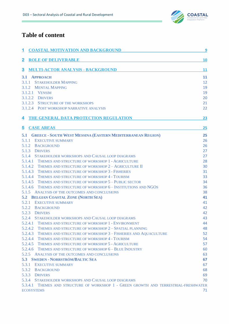
Table of content
1 COASTAL MOTIVATION AND BACKGROUND 9
2 ROLE OF DELIVERABLE 10
3 MULTI-ACTOR ANALYSIS - BACKGROUND 11
3.1 APPROACH 11 3.1.1 STAKEHOLDER MAPPING 12 3.1.2 MENTAL MAPPING 19 3.1.2.1 VENSIM 19 3.1.2.2 DRIVERS 20 3.1.2.3 STRUCTURE OF THE WORKSHOPS 21 3.1.2.4 POST WORKSHOP NARRATIVE ANALYSIS 22
4 THE GENERAL DATA PROTECTION REGULATION 23
5 CASE AREAS 25
5.1 GREECE - SOUTH WEST MESSINA (EASTERN MEDITERRANEAN REGION) 25 5.1.1 EXECUTIVE SUMMARY 26 5.1.2 BACKGROUND 26 5.1.3 DRIVERS 27 5.1.4 STAKEHOLDER WORKSHOPS AND CAUSAL LOOP DIAGRAMS 27 5.1.4.1 THEMES AND STRUCTURE OF WORKSHOP 1 - AGRICULTURE 28 5.1.4.2 THEMES AND STRUCTURE OF WORKSHOP 2 – AGRICULTURE II 30 5.1.4.3 THEMES AND STRUCTURE OF WORKSHOP 3 - FISHERIES 31 5.1.4.4 THEMES AND STRUCTURE OF WORKSHOP 4 - TOURISM 33 5.1.4.5 THEMES AND STRUCTURE OF WORKSHOP 5 – PUBLIC SECTOR 34 5.1.4.6 THEMES AND STRUCTURE OF WORKSHOP 6 – INSTITUTIONS AND NGOS 36 5.1.5 ANALYSIS OF THE OUTCOMES AND CONCLUSIONS 38 5.2 BELGIAN COASTAL ZONE (NORTH SEA) 41 5.2.1 EXECUTIVE SUMMARY 41 5.2.2 BACKGROUND 42 5.2.3 DRIVERS 42 5.2.4 STAKEHOLDER WORKSHOPS AND CAUSAL LOOP DIAGRAMS 43 5.2.4.1 THEMES AND STRUCTURE OF WORKSHOP 1 - ENVIRONMENT 44 5.2.4.2 THEMES AND STRUCTURE OF WORKSHOP 2 – SPATIAL PLANNING 48 5.2.4.3 THEMES AND STRUCTURE OF WORKSHOP 3 – FISHERIES AND AQUACULTURE 52 5.2.4.4 THEMES AND STRUCTURE OF WORKSHOP 4 - TOURISM 54 5.2.4.5 THEMES AND STRUCTURE OF WORKSHOP 5 - AGRICULTURE 57 5.2.4.6 THEMES AND STRUCTURE OF WORKSHOP 6 – BLUE INDUSTRY 60 5.2.5 ANALYSIS OF THE OUTCOMES AND CONCLUSIONS 63 5.3 SWEDEN - NORRSTRÖM/BALTIC SEA 67 5.3.1 EXECUTIVE SUMMARY 67 5.3.2 BACKGROUND 68 5.3.3 DRIVERS 69 5.3.4 STAKEHOLDER WORKSHOPS AND CAUSAL LOOP DIAGRAMS 70 5.3.4.1 THEMES AND STRUCTURE OF WORKSHOP 1 - GREEN GROWTH AND TERRESTRIAL-FRESHWATER
ECOSYSTEMS 71
This project has received funding from the European Union’s Horizon 2020 research and innovation programme under grant agreement N° 773782
4
D03 – Sectoral Analysis of Coastal and Rural Development
5.3.4.2 THEMES AND STRUCTURE OF WORKSHOP 2 - INDUSTRY, WATER-WASTEWATER AND SOLID WASTE
INFRASTRUCTURE, AND INNOVATION 72 5.3.4.3 THEMES AND STRUCTURE OF WORKSHOP 3 - URBAN-RURAL COMMUNITIES AND LAND SPATIAL
PLANNING 74 5.3.4.4 THEMES AND STRUCTURE OF WORKSHOP 4 - BLUE GROWTH AND COASTAL-MARINE ECOSYSTEMS 75 5.3.4.5 THEMES AND STRUCTURE OF WORKSHOP 5 - COASTAL TOURISM, RECREATION, HARBOURS AND
OTHER COASTAL ACTIVITIES 76 5.3.4.6 THEMES AND STRUCTURE OF WORKSHOP 6 - MARINE TOURISM, FISHERIES, MARINE SPATIAL
PLANNING AND OTHER MARINE ACTIVITIES 78 5.3.5 ANALYSIS OF THE OUTCOMES AND CONCLUSIONS 79 5.4 ROMANIA - DANUBE MOUTH (BLACK SEA) 81 5.4.1 EXECUTIVE SUMMARY 81 5.4.2 BACKGROUND 82 5.4.3 DRIVERS 83 5.4.4 STAKEHOLDER WORKSHOPS AND CAUSAL LOOP DIAGRAM 84 5.4.4.1 THEMES AND STRUCTURE OF WORKSHOP 1 – BLUE GROWTH, DANUBE MOUTH 84 5.4.4.2 THEMES AND STRUCTURE OF WORKSHOP 2 - DANUBE MOUTH - TOURISM 86 5.4.4.3 THEMES AND STRUCTURE OF WORKSHOP 3 - FISHERIES 88 5.4.4.4 THEMES AND STRUCTURE OF WORKSHOP 4 – RURAL DEVELOPMENT 89 5.4.4.5 THEMES AND STRUCTURE OF WORKSHOP 5 – AGRICULTURE, CROSS-COMPLIANCE AND ECOSYSTEM
SERVICES 91 5.4.4.6 THEMES AND STRUCTURE OF WORKSHOP 6 – RURAL TOURISM, RECREATION AND OTHER RURAL
ACTIVITIES 93 5.4.5 ANALYSIS OF THE OUTCOMES AND CONCLUSIONS 94 5.5 FRANCE - CHARRENTE RIVER BASIN (ATLANTIC REGION) 96 5.5.1 EXECUTIVE SUMMARY 96 5.5.2 BACKGROUND 97 5.5.3 DRIVERS 98 5.5.4 STAKEHOLDER WORKSHOPS AND CAUSAL LOOP DIAGRAMS 99 5.5.4.1 THEMES AND STRUCTURE OF WORKSHOP 1 - AGRICULTURE AND AGRO-INDUSTRY 99 5.5.4.2 THEMES AND STRUCTURE OF WORKSHOP 2 – WATER SECTOR 102 5.5.4.3 THEMES AND STRUCTURE OF WORKSHOP 3 - ENVIRONMENTAL POLICY AND TERRITORIAL
DEVELOPMENT 105 5.5.4.4 THEMES AND STRUCTURE OF WORKSHOP 4 - PORT ACTIVITIES, INFRASTRUCTURES, ENERGY 108 5.5.4.5 THEMES AND STRUCTURE OF WORKSHOP 5 - SHELLFISH FARMING, AQUACULTURE AND FISHING 110 5.5.4.6 THEMES AND STRUCTURE OF WORKSHOP 6 - RURAL AND COASTAL TOURISM 112 5.5.5 ANALYSIS OF THE OUTCOMES AND CONCLUSIONS 114 5.6 SPAIN – MAR MENOR COASTAL LAGOON (WESTERN MEDITERRANEAN) 116 5.6.1 EXECUTIVE SUMMARY 116 5.6.2 BACKGROUND 116 5.6.3 DRIVERS 117 5.6.4 STAKEHOLDER WORKSHOPS AND CAUSAL LOOP DIAGRAMS 117 5.6.4.1 THEMES AND STRUCTURE OF WORKSHOP 1 – ENVIRONMENTAL SECTOR 117 5.6.4.2 THEMES AND STRUCTURE OF WORKSHOP 2 - AGRICULTURE 118 5.6.4.3 THEMES AND STRUCTURE OF WORKSHOP 3 – PUBLIC ADMINISTRATION 120 5.6.4.4 THEMES AND STRUCTURE OF WORKSHOP 4 - FISHERMEN AND SALT PANS SECTOR 121 5.6.4.5 THEMES AND STRUCTURE OF WORKSHOP 5 - TOURISM 121 5.6.4.6 THEMES AND STRUCTURE OF WORKSHOP 6 – LOCAL POPULATION 123 5.6.5 ANALYSIS OF THE OUTCOMES AND CONCLUSIONS 124
6 CONCLUSIONS AND LESSONS LEARNED FROM SECTOR WORKSHOPS 125
This project has received funding from the European Union’s Horizon 2020 research and innovation programme under grant agreement N° 773782
5
D03 – Sectoral Analysis of Coastal and Rural Development
7 ACKNOWLEDGEMENTS 129
8 REVISIONS REQUESTED AFTER RP1 – M18 130
9 REFERENCES 135

This project has received funding from the European Union’s Horizon 2020 research and innovation programme under grant agreement N° 773782
6
D03 – Sectoral Analysis of Coastal and Rural Development
List of Tables
Table 1: Stakeholder mapping in the six MALs ..................................................................................................... 13 Table 2: Overview of case areas, respective stakeholders and key issue areas ...................................................... 25 Table 3: Original vs. Workshop drivers used in the Greek case study .................................................................. 27 Table 4: Sectoral workshops’ types, participants’ links to the workshop and the total number of participants in
each of the Greek workshops. .......................................................................................................................... 27 Table 5: Major issues linked to the different drivers and their occurrence of appearance (number in paragraph).
The first line under each driver refers to Uses tree analysis in Vensim, and the second to Causes tree
analysis. ............................................................................................................................................................ 38 Table 6: Original vs. Workshop drivers used in the Belgian case study ................................................................ 43 Table 7: Original vs. workshop drivers Sweden ..................................................................................................... 69 Table 8: Sector workshop overview for MAL3 Sweden ......................................................................................... 70 Table 9: Overview of Swedish workshop outputs in terms of drivers and how often variables under these were
mentioned in different workshops. .................................................................................................................. 79 Table 10: Drivers for the Danube Mouth case area ................................................................................................ 83 Table 11: Stakeholder overview Danube mouth ..................................................................................................... 84 Table 12: Variables produced during the blue growth workshop .......................................................................... 85 Table 13: Variables produced during the Tourism workshop ............................................................................... 87 Table 14: Variables for the Fisheries and Aquaculture workshop Danube delta .................................................. 89 Table 15: Variables discussed during the Rural Development workshop .............................................................. 91 Table 16: Variables discussed during the Agriculture workshop in Danube region.............................................. 92 Table 17: Variables discussed during the rural tourism workshop in Danube delta ............................................. 93 Table 18: Drivers used during the workshops in Charente .................................................................................... 98 Table 19: The use of drivers (links) depending on the sector workshops – Charente site ..................................... 99 Table 20: Lessons learned from sectoral workshops in all case areas. ..................................................................126 Table 21: The themes in column 1 of the table are first themes we extracted based on the deliverable itself and
the workshops in the six case areas. Then we related these to the CAP and MSFD and added weights of
importance to these as well. ............................................................................................................................127
This project has received funding from the European Union’s Horizon 2020 research and innovation programme under grant agreement N° 773782
7
D03 – Sectoral Analysis of Coastal and Rural Development
List of Figures
Figure 1: Multi Actor labs on the COASTAL platform................................................................................................... 9 Figure 2: COASTAL platform diagram ................................................................................................................. 10 Figure 3: Graphical presentation of the entire stakeholder driven process of the COASTAL project. D1.1 takes place
in the marked section 1 of sectoral workshops in six case areas. ...................................................................... 12 Figure 4: Stakeholder selection MAL 4 graphic ......................................................................................................... 17 Figure 5: Vensim PLE Plus interface showing an example of a mental map (http://vensim.com) ........................ 20 Figure 6: Vensim user interface with start up screen and system drivers as agreed upon during the project
kickoff meeting. ............................................................................................................................................... 21 Figure 7: Whiteboard results from mind-mapping the agriculture workshop in Messinia, Greece ...................... 29 Figure 8: Vensim diagram from workshop on Agriculture in Messinia, Greece ................................................... 29 Figure 9: Whiteboard results from mindmapping the olive oil industry in Messinia, Greece ............................... 31 Figure 10: Vensim representation of mind-mapping results of olive oil industry in Messinia, Greece ................. 31 Figure 11: Whiteboard mindmapping results from the workshop with fishers in Messinia, Greece .................... 32 Figure 12: Vensim representation of fishers workshop i n Messinia, Greece ........................................................ 33 Figure 13: Whiteboard of mind map from Messinia workshop with tourism sector ............................................. 34 Figure 14: Vensim representation of tourism workshop in Messinia, Greece ....................................................... 34 Figure 15: Whiteboard output from mindmapping the public sector in Messinia, Greece ................................... 36 Figure 16: Vensim output from public sector, Messinia, Greece............................................................................ 36 Figure 17: Whiteboard of institutions and NGO mindmaps in Messinia, Greece ................................................. 37 Figure 18: Vensim representation of mindmap for institutions and NGOs in Messinia, Greece ........................... 38 Figure 19: Combined mind map for the theme environment in Belgium................................................................... 47 Figure 20: Combined mind map for the theme spatial planning............................................................................ 51 Figure 21: Combined mind map for fisheries and aquaculture Belgium ............................................................... 54 Figure 22: Combined mind map for inland and coastal tourism Belgium ............................................................. 57 Figure 23: Combined map for agriculture – Belgium ............................................................................................ 60 Figure 24: Combined mental map for the Blue Industry Stakeholders – Belgium ................................................ 63 Figure 25: Main linkages between all the sectors - Belgium ................................................................................... 66 Figure 26: The Baltic Sea and its catchment area with the Norrström drainage basin outlined in yellow.................. 67 Figure 27: First MAL3 workshop – results from whiteboard mindmapping exercise ........................................... 71 Figure 28: Causal loop diagram from MAL3 sector workshop 1 (white-board version above; digitized version in
Vensim below). ................................................................................................................................................. 72 Figure 29: Second MAL3 workshop – results from whiteboard mindmapping exercise with industry, water-
wastewater and solid waste infrastructure and innovation............................................................................. 73 Figure 30: Digitized Vensim visualization of whiteboard mindmap ...................................................................... 73 Figure 31: Whiteboard 3rd workshop Sweden ....................................................................................................... 74 Figure 32: Vensim representation of mindmap 3rd workshop............................................................................... 74 Figure 33: Whiteboard mindmap for the fourth workshop in Sweden .................................................................. 75 Figure 34: Vensim representation of the 4th workshop ......................................................................................... 76 Figure 35: Whiteboard mindmap 5th workshop in Sweden ................................................................................... 77 Figure 36: Vensim representation of mindmap in workshop 5 Sweden ................................................................. 77 Figure 37: 6th workshop Sweden, whiteboard mindmap ....................................................................................... 78 Figure 38: Vensim mindmap based on whiteboard ................................................................................................ 78 Figure 39: Map of the Romanian Black Sea’s coastal zone and main activities .......................................................... 82 Figure 40: Blue Growth Workshop – Romania, Constanta, 30 October 2018 ............................................................. 84 Figure 41: White-board - Blue Growth Workshop – Romania, Constanta, 30 October 2018 ...................................... 85 Figure 42: Casual Loop Diagram - Blue Growth Workshop – Romania, Constanta, 30 October 2018 ......................... 85 Figure 43: White-board – Tourism-costal Workshop – Romania, Constanta, 31 October 2018 ........................... 86 Figure 44: Causal loop diagram for tourism workshop - Danube mouth, Romania.................................................... 87 Figure 45: White-board – Fisheries & Aquaculture (marine) Workshop – Romania, Constanta, 31 October 2018
.......................................................................................................................................................................... 88 Figure 46: Casual Loop Diagram – Fisheries & Aquaculture (marine) Workshop – Romania, Constanta, 31 October
2018 .................................................................................................................................................................. 89 Figure 47: Blackboard version of the Rural Development mind map session in Danube’s Delta region .............. 90 Figure 48: Vensim representation of mind map - Rural Development .................................................................. 90
This project has received funding from the European Union’s Horizon 2020 research and innovation programme under grant agreement N° 773782
8
D03 – Sectoral Analysis of Coastal and Rural Development
Figure 49: Flip chart with mind map from the Agriculture workshop ........................................................................ 91 Figure 50: Vensim presentation of the mental mind map developed for Agriculture ............................................ 92 Figure 51: Mind map on flip chart for Rural Tourism in Danube delta region. ........................................................... 93 Figure 52: Vensim representation of flip chart mind-map ..................................................................................... 93 Figure 53: Map of the Charente site ....................................................................................................................... 98 Figure 54: Agricultural sector – Mental map built with stakeholders on whiteboard ..........................................100 Figure 55: Agricultural sector – Mental map built with stakeholders - redone in Vensim based on whiteboard
version .............................................................................................................................................................100 Figure 56: Water sector – Mental map built with stakeholders on whiteboard .......................................................103 Figure 57: Water sector – Mental map built with stakeholders visualized by Vensim ..............................................104 Figure 58: Environmental policy and territorial development – Mental map built with stakeholders on white
board. ..............................................................................................................................................................105 Figure 59: Environmental policy and territorial development – Mental map built with stakeholders in Vensim.
.........................................................................................................................................................................106 Figure 60: Port, infrastructure, energy sector – Mental map built with stakeholders on whiteboard with Vensim
representation .................................................................................................................................................108 Figure 61: Port, infrastructure, energy sector – Mental map built with stakeholders, finished Vensim representation
.........................................................................................................................................................................109 Figure 62: The mental map for the shellfish farming, aquaculture and fishing sector - whiteboard ...................111 Figure 63: The mental map for the shellfish farming, aquaculture and fishing sector in Vensim ..............................111 Figure 64: Mental map built by the tourism workshop group.whiteboard edition ...................................................113 Figure 65: Mental map built by the tourism workshop group on Vensim ................................................................113 Figure 66: Use of drivers in every workshop (the size of the arrows depends on the number of links with the
driver) .............................................................................................................................................................115 Figure 67: Causal loop diagram from MAL6 sector workshop 1. .........................................................................118 Figure 68: Causal loop diagram from MAL6 sector workshop 2. .........................................................................119 Figure 69: Causal loop diagram from MAL6 sector workshop 3. .........................................................................120 Figure 70: Causal loop diagram from MAL6 sector workshop 4. .........................................................................121 Figure 71: Causal loop diagram from MAL6 sector workshop 5. .........................................................................122 Figure 72: Causal loop diagram from MAL6 sector workshop 6. .........................................................................123
This project has received funding from the European Union’s Horizon 2020 research and innovation programme under grant agreement N° 773782
9
D03 – Sectoral Analysis of Coastal and Rural Development
1 COASTAL motivation and background
COASTAL represents a unique collaboration of coastal and rural business entrepreneurs, administrations,
stakeholders, and natural and social science experts. Local and scientific knowledge are combined to identify
problems and develop practical and robust business road maps and strategic policy guidelines, aimed at improving land-sea synergy. A multi-actor approach is followed to analyse the social, environmental and
economic land-sea interactions in a collaborative System Dynamics (SD) framework, taking into consideration
the short-, mid- and long-term impacts of decision making and feedback mechanisms on coastal and rural
development.
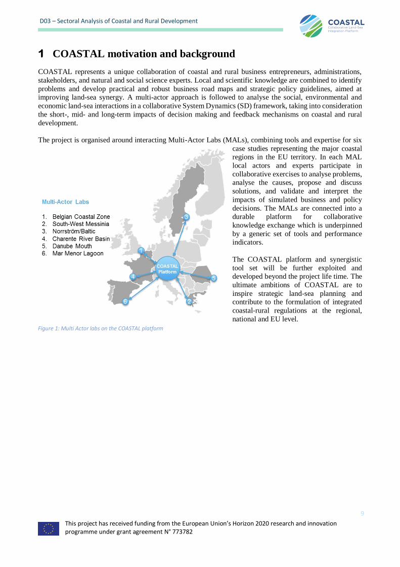
The project is organised around interacting Multi-Actor Labs (MALs), combining tools and expertise for six
case studies representing the major coastal regions in the EU territory. In each MAL
local actors and experts participate in
collaborative exercises to analyse problems, analyse the causes, propose and discuss
solutions, and validate and interpret the
impacts of simulated business and policy
decisions. The MALs are connected into a durable platform for collaborative
knowledge exchange which is underpinned
by a generic set of tools and performance indicators.
The COASTAL platform and synergistic
tool set will be further exploited and developed beyond the project life time. The
ultimate ambitions of COASTAL are to
inspire strategic land-sea planning and contribute to the formulation of integrated
coastal-rural regulations at the regional,
national and EU level.
Figure 1: Multi Actor labs on the COASTAL platform

This project has received funding from the European Union’s Horizon 2020 research and innovation programme under grant agreement N° 773782
10
D03 – Sectoral Analysis of Coastal and Rural Development
2 Role of Deliverable
Deliverable D3 describes the approach, results and lessons learned for the sector workshops in the six case
studies. This task will prepare and organize sector workshops with the local R&D partners and WP3
(contributing to tasks 3.2 and 3.3) for each of the study regions. For this we will use co-creation, science-policy-industry exchanges, and direct involvement of local actors to ensure a full understanding of the local
system and effective information flow towards the qualitative tools developed in other WPs. In a first step a
three-day briefing (M2) will be organised to brief and train the local R&D partners. This will ensure methodological coherence and comparability across the six case studies. At least two participants from each
case study will attend the briefing, as a risk mitigation measure in terms of methodological understanding and
ability to change facilitators during workshops if necessary.
The logistic, technical and research details for the sector workshops will be discussed during the briefing,
including a consensus on the thematic balance of the sectors represented in the workshops, and the issues to
address. Following this phase, three coastal and three rural sector workshops will be organised for each case study during M3-M6. Here, policy makers, business entrepreneurs, sector representatives, and domain experts
will participate to explore the relevant land-sea interactions from a coastal or rural perspective, taking into
consideration the motivations and barriers for collaboration, as well as the positive and negative externalities.
The results feed into Task 1.2 through interpretations of the results obtained under Task 1.3 (conceptual
analysis).
Figure 2: COASTAL platform diagram
This project has received funding from the European Union’s Horizon 2020 research and innovation programme under grant agreement N° 773782
11
D03 – Sectoral Analysis of Coastal and Rural Development
3 Multi-actor analysis - Background
This deliverable partially answers all of the four objectives of WP1 – Multi Actor Analysis as described in the
Grant Agreements. These objectives are to:
1. Adapt and apply the state-of–the-art methodology for participatory, multi-actor approaches to enable
mental mapping of the feedback structures of the land-sea system for the case studies;
2. Develop transferable and generic mental maps allowing application to other study regions or
adaptation to new problem contexts; 3. Engage with the relevant actors and stakeholders for the different cases during the participatory sector
workshops;
4. Push interdisciplinary collaboration beyond the state of the art towards an actor-driven, iterative, and bottom up approach with generic, qualitative tools which are developed in collaboration with the
sectors, stakeholders, and administrations; and
5. Provide a solid basis for evidence-based analysis of business and policy strategies, and systems modelling, and platform for knowledge exchange.
3.1 Approach
In this deliverable, we report on results from six case areas of the COASTAL project, where workshops took
place in M3-9 of the project period (Task 1.1 Sectoral Analysis of Coastal & Rural Development of WP1). During these workshops, we developed case and sector specific shared mental maps of the land-sea system in
the given case areas by bringing together for each case study domain experts, rural and coastal stakeholders
and administrations.
As a first step a one-day seminar was organised during the kick off meeting (M2) of the project, where the WP
leader briefed and trained the local R&D partners. This was to ensure methodological coherence and
comparability across the six case studies. Since this was done in conjunction with the kick off meeting in Brussels the first week of June 2018, the participation rate was high, which is required as a risk mitigation
measure in terms of methodological understanding and the ability of the local R&D partners to change
facilitators during the workshops if it became necessary. It was agreed during the project proposal stage that
three coastal and three rural sector workshops would be organised for each case study, where policy makers, business entrepreneurs, sector representatives, and domain experts would participate to explore the relevant
land-sea interactions from a coastal or rural perspective in each case area, taking into consideration the
motivations and barriers for collaboration, as well as the positive and negative externalities
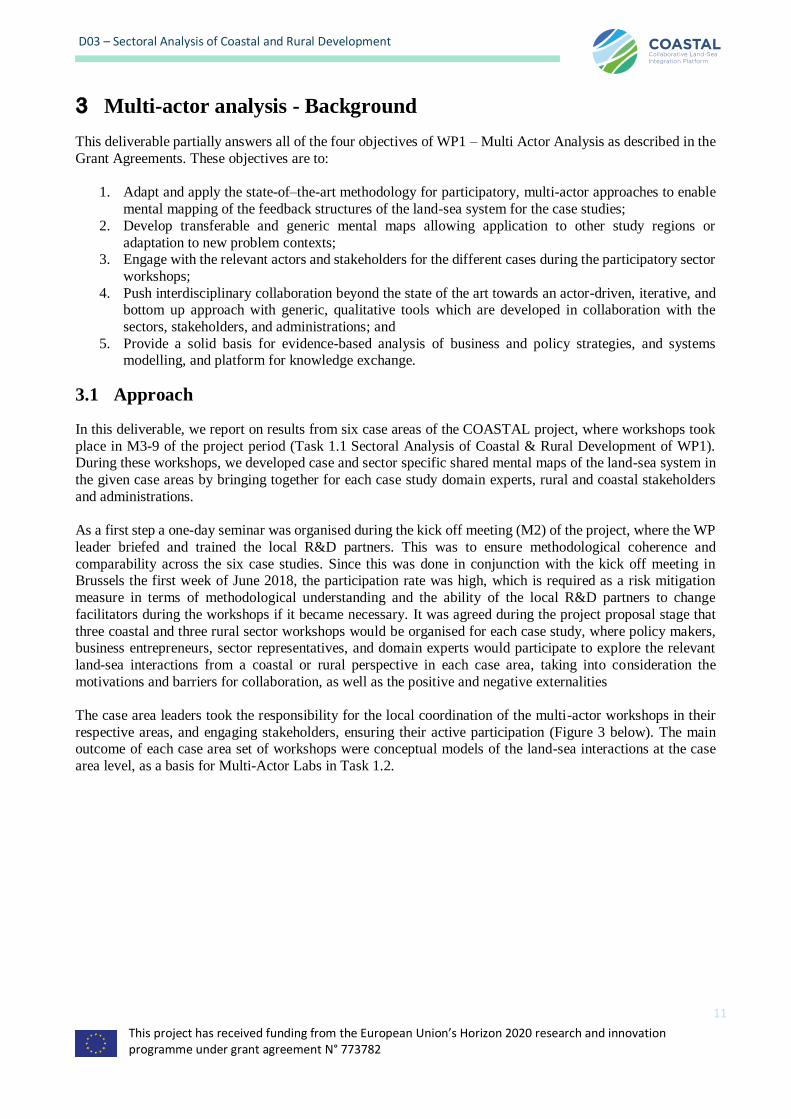
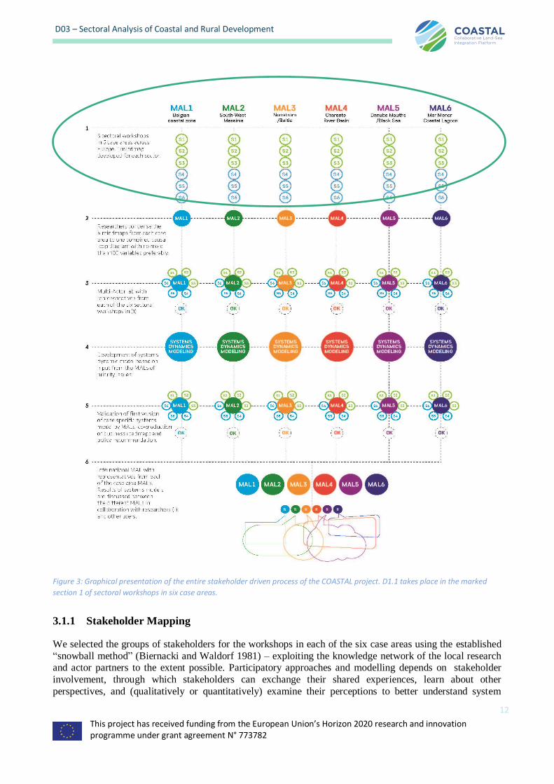
The case area leaders took the responsibility for the local coordination of the multi-actor workshops in their
respective areas, and engaging stakeholders, ensuring their active participation (Figure 3 below). The main outcome of each case area set of workshops were conceptual models of the land-sea interactions at the case
area level, as a basis for Multi-Actor Labs in Task 1.2.
This project has received funding from the European Union’s Horizon 2020 research and innovation programme under grant agreement N° 773782
12
D03 – Sectoral Analysis of Coastal and Rural Development
3.1.1 Stakeholder Mapping
We selected the groups of stakeholders for the workshops in each of the six case areas using the established
“snowball method” (Biernacki and Waldorf 1981) – exploiting the knowledge network of the local research and actor partners to the extent possible. Participatory approaches and modelling depends on stakeholder
involvement, through which stakeholders can exchange their shared experiences, learn about other
perspectives, and (qualitatively or quantitatively) examine their perceptions to better understand system
Figure 3: Graphical presentation of the entire stakeholder driven process of the COASTAL project. D1.1 takes place in the marked
section 1 of sectoral workshops in six case areas.
This project has received funding from the European Union’s Horizon 2020 research and innovation programme under grant agreement N° 773782
13
D03 – Sectoral Analysis of Coastal and Rural Development
behavior (Sterman 2000). We used this approach because the quality of the results sampled from representative
groups would outweigh the relatively small number of workshop participants the method usually produces. This is often the case in qualitative research studies. Sometimes, large samples can in fact be ineffective and
not provide the detailed and contextual information and in-depth interactions desired by the facilitators. For
the purposes of the participatory workshops in this study, we considered fifteen to be the maximum of what would provide a holistic narrative where all participants were provided ample opportunities to share their
perceptions. The sample size can be as small as one or two as well, if this participant has information which is
of critical value for the given sector and advances the research towards a specific goal (Sandelowski 1995).
From a natural science perspective, this may seem like a small number of observations. However, samples in
qualitative research methods tend to be smaller than one would expect in the more numerical sciences. This is
to support the depth of case-oriented analysis that is fundamental to this mode of inquiry, such as with the
COASTAL sector workshops where the aim was to conceptualize the relevant land-sea interactions from a
thematic point of view first. The samples were also purposive in that they were selected by virtue of the
respondent’s capacity to provide richly textured information that was required specifically for this study,
relevant to the phenomenon under investigation. As such, this purposive sampling (as opposed to probability
sampling that is customarily employed in quantitative research methods) selects ‘information-rich’ cases or
respondents. The more useful the data sampled from each of the participant is during these sessions, the fewer
respondents are needed. In fact, research has shown that after 20 responses, there is seldom any new
information to be gained that is analytically relevant (Green and Thorogood 2018), hence why a limit of 15
persons per workshop was suggested to the Multi-Actor Labs.
The following table is an overview for case specific stakeholder mapping experiences in each of the case areas.
The MAL leaders reflect on difficulties in recruitment, benefits of having actor partners involved, and the
relevance of stakeholder fatigue.
Table 1: Stakeholder mapping in the six MALs
Case
area
Stakeholder mapping process – retrospective for sectoral workshops (6 in each of the six
case areas) - "How were the stakeholders selected?"
MAL
1
The Belgian MAL consists of VITO, GRBR, VLIZ, VLM, AGHO and POM-WVL. VITO and
GRB (Greenbridge) are two research partners, the others act as actor partner in this project. VITO also engaged its independent division Vlakwa (Flemish Knowledge Center Water).
GRBR is a business incubator with a large network among blue industry stakeholders in
Flanders through their work as facilitator for the sector. Although VITO has thematic
experience, they are relatively new to the marine sectors in Belgium. They have a more extended network in environmental research, renewable energy, coastal and inland water management and
in spatial planning and analysis. VLIZ (Flanders Marine Institute) as a research institute and
facilitator for marine and coastal research has a very broad overview of all coastal stakeholders in Belgium (and abroad). VLM (Flanders Land Agency) is responsible for rural
development and land-use planning in the Flemish region and thus has an extended network
amongst rural and agricultural stakeholders. AGHO (Port of Ostend) and POM-WVL (West Flanders Development Agency) are key actors with complementary roles in boosting the Belgian
blue industry, spatial planning and rural development.
The mapping and resultant selection of stakeholders for the sectoral workshops was based on suggestions of all six local partners, mainly depending on the topic. Given the experience and
network of the partners, we had for each topic an existing and broad
overview of Belgian stakeholders. Key stakeholders per sector were invited to workshops by email. Stakeholders that didn’t respond to the invitation were called in an attempt to convince
them to attend, which more then doubled the attendance for most workshops. It should be noted
that the actor partners VLIZ, AGHO, POM-WVL and VLM (and to a lesser extent GRBR for
This project has received funding from the European Union’s Horizon 2020 research and innovation programme under grant agreement N° 773782
14
D03 – Sectoral Analysis of Coastal and Rural Development
blue industry) are also important stakeholders in the Belgian case area, and joined the meeting
for their sectors as experts or stakeholders, and not with the partner hat on. For most sectors, those actor partners are key stakeholders that have a key role in the discussion (also outside the
project), covering the relevant land- and sea-based economic and environmental processes with
their own expertise or through their network in the coastal region and hinterland.
For the ‘nature’ sectoral workshop we relied on the networks of both rural and marine actor
partners in the project to select stakeholders and got representants from public and private nature
managers to attend, as well as policy makers and researchers. The diversity in the group was large, with both marine and land-based coastal experts. For the ‘spatial planning’ workshop, a
diversity of public and private spatial planners attended. The group contained planners at sea
(marine spatial planning) and (more) planners on land, with a few people having experience in the (lack of) synergies between both. For the fisheries and aquaculture workshop the network of
AGHO, GRBR and especially VLIZ was used to invite a large array of researchers, policy
makers and industry, as well as representatives from the retail sector (who
are the main driving forces for the aquaculture sector). During the workshop the attendance of the industry (fishers/aquaculture) was only one participant, due to other entrepreneurs
being too busy to attend or not answering emails and calls. This was somewhat compensated
through the attendance of 2 marine food experts from the retail industry with similar challenges. Getting stakeholders to attend the Blue industry workshop proved even more difficult however,
even if GRBR, AGHO and POM all have an extended network in this sector (and are in fact also
part of the sector). After intense telephone encouragement, still only 10 participants confirmed their attendance, so the workshop was postponed with a month since the group that had
confirmed were not broad and inclusive enough to be valid for the needs of this workshop. A
larger effort was made, and the workshop was also aligned with a blue industry event, and
finally attendance numbers were considered acceptable to the facilitators. These difficulties are related to the busy schedule of industrial entrepreneurs in this sector. It proved even more
difficult to invite people to the tourism workshop because of the fragmentation and lack of
coordination the sector, but eventually policy makers, the industry and also citizen interest groups were well represented during this sectoral workshop as well. Finally, for
the agriculture workshop we relied on the VITO and Vlakwa networks, who could rely on a
tradition of meetings and workshops for this sector and related themes (especially coastal water
management). We had no difficulty to get researchers, policy makers and farmers (organisations) to attend.
The overall conclusion is that it is easier to get a good attendance for sectors with a tradition in intersectoral meetings and policy-oriented workshops where also the triple helix (research-
policy-industry) is more important, like agriculture, spatial planning and nature. Even if project
partners have a very good networks in the blue industry sector, for example, this sector still proved to be very challenging in terms of engaging stakeholders. Certainly, the perception of the
value of time spent versus the personal busy schedule plays a role here, with sectors like
agriculture having experience that in the long term such workshops do pay off for them.
Stakeholder fatigue also played a role here, with several invitees responding that there are
already to many workshop invitations, and attendees indicating that they were not interested in a
second workshop. This stakeholder fatigue varied greatly between sectors (with blue industry, tourism, fisheries & aquaculture and nature suffering the most). Even if the agriculture sector
has a large number of workshops (often with VLM and VITO also in the organisation),
stakeholder fatigue in this sector seems to be relatively low.
MAL
2
The Greek MAL consists of NEO/SU, HCMR, TEMES SA, CVF and DAM. The first two partners are research partners. In particular, NEO/SU is located in the case study and has already
a wide network of stakeholders with whom they collaborate in research and educational projects.
HCMR has a long presence in the area mainly focusing on marine and wetland research.
This project has received funding from the European Union’s Horizon 2020 research and innovation programme under grant agreement N° 773782
15
D03 – Sectoral Analysis of Coastal and Rural Development
The three actor partners are TEMES, CVF and DAM. TEMES owns the biggest touristic
development in the area, CVF is a foundation focusing on the sustainable development of agriculture in Messinia and DAM is a company of the sub-region of Messinia which among
others has the responsibility to administrate LEADER projects in the Messinia region. Thus, the
selection of our stakeholders was based on suggestions from each MAL partner, who are related
to different stakeholders, followed by the snowball method.
For the first and the second sectoral workshops (farmers/ agronomists, local industry) we mainly
relied on stakeholders linked to NEO/SU and CVF. The main focus was to approach stakeholders who were knowledgeable and had long experience in their fields. Our initial
selection included organic and conventional farmers, agronomists and cooperative
representatives, olive-mill and pomace-mill owners. The first contact with the stakeholders was made about a month before the workshop date, followed by a phone-call follow up few days
before the workshop to ensure their participation. Eventually, due to last minute cancellations in
the first workshop we had 5 farmers (including 2 young farmers) and 2 agronomists (out of 11
initially contacted stakeholders), and in the second workshop 2 olive-mill owners and one pomace-mill owner (out of 6 initially contacted stakeholders).
The mapping of fishers (third workshop) was more challenging. The main challenge was to approach both lagoon and coastal fishers, but our local contacts were mainly with lagoon fishers.
Another challenge was to ensure the participation of fishers in the workshop since most of them
wait to check the weather first (if it is appropriate to go out for fishing or not) before committing themselves. Thus, the phone-call follow up had to be the day before the workshop. Eventually,
and with the tremendous help from one of the older local fishers of the area in a classic snowball
approach, 9 fishers participated in the workshop (2 lagoon and 7 coastal fishers).
For mapping stakeholders for the fourth workshop (tourism) we relied on our MAL related
partner (TEMES SA) and we contacted local tourism associations, restaurant/bar/café and hotel
owners, and stakeholders linked to outdoor activities. The process of initial contact and follow-up was similar as above, and apart from few last-minute cancellations, the workshop was
followed by most of the invited stakeholders (3 from outdoor activities, 2 from the local
association of enterprises, 2 hotel managers and 2 restaurant owners).
Mapping policy making stakeholders and Institutions/NGOs for the fifth and the sixth workshop
was a straightforward process. For the fifth workshop (policy) we selected all the relevant
authorities linked to policy-making in the area (e.g. Sub-region of Messinia, Municipality, Water agency, Forestry, Ephorate of Archaeology, etc.), and for the sixth workshop universities,
institutions and NGOs which are all active stakeholders in the area. As it happened in the
previous workshops, all stakeholders were contacted a month in advance and there was a follow-up few days before the workshop. Both workshops were well attended. In contrast to the
previous four workshops, where last-minute cancellations resulted to fewer participants, in the
last two workshops any last-minute cancellation was covered internally by the local authority or
the Institution/NGO.
With regards to stakeholders’ fatigue, we noticed that there were stakeholders who were not
convinced with the process and they were not willing to participate in similar processes in the future. On the other hand, stakeholders who were interested in the process were in general
willing to be contacted again and again without any complaints. For example, some of them
were post contacted by PhD and MSc students doing relevant research in the area. These stakeholders were in general more knowledgeable in their fields, they could understand the value
of the workshops, and they were asked to participate in the MAL workshops (see D04).
MAL
3
MAL3 represents the Swedish cross-scale case of the Norrström drainage basin and its adjacent
and surrounding coastal zones (local/regional scale) and, analogously, the coastal zones around the whole Baltic Sea, which is led by Stockholm University (SU). Stakeholder workshops and
This project has received funding from the European Union’s Horizon 2020 research and innovation programme under grant agreement N° 773782
16
D03 – Sectoral Analysis of Coastal and Rural Development
co-creation of mind maps were the first steps to identify physical-environmental and socio-
economic land-coast-sea interactions involved in these problems. In planning the stakeholder workshops, six workshop themes were selected based on different sectors and related
problem aspects, considering also relations with the Sustainable Development Goals in Agenda
2030.
To select groups of stakeholders for the different sector workshop themes, SU prepared a list of
national and international actors in a close collaboration with MAL3 local partners (Stockholm
Environmental Institute – SEI, Campus Roslagen – CRAB, NIRAS Sweden AB, Global Utmaning – GLOB, and Natural Resources Institute Finland – LUKE). The aim was to identify
key actors with main responsibilities for, impacts from, and/or potential to contribute to
problem solutions to the main coastal development and environmental problems in focus for MAL3, following the general snowball approach.
In total 112 relevant actors (organizations) were identified in this process, including green
growth actors (agriculture, forestry), municipalities, blue growth actors, universities and other research organizations, industry, business, governmental agencies and authorities, local-
regional authorities, NGOs and ICT organizations. These were further classified and
distributed in terms of their closest relation to the different workshop themes, based on the main focus/location of their activities (inland/rural, coastal, at sea).
For each organization actor, at least one person with relevant responsibilities, activities, expertise, practical experiences, as known to the SU team, the MAL3 local partners,
or identified from the actor organization itself, was invited to the related sector workshop. Some
actors were invited to more than one sector workshop, because their responsibilities, expertise,
activities, experiences were relevant for more than one workshop theme. In total, 24 person representing 23 actor organizations accepted to attend the sector workshops (20.5% positive
responses), including the MAL3 local partners who are also relevant
stakeholder actors for the main socio-economic and environmental problems in this case.
Overall, most of the invited actors did not respond to the invitations. Some of them were not
available at the specific workshop times, and some did not consider the incentives be high
enough for participating in such workshops, since decades of intensive eutrophication mitigation efforts for the Baltic Sea have still not been successful. Thus, main challenges in
engaging actors in the MAL3 workshops were related to lack of time and availability (most of
the actors are generally very busy) and lack of incentives to further discuss case-related problems and potential solutions after decades of not very successful solution efforts.
This project has received funding from the European Union’s Horizon 2020 research and innovation programme under grant agreement N° 773782
17
D03 – Sectoral Analysis of Coastal and Rural Development
MAL
4
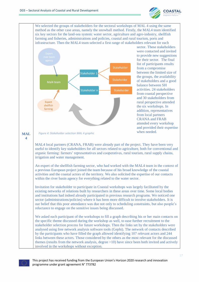
We selected the groups of stakeholders for the sectoral workshops of MAL 4 using the same
method as the other case areas, namely the snowball method. Firstly, the MAL4 team identified six key sectors for the land-sea system: water sector, agriculture and agro-industry, shellfish
farming and fisheries, administrations and policies, coastal and rural tourism, ports and
infrastructure. Then the MAL4 team selected a first range of stakeholders relevant for each
sector. These stakeholders were contacted and invited
to provide new suggestions
for their sector. The final list of participants results
from a compromise
between the limited size of the groups, the availability
of stakeholders and a good
balance between SH
activities. 24 stakeholders from coastal perspective
and 30 stakeholders from
rural perspective attended the six workshops. In
addition, representatives
from local partners CRANA and FRAB
attended every workshop
and provided their expertise
when needed.
MAL4 local partners (CRANA, FRAB) were already part of the project. They have been very useful to identify key stakeholders for all sectors related to agriculture, both for conventional and
organic farming: farmers’ representatives and cooperatives, rural tourism, rural supply chains,
irrigation and water management.
An expert of the shellfish farming sector, who had worked with the MAL4 team in the context of
a previous European project joined the team because of his broad knowledge of the coastal
activities and the coastal actors of the territory. We also solicited the expertise of our contacts within the river basin agency for everything related to the water sector.
Invitation for stakeholder to participate in Coastal workshops was largely facilitated by the existing networks of relations built by researchers in these areas over time. Some local bodies
and institutions had indeed already participated in previous research programs. We noticed one
sector (administrations/policies) where it has been more difficult to involve stakeholders. It is
our belief that this poor attendance was due not only to scheduling constraints, but also people’s reluctance to engage on the sensitive issues being discussed.
We asked each participant of the workshops to fill a graph describing his or her main contacts on the specific theme discussed during the workshop as well, to ease further recruitment to the
stakeholder selection process for future workshops. Then the links set by the stakeholders were
analysed using free network analysis software tools (Gephi). The network of contacts described by the participants who have filled the graph allowed identifying 107 relevant actors and 244
links between these actors. Those considered by the others as the most relevant for the discussed
themes (results from the network analysis, degree >10) have since been both invited and actively
involved in the workshops without exception.
Figure 4: Stakeholder selection MAL 4 graphic
This project has received funding from the European Union’s Horizon 2020 research and innovation programme under grant agreement N° 773782
18
D03 – Sectoral Analysis of Coastal and Rural Development
MAL
5
The Romanian MAL includes 2 core partners and 2 actor partners: - two research institutes –
INCDTM and ICEADR; and two Local Action Groups (LAG)- Asociatia GAL Delta Dunarii (GAL DD) and Asociatia GAL Dobrogea Centrala (GAL DC). INCDTM is specialised in
coastal and marine Environment while ICEADR’s main activity research on agricultural
economy and rural development. Both are involved in organizing stakeholders workshops
regularly, facilitating the exchange of ideas and discussions. The actor partners are local action groups, and not research institutes. LAGs operate as territorial management unit at subregional
level for National Rural Development Plan 2014-2020. In this project, LAGs are bringing in
expertise on public-private collaboration and rural development and a local network. They were involved in identification of stakeholders throughout their own collaborators network. The
cornerstone in selection of COASTAL stakeholders was identifying organisations and
individuals who have an interest in the project outcome based on these networks.
An invitation for participation was sent to this extended list of stakeholders, based on their level
of influence, or level of interest. Part of them belonged to core groups of traditional collaborators
from current ongoing activities organized by both MAL Co-leaders. Another part of the list belonged to newly identified actors that could bring added value to the project development and
had expressed an interest in the project to the facilitators. The first contact for the known
stakeholders was established by phone call, followed by official invitation send by e-mail.
It was not difficult to find stakeholders given the previous experience of the Partners in
organising similar events, such as workshops, roundtables and scientific symposiums. Of course, stakeholders’ fatigue was still a reality, and it was sometimes difficult to find a common
timetable for all stakeholders that were preferable to involve, but, eventually, we managed to
bring them all together.
MAL
6
MAL 6 local actor partners include FECOAM, one of the biggest farmers association in Murcia, Spain, and CARM, the Environmental Department of the Regional Government of
Murcia. Each of these actor partners attended their respective sectoral workshop (agriculture and
administrations respectively), as well as the later multi-actor workshop (D04) and helped identify most relevant and representative stakeholders for the workshops. CSIC, as
research partner in the project, has a long-standing record of research projects in the region that
has resulted in an existing and large network of contacts in research and beyond that also greatly
facilitated the stakeholder selection process.
For each sector the most relevant entities and actors were identified based on their participation
in previous projects related to the Mar Menor lagoon, their social media activity, their relevance as policy makers (local, regional and national authorities), scientific-technical advisers
(universities, research centers and consulting companies), SMEs and big companies (agriculture,
tourism, etc.), civil society organizations (local population associations, NGOs). The snowball
technique was used to identify relevant entities and actors after an initial list was compiled in collaboration between CSIC, FECOAM and CARM, always trying to identify rural and
coastal representatives that could speak on behalf of a larger group.
The environmental sector was convened to the first workshop, including
researchers (social scientists, economists, marine and terrestrial ecologists, hydrologists,
agronomists, etc.), NGOs (local and regional), and environmental consulting companies. To the second workshop the agricultural sector was convened, including farmers’
associations, SMEs related to agricultural technologies, representatives of irrigation
communities, and Think Tanks related to agriculture. The public administrations sector was
convened to the third workshop, including entities working at different scales and realms, such as the Segura River Basin Authority (CHS), the General Directorate (GD) of Natural
Environment, the Territorial Planning Office, one representative from a city hall, the Spanish
Government General Directorate of the Coasts. The fishermen and salt pans sector was convened to the fourth workshop. However, fishermen were not available and were
This project has received funding from the European Union’s Horizon 2020 research and innovation programme under grant agreement N° 773782
19
D03 – Sectoral Analysis of Coastal and Rural Development
represented by small companies that work with them, together with representatives from saltpans
facilities. The touristic sector was convened in the fifth workshop, including representatives from nautical stations, sailing and diving federations and accommodation and restaurant
owners. The local population sector was convened to the sixth workshop,
including representatives of schools, as well as coastal and rural neighborhood associations.
It was not very difficult to find relevant stakeholders to any of the workshops because of the
long experience in the study area working in several projects with different stakeholders and
because most of them had already engaged in previous participatory activities organized by other projects in relation to the Mar Menor lagoon. Moreover, due to the recent dramatic
developments related to the ecological collapse of the lagoon there was a lot of public attention
and interest for the topic.
However, stakeholder fatigue was still an issue since in the same period many events were
organized by different institutes. It was difficult to receive positive responses to participate in the
workshops since most of them had to spend half a day of work or they claimed that they had already participated in similar initiatives before. A total of 260 stakeholders were invited to the
sectoral workshops, of which 42 attended the sectoral workshops (16% of positive response).
3.1.2 Mental Mapping
The main purpose of the sector workshops is to engage stakeholders in an open discussion, aimed at identifying the main issues, opportunities, obstacles and solutions in the context of land-sea interaction and their own
sector or field of expertise (tourism, farming, water management, spatial planning). The mental mapping refers
to the graphical representation of the issues brought forward by the workshop participants, linking the elements mentioned. Causality between key variables is an important aspect of the mental maps (sometimes referred to
as ‘mind maps’). This is not exclusive, other dependencies between issues (hierarchical, examples) may be
included.
3.1.2.1 Vensim
Several user-friendly software platforms are available for the design, testing and application of System
Dynamics (SD) models (Sterman 2000): Stella®, VenSim®, PowerSim®, ExtendSim®
During the project kickoff meeting the decision was taken to use VenSim® for the mental mapping in WP1
and SD modelling in WP4. VenSim® has been developed by Ventana Systems and a freeware version is available online (https://vensim.com/free-download/). VenSim was chosen because of the familiarity of the
key partners with the software, the user-friendliness, and the free license provided. The standard version used
by the project partners is VenSim PLE (Personal Learning Edition), which has most of the features needed for the mental mapping activities discussed in this report, and the SD modelling discussed in deliverable D12 (Kok
and Viaene 2018).
VenSim PLE Plus has some additional features at low cost (such as data i/o and tools for sensitivity analysis). VenSim Model Reader is a runtime (read-only) version of the software, which can be useful for exchanging
models with stakeholders and end-users. The functionalities provided in VenSim PLE allow plug-and-play
construction of mental maps by adding variables, issues and the linkages between them in an interactive session (Figure 5).

This project has received funding from the European Union’s Horizon 2020 research and innovation programme under grant agreement N° 773782
20
D03 – Sectoral Analysis of Coastal and Rural Development
Figure 5: Vensim PLE Plus interface showing an example of a mental map (http://vensim.com)
3.1.2.2 Drivers
The project kickoff meeting in June 2018 was used to fine tune the practical implementation of the sector
workshops, including the initialization of the mental mapping. To set the scope the workshop participants
were to be informed about the project objectives and outcomes, as well as the relevance for their own activities.
The Multi-Actor Labs were instructed to use a similar setup for the workshop start-up, with a selection of seven main themes or ‘drivers’ (Figure 6) that were decided upon during this meeting. These drivers were
decided upon as those that would most affect both coastal and rural economies as well as their interaction.
Water was related to both quality and quantity, saline and fresh, and pollution thereof – all of which affected all stakeholders, from urban dwellers to farmers to fishers. Human consumption pattern was another driver
that was considered important, though there were some discussions around the semantics around it. The
emphasis was on how the middle class is growing globally, and as such, the demand for more products is
increasing as well. Some of the participants felt that the word “Lifestyle” would encompass more, as it would bring in connotations of millennials, smartphones, urbanization, organic food etc. that all are results of changes
in human consumption patterns, and simultaneously have an effect on many stakeholder groups. Regulations
and policy are natural drivers in any system and there was not much discussion around it beyond what level of regulation we should concentrate on.
We agreed that this would be something driven by the stakeholders and what their perceptions were of this driver. Temperature is another given, though some of the MAL leaders considered using the driver “climate
change” instead. This is up to the group in question, since these drivers are conversation starters and not
variables per se. Human migration was chosen since this is an era in which we see a large movement of people
and a lot of challenges associated with this. With human migration, we did not consider only immigration from other nations, but also migration within a nation, often from rural to coastal areas. Pollution was included as
well, since many sectors struggle with this, both in terms of being affected by it and being blamed for it – and
as such it was considered an important topic to bring up. Finally, infrastructure was the last driver we considered important enough to reach the “top level” in our mind maps. This also includes a lot, including
roads, public transport, airports, internet, canals etc.
The final list was the following:
1. Water;
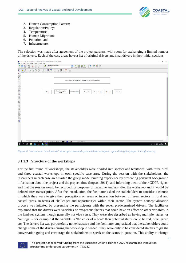
This project has received funding from the European Union’s Horizon 2020 research and innovation programme under grant agreement N° 773782
21
D03 – Sectoral Analysis of Coastal and Rural Development
2. Human Consumption Pattern;
3. Regulation/Policy; 4. Temperature;
5. Human Migration;
6. Pollution; and 7. Infrastructure.
The selection was made after agreement of the project partners, with room for exchanging a limited number
of the drivers. Each of the case areas have a list of original drivers and final drivers in their initial sections.
Figure 6: Vensim user interface with start up screen and system drivers as agreed upon during the project kickoff meeting.
3.1.2.3 Structure of the workshops
For the first round of workshops, the stakeholders were divided into sectors and territories, with three rural
and three coastal workshops in each specific case area. During the session with the stakeholders, the
researchers in each case area started the group model building experience by presenting pertinent background
information about the project and the project aims (Impson 2011), and informing them of their GDPR rights,
and that the session would be recorded for purposes of narrative analysis after the workshop and it would be
deleted after transcription. After the introduction, the facilitator asked the stakeholders to consider a context
in which they were to give their perceptions on areas of interaction between different sectors in rural and
coastal areas, in terms of challenges and opportunities within their sector. The system conceptualization
process was initiated by presenting the participants with the seven predetermined drivers. The facilitator
explained that the drivers were variables or exogenous factors that could have an effect on other variables in
the land-sea system, though generally not vice versa. They were also described as having multiple ‘states’ or
‘settings’ – for example if the variable is ‘the color of a boat’ then potential states could be red, blue, green
etc. The drivers list was purposefully not exhaustive and the facilitator emphasized that the stakeholders could
change some of the drivers during the workshop if needed. They were only to be considered starters to get the
conversation going and encourage the stakeholders to speak on the issues in question. This ability to change
This project has received funding from the European Union’s Horizon 2020 research and innovation programme under grant agreement N° 773782
22
D03 – Sectoral Analysis of Coastal and Rural Development
or modify the drivers speaks of the benefits of this method, since it allows the inclusion of additional drivers
through facilitating direct group input.
The drivers were either posted on the board with coloured "sticky" notes or written on the board directly. The
stakeholders were then encouraged to identify the causal interrelationships and connections between these
variables in the form of directional step-by-step associations to guide the brainstorm session. This could, for
example, be connections that highlighted that water quality in the olive oil industry (variable ‘A’) was affected
by the number of tourists in the area because of pollution (variable ‘B’). It could also for example be that the
amount of fish that an aquaculture company was allowed to have in a pen (variable ‘C’) directly affected the
areas available for fisheries (variable ‘D’). The result of this variable identification and step-wise
interconnection process, which took between one to two hours usually – and sometimes more if the
stakeholders were very engaged. This resulted in a broad system conceptualization or group mental model –
also referred to as sector mind maps. These mind maps were graphical representations of the problems,
solutions and opportunities and interconnections as perceived by the stakeholders during the sector workshops,
such as those of the sectors for Nature, Agriculture, Spatial Planning, Blue Industry, Fisheries & Aquaculture
and Tourism (taking the example of the Belgian Multi-Actor Lab). This model represented how this particular
group of stakeholders collectively viewed the causal pathways between variables at that given time and
identified by closer inspection where problems, possible solutions and conflict points, obstacles and
opportunities for development could be located.
3.1.2.4 Post workshop narrative analysis
After the workshops, the research team used the Vensim® software to visualize the results graphically in
combination with analyzing the narratives from the workshop. We used the ‘causes trees’ and ‘uses trees’
diagnostic tools within the program to visualize the degree of connectivity between variables of the group
conceptualization. When needed, we coupled the visualization process with a narrative analysis from the
recordings taken during the workshop. Narratives can be described as "discourses with a clear sequential order
that connect events in a meaningful way for a definite audience and thus offer insights about the world and/or
people's experiences of it" (Hinchman and Hinchman 1997). To get the narratives from the transcription of the
sound recordings from the workshop, we can concoct one's own narrative; that of the researcher's interpretation
of what was discussed during the workshop, rewritten from its original form. Another option is to analyze the
narratives as special kinds of texts, in and of themselves, using conversation analysis (Czarniawska 2004).
You can also use a combination of the two, where you interpret the narratives within the context of the
workshop setting, and other times treating the text literally as it related to the output of the systems thinking
analysis from the workshop. The most important role of the narrative is the knowledge content that can be
extracted that might be missed from the model conceptualization process alone. This is in line with Elliott's
account of narratives as being instrumental because "...internal validity is...thought to be improved by the use
of narrative because participants are empowered to provide more concrete and specific details about the topics
discussed and to use their own vocabulary and conceptual framework to describe life experiences." (2005).
This project has received funding from the European Union’s Horizon 2020 research and innovation programme under grant agreement N° 773782
23
D03 – Sectoral Analysis of Coastal and Rural Development
4 The General Data Protection Regulation
As WP leader and participant in the data collection process of COASTAL, Partner 4 (SINTEF) was required
to notify the National Data Protection Official for Research when processing personal data in the same way as
for data collection in Norway. The research conducted in the third country (i.e. Norway) is limited to (1) briefings of the partners/persons coordinating the multi-actor sessions and (2) post-processing of these data. It
can be legally carried out in at least one EU Member state. Supporting evidence will be kept by the Coordinator
and provided upon request.
COASTAL emphasizes that the regulations in Norway are in line with The European Code of Conduct for
Research Integrity as well as the cross-cutting issue of Horizon2020 on Responsible Research and Innovation. The regulations are also in line with Directive 95/46/EC, which specifies that personal data must be processed
according to certain principles and conditions that aim to limit the impact on the persons concerned and ensure
data quality and confidentiality. This is also in line with the ethical standards and guidelines of
Horizon2020. Data transfers within the EU/EEA are not subject to specific requirements (i.e. specific authorisations or other restrictions), and COASTAL therefore only need to comply with the general
requirements of Directive 95/46/EC.
The new EU Regulation 2016/6791 builds on the earlier General Data Protection Regulation (95/46/EC) or
GDPR and is aimed at ensuring the protection of natural persons with regard to the processing of personal
data. The main goal is to increase the accountability and transparency of the data processing, and data protection rights of individual persons. It is not referring to the use and/or protection of research data (see
COASTAL deliverable D26 – Data Management Plan). Personal data refers to information corresponding to
a natural person (a so-called ‘data subject’) who has been or can be identified directly, or indirectly. In
particular this will be the case if identifiers such as names, addresses, id numbers etc. are used. It also refers to person-specific factors such as gender, physical, mental, social-economic and cultural characteristics. The
data processing refers to the collection, recording, storage, adaptation, disclosure, forwarding, destruction,
and all uses of the data.
Important to keep in mind are a few key principles:
• The personal data should be adequate, relevant and limited for the intended use, rather than what data
are desirable to collect and process
• Accountability of the data processing and data replaces a compliance-based approach (record keeping)
• It is mandatory to appoint an independent data protection officer, who will provide advice and can evaluate the data processing against compliance with the GDPR
• The rights of the data subjects are strengthened, for example natural persons should give explicit
consent before personal data can be collected, and the data can be removed upon request
In addition, two general approaches are allowed in the GDPR and useful for projects such as COASTAL:
• Anonymisation: this means that personal data are processed in a way that makes the risk of identification
negligable. For example, interview data can be collected without storing the names, gender, age of the data subjects responding to the survey
• Pseudo-anonymisation: here direct identifiers such as names and addresses are replaced by indirect identifiers
(for example numbers) in the data set. A separate data set, known as the ‘key’, is used to link the indirect
identifiers to the direct identifiers
1 https://eur-lex.europa.eu/legal-content/EN/TXT/PDF/?uri=CELEX:32016R0679&from=EN

This project has received funding from the European Union’s Horizon 2020 research and innovation programme under grant agreement N° 773782
24
D03 – Sectoral Analysis of Coastal and Rural Development
Limited use was made of personal data in COASTAL for the purposes of the sector workshops, focused
primarily on audio recordings which were temporarily kept during the processing of intermediate results of these co-creation activities until these had been analysed for the purposes of this deliverable.
To ensure compliance with the EU Regulation 2016/679 on the protection of natural persons with regard to
the processing of personal data during the sector workshops, COASTAL took the following actions:
• all project partners have been informed and reminded regularly of the obligations with respect to
the collection and processing of personal data related to EU Regulation 2016/679
• effort have been made by means of technical and organisational measures to ensure the collection and
processing of personal data are transparent, lawful, and limited to the purposes specified to the data subjects (natural persons) following (EU Reg. 2016-679 – Art. 28)
• a central, independent Data Protection Officer (DPO) has been appointed for the duration of the project
to monitor compliance with the Regulation and provide advice to the project consortium members (EU
Reg. 2016-679 – Art. 35)
• pseudonymisation will be used to reduce the risks to the data subjects and assists the data controllers
and processers with their obligations with regard to the Regulation (EU Reg. 2016-679 – Art. 32)
This project has received funding from the European Union’s Horizon 2020 research and innovation programme under grant agreement N° 773782
25
D03 – Sectoral Analysis of Coastal and Rural Development
5 Case areas The following table gives an overview of the case areas that COASTAL held initial sectoral workshops in (Task 1.1), and
where the multi-actor labs will be held in subsequent workshops (Task 1.2). Sections 5.1-5.6 will detail the results of each of the case areas.
Table 2: Overview of case areas, respective stakeholders and key issue areas
Country European Sea Specific case Coastal
stakeholders
Rural
stakeholders
Key issue areas
Greece Eastern
Mediterranean
Region
SW Messina 30 27 Olive-oil production and
related industry, fishing (sea
and lagoon), coastal tourism
Belgium Southern
North Sea
Belgian
North Sea
(BNS),
Coastal Zone
and
hinterland
(Province West
Flanders)
30 29 Coastal pressure; landscape
fragmentation, inland
salination, fresh water
availability, transport
infrastructure, offshore energy
& innovation, aquaculture,
coastal flood defense, multifunctional use of
space, coordinated spatial
planning.
Sweden Baltic Sea Norrström 31 29 Water quality; Baltic
ecosystem health ; Investments,
Land price, Recreation/Tourism; Behaviour
choices, Societal values;
Seasonal population variability;
Power/Influence structure.
Romania Black Sea Danube Mouths
36 61 Bureaucracy Infrastructure
Workforce
Social protection
Health and education
France Atlantic region Charrente
River Basin
24 30 Water quality and quantity;
Agriculture and shellfish farming development;
Infrastructure development
Spain Western
Mediterranean
Mar Menor
Coastal
Lagoon
35 33 (Water) water scarcity;
(Environmental challenges)
lagoon ecosystem health;
(Regional economy) Investments, Land price,
Recreation/Tourism; (Life
style) Societal values;
(Population) Seasonal
population variability; (Social
challenges) Governance.
5.1 Greece - South West Messina (Eastern Mediterranean Region)

This project has received funding from the European Union’s Horizon 2020 research and innovation programme under grant agreement N° 773782
26
D03 – Sectoral Analysis of Coastal and Rural Development
5.1.1 Executive summary
The case study of SW-Messinia, Peloponnese, Greece, is a representative example of an interlinked coastal-inland area in the Eastern Mediterranean region. Agriculture (olive groves mainly) and coastal tourism are the
two major economic activities in the area, while fisheries is another important aspect of primary economic
sector for the area. Besides the presence of olive groves, the land cover consists of a variety of Mediterranean
habitats included in the reference list of the Natura2000 initiative and several important cultural sites are
scattered within the study area.
The six sectoral workshops were co-organised by HCMR and NEO/SU and were held at the premises of
Navarino Environmental Observatory (NEO), in Messinia Greece, from July to October 2018. In total, 57
stakeholders (27 rural and 30 coastal) and 10 MAL representatives attended the workshops. During the workshops, the participants showed enthusiasm and were happy to be given the opportunity to meet and discuss
about common issues within their sector. Similar discussions have never happened before though there is a
clear need for discussion and debate on these topics. As such, the workshops already at this stage represent a
key outcome from COASTAL project.
Participants from all sectors were aware of climate change impacts and could describe how it affects their lives and livings. Agriculture and industries related to olive oil, and in part tourism as well, were the sectors mainly
linked to water issues in that these affect fishing, the environment as well as the local population. Local
population growth was furthermore strongly linked to the creation of new job opportunities in the tourism
sector and as a side effect of the economic crisis.
The participants could furthermore identify the potential of further development in and between their sectors
and issues linking to business opportunities and innovations were discussed during the workshops. Smart
agriculture, re-use of different types of by-products from the olive-oil farming and innovative tourism solutions
were brought up by the participants as possible solutions, and these could be major drivers for the sustainable development of Messinia region in the future. Nonetheless, at present such initiatives are put on hold due to
lack of infrastructure and issues with legislation. The participants also felt that the lack of communication and
cooperation primarily within the sectors and secondarily among them, together with issues linked to the lack of education/awareness/mentality of the local population, were major obstacles to advances in local economic
development.
5.1.2 Background
Agriculture, mainly represented by olive trees, and coastal tourism are the two major economic activities in
South-Western Messinia, Greece. Tourism is expanding and goes hand in hand with infrastructure development such as hotels, roads and airports. This sector as such can provide both opportunities for
diversified livelihoods, but also increases the pressures on the environment and cultural sites. Coastal areas are
also affected by agrochemicals, soil erosion, solid waste landfills, and wastewaters. Climate change is expected to lead to more frequent occurrence of extremes (e.g. extended heat waves, droughts, floods) and decrease the
availability of freshwater in this area. This in turn increases the risk for saltwater intrusion into coastal wetlands
and aquifers. There are also plans for offshore oil and gas exploration in the area that could have implications
for the area’s rich coastal biodiversity.
The case study of SW-Messinia, Peloponnese, Greece, is therefore a representative example of an interlinked coastal-inland area in the Eastern Mediterranean region, well situated to represent many islands and coastal
areas of the region. It is comprised of several important cultural sites and Mediterranean habitats included in
the reference list of the Natura 2000 initiative. Based on the different workshops, the local Multi-Actor Lab, with the exchanges with the COASTAL partners, the results will include the development of a number of
alternative strategies for local economic development that will allow a diversification and strengthening of a
sustainable local economy, while minimizing the impact on the Natura 2000 sites and enhancing ecosystem
services. Long-term planning for tourism and agriculture will also have to take into account the area´s and the
This project has received funding from the European Union’s Horizon 2020 research and innovation programme under grant agreement N° 773782
27
D03 – Sectoral Analysis of Coastal and Rural Development
population´s resilience to the effects of climatic changes through consultation with the expertise and experience
of local stakeholders.
5.1.3 Drivers
The selected drivers deviated somewhat from the original drivers decided on during the kick off meeting
(Figure 6), though for the most part semantically. For example, rather than using “Human consumption
pattern”, the driver “Economy” was used (see Table 3). The two only drivers that were left as originally
discussed were “Water” and “Infrastructure”. Given that drivers primarily serve as vehicles for starting the discussion, this is unproblematic, and in fact is good. This is because drivers that are adapted to the realities of
the stakeholder group in question are more likely to elicit the good discussions that are necessary for conceptual
maps to have the depth of information needed.
Table 3: Original vs. Workshop drivers used in the Greek case study
Original drivers Workshop drivers
Water Water → Water quality (for fisheries)
Human Consumption Pattern Economy → Economic crisis
Regulation policy Legislation → Policy/legislation (for institutions and NGOs)
Temperature Climate change
Human migration Population
Pollution Environment
Infrastructure Infrastructure
Economy was however approached not under the umbrella om human consumption patterns, but rather under
the prism of the Economic Crisis, which has affected and still affects all sectors in the area - and in Greece in general – and could become a challenge in other European countries in the future. Thus, economy was later
replaced by “economic crisis” in all workshops. Water and legislation changed to water quality (for the
fisheries sectoral workshop (see 5.1.4.3)) and policy/legislation (for institutions and NGOs (see 5.1.4.6)) in
two of the workshops.
5.1.4 Stakeholder workshops and Causal loop diagrams
All the sectoral workshops were co-organised by HCMR and NEO/SU and were held at the premises of
Navarino Environmental Observatory (NEO), in Messinia Greece, during the period of July-October 2018. A total number of 57 stakeholders and 11 MAL representatives attended the six workshops, based on NEO/SU
networking and additional contacts from the different MAL partners, and especially CVKKF (see Table 4).
Table 4: Sectoral workshops’ types, participants’ links to the workshop and the total number of participants in each of the Greek
workshops.
Sector linked to Participants linked to Number of
participants
Agriculture Olive-oil producers and agronomists 16
Agriculture Olive- and pomace-mill extraction and management of by-products 11
Fishing Fishing both in transitional and coastal waters 12
Tourism Hotels, local enterprise (restaurants, gift shops), outdoor activities 13
Administration/
local authorities
Municipalities, regional government, water management, forestry,
archaeology
15
Institutions/NGOs SU, HCMR, local universities and foundations, NGOs for nature
conservation
13
Four sectoral workshops were organized inviting representatives from the basic economic activities of the area (agriculture, fishing, tourism), and one inviting representatives from the public sector. The last workshop was
This project has received funding from the European Union’s Horizon 2020 research and innovation programme under grant agreement N° 773782
28
D03 – Sectoral Analysis of Coastal and Rural Development
held with representatives from institutions, universities and NGOs adding knowledge and expertise. In all the
workshops, the participants would be presented with the pre-selected drivers (water, climate change, infrastructure, environment, legislation, economy, population) and guide themselves into the discussions with
the help of the facilitator.
5.1.4.1 Themes and structure of workshop 1 - Agriculture
The first sectoral workshop for the Messinia case study took place on the 26th of July 2018. During this, the
theme was agricultural from the perceptions of local farmers and agronomists. This is because olive-oil production is one of the main economic activities in the area, interacting with the natural environment, fishing
and tourism. In total, 16 people (11 stakeholders and 5 MAL representatives) attended the workshop. The
workshop took place in a friendly atmosphere, whereby most of the farmers participated and discussed in a constructive way. However, they expressed some doubts about the project, the utility of the mental mapping,
the suggested outcomes, the impact of the project on their activity, as well as the continuity of the project.
Olive-oil producers in SW Messinia are either full- or part-time farmers who produce olive-oil to increase their
income. All the people present at the workshop recognized the potential water quality degradation in small
rivers and the coastal zone due to the use of agrochemicals (nutrients, pesticides). Furthermore, because irrigation of olive trees is mainly based on groundwater resources, the participants highlighted the lack of an
adequate irrigation network in that the current network only covers approximately 20% of the land.
There was consensus though that actual water availability is not an important issue for olive tree cultivation,
but it is a constraint to agricultural innovation, such as growing innovative crops. They also indicated that the frequency of watering and the volume of water needed for irrigation could be even higher in the coming years
due to Climate Change, and the lack of Infrastructure, such as irrigation networks. This could in turn add
pressure to the groundwater resources. Nonetheless, they pointed out that new Legislation has led to a decrease
in the number of new wells in the area. However, the participants also agreed that legislation is inadequately
applied and, in many cases, appears to have gaps and overlaps.
Climate Change as a driver was also linked to new diseases, which the stakeholders stated impacted olive-oil
production (both the quality and quantity of olive-oil). Olive oil production was also affected by the Economic
crisis and has led to small-scale abandonment of agricultural lands. On the other hand, the crisis has also driven people to return to their villages, adding to local Population, which in turn is linked to labor work and changes
in lifestyle. Currently, the economic situation and taxation in Greece, remain an obstacle for famers in terms
of investments in new infrastructure, such as the development of agro-tourism facilities.
Furthermore, the value of olive oil among the local producers is quite underestimated currently. As indicated
by the participants, a large percentage of the oil production in Messinia is exported bulk, without any treatment. Even though the price is lower, this situation creates some security to farmers, and especially to those who are
not professionals but produce big volumes each year. Most of the olive-oil producers attending the workshop
were full-time farmers and raised the issue of how part-time agriculture affects their sector.
The participants also indicated that compared to other olive-oil producing countries in Europe, Greece produces only small volumes of olive oil but of high quality and in a more traditional way (especially during
harvesting as the Greek landscape prevents the use of big machinery in the farm). In fact, the area is producing
extra virgin olive oil (PDO protected) and the farmers feel that the only way to compete the global market is
by investing in quality and authenticity.
However, land fragmentation (Messinia agricultural sector is characterized by small farmer’s properties) is a constraint for business development, as individual farmers cannot meet the need in volumes of the global
market. Branding and marketing of the local PDO variety, requires farmers to collaborate with each other, but
unfortunately, as the participants indicated, there is a huge lack of cooperation among them and they don’t see
how things could change in the future.
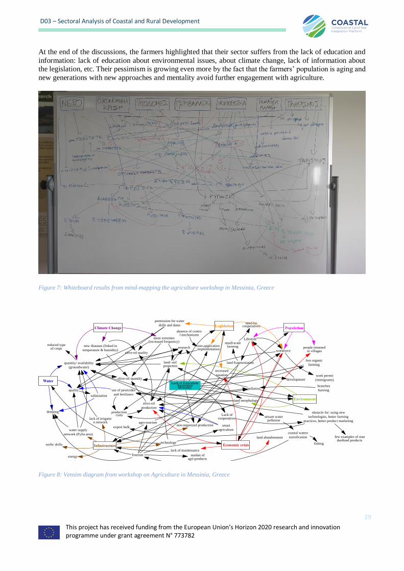
This project has received funding from the European Union’s Horizon 2020 research and innovation programme under grant agreement N° 773782
29
D03 – Sectoral Analysis of Coastal and Rural Development
At the end of the discussions, the farmers highlighted that their sector suffers from the lack of education and
information: lack of education about environmental issues, about climate change, lack of information about the legislation, etc. Their pessimism is growing even more by the fact that the farmers’ population is aging and
new generations with new approaches and mentality avoid further engagement with agriculture.
Figure 7: Whiteboard results from mind-mapping the agriculture workshop in Messinia, Greece
Figure 8: Vensim diagram from workshop on Agriculture in Messinia, Greece
Water
Legislation
Environment
Climate Change Population
Infastructure Economic crisis
quality
quantity/ availability
(groundwater)
drinking
lack of irrigation network
salinization
reduced typeof crops
more extremes(increased frequency)
new diseases (linked to
temperature & humidity)
land/ soilproperties
olive-oil quantity
olive-oil quality
water supply
network (Pylia area)
land morphology
pollution
permission for water
drills and dams
olive-oil
production
Lack of Education/Awareness/Mentality
Tourism
technology
energy
wells/ drills
non-organized production
land fragmentation
Lifestyle
export bulk
Lack ofcooperatives
non-application/
implementation
lack of maintenance
land abandonment
small-scalefarming
need forcooperatives
smart
agriculture
use of pesticides
and fertilizers
productioncosts
stream waterpollution
coastal waters
eutrofication
fishing
less organic
farming
obstacle for: using new
technologies, better farming
practices, better product marketing
increased
taxation
workforcepeople returned
to villages
work permit
(immigrants)
agro-tourism
market ofagri-products
branches
burning
research
development
few examples of standardized products
absence of control mechanisms
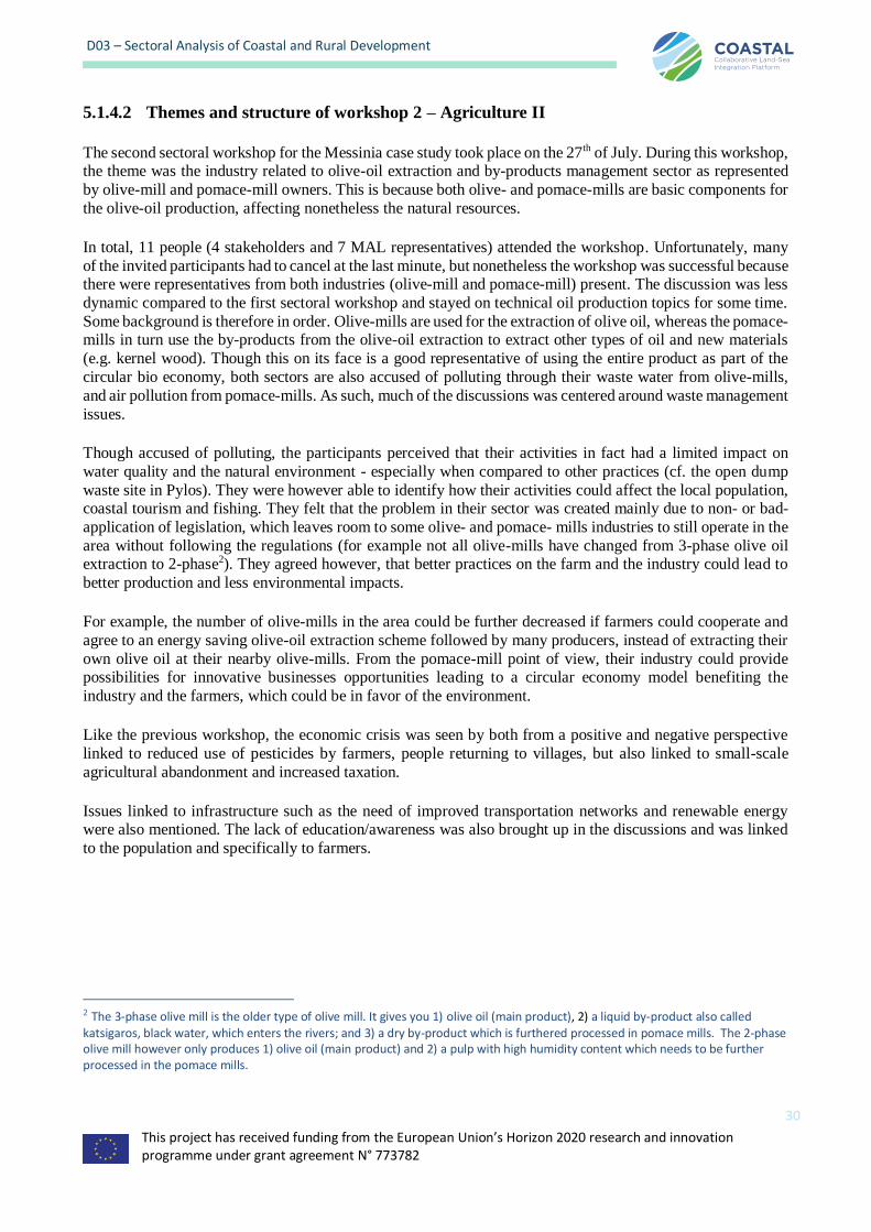
This project has received funding from the European Union’s Horizon 2020 research and innovation programme under grant agreement N° 773782
30
D03 – Sectoral Analysis of Coastal and Rural Development
5.1.4.2 Themes and structure of workshop 2 – Agriculture II
The second sectoral workshop for the Messinia case study took place on the 27th of July. During this workshop, the theme was the industry related to olive-oil extraction and by-products management sector as represented
by olive-mill and pomace-mill owners. This is because both olive- and pomace-mills are basic components for
the olive-oil production, affecting nonetheless the natural resources.
In total, 11 people (4 stakeholders and 7 MAL representatives) attended the workshop. Unfortunately, many
of the invited participants had to cancel at the last minute, but nonetheless the workshop was successful because there were representatives from both industries (olive-mill and pomace-mill) present. The discussion was less
dynamic compared to the first sectoral workshop and stayed on technical oil production topics for some time.
Some background is therefore in order. Olive-mills are used for the extraction of olive oil, whereas the pomace-mills in turn use the by-products from the olive-oil extraction to extract other types of oil and new materials
(e.g. kernel wood). Though this on its face is a good representative of using the entire product as part of the
circular bio economy, both sectors are also accused of polluting through their waste water from olive-mills,
and air pollution from pomace-mills. As such, much of the discussions was centered around waste management
issues.
Though accused of polluting, the participants perceived that their activities in fact had a limited impact on
water quality and the natural environment - especially when compared to other practices (cf. the open dump
waste site in Pylos). They were however able to identify how their activities could affect the local population, coastal tourism and fishing. They felt that the problem in their sector was created mainly due to non- or bad-
application of legislation, which leaves room to some olive- and pomace- mills industries to still operate in the
area without following the regulations (for example not all olive-mills have changed from 3-phase olive oil extraction to 2-phase2). They agreed however, that better practices on the farm and the industry could lead to
better production and less environmental impacts.
For example, the number of olive-mills in the area could be further decreased if farmers could cooperate and
agree to an energy saving olive-oil extraction scheme followed by many producers, instead of extracting their
own olive oil at their nearby olive-mills. From the pomace-mill point of view, their industry could provide possibilities for innovative businesses opportunities leading to a circular economy model benefiting the
industry and the farmers, which could be in favor of the environment.
Like the previous workshop, the economic crisis was seen by both from a positive and negative perspective
linked to reduced use of pesticides by farmers, people returning to villages, but also linked to small-scale
agricultural abandonment and increased taxation.
Issues linked to infrastructure such as the need of improved transportation networks and renewable energy were also mentioned. The lack of education/awareness was also brought up in the discussions and was linked
to the population and specifically to farmers.
2 The 3-phase olive mill is the older type of olive mill. It gives you 1) olive oil (main product), 2) a liquid by-product also called katsigaros, black water, which enters the rivers; and 3) a dry by-product which is furthered processed in pomace mills. The 2-phase olive mill however only produces 1) olive oil (main product) and 2) a pulp with high humidity content which needs to be further processed in the pomace mills.
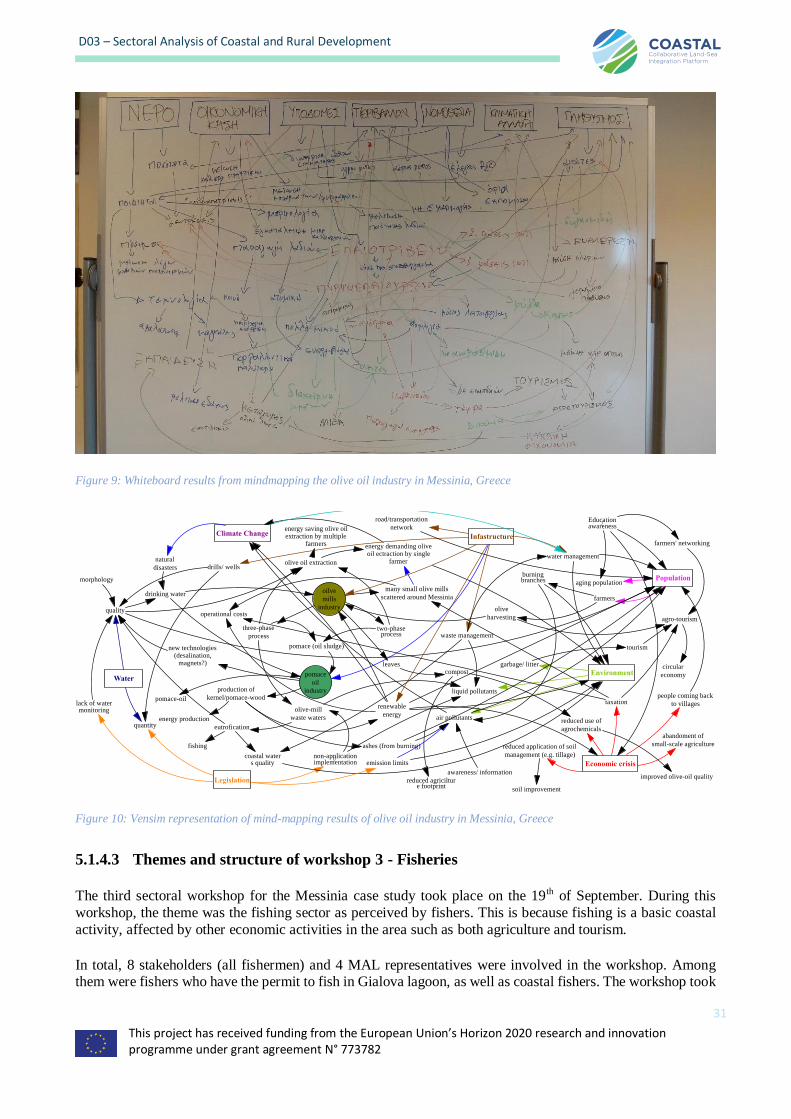
This project has received funding from the European Union’s Horizon 2020 research and innovation programme under grant agreement N° 773782
31
D03 – Sectoral Analysis of Coastal and Rural Development
Figure 9: Whiteboard results from mindmapping the olive oil industry in Messinia, Greece
Figure 10: Vensim representation of mind-mapping results of olive oil industry in Messinia, Greece
5.1.4.3 Themes and structure of workshop 3 - Fisheries
The third sectoral workshop for the Messinia case study took place on the 19th of September. During this
workshop, the theme was the fishing sector as perceived by fishers. This is because fishing is a basic coastal
activity, affected by other economic activities in the area such as both agriculture and tourism.
In total, 8 stakeholders (all fishermen) and 4 MAL representatives were involved in the workshop. Among them were fishers who have the permit to fish in Gialova lagoon, as well as coastal fishers. The workshop took
Water
Legislation
Environment
Climate Change
Population
Infastructure
Economic crisis
quality
quantity
drinking water
natural
disasters
morphology
lack of watermonitoring
new technologies(desalination,
magnets?)
oilve
mills
industry
pomace
oil
industry
energy demanding oliveoil ectraction by single
farmer
two-phaseprocess
three-phase
process
energy saving olive oilextraction by multiple
farmers
olive oil extraction
many small olive mills
scattered around Messinia
non-application/implementation
olive-mill
waste waters
eutrofication
coastal waters quality
fishing
pomace (oil sludge)
air pollutants
liquid pollutants
emission limits
drills/ wells
waste management
water management
road/transportation
network
leaves
awareness/ information
abandoment of
small-scale agriculture
reduced use of
agrochemicals
reduced application of soil
management (e.g. tillage)
soil improvement
garbage/ littercompost
reduced agricilture footprint
people coming back
to villages
aging population
farmers
olive
harvesting
tourism
agro-tourism
circular
economy
Education/awareness
farmers' networking
taxation
burningbranches
renewable
energy
production of
kernel/pomace-wood
energy production
ashes (from burning)
operational costs
improved olive-oil quality
pomace-oil
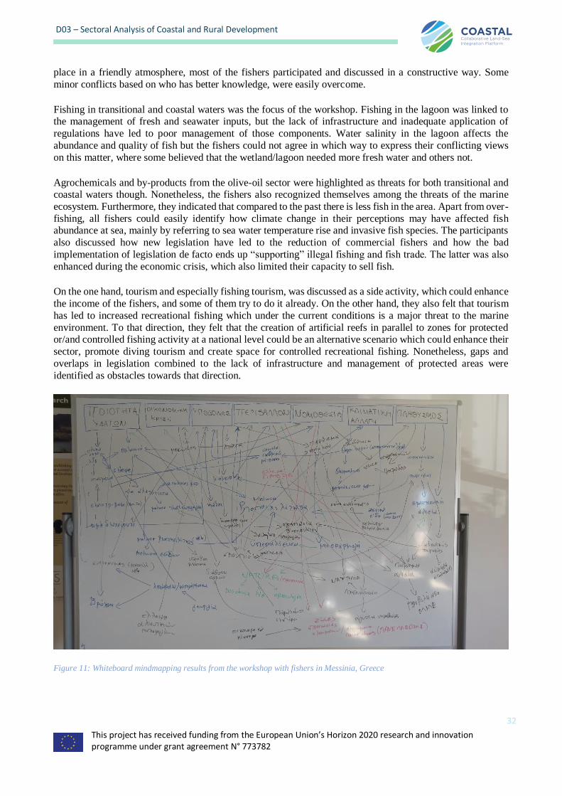
This project has received funding from the European Union’s Horizon 2020 research and innovation programme under grant agreement N° 773782
32
D03 – Sectoral Analysis of Coastal and Rural Development
place in a friendly atmosphere, most of the fishers participated and discussed in a constructive way. Some
minor conflicts based on who has better knowledge, were easily overcome.
Fishing in transitional and coastal waters was the focus of the workshop. Fishing in the lagoon was linked to the management of fresh and seawater inputs, but the lack of infrastructure and inadequate application of
regulations have led to poor management of those components. Water salinity in the lagoon affects the
abundance and quality of fish but the fishers could not agree in which way to express their conflicting views
on this matter, where some believed that the wetland/lagoon needed more fresh water and others not.
Agrochemicals and by-products from the olive-oil sector were highlighted as threats for both transitional and coastal waters though. Nonetheless, the fishers also recognized themselves among the threats of the marine
ecosystem. Furthermore, they indicated that compared to the past there is less fish in the area. Apart from over-
fishing, all fishers could easily identify how climate change in their perceptions may have affected fish abundance at sea, mainly by referring to sea water temperature rise and invasive fish species. The participants
also discussed how new legislation have led to the reduction of commercial fishers and how the bad
implementation of legislation de facto ends up “supporting” illegal fishing and fish trade. The latter was also
enhanced during the economic crisis, which also limited their capacity to sell fish.
On the one hand, tourism and especially fishing tourism, was discussed as a side activity, which could enhance
the income of the fishers, and some of them try to do it already. On the other hand, they also felt that tourism
has led to increased recreational fishing which under the current conditions is a major threat to the marine
environment. To that direction, they felt that the creation of artificial reefs in parallel to zones for protected or/and controlled fishing activity at a national level could be an alternative scenario which could enhance their
sector, promote diving tourism and create space for controlled recreational fishing. Nonetheless, gaps and
overlaps in legislation combined to the lack of infrastructure and management of protected areas were
identified as obstacles towards that direction.
Figure 11: Whiteboard mindmapping results from the workshop with fishers in Messinia, Greece
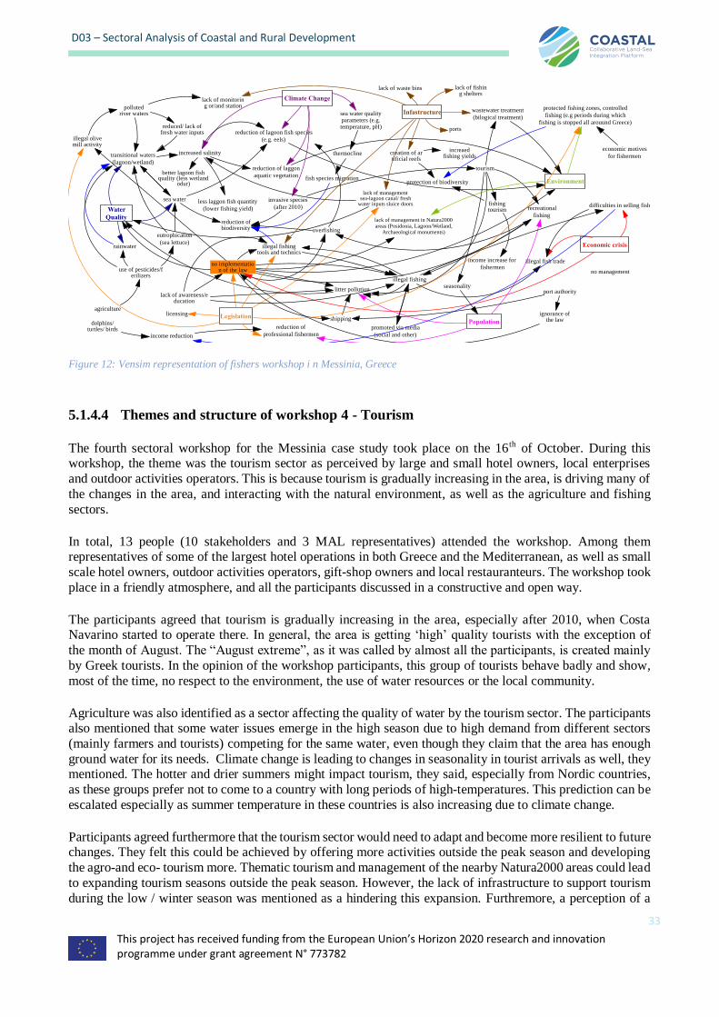
This project has received funding from the European Union’s Horizon 2020 research and innovation programme under grant agreement N° 773782
33
D03 – Sectoral Analysis of Coastal and Rural Development
Figure 12: Vensim representation of fishers workshop i n Messinia, Greece
5.1.4.4 Themes and structure of workshop 4 - Tourism
The fourth sectoral workshop for the Messinia case study took place on the 16th of October. During this workshop, the theme was the tourism sector as perceived by large and small hotel owners, local enterprises
and outdoor activities operators. This is because tourism is gradually increasing in the area, is driving many of
the changes in the area, and interacting with the natural environment, as well as the agriculture and fishing
sectors.
In total, 13 people (10 stakeholders and 3 MAL representatives) attended the workshop. Among them representatives of some of the largest hotel operations in both Greece and the Mediterranean, as well as small
scale hotel owners, outdoor activities operators, gift-shop owners and local restauranteurs. The workshop took
place in a friendly atmosphere, and all the participants discussed in a constructive and open way.
The participants agreed that tourism is gradually increasing in the area, especially after 2010, when Costa Navarino started to operate there. In general, the area is getting ‘high’ quality tourists with the exception of
the month of August. The “August extreme”, as it was called by almost all the participants, is created mainly
by Greek tourists. In the opinion of the workshop participants, this group of tourists behave badly and show,
most of the time, no respect to the environment, the use of water resources or the local community.
Agriculture was also identified as a sector affecting the quality of water by the tourism sector. The participants also mentioned that some water issues emerge in the high season due to high demand from different sectors
(mainly farmers and tourists) competing for the same water, even though they claim that the area has enough
ground water for its needs. Climate change is leading to changes in seasonality in tourist arrivals as well, they mentioned. The hotter and drier summers might impact tourism, they said, especially from Nordic countries,
as these groups prefer not to come to a country with long periods of high-temperatures. This prediction can be
escalated especially as summer temperature in these countries is also increasing due to climate change.
Participants agreed furthermore that the tourism sector would need to adapt and become more resilient to future changes. They felt this could be achieved by offering more activities outside the peak season and developing
the agro-and eco- tourism more. Thematic tourism and management of the nearby Natura2000 areas could lead
to expanding tourism seasons outside the peak season. However, the lack of infrastructure to support tourism
during the low / winter season was mentioned as a hindering this expansion. Furthremore, a perception of a
Water
Quality
Legislation
Environment
Climate Change
Population
Infastructure
Economic crisisrainwater
sea water
no management
transitional waters
(lagoon/wetland)
illegal olivemill activity
pollutedriver waters
reduced/ lack offresh water inputs
increased salinity
better lagoon fishquality (less wetland
odur)
less laggon fish quantity
(lower fishing yield)
reduction of lagoon fish species
(e.g. eels)
reduction of laggon
aquatic vegetation
lack of managementsea-lagoon canal/ fresh
water inputs sluice doors
agriculture
use of pesticides/ferilizers
eutrophication
(sea lettuce)
lack of monitoring or/and station
lack of waste bins
wastewater treatment
(bilogical treatment)
tourism
lack of fishing shelters
creation of artificial reefs
increaedfishing yields
protection of biodiversity
ports
reduction ofbiodiversity overfishing
invasive species
(after 2010)fishingtourism
income increase for
fishermen
litter pollution
shipping
illegal fishing
no implementation of the law
lack of awareness/education
recreational
fishing
sea water qualityparameters (e.g.temperature, pH)
thermocline
fish species migration
lack of management in Natura2000areas (Posidonia, Lagoon/Wetland,
Archaeological monuments)
seasonality
illegal fishingtools and technics
illegal fish trade
difficulties in selling fish
promoted via media
(social and other)
port authority
ignorance ofthe law
licensing
reduction of
professional fishermenincome reduction
dolphins/turtles/ birds
protected fishing zones, controlled
fishing (e.g periods during which
fishing is stopped all arouund Greece)
economic motives
for fishermen

This project has received funding from the European Union’s Horizon 2020 research and innovation programme under grant agreement N° 773782
34
D03 – Sectoral Analysis of Coastal and Rural Development
lack of education and awareness, as well as lack of cooperation among the locals, were again thoroughly
discussed, bringing also the perspective of collective consciousness, which is currently missing from the
society.
Figure 13: Whiteboard of mind map from Messinia workshop with tourism sector
Figure 14: Vensim representation of tourism workshop in Messinia, Greece
5.1.4.5 Themes and structure of workshop 5 – Public sector
The fifth sectoral workshop for the Messinia case study took place on the 17th of October. During this
workshop, the theme was the public sector as perceived by representatives from municipalities and other administration agencies. This is because the public sector is interacting with all type of activities in addition
to being responsible for the overall management and planning of the area.
Water
Legislation
Environment
Climate Change Population
Infastructure
Economic crisis
drinkingwater quality
irrigation water
drinkingwater quantity
olive millby-products
agrochemicals
extremes (floods/droughts)
change in seasonality
temperatureraise at the north
August extreme
(not desirable)Tourism
tourism during the rest of theyear
(nature,culture,anthropogenic)
Lifestyle
increased numberof visitors
(tourists/residents)
shifts intouristic season
new touristic model
increasedwater demand
house building
increased demand for
infrastructure
improved living standards
investement freeze
change in tourists' profilecontinental tourism
seasonalwater scarcity
lack of longterm planning
fuzziness
absence of winterhotel rooms
lack of promotion
impovent ofinfrastructure
lack of a ManagementBody for Natura2000
areas
lack of environmental
protection
limitation of new
wells for irrigation
gaps in legislation
tourism of special interests(agro-,eco-,birdwatching,whalewatching,
sports)
expansion of
touristic season
land uses/ incomplete forestmaps
lack of organisation
max. revenue
mentality/ lack of
education
mentality of
visitors in August
locals' and visitors'
well-being
litter
aesthetic degradation
inadequate
implementation
poor beach and wetland management
lack of cooperation, collective consciousness
sustainable food
productionincreased tourism
responsible travelling
less use of agrochemicals
pressure on theecosystems (sand
dunes)
This project has received funding from the European Union’s Horizon 2020 research and innovation programme under grant agreement N° 773782
35
D03 – Sectoral Analysis of Coastal and Rural Development
In total, 15 people (11 stakeholders and 4 MAL representatives) attended the workshop. Among them, were
representatives from the local municipality and water agency, the regional department for agriculture and fishing, the forestry department and the archaeological agency and the decentralized regional government.
Almost all invited entities were represented, and it is considered that this workshop was the most “complete”
regarding the number of stakeholders. By the end of the workshop, the participants were happy that had the opportunity to meet and discuss about common local issues. In fact, the participants agreed that the workshop
was a unique experience for them, as it was the first time that representatives from the different administrations
sat around the same table and discussed about common issues (there is a real need to have a stage for discussion
& debate).
It must be noted though that coastal (maritime) issues haven’t been discussed as much as it was anticipated, as the administrations were mainly looking towards inland. The major issue discussed during this workshop was
the complete lack of cooperation between every single administration unit concerning any kind of issue
(e.g. agriculture-olive trees- with ground water administrations etc.). A complete lack of communication was
obvious at all levels of the administrations.
During the workshop the participants indicated that in their opinion, there is a lack of a strategic approach and
planning in Messinia region. The representatives recognized the need of a better vision as well as cooperation
between them for the development of the area, but no one knows how to proceed and which sector(s) to
prioritize. Furthermore, they emphasized that there were too many laws and that these also competed against each other – something that the stakeholders in the agriculture workshop also brought up in terms of legislation
gaps and overlaps. The policy makers also emphasized that it is difficulties to implement rules locally, and
sometimes the authorities don’t know which law to follow either. Subsequently implementing the laws becomes too complicated. Different authorities are involved in more or less all matters, but the lack of
constructive cooperation among them makes it extremely difficult as well as time consuming to manage any
case when it comes to law enforcement. The example of canteens on Divari beach, an area which is part of an archaeological site as well as part of a wider Natura2000 site and a touristic attraction, was mentioned several
times to prove the disconnection of the different administrations 3. Finally, the lack of education and awareness
is a big obstacle, which they have to cope with on an everyday basis.
3 Divari beach is a Natura2000 site and also an archaeological site. There is no specific management body for this Natura2000 area, so different agencies need to be engaged and come up with common decisions and this is not always possible. The license for the canteens for example is given by the archaeological agency and then it is auctioned off by the municipality, without a proper environmental assessment or/and consultation from the forestry department or the environmental department and without a proper scheme for checking the operation of the canteen. In 2018, one owner removed natural vegetation to enlarge their parking space for example, and no management body could check if the canteen owner was following the guidelines. This has created complaints from the local community who are demanding action. However, currently, for action to take place, first the forestry or/and the environmental department needs to investigate the problem and write a report. This then has to be followed by the report being communicated to the archaeological agency, the municipality as well as the coast guard (who are responsible for the beaches). These in turn may also need to examine the problem. Finally, these latter three will need to answer back to the other agencies and to each other about their findings and decisions. The whole process can take a month or even longer in some cases. Furthermore, even if the decision is against the canteen owner in this case, the authority responsible to apply the decision (the municipality) most likely will postpone the process because it would be during the peak touristic season. Similar issues have arisen in the past as well. In that case, a canteen owner was trying to put more and more umbrellas out, changing from a canteen to a beach bar size. Even though at that time the decision was to terminate the operation of the canteen and to not allow the re-opening, it took 8 months to be processed through the different levels of administration.
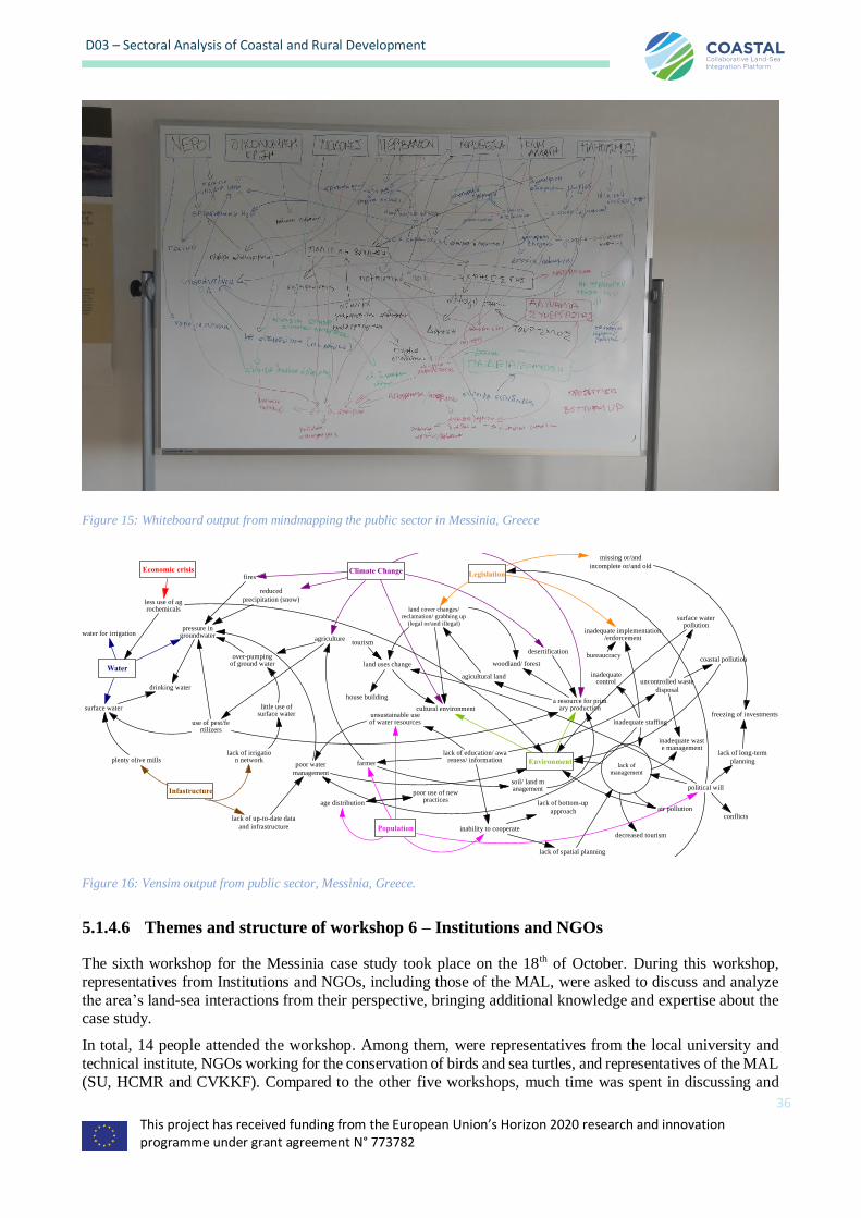
This project has received funding from the European Union’s Horizon 2020 research and innovation programme under grant agreement N° 773782
36
D03 – Sectoral Analysis of Coastal and Rural Development
Figure 15: Whiteboard output from mindmapping the public sector in Messinia, Greece
Figure 16: Vensim output from public sector, Messinia, Greece.
5.1.4.6 Themes and structure of workshop 6 – Institutions and NGOs
The sixth workshop for the Messinia case study took place on the 18th of October. During this workshop,
representatives from Institutions and NGOs, including those of the MAL, were asked to discuss and analyze
the area’s land-sea interactions from their perspective, bringing additional knowledge and expertise about the case study.
In total, 14 people attended the workshop. Among them, were representatives from the local university and
technical institute, NGOs working for the conservation of birds and sea turtles, and representatives of the MAL
(SU, HCMR and CVKKF). Compared to the other five workshops, much time was spent in discussing and
Water
Legislation
Environment
Climate Change
Population
Infastructure
Economic crisis
water for irrigation
surface water
pressure ingroundwater
drinking water
less use of agrochemicals
lack of irrigation networkplenty olive mills
lack of up-to-date data
and infrastructure
poor water
management
over-pumpingof ground water
little use ofsurface water
agriculture
a resource for primary production
desertification
fires
reduced
precipitation (snow)
cultural environment
agicultural land
woodland/ forest
land cover changes/reclamation/ grabbing up
(legal or/and illegal)
use of pest/fertilizers
lack of education/ awareness/ information
farmer
soil/ land management
land uses change
tourism
house building
inadequate implementation/enforcement
bureaucracy
inadequate staffing
inadequatecontrol
lack ofmanagement
political will
unsustainable useof water resources
missing or/and
incomplete or/and old
inability to cooperate
lack of spatial planning
age distribution
poor use of newpractices
lack of long-term
planning
air pollution
inadequate waste management
freezing of investments
conflicts
uncontrolled waste
disposal
surface waterpollution
coastal pollution
decreased tourism
lack of bottom-up
approach
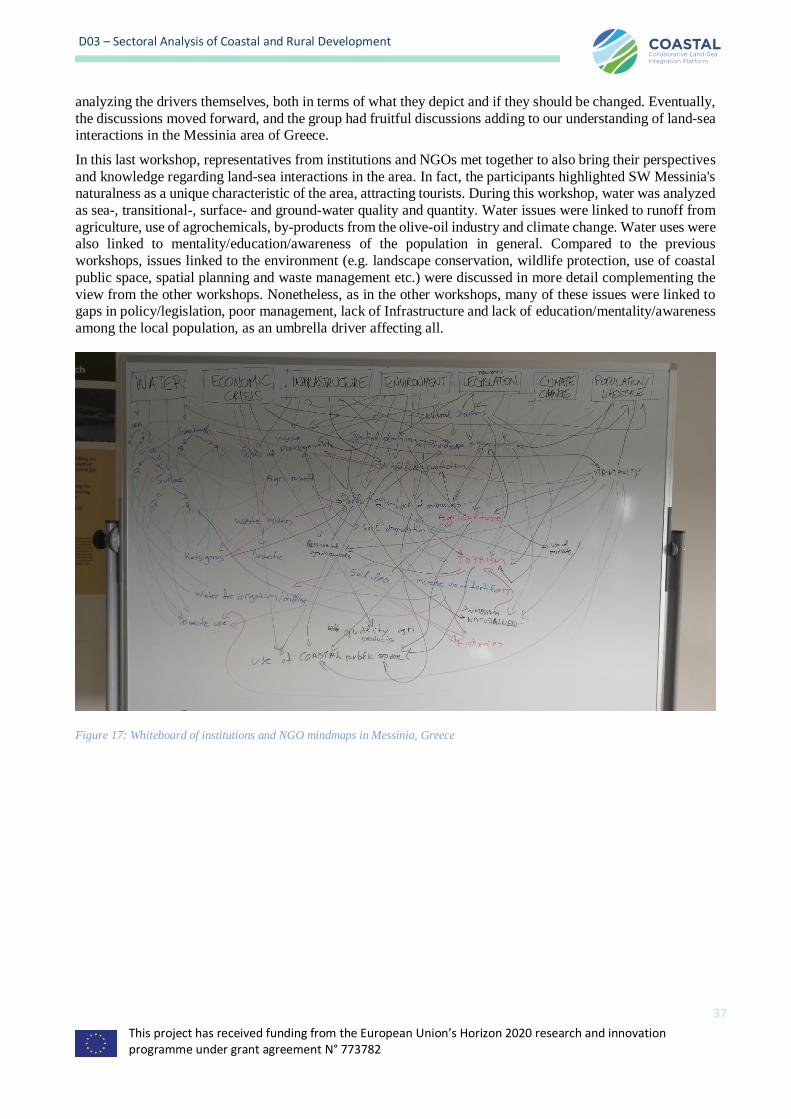
This project has received funding from the European Union’s Horizon 2020 research and innovation programme under grant agreement N° 773782
37
D03 – Sectoral Analysis of Coastal and Rural Development
analyzing the drivers themselves, both in terms of what they depict and if they should be changed. Eventually,
the discussions moved forward, and the group had fruitful discussions adding to our understanding of land-sea interactions in the Messinia area of Greece.
In this last workshop, representatives from institutions and NGOs met together to also bring their perspectives
and knowledge regarding land-sea interactions in the area. In fact, the participants highlighted SW Messinia's naturalness as a unique characteristic of the area, attracting tourists. During this workshop, water was analyzed
as sea-, transitional-, surface- and ground-water quality and quantity. Water issues were linked to runoff from
agriculture, use of agrochemicals, by-products from the olive-oil industry and climate change. Water uses were also linked to mentality/education/awareness of the population in general. Compared to the previous
workshops, issues linked to the environment (e.g. landscape conservation, wildlife protection, use of coastal
public space, spatial planning and waste management etc.) were discussed in more detail complementing the
view from the other workshops. Nonetheless, as in the other workshops, many of these issues were linked to gaps in policy/legislation, poor management, lack of Infrastructure and lack of education/mentality/awareness
among the local population, as an umbrella driver affecting all.
Figure 17: Whiteboard of institutions and NGO mindmaps in Messinia, Greece
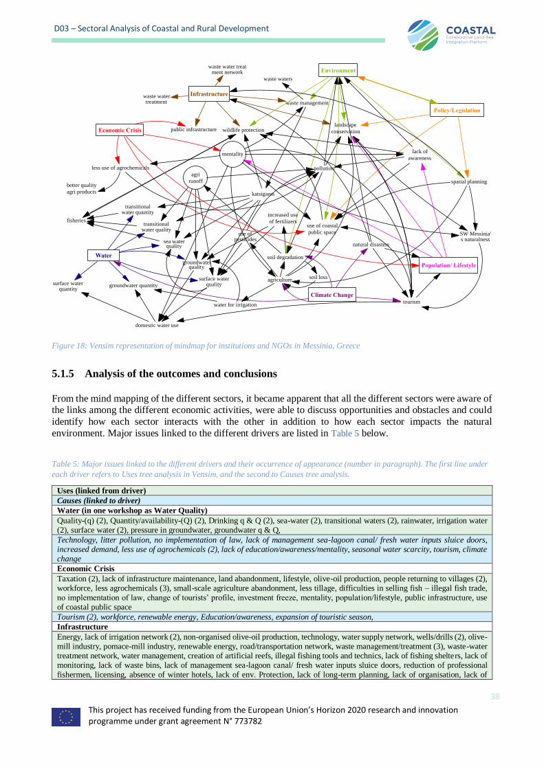
This project has received funding from the European Union’s Horizon 2020 research and innovation programme under grant agreement N° 773782
38
D03 – Sectoral Analysis of Coastal and Rural Development
Figure 18: Vensim representation of mindmap for institutions and NGOs in Messinia, Greece
5.1.5 Analysis of the outcomes and conclusions
From the mind mapping of the different sectors, it became apparent that all the different sectors were aware of the links among the different economic activities, were able to discuss opportunities and obstacles and could
identify how each sector interacts with the other in addition to how each sector impacts the natural
environment. Major issues linked to the different drivers are listed in Table 5 below.
Table 5: Major issues linked to the different drivers and their occurrence of appearance (number in paragraph). The first line under
each driver refers to Uses tree analysis in Vensim, and the second to Causes tree analysis.
Uses (linked from driver)
Causes (linked to driver)
Water (in one workshop as Water Quality)
Quality-(q) (2), Quantity/availability-(Q) (2), Drinking q & Q (2), sea-water (2), transitional waters (2), rainwater, irrigation water (2), surface water (2), pressure in groundwater, groundwater q & Q,
Technology, litter pollution, no implementation of law, lack of management sea-lagoon canal/ fresh water inputs sluice doors, increased demand, less use of agrochemicals (2), lack of education/awareness/mentality, seasonal water scarcity, tourism, climate change
Economic Crisis
Taxation (2), lack of infrastructure maintenance, land abandonment, lifestyle, olive-oil production, people returning to villages (2), workforce, less agrochemicals (3), small-scale agriculture abandonment, less tillage, difficulties in selling fish – illegal fish trade, no implementation of law, change of tourists’ profile, investment freeze, mentality, population/lifestyle, public infrastructure, use of coastal public space
Tourism (2), workforce, renewable energy, Education/awareness, expansion of touristic season,
Infrastructure
Energy, lack of irrigation network (2), non-organised olive-oil production, technology, water supply network, wells/drills (2), olive-mill industry, pomace-mill industry, renewable energy, road/transportation network, waste management/treatment (3), waste-water treatment network, water management, creation of artificial reefs, illegal fishing tools and technics, lack of fishing shelters, lack of monitoring, lack of waste bins, lack of management sea-lagoon canal/ fresh water inputs sluice doors, reduction of professional fishermen, licensing, absence of winter hotels, lack of env. Protection, lack of long-term planning, lack of organisation, lack of
Water
Economic Crisis
Infrastructure
Environment
Policy/Legislation
Climate Change
Population/ Lifestyle
sea waterquality
groundwaterquality
surface waterquality
transitionalwater quality
mentality
less use of agrochemicals
public infrastructure
use of coastal
public space
landscape
conservation
waste management
waste water treatment network
waste watertreatment
wildlife protection
lack of
awareness
natural disasters
pollution
soil degradation
spatial planning
agriculture
tourism
groundwater quantity
transitionalwater quantity
katsigaros
agri
runoff
surface waterquantity
waste waters
increased use
of fertilizersfisheries
domestic water use
water for irrigation
soil loss
SW Messinia's naturalness
better quality
agri products
use ofpesticides

This project has received funding from the European Union’s Horizon 2020 research and innovation programme under grant agreement N° 773782
39
D03 – Sectoral Analysis of Coastal and Rural Development
promotion, limitation of new wells/drills, plenty olive-mills, lack of up-to-date data and infrastructure, landscape conservation, public infrastructure, wildlife protection
Agro-tourism, lack of maintenance, land fragmentation, land morphology, tourism, house building, increased demand, improvements, spatial planning, natural disasters,
Environment
Land morphology, land/soil properties, air pollutants, garbage/litter, liquid pollutants, lack of management in Natura2000 areas, lack of protected and controlled fishing zones, a resource for primary production, cultural, policy/legislation, landscape conservation, soil degradation, spatial planning, use of public coastal space, waste management, wildlife protection
Lack of Education/awareness/mentality (3), pollution (air, water, land) (3), burning branches, coastal water quality, emission limits, renewable energy, water management (2), energy demanding single olive-oil extraction by single farmers, no implementation of law, waste-water treatment, reduction of lagoon’s aquatic vegetation, reduction of lagoon’s fish species, agrochemicals, August extreme, lack of env. Protection, tourism, sustainable food production, seasonal water scarcity, less use of agrochemicals (2), tourism, lack of management, natural disasters, policy/legislation,
Legislation (in one workshop as Policy/ Legislation)
Non-application/implementation (3), taxation, permission for drills and dams, workforce, emission limits, lack of water monitoring,
water quantity, illegal fishing tools and technics, illegal olive-mill activity, lack of management sea-lagoon canal/ fresh water inputs sluice doors, protected and controlled fishing zones, fuzziness, gaps (2), inadequate implementation (2), land uses/incomplete forest maps, lack of management in Natura2000, land cover changes/reclamation, incomplete/old, Environment, landscape conservation, spatial planning, use of coastal public space
Lack of Education/awareness/mentality (2) , Agro-tourism, political will, environment,
Climate Change
More extremes/natural disasters (4), new crop diseases, groundwater quantity/availability, water management, increased salinity, invasive fish species, reduction of lagoon’s aquatic vegetation, reduction of lagoon’s fish species, sea-water parameters (temperature and pH), changes in seasonality, temperature raise at the north, fires, agriculture (2), cultural environment, desertification, reduced precipitation (snow), soil degradation, water, tourism
Air pollutants, renewable energy, energy demanding single olive-oil extraction by single farmers
Population (in one workshop as Population/ Lifestyle)
Lifestyle (2), workforce, people returning to villages, aging population, farmers (2), litter production, recreational fishing, reduction of professional fishermen, increased visitors, age distribution, inability to cooperate, political will, unsustainable use of water resources,
Tourism (2), air pollutants, water quality, renewable energy, road/transportation network, water management, Education/awareness, seasonality, lack of awareness/mentality, landscape conservation, economic crisis, natural disasters
In general, most of the participants indicated that water is not scarce in the area, even though water issues
emerge in summer due to high demand from different sectors (mainly farmers and tourism). Agriculture and
industry related to olive-oil, and partly tourism, were the economic activities mainly linked to water issues affecting fisheries, the environment and the local population (e.g. increased water demand during summer
leading to less available water for the locals). The need for better management of Natura2000 areas and more
efficient environmental protection of the whole area was also raised in most workshops, except the one with
representatives from the industry sector. Participants from all sectors, were also aware of climate change impacts (e.g. extreme phenomena, sea temperature rise, invasive species, seasonality), and the links to tourism
industry, primary production and water related issues. The lack of different types of infrastructure was also
highlighted was described as one more obstacle for further development and innovation in the different sectors.
The agricultural, fishing and tourism sectoral workshops, also brought up the issue of gaps and overlaps in legislation, which in most occasions is not applied adequately, and creates confusion and obstacles for further
development and investments. This finding was also verified during the workshop with administration/public
authorities and was discussed by Institutions and NGOs.
The lack of infrastructure and the maintenance of what is already in place, was linked to the Economic crisis.
The crisis, however, seems to have led to reduced use of agrochemicals and has also drove people to return to
their villages adding to the local population.
Local population growth was furthermore strongly linked to the creation of new job opportunities in the
tourism sector which eased the impacts of the economic crisis - especially after 2010 when Costa Navarino
started to operate, and the area appeared as a destination on the global touristic map.
On the other hand, the farmers’ population is aging, and local farmers worry that young people returning to their roots prefer to think their future in relation to tourism and avoid working in the farm. New trends in
This project has received funding from the European Union’s Horizon 2020 research and innovation programme under grant agreement N° 773782
40
D03 – Sectoral Analysis of Coastal and Rural Development
lifestyle, income uncertainties and the “traditional” mentality among farmers (older farmers, who usually own
the land, resist to changes and “modern” ways) turn away the new generation, leading to lack of investments
in new technologies and innovation in the agricultural sector.
The participants could identify the potential of further development in and between their sectors and issues
linking to business opportunities and innovations were discussed during the workshops. Smart agriculture, re-
use of different types of by-products from the olive-oil farming and innovative tourism solutions were brought
up by the participants and could be major drivers for the sustainable development of Messinia region.
Indeed, increased monitoring and remote sensing in the farm could benefit both the agricultural and the public sector reducing the impact to the environment. New technologies in the farm could lead to optimized use of
water/natural resources and prudent use of agrochemicals (reducing farmers’ costs) and to a more effective
management/follow-up of the whole production process (from farm to olive-mill), generating more free-time for farmers (improving farmers’ well-being). Such agriculture could be more attractive to young generations.
Coupling new technologies with authenticity could boost the local/regional olive-oil production and create
new high-quality products. Agro-, thematic- and eco-tourism remains of a great potential in the area and offers opportunities to increase land-sea synergies, coastal-rural stakeholders’ collaborations and creation of more
jobs. It can also create a new market for local products. The local secondary sector, and especially pomace-
mills, could provide innovative solutions in the fields of energy production and management/ re-use of waste
and by-products in the farm, thus feeding a circular-economy model with benefits to the environment.
Nonetheless, at present such initiatives are put on hold due to lack of infrastructure and issues with legislation. The participants felt that the lack of communication and cooperation primarily within the sectors and
secondarily among them, together with issues linked to the lack of education/ awareness/ mentality of the
local population are major obstacles to advances in local economy.
This project has received funding from the European Union’s Horizon 2020 research and innovation programme under grant agreement N° 773782
41
D03 – Sectoral Analysis of Coastal and Rural Development
5.2 Belgian Coastal Zone (North Sea)
5.2.1 Executive summary
The 65 km long Belgian coastline as well as its hinterland face environmental and economic stresses from intensive use of space. Land- and sea-based activities from agriculture, fisheries, the agro-food industry,
transport, energy production and recreation are closely interwoven, and all compete for space. New
development opportunities for this densely populated region are created through among others blue growth,
and especially on- and offshore energy production which create opportunities for new jobs and strategic
specialization of port activities.
Innovative production methods using wave and tidal energy are the subject of ongoing research as well. In
fact, Belgium is one of the leading countries when it comes to offshore energy production know-how, ranking
fifth in the EU for installed offshore energy capacity. It is also the first country to put in practice multi-purpose use of wind farms (i.e. combined with mussel aquaculture). Meanwhile, the quality of fresh water resources is
under pressure, and land-based emissions of nutrients still exceed the EU-WFD target levels and contribute to
coastal eutrophication. The quantities of fresh water are under pressure during extended periods of drought,
because of multiple demands from industry, tourism, population and agriculture, and skewed rainfall patterns. A major stressor is the increasing salinisation of inland waters, due to drought and related to human
waterworks, water management, and sea level rise.
During the six workshops with key stakeholders in these industries and related government and NGO positions,
these topics and others were discussed and the key findings were the following:
• The limited space left between the built-up area along the coast and beach front, also known
as the ‘coastal squeeze’, leaves limited area for coastal protection and the environment and is strongly driven by the real estate sector and investments. This reduces the options for adaptive
flood and environment management, and the quality of the coastal view;
• Sea level rise and changing rainfall patterns affect farming in the hinterland, with increasing
salination of the low-lying polder4 areas;
• The impact of agriculture on coastal eutrophication is still pronounced as duckweed due to the drought, with emission levels still exceeding the EU-WFD targets;
• Agro- and eco farming could provide farmers with alternatives, the sector is under pressure
from EU and other regulations, and real estate development leading to non-farming use of
farming land (‘horsification’ and ‘gardenification’ due to land speculation);’
• Traffic congestion is one of the most significant problems caused by mass coastal tourism, but
mainly during the peak season. The transport infrastructure should be improved to connect the hinterland and develop rural tourism as well as inland freight transport to rural areas.
Infrastructure and residential units are underexploited during the low season;
• The development of offshore (wind) farms creates new opportunities for employment and
economic development in the region with the port city of Ostend as main hub;
• Ageing of the population is a general problem in Flanders, but more pronounced in the coastal region of West-Flanders which attracts elderly people;
• Tourism and recreation could focus on the selling of local food products, for example along
cycling paths, and a shift to the low season. Marketing strategies should include the
consumption habits and promote the need for a changed lifestyle of the population;
4 Polders are low-lying tracts of land enclosed by dikes that form an artificial hydrological entity. This means that it has no connection with outside water other than through manually operated devices such as sluices. See more at: https://en.wikipedia.org/wiki/Polder
This project has received funding from the European Union’s Horizon 2020 research and innovation programme under grant agreement N° 773782
42
D03 – Sectoral Analysis of Coastal and Rural Development
• Aquaculture offers a new blue growth opportunity and an alternative for the declining catches
of fisheries, but success will depend on a proper marketing strategy which takes the need for
changing consumption habits and lifestyle into consideration;
• R&D cooperation with interaction with the industry and policy makers can drive innovation in technological and governance issues for the coastal and rural sectors, such as energy
production, spatial planning or coastal defense
5.2.2 Background
Limited water resources and decreasing surface water quality has put pressure on the traditional activities in
the rural hinterland of Belgium. Increased salination is another challenge, with traditional agriculture suffering. However, this may also offer an opportunity for alternative forms of agriculture or aquaculture in these areas.
Based on the expertise and infrastructure of coastal tourism, developing sustainable rural and/or agro-tourism
can provide additional income for the hinterland. Economic and environmental opportunities are found, for example, in sectoral restructuring and modernisation, improved integration in the rural food chain with
diversification, changes in farming practices and new business opportunities.
For the coastal zone, similarly, Blue Growth and offshore energy production offer new opportunities for
employment and port development, while marine spatial planning faces the challenge of combining multiple
competing functions that feed back to the mainland and in particular the coastal zone. A new, six-year Marine Spatial Plan has been prepared by the federal government together with coastal and marine stakeholders and
will be in force in 2020.
Some typical land-sea interactions for the region, identified during the sector workshops by the relevant
stakeholder groups, were:
• The ‘dense use of space and real estate development leaves little room for other activities and
reduces storm protection options, with the example of the Belgian coast being densely populated with high rise apartment buildings facing the waterline offered;
• The artificial coastline with hard-coastal defenses and linear urbanization (apartment buildings)
limit the natural land-sea interactions and results in a coastal squeeze;
• The presence of two large harbors as gateways between offshore human activities and mainland
demands for transport and products;
• Salinity levels and water quality of rural surface waters are impacted by sea level rise, droughts
and fresh water overexploitation;
• Fragmentation of the natural landscape with tracts of land removing the natural landscape for nature and wild animals is a general problem in Flanders. This impacts nature, agriculture as
well as urban planning;
• Agricultural activities impact the quality of coastal (inland) surface waters through
eutrophication, with concentrations still exceeding the EU-WFD targets;
• Coastal tourism during holiday periods and peak seasons causes inland congestion, primarily with an increase in road transport of both humans and goods; and
• Concentration of economic and industrial activities in ports, both aimed at traditional port
activities as well as newer activities related to blue growth (e.g. offshore wind energy), with
related supply chain, transport, space, services and employment issues.
5.2.3 Drivers
The drivers discussed in Section Error! Reference source not found. were used to initiate the discussion in the workshops and used in the mind maps. Not each driver was used (i.e. connected to other variables) in each
workshop however. As with the Greek case study, only “Water” and “Infrastructure” were unchanged from
the initial workshop in Brussels in June of 2018. However, they are still content wise very similar.

This project has received funding from the European Union’s Horizon 2020 research and innovation programme under grant agreement N° 773782
43
D03 – Sectoral Analysis of Coastal and Rural Development
Table 6: Original vs. Workshop drivers used in the Belgian case study
Original drivers Workshop drivers
Water Water (related to water demand and supply, and water quality)
Human Consumption
Pattern
Lifestyle (related to the marketing of new products and need for changed habits)
Regulation policy Policy (EU, regional and local regulations, need for coordination, local solutions)
Temperature Climate (related to coastal protection and water shortage)
Human migration Population (related to the pressure on land use, tourism, ageing)
Pollution Environment (environmental challenges related to fisheries, aquaculture and
tourism)
Infrastructure Infrastructure (related to coastal protection, congestion, and economic activities)
5.2.4 Stakeholder workshops and Causal loop diagrams
In total six sector workshops were organized to cover the following themes and/or sectors with representative
of stakeholders (administrative agencies, entrepreneurs, researchers, and business developers):
• Environment (Flemish Land Agency, Bruges – September 19, 2018)
• Spatial Planning (Flemish Land Agency, Bruges – September 26, 2018)
• Fisheries and aquaculture (GreenBridge, Ostend – October 5, 2018)
• Tourism (Flanders Marine Institute – Ostend – October 24, 2018)
• Agriculture (Flemish Land Agency, Bruges, October 26, 2018)
• Blue Industry (GreenBridge, Ostend – December 5, 2018)
An identical agenda was used for each workshop (referred to as “work tables”), taking half a day with a coffee
break. Participants were provided with three documents prior to the mind mapping exercise: a flyer summarising the COASTAL objectives, a summary of the purpose of the workshop, and a document
explaining the use of personal data in the context of the new GDPR. Each workshop was initiated with a brief
presentation clarifying the COASTAL project, the way the project is to handle transition phenomena, and the
purpose of the workshop and follow up of the workshop results
A slightly ‘provocative’ statement was provided to challenge the participants, different for each workshop:
1. Environment: “the impact of economic activities on the environment on land and at sea will increase rather than decrease in the coming years”;
2. Spatial Planning: “the spatial planning of sea-based activities cannot be considered separately
from the spatial planning of land-based activities”; 3. Fisheries and aquaculture: “the economic contribution of aquaculture and fish processing will
become significantly larger than that of catch fisheries”;
4. Tourism: “hinterland tourism can help limit the negative impacts of coastal tourism during the
peak season and simultaneously help develop the coastal region into a four-season destination”; 5. Agriculture: “the availability of water is the main limiting factor for farming in the coastal
region”; and
6. Blue Industry: “there is sufficient space along the Belgian coast and at sea for blue growth”.
A practical problem turned out to be the timely engagement of sufficient persons (ideally 5-8), particularly for
the Blue Industry workshop, which was postponed to early December for this reason.
This project has received funding from the European Union’s Horizon 2020 research and innovation programme under grant agreement N° 773782
44
D03 – Sectoral Analysis of Coastal and Rural Development
5.2.4.1 Themes and structure of workshop 1 - Environment
The theme for the first workshop centered on the marine, coastal and inland environment (‘nature’), which is under stress from pollution, disturbance, fragmentation, invasive species and other processes resulting from
human activities and climate change. Invited stakeholders represented federal (national level) and regional
(Flemish level) administrations, marine knowledge institutes and environmental protection agencies, and
nature-oriented NGOs.
The main issues raised were:
• climate change: sea-level rise and changes in rainfall patterns;
• coastal squeeze and the dense use of space (multiple user functions);
• loss, disturbance and fragmentation of natural habitats;
• saline water intrusion and water management of the polders;
• invasive species;
• litter and microplastics;
• impact and role of recreation and tourism;
• impact and role of shipping and fisheries;
• division of administrative responsibilities; and
• eutrophication.
Opportunities for development raised were:
• restoring the natural water dynamics of polders (allowing saline intrusion);
• adaptive water management;
• integration of tourism/recreation and environmental protection;
• offshore recreation;
• inland alternatives for coastal tourism;
• cross-competence; and
• stakeholder consultation in planning processes.
The following aspects were discussed in more detail:
• The climate induced sea level rise results in “coastal squeeze”: a reduced intertidal environment
(“mudflats and tidal marshes”) between the sea and the coastal defenses (dikes) and dunes. This
is specially the case where there is a hard coastal defense (like dikes, urban area) which cannot
migrate;
• More room for the terrestrial environment (for example by means of sand supplementation or dune enhancement) implies less room for the marine environment and vice versa;
• The environment can be part of coastal defenses (for example dunes, ‘dune before dike’
principle);
• Typically for Belgium, the terrestrial environment is a regional Flemish jurisdiction, whereas the
marine environment is a federal (Belgian) jurisdiction. Cooperation between the two administrative levels aimed at Integrated Coastal Zone Management (ICZM) is still in the initial
phase. Unfortunately, the Flemish Government is encouraging administrations to focus on own
key, sectoral themes, hampering an integrated approach;
• The implementation of the EU guidelines at the national level is diverse and each country follows its own approach to meet the standards imposed, which is problematic.;
• Droughts and rainfall peaks are aspects of climate change. Salinization of grasslands (‘polders’)
is a result of sea-level rise and hydrostatic pressure (seepage). This seepage increase results from
drainage of freshwater and water usage for different purposes;
This project has received funding from the European Union’s Horizon 2020 research and innovation programme under grant agreement N° 773782
45
D03 – Sectoral Analysis of Coastal and Rural Development
• Salinisation is not necessarily a problem for biodiversity – the Flemish polder system is unique
in Europe, with some well adapted species; a part of the defined nature goals is to focus on saline
nature;
• There is no clear strategy to cope with spatial-temporal changes, although vulnerable zones have been mapped;
• Droughts and evaporation can lead to very high salinity values affects the availability of drinking
water for cow farming and sheep. Transition of cow farming to maize culture leads to changes in
the landscape, in turn negatively affects biodiversity etc.;
• Climate change also results in increased sea surface temperatures, leading the northwards migration of marine species, which has also an impact on fisheries;
• Top terrestrial and intertidal species are usually highly specialized and have limited options for
migration, making them vulnerable. Moreover, the highly fragmented landscape hinders natural
migration. Opportunistic species dominate the Belgian coastal zone due to the dense use of coastal
and marine space;
• Marine gravel beds form a better habitat for sedimentary species than hard structures used for coastal protection and e.g. wind farming;
• It is very difficult to control environment changes, which often took centuries or longer. Our
knowledge is limited;
• Even Greenpeace support a transition to renewable energy, but we should keep in mind that for
example offshore wind farming has side effects for the environment, particularly when implemented at a large scale. Limiting energy use should be taken into consideration as well,
paying attention to the positive and negative impacts of this activity;
• Reconverting polders to tidal areas (ontpoldering, opening the dikes) can be a strategy for
environmental compensation, but the dense use of space is an obstacle. Ontpoldering can also contribute to coastal protection due to natural sediment deposition following sea level rise;
• Coastal and inland eutrophication due to farming, and shipping (atmospheric deposition) have a
negative impact on terrestrial and marine biodiversity/species communities, causes algal blooms
depleting oxygen, in turn affecting fisheries;
• Water storage could be used for or be combined with nature development and agricultural
activities. Drainage and intensive agriculture (livestock) put a high pressure on the system (e.g. midland polders);
• Tourism is mostly oriented to the coast, coastal towns such as Ostend and Knokke should exploit
their alternatives (inland recreation, cultural trips, etc.) an integrated approach is needed here;
• Tourism creates support for environmental protection, which in turn can be used for recreation.
The current strategy of Natuurpunt supports “open nature” (meaning that recreation is welcome in their (non marine) nature reserves). The alternative of offshore tourism activities is not yet well
developed;
• The support for environmental protection is higher in coastal regions, with less nature, compared
to inland regions; involving the relevant local stakeholders in the planning process to create support is recommended, however different Flemish subcultures (difference in urban vs rural
societal support) can complicate the process;
• Coastal densification and the real-estate sector have a clear impact on the environment:
fragmentation of natural landscape is a real problem. Spatial planning could focus on the areas
between the coastal cities. However, this is not easy due to the presence of coastal roads, tramways, different local administrations, etc. Defragmentation of the natural landscape is needed
to restore the natural dynamics of the dunes;
• Litter and microplastics have an impact on the food chain, marine, inter-tidal and terrestrial
environment and public health. Automatic cleaning operation disturb the benthic substrates of the beaches;
• Offshore sand extraction for the construction sector and coastal protection affects the nearby
habitats due to disturbance of the sediment balance;
This project has received funding from the European Union’s Horizon 2020 research and innovation programme under grant agreement N° 773782
46
D03 – Sectoral Analysis of Coastal and Rural Development
• Other causes of biodiversity loss and habitat destruction are: invasive species (due to gardening
and shipping ballast and waste water) and bottom disturbing fishing techniques
(“boomkorvisserij”);
• Recreational farming by non-farmers (e.g. horse breeders; ‘verpaarding’) and extremely large gardens occupying former agricultural land put a pressure on professional farming and on the
environment, and is difficult to control due to the lack of management tools (such as subsidies).
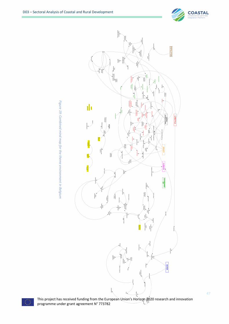
This project has received funding from the European Union’s Horizon 2020 research and innovation programme under grant agreement N° 773782
47
D03 – Sectoral Analysis of Coastal and Rural Development
LIF
ES
TY
LE
INF
RA
ST
RU
CT
UR
EE
NV
IRO
NM
EN
TP
OL
ICY
CL
IMA
TE
blu
e e
co
no
my
activitie
s a
tse
a
ma
ke
ab
lena
ture
kno
wle
dg
e g
ap
ma
rine
sp
atia
lp
lan
ene
rgie
ne
ed
of E
Up
olic
y
zonne
pa
ne
len
frag
me
nta
tion
of p
olic
y
klim
aa
td
oe
lste
lling
en
sa
nd
sup
ple
tion
be
ache
s
na
ture
as
pro
tectio
n
pum
pin
g
dra
inin
g
sa
lina
tion
dik
es
bro
ad
dune
be
lt
ag
ricultu
rep
ractic
es
sw
ee
tenin
gw
ate
r
are
a m
arin
ena
ture
lack o
fin
tera
ctio
n
typic
al ve
ge
tatio
n
bio
dive
rsity
ne
w ifn
rastru
ctu
re
stric
t divis
ion o
f po
we
rs
link to
na
ture
inte
gra
ted
co
asta
l zone
ma
na
ge
me
nt
wa
rmin
g
cha
ng
e in
pre
cip
itatio
n
se
a le
vel ris
e
sa
lina
tion p
old
ers
hyd
rosta
tic p
ressure
ero
sio
n d
une
s
ero
sio
n m
ud
flats
mo
re c
rop
land
are
a
??
gra
vitair
lee
m?
?
are
a te
rrest.
na
ture
livesto
ck
farm
ers
cha
ng
ing
land
sca
pe
inte
rtida
le
nviro
nm
ent
ne
ed
of p
olic
yfra
me
wo
rk
cre
ate
sp
ace
a 'p
old
er' is
limite
d m
ake
ab
lele
ss p
ote
ntia
lco
mp
are
d to
na
tura
lha
rd s
ub
stra
te
ha
rdco
nstru
ctio
ns
less s
pa
ce
for
'se
dim
ent n
atu
re'
build
ing
s
wa
ter w
arm
ing
mig
ratio
n m
arin
esp
ecie
s
oth
er
eco
sys
tem
ad
ap
tif po
licy
influ
ence
sfis
he
rs
mig
ratio
n la
nd
sp
ecie
s
limits
mig
ratio
np
ote
ntia
lp
rote
ctio
nhis
toric
gra
ssla
nd
EU
prio
rities
varia
be
lere
sp
ons
co
asta
lsq
ue
eze
sm
alle
r are
a
wa
ter le
vel
gra
ssla
nd
om
vang
ha
bita
ts
top
so
orte
n
ka
na
len
WA
TE
R
PO
PU
LA
TIO
N
de
po
lde
ring
lack o
f sp
ace
sp
atia
l pla
nnin
g
wa
terq
ua
ntity
eutro
fica
tion
bio
dive
rsity lo
ss
on la
nd
alg
ae
blo
om
toxic
fish s
tock
fishe
ries
nutrie
nts
and
em
issio
ns fro
mna
viga
tion
eutro
fica
tion a
tse
a
aq
ua
cultu
re
wa
ter s
up
plie
s
wa
ter
ma
na
ge
me
nt
sw
ee
t na
ture
ne
ed
for p
olic
y
dryin
g o
ut
sub
cultu
re
rura
l vs u
rba
n
co
asta
lp
rote
ctio
n
'ne
w' n
atu
re
se
co
nd
sta
yers
effic
ient u
se
of
sp
ace
litter
mic
rop
lastic
s
foo
d c
ha
in
exp
erie
nce
'be
levin
g'
pub
lic h
ea
lth
ne
ed
for m
achin
ecle
anig
n b
ea
che
s
be
nth
os
varia
tion
dune
de
velo
pm
ent
sa
nd
exp
loita
tion
at s
ea
influ
ence
sm
orfo
log
y & h
ab
itat
se
dim
ent
surp
lus
diffe
rentia
tion o
fsurro
und
ing
are
a
gra
vel b
ar
siltin
g u
p o
fZ
win
are
a
tida
l flats
and
ma
rshe
s d
ecre
ase
influ
ence
s h
ab
itat
eq
uilib
rium
na
tura
ld
yna
mic
s
na
ture
reha
bilita
tion
inva
sive
sp
ecie
s
imp
act o
n lo
ca
lsp
ecie
s
ha
bita
ts s
pe
cie
s
ga
rde
ns/la
nd
sca
pp
ing
ha
bita
tde
gra
da
tion
rura
l are
a
urb
aniza
tion
co
asta
l are
a
recre
ative
farm
ers
limite
d in
flue
nce
of p
olic
y
ship
s a
nd
ha
rbo
urs
ha
rbo
ur
se
dim
ents
yste
m
VL
M c
ontra
ct
na
tuur
ontw
ikke
ling
(2)
oth
er a
ge
nd
aco
op
era
tivefa
rms
pre
ssure
on
ag
ricultu
rep
ressure
on
land
are
a
touris
m
dive
rsific
atio
n
inco
me
touris
m
sup
po
rt for n
atu
red
eve
lop
me
nt
na
ture
de
velo
pm
ent
rea
l esta
tese
cto
r
sp
atia
lfra
gm
enta
tion
limite
d d
yna
mic
so
f sys
tem
ha
bita
td
eg
rad
atio
n d
une
sp
ressure
on
na
ture
dis
turb
ance
num
be
r of a
nim
al
sp
ecie
s
co
sts
acce
ss
po
pula
tion
de
nsity
pre
ssure
/ne
ed
inco
me
na
ture
infra
stru
ctu
reco
nstru
ctio
n
Bo
ttom
traw
ling
pre
ssure
fishe
ries
po
licy o
nb
yca
tch
byc
atc
hb
irds
wa
ter-s
oil
dis
turb
ance
ha
bita
td
eg
rad
atio
n
loss o
f sp
ecie
s
ag
ricultu
re
Figure 1
9: Com
bin
ed mind
map fo
r the them
e environm
ent in
Belgiu
m

This project has received funding from the European Union’s Horizon 2020 research and innovation programme under grant agreement N° 773782
48
D03 – Sectoral Analysis of Coastal and Rural Development
5.2.4.2 Themes and structure of workshop 2 – Spatial planning
The theme of this workshop, spatial planning at sea and on land, is not a sector per se, but the theme was
considered important enough for a separate workshop. The reason is the dense use of inland and coastal space,
paralleled by the dense use of space in the Belgian North Sea (BNS). The temporary nature of concessions offers new opportunities for development. The 65 km long coastline forms a unique location in Flanders. The
coastal area has its own dynamic, resulting in its own opportunities and challenges. The sea view is considered
one of the greatest assets of the Flemish coast. Spatial challenges are related to climate change and coastal defence, housing and quality of life, mobility and architecture and the public domain.
Spatial coastal planning specifically has to take into account:
• the impact of climate changes on the coastal zone;
• the shortage of water storage;
• the demographic and social mix (affordable housing, ageing, , 2nd stays);
• the need for a performant and efficient public transport system;
• the accommodating of the seasonal tourist;
• the recreational pressure;
• the outdated patrimony; and
• the demand for more nature and areas for farming.
A new Marine Spatial Plan (2020-2026) is accepted by the federal Government after intensive stakeholder
consultations. This makes the theme highly relevant for COASTAL. Land-sea interactions and spatial dynamics can be expected to be highly relevant for the effective implementation of the plan.
Invited stakeholders to this workshop were therefore represented by the following groups:
• the provincial (sub-regional) government;
• spatial planning agencies;
• environmental protection agencies; and
• maritime services.
The issues raised during the workshop were the following, and in many aspects echoed that which was brought
up in the Environmental workshop:
1. climate change;
2. sea-level rise; 3. flood safety;
4. water management;
5. the dense use of space along the coast; 6. policy fragmentation and lack of integrated policy;
7. seaward flood defense structures and artificial dunes;
8. adaptive building;
9. public transport; 10. integration of flood defense and environment
11. public support;
12. harbors; 13. marine spatial planning;
14. tourism; and
15. the role of demographic change.
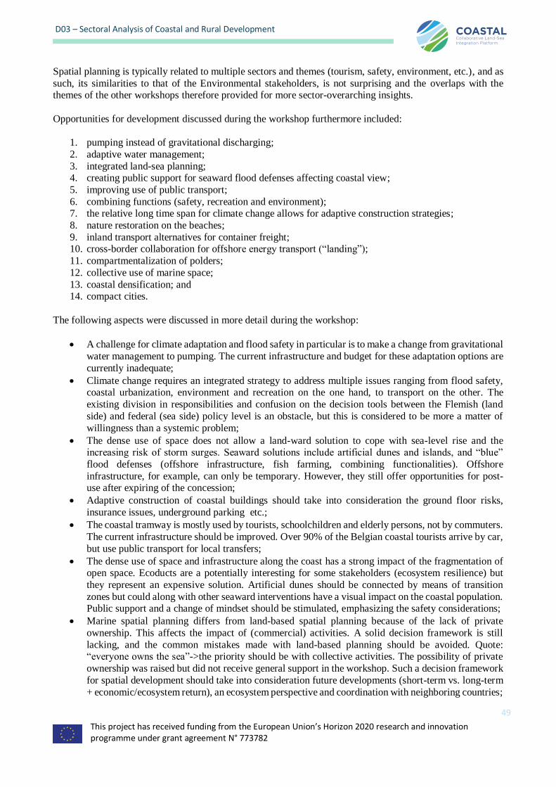
This project has received funding from the European Union’s Horizon 2020 research and innovation programme under grant agreement N° 773782
49
D03 – Sectoral Analysis of Coastal and Rural Development
Spatial planning is typically related to multiple sectors and themes (tourism, safety, environment, etc.), and as
such, its similarities to that of the Environmental stakeholders, is not surprising and the overlaps with the themes of the other workshops therefore provided for more sector-overarching insights.
Opportunities for development discussed during the workshop furthermore included:
1. pumping instead of gravitational discharging;
2. adaptive water management;
3. integrated land-sea planning; 4. creating public support for seaward flood defenses affecting coastal view;
5. improving use of public transport;
6. combining functions (safety, recreation and environment); 7. the relative long time span for climate change allows for adaptive construction strategies;
8. nature restoration on the beaches;
9. inland transport alternatives for container freight; 10. cross-border collaboration for offshore energy transport (“landing”);
11. compartmentalization of polders;
12. collective use of marine space;
13. coastal densification; and 14. compact cities.
The following aspects were discussed in more detail during the workshop:
• A challenge for climate adaptation and flood safety in particular is to make a change from gravitational
water management to pumping. The current infrastructure and budget for these adaptation options are
currently inadequate;
• Climate change requires an integrated strategy to address multiple issues ranging from flood safety, coastal urbanization, environment and recreation on the one hand, to transport on the other. The
existing division in responsibilities and confusion on the decision tools between the Flemish (land
side) and federal (sea side) policy level is an obstacle, but this is considered to be more a matter of
willingness than a systemic problem;
• The dense use of space does not allow a land-ward solution to cope with sea-level rise and the increasing risk of storm surges. Seaward solutions include artificial dunes and islands, and “blue”
flood defenses (offshore infrastructure, fish farming, combining functionalities). Offshore
infrastructure, for example, can only be temporary. However, they still offer opportunities for post-use after expiring of the concession;
• Adaptive construction of coastal buildings should take into consideration the ground floor risks,
insurance issues, underground parking etc.;
• The coastal tramway is mostly used by tourists, schoolchildren and elderly persons, not by commuters.
The current infrastructure should be improved. Over 90% of the Belgian coastal tourists arrive by car,
but use public transport for local transfers;
• The dense use of space and infrastructure along the coast has a strong impact of the fragmentation of open space. Ecoducts are a potentially interesting for some stakeholders (ecosystem resilience) but
they represent an expensive solution. Artificial dunes should be connected by means of transition
zones but could along with other seaward interventions have a visual impact on the coastal population. Public support and a change of mindset should be stimulated, emphasizing the safety considerations;
• Marine spatial planning differs from land-based spatial planning because of the lack of private
ownership. This affects the impact of (commercial) activities. A solid decision framework is still
lacking, and the common mistakes made with land-based planning should be avoided. Quote: “everyone owns the sea”->the priority should be with collective activities. The possibility of private
ownership was raised but did not receive general support in the workshop. Such a decision framework
for spatial development should take into consideration future developments (short-term vs. long-term
+ economic/ecosystem return), an ecosystem perspective and coordination with neighboring countries;

This project has received funding from the European Union’s Horizon 2020 research and innovation programme under grant agreement N° 773782
50
D03 – Sectoral Analysis of Coastal and Rural Development
• Harbors play a central role in the land-sea interaction and hence should transcend local discussions
and have a spatial planning strategy incorporating the hinterland and stakeholders. Harbors entail
different impacts: transport (inland container transport, congestion), water and agriculture (salinity impact of canals), pollution and inefficient use of space. Freight transport by rail and inland shipping
is underutilized due to technical limitations and planning choices;
• The water demand for agriculture is excessive and could be addressed by giving up space for
agriculture.
• Another problem is the transition of farmland to gardens or “vertuining” and “verpaarding” (horsification): this involves the use of large sections (up to 10 ha) of agricultural land for residential
use without farming purpose or non-professional farming (horses);
• Climate change is likely to affect coastal tourism in a positive way (cfr. Mediterranean region). This
could make it appropriate to evaluate urban infrastructure in a stepwise way, keeping in mind a (likely)
reduction in the number of elderly people (demographic evolutions) in the long term/within more or less the same time frame.
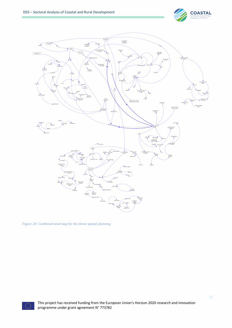
This project has received funding from the European Union’s Horizon 2020 research and innovation programme under grant agreement N° 773782
51
D03 – Sectoral Analysis of Coastal and Rural Development
Figure 20: Combined mind map for the theme spatial planning
WATER
LIFESTYLE
INFRASTRUCTUUR
ENVIRON
MENT
POLICY
CLIMATE
sea level
coastal defense
gravitational discharge
- time frame
policy neednew infrastr
ucture?excess
shortage
more space for
water
naturefragmented policy
need for
collaboration fragmented
responsibility
need for
coordination
ruimte
tourism
planning building
adaptive
construction
sea defense
structures
waves
infra
reefs
functions depending
on height
electricity
parking
wind
glas
tramway
functional use
car traffic
frequency
Royal Lane
parkeercapaciteit
parking policy
accessibility
versnippering
ruimte
ecoduct
transport
infrastructure
flora & fauna
landward
seawardtooth profile
hold the line
Zwin polder
dunes front dike
connecting to
existing dunes
regulations
sea view
little dynamics in
environment
diverse
natuurfunctie
islands
extra functions
need for
infrastructure
limited space on
land
use of space at sea
integrated policy
framework
process behind
sand extraction
at sea
sand engine
sand
NIMBY
HARBORS
mobility
water management
sluices
siltationmussels in channel
seawater in
channel
saline environment
use of space
removing nature
discharging
containers traffic
need for railway
cars
need for
connections
pipelines
need specialisation
choice
limit on
development
estuarine shipping
technical problems
inland shipping
along seaside
wave climate
transborder island
network
need 4 transborder
collaboration
wind parks
land-based spatial
planning
marine spatial
planning
plan
landing of energy
cable trajectory
lack of
coordination
Nieuwpoort
Plaats voor water Jachthaven
dune-polder
transition
need for link
conflict with
agriculture
water shortage
city of Ostendexpandingneed for planning
city of Zeebrugge
storm surge
sea level rise
highten quays
sea defense
function
storm wall
shipping
professional
recreational
need space
under pressure
need for infrastr docking places
radar
mixed use
large zones
changing use
choice of functions
second line coastal
defense
cacthing water behind
the coast line
polders are human
artifacts
making choices
possible to make
room
Urbanisation
Landscape view
quality
Quality of life
densificationbuilding higher
densifying villa
neighborhoods
tourism attractive
warmer
POPULATION
Ageing
disappears what to do with
infra
adapt infrastructure
to evaluations
reusedissappearing of own
populationchange into
gardens open space
functions
individualised
functions
water storage
agriculture
no private
property at sea
how to exploit
shifting costs
principle
which activities
evaluation plan
short term
LONG
TERM
impedes new
activities
collectieve
activiteiten
private activities
host
diverse channel
options
opportunities for
urban area
polder view
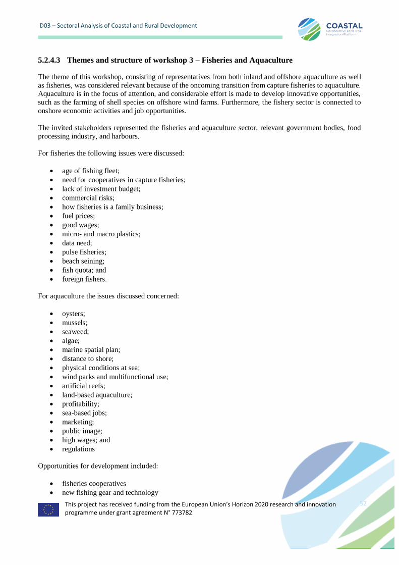
This project has received funding from the European Union’s Horizon 2020 research and innovation programme under grant agreement N° 773782
52
D03 – Sectoral Analysis of Coastal and Rural Development
5.2.4.3 Themes and structure of workshop 3 – Fisheries and Aquaculture
The theme of this workshop, consisting of representatives from both inland and offshore aquaculture as well
as fisheries, was considered relevant because of the oncoming transition from capture fisheries to aquaculture. Aquaculture is in the focus of attention, and considerable effort is made to develop innovative opportunities,
such as the farming of shell species on offshore wind farms. Furthermore, the fishery sector is connected to
onshore economic activities and job opportunities.
The invited stakeholders represented the fisheries and aquaculture sector, relevant government bodies, food
processing industry, and harbours.
For fisheries the following issues were discussed:
• age of fishing fleet;
• need for cooperatives in capture fisheries;
• lack of investment budget;
• commercial risks;
• how fisheries is a family business;
• fuel prices;
• good wages;
• micro- and macro plastics;
• data need;
• pulse fisheries;
• beach seining;
• fish quota; and
• foreign fishers.
For aquaculture the issues discussed concerned:
• oysters;
• mussels;
• seaweed;
• algae;
• marine spatial plan;
• distance to shore;
• physical conditions at sea;
• wind parks and multifunctional use;
• artificial reefs;
• land-based aquaculture;
• profitability;
• sea-based jobs;
• marketing;
• public image;
• high wages; and
• regulations
Opportunities for development included:
• fisheries cooperatives
• new fishing gear and technology

This project has received funding from the European Union’s Horizon 2020 research and innovation programme under grant agreement N° 773782
53
• sustainable consumption and public awareness
• green fueling
• know-how for proper risk assessment
• wind parks and artificial reefs (offshore aquaculture)
• export of know-how on aquaculture
• collaboration with offshore energy sector (labor and technology).
Obstacles identified included:
• EU- regulations
• existing marine spatial plan
• lack of investment funding for fleet renewal
• consumer behavior and lifestyle
• impact on social life
• international competition and
• scale-disadvantages for Belgian fishery companies
The following aspects were discussed in more detail:
• The Belgian commercial fishing fleet is aged and should be renewed to meet the environmental
standards to increase fuel, as well as fishing, efficiency. However, investment funding is not available and the sector is not well organized compared to, for example, its equivalent in the Netherlands where
cooperatives with banks exist for this purpose. Differences in funding have resulted in a less
competitive Belgian fleet compared to neighboring countries, leading to a lower attractiveness for
investors, and like this creating a vicious circle that is hard to break;
• Belgian capture fisheries are declining and could disappear within a decade (already 50 % are Dutch fishermen sailing under Belgian flag in Belgian waters), even if profits are made. Indirectly, other
economic activities (ship maintenance, fish processing, etc.) will also be affected;
• Combining fisheries and tourism will be difficult due to safety regulations;
• The fish stocks have recovered due to the EU quota regulations which are in effect. Quota are assigned
to boat licenses, which are taken over by the larger businesses (i.e. small family businesses are disappearing). Regulations concern the closure of fishing grounds, mesh size, effort and fishing
technology;
• In the past, bottom trawling (“boomkor”) has destroyed the habitat, with an impact on the fish stocks,
the technique is still applied in the Belgian North Sea (BNS);
• There is a strong need for fisheries data and it should be better used to increase objective of measures;
• The impact of microplastics on fisheries is limited. Macroplastics are a nuisance though, with the occasional need to discard catch. However, it is not as much of a nuisance as jellyfish, and not
problematic;
• Offshore aquaculture (on wind farms or artificial reefs) has a high potential attracting a lot of attention.
However, the development depends on the progress of high-tech know-how, spatial planning and
regulations, and the collaboration with other actors at sea. The main (currently unanswered) question is: where will it be allowed? This makes investment difficult and risky. Also, food safety should be
taken into consideration;
• Offshore aquaculture will generate new sea-based job opportunities for fishermen, but they are not
likely to change to this unknown activity. The participants mentioned that previously, EU job reconversion funds were used for the wrong purposes in their opinion;
• The physical conditions for offshore aquaculture are difficult due to the rough seas, but the ecological
conditions are excellent and not a problem;
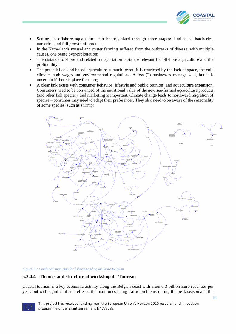
This project has received funding from the European Union’s Horizon 2020 research and innovation programme under grant agreement N° 773782
54
• Setting up offshore aquaculture can be organized through three stages: land-based hatcheries,
nurseries, and full growth of products;
• In the Netherlands mussel and oyster farming suffered from the outbreaks of disease, with multiple causes, one being overexploitation;
• The distance to shore and related transportation costs are relevant for offshore aquaculture and the
profitability;
• The potential of land-based aquaculture is much lower, it is restricted by the lack of space, the cold
climate, high wages and environmental regulations. A few (2) businesses manage well, but it is uncertain if there is place for more;
• A clear link exists with consumer behavior (lifestyle and public opinion) and aquaculture expansion.
Consumers need to be convinced of the nutritional value of the new sea-farmed aquaculture products
(and other fish species), and marketing is important. Climate change leads to northward migration of
species – consumer may need to adapt their preferences. They also need to be aware of the seasonality of some species (such as shrimp).
Figure 21: Combined mind map for fisheries and aquaculture Belgium
5.2.4.4 Themes and structure of workshop 4 - Tourism
Coastal tourism is a key economic activity along the Belgian coast with around 3 billion Euro revenues per
year, but with significant side effects, the main ones being traffic problems during the peak season and the
water
lifestyle
infrastructure
population
environmental
challenges
policy
climate
migrating fish
warming
sea water migrating plancton
other fish species
conflict net quota
Brexit effect
model quota
changes
uncertainty arriving
fish species
need other
techniques
market demand
changing food
preference
low energy
fishing
pulse fishing
decreasing impact
on seafloor
benthic life
price
social +ecologic +
need of
modernisation
old fleet
lack of
investments
more expensive
operational costs
lack of
cooperative policy
disappearing ships
quota to foreign
statesenlarged fish stock
closed areas, other
techniques, limitations
uncertain
future
alternatives
renewal
social sustainable
securetoo littleservice
providers
fish mine problem
employment
disappearing
culture
influence tourism
well paid
fishermen
source depending
on catch
conservative
improvement support no
replacement supportfamily businessess
limited budget
NL subsidies
NL funds
sales to NL
disappearing
fisheries
historic quota
allocation
flexibilityfarther shipping
productivity
need of quota
renewal
fuel
profitable
well payed
lack of schools
a lot of foreigners
becoming folclore
aquaculture
aquaculture space
quality
plastic
consumerhealth?
perception
eutrophication
no influence
jellyfish
overfishing
bycatch
recovery of sea life
decreasing fishery
habitat destruction
less oysters
less fish
decreasing sealife
DATA
fish stock
euros
no cooperation
seafloor disturbancesustainability
no interest
retail
environmental
challenges 0
space demand
aquaculture 0
new
better
improved planning
xxx sustainability
unique North
Sea ecosystem
know-how
knowledge
institutions
xxx??
knowledge export
consumer demand
islands
new
opportunities
intratidal
aquaculture
subtidal
aquaculture
limited space
limited future in
classic aquaculture
decision need
synergy of wind
parks
multiple space use
and and
link tourism
knowledge needed
coastal defence
vision
fragmentedemotion
multiple stakes
potential
mussels ++
Open farm
principal
aquaculture
and fisheries
Bonamia problem
oysters
barier
seaweed
mats
space
distance at sea
WHERE
work at sea
costs
sustainability 0
high demand
long season
rough sea
tough physical
circumstance
exploitation cost
forces on the
system
synergy
windparks
What is allowedinfluence on return
rendability
legislative
uncertainty
diseases
multispecies
hatchery
nursery
landbased
aquaculture
sea
land
microalgae
sector organisation
accumulate and
share know how
aq fishery, extensive fishery
alternative protein source
innovative product
know how
sharing accumulation
valorise
new know how needed
data 0
not evident
marine spatial plan
sometimes barier
sensor techniques
uncertain rendability
public opinion
image
know how fish feed/ feed sector
link fisheries
disappearing fishermenirregular life
transition to aquaculture
image aquaculture
unknown
multiple funding opportunities
selling market
secondary industry
This project has received funding from the European Union’s Horizon 2020 research and innovation programme under grant agreement N° 773782
55
spatial pressure on the coastal strip (sometimes referred to as the ‘Atlantic Wall’ because of all the tall apartment buildings facing the coast). Simultaneously, the hinterland is not well connected and opportunities
for tourism could be better exploited to reduce the pressure on the coast. Seasonal dynamics with unused
infrastructure and apartments during the low season affect the visual identity of the communities and local population.
Invited stakeholders represented coastal cities, tourism planning agencies, a recreational agency and a regional
airport.
The main issues raised during this workshop were:
• transport problems (road and public transport);
• parking capacity;
• inland hiking & cycling tourism;
• diversification of tourism and tourist target groups (daytrips, cruises, families, foreign tourists);
• low season and midweek vacancy of apartment blocks (‘ghost towns’);
• impact on local population and facilities;
• need for coordinated coastal-rural tourism policy;
• weather sensitivity; and
• litter.
Opportunities for synergies identified during the workshop included:
• attracting foreign tourists (Ostend airport and linking up with cruises);
• combining recreational functions (hiking + cycling + boats);
• connecting tramway inland (Zeebrugge-Bruges) and to airport;
• target group specific marketing (families, adolescents, city trippers, ‘high spenders’);
• electric bicycles;
• local food products;
• ecotourism;
• using Ostend airport for events;
• parking;
• promoting alternatives for beach tourism (cycling, WWI, surrounding region of Bruges);
• new functions (recreation, environment) for the closing airport of Koksijde;
• a new ferry from Ostend to Great Britain;
• public-private collaboration;
• promoting 4-season tourism;
• visiting nature and water saving reserves; and
• offshore wind parks.
Obstacles identified concerned
• the role of the real estate sector and investment in apartments;
• local (harbor) regulations;
• emphasis of tourism offices on promoting local tourism;
• capacity of existing transport infrastructure;
• dependency between supply and demand;
• impact of weather; and
• maximal capacity of tourist reached for Bruges, which limits synergy potential
This project has received funding from the European Union’s Horizon 2020 research and innovation programme under grant agreement N° 773782
56
The specified issues raised were:
• Mobility, congestion and capacity problems are the main issues for tourism – both for road and
public transport (for example the coastal tramway);
• In the coastal cities, parking is a problem during the high season. This could be addressed by allocating parking space at the city boundaries, combined with quality public transport with high
frequency.
• The airport of Ostend is well place and could be developed to attract foreign tourists and used of
organizing events and increasing the parking capacity near the coastal city of Ostend. This airport
could also focus on foreign tourists with synergies between coastal tourism and (inland) city trips, but Bruges is already at maximal tourist capacity and not searching for new opportunities to attract tourists.
• The coastal apartment market is mainly driven by investment and speculation, it is difficult to
control. It leads to excessive vacancy resulting in ‘ghost towns’ during the low season, affecting the
facilities for the local population. This also affects the identity of the local population. Larger cities like Ostend suffer less from this problem.
• Tourism development and marketing should be diversified and distinguish the different types of
tourism (families, daytrips, cruises, long stays, foreign tourists, adolescents, beach tourism, inland
recreation)
• A clear market exists for combining inland recreation functions (hiking + cycling + boats, markets and events, cultural activities, local food products), but should be developed (for example luggage
transport between hotels).
• Farm tourism has a low capacity due to limitations in the number of farms willing and available to
participate; Low season camping could be a more interesting alternative.
• The infrastructure for (inland) cycling activities is generally good but could be improved and be better
integrating with facilities along the cycle roads. A distinction should be made here between recreational and functional (speed) cycling.
• The demand for alternatives for coastal and beach tourism will follow the supply of these
alternatives and vice versa – a gradual process which can be supported by local initiatives and pilot
projects.
• A potential side effect of developing these alternatives is that it could affect the peacefulness of inland recreation options.
• Day trips are important for the coastal cities but have an impact on the food demand (resulting in
additional transport), mobility, the energy demand and environment.
• The main inland attractor is the city of Bruges, which is reaching its capacity for tourism
• Water supply is not (yet) an issue for tourism, except for problems with sluice passages for
recreational boats during extended periods of drought
• Climate change has an indirect impact through the need for beach restoration (due to waves) and heat stress in coastal cities. Artificial dunes could combine use for recreation but require public support.
• The daily volume of litter left on the beaches during the peak season is enormous. Cleaning beaches
even requires the involvement of local action groups. Inland, it is becoming more and more of problem.
A pilot project will be organized in 2019 to raise the public awareness.
• A strong need exists for a coordinated, coastal-inland tourism strategy, integrating the economic,
environmental and social aspects, as well as mobility and spatial planning. Similarly, public-private collaboration initiatives could be further developed.
• The tourism offices of coastal cities could do a better job to promote inland tourism, which is usually
given less priority in marketing.
• Ageing (demographic change) is only an issue for the local population, the average age of tourists is
decreasing a bit; and

This project has received funding from the European Union’s Horizon 2020 research and innovation programme under grant agreement N° 773782
57
• Coastal tourism is extremely weather sensitive. Alternatives (amusement parks, museums etc.) are
needed in case of bad weather.
Figure 22: Combined mind map for inland and coastal tourism Belgium
5.2.4.5 Themes and structure of workshop 5 - Agriculture
Agriculture is still a key economic activity in West Flanders, and significant in terms of water demand and land use. The challenge is to increase the competitiveness of coastal farming and to create a fairer payment for
their products. There is also a need to strengthen the coastal network and to enhance bonds between agri-food
stakeholders as well as among producers and coastal consumers.
Simultaneously, climate change and sea level rise have an impact of the quality of soil and surface water due
to saline intrusion, which may also, however, create new opportunities (saline farming). Combining farming with tourism and environmental management could also create new opportunities for farmers. Rural tourism
is relatively poorly developed and could be enhanced to combine sustainable rural tourism with local farming
practices. It is a local challenge to upscale profitable short food chains for more coastal farms to benefit. The
consumption of more local food and products produced along the coast can lead to reduced food transport.
water
LifestyleInfrastructure
population
Policy
Climate
mobility
too many cars
peak season
less tourists
look fo other
destinations (FR, NL)
weather
urban tourism in case
of bad weather
trains
overoccupied
tramways
overloaded
less Germans and
Dutch
policy in Netherlnds
& Germany
aim for Dutch and
German market
car free
in-city parking
contradiction
expect car close to
seadike
aim for direct hinterland
(example Nieuwpoort)
less mobility
problems
spreading toruists
tramway
fast accessibility
connection with
P&R
limited promotion
tourism alternatives
unknown
west coast
hiking, cycling
WW I
water storage
pond
need for innovationcomfort
limited tramway
capacity
low frequency
visual quality (cables,
infrastructure)environmental
impact
safety
hinterland mobility
limited hinterland
infrastructure
coastal revenues 2.8
BEUR per year
West-Flanders 3.5
BEUR without Bruges
less water supply
dryer
Niewpoort sluices
will not open
recreational boats
locked in
stop recreational
bopating
new form: standing
peddle boarden
need water recreation
more known
more quality
tourism
larger diversity
policy not open to
innovative watersport
hampering
innovation
threat of shortage
desalination
need for some
innvations
product delivery
need for smart
mobility
need for parking
spacehigh parking fees
high real estate
prices
toruism primarily in
summer
seasonal
unoccpuation
real estate as
investment
ghost town
lonely seniorsdissappearance of hotels,
restaurants & bars
local economy
slows downno services for local
populaiton
space used for
infrastrucutre
no space for young
families
promoting 4
seasonslack of 4 seasonn
infrastructure
tourists not satisfied
outside peak season
match supply and
demand
Ostend aims for 4
seasons
infrastructure in
low season
non-local responsibilities
& budgets
obstacle for new
infrastructure
use coastal infrastructure
to attract foreign tourists
Visit of hinterland
increase hinterland
tourism
Environment
al challenges
farm tourism
limited capacity
farm camping
few farms with
potential
labor capacity
regulation difficult
limited influence
cyclinghiking
water tourism
combination
day tourism
local products
wine tourism
tourism hinterland
limited investement
Airport Koksijde
tourism potential
limited redirection
function
limited
coastal-rural link
new space
nature
cycling highway
electrical cycling
need for silence
quality tourist
cycle ways
need for
experiences
hotels, restaurants
& bars
large supply
otherwise move
abroad
private-public
innovation needed
ecotourism
need for nature
reserves
too many seagullsannoying
invest in mitigation
(drones)
heat stress
need for shadow,
green
health of long-term
stayers
more wind
beach erosion
sand suppletion
innvations
sealevel risedune ribbon
lack of societal
support
innovative measures
Blue Cluster
development of
airport
potential for additional
foreighn tourists
too much pressure
on Brugges
quality of life
too many toruists
Brugges
no need for more
tourists
Ghent city
new infrastructure
needed to airport
tramway
connection
parkings
underused
use for events
warmer
new/more tourists
sun holiday
fly in cruises
sustainability
image
milieuimpact
Ferry
Fear of migrants
Cruise Tourism
Zeebrugge
Reception Hall
Promoting other
activities
high spenders
damme-brugge
luggage transport
bicycle rental
offer for children
bad weather
activities
tourism to wind
parks
ageing
more toruism
more to spend
more yearly
holidays
weather sensitive
destination
promotion often
connected to weather
need for attractors
less weather
sensitive
bead weather
garantuee (free musea)
need for policy
collaboration
collaboration
trash garbage
by tourists
by inhabitants
need for cleaning
cititzen initatives
by city of Ostenrepressive policy

This project has received funding from the European Union’s Horizon 2020 research and innovation programme under grant agreement N° 773782
58
This can create economic, environmental and social benefits such as transport cost savings, fewer emissions, less wear and tear on rural roads, reduced coastal traffic congestion and associated improved road safety.
Partnership approaches for strengthening local food markets should be enhanced. This would ensure that local
markets could bring greater economic returns to the producer and enable diversification of local production.
Invited stakeholders to the agriculture workshops therefore included representative of the farming sector,
environmental agencies, relevant regional administrations as well as spatial planning agencies.
The issues raised concerned:
• market orientation (involvement all actors);
• local products;
• short food chains;
• connection with tourism and recreation (including cycling);
• non-agricultural use of farming area;
• real-estate value;
• integration of nature;
• agriculture and recreation;
• coastal pressure on availability of land;
• upscaling of farms to survive;
• ageing rural population;
• inland wind and solar farms;
• smart grids;
• cooperative investment strategy;
• EU Common Agricultural Policy;
• water demand for agriculture and nature;
• ecosystem services;
• beekeeping;
• water buffering;
• climate change;
• salinization of grasslands;
• livestock reduction;
• use of polder land; and
• multiple use of land.
Opportunities for development included:
• farming cooperatives;
• silt crops and animal farming;
• renewable energy farms;
• integration with recreation;
• local food products;
• public awareness and food choices.
Obstacles identified concerned
• EU regulations;
• Upscaling;
• real-estate sector;
This project has received funding from the European Union’s Horizon 2020 research and innovation programme under grant agreement N° 773782
59
• coastal squeeze;
• non-agricultural use of farm land;
• water demand;
• climate change;
• droughts;
• sea level rise; and
• salinization.
Sector-specific aspects discussed were the following:
• Market orientation on new and local (food) products should involve all actors (local inhabitants,
tourists, hotel, restaurants, supermarkets). This will require management as well as farming skills, so that to ensure the quality of local products and guarantee supply. Prices will be less of a problem.
Quality labels such as the pré-salé sheep (sheep grazing on salty grasslands) can be an inspiration and
could be applied to the Belgian coast
• Short food chains involving direct selling of food products (for example ice cream) to consumers are an opportunity.
• Farming land can be used for nature development and vice versa. This is already happening and
strongly policy driven by EU-CAP regulations and subsidies, providing new roles for farmers related
to the management of the landscape. However, this is not expected to generate additional income for
the farmers.
• The low polders are primarily intended for and managed as farming lands, which should be taken into consideration.
• Sea level rise reduces the water discharge window, increasing flood risks. In addition, sea level rise
increases saline seepage in the polders, and reduces freshwater stored in aquifers (dunes and others).
Consequently, sea level rise affects the quantity of water resources and potential for land-based activities.
• An opportunity is the multi-functional use of agricultural land, integrating farming with nature,
tourism and recreation (in particular cycling). This will also increase the attractiveness of the landscape
for residential land use.
• An obstacle for farming is the loss of productive land to non-agricultural activities (gardening, horse keeping) by wealthy buyers. This results in decreased agricultural area, but also in increased real estate
and land prices for farmers; it is strongly driven by investors and the real-estate sector. Although it
provides an income for retiring farmers, it limits opportunities for active/starting farmers.
• Small farms find it difficult to survive, upscaling and ageing of the rural population affect the sector.
• Renewable energy (inland wind and solar farms) and energy storage are an opportunity to be
developed → smart grids.
• Investments in changes in agricultural practices and use of farming land for other purposes are best organized through farming cooperatives
• Farming land can be adapted to provide ecosystem services (nature, water buffering, ….)
• The water demand for agriculture and nature are different; the environment could contribute to water
supply for nearby farms, a win-win opportunity.
• It is not clear whether the regulation targets for nature (“instandhoudingsdoelstellingen”) are robust
for climate change; regulatory uncertainties are an obstacle for the agricultural sector and investments
• The dense use of land along the coast and increasing pressure (“coastal squeeze”) have an impact on
the availability of farming land and cause mobility problems.
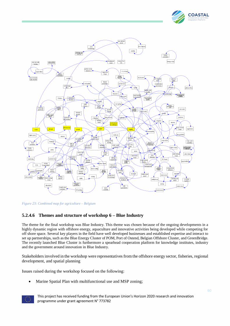
This project has received funding from the European Union’s Horizon 2020 research and innovation programme under grant agreement N° 773782
60
Figure 23: Combined map for agriculture – Belgium
5.2.4.6 Themes and structure of workshop 6 – Blue Industry
The theme for the final workshop was Blue Industry. This theme was chosen because of the ongoing developments in a
highly dynamic region with offshore energy, aquaculture and innovative activities being developed while competing for
off shore space. Several key players in the field have well developed businesses and established expertise and interact to
set up partnerships, such as the Blue Energy Cluster of POM, Port of Ostend, Belgian Offshore Cluster, and GreenBridge.
The recently launched Blue Cluster is furthermore a spearhead cooperation platform for knowledge institutes, industry
and the government around innovation in Blue Industry.
Stakeholders involved in the workshop were representatives from the offshore energy sector, fisheries, regional development, and spatial planning
Issues raised during the workshop focused on the following:
• Marine Spatial Plan with multifunctional use and MSP zoning;
lifestyleinfrastructure
people
environment
al challenges
policy climatewater
definitiecoastalregion extreme
weather:drought fresh water
storage
irrigation
reducedischarge at
see
harvest
deep-rooted
crops
potatoes
less problem
sugarbeets
waterquality
crop needs
nieuwevormen vanberegening
quantity
other crops
salty tolerant
cropssoil =
limitation
salty tolerant
buffering
waterclay : soil
suitability
arable farming (vegetable crops more difficult)
sales/chain
opportunities
supply
changes
question
change
other sectors
drinking
water
schipping
livestock
great need
make
choices
cultivation
freedom
claining
waste water
source fres
water
upstream
intervention
buffer zonesvegetable
areas
buffering
upstream
tuning within
farming
quality
slightly salty
possible
equal quality
is necessary
poultry/pigs grondwaterextraction nolongerpossible
rain water
bacteriological waterquality
claining
water
milking
equipment= drinking
waterquality
space for
water
nature
innovative
crops
multi-use
canal system
Polders
water level
management
wider water
courses
poldersystem as
buffercompartmen
talisation
distribute
expensed
drainage
safety
sealevel rise
emergencypump
installations
soil quality
soil sponge
ffect
impact
pesticides soil live loss
rooting duckweedtoo stagnant
waterprevent
salinity
sufficent flow
purification
necessarybiomass
longergrowingseason
improved
crops
+ 11,4 days
perfect circu
mstances
wet spring
demand
people
aquacultuur
moreresearch
necessary
win win with
farming
salty polderwatercourse
s
not economi
cally feasible
Polders
desalinated
water
research at
UG
drinking water productio
n at sea
new
technology
energy crops
product
selling direct selling
catering
industry
permanent
residents
farmingneighborsprojects
farmer's
suitability
goodmanagerneeded
labor needs
famers
markets
marketing
CSA
subsidizes
Polder
potatoes
local
products
higher priceinterest
difficult
region
knowledge
people
recreatieve
fietsroutes
real estate
valuefarmland
threat to
agriculture
money box
for farming
visible open
space
reduction of
farmland
scalingaging
newwindmills in
Polders more energy
crops
farming
interestsolar panels
smartgrids
energy
cooperation
multiple usefarming and
nature
interwovenseperate
synerg
EU frame
nature area
working
together
watersource
salty
grasslandsspace
available
protectionPolder
grasslands
buffering
limited
potential
mobility
new ringway
new infrastr
ucture
3D printing
small-scale
machines
affordable

This project has received funding from the European Union’s Horizon 2020 research and innovation programme under grant agreement N° 773782
61
• concession zones;
• land-sea connection and land-sea synergy;
• offshore wind energy;
• energy storage and grids;
• Hydrogen (H2)
• wave & solar energy;
• freshwater production;
• sea level rise;
• coastal protection (Complex Project Kustvisie (2100));
• wave breaking islands;
• offshore offloading and energy supply for shipping;
• Arctic route;
• demography (aging) and shortage in skilled labor;
• knowledge platforms/test facilities and innovation;
• circular economy;
• smart sea; and
• sea mining,
Opportunities for development discussed were:
• integrated land-sea planning;
• (temporal) surplus energy and grid balancing give opportunities for hydrogen generation and
desalination (with dune aquifer storage);
• large-scale offshore wind farms;
• floating infrastructure;
• northern Arctic route;
• sand mining and dredging for construction;
• electrical fleet and transshipment at sea;
• test and innovation platforms;
• circular economy;
• social cost-benefit analysis;
• innovative sea mining; and
• recycling of wind farm materials after decommissioning.
Obstacles discussed were:
• adapting energy supply to demand (spatial and temporal);
• energy storage options;
• long-term uncertainty of regional planning (concessions);
• fixed concession zones in MSP;
• uncertainty of zoning (aquaculture);
• societal support;
• raw materials for construction sector;
• limited wave climate;
• ageing;
• maintenance costs of wind parks;
• aging technology;
• protection marine environment in MSP;
• difficult physical marine environment for energy generation (wave, solar, etc.); and

This project has received funding from the European Union’s Horizon 2020 research and innovation programme under grant agreement N° 773782
62
• lack of skilled labor, required conditions for testing (e.g. wave climate).
Sector-specific aspects discussed were the following:
• Blue Industry, as a sector, should be properly defined – in principle it refers to sea-based activities,
but the landward connection is highly relevant. Think of the position for landing of energy (cables), and interference with land-based activities (agriculture, residential, etc.). Example
Zeebrugge-Zomergem (STEVIN project). The west coast is a blind spot with few connections for
energy installations – international connection to France should also be examined. A need exists
for integrated land-sea spatial planning (combined projects, timing issues) and by extension international cooperation;
• The matching of supply and demand is a challenge for offshore energy; an interesting opportunity
is the generation of hydrogen (H2) using excess energy, with green fueling stations for electrical
ships. The existing distribution network could be used (Norway and UK are already well connected – example NEMO network) Hydrogen also links up with lifestyle and infrastructure
(cars, boats, public transport, etc.). This requires infrastructure, policy and investment.
• Offshore wind farms offer an interesting alternative for land-based wind farms (lack of space and
NIMBY attitude in Flanders, the operational costs are much lower nowadays due to large-scale production and more efficient design. Offshore energy could also be used for
desalination/freshwater production (‘brine’ as a resource or as a waste product?). Safety is the
primary concern for the offshore wind sector, other multi-purpose types of use (aquaculture,
tourism, etc.) are of limited concern and allowed on an arbitrary basis by the concessionaire. The existing wind park grid could be used for energy distribution;
• The current life span of wind parks is 20 years – then operators are obliged to remove the
foundations and restore the natural environment at that time, although the concession zones are
maintained. Material reuse (circular economy, reuse or recycling), decommissioning and spatial reuse should be considered and is an interesting opportunity for the Blue Industry sector. Also,
opportunities in know-how from other sectors (oil gas) should be explored;
• Energy islands (‘energie atollen’)– have been proposed but met a lot of opposition (costs and
especially visual aspect). Other solution for energy storage are also being explored. Testing zones can be found in the MSP, one physical test platform (“Blue Accelerator”), which will be open to
both the industry and knowledge institutions, is under construction. Tidal and wave energy are the
subject of research, but the Belgian wave climate may be too moderate for the latter to be
profitable, although perfect for the testing phase.
• Sea level rise may be 2 m (worst case) instead of 90 cm and is a non-linear process – this is both an opportunity and threat for Blue Growth. Coastal defenses and harbor infrastructure can be
adapted in terms of heights, and in landward (often not an option due to lack of space) or seaward
direction. Also, land-based industries can opt to use space in a seaward direction (like Voorhaven Zeebrugge) with potential benefits for coastal defense.
• A new opportunity resulting from climate change could be the opening of the Northern, Arctic
route for shipping. This changes the position of Belgium on the international shipping routes
• The construction sector is running out of raw materials (sand) for concrete– sea mining offers an
alternative. Dredging waste can also be used as a resource (example project AMOROS – generating bricks from riverine dredging material). The regulations concerning the use of shells
as insolation material in construction are not yet clear;
• Ageing could be a problem for the supply of skilled labor, which is already a challenge. The
research and education activities of knowledge platforms (academic world, businesses and
administration) should be tuned to economic needs;
• The submarine environment offers ‘smart sea’ opportunities for Blue Industry: AI, UAVs (drones) etc. could be used for maintenance and operations, cable inspections,

This project has received funding from the European Union’s Horizon 2020 research and innovation programme under grant agreement N° 773782
63
• Underwater heritage could be relevant for tourism.
• Relevance and importance of ecosystems approach also for blue industry.
Figure 24: Combined mental map for the Blue Industry Stakeholders – Belgium
5.2.5 Analysis of the outcomes and conclusions
In general, the workshops took place in a positive atmosphere with useful discussions that were constructive,
without disputes among participants. Local and regional land-sea interactions, including interactions with the other sectors or across themes, were addressed to some extent in all the workshops. However, for some themes
it appeared to be difficult to define a clear vision on the mid- and long-term changes expected in the study
region or couple them to innovative (economic and environmental) opportunities and benefits. To support the analysis (WP3) and transition (WP5) work packages this should be taken into consideration when organizing
the oncoming multi-actor workshop for the Belgian MAL.
Key issues addressed in the first two workshops (“environment” and “spatial planning”) were:
• the dense use of space;
• the “coastal squeeze”;
life styleinfrastructure
population
environment
al challengespolicy climatewater
zones for
windfarms
new wind farms
new electricity
connections
needs space on
land
link with existing
infrastructure
time needed for
planning
need for integrated
onland-maritime policy
western coast
'Westkust'
no other developments
possible on land
link with France
energy storage
hydrogen
production
sustainable
transport
pharmaceutical use
energy atolenergy surpluss and
grid balancing
solar energy
wave energy
battery function
loss of energyR&D potential
desalination
water productionbrine?
cars, boats, ...
tram (kusttram)
no need for
overhead line
important energy
resource alternative for wind
energy at land
efficicency at seavisual impact
cost
public support
sea level rise
island
coastal defence
seamininglimited amount of
sand
influence cocnrete
production'ontharding' (decrease of
sealed surface on land)
sand bars raised
how to use?
mobile
infrastructure
use of dridging
sludge
scale necessaryexpensive
technological r&d
demand
waves in NSea not
very suitable
blue accelerator R&D
and infrastructureproject zones
defined
lower cost if close
to land
transshipment at
sea
influence space
needed
population island
northern sea route
more traffic
opportunities for
services
more attractive
aging
shortage in people with
correct training
decrease in active
population
local population
inland retired people
move to coast
braindrain
tourism
aquaculture
need for R&D on
multifunctionality
AUV, underwater
industrie
smart sea
maintenance of cables
and foundations
inspection of
seabed
safety and
environment
new academic
campus
aligning R&D
needs
science park
aligning with
industrial needs
creating new
markets
sea shells as
insolation material?new R&D needs
wind farms
safety aspects of
wind farms
limits
multifunctionality
less fishery zones
multifunctionality
require
concessions
increased costs
wind farms don't
like risks
decommisioning
opportunities for
reuse/recycling/...?
R&D need on
decommisioning abroad experience from
oil&gas decommisioning
unknown influence
on nature
economic opportunity
of decommisioning
also R&D on
monopolies on space
'sand motor'
muddy environment
of BE NSea
limits potential to
work with sand
industrial development
in sea (outport)
can be used foralternative energy
methods
decreases waves
limited space on
land
need for new
development sites
new opportunities on landfor energy consuming
industries

This project has received funding from the European Union’s Horizon 2020 research and innovation programme under grant agreement N° 773782
64
• water management and salinization; and
• coastal protection against climate change.
The third workshop (on fisheries and aquaculture) focused more clearly on:
• the obstacles and opportunities of the declining fisheries sector; and
• the opportunities for the innovative aquaculture sector.
The tourism workshop focused on :
• mobility issues;
• the real estate market; and
• development of inland tourism as an alternative for and addition to coastal tourism.
The agriculture workshop focused on:
• (alternative) farmer income;
• water supply;
• the role of EU and other regulations;
• food chains and marketing of farm products; and
• rural tourism.
The blue industry workshop focused on:
• marine spatial planning;
• opportunities and challenges in offshore energy in terms of infrastructure/storage/multifunctional
use/end-of-life;
• the opportunities related to innovation and knowledge platforms; and
• the consequences of sea level rise.
Key issues discussed in more than one workshop were:
• climate change and climate adaptation;
• challenges related to sea level rise (coastal squeeze, sea defence);
• limited space availability on land and multifunction spatial use at land;
• the limited coordination of land- and sea-based activities (regulation, policy, governance);
• the densely populated area, with multiple stakeholders and activities in a limited area;
• congestion problems;
• the impact of peak season tourism;
• food consumption habits and food marketing (e.g. sea food products);
• the changing hydrology and physical conditions (salinity, floods, drought, storm surges);
• ineffective or limiting regulations and policies;
• public support for changes; and
• multi-functional use of inland, coastal and offshore space.
Key findings
1. There is a very high land use pressure due to urbanisation, industrialisation, and traditional agriculture.
There is however also a high pressure on the use of the marine space, and multifunctional use of can provide an option for a more efficient planning;

This project has received funding from the European Union’s Horizon 2020 research and innovation programme under grant agreement N° 773782
65
2. The alignment/harmonisation of land- and sea-based activities, regulations and policies should be improved;
3. Existing and identified potential opportunities for land-sea interaction focus more on industrial
activities and urbanized areas and only to a lesser extent on the rural areas; 4. The unique Flemish polder system (from an ecological and agricultural perspective) has to be protected
but is under threat from changing physical conditions (SRL, hydrology, salinization);
5. Coastal densification and urbanisation threaten the environment, and result in landscape
fragmentation. This reduces the options for climate adaption (e.g. through coastal squeeze), and affect the visual quality of the coast
6. Roads and other tourism infrastructure are fully aimed at summer coastal tourism and (year-round)
and weekend day trips. However, while congestion problems arise during peak season, this infrastructure is underexploited during the off season;
7. Farming can well be combined with tourism, recreation and environmental protection;
8. Challenges for coastal defence with sea level rise provide potential for nature-based solutions (e.g. sand motor) that might benefit nature, tourism and industry and provide an alternative for the current
hard coastal defence;
9. The offshore energy production industry is an important sector and offers many opportunities with
links to other sectors, including the desalination industry, hydrogen production, and off-shore services to name a few. It also, however, leads to other challenges related to multifunctional use and
decommissioning.
The creation of offshore islands offers different cross-sectoral opportunities for e.g. energy production and
storage, aquaculture, nature development, tourism and coastal defence; but quantifying costs, impacts and
benefits requires still a major R&D step, and societal opposition is large.
The conversion of rural farming land to gardens and horse estates (‘verpaarding’) is related to coastal
urbanisation and recreation (second homes), and puts a large pressure on rural land use, agriculture and nature,
but also provides also opportunities related to environmental issues and farmers income.
The workshops generally resulted in complex “mind maps” (see figures above). The anonymous transcriptions
of the sound recordings (2-page summaries) complemented this information. Clearly, some system feedback
mechanisms can be identified in the mind maps diagrams, but this was not the first consideration for the sector workshops. Figure 25 shows the main issues and interlinkages discussed during the six sector workshops.
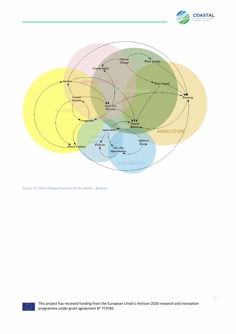
This project has received funding from the European Union’s Horizon 2020 research and innovation programme under grant agreement N° 773782
66
Figure 25: Main linkages between all the sectors - Belgium
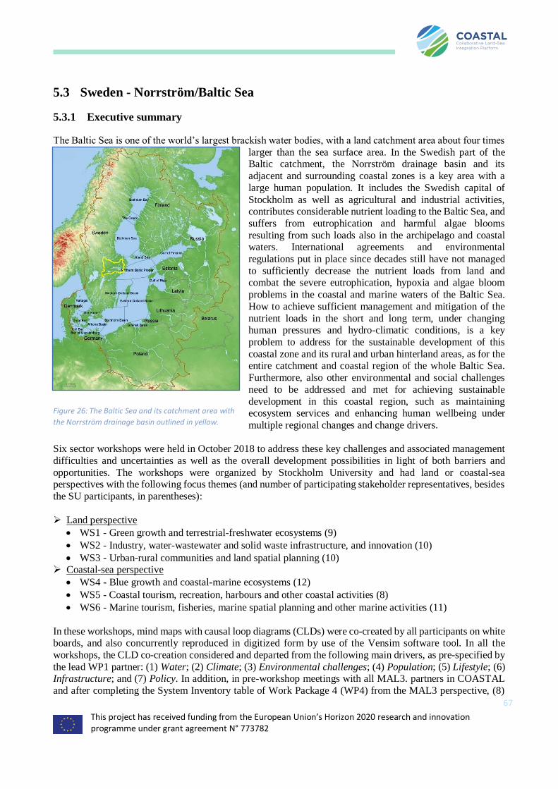
This project has received funding from the European Union’s Horizon 2020 research and innovation programme under grant agreement N° 773782
67
5.3 Sweden - Norrström/Baltic Sea
5.3.1 Executive summary
The Baltic Sea is one of the world’s largest brackish water bodies, with a land catchment area about four times
larger than the sea surface area. In the Swedish part of the Baltic catchment, the Norrström drainage basin and its
adjacent and surrounding coastal zones is a key area with a
large human population. It includes the Swedish capital of
Stockholm as well as agricultural and industrial activities, contributes considerable nutrient loading to the Baltic Sea, and
suffers from eutrophication and harmful algae blooms
resulting from such loads also in the archipelago and coastal waters. International agreements and environmental
regulations put in place since decades still have not managed
to sufficiently decrease the nutrient loads from land and combat the severe eutrophication, hypoxia and algae bloom
problems in the coastal and marine waters of the Baltic Sea.
How to achieve sufficient management and mitigation of the
nutrient loads in the short and long term, under changing human pressures and hydro-climatic conditions, is a key
problem to address for the sustainable development of this
coastal zone and its rural and urban hinterland areas, as for the entire catchment and coastal region of the whole Baltic Sea.
Furthermore, also other environmental and social challenges
need to be addressed and met for achieving sustainable
development in this coastal region, such as maintaining ecosystem services and enhancing human wellbeing under
multiple regional changes and change drivers.
Six sector workshops were held in October 2018 to address these key challenges and associated management
difficulties and uncertainties as well as the overall development possibilities in light of both barriers and
opportunities. The workshops were organized by Stockholm University and had land or coastal-sea perspectives with the following focus themes (and number of participating stakeholder representatives, besides
the SU participants, in parentheses):
➢ Land perspective
• WS1 - Green growth and terrestrial-freshwater ecosystems (9)
• WS2 - Industry, water-wastewater and solid waste infrastructure, and innovation (10)
• WS3 - Urban-rural communities and land spatial planning (10) ➢ Coastal-sea perspective
• WS4 - Blue growth and coastal-marine ecosystems (12)
• WS5 - Coastal tourism, recreation, harbours and other coastal activities (8)
• WS6 - Marine tourism, fisheries, marine spatial planning and other marine activities (11)
In these workshops, mind maps with causal loop diagrams (CLDs) were co-created by all participants on white boards, and also concurrently reproduced in digitized form by use of the Vensim software tool. In all the
workshops, the CLD co-creation considered and departed from the following main drivers, as pre-specified by
the lead WP1 partner: (1) Water; (2) Climate; (3) Environmental challenges; (4) Population; (5) Lifestyle; (6) Infrastructure; and (7) Policy. In addition, in pre-workshop meetings with all MAL3. partners in COASTAL
and after completing the System Inventory table of Work Package 4 (WP4) from the MAL3 perspective, (8)
Figure 26: The Baltic Sea and its catchment area with
the Norrström drainage basin outlined in yellow.

This project has received funding from the European Union’s Horizon 2020 research and innovation programme under grant agreement N° 773782
68
Regional economy was also included in the set of main drivers. Furthermore, after analysing the CLD outcomes from all MAL3 workshops, two types of CLD word elements came up across different WS that semantically
relate more closely to concepts of Biogeophysical system behaviour and Social challenges than to any of the
pre-specified main drivers 1-8; as such, these concepts may thus be considered as two additional main drivers for the MAL3 coastal region.
Some more main reflections on the CLD word elements that came up in the MAL3 workshops may be
summarised as:
• Most words came up in only one WS, indicating achievement of the sector specificity and added value
aimed at with the choices of different WS themes and associated participating stakeholders.
• The large variety and multiple links among words that came up in the different workshops indicate a
general stakeholder perception of high complexity and numerous dynamic interactions in the MAL3 system.
• The same words that came up most frequently among (at least 3 of) the different workshops, and
therefore indicated as main concerns of various MAL3 sectors and stakeholders, were:
o Water quality, o Baltic ecosystem health,
o Investments,
o Land price,
o Recreation/Tourism, o Behaviour choices,
o Societal values,
o Seasonal population variability, and o Power/influence structure.
• The highest number of different words that relate (semantically) most closely to the same driver came
up for the driver Policy among the different WS. This highlights a wide range of different types of policy that are relevant for the sustainability of coastal, rural and urban development in the MAL3
coastal region.
Relatively few words with closest semantic relationship to the drivers Climate and Population came
up among the different WS. This may indicate a general stakeholder view of these drivers and their change trends as not readily controllable by many other drivers and/or actions.
5.3.2 Background
The Baltic Sea is one of the world’s largest brackish water areas, with a land catchment area about four times
larger than the sea surface area (Figure 26). The catchment area is inhabited by around 85 million people, and
various activities of this population on land and sea influence the Baltic Sea ecosystem status (Gren and Destouni 2012). The water exchange between the Baltic Sea and the North Sea is limited, leading to nutrients
and other substances that are carried to the coast by the water discharges (runoff) from the land catchment
largely accumulating in the Baltic Sea. Such land-based nutrient and pollutant inputs to the sea, together with pressures from human activities at the sea itself, cause eutrophication, pollution, marine littering, habitat loss
and other types of disturbances, such as underwater sounds, over-fishing, and introduction and spreading of
alien species in the Baltic Sea (HELCOM, 2017). In the Swedish part of the Baltic catchment, the Norrström drainage basin and its adjacent and surrounding coastal zones is a key area with a large human population.
This area includes the Swedish capital of Stockholm as well as agricultural and industrial activities,
contributing a relatively large nutrient loading to the Baltic Sea, while also suffering from eutrophication and
harmful algae blooms occurring in the own local archipelago and coastal waters. As in other places around the Baltic Sea (and the world), also here the human population and its land and water uses (Darracq, Greffe et al.
2005), as well as the regional climate (Bring, Asokan et al. 2015) have changed and will continue to change
This project has received funding from the European Union’s Horizon 2020 research and innovation programme under grant agreement N° 773782
69
over time, and these changes affect directly the nutrient loading to the sea (Bring, Rogberg et al. 2015) as well as biodiversity and ecosystem services on land (Elmhagen, Destouni et al. 2015).
International agreements and environmental regulations put in place since decades still have not managed to
sufficiently decrease the nutrient loads from land (Destouni, Fischer et al. 2017) and combat the severe eutrophication, hypoxia and harmful algae bloom problems in the coastal and marine waters of the Baltic Sea
(Davis 2018). There are several combined reasons that need to be addressed and solved for overcoming the
great difficulties in managing and decreasing the nutrient loads from land to sea. These include uncertainties
about actual biogeophysical system behaviour (Destouni, Fischer et al. 2017, Levi, Cvetkovic et al. 2018) combined with social fairness issues (Gren and Destouni 2012) and still remaining: i) major gaps in relevant
environmental monitoring (Hannerz and Destouni 2006, Destouni, Fischer et al. 2017), and ii) dominant
nutrient legacies from historic-to-present human activities, with unclear sector responsibility for the difficult (if not practically impossible) mitigation of their considerable contributions to current nutrient loads (Destouni
and Jarsjö 2018). How to achieve sufficient nutrient load management and mitigation in the short and long
term, under changing human pressures and hydro-climatic conditions, is a key problem to address in MAL3 for the sustainable development of the Norrström coastal region and its rural and urban hinterland areas, as for
the entire catchment and coastal region of the whole Baltic Sea. Furthermore, also other environmental and
social challenges need to be addressed and met for achieving sustainable development in this coastal region,
such as maintaining ecosystem services (Goldenberg, Kalantari et al. 2017) and enhancing human wellbeing (Goldenberg, Kalantari et al. 2018) under the multiple regional changes and change drivers.
5.3.3 Drivers
Changing human socio-economic activities and associated environmental pressures, along with changing
climate and other environmental conditions are key drivers of coastal development and its sustainability in the Norrström and whole Baltic Sea coastal region. These are consistent with the general issues and challenges
discussed in the Executive summary. Based on these, and discussions on key drivers during the COASTAL
kickoff meeting, a common set of drivers was decided on as basis and departure point for the co-creation of mind maps and causal loop diagrams (CLDs) in the sector workshops (WS) with stakeholders for all MALs.
In addition, in pre-WS meetings with all MAL3 partners in COASTAL and after completing the “System
Inventory” table of Work Package 4 (WP4) from the MAL3 perspective, (8) Regional economy was also
included in the set of main drivers for MAL3.
Furthermore, after semantically structuring and analysing the CLD outcomes from all MAL3 WS, the SU team
identified two types of CLD word elements that came up across different WS, which semantically relate more closely to concepts of Biogeophysical system behaviour and Social challenges than to the pre-specified main
drivers 1-8. As such, Biogeophysical system behaviour and Social challenges may be considered as two
additional main drivers for the MAL3 coastal region. This identification of Biogeophysical system behaviour and Social challenges as drivers is then a result from, and not an input to, the CLD co-creation in the MAL3
WS; the CLD word element structuring and analysis that led to this result is discussed further in section 5.3.5
- Analysis of the outcomes and conclusions. As driver inputs, all of the MAL3 workshops considered and
departed from the pre-specified drivers 1-8, to enable combination of the various WS CLDs for further development of a single representative MAL3 CLD.
Table 7: Original vs. workshop drivers Sweden
Original drivers Workshop drivers Sweden
Water Water
This project has received funding from the European Union’s Horizon 2020 research and innovation programme under grant agreement N° 773782
70
Human Consumption
Pattern
Lifestyle
Regulation policy Policy
Temperature Climate
Human migration Population
Pollution Environmental Challenges
Infrastructure Infrastructure
Regional Economy
5.3.4 Stakeholder workshops and Causal loop diagrams
Six sector workshops were held in October 2018 for MAL3. The workshops were organized by Stockholm
University and had land or coastal-sea perspectives with the WS themes and numbers of invited and
participating stakeholders outlined in Table 8. The list of invited stakeholders for each WS was developed in close cooperation by all MAL3 partners. Invitation letters were in both English and Swedish and kept short
and simple, providing information about the COASTAL project and the WS concepts and themes. The
stakeholder invitations were sent out around one and half month before each WS date to provide enough time for stakeholder consideration and participation response and practical WS planning and organisation. An
online survey was created for gathering the stakeholder participation responses and also refer to the EU General
Data Protection Regulation (GDPR) for each WS. The surveys were closed after holding the MAL3 WS, and stakeholder information provided in the surveys is kept as confidential working material for managing further
stakeholder interactions within COASTAL and will be destroyed at project completion. Each WS started with
a round of participant presentations, followed by an introductory presentation of the COASTAL project and
MAL3. The participants were also given the English and Swedish project flyer and asked to fill out a sign sheet and to think about and answer two questions specified by the WP1 leader:
1. List the main challenges/opportunities, in your opinion, for your sector (within the theme of the
workshop), with activities in the hinterland/by the coast/in the sea (how are you affected by activities
in the other areas). Circle your top two activities/challenges.
2. List the main challenges/opportunities, in your opinion, for your sector (within the theme of the
workshop), with activities in the hinterland/by the coast/in the sea (how are you affected by activities
in the other areas). Circle your top two activities/challenges.
Thereafter, the mind maps and CLDs shown in the following sections were co-created by all WS participants on white board and also concurrently reproduced in digitized form by use of the Vensim software tool. In all
WS, the CLD co-creation considered and departed from the main drivers 1-8 outlined above.
Table 8: Sector workshop overview for MAL3 Sweden
Perspective Sectoral
Workshop Theme
Number of
invited
stakeholders
Number of
participating
stakeholder
representatives
Date and Time
Land
1 Green growth and terrestrial-freshwater ecosystems
27 9 Wednesday, 3 October 2018, Morning
2 Industry, water-wastewater and solid waste infrastructure, and innovation
24 10 Thursday, 4 October 2018, Morning
3 Urban-rural communities and land spatial planning
29 10 Friday, 5 October 2018, Morning
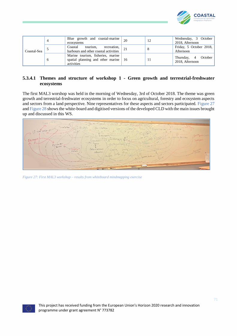
This project has received funding from the European Union’s Horizon 2020 research and innovation programme under grant agreement N° 773782
71
Coastal-Sea
4 Blue growth and coastal-marine ecosystems
20 12 Wednesday, 3 October 2018, Afternoon
5 Coastal tourism, recreation,
harbours and other coastal activities 21 8
Friday, 5 October 2018,
Afternoon
6 Marine tourism, fisheries, marine spatial planning and other marine activities
16 11 Thursday, 4 October 2018, Afternoon
5.3.4.1 Themes and structure of workshop 1 - Green growth and terrestrial-freshwater
ecosystems
The first MAL3 worshop was held in the morning of Wednesday, 3rd of October 2018. The theme was green growth and terrestrial-freshwater ecosystems in order to focus on agricultural, forestry and ecosystem aspects
and sectors from a land perspective. Nine representatives for these aspects and sectors participated. Figure 27
and Figure 28 shows the white-board and digitised versions of the developed CLD with the main issues brought
up and discussed in this WS.
Figure 27: First MAL3 workshop – results from whiteboard mindmapping exercise
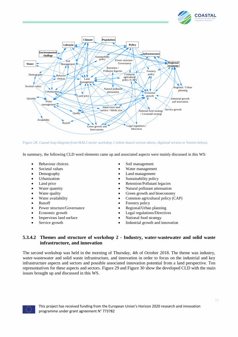
This project has received funding from the European Union’s Horizon 2020 research and innovation programme under grant agreement N° 773782
72
Figure 28: Causal loop diagram from MAL3 sector workshop 1 (white-board version above; digitized version in Vensim below).
In summary, the following CLD word elements came up and associated aspects were mainly discussed in this WS:
• Behaviour choices
• Societal values
• Demography
• Urbanization
• Land price
• Water quantity
• Water quality
• Water availability
• Runoff
• Power structure/Governance
• Economic growth
• Impervious land surface
• Service growth
• Soil management
• Water management
• Land management
• Sustainability policy
• Retention/Pollutant legacies
• Natural pollutant attenuation
• Green growth and bioeconomy
• Common agricultural policy (CAP)
• Forestry policy
• Regional/Urban planning
• Legal regulations/Directives
• National food strategy
• Industrial growth and innovation
5.3.4.2 Themes and structure of workshop 2 - Industry, water-wastewater and solid waste
infrastructure, and innovation
The second workshop was held in the morning of Thursday, 4th of October 2018. The theme was industry,
water-wastewater and solid waste infrastructure, and innovation in order to focus on the industrial and key
infrastructure aspects and sectors and possible associated innovation potential from a land perspective. Ten representatives for these aspects and sectors. Figure 29 and Figure 30 show the developed CLD with the main
issues brought up and discussed in this WS.
Water
Lifestyle
Environmentalchallege
Climate Population
Policy
Regionaleconomy
Infrastructure
SoilManagement
Landmanagement
Watermanagement
Quantity
Quality
Natural pollutantattenuation
Retention /Pollutant legacies
Impervious landsurface / Hårda ytor
AvailabilityRunoff
Commonagricultural
policy (CAP)
Forestrypolicy
Economicgrowth
Behaviorchoices
Societal values
Legal regulations /Directives
National food strategy/ Livsmedel strategi
Urbanization
Regional / Urbanplanning
Land price
Demography
Industrial growthand innovation
Service growth
Power structure /Governance
Sustainabilitypolicy
Green growth andbioeconomy
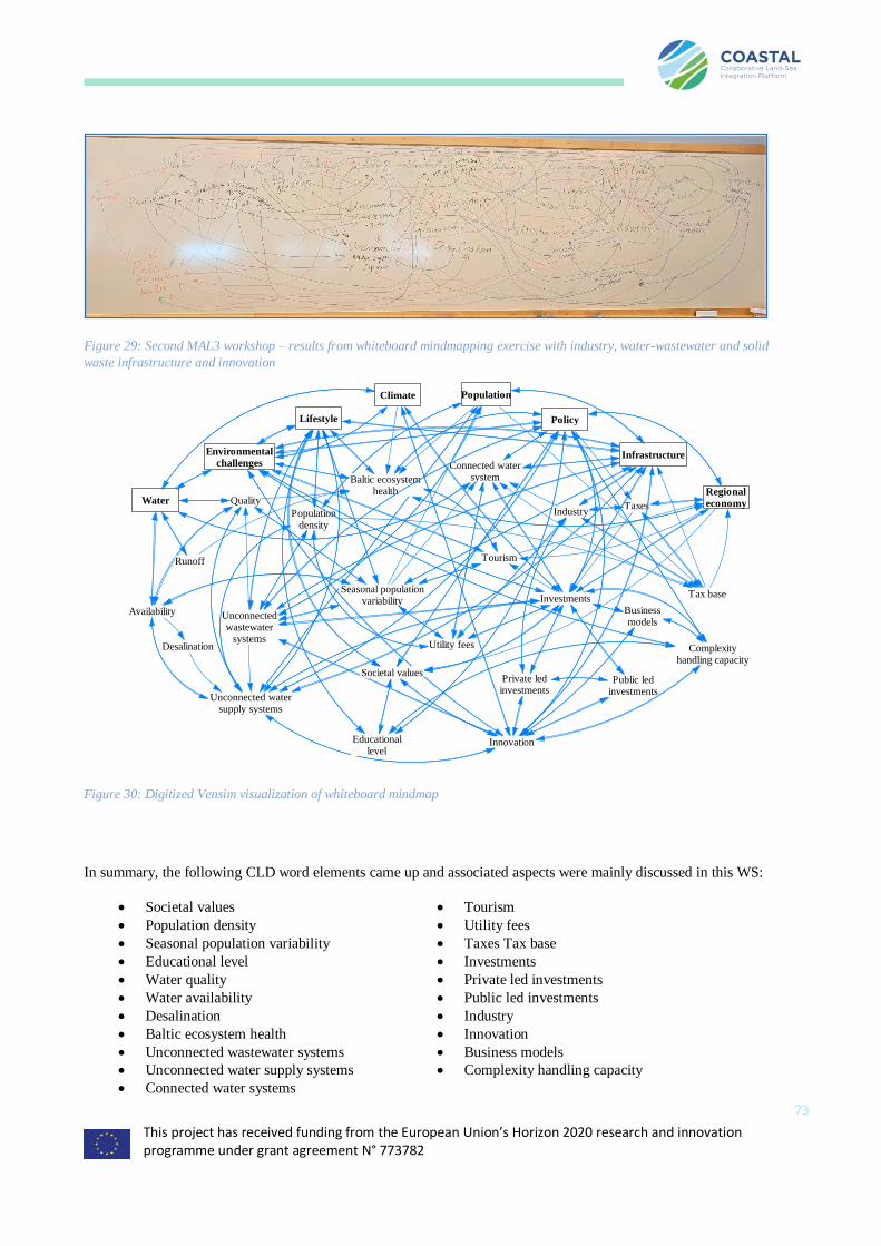
This project has received funding from the European Union’s Horizon 2020 research and innovation programme under grant agreement N° 773782
73
Figure 29: Second MAL3 workshop – results from whiteboard mindmapping exercise with industry, water-wastewater and solid
waste infrastructure and innovation
Figure 30: Digitized Vensim visualization of whiteboard mindmap
In summary, the following CLD word elements came up and associated aspects were mainly discussed in this WS:
• Societal values
• Population density
• Seasonal population variability
• Educational level
• Water quality
• Water availability
• Desalination
• Baltic ecosystem health
• Unconnected wastewater systems
• Unconnected water supply systems
• Connected water systems
• Tourism
• Utility fees
• Taxes Tax base
• Investments
• Private led investments
• Public led investments
• Industry
• Innovation
• Business models
• Complexity handling capacity
Water
Population
Lifestyle
Climate
Environmentalchallenges
Regionaleconomy
Infrastructure
Policy
Unconnectedwastewater
systems
Unconnected watersupply systems
Availability
Quality
Desalination
Investments
Populationdensity
Seasonal populationvariability
Tourism
Tax base
Taxes
Utility fees
Industry
Connected watersystem
Businessmodels
Baltic ecosystemhealth
Runoff
Public ledinvestments
Private ledinvestments
Innovation
Societal values
Educationallevel
Complexityhandling capacity

This project has received funding from the European Union’s Horizon 2020 research and innovation programme under grant agreement N° 773782
74
5.3.4.3 Themes and structure of workshop 3 - Urban-rural communities and land spatial
planning
The third workshop was held in the morning of Friday, 5th of October 2018. The theme was urban-rural
communities and land spatial planning in order to focus on rural and urban interaction and development aspects
and sectors from a land perspective. Ten representatives for these aspects and sectors participated. Figure 31 and Figure 32 show the white-board and digitised versions of the developed CLD with the main issues brought
up and discussed in this WS.
Figure 31: Whiteboard 3rd workshop Sweden
Figure 32: Vensim representation of mindmap 3rd workshop
In summary, the following CLD word elements came up and associated aspects were mainly discussed in this WS:
Water
Climate
Environmentalchallenges
Policy
Regionaleconomy
Population
Lifestyle
Infrastructure
Transportation InformationSystems
Innovation
Education /Research
Communiationsystems
Production
Job creation
Goods Services
Consumption
Water utilities
Urban Rural
Water supply
Water demand
Builtenvironment
Solid Waste
Public services
Food supply
Spatial planning
Energy supply
Ecosystemservices
Land price
Socialchallenges
Complexityhandling capacity
Naturalresources
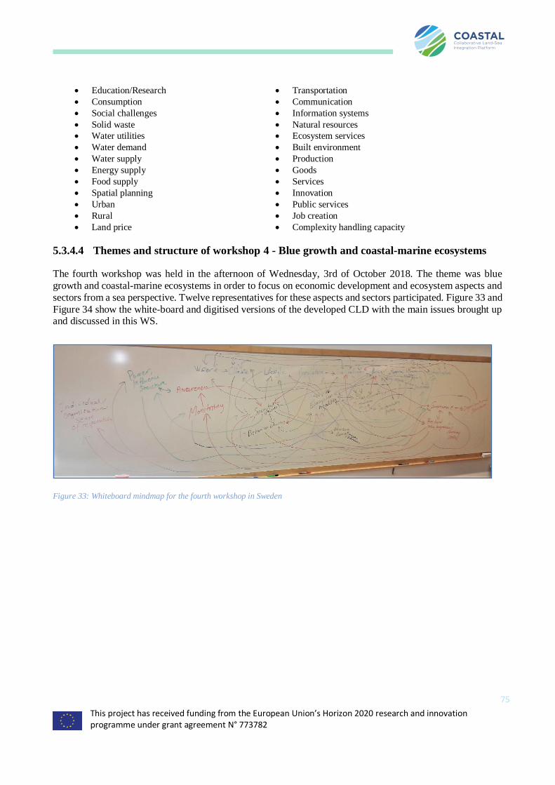
This project has received funding from the European Union’s Horizon 2020 research and innovation programme under grant agreement N° 773782
75
• Education/Research
• Consumption
• Social challenges
• Solid waste
• Water utilities
• Water demand
• Water supply
• Energy supply
• Food supply
• Spatial planning
• Urban
• Rural
• Land price
• Transportation
• Communication
• Information systems
• Natural resources
• Ecosystem services
• Built environment
• Production
• Goods
• Services
• Innovation
• Public services
• Job creation
• Complexity handling capacity
5.3.4.4 Themes and structure of workshop 4 - Blue growth and coastal-marine ecosystems
The fourth workshop was held in the afternoon of Wednesday, 3rd of October 2018. The theme was blue
growth and coastal-marine ecosystems in order to focus on economic development and ecosystem aspects and
sectors from a sea perspective. Twelve representatives for these aspects and sectors participated. Figure 33 and
Figure 34 show the white-board and digitised versions of the developed CLD with the main issues brought up and discussed in this WS.
Figure 33: Whiteboard mindmap for the fourth workshop in Sweden
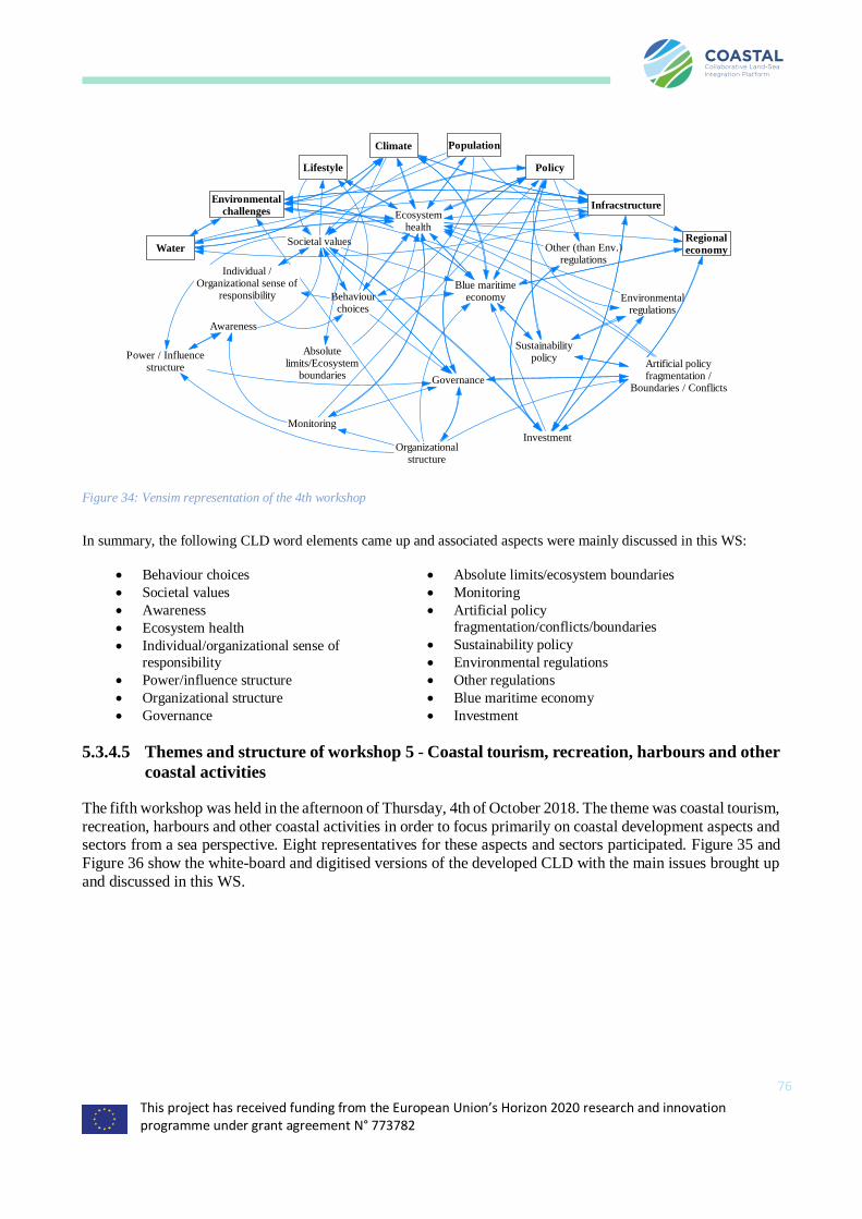
This project has received funding from the European Union’s Horizon 2020 research and innovation programme under grant agreement N° 773782
76
Figure 34: Vensim representation of the 4th workshop
In summary, the following CLD word elements came up and associated aspects were mainly discussed in this WS:
• Behaviour choices
• Societal values
• Awareness
• Ecosystem health
• Individual/organizational sense of
responsibility
• Power/influence structure
• Organizational structure
• Governance
• Absolute limits/ecosystem boundaries
• Monitoring
• Artificial policy
fragmentation/conflicts/boundaries
• Sustainability policy
• Environmental regulations
• Other regulations
• Blue maritime economy
• Investment
5.3.4.5 Themes and structure of workshop 5 - Coastal tourism, recreation, harbours and other
coastal activities
The fifth workshop was held in the afternoon of Thursday, 4th of October 2018. The theme was coastal tourism,
recreation, harbours and other coastal activities in order to focus primarily on coastal development aspects and sectors from a sea perspective. Eight representatives for these aspects and sectors participated. Figure 35 and
Figure 36 show the white-board and digitised versions of the developed CLD with the main issues brought up
and discussed in this WS.
Water
Climate
Lifestyle
Population
Environmentalchallenges
Regionaleconomy
Infracstructure
Blue maritimeeconomy
Policy
Sustainabilitypolicy
Societal values
Behaviourchoices
Ecosystemhealth
Absolutelimits/Ecosystem
boundaries
Investment
Environmentalregulations
Other (than Env.)regulations
Governance
Artificial policyfragmentation /
Boundaries / Conflicts
Organizationalstructure
Monitoring
Awareness
Power / Influencestructure
Individual /Organizational sense of
responsibility

This project has received funding from the European Union’s Horizon 2020 research and innovation programme under grant agreement N° 773782
77
Figure 35: Whiteboard mindmap 5th workshop in Sweden
Figure 36: Vensim representation of mindmap in workshop 5 Sweden
In summary, the following CLD word elements came up and associated aspects were mainly discussed in this WS:
• Seasonal population variability
• Urban growth
• Awareness
• Recreation/tourism
• Water quality
• Aquaculture
• Extreme events
• Sea level rise
• Wastewater treatment systems
• Pollution from boats
• Sewage collecting systems for boats
• Public access to coastal waters/ Archipelago
• Policy-Authority fragmentation/lack of
coordination
• Power structure
• Special coastal habitats/reproduction/nursing
actions
• Local coastal challenges/solutions
• Coastline protection and management
• Harbours
• Coastal resilience
• Weak environmental policy implementation
• Investments
• Insurance
Water
Climate
Environmentalchallenges
Policy
Infrastructure
Regionaleconomy
Population
Lifestyle
Sea level rise
Coastal economicdevelopment
Local coastalchallenges / Solutions
Seasonal populationvariability
Special coastal habitats /Reproduction / Nursing
actions
Public access tocoastal waters /
Archipelago
Coastline protection andmanagement
(shrvredskydd)
Weak environmentalpolicy implementation
Sewage collectingsystems for boats
Urban growthQuality
Insurance
Extreme events
Coastalresilience
Awareness
Recreation /Tourism
Wastewatertreatment systems
Pollution fromboats
Power structure
Harbors
Policy -Authorityfragmentation / Lack of
coordination
Investments
Aquaculture
Desalination
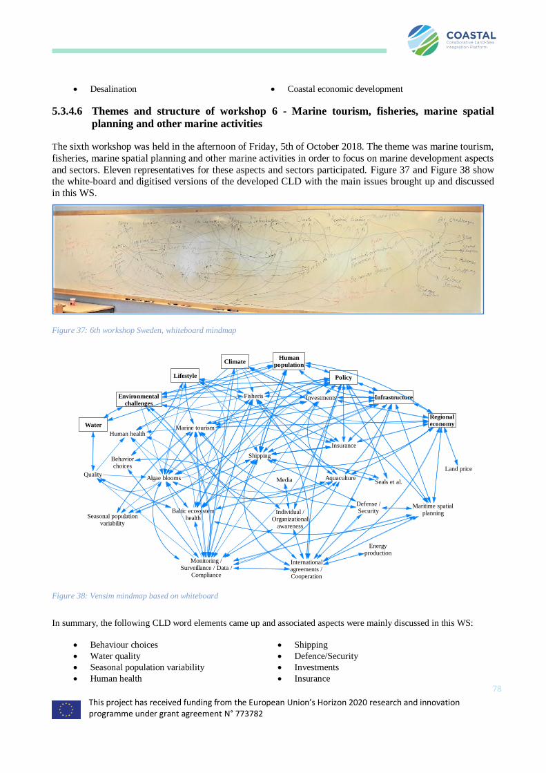
This project has received funding from the European Union’s Horizon 2020 research and innovation programme under grant agreement N° 773782
78
• Desalination • Coastal economic development
5.3.4.6 Themes and structure of workshop 6 - Marine tourism, fisheries, marine spatial
planning and other marine activities
The sixth workshop was held in the afternoon of Friday, 5th of October 2018. The theme was marine tourism,
fisheries, marine spatial planning and other marine activities in order to focus on marine development aspects
and sectors. Eleven representatives for these aspects and sectors participated. Figure 37 and Figure 38 show the white-board and digitised versions of the developed CLD with the main issues brought up and discussed
in this WS.
Figure 37: 6th workshop Sweden, whiteboard mindmap
Figure 38: Vensim mindmap based on whiteboard
In summary, the following CLD word elements came up and associated aspects were mainly discussed in this WS:
• Behaviour choices
• Water quality
• Seasonal population variability
• Human health
• Shipping
• Defence/Security
• Investments
• Insurance
Water
Humanpopulation
Lifestyle
Environmentalchallenges
Policy
Infrastructure
Climate
Regionaleconomy
Marine tourism
Fisheris
Shipping
Algae blooms AquacultureQuality
Investments
Insurance
Individual /Organizational
awareness
Behaviorchoices
Maritime spatialplanningBaltic ecosystem
healthSeasonal populationvariability
Monitoring /Surveillance / Data /
Compliance
Seals et al.
Defense /Security
Land price
Internationalagreements /Cooperation
Energyproduction
Media
Human health
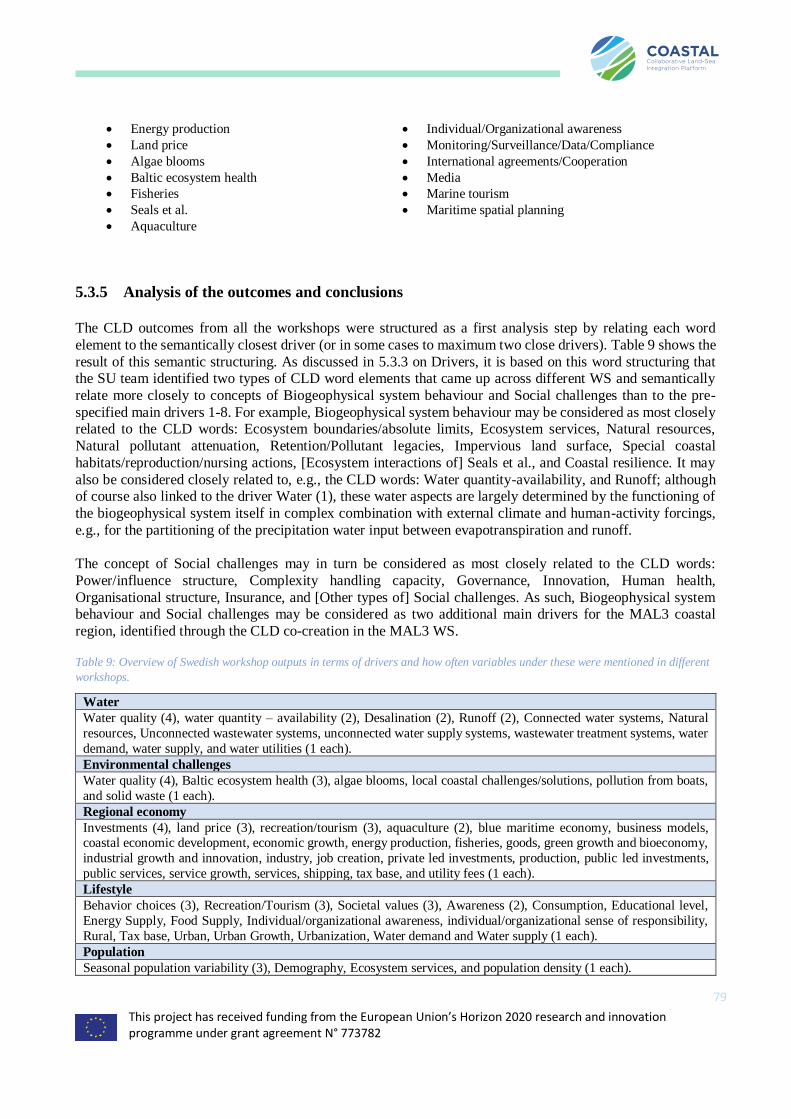
This project has received funding from the European Union’s Horizon 2020 research and innovation programme under grant agreement N° 773782
79
• Energy production
• Land price
• Algae blooms
• Baltic ecosystem health
• Fisheries
• Seals et al.
• Aquaculture
• Individual/Organizational awareness
• Monitoring/Surveillance/Data/Compliance
• International agreements/Cooperation
• Media
• Marine tourism
• Maritime spatial planning
5.3.5 Analysis of the outcomes and conclusions
The CLD outcomes from all the workshops were structured as a first analysis step by relating each word
element to the semantically closest driver (or in some cases to maximum two close drivers). Table 9 shows the
result of this semantic structuring. As discussed in 5.3.3 on Drivers, it is based on this word structuring that the SU team identified two types of CLD word elements that came up across different WS and semantically
relate more closely to concepts of Biogeophysical system behaviour and Social challenges than to the pre-
specified main drivers 1-8. For example, Biogeophysical system behaviour may be considered as most closely related to the CLD words: Ecosystem boundaries/absolute limits, Ecosystem services, Natural resources,
Natural pollutant attenuation, Retention/Pollutant legacies, Impervious land surface, Special coastal
habitats/reproduction/nursing actions, [Ecosystem interactions of] Seals et al., and Coastal resilience. It may
also be considered closely related to, e.g., the CLD words: Water quantity-availability, and Runoff; although of course also linked to the driver Water (1), these water aspects are largely determined by the functioning of
the biogeophysical system itself in complex combination with external climate and human-activity forcings,
e.g., for the partitioning of the precipitation water input between evapotranspiration and runoff.
The concept of Social challenges may in turn be considered as most closely related to the CLD words:
Power/influence structure, Complexity handling capacity, Governance, Innovation, Human health,
Organisational structure, Insurance, and [Other types of] Social challenges. As such, Biogeophysical system behaviour and Social challenges may be considered as two additional main drivers for the MAL3 coastal
region, identified through the CLD co-creation in the MAL3 WS.
Table 9: Overview of Swedish workshop outputs in terms of drivers and how often variables under these were mentioned in different
workshops.
Water
Water quality (4), water quantity – availability (2), Desalination (2), Runoff (2), Connected water systems, Natural
resources, Unconnected wastewater systems, unconnected water supply systems, wastewater treatment systems, water
demand, water supply, and water utilities (1 each).
Environmental challenges
Water quality (4), Baltic ecosystem health (3), algae blooms, local coastal challenges/solutions, pollution from boats,
and solid waste (1 each).
Regional economy
Investments (4), land price (3), recreation/tourism (3), aquaculture (2), blue maritime economy, business models, coastal economic development, economic growth, energy production, fisheries, goods, green growth and bioeconomy,
industrial growth and innovation, industry, job creation, private led investments, production, public led investments,
public services, service growth, services, shipping, tax base, and utility fees (1 each).
Lifestyle
Behavior choices (3), Recreation/Tourism (3), Societal values (3), Awareness (2), Consumption, Educational level,
Energy Supply, Food Supply, Individual/organizational awareness, individual/organizational sense of responsibility,
Rural, Tax base, Urban, Urban Growth, Urbanization, Water demand and Water supply (1 each).
Population
Seasonal population variability (3), Demography, Ecosystem services, and population density (1 each).

This project has received funding from the European Union’s Horizon 2020 research and innovation programme under grant agreement N° 773782
80
Climate
Insurance (2), Extreme events and sea level rise (1 each).
Infrastructure
Built environment, communication system, Connected water systems, Energy supply, Food supply, Harbors,
Information systems, Media, Sewage collecting system for boats, Transportation, Wastewater treatment systems,
Water supply, and Water utilities (1 each).
Policy
Monitoring/Surveillance/Data/Compliance (2), Sustainability policy (2), Articifical policy
fragmentation/conflicts/boundaries, coastaline protection and management, common agricultural policy (CAP),
Defense/Security, Education/Research, Environmental regulations, Forestry policy, International agreements/cooperation, Job creation, Land management, Legal regulations/directives, maritime spatial planning,
national food strategy, other than environmental regulations, policy-authority fragmentation/lack of coordination,
public access to coastal waters/archipelago, regional/urgan planning, soil management, spatial planning, taxes, water
management, and weak environmental policy implementation (1 each).
Biogeophysical systems behaviour
Runoff (2), water quantity availability (2), absolute limits/ecosystem boundaries, coastal resilience, ecosystem
services, impervious land surface, natural pollutant attenutation, natural resources, retention/pollutant legacies, seals
etc, and special coastal habitats/reproduction/nursing actions (1 each).
Social challenges
Power/influence structure (3), complexity handling capacity (2), governance (2), innovation (2), insurance (2), human
health, organizational structure and social challenges (1 each).
Furthermore, some more main reflections on the CLD word elements that came up in the MAL3 WS may be
summarised as:
• Most words came up in only one WS, indicating achievement of the sector specificity and added value
aimed at with the choices of different WS themes and associated participating stakeholders.
• The large variety and multiple links among words that came up in the different WS indicate a general stakeholder perception of high complexity and numerous dynamic interactions in the MAL3 system.
• The same words that came up most frequently among (at least 3 of) the different WS are: Water quality,
Baltic ecosystem health, Investments, Land price, Recreation/Tourism, Behaviour choices, Societal
values, Seasonal population variability, Power/influence structure. These word aspects are thus indicated as main concerns of various MAL3 sectors and stakeholders.
• The highest number of different words that relate (semantically, Table 9) most closely to the same
driver came up for the driver Policy among the different WS. This highlights a wide range of different
types of policy that are relevant for the sustainability of coastal, rural and urban development in the MAL3 coastal region.
• Relatively few words with closest semantic relationship to the drivers Climate and Population came
up among the different WS (Table 9). This may indicate a general stakeholder view of these drivers
and their change trends as not readily controllable by many other drivers and/or actions.

This project has received funding from the European Union’s Horizon 2020 research and innovation programme under grant agreement N° 773782
81
5.4 Romania - Danube Mouth (Black Sea)
5.4.1 Executive summary
The study case Black Sea - Danube Mouths combines the natural features of the area (the Black Sea waters
receiving the Danube’s waters jointly with suspended solids and chemicals), the Danube Delta’s (unique
natural reservation with specific requirements on coastal and rural zone and limitation of activities) with the
lack of and/or chaotic development and need for a sustainable one. At this time, there is a national strategy for the Danube Delta (2016) with the vision (for 2030) of a "living delta" (an area where people live and work),
with a balance between the environment and the community; with a sustainable and healthy local economy -
based mainly on nature and cultural tourism; with an inclusive planning process (locals authorities, business environment). The vision for neighboring areas is for the co-existence of both agriculture and a vibrant
business environment network of urban service centers and an integrated tourist sector in attractions the area
and the Delta.
The sectorial workshops have generally identified the same vision for development but real issues and
impediments to implement it. The coastal workshops (three) were held in Constanta, on 30 and 31 of October 2018, at the National Institute for Marine Research and Development “Grigore Antipa” premises. Local actors
and experts from the Danube Delta and Black Sea coastal zone participated in collaborative exercises to
analyse problems, the underlying causes, propose and discuss solutions, and validate and interpret the impacts of simulated business and policy decisions. The interactive workshops were focusing on Blue Growth
(industry, transport and administration), Tourism - coastal and Fisheries & Aquaculture, attended by local
stakeholders.
Discussions and qualitative techniques were combined in this co-creation process supported by graphical tools to gain in-depth understanding of the systemic transitions underlying the land-sea interactions in each specific
domain. During the three workshops, stakeholders were actively involved in identifying the main connections
between the 8 drivers, specifically tailored for the activity sectors. For Blue Growth, representatives from
public administration, policy makers, industry and transportation were present, while for Tourism and Fisheries & Aquaculture - operators, investors and control authorities attended. For all three activity fields, it
resulted that the most significant driver is represented by policy, as it can influence all activities by regulating
them. All these identified interactions between drivers were further introduced into the VENSIM software, in order to graphically represent the cause-effects relationships. These systemic transitions will further be
synthesized and analysed with system dynamic models to produce multiple transition scenarios for key
business and policy indicators, in a process of fostering co-creation as a must-have approach of current
environmental and societal issues.
The rural workshops (three) were held in Bucharest and in Constanta county (Ciocarlia and Topalu) on the 11th, 15th and 16th of January, at ICEADR (the Research Institute for Agrarian Economy and Rural
Development) and at the Ciocarlia and Topalu city hall. The following are the sectors and/or thematic areas
that were focused on during the workshop: 1) Rural Development of Danube’s Delta region (first workshop, 14 participants), 2) Agriculture, cross-compliance, and ecosystem services (second workshop, 32 participants)
and 3) Rural tourism, recreation others rural activities (third workshop, 22 participants).
The predetermined seven drivers were used in all workshops and the main issues for the region as identified
by the stakeholders in the workshops, irrespective of sector, were infrastructure, red tape and legislation. All
the meetings were interactive in that each participant would inform about the main challenges that influences their activity. As a conclusion, the main challenged identified by farmers, rural communities, economic agents
in the area and other target groups, were policy and legislation that influences infrastructure and other
variables. The main opportunity identified in the workshops in the rural areas of the Danube Mouth center on

This project has received funding from the European Union’s Horizon 2020 research and innovation programme under grant agreement N° 773782
82
the concept of bioeconomy. Vensim was used for the graphically representation of the discussion here as well, and like with the coastal CLDs, these will further be synthesized and analysed with system dynamic models
to produce multiple transition scenarios for key business and policy indicators, in a process of fostering co-
creation as a must-have approach of current environmental and societal issues.
5.4.2 Background The Romanian Black Sea coastline extends for 244 km and is divided into two main geographical and
geomorphological sectors: The northern sector (165 km in length) lies between the Musura Bay and Cape
Midia and forms a limitrophe shore to the Danube Delta, including the lateral lagoon complex Razim-Sinoe and consisting of alluvial sediments with extensive lowlands marshes and lagoons, and beaches formed of
Danube sediments; the contour of the seaward delta front is smooth and nearly linear except for mouths of Sf.
Gheorghe and Sulina branches of the Danube.
The southern sector (about 75 km in
length) lies between Cape Midia and
Vama Veche, subdivided in two sub-
sectors: Cape Midia - Cape Singol (characterized by the appearance of the
first promontories with active, high cliffs
until 35-40 m, separated by large zones with accumulative beaches) and Cape
Singol-Vama Veche, where active or
inactive cliffs are predominant and only
interrupted by beaches at the mouth of the Black Sea tributaries. It has been
transformed as a result of intensive
development: ports, coastal protecting structures, urban and touristic
infrastructures. Mass tourism is an
important growth sector for the Black Sea and eco-tourism is becoming more
important in the region.
The Danube Delta and the adjacent
Razim-Sinoe complex of lagoons, located
in Romania and Ukraine, is the second largest wetland of Europe — after the
Volga Delta. The Danube River splits
into three channels: the Chilia, the Sulina and the Sfântu Gheorghe, carrying about
60 %, 20 % and 20 % of the total runoff
respectively. Navigation is possible only
through the Sulina Channel, which has been straightened and dredged along its
60 km length. The Black Sea has special
natural features due to its semi-enclosed location and catchment area that is five
times larger than its surface. Therefore, it is vulnerable to anthropogenic pressures and pollution sources (BSC,
2008) such as that which may come through the Danube Delta. Until the 1960s, the Western part of the Black Sea was known as an example of a natural eutrophic ecosystem due to the permanent input of nutrients from
Figure 39: Map of the Romanian Black Sea’s coastal zone and main activities

This project has received funding from the European Union’s Horizon 2020 research and innovation programme under grant agreement N° 773782
83
the Danube (Gomoiu 1981). As anthropogenic activities increased, as did the use of fertilizers, as well as discharge of wastewater and detergents, and the nutrients regime has therefore undergone significant changes.
These changes were related to the Danube’s nutrients input that simultaneously also increased significantly
(Mee and Topping 1999)( Cociaşu et al., 2008) and led to alterations in the Black Sea ecosystem. Mismanagement of nutrients in the Danube Basin has therefore led to severe ecological challenges in the area,
including the deterioration of groundwater resources and the eutrophication of rivers, lakes and especially the
Black Sea.
These challenges are directly related to social and economic issues such as drinking water supply, tourism and
fishery as affected sectors and agriculture, nutrition, industry and waste water management as drivers (Kroiss, Lampert et al. 2004). The Black Sea eutrophication effects included its the transparency decreasing, higher
quantities of organic matter decomposing in it and oxygen depletion (Gomoiu 1992) as well as bottom waters
becoming seasonally hypoxic or even anoxic (SoKolnikov 1999), transforming the North Western part of the Black Sea into a highly eutrophic one (Zaitsev in Mee, 1999). Since the early 1990s, however, decreasing
nutrient inputs have resulted in signs of recovery.
Today the Black Sea catchment is still under pressure from excess nutrients and contaminants due to emissions
from agriculture, tourism, industry and urbanization in the Danube basin though. This prevents achieving the
Good Environmental Status by 2020, as required by the EU-Marine Strategy Framework Directive. The increased rates of eutrophication, pollution and bioaccumulation affect both biodiversity (including Natura
2000 sites) and the fishing sectors. Approximately 65% of the Romanian coastline is in the Danube Delta
Biosphere Reserve and subject to tourism regulations, resulting in conflicts between nature conservation and
economic development (Fig.5.4.2.1).
Though the coastal areas of Romania are thriving, it is also important for the population to promote an efficient
development and revitalization of rural area in the country. This however requires a thorough assessment of
the current situation. The challenge of the rural areas is to compare the different economic sectors while still
capturing their diversity. The structure of the land areas is diversified, dominated by the reed-fishery and agriculture. However, agriculture represents the major economic sector in the region, with high importance in
the bio economy area, fostering the establishment of the environment–economic development system (Andrei
M.-T, Lianu C., Gudei S., 2014). In fact, in the Romanian coastal region, the agricultural sector accounts for 32 % of jobs (30 % in the whole country). Generally, the development strategy of this region observes the
Sustainable Development Strategy of the EU, where the overall objective to improve the management of
natural resources and to avoid their excessive exploitation while recognizing the value of ecosystem services (Development strategy of Tulcea county 2014-2020).
At the regional level, the goal should be to reach a superior valorization of the available biomass and
agricultural land and assuring at the same time a sustainable management of natural resources. For a future integration of rural development goals, it is vital to find a balance towards a new perspective on traditional and
high-value production, as well as creating opportunities and jobs for farming, forestry, fisheries, aquaculture
and industry (Integrated Strategy for Sustainable Development of the Danube Delta) and avoiding cross sectoral conflicts. Failing to resolve these conflicts has social, economic and political impacts which calls for
urgent co-creation actions among all the stakeholders involved (Golumbeanu and Nicolaev 2015).
5.4.3 Drivers
Variations of the common drivers used by all study cases were good matches with the Danube’s Mouths –
Black Sea case. However, the additional driver of “Industry and Business Development was added”.
Table 10: Drivers for the Danube Mouth case area
Original drivers Workshop drivers Sweden
This project has received funding from the European Union’s Horizon 2020 research and innovation programme under grant agreement N° 773782
84
Water Water
Human Consumption
Pattern
Lifestyle
Regulation policy Politics/administration
Temperature Climate change
Human migration Demography/Population
Pollution Environment
Infrastructure Infrastructure
Industry and Business development
5.4.4 Stakeholder workshops and Causal loop diagram
Table 11: Stakeholder overview Danube mouth
Perspective Sectoral
Workshop Theme
Number of
participating
stakeholder
representatives
Date and Time
Coastal-Sea
1 Blue Growth - Industry, transport and
administration 13 30th October 2018
2 Tourism 16 31st October 2018
3 Fisheries and aquaculture (marine) 31st October 2018
Land
4 Rural development of Danube’s Delta region 17 11 January 2019
5 Agriculture, cross-compliance and ecosystem
services 29 15 January 2019
6 Rural tourism, recreation and others rural
activities 19 16 January 2019
5.4.4.1 Themes and structure of workshop 1 – Blue Growth, Danube mouth
During the first workshop, the theme was Blue Growth, including industry, transport and administration
stakeholders. This is because the Romanian littoral is divided into two areas with different geography and
development. In the Blue Growth Workshop have actively participated 16 stakeholders from public
administration, the oil and gas industry and the transport sector.
The workshop was an open discussion where the stakeholders were encouraged to participate and to point to the main challenges of their activities, and this was a very welcomed approach. All the participants were
actively involved and a complex white-board (Error! Reference source not found.) and casual loop diagram (
Fig.5.4.4.1.3) resulted.
Figure 40: Blue Growth Workshop – Romania, Constanta, 30 October 2018

This project has received funding from the European Union’s Horizon 2020 research and innovation programme under grant agreement N° 773782
85
Table 12: Variables produced during the blue growth workshop
Variables in alphabetical order
accessibility (transport), population isolation government
agriculture social protection income (salaries)
awareness tourism jobs
business planning utilities lack of information
education wastewater treatment plants naval transport
Figure 42: Casual Loop Diagram - Blue Growth Workshop – Romania, Constanta, 30 October 2018
Figure 41: White-board - Blue Growth Workshop – Romania, Constanta, 30
October 2018
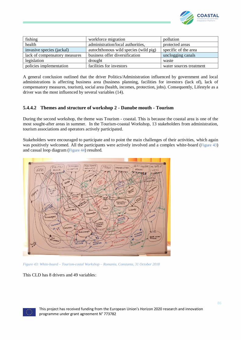
This project has received funding from the European Union’s Horizon 2020 research and innovation programme under grant agreement N° 773782
86
fishing workforce migration pollution
health administration/local authorities, protected areas
invasive species (jackal) autochthonous wild species (wild pig) specific of the area
lack of compensatory measures business offer diversification unclogging canals
legislation drought waste
policies implementation facilities for investors water sources treatment
A general conclusion outlined that the driver Politics/Administration influenced by government and local administrations is affecting business area (business planning, facilities for investors (lack of), lack of
compensatory measures, tourism), social area (health, incomes, protection, jobs). Consequently, Lifestyle as a
driver was the most influenced by several variables (14).
5.4.4.2 Themes and structure of workshop 2 - Danube mouth - Tourism
During the second workshop, the theme was Tourism - coastal. This is because the coastal area is one of the most sought-after areas in summer. In the Tourism-coastal Workshop, 13 stakeholders from administration,
tourism associations and operators actively participated.
Stakeholders were encouraged to participate and to point the main challenges of their activities, which again
was positively welcomed. All the participants were actively involved and a complex white-board (Figure 43)
and casual loop diagram (Figure 44) resulted.
Figure 43: White-board – Tourism-costal Workshop – Romania, Constanta, 31 October 2018
This CLD has 8 drivers and 49 variables:
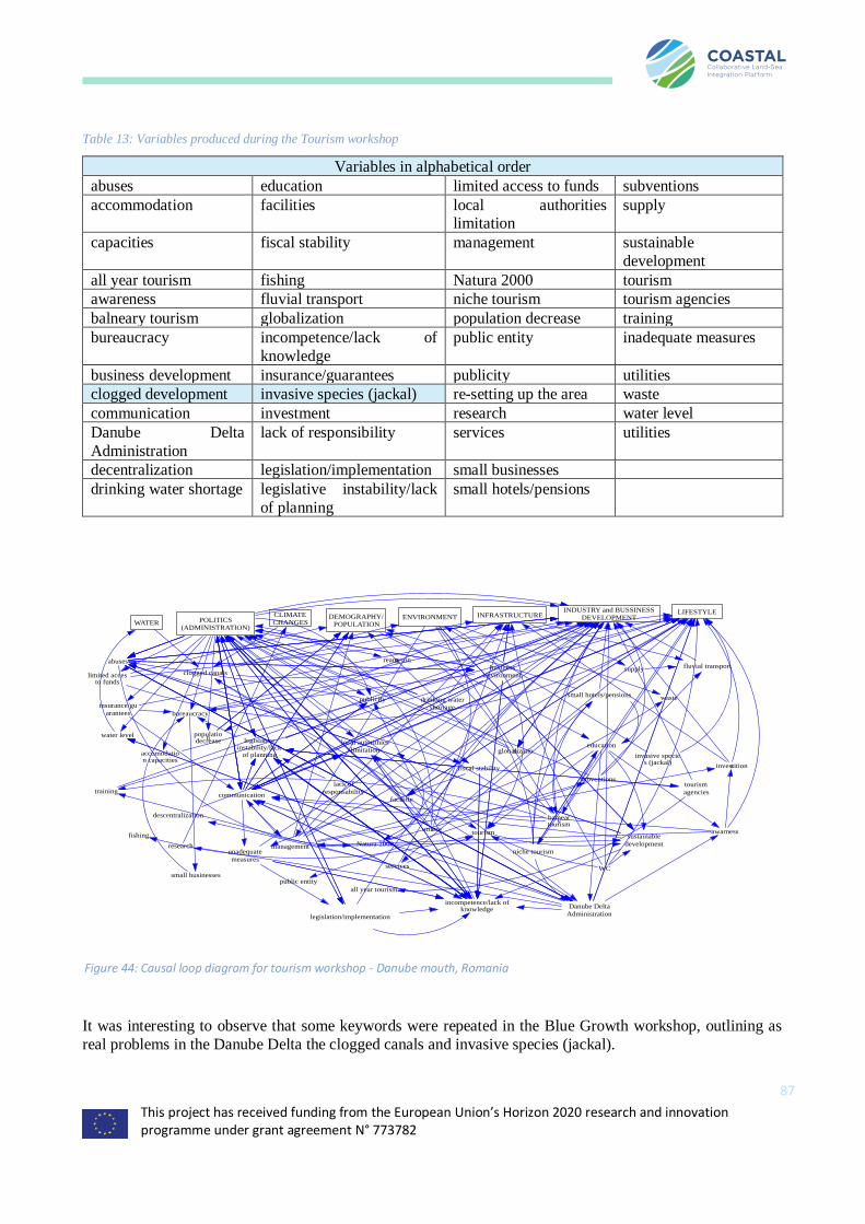
This project has received funding from the European Union’s Horizon 2020 research and innovation programme under grant agreement N° 773782
87
Table 13: Variables produced during the Tourism workshop
Variables in alphabetical order
abuses education limited access to funds subventions
accommodation facilities local authorities limitation
supply
capacities fiscal stability management sustainable
development
all year tourism fishing Natura 2000 tourism
awareness fluvial transport niche tourism tourism agencies
balneary tourism globalization population decrease training
bureaucracy incompetence/lack of
knowledge
public entity inadequate measures
business development insurance/guarantees publicity utilities
clogged development invasive species (jackal) re-setting up the area waste
communication investment research water level
Danube Delta
Administration
lack of responsibility services utilities
decentralization legislation/implementation small businesses
drinking water shortage legislative instability/lack
of planning
small hotels/pensions
It was interesting to observe that some keywords were repeated in the Blue Growth workshop, outlining as
real problems in the Danube Delta the clogged canals and invasive species (jackal).
WATER POLITICS
(ADMINISTRATION)
CLIMATE
CHANGESDEMOGRAPHY/
POPULATIONENVIRONMENT INFRASTRUCTURE
INDUSTRY and BUSSINESS
DEVELOPMENTLIFESTYLE
clogged canals
water level
abuses
limited accesto funds
Danube Delta
Administration
insurance/gu
arantees bureaucracy
accomodation capacities
communication
incompetence/lack ofknowledge
legislativeinstability/lack
of planning
local autorithies
limitation
publicity
reamening
population
decrease
fiscal stability
facilities
utilities
globalization
legislation/implementation
drinking water
shortage
lack of
responsability
business
environment
subventions
balneary
tourism
research management
small hotels/pensions
niche tourism
education
invasive species (jackal)
waste
sustainable
developmentNatura 2000
tourism
investitions
WC
supply fluvial transport
tourism
agenciestraining
unadequate
measuresservices
awarness
small businesses
descentralization
all year tourism
fishing
public entity
Figure 44: Causal loop diagram for tourism workshop - Danube mouth, Romania
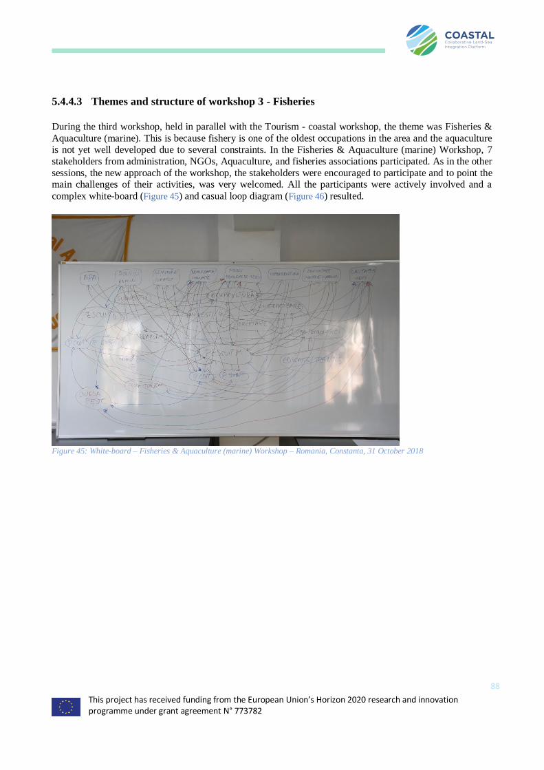
This project has received funding from the European Union’s Horizon 2020 research and innovation programme under grant agreement N° 773782
88
5.4.4.3 Themes and structure of workshop 3 - Fisheries
During the third workshop, held in parallel with the Tourism - coastal workshop, the theme was Fisheries &
Aquaculture (marine). This is because fishery is one of the oldest occupations in the area and the aquaculture is not yet well developed due to several constraints. In the Fisheries & Aquaculture (marine) Workshop, 7
stakeholders from administration, NGOs, Aquaculture, and fisheries associations participated. As in the other
sessions, the new approach of the workshop, the stakeholders were encouraged to participate and to point the main challenges of their activities, was very welcomed. All the participants were actively involved and a
complex white-board (Figure 45) and casual loop diagram (Figure 46) resulted.
Figure 45: White-board – Fisheries & Aquaculture (marine) Workshop – Romania, Constanta, 31 October 2018

This project has received funding from the European Union’s Horizon 2020 research and innovation programme under grant agreement N° 773782
89
Table 14: Variables for the Fisheries and Aquaculture workshop Danube delta
Variables in alphabetical order
aquaculture Danube Delta fishing legislation
implementation
research
awareness education/training investment subsistence fishing freshwater
commercial fishing
freshwater
Fish stock exchange lack of technology subsistence fishing
marine
commercial fishing marine
fishing poaching
Policy and administration was identified as the main factor influencing fisheries and aquaculture in Romania,
both in the Danube Delta and Black Sea coast area, with the biggest concern being the conflict between Marine
Protected Areas (and restrictive measures) and the exploitation of resources. The creation of a fish stock trade
market (Bursa Pește) was deemed beneficial, however its operation is not optimized and adequate polices are
required.
5.4.4.4 Themes and structure of workshop 4 – Rural development
During the fourth workshop, the theme was Rural Development of Danube’s Delta region. This is because of
the specific experience and activity of the participants and their interest for the rural development of Danube’s
Delta region. In this workshop, 14 stakeholders from administration, university, research and non-
governmental organization participated.
WATER POLITICS/ADMINISTRATIONCLIMATE
CHANGES
DEMOGRAPHY/
POPULATION ENVIRONMENT INFRASTRUCTUREINDUSTRY and
BUSINESS
DEVELOPMENT
LIFESTYLE
Investment
aquaculture
awarness
research
lack of technology
Danube Delta
fishing
Fishing
POACHING
subsistence fishing freshwater
commercial fishing
freshwater
education/training
Commercial
fishing marine
Subsistence
fishing marine
tourism for fishing
Fish Stock Exchangeimplementation /
legislation
Figure 46: Casual Loop Diagram – Fisheries & Aquaculture (marine) Workshop – Romania, Constanta, 31 October 2018

This project has received funding from the European Union’s Horizon 2020 research and innovation programme under grant agreement N° 773782
90
Figure 47: Blackboard version of the Rural Development mind map session in Danube’s Delta region
During this first workshop, the participants were actively involved in an interactive discussion regarding the rural development in Danube’ Delta. They were enthusiastic about the methodology of the COASTAL project,
which presented to them a different approach from the one they were used to. Furthermore, the presence of
teachers and people from Academia was a welcome addition.
Figure 48: Vensim representation of mind map - Rural Development
In summary, the following CLD variables were discussed during the workshop:
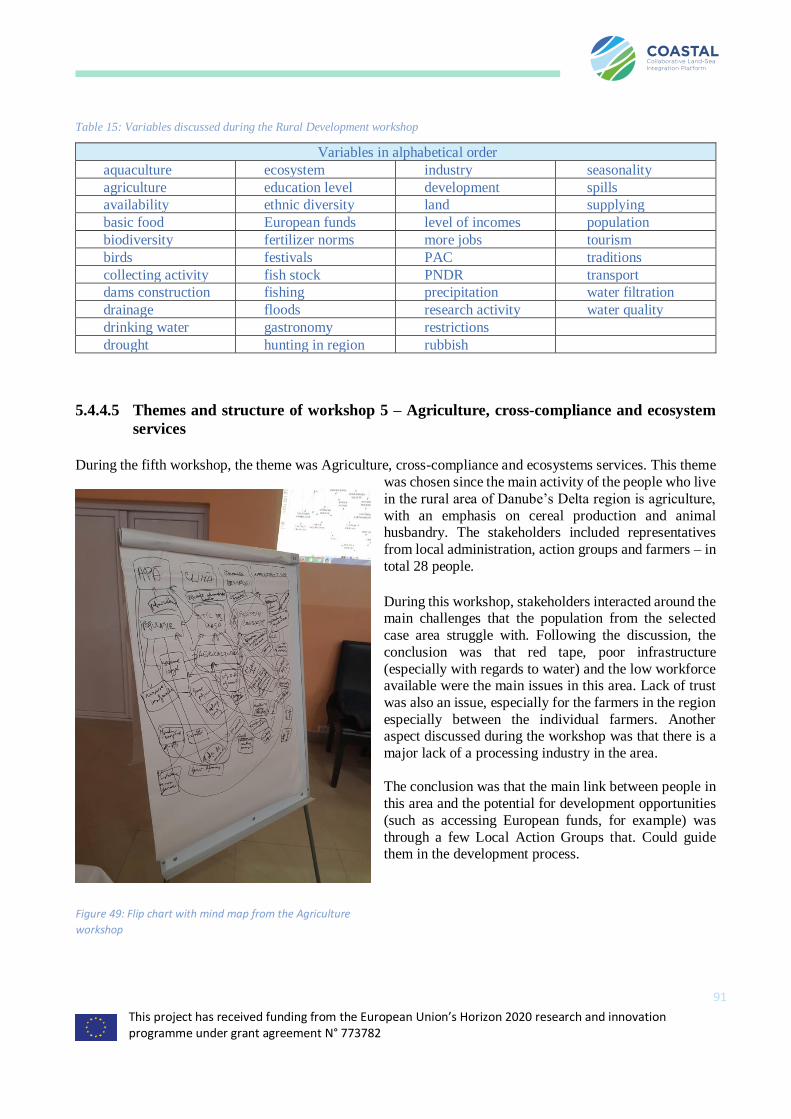
This project has received funding from the European Union’s Horizon 2020 research and innovation programme under grant agreement N° 773782
91
Table 15: Variables discussed during the Rural Development workshop
Variables in alphabetical order
aquaculture ecosystem industry seasonality
agriculture education level development spills
availability ethnic diversity land supplying
basic food European funds level of incomes population
biodiversity fertilizer norms more jobs tourism
birds festivals PAC traditions
collecting activity fish stock PNDR transport
dams construction fishing precipitation water filtration
drainage floods research activity water quality
drinking water gastronomy restrictions
drought hunting in region rubbish
5.4.4.5 Themes and structure of workshop 5 – Agriculture, cross-compliance and ecosystem
services
During the fifth workshop, the theme was Agriculture, cross-compliance and ecosystems services. This theme
was chosen since the main activity of the people who live
in the rural area of Danube’s Delta region is agriculture,
with an emphasis on cereal production and animal husbandry. The stakeholders included representatives
from local administration, action groups and farmers – in
total 28 people.
During this workshop, stakeholders interacted around the main challenges that the population from the selected
case area struggle with. Following the discussion, the
conclusion was that red tape, poor infrastructure
(especially with regards to water) and the low workforce available were the main issues in this area. Lack of trust
was also an issue, especially for the farmers in the region
especially between the individual farmers. Another aspect discussed during the workshop was that there is a
major lack of a processing industry in the area.
The conclusion was that the main link between people in
this area and the potential for development opportunities
(such as accessing European funds, for example) was
through a few Local Action Groups that. Could guide them in the development process.
Figure 49: Flip chart with mind map from the Agriculture
workshop
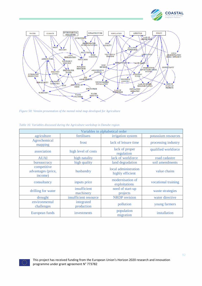
This project has received funding from the European Union’s Horizon 2020 research and innovation programme under grant agreement N° 773782
92
Figure 50: Vensim presentation of the mental mind map developed for Agriculture
Table 16: Variables discussed during the Agriculture workshop in Danube region
Variables in alphabetical order
agriculture fertilisers irrigation system potassium resources
Agrochemical mapping
frost lack of leisure time processing industry
association high level of costs lack of proper
regulation qualified workforce
AUAI high natality lack of workforce road cadastre
bureaucracy high quality land degradation soil amendments
competitive
advantages (price,
income)
husbandry local administration
highly efficient value chains
consultancy inputs price modernisation of
exploitations vocational training
drilling for water insufficient
machinery
need of start-up
projects waste strategies
drought insufficient resource NRDP revision water directive
environmental
challenges
integrated
production pollution young farmers
European funds investments population migration
installation
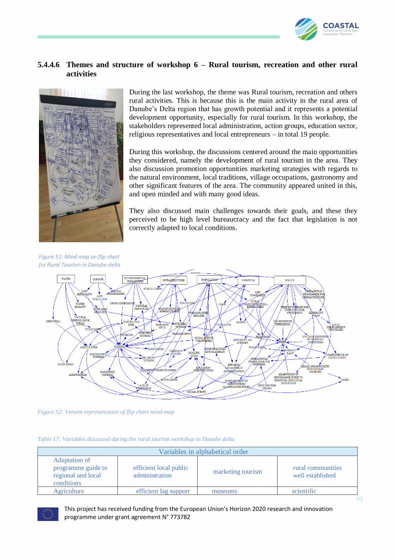
This project has received funding from the European Union’s Horizon 2020 research and innovation programme under grant agreement N° 773782
93
5.4.4.6 Themes and structure of workshop 6 – Rural tourism, recreation and other rural
activities
During the last workshop, the theme was Rural tourism, recreation and others
rural activities. This is because this is the main activity in the rural area of Danube’s Delta region that has growth potential and it represents a potential
development opportunity, especially for rural tourism. In this workshop, the
stakeholders represented local administration, action groups, education sector,
religious representatives and local entrepreneurs – in total 19 people.
During this workshop, the discussions centered around the main opportunities
they considered, namely the development of rural tourism in the area. They
also discussion promotion opportunities marketing strategies with regards to
the natural environment, local traditions, village occupations, gastronomy and other significant features of the area. The community appeared united in this,
and open minded and with many good ideas.
They also discussed main challenges towards their goals, and these they
perceived to be high level bureaucracy and the fact that legislation is not
correctly adapted to local conditions.
Figure 52: Vensim representation of flip chart mind-map
Table 17: Variables discussed during the rural tourism workshop in Danube delta
Variables in alphabetical order Adaptation of
programme guide to
regional and local
conditions
efficient local public
administration marketing tourism
rural communities
well established
Agriculture efficient lag support museums scientific
Figure 51: Mind map on flip chart
for Rural Tourism in Danube delta
region.
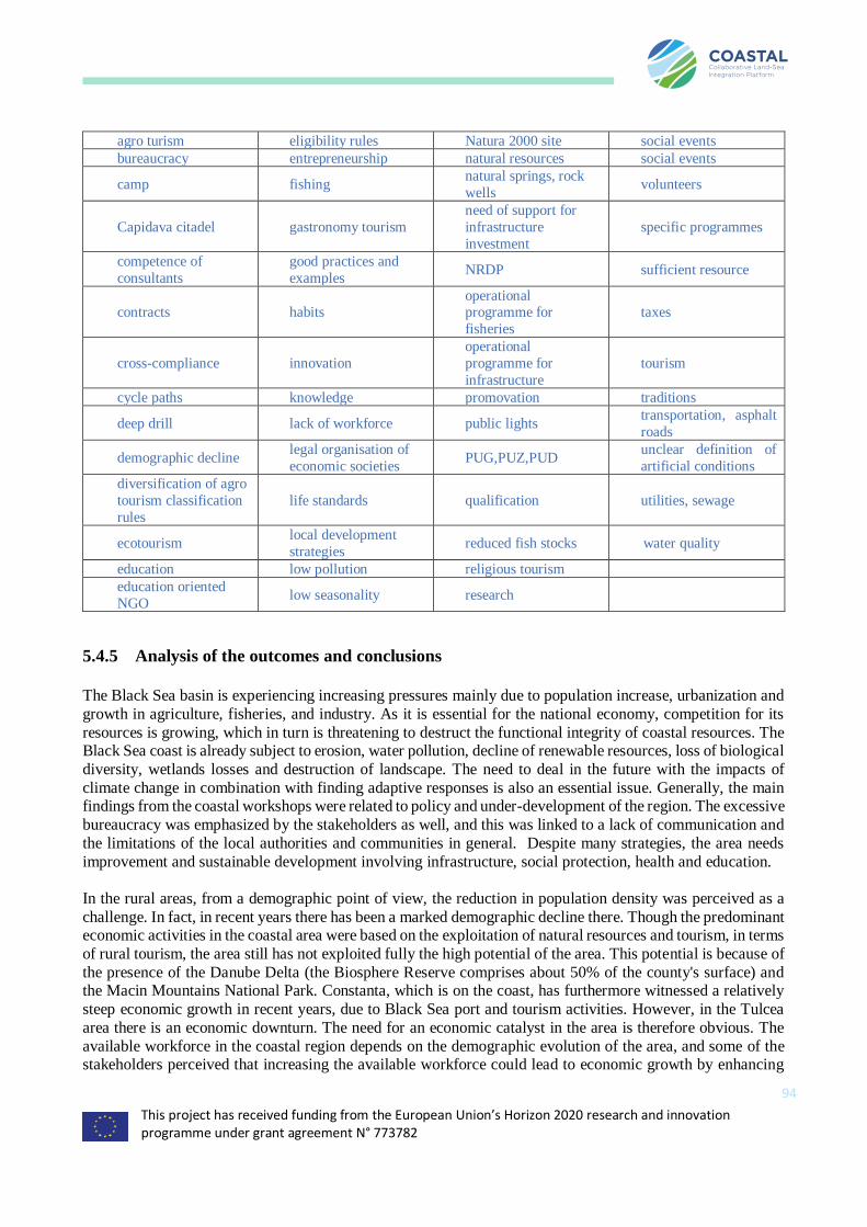
This project has received funding from the European Union’s Horizon 2020 research and innovation programme under grant agreement N° 773782
94
agro turism eligibility rules Natura 2000 site social events
bureaucracy entrepreneurship natural resources social events
camp fishing natural springs, rock
wells volunteers
Capidava citadel gastronomy tourism
need of support for
infrastructure
investment
specific programmes
competence of
consultants
good practices and
examples NRDP sufficient resource
contracts habits operational programme for
fisheries
taxes
cross-compliance innovation
operational
programme for
infrastructure
tourism
cycle paths knowledge promovation traditions
deep drill lack of workforce public lights transportation, asphalt
roads
demographic decline legal organisation of
economic societies PUG,PUZ,PUD
unclear definition of
artificial conditions
diversification of agro
tourism classification
rules
life standards qualification utilities, sewage
ecotourism local development
strategies reduced fish stocks water quality
education low pollution religious tourism
education oriented
NGO low seasonality research
5.4.5 Analysis of the outcomes and conclusions
The Black Sea basin is experiencing increasing pressures mainly due to population increase, urbanization and
growth in agriculture, fisheries, and industry. As it is essential for the national economy, competition for its
resources is growing, which in turn is threatening to destruct the functional integrity of coastal resources. The Black Sea coast is already subject to erosion, water pollution, decline of renewable resources, loss of biological
diversity, wetlands losses and destruction of landscape. The need to deal in the future with the impacts of
climate change in combination with finding adaptive responses is also an essential issue. Generally, the main findings from the coastal workshops were related to policy and under-development of the region. The excessive
bureaucracy was emphasized by the stakeholders as well, and this was linked to a lack of communication and
the limitations of the local authorities and communities in general. Despite many strategies, the area needs
improvement and sustainable development involving infrastructure, social protection, health and education.
In the rural areas, from a demographic point of view, the reduction in population density was perceived as a
challenge. In fact, in recent years there has been a marked demographic decline there. Though the predominant economic activities in the coastal area were based on the exploitation of natural resources and tourism, in terms
of rural tourism, the area still has not exploited fully the high potential of the area. This potential is because of
the presence of the Danube Delta (the Biosphere Reserve comprises about 50% of the county's surface) and the Macin Mountains National Park. Constanta, which is on the coast, has furthermore witnessed a relatively
steep economic growth in recent years, due to Black Sea port and tourism activities. However, in the Tulcea
area there is an economic downturn. The need for an economic catalyst in the area is therefore obvious. The
available workforce in the coastal region depends on the demographic evolution of the area, and some of the stakeholders perceived that increasing the available workforce could lead to economic growth by enhancing
This project has received funding from the European Union’s Horizon 2020 research and innovation programme under grant agreement N° 773782
95
activities, if the quality of this indicator increases. Given the geographic position of this rural area, aquaculture and fishing could also be a priority development area for the area in the future, alongside rural, recreational,
scientific or ecumenical tourism.
Improvement in the transport infrastructure could furthermore solve the seasonal traffic jams, with special
needs both in both Constanca and Tulcea Counties. Regarding commercial transport, a considerable amount
of goods is transported from Constanta port within the country and in Central Europe to Constanta, leading to
congestion of main roads. The development of the county road transport infrastructure in the counties of Constanta and Tulcea is a therefore topical issue. The two counties have a great potential for economic
development. They have minerals, materials, humans and unique natural resources. Elements of integrated
logistics and multimodal transport are developed in the county of Constanta and in Tulcea county, but it is still at an early stage. The lack of adequate transport infrastructure would demonstrates that the two counties are
not at the level of existing economic opportunities (Iordanaia, 2016).
Furthermore, the stakeholders suggested that to promote an efficient development and revitalization of rural
coastal areas, the proper assessment of the current situation is needed. The challenge is to be able to compare
bioeconomic sectors while still capturing their diversity. At regional level, the goal should be to reach a
superior valorization of the available biomass and agricultural land in rural areas and assure at the same time the sustainable management of natural resources. For future integration of rural development, it is vital to find
a balance towards a new perspective on traditional and high-value production, as well as creating opportunities
and jobs for farming, forestry, fisheries, aquaculture and industry. As such, for a balanced evolution of land sea interactions, the strategy should be to go beyond traditional uses of resources including innovative
economic activities and bio-based technologies. A better use of waste and the recovery of resources, such as
nutrients, is also something that could contribute to resource efficiency and circularity.
Current solutions within the individual sector frameworks usually “transfer” problems to other areas,
resources, products or services. Industry and power engineering are able to create a situation wherein the
environment becomes unsuitable for any other type of utilisation. As problems become more and more critical, the transference of coastal problems from one place to another and from one sector to another can be long-
term. There needs to be a mechanism for solving such problems, elaborated within the prevailing economic
and social systems. Such solutions must begin to involve all stakeholders including the general public (Golumbeanu and Nicolaev 2015).

This project has received funding from the European Union’s Horizon 2020 research and innovation programme under grant agreement N° 773782
96
5.5 France - Charrente River Basin (Atlantic Region)
5.5.1 Executive summary
The Charente River watershed (10 000 km2) is located in the South West of France, in the northern part of the
“Nouvelle Aquitaine” region. Its coastal zone is connected to the Pertuis Sea. Agriculture, shellfish farming
and tourism are highly developed economic activities in this area. The use of water resources is the most
important environmental issue both in terms of quality (i.e. pollution by nitrate and pesticides) and quantity (impact on natural environments and availability of drinking water). The issue of water quality in the coastal
environment (salinity, planktonic and benthic production) receives little attention from inland stakeholders,
who are more interested in having a sufficient quantity of water at their disposal. Economic activities carried out inland (irrigation of crops, use of fertilizers for cereal crops and pesticides on vines used for Cognac
production) have a significant impact on water quality. This impact is felt downstream, in coastal areas, in
very important sectors for the coastal economy such as shellfish farming and tourism. At the same time, two major ports in the area rely on local agricultural produce for a sizable portion of their business. In addition, the
continuous increase of residential retirees and tourists on coastal zones has an important effect on land prices
and on new demands for products and services.
Six sectorial workshops (WS) were held in October 2018 to identify key issues for stakeholders relative to
land-sea interactions between sectors. They were attended by a large number of stakeholders, from both coastal (24) and rural (30) areas. These workshops were focused on the following themes: agriculture and the agro-
industry, infrastructure/ports/energy, the water sector, rural and coastal tourism, environmental
policy/territorial development and finally shellfish farming/aquaculture/fishing. They took place in Saintes, a medium sized town located halfway between the coastal zone and the rural hinterland. Overall, these sectoral
workshops were welcomed by stakeholders, and benefited from past researcher/stakeholder experiences,
performed in previous research programs, within the case area. The use of mental maps was widely accepted
as such approaches are now well established in the field. The key topics discussed in the workshops were: impacts of climate change, population changes and concentration of activities, development of organic farming
and adaptation of current farming systems, inland water storage, development of sustainable energies,
adaptation of coastal activities to sea level rise.
In these workshops, mental maps were co-created by all participants on white boards, and simultaneously reproduced in digitized form using the Vensim software. The drivers proposed by WP1 coordinator - policy
(129 links), population (80 links), climate (61 links), infrastructure (50 links) lifestyle (41 links), environment
(28 links), energy (14 links), water (6 links)- were used and an additional driver, “market” (41 links) was added
by participants. This driver turned out to be helpful for the building of mental maps because economic activities in this particular area are largely conditioned by the market. With the exception of the climate driver, the most
commonly used drivers related to human activities: population, politics and infrastructure. This was followed
by lifestyle and then market drivers, with environment and water drivers a fair way behind them. A semantic analyses was performed for each individual workshop, as well as all workshops together. 402 terms were
collected from the co-created mental maps. A final lexicon of 350 terms was created by eliminating strict
duplicates. The most frequently used terms were: ‘water quality’, 'population increase', 'biodiversity', 'climate change', 'population change', 'exports', 'quantity of water', ‘Short supply chain’, field crops’, tourism,
viticulture’.
In the last part of the workshops, stakeholders were asked to express their vision of the future of their activities
by defining scenarios. Similar scenarios, such as the controversial water storage scenario, were proposed in a
slightly different or complementary way depending on the workshop. Several scenarios are linked to climate change, and mitigation measures to deal with the environmental and economic consequences associated with
it.
This project has received funding from the European Union’s Horizon 2020 research and innovation programme under grant agreement N° 773782
97
Some others are linked to the increase of population and its consequences on land pressure and concentration of activities. Cross-cutting scenarios refer to greater sustainability of activities, an increase in recycling
processes, and the development of renewable energies. Finally, stakeholders argued for newly improved
coastal and rural public policies, set in some scenarios. In addition, we asked each participant to describe his or her main contacts on the specific theme discussed during the workshop. The links set by the stakeholders
were further analysed using a free network analysis software tool (Gephi). 107 actors of the territory were
named by the participants and 244 links between those actors were described.
5.5.2 Background
The Charente River watershed (10 000 km2) is located in the South West of France, in the northern part of the “New Aquitaine” region (Figure 53). Summer tourism, agriculture, and shellfish farming are highly developed
economic activities in the area. The Nouvelle Aquitaine region is at the forefront in France for tourism and
agriculture and in Europe for shellfish farming. Environmental issues are all the more important as the urban
coastal population is steadily increasing, resulting in continued pressure on rural areas, protected areas and on the many salt marshes or freshwater wetlands. The use of water resources is the most important environmental
issue both in terms of quality (i.e. pollution by nitrate and pesticides) and quantity (impact on natural
environments and availability of drinking water). Drinking water, agriculture and preservation of aquatic environments require large volumes of water, but constrained by the effects of climate change. This is a
frequent situation in France and Europe but exacerbated in the Charente catchment area. In this area, rising sea
levels as a potential effect of climate change are enhanced by the flatness of the coast and the presence of large wetlands leading to possible increases in salt intrusion in agricultural or coastal farming areas. The effects of
water quality on coastal environment (salinity, planktonic and benthic production) receive little attention from
inland stakeholders, who are more focused on concerns relating to water quantity. Economic activities carried
out inland (irrigation of crops, use of fertilizers for cereal crops and pesticides on vines used for Cognac production) have a significant impact on water quality. This impact is felt downstream, in coastal areas, in
significant sectors for the local economy such as shellfish farming and tourism. At the same time, the two
major ports in the area rely on local agricultural produce for a sizeable portion of their business. In addition, the continuous growth in the number of resident retirees and tourists in coastal zones has an important effect
on land prices and demand for products and services. All of these issues mean that any significant change in
land use and/or sector activities will impact employment in a number of coastal and rural sectors.
To understand the multiple interconnected issues relating to water quality and availability, we held a number
of workshops with stakeholders from both coastal (two workshops) and inland rural areas (two workshops). Two rural-costal workshops (tourism and policies) were dedicated to common concerns. The aim of these
events was to pinpoint key problems and define an overview and the dynamics of this territory. Invitation for
stakeholder to participate in Coastal workshops was largely facilitated by the networks of relations built by researchers in these areas. Some local bodies and institutions (territorial communities, administrations,
organizations, associations, etc.) had indeed already participated in previous research programs.

This project has received funding from the European Union’s Horizon 2020 research and innovation programme under grant agreement N° 773782
98
Figure 53: Map of the Charente site
5.5.3 Drivers
The drivers proposed by the WP1 coordinator were semantically different but thematically similar, and brought up in different ways depending on the themes of the workshops, as you can see in Table 19 below. The indicator
is the number of links from the driver to the variables in the mental maps built with the stakeholders. Two
additional drivers, named “the market” and “Energy” were added for the Charente case study by all the
workshops participants. The “Market” driver especially turned out to be helpful for the building of mental
maps because economic activities on this particular area are highly conditioned by the market.
Table 18: Drivers used during the workshops in Charente
Original drivers Workshop drivers Charente, France
Water Water
Human Consumption
Pattern
Lifestyle
Regulation policy Policies
Temperature Climate
Human migration Population
Pollution Environment
Infrastructure Infrastructure
Market
Energy
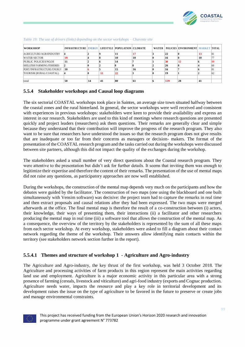
This project has received funding from the European Union’s Horizon 2020 research and innovation programme under grant agreement N° 773782
99
Table 19: The use of drivers (links) depending on the sector workshops – Charente site
WORKSHOP INFRASTRUCTURE ENERGY LIFESTYLE POPULATION CLIMATE WATER POLICIES ENVIRONMENT MARKET TOTAL
AGRICULTURE/AGROINDUSTRY 4 2 9 11 17 3 22 0 13 81
WATER SECTOR 19 4 8 10 10 0 16 0 10 77
PUBLIC POLICIES/NGOS 11 2 6 14 7 1 30 12 6 89
SHELLFISH FARMING/FISHERIES 2 0 2 8 8 2 26 8 4 60
PORT/INFRASTRUCTURE/ENERGY 10 6 5 15 16 0 16 7 6 81
TOURISM (RURAL/COASTAL) 4 0 11 22 3 0 19 1 2 62
total 50 14 41 80 61 6 129 28 41
5.5.4 Stakeholder workshops and Causal loop diagrams
The six sectorial COASTAL workshops took place in Saintes, an average size town situated halfway between
the coastal zones and the rural hinterland. In general, the sector workshops were well received and consistent
with experiences in previous workshops: stakeholders were keen to provide their availability and express an
interest in our research. Stakeholders are used to this kind of meetings where research questions are presented quickly and project leaders (researchers) ask them questions. Their remarks are generally clear and simple
because they understand that their contribution will improve the progress of the research program. They also
want to be sure that researchers have understood the issues so that the research program does not give results that are inadequate or too far from their concerns as managers or decision- makers. The format of the
presentation of the COASTAL research program and the tasks carried out during the workshops were discussed
between site partners, although this did not impact the quality of the exchanges during the workshop.
The stakeholders asked a small number of very direct questions about the Coastal research program. They were attentive to the presentation but didn’t ask for further details. It seems that inviting them was enough to
legitimize their expertise and therefore the content of their remarks. The presentation of the use of mental maps
did not raise any questions, as participatory approaches are now well established.
During the workshops, the construction of the mental map depends very much on the participants and how the
debates were guided by the facilitator. The construction of two maps (one using the blackboard and one built simultaneously with Vensim software) was decisive: the project team had to capture the remarks in real time
and then extract proposals and causal relations after they had been expressed. The two maps were merged
afterwards at the office. The final mental map is therefore the result of a co-construction between (i) actors, their knowledge, their ways of presenting them, their interactions (ii) a facilitator and other researchers
producing the mental map in real time (iii) a software tool that allows the construction of the mental map. As
a consequence, the overview of the territory by the stakeholders is represented by the sum of all these maps
from each sector workshop. At every workshop, stakeholders were asked to fill a diagram about their contact network regarding the theme of the workshop. Their answers allow identifying main contacts within the
territory (see stakeholders network section further in the report).
5.5.4.1 Themes and structure of workshop 1 - Agriculture and Agro-industry
The Agriculture and Agro-industry, the key thrust of the first workshop, was held 3 October 2018. The
Agriculture and processing activities of farm products in this region represent the main activities regarding
land use and employment. Agriculture is a major economic activity in this particular area with a strong presence of farming (cereals, livestock and viticulture) and agri-food industry (exports and Cognac production.
Agriculture needs water, impacts the resource and play a key role in territorial development and its
development raises the issue on the type of agriculture to be favored in the future to preserve or create jobs
and manage environmental constraints.
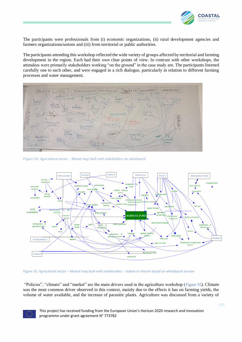
This project has received funding from the European Union’s Horizon 2020 research and innovation programme under grant agreement N° 773782
100
The participants were professionals from (i) economic organizations, (ii) rural development agencies and farmers organizations/unions and (iii) from territorial or public authorities.
The participants attending this workshop reflected the wide variety of groups affected by territorial and farming development in the region. Each had their own clear points of view. In contrast with other workshops, the
attendees were primarily stakeholders working “on the ground” in the case study are. The participants listened
carefully one to each other, and were engaged in a rich dialogue, particularly in relation to different farming
processes and water management.
Figure 54: Agricultural sector – Mental map built with stakeholders on whiteboard
“Policies”, “climate” and “market” are the main drivers used in the agriculture workshop (Figure 55). Climate
was the most common driver observed in this context, mainly due to the effects it has on farming yields, the
volume of water available, and the increase of parasitic plants. Agriculture was discussed from a variety of
POPULATION WATER ENERGY
increase of
population competitiveness
renewable
energies
population change environments competition for
water port capacity
water quantity
energy
demand
air quality conflicts between
actors funding exportation
regulation farming model
acceptability water storage
drugs cohabitation between
land availability
+-
conventional
farming
urban and rural excessive standards
summer crops populations
attractiveness farm size organic farming
attractiveness of the
territory
invasive
species
diffuse pollution agricultural
AGRICULTURE productions effectiveness
of policies decline of livestock
development of
agricultural crops
other livestock farming climate
change
yields nitrate, pesticides
insects modes of
consumption
maintenance of
farm income
flora sectors
adaptation of
agricultural sectors
viticulture
grazing livestock
systems public health
ENVIRONMENT allergens field crops MARKET
types of crops
development of agricultural
sectors
decrease in maize
animal feed
CLIMATE
INFRASTRUCTURE POLICY LIFESTYLE
Figure 55: Agricultural sector – Mental map built with stakeholders - redone in Vensim based on whiteboard version
This project has received funding from the European Union’s Horizon 2020 research and innovation programme under grant agreement N° 773782
101
perspectives, including traditional and organic methods, field crops and viticulture, grazing and other forms of livestock breeding, locally-focused production, exports, and its relationship with air and water quality.
The debate centred primarily on the factors which have determined the current situation, and the way in which that situation has developed over time (water resources, lifestyle, infrastructure, population, environmental
issues, public policy, climate, and energy). The key topics of the discussed were the following:
Population changes: the city of La Rochelle and adjoining coastal areas have positive demographics, i.e. a growing number of elderly permanent residents and every greater volume of seasonal residents (with
significant buying power). Further inland, the situation is the opposite, with a dwindling population whose
revenues are in decline. This situation leads to greater segmentation in the food market. Sociocultural evolution has meant that members of the general public have little or no understanding of farming. The growing, ageing
population also has an impact of water quality, due to pharmaceutical residue finding its way into water table.
In addition, tourist booms increase land pressure.
Traditional and organic farming methods: The Charente Basin comprises a variety of territory types,
including a large area dedicated to Cognac production, of which 98% is exported. There is also a livestock
breeding further inland, as well as on the coastal area. Both methods of sale and environmental impacts are different from one area to another. Multiple forms of farming could/should coexist. Topics around farming
production systems were addressed in tense dialogue with their differing impacts on water quality. Was put
ahead that the exercise was not to compare and contrast farming models, thus generating conflict. Water management priorities are defined in official Water Development and Management Plans (SAGE).
Both traditional and organic farming practices are undergoing changes in order to preserve air and water
quality, with farmers being certified under the French HVE (High Environmental Value) certification system with differing environmental impacts depending on production methods. Livestock breeders value pasture,
thus contributing to the quality of local landscapes and the production of organic matter.
There is demand among consumers for organic products but the environmental cost of different farming
methods is absorbed through public policy rather than being factored into the price paid by the end user. The
development of differentiated farming industries depends on markets and public policy. The Charente Basin is a large cereal producing area, with large quantities being exported to North Africa, whose growing
population and changing consumer behaviour is feeding demand. Most of the production is exported via the
shipping ports of La Rochelle and Tonnay-Charente that play an important role in the local economy.
The livestock breeding issue was discussed at length. Continued livestock breeding contributes in some ways
to water quality. Public policy has not been able to stop the decline in livestock that has to be linked to markets,
prices, lifestyle of breeders, and environmental and economic regulations. In fact, insufficient money has been allocated to this issue and regulations tend to coerce farmers as opposed to encouraging certain behaviours.
The decline in livestock production is down to falling incomes, restructuring of economic bodies, failure of
producers to benefit from added value, and arduous working conditions.
It has been stressed that Public policy has led to the opposite of what is wanted, i.e. fewer farms, larger
infrastructure, and greater industrial production and this has destabilized local farming and created conflicts.
Farming organizations consider that Public policy has increased production costs, through an excessive amount of environmental and social regulations. It is conceivable that new sectors may develop, notably in the field of
energy production. However, the local population is opposed to the idea of biogas and windfarms.
The climate change issue is a main concern on the area in that it affects yields (both positive and negative),
the development of crop types, and the availability of water, all of which in turn affect farmers’ income.
Climate change also influences biodiversity, with the arrival of greater numbers of invasive plant species, such
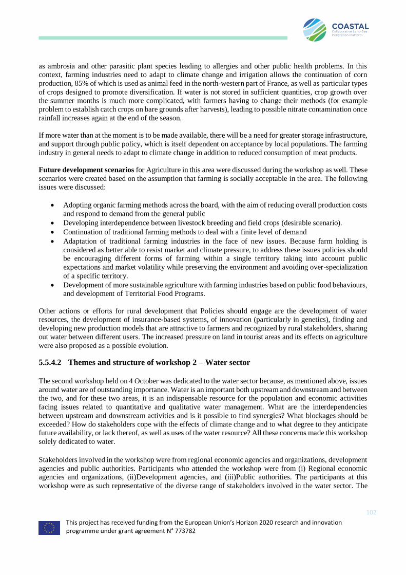
This project has received funding from the European Union’s Horizon 2020 research and innovation programme under grant agreement N° 773782
102
as ambrosia and other parasitic plant species leading to allergies and other public health problems. In this context, farming industries need to adapt to climate change and irrigation allows the continuation of corn
production, 85% of which is used as animal feed in the north-western part of France, as well as particular types
of crops designed to promote diversification. If water is not stored in sufficient quantities, crop growth over the summer months is much more complicated, with farmers having to change their methods (for example
problem to establish catch crops on bare grounds after harvests), leading to possible nitrate contamination once
rainfall increases again at the end of the season.
If more water than at the moment is to be made available, there will be a need for greater storage infrastructure,
and support through public policy, which is itself dependent on acceptance by local populations. The farming
industry in general needs to adapt to climate change in addition to reduced consumption of meat products.
Future development scenarios for Agriculture in this area were discussed during the workshop as well. These
scenarios were created based on the assumption that farming is socially acceptable in the area. The following issues were discussed:
• Adopting organic farming methods across the board, with the aim of reducing overall production costs
and respond to demand from the general public
• Developing interdependence between livestock breeding and field crops (desirable scenario).
• Continuation of traditional farming methods to deal with a finite level of demand
• Adaptation of traditional farming industries in the face of new issues. Because farm holding is
considered as better able to resist market and climate pressure, to address these issues policies should be encouraging different forms of farming within a single territory taking into account public
expectations and market volatility while preserving the environment and avoiding over-specialization
of a specific territory.
• Development of more sustainable agriculture with farming industries based on public food behaviours, and development of Territorial Food Programs.
Other actions or efforts for rural development that Policies should engage are the development of water resources, the development of insurance-based systems, of innovation (particularly in genetics), finding and
developing new production models that are attractive to farmers and recognized by rural stakeholders, sharing
out water between different users. The increased pressure on land in tourist areas and its effects on agriculture
were also proposed as a possible evolution.
5.5.4.2 Themes and structure of workshop 2 – Water sector
The second workshop held on 4 October was dedicated to the water sector because, as mentioned above, issues
around water are of outstanding importance. Water is an important both upstream and downstream and between the two, and for these two areas, it is an indispensable resource for the population and economic activities
facing issues related to quantitative and qualitative water management. What are the interdependencies
between upstream and downstream activities and is it possible to find synergies? What blockages should be
exceeded? How do stakeholders cope with the effects of climate change and to what degree to they anticipate future availability, or lack thereof, as well as uses of the water resource? All these concerns made this workshop
solely dedicated to water.
Stakeholders involved in the workshop were from regional economic agencies and organizations, development
agencies and public authorities. Participants who attended the workshop were from (i) Regional economic agencies and organizations, (ii)Development agencies, and (iii)Public authorities. The participants at this
workshop were as such representative of the diverse range of stakeholders involved in the water sector. The
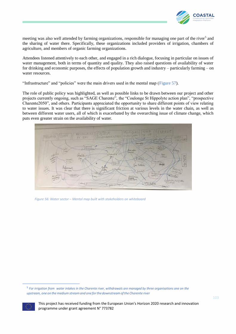
This project has received funding from the European Union’s Horizon 2020 research and innovation programme under grant agreement N° 773782
103
meeting was also well attended by farming organizations, responsible for managing one part of the river5 and the sharing of water there. Specifically, these organizations included providers of irrigation, chambers of
agriculture, and members of organic farming organizations.
Attendees listened attentively to each other, and engaged in a rich dialogue, focusing in particular on issues of water management, both in terms of quantity and quality. They also raised questions of availability of water
for drinking and economic purposes, the effects of population growth and industry – particularly farming – on
water resources.
“Infrastructure” and “policies” were the main drivers used in the mental map (Figure 57).
The role of public policy was highlighted, as well as possible links to be drawn between our project and other projects currently ongoing, such as “SAGE Charente”, the “Coulonge St Hippolyte action plan”, “prospective
Charente2050”, and others. Participants appreciated the opportunity to share different points of view relating
to water issues. It was clear that there is significant friction at various levels in the water chain, as well as between different water users, all of which is exacerbated by the overarching issue of climate change, which
puts even greater strain on the availability of water.
5 For irrigation from water intakes in the Charente river, withdrawals are managed by three organisations one on the
upstream, one on the medium stream and one for the downstream of the Charente river
Figure 56: Water sector – Mental map built with stakeholders on whiteboard

This project has received funding from the European Union’s Horizon 2020 research and innovation programme under grant agreement N° 773782
104
Future development scenarios discussed by participants during the workshop were around the creation of new water storage and “business as usual”, constraints on water use, changes of practices in vineyards, changes of
public policies caused by climate changes and increase of population in coastal areas.
In the first scenario, water is stored in reservoirs with changes in farming practices although irrigated crops continue to be grown. This is due to climate change that calls for water to be managed in terms of both time
and space. Reservoirs are the mean for farmers to have a reliable source of water over the plants growing
season to irrigate their crops and protect biodiversity.
The second scenario relates to a stricter control on water resource leading to conversion of conventional farms
to organic farming. In this scenario, priority is given to sustainable farming systems without the use of pesticides. There is indeed a marked growth in the use of organic farming techniques, in response to growing
demand from consumers for local and certified produce.
Scenario 3 on the other hand is focused on winegrowing practices and their changes. For various reasons, the Cognac industry is unable to effectively develop “organic” production techniques to serve its export market.
The sector therefore decides to focus on HVE (High environmental value) certification and develop its
practices.
In scenario 4 Climate change and public expectations lead to changes in public policy that focuses on
increasing availability of water, as well as re-examining the hierarchy of water uses: drinking water,
biodiversity in hydrosystems, food production, and other economic requirements. Action plans and subsidies are devised to deal with environmental issues.
Finally, in scenario 5, population in coastal areas continues to increase with consequences on water resources. This scenario is to be linked with prospective studies on the Charente river basin (Charente2050, SAGE
Figure 57: Water sector – Mental map built with stakeholders visualized by Vensim
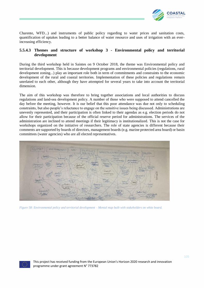
This project has received funding from the European Union’s Horizon 2020 research and innovation programme under grant agreement N° 773782
105
Charente, WFD...) and instruments of public policy regarding to water prices and sanitation costs, quantification of uptakes leading to a better balance of water resource and uses of irrigation with an ever-
increasing efficiency.
5.5.4.3 Themes and structure of workshop 3 - Environmental policy and territorial
development
During the third workshop held in Saintes on 9 October 2018, the theme was Environmental policy and
territorial development. This is because development programs and environmental policies (regulations, rural development zoning...) play an important role both in term of commitments and constraints to the economic
development of the rural and coastal territories. Implementation of these policies and regulations remain
unrelated to each other, although they have attempted for several years to take into account the territorial
dimension.
The aim of this workshop was therefore to bring together associations and local authorities to discuss regulations and land-sea development policy. A number of those who were supposed to attend cancelled the
day before the meeting, however. It is our belief that this poor attendance was due not only to scheduling
constraints, but also people’s reluctance to engage on the sensitive issues being discussed. Administrations are unevenly represented, and their participation is often linked to their agendas as e.g. election periods do not
allow for their participation because of the official reserve period for administrations. The services of the
administration are inclined to attend meetings if their legitimacy is institutionalized. This is not the case for workshops organized on the initiative of researchers. The role of state agencies is different because their
comments are supported by boards of directors, management boards (e.g. marine protected area board) or basin
committees (water agencies) who are all elected representatives.
Figure 58: Environmental policy and territorial development – Mental map built with stakeholders on white board.
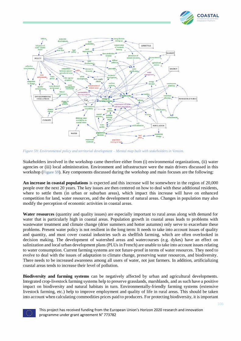
This project has received funding from the European Union’s Horizon 2020 research and innovation programme under grant agreement N° 773782
106
Figure 59: Environmental policy and territorial development – Mental map built with stakeholders in Vensim.
Stakeholders involved in the workshop came therefore either from (i) environmental organizations, (ii) water
agencies or (iii) local administration. Environment and infrastructure were the main drivers discussed in this
workshop (Figure 59). Key components discussed during the workshop and main focuses are the following:
An increase in coastal populations is expected and this increase will be somewhere in the region of 20,000 people over the next 20 years. The key issues are then centered on how to deal with these additional residents,
where to settle them (in urban or suburban areas), which impact this increase will have on enhanced
competition for land, water resources, and the development of natural areas. Changes in population may also
modify the perception of economic activities in coastal areas.
Water resources (quantity and quality issues) are especially important to rural areas along with demand for water that is particularly high in coastal areas. Population growth in coastal areas leads to problems with
wastewater treatment and climate change (drier summers and hotter autumns) only serve to exacerbate these
problems. Present water policy is not resilient in the long term: It needs to take into account issues of quality and quantity, and must cover coastal industries such as shellfish farming, which are often overlooked in
decision making. The development of watershed areas and watercourses (e.g. dykes) have an effect on
salinization and local urban development plans (PLUs in French) are unable to take into account issues relating
to water consumption. Current farming systems are not future-proof in terms of water resources. They need to evolve to deal with the issues of adaptation to climate change, preserving water resources, and biodiversity.
There needs to be increased awareness among all users of water, not just farmers. In addition, artificializing
coastal areas tends to increase their level of pollution.
Biodiversity and farming systems can be negatively affected by urban and agricultural developments. Integrated crop-livestock farming systems help to preserve grasslands, marshlands, and as such have a positive
impact on biodiversity and natural habitats in turn. Environmentally-friendly farming systems (extensive
livestock farming, etc.) help to improve employment and quality of life in rural areas. This should be taken
into account when calculating commodities prices paid to producers. For protecting biodiversity, it is important
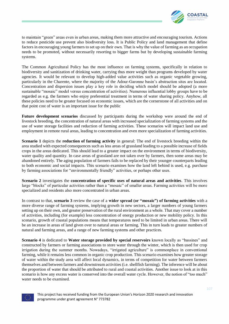
This project has received funding from the European Union’s Horizon 2020 research and innovation programme under grant agreement N° 773782
107
to maintain “green” areas even in urban areas, making them more attractive and encouraging tourism. Actions to reduce pesticide use prevent also biodiversity loss. It is Public Policy and land management that define
factors in encouraging young farmers to set up on their own. That is why the value of farming as an occupation
needs to be promoted, without necessarily resorting to bigger farms but by developing sustainable farming
systems.
The Common Agricultural Policy has the most influence on farming systems, specifically in relation to
biodiversity and sanitization of drinking water, carrying thus more weight than programs developed by water
agencies. It would be relevant to develop high-added value activities such as organic vegetable growing,
particularly in the Charente, where the majority of the Adour-Garonne basin’s abstraction sites are located. Concentration and dispersion issues play a key role in deciding which model should be adopted (a more
sustainable “mosaic” model versus concentration of activities). Numerous influential lobby groups have to be
regarded as e.g. the farmers who enjoy preferential treatment in terms of water sharing policy. Anyhow, all these policies need to be greater focused on economic issues, which are the cornerstone of all activities and on
that point cost of water is an important issue for the public
Future development scenarios discussed by participants during the workshop were around the end of
livestock breeding, the concentration of natural areas with increased specialization of farming systems and the
use of water storage facilities and reduction of farming activities. These scenarios will impact land use and
employment in remote rural areas, leading to concentration and even more specialization of farming activities.
Scenario 1 depicts the reduction of farming activity in general: The end of livestock breeding within the
area studied with expected consequences such as less areas of grassland leading to a possible increase of fields
crops in the areas dedicated. This should lead to a greater impact on the environment in terms of biodiversity, water quality and quantity. In case areas of grassland are not taken over by farmers, then some areas may be
abandoned entirely. The aging population of farmers fails to be replaced by their younger counterparts leading
to both economic and social impacts. This scenario examines how the land left behind is used, e.g. purchase
by farming associations for “environmentally friendly” activities, or perhaps other uses.
Scenario 2 investigates the concentration of specific uses of natural areas and activities. This involves large “blocks” of particular activities rather than a “mosaic” of smaller areas. Farming activities will be more
specialized and residents also more concentrated in urban areas.
In contrast to that, scenario 3 review the case of a wider spread (or “mosaic”) of farming activities with a
more diverse range of farming systems, implying growth in new sectors, a larger numbers of young farmers setting up on their own, and greater preservation of the rural environment as a whole. That may cover a number
of activities, including (for example) less concentration of energy production or new mobility policy. In this
scenario, growth of coastal populations means that temperatures need to be limited in urban areas. There will
be an increase in areas of land given over to natural areas or farming. This in turn leads to greater numbers of
natural and farming areas, and a range of new farming systems and other practices.
Scenario 4 is dedicated to Water storage provided by special reservoirs known locally as “bassines” and
constructed by farmers or farming associations to store water through the winter, which is then used for crop
irrigation during the summer months. Nowadays, “irrigated agriculture” is commonplace in conventional farming, while it remains less common in organic crop production. This scenario examines how greater storage
of water within the study area will affect local dynamics, in terms of competition for water between farmers
themselves and between farmers and downstream activities (i.e. shellfish farming). The inference will be about the proportion of water that should be attributed to rural and coastal activities. Another issue to look at in this
scenario is how any excess water is conserved into the overall water cycle. However, the notion of “too much”
water needs to be examined.
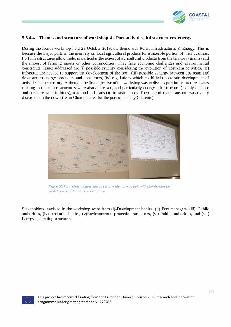
This project has received funding from the European Union’s Horizon 2020 research and innovation programme under grant agreement N° 773782
108
5.5.4.4 Themes and structure of workshop 4 - Port activities, infrastructures, energy
During the fourth workshop held 23 October 2019, the theme was Ports, Infrastructures & Energy. This is
because the major ports in the area rely on local agricultural produce for a sizeable portion of their business.
Port infrastructures allow trade, in particular the export of agricultural products from the territory (grains) and
the import of farming inputs or other commodities. They face economic challenges and environmental constraints. Issues addressed are (i) possible synergy considering the evolution of upstream activities, (ii)
infrastructure needed to support the development of the port, (iii) possible synergy between upstream and
downstream energy producers and consumers, (iv) regulations which could help constrain development of activities in the territory. Although, the first objective of the workshop was to discuss port infrastructure, issues
relating to other infrastructures were also addressed, and particularly energy infrastructure (mainly onshore
and offshore wind turbines), road and rail transport infrastructures. The topic of river transport was mainly
discussed on the downstream Charente area for the port of Tonnay Charente).
Stakeholders involved in the workshop were from (i)-Development bodies, (ii) Port managers, (iii). Public authorities, (iv) territorial bodies, (v)Environmental protection structures, (vi) Public authorities, and (vii)
Energy generating structures.
Figure 60: Port, infrastructure, energy sector – Mental map built with stakeholders on
whiteboard with Vensim representation
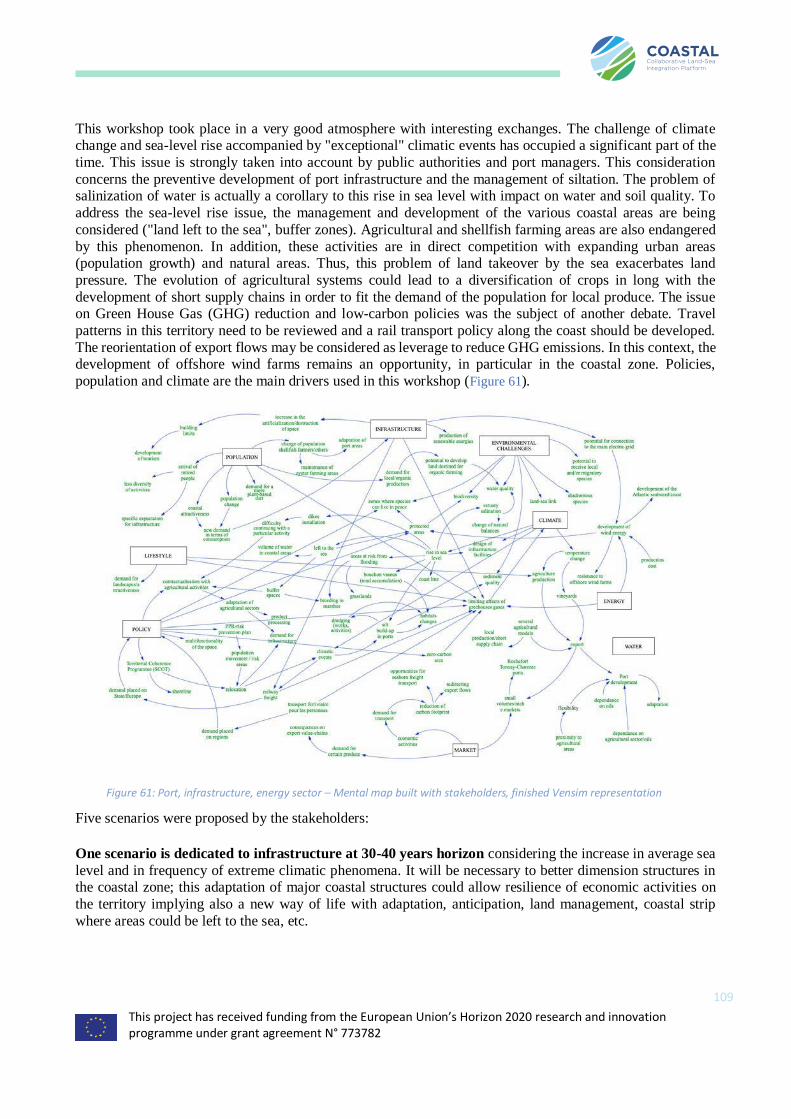
This project has received funding from the European Union’s Horizon 2020 research and innovation programme under grant agreement N° 773782
109
This workshop took place in a very good atmosphere with interesting exchanges. The challenge of climate change and sea-level rise accompanied by "exceptional" climatic events has occupied a significant part of the
time. This issue is strongly taken into account by public authorities and port managers. This consideration
concerns the preventive development of port infrastructure and the management of siltation. The problem of salinization of water is actually a corollary to this rise in sea level with impact on water and soil quality. To
address the sea-level rise issue, the management and development of the various coastal areas are being
considered ("land left to the sea", buffer zones). Agricultural and shellfish farming areas are also endangered
by this phenomenon. In addition, these activities are in direct competition with expanding urban areas (population growth) and natural areas. Thus, this problem of land takeover by the sea exacerbates land
pressure. The evolution of agricultural systems could lead to a diversification of crops in long with the
development of short supply chains in order to fit the demand of the population for local produce. The issue on Green House Gas (GHG) reduction and low-carbon policies was the subject of another debate. Travel
patterns in this territory need to be reviewed and a rail transport policy along the coast should be developed.
The reorientation of export flows may be considered as leverage to reduce GHG emissions. In this context, the development of offshore wind farms remains an opportunity, in particular in the coastal zone. Policies,
population and climate are the main drivers used in this workshop (Figure 61).
Five scenarios were proposed by the stakeholders:
One scenario is dedicated to infrastructure at 30-40 years horizon considering the increase in average sea
level and in frequency of extreme climatic phenomena. It will be necessary to better dimension structures in the coastal zone; this adaptation of major coastal structures could allow resilience of economic activities on
the territory implying also a new way of life with adaptation, anticipation, land management, coastal strip
where areas could be left to the sea, etc.
Figure 61: Port, infrastructure, energy sector – Mental map built with stakeholders, finished Vensim representation

This project has received funding from the European Union’s Horizon 2020 research and innovation programme under grant agreement N° 773782
110
Another scenario is the decarbonation of the territory implying economic activities to reduce their footprint e.g. to change transport from trucks to trains, to increase renewable energy production and to develop new
agricultural sectors with more diversification of crops and adapted storage silos.
The third scenario implies the development of a biomass energy sector with valorisation of organic waste
for energy production (biomethane) and valorisation of waste on fishing ports.
The fourth scenario is dedicated to the development of photovoltaic/windpower potential: the current
objective is to develop offshore wind power farms for a production of 1 GigaWatt in the area.
The last scenario is dedicated to renewed public policies in the horizon of 2030-2050 allowing the integration of the climate change issue into urban planning management – this could include the making of
strategic documents (planning) impacting all activities.
5.5.4.5 Themes and structure of workshop 5 - Shellfish farming, aquaculture and fishing
During the fifth workshop held 25 October 2018, the theme was Shellfish farming, aquaculture and fishing.
This is because these activities are the major marine economic activities of the area. All these activities require water of good quality with sufficient quantity and thus are dependent on upstream activities particularly
agriculture.
The question was about developing a better territorial solidarity and land-sea synergies in the face of economic
and social challenges. Another question was the preferred development paths in this context for coastal activities. Unfortunately, representatives from the fishing industry couldn’t attend the meeting at the last
moment, but representatives of shellfish farmers were, as well as management and policy.
A number of stakeholders were enthusiastic about the creation of a continuous sea/land information system
which is currently lacking. The workshop went very well with participants engaged in the discussion. The
mental map reflects the complexity of the debate (see Figure 63). The quality of coastal waters and its links with the quality of surface water (and how water resources are managed) have been at the heart of the
exchanges. The importance of regulation by public policies to limit conflicts between actors was highlighted.
The question of summer tourism and of the increase of population on the coast exacerbating the pressure on coastal environment was discussed. Waste management and wastewater treatment to deal with a continuously
increasing population are the main policy concerns. European regulations were also mentioned with regard to
fishing quotas and stock management.
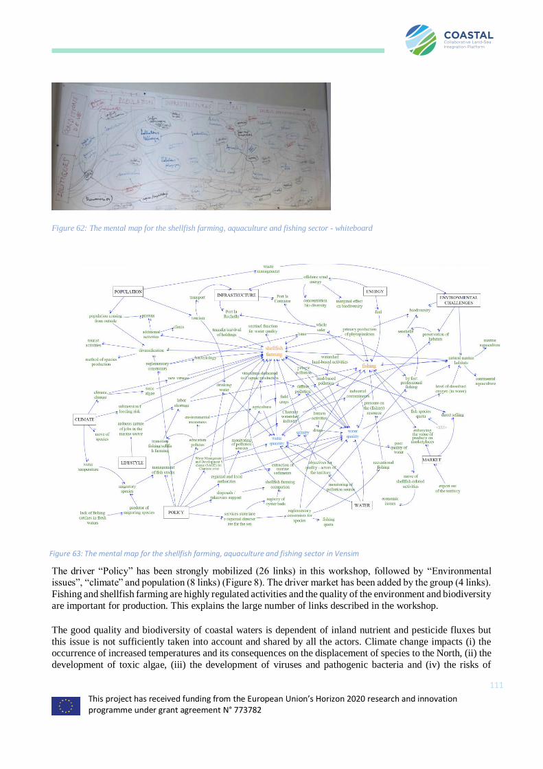
This project has received funding from the European Union’s Horizon 2020 research and innovation programme under grant agreement N° 773782
111
Figure 62: The mental map for the shellfish farming, aquaculture and fishing sector - whiteboard
The driver “Policy” has been strongly mobilized (26 links) in this workshop, followed by “Environmental issues”, “climate” and population (8 links) (Figure 8). The driver market has been added by the group (4 links).
Fishing and shellfish farming are highly regulated activities and the quality of the environment and biodiversity
are important for production. This explains the large number of links described in the workshop.
The good quality and biodiversity of coastal waters is dependent of inland nutrient and pesticide fluxes but
this issue is not sufficiently taken into account and shared by all the actors. Climate change impacts (i) the occurrence of increased temperatures and its consequences on the displacement of species to the North, (ii) the
development of toxic algae, (iii) the development of viruses and pathogenic bacteria and (iv) the risks of
Figure 63: The mental map for the shellfish farming, aquaculture and fishing sector in Vensim
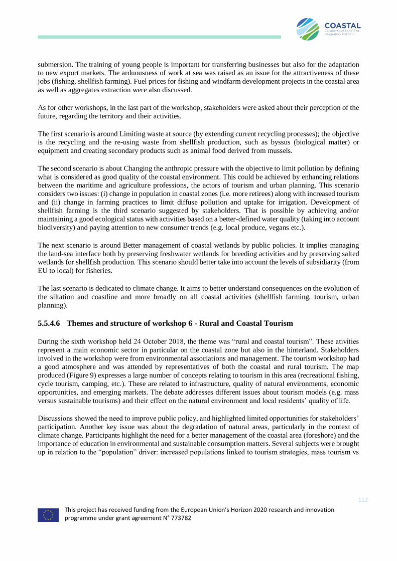
This project has received funding from the European Union’s Horizon 2020 research and innovation programme under grant agreement N° 773782
112
submersion. The training of young people is important for transferring businesses but also for the adaptation to new export markets. The arduousness of work at sea was raised as an issue for the attractiveness of these
jobs (fishing, shellfish farming). Fuel prices for fishing and windfarm development projects in the coastal area
as well as aggregates extraction were also discussed.
As for other workshops, in the last part of the workshop, stakeholders were asked about their perception of the
future, regarding the territory and their activities.
The first scenario is around Limiting waste at source (by extending current recycling processes); the objective is the recycling and the re-using waste from shellfish production, such as byssus (biological matter) or
equipment and creating secondary products such as animal food derived from mussels.
The second scenario is about Changing the anthropic pressure with the objective to limit pollution by defining
what is considered as good quality of the coastal environment. This could be achieved by enhancing relations between the maritime and agriculture professions, the actors of tourism and urban planning. This scenario
considers two issues: (i) change in population in coastal zones (i.e. more retirees) along with increased tourism
and (ii) change in farming practices to limit diffuse pollution and uptake for irrigation. Development of shellfish farming is the third scenario suggested by stakeholders. That is possible by achieving and/or
maintaining a good ecological status with activities based on a better-defined water quality (taking into account
biodiversity) and paying attention to new consumer trends (e.g. local produce, vegans etc.).
The next scenario is around Better management of coastal wetlands by public policies. It implies managing
the land-sea interface both by preserving freshwater wetlands for breeding activities and by preserving salted wetlands for shellfish production. This scenario should better take into account the levels of subsidiarity (from
EU to local) for fisheries.
The last scenario is dedicated to climate change. It aims to better understand consequences on the evolution of
the siltation and coastline and more broadly on all coastal activities (shellfish farming, tourism, urban
planning).
5.5.4.6 Themes and structure of workshop 6 - Rural and Coastal Tourism
During the sixth workshop held 24 October 2018, the theme was “rural and coastal tourism”. These ativities
represent a main economic sector in particular on the coastal zone but also in the hinterland. Stakeholders
involved in the workshop were from environmental associations and management. The tourism workshop had a good atmosphere and was attended by representatives of both the coastal and rural tourism. The map
produced (Figure 9) expresses a large number of concepts relating to tourism in this area (recreational fishing,
cycle tourism, camping, etc.). These are related to infrastructure, quality of natural environments, economic
opportunities, and emerging markets. The debate addresses different issues about tourism models (e.g. mass
versus sustainable tourisms) and their effect on the natural environment and local residents’ quality of life.
Discussions showed the need to improve public policy, and highlighted limited opportunities for stakeholders’
participation. Another key issue was about the degradation of natural areas, particularly in the context of
climate change. Participants highlight the need for a better management of the coastal area (foreshore) and the importance of education in environmental and sustainable consumption matters. Several subjects were brought
up in relation to the “population” driver: increased populations linked to tourism strategies, mass tourism vs
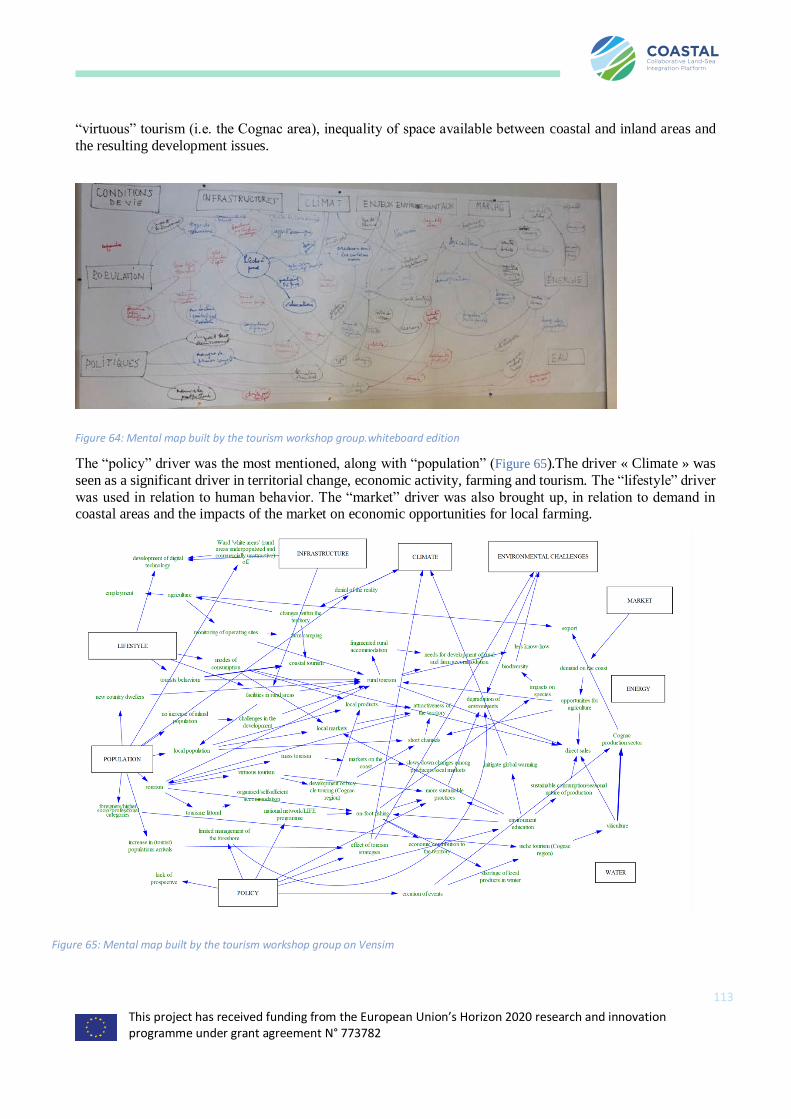
This project has received funding from the European Union’s Horizon 2020 research and innovation programme under grant agreement N° 773782
113
“virtuous” tourism (i.e. the Cognac area), inequality of space available between coastal and inland areas and
the resulting development issues.
The “policy” driver was the most mentioned, along with “population” (Figure 65).The driver « Climate » was
seen as a significant driver in territorial change, economic activity, farming and tourism. The “lifestyle” driver
was used in relation to human behavior. The “market” driver was also brought up, in relation to demand in coastal areas and the impacts of the market on economic opportunities for local farming.
Figure 65: Mental map built by the tourism workshop group on Vensim
Figure 64: Mental map built by the tourism workshop group.whiteboard edition
This project has received funding from the European Union’s Horizon 2020 research and innovation programme under grant agreement N° 773782
114
Although Recreational fishing (practiced essentially exclusively by tourists) may have a negative impact in terms of depletion of fish stocks and damage caused to natural areas, it is possible to improve fishing practices
by education (effective educational campaigns carried out in the area). There is a trend to change mass tourism
to more sustainable tourism supported by NGOs. There did not appear to be any real willingness to restrict the numbers of people fishing on the shoreline. There are no farmers’ local markets in coastal areas. Most of the
local markets in these areas tend to be run by resellers who provide less guarantees about the provenance of
the products being sold. The ability of the coastline to handle a certain number of visitors is a subjective notion.
A distinction has to be made between the number of tourists and the potential impact of tourism: it is still possible to have more visitors while providing nice tourist experiences.
In inland areas, the tourist industry is less well organized, with an assortment of rental properties and bed and breakfast accommodation. Rural owners have difficulty networking. Sales of local farm produce (short supply
chains) are flourishing in inland areas, in particular Cognac area and there is little reason for changes.
Diversification through bed-and-breakfast type activities was seen as a real necessity in order to protect the economic wellbeing of farmers, specifically wives. Over the last ten years, around one quarter of new farmers
setting up in the countryside have tourist accommodation as a key aspect of their business.
Potential for climate change and the resulting consequences on coastal areas are widely known: submersion, storms, future of certain grape varieties, etc. Many decision-makers are in denial and do not want to take pre-
emptive action for fear of creating negative atmosphere. The infrastructure plays an important role in
developing tourism (public transport, roads, internet access, etc.)
5.5.5 Analysis of the outcomes and conclusions
The most used variable in all workshops were the “policies” driver (129 links) especially by the workshops
dedicated to “Environmental policy and territorial development” and “shellfish farming”. This was followed by the “population” driver (80 links). At the opposite, the driver “Energy” was not much mobilized (14 links),
possibly due to the lack of stakeholders for this sector. The “water” driver is the less used of all drivers (6
links) but water resource issues were debated in every workshop. Surprisingly, the “Environmental challenges”
driver was barely used (28 links). The driver added by the group (the market) was used in all the workshops
and scored 41 links.
The climate driver (61 links) was the most used by the agriculture workshop and by the port/infrastructure
workshop.

This project has received funding from the European Union’s Horizon 2020 research and innovation programme under grant agreement N° 773782
115
Figure 66: Use of drivers in every workshop (the size of the arrows depends on the number of links with the driver)
The use of drivers is reported along with the 6 workshops in Figure 66. The workshops are positioned near the
drivers that they mobilized the most. The size of the arrows shows the number of links from the driver in each
workshop. This makes it possible to illustrate how the actors debating a given subject perceived the influence of the drivers on the theme which is debated. With the important exception of climate, the most commonly
used drivers are all related to human activities: population, politics and infrastructure. Then comes the lifestyle
driver and then the market driver, and far behind environment and water drivers.

This project has received funding from the European Union’s Horizon 2020 research and innovation programme under grant agreement N° 773782
116
5.6 Spain – Mar Menor Coastal Lagoon (Western Mediterranean)
5.6.1 Executive summary
The Mar Menor coastal lagoon (135 km2) is located in the Region of Murcia in South Eastern Spain. The area
is characterized by multiple environmental, social-cultural and economic interests, often competing for scarce
resources, water being the most important. The Campo de Cartagena catchment draining into the Mar Menor covers an area of 1.255 km2 and is mainly covered by intensive irrigated horticulture and tree crops, which has
caused a hydrological and nutrients imbalance in the lagoon. Public administrations are not controlling that
best agricultural practices optimizing water and fertilizer use are being implemented, and there is a general
lack of support of touristic activities by the local and regional governments.
A total of 6 workshops were held about the Campo de Cartagena watershed and Mar Menor lagoon area with
the following stakeholder groups:
1. environmental sector (researchers, NGOs, environmental consulting companies),
2. agricultural sector,
3. public administrations, 4. fishermen and salt pans sector,
5. tourist sector and
6. local populations.
The main issues identified during the workshops were the lack of holistic and long-term perspective for
management and lack of well-defined action plans, the habitat degradation and biodiversity loss in the lagoon and associated wetlands around the Mar Menor lagoon due to eutrophication (nutrients and sediments from
agriculture, heavy metals from the old mining areas and wastewater inputs), concentration of tourism in
summer months, the decrease in recreation opportunities for local populations living around the Mar Menor
lagoon and tourists and lack of investment in general infrastructures, including waste water treatment.
The main solutions mentioned were promoting education activities regarding environmental issues and
policies, improving the sewerage system in coastal areas around the Mar Menor, creating a public entity that
manages the Mar Menor and Campo de Cartagena area as a whole, promoting crop diversification, promoting
integration of agriculture and tourist activities (agrotourism), and implementing a buffer strip around the Mar Menor lagoon to retain nutrients and sediments and restoring villages and road infrastructures around Mar
Menor.
5.6.2 Background
The Mar Menor coastal lagoon (135 km2) is located in the Region of Murcia (SE Spain). The area is
characterized by multiple environmental, social-cultural and economic interests, often competing for scarce resources, water being the most important. There is a high potential for complementarity, win-win scenarios
and development of sustainable business cases based on public-private collaboration, efficient use of water,
and innovative farming practices and a transition to sustainable models of tourism and agriculture. The Campo de Cartagena catchment draining into the Mar Menor covers an area of 1.255 km2 and is mainly covered by
intensive irrigated horticulture and tree crops. The intensive and highly profitable irrigated agriculture depends
on scarce low quality groundwater and water from inland inter-basin water transfers. Agriculture provides labor and income to the region but forms a source of excessive nutrients and contamination into the Mar Menor
coastal lagoon. The resulting poor water quality affects the ecology of the lagoon with severe implications for
its potential function for tourism and fisheries.
This project has received funding from the European Union’s Horizon 2020 research and innovation programme under grant agreement N° 773782
117
The coastal lagoon furthermore forms part of a Specially Protected Area of Mediterranean Importance (SPAMI). The Mar Menor is one of the hotspots for tourism in the Region of Murcia, with a total number of
346,000 tourists and 1.4 million over-night stays in 2016. Beside international visitors, the Mar Menor has an
important touristic function for the regional population (1.5 million inhabitants). The availability of water for irrigation and drinking water for tourism will be further reduced under future climate conditions. As such, the
Mar Menor is strongly influenced by interactions between inland agriculture on the one side, and coastal
tourism and fisheries affecting natural ecological values and socioeconomic sustainability on the other side.
The need to move towards sustainable modes of agriculture, fishery and tourism is increasingly recognized and recently revived strongly due to sudden increase in contamination levels resulting in a strong drop in
tourism.
5.6.3 Drivers
The main driver that has caused a hydrological and nutrients imbalance in the study area is intensive
agriculture. The opening of the Tajo-Segura water transfer in the 80’s promoted an uncontrolled flourishing of irrigated croplands in an area that had been traditionally dominated by rainfed agriculture. Public
administrations are not controlling that best agricultural practices are being implemented, there is historic
contamination from mining activities, and there is a general lack of support of touristic activities by the local and regional governments, favoring the development of agriculture, which is the main cause of the ecological
crash of the Mar Menor lagoon. This crash is, on the other hand, negatively affecting the attractiveness and
touristic potential of the area, impoverishing local communities. As such, the Mar Menor case area did not use
the traditional drivers as were used in the other workshops, but started blanc on their mind mapping, keeping in mind that agriculture is the main driver.
5.6.4 Stakeholder workshops and Causal loop diagrams
A total of 6 workshops were held about the Campo de Cartagena watershed and Mar Menor lagoon area:
environmental sector (researchers, NGOs, environmental consulting companies), agricultural sector, public
administrations, fishermen and salt pans sector, tourist sector and local populations. All workshops were held at the CEBAS-CSIC facilities in Murcia and lasted 4 hours, including an introduction to the project and 2
sessions of mental mapping.
5.6.4.1 Themes and structure of workshop 1 – Environmental sector
During the first workshop, the theme was the biophysical and socio-economic system of the Mar Menor lagoon
and the Campo de Cartagena from a transdisciplinary perspective. The environmental sector was convened,
including researchers, NGOs and environmental consulting companies. There were 12 stakeholders involved in the workshop, representing research, education, conservation, NGOs, and foundations.
Figure 67 shows a summarised Vensim diagram of the developed CLD with the main topics brought up and discussed in this WS.
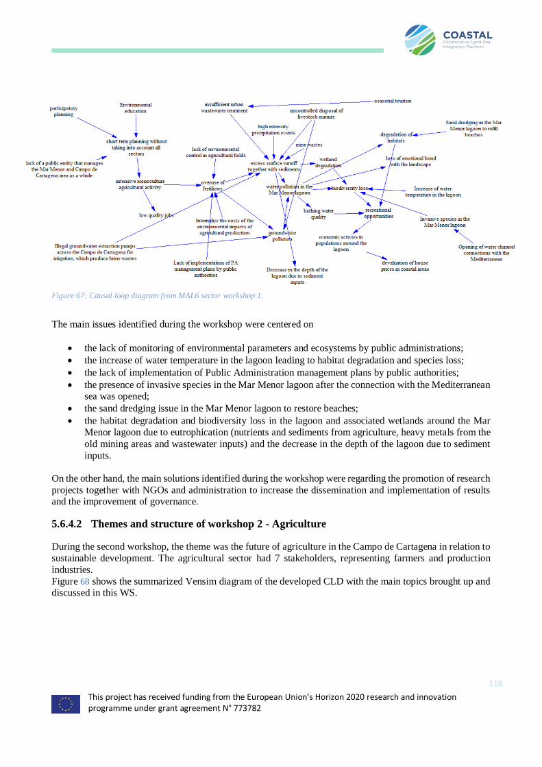
This project has received funding from the European Union’s Horizon 2020 research and innovation programme under grant agreement N° 773782
118
Figure 67: Causal loop diagram from MAL6 sector workshop 1.
The main issues identified during the workshop were centered on
• the lack of monitoring of environmental parameters and ecosystems by public administrations;
• the increase of water temperature in the lagoon leading to habitat degradation and species loss;
• the lack of implementation of Public Administration management plans by public authorities;
• the presence of invasive species in the Mar Menor lagoon after the connection with the Mediterranean sea was opened;
• the sand dredging issue in the Mar Menor lagoon to restore beaches;
• the habitat degradation and biodiversity loss in the lagoon and associated wetlands around the Mar
Menor lagoon due to eutrophication (nutrients and sediments from agriculture, heavy metals from the
old mining areas and wastewater inputs) and the decrease in the depth of the lagoon due to sediment
inputs.
On the other hand, the main solutions identified during the workshop were regarding the promotion of research
projects together with NGOs and administration to increase the dissemination and implementation of results and the improvement of governance.
5.6.4.2 Themes and structure of workshop 2 - Agriculture
During the second workshop, the theme was the future of agriculture in the Campo de Cartagena in relation to
sustainable development. The agricultural sector had 7 stakeholders, representing farmers and production
industries.
Figure 68 shows the summarized Vensim diagram of the developed CLD with the main topics brought up and discussed in this WS.

This project has received funding from the European Union’s Horizon 2020 research and innovation programme under grant agreement N° 773782
119
Figure 68: Causal loop diagram from MAL6 sector workshop 2.
The main issues identified during the workshop centered on
• nutrients and sediment transport (soil erosion) to the lagoon from agricultural fields due to bad
management practices and overuse of fertilizers;
• the lack of control by the administration (including the CAP implementation) of the fulfillment of
environmental regulations by farmers;
• the lack of capacity building to farmers on the use of fertilizers;
• the issue of intensive agricultural farming near coastal areas;
• the issue of the leaching of nutrients from agricultural fields to groundwater (and salinization);
• the issue of water and soil pollution by plastics from greenhouses;
• the fact that there is a competitive disadvantage with agricultural products coming from low income countries;
• the issue of illegal groundwater extraction pumps across the Campo de Cartagena for irrigation, which
produce brine wastes;
• the issue of intensive livestock farming leaching pig manure to the soil and water courses;
• the issue of lower crop yields due to the use of saline water from the aquifers;
• the fact that agricultural soil quality is decreasing; and
• the fact that agricultural production is becoming more expensive due to the necessity of desalinating
water due to lack of water.
On the other hand, the main solutions identified during the workshop were regarding
• implementing buffer strips to retain nutrients and sediments around cropland areas;
• implementing a buffer strip around the Mar Menor lagoon to retain nutrients and sediments;
• implementing buffer strips to retain nutrients and sediments along roads in the Campo de Cartagena
watershed; • correcting bad agricultural practices that promote soil erosion;
• decrease the number of crop harvests a year;
• internalizing the costs of the environmental impacts of agricultural production;

This project has received funding from the European Union’s Horizon 2020 research and innovation programme under grant agreement N° 773782
120
• removing agricultural farming near coastal areas; • building channels for the diversion of pig manure to treatment plants and use it for biogas production;
• using wastewater from aquaculture as fertilizers in agriculture; promoting new brine denitrification
and desalination technologies; • promoting new technologies to reduce evaporation in small irrigation dams;
• building channels for the diversion of brine to treatment plants; promoting capacity building activities
on the use of fertilizers;
• promoting crop diversification; • creating an agricultural bio/eco trade mark from the Campo de Cartagena and promote this type of
production;
• promoting the use of agricultural wastes as natural fertilizers; • producing agricultural products with a higher added value, such as seeds;
• promoting sustainable intensification of the agriculture in the Campo de Cartagena thereby reducing
the extension of cropland areas; • promoting hydroponic farming;
• promote precision agriculture; and
• promote biotechnology to develop crop varieties more adapted to drier environments.
5.6.4.3 Themes and structure of workshop 3 – Public administration
During the third workshop, the theme was sustainable management opportunities for the Mar Menor lagoon
and the Campo de Cartagena in the European context. The public administrations sector was represented by 7 stakeholders.
Figure 69 shows the summarized Vensim diagram of the developed CLD with the main topics brought up and
discussed in this WS. Figure 69: Causal loop diagram from MAL6 sector workshop 3.
The main issues identified during the workshop were regarding
• the lack of a scientific/policy interface to support management decisions;
• the absence of real action plans; legal boundaries;

This project has received funding from the European Union’s Horizon 2020 research and innovation programme under grant agreement N° 773782
121
• the lack of accounting for climate change for management due to uncertainty and the lack of holistic
and long-term perspective for management.
On the other hand, the main solutions identified during the workshop were regarding
• improving communication and governance among institutions from different sectors;
• promote and facilitate scientific advice to parliament;
• create a public entity that manages the Mar Menor and Campo de Cartagena area as a whole;
• enhance environmental monitoring and control in agricultural areas;
• improve the sewerage system in coastal areas around the Mar Menor; promote startup incubators
in Murcia Region;
• promote education activities regarding environmental issues & policies; promote land stewardship initiatives; and
• restoration of old iron open mines to promote eco-tourism and enhancement of public transport
and public services in villages around Mar Menor connecting them also with inland and with
airports.
5.6.4.4 Themes and structure of workshop 4 - Fishermen and salt pans sector
During the fourth workshop, the theme was the future of fishing and saltpan activity in the Mar Menor lagoon in relation to sustainable development. The fisheries and salt pans sectors were represented by in total 4
stakeholders.
Figure 70 shows the summarized Vensim diagram of the developed CLD with the main topics brought up and
discussed in this WS.
Figure 70: Causal loop diagram from MAL6 sector workshop 4.
The main issues identified during the workshop were regarding
• the increasing fishing pressure in the Mar Menor lagoon due to the bigger size of the fishermen ships
driven by a reduction in the number of ships allowed following the current legislation;
• the lack of social cohesion within the fishermen sector;
• the issue of illegal fishing in the Mar Menor lagoon;
• the decrease in the price of salt and the decrease in the number of fisheries target species due to lagoon
water pollution.
On the other hand, the main solutions identified during the workshop were regarding
• improving regulation of the channels that connect the Mar Menor with the Mediterranean sea;
• limiting fish catches in the Mar Menor and
• producing fish/salt products with a higher added value, and restoring cultural heritage.
5.6.4.5 Themes and structure of workshop 5 - Tourism
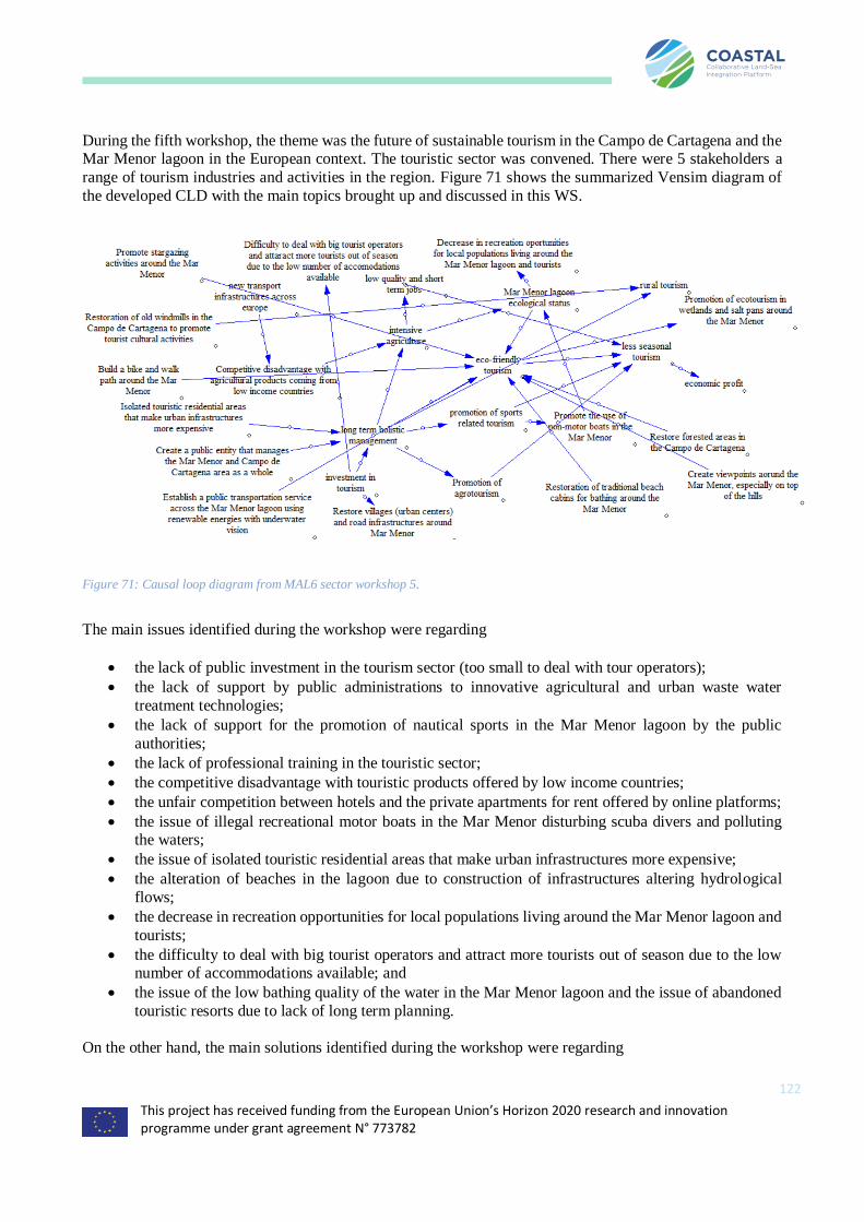
This project has received funding from the European Union’s Horizon 2020 research and innovation programme under grant agreement N° 773782
122
During the fifth workshop, the theme was the future of sustainable tourism in the Campo de Cartagena and the Mar Menor lagoon in the European context. The touristic sector was convened. There were 5 stakeholders a
range of tourism industries and activities in the region. Figure 71 shows the summarized Vensim diagram of
the developed CLD with the main topics brought up and discussed in this WS.
Figure 71: Causal loop diagram from MAL6 sector workshop 5.
The main issues identified during the workshop were regarding
• the lack of public investment in the tourism sector (too small to deal with tour operators);
• the lack of support by public administrations to innovative agricultural and urban waste water
treatment technologies;
• the lack of support for the promotion of nautical sports in the Mar Menor lagoon by the public
authorities;
• the lack of professional training in the touristic sector;
• the competitive disadvantage with touristic products offered by low income countries;
• the unfair competition between hotels and the private apartments for rent offered by online platforms;
• the issue of illegal recreational motor boats in the Mar Menor disturbing scuba divers and polluting the waters;
• the issue of isolated touristic residential areas that make urban infrastructures more expensive;
• the alteration of beaches in the lagoon due to construction of infrastructures altering hydrological
flows;
• the decrease in recreation opportunities for local populations living around the Mar Menor lagoon and
tourists;
• the difficulty to deal with big tourist operators and attract more tourists out of season due to the low number of accommodations available; and
• the issue of the low bathing quality of the water in the Mar Menor lagoon and the issue of abandoned
touristic resorts due to lack of long term planning.
On the other hand, the main solutions identified during the workshop were regarding
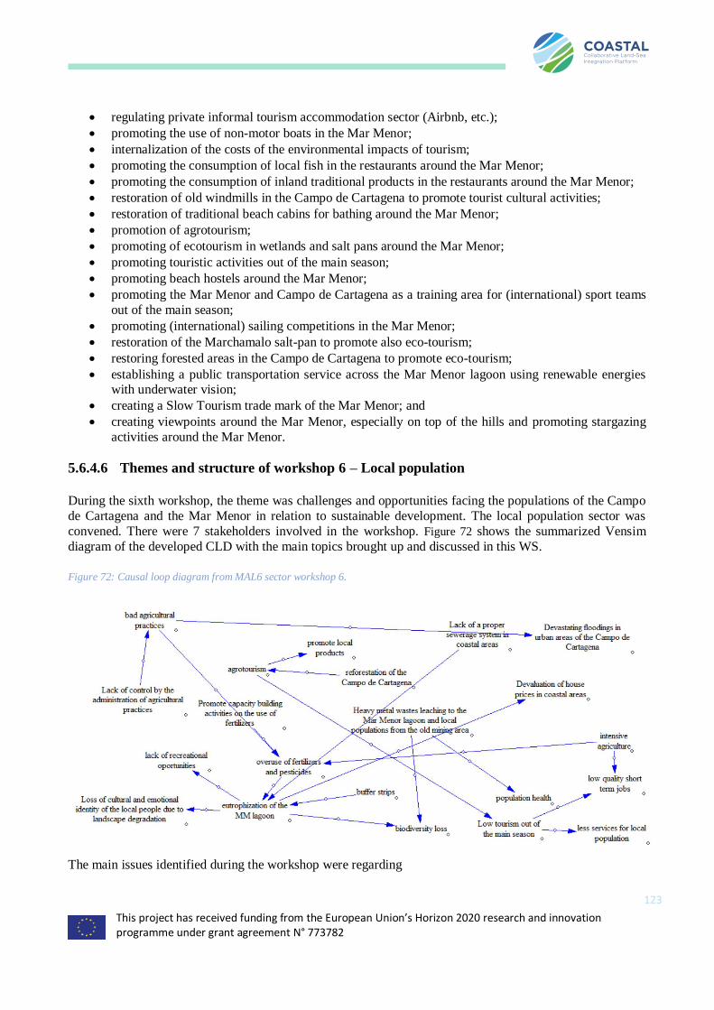
This project has received funding from the European Union’s Horizon 2020 research and innovation programme under grant agreement N° 773782
123
• regulating private informal tourism accommodation sector (Airbnb, etc.);
• promoting the use of non-motor boats in the Mar Menor;
• internalization of the costs of the environmental impacts of tourism;
• promoting the consumption of local fish in the restaurants around the Mar Menor;
• promoting the consumption of inland traditional products in the restaurants around the Mar Menor;
• restoration of old windmills in the Campo de Cartagena to promote tourist cultural activities;
• restoration of traditional beach cabins for bathing around the Mar Menor;
• promotion of agrotourism;
• promoting of ecotourism in wetlands and salt pans around the Mar Menor;
• promoting touristic activities out of the main season;
• promoting beach hostels around the Mar Menor;
• promoting the Mar Menor and Campo de Cartagena as a training area for (international) sport teams
out of the main season;
• promoting (international) sailing competitions in the Mar Menor;
• restoration of the Marchamalo salt-pan to promote also eco-tourism;
• restoring forested areas in the Campo de Cartagena to promote eco-tourism;
• establishing a public transportation service across the Mar Menor lagoon using renewable energies with underwater vision;
• creating a Slow Tourism trade mark of the Mar Menor; and
• creating viewpoints around the Mar Menor, especially on top of the hills and promoting stargazing
activities around the Mar Menor.
5.6.4.6 Themes and structure of workshop 6 – Local population
During the sixth workshop, the theme was challenges and opportunities facing the populations of the Campo
de Cartagena and the Mar Menor in relation to sustainable development. The local population sector was
convened. There were 7 stakeholders involved in the workshop. Figure 72 shows the summarized Vensim
diagram of the developed CLD with the main topics brought up and discussed in this WS.
Figure 72: Causal loop diagram from MAL6 sector workshop 6.
The main issues identified during the workshop were regarding
This project has received funding from the European Union’s Horizon 2020 research and innovation programme under grant agreement N° 773782
124
• the lack of coordination and communication among administrations (local, regional, national) and
sectors;
• the lack of social cohesion within the local populations around the Mar Menor lagoon;
• the heavy metal wastes issue leaching to the Mar Menor lagoon and local populations from the old mining area;
• the lack of a proper sewerage system in coastal areas (salinization of waste water, the input of organic
contaminants and phosphorous to the lagoon) making it more expensive to treat;
• the devaluation of house prices in coastal areas due to the bad ecological status of the Mar Menor
lagoon;
• the loss of cultural and emotional identity of the local people due to landscape degradation;
• the devastating floods in urban areas of the Campo de Cartagena, exacerbated by high sediment transport rates;
• the fact that much of the profit from industrial agriculture goes to international companies, not
reverting to the local economy; and
• the fact that industrial agriculture promotes low qualified short-term jobs with little employee benefits,
mostly taken by the immigrant population and the low tourism issue out of the main season (short term
jobs).
On the other hand, the main solutions identified during the workshop were regarding building a bike and walk path around the Mar Menor and restoring villages (urban centers) and road infrastructures around the Mar
Menor.
5.6.5 Analysis of the outcomes and conclusions
The main driver that has caused a hydrological and nutrients imbalance in the study area is intensive agriculture. The opening of the Tajo-Segura water transfer in the 80’s promoted an uncontrolled flourishing of
irrigated croplands in an area that had been traditionally dominated by rainfed agriculture. Public
administrations are not controlling that best agricultural practices are being implemented, there is historic
contamination from mining activities, and there is a general lack of support of touristic activities by the local and regional governments, favoring the development of agriculture, which is the main cause of the ecological
crash of the Mar Menor lagoon. This crash is, on the other hand, negatively affecting the attractiveness and
touristic potential of the area, impoverishing local communities.
During the 6 workshops more than 50 issues and barriers were mentioned in the study area, together with around 60 proposals to tackle the issues and improve the sustainability of the Mar Menor lagoon and Campo
de Cartagena watershed. A total of 260 people were invited, of which a total of 42 attended the workshops
(16% of positive response). Participants were very motivated and contributed with a lot of suggestions, even during workshops with a smaller group of people. Regarding the issues, the tourism, fishermen/saltpans and
agricultural sectors had very different concerns, whereas local populations shared most concerns with all of
them. Public administrations and the environmental sector (researchers, NGOs and environmental consulting
SMEs) shared common concerns and were mostly worried about the impacts of agriculture on the environment.
However, regarding the solutions, there were three main groups based on similar proposals: (a) local
populations and tourism; (b) fishermen/saltpans, environmental sector and public administrations and (c) farmers. Multidimensional scaling was used to visually represent dissimilarities between sectors. Error! R
eference source not found. and Error! Reference source not found. show the graphical representation of
the level of similarity among sectors based on their main issues and proposed solutions, respectively. Sectors
that are more similar based on their main issues or proposed solutions are closer together on the graph than sectors that are less similar.
This project has received funding from the European Union’s Horizon 2020 research and innovation programme under grant agreement N° 773782
125
6 Conclusions and Lessons learned from sector workshops
For the purposes of investigating the efficacy of some of the methodological challenges of bringing in qualitative
narratives from local stakeholders into a decision-making process, we have reported on the results from a cross-sectoral
and socio-political comparative analysis. Our analysis was driven by a demand from decision makers that are increasingly
asking for prediction tools and quantitative analysis of the impacts and effectiveness of management alternatives that
could include socio-ecological variables. We developed an inter- and transdisciplinary multi-methodological approach of
taking qualitative narratives from participatory workshops and transforming these into causal loop diagrams for later use
in decision support. This is an approach that allows us to address a number of questions, and requires the mix of inter-
and intra-disciplinary methods, both of which have been discussed before (Brannen 2005, Elliott 2005, Kelle 2006). We
did this within a context of assessing land-sea interactions under different climatic and anthropogenic stressors in six case
areas across Europe (Belgium, Greece, Sweden, Romania, Spain and France). We studied the discourses and narratives
from 36 sectorial participatory workshop discussions, and developed conceptual maps from each sector. Data from these
exercises allow us to better understand how participants perceive their individual and group roles, and offers insights into
attitudes, beliefs, and knowledge, which subsequently may help researchers develop more effective and appropriate
approaches to involve diverse populations in the policy process, ensuring more legitimacy with the political process,
which in turn can be translated towards the global aspirations of many of the global sustainable development goals.
The sectoral workshops and analyses from the sectoral workshops had as such as its purpose to develop an integrated,
conceptual model - a diagram of the land-sea system at a national scale serving as architecture for the subsequent
evidence-based systems modelling and multi-actor labs (D1.2), and thereby enable the later formulation of business road
maps and policy guidelines. It was also to identify the reinforcing and balancing feedback mechanisms underlying the
problems and affecting the opportunities for improved land-sea synergy, as reported by the stakeholders and to define
and/or validate the significance of the land-sea interactions in the diagram. We wanted to challenge the stakeholders to
formulate their perceptions in terms of challenges and opportunities with the aim of regional sustainable development
and improved land-sea synergy, taking into consideration potential opportunities and obstacles for implementation.
The following is an overview over the lessons learned in the workshops held across the different case areas around Europe.
Some observations center on the fact that there is a frustration over the lack of tourism in the off-season, often leading to
empty hotels and lack of employment for those that come in for the summer season. This is in many places also coupled
with an aging population, though in Greeece, the economic crisis to an extent changed this with many young people
moving home again for financial reasons. Regulatory fragmentation also played a role in many of the workshops, where
the perception that regulatory agencies worked next to each other but never coordinated activities was apparent in many
of the workshops as well. The outcomes from these workshops will be used as starting point for work leading to an
evidence-based system dynamics model that can in turn be used as decision support tools that are inclusive and
transdisciplinary and have legitimacy with the users of six different case areas across Europe.
The next step (spring and summer 2019) is to translate the mental maps into Causal Loop Diagrams or CLDs (Kim 1992, Sterman 2000), combine them into holistic country specific and sector merged CLDs and Fuzzy Cognitive Maps to be
used during the second round of MAL workshops.
Below is table that gives some highlights of each of the case areas and the lessons learned in each. Important notes of a
general nature though is that there was a lack of effective communication and cooperation between stakeholders with
a different background or interest – which was common across case areas. Furthermore, there was a lack of information,
knowledge exchange and capacity building resulting from the work that would allow policy makers at this stage to
effectively improve strategic decision making based on the results. In addition, there was a general perception from the
stakeholders that there was a fragmentation of decision power over multiple policy levels, administrations, and
authorities, which in their opinion resulted in non-aligned, inconsistent and less decisive government. Also, we found that
countries have different levels of experience in terms of land-based and marine spatial planning, which is important since this was generally perceived as an important policy/regulation instrument). Finally, stakeholders across the different
case areas and workshops expressed a need for improved planning and coordination between land-based an marine
planning, and coordination between countries
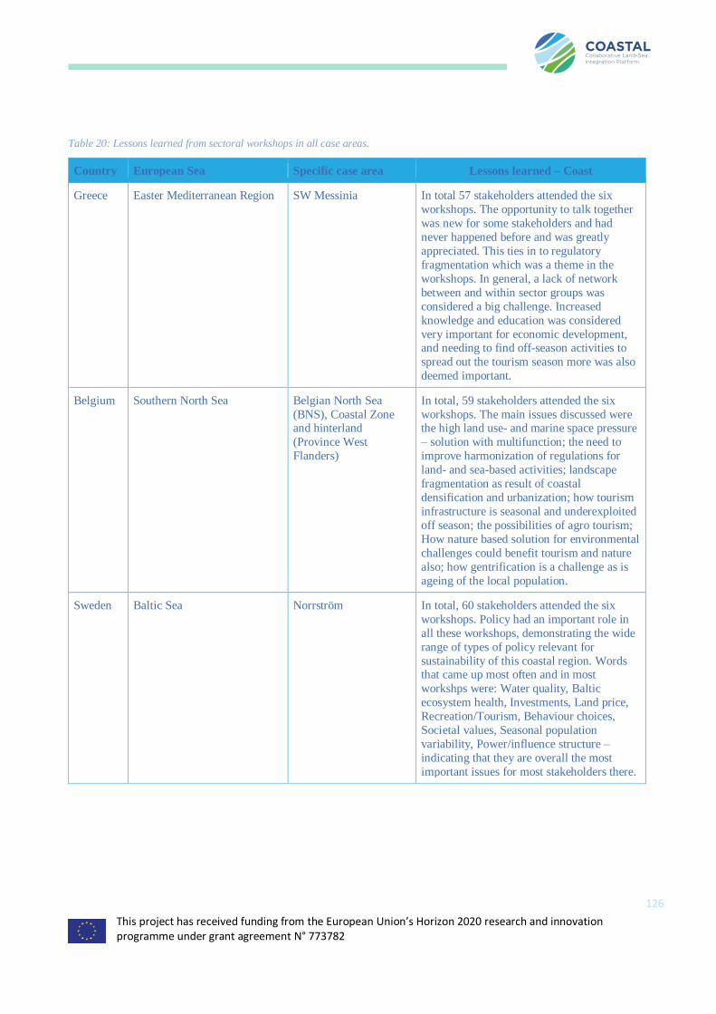
This project has received funding from the European Union’s Horizon 2020 research and innovation programme under grant agreement N° 773782
126
Table 20: Lessons learned from sectoral workshops in all case areas.
Country European Sea Specific case area Lessons learned – Coast
Greece Easter Mediterranean Region SW Messinia In total 57 stakeholders attended the six
workshops. The opportunity to talk together
was new for some stakeholders and had
never happened before and was greatly
appreciated. This ties in to regulatory
fragmentation which was a theme in the
workshops. In general, a lack of network
between and within sector groups was
considered a big challenge. Increased
knowledge and education was considered
very important for economic development, and needing to find off-season activities to
spread out the tourism season more was also
deemed important.
Belgium Southern North Sea Belgian North Sea
(BNS), Coastal Zone and hinterland
(Province West
Flanders)
In total, 59 stakeholders attended the six
workshops. The main issues discussed were the high land use- and marine space pressure
– solution with multifunction; the need to
improve harmonization of regulations for
land- and sea-based activities; landscape
fragmentation as result of coastal
densification and urbanization; how tourism
infrastructure is seasonal and underexploited
off season; the possibilities of agro tourism;
How nature based solution for environmental
challenges could benefit tourism and nature
also; how gentrification is a challenge as is
ageing of the local population.
Sweden Baltic Sea Norrström In total, 60 stakeholders attended the six
workshops. Policy had an important role in
all these workshops, demonstrating the wide
range of types of policy relevant for
sustainability of this coastal region. Words that came up most often and in most
workshps were: Water quality, Baltic
ecosystem health, Investments, Land price,
Recreation/Tourism, Behaviour choices,
Societal values, Seasonal population
variability, Power/influence structure –
indicating that they are overall the most
important issues for most stakeholders there.

This project has received funding from the European Union’s Horizon 2020 research and innovation programme under grant agreement N° 773782
127
Romania Black Sea Danube Mouths In total, 97 stakeholders attended these six
workshops. Policy and underdevelopment were important issues during these
workshops, as was lack of communications
and low know-how and knowledge of the
local authorities and in communities in
general. Rural tourism was considered
something that could be important, and the
local population was positive to it.
France Atlantic Region Charrente River Basin In total, 54 stakeholders attended these
workshops. The use of water resources was
the most important thing for these
stakeholders, both quality and quantity.
Other key topics were the impacts of climate
change, population changes and
concentration of activities, development of
organic farming and adaptation of current
farming systems, inland water storage,
development of sustainable energies, adaptation of coastal activities to sea level
rise.
Spain Western Mediterranean Mar Menor Coastal
lagoon
In total, 68 stakeholders attended these six
workshops. The main issues identified were a
lack of holistic and long-term perspective for
management and lack of well-defined action plans; habitat degradation and biodiversity
loss in the lagoon and associated wetlands
around the Mar Menor lagoon due to
eutrophication (nutrients and sediments from
agriculture, heavy metals from the old mining
areas and wastewater inputs); concentration
of tourism in summer months; the decrease in
recreation opportunities for local populations
living around the Mar Menor lagoon and
tourists and lack of investment in general
infrastructures, including waste water treatment.
The following table shows some of the results in a more comparable manner across case-areas. First, we filled it in based
on the results from the analysis per case area with each MAL leader being asked to complete and correct the table. The
tables shows the policy themes (rows) and how important they were to the stakeholders based on the analysis of the MAL
leaders (0: not important; 1: mentioned but not a main focus point; 2: focus point of the MAL).
Table 21: The themes in column 1 of the table are first themes we extracted based on the deliverable itself and the workshops in the
six case areas. Then we related these to the CAP and MSFD and added weights of importance to these as well.
Belgian
coastal
zone
Messina Baltic Charente Danube
Mouth
Mar
Menor
Inland water quality 2 2 2 2 2 2
Fresh water availability 2 2 0 2 1 2
Rural economy reform 1 2 1 2 2 2
Funding for agriculture transition 0 2 0 1 2 1
Rural gentrification 2 0 0 2 0 2

This project has received funding from the European Union’s Horizon 2020 research and innovation programme under grant agreement N° 773782
128
(On land) spatial planning 2 2 2 2 1 2
Management of nature areas 0 2 0 1 2 2
Capacity building 1 2 2 0 2 1
Bureaucracy 0 2 0 1 2 2
Preserve local traditions 1 1 0 0 2 1
Tourism coordination 2 2 2 0 2 2
Tourism diversification 2 2 0 1 2 2
International cooperation 2 0 2 0 2 0
Cross-sector cooperation 2 2 2 2 2 2
Coastal water quality 1 2 2 2 2 2
Marine spatial planning 2 2 1 1 2 1
Climate change and sea defense 2 2 1 1 1 1
Aquaculture regulation 2 2 1 2 2 0
COMMON AGRICULTURE POLICY POINTS
Ensuring viable farm income 2 2 0 2 2 1
Increasing competitiveness 2 2 1 1 1 1
Farmer position in value chains 2 2 0 2 2 0
Agriculture and climate mitigation 2 2 1 2 1 0
Efficient soil management 0 2 1 1 2 2
Biodiversity and farmed landscapes 1 2 1 2 2 1
Structural change and generational re 1 2 0 1 1 0
Jobs and growth in rural areas 1 2 1 2 2 2
Health, food and antimicrobial resistance 0 2 1 1 1 0
Simplifying the CAP 0 2 1 0 0 0
MARINE STRATEGIC FRAMEWORK DIRECTIVE DESCRIPTORS
Biological diversity 2 1 0 2 2 2
Non-indigenous species 1 1 0 1 1 1
Commercially exploited fish and shellfish 2 2 0 1 2 2
Marine food webs 1 0 0 1 0 1
Eutrophication 1 1 2 1 2 2
Sea-floor integrity 2 2 0 1 1 0
Hydrographical conditions 0 0 0 1 1 2
Contaminants 0 2 2 2 1 2
Contaminants in fish and other seafood 0 1 0 2 2 2
Marine litter 2 2 0 1 1 2
Underwater noise and other forms of ……. 1 0 0 0 0 1
The general impact of the results from the workshops, and the analysis from the table above in the six case areas were:
1. The development of a transferable set of tools and indicators allowing the quantitative and qualitative
description of a wide variety of economic, environmental and social land-sea interactions, thus improving
understanding of economic and social interactions in coastal areas, serving a more evidence-based policy-
making at local and regional level;
2. A thorough understanding of the factors (barriers and motivators) influencing behaviour and solutions to
enable joint actions;
3. An identification of new business opportunities stemming from closer cooperation between land- and sea-based
economic operators which in time can lead to increased potential for job and added-value creation in coastal
areas; and
4. The creation of longer-term relationships between coastal areas serving as European flagships for rural-
coastal synergies and ensuring longer and wider dissemination of results.
This project has received funding from the European Union’s Horizon 2020 research and innovation programme under grant agreement N° 773782
129
Challenges of the methodology concept we chose to adapt for COASTAL is in its inherent complicated nature as it
involves numerous stakeholder groups from different and often competing sectors, which in addition is layered in two
different geographical areas – the inland and the coastal areas. On the note of this along, the stakeholder integration process is difficult. Adding to this that this was done with the same methodology in six different case areas across Europe,
where the facilitators came from several different disciplinary backgrounds, made this especially challenging. Reaching
stakeholders and ensuring that there was adequate – but not too high – attendance at the workshops was also a challenge.
Using the snowball method helps in this endeavour, as we thereby ensured that rather than high numbers, we had the
correct stakeholders with the correct background and interest in the topic attending. This was a methodologically choice
that is well accepted in the social sciences, and as such was not considered a limit to the study. It did however require a
lot of effort in ensuring participation, as opposed to using large scale questionnaires where the responses would come
from a cross-section of society. Either approach has its benefits and limitations.
Stakeholder fatigue was another challenge we were face with. Many of these stakeholders have a great interest in the
topic, and are generally approachable, and as such are invited to attend many different research projects and workshops.
As such, they may at times have less interest in showing up to "yet another research project". Furthermore, many expected there to be more immediate results that would show direct relevance to their field, which is not always the case in research
projects, where results take time. As such, ensuring good communication and making sure that stakeholders are
continuously kept in the loop on ongoing developments of the project and results are shown as they come in to those that
need these the most has been critical. This has been solved differently in all the different case areas, and this is also a
methodological choice. Cultural differences and needs will steer how any given case area will need and want to approach
stakeholders outside of the regular scheduled meetings (see figure 3 for information about how often and to what extent
stakeholders are planned to be involved in the COASTAL project).
7 ACKNOWLEDGEMENTS
This report is compiled for the H2020 COASTAL project (Grant Agreement No. 773782). Colleagues at partner
organisations have contributed information on specific details relating to data protection and the named individuals with
the relevant responsibilities. Partners with relevant authority have signed the declarations of compliance with EU and
national laws and regulations.

This project has received funding from the European Union’s Horizon 2020 research and innovation programme under grant agreement N° 773782
130
8 Revisions requested after RP1 – M18
Improve the methodology section
1) How were the participants selected? We added the following text to the methodology section
3.1.1:
We selected the groups of stakeholders for the workshops in
each of the six case areas using the established “snowball method” (Biernacki and Waldorf 1981) – exploiting the
knowledge network of the local research and actor partners as
well as possible. Participatory approaches and modelling
depends on stakeholder involvement, through which stakeholders can exchange their shared experiences, learn
about other perspectives, and (qualitatively or quantitatively)
examine their perceptions to better understand system behavior (Sterman 2000). We used this approach because the
quality of the results sampled from representative groups
would outweigh the relatively small number of workshop participants the method usually produces. This is often the
case in qualitative research studies. Sometimes, large samples
can in fact be ineffective and not provide the detailed and
contextual information and in-depth interactions desired by the facilitators. For the purposes of the participatory
workshops in this study, we considered fifteen to be the
maximum of what would provide a holistic narrative where all participants were provided ample opportunities to share their
perceptions. The sample size can be as small as one or two as
well, if this participant has information which is of critical
value for the given sector and advances the research towards a specific goal (Sandelowski 1995).
From a natural science perspective, this may seem like a small number of observations. However, samples in qualitative
research methods tend to be smaller than one would expect in
the more numerical sciences. This is to support the depth of case-oriented analysis that is fundamental to this mode of
inquiry, such as with the COASTAL sector workshops where
the aim was to conceptualize the relevant land-sea
interactions from a thematic point of view first. The samples were also purposive in that they were selected by virtue of the
respondent’s capacity to provide richly textured information
that was required specifically for this study, relevant to the phenomenon under investigation. As such, this purposive
sampling (as opposed to probability sampling that is
customarily employed in quantitative research methods) selects ‘information-rich’ cases or respondents. The more
useful the data sampled from each of the participant is during
these sessions, the fewer respondents are needed. In fact,
research has shown that after 20 responses, there is seldom any new information to be gained that is analytically relevant
This project has received funding from the European Union’s Horizon 2020 research and innovation programme under grant agreement N° 773782
131
(Green and Thorogood 2018), hence why a limit of 15 persons per workshop was suggested to the Multi-Actor Labs.
We also added Table 1 with point-by-point explanations from
each case area leader on what the methods and challenges were in terms of stakeholder mapping and selection in each area,
including representativeness of the participants.
2) What was the structure of the
workshops?
We added the following text to section 3.1.2.3 Structure of
the workshops:
For the first round of workshops, the stakeholders were divided into sectors and territories, with three rural and three
coastal workshops in each specific case area. During the
session with the stakeholders, the researchers in each case area started the group model building experience by
presenting pertinent background information about the
project and the project aims (Impson 2011), and informing them of their GDPR rights, and that the session would be
recorded for purposes of narrative analysis after the workshop
and it would be deleted after transcription. After the
introduction, the facilitator asked the stakeholders to consider a context in which they were to give their perceptions on areas
of interaction between different sectors in rural and coastal
areas, in terms of challenges and opportunities within their sector. The system conceptualization process was initiated by
presenting the participants with the seven predetermined
drivers. The facilitator explained that the drivers were variables or exogenous factors that could have an effect on
other variables in the land-sea system, though generally not
vice versa. They were also described as having multiple
‘states’ or ‘settings’ – for example if the variable is ‘the color of a boat’ then potential states could be red, blue, green etc.
The drivers list was purposefully not exhaustive and the
facilitator emphasized that the stakeholders could change some of the drivers during the workshop if needed. They were
only to be considered starters to get the conversation going
and encourage the stakeholders to speak on the issues in
question. This ability to change or modify the drivers speaks of the benefits of this method, since it allows the inclusion of
additional drivers through facilitating direct group input.
The drivers were either posted on the board with coloured
"sticky" notes or written on the board directly. The
stakeholders were then encouraged to identify the causal interrelationships and connections between these variables in
the form of directional step-by-step associations to guide the
brainstorm session. This could for example be connections
that highlighted that water quality in the olive oil industry (variable ‘A’) was affected by the number of tourists in the
area because of pollution (variable ‘B’). It could also for
This project has received funding from the European Union’s Horizon 2020 research and innovation programme under grant agreement N° 773782
132
example be that the amount of fish that an aquaculture company was allowed to have in a pen (variable ‘C’) directly
affected the areas available for fisheries (variable ‘D’). The
result of this variable identification and step-wise
interconnection process, which took between one to two hours usually – and sometimes more if the stakeholders were very
engaged. This result in a broad system conceptualization or
group mental model – also referred to as sector mind maps. These mind maps were graphical representations of the
problems, solutions and opportunities and interconnections as
perceived by the stakeholders during the sector workshops, such as those of the sectors for Nature, Agriculture, Spatial
Planning, Blue Industry, Fisheries & Aquaculture and
Tourism (taking the example of the Belgian MAL). This model
represented how this particular group of stakeholders collectively viewed the causal pathways between variables at
that given time and identified by closer inspection where
problems, possible solutions and conflict points, obstacles and opportunities for development could be located.
3) How were the mental models
constructed (for example, how was the discussion initiated?
See above
4) How was the verification of the drivers
done?
The drivers were selected initially by the research team and
were open to be changed by the stakeholders in the subsequent workshops. This flexibility and stakeholder adaptation
possibility is part of what legitimizes this methodology, and it
has been tested in a number of peer-reviewed journal articles
using this method (Tiller, Gentry et al. 2013, Tiller, Richards et al. 2014, Tiller and Richards 2015, Tiller, Hansen et al.
2015, Tiller, Mork et al. 2015, Tiller, De Kok et al. 2016,
Tiller, De Kok et al. 2017, Tiller and Richards 2018). The drivers were initially defined as "conversation starters" but
were presented and adjusted during the project kickoff in a
brainstorm session of the researchers with expertise in field
of social-environmental modelling. In this case, this was the entire project core group of COASTAL. This is described in
section 3.1.2.2 Drivers.
5) How was the mental mapping exercise facilitated?
See #2 above
6) What were the different steps in the
process?
In Section 3.1 we added a graphical representation (Figure 3)
of the entire process of all of COASTAL in terms of
stakeholder interaction and verification, marking what section of this Figure refer to this current deliverable D1.1.
In addition to that and #2 above, we have now also added the following text in a new section – 3.1.2.4 Post workshop
narrative analysis
Narrative analysis and post-processing:
This project has received funding from the European Union’s Horizon 2020 research and innovation programme under grant agreement N° 773782
133
After the workshops, the research team used the Vensim® software to visualize the results graphically in combination
with analyzing the narratives from the workshop. We used the
‘causes trees’ and ‘uses trees’ diagnostic tools within the
program to visualize the degree of connectivity between variables of the group conceptualization. When needed, we
coupled the visualization process with a narrative analysis
from the sound recordings taken during the workshop. Narratives can be described as "discourses with a clear
sequential order that connect events in a meaningful way for
a definite audience and thus offer insights about the world and/or people's experiences of it" (Hinchman and Hinchman
1997). To get the narratives from the transcription of the
recordings from the workshop, we can concoct one's own
narrative; that of the researcher's interpretation of what was discussed during the workshop, rewritten from its original
form. Another option is to analyze the narratives as special
kinds of texts, in and of themselves, using conversation analysis (Czarniawska 2004). You can also use a combination
of the two, where you interpret the narratives within the
context of the workshop setting, and other times treating the text literally as it related to the output of the systems thinking
analysis from the workshop. The most important role of the
narrative is the knowledge content that can be extracted that
might be missed from the model conceptualization process alone. This is in line with Elliott's account of narratives as
being instrumental because "...internal validity is...thought to
be improved by the use of narrative because participants are empowered to provide more concrete and specific details
about the topics discussed and to use their own vocabulary
and conceptual framework to describe life experiences."
(2005).
7) How long did the exercise take? 1-2 hours. This information was added to section 3.1.2.3
Structure of the workshops.
8) Were positive and negative causalities between variables identified);
Positive and negative causalities (i.e. the polarity of interactions) were not yet considered under Task 1.1 in this
exercise. We explain this process in deliverable D04, where
the methodology leading to the first round of multi-actor workshops (combining the coastal and rural sectors) is
explained. The polarities were added in the inter-workshop
interpretations where we developed causal loop diagrams (CLDs) – but this was not part of deliverable D03.
9) how the data was analyzed to produce
the findings reported in the
deliverable;
See #6 - 3.1.2.4 Post workshop narrative analysis
10) MALs that deviated from the commonly
agreed methodology and why (for
example Mar Menor did not work with
the pre-established drivers and does not describe which drivers were used).
This is not correct. All the Multi-Actor Labs used the same pre-
established drivers. As explained, however, the benefits of this
methodology lies in its flexibility. See #4 above, and list of
peer-reviewed publications on the use of this methodology.
This project has received funding from the European Union’s Horizon 2020 research and innovation programme under grant agreement N° 773782
134
Review the conclusions on “lessons
learned” because they are rather
generic and lacking an appropriate level
of comparative analysis.
We rewrote this section to be less generic and added more detail allowing more of a conclusion. The lessons learned are
already in table form, divided into the different case areas. We
have added Table 20 to Section 6 showing some of the key
variables that were brought up to visualize where there were similarities and which were most important across case areas.
Optional: include a section outlining the
challenges and lessons learnt from using
the mental models methodology. This
would be very useful not only for any
papers that the consortium wants to
write, but also for the research
community interested in using this kind
of methodology.
This is now part of the conclusion. We added two more
paragraphs to the end of section 6 that addresses specifically the challenges of the multi-actor analysis, stakeholder
exchanges and processing of results.

This project has received funding from the European Union’s Horizon 2020 research and innovation programme under grant agreement N° 773782
135
9 REFERENCES
Biernacki, P. and D. Waldorf (1981). "Snowball Sampling: Problems and Techniques of Chain Referral Sampling."
Sociological Methods & Research 10(2): 141-163.
Brannen, J. (2005). "Mixing Methods: The Entry of Qualitative and Quantitative Approaches into the Research Process."
International Journal of Social Research Methodology 8(3): 173-184.
Bring, A., S. M. Asokan, F. Jaramillo, J. Jarsjö, L. Levi, J. Pietroń, C. Prieto, P. Rogberg and G. Destouni (2015).
"Implications of freshwater flux data from the CMIP5 multimodel output across a set of Northern Hemisphere drainage
basins." Earth's Future 3(6): 206-217.
Bring, A., P. Rogberg and G. Destouni (2015). "Variability in climate change simulations affects needed long-term
riverine nutrient reductions for the Baltic Sea." Ambio 44(3): 381-391. Czarniawska, B. (2004). Narratives in social science research. London, Sage.
Darracq, A., F. Greffe, F. Hannerz, G. Destouni and V. Cvetkovic (2005). "Nutrient transport scenarios in a changing
Stockholm and Mälaren valley region, Sweden." Water Science and Technology 51(3-4): 31-38.
Davis, N. (2018). Baltic Sea oxygen levels at '1,500-year low due to human activity'. The Guardian.
https://www.theguardian.com/environment/2018/jul/05/baltic-sea-oxygen-levels-at-1500-year-low-due-to-human-
activity.
Destouni, G., I. Fischer and C. Prieto (2017). "Water quality and ecosystem management: Data‐driven reality check of
effects in streams and lakes." Water Resources Research 53(8): 6395-6406.
Destouni, G. and J. Jarsjö (2018). "Zones of untreatable water pollution call for better appreciation of mitigation limits
and opportunities." Wiley Interdisciplinary Reviews: Water 5(6): e1312.
Elliott, J. (2005). Using narrative in social research: Qualitative and quantitative approaches. London, UK, Sage. Elmhagen, B., G. Destouni, A. Angerbjörn, S. Borgström, E. Boyd, S. A. Cousins, L. Dalén, J. Ehrlén, M. Ermold and P.
A. Hambäck (2015). "Interacting effects of change in climate, human population, land use, and water use on biodiversity
and ecosystem services." Ecology and Society 20(1).
Goldenberg, R., Z. Kalantari, V. Cvetkovic, U. Mörtberg, B. Deal and G. Destouni (2017). "Distinction, quantification
and mapping of potential and realized supply-demand of flow-dependent ecosystem services." Science of the Total
Environment 593: 599-609.
Goldenberg, R., Z. Kalantari and G. Destouni (2018). "Increased access to nearby green–blue areas associated with greater
metropolitan population well‐being." Land Degradation & Development 29(10): 3607-3616.
Golumbeanu, M. and S. Nicolaev (2015). "Study on integrated coastal zone management." 454p Report by the Project
Improvement of the Integrated Coastal Zone Management in the Black Sea Region ICZM, funded by the Joint Operational
Programme Black Sea Basin 2007-2013 ISBN: 978-606-598-397-7 This publication has been produced with the
assistance of the European Union. Gomoiu, M.-T. (1992). Marine eutrophication syndrome in the north-western part of the Black Sea. Marine coastal
eutrophication, Elsevier: 683-692.
Gomoiu, M. (1981). "Some problems concerning actual ecological changes in the Black Sea." Cercetari marine 14: 109-
127.
Green, J. and N. Thorogood (2018). Qualitative methods for health research, sage.
Gren, M. and G. Destouni (2012). "Does divergence of nutrient load measurements matter for successful mitigation of
marine eutrophication?" Ambio 41(2): 151-160.
Hannerz, F. and G. Destouni (2006). "Spatial characterization of the Baltic Sea drainage basin and its unmonitored
catchments." AMBIO: A Journal of the Human Environment 35(5): 214-219.
Hinchman, L. P. and S. Hinchman (1997). Memory, identity, community: The idea of narrative in the human sciences.
Albany, NY, Suny Press. Impson, S. (2011). "The blue food revolution." Scientific American 304(2): 54-61.
Kelle, U. (2006). "Combining qualitative and quantitative methods in research practice: purposes and advantages."
Qualitative Research in Psychology 3(4): 293-311.
Kim, D. H. (1992). "Guidelines for drawing causal loop diagrams." The Systems Thinker 3(1): 5-6.
Kok, J.-L. D. and P. Viaene (2018). COASTAL Deliverable D12 – Model Scope and Feedback Structure. . European
Union’s Horizon 2020 research and innovation programme under grant agreement N° 773901. https://h2020-coastal.eu/4.
Kroiss, H., C. Lampert and M. Zessner (2004). Nutrient management in the Danube basin and its impact on the Black
Sea (Danubs). European Conference on Marine Science & Ocean Technology.
Levi, L., V. Cvetkovic and G. Destouni (2018). "Data-driven analysis of nutrient inputs and transfers through nested
catchments." Science of the Total Environment 610: 482-494.
Mee, L. D. and G. Topping (1999). Black Sea pollution assessment, United Nations Publications New York, NY, USA.
This project has received funding from the European Union’s Horizon 2020 research and innovation programme under grant agreement N° 773782
136
Sandelowski, M. (1995). "Sample size in qualitative research." Research in Nursing & Health 18(2): 179-183.
SoKolnikov, M. (1999). "Causes and effects of eutrophication in the Black Sea." Danube Pollution Reduction Programme.
Summary report. Programme Coordination Unit UNDP/GEF Assistance. Vienna: 13-17.
Sterman, J. (2000). Business Dynamics: systems thinking and modelling for a complex world. Boston, McGraw Hill Higher Education.
Sterman, J. D. (2000). Business dynamics: systems thinking and modeling for a complex world, Irwin/McGraw-Hill
Boston.
Tiller, R., R. Gentry and R. Richards (2013). "Stakeholder driven future scenarios as an element of interdisciplinary
management tools; the case of future offshore aquaculture development and the potential effects on fishermen in Santa
Barbara, California." Ocean & Coastal Management 73: 127-135.
Tiller, R. and R. Richards (2015). "Once bitten, twice shy: Aquaculture, stakeholder adaptive capacity, and policy
implications of iterative stakeholder workshops; the case of Frøya, Norway." Ocean & Coastal Management 118(Part B):
98-109.
Tiller, R. G., L. Hansen, R. Richards and H. Strand (2015). "Work segmentation in the Norwegian salmon industry: The
application of segmented labor market theory to work migrants on the island community of Froya, Norway." Marine
Policy 51: 563-572. Tiller, R. G., J. Mork, Y. Liu, Å. L. Borgersen and R. Richards (2015). "To Adapt or Not Adapt: Assessing the Adaptive
Capacity of Artisanal Fishers in the Trondheimsfjord (Norway) to Jellyfish (Periphylla periphylla) Bloom and Purse
Seiners." Marine and Coastal Fisheries 7(1): 260-273
Tiller, R., J.-L. De Kok, K. Vermeiren, R. Richards, M. V. Ardelan and J. Bailey (2016). "Stakeholder Perceptions of
Links between Environmental Changes to their Socio-Ecological System and their Adaptive Capacity in the Region of
Troms, Norway." Frontiers in Marine Science 3(267).
Tiller, R. G., J.-L. De Kok, K. Vermeiren and T. Thorvaldsen (2017). "Accountability as a Governance Paradox in the
Norwegian Salmon Aquaculture Industry." Frontiers in Marine Science 4(71).
Tiller, R. and R. Richards (2018). "Ocean futures: Exploring stakeholders' perceptions of adaptive capacity to changing
marine environments in Northern Norway." Marine Policy.
.