sea_reach9phase3_2013.pdf - US Army Corps of Engineers ...
410
Los Angeles District FINAL SUPPLEMENTAL ENVIRONMENTAL ASSESSMENT and Addendum to Environmental Impact Report (EIR) 583 Santa Ana River: Reach 9 Phase 3 County of Orange, California U.S. Army Corps of Engineers Los Angeles District P.O. Box 532711 Los Angeles, California 90053-2325 March 2013
-
Upload
khangminh22 -
Category
Documents
-
view
2 -
download
0
Transcript of sea_reach9phase3_2013.pdf - US Army Corps of Engineers ...

Los Angeles District
FINAL SUPPLEMENTAL ENVIRONMENTAL ASSESSMENT and Addendum to Environmental Impact Report (EIR) 583
SSaannttaa AAnnaa RRiivveerr:: RReeaacchh 99 PPhhaassee 33 County of Orange, California
U.S. Army Corps of Engineers Los Angeles District
P.O. Box 532711 Los Angeles, California 90053-2325
March 2013


Contents1.0 PROJECT BACKGROUND ................................................................................... 1
1.1 Previously Prepared Documents .......................................................................... 2 2.0 PROJECT LOCATION ........................................................................................... 4 3.0 PURPOSE AND NEED ......................................................................................... 10
3.1 Statement of Need .............................................................................................. 10 3.2 Statement of Purpose .......................................................................................... 10
4.0 ALTERNATIVES.................................................................................................. 11 4.1 Description of Alternatives ................................................................................ 11 4.2 Alternatives Eliminated from Further Consideration ......................................... 27
5.0 AFFECTED ENVIRONMENT AND ENVIRONMENTAL CONSEQUENCES 29 5.1 GEOLOGY AND SOILS ............................................................................... 29
5.1.1 Affected Environment ................................................................................. 29 5.1.2 Environmental Consequences ..................................................................... 29
5.2 HYDROLOGY................................................................................................... 30 5.2.1 Affected Environment ................................................................................. 30 5.2.2 Environmental Consequences ..................................................................... 30
5.3 GROUND WATER ........................................................................................ 32 5.3.1 Affected Environment ................................................................................. 32 5.3.2 Environmental Consequences ..................................................................... 33
5.4 SURFACE WATER QUALITY .................................................................... 34 5.4.1 Affected Environment ................................................................................. 34 5.4.2 Environmental Consequences ..................................................................... 34 5.4.3 Environmental Commitments ..................................................................... 35
5.5 BIOLOGICAL RESOURCES ........................................................................ 36 5.5.1 Affected Environment ................................................................................. 36 5.5.2 Environmental Consequences ..................................................................... 74 5.5.3 Environmental Commitments ..................................................................... 90
5.6 AIR QUALITY .................................................................................................. 96 5.6.1 Affected Environment ................................................................................. 96 5.6.2 Environmental Consequences ..................................................................... 99 5.6.3 Environmental Commitments ................................................................... 102
5.7 NOISE .............................................................................................................. 104 5.7.1 Affected Environment ............................................................................... 104 5.7.2 Environmental Consequences ................................................................... 104
5.8 CULTURAL RESOURCES ............................................................................ 106 5.8.1 Affected Environment ............................................................................... 106 5.8.2 Environmental Consequences ................................................................... 106 5.9.3 Environmental Commitments ................................................................... 107
5.9 LAND USE ...................................................................................................... 107 5.9.1 Affected Environment ............................................................................... 107 5.9.2 Environmental Consequences ................................................................... 107
5.10 RECREATION ............................................................................................. 108

5.10.1 Affected Environment ............................................................................... 108 5.10.2 Environmental Consequences ................................................................... 108
5.11 TRANSPORTATION .................................................................................. 109 5.11.1 Affected Environment ............................................................................... 109 5.11.2 Environmental Consequences ................................................................... 110 5.11.3 Environmental Commitments ................................................................... 112
5.12 AESTHETICS .............................................................................................. 112 5.12.1 Affected Environment ............................................................................... 112 5.12.2 Environmental Consequences ................................................................... 112
5.13 PUBLIC UTILITIES AND SERVICES ..................................................... 113 5.13.1 Affected Environment ............................................................................... 113 5.13.2 Environmental Consequences ................................................................... 113
5.14 HAZARDOUS MATERIALS ...................................................................... 114 5.14.1 Affected Environment ............................................................................... 114 5.14.2 Environmental Consequences ................................................................... 114
5.15 SOCIOECONOMICS ................................................................................... 115 5.15.1 Affected Environment ............................................................................... 115 5.15.2 Environmental Consequences ................................................................... 116
5.16 ENVIRONMENTAL JUSTICE ................................................................... 117 5.16.1 Affected Environment ............................................................................... 117 5.16.2 Environmental Consequences ................................................................... 118
5.17 CUMULATIVE IMPACTS ........................................................................ 118 6.0 ENVIRONMENTAL COMMITMENTS ............................................................ 124 7.0 ENVIRONMENTAL COMPLIANCE ................................................................ 133 8.0 COORDINATION ............................................................................................... 136 9.0 LIST OF PREPARERS AND REVIEWERS ...................................................... 137 10.0 CONCLUSION .................................................................................................... 138 11.0 LIST OF ACRONYMS AND ABBREVIATIONS ............................................ 139 12.0 REFERENCES .................................................................................................... 142

FiguresFigure 2-1 Area/Regional Map………………………………………………….....................5 Figure 2-2 Watershed Map…………………………………………………………………...6 Figure 2-3 Vicinity Map……………………………………………………………………...8 Figure 4-1.1 Project Features: West………………………………………………..................12 Figure 4-1.2 Project Features: Middle………………………………………………………...14 Figure 4-1.3 Project Features: East………………………………………………....................16 Figure 4-2 Typical Section of Bank Protection……………………………………………..18 Figure 4-3 Staging Areas Map…………………………………………………....................20 Figure 4-4 Site Preparation Map……………………………………………………………22 Figure 4-5 Storm Drain Outlets and Undercrossings……………………………………….24 Figure 5-1 Freeway Complex Fire Map…………………………………………………….37 Figure 5-2.1 Plant Communities/Habitat Map: General Classification………………………40 Figure 5-2.2 Plant Communities/Habitat Map: Major Classification……………....................42 Figure 5-2.3 Plant Communities/Habitat Map: Detailed Classification…………....................44 Figure 5-3 Santa Ana Sucker: Critical Habitat Map………………………………………..69 Figure 5-4 Coastal California Gnatcatcher: Critical Habitat Map………………………….72 Figure 5-5 Least Bell’s Vireo Map…………………………………………….....................73 Figure 5-6 Off-Site Mitigation Map………………………………………………………...78 Figure 5-7 Transportation Map…………………………………………………………….111
TablesTable 5.1 Summary of Groundwater Field Exploration…………………………………...32 Table 5.5-1 Special Status Plants and their Probability to Occur Within the
Project Area………………………………………………………………..........50 Table 5.5-2 Special Status Wildlife and their Probability to Occur Within the
Project Area………………………………………………………………..........59 Table 5.5-3 General Scale Habitat Classification Predicted Acreages……………………...75 Table 5.6-1 Attainment Status for the South Coast Air Basin (SCAB)……………………...97 Table 5.6-2 Air Quality Monitoring Summary (2007-2009)………………………………..98 Table 5.6-3 Comparison of Federal de minimis Thresholds (in Tons/Year) and
Soil Cement Alternative Maximum (Worst Case Scenario) Estimated………..101 Table 5.6-4 Comparison of SCAQMD Thresholds (in lbs/day) and Soil Cement
Alternative Maximum (Worst Case Scenario) Estimated Emissions (lbs/day)……………………………………………………………………......101
Table 5.7-1 Range of Noises…………………………………………………………..........104 Table 5.7-2 Potential Noise Levels at Various Distances…………………………………..105 Table 5.11-1 Current Traffic Volumes……………………………………………………….110 Table 5.11-2 Comparison of Baseline AADT to Project Traffic Increases…………….........112 Table 5.15-1 Population, Housing, and Employment…………………………………..........116 Table 5.15-2 Ethnicity, Low Income………………………………………………………...117

AppendicesA. 404(b) (1) Evaluation B 2001 BO, 2012 BO Amendment and 2013 BO Amendment C Air Quality Analysis D. Native American Heritage Commission (NAHC) response to Reach 9 Phase 3 E CDFW Code Compliance F. 401 Certification G. Draft SEA/EIR Addendum Comments and Responses to Comments H. Mailing Distribution List

1
1.0 PROJECTBACKGROUND This Supplemental Environmental Assessment /Environmental Impact Report Addendum (SEA/EIR Addendum) supplements the Supplemental Environmental Impact Statement/Environmental Impact Report (SEIS/ EIR) for Prado Basin and Vicinity, Including Reach 9 and Stabilization of the Bluff Toe at Norco Bluffs, dated November 2001 (2001 SEIS/EIR). The 2001 SEIS/EIR had identified six distinct locations on the south and north banks of Reach 9 that required protection. This project site was not included in the 2001 SEIS/EIR. However, subsequent technical studies indicated that the existing soil cement protection in the project reach is neither thick enough nor deep enough to withstand a 30,000 cubic feet per second (cfs) release of water from Prado Dam. This SEA/EIR Addendum evaluates structural alternatives for decreasing flood damage risks along the project reach, documents existing conditions, and evaluates environmental effects (e.g., environmental consequences) of the alternatives considered. The Corps has continued to analyze scour studies that have been completed in the last few years, and has further evaluated the depth and condition of existing bank protection outside of the various “Reach 9” features that have been constructed by the Corps since 2001. Initial findings led to the development of the Phase 3 project addressed in this document, and also identification of the need for scour protection at the BNSF Railroad Bridge just upstream of the Green River Golf Club. The Corps has been evaluating alternatives for the railroad bridge protection for the last several months (in coordination with the U.S. Fish and Wildlife Service and other agencies), and intended to prepare another Supplemental EA for that project in the next calendar year. In recent weeks, however, the Corps completed additional analysis and identified two additional areas that will likely require strengthening of the bank and deepening of the embankment toe. Similar to the other Reach 9 features, the purpose would be to prevent undercutting or erosion of the embankments caused by high-velocity flows and associated scour, and to protect adjacent development. One of these areas is on the south bank, contiguous with and continuing upstream of the Reach 9 Phase 3 project feature. This will be referred to as “Reach 9 Phase 4.” The second area is on the north bank, contiguous with and continuing upstream of the “Car Wash Strip Mall” (Reach 9 Phase 1) project feature. This will be referred to as “Reach 9 Phase 5.” Reach 9 Phase 4 may extend approximately 3,500 feet upstream from the end of the Reach 9 Phase 3 project feature, to the boundary of State Park property (approximately 1,600 feet downstream of Coal Canyon Road). Reach 9 Phase 5 may extend approximately 4,400 feet upstream from the end of the Car Wash Strip Mall project feature. No alternatives have been developed for either of these new features. Based on previous projects, and the fact that the existing low flow stream is not immediately adjacent to the south bank in this area, it is probable that the preferred option for Reach 9 Phase 4 would consist of grouted stone. The river appears to meander closer in some areas to the Reach 9 Phase 5 project area, but it has not been determined whether diversion of flows may be needed. No specific options have been identified for that feature. The Corps will begin developing and evaluating alternatives for Phases 4 and 5, and will continue analyzing alternatives for the BNSF scour protection over the next several months, and expects to complete environmental documentation for all three projects next calendar year. This

2
documentation will analyze potential cumulative impacts from all of the Reach 9 features (considering the restoration and mitigation that has already been accomplished or will be accomplished for those features). The U.S. Army Corps of Engineers (Corps) is the lead agency for the Reach 9, Phase 3 project under the National Environmental Policy Act (NEPA), and the Orange County Flood Control District (OCFCD) is the lead agency under California Environmental Quality Act (CEQA). OCFCD will use the contents of this document to satisfy CEQA requirements. Other agencies (i.e., cooperating, responsible, and trustee agencies) may use this SEA/EIR Addendum, and the information contained within it, in their respective decision making or permit process. Caltrans, for instance, is a responsible agency, as they would be issuing an Encroachment Permit for this project. Responsible and trustee agencies were identified in the 2001 Final SEIS/EIR, and are listed again as follows:
California Department of Fish and Wildlife (CDFW) (until recently, this agency was known as California Department of Fish and Game (CDFG),
California Regional Water Quality Control Board (RWQCB), United State Fish and Wildlife Service (USFWS), California Department of Transportation (Caltrans), Orange County Water District (OCWD), and Orange County Parks (OC Parks).
1.1 PreviouslyPreparedDocumentsBelow is a partial list of environmental documents that have been completed for the Santa Ana River Mainstem Flood Control Project (SARP) and for Reach 9 in particular, which may be referenced throughout the SEA/EIR Addendum.
Survey Report and Environmental Impact Statement (EIS), United States Army Corps of Engineers, Los Angeles District, 1975.
Phase I General Design Memorandum and Supplemental Environmental Impact Statement (SEIS), United States Army Corps of Engineers, Los Angeles District, 1980.
Upstream Dam Alternatives SEIS, United States Army Corps of Engineers, Los Angeles District, 1985.
Santa Ana River Mainstem including Santiago Creek. Phase II General Design Memorandum and Supplemental Environmental Impact Statement (GDM/SEIS), United States Army Corps of Engineers, Los Angeles District, 1988.
Prado Basin and Vicinity, Including Reach 9 and Stabilization of the Bluff Toe at Norco Bluffs SEIS/Environmental Impact Report (EIR), United States Army Corps of Engineers, Los Angeles District, 2001.
Santa Ana River Reach 9 Phase II Green River Mobile Home Park Embankment Supplemental Environmental Assessment (SEA)/Addendum to EIR 583, United States Army Corps of Engineers, Los Angeles District, 2008.
Santa Ana River Reach 9 Phase II Green River Golf Club SEA/Addendum to EIR 583, United States Army Corps of Engineers, Los Angeles District, 2009.
Santa Ana River Interceptor Line (SARI) Protection/Relocation Project SEIS/EIR, United States Army Corps of Engineers, Los Angeles District, 2009.
Santa Ana River Interceptor Line (SARI) Protection/Relocation Project SEA/Addendum to EIR IP 03-26, Orange County Public Works and United States Army Corps of Engineers, Los Angeles District, 2010.

3
Santa Ana River Flood Control Project Reach 9 Phase 2A Embankment SEA/Addendum to EIR 583, United States Army Corps of Engineers, Los Angeles District, 2011a.

4
2.0 PROJECTLOCATIONIn general, the Santa Ana River Reach 9 Phase 3 project is located within the Santa Ana River watershed and adjacent to the Lower Santa Ana River, approximately 5 miles downstream of Prado Dam at the intersection of Gypsum Canyon Road and State Route 91 (SR-91) in the city of Yorba Linda, Orange County, California (lat/long: 33˚ 52′ 20.64″ N/117° 42' 16.92″ W). See Figure 2-1, Area/Regional Map, on page 5 and Figure 2-2, Watershed Map, on page 6. In particular, the embankment work is approximately 1,600 feet long, located approximately 2,200 feet east of Gypsum Canyon Road, and terminates adjacent to the eastern boundary of the Canyon Recreational Vehicle (RV) Park. See Figure 2-3, Vicinity Map, on page 8.


Riverside County
San Bernardino CountyLos Angeles County
Orange County
Santa
Ana R
iver
Colorado River Aqueduct
California Aqueduct
San Jacinto River
Bautista Creek
Lytle Creek
MWD Up per Feede r
B ear
Creek
Chino Creek
North Fork Lytle Creek
South Fork San Jacinto River
Santa Ana River
Prado Dam
Seven Oaks Dam
Reach 9, Phase 3
U.S. Army Corpsof Engineers
Los Angeles District
Figure 2-2Reach 9, Phase 3
Watershed Map
µ0 10 205
MilesU.S. Army Corps of Engineers, 2012- Base Map Credit: Imageryl, ESRI, 2012
Santa Ana River Watershed BoundaryMajor Watercourses in SAR Watershed

7

San B
erna
rdino
Cou
nty
Orange County
Rive
rside
Cou
nty
Orange County
Riverside County
San Bernardino County
U.S. Army Corpsof Engineers
Los Angeles District
µU.S. Army Corps of Engineers, 2012
0 0.5 10.25Miles
Figure 2-3
Reach 9, Phase 3
Vicinity Map
Reach 9, Phase 1: Car Wash Stripmall- Completed 2009
Reach 9, Phase 1: Savi Ranch- Completed 2009
Reach 9, Phase 3- Est. Start: Jan 2013- Est. Completion: Oct 2013
Reach 9, GRMHP- Est. Completion: Oct 2015
Reach 9, Phase 2A: BNSF Railroad Bridge- Est. Start: Sep 2014- Est. Completion: Oct 2015
Reach 9, Phase 2A: GRHA - Est. Completion:Apr 2014
Reach 9, Phase 2A: GRHA - Est. Completion: Apr 2014
Reach 9, Phase 2B & Perennial Stream- Est. Completion: Mar 2013
OC SARI Line- Est. Completion: Jan 2014
RC SARI Line- Est. Start: Jun 2013- Est. Completion: Jun 2014
Prado Dam
Prado Basin
Base Map Credit: Bing Hybrid Aerial, ESRI 2012
Reach 9 ProjectsSARI Line Alignment
New AlignmentOld Alignment

9

10
3.0 PURPOSEANDNEED
3.1 StatementofNeedThe 2001 SEIS/EIR had identified six distinct locations on the south and north banks of Reach 9 that required protection in order to withstand dam releases up to 30,000 cfs. Since that time, additional analysis has been conducted on the adequacy of existing bank protection in other areas, and on the anticipated amount of future scour (bed degradation). The Lower Santa Ana Mainstem Project Design Documentation Report dated November 2011, which incorporated the results of this analysis, indicated the possible need to provide improve bank or facility protection to additional areas within Reach 9. One of these locations is the subject project area. SR-91 is one of four major east-west highways that connect Los Angeles County to Riverside and San Bernardino counties. It is the most southerly of the four highways. The highway starts in southeastern Los Angeles County, traverses through northwestern Orange County, and terminates at the intersection of I-210 and SR-60 in Riverside County. The project reach is located adjacent to the segment of the alignment that runs through northwestern Orange County, near the city of Yorba Linda. An approximately 12-mile segment of the highway, from the SR-91/SR-50 intersection to Prado Dam, is located parallel to the Santa Ana River. Caltrans previously constructed an approximately 1,600 foot-long soil cement structure at the project reach in order to protect the highway. Subsequent hydraulic analysis has since determined that the anticipated scour depth associated with maximum dam releases could extend approximately 10 feet below the riverbed within the project reach. The toe of the existing structure extends only approximately 5 feet below the riverbed. Therefore, future erosion could undermine the existing soil cement structure and threaten SR-91. Furthermore, the structural integrity of the existing bank protection is unknown. Based on the above, there is a need to protect SR-91 from potential scour through the project reach.
3.2 StatementofPurposeThe purpose is to reconstruct the existing 1,600-foot long embankment to protect SR-91against damage from predicted future scour associated with high discharges from Prado Dam.

11
4.0 ALTERNATIVES
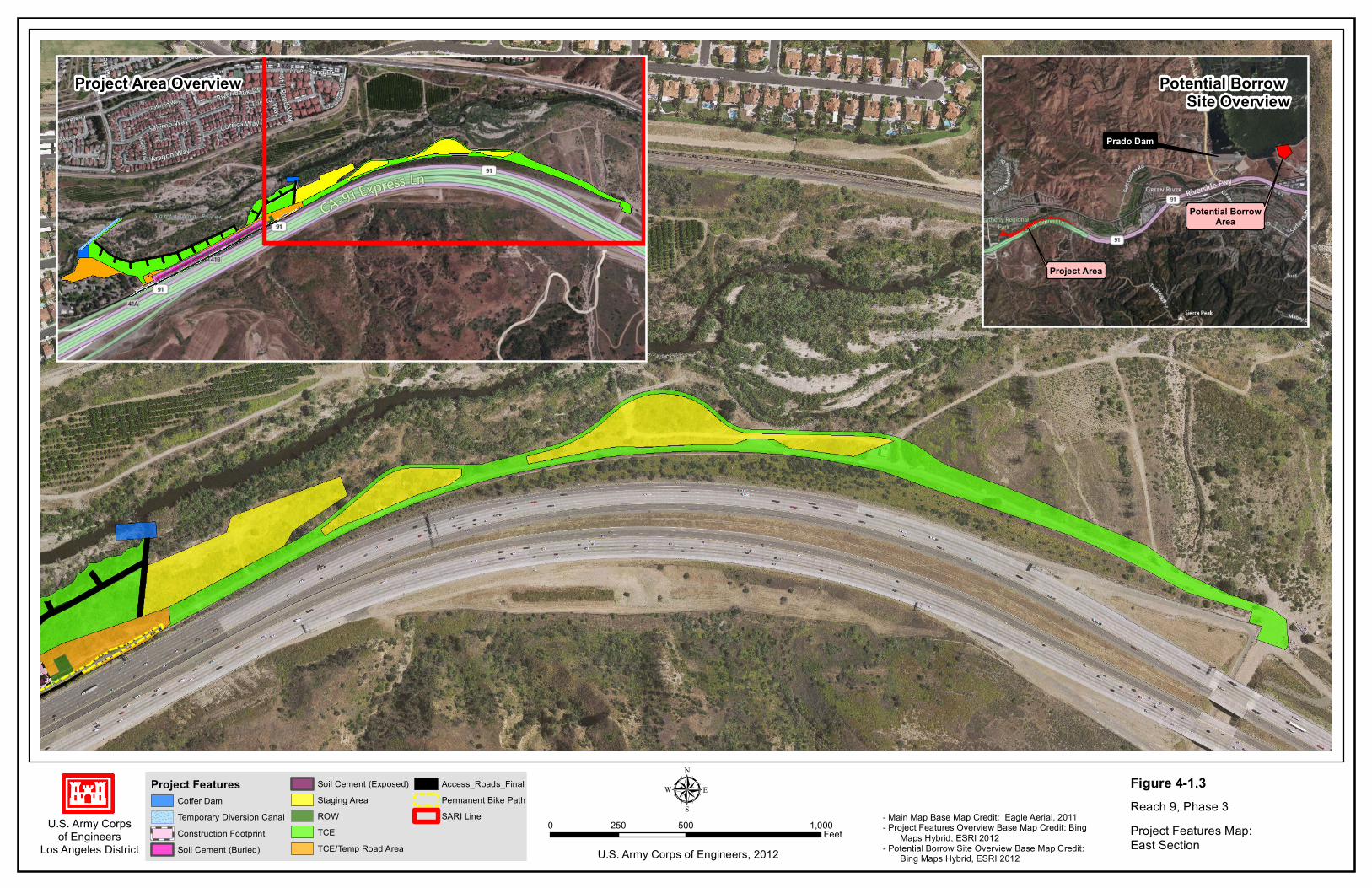
4.1 DescriptionofAlternatives Soil Cement Alternative (Alternative 1, Preferred Alternative) Under this alternative, the existing 1,600-foot long soil cement embankment would be removed and replaced with a soil cement structure that would have a deeper foundation. The soil cement structure would resemble a vertical parallelogram with a 1:1 horizontal-to-vertical slope. The structure would be 10 feet thick and approximately 30 feet tall. Approximately 10 to 15 feet of the structure would be buried beneath the channel invert in a typical cross-section, while the upper 15 to 20 feet would remain exposed above the channel invert. Due to slope stability concerns, the required v-shaped trench would be excavated at a 1.5:1 slope. The excavation footprint would be approximately 80-feet wide along the entire project. A combined total of approximately 55,000 cubic yards of alluvial substrate and soil cement would be excavated. Suitable material would be utilized in the soil cement mix and for backfill. Unsuitable material would be hauled to appropriate disposal sites. If additional material is needed for backfill or soil cement creation it would be imported from an outside source (e.g., Prado Dam borrow site). The following paragraphs provide details for various features and tasks associated with this alternative. Figures 4-1.1 to 4-1.3, on pages 12-16, respectively, show the locations of the features associated with this alternative. Figure 4-2, Typical Section of Bank Protection, on page 18, shows a design drawing of a representative portion of the soil cement bank protection. Phasing It is anticipated that the soil cement structure could be constructed in two phases. The construction contractor will be allowed to decide if work will proceed from upstream to downstream or vice versa. The scenario presented below assumes work will be conducted from upstream to downstream. The same general methodology would be applied if the construction contractor chooses to work from downstream to upstream. First, the trench would be excavated along the upstream 800-foot section. Material suitable for reuse would be hauled to a soil cement batch plant that will be placed in the staging area for mixing. The soil cement placement and backfilling is expected to be brought up in continuous lifts to the designed finished configuration. At each lift, the backfill would be compacted behind the soil cement, then the soil cement layer would be placed and finally the backfill would be placed in front of the soil cement. The backfill material would be obtained from the downstream 800-foot section as the trench is excavated. Upon completion of the upstream 800-foot section, some of the excavated material from the downstream section would be hauled to the soil cement batch plant for mixing while the material to be used for backfill could be temporarily stockpiled at the upstream section or staging area.

U.S. Army Corpsof Engineers
Los Angeles District
µU.S. Army Corps of Engineers, 2012
0 100 20050Feet
Project Area Overview
Project FeaturesCoffer DamTemporary Diversion CanalSoil Cement (Exposed)Soil Cement (Buried)
Construction FootprintStaging AreaROWTCETCE/Temp Road Area
Access RoadsPermanent Bike PathSARI Line
- Main Map Base Map Credit: Eagle Aerial, 2011- Project Area Overview Base Map Credit: Bing Maps Hybrid, ESRI 2012
Figure 4-1.1Reach 9, Phase 3Project Features Map:West Section
Canyon RV Park

13

U.S. Army Corpsof Engineers
Los Angeles District
µU.S. Army Corps of Engineers, 2012
0 100 20050Feet
Project Area Overview
Project FeaturesCoffer DamTemporary Diversion CanalSoil Cement (Exposed)Soil Cement (Buried)
Construction FootprintStaging AreaROWTCETCE/Temp Road Area
Access RoadsPermanent Bike PathSARI Line
- Main Map Base Map Credit: Eagle Aerial, 2011- Project Area Overview Base Map Credit: Bing Maps Hybrid, ESRI 2012
Figure 4-1.2Reach 9, Phase 3Project Features Map:Middle Section
Construction Footrprint (Includesexposed and buried soil cement structure and excavation area)

15
U.S. Army Corpsof Engineers
Los Angeles District
µU.S. Army Corps of Engineers, 2012
0 500 1,000250Feet
Project Area Overview Potential Borrow Site Overview
Project Area
Potential BorrowArea
Prado Dam
Project FeaturesCoffer DamTemporary Diversion CanalConstruction FootprintSoil Cement (Buried)
Soil Cement (Exposed)Staging AreaROWTCETCE/Temp Road Area
Access_Roads_FinalPermanent Bike PathSARI Line - Main Map Base Map Credit: Eagle Aerial, 2011
- Project Features Overview Base Map Credit: Bing Maps Hybrid, ESRI 2012- Potential Borrow Site Overview Base Map Credit: Bing Maps Hybrid, ESRI 2012
Figure 4-1.3Reach 9, Phase 3Project Features Map:East Section

17

U.S. Army Corpsof Engineers
Los Angeles District
Figure 4-2Reach 9, Phase 3Typical Section ofBank ProtectionU.S. Army Corps of Engineers, 2012

19
Dewatering Approximately 350 feet upstream of the project site, the main channel of the Santa Ana River bifurcates into a south and north fork. An approximately 1,600-foot long segment of the south fork is immediately adjacent to the project footprint. In order to dewater the construction area, a cofferdam with approximate dimensions of 50 feet in length by 20 feet in width, constructed of compacted earthen material with riprap lining the water-deflecting face would be temporarily placed upstream at the point where the main channel bifurcates. All flows would continue along the north fork for approximately 2,750 feet, to a point approximately 800 feet beyond the downstream end of the project area. At that point, a 400-foot long pilot channel would be constructed from the north fork to the south fork to hydraulically re-connect the two forks and re-establish natural flow conditions. The pilot channel would be strategically placed at a bend in the south fork where the distance between both forks is minimized. A coffer dam would also be constructed at the downstream terminus of the south fork to prevent flows from backing up into the dewatered area. Upon completion of the project, the coffer dams will be removed, water will be put back into the river as it was prior to construction. The diversion canal will also be backfilled and restored with appropriate native vegetation. Staging Areas Staging areas are located upstream of the actual soil cement construction area as shown on Figure 4-3, Staging Areas, on page 20. Staging areas will be used for storage of construction equipment and materials, turnaround areas, and soil cement production. For the purposes of discussion, the staging areas have been numbered as shown on Figure 4-3. R9P3-1 is an approximately 2.8-acre, area located immediately upstream of the soil cement embankment. The remaining staging areas (SARI-1 and SARI-2, as shown on Figure 4-3) encompass approximately 0.96 and 2.62 acres, respectively. SARI-1 and SARI-2 were retained from the SARI Line project. These staging areas have already been cleared and grubbed and were incorporated into the proposed project area to minimize the amount of additional habitat disturbance associated with necessary staging areas. All of the staging areas will be restored with appropriate native vegetation upon completion of the project. The combination of all staging areas results in approximately 6.38 acres of land available for staging, but only requires approximately 2.8 acres of clearing and grubbing.
Land Leases The local sponsor, the OCFCD, would be responsible for obtaining the necessary permits, right of entry, temporary construction easements (TCEs) from the appropriate agencies and their leases. Access Access to the project area will be had from the Coal Canyon off ramp from SR-91. Once equipment and workers exit Coal Canyon they will be able to access the construction area via access roads associated with the construction of the project that occur within the project’s TCE.

R9P3-1
SARI-2
SARI-1
U.S. Army Corpsof Engineers
Los Angeles District
Figure 4-3
Reach 9, Phase 3
Staging Areas Map
µ0 1,000 2,000500
FeetU.S. Army Corps of Engineers, 2012
Other Project FeaturesStaging Areas
Staging AreaStaging Area (SARI Line)
These staging areas were acquiredfrom the SARI Line construction project to minimize temporary disturbance to undisturbed areas during construction.
These staging areas were acquiredfrom the SARI Line construction project to minimize temporary disturbance to undisturbed areas during construction.

21
Roads A permanent paved access road will be constructed on top of the soil cement structure for routine inspection and operation & maintenance (O&M) work. A temporary access road will be construction on the north side of the south fork of the river, as shown on Figures 4-1.1 and 4-1.2. This temporary access road will be offset from north bank of the river to minimize impacts to the river bank. Several access points will be “stubbed off” this temporary access road to allow construction personnel access to construct and maintain the sound fence that will be construction near the north bank. A temporary access road will also be constructed near the south bank of the south fork of the river connecting the construction area to the upstream coffer dam, as is shown on Figure 4-1.3. Three “stub offs” provide access to the channel to allow construction personnel access to implement and maintain dewatering equipment during the construction phase. Stub offs are implemented to limit the amount of area that has to be cleared and grubbed to facilitate access to various features or components of construction to minimize the overall impact to habitat. A third temporary access road will be constructed from the downstream extent of the soil cement embankment area to the diversion canal to allow construction and maintenance of the diversion canal. This access road will be delineated by the construction contractor and will be located in the orange area shown on Figure 4-4, Site Preparation Map, on page 22. All temporary access roads will be restored with appropriate native plants upon completion of construction.
Storm Drain Outlets Three outlet (storm drain) structures would be constructed with this project, as is shown on Figure 4-5, Storm Drain Outlets and Undercrossings, on page 24. One storm drain structure is for an 18-inch reinforced corrugated pipe (RCP) outlet (Station 1372+20), and there are also two 60-inch RCP outlet storm drain structures (Stations 1375+26 and 1380+04). The RCP at Station 1372+20 (18 inch) will be extended approximately 8 feet through the new soil cement embankment and its opening will be approximately 7 feet above the stream invert. This RCP extends approximately 20 feet towards the center of SR-91. It does not extend the entire distance below SR-91. The 60-inch RCP’s will be lengthened approximately 10 feet as a result of the proposed project. Both of these culverts span the entire length of SR-91. The 60-inch RCP located at Station 1375+26 will daylight approximately 7 feet above stream invert in the soil cement embankment. The remaining 60-inch RCP located at Station 1380+04 will open through the soil cement embankment approximately 5 feet above the stream invert upon completion of the project. The elevation where the 60-inch RCP’s will daylight upon completion of construction is the same as the existing elevation. Construction Equipment Construction equipment would include, but is not limited to, machinery such as excavators, scrapers, graders, bulldozers, loaders, cranes, caisson drill rigs, pumps, forklifts, batch cement plant, concrete pump trucks, water trucks, and dump trucks. Additionally, delivery truck trips would be associated with imported materials.

U.S. Army Corpsof Engineers
Los Angeles District
µU.S. Army Corps of Engineers, 2012
0 500 1,000250Feet - Main Map Base Map Credit: Eagle Aerial, 2011
- Potential Borrow Area Base Map Credit: Bing Maps Hybrid, ESRI 2012
Figure 4-4Reach 9, Phase 3Site Preparation Map
Potential Borrow Area
Previously DisturbedSite Preparation Method
Clear and GrubPartial Clear and Grub
Clear and Grub: ArundoCutN/A

23

91-08
91-07
91-02
91-06
91-05
91-09
91-NS
91-0491-03U.S. Army Corps
of EngineersLos Angeles District
Figure 4-5Reach 9, Phase 3Storm Drain Outletsand Undercrossings
µ0 1,000 2,000500
FeetU.S. Army Corps of Engineers, 2012
LegendUnderpasses With No Change
Underpasses To Be Extended (~10 Feet)
Project AreaProject AreaConstruction Footprint
- Base Map Credit: Eagle Aerial (2011)- Culvert Data: USGS (2011)
ID Underpass Type91-02 RCP and CMP91-NS RCP91-03 RCP 91-04 RCP91-05 Box (1-chamber)91-06 Box (1-chamber)91-07 Box (1-chamber)91-08 Box (2-chamber)91-09 Bridge (Coal Cyn)
Culvert Information

25
Construction Window Construction is expected to take approximately 10 months to complete. Clearing and grubbing and river diversion is proposed to begin in the winter of 2012/2013 and would need to be completed before February 15, 2013, to avoid impacts to nesting birds. Construction is expected to continue through Fall of 2014. Funding constraints, weather delays, and contractual issues with the construction contractor could potentially move the construction timeline into 2015. The total area of new permanent impact will be approximately 0.51 acres. This accounts for areas that were not already permanently impacted by the existing soil cement structure and areas that are located less than 5 feet below the channel invert. The portion of the structure that is buried more than 5 feet below the channel invert is not expected to prohibit re-growth of vegetation and is consequently thought to result in temporary impact associated with disturbance during construction and the re-growth period. New temporary impacts associated with this project are expected to encompass approximately 18.70 acres.
Site Preparation As was previously stated, site preparation will be completed between 15 August and 15 February to minimize impacts to nesting birds. Areas to be cleared and grubbed generally include staging areas (that have not already been cleared and grubbed), the construction footprint, and temporary and permanent access roads. These areas are shown in brown and yellow on Figure 4-4, Site Preparation Map, on page 22. As was previously discussed in the “Roads” section, above, the construction contractor will be allowed to delineate a road extending from the downstream portion of the construction footprint to the diversion canal (this area is shown as orange in Figure 4-4). This road will be cleared and grubbed, but the remainder of the orange area will not be cleared and grubbed or cut. The vegetation between the access road that is set back from the north bank will be cut or mowed to a height of less than 2 feet tall but will not be entirely cleared and grubbed (shown in green on Figure 4-4). This site preparation method will be used to minimize the direct and indirect effects of construction to birds that may attempt to nest in this streamside vegetation. The roots and stumps will be left in place to maintain the integrity of the north bank of the river and to facilitate faster restoration of the site upon completion of construction. Areas shown as black on Figure 4-4 were either cleared and grubbed as a part of the SARI Line construction and are expected to remain clear of vegetation at the start of construction for the Reach 9, Phase 3 project or are expected to be otherwise devoid of vegetation at the start of construction (i.e. existing soil cement structure, existing development, or flowing water). Future Operations and Maintenance Future operations and maintenance (O&M) activities would entail structural and non-structural repairs.
Structural Repairs: Damaged sections would be removed by a hoe ram or by cutting with a concrete saw. The exposed cut surface would be power-washed using clean (potable) water and broom cleaned to remove all loose or friable pieces or fragments of the soil-cement. The exposed cut surface would then be pre-moistened before placing new soil-cement or other acceptable repair material.
Repair work in small or confined areas may utilize concrete mix instead of soil cement since it is typically difficult to place and properly compact soil-cement in a confined space. The concrete mix would be poured in place, vibrated to remove voids, and allowed to cure without compacting.

26
The repaired sections would be anchored to the soil cement embankment with reinforcing bar dowels. These dowels would be approximately three feet in length and would typically be installed on 18-inch centers in a grid pattern over the cut face of the soil-cement. Dowels would extend approximately 18 inches into the existing soil-cement embankment, using a 1.25 inch diameter drilled hole, and would be secured using a two-part epoxy specifically designed for rebar embedment.
Repair of large section would utilize soil-cement which would be compacted into place. Large sections would not typically require anchors.
If repairs require excavation to the toe-down, and work within the watercourse, the minimum amount of vegetation required to undertake the repair would be removed. The work area would be dewatered with portable dewatering structures such as k-rails or coffer dams. Upon completion of work, the dewatering structures would be removed, and the area would be allowed to revegetate via natural recruitment.
Non-Structural Repairs: Non-structural repairs would entail removal of vegetation that
may grow on the soil-cement structure or removal of small mammal burrows from the earthen embankment that supports the soil-cement structure. Herbicides or rodenticides may be applied as needed.
Equipment that would be utilized during routine O&M activities include: pickup trucks, ½ and ¾ ton trucks, spray rigs, fence trucks, bob cats, dozers, loaders, backhoes, tractors, transports, motor graders, cranes, water trucks, 5- and10-yard dump trucks and excavators.
Grouted Stone Alternative (Alternative 2) Under this alternative, the existing 1,600-foot long soil cement embankment would be removed, and an 80-foot wide, v-shaped trench would be excavated along the 1,600-foot long embankment. A compacted earthen embankment would be constructed at a 2:1 horizontal-to-vertical slope. The slope would be protected by a 2-foot thick concrete layer embedded with stones. Launchable derrick stone would be placed at the toe of the structure to provide further protection. The structure would be approximately 28 feet high. Approximately 20 feet of the structure would be buried beneath the channel invert in a typical cross-section, while the upper 8 feet would remain exposed above the channel invert. A combined total of approximately 55,000 cubic yards of alluvial substrate would be excavated. The excavated material would be used to backfill the trench. Other aspects of the alternative such as dewatering structures, staging areas, storm drains, axis has, construction equipment, and construction window would in general be similar to the Soil Cement Alternative. Sheet Pile Wall with Tiebacks (Alternative 3) Under this alternative, the existing 1,600-foot long soil cement embankment would be left intact. In addition, an approximately 1,600-foot long sheet pile wall would be constructed in the uplands immediately behind the existing soil cement embankment. Individual panels, approximately 2-foot wide, would be driven from the top of the embankment approximately 10 to 15 feet past the projected scour depth (approximately 10 feet below the invert). The panels would be held in place by horizontal rods that (tiebacks) would be driven into the soil.
27
Work with in the river would not be required since all phases of construction would be located entirely in the uplands. Therefore, there would be no need to excavate a v-ditch, construct coffer dams at the point of channel bifurcation, or excavate a channel to hydrologically reconnect the south fork to the north fork. Furthermore, there would not be a need to establish as many temporary access roads or staging areas. Sheet Pile Wall with King Piles (Alternative 4) Under this alternative, the existing 1,600-foot long soil cement embankment would be left intact. In addition, an approximately 1,600-foot long sheet pile wall would be constructed in the uplands immediately behind the existing soil cement embankment. Individual panels, approximately 2-foot wide, would be driven from the top of the embankment approximately 10 to 15 feet past the projected scour depth (approximately 10 feet below the invert). The panels would be held in place by I-beams (king piles) that would be driven vertically into the ground at the locations where panels connect to one another. Work with in the river would not be required since all phases of construction would be located entirely in the uplands. Therefore, there would be no need to excavate a v-ditch, construct water diverting structures at the point of channel bifurcation, or excavate a channel to hydrologically reconnect the south fork to the north fork. Furthermore, there would not be a need to establish as many temporary access roads or staging areas. No Federal Action Alternative With the No Federal Action Alternative, there would be no reconstruction of the existing bank protection structure to provide additional protection against high flows and scour. Because the toe of the existing bank protection structure is not deep enough to protect against scour associated with high flow events, future high flow conditions through the project reach could undermine the structure and threaten the segment of SR-91 located adjacent to the project reach. Furthermore, the segment of SARI Line that is located south of the bank protection would be susceptible to damage. Therefore, under the No Federal Action Alternative, SR-91 and the SARI would periodically be threatened during high flow conditions requiring emergency repairs of the existing bank protection. It is likely that any emergency repair would be limited in scope and duration and would likely entail the discharge of rocks to stabilize the embankment. Without adequate bank protection, the lower Santa Ana River may not be able to convey flows at the design capacity.
4.2 AlternativesEliminatedfromFurtherConsiderationAlternatives were evaluated pursuant to requirements under the National Environmental Policy Act, and the Clean Water Act 404(b) (1) Guidelines.
National Environmental Policy Act The National Environmental Policy Act requires an evaluation of all reasonable alternatives including the No Federal Action Alternative. Five alternatives including the No Federal Action Alternative were evaluated. Both sheet pile wall alternatives were deemed to be not reasonable due to difficulties in co-locating the sheet pile wall and the SARI line within a confined and narrow area. Furthermore, both sheet pile wall alternatives cost approximately two – three times the approximate cost for the Soil Cement Alternative, and the Grouted Stone Alternative. Costs and constructability constraints associated with the sheet pile wall alternatives are also discussed in Appendix A.

28
Clean Water Act 404(b) (1) Guidelines Clean Water Act 404(b) (1) Guidelines (Guidelines) require implementation of the alternative deemed to be least environmentally damaging practicable alternative (LEDPA) for activities that would result in the discharge of dredged or fill material into waters of the United States. All alternatives including the No Federal Action Alternative were evaluated pursuant to the Guidelines in detail in Appendix A. The evaluation concluded that the Soil Cement Alternative is the least environmentally damaging practicable alternative. In short, the Soil Cement Alternative is practicable, meets the overall project purpose, minimizes impacts to waters of the United States, and would not entail significant impacts to non-aquatic resources. Conclusion Based on the above discussion, both sheet pile wall alternatives (Alternatives 3 and 4) were eliminated from further consideration. Alternatives 1 and 2 and the No Federal Action Alternative were carried forward for further evaluation.
Reasonable per NEPA?
LEDPA? Carried Foreword?
Alternative 1 Y Y Y
Alternative 2 Y N Y
Alternative 3 N N N
Alternative 4 N N N
No Federal Action n/a N Y

29
5.0 AFFECTEDENVIRONMENTANDENVIRONMENTALCONSEQUENCES
5.1 GEOLOGYANDSOILS
5.1.1AffectedEnvironmentIn general, the substrate which characterizes the streambed of the Santa Ana River has been laid down over periods of river meandering and floodplain functions. The upper portions of the Santa Ana River streambed are rocky with soils consisting of finder sands and silts throughout the middle and lower portions of the river. Soils of the coastal plain are similar to those of the middle and lower portions of the Santa Ana River. Soils in the project area derived from the alluvial materials that dominate the valley floor and slopes. Specifically, the dominant soil within the project area is Metz series, specifically Metz loamy sand [Natural Resources Conservation Service (NRCS, 2012)]. Derived from erosion of sedimentary rocks, Metz series is typically light, sandy, and highly permeable. These soils are found on floodplains and alluvial fans throughout southern California.
5.1.2EnvironmentalConsequences Significance Threshold Based on the existing conditions discussed above, impacts would be considered significant if the alternative results in:
Substantial discharge of non-native material into the Santa Ana River Substantial erosion of soils from the project area
No Federal Action Alternative With the No Federal Action Alternative, there would be no reconstruction of the existing bank protection structure to provide additional protection against high flows and scour. Therefore, future high flow conditions through the project reach could undermine and erode the existing bank protection and threaten the segment of SR-91 located adjacent to the project reach. Periodic emergency repairs of the existing bank protection would likely be required. It is likely that any emergency repair would be limited in scope and duration. Emergency repairs would likely entail the discharge of rocks to stabilize the embankment. Soil Cement Alternative (Alternative 1) The Soil Cement Alternative would entail removal of the existing bank protection and reconstruction of the embankment with soil cement. This alternative would reuse the on-site substrate as much as possible in order to minimize the import of soil. Prior to construction, the project area will be prepared for construction. This will include tasks such as clearing and grubbing, cutting vegetation, and grading. Clearing activities may require the use of a loader or bulldozer to scrape the top soil. However, the loss of topsoil would be temporary, since future flows through the project area would replace topsoil removed during the clearing and grubbing operations. Subsequent to clearing activities, an 80-foot wide by 1,600-foot long, v-shaped trench would be excavated. The excavated material would be temporarily stored in the uplands

30
during construction. Upon completion of construction, the trench would be backfilled with native material previously excavated. There could be some loss of unconsolidated substrate during initial storm flows following construction. This impact would lessen as vegetation is reestablished through the project reach via plantings, hydroseeding and natural recruitment. The establishment of root structures in the topsoil would minimize erosion. There would not be a substantial change in substrate when compared to the No Federal Action Alternative, since the existing bank protection structure is composed of soil cement. There would be short-term loss of topsoil and unconsolidated substrate. However, vegetation growth and future flows would replenish the substrate. Based on the above, the Soil Cement Alternative would result in less than significant impacts to substrate. Grouted Stone Alternative (Alternative 2) The Grouted Stone Alternative would entail the same construction preparation work as the Soil Cement Alternative. However, the existing soil cement embankment would be replaced with a compacted earthen embankment protection with a 2-foot thick grouted stone layer.
5.2 HYDROLOGY
5.2.1AffectedEnvironmentThe Santa Ana River Basin is the largest watershed in southern California with a drainage area of about 2,670 square miles (mi²). The Santa Ana River watershed is separated into an upper and a lower basin divided by Prado Dam and Reservoir. The project area is in the lower Santa Ana River basin, approximately 5 miles downstream of Prado Dam. Therefore, the hydrology reflects the water release regime of Prado Dam. Since the modifications to Prado Dam in 2008, the average outflows have been approximately 450 cfs from October to February and approximately 275 cfs from March to May. The outflows during the summer months average around 150 cfs, which are usually unconstrained base flows [averages based on flow records from US Geological Survey (USGS), 2012]. The average outflows from March 1st to May are lower due to water conservation agreements with Orange County Water District (OCWD) that limit outflows to match OCWD processing capacity. The values above are averages and do not fully represent the maximum range of flows. For example, in December of 2010 and January of 2011, the outflow reached as high as 5000 cfs for a few days and was sustained at over 3,000 cfs for some period of time. Channel capacity allowed for higher outflows, but concerns with the scouring of the downstream SARI line prohibited release in excess of 5,000 cfs.
5.2.2EnvironmentalConsequences Significance Threshold Based on the existing conditions discussed above, impacts would be considered significant if the alternative results in:
Substantial change to base flow characteristics such as flow velocity, channel capacity, and channel configuration
31
No Federal Action Alternative With the No Federal Action Alternative, there would be no reconstruction of the existing bank protection structure to provide additional protection against high flows and scour. Therefore, the hydrology through the project area would remain unchanged. Future high flow conditions through the project reach could undermine the existing bank protection and threaten the segment of SR-91 located adjacent to the project reach. Periodic emergency repairs of the existing bank protection would likely be required. Emergency repairs would likely entail the discharge of rocks to stabilize the embankment. Given that the Santa Ana River floodplain transecting the project area is approximately 900 feet wide, it is unlikely that periodic discharge of rocks to stabilize portions of the existing embankment would affect the flow velocity or the alignment of the active channel. Soil Cement Alternative (Alternative 1) The Soil Cement Alternative would entail removal of the existing bank protection and reconstruction of the embankment with soil cement. In general, the Soil Cement Alternative would retain the approximate configuration and dimension of the existing soil cement embankment. However, the Soil Cement Alternative would establish a deeper toe to protect against maximum scour depths. In general, the channel configuration would remain the same, and the capacity of the channel would remain unchanged. Given that the Santa Ana River floodplain transecting the project area is approximately 900 feet wide, it is unlikely that the increased width and depth of the existing soil cement embankment would affect the channel capacity. Removal of river side vegetation will temporarily reduce channel roughness and increase capacity through the project area. However, vegetation is expected to quickly reestablish in the project area through hydroseeding, plantings and natural recruitment. Hydrologic changes associated with vegetation removal will likely return to baseline levels within one to two years subsequent to the completion of construction. Based on the above, the Soil Cement Alternative would result in less than significant impacts on hydrology. Grouted Stone Alternative (Alternative 2) The Grouted Stone Alternative would be constructed at a 2:1 horizontal-to-vertical slope. The slope would be protected by a 2-foot thick concrete layer embedded with stones. With respect to the No Federal Action Alternative, Alternative 2 would result in an embankment slope that is relatively shallow when compared to the existing flow from a structure which has an approximately 1:1 horizontal-to-vertical slope profile. Though the change in channel capacity associated with a 2:1 slope has not been determined, it is likely that any change in capacity would be de minimis given that the Santa Ana River floodplain transecting the project area is approximately 900 feet wide. Furthermore, the grouted stones would permanently increase channel roughness, and thereby decrease velocity. However, the increase in channel roughness would be de minimis in consideration of the surrounding vegetation which affects channel roughness to a larger degree. Removal of river side vegetation will temporarily reduce channel roughness and increase capacity through the project area. However, vegetation is expected to quickly reestablish in the project area through hydroseeding, plantings and natural recruitment. Hydrologic changes associated with vegetation removal will likely return to baseline levels within one to two years subsequent to the completion of construction. Based on the above, the Grouted Stone Alternative would result in less than significant impacts on hydrology.

32
5.3 GROUNDWATER
5.3.1AffectedEnvironmentGroundwater at the project area is primarily within the alluvium of the Santa Ana River drainage (Corps, 2011b). The alluvial aquifers are believed to be unconfined to semi-confined and perched on top of the lower permeability bedrock formations. During the field explorations in May 2009 and March 2010, groundwater was encountered in all of the hollow-stem-auger borings. Depths to groundwater were found to range from 15 to 19 feet below the existing grade. The groundwater levels encountered in the borings are summarized in Table 5.1, below. Table 5.1Summary of Groundwater Field Exploration
Reference: Corps, 2011b. Note: “*” means converted to groundwater monitoring well.
The groundwater table was also monitored in the monitoring well MW-140+60B installed during the field exploration. Fluctuations, generally on the order of one to four feet, were noted from several readings taken between July 6, 2009 and April 30, 2010. Factors such as seasonal rainfall, groundwater pumping at the Canyon RV Park and Green River Golf Course, irrigation, and discharge from Prado Dam would affect the groundwater level at the site. During the time period between June 2009 and April 2010, the southern California region experienced several rainfall events that ranged from less than 0.1 inches to greater than 2 inches of rainfall within a 24-hour period. Groundwater table readings were collected within a few days after the rain storms to evaluate the groundwater fluctuations due to the rainfall and release from Prado Dam. During significant rainfall events and increased releases in the Santa Ana River below Prado Dam, a rise in elevation of groundwater levels was measured in the monitoring well. The maximum rise in groundwater elevations was on the order of 4 feet when approximately 5,000 cubic feet per second (cfs) of stream flow were released into the river. The ground surface elevation at this groundwater monitoring well location is at 389.5 feet. Groundwater Quality As part of the National Water Quality Assessment Program (NWQAP), administered by the USGS, groundwater samples were collected throughout the Santa Ana Basin between 1999 and 2001, and analyzed for the existence of contaminants. This study determined that most exceedances of maximum contaminant levels occurred in shallow, coastal monitoring wells that tap ground water not used for water supply. Pesticides were detected above the laboratory reporting limit in approximately half of the wells sampled in the Santa Ana Basin. Volatile organic compounds were present in approximately 56 percent of the 207 wells sampled (USGS,

33
2002). Water supply management activities, such as enhanced groundwater recharge and the discharge of treated wastewater within the Santa Ana Basin, are among many factors affecting water quality. Other factors that contribute to water quality include urbanization throughout the watershed, and nonpoint agricultural sources.
5.3.2EnvironmentalConsequences Significance Threshold Based on the existing conditions discussed above, impacts would be considered significant if the alternative results in:
Substantially reduce the ability to recharge the underlying aquifer, cause substantial groundwater contamination, or substantial groundwater depletion
No Federal Action Alternative With the No Federal Action Alternative, there would be no reconstruction of the existing bank protection structure to provide additional protection against high flows and scour. As a result, excavation of a v-shaped trench which could expose groundwater would not be required. Therefore, there would be no impacts to the ability to recharge groundwater in the project area, nor would there be activities that could result in substantial groundwater contamination. However, future high flow conditions through the project reach could undermine the existing bank protection and threaten the segment of SR-91 located adjacent to the project reach. Periodic emergency repairs of the existing bank protection may be required. Emergency repairs would likely entail the discharge of rocks to stabilize the embankment. It is possible that emergency repairs would require some amount of excavation to establish a proper toe for rocks. If groundwater is encountered, it is unlikely that emergency repairs would hinder the ability to recharge groundwater or result in groundwater contamination. Soil Cement Alternative (Alternative 1) The Soil Cement Alternative would entail removal of the existing bank protection and reconstruction of the embankment with soil cement. Construction would require excavation of an approximately 24-feet deep and 80-feet wide, v-shaped trench along the entire length of the 1,600-foot long project area. Depths to groundwater were found to range from 15 to 19 feet below the existing grade. Therefore, construction activities will come into contact with groundwater. However, the excavation area would be dewatered (any groundwater encountered would be pumped outside of the work limits, most likely into the active flow channel downstream of the project area), thereby minimizing contact with construction activities. Furthermore, soil cement is an inert and stable material. Therefore, the structure would not leach chemicals into groundwater. Soil cement is not permeable. Therefore, the portion of the structure buried beneath the invert would form an impermeable barrier. Based on the typical cross-section, the structure would result in an approximately 0.52 acres increase in impermeable barrier in to the existing soil cement structure. This acreage is spread out over the entire length of the structure. Based on the above, the Soil Cement Alternative would result in less than significant impacts to groundwater.

34
Dewatering during construction will not lead to a substantial depletion of groundwater during the 10 month construction period, especially considering that the water will be pumped back into the active channel or elsewhere in the floodplain. Furthermore, upon completion of construction, the trench would be backfilled with native material previously excavated. Therefore, the ability of the project area to absorb and recharge groundwater would not be compromised. Moreover, the toe of the soil cement structure is composed of an inert mixture of soil and cement. Therefore, Soil cement Alternative would not introduce or leach into organic or organic compounds into the groundwater aquifer. Grouted Stone Alternative (Alternative 2) The Grouted Stone Alternative would have impacts similar to the Soil Cement Alternative.
5.4 SURFACEWATERQUALITY
5.4.1AffectedEnvironmentSanta Ana River, Reach 9 is not on the 303(d) list of water quality limited segments requiring TMDLs [Santa Ana Regional Water Quality Control Board (SARWQCB), 2007]. Water quality data from stream gage(s) located downstream from Prado Dam indicate that water quality downstream of Prado Dam is within the acceptable limits provided by the SARWQCB [Santa Ana Watershed Project Authority (SAWPA), 2011]. Water quality parameters evaluated include TDS, hardness, sodium, chloride, total nitrogen, sulfate, chemical oxygen demand and boron (SAWPA, 2011). Since 2000, these water quality objectives have been exceeded occasionally; for the most part, water quality parameters have not exceeded objectives specified in the Basin Plan.
5.4.2EnvironmentalConsequencesSignificance Threshold Based on the existing conditions discussed above, impacts would be considered significant if the alternative results in:
Long-term violation of RWQCB water quality standards or objectives or cause impairment of beneficial uses of water1
No Federal Action Alternative With the No Federal Action Alternative, there would be no reconstruction of the existing bank protection structure to provide additional protection against high flows and scour. Therefore, there would be no water quality impacts associated with construction. However, future high flow conditions through the project reach could undermine the existing bank protection and threaten the segment of SR-91 located adjacent to the project reach. Periodic emergency repairs of the existing bank protection may be required. It is likely that any emergency repair would be limited in scope and duration. Emergency repairs would likely entail
1 Beneficial uses for Reach 9 include: Agriculture (AGR), Groundwater Recharge (GWR), Water Contact Recreation (REC 1), Non-contact Water Recreation (REC 2), Warm Freshwater Habitat (WARM), Wildlife Habitat (WILD), and Rare, Threatened or Endangered Species (RARE).

35
the discharge of rocks to stabilize the embankment, which could temporarily elevate turbidity. However, turbidity levels would return to baseline conditions upon completion of construction. Since both the highway and the wastewater line that is currently being placed behind the existing bank protection are regionally important, maintenance and repair actions would be undertaken expeditiously to provide protection. Therefore, the possibility of high flow conditions within the project reach eroding and rupturing the SARI line is minimal. In the event that high flow conditions lead to the rupture of the SARI line, treated wastewater containing high concentrations of salt would be released into the aquatic environment. Potential rupture of the SARI line could entail temporary exceedances of surface water quality standards. Soil Cement Alternative (Alternative 1) The Soil Cement Alternative would entail removal of the existing bank protection and reconstruction of the embankment with additional soil cement. Prior to construction, the construction footprint would be prepared using methods such as clearing and grubbing, grading, and cutting of vegetation. Vegetation clearing activities may require the use of a loader or bulldozer to scrape the top soil. Subsequently, an 80-foot wide by 1,600-foot long, v-shaped trench would be excavated. Upon completion of construction, the trench would be backfilled with native material previously excavated. The project area would be dewatered during construction with a coffer dam located approximately 650-feet northeast of the existing soil cement embankment project area. Therefore, there would be minimal surface water within the project area during construction. However, the act of diverting surface flows would lead to substantial turbidity for several hundred feet downstream of the upper and lower diversion points, which is expected to dissipate within a few hours. This analysis is based on observations and measurements obtained during diversions that have recently occurred at other Santa Ana River project features upstream, including the Reach 9 Phase 2b project. Upon completion of construction there could be a temporary, localized increase in turbidity as flows flush unconsolidated topsoil downstream. The temporary increase in temperature they would return to baseline levels soon after. There would be no permanent impacts to water quality. The soil cement structure is composed of an inert mixture of soil and cement. Therefore, Soil cement Alternative would not introduce or leach inorganic or organic compounds into surface waters. The contractor will be required to develop and implement a Storm Water Pollution Prevention Plan which should minimize water quality impacts from staging and other work areas. This will include construction of a silt fence or other barrier between the work site and the rest of the floodplain, where necessary. Grouted Stone Alternative (Alternative 2) The Grouted Stone Alternative would have impacts similar to the Soil Cement Alternative.
5.4.3EnvironmentalCommitments
R9P3-WQ-1: Prepare and implement an erosion control plan to minimize potential
sedimentation and turbidity impacts.
R9P3-WQ-2: Obtain a dewatering permit if the installation and maintenance of the structure extends into the groundwater table.

36
R9P3-WQ-3: Prepare and implement a pollution prevention plan to reduce the potential for
accidental release of fuels, pesticides, and other materials. This plan will include the designation of refueling locations, emergency response procedures, and reporting requirements for any spill that occurs. This plan shall also include herbicide and pesticide application activities such as storage, handling of herbicides, and application methods.
R9P3-WQ-4: Keep cleanup equipment and supplies at the staging area for immediate use. R9P3-WQ-5: Utilize liners and earthen berms in the establishment of upland refueling areas to
isolate potential fuel spills from the aquatic environment. Keep fuel spill cleanup equipment and supplies adjacent to the refueling area.
R9P3-WQ-6: Place oil drip pans underneath engine block and hydraulic systems for equipment
not in use.
5.5 BIOLOGICALRESOURCESThe information presented in this chapter describes the biological resources that occur within the proposed project area and its vicinity. It includes descriptions of common plant communities and wildlife, including special-status species that have either been observed or have the potential to occur in the project area.
5.5.1 AffectedEnvironment General Setting Natural conditions in this region are generally dictated by climate, which is typical of southern California inland areas. The Mediterranean climate of the watershed is characterized by typical hot, dry summers and relatively cooler, wetter winters. The annual precipitation in the region averages approximately eighteen inches per year. Most precipitation occurs between November and March with little to no rainfall during the summer months. Prevailing temperatures in the watershed vary depending on location, elevation, and topography. These conditions all contribute to the unique composition of vegetation communities and wildlife species occurring in the region. The Santa Ana River has a bifurcated channel in this area in its existing condition. The project is located near the south bank of the southern fork of this bifurcation. The splitting of the channel has formed a large island. Although the Santa Ana River consists of a diverse assemblage of habitats that are vital to a variety of biological resources, it has also been subjected to several episodes of human disturbance. Disturbances include urban development, agricultural development, and flood control activities. Recently, the SARI Line has disturbed areas within the project area during its construction phase. Other types of disturbances occur in the area as well, including floods, fires, and other more “natural” disasters and disturbances. The Freeway Complex Fire, which occurred in 2008, burned approximately 30,300 acres, including nearly the entire project area (as shown in Figure 5-1, Freeway Complex Fire Map, on page 37). In general plant communities affected by the fire are well on their way to recovery. Signs of the fire are still apparent in areas. Ash from the fire can still be found blanketing the soil in areas and several burned tree stumps are scattered
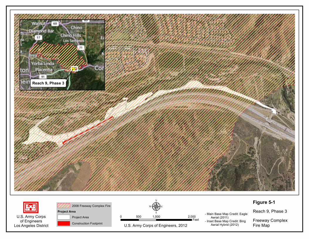
U.S. Army Corpsof Engineers
Los Angeles District
Figure 5-1Reach 9, Phase 3Freeway ComplexFire Map
µ0 1,000 2,000500
FeetU.S. Army Corps of Engineers, 2012
2008 Freeway Complex FireProject Area
Project AreaConstruction Footprint
- Main Base Map Credit: Eagle Aerial (2011)- Inset Base Map Credit: Bing Aerial Hybrid (2012)

38
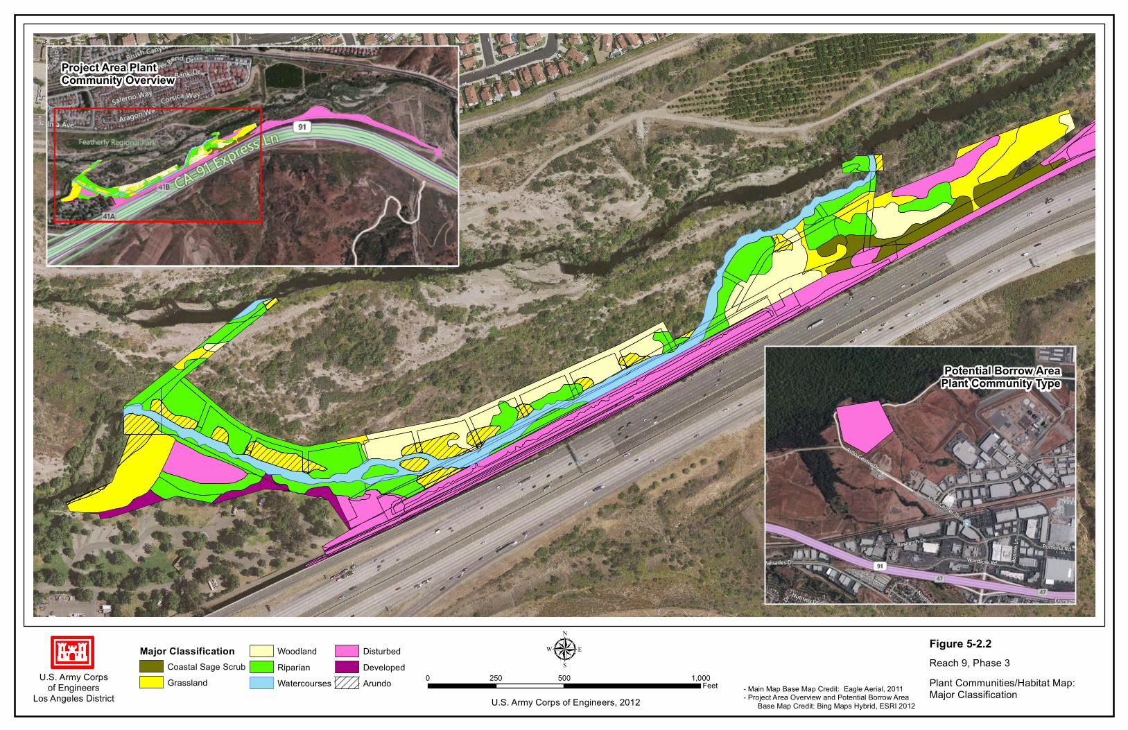
throughout the area. A number of the trees that were burned during the fire are showing signs of recovery as new limbs and leaves sprout from their charred remains. Plant Communities A description and analysis of plant communities in Reach 9 of the Santa Ana River was originally provided in the 2001 EIS/EIR. A more recent plant community mapping effort was conducted in Reach 9 to comply with requirements related to the Habitat Management Plan (HMP) for Reach 9, which itself was a requirement of the Santa Ana River Project’s 1988 SEIS and 2001 BO. This HMP mapping effort followed the Orange County Habitat Classification System (HCS) (County of Orange, 1992), which was developed specifically for plant communities occurring within Orange County. It was conducted by LSA Associates, Inc. in early 2012 using orthographically rectified aerial photographs at a scale of 1”=100’, combined with field truthing surveys. The minimum polygon size was 0.5 acres (Orange County, 2012a). In order to further refine the analysis of existing plant community conditions within the proposed project area, vegetation mapping surveys were again conducted in April 2012 by the Corps. The purpose of this round of surveys was to determine the extent of clearing and grubbing and grading associated with SARI Line construction that occurred in the early months of 2012. The HMP maps were combined with the information gleaned from the Corps’ April 2012 mapping effort to evaluate and update existing conditions. A hierarchy of plant community organization was created to enable varying levels of detail for analysis and presentation. The Orange County HCS presented the two most detailed levels of this hierarchy. Another, more generalized level was added to facilitate varying scales of analysis. At the most general level of organization there are 4 communities (see Figure 5-2.1, Plant Communities/Habitat Map: General Classification, on page 40): (1) Riparian, (2) Upland, (3) Water, and (4) Developed. The four general scale characterizations were then subdivided into 10 major habitat community or land use classifications. These 10 major classifications are shown below with the corresponding generalized classification shown within brackets and on Figure 5-2.2, Plant Communities/Habitat Map: Major Classification, on page 42:
1. Coastal sage scrub (CSS) [Upland] 2. Grassland [Upland] 3. Marsh [N/A] 4. Riparian [Riparian] 5. Woodland [Upland] 6. Lakes, reservoirs, and basins [N/A] 7. Watercourses [Water] 8. Agriculture [N/A] 9. Developed [Developed] 10. Disturbed [Developed or Upland or Riparian]
Not all of these major classifications are found within the project area or within its immediate vicinity. Those classifications identified at the major scale not present within the project area are labeled [N/A] in the list above. Several sub-categories for each of the 10 major classifications were also mapped. These will be referred to herein as “detailed” scale communities/classifications. The location of the detailed habitat classifications can be viewed on Figure 5-2.3, Plant Communities/Habitat Map: Detailed Classification, on page 44. Both the major and detailed scale community classifications correspond with the Orange County HCS.

39

U.S. Army Corpsof Engineers
Los Angeles District
µU.S. Army Corps of Engineers, 2012
0 500 1,000250Feet - Main Map Base Map Credit: Eagle Aerial, 2011
- Project Area Overview and Potential Borrow Area Base Map Credit: Bing Maps Hybrid, ESRI 2012
Figure 5-2.1Reach 9, Phase 3Plant Communities/Habitat Map:General Classification
Potential Borrow AreaPlant Community Type
Project Area PlantCommunity Overview
General ClassificationRiparianUpland
WaterDevelopedArundo

41
U.S. Army Corpsof Engineers
Los Angeles District
µU.S. Army Corps of Engineers, 2012
0 500 1,000250Feet - Main Map Base Map Credit: Eagle Aerial, 2011
- Project Area Overview and Potential Borrow Area Base Map Credit: Bing Maps Hybrid, ESRI 2012
Figure 5-2.2Reach 9, Phase 3Plant Communities/Habitat Map:Major Classification
Potential Borrow AreaPlant Community Type
Project Area PlantCommunity Overview
Major ClassificationCoastal Sage ScrubGrassland
WoodlandRiparianWatercourses
DisturbedDevelopedArundo

43

4.6
4.6
8.4
8.4
4.1
7.8
16.1
7.2
7.8
7.8
16.2.2
7.8
8.4
8.4
16.1
7.8
7.2
7.8
4.11
4.6
16.1
7.8
8.4
7.8
4.11
7.2
7.8
16.1
4.11
7.37.3
4.11
4.11
U.S. Army Corpsof Engineers
Los Angeles District
µU.S. Army Corps of Engineers, 2012
0 500 1,000250Feet- Main Map Base Map Credit: Eagle Aerial, 2011
- Project Area Overview and Potential Borrow Area Base Map Credit: Bing Maps Hybrid, ESRI 2012
Figure 5-2.3Reach 9, Phase 3Plant Communities/Habitat Map:Detailed Classification
Potential Borrow AreaPlant Community Type
Project Area PlantCommunity Overview
Detailed Classification(2.10) Yerba Santa Scrub(2.3.10) Mixed Scrub(4.1) Annual Grassland(4.6) Ruderal Grassland(7.12) Barren Riparian(7.2) Willow Riparian Scrub
(7.3) Mulefat Scrub(4.11) Giant Reed Grassland(7.4) Sycamore Riparian Woodland(7.6) Arroyo Willow Riparian Forest(7.7) Black Willow Riparian Forest(7.8) Cottonwood-Willow Riparian Forest(8.1) Coast Live Oak Woodland
(8.4) Mexican Elderberry Woodland(13.1) Perennial Rivers and Streams(15.1) Urban and Commercial(15.5) Ornamental Landscaping(16.1) Disturbed or Barren(16.2.2) Disturbed Riparian

45

46
Descriptions of classifications at the three mapped scales (i.e. general, major, and detailed) occurring within the project area are provided in the following paragraphs and closely follow descriptions provided in the Santa Ana River Canyon Habitat Management Plan Maintenance and Monitoring Report (Orange County, 2012a). Riparian Two major scale plant communities are encompassed in the general scale riparian designation. These include riparian, as defined by the Orange County HCS, as well as some disturbed communities that occur within the riparian corridor and are generally known to be associated with river bank plants. Riparian According to the Orange County HCS, the “major” scale riparian plant community consists of trees, shrubs, or herbs that occur along watercourses and bodies of water. The vegetation is adapted to flooding and soil saturation during at least a portion of its growing season. Riparian communities are considered sensitive by GDFG (Holland 1986). There are 7 detailed scale riparian communities. These 7 communities are described below.
Barren Riparian. Barren riparian areas have recently experienced a significant flood event that has left them devoid of vegetation. The soils within these areas are dominated by cobble and coarse sands. Fine sediments are absent. Although these areas appear disturbed or barren, they are to be expected within a healthy, dynamic native riparian system.
Willow Riparian Scrub. Willow riparian scrub is dominated by willow species and
saplings of riparian forest. Common willow scrub dominants include arroyo willow (Salix lasiolepis) and narrow-leaved willow (Salix exigua), with lesser amounts of mulefat (Baccharis salicifolia) and black willow (Salix nigra). Weedy species found in this scrub may include castor bean (Ricinus communis), giant reed (Arundo donax), tree tobacco (Nicotiana glauca), and pampas grass (Cortaderia sp.).
Mulefat Scrub. Mulefat scrub consists of dense stands of mulefat and lesser amounts of
willow. It usually occupies intermittent streambeds, seeps, and toe of landslides (where local seeps develop). Other associated species may include Bermuda grass (Cynodon dactylon), California mugwort (Artemisia douglasiana), lamb’s quarters (Chenopodium sp.), western ragweed (Ambrosia psilostachya), Douglas’ nightshade (Solanum douglasii), castor bean, and cocklebur (Xanthium strumarium).
Sycamore Riparian Woodland. Sycamore riparian woodland consists of open to dense
woodlands dominated by western sycamore (Platanus racemosa), with coast live oak (Quercus agrifolia) and scale-broom (Lepidospartum squamatum), mulefat, or willow as understory species. Large grassland areas dominated by bromes are often present.
Black Willow Riparian Forest. Black willow riparian forest is a multilayered forest with a
canopy dominated by black willow, with some red willow (Salix laevigata) and arroyo willow. The subcanopy layer contains arroyo willow and mulefat. Coast live oak and western sycamore are occasionally present on the outer margins of this forest. The understory is composed of different associations of species, such as hoary nettle (Urtica holosericea), poison oak (Toxicodendron diversilobum), California mugwort, and Douglas’ nightshade. The habitat develops on floodplains along major rivers and

47
streams. Within the project area, this habitat type is found along the banks of the Santa Ana River.
Arroyo Willow Riparian Forest. Arroyo willow riparian forest has a closed canopy of
arroyo willow in arborescent form. The understory is similar in composition to black willow forest. The forest occurs on floodplains along major streams and rivers. Within the project area this habitat type is mainly found adjacent to the Santa Ana River and may integrate with black willow riparian forest and cottonwood-willow riparian forest.
Cottonwood-Willow Riparian Forest. Cottonwood-willow riparian forest is a multilayered forest community dominated by cottonwoods (Populus fremontii) and willows with other tree species at low numbers and percent cover. It is typically lower on the floodplain than the other forest types previously described. A second canopy layer of mulefat, poison oak, and wild grape (Vitis californica) is often associated. The understory is composed of hoary nettle, branching phacelia (Phacelia ramisissima), and blackberry (Rubus ursinus). Several invasive weedy species, principally giant reed or arundo, castor bean, and tree tobacco, are often found within or beside these forest areas. This community is found adjacent to the Santa Ana River within the project area.
Disturbed
Disturbed Riparian. Disturbed riparian areas are riparian habitats that have experienced a relatively recent disturbance and still show characteristics of riparian habitat. These areas are beginning to revegetate naturally with riparian species and have a low percent cover by nonnative ruderal grassland species.
Upland The general upland habitat classification is found in areas slightly removed from the immediate banks of the Santa Ana River. Habitats occurring in the upland general classification are generally less dependent on proximity to the river and saturated soils. Major classifications of habitat within this general classification include coastal sage scrub (CSS), grassland, and woodland. Several detailed habitat classifications occur within these three major classifications. Descriptions of the major and detailed habitat classifications occurring within the upland general classification within the project area are provided below. Coastal sage scrub (CSS): CSS vegetation consists of drought-deciduous, low-growing, soft-leaved shrubs and herbs, and is often a gray-green color. It occupies gentle to steep slopes and occurs most often in shallow or heavy soils at elevations below 3,000 feet. CSS is considered a special-status vegetation type by CDFW because of its high potential to support threatened and endangered wildlife species. There are two detailed habitat classifications of CSS that occur within the project area. The shrubs that make up CSS are relatively short-lived and are adapted to a natural fire regime, possibly with an interval of 40 to 60 years, readily sprouting from seed or from the base of the parent plant following such an event.
Yerba Santa Scrub. Yerba Santa scrub is dominated by either thick-leaf (Eriodictyon crassifolium) or hairy yerba santa (Eriodictyon trichocalyx). This is a relatively scare

48
habitat type within the floodplain that is found on sandy river terraces along the Santa Ana River.
Mixed Scrub. Mixed sage scrub is dominated by a relatively even mix of each of four or
more CSS species. CSS species that may make up mixed scrub are California buckwheat (Eriogonum fasciculatum), black sage (Salvia mellifera), purple sage (Salvia leucophylla), white sage (Salvia apiana), California encelia (Encelia californica), laurel sumac (Malosma laurina), bush monkey flower (Mimulus aurantiacus), and coast prickly pear (Opuntia littoralis). Coastal sagebrush can occur but is not an important species in this community. This habitat classification is found primarily on the upper terraces of the floodplain, well away from the main river course.
Grassland: Historically (pre-European settlement), needlegrass grassland covered as much as 17 percent of California (Keeley 1989 in Orange County, 2012a), but it has been greatly reduced by the invasion of nonnative annual grasses and forbs of Mediterranean origin, changes in the kinds of animals present and their grazing patterns, cultivation, and fire (Heady 1977 in Orange County, 2012a). These nonnative plants, often considered weeds, include grasses such bromes (Bromus spp.), wild oats (Avena spp.), barley (Hordeum spp.), and herbs such as mustards and thistles. Only 0.1 percent of historic perennial native grasslands in California are extant (Barry 1981 in Orange County 2012a). Due to its reduction in range, native grassland is considered a special-status vegetation type by CDFW. There are three detailed scale classifications of grassland found within the project area. None of these three grassland types are considered native or sensitive.
Annual Grassland. Annual grasslands are dominated by annual grasses that are primarily Mediterranean in origin. Dominant species include bromes, wild oats, fescues, and barleys. Many species of native forbs and bulbs, as well as naturalized annual forbs, are found in this habitat. Native forbs in these grasslands may include common fiddleneck (Amsinckia intermedia), miniature lupine (Lupinus bicolor), California popcorn flower (Plagiobothrys sp.), California milkweed (Asclepias californica), common cryptantha (Cryptantha affinis), and fascicled tarweed (Hemizonia fasciculata). Annual grasslands occur on gradual slopes with deep soils below 3,000 feet in elevation.
Giant Reed Grassland. Giant reed grassland is dominated by dense stands of giant reed.
Giant reed is an invasive species found throughout southern California.
Ruderal Grassland. Ruderal grassland consists of early successional grassland dominated by pioneering herbaceous plants that readily colonize disturbed ground. Ruderal grassland is dominated by many grassland species and species of the genera Centaurea, Brassica, Malva, Salsola, Eremocarpus, Amaranthus, and Atriplex. Ruderal grassland occurs at locations that have been disturbed by either natural or human causes. Giant reed may also be present within this habitat type; however, it is not a dominant species. The dominant species within this habitat classification in the vicinity of the project area are tocalote (Centaurea melitensis) and shortpod mustard (Hirschfeldia incana).
Woodland: The woodland major habitat classification is generally characterized as a multilayered plant community with a canopy that is approximately 20 to 80 percent tree cover.

49
Coast Live Oak Woodland. Coast live oak woodland is dominated by coast live oak, with associated shrubs such as California scrub oak (Quercus berberidifolia), holly-leaved redberry (Rhamnus ilicifolia), California coffee berry (Rhamnus californica), toyon (Heteromeles arbutifolia), fuchsia-flowering gooseberry (Ribes speciosum), Mexican elderberry (Sambucus mexicana), and poison oak. Coast live oak woodlands have a limited distribution in the Santa Ana River floodplain and are primarily found on the upper terraces of the floodplain or as planted groves within Featherly Regional Park.
Mexican Elderberry Woodland. The Mexican elderberry woodland is an open woodland
found on stream benches dominated by Mexican elderberry. Scattered laurel sumac, toyon, and lemonade berry (Rhus integrifolia) may be found on these open grass benches. This detailed classification is often associated with sycamore riparian woodland. Mexican elderberry woodland is a common habitat type within the floodplain and is found on the upper benches of the Santa Ana River that have not seen significant flow in decades.
Water Watercourses: Watercourses include flood control channels, streams, and rivers. The only type of watercourse present within the project area is the Santa Ana River.
Perennial Rivers and Streams. This detailed habitat classification is characterized as unvegetated, open-water portions of the Santa Ana River. Areas defined within the project area as perennial stream correlate to southern California arroyo chub/Santa Ana sucker stream, a habitat recognized as sensitive by CDFW.
Developed Developed areas represent locations within the project area associated with existing or on-going development. The construction of the SARI Line was started in winter/spring of 2012 and cleared, grubbed, and graded the area between the bike path and the top of the existing soil cement. This cleared, grubbed, and graded area continues upstream beyond the existing soil cement as shown in Figure 4-4. The Canyon RV Park and associated access roads are also delineated as “developed” on Figure 5-2.1. Existing soil cement that does not have any vegetative cover was also classified as “developed.” Developed: The major classification known as developed includes urban areas, roads, parks, and cleared or graded sites. There are two detailed classifications that fall within the developed major classification within the project area: (1) urban and commercial and (2) ornamental landscaping.
Urban and Commercial. The urban and commercial detailed classification includes all buildings, pavement, and highway rights-of-way (except freeways and arterial highways). All paved surfaces and flood protection features were mapped as urban and commercial.
Ornamental Landscaping. Ornamental landscaping (parks and ornamental plantings)
consist of introduced trees, shrubs, flowers, and turf grass. Ornamental landscaping occurs in greenbelts, parks, and horticultural plantings. This classification is primarily

50
associated with the Canyon RV Park and other portions of Featherly Regional Park within the vicinity of the project area.
Disturbed: There is one detailed habitat classification within the project area that falls within the major classification of disturbed. It is described below.
Disturbed or Barren. Disturbed or barren (cleared or graded) areas either lack vegetation or are dominated by a sparse cover of ruderal vegetation, such as tocalote, wild oats, black mustard (Brassica nigra), prickly sow-thistle (Sonchus asper), and prickly lettuce (Lactuca serriola). Special-Status Plant Species Special-status plants included in this SEA/EIR Addendum include those species listed as threatened or endangered under the federal or California Endangered Species Acts, species proposed for listing, species of special concern, and other species which have been identified by the USFWS, CDFW, or have been assigned by local jurisdictions as unique or rare and which have the potential to occur within the project area. Each of these species was assessed for its potential to occur within the project area. Surveys for special-status plant species were conducted in April 2012. Surveys were conducted using random meandering and intuitive controlled transects to focus in on areas that contained suitable habitat for special-status plants. Surveys were floristic in nature and were conducted during the optimal survey period for the majority of the special-status species that may occur in the region. No plants federally or State listed as threatened or endangered were identified during the April 2012 surveys or are expected to occur in the project area. Only one rare plant was identified within the project area, the southern California black walnut (Juglans californicus). Southern California black walnut is a CNPS List 4 species. This species was very uncommon within riparian areas of the project area and is considered a plant of limited distribution throughout its range in southern California. Table 5.5-1 lists all plant species documented in the CNDDB for USGS quads (Black Star Canyon and Prado Dam) encompassing the project area and its reasonable vicinity. Special status plant species documented during surveys of the project area are also included.
Table 5.5-1 Special Status Plants and their Probability to Occur Within the project area
Scientific Name Common Name Conservation Status
Habitat and Distribution Flower Season
Occurrence Probability
Allium marvinii Yucaipa onion Fed: END State: THR, S1.1
Bulb; clay openings in chaparral; about 2500-3500 ft. elev.
Apr-May Not Likely to Occur. No suitable habitat; outside elevation range
Allium munzii Munz’s onion Fed: END State: THR, S1.1
Bulb; upland clay soils, gen. shrublands and woodlands; endemic to W Riv Co, about 1000-3500 ft. elev.
Mar-May Not Likely to Occur. No suitable habitat; outside elevation range
Ambrosia pumila San Diego ambrosia Fed: END State: S1.1
Perennial herb; clay soils, sometimes in or around vernal pools, grasslands or openings in shrublands; sea level to about 1400 ft.
Jun-Sep Not Likely to Occur. No suitable habitat.

51
elev.; SW Riv Co (Murrieta and Lk Elsinore areas), San Diego Co, Baja Calif
Astragalus brauntonii
Braunton’s milk-vetch
Fed: END State: S2.1
Subshrub or perennial herb; scattered locations in Ventura, LA & Orange cos; foothills below about 2100 ft. elev.; chaparral, often on carbonate soils; often follows fire or soil disturbance
Feb-June Low. Marginally suitable habitat
Atriplex coronate var. notiator
San Jacinto Valley
crownscale
Fed: END
State: S1.1
Annual herb; playas, valley
and foothill grassland,
vernal pools; alkaline soils;
mesic areas; about 500‐
1500 ft. elev.
Apr‐Aug Not Likely to
Occur. No
suitable habitat
Berberis nevinii Nevin’s barberry Fed: END
State: END,
S2.2
Evergreen shrub;
chaparral, cismontane
woodland, coastal scrub,
riparian scrub; sandy or
gravelly soils; about 900‐
2700 ft. elev.
Mar‐Jun Not Likely to
Occur. No
suitable habitat
Brodiae filifolia Thread‐leaved brodiae Fed: END
State: END,
S2.1
Bulb; chaparral,
cismontane woodland,
coastal scrub, playas,
valley and foothill
grassland, vernal pools;
often clay soils; about 80‐
4000 ft. elev.
Mar‐Jun Not Likely to
Occur. No
suitable habitat
Calochortus weedii var. intermedius
Weed’s mariposa lilly Fed: None
State: S2.2
Perennial herb;
shrublands, grassland,
various soils, about 600‐
2800 ft. elev.; coastal
southern Calif., inland to
western Riverside Co.
Jun‐Aug Low. Marginally
suitable habitat
Ceanothus ophiochilus
Vail Lake ceanothus Fed: THR
State: END,
S1.1
Evergreen shrub;
chaparral; about 1900‐
3500 ft. elev.
Feb‐Mar Not Likely to
Occur. No
suitable habitat;
outside elevation
range
Chorizanthe parryi var. Fernandina
San Fernando Valley
spineflower
Fed: CAND
State: END,
S1.1
Sandy places, gen in
coastal or desert
shrublands; historically
from San Fernando Valley,
adjacent foothills, and
coastal Orange Co.; now
known only in E Ventura &
W LA Cos; about 500‐4,000
ft. elev
Apr‐Jun Not Likely to
Occur. No
suitable habitat;
outside known
distribution
Deinandra mohavensis (Hemizonia mohavensis)
Mojave tarplant Fed: None
State: END,
S2.3
Annual herb; chaparral,
coastal scrub, riparian
scrub; mesic areas; about
2100‐5250 ft. elev.
Jun‐Oct Not Likely to
Occur. Outside
elevation range

52
Dodecahema leptoceras
Slender‐horned
spineflower
Fed: END
State: END,
S1
Annual herb; chaparral,
cismontane woodland,
coastal scrub; about 650‐
2500 ft. elev.
Apr‐Jun Not Likely to
Occur. No
suitable habitat
Dudleya multicaulis Many‐stemmed dudleya Fed: None
State: S2.1
Perennial herb; heavy soils
or sandstone outcrops;
grassland or shrubland
below about 2600 ft. elev.;
LA to SD Co, inland to San
Gabriel Mtn foothills and
W Riv Co
May‐Jun Low. Marginally
suitable habitat
Eriastrum densifolium ssp. sanctorum
Santa Ana River
woollystar
Fed: END
State: END,
S1‐1
Subshrub; alluvial fans and
plains; endemic to Santa
Ana River Watershed
(mainly San Bern. Co. but
rarely in Riverside &
Orange cos.), below about
2,000 ft. elev.
May‐Sept Not Likely to
Occur. No
suitable habitat
Eryngium aritulatum var. parishii
San Diego button‐celery Fed: END
State: END,
S2.1
Annual/perennial herb;
coastal scrub, valley and
foothill grassland, vernal
pools; mesic areas; about
65‐2050 ft. elev.
Apr‐Jun Not Likely to
Occur. Outside
known
distribution
Juglans californica var. californica
So. California black
walnut
Fed: None
State: S3.2
Tree or large shrub;
woodland, coastal sage
scrub, chaparral, below
about 3000 ft. elev.;
Ventura, LA, Orange, San
Bernardino cos.
Can be ID’d
all year
High. Known to
occur in and
around the
project area.
Lepidium virginicum var. robinsonii
Robinson’s pepper‐grass Fed: None
State: S2.2
Ephemeral spring annual;
shrublands; sea level to
about 2900 ft. elev.; LA Co,
most Channel Islands,
inland to W Riv & San Bern
Cos, S to Baja Calif
Jan‐Jul Low. Marginally
suitable habitat
Limnanthes gracilis ssp. parishii
Parish’s meadowfoam Fed: None
State: END,
S2.2
Annual herb; lower
montane coniferous forest,
meadows and seeps,
vernal pools; about 1970‐
6560 ft. elev.
Apr‐Jun Not Likely to
Occur. No
suitable habitat;
outside elevation
range
Navarretia fossalis Spreading navarretia Fed: THR
State: S1
Annual herb; chenopod
scrub, marshes and
swamps, playas, vernal
pools; about 100‐4265 ft.
elev.
Apr‐Jun Not Likely to
Occur. No
suitable habitat
Orcuttia californica California Orcutt grass Fed: END
State: END,
S2.1
Annual herb; vernal pools;
about 50‐2165 ft. elev.
Apr‐Aug Not Likely to
Occur. No
suitable habitat

53
Pseudognaphalium leucocephalum
White rabbit‐tobacco Fed: None
State: S3.2
Perennial herb; sea level to
about 7000 ft. elev.; open
sand, usually alluvium; SLO
through SD Cos, inland to
Riv and San Bern Cos;
disjunct (and maybe a
different species) from AZ,
TX, Sonora
Jul‐Nov Moderate. See
text
Conservation Status Federal Designations: (federal Endangered Species Act, US Fish and Wildlife Service). Until 1996, FWS maintained a list of “category 2 candidates,” described as species of concern, but for which insufficient data were available to support listing. This list is no longer maintained and FWS has no “SOC” category, though some agencies continue to cite it. END: Federally listed, endangered
THR: Federally listed, threatened CAN: (Candidate) Sufficient data are available to support federal listing, but no yet listed. PRO: (Proposed) Formally proposed for federal status shown.
State Designations: (California Endangered Species Act, California Dept. of Fish and Game) END: State listed, endangered THR: State listed, threatened CDFW Natural Diversity Data Base Designations: Applied to special status plants and sensitive plant communities; where correct category is uncertain, CDFW uses two categories or question marks. S1: Fewer than 6 occurrences or fewer than 1000 individuals or less than 2000 acres. S1.1: Very threatened S1.2: Threatened S1.3: No current threats known S2: 6-20 occurrences or 1000-3000 individuals or 2000-10,000 acres (decimal suffixes same as above) S3: 21-100 occurrences or 3000-10,000 individuals or 10,000-50,000 acres (decimal suffixes
same as above. S4: Apparently secure in California; this rank is clearly lower than S3 but factors exist to
cause some concern, i.e., there is some threat or somewhat narrow habitat. No threat rank. S5: Demonstrably secure or ineradicable in California. No threat rank. SH: All California occurrences “historical” (i.e., no records in >20 years). Occurrence Probability: Estimated occurrence probabilities based on literature sources cited earlier and field surveys and habitat analyses reported here. Present: Observed on the site by qualified biologists. High: Habitat is a type often utilized by the species and the site is within the known range of
the species. Moderate: Site is within the known range of the species and habitat on the site is a type occasionally used. Low: Site is within the species’ known range but habitat is rarely used, or the species was not
found during surveys. Not Likely to Occur: No suitable habitat on the site; or well outside the species’ known
elevational or geographic ranges; or a focused study covering 100% of all suitable habitat, completed during the appropriate season and during a year of appropriate rainfall, did not detect the species.
Special-Status Species Descriptions with the Potential to Occur in the project area Federal and State Listed Species There were no federally listed planted species observed within the project area during surveys. Additionally, no federally listed plants are expected to occur within the project area based on lack

54
of suitable habitat and recognized distributions of such species known from the region. Two plant species are listed as S3.2 on the CNDDB either occur or have the potential to occur within the project area. These species are described in the following paragraphs. Southern California black walnut The southern California black walnut (Juglans californica var. californica) is listed as S3.2 under the CDFW’s Natural Diversity Database (CNDDB). This rating means there are between 21 and 100 occurrences or 3000-10,000 individuals or 10,000 to 50,000 acres and the species is threatened. The range for the southern California black walnut extends from San Luis Obispo County to the southeast along the SAR, eastward through Riverside County. With the exception of a few areas where walnut-dominated woodlands occur, this species is generally associated with a mixture of other trees, particularly oaks. Southern California black walnut occurs in a variety of habitats throughout its range, typically on deep, friable soils that exhibit a high water-holding capacity. In riparian corridors, this species prefers drier slopes that are rarely prone to flooding and erosion activities yet are in proximity to ground water and seasonal surface water. Southern California black walnut occurs within the project area and its immediate vicinity. White rabbit-tobacco White rabbit-tobacco (Pseudognaphalium leucocephalum) is also listed as S3.2 on CDFW’s CNDDB list. The species is distributed along coastal habitats of southern California, from southwestern Riverside County north to San Luis Obispo County. White rabbit-tobacco is a perennial herb that typically occurs in sand to gravelly soils within chaparral, cismontane woodland, coastal scrub, and riparian woodland habitats below approximately 6,800 feet (2,100 m). Although white rabbit-tobacco was not identified in any surveys of the project area, it does support suitable habitat within the known distribution for this species. Therefore, there is moderate potential for white rabbit-tobacco to occur. Coast live oak Coast live oak is not included as a federal or State listed species; however, this species is often afforded protection through local and/or State ordinances and management guidelines. Approximately 5 to 10 coast live oak trees occur within the project area. These trees are represented by individuals of various age classes and diameter at breast height (dbh) girths (ranging between 1 to 30 inches). Most of the oak trees occurring in the project area were affected to some degree by the 2008 Freeway Complex fire, but are showing signs of emergent growth and appear to be recovering. Oak tree occurrences in the project area primarily occur near the eastern staging area, with a few individuals distributed elsewhere. There is approximately 0.05 acres of coast live oak woodland occurring within the project area at the upstream end of the staging area known as R9P3-1. Wildlife Riparian communities support some of the most diverse assemblages of wildlife in the region. This is in part due to their ability to provide access to water, shade, and protection from predation. These areas also provide foraging habitat and are used nesting and breeding by a number of species. The riparian and upland plant communities that occur in and adjacent to the Santa Ana River provide habitat for a variety of resident and migratory wildlife species including several special-status species. Of particular importance are perennial stream areas that provide potential habitat for the federally threatened Santa Ana sucker (Catostomus santaanae) and riparian areas that provide habitat for the federally and State endangered least Bell’s vireo (Vireo bellii pusillus).

55
The stretch of the river and corresponding floodplain within the vicinity of the project area is surrounded by a variety of different land uses. The Canyon RV Park is located immediately adjacent to the project area towards its west end, SR- 91 is located to the south, and areas on the north side of the floodplain are characterized by residential development. This leaves the floodplain as the primary habitat area in the immediate vicinity of the Project. The river and corresponding undeveloped floodplain provides a corridor for wildlife to move up and down the river and allows access to linkages to additional core habitat areas, such as the Santa Ana Mountains, Prado Basin, and Chino Hills, upstream and to a more limited extent downstream of the project. Common Wildlife Invertebrates. As in all ecological systems, invertebrates play a crucial role in a number of biological processes. They serve as the primary or secondary food source for a variety of fish, bird, reptile, and mammalian predators; they provide important pollination vectors for numerous plant species; they act as efficient components in controlling pest populations; and, they support the maintenance of the area by performing essential nutrient cycling functions that contribute to soil nutrients. The Santa Ana River provides habitat for a vast number of insects, crustaceans, and other invertebrate species. Although specific surveys for invertebrates were not conducted for the Project, it is expected that invertebrates in the project area are represented by a composition of insect species that commonly occur in southern California. These include representatives of various orders, such as Orthoptera (grasshoppers, crickets), Odonata (dragonflies, damselflies), Hemiptera (true bugs), Coleoptera (beetles), Diptera (flies), Hymenoptera (bees, wasps, ants), and Lepidoptera (butterflies, moths), among others. In recent river diversions associated with the Reach 9, Phase 2B Project, red swamp crayfish (Procambarus clarkii) were also common. Fish. There are two native fish species that have been reported from Reach 9: the federally threatened Santa Ana sucker and the arroyo chub (Gila orcuttii), a CDFW species of special concern. All other fish species known to occur in the Santa Ana River have been introduced and are expected to occur in varying densities and conditions. The most abundant non-native fish are the common carp (Cyprinus carpio), the fathead minnow (Pimephales promelas), inland silverside (Menidia beryllina), western mosquitofish (Gambusia affinis), black bullhead (Ameiurus melas), yellow bullhead (Ameiurus natalis), channel catfish (Ictalurus punctatus), largemouth bass (Micropterus salmoides), black crappie (Pomoxis nigromaculatus), and green sunfish (Lepomis cyanellus). Amphibians. Amphibians often require a source of standing or flowing water to complete their life cycle. However, some terrestrial species can survive in drier areas by remaining in moist environments found beneath leaf litter and fallen logs, or by burrowing into the soil. No amphibian species were observed during surveys conducted during 2012. However, based on survey data collected by the Santa Ana Watershed Association (SAWA) within Chino Hills State Park between 1998 and 2003, western toad (Bufo boreas), arboreal salamander (Aneides lugubris), and garden slender salamander (Batrachoseps major) have a high likelihood of occurrence, particularly in the upland habitats where moist microclimates are present (USGS, 2004). There is also potential for these species to occur within areas of the riparian mixed scrub habitat that meet similar microclimate characteristics. Other commonly found amphibian species that would be expected to occur within the project area include the Pacific tree frog (Pseudacris regilla), California tree frog (P. cadaverina), and the non-native bullfrog (Rana catesbeiana) and African clawed frog (Xenopus laevis).

56
Reptiles. The potential diversity of reptile species is typically related to the diversity of plant communities found at a particular site. Typically, plant communities that have an abundant amount of undisturbed leaf litter, rocks, rotting logs, and other cover sources would have a higher diversity of reptile presence than those areas with regular disturbance and subsequently fewer cover elements. The western fence lizard (Sceloporus occidentalis) and side-blotch lizard (Uta stansiburiana) were the only two reptile species documented during surveys of the site in 2012. Several additional reptile species are expected to occur and have been documented in the vicinity of the project area, including southern alligator lizard (Elgaria multiarinata), western skink (Eumeces skiltonianus), striped racer (Masticophis lateralis), western yellow-bellied racer (Coluber constrictor), California black-headed snake (Tantilla planiceps), gopher snake (Pituophis melanoleucus), California kingsnake (Lampropeltis getula californiae), and the southern Pacific rattlesnake (Crotalus viridis) (USGS, 2004). The project area also has the potential to house the western pond turtle (Actinemys marmorata), orange-throated whiptail (Aspidoscelis hyperythera), coastal whiptail (A. tigris stejnegeri), and coast hoarned lizard (Phrynosoma blainvillii). Birds. Bird species are quite diverse and abundant in the Prado Basin and downstream areas, including the project area. More than 200 species of birds have been recorded in this area (Hays, 1987). Of these, approximately 95-100 breed nearby in the Prado Basin, and many are likely to occur in the project area. Raptors, waterfowl, riparian obligate species, and grassland species are regular inhabitants. Some of the common species that were observed in the project area during 2012 surveys include, but are not limited to, red-tailed hawk (Buteo jamaicensis), red-shouldered hawk (Buteo lineatus), Cooper’s hawk (Accipiter cooperii), common raven (Corvus corax), Bullock’s oriole (Icterus bullockii), blue-headed grosbeak (Pheucticus melanocephalus), lesser goldfinch (Carduelis psaltria), Anna’s hummingbird (Calypte anna), house finch (Carpodacus mexicanus), California towhee (Melozone chrysalis), California quail (Callipepla californica), wood duck (Aix sponsa), turkey vulture (Cathartes aura), double-crested cormorant (Phalacrocorax auritus), greater roadrunner (Geococcyx californianus), and black phoebe (Sayomis nigricans). In addition to special-status species like the least Bell’s vireo and southwestern willow flycatcher, a number of common songbirds, such as the American goldfinch (Carduelis tristis), blue grosbeak (Passerina caerulea), song sparrow (Melospiza melodia), bushtit (Psaltriparus minimus), and house wren (Troglodytes aedon) are also expected to occur within the project area. A variety of bird species that are closely tied to the open water resources available within the nearby Prado Basin may occasionally pass through the project area. These species include the great blue heron (Ardea herodias), great egret (Ardea alba), snowy egret (Egretta thula), black-crowned night heron (Nycticorax nycticorax), tree swallow (Tachycineta bicolor), and mallard (Anas platyrhynchos). A substantial raptor population also resides in the Prado Basin and may utilize surrounding areas, including the project area. A number of raptors that do occur or could occur within the project area are special-status species. These include the Cooper’s hawk, sharp-shinned hawk (Accipiter striatus), golden eagle (Aquila chrysaetos), long-eared owl (Asio otus), Swainson’s hawk (Buteo swainsoni), turkey vulture, northern harrier (Circus cyaneus), and white-tailed kite (Elanus leucurus). Raptor numbers are significantly augmented in winter with several species breeding farther north. Mammals. Twenty-three species of mammals, including three non-native species, have been observed in the nearby Prado Basin (Zembal et al, 1985). Many of these species have been previously detected within the general vicinity of the project or would be expected to occur

57
within the project area. The most common small mammals include the California ground squirrel (Spermophilus beecheyi), western harvest mouse (Reithrodontomys megalotis), California vole (Microtus californicus), Botta’s pocket gopher (Thomomys bottae), and western brush rabbit (Oryctolagus cuniculus). The only large ungulate known to occur in the vicinity is the mule deer (Odocoileus hemionus). Meso-predators known from the area include the gray fox (Urocyon cinereoargentus), raccoon (Procyon lotor), striped skunk (Mephitis mephitis), and long-tailed weasel (Mustela frenata). Top carnivores that have potential to occur in the vicinity include the coyote (Canis latrans), bobcat (Lynx rufus), and mountain lion (Puma concolor). Several bat species are also known to occur within the vicinity of the project area. These species would be most likely to use the site for foraging, as roosting habitat is limited. All of the bats identified within the vicinity are considered CDFW species of special concern. These include the pallid bat (Antrozous pallidus), western mastiff bat (Eumops perotis californicus), Yuma myotis (Myotis yumanensis), and pocketed free-tailed bat (Nyctinomops femorasaccus). Wildlife Movement. Linkages and corridors facilitate regional animal movement and are generally centered on waterways, riparian corridors, flood control channels, contiguous habitat, and upland habitat. Drainage ways generally serve as movement corridors because they are natural elements in the landscape that guide animal movement (Noss, 1991; Ndubisi et al., 1995; R. Walker and Craighead, 1997, in Hilty et al., 2006). Corridors would ideally offer wildlife unobstructed terrain for foraging and for dispersal of young individuals. In reality, many corridors may have disturbed characteristics. It is necessary to consider the state of the urban/wild land matrix in addition to spatial and temporal scales when analyzing potential corridors. For example, some species will require large amounts of habitat to fulfill their life history, and others will require less; some species will require use of corridors on temporal scales as short as minutes or hours to as long as generations. Landscapes contain a variety of movement paths, territories, travel routes, and other features that facilitate wildlife movement, which in turn maintains a healthy exchange of genetic material, provides areas for forage, and other life history requirements. The relative size and characteristics of these features are different for each species that uses them. Urban or otherwise developed and/or disturbed landscapes results in fragmentation of habitat. This can affect the way wildlife uses a particular landscape, which emphasizes the need for wildlife corridors and linkages to connect remaining habitat patches. Determinants for use of corridors and linkages are dependent on several factors depending on which species is in question. In general, these determinants include the ability to find adequate cover, food, and water and minimization or elimination of obstacles (e.g. man-made noise, lighting, or structures). The linkage between core habitats in the Santa Ana Mountains, the Prado Basin, and the Puente-Chino Hills was once several miles wide. It is now extremely limited, due in large part to the Riverside Freeway or SR-91, the Corona Expressway or SR-71, and urban development. The only passageways remaining for wildlife to utilize to safely traverse SR-91 and SR-71 are freeway undercrossings, including culverts and bridges. These passageways can provide vital ecological connections for wildlife moving between remaining patches of quality habitat. Nine undercrossings run beneath SR-91into the project area. Three of these undercrossings are culverts, or storm drain outlets, that have an opening located within the construction footprint of the project. These culverts are labeled as 91-03, 91-04, and 91-NS on Figure 4-5, Storm Drain Outlets and Undercrossings, on page 24. Culvert 91-NS is located at Station 1372+20. This reinforced corrugated pipe (RCP) is approximately 18 inches in diameter and does not traverse the entire width of SR-91 and is not expected to support wildlife movement. Culverts 91-03 and 91-04 are located at Stations 1375+26 and 1380+04, respectively. Both of these RCP’s are

58
approximately 60 inches in diameter. The other six undercrossings do have openings within the project area, but not within the construction footprint and will not be altered. These undercrossings are labeled 91-02, 91-05, 91-06, 91-07, 91-08, and 91-09 on Figure 4-5. Special-Status Wildlife Species Special-status wildlife considered in this document include those listed as threatened or endangered under the federal or California Endangered Species Acts, species proposed for listing, species of special concern, and other species which have been identified by the USFWS, CDFW, or have been assigned by local jurisdictions as unique or rate and which have the potential to occur within the project area. Each of these species was assessed for its potential to occur within the project area. The 2001 SEIS/EIR produced by the Corps identified five bird species, two amphibian species, and one fish species that occur or potentially occur in Reach 9. Reach 9, Phase 3 was not included in the analysis of the 2001 SEIS/EIR, but it occurs within Reach 9, so the potential species identified in the 2001 SEIS/EIR are relevant. The least Bell’s vireo was listed as endangered in 1986. It is a common summer breeding resident in the nearby Prado Basin and throughout Reach 9. As such, this species has been a major focus in previous documents. The southwestern willow flycatcher, another summer breeding resident in the Prado Basin, is much less common, and has not been seen in Reach 9 since 1999. It was afforded protection under the federal Endangered Species Act nine years after the least Bell’s vireo in 1995. The peregrine falcon was formally listed in 1984, but was already protected under legislation that preceded the Endangered Species Act of 1973 and has since been delisted. The bald eagle was formally listed in 1978; however it was delisted in 2007. Both species are occasional winter visitors to the Prado Basin, but are not known to breed in the Reach 9. In 2000, the Santa Ana sucker was listed as a threatened species under the federal Endangered Species Act. Critical habitat was re-designated for the Santa Ana sucker in 2010. The critical habitat designation extends through Reach 9, including the project area, as shown on Figure 5-3, Santa Ana Sucker: Critical Habitat, on page 69. The arroyo southwestern toad (Bufo californicus) was listed as endangered in 1995; however, it has never been recorded in Reach 9. The California red-legged frog (Rana draytonii) was listed as threatened in 1996 and was formerly a resident in the Prado Basin, but is not expected to occur in the project area. The 2001 SEIS/EIR also analyzed two additional species, the western yellow-billed cuckoo (Coccyzus americanus) and Swainson’s hawk, that are listed as State endangered and threatened, respectively. Updated survey efforts, occurrence information, distribution maps, literature, and correspondence with local experts have been utilized to refine the list of special-status species either present or with the potential to occur in the project area. Special-status wildlife surveys were conducted in February, March, and April of 2012. Surveys were conducted using random meandering and intuitive controlled transects to focus in areas that contained suitable habitat for special status wildlife. There is potential for special-status species to occur within the project area based on suitable habitat conditions, known historical observations, and documented distributions. Table 5.5-2 lists all the special status species documented in the literature, listed in the CNDDB for USGS 1:24,000 scale quads encompassing the project area (Black Star Canyon and Prado Dam) regardless of presence of habitat or likelihood of occurrence. Only those federally or State endangered or threatened species known to be present or with at least a moderate potential to occur within the project area will be discussed further in this document.

59
Table 5.5-2 Special Status Wildlife and their Probability to Occur Within the project area
Scientific Name Common Name
Conservation Status
Habitat and Distribution
Occurrence Probability
Branchinecta lynchi Vernal pool fairy shrimp
Fed: THR State: None
Restricted to seasonal vernal pools
Not Likely to Occur. (no suitable habitat)
Branchinecta sandiegonensis San Diego
fairy shrimp
Fed: END
State: None
Restricted to
seasonal vernal
pools
Not Likely to Occur. (no
suitable habitat)
Streptocephalus woottoni Riverside fairy
shrimp
Fed: END
State: None
Restricted to deep
seasonal vernal
pools, vernal pool‐
like ephemeral
ponds, and stock
ponds and other
human modified
depressions
Not Likely to Occur. (no
suitable habitat)
Catostomus santaanae Santa Ana
sucker
Fede: THR
State: CSC
Major cismontane
stream systems in S
Calif. Incl. Santa Ana
Riv., extant popns
near Riverside and
downstream.
Year‐round.
Moderate. This species is
known from portions of the
Santa Ana River where
suitable habitat occurs
above and below Prado
Dam. Nearest record is
within the general project
area. Observed in previous
Prado Dam outlet channel
in 2008 and in the Reach 9,
Phase 2B project area in
Spring 2010. Currently
Santa Ana sucker is
restricted to the middle
and lower portions of the
river, mainly along reaches
with flows enhanced by
wastewater (Moyle et al,
1995).
Gila orcutti Arroyo chub Fed: None
State: CSC
Slow‐flowing
sections or
backwaters,
cismontane stream
systems in S Calif.
Incl. Santa Ana Riv.;
extant popns near
Riverside and down‐
stream; introduced
populations occur
outside historic
native range
Year‐round
Low. Known from Corona
North USGS quad in
isolated sections of the
Santa Ana River from
Riverside and San
Bernardino County line
downstream to the Prado
Dam (Swift 2001). Nearest
record is from 3.5 miles
upstream of the project
area. Species may be
washed down to project
area during high flows.

60
Spea hammondii Western
spadefoot
Fed: None
State: CSC
Breeds in quiet
streams, temporary
ponds, vernal pools,
burrows I sand
during dry season;
sea level to about
4500 ft. elev.;
Central Val to N
Baja.
October‐Aril
Moderate. Breeding
populations have been
documented nearby.
Ponded water, such as
vernal pools or road pools,
or slow moving streams are
required for breeding.
These features were not
identified in the project
area during surveys.
Actinemys marmorata Western pond
turtle
Fed: None
State: CSC
Perennial ponds,
streams; breed &
overwinter in adj
uplands; coastal S
and Cent. Calif., NW
Baja Calif., below
about 4800 ft. elev.
Year‐round
Moderate. Although not
identified during surveys,
the project area supports
suitable habitat and this
species is known from
nearby areas, including the
Prado Basin.
Aniella pulchra pulchra Silvery
(California)
legless lizard
Fed: None
State: CSC
Sand or loose loamy
soils under sparse
vegetation; soil
moisture is
essential; prefer
soils with high
moisture content.
Low. Although scattered
records occur for this
subspecies throughout
nearby western Riverside
County, the project area
supports only marginal
habitat.
Aspidoscelis hyperythra Orange‐
throated
whiptail
Fed: None
State: CSC
Inhabits low‐
elevational coastal
scrub, chaparral,
and valley‐foothill
hardwood habitats;
prefers washes and
other sandy areas
with patches of
brush and rocks;
perennial plants
necessary to
support major food
source of termites
Moderate. Habitat is
marginal in pockets for this
species within the project
area. Records in the
vicinity of project area
inlcude near Coal Canyon
and Scully Hill.
Aspidoscelis tigris stejnegeri Coastal
whiptail
Fed: None
State: SA
Found in deserts
and semi‐arid areas
with sparse
vegetation and
open areas; also
found I woodland
and riparian
habitats; substrates
may be firm soil,
sandy, or rocky
Moderate. The project
area supports suitable
habitat for this species.
Known observations west
of the project near Weir
Canyon.
Crotalus ruber ruber Red diamond
rattlesnake
Fed: None Coastal sage scrub,
chaparral, desert
scrub; SW Calif, Baja
Moderate. Project and
immediate vicinity
supports suitable habitat

61
State: CSC Calif.; sea level to
about 5000 ft. elev.
Spring‐Summer
for this species. Recent
observations have been
made at the Green River
Golf Club.
Lampropeltis zonata California
mountain
kingsnake
Fed: None
State: CSC
Valley foothill‐
hardwood,
hardwood conifer
forest, chaparral,
valley‐foothill
riparian forest,
coniferous forest,
wet meadows
Not Likely to Occur. No
suitable habitat.
Phrynosoma blainvillii Coast horned
lizard
Fed: None
State: CSC
Sandy soils, forest,
shrubland or
grassland; W Calif.
From LA Co through
Baja Calif., below
about 6000 ft. elev.
High. This species has
been reported from the
general region surrounding
the project area; the
project area supports
suitable habitat and is
within the known
distribution for this
species.
Accipiter cooperii Cooper’s hawk Fed: None
State: CSC
Nests and hunts in
forests & woodland,
also forages in open
areas; most of US,
Central and S
America.
Year‐round
Present. This species was
observed flying over
and/or foraging on several
occasions in 2011 and
2012. Nesting habitat is
available within and near
the project area; however,
no active nests have been
found or reported.
Accipiter striatus Sharp‐shinned
hawk
Fed: None
State: CSC
Nests in conifer and
riparian forests,
preferably on north
facing slopes near
water. Forages in
many habitats in
winter and
migration
High. This species is known
to winter in the Prado
Basin and has been
recorded in the vicinity of
the project area. Sharp‐
shinned hawks have nested
as far south as the San
Jacinto Mountains at high
elevation where it typically
breeds within coniferous
forests. This species may
not nest regularly
anywhere in southern
California. Breeding
habitat does not occur in
the project area.
Aimophila ruficeps canescens Southern
California
rufous‐
crowned
sparrow
Fed: None
State: CSC
Valley foothill‐
hardwood,
hardwood conifer
forest, chaparral,
valley‐foothill
riparian forest,
coniferous forest,
Not Likely to Occur. No
suitable habitat.

62
wet meadows
Amphispiza belli belli Bell’s sage
sparrow
Fed: None
State: CSC
Uncommon to fairly
common localized
breeder in dry
chaparral and
coastal sage scrub
habitats.
Not Likely to Occur. No
suitable habitat
Aquila chrysaetos Golden eagle Fed: None
State: FP, CSC
Uncommon resident
in southern
California; nests
primarily located in
rugged, isolated
mountain areas
Moderate. This species
has been historically
reported nesting in the
Chino Hills and was
observed flying over the
nearby Auxiliary Dike
Project. The project area
does not support suitable
nesting habitat; however,
this species may
infrequently fly over and
forage within the project
area.
Ardea Herodias Great blue
heron
Fed: None
State: SA
Rookery sites
typically occur in
groves of large trees
within proximity to
aquatic foraging
areas of streams,
wetlands, and
grasslands
Present. This species was
identified in the project
area during several
surveys/ site visits
conducted in 2011 and
2012. Suitable rookery site
habitat does not occur;
however this species may
utilize the project area for
foraging opportunities.
Athene cunicularia (Speotyto cunicularia) Burrowing
Owl
Fed: None
State: CSC
(burrow sites)
Open, dry perennial
or annual
grasslands, deserts,
and scrublands
characterized by
low‐growing
vegetation;
subterranean
nester, dependent
upon burrowing
mammals,
particularly
California ground
squirrels
Low. This species was not
observed during any
surveys of the project area.
The project area lacks
foraging and roosting
opportunities and is
isolated from known
populations.
Botaurus lentiginosus American
bittern
Fed: None
State: SA
Found almost
exclusively in
emergent habitat of
freshwater marshes
and vegetated
borders of ponds
and lakes
Low. Known from Prado
Basin; probably extirpated
as a nesting resident; may
still occur as a rare migrant
or wintering species in the
Basin.

63
Buteo regalis Ferruginous
hawk
Fed: None
State: CSC
(wintering)
Open grasslands,
sagebrush flats,
desert scrub, low
foothills, and fringes
of pinyon‐juniper
habitats
Low. Although this species
does not breed in Southern
California, it has been
known as a rare winter
visitor in the Prado Basin;
may forage within or fly
over the project area.
Buteo swainsoni Swainson’s
hawk
Fed: None
State: THR
Breeds in interior
valleys and high
desert with
scattered large trees
or riparian
woodland corridors
surrounded by open
fields, desert scrub
or agriculture.
Spring through fall.
Moderate. Although this
species was formerly
common in Southern
California, it no longer
breeds in the region; this
species has been reported
from the Prado Basin,
where it likely occurs
during spring migrations.
Circus cyaneus Northern
harrier
Fed: None
State: CSC
Prefer open
country, grasslands,
steppes, wetlands,
meadows,
agriculture fields;
roost and nest on
ground in shrubby
vegetation often at
edge of marshes
High. Although this species
was not detected during
surveys, it has been
recorded in the nearby
Alcoa Dike Study Area
amongst other locations in
and around the Prado
Basin.
Dendroica petechia Yellow warbler Fed: None
State: CSC
Riparian plant
associations; prefers
willows,
cottonwoods,
aspens, sycamores,
and alders for
nesting and foraging
Present. This species was
identified in the project
area during April 2012
surveys. The project area
supports suitable nesting
habitat.
Elanus leucurus White‐tailed
kite
Fed: None
State: FP
Typically nests at
lower elevations in
riparian trees,
including oaks,
willows, and
cottonwoods;
forages over open
country
High. Although this species
was not detected during
surveys in 2011 or 2012, it
has been observed near
the Auxiliary Dike Project
Site. Breeding is strongly
suspected though not
confirmed in the area.
Year round visitor.
Empidonax traillii extimus Southwestern
willow
flycatcher
Fed: END
State: END
Riparian obligate.
Breeds in willow
riparian forests &
shrublands at
scattered locations
in SW US and N
Baja; winters in
Cent. Amer.;
threatened by
habitat loss and
Low. Known from three
surrounding USGS quads.
Successful nesting has
been documented in Prado
Basin since 1988, but has
not been detected in Reach
9 or the SAR Canyon
throughout the course of
extensive surveys
conducted by SAWA since

64
cowbird parasitism.
Summer (May
through August)
2001. Nesting sites have
been primarily located at
the south end of the Basin.
Eremophila alpestris actia California
horned lark
Fed: None
State: CSC
Short‐grass prairie,
bald hills, mountain
meadows, open
coastal plains,
fallow grain fields,
alkali flats
Moderate. Although this
subspecies was not
identified during surveys, it
has been reported at the
Auxiliary Dike Project Site.
The project area does not
support suitable habitat;
however, this subspecies
may occur as a transient.
Falco columbaris Merlin Fed: None
State: CSC
(wintering)
Seacoasts, tidal
estuaries, open
woodlands,
savannahs, edges of
grasslands and
deserts, farms and
ranches; require
clumps of trees or
windbreaks for
roosting in open
country.
Moderate. This species
occurs as a winter visitor
within the Prado Basin and
may occur foraging or
flying over the project area.
Falco mexicanus Prairie falcon Fed: None
State: CSC
(nesting)
Rare in southern
California; nests
along cliff faces or
rocky outcrops;
forages over open
spaces, agricultural
fields
Low. May fly through or
forage. This species has
been observed foraging in
the Puente/Chino Hills and
Chino Hills State Park (Scott
and Cooper, 1999). No
nesting habitat occurs
within the project area.
Falco peregrines American
peregrine
falcon
Fed: None
State: FP, CSC
Prefers coastal
estuaries and other
wetlands; occurs in
S. California as a
rare migrant
Low. May fly through or
forage. Occurs as a rare
and transient winter visitor
to the Prado Basin. No
nesting habitat occurs
within the project area.
Haliaeetus leucocephalus Bald eagle Fed: None
State: FP
Breeds in large
trees, usually near
major rivers or
lakes; winters more
widely; wide but
scattered
distribution in N
America; esp.
coastal regions.
Winter
Low. Historically known to
breed in the area.
Observed breeding in
Prado Basin in 2000. May
fly over the project area,
although foraging
opportunities are
extremely limited. No
suitable nesting habitat
exists within the project
area.
Icteria virens Yellow‐
breasted chat
Fed: None
State: CSC
Summer resident;
inhabits riparian
thickets of willow
High. Although this species
was not observed during
surveys in 2012, it is known

65
(nesting) and other brushy
tangles near water
courses; nests in
low, dense riparian
vegetation; nests
and forages within
10 feet of ground
within the vicinity of the
project and suitable habitat
occurs in the project area.
Lanius ludovicianus Loggerhead
shrike
Fed: None
State: CSC
(nesting)
Broken woodland,
savannah, pinyon‐
juniper woodland,
Joshua tree
woodland, riparian
woodland, desert
oases, scrub and
washes; prefers
open country for
hunting with
perches for
scanning and fairly
dense shrubs and
brush for nesting
Moderate. Known to
forage in upland habitats
within the Prado Basin.
Observed but uncommon
in the Auxiliary Dike and
Alcoa project areas.
Suitable nesting habitat in
project area is minimal.
Pandion haliaetus Osprey Fed: None
State: WL
Breeds in variety of
habitats with
shallow water and
large fish, including
boreal forest ponds,
desert salt‐flat
lagoons, temperate
lakes, and tropical
coasts. Winters
along large bodies
of water containing
fish
Low. May fly over the
Project, although foraging
opportunities are limited.
No suitable nesting habitat
exists within the project
area.
Phalacrocorax auritus Double‐
crested
cormorant
Fed: None
State: WL
Require lakes,
rivers, reservoirs,
estuaries, or ocean
for foraging; nests in
tall trees, wide rock
ledges on cliffs, or
rugged slopes near
aquatic
environments
Present. Although this
species was observed in
flight above the project
area in 2012, it occurs in
transience only. The
project area does not
support suitable nesting or
foraging habitat.
Plegadis chihi White‐faced
ibis
Fed: None
State: CSC
(rookery sites)
Shallow freshwater
marsh; prefers
dense tule thickets
for nesting and
shallow water for
foraging
Low. This species is known
to frequent areas upstream
of Prado Dam. It would be
expected to occur in the
project area as a transient
only; the project area does
not support suitable
nesting or foraging habitat.
Polioptila californica californica Coastal
California
Fed: THR Obligate,
permanent resident
of coastal sage
Moderate. Species is
known to occur within
suitable habitat in Reach 9.

66
gnatcatcher State: CSC scrub below 2500 ft
in southern
California; low scrub
in arid washes, on
mesas and slopes
The project area supports
habitat that could be used
by the species.
Vireo bellii pusillus Least Bell’s
vireo
Fed: END
State: END
Summer resident of
southern California
in low riparian
habitats in vicinity
of water or dry river
bottoms; found
below 2000 ft; nests
placed along
margins of bushes
or on twigs
projecting into
pathways, usually
willow, mesquite,
Baccharis
High. There were two
nesting pairs within 200
feet of the project area in
2011 surveys conducted by
SAWA. 6 more territories
fall within a 500 foot buffer
of the project area. There
were no territories within
the project area according
to the 2011 survey data.
Dipodomys stephensi Stephen’s
kangaroo rat
Fed: END
State: THR
Primarily annual and
perennial
grasslands, but also
occurs in coastal
scrub and sagebrush
with sparse canopy
cover, prefers
buckwheat,
chamise, brome
grass, and filaree;
will burrow into firm
soil
Not Likely to Occur. This
species is only likely to
occur in transience. There
has been no recent
recorded evidence (i.e.
inter‐related burrows,
runways, sufficient open
forb‐rich habitat in the
Study Area.
Lepus californicus bennettii San Diego
black‐tailed
jackrabbit
Fed: None
State: CSC
Intermediate
canopy stages of
shrub habitats and
shrub, tree,
herbaceous edges;
primarily coastal
sage scrub habitats
Moderate. This subspecies
is known from the Prado
Basin and was observed
within the Auxiliary Dike
project area; project area
supports suitable habitat.
Neotoma lepida intermedia San Diego
desert
woodrat
Fed: None
State: CSC
Arid shrublands,
esp. around rocky
outcrops & crevices;
cismontane Calif
from San Luis
Obispo to San Diego
Co, and NW Baja
Calif.
Year‐round
Not Likely to Occur. No
suitable habitat.
Perognathus longimembris brevinasus Los Angeles
pocket mouse
Fed: None
State: CSC
Open shrublands,
grasslands; often
sand alluvial
benches; S Calif.
Valleys, LA, SW San
Not Likely to Occur. No
suitable habitat.

67
Bernardino and W
Riverside Cos.
Year‐round (?)
Occurrence Probability: Estimated occurrence probabilities based on literature sources cited earlier and field surveys and habitat analyses reported here. Present: Observed on the site by qualified biologists. High: Habitat is a type often utilized by the species and the site is within the known range of
the species. Moderate: Site is within the known range of the species and habitat on the site is a type occasionally used. Low: Site is within the species’ known range but habitat is rarely used, or the species was not
found during surveys. Not Likely to Occur: No suitable habitat on the site; or well outside the species’ known
elevational or geographic ranges; or a focused study covering 100% of all suitable habitat, completed during the appropriate season and during a year of appropriate rainfall, did not detect the species.
References and Notes Barbour & Davis 1969 (bats); Calif. Dept. of Fish & Game 2009; California Natural Diversity Database
2012; Garrett & Dunn 1981; Grinell and Miller 1943; Hall 1981; Hickman 1993; Ingles 1965; Jennings and Hayes 1994; Munz 1974; Remsen 1978; Stebbins 1985; Tibor 2001; Williams 1976; Zeiner et al. 1988, 1990a, 1990b.
Status Designations Federal designations (US Fish and Wildlife Service). Note that some agencies, but not FWS, continue to
use “SOC” as a federal status designation. Until 1996, FWS maintained a list of ‘category 2 candidates,” described as species of concern, but for which insufficient data were available to support listing. This is no longer maintained and FWS has no “SOC” category.
END: Federally listed, endangered THR: Federally listed, threatened CAND: Candidate for federal listing; sufficient data available to support listing, but not yet listed. None: Not designated State designations (California Dept. of Fish and Game): END: State listed, endangered THR: State listed, threatened FP: State fully protected CSC: California species of special concern None: Not designated Special Status Species Descriptions with the Potential to Occur in the project area Federal and State Listed Species Santa Ana Sucker FT The Santa Ana sucker is federally threatened and a California species of special concern. The Santa Ana sucker historically occurred in small, shallow, low-elevation streams in the Los Angeles, San Gabriel, and Santa Ana River systems (Swift et al., 1993). They also historically occurred in the upper Santa Ana River, on Cajon and City Creeks in the foothills of the San Bernardino Mountains, and in Santiago Creek in the foothills of the Santa Ana Mountains (Moyle et al., 1995). Currently, the Santa Ana sucker is restricted to 3 noncontiguous populations: the lower Big Tujunga Creek; the east, west, and north forks of the San Gabriel River; and the lower and middle Santa Ana River (USFWS, 2000). Introduced populations are present in the Santa

68
Clara River, Sespe Creek, Santa Paula Creek, Piru Creek, and San Francisquito Creek. Hybridization with the Owen’s sucker (Catostomus fumeiventris) has occurred in the Santa Clara River drainage populations. The Santa Ana sucker is known to occur in patches throughout the Santa Ana River where habitat is suitable. Most populations have been found where the substrate is composed of sand or gravel. Critical habitat was re-designated for the species in 2010. This most recent modification to designated critical habitat includes a total of approximately 9,331 acres located within three units (Units 1-3). Unit 1 is located along portions of the Santa Ana River and is further divided into three separate units (Subunits A-C). Unit 2 includes portions of the San Gabriel River and Unit 3 encompasses sections of Gold Canyon, Big Tujunga Wash, Delta Canyon, and Stone Canyon. The entire project area falls within critical habitat Subunit 1C (Lower Santa Ana River) (Figure 5-3). This subunit totals approximately 767 acres and is located near the City of Corona in Riverside County and the cities of Anaheim and Yorba Linda in Orange County. Approximately 10.7 miles of the Santa Ana River’s main stem is included in this subunit. This reach spans from the Prado Dam outlet in Riverside County downstream to roughly 0.6 miles downstream of the SR-90 (Imperial Highway) Bridge in Orange County. Water flows into Subunit 1C are regulated by releases from Prado Dam. The distribution of suckers downstream of Prado Dam is quite sparse. Observations of the fish have been infrequent. There is a CNDDB record of occurrence for this species approximately 0.75 miles downstream from the project in 1996. The Corps also documented one adult sucker in Reach 9, Phase 2B during a diversion in 2010, approximately 2.5 river miles upstream. No suckers were detected in two river diversions in the Reach 9, Phase 2B project area in 2012. Swainson’s Hawk ST The Swainson’s hawk is listed as State threatened. It inhabits grasslands, sage-steppe plains, and agricultural regions of western North America during its breeding season and winters in grassland and agricultural regions from Central Mexico to southern South America (England, et al., 1997; Woodbridge et al., 1995a). The North American breeding range extends north from California to British Columbia east of the Sierra Nevada and Cascade Ranges, east to Saskatchewan, and south to northern Mexico. Several disjunct populations occur throughout the breeding range, including populations in Alaska, western Missouri, and the Sacramento and San Joaquin Valleys of California (England et al., 1997). This species occurs in southern California as a rare to uncommon transient with breeding mostly confined to valleys in the northern interior of the state. Along the coast, the Swainson’s hawk is a rare spring and fall migrant. Swainson’s hawks have been observed on several occasions in the Prado Basin during spring migration and can reasonably be expected to forage within the vicinity of the project area. Nesting habitat is not available in the project area. There is moderate potential for this species to occur in the project area. Southwestern Willow Flycatcher FE, SE The southwestern willow flycatcher is both federally and state endangered. It is a riparian obligate that is present in the United States only during the summer months. This historic breeding range of the species once included southern California, much of Arizona and New Mexico, western Texas, southwestern Colorado, southern Nevada and Utah, and northern portions of Sonora and Baja California, Mexico (Unitt, 1987). Currently, breeding is only known from southern California, extreme southern Nevada, Arizona, New Mexico, and western Texas (Hubbard, 1987; Unitt, 1987; Browning, 1993; McKernan and Braden, 1998; Sedgwick, 2000). This flycatcher species typically requires a relatively complex vegetative structure that includes

U.S. Army Corpsof Engineers
Los Angeles District
Figure 5-3Reach 9, Phase 3Santa Ana Sucker (SAS)Critical Habitat Map
µ0 1,000 2,000500
FeetU.S. Army Corps of Engineers, 2012
SAS Critical Habitat (1.C)Project Area
Project AreaConstruction Footprint
- Base Map Credit: Eagle Aerial (2011)- SAS CH Data: USFWS (2010)

70
flowing or open water (occasionally very moist soils that support insect breeding may suffice), a moderate to tall canopy (i.e. young, regenerating vegetation is not favored), open areas for foraging (especially for males), and areas where the canopy is separated from an understory (the shaded, open region favored by females for foraging). In southern California, this subspecies is a very rare and local summer resident that is known to breed at very few locations. Documented breeding sites in the general region include the San Bernardino Mountains and the Mojave River to the northeast, and the Santa Clara River to the northwest (USFWS, 2002). On a more local scale, the nearby Prado Basin has in recent years harbored the species in small numbers and nesting has been documented as recently as 2007 (Corps, 2010). The species was first recorded in the Prado Basin in 1987. Between 1992 and 2006, up to nine territorial (i.e. adult male) southwestern willow flycatchers have been reported (Pike et al, 1992, 1995, 1997, 1999, 2003, and 2005). Individuals have been observed in the Prado Basin as early as April and early May (Pike et al., 2005). This bird was observed at four locations during monitoring activities conducted by Aspen Environmental Group (Aspen) in 2005 at the edge of the Prado Basin, approximately 5.5 river miles from the project area. Subsequent surveys along the river conducted annually by SAWA and reconnaissance surveys conducted for the Reach 9, Phase 2B Project in 2009, the Auxiliary Dike Project in 2009, and the Reach 9, Phase 2A Project in 2010 and 2011 did not result in positive detections. All known flycatcher territories within or near the Prado Basin have been located in proximity to surface water, which is consistent with the biology of the species (Pike et al., 2005). Additionally, Pike et al. (2005) reports that territories in the Prado Basin have incorporated overgrown clearings with at least a few moderately tall, often dense willow trees. These habitat features, as mentioned above, are thought to be favored for foraging. Breeding willow flycatchers have been documented primarily in the southern portions of the Prado Basin, where 19 or 29 nests occurring throughout the basin were documented between 1996 and 2004 (Pike et al., 2005). A CNDDB search yielded one record from 1999 of a sighting of the species in the northern portion of the Santa Ana River floodplain just west of the Gypsum Canyon Road Bridge. No sightings have been documented in the immediate vicinity of the project area since this record. There is an assumed low potential for southwestern willow flycatcher to occur within the project area. Coastal California Gnatcatcher FT The coastal California gnatcatcher (Polioptila californica californica) is listed as federally threatened. It is primarily restricted to coastal sage scrub habitats of coastal southern California and northern Baja California. This subspecies sometimes occurs in other types of habitats adjacent to coastal sage scrub, including grasslands, chaparral, and riparian habitat. Although breeding territories have been reported in non-sage scrub habitats, these habitats are most commonly used for foraging or dispersal in the non-breeding season (Atwood, 1980; Campbell et al., 1998; Rotenberry and Scott, 1998). In California, this gnatcatcher species is a year-round resident of scrub dominated plant communities from southern Ventura County southward through Los Angeles, Orange, San Bernardino, Riverside, and San Diego counties (Atwood, 1980). This species was not observed during surveys conducted in February, March, or April of 2012, but does have potential to occur within the project area. Gnatcatchers were recently documented near SARI Line construction within the immediate vicinity of the Reach 9, Phase 2B project located upstream and were documented in the CNDDB within the vicinity of the Gypsum Canyon Road (CNDDB 2012). Coastal sage scrub elements are present within the project area of sufficient quality to facilitate use by the gnatcatcher. There is at least a moderate potential for this species to occur within the project area and its immediate vicinity.

71
Final designated critical habitat for the coastal California gnatcatcher includes approximately 197,303 acres in San Diego, Orange, Riverside, San Bernardino, Los Angeles, and Ventura Counties. The project area is lies partially within designated critical habitat. The upstream staging area, coffer dam, a small corner of the temporary excavation area for the soil cement, and a portion of the diversion channel intersect or are contained within critical habitat (see Figure 5-4, Coastal California Gnatcatcher: Critical Habitat Map, on page 72). Least Bell’s Vireo FE, SE The least Bell’s vireo is listed as endangered by both the federal and State Endangered Species Acts. This species was historically common in lowland riparian habitat, ranging from coastal southern California through the Sacramento and San Joaquin Valleys with scattered populations in the Coast Ranges, Sierra Nevada, Mojave Desert, and Owens and Death Valleys (Kus, 2002). This species currently occurs only in riparian woodlands (especially Southern Cottonwood Willow Riparian Forest, Southern Willow Scrub, and Mulefat Scrub) in southern California. The majority of breeding pairs occur in San Diego, Santa Barbara, and Riverside Counties. Smaller populations are known in Los Angeles, San Bernardino, and Imperial Counties (USFWS, 1998). Approximately half of the current population is thought to occur within drainages on Camp Pendleton in northwestern San Diego County. This species has a high probability of occurring within and adjacent to the project area. Data provided by SAWA from the 2011 vireo breeding season does not show any nesting sites within the project area, but there were 8 within 500 feet of it (see Figure 5-5, Least Bell’s Vireo Map, on page 73). 2 of those 8 territories were located within 200 feet of the project area. State Fully Protected Species Golden Eagle FP The golden eagle is a CDFW Fully-Protected species and is also covered by the Bald and Golden Eagle Protection Act. The breeding range for golden eagles extends across western North America from Alaska south to northern Baja California and east to central Tennessee, Pennsylvania, and Maine (AOU, 1998; Johnsgard, 1990). Throughout California, with the exception of the floor of the Central Valley, golden eagles are an uncommon permanent resident and migrant. It is considered more common in southern California than in the northern half of the state. This species is known to nest within the Prado Basin and has been observed within the Auxiliary Dike project area, just upstream of Prado Dam. There is moderate potential for this species to be observed within the project area. White-Tailed Kite FP The white-tailed kite is a CDFW Fully Protected Species. It is a resident in California, southern Texas, Washington, Oregon, and Florida. It also occurs as a resident from Mexico into parts of South America (Dunk, 1995). In California, this species inhabits coastal and valley lowlands and is typically found in agricultural areas. Its population has increased in numbers along with its range in recent decades (Zeiner et al., 1990a). This species occurs regularly in habitat near the Auxiliary Dike project and the Prado Dam Field Offices. Breeding is strongly suspected though not confirmed in the general vicinity. The white-tailed kite is a known year round visitor. There is a high potential for this species to occur in the project area.

U.S. Army Corpsof Engineers
Los Angeles District
Figure 5-4Reach 9, Phase 3Ca. Gnatcatcher (CAGN):Critical Habitat Map
µ0 1,000 2,000500
FeetU.S. Army Corps of Engineers, 2012
CAGN Critical HabitatProject Area
Project AreaConstruction Footprint - Base Map Credit: Eagle
Aerial (2011)

!Æ
!Æ!Æ
!Æ!Æ !Æ!Æ !Æ !Æ!Æ
!Æ
!Æ !Æ!Æ !Æ!Æ!Æ!Æ
!Æ
U.S. Army Corpsof Engineers
Los Angeles District
Figure 5-5
Reach 9, Phase 3
Least Bell's Vireo Map
µ0 1,000 2,000500
FeetU.S. Army Corps of Engineers, 2012
2011 LBVI Territory Locations
!Æ Within 200-Ft Buffer (2)
!Æ Within 500-Ft Buffer (6)
!Æ Not Within Buffer (11)
Project Buffer (200 Feet)Project Buffer (500 Feet)Project Area
- Base Map Credit: Bing Hybrid Base Map, ESRI (2012)- LBVI Data: SAWA (2011)

74
5.5.2 EnvironmentalConsequences Significance Threshold An impact to biological resources would occur if the proposed project results in:
A direct adverse affect on a population of a threatened, endangered or candidate species or the loss or disturbance of important habitat for a listed or candidate species.
A net loss in the habitat value of a sensitive biological habitat or area of special biological significance.
Substantial impedance to the movement or migration of fish or wildlife. Substantial loss to the population of any native fish, wildlife or vegetation. For the
purpose of this analysis, substantial is defined as a change in a population or habitat that is detectable over natural variability for a period of 5 years or more.
Substantial loss in overall diversity of the ecosystem. An evaluation of whether an impact on biological resources would be substantial must consider the resource at appropriate scales and in proper ecological context. Impacts are sometimes locally important but not significant because, although they would result in an adverse alteration of existing conditions, they would not substantially diminish, or result in the permanent loss of, an important resource on a population-wide or region-wide basis. Direct impacts would occur when sensitive biological resources are altered, disturbed, destroyed, or removed during the course of the proposed project construction. Direct impacts would result from such activities as removal, grading, or brushing of vegetation, or the mechanical crushing from equipment and vehicles. Other direct impacts could include loss of foraging, nesting, or burrowing habitat for wildlife species, and habitat disturbance that results if unfavorable substrate conditions to allow vegetative regeneration or results in the introduction of exotic invasive species. Indirect impacts occur when project activities affect adjacent biological resources without direct physical disturbance. Potential indirect impacts that could occur from any riverine construction project include changes to erosion and sedimentation, changes to hydrology, or long term degradation of natural vegetation communities. These changes may in turn affect vegetation communities and sensitive species. Both direct and indirect impacts can be classified as either temporary or permanent, depending on the duration of the impact. Temporary impacts may be considered to have reversible effects on biological resources. Permanent impacts are those impacts resulting in the irreversible removal of biological resources such as the permanent removal of habitat. Federal Action Alternative Under the No Federal Action Alternative, there would be no disturbance from construction. Therefore, there would be no direct or indirect impacts to biological resources. However, the existing soil cement protection would be susceptible to damage from large releases from Prado Dam. If the existing structure were to be undercut or otherwise damaged during high releases, emergency maintenance may be needed. This would most likely manifest itself in the form of

75
placement of additional large rock at the toe of the structure to assist with bank stabilization. Placement of rock for an emergency repair may require the use of heavy equipment and work within flowing water. Any emergency repair is expected to be localized, which would minimize its impact to biological resources to the extent possible. A biological monitor would also be on site during the repairs to ensure implementation of avoidance and minimization measures and to document any disturbances cause by the emergency action. If scour has produced a condition where the structure is in danger of failing it is presumable that the stream side vegetation has been uprooted and washed away or severely damaged. After rock has been placed, the voids between the rocks would be capable of providing cover to native fish and insects while the streamside plants recover. Soil Cement Alternative (Alternative 1) Vegetation Communities and Habitat Implementation of the soil cement alternative would result in temporary and permanent impacts to riparian and upland vegetation within the project area. In total, this alternative is expected to create new 18.70 acres of new temporary impacts. Areas associated with the project that already have been temporarily impacted, included those areas associated with the SARI Line project and the potential borrow site, cover approximately 40.50 acres. The existing soil cement protection encompasses approximately 0.59 acres. The proposed project would remove the existing soil cement and replace it with a thicker volume of soil cement that is toed down deeper. This is expected to result 0.52 acres of additional permanent impact relative to the existing soil cement structure’s footprint. The riparian plant communities play a large role in the ecological function of the watershed. These communities play important roles in the life histories for a high diversity of both common and special-status wildlife species, including Santa Ana sucker and least Bell’s vireo. Table 5.5-3 provides a description of the general scale habitat classification acreages subject to temporary or permanent impacts for the soil cement alternative.
Table 5.5-3 General Scale Habitat Classification Predicted Acreages
General Scale Habitat Classification Predicted Acreages
General Scale Habitat Classification
R9P3 New Impact Acres Existing Disturbance
W/In project area Acres Total Impact Acres
Temporary Permanent Temporary Permanent Temporary Permanent
Riparian 6.55 0.01 0.00 0.00 6.55 0.01
Upland 7.65 0.00 0.58 0.00 8.23 0.00
Water 2.54 > 0.01 0.00 0.00 2.54 > 0.01
Developed 1.96 0.51 39.92 1.49 41.87 2.00
TOTALS 18.70 0.51 40.50 1.49 59.19 2.01
Implementation of the soil cement alternative would result in both direct and indirect effects to riparian and upland plant communities within the project area. Direct impacts to native plant communities would occur as a result of the removal of vegetation prior to construction activities.

76
These ground-disturbing construction activities include clearing, grubbing, and grading for bank stabilization, staging areas, and construction site access. Vegetation that is not associated with a temporary road on the north bank will not be grubbed. It will be either mowed or cut to a height of less than 2 feet to eliminate the potential for interactions between birds and other wildlife that may inhabit or use them. The roots and stumps will be left in place to help with bank stability and to assist in the restoration of the site after construction. Construction may also result in the temporary degradation of the value of adjacent habitat areas due to disturbance, increased human presence, and increased vehicle traffic during construction. Indirect impacts to adjacent habitat could include minor alterations in existing topography, erosion and sedimentation if runoff through the project area is not controlled, the accumulation of fugitive dust, disruptions to native seed banks from ground disturbance, and the colonization of non-native, invasive plant species. These indirect impacts will be minimized and mitigated by the use of best management practices such as silt curtains or berms to control runoff, and restoration of temporarily disturbed areas with native vegetation. Impacts to wildlife species, especially nesting birds, from clearing and grubbing activities will be minimized by clearing vegetation prior to the nesting season, which in this case is assumed to begin on February 15 due to the possible presence of gnatcatchers and other early nesting species. This alternative was designed to minimize impacts to sensitive vegetation and aquatic communities. This is one reason why this soil cement alternative is the preferred alternative. The grouted stone alternative would have resulted in approximately more acres of permanent impact than the soil cement alternative. The 2001 SEIS/EIR included a series of mitigation measures that would be implemented for Reach 9 elements of the Santa Ana River Project to compensate for impacts to vegetation communities. These include measures to mitigate for temporary and permanent effects to aquatic, riparian, and upland habitats, such as BR-17A,which would minimize project grading activities and feasibly maintain existing root systems; BR-18, which would remove arundo and other non-native vegetation from areas upstream of the project area as mitigation for temporary impacts; BR-18A, BR-18B, BR-26B, and BR-26C, which require the restoration and maintenance of native habitats that are temporarily disturbed during project construction activities; BR-18C, which would provide compensation through creation or restoration of riparian habitat for each acre of habitat permanently affected by project construction; BR-20, which would limit vegetation removal to designated areas; BR-24, which would provide monitoring for signs of plant stress to riparian vegetation; and BR-26A, which requires hydroseeding with local native shrubs and ground cover species in upland areas disturbed by project activities. EC-BR-5, from the 2011 SEA for Reach 9, Phase 2A, has also been added to this document to ensure compliance with all mitigation measures and environmental commitments during construction activities. These measures would reduce the effects of the proposed action by reducing impacts and fully restoring native plant communities on-site after construction is complete, and by providing adequate compensation by restoring native vegetation upstream of the project area. A full list of approved mitigation measures and environmental commitments can be found in Chapter 6 of this document. Adherence to identified mitigation measures and environmental commitments would reduce impacts to less than significant levels. Mitigation measures BR-18, BR-18B, and BR-18C require the Corps and sponsors to remove arundo (and other non-native invasive vegetation from the watershed and restore riparian habitat. The specific ratios and some of the mitigation options that had been previously coordinated with the USFWS and other agencies have recently been modified in a Biological Opinion amendment dated March 28, 2012 (see Appendix B). Similar modifications of CDFW permits/agreements

77
will also be requested. With the BO amendment, the concept of improving habitat conditions through removal of non-native species remains the same, but the mitigation ratios for temporary impacts to riparian habitat may be adjusted if “life of the project” management of the mitigation site does not occur: The original (2001) BO had required 1:1 off-site mitigation for temporary impacts to riparian habitat; this option is still available if a mechanism is put in place to ensure continued management of this area for the life of the flood control project. Otherwise, the 2012 BO Amendment provides an option of 3:1 off-site mitigation (removing 3 acres of arundo for each acre of riparian habitat temporarily affected by the project) with a 5-year management commitment. Mitigation ratios for permanent impacts remain consistent with previous environmental documents and permits, although the mechanism for ensuring future maintenance of the mitigation areas has changed. These ratios are 3:1 for each acre of upland (or non-riparian) habitat permanently impacted; and 5:1 for each acre of riparian habitat permanently impacted. Based on the anticipated impacts noted in Table 5.5-3, the mitigation requirement for this project is to remove 19.68 acres of arundo and manage this area to ensure successful restoration of native riparian habitat. This acreage will be added to the approximately 250-acre mitigation area shown in Figure 5-6, Off-Site Mitigation Area Map, on page 78. Mitigation will be implemented prior to or during construction of the Reach 9 Phase 3 project. Habitat Management Plan BR-16A from the 2001 SEIS/EIR (as well as commitments from the 1988 SEIS) had required completion of a Habitat Management Plan (HMP) for Reach 9, public ownership of the entire floodplain between Prado Dam and Weir Canyon Road (estimated to be approximately 1,123.6 acres plus approximately 340.5 acres in Brush Canyon), and management of this area in a manner that maintains or enhances existing riparian habitat acreages and wildlife values. The HMP was completed in 2012. While the Reach 9 Phase 3 project will result in a very minor, permanent encroachment into the HMP (approximately 0.02 acres or 0.0017 % of overall HMP area, excluding the additional acreage in Brush Canyon), habitat values will be fully mitigated as described above. Impacts were minimized by selection of the soil cement alternative over less expensive grouted stone options, which would have resulted in a wider permanent footprint. As discussed later in this document, wildlife movement will not be significantly affected, and all temporarily impacted areas will be restored. Noxious and Invasive Plants Typically in areas where few exotic species occur, the characteristics of the existing topsoil structure, cryptogrammic crusts, or the existing native vegetation prevent weed seeds from germinating. Once soil disturbance has occurred, the soil structure or native biotic components are affected such that these factors no longer preclude the establishment of noxious or invasive weeds. Following establishment, new populations of weeds are often extremely difficult to eradicate. In riparian areas where access to groundwater is available exotics plants such as giant reed (Arundo donax), tamarisk (Tamarix sp.), or white sweet clover (Melilotus alba) can quickly out compete many native plant species. Another important factor is the potential spread of exotic plant species to riparian corridors. Many plant species utilized in landscaping can be invasive and spread to adjacent wetlands. Exotic vegetation has been demonstrated to be more abundant in riparian habitats that are in close proximity to urbanized areas. Studies have shown that riparian bird species richness and density tend to be negatively correlated with exotic vegetation abundance, presumably because exotic plant assemblages fail to provide the necessary structural and nutritional resources that native plant communities provide (Rottenborn, 1997 and 1999;

U.S. Army Corpsof Engineers
Los Angeles District
Figure 5-6Reach 9, Phase 3Off-Site MitigationArea Map
µ0 0.5 10.25
MilesU.S. Army Corps of Engineers, 2012- Base Map Credit: Imageryl, ESRI, 2012
Off-Site Restoration Area
Prado Basin
A minimum of 19.68 acres of arundo removal will be added to this approximately 250-acre mitigation area to offest impacts to riparian habitat per agreements made in the 2012 BO amendment.
Prado Dam
Reach 9, Phase 3
Off-Site Mitigation Area
Santa Ana River

79
Mills et al., 1989; Anderson et al., 1977). Urbanized areas tend to support higher concentrations of common disturbance-following species that often displace local species dependent of riparian habitats. As many noxious weeds occurring in southern California are fast-growing plants adapted to high light conditions, removal of canopy vegetation may release weed seeds present in the seed bank from dormancy and allow them to germinate and establish. Weeds can also be imported to the site from equipment that recently worked in infested areas.
Direct impacts associated with the introduction of noxious weeds could occur when noxious weeds become established in an area. These invasive plant species can cause a permanent or long-lasting change to the environment by increasing vegetative cover, creating a dense layer that prevents native vegetation from germinating, altering the edaphic and hydrological conditions through nitrogen fixation (as in Spanish broom [Spartium junceum]), or may drain the water table as in arundo. Noxious weeds can create such an unfavorable environment for wildlife that associate, mutualistic species necessary for native plant cycles, such as seed dispersers, fossorial mammals, or pollinators, are lost from the area. A positive direct impact from implementation the project is that approximately 1.90 acres of giant reed grassland and 14.72 acres of disturbed habitat (44.07 acres if the potential borrow site is included) will be restored with appropriate native vegetation within the project area upon completion of construction. The restoration of native plants to areas that were characterized as giant reed grassland and otherwise disturbed is expected to provide a direct positive impact to wildlife species that utilize these habitats. To reduce the effects of exotic weeds on natural plant communities, the Corps would implement mitigation measures provided in the 2001 SEIS/EIR along with environmental commitments prepared as part of this document. These include BR-18A and BR-18B, which require the restoration and maintenance of native riparian and upland habitats that are temporarily disturbed during project construction activities; BR-26A, which requires hydroseeding with local native shrubs and ground cover species in upland areas disturbed by project activities; R9P3-BR-5, which requires implementation of container plants in upland areas to expedite restoration of these habitats; EC-BR-1, which requires the delineation of work areas prior to disturbance; EC-BR-3, which requires worker training; and EC-BR-5, which ensures compliance with all mitigation measures and environmental commitments during construction activities. These measures would reduce the effects of the soil cement alternative by reducing the potential spread and colonization of weedy species and by restoring native plan communities at the conclusion of construction. A full list of mitigation measures and environmental commitments can be found in Chapter 6 of this document. Adherence to identified mitigation measures and environmental commitments would reduce impacts to less than significant. Special-Status Plant Species No plants federally or State listed as threatened or endangered under their respective Endangered Species Acts were observed during surveys conducted for this project. The only rare plant identified within the project area was the Southern California black walnut. This species was listed as S3.2 in the CNDDB and a California Native Plant Society (CNPS) List 4 species. This species was uncommon and only noted towards the upstream extent of the project. Although no other special-status plant species were identified in the project area during surveys, there is moderate potential for white rabbit-tobacco (CNDDB S3.2) to occur based on habitat conditions occurring on-site and the known distributions of the species.

80
Implementation of this alternative could result in both direct and indirect effects to special-status plant species, if present, within the project area. Direct impacts to special-status plants, if present, would occur as a result of the removal of plants during the clear and grub phase of construction activities. Removal of non-native plant communities and restoring them to native communities will provide more available area for special status species to proliferate and reduce the pressure of invasion from exotic species. Indirect impacts to special-status plant species, if present, could occur from the accumulation of fugitive dust related to project construction, the introduction and proliferation of non-native invasive plants, and increased soil compaction, erosion, and sedimentation. Because noxious weeds can permanently degrade rare plant and animal habitats, their proliferation as a result of project activities could adversely affect special-status plant species if they are present. Excessive dust can decrease or limit plant survivorship by decreasing photosynthetic output, reducing transpiration, and adversely affecting reproductive success. Soil compaction, erosion, and sedimentation resulting from project activities can also indirectly impact rare plants, if present. Operational effects could occur during routine inspection and maintenance of project components. These impacts could include trampling or crushing of special-status plant species, should they occur, by vehicular or foot traffic, alterations in topography and hydrology, increased erosion and sedimentation, and the introduction of non-native, invasive plants. The 2001 SEIS/EIR included a series of mitigation measures that would be applicable to this project and would be implemented as a part of it to compensate for impacts to special-status plant species. Construction-related mitigation measures from the 2001 SEIS/EIR and additional commitments developed for this document will be implemented to reduce impacts to special-status plants, if present. These include EC-AQ-2, which requires the implementation of techniques to control fugitive dust; and WR-1, which requires the preparation of an erosion control plan. Prior to application of hydroseed or other planting techniques the soil will be properly prepared. This could include tasks such as decompacting the soil. A full list of mitigation measures and environmental commitments can be found in Chapter 6 of this document. Adherence to identified mitigation measures and environmental commitments would reduce impacts to special-status plants to less than significant levels. Oak Trees Surveys conducted in March of 2012 resulted in the documentation of 5 to 10 coast live oak trees within the project area. These trees are represented by individuals of various age classes and diameter at breast height (dbh) girths. Many of the oak trees occurring in the project area were affected to some degree by the 2008 Freeway Complex fire; however, most of these are exhibiting signs of emergent vegetative growth. Where possible, project related activities will be conducted outside of the drip line of oak trees. However, implementation of the soil cement alternative could result in both direct and indirect effects to coast live oaks. Direct impacts could occur as a result of removal or trimming during construction. Indirect impacts could include alterations to topography, erosion, and sedimentation if runoff through the project area is not controlled. These indirect impacts will be minimized and mitigated by the use of best management practices such as silt curtains or berms to control runoff, and restoration of temporarily disturbed areas with appropriate native vegetation. Operation impacts could occur during routine inspection and maintenance of the Project. Mitigation measures and environmental commitments would be implemented to compensate for potential impacts to coast live oaks present within the project area. These would include EC-BR-

81
3, which requires worker training; and EC-BR-6, which requires replacement of all removed oaks at a specified ratio. A full list of mitigation measures and environmental commitments can be found in Chapter 6 of this document. Adherence to identified mitigation measures and environmental commitments would reduce impacts to oak trees and oak woodlands to less than significant levels. 6.3.2.1 Wildlife Habitats of the Santa Ana River and surrounding environs support a variety of both common and special-status wildlife species. Wildlife species that rely on the existing habitat within the project area, for all or significant portions of their life history, could be affected. The water present within the project area likely attracts species that live in the vicinity thus increasing the likelihood of use by wildlife. The project area contains suitable foraging and nesting habitat for both resident and migratory birds. As described above, construction related activities have the potential to disturb vegetation utilized by wildlife, including nesting birds. Construction noise could also disturb or harass birds breeding within the general vicinity of the project. With the exception of a few non-native birds, any active nest is fully protected against take pursuant to the Migratory Bird Treaty Act (MBTA) and relevant CDFW Codes. Impacts to nesting birds could occur if construction activities disrupt habitat utilized for nesting or construction activity results in abandonment of the nest. Direct impacts to wildlife that would occur as a result of construction activities include the removal of vegetation and subsequent temporary loss of wildlife habitat. In addition, construction activities would result in the displacement of some resident wildlife species, in most cases on a temporary basis. There is the chance that some individuals could also be killed or injured during the construction process. Construction may also result in the temporary degradation of the value of adjacent habitat areas due to proximity to disturbance, fugitive dust accumulation, increased human presence, and increased vehicle traffic during construction. Indirect impacts may include increased human presence and the loss of habitat through the colonization of noxious weeds. Operational impacts would be limited to those associated with periodic inspection and maintenance of project components. During inspections wildlife could be affected from noise, human presence, and fugitive dust. Impacts associated with operations and maintenance is expected to be minimal, short term, and in most cases would not directly affect wildlife. If repairs are required, potential effects to wildlife would likely be small in magnitude. Project related impacts to wildlife within Reach 9, both common and special-status, have been previously analyzed in the 2001 SEIS/EIR and a series of Supplemental Environmental Assessments. Impacts have not been analyzed specifically for Reach 9, Phase 3, but for several other projects in the immediate vicinity with similar habitat types and wildlife. The 2001 SEIS/EIR included a series of mitigation measures that would be implemented to compensate for impacts to special-status wildlife, should they occur. Construction related mitigation measures from the 2001 SEIS/EIR and additional environmental commitments developed for this document will be implemented to reduce potential impacts to common and special-status wildlife. These include measures to offset the permanent and temporary loss of habitat, such as BR-18A, BR-18B, BR-26B, and BR-26C, which require the restoration and maintenance of native habitats that are temporarily disturbed during project construction; and BR-18C, which would provide compensation through creation or restoration of riparian habitat for each acre of habitat permanently affected by construction. Additional measures would be implemented to minimize and/or avoid impacts to wildlife associated with mortality due to vehicular or mechanical

82
crushing, exposure to fugitive dust, the spread and colonization of invasive weeds, and increased human presence. These include EC-BR-3, which requires pre-construction sweeps and relocation of special-status (non-listed) species occurring in the project area; EC-AQ-2, which requires the implementation of techniques to control fugitive dust; BR-26A, which requires hydroseeding with local native shrubs and ground cover species in upland areas disturbed by construction; EC-BR-3, which requires worker training; and EC-BR-5, which ensures compliance with all mitigation measures and environmental commitments during construction. A full list of mitigation measures and environmental commitments can be found in Chapter 6 of this document. Implementation of these mitigation measures and environmental commitments will result in less than significant impacts to wildlife. Wildlife Movement There are three culverts that extend beneath SR-91 through the soil cement embankment. Two culverts are 60-inch RCP’s and the third is an 18-inch RCP. The 18-inch RCP, located at Station 1372+20, only extends approximately 20 feet into SR-91. It does not span the entire width of the freeway. The 60-inch RCP culverts located at 1375+26 and 1380+04 do span the entire width of the freeway. These culverts will be lengthened approximately 10 feet through the proposed project. Aside from the minimal increase in length, the characteristics of these culverts are not expected to change. The other dimensions, angle of the culvert, and materials will remain the same. In essence, there is a negligible change to the culverts providing access to and from the site that may be used by wildlife. Switchback ramps will be constructed into the embankment leading away from each of the two 60-inch culvert openings in order to help wildlife transition from the culvert crossing into the floodplain or vice versa. Six additional undercrossings (91-02, 91-05, 91-06, 91-07, 91-08, and 91-09, as shown on Figure 4-5) will have an opening within the immediate vicinity of the project area but not the construction footprint and will not be physically altered during project construction. There will be temporary direct impacts to the ability of the culverts running into the project area to provide utility for wildlife movement. The three culverts that will be extended through the soil cement structure will remain largely inaccessible to wildlife during the time of their construction and the vegetative cover that currently occurs on the project side of the culverts will be removed as a part of the clear and grub phase of the project. As was previously discussed, all areas disturbed by construction will be restored with native vegetation following construction. When the culverts, themselves, are not under construction they would be available for use during off-hours of construction, typically nights, weekends, and holidays. Construction would be limited to day time hours unless otherwise coordinated with the USFWS, since the majority of wildlife using the culverts for regional scale movement would do so at night. This measure is intended to minimize the potential temporary, direct impact to wildlife movement. Indirect impacts to wildlife movement could occur temporarily due to the increased presence of machinery and people that could discourage use of the area by wildlife. As was previously mentioned, work hours will be limited to day time hours to reduce potential indirect impacts to wildlife movement. The temporary loss of vegetation within the project area could also reduce the likelihood that habitats immediately adjacent to cleared and grubbed would be utilized by certain species. All disturbed areas will be restored upon completion of construction. Container plants will be added to the restoration plan in upland areas to help decrease the amount of time that habitats that provide vital functions, such as cover and foraging opportunities, are not present for wildlife.

83
Federally/State Listed and California Fully Protected Species Habitat in the proposed project area has the potential to support federally and state listed wildlife species. Effects to these species have been analyzed in the 2001 SEIS/EIR, the 2001 Biological Opinion and the 2012 BO Amendment prepared for the SARP. While the Reach 9, Phase 3 project was not specifically analyzed in the 2001 SEIS/EIR and BO, the evaluation of potential effects from the projects that were analyzed in Reach 9 is similar and provides a valid reference. As is described in further detail in subsequent paragraphs, the implementation of avoidance and mitigation measures is expected to maintain less than significant impacts to federally and State listed species. Santa Ana Sucker The Santa Ana sucker is listed as a federally threatened and CDFW species of special concern. Designated critical habitat for the species occurs within the project area, as is shown in Figure 5-3, Santa Ana Sucker: Critical Habitat Map, on page 69. Suckers have been documented within Reach 9 in recent histories and are assumed to be present in low numbers; however breeding has not been confirmed in recent years. Construction of the this alternative is expected to include less than 0.01 acres of permanent impact and approximately 2.54 acres of temporary impact to sucker habitat (i.e. perennial stream). Implementation of the project brings with it the possibility of direct effects to Santa Ana suckers and their habitat. The control of water during the project will require the contractor to dewater the portion of the river running within the project area. As is described in the Project Description (Chapter 4.1of this document), a coffer dam will be placed along the south fork of the river where it bifurcates, as shown on Figures 4-1.1 to 4-1.3. This will force all flows from the river through the north fork of the bifurcation. A diversion canal will be dug approximately 2,100 feet downstream of the coffer dam to reconnect flows to the remaining reach of the south fork. The contractor will be required to ensure river water is flowing in both of the forks at all times during construction. The diversion canal connects the north fork back to the south fork to a location that minimizes the distance between the two watercourses. This alignment allowed the Corps to minimize the impact to habitats that the diversion canal will be temporarily disturbing. Diversion activities shall not occur during sucker spawning season unless otherwise coordinated with the USFWS. Sucker spawning season generally occurs from late March to early July, with peak occurring in late May and June (USFWS, 2001; Greenfield et al. 1970; Swift 2001). Prior to diversion/dewatering of surface flows, including building of coffer dam and river management (diversion), a qualified biologist will survey areas to be dewatered to identify potential locations where suckers might occur. This will allow the biologists to focus on areas of quality habitat when conducting monitoring for the species during surface flow dewatering activities. The qualified biologist(s) would actively monitor during any diversion or surface water dewatering activities to minimize the likelihood of stranding and direct interactions between construction equipment and suckers. No work shall be conducted in the channel until it has been cleared by a qualified biologist. Block nets and/or stakes, or other means, would be used to delineate areas that have been cleared for suckers that are ready for further construction work. Non –native species would be removed from the system when encountered. The removed non-native fish may be donated to an organization, individual, or group of individuals. The current BO for Reach 9 Projects, which does not include the proposed project, has a remaining incidental take balance of less than 4 suckers as a result of capture and relocation and less than 5 as a result of stranding. If during the course of dewatering or other construction

84
activities, the biologist feels this amount of incidental take will be exceeded, construction will be temporarily halted. The Corps would then coordinate with the USFWS on how to best proceed. Once the reach of the river running through the project area is dewatered a survey will be require to document habitat characteristics of the dewatered reach. A qualified biologist will document the location and extent of river substrates, noting features including, but not limited to, gravel beds, boulders, and sand bars. The biologist will also look for locations and approximate sizes of pools, runs, and riffles. This information will be used to inform restoration of the river bed following construction. Indirect impacts would be expected to be temporary and associated with the rehabilitation of the perennial stream and stream side habitat, including algae accumulation, re-colonization of benthic invertebrates following construction, and lack of shade while stream side vegetation is re-growing. All indirect impacts are expected to be temporary and are expected to be ameliorated upon restoration of the site following construction. Project related impacts to Santa Ana sucker have previously been analyzed in the 2001 SEIS/EIR and the BO prepared for projects with similar effects in Reach 9. These documents included a series of mitigation measures that would be implemented to avoid, minimize and compensate for impacts to this species associated with construction of the proposed action. Mitigation measures directed at offsetting impacts associated with permanent loss or temporary disturbance to Santa Ana sucker habitat include BR-26B, which requires the restoration and maintenance of aquatic (perennial stream) habitat that is temporarily disturbed during project construction activities; and, BR-26C, which would provide compensation through creation and/or enhancement of aquatic (perennial stream) habitat within the SAR or its tributaries. Additional measures would be implemented to minimize and/or avoid impacts to Santa Ana sucker associated with dewatering activities, increased levels of sedimentation, turbidity and siltation, and exposure to accidental releases of contaminants. These include WR-1 and BR-23, which require the preparation of an erosion control plan and the implementation of erosion control measures, respectively; WR-3, which would require the obtainment of a National Pollution Discharge Elimination Stormwater (NPDES) construction stormwater permit prior to construction; WR-4, which would require the preparation of Pollution Prevention Plan; and EC-BR-4, which would require the preparation of a Spill Prevention and Contingency Plan. A full list of mitigation measures and environmental commitments can be found in Chapter 6 of this document. Implementation of these mitigation measures and environmental commitments will ensure that the project has no increased affect on the Santa Ana sucker beyond that anticipated and addressed in the 2001 SEIS/EIR and Biological Opinion. Any areas disturbed by the construction of the proposed project will be restored upon completion and measures will be taken to avoid and minimize impacts to suckers during surface flow dewatering efforts. Therefore, the proposed project may adversely affect, but would not jeopardize the Santa Ana sucker and is not expected to adversely modify designated critical habitat for the species. Southwestern Willow Flycatcher Southwestern willow flycatcher has not been identified in the proposed project area or in Reach 9 since SAWA has been conducting surveys (since 2001). Due to the narrow breadth of the riparian corridor through the area in combination with a narrow or absent buffer, and proximity to human development, the project area does not support suitable breeding habitat and no flycatcher home ranges have been reported from the Reach 9 area of the river since SAWA began conducting extensive surveys in 2001. The last successful breeding pair of this species was documented in

85
the Prado Basin in 1988. Therefore, there is a low to moderate potential for this species to occur in the project area as a transient. Since suitable breeding and nesting habitat for southwestern willow flycatcher does not occur within the project area, and continuing surveys by SAWA have not identified any resident or nesting individuals or home ranges within the area of potential effects, the soil cement alternative is not expected to result in adverse direct, indirect, or operational impacts to breeding or nesting flycatcher individuals. Potential impacts to southwestern willow flycatchers were analyzed for areas within reasonable proximity to the Reach 9, Phase 3 project area in the 2001 SEIS/EIR and the 2001 BO prepared for the SARP. Although these documents concur that impacts to breeding southwestern willow flycatchers would not occur as a result of activities proposed for those projects, a series of mitigation measures were provided to further ensure that impacts to this species are avoided, should transient or dispersing individuals occur in the project area. The following measures are relevant for the proposed project and will be adopted. These include BR-17, which requires vegetation clearing to be conducted outside of the known flycatcher nesting season; and BR-19, which requires the implementation or funding towards a cowbird trapping program. The requirements of the cowbird trapping program have been met for previously analyzed Reach 9 features, however, an additional 2 years of trapping is proposed to mitigate potential effects from the Reach 9, Phase 3 project. Additional measures to offset the permanent loss and temporary disturbance of suitable foraging habitat include BR- 18A, BR-18B, BR-26B, and BR-26C, which require the restoration and maintenance of native habitats that are temporarily disturbed during project construction activities; and, BR-18C, which would provide compensation through creation or restoration of riparian habitat for each acre of habitat permanently affected by project construction. Additionally, mitigation measures and environmental commitments developed for this document would be implemented. These would include EC-BR-3, which requires worker training; and EC-BR-5, which ensures compliance with all mitigation measures and environmental commitments during construction activities. A full list of mitigation measures and environmental commitments can be found in Chapter 6 of this document. While the southwestern willow flycatcher has not been observed within Reach 9 in over a decade, the adoption of the mitigation measures described in the previous paragraphs would further reduce the probability of any impact from the project on the species. Therefore, there is expected to be no effect to this species from the proposed project. Critical habitat for the species does not occur within the project area or its vicinity, so there would be no adverse modification to designated critical habitat for the species. Coastal California Gnatcatcher No gnatcatchers were observed during surveys performed in 2012 within the project area; however, the species has been documented upstream near the Reach 9, Phase 2B project area. Designated critical habitat for the species also extends within the project area. There are no permanent impacts expected to gnatcatcher habitat within the project area or designated critical habitat. The presence of suitable habitat and known individuals within the vicinity of the project area result in the potential for this species to occur. Direct impacts to the gnatcatcher include temporary disturbance to approximately 0.67 acres of coastal sage scrub habitat (major scale classification). Additional direct impacts could include disruption of breeding activity in adjacent habitats due to increased noise, fugitive dust, and activities associated with construction. Indirect impacts could include the degradation of habitat due to the potential introduction and colonization of invasive weeds that could serve to out-

86
compete the gnatcatcher’s preferred habitat type. Operational impacts are expected to be negligible since tasks would be confined to the structure itself, which is not adjacent to gnatcatcher habitat, and maintenance roads. The project has been designed to minimize impacts to habitat to the extent feasible. According to the most recently prepared vegetation maps, the soil cement alternative would result in less permanent and less temporary impact to gnatcatcher habitats that the, as compared to the grouted stone alternative (Alternative 2). While project related impacts to the gnatcatcher have not been analyzed in previous documents, including the 2001 SEIS/EIR and 2001 BO and its 2012 amendment, environmental commitments detailed in those documents are relevant to mitigate potential effects to the species. These include measures to mitigate for permanent and temporary effects to habitats in which gnatcatchers may occupy in the project area. Commitments include BR-17, which requires vegetation clearing to be conducted outside of the known nesting season. According to the 2001 SEIS/EIR and 2001 BO, a number of substantive measures would be implemented to minimize potential noise and vibration effects as a result of project construction activities. As stated in the 2001 BO, these measures were intended to ensure that: (1) noise does not exceed 60 dBA; or, (2) noise does not exceed 5 dBA above ambient conditions if said levels are above 60 dBA. In order to comply with noise requirements addressed in the project BO’s, mitigation measure BR-21, which requires the installation of noise barriers between construction areas habitat, will be installed where necessary and feasible. Barriers may not be installed if it is determined that the additional footprint required would result in a greater impact to adjacent nesting territories than the construction noise itself. Additional mitigation measures from the 2001 SEIS/EIR and project BO’s and environmental commitments developed for this document that would be implemented to further avoid and/or minimize impacts to the gnatcatcher include EC-AQ-2, which requires the implementation of techniques to control fugitive dust; EC-BR-3, which requires worker training; and, EC-BR-5, which ensures compliance with all mitigation measures and environmental commitments during construction activities. A full list of mitigation measures and environmental commitments can be found in Chapter 6 of this document. Implementation of these mitigation measures and environmental commitments are designed to ensure that the project has as minimal effect on the species as possible and feasible. Potential impacts have been reduced by reducing the project footprint and eliminating the previously approved river diversion, which would have impacted substantially more suitable habitat than the proposed project. With the implementation of the mitigation measures, the proposed project may adversely affect, but would not jeopardize the coastal California gnatcatcher. Designated critical habitat for the species does occur within the project area, but is not expected to be adversely modified. Least Bell’s Vireo SAWA reported a total of 56 vireo territories in Reach 9 during 2011 protocol surveys. This total is up from 37 territories in 2010 in Reach 9. Of this total, 8 territories were identified within a 500-foot buffer of the project area. Of these 8 territories, 2 fell within 200 feet of the project area. No vireo territories were observed within 100 feet of the project area or in the project area itself. The closest vireo territory to the construction footprint portion of the project area was approximately 400 feet away. As documented in the 2001 SEIS/EIR, implementation of the Proposed Action would result in direct and indirect impacts to nesting least Bell’s vireo individuals and habitat in Reach 9. Direct impacts to least Bell’s vireo would include the permanent removal of 0.01 acres and temporary disturbance to 6.55 acres of suitable habitat (general scale riparian classification).

87
Additional direct impacts to least Bell’s vireo could include disruption of breeding activity in adjacent, undisturbed habitat due to increased fugitive dust, noise, and human presence associated with construction activities. Indirect impacts could also include the degradation of habitat due to the potential introduction and colonization of invasive weeds. Operational impacts could include disturbance of birds due to the presence of maintenance personnel and equipment adjacent to recovered riparian habitats. Construction disturbance during the breeding season could result in the incidental loss of fertile eggs or nestlings, or otherwise lead to nest abandonment. In the absence of specific measures to abate noise and fugitive dust during construction, as many as 2 vireo pairs that nested within 200 feet of the project area could be adversely affected, in addition to the other 6 pairs within 500 feet of the project area. Potential indirect impacts to these 8 pairs are expected to be somewhat reduced due to the visual and noise buffering provided by undisturbed habitat. Birds use their sense of hearing to locate their young and mates, to establish and defend territories, and to locate and evade predators (Scherzinger, 1970). The remaining 48 pairs that were identified during 2011 surveys are beyond 500 feet from the project area. Based on observations of vireos that nested successfully within and adjacent to other construction projects in the vicinity (including the Corps’ Sewage Treatment Plant dike, Prado Embankment and Reach 9 Phase 2B projects), it is anticipated that most of the nesting locations outside of the direct project footprint will continue to support vireos during and after construction. As discussed further below, sound levels will be monitored and sound walls or other barricades will be constructed if necessary to reduce indirect impacts to birds outside of the construction area. The 2001 BO authorized “take” of up to 31 pairs of vireos downstream of Prado Dam. Previous construction of the Prado outlet structure, Reach 9, Phases 2A and 2B, features have resulted in temporary or permanent displacement (“take”) of an estimated 26 pairs. Assuming that vireos outside of the construction footprint will be able to continue nesting successfully, this project’s potential impact to 2 vireo territories will be within the authorized take limit of the 2001 BO and its 2012 amendment. The project has been designed to minimize impacts to these vegetation communities and limit the amount of disturbance to suitable least Bell’s vireo habitat to the extent feasible. According to the most recently prepared vegetation maps, the soil cement alternative would result in less permanent and less temporary impact to riparian habitats that the vireo is known occupy, as compared to the grouted stone alternative (Alternative 2). Project related impacts to least Bell’s vireo in Reach 9 have been previously analyzed in the 2001 SEIS/EIR and 2001 BO and its 2012 amendment. These documents included a series of mitigation measures that would be implemented as part of the project to compensate for impacts to least Bell’s vireo. These include measures to mitigate for permanent and temporary effects to habitats in which vireos occur in the project area, such as BR-18, which would remove arundo from areas upstream of the project area; BR- 18A, which requires the restoration and maintenance of riparian habitat that is temporarily disturbed during project construction; and, BR-18C, which would provide compensation through creation or restoration of riparian habitat for each acre of habitat permanently affected by project construction. In addition to the preceding measures, several other measures would be implemented that specifically address impact to least Bell’s vireo and other nesting birds. These include BR-17, which requires vegetation clearing to be conducted outside of the known vireo nesting season; and, BR-19, which requires the implementation or funding towards a cowbird trapping program. The requirements of the cowbird trapping program have been met for previously analyzed Reach 9 features, however, an additional

88
2 years of trapping is proposed to mitigate potential effects from the Reach 9, Phase 3 project. According to the 2001 SEIS/EIR and 2001 BO, a number of substantive measures would be implemented to minimize potential noise and vibration effects to least Bell’s vireo as a result of project construction activities. As stated in the 2001 BO, these measures were intended to ensure that: (1) noise does not exceed 60 dBA within occupied vireo habitat; or, (2) noise does not exceed 5 dBA above ambient conditions if said levels are above 60 dBA. In order to comply with noise requirements addressed in the 2001 BO, mitigation measure BR-21, which requires the installation of noise barriers between construction areas and riparian habitat where necessary and feasible. Barriers may not be installed if it is determined that the additional footprint required would result in a greater impact to adjacent nesting territories than the construction noise itself. Additional mitigation measures from the 2001 SEIS/EIR and 2001 BO and environmental commitments developed for this document that would be implemented to further avoid and/or minimize impacts to least Bell’s vireo include EC-AQ-2, which requires the implementation of techniques to control fugitive dust; EC-BR-3, which requires worker training; and, EC-BR-5, which ensures compliance with all mitigation measures and environmental commitments during construction activities. A full list of mitigation measures and environmental commitments can be found in Chapter 6 of this document. Implementation of these mitigation measures and environmental commitments will ensure that the project has no increased affect on least Bell’s vireo beyond that anticipated and addressed in the 2001 SEIS/EIR and project biological opinions. Potential impacts have been reduced by reducing the project footprint and eliminating the previously approved river diversion. With the implementation of the mitigation measures, the proposed project may adversely affect, but would not jeopardize the least Bell’s vireo. Designated critical habitat for the species does not occur within the project area, consequently there will be no adverse modification to designated critical habitat. Golden Eagle, Swainson’s Hawk, and White-Tailed Kite Although none of these species were identified in the project area during 2012 surveys, each are known to occur in the region and have the potential to occur within the proposed project area. The proposed project area does not support suitable nesting habitat for golden eagle; however, this species has been historically documented nesting in the Chino Hills. The proposed project area supports suitable nesting habitat for white-tailed kite and breeding is strongly suspected in suitable habitat throughout the region; however, this has not been documented within the project area. Swainson’s hawk does not breed in the proposed project area. Suitable foraging habitat for each of these species does occur. Direct impacts to these species could include the temporary disturbance of breeding habitat (white-tailed kite) and foraging habitat. If white-tailed kite is breeding in the project area, disturbance to breeding habitat due to construction activities could result in reduced reproductive success, although it is assumed that most individuals would be able to successfully relocate to unaffected areas in the immediate vicinity. The removal of existing vegetation and topsoil within work areas would likely cause small terrestrial wildlife populations, which serve as important food resources for raptors, to move into unaffected areas. Subsequently, foraging opportunities may temporarily increase within the first few days or weeks of construction as individuals are displaced. Operational impacts include disturbance of birds due to the presence of maintenance personnel and equipment. Project related impacts to raptors in Reach 9 have previously been analyzed in the 2001 SEIS/EIR. While the proposed project was not detailed in the 2001 SEIS/EIR, the analysis for projects within Reach 9 is valid due to the its analysis of effects to similar habitats and species.

89
Significant impacts to these species is not expected due to the relatively small amount of habitat that would be disturbed as a result of implementation of the proposed project in comparison to the amount of suitable habitat available to these species in Reach 9 and within the region. To further ensure that impacts to golden eagle, Swainson’s hawk, and white-tailed kite are minimized and/or avoided, a series of mitigation measures provided in the 2001 SEIS/EIR and environmental commitments developed for this document would be implemented. These include measures to offset the permanent loss and temporary disturbance of suitable foraging habitat, such as BR-16A, which requires the finalization of a habitat management plan; BR-18A, BR-18B, BR-26B, and BR-26C, which require the restoration and maintenance of native habitats that are temporarily disturbed during project construction activities; and, BR-18C, which would provide compensation through creation or restoration of riparian habitat for each acre of habitat permanently affected by project construction. Additional mitigation measures and environmental commitments that would be implemented include EC-BR-2, which requires construction site inspections for active raptor nests and agency coordination upon the discovery of an active nest site; EC-BR-3, which requires worker training; and, EC-BR-5, which ensures compliance with all mitigation measures and environmental commitments during construction activities. A full list of mitigation measures and environmental commitments can be found in Chapter 6 of this document. Implementation of these mitigation measures and environmental commitments will result in less than significant impacts to golden eagle, Swainson’s hawk, and white-tailed kite, should they occur. Future Maintenance Future maintenance activities may include routine inspections and monitoring of project structures by access road, lowered ramp, or floating device, such as a raft or boat; mobilizing dump trucks and hydraulic excavators to haul and place stones in the river to protect project structures as necessary; periodic weeding, patching soil cement, and asphalt road maintenance; periodic clearing of debris around drainage structures; and, periodic repairs to fencing and gates. Impacts related to maintenance activities of project structures could include trampling or crushing of vegetation by vehicular or foot traffic, alterations in topography and hydrology, increased erosion and sedimentation, and the introduction of non-native, invasive plants due to increased human presence on foot or equipment. Most inspections and minor repairs would be confined to paved maintenance and access roads. Impacts to native vegetation and wildlife, therefore, would be minimal and are not expected to be significant. Grouted Stone Alternative (Alternative 2) Impacts to biological resources from the implementation of the grouted stone alternative are generally expected to be similar to the soil cement alternative, with the exception of the aerial extent of the footprint of the permanent structure. As was previously mentioned, the grouted stone alternative would result in more acres of permanent impact than the soil cement alternative. The grouted stone alternative would also force the river further to the north, which would require more severe disturbance to the north bank of the river that occurs within the project area. This would cause the need for the channel to be re-engineered to restore a cross sectional width that is similar to existing conditions. Habitats would likely recover in a similar fashion when compared to the soil cement alternative; however, there would be a net loss in habitat as some of the area that would be native habitat under the soil cement alternative would be grouted stone under Alternative 2.

90
5.5.3EnvironmentalCommitmentsThe following commitments from the 2001 Final SEIS/EIR would be incorporated into contract specifications for the proposed project or implemented by the Corps to reduce potential impacts to biological resources. BR-16 Prior to construction a monitoring program shall be developed and implemented
by the Corps that entails surveys for least Bell’s vireo and southwestern willow flycatcher in the spring and early summer in the year prior to construction, as well as during the year of construction. [Surveys are being conducted by SAWA.]
BR-16A Within 1 year after initiation of construction activities, the Corps shall finalize a
habitat management plan for the areas where the Corps and/or project sponsors have the legal right/jurisdiction. The USFWS and CDFW will review the plan, which will address how the Corps and/or their sponsors will maintain or increase the baseline amount of riparian habitat, and funding. This plan will also address conservation goals and thresholds, monitoring and evaluation methodologies, and reporting and review procedures. [Update: OCFCD has finalized the Habitat Management Plan.]
BR-17 The construction contractor shall only clear vegetation associated with project
construction during periods when the least Bell’s vireo and southwestern willow flycatcher are not nesting (15 August through 28 February).
BR-17A Grading activities associated with project construction shall be kept to a
minimum and existing root systems will be left intact to the extent possible. BR-18 For each acre of riparian/wetland habitat (excluding unvegetated perennial
stream) that is temporarily disturbed during construction related activities, the Corps shall contribute sufficient funds to SAWA to: Remove one acre of Arundo donax from the upper Santa Ana River
watershed and/or action area (for each acre affected) Actively monitor and manage this acreage until riparian habitat is completely
restored o Maintain this acreage arundo-free for the life of the project [or until
success criteria are met – possible revised approach is currently being coordinated with USFWS.]
[The original (2001) BO had required 1:1 off-site mitigation for temporary impacts to riparian habitat; this option is still available if a mechanism is put in place to ensure continued management of this area for the life of the flood control project. Otherwise, the 2012 BO Amendment provides an option of 3:1 off-site mitigation (removing 3 acres of arundo for each acre of riparian habitat temporarily affected by the project) with a 5-year management commitment.]
BR-18A The Corps [or sponsors] shall successfully restore each acre of riparian
vegetation that is temporarily disturbed during construction-related activities and will keep all temporarily disturbed areas free of exotic plants until riparian vegetation is re-established. If the site has not begun to recover within 5 years

91
(i.e. 50 percent of the disturbed areas are not vegetated with young riparian vegetation), then the site will be replanted with cuttings from native riparian species.
BR-18B The Corps [or sponsors] shall maintain non-riparian areas that are temporarily
disturbed or destroyed free of exotic plants for 8 years. In addition, the Corps shall use one of the following alternatives, or a combination thereof, to mitigate for each acre of non-riparian floodplain habitat (excluding perennial stream) that is permanently destroyed or isolated from the floodplain during construction related activities. The Corps shall successfully create one acre of flood plain within the action
area (for each acre affected). These areas will be kept free of exotic plants for 8 years; or
The Corps shall contribute sufficient funds to the Trust Fund [or other contractor] to:
o Remove 3 acres of Arundo donax from the upper Santa Ana River watershed and/or action area for each acre of [non-] riparian vegetation that is permanently destroyed or isolated from the flood plain during construction related activities.
o Actively monitor and manage this acreage o Maintain this acreage arundo-free for the life of the project [or until
success criteria are met – possible revised approach is currently being coordinated with the USFWS]
o Conduct cowbird removal trapping in the vicinity of the restored habitat for the life of the project [or until success criteria are met – possible revised approach is currently being coordinated with the USFWS].
[Mitigation ratios for permanent impacts remain consistent with previous environmental documents and permits, although the mechanism for ensuring future maintenance of the mitigation areas has changed.]
BR-18C The Corps shall use one of the following alternatives, or a combination thereof, to mitigate for each acre of riparian vegetation that is permanently destroyed or isolated from the flood plain during construction related activities: Remove 5 acres of Arundo donax from the upper Santa Ana River watershed
and/or action area for each acre of [non-] riparian vegetation that is permanently destroyed or isolated from the flood plain during construction related activities.
Actively monitor and manage this acreage Maintain this acreage arundo-free for the life of the project [or until success
criteria are met – possible revised approach is currently being coordinated with the USFWS]
Conduct cowbird removal trapping in the vicinity of the restored habitat for the life of the project [see BR-19 for updates to cowbird trapping commitments].

92
BR-19 The Corps [or its local sponsor] shall implement a cowbird trapping program in Reach 9 or shall make a cash contribution to the Santa Ana River Conservation Trust Fund for that purpose. In lieu of a cash contribution, the Corps or its sponsor shall conduct a cowbird trapping program for a period of 2 years during [Reach 9] project construction and 5 years following project completion. Trapping shall consist of fifteen monitored traps during vireo and flycatcher egg-laying season (15 March to 30 July). This effort is viewed as supplementing on-going cowbird trapping activities in the Prado Basin. [The Corps funded four years of trapping efforts in Reach 9 and vicinity from 2002 through 2006, and awarded a contract in 2009 for an additional three years of trapping.] As such, the requirements of BR-19 have been fulfilled for the projects that were analyzed in the 2001 SEIS/EIR and project BO’s. 2 additional years of trapping are being proposed to help offset any potential impacts to relevant avian species resulting from the Reach 9, Phase 3 project.
BR-20 The Corps shall monitor construction activities to assure that vegetation is
removed only in the designated areas. Riparian areas not to be disturbed shall be flagged.
BR-21 If any construction is to take place during the time of year when vireos are
present, the construction contractor shall install noise barriers between construction areas and riparian habitat prior to March 1. These noise barriers shall be kept in place until all construction in the area is completed. [The Corps will continue to coordinate with the USFWS to determine whether noise barriers are necessary or prudent for the Reach 9, Phase 3 project, since the footprint required for construction of the barriers may result in additional habitat removal. Sound monitoring and vireo surveys will be conducted throughout the nesting season to determine if noise barriers or other modifications are warranted.]
BR-22 To minimize impacts on the Santa Ana sucker population, in areas where
dewatering is to take place, the construction contractor shall direct discharge water into a stilling basin and allow this water to flow through existing vegetation into the river downstream of the construction area.
BR-23 During construction, the construction contractor shall implement measures to
control sedimentation; these include re-contouring, sandbagging, the development of stilling basins, and other appropriate erosion control measures developed on a site-specific basis.
BR-24 During construction, riparian vegetation adjacent to de-watering areas shall be
monitored by the Corps for signs of plant stress. Supplemental watering shall be added to this vegetation, as needed.
BR-25 In areas where de-watering is necessary, a permitted sucker biologist shall be
retained by the Corps to survey for Santa Ana suckers prior to and during any river diversions. If suckers are found, they shall be removed and relocated to appropriate habitats outside of the construction area.
BR-26A As construction is completed in a given area, the construction contractor shall
hydroseed all disturbed upland areas with local native shrubs and groundcover. The mix of native species in the hydroseed shall be approved in advance by the

93
Environmental Resources Branch of the Corps’ Los Angeles District. [Container plants shall also be implemented in the effort to restore upland habitats.]
BR-26B The Corps shall successfully restore each acre of perennial stream that is
temporarily disturbed during construction related activities. Restoration of perennial stream habitats would include: Replacement of pre-construction substrates and microhabitat features Maintenance or re-establishment of natural channel morphology (e.g., stream
meanders, pool-riffle complexes) Maintenance or re-establishment of perennial flows Verification that the structure and composition of the restored area is similar
to pre-construction conditions. BR-26C The Corps shall create and/or enhance one acre of perennial stream habitat within
the Santa Ana River or its tributaries for each acre of unvegetated perennial stream that is temporarily or permanently disturbed during construction-related activities. Creation/enhancement activities could include but are not limited to the following: The development of pool-riffle complexes by placing clusters of various
sized boulders within the river channel to provide limited cover and areas of reduced water velocity
The creation of potential sucker habitat below Prado Dam within one or more tributaries of the Santa Ana River
The creation of lateral stream habitats that is apparently essential for the survival of larval suckers.
WR-3 The construction contractor shall obtain a National Pollution Discharge
Elimination System (NPDES) construction stormwater permit prior to construction.
The following commitments from the 2011 Final SEA/EIR Addendum for the Reach 9, Phase 2A project would be incorporated into contract specifications for the proposed project or implemented by the Corps to reduce potential impacts to biological resources. EC-BR-1 Upon development of final construction plans and prior to site disturbance, the
Corps shall clearly delineate the limits of construction on project plans. All construction, site disturbance, and vegetation removal shall be located within the delineated construction boundaries. The storage of equipment and materials, and temporary stockpiling of soil shall be located within designated areas only, and outside of natural habitat areas. The limits of construction shall be delineated in the field with temporary construction fencing, staking, or flagging.
EC-BR-2 Prior to construction activities and throughout the construction period, a Corps
qualified biologist (or the environmental monitor) shall inspect the construction site and adjacent areas to determine if any raptors are nesting within 500 feet of the construction site. If active nests are found, the Corps biologist will coordinate with USFWS and CDFW to determine appropriate avoidance or minimization measures.
94
EC-BR-3 Prior to construction activities, a qualified biologist (or environmental monitor) shall conduct pre-construction training for all construction crew members. The training shall focus on required mitigation measures and environmental commitments and conditions of regulatory agency permits and approvals (if required). The training shall also include a summary of sensitive species and habitats potentially present within and adjacent to the project site.
EC-BR-4 The construction contractor will prepare a Spill Prevention and Contingency
Plan. The Plan shall be implemented prior to and during site disturbance and construction activities. The plan will include measures to prevent or avoid an incidental leak or spill, including identification of materials necessary for containment and clean-up and contact information for management and agency staff. The plan necessary containment clean-up materials shall be kept within the construction area during all construction activities. The construction contractor shall ensure workers are educated on measures included in the plan at the pre-construction meeting or prior to beginning work on the project.
EC-BR-5 The Corps biologist (or the environmental monitor) shall monitor construction
activities to ensure compliance with environmental commitments. EC-BR-6 Upon completion of construction activities, the Corps shall mitigate for the
removal of coast live oaks within the project area by replacing all removed oak trees at a ratio of 4:1. Any planted oak trees that do not survive the first two years will be replaced in-kind. At the end of the initial five year monitoring period, any oak trees that do not survive will then be replaced at a 10:1 ratio, with an additional one-year (minimum) plant establishment monitoring period. Replacement plantings shall be located within the project area as well as within other restoration areas located along the Santa Ana River Mainstem Project area and may consist of acorn plantings, potted nursery stock, or a combination of both. All plant propagules shall be collected within a five-mile radius and within 1,000 feet elevation of the project area. All planting locations, procedures, and results shall be evaluated by a qualified arborist/botanist.
The Corps shall develop and implement an Oak Resource Management Plan to be submitted for review by the USFWS and CDFW that is designed to meet the objectives of the successful establishment and long-term survival of replaced oak trees in the project area. This plan shall include the following: A map identifying locations where oak tree plantings occur, specifically
targeting suitable soil types; A detailed schedule indicating when plantings will occur; A description of the irrigation methodology; Measures to control exotic vegetation at the planting locations; Certification of use of local propagules; Measures to provide protection from herbivory; Success criteria shall include:
o All oak plantings will exhibit a minimum of an 80% survivability rate without artificial irrigation for no less than one year after artificial irrigation is removed.
o All oak trees shall be monitored for a minimum of five (5) years or until all success criteria as identified in the plan have been met.

95
Individual oak trees that do not meet the success criteria shall be replanted and corrected prior to replanting.
EC-AQ-2 All unpaved construction roads shall be stabilized with a non-toxic soil stabilizer
or soil weighting agent, with or without the use of geotextiles that can be determined to be both, as efficient, or more efficient for fugitive dust control as California Air Resources Board approved soil stabilizers, and shall not increase any other environmental impacts including loss of vegetation.
The following additional environmental commitments would be incorporated into contract specifications for the proposed project to reduce potential impacts to biological resources. R9P3-BR-1 Vegetation along the north bank of the Santa Ana River within the project area
that is not associated with a temporary access/maintenance road or characterized as “Giant Reed Grassland” (see Figure 4-4 on page 22) or “Clear and Grub – Arundo” on Figure 4-4 shall be mowed or cut to a height less than 2 feet to eliminate the potential for interactions between birds and other wildlife during construction. Areas that meet these criteria are shown in green and labeled as “cut” on Figure 4-4. The roots and stumps will be left in place to help with bank stability and to assist in the restoration of the project area following construction.
R9P3-BR-2 Any areas characterized as “Giant Reed Grassland” (see Figure 4-4) or Clear and
Grub – Arundo,” as shown on Figure 4-4 shall be cleared and grubbed and removed from the construction area to a suitable disposal site.
R9P3-BR-3 The construction contractor shall ensure river flows are maintained in both the
diversion canal, shown on Figure 4-1.1, as well as the un-diverted portions of the Santa Ana River. The proportion of flow volumes in each channel should be maintained similar to the proportion that occurred in two main braids of the river prior to construction.
R9P3-BR-4 The project biologist or biological monitor shall have the authority to stop work
should he/she notice a construction activity that may result in exceedence of incidental take amounts or undocumented impact to any biological resource.
R9P3-BR-5 Container plants shall be planted to augment the hydroseed treatment in upland
areas to expedite the restoration process. R9P3-BR-6 Where possible, project related activities will be conducted outside of the drip
line of oak trees. R9P3-BR-7 Work hours will be limited to day time hours to reduce potential direct and
indirect impacts to wildlife movement.
R9P3-BR-8 Imported soil shall be tested for compatibility with native soil, re-vegetation palette, and the ecology of the project area and vicinity. Samples shall be tested from the project site, the proposed import source, and any combinations of mixtures of the native soil and imported soil desired for use within the site. The results of the tests must show compatibility with existing soil, re-vegetation

96
palette and ecology of the project area and vicinity, as determined by the project biologist and soils/geology team members.
R9P3-BR-9 Switchback ramps will be incorporated into the embankment to facilitate wildlife movement into and out of the project area as wildlife transitions between each of the two 60-inch culverts being altered by the project and the floodplain.
R9P3-WR-1 Prior to initiating construction, the construction contractor shall prepare an
erosion control plan to control potential sedimentation and turbidity impacts. The erosion control plan shall include temporary measures such as sandbags and/or water bars and may include long-term measures such as re-vegetating the access road and soils borrow areas.
R9P3-WR-4 Prior to construction, the construction contractor shall prepare a pollution
prevention plan to reduce the potential for accidental release of fuels, pesticides, and other materials. This plan shall include the designation of refueling locations, emergency response procedures, and definition or reporting requirements for any spill that occurs. Equipment for immediate cleanup shall be kept at the staging area for immediate use. This plan shall also include pesticide application activities such as storage, handling of herbicides, and application methods.
5.6 AIRQUALITY
5.6.1 AffectedEnvironment Air Quality Standards The United States Environmental Protection Agency (USEPA), the California Air Resources Board (CARB), and the local air district, the South Coast Air Quality Management District (SCAQMD), classify an area as attainment, unclassified, or nonattainment, depending on whether or not the monitored ambient air quality data shows compliance, insufficient data available, or non-compliance with the ambient air quality standards, respectively. The project area is located within the SCAB in southern California, and within the jurisdiction of the SCAQMD. SCAQMD is the air pollution control agency for all of Orange County and the urban portions of Los Angeles, Riverside and Orange counties. Table 5.6-1 below summarizes the Federal and California attainment status of the criteria pollutants for the project area based on the NAAQS and the CAAQS, respectively.

97
Table 5.6-1 Attainment Status for the South Coast Air Basin (SCAB)
Reference: CARB, 2011. USEPA, 2011 Footnote a: The SCAB was designated as attainment for CO on May 11, 2007. Footnote b: A new Federal 1-hour NO2 became effective April 12, 2010. Attainment status was expected to be determined by January 2012.
The attainment status has not changed since the 2001 SEIS/EIR (Corps, 2001), with the exception of the PM2.5 and CO standards. PM2.5 standards were not implemented at the time of the SEIS/EIR, and the attainment status for CO has been changed to nonattainment from attainment in the 2001 SEIS/EIR. Existing Air Quality The nearest ambient air quality monitoring stations to the Reach 9 Phase 3 project area are as follows:
Anaheim (Pampas Lane) Station – upwind of the project area Riverside (Rubidoux) Station – downwind of the project area Riverside (Magnolia) Station – downwind of the project area Mira Loma (Van Buren) Station – downwind of the project area Norco (Norconian) Station – downwind of the project area Costa Mesa (Mesa Verde) Station–upwind of the project area (SO2 only)
Data from these monitoring stations is considered representative of the Reach 9 Phase 3 project area for both short and long term ambient air quality depending upon the time of year, climate conditions, and air flow systems (See Table 5.6-2 below).

98
Table 5.6-2 Air Quality Monitoring Summary (2007- 2009)
Reference: CARB, 2012 (online: http://www.arb.ca.gov/html/ds.htm); USEPA 2012.
Table 5.6-2, above, shows air quality monitoring results for locations within the vicinity of the project area. O3, PM10, and PM2.5 appear to have readings that are higher than federal and/or State standards, while CO, NO2, and SO2 concentrations are all typically below both federal and State standards. Greenhouse Gases Greenhouse gases (GHGs) are defined as any gas that absorbs infrared radiation in the atmosphere. Common GHGs include water vapor, carbon dioxide (CO2), methane, nitrous oxide (N2O), chlorofluorocarbons (CFCs), hydrofluorocarbons (HFCs), perfluorocarbons (PFCs), sulfur hexafluoride (SF6), ozone and aerosols (Hendrix, Wilson, et. al., 2007). GHGs are emitted by both natural processes and human activities, and lead to the trapping and buildup of heat in the atmosphere near the earth’s surface, commonly known as the “Greenhouse Effect.” There is increasing evidence that GHGs and the Greenhouse Effect are leading to global warming and

99
climate change (USEPA, 2007). “The potential adverse impacts of global warming include the exacerbation of air quality problems, a reduction in the quality and supply of water to the state (of California) from the Sierra snowpack, a rise in sea levels resulting in the displacement of thousands of coastal businesses and residences, damage to marine ecosystems and the natural environment, and an increase in the incidences of infectious diseases, asthma, and other human health-related problems” (California Health & Safety Code, Division 25.5, Part 1). The primary source of GHGs in the United States is energy-use related, primarily including activities involving fuel combustion. Federal Executive Order (EO) 13514 requires that GHG be reduced (EO 13514, 2009). As part of the Federal Council on Environmental Quality (CEQ) to address GHG, the Federal government proposed CO2e threshold is 25,000 metric tons/year CO2e yearly (CEQ, 2010), while the CARB yearly CO2e threshold is 7,000 metric tons/year CO2e (CARB, 2008), and the SCAQMD yearly CO2e threshold is metric 10,000 tons/year (SCAQMD, 2010). Sensitive Receptors Certain land uses are considered more sensitive to air pollution than others due to the types of population groups or activities involved. Sensitive population groups include children, the elderly, the acutely ill and the chronically ill, especially those with cardio-respiratory diseases. Residential areas are also considered to be sensitive to air pollution because residents (including children and the elderly) tend to be at home for extended periods of time, resulting in sustained exposure to any pollutants present. Recreational land uses are considered moderately sensitive to air pollution. Although exposure periods are generally short, exercise places a high demand on respiratory functions, which can be impaired by air pollution. In addition, noticeable air pollution can detract from the enjoyment of recreation. Industrial and commercial areas are considered the least sensitive to air pollution. Exposure periods are relatively short and intermittent, as the majority of the workers tend to stay indoors most of the time. In addition, the working population is generally the healthiest segment of the public. The nearest residential receptor, Canyon RV Park, is located approximately 100 feet west of the Reach 9 Phase 3 project area. A residential development in the City of Yorba Linda is located approximately 1,250 feet (or approximately 0.25 mile) north of the project area.
5.6.2 EnvironmentalConsequencesSignificance Threshold Based on the existing conditions discussed above, impacts would be considered significant on air quality if the alternative results in:
Air emissions that would exceed any SCAQMD daily construction significance thresholds
Air emissions that would exceed Federal General Conformity Rule de minimis thresholds Long-term exposure of sensitive receptors to criteria pollutants
No Federal Action Alternative Under the No Federal Action Alternative, the existing bank stabilization would not be removed and replaced with a structure capable of providing additional flood protection. There would be no diesel emissions from earth moving equipment, and on-site batch plant. Furthermore, there would also be no emissions from on-road trucks for the import or export of fill from the project area. Based on the above, there would be no impact air quality.

100
However, future high flow conditions through the project reach could undermine the existing bank protection and threaten the segment of SR-91 located adjacent to the project reach. Periodic emergency repairs of the existing bank protection may be required. It is likely that any emergency repair would be limited in scope and duration. Emergency repairs would likely entail the discharge of rocks to stabilize the embankment. It is unlikely that air quality impacts associated with emergency repairs would exceed SCAQMD daily construction emissions thresholds or surpass federal General Conformity de minimis thresholds. Soil Cement Alternative (Alternative 1) The air emissions from the soil cement proposed project are comprised of temporary construction emissions. No new permanent, stationary source of emissions would be constructed or operated as part of the project. The soil cement work would involve the following activities, equipment and time frames. It is anticipated that mobilization and staging work would be completed in approximately 10 days, utilizing a compactor, crane, post-hole drill, and crawler. Clearing and grubbing work be completed in approximately 34 days, utilizing a tractor, a chipper, chainsaws, and two crawlers. Construction of access and haul roads would be completed in approximately 19 days, utilizing two graders, a roller, two crawlers, and a tractor. Soil exploration would be completed in approximately 19 days, utilizing an excavator, tractor, and two drill rigs. Excavation and dewatering work would be completed in approximately 19 days, utilizing four crawlers, an excavator, two front end loaders, and a tractor. Part 1 of the soil cement construction work would be completed in approximately 20 days, utilizing a batch plant and a crane, and Part 2 would be completed in approximately 20 days, utilizing a batch plant, a drill rig and a front end loader. The compacted fill for embankment work would be completed in approximately 19 days, utilizing a compactor, front end loader, roller, two crawlers and tractor. The construction of soil cement embankment protection work would be completed in approximately 20 days, utilizing a batch plant, a crane, a front end loader, and two crawlers. The construction of drain outlets work would be completed in approximately 19 days, utilizing an excavator, front end loader, a backhoe loader, and a trencher. The construction of pave bike trails and roads work would be completed in approximately 19 days, utilizing a grader, roller, crawler and a compactor. The clean up and demobilization work would be completed in approximately 2 days, utilizing a front end loader. The total soil cement work duration would be approximately 220 days within a 10 month period, working 5 days a week (Monday thru Friday) during an 8 hour workday, and require approximately 35 laborers. Most of the equipment operating listed above would be in operation approximately between 1 to 5 hours a day except for the batch plant which would be operating 8 hours a day. All the computations have been calculated for a worst case scenario daily (lbs/hr.) and yearly (tons/year) air emission analysis, as shown in Appendix C. Emissions were estimated using 2013 off-road and on-road vehicle emissions factors provided by the SCAQMD in their updated CEQA Air Quality Handbook Website (SCAQMD, 2013), with the air quality calculations shown in Appendix C of this document. Fugitive dust emissions were estimated using USEPA’s, A Compilation Air Pollutant Emissions Factors, Volume 1: Stationary Sources, Section 13 (USEPA, 1985, with updates through 2012) with the air quality calculations shown in Appendix C of this document. The batch (cement) plant emissions criteria were estimated using USEPA’s Emission Factor Documentation for AP-42 Section 11.12, Concrete Batching (USEPA, 2006). A comparison of the maximum (worst case scenario) yearly (tons/year) construction emissions and daily construction emissions (lbs/day) of the soil cement proposed project are shown in Table 5.6-3 and Table 5.6-4, respectively.

101
Table 5.6-3 Comparison of Federal de minimis Thresholds (in Tons/Year) and Soil Cement Alternative Maximum (Worst Case Scenario) Estimated Emissions (Tons/Year)
Reference 1: 40 CFR 93.153 (USEPA. 2010). Reference 2: SCAQMD, 2013; USEPA; 2013; and Appendix C of this document. The estimated emissions for the Soil Cement Alternatives are below the yearly Federal de minimis thresholds (Tons/Year) established by the U.S. EPA for conformity analyses (U.S. EPA, 2010). Therefore, a conformity determination is not required.
Table 5.6-4 Comparison of SCAQMD Thresholds (in lbs/day) and Soil Cement Alternative Maximum (Worst Case Scenario) Estimated Emissions (lbs/day)
Air Pollutant
Federal de minimis thresholds¹ (tons/year)
Soil Cement estimated emissions²(tons/year)
Volatile organic compounds (VOC)
10 0.17
Carbon monoxide (CO)
100 0.70
Nitrogen Dioxide (NO2)
10 1.10
Sulfur Dioxide (SO2)
100 <0.01
PM 10 70 1.50
PM 2.5 100 0.36
Air Pollutant
SCAQMD construction significance thresholds ¹ (lbs/day)
Soil Cement estimated emissions²(lbs/day)
Volatile organic compounds (VOC)
75 11.40
Carbon monoxide (CO)
550 43.87

102
Reference 1: SCAQMD, 2011. Reference 2: SCAQMD, 2013; USEPA; 2013; and Appendix C of this document. The estimated emissions for Soil Cement Alternative are below the SCAQMD thresholds (lbs/day) established by the SCAQMD for the SCAB (SCAQMD, 2011). Therefore, the Soil Cement Alternative impact would be less than significant on air quality. Based on the above, the estimated annual emissions associated with the construction of the Soil Cement Alternative are less than the General Conformity de minimis thresholds, and the estimated daily emissions are less than the SCAQMD construction significance thresholds. Therefore, based on the above, the Soil Cement Alternative would have less than significant impact on air quality. Greenhouse Gases Tasks associated with the project will create temporary greenhouse gas emissions during construction and very minimal greenhouse gas emissions during operations. The project has an expected life of 50 years. The annualized total construction and operations emissions over the lifetime of the project are expected to be much less than the published CARB and SCAQMD significance thresholds of 7,000 metric tonnes of Carbon Dioxide Equivalent (CO2E) per year and 10,000 metric tonnes per year, respectively (CARB, 2008; SCAQMD, 2010). Therefore, the project would have a less than significant contribution to climate change. Sensitive Receptors The portion of the Canyon RV Park upstream of (or east of) Gypsum Canyon Road is located approximately 200 feet from the construction footprint and a residential development is located approximately 1,250 feet north of the project area. The air quality analysis above, indicates that the estimated annual emissions associated with the construction of the Soil Cement Alternative are less than the General Conformity de minimis thresholds, and the estimated daily emissions are less than the SCAQMD construction significance thresholds. Therefore, based on the above, the Soil Cement Alternative would not impact this sensitive receptor. Grouted Stone Alternative (Alternative 2) The Grouted Stone Alternative would have impacts similar to the Soil Cement Alternative.
5.6.3EnvironmentalCommitments R9P3-AQ-1: Prepare and implement a fugitive dust emission control plan. Measures to be
incorporated into the plan shall include, but are not limited to the following:
Nitrogen Dioxide (NO2)
100 87.15
Sulfur Dioxide (SO2)
150 0.12
PM 10 150 42.08
PM 2.5 55 8.87
103
Water the unpaved road access and other disturbed areas of the active construction sites at least three times per day, or apply CARB certified soil binders.
Enclose or cover exposed soil piles with a five percent or greater silt content.
Alternatively water three times daily, or apply CARB certified soil binders.
Install rumble plates and wheel washers/cleaners or wash the wheels/exteriors of trucks and other heavy equipment where vehicles exit the site.
Sweep paved areas daily with water sweepers if visible soil material from the construction sites or unpaved access roads is carried onto such areas.
R9P3-AQ-2: Diesel engine idle time shall be restricted to no more than 10 minutes duration.
This is not required for trucks that require engines to be on while waiting onsite, such as concrete trucks.
R9P3-AQ-3: Use lower emitting off-road diesel-fueled equipment. All off-road construction
diesel engines not registered under CARB’s Statewide Portable Equipment Registration Program, which have a rating of 50 horsepower (hp) or more, shall meet, at a minimum, the Tier 2 California Emission Standards for Off-Road Compression-Ignition Engines as specified in California Code of Regulations, Title 13, section 2423(b) (1) unless that such engine is not available for a particular item of equipment. In the event a Tier 2 engine is not available for any off-road engine larger than 100 hp, that engine shall be equipped with a Tier 1 engine. In the event a Tier 1 engine is not available for any off-road engine larger than 100 hp, that engine shall be equipped with a catalyzed diesel particulate filter (soot filter), unless certified by engine manufacturers that the use of such devices is not practical for specific engine types. Equipment properly registered under and in compliance with CARB’s Statewide Portable Equipment Registration Program are considered to comply with this environmental commitment. This measure does not apply to construction equipment that are active at the site for less than two weeks total duration and specific exceptions to these requirements may be allowed on a case by case basis in the determination of extreme financial difficulty for subcontractors that are using specialized self-owned construction equipment.
R9P3-AQ-4: Use on-road vehicles that meet California on-road emission standards. R9P3-AQ-5: Maximize use of lower emitting off-road gasoline-fueled construction equipment.
All off-road stationary and portable gasoline powered construction equipment shall have EPA Phase 1/Phase 2 compliant engines, where the specific engine requirement shall be based on the new engine standard in effect two years prior to the initiating project construction.
R9P3-AQ-6: Schedule deliveries outside of peak hours. All material deliveries to the project
site shall be scheduled to occur outside of peak “rush hour” traffic hours (7:00 to 10:00 a.m. and 4:00 to 7:00 p.m.) to the extent feasible, and other truck trips during peak traffic hours shall be minimized to the extent feasible.

104
5.7 NOISE
5.7.1 AffectedEnvironment Noise Levels and Ranges In general, noise is defined as unwanted sound. The effects of noise on people range from annoyance to inconvenience to temporary or permanent hearing loss. Level of annoyance or impact produced by a sound depends on its loudness, duration, time of day, and land use. Sound measurements are usually expressed as decibels (dB) which equally weights all frequencies. However, the human ear is not equally sensitive to sounds at all frequencies. Therefore, the dBA scale which primarily weighs frequencies within the human range of hearing is used to assess the impact of noise on human hearing (USEPA, 1972). A range of noise levels in dBA are shown in Table 5.7-1 below.
Table 5.7-1 Range of Noises
Noise level (dBA) Examples Human Response
0 recording studio hearing threshold 20 rustling leaves 40 conversational speech quiet 60 freeway at 50 feet 70 freight train at 100 feet moderately loud 90 heavy truck at 50 feet 110 ambulance siren at 100
feet very loud
120 jet engine at 200 feet threshold of pain Reference: USEPA, 1972.
Local Ordinances Orange County Codified Ordinance Division 6 (Noise Control) provides the following:
Construction activities are generally restricted to between 7:00 a.m. and 8:00 p.m. from Monday
No construction activity is permitted on Sundays and Federal holidays. Construction noise during the allowed construction time periods is exempted from the
noise level provisions in the noise control ordinance. Existing Noise The primary noise source within the project area is SR-91. SR-91, which is within 60 feet of the construction footprint. A noise study near the project area revealed that traffic noise at SR-91 was approximately 79.6 dbA, and that noise at Reach 9 (buffered by slope), approximately 300 feet away from SR-91, was approximately 57.4 dbA (Corps, 2001).
5.7.2 EnvironmentalConsequences Significance Threshold

105
Based on the existing conditions discussed above, impacts would be considered significant on noise if the alternative results in:
Noise levels above 70dBA near sensitive receptors beyond the 7:00 a.m.-to-8:00 p.m., Monday-through-Saturday construction window authorized by the Orange County Codified Ordinance Division 6 during construction
No Federal Action Alternative With the No Federal Action Alternative, there would be no embankment protection construction, dewatering or staging activities. There would be no temporary noise impacts associated with the use of earth moving equipment in the project area. The ambient noise level within the project area would continue to be affected by the traffic noise on SR-91. Therefore, noise levels ranging from 60dB to 70dB may best characterize ambient noise levels under the No Federal Action Alternative. Soil Cement Alternative (Alternative 1) Soil Cement Alternative would entail use of mechanical earth moving equipment on top of the embankment and within the channel. Noise associated with construction equipment at 50 feet ranges from 80 dBA to 90 dBA (USEPA, 1972). Furthermore, noise levels are atmospherically attenuated by a factor of 6 dB per doubling of the distance. The project area is located adjacent to the Canyon RV park at the downstream terminus, and is located within the vicinity of a City of Yorba Linda residential development to the north, approximately 1,250 feet away from the project area. Potential noise levels at various distances are shown in the Table 5.7-2 below.
Table 5.7-2 - Potential Noise Levels at Various Distances
Distance from Construction Activities (ft)
Noise Levels (dBA)
50 80 - 90 100 74 – 84 200 68 – 78 400 66 – 72 800 60 – 66
References: USEPA, 1972.
The nearest sites available for use within the Canyon RV Park are approximately 200 feet from the construction footprint. This could result in noise levels approximately ranging from 68 to 78 dBA. It is important to note that these same sites are approximately 100 feet from SR-91, which inflates the ambient noise readings at these locations, consequently diminishing any potential noise effects from construction. At a distance of more than 800 feet, the noise level at the residential development located on the opposite bank may not be distinguishable from ambient noise levels. Noise levels will return to baseline conditions upon completion of construction. Noise levels will also be monitored for biological resources purposes and measures such as erecting a sound fence could be implemented if noise becomes problematic for Canyon RV Park patrons. Based on the above, the Soil Cement Alternative would result in less than significant impacts to noise levels. Grouted Stone Alternative (Alternative 2) The Grouted Stone Alternative would have impacts similar to the Soil Cement Alternative.

106
5.8 CULTURALRESOURCES
5.8.1 AffectedEnvironmentPortions of the area of potential effects (APE) were surveyed for the presence of historic and prehistoric resources in 1985 by ECOS Management Criteria, Inc. (Brock and Langenwalter 1985). This survey identified and inventoried National Register of Historic Places (NRHP) resources along the Santa Ana River from Prado Dam Flood Control Basin all the way to the Pacific Ocean. This survey indicated that for this feature, there are no historic or prehistoric resources present within the APE. An updated cultural resources survey was conducted by the Corps’ archeology staff in February of 2012. It included the entire APE. From an archeological perspective, the entire APE is quite disturbed. The existing Featherly Park operations and periodic flooding episodes from the Santa Ana River would have likely destroyed any cultural resources sites present. The field survey did not encounter any prehistoric remains. No historical remains greater than 50 years were observed. A Sacred Lands file check was requested of the Native American Heritage Commission. Their response, dated 20 March 2012, indicated that no sites are recorded on their database within the APE (Appendix D).
5.8.2 EnvironmentalConsequencesSignificance Threshold Based on the existing conditions discussed above, impacts would be considered significant on noise if the alternative results in:
permanent modification of characteristics and qualities of a resource listed or eligible for listing on the National Register of Historic Places.
the removal or destruction of buried prehistoric cultural resources.
No Federal Action Alternative With the No Federal Action Alternative, there would be no reconstruction of the existing bank protection structure to provide additional protection against high flows and scour. Therefore, future high flow conditions through the project reach could undermine the existing bank protection and threaten the segment of SR-91 located adjacent to the project reach. Periodic emergency repairs of the existing bank protection may be required. It is likely that any emergency repair would be limited in scope and duration. Emergency repairs would likely entail the discharge of rocks to stabilize the embankment. Soil Cement Alternative (Alternative 1) The Soil Cement Alternative would entail removal of the existing bank protection and reconstruction of the embankment with soil cement. This alternative would reuse the on-site substrate as much as possible in order to minimize the import of soil. Prior to construction, the project area would be prepared for construction. This preparation will include methods such as clearing and grubbing, grading, and cutting or mowing of vegetation. Vegetation clearing activities may require the use of a loader or bulldozer to scrape the top soil. Subsequent to grading activities an 80-foot wide by 1,600-foot long, v-shaped trench would be excavated. The excavated material would be temporarily stored in the uplands during construction. Upon
107
completion of construction, the trench would be backfilled with native material previously excavated. As no resources eligible for the NRHP are present within the APE, none would be affected by the proposed project. There is a low to medium potential for the presence of buried prehistoric and historical archeological deposits and features to be discovered during construction. However, construction will be monitored by an archeologist meeting the Secretary of the Interior’s Qualification Standards. In the event that previously unknown resources are found during construction, the Corps will comply with the requirements of 36 CFR 800.13. Based on the above, the Soil Cement Alternative would result in less than significant impacts to cultural resources. Grouted Stone Alternative (Alternative 2) The Grouted Stone Alternative would have impacts similar to the Soil Cement Alternative. 5.9.3 EnvironmentalCommitments R9P3-CR-1: Monitor construction activities with an archeologist meeting the Secretary of the
Interior’s Qualification Standards. In the event that previously unknown resources are found during construction, the Corps shall comply with the requirements of 36 CFR 800.13.
5.9 LANDUSE
5.9.1 AffectedEnvironmentLand uses occurring in the vicinity of the project area include SR-91 to the south; the Canyon RV Park to the west; and the Santa Ana River to the north. The California Department of Parks and Recreation has land that is east of the project area.
5.9.2 EnvironmentalConsequences Significance Threshold Based on the existing conditions discussed above, impacts would be considered significant on noise if the alternative results in:
permanent incompatibilities with surrounding or onsite land uses No Federal Action Alternative With the No Federal Action Alternative, there would be no reconstruction of the existing bank protection structure to provide additional protection against high flows and scour. Therefore, future high flow releases from Prado Dam could undermine the existing bank protection and threatened the existing utility and transportation infrastructure requiring emergency repairs of the existing bank protection. Emergency repairs could temporarily affect the portion of Canyon RV Park upstream of Gypsum Canyon Road. Likewise, emergency repairs would temporarily affect the use of the existing bike trail. Subsequent to emergency repairs, the use of the Canyon RV Park, and the bike trail would be restored. There would be no permanent changes to the existing land uses. Based on the above, the No Federal Action Alternative would have less than significant impacts to land use.

108
Soil Cement Alternative (Alternative 1) With the Soil Cement Alternative there would be a need to establish staging areas. All staging areas are located towards the upstream extent of the project area, as is shown on Figures 4-1.1 to 4-1.3. These areas are all within the undeveloped portion of the floodplain and do not support recreational facilities. Furthermore, a portion of bike path that is located within the project area, at the existing embankment, would be temporarily closed as a result of construction activities. A temporary detour will be provided around the construction site prior to closing the existing bike path. This detour will remain in place throughout the construction period. Upon completion of construction, the impacted portion of the bike path would be restored. The Soil Cement Alternative would not entail permanent changes to existing land uses. The affected land use would be restored upon completion of construction. Based on the above, the Soil Cement Alternative would have less than significant impact on land use. Grouted Stone Alternative (Alternative 2) The Grouted Stone Alternative would have impacts similar to the Soil Cement Alternative.
5.10 RECREATION
5.10.1 AffectedEnvironmentThe project area lies adjacent to the upstream end of the Canyon RV Park. The Canyon RV Park offers 140 RV sites and group camping areas including 10 cabins (Canyon RV Park, 2012). The 30-year lease runs through June 2028 (Corps, 2010). Featherly Regional Park encompasses the project area. The park includes 357 acres of mostly natural areas along the Santa Ana River including 64 acres developed as Canyon RV Park, a RV park and campground. Outside of Canyon RV Park, there are no recreational facilities or amenities such as parking or restrooms in the portion of the park closest to the project area. The Santa Ana River Class I Bikeway, a bike path that in this area runs from the Green River Golf Club to Huntington Beach (Corps, 2008), transects the project area, south of the embankment protection. The existing bike path is also used for walking, jogging, running, hiking, and can be used for horse riding by permit. The aforementioned recreational features are shown on Figure 4-1.1. The California Department of Parks and Recreation, also known as State Parks, has land that is east of the project area that includes trails for hiking, walking and biking.
5.10.2 EnvironmentalConsequences Significance Threshold Based on the existing conditions discussed above, impacts would be considered significant on noise if the alternative results in:
permanent removal of substantial recreational areas and critical recreational facilities increased usage that would result in substantial physical deterioration of the recreational
area or facility No Federal Action Alternative

109
With the No Federal Action Alternative, there would be no reconstruction of the existing bank protection structure to provide additional protection against high flows and scour. Periodic emergency repairs of the existing bank protection may be required. Emergency repairs could temporarily affect the portion of Canyon RV Park upstream of Gypsum Canyon Road. Likewise, emergency repairs would temporarily affect the use of the existing bike trail. Subsequent to emergency repairs, the use of the Canyon RV Park, and the bike trail would be restored. There would be no changes to the existing land uses. Based on the above, the No Federal Action Alternative would have less than significant impacts recreation. Soil Cement Alternative (Alternative 1) With the Soil Cement Alternative there would be a need to establish staging areas. All staging areas are located towards the upstream extent of the project area, as is shown on Figures 4-1.1 to 4-1.3. These areas are all within the undeveloped portion of the floodplain and do not support recreational facilities. A portion of bike path that is located within the project area, at the existing embankment, would be temporarily closed as a result of construction activities. A temporary detour will be provided around the construction site prior to closing the existing bike path. This detour will remain in place throughout the construction period. Upon completion of construction, the impacted portion of the bike path would be restored. All recreation uses would be restored upon completion of construction. The alternative would not create any incompatibilities or permanent changes with current recreational activities or recreational uses. Based on the above, the Soil Cement Alternative would have less than significant impact on recreation. Grouted Stone Alternative (Alternative 2) The Grouted Stone Alternative would have impacts similar to the Soil Cement Alternative.
5.11 TRANSPORTATION5.11.1 AffectedEnvironment Transportation and traffic routes in the vicinity of the project area include the following:
SR-91. SR-91 is an eight lane highway that runs adjacent to (south of) the Santa Ana River near the Reach 9 Phase 3 project area. SR-91 is an eight-lane divided freeway with a design capacity of 175,000 vehicles per day (Corps, 2010). Portions of the project area are as close as 65 feet to the toe of (north of) SR- 91.
Gypsum Canyon Road. Gypsum Canyon Road is a four lane north-south street that
connects La Palma Avenue with State Route 91. Gypsum Canyon Road is classified as a secondary arterial road by Orange County Master Plan of Arterial Highways (MPAH). The Reach 9 Phase 3 project area is east of and accessible to via Gypsum Canyon Road which connects to SR-91.
La Palma Avenue. La Palma Avenue is a four-lane east-west street that is located runs
parallel with the Santa Ana River. La Palma Avenue is classified as a modified primary arterial by Orange County MPAH. The project area is south of La Palma Avenue.
Annual Average Daily Traffic (AADT) capacities represent the general level of daily traffic that each roadway type can carry. Table 5.11-1 below shows the current (baseline) traffic volumes including the 2010 AADT totals for roadways in the vicinity of the project area (CALTRANS, 2011).

110
Table 5.11-1 Current Traffic Volumes
Roadway Name AADT SR-91 (between Gypsum Canyon Rd./Coal Canyon Rd.) 279,000 Gypsum Canyon Road (off SR-91) 57,000* La Palma Avenue 54,000 Reference: CALTRANS, 2011. Reference: * CALTRANS, 2010.
Figure 5-7, Transportation Map, on page 111, shows the transportation and traffic patterns in the Reach 9 Phase 3 project area.
5.11.2 EnvironmentalConsequences Significance Threshold Based on the existing conditions discussed above, impacts would be considered significant on traffic if the alternative results in:
long-term closure of a major roadway with no be no suitable alternative routes available
No Federal Action Alternative With the No Federal Action Alternative, there would be no reconstruction of the existing bank protection structure to provide additional protection against high flows and scour. Therefore, future high flow releases from Prado Dam could undermine the existing bank protection and threatened the existing utility and transportation infrastructure requiring emergency repairs of the existing bank protection. Emergency repairs would require the import of fill material to stabilize the bank protection structure. It is likely that any emergency repair would be limited in scope and duration. Therefore, there would be short-term, de minimis impacts to traffic during emergency repairs. Soil Cement Alternative (Alternative 1) With the soil cement proposed project alternative, potential impacts would include daily commutes from approximately 35 laborers, and the daily hauling of construction material to and from the project site of approximately 8 vehicles, for a total of 43 vehicles per day (on average). Thus, approximately 35 individuals per day would commute to and work at the project area, and approximately 43 vehicles and construction equipment would be operating daily. The increases in AADT associated with the alternative are shown in Table 5.11-2. The AADT increases of all 3 major roadways in the vicinity of the project area would be limited to the duration, approximately 10 months, of the proposed project construction. Due to the limited number of trips, and the fact that the entire project construction area is off roadways, the Soil Cement Alternative would not require the closure of any roads, and would not substantially increase vehicle trips. Thus, there would not be an unacceptable reduction in the level of service to SR-91, Gypsum Canyon Road, La Palma Drive, Coal Canyon Road, or any other roads in the surrounding areas. Traffic conditions would return to baseline levels upon completion of the proposed project construction. Based on the above, the Soil Cement Alternative would have temporary and less than significant impact on transportation.

U.S. Army Corpsof Engineers
Los Angeles District
Figure 5-7Reach 9, Phase 3Transportation Map
µ0 1,000 2,000500
FeetU.S. Army Corps of Engineers, 2012
- Base Map Credit: ESRI Open Street Map and Topographic Base Maps (2012)
Project Area
Coal Canyon Offramp(To Be Used For Site
Access)
Transportation in Vicinity

112
Table 5.11-2 Comparison of Baseline AADT to Project Traffic Increases
Roadway Name AADT Projected Increase in AADT for Soil Cement
Percent Increase from baseline AADT
SR-91 (btwn Gypsum Canyon Rd./Coal Canyon Rd.) 279,000 43 0.015% Gypsum Canyon Road (off SR-91) 57,000* 43 0.075% La Palma Avenue 54,000 43 0.080%
Reference: CALTRANS, 2011. Reference: * CALTRANS, 2010.
Grouted Stone Alternative (Alternative 2) The Grouted Stone Alternative would have impacts similar to the Soil Cement Alternative.
5.11.3 EnvironmentalCommitments R9P3-TF – 1: Prepare and implement a traffic management plan. The plan at a minimum
would include the identification of ingress and egress points, speed limits, and placement of traffic signage.
5.12 AESTHETICS
5.12.1 AffectedEnvironmentThe project area lies in a partially developed canyon area which includes a major freeway (SR-91), arterial streets (Gypsum Canyon Road and La Palma Road), a regional recreational park, and Canyon RV Park. However, the majority of the project footprint encompasses a scenic vista of undeveloped riparian areas along the Santa Ana River.
5.12.2 EnvironmentalConsequences Significance Threshold Based on the existing conditions discussed above, impacts would be considered significant on traffic if the alternative results in:
a substantial and permanent modification of the scenic vista
No Federal Action Alternative With the No Federal Action Alternative, there would be no reconstruction of the existing bank protection structure to provide additional protection against high flows and scour. Therefore, future high flow conditions through the project reach could undermine the existing bank protection and threaten the segment of SR-91 located adjacent to the project reach. Periodic emergency repairs of the existing bank protection may be required. Emergency repairs would likely entail the discharge of rocks to stabilize the embankment. Emergency repairs could entail the limited removal of vegetation growing adjacent to the embankment. Because of the relative abundance of surface flow and groundwater, impacted areas within the river would be

113
repopulated with native vegetation within a few years via native recruitment. The existing views of the riparian vegetation in the Santa Ana River would remain unaltered over the long-term. Based on the above, the No Federal Action Alternative would entail less than significant impacts. Soil Cement Alternative (Alternative 1) Under the Soil Cement Alternative there would be temporary impacts to aesthetics during construction. Prior to construction, the project area will be prepared for construction. This will entail methods such as clearing and grubbing, grading, and mowing and/or cutting of vegetation. During construction, the existing bank protection structure would be removed, and a new one constructed in its place. This would require the excavation of an 80-foot wide, v-shaped trench would be excavated along the 1600-foot long project footprint. There would be a cofferdam constructed of compacted earthen material that would be temporarily placed upstream at the point where the main channel bifurcates in order to dewater the worksite. There would be earthmoving equipment working within the river as well as the uplands. Furthermore, there would be staging areas at the upstream and downstream termini of the project footprint where equipment and construction materials would be present. The above construction activities would temporarily reduce the aesthetic quality of the project area. Upon completion of construction, the trench would be backfilled with native material, the dewatering structure upstream would be removed, and the staging areas would be restored to pre-project conditions. Because of the relative abundance of surface flow and groundwater, impacted areas within the river would be quickly repopulated with native vegetation via a combination of planting, hydroseeding and native recruitment. The existing views of the riparian vegetation in the Santa Ana River would remain unmodified. The project area would be restored to its pre-project conditions. Therefore, the Soil Cement Alternative would entail less than significant impacts on aesthetics. Grouted Stone Alternative (Alternative 2) The Grouted Stone Alternative would have impacts similar to the Soil Cement Alternative.
5.13 PUBLICUTILITIESANDSERVICES
5.13.1 AffectedEnvironmentThe project area encompasses the following utility lines:
SARI Line: The SARI line is a brine sewer line that crosses the river in several locations throughout the Santa Ana River floodplain. A segment of the SARI line would be installed parallel to the Santa Ana River between the embankment and SR-91.
Storm water outfalls: The existing embankment accommodates 3 storm water outfalls which convey storm runoff from SR-91 into the Santa Ana River.
5.13.2 EnvironmentalConsequences Significance Threshold Based on the existing conditions discussed above, impacts to public utilities would be considered significant if the alternative results in:
a modification to an existing utility that would result in substantial disruptions to services
provided to the public
No Federal Action Alternative

114
With the No Federal Action Alternative, there would be no reconstruction of the existing bank protection structure to provide additional protection against high flows and scour. Therefore, future high flow releases from Prado Dam could undermine the existing bank protection and threaten the segment of SR-91 located adjacent to the project reach. Furthermore, a segment of the SARI line would soon be relocated in the area between SR-91, and the existing bank protection structure. Under the No Federal Action Alternative, SR-91 and the SARI line would periodically be threatened under high flow release conditions from Prado Dam, requiring emergency repairs of the existing bank protection. However, since both the highways and the wastewater line are regionally important, maintenance and repair actions would be undertaken as needed to provide protection. Based on the above, the No Federal Action Alternative would entail less than significant impacts to public utilities and services. Soil Cement Alternative (Alternative 1) The Soil Cement Alternative would result in beneficial impacts to public utilities and services by providing flood protection to the SARI line. Construction of the embankment protection will require an extension of the storm water outfalls. This modification will be completed without disrupting existing drainage under SR-91. Therefore, the Soil Cement Alternative would entail less than significant impacts on public utilities and services. Grouted Stone Alternative (Alternative 2) The Grouted Stone Alternative would have impacts similar to the Soil Cement Alternative.
5.14 HAZARDOUSMATERIALS
5.14.1 AffectedEnvironmentThere are no known, existing hazardous toxic radioactive wastes (HTRW) below or above ground in the Reach 9 Phase 3 project area or in the immediate vicinity per searches performed through the federal and state hazardous material site databases including the RWQCB’s geotracker website (http://geotracker.waterboards.ca.gov/). .
5.14.2 EnvironmentalConsequences Significance Threshold Based on the existing conditions discussed above, impacts would be considered significant if the alternative results in:
long-term exposure of humans, wildlife, wildlife habitat and the general environment to
hazardous materials an acute or adverse public health hazard through the release of hazardous materials into
the environment No Federal Action Alternative With the No Federal Action Alternative, there would be no reconstruction of the existing bank protection structure to provide additional protection against high flows and scour. Therefore, future high flow conditions through the project reach could undermine the existing bank protection and threaten the segment of SR-91 located adjacent to the project reach. Furthermore, a segment of the SARI line would soon be relocated in the area between SR-91, and the existing bank protection structure. Therefore, under the No Federal Action Alternative, SR-91 and the SARI line would periodically be threatened during high flow conditions through the project reach
115
requiring emergency repairs of the existing bank protection. However, since both the highways and the wastewater line are regionally important, maintenance and repair actions would be undertaken as needed to provide protection. Therefore, the possibility of high flow conditions within the project reach eroding and rupturing the SARI line is minimal. In the event that high flow conditions lead to the rupture of the SARI line, treated wastewater containing high concentrations of salt would be released into the aquatic environment. However, the contents of the wastewater line are not considered to be hazardous materials. Furthermore, under high flow conditions contents of the wastewater line introduced into the aquatic environment would be diluted. Based on the above, the No Federal Action Alternative would entail less than significant impacts to public utilities services, safety and hazards. Soil Cement Alternative (Alternative 1) With the Soil Cement Alternative the existing bank protection structure would be removed and replaced with a soil cement structure. However, there are no known HTRW sites in or within the vicinity of the project area. Therefore, the construction work is not expected to unearth or otherwise disturb HTRW. During construction, there would be earthmoving equipment within the riverbed. Contact between machinery and the riverine environment could potentially introduce minimal amounts of oil and lubricant into the aqueous environment. However, the project area would be dewatered by a coffer dam upstream of the project area. Therefore, the possibility of introducing oil and lubricant into the aqueous environment would be minimal. The proposed project activities would not require long-term storage, treatment, disposal, or transport of substantial quantities of hazardous materials. However, small quantities of hazardous materials would be stored, used, and handled during the proposed project activities, including petroleum hydrocarbons and their derivatives (e.g., diesel, gasoline, oils, lubricants, and solvents) to operate the construction equipment. The hazardous materials would be contained within vessels engineered for safe storage. Construction vehicles may require on-site fueling, or routine or emergency maintenance that could result in the release of oil, diesel fuel, transmission fluid or other materials; however, the materials would not be used in quantities or stored in a manner that would pose a significant hazard to the public or the workers themselves. The potential for an accidental release of toxic materials from construction vehicles (e.g., oil and diesel fuel) would be minimized by the fueling and servicing of construction vehicles in protected areas so that fluids would be contained within an isolated or impervious area a safe distance from the active flow path. Spills or leaks would be cleaned up immediately, and any contaminated soil would be disposed of properly. Based on the above, the Soil Cement Alternative would entail less than significant impacts with respect to hazardous materials, safety and hazards. Grouted Stone Alternative (Alternative 2) The Grouted Stone Alternative would have impacts similar to the Soil Cement Alternative.
5.15 SOCIOECONOMICS
5.15.1 AffectedEnvironmentThe project area is located within an unincorporated portion of Orange County. The adjacent community closest to the unincorporated portion of Orange County is the City is Yorba Linda.
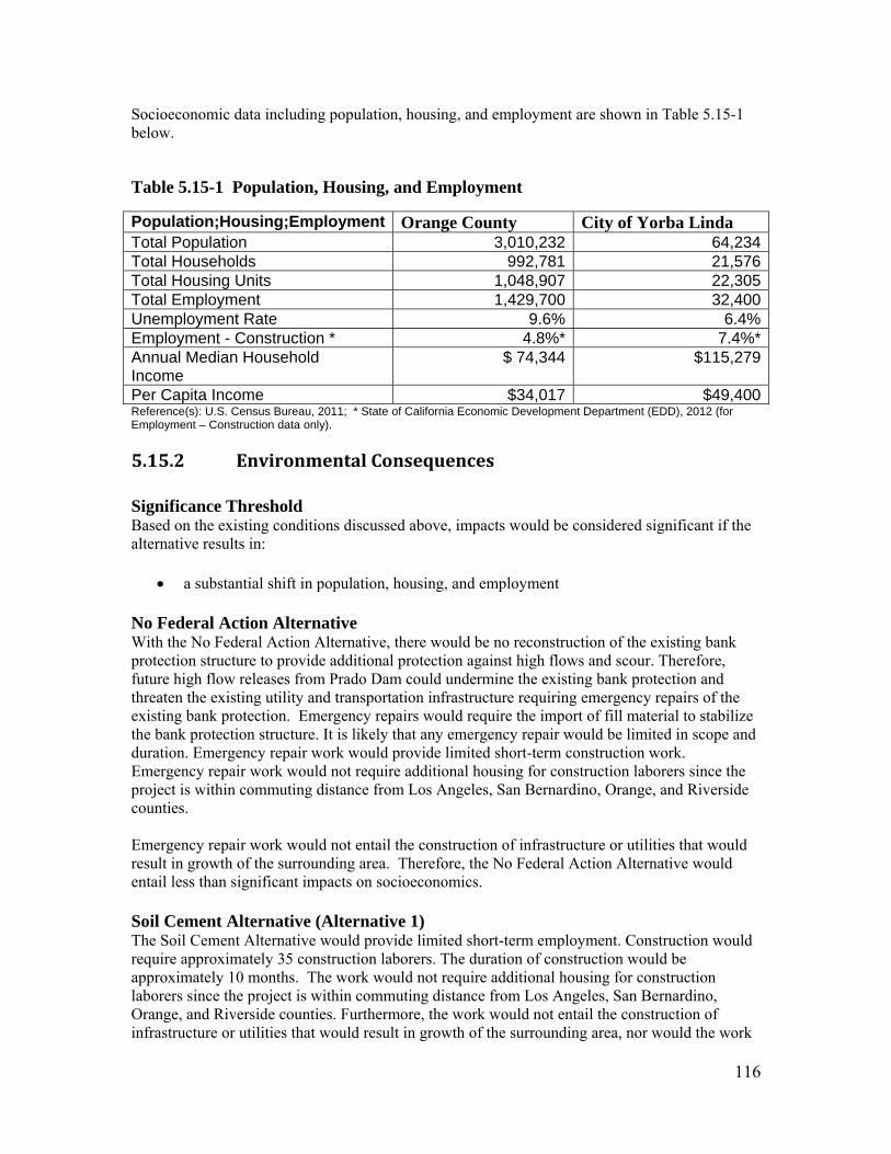
116
Socioeconomic data including population, housing, and employment are shown in Table 5.15-1 below.
Table 5.15-1 Population, Housing, and Employment
Population;Housing;Employment Orange County City of Yorba Linda Total Population 3,010,232 64,234Total Households 992,781 21,576Total Housing Units 1,048,907 22,305Total Employment 1,429,700 32,400Unemployment Rate 9.6% 6.4%Employment - Construction * 4.8%* 7.4%*Annual Median Household Income
$ 74,344 $115,279
Per Capita Income $34,017 $49,400Reference(s): U.S. Census Bureau, 2011; * State of California Economic Development Department (EDD), 2012 (for Employment – Construction data only).
5.15.2 EnvironmentalConsequences Significance Threshold Based on the existing conditions discussed above, impacts would be considered significant if the alternative results in:
a substantial shift in population, housing, and employment No Federal Action Alternative With the No Federal Action Alternative, there would be no reconstruction of the existing bank protection structure to provide additional protection against high flows and scour. Therefore, future high flow releases from Prado Dam could undermine the existing bank protection and threaten the existing utility and transportation infrastructure requiring emergency repairs of the existing bank protection. Emergency repairs would require the import of fill material to stabilize the bank protection structure. It is likely that any emergency repair would be limited in scope and duration. Emergency repair work would provide limited short-term construction work. Emergency repair work would not require additional housing for construction laborers since the project is within commuting distance from Los Angeles, San Bernardino, Orange, and Riverside counties. Emergency repair work would not entail the construction of infrastructure or utilities that would result in growth of the surrounding area. Therefore, the No Federal Action Alternative would entail less than significant impacts on socioeconomics. Soil Cement Alternative (Alternative 1) The Soil Cement Alternative would provide limited short-term employment. Construction would require approximately 35 construction laborers. The duration of construction would be approximately 10 months. The work would not require additional housing for construction laborers since the project is within commuting distance from Los Angeles, San Bernardino, Orange, and Riverside counties. Furthermore, the work would not entail the construction of infrastructure or utilities that would result in growth of the surrounding area, nor would the work

117
increase capacity of existing infrastructure that would induce growth. If the RV Park is directly affected (which is not expected at this time), the operators would be fully compensated. Therefore, the soil cement proposed project alternative would have a less than significant impact on socioeconomics. Grouted Stone Alternative (Alternative 2) The Grouted Stone Alternative would have impacts similar to the Soil Cement Alternative.
5.16 ENVIRONMENTALJUSTICE
5.16.1 AffectedEnvironmentThe 1994 Executive Order (EO) 12898, Federal Actions to Address Environmental Justice in Minority Populations and Low-Income Populations, requires all Federal agencies to conduct “programs, policies, and activities that substantially affect human health or the environment, in a manner that ensures that such programs, policies, and activities do not have the effect of excluding persons (including populations) from participation in, denying persons (including populations) the benefits of, or subjecting persons (including populations) to discrimination under, such programs, policies, and activities, because of their race, color, or national origin.” Section 1-101 of the Order requires Federal agencies to identify and address “disproportionately high and adverse human health or environmental effects” of programs on minority and low-income populations (EO, 1994). The Federal Council on Environmental Quality (CEQ) identifies minority groups as Asian, American Indian and Alaskan Native, Native Hawaiian & Pacific Islander, Black or African American, and Latino. CEQ further defined minority population as any group of minorities that exceed 50% of the existing population within an area where a minority group comprises a meaningfully greater percentage of the local population than in the general population. Since the project area is located within an unincorporated portion of Orange County, the surrounding counties of Los Angeles and Riverside serve as the reference socioeconomic demographics. Ethnicity and low-income data are shown in Table 5.15-2 below.
Table 5.15-2: Ethnicity, Low Income
Ethnicity; Low Income Orange County
Los Angeles County
Riverside County
Total Population 3,010,232 9,818,605 2,189,641 POVERTY DATA Percentage Below Poverty Threshold
10.1% 15% 13.4%
ETHNICY DATA White 60% 50% 61% Black 1.7% 8.7% 6.4% Hispanic/Latino 33.7 47.7% 45.5% Asian 17.9% 13.7% 1.1% American Indian/Native Alaskan
0.6% 0.7% 1.1%
Native Hawaiian/Pacific Islander
0.3% 0.3% 0.3%

118
Reference(s): U.S. Census Bureau, 2011.
5.16.2 EnvironmentalConsequences Significance Threshold Based on the existing conditions discussed above, impacts would be considered significant if the alternative results in:
a disproportionately high and adverse human health or environmental effect on minority and low-income populations
No Federal Action Alternative With the No Federal Action Alternative, there would be no reconstruction of the existing bank protection structure to provide additional protection against high flows and scour. Therefore, future high flow releases from Prado Dam could undermine the existing bank protection and threaten the existing utility and transportation infrastructure requiring emergency repairs of the existing bank protection. Emergency repairs would require the import of fill material to stabilize the bank protection structure. It is likely that any emergency repair would be limited in scope and duration. Moreover, emergency repairs would most likely entail the discharge of rocks to stabilize the embankment. The work would not result in adverse human health or environmental effects. It would provide equal protection to everyone who uses SR-91, although the protection would be less substantial and less permanent than that afforded by Alternative 1 or Alternative 2. The No Federal Action Alternative would not disproportionately affect minority and low-income populations. Therefore, the No Federal Action Alternative would entail less than significant impacts on environmental justice. Soil Cement Alternative (Alternative 1) With the Soil Cement Alternative, the existing bank protection structure would be removed and replaced with a soil cement structure. As previously documented, Alternative 1 would not result in significant environmental impacts. It would provide protection to the freeway (and all those who use the freeway) from high flows and scour. Therefore, environmental impacts associated with the Soil Cement Alternative would not disproportionately affect minority and low-income populations. Grouted Stone Alternative (Alternative 2) The Grouted Stone Alternative would have impacts similar to the Soil Cement Alternative.
5.17 CUMULATIVEIMPACTSA cumulative impact is the impact on the environment which results from the incremental impact of the action when added to other past, present, and reasonably foreseeable future actions. Cumulative impacts can result from individually minor but collectively significant actions taking place over a period of time in the proposed activity area. Those actions could be undertaken by various agencies (Federal, state, or local) or private entities. A discussion of cumulative impacts resulting from actions and projects that are proposed, under implementation, or reasonably anticipated to be implemented in the near future is required. Cumulative environmental impacts are most likely to arise when a relationship exists between a proposed activity and other projects expected to occur in a similar location, time period, and/or

119
involving similar actions. Projects in proximity to the proposed project activities would be expected to have more potential for a relationship that could result in potential cumulative impacts than those more geographically separated. The cumulative impact discussion analyzes cumulative projects located within the vicinity of the Santa Ana River Reach 9 Phase 3 project area that could have the potential to combine with impacts with the soil cement proposed project. As discussed in Chapter 1, the Corps has identified the potential need for additional embankment and bridge protection in Reach 9. However, as no alternatives have been fully developed, it is difficult to identify potential impacts or cumulative impacts at this time. The vast majority of impacts from all of the Reach 9 bank protection features have been temporary and all temporary work areas have been or will be restored. All temporary and permanent impacts have also been mitigated off-site and/or by enhancing project areas. Adjacent habitats and sensitive species are also protected throughout the construction process by the use of sound walls and other best management practices. Therefore, significant cumulative impacts are not anticipated. Further analysis, however, will be completed within the environmental documentation that will be prepared for the next phases of bank and bridge protection. The known projects in the vicinity of the project area are summarized as follows:
1. Santa Ana River Reach 9 Phase 2A [Green River Housing Estates (GRHE) and Upper SR-91 Embankment]. The Corps project would add protection to the GRHE and the Upper SR-91 from the potential increased releases after the completed raising of Prado Dam. The embankment will be approximately 5,760 feet long for the GRHE, and approximately 1,878 feet long for the Upper SR-91. General Location: Northeast of the Santa Ana Reach 9 Phase 3 project area. Construction is ongoing.
2. Santa Ana River Reach 9 Phase 2B [Green River Golf Club (GRGC) Embankment Protection]. The Corps project would add protection to SR- 91 from the potential increased releases after the completed raising of Prado Dam. The embankment will be approximately 6,000 feet long, approximately 110 to 120 feet wide, and approximately 35 feet deep. General Location: Northeast of the proposed project. Construction is currently ongoing.
3. SARI Line Protection/Relocation Project. Orange County Flood Control District (OCFCD) is relocating a segment of the major SARI brine line to the south bank of the Santa Ana River between Green River Golf Course and Weir Canyon Road (south of the proposed project). In addition, Riverside County will be adding sheet pile bank protection along the north bank of the river (northeast of the proposed project). Construction is ongoing.
4. SR-91 Corridor Improvement Project (CIP). The Caltrans project consists of widening the eastbound SR- 91 to add one general-purpose lane and establish full standard lane and shoulder widths across the eastbound freeway from SR-241 to SR-71. A series of retaining walls would be constructed on the south side of the SR-91 to accommodate the widening. Construction is ongoing.
5. CalTrans Project 0K3300. This effort involves extensive plantings and boulder placement to eight acres of State Right of Way (ROW). This project will attract wildlife to the area via the Coal Canyon Undercrossing and requires a three year plant establishment period. The area is fenced to ensure safe passage below SR-91 for wildlife.
120
6. CalTrans Project 0G3310. This project involves replacement planting and a plant establishment for up to three years between post mile 6.2 and 15.9 within and near the proposed TCE for the Reach 9, Phase 3 Project. Phase 3 for this CalTrans project is scheduled for 11/13 through 6/18.
7. CalTrans Project 0L8100. This project involves an extended plant establishment period and occurs at post mile 15.9/19.9. It is programmed to initiate in 2013.
Water Resources and Hydrology Cumulative Impacts – Construction activities for the proposed project would not have water resources impacts above and beyond those determined in the Corps’ 2001 SEIS/EIR, which were largely characterized by other flood control projects in and downstream of the Prado Basin. As discussed above in Chapter 5 (Water Resources and Hydrology) of this SEA, implementation of the proposed project would include full compliance with applicable laws and regulations, as well as Environmental Commitments identified in the Corps’ 2001 SEIS/EIR and in Chapter 6 of this document. As such, potential impacts to water resources and hydrology would be site-specific and not significant. Water resources and hydrology impacts of the proposed project would not singly, or combine cumulatively, with similar impacts of other projects as significant impacts. Also, the proposed project would provide flood protection for the surrounding area Santa Ana River Reach 9 Phase 3, and meets the water quality objective discussed in Chapter 5. 2, above. The other Corps flood control projects and the SARI line project in the cumulative scenario would also contribute to meeting the water quality objective, resulting in an overall benefit. Therefore, the water resources and hydrology cumulative impacts for the proposed project would be less than significant on water resources and hydrology. Biological Resources Cumulative Impacts - Implementation of the Reach 9, Phase 3 project would not result in significant impacts to biological resources (See Chapter 5.5.2). This project combined with other projects would not contribute to cumulative biological resource impacts within the region. Restoration of riparian, upland, and perennial stream habitat within the Reach 9, Phase 2B project area, a large portion of which is attributed to the Perennial Stream Restoration project, is currently underway. Construction associated with the Phase 2B project is expected to be completed prior to the start of Phase 3 construction. Restored areas are expected to be capable of supporting vireo during the 2013 nesting season and aquatic habitats associated with the Perennial Stream Restoration project are expected to provide quality habitat for the various life history requirements of the Santa Ana sucker. Wildlife movement will be restored to its full capacity as this project is completed. Impacts to wildlife movement are minimized during construction by limiting work to daylight hours to avoid disturbances when wildlife are most likely to be moving throughout the site and through the culverts that run below SR-91. Construction will likely be concurrently occurring at the Reach 9, Phase 2A project during Reach 9, Phase 3 construction. Vegetation and habitat on the north bank of the river was avoided during the Phase 2A construction and is consequently available for nesting birds and other wildlife. Areas disturbed by construction on the south bank within the Phase 2A construction footprint will be restored upon completion of construction. This restoration will be occurring during Phase 3 construction. As portions of this project are completed and habitats are restored, wildlife

121
movement capabilities will be returned to normal. Wildlife ramps and other features were incorporated into the grouted stone embankment to make it easier for wildlife to navigate the system of culverts that run beneath SR-91 within the project area. Impacts to wildlife movement were minimized to the extent possible during construction by limiting working hours to daytime, to avoid the time when wildlife are most likely to be utilizing the site. Construction of the SARI Line and the SR-91 CIP are not expected to have an appreciable cumulative impact to biological resources. All Reach 9 flood risk management projects constructed by the Corps factored in the SARI Line and SR-91 CIP to avoid replication of impacts to biological resources to the extent possible. Culverts should not have to be lengthened or detrimentally altered as a part of these projects within the Phase 2A, 2B, or 3 project areas. The SR-91 CIP will be dropping the grade of the Wardlow Wash undercrossing of SR-91 to make that potential path more amenable to wildlife seeking to traverse the freeway. These projects also have restoration requirements for areas that they disturb and will be held to the same standards and commitments to restoration that the Corps has within Corps project areas.
CalTrans Projects 0K3300, 0G3310, and 0L8100 are not expected to contribute to cumulative impacts to biological resources. The Reach 9, Phase 3 Project is also not expected to have an effect on these three CalTrans projects. Access to the Reach 9, Phase 3 Project through Coal Canyon will be limited to the currently used construction roads only and will only be permitted during daylight hours to avoid impacts to wildlife movement and any planting that may occur. Coordination with CalTrans points of contact will enable avoidance and minimization of impacts to CalTrans projects.
In general, the effects of the proposed project are site specific, localized, largely temporary in duration, and would not result in incremental cumulative impacts to biological resources through increased human encroachment (e.g., removal of habitat, degradation of habitat through trampling, increased noise, or decreased water quality). At the conclusion of construction, the Corps would restore or enhance habitat in the project area. Impacts of the Proposed Action would be reduced to less than significant levels and effects of this proposed project would not be considered cumulatively significant with mitigation. Each of the proposed projects discussed above in this section are fully mitigated, and each incorporates environmental commitments and BMP measures to avoid and minimize impacts, and to restore temporarily impacted areas. Often, the impacted areas are restored to a better condition than pre-project, as non-native vegetation is replaced with native habitat. Mitigation for the Corps’ SARP projects alone have resulted in the removal and treatment of hundreds of acres of arundo and other invasives from the Santa Ana River watershed, allowing the re-establishment and expansion of native habitat and protecting downstream areas from infestation. Mitigation has also included funding for an ongoing cowbird trapping program, which helps to protect songbird populations. Air Quality Cumulative Impacts - Construction activities for the proposed project would not have air quality impacts above and beyond those determined in the Corps’ 2001 SEIS/EIR, where in that document the cumulative project impacts were determined to be significant in large part due to the significant project impacts. The cumulative projects discussed above would not singly, or combined cumulatively, would have significant criteria pollutant impacts. The mitigation measures identified in the 2001 SEIS/EIR and the Air Quality (AQ) Environmental Commitments

122
recommended in Chapter 6 of this document would reduce air quality impacts to the extent feasible. Therefore, the air quality cumulative impact findings for the proposed project would be less than significant on air quality. Noise Cumulative Impacts - Cumulative increase in temporary noise levels as a result of proposed project construction in conjunction with construction of the projects described above in this section could temporarily increase ambient noise levels in the vicinity of the proposed project area. Construction activities associated with other projects in close proximity to the proposed project could potentially occur at the same time as the proposed project and disturb sensitive receptors near multiple project locations. Construction impacts of all cumulative projects would be temporary and short duration. Each project would be required to comply with local noise ordinances, as discussed in Chapter 5.7.1 (Noise, Affected Environment). As discussed in Chapter 5.7.2 (Noise, Environmental Effects), mobile construction noise associated with the proposed project would be less than significant. Also, with the implementation of the Noise Environmental Commitments in Chapter 6 of this document, the proposed project would result in less than significant stationary construction noise impacts. The projects discussed above in this section would contribute both mobile and stationary construction noise of the proposed project, and would require similar project specific mitigation and environmental commitments to reduce construction noise impacts. Therefore, while overall development of the Santa Ana River Reach 9 embankment area could result in cumulative temporary construction noise impacts, the proposed project would have a less than significant project specific cumulative impact to noise including on sensitive receptors within proximity of the multiple construction projects. Cultural Resources - Implementation of the Reach 9, Phase 3 project would not result in significant impacts to cultural resources (See Chapter 5.9). Any foreseeable future development resulting from construction of this particular feature is unlikely to endanger previously known and undiscovered historical and prehistoric resources. This project combined with other projects would not contribute to cumulative cultural resource impacts within the region. Land Use and Recreation Cumulative Impacts - The area potentially affected by cumulative land use and recreation impacts is the local vicinity of the Santa Ana River Reach 9 flood control features where construction and operation activities could affect nearby land uses. Land use and recreation impacts tend to be localized, affecting properties in the immediate vicinity of the project area. Potential cumulative land use and recreation impacts from the proposed project could potentially affect recreational land uses, and residential land uses, surrounding the project area. Although potential land use and recreation impacts from the proposed project construction are localized, the land use and recreation benefits of the proposed project, in terms of flood protection for populated areas, are regional in scope, benefiting areas in Orange, Riverside, and San Bernardino Counties. Transportation Cumulative Impacts – The cumulative transportation impacts from the projects discussed above would generate construction and operational trips to and from the respective project sites using local roadways including SR-91, Gypsum Canyon Road, La Palma Avenue, and Coal Canyon Road. Construction of these projects could also result in an increase in temporary delays and hazards from construction vehicle trips on the local roadway network. However, as discussed in Chapter 5.11.2 (Transportation Environmental Consequences), construction trips associated with the proposed project would have a less than significant impact on the existing capacities of the above lased roadways used by construction vehicles. Due to the AADT of utilized roadways and the temporary and short term nature of construction related trips, the proposed project construction trips would not combine with cumulative construction trips to

123
significantly impact existing traffic volumes and capacities of any shared roadways during construction. With the implementation of Transportation Environmental Commitments discussed in Chapter 6 of this document, cumulative construction transportation impacts would be reduced to a less than significant level. Therefore, while development of cumulative projects discussed above in this section would result in project-related construction trips and additional traffic volumes on local area roadways, the proposed projects cumulative construction traffic related impacts would be minimal and would cease upon completion of construction.

124
6.0 ENVIRONMENTALCOMMITMENTS As was discussed in Chapter 5, the proposed action would not result in any significant impacts to (or from) geology and soils, hydrology, ground water, surface water quality, biological resources, air quality, green house gases, noise, cultural resources, land use, recreation, transportation, aesthetics, public utilities and services, hazardous materials, socioeconomics, or environmental justice. Water Quality The following environmental commitments from the 2001 SEIS/EIR would be incorporated into contract specifications or otherwise implemented by the Corps to reduce potential impacts to water quality. WR-3 The construction contractor shall obtain a National Pollution Discharge
Elimination System (NPDES) construction stormwater permit prior to construction.
The following mitigation measures would be incorporated to the Reach 9, Phase 3 plans and specifications to reduce potential impacts to surface water quality.
R9P3-WQ-1: Prepare and implement an erosion control plan to minimize potential
sedimentation and turbidity impacts. The erosion control plan shall include temporary measures such as sandbags and/or water bars and may include long-term measures such as re-vegetating the access road and soils borrow areas.
R9P3-WQ-2: Obtain a dewatering permit if the installation and maintenance of the structure
extends into the groundwater table. R9P3-WQ-3: Prepare and implement a pollution prevention plan to reduce the potential for
accidental release of fuels, pesticides, and other materials. This plan will include the designation of refueling locations, emergency response procedures, and reporting requirements for any spill that occurs. This plan shall also include herbicide and pesticide application activities such as storage, handling of herbicides, and application methods.
R9P3-WQ-4: Keep cleanup equipment and supplies at the staging area for immediate use. R9P3-WQ-5: Utilize liners and earthen berms in the establishment of upland refueling areas to
isolate potential fuel spills from the aquatic environment. Keep fuel spill cleanup equipment and supplies adjacent to the refueling area.
R9P3-WQ-6: Place oil drip pans underneath engine block and hydraulic systems for equipment
not in use.
Biological Resources The following commitments from the 2001 Final SEIS/EIR would be incorporated into contract specifications for the proposed project or otherwise implemented by the Corps to reduce potential impacts to biological resources.

125
BR-16 Prior to construction a monitoring program shall be developed and implemented
by the Corps that entails surveys for least Bell’s vireo and southwestern willow flycatcher in the spring and early summer in the year prior to construction, as well as during the year of construction. [Surveys are being conducted by SAWA.]
BR-16A Within 1 year after initiation of construction activities, the Corps shall finalize a
habitat management plan for the areas where the Corps and/or project sponsors have the legal right/jurisdiction. The USFWS and CDFW will review the plan, which will address how the Corps and/or their sponsors will maintain or increase the baseline amount of riparian habitat, and funding. This plan will also address conservation goals and thresholds, monitoring and evaluation methodologies, and reporting and review procedures. [Update: OCFCD has finalized the Habitat Management Plan.]
BR-17 The construction contractor shall only clear vegetation associated with project
construction during periods when the least Bell’s vireo and southwestern willow flycatcher are not nesting (15 August through 28 February).
BR-17A Grading activities associated with project construction shall be kept to a
minimum and existing root systems will be left intact to the extent possible. BR-18 For each acre of riparian/wetland habitat (excluding unvegetated perennial
stream) that is temporarily disturbed during construction related activities, the Corps shall contribute sufficient funds to SAWA to: Remove one acre of Arundo donax from the upper Santa Ana River
watershed and/or action area (for each acre affected) Actively monitor and manage this acreage until riparian habitat is completely
restored o Maintain this acreage arundo-free for the life of the project [or until
success criteria are met – possible revised approach is currently being coordinated with USFWS.]
[The original (2001) BO had required 1:1 off-site mitigation for temporary impacts to riparian habitat; this option is still available if a mechanism is put in place to ensure continued management of this area for the life of the flood control project. Otherwise, the 2012 BO Amendment provides an option of 3:1 off-site mitigation (removing 3 acres of arundo for each acre of riparian habitat temporarily affected by the project) with a 5-year management commitment.]
BR-18A The Corps [or sponsors] shall successfully restore each acre of riparian vegetation that is temporarily disturbed during construction-related activities and will keep all temporarily disturbed areas free of exotic plants until riparian vegetation is re-established. If the site has not begun to recover within 5 years (i.e. 50 percent of the disturbed areas are not vegetated with young riparian vegetation), then the site will be replanted with cuttings from native riparian species.

126
BR-18B The Corps [or sponsors] shall maintain non-riparian areas that are temporarily disturbed or destroyed free of exotic plants for 8 years. In addition, the Corps shall use one of the following alternatives, or a combination thereof, to mitigate for each acre of non-riparian floodplain habitat (excluding perennial stream) that is permanently destroyed or isolated from the floodplain during construction related activities. The Corps shall successfully create one acre of flood plain within the action
area (for each acre affected). These areas will be kept free of exotic plants for 8 years; or
The Corps shall contribute sufficient funds to the Trust Fund [or other contractor] to:
o Remove 3 acres of Arundo donax from the upper Santa Ana River watershed and/or action area for each acre of [non-] riparian vegetation that is permanently destroyed or isolated from the flood plain during construction related activities.
o Actively monitor and manage this acreage o Maintain this acreage arundo-free for the life of the project [or until
success criteria are met – possible revised approach is currently being coordinated with the USFWS]
o Conduct cowbird removal trapping in the vicinity of the restored habitat for the life of the project [or until success criteria are met – possible revised approach is currently being coordinated with the USFWS].
[Mitigation ratios for permanent impacts remain consistent with previous environmental documents and permits, although the mechanism for ensuring future maintenance of the mitigation areas has changed.]
BR-18C The Corps shall use one of the following alternatives, or a combination thereof,
to mitigate for each acre of riparian vegetation that is permanently destroyed or isolated from the flood plain during construction related activities: Remove 5 acres of Arundo donax from the upper Santa Ana River watershed
and/or action area for each acre of [non-] riparian vegetation that is permanently destroyed or isolated from the flood plain during construction related activities.
Actively monitor and manage this acreage Maintain this acreage arundo-free for the life of the project [or until success
criteria are met]
[Mitigation ratios for permanent impacts remain consistent with previous environmental documents and permits, although the mechanism for ensuring future maintenance of the mitigation areas has changed.]
BR-19 The Corps [or its local sponsor] shall implement a cowbird trapping program in
Reach 9 for a period of 2 years starting during [Reach 9, Phase 3] project construction. Trapping shall consist of two monitored traps during vireo and flycatcher egg-laying season (15 March to 30 July). This effort is viewed as supplementing on-going cowbird trapping activities in the Prado Basin. [The Corps funded four years of trapping efforts in Reach 9 and vicinity from 2002

127
through 2006, and awarded a contract in 2009 for an additional three years of trapping. As such, the requirements of BR-19 have been fulfilled for the projects that were analyzed in the 2001 SEIS/EIR and project BO’s. 2 additional years of trapping are being proposed to help offset any potential impacts to relevant avian species resulting from the Reach 9, Phase 3 project.]
BR-20 The Corps shall monitor construction activities to assure that vegetation is
removed only in the designated areas. Riparian areas not to be disturbed shall be flagged.
BR-21 If any construction is to take place during the time of year when vireos are
present, the construction contractor shall install noise barriers between construction areas and riparian habitat prior to March 1. These noise barriers shall be kept in place until all construction in the area is completed. [The Corps will continue to coordinate with the USFWS to determine whether noise barriers are necessary or prudent for the Reach 9, Phase 3 project, since the footprint required for construction of the barriers may result in additional habitat removal. Sound monitoring and vireo surveys will be conducted throughout the nesting season to determine if noise barriers or other modifications are warranted.]
BR-22 To minimize impacts on the Santa Ana sucker population, in areas where
dewatering is to take place, the construction contractor shall direct discharge water into a stilling basin and allow this water to flow through existing vegetation into the river downstream of the construction area.
BR-23 During construction, the construction contractor shall implement measures to
control sedimentation; these include re-contouring, sandbagging, the development of stilling basins, and other appropriate erosion control measures developed on a site-specific basis.
BR-24 During construction, riparian vegetation adjacent to de-watering areas shall be
monitored by the Corps for signs of plant stress. Supplemental watering shall be added to this vegetation, as needed.
BR-25 In areas where de-watering is necessary, a permitted sucker biologist shall be
retained by the Corps to survey for Santa Ana suckers prior to and during any river diversions. If suckers are found, they shall be removed and relocated to appropriate habitats outside of the construction area.
BR-26A As construction is completed in a given area, the construction contractor shall
hydroseed all disturbed upland areas with local native shrubs and groundcover. The mix of native species in the hydroseed shall be approved in advance by the Environmental Resources Branch of the Corps’ Los Angeles District. [Container plants shall also be implemented in the effort to restore upland habitats.]
BR-26B The Corps shall successfully restore each acre of perennial stream that is
temporarily disturbed during construction related activities. Restoration of perennial stream habitats would include: Replacement of pre-construction substrates and microhabitat features Maintenance or re-establishment of natural channel morphology (e.g., stream
meanders, pool-riffle complexes)

128
Maintenance or re-establishment of perennial flows Verification that the structure and composition of the restored area is similar
to pre-construction conditions. BR-26C The Corps shall create and/or enhance one acre of perennial stream habitat within
the Santa Ana River or its tributaries for each acre of unvegetated perennial stream that is temporarily or permanently disturbed during construction-related activities. Creation/enhancement activities could include but are not limited to the following: The development of pool-riffle complexes by placing clusters of various
sized boulders within the river channel to provide limited cover and areas of reduced water velocity
The creation of potential sucker habitat below Prado Dam within one or more tributaries of the Santa Ana River
The creation of lateral stream habitats that is apparently essential for the survival of larval suckers.
The following commitments from the 2011 Final SEA/EIR Addendum for the Reach 9, Phase 2A project would be incorporated into contract specifications for the proposed project or implemented by the Corps to reduce potential impacts to biological resources. EC-BR-1 Upon development of final construction plans and prior to site disturbance, the
Corps shall clearly delineate the limits of construction on project plans. All construction, site disturbance, and vegetation removal shall be located within the delineated construction boundaries. The storage of equipment and materials, and temporary stockpiling of soil shall be located within designated areas only, and outside of natural habitat areas. The limits of construction shall be delineated in the field with temporary construction fencing, staking, or flagging.
EC-BR-2 Prior to construction activities and throughout the construction period, a Corps
qualified biologist (or the environmental monitor) shall inspect the construction site and adjacent areas to determine if any raptors are nesting within 500 feet of the construction site. If active nests are found, the Corps biologist will coordinate with USFWS and CDFW to determine appropriate avoidance or minimization measures.
EC-BR-3 Prior to construction activities, a qualified biologist (or environmental monitor)
shall conduct pre-construction training for all construction crew members. The training shall focus on required mitigation measures and environmental commitments and conditions of regulatory agency permits and approvals (if required). The training shall also include a summary of sensitive species and habitats potentially present within and adjacent to the project site.
EC-BR-4 The construction contractor will prepare a Spill Prevention and Contingency
Plan. The Plan shall be implemented prior to and during site disturbance and construction activities. The plan will include measures to prevent or avoid an incidental leak or spill, including identification of materials necessary for containment and clean-up and contact information for management and agency staff. The plan necessary containment clean-up materials shall be kept within the construction area during all construction activities. The construction contractor

129
shall ensure workers are educated on measures included in the plan at the pre-construction meeting or prior to beginning work on the project.
EC-BR-5 The Corps biologist (or the environmental monitor) shall monitor construction
activities to ensure compliance with environmental commitments. EC-BR-6 Upon completion of construction activities, the Corps shall mitigate for the
removal of coast live oaks within the project area by replacing all removed oak trees at a ratio of 4:1. Any planted oak trees that do not survive the first two years will be replaced in-kind. At the end of the initial five year monitoring period, any oak trees that do not survive will then be replaced at a 10:1 ratio, with an additional one-year (minimum) plant establishment monitoring period. Replacement plantings shall be located within the project area as well as within other restoration areas located along the Santa Ana River Mainstem Project area and may consist of acorn plantings, potted nursery stock, or a combination of both. All plant propagules shall be collected within a five-mile radius and within 1,000 feet elevation of the project area. All planting locations, procedures, and results shall be evaluated by a qualified arborist/botanist.
The Corps shall develop and implement an Oak Resource Management Plan to be submitted for review by the USFWS and CDFW that is designed to meet the objectives of the successful establishment and long-term survival of replaced oak trees in the project area. This plan shall include the following: A map identifying locations where oak tree plantings occur, specifically
targeting suitable soil types; A detailed schedule indicating when plantings will occur; A description of the irrigation methodology; Measures to control exotic vegetation at the planting locations; Certification of use of local propagules; Measures to provide protection from herbivory; Success criteria shall include:
o All oak plantings will exhibit a minimum of an 80% survivability rate without artificial irrigation for no less than one year after artificial irrigation is removed.
o All oak trees shall be monitored for a minimum of five (5) years or until all success criteria as identified in the plan have been met. Individual oak trees that do not meet the success criteria shall be replanted and corrected prior to replanting.
The following additional environmental commitments would be incorporated into contract specifications for the proposed project to reduce potential impacts to biological resources. R9P3-BR-1 Vegetation along the north bank of the Santa Ana River within the project area
that is not associated with a temporary access/maintenance road or characterized as “Giant Reed Grassland” (see Figure 4-4 on page 22) or “Clear and Grub – Arundo” on Figure 4-4 shall be mowed or cut to a height less than 2 feet to eliminate the potential for interactions between birds and other wildlife during construction. Areas that meet these criteria are shown in green and labeled as “cut” on Figure 4-4. The roots and stumps will be left in place to help with bank stability and to assist in the restoration of the project area following construction.

130
R9P3-BR-2 Any areas characterized as “Giant Reed Grassland” (see Figure 4-4) or Clear and
Grub – Arundo,” as shown on Figure 4-4 shall be cleared and grubbed and removed from the construction area to a suitable disposal site.
R9P3-BR-3 The construction contractor shall ensure river flows are maintained in both the
diversion canal, shown on Figure 4-1.1, as well as the un-diverted portions of the Santa Ana River. The proportion of flow volumes in each channel should be maintained similar to the proportion that occurred in two main braids of the river prior to construction.
R9P3-BR-4 The project biologist or biological monitor shall have the authority to stop work
should he/she notice a construction activity that may result in exceedence of incidental take amounts or undocumented impact to any biological resource.
R9P3-BR-5 Container plants shall be planted to augment the hydroseed treatment in upland
areas to expedite the restoration process. R9P3-BR-6 Where possible, project related activities will be conducted outside of the drip
line of oak trees. R9P3-BR-7 Work hours will be limited to day time hours to reduce potential direct and
indirect impacts to wildlife movement.
R9P3-BR-8 Imported soil shall be tested for compatibility with native soil, re-vegetation palette, and the ecology of the project area and vicinity. Samples shall be tested from the project site, the proposed import source, and any combinations of mixtures of the native soil and imported soil desired for use within the site. The results of the tests must show compatibility with existing soil, re-vegetation palette and ecology of the project area and vicinity, as determined by the project biologist and soils/geology team members.
R9P3-BR-9 Switchback ramps will be incorporated into the embankment to facilitate wildlife movement into and out of the project area as wildlife transitions between each of the two 60-inch culverts being altered by the project and the floodplain.
Air Quality The following commitments from the 2011 Final SEA/EIR Addendum for the Reach 9, Phase 2A project would be incorporated into contract specifications for the proposed project or otherwise implemented by the Corps to reduce potential impacts to air quality. EC-AQ-2 All unpaved construction roads shall be stabilized with a non-toxic soil stabilizer
or soil weighting agent, with or without the use of geotextiles that can be determined to be both, as efficient, or more efficient for fugitive dust control as California Air Resources Board approved soil stabilizers, and shall not increase any other environmental impacts including loss of vegetation.

131
The following additional environmental commitments would be incorporated into contract specifications for the proposed project to reduce potential impacts to air quality. R9P3-AQ-1: Prepare and implement a fugitive dust emission control plan. Measures to be
incorporated into the plan shall include, but are not limited to the following:
Water the unpaved road access and other disturbed areas of the active construction sites at least three times per day, or apply CARB certified soil binders.
Enclose or cover exposed soil piles with a five percent or greater silt content.
Alternatively water three times daily, or apply CARB certified soil binders.
Install rumble plates and wheel washers/cleaners or wash the wheels/exteriors of trucks and other heavy equipment where vehicles exit the site.
Sweep paved areas daily with water sweepers if visible soil material from the construction sites or unpaved access roads is carried onto such areas.
R9P3-AQ-2: Diesel engine idle time shall be restricted to no more than 10 minutes duration.
This is not required for trucks that require engines to be on while waiting onsite, such as concrete trucks.
R9P3-AQ-3: Use lower emitting off-road diesel-fueled equipment. All off-road construction
diesel engines not registered under CARB’s Statewide Portable Equipment Registration Program, which have a rating of 50 horsepower (hp) or more, shall meet, at a minimum, the Tier 2 California Emission Standards for Off-Road Compression-Ignition Engines as specified in California Code of Regulations, Title 13, section 2423(b) (1) unless that such engine is not available for a particular item of equipment. In the event a Tier 2 engine is not available for any off-road engine larger than 100 hp, that engine shall be equipped with a Tier 1 engine. In the event a Tier 1 engine is not available for any off-road engine larger than 100 hp, that engine shall be equipped with a catalyzed diesel particulate filter (soot filter), unless certified by engine manufacturers that the use of such devices is not practical for specific engine types. Equipment properly registered under and in compliance with CARB’s Statewide Portable Equipment Registration Program are considered to comply with this environmental commitment. This measure does not apply to construction equipment that are active at the site for less than two weeks total duration and specific exceptions to these requirements may be allowed on a case by case basis in the determination of extreme financial difficulty for subcontractors that are using specialized self-owned construction equipment.
R9P3-AQ-4: Use on-road vehicles that meet California on-road emission standards. R9P3-AQ-5: Maximize use of lower emitting off-road gasoline-fueled construction equipment.
All off-road stationary and portable gasoline powered construction equipment shall have EPA Phase 1/Phase 2 compliant engines, where the specific engine requirement shall be based on the new engine standard in effect two years prior to the initiating project construction.

132
R9P3-AQ-6: Schedule deliveries outside of peak hours. All material deliveries to the project
site shall be scheduled to occur outside of peak “rush hour” traffic hours (7:00 to 10:00 a.m. and 4:00 to 7:00 p.m.) to the extent feasible, and other truck trips during peak traffic hours shall be minimized to the extent feasible.
Cultural Resources The following commitment will be added to the Reach 9, Phase 3 contract specifications or otherwise implemented by the Corps to minimize potential impacts to cultural resources.
R9P3-CR-1: Monitor construction activities with an archeologist meeting the Secretary of the
Interior’s Qualification Standards. In the event that previously unknown resources are found during construction, the Corps shall comply with the requirements of 36 CFR 800.13.
Transportation The following environmental commitment will be added to the proposed project specifications or otherwise implemented by the Corps to minimize potential impacts to transportation. R9P3-TF – 1: Prepare and implement a traffic management plan. The plan at a minimum
would include the identification of ingress and egress points, speed limits, and placement of traffic signage.

133
7.0 ENVIRONMENTALCOMPLIANCE
The National Environmental Policy Act (NEPA). This Supplemental Environmental Assessment has been prepared in accordance with NEPA.
California Environmental Quality Act (CEQA). This EIR Addendum has been prepared
in accordance with CEQA.
National Historic Preservation Act (NHPA) of 1966, as amended. The project is in compliance. The Corps is in compliance with Section 106 of the act. A programmatic agreement (PA) was executed for the Santa Ana River Project in 1992 by the Advisory Council on Historic Preservation. This document detailed the procedures to be followed for each feature of the project. This feature is in compliance with the stipulations in the PA. No additional coordination with the SHPO is required unless an unanticipated discovery is made during construction. In that event the Corps would comply with the procedures in 36 CFR 800.13.
Fish and Wildlife Coordination Act (FWCA). The project is in compliance. The Santa
Ana River Project has been fully coordinated with the USFWS. Two Coordination Act Reports have been prepared for the SARP (1988 and 1999). These documents are included in the 1988 SEIS and the 2001 SEIS/EIR, and the recommendations continue to be carried forward during implementation of each SARP feature. In recent years, numerous meetings have occurred between the USFWS, CDFW, other resource agencies, local sponsors and the Corps to discuss the various proposed projects in Reach 9. These projects include the Santa Ana River Reach 9 Phase 3 (the subject of this SEA), SARI line, and other proposed and ongoing embankment protection projects. Discussions included potential impacts to, mitigation for, and minimization and avoidance measures for nesting birds covered under the MBTA, species covered under the Federal ESA and the California Endangered Species Act (such as the least Bell’s vireo and Santa Ana sucker), and wildlife movement issues. Specific issues related to the Santa Ana River Reach 9 Phase 3 project have also been coordinated with the resource agencies, apart from the overall Reach 9 discussions. Furthermore, the Draft SEA was sent to USFWS and CDF&G for review.
California Department of Fish and Wildlife Code, Section 1600. This project is in
compliance. A 1601 Streambed Alteration Agreement (SAA No. 6-2001-263) was issued for the Mainstem Santa Ana River Project (Prado Dam and Vicinity features) in 2002. This SAA had expired, and a new SAA (1600-2009-0031-R6) was signed by Orange County in October 2009. This revised agreement, however, did not specifically incorporate the Reach 9 Phase 3 project; however, the Corps and Orange County reviewed the 2009 SAA and determined that the document contemplated the type of construction that would occur with the Reach 9 Phase 3 project. Therefore, a new SAA would not be required for construction. This determination by the Corps was documented in a letter sent to the CDFW by Orange County dated December 26, 2012. Kim Freeburn, of the CDFW, supported the determination by the Corps that a new SAA would not be required to initiate construction of the Reach 9 Phase 3 project in a call to Lance Natsuhara, of OCFCD on January 30, 2013. The CDFW did request that further coordination be conducted with their agency prior to the initiation of additional projects

134
mentioned in this document, including the Reach 9 Phase 4 and Reach 9 Phase 5 projects. Minimization and avoidance measures included in the amended SAA would be followed during construction of this project.
The Endangered Species Act (ESA), as amended and California Endangered Species Act
(CESA). This project is in compliance. Effects of the proposed project on State and/or federally listed species were addressed in consultations with the USFWS (by the Corps) and coordination with the CDFW (by Orange County). The USFWS issued an amendment (FWS-OR-08B0408-13F0036) to the Biological Opinion (FWS-SB-909.6) obtained for other Prado and Vicinity features of the Santa Ana River Mainstem Project in 2001/2002 on February 7, 2013. Similar to the SAA coordination process, the CESA permit (2081-2001-023-06) that was previously issued for the Santa Ana River Mainstem Project was deemed to have contemplated the type of construction that would occur for the Reach 9 Phase 3 project. Consequently, an amendment to the existing CESA permit would not be required. CDFW concurred with this determination as is described in phone conversation between Lance Natsuhara, of OCFCD, and Kim Freeburn, of CDFW, on January 30, 2013.
Clean Air Act (CAA), as amended. The project is in compliance. Impacts of this project
were thoroughly analyzed in Chapter 5.6 and Appendix C of the EA and found to be below significance thresholds. The overall Prado Basin and Vicinity, Including Reach 9 and Stabilization of the Bluff Toe at Norco Bluffs project was analyzed in the 2001 SEIS/EIR. The contractor would be responsible for implementing mitigation measures included in this document and complying with all Federal, State, and local laws regarding air quality.
Clean Water Act (CWA), as amended. This action would be in compliance with the
guidelines in 40 CFR 230.10 (c), promulgated by the EPA under section 404 (b) (1) and Section 404 of the Clean Water Act (CWA) guidelines. The overall Santa Ana River Project, including Reach 9 Phase 3, entails discharge of dredged material into waters of the United States. Information on the Santa Ana River Project’s compliance, including a 404 (b) (1) evaluation, and a waiver of 401 certification pursuant to the Corps’ Clean Water Act implementation regulations (33 CFR 336.1(a) (1)) may be found in the 2001 EIS/EIR. A new 404(b)(1) Evaluation for Santa Ana River Reach 9 Phase 3 been prepared and is also included in Appendix A. This project has been coordinated informally with the Santa Ana River RWQCB, and the Corps has received 401 Certification for the soil cement project. Measures to protect water quality during dewatering (i.e., river diversion and control of sedimentation) would be similar to those to be implemented during construction of previous features.
Farmland Protection Policy Act. There is no change from the 2001 SEIS/EIR. Citrus
orchards located within Reach 9 are on lands that are not designated prime or unique farmlands. This project would not result in any impacts to prime or unique farmlands. The project is in compliance.
Executive Order (EO) 11988, Floodplain Management. Under this Executive Order, the
Corps must take action to avoid development in the flood basin (e.g., 100 year flood) unless it is the only practicable alternative to reduce hazards and risks associated with floods; to minimize the impact of floods on human safety, welfare, and health; and to restore and preserve the natural and beneficial value of the case floodplain. The soil

135
cement project and other alternatives including the grouted stone alternative would avoid development in the flood basin to the extent practicable to reduce hazards and risks. The project is in compliance.
Executive Order (EO) 11900. Protection of Wetlands. In developing alternatives, the
Corps considered the effects of the project on the survival and quality of wetlands. Projects are “…avoid to the extent possible the long and short term adverse impacts associated with the destruction or modification of wetlands and to avoid direct or indirect support of new construction in wetlands wherever there is a practicable alternative…” Mitigation measures have been formulated to reduce impacts to wetlands.
Executive Order (EO) 12898. Environmental Justice discusses disproportionate
environmental impacts to low income and minority populations. The soil cement project and other alternatives including the grouted stone alternative do not introduce disproportionate environmental impacts to low income and minority populations in the unincorporated portion of Orange County (reference community) when compared to adjacent (City of Yorba Linda) community. The project is in compliance.

136
8.0 COORDINATION The proposed Santa Ana River Reach 9 Phase 3 project has been fully coordinated with numerous agencies, organizations, and individuals, including the U.S. Fish and Wildlife Service (USFWS), California Department of Fish and Game (CDFW), California State Parks (State Parks, also known as California Department of Parks and Recreation), State Office of Historic Preservation (SHP)), the Santa Ana Regional Water Quality Control Board (RWQCB), Caltrans, Orange County agencies, and local cities. A Draft SEA/EIR Addendum was distributed to several public agencies and numerous interested parties for review. The comments that were received are addressed in Appendix G of this document and within the text, where appropriate. The Santa Ana River Project has been fully coordinated with resource agencies and interested parties since the 1970’s. Summaries of past coordination, consultation and permitting are included in the 1988 SEIS and the 2001 SEIS/EIR. In recent years, numerous meetings have occurred between the USFWS, CDFW, other resource agencies, local sponsors and the Corps to discuss the various proposed projects in Reach 9. These projects include the Reach 9 Phase 3 (the subject of this SEA), SARI line, and other proposed and ongoing embankment protection projects. Specific issues related to the Reach 9 Phase 3 project have also been coordinated with the resource agencies, apart from the overall Reach 9 discussions. The Draft SEA also served as the Biological Assessment that was used to facilitate formal consultation with the USFWS for the project.

137
9.0 LISTOFPREPARERSANDREVIEWERS LIST OF PREPARERS
Kirk Brus; Environmental Coordinator; Corps Chris Jones; Biologist and Environmental Coordinator; Corps Steve Dibble; Archaeologist; Corps
LIST OF REVIEWERS
Kenneth Wong; Chief, Regional Planning Section; Corps Hayley Lovan; Biologist; Chief, Ecosystem Planning Section; Corps

138
10.0 CONCLUSION The construction of the Reach 9, Phase 3 embankment protection proposed action would not have a significant impact on the environmental quality of the area. Therefore, an Environmental Impact Statement (EIS) is not required.

139
11.0 LISTOFACRONYMSANDABBREVIATIONS ACS = American Community Survey AADT = Annual Average Daily Traffic ADT = Average Daily Traffic APE = Area of Potential Effects ATCM = Airborne Toxic Control Measure bgs = Below ground surface BLM = Bureau of Land Management BMP = Best Management Practice BNSF = Burlington Northern Santa Fe CAA = Clean Air Act (Federal) CAAA = Clean Air Act Amendments CAAQS = California Ambient Air Quality Standards Cal/OSHA = California Office of Safety and Health Administration CARB = California Air Resources Board Caltrans = California Department of Transportation CEQA = California Environmental Quality Act (California Public Resources Code
section 21000 et seq.) cfs = Cubic feet per second CCIC = Central Coastal Information Center CCWA = Central Coast Water Authority CDFW = California Department of Fish and Wildlife (formerly CDFG) CDFG = California Department of Fish and Game (now CDFW) CERCLA = Comprehensive Environmental Response, Compensation, and Liability
Act (Superfund) CESA = California Endangered Species Act CFR = U.S. Code of Federal Regulations CH4 = Methane CHRIS = California Historical Resources Information System CNEL = Community Noise Equivalent Level CO = Carbon Monoxide CO2 = Carbon Dioxide Corps = United States Army Corps of Engineers CRWQCB = California Regional Water Quality Control Board CWA = Clean Water Act of 1977 (33 U.S.C. 1251 et seq.) (formerly the Federal Water Pollution Control Act of 1972) cy = Cubic Yards dB = Decibel dBA = Decibel (A-weighting network) DBESP = Determination of Biological Equivalent or Superior Preservation DDT = Dichlorodiphenyltrichloroethane DWR = Department of Water Resources EA = Environmental Assessment

140
EC = Environmental Commitment EIS = Environmental Impact Statement ER = Engineer Regulation ESA = Endangered Species Act of 1973, 1988 Amendments (16 USC § 1531 et
seq.) FEMA = Federal Emergency Management Agency FONSI = Finding of No Significant Impact g = peak ground acceleration GDM = General Design Memorandum GHG = Greenhouse Gas HCP = Habitat Conservation Plan Ldn = Day-Night Average Sound Level LEDPA = Least Environmentally Damaging Practicable Alternative Leq = Equivalent Continuous Sound Level Lmax = Maximum Sound Level Lmin = Minimum Sound Level LRL = Laboratory Reporting Limit lsd = land surface datum LST = localized significance thresholds MBTA = Migratory Bird Treaty Act MCL = Maximum Contaminant Level MSHCP = Multiple Species Habitat Conservation Plan M = magnitude NAAQS = National Ambient Air Quality Standards NAHC = Native American Heritage Commission NED = National Economic Development NEPA = National Environmental Policy Act (42 U.S.C. § 4321 et seq.) NHPA = National Historic Preservation Act NMFS = National Marine Fisheries Service NPDES = National Pollutant Discharge Elimination System NWQA = National Water Quality Assessment NRCS= Natural Resources Conservation Service N2O = Nitrous Oxide NOx /NO2 = Oxides of Nitrogen / Nitrogen Dioxide NRHP = National Register of Historic Places NSR = New Source Review OCFCD = Orange County Flood Control District OCWD = Orange County Water District OPR = Office of Planning and Research OS-C = Open-Space Conservation OSHA = U.S. Department of Labor Occupation Safety & Health Administration PM10 = Particulate Matter PM2.5 = Fine Particulate Matter PSD = Prevention of Significant Deterioration RCRA = Resource Conservation and Recovery Act RWQCB = Regional Water Quality Control Board

141
SAA = Streambed Alteration Agreement SARP = Santa Ana River Mainstem Flood Control Project SAWPA = Santa Ana Watershed Project Authority SoCAB = South Coast Air Basin SEA = Supplemental Environmental Assessment SEIR = Supplemental Environmental Impact Report SEIS = Supplemental Environmental Impact Statement SHPO = State Historic Preservation Office SIP = State Implementation Plan SOX /SO2 = Oxides of Sulfur / Sulfur Dioxide SOI = Sphere of Influence SR = State Route Superfund = Comprehensive Environmental Response, Compensation, and Liability Act (CERCLA) SWPPP = Storm-Water Pollution Prevention Plan TCE = Temporary Construction Easements TAC = Toxic Air Contaminants TDS = Total Dissolved Solid TMDL = Total Maximum Daily Loads UBC = Uniform Building Code USA = Underground Service Alert Corps = United States Army Corps of Engineers USC = U.S. Code USEPA = United States Environmental Protection Agency USFWS = United States Fish and Wildlife Service USGS = United States Geological Survey VMT = Vehicles Miles Traveled VOC = Volatile Organic Compounds WMA = Wildlife Management Area WRDA = Water Resources Development Act
142
12.0 REFERENCES American Ornithologists’ Union (AOU). 1998. Checklist of North American Birds. 7th ed. Am. Ornithological Union, Washington, D.C. Anderson, B.W., A. Higgins, and R.D. Ohmart. 1977. Avian use of saltcedar communities in the lower Colorado River valley. U.S. Department of Agriculture Forest Service General Technical Report RM-43. Atwood, J.L. 1980. The United States Distribution of California Black-Tailed Gnatcatcher. Western Birds. Vol. 11(2). 65-78. Brock, J. and Langenwalter, P., 1985. Phase II: Archaeological Studies of the Prado Basin and the Lower Santa Ana River. Browning, M.R. 1993. Comments on the taxonomy of Empidonax traillii (willow flycatcher). Western Birds 24:241-257. California Air Resources Board (CARB), 2011. State of California attainment status for SCAB. [online]: http://www.arb.ca.gov/desig/adm/adm.htm. Accessed in April 2011. _____. 2012. State of California attainment status for SCAB. [online]: http://www.arb.ca.gov/desig/adm/adm.htm. Accessed in February 2012. _____. 2008. Greenhouse Gas (GHG) Emission and Carbon Dioxide equivalent (CO2e). [online]: http://www.arb.ca.gov/cc/localgov/ceqa/meetings/102708/prelimdraftproposal102408.pdf _____. 2012. National (Federal) and California Standards Ambient Air Quality Standards. [online]: http://www.arb.ca.gov/research/aaqs/aaqs2.pdf. Access in February 2012. Air Quality Monitoring Summaries. 2012 [online]: http://www.arb.ca.gov/html/ds.htm California Department of Fish and Game (CDFW), 2012. California Natural Diversity Database (CNDDB) RareFind. Version 3.1.0. Black Star Canyon and Prado Dam 1:24000 Quads. Campbell, K.F., R.A. Erickson, W.E. Haas, and M.A. Patten. 1998. California Gnatcatcher use of habitats other than coastal sage scrub: conservation and management implications. Western Birds 29:421-433. Canyon Recreational Vehicle (RV) Park. 2012. RV Facilities and Cabins. [online]:http://canyonrvpark.com/rv.facilities/; http://canyonrvpark.com/our.cabins/ City of Anaheim. 2012. Municipal Codes. [online]:http://www.amlegal.com/nxt/gateway.dll/California/anaheim/anaheimmunicipalcode?f=templates$fn=default.htm$3.0$vid=amlegal:anaheim_ca

143
Dunk, J.R. 1995. White-tailed Kite (Elanus leucurus). In The Birds of North America, No. 178 (A. Poole and F. Gill, eds.). The Academy of Natural Sciences, Philadelphia, PA, and The American Ornithologists’ Union, Washington, D.C. England, A.S., M.J. Bechard, and C.S. Houston. 1997. Swainson’s Hawk (Buteo swainsonii), In: A. Poole and F. Gill (eds.), The Birds of North America, No. 265. The Academy of Natural Sciences, Philadelphia, PA, and The American Ornithologists’ Union, Washington, D.C. Hays, L. 1987. The status and management of the least Bell’s vireo within the Prado Basin, California, during 1987. Prepared for the California Department of Transportation, District 6. Hilty, J.A., W.Z. Lidicker, Jr., and A.M. Merenlender. 2006. Corridor Ecology: The Science and Practice of Linking Landscapes for Biodiversity Conservation. Washington, D.C.: Island Press. Holland, R.F. 1986. Preliminary Descriptions of the Terrestrial Natural Communities of California. State of California, The Resources Agency, Department of Fish and Game. October. Hubbard, J.P. 1987. The status of the willow flycatcher in New Mexico. Endangered Species Program, New Mexico Department of Game and Fish, Santa Fe, New Mexico. Johnsgard, P.A. 1990. Hawks, eagles, and falcons of North America. Washington, D.C.: Smithsonian Institution Press. Kus, B. 2002. Least Bell’s Vireo (Vireo bellii pusillus). In The Riparian Bird Conservation Plan: a strategy for reversing the decline of riparian-associated birds in California. California Partners in Flight. http://www.prbo.org/calpif/htmldocs/riparian_v-2.html. McKernan, R.L. and G. Braden. 1998. Status, distribution, and habitat affinities of the southwestern willow flycatcher along the lower Colorado River: Year 2 – 1997. U.S. Bureau of Reclamation Report. Moyle, P.B., R.M. Yoshiyama, J.E. Williams, and E.D. Wikramanayake. 1995. Fish species of special concern in California. Second edition. California Department of Fish and Game, Inland Fisheries Division, Rancho Cordova, California. Orange County, 1992. Habitat Classification System Natural Resources Geographic Information System (GIS) Project. Prepared for the County of Orange, Environmental Management Agency, Planning by John Gray, Ph.D. (Dames & Moore) and David Bramlet. May. _____. 2012a. Santa Ana River Canyon Habitat Management Plan Maintenance and Monitoring Report. Prepared for the County of Orange by LSA Associates, Inc. August. _____. 2012b. OC Community Development. Codes and Regulations. [online]: http://ocplanning.net/CodesRegulations.aspx City of Yorba Linda. 2012. Municipal Codes. [online]: http://library.municode.com/index.aspx?clientId=13406 Council on Environmental Quality (CEQ). 2010. Draft Guidance for Greenhouse Gas (GHG) Emissions and Climate Change Impacts Executive Order (EO) 12898, Federal Actions to Address Environmental Justice in Minority Populations and Low-Income Populations. 1994. 59 Federal Register 7629 (1994).

144
Executive Order (EO) 13514, 2009. Federal Leadership In Environmental, Energy, and Economic Performance. http://www.whitehouse.gov/assets/documents/2009fedleader_eo_rel.pdf Greenfield, D.W., S.T. Ross, and G.D. Deckert. 1970. Some aspects of the life history of the Santa Ana sucker, Catostomus (Pantosteus) santaanae (Snyder). California Department of Fish and Game 56: 166-179. Hendrix, M., Wilson, C., Held, T., Rivasplata, T. Rimpo, T, Walter, R. and Bogdan, K. 2007. Draft White Paper - Alternative Approaches to Analyze Greenhouse Gas Emissions and Global Climate Change in CEQA Documents. 2008. Prepared for the California Association of Environmental Professionals. [online]: http://www.califaep.org/climate%20change/default.html. http://www.califaep.org/userdocuments/ File/ AEP_Global_Climate_Change_June_29_Final.pdf; and OPR, Technical Advisory, CEQA and Climate Change Mills, G.S., J.B. Dunning, Jr., and J.M. Bates. 1989. Effects of urbanization on breeding bird community structure in southwestern desert habitats. Condor 91:416-428. National Resources Conservation Services (NRCS). 2012. Web Soil Survey. [online]: http://websoilsurvey.nrcs.usda.gov/app/WebSoilSurvey.aspx NWQAP (National Water Quality Assessment Program). 2007 . Santa Ana Basin. [online]: http://ca.water.usgs.gov/user_projects/sana_nawqa/index.html. Pike, J., and L.R. Hays. 1992. The Status and Management of the Least Bell’s Vireo within the Prado Basin, California, 1986-1992 (Final Report). Prepared for the Orange County Water District, Fountain Valley, CA, by the California State University Long Beach Foundation and the U.S. Fish and Wildlife Service, Laguna Niguel, CA. Pike, J., S. Morris, V. Smith, and L.R. Hays. 1995. The Status and Management of the Least Bell’s Vireo and Southwestern Willow Flycatcher Within the Prado Basin, California, 1986-1995. Prepared for The Nature Conservancy, Orange County Water District, U.S. Army Corps of Engineers, U.S. Fish and Wildlife Service, and California Department of Fish and Game. Pike, J., D. Pellegrini, V. Smith, and L.R. Hays. 1997. The Status and Management of the Least Bell’s Vireo and Southwestern Willow Flycatcher within the Prado Basin, California, 1986-1997. Prepared for The Nature Conservancy, Orange County Water District, U.S. Army Corps of Engineers, U.S. Fish and Wildlife Service, and California Department of Fish and Game. Pike, J., D. Pellegrini, S. Reynolds, and L.R. Hays. 1999. The Status and Management of the Least Bell’s Vireo and Southwestern Willow Flycatcher within the Prado Basin, California, 1986-1999. Prepared for the Orange County Water District, U.S. Army Corps of Engineers, U.S. Fish and Wildlife Service, and California Department of Fish and Game. Pike, J., D. Pellegrini, L. Hays, and R. Zembal. 2003. Least Bell’s Vireos and Southwestern Willow Flycatchers in Prado Basin of the Santa Ana River Watershed, CA. Unpublished report prepared for the Orange County Water District and U.S. Fish and Wildlife Service.

145
_____. 2005. Least Bell’s Vireos and Southwestern Willow Flycatchers in the Prado Basin of the Santa Ana River Watershed, CA. Unpublished report prepared by the Orange County Water District and U.S. Fish and Wildlife Service. Rottenberry, J.T. and T.A. Scott. 1998. Biology of the California Gnatcatcher: filling in the gaps. Western Birds 29:237-241. Rottenborn, S.C. 1997. The impacts of urbanization on riparian bird communities in central California. Dissertation. Stanford University, Stanford, California, USA. _____. 1999. Predicting the impacts of urbanization on riparian bird communities. Biological Conservation 88:289-299. Santa Ana Regional Water Quality Control Board (SARWQCB), 2007. Total Maximum Daily Load Program, 2006 Clean Water Act Section 303(d) List of Water Quality Limited Segments Requiring TMDLs: Region 8. [online]: http://www.waterboards.ca.gov/water_issues/programs/tmdl/303d_lists2006_approved.shtml. Santa Ana Watershed Association. (SAWA) 2011. Least Bell’s Vireo survey data: Santa Ana Canyon. Scherzinger, W. 1970. Zum Aktionssytem des Sperlingskauzes (Glaucidium passerinum). Zoologica, 118: 1-120. Sedwick, J.A. 2000. Willow Flycatcher (Empidonax traillii). In The Birds of North America, No. 533 (A. Poole and F. Gill, eds.). The Birds of North America, Inc. Philadelphia, PA. South Coast Air Quality Management District (SCQAMD). 2008. December 5, 2008, Board Agenda Item 31. Interim Greenhouse Gas (GHG) significance thresholds.. [online]: http://www.aqmd.gov/hb/2008/December/081231a.htm _____. 2011. SCAQMD Air Quality Significance Thresholds.[online]: http://www.aqmd.gov/ceqa/handbook/signthres.pdf _____. 2012. [online}: http://www.aqmd.gov/ State of California’s, California’s Integrated Waste Management Board, Solid Waste Information System (SWIS). 2012. Database search. State of California’s Department of Toxic Substance Control (DTSC), EnviroStor and Cortese Databases – Site Mitigation Program Property Database (formerly CalSites). 2012. Database searches. State of California Department of Transportation (CALTRANS), 2010. Corridor System Management Plan (CSMP). 2010. Orange County SR-91 Corridor. Final Report. [online]: http://www.dot.ca.gov/hq/tpp/corridor-mobility/CSMPs/d12_CSMPs/SR%2091/D12_SR-91_CSMP_Final_Technical_Report_dec2010.pdf

146
State of California Department of Transportation (CALTRANS), 2011. 2010 Traffic Counts. [online]: http://www.dot.ca.gov/hq/traffops/saferesr/trafdata/2010all/2010_Traffic_Volumes.pdf State of California Economic Development Department (EDD) (2011). California LaborMarketInfo. 2012. [online]: http://www.labormarketinfo.edd.ca.gov State of California’s State Water Resources Control Board, GeoTracker, Spills-Leaks-Investigations-Cleanups (SLIC) database, Leaking Underground Fuel Tanks (LUFTs), Leaking Underground Storage Tanks (LUSTs), Above Ground Tanks (AGT), and Landfill. 2012. Database searches. Swift, C.C., Haglund, T., Ruiz, M. and R. Fisher. 1993. The status and distribution of the freshwater fishes of southern California. Bull. Southern California Academy of Sciences 92: 101-167. Swift, C.C. 2001. The Santa Ana sucker in the Santa Ana River: distribution, relative abundance, spawning areas, and impact of exotic predators. Submitted to the Santa Ana Water Project Authority, Riverside CA. Tetra Tech, 2011. Geotechnical Appendix of Design Document Report (DDR), Lower Santa Ana River Channel, Reach 9 – Phase 3, Orange County California. Transportation Research Board. 2000. Highway Capacity Manual. [online]: http://www.trb.org/Main/Blurbs/152169.aspx United States Army Corps of Engineers (Corps). Corps Safety Engineering Manual (EM) 385-1-1. 2008. EM 385-1-1, Safety –Safety and Health Requirements. United States Army Corps of Engineers (Corps), Los Angeles District, 1988. Phase II General Design Memorandum on the Santa Ana River Mainstem including Santiago Creek. Main Report, Supplemental Environmental Impact Statement, and Appendices. August 1988. _____. 2001. Prado Basin and Vicinity, Including Reach 9 and Stabilization of the Bluff Toe at Norco Bluffs, Supplemental Environmental Impact Statement/Environmental Impact Report, and Appendices. November 2001. _____. 2008. Santa Ana River Flood Control Project, Reach 9, Phase II (2), Green River Mobile Home Park Embankment. Final Supplemental Environmental Assessment and Addendum to EIR 583. _____. 2009. Santa Ana River Flood Control Project, Reach 9, Phase II (2), Green River Golf Club Embankment Protection. Final Supplemental Environmental Assessment and Addendum to EIR 583. _____. 2010. Santa Ana River Interceptor Line (SARI) Protection/Relocation Project. Final Supplemental Environmental Assessment and Addendum to Environmental Impact Report IP 03-226 (State Clearinghouse No. 2004044001). _____. 2011a. Santa Ana River Flood Control Project, Reach 9, Phase 2A Embankment. Final Supplemental Environmental Assessment and Addendum to Environmental Impact Report 583.

147
_____. 2011b. Geotechnical Appendix of Design Document Report (DDR), Lower Santa Ana River Channel, Reach 9 – Phase 3, Orange County California. U.S. Army Corps of Engineers’ (Corps) Formerly Used Defense Site (FUDS) program. 2012. Database search. U.S. Council on Environmental Quality (CEQ). 1997. Environmental Justice: Guidance under the National Environmental Policy Act. Prepared by Council on Environmental Quality. Office of the President, Washington, DC. _____. 2010. Draft NEPA Guidance on Consideration of the Effects of Climate Change and Greenhouse Gas Emissions. United States Environmental Policy Act (USEPA), 1972. USEPA Model Noise Ordinances. _____. 1978. Protective Noise Levels, Condensed Version of the EPA Levels Document. _____. 2006. Emission Factor Documentation for AP-42 Section 11.12, Concrete Batching. _____. 2009. Endangerment and Cause or Contribute Findings for Greenhouse Gases under Section 202(a) of the Clean Air Act _____. 2011. Federal attainment status for SCAB. [online]: http://www.epa.gov/region09/air/maps/maps_top.html. Accessed in April 2011. _____. 2012. Federal attainment status for SCAB. [online]: http://www.epa.gov/region09/air/maps/maps_top.html. Accessed in February 2012. _____. 2012. AP-42, A Compilation of Air Pollutant Emission Factors 1985, With Updates through 2012. United States Environmental Protection Agency (USEPA’s) Comprehensive Environmental Response, Compensation and Liability Information System (CERCLIS), Superfund. 2012. Database search. United States Environmental Protection Agency (USEPA) National Priorities List (NPL), Superfund, Comprehensive Environmental Response, Compensation and Liability Act (CERCLA). 2012. Database search. United States Environmental Protection Agency (USEPA) Resource Conservation & Recovery Information System (RCRIS), Resource Conservation and Recovery Act (RCRA). 2012. Database search. United States Fish and Wildlife Service (USFWS). 1998. Draft recovery plan for the least Bell’s vireo. U.S. Fish and Wildlife Service, Portland, OR. _____. 2000. Final Listing, Threatened Status for the Santa Ana sucker. Vol. 65, April 12, 2000.

148
_____. 2001. Biological Opinion on the Prado Mainstem and Santa Ana River Reach 9 Flood Control Projects and Norco Bluffs Stabilization Project, Orange, Riverside, and San Bernardino Counties, California. December 5. _____. 2012. Reinitiation of Formal Section 7 Consultation on the Prado Mainstem and Santa Ana River Reach 9 Flood Control Projects and Norco Bluffs Stabilization Project, Orange, Riverside, and San Bernardino Counties, California (FWS-SB-909.6). March 28. United States Geological Survey (USGS), 2002. Ground-Water Quality in the Santa Ana Watershed, California: Overview and Data Summary. [online]: http://pubs.usgs.gov/wri/wri02-4243/text.html. _____. 2004. Inventory and Management Needs: Study of Chino Hills State Park Herpetofauna and Ants with Comments on Small Mammals, June 1998-June 2003. _____. 2012. USGS Surface-Water Monthly Statistics, period 10/2008 to 9/2011. URL: http://waterdata.usgs.gov/nwis/monthly?; http://waterwatch.usgs.gov/index.php?id=stategage The Weather Channel, 2012. Monthly averages (air temperatures; precipitation) for Yorba Linda, California. . [online]:http://www.weather.com/weather/wxclimatology/monthly/USCA1267 Woodbridge, B., K.K. Finley, and S.T. Seager. 1995a. An investigation of the Swainson’s Hawk in Argentina. Journal of Raptor Research 29:202-204. Zeiner, D.C., W.F. Laudenslayer, and K.E. Mayer. 1988. California’s Wildlife, Vol. 1: Amphibians and Reptiles. California Department of Fish and Game, Sacramento. Zembal, R., K.J. Kramer and R.J. Bransfield. 1985. Survey of vegetation and vertebrate fauna in the Prado Basin and the Santa Ana River Canyon, California. U.S. Fish and Wildlife Service, Laguna Niguel, CA.

APPENDIX A. 404(b) (1) Evaluation
SECTION 404(b) (1) EVALUATION SANTA ANA RIVER REACH 9 PHASE 3
SOIL CEMENT EMBANKMENT PROTECTION ORANGE COUNTY, CALIFORNIA
EFFECTS OF THE DISCHARGE OF DREDGED OR FILL MATERIAL
INTO THE WATERS OF THE UNITED STATES
I. INTRODUCTION The following evaluation is provided in accordance with Section 404(b) (1) of the Federal Water Pollution Control Act Amendments of 1972 (Public Law 92-500) as amended by the Clean Water Act of 1977 (Public Law 95-217). Its intent is to succinctly state and evaluate information regarding the effects of discharge of dredged or fill material into Waters of the United States. As such, this analysis is not meant to stand alone and relies heavily upon information provided in the Supplemental Environmental Assessment (SEA) to which it is attached, to which the reader should refer for details II. PROJECT DESCRIPTION Basic Project Purpose. The basic project purpose comprises the fundamental, essential, or irreducible purpose of the proposed project, and is used by the Corps to determine whether the project is water dependent. The basic project purpose for the proposed project is flood protection. Thus, the project is water dependent. Overall Project Purpose. The overall project purpose serves as the basis for the Corps 404(b) (1) alternatives analysis and is determined by further defining the basic project purpose in a manner that more specifically describes the goals for the project, and which allows a reasonable range of alternatives to be analyzed. The overall project purpose is to protect a 1600 foot long segment of the 91 freeway embankment against future scour associated with high discharges from Prado Dam. A requirement of the 404(b) (1) Evaluation is the identification of the Least Environmental Damaging Practicable Alternative (LEDPA). The alternatives evaluated in this document, and in the accompanying SEA, include Alternative 1 - No Federal Action, Alternative 2- Grouted Stone, and Alternative 3 – Soil Cement. Alternative 1 – No Federal Action would require occasional emergency protection of the freeway embankment, resulting in repeated disturbance to aquatic and riparian habitat. This alternative, therefore, is not the least environmentally damaging practicable alternative, and would not meet the LEDPA Overall Project Purpose. Alternative 2- Grouted Stone Embankment Protection. The Grouted Stone Embankment Protection would have a 2:1 slope, approximately 1,600 foot long and 120 feet wide. Approximately 192,000 square feet, or 1.42 acres would be placed within the Santa Ana River

floodplain, which would be considered discharge of fill material into Waters of the U.S. Alternative 3- Soil Cement Embankment Protection (the proposed project), is practicable, least environmentally damaging, and meets the overall project purpose. This alternative would consist of a 1:1 slope, approximately 1,600 feet long and 80 feet wide. Approximately 128,000 square feet, or 0.92 acres would be placed within the Santa Ana River floodplain, which would be considered discharge of fill material into Waters of the U.S. In addition to requiring less fill than the grouted stone alternative, the soil cement alternative would also have less permanent impact on the existing low flow channel. The Alternatives discussed above for LEDPA are summarized in the Table below.
Alternatives Practicable? Least
Environmentally Damaging?
Meets Overall Project Purpose?
Alternative 1 Yes No No Alternative 2 Yes No Yes Alternative 3 Yes Yes Yes
Based on the 404(b) (1) evaluation analysis and additional information in the EA, it has
been determined that Alternative 3 – Soil Cement Embankment Protection would be the LEDPA. Unlike the No Action alternative, it meets the project purpose, and results in less impact to Waters of the U.S. than the Grouted Stone alternative. The Soil Cement alternative, therefore, is carried forward for additional analysis, below. a. Location. The Santa Ana River Reach 9 Phase 3 project area is located adjacent to the Lower Santa Ana River, in the County of Orange, California, approximately 5 miles downstream of Prado Dam. b. General Description of Dredged or Fill Material. Approximately 55,000 cubic yards of alluvial substrate and existing soil cement would be excavated. The suitable material would be utilized in the soil cement mix and for backfill. c. Description of the Proposed Discharge Site. The soil cement embankment protection placement site is approximately 1,600 linear feet, approximately 80 feet wide (including the 10 foot wide soil cement structure), approximately 30 feet in total height with 15 feet below surface grade. d. Description of Dredging and Disposal Methods: Heavy duty vehicles and equipment such as excavator, crawler, dozer, crane, trencher, backhoe, front end loader, grader, roller. e. Timing and duration of Discharge: Clearing and grubbing would begin sometime in January or February 2013. Construction is expected to continue through October 2013.

III. FACTUAL DETERMINATIONS. A. Disposal Site Physical Substrate Determinations:
1. Substrate Elevation and Slope.
Impact: ____ N/A __X_ INSIGNIFICANT ____ SIGNIFICNT
The proposed project is not expected to result in significant substrate impacts, because the existing embankment would be reconstructed at approximately the same elevation and slope.
2. Sediment type.
Impact: ____ N/A __X_ INSIGNIFICANT ____ SIGNIFICNT
Geotechnical studies indicate that the sediment consist primarily of loamy sand. Excavated material will be reused for backfill within the same area. If additional fill material is needed, it would be compatible with existing materials.
3. Dredged/Fill Material Movement.
Impact: ____ N/A __X_ INSIGNIFICANT ____ SIGNIFICNT
Fill material would be placed (or replaced) within the project area, and is expected to be held in place by the cement emulsion.
4. Physical Effects on Benthos (burial, changes in sediment type, composition, etc.).
Impact: ____ N/A __X_ INSIGNIFICANT ____ SIGNIFICNT
Temporary, short-term impacts from excavation and placement of fill material as backfill may occur. Material that is currently behind the existing soil cement embankment is not expected to support any benthic organisms, although excavation and fill within the adjacent low-flow channel (after water is diverted) would likely disturb/destroy organisms within that area. However, this community is expected to quickly re-establish, and no long-term, adverse significant impacts are expected.
5. Other Effects.
Impact: __X__ N/A ___ INSIGNIFICANT ____ SIGNIFICNT
6. Actions Taken to Minimize Impacts.
Needed: __X__ YES ___ NO

If needed, Taken: __X__ YES ____ NO
Fill material and backfill for embankment protection would be monitored for effects on water quality. Water Resources Environmental Commitments and Best Management Practices (BMP) would be implemented to avoid significant impacts to water quality or if turbidity exceeds water quality criteria.
7. Effect on Water Circulation, Fluctuation, and Salinity Determinations:
(1) Water. The following potential impacts were considered:
Salinity ____N/A __X_ INSIGNIFICANT ____ SIGNIFICANT Water Chemistry ____N/A __X_ INSIGNIFICANT ____ SIGNIFICANT Clarity ____N/A __X_ INSIGNIFICANT ____ SIGNIFICANT Odor ____N/A __X_ INSIGNIFICANT ____ SIGNIFICANT Taste __X_N/A ____ INSIGNIFICANT ____ SIGNIFICANT Dissolved gas levels ____N/A __X_ INSIGNIFICANT ____ SIGNIFICANT Nutrients ____N/A __X_ INSIGNIFICANT ____ SIGNIFICANT Eutrophication ____N/A __X_ INSIGNIFICANT ____ SIGNIFICANT Others __X_N/A ____ INSIGNIFICANT ____ SIGNIFICANT
The proposed project is not expected to significantly affect water circulation, fluctuation, salinity, or other chemical/physical constituents. River flows will be temporarily diverted around the project area, thereby avoiding the potential for accidental spills or other construction-related effects. Existing hydrology will be re-established once construction is completed. Clarity will be affected during the diversion and re-diversion process, but turbidity would quickly subside (within a few hours). Most of the material to be discharged would have been excavated from within the project area, so no new sources of nutrients, salinity or chemical contamination will be introduced. The soil cement, once dry, will be an inert substance and would not affect water quality.
(2) Current Patterns and Circulation. The potential of discharge on the following conditions were evaluated:
Current Pattern and Flow ____N/A __X_ INSIGNIFICANT ____ SIGNIFICANT Velocity ____N/A __X_ INSIGNIFICANT ____ SIGNIFICANT Stratification ____N/A __X_ INSIGNIFICANT ____ SIGNIFICANT Hydrology Regime ____N/A __X_ INSIGNIFICANT ____ SIGNIFICANT
The proposed project is not expected to significantly affect current patterns or circulation. River flows will be temporarily diverted around the project area. It has been determined that the existing secondary channel (into which flows will be diverted) is of sufficient width and depth to accommodate anticipated flow volumes without substantially increasing velocity. Existing hydrology will be re-established once construction is completed.

(3) Normal Water Level Fluctuations. The potential of discharge on the following were evaluated:
Tide __X__N/A ___ INSIGNIFICANT ____ SIGNIFICANT River Stage ___N/A _X__ INSIGNIFICANT ____ SIGNIFICANT
For reasons listed above, the proposed project is not expected to have a significant impact on normal water level fluctuations.
8. Suspended Particulate/Turbidity Determinations.
(1) Expected Changes in Suspended Particulates and Turbidity Levels in Vicinity of Disposal Site.
Impact: ____N/A __X_ INSIGNIFICANT ____ SIGNIFICANT
Impacts would be temporary and short term, but not adverse or significant. Diversion and re-diversion of river flows into/from the secondary channel will require construction of soil coffer dams within the flowing water, resulting in short-term, substantial increases in suspended particulates. Turbidity plumes would likely extend several hundred feet (or more) downstream of the action area during the initial diversion event(s), but these would quickly subside (within a few hours). This diversion, and other best management practices that would be implemented as part of the Contractor’s Storm Water Pollution Prevention Plan (SWPPP), would then allow water quality to be protected throughout the remainder of the construction.
(2) Effects on Chemical and Physical Properties of the Water Column.
Light Penetration ____N/A __X_ INSIGNIFICANT ____ SIGNIFICANT Dissolved Oxygen ____N/A __X_ INSIGNIFICANT ____ SIGNIFICANT Toxic Metals & Organic ____N/A __X_ INSIGNIFICANT ____ SIGNIFICANT Pathogen ____N/A __X_ INSIGNIFICANT ____ SIGNIFICANT Aesthetics ____N/A __X_ INSIGNIFICANT ____ SIGNIFICANT Others __X N/A ____ INSIGNIFICANT ____ SIGNIFICANT
For reasons listed above, impacts would be temporary and short term, but not significant or adverse.
(3) Effects of Turbidity on Biota.
Primary Productivity ____N/A __X_ INSIGNIFICANT ____ SIGNIFICANT Suspension/Filter Feeders ____N/A __X_ INSIGNIFICANT ____ SIGNIFICANT Sight feeders ____N/A __X_ INSIGNIFICANT ____ SIGNIFICANT
For reasons listed above, impacts would be temporary and short term, but not significant or adverse. Fish and other mobile organisms within the low-flow channel will be able to avoid the areas of high turbidity during the diversion/re-diversion process, and will be able to re-occupy the secondary channel as soon as suspended sediments settle, and the entire bifurcated stream once construction is complete.
(4) Actions Taken to Minimize Impacts.
Needed: __X__ YES ___ NO
If needed, Taken: __X__ YES ____ NO
Water Resources Environmental Commitments and Best Management Practices (BMP) would be implemented to avoid significant impacts to water quality.
9. Contaminant Determination. The following information has been considered in evaluating the biological availability of possible contaminants in dredged or fill material. (Check only those appropriate).
(1) Physical characteristics _X_
(2) Hydrography in relation to known or anticipated sources of contaminants _X_
(3) Results from previous testing of the material or similar material in the vicinity of the proposed project _X_
(4) Known, significant sources of contaminants (e.g. pesticides) from land runoff or percolation _X__ (5) Spill records for petroleum products or designated (Section 311 of the CWA) hazardous substances _X__
(6) Other public records of significant introduction of contaminants from industries, municipalities, or other sources _X__
(7) Known existence of substantial material deposits of substances which could be released in harmful quantities to the aquatic environment by man- induced discharge activities _X__
(8) Other sources (specify) _X__
From an evaluation performed on Federal, state of California, and County of Orange HRTW databases, there are no known past or existing HTRW sites within the Santa Ana River Reach 9 Phase 3 project area.

10. Effect on aquatic Ecosystem and Organism Determinations.
Plankton ____N/A __X_ INSIGNIFICANT ____ SIGNIFICANT Benthos ____N/A __X_ INSIGNIFICANT ____ SIGNIFICANT Nekton ____N/A __X_ INSIGNIFICANT ____ SIGNIFICANT Food Web ____N/A __X_ INSIGNIFICANT ____ SIGNIFICANT Sensitive Habitats
Sanctuaries, refuges __X__N/A ___ INSIGNIFICANT ____ SIGNIFICANT Wetlands ____N/A __X_ INSIGNIFICANT ____ SIGNIFICANT Mudflats ____N/A __X_ INSIGNIFICANT ____ SIGNIFICANT Eelgrass beds __X__N/A ___ INSIGNIFICANT ____ SIGNIFICANT Riffle & pool complexes ____N/A __X_ INSIGNIFICANT ____ SIGNIFICANT Threatened & endangered species ____N/A __X_ INSIGNIFICANT ____ SIGNIFICANT Other wildlife ____N/A __X_ INSIGNIFICANT ____ SIGNIFICANT
11. Actions Taken to Minimize Impacts.
Construction work would be performed during the period when there are expected to be relatively low water flows in the Santa Ana River. Clearing and grubbing of vegetation will occur prior to the nesting period for sensitive/migratory birds. Flows will be diverted around the project site to avoid use of construction equipment within wetted areas (other than the equipment needed to build and remove coffer dams). This activity is expected to occur prior to the main spawning season for native fish. After the coffer dam is in place and the work area is cut off from the main channel, most mobile species would likely sense the lowering water levels and follow the remaining flow path as water drains from the work area. Thorough surveys will be conducted as the water drains to rescue and relocate any native aquatic species. Non-native species that are stranded within the work area will be disposed of, thereby removing potential predators/competitors and improving conditions for native species in the long-term. Once construction is completed and river flows are restored within the project area, it is expected that the benthic and vegetative community will re-establish within several months to a few years. In the mean time, food sources and shelter will continue to exist upstream and downstream of the work area (and in the secondary channel). The Corps will actively revegetate temporary work areas, and will restore or improve physical dimensions/substrate within the perennial stream, to expedite the recovery process. Temporary and permanent impacts will also be mitigated off-site through habitat restoration (exotics removal), to further improve conditions for native species throughout the watershed.
12. Proposed Disposal Site Determinations. Is the mixing zone for each disposal site confined to the smallest practicable zone? __X_ YES ____ NO
13. Determination of Cumulative Effects of Disposal or Fill on the Aquatic Ecosystem.
Impacts: ____N/A __X_ INSIGNIFICANT ____ SIGNIFICANT

14. Determination of Indirect Effects of Disposal or Fill on the Aquatic Ecosystem.
Impacts: ____N/A __X_ INSIGNIFICANT ____ SIGNIFICANT
IV. FINDING OF COMPLIANCE a. Adaptation of the Section 404 (b)(1) Guidelines to this Evaluation. No significant adaptations of the guidelines were made relative to this evaluation. b. Evaluation of Availability of Practicable Alternatives to the Proposed Discharge Site Which Would Have Less Adverse Impact on the Aquatic Ecosystem. All practicable alternatives for fill material and backfill were evaluated. The proposed project is the most cost effective and least environmentally damaging. c. Compliance with Applicable State Water Quality Standards: The proposed project would comply with State of California water quality standards. The Corps will request a 401 Certification from the Regional Water Quality Control Board and comply with its terms and conditions. The Construction contractor will prepare a SWPPP and provide required notifications/reports to the State Water Resources Control Board. d. Compliance with Applicable Toxic Effluent Standard or Prohibition Under Section 307 of the Clean Water Act: No toxic materials/wastes are expected to be produced or introduced into the environment by this project. Discharge will consist of native substrate mixed with concrete. The concrete, once dried, will be inert and stable. (Surface flows will not be reintroduced into the work area until the concrete is completely dry.) e. Compliance with the Endangered Species Act of 1973: As discussed in the attached SEA, the Corps has determined the proposed project may adversely affect, but would not jeopardize the continued existence of Federally-listed threatened or endangered species including California gnatcatcher, least Bell’s vireo and Santa Ana sucker. Formal consultation pursuant to Section 7(c) of this act will be completed prior to implementation of this project. f. Compliance with Specified Protection Measures for Marine Sanctuaries Designated by the Marine Protection, Research, and Sanctuaries Act of 1972: No sanctuaries as designated by the Marine Protection, Research and Sanctuaries Act of 1972 will be affected by the proposed project. No sediments would be disposed of within the ocean. g. Evaluation of Extent of Degradation of the Waters of the United States: No significant degradation of municipal or private water supplies, special aquatic sites, or plankton resources will occur. The project will have a short-term effect upon fish and invertebrates due to project-related turbidity and the excavation and/or burial of organisms. h. Appropriate and Practicable Steps Taken to Minimize Potential Adverse Impacts of the Discharge on the Aquatic Ecosystem: Specific environmental commitments are outlined in the attached SEA.

i. On the Basis of the Guidelines, the Proposed Disposal Site(s) for the Discharge of Dredged or Fill Material is: X (1) Specified as complying with the requirements of these guidelines; or, ____ (2) Specified as complying with the requirements of these guidelines, with the inclusion of appropriate and practical conditions to minimize pollution or adverse effects on the aquatic ecosystem; or, ____ (3) Specified as failing to comply with the requirements of these guidelines. Prepared by: Kirk C. Brus and Hayley Lovan Date: September 28, 2012

APPENDIX B. 2001 BO, 2012 BO Amendment and 2013 BO Amendment


0
t:jD
• . .
United States Department of the Interior
In Reply Refer To: FWS-SB-909.6
Colonel Richard G. Thompson District Engineer
FISH AND WILDLIFE SERVICE Ecological Services
Carlsbad Fish and Wildlife Office 2730 Loker Avenue West
Carlsbad, California 92008
U.S. Army Corps of Engineers, Los Angeles District P.O. Box 532711 Los Angeles, California 90053-2325
DEC 05 2DD1
Attn: Ruth Villalobos and Hayley Lovan, Environmental Planning Branch
Re: Biological Opinion on the Prado Mainstem and Santa Ana River Reach 9 Flood Control Projects and Norco Bluffs Stabilization Project, Orange, Riverside, and San Bernardino Counties, California
Dear Colonel Thompson:
This document transmits our biological opinion based on our review of the proposed Prado Mainstem, Norco Bluffs, and Santa Ana River Reach 9 flood control and bank stabilization project, and its effects on federally threatened and endangered species and their crj.tical habitats, in accordance with section 7 of the Endangered Species Act (Act) of 1973, as amended (16 U.S.C. 1531 et seq.). The biological opinion considers the possible effects of the proposed action on the federally threatened Santa Ana sucker ( Catostomus santaanae, "sucker"), endangered least Bell's vireo (Vireo bellii pusillus, "vireo") and its designated critical habitat, and endangered southwestern willow flycatcher (Empidonax traillii extimus, "flycatcher"). Your August 14, 2000, letter requesting the initiation of formal consultation on the revised project was received by us on August 16, 2000.
Your request for consultation did not include the federally threatened bald eagle (Haliaeetus leucocephalus). As many as four bald eagles were present within the action area during the winter of 2000-2001. All four eagles were detected within pond and marsh habitats in the central and northern portions of the Prado Basin (i.e., outside of the proposed construction areas). To ensure compliance with pertinent State and Federal statutes protecting the bald eagle, your agency has agreed to avoid any project-related activities that would result in "take" (per the prohibitions prescribed by the Bald Eagle Protection Act) or adversely affect the species (per the regulations implementing section 7 of the Act). Specifically, your agency has indicated that" ... [i]n an attempt to avoid even ... minor impacts [to the species], the Corps [U.S. Army Corps of Engineers] will survey for bald eagles immediately prior to fall/winter construction near flowing water, and for golden eagles prior to initiating activities at Borrow Area #2. If eagles are foraging in the vicinity, the Corps will coordina~~wtth the Contracting Officer Representative
Colonel Richard G. Thompson (FWS-SB-909.6) 2
and FWS [U.S. Fish and Wildlife Service].to develop appropriate avoidance measures" (Corps 2001a). Based on the best scientific information available, and the above-mentioned avoidance measures that will be implemented as part of the project description, we concur with your determination that the proposed action is not likely to adversely affect the bald eagle. As a result, this species will not be considered further in this biological opinion.
Though the federally listed arroyo toad (Bufo microscaphus califomicus) and California redlegged frog (Rana aurora draytoni) are known from the Santa Ana River watershed, neither spedes was detected in the proposed action area during focused surveys in 1997, 1998, and 1999 (Corps 2000). Therefore, we concur with your determination that the proposed action is not likely to adversely affect these species. As a result, these species will not be considered further in this biological opinion.
Subsequent to the transmittal of the biological assessment (BA) for the project, critical habitat for the coastal California gnatcatcher (Polioptila califomica califomica, "gnatcatcher") was designated (65 Federal Register 63680). A small portion of this designated critical habitat occurs in the proposed project for Reach 9 (Component C). As indicated in the Supplemental Environmental Impact Statement (SEIS; Corps 2000), approximately 0.9 acres of upland scrub ("manufactured" coastal sage scrub) will be temporarily disturbed for vehicle access, and 1.5 acres of coyote brush scrub will be permanently destroyed during bank stabilization. The SEIS and BA concluded that this vegetation is unlikely to provide suitable habitat for the gnatcatcher, and that the proposed action is not anticipated to have any measurable effect on the species. Therefore, your agency concluded that" ... the small impact on unsuitable vegetation would not adversely modify the gnatcatcher's designated critical habitat."
Though the proposed action will alter approximately 0.9 acres of designated critical habitat with primary constituent elements for the gnatcatcher, this alteration will not adversely affect the proper functioning of this critical habitat as a corridor connecting gnatcatcher occurrences in Los Angeles, Orange, Riverside, and San Bernardino counties. We reached this finding based on the following reasons: 1) the proposed action will only affect a small fraction of the designated critical habitat in this linkage; 2) temporarily disturbed primary constituent elements will be restored following construction in the area; and 3) nearby annual grassland sites (e.g., construction borrow areas) within the project area will be restored with primary constituent elements following construction activities.
This biological opinion was prepared in large part using the following information:
• 1988 Phase IT GDM on the Santa Ana River Mainstem Including Santiago Creek; Main Report & Supplemental Environmental Impact Statement. U.S. Army Corps of Engineers, Los Angeles District, Los Angeles, California (Corps 1988);
• Biological opinion and conference (#1-6-88-F-6) dated June 22, 1989, on the Santa Ana River Project in San Bernardino, Riverside, and Orange counties; U.S. Fish and Wildlife Service; Laguna Niguel, California (U.S. Fish and Wildlife Service 1989);

tCl
~
Colonel Richard G. Thompson (FWS-SB-909.6) 3
• July 2000 Supplemental Draft Environmental Impact Statement and Project Draft Environmental Impact Report for Prado Basin and Vicinity, including Stabilization of the Bluff Toe at Norco Bluffs (State Clearinghouse No. 97071087). Planning Division, Environmental Resources Branch, U.S. Army Corps of Engineers, Los Angeles District. Drafted by Larry Munsey International, Tustin, California (Corps 2000);
• July 2000 Draft Biological Assessment, Santa Ana River Improvements in the Prado Basin and Vicinity Including Stabilization of the Bluff Toe at Norco Bluffs, Riverside, San Bernardino, and Orange Counties. Prepared for the U. S. Fish and Wildlife Service by the U.S. Army Corps of Engineers, Los Angeles District, Planning Division, Environmental Resources Branch, Los Angeles, California;
•
•
Amendment (#1-6-88-F-6-R1) dated September 19, 2000, to the biological opinion and conference on the Santa Ana River Project in San Bernardino, Riverside, and Orange counties; U.S. Fish and Wildlife Service, Carlsbad, California;
September 26, 2000, letter commenting on the DSEIS/DEIR from the Department of Interior to the U.S. Army Corps of Engineers, Los Angeles District (Interior Letter);
• November 1, 2000, letter providing comments on the draft biological assessment from the U.S. Fish and -Wildlife Service, Carlsbad, California;
• March 12, 2001, letter from the U.S. Fish and Wildlife Service, Carlsbad, California to the U.S. Army Corps of Engineers, Los Angeles District; ·
• May 29,2001, letter from the U.S. Army Corps of Engineers, Los Angeles District, to the U.S. Fish and Wildlife Service, Carlsbad, California (Corps 2001a);
•
•
•
•
June 13, 2001, transmittal from the U.S. Army Corps of Engineers, Los Angeles District, to the U.S. Fish and Wildlife Service, Carlsbad, California (Corps 2001b);
September 19, 2001, transmittal (Final Comments on Preliminary Biological Opinion) from the U.S. Army Corps of Engineers, Los Angeles District, to the U.S. Fish and Wildlife Service, Carlsbad, California (Corps 2001c);
September 10, 2001 transmittal (GIS-Assisted Analysis to Identify Impacts to Riparian Vegetation From Controlled Releases from the Prado Dam, September 9, 2001) from the U.S. Army Corps of Engineers, Los Angeles District, to the U.S. Fish and Wildlife Service, Carlsbad, California (Corps 2001d);
September 23, 2001, letter from the County of Orange, Public Facilities and Resources Department to the Corps of Engineers regarding the Santa Ana River Habitat Management Plan (County of Orange 2001);

Colonel Richard G. Thompson (FWS-SB-909.6) 4
.. October 10, 2001 transmittal (table of "Areal Extent of Vegetation to be Removed in Reach 9 and Prado Basin") from the U.S. Army Corps of Engineers, Los Angeles District and County of Orange, to the U.S. Fish and Wildlife Service, Carlsbad, California (Corps 2001g);
•
•
•
•
•
•
A "Summary of Agreed-upon Conservation Measures for Prado Dam/Norco Bluffs/Reach 9 Projects along the Santa Ana River" prepared by our agencies, County of Orange, and California Department ofFish and Game·(CDFG) during September 25-27,2001 (Agency Agreement 2001);
November 6, 2001, transmittal (Comments on 10/25/01 Draft Biological Opinion) from the U.S. Army Corps of Engineers, Los Angeles District and County of Orange, to the U.S. Fish and Wildlife Service, Carlsbad, California (Corps 2001e);
November 19, 2001, transmittal (Comments on 11116/01 Draft Biological Opinion for Prado and Vicinity) from the U.S. Army Corps of Engineers, Los Angeles District and County of Orange, to the U.S. Fish and Wildlife Service, Carlsbad, California (Corps 2001f);
Relevant biological literature (see "Literature Cited and References" section herein);
Telephone conversations, electronic mail messages, and meetings with personnel from your agency, CDFG, County of Orange, Orange County Water District (OCWD), and other interested parties; and
Field investigations, information in our files, and other sources of information .
A complete administrative record of this consultation is on file in our office.
Consultation History
The proposed construction and operations of Prado Dam were originally evaluated as part of the Santa Ana River Project ("Mainstem"), which is designed to provide urban flood protection to growing communities in Orange, Riverside, and San Bernardino counties. The Mainstem project extends approximately 75 miles along the Santa Ana River from the upper canyon in the San Bernardino Mountains downstream to its confluence with the Pacific Ocean at Newport Beach, Orange County, California. The project is designed to provide various levels of flood protection ranging from 100 to 190 years for areas most susceptible to damages from flood flows. Once completed, the Mainstem project will afford increased flood protection for millions of residents and businesses and prevent estimated damages of nearly $15 billion from future flooding.
The Mainstem project includes the following components: 1) construction of Seven Oaks Dam in the upper Santa Ana River canyon to control a 350-year flood event at the dam site; 2) delineation of the 100-year floodway and floodway fringe from the reach between Seven Oaks Dam and Prado Dam, with local authorities managing this area in accordance with guidelines

0 ID '
'
' '
0 ~ ';Ill
Colonel Richard G. Thompson (FWS-SB-909.6) 5
established by the Federal Emergency Management Agency; 3) modifications to the existing Federal flood control levees at Ivlill Creek to restore their original Standard Project Flood level of protection; 4) construction of a 100-year level of flood protection channel on the Oak Street Drain in the City of Corona; 5) modifications to the existing Prado Dam to provide a 190-year level of protection; 6) channel improvements along Santiago Creek in Orange County to provide 100-year-level flood protection; 7) construction of the lower Santa Ana River channel to provide 190-year level flood protection; and 8) enhancement of 84 acres of degraded marshland at the mouth of the Santa Ana River for endangered species and the restoration of 8 acres of marshland for wildlife habitat.
In 1980, your agency completed the Final Environmental Impact Statement (EIS) for the Mainstem project and adopted an alternative that-would not adversely affect federally listed species. Thus, formal consultation under section 7 of the Act was not initiated with our agency, and no biological opinion was prepared. However, a different construction method for the project was proposed several years later, when your agency selected a contractor to widen the lower reach of the Santa Ana River mouth between the cities of Huntington Beach and Newport Beach. As a result, your agency prepared a SEIS and Phase ll General Design Memorandum for the Mainstem project in 1988, and informal consultation with our agency was initiated to develop measures that would avoid adverse effects to federally listed species, including the endangered California least tern (Sterna antillarum browni, "least tern") that nests next to the mouth of the Santa Ana River. This consultation concluded with a determination that the proposed project, including the implementation of conservation measures (e.g., construction practices/guidelines), was not likely to adversely affect the least tern. These conservation measures were subsequently implemented during the widening of the lower reach of the Santa Ana River, and monitoring of least tern nest sites confirmed that the construction did not adversely affect the least tern:
Environmental impacts and mitigation associated with raising Prado Dam and other associated modifications, including flood control improvements ,in Reach 9 of the Santa Ana River, were originally addressed as part of the SEIS and Phase IT GDM (Corps 1988). However, the stabilization of the bluff toe at Norco Bluffs was not addressed because it is a more-recent component of the Mainstem project. Subsequent to the preparation of the SEIS, it was determined that the proposed construction work associated with raising Prado Dam, modifying the spillway and constructing new outlet works, as well as the future operation of the dam, would have an adverse effect on the vireo (BA, page 1-1).
We initiated formal consultation on the proposed Mainstem project with your agency under section 7 of the Act in 1988. Five endangered species were initially considered: vireo, bald eagle, peregrine falcon (Falco peregrinus anatum), Santa Ana River woolly-star (Eriastrum densifolium spp. sanctorum, "woolly-star), and slender-homed spineflower (Dodecahema leptoceras, "spineflower"). Based on the findings presented in the 1988 biological assessment, the Mainstem project was anticipated to have no effect on the bald eagle, peregrine falcon, or spineflower. The biological assessment determined that the woolly-star and vireo would be affected by operation of Seven Oaks Dam and Prado Dam, respectively. The "may affect" determination for the woolly-star was attributed to the loss of suitable habitat as a result of the reduction of sediment and post-dam fluvial dynamics due to the operation of Seven Oaks Dam.

Colonel Richard G. Thompson (FWS-SB-909.6)
The "may affect" determination for the vireo was based on the modifications to Prado Dam and resulting operational effects; specifically, the increased duration and extent of inundation of suitable habitat occurring within the reservoir. Other effects to vireos within the Prado Dam project area may include elevated noise levels directly or indirectly associated with the construction of the dam and the use of haul roads and borrow sites.
6
The proposed raising of Prado Dam and other associated modifications, including flood control improvements in Reach 9 of the Santa Ana River, were originally evaluated as part of the Mainstem project in our biological opinion (#1-6-88-F-6) dated June 22, 1989. Based on the findings presented in the 1988 biological assessment, we concurred that the proposed project was not likely to adversely affect the bald eagle, peregrine falcon, or spineflower. We concluded in the biological opinion that the raising of Prado Dam, enlarging the basin, and modifying the channel downstream of the dam would result in the permanent loss of 133 acres of habitat for the vireo, but would not jeopardize the continued existence of this species.
When the original biological opinion (#1-6-88-F-6) for the Mainstem project was issued on June 22, 1989, the flycatcher and sucker were not listed as federally endangered and threatened species, respectively, under the Act. The flycatcher was listed as a federally endangered species on February 27, 1995 (59 Federal Register 10693). The sucker was listed as a federally threatened species on_ April 12, 2000 (65 Federal Register 19686).
Construction of the Mainstem project was initiated in 1990 and various components have been phased over time based on budget approval and appropriations, engineeringrequirements, safety, and environmental scheduling windows (e.g., to avoid impacts to breeding activities of listed species). Your agency has completed the 100-year floodway delineation and construction of Seven Oaks Dam, Mill Creek levees, Oak Street drain, enhancement of the Santa Ana River salt marsh, Reaches 1-3a of the San Timoteo Creek Flood Control Project, and Reaches 1-8 and 10 of the lower Santa Ana River channel.
In a letter dated May 11, 2000, your agency requested our concurrence that ongoing construction activities for the Mainstem project between Weir Canyon Road and Imperial Highway (i.e., Reach 8) were not likely to adversely affect the sucker. On August 4, 2000, we responded via letter that we could not concur with this determination, and requested that your agency reinitiate formal consultation on the Mainstem project to address project-related effects to the sucker. The subsequent amendment (#1-6-88-F-6-Rl) to the original biological opinion, which was issued on September 19, 2000, evaluated the potential adverse effects of remaining construction activities along Reach 8 to the sucker. These activities included the following: 1) re-diverting flows back to the north bank by breaching the temporary berm that had been constructed along the channel invert centerline; 2) filling "gaps" in the concrete drop structures and grouted stone stabilizers to establish the final invert design grade; and 3) paving the top of the north levee. We concluded in the amendment that the proposed activities would result in the incidental take of suckers present in Reach 8, but would not jeopardize the continued existence of this species. Construction in Reach 8 has since been completed.

~ ~WJV
Cl
0
0 A lll~JlV
0
Colonel Richard G. Thompson (FWS-SB-909.6) 7
Your August 14, 2000, letter requesting the reinitiation of formal consultation regarding activities associated with raising Prado Dam and other modifications, including flood control improvements in Reach 9 of the Santa Ana River, was received by us on August 16, 2000. On September 26, 2000, the Department of Interior (Department) provided written comments to your agency on the Draft Environmental Impact Statement and Project Draft Environmental Impact Report (DSEIS/DEIR) and the disclosed, potential, substantial impacts associated with the implementation of the revised project. In that letter, the Department concurred that most of the proposed individual flood control project components within the Prado Basin were previously disclosed in two documents released by your agency in 1988: 1) the Phase IT General Design Memorandum (GDM); and 2) Phase ll GDM SEIS. However, the Department noted that these documents are now 13 years old and, therefore, could not have adequately disclosed, evaluated, or minimized project-related effects to a variety of fish and wildlife species, habitats, and landscapes that have significantly changed in official status, quality, or distribution since 1988.
Furthermore, the Department concluded that the proposed stabilization of the Norco Bluffs and all but one of the Santa Ana River Reach 9 levee and bank protection projects located downstream from the dam were new project features that had never been disclosed or evaluated pursuant to requirements of the National Environmental Policy Act (NEPA) and California Environmental Quality Act (CEQA). Components of the proposed project that your agency has identified as new or modified since completion of the 1988 Phase II GDM include the following (Corps 2001a, b): 1) Norco Bluffs toe stabilization; 2) Prado Petroleum Tank Farm levee; 3) Alcoa Aluminum Plant dike (modified design); 4) River Road floodwall; 5) River Road dike; 6) California Institute for Women dike (modified design); 7) Yorba Slaughter Adobe protection; 8) embankment protection for upper and lower portions of Highway 91, Green River Housing Estate, and Car Wash and Strip Mall; 9) Green River Mobile Home Park levee (modified design); and 10) low-flow channel protection for Highway 91 at Green River Golf Course.
In addition, the Department expressed concern for the uncompensated loss of tributary waters containing habitat occupied by the vireo, as well as the potential loss of a viable wildlife corridor. In response to these concerns, your agency indicated that you ·· ... do not concur that this project, with mitigation, would result in any uncompensated loss of biological resources or tributary waters" (Corps 2001b).
The formal consultation process continued with information exchanges and formal meetings with our agencies and the local sponsors (i.e., the County of Orange, County of Riverside, and County of San Bernardino) on the project on the following dates: November 7, 2000; November 21, 2000; January 9, 2001; and March 14, 2001. In a letter dated March 12, 2001, to your agency, we recommended specific measures to offset or avoid substantial, potential, project-related impacts to the sucker. At the March 14, 2001, meeting and by means of a March 29, 2001, electronic mail message, we emphasized our concerns regarding proposed, project-related impacts to the sucker, vireo, and flycatcher and the absence of specific conservation measures to avoid or minimize adverse effects to those species. During the March 14, 2001, meeting, we also discussed means to ensure connectivity and unimpaired wildlife movement within the action area. A subsequent meeting was conducted on May 22, 2001. On May 29, 2001, we received further clarification of the project description from your agency.

Colonel Richard G. Thompson (FWS-SB-909.6) 8
On June 1, 2001, we received correspondence from your agency (Corps 2001a) that contained information necessary to further refine the project description and the conservation measures that would be undertaken to avoid or minimize adverse effects to federally listed species. We provided a draft project description incorporating this information for your review on June 7, 2001. Your staff provided comments on this draft on June 13, 2001 (Corps 2001b). Subsequent to a review of these comments, we prepared a document containing a revised project description and analysis of the potential effects of the proposed action. We submitted this document to your staff for review on July 30, 2001. Meetings on August 2, 2001; August 13, 2001; August 15, 2001; August 23, 2001; and August 30, 2001, were convened to discuss project-related issues and to further develop the project description.
During a meeting on September 10, 2001, our agencies further discussed measures to minimize adverse effects to federally listed species and their habitats in the action area. On September 19, 2001, we received your comments on our July 30, 2001, revised project description and analysis of the potential effects of the proposed action (Corps 200 1c ). These comments included clarifications of previously disclosed project features and conservation measures.
On September 25, 26, and 27, 2001, our agencies met with the CDFG, County of Orange, and Orange County Flood Control District to finalize the project description and develop a comprehensive list of conservation measures to avoid or minimize project-related effects to federally listed species entitled "Summary of Agreed-upon Conservation Measures for Prado Dam/Norco Bluffs/Reach 9 Projects along the Santa Ana River, September 25-27, 2001" (Agency Agreement 2001). This document represented a joint understanding between our agencies, CDFG, and the Orange County Flood Control District regarding additional conservation m~asures for the vireo, flycatcher, sucker, and yellow-billed cuckoo ( Coccyzus americanus) that would be added to the project description for the proposed project. Acreages of disturbance and compensation were estimated· based qn the best available project designs. It was agreed by all parties that if impacts were later reduced, then compensation would also be commensurably reduced (Agency Agreement 2001).
The draft Biological Opinion was sent to the Corps on October 26, 2001. The Corps provided comments dated November 5 and November 6, 2001, on the draft Biological Opinion. During a conference call on November 1, 2001, the Corps agreed that the master recreation plan (as referred to in the comments dated November 6, 2001, from the Corps) would require a separate consultation if the plan would affect any federally listed species. Therefore, any activities arising from the master recreation plan are not part of this proposed action and therefore will not be exempt from the takings prohibitions set forth under Section 9 of the Act.
BIOLOGICAL OPINION
DESCRIPTION OF THE PROPOSED ACTION
Prado Dam is located just downstream of the convergence of Chino Creek, Cucamonga/Mill Creek, and Temescal Creek. These creeks combine with the Santa Ana River to drain the largest
Amf!!), \l~J1
()
~ I; llJJJJID~~
0
Colonel Richard G. Thompson (FWS-SB-909.6) 9
watershed in southern California (BA, page 2-2). The area affected by components of the · proposed project includes the Prado Basin, which is defined here to encompass the impoundment area below 566 feet elevation. The Basin includes: 1) the Santa Ana River upstream of the darn to Norco Bluffs (located just downstream of the Interstate Highway 15 crossing); 2) the lower reaches of three major tributaries to the Santa Ana River (i.e., Chino Creek, Mill/Cucamonga Creek, and Ternescal Creek), and 3) Reach 9 of the Santa Ana River from the dam downstream to Weir Canyon, a distance of7.4 miles (11.2 kilometers) (BA, page 1-1, Exhibits 1 and 2). The Prado Basin comprises more than 11 ,500 acres ( 4,650 hectares), of which 4,100 acres ( 1,660 hectares) are riparian habitat (mostly willow woodland; BA, page 2-6). The following description of the revised project components is derived primarily from the BA and subsequent clarifications provided by your agency (Corps 2001a, b). For a more-detailed description of the proposed action, please refer to these documents.
Your agency, in concert with the counties of Orange, San Bernardino, and Riverside, proposes to raise the existing top of Prado Darn and spillway, increasing the capacity of the reservoir behind the dam (BA, page 1-1). Associated improvements include the construction of a new intake structure and outlet conduits in the dam. The new outlet works will include channelization from the base of the darn to the gauging station drop structure. The modified darn will have a controlled outflow capacity of 30,000 cubic feet per second (cfs). Proposed ancillary features (e.g., new dikes and floodwalls, intermittent levee and bank protection) to prevent flooding of low-lying facilities around the perimeter of the basin and protect structures up- and down-stream of the dam include the following: 1) Norco Bluffs toe stabilization; 2) a dike at the Prado petroleum storage facility; 3) a dike at the Corona Sewage Treatment Plant; 4) a dike at the Alcoa Aluminum Plant on Rincon Road; 5) a dike and floodwall at the National Housing Tract adjacent to the homes on Greenbriar A venue and Meadowview Street; 6) a floodwall along River Road just south of the Santa Ana River; 7) a dike (River Road Dike) approximately 2,000 feet east of Hellman A venue and north of River Road; 8) two dikes at the California Institute for Women; 9) a floodwall at the Yorba-Slaughter Adobe; 10) a borrow site between the Pomona Rincon Road and Highway 91 (in three sections); 11) a borrow site at the terminus of Cucamonga Avenue on the north side of the Basin; 12) an auxiliary dike and floodwall from the spillway to Auto Center Drive; 13) embankment protection for upper and lower portions of Highway 91, Green River Housing Estate, and Car Wash and Strip Mall; 14) a levee at the Green River Mobile Horne Park; 15) low-flow channel protection for Highway 91 at the Green River Golf Course; and 16) various haul routes along existing roads, including one along the old Pomona Rincon Road (BA, page 2-2; Corps 2001a, b).
The Norco Bluffs component of the project is located along an approximate 1.54-rnile (2.5-kilorneter) reach of the Santa Ana River near the northwest boundary of the City of Norco. The project area is approximately 8 miles (13 kilometers) north of Prado Darn and about 40 miles (64 kilometers) southeast of Los Angeles. The flood plain within the Norco Bluffs project area is dominated by giant reed (Arundo donax), an invasive plant that gradually has displaced many of the dense stands of native willows tJ;lat were once present in the area. However, large patches of willows remain in a few areas and are primarily concentrated near the north bank and on the south bank near the staging area and lower portion of the haul road (BA, page 2-4).

Colonel Richard G. Thompson (FWS-SB-909.6) 10
The site of the proposed toe stabilization at Norco Bluffs is located along->the southern bank of the Santa Ana River, southwest of Interstate 15, and comprises three reaches that are classified as Zones 3, 4, and 5 for the purposes of this project. Zone 3 is located downstream of Hamner A venue Bridge. Zones 4 and 5 are located immediately downstream of Zone 3 in succession. A temporary construction road will extend along the entire length of the zones. In addition, this road will extend approximately 1,440 feet (440 meters) to a 2.7 acres (1.1 hectares) staging area. Along the access road will be five turnaround areas and seven scour gauges, four of which will be within the turnarounds (BA, page 2-1).
Project features along Reach 9 of the Santa Ana River will consist of intermittent levee and bank protection. Reach 9 comprises the portion of the Santa Ana River extending from the base of Prado Darn downstream to the Weir Canyon drop structure at the Weir Canyon bridge crossing. The upper 2.5 miles (4.0 kilometers) of Reach 9 is in Riverside County, with a small portion at Green River Golf Course in San Bernardino County. Downstream of the Green River Golf Course, Reach 9 is in Orange County (BA page 2-2). Reach 9 of the Santa Ana River supports approximately 315 acres (127 hectares) of wetland habitats, of which 238 acres (96 hectares) is cottonwood woodland and savannah, willow riparian, and mixed riparian habitats (predominantly cottonwood and willow; BA, page 2-6).
Bank stabilization projects will be undertaken at several locations within Reach 9. Construction will occur in the following locations (see SEIS, Corps 1988, for station locations): 1) the Highway 91 embankment between Stations 1588+00 and 1607+00; 2) the Green River Housing Estate between Stations 1515+00 and 1572+00; 3) the Green River Mobile Horne Park between Stations 1500+00 and 1513+00; 4) the Green River Golf Course between Stations 1440+00 and 1490+00; 5) the Highway 91 embankment between Stations 1284+00 and 1303+00; and 6) the car wash and strip mall between Stations 1227+00 and 1233+00 (BA, page 2-2). Most utilities within the Santa Ana Canyon will be protected in place, w1th the exception of the sewer at Station 1609+80 and the Santa Ana River Interceptor Line. Both of these utilities will either be relocated or protected in place (BA, page 3-3; Corps. 200 le).
A detailed project description is provided in Section 2.5 of the SEIS and Section 3.4 of the BA. Vegetation clearing is scheduled to begin in February 2003 and construction is expected to continue through 2007. Delays in real estate acquisition could result in an extended construction period: Construction equipment will include, but will not be limited to, scrapers, loaders, dozers, backhoes, cranes, and trucks.
In conjunction with the raising of Prado Darn, the Orange County Flood Control District will be responsible for acquiring all property or obtaining a flood easement between the 556-feet (169-rneter) and 566-feet ( 172.5-rneter) elevation line, the upper limits of which encompass the toe of the bluff at Norco Bluffs (BA, page 1-1).
The water control manual for operations of the modified darn will be prepared after construction is completed. A copy of the manual will be provided to our agency at that time (Corps 2001a). Target water surface elevations and discharges associated with the existing and post-project conditions are summarized in Tables 2 and 3. Though the operations and maintenance of Prado

Colonel Richard G. Thompson (FWS-SB-909.6)
Dam will be turned over to the local sponsors following the completion of the proposed project, your agency will provide continued oversight of Prado Dam operations. Thus, we understand that any changes in operations or maintenance cannot occur without your agency's approval (Corps 2001a).
Conservation Measures
11
As part of the project description for the original biological opinion (#1-6-88-F-6; June 22, 1989) regarding the Mainstem project, your agency agreed to restore 133 acres of riparian forest to compensate for impacts resulting to the vireo from the construction of haul roads and berm placements and the periodic loss and disruption of a total of 133 acres of habitat between 490 and 500 feet elevation due to inundation (1989). Also, the County of Orange provided $450,000 to fund a vireo monitoring and management program in the Prado Basin and environs (Letter dated May 20, 1992, from Elayne Rail of the County Orange, Environmental Management Agency, to the Corps).
This initial commitment to restore 133 acres of riparian habitat was apparently later superseded by a 1994 Cooperative Agreement between and among the OCWD, the Department of Interior, and your agency (Corps 200la, c). In 1994, the OCWD and your agency proposed to implement seasonal water conservation to an elevation of 505 feet within the Prado Basin (as indicated in the project description of biological opinion #1-6-95-F-28) that would adversely affect many of the same acres of riparian habitat for the vireo that were evaluated in the 1989 biological opinion regarding the Mainstem project. Because the water conservation activities were implemented prior to the Prado Basin portion of the Mainstem Project, and the estimated cost of restoration. of 133 acres of upland habitat within the Prado Basin to riparian vegetation was higher than anticipated, the OCWD agreed to contribute $1,000,000 to the Santa Ana Watershed Association of Resource Conservation Districts (Trust Fund) in lieu of restoring the previously mentioned 133 acres. The monetary contribution was to be used for the removal of exotic species along the Santa Ana River and its tributaries, and the restoration of riparian habitat for the vireo and other species.
The 1988 SEIS required that 1,100 acres of post-project flood plain in the Santa Ana River canyon be acquired or kept in public ownership and managed for open space' and wildlife habitat values (County of Orange 2001). The acquisition and management of these lands was intended to offset adverse impacts to wildlife to a level of non-significance, and was to be implemented prior to the completion of construction. Since the circulation of the SEIS, Orange County has begun to acquire lands within the post-project, 100-year flood plain from Prado Dam to Weir Canyon Road bridge for flood plain management. Approximately 789 acres of land within the floodplain have been obtained in fee title. These lands total approximately 1,100 acres and will be operated and maintained for open space and wildlife habitat in accordance with the Santa Ana River Canyon Habitat Management Plan (County of Orange 2000). This plan was developed by your agency and the Orange County Flood Control District in consultation with numerous public resource agencies including the Service and CDFG, citizens, and public interest groups at the Federal, State and local levels. The Local Sponsors are responsible for implementing management commitments for the habitat resources and flood plain within their respective

Colonel Richard G. Thompson (FWS-SB-909.6) 12
jurisdictions. Though an estimated 1,233 acres of the Santa Ana River Canyon are currently held . in public domain, including 789 acres of floodway and 444 acres of non-floodway property, a golf course in the floodway has not yet been purchased (Corps 2001c).
The primary management commitment of the Santa Ana River Canyon Habitat Management Plan is the retention of existing habitat as permanent open space. The local sponsors are responsible for implementing management commitments for the habitat resources and flood plain within their respective jurisdictions. The Santa Ana River Canyon Habitat Management Plan (County of Orange 2000; Volumes I, II, and ill) provides a detailed list of commitments, . reference maps, and supporting documentation, including biological surveys.
Per commitments made in the EIS for the 1980 Phase I GDM and the 1988 EIS for the Phase II GDM , the objectives of commitments related to flood control and water resources within the Habitat Management Plan area are to maintain and protect existing facilities and not change or modify the natural streambed and flood plain (Corps 2001a). In addition, the Habitat Management Plan area will be allowed to revegetate through natural processes following storm events, and flow rates and water quality will be monitored{Corps 2001a). ·
As part of the proposed project-related activities, your agency and/or your agents and sponsors have agreed to implement the following measures to avoid or minimize effects to the vireo and its designated critical habitat, flycatcher, sucker, and yellow-billed cuckoo, which is a State-listed species and a Federal candidate species (Agency Agreement 2001; BA; Corps 2001a, b, c). Acreages of disturbance and compensation were estimated based on the best available project ~esigns. If less acreage is actually disturbed, then compensation will be commensurably reduced (Agency Agreement 2001):
Temporary Disturbance of Riparian/Wetland Habitat (excluding unvegetated perennial stream)
• Successfully restore each acre of riparian vegetation that is temporarily disturbed during construction-related activities. Keep all temporarily disturbed areas free of exotic plants until riparian vegetation is re-established. If the site(s) have not begun to recover within 5 years (i.e., 50 percent of the disturbed areas are not vegetated with young riparian vegetation), then the site(s) will be replanted with cuttings from native riparian species.
• Non-riparian areas that are temporarily disturbed will be maintained free of exotic plants for 8 years.
• Contribute sufficient funds to the Trust Fund to remove one acre of giant reed from the upper Santa Ana River watershed and/or action area for each acre of riparian/wetland vegetation that is temporarily disturbed during construction-related activities; actively monitor and manage this acreage until riparian habitat is completely restored; and maintain this acreage Arundo-free for the life of the project.
• Conduct brown-headed cowbird (Molothrus ater, "cowbird") removal trapping at a minimum of 5 sites in the Norco Bluffs area and 15 sites in the Reach 9 for at least 7

Colonel Richard G. Thompson (FWS-SB-909.6) 13
years during and following construction. Alternatively, a cash contribution will be made to the Trust Fund for the equivalent amount of cowbird trapping in the upper Prado Basin and Reach 9. Trapping will occur during the vireo and flycatcher egg-laying season ( March 15 to July 30). This effort is intended to supplement on-going cowbird trapping activities elsewhere in the Prado Basin;
Permanent Loss of Non-riparian Habitat Within the Flood Plain
• Successfully create one acre of flood plain within the action area for each acre of nonriparian habitat that is permanently destroyed or isolated from the flood plain during construction-related activities (estimated total of destroyed or isolated non-riparian habitat is approximately 24 acres, excluding unvegetated perennial stream, Corps 200lg). These areas will be kept free of exotic plants for 8 years.
OR
Contribute sufficient funds to the Trust Fund to remove 3 acres of giant reed from the upper Santa Ana River watershed and/or action area for each acre of non-riparian habitat that is permanently destroyed or isolated from the flood plain during construction-related activities; actjvely monitor and manage this acreage; maintain this acreage Arundo-free for the life of the project; and conduct cowbird removal trapping in the vicinity of the restored habitat for the life of the project.
Note: A combination of these alternatives can be used to fulfill the requirements of this conservation measure.
Permanent Loss of Riparian Habitat
• . Successfully create 3 acres of riparian vegetation within the action area for each acre of riparian vegetation that is permanently destroyed or isolated from the flood plain during construction-related activities.
OR
Contribute sufficient funds to the Trust Fund to remove 5 acres of giant reed from the upper Santa Ana River watershed and/or action area for each acre of riparian vegetation that is permanently destroyed or isolated from the flood plain during construction-related activities; actively monitor and manage this acreage; maintain this acreage giant reed-free for the life of the project; and conduct cowbird removal trapping in the vicinity of the restored habitat for the life of the project.
Note: A combination of these alternatives can be used to fulfill the requirements of this conservation measure.

Colonel Richard G. Thompson (FWS-SB-909.6)
General Habitat Creation/Restoration Measures, Mitigation Option for Permanent Impacts
• Creation activities will be initiated as soon as project activities within the creation area are completed. Restoration activities will be initiated immediately following the completion of project activities within the restoration area. Creation and restoration activities will occur during the non-breeding season for vireos (if adjacent to occupied vireo habitat).
14
• Creation and restoration of riparian habitat will be considered successful when the following target/threshold objectives are met: 1) a minimum of 30 percent absolute ground cover of native plant species; 2) less than 10 percent absolute ground cover of exotic plant species; 3) the absolute ground cover of native species must be represented by, at least, five dominant or co-dominant plant species; 4) the recruitment of native plant seedlings must be documented to occur within the replanted areas; 5) a positive trend in the diversity and absolute ground cover of native plant species must be observed based on appropriate statistical analyses that account for natural, year-to-year variations; and 6) the structure and composition of the revegetated area is statistically similar (i.e., not significantly different) to habitat occupied by vireos in the vicinity. Alternatively, riparian revegetation efforts can be considered successful if the habitat is occupied by a breeding pair of vireos, flycatchers, and/or yellow-breasted chats (Icteria virens). In addition, habitat must sustain itself for 2 consecutive years without supplemental water.
• All acres of created or restored riparian habitat will be protected in perpetuity through proper legal instruments for the conservation of Federal and State listed species and their habitats.
• Prior to the creation of habitat for the vireo, sufficient funds will be contributed to the OCWD, Trust Fund, or other organization approved by the CDFG and our agency to conduct cowbird removal trapping in the vicinity of the created riparian habitat for the life of the project. Program specifics (e.g., number and locations of traps) will be determined in conjunction with permitting processes for the CDFG and our agency.
• If funding is available, then your agency will make a lump sum payment to the Trust Fund prior to the initiation of project-related activities that disturb habitat for federally listed species. Alternately, during the first year of construction, funds will be contributed to the Trust Fund within one year of the initiation of construction activities. Afterwards, contributions to the Trust Fund will occur prior to construction of individual project features. If for whatever reason the Trust Fund becomes insolvent at a future date and is unable to continue exotic species removal (e.g., giant reed, cowbirds) and monitoring and management activities in the upper Santa Ana River watershed and/or action area, then your agency will transfer remaining funding and/or resources to another administrator/contractor or otherwise ensure that the proposed conservation measures are continued for the life of the project. Any funds contributed above and beyond the amounts prescribed herein may be credited as compensation for the effects of future projects.

Colonel Richard G. Thompson (FWS-SB-909.6) 15
•
•
Ensure that the administrator of the Trust Fund identifies and delineates on well-labeled maps the specific areas in the upper Santa Ana River watershed and/or action area from which giant reed will be removed, and riparian vegetation restored, using funding contributed by your agency for the proposed action. These areas must be approved by the local sponsors, CDFG, and our agencies. An annual report will be required that addresses the following information: 1) accomplishments during the previous year; 2) what is anticipated to be accomplished during the upcoming year; 3) results of monitoring and management; 4) updated mapping that delineates areas in the upper Santa Ana River watershed and/or action area from which giant reed has been removed; and 5) an itemized financial accounting/report.
Request that the administrator of the Trust Fund identify those acres within the San Timoteo Creek system within which giant reed was previously removed using the $1,000,000 contributed by the OCWD in lieu of restoring 133 acres of riparian habitat in the Prado Basin. This acreage must be actively monitored and managed until riparian habitat is completely restored, and then maintained giant reed-free for the life of the project.
Maintenance and Management of Riparian Habitat Downstream of Prado Dam
•
•
•
•
Prior to initiating construction-related activities in Reach 9, quantify and delineate the existing riparian habitat in this reach. Provide an accounting of the amount of habitat that is being, or has been, used for other mitigation projects.
Prior to initiating construction-related activities downstream of Prado Dam, provide written documentation that 1,233 acres of land. mcluding 789 acres of land within the flood plain along the Santa Ana River as depicted in Figure 1, have been obtained in fee title and protected via conservation easement. deed restriction, or other protection mechanism to provide for the conservation of the vireo and other Federal and State listed species. The County of Orange will provide addttiOnal information concerning the status of the Habitat Management Plan area and a map of the area delineating vegetation types, acreages, and land use activities (including potential recreational uses and areas where the conservation of listed species and their habitats will be the primary land use).
Maintain the baseline acreage of riparian vegetation within the Habitat Management Plan area as averaged over 10 years. The current estimate of riparian vegetation is between 350 and 380 acres.
Vegetation mapping will occur every 10 years to document long-term trends and monitor post-flood recovery. Actions will be taken to re-establish the baseline if post-flood recovery does not occur within 10 years or does not meet the criteria that will be established in the Habitat Management Plan.

Colonel Richard G. Thompson (FWS-SB-909.6) 16
• Within one year after initiation of construction activities; finalize a Habitat Management Plan for the areas where your agency and/or the local sponsors have legal rights/jurisdiction. The Habitat Management Plan will be coordinated with the CDFG and our agency, provide assurances of funding, and address how the baseline amount of riparian habitat will be maintained or increased. Your agency and the local sponsors have agreed to gain consensus with our agency and the CDFG throughout the development and implementation of the Habitat Management Plan. The Habitat Management Plan will define the composition and structure of the management oversight committee and the explicit decision-making process. The Habitat Management Plan will include rules for timely resolution of disagreements to avoid biologically costly delays in management responses, "trigger points" for implementing management actions and a clearly defined mechanism (e.g., consensus among agencies; one agency with full authority) for modifying the trigger points.
• At a minimum, the Habitat Management Plan will address the following: 1) measurable conservation goals that clearly articulate a measurable standard, desired state, threshold value, amount of change, or trend that you are striving to achieve for the particular species; 2) measurable sampling objectives; 3) quantitative monitoring methodologies; 4) a strategy to determine the effectiveness and feasibility of possible alternate management, restoration, and/or translocation methods; 5) a strategy to evaluate the proposed monitoring and quantitatively establish the existing status (i.e., baseline) of covered species; 6) well-defined initial management thresholds (i.e., triggers) and a range of alternate, feasible responses; 7) an explicit process for evaluating monitoring data; 8) a defined management committee and decision-making process for implementing management responses (i.e., explicitly defined feedback loops that link implementation and monitoring to a decision-making process and, thereby, result in appropriate changes in management); and 9) reporting requirements, --contents, and review procedures.
• The Corps will consult with the Service prior to initiating any actions that have not been explicitly defined as part of this project and may affect federally listed species or designated critical habitat. Actions that have not been defined as part of this project include, but are not limited to, the development of recreational trails, the protection or relocation of the Santa Ana River Interceptor (SARI) line, and the maintenance of existing or planned utilities.
General Conservation Measures for the Vireo and Flycatcher
• Construction-related activities will not occur in the eastern third of borrow site #lA during April 29 to September 25 during each calendar year or at any other time while flycatchers are present in habitats adjacent to the borrow site in the southern portion of the Prado Basin,
• A monitoring program will be developed and implemented at Norco Bluffs and in Reach 9 that entails surveys for the vireo during spring and early summer of the year prior to construction and, also, during the year of construction. Construction activities will be

0 . .
<!!)
Colonel Richard G. Thompson (FWS-SB-909.6) 17
•
•
•
•
•
monitored to assure that vegetation is removed only in the designated areas. Riparian areas not to be disturbed will be flagged .
Vegetation clearing associated with project construction will take place only during periods when the vireo and flycatcher are not nesting (August 15 through February 28).
Vegetation trimming and clearance within Prado Basin required for haul road maintenance and upkeep will be done when the vireo and flycatcher are not present.
To the maximum extent practicable, haul routes and staging areas will be located outside of the flood plain (e.g., along bike trails, levees, and roads). Bank protection in Reach 9 will occur only in those locations that would otherwise be jeopardized by 30,000 cfs flows.
To the extent that construction and hauling of embankment materials must take place during the vireo nesting season, noise curtains will be employed to shield nesting vireos from excessive noise generated by construction vehicles and equipment entering and leaving the construction sites at Norco Bluffs and at the upper Highway 91 embankment· and Green River Housing Estate in Reach 9.
Noise barriers will also be constructed by February 28 of each year during construction in or near habitat for the vireo and/or flycatcher. For example, a noise barrier will be installed at the extreme downstream end of the access road to Norco Bluffs to shield nesting vireos from excessive noise generated by construction vehicles and equipment entering and leaving the staging area. Also, noise barriers will be installed along the perimeter of Borrow Site lA to address potential noise impacts at that locale. Furthermore, a dirt berm will be placed between Borrow Sites 1 and 2 and adjacent habitat for the vireo to abate construction noise.
• During construction, riparian vegetation adjacent to de-watering areas will be monitored.
•
•
Supplemental water will be added to this vegetation as necessary to avoid water stress.
To reduce fire hazards, a water truck will always be present during construction activities . Construction activities will comply with the fire prevention and protection practices set forth in your agency's Safety and Health Requirements Manual (EM 385-1-1). The provisions of EM 385-1-1 will be incorporated into all construction specifications, and the contractor will be required to prepare a fire prevention and protection plan for the construction project.
Excavated materials will be backfilled over the toe stabilization structures. The contractor will replace surface material and re-grade disturbed soft-bottomed substrate areas, in particular the low-flow river channel, to replicate pre-project conditions. Your agency will continue to coordinate with us to develop and improve measures for reestablishing habitat values within the construction area.

Colonel Richard G. Thompson (FWS-SB-909.6)
Specific Conservation Measures for the Sucker:
• Re-design the drop structure and associated baffles at the gauging station below Prado Dam to minimize the risk of injury or death owing to collision and not reduce connectivity. If this re-design results in additional disturbances to habitat, then your agency will contribute funds to the Trust Fund at a 1: 1 ratio of disturbed to restored habitat for each additional acre affected.
18
• Implement a "trap and haul" program to periodically trap suckers from existing pools downstream of existing drop structures (i.e., impediments or barriers to upstream movement) and transport and release the fish in favorable habitat upstream (e.g., upstream of the Prado Dam reservoir). Your agency has agreed to meet with the CDFG, our agency, and other experts on the species to design an efficient, cost-effective program. Non-native predators of the sucker that are caught during trapping bouts will be destroyed rather than released. This conservation measure is intended to provide "out-ofkind" compensation for the destruction of 1,850 feet of unvegetated perennial streambed habitat (i.e., current outlet structure) for the sucker.
• Successfully restore each acre of perennial stream that is temporarily disturbed during construction-related activities. Restoration will include: l) replacement of preconstruction substrates and microhabitat features; 2) maintenance or re-establishment of natural channel morphology (e.g., stream meanders. pool-riffle complexes); 3) maintenance or re-establishment of perennial flows; and 4) verification that the structure and composition of the restored area is similar to pre-construction conditions. A conceptual habitat restoration plan will be reviewed and approved by our agency prior to initiating construction activities that will affect perennial stream habitat for the sucker.
• Create and/or enhance one acre of perennial stream habitat within the Santa Ana River or its tributaries for each acre of unvegetated perennial stream that is temporarily or permanently disturbed during construction-related activities (estimated total of disturbed habitat is approximately 13.2 acres 9.0 acres of permanent effects and 4.2 acres of temporary effects]). A conceptual habitat creation plan will be reviewed and approved by our agency prior to initiating construction activities that will affect perennial stream habitat for the sucker. Creation/enhancement activities could include but are not limited to the following:
• The development of pool-riffle complexes by placing clusters of various sized boulders within the river channel to provide limited cover and areas of reduced water velocity.
• The creation of potential spawning/larval habitat downstream of Prado Dam. For example, San Marino Environmental Associates identified Aliso Creek, which is a tributary downstream of Prado Dam within Chino Hills State Park, as a possible restoration site for sucker spawning habitat in their Conservation Program for the Santa Sucker in the Santa Ana River, Southern California, December 1999.

, I·· (),'[ '{'
Colonel Richard G. Thompson (FWS-SB-909.6) 19
• The creation of lateral stream habitats (i.e., very shallow areas along the stream margin with little current) that are apparently essential for the survival of larval suckers.
• Roughen the surface of the low flow portion of the concrete-lined outlet channel and revegetate along both sides of the channel with native trees.
• During construction, the construction contractor will implement measures to control sedimentation, including recontouring, sandbagging, sediment basins, and other appropriate erosion control measures developed on a site-specific basis.
•
•
To minimize adverse effects to the sucker, your agency will ensure that the construction contractor diverts the stream channel away from the initial project construction area. The construction area will then be de-watered to lower the water table. Discharge will be directed into a stilling basin and allow flow through existing vegetation and into the river downstream of the construction area. Ground water will be introduced into the stream as necessary to avoid excess turbidity.
Prior to diverting any water or de-watering a reach of the river, biologists approved by our agency will conduct a preliminary survey of the affected reach(es) to assess the probability of capturing suckers, potential hazards to survey personnel, and to identify areas within the reach(es) that are most likely to contain suckers. Prior to initiating any activities associated with the diversion and/or de-watering, your agency and/or your representative will submit for our review and approval a complete, detailed, comprehensive description of these actions and conservation measures necessary to minimize any adverse effects to the sucker. This document should also include the results and recommendations of the preliminary biological survey of the affected reach(es).
A qualified sucker biologist will implement and oversee the execution of the diversion, survey and relocation efforts, and construction monitoring of the project site. Diversions and dewatering must be accomplished in such a manner to prevent the stranding .or harm of suckers. The affected reach(es) will be surveyed for fishes throughout the duration of the project using seining, traps, or electrofishing, as necessary. Captured suckers will be retained in river water in insulated, aerated, and covered containers, as necessary. Temperature, dissolved oxygen, and observation of fish behavior will be recorded once per hour until suckers have been relocated. Captured suckers will be measured, weighed, sexed, and relocated to appropriate areas in the vicinity of the affected reach(es) or other locations as specified by our agency. The physical condition of the suckers will be recorded including the presence of external parasites or lesions. Suckers should be relocated to appropriate areas in the vicinity of the affected reach( es) or other locations specified by the Service within four hours of capture.

Colonel Richard G. Thompson (FWS-SB-909.6) 20
Any Santa Ana speckled dace (Rhinichthys osculus spp.), arroyo chubs {Gila orcutti), or other native fish that are captured will be retained in river water in insulated, aerated, and covered containers, as necessary. The fish will be relocated to appropriate areas in the vicinity of the affected reach(es) or other locations as specified by our agency. Any exotic fish that are captured will not be released back into affected reach( es) or other areas supporting native fish.
• River diversion activities within the Norco Bluffs area will occur between August and December to reduce disturbance to the spawning and nursery habitat for suckers. Additionally, construction activities within Reach 9 will be performed between August 15 and February 28, thereby avoiding the majority of the sucker spawning season.
• The banks along the new outlet channel will be planted with native non-riparian vegetation to provide a partial canopy over the channel.
General Conservation Measures to Maintain Wildlife Movement Through the Action Area:
• Native plant species will be used to revegetate disturbed upland areas.
• The area between the dam and the downstream end of the new outlet channel will be revegetated, thereby providing additional cover for any wildlife that may be attempting to cross through that area. If necessary, the vehicle bridge over the outlet channel may be modified to be more conducive for wildlife crossing. Native upland vegetation could be planted at the approaches to the bridge, and soil could be placed on the surface.
• Place soil on the face of the dam along the western end near State Route 71 to provide a more natural surface and allow for enhanced wildlife movement over the structure. Native grasses and other shallow-rooted vegetation will be planted on this surface.
• Construction of the upper Highway 91 bank stabilization and the outlet channel will occur only during daylight hours to niiriimize disturbance to wildlife species that move primarily at night.
Instead of noise reduction or abatement measures proposed in the Agency Agreement (2001), the Corps (2001f) has proposed the following: "For construction activities within or adjacent to occupied vireo or flycatcher habitat, the following measures shall be implemented to reduce or avoid noise impacts:
1. Prior to the commencement of construction activities, ambient noise levels will be measured at 50 feet and 100 feet from the proposed boundaries of the construction sites and recorded in a graphic format.
2. Sound walls shall be constructed at the boundary of the proposed construction site and/or haul route prior to March 1. Sound walls will probably consist of Yz" -thick,

G .
.
Colonel Richard G. Thompson (FWS-SB-909.6) \
21
8' -high plywood sheets. The construction contractor may use other materials or procedures that attenuate sound to acceptable levels, defined below .
3. Where ambient noise is less than 60dBA and it is determined that construction-related noise levels may exceed 60dBA: monitoring shall be conducted at 50 feet and 100 feet from the sound wall, or at the boundary of occupied habitat (if habitat areas are more than 100 feet from the construction site), to ensure that construction-related noise does not exceed 60dBA within thes,e areas. If construction noise levels exceed authorized limits, the contractor shall modify the sound barriers, equipment, or procedures (including construction schedules) as necessary to meet these conditions.
4. Where pre-construction ambient noise is greater than 60dBA: monitoring shall be conducted at 50 feet and 100 feet from the sound wall, or at the boundary of occupied habitat (if habitat areas are more than 100 feet from the construction site), to ensure that construction does not result in a significant increase over ambient conditions (i.e., noise level increases shall not exceed 5dBA over ambient.) If construction noise levels exceed authorized limits, the contractor shall modify the sound barriers, equipment, or procedures (including construction schedules) as necessary to meet these conditions.
5. Sound curtains and noise monitoring shall not be required at the following locations:
a) Reach 9 haul route to the lower Highway 91 bank stabilization construction area, from Crystal Drive. The proposed haul route is on top of the levee on the south side of the river; the levee road is not wide enough to accommodate both construction traffic and a sound barrier. Noise would be intermittent, as only 30-35 round trips per day are expected to be required during construction of this feature.
b) Dam and outlet channel. Construction vehicles and equipment used for raising the dam will be working adjacent to and above the outlet channel. To be effective, a sound wall would have to span the channel (to block the sound of vehicles driving along the base of the dam) and reach the height of the dam itself (as vehicles and equipment reach progressively higher elevations up the face of the dam). As this is not feasible, and because this area is already subject to sound intrusion from SR71, additional construction impacts are considered insignificant and unavoidable.
6. The area behind the dam, around the new outlet works, may still be inundated on March 1. This could preclude establishment of a sound barrier in this area prior to the nesting season. In that case, a sound barrier will be placed around the perimeter of the cleared area as soon as conditions are dry enough to permit construction.
A partial summary of compensation measures proposed by your agency is provided in Table 4.
Colonel Richard G. Thompson (FWS-SB-909.6)
STATUS OF THE SPECIES
Least Bell's vireo
22
The least Bell's vireo is a neotropical, migratory, insectivorous songbird that nests and forages almost exclusively in riparian woodland habitats in California and northern Baja California, Mexico (Garrett and Dunn 1981, Gray and Greaves 1981, Miner 1989, AOU 1998). A draft recovery plan (U.S. Fish and Wildlife Service 1998) provides information regarding the description, taxonomy, life history, habitat requirements, behavior, and population demographics of this subspecies.
, Least Bell's vireos generally begin to arrive from their wintering range in southern Baja California and, possibly, mainland Mexico to establish breeding territories by mid- to late-March, though a singing vireo was detected on territory on March 2, 1994 (Garrett and Dunn 1981; Salata 1983a, b; Hays 1989; Pike and Hays 1992; U.S. Fish and Wildlife Service, unpublished data). The large majority of the breeding vireos typically depart their breeding grounds by the third week of September, and only a few Bell's vireos are found wintering in California or the United States as a whole (Barlow 1962; Nolan 1960; Garrett and Dunn 1981; Ehrlich et al. 1988; Salata 1983a, b; Pike and Hays 1992).
Least Bell's vireo nesting habitat typically consists of riparian woodlands with well-developed overstories, understories, and low densities of aquatic and herbaceous cover (Zembal 1984; Zembal et al. 1985; Hays 1986, 1989; Salata 1983a; RECON 1988). The understory frequently contains dense subshrub or shrub thickets. These thickets are often dominated by sandbar willow (Salix hindsiana), mule fat (Baccharis salicifolia), young individuals of other willow species, such as arroyo willow (Salix lasiolepis) or black willow (S. gooddingii), and one or more herbaceous species (Salata 1983a, b; Zembal 1984; Zembal et al. 1985). Significant overstory species include mature arroyo willows and black willows. Occasional cottonwoods (Populus spp.) and western sycamore (Platanus racemosa) occur in some vireo habitats, and there additionally may be locally important contributions to the overstory by coast live oak (Quercus agrifolia).
Though the least Bell's vireo occupies home ranges that typically range in size from 0.5 to 4.5 acres (Regional Environmental Consultants 1988), a few may be as large as 7.5 acres (U.S. Fish and Wildlife Service 1998). In general, areas that contain relatively high proportions of degraded habitat have lower productivity (hatching success) than areas that contain high quality riparian woodland (Jones 1985, RECON 1988, Pike and Hays 1992).
The vireo was historically described by multiple observers as common to abundant in the appropriate riparian habitats from as far north as Tehama County, California, to northern Baja California, Mexico (Grinnell and Storer 1924, Willett 1933, Grinnell and Miller 1944, Wilbur 1980). The past, unparalleled decline of this California landbird species (Salata 1986, U.S. Fish and Wildlife Service 1986) has been attributed, in part, to the combined, perhaps synergistic effects of the widespread and relentless destruction of riparian habitats, habitat fragmentation, and brood-parasitism by cowbirds (Garrett and Dunn 1981).

Colonel Richard G. Thompson (FWS-SB-909.6) 23
Reductions in vireo numbers in southern California and the San Joaquin and Sacramento Valleys were evident by the 1930s and were "apparently coincident with increase of cowbirds which heavily parasitize this vireo" (Grinnell and Miller 1944). Widespread habitat losses fragmented most remaining populations into small, disjunct, and widely dispersed subpopulations. The historic loss of wetlands (including riparian woodlands) in California has been estimated at 91 percent (Dahl1990). Much of the potential habitat remaining is infested with alien plants (e.g., giant reed) and exotic animals (e.g., cowbirds).
During the past decade, the vireo has begun to recover at selected locales (e.g., Prado Basin) within its range owing to relatively intensive recovery efforts. Approximately 2,000 vireo territories were detected within California during 2000 (U.S. Fish and Wildlife Service, unpublished data). The largest population of vireps continues to be located on Marine Corps Base, Camp Pendleton in San Diego County. In recent years, the populations of vireos at Camp Pendleton and the Prado Basin collectively represented approximately 60 percent of all known territories within California and the United States as a whole.
Habitat fragmentation negatively affects abundance and distribution of neotropical migratory songbirds, in part by increasing incidence of nest predation and parasitism (Whitcomb et al. 1981, Small and Hunter 1988). Also, vireos are sensitive to many forms of human disturbance including noise, night lighting, and consistent human presence in an area. Excessive noise can cause vireos to abandon an area. Greaves (1989) hypothesized that the lack of breeding vireos in apparently suitable habitat was due to human disturbances (e.g., bulldozers, off-highway vehicles, and hiker travel). He further suggested that buffer zones between natural areas and surrounding degraded and disturbed areas could be used to increase the suitability of some habitat for vireos.
Habitat destruction and brood-parasitism by the cowbird continue to be the primary threats to the survival and recovery of this species. Riparian woodland vegetation containing both canopy and shrub layers, combined with adjacent upland habitats; are essential to the conservation of the vireo. The following activities continue to destroy or degrade habitat for vireos: 1) removal of riparian vegetation; 2) invasion of exotic species (e.g., giant reed, cowbird); 3) thinning of riparian growth, especially near ground level; 4) removal or destruction of adjacent upland habitats used for foraging; 5) increases in human-associated or human-induced disturbances; and 6) flood control activities, including dams, channelization, water impoundment or extraction, and water diversion. The draft recovery plan for the vireo identified two major causes of decline: 1) habitat loss and degradation; and 2) cowbird-nest parasitism. Recovery efforts are focused on addressing these two issues.
Because of the documented, drastic decline in abundance and distribution, the vireo was listed as an endangered species by the State of California in 1980. The vireo subsequently was listed as a federally endangered species by our agency on May 2, 1986 (51 Federal Register 16474). Critical habitat for this species, which includes all riverine and flood plain habitats with appurtenant riparian vegetation in the Prado Basin below the elevation of 543 feet upstream on the Santa Ana River to the Norco Bluffs project area and beyond to the vicinity of the Van Buren Boulevard crossing, was designated on February 3, 1994 (59 Federal Register 4845).

Colonel Richard G. Thompson (FWS-SB-909.6) 24
Southwestern willow flycatcher
The southwestern willow flycatcher is a relatively small, insectivorous-(passerine) songbird that is one of five subspecies of the willow flycatcher (Hubbard 1987, Unitt 1987, Browning 1993). Although previously considered conspecific with the alder flycatcher (Empidonax alnorum), the willow flycatcher is distinguishable from that species by morphology (Aldrich 1951), song type, habitat use, structure and placement of nests (Aldrich 1953), eggs (Walkinshaw 1966), ecological separation (Barlow and MacGillivray 1983), and genetic distinctness (Seutin and Simon 1988).
The breeding range of the southwestern willow flycatcher includes southern California, southern Nevada, Arizona, New Mexico, and western Texas (Hubbard 1987, Unitt 1987, Browning 1993). The species may also breed in southwestern Colorado, but nesting records are lacking. Past records of breeding in Mexico are few and confined to extreme northern Baja California and Sonora (Unitt 1987, Howell and Webb 1995). Willow flycatchers winter in Mexico, Central America, and northern South America (Phillips 1948, Ridgely 1981, AOU 1983, Stiles and Skutch 1989, Ridgely and Tudor 1994, Howell and Webb 1995).
Breeding southwestern willow flycatchers are often present and singing on territories in mid-May (exceptionally in late April in southern California). Flycatchers are generally gone from breeding grounds in southern C:alifornia by late August (The Nature Conservancy 1994) and are exceedingly scarce in the United States after mid-October (Garrett and Dunn 1981).
The flycatcher breeds in riparian habitats along rivers, streams, and other wetland habitats where dense growths of willows (Salix spp.), coyote-bush (Baccharis spp.), arrowweed (Pluchea sericea), buttonbush (Cephalanthus occidentalis) [not found in southern California], or other plants of similar structure and configuration are present. The flycatcher nests in thickets of trees and shrubs approximately 13 to 23 feet (4 to 7 meters) or more in height with dense foliage from approximately 0 to 13 feet (0 to 4 meters) above ground. Overstories are often present in occupied habitats and composed of willows or cottonwoods or, in some portions of the species' range, tamarisks (Tamarix, spp.) (Phillips 1948, Grinnell and Miller 1944, Whitmore 1977, Hubbard 1987, Unitt 1987, Whitfield 1990, Brown 1991, U.S. Fish and Wildlife Service 1993, 1995). Nesting flycatchers generally prefer areas with surface. water nearby (Bent 1960, Stafford and Valentine 1985, Harris et al. 1986).
All three resident subspecies of the willow flycatcher (E. t. extimus, E. t. brewsteri, and E. t. adastus) were once considered widely distributed and common within California wherever suitable habitat existed (Grinnell and Miller 1944). The historic range of E. t. extimus in California apparently included all lowland riparian areas of the southern third of the State. Nest and egg collections indicate the bird was a common breeder along the lower Colorado River near Yuma in 1902 (T. Huels, University of Arizona, in !itt.). Willett (1933) considered the bird to be a common breeder in coastal southern California. Most recently, Unitt (1987) concluded that the southwestern willow flycatcher was once fairly common in the Los Angeles basin, the San Bernardino/Riverside area, and San Diego County.

'I :I'
Colonel Richard G. Thompson (FWS-SB-909 .6) 25
Throughout the known range of the flycatcher, occupied riparian habitats have been, and remain, widely separated by vast expanses of relatively arid lands. However, the species has suffered the extensive loss and modification of these cottonwood-willow riparian habitats due to due to grazing, flood control projects, and other water or land development projects (Klebenow and Oakleaf 1984, Taylor and Littlefield 1986, Unitt 1987, Dahl 1990, U.S. Fish and Wildlife Service 1995). Estimated losses of wetlands between 1780 and the 1980's in the American southwest are as follows: California (91 percent); Nevada (52 percent); Utah (30 percent); Arizona (36 percent); New Mexico (33 percent); and Texas (52 percent) (Dahl 1990). Changes in riparian plant communities have resulted in the reduction, degradation, and elimination of nesting habitat for the flycatcher, curtailing the ranges, distributions, and numbers of western subspecies, including E. t. extimus (e.g., Klebenow and Oakleaf 1984, Taylor and Littlefield 1986, Unitt 1987, Ehrlich et al. 1992).
The species is also impacted by a variety of other factors, including brood parasitism by cowbirds (Unitt 1987; Ehrlich et al. 1992; U.S. Fish and Wildlife Service 1993, 1995). Parasitism rates of flycatcher nests have ranged from 50 to 80 percent in California (Whitfield 1990; M. Whitfield and S. Laymon, unpublished data) to 100 percent in the Grand Canyon in 199~ (U.S. Fish and Wildlife Service 1993). Mayfield (1977) concluded that a species or population might be able to survive a 24 percent parasitism rate, but that much higher losses "would be alarming." In any case, a composite of all current information indicates continuing declines, poor reproductive performance, and continued threats to most of the extant populations of flycatchers (e.g., Brown 1991; U.S. Fish and Wildlife Service 1992; Whitfield and Laymon (Kern River Research Center, in litt., 1993); U.S. Fish and Wildlife Service 1993, 1995; U.S. Fish and Wildlife Service, unpublished data).
Available information suggests that the abundance and distribution of breeding flycatchers in California have declined substantially, such that only small, disjunct nesting groups remain (e.g., Unitt 1987, U.S. Fish and Wildlife Service 1995). Status reviews or analyses conducted before the listing of the flycatcher considered extirpation from California to be possible in the foreseeable future (Garrett and Dunn 1981, Harris era/. 1986). Unitt (1987) reviewed historical and contemporary records of the flycatcher throughout its range and determined that the species had declined precipitously during the last 50 years. He argued that the flycatcher was faring poorly throughout much of its breeding range and postulated that the "total population of the subspecies is well under 1,000 pairs; I suspect that 500 is more likely" (see also Monson and Phillips 1981, Garrett and Dunn 1981, U.S. Fish and Wildlife Service 1995). Despite recent, relatively intensive surveys in much of the historic range of the species, the United States population is now estimated at 900 to 1,100 pairs (U.S. Fish and Wildlife Service, unpublished data, 2001). The species is apparently extirpated or exceedingly rare in Mexico (Howell and Webb 1995).
Only six permanent breeding sites for the flycatcher remain in California. Only the populations along the Kern and San Luis Rey rivers contain 20 or more nesting pairs. Despite the virtual elimination of impacts from livestock grazing to the large and important flycatcher population on the south fork of the Kern River (Harris et al. 1986, Whitfield 1990), numerical declines in the population levels were observed in 1991 and 1992. Fortunately, increases in nesting success

Colonel Richard G. Thompson (FWS-SB-909.6) 26
were realized in 1992 and 1993. These increases were attributed to removing cowbird eggs or nestlings found in southwestern willow flycatcher nests and cowbird trapping (Whitfield and Laymon, Kern River Research Center, in !itt., 1993). The Kern River population consisted of 23 pairs in 1999 [U.S. Geological Survey, Biological Resources Division (USGS/BRD), unpublished data]. Forty-seven pairs were detected along the upper San Luis Rey River in 1999 where cowbird numbers have also been reduced by trapping (USGS/BRD, unpublished data).
Although four other nesting groups were known in southern California in 1996, all but one of these consisted of four or fewer nesting pairs in recent years (U.S. Fish and Wildlife Service, unpublished data). A total of 104 pairs of southwestern willow flycatchers were recorded in California in 1996, and the available data indicate that approximately 100 pairs were present in the state in 1998 (U.S. Fish and Wildlife Service,.unpublished data). More intensive survey efforts in 1999 resulted in the detection of 160 territories that contained 117 confirmed pairs (U.S. Fish and Wildlife Service/U.S. Geologic Survey, Biological Resources Division, unpublished data).
The southwestem willow flycatcher was listed as a federally endangered species throughout its range on February 27, 1995 (59 Federal Register 10693). Breeding willow flycatchers are listed as endangered by the States of California and Arizona. As identified in the Draft Recovery Plan for the southwestern willow flycatcher (U.S. Fish and Wildlife Service 2001), the conservation needs of the species include preventing the loss of flycatcher habitat, habitat restoration, cowbird trapping, and research designed to evaluate the efficacy of measures intended to minimize or reduce impacts.
Santa Ana sucker
The sucker is a small, short-lived member of the Catostomidae family that is endemic to the Los - "
Angeles, San Gabriel, and Santa Ana rivers. The sucker was listed as a federally threatened species on April 12, 2000 (65 Federal Register 19686). Critical habitat was not designated at that time because the biological needs of the sucker were not sufficiently known to identify areas essential for conservation. The sucker is designated a "species of special concern" by the State of California.
Historically, the sucker occupied the Los Angeles, San Gabriel, and Santa Ana rivers from near the Pacific Ocean to their uplands (Swift et al. 1993). Though the sucker was described as common in the 1970s (Moyle 1976), recent surveys indicate that the species has experienced declines throughout most of its range (Moyle et al. 1995, Swift et al. 1993) and persists in isolated, remnant populations. Approximately 70 to 80 percent of the sucker's historic range in the Los Angeles, San Gabriel, and Santa Ana rivers has been destroyed.
The sucker only occupies portions of Big Tujunga Creek between the Big Tujunga and Hansen dams along the Los Angeles River. Recent surveys indicate that the sucker is relatively rare downstream of the Big Tujunga Dam, including the vicinities of Delta Flat and Wildwood but relatively abundant near Stoneyvale (Wickman 1996).

""'. \L)
dPh ~ul~Y
Colonel Richard G. Thompson (FWS-SB-909.6) 27
The sucker is found only in the west, east, and north forks of the San Gabriel River above the Morris Dam. In the west fork, Haglund et al. (1992, 1995, 1996) found the sucker from the Cogswell Reservoir to the confluence of the north and west forks. In the east fork, the sucker was observed during surveys by Saiki (2000) and Knowles (1999b). The California Department of Fish and Game detected suckers in the north fork just above its confluence with the west fork, sections of the west fork, and one section of the east fork (Deinstadt 1997). The east fork appeared to have the highest relative abundance, followed by sections of the west and north forks. The population of suckers in the north fork is small, and the population in the west fork appears to be declining.
The sucker occupies reaches of the Santa Ana River between the City of San Bernardino and the vicinity of Anaheim. During 1999 and 2000, the sucker was collected between the Rapid Infiltration and Extraction (RIX) facility in Colton and Prado Dam and was relatively abundant in the upstream portions of this reach (Swift 2001). Baskin and Haglund (2001) detected eight adult and two juvenile suckers downstream of Prado Dam between Weir Canyon Road and the Imperial Highway. Chadwick and Associates (1996) hypothesized that tributaries are the primary source of suckers for the Santa Ana River population because abundances were highest in these areas during their surveys. However, Swift (1999) detected a relatively low abundance of suckers in only four tributaries (i.e., Rialto drain, Sunnyslope Creek, Evans Lake drain, and Anza Park drain).
There is a population of suckers in the Santa Clara River that is thought to be introduced, although this presumption is based on the absence of the species from early collections rather than any documented records of introduction (Bell 1978). Portions of this population have apparently hybridized with the Owens sucker (Catostomusfumeiventris; Hubbs et al., 1943) and, as a result, this population is not included within the range of the native sucker.
The sucker is fairly general in its habitat requirements, occupying both low-gradient, lowland reaches and high-gradient, mountain streams where water temperatures are less than 22° Celsius. However, the sucker appears to fair best in small to medium streams with higher gradients, clear water, and coarse substrates, such as the East Fork of the San Gabriel River. Flowing water is essential, but flows can range from slight to swift. The sucker can tolerate seasonal turbidity, but Saiki (2000) found that their relative abundance is negatively correlated with turbidity.
The sucker is typically associated with gravel, cobble, and boulder substrates, although it is also found over sand and mud substrates. Catostomus spp. produce demersal, adhesive eggs that are thought to be adapted to spawning habitat with boulders, cobble, and gravel rather than shifting sands or mud (Moyle 1976). Saiki (2000) found the sucker to be most common near cobble, boulders, and man-made structures in the San Gabriel River. During sampling in the Santa Ana River, Swift (1999) found that suckers comprised 38 percent of the catch in a habitat dominated by gravel and cobble, but only 2 percent of the catch in a habitat dominated by shifting sands. Conversely, no suckers were present in the Chino Creek, a tributary of the Santa Ana River, where gravel and cobble comprised a majority of the substrates. Water quality may have been reduced at that site, thus accounting for the lack of the sucker (Swift 1998).

Colonel Richard G. Thompson (FWS-SB-909.6) 28
The sucker feeds mostly on algae, diatoms, and detritus scraped from rocks and other hard substrate. Aquatic insects comprise only a small component of their diet (Greenfield et al. 1970). They have a relatively short life span of three to four years, but reach sexual maturity in one year and have high fecundity. For example, the fecundity of 6 females, ranging in size from 3.1 inches (78 millimeters) to 6.2 inches (158 millimeters), was 4,423 to 16,151 eggs (Greenfield et al. 1970). Spawning generally occurs from late March to early July, with the peak occurring in late May and June (Greenfield et al. 1970, Swift 2001).
Although little is known about sucker movements, other species in the Catostomidae family are known to be highly vagile and undertake spawning migrations (Tyus and Karp 1990). For example, juveniles of another species of mountain sucker, Catostomus platyrhynchus, swim downstream and then move back upstream to spawn (Moyle 1976). It is not known if the sucker follows this pattern; however, Swift (2000c) reported that juveniles detected downstream of River Road in the Santa Ana River were likely the progeny of adults reproducing upstream. These suckers may need to return upstream to spawn.
Information on population dynamics of the sucker is lacking. However, high frequency fluctuations between periods of low and high abundance may be characteristic of their populations owing to the unpredictable fluvial systems they inhabit. Arid regions of California are subject to considerable environmental variation, particularly in year-to-year precipitation that occurs primarily as winter rains. Unpredictable flood events and/or droughts may contribute to catastrophic decreases in sucker abundance by transporting them downstream past barriers to movement that essentially preclude any future contribution to the breeding population. Conversely, unpredictable droughts may contribute to decreases in sucker abundance by stranding them in isolated pools where ambient conditions become unsuitable or they can be extirpated by predation. Though the sucker's high intrinsic reproductive rate should enable it to quickly repopulate once environmental conditions become more favorable (Moyle 1976), rapid decreases in abundance render small populations even more susceptible to chance extinctions; especially if unfavorable environmental conditions persist or reoccur before the populations can recover.
Few estimates of age-specific survival rates, age structures, sex ratios, or dispersal rates are available from populations of the sucker. Age classes of suckers in the San Gabriel River were normally distributed between zero and four years old during 1984 and 1994. In 1987 and 1995, however, young-of-the-year were preponderant and older age classes were lacking (Haglund and Baskin 1995, 1996). Density estimates in the Santa Ana River during winter of 1999 and 2000 were 0.02 to 1 fish per meter (Swift 2001). Density estimates in the San Gabriel River during 1997 were 0.03 to 0.13 fish per meter (Hernandez 1997).
Threats that may have contributed to the decrease in the status of the sucker include the following: 1) destruction and degradation of habitat through urbanization, channelization and other flood control structures, water diversion and withdrawal, suction dredging, reductions in water quality, and other activities; 2) direct loss of suckers due to water diversions; 3) competition and predation from introduced non-native competitors and predators; and 4) loss of connectivity (65 Federal Register 19686).

• . I ([)
,..,A1f\ \; /~u~JilllY
()
• . '
Colonel Richard G. Thompson (FWS-SB-909.6) 29
The construction of flood control and water diversion structures associated with urbanization has resulted in conversion of sucker habitat to unsuitable concrete-lined storm drains in the lowermost reaches of the Los Angeles, San Gabriel, and Santa Ana rivers (Mount 1995) and a substantial loss of habitat in the upper portions of these rivers and their tributaries. These structures have also contributed to the dewatering of extensive reaches of these rivers and their tributaries, thereby eliminating additional habitat for the sucker. For example, the Big Tujunga Creek Dam has eliminated flows along most of the Big Tujunga Creek during late summer and autumn of dry years. During these periods, the sucker is restricted to an approximate 1-mile (1.6 kilometer) stretch of the creek.
Historically, the Los Angeles, San Gabriel, and Santa Ana rivers flowed perennially throughout their length (McGlashan 1930). However, the withdrawal of ground and surface water has dewatered extensive portions of these rivers that now remain dry during non-flood periods, unless the discharge of treated wastewater effluent sustain flows (e.g., Santa Ana River downstream of the RIX facility). For example, surface flows along the Santa Ana River upstream of the City of Riverside have long been diverted to provide water for communities in western San Bernardino and Riverside counties. Though records from the 1940's (Anonymous 2000) indicate that the sucker was once a common resident in this reach, no suckers have been detected within the upper Santa Ana River in recent years (Jones & Stokes Associates 1997).
Remaining habitat for sucker is often degraded by a variety of factors, including sedimentation, ephemeral water flow, reduced water quality, and the presence of invasive species. Degraded habitat conditions may contribute to reduced growth, fecundity, and survival of suckers due to loss of prey items, reduction in foraging efficiency, and lack of nursery areas (Gibson 1994). High turbidity is strongly correlated with lower relative abundance of suckers, possibly owing to a reduction in the availability of prey (e.g., loss of light for algal photosynthesis) and/or the inability of suckers to detect prey items in turbid waters (Saiki 2000).
Most of the existing flow in the lower Santa Ana River during the summer months is derived from treated wastewater discharged into the stream channel, primarily from the RIX treatment facility in Colton. Flows from this facility are reduced or terminated periodically when malfunctions cause reductions in discharge quality that exceed standards required by th_e State Regional Water Quality Control Board. The temporary reduction or termination of flows significantly reduce the amount of habitat available to suckers and could potentially strand them in dewatered sections of the stream. Also, because much of the Santa Ana River is maintained through treated water, contaminants within the treated water may adversely affect the sucker. Saiki (2000) reported that suckers inhabiting the Santa Ana River had significantly higher concentrations of dichlorodiphenyltrichloroethylene (DDT) and trans-Nonachlor than those in the San Gabriel River. Conversely, concentrations of arsenic and mercury were significantly higher in suckers inhabiting the San Gabriel River. However, all of these concentrations were lower than those found in a variety of freshwater species throughout the United States (Saiki 2000).
Recreational activities have contributed to the degradation of habitat for the sucker via erosion of stream banks, destruction of vegetation, and release of untreated human waste and other refuse . Off-highway vehicle activity may physically increase erosion and sedimentation and alter

Colonel Richard G. Thompson (FWS-SB-909.6) 30
channel morphology. In addition, recreational suction dredging occurs.in,.all counties occupied by the sucker. Suction dredging removes all substrates smaller than the diameter of the intake nozzle and deposits them as large, unstable piles just downstream from the dredge. As a result, suction dredging can locally increase turbidity, change channel topography, and decrease the abundance of aquatic insects (Harvey and Lisle 1998). Also, suction dredging appears to have significant negative effects to the early life stages (i.e., eggs, larvae, fry) that could pass through a suction dredge and be killed or injured (Harvey and Lisle 1998). For example, Griffith and Andrews (1981) found mortality rates of up to 100 percent for eggs and fry of cutthroat trout (Oncorhynchus clarki) and rainbow trout (0. mykiss) that passed through a suction dredge.
The introduction of exotic species may eliminate or reduce the abundance and distribution of native species via predation, competition, and ecosystem alteration (Moyle 1996). Infestations of the invasive giant reed have degraded extensive areas of habitat for the sucker by forming monotypic stands of marsh and slow moving aquatic habitats. Although giant reed may provide cover and a possible source of food for the sucker, it's overall effects are likely more detrimental than beneficial (Baskin and Haglund 1999).
Moyle and Yoshiyama (1992) concluded that introduced brown trout (Salmo trutta) contributed to the extirpation of the sucker from the upper Santa Ana River in the San Bernardino Mountains. In addition, flood control and water diversion structures have contributed to conditions that are favorable to many predators and competitors of the sucker, including the common carp (Cyprinus carpio), largemouth bass (Micropterus salmoides), channel catfish (Ictalurus punctatus), green sunfish (Lepomis cyanella) and tilapia (Oreochromis mossambicus). Saiki (2000) reported that the relative abundance of the sucker was negatively correlated with the relative abundances of common carp and largemouth bass. Hence, the ponding of water (e.g., settling ponds, inundation pools for dams) essentially creates areas that are unsuitable for the sucker and serve as population sinks.
Flood control and water diversion structures on the Los Angeles, San Gabriel, and Santa Ana rivers have also reduced the status of the sucker by imposing barriers that preclude or impede movements within populations. Within the Santa Ana River, the sucker population is bisected by Prado Dam, which effectively blocks the movement of fish upstream. Hence, larvae or juveniles that move downstream of Prado Dam are lost from the upstream portion of the breeding population. The Hansen Dam on the Big Tujunga Creek and the San Gabriel River Dam may contribute to similar effects. Smaller barriers such as gauging stations, culverts and drop structures also impede movements of suckers along each of these rivers. For example, suckers washed downstream of the Weir Canyon drop structure along the Santa Ana River during high flows are effectively removed from the breeding population. The importance for upstream migration for the sucker is not known at this time. However, it is apparent that spawning is rare below Prado Dam and appears to be concentrated between Mission Boulevard and Rialto Drain well upstream of Prado Dam. Therefore, providing upstream passage to the sucker may be important to improving reproduction for this species.
All remaining populations of the sucker are at risk due to their small size. Most of the lowland river habitats have been destroyed, and the remaining populations of the sucker are low in

""' ~·!
11.1 1,)
'1.,1' I
Colonel Richard G. Thompson (FWS-SB-909.6) 31
numbers, with the exception of the population in the San Gabriel River. Although the sucker is, in places, locally common in what remains of their native range, the total population size of any one of these remaining populations is still relatively small. Small populations have a higher probability of extinction than larger populations because their low abundance renders them susceptible to stochastic (random, naturally occurring) events such as inbreeding, the loss of genetic variation, demographic problems like skewed variability in age and sex ratios, and catastrophes such as floods, droughts; or disease epidemics (Lande 1988, Saccheri et al. 1998).
Another factor that renders populations of the sucker vulnerable to stochastic events is isolation, which often acts in concert with small population size to increase the probability of extinction for populations. Altered fluvial processes and impediments to movement have fragmented the historic range of the sucker such that remaining n~aches of occupied habitat now function independently of each other. Isolated populations are more susceptible to extirpation by -accidental or natural catastrophes because their recolonization has been precluded. Hence, the extirpation of remnant populations during local catastrophes will continue to become more probable as development and barriers further constrict remaining populations.
ENVIRONMENTAL BASELINE
Regulations implementing the Act (50 CFR § 402.02) define the environmental baseline as the past and present effects of all Federal, State, or private actions and other human activities in the action area. Included in the environmental baseline are the anticipated effects of all proposed
· Federal projects in the action area that have undergone section 7 consultation and the effects of State and private actions which are contemporaneous with the consultation in progress.
The action area encompasses areas that would either be directly or indirectly affected by the proposed action, and not merely the immediate area invplved in the action. Subsequent analyses of the environmental baseline, effects of the action, and levels of incidental take are based upon the action area as determined by our agency. For reasons that will be explained and discussed in the "Effects of the Action" section, we have described the action area in this consultation to include the Prado Dam and its ancillary features (e.g., interior dikes, spillway, outlet works); the Prado Flood Control Basin upstream of the dam, including Norco Bluffs zones 3, 4, and 5; and Reach 9 of the Santa Ana River downstream of the dam (see BA, page 1-2); and other areas adjacent to the Santa Ana River that may be directly or indirectly affected by construction activities. Because our action area is a biological determination that must incorporate direct, indirect, and interrelated/interdependent effects to listed species and their habitats, our action area may differ from the scope of analysis used by your agency under the National Environmental Policy Act as defined in Paragraph 7(b) of Appendix B of 33 CFR 325.
Least Bell's vireo
The vireo population in the Prado Basin and contiguous reaches of the Santa Ana River and Mill and Chino creeks has been actively studied and managed for the past 16 years. Annual monitoring is conducted to estimate abundance and distribution, breeding chronology, reproductive success, and nest site preferences. Also, cowbirds present in vireo home ranges

Colonel Richard G. Thompson (FWS-SB-909.6)
were routinely monitored, and modified Australian crow. traps were deployed throughout the. basin and the adjacent Santa Ana River in an attempt to control this brood-parasitic species.
32
Vireos nesting in the Prado Basin area demonstrate a strong preference for nesting and foraging ii). willows and mule fat (The Nature Conservancy 1997, Pike and Hays 2000). Fifty-four percent of all nests in 1997 for which data were available (n = 239) were placed in various willow species, whereas 40 percent were found in mule fat (The Nature Conservancy 1997).
Sur¥ey efforts indicate that the population of vireos in the Prado Basin has increased significantly from approximately 164 pairs in 1995 to a minimum of 320 pairs during the 2001 breeding season (James Pike, personal communication to Loren Hays, July 16, 2001). This population continues to be the second largest overall and the largest by far north of San Diego County. The preliminary data derived from studies during the 2001 breeding season suggest that there were a minimum of 430 vireo territories (that contained approximately 320 vireo mated pairs) within the Prado Basin and environs (James Pike, personal communication to Loren Hays, July 16, 2001). The corresponding data obtained in the Prado Basin and environs during the 2000 breeding season indicated that there were then at least 357 territorial male vireos, 281 of which were paired (Pike and Hays 2000). Of the 336 territorial male vireos that were detected within the Prado Basin study area in 1999, 224 of these were found to be paired (Pike and Hays 1999). By contrast, 270 pairs were recorded in 1998, 195 pairs were detected in 1996, and 164 pairs were located in 1995 (Pike-and Hays 1998). The reason for the substantial decrease in the number of breeding pairs from 1998 to 1999 remains unknown.
A minimum of 649 known fledged young were detected within the study area during the 2000 breeding season (Pike and Hays 2000), which was a 33 percent increase over the corresponding total (489) in 1999. Nesting success was 57 percent in 1999 and 71 percent in 2000, both of which exceeded the corresponding figures for 1997 (50 percent) and 1998 (41 percent; Pike and Hays 1999, 2000). Though the number of fledglings per breeding pair averaged 2.2 and 2.5 in 1999 and 2000, respectively, recruitment remained lower than the 1988 to 1991 average of 3.1 fledglings per breeding pair. In recent years, significantly fewer pairs have elected to renest after successfully fledging young on their first attempt (Pike and Hays 1999, 2000).
The two primary threats to the vireo in the Prado Basin and environs are habitat loss and degradation and cowbird-nest parasitism. Recovery objectives and current range-wide management efforts are focused on addressing these two issues (U.S. Fish and Wildlife Service 1998). For example, 2,587 cowbirds were trapped and removed from habitats for the vireo and flycatcher within the Prado Basin and environs during year 2000, and an additional 2,300 cowbirds were removed during 1999. Almost certainly as a result, the rate of cowbird parasitism on vireo nests decreased to an all-time, observed low of eight percent during the 2000 breeding season (Pike and Hays 2000).
Researchers of vireos within the Prado Basin and environs have detected several apparently well-incubated clutches of vireos that failed to produce a single viable nestling (Hays 1989). Entire clutches failed to hatch in three cases, and all vireo nestling young failed to survive in two other instances during the early part of the 1988 breeding season. In 1994, four full clutches

~ ~illJl.i 0
~~~ '- 11-ifiJllil'
0
0 A \IJ]JilllJ
Colonel Richard G. Thompson (FWS-SB-909.6) 33
failed to hatch. One apparently infertile female is thought to be responsible for two of these clutches. In 1997, a vireo nestling with a deformed upper mandible was observed in a nest (Pike and Hays 2000). Such abnormalities are often the expressed result of exposure to environmental contaminants.
Abnormalities that often are attributable to toxic levels of various pollutants were detected in invertebrate specimens collected within the Prado Basin. Specifically, crayfish (Procambius clarkii) with abnormal appendages have been found, and several Chinese river clam (Corbicula jluminea) specimens exhibited shell ring patterns that indicated irregular growth (U.S. Fish and Wildlife Service, unpublished data). Also, several age classes of Chinese river clams appeared to be missing from the aquatic habitats that were surveyed. This phenomenon may be the result of episodic, lethal exposures to toxic substances. Most importantly, preliminary data derived from the toxicological testing of abandoned vireo eggs from the Prado Basin have revealed the presence of dichlorodiphenylethylene (DDE), a metabolite of DDT, in concentrations that could cause eggshell thinning (U.S. Fish and Wildlife Service, unpublished data).
The Draft Recovery Plan for the vireo (U.S. Fish and Wildlife Service 1998) calls for the protection and management of riparian and adjacent upland habitat in each identified population/metapopulation site (including the Santa Ana River) and a reduction of threats to the extent that: 1) the species no longer needs significant human intervention to survive; or 2) if human intervention is necessary," ... perpetual endowments arc secured for cowbird trapping and exotic plant (Arundo) control in riparian habitat occupied by least Bell's vireos."
Critical habitat for the vireo includes all riverine and flood plain habitats with appurtenant riparian vegetation in the Prado Basin below the elevation of 543 feet and upstream along the Santa Ana River through the Norco Bluffs area to the VIcinity of the Van Buren Boulevard crossing. The action area contains a minimum of 3.500 acres of riparian habitats supporting the primary constituent elements of critical habitat. This en tical habitat functions as a core area for resident vireos that is essential for the conservation of th1s species. Activities that could adversely affect these primary constituent elements were previously described in the "Status of the Species" section of this document.
Southwestern willow flycatcher
The Prado Basin population is one of only 6 permanent southwestern willow flycatcher breeding sites that now exist in California. Despite 16 consecutive years of cowbird management and habitat conservation efforts within the Prado Basin, only 5 flycatcher home ranges were detected within the Prado Basin during the 2001 breeding season. The preliminary data derived from studies during the 2001 breeding season (U.S. Fish and Wildlife Service, unpublished data) indicate that only three of the territorial birds were found to be paired and that only three flycatcher young were fledged within the action area. Only one pair of flycatchers was detected during the 2000 breeding season, and apparently only two flycatcher young were fledged in the Prado Basin at that time (Pike and Hays 2000). By contrast, five flycatcher home ranges were detected within the Prado Basin during the 1999 breeding season. Pairs were eventually found in

Colonel Richard G. Thompson (FWS-SB-909.6) 34
three of these home ranges. Two of the three pairings resulted in successful breeding, producing a total of five fledglings (Pike and Hays 1999).
In 1997, the first flycatcher of the breeding season at the Prado Basin was detected on May 7 and the last (a juvenile) was noted on September 10. In 1998, the first flycatcher of the breeding season was detected on May 4 and the last was noted on August 9. Flycatchers in the Prado Basin virtually always nest near surface water or saturated soil (The Nature Conservancy 1994). All known territories have been situated in relatively close proximity to water-filled creeks or channels. In addition, territories have usually included overgrown clearings with varying amounts of nettles and at least a few moderately tall, often dense willows. Of the five flycatcher nests found in 1996, two were placed in arroyo willow, one was found in a red willow (Salix laevigata), one was placed in a sandbar willow, and one was placed in a tamarisk. Both nests discovered during the 1997 season were in arroyo willows. Nests have been placed as low as 2.0 feet (0.61 meters) above ground level.
Though flycatcher home ranges have been detected throughout much of the surveyed portions of the Prado Basin, successful breeding prior to 1996 had been detected only in North Basin and West Basin (Chino Creek). From 1996 to 1998 and again in 2000 and 2001, however, the only successful breeding occurred in the South Basin.
Though trapping and removal efforts of cowbirds have reduced nest parasitism and increased reproductive success of vireos in the Prado Basin, similar results have not been demonstrated for the flycatcher. The lack of a demonstrated relationship may reflect the low abundance of flycatchers in the basin or, alternatively, that some other factor(s) are limiting the population.
Although the unauthorized destruction of habitat within the action area has largely been curtailed, it has not ceased. During 1998, 1999, and 2000, lessee~ from your agency apparently mowed or cleared as part of projects unrelated to the Santa Ana River Project more than 3 acres of riparian habitat suitable for the vireo and flycatcher within the basin adjacent to Chino Creek. In addition, operations and maintenance work completed for your agency in late 1998 resulted in the clearing of less than one acre of riparian habitat suitable for the vireo and flycatcher. Also, during autumn 1999 approximately 2 acres of vireo habitat was destroyed or degraded in conjunction with the construction of roads, apparently on OCWD property, in the western portion of the Basin. Most recently, a total of 7 ponds in the lower basin was created without apparent authorization. Staff in your Operations and Regulatory branches are currently working with us to address these issues.
No flycatcher home ranges have been detected in either Reach 9 of the Santa Ana River or in the Norco Bluffs project areas (BA; U.S. Fish and Wildlife Service, unpublished data).
The primary threats to flycatcher within the action area essentially are those identified as impacting the vireo. The Draft Recovery Plan for the southwestern willow flycatcher (U.S. Fish and Wildlife Service 2001) calls for a minimum of 50 territories within the designated Santa Ana management unit and protection from identified threats to assure maintenance of the population over time.

Colonel Richard G. Thompson (FWS-SB-909.6) 35
Santa Ana sucker
The sucker has lost approximately 70% of its native range in the Santa Ana River. However, the portions of the Santa Ana River occupied by the sucker constitute approximately 60% of the entire remaining native range of the species. Recent survey information for suckers within the action area is presented in Table 1.
In the mid 1980's, Fisher (1999) reported observing numerous suckers at Imperial Highway. In Reach 9, researchers caught 5 suckers in 1991, one sucker in 1996, and 5 suckers in 1998 (Chadwick and Associates 1996, Swift 1998). The area downstream of the first drop structure downstream of Prado Dam contained appropriate habitat for sucker, including rocky to gravelly substrate, slow to moderate flowing water, and a mean depth of 19.7 inches (50 centimeters; Swift, 1998). Thus, the relatively low density of suckers is apparently not due to a lack of habitat. In recent surveys, ten adult suckers were caught between Weir Canyon Road and Imperial Highway (Baskin and Haglund 2001).
Between the Hamner A venue crossing of the Santa Ana River (just upstream of the Norco Bluffs construction site) and the Prado Dam, researchers caught 3 fish in 1991, 76 fish in 1997, 22 fish in 1998, 5 fish in 1999, and 3 fish in 2000 (Chadwick and Associates 1996; Swift 1997, 1998, 1999, 2001). All 76 fish caught in the Norco Bluffs area in 1997 were between 0.8 and 2.8 inches (20 and 70 millimeters) in length. Therefore, Swift (1997) hypothesized that this area was a nursery for the sucker. However, the substrate was mostly shifting sand and provided low food resources. Additionally, the presence of invasive competitors such as fathead minnow may limit the availability of diatoms and epiphytic green algae to the sucker. The fish caught in this area during other years were adults or the length information was not provided. It appears that this area may provide appropriate habitat to the sucker in some years.
The causes of sucker decline in, the proposed project area are attributed to habitat degradation and destruction, increase in invasive species and loss of connectivity in recent years. Habitat quality and quantity has been reduced by increased turbidity and sedimentation upstream of the Prado Dam, and the construction and maintenance of flood control structures. Increased turbidity reduces the available light needed for photosynthetic processes for algae and visibility for prey searching. Sedimentation reduces available spawning habitat and food sources by covering favorable cobble and gravel substrate. The installation of hard bank stabilization structures along various areas of the Santa Ana River has also contributed to losses of habitat. These hard bank stabilization structures reduce habitat quality and quantity by reducing bank vegetation and increasing flow, thus encouraging the removal of larger-sized substrate. Habitat quality is further reduced by bank stabilization structures that remove pool-riffle complexes.
The status of the sucker in the action area has likely been adversely affected by increased predation and competition from invasive species. Banks stabilization structures, the Prado Dam reservoir, and the construction of wetlands have provided excellent habitat for invasive predatory and competitive species such as largemouth bass, channel catfish, carp, bluegill, green sunfish and mosquitofish (Gambusia affinis). Swift (2001) reported that carp and channel catfish were
Colonel Richard G. Thompson (FWS-SB-909.6) 36
most common downstream of the Prado Dam, and green sunfish and largemouth bass rarely strayed from deep pools and slow-moving aquatic habitats. However, Baskin (2001) hypothesized that large numbers of mosquitofish observed in the mouth of the Sunnyslope Creek may be preying on recently spawned larval suckers.
As suckers are washed down the river, they are unable to return upstream due to the presence of several barriers. Four existing drop structures are present downstream of Prado Dam that probably prevent suckers from passing upstream due to their height and design. Additionally, Prado Dam almost certainly impedes passage, especially during low flows in the dry season and high flows and subsequent ponding upstream of the dam during flood seasons. Upstream of Prado Dam, the diversion at River Road provides another barrier. This diversion is a 12- to 36-inch (30- to 91-centimeter), earthen dam that diverts 70 percent of the water to wetlands managed by the Orange County Water District. The remaining water is diverted through culverts beneath the dam to the main river channel. Upstream of the culverts, water is ponded and provides habitat for exotic predators and competitors. Suckers are likely not able to swim upstream through the fast flowing water exiting the culverts and, should they succeed, then they must pass through ponds. The importance of upstream migration has been demonstrated for several species of lake suckers, including the cui-ui sucker ( Chasmistes cujus), Sacramento sucker (Catostomus occidentalis), and Modoc sucker (Catostomus microps) (Moyle 1976; Stewart Reid, U.S. Fish and Wildlife Service, Klamath Falls, Oregon, personal communication to Lucy Caskey, April, 2001). Where fish passage has been constructed for the lake suckers, fish locks have been successful in passing 150,000 to 700,000 suckers per day (Brant Mefford, Bureau of Reclamation, Denver, Colorado personal communication to Lucy Caskey, March, 2001).
The relatively low density of suckers downstream of Prado Dam may be due to several factors, including a lack of recruitment in this portion of the river due to the small amount of suitable spawning habitat, relatively high density of exotic predators. and loss of habitat from the installation of flood control features (e.g., drop structures. bank stabilization, and low flow channels).
Because the status of the sucker is precarious and declining. long-term conservation depends on the implementation of the following conservation measures: l) protection of remaining populations to ensure that they are independently viable with stable or increasing abundance and recruitment; 2) maintenance or restoration of adequate perennial flows necessary to support and create viable habitat in each river and tributary occupied by the sucker, including reaches that are currently dewatered; 3) maintenance or restoration of connectivity of habitat in each river and tributary occupied by the sucker, including the removal or modification of existing barriers to movement; 4) maintenance of water quality suitable for the sucker; and 5) removal of exotic species that degrade habitat and/or reduce the status of the sucker through predation or competition.
Habitats that are currently degraded could be improved in a number of ways. Naturally sinuous river channels should be encouraged throughout the historic range of the sucker, and ponded water should be reduced to a minimum and/or managed in such a way as to discourage entry by

• ' '
c
0
Colonel Richard G. Thompson (FWS-SB-909.6) 37
the sucker. In addition, water management plans and/or legal agreements. should be developed to maintain relatively adequate perennial flows in all rivers, particularly in the Santa Ana River where RIX facility shutdowns could strand the sucker in shallow pools. Furthermore, restoring flow to dry reaches with appropriate substrate could provide adequate habitat to support the reintroduction of suckers. In addition to flow, turbidity should be reduced through appropriate dam modifications, and the scope and intensity of recreational activities that adversely affect the sucker and its habitat should 'be limited. Habitat for sucker may also be improved by adding coarse material and boulders to the substrate. In areas where other listed species are not present, nursery habitats should be created and maintained by clearing emergent non-native vegetation and, if necessary, modifying stream banks to create shallow stream bank areas. Once habitat is created, it should be protected from human-induced high flows (e.g., dam releases) that could scour gravel and cobble substrate. One possible measure that could dissipate these high velocity flows is the installation of relief channels. Relief channels are constructed to divert high flows away from the main channel. An example of a relief channel is at the confluence of Sespe Creek and Santa Clara River. This relief channel appears to support a population of suckers, arroyo chubs and sticklebacks (Baskin and Haglund 1999).
An exotic species program should be implemented to remove vegetation such as the giant reed and competitors and predators of the sucker such as the green sunfish, largemouth bass, carp, and channel catfish. Such a program would improve habitat for the sucker by reducing the amount of slow moving or standing water created by large stands of giant reed and by decreasing the presence of exotic fish. Removal of invasive fish species is usually completed by chemical or mechanical means such as the use of seines, nets, and traps. Mechanical means would be the most effective and least harmful to the native fish species in the Santa Ana River.
Barriers that preclude or impede the movements of suckers should be removed or modified (e.g., installation of fish passage structures) so that individuals are no longer lost to the breeding population and can colonize currently unoccupied areas. Several types of fish passage are available including fish locks, vertical slot structures, and fish rock passageways. Vertical slot structures have been successful for the cui-ui sucker in the Truckee River, and natural fish passageways are being constructed for the Modoc sucker in a Pit River tributary (Stewart Reid, personal communication to Lucy Caskey, April, 2001). The darting speed of small suckers is estimated to be 4 body lengths per second (e.g., a 6-inch-long sucker would have darting speed of 2 feet per second) (Stewart Reid, personal communication to Lucy Caskey, April, 2001). However, the swimming speed and affinities of the sucker and other similar species should be examined more closely so that appropriate passageways can be constructed.
Because few specifics are known about the life history strategies, population dynamics, and habitat affinities of the sucker, research and monitoring should be initiated immediately. The Santa Ana Sucker Discussion Team has funded initial studies of the distribution, habitat affinities, and potential effects of contaminants, turbidity, and exotic species on the sucker population in the Santa Ana River. Additional studies should be funded to investigate additional areas and variables. Also, goals should be clearly defined for all measures implementing conservation needs, and the success of conservation efforts must be assessed through quantitative and qualitative monitoring.

Colonel Richard G. Thompson (FWS-SB-909.6)
EFFECTS OF THE ACTION
Effects of the action refer to the direct and indirect effects of an action on the species or critical habitat, together with the effects of other activities that are interrelated and interdependent with that action, that will be added to the environmental baseline. Interrelated actions are those that are part of a larger action and depend on the larger action for their justification. Interdependent actions are those that have no independent utility apart from the action under consideration. Indirect effects are those that are caused by or result from the proposed action, and are later in time, but are still reasonably certain to occur.
38
Activities associated with, or resulting from, the proposed action could adversely affect the vireo, flycatcher, and/or sucker in the following manner: 1) direct removal and/or disturbance of habitat occupied by these species during construction; 2) increased degradation of habitat downstream of the dam owing to more-frequent, higher-rate discharges; 3) disturbance from noise and vibration effects during construction; 4) increased degradation of habitat in the reservoir pool owing to more-frequent, higher-elevation pooling of water and, in turn, inundation effects to habitat occupied by these species; 5) increased invasion of exotic species due to disturbance of habitats and land use activities within the expanded reservoir pool area that are favorable to these species; 6) increased potential for accidental spillage and dispersal of environmental contaminants that could contribute to reduced recruitment; 7) increased disturbance from human presence during and following construction, restoration, operation and maintenance activities; 8) increased risk of fires during and following construction, restoration, operation and maintenance activities; and 9) increased impediments to wildlife movement · through the area that could reduce the status of the vireo and flycatcher by reducing ecological function in the Prado Basin and contribute to mesopredator release. Each of these categories of adverse effects are discussed in detail in the following sections.
Direct removal and/or disturbance of habitat during construction: Approximately 52.5 acres of riparian habitats, all of which contain the primary constituent elements of critical habitat for the vireo, will be destroyed or disturbed as result of the construction of the project. The Norco Bluffs stabilization footprint will destroy 1.81 acres of cottonwood-willow riparian, 5.86 acres of willow riparian, and 0.31 acres ofriparian scrub (Corps 2000, Table 3-2, page 3-6). Construction activities associated with raising the dam and associated flood control structures (e.g., levees) would result in the direct loss of 18.3 acres of willow woodland and herbaceous riparian in the Prado Basin (Corps, 2001g). The Reach 9 project component will result in the disturbance of 26.3 acres of riparian habitat, including the permanent removal of 8.8 acres and temporary removal of 17.5 acres of nesting and foraging habitat for vireos (i.e., cottonwood-willow riparian woodland and riparian scrub; BA, Table 9).
This habitat removal is anticipated to adversely affect a minimum of 24 pairs of vireos (BA, page 4-14) and, possibly, as many as 31 vireo territories based on surveys conducted during the 2001 breeding season (James Pike, personal communication to Loren Hays, June 5, 2001). This permanent and temporal loss of habitat for the vireo could result in a decrease in their abundance and recruitment that affects population dynamics for a period longer than 5 years. Also, the value and function of these riparian areas could be degraded for more than 5 years because of the

A ~~~JW' ~
Colonel Richard G. Thompson (FWS-SB-909.6)
uncertainties associated with riparian revegetation and the time necessaryto re-establish functional and mature habitats.
39
A total of 9.0 acres of perennial stream occupied by the sucker will be permanently destroyed as a result of the construction of a toe stabilization structure at Norco Bluffs and flood control improvements to Prado Basin and Reach 9 (Corps, 2001g). Another 4.2 acres of streambed will be temporarily disturbed by construction activities in these areas (Corps, 2001g). In 1997, Swift collected 76 juvenile suckers within Zone 3 and Zone 4 of Norco Bluffs. Although spawning habitat may be limited in this area, shallow sandy margins have been documented as nursery areas for juvenile suckers (Swift 2001). Additionally, suckers have been detected in Reach 9 between Prado Dam and Imperial Highway during surveys conducted between 1991 and 2000 (Baskin and Haglund, 2001). Degradation of potential spawning habitat due to construction and the establishment of new flood control structures in Reach 9 of the Santa Ana River would represent a significant adverse effect to the population because suckers depend solely on appropriate habitat between Prado Dam and Weir Canyon Road to spawn. Increased turbidity and sedimentation would reduce available habitat by covering cobble and gravel with sediment. Hard flood control structures such as those described in the BA and SEIS for Reach 9 increase flow velocities, exacerbate downstream bank erosion, and lead to channel narrowing and bed degradation. Furthermore, hard bank stabilization measures redirect flows so that shallow sand habitats are reduced. These habitats are particularly important as nursery areas to the larval and early juvenile stages of the sucker (Swift 2001). The loss of any riparian vegetation decreases habitat diversity within the river by reducing the amount of root systems and woody debris in the system. The construction of a new levee and the increase in toe depth to protect a golf course will decrease available habitat to the sucker by reducing appropriate substrate, removing vegetation, and decreasing water quality. As a result, we anticipate that the proposed destruction and degradation of habitat could contribute to decreased reproduction, survival, and recruitment by the sucker owing to a decrease in the availability of appropriate substrate, food sources, vegetation, and water quality.
To minimize the potential effects of removal and/or disturbance of habitat to the vireo, flycatcher, and sucker, your agency and the local sponsors have proposed to avoid the use of the northeastern portion of borrow area #lA near known flycatcher nesting locations during flycatcher breeding season and restore anO/or replace riparian and non-riparian habitats (including perennial stream) disturbed during the project. If temporarily disturbed areas do not naturally revegetate within a five-year monitoring period, then your agency has agreed to replant each area with cuttings from native riparian species and ensure successful restoration. Nonriparian areas that are temporarily disturbed will be maintained free of exotic plants for 8 years. Restoration of perennial stream habitat will include the replacement of pre-construction substrates and microhabitat features, re-establishment of natural channel morphology, reestablishment of perennial flows, and verification that the structure and composition of the restored area is similar to pre-construction conditions. In addition, for each acre of habitat that is disturbed, additional habitat will be created and/or funds will be contributed to the Trust Fund as outlined in the project description to increase the existing baseline of habitat available to these species in the upper Santa Ana River watershed and/or action area; actively monitor and manage

Colonel Richard G. Thompson (FWS-SB-909.6) 40
this habitat until it is completely restored; and maintain this habitat Arundo-free for the life of the project.
Though habitat restoration and creation are rarely, if ever, successful in replacing lost riparian functions or values (Sudol1996), we anticipate that the proposed restoration and creation efforts will ensure that the baseline of riparian and other flood plain habitat will be maintained or increased during the life of the project. In addition, contributions to the Trust Fund could exceed $8,000,000 if your agency exercises this option to minimize project-related effects (see "Conservation Measures" section of this document). These contributions would help ensure that the Trust Fund remains solvent for the life of the project and continues exotic plant removal and wildlife and habitat management programs throughout the Santa Ana River Watershed. These measures would also minimize the potential adverse effects to designated critical habitat for the vireo by maintaining the function of riparian habitat within the Prado Basin and environs for a core population of vireos.
Increased degradation of habitat downstream of the dam owing to more-frequent, higher-rate discharges from the dam: Additional impacts to habitat for the vireo, flycatcher, and sucker will result from re-sizing the dam outlet works to provide increased discharge capability. The upsizing of the dam outlet works will increase the capacity of discharges from 5,000 cfs to 8,760 cfs for a 25-year flood, from 5,000 cfs to 18,500 for a 50-year flood, and from 22,200 cfs to 30,000 for a 100-year flood (Corps 2001c, d). Your agency originally anticipated that these increased discharge rates could destroy or seriously damage at least 282 acres of riparian woodland habitat downstream from the dam and would be catastrophic for vegetation loss (DSEIS/DEIR, page S-4).
More-recent, fixed-bed modeling efforts by your agency estimate that relatively little riparian habitat will be adversely affected by the proposed increase in discharge rates and frequency (Corps 2001c, d). Approximately 37.7 acres would be exposed to high-velocity flows >10 feet per second during a 30,000 cfs flow event, whereas 86.1 acres would be exposed to moderate velocities of 6 to 10 feet per second, and 145.5 acres would experience low, "non-damaging" velocities of <6 feet per second. Comparatively, 9.5 acres of riparian vegetation would be subjected to flows >10 feet per second at discharges of up to 18,200 cfs, and no riparian vegetation would be subjected to such flows at discharges ~5,000 cfs (Corps 2001d). Also, your agency maintains that significant damage to riparian habitat downstream from the dam would occur only rarely because sustained discharges exceeding 10,000 cfs would be rare. As an example, a release rate of 30,000 cfs is not achieved until the water surface elevation reaches 540 feet (Table 2). Since the existing Prado Dam was completed in 1941, the maximum recorded water surface elevation has been 528 feet (Corps 1994; Joe Evelyn, U.S. Army Corps of Engineers, personal communication to Loren Hays, September 26, 2001 ).
The proposed re-sizing of the dam outlet works to increase the capacity of discharges is reasonably certain to contribute to the degradation of downstream habitat for the sucker over time. Suckers depend on gravel substrate because they scrape algae off of rocks for sustenance and use these areas for spawning. Although it is not known if suckers spawn in this area, they have been detected in Reach 9. It is reasonably certain that discharges in the range of 5,000 to

(I
0 ' '
Colonel Richard G. Thompson (FWS-SB-909.6) 41
10,000 cfs will mobilize gravels, alter the river substrate, and decrease the.availability of spawning habitat and food resources for the sucker downstream of Prado Dam. This substrate is unlikely to be replaced at a rate commensurate with its loss owing to the barrier to gravel transport imposed by the dam. Spawning habitat would also be lost due to increased sedimentation. The loss of any spawning habitat downstream of the Prado Dam could significantly limit reproduction by the sucker because there is little possibility for these fish to return to upstream spawning sites owing to the barrier imposed by the dam. Even an infrequent, high-rate discharge event that reduces available spawning or larval habitat and, thereby, contributes to a decrease in recruitment could decrease the status of these species for years owing to persistent effects (i.e., time lags) on local population dynamics.
The areas of the Santa Ana River that will be most vulnerable to habitat degradation, which includes substrate and vegetation removal from increased frequency and flows, include the section/sections: • immediately adjacent to and downstream of the Car Wash and Strip Mall Protection
(Figure 2-1, Corps 2001d), • between the strip mall protection and the Lower Highway 91 Embankment (Figure 2-1,
Corps 2001d), • immediately adjacent to and downstream of the Lower Highway 91 Embankment, • the unchannelized streambed between the Lower Highway 91 Embankment and the Green
River Golf Course (Figure 2-2, Corps 200ld), • immediately adjacent to Low Flow Channel at Green River Golf Course (Figure 2-3,
Corps 2001 d), • the river channel near the Green River Mobile Home Park (Figure 2-3, Corps 2001d), • the section immediately adjacent to and upstream of Green River Housing Estate (Figure
2-3, Corps 2001d), and • immediately adjacent to and downstream of Upper Highway 91 Embankment (Figure 2-3,
Corps 2001d).
These areas are expected to experience flows greater than 6 fps during high flood flows of 18,200 cfs and greater (Corps 2001d). Flows greater than 6 fps arc expected to destroy larger vegetation such as trees and shrubs and thus can be reasonably expected to disturb gravel and cobble substrate.
Impacts to sucker from the increased flow and frequency include sweeping suckers from areas where there is great constriction and no refugia past Weir Canyon Bridge into Reach 8 and beyond of the Santa Ana River, loss of spawning habitat, and loss of food resources. Since there are no known spawning locations between Prado Dam and Weir Canyon Bridge, it is difficult to assess impacts to reproduction. Survival could be significantly reduced for any existing sucker population as food resources would be would be anticipated to decrease. Additionally, any suckers swept past the drop structure downstream of Weir Canyon Bridge would be moved to habitats that are less conduciveto their survival. For example, between Weir Canyon Bridge and Imperial Highway Bridge, there is less canopy and refugia, and the river is highly fragmented by three drop structures. After Imperial Highway Bridge, water flow is extremely reduced, and little

Colonel Richard G. Thompson (FWS-SB-909.6)
or no canopy and habitat, including appropriate substrate, exists. Therefore, it is likely any suckers swept below Weir Canyon would be lost to the known sucker populations.
42
To minimize the potential effects of increased degradation of habitat downstream of the dam, your agency and the local sponsors have proposed to maintain and manage more than 1,100 acres in the Santa Ana River Canyon for wildlife values, including an estimated 789 acres of flood plain and an additional 444 acres of non-flood plain properties that are currently held in public domain and dedicated for open space/habitat purposes (County of Orange 2001). Upon approval of the Prado Dam Project Cooperation Agreement, which is anticipated to occur during February 2002, the local sponsors anticipate proceeding with the proposed purchase of an additional estimated 290 acres of the Santa Ana River Canyon flood plain that is privately owned (County of Orange 2001).
The Habitat Management Plan prepared for these public lands has not been completed or adopted. However, your agency and the local sponsors have agreed to finalize the proposed plan or equivalent within one year of the initiation of construction in coordination with our agency and, subsequently, obtain approval from our agency and implement the plan immediately thereafter to appropriately conserve listed species within Reach 9 of the River. The local sponsors have indicated that, under any circumstances, the approved Habitat Management Plan will be implemented in full upon the conclusion of construction in the Santa Ana River Canyon (County of Orange 2001). In the interim local sponsors have committed to maintain open space that is under their direct control in a manner that is consistent with the intent of the Habitat Management Plan (County of Orange 2001). The Habitat Management Plan' restricts commercial and residential development within the 1,100 acres of the Habitat Management Plan area, and conserved lands are to be managed in the future in such a way as to promote the conservation of listed species. Although there are no ordinances, easements, or other commitments that would require the avoidance of projects and activities that are inherently inconsistent with listed species and wildlife conservation in the Habitat ManagementPlan area, any future activities that may affect federally listed species will require consultation. The Habitat Management Plan must guarantee that the baseline amount of riparian vegetation will be maintained.
The draft Habitat Management Plan provided to us on August 20, 2001, is not adequate to ensure that the baseline riparian and other habitat for listed species is maintained in the action area downstream of the dam. For example, there are few details regarding the decision making process of the Management Committee, no apparent reporting requirements, and no detailed management and enforcement responsibilities. As currently proposed, the proposal to restore habitat is limited to riparian areas and will be done only as mitigation requirement for County projects. Moreover, we understand that the exotic plant (giant reed) removal program, which was formerly incorporated into the Habitat Management Plan, has now been removed from the plan and is now considered" ... to be a 'betterment' or separate program for mitigation credit purposes" (County of Orange 2001). In addition, the restoration that will be conducted under the program is not defined and criteria determining which areas should be restored has not yet been provided. Moreover, the plan should address the restoration of habitats downstream from the dam if project-enabled discharges unexpectedly cause the destruction or degradation of substantial riparian habitat elements downstream from the dam. However, it is anticipated that

~ ' . G
Colonel Richard G. Thompson (FWS-SB-909.6) 43
the purchase and management of the Santa Ana River flood plain and other habitat restoration measures within the action area will be implemented over time to moderate any damage incurred.
Increased discharge rates may wash suckers past Weir Canyon, where they would not be able to return upstream past the several existing drop structures. These suckers would be lost to any breeding population downstream of Prado Dam because there is no known spawning habitat downstream of Weir Canyon.
To ririnimize the effects of increased discharge rates and frequencies to the sucker, your agency will design and implement an efficient, cost effective trap and haul program in coordination with the Service, CDFG and other experts. This program should reduce the number of suckers permanently lost from the bottom population below Prado Dam. This program will also contribute to removing non-native predators and competitors of the sucker from the system.
Additional barriers/impediments to movement and the likely elimination of upstream movement through the outlet works: Though the existing Prado Dam may impede the upstream movement of suckers during most conditions, it is still possible that suckers occasionally pass upstream through the outlet works. Also, it may be economically and technically feasible to establish a passageway through the existing dam that would provide connectivity for the sucker and allow upstream as well as downstream movements along the Santa Ana River (Jim Stowe, Fish and Wildlife Service, Portland, Oregon, personal communication to Lucy Caskey, September, 2001). The proposed raising of the dam and outlet works will worsen this situation somewhat by essentially precluding passage through the dam and making it less feasible to establish a passageway in the future.
Connectivity between the upstream and downstream segments of the sucker population along the Santa Ana River may be essentially precluded by cementing over (i.e., eliminating) the existing outlet works and cement lining approximately 3,129 feet (1 kilometer) of stream habitat from the new outlet works through the first downstream drop structure (i.e., gauging station). Cementlined channels do not offer the refugia that natural rivers provide (e.g., boulders, shallow pools, gravel). As a result, suckers moving through the outlet channel will be vulnerable to predation. Also, a smooth substrate reduces the ability of suckers to swim against the current (Brant Mefford and Stewart Reid, personal communications to Lucy Caskey, March. and April 2001). Typically, suckers hug a roughened substrate where downstream velocity is low or nonexistent as they swim upstream. Additionally, the concrete channel could result in increased water temperatures during the summer months to a level beyond the lethal limit for the sucker.
The proposed modification of the existing drop structure at the gauging station to include baffles at the downstream end also poses a significant mortality risk to the sucker (R2 Resource Consultants Inc. 1998). Baffles act as energy dissipaters by significantly increasing turbulence. Currently, the drop structure consists of large and small rocks providing varying degrees of roughness. Roughness of the substrate provides eddies and back-currents that could reduce the downstream velocity to near zero and, as a result, minimize injuries to suckers moving downstream. By comparison, the proposed addition of baffles would increase the vulnerability of suckers moving downstream to injury and death as they are tumbled through the baffle rows .

Colonel Richard G. Thompson (FWS-SB-909.6) 44
To minimize these effects, your agency has agreed to "roughen" the cement-lined outlet channel to emulate a natural gravel-cobble streambed. Also, native vegetation will be planted adjacent to the channel to provide as much canopy cover as possible. In addition, your agency has agreed to re-design the drop structure such that the risk of injury and/or mortality to the sucker is minimized.
Harassment from noise and vibration effects during construction: In the absence of specific measures to abate noise and fugitive dust during construction, as many as 90 pairs of vireos could be adversely affected in the Prado Dam project area, as would all 24 pairs in Reach 9 (BA, pages 4-17 and 4-18). Noise and vibration are potentially harmful to bird species that have acute senses of hearing (Gunn and Livingston 1974, Dooling 1978, Knudsen 1978, Fay and Ferig 1983, RECON 1988, Pike and Hays 1992). Dufour (1980) identified four major categories of noise effects on wildlife: 1) auditory physiological; 2) nonauditory physiological; 3) behavioral; and 4) masking (i.e., interference with the reception of auditory signals because of interfering environmental noise). Though masking and behavioral considerations are of primary concern with regards to the proposed project, Dooling (1987) indicated that "as studies with humans have shown, noise has other deleterious effects [other than masking] and there is no reason to think that noise would not effect animals in the same way." Fletcher et al. (1971) reported that detrimental noise effects may decrease the chances for survival of birds, or even lead to their death. For example, Gunn and Livingston (1974) reported that a bird population exposed to helicopter disturbances and human activity suffered (in contrast to the control population) lower hatching and fledging success and increased rates of nest abandonment and the premature disappearance of nestlings. Also, Woolf et al. (1976) concluded that prenatal auditory stimulation can affect the development and, therefore, the physiology of an avian embryo inside an egg.
Masking may be most detrimental to small perching birds like the vireo where excess sound can interfere with the perception of important, relevant auditory signals (Miller 1974). Whether a vireo receives potentially vital auditory information depends on such noise parameters as environmental attenuation, signal to noise ratios, and discnmination of the receiver given the background noise. The pertinent biological literature suggests that birds use their sense of hearing to locate their young and mates, to establish and defend territories, and to locate and evade predators (Scherzinger 1970). Shen (1983) observed that the ability of a bird to detect vibration may be crucial for sensing approaching predators, particularly if the birds are sleeping. Thus, the life of a vireo may depend upon its detection of an alarm call given by another vireo (or other species) that warns of the approach of potential predators.
Masking noise may also affect the breeding behaviors of affected birds. Dr. R. Dooling, bioacoustics expert from the University of Maryland, concluded that if "noise masks vireo song for the human (at some given distance) then it probably also significantly masks vireo song for the vireo" (personal communication to Loren Hays, 1987). Dooling continued that "the human almost certainly does better than the vireo in hearing a signal in noise around 2 to 4 kilohertz; probably about twice as good." Given Dooling's remarks concerning the relative acuities of human and vireo hearing, and the importance of hearing for the essential behaviors (e.g.,

0 ' '
[)
0 lOr\ 'llillliV
Colonel Richard G. Thompson (FWS-SB-909.6) 45
breeding, feeding) of the vireo and flycatcher, unabated masking noise during construction could adversely affect the status of birds in, or adjacent to, the action area.
To minimize potential noise and vibration impacts to the vireo and flycatcher, your agency has agreed to a number of substantive measures (see "Conservation Measures," above), to ensure, in most all cases, that: 1) noise does not exceed 60 dBA within vireo habitat or, 2) noise does not exceed established baseline levels if said levels are above 60 dBA. The measures proposed should significantly reduce the likelihood of noise impacts to vireos and preclude impacts to flycatchers.
Increased degradation of habitat in the reservoir pool owing to more-frequent, higher-elevation pooling of water and, in turn, inundation effects to habitat occupied by these species: With and without-project inundation levels and durations were compared to determine if the project would result in "prolonged inundation of vireo critical habitat or an increased potential for flooding of vireo nests following rare late spring storms". Your agency has maintained that the proposed flood control project would not cause significant increases in inundation elevations or dwell times within habitat for vireos behind the dam owing to the increased discharge capacity of the outlet works (Corps 2001c). Also, your staff has indicated that the dam will continue to be operated primarily for flood control purposes, and that during late winter water will not be held longer or at higher elevations behind the dam in anticipation of water control activities up to 505 feet elevation following March 1. In addition, your agency maintains that any increases in inundation under future conditions will be the result of parameters (e.g., sedimentation and watershed development) not related to the proposed project or increased water conservation activities subject to consultation under section 7 of the Act.
While we agree that the increased discharge capacity of the reconstructed dam could, under certain circumstances, reduce both the elevation and dwell time of water pooled behind the dam, it seems evident that the inundation of all (wetland/riparian and upland) habitats up to an elevation of 566 feet will be enabled by the project and that the dwell time of impounded waters at all elevations could be increased. In addition, it is reasonably certain that the project will effectively enable or facilitate increased watershed development and, eventually, increase the overall deposition of sediments behind the dam. As an example, the current water control manual (Corps 1994) provides for a range of release rates at all elevations from the debris pool to the elevation of the spillway (and above). Given that a stated objective of the manual is to accommodate water conservation whenever possible, the much larger post-project potential reservoir pool, and resulting decreased flood risk associated with storing water at higher elevations, it seems reasonable to conclude that the project will induce occasional, incremental damage to habitats occupied by the vireo and, possibly, the flycatcher. The increased storage of water during the later winter and spring growing seasons could result in the degradation of riparian habitat and the understory that vireos require for nesting and/or increased nest inundation. Although termed "rare" (BA, page 4-11 ), March and April rains and runoff associated with snow melt have occurred frequently since 1995 (including 2001) and resulted in the inundation of riparian habitat up to an elevation of 505 feet during the flycatcher and vireo breeding seasons.

Colonel Richard G. Thompson (FWS-SB-909.6) 46
Consistent with your agency's analysis, we anticipate thatthe, project~enabled, increased pooling of water during winter months when Prado Dam is operated for flood control (October 1 to February 28) is not likely to directly threaten individual vireos or flycatchers because these species are typically not present in the project area during this time period. Vireos typically arrive in the Prado Basin and southern California from their wintering grounds in mid to late March, with territory establishment and nesting taking place from March through late July (Pike and Hays 1999). Dispersal of fledglings and mature adults typically occurs in August and September. Flycatchers typically arrive in the Prado Basin later than vireos and leave earlier. As a result, vireos and flycatchers are only rarely detected in the Basin during October 1 to March 15 (Pike and Hays 1999).
During the 2000 breeding season, vireos successfully bred at an approximate elevation of 488 feet within the Prado Basin (James Pike, personal communication to Loren Hays, March 2001) and in 1999, approximately 27 percent of the male vireo territories in Prado basin were at an elevation of 505 feet or less (Corps, 2001h). Willow riparian habitats occur between an elevation of 488 feet and the vicinity of the base of the dam at elevation 460 feet. In the absence of a revised water control manual, the larger storage capacity behind the dam enabled by the proposed project will allow the pooling of water to elevations of 566 feet. As a result, riparian habitat associations used by the vireo and flycatcher for nesting in the action area could be subject to the deleterious effects of inundation (e,g., kill embryos/nestlings; loss of understory).
Though March and April rains were evaluated as "rare" in the BA (page 4-11), such rains have occurred frequently during these months since 1995 (see historic Corps telemetry data at www.spl.usace.army.mil); resulting in periodic inundations of vireo and flycatcher habitat up to an elevation of 505 feet during the flycatcher and vireo breeding seasons. The raising of Prado Dam will increase the capacity of flood control pool and enable changes in operation of the dam that could prolong the length of time that habitat for the vireo and flycatcher below 505 feet is inundated. For example, during the 1998 breeding season, authorized water conservation resulted in the holding of water at or above an elevation of 505 feet from February 25 until May 31, during which time habitats below that elevation were entirely unavailable to vireos and flycatchers.
Though the effects of flooding on riparian habitat are relatively difficult to quantify, a projectrelated increase in the capacity to store water behind Prado Basin in concert with water conservation efforts may result in the following effects: 1) vegetation mortality (i.e., reduction in the aerial extent of willow riparian habitat); 2) reduction in species diversity, as plants intolerant of flooding are reduced within the basin; and 3) structural changes within the habitat, especially a loss of shrubby understory. The primary effects to the vireo include a reduction in the carrying capacity of the action area due to decreased availability of habitat and, also, a reduction in recruitment due to decreased foraging and nesting locations.
Given the previously mentioned potential effects of inundation, we remain concerned that the dwell time of impounded waters at all elevations behind the dam could be increased and contribute to further degradation of riparian habitats in the Basin. However, we have not anticipated any change from existing conditions based on your commitments to operate the dam

0 '
'
()
0
0 A ~UJV
Colonel Richard G. Thompson (FWS-SB-909.6) 47
per the water control manual. Thus, the proposed flood control project is, not anticipated to cause significant increases in inundation elevations or dwell times within habitat for vireos owing to the increased discharge capacity of the outlet works (Corps 2001c). In tum, we will evaluate the degradation of habitat by waters impounded behind the darn during reinitiation(s) of this biological opinion and/or ongoing and future consultations under section 7 of the Act regarding proposals to increase water conservation activities in the basin.
Increased invasion of exotic species due to disturbance of habitats and land use activities within the expanded reservoir pool area that are favorable to these species: Any project-related creation and maintenance of conditions that favor exotic plants and animals could decrease the status of the vireo, flycatcher, and sucker. The increase and spread of alien plants such as giant reed is continuing in the Santa Ana River watershed, including the Prado Basin. Undisturbed areas vegetated with native species are much more resistant to invasion by this and other alien plants. Areas directly affected or disturbed by construction activities are likely to accommodate, sustain, and facilitate the spread of non-native plants within the project area. The alteration of the landscape within the project area and associated establishment and dispersal of select non-native plants likely will impact, and could overwhelm, native habitats in the project area and environs. Invasive exotic plants could be established in riparian and upland areas impacted by construction, maintenance, or operations activities associated with the project. Stands of giant reed, castor bean, and other invasive, noxious non-native plants provide little habitat for the vireo and flycatcher. The vast majority of vireo nests within the Prado Basin and elsewhere have been placed in native trees and shrubs (Pike and Hays 2000).
To minimize the risk of invasion by exotic plant species, your agency has agreed to keep all temporarily disturbed riparian areas free of exotic plants until riparian vegetation is reestablished. If the site(s) have not begun to recover within 5 years (i.e., 50 percent of the disturbed areas are not vegetated with young riparian vegetation), then the site(s) will be replanted with cuttings from native riparian species. Also, non-riparian areas that are temporarily disturbed will be maintained free of exotic plants for 8 years.
The disturbance or removal of existing riparian and upland vegetation can result in the creation of cowbird foraging habitat or increase cowbird parasitism events due to the fragmentation of nesting habitat (Askins 2000). Cowbirds prefer feeding in open areas such as those created by human alterations of the landscape (Garrett and Dunn 1981). There is a relatively high density of cowbirds in the Prado Basin and contiguous reaches of the Santa Ana River, possibly owing to the rather close juxtaposition of host-rich riparian habitats and expansive feeding areas in and around nearby dairies, livestock operations, urban, and agricultural fields (Zembal et al. 1985, Hays 1987, Lowther 1993, Pike and Hays 1999).
Because the rate of parasitism of vireo nests in the Prado Basin was as high as 100 percent prior to the inception of current management efforts (Zembal et al. 1985), any project-related feature that creates conditions favorable to cowbirds in, or immediately adjacent to Prado Basin, Norco Bluffs, or Santa Ana River Reach 9 project areas would likely decrease the reproductive success of vireos in the absence of management. However, the cowbird trapping and removal efforts proposed by your agency, in conjunction with ongoing efforts by the OCWD should effectively

Colonel Richard G. Thompson (FWS-SB-909.6) 48
reduce the incidence of parasitism to the vireo or flycatcher in the Prado Basin, based on the results of several recent publications that demonstrated the efficacy of cowbird trapping programs at increasing the reproductive success for the vireo (Kus 1999, Whitfield and Sogge 1999, Whitfield et al. 1999, Pike and Hays 2000, Powell and Steidl2000). Your proposed trapping efforts will also reduce cowbird-related impacts to vireos in and adjacent to the Reach 9 and Norco Bluffs project areas during the 7-year period trapping is implemented.
Increased potential for accidental spillage and dispersal of environmental contaminants that could contribute to reduced recruitment: The potential spillage and/or dispersal of contaminants (e.g., crude oil, fuel, petroleum products, solvents) within the action area as result of the construction or implementation of the project could have significant, adverse consequences to breeding vireos. Given that the bioaccumulation of toxic substances may cause reproductive failures in vireos, as discussed in the "Environmental Baseline" section, the discharge, dispersal, and accumulation of potentially toxic environmental contaminants associated with construction and implementation of residential housing and commercial projects could adversely affect the vireo and flycatcher by decreasing recruitment and, in tum, abundance.
The discharge or dispersal of environmental contaminants from the proposed project would likely contain various pollutants, including petroleum hydrocarbons, that have been shown to induce morphological defects in larval fish (Bodammer 1993). As a result, these pollutants could adversely affect the growth and survival of larval suckers.
The best management practices and conservation measures incorporated into the project description should decrease the likelihood of accidental spillage and dispersal of environmental contaminants during the construction.
Increased harassment from humans during and following construction: Increased human presence in and near occupied habitats in the proposed project areas in the Prado Basin and Santa Ana River associated with construction, project implementation, and maintenance activities can affect the abundance and distribution of vireos, in part, because they often react strongly to the close approach of humans, particularly when nestling or fledgling young are also present. As a result, unnecessary human disturbances may threaten vireo nesting success (Salata 1987b ). Research has also documented that the presence of humans at or near cowbird traps compromises the success of trapping efforts because predators and cowbirds may both be capable of "homing in" on agitated vireos and subsequently destroy nearby nests (The Nature Conservancy 1997).
Prior to initiating construction activities, it may be necessary to remove suckers from certain portions of the river and deposit them in area(s) approved by our agency. Any suckers that are not captured during survey and relocation efforts may be stranded and consequently harmed during proposed water diversions. Stranding in pools increases the vulnerability of the sucker to predation due to lack of refugia and to poor water quality conditions as water temperatures and ammonia levels increase and dissolved oxygen levels decrease. Also, any fish captured and relocated during the project may be stressed during handling and transport and/or be subject to greater risk of disease.
Colonel Richard G. Thompson (FWS-SB-909.6) 49
To minimize these effects, your agency has committed to implementing best management practices and specific conservation measures (e.g, removal and handling of suckers) during construction, implementing cowbird trapping during and following construction, and consulting with our agency regarding the upcoming Recreation Master Plan for the Prado Basin, including a portion of the action area.
Increased risk of fires during and following construction: The project area is in a high to extreme fire hazard zone; especially during summer when vireos and flycatchers are present. A major uncontrolled fire that spreads rapidly through these lands due to the nature of the terrain and current absence of onsite substantial abatement facilities and personnel could result in substantial, and perhaps catastrophic, direct or indirect consequences to a variety of fish and wildlife resources, including the vireo, flycatcher; and their designated critical habitats. Fires have regularly affected upland and riparian habitats within the project area, including large tracts of habitat occupied by the vireo. The most-recent fire in the northern part of the Prado Basin during September 2000 destroyed habitat occupied by two pairs of vireos during the breeding season. Previous fires in the action area have destroyed hundreds of acres of upland vegetations and impacted vireo-occupied riparian habitat along Chino Creek, Mill Creek, and the south Prado Basin. In the absence of specific measures to prevent and/or minimize the effects of such fires, it is likely that project-related, induced, or facilitated fires could individually or collectively destroy or degrade habitats occupied by federally listed species. Even one project-induced fire that is beyond the capabilities of a single water truck and/or local firefighting authorities coming from distant stations could hav~ devastating effects on any or all of the listed species.
l
To minimize these potential effects, your agency has indicated that one or more water trucks will always be present during construction activities and that projects must comply with the fire prevention and protection practices set forth in the Corps' Safety and Health Requirements Manual (EM 385-1-1; Corps 2001a).
Increased impediments to wildlife movement through the area that could reduce the status of the vireo and flycatcher by reducing ecological function in the Prado Basin and contribute to mesopredator release: Your agency concluded that no significant impacts to wildlife corridors will occur in conjunction with the project, based on the following rationale (Corps 2001a): 1) the proposed project will not result in any obstruction of canyon linkages, culverts, or underpasses; 2) the interior dikes surrounding Prado Basin are primarily in agricultural land adjacent to urbanized areas and will not create any impediment to wildlife movement within the basin or between Prado Dam and surrounding open areas; 3) raising the dam and spillway by 20 feet will not significantly affect the ability of wildlife to cross over these structures because the existing slope and type of surface material will not change; and 4) the project will result in little surface intrusion into the channel.
However, this assessment contrasts with statements in theDSEIS/DEIR (Corps 2000, page 3-43) indicating that is unlikely that wildlife will continue to move freely in the face of substantially enlarged or newly created movement barriers (e.g., dam, spillway, dikes, outlet conduits), devegetated areas resulting from construction or increased outlet flows, or in construction areas that are thoroughly disturbed by, and occupied by, humans. Furthermore, a recent study (Lyren

Colonel Richard G. Thompson (FWS-SB-909.6) 50
2001) indicates that there is significant wildlife movement in the vicinity of the existing dam both across and under State Route 71, in part, because reach 9 of the Santa Ana River serves as an important corridor for wildlife movement. Thus, it appears that the construction and operation of substantially enlarged flood control infrastructure at the juncture of the Prado Basin and Reach 9 likely will impact wildlife movement in the project area, including between and among the Prado Basin, Chino Hills State Park, and along the Santa Ana River both upstream and downstream from the dam.
The persistence of the vireo in the Prado Basin is likely due, at least in part, to the extent of available riparian habitats, relatively large size of the entire Prado Basin/Chino Hills/adjacent Santa Ana River ecosystem, and overall ecological diversity accommodated therein. Though this ecosystem is essentially surrounded by urban and suburban landscapes, it retains a relatively high degree of function and integrity.
The DSEIS/DEIR prepared for the proposed projects (Corps 2000) provides a recent, informative discussion pertaining to wildlife- corridors and their importance in maintaining functional ecosystems. In the absence of habitat linkages that allow movement to adjoining open space areas, wildlife species such as the larger and more mobile mammals will not likely persist over time in fragmented or isolated habitat areas (MacArthur and Wilson 1967, Soule 1987, Harris and Gallagher 1989, Bennett 1990). In addition, species richness in fragmented habitats may be reduced due to spatia1 heterogeneity (Preston 1962, MacArthur and Wilson 1987) and some species within the fragments may become extinct after isolation (Berger et al. 1991). Habitat fragments simply may not be large enough to support viable populations of some species, which may be extirpated due to the expressed effects of environmental or demographic stochasticity (Shaffer 1981, Gilpin and Soule 1986).
Fragmentation may further erode ecosystem function by contributing to the establishment of exotic species at the expense of native species. For example, Suarez et al. (1998) concluded that exotic Argentine ants (Linepithema humile), which have been conclusively implicated as a nest predator of the vireo, successfully outcompete native ant species in fragmented habitats in coastal southern California. These authors determined that Argentine ant activity was negatively correlated with the distance to the nearest urban edge and positively correlated with the amount of exotic vegetation. They noted further that the presence of Argentine ants was likely dependent on human-mediated disturbance such as water runoff from developed areas, and that Argentine ants were able to aggressively overwhelm colonies of native ant species or otherwise monopolize shared resources.
Numerous studies have revealed that overall nest success of songbirds in the United States is depressed in habitat fragments or edges due to the individual or combined effects of nest parasitism by the cowbird, nest depredation, and, possibly, documented reductions in insect prey (Askins 2000). With regard to depredation, classic fragmentation studies by Soule et al. (1988) and Crooks and Soule (1999) concluded that the decline of top predators in fragmented landscapes could lead to the "release" of smaller predators that, in turn, strongly limit populations of prey species. This "mesopredator release" has been implicated in the decline and extinction of prey species worldwide (Willis and Eisenmann 1979; Matth:itae and Stearns 1981;

0~.1.· ·~lliJt:.Jl
0 4h ~JUlY
0
Colonel Richard G. Thompson (FWS-SB-909.6)
Whitcomb et al. 1981; Sergeant etal. 1983; Wilcove et al. 1986; Soule et.al. 1988; Terborgh. 1988; Sovoda et al. 1995; Crooks and Soule 1999, Haas and Crooks 1999).
51
Mountain lions (Felis concolor), bobcats (Felis rufus), and coyotes (Canis latrans) are the top (i.e., "keystone") predators within the Chino Hills/Prado Basin ecosystem (Beier 1995, Haas and Crooks 1999). Of these species, mountain lions are by far the rarest and, not coincidentally, the most sensitive to habitat fragmentation (see Beier 1993). Coyotes remain the most common of the keystone predatory species and are most responsible for the prevention or amelioration of mesopredator release that is prompted by habitat fragmentation.
Wildlife corridors and linkages mitigate the effects of this fragmentation as follows (Corps 2000): 1) allowing animals to move between remaining habitats, which allows depleted populations to be replenished and promotes genetic exchange; 2) providing escape routes from fire, predators, and human disturbances, thus reducing the risk that catastrophic events (such as fire or disease) will result in population or local species extinction; and 3) serving as travel routes for individual animals as they move within their home ranges in search of food, water, mates and other needs (Noss 1983; Farhig and Merriam 1985; Simberloff and Cox 1987; Harris and Gallagher 1989). Corridors and linkages additionally allow the recolonization of disturbed areas and promote the survival of native species that are otherwise outcompeted by more aggressive non-native species in fragmented habitats (Harris and Gallagher 1989 as cited in Corps 2000). Murphy et al. (1990) argued that though the need for corridors for large mammals is intuitive, functional corridors may be necessary to conserve invertebrate species as well.
In general, to function appropriately, corridors and linkages should be sufficiently isolated from human disturbance to avoid disruption of animal movements between larger patches of habitat. The relative value of a corridor or linkage is also largely dependent on its width. Linkages must be wide enough to provide a suitable environment that supports wildlife species during sustained periods, not only during dispersion. Topography and vegetation are probably as important as length in determining quality and, hence, width of corridors or linkages (Henein and Merriam 1990; Beier and Lowe 1992). For example, mountain lions cross freeways not through the bestdesigned underpass but rather through the underpass that is best aligned with a major drainage (P. Beier, University of Northern Arizona, Flagstaff, Arizona, unpublished data).
The action area and the interconnected, adjacent Chino Hills State Park and Cleveland National Forest comprise a regionally significant ecological area that retains a relatively high degree of diversity and ecological function. In addition to federally listed and proposed avian species already mentioned in this biological opinion, the action area supports the white-faced ibis (Plegadis chihi), least bittern (Ixobrychus exilis), burrowing owl (Speotyto cunicularia), Cooper's hawk (Accipiter cooperi), yellow warbler (Dendroica petechia), yellow-breasted chat (lcteria virens), common ground dove (Columbina passerina), marsh wren (Cistothorus palustris), Swainson's thrush (Catharus ustulatus), blue grosbeak (Guiraca caerulea), lazuli bunting (Passerina amoena) and grasshopper sparrow (Ammodramus savannarum) (Garrett and Dunn 1981). As a result, the maintenance of wildlife corridors and associated connectivity within the Chino Hills/Prado Basin/adjacent Santa Ana River is essential to preserving, over time, the ecological integrity and function that sustains the local population of vireos, flycatchers, and a

Colonel Richard G. Thompson (FWS-SB-909 .6) 52
vast array of other sensitive species that are rare or absentthroughout the remainder of western Riverside and San Bernardino counties, and southern California as a whole. Without appropriate provisions to maintain wildlife movement the proposed project could significantly impact the ecological function of the action area over time and, in turn, reduce the status of populations of the vireo and flycatcher.
To minimize these effects, your agency has proposed to revegetate disturbed upland areas with native plant species, vegetate the area between the dam and the downstream end of the new outline channel, modify the vehicle bridge over the outlet channel for wildlife crossing, as necessary, place soil on top of the dam along the western end near State Route 71 to allow for enhanced wildlife movement over the structure, and limit construction of the upper Highway 91 bank stabilization and the outlet channel to daylight hours to minimize disturbance to wildlife species that move primarily at night
CUMULATIVE EFFECTS
Cumulative effects include the effects of future State, tribal, local or private actions that are reasonably certain to occur in the action area considered in this biological opinion. Future Federal actions that are unrelated to the proposed action are not considered in this section because they require separate consultation pursuant to section 7 of the Act.
We are unaware of any future, non-Federal actions that are reasonably certain to occur within the action area and may affect the vireo, flycatcher, and/or sucker.
CONCLUSION
After reviewing the current status of the vireo, flycatcher. and sucker, environmental baselines for the action area, effects of the proposed action, and the cumulative effects, it is our biological opinion that the proposed action is not likely to jeopardize the continued existence of these species or adversely modify critical habitat for the vireo. Our conclusion is based on the following findings:
1) Adequate conservation measures will be implemented to minimize project-related effects and maintain the baseline of habitat, abundance, and distribution for each species along the Santa Ana River.
2) Direct effects to flycatchers and their occupied habitats will be avoided.
3) The proposed habitat restoration and/or creation efforts will ensure that the function of designated critical habitat as an essential core area for resident vireos is maintained within the action area.
4) The proposed action will not contribute to any significant increases in inundation elevations or dwell times within habitat for the vireo behind the dam.

Colonel Richard G. Thompson (FWS-SB-909.6) 53
5)
6)
Riparian habitat and/or perennial stream substrate downstream of the dam will only rarely (e.g., 50- to 100-year flood events) be adversely affected by the proposed increase in discharge rates and frequencies from the dam, and your agency and/or the local sponsors will contribute to the restoration of habitat within the action area that is degraded by these large-scale events.
Although project-related activities could substantially affect habitat connectivity and wildlife corridors within the action area, your agency has committed to revegetating the area below the dam to provide habitat for wildlife and maintain a wildli~e movement corridor over the dam.
INCIDENTAL TAKE STATEMENT
Section 9 of the Act and Federal regulation pursuant to section 4(d) of the Act prohibit the take of endangered and threatened species, respectively, without special exemption. Take is defined as to harass, harm, pursue, hunt, shoot, wound, kill, trap, capture or collect, or to attempt to engage in any such conduct. Harm is further defined to include significant habitat modification or degradation that results in death or injury to listed species by significantly impairing essential behavioral patterns, including breeding, feeding, or sheltering. Harass is defined as intentional or negligent actions that create the likelihood of injury to listed species to such an extent as to significantly disrupt normal behavior patterns which include, but are not limited to, breeding, feeding, or sheltering. Incidental take is defined as take that is incidental to, and not the purpose of, the carrying out of an otherwise lawful activity. Under the terms of section 7(b)(4) and section 7(o)(2), taking that is incidental to and not intended as part of the agency action is not considered to be prohibited taking under the Act provided that such taking is in compliance with the terms and conditions of this Incidental Take Statement.
The measures described below are nondiscretionary and must be undertaken by your agency and/or the local sponsors, as appropriately defined in your scope of analysis, in order for the exemption in section 7(o)(2) to apply. Your agency has a continuing duty, subject to your jurisdictional authority, to regulate the activity situated within your scope of analysis and covered by this incidental take statement. Within this scope of analysis, if your agency fails to assume and implement the terms and conditions or fails to require the local sponsors to adhere to the terms and conditions through enforceable terms that are added to the permit or grant document, the protective coverage of section 7(o)(2) may lapse. Outside your agency's scope of analysis, if the local sponsors fail to assume and implement the terms and conditions of the incidental take statement, the protective coverage of section 7(o)(2) may lapse. To monitor the impacts of incidental take, your agency and/or the local sponsors must report the progress of the action and its impact on the species to our agency as specified in the incidental take statement [50 CFR § 402.14(i)(3)].
AMOUNT OR EXTENT OF TAKE
We anticipate that the following take in the form of harm or harassment, as defined in 50 CFR § 17.3, could occur during the life of the proposed project:

Colonel Richard G. Thompson (FWS-SB-909.6)
1. Thirty-one pairs of vireos residing downstream of the Prado Dam owing to the loss or degradation of habitat resulting from construction or implementation of the project.
54
2. An unquantifiable number of suckers that may be missed during pre-construction capture efforts and subsequently stranded in de-watered sections of the Santa Ana River in the following areas: 1) 2,000-foot reach along the upper State Highway 91 embankment in Reach 9; 2) 550-foot reach along the car wash and strip mall area in Reach 9; 3) 5,500-foot reach along the low flow channel at Green River Housing Estates in Reach 9; 4) 1,850-foot reach immediately downstream of Prado Dam (i.e., from the old outlet works to the confluence with the new outlet channel); and 5) 2,578-foot reach within Zone 3 of the Norco Bluffs area. Based on the best available scientific information, we anticipate that this number will be less than 5 suckers downstream of the dam and 10 suckers upstream of the dam.
3. An unknown number of suckers that may be captured, removed, and relocated during preconstruction survey, de-watering, and/or diversion efforts. Based on the best available scientific information, we anticipate that this number will be less than 10 suckers downstream of the dam and 20 suckers upstream of the dam.
4. An unknown number of suckers that may be removed and relocated during each trap and haul event. Based on the best available scientific information, we anticipate that the number will be less than 10 suckers per event.
We do not anticipate the incidental take of any flycatchers from the proposed action.
EFFECT OF THE TAKE
In the biological opinion, we determined that this level of anticipated take is not likely to result in jeopardy to the vireo, flycatcher, or sucker; or adverse modification of designated critical habitat for the vireo.
REASONABLE AND PRUDENT MEASURES
We believe the following reasonable and prudent measures are necessary and appropriate to minimize the effects of incidental take of the vireo and sucker:
1. Your agency and/or the local sponsors will ensure that adverse effects to the vireo and sucker resulting from the implementation of the proposed action are minimized to the maximum extent practicable.
2. Your agency and/or the local sponsors will monitor and report on compliance with, and the effectiveness of, project avoidance and minimization measures.

0
Q
• '
I
Colonel Richard G. Thompson (FWS-SB-909.6)
TERMS AND CONDITIONS
55
To be exempt from the prohibitions of section 9 of the Act, your agency and/or the local sponsors and their agents must comply with the following terms and conditions, which implement the reasonable and prudent measures described above and outline required reporting/monitoring requirements. These terms and conditions are nondiscretionary.
1.1
1.2
Prior to vegetation clearing or ground-disturbing activities of areas with habitat for federally listed species, provide our office with the name(s), address(es), and phone number(s) of a field contact representative responsible for overseeing compliance with protective measures for the listed species, and any biological monitor(s) contracted for project implementation. The field contact representative and biological monitor(s) will report all associated project activities that may be in violation of the terms and conditions of the biological opinion, or activities that may result in the unanticipated incidental take of federally listed species to the project manager and/or other personnel with the authority to halt/suspend such activities for as long as necessary to resolve the situation through consultation with this office.
Ensure that a biological monitor approved by this office is present prior to and during all activities that result in the clearing or grading of habitat for federally listed species (or areas adjacenf to such habitat) to minimize the amount of disturbance by detecting any individuals or sign of these species occurring within the project area, assuring restrictive markers are obeyed, and conservation measures and best management practices are followed.
1.3 Notify us at least 5 days prior to the initiation construction activities and, at least, 5 days prior to the completion of construction activities. Photo-document the pre- and postconstruction condition of the sites in areas that have habitat for listed species.
1.4 -Ensure that the limits of construction are marked prior to ground-disturbing activities and clearly visible to personnel on foot and heavy equipment.
1.5 Each employee, contractor, or subcontractor involved in project construction (including temporary, contractors, and subcontractors) will be briefed on the following information prior to working within or near areas that may affect federally listed or proposed species: 1) general types and locations of sensitive habitats and federally listed and proposed species that may occur in the action area; 2) measures that will be taken to avoid and minimize incidental take during construction activities; 3) location of conservation and protected areas within the action area; 4) reporting procedures for observations of federally listed and proposed species; 5) reporting procedures for incidents involving the take or potential for take of listed and proposed species; 6) information regarding whom to contact at this office to report non-compliance with the conservation measures in the biological opinion and terms and conditions of the incidental take statement (or other potential violations of the Act); and 7) applicable permit conditions stipulated by the CDFG and/or other regulatory agencies.

Colonel Richard G. Thompson (FWS-SB-909.6) 56
1.6 The use of rodenticides, herbicides, insecticides, or other chemicals that could potentially harm federally listed species will be prohibited.
1.7 Ensure that crude oil, petroleum products, and/or any other toxic substances or hazardous materials are not stored and/or dispensed within habitats for federally listed species within the action area that would be inundated or dispersed by water during the construction or implementation of the project. No equipment that is determined to be leaking fuel or other fluids will be used in the project area. No mechanized equipment will be used within 10 feet of any pipelines or other infrastructure transporting or containing crude oil or petroleum, or petroleum products. The project area will be inspected prior to, and during, the implementation of the project to ensure that habitat areas are free from petroleum products and contaminant spills.
1.8 The taking and use of cuttings from willow riparian, riparian scrub, marsh, or aquatic habitats will be prohibited except from areas that will be temporarily or permanently disturbed (as described in the project description) or with the prior approval of our agency and the CDFG. Also, all water con.veyance infrastructure in restoration areas and their environs will be constructed and operated to avoid the flooding of vireo habitat in the action area. Likewise, imported water (including water used for irrigation) will not be allowed to flood or otherwise degrade existing or replacement habitats.
1.9 Any habitats not within the authorized construction footprints that are disturbed or destroyed during project-related activities will be immediately reported to us and replaced or restored as deemed appropriate by our agency and the CDFG based on the scope and intensity of the unauthorized incursion. Potential project-induced impacts include, but are not limited to, fire, deposition or dispersal of environmental contaminants, and high velocity discharges that result in the degradation or destruction of downstream habitat not anticipated in this biological opinion. In addition, the location and extent of all habitat that is destroyed, degraded, or otherwise adversely affected by activities associated with the project that were not identified in the project description, or occur in areas not anticipated to be affected by the proposed project, will be disclosed immediately to our agency for possible reinitiation of consultation.
1.10 To minimize the likelihood of unauthorized human incursions into the action area and unanticipated adverse effects to federally listed species, restrict the use of roads to accommodate only project-related traffic along haul roads or other conveyances access into project sites to authorized personnel during the construction or implementation phases of the project. All roads created during construction will be successfully restored following construction to appropriate wetland or upland habitats (using the success criteria outlined in the project description). Restored roads will be fenced or gated off to prevent ingress into restored areas.
1.11 Develop and implement methods and measures to protect created and restored habitat areas and their environs from attracting or propagating exotic predators (e.g., rats,

Colonel Richard G. Thompson (FWS-SB-909.6) 57
bullfrogs, mosquitoes, exotic plants). Ensure that trash, other dumped debris, abandoned vehicles, equipment, or other potential exotic species and mosquito habitats and shelter
0 are removed from habitat restoration/creation areas. Ensure that site mitigation and monitoring plans contain measures to prevent the onsite establishment of exotic plant species, thus preventing their dispersal into the remainder of the action area.
~) 'L'IJJUJ~;
0
0
0
• .
1.12 Ensure that all lands in designated restoration and/or creation areas (including wildlife corridors) are not used for any purpose that would change or otherwise interfere with their value as wildlife habitat or a wildlife corridor (e.g., erect permanent or temporary structures, night lighting, or facilitate the ingress of domestic animals, exotic animals, or non-native plants).
2.1
2.2
-During construction activities, submit quarterly reports that summarize environmental compliance activities completed during the previous three calendar months to our office within 10 days of the end of the 3-month period. The first quarterly report will be submitted 3 months after the initiation of construction activities and subsequent reports will be prepared for any 3-month period during which construction activities occur.
At a minimum, each quarterly report should include the following information: 1) a listing of areas and activities monitored during the reporting period; 2) dates and attendees of worker environmental awareness training; 3) estimates of habitat disturbed, by vegetation type and disturbance type (i.e., permanent, temporary); 4) any observations of listed species or their sign onsite or in the vicinity of construction activities; 5) known occurrences of incidental take; 6) a summary of pre-construction surveys; 7) information on captured animals, including their capture and condition; 8) information on released animals including the results of monitoring (e.g., survival, cause of death); 9) updates on the implementation and completion of the proposed action, to include construction and monitoring activities planned for the following quarter and any anticipated changes in the project description or implementation schedule; 10) non-compliance/incident reports and the resolution of each reported situation; 11) information regarding the monitoring and effectiveness of revegetation and restoration activities; 12) any other pertinent data concerning the your agency's success in meeting conservation measures outlined in the project description of the biological opinion or the terms and conditions of the incidental take statement, and an explanation of failure to meet such measures, if any; 13) an evaluation of the efficacy of the conservation measures and terms and conditions at avoiding and minimizing incidental take; and 14) pertinent recommendations. The reports will include high-quality, well-labeled maps or GIS coverages that depict the precise location(s) of project activities to date, the location of known, suspected, or potential biological resources (including nests) on or near construction areas, the location of observations of listed species or their sign on or near construction areas, and a delineation of the major vegetation communities on and immediately adjacent to construction activities. All maps will have a title, date, scale, legend, and north arrow.
Submit an annual report that summarizes how the project is in compliance with the reasonable and prudent measures and terms and conditions of the biological opinion to

Colonel Richard G. Thompson (FWS-SB-909.6)
our office annually by February 1 of the following year, for the duration of construction of the project. Each report will summarize the information contained in the quarterly reports for that year.
58
2.3 Submit an annual habitat restoration/creation report that describes efforts during the previous calendar year to our office by February 1 each year, until all temporarily disturbed areas are successfully restored as habitat for the vireo or sucker and all habitat creation obligations are successfully fulfilled. At a minimum, each report will include the .following information: 1) a description of the restoration and/or creation activities (including revegetation and exotic species removal) and when they were conducted; 2) a description of the existing conditions of restoration and/or creation sites, including descriptions of vegetation composition, weed species and erosion problems; 3) qualitative and quantitative monitoring data related to proposed performance standards; 4) weather conditions and the response of restoration and/or creation areas to changes in weather conditions; 5) any observations of listed or proposed species or their sign on restoration and/or creation areas; 6) a discussion of any problems encountered during restoration and/or creation; and 7) remedial measures (e.g., weed control, trash removal) that were implemented to correct problems or deficiencies.
2.4 Prior to initiating restoration and/or creation activities, submit a restoration/creation plan to our agency-and the CDFG for approval. The restoration/creation must, at a minimum, include the following components: 1) plantmaterial and seed mix; 2) planting and seeding methods; 3) salvage methods for vegetation and topsoil; 4) preparation of sites and implementation of planting; 5) proposed monitoring schedule; and 6) remediation measures to be implemented if initial restoration efforts are unsuccessful. Restoration and creation activities will be conducted between September 15 and March 15 of each calendar year unless specifically authorized to do otherwise by our agency and the CDFG. If it is necessary to conduct weeding or other restoration/creation activities outside of this period, then authorizations from our agencies must be obtained in advance to preclude the unauthorized take of federally listed species (which is increasingly likely as the restored/created habitat matures).
2.5 Notify our agency and CDFG via written report when restoration and/or creation efforts in a given area are deemed successful by your agency based on the success criteria in the project description. Each report must include quantitative evidence that the structure and composition of the revegetated area is statistically similar (i.e., not significantly different) to habitat occupied by vireos in the vicinity or other willow woodland habitats with understory as characterized by Zemba! et al. (1985) and Zemba! (1986). If the success criteria have been completely satisfied, then our agency will concur in writing that restoration and/or creation requirements for that given area have been successfully attained.
2.6 With prior notification, ensure that personnel from our agency, the CDFG, and/or other regulatory agencies are given the right and means to access and inspect lands within the action area under the legal right/jurisdiction of your agency and/or the local sponsors for

• I '
ID
....... ,,, \L'' , I I L - II i [/
Colonel Richard G. Thompson (FWS-SB-909.6) 59
2.7
2.8
2.9
compliance with the project description and the terms and conditions of the biological opinion during the implementation of the proposed action.
At least 30 days prior to initiating construction activities within or near habitat(s) for federally listed species, submit, in writing, to our agency and the CDFG, the name(s), any State and Federal permit numbers and experience, resumes, and at least 3 references of all biologists that might need to monitor, capture, handle, and/or relocate federally listed species. References must be familiar with the relevant qualifications of the proposed biologist. The Service will provide approval of biologists within seven days of receipt. Proposed activities shall not begin until an authorized biologist has been approved by our agency and/or the CDFG, as appropriate.
Prior to the commencement of construction, develop and provide to our agency and the CDFG for review and approval a plan that enables wildlife movement and habitat connectivity commensurate with baseline conditions. This plan will include specific measures to clarify or augment general proposals made to date (see "Conservation Measures" section of this document) and provide for established baseline movements and concentrations of keystone predators (e.g., coyotes, bobcats) within the action area. In particular, measures will be taken to accommodate and facilitate the movement of predators across the newly-constructed (and significantly higher) dam and spillway and from access points on either side of the new outlet structures (unless measures are taken to provide for the free passage of predators across a bridge constructed over the outlet channel east of State Route 71). In addition, measures will be taken to provide for wildlife movement over each constructed berm or dike and upland environments that are disturbed as a result of construction if 1) wildlife movement occurs, or potentially could occur, within the footprint of the specific proposed project feature or devegetated upland area and 2) the constructed feature or devegctated area would interfere with wildlife movement. Consistent with the description of the proposed action and constituent conservation measures, upland areas disturbed and subsequently replanted with native habitat elements will be returned to open space usc and designations upon completion of construction activities.
Prior to initiating construction activities in areas within or near habitats for federally listed species, provide our agency and the CDFG with a written document that details which alternative conservation measures, or combinations thereof (see "Conservation Measures" section of the project description), will be implemented to fulfill your commitments to compensate for the permanent loss of riparian and non-riparian habitat within the flood plain. The document should also identify potential areas for restoration or creation of habitat for the vireo and existing areas of conservation (i.e., restoration, creation) resulting from previous consultations or other mechanisms. In addition, document should identify potential areas for restoration or creation of habitat for the sucker, as well as the type of restoration/creation (e.g., spawning habitat, pool-riffle complexes) that may be implemented in each area.

Colonel Richard G. Thompson (FWS-SB-909.6) 60
2.10 Prior to completing construction activities associated with the new outlet works, develop and submit to our agency and the CDFG for review and approval a plan to quantitatively monitor the effects of increased rates and frequencies of discharges from the dam to habitat for the vireo and sucker at various distances downstream from the endpoint of the outlet channel.
2.12 The Habitat Management Plan must incorporate the most recent and best biological data available into the management design of the Habitat Management Plan area.
2.13 Within one working day of discovering a dead, injured, or sick federally listed species, notify Larry Farrington of our Law Enforcement Division at (301) 328-6307 and either Loren Hays (birds) or Lucy Caskey (fish) pf our office at (760) 431-9440. Written notification to both offices must be made within 5 calender days and include the date, time, and location of the animal(s), and any other pertinent information. The location where the animal(s) were found should be marked in an appropriate manner and photographed. Care must be taken in handling sick or injured animals to ensure effective treatment and care. Injured animals should be transported to a qualified veterinarian. Should any treated animals survive, our office should be contacted regarding the final disposition of the animals. Dead specimens should be sealed in an appropriately sized container and refrigerated to preserve biological material in the best possible state.
The reasonable and prudent measures, with their implementing terms and conditions, are designed to minimize incidental take that might otherwise result from the proposed action. With implementation of these measures, we anticipate that only a portion of the animals identified in the incidental take statement will actually be taken. We will not refer the incidental take of any federally listed, migratory bird, including the vireo, for prosecution under the Migratory Bird Treaty Act of 1918, as amended (16 U.S.C. §§ 703-712), if such take is in compliance with the terms and conditions (including amount and/or number) specified herein. If, during the course of the action, the level of incidental take is exceeded, such incidental take represents new information requiring reinitiation of consultation and review of the reasonable and prudent measures provided. Your agency must immediately provide an explanation of the causes of the taking and review with this office the need for possible modification of the reasonable and prudent measures.
Unless otherwise specified, the implementation and execution of all preceding terms and conditions will begin immediately upon the issuance of this biological opinion and continue for the life the project and/or the term and condition has been fully implemented and executed. The Federal action agency is ultimately responsible for the implementation of all preceding terms and conditions in the event of the financial or institutional incapacity of the local sponsors or their agents to perform them.
CONSERVATION RECOMMENDATIONS
Section 7(a)(1) of the Act directs Federal agencies to use their authorities to further the purposes of the Act by carrying out conservation programs for the benefit of endangered and threatened
In
A) lit~J,J
Colonel Richard G. Thompson (FWS-SB-909.6) 61
species. Conservation recommendations are discretionary agency activities to minimize or avoid adverse effects of a proposed action on listed species or critical habitat, to help implement recovery plans, or to develop information. We recommend your agency consider implementing the following recommendations to further the conservation of the vireo, flycatcher, and/or sucker:
1. Conduct an annual assessment of the effects of inundation (e.g., dwell time and elevation) to the vireo, sucker, and their habitats for the life of the dam. This assessment should include baseline information such as the distribution and elevation of all vireo nests during each monitoring season for which data has been collected (i.e., approximately the past 16 years).
2.
3.
4.
To the extent practicable, restore and protect all habitats consisting of native plant communities and natural physical features in the Prado Basin, Santa Ana River Reaches 8 and 9, and the Norco Bluffs Area. During the past 16 years, habitat within known vireo home ranges was destroyed or degraded as a result of livestock grazing, off-road vehicle activity, stream diversions, unauthorized dredge and fill operations, incursions of heavy equipment (including bulldozers, mowing machines, and road graders), fires, oil spills, and vandalism. All such activities should be strictly prohibited, curtailed to the extent possible, and/or appropriately compensated. Past losses of habitat that can be traced to the responsible parties should be appropriately prosecuted or remediated. Because habitat for the vireo and flycatcher has been only rarely created successfully, the avoidance of impacts to existing habitat is of paramount importance.
To the extent practicable, remove all invasive/exotic biota from riparian habitats in the Prado Basin. The existing cowbird management program should be continued and expanded to maximize the reproductive success of the vireo, flycatcher, and other sensitive avian species. Also, the control of invasive, exotic plants such as giant reed and castor bean must continue if riparian habitats are to provide the elements necessary to accommodate the vireo, flycatcher, and a large variety of other sensitive animal taxa over time.
Human presence and activities should be restricted within and near habitat for the vireo and flycatcher. Much of the Prado Basin continues to be used for illegal hunting and recreational shooting. Spent cartridges, freshly broken skeet, and the carcasses of animals that had obviously been shot were found throughout most of the Prado Basin in 1986 and, to lesser extents, each year from 1987 to 2000. Target shooting in or near habitats occupied by vireos may threaten individual birds (or their breeding attempts). Also, c9wbird traps have been repeatedly vandalized in recent years in scattered locales throughout the Prado Basin. Moreover, the presence of humans at or near cowbird traps appears to compromise the success of trapping efforts. Although the installation of "No Trespassing" signs and/or the creation of berms near occupied vireo habitats near Temescal Creek and the South Basin locale were apparently responsible for a reduction in the foot and vehicular traffic within wetland habitats at those locales, further measures to restrict or curtail unauthorized human activities (including paint ball games, illegal hunting and the destruction or theft of traps) are necessary.
Colonel Richard G. Thompson (FWS-SB-909.6)
Specifically, we recommend that your agency erect a gate where Butterfield Drive becomes Clearwater Drive within the City of Corona lease. The purpose of this gate would be to bar access to a dirt parking area that has become the site of trash dumping, the abandonment of automobiles, and other apparently illicit activities. A fence should also be constructed along the remainder of Clearwater Lane to prevent vehicles from traversing the agricultural field and thus circumventing the existing gate.
In addition, we recommend that your agency erect fencing or other equivalent barriers around or below the highway turnouts along State Route 71 adjacent to lower Chino Creek vireo habitat. These turnouts are commonly used for trash-dumping (including hundreds of automobile tires) and unauthorized access points for human and automobile traffic. In 1996, two cowbird traps on Lower Chino Creek were closed after being vandalized by persons who apparently had driven into the Pardo Basin from the northernmost of the three State Route 71 turnouts.
62
Moreover, we recommend that your agency post "No Trespassing" signs every 15 feet (50 meters) around the perimeter of key vireo and flycatcher breeding areas. Particular areas of concern are the turnouts along State Route 71, the northern border of vireo habitat along lower Chino Creek, Clearwater Lane and Rincon Street in Corona, and along the forest edge adjacent to Prado Regional Park in Chino. "Critical Wildlife Habitat" signs recently posted by the OCWD appear to be effective and are recommended for use in conjunction with "No Trespassing" designations. Although such signs are unlikely to dissuade all potential trespassers, they would remove any ambiguity that exists as to where access is restricted or prohibited.
4. A long-term plan for restoring sucker habitat within the Santa Ana River, including Reach 8, should be developed and implemented to address the creation of stream meanders, pool-riffle complexes, upstream and downstream fish passage throughout the reach, reestablishment of riparian vegetation. and other conservation needs. Your agency should regularly participate in the monthly meetmgs of the Adhoc Sucker Discussion Team.
5. An aquatic exotic species removal program should be developed and implemented for areas directly or indirectly affected by the construction and/or operation of Prado Dam and its associated reaches, including any areas of created and/or restored habitat. A comprehensive plan for exotic species removal in perpetuity should be reviewed and approved by our agency. The plan should outline management actions and an implementation schedule and include funding assurances for implementation and monitoring.
6. The installation of low-flow rock passageways, vertical slot structures, fish locks, or other similar methods that provide fish passage through or around drop structures in the Santa Ana River should be developed and implemented. The U.S. Bureau of Reclamation has successfully installed various types of passages for other species of suckers on the
..A11!\ t_IIU[lliW
0
Colonel Richard G. Thompson (FWS-SB-909.6) 63
7.
Colorado, Yellowstone, and Truckee Rivers (Brant Mefford, personal communication to Lucy Caskey, March 9, 2001). The velocity of flow in which the sucker can maintain direction and movement should be investigated so that appropriate fish passage systems could be established at each of the drop structures between Prado Dam and Imperial Highway.
A sediment transport study should be developed and implemented in cooperation with other local, State, and Federal agencies. The sediment transport study should incorporate historical and current data, and evaluate the effectiveness of the Santa Ana River as a sediment transport system. The study should address the excess sedimentation that occurs upstream of Prado Dam and the sediment deficit downstream of Prado Dam. The results of this study would be used to develop measures that would attempt to return the Santa Ana River to a fully functioning sediment transport system.
In order for that office be kept informed of actions that either minimize or avoid adverse effects or that benefit federally listed species or their habitats, we request notification of the implementation of any conservation recommendations.
REINITIATION NOTICE
This concludes formal consultation on the proposed action as specified in your request for formal consultation. As provided in 50 CFR §402.16, reinitiation of formal consultation is required where discretionary Federal agency involvement or control over the action has been retained (or is authorized by law) and if: 1) the amount or extent of incidental take is exceeded; 2) new information reveals effects of the agency action that may affect listed species or critical habitat in a manner or to an extent not considered in this opinion; 3) the agency action is subsequently modified in a manner that causes an effect to the listed species or critical habitat not considered in this opinion; or (4) a new species is listed or critical habitat designated that may be affected by the action. In instances where the amount or extent of incidental take is exceeded, any operations causing such take must cease pending reinitiation.
Any questions or comments should be directed to Loren Hays or P.J. White of my staff at (760) 431-9440.
Sincerely,
Karen A. Evans Assistant Field Supervisor
Enclosures
Colonel Richard G. Thompson (FWS-SB-909.6) 64
LITERATURE CITED AND SELECTED REFERENCES
Acoustical Society of America. 1980. San Diego Workshop on the interaction between man-made noise and vibration and arctic marine wildlife. Acous. Soc. Amer., American Institute of Physics, New York. 84pp.
Agency Agreement. 2001. Summary of Agreed-upon Conservation Measures for Prado Dam/Norco Bluffs/Reach 9 Projects along the Santa Ana River, September 25-27, 2001. Document cooperatively prepared by the U.S. Fish and Wildlife Service, Corps of Engineers, California Department of Fish and Game, and Orange County Flood Control District; Carlsbad, California.
American Ornithologists' Union. 1983. Checklist of North American Birds, Sixth Edition. American Ornithologists' Union. Printed by Allen Press, Lawrence, Kansas. 877 pages.
American Ornithologists' Union. 1989. Thirty-seventh Supplement to the American Ornithologists' Union Checklist of North American Birds. Auk 106(3): 532-538.
American Ornithologists' Union. 1998. Checklist of North American Birds, Seventh Edition. American Ornithologists' Union, Washington, D. C. 829 pages.
Anonymous. 2000. Internet search for "Genus= Catostomus and Species=santannae". Museum of Zoology Fish Division University of Michigan.
Askins, R. A. 2000. Restoring North America's Birds: Lessons from Landscape Ecology. Yale University Press, New Haven and London. 320 pp.
Barlow, J. 1962. Natural History of the Bell Vireo, Vireo bellii Audubon. Uni v. of Kansas Publ. Mus. of Nat. Hist. 12 (5): 241-296.
Baskin, J. N. and T. R. Haglund. 2001. Santa Ana sucker Survey/Seining in the Santa Ana River. Prepared for United States Army Corps of Engineers, Contract No. DACA09-99-0003.
Baskin, J. N. 2001. Discussion at the Ad-Hoc Santa Ana Sucker Discussion Team Meeting April 9, 2001.
Beier, P. 1993. Determining minimum habitat areas and habitat corridors for cougars. Conservation Biology 7: 94-108.
Beier, P. 1995. Dispersal of juvenile cougars in fragmented habitat. Journal of Wildlife Management 59(2): 229-237.
Beier, P. and S. Loe. 1992. A checklist fore valuating impacts to wildlife movement corridors. Wildlife Society Bulletin 20: 434-440.

0 A ~~JlliV
Colonel Richard G. Thompson (FWS-SB-909 .6)
Bell, M.A. 1978. Fishes of the Santa Clara system, southern California. Contributions in Science, Natural History Museum of Los Angeles County, No. 295, 20 pp.
65
Bent, A. C. 1960. Life Histories of North American Birds. Volume II, Land Birds. Harper and Brothers, New York. 555 pp.
Bent, A. C. 1963. Life Histories of North American Flycatchers, Larks, Swallows, and Their Allies. Dover Press, New York.
Bodarnmer, J. 1993. The teratological and pathological effects of contaminants on embryonic and larval fishes exposed as embryos: a brief review. American Fisheries Society Symposium 14: 77-84.
Bond, J. 1971. Noise: it's effect on the physiology and behavior of animals. Science Review 9 (4): 1-10.
Chadwick and Associates. 1996. Current status of the Santa Ana sucker in the Santa Ana River, California. Report prepared for the Santa Ana River Dischargers Association, California.
Chapin, E. 1925. Food habits of the vireos; a family of insectivorous birds. U. S. Dept. Agric. Bull. 1355: 1-44.
Coues, E. 1903. Key to North American Birds. Fifth Edition. The Page Company, Boston.
County of Orange. 2000. "Santa Ana River Canyon Habitat Management Plan." Orange County Flood Control District.
County of Orange. 2001. "Santa Ana River Canyon Habitat Management Plan". Letter from County of Orange, Public Facilities and Resources Department to Hayley Lovan of the Corps of Engineers, Los Angeles.
Crooks, K. R. and M. E. Soule. 1999. Mesopredator release and avifauna! collapse in urban habitat fragments. Nature 400: 563-566.
Dahl, T. E. 1990. Wetland Losses in the Unites States, 1780s to 1980s. U.S. Department of the Interior; U.S. Fish and Wildlife Service; Washington; D.C. 13 pp.
Dames and Moore. 1987. Supplemental Biological Information, Evaluation of Potential Impacts to the least Bell's vireo, Prado Basin Water Conservation Study. Unpublished report prepared for the Orange County Water District. Santa Barbara, California.
Deinstadt, J. M. and R. Ally. 1997. Status of fish populations in the West Fork Sank Gabriel River: 1987-1997, DRAFT. File Report 97-3, Wild Trout Project, California Department of Fish and Game, Rancho Cordova, California.

Colonel Richard G. Thompson (FWS-SB-909.6) 66
Dooling, R. 1978. The behavior and psychophysics of hearing in birds. Journal of the Acoustic Society of America 64 (Suppl. 1): S4.
Dooling, R. 1987. Letter to U.S. Fish and Wildlife Service dated 1 April, 1987. University of Maryland, College Park.
Dubois, P. 1980. Evolution des populations d'oiseaux d'eau nicheuses en Region Parisienne 1945-1978. (English abstract). Oiseaux Rev. Fr. Ornithol. 50 (1): 33-46.
Dufour, P. 1980. Effects of noise on wildlife and other animals: review of research since 1971. United States Environmental Protection Agency; EPA 550/9-80-100. 97pp.
Dunne, T. and L. B. Leopold 1978. Water in Environmental Planning. W.H. Freeman and Company, San Francisco.
Ehrlich, P., D. Dobkin, and D. Wheye. 1988. The Birder's Handbook: A Field Guide to the Natural History of North American Birds. Simon and Schuster, Inc. New York; 785 pp.
Ehrlich, P., D. Dobkin, and D. Wheye. 1992. Birds in Jeopardy. Stanford University Press, Stanford, California; 259 pages.
Farhig, L., and G. Merriam. 1985. Habitat patch connectivity and population survival. Ecology 66(1): 762-768.
Fay, R. and A. Feng. 1983. Mechanisms for directional hearing among nonmammalian vertebrates. J. Acoust. Soc. Amer. 73 (Suppl. 1): S18.
Fisher, R.N. 1999. San Diego State/Biological Resources Division Researcher. Personal 'communication.
Fitch, H. 1958. Home ranges, territories and seasonal movements of vertebrates in the Natural History Reservation. Univ. of Kansas Pub I. Mus. of Nat. Hi st. 11 (3): 63-326.
Fletcher, J. et al. 1971. Effects of noise on wildlife and other animals. U.S. Environmental Protection Agency. NTID 300.5. 74 pp.
Frederickson, L. 1979. Floral and faunal changes in lowland hardwood forests in Missouri resulting from channelization, drainage, and impoundment. U.S. Fish and Wildlife Service Publications, FWS/OBS-78/91. 130 pp.
Garrett, K. and J. Dunn. 1981. Birds of southern California: status and distribution. Los Angeles Audubon Society; 408pp.

Colonel Richard G. Thompson (FWS-SB-909.6)
Gibson, R. N. 1994. Impact of habitat quality and quantity on the recruitment of juvenile flatfishes. Netherlands Journal of Sea Research 32: 191-206.
Gilpin, M. E. and M. E. Soule. 1986. Minimum viable populations: process of species extinctions. Pages 19-34 in M. E. Soule (ed.), Conservation Biology: the Science of Scarcity and Diversity. Sinauer, Sunderland, Massachussetts.
67
Goldwasser, S. 1978. Distribution, reproductive success, and impact of nest parasitism by Brown-headed Cowbirds on least Bell's vireos. State of California, the Resources Agency; California Department of Fish and Game, Sacramento. Fed. Aid Wildl. Rest. W-54-R-10; Nongame Wildl. Prog. Job W 1.5.1; Final (unpublished) Report.
Goldwasser, S. 1981. Habitat requirements of the least Bell's vireo. State of California, the Resources Agency; California Department of Fish and Game, Sacramento. Unpublished report.
Goldwasser, S., D. Gaines and S. Wilbur. 1980. The least Bell's vireo in California: a de facto endangered race. American Birds 34: 742-745.
Greenfield, D. W., S. T. Ross, and G. D. Deckert. 1970. Some aspects of the life history of the Santa Ana sucker, Catostomus (Pantosteus) santaanae (Snyder). California Fish and Game 56:166-179.
Gray, V. and J. Greaves. 1981. The riparian forest as habitat for the Least Bell's Vireo (Vireo bellii pusillus). Paper presented at the California Riparian Systems Conference, University of California, Davis; September, 1981.
Greaves, J. 1987. Least Bell's vireos at the Gibraltar ReservOir in Santa Barbara County, California in 1987. Unpublished report prepared for the Office of Endangered Species, U. S. Fish and Wildlife Service, U. S. Forest Service. and the California Department of Fish and Game.
Greaves, J., M. V. Gray, and T. Olson. 1988. Status of the least Bell's vireo in the Gibraltar Reservoir Area during 1988. Unpublished report prepared by Dames and Moore for the City of Santa Barbara, Department of Public Works.
Greenfield, D. W., S. T. Ross, and G. D. Deckert. 1970. Some aspects of the life history of the Santa Ana sucker, Catostomus (Pantosteus) santaanae (Snyder). California Fish and Game 56:166-179.
Grinnell, J. and T. Storer. 1924. Animal life in the Yosemite. University of California Press, Berkeley.
Grinnell, J. and A. Miller. 1944. The distribution of the birds of California. Pacific Coast Avifauna Number 27: 1-608.
Colonel Richard G. Thompson (FWS-SB-909.6)
Gunn, W. and J. Livingston (Eds.). 1974. Disturbance to birds by gas compressor noise simulators, aircraft and human activity in the Mackenzie Valley and North Slope, 1972. Arctic Gas Bioi. Rep. Ser. 14. 280pp.
68
Haas, C. and K. Crooks. 1999. Carnivore Abundance and Distribution throughout the Puente/Chino Hills. Final report prepared for the Mountains Recreation and Conservation Authority and the State of California, Department of Transportation. 60 pp. plus figures and appendices.
Haglund, T. R. and J. N. Baskin. 1992. Distribution of Native Fishes and Trout in the West Fork of the San Gabriel River. Submitted to Los Angeles County Department of Public Works.
Haglund, T. R. and J. N. Baskin. 1995. Fish population and Gravel Studies during Cogswell Riverside Sediment Removal- Phase 2, 1994 Status Report. Submitted to: Los Angeles County Department of Public Works, Ms. Patricia Wood, Hydraulic/Water Conservation Division.
Haglund, T. R. and J. N. Baskin. 1996. Fish population and Gravel Studies during Cogswell Riverside Sediment Removal- Phase 2, 1995 Status Report. Submitted to: Los Angeles County Department of Public Works, Ms. Patricia Wood, Hydraulic/Water Conservation Division.
Hamilton and Willick. 1996. The Birds of Orange County: Status and Distribution. Sea and Sage Audubon Society. Sea and Sage Press, Irvine, California. 150 pp. with appendices.
Harris, L. D., and Gallagher, P. B. 1989. New initiatives for wildlife conservation: the need for movement corridors. Pages 11-34 in Mackintosh, G. (ed.), Preserving Communities and Corridors. Defenders of Wildlife, Washington, D.C.
Harvey, B. C. and T. E. Lisle. 1998. Effects of suction dredging on streams: a review and an evaluation strategy. Fisheries 23(8): 8-17.
Hays, L. 1986. The status and management of the least Bell's vireo within the Prado Basin, California, during 1986. Unpublished report, California State University, Long Beach Foundation.
Hays, L. 1987. The status and management of the least Bell's vireo within the Prado Basin, California, during 1987. Unpublished report, California State University, Long Beach Foundation.
Hays, L. 1989. The status and management of the least Bell's vireo within the Prado Basin, California, 1986-1989. Unpublished report, California State University, Long Beach, California.
• . '
0
Colonel Richard G. Thompson (FWS-SB-909.6)
Henein, K. and G. Merriam. 1990. The elements of connectivity where corridor quality is variable. Landscape Ecology 4: 157-170 .
Hernandez, J.J. 1997. August 20, California Department of Fish and Game Report titled"Fish Survey on the East Fork of the San Gabriel River (EFSGR) and Cattle Creek."
Howell, S. N. G. and S. Webb. 1995. A Guide to the Birds of Mexico and Northern Central America. Oxford University Press; Oxford (Great Britain). 851 pp.
69
Hubbs, C. L., Hubbs, L. C., and R. E. Johnson. 1943. Hybridization in nature between species of catostomid fishes. Contributions from the laboratory of vertebrate biology, University of Michigan, number 22. 76 pp.
James, F. 1971. Ordinations of habitat relationships among breeding birds. Wilson Bulletin 83: 215-236.
Jones, B. 1985. A report on the status of the least Bell's vireo on the San Diego, Sweetwater, and San Luis Rey Rivers, San Diego County, California. Unpublished Report.
Knowles, G. W. 1999a. Unpublished report entitled "Summary of Field Notes from Fish Surveys on the Big Tujunga Creek in 1999." U.S. Fish and Wildlife Service, Carlsbad, California.
Knowles, G. W. 1999b. Unpublished report entitled "Summary of Field Notes from Fish Surveys on the East Fork San Gabriel River, Cattle Canyon Creek, and the Santa Ana River in January 1999." U.S. Fish and Wildlife Service, Carlsbad, California.
Knudsen, E. 1978. Strategies for sound localization in birds. J. Acoust. Soc. Amer. (Suppl.l ): S4.
Kus, B. E. 1999. Impact of brown-headed cowbird parasitism on productivity of the endangered Least Bell's Vireo. Studies in Avian Biology 18: 160-166.
Lowther, P. E. 1993. Brown-headed Cowbird (Molothrus ater). In The Birds of North America, No. 47 (A. Poole and F. Gill, eds.). Philadelphia: The Academy of Natural Sciences; Washington, D.C.: The American Ornithologists' Union.
Lyren, L. M. 2001. Movement Patterns of Coyotes and Bobcats Relative to Roads and Underpasses in the Chino Hills Area of Southern California. M.S. thesis. California State Polytechnic University, Pomona. 127p.
Marsh, K. 1987. Santa Ana River Canyon Resource Management Plan. Report submitted to the County of Orange, General Services Agency and Environmental Management Agency. Environmental Impact Report Biological Assessments, Silverado, California.

Colonel Richard G. Thompson (FWS-SB-909.6)
Matthiae, P. E. and F. Stearns. 1981. Mammals in forest islands in southeastern Wisconsin. Pages 55-66 in R. L. Burgess and D. M. Sharpe (eds.), Forest Island Dynamics in ManDominated Landscapes. Springer-Verlag, New York, New York.
70
Mayfield, H. 1977. Brown-headed Cowbird: agent of extermination? American Birds 31: 107-113.
McGlashan, H. D. 1930. Surface water supply of Pacific slope basins in southern California, 1894-1927. Contributions to the Hydrology of the United states, pages169-219. Department of Interior. United States Government Printing Office, Washington.
Miller, J. 1974. Effects of noise on people. J. Acoust Soc. Amer. 56 (3): 729-764.
Miller, R. R. 1968. Records of some native freshwater fishes transplanted into various waters of California, Baja California, and Nevada. California Fish and Game, 54:170-179.
Miller, R. R. 1961. Man and the changing fish fauna of the American southwest. Papers of the Michigan Academy of Science, Arts, and Letters 46: 365-404.
Miner, K. L. 1989. Foraging ecology of the least Bell's vireo, Vireo bellii pusillus. Unpublished Master's Thesis, San Diego State University, San Diego California.
Moyle, P. B. 1976. Inland Fishes of California. University of California Press, 405 pp.
Moyle, P. B. and T. Light. 1996. Fish invasions in California: do abiotic factors determine success? Ecology 77(6):1666-1670.
Moyle, P. B. and R. M. Yoshiyama. 1992. Fishes. Aquatic Diversity Management Areas and Endangered Species: A Plan to Protect California's Native Aquatic Biota. The California Policy Seminar, University of California.
Moyle, P. B., R. M. Yoshiyama, J. E. Williams, and E. D. Wikramanayake. 1995. Fish species of special concern in California, second edition. California Department ofFish and Game, Rancho Cordova, California.
Moyle, P. B. and R. M. Yoshiyama. 1992. Fishes, aquatic diversity management areas, and endangered species: Plan to protect California's native aquatic biota. The California Policy Seminar, University of California.
Moyle, P. B., R. M. Yoshiyama, J. E. Williams, and E. D. Wikramanayake. 1995. Fish species of special concern in California, second edition. California Department of Fish and Game, Rancho Cordova, California.
Mumford, R. 1952. Bell's Vireo in Indiana. Wilson Bulletin 64:224-233.

0 '
I
{;\
~ ILIIJ!JilllJ
Colonel Richard G. Thompson (FWS-SB-909 .6) 71
Munz, P. 1974. A flora of southern California. University of California Press, Berkeley; 1086 pp.
Murphy, D. D., K. E. Freas, and S. B. Weiss. 1990. An environment-metapopulation approach to population viability analysis for a threatened invertebrate. Conservation Biology 4(1): 41-51.
Nature Conservancy, The. 1993a. The status and management of the least Bell's vireo in the Prado Basin, California, 1986-1992. Unpublished report prepared for the Orange County Water District, U.S. Army Corps of Engineers, California Department of Fish and Game, and U.S. Fish and Wildlife Service.
Nature Conservancy, The. 1993b. The status and management of the least Bell's vireo in the Prado Basin, California, 1986-1993. Unpublished report prepared for the Orange County Water District, U.S. Army Corps of Engineers, California Department of Fish and Game, and U.S. Fish and Wildlife Service.
Nature Conservancy, The. 1994. Status and management of the least Bell's vireo in the Prado Basin, California, 1986-1994. Unpublished report prepared for the Orange County Water District, County of Orange, California Department of Fish and Game, U.S. Army Corps of Engineers, and U.S. Fish and Wildlife Service.
Nature Conservancy, The. 1995. Status and management of the least Bell's vireo and the southwestern willow flycatcher within the Prado Basin, California, 1986-1995. Unpublished report prepared for the Orange County Water District, County of Orange, California Department of Fish and Game, U.S. Army Corps of Engineers, and U.S. Fish and Wildlife Service.
Nature Conservancy, The. 1996. Status and management of the least Bell's vireo and the southwestern willow flycatcher within the Prado Basin, California, 1986-1996. Unpublished report prepared for the Orange County Water District, County of Orange, California Department of Fish and Game, U.S. Army Corps of Engineers, and U.S. Fish and Wildlife Service.
Nature Conservancy, The. 1997. Status and Distribution of the least Bell's vireo and southwestern willow flycatcher in the Prado Basin, California, 1986-1997. Unpublished report prepared for the Orange County Water District, County of Orange, California Department of Fish and Game, U.S. Army Corps of Engineers, and U.S. Fish and Wildlife Service.
Nolan, V. 1960. Breeding behavior of the Bell Vireo in southern Indiana. Condor 62: 225-244.
Noss, R. F. 1983. A regional landscape approach to maintain diversity. BioScience 33: 700-706.
Noss, R. F. and L. D. Harris. 1986. Nodes, networks, and MUMs: preserving diversity at all scales. Environmental Management 10: 299-309.

Colonel Richard G. Thompson (FWS-SB-909 .6)
Pike, J. and L. Hays. 1992. The status and management of the least Bell's vireo within the Prado Basin, California, 1986-1991. Unpublished report, California.State University, Long Beach Foundation and U.S. Fish and Wildlife Service, Laguna Niguel, California.
72
Pike, J., and L. R. Hays. 1998. Status and distribution of the least Bell's vireo and southwestern willow flycatcher in the Prado Basin, California, 1986-1998. Unpublished report prepared for the Orange County Water District, County of Orange, California Department of Fish and Game, U.S. Army Corps of Engineers, and U.S. Fish and Wildlife Service.
Pike, J., and L. R. Hays. 1999. Status and distribution of the least Bell's vireo and southwestern willow flycatcher in the Prado Basin, California, 1986-1999. Unpublished report prepared for the Orange County Water District, County of Orange, California Department ofFish and Game, U.S. Army Corps of Engineers, and U.S. Fish and Wildlife Service.
Pike, J ., and L. R. Hays. 2000. Status and distribution of the least Bell's vireo and southwestern willow flycatcher in the Prado Basin, California, 1986-2000. Unpublished report prepared for the Orange County Water District, County of Orange, California Department ofFish and Game, U.S. Army Corps of Engineers, and U.S. Fish and Wildlife Service.
Pitelka, F. and E. Koestner. 1942. Breeding behavior of the Bell's Vireo in Illinois. Wilson Bulletin 54: 97-106.
Powell, B. F. and R. J. Steidl. 2000. Nesting habitat and reproductive success of southwestern riparian birds. Condor 102: 823-831.
Preston, F. W. 1962. The canonical distribution of commonness and rarity: part I. Ecology 43: 185-215.
Pyle, P., S. N. G. Howell, R. P. Yunick, and D. F. DeSante. 1987. Identification Guide to North American Passerines. Point Reyes Bird Observatory (Slate Creek Press, Bolinas, California).
R2 Resource Consultants, Inc. 1998. Annotated bibliography of literature regarding mechanical injury with emphasis on effects from spillways and stilling basins, Final Report. Contract No. DACW57-96-D-0007, Task Order No. 03. Prepared for US Army Corps of Engineers, Portland District.
RECON (Regional Environmental Consultants). 1988. Comprehensive Management Plan for the Least Bell's Vireo. Unpublished report submitted to the San Diego Area of Governments (SANDAG); San Diego, California.
Remsen, V. 1978. Bird species of special concern in California. The Resources Agency, California Department of Fish and Game. Project W-54-R -9, Report 78-1.

llr'ol ~. i I 'l "l_ · '!. I : ' ~ r ''li
(l
f) I .
Colonel Richard G. Thompson (FWS-SB-909 .6) 73
Robins, C. R., R. M. Bailey, C. E. Bond, J. R. Brooker, E. A. Lachner, R. N. Lea, and W. B. Scott. 1991. Common and scientific names of fishes from the United States and Canada. Fifth Edition. American Fisheries Society Special Publication No. 20, Bethesda, Maryland. 183pp.
Rothstein, S., J. Verner and E. Stevens. 1984. Radio-tracking confirms a unique diurnal pattern of spatial occurrence in the Brown-headed Cowbird. Ecology 65 (1): 77-88.
Saiki, M. K. 2000. Water quality and other environmental variables associated with variations in population densities of the Santa Ana sucker. Final Report prepared for the National Fish and Wildlife Foundation by the U.S. Geological Survey, Biological Resources Division, Western Fisheries Research Center. 117pp.
Salata, L. R. 1983a. Status of the least Bell's vireo on Camp Pendleton, California. Report on research done in 1982. U.S. Fish and Wildlife Service Contract Report No. 11100-0145-82, Laguna Niguel, California. 73pp.
Salata, L. R. 1983b. Status of the least Bell's vireo on Camp Pendleton, California. Report on research done in 1983. U.S. Fish and Wildlife Service Contract Report No. 10181-9373, Laguna Niguel, California. 73pp.
Salata, L. R. 1984. Status of the least Bell's vireo on Camp Pendleton, California. Report on research done in 1984. Prepared for U.S. Marine Corps, Natural resources Office, Camp Pendleton, California by the U.S. Fish and Wildlife Service, Division of Ecological Services, Laguna Niguel, California. 54pp.
Salata, L. R. 1986. Status of the least Bell's vireo at Camp Pendleton, California in 1985. Unpublished report, Sweetwater Environmental Biologists, Spring Valley, California.
Salata, L. R. 1987 a. Status of the least Bell's vireo at Camp Pendleton, California in 1986. Unpublished report, Sweetwater Environmental Biologists, Spring Valley, California.
Salata, L. R. 1987b. Status of the least Bell's vireo at Camp Pendleton, California in 1987. Unpublished report, Sweetwater Environmental Biologists, Spring Valley, California.
Scherzinger, W. 1979. On the relations of predators of Hazel Grouse (Bonasa bonasa). Vogelwelt 100 (6): 325-217. English translation of abstract.
Sexton, C. W. and G. L. Hunt. 1979. An Annotated Checklist of the Birds of Orange County, California. Department of Ecology and Evolutionary Biology, Museum of Systematic Biology, University of California, Irvine. Research Series Number 5. 95pp.
Shaffer, M. L. 1981. Minimum population sizes for species conservation. BioScience 31: 131-134.

Colonel Richard G. Thompson (FWS-SB-909.6)
Shen, J. 1983. A behavioral study of vibrational sensitivity in the pigeon (Columba livia). Journ. Comp. Physiology 152: 251-255.
Simberloff, D., and J. Cox. 1987. Consequences and costs of conservation corridors. Conservation Biology 1:63-71. Stadelman, W. 1958. Effects of sound of varying intensity on hatchability on chicken eggs. Poultry Sci. 37: 166-169.
Smith, G. R. 1966. Distribution and evolution of the North American catostomid fishes of the subgenus Pantosteus, Genus Catostomus. Number 129, Miscellaneous Publications, Museum of Zoology, University of Michigan, Ann Arbor.
Soule, M. E., D. T. Bolger, A.C. Roberts, R. Sauvajot, J. Wright, M. Sorice, and S. Hill. 1988.
74
Reconstructed dynamics of rapid extinctions of chaparral-requiring birds in urban habitat islands. Conservation Biology 2: 75-92.
Sovoda, M.A., A. B. Sargeant, and J. W. Grier. Differential effects of coyotes and red foxes on duck nest success. Journal of Wildlife Management 59: 1-9.
Stiles, F. G. and A. F. Skutch. 1989. A Guide to the Birds of Costa Rica. Cornell University Press, Ithaca, New York. 511 pp.
Stowe, J. Personal communication by telephone to Lucy Caskey, Fish and Wildlife Service, Carlsbad, California, from Jim Stowe, Fish and Wildlife Service, Portland regarding the establishment of upstream passage for the Santa Ana sucker. September 10, 2001.
Suarez, A. V., D. T. Bolger, and T. J. Case. 1998. Effects of fragmentation and invasion on native ant communities in coastal southern California. Galley proof of article published in Ecology, 1998; accepted 6 October 1997. 16pp.
Sudol, M. F. 1996. Success of riparian mitigation as compensation for impacts due to permits issued through section 404 of the Clean Water Act in Orange County, California. Ph.D. Dissertation, University of California Los Angeles. 227pp.
Sweetwater Environmental Biologists. 1989. Cowbird removal program during 1988 at Marine Corps Base, Camp Pendleton, California. Unpublished report prepared for U.S. Marines Corps Natural Resources Office, Camp Pendleton, California.
Swift, C. C. 1997. Informal data report on Santa Ana River fish surveys in June, and July, 1997, for Corps of Engineers, Norco Bluffs, Zone 4 Streambanks Stabilization Project. Submitted to the Corps and included in the Biological Assessment for Santa Ana River Improvements in the Prado Basin and Vicinity Including Stabilization of the Bluff Toe at Norco Bluffs.

• ' '
0
0 ~ ~~)i
Colonel Richard G. Thompson (FWS-SB-909.6)
Swift, C. C. 1998. Informal data report on Santa Ana River fish surveys in June, July, and August 1998 for the Prado Dam raising biological assessment, including the pool above the dam up to the 556 foot elevation and the Santa Ana River downstream to Weir Canyon Road (Yorba Linda A venue), for Corps of Engineers.
Swift, C. C. 1999. Interim report on collections from Santa Ana River, late summer and fall, 1999. Report submitted to Ad-Hoc Santa Ana Sucker Discussion Team, November 28, 1999.
Swift, C. C. 2000. Personal communication to Glen Knowles on January 3, 2000.
Swift, C. C. 2000a. Interim report on collections from the Santa Ana River December, 1999-February, 2000. Report submitted to Ad-Hoc Santa Ana Sucker Discussion Team, March 6, 2000.
75
Swift, C. C. 2000b. Interim report on Santa Ana sucker surveys and reproduction by suckers in spring, 2000. Report submitted to Ad-Hoc Santa Ana Sucker Discussion Team, March 6, 2000
Swift, C. C. 2000c. Informal data report on Santa Ana sucker surveys and reproduction by suckers in spring, 2000: activities and update since 22 April meeting. Report submitted to Ad-Hoc Santa Ana sucker discussion Team, May 23, 2000.
Swift, C. C., T. R. Haglund, M. Ruiz, and R.N. Fisher. 1993. The status and distribution of the freshwater fishes of southern California. Bulletin of the Southern California Academy of Sciences, 92: 1-67.
Terborgh, J. 1988. The big things that run the world--a sequel to E. 0. Wilson. Conservation Biology 2: 402-403.
Tyus, H. M. and C. A. Karp. 1990. Spawning and movement of razorback sucker in the Green River, Utah, 1979-1986. Southwestern Naturalist 35:427-433.
Unitt, P. 1987. Empidonax traillii extimus: an endangered subspecies. Western Birds 18 (3): 137-162.
U.S. Army Corps of Engineers. 1987. Prado Dam Water Conservation Study, Unpublished Draft Engineering/Hydrology Report; May, 1987; U.S. Army Corps of Engineers, Los Angeles District, May, 1987.
U.S. Army Corps of Engineers. 1988. Phase II GDM on the Santa Ana River Mainstem, Including Santiago Creek; Main Report & Supplemental Environmental Impact Statement. Corps of Engineers, Los Angeles District, Los Angeles, CA.

Colonel Richard G. Thompson (FWS-SB-909.6) 76
U.S. Army Corps of Engineers. 1993. Reconnaissance Report, Norco Bluffs, Riverside County, California, Volume I Main Report. Corps of Engineers, Los Angeles District, Los Angeles, CA.
U.S. Army Corps of Engineers. 1994. Water Control Manual. Prado Dam and Reservoir, Santa Ana River, California. Prepared by Los Angeles District, Reservoir Regulation Section, CESPL-ED-HR; September, 1994.
U. S. Army Corps of Engineers. 1996. Norco Bluffs, Riverside County, California, Final Main Report, including Final Environmental Impact Statement & Final Environmental Impact Report: Feasibility Study, Appendix E: Biological Assessment. Corps of Engineers, Los Angeles District, Los Angeles, CA.
U.S. Army Corps of Engineers. 1999. Draft Prado Dam Water Conservation and Supply Study EIS. Corps of Engineers, Los Angeles District, Los Angeles, CA.
U.S. Army Corps of Engineers. 2000. Supplemental EIS and Project EIR for Prado Basin and Vicinity, including Stabilization of the Bluff Toe at Norco Bluffs. Planning Division, Environmental Resources Branch; Army Corps of Engineers, Los Angeles District. Drafted by Larry Munsey International, Tustin, California. July, 2000. (State Clearinghouse No. 97071087).
U.S. Army Corps of Engineers. 2001a. Letter dated May 29, 2001, to Jim Bartel of the U.S. Fish and Wildlife Service regarding the Prado Mainstem Project and the Stabilization of the Bluff Toe at Norco Bluffs. Planning Division, Environmental Resources Branch, Army Corps of Engineers, Los Angeles District.
U.S. Army Corps of Engineers. 200 lb. "Comments on -Prado Dam Draft BO- Project Description." Electronic mail dated June 13, 2001, from Hayley Lovan of the Corps of Engineers, Los Angeles District.
U.S. Army Corps of Engineers. 2001c. "Comments on Preliminary Biological Opinion-Prado Dam, Santa Ana River Reach 9, and Norco Bluffs Flood Control Project" Electronic mail dated September 19, 2001, from Hayley Lovan of the Corps of Engineers, Los Angeles District.
U.S. Army Corps of Engineers. 2001d. Report prepared by the Corps of Engineers, Los Angeles District and Aspen Environmental Group. GIS-Assisted Analysis to Identify Impacts to Riparian Vegetation From Controlled Releases from the Prado Dam. September 9, 2001.
U.S. Army Corps of Engineers. 2001e. "Comments on 10/25/01 Draft Biological Opinion for Prado and Vicinity." Electronic mail dated November 6, 2001 from Hayley Lovan of the Corps, Los Angeles District and County of Orange, to the U.S. Fish and Wildlife Service, Carlsbad, California.

A 'llui~Jv
{[)
Colonel Richard G. Thompson (FWS-SB-909.6)
U.S. Army Corps of Engineers. 2001f. "Comments on 11/16/0l.Draft Biological Opinion for Prado and Vicinity." Electronic mail dated November 19, 2001 from Hayley Lovan of the Corps, Los Angeles District and County of Orange, to the U.S. Fish and Wildlife Service, Carlsbad, California.
U.S. Army Corps of Engineers. 2001g. Table of "Areal Extent of Vegetation to be Removed in Reach 9 and Prado Basin." Electronic mail dated October 10, 2001 from Hayley Lovan of the Corps, Los Angeles District to the U.S. Fish and Wildlife Service, Carlsbad, California.
77
U.S. Army Corps of Engineers. 2001h. Prado Dam water Conservation and Supply Study, Draft Biological Assessment. Planning Division, Environmental Resources Branch; Army Corps of Engineers, Los Angeles District. Drafted by Larry Munsey International, Tustin, California. May, 2001
U.S. Fish and Wildlife Service. 1986. Endangered and Threatened Wildlife and Plants: Determination of Endangered Status for the Least Bell's Vireo, Final Rule. Federal Register 51(85): 16474-16483.
U.S. Fish and Wildlife Service. 1987. U.S. Fish and Wildlife Service. 1987. Planning Aid Letter, Water Conservation in Prado Reservoir; Fish and Wildlife Enhancement, Laguna Niguel, California.
U.S. Fish and Wildlife Service. 1989. Biological Opinion on the Santa Ana River Mainstem Project (SARP) and its effects on the federally endangered least Bell's vireo (Vireo bellii pusillus) and Santa Ana River woolly-star (Eriastrum densifolium spp. sanctorum) (1-6-88-F-6); Service; Laguna Niguel, California; 1989.
U.S. Fish and Wildlife Service. 1990. Fish and Wildlife Coordination Act Report dated July, 1990; Water Conservation in the Prado Basin, Riverside and San Bernardino Counties, California. Fish and Wildlife Enhancement, Laguna Niguel, California.
U.S. Fish and Wildlife Service. 1994. Endangered and Threatened Wildlife and Plants: Determination of Critical Habitat for the Least Bell's Vireo, Final Rule. Federal Register 59: 4845-4867.
U.S. Fish and Wildlife Service. 1995b. Endangered and Threatened Wildlife and Plants: Determination of Endangered Status for the Southwestern Willow Flycatcher, Final Rule. Federal Register 60: 10693-10715; February 27, 1995.
U.S. Fish and Wildlife Service. 1996. Fish and Wildlife Coordination Act Report for Norco Bluffs Bank Stabilization Project [Zone 2], Santa Ana River, Riverside County, California. Prepared for the U. S. Army Corps of Engineers, Los Angeles District, Los Angeles, CA.

Colonel Richard G. Thompson (FWS-SB-909.6)
U.S. Fish and Wildlife Service. 1997a. Endangered and Threatened Wildlife and Plants: Final Determination of Critical Habitat for the Southwestern Willow Flycatcher. Federal Register 62(140): 39129-39147.
U. S. Fish and Wildlife Service. 1997b. Endangered and Threatened Wildlife and Plants: Final Determination of Critical Habitat for the Southwestern Willow Flycatcher, Correction. Federal Register 62 (161):44228.
U.S: Fish and Wildlife Service. 1998. Draft Recovery Plan for the Least Bell's Vireo. U.S. Fish and Wildlife Service, Portland, Oregon. 139 pp.
78
U.S. Fish and Wildlife Service. 1999. Formal Section 7 Consultation on the Prado Basin Water Conservation and Water Control Operations Project, Prado Basin, Riverside and San Bernardino Counties, California (l-6-99-F-75). Carlsbad Fish and Wildlife Office, Carlsbad, California. February 10, 1999.
U.S. Fish and Wildlife Service. 2000a. Endangered and Threatened Wildlife and Plants: Threatened Status for the Santa Ana Sucker. Federal Register 65(71): 19686-19698.
U. S. Fish and Wildlife Service. 2000b. Amendment to Formal Section 7 Consultation, Santa Ana River Mainstem Project, Orange County, California (l-6-88-F-6-R1); document dated September 19, 2000.
U.S. Fish and Wildlife Service. 2001. Draft Southwestern Willow Flycatcher Recovery Plan. Region 2, Albuquerque, New Mexico.
Unitt, P. 1987. Empidonax traillii extimus: an endangered subspecies. Western Birds 18 (3): 137-162.
Van Tyne, J. and A. Berger. 1976. Fundamentals of Ornithology. John Wiley and Sons, New York. 808pp.
Walkinshaw, L. H. 1966. Summer biology of Traill's flycatcher. Wilson Bulletin: 78: 31-46.
Walters, M., R. Tesky, and T. Hinckley. 1980. Impact of water level changes on woody riparian and wetland communities; Volume VII, Mediterranean Region, western arid and semi-arid region. U.S. Fish and Wildlife Publications, FWS/OBS-78/93. 84pp.
Whitcomb, R. F., S. S. Robbins, J. F. Lynch, B. I. Whitcomb, M. K. Klimkiewicz, and D. Bystrak. 1981. Effects of forest fragmentation on avifauna of the eastern deciduous forest. Pages 125-292 in R. L. Burgess and D. M. Sharpe (eds.), Forest Island Dynamics in Man-Dominated Landscapes. Springer-Verlag, New York.

• . .
.
tO
0
Colonel Richard G. Thompson (FWS-SB-909.6) 79
Whitfield, M. J. and M. K. Sogge. 1999. Range-wide impact of Brown-headed Cowbird parasitism on the Southwestern Willow Flycatcher (Empidonax traillii extimus). Studies in Avian Biology 18: 182-190.
Whitfield, M. J., K. M. Enos, and S. P. Rowe. 1999. Is Brown-headed Cowbird trapping effective for managing populations of the endangered Southwestern Willow Flycatcher? Studies in Avian Biology 18: 260-266.
Whitmore, R. C. 1977. Habitat partitioning in a community of passerine birds. Wilson Bulletin 89: 253-265.
Wilbur, S. 1980. Status report on the least Bell's vireo. Unpublished report, U. S. Fish and Wildlife Service, Region 1, Portland, Oregon.
Wickman, M. 1996. October 31, 1996letter and summary of fish survey of Big Tujunga Canyon.
Wilcove, D. S., C. H. McLellan, and A. P. Dobson. 1986. Habitat fragmentation in the temperate zone. Pages 237-256 in M. E. Soule (ed.), Conservation Biology: The Science of Scarcity and Diversity. Sinauer Associates, Sunderland, Massachusetts.
Willett, G. 193 3. Revised list of the birds of southwestern California. Pacific Coast Avifauna 21: 1-204.
Willis, E. 0., and E. Eisenmann. 1979. A revised list of birds in Barro Colorado Island, Panama. Smithsonian Contributions in Zoology 291: 1-31.
Woolf, N., J. Bixby, and R. Capranka. 1976. Prenatal experience avian development: brief stimulation accelerates the hatching of Japanese Quail. Science 194: 959-960.
Zemba!, R. 1984. Santa Margarita River Project, San Diego County, California. Fish and Wildlife Coordination Act Report, United States Fish and Wildlife Service, Laguna Niguel, California. 91 pp. plus appendices (267 pp.)
Zembal R. 1986. The least Bell's vireo in the Prado Basin and environs, 1985. Unpublished report, U.S. Fish and Wildlife Service, Laguna Niguel, California.
Zemba!, R., K. Kramer, and R. Bransfield. 1985. Survey of Vegetation and Vertebrate Fauna in the Prado Basin and the Santa Ana River Canyon, California. Unpublished report, U.S. Fish and Wildlife Service, Laguna Niguel, California.

Colonel Richard G. Thompson (FWS-SB-909.6) 80
TABLE 1- WITHOUT-PROJECT OPERATION FOR PRADO DAM: Target Water Surface Elevations (WSE) and Associated Discharges (Source: Corps 2001a [Table 1])
Water Surface Elevation Discharges ( cfs) Comments & Notations (Feet)
I October - 28 February 1 March to 30 September (Winter Flood Season) (Non-Flood Season)
460-490 0-600 0-600 The debris pool is allowed to fill prior to the flood control releases in order to prevent debris (Debris Pool) from entering and plugging the outlet works. There are no seasonal restrictions for inundation
of this pool. Releases set equal to OCWDOs recharge capacity.
490-494 200- 600* 200-600 The release rate is coordinated with OCWD to maximize the conservation of water through (Buffer Pool) ground water recharge. A minimum release of 200 cfs is required except for temporary release
200 - 2,500** cutbacks to facilitate OCWD' s reconstruction of in-stream diversion dikes. Releases set equal to OCWDOs recharge capacity.
494-505 2,500- 5,000 350- 650*** Pre-releases up to 5,000 cfs are made to try and keep water surface from exceeding elevation 505ft during the non-flood season. Beginning 1 March, the maximum allowable WSE is increased from 494 ft to 505 ft by I 0 March.
505-520 2,500 - 5,000**** 350 - 5,000****
520- 543 5,000**** 5,000**** Reservoir stages above 520ft require the maximum scheduled release of 5,000 cfs. Should dispatched river monitors observe significant downstream channel damages, the 5,000 cfs release may be cut back.
543-544.3 5,000**** 5,000**** Flood control releases through the outlet works are reduced as the reservoir pool level rises (Controlled Spillway Flow) above the spillway crest so as to maintain outflow from spillway plus outlet works at a
maximum outflow of 5,000 cfs.
544.3 and above 5,000 or greater 5,000 or greater All outlet gates are closed at reservoir pool levels of 544.3 ft and above. Under the extremely (Uncontrolled Spillway Flow) remote circumstance that the dam embankment is in danger of overtopping, the outlet gates
would be opened to lessen the possibility of dam failure. The maximum design release from the outlet works is 17,000 cfs.
Notes: I. Source for this table is the 1994 Water Control Manual (WCM). For a complete discussion please refer to the WCM. 2. Water conservation refers to the water storage activities currently approved for Prado Dam and Basin. It does not include any on-going water conservation studies. 3. Releases greater than 800 cfs can damage OCWDOs in-channel sand diversion dikes.
*No storm forecast. Operated for water conservation. ** Storm forecasted. ***Running average equal or greater than 500 cfs. **** The WCM allows for releases greater than 5,000 cfs if conditions warrant.

g -@ ~ ~
0 Q
Colonel Richard G. Thompson (FWS-SB-909.6)
0 • tl (') 0 ~
81
TABLE 2- WITH-PROJECT OPERATION FOR PRADO DAM Target Water Surface Elevations (WSE) and Associated Discharges
(Source: Corps 2001a [Table 2])
Water Surface Elevation Discharges (cfs) Comments & Notations (Feet)
1 October - 28 February 1 March to 30 September 0
(Winter Flood Season) (Non-Flood Season)
460-490 0-600 0-600 The debris pool is allowed to fill prior to the flood control releases in order to prevent (Debris Pool) debris from entering and plugging the outlet works. There are no seasonal restrictions
for inundation of this pool. Releases set equal to OCWDOs recharge capacity.
490-494 200- 600* 200-600 The release rate is coordinated with OCWD to maximize the conservation of water (Buffer Pool) through ground water recharge. A minimum release of 200 cfs is required except for
200 - 2,500** temporary release cutbacks to facilitate OCWDDs reconstruction of in-stream diversion dikes. Releases set eQual to OCWDOs recharge capacity.
494-505 2,500 - 5,000 350- 650*** Pre-releases up to 5,000 cfs are made to try and keep water surface from exceeding elevation 505' during the non-flood season. Beginning 1 March, the maximum allowable WSE is increased from 494' to 505' by 10 March.
505- 510 2,500- 5,000**** 350 - 5,000****
510- 540 5,000- 30,000 5,000- 30,000 A release rate of 30,000 cfs is not achieved until WSE reaches 540 ft.
540-563 30,000 30,000
563-567.4 30,000 30,000 Flood control releases through the outlet works are reduced as the reservoir pool level (Controlled Spillway Flow) rises above the spillway crest so as to maintain outflow from spillway plus outlet
works at a maximum outflow of 30,000 cfs.
567.4 and above 30,000 or greater 30,000 or greater All outlet gates are closed at reservoir pool levels of 567.4 ft and above. (Uncontrolled Spillway Flow)
Notes: l. Source for this table is the 1988 Phase II GDM, Hydrology Appendix. 2. Water conservation refers to the water storage activities currently approved for Prado Dam and Basin. It does not include any on-going water conservation studies. 3. Releases greater than 800 cfs can damage OCWDDs in-channel sand diversion dikes.
* No storm forecast. Operated for water conservation. ** Storm forecasted. *** Running average equal or greater than 500 cfs. **** The WCM allows for releases greater than 5,000 cfs if conditions warrant.
c;
!

Colonel Richard G. Thompson (FWS-SB-909.6) 82
TABLE 3 -POOL AND OUTFLOW DYNAMICS WITHOUT- & WITH-PROJECT AT PRADO DAM (Source: Corps 2001a [Table 3])
Recurrence Without-Projed With-Projece Interval Outflow (cfs) Outflow (cfs)
Max. Max. WSE Inundated Area (ac) Max. Outflow Max. WSE Inundated Area (ac) Outflow (ft) [Duration (days)] 3 (cfs) (ft) [Duration (days)] 3
(cfs)
2-year 2,100 494.36 1,117 2,410 494.36 1,117
5-year 5,000 496.20 1,250 5,000 496.21 1,250
10-year 5,000 501.22 1,744 5,000 501.23 1,744
25-year 5,000 516.98 3,467 [4] 8,710 515.96 3,346 [4]
50-year 5,000 531.56 5,118 [11] 18,500 528.12 4,626 [11]
100-year 18,200 545.32 6,846 [18] 30,000 541.10 6,306 [18]
1Without-Project: Refers to the existing Prado Dam and the associated water conservation and flood control operations that are implemented in accordance with the 1994 Water Control Manual and subsequent revisions stipulated in the Biological Opinion for the Prado Dam Water Conservation & Supply (USFWS 2000). 2 With-Project: Includes all of the Phase II Prado Dam improvements, including raising the embankment and spillway, and expansion of the outlet works.
__:'IL~e to drain to 505.0' (with 200 cfs baseflow) from a single 24 hour storm. -~
Source: 1994 Water Control Manual and Phase II GDM, USACE (1988).

0 @ e 0 0
Colonel Richard G. Thompson (FWS-SB-909.6)
(} C)
~ ~
~ ~ @
TABLE 4- PARTIAL LIST OF CORPS OF ENGINEERS BIOLOGICAL COMMITMENTS Prado Dam-Norco Bluffs-Reach 9; Santa Ana River Mainstem Project (SARP)
Orange, Riverside, San Bernardino Counties, California (Derived from Table 5, Corps 200lb)
COMPONENT A; NORCO BLUFFS STABILIZATION
Type and Quantity I Mitigation Measure of Resource/Species Impacted
Bald/Golden Eagles I Survey for bald eagles immediately prior to
Least Bell's Vireo and Critical Habitat
fall/winter construction near flowing water, and for golden eagles prior to initiating activities at Borrow Area #2. If eagles are foraging in vicinity, coordinate with Contracting Officer Representative and FWS to develop avoidance measures.
Phased use of Borrow Area #2
Perform protocol surveys for vireo and flycatcher in the spring and summer prior to cpnstruction.
Action, Schedule and Timing of Mitig_ation Measure
Perform surveys, develop site-specific avoidance measures during construction.
Input into P&S and inspections during construction.
In spring/summer prior to commencement of construction, develop and implement a monitoring program that entails surveys for vireo and flycatcher. Per 2000 Calculations
Impacts same as riparian woodlands. ~~~~~;::!~~~e~~:~~~i~~;~s~i~:~~g~e~~tation to I i~-~~-t-~~-t~-~~S-~~d-~C-l~~;~~t~~~~-d~~l~~---
February) construction.
Conduct cowbird trapping during project construction and 5 years following project completion. Trapping shall consist of 5 monitored traps during the period 15 March to 30 July. Or, make cash contribution to Trust Fund.
Between 16 August and 28 February, erect a noise barrier along the access/haul roads that are within 1000 feet of known or suitable vireo habitat.
Develop cowbird trapping program, scope of work prior to commencement of construction. Fund and perform trapping during and following construction.
Input into P&S and EC inspections during construction. Include location of known vireo territories on construction drawings/plans.
Source(s) of R~q!lirement
2000 SEIS/R
2000 SEIS/R. ESA and MBTA.
@
~ ~
83
Complete J~)
0
0
0
0
0
0
®

Colonel Richard G. Thompson (FWS-SB-909.6)
TABLE 4: COMPONENT A; NORCO BLUFFS STABILIZATION (Continued)
Type and Quantity of Resource/Species Impacted Southwestern Willow Flycatcher and Critical Habitat
Santa Ana Sucker Per 2000 Calculations: Perennial Stream: Direct, Perm: 0.72 Direct, Temp: 0.69
Mitigation Measure
Perform protocol surveys for vireo and flycatcher in the spring and summer prior to construction.
Limit grubbing and clearing of riparian vegetation to non-breeding season (16 August through 28 February)
Conduct cowbird trapping for a period of 1 year during project construction and 5 years following project completion. Trapping shall consist of 5 monitored traps during the period 15 March to 30 July. Or, make cash contribution to Trust Fund for cowbird trapping.
Between 16 August and 28 February, erect a noise barrier along the access/haul roads that are within 1000 feet of known or suitable flycatcher habitat.
In areas where dewatering is taking place, groundwater shall be introduced into the river system d/s of the construction area in such a way as to avoid turbidity, based on the conditions of the required dewatering permit.
Control sedimentation by recontouring, sandbagging and use of other erosion control measures.
•At water diversion locations, the areas shall be blocked off and seined for fish. All captured fish shall be relocated upstream of the diversion.
• Vegetation/streambed impacts will be mitigated as described above (see Riparian Woodland column).
Action, Schedule and Timing of Mitigation Measure
In spring/summer prior to commencement of construction, develop and implement a monitoring programs for vireo and flycatcher.
Input into P&S and EC inspections during construction.
Develop cowbird trapping program, scope of work prior to commencement of construction. Fund and perform trapping during and following construction.
Input into P&S and EC inspections during construction. Include location of known flycatcher territories on construction drawings/plans.
Input into P&S and EC inspections during construction.
•Input into P&S and EC inspections during construction.
•Input into P&S and EC inspections during construction. Fund an on-site permitted biologist to perform seining and relocation activities.
•Monetary contribution to trust fund concurrent with construction, and on-site weed abatement for 5 years following construction.
Source(s) of Requirement
2000 SEIS/R. ESA and MBTA.
2000 SEIS/R, ESA.
84
Complete (.I)
0
0
0
0
0
0
0
0

0 @
8 (;) 0 0 (:j
~ tJ t) t3 Cj
• @
Colonel Richard G. Thompson (FWS-SB-909.6) 85
TABLE 4: COMPONENT B; PRADO DAM, INTERIOR DIKES, OUTLET WORKS, AND SPILLWAY
Type and Quantity of Mitigation Measure Proposed Action and Timing of Source of Requirement Status Resource or Species Implementation for Complete
Impacted (Who, When and Where) Mitigation. Measure (.I)
Shrub/Grasslands • Esthetic Treatment Plan. Stockpile topsoil from dike • Update Resource Use Plan prior to I988 SEIS. USFWS, CDFG sites and borrow areas and reuse it. Seed and maintain future recreation plans. and public concerns.
Per I988 Calculations dis sides of dikes with forbs and grasses. Esthetically FWCA. 0 Borrow Areas: 590 ac reshape borrow areas and reseed with native shrubland, Outlet: 2.6 ac native wetland or geese foraging species, as appropriate. Hwy 71 dike: 9.1 ac Scarify haul roads when retired from use.
-------------------------------------------------------------------- -------------------------------------------------- -------------Per 2000 Calculations • Change land use category of 32 acres to category I • Provide input to O&M manual prior to -----------------------------------Borrow Areas: 590 ac (lowest use). Protect mitigation area. completion of construction. See also 1988 SEIS 0 Outlet: 2.6 ac Esthetic Treatment mitigation measure Hwy 71 dike: 4. 1 ac below for more detail.
Canada Geese • Phased use of Borrow Site #2 (divided into 3 sections • Input to, and review of P&S during 1988 SEIS. USFWS, CDFG and each section will he used unlll no additwnal suitable design phase; EC (Environmental and public concerns. 0
Per 1988 Calculations material is left or is pracllcahle to remove) Coordmator) inspections during FWCA. Direct, Temp: 430 ac construction period. (Borrow Area #2) -----------------------.------------- .. ----- ~- ·~ .... ·-. --- ....... ---· .. -- ..... -... -.. -.-- ------------------------------ -------------
• Esthetic Treatment Plan. Each scrt1on of Uorrow Sue • Input into P&S during design and EC -----------------------------------Per 2000 Calculations #2 will be restored as soon as po~\Jhlc after wrnpleuon mspecttons during construction. Monitor 1988 SEIS Same of activities between 15 October and 15 January. hydrosccding after construction. 0
Restoration will include recontouring. respread111g salvaged topsoil, fertilization, and seeding with appropriate seedmix(es).
Oak Woodlands • Establishment of new oak woodlands near Prado • Confirm proposed site, design site and 1988 SEIS. USFWS, Regional Park; replace 84 trees impacted by Hwy. 71 provide input into P&S. Flag trees prior CDF.G, public concerns.
Per 1988 Calculations dike at 4: I ration. Irrigate and protect trees. to construction, perform EC inspections FWCA. NIA • Direct, Perm: 5 ac during construction and provide input to
(84 trees) NOTE: This measure is no longer warranted due to SR O&M manual. (No longer required.) 2000 SEA. 71 Dike redesign which eliminated all impacts to
Per 2000 Calculations existing oak woodlands. None
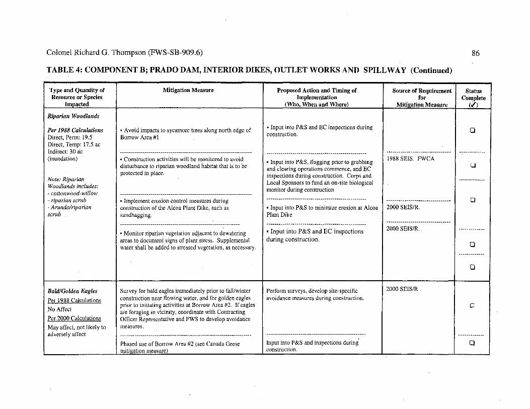
Colonel Richard G. Thompson (FWS-SB-909.6)
TABLE 4: COMPONENT B; PRADO DAM, INTERIOR DIKES, OUTLET WORKS AND SPILLWAY (Continued)
Type and Quantity of Resource or Species
lnyJacted
Riparian Woodlands
Per 1988 Calculations Direct, Perm: 19.5 Direct, Temp: 17.5 ac Indirect: 30 a:c (inundation)
Note: Riparian Woodlands includes: - cottonwood-willow - riparian scrub - Arundolriparian scrub
Bald/Golden Eagles
Per 1988 Calculations
No Affect
Per 2000 Calculations
May affect, not likely to adversely affect
Mitigation Measure
• A void impacts to sycamore trees along north edge of Borrow Area #I
• Construction activities will be monitored to avoid disturbance to riparian woodland habitat that is to be protected in place.
• Implement erosion control measures during construction of the Alcoa Plant Dike, such as sandbagging.
I
• Monitor riparian vegetation adjacent to dewatering areas to document signs of plant stress. Supplemental water shall be added to stressed vegetation, as necessary.
Survey for bald eagles immediately prior to fall/winter construction near flowing water, and for golden eagles prior to initiating activities at Borrow Area #2. If eagles are foraging in vicinity, coordinate with Contracting Officer Representative and FWS to develop avoidance measures.
Phased use of Borrow Area #2 (see Canada Geese mitigation measure)
Proposed Action and Timing of Implementation
(Who, When and Where)
• Input into P&S and EC inspections during construction.
• Input into P&S, flagging prior to grubbing and clearing operations commence, and EC inspections during construction. Corps and Local Sponsors to fund an on-site biological monitor during construction
• Input into P&S to minimize erosion at Alcoa Plant Dike
• Input into P&S and EC inspections during construction.
Perform surveys, develop site-specific avoidance measures during construction.
Input into P&S and inspections during' construction.
Source of ~equirement for
Mitigation Measure
1988 SEIS. FWCA
2000 SEIS/R.
2000 SEIS/R.
2000 SEIS/R
86
Status Complete
(¢")
0
0
0
0
0
0
0

~ fie) 0 0 0
~ () () ~ (}e 13
Colonel Richard G. Thompson (FWS-SB-909.6) 87
TABLE 4: COMPONENT B; PRADO DAM, INTERIOR DIKES, OUTLET WORKS AND SPILLWAY (Continued)
Type and Quantity of Mitigation Measure Proposed Action and Timing of Source of Requirement Status Resource or Species Implementation for Complete
Impacted (Who, When and Where) Mitil!;ation Measure (,/)
Least Bell's Vireo and Critical Habitat • Limit grubbing and clearing of riparian vegetation to • Input into P&S and EC inspections 1995 SEA 0
non-breeding season (16 August through 28 February) during construction.
Per 1988 Calculations ------------------------------------------------------------------- -------------------------------------------------- ----------------------------------- -------------
Direct, Perm: 19.5 • Between 16 August and 28 February, erect a noise • Input into P&S and EC inspections 2000 SEIS/R
Direct, Temp: 17.5 ac barrier along the access/haul road east and southeast of during construction. Include location of
Indirect: 30 ac the dam along the southwestern border of the basin to known vireo territories on construction 0 (inundation) shield nesting vireos from excessive noise (greater than drawings/plans.
60 decibels) during construction. -------------------------------------------------------------------- ------------------------------------------------- ----------------------------------- -------------• At Borrow Sites 1 and 2 construct dirt berms along the • Input into P&S and EC inspections 2000 SEIS/R. USFWS, perimeters that border the willow riparian forest to during construction. Include location of CDFG, State Parks, and minimize noise effects on vireos. known vireo territories on construction public concerns. ESA, 0
drawings/plans. FWCA,MBTA. -------------------------------------------------------------------- --------------------------------------------------• Set aside $450,000 for a monitoring program for the • Prior to construction, develop a scope ----------------------------------- -------------vireo and a management program for its pests of work, set up funding mechanism, and 2000 SEIS/R
monitor annual reports. 0
----------------------------------- -------------1988 SEIS
./

Colonel Richard G. Thompson (FWS-SB-909.6) 88
TABLE 4: COMPONENT B; PRADO DAM, INTERIOR DIKES, OUTLET WORKS AND SPILLWAY (Continued)
Type and Quantity of Mitigation Measure Proposed Action and Timing of Source of Status Resource or Species Implementation Requirement Complete
Impacted (Who, When and Where) for (.I) MitigatioAMeasure
Southwestern Willow • Limit grubbing and clearing of riparian vegetation to • Input into P&S and EC inspections during 2000 SEIS/R 0 Flycatcher and non-breeding season (16 August through 28 February) construction. '
Critical Habitat ----------------·--------------------------------------------------- -------------------------------------------------- -------------------------- -------------• Between 16 August and 28 February, erect a noise • Input into P&S and EC inspections during 2000 SEIS/R. USFWS,
Per 1988 Calculations barrier along the access/haul road east and southeast of construction. Include location of known CDFG, State Parks, and N/A the dam along the southwestern border of the basin to flycatcher territories on construction public concerns. ESA, 0
shield nesting flycatchers from excessive noise (greater drawings/plans. FWCA,MBTA. than 60 decibels) during construction. _____________________________________________________ .., ______________ -------------------------------------------------- ----------------------------- -------------• At Borrow Sites 1 and 2 construct dirt berms along the • Input into P&S and EC inspections during 2000 SEIS/R perimeters that border the willow riparian forest to construction. Include location of known 0 minimize noise effects on vireos. flycatcher territories on construction
I drawings/plans. ------------- I
Santa Ana Sucker • In areas where dewatering is to take place, • Input into P&S and EC inspections during 2000 SEIS/R. ESA groundwater shall be introduced into the river system construction.
Per 1988 Calculations dis of the construction area in such a way as to avoid 0 N/A turbidity, based on the conditions of the required
dewatering permit --------------------------------------------------Per 2000 Calculations ------------------------------------------------------------ • Input into P&S and EC inspections during -------------Temporary affect from • Control sedimentation by recontouring, sandbagging construction. dewatering during and use of other erosion control methods. -------------------------------------------------- 0 construction in vicinity --------------------------------------------·--------------- • Input into P&S and EC inspections during ·------------of dam and outlet • At water diversion locations, the areas shall be blocked construction. Fund an on-site permitted
channel. off and seined for fish. All captured fish shall be biologist to perform seining and relocation 0 relocated upstream of the diversion. activities.
-------------
-------------------------------------------------------------------- 0 --------------------------------------------------• Vegetation/streambed impacts have been mitigated as •Monetary contribution to trust fund concurrent described above (see Riparian Woodland column). with construction, and on-site weed abatement
for 5 years following construction. -----

@ ~~ ~
0 0 0
Colonel Richard G. Thompson (FWS-SB-909.6)
TABLE 4: COMPONENT C; REACH 9 IMPROVEMENTS
Type and Quantity Mitigation Measure of Resource or Species
Impacted
General Wildlife • Maintenance of approximately I, 100 acres of post-project 100-yr floodplain acquired in the canyon for
Per 1988 Calculations open space and wildlife habitat values. Agricultural Limited discussion. lands acquired in fee will not be leased back for Impacts would occur agriculture. (Mitigation is for all lower Santa Ana primarily in ruderal River project elements.) habitat.
Per 2000 Calculations Less than significant impacts to non-sensitive wildlife.
Riparian Woodland • Construction activities will be monitored to avoid disturbance to riparian woodland habitat that is to be
Per 1988 Calculations protected in place. See General Wildlife. A few scattered willows -----------------------------------------------------------------
would be affected • Monitor riparian vegetation adjacent to dewatering areas to document signs of plant stress. Supplemental water shall be added to stressed vegetation, as necessary.
----
• 0 a ® "e €3
89
Proposed Action and Timing of Source of Requirement Status I
I Implementation for Complete 1
(Wbo When and Where) MitigatiQn Measure (.I) :
• Prior to completion of construction, Phase I GDM, 1988 SEIS. provide input into O&M manual and FWCA ./ complete real estate purchase agreements.
I
-------------------------------------------------- ----------------------------------- -------------• Prepare Habitat Management Plan Phase 1 GDM, 1988 SEIS.
./
• Corps, Local Sponsors, USFWS, CDFG 2000 SEIS/R to develop joint MOU for Trust Fund
------------------------------------------------ 0 -----------------------------------• Input into P&S and EC inspections during construction. Fund an on-site 2000 SEIS/R
biological monitor during construction. --------------------------------------------------
-------------• Input into P&S and EC inspections during construction. 0
--------------
0
I

Colonel Richard G. Thompson (FWS-SB-909.6)
TABLE 4: COMPONENT C; REACH 9 IMPROVEMENTS (Continued)
Type and Quantity of Resource or Species
Impacted
Bald/Golden Eagles
Per 1988 Calculations No Affect
Per 2000 Cruculations May Affect, not likely to adversely affect
Least Bell's Vireo and Critical Habitat
Per 1988 Calculations N/A
Note: area of impact is the same as for flycatcher.
Mitigation Measure
• Survey for bald eagles immediately prior to fall/winter construction near flowing water, and for golden eagles prior to initiating activities at Borrow Area #2. If eagles are foraging in vicinity, coordinate with Contracting Officer Representative and FWS to develop avoidance measures.
• Phased use of Borrow Area #2 (see Canada Geese mitigation measure)
• Perform protocol surveys for vireo and flycatcher during the spring and summer prior to construction.
• Limit grubbing and clearing of riparian vegetation to non-breeding season (16 August through 28 February)
• Conduct cowbird trapping for 2 years during project construction and 5 years following project completion. Trapping shall consist of 15 monitored traps during the period 15 March to 30 July.
• Between 16 August and 28 February, erect a noise barrier along the access/haul roads and construction zones that are within 1000 feet of known or suitable vireo habitat.
Proposed Action and Timing of Implementation
(Who, When and Where)
• Perform surveys, develop site-specific avoidance measures during construction.
• Input into P&S and inspections during construction.
• Prior to commencement of construction, develop and implement a monitoring (survey) program for vireo and flycatcher.
• Input into P&S and EC inspections during construction.
• Develop cowbird trapping program (scope of work) prior to commencement of construction. Fund and perform trapping during and following construction.
• Input into P&S and EC inspections during construction. Include location of known vireo territories on construction drawings/plans.
Source of Requirement M•. .fOr.M Itlgabon easure
2000 SEIS/R
2000 SEIS/R
2000 SEIS/R. ESA and MBTA.
2000 SEIS/R and MBTA
2000 SEIS/R and MBTA
2000 SEIS/R and MBTA
90
Status Complete
(.()
0
0
0
0
0
0

Q) a 8
g () () ()
• a (:) C)
Colonel Richard G. Thompson (FWS-SB-909.6)
TABLE 4: COMPONENT C; REACH 9 IMPROVEMENTS (Continued)
Type and Quantity of Resource or Species
Im_I!!lcted
Southwestern Willow Flycatcher and Critical Habitat
1988 Calculations NIA
Note: area of impact is the same for vireo
Mitigation Measure
• Perform protocol surveys for vireo and flycatcher during spring and summer prior to construction.
• Limit grubbing and clearing of riparian vegetation to non-breeding season (16 August through 28 February)
• Conduct cowbird trapping for a period of 2 year sduring project construction and 5 years following project completion. Trapping shall consist of 15 monitored traps during the period 15 March to 30 July.
• Between 16 August and 28 February, erect a noise barrier along the access/haul roads and construction zones that are within 1000 feet of known or suitable flycatcher habitat.
Proposed Action and Timing of Implementation
(Who, When and Where)
• Prior to commencement of construction, develop and implement a monitoring program that entails surveys for vireo and flycatcher.
• Input into P&S and EC inspections during construction.
Source of Requirement for
Mit!g_ation Measure
2000 SEIS/R. ESA and MBTA.
2000 SEIS/R
• Develop cowbird trapping program, I 2000 SEIS/R scope of work prior to commencement of construction. Fund and perform trapping during and following construction.
• Input into P&S and EC inspections I 2000 SEIS/R during construction. Include location of known flycatcher territories on construction drawings/plans.
C)
~
91
Status Complete
(.f)
0
0
0
0
®

Colonel Richard G. Thompson (FWS-SB-909.6) 92
TABLE 4: COMPONENT C; REACH 9 IMPROVEMENTS (Continued)
Type and Quantify Mitigation Measure Proposed Action and Timing of Source of Requirement Status of Resource or Species Implementation of Complete
Impacted (Who, When and Where) Miti2atiqn M:ea~1Jfj! (.f)
Santa Ana Sucker • In areas where dewatering is to take place, • Input into P&S and EC inspections 2000 SEIS/R. ESA groundwater shall be introduced into the river system during construction.
Per 1988 Calculations dis of the construction area in such a way as to avoid 0 NIA turbidity, based on the conditions of the required
dewatering permit Per 2000 Calculations ----------------------------------------------------------------- -------------------------------------------------- ----------------------------------- --------------approx. 7.2 river miles • Control sedimentation by recontouring, sandbagging • Input into P&S and EC inspections 2000 SEIS/R
and use of other erosion control methods. during construction. 0 ----------------------------------------------------------------- -------------------------------------------------- ----------------------------------- --------------• At water diversion locations, the areas shall be • Input into P&S and EC inspections 2000 SEIS/R blocked off and seined for fish. All captured fish shall during construction. be relocated upstream of the diversion. 0
----------------------------------------------------------------- -------------------------------------------------- ----------------------------------- --------------• For construction of Hwy. 91 bank stabilization and • Input into P&S and EC inspections 2000 SEIS/R Green River Housing Estates bank stabilization, during construction. Fund an on-site discharges from Prado Dam shall be reduced to the permitted biologist to perform seining 0 maximum extent practicable and a temporary low flow and relocation activities. channel will be cut to divert the flow past the area of construction.
------------------------------------------------- ----------------------------------- -------------------------------------------------------------------------------
• Vegetation/streambed impacts will be mitigated as • Input into P&S and EC inspections 2000 SEIS/R during construction.
described above (see Riparian Woodland column). 0

Colonel Richard G. Thompson (FWS-SB-909.6) 93
Table 5. Santa Ana Sucker Survey Results, Santa Ana River and Project Action Area.
REACH/YEAR
Reach 8: 1986/1987
Reach 8: 1991
Reach 8: 1995
Reach 8: 1996
Reach 8: 1998/1999
Reach 8: 2000
Prado Dam to Weir Canyon Road: 1996
Weir Canyon Road: 1996
RESULTS REFERENCE
Positive for suckers (numerous individuals near Robert Fisher, Imperial Highway). At this time, River was less pers. comm., channelized and supported more riparian 1999 vegetation.
2 (29 and 146 mm total length) at Imperial Chadwick and Highway Associates 1996
53 (mean total length 52 mm, total length range Chadwick and 32-190 mm) Associates 1996
1 (83 mm total length)
Negative for suckers at Imperial Highway
10 (mean total length)
5 (35.4 mm mean total length)
1 (196 mm total length)
Chadwick and Associates 1996
Mike Saiki, pers. comm .. , 2000
Baskin and Haglund 2001
Guisti, CADFG, 1996
Chadwick and Associates 1996
Reach 9, Gypsum 5 Swift 1998 Canyon Road: 1998
Northwest of Corona 16 Airport: 1998
300-400 m downstream 1 of River Road: 1998
Downstream of River Road Diversion: 1999
Downstream of River Road: 1999
3
1
Swift 1998
Swift 1998
Swift 1999
Swift, March 2000

Colonel Richard G. Thompson (FWS-SB-909.6) 94
Table 5. Santa Ana sucker survey results, Santa Ana River and project action area (continued).
Downstream of River 1 Swift Road: 2000 March, 2000
Below River Road 1 (within 30-40 mm) _ Swift Diversion: 2000 May,20oo-
500-700 m upstream of 1 Swift 1998 River Road: 1998
100 meters upstream of 1 Swift 1999 River Road Diversion: 1999
Upstream of River 3 Swift Road mining operation: May,2000 2000
Norco (SAR 8): 1991 3 (74 mm mean total length) Chadwick and Associates 1996
Norco Bluffs, Zone 4: 76 (total length range 20-70 mm) Swift 1997 1997
50-7 50 meters 4 Swift 1998 downstream of Hamner Avenue, Zone 3: 1998

• . . Colonel Richard G. Thompson (FWS-SB-909.6)
Table 6. Areal Extent of Vegetation to be Removed within Project Area*
95
Riparian Non Riparian Arundo Perennial Stream Soft Bottom Vegetation Vegetation** Unvegetated
Channel Perman en Temporal) Permanent Temporary Permanent Temporar) Perman en Temporal) Permanen Temporary Improvement Removal Removal Removal Removal Removal Removal Removal Impact Impact Impact Feature (ac) (a c) (ac) (ac)
(ac) (ac) (ac) (ac) (ac) (ac)
REACH 9 Upper Hwy 1.4 3.4 0.0 0.0 0.0 0.0 0.0 0.0 0.0 0.0 91 Bank Stabilization Green River 3.7 7.7 0.7 1.1 0.0 0.0 0.7 1.1 0.0 0.0 Estate Bank Stabilization Green River 0.5 0.0 0.0 0.0 0.0 0.0 0.0 0.0 0.0 0.0 Mobile Home Park Levee Green River 1.2 0.0 0.2 1.1 0.0 0.0 0.0 0.6 0.2 0.5 Golf Course Low-Flow Channel Lower Hwy 1.4 4.2 1.2 1.1 0.1 0.2 1.0 0.9 0.1 0.0 91 Bank Stabilization Car 0.6 2.2 0.1 0.9 0.0 0.0 0.1 0.9 0.0 0.0 Wash/Strip Mall Bluff Stabilization
Totals 18.8 17.5 I 2.2 4.2 I 0.1 0.2 1.8 3.5 I 0.3 0.5
PRADO BASIN Outlet 11.9 -- 6.5 -- 0.0 -- 6.5 -- 0.0 --Works Auxiliary 0.6 -- 0.0 -- 0.0 -- 0.0 -- 0.0 --Dike and Floodwall Alcoa 1.5 -- 0.0 -- 0.0 -- 0.0 -- 0.0 --Aluminum Plant Dike Borrow Site 2.6 -- 0.0 -- 0.0 -- 0.0 -- 0.0 --1 Borrow Site 0.0 -- 0.0 -- 0.0 -- 0.0 -- 0.0 --2 Haul Roads 1.7 -- 0.0 -- 0.0 -- 0.0 -- 0.0 --
Totals 18.3 0.0 6.5 0.0 0.0 0.0 6.5 0.0 0.0 0.0

Colonel Richard G. Thompson (FWS-SB-909.6) 96
Table 6. Areal Extent of Vegetation to be Removed with Project Area (Continued)
Riparian Non Riparian Arundo Pere·nnial Stream Soft Bottom Vegetation Vegetation Unvegetated
Channel Perman en Temporary Permanent Temporary Permanent Temporary Permanen Temporal) Permanen Improvement Removal Impact Removal Impact Removal Impact Removal Impact Impact Feature (ac) (ac) (ac) (ac) (a c) (ac) (ac) (ac) (a c)
NORCO BLUFFS** Zone 3 2.2 2.0 3.6 6.4 2.9 5.7 0.7 0.7 0.0 Zone4 0.5 0.8 4.7 5.1 2.7 4.1 0.0 0.0 2.0 Zone 5 0.3 1.0 6.9 5.4 5.8 5.4 0.0 0.0 1.1 Temporary 0.0 0.7 0.0 0.4 0.0 0.4 0.0 0.0 0.0 Access Road Zone 5 Stablization to Staging Area Permanent 0.0 0.0 0.0 0.0 0.0 0.0 0.0 0.0 0.0 Access Road from Side Canyon at Zones 4 and 5 Interface Zone 3/4 0.1 0.0 0.0 0.0 0.0 0.0 0.0 0.0 0.0 Interface Side Drainaoe Zone 4 Side 0.1 0.0 0.0 0.0 0.0 0.0 0.0 0.0 0.0 Drainage Zone 4/5 0.3 0.0 0.0 0.0 0.0 0.0 0.0 0.0 0.0 Interface Side Drainaoe Zone 5 Side 0.0 0.0 0.0 0.0 0.0 0.0 0.0 0.0 0.0 Drainage
Totals 3.4 4.5 15.3 17.3 11.4 15.6 0.7 0.7 3.1
* Data in table derived from Corps of Engineers, in /itt., October 10, 200.
** Non Riparian Vegetation includes the following categories only: Arundo, Perennial Stream, and Soft Bottom
Unvegetated.
Temporary Impact
(ac)
0.0 1.0 0.0 0.0
0.0
0.0
0.0
0.0
0.0
1.0
***Norco Bluffs data originate from the SEIS (Corps 2000) Tables 4-3 and 4-4 on pages 4-13 and 4-14. The "Willow Riparian," "Riparian Scrub," and "Cottonwood-Willow Riparian" categories from those tables have been combined in this table. In addition, this table does not contain data from the "Annual Grassland" and "Eucalyptus" categories as identified in the SEIS.
'


® "::! !-"•
(JQ
~ I'D
'""' n 0
1) 1:1 rt . .
0
• . .
l '!;
\
\
a
H
,. / ,.
/
r----~~---___11 ,.·-
/

' ' ·.._cq,":>-·,,. %~'%.
~'~+ ... a.~,""<t> ·,
' ·,,
~'-· ..... ·---- ...... ~-·-\
\
\
\
Figure 1
I --·--·-
\ ORANG~ COUNtY f~OOO CONtRO~ OIStRIC
PROP~RfY OWN~RSHIP WitHIN
6ANfA ANA RIV~R CANYON HAelfAf MANAb~M~Nf AR~A SANfA ANA RIV~R MAINSf~M PROJ~Gf/R~AGH 9
NO SCAt..~ 1997 fi&UR~ 2.

United States Department of the Interior FISH AND WILDLIFE SERVICE
In Reply Refer To: FWS-SB/WRIV /OR-08B0408-II F0551
Colonel R. Mark Toy District Commander
Ecological Services Carlsbad Fish and Wildlife Office
6010 Hidden Valley Road, Suite 101 Carlsbad, California 920 II
U.S. Army Corps of Engineers, Los Angeles District P.O. Box 532711 Los Angeles, California 90053-2325
MAR 2 8 2012
Attention: Josephine Axt, Ph.D. (Chief) and Hayley Lovan (Project Environmental Coordinator), Planning Division
Subject: Reinitation of Formal Section 7 Consultation on the Prado Mainstem and Santa Ana River Reach 9 Flood Control Projects and Norco Bluffs Stabilization Project, Orange, Riverside, and San Bernardino Counties, California (FWS-SB-909.6)
Dear Colonel Toy:
This letter is in response to your August 19, 2011, letter regarding proposed changes to the "mitigation approach" for the Santa Ana River Mainstem Flood Control Project (SARP). Our biological opinion dated December 5, 2001, addressed the effects of the SARP on the federally threatened Santa Ana sucker (Catostomus santaanae), endangered least Bell's vireo (Vireo bellii pusillus, "vireo") and its designated critical habitat, and endangered southwestern willow flycatcher (Empidonax traillii extimus, "flycatcher"), in accordance with section 7 of the Endangered Species Act of 1973 (Act), as amended (16 U.S.C. 1531 et seq.). During the consultation period, we requested additional information and clarification regarding implementation of the SARP. On February 9, 2012, we received the final information necessary to prepare a response to your request. This amendment modifies the original biological opinion to address the requested changes to the project.
Santa Ana River Mainstem Project Consultation History and Current Status
We issued the first biological opinion for the SARP and its effects on federally listed species on October 1, 1980 (1-1-80-F-75). Consultation has since been reinitiated five times to address modifications to the project and/or effects to listed species or critical habitat not previously considered [i.e., U.S. Fish and Wildlife Service (Service) 1989,2000,2001,2003, 2004]. Your agency has completed the following SARP components to date: Seven Oaks Dam, Mill Creek Levees, Oak Street Drain, San Timoteo Creek Flood Control Project, Reaches 1-8 and 10 ofthe Lower Santa Ana River Channel, the raising of Prado Dam, Prado Dam Outlet Channel, Green River Mobile Home Park Levee, Lower Highway 91 Embankment, Car Wash/Strip Mall Bluff

Colonel R. Mark Toy (FWS-SB/WRIV /OR-08B0408-11F0551)
Stabilization, National Housing Tract Dike, and the Corona Sewage Treatment Plant Dike. The Reach 9 Phase 2A Embankment Project (including the Upper Highway 91 Embankment and Green River Housing Estate Embankment), Green River Golf Club Embankment, and Auxiliary Dike projects are currently under construction. Remaining project components that were addressed in the 2001 biological opinion include Norco Bluffs Toe Stabilization, Prado Petroleum Tank Farm Levee, Alcoa Aluminum Plant Dike, River Road Floodwall, River Road Dike, California Institute for Women Dike, and Yorba Slaughter Adobe Protection.
Changes in the Conservation Measures
2
The SARP, as described in the 2001 biological opinion, included conservation measures to offset impacts to riparian vegetation for the vireo and perennial stream for Santa Ana sucker. One option to offset impacts to riparian vegetation was to contribute funding to the Trust Fund established by the Santa Ana Watershed Association of Resource Conservation Districts (SAW A) to remove giant reed (Arundo donax) from the Santa Ana River watershed and to actively monitor and manage restored habitat for the life of the project. Beginning in 2006, your agency, the U.S. Army Corps of Engineers (Corps), issued contracts to implement the conservation measures pertaining to habitat restoration in a manner that was inconsistent with the 2001 biological opinion. Laws and regulations governing Corps contracts prohibited the release of funding for monitoring and management to be conducted over the life of the project, as originally intended (Lovan 2011, pers. comm.). In addition, a significant portion of the anticipated funding for giant reed removal did not go to the Trust Fund.
Although the Corps informally coordinated with the Service regarding proposed changes in the distribution of funding beginning in 2005, we remained concerned with the apparent lack of a mechanism for ensuring habitat would continue to be maintained after funds were expended. This document identifies and analyzes changes made by the Corps with respect to implementation of specific conservation measures addressing giant reed removal options and other measures that offset impacts to vireo and additional changes in the project's conservation measures that minimize or offset impacts to the Santa Ana sucker.
Changes in the conservation measures addressed by this amendment to the 2001 biological opinion are identified below with deletions in strikeout and additions underlined. To facilitate future reference and implementation of all conservation measures addressed by the 2001 biological opinion and its amendments, Attachment 1 presents a complete description of the conservation measures, including the changes incorporated below.
Colonel R. Mark Toy (FWS-SB/WRIV/OR-08B0408-11F0551)
Specific Conservation Measures Revised by this Reinitiation and Amendment to the 2001 Biological Opinion.
Temporary Disturbance of Riparian/Wetland Habitat (excluding unvegetated perennial stream) (page 12 of the 2001 biological opinion)
• Contribute sufficient funds to the Trust Fund to rRemove one acre of giant reed from the upper Santa Ana River watershed and/or action area for each acre of riparian/wetland vegetation that is temporarily disturbed during construction-related activities; actively monitor and manage this acreage for a period of 1 year; and then arrange for the local sponsors (i.e., the County of Orange, County of Riverside, and County of San Bernardino) and/or another approved entity such as the SAW A to until riparian habitat is completely restored; and maintain this acreage giant reed41'htntio free for the life of the project; OR
• Remove three acres of giant reed for each acre of temporary impact and maintain this acreage giant reed-free for a minimum of 5 years.
Permanent Loss of Non-riparian Habitat Within the Flood Plain (page 13 of the 2001 biological opinion)
3
• Contribute sufficient funds to the Trust Fund to rRemove 3 acres of giant reed from the upper Santa Ana River watershed and/or action area for each acre of non-riparian habitat that is permanently destroyed or isolated from the flood plain during construction-related activities; actively monitor and manage this acreage for a period of 5 years; and then arrange for the local sponsors and/or another approved entity such as the SAW A to maintain this acreage giant reed41'htntio free for the life of the project; and conduct cowbird removal trapping in the vicinity of the restored habitat for the life of the project.
Permanent Loss of Riparian Habitat (page 13 of the 2001 biological opinion)
• Contribute sufficient funds to the Trust Fund to rRemove 5 acres of giant reed from the upper Santa Ana River watershed and/or action area for each acre of riparian vegetation that is permanently destroyed or isolated from the flood plain during construction-related activities; actively monitor and manage this acreage for a period of 5 years; and then arrange for the local sponsors and/or another approved entity such as the SAW A to maintain this acreage giant reed-free for the life of the project; and conduct cowbird removal trapping in the vicinity of the restored habitat for the life of the project.
General Habitat Creation/Restoration Measures, Mitigation Option for Permanent Impacts (page 14 of the 2001 biological opinion)
• Creation and restoration of riparian habitat will be considered successful when the following target/threshold objectives are met: 1) a minimum of 30 percent absolute ground

Colonel R. Mark Toy (FWS-SB/WRIV/OR-08B0408-11F0551) 4
cover of native plant species; 2) less than 10 percent absolute ground cover of exotic plant species (including 0 percent giant reed); 3) the absolute ground cover of native species must l:>e represented by, at least, five dominant or co-dominant plant species; 4) the recruitment of native plant seedlings must be documented to occur within the replanted areas; 5) a positive trend in the diversity and absolute ground cover of native plant species must be observed based on appropriate statistical analyses that account for natural, year to year variations; and 6) the structure and composition of the revegetated area is statistically similar (i.e., not significantly different) to habitat occupied by vireos in the vicinity. Alternatively, riparian revegetation efforts can be considered successful if the habitat is occupied by a breeding pair of vireos, flycatchers, and/or yellow-breasted chats (Jete ria virens). In addition, habitat must sustain itself for 2 consecutive years without supplemental water.
• All acres of created or restored riparian habitat will be protected in perpetuity through proper legal instruments for the conservation of Federal and State listed species and their habitats.
• Prior to the creation of habitat for the vireo, sufficient funds v;ill be contributed to the OC'ND, Trust Fund, or other organization approved by the CDFG and our agency tolf the habitat creation option is selected, the Corps will ensure that the local sponsors commit to funding a conduct cowbird removal trapping program in the vicinity of the created riparian habitat for the life of the project. Program specifics (e.g., number and locations of traps) will be determined in conjunction with permitting processes for the CDFG and our agency.
• If funding is available, then your agency will make a lump sum payment to the Trust Fund prior to the initiation of project related activities that disturb habitat for federally listed species. Alternately,Mitigation will be initiated as soon as practicable for impacts that occur during the first year of construction, funds vlill be contributed to the Trust Fund within one year of the initiation of construction activities. Afterwards, mitigation will be initiated contributions to the Trust Fund v;ill occur prior to construction of individual project features. If for ·.vhatever reason the Trust Fund becomes insolvent at a future date and is unable to For restoration options that include management for the life of the project, the Corps will continue exotic species removal (e.g., giant reed) and cowbird controlsj until such time as the Service receives written documentation that the local sponsors and/or another approved entity (such as SAWA) have accepted responsibility for management of the restored area(s). Written documentation will include an estimate of costs associated with management responsibilities and a description of the funding mechanism(s) that will be used to ensure management will continue for the life of the project. If SAW A or another non-public entity accepts management responsibility and then becomes unwilling or unable to continue, then responsibility for continued management will revert to the local sponsors.and monitoring and management activities in the upper Santa Ana River watershed and/or action area, then your agency will transfer remaining funding and/or resources to another administratorkontractor or otherwise ensure that the proposed

Colonel R. Mark Toy (FWS-SB/WRIV/OR-08B0408-11F0551) 5
consePration measures are continued for the life of the project. Any advance mitigation that exceeds the requirements of the project (i.e., if actual project impacts are less than what was anticipated when the mitigation was initiated), funds contributed above and beyond the amounts prescribed herein may be credited as compensation for the effects of future projects.
• Ensure that the administrator of the Trust Fund identifies Identify and delineates on welllabeled maps the specific areas in the upper Santa Ana River watershed and/or action area from which giant reed will be or has been removed, and riparian vegetation restored, as compensation using funding contributed by your agency for the proposed action. These areas must be approved by the local sponsors, CDFG, and our agencies. An annual report will be prepared for the Service by the approved management entity (e.g., SAWA) required that addresses the following information: 1) accomplishments during the previous year; 2) what is anticipated to be accomplished during the upcoming year; 3) results of monitoring and management; and 4) updated mapping that delineates areas in the upper Santa Ana River watershed and/or action area from which giant reed has been removed; and 5) an itemi1>ed financial accounting/report.
• Request that the administrator of the Trust Fund identify those acres within the £an Timoteo Creek systemSanta Ana Watershed where within vrhich giant reed was previously removed and/or habitat restored using the $1,000,000 contributed by the OCWD in lieu of restoring 133 acres of riparian habitat in the Prado Basin. This acreage mu-stwill be actively monitored and managed until riparian habitat is completely restored, and then maintained giant reed-free for the life of the project.
Maintenance and Management of Riparian Habitat Downstream of Prado Dam (page 15 of the 2001 biological opinion)
• Prior to initiating construction-related activities downstream of Prado Dam, provide written documentation that 1 .~ 100 acres of land, including 789 acres of land within the flood plain along the Santa Ana River as depicted in Figure 1, have been obtained in fee title and protected via conservation easement, deed restriction, or other protection mechanism to pro:vide for the conservation of the vireo and other Federal and State listed speciesisare held in public domain as property of Orange County, California State Parks, or other public entities "for floodplain management in keeping with open space and wildlife habitat values" (Corps 1988, page SEIS-V -66). The County of Orange will provide additional information concerning the status of the Habitat Management Plan area and a map of the area delineating vegetation types, acreages, and land use activities (including potential recreational uses and areas where the conservation of listed species and their habitats will be the primary land use).

Colonel R. Mark Toy (FWS-SB/WRIV/OR-08B0408-11F0551) 6
Specific Conservation Measures for the Sucker: (page 18 of the 2001 biological opinion)
• Implement a "trap and hat:Il" program to periodically trap suckers from eKisting pools downstream of eKisting drop structures (i.e., impediments or barriers to upstream movement) and transport and release the fish in favorable habitat upstream (e.g., upstream of the Prado Dam reservoir). Your agency has agreed to meet with the CDFG, our agency, and other eKperts on the species to design an efficient, cost effective program. Non native predators of the sucker that are caught during trapping bouts will be destroyed rather than released. This conservation measure is intended to provide "out of kind" compensation for the destruction of 1,850 feet of unvegetated perennial streambed habitat (i.e., current outlet structure) for the sucker. The "trap and haul" program that was included in the 2001 Biological Opinion shall be discontinued and replaced with an additional three acres of stream restoration as described below, for a total of 10.9 acres of created/enhanced streambed.
• Create and/or enhance one acre of perennial stream habitat within the Santa Ana River or its tributaries for each acre of unvegetated perennial stream that is temporarily or permanently disturbed during construction-related activities,_ fThe estimated total of disturbed habitat is approximately H-:2.7 .9 acres f9-:0( 4.4 acres of permanent effects and 4;.2;3.5 acres of temporary effects}, not including the previously concreted portion of the Green River Golf Course channel1
). A conceptual habitat creation plan will be reviewed and approved by our agencythe Service prior to initiating construction activities that will affect perennial stream habitat for the sucker. Creation/enhancement activities could include but are not limited to the following:
• The development of pool-riffle complexes by placing clusters of various sized boulders within the river channel to provide limited cover and areas of reduced water velocity.
• The creation of potential spawning/larval habitat downstream of Prado Dam. For example, San Marino Environmental Associates identified Aliso Creek, which is a tributary downstream of Prado Dam within Chino Hills State Park, as a possible restoration site for sucker spawning habitat in their Conservation Program for the Santa Sucker in the Santa Ana River, Southern California, December 1999.
• The creation of lateral stream habitats (i.e., very shallow areas along the stream margin with little current) that are apparentlybelieved to be essential for the survival of larval suckers.
1 At the time the 2001 biological opinion was issued, a 4. 7 -acre section of perennial stream habitat within the Green River Golf Club Embankment Project area was lined with concrete, and it was assumed the concrete channel would remain in that area. Although the concrete washed out during the winter storm season in early 2005, the Corps is not proposing to offset impacts to this section of stream. In the Corps' view, the replacement of this section with permanent soft-bottom channel (in lieu of repairing the broken concrete to the previous designed condition) is selfmitigating.

Colonel R. Mark Toy (FWS-SB/WRIV/OR-08B0408-11F0551) 7
Effects of Proposed Changes in Conservation Measures on the Vireo
An estimated 59.2 acres of riparian vegetation were temporarily or permanently impacted and 6.2 acres of upland vegetation were permanently impacted from construction of SARP components that were addressed in the 2001 biological opinion (Table 1). Refinements to the design of individual project components and updated vegetation mapping have resulted in a 20.4-acre increase in impacts to riparian vegetation relative to what was anticipated in Table 6 of the 2001 biological opinion. Compensation for impacts based on the original conservation measures would have resulted in the removal of 133 acres of giant reed. The area containing the 133 acres would then be actively monitored and maintained (including cowbird trapping and giant reed control) for the life of the project at an estimated cost of approximately $50,000 per acre or a total of about $6,650,000. The $6,650,000 was to be deposited in the Trust Fund and managed by SAW A to generate interest adequate to cover monitoring and management costs.
Funding provided by the Corps in accordance with applicable contracting laws and regulations allowed for treatment of a much larger area within the watershed than originally anticipated, but no additional funds remain to maintain these areas beyond the contract period. A total of $1,959,000 was provided to SAWA for giant reed removal and control in Mystic Lake (San J acini to Wash) and several areas along the main channel of the Santa Ana River ("mainstem") between La Cadena A venue and Hamner A venue. The Corps also contracted with Agri Chemical and Supply, Inc. to remove approximately 131 acres of giant reed from a 250-acre area between Hamner A venue and River Road and to maintain and monitor this area for a 5-year period. In total, funding provided by the Corps supported the removal of 154.4 acres of giant reed from areas that had not been previously treated, the maintenance of 1,341 acres of previously treated areas for 1 year, and the maintenance of 250 acres for 5 years (Table 1). Additional funding, equivalent to the costs of operating 15 cowbird traps per year for 7 years, was provided by the Corps to offset temporary impacts to riparian vegetation in Reach 9.
Monitoring conducted in the watershed by SAW A demonstrates that giant reed removal is contributing to an increase in functional riparian habitat for the vireo (SAWA 2010) and that cowbird trapping is contributing to an increase in vireo productivity by keeping nest parasitism levels low (Hoffman and Zembel2011); however, on-going management is necessary to ensure the quality of habitat for the vireo is maintained over the long term. Cowbird parasitism is a continuing threat where riparian habitats are located adjacent to urban areas, dairies, livestock operations, and/or agricultural fields. Trapping efforts in the watershed are coordinated by SAW A to ensure appropriate trap placement (i.e., concentrated in areas with high densities of cowbirds). SAWA has removed over 90,000 cowbirds from the watershed since 2000, and only 3 percent of observed nests failed due to parasitism in 2010 (Hoffman and Zembel2011).

Colonel R. Mark Toy (FWS-SB/WRN/OR-08B0408-11F0551) 8
Table I. Impacts to riparian and non-riparian (i.e., upland) vegetation associated with construction of SARP project features that resulted in giant reed l/maintenance (* - impacts not mitigated with giant reed removal)
Riparian Vegetation Project Feature Impacts
(acres) Permanent Temporary
Car Wash Strip Mall 1 0.4 6.7 Lower Highway 91 2 0.8 8.2 Prado Outlet' 0 5.6 Sewage Treatment Plant and National Housing 0.6 2.2 Tract Dikes3
Mobile Home Park4 0.3 0.7
Green River Golf Club 0.0
(Reach 9 Phase 2B)5 9.4
Upper Highway 91, Green River Housing Estates 10.2 12.6 (Reach 9 Phase 2A)4
Auxiliary Dike4 l.5 *
Total 13.8 45.4
Anticipated Giant Reed Removal using conservation measures 5:1 = 69.0 1:1 = 45.4 from 2001 biological opinion
1 Actual impacts based on Apsen Environmental Group (20 1 Oa, b). 2 Actual impacts based on Apsen Environmental Group (2010a).
Non-Riparian Floodplain
Impacts (acres) Permanent
0.2 0.0
*
*
l.O
0.0
5.0
*
6.2
3:1 = 18.6
Contribution to Giant Reed Removal and Maintenance SAWA
1 year of maintenance of 1 ,217 acres within the Santa Ana River Watershed (previously treated areas)
$1,434,500 including Norco Burn site (485 acres), mainstem between La Cadena and Mission Avenues (500 acres), and Mystic Lake Phase 3 (232 acres)
23.4 acres of giant reed removed and 124 acres $525,000 maintained for 1 year within Hidden Valley Wildlife
Area
Contract to Agri 131 acres of giant reed removed and 250 acres Chemical and
maintained for 5 years. Supply
$1,959,000 to SAW A plus 154.4 acres of giant reed removed, 1,341 acres contract to Agri maintained for 1 year, 250 acres maintained for 5 Chemical and years. Supply
133.0 acres at $50,000 per 133.0 acres restored and maintained giant reed-free acre= in perpetuity $6,650,000
3 Actual impacts based on Apsen Environmental Group (20 11 ). Includes only impacts beyond what was anticipated in Corps ( 1988). 4 Estimated impacts based on Jones (20 ll, pers. comrn.). Auxiliary Dike includes only impacts beyond what was anticipated in Corps (1988). 5 Estimated impacts based on Jones (2012a, pers. comrn.).

Colonel R. Mark Toy (FWS-SB/WRIV/OR-08B0408-11F0551) 9
Giant reed is difficult to completely eradicate, and the potential for re-infestation from upstream sources is high. For example, the number of vireo territories located in the mainstem between Goose Creek Golf Club (upstream from Interstate 15) and River Road increased from 28 in 2004 to 101 in 2010, following the removal of giant reed in 2003 (i.e., 485-acre Norco Bum site) and subsequent re-colonization with native riparian vegetation (Hoffman and Zembel 2011 ). Funding provided by the Corps assisted in maintaining this area for 1 year, but a new $54,000 spray contract was issued for the Norco Bum site using alternative funding sources in 2011 to treat re-infestations of giant reed, tree of heaven (Ailanthus altissima), tree tobacco (Nicotiana glauca), and castor bean (Ricinus communis) that continue to wash in from untreated areas immediately upstream (Reeder 2011, pers. comm.). SAWA regularly works with private landowners to gain access for treatment and successfully gained access to remove invasive plants upstream from the Norco Bum site in 2011. Without substantial funding for on-going monitoring and management, we expect the quality of habitat for the vireo will rapidly decline in previously managed areas.
Proposed changes in the conservation measures implemented to offset project impacts on vireo include the transfer of responsibility for long-term management of habitat from the Corps to the local sponsors or another Service-approved entity (such as SAW A). To ensure management will continue for the life of the project, the Corps has agreed to provide written documentation that the proposed entity has accepted responsibility for management of the restored area(s) and a description of the funding mechanism(s) that will be used to cover management costs. Orange County Flood Control District is ultimately responsible for the costs of mitigation related to SARP construction at Prado Dam and Basin, and Reach 9 as described in Local Cooperative Agreement Among the Department of the Army, Orange County Flood Control District, San Bernardino County Flood Control District and Riverside County Flood Control and Water Conservation District for the Contruction of the Santa Ana River Mainstem, Including Santiago Creek, California Flood Control Project (Version 12/13/89).
At present, SAW A has agreed to accept responsibility for long-term management (including giant reed control and cowbird trapping), for as long as it has sufficient funding to do so. In response to a request from the Corps that SAW A manage the 250-acre area in Norco, SAW A provided a letter dated August 22, 2011, documenting their willingness to manage not only the 250-acre area, but all of the Corps' previous mitigation areas. Long-term management of the 250-acre area (from which 131 acres of giant reed was removed) is sufficient to offset all of the SARP-related impacts included in Table 1. Because Orange County Flood Control District is obligated to take responsibility for long-term management should SAW A request to be released from its management obligations in the future, we consider the proposed measures sufficient to ensure long-term management will continue for the life of the project.
Proposed changes in the conservation measures also include an alternative to reduce long-term management obligations associated with temporary impacts to riparian habitat. The proposed alternative increases the ratio for temporary impacts from 1: 1 to 3: 1 and decreases the maintenance period to 5 years. Because monitoring conducted by the Corps has demonstrated

Colonel R. Mark Toy (FWS-SB/WRIV/OR-08B0408-11F0551) 10
that vireos recolonized temporary impact areas less than 5 years following the completion of project impacts, 5 years of giant reed control will contribute to improving the overall quality of habitat for vireo in the watershed until vegetation within temporary impact areas is restored. For example, the Car Wash Strip Mall Embankment Project site was initially impacted in 2002/2003. Quantitative vegetation surveys documented 52 percent cover of native vegetation in 2008. Vireo began nesting on the site in 2007, and four pairs were observed in and adjacent to the site by 2008 (Aspen 2010c).
Effects of Proposed Changes in Conservation Measures on the Santa Ana Sucker
An estimated 12.6 acres of perennial stream have been impacted from construction of SARP components in Reach 9 (Table 2). Compensation for impacts based on the original conservation measures would have resulted in the creation and/or enhancement of 1 acre of stream habitat for each acre temporarily or permanently impacted for a total of 12.6 acres. Proposed changes in the conservation measures implemented to offset project impacts on Santa Ana suckers include: 1) restoring 3 acres of additional stream habitat in lieu of implementing a "trap and haul" program and 2) not offsetting impacts to a 4.7-acre section of stream channel within the Green River Golf Club Embankment project area that was concrete-lined prior to the 2005 winter storm season. Based on the proposed measures, the Corps would enhance/create 10.9 acres.
Table 2. Impacts and enhancement to perennial stream habitat (Corps 2012, Jones 2012a, pers. comm.). Perennial Stream Impacts (acres)
Project Feature Permanent Temporary Total
Car Wash/Strip Mall 0.0 1.1 1.1
Green River Golf Club 0.0 7.1 1 7.1
Outlet Works 4.4 0.0 4.4
Trap and Haul Program N/A N/A N/A
Total 4.4 8.2 12.6 1 Includes 4.7 acres of channel that was lined with cement prior to 2005.
Proposed Habitat Enhancement/Creation (acres)
1.1
2.4
4.4
3.0
10.9
Temporary impacts to habitat for construction of the Car Wash Strip Mall Embankment (1.1 acre) were offset by enhancing the site with a meandering channel construction and the placement of gravel, cobble, and boulders in the new channel. The site was monitored for approximately 1 year to evaluate restoration efforts. Monitoring demonstrated the newly created channel provided more diverse fish habitat than the original channel (SMEA 2005). Created habitat features were short-lived, however, as high velocity flows during winter storm events in 2005 straightened the channel and flushed the substrate downstream. The availability of habitat for the Santa Ana sucker in the Car Wash Strip Mall project reach has since been dictated by hydrological processes.

Colonel R. Mark Toy (FWS-SB/WRIV/OR-08B0408-11F0551) 11
The remaining 9.9 acres will be restored/created adjacent to the Green River Golf Club Embankment Project (Corps 2012). The proposed Reach 9, Phase 2B Perennial Stream Restoration Project will improve the channel condition by increasing the total aquatic habitat on the site by 2.8 acres and increasing the buffer of riparian/upland vegetation surrounding the creek by 6.5 acres. The Corps has estimated the 9 .3-acre increase in habitat will expand the potential stream meander width by an average of 136 feet (Jones 2012b, pers. comm.). The increase in channel width will reduce velocities through the restoration reach during high flow events relative to the baseline condition.
In addition, the restoration project includes several features to increase the habitat complexity for the Santa Ana sucker. Side drains will outlet into the habitat in a way that will allow access for Santa Ana suckers and will provide potential refugia during high flow events (Corps 2012). Boulders placed around the side drains will help to maintain meanders in the stream channel, and shallow gravel bars will be placed along the low flow channel to provide potential spawning and foraging habitat. Boulders will also be arranged in the channel to encourage the development of riffle/pool complexes along the length of the restoration area. The habitat features, particularly the substrates, are not all expected to remain on the site over the long term, and the length of time they will remain in place is dependent on the magnitude and timing of storm flows (Corps 2012). Therefore, the restoration project will provide a short-term benefit for the Santa Ana sucker but will not contribute to the long-term recovery of the species. To effect recovery, we anticipate changes in the operations and maintenance of Prado Dam and reservoir will be necessary to address hydrological conditions that are currently limiting the suitability of habitat below Prado Dam for Santa Ana sucker.
The intended purpose of the "trap and haul" program was to maintain genetic connectivity between populations of Santa Ana suckers above and below Prado Dam in lieu of providing a fish passageway through the dam. The design of the new outlet structure (i.e., baffles, cement lined channel, and drop structure) was anticipated to significantly increase the potential for injury or death of Santa Ana suckers moving downstream past Prado Dam (Service 2001). Santa Ana suckers were to be collected from areas downstream of existing barriers with no known spawning habitat (e.g., below Weir Canyon Road) and released into favorable habitat upstream (e.g., upstream of Prado Dam reservoir).
Given the extremely low numbers of Santa Ana suckers captured below Prado Dam since the species was listed, it is not certain that there is a viable breeding population supported in Reach 9. Despite numerous survey efforts below Prado Dam (e.g., Haglund and Baskin 2004; RCRCD 2005, 2010; Baskin and Haglund 2008; ECORP 2009), only six Santa Ana suckers have been captured since 2001, all in conjunction with monitoring for the SARP. Five Santa Ana suckers were collected in the old Prado Dam outlet channel, immediately upstream from the Reach 9, Phase 2A project area, and one was located in the Green River Golf Club Embankment Project area.

Colonel R. Mark Toy (FWS-SB/WRIV/OR-08B0408-11F0551)
While Prado Dam is limiting connectivity with the population upstream, there are several other important factors (e.g., altered hydrology, non-native fish, and water quality) that are reducing
12
the potential for Reach 9 to support Santa Ana sucker (Service 2011). Until habitat conditions for the Santa Ana sucker are improved to the point where a viable breeding population is established, there is little benefit to the species from implementing a "trap and haul" program. There are too few fish available to be captured. The creation/enhancement of an additional 3 acres of habitat will provide a greater benefit to the species at this time. Once a viable population is again established below the dam, then the question of maintaining connectively may need to be readdressed, potentially as part of a future consultation with the Corps on the operation of Prado Dam.
Conclusion
With the proposed changes in conservation measures, management of habitat for the vireo will continue for the life of the project as anticipated. We also anticipate that the proposed restoration achieved by the project will be equivalent to what was anticipated for the vireo and Santa Ana sucker. Therefore, the conclusions in our 2001 biological opinion that the proposed action is not likely to jeopardize the continued existence of the vireo or Santa Ana sucker remain valid. The proposed changes in conservation measures will not affect the anticipated level of take associated with the project, so the incidental take statement, reasonable and prudent measures, and terms and conditions remain unchanged.
Conservation Recommendations
Section 7(a)(l) of the Act directs Federal agencies to utilize their authorities to further the purposes of the Act by carrying out conservation programs for the benefit of endangered and threatened species. Conservation recommendations are discretionary agency activities to minimize or avoid adverse effects of a proposed action on listed species or critical habitat, to help implement recovery plans, or to develop information. These recommendations are intended to supplement those included in the 2001 biological opinion.
• Although 4.7 acres of perennial stream habitat within the Green River Golf Club Embankment Project area was concrete lined in early 2005, we disagree that this impact should be discounted. Winter storms broke apart the concrete in early 2005, and aquatic habitat was in the process of returning to a more natural condition when the habitat was impacted in the fall of 2009. Therefore, we recommend the Corps offsets impacts to 4.7 acres of stream habitat that resulted from construction of the project.
• Specific project features included in the proposed Reach 9, Phase 2B Perennial Stream Restoration Project are expected to increase the diversity of habitats within the reach; however, the longevity of these features will be dependent on hydrological processes of the river system. Because the hydrological processes play an overarching role in the availability of habitats for the Santa Ana sucker, understanding the processes necessary to

Colonel R. Mark Toy (FWS-SB/WRIV/OR-08B0408-11F0551) 13
maintain habitat diversity over time will play a crucial role in the recovery ofthe species. Until such time as these larger processes can be fully understood and addressed, we recommend the Corps continue to monitor and manage habitat within the Reach 9, Phase 2B Perennial Stream Restoration Project area to ensure quality habitat for the Santa Ana sucker is maintained.
Reinitiation Notice
This concludes formal consultation on the modified "mitigation approach" for the Santa Ana River Mainstem Flood Control Project as outlined in materials submitted to us. As provided in 50 CFR §402.16, reinitiation of formal consultation is required where discretionary Federal agency involvement or control over the action has been retained (or is authorized by law) and if (1) the amount or extent of incidental take is exceeded; (2) new information reveals effects of the agency action that may affect listed species or critical habitat in a manner or to an extent not considered in this opinion; and (3) the agency action is subsequently modified in a manner that causes an effect to the listed species or critical habitat not considered in this opinion; or ( 4) a new species is listed or critical habitat designated that may be affected by the action. In instances where the amount or extent of incidental take is exceeded, any operations causing such take must cease pending reinitiation.
Should you have any questions regarding this letter, please contact Christine Medak of my staff at (760) 431-9440, extension 298.
cc:
Sincerely,
Karen A. Goebel Assistant Field Supervisor
Kimberly Freeburn-Marquez, California Department ofFish and Game (Ontario)

Colonel R. Mark Toy (FWS-SB/WRIV /OR-08B0408-11F0551)
LITERATURE CITED
14
Aspen Environmental Group. 2010a. Project memorandum USACE Prado Basin and Santa Ana River Maintstem (Reach 9) Project, Prado Basin/Reach 9 Santa Ana River Annual Report for 2002. Prepared for U.S. Army Corps of Engineers, Los Angeles District. June 7.
Aspen Environmental Group. 2010b. Project memorandum USACE Prado Basin and Santa Ana River Maintstem (Reach 9) Project, Prado Basin Annual Report for 2003. Prepared for U.S. Army Corps of Engineers, Los Angeles District. July 27.
Aspen Environmental Group. 2010c. Project memorandum USACE Prado Basin and Santa Ana River Maintstem (Reach 9) Project, Prado Basin Annual Report for 2008. Prepared for U.S. Army Corps of Engineers, Los Angeles District.
Aspen Environmental Group. 2011. Project memorandum USACE Prado Basin and Santa Ana River Maintstem (Reach 9) Project, Recalculation of Acreage Impacts at the Prado Embankment and Dikes. Prepared for U.S. Army Corps of Engineers, Los Angeles District.
Baskin, J. N. and T. R. Haglund. 2008. Fish Protection Activities at Prado Dam, Corona, California. Prepared for U.S. Army Corps of Engineers, Los Angeles District.
Corps (U.S. Army Corps of Engineers). 1988. Santa Ana River Design Memorandum No.1 Phase IT GDM on the Santa Ana River Maintstem including Santiago Creek. Main Report & Supplemental Environmental Impact Statement, dated August 1988.
Corps (U.S. Army Corps of Engineers). 2012. Santa Ana River Main Stem Project Reach 9, Phase 2B Perennial Stream Restoration Project. Planning Division, Army Corps of Engineers, Los Angeles District, Los Angeles, California. January.
ECORP Consulting, Inc. 2009. 45-day survey report on pre-construction presence/absence surveys for the Santa Ana sucker (Catostomus santaanae) at three locations on the Santa Ana River.
Haglund, T. R. and Baskin, J. N. 2004. Santa Ana sucker protection during stream re-diversion in Reach 9 of the Santa Ana River. Prepared for U.S. Army Corps of Engineers, Los Angeles District. February 2004.
Hoffman, M.S. and D. Zembal. 2011. Status and management of the least Bell's vireo and southwestern willow flycatcher in the Santa Ana River Watershed, 2010, and summary data by site and watershed-wide, 2000-2010. Prepared by the Santa Ana Watershed Association for Orange County Water District and U.S. Fish and Wildlife Service.
Colonel R. Mark Toy (FWS-SB/WRIV/OR-08B0408-11F0551) 15
RCRCD (Riverside-Corona Resource Conservation District). 2005. Prado Dam channel improvement project native fish protection and relocation. Summary Report for first and second diversions, April 25-28 and May 3, 2005.
RCRCD (Riverside-Corona Resource Conservation District). 2010. Field report for native fish relocation for ACOE Reach 9 channel diversions.
SAWA (Santa Ana Watershed Association). 2010. Santa Ana Watershed Association 2010 Annual Report, Reach 3B Mitigation Project, San Timoteo Canyon.
Service (U;S. Fish and Wildlife Service). 1989. Biological opinion and conference on the Corps of Engineers Santa Ana River Project in San Bernardino, Riverside, and Orange Counties, California (#1-6-88-F-6). June 22, 1989.
Service (U.S. Fish and Wildlife Service). 2000. Amendment to formal section 7 consultation, Santa Ana Mainstem Project, Orange County, California (1-88-F-6-R1). On file, U.S. Fish and Wildlife Service Carlsbad Fish and Wildlife Office, Carlsbad, California.
Service (U.S. Fish and Wildlife Service). 2001. Biological opinion on the Prado Mainstem and Santa Ana River Reach 9 Flood Control Projects and Norco Bluffs Stabilization Project, Orange, Riverside, and San Bernardino Counties, California. On file, U.S. Fish and Wildlife Service Carlsbad Fish and Wildlife Office, Carlsbad, California.
Service (U.S. Fish and Wildlife Service). 2003. Biological opinion on the Car Wash Strip Mall Project feature, Santa Ana River Mainstem Flood Control and Norco Bluffs Toe Stabilization Projects, Orange, Riverside, and San Bernardino Counties, California. On file, U.S. Fish and Wildlife Service Carlsbad Fish and Wildlife Office, Carlsbad, California.
Service (U.S. Fish and Wildlife Service). 2004. Reinitiation of formal section 7 consultation for the Prado Mainstem and Santa Ana River Reach 9 Flood Control Projects and Norco Bluffs Stabilization Project, Orange, Riverside, and San Bernardino Counties, California (FWS-SB-909.6). On file, U.S. Fish and Wildlife Service Carlsbad Fish and Wildlife Office, Carlsbad, California.
Service (U.S. Fish and Wildlife Service). 2011. Santa Ana sucker (Catostomus santaanae) 5-y ear Review: Summary and Evaluation. Carlsbad Fish and Wildlife Office, Carlsbad, California.
SMEA (San Marino Environmental Associates). 2005 Monitoring of the Santa Ana River Reach 9 Diversion: April-December 2004. Prepared for the U.S. Army Corps of Engineers, Los Ang~les District, Los Angeles, California.

Colonel R. Mark Toy (FWS-SB/WRIV/OR-08B0408-11F0551)
Personal Communication
Jones, C. 2011. Corps, electronic message to C. Medak, Carlsbad Fish and Wildlife Office, November 30, 2011.
Jones, C. 2012a. Corps, electronic message to C. Medak, Carlsbad Fish and Wildlife Office, February 9, 2012.
Jones, C. 2012b. Corps, electronic message to C. Medak, Carlsbad Fish and Wildlife Office, February 16, 2012.
Lovan, H. 2011. Corps, electronic message to C. Medak, Carlsbad Fish and Wildlife Office, August 29, 2011.
16
Reeder, L. 2011. Executive Director, Santa Ana Watershed Association, SAWA Mainstem Restoration Efforts 2010-2011, provided in an electronic message to C. Medak, Carlsbad Fish and Wildlife Office, November 23, 2011.

Colonel R. Mark Toy (FWS-SB/WRN/OR-08B0408-11F0551) 17
Attachment 1
Conservation Measures2
As part of the project description for the original biological opinion (#1-6-88-F-6; June 22, 1989) regarding the Mainstem project, your agency agreed to restore 133 acres of riparian forest to compensate for impacts resulting to the vireo from the construction of haul roads and berm placements and the periodic loss and disruption of a total of 133 acres of habitat between 490 and 500 feet elevation due to inundation (1989). Also, the County of Orange provided $450,000 to fund a vireo monitoring and management program in the Prado Basin and environs (Letter dated May 20, 1992, from Elayne Rail of the County Orange, Environmental Management Agency, to the Corps).
This initial commitment to restore 133 acres of riparian habitat was apparently later superseded by a 1994 Cooperative Agreement between and among the OCWD, the Department of Interior, and your agency (Corps 2001a, c). In 1994, the OCWD and your agency proposed to implement seasonal water conservation to an elevation of 505 feet within the Prado Basin (as indicated in the project description of biological opinion #1-6-95-F-28) that would adversely affect many of the same acres of riparian habitat for the vireo that were evaluated in the 1989 biological opinion regarding the Mainstem project. Because the water conservation activities were implemented prior to the Prado Basin portion of the Mainstem Project, and the estimated cost of restoration of 133 acres of upland habitat within the Prado Basin to riparian vegetation was higher than anticipated, the OCWD agreed to contribute $1,000,000 to the Santa Ana Watershed Association of Resource Conservation Districts (Trust Fund) in lieu of restoring the previously mentioned 133 acres. The monetary contribution was to be used for the removal of exotic species along the Santa Ana River and its tributaries, and the restoration of riparian habitat for the vireo and other species.
The 1988 SEIS required that 1,100 acres of post-project flood plain in the Santa Ana River canyon be acquired or kept in public ownership and managed for open space and wildlife habitat values (County of Orange 2001). The acquisition and management of these lands was intended to offset adverse impacts to wildlife to a level of non-significance, and was to be implemented prior to the completion of construction. Since the circulation of the SEIS, Orange County has begun to acquire lands within the post-project, 100-year flood plain from Prado Dam to Weir Canyon Road bridge for flood plain management. Approximately 789 acres of land within the floodplain have been obtained in fee title. These lands total approximately 1,100 acres and will be operated and maintained for open space and wildlife habitat in accordance with the Santa Ana River Canyon Habitat Management Plan (County of Orange 2000). This plan was developed by your agency and the Orange County Flood Control District in consultation with numerous public resource agencies including the Service and CDFG, citizens, and public interest groups at the Federal, State and local levels. The Local Sponsors are responsible for implementing management commitments for the habitat resources and flood plain within their respective
2 Refer to 2001 biological opinion for literature cited in the Conservation Measures

Colonel R. Mark Toy (FWS-SB/WRIV/OR-08B0408-11F0551) 18
jurisdictions. Though an estimated 1,233 acres of the Santa Ana River Canyon are currently held in public domain, including 789 acres of floodway and 444 acres of non-floodway property, a golf course in the floodway has not yet been purchased (Corps 2001c).
The primary management commitment of the Santa Ana River Canyon Habitat Management Plan is the retention of existing habitat as permanent open space. The local sponsors are responsible for implementing management commitments for the habitat resources and flood plain within their respective jurisdictions. The Santa Ana River Canyon Habitat Management Plan (County of Orange 2000; Volumes I, IT, and Ill) provides a detailed list of commitments, reference maps, and supporting documentation, including biological surveys.
Per commitments made in the EIS for the 1980 Phase I GDM and the 1988 EIS for the Phase IT GDM, the objectives of commitments related to flood control and water resources within the Habitat Management Plan area are to maintain and protect existing facilities and not change or modify the natural streambed and flood plain (Corps 2001a). In addition, the Habitat Management Plan area will be allowed to revegetate through natural processes following storm events, and flow rates and water quality will be monitored (Corps 2001a).
As part of the proposed project-related activities, your agency and/or your agents and sponsors have agreed to implement the following measures to avoid or minimize effects to the vireo and its designated critical habitat, flycatcher, sucker, and yellow-billed cuckoo, which is a State-listed species and a Federal candidate species (Agency Agreement 2001; BA; Corps 2001a, b, c). Acreages of disturbance and compensation were estimated based on the best available project designs. If less acreage is actually disturbed, then compensation will be commensurably reduced (Agency Agreement 2001):
Temporary Disturbance of Riparian!W etland Habitat (excluding unvegetated perennial stream)
• Successfully restore each acre of riparian vegetation that is temporarily disturbed during construction-related activities. Keep all temporarily disturbed areas free of exotic plants until riparian vegetation is re-established. If the site(s) have not begun to recover within 5 years (i.e., 50 percent of the disturbed areas are not vegetated with young riparian vegetation), then the site(s) will be replanted with cuttings from native riparian species.
• Non-riparian areas that are temporarily disturbed will be maintained free of exotic plants for 8 years.
• Remove 1 acre of giant reed from the upper Santa Ana River watershed and/or action area for each acre of riparian/wetland vegetation that is temporarily disturbed during construction-related activities; actively monitor and manage this acreage for a period of 1 year; and then arrange for the local sponsors (i.e., the County of Orange, County of Riverside, and County of San Bernardino) and/or another approved entity such as the SAW A to maintain this acreage giant reed-free for the life of the project;
Colonel R. Mark Toy (FWS-SB/WRIV/OR-08B0408-11F0551)
OR
Remove 3 acres of giant reed for each acre of temporary impact and maintain this acreage giant reed-free for a minimum of 5 years.
19
• Conduct brown-headed cowbird (Molothrus ater, "cowbird") removal trapping at a minimum of 5 sites in the Norco Bluffs area and 15 sites in the Reach 9 for at least 7 years during and following construction. Alternatively, a cash contribution will be made to the Trust Fund for the equivalent amount of cowbird trapping in the upper Prado Basin and Reach 9. Trapping will occur during the vireo and flycatcher egg-laying season (March 15 to July 30). This effort is intended to supplement on-going cowbird trapping activities elsewhere in the Prado Basin;
Permanent Loss of Non-riparian Habitat Within the Flood Plain
• Successfully create one acre of flood plain within the action area for each acre of nonriparian habitat that is permanently destroyed or isolated from the flood plain during construction-related activities (estimated total of destroyed or isolated non-riparian habitat is approximately 24 acres, excluding unvegetated perennial stream, Corps 2001g). These areas will be kept free of exotic plants for 8 years.
OR
Remove 3 acres of giant reed from the upper Santa Ana River watershed and/or action area for each acre of non-riparian habitat that is permanently destroyed or isolated from the flood plain during construction-related activities; actively monitor and manage this acreage for a period of 5 years; and then arrange for the local sponsors and/or another approved entity such as the SAW A to maintain this acreage giant reed-free for the life of the project; and conduct cowbird removal trapping in the vicinity of the restored habitat for the life of the project.
Note: A combination of these alternatives can be used to fulfill the requirements of this conservation measure.
Permanent Loss of Riparian Habitat
• Successfully create 3 acres of riparian vegetation within the action area for each acre of riparian vegetation that is permanently destroyed or isolated from the flood plain during construction-related activities.
OR
Colonel R. Mark Toy (FWS-SB/WRIV/OR-08B0408-11F0551) 20
Remove 5 acres of giant reed from the upper Santa Ana River watershed and/or action area for each acre of riparian vegetation that is permanently destroyed or isolated from the flood plain during construction-related activities; actively monitor and manage this acreage for a period of 5 years; and then arrange for the local sponsors and/or another approved entity such as the SAW A to maintain this acreage giant reed-free for the life of the project; and conduct cowbird removal trapping in the vicinity of the restored habitat for the life of the project.
Note: A combination of these alternatives can be used to fulfill the requirements of this conservation measure.
General Habitat Creation/Restoration Measures, Mitigation Option for Permanent Impacts
• Creation activities will be initiated as soon as project activities within the creation area are completed. Restoration activities will be initiated immediately following the completion of project activities within the restoration area. Creation and restoration activities will occur during the non-breeding season for vireos (if adjacent to occupied vireo habitat).
• Creation and restoration of riparian habitat will be considered successful when the following target/threshold objectives are met: 1) a minimum of 30 percent absolute ground cover of native plant species; 2) less than 10 percent absolute ground cover of exotic plant species (including 0 percent giant reed); 3) the absolute ground cover of native species must be represented by, at least, five dominant or co-dominant plant species; 4) the recruitment of native plant seedlings must be documented to occur within the replanted areas; 5) a positive trend in the diversity and absolute ground cover of native plant species must be observed based on appropriate statistical analyses that account for natural, year to year variations; and 6) the structure and composition of the revegetated area is statistically similar (i.e., not significantly different) to habitat occupied by vireos in the vicinity. Alternatively, riparian revegetation efforts can be considered successful if the habitat is occupied by a breeding pair of vireos, flycatchers, and/or yellow-breasted chats (Icteria virens). In addition, habitat must sustain itself for 2 consecutive years without supplemental water.
• All acres of created riparian habitat will be protected in perpetuity through proper legal instruments for the conservation of Federal and State listed species and their habitats.
• If the habitat creation option is selected, the Corps will ensure that the local sponsors commit to funding a cowbird trapping program in the vicinity of the created riparian habitat for the life of the project. Program specifics (e.g., number and locations of traps) will be determined in conjunction with permitting processes for the CDFG and our agency.
• Mitigation will be initiated as soon as practicable for impacts that occur during the first year of construction. Afterwards, mitigation will be initiated-prior to construction of

Colonel R. Mark Toy (FWS-SB/WRIV/OR-08B0408-11F0551) 21
individual project features. For restoration options that include management for the life of the project, the Corps will continue exotic species removal (e.g., giant reed) and cowbird control until such time as the Service receives written documentation that the local sponsors and/or another approved entity (such as SAW A) have accepted responsibility for management of the restored area(s). Written documentation will include an estimate of costs associated with management responsibilities and a description of the funding mechanism(s) that will be used to ensure management will continue for the life of the project. If SAW A or another non-public entity accepts management responsibility and then becomes unwilling or unable to continue, then responsibility for continued management will revert to the local sponsors. Any advance mitigation that exceeds the requirements of the project (i.e., if actual project impacts are less than what was anticipated when the mitigation was initiated), may be credited as compensation for the effects of future projects.
• Identify and delineates on well-labeled maps the specific areas in the upper Santa Ana River watershed and/or action area from which giant reed will be or has been removed, and riparian vegetation restored, as compensation _for the proposed action. These areas must be approved by the local sponsors, CDFG, and our agencies. An annual report will be prepared for the Service by the approved management entity (e.g., SAWA) that addresses the following information: 1) accomplishments during the previous year; 2) what is anticipated to be accomplished during the upcoming year; 3) results of monitoring and management; and 4) updated mapping that delineates areas in the upper Santa Ana River watershed and/or action area from which giant reed has been removed.
• Request that the administrator of the Trust Fund identify those acres within the Santa Ana Watershed where-giant reed was previously removed and/or habitat restored using the $1,000,000 contributed by the OCWD in lieu of restoring 133 acres of riparian habitat in the Prado Basin. This acreage will be actively monitored and managed until riparian habitat is completely restored, and then maintained giant reed-free for the life of the project.
Maintenance and Management of Riparian Habitat Downstream of Prado Dam
• Prior to initiating construction-related activities in Reach 9, quantify and delineate the existing riparian habitat in this reach. Provide an accounting of the amount of habitat that is being, or has been, used for other mitigation projects.
• Prior to initiating construction-related activities downstream of Prado Dam, provide written documentation that 1,100 acres of land, including 789 acres of land within the flood plain along the Santa Ana River as depicted in Figure 1, are held in public domain as property of Orange County, California State Parks, or other public entities "for floodplain management in keeping with open space and wildlife habitat values" (Corps 1988, page SEIS-V-66). The County of Orange will provide additional information concerning the status of the Habitat Management Plan area and a map of the area delineating vegetation types,

Colonel R. Mark Toy (FWS-SB/WRIV/OR-08B0408-11F0551) 22
acreages, and land use activities (including potential recreational uses and areas where the conservation of listed species and their habitats will be the primary land use).
• Maintain the baseline acreage of riparian vegetation within the Habitat Management Plan area as averaged over 10 years. The current estimate of riparian vegetation is between 350 and 380 acres.
• Vegetation mapping will occur every 10 years to document long-term trends and monitor post-flood recovery. Actions will be taken to re-establish the baseline if post-flood recovery does not occur within 10 years or does not meet the criteria that will be established in the Habitat Management Plan.
• Within 1 year after initiation of construction activities, finalize a Habitat Management Plan for the areas where your agency and/or the local sponsors have legal rights/jurisdiction. The Habitat Management Plan will be coordinated with the CDFG and our agency, provide assurances of funding, and address how the baseline amount of riparian habitat will be maintained or increased. Your agency and the local sponsors have agreed to gain consensus with our agency and the CDFG throughout the development and implementation of the Habitat Management Plan. The Habitat Management Plan will define the composition and structure of the management oversight committee and the explicit decision-making process. The Habitat Management Plan will include rules for timely resolution of disagreements to avoid biologically costly delays in management responses, "trigger points" for implementing management actions and a clearly defined mechanism (e.g., consensus among agencies; one agency with full authority) for modifying the trigger points.
• At a minimum, the Habitat Management Plan will address the following: 1) measurable conservation goals that clearly articulate a measurable standard, desired state, threshold value, amount of change, or trend that you are striving to achieve for the particular species; 2) measurable sampling objectives; 3) quantitative monitoring methodologies; 4) a strategy to determine the effectiveness and feasibility of possible alternate management, restoration, and/or translocation methods; 5) a strategy to evaluate the proposed monitoring and quantitatively establish the existing status (i.e., baseline) of covered species; 6) welldefined initial management thresholds (i.e., triggers) and a range of alternate, feasible responses; 7) an explicit process for evaluating monitoring data; 8) a defined management committee and decision-making process for implementing management responses (i.e., explicitly defined feedback loops that link implementation and monitoring to a decisionmaking process and, thereby, result in appropriate changes in management); and 9) reporting requirements, contents, and review procedures.
• The Corps will consult with the Service prior to initiating any actions that have not been explicitly defined as part of this project and may affect federally listed species or designated critical habitat. Actions that have not been defined as part of this project include, but are

Colonel R. Mark Toy (FWS-SB/WRIV/OR-08B0408-11F0551)
not limited to, the development of recreational trails, the protection or relocation of the Santa Ana River Interceptor (SARI) line, and the maintenance of existing or planned utilities.
General Conservation Measures for the Vireo and Flycatcher
23
• Construction-related activities will not occur in the eastern third of borrow site #1A during April 29 to September 25 during each calendar year or at any other time while flycatchers are present in habitats adjacent to the borrow site in the southern portion of the Prado Basin.
• A monitoring program will be developed and implemented at Norco Bluffs and in Reach 9 that entails surveys for the vireo during spring and early summer of the year prior to construction and, also, during the year of construction. Construction activities will be monitored to assure that vegetation is removed only in the designated areas. Riparian areas not to be disturbed will be flagged.
• Vegetation clearing associated with project construction will take place only during periods when the vireo and flycatcher are not nesting (August 15 through February 28).
• Vegetation trimming and clearance within Prado Basin required for haul road maintenance and upkeep will be done when the vireo and flycatcher are not present.
• To the maximum extent practicable, haul routes and staging areas will be located outside of the flood plain (e.g., along bike trails, levees, and roads). Bank protection in Reach 9 will occur only in those locations that would otherwise be jeopardized by 30,000 cfs flows.
• To the extent that construction and hauling of embankment materials must take place during the vireo nesting season, noise curtains will be employed to shield nesting vireos from excessive noise generated by construction vehicles and equipment entering and leaving the construction sites at Norco Bluffs and at the upper Highway 91 embankment and Green River Housing Estate in Reach 9.
• Noise barriers will also be constructed by February 28 of each year during construction in or near habitat for the vireo and/or flycatcher. For example, a noise barrier will be installed at the extreme downstream end of the access road to Norco Bluffs to shield nesting vireos from excessive noise generated by construction vehicles and equipment entering and leaving the staging area. Also, noise barriers will be installed along the perimeter of Borrow Site 1A to address potential noise impacts at that locale. Furthermore, a dirt berm will be placed between Borrow Sites 1 and 2 and adjacent habitat for the vireo to abate construction noise.

Colonel R. Mark Toy (FWS-SB/WRIV/OR-08B0408-11F0551) 24
• During construction, riparian vegetation adjacent to de-watering areas will be monitored. Supplemental water will be added to this vegetation as necessary to avoid water stress.
• To reduce fire hazards, a water truck will always be present during construction activities. Construction activities will comply with the fire prevention and protection practices set forth in your agency's Safety and Health Requirements Manual (EM 385-1-1). The provisions of EM 385-1-1 will be incorporated into all construction specifications, and the contractor will be required to prepare a fire prevention and protection plan for the construction project.
• Excavated materials will be backfilled over the toe stabilization structures. The contractor will replace surface material and re-grade disturbed soft-bottomed substrate areas, in particular the low-flow river channel, to replicate pre-project conditions. Your agency will continue to coordinate with us to develop and improve measures for re-establishing habitat values within the construction area.
Specific Conservation Measures for the Sucker:
• Re-design the drop structure and associated baffles at the gauging station below Prado Darn to minimize the risk of injury or death owing to collision and not reduce connectivity. If this re-design results in additional disturbances to habitat, then your agency will contribute funds to the Trust Fund at a 1: 1 ratio of disturbed to restored habitat for each additional acre affected.
• The "trap and haul" program that was included in the 2001 Biological Opinion shall be discontinued and replaced with an additional three acres of stream restoration as described below, for a total of 10.9 acres of created/enhanced streambed.
• Successfully restore each acre of perennial stream that is temporarily disturbed during construction-related activities. Restoration will include: 1) replacement of preconstruction substrates and microhabitat features; 2) maintenance or re-establishment of natural channel morphology (e.g., stream meanders, pool-riffle complexes); 3) maintenance or re-establishment of perennial flows; and 4) verification that the structure and composition of the restored area is similar to pre-construction conditions. A conceptual habitat restoration plan will be reviewed and approved by our agency prior to initiating construction activities that will affect perennial stream habitat for the sucker.
• Create and/or enhance 1 acre of perennial stream habitat within the Santa Ana River or its tributaries for each acre of unvegetated perennial stream that is temporarily or permanently disturbed during construction-related activities. The estimated total of disturbed habitat is approximately 7.9 acres (4.4 acres of permanent effects and 3.5 acres of temporary effects,

Colonel R. Mark Toy (FWS-SB/WRIV/OR-08B0408-11F0551)
not including the previously concreted portion of the Green River Golf Course channel\ A conceptual habitat creation plan will be reviewed and approved by the Service prior to initiating construction activities that will affect perennial stream habitat for the sucker. Creation/enhancement activities could include but are not limited to the following:
25
• The development of pool-riffle complexes by placing clusters of various sized boulders within the river channel to provide limited cover and areas of reduced water velocity.
• The creation of potential spawning/larval habitat downstream of Prado Dam. For example, San Marino Environmental Associates identified Aliso Creek, which is a tributary downstream of Prado Dam within Chino Hills State Park, as a possible restoration site for sucker spawning habitat in their Conservation Program for the Santa Sucker in the Santa Ana River, Southern California, December 1999.
• The creation of lateral stream habitats (i.e., very shallow areas along the stream margin with little current) that are believed to be essential for the survival of larval suckers.
• Roughen the surface of the low flow portion of the concrete-lined outlet channel and revegetate along both sides of the channel with native trees.
• During construction, the construction contractor will implement measures to control sedimentation, including recontouring, sandbagging, sediment basins, and other appropriate erosion control measures developed on a site-specific basis.
• To minimize adverse effects to the sucker, your agency will ensure that the construction contractor diverts the stream channel away from the initial project construction area. The construction area will then be de-watered to lower the water table. Discharge will be directed into a stilling basin and allow flow through existing vegetation and into the river downstream of the construction area. Ground water will be introduced into the stream as necessary to avoid excess turbidity.
• Prior to diverting any water or de-watering a reach of the river, biologists approved by our agency will conduct a preliminary survey of the affected reach( es) to assess the probability of capturing suckers, potential hazards to survey personnel, and to identify areas within the reach(es) that are most likely to contain suckers. Prior to initiating any activities associated with the diversion and/or de-watering, your agency and/or your representative will submit for our review and approval a complete, detailed, comprehensive description of these actions and conservation measures necessary to minimize any adverse effects to the sucker. This document should also include the results and recommendations of the preliminary biological survey of the affected reach(es).
3 At the time the 200 I biological opinion was issued, a 4. 7 -acre section of perennial stream habitat within the Green River Golf Club Embankment Project area was lined with concrete. Although the concrete washed out during the winter storm season in early 2005, the Corps is not proposing to offset impacts to this section of stream.

Colonel R. Mark Toy (FWS-SB/WRIV/OR-08B0408-11F0551) 26
A qualified sucker biologist will implement and oversee the execution of the diversion, survey and relocation efforts, and construction monitoring of the project site. Diversions and dewatering must be accomplished in such a manner to prevent the stranding or harm of suckers. The affected reach( es) will be surveyed for fishes throughout the duration of the project using seining, traps, or electrofishing, as necessary. Captured suckers will be retained in river water in insulated, aerated, and covered containers, as necessary. Temperature, dissolved oxygen, and observation of fish behavior will be recorded once per hour until suckers have been relocated. Captured suckers will be measured, weighed, sexed, and relocated to appropriate areas in the vicinity of the affected reach(es) or other locations as specified by our agency. The physical condition of the suckers will be recorded including the presence of external parasites or lesions. Suckers should be relocated to appropriate areas in the vicinity of the affected reach( es) or other locations specified by the Service within four hours of capture.
Any Santa Ana speckled dace (Rhinichthys osculus spp.), arroyo chubs (Gila orcutti), or other native fish that are captured will be retained in river water in insulated, aerated, and covered containers, as necessary. The fish will be relocated to appropriate areas in the vicinity of the affected reach(es) or other locations as specified by our agency. Any exotic fish that are captured will not be released back into affected reach( es) or other areas supporting native fish.
• River diversion activities within the Norco Bluffs area will occur between August and December to reduce disturbance to the spawning and nursery habitat for suckers. Additionally, construction activities within Reach 9 will be performed between August 15 and February 28, thereby avoiding the majority of the sucker spawning season.
• The banks along the new outlet channel will be planted with native non-riparian vegetation to provide a partial canopy over the channel.
General Conservation Measures to Maintain Wildlife Movement Through the Action Area:
• Native plant species will be used to revegetate disturbed upland areas.
• The area between the dam and the downstream end of the new outlet channel will be revegetated, thereby providing additional cover for any wildlife that may be attempting to cross through that area. If necessary, the vehicle bridge over the outlet channel may be modified to be more conducive for wildlife crossing. Native upland vegetation could be planted at the approaches to the bridge, and soil could be placed on the surface.
• Place soil on the face of the dam along the western end near State Route 71 to provide a more natural surface and allow for enhanced wildlife movement over the structure. Native grasses and other shallow-rooted vegetation will be planted on this surface.

Colonel R. Mark Toy (FWS-SB/WRIV/OR-08B0408-11F0551) 27
• Construction of the upper Highway 91 bank stabilization and the outlet channel will occur only during daylight hours to minimize disturbance to wildlife species that move primarily at night.
Instead of noise reduction or abatement measures proposed in the Agency Agreement (2001), the Corps (2001f) has proposed the following:
"For construction activities within or adjacent to occupied vireo or flycatcher habitat, the following measures shall be implemented to reduce or avoid noise impacts:
1. Prior to the commencement of construction activities, ambient noise levels will be measured at 50 feet and 100 feet from the proposed boundaries of the construction sites and recorded in a graphic format.
2. Sound walls shall be constructed at the boundary of the proposed construction site and/or haul route prior to March 1. Sound walls will probably consist of W' -thick, 8' -high plywood sheets. The construction contractor may use other materials or procedures that attenuate sound to acceptable levels, defined below.
3. Where ambient noise is less than 60dBA and it is determined that construction-related noise levels may exceed 60dBA: monitoring shall be conducted at 50 feet and 100 feet from the sound wall, or at the boundary of occupied habitat (if habitat areas are more than 100 feet from the construction site), to ensure that construction-related noise does not exceed 60dBA within these areas. If construction noise levels exceed authorized limits, the contractor shall modify the sound barriers, equipment, or procedures (including construction schedules) as necessary to meet these conditions.
4. Where pre-construction ambient noise is greater than 60dBA: monitoring shall be conducted at 50 feet and 100 feet from the sound wall, or at the boundary of occupied habitat (if habitat areas are more than 100 feet from the construction site), to ensure that construction does not result in a significant increase over ambient conditions (i.e., noise level increases shall not exceed 5dBA over ambient.) If construction noise levels exceed authorized limits, the contractor shall modify the sound barriers, equipment, or procedures (including construction schedules) as necessary to meet these conditions.
5. Sound curtains and noise monitoring shall not be required at the following locations:
a) Reach 9 haul route to the lower Highway 91 bank stabilization construction area, from Crystal Drive. The proposed haul route is on top of the levee on the south side of the river; the levee road is not wide enough to accommodate both construction traffic and a sound barrier. Noise would be intermittent, as only 30-35 round trips per day are expected to be required during construction of this feature.

Colonel R. Mark Toy (FWS-SB/WRIV/OR-08B0408-11F0551) 28
b) Dam and outlet channel. Construction vehicles and equipment used for raising the dam will be working adjacent to and above the outlet channel. To be effective, a sound wall would have to span the channel (to block the sound of vehicles driving along the base of the dam) and reach the height of the dam itself (as vehicles and equipment reach progressively higher elevations up the face of the dam). As this is not feasible, and because this area is already subject to sound intrusion from SR71, additional construction impacts are considered insignificant and unavoidable.
6. The area behind the dam, around the new outlet works, may still be inundated on March 1. This could preclude establishment of a sound barrier in this area prior to the nesting season. In that case, a sound barrier will be placed around the perimeter of the cleared area as soon as conditions are dry enough to permit construction.

United States Department of the Interior FISH AND WILDLIFE SERVICE
In Reply Refer To: FWS-OR-08B0408-13F0036
Colonel R. Mark Toy District Commander
Ecological Services Carlsbad Fish and Wildlife Office
60 1 0 Hidden Valley Road, Suite 1 0 1 Carlsbad, California 92011
U.S. Army Corps of Engineers, Los Angeles District P.O. Box 532711 Los Angeles, California 90053-2325
Attention: Josephine R. Axt Christopher Jones
F£8 Of l013
Subject: Reinitiation of Formal Section 7 Consultation on the Santa Ana River Project; Reach 9 Phase 3, San Bernardino, Riverside and Orange Counties, California
Dear Colonel Toy:
This document responds to your letter dated October 11, 2012, requesting reinitiation of formal consultation on the Santa Ana River Mainstem Flood Control Project (SARP), and its effects on federally listed species in accordance with section 7 of the Endangered Species Act of 1973 (Act), as amended (16 U.S.C. 1531 et seq.). Our biological opinion dated December 5, 2001, addressed the effects of the SARP on the federally threatened Santa Ana sucker ( Catostomus santaanae), endangered least Bell's vireo (Vireo bellii pusillus, vireo) and its designated critical habitat, and endangered southwestern willow flycatcher (Empidonax traillii extimus, flycatcher), in accordance with section 7 ofthe Endangered Species Act of 1973 (Act), as amended (16 U.S.C. 1531 et seq.). The reinitiated consultation addressed by this document considers the possible effects of the proposed Santa Ana River Reach 9 Phase 3 Project on the Santa Ana sucker and its designated critical habitat and the vireo. Your October 11, 2012, letter requesting the initiation of formal consultation on the revised project was received by us on October 22, 2012.
Your request for consultation also included the federally threatened coastal California gnatcatcher (Polioptila californica californica, gnatcatcher) and its designated critical habitat. Based on our review of the Draft Supplemental Environmental Assessment and Addendum to Environmental Impact Report 583 Santa Ana River: Reach 9 Phase 3, County of Orange, California (Draft SEAIEIR) and additional information provided during the consultation period, we have determined that the proposed action is not likely to adversely affect the gnatcatcher or its designated critical habitat. We reached this conclusion for the following reasons:

Colonel R. Mark Toy (FWS-OR-08B0408-13F0036)
2
1. Although gnatcatchers have been observed in the project vicinity, no gnatcatchers have been observed within 500 feet of the construction footprint or construction staging areas (i.e., Holbrook 2012; PCR 2011; Hoffman and Zembal 2007, 2010); therefore, construction noise and disturbance is not expected to disrupt nesting gnatcatchers;
2. Conservation measures that will be implemented to minimize the potential for
disturbance to nesting vireo (i.e., installation of sound walls adjacent to the construction boundary and haul route) will further reduce the potential for disturbance to any gnatcatchers in the project vicinity;
3. The proposed project will permanently impact 0.19 acre of gnatcatcher designated critical habitat in Unit 9, East Los Angeles County-Matrix/NCCP Subregion of Orange County, which includes a portion of the Santa Ana River Canyon (72 FR 72010). The primary function of critical habitat within the Santa Ana River Canyon is to maintain connectivity and genetic interchange between significant gnatcatcher populations in the Santa Ana Mountains and those in the Chino/Puente Hills (72 FR 72010). The impacts will occur at the outside edge of the Santa Ana River floodplain and are limited to the permanent loss of primary constituent elements within just 0.19 acre of the designation (i.e., less than 0.001 percent of Unit 9). This level of impact is deemed insignificant to maintaining the overall function of Unit 9.
4. The proposed project will result in temporary impacts to 17.72 acres of gnatcatcher designated critical habitat in Unit 9, including 7.62 acres of vegetation (a mix of coastal sage scrub, non-native grassland, woodlands, and riparian vegetation) and 10.1 acres of bare ground (recently cleared as part of the Santa Ana River Interceptor Protection/Relocation Project) that contain primary constituent elements for the gnatcatcher. Although the overall acreage of primary constituent elements will be temporarily reduced in Unit 9, the temporary impact area will be restored following completion of the project using a native seed mix and container plants to expedite the restoration process. Because non-native upland vegetation and bare ground in the project footprint will be replaced with native scrub vegetation, there will be an overall increase in the quality of available primary constituent elements in Unit 9. Thus, the proposed action will not diminish the primary functions of Unit 9 or the value of designated critical habitat for recovery of the species.
The analysis and conclusions provided are based on: (1) your letter requesting reinitiation of consultation; (2) information provided in the Draft SEA/EIR; and (3) correspondence, notes, and information compiled during the course of our consultation with the U.S. Army Corps of Engineers (Corps) on the subject project. The information and other references cited this biological opinion constitute the best available scientific information on the status and biology of the species considered. The complete project file for this consultation is maintained at the Carlsbad Fish and Wildlife Office (CFWO).
Colonel R. Mark Toy (FWS-OR-08B0408-13F0036)
3
CONSULTATION HISTORY The effects of constructing, operating, and maintaining the SARP on federally listed species and their critical habitat was addressed initially in a biological opinion issued on October 1, 1980 [U.S. Fish and Wildlife Service (Service) 1980]. A series of biological opinions and amendments have been issued since that time to address modifications to the project and/or effects to listed species or critical habitat not previously considered (e.g., Service 1989, 2000a, 2001, 2003, 2004). On December 5, 2001, we issued a biological opinion (2001 biological opinion) that addressed, in part, components of the SARP that were added to protect existing infrastructure in Reach 9 of the Santa Ana River (floodplain between Prado Dam and Weir Canyon Road Bridge). These project components are generally referred to as “Reach 9 Projects” (also referred to as Reach 9 features and Santa Ana River Reach 9 Flood Control Projects (Draft SEA/EIR, Figure 2-3). Your agency has completed the following Reach 9 Projects to date: Green River Mobile Home Park Levee, Lower Highway 91 Embankment, and Car Wash/Strip Mall Bluff Stabilization. The Reach 9 Phase 2A Project (including the Upper Highway 91 Embankment and Green River Housing Estate Embankment) and Reach 9 Phase 2B Project (Green River Golf Club Embankment) are currently under construction. On March 27, 2012, we issued an amendment (2012 amendment) to the 2001 biological opinion to address proposed changes to the mitigation approach for the SARP1 that will be applied to the remaining SARP components (Service 2012a). On October 22, 2012, we received a letter from your agency requesting reinitiation of consultation to address the addition of Santa Ana River Reach 9 Phase 3 to the SARP, and on November 21, 2012, we responded to your request and committed to the completion of the biological opinion by March 6, 2013. On January 30, 2013, we provided a draft biological opinion to your agency for review and comment. On February 5, 2013, we received comments on the draft biological opinion, which are incorporated into this final biological opinion.
BIOLOGICAL OPINION DESCRIPTION OF THE PROPOSED ACTION A description of the SARP may be found in the Supplemental Final Environmental Impact Statement/ Environmental Impact Report (Corps 2001) and 2001 biological opinion, which are incorporated by reference. The proposed Reach 9 Phase 3 Project to be implemented by the Corps and the Orange County Flood Control District (local sponsor) is the replacement of an existing soil cement embankment located adjacent to State Route 91 (SR-91), upstream from Gypsum Canyon Road in the city of Yorba Linda, Orange County, California (Draft SEA/EIR, Figure 4-1.2). This project is a new SARP feature that was added as a result of recent technical studies that predict greater than anticipated scour depths in Reach 9 as a result of Prado Dam operations. The new embankment will be constructed of thicker soil cement and will extend
1 The revised Conservation Measures are included in Service (2012), Attachment 1.

Colonel R. Mark Toy (FWS-OR-08B0408-13F0036)
4
approximately 5 to 10 feet deeper below the riverbed than the existing structure, increasing protection of SR-91 from potential scour through the project reach. Construction is anticipated to begin in January 2013 and continue through October 2013. As part of the project, two underpasses that currently facilitate wildlife movement under SR-91 will be extended 10 feet and will exit onto the embankment. Two switchback ramps will be built into the embankment to accommodate wildlife movement through the project area. Construction of the project will require diversion of the Santa Ana River away from the project area in order to excavate a trench approximately 1,600 feet long, 24 feet deep, and 80 feet wide. Temporary impacts will include removing 6.55 acres of riparian vegetation, 8.23 acres of upland vegetation2, and 2.54 acres of aquatic habitat. Permanent impacts are limited to approximately 2 acres of developed areas and 0.01 acre of riparian vegetation. Impacts are considered permanent to a depth of 5 feet below the channel invert. An additional 10-15 feet of the embankment will be buried below the channel invert but is not expected to prohibit re-growth of vegetation and is, therefore, considered a temporary impact (Draft SEA/EIR, page 22). A portion of the project site that was recently impacted by the Santa Ana River Interceptor Line Protection/Relocation Project (11.15 acres) will be used as staging areas for the Reach 9 Phase 3 Project to minimize the amount of additional vegetation disturbance required. Permanent and temporary impacts to riparian, upland, and aquatic habitat will be minimized and offset as established in the 2012 amendment and discussed in the Draft SEA/EIR. This consultation also considers future maintenance of the embankment and habitat restoration areas, subject to the conservation measures included in the 2012 amendment, as modified below. A paved road along the top of the structure will be used to access the site for maintenance purposes. Embankment maintenance includes routine inspections, structural repairs, and vegetation removal from the embankment face. Restoration includes removal of non-native vegetation and planting native vegetation within the temporary impact area (Draft SEA/EIR, Figures 4-1.1, 4-1.2, and 4-1.3). Maintenance of the embankment will be limited to the area identified as “Soil Cement” in Figure 4-1.2 of the Draft SEA/EIR. Changes to the Conservation Measures Conservation measures previously identified in the 2012 amendment will be implemented to offset impacts to habitat for vireo, Santa Ana sucker, and gnatcatcher and to minimize construction-related impacts, including: (1) the size of the construction footprint, (2) disturbance to nesting birds, (3) impacts to water quality, and (4) soil contamination. However, six conservation measures will be modified specifically for the Reach 9 Phase 3 Project to address
2 Impacts to an additional 29.35 acres of upland habitat may occur if construction requires backfill to be brought in from outside of the project area. The potential borrow pit is located in Prado Basin (Draft SEA/EIR, Figure 4.1-3), and impacts to this area were considered in our 2001 biological opinion.

Colonel R. Mark Toy (FWS-OR-08B0408-13F0036)
5
proposed changes in construction timing and the new footprint of SARP impacts as follows [deletion in strikeout, addition underlined]: Temporary Disturbance of Riparian/Wetland Habitat (excluding unvegetated perennial stream)
Non-riparian areas that are temporarily disturbed will be maintained free of exotic plants for 8 years. Container plants will be planted in upland areas to expedite the restoration process.
Conduct brown-headed cowbird (Molothrus ater, cowbird) removal trapping at a minimum of 5 sites in the Norco Bluffs area for at least 7 years and 15 sites in the Reach 9 for at least 97 years during and following construction. Alternatively, a cash contribution will be made to the Trust Fund for the equivalent amount of cowbird trapping in the upper Prado Basin and Reach 9. Trapping will occur during the vireo and flycatcher egg-laying season (March 15 to July 30). This effort is intended to supplement on-going cowbird trapping activities elsewhere in the Prado Basin.
General Conservation Measures for the Vireo and Flycatcher
Noise barriers will also be constructed by April 1February 28 of each year during construction in or near habitat for the vireo and/or flycatcher. For example, a noise barrier will be installed at the extreme downstream end of the access road to Norco Bluffs to shield nesting vireos from excessive noise generated by construction vehicles and equipment entering and leaving the staging area. Also, noise barriers will be installed along the perimeter of Borrow Site 1A to address potential noise impacts at that locale. Furthermore, a dirt berm will be placed between Borrow Sites 1 and 2 and adjacent habitat for the vireo to abate construction noise.
Specific Conservation Measures for the Sucker
River diversion activities within the Norco Bluffs area will occur between August and December to reduce disturbance to the spawning and nursery habitat for suckers. Additionally, construction activities within Reach 9 will be performed between August 15 and February 28, River diversion activities within the Reach 9 Phase 3 area will occur prior to March 15, thereby avoiding the majority of the sucker spawning season.
General Conservation Measures to Maintain Wildlife Movement through the Action Area
Construction of the upper Highway 91 bank stabilization, Reach 9 Phase 3, and the outlet channel will occur only during daylight hours to minimize disturbance to wildlife species that move primarily at night.

Colonel R. Mark Toy (FWS-OR-08B0408-13F0036)
6
Noise Reduction or Abatement Measures
Sound walls shall be constructed at the boundary of the proposed construction site and/or haul route prior to initiation of construction with heavy equipmentMarch 1. Sound walls probably consist of ½”-thick, 8’ high plywood sheets. The construction contractor may use other materials or procedures that attenuate sound to acceptable levels, defined below3.
Action Area According to 50 CFR § 402.02 pursuant to section 7 of the Act, the “action area” means all areas to be affected directly or indirectly by the Federal action and not merely the immediate area involved in the action. Subsequent analyses of the environmental baseline, effects of the action, and levels of incidental take are based upon the action area. The action area for the Reach 9 Phase 3 Project includes Reach 9 of the Santa Ana River, which extends approximately 7.4 miles between Prado Dam in Riverside County and Weir Canyon Road Bridge in Orange County (Figure 1). Reach 9 encompasses the project area, where we anticipate project-related effects such as increased noise, light, dust levels and human activity during construction of the project. It also encompasses the range of the vireo below Prado Dam where temporary changes in the distribution of the species may occur in association with the project. STATUS OF THE SPECIES Detailed information on the status of the vireo and Santa Ana sucker was included in the 2001 biological opinion. More recently, the status of the vireo was described in the Least Bell’s Vireo (Vireo bellii pusillus) 5-Year Review: Summary and Evaluation (Service 2006) at: http://ecos.fws.gov/docs/five_year_review/doc781.pdf, and the status of the Santa Ana sucker was described in the Santa Ana sucker (Catostomus santaanae) 5-Year Review: Summary and Evaluation (Service 2011a) at: http://ecos.fws.gov/docs/five_year_review/doc3616.pdf. and Recovery outline for Santa Ana sucker (Catostomus santaanae) (Service 2012b) at: http://ecos.fws.gov/docs/recovery_plan/Recovery%20Outline%20for%20Santa%20Ana%20Sucker_3-30-2012.pdf. Please refer to these documents for updated specific information on the life history requirements, threats, and conservation needs of each species. General information on the status of vireo, Santa Ana sucker, and Santa Ana sucker critical habitat The vireo population in the U.S. has increased 10-fold since its listing in 1986, from 291 to 2,968 known territories (Service 2006). The population has grown during each 5-year period
3 Measures pertaining to acceptable noise levels are included in the 2012 amendment, Appendix 1

Colonel R. Mark Toy (FWS-OR-08B0408-13F0036) 7

Colonel R. Mark Toy (FWS-OR-08B0408-13F0036) 8
since the original listing, although the rate of increase has slowed over the last 10 years. Most of the vireo breeding sites are located in southern California between the Tehachapi Mountains in Kern and Ventura counties south to northwestern Baja California, Mexico (Service 2006). Thus, despite a significant increase in overall population numbers, the population remains restricted to the southern portion of its historic range. The overall positive population trend for vireo since its listing is primarily due to efforts to reduce threats such as wholesale loss and degradation of riparian habitat and cowbird parasitism. The control of giant reed has been effective at improving vireo habitat since the original listing of the vireo. Continued control will be needed to achieve local eradications and to address invasions by other exotic plants [e.g., Tamarix species, perennial pepperweed (Lepidium latifolium)] that continue to degrade existing riparian habitat. Brood parasitism by cowbirds remains the primary threat to vireo recovery. Cowbird trapping has proven to be an effective technique for recovering vireo populations in areas it is implemented; however, Kus and Whitfield (2005) argue that trapping programs may not be the best way to achieve long-term recovery of the vireo. Additional research is needed to identify the best way to manage this threat over the long term. The listed entity of Santa Ana sucker is confined to three watersheds in Southern California: (1) Santa Ana River in San Bernardino, Riverside, and Orange counties; (2) San Gabriel River in Los Angeles County; and (3) Big Tujunga Creek, a tributary to the Los Angeles River in Los Angeles County (Service 2000b). At the time of listing we estimated that the historical range of the species had been reduced by at least 70 percent in each watershed and that the range and distribution of Santa Ana sucker was primarily limited by habitat modifications attributed to urbanization (e.g., dams, road crossings, cement-lined channels) (Service 2000b). The threats identified at the time of listing have not abated but have continued to increase, thereby making the species more vulnerable to extinction (Service 2011a). Although Santa Ana sucker is a highly fecund species, breeding and foraging areas have been fragmented and modified to an extent that is inhibiting the proliferation of the species (Service 2011a). Critical habitat for Santa Ana sucker was designated on December 14, 2010 (75 FR 77962). There are three designated critical habitat units that include approximately 9,331 acres of Federal, State, local, and private land in the Santa Ana River (San Bernardino, Riverside, and Orange counties), the San Gabriel River (Los Angeles County) and Big Tujunga Creek (Los Angeles County). Individual units are each intended to independently support a population of Santa Ana sucker in a functioning hydrologic system that provides suitable water quality, water supply, and coarse sediments. The proposed project is located within Unit 1, which includes 7,097 acres within the Santa Ana River and its watershed. Primary constituent elements (PCEs) for the Santa Ana sucker are those physical and biological features that support life history functions essential to the conservation of the species including primarily a functioning hydrological system that provides sources of water and course sediment

Colonel R. Mark Toy (FWS-OR-08B0408-13F0036)
9
necessary to maintain all life stages (i.e., adults, juveniles, larvae, and eggs) of the species. A detailed description of the PCEs and the function of critical habitat for the species can be found within the 2010 final rule designating critical habitat (75 FR 77962). ENVIRONMENTAL BASELINE Regulations implementing the Act (50 CFR §402.02) define the environmental baseline as the past and present impacts of all Federal, State, or private actions and other human activities in the action area. Also included in the environmental baseline are the anticipated impacts of all proposed Federal projects in the action area that have undergone section 7 consultation and the impacts of State and private actions that are contemporaneous with the consultation in progress. Vegetation Communities and Aquatic Habitat in the Action Area The project is located in Reach 9 of the Santa Ana River floodplain. Approximately 1,100 acres of floodplain in Reach 9, including the project area, are contained within the Santa Ana River Canyon Habitat Management Area (HMA), which is “operated and maintained for open space and wildlife habitat values” by the County of Orange (Corps 1988). Vegetation mapping was completed in the HMA in 2012 using the Orange County Habitat Classification System (LSA 2012). Riparian vegetation within this reach is composed primarily of native cottonwood-willow forest, mulefat, and willow scrub plant communities, interspersed to varying degrees with non-native plants such as giant reed (Arundo donax), castor bean (Ricinus communis), and tree tobacco (Nicotiana glauca). Mexican elderberry and oak woodland communities are common on the upper benches of the Santa Ana River. Upland areas of the floodplain are dominated by ornamental landscaping, non-native/ruderal grassland communities, and disturbed or barren areas. Native upland habitat consists of a mixture of scrub (i.e., coastal sage, scale-broom, buckwheat, Yerba Santa) and grassland (i.e., salt grass) communities. The Santa Ana River flows perennially though Reach 9. Average outflows from Prado Dam are 450 cubic feet per second (cfs) from October to February, 275 cfs from March to May, and 150 cfs during the summer months (Draft SEA/EIR, page 27). A survey of the aquatic habitat, relative to Santa Ana sucker life history requirements, has not been completed. High flows and turbid water conditions make systematic surveys difficult, but gravel and cobble substrate is often present (Swift 2001). Construction of a temporary diversion channel in conjunction with the Green River Golf Club Embankment Project revealed gravel/cobble substrate within the construction area (RCRCD 2010).

Colonel R. Mark Toy (FWS-OR-08B0408-13F0036)
10
Status of the Species in the Action Area Least Bell’s vireo Annual surveys conducted by the Santa Ana Watershed Association (SAWA) have documented a substantial increase in the vireo population in the Santa Ana River watershed since 2001 (Hoffman and Zembel 2012). In the action area, the number of territories increased from 23 in 2001 to a high of 81 in 2005 and then fluctuated between 2006 and 2011 from a low of 61 to a high of 75 territories. Preliminary information indicates 65 territories in 2012 (Reeser 2012). As the vireo numbers increase, the species is expanding its range and occupying habitat at higher densities. In 2001, all 23 territories detected in Reach 9 were located between Prado Dam and the Green River Golf Club. Beginning in 2002, vireos established territories downstream from the Green River Golf Club in the “Featherly Park” survey reach, which includes the project area (Hoffman and Zembel 2012). Preliminary 2012 data suggests 36 out of 65 territories observed in Reach 9 were located downstream of the Green River Golf Club (Reeser 2012). A total of eight vireo territories were located within 500 feet of the project footprint in 2011, including two territories that were supported, in part, by habitat within the project footprint (Hoffman and Zembel 2012). Based on preliminary survey data, two territories were again supported, in part, by habitat within the project footprint in 2012 (Reeser 2012). Estimated productivity in Reach 9 is currently at the lowest level recorded since SAWA began conducting surveys in 2001. In 2001, a total of 50 fledglings were observed. The number of observations since 2001 has fluctuated between a high of 82 in both 2003 and 2005 (Hoffman and Zembal 2012) to a low of 29 in 2012 (Reeser 2012). Santa Ana sucker Despite numerous survey efforts (e.g., Haglund and Baskin 2004; RCRCD 2005, 2010; Baskin and Haglund 2008; Entrix, Inc. 2005; ECORP 2009; Mills 2012), only six Santa Ana suckers have been captured in the action area since 2001, all in conjunction with monitoring for the SARP. Five Santa Ana suckers were collected in the old Prado Dam outlet channel, immediately upstream from the Reach 9, Phase 2A project area, and one was collected in the Reach 9, Phase 2B project area. The proposed project is located in Subunit 1C (Lower Santa Ana River) of designated critical habitat for the Santa Ana sucker, which extends approximately 10.7 miles from below the Prado Dam outlet to 0.6 mile downstream of the State Route 90 (Imperial Highway) Bridge in Orange County (75 FR 77962). Subunit 1C constitutes approximately 11 percent of designated critical habitat in Unit 1 that is intended to independently support a population of Santa Ana sucker in the Santa Ana Watershed. The final rule recognizes that special management considerations or

Colonel R. Mark Toy (FWS-OR-08B0408-13F0036)
11
protection may be required in this subunit to address habitat degradation associated with reduced water quality, altered hydrology, and channel constriction (i.e., bridges, levees) occurring in conjunction with urban development (75 FR 77962). The majority of Subunit 1C is located within the HMA and will benefit from management actions that will be implemented by the Corps and local sponsor as part of the SARP to ensure the baseline acreage of riparian vegetation is maintained within the HMA (Service 2001). Factors Affecting the Species in the Action Area Altered Hydrology and Geomorphology Prado Dam regulates the water flow in Reach 9 and is a significant impediment to the transport of sediment to the streambed below the dam (Chang 2008). Because the majority of the sediment carried by the Santa Ana River is captured above Prado Dam, the channel bed in Reach 9 has been in a constant state of degradation since the dam was constructed in 1940 (Mostafa and Rashedi 1991). As part of the SARP, Prado Dam was raised 28.4 feet, and the outlet was redesigned to allow controlled releases of 30,000 cfs. An additional 5,000 cubic yards of sediment are anticipated to be eroded from the Santa Ana River bed downstream of Prado Dam and delivered to the ocean each year as a result of operations enabled by the new outlet (Corps 1988). Bed profile modeling conducted to determine requirements for protection of the Santa Ana River Interceptor (a buried wastewater/brine line) estimated that about 26 feet of the Santa Ana River near Prado Dam will be down cut due to lack of sediment replenishing the area (Chang 2008). A grade control structure at the downstream end of Reach 9, just below Weir Canyon Road Bridge, prevents degradation of the channel bed (Tetra Tech 2012). The extent to which geomorphological changes in Reach 9 will alter habitats for the vireo, gnatcatcher, and Santa Ana sucker has not yet been fully evaluated; however, the Corps has initiated a study (Proposed Prado Basin, California Feasibility Study) to, in part, evaluate issues related to alteration of the natural sediment transport regime in the Santa Ana River (77 FR 68749). In a letter, dated August 3, 2012, to the Service, the Corps requested initiation of informal consultation on the potential effects to the Santa Ana sucker and its critical habitat from ongoing operations at Prado Dam and proposed changes in the operations of Seven Oaks Dam. The Service and Corps are working closely to assess information on the factors that may influence Santa Ana sucker habitat and conditions in the Santa Ana River and its tributaries. Construction and Habitat Restoration Vireos in Reach 9 are affected by habitat loss and degradation associated with ongoing construction projects (e.g., Service 2012a, c; Hoffman and Zembal 2012). Construction of SARP components in Reach 9 has resulted in impacts to 54.2 acres of riparian vegetation and 6.2 acres of upland vegetation that have been offset through the removal of giant reed from locations outside of Reach 9, but within the Santa Ana River watershed, as described in the 2012

Colonel R. Mark Toy (FWS-OR-08B0408-13F0036)
12
amendment. Temporary impacts to habitat have been restored in areas where construction is complete (i.e., Lower Highway 91 Embankment and Car Wash/Strip Mall Bluff Stabilization); however, areas currently under construction (i.e., an estimated 116 acres associated with Reach 9 Phase 2A and 2B) are disturbed or barren (LSA 2012). Additional barren areas are associated with Santa Ana River Interceptor Line Protection/Relocation Project (SARI Project), which is anticipated to impact approximately 28 acres in Reach 9 (OCFCD and Corps 2010) and is also currently under construction. The reduction in habitat, combined with the noise and disturbance associated with construction of recent SARP components during the breeding season has likely contributed to the low vireo productivity recorded in Reach 9 in 2012. We anticipate that vireo productivity in Reach 9 will increase as temporary impact areas are restored. Depending on the nature of the impacts (i.e., removal of above-ground vegetation only or removal of all vegetation, including root systems), habitat should recover in approximately 5 years or less following construction (Aspen 2010). We exempted incidental take of 31 pairs of vireos residing downstream of Prado Dam due to the potential for noise impacts during construction and the loss or degradation of habitat resulting from construction and operation of the SARP over the life of the project (Service 2001). We exempted incidental take of an additional 3 pairs of vireos due to the potential for noise impacts during construction of the SARI Project in the 2012 vireo nesting season (Service 2012c). In reviewing the information provided in association with past SARP projects, we estimate that incidental take of at least 31 pairs of vireos has occurred as a result of past SARP projects. To quantify the number of vireos impacted by past SARP projects, we reviewed the distribution of vireos in the breeding season prior to the initiation of construction of each project (i.e., Hoffman and Zembal 2005, 2010, 2012). Using our best professional judgment, we included those territories documented within the project footprint and within 150 feet of the project footprint to account for potential construction-related noise impacts4. Using this approach, the SARP resulted in impacts to 10 pairs in 2005 due to construction of the Prado Dam Embankment and Outlet Works, 7 pairs in 2010 due to construction of the Reach 9 Phase 2B Project, and 15 pairs in 2012 due to construction of Reach 9 Phase 2A. Because vegetation clearing occurred outside of the breeding season, no vireos were injured or killed during construction, and many of the displaced pairs returned to adjacent habitat in the following breeding season. However, the available habitat for these pairs has been substantially reduced and has likely contributed to the low productivity observed in 2012. The Santa Ana sucker is also affected by construction-related degradation of habitat (Service 2012a). A total of 12.6 acres of aquatic habitat for the Santa Ana sucker was impacted in Reach 9 during construction of the Car Wash/Strip Mall Bluff Stabilization, Outlet Works, and Reach 9
4 Our estimate of incidental take differs from that reported in the Draft SEA/EIR (page 82) because we included vireos that may have been exposed to high levels of noise and human activity during the breeding season in addition to those documented within the project footprint. This method is consistent with the analysis in the 2001 biological opinion that anticipates proposed conservation measures will reduce but not eliminate the potential for noise impacts of construction activities during the vireo breeding season.

Colonel R. Mark Toy (FWS-OR-08B0408-13F0036)
13
Phase 2B Projects. Impacts to habitat were offset through enhancement of the stream within the Car Wash/Strip Mall project area and expansion of aquatic habitat in the Reach 9 Phase 2B project area, adjacent to Green River Golf Club. However, the habitat features constructed within the restoration sites are not all expected to remain on the site over the long term due to the high flows expected to be released from Prado Dam (Corps 2012). Therefore, the restoration project will provide a short-term benefit for the Santa Ana sucker but will not contribute to the long-term recovery of the species. We exempted incidental take of 13 Santa Ana suckers residing downstream of Prado Dam for the completion of these projects, including 4 as a result of stranding and 9 as a result of pre-construction capture and relocation efforts. Based on our review of construction projects completed to date, a total of 6 Santa Ana suckers have been captured downstream from Prado Dam during project related diversions (Baskin and Haglund 2008, RCRCD 2010). Therefore, the incidental take exemption for completion of the remaining project features in Reach 9 is still valid for 4 Santa Ana suckers as a result of stranding and 3 as a result of capture and relocation. Fire Vireo habitat in the action area was degraded by the 28,889-acre Freeway Fire in November 2008 (California Office of Emergency Services 2008). Habitat within approximately 43 vireo territories was burned (Hoffman and Zembal 2011). Although riparian habitat is in the process of recovery and vireos are beginning to re-establish territories within the burn areas, the reduction in habitat may be contributing to the observed decrease in vireo productivity in Reach 9. Habitat Management Cowbird trapping conducted with funding provided in large part by the Corps as part of the SARP is helping to offset impacts to vireo productivity in the action area by keeping nest parasitism levels low. Since 2001, SAWA has removed over 1,600 cowbirds from Reach 9 (Hoffman and Zembel 2012). As a result of trapping efforts, parasitism was detected in only 1 nest within Reach 9 between 2004 and 2011. Giant reed removal projects have also increased the quality of habitat for the vireo in Reach 9. Orange County Public Works is maintaining approximately 130 acres of habitat in Reach 9 as mitigation for impacts to Corps jurisdictional areas associated with construction of flood control projects in Orange County (Paster 2012). Giant reed removal is expected to increase functional riparian habitat for the vireo (SAWA 2010) as long as maintenance continues to prevent re-infestation of the treated areas.

Colonel R. Mark Toy (FWS-OR-08B0408-13F0036)
14
Wildlife Movement The 2001 biological opinion discusses the importance of maintaining wildlife corridors within the action area for preserving the ecological integrity and function that sustains the local population of vireos and other sensitive species. Reach 9 provides an important corridor for wildlife movement between the Santa Ana Mountains, to the south, and the Chino Hills and Prado Basin, to the north and northeast. The U. S. Geological Survey (USGS) recently completed a study for the California Department of Transportation to evaluate connectivity for carnivores across SR-91. From 2008-2010, 24 underpasses on SR-91 between Gypsum Canyon Road and Auto Center Drive were monitored using remotely-triggered cameras, GPS tracking of bobcats and coyotes, and mortality surveys (Lyren 2011). Preliminary results indicate that hot spots for bobcat crossing activity, those areas where animals prefer to cross the highway, occur near the Reach 9 Phase 2A and 2B project areas. For coyotes, hot spots of crossing activity occur within the Reach 9 Phase 2A project area. Bobcats and coyotes use other underpasses in the action area, including those in the Reach 9 Phase 3 project area, but at a lower frequency (Lyren 2012). To increase the probability of maintaining wildlife movement through an underpass, Lyren et al. (2006) recommend wildlife underpasses be surrounded by native vegetation, located along primary wildlife travel routes (away from areas containing noise and light pollution), and serve only wildlife needs. Bobcats are less likely to use underpasses that have a road/trail/paved bike path going through them (Crooks & Jones 1998) and are more likely to use underpasses surrounded by vegetation (Haas 2000). The vegetation provides cover for the animals as they enter or exit the underpasses. In addition, underpass openness5 will influence the frequency of use by bobcats and coyotes (Haas 2000, Clevenger and Waltho 2005). In general, the frequency of underpass use by bobcats and coyotes increases as underpass height, width, and/or openness increases (Haas 2000). As part of the SARP, the Corps is required to develop a plan to maintain wildlife movement and habitat connectivity commensurate with baseline conditions (Term and Condition 2.8 of the 2001 biological opinion). A draft of this plan was reviewed by our agency in 2003, but the plan was never finalized. Instead, specific design features to facilitate wildlife movement have been developed for each project component during project design. An evaluation of the efficacy of these measures to maintain baseline movement levels in Reach 9 will be complicated by a number of road improvement projects that are anticipated to constrain wildlife movement: Eastbound SR-91 Lane Addition from SR-241 to SR-71 (Service 2007), State Route 91 and SR 71 Interchange Improvement Project (Service 2011b), State Route 91 Corridor Improvement Project (Service 2011c), and the Green River Road Widening Project (RCA 2010). These projects are anticipated to limit movement through three of five underpasses in the Reach 9 Phase 2A project area by extending the length of the underpasses (reducing openness),
5 Openness is calculated as: (height x width)/length of the underpass in meters (Lyren et al. 2006).

Colonel R. Mark Toy (FWS-OR-08B0408-13F0036)
15
reducing or eliminating vegetation near the entrance to the underpasses, and/or limiting access to the underpasses. One underpass will be altered to improve wildlife movement; however, this underpass does not provide access to habitat in Reach 9. A switchback trail constructed in the grouted stone face of the Reach 9 Phase 2A embankment is intended to provide wildlife movement opportunities to Reach 9 commensurate with baseline conditions; however, once the soil placed over the embankment erodes away, the lack of vegetation and grouted stone substrate will likely discourage movement by bobcats. In addition, should discharge from Prado Dam shift to the south, water flow will impede movement down the embankment, necessitating travel along the 1,500-foot length of the embankment to access habitats in Reach 9 to the west. The California Department of Transportation is looking at potential design alternatives that would increase the probability of continued wildlife movement through one additional underpass in this vicinity (Blanco 2012). EFFECTS OF THE ACTION Effects of the action refer to the direct and indirect effects of an action on the species, together with the effects of other activities that are interrelated and interdependent with that action, which will be added to the environmental baseline. Interrelated actions are those that are part of a larger action and depend on the larger action for their justification. Interdependent actions are those that have no independent utility apart from the action under consideration. Indirect effects are those that are caused by the proposed action, are later in time, and still reasonably certain to occur. Least Bell’s Vireo Direct removal and/or disturbance of habitat during construction Construction of the Reach 9 Phase 3 Project will impact 6.56 acres of breeding, sheltering, and foraging habitat used by two pairs of vireo. These are new impacts that will occur in an area not previously considered in our consultation on the SARP. Because suitable habitat will remain in the vicinity of the project, the affected vireo pairs will likely use the adjacent habitat, but experience reduced productivity until habitat is restored (i.e., up to 5 years) due to reduced foraging and breeding habitat and increased territorial interactions. To offset temporary (6.55 acres) and permanent (0.01 acre) impacts to occupied vireo habitat, the Corps and/or local sponsor will remove 19.68 acres of giant reed from an area adjacent to an existing 250-acre SARP mitigation site, upstream from Prado Dam (Draft SEA/EIR, Figure 5-6). Consistent with the 2012 amendment, this habitat will be managed for a minimum of 5 years to ensure successful restoration of native riparian habitat. In addition, the quantity of habitat for the vireo in the project area will be increased because all temporary impacts (i.e., 6.55 acres of riparian vegetation, 8.23 acres of upland vegetation, and 12.5 acres of disturbed areas) will be restored with native riparian and upland scrub habitats. The proposed project will impact

Colonel R. Mark Toy (FWS-OR-08B0408-13F0036)
16
approximately 3 percent of the vireos in the action area (i.e., 2 out of 65 pairs in Reach 9). However, with improvements in the quality and quantity of habitat both in the project area and upstream from Prado Dam as a result of this project, we anticipate vireo numbers and productivity to re-establish to at least the 2012 baseline condition within 5 years. Moreover, we believe that a more likely outcome is a net increase in the number of vireo pairs supported in the watershed following completion of the project. Thus, no appreciable reduction in the numbers, reproduction, or distribution of vireos is expected over the long term. Routine maintenance of the embankment is not expected to require disturbance to vireo habitat; therefore, maintenance involving removal of vireo habitat is not addressed in this biological opinion. Increased invasion of exotic species due to disturbance of habitats The project will result in disturbance to a total of 31.85 acres (excluding impacts to the borrow pit that were considered in the 2001 biological opinion). The limits of vegetation disturbance were minimized by using areas cleared as part of the SARI Project for staging; however, construction of the proposed project will extend the period of time before habitats in the SARI Project area are restored and will increase the potential for non-native plants to become established in the disturbed areas. The disturbed areas also provide opportunities for cowbird foraging and will increase the potential for cowbird parasitism adjacent to the project area. To minimize impacts to vireo associated with disturbance of habitats in Reach 9, the Corps and/or local sponsor will use container plants in the restoration area and will extend the cowbird trapping period in Reach 9 by 2 years. The use of container plants in addition to a native hydroseed mix will reduce the period of time required to restore the disturbed upland areas. The existing cowbird trapping program in Reach 9 has been very effective at reducing cowbird parasitism; therefore, we expect the continuation of trapping during construction of Reach 9 Phase 3 will minimize the potential for increased cowbird parasitism and may help to offset impacts to vireo productivity associated with the project. Increased noise and vibration during construction Because construction is scheduled to occur during the vireo breeding and nesting season, the nesting activities of six vireo pairs, not addressed by the 2001 biological opinion or the initial 2012 amendment to this opinion, but located within 500 feet of the footprint for this project, could be disrupted by the noise and vibration associated with the operation of heavy equipment. To minimize the potential for disruption of nesting activity, vegetation will be cut to a height of 2 feet within approximately 200 feet from the construction footprint, thereby excluding nesting activity from this area. A sound wall will also be erected adjacent to the construction footprint and haul road to reduce noise levels in adjacent undisturbed habitat to levels established in the
Colonel R. Mark Toy (FWS-OR-08B0408-13F0036)
17
2001 biological opinion6. Although construction of the sound wall may occur between March 15 and April 1, which is during the vireo breeding and nesting season, installation is not expected to increase average noise levels above ambient conditions6. With these measures in place, the effects of noise and construction activities on the six vireo pairs located outside the project area are anticipated to be insignificant (i.e., the scale of impacts does not allow meaningful detection, measurement, or evaluation). Conservation measures that will be implemented to minimize the potential for disruption of vireo breeding and nesting activities during construction will also be implemented during routine maintenance activities; therefore, routine maintenance is not anticipated to substantially interfere with vireo breeding and nesting activities. Increased impediments to wildlife movement through the area that could reduce the status of the vireo and flycatcher by reducing ecological function in the Prado Basin and contribute to mesopredator release The proposed project will constrain wildlife movement through two SR-91 underpasses. Currently, the entrances to the underpasses are at or near ground level in Reach 9 and surrounded by vegetation. The altered underpasses will exit onto the soil cement face of the embankment, approximately 5 to 7 feet above ground level. Because the Santa Ana River will be returned to its existing pathway following completion of construction, it will likely flow immediately adjacent to the embankment; therefore, animals will need to travel into the river or along the length of the embankment without the benefit of vegetation for cover. The underpasses will also be extended by 10 feet, which further reduces the probability of use of the underpass by reducing its openness. Constraints on wildlife movement through the project area will increase the importance of maintaining wildlife movement through adjacent underpasses. In particular, underpass 91-05 (refer to the Draft SEA/EIR Figure 4-5) was heavily used by bobcats during the USGS study (Lyren 2012). As part of the project, Corps has agreed to include two switchback ramps to provide movement paths for wildlife down the face of the embankment. Although the ramps may not support regular movement over the embankment due to the lack of vegetative cover, they may support some movement and will provide a potential escape route during catastrophic events such as flooding or wildfire. During construction, impacts to wildlife movement will be minimized by limiting construction to daylight hours. Effects on Recovery Vireos in the action area are considered part of the Santa Ana River metapopulation in the draft recovery plan for the vireo (Service 1998). The Santa Ana River metapopulation is one of the
6 Information regarding the location and design of the sound wall was received from C. Jones (Corps) on December 13, 2012.

Colonel R. Mark Toy (FWS-OR-08B0408-13F0036)
18
two largest concentrations of vireo and is considered a major source population providing for expansion of the vireo in southern California (Service 2006). The short-term effects of the Reach 9 Projects, including Reach 9 Phase 3, are to limit vireo productivity for several years during and following construction, which will temporarily limit the action area’s contribution towards the expansion of the vireo population. However, restoration and management actions that will be implemented as part of the project are consistent with the recovery actions and goals described in the draft recovery plan for the vireo. Specifically, the proposed removal of non-native plants, restoration of adjacent upland habitat, and cowbird trapping will help accomplish recovery task 1, which is to protect and manage riparian and adjacent upland habitat within the vireo’s historic range. Proposed restoration and management actions will result in a net gain of native riparian habitat in the watershed, which will support the survival and recovery of the species. Santa Ana sucker Construction of the Reach 9 Phase 3 Project will require diversion of the Santa Ana River away from the construction footprint. The effects of de-watering aquatic habitat for the Santa Ana sucker were previously evaluated in our 2001 biological opinion; however, river diversion activities in Reach 9 were to be conducted between August 15 and February 28, thereby avoiding the majority of the spawning season for the Santa Ana sucker. The proposed project will require de-watering approximately 3,270 feet of aquatic habitat in a new location and during the Santa Ana sucker spawning season. Very few Santa Ana suckers have been captured below Prado Dam since the species was listed, and it is not certain that a viable breeding population is supported in Reach 9. Thus, although construction will occur at a time when Santa Ana suckers could be spawning, very few, if any, Santa Ana suckers are likely to be impacted by the project. The 2001 biological opinion estimated that up to 13 Santa Ana suckers (4 due to stranding and 9 due to pre-construction surveys) will be impacted in the action area by the SARP. Since only 6 Santa Ana suckers have been captured in Reach 9 in association with the SARP, the risk of exceeding the incidental take exemption established in the 2001 biological opinion is low. Critical habitat This biological opinion does not rely on the regulatory definition of “destruction or adverse modification” of critical habitat at 50 CFR § 402.2. Instead, we have relied upon the statutory provisions of the Act to complete the following analysis with respect to critical habitat. The proposed project will impact less than 31.85 acres of Santa Ana sucker designated critical habitat in Subunit 1C of Unit 1. The impact area is located within the Santa Ana River floodplain, which contains the primary constituent elements for the Santa Ana sucker. Permanent impacts to less than 2 acres of designated critical habitat will result in a slight reduction in the width of the floodplain adjacent to the embankment (i.e., approximately 1 percent); however, the reduction in floodplain width is not expected to significantly alter the hydrology (PCE 2) through the project reach (Draft SEA/EIR, page 28).
Colonel R. Mark Toy (FWS-OR-08B0408-13F0036)
19
Project construction and diversion of the river to a new temporary channel will result in a temporary modification to the PCEs in the remainder of the project area including substrate (PCE 2), water depth and velocity (PCE 3), water clarity (PCE 4), and instream habitat (PCE 6), but all temporary impacts to critical habitat will be restored. Disturbed land areas will be restored with native riparian and upland scrub vegetation and perennial stream habitat will be restored to pre-construction conditions as described in the 2001 biological opinion (e.g., re-establishment of natural channel morphology, pre-construction substrates, and microhabitat features). Therefore, we do not anticipate the proposed project to appreciably diminish or preclude the function of Subunit 1 C, Unit1, or the overall designation to support a population of Santa Ana sucker. In addition to restoring temporary impact areas, the Corps and/or local sponsor will create/enhance 2.54 acres of perennial stream habitat for the Santa Ana sucker to offset temporary impacts to 2.54 acres of perennial stream. The Draft SEA/EIR does not identify a specific proposal for the creation/enhancement of 2.54 acres; however, in keeping with the 2001 biological opinion and 2012 amendment, a conceptual habitat creation plan will be reviewed and approved by the Service prior to the initiation of construction activities. Habitat creation/enhancement efforts are anticipated to maintain or increase the baseline of floodplain habitat in the action area (Service 2001). Effects on Recovery Implementation of the proposed Project will result in temporary impacts to Santa Ana sucker habitat in a section of the Santa Ana River that is currently occupied at very low densities. There are several important factors (e.g., altered hydrology, non-native fish, and water quality) that are reducing the potential for Reach 9 to support Santa Ana sucker (Service 2011a). Until the primary limiting factors are discerned and habitat conditions for the Santa Ana sucker are improved, the action area is likely to continue to support few individuals with poor breeding success. Therefore, although the project will cause a temporary degradation of habitat and may limit the use of the area by Santa Ana suckers until habitat is restored, it is not likely to limit Santa Ana sucker population growth at the site over the long term. We believe that the proposed conservation measures will avoid and minimize adverse effects to Santa Ana suckers that may be in the action area to the maximum extent possible. We conclude that the proposed project will not negatively impact Santa Ana sucker recovery. CUMULATIVE EFFECTS Cumulative effects include the effects of future State, tribal, local or private actions that are reasonably certain to occur in the action area considered in this biological opinion. Future Federal actions that are unrelated to the proposed action are not considered in this section because they require separate consultation pursuant to section 7 of the Act. We are unaware of any non-Federal actions in the area of the proposed project that may affect the species considered in this biological opinion.

Colonel R. Mark Toy (FWS-OR-08B0408-13F0036)
20
CONCLUSION After reviewing the current status of the species, the environmental baseline for the action area, the effects of the proposed action and the cumulative effects, it is our opinion that the action, as proposed, is not likely to jeopardize the continued existence of the vireo or Santa Ana sucker and is not likely to result in the destruction or adverse modification of designated critical habitat for the Santa Ana sucker. We reached these conclusions by considering the following:
Implementation of the proposed changes in the conservation measures will ensure the restoration achieved as part of the Reach 9 Phase 3 Project is consistent with the conservation anticipated in the 2001 biological opinion and 2012 amendment;
Habitat supporting two vireo pairs will be removed by the proposed project. These vireo pairs represent only about 3 percent of the vireos in Reach 9 of the Santa Ana River and only a fraction of the total vireo population;
When considering vireo habitat, all but a small fraction of the impact area will be restored to better than pre-project condition such that an overall increase in the number and productivity of vireos sustained in the action area over the long-term is likely;
While additional aquatic habitat for the Santa Ana sucker from the Reach 9 Phase 3 Project will be affected, the impacts will not increase the anticipated level of take associated with the SARP; and
Permanent and temporary impacts to PCEs in Reach 9 will be offset by restoring all temporary impact areas and creating/restoring an additional 2.54 acres of perennial stream habitat and are not expected to diminish or preclude the function of the designation to support a population of Santa Ana suckers within the Santa Ana River.
INCIDENTAL TAKE STATEMENT
AMOUNT OR EXTENT OF TAKE Vireo The 2001 biological opinion exempted take of 31 pairs of vireo below Prado Dam in association with the Reach 9 projects. This number included all those vireos known to occur in Reach 9 at the time the 2001 biological opinion was issued to address impacts associated with both construction and operation of the SARP. Because SARP components completed to date have exhausted the anticipated level of incidental take, additional take exemption is necessary for the Reach 9 Phase 3 Project.

Colonel R. Mark Toy (FWS-OR-08B0408-13F0036)
21
Impacts to vireo habitat caused by Reach 9 Phase 3 project activities will lead to reduced breeding success for vireos in the vicinity of the project. The estimated level of take for vireo is based on the number of vireo pairs in the vicinity of the project and the amount of vireo habitat that will be impacted. If the amount or extent of incidental take is exceeded (i.e., number of vireo pairs affected or amount of habitat impacted), it will trigger reinitiation of consultation. Take for the Reach 9 Phase 3 Project is exempted as follows:
Harm to no more than two pairs of vireos is expected, as defined in 50 CFR § 17.3, due to the direct loss of no more than 6.56 acres of riparian vegetation, as identified in the Draft SEA/EIR, Figure 5-2.1, that includes a significant portion of the use areas for these pairs. These birds are not expected to die but are anticipated to suffer a reduction in fitness and productivity. The reduction in productivity may extend for a period of up to 5 years or until riparian habitat on the project site is restored.
Santa Ana sucker No incidental take of Santa Ana suckers beyond that authorized in the 2001 biological opinion is anticipated with implementation of the proposed actions, and none is authorized; however, the take statement is revised as follows:
2. Suckers may be missed during pre-construction capture efforts and subsequently stranded in de-watered sections of the Santa Ana River in the following areas: (1) 2,000-foot reach along the upper State Highway 91 embankment in Reach 9; (2) 550-foot reach along the car wash and strip mall area in Reach 9; (3) 5,500-foot reach along the low flow channel at Green River Housing Estates in Reach 9; (4) 1,850-foot reach immediately downstream of Prado Dam (i.e., from the old outlet works to the confluence with the new outlet channel); (5) 3,270-foot reach along the Reach 9 Phase 3 area; and (6) 2,578-foot reach within Zone 3 of the Norco Bluffs area. Based on the best available scientific information, we anticipate that this number will be less than 5 suckers downstream of the dam and 10 suckers upstream of the dam.
EFFECT OF TAKE In the accompanying biological opinion, we determined that this level of anticipated take is not likely to result in jeopardy to the vireo or Santa Ana sucker or destruction or adverse modification of Santa Ana sucker critical habitat.

Colonel R. Mark Toy (FWS-OR-08B0408-13F0036)
22
REASONABLE AND PRUDENT MEASURES To minimize the effects of incidental take on the vireo and Santa Ana sucker, your agency and/or the local sponsor will continue to implement the reasonable and prudent measures established in the 2001 biological opinion. TERMS AND CONDITIONS To be exempt from the prohibitions of section 9 of the Act, your agency and/or the local sponsor will continue to comply with the terms and conditions established in the 2001 biological opinion. DISPOSITION OF SICK, INJURED, OR DEAD SPECIMENS Upon locating dead, injured, or sick individuals of threatened or endangered species, initial notification must be made to our Division of Law Enforcement in either San Diego, California, at 619-557-5063 or in Torrance, California, at 310-328-6307 within 3 working days. Notification should also be sent by telephone and writing to this office in Carlsbad, California, at 6010 Hidden Valley Road, Suite 101, Carlsbad, California 92011, 760-431-9440, within 1 business day. Written notification should include the collection date and time, where the animal was collected, and an explanation of the likely cause of the mortality. Care must be taken in handling sick or injured animals to ensure effective treatment and care and in handling dead specimens to preserve biological material in the best possible state. The remains of intact specimens shall be placed with educational or research institutions holding the appropriate State and Federal permits. Remains shall be placed with the San Diego Natural History Museum, San Diego. Arrangements regarding proper disposition of potential museum specimens shall be made with the institution by the authorized biologist prior to implementation of the action.
CONSERVATION RECOMMENDATIONS Section 7(a)(1) of the Act directs Federal agencies to utilize their authorities to further the purposes of the Act by carrying out conservation programs for the benefit of endangered and threatened species. Conservation recommendations are discretionary agency activities to minimize or avoid adverse effects of a proposed action on listed species or critical habitat, to help implement recovery plans, or to develop information. This recommendation is intended to supplement those included in the 2001 biological opinion and 2012 amendment. The Draft SEA/EIR identifies several additional SARP stabilization projects (i.e., scour protection at the BNSF Railroad Bridge, Reach 9 Phase 4, and Reach 9 Phase 5) that will likely be required in the action area. In consideration of the limitations on wildlife movement that will result from the construction of Reach 9 Phase 2a and Reach 9 Phase 3 embankments and in order to maintain baseline levels of wildlife movement and to increase wildlife connectivity, to the

Colonel R. Mark Toy (FWS-OR-08B0408-13F0036)
23
extent practicable, we recommend incorporation of the following specific design features into remaining SARP projects:
Increase the size of SR-91 underpasses that must be lengthened as part of the stabilization projects to maintain or increase openness. Increasing the openness of underpasses should also reduce the velocity of water flowing over the embankment, which may reduce soil erosion and reduce the frequency of repairs to the embankment face;
Accommodate vegetation growth at the entrances to the underpasses;
Include measures to ensure the entrances to the underpasses will remain at channel grade for the life of the project. For example, embankments could be designed with features to reflect river flows away from underpasses and or management measures could be included to restore habitat at grade following storm events that scour away the soil covering the embankment. Vegetative features that prevent scour immediately adjacent to the embankment may also protect the embankment from damage associated with scoring flows.
To ensure wildlife connectivity is maintained as anticipated following completion of these projects, cooperate with the transportation agencies on a post-construction wildlife movement study that is comparable to the results of the USGS study. This study should be used to evaluate the efficacy of the design features intended to accommodate continued wildlife movement and also to identify additional management measures that could increase the probability of use within the altered underpasses.
REINITIATION NOTICE
This concludes formal consultation on the Reach 9 Phase 3 Project as outlined in materials submitted to us. As provided in 50 CFR §402.16 reinitiation of formal consultation is required where discretionary Federal agency involvement or control over the action has been retained (or is authorized by law) and if (1) the amount or extent of incidental take is exceeded; (2) new information reveals effects of the agency action that may affect listed species or critical habitat in a manner or to an extent not considered in this opinion; and (3) the agency action is subsequently modified in a manner that causes an effect to the listed species or critical habitat not considered in this opinion; or (4) a new species is listed or critical habitat designated that may be affected by the action. In instances where the amount or extent of incidental take is exceeded, any operations causing such take must cease pending reinitiation.

Colonel R. Mark Toy (FWS-OR-08B0408-13F0036)
Should you have any questions regarding this consultation, please contact Fish and Wildlife Biologist Christine Medak of my staff at 760-431-9440, extension 298.
Sincerely,
fuo.&M \' ~ (L Jim A. Bartel ~ Field Supervisor
cc: Kimberly Freeburn-Marquez, California Department ofFish and Wildlife (Ontario)
24

Colonel R. Mark Toy (FWS-OR-08B0408-13F0036)
25
LITERATURE CITED Aspen Environmental Group. 2010. Project Memorandum USACE Prado Basin and Santa Ana
River Maintstem (Reach 9) Project, Prado Basin Annual Report for 2008. Prepared for U.S. Army Corps of Engineers, Los Angeles District.
Baskin, J. N. and T. R. Haglund. 2008. Fish Protection Activities at Prado Dam, Corona, CA.
Prepared for U.S. Army Corps of Engineers, Los Angeles District. California Office of Emergency Services. 2008. Data Archive, dated November 19, 2008. Chang, H. H. 2008. Hydraulic Requirements for SARI Pipeline Protection along Channel Bank
and at River Crossing of the Santa Ana River below Prado Dam. Prepared for County of Orange Resources and Development Management Department, Santa Ana, California.
Clevenger, A. P. and N. Waltho. 2005. Performance indices to identify attributes of highway
crossing structures facilitating movement of large mammals. Biological Conservation, 121, 453-464.
Corps (U.S. Army Corps of Engineers). 1988. Santa Ana River Design Memorandum No. 1
Phase II GDM on the Santa Ana River Maintstem including Santiago Creek. Main Report & Supplemental Environmental Impact Statement. August 1988.
______. 2001. Prado Basin and Vicinity, including Reach 9 and Stabilization of the Bluff Toe
at Norco Bluffs Supplemental Final Environmental Impact Statement/Environmental Impact Report (State Clearinghouse No. 97071087) Riverside, San Bernardino and Orange Counties, California. Planning Division, Army Corps of Engineers, Los Angeles District, Los Angeles, California. November.
______. 2012. Santa Ana River Main Stem Project Reach 9, Phase 2B Perennial Stream
Restoration Project. Planning Division, Army Corps of Engineers, Los Angeles District, Los Angeles, California. January.
Crooks, K.R., and D. Jones. 1998. Monitoring Program for Carnivore Corridor Use in the Nature
Reserve of Orange County. Annual Report to Nature Reserve of Orange County, Santa Ana, California.
Entrix, Inc. 2005. Monitoring for Santa Ana suckers during emergency work in the Santa Ana
River floodplain to protect various parts of the SARI line. Prepared for Jamison Engineering, Fountain Valley, California.

Colonel R. Mark Toy (FWS-OR-08B0408-13F0036)
26
ECORP Consulting, Inc. 2009. 45-day survey report on pre-construction presence/absence surveys for the Santa Ana sucker (Catostomus santaanae) at three locations on the Santa Ana River.
Haas, C. D. 2000. Distribution, relative abundance, and roadway underpass responses of
carnivores throughout the Puente-Chino Hills. 110 pp. Master's Thesis, Pomona: California State Polytechnic University.
Haglund, T. R. and Baskin, J. N. 2004. Santa Ana sucker protection during stream re-diversion
in Reach 9 of the Santa Ana River. Prepared for U.S. Army Corps of Engineers, Los Angeles District. February 2004.
Hoffman, S. M. and R. Zembal. 2005. Status and management of the least Bell’s vireo and
southwestern willow flycatcher in Santa Ana River Watershed 2004. Prepared for Orange County Water District and U.S. Fish and Wildlife Service.
Hoffman, S. M. and R. Zembal. 2007. Status and management of the least Bell’s vireo and
southwestern willow flycatcher in Santa Ana River Watershed 2006. Prepared for Orange County Water District and U.S. Fish and Wildlife Service.
Hoffman, S. M. and R. Zembal. 2010. Status and management of the least Bell’s vireo and
southwestern willow flycatcher in Santa Ana River Watershed, 2009, and summary data by site and watershed-wide, 2000-2009. Prepared for Orange County Water District and U.S. Fish and Wildlife Service.
Hoffman, M. S. and D. Zembal. 2011. Status and management of the least Bell’s vireo and
southwestern willow flycatcher in the Santa Ana River Watershed, 2010, and summary data by site and watershed-wide, 2000-2010. Prepared by the Santa Ana Watershed Association for Orange County Water District and U.S. Fish and Wildlife Service.
Hoffman, S. M. and R. Zembal. 2012. Status and management of the least Bell’s vireo and
southwestern willow flycatcher in Santa Ana River Watershed, 2011, and summary data by site and watershed-wide, 2000-2011. Prepared for Orange County Water District and U.S. Fish and Wildlife Service.
Kus, B., and M. Whitfield. 2005. Parasitism, productivity, and population growth: response of
least Bell’s vireos (Vireo bellii pusillus) and southwestern willow flycatchers (Empidonax traillii extimus) to cowbird (Molothrus spp.) control. Ornithological Monographs 57:16-27.
LSA (LSA Associates, Inc.). 2012. Draft Santa Ana River Canyon Habitat Management Plan
Maintenance and Monitoring Report. Prepared for County of Orange, Santa Ana, California. August.

Colonel R. Mark Toy (FWS-OR-08B0408-13F0036)
27
Lyren, L. M, G. M. Turschak, E. S. Ambat, C. D. Haas, J. A. Tracey, E. E. Boydston, S. A.
Hathaway, R. N. Fisher, and K. R. Crooks. 2006. Carnivore activity and movement in a Southern California protected area, the North/Central Irvine Ranch. Prepared by U. S. Geological Survey, Western Ecological Research Center and Colorado State University for The Nature Conservancy, Newport Beach, California.
Mostafa, M. G. and Rashedi., N. 1991. Low Santa Ana River canyon sediment yield study,
Volume I. Prepared for County of Orange Environmental Management Agency, Santa Ana, California.
OCFCD (Orange County Flood Control District) and Corps. 2010. Santa Ana River Interceptor
Line (SARI) Protection/Relocation Project Final Supplemental Environmental Assessment and Addendum to Environmental Impact Report IP 03-226. September.
PCR (PCR Services Consulting Corporation). 2011. Results of focused coastal California
gnatcatcher surveys for the main line portion of the Santa Ana River Interceptor Pipeline Relocation Project, Orange County, California.
RCA (Regional Conservation Authority). 2010. Western Riverside County Regional
Conservation Authority. Joint project review 10-02-16-01: City of Corona Green River Road Widening Project. 6pp.
RCRCD (Riverside-Corona Resource Conservation District). 2005. Prado Dam channel
improvement project native fish protection and relocation. Summary Report for first and second diversions, April 25-28 and May 3, 2005.
______. 2010. Field report for native fish relocation for ACOE Reach 9 channel diversions. SAWA (Santa Ana Watershed Association). 2010. Santa Ana Watershed Association 2010
Annual Report, Reach 3B Mitigation Project, San Timoteo Canyon. Service (U.S. Fish and Wildlife Service). 1980. Biological opinion on the effects of the Santa
Ana River Flood Control Project in the Counties of Orange, Riverside, and San Bernardino, California, on endangered species and their habitat (1-1-80-F-75). On file, U. S. Fish and Wildlife Service Carlsbad Fish and Wildlife Office, Carlsbad, California.
______. 1998. Draft recovery plan for the least Bell's vireo. U.S. Fish and Wildlife Service,
Portland, Oregon. 139pp.

Colonel R. Mark Toy (FWS-OR-08B0408-13F0036)
28
______. 2000a. Amendment to formal section 7 consultation, Santa Ana Mainstem Project, Orange County, California (1-88-F-6-R1). On file, U. S. Fish and Wildlife Service Carlsbad Fish and Wildlife Office, Carlsbad, California.
______. 2000b. Endangered and threatened wildlife and plants; Threatened status for the Santa
Ana sucker. Federal Register 65:19686-19698. ______. 2001. Biological opinion on the Prado Mainstem and Santa Ana River Reach 9 Flood
Control Projects and Norco Bluffs Stabilization Project, Orange, Riverside, and San Bernardino Counties, California (FWS-SB-909.6). On file, U. S. Fish and Wildlife Service Carlsbad Fish and Wildlife Office, Carlsbad, California.
______. 2003. Biological opinion on the Car Wash Strip Mall Project feature, Santa Ana River
Mainstem Flood Control and Norco Bluffs Toe Stabilization Projects, Orange, Riverside, and San Bernardino Counties, California. On file, U. S. Fish and Wildlife Service Carlsbad Fish and Wildlife Office, Carlsbad, California.
______. 2004. Reinitiation of formal section 7 consultation for the Prado Mainstem and Santa
Ana River Reach 9 Flood Control Projects and Norco Bluffs Stabilization Project, Orange, Riverside, and San Bernardino Counties, California (FWS-SB-909.13). On file, U. S. Fish and Wildlife Service Carlsbad Fish and Wildlife Office, Carlsbad, California.
______. 2006. Least Bell’s Vireo (Vireo bellii pusillus) 5-Year Review: Summary and
Evaluation. Unpublished document prepared by the Carlsbad Fish and Wildlife Office. September 20, 2006.
______. 2007. Formal section 7 consultation and conference for the Eastbound SR-91 Lane
Additions from SR-241 to SR-71, Orange and Riverside Counties, California (FWS-OR/WRIV-08B0054-08F0081). Carlsbad Fish and Wildlife Office, Carlsbad, California.
______. 2011a. Santa Ana sucker (Catostomus santaanae) 5-Year Review: Summary and
Evaluation. Unpublished document prepared by the Carlsbad Fish and Wildlife Office, Carlsbad, California.
______. 2011b. Formal section 7 consultation for State Route 91 and State Route 71
Interchange Improvement Project, City of Corona, Riverside County, California (FWS-WRIV-09B0057-11F0421). Carlsbad Fish and Wildlife Office, Carlsbad, California.
______. 2011c. Formal and streamlined section 7 consultation for State Route 91 Corridor
Improvement Project, Orange and Riverside Counties, California (FWS-OR/WRIV-08B0733-11F0547). Carlsbad Fish and Wildlife Office, Carlsbad, California

Colonel R. Mark Toy (FWS-OR-08B0408-13F0036)
29
______. 2012a. Reinitiation of Formal Section 7 Consultation on the Prado Mainstem and Santa Ana River Reach 9 Flood Control Projects and Norco Bluffs Stabilization Project, Orange, Riverside, and San Bernardino Counties, California (FWS-SB/WRIV/OR-08B0408-11F0551). Carlsbad Fish and Wildlife Office, Carlsbad, California.
______. 2012b. Recovery outline for Santa Ana sucker (Catostomus santaanae). Unpublished
document prepared by the Carlsbad Fish and Wildlife Office. ______. 2012c. Formal section 7 consultation for the Santa Ana River Interceptor Line
Protection/Relocation Project, Orange County, California (FWS-OR-08B0408-12F0298). Carlsbad Fish and Wildlife Office, Carlsbad, California.
Swift, C. C. 2001. The Santa Ana sucker in the Santa Ana River: distribution, relative
abundance, spawning areas and impact of exotic predators. Final report submitted to the Ad-Hoc Santa Ana Sucker Discussion Team, June, 2001.
Tetra Tech. 2012. Lower Santa Ana River, Reach 9, Design Documentation Report Hydrology,
Hydraulics, & Sedimentation Appendix Orange County, California. Prepared for U.S. Army Corps of Engineers, Los Angeles District, Los Angeles, California. April.
Personal Communication Blanco, S. Parsons Transportation Group, telephone conversation with C. Medak, Carlsbad Fish
and Wildlife Office, January 19, 2012.
Holbrook, S. 2012. PCR Services Corporation, electronic mail received by C. Medak, Carlsbad Fish and Wildlife Office, December 5, 2012.
Lyren, L. 2011. U. S. Geological Survey, electronic message to C. Medak, Carlsbad Fish and
Wildlife Office, January 11, 2012. Lyren, L. 2012. U. S. Geological Survey, personal communication to C. Medak, Carlsbad Fish
and Wildlife Office, December 3, 2012. Mills, B. 2012. Riverside-Corona Resource Conservation District , electronic mail received by
C. Medak, Carlsbad Fish and Wildlife Office, November 8, 2012. Paster, R. 2012. Orange County Public Works, Regulatory Permits Section, electronic mail
received by C. Medak, Carlsbad Fish and Wildlife Office, March 5, 2012. Reeser, T. 2012. Santa Ana Watershed Association, electronic mail received by C. Medak,
Carlsbad Fish and Wildlife Office, October 2, 2012.

APPENDIX C. AIR QUALITY ANALYSIS


Emission Calculation Assumptions Proposed Project General Assumptions 1) Work occurs 5 days a week, 8 hours a day, excepting major holidays (average 22 days/month). Off road Equipment Emission Calculation Assumptions 1) Emission factors are the latest available from the SCAQMD website, where the nearest horsepower sized equipment given in the SCAQMD. Emission factor database are used with a ratio of actual assumed equipment horsepower to derive hourly emission factors. 2) Emission factors for year 2013 assumed in the project schedule are used to calculate the annual emissions. 3) Equipment type, number, and usage estimates are used as estimated using equipment data and quantity estimates provided by the project design engineer. 4) The following vehicle types, which could be off road vehicles are assumed to be on road vehicles considering the project description, needs and location: water trucks and dump trucks. On road Equipment Emission Calculations Assumptions 1) Emission factors are the latest available from the SCAQMD website, where the vehicles have been assigned three classes, passenger (i.e. employee vehicles and pickups), delivery (all non passenger vehicles smaller than Heavy-Heavy Duty), and heavy-heavy duty vehicles. 2) Batch plant emission factors and assumptions cited using USEPA AP-42 Section 11.12 (Concrete Batching). 2) Emission factors from year 2013 assumed in the project schedule are used to calculate the annual emissions. 3) Trip estimates are based on import/export quantities, equipment and worker trips estimated using information provided by the project design engineer. 4) All on road traffic for the project is assumed to occur within SCAQMD jurisdiction. 5) Grout and engineered fill is imported for use on the bottom half of open trench, existing soils are used to refill the rest. 6) Dump trucks are 12 cubic yards. Grout and fill loads are 10 cubic yards. 7) A ten percent contingency is added to the soil and grout and fill trips. This contingency considers excavated soil expansion and grout wastage. Fugitive Dust Emission Calculations Assumptions 1) Unpaved road travel is minimized to the extent feasible and shall be no more than one-half mile per trip for equipment that must access the working sites. Construction employee traffic does not use unpaved roads, parking will be on paved roads/lots.
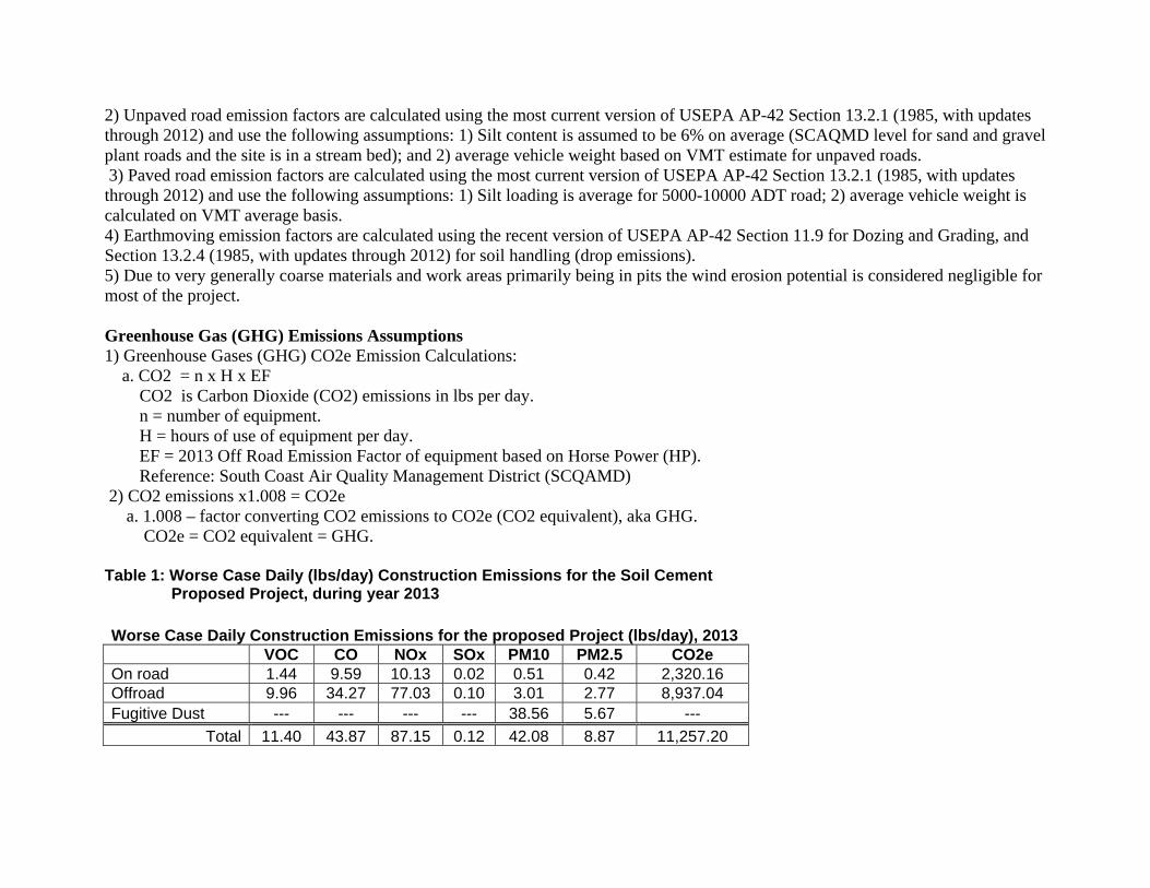
2) Unpaved road emission factors are calculated using the most current version of USEPA AP-42 Section 13.2.1 (1985, with updates through 2012) and use the following assumptions: 1) Silt content is assumed to be 6% on average (SCAQMD level for sand and gravel plant roads and the site is in a stream bed); and 2) average vehicle weight based on VMT estimate for unpaved roads. 3) Paved road emission factors are calculated using the most current version of USEPA AP-42 Section 13.2.1 (1985, with updates through 2012) and use the following assumptions: 1) Silt loading is average for 5000-10000 ADT road; 2) average vehicle weight is calculated on VMT average basis. 4) Earthmoving emission factors are calculated using the recent version of USEPA AP-42 Section 11.9 for Dozing and Grading, and Section 13.2.4 (1985, with updates through 2012) for soil handling (drop emissions). 5) Due to very generally coarse materials and work areas primarily being in pits the wind erosion potential is considered negligible for most of the project. Greenhouse Gas (GHG) Emissions Assumptions 1) Greenhouse Gases (GHG) CO2e Emission Calculations: a. CO2 = n x H x EF CO2 is Carbon Dioxide (CO2) emissions in lbs per day. n = number of equipment. H = hours of use of equipment per day. EF = 2013 Off Road Emission Factor of equipment based on Horse Power (HP). Reference: South Coast Air Quality Management District (SCQAMD) 2) CO2 emissions x1.008 = CO2e a. 1.008 – factor converting CO2 emissions to CO2e (CO2 equivalent), aka GHG. CO2e = CO2 equivalent = GHG. Table 1: Worse Case Daily (lbs/day) Construction Emissions for the Soil Cement Proposed Project, during year 2013
Worse Case Daily Construction Emissions for the proposed Project (lbs/day), 2013
VOC CO NOx SOx PM10 PM2.5 CO2e On road 1.44 9.59 10.13 0.02 0.51 0.42 2,320.16Offroad 9.96 34.27 77.03 0.10 3.01 2.77 8,937.04Fugitive Dust --- --- --- --- 38.56 5.67 ---
Total 11.40 43.87 87.15 0.12 42.08 8.87 11,257.20

Table 2: Worse Case Yearly (Tons/Year) Construction Emissions for Soil Cement Proposed Project, year 2013
Worse Case 2013, Tons/Year
VOC CO NOx SOx PM10 PM2.5 CO2eOn road 0.02 0.18 0.14 <0.01 0.01 0.01 37.80Offroad 0.14 0.52 0.96 <0.01 0.04 0.04 109.56Fugitive Dust --- --- --- --- 1.45 0.31 ---
Total 0.17 0.70 1.10 <0.02 1.50 0.36 147.36

Table 3: Soil Cement Construction Schedule
Stage Duration Employee 15 30 45 60 75 90 105 120 135 150 165 180 195 210 225Mobilize and Staging(part of Clearing&Grubbing) 10 35 X Clearing and Grubbing 34 35 X X X Construct Access and Haul Roads 19 35 X X Soil Exploration 19 35 X X Excavation and Dewatering 19 35 X X Construct Soil Cement (Part 1) 20 35 X X Construct Soil Cement (Part 2) 20 35 X X Compacted Fill for Embankment 19 35 X X Construct Soil Cement Embankment Protection 20 35 X X Construction Drain Outlets 19 35 X X Pave Bike Trails/Roads 19 35 X X Clean Up and Demobilize 2 35 X Total Construction Days 220 Notes: 1. Duration are in days. Schedule also breaks days into 15 day segment with proposed “X” durations. 2. 8 hours per day is workday. 3. 22 working days/month. 4. Total project construction days 220 working days/year (approx 10 months).

Table 4: Equipment Description, Horsepower; Operating Hours Per Day

Table 5: Construction Quantities
Material Total
Required Provided
Onsite Net Import
Assumption (per trip)
Trips Phase(s)
Soil Cement Embankment, Fill (cy)* 55,000 55,000 0 0 0 Construct Soil Cement (Part 1)* Construct Soil Cement (Part 2)*
Compacted Fill for Embankment*
Construct Soil Cement Embankment Protection*
Asphalt Concrete, Fill (cy) 4,950 4,950 0 0 0 Pave Bike Trails/Roads Note: 1. cy is cubic yards 2. “*” Soil Cement Embankment, Fill (cy) work of 55,000 cy includes all phases of work, including Construct Soil Cement (Part 1), Construct Soil Cement (Part 2), Compacted Fill for Embankment, and Construct Soil Cement Embankment Protection.
Table 6: Information and data for VMT
Phase Duration (working
days)Employee Truck
Trips/day Mobilize and Staging 10 35 2 Clearing and Grubbing 34 35 3 Construct Access and Haul Roads 19 35 3 Soil Exploration 19 35 6 Excavation and Soil Dewatering 19 35 3 Construct Soil Cement (Part 1) 20 35 4 Construct Soil Cement (Part 2) 20 35 2 Compacted Fill for Embankment 19 35 4 Construct Soil Cement Embankment Protection 20 35 5 Construct Drain Outlets 19 35 1 Pave Bike Trails/Roads 19 35 4 Clean Up and Demobilize 2 35 1

Table 7: VMT Calculations
No.
Vehicles No.
Trips/day Unpaved
VMT VMT/RT Duration
Mobilize and Staging Employee Passenger 35 1 0 30 10 Equipment Delivery HHDT 1 1 3.8 20 10 Pickup Truck Delivery 1 1 3.8 30 10Clearing and Grubbing Employee Passenger 35 1 0 30 34 Equipment Delivery HHDT 1 1 3.8 20 34 Pickup Truck Delivery 1 1 3.8 30 34 Waste Truck HHDT 1 1 3.8 10 34Construct Access and Haul Roads Employee Passenger 35 1 0 30 19 Equipment Delivery HHDT 1 1 3.8 20 19 Pickup Truck Delivery 1 1 3.8 30 19 Water Truck HHDT 1 1 3.8 10 19Soil Exploration Employee Passenger 35 1 0 30 19 Equipment Delivery HHDT 1 1 3.8 20 19 Pickup Truck Delivery 1 1 3.8 30 19 Water Truck HHDT 1 1 3.8 10 19Excavation and Soil Dewatering Employee Passenger 35 1 0 30 19 Equipment Delivery HHDT 1 1 3.8 20 19 Pickup Truck Delivery 1 1 3.8 30 19 Water Truck HHDT 1 1 3.8 10 19Conduct Soil Cement (Part 1) Employee Passenger 35 1 0 30 20

Equipment Delivery HHDT 1 1 3.8 20 20 Pickup Truck Delivery 1 1 3.8 30 20 Bottoms HHDT 1 1 3.8 100 7 Water Truck HHDT 1 1 3.8 10 20Construct Soil Cement (Part 2) Employee Passenger 35 1 0 30 20 Equipment Delivery HHDT 1 1 3.8 20 20 Pickup Truck Delivery 1 1 3.8 30 20Compacted Fill for Embankment Employee Passenger 35 1 0 30 19 Equipment Delivery HHDT 1 1 3.8 20 19 Pickup Truck Delivery 1 1 3.8 30 19 Bottoms HHDT 1 1 3.8 20 19 Water Truck HHDT 1 1 3.8 10 19Construct Soil Cement Embankment Protection Employee Passenger 35 1 0 30 20 Equipment Delivery HHDT 1 1 3.8 20 20 Pickup Truck Delivery 1 1 3.8 30 20 Delivery Truck-Soil Cement HHDT 1 1 3.8 20 20 Delivery Truck-Soil Cement HHDT 1 1 3.8 20 20 Delivery Truck-Riprap Delivery 1 1 3.8 20 20Construction Drain Outlets Employee Passenger 35 1 0 30 19 Equipment Delivery HHDT 1 1 3.8 20 19Pave Bike Trails/Roads Employee Passenger 35 1 0 30 19 Equipment Delivery HHDT 1 1 3.8 20 19 Pickup Truck Delivery 1 1 3.8 30 19 Concrete Truck HHDT 1 1 3.8 20 19 Water Truck HHDT 1 1 3.8 10 19Clean Up and Demobilize Employee Passenger 35 1 0 30 2 Pickup Truck Delivery 1 1 3.8 30 2

Table 7: VMT Calculations (continued from Table 7 immediately above)
Trips/day Daily VMT
Total Trips
Total VMT
Unpaved Daily VMT
Paved Daily VMT
Unpaved Total
Paved Total
Mobilize and Staging
35 180 60 1800 0 180 0 18001 20 10 200 3.8 16.2 38 162 1 30 10 300 3.8 26.2 38 262
Clearing and
Grubbing 35 180 204 6120 0 180 0 61201 20 34 680 3.8 16.2 129.2 550.81 30 34 1020 3.8 26.2 129.2 890.81 10 34 340 3.8 6.2 129.2 210.8
Construct Access and Haul Roads
35 180 114 3420 0 180 0 34201 20 19 380 3.8 16.2 72.2 307.81 30 19 570 3.8 26.2 72.2 497.81 10 19 190 3.8 6.2 72.2 117.8
Soil Exploration
35 180 114 3420 0 180 0 34201 20 19 380 3.8 16.2 72.2 307.84 120 76 2280 15.2 104.8 288.8 1991.21 10 19 190 3.8 6.2 72.2 117.8
Excavation and
Dewatering 35 180 114 3420 0 180 0 3420

1 20 19 380 3.8 16.2 72.2 307.81 30 19 570 3.8 26.2 72.2 497.81 10 19 190 3.8 6.2 72.2 117.8
Construct Soil Cement
(Part 1) 35 180 120 3600 0 180 0 36001 20 20 400 3.8 16.2 76 324 1 30 20 600 3.8 26.2 76 524 1 100 7 700 3.8 96.2 26.6 673.41 10 20 200 3.8 6.2 76 124
Construct Soil Cement
(Part 2) 35 180 120 3600 0 180 0 36001 20 20 400 3.8 16.2 76 324 1 30 20 600 3.8 26.2 76 524
Compacted Fill for
Embankment 35 180 114 3420 0 180 0 34201 20 19 380 3.8 16.2 72.2 307.81 30 19 570 3.8 26.2 72.2 497.81 20 19 380 3.8 16.2 72.2 307.81 10 19 190 3.8 6.2 72.2 117.8
Construct Soil Cement Embankment
Protection 35 180 120 3600 0 180 0 36001 20 20 400 3.8 16.2 76 324 1 30 20 600 3.8 26.2 76 524 1 20 20 400 3.8 16.2 76 324 1 20 20 400 3.8 16.2 76 324 1 20 20 400 3.8 16.2 76 324

Construct Drain Outlets
35 180 114 3420 0 180 0 34201 20 19 380 3.8 16.2 72.2 307.8
Pave Bike Trails/Roads
35 180 114 3420 0 180 0 34201 20 19 380 3.8 16.2 72.2 307.81 30 19 570 3.8 26.2 72.2 497.81 20 19 380 3.8 16.2 72.2 307.81 10 19 190 3.8 6.2 72.2 117.8
Clean Up Demobilize
35 180 12 360 0 180 0 360 1 30 2 60 3.8 26.2 7.6 52.4

Table 8: On Road Worse Case Daily (lbs/day) Construction Emissions for the Soil Cement Proposed Project, during year 2013
On Road Worse Case Daily Emissions (lbs/day)
Worst Case Daily Emissions (lbs/day) VMT Emissions lbs -2013 Vehicle Type Total VOC CO NOx SOx PM10 PM2.5 CO2e Passenger 720 0.54 5.11 0.51 0.01 0.07 0.04 793 Delivery 140 0.29 1.97 2.21 0.00 0.08 0.07 389 Heavy-Heavy Duty 270 0.61 2.52 7.41 0.01 0.36 0.31 1,138 Totals 1.44 9.59 10.13 0.02 0.51 0.42 2,320
On Road Worse Case Annual Emissions (ton/year), 2013 Emissions tons/year
VOC CO NOx SOx PM10 PM2.5 CO2e 2013 Emissions 0.02 0.18 0.14 0.01 0.01 0.01 38
2013 Emissions On road Emissions (Construction) – Daily (Worse Case Daily)

Construct Soil Cement (Part 1 & 2) 2013 Emissions VMT Emissions lbs -2013 Vehicle Type Total VOC CO NOx SOx PM10 PM2.5 CO2e Passenger 180 0.13 1.28 0.13 0.00 0.02 0.01 198 Delivery 30 0.06 0.42 0.47 0.00 0.02 0.02 83 Heavy-Heavy Duty 130 0.29 1.21 3.57 0.01 0.17 0.15 548 Totals 0.49 2.91 4.17 0.01 0.21 0.17 830 Compacted Fill for Embankment 2013 Emissions VMT Emissions lbs -2013 Vehicle Type Total VOC CO NOx SOx PM10 PM2.5 CO2e Passenger 180 0.13 1.28 0.13 0.00 0.02 0.01 198 Delivery 30 0.06 0.42 0.47 0.00 0.02 0.02 83 Heavy-Heavy Duty 50 0.11 0.47 1.37 0.00 0.07 0.06 211 Totals 0.31 2.16 1.97 0.00 0.10 0.08 492 Construct Soil Cement Embankment Protection 2013 Emissions VMT Emissions lbs -2013 Vehicle Type Total VOC CO NOx SOx PM10 PM2.5 CO2e Passenger 180 0.13 1.28 0.13 0.00 0.02 0.01 198 Delivery 50 0.10 0.70 0.79 0.00 0.03 0.03 139 Heavy-Heavy Duty 60 0.14 0.56 1.65 0.00 0.08 0.07 253 Totals 0.37 2.54 2.56 0.01 0.13 0.10 590
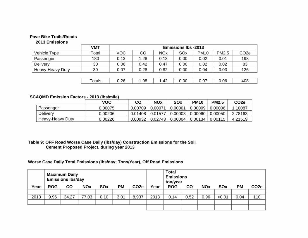
Pave Bike Trails/Roads 2013 Emissions VMT Emissions lbs -2013 Vehicle Type Total VOC CO NOx SOx PM10 PM2.5 CO2e Passenger 180 0.13 1.28 0.13 0.00 0.02 0.01 198 Delivery 30 0.06 0.42 0.47 0.00 0.02 0.02 83 Heavy-Heavy Duty 30 0.07 0.28 0.82 0.00 0.04 0.03 126 Totals 0.26 1.98 1.42 0.00 0.07 0.06 408
SCAQMD Emission Factors - 2013 (lbs/mile) VOC CO NOx SOx PM10 PM2.5 CO2e Passenger 0.00075 0.00709 0.00071 0.00001 0.00009 0.00006 1.10087 Delivery 0.00206 0.01408 0.01577 0.00003 0.00060 0.00050 2.78163 Heavy-Heavy Duty 0.00226 0.00932 0.02743 0.00004 0.00134 0.00115 4.21519
Table 9: OFF Road Worse Case Daily (lbs/day) Construction Emissions for the Soil Cement Proposed Project, during year 2013 Worse Case Daily Total Emissions (lbs/day; Tons/Year), Off Road Emissions
Maximum Daily Emissions lbs/day
Total Emissions ton/year
Year ROG CO NOx SOx PM CO2e Year ROG CO NOx SOx PM CO2e
2013 9.96 34.27 77.03 0.10 3.01 8,937 2013 0.14 0.52 0.96 <0.01 0.04 110

Offroad Emissions (Construction) HP Hr/dayMobilize and Staging Compactor 5 1 Crane 47 1 Post Hole Drill 1 2 Crawler 32 1Clearing and Grubbing Tractor 11 1 Chipper 15 1 Chainsaw 2 3 Crawler 31 1 Tractor 29 1 Crawler 20 3Construct Access and Haul Roads Grader 18 1 Roller 17 1 Crawler 42 2 Crawler 71 3 Tractor 72 3 Grader 18 3Soil Exploration Excavator 18 1 Tractor 71 1 Drill Rig 2 1 Drill Rig 1 3
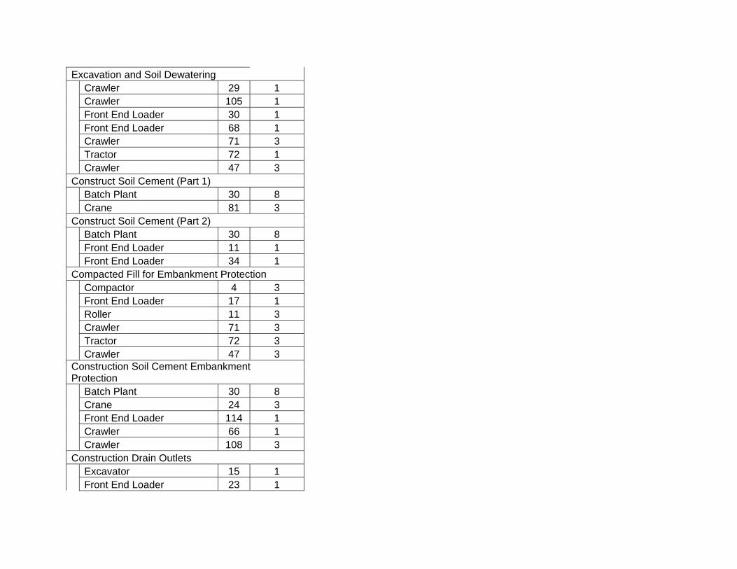
Excavation and Soil Dewatering Crawler 29 1 Crawler 105 1 Front End Loader 30 1 Front End Loader 68 1 Crawler 71 3 Tractor 72 1 Crawler 47 3Construct Soil Cement (Part 1) Batch Plant 30 8 Crane 81 3Construct Soil Cement (Part 2) Batch Plant 30 8 Front End Loader 11 1 Front End Loader 34 1Compacted Fill for Embankment Protection Compactor 4 3 Front End Loader 17 1 Roller 11 3 Crawler 71 3 Tractor 72 3 Crawler 47 3Construction Soil Cement Embankment Protection Batch Plant 30 8 Crane 24 3 Front End Loader 114 1 Crawler 66 1 Crawler 108 3Construction Drain Outlets Excavator 15 1 Front End Loader 23 1

Loader, Backhoe 9 1 Trencher 7 3Pave Bike Trails/Roads Grader 18 1 Roller 16 1 Crawler 51 1 Compactor 2 3Clean Up and Demobilize Front End Loader 34 1
2013 SCAQMD Emission Factor lbs/hour *
ROG CO NOx SOx PM CO2e
0.0062 0.0325 0.0388 0.0001 0.0015 5.32 0.1039 0.3148 0.9715 0.0012 0.0361 108.77 0.0024 0.0126 0.0151 0.0000 0.0006 2.07 0.1687 0.7089 1.3030 0.0014 0.0699 127.78
0.0822 0.3316 0.3490 0.0005 0.0290 37.98 0.1451 0.6114 0.9160 0.0011 0.0787 90.79 0.6138 2.1016 0.0254 0.0000 0.0033 5.6804 0.1687 0.7089 1.3030 0.0014 0.0699 127.78 0.0988 0.5861 0.7696 0.0011 0.0428 101.39 0.1466 0.6035 0.9887 0.0010 0.0694 90.98
0.1409 0.6790 1.0248 0.0013 0.0643 110.57

0.1010 0.3339 0.3946 0.0005 0.0352 38.24 0.1733 0.5849 1.4761 0.0017 0.0648 150.55 0.2007 0.6405 1.7956 0.0021 0.0693 195.18 0.1552 0.4874 1.4539 0.0026 0.0476 227.13 0.1409 0.6790 1.0248 0.0013 0.0643 110.57
0.1009 0.4509 0.5553 0.0007 0.0479 59.74 0.1552 0.4874 1.4539 0.0026 0.0476 227.13 0.0060 0.0316 0.0377 0.0001 0.0015 5.17 0.0024 0.0126 0.0151 0.0000 0.0006 2.07
0.1674 0.7448 1.2529 0.0014 0.0713 121.19 0.2387 0.8604 2.1100 0.0024 0.0817 240.61 0.1239 0.6101 0.9676 0.0012 0.0527 109.16 0.1424 0.4422 1.3494 0.0019 0.0470 172.92 0.2007 0.6405 1.7956 0.0021 0.0693 195.18 0.1552 0.4874 1.4539 0.0026 0.0476 227.13 0.1752 0.5326 1.5490 0.0018 0.0627 160.14
0.1493 0.5511 1.9640 0.0028 0.0554 262.24 0.1275 0.4026 1.1918 0.0015 0.0428 143.41
0.1048 0.4843 0.6172 0.0008 0.0533 66.68 0.1033 0.4013 0.5229 0.0006 0.0462 51.38 0.1244 0.5549 1.0236 0.0013 0.0502 118.26
0.4092 1.4011 0.0169 0.0000 0.0022 3.7869 0.1160 0.3729 0.3615 0.0005 0.0332 35.91 0.1010 0.3339 0.3946 0.0005 0.0352 38.24 0.2007 0.6405 1.7956 0.0021 0.0693 195.18 0.1552 0.4874 1.4539 0.0026 0.0476 227.13 0.1752 0.5326 1.5490 0.0018 0.0627 160.14
0.1052 0.3116 0.3228 0.0004 0.0275 34.33 0.1001 0.4493 0.7152 0.0008 0.0458 72.11

0.2026 0.6932 1.8680 0.0025 0.0666 256.89 0.1951 0.6081 1.7492 0.0020 0.0675 188.48 0.5505 2.0970 5.4118 0.0055 0.1888 542.05
0.1086 0.5177 0.6791 0.0009 0.0586 73.62 0.1141 0.5502 0.8234 0.0010 0.0531 89.08 0.0845 0.3279 0.3299 0.0004 0.0273 35.54 0.0367 0.1272 0.2322 0.0004 0.0090 30.47
0.1409 0.6790 1.0248 0.0013 0.0643 110.57 0.1033 0.4451 0.6955 0.0008 0.0537 67.93 0.1776 0.5072 1.6048 0.0019 0.0617 167.62 0.0024 0.0125 0.0149 0.0000 0.0006 2.04
0.1244 0.5549 1.0236 0.0013 0.0502 118.26
*SCAQMD emission factors are linearly interpolated as necessary for the specific hp size of the assumed equipment Gasoline Equipment E.F Calculation: Compactor 4 HP ROG CO NOx SOx PM CO2eg/hp-hr 46.40 158.88 1.92 0.00 0.25 429.44g/hr 185.60 635.52 7.68 0.01 1.00 1,717.76 lbs/hr 0.4092 1.4011 0.0169 0.0000 0.0022 3.79 Gasoline Equipment E.F Calculation: Chain Saw 6 HP ROG CO NOx SOx PM CO2e g/hp-hr 46.40 158.88 1.92 0.00 0.25 429.44g/hr 278.40 953.28 11.52 0.02 1.50 2576.64 lbs/hr 0.6138 2.1016 0.0254 0.0000 0.0033 5.68
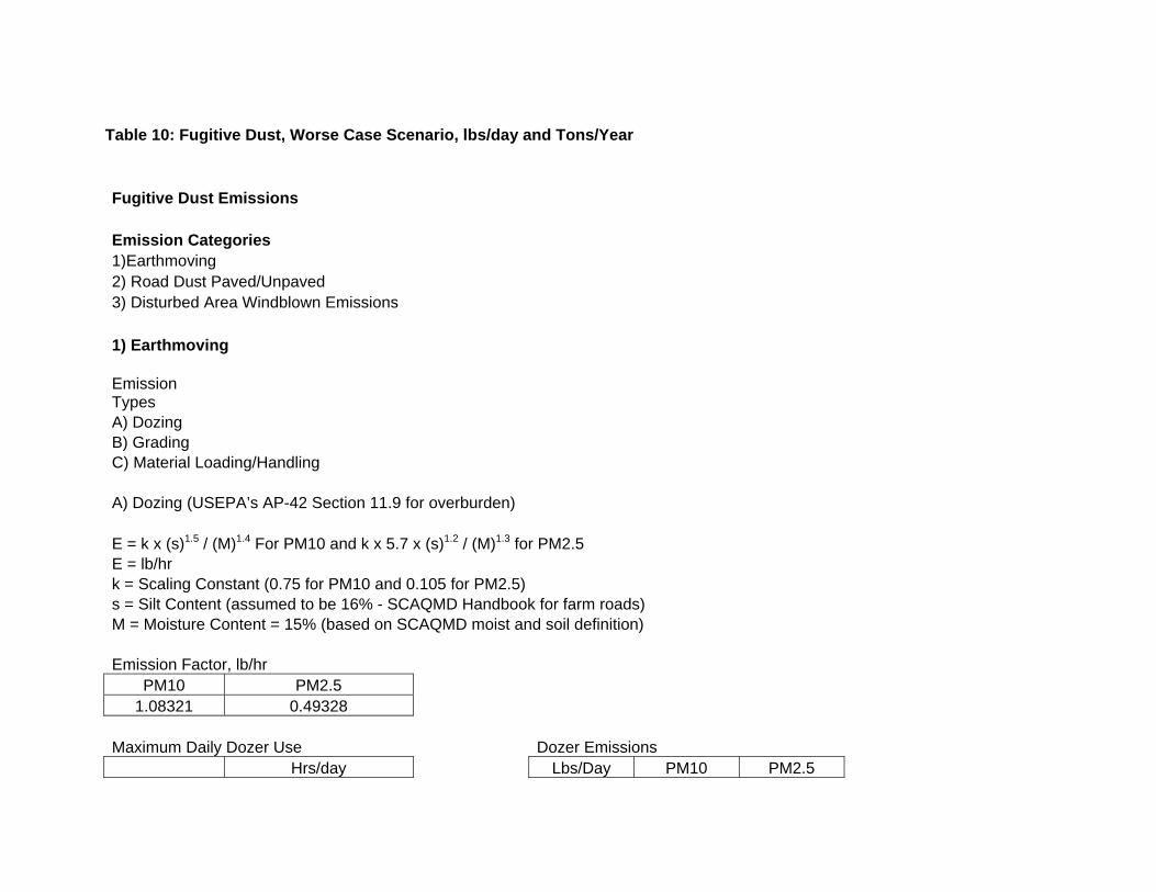
Table 10: Fugitive Dust, Worse Case Scenario, lbs/day and Tons/Year
Fugitive Dust Emissions Emission Categories 1)Earthmoving 2) Road Dust Paved/Unpaved 3) Disturbed Area Windblown Emissions 1) Earthmoving Emission Types A) Dozing B) Grading C) Material Loading/Handling A) Dozing (USEPA’s AP-42 Section 11.9 for overburden) E = k x (s)1.5 / (M)1.4 For PM10 and k x 5.7 x (s)1.2 / (M)1.3 for PM2.5 E = lb/hr k = Scaling Constant (0.75 for PM10 and 0.105 for PM2.5) s = Silt Content (assumed to be 16% - SCAQMD Handbook for farm roads) M = Moisture Content = 15% (based on SCAQMD moist and soil definition) Emission Factor, lb/hr
PM10 PM2.5 1.08321 0.49328
Maximum Daily Dozer Use Dozer Emissions
Hrs/day Lbs/Day PM10 PM2.5
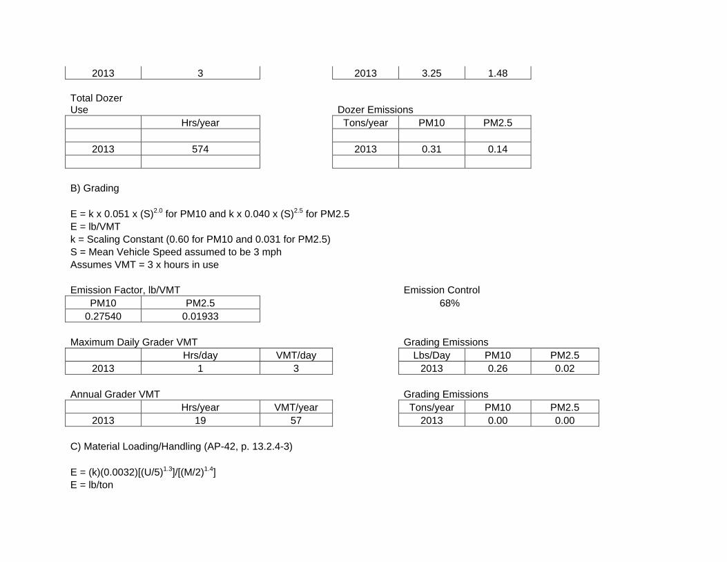
2013 3 2013 3.25 1.48 Total Dozer Use Dozer Emissions
Hrs/year Tons/year PM10 PM2.5
2013 574 2013 0.31 0.14
B) Grading E = k x 0.051 x (S)2.0 for PM10 and k x 0.040 x (S)2.5 for PM2.5 E = lb/VMT k = Scaling Constant (0.60 for PM10 and 0.031 for PM2.5) S = Mean Vehicle Speed assumed to be 3 mph Assumes VMT = 3 x hours in use Emission Factor, lb/VMT Emission Control
PM10 PM2.5 68% 0.27540 0.01933
Maximum Daily Grader VMT Grading Emissions
Hrs/day VMT/day Lbs/Day PM10 PM2.5 2013 1 3 2013 0.26 0.02
Annual Grader VMT Grading Emissions
Hrs/year VMT/year Tons/year PM10 PM2.5 2013 19 57 2013 0.00 0.00
C) Material Loading/Handling (AP-42, p. 13.2.4-3) E = (k)(0.0032)[(U/5)1.3]/[(M/2)1.4] E = lb/ton
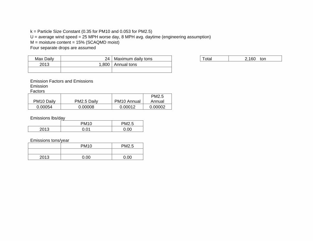
k = Particle Size Constant (0.35 for PM10 and 0.053 for PM2.5) U = average wind speed = 25 MPH worse day, 8 MPH avg. daytime (engineering assumption) M = moisture content = 15% (SCAQMD moist) Four separate drops are assumed
Max Daily 24 Maximum daily tons Total 2,160 ton2013 1,800 Annual tons
Emission Factors and Emissions Emission Factors
PM10 Daily PM2.5 Daily PM10 AnnualPM2.5 Annual
0.00054 0.00008 0.00012 0.00002
Emissions lbs/day PM10 PM2.5
2013 0.01 0.00
Emissions tons/year PM10 PM2.5
2013 0.00 0.00
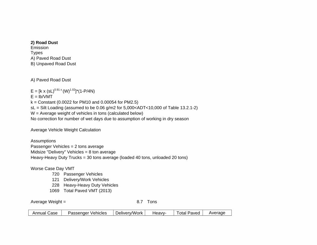
2) Road Dust Emission Types A) Paved Road Dust B) Unpaved Road Dust A) Paved Road Dust E = [k x (sL)0.91 x (W)1.02]*(1-P/4N) E = lb/VMT k = Constant (0.0022 for PM10 and 0.00054 for PM2.5) sL = Silt Loading (assumed to be 0.06 g/m2 for 5,000<ADT<10,000 of Table 13.2.1-2) W = Average weight of vehicles in tons (calculated below) No correction for number of wet days due to assumption of working in dry season Average Vehicle Weight Calculation Assumptions Passenger Vehicles = 2 tons average Midsize "Delivery" Vehicles = 8 ton average Heavy-Heavy Duty Trucks = 30 tons average (loaded 40 tons, unloaded 20 tons) Worse Case Day VMT
720 Passenger Vehicles 121 Delivery/Work Vehicles 228 Heavy-Heavy Duty Vehicles
1069 Total Paved VMT (2013) Average Weight = 8.7 Tons Annual Case Passenger Vehicles Delivery/Work Heavy- Total Paved Average
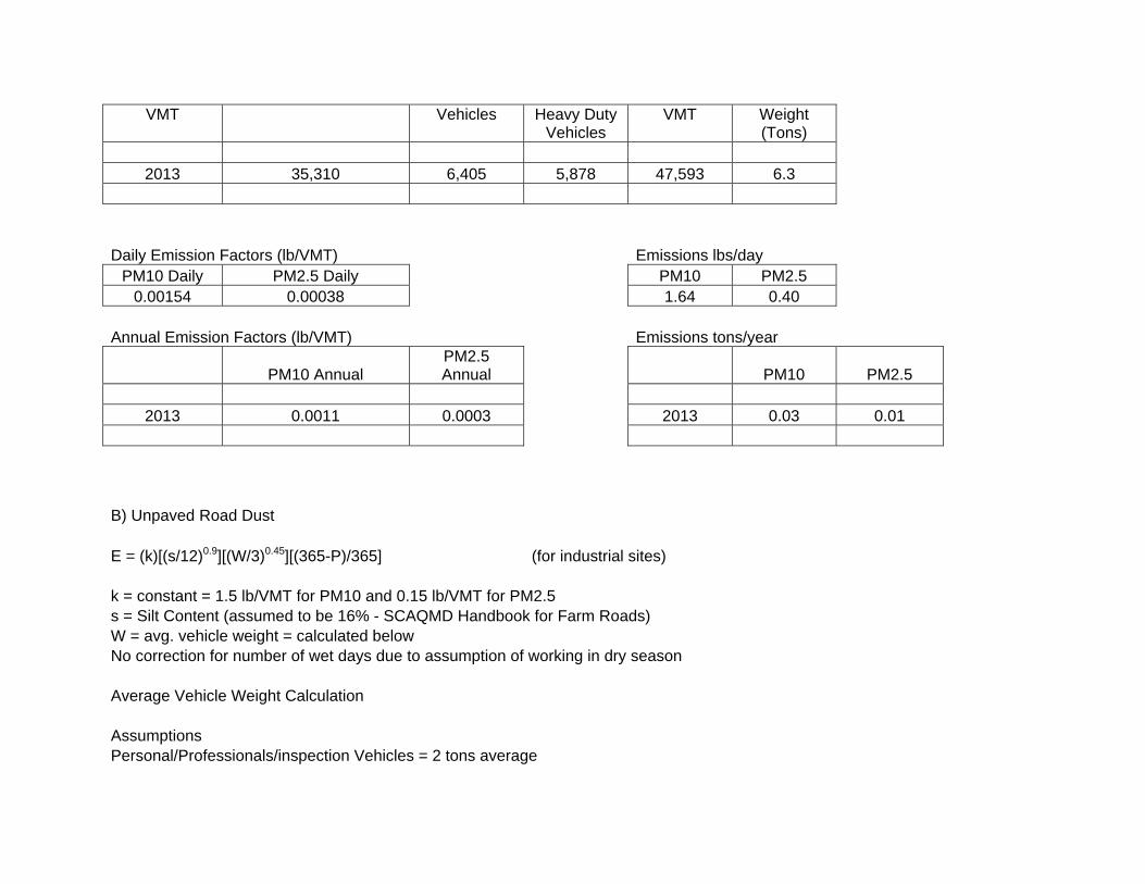
VMT Vehicles Heavy Duty Vehicles
VMT Weight (Tons)
2013 35,310 6,405 5,878 47,593 6.3
Daily Emission Factors (lb/VMT) Emissions lbs/day
PM10 Daily PM2.5 Daily PM10 PM2.5 0.00154 0.00038 1.64 0.40
Annual Emission Factors (lb/VMT) Emissions tons/year
PM10 AnnualPM2.5 Annual PM10 PM2.5
2013 0.0011 0.0003 2013 0.03 0.01
B) Unpaved Road Dust E = (k)[(s/12)0.9][(W/3)0.45][(365-P)/365] (for industrial sites) k = constant = 1.5 lb/VMT for PM10 and 0.15 lb/VMT for PM2.5 s = Silt Content (assumed to be 16% - SCAQMD Handbook for Farm Roads) W = avg. vehicle weight = calculated below No correction for number of wet days due to assumption of working in dry season Average Vehicle Weight Calculation Assumptions Personal/Professionals/inspection Vehicles = 2 tons average

Midsize "Delivery" Vehicles = 8 ton average Heavy-Heavy Duty Trucks = 30 tons average (loaded 40 tons, unloaded 20 tons) Worse Case Day VMT
0 Passenger Vehicles 19 Delivery/Work Vehicles 42 Heavy-Heavy Duty Vehicles
60.8 Total Unpaved VMT Average Weight = 23.1 Tons
Annual Case VMT Passenger Vehicles
Delivery/Work Vehicles
Heavy-Heavy Duty
Vehicles
Total Unpaved
VMT
Average Weight (Tons)
2013 0 953 1,577 2,530 21.7
Uncontrolled Emission Factors and Emissions Daily Emission Factors (lb/VMT) Emissions lbs/day
PM10 Daily PM2.5 Daily PM10 PM2.5 4.87 0.49 296.19 29.62
Annual Emission Factors (lb/VMT) Emissions tons/year
PM10 AnnualPM2.5 Annual PM10 PM2.5
2013 4.74 0.47 2013 5.99 0.60
Controlled Emissions (assumes 90% soil binder)

Emissions lbs/day Emission Control
PM10 PM2.5 90% 29.62 2.96
Emissions tons/year PM10 PM2.5
2013 0.60 0.06
3) Disturbed Area Windblown Emissions
Assumptions Emission Factor is 0.38 tons/disturbed acres/year of Total Suspended Particulate (AP-42 Section 11.9) PM10 and PM2.5 fractions of TSP are 0.489 and 0.102 respectively per CEIDARS factors from SCAQMD CEQA WebsiteThere are permanent and temporary disturbed acres that make up the total acre-years of disturbed area Disturbed areas are controlled by soil stabilizer suppressing 84% control Restoration of disturbed acres creates no net emission increase of permanently disturbed acres
Disturbed Acres (acre-
years) Emissions (tons/year) Emissions (lbs/day) PM10 PM2.5 PM10 PM2.5
2013 17.01 0.51493 0.10547 4.04 0.83

Fugitive Dust Emissions (Worse Case), lbs/day and Tons/Yr
Daily Maximum Fugitive Dust Emissions (lbs/day, 2013)
PM10 lbs/dayPM2.5 lbs/day
Dozer 3.25 1.48 Soil Handling 0.01 0.00 Paved Road Dust 1.64 0.40 Unpaved Road Dust 29.62 2.96 Disturbed Area Dust 4.04 0.83
Totals 38.56 5.67 Fugitive Dust Emission Totals (tons/year) 2013
PM10 t/yr PM2.5 t/yr Dozer 0.31 0.14 Grading 0.00 0.00 Soil Handling 0.00 0.00 Paved Road Dust 0.03 0.01 Unpaved Road Dust 0.60 0.06 Disturbed Area Dust 0.51 0.11 Totals 1.45 0.31

Table 11- Fugitive Dust Emissions – Paved Road DustPaved Road Dust E = [k x (sL)0.91 x (W)1.02]*(1-P/4N) E = lb/VMT k = Constant (0.0022 for PM10 and 0.00054 for PM2.5) sL = Silt Loading (assumed to be 0.06 g/m2 for 5,000<ADT<10,000 of Table 13.2.1-2)W = Average weight of vehicles in tons (calculated below) No correction for number of wet days due to assumption of working in dry season Average Vehicle Weight Calculation Assumptions Passenger Vehicles = 2 tons average Midsize "Delivery" Vehicles = 8 ton average Heavy-Heavy Duty Trucks = 30 tons average (loaded 40 tons, unloaded 20 tons)
Annual Case VMT
Passenger Vehicles
Delivery/Work Vehicles
Heavy-Heavy Duty
VehiclesTotal Paved
VMT
Average Weight (Tons)
2013 990 990 1,020 3,000 13.5 Annual Emission Factors (lb/VMT)
PM10 Annual
PM2.5 Annual
2013 0.0024 0.0006
Reference: United States Environmental Protection Agency (USEPA). 2013. AP-42, A Compilation of Air Pollutant Emission Factors 1985, With Updates through 2012.


APPENDIX D. NATIVE AMERICAN HERTIGAGE COMMISION (NAHC) RESPONSE TO REACH 9, PHASE 3


APPENDIX E. CDFW Code Compliance


APPENDIX F. 401 Certification


APPENDIX G. Draft SEA/EIR Addendum Comments and Responses to Comments

NOTE: Comment letters are presented prior to the responses to comments in the order received.


Commenter No. 1
Dave Singleton Program Analyst Native American Heritage Commission 915 Capitol Mall, Room 364 Sacramento, California 95814 Letter dated November 7, 2012 Response to Comments. Comments noted. Coordination has occurred as recommended in the comment letter. The project is in compliance with state and federal statutes described in the comment letter.


Commenter No. 2
Christopher Herre Branch Chief Local Development/Intergovernmental Review California Department of Transportation District 12 3347 Michelson Drive, Suite 100 Irvine, California 92612‐8894 Letter dated November 21, 2012
Response to Comment 1.
Comment noted. The project will comply with the CalTrans Statewide NPDES Storm Water Permit
(Order No. 99‐06‐DWQ, NPDES No. CAS000003) and other subsequent permits in effect at the time of
construction.
Response to Comment 2.
An encroachment permit will be applied for. A Storm Water Pollution Prevention Plan (SWPPP) will be
created and implemented.
Response to Comment 3.
The proposed project is not expected to impact or alter the operation of the biofiltration swales.
Response to Comment 4.
The outlet features were designed to meet CalTrans standards for drainage. An additional 5 feet of toe
has been added to the design for stability and protection for local scour.
Response to Comment 5.
Comment noted.
Response to Comment 6.
Comment noted. This project will use the same detour that is being used by the Santa Ana River
Interceptor (SARI) Line Project.
Response to Comment 7.
Comment noted.
Response to Comment 8.
Comment noted.

Response to Comment 9.
Comment noted. The SEA/EIR Addendum reflects potential impacts to SR‐91, both temporary and
permanent. A list of environment commitments is included in the SEA/EIR Addendum
Response to Comment 10.
Comment noted.


Commenter No. 3
Karen A. Goebel Assistant Field Supervisor United States Department of the Interior Fish and Wildlife Service Ecological Services Carlsbad Fish and Wildlife Office 6010 Hidden Valley Road, Suite 101 Carlsbad, California 92011 Letter dated November 21, 2012 Response to Comments. Comments noted.


Commenter No. 4 Daisy Covarrubas, MPA Senior Staff Analyst Orange County Sanitation District 10844 Ellis Avenue Fountain Valley, California 92708 Letter dated November 27, 2012
Response to Comment 1.
Comment noted.

APPENDIX H. Mailing Distribution List

Federal Agencies Mr. Jim Bartel, Field Supervisor U.S. Fish & Wildlife Service 6010 Hidden Valley Rd, Suite 101 Carlsbad, CA 92011 Ms. Christine Medak U.S. Fish and Wildlife Service 6010 Hidden Valley Rd, Suite 101 Carlsbad, CA 92011 Kathleen Pollett U.S. Fish and Wildlife Service 6010 Hidden Valley Rd, Suite 101 Carlsbad, CA 92011 U.S. Environmental Protection Agency Deanna W. Wieman, Deputy Director Cross Media Division Mail Code CMD-2 75 Hawthorne Street San Francisco, CA 94105 Attn: Lisa Lyren Supervisory Ecologist U.S. Geological Survey-BRD Western Ecological Research Center 6010 Hidden Valley Road Carlsbad, CA 92011 Jason P. Lambert US Army Corps of Engineers, LA District Regulatory Branch (CESPL-CO) P.O. Box 532711 Los Angeles, CA 90053-2325 State Agencies Scott Morgan State Clearinghouse Office of Planning and Research P.O. Box 3044 Sacramento, CA 95812-3044

Paul Frost CA. Dept. of Conservation, District 1 Division of Oil, Gas and Geothermal 5816 Corporate Avenue, Suite 200 Cypress, CA 90630-4731 Robin Maloney-Rames California Department of Fish and Wildlife Eastern Sierra – Inland Deserts Region 3602 Inland Empire Blvd., Ste C-220 Ontario, CA 91764 Kim Freeburn-Marquez Environmental Scientist California Department of Fish and Wildlife Region 6 3602 Inland Empire Blvd., Ste. C-220 Ontario, CA 91764 California Department of Fish and Wildlife Attn: Streambed Team 4665 Lampson Ave., Suite J Los Alamitos, CA 90720 Milford Wayne Donaldson State Historic Preservation Officer Office of Historic Preservation 1725 23rd Street, Suite 100 Sacramento, CA 95816 Christopher Herre Chief, Local Development/IGR Caltrans, District 12 3337 Michelson Drive, Suite 380 Irvine, CA 92612 Attn: Aileen Kennedy Caltrans, District 8 Attn: IGR/CEQA Division 464 W. 4th St. San Bernardino, CA 92402 Mr. Kurt V. Berchtold Regional Water Quality Control Board Region 8 3737 Main Street, Suite 500 Attn: Marc Brown Riverside, CA 92501-3339

Dave Singleton Native American Heritage Commission 915 Capital Mall, Room 364 Sacramento, CA 95814 James Hockenberry State Water Resources Control Board Environmental Services Unit 1001 I Street Sacramento, CA 95814 Enrique Arroyo, District Planner Department of Parks and Recreation Inland Empire District 17801 Lake Perris Dr. Perris, CA 92571 Russell M. Barabe (from SARI mailing list 2010) California Department of Fish and Game 3883 Ruffin Road San Diego, CA 92123 Rich Adler OC Parks 13042 Old Myford Rd. Irvine, CA 92602 CA. Dept. of Toxic Substances Control 5796 Corporate Avenue Attn: Greg Holmes, Unit Chief Cypress, CA 90630 Local Agencies Dan Bott Orange County Water District 18700 Ward Street Fountain Valley, California 92708 Dick Zembal Orange County Water District 18700 Ward Street Fountain Valley, CA 92708

Mr. William Mills General Manager Orange County Water District 10500 Ellis Avenue Fountain Valley, CA 92708 Inland Empire Utilities Agency P.O. Box 9020 Chino Hills, CA 91709 Jack S. Safely, P.E. Water Resources Manager Western Municipal Water District 14205 Meridian Parkway Riverside, CA 92518 Mr. Albert Martinez Riverside Co. Flood Control 1995 Market St. Riverside, CA 92501 Corona Department of Water and Power 400 S. Vincentia Ave. Corona, CA 92882 Ms. Laura Manchester Deputy City Manager City of Corona 815 West Sixth Street (P.O. Box 940) Corona, CA 91718-0090 Steve Powers City of Corona Public Works Department 815 West Sixth Street Corona, CA 91720-3238 Mr. David Lovell Assistant Chief, Federal Projects Division San Bernardino County Flood Control District Public Works Group 825 East Third Street, Room 118 San Bernardino, CA 92415-0835 Mr. Lance Natsuhara Orange County Public Works Flood Control Div./Santa Ana River Section 300 N. Flower Street Santa Ana, CA 92703

Mr. Ariel Corpuz Orange County Public Works Flood Control Div./Santa Ana River Section 300 N. Flower Street Santa Ana, CA 92703 Mr. Greg Yi Orange County Public Works Flood Control Div./Santa Ana River Section 300 N. Flower Street Santa Ana, CA 92703 Mr. Giatho Tran Orange County Public Works Flood Control Div./Santa Ana River Section 300 N. Flower Street Santa Ana, CA 92703 Jeff Dickman Orange County Public Works Flood Control Div./Santa Ana River Section 300 N. Flower Street Santa Ana, CA 92703 Mr. Hardat Khublall Orange County Sanitation District 10844 Ellis Avenue Fountain Valley, CA 92708-7018 South Coast Air Quality Management District 21865 Copley Drive Diamond Bar, CA 91765 Metropolitan Water District P.O. Box 54153 Los Angeles, CA 90054-0153 Orange County Transportation Authority Attn: Dan Phu 550 S. Main Street Orange, CA 92863 Riverside County, County Recorder P.O. Box 751 2724 Gateway Drive Riverside, CA 92502 Riverside County Planning Department Director of Planning 4080 Lemon Street Riverside, CA 92501

Parks Director Riverside County Regional Parks and Open Space 4600 Crestmore Road Riverside, CA 92509 Don Williams Asst. General Manager Strategic Planning and Engineering City of Corona Department of Water and Power 815 W. Sixth Street Corona, CA 92882 Orange County Clerk - Recorder 12 Civic Center Plaza, Room 101 Santa Ana, CA 92701 Charles Landry Executive Director Western Riverside County Regional Conservation Authority 3403 10th Street Riverside, CA 92501 Mark Stowell, Director of Public Works City of Yorba Linda 4845 Casa Loma P.O. Box 87014 Yorba Linda, CA 92886-8714 Jonathan E. Borrego City of Anaheim Planning Department P.O. Box 3222 Anaheim, CA 92803 City of Yorba Linda Planning Department 4845 Casa Loma P.O. Box 87014 Yorba Linda, CA 92886-8714 Organizations/Groups Lee Reeder Executive Director Santa Ana Watershed Association P.O. Box 5407 Riverside, CA 92517

David Ruhl Santa Ana Watershed Project Authority 11615 Sterling Avenue Riverside, CA 92503 Friends of Harbors, Beaches and Parks P.O. Box 9256 Newport Beach, CA 92658 Mr. Kirk Holland Manager, OC Parks 13042 Old Myford Rd. Irvine, CA 92602 Riverside Audubon Society 5370 Riverview Drive Rubidoux, CA 92509 Bob McKernan San Bernardino Valley Chapter Audubon Society 1230 Friar Lane Redlands, CA 92373 Brad Richards Chair: Prado Basin Group Sierra Club San Gorgonio Chapter 4079 Mission Inn Ave. Riverside, CA 92501 Wildlife Corridor Conservation Authority 570 West Avenue 26, Suite 100 Attn: Glenn Parker Los Angeles, CA 90065 Private Entity Jill O’Connor LSA Associates, Inc. 20 Executive Park, Suite 200 Irvine, CA 92614 Art Homrighausen Principal/Biologist LSA Associates, Inc. 20 Executive Park, Suite 200 Irvine, CA 92614

Chris Meloni Biologist LSA Associates, Inc. 20 Executive Park, Suite 200 Irvine, CA 92614 Romi Archer Sr. Environmental Planner LSA Associates, Inc. 20 Executive Park, Suite 200 Irvine, CA 92614 Stephanie Blanco Parsons 3200 E. Guasti Rd., Suite 200 Ontario, CA 91761 Dana Busch Canyon RV Park 24001 Santa Ana Canyon Road Anaheim, CA 92808 Ann and Gordon Luce 6020 Toulan Way Yorba Linda, CA 92887 Terry J. Hartman Irvine Community Development Company 550 Newport Center Drive Newport Beach, CA 92660 Robert S. Coldren Hart, King and Coldren, on behalf of Canyon RV Park 200 Sandpointe Avenue, Fourth Floor Santa Ana, CA 92707 James Cathcart, P.E. HDR Engineering, Inc. 3230 El Camino Real, Suite 200 Irvine, CA 92607 Libraries Orange County Public Library Villa Park Library 17865 Santiago Blvd. Villa Park, CA 92861

Yorba Linda Library 18262 Lemon Drive Yorba Linda, CA 92686 Main Library City of Anaheim 500 West Broadway Anaheim, CA 92805 CSU Fullerton Library 800 N. State College Fullerton, CA 92833 Corona Public Library - Nora Jacob 650 South Main Street Corona, CA 91720 Norco Public Library 3954 Old Hamner Avenue Norco, CA 91760 Riverside Public Library Attn: Government Documents 3581 Mission Inn Avenue Riverside, CA 92501 San Bernardino County Library 104 West 4th Street San Bernardino, CA 92401 Chino Branch Library 13180 Central Avenue Chino, CA 91710 Native American Contacts Juaneno Band of Mission Indians Acjachemen Nation David Belardes, Chairperson 32161 Avenida Los Amigos San Juan Capistrano, CA 92675 Tongva Ancestral Territorial Tribal Nation John Tommy Rosas, Tribal Admin. Private Address Gabrieleno/Tongva San Gabriel Bnd Mission Anthony Morales, Chairperson PO Box 693 San Gabriel, CA 91778
Gabrielino Tongva Nation Sam Dunlap, Chairperson P.O. Box 86908 Los Angeles, CA 90086 Juaneno Band of Mission Indians Acjachemen Nation Anthony Rivera, Chairman 31411-A La Matanza Street San Juan Capistrano, CA 92675-2674 Gabrielino Tongva Indians of California Tribal Council Robert F. Dorame, Tribal Chair/Cultural Resources P.O. Box 490 Bellflower, CA 90707 Juaneno Band of Mission Indians Alfred Cruz, Cultural Resources Coordinator P.O. Box 25628 San Ana, CA 92799 Juaneno Band of Mission Indians Sonia Johnston, Tribal Chairperson P.O. Box 25628 Santa Ana, CA 92799 Juaneno Band of Mission Indians Anita Espinoza 1740 Concerto Drive Anaheim, CA 92807 United Coalition to Protect Panhe (UCPP) Rebecca Robles 119 Avenida San Fernando San Clemente, CA 92672 Gabrielino-Tongva Tribe Bernie Acuna 1875 Century Pk East #1500 Los Angeles, CA 90067 Juaneno Band of Mission Indians Acjachemen Nation Joyce Perry, Representing Tribal Chairperson 4955 Paseo Segovia Irvine, CA 92612 Gabrielino-Tongva Tribe Linda Candelaria, Chairwoman 1875 Century Pk East #1500 Los Angeles, CA 90067

Gabrieleno Band of Mission Indians Andrew Salas, Chairperson P.O. Box 393 Covina, CA 91723