Genetics of amyotrophic lateral sclerosis in the Han Chinese

Sanyangzhuang: early farming and aHan settlement preserved beneathYellow River flood depositsTristram R. Kidder1, Haiwang Liu2 & Minglin Li3
Beijing
0 km 2000
N
Sanyangzhuang
The authors present the discovery of a Hanperiod farming site sealed beneath 5m offlood deposits, where courtyard houses havebeen excavated belonging to the Western HanDynasty and Wang Mang period (c. 140 BC–AD 23). Preservation is exceptional, both atthe village of Sanyangzhuang itself and, bydint of satellite reconnaissance, over a vastlandscape contemporarily covered by the flood.Deep profiles show that here land surfaces of theNeolithic and Warring States periods also lieburied. The potential for the study of the earlyagricultural sequence and a deeper knowledge ofHan society is truly outstanding. The discoveriesalso offer a vivid account of the way a settlementwas overwhelmed by flooding.
Keywords: China, Huanghe, Neolithic, Warring States, Han, Western Han, Wang Mang,farming, Han building compounds, river systems, flooding
IntroductionThe Han Dynasty (202 BC–AD 220) administered one of the world’s great empires, rivallingits western contemporary, Rome. Much is known about the Han from contemporaryhistories and from recent archaeology, but much of this information focuses on the imperialcourt and the activities of ruling elites or military authorities. At a time when trade along theSilk Road was enlarging contacts between China, South Asia and the Mediterranean world,we have very little archaeological knowledge about the everyday lives of the people in eastern
1 Anthropology, Washington University in St Louis, St Louis, MO 63130, USA (Email: [email protected])2 Archaeology, Henan Provincial Institute of Cultural Relics and Archaeology, 9 Longhaibeisanjie, Zhengzhou,
Henan 450000, PR China3 College of Urban and Environmental Sciences, Peking University, Beijing 100871, PR China
C© Antiquity Publications Ltd.ANTIQUITY 86 (2012): 30–47 http://antiquity.ac.uk/ant/086/ant0860030.htm
30

Res
earc
h
Tristram R. Kidder, Haiwang Liu & Minglin Li
China who underwrote the imperial economy and produced the goods that were the focusof this fabled trade route. Archaeologists studying the Han era working in the Yellow Riverfloodplain have focused almost exclusively on the royal cities of Chang’an and Luoyang, oron the excavation of thousands of Han-era tombs. Research on small settlements outside ofthe royal cities is nearly non-existent. Recent excavations at the remarkably well-preservedSanyangzhuang site, however, provide an extraordinary opportunity to understand rural lifeduring terminal Western Han times.
The geological settingThe Yellow River (Huanghe) has been the dominant force shaping the landscape andinfluencing human and natural environments in the Sanyangzhuang area. It flows throughthe easily eroded loess plateau of central China, bringing down massive quantities of sand,silt and clay that are deposited to form the alluvial plain east of Luoyang (Liu & Liang 1989:223–4). The Yellow River has flooded its banks and shifted its position several times. As theriver channel aggrades and channel gradients become increasingly steep, avulsions (naturalbreak-outs) occur, or, in some instances, human breaches of dikes and levees (Cen 1957;Hsu 1980: 103; Xu, Fuling 1989; Wang, Yulei 2008).
For much of the Holocene the Yellow River flowed north from Luoyang to discharge intothe Gulf of Bohai (Xu, Fuling 1989; Ye 1989: fig. 1) (Figure 1). The river was confinedto the western edge of the Central Plains up to the end of the first decade of the firstmillennium AD. As the river channel aggraded and gradients increased, the river beganshifting eastward. This process was probably accelerated by increasing sediment associatedwith human-induced erosion in the loess plateau (Ren & Zhu 1994; Xu, Jiongxin 2003;He et al. 2006; Huang et al. 2006). By Han times, the river frequently flooded the lowerregions of Henan, Hebei and Shandong provinces (Sima 1959: 1409).
The archaeology of SanyangzhuangSanyangzhuang is located north-west of the modern channel of the Yellow River in HenanProvince (Henan 2010). The site was discovered in the course of digging an irrigation canal in2003 and thereafter defined by coring and several c. 12m-deep profiles that extend back intodeposits of Pleistocene age (Figure 2). These strata indicate that the Yellow River floodplainwas marked by episodes of stability indicated by well-developed palaeosols, alternated withepisodes of large-scale flooding (Figure 3). Four pre-Han palaeosols have been identified.The lower two, dated respectively to the Early and Middle Holocene, appear to be entirelynatural. The next two palaeosols are ridged cultivation horizons, dated by ceramics in thefill to the Late Neolithic or Early Bronze age (Figure 3: 2a), and to the Warring States period(Figure 3: 3). The Han occupation of the site developed on the surface of a flood depositfollowing the Warring States occupation. The Han remains are covered by 3m of sedimentfrom a massive Yellow River flood that catastrophically buried the site. Two more metres ofoverburden accumulated after the Han-era flood. (Figure 4).
C© Antiquity Publications Ltd.
31

Sanyangzhuang
Figure 1. Topographic map of the North China Plain showing modern and ancient courses of the YellowRiver. Map data from United States Geological Survey 3 Arc Second Shuttle Radar Topography Mission dataset(http://www.glcf.umd.edu/data/srtm/).
InvestigationWe followed a three-part strategy for the investigation of Sanyangzhuang. First, an intensiveprogramme of hand-operated coring was used to sample the subsurface remains in the areaimmediately around the site (Figure 2). To date, 1km2 has been sampled at 4m intervalsusing split-spoon augers with a c. 200mm-long sample tube (the Luoyang spade). Eachexcavation extended to the Han level, which is easily identified by its colour and texture. Ineach core, the presence and absence of remains is noted by stratigraphic level.
Second, six stratigraphic profiles were excavated. The deepest reach c. 12m below thesurface while the others expose the stratigraphy overlying the Han occupation (Figures 3 &4). Each profile was dug by hand and has been documented using standard geoarchaeologicaldescriptive methods. Multiple samples for pollen and sedimentary analysis have been takenfrom these profiles.
Finally, three areas where buildings had been located during excavation of the irrigationditch were opened by hand, exposing an area sufficient to document the architecturalremains and to reveal surrounding features, such as fields and wells (Figure 2). Structurestook the form of courtyard residences, termed compounds. The smallest excavation exposedc. 400m2 (compound 1), while the work in compounds 3 and 4 uncovered more thanC© Antiquity Publications Ltd.
32

Res
earc
h
Tristram R. Kidder, Haiwang Liu & Minglin Li
Figure 2. Map of the Sanyangzhuang site area showing known Han-age cultural features, areas of coring and the location ofprofiles.
1200m2. The average depth to the ground surface on which these compounds were built is5m below the modern ground surface.
Excavations extended to the upper level of the architectural remains (usually the top of theroof tiles) or to the level of the then contemporary ground surface (Figure 5). Overlying flooddeposits peel off the Han surface, which makes recognising the surface easy. Sanyangzhuanghas preserved features rarely seen at most sites. Human and animal prints have been recoveredfrom the fields and activity areas around compounds 2 and 3. The hoof prints appear to beof horse or mule. Compounds 2, 3 and 4 had trees growing immediately outside of theircompound walls. Casts of the tree stumps indicate that they were 100–200mm in diameterand relatively evenly spaced. Fossilised leaf casts recovered from the north end of compound3 show that both Mulberry (Morus sp.) and Elm (Ulmus cf. parvifolia) were grown (Figure 6).Outside the compounds we exposed ridged fields, remains of cart tracks, human and animalfoot/hoof prints, casts of trees and leaves, activity areas, wells and latrines.
Because of concerns about preservation, excavation of the compounds did not penetratebeneath the top of the architectural remains, which means we have not exposed living surfaceswithin rooms or spaces that were covered by a roof or by roof-fall. Following excavationand documentation, three of the four compounds were covered with sand to stabilise andprotect them. A museum building was constructed over the remaining compound 2.
C© Antiquity Publications Ltd.
33

Sanyangzhuang
Figure 3. Part of the stratigraphic profile at Sanyangzhuang showing palaeosols and intervening Yellow River (Huangheflood [HHF]) deposits: 1) Middle Holocene (top of strata is 8.8m below ground surface [bgs]); 2) Late Middle Holocene (2b)with Neolithic/Early Bronze Age field (2a); 3) Warring States; 4) Han occupation level.
C© Antiquity Publications Ltd.
34

Res
earc
h
Tristram R. Kidder, Haiwang Liu & Minglin Li
Figure 4. Sample of the post-Han stratigraphy, showing the stage 1–3 flood deposits with the Tang midden that developed inand on a natural palaeosol on its surface (scale is in 100mm increments).
C© Antiquity Publications Ltd.
35
Sanyangzhuang
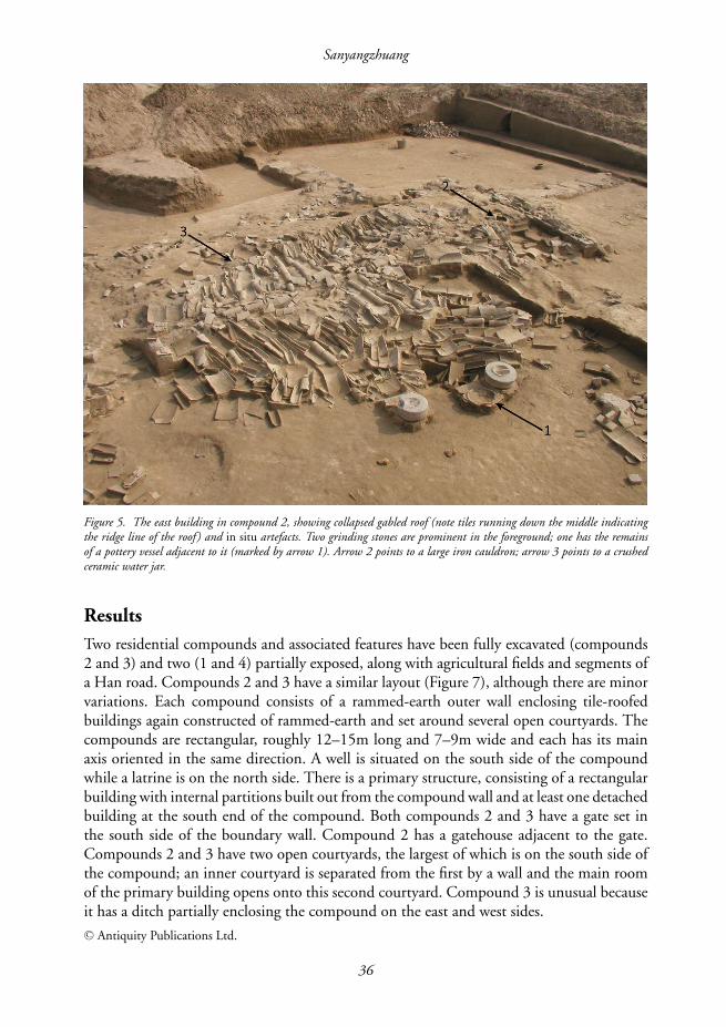
Figure 5. The east building in compound 2, showing collapsed gabled roof (note tiles running down the middle indicatingthe ridge line of the roof ) and in situ artefacts. Two grinding stones are prominent in the foreground; one has the remainsof a pottery vessel adjacent to it (marked by arrow 1). Arrow 2 points to a large iron cauldron; arrow 3 points to a crushedceramic water jar.
ResultsTwo residential compounds and associated features have been fully excavated (compounds2 and 3) and two (1 and 4) partially exposed, along with agricultural fields and segments ofa Han road. Compounds 2 and 3 have a similar layout (Figure 7), although there are minorvariations. Each compound consists of a rammed-earth outer wall enclosing tile-roofedbuildings again constructed of rammed-earth and set around several open courtyards. Thecompounds are rectangular, roughly 12–15m long and 7–9m wide and each has its mainaxis oriented in the same direction. A well is situated on the south side of the compoundwhile a latrine is on the north side. There is a primary structure, consisting of a rectangularbuilding with internal partitions built out from the compound wall and at least one detachedbuilding at the south end of the compound. Both compounds 2 and 3 have a gate set inthe south side of the boundary wall. Compound 2 has a gatehouse adjacent to the gate.Compounds 2 and 3 have two open courtyards, the largest of which is on the south side ofthe compound; an inner courtyard is separated from the first by a wall and the main roomof the primary building opens onto this second courtyard. Compound 3 is unusual becauseit has a ditch partially enclosing the compound on the east and west sides.C© Antiquity Publications Ltd.
36

Res
earc
h
Tristram R. Kidder, Haiwang Liu & Minglin Li
Figure 6. Fossil casts of mulberry leaves from compound 3: left) length = 80mm; right) length = 950mm.
In compounds 2 and 4 rammed-earth building walls were set on fired-brick foundationsroughly 0.6m (three to four courses) wide. This may be the case in the other compoundsbut we have not excavated through the rammed-earth remains to determine these details. Incompound 2 there is a round stone column base about 1.75m south of the edge of the wallof the primary structure. This column base is surrounded by collapsed roof tile, suggestingthe column supported a roofed, open veranda attached to the primary structure but stillinside the wall that defined the inner courtyard area.
Each building had a gabled roof covered with ceramic roof tiles composed of interlockingpan and plate tiles. Some buildings had single incline roofs while others had double inclineroofs with a ridgepole. Roofs were presumably constructed of rafters with a lattice ofpurlins to support the roof tiles. In the south-east corner of compound 1, within one ofthe courtyards, we discovered orderly stacks of unused pan and plate tiles, suggesting theoccupants were undertaking repairs to the house. Nearby we found a sink-like depressionto pug mud for the clay to make roofing. In compound 2 we found four eave tiles (wadang)decorated with the characters yi shou wan sui (‘longevity’) (Figure 8). The composition ofthese four characters and their layout on the wadang are unique to Sanyangzhuang.
The wells located on the south side of compounds 2 and 3 were lined with fired bricksstacked in an overlapping, herringbone pattern. Around the mouth of the well in compound2 was a 3.2 × 2.5m prepared earth well pad approximately 50–90mm above the groundsurface and partially covered with fired bricks. We suspect that this well pad supported awooden housing for a pulley such as are commonly depicted in Han-era stone reliefs or as
C© Antiquity Publications Ltd.
37

Sanyangzhuang
loom
Nlatrine
Well
East WingFirst Courtyard
Second Courtyard
Main Room
WestWing
Trees
GateHouse
South Gate
Pond
Ridge & FurrowField
NAgricultural Field
Agricultural FieldAgricultural Field
MulberryTrees
latrine
MainRoom
InnerGate
BackGate
FrontGate
SouthWing
1st Courtyard
2ndCourt-yard
Well
West
Ditch
East Ditch
a
b
Figure 7. a) Sketch map of compound 2; b) sketch map of compound 3.
C© Antiquity Publications Ltd.
38

Res
earc
h
Tristram R. Kidder, Haiwang Liu & Minglin Li
Figure 8. Wadang (eave tiles) in compound 2: a) tiles in situ; b) photograph of intact wadang, length = 35mm.
C© Antiquity Publications Ltd.
39

Sanyangzhuang
ceramic miniatures placed in Han tombs as spirit articles (mingqi) (Guo 2010). A pavementof bricks and tiles leads from the well to the gate. There are broken pottery jars, a potterysink, a pottery basin, a grinding stone and a round stone mortar scattered around the well.
About 5m west of the well in compound 2, we discovered the remains of a warp-weightedloom. This is made up of four supports, each consisting of four stacked bricks arranged ina 1.25 × 1m rectangle. In the middle of these four supports there is a line of loom weights,consisting of brick and stone fragments smoothed on the ends and abraded in the middle.
A brick latrine was excavated at the north end of compound 2. This was composed ofa rectangle of bricks stacked around a sloping pit. There was only a ∼10mm thin layer ofblack soil at its base, suggesting it had recently been cleaned out. A pile of collapsed rooftiles on the west side of the lavatory is presumed to be the remains of the roof of the privy.Similar structures at the north of compounds 3 and 4 are also presumed to be lavatories.
Artefacts at Sanyangzhuang are found where they rested at the time the site wasabandoned. For example, in compound 2 we found a large metal cauldron within theinner courtyard and a drum-like stone threshing roller was immediately next to the innercompound wall. Within the building we hypothesise is a kitchen we can see the remains ofseveral ceramic vessels; an iron axe and stone mortar rested against the wall of this building,while two stone grinding mills and the remains of a pottery jar were discovered in thecourtyard adjacent to this building’s west wall (Figure 5, n◦ 1–3). The well in compound2 had a large ceramic jar immediately on its west side and a large sink or basin on its eastside.
Most artefacts consist of agricultural tools or domestic utensils and are made of stone,ceramic or metal (iron or bronze). Stone tools include large grinding stones, mortars andquerns (Figure 9a & b). A large stone head for a trip-hammer has also been recovered.Ceramic bowls, cups, jars, pans and perforated steamers have been found (Figure 9c &d). Metal tools include iron basins and kettles, as well as ploughshares, scythe blades, axes,knives and unidentified fragments. A bronze horse fitting was recovered, but this metalis otherwise quite rare. Three copper alloy huoquan coins were found in the courtyard ofcompound 2 and a half coin came from compound 3.
The wider siteProbing using Luoyang spades shows that there are ten additional agricultural compoundssimilar to the ones already exposed by excavation, making 14 so far. Architectural remainswest of the excavated compounds extend over 1ha. These remains partially lie below mausoleaattributed to the mythical thearchs Zhuanxu and Di Ku. This is much too large to be a singlecompound and it is possible that this feature is some form of ritual or ceremonial structure,but at present this is only speculation. Probing indicates that the agricultural compounds arewidely but irregularly spaced. Furthermore, the compounds were surrounded by cultivatedland. In compounds 2, 3 and 4 the ridged fields come to within 2m of the compoundboundaries. In compounds 2 and 3 there is an open, cleared activity area on the south sideof the compound walls that extends 15–20m south of the wall.
Our close spaced probing also allowed us to locate Han-era roads. These are identifiedby their distinctive texture, compaction and linear pattern. Based on their width we haveC© Antiquity Publications Ltd.
40

Res
earc
h
Tristram R. Kidder, Haiwang Liu & Minglin Li
A B
C D
cm
cm
0 20
cm0 20
cm0 20
cm
0 20
Figure 9. Artefacts from Sanyangzhuang: a–b) examples of grinding stones, mortar and quern; c–d) selected examples of lateWestern Han pantiles and greyware pottery.
identified three types of roads—main roads roughly 20m wide, secondary roads about halfthe width of the main road, and paths that are only a couple of metres wide and connectcompounds to larger tracks. A portion of one of the secondary roads was exposed nearcompound 2 (Figure 10). This road consists of a compacted surface about 8m across andwide enough for a wheeled cart or chariot. Multiple wheeled vehicle tracks define the roadbut it is otherwise not an obviously constructed feature.
We have also located the remains of a walled community c. 2.6km south-east ofSanyangzhuang. The remains of a rammed-earth wall, roughly 700m long, are visibletoday standing 2–3m above the modern surface. Probing at the base of this wall indicatesthat it is buried approximately 5m below the surface, which suggests that it is contemporarywith the Han deposits at Sanyangzhuang.
C© Antiquity Publications Ltd.
41

Sanyangzhuang
Figure 10. The Han-era secondary road near compound 2.
C© Antiquity Publications Ltd.
42

Res
earc
h
Tristram R. Kidder, Haiwang Liu & Minglin Li
The chronology of the Sanyangzhuang siteThe excavated compounds at the site date to the terminal Western Han Dynasty and WangMang period (c. 140 BC–AD 23) (Henan 2010). Because there is no natural palaeosol,we believe the ground surface on which the Han-era Sanyangzhuang site was found wasoccupied immediately after a flood had buried the fields of the Warring States period. Theprecise date when the Han occupation was established is unclear but based on the ceramicvessels and architectural tiles we believe it was in the middle of the Western Han, or c. 140–130 BC. The huoquan coins were first circulated in AD 14 (Ban 1962: 1184) and were notminted after AD 40 (Zhongguo kexueyuan kaogu yanjiusuo Luoyang qu kaogu fajue dui1959). These coins provide a terminus post quem for the flood event, but evidence suggeststhe flood happened well before these coins were last minted. First, all of the artefacts at thesite are in Western Han styles. The pottery, roof tiles and other objects show no evidence ofEastern Han stylistic or technological characteristics. The herringbone walls of the wells incompound 2 parallel those of the well at the late Western Han Sandaohao site, Liaoyang city,Liaoning Province (Dongbei Bowuguan 1957). Furthermore, the excavated wadang showsimilarities with those unearthed at Chang’an (Liu 2000: 325–38) and which are dated tothe middle and late Western Han Dynasty (Wang 1982). Therefore, we believe that theSanyangzhuang community was established in the late Western Han Dynasty and buried bya massive flood, at or soon after AD 14, and no later than the establishment of the EasternHan Dynasty in AD 23.
The end of Han SanyangzhuangTopographic mapping, using satellite-based altimetry, and augmented with coring andstratigraphic observations, indicates Sanyangzhuang is near the centre of a complex alluvialfan that was initiated as an avulsion from a now relict Yellow River channel north-east of thecity of Hebi (Figure 11). The sediments immediately above the Han settlement represent afluvial deposit nearly 3m thick, representing a catastrophic flood. This deposit consists of aninitial fine-grained massive deposit (stage 1) that gradually transitioned to a silt loam/siltyclay loam (stage 2) and then abruptly shifted to a laminated silt and silty clay stratum (stage3) (Figure 4). Although we have divided the flood into three stages, these simply representdifferences in sediment texture and reflect the evolution of a single continuous flood. Thereare no interruptions in the flood sediments; once the flood was initiated by the avulsion ofthe Yellow River it continued unabated until the riverbank was repaired.
Sediment-rich water infiltrated houses and deposited mud as a blanket across the sitearea. Even though the flood energy increased slightly in stage 2, the inundation was gentleand buildings collapsed into these sediments as the standing water weakened rammed-earthbuilding material, allowing structures to essentially melt into the watery slurry. Roofs seemto have collapsed onto and over the buildings but in a few cases they were offset fromthe underlying features, suggesting they settled at an angle. The initial stages of flooding,with their fine-grained mud, sealed the archaeological remains from any disturbance bysubsequent higher energy flooding and locked the cultural deposits in their primary contextat the time of the flood.
C© Antiquity Publications Ltd.
43

Sanyangzhuang
Figure 11. Topographic map of the alluvial fan covering Sanyangzhuang with locations of Han-era avulsions. The prominentchannel that extends over the site formed during the Jin Dynasty (AD 1115–1234). Map data from United States GeologicalSurvey 3 Arc Second Shuttle Radar Topography Mission dataset (http://www.glcf.umd.edu/data/srtm/).
The flood caught the residents off-guard and forced a rapid abandonment of the site.The abundance of archaeological remains, including artefacts across a wide range of sizeand functional classes, suggests the inhabitants did not have time to selectively removetheir possessions in advance of the inundation. Tools are found in functional contexts—next to the well, adjacent to and within structures, against the walls within courtyards—indicating rapid abandonment. The distribution of loom weights in a line within the frameof the loom shows that fibres were under tension when the site was abandoned. Whilelarge, heavy artefacts, such as grinding stones and stone mortars, might be expected to beabandoned, small artefacts, such as coins were also left behind, along with ploughs, axes,scythes and other agricultural implements critical for future production. The inhabitantsfled the site leaving behind most of their possessions. Although not a definitive sign of ahurried departure, in compound 1 the presence of neatly stacked and separated pan and platetiles demonstrates the inhabitants were planning for the future—in this instance re-roofinga structure—which is hardly behaviour of a community anticipating an impending threat.
Historical records (Ban 1962: 4127) indicate there was a major flood in the North ChinaPlain during Wang Mang’s reign. This flood is said to have begun in AD 11 and the breachesin the levee were not repaired until AD 69/70. While floods were frequent occurrences inthe North China Plain, the event (or events) noted in the Han Shu coincide very closely withthe physical evidence from Sanyangzhuang, leading us to suspect the historical records arelargely accurate in this regard. Some Western historians have accepted the conclusion thatflooding caused the demise of Wang Mang’s brief reign (Bielenstein 1986: 242–4; HansenC© Antiquity Publications Ltd.
44

Res
earc
h
Tristram R. Kidder, Haiwang Liu & Minglin Li
2000: 135; Kruger 2003: 142–3; De Crespigny 2007: xvi, 196; Tanner 2009: 111). Thisanalysis is not a settled matter because the historical documents are at best ambiguous,both in regards to the nature of the flooding and to the causes of Wang Mang’s fall frompower (Dubs 1955: 112–24; Yu 1956). Now, however, we can unquestionably documentthat flooding across the North China Plain during Wang Mang’s time was extensive andcatastrophically disruptive at the local if not regional level. How this flooding affected Haneconomy and politics during Wang Mang’s time is yet to be decided, but this work providesnew evidence to use in conjunction with existing historical documents and provides anopportunity to reconsider existing arguments about the fall of Wang Mang and the re-establishment of the Eastern Han. Furthermore, our research provides an opportunity fortesting the hypothesis that flooding at the end of the Western Han may have led to thelarge-scale population movements out of the Yellow River Valley documented in the Hancensuses of AD 2 and AD 140 (Bielenstein 1947, 1986, 1987).
Following the Han flood there was a significant hiatus in human use of the site area.During this time, the upper surface of the Han flood deposit was stable and a natural,organically enriched palaeosol developed. People had moved back to the site area by atleast Tang times (AD 618–907) and disturbed the upper surface of the Han flood/naturalpalaeosol, leaving anthropogenic deposits across much of the site area.
ConclusionWe know—or think we know—much about daily life in Han China (Loewe 1968; Pirazzoli-t’Serstevens 1982). Extensive historical records (e.g. Ban 1962), coupled with graphicinformation recorded in mingqi—clay models left in tombs—or on bricks, tomb muralsand even textiles, provide a remarkable record of Han life. These data, however, are oftendisconnected from their social contexts. Moreover, the historical records have often been useduncritically and lead to an assumption that Han society and economy was largely uniformacross the breadth of the empire. While there is an abundance of Han-era archaeology,almost none of this work has focused on documenting rural life, especially in an area farremoved from the dynastic capitals.
Sanyangzhuang was catastrophically buried by a massive flood at or soon after AD 14.Although the flood caused the abandonment of the site, it preserved the archaeologicalrecord in a primary context to a degree not seen before in China. Because it is so wellpreserved, work at Sanyangzhuang provides an unparalleled opportunity for archaeologistsand historians to study the structure and organisation of Han households and communityin one part of the empire. The site was occupied during a time of considerable prosperity.Rural compounds are widely dispersed, with habitations situated within agricultural fields.These domestic agrarian compounds were joined by paths and roads, and the settlementsystem was evidently articulated at a higher level with one or more nearby walled townsor small cities and a local kiln for the production of ceramics. The compounds were wellbuilt and substantial, with extensive investment in architecture (brick foundations, rooftiles, deeply dug brick-lined wells). Evidence from the excavated compounds indicates somematerial culture disparities within the community. Compound 2 seems to be slightly larger
C© Antiquity Publications Ltd.
45

Sanyangzhuang
than the rest, with more artefacts (especially large stone tools for grinding and pounding)and unique eave tiles (wadang).
This variation, however, is not so great as to suggest significant social differences amongmembers of the community. The inhabitants of the region were using iron tools for a numberof purposes, including agricultural tools and domestic objects. Agricultural production wasintensively focused on row-crop cultivation using draft animals to pull large, iron ploughsand conforming in general to the field system described in the historical records (Hsu 1980).The presence of mulberry leaves and the remains of a loom hint that textile productionmay have been an important component of the domestic economy and provides tantalisingevidence that the site is an example of the basic economic nodes forming the network thatcreated the Silk Road and on which the Han Dynasty was built.
Because of the remarkable preservation at Sanyangzhuang, we now have opportunitiesto investigate social organisation within and between households; how cropping systemsand field management evolved and were maintained, how agricultural technology was used,and how local economies functioned are among the many possibilities this site has to offer.Although plant and animal bone remains are not preserved, preliminary research usingcarbon isotopes in the soils indicates there is considerable potential for investigating changesin agricultural practices. In addition, geoarchaeological work at the site shows that there areat least two more well-preserved buried fields (and nearby, we presume, the contemporaryhabitation sites) dating to the Warring States and Late Neolithic or Early Bronze Age. Belowthese cultural levels are Middle and Early Holocene deposits that promise to yield importantpalaeoenvironmental information about the evolution of the Central Plains.
Analysis of satellite-derived topographic mapping indicates that the flood that buriedSanyangzhuang deposited a sediment fan covering c. 900km2 (Figure 11), thus possiblypreserving a vast Han-era landscape. We have at present only a small window into thearchaeology of a rural Han community, but these data suggest that there is a wealth ofopportunity for scholars who study the Han and other imperial systems. Furthermore,the sealed landscape provides an opportunity to correlate archaeological, historical andpalaeoflood records in order to understand how changes in the Yellow River affected the arcof Chinese history.
AcknowledgementsThe authors are grateful for the comments of the three anonymous reviewers. We also wish to thank the HenanProvincial Institute of Cultural Relics and Archaeology, Dr Song Yuqin, Dr Mo Duowen, Dr Ma Xiaolin,Dr Xu Qinghai and Dr Jing Zhichun for their support. This work was supported by the Henan ProvincialInstitute of Cultural Relics and Archaeology, and the McDonnell Academy Global Energy and EnvironmentPartnership. Li Minglin’s research at Washington University in St Louis was funded by the China ScholarshipCouncil (File No. 2010601207). Dr Timothy Schilling helped produce Figures 1 and 11 and his assistance isgratefully acknowledged.
ReferencesBAN, GU. 1962. Han shu. Beijing: Zhonghua shuju.
BIELENSTEIN, H. 1947. The census of China during theperiod 2–742 AD. Bulletin of the Museum of FarEastern Antiquities 19: 125–63.
– 1986. Wang Mang, the restoration of the HanDynasty, and Later Han, in D. Twitchett & M.Loewe (ed.) The Cambridge history of China, Volume1: the Ch’in and Han Empires, 221 BC–AD 220:223–90. Cambridge: Cambridge University Press.
C© Antiquity Publications Ltd.
46

Res
earc
h
Tristram R. Kidder, Haiwang Liu & Minglin Li
– 1987. Chinese historical demography AD 2–1982.Bulletin of the Museum of Far Eastern Antiquities 59:1–288.
CEN, ZHONGMIAN. 1957. The history of the evolutionof the Yellow River. Beijing: Renmin Chubanshe (inChinese).
DE CRESPIGNY, R. 2007. A biographical dictionary ofLater Han to the Three Kingdoms (23–220 AD).Leiden: Brill.
Dongbei Bowuguan. 1957. Liaoyang sandaohao Xihancunluo yizhi. Kaogu Xuebao 1: 119–26.
DUBS, H.H. 1955. Introduction to the Memoire ofWang Mang, in H.H. Dubs (trans.) The history ofthe former Han Dynasty. Volume 3: Imperial AnnalsXI and XII and the Memoire of Wang Mang: 88–124.Baltimore (MD): Waverly Press.
GUO, QINGHUA. 2010. The Mingqi pottery buildings ofHan Dynasty China, 206 BC–AD 220: architecturalrepresentations and represented architecture. Brighton:Sussex Academic Press.
HANSEN, V. 2000. The open empire: a history of China to1600. New York: W.W. Norton & Co.
HE, XIUBIN, JIE ZHOU, XINBAO ZHANG & KELI TANG.2006. Soil erosion response to climatic change andhuman activity during the Quaternary on the LoessPlateau, China. Regional Environmental Change 6:62–70.
Henan Provincial Institute of Cultural Relics andArchaeology and Neihuang County Office for thePreservation of Ancient Monuments. 2010.Excavation of the second courtyard of the Hanperiod settlement-site at Sanyangzhuang inNeihuang county, Henan. Huaxia Kaogu 2010-3:19–31.
HSU, CHO-YUN. 1980. Han agriculture: the formation ofearly Chinese agrarian economy (206 BC–AD 220).Seattle (WA): University of Washington Press.
HUANG, CHUN CHANG, YAOFENG JIA, JIANGLI PANG,XIAOCHUN ZHA & HONGXIA SU. 2006. Holocenecoluviation and its implications for tracinghuman-induced soil erosion and redeposition onthe piedmont lands of the Qinling Mountains,northern China. Geoderma 136: 838–51.
KRUGER, R. 2003. All under Heaven: a complete historyof China. Chichester: John Wiley & Sons.
LIU, CHANGMING & LIANG JIYANG. 1989. Someproblems of flooding and its prevention in the lowerYellow River, in L.M. Brush, M.G. Wolman &Huang Bing-Wei (ed.) Taming the Yellow River: siltand floods: 223–41. Dordrecht: Kluwer Academic.
LIU, QINGZHU. 2000. Handai wenzi wadang gailun, inKaogu ducheng yu diling kaoguxue yanjiu: 325–38.Beijing: Science Press.
LOEWE, M. 1968. Everyday life in early Imperial Chinaduring the Han period 202 BC–AD 220. London:B.T. Batsford.
PIRAZZOLI-T’SERSTEVENS, M. 1982. The Han Dynasty.Translated by J. Seligman. New York: Rizzoli.
REN, MEI-E & XIANMO ZHU. 1994. Anthropogenicinfluences on changes in the sediment load of theYellow River, China, during the Holocene. TheHolocene 4: 314–20.
SIMA, QIAN. 1959. Shi ji. Beijing: Zhonghua shuju.
TANNER, H.M. 2009. China: a history. Indianapolis(IN): Hacket Publishing Co.
WANG, ZHONGSHU. 1982. Han civilization. Translatedby K. C. Chang and collaborators. New Haven(CT): Yale University Press.
WANG, YULEI. 2008. Huanghe shi hua [History of theYellow River]. Beijing: Encyclopedia of ChinaPublishing House.
XU, FULING. 1989. Evolution of the course of the lowerYellow River in past history, in L.M. Brush, M.G.Wolman & Huang Bing-Wei (ed.) Taming theYellow River: silt and floods: 545–555. Dordrecht:Kluwer Academic.
XU, JIONGXIN. 2003. Sedimentation rates in the lowerYellow River over the past 2300 years as influencedby human activities and climate change.Hydrological Processes 17: 3359–71.
YE, QINGCHAO. 1989. Fluvial processes of the lowerYellow River and estimation of flood conditions, inL.M. Brush, M.G. Wolman & Huang Bing-Wei(ed.) Taming the Yellow River: silt and floods:261–74. Dordrecht: Kluwer Academic.
YU, YINGSHI. 1956. Dong Han zhengquan zhi jianli yushizu daxing zhi guanxi. Xinya Xuebao 1(2):270–80.
Zhongguo kexueyuan kaogu yanjiusuo Luoyang qukaogu fajue dui. 1959. Luoyang shaogou hanmu.Beijing: Science Press.
Received: 28 January 2011; Accepted: 28 April 2011; Revised: 11 May 2011
C© Antiquity Publications Ltd.
47
Copyright © 2022 FDOKUMEN