Ruffin Hall, City Manager THRU - Board Docs
132
1 Municipal Building 222 West Hargett Street Raleigh, North Carolina 27601 One Exchange Plaza 1 Exchange Plaza, Suite 1020 Raleigh, North Carolina 27601 City of Raleigh Post Office Box 590 • Raleigh North Carolina 27602-0590 (Mailing Address) TO: Ruffin Hall, City Manager THRU: Ken Bowers, AICP, Deputy Director FROM: Matthew Klem, Senior Planner DEPARTMENT: Planning and Development DATE: December 8, 2020 SUBJECT: City Council agenda item for December 15, 2020 – Z-13-20 On December 1, 2020, City Council authorized the public hearing for the following item: Z-13-20 Downtown South, approximately 145 acres located at located northeast, northwest, and southeast of the South Saunders Street and I-40 interchange with frontage on Maywood Avenue, Gilbert Avenue, Green Street, Penmarc Drive, South Saunders Street, Walker Street, Bluff Street and South Wilmington Street Signed zoning conditions provided on November 25, 2020 Current zoning: R-6, NX-3-PL, IX-3 w SHOD-2, IX-3-PL w/ SHOD-2, IX-4-PL w/ SHOD-1, and IH w/ SHOD-2 Requested zoning: CX-20-CU w/ SHOD-2, CX-40-UL-CU w/ SHOD-2, and CX-20-UL-CU The request is inconsistent with the 2030 Comprehensive Plan. The request is inconsistent with the Future Land Use Map. The request is consistent with the Urban Form Map. The Planning Commission recommends denial of the request (8 - 0). Attached are the Planning Commission Certified Recommendation (including Staff Report), the Zoning Conditions, the Petition for Rezoning, and the Neighborhood Meeting Report.
-
Upload
khangminh22 -
Category
Documents
-
view
1 -
download
0
Transcript of Ruffin Hall, City Manager THRU - Board Docs

1
Municipal Building 222 West Hargett Street Raleigh, North Carolina 27601 One Exchange Plaza 1 Exchange Plaza, Suite 1020 Raleigh, North Carolina 27601 City of Raleigh Post Office Box 590 • Raleigh North Carolina 27602-0590 (Mailing Address)
TO: Ruffin Hall, City Manager
THRU: Ken Bowers, AICP, Deputy Director
FROM: Matthew Klem, Senior Planner
DEPARTMENT: Planning and Development
DATE: December 8, 2020
SUBJECT: City Council agenda item for December 15, 2020 – Z-13-20
On December 1, 2020, City Council authorized the public hearing for the
following item:
Z-13-20 Downtown South, approximately 145 acres located at located
northeast, northwest, and southeast of the South Saunders Street and I-40
interchange with frontage on Maywood Avenue, Gilbert Avenue, Green Street,
Penmarc Drive, South Saunders Street, Walker Street, Bluff Street and South
Wilmington Street
Signed zoning conditions provided on November 25, 2020
Current zoning: R-6, NX-3-PL, IX-3 w SHOD-2, IX-3-PL w/ SHOD-2, IX-4-PL
w/ SHOD-1, and IH w/ SHOD-2
Requested zoning: CX-20-CU w/ SHOD-2, CX-40-UL-CU w/ SHOD-2, and
CX-20-UL-CU
The request is inconsistent with the 2030 Comprehensive Plan.
The request is inconsistent with the Future Land Use Map.
The request is consistent with the Urban Form Map.
The Planning Commission recommends denial of the request (8 - 0).
Attached are the Planning Commission Certified Recommendation (including
Staff Report), the Zoning Conditions, the Petition for Rezoning, and the
Neighborhood Meeting Report.

RALEIGH PLANNING COMMISSION
CERTIFIED RECOMMENDATION
CR# 12064
CASE INFORMATION: Z-13-20 DOWNTOWN SOUTH Location
Various parcels located northeast, northwest, and southeast of the
South Saunders Street and I-40 interchange with frontage on
Maywood Avenue, Gilbert Avenue, Green Street, Penmarc Drive,
South Saunders Street, Walker Street, Bluff Street and South
Wilmington Street.
Addresses:
2400 S SAUNDERS ST 1615 S SAUNDERS ST 235 WALKER ST 1821 S SAUNDERS ST 1640 GREEN ST 212 WALKER ST 1813 S SAUNDERS ST 1632 GREEN ST 201 WALKER ST 2100 S WILMINGTON ST 1624 GREEN ST 137 BLUFF ST 1938 S WILMINGTON ST 1628 GREEN ST 133 BLUFF ST 655 MAYWOOD AVE 1620 GREEN ST 125 BLUFF ST 1801 S SAUNDERS ST 1616 GREEN ST 95 BLUFF ST 1811 S SAUNDERS ST 201 GILBERT AVE 1809 S SAUNDERS ST 1639 GREEN ST 0 S SAUNDERS ST 150 PENMARC DR 1731 S SAUNDERS ST 100 PENMARC DR 1727 S SAUNDERS ST 120 PENMARC DR 1717 S SAUNDERS ST 130 PENMARC DR 1701 S SAUNDERS ST 239 WALKER ST 201 PENMARC DR 232 WALKER ST 126 PENMARC DR 228 WALKER ST
PINs:
1702381400 1703402443 1703413254 1703505257 1702492952 1703402539 1703413364 1703505297 1702494929 1703402735 1703413440 1703506166 1702596769 1703402838 1703413593 1703507332 1702691938 1703404666 1703415274 1703508002 1703116256 1703406591 1703418217 1703509386 1703402054 1703412400 1703501032 1703600326 1703402145 1703413123 1703501517 1703601307 1703402242 1703413159 1703502802 1703601391 1703402342 1703413219 1703505186
iMaps, Google Maps, Directions from City Hall

Current Zoning R-6, NX-3-PL, IX-3 w/ SHOD-2, IX-3-PL w/ SHOD-2, IX-4-PL w/ SHOD-1, IH w/ SHOD-2
Requested Zoning CX-40-CU w/ SHOD-2, CX-40-UL-CU w/ SHOD-2, CX-20-UL-CU
Area of Request 145.2 acres
Corporate Limits All properties in the rezoning request are within and surrounded by the corporate limits of the city.
Property Owner MK South LLC, Alice Penny, JPB Holdings, BW RRI LLC, Irene Trujillo-Angulo, Avi Lucy Solomon
Applicant MK South LLC, Alice Penny, JPB Holdings, BW RRI LLC, Irene Trujillo-Angulo, Avi Lucy Solomon
Council District D
PC Recommendation Deadline
January 11, 2021
SUMMARY OF PROPOSED CONDITIONS
1. The following uses are prohibited: cemetery, adult establishment, detention center,
jail, prison and vehicle repair (major). Vehicle gasoline sales shall be prohibited on
the subject site.
2. For that portion of the subject site located on the block bounded by South Saunders
Street on the west, Penmarc Drive on the south, Greene Street on the east, and
Gilbert Avenue on the north, the following use restrictions shall apply: (i) retail uses
shall not be the sole principal use within any building except during any period of
time in which non-retail space within such building shall be vacant, (ii) total retail
area within a single building shall not exceed the greater of (a) 25% of the gross
floor area of the building; and (b) 4,000 square feet, and (iii) drive-thru and drive-in
facilities shall be prohibited as part of any single-story building.
3. Maximum building heights and step backs on the subject properties shall be in
accordance with the attached Exhibit B.
4. No certificate of occupancy shall be issued for any structure that would result in
occupancy of more than 999 new dwelling units on the subject site after the
effective date of these conditions, except where the following amenities have been
provided for on one or more approved site plans for any portion of the subject site:
a) Two access points from the subject property to the public greenway system
located on or adjacent to the subject property.
b) Two public art installations within or visible from any portion of the public
greenway system or the access points thereto.
c) One or more outdoor areas (the “Initial Outdoor Area”) with a minimum
aggregate area of 6 acres and including no fewer than three of the following
facilities and improvements: dog park, playground, play field, play court,
public art, seating area, walking trail, community garden, entertainment
venue, and pedestrian promenade. This outdoor area or areas shall be
open to the public during daylight hours.

5. No certificate of occupancy shall be issued for any structure that would result in
occupancy of more than 1699 new dwelling units on the subject site after the
effective date of these conditions, except where one or more outdoor areas in
excess of the Initial Outdoor Area (the “Additional Outdoor Area”) shall have been
provided for on one or more approved site plans for any portion of the subject site.
Such outdoor area shall have a minimum aggregate area of 8 acres and include no
fewer than three of the following facilities and improvements: dog park, playground,
play field, play court, public art, seating area, walking trail, community garden,
entertainment venue, and pedestrian promenade. This outdoor area or areas shall
be open to the public during daylight hours. Nothing in these conditions shall
prevent either the Initial Outdoor Area nor the Additional Outdoor Area (the
“Outdoor Areas”) from comprising all or a portion of any required outdoor amenity
area to the extent such Outdoor Areas otherwise meet the requirements applicable
to outdoor amenity areas and are so designated on any development plan.
6. All landscape installed in connection with a Tier 3 Site Plan shall utilize native or
adapted plants. Native or adapted plants are plants indigenous to a locality or
cultivars of native plants that are adapted to the local climate and are not
considered invasive species or noxious weeds.
7. All pole lighting situated in a parking lot or on or within a parking deck or within a
street right-of-way installed after the effective date of this zoning ordinance shall be
full cut-off (shielded) design and directed away from any adjacent residential uses.
8. Development of that area of the subject property situated in the northwest quadrant
of I-40 and S. Saunders Street shall adhere to the following limitations: a maximum
of 400,000 square feet for office uses, 25,000 square feet for retail uses, and 500
residential dwelling units. Development can include any otherwise permitted uses
so long as these maximums are not exceeded. In the event that vehicular and
pedestrian access to the subject property in this area is secured from both
Maywood Avenue and S. Saunders Street, the maximum limits in this condition
shall automatically increase by 50%.
9. Development of that area of the subject property situated in the southwest quadrant
of I-40 and S. Saunders Street shall adhere to the following limitations: a maximum
of 500,000 square feet for office uses, 50,000 square feet for retail uses, and 900
residential dwelling units. Development can include any otherwise permitted uses
so long as these maximums are not exceeded. In the event that vehicular and
pedestrian access to the subject property in this area is secured in excess of one
point of access from each of S. Saunders Street and Carolina Pines Avenue, the
maximum limits in this condition shall increase by 50%.
10. Any new site plan will provide for treatment of the first 1.34 inches of runoff from
proposed impervious surfaces in place of the City of Raleigh standard of 1.0 inch of
runoff from impervious surfaces. Green Stormwater infrastructure shall be used in
one of the first four site plans.

11. No lot coverage will be permitted within the portion of the floodway fringe or future
conditions flood hazard areas on any lot, with the following exceptions: (i) uses
permitted in floodways, and (ii) ground level loading areas, parking areas, heliports
and other similar ground level uses.
12. Requirement of a detailed stormwater analysis prior to filing the first development
plan to include peak flows, water surface elevations and velocities on all ephemeral,
intermittent and perennial streams flowing on or away from the subject property,
hydrologic and hydraulic modeling, USGS storage data, and surface elevations.
13. Development on the subject property shall limit the post-development peak runoff
rate to that of a fair forested condition for standard design storms up to the 100-year
recurrence interval.
14. Establishment of the Walnut Creek Corridor Fund to be used for matching grants to
support projects in the Walnut Creek area.
15. Requirement that stormwater plans and analysis be publicly available online.
16. Requirement of continued community engagement.
17. Requirement that controlled housing units affordable to households earning 80%
AMI for 5 years be provided.
COMPREHENSIVE PLAN GUIDANCE
Future Land Use Office and Residential Mixed Use, Office/Research and
Development, Regional Mixed Use, Public Parks and Open
Space, Private Open Space.
Urban Form Parkway Corridor, Transit Emphasis Corridor, Transit Oriented
District, Core Transit Area
Consistent Policies LU 1.3 Conditional Use District Consistency
LU 2.2 Compact Development
LU 2.4 Large Site Development
LU 4.7 Capitalizing on Transit Access
LU 4.8 Station Area Land Uses
LU 4.10 Development at Freeway Interchanges
LU 5.4 Density Transitions
LU 12.3 Reservations for Community Facilities
H 1.8 Zoning for Housing
EP 1.8 Sustainable Sites
EP 3.12 Mitigating Stormwater Impacts

EP 9.1 Environmental Education
PR 3.8 Multi-Modal Integration
PR 4.8 Private Parks Development
PR 3.13 Greenway-oriented Development
AC 1.1 Public Art and Neighborhood Identity
AC 1.4 Public Art in Private Development
AP-SG 5 Improve Greenway Trail Connections
Inconsistent Policies LU 1.2 Future Land Use Map and Zoning
LU 2.6 Zoning and Infrastructure Impacts
T 1.1 Coordination with Land Use Map
T 1.6: Transportation Impacts
T 2.10 Level of Service
FUTURE LAND USE MAP CONSISTENCY
The rezoning case is Consistent Inconsistent with the Future Land Use Map.
COMPREHENSIVE PLAN CONSISTENCY
The rezoning case is Consistent Inconsistent with the 2030 Comprehensive Plan.
PUBLIC MEETINGS
First
Neighborhood
Meeting
Second
Neighborhood
Meeting
Planning Commission City Council
February 19, 2020
58 attendees
October 5, 2020
76 attendees
October 13, 2020
October 23, 2020
October 29, 2020
November 5, 2020
November 19, 2020
December 8, 2020
December 15, 2020

PLANNING COMMISSION RECOMMENDATION
The rezoning case is Inconsistent with the Future Land Use Map and Inconsistent with the
relevant policies in the Comprehensive Plan, furthermore Denial is reasonable and in the
public interest because:
Reasonableness and
Public Interest
The request is not reasonable or in the public interest and is
inconsistent with the 2030 Comprehensive Plan and specific
policies regarding zoning and infrastructure impacts,
transportation impacts, level of service, zoning for housing, and
equitable development. For a project of this scale to achieve
consistency it requires further development of outside
agreements and technical revisions to conditions to address
development intensity and impacts, transportation infrastructure
improvements, additional public benefits, and community
involvement in design and decision making.
Change(s) in
Circumstances
N/A
Amendments to the
Comprehensive Plan
N/A
Recommendation Denial
Motion and Vote Motion: Fox; Second: Miller; In favor: Bennett, Fox, Hicks,
Lampman, McIntosh, Miller, Tomasulo, and Winters
Reason for Opposed
Vote(s)
N/A
ATTACHMENTS 1. Staff report 2. Rezoning Application 3. Zoning conditions
This document is a true and accurate statement of the findings and recommendations of the
Planning Commission. Approval of this document incorporates all of the findings of the
attached Staff Report and Comprehensive Plan Amendment Analysis.
Ken Bowers, AICP Planning and Development Deputy Director
Staff Coordinator: Matthew Klem: (919) 996-4637; [email protected]

OVERVIEW
The request is to rezone 145.2 acres.
Existing Zoning
• Residential-6 (R-6)
• Neighborhood Mixed Use-3 stories-Parking Limited (NX-3-PL)
• Industrial Mixed Use – 3 stories with Special Highway Overlay District-2 (IX-3 w/ SHOD-2)
• Industrial Mixed Use – 3 stories- Parking Limited with Special Highway Overlay District-2 (IX-3-PL w/ SHOD-2)
• Industrial Mixed Use – 4 stories – Parking Limited with Special Highway Overlay District-1 ( IX-4-PL w/ SHOD-1)
• Heavy Industrial with Special Highway Overlay District-2 (IH w/ SHOD-2)
Requested Zoning
• Commercial Mixed Use – 40 stories with Special Highway Overlay District – 2 – Conditional Use (CX-40 w/ SHOD-2)
• Commercial Mixed Use – 40 stories – Urban Limited Frontage with Special Highway Overlay District – 2 – Conditional Use (CX-40-UL w/ SHOD-2)
• Commercial Mixed Use – 20 stories – Urban Limited – Conditional Use (CX-20-UL-CU).
Please see the Proposed Zoning Districts map on page 8.
Proposed zoning conditions require the following (for a detailed list please see Summary of Proposed Conditions on page 1):
1. Prohibit cemetery, adult establishment, detention center, jail, prison and vehicle
repair (major), and vehicle fuel sales.
2. Limit retail uses for the properties in the block bounded by Penmarc Dr, S Saunders
St, Green St, and Gilbert St:
3. Restrict building height according to Exhibit B (shown on page 8).
4. Provide recreational and/or open space amenities with a minimum area of 1.5 acres
before the 999 residential unit is occupied.
5. Provide recreational and/or open space amenities with a minimum area of 1 acre
before the 1699 residential unit is occupied.
6. Treat the first 1.34 inches of runoff (code standard is 1 inch) from impervious
surfaces and include green stormwater infrastructure.
ZONING STAFF REPORT Z-13-20
DOWNTOWN SOUTH
Conditional Use District

7. Limit development northwest of I-40 and S. Saunders to a maximum of 400,000
square feet of office, 25,000 square feet of retail, and 500 residential units. If access
to the property is provided along both Maywood Avenue and S. Saunders Street,
those limits will increase by 50 percent.
8. Limit development southwest of I-40 and S. Saunders to a maximum of 500,000
square feet of office, 50,000 square feet of retail, and 900 residential units. If more
than one point of access to the property is provided along both Carolina Pines
Avenue and S. Saunders Street, those limits will increase by 50 percent.
9. Prohibit building in the floodway fringe or future conditions flood hazard areas.
Exceptions include uses that are permitted in floodways and ground level uses such
as parking and loading areas.
The rezoning site comprises 39 parcels located northeast, northwest, and southwest of the
South Saunders Street and I-40 interchange with addresses on Maywood Avenue, Gilbert
Avenue, Green Street, Penmarc Drive, South Saunders Street, Walker Street, Bluff Street
and South Wilmington Street. The site is mostly vacant land with the exception of one
detached house on Green Street, two warehouses and two single-story office buildings on
Penmarc Drive, the Red Roof Inn and three light industrial buildings on South Saunders
Street, and light industrial uses on Maywood Avenue and Walker Street. These uses
comprise 18 properties and approximately 32 acres of the 39 property, 145-acre rezoning
site.
The Walnut Creek, its floodplains, and the Walnut Creek Greenway run through portions of
the subject site north of I-40 from west to east. The topography of the subject site varies with
the highest elevations being on the ridges of the Walnut Creek watershed area with peaks at
the Wilmington Street I-40 underpass, the South Saunders Street and Penmarc Drive
intersection, the area adjacent to Granite Street, and the site’s frontage on Maywood
Avenue.
The site is adjacent to four residential neighborhoods: Caraleigh to the northeast, Caraleigh
Mills and Caraleigh Commons to the northwest, and the Carolina Pines to the southwest.
The remainder of the subject site is adjacent to a mix of commercial and light industrial uses
concentrated along South Saunders Street and Penmarc Drive. These adjacent properties
are zoned for a mix of low to moderate density residential uses, commercial uses, and
industrial uses.
The Future Land Use Map recommends multiple designations among the parcels under
request for rezoning. The subject site and surrounding area include a wide range of
recommended land uses and intensities across more than 100 acres of land. Of those
designations, most of the area is identified as Regional Mixed Use. Southwest of the South
Saunders and I-40 interchange is a large area designated for Office/Research and
Development, and six small parcels along Green Street and South Saunders Street are
identified as Office and Residential Mixed Use. A mix of Public Parks and Open Space and
Private Open Space are mapped along the Walnut Creek and its floodplains. Adjacent
designations include more of what has already been listed above, plus Low- and Moderate
Density Residential Areas, and Business and Commercial Services.
The Urban Form Map identifies South Wilmington Street as a Transit Emphasis Corridor and
buffers that corridor with Core Transit Area with Transit Oriented District mapped throughout.
Together these designations are mapped in conjunction with the future bus rapid transit
(BRT) service that is planned this area. While there are two possible locations for BRT, these
designations are designated on the Urban Form Map along South Wilmington Street which
have been identified for a high likelihood for BRT service. The alternative alignment is along
South Saunders Street, which bisects the rezoning site.
Overall, the built environment of the area is an auto-oriented development form bounded by
low- to moderate-density residual uses to the north and southwest and centrally anchored by
South Saunders Street, the main commercial corridor in this area of the city. This corridor
and larger surrounding area are connected regionally by I-40 and South Wilmington Street.
If approved, the rezoning request would significantly increase the development entitlement of
the subject site, with the potential for 21.5 million square feet of development. For context,
Downtown Raleigh is approximately 32 million square feet of existing building space.
UPDATE FOR OCTOBER 22, 2020 COMMITTEE OF THE WHOLE
On October 12, 2020, three new zoning conditions were submitted. A detailed summary can
be found on page 3. The following have been included as consistent policies in the Policy
Guidance section of this report:
Policy EP 1.8 Sustainable Sites
Policy EP 3.12 Mitigating Stormwater Impacts
Policy EP 9.1 Environmental Education
UPDATE FOR NOVEMBER 19, 2020 COMMITTEE OF THE WHOLE
Following the October Committee of the Whole meeting, conditions were revised. A new
condition specifies that no buildings will be placed in the floodway fringe or future flood
hazard areas. Revised conditions also reduce height along Wilmington Street from 40 to 20
stories and from 12 stories to five stories next to parcels on the south side of Gilbert Avenue.
This is shown on the map exhibit on the following page. A third revision increased the
amount of runoff that must be treated from 1.25 inches to 1.34 inches.
Additionally, staff performed analysis on conditions that provided limits on the amount of
development west of S. Saunders Street on both sides of I-40 That resulted in a drop in the
estimated amount of total potential development from 38 million square feet to 21.5 million
square feet and a drop in potential residential units from 32,800 to 16,700.

UPDATE FOR NOVEMBER 19, 2020 COMMITTEE OF THE WHOLE
Additional conditions have been submitted that a detailed stormwater analysis be conducted
prior to development, continued community engagement, require stormwater plans and
analysis be publicly available online, and a reduction of building heights west of South
Saunders Street from 40 to 20 stories.
OUTSTANDING ISSUES
Outstanding
Issues
1. None
Suggested
Mitigation
1. None needed


COMPREHENSIVE PLAN
Determination of the conformance of a proposed use or zone with the Comprehensive Plan
includes consideration of the following questions:
A. Is the proposal consistent with the vision, themes, and policies contained in the
Comprehensive Plan?
Yes, the proposal is consistent with the vision, themes, and policies in the
Comprehensive Plan. The rezoning request is consistent with the vision theme of
Expanding Housing Choices because the proposed zoning districts would permit a
significant increase to the potential housing supply, an estimated 16,000 residential
units including permitted housing types such as apartment buildings and townhomes.
The rezoning request is consistent with the vision theme of Coordinating Land Use
and Transportation because the rezoning request will increase the entitled land use
intensity adjacent to the planned southern corridor for Bus Rapid Transit. While the
traffic impact analysis indicates that existing transportation infrastructure is
insufficient to fully serve the requested zoning entitlement, additional traffic impact
analysis will be required when and if development plans are submitted for
administrative review. The city’s level of service standards for automobile congestion
will ultimately govern the amount of development permitted and dictate appropriate
mitigations required to serve additional infrastructure demands.
B. Is the use being considered specifically designated on the Future Land Use Map in the
area where its location is proposed?
No, the request is not wholly consistent with the Future Land Use Map. In terms of
permitted land uses, the request is consistent with the Future Land Use Map for the
majority of the subject site, where Regional Mixed Use and Office and Residential
Mixed Use is mapped. The request is inconsistent with the Future Land Use Map in
terms of permitted uses where the designation of Office/Research and Development
is mapped (southwest of the South Saunders Street and I-40 interchange). In this
area of the request, Commercial Mixed Use (CX-) zoning is requested, which permits
a wide range of commercial, office, and residential uses that are not envisioned in
that location. This part of the request is also inconsistent with the suggested height
range outlined in Table LU-2 for its land use designation, a critical departure from
adopted policy.
The most critical inconsistency with the Future Land Use Map stems from the two-
times order of magnitude increase on suggested building heights outlined in Table
LU-2 Recommend Building Heights. Much of the property in the rezoning request is
considered to be of a core/transit context based on existing frequent transit service
along South Saunders Street and planned Bus Rapid Transit service on either South
Saunders Street of Wilmington Street. Based on this existing and planned transit
service, building heights of up to 20-stories would be recommended for much of the
areas identified as Regional Mixed Use, which accounts for most of the subject site’s
145 acres. The request for 40-story zoning, twice the recommended height, in these
areas is the purpose for the overall Future Land Use Map inconsistency.

C. If the use is not specifically designated on the Future Land Use Map in the area where its
location is proposed, is it needed to service such a planned use, or could it be
established without adversely altering the recommended land use and character of the
area?
In terms of permitted land uses under the requested zoning, the properties in the
rezoning request north of I-40 are consistent with the recommendations of the Future
Land Use Map and could be established without adversely altering the
recommended land use and character of the area. The balance of property to the
south of I-40 is identified as Office/Research and Development. The requested
zoning district of Commercial Mixed Use is inconsistent with the guidance of the
Future Land Use Map.
D. Will community facilities and streets be available at City standards to serve the use
proposed for the property?
It is unknown based on current information available whether city streets specifically
will be available to serve the requested use. Based on the estimated zoning
entitlement requested by the rezoning, it is unclear whether or not adequate
transportation infrastructure, particularly infrastructure serving individual automobiles,
is currently in place. If the rezoning request were approved, and the subject
properties were developed under the proposed zoning districts, more detailed
analysis for transportation impacts and potential mitigations would be required and
proposed based on specific details outlined in future site planning.
Future Land Use
Future Land Use designation: Office and Residential Mixed Use, Office/Research and
Development, Regional Mixed Use, Public Parks and Open Space, Private Open Space
The rezoning request is
Consistent with the Future Land Use Map.
Inconsistent
The request is inconsistent with the Future Land Use Map mainly for its significant
departure from suggested building heights outlined in Table LU-2 Recommended
Building Height for the areas identified as Regional Mixed Use and Office/Research
and Development. The request is also inconsistent with the recommended uses in
Office/Research and Development by proposing a Commercial Mixed Use District.
This inconsistency could be improved by limiting proposed building heights in areas
identified as Regional Mixed Use and by changing the requested zoning district in
areas identified as Office/Research and Development.
The request is consistent with the designations of Public Parks and Open Space and
Private Open Space because the areas where these designations are mapped
coincide with the floodplains associated with the Walnut Creek, meaning they are
otherwise protected from development regardless of zoning.

Urban Form
Urban Form designation: Parkway Corridor, Transit Emphasis Corridor, Transit Oriented
District, Core Transit Area
The rezoning request is
Consistent with the Urban Form Map.
Inconsistent
Other
Overview: The majority of the property within the rezoning request applies an urban
frontage where it is recommended by the Urban Form Map.
Impact: The application of the urban frontage will produce a more walkable and
pedestrian oriented built environment.
Compatibility: The Urban Limited Frontage proposed is compatible with the existing
built environment adjacent to the rezoning request.
Compatibility
The proposed rezoning is
Compatible with the property and surrounding area.
Incompatible.
The majority of the request proposes zoning districts and building heights that are compatible with the surrounding area. The request could be made more compatible with adjacent properties located along Granite Street by reducing the requested building heights and changing the proposed zoning district of Commercial Mixed Use to a lower-intensity district.
Public Benefits of the Proposed Rezoning
• The request will create an expansive urban environment proximate to planned BRT
service, on mostly vacant land which will create opportunities for housing and
employment.
• Proposed zoning conditions will create up to two and a half acres of semi-private
park land, public art installations, and other recreational amenities to enhance the
experience of residents, employees, and patrons of the areas developments.
Detriments of the Proposed Rezoning
• The rezoning request will result in suboptimal performance of transportation
infrastructure for automobiles traveling through the area.

Policy Guidance
The rezoning request is consistent with the following policies:
Policy LU 1.3 Conditional Use District Consistency
All conditions proposed as part of a conditional use district (CUD) should be consistent with the Comprehensive Plan.
Policy LU 2.2 Compact Development
New development and redevelopment should use a more compact land use pattern to support the efficient provision of public services, improve the performance of transportation networks, preserve open space, and reduce the negative impacts of low intensity and non-contiguous development.
Policy LU 4.7 Capitalizing on Transit Access
Sites within walking distance of existing and proposed rail and bus rapid transit stations should be developed with intense residential and mixed uses to take full advantage of and support investment in transit infrastructure.
• The proposed zoning district will increase development intensity to a high-density
urban scale in an area that is currently served by frequent transit and that is planned
for Bus Rapid Transit.
Policy LU 4.10 Development at Freeway Interchanges
Development near freeway interchanges should cluster to create a node or nodes located at a nearby intersection of two streets, preferably classified two-lane avenue or higher, and preferably including a vertical and/or horizontal mix of uses. Development should be encouraged to build either frontage or access roads behind businesses to provide visibility to the business from the major street while limiting driveway connections to the major street.
• The site for the rezoning request satisfies the locational requirements of this policy.
Policy LU 2.4 Large Site Development
Developments on large sites should set aside land for future parks and community facilities to help meet identified needs for public amenities and services and to offset the impacts of the development.
Policy LU 12.3 Reservations for Community Facilities
Plans for large sites should identify park and community facility needs and reserve appropriate portions of the site for schools, parks, public safety buildings, and other facilities.
Policy PR 3.8 Multi-Modal Integration
Improve pedestrian and bicycle linkages by closing gaps in network connectivity and prioritizing connections to public transportation, streets, sidewalks, and other transportation corridors. Development along proposed Greenway Connectors should provide public access and infrastructure necessary to serve the needs of greenway trail users.
Policy PR 3.13 Greenway-oriented Development

Development adjacent to or encompassing a designated greenway corridor or greenway connector should provide links between internal pedestrian infrastructure and the greenway network, where appropriate. The development should pro-actively respond to greenways as an amenity, incorporating and maintaining greenway viewsheds and aesthetic character, as well as storm water management and flood control benefits.
Policy PR 4.8 Private Parks Development
Encourage the provision of tot lots, pocket parks, and other privately-held and maintained park spaces within residential developments to improve access public park facilities.
Policy AC 1.1 Public Art and Neighborhood Identity
Encourage the use of public art to enhance or create a neighborhood identity.
Policy AC 1.4 Public Art in Private Development
Encourage the inclusion of public art in private development.
• Proposed zoning conditions will produce up to two and a half acres of semi-private
amenity space. The condition the amenity space must include some combinations of
access points to the Walnut Creek Greenway, art installations, dog parks,
playgrounds, play fields, play courts, seating areas, walking trails, community
gardens, entertainment venues, and pedestrian promenades.
Policy H 1.8 Zoning for Housing
Ensure that zoning policy continues to provide ample opportunity for developers to build a
variety of housing types, ranging from single-family to dense multi-family. Keeping the
market well supplied with housing will moderate the costs of owning and renting, lessening
affordability problems, and lowering the level of subsidy necessary to produce affordable
housing. In areas characterized by detached houses, accommodations should be made for
additional housing types while maintaining a form and scale similar to existing housing.
• The rezoning request would increase the entitlement for residential housing units to
more than 16,000 units. An increase of potential units in the city will help supply the
housing market with new places to live and reduce the demand for housing
elsewhere in the city.
Policy EP 1.8 Sustainable Sites
Encourage the use of environmentally-friendly site planning and landscape design
approaches and techniques such as those developed by the Sustainable Sites Initiative.
Incorporate sustainable green infrastructure and low impact development practices to help
control stormwater runoff and reduce pollutant impacts to streams.
Policy EP 3.12 Mitigating Stormwater Impacts
Potential stormwater impacts from new development on adjoining properties should mimic
pre-development conditions and control the peak rate of runoff and/or volume of runoff so as
to avoid flooding of adjoining and downstream properties, erosion of stream banks, and to

allow the recharging of groundwater. The intent is to avoid environmental and economic
damage to the adjacent properties, city infrastructure, and receiving surface waters.
Policy EP 9.1 Environmental Education
Develop and promote permanent environmental education and interpretive facilities and
programs to foster broad public awareness of environmental issues and consequences and
to promote greater appreciation and stewardship of our natural resources both locally and
globally.
• Proposed zoning conditions require the any new site plan within the development will
treat the first 1.34 inches of runoff from impervious surfaces; this is a 34% increase
over what would otherwise be required.
• Proposed zoning conditions require that green stormwater infrastructure and
educational signage be included within the development to help control runoff and
reduce pollutant impacts on the Walnut Creek.
The rezoning request is inconsistent with the following policies:
Policy LU 1.2 Future Land Use Map and Zoning
The Future Land Use Map shall be used in conjunction with the Comprehensive Plan policies to evaluate zoning consistency including proposed zoning map amendments and zoning text changes.
• The request is inconsistent with the Future Land Use Map mainly for its significant
departure from suggested building heights outlined in Table LU-2 Recommended
Building Height for the areas identified as Regional Mixed Use and Office/Research
and Development. The request is also inconsistent with the recommended uses in
Office/Research and Development by proposing a Commercial Mixed Use District.
This inconsistency could be improved by limiting proposed building heights in areas
identified as Regional Mixed Use and by changing the requested zoning district in
areas identified as Office/Research and Development.
Policy LU 2.6 Zoning and Infrastructure Impacts
Carefully evaluate all amendments to the zoning map that significantly increase permitted
density or floor area to ensure that impacts to infrastructure capacity resulting from the
projected intensification of development are adequately mitigated or addressed.
Policy T 1.6: Transportation Impacts
Identify and address transportation impacts before a development is implemented.
Policy T 2.10 Level of Service

Maintain level of service (LOS) "E" or better on all roadways and for overall intersection
operation at all times, including peak travel times, unless maintaining this LOS would be
infeasible and/or conflict with the achievement of other goals.
• According to the results of the TIA, street infrastructure is not sufficient to fully build
out the entitlement for the zoning case. In this scenario, UDO Section 8.2.2.E will be
in effect, meaning that build out of the site may be limited unless a reasonable and
adequate traffic mitigation plan is provided at the time of site plan. The TIA assumes
that traffic congestion created at build out of this site will divert trips to more
circuitous routes away from the area. The TIA did not identify these impacts.
• To be consistent with these policies, a full analysis of the network impacts of the
traffic diversion should be completed to determine appropriate mitigations.
Area Plan Policy Guidance
The rezoning request is consistent with the following policies:
Policy AP-SG 5 Improve Greenway Trail Connections
New development within the district should link to and extend the greenway trail system that
links areas south of I-40 to each other and to downtown, Dorothea Dix Park, and the State
Farmers Market. Improve connections to the Capital Area Greenway System with the
incorporation of green infrastructure.
Four target locations, each with its own scale and character, are identified as key focus
areas with opportunities for development as identified in Map AP-SG2. Each focus area can
take various physical forms in scale, complexity, and architectural style depending on their
location and context.
• Proposed zoning conditions state that multiple greenway connections may be made
throughout the development of the land.

HOUSING AFFORDABILITY &
ENERGY EFFICIENCY ANALYSIS
Carbon Footprint: Transportation
Summary: The transit, walk, and bike scores are not exceptionally high compared to the city
average, however the requested rezoning would increase all scores by creating an urban
place with high intensity mixed use. The scores for each category are low because most of
the land under request is vacant and surrounded by auto oriented suburbs and strip
commercial development.
City
Average
Site Notes
Transit Score 30 Range: 30-43
Mean: 41
The range of properties starts at the city
average and ends slightly above. The
average transit score of the rezoning
site is slightly above the city average.
Walk Score 30 Range: 20-43
Mean: 29
There is a wide range of walkability
across the rezoning site. The average
for the area is below that of the city.
Bike Score 41 Range: 41-62
Mean: 54
There is a wide range of bikeability
across the rezoning site. The average
bike score is slightly higher than the city
average.
Source: Walk Score is a publicly available service that measures pedestrian friendliness by analyzing population density and road metrics such as block length and intersection density. The higher the Transit Score or Walk Score, the greater the percentage of trips that will be made on transit or by walking, and the smaller the carbon footprint. The scores also correlate with shorter vehicle trips, which also produce less carbon. The city has a wide range of scores. Raleigh Municipal Building, for instance, has a Walk Score of 92, meaning the area is highly pedestrian-friendly and that many destinations are within a short walk. Some areas in the city have scores in single digits, indicating that few if any destinations are within walking distance, so nearly all trips are made by car.

Carbon/Energy Footprint: Housing
Housing Type Average Annual Energy Use (million BTU)
Permitted in this project?
Detached House 82.7 Yes
Townhouse 56.5 Yes
Small Apartment (2-4 units) 42.1 Yes
Larger Apartment 34.0 Yes
Source: U.S. Energy Information Administration, 2015 survey. Statistics for residential structures in the South.
Summary: The rezoning request would permit a significant amount of housing types that are
more energy efficient than detached housing.
Housing Supply and Affordability
Summary: The rezoning request would permit a significant amount of housing types that are
less expensive to own or rent than detached housing.
Does it add/subtract
from the housing
supply?
Adds The proposed rezoning would increase
residential entitlement to over 16,000 units.
Does it include any
subsidized units?
No No subsidized units are offered in the
rezoning request.
Does it permit a variety
of housing types beyond
detached houses?
Yes The request permits all residential building
types.
If not a mixed-use
district, does it permit
smaller lots than the
average?*
N/A The request is for a mixed use district.
Is it within walking
distance of transit?
Yes The site is within walking distance of transit
service on Maywood Avenue, Carolina Pines
Avenue, South Saunders Street, and
planned Bus Rapid Transit.
*The average lot size for detached residential homes in Raleigh is 0.28 acres.

IMPACT ANALYSIS
Historic Resources
The site is not located within or adjacent to a National Register Historic District or Raleigh
Historic Overlay District. It does not include any National Register individually-listed
properties or Raleigh Historic Landmarks. The property is directly adjacent to Caraleigh Mills
and E.B. Bain Water Treatment Plant, both individually-listed National Register properties
and designated Raleigh Historic Landmarks.
Impact Identified: No impacts identified.
Parks and Recreation
Greenway Trail Impacts
The Walnut Creek Greenway Trail traverses this site. There are several public greenway trail
access points currently existing or planned in this area:
• S Wilmington St. & Fayetteville St.,
• Summit Ave. & Water Works St.,
• East side of S Saunders St., north of I-40 ramp
• Lake Wheeler Rd. & Centennial Parkway
• Proposed connection at Caraleigh Commons (Z-23-2014)
The proposed rezoning will create additional demand for greenway trail access,
necessitating improvements to existing access points and/or the creation of additional
access points. New or improved greenway trail access points should be co-located with
transit access or bus stop facilities where feasible to promote multi-modal transportation
options. Additional signage and wayfinding, both at access points and at key strategic
locations in the vicinity, could improve public access to the site and public awareness of the
Walnut Creek Greenway Trail as an alternative transportation option.
The proposed rezoning would create demand for direct access to the Walnut Creek
Greenway Trail east of Wilmington St., near its intersections with Fayettville St. / Bluff St.
The current access configuration at this location is insufficient to meet the demand for safe
and convenient access directly from the rezoning site. The existing configuration would
require users to follow a circuitous route of approximately 1-mile to reach a mid-block
crossing at Wilmington St. & City Farm Rd. New direct connection across Wilmington Street
would improve this condition.
Additional demand and use of greenway infrastructure as a result of this rezoning would
create a need for improvements to portions of the Walnut Creek Greenway Trail throughout
this site in order to increase capacity, including: potential improvements to existing structures
such as boardwalks and tunnels, additional wayfinding and signage, installation of lighting to
enable use of the trail after dark, improvements to bicycle and pedestrian infrastructure
connecting the greenway trail to existing sidewalks and the broader transportation network,
and the need for additional stream crossings and new trail connections throughout the site.
Improvements to bike and pedestrian infrastructure, including existing facilities such as
sidewalks and crosswalks, especially along South Saunders St., would improve user safety
and pedestrian experience accessing the greenway trail and utilizing it as part of the
multimodal transportation network.
Policy PR 3.13 Greenway Oriented Development
Development adjacent to or encompassing a designated greenway corridor or
greenway connector should provide links between internal pedestrian infrastructure
and the greenway network, where appropriate. The development should proactively
respond to greenways as an amenity, incorporating and maintaining greenway
viewsheds and aesthetic character, as well as storm water management and flood
control benefits.
Policy UD 2.5 Greenway Access
Safe and clearly marked access points to the city’s greenway system should be
provided in new and existing mixed-use centers where feasible.
Policy PR 3.8 Multi-Modal Integration
Improve pedestrian and bicycle linkages by closing gaps in network connectivity and
prioritizing connections to public transportation, streets, sidewalks, and other
transportation corridors. Development along proposed Greenway Connectors should
provide public access and infrastructure necessary to serve the needs of greenway
trail users
Greenway Corridor Impacts
The Walnut Creek stream corridor is a designated greenway corridor in the City of Raleigh
Comprehensive Plan. This designation provides additional protections and regulations
beyond Neuse River Buffer rules in order to preserve the ecological health of the stream
corridor and to provide public access to trails within the corridor.
New development along this corridor is required to dedicate or reserve greenway easement
over all land within a 100-foot buffer of the Walnut Creek top-of-bank. Disturbance (including
clearing, grading, tree removal, and installation of any structures) within this area is not
permitted without prior approval from the City of Raleigh, and activity within this area is
generally limited to improvements that serve a valid public purpose that advances the
greenway program.
The rezoning proposal should address potential ecological impacts to the health of the
stream corridor and should propose opportunities for mitigating potential impacts such as
streambank erosion and degradation of the ecological and aesthetic qualities of the stream
corridor. Proposed improvements and modifications to the greenway trail itself, or

improvements and modifications to any land within a greenway easement (such as grading,
revegetation, or construction), should be developed in coordination with the City of Raleigh
Parks, Recreation, and Cultural Resources Department.
Policy EP 3.12 Mitigating Stormwater Impacts
Potential stormwater impacts from new development on adjoining properties should
mimic pre-development conditions and control the peak rate of runoff and/or volume
of runoff so as to avoid flooding of adjoining and downstream properties, erosion of
stream banks, and to allow the recharging of groundwater. The intent is to avoid
environmental and economic damage to the adjacent properties, city infrastructure,
and receiving surface waters.
Impact on Neighborhood Park Capacity
This site is within a 10-minute walk of two neighborhood parks (Eliza Pool Park and
Caraleigh Park). These smaller parks are designed to meet the needs of the residential
neighborhoods in their immediate vicinity. The additional density proposed through this
rezoning is forecasted to overburden these neighborhood parks if additional public park
facilities are not provided. Public park facilities that will most likely be in demand, and for
which there will be an unmet need without the provision of new publicly accessible facilities,
include: dog parks, play areas, athletic courts, and multi-purpose fields.
Additional spillover effects that may impact these existing neighborhood parks include
increased use of these facilities by visitors of the rezoning site, such as overcrowding of the
parking lot at Eliza Pool Park, which may negatively impact the ability of these parks to serve
their core purpose for neighborhood use.
Policy LU 2.4 Large Site Development
Developments on large sites should set aside land for future parks and community
facilities to help meet identified needs for public amenities and services and to offset
the impacts of the development.
Policy LU 12.3 Reservations for Community Facilities
Plans for large sites should identify park and community facility needs and reserve
appropriate portions of the site for schools, parks, public safety buildings, and other
facilities.
Policy PR 4.3 Partnerships and Collaboration
Collaborate with partners in the public and private sectors to develop innovative park
arrangements and spaces that help provide a diversity of needed recreational
facilities.
Policy PR 4.8 Private Parks Development
Encourage the provision of tot lots, pocket parks, and other privately held and
maintained park spaces within residential developments to improve access to public
park facilities.
Additional Impacts to Parks, Recreation, and Cultural Resources

This rezoning proposal presents a number of opportunities for additional public and
community benefit.
The Comprehensive Plan encourages public-private collaboration to develop innovative park
arrangements and spaces that help provide a diversity of needed recreational facilities. The
development of community benefit agreements providing, for example, use of athletic
facilities for youth or school athletics programs during non-peak times, could provide
significant public benefit and address the need for additional recreational facilities to serve
this area.
The proposed rezoning should consider opportunities to incorporate public art within the
development, as a means of enhancing neighborhood identity and cohesiveness with the
existing surrounding development. The addition of public art along the Walnut Creek
Greenway Trail and at key points along the bike-ped network could help to improve the user
experience of accessing this trail for recreation and transportation.
Parks, Recreation and Cultural Resources staff has documented significant cases of people
experiencing homelessness living in the undeveloped areas around Walnut Creek, including
portions of this rezoning site. The proposed development of this site should consider
opportunities to mitigate the negative effects of displacing these populations.
Policy PR 4.3 Partnerships and Collaboration
Collaborate with partners in the public and private sectors to develop innovative park
arrangements and spaces that help provide a diversity of needed recreational
facilities.
Policy AC 1.1 Public Art and Neighborhood Identity
Encourage the use of public art to enhance or create a neighborhood identity.
Policy AC 1.4 Public Art in Private Development
Encourage the inclusion of public art in private development.
Impact Identified: The rezoning request will result in additional demand on the adjacent
Walnut Creek Greenway and the larger greenway corridor, Eliza Pool Park and Caraleigh
Park. This impact has been addressed by zoning conditions that offer additional connections
to the Walnut Creek Greenway and a total of two and a half acres of semi-private park space
phased throughout the development timeline (open to the public during daylight hours). The
rezoning request also offers public art as part of the proposed amenity spaces which
advances the policies referenced above.
Public Utilities
Maximum Demand
(current use)
Maximum Demand
(current zoning)
Maximum Demand
(proposed zoning)
Water 0 531,673 7,348,000

Waste Water 0 531,673 7,348,000
Impact Identified:
1. The proposed rezoning would add approximately 6,816,327 gpd to the wastewater
collection and water distribution systems of the City. There are existing sanitary
sewer and water mains adjacent to the proposed rezoning area
2. At the time of development plan submittal, a Downstream Sewer Capacity Study may
be required to determine adequate capacity to support the proposed development.
Any improvements identified by the study would be required to be permitted prior to
the issuance of Building Permit & constructed prior to release of a Certificate of
Occupancy
3. Verification of water available for fire flow is required as part of the Building Permit
process. Any water system improvements recommended by the analysis to meet fire
flow requirements will also be required of the Developed
Stormwater
Floodplain FEMA
Drainage Basin Walnut
Stormwater Management UDO 9.2 and 9.3
Overlay District n/a
Impact Identified: No downstream structural impacts identified.
Transportation and Transit
Location
The Z-13-20 site is located south of Downtown Raleigh near the interchange of South
Saunders Street and I-40.
Z-13-20 is divided into three disconnected tracts, each with different site characteristics:
• Tract A is northwest of the South Saunders Street and I-40 interchange, south of
Maywood Avenue.
• Tract B is southwest of the South Saunders Street and I-40 interchange, and north of
Carolina Pines Avenue.
• Tract C is northeast of the South Saunders Street and I-40 interchange and west of
South Wilmington Street.
Area Plans

The Z-13-20 site is located within the Southern Gateway Corridor Study Boundary, but not
within a specific focus area. The plan recommends that the southern Bus Rapid Transit
corridor follow South Wilmington Street between Downtown Raleigh and the Town of Garner.
This alignment would likely serve the eastern side of Tract C directly.Projects in the Area
There are several nearby transportation improvement projects:
• The Carolina Pines Avenue Improvement Project will add curb and gutter, a
sidewalk, a multi-use path and associated improvements from South Saunders
Street to Lake Wheeler Road. A roundabout is planned at the intersection of Carolina
Pines Avenue and Granite Street. This location may provide access to Tract B of the
Z-13-20 site. This project is currently in design and is expected to be completed by
the summer of 2023.
• The Maywood Avenue Sidewalk Project will add sidewalks on the north side of
Maywood Avenue from South Saunders Street to Summit Avenue; on the south side
of Maywood Avenue from South Saunders Street to Lake Wheeler Road; and, on
Lake Wheeler Road from Maywood Street to the Walnut Creek Greenway at
Centennial Parkway. The project is currently in right-of-way acquisition.
• The southern corridor of the Wake BRT system in in the planning stage. It is
expected to serve Tract C of the Z-13-20 site.
Existing and Planned Infrastructure – Tract A
Streets
Tract A of the Z-13-20 site is located north of I-40, south of Maywood Avenue, and west of
South Saunders Street. Its only public street frontage is on Maywood Avenue, which is
designated as a 2-lane divided avenue on map T-1 of the Comprehensive Plan (Street Plan)
and is maintained by the City of Raleigh. The site also has access to the stub of Hubert
Street, which is not in the Street Plan and is maintained by the City of Raleigh. The Traffic
Impact Analysis performed for Z-13-20 assumed that no access could be taken from Hubert
Street, presumably due to the difficulty of crossing Walnut Creek and its floodplain.
In accordance with UDO section 8.3.2, the maximum block perimeter for an CX-40 zoning
district is 2,500 feet. The existing block perimeter is approximately 18,300 feet, and is bound
by Maywood Ave, Lake Wheeler Road, Carolina Pines Avenue, and South Saunders Street.
Walnut Creek, the Norfolk Southern Railroad, and I-40 all limit opportunities to construct
blocks meeting block perimeter standards.
Pedestrian Facilities
There are no sidewalks currently along the site’s frontage on Maywood Avenue, however
one is planned with a Capital Improvement Project that is currently in right-of way acquisition.
Bicycle Facilities
There are existing bicycle lanes on Maywood Avenue between South Saunders Street and
Lake Wheeler Road. Map T-3 in the Comprehensive Plan designates Maywood Avenue for a
bicycle lane. The Walnut Creek Greenway Trail bisects Tract A of the Z-13-20 site.

Several Bikeshare stations are operational near the Z-13-20 site, including ones at the North
Carolina State Farmers Market, Dix Park, and the Walnut Creek Wetland Park. These
stations are connected to the site by the Walnut Creek Greenway Trail. Other nearby
stations are in Downtown Raleigh. Bikeshare station spacing guidelines suggest that
additional stations in the vicinity of this site may be appropriate. The addition of Bikeshare
infrastructure may help to mitigate traffic concerns, as trips would be converted from
motorized vehicles to bicycles. The applicant could offer a condition requiring the purchase and installation of bikeshare stations and additional bikes for the system.
Transit
GoRaleigh Route 21 stops every 30 minutes along Maywood Avenue. This route operates in
a clockwise loop that includes South Blount Street, Maywood Avenue, and Lake Wheeler
Road.
Access
Access to the subject property will be via Maywood Avenue. If Walnut Creek can be crossed,
access may be possible from Hubert Street as well; this access was not studied as part of
the Traffic Impact Analysis.
Existing and Planned Infrastructure – Tract B
Streets
Tract B of the Z-13-20 site is located is south of I-40, west of South Saunders Street, and
north of Carolina Pines Avenue. It has public street frontage is on Carolina Pines Avenue,
which is designated as a 2-lane undivided avenue on map T-1 of the Comprehensive Plan
(Street Plan) and is maintained by the City of Raleigh. The site also has frontage on South
Saunders Street, which is designated as a six-lane divided avenue and is maintained by
NCDOT. The Traffic Impact Analysis performed for Z-13-20 assumed that an access point to
South Saunders Street would be right-in and right-out only.
In accordance with UDO section 8.3.2, the maximum block perimeter for an CX-40 zoning
district is 2,500 feet. The existing block perimeter is approximately 18,300 feet, and is bound
by Maywood Ave, Lake Wheeler Road, Carolina Pines Avenue, and South Saunders Street.
Walnut Creek, the Norfolk Southern Railroad, and I-40 all limit opportunities to construct
blocks meeting block perimeter standards.
Pedestrian Facilities
There are no existing sidewalks on the Carolina Pines Avenue; they will be constructed by
the Carolina Pines Avenue Improvement Project. Sidewalks exist on South Saunders Street
in the vicinity of Tract B.
Bicycle Facilities
There are no existing bikeways on either existing public street. A multi-use path will be
constructed on Carolina Pines Avenue as part of the Carolina Pines Avenue Improvement
Project. Map T-3 in the Comprehensive Plan designates Carolina Pines Avenue for a bicycle
lane and South Saunders Street for a separated bikeway.

Several bikeshare stations are operational near the Z-13-20 site, with the nearest stations at
the North Carolina State Farmers Market, Dix Park, and the Walnut Creek Wetland Park.
Other nearby stations are in Downtown Raleigh. There are not currently bicycle facilities that
connect Tract B to these stations, but the facilities are planned. Bikeshare station spacing
guidelines suggest that additional stations in the vicinity of this site may be appropriate. The
addition of Bikeshare infrastructure may help to mitigate traffic concerns, as trips would be
converted from motorized vehicles to bicycles. The applicant could offer a condition requiring
the purchase and installation of bikeshare stations and additional bikes for the system.
Transit
GoRaleigh Route 7L stops every 30 minutes during peak times and every 60 minutes during
other times on Carolina Pines Avenue. Route 7 provides frequent service on South Saunders
Street. This service is between Downtown Raleigh shopping areas in the Town of Garner.
The Southern Corridor of Wake BRT is planned to serve the area. The most likely stop
location near Tract B is the intersection of Pecan Road and South Wilmington Street, which
is approximately 0.4 miles from Tract B.
Access
Access to the subject property will be via Carolina Pines Avenue and South Saunders Street.
Access to South Saunders Street is likely to be right-in and right-out only due to the proximity
to the I-40 interchange and the existing medians.
Existing and Planned Infrastructure – Tract C
Streets
Tract C of the Z-13-20 site is located north of I-40, east of South Saunders Street, and west
of South Wilmington Street. It has frontage on several public streets and is bisected by
others.
The tract has frontage on South Saunders Street, which is designated as a six-lane divided
avenue in the Street Plan and is maintained by NCDOT. South Wilmington Street is
designated as a four-lane divided avenue in the Street Plan and is maintained by NCDOT.
Other streets within or adjacent to Tract C are maintained by the City of Raleigh: Green
Street, Penmarc Drive, Water Works Street, Bluff Street, Plum Street, and Walker Street. A
section of Penmarc Drive is designated as an Industrial Street in the street plan along with
Water Works Street. The remaining streets are not designated in the street plan.
In accordance with UDO section 8.3.2, the maximum block perimeter for an CX-40 zoning
district is 2,500 feet. There are multiple existing blocks that make up Tract C. Their
approximate perimeters are:
1700 feet (Green Street, Gilbert Avenue, Penmarc Drive, and South Saunders Street)
3400 feet (Green Street, Gilbert Avenue, Penmarc Drive, Water Works Street, and Summit
Avenue)
2900 feet (Penmarc Drive and South Saunders Street)
1400 feet (Bluff Street, Plum Street, Walker Street, and South Wilmington Street)
10,600 feet (South Saunders Street, Penmarc Drive, Water Works Street, Fayetteville Street,
South Wilmington Street, and Pecan Road)
Walnut Creek and I-40 limit opportunities to form blocks meeting block perimeter standards
from the latter block.
Pedestrian Facilities
There are existing sidewalks on South Wilmington Street and South Saunders Street. Most
of the other sections of existing streets do not currently have sidewalks. Sidewalk
construction is a site plan requirement.
Bicycle Facilities
There are no existing on-street bikeways within Tract C. The Walnut Creek Greenway Trail
bisects the tract. Map T-3 in the Comprehensive Plan designates on South Wilmington Street
and South Saunders Street for separated bikeways; Fayetteville Street is designated for a
bicycle lane.
Bikeshare stations are operational near the Z-13-20 site at the North Carolina State Farmers
Market and the Walnut Creek Wetland Park. Both stations are connected to the site by the
Walnut Creek Greenway Trail. Other nearby stations are in Downtown Raleigh. Bikeshare
station spacing guidelines suggest that additional stations in the vicinity of this site may be
appropriate. The addition of Bikeshare infrastructure may help to mitigate traffic concerns, as
trips would be converted from motorized vehicles to bicycles. The applicant could offer a
condition requiring the purchase and installation of bikeshare stations and additional bikes
for the system.
Transit
GoRaleigh Route 7 provides frequent service on South Saunders Street. This service is
between Downtown Raleigh and shopping areas in the Town of Garner. The Southern
Corridor of Wake BRT is planned to serve the area. The most likely routing location near
Tract C is along South Wilmington Street. A specific alignment and stop locations are not
currently known.
Access
Access to the subject property will be via existing City-maintained streets or new public
streets. Direct vehicle access to South Saunders Street is unlikely due to driveway spacing
standards, medians, and the proximity to the I-40 interchange. Direct private vehicle access
to South Wilmington Street is unlikely due to driveway spacing standards, medians, and
planned bus rapid transit.
Traffic Impact
TIA Determination
Based on preliminary Envision results, approval of case Z-13-20 would increase the amount
of projected vehicular trips for the site from by approximately 75,000 daily trips. The
proposed rezoning is projected to have approximately additional 8,500 trips in the AM peak

hour and 7,400 trips in the PM. In addition to several site triggers in Raleigh Street Design
Manual Section 7.1.3.C, these values trigger a Traffic Impact Analysis.
TIA Review
A TIA was performed by the Kimley-Horn and Associates and reviewed by City Staff. It
indicates that the proposed development will have severe impacts to the surrounding
roadway network intersections that cannot be mitigated by the study’s recommendations.
The study also proposed a diversion scenario that assumed a portion of traffic would divert
away from the area due to the traffic impacts of the development. However, this scenario did
not include a detailed analysis of the intersections or street segments for the locations to
which traffic was diverted. Kimley-Horn provided some information about generalized
capacity of facilities that may see increases in traffic from these diversions. The Diversion
scenario for the proposed zoning still indicates that there will be failing levels of service. This
rezoning analysis indicates that the maximum proposed zoning scenario cannot be brought
into overall compliance with the City of Raleigh’s Level-of-Service standards.
See the attached technical review memo for additional details regarding the TIA, including
Kimley Horn’s recommended improvements to improve traffic flow. These recommendations
would result in dual and triple turning lanes and many intersections. These can make
pedestrian access and safety challenging. These changes to the system may be inconsistent
with Comprehensive Plan Policies regarding pedestrian safety and access, including policies
T 5.1, T 5.3, and T 5.13.
Infrastructure Sufficiency and Comprehensive Plan Consistency
There are three Comprehensive Plan policies from the Transportation Section that this
zoning case is inconsistent with.
Comprehensive Plan Policy T 2.10 provides articulates policy related to peak hour
congestion:
Policy T 2.10 Level of Service
Maintain level of service (LOS) "E" or better on all roadways and for overall
intersection operation at all times, including peak travel times, unless maintaining this
LOS would be infeasible and/or conflict with the achievement of other goals.
UDO Article 8.2 regulates infrastructure sufficiency for site plans. Where a TIA demonstrates
a degradation of overall intersection LOS below E or impacts to an existing intersection
operating at LOS F, build out of a site is limited and a traffic mitigation plan is required if
certain site conditions are not met. The TIA demonstrates that the proposal is not consistent
with Comprehensive Plan Policy T 2.10.
According to the results of the TIA, the street infrastructure is not sufficient to fully build out
the entitlement for the zoning case. In this scenario, UDO Section 8.2.2.E will be in effect,
meaning that build out of the site may be limited unless a reasonable and adequate traffic
mitigation plan is provided.
Large-scale changes to land use entitlement, especially when not consistent existing future
land use map designations are evaluated by Comprehensive Plan Policy T 1.1:
Policy T 1.1 Coordination with Land Use Map
Transportation planning, development, expansion, and investment in transportation
facilities should be coordinated with the Future Land Use Map.
This policy indicates that changes to land use plans may require corresponding changes to
transportation plans. Possible changes could include changes to Map T-1 (Street Plan), Map
T-2 (Planned Transit Facilities), Map T-3 (Planned Bicycle Facilities), and Map T-5 (Planned
Interchanges and Grade Separations). For instance, additional public streets that cross I-40
and Walnut Creek may provide street grid that increases vehicle capacity, shortens trip
distances, and improves walking, biking, and transit access to the site.
Similarly, if adopted, this zoning district may result in a lack of street capacity impacting the
ability for other parcels to be developed in ways that are consistent with the Comprehensive
Plan due to infrastructure sufficiency policy and regulations.
The TIA assumes that traffic congestion created by build out of this site will divert trips to
more circuitous routes away from the area. The TIA did not study these impacts. This case is
therefore inconsistent with Comprehensive Plan Policy T 1.6:
Policy T 1.6: Transportation Impacts
Identify and address transportation impacts before a development is implemented.
To be consistent with this policy, a full analysis of the network impacts of the traffic diversion
should be completed.
Impact Identified: Based on preliminary Envision results, approval of case Z-13-20 would
increase the amount of projected vehicular trips for the site from by approximately 75,000
daily trips. The proposed rezoning is projected to have approximately additional 8,500 trips in
the AM peak hour and 7,400 trips in the PM. In addition to several site triggers in Raleigh
Street Design Manual Section 7.1.3.C, these values trigger a Traffic Impact Analysis.
Impacts Summary
The greatest anticipated impact of the rezoning request is the additional demand on existing
transportation infrastructure and increased demand on parks and recreation infrastructure.
There are no structural downstream impacts anticipated to the Walnut Creek.
Mitigation of Impacts
Impacts on transportation infrastructure could be mitigated during the rezoning by offering
proposed improvements to the surrounding network of public streets. To do this, a broader
traffic impact analysis would need to be completed. Alternatively, UDO Article 8.2
Infrastructure Sufficiency would require that the same type of analysis to be conducted later
when more specific development plans are submitted to the city for administrative review.

Infrastructure sufficiency regulations could limit entitlement to less than what would otherwise
be allowed by the requested rezoning.
The impacts on parks and recreation infrastructure are partially mitigated by the proposed
zoning conditions to include up to two and a half acres of amenity space comprising various
amenities such as greenway connections, play fields, and public art. Additional specificity or
offerings of recreational assets could better mitigate anticipated impacts.
CONCLUSION
The scale of the rezoning request could result in nearly 21.5 million square feet of new
development across a 145-acre and mostly vacant area. High intensity urban development at
this scale, providing a significant increase in opportunity for places for people to live and
work in an area planned for Bus Rapid Transit, would advance numerous Comprehensive
Plan themes and policies.
The Future Land Use Map inconsistency could be addressed by lowering requested building
heights throughout the case and by amending the zoning district requested where
Office/Research and Development is mapped to a lower intensity district.
The anticipated transportation infrastructure impacts that could result from this scale of
development may produce suboptimal performance for automobiles traveling through the
area. While this negative impact is a realistic outcome, any new development in the rezoning
area is still under control of UDO Article 8.2 Infrastructure Sufficiency which would require
that more detailed analysis be conducted later when specific development plans are
submitted to the city for administrative review. At that time more detailed impacts will be
identified and must be appropriately mitigated through improvements to the transportation
infrastructure or reductions in development intensity. This means that while the land use
intensity permitted is anticipated to have widespread negative impacts on transportation
infrastructure, the final development pattern in the area will be dictated by a detailed analysis
of transportation impacts and proposed improvements to infrastructure; sufficient
transportation infrastructure will be required to serve any new development.
CASE TIMELINE
Date Action Notes
February 19, 2020 1st neighborhood meeting 58 attendees
October 5, 2020 2nd neighborhood meeting 76 attendees
October 13, 2020 Planning Commission Consent agenda
October 22, 2020 Committee of the Whole Retained at Committee
October 23, 2020 Special Committee of the Whole Retained at Committee

October 29, 2020 Special Committee of the Whole Retained at Committee
November 5, 2020 Special Committee of the Whole Referred to PC
November 19, 2020 Special Planning Commission
December 8, 2020 Planning Commission Recommend denial

APPENDIX
SURROUNDING AREA LAND USE/ ZONING SUMMARY
SUBJECT
PROPERTY NORTH SOUTH EAST WEST
Existing
Zoning
R-6
NX-3-PL
IX-3 w/ SHOD-2
IX-3-PL w/ SHOD-2
IX-4-PL w/ SHOD-1
IH w/ SHOD-2
R-6
R-10-CU
NX-3-PL
CX-3-PL
IX-3
IX-3-CU
R-6
R-10-CU
NX-3-PL
CX-3-PL
R-6
CX-3-PL
IX-3-CU
IH
R-6
R-10-CU
NX-3-PL
IX-3
IX-3-PL
Additional
Overlay SHOD-2 SHOD-2 SHOD-2 SHOD-2 SHOD-2
Future
Land Use
Low Density Residential, Medium Density Residential, High Density
Residential, Office and Residential Mixed Use, Office/Research and
Development, Regional Mixed Use, Public Parks and Open Space, Private
Open Space – see map on page 10
Urban Form Parkway, Transit Emphasis Corridor, Transit Oriented District, Core Transit
Area – see map on page 11
CURRENT VS. PROPOSED ZONING SUMMARY
EXISTING ZONING PROPOSED ZONING
Zoning
R-6
NX-3-PL
IX-3 w/ SHOD-2
IX-3-PL w/ SHOD-2
IX-4-PL w/ SHOD-1
IH w/ SHOD-2
CX-40-CU w/ SHOD-2
CX-40-UL-CU w/ SHOD-2
CX-20-U-CU
Total Acreage 145.2 145.2
Residential Density: 17 units per acre on
average
115 units per acre on
average
Max. # of Residential Units 2,402 16,746
Max. Gross Building SF 9,526,817 21,457,778
Max. Gross Office SF 2,798,130 12,018,939
Max. Gross Retail SF 1,420,469 912,113
Max. Gross Industrial SF 9,502,585 -
Potential F.A.R 1.51 3.39
*The development intensities for proposed zoning districts were estimated using an impact analysis tool. The estimates
presented are only to provide guidance for analysis.

PAGE 2 OF WWW.RALEIGHNC.GOV
C
Zoning Case Number OFFICE USE ONLY
Transaction #Date Submitted
Existing Zoning Proposed Zoning
N Z C O
These zoning conditions have been voluntarily offered by the property owner. All property owners must sign each condition page. This page may be photocopied if additional space is needed.
Owner/Agent Signature __________________________________________ Print Name _ __________________
REVISION
Z-13-20
See Exhibit A (version 2.0)
Uses:
1. The following uses are prohibited: cemetery, adult establishment, detention center, jail, prison and vehicle repair(major). Vehicle gasoline sales shall be prohibited on the subject site.
2. For that portion of the subject site located on the block bounded by South Saunders Street on the west, PenmarcDrive on the south, Greene Street on the east, and Gilbert Avenue on the north, the following use restrictions shallapply: (i) retail uses shall not be the sole principal use within any building except during any period of time in whichnon-retail space within such building shall be vacant, (ii) total retail area within a single building shall not exceed thegreater of (a) 25% of the gross floor area of the building; and (b) 4,000 square feet, and (iii) drive-thru and drive-infacilities shall be prohibited as part of any single-story building.
Heights:
3. Maximum building heights and step backs on the subject properties shall be in accordance with the attachedExhibit B.
Open Space and Habitat:
4. No certificate of occupancy shall be issued for any structure that would result in occupancy of more than 999 newdwelling units on the subject site after the effective date of these conditions, except where the following amenitieshave been provided for on one or more approved site plans for any portion of the subject site:
(a) Two access points from the subject property to the public greenway system located on or adjacent to the subjectproperty.(b) Two public art installations within or visible from any portion of the public greenway system or the access pointsthereto. The Raleigh Arts Commission through its Public Art and Design Board shall be consulted in the selection ofan artist or artists and shall advise on content to ensure such public art installations reflect the culture and heritage ofthe local community.(c) One or more outdoor areas (the “Initial Outdoor Area”) with a minimum aggregate area of 6 acres and includingno fewer than three of the following facilities and improvements: dog park, playground, play field, play court, publicart, seating area, walking trail, community garden, entertainment venue, and pedestrian promenade. This outdoorarea or areas shall be open to the public during daylight hours.
See Exhibit A (v.2.0
November 25, 2020
________PENNY, ALICE W
DocuSign Envelope ID: 5C38E425-243A-45B7-AADD-99DA57EC8CFE

PAGE 2 OF WWW.RALEIGHNC.GOV
C
Zoning Case Number OFFICE USE ONLY
Transaction #Date Submitted
Existing Zoning Proposed Zoning
N Z C O
These zoning conditions have been voluntarily offered by the property owner. All property owners must sign each condition page. This page may be photocopied if additional space is needed.
Owner/Agent Signature __________________________________________ Print Name ___ ________________
REVISION
Z-13-20
See Exhibit A (version 2.0)
Open Space and Habitat (continued):
5. No certificate of occupancy shall be issued for any structure that would result in occupancy of morethan 1699 new dwelling units on the subject site after the effective date of these conditions, except whereone or more outdoor areas in excess of the Initial Outdoor Area (the “Additional Outdoor Area”) shall havebeen provided for on one or more approved site plans for any portion of the subject site. Such outdoorarea shall have a minimum aggregate area of eight acres and include no fewer than three of the followingfacilities and improvements: dog park, playground, play field, play court, public art, seating area, walkingtrail, community garden, entertainment venue, and pedestrian promenade. This outdoor area or areasshall be open to the public during daylight hours. Nothing in these conditions shall prevent either the InitialOutdoor Area nor the Additional Outdoor Area (the “Outdoor Areas”) from comprising all or a portion ofany required outdoor amenity area to the extent such Outdoor Areas otherwise meet the requirementsapplicable to outdoor amenity areas and are so designated on any development plan. There shall be aminimum of two acres of Outdoor Area on the site situated at the southwest quadrant of I-40 and S.Saunders Street, the northwest quadrant of I-40 and S. Saunders Street, and the northeast quadrant ofI-40 and S. Saunders Street, respectively.
6. All landscape installed in connection with a Tier 3 Site Plan shall utilize native or adapted plants. Nativeor adapted plants are plants indigenous to a locality or cultivars of native plants that are adapted to thelocal climate and are not considered invasive species or noxious weeds.
7. All pole lighting situated in a parking lot or on or within a parking deck or within a street right-of-wayinstalled after the effective date of this zoning ordinance shall be full cut-off (shielded) design and directedaway from any adjacent residential uses.
See Exhibit A (v.2.0
November 25, 2020
PENNY, ALICE W
DocuSign Envelope ID: 5C38E425-243A-45B7-AADD-99DA57EC8CFE

PAGE 2 OF WWW.RALEIGHNC.GOV
C
Zoning Case Number OFFICE USE ONLY
Transaction #Date Submitted
Existing Zoning Proposed Zoning
N Z C O
These zoning conditions have been voluntarily offered by the property owner. All property owners must sign each condition page. This page may be photocopied if additional space is needed.
Owner/Agent Signature __________________________________________ Print Name ___ _________________
REVISION
Z-13-20
See Exhibit A (version 2.0)
Transportation:
8. Development of that area of the subject property situated in the northwest quadrant of I-40 and S. Saunders Street shalladhere to the following limitations: a maximum of 400,000 square feet for office uses, 25,000 square feet for retail uses,and 500 residential dwelling units. Development can include any otherwise permitted uses so long as these maximums arenot exceeded. In the event that vehicular and pedestrian access to the subject property in this area is secured from bothMaywood Avenue and S. Saunders Street, the maximum limits in this condition shall automatically increase by 50%.
9. Development of that area of the subject property situated in the southwest quadrant of I-40 and S. Saunders Street shalladhere to the following limitations: a maximum of 500,000 square feet for office uses, 50,000 square feet for retail uses,and 900 residential dwelling units. Development can include any otherwise permitted uses so long as these maximums arenot exceeded. In the event that vehicular and pedestrian access to the subject property in this area is secured in excess ofone point of access from each of S. Saunders Street and Carolina Pines Avenue, the maximum limits in this condition shallincrease by 50%.
Stormwater Mitigation:
10. To provide enhanced treatment of stormwater before drainage to the Walnut Creek/Neuse River Watershed, any newTier 3 site plan will provide for treatment of the first 1.34 inches of runoff from proposed impervious surfaces (in place of theCity of Raleigh standard of 1.0 inch of runoff from impervious surfaces) or treatment of the difference in runoff from thepredevelopment to post development site for the 1-year 24-hour storm, whichever is greater. Additionally, stormwatertreatment shall include Green Stormwater Infrastructure measures within the project limits. Each of the following types ofGreen Stormwater Infrastructure shall be included on at least one of the first four site plans submitted in connection withthe subject site: bio-retention areas, permeable pavement systems, rainwater harvesting (cisterns), green roofs, andplanter boxes. Educational signage will be deployed where Green Stormwater Infrastructure techniques are located on siteand such locations shall be open to the public and community groups for educational purposes.
11. No lot coverage shall be permitted within the portion of the floodway fringe or future conditions flood hazard areas onany lot, with the following exceptions: (i) uses permitted in floodways, and (ii) ground level loading areas, and other similarground level uses.
See Exhibit A (v.2.0
November 25, 2020
PENNY, ALICE W
DocuSign Envelope ID: 5C38E425-243A-45B7-AADD-99DA57EC8CFE

PAGE 2 OF WWW.RALEIGHNC.GOV
C
Zoning Case Number OFFICE USE ONLY
Transaction #Date Submitted
Existing Zoning Proposed Zoning
N Z C O
These zoning conditions have been voluntarily offered by the property owner. All property owners must sign each condition page. This page may be photocopied if additional space is needed.
Owner/Agent Signature __________________________________________ Print Name ____ _______________
REVISION
Z-13-20
See Exhibit A (version 2.0)
Stormwater Mitigation (continued):
12. Prior to filing the first Tier 3 Site Plan, a comprehensive stormwater analysis shall be conducted and made available to thepublic through the City of Raleigh Stormwater Department. Such analysis shall evaluate potential downstream impacts fromproposed development on the subject property and include examination, results, and interpretation of the following information:
A. Peak flows, water surface elevations and velocities on all ephemeral, intermittent and perennial streams flowing on or awayfrom the subject property
B. 1-year/24 hour, 2-year/24 hour, 10-year/24 hour, 25-year/24 hour and 100-year/24 hour storm events
C. Hydrologic and hydraulic modeling (hydraulic modeling shall include flood hydrographs and examine the effects of culvertsand backwater on the timing and duration of storm events and hydrologic modeling shall (i) include and ignore the dampeningimpacts (routing) of the Lake Raleigh and Lake Johnston impoundments; (ii) include an iteration which simulates a stormtraveling west to east in general direction of the watershed; and (iii) include an iteration which simulates different timingconditions of storms as theyapproach the subject property from three different directions.
D. USGS gauge station and stage-storage data available on the USGS website, comparing and calibrating modeling data toevaluate the timing, duration and frequency of storm events and describing the potential effects of development on storm flowson a time series basis
E. Water surface elevations and peak discharges of Walnut Creek at S. Saunders Street, Walnut Creek at S. WilmingtonStreet, Walnut Creek at Garner Street, Walnut Creek at State Street, Walnut Creek at Rose Lane and an unnamed tributary atBailey Drive
F. Water balance estimates of infiltration, runoff, and comparisons of the timing, duration, and frequency effects of flow onWalnut Creek.
If the foregoing comprehensive stormwater analysis shows an increase greater than 0.04 feet between predevelopment andpost-development flood levels, then mitigation to pre-development flood conditions will be required to prevent further damage.
See Exhibit A (v.2.0
November 25, 2020
_PENNY, ALICE W
DocuSign Envelope ID: 5C38E425-243A-45B7-AADD-99DA57EC8CFE

PAGE 2 OF WWW.RALEIGHNC.GOV
C
Zoning Case Number OFFICE USE ONLY
Transaction #Date Submitted
Existing Zoning Proposed Zoning
N Z C O
These zoning conditions have been voluntarily offered by the property owner. All property owners must sign each condition page. This page may be photocopied if additional space is needed.
Owner/Agent Signature __________________________________________ Print Name __ _________________
REVISION
Z-13-20
See Exhibit A (version 2.0)
Stormwater Mitigation (continued):
13. All preliminary stormwater plans, including CAD drawings, analysis, and modeling data relied on in the analysis shall be publiclyavailable via a link or links posted online at www.visitdowntownsouth.com and submitted electronically to the City Department ofPlanning and Development not less than ten days before submittal of the first Tier 3 site plan for any portion of the site for Cityadministrative review.
14. With the following exceptions, development on the subject property shall limit the post-development peak runoff rate to that of afair forested condition for standard design storms up to the 100-year recurrence interval. For development situated on the northeastquadrant of I-40 and S. Saunders Street and west of Walnut Creek, the post-development peak runoff rate shall be limited to that ofa fair forested condition for the 1 year/24 hour storm only. For development situated on the northeast quadrant of I-40 and S.Saunders Street and east of Walnut Creek, the post-development peak runoff rate shall be reduced by 10% from existingconditions. This condition shall only be required where it provides improved performance from the City of Raleigh requirements atthe time of plan review for each development. If a detailed analysis as described in condition 10 completed in connection with a Tier3 site plan shows that detaining a design storm will cause an increase in downstream water surface elevations or duration offlooding or a minimal decrease (0.04 feet), then that Tier 3 site plan shall be exempt from the applicable requirements in thiscondition.
15. For the purpose of improving water quality, mitigating flooding, or restoring streams, riparian communities, and wildlife habitatsin the Walnut Creek Corridor, the owner shall establish a fund (the Walnut Creek Corridor Fund). Such fund shall be used formatching grants to support projects in furtherance of the above-mentioned purpose. Within one year of the effective date of theadopting ordinance, the owner shall provide the City the list of stakeholders included in a group to manage this fund (Walnut CreekStakeholders Group). Such stakeholder group shall include Partners for Environmental Justice, the Owner, and their chosencommunity partners. The owner shall pay into the Walnut Creek Corridor Fund by depositing into an account, held by an escrowagent acceptable to the City of Raleigh, $150,000 within 5 business days after issuance of the first certificate of occupancy for eachTier 3 site plan beginning with the second Tier 3 site plan issued for development on the subject property up to a maximum of$2,500,000. The Owner shall ensure that cumulative total contributions to the Walnut Creek Corridor Fund shall equal or exceed$750,000 on or before December 31st, 2031, including, if necessary, the obligation to make additional deposits by such date. Ifadditional contributions not associated with certificates of occupancy are made, the amount of the additional contributions shall becredited against future contributions that would otherwise be due to the fund under this paragraph as future certificates ofoccupancy are issued by the City of Raleigh. The Walnut Creek Stakeholders Group, through its chosen designee, may submit tothe City of Raleigh a grant distribution request, drawing from the funds then available in the Walnut Creek Corridor Fund. Thiscondition shall not apply to any site plan including an affordable housing project, defined as a multi-family development with incomerestrictions, restrictions on rental rates, and subject to a binding regulatory agreement for a specified duration.
See Exhibit A (v.2.0
November 25, 2020
_PENNY, ALICE W
DocuSign Envelope ID: 5C38E425-243A-45B7-AADD-99DA57EC8CFE

PAGE 2 OF WWW.RALEIGHNC.GOV
C
Zoning Case Number OFFICE USE ONLY
Transaction #Date Submitted
Existing Zoning Proposed Zoning
N Z C O
These zoning conditions have been voluntarily offered by the property owner. All property owners must sign each condition page. This page may be photocopied if additional space is needed.
Owner/Agent Signature __________________________________________ Print Name _____ ______________
REVISION
Z-13-20
See Exhibit A (version 2.0)
Continued Community Outreach:
16. Beginning on or before the date 30 days after submittal to the City of the first Tier 3 site plan for any portionof the site, and not less than once per calendar quarter thereafter for a period of three years, the owner(s) of thesite shall, separately, collectively, or in groups, hold public informational meetings, in person or virtually, toprovide updates and receive comments regarding all development plan(s) that have been submitted for cityadministrative review for any portion of the site owned by the party(ies) convening such meeting. A written reportof each required meeting will be submitted to the City’s Department of Planning and Development within 15business days after each such meeting and will include a list of persons and organizations contacted about themeeting, a listing of those in attendance who have provided their names, and a summary of issues discussed atthe meeting. At least ten days prior to the first required meeting, written notice of such meeting shall be mailed toeach property owner and tenant owning property or residing within 1,000 feet of the site, and emailed notice ofsuch meeting shall be delivered to anyone requesting such notification by providing their complete and correctemail address at least 11 days before the date of such meeting by emailing [email protected] of subsequent required meetings shall be provided via email to all email addresses collected from priormeeting attendees and to all who have provided their email address by emailing [email protected] less than 11 days before the date of such meeting.
Affordable Housing:
17. No certificate of occupancy shall be issued for any structure that would result in occupancy of more than 999dwelling units on the subject property after the effective date of these conditions, except where the followingrequirements relating to affordable housing are met: 10% of the units on the subject site at the time qualify asaffordable for households earning 80% area median income or less for a period of no less than 5 years from thedate of issuance of a certificate of occupancy for the existing units. The rent and income limits will follow theAffordable Housing Standards determined annually by the City of Raleigh Housing & Neighborhoods Department.An Affordable Housing Deed Restriction in a form approved by the City, and which identifies the affordablehousing option chosen by the property owner, shall be filed and recorded in the property’s chain of title by theproperty owner in the Wake County Register of Deeds prior to the project receiving a certificate of occupancy.
See Exhibit A (v.2.0
November 25, 2020
________PENNY, ALICE W
DocuSign Envelope ID: 5C38E425-243A-45B7-AADD-99DA57EC8CFE

PAGE 2 OF WWW.RALEIGHNC.GOV
C
Zoning Case Number OFFICE USE ONLY
Transaction #Date Submitted
Existing Zoning Proposed Zoning
N Z C O
These zoning conditions have been voluntarily offered by the property owner. All property owners must sign each condition page. This page may be photocopied if additional space is needed.
Owner/Agent Signature __________________________________________ Print Name ____________________________________
REVISION
Z-13-20
See Exhibit A (version 2.0)
Uses:
1. The following uses are prohibited: cemetery, adult establishment, detention center, jail, prison and vehicle repair(major). Vehicle gasoline sales shall be prohibited on the subject site.
2. For that portion of the subject site located on the block bounded by South Saunders Street on the west, PenmarcDrive on the south, Greene Street on the east, and Gilbert Avenue on the north, the following use restrictions shallapply: (i) retail uses shall not be the sole principal use within any building except during any period of time in whichnon-retail space within such building shall be vacant, (ii) total retail area within a single building shall not exceed thegreater of (a) 25% of the gross floor area of the building; and (b) 4,000 square feet, and (iii) drive-thru and drive-infacilities shall be prohibited as part of any single-story building.
Heights:
3. Maximum building heights and step backs on the subject properties shall be in accordance with the attachedExhibit B.
Open Space and Habitat:
4. No certificate of occupancy shall be issued for any structure that would result in occupancy of more than 999 newdwelling units on the subject site after the effective date of these conditions, except where the following amenitieshave been provided for on one or more approved site plans for any portion of the subject site:
(a) Two access points from the subject property to the public greenway system located on or adjacent to the subjectproperty.(b) Two public art installations within or visible from any portion of the public greenway system or the access pointsthereto. The Raleigh Arts Commission through its Public Art and Design Board shall be consulted in the selection ofan artist or artists and shall advise on content to ensure such public art installations reflect the culture and heritage ofthe local community.(c) One or more outdoor areas (the “Initial Outdoor Area”) with a minimum aggregate area of 6 acres and includingno fewer than three of the following facilities and improvements: dog park, playground, play field, play court, publicart, seating area, walking trail, community garden, entertainment venue, and pedestrian promenade. This outdoorarea or areas shall be open to the public during daylight hours.
See Exhibit A (v.2.0
November 25, 2020
DocuSign Envelope ID: 713DC225-9952-4BB4-B95C-89EDE88FBFB6
AVI SALOMON
IRENE LUCY TRUJILLO-ANGULO

PAGE 2 OF WWW.RALEIGHNC.GOV
C
Zoning Case Number OFFICE USE ONLY
Transaction #Date Submitted
Existing Zoning Proposed Zoning
N Z C O
These zoning conditions have been voluntarily offered by the property owner. All property owners must sign each condition page. This page may be photocopied if additional space is needed.
Owner/Agent Signature __________________________________________ Print Name ____________________________________
REVISION
Z-13-20
See Exhibit A (version 2.0)
Open Space and Habitat (continued):
5. No certificate of occupancy shall be issued for any structure that would result in occupancy of morethan 1699 new dwelling units on the subject site after the effective date of these conditions, except whereone or more outdoor areas in excess of the Initial Outdoor Area (the “Additional Outdoor Area”) shall havebeen provided for on one or more approved site plans for any portion of the subject site. Such outdoorarea shall have a minimum aggregate area of eight acres and include no fewer than three of the followingfacilities and improvements: dog park, playground, play field, play court, public art, seating area, walkingtrail, community garden, entertainment venue, and pedestrian promenade. This outdoor area or areasshall be open to the public during daylight hours. Nothing in these conditions shall prevent either the InitialOutdoor Area nor the Additional Outdoor Area (the “Outdoor Areas”) from comprising all or a portion ofany required outdoor amenity area to the extent such Outdoor Areas otherwise meet the requirementsapplicable to outdoor amenity areas and are so designated on any development plan. There shall be aminimum of two acres of Outdoor Area on the site situated at the southwest quadrant of I-40 and S.Saunders Street, the northwest quadrant of I-40 and S. Saunders Street, and the northeast quadrant ofI-40 and S. Saunders Street, respectively.
6. All landscape installed in connection with a Tier 3 Site Plan shall utilize native or adapted plants. Nativeor adapted plants are plants indigenous to a locality or cultivars of native plants that are adapted to thelocal climate and are not considered invasive species or noxious weeds.
7. All pole lighting situated in a parking lot or on or within a parking deck or within a street right-of-wayinstalled after the effective date of this zoning ordinance shall be full cut-off (shielded) design and directedaway from any adjacent residential uses.
See Exhibit A (v.2.0
November 25, 2020
DocuSign Envelope ID: 713DC225-9952-4BB4-B95C-89EDE88FBFB6
AVI SALOMON
IRENE LUCY TRUJILLO-ANGULO

PAGE 2 OF WWW.RALEIGHNC.GOV
C
Zoning Case Number OFFICE USE ONLY
Transaction #Date Submitted
Existing Zoning Proposed Zoning
N Z C O
These zoning conditions have been voluntarily offered by the property owner. All property owners must sign each condition page. This page may be photocopied if additional space is needed.
Owner/Agent Signature __________________________________________ Print Name ____________________________________
REVISION
Z-13-20
See Exhibit A (version 2.0)
Transportation:
8. Development of that area of the subject property situated in the northwest quadrant of I-40 and S. Saunders Street shalladhere to the following limitations: a maximum of 400,000 square feet for office uses, 25,000 square feet for retail uses,and 500 residential dwelling units. Development can include any otherwise permitted uses so long as these maximums arenot exceeded. In the event that vehicular and pedestrian access to the subject property in this area is secured from bothMaywood Avenue and S. Saunders Street, the maximum limits in this condition shall automatically increase by 50%.
9. Development of that area of the subject property situated in the southwest quadrant of I-40 and S. Saunders Street shalladhere to the following limitations: a maximum of 500,000 square feet for office uses, 50,000 square feet for retail uses,and 900 residential dwelling units. Development can include any otherwise permitted uses so long as these maximums arenot exceeded. In the event that vehicular and pedestrian access to the subject property in this area is secured in excess ofone point of access from each of S. Saunders Street and Carolina Pines Avenue, the maximum limits in this condition shallincrease by 50%.
Stormwater Mitigation:
10. To provide enhanced treatment of stormwater before drainage to the Walnut Creek/Neuse River Watershed, any newTier 3 site plan will provide for treatment of the first 1.34 inches of runoff from proposed impervious surfaces (in place of theCity of Raleigh standard of 1.0 inch of runoff from impervious surfaces) or treatment of the difference in runoff from thepredevelopment to post development site for the 1-year 24-hour storm, whichever is greater. Additionally, stormwatertreatment shall include Green Stormwater Infrastructure measures within the project limits. Each of the following types ofGreen Stormwater Infrastructure shall be included on at least one of the first four site plans submitted in connection withthe subject site: bio-retention areas, permeable pavement systems, rainwater harvesting (cisterns), green roofs, andplanter boxes. Educational signage will be deployed where Green Stormwater Infrastructure techniques are located on siteand such locations shall be open to the public and community groups for educational purposes.
11. No lot coverage shall be permitted within the portion of the floodway fringe or future conditions flood hazard areas onany lot, with the following exceptions: (i) uses permitted in floodways, and (ii) ground level loading areas, and other similarground level uses.
See Exhibit A (v.2.0
November 25, 2020
DocuSign Envelope ID: 713DC225-9952-4BB4-B95C-89EDE88FBFB6
AVI SALOMON
IRENE LUCY TRUJILLO-ANGULO

PAGE 2 OF WWW.RALEIGHNC.GOV
C
Zoning Case Number OFFICE USE ONLY
Transaction #Date Submitted
Existing Zoning Proposed Zoning
N Z C O
These zoning conditions have been voluntarily offered by the property owner. All property owners must sign each condition page. This page may be photocopied if additional space is needed.
Owner/Agent Signature __________________________________________ Print Name ____________________________________
REVISION
Z-13-20
See Exhibit A (version 2.0)
Stormwater Mitigation (continued):
12. Prior to filing the first Tier 3 Site Plan, a comprehensive stormwater analysis shall be conducted and made available to thepublic through the City of Raleigh Stormwater Department. Such analysis shall evaluate potential downstream impacts fromproposed development on the subject property and include examination, results, and interpretation of the following information:
A. Peak flows, water surface elevations and velocities on all ephemeral, intermittent and perennial streams flowing on or awayfrom the subject property
B. 1-year/24 hour, 2-year/24 hour, 10-year/24 hour, 25-year/24 hour and 100-year/24 hour storm events
C. Hydrologic and hydraulic modeling (hydraulic modeling shall include flood hydrographs and examine the effects of culvertsand backwater on the timing and duration of storm events and hydrologic modeling shall (i) include and ignore the dampeningimpacts (routing) of the Lake Raleigh and Lake Johnston impoundments; (ii) include an iteration which simulates a stormtraveling west to east in general direction of the watershed; and (iii) include an iteration which simulates different timingconditions of storms as theyapproach the subject property from three different directions.
D. USGS gauge station and stage-storage data available on the USGS website, comparing and calibrating modeling data toevaluate the timing, duration and frequency of storm events and describing the potential effects of development on storm flowson a time series basis
E. Water surface elevations and peak discharges of Walnut Creek at S. Saunders Street, Walnut Creek at S. WilmingtonStreet, Walnut Creek at Garner Street, Walnut Creek at State Street, Walnut Creek at Rose Lane and an unnamed tributary atBailey Drive
F. Water balance estimates of infiltration, runoff, and comparisons of the timing, duration, and frequency effects of flow onWalnut Creek.
If the foregoing comprehensive stormwater analysis shows an increase greater than 0.04 feet between predevelopment andpost-development flood levels, then mitigation to pre-development flood conditions will be required to prevent further damage.
See Exhibit A (v.2.0
November 25, 2020
DocuSign Envelope ID: 713DC225-9952-4BB4-B95C-89EDE88FBFB6
AVI SALOMON
IRENE LUCY TRUJILLO-ANGULO

PAGE 2 OF WWW.RALEIGHNC.GOV
C
Zoning Case Number OFFICE USE ONLY
Transaction #Date Submitted
Existing Zoning Proposed Zoning
N Z C O
These zoning conditions have been voluntarily offered by the property owner. All property owners must sign each condition page. This page may be photocopied if additional space is needed.
Owner/Agent Signature __________________________________________ Print Name ____________________________________
REVISION
Z-13-20
See Exhibit A (version 2.0)
Stormwater Mitigation (continued):
13. All preliminary stormwater plans, including CAD drawings, analysis, and modeling data relied on in the analysis shall be publiclyavailable via a link or links posted online at www.visitdowntownsouth.com and submitted electronically to the City Department ofPlanning and Development not less than ten days before submittal of the first Tier 3 site plan for any portion of the site for Cityadministrative review.
14. With the following exceptions, development on the subject property shall limit the post-development peak runoff rate to that of afair forested condition for standard design storms up to the 100-year recurrence interval. For development situated on the northeastquadrant of I-40 and S. Saunders Street and west of Walnut Creek, the post-development peak runoff rate shall be limited to that ofa fair forested condition for the 1 year/24 hour storm only. For development situated on the northeast quadrant of I-40 and S.Saunders Street and east of Walnut Creek, the post-development peak runoff rate shall be reduced by 10% from existingconditions. This condition shall only be required where it provides improved performance from the City of Raleigh requirements atthe time of plan review for each development. If a detailed analysis as described in condition 10 completed in connection with aTier 3 site plan shows that detaining a design storm will cause an increase in downstream water surface elevations or duration offlooding or a minimal decrease (0.04 feet), then that Tier 3 site plan shall be exempt from the applicable requirements in thiscondition.
15. For the purpose of improving water quality, mitigating flooding, or restoring streams, riparian communities, and wildlife habitatsin the Walnut Creek Corridor, the owner shall establish a fund (the Walnut Creek Corridor Fund). Such fund shall be used formatching grants to support projects in furtherance of the above-mentioned purpose. Within one year of the effective date of theadopting ordinance, the owner shall provide the City the list of stakeholders included in a group to manage this fund (Walnut CreekStakeholders Group). Such stakeholder group shall include Partners for Environmental Justice, the Owner, and their chosencommunity partners. The owner shall pay into the Walnut Creek Corridor Fund by depositing into an account, held by the City ofRaleigh or by a non-profit corporation approved by the City of Raleigh, $150,000 within 5 business days after issuance of acertificate of occupancy for each Tier 3 site plan beginning with the second Tier 3 site plan issued for development on the subjectproperty up to a maximum of $2,500,000. The Owner shall ensure that cumulative total contributions to the Walnut Creek CorridorFund shall equal or exceed $750,000 on or before December 31st, 2031, including, if necessary, the obligation to make additionaldeposits by such date. If additional contributions not associated with certificates of occupancy are made, the amount of theadditional contributions shall be credited against future contributions that would otherwise be due to the fund under this paragraphas future certificates of occupancy are issued by the City of Raleigh. The Walnut Creek Stakeholders Group, through its chosendesignee, may submit to the City of Raleigh a grant distribution request, drawing from the funds then available in the Walnut CreekCorridor Fund. This condition shall not apply to any affordable housing project defined as a multi-family development with incomerestrictions, restrictions on rental rates, and subject to a binding regulatory agreement for a specified duration.
See Exhibit A (v.2.0
November 25, 2020
DocuSign Envelope ID: 713DC225-9952-4BB4-B95C-89EDE88FBFB6
AVI SALOMON
IRENE LUCY TRUJILLO-ANGULO

PAGE 2 OF WWW.RALEIGHNC.GOV
C
Zoning Case Number OFFICE USE ONLY
Transaction #Date Submitted
Existing Zoning Proposed Zoning
N Z C O
These zoning conditions have been voluntarily offered by the property owner. All property owners must sign each condition page. This page may be photocopied if additional space is needed.
Owner/Agent Signature __________________________________________ Print Name ____________________________________
REVISION
Z-13-20
See Exhibit A (version 2.0)
Continued Community Outreach:
16. Beginning on or before the date 30 days after submittal to the City of the first Tier 3 site plan for any portion of the site, and not less than once per calendar quarter thereafter for a period of three years, the owner(s) of the site shall, separately, collectively, or in groups, hold public informational meetings, in person or virtually, to provide updates and receive comments regarding all development plan(s) that have been submitted for city administrative review for any portion of the site owned by the party(ies) convening such meeting. A written report of each required meeting will be submitted to the City’s Department of Planning and Development within 15 business days after each such meeting and will include a list of persons and organizations contacted about the meeting, a listing of those in attendance who have provided their names, and a summary of issues discussed at the meeting. At least ten days prior to the first required meeting, written notice of such meeting shall be mailed to each property owner and tenant owning property or residing within 1,000 feet of the site, and emailed notice of such meeting shall be delivered to anyone requesting such notification by providing their complete and correct email address at least 11 days before the date of such meeting by emailing [email protected]. Notice of subsequent required meetings shall be provided via email to all email addresses collected from prior meeting attendees and to all who have provided their email address by emailing [email protected] not less than 11 days before the date of such meeting.
Affordable Housing:
17. No certificate of occupancy shall be issued for any structure that would result in occupancy of more than 999 dwelling units on the subject property after the effective date of these conditions, except where the following requirements relating to affordable housing are met: 10% of the units on the subject site at the time qualify as affordable for households earning 80% area median income or less for a period of no less than 5 years from the date of issuance of a certificate of occupancy for the existing units. The rent and income limits will follow the Affordable Housing Standards determined annually by the City of Raleigh Housing & Neighborhoods Department. An Affordable Housing Deed Restriction in a form approved by the City, and which identifies the affordable housing option chosen by the property owner, shall be filed and recorded in the property’s chain of title by the property owner in the Wake County Register of Deeds prior to the project receiving a certificate of occupancy.
See Exhibit A (v.2.0
November 25, 2020
DocuSign Envelope ID: 713DC225-9952-4BB4-B95C-89EDE88FBFB6
AVI SALOMON
IRENE LUCY TRUJILLO-ANGULO

PAGE 2 OF WWW.RALEIGHNC.GOV
C
Zoning Case Number OFFICE USE ONLY
Transaction #Date Submitted
Existing Zoning Proposed Zoning
N Z C O
These zoning conditions have been voluntarily offered by the property owner. All property owners must sign each condition page. This page may be photocopied if additional space is needed.
Owner/Agent Signature __________________________________________ Print Name _
REVISION
Z-13-20
See Exhibit A (version 2.0)
Uses:
1. The following uses are prohibited: cemetery, adult establishment, detention center, jail, prison and vehicle repair(major). Vehicle gasoline sales shall be prohibited on the subject site.
2. For that portion of the subject site located on the block bounded by South Saunders Street on the west, PenmarcDrive on the south, Greene Street on the east, and Gilbert Avenue on the north, the following use restrictions shallapply: (i) retail uses shall not be the sole principal use within any building except during any period of time in whichnon-retail space within such building shall be vacant, (ii) total retail area within a single building shall not exceed thegreater of (a) 25% of the gross floor area of the building; and (b) 4,000 square feet, and (iii) drive-thru and drive-infacilities shall be prohibited as part of any single-story building.
Heights:
3. Maximum building heights and step backs on the subject properties shall be in accordance with the attachedExhibit B.
Open Space and Habitat:
4. No certificate of occupancy shall be issued for any structure that would result in occupancy of more than 999 newdwelling units on the subject site after the effective date of these conditions, except where the following amenitieshave been provided for on one or more approved site plans for any portion of the subject site:
(a) Two access points from the subject property to the public greenway system located on or adjacent to the subjectproperty.(b) Two public art installations within or visible from any portion of the public greenway system or the access pointsthereto. The Raleigh Arts Commission through its Public Art and Design Board shall be consulted in the selection ofan artist or artists and shall advise on content to ensure such public art installations reflect the culture and heritage ofthe local community.(c) One or more outdoor areas (the “Initial Outdoor Area”) with a minimum aggregate area of 6 acres and includingno fewer than three of the following facilities and improvements: dog park, playground, play field, play court, publicart, seating area, walking trail, community garden, entertainment venue, and pedestrian promenade. This outdoorarea or areas shall be open to the public during daylight hours.
See Exhibit A (v.2.0
November 25, 2020
Dorraine Lallani ___________
BW RRI I LLC
DocuSign Envelope ID: 133EAAB0-5299-4309-867D-E95D5F1188D7

PAGE 2 OF WWW.RALEIGHNC.GOV
C
Zoning Case Number OFFICE USE ONLY
Transaction #Date Submitted
Existing Zoning Proposed Zoning
N Z C O
These zoning conditions have been voluntarily offered by the property owner. All property owners must sign each condition page. This page may be photocopied if additional space is needed.
Owner/Agent Signature __________________________________________ Print Name ___
REVISION
Z-13-20
See Exhibit A (version 2.0)
Open Space and Habitat (continued):
5. No certificate of occupancy shall be issued for any structure that would result in occupancy of morethan 1699 new dwelling units on the subject site after the effective date of these conditions, except whereone or more outdoor areas in excess of the Initial Outdoor Area (the “Additional Outdoor Area”) shall havebeen provided for on one or more approved site plans for any portion of the subject site. Such outdoorarea shall have a minimum aggregate area of eight acres and include no fewer than three of the followingfacilities and improvements: dog park, playground, play field, play court, public art, seating area, walkingtrail, community garden, entertainment venue, and pedestrian promenade. This outdoor area or areasshall be open to the public during daylight hours. Nothing in these conditions shall prevent either the InitialOutdoor Area nor the Additional Outdoor Area (the “Outdoor Areas”) from comprising all or a portion ofany required outdoor amenity area to the extent such Outdoor Areas otherwise meet the requirementsapplicable to outdoor amenity areas and are so designated on any development plan. There shall be aminimum of two acres of Outdoor Area on the site situated at the southwest quadrant of I-40 and S.Saunders Street, the northwest quadrant of I-40 and S. Saunders Street, and the northeast quadrant ofI-40 and S. Saunders Street, respectively.
6. All landscape installed in connection with a Tier 3 Site Plan shall utilize native or adapted plants. Nativeor adapted plants are plants indigenous to a locality or cultivars of native plants that are adapted to thelocal climate and are not considered invasive species or noxious weeds.
7. All pole lighting situated in a parking lot or on or within a parking deck or within a street right-of-wayinstalled after the effective date of this zoning ordinance shall be full cut-off (shielded) design and directedaway from any adjacent residential uses.
See Exhibit A (v.2.0
November 25, 2020
Dorraine Lallani _______________
BW RRI I LLC
DocuSign Envelope ID: 133EAAB0-5299-4309-867D-E95D5F1188D7

PAGE 2 OF WWW.RALEIGHNC.GOV
C
Zoning Case Number OFFICE USE ONLY
Transaction #Date Submitted
Existing Zoning Proposed Zoning
N Z C O
These zoning conditions have been voluntarily offered by the property owner. All property owners must sign each condition page. This page may be photocopied if additional space is needed.
Owner/Agent Signature __________________________________________ Print Name ___
REVISION
Z-13-20
See Exhibit A (version 2.0)
Transportation:
8. Development of that area of the subject property situated in the northwest quadrant of I-40 and S. Saunders Street shalladhere to the following limitations: a maximum of 400,000 square feet for office uses, 25,000 square feet for retail uses,and 500 residential dwelling units. Development can include any otherwise permitted uses so long as these maximums arenot exceeded. In the event that vehicular and pedestrian access to the subject property in this area is secured from bothMaywood Avenue and S. Saunders Street, the maximum limits in this condition shall automatically increase by 50%.
9. Development of that area of the subject property situated in the southwest quadrant of I-40 and S. Saunders Street shalladhere to the following limitations: a maximum of 500,000 square feet for office uses, 50,000 square feet for retail uses,and 900 residential dwelling units. Development can include any otherwise permitted uses so long as these maximums arenot exceeded. In the event that vehicular and pedestrian access to the subject property in this area is secured in excess ofone point of access from each of S. Saunders Street and Carolina Pines Avenue, the maximum limits in this condition shallincrease by 50%.
Stormwater Mitigation:
10. To provide enhanced treatment of stormwater before drainage to the Walnut Creek/Neuse River Watershed, any newTier 3 site plan will provide for treatment of the first 1.34 inches of runoff from proposed impervious surfaces (in place of theCity of Raleigh standard of 1.0 inch of runoff from impervious surfaces) or treatment of the difference in runoff from thepredevelopment to post development site for the 1-year 24-hour storm, whichever is greater. Additionally, stormwatertreatment shall include Green Stormwater Infrastructure measures within the project limits. Each of the following types ofGreen Stormwater Infrastructure shall be included on at least one of the first four site plans submitted in connection withthe subject site: bio-retention areas, permeable pavement systems, rainwater harvesting (cisterns), green roofs, andplanter boxes. Educational signage will be deployed where Green Stormwater Infrastructure techniques are located on siteand such locations shall be open to the public and community groups for educational purposes.
11. No lot coverage shall be permitted within the portion of the floodway fringe or future conditions flood hazard areas onany lot, with the following exceptions: (i) uses permitted in floodways, and (ii) ground level loading areas, and other similarground level uses.
See Exhibit A (v.2.0
November 25, 2020
Dorraine Lallani _________
BW RRI I LLC
DocuSign Envelope ID: 133EAAB0-5299-4309-867D-E95D5F1188D7

PAGE 2 OF WWW.RALEIGHNC.GOV
C
Zoning Case Number OFFICE USE ONLY
Transaction #Date Submitted
Existing Zoning Proposed Zoning
N Z C O
These zoning conditions have been voluntarily offered by the property owner. All property owners must sign each condition page. This page may be photocopied if additional space is needed.
Owner/Agent Signature __________________________________________ Print Name ____
REVISION
Z-13-20
See Exhibit A (version 2.0)
Stormwater Mitigation (continued):
12. Prior to filing the first Tier 3 Site Plan, a comprehensive stormwater analysis shall be conducted and made available to thepublic through the City of Raleigh Stormwater Department. Such analysis shall evaluate potential downstream impacts fromproposed development on the subject property and include examination, results, and interpretation of the following information:
A. Peak flows, water surface elevations and velocities on all ephemeral, intermittent and perennial streams flowing on or awayfrom the subject property
B. 1-year/24 hour, 2-year/24 hour, 10-year/24 hour, 25-year/24 hour and 100-year/24 hour storm events
C. Hydrologic and hydraulic modeling (hydraulic modeling shall include flood hydrographs and examine the effects of culvertsand backwater on the timing and duration of storm events and hydrologic modeling shall (i) include and ignore the dampeningimpacts (routing) of the Lake Raleigh and Lake Johnston impoundments; (ii) include an iteration which simulates a stormtraveling west to east in general direction of the watershed; and (iii) include an iteration which simulates different timingconditions of storms as theyapproach the subject property from three different directions.
D. USGS gauge station and stage-storage data available on the USGS website, comparing and calibrating modeling data toevaluate the timing, duration and frequency of storm events and describing the potential effects of development on storm flowson a time series basis
E. Water surface elevations and peak discharges of Walnut Creek at S. Saunders Street, Walnut Creek at S. WilmingtonStreet, Walnut Creek at Garner Street, Walnut Creek at State Street, Walnut Creek at Rose Lane and an unnamed tributary atBailey Drive
F. Water balance estimates of infiltration, runoff, and comparisons of the timing, duration, and frequency effects of flow onWalnut Creek.
If the foregoing comprehensive stormwater analysis shows an increase greater than 0.04 feet between predevelopment andpost-development flood levels, then mitigation to pre-development flood conditions will be required to prevent further damage.
See Exhibit A (v.2.0
November 25, 2020
Dorraine Lallani
BW RRI I LLC
DocuSign Envelope ID: 133EAAB0-5299-4309-867D-E95D5F1188D7

PAGE 2 OF WWW.RALEIGHNC.GOV
C
Zoning Case Number OFFICE USE ONLY
Transaction #Date Submitted
Existing Zoning Proposed Zoning
N Z C O
These zoning conditions have been voluntarily offered by the property owner. All property owners must sign each condition page. This page may be photocopied if additional space is needed.
Owner/Agent Signature __________________________________________ Print Name __
REVISION
Z-13-20
See Exhibit A (version 2.0)
Stormwater Mitigation (continued):
13. All preliminary stormwater plans, including CAD drawings, analysis, and modeling data relied on in the analysis shall be publiclyavailable via a link or links posted online at www.visitdowntownsouth.com and submitted electronically to the City Department ofPlanning and Development not less than ten days before submittal of the first Tier 3 site plan for any portion of the site for Cityadministrative review.
14. With the following exceptions, development on the subject property shall limit the post-development peak runoff rate to that of afair forested condition for standard design storms up to the 100-year recurrence interval. For development situated on the northeastquadrant of I-40 and S. Saunders Street and west of Walnut Creek, the post-development peak runoff rate shall be limited to that ofa fair forested condition for the 1 year/24 hour storm only. For development situated on the northeast quadrant of I-40 and S.Saunders Street and east of Walnut Creek, the post-development peak runoff rate shall be reduced by 10% from existingconditions. This condition shall only be required where it provides improved performance from the City of Raleigh requirements atthe time of plan review for each development. If a detailed analysis as described in condition 10 completed in connection with a Tier3 site plan shows that detaining a design storm will cause an increase in downstream water surface elevations or duration offlooding or a minimal decrease (0.04 feet), then that Tier 3 site plan shall be exempt from the applicable requirements in thiscondition.
15. For the purpose of improving water quality, mitigating flooding, or restoring streams, riparian communities, and wildlife habitatsin the Walnut Creek Corridor, the owner shall establish a fund (the Walnut Creek Corridor Fund). Such fund shall be used formatching grants to support projects in furtherance of the above-mentioned purpose. Within one year of the effective date of theadopting ordinance, the owner shall provide the City the list of stakeholders included in a group to manage this fund (Walnut CreekStakeholders Group). Such stakeholder group shall include Partners for Environmental Justice, the Owner, and their chosencommunity partners. The owner shall pay into the Walnut Creek Corridor Fund by depositing into an account, held by an escrowagent acceptable to the City of Raleigh, $150,000 within 5 business days after issuance of the first certificate of occupancy for eachTier 3 site plan beginning with the second Tier 3 site plan issued for development on the subject property up to a maximum of$2,500,000. The Owner shall ensure that cumulative total contributions to the Walnut Creek Corridor Fund shall equal or exceed$750,000 on or before December 31st, 2031, including, if necessary, the obligation to make additional deposits by such date. Ifadditional contributions not associated with certificates of occupancy are made, the amount of the additional contributions shall becredited against future contributions that would otherwise be due to the fund under this paragraph as future certificates ofoccupancy are issued by the City of Raleigh. The Walnut Creek Stakeholders Group, through its chosen designee, may submit tothe City of Raleigh a grant distribution request, drawing from the funds then available in the Walnut Creek Corridor Fund. Thiscondition shall not apply to any site plan including an affordable housing project, defined as a multi-family development with incomerestrictions, restrictions on rental rates, and subject to a binding regulatory agreement for a specified duration.
See Exhibit A (v.2.0
November 25, 2020
BW RRI I LLC
Dorraine Lallani
DocuSign Envelope ID: 133EAAB0-5299-4309-867D-E95D5F1188D7

PAGE 2 OF WWW.RALEIGHNC.GOV
C
Zoning Case Number OFFICE USE ONLY
Transaction #Date Submitted
Existing Zoning Proposed Zoning
N Z C O
These zoning conditions have been voluntarily offered by the property owner. All property owners must sign each condition page. This page may be photocopied if additional space is needed.
Owner/Agent Signature __________________________________________ Print Name _____
REVISION
Z-13-20
See Exhibit A (version 2.0)
Continued Community Outreach:
16. Beginning on or before the date 30 days after submittal to the City of the first Tier 3 site plan for any portionof the site, and not less than once per calendar quarter thereafter for a period of three years, the owner(s) of thesite shall, separately, collectively, or in groups, hold public informational meetings, in person or virtually, toprovide updates and receive comments regarding all development plan(s) that have been submitted for cityadministrative review for any portion of the site owned by the party(ies) convening such meeting. A written reportof each required meeting will be submitted to the City’s Department of Planning and Development within 15business days after each such meeting and will include a list of persons and organizations contacted about themeeting, a listing of those in attendance who have provided their names, and a summary of issues discussed atthe meeting. At least ten days prior to the first required meeting, written notice of such meeting shall be mailed toeach property owner and tenant owning property or residing within 1,000 feet of the site, and emailed notice ofsuch meeting shall be delivered to anyone requesting such notification by providing their complete and correctemail address at least 11 days before the date of such meeting by emailing [email protected] of subsequent required meetings shall be provided via email to all email addresses collected from priormeeting attendees and to all who have provided their email address by emailing [email protected] less than 11 days before the date of such meeting.
Affordable Housing:
17. No certificate of occupancy shall be issued for any structure that would result in occupancy of more than 999dwelling units on the subject property after the effective date of these conditions, except where the followingrequirements relating to affordable housing are met: 10% of the units on the subject site at the time qualify asaffordable for households earning 80% area median income or less for a period of no less than 5 years from thedate of issuance of a certificate of occupancy for the existing units. The rent and income limits will follow theAffordable Housing Standards determined annually by the City of Raleigh Housing & Neighborhoods Department.An Affordable Housing Deed Restriction in a form approved by the City, and which identifies the affordablehousing option chosen by the property owner, shall be filed and recorded in the property’s chain of title by theproperty owner in the Wake County Register of Deeds prior to the project receiving a certificate of occupancy.
See Exhibit A (v.2.0
November 25, 2020
Dorraine Lallani__
BW RRI I LLC
DocuSign Envelope ID: 133EAAB0-5299-4309-867D-E95D5F1188D7

PAGE 2 OF WWW.RALEIGHNC.GOV
C
Zoning Case Number OFFICE USE ONLY
Transaction #Date Submitted
Existing Zoning Proposed Zoning
N Z C O
These zoning conditions have been voluntarily offered by the property owner. All property owners must sign each condition page. This page may be photocopied if additional space is needed.
Owner/Agent Signature __________________________________________ Print Name ____________________________________
REVISION
Z-13-20
See Exhibit A (version 2.0)
Uses:
1. The following uses are prohibited: cemetery, adult establishment, detention center, jail, prison and vehicle repair(major). Vehicle gasoline sales shall be prohibited on the subject site.
2. For that portion of the subject site located on the block bounded by South Saunders Street on the west, PenmarcDrive on the south, Greene Street on the east, and Gilbert Avenue on the north, the following use restrictions shallapply: (i) retail uses shall not be the sole principal use within any building except during any period of time in whichnon-retail space within such building shall be vacant, (ii) total retail area within a single building shall not exceed thegreater of (a) 25% of the gross floor area of the building; and (b) 4,000 square feet, and (iii) drive-thru and drive-infacilities shall be prohibited as part of any single-story building.
Heights:
3. Maximum building heights and step backs on the subject properties shall be in accordance with the attachedExhibit B.
Open Space and Habitat:
4. No certificate of occupancy shall be issued for any structure that would result in occupancy of more than 999 newdwelling units on the subject site after the effective date of these conditions, except where the following amenitieshave been provided for on one or more approved site plans for any portion of the subject site:
(a) Two access points from the subject property to the public greenway system located on or adjacent to the subjectproperty.(b) Two public art installations within or visible from any portion of the public greenway system or the access pointsthereto. The Raleigh Arts Commission through its Public Art and Design Board shall be consulted in the selection ofan artist or artists and shall advise on content to ensure such public art installations reflect the culture and heritage ofthe local community.(c) One or more outdoor areas (the “Initial Outdoor Area”) with a minimum aggregate area of 6 acres and includingno fewer than three of the following facilities and improvements: dog park, playground, play field, play court, publicart, seating area, walking trail, community garden, entertainment venue, and pedestrian promenade. This outdoorarea or areas shall be open to the public during daylight hours.
See Exhibit A (v.2.0
November 25, 2020
William Prentiss Baker, III
JPB HOLDINGS LLC
DocuSign Envelope ID: F80EDCD1-D235-481E-A7D0-F38C4A797314

PAGE 2 OF WWW.RALEIGHNC.GOV
C
Zoning Case Number OFFICE USE ONLY
Transaction #Date Submitted
Existing Zoning Proposed Zoning
N Z C O
These zoning conditions have been voluntarily offered by the property owner. All property owners must sign each condition page. This page may be photocopied if additional space is needed.
Owner/Agent Signature __________________________________________ Print Name ____________________________________
REVISION
Z-13-20
See Exhibit A (version 2.0)
Open Space and Habitat (continued):
5. No certificate of occupancy shall be issued for any structure that would result in occupancy of morethan 1699 new dwelling units on the subject site after the effective date of these conditions, except whereone or more outdoor areas in excess of the Initial Outdoor Area (the “Additional Outdoor Area”) shall havebeen provided for on one or more approved site plans for any portion of the subject site. Such outdoorarea shall have a minimum aggregate area of eight acres and include no fewer than three of the followingfacilities and improvements: dog park, playground, play field, play court, public art, seating area, walkingtrail, community garden, entertainment venue, and pedestrian promenade. This outdoor area or areasshall be open to the public during daylight hours. Nothing in these conditions shall prevent either the InitialOutdoor Area nor the Additional Outdoor Area (the “Outdoor Areas”) from comprising all or a portion ofany required outdoor amenity area to the extent such Outdoor Areas otherwise meet the requirementsapplicable to outdoor amenity areas and are so designated on any development plan. There shall be aminimum of two acres of Outdoor Area on the site situated at the southwest quadrant of I-40 and S.Saunders Street, the northwest quadrant of I-40 and S. Saunders Street, and the northeast quadrant ofI-40 and S. Saunders Street, respectively.
6. All landscape installed in connection with a Tier 3 Site Plan shall utilize native or adapted plants. Nativeor adapted plants are plants indigenous to a locality or cultivars of native plants that are adapted to thelocal climate and are not considered invasive species or noxious weeds.
7. All pole lighting situated in a parking lot or on or within a parking deck or within a street right-of-wayinstalled after the effective date of this zoning ordinance shall be full cut-off (shielded) design and directedaway from any adjacent residential uses.
See Exhibit A (v.2.0
November 25, 2020
William Prentiss Baker, III
JPB HOLDINGS LLC
DocuSign Envelope ID: F80EDCD1-D235-481E-A7D0-F38C4A797314

PAGE 2 OF WWW.RALEIGHNC.GOV
C
Zoning Case Number OFFICE USE ONLY
Transaction #Date Submitted
Existing Zoning Proposed Zoning
N Z C O
These zoning conditions have been voluntarily offered by the property owner. All property owners must sign each condition page. This page may be photocopied if additional space is needed.
Owner/Agent Signature __________________________________________ Print Name ____________________________________
REVISION
Z-13-20
See Exhibit A (version 2.0)
Transportation:
8. Development of that area of the subject property situated in the northwest quadrant of I-40 and S. Saunders Street shalladhere to the following limitations: a maximum of 400,000 square feet for office uses, 25,000 square feet for retail uses,and 500 residential dwelling units. Development can include any otherwise permitted uses so long as these maximums arenot exceeded. In the event that vehicular and pedestrian access to the subject property in this area is secured from bothMaywood Avenue and S. Saunders Street, the maximum limits in this condition shall automatically increase by 50%.
9. Development of that area of the subject property situated in the southwest quadrant of I-40 and S. Saunders Street shalladhere to the following limitations: a maximum of 500,000 square feet for office uses, 50,000 square feet for retail uses,and 900 residential dwelling units. Development can include any otherwise permitted uses so long as these maximums arenot exceeded. In the event that vehicular and pedestrian access to the subject property in this area is secured in excess ofone point of access from each of S. Saunders Street and Carolina Pines Avenue, the maximum limits in this condition shallincrease by 50%.
Stormwater Mitigation:
10. To provide enhanced treatment of stormwater before drainage to the Walnut Creek/Neuse River Watershed, any newTier 3 site plan will provide for treatment of the first 1.34 inches of runoff from proposed impervious surfaces (in place of theCity of Raleigh standard of 1.0 inch of runoff from impervious surfaces) or treatment of the difference in runoff from thepredevelopment to post development site for the 1-year 24-hour storm, whichever is greater. Additionally, stormwatertreatment shall include Green Stormwater Infrastructure measures within the project limits. Each of the following types ofGreen Stormwater Infrastructure shall be included on at least one of the first four site plans submitted in connection withthe subject site: bio-retention areas, permeable pavement systems, rainwater harvesting (cisterns), green roofs, andplanter boxes. Educational signage will be deployed where Green Stormwater Infrastructure techniques are located on siteand such locations shall be open to the public and community groups for educational purposes.
11. No lot coverage shall be permitted within the portion of the floodway fringe or future conditions flood hazard areas onany lot, with the following exceptions: (i) uses permitted in floodways, and (ii) ground level loading areas, and other similarground level uses.
See Exhibit A (v.2.0
November 25, 2020
William Prentiss Baker, III
JPB HOLDINGS LLC
DocuSign Envelope ID: F80EDCD1-D235-481E-A7D0-F38C4A797314

PAGE 2 OF WWW.RALEIGHNC.GOV
C
Zoning Case Number OFFICE USE ONLY
Transaction #Date Submitted
Existing Zoning Proposed Zoning
N Z C O
These zoning conditions have been voluntarily offered by the property owner. All property owners must sign each condition page. This page may be photocopied if additional space is needed.
Owner/Agent Signature __________________________________________ Print Name ____________________________________
REVISION
Z-13-20
See Exhibit A (version 2.0)
Stormwater Mitigation (continued):
12. Prior to filing the first Tier 3 Site Plan, a comprehensive stormwater analysis shall be conducted and made available to thepublic through the City of Raleigh Stormwater Department. Such analysis shall evaluate potential downstream impacts fromproposed development on the subject property and include examination, results, and interpretation of the following information:
A. Peak flows, water surface elevations and velocities on all ephemeral, intermittent and perennial streams flowing on or awayfrom the subject property
B. 1-year/24 hour, 2-year/24 hour, 10-year/24 hour, 25-year/24 hour and 100-year/24 hour storm events
C. Hydrologic and hydraulic modeling (hydraulic modeling shall include flood hydrographs and examine the effects of culvertsand backwater on the timing and duration of storm events and hydrologic modeling shall (i) include and ignore the dampeningimpacts (routing) of the Lake Raleigh and Lake Johnston impoundments; (ii) include an iteration which simulates a stormtraveling west to east in general direction of the watershed; and (iii) include an iteration which simulates different timingconditions of storms as theyapproach the subject property from three different directions.
D. USGS gauge station and stage-storage data available on the USGS website, comparing and calibrating modeling data toevaluate the timing, duration and frequency of storm events and describing the potential effects of development on storm flowson a time series basis
E. Water surface elevations and peak discharges of Walnut Creek at S. Saunders Street, Walnut Creek at S. WilmingtonStreet, Walnut Creek at Garner Street, Walnut Creek at State Street, Walnut Creek at Rose Lane and an unnamed tributary atBailey Drive
F. Water balance estimates of infiltration, runoff, and comparisons of the timing, duration, and frequency effects of flow onWalnut Creek.
If the foregoing comprehensive stormwater analysis shows an increase greater than 0.04 feet between predevelopment andpost-development flood levels, then mitigation to pre-development flood conditions will be required to prevent further damage.
See Exhibit A (v.2.0
November 25, 2020
William Prentiss Baker, III
JPB HOLDINGS LLC
DocuSign Envelope ID: F80EDCD1-D235-481E-A7D0-F38C4A797314

PAGE 2 OF WWW.RALEIGHNC.GOV
C
Zoning Case Number OFFICE USE ONLY
Transaction #Date Submitted
Existing Zoning Proposed Zoning
N Z C O
These zoning conditions have been voluntarily offered by the property owner. All property owners must sign each condition page. This page may be photocopied if additional space is needed.
Owner/Agent Signature __________________________________________ Print Name ____________________________________
REVISION
Z-13-20
See Exhibit A (version 2.0)
Stormwater Mitigation (continued):
13. All preliminary stormwater plans, including CAD drawings, analysis, and modeling data relied on in the analysis shall be publiclyavailable via a link or links posted online at www.visitdowntownsouth.com and submitted electronically to the City Department ofPlanning and Development not less than ten days before submittal of the first Tier 3 site plan for any portion of the site for Cityadministrative review.
14. With the following exceptions, development on the subject property shall limit the post-development peak runoff rate to that of afair forested condition for standard design storms up to the 100-year recurrence interval. For development situated on the northeastquadrant of I-40 and S. Saunders Street and west of Walnut Creek, the post-development peak runoff rate shall be limited to that ofa fair forested condition for the 1 year/24 hour storm only. For development situated on the northeast quadrant of I-40 and S.Saunders Street and east of Walnut Creek, the post-development peak runoff rate shall be reduced by 10% from existingconditions. This condition shall only be required where it provides improved performance from the City of Raleigh requirements atthe time of plan review for each development. If a detailed analysis as described in condition 10 completed in connection with a Tier3 site plan shows that detaining a design storm will cause an increase in downstream water surface elevations or duration offlooding or a minimal decrease (0.04 feet), then that Tier 3 site plan shall be exempt from the applicable requirements in thiscondition.
15. For the purpose of improving water quality, mitigating flooding, or restoring streams, riparian communities, and wildlife habitatsin the Walnut Creek Corridor, the owner shall establish a fund (the Walnut Creek Corridor Fund). Such fund shall be used formatching grants to support projects in furtherance of the above-mentioned purpose. Within one year of the effective date of theadopting ordinance, the owner shall provide the City the list of stakeholders included in a group to manage this fund (Walnut CreekStakeholders Group). Such stakeholder group shall include Partners for Environmental Justice, the Owner, and their chosencommunity partners. The owner shall pay into the Walnut Creek Corridor Fund by depositing into an account, held by an escrowagent acceptable to the City of Raleigh, $150,000 within 5 business days after issuance of the first certificate of occupancy for eachTier 3 site plan beginning with the second Tier 3 site plan issued for development on the subject property up to a maximum of$2,500,000. The Owner shall ensure that cumulative total contributions to the Walnut Creek Corridor Fund shall equal or exceed$750,000 on or before December 31st, 2031, including, if necessary, the obligation to make additional deposits by such date. Ifadditional contributions not associated with certificates of occupancy are made, the amount of the additional contributions shall becredited against future contributions that would otherwise be due to the fund under this paragraph as future certificates ofoccupancy are issued by the City of Raleigh. The Walnut Creek Stakeholders Group, through its chosen designee, may submit tothe City of Raleigh a grant distribution request, drawing from the funds then available in the Walnut Creek Corridor Fund. Thiscondition shall not apply to any site plan including an affordable housing project, defined as a multi-family development with incomerestrictions, restrictions on rental rates, and subject to a binding regulatory agreement for a specified duration.
See Exhibit A (v.2.0
November 25, 2020
William Prentiss Baker, III
JPB HOLDINGS LLC
DocuSign Envelope ID: F80EDCD1-D235-481E-A7D0-F38C4A797314

PAGE 2 OF WWW.RALEIGHNC.GOV
C
Zoning Case Number OFFICE USE ONLY
Transaction #Date Submitted
Existing Zoning Proposed Zoning
N Z C O
These zoning conditions have been voluntarily offered by the property owner. All property owners must sign each condition page. This page may be photocopied if additional space is needed.
Owner/Agent Signature __________________________________________ Print Name ____________________________________
REVISION
Z-13-20
See Exhibit A (version 2.0)
Continued Community Outreach:
16. Beginning on or before the date 30 days after submittal to the City of the first Tier 3 site plan for any portionof the site, and not less than once per calendar quarter thereafter for a period of three years, the owner(s) of thesite shall, separately, collectively, or in groups, hold public informational meetings, in person or virtually, toprovide updates and receive comments regarding all development plan(s) that have been submitted for cityadministrative review for any portion of the site owned by the party(ies) convening such meeting. A written reportof each required meeting will be submitted to the City’s Department of Planning and Development within 15business days after each such meeting and will include a list of persons and organizations contacted about themeeting, a listing of those in attendance who have provided their names, and a summary of issues discussed atthe meeting. At least ten days prior to the first required meeting, written notice of such meeting shall be mailed toeach property owner and tenant owning property or residing within 1,000 feet of the site, and emailed notice ofsuch meeting shall be delivered to anyone requesting such notification by providing their complete and correctemail address at least 11 days before the date of such meeting by emailing [email protected] of subsequent required meetings shall be provided via email to all email addresses collected from priormeeting attendees and to all who have provided their email address by emailing [email protected] less than 11 days before the date of such meeting.
Affordable Housing:
17. No certificate of occupancy shall be issued for any structure that would result in occupancy of more than 999dwelling units on the subject property after the effective date of these conditions, except where the followingrequirements relating to affordable housing are met: 10% of the units on the subject site at the time qualify asaffordable for households earning 80% area median income or less for a period of no less than 5 years from thedate of issuance of a certificate of occupancy for the existing units. The rent and income limits will follow theAffordable Housing Standards determined annually by the City of Raleigh Housing & Neighborhoods Department.An Affordable Housing Deed Restriction in a form approved by the City, and which identifies the affordablehousing option chosen by the property owner, shall be filed and recorded in the property’s chain of title by theproperty owner in the Wake County Register of Deeds prior to the project receiving a certificate of occupancy.
See Exhibit A (v.2.0
November 25, 2020
William Prentiss Baker, III
JPB HOLDINGS LLC
DocuSign Envelope ID: F80EDCD1-D235-481E-A7D0-F38C4A797314

PAGE 2 OF WWW.RALEIGHNC.GOV
C
Zoning Case Number OFFICE USE ONLY
Transaction #Date Submitted
Existing Zoning Proposed Zoning
N Z C O
These zoning conditions have been voluntarily offered by the property owner. All property owners must sign each condition page. This page may be photocopied if additional space is needed.
Owner/Agent Signature __________________________________________ Print Name ____________________________________
REVISION
Z-13-20
See Exhibit A (version 2.0)
Uses:
1. The following uses are prohibited: cemetery, adult establishment, detention center, jail, prison and vehicle repair(major). Vehicle gasoline sales shall be prohibited on the subject site.
2. For that portion of the subject site located on the block bounded by South Saunders Street on the west, PenmarcDrive on the south, Greene Street on the east, and Gilbert Avenue on the north, the following use restrictions shallapply: (i) retail uses shall not be the sole principal use within any building except during any period of time in whichnon-retail space within such building shall be vacant, (ii) total retail area within a single building shall not exceed thegreater of (a) 25% of the gross floor area of the building; and (b) 4,000 square feet, and (iii) drive-thru and drive-infacilities shall be prohibited as part of any single-story building.
Heights:
3. Maximum building heights and step backs on the subject properties shall be in accordance with the attachedExhibit B.
Open Space and Habitat:
4. No certificate of occupancy shall be issued for any structure that would result in occupancy of more than 999 newdwelling units on the subject site after the effective date of these conditions, except where the following amenitieshave been provided for on one or more approved site plans for any portion of the subject site:
(a) Two access points from the subject property to the public greenway system located on or adjacent to the subjectproperty.(b) Two public art installations within or visible from any portion of the public greenway system or the access pointsthereto. The Raleigh Arts Commission through its Public Art and Design Board shall be consulted in the selection ofan artist or artists and shall advise on content to ensure such public art installations reflect the culture and heritage ofthe local community.(c) One or more outdoor areas (the “Initial Outdoor Area”) with a minimum aggregate area of 6 acres and includingno fewer than three of the following facilities and improvements: dog park, playground, play field, play court, publicart, seating area, walking trail, community garden, entertainment venue, and pedestrian promenade. This outdoorarea or areas shall be open to the public during daylight hours.
See Exhibit A (v.2.0
November 25, 2020
Stephen N. Malik
MK SOUTH LLC II
DocuSign Envelope ID: 2525DE19-6AF1-40ED-9B4D-F4644733D37C

PAGE 2 OF WWW.RALEIGHNC.GOV
C
Zoning Case Number OFFICE USE ONLY
Transaction #Date Submitted
Existing Zoning Proposed Zoning
N Z C O
These zoning conditions have been voluntarily offered by the property owner. All property owners must sign each condition page. This page may be photocopied if additional space is needed.
Owner/Agent Signature __________________________________________ Print Name ____________________________________
REVISION
Z-13-20
See Exhibit A (version 2.0)
Open Space and Habitat (continued):
5. No certificate of occupancy shall be issued for any structure that would result in occupancy of morethan 1699 new dwelling units on the subject site after the effective date of these conditions, except whereone or more outdoor areas in excess of the Initial Outdoor Area (the “Additional Outdoor Area”) shall havebeen provided for on one or more approved site plans for any portion of the subject site. Such outdoorarea shall have a minimum aggregate area of eight acres and include no fewer than three of the followingfacilities and improvements: dog park, playground, play field, play court, public art, seating area, walkingtrail, community garden, entertainment venue, and pedestrian promenade. This outdoor area or areasshall be open to the public during daylight hours. Nothing in these conditions shall prevent either the InitialOutdoor Area nor the Additional Outdoor Area (the “Outdoor Areas”) from comprising all or a portion ofany required outdoor amenity area to the extent such Outdoor Areas otherwise meet the requirementsapplicable to outdoor amenity areas and are so designated on any development plan. There shall be aminimum of two acres of Outdoor Area on the site situated at the southwest quadrant of I-40 and S.Saunders Street, the northwest quadrant of I-40 and S. Saunders Street, and the northeast quadrant ofI-40 and S. Saunders Street, respectively.
6. All landscape installed in connection with a Tier 3 Site Plan shall utilize native or adapted plants. Nativeor adapted plants are plants indigenous to a locality or cultivars of native plants that are adapted to thelocal climate and are not considered invasive species or noxious weeds.
7. All pole lighting situated in a parking lot or on or within a parking deck or within a street right-of-wayinstalled after the effective date of this zoning ordinance shall be full cut-off (shielded) design and directedaway from any adjacent residential uses.
See Exhibit A (v.2.0
November 25, 2020
Stephen N. MalikMK SOUTH LLC II
DocuSign Envelope ID: 2525DE19-6AF1-40ED-9B4D-F4644733D37C

PAGE 2 OF WWW.RALEIGHNC.GOV
C
Zoning Case Number OFFICE USE ONLY
Transaction #Date Submitted
Existing Zoning Proposed Zoning
N Z C O
These zoning conditions have been voluntarily offered by the property owner. All property owners must sign each condition page. This page may be photocopied if additional space is needed.
Owner/Agent Signature __________________________________________ Print Name ____________________________________
REVISION
Z-13-20
See Exhibit A (version 2.0)
Transportation:
8. Development of that area of the subject property situated in the northwest quadrant of I-40 and S. Saunders Street shalladhere to the following limitations: a maximum of 400,000 square feet for office uses, 25,000 square feet for retail uses,and 500 residential dwelling units. Development can include any otherwise permitted uses so long as these maximums arenot exceeded. In the event that vehicular and pedestrian access to the subject property in this area is secured from bothMaywood Avenue and S. Saunders Street, the maximum limits in this condition shall automatically increase by 50%.
9. Development of that area of the subject property situated in the southwest quadrant of I-40 and S. Saunders Street shalladhere to the following limitations: a maximum of 500,000 square feet for office uses, 50,000 square feet for retail uses,and 900 residential dwelling units. Development can include any otherwise permitted uses so long as these maximums arenot exceeded. In the event that vehicular and pedestrian access to the subject property in this area is secured in excess ofone point of access from each of S. Saunders Street and Carolina Pines Avenue, the maximum limits in this condition shallincrease by 50%.
Stormwater Mitigation:
10. To provide enhanced treatment of stormwater before drainage to the Walnut Creek/Neuse River Watershed, any newTier 3 site plan will provide for treatment of the first 1.34 inches of runoff from proposed impervious surfaces (in place of theCity of Raleigh standard of 1.0 inch of runoff from impervious surfaces) or treatment of the difference in runoff from thepredevelopment to post development site for the 1-year 24-hour storm, whichever is greater. Additionally, stormwatertreatment shall include Green Stormwater Infrastructure measures within the project limits. Each of the following types ofGreen Stormwater Infrastructure shall be included on at least one of the first four site plans submitted in connection withthe subject site: bio-retention areas, permeable pavement systems, rainwater harvesting (cisterns), green roofs, andplanter boxes. Educational signage will be deployed where Green Stormwater Infrastructure techniques are located on siteand such locations shall be open to the public and community groups for educational purposes.
11. No lot coverage shall be permitted within the portion of the floodway fringe or future conditions flood hazard areas onany lot, with the following exceptions: (i) uses permitted in floodways, and (ii) ground level loading areas, and other similarground level uses.
See Exhibit A (v.2.0
November 25, 2020
Stephen N. MalikMK SOUTH LLC II
DocuSign Envelope ID: 2525DE19-6AF1-40ED-9B4D-F4644733D37C

PAGE 2 OF WWW.RALEIGHNC.GOV
C
Zoning Case Number OFFICE USE ONLY
Transaction #Date Submitted
Existing Zoning Proposed Zoning
N Z C O
These zoning conditions have been voluntarily offered by the property owner. All property owners must sign each condition page. This page may be photocopied if additional space is needed.
Owner/Agent Signature __________________________________________ Print Name ____________________________________
REVISION
Z-13-20
See Exhibit A (version 2.0)
Stormwater Mitigation (continued):
12. Prior to filing the first Tier 3 Site Plan, a comprehensive stormwater analysis shall be conducted and made available to thepublic through the City of Raleigh Stormwater Department. Such analysis shall evaluate potential downstream impacts fromproposed development on the subject property and include examination, results, and interpretation of the following information:
A. Peak flows, water surface elevations and velocities on all ephemeral, intermittent and perennial streams flowing on or awayfrom the subject property
B. 1-year/24 hour, 2-year/24 hour, 10-year/24 hour, 25-year/24 hour and 100-year/24 hour storm events
C. Hydrologic and hydraulic modeling (hydraulic modeling shall include flood hydrographs and examine the effects of culvertsand backwater on the timing and duration of storm events and hydrologic modeling shall (i) include and ignore the dampeningimpacts (routing) of the Lake Raleigh and Lake Johnston impoundments; (ii) include an iteration which simulates a stormtraveling west to east in general direction of the watershed; and (iii) include an iteration which simulates different timingconditions of storms as theyapproach the subject property from three different directions.
D. USGS gauge station and stage-storage data available on the USGS website, comparing and calibrating modeling data toevaluate the timing, duration and frequency of storm events and describing the potential effects of development on storm flowson a time series basis
E. Water surface elevations and peak discharges of Walnut Creek at S. Saunders Street, Walnut Creek at S. WilmingtonStreet, Walnut Creek at Garner Street, Walnut Creek at State Street, Walnut Creek at Rose Lane and an unnamed tributary atBailey Drive
F. Water balance estimates of infiltration, runoff, and comparisons of the timing, duration, and frequency effects of flow onWalnut Creek.
If the foregoing comprehensive stormwater analysis shows an increase greater than 0.04 feet between predevelopment andpost-development flood levels, then mitigation to pre-development flood conditions will be required to prevent further damage.
See Exhibit A (v.2.0
November 25, 2020
Stephen N. MalikMK SOUTH LLC II
DocuSign Envelope ID: 2525DE19-6AF1-40ED-9B4D-F4644733D37C

PAGE 2 OF WWW.RALEIGHNC.GOV
C
Zoning Case Number OFFICE USE ONLY
Transaction #Date Submitted
Existing Zoning Proposed Zoning
N Z C O
These zoning conditions have been voluntarily offered by the property owner. All property owners must sign each condition page. This page may be photocopied if additional space is needed.
Owner/Agent Signature __________________________________________ Print Name ____________________________________
REVISION
Z-13-20
See Exhibit A (version 2.0)
Stormwater Mitigation (continued):
13. All preliminary stormwater plans, including CAD drawings, analysis, and modeling data relied on in the analysis shall be publiclyavailable via a link or links posted online at www.visitdowntownsouth.com and submitted electronically to the City Department ofPlanning and Development not less than ten days before submittal of the first Tier 3 site plan for any portion of the site for Cityadministrative review.
14. With the following exceptions, development on the subject property shall limit the post-development peak runoff rate to that of afair forested condition for standard design storms up to the 100-year recurrence interval. For development situated on the northeastquadrant of I-40 and S. Saunders Street and west of Walnut Creek, the post-development peak runoff rate shall be limited to that ofa fair forested condition for the 1 year/24 hour storm only. For development situated on the northeast quadrant of I-40 and S.Saunders Street and east of Walnut Creek, the post-development peak runoff rate shall be reduced by 10% from existingconditions. This condition shall only be required where it provides improved performance from the City of Raleigh requirements atthe time of plan review for each development. If a detailed analysis as described in condition 10 completed in connection with a Tier3 site plan shows that detaining a design storm will cause an increase in downstream water surface elevations or duration offlooding or a minimal decrease (0.04 feet), then that Tier 3 site plan shall be exempt from the applicable requirements in thiscondition.
15. For the purpose of improving water quality, mitigating flooding, or restoring streams, riparian communities, and wildlife habitatsin the Walnut Creek Corridor, the owner shall establish a fund (the Walnut Creek Corridor Fund). Such fund shall be used formatching grants to support projects in furtherance of the above-mentioned purpose. Within one year of the effective date of theadopting ordinance, the owner shall provide the City the list of stakeholders included in a group to manage this fund (Walnut CreekStakeholders Group). Such stakeholder group shall include Partners for Environmental Justice, the Owner, and their chosencommunity partners. The owner shall pay into the Walnut Creek Corridor Fund by depositing into an account, held by an escrowagent acceptable to the City of Raleigh, $150,000 within 5 business days after issuance of the first certificate of occupancy for eachTier 3 site plan beginning with the second Tier 3 site plan issued for development on the subject property up to a maximum of$2,500,000. The Owner shall ensure that cumulative total contributions to the Walnut Creek Corridor Fund shall equal or exceed$750,000 on or before December 31st, 2031, including, if necessary, the obligation to make additional deposits by such date. Ifadditional contributions not associated with certificates of occupancy are made, the amount of the additional contributions shall becredited against future contributions that would otherwise be due to the fund under this paragraph as future certificates ofoccupancy are issued by the City of Raleigh. The Walnut Creek Stakeholders Group, through its chosen designee, may submit tothe City of Raleigh a grant distribution request, drawing from the funds then available in the Walnut Creek Corridor Fund. Thiscondition shall not apply to any site plan including an affordable housing project, defined as a multi-family development with incomerestrictions, restrictions on rental rates, and subject to a binding regulatory agreement for a specified duration.
See Exhibit A (v.2.0
November 25, 2020
Stephen N. MalikMK SOUTH LLC II
DocuSign Envelope ID: 2525DE19-6AF1-40ED-9B4D-F4644733D37C

PAGE 2 OF WWW.RALEIGHNC.GOV
C
Zoning Case Number OFFICE USE ONLY
Transaction #Date Submitted
Existing Zoning Proposed Zoning
N Z C O
These zoning conditions have been voluntarily offered by the property owner. All property owners must sign each condition page. This page may be photocopied if additional space is needed.
Owner/Agent Signature __________________________________________ Print Name ____________________________________
REVISION
Z-13-20
See Exhibit A (version 2.0)
Continued Community Outreach:
16. Beginning on or before the date 30 days after submittal to the City of the first Tier 3 site plan for any portionof the site, and not less than once per calendar quarter thereafter for a period of three years, the owner(s) of thesite shall, separately, collectively, or in groups, hold public informational meetings, in person or virtually, toprovide updates and receive comments regarding all development plan(s) that have been submitted for cityadministrative review for any portion of the site owned by the party(ies) convening such meeting. A written reportof each required meeting will be submitted to the City’s Department of Planning and Development within 15business days after each such meeting and will include a list of persons and organizations contacted about themeeting, a listing of those in attendance who have provided their names, and a summary of issues discussed atthe meeting. At least ten days prior to the first required meeting, written notice of such meeting shall be mailed toeach property owner and tenant owning property or residing within 1,000 feet of the site, and emailed notice ofsuch meeting shall be delivered to anyone requesting such notification by providing their complete and correctemail address at least 11 days before the date of such meeting by emailing [email protected] of subsequent required meetings shall be provided via email to all email addresses collected from priormeeting attendees and to all who have provided their email address by emailing [email protected] less than 11 days before the date of such meeting.
Affordable Housing:
17. No certificate of occupancy shall be issued for any structure that would result in occupancy of more than 999dwelling units on the subject property after the effective date of these conditions, except where the followingrequirements relating to affordable housing are met: 10% of the units on the subject site at the time qualify asaffordable for households earning 80% area median income or less for a period of no less than 5 years from thedate of issuance of a certificate of occupancy for the existing units. The rent and income limits will follow theAffordable Housing Standards determined annually by the City of Raleigh Housing & Neighborhoods Department.An Affordable Housing Deed Restriction in a form approved by the City, and which identifies the affordablehousing option chosen by the property owner, shall be filed and recorded in the property’s chain of title by theproperty owner in the Wake County Register of Deeds prior to the project receiving a certificate of occupancy.
See Exhibit A (v.2.0
November 25, 2020
Stephen N. MalikMK SOUTH LLC II
DocuSign Envelope ID: 2525DE19-6AF1-40ED-9B4D-F4644733D37C

PAGE 2 OF WWW.RALEIGHNC.GOV
C
Zoning Case Number OFFICE USE ONLY
Transaction #Date Submitted
Existing Zoning Proposed Zoning
N Z C O
These zoning conditions have been voluntarily offered by the property owner. All property owners must sign each condition page. This page may be photocopied if additional space is needed.
Owner/Agent Signature __________________________________________ Print Name ____________________________________
REVISION
Z-13-20
See Exhibit A (version 2.0)
Uses:
1. The following uses are prohibited: cemetery, adult establishment, detention center, jail, prison and vehicle repair(major). Vehicle gasoline sales shall be prohibited on the subject site.
2. For that portion of the subject site located on the block bounded by South Saunders Street on the west, PenmarcDrive on the south, Greene Street on the east, and Gilbert Avenue on the north, the following use restrictions shallapply: (i) retail uses shall not be the sole principal use within any building except during any period of time in whichnon-retail space within such building shall be vacant, (ii) total retail area within a single building shall not exceed thegreater of (a) 25% of the gross floor area of the building; and (b) 4,000 square feet, and (iii) drive-thru and drive-infacilities shall be prohibited as part of any single-story building.
Heights:
3. Maximum building heights and step backs on the subject properties shall be in accordance with the attachedExhibit B.
Open Space and Habitat:
4. No certificate of occupancy shall be issued for any structure that would result in occupancy of more than 999 newdwelling units on the subject site after the effective date of these conditions, except where the following amenitieshave been provided for on one or more approved site plans for any portion of the subject site:
(a) Two access points from the subject property to the public greenway system located on or adjacent to the subjectproperty.(b) Two public art installations within or visible from any portion of the public greenway system or the access pointsthereto. The Raleigh Arts Commission through its Public Art and Design Board shall be consulted in the selection ofan artist or artists and shall advise on content to ensure such public art installations reflect the culture and heritage ofthe local community.(c) One or more outdoor areas (the “Initial Outdoor Area”) with a minimum aggregate area of 6 acres and includingno fewer than three of the following facilities and improvements: dog park, playground, play field, play court, publicart, seating area, walking trail, community garden, entertainment venue, and pedestrian promenade. This outdoorarea or areas shall be open to the public during daylight hours.
See Exhibit A (v.2.0
November 25, 2020
Stephen N. Malik
MK SOUTH LLC III
DocuSign Envelope ID: 2525DE19-6AF1-40ED-9B4D-F4644733D37C

PAGE 2 OF WWW.RALEIGHNC.GOV
C
Zoning Case Number OFFICE USE ONLY
Transaction #Date Submitted
Existing Zoning Proposed Zoning
N Z C O
These zoning conditions have been voluntarily offered by the property owner. All property owners must sign each condition page. This page may be photocopied if additional space is needed.
Owner/Agent Signature __________________________________________ Print Name ____________________________________
REVISION
Z-13-20
See Exhibit A (version 2.0)
Open Space and Habitat (continued):
5. No certificate of occupancy shall be issued for any structure that would result in occupancy of morethan 1699 new dwelling units on the subject site after the effective date of these conditions, except whereone or more outdoor areas in excess of the Initial Outdoor Area (the “Additional Outdoor Area”) shall havebeen provided for on one or more approved site plans for any portion of the subject site. Such outdoorarea shall have a minimum aggregate area of eight acres and include no fewer than three of the followingfacilities and improvements: dog park, playground, play field, play court, public art, seating area, walkingtrail, community garden, entertainment venue, and pedestrian promenade. This outdoor area or areasshall be open to the public during daylight hours. Nothing in these conditions shall prevent either the InitialOutdoor Area nor the Additional Outdoor Area (the “Outdoor Areas”) from comprising all or a portion ofany required outdoor amenity area to the extent such Outdoor Areas otherwise meet the requirementsapplicable to outdoor amenity areas and are so designated on any development plan. There shall be aminimum of two acres of Outdoor Area on the site situated at the southwest quadrant of I-40 and S.Saunders Street, the northwest quadrant of I-40 and S. Saunders Street, and the northeast quadrant ofI-40 and S. Saunders Street, respectively.
6. All landscape installed in connection with a Tier 3 Site Plan shall utilize native or adapted plants. Nativeor adapted plants are plants indigenous to a locality or cultivars of native plants that are adapted to thelocal climate and are not considered invasive species or noxious weeds.
7. All pole lighting situated in a parking lot or on or within a parking deck or within a street right-of-wayinstalled after the effective date of this zoning ordinance shall be full cut-off (shielded) design and directedaway from any adjacent residential uses.
See Exhibit A (v.2.0
November 25, 2020
Stephen N. MalikMK SOUTH LLC III
DocuSign Envelope ID: 2525DE19-6AF1-40ED-9B4D-F4644733D37C

PAGE 2 OF WWW.RALEIGHNC.GOV
C
Zoning Case Number OFFICE USE ONLY
Transaction #Date Submitted
Existing Zoning Proposed Zoning
N Z C O
These zoning conditions have been voluntarily offered by the property owner. All property owners must sign each condition page. This page may be photocopied if additional space is needed.
Owner/Agent Signature __________________________________________ Print Name ____________________________________
REVISION
Z-13-20
See Exhibit A (version 2.0)
Transportation:
8. Development of that area of the subject property situated in the northwest quadrant of I-40 and S. Saunders Street shalladhere to the following limitations: a maximum of 400,000 square feet for office uses, 25,000 square feet for retail uses,and 500 residential dwelling units. Development can include any otherwise permitted uses so long as these maximums arenot exceeded. In the event that vehicular and pedestrian access to the subject property in this area is secured from bothMaywood Avenue and S. Saunders Street, the maximum limits in this condition shall automatically increase by 50%.
9. Development of that area of the subject property situated in the southwest quadrant of I-40 and S. Saunders Street shalladhere to the following limitations: a maximum of 500,000 square feet for office uses, 50,000 square feet for retail uses,and 900 residential dwelling units. Development can include any otherwise permitted uses so long as these maximums arenot exceeded. In the event that vehicular and pedestrian access to the subject property in this area is secured in excess ofone point of access from each of S. Saunders Street and Carolina Pines Avenue, the maximum limits in this condition shallincrease by 50%.
Stormwater Mitigation:
10. To provide enhanced treatment of stormwater before drainage to the Walnut Creek/Neuse River Watershed, any newTier 3 site plan will provide for treatment of the first 1.34 inches of runoff from proposed impervious surfaces (in place of theCity of Raleigh standard of 1.0 inch of runoff from impervious surfaces) or treatment of the difference in runoff from thepredevelopment to post development site for the 1-year 24-hour storm, whichever is greater. Additionally, stormwatertreatment shall include Green Stormwater Infrastructure measures within the project limits. Each of the following types ofGreen Stormwater Infrastructure shall be included on at least one of the first four site plans submitted in connection withthe subject site: bio-retention areas, permeable pavement systems, rainwater harvesting (cisterns), green roofs, andplanter boxes. Educational signage will be deployed where Green Stormwater Infrastructure techniques are located on siteand such locations shall be open to the public and community groups for educational purposes.
11. No lot coverage shall be permitted within the portion of the floodway fringe or future conditions flood hazard areas onany lot, with the following exceptions: (i) uses permitted in floodways, and (ii) ground level loading areas, and other similarground level uses.
See Exhibit A (v.2.0
November 25, 2020
Stephen N. MalikMK SOUTH LLC III
DocuSign Envelope ID: 2525DE19-6AF1-40ED-9B4D-F4644733D37C

PAGE 2 OF WWW.RALEIGHNC.GOV
C
Zoning Case Number OFFICE USE ONLY
Transaction #Date Submitted
Existing Zoning Proposed Zoning
N Z C O
These zoning conditions have been voluntarily offered by the property owner. All property owners must sign each condition page. This page may be photocopied if additional space is needed.
Owner/Agent Signature __________________________________________ Print Name ____________________________________
REVISION
Z-13-20
See Exhibit A (version 2.0)
Stormwater Mitigation (continued):
12. Prior to filing the first Tier 3 Site Plan, a comprehensive stormwater analysis shall be conducted and made available to thepublic through the City of Raleigh Stormwater Department. Such analysis shall evaluate potential downstream impacts fromproposed development on the subject property and include examination, results, and interpretation of the following information:
A. Peak flows, water surface elevations and velocities on all ephemeral, intermittent and perennial streams flowing on or awayfrom the subject property
B. 1-year/24 hour, 2-year/24 hour, 10-year/24 hour, 25-year/24 hour and 100-year/24 hour storm events
C. Hydrologic and hydraulic modeling (hydraulic modeling shall include flood hydrographs and examine the effects of culvertsand backwater on the timing and duration of storm events and hydrologic modeling shall (i) include and ignore the dampeningimpacts (routing) of the Lake Raleigh and Lake Johnston impoundments; (ii) include an iteration which simulates a stormtraveling west to east in general direction of the watershed; and (iii) include an iteration which simulates different timingconditions of storms as theyapproach the subject property from three different directions.
D. USGS gauge station and stage-storage data available on the USGS website, comparing and calibrating modeling data toevaluate the timing, duration and frequency of storm events and describing the potential effects of development on storm flowson a time series basis
E. Water surface elevations and peak discharges of Walnut Creek at S. Saunders Street, Walnut Creek at S. WilmingtonStreet, Walnut Creek at Garner Street, Walnut Creek at State Street, Walnut Creek at Rose Lane and an unnamed tributary atBailey Drive
F. Water balance estimates of infiltration, runoff, and comparisons of the timing, duration, and frequency effects of flow onWalnut Creek.
If the foregoing comprehensive stormwater analysis shows an increase greater than 0.04 feet between predevelopment andpost-development flood levels, then mitigation to pre-development flood conditions will be required to prevent further damage.
See Exhibit A (v.2.0
November 25, 2020
Stephen N. MalikMK SOUTH LLC III
DocuSign Envelope ID: 2525DE19-6AF1-40ED-9B4D-F4644733D37C

PAGE 2 OF WWW.RALEIGHNC.GOV
C
Zoning Case Number OFFICE USE ONLY
Transaction #Date Submitted
Existing Zoning Proposed Zoning
N Z C O
These zoning conditions have been voluntarily offered by the property owner. All property owners must sign each condition page. This page may be photocopied if additional space is needed.
Owner/Agent Signature __________________________________________ Print Name ____________________________________
REVISION
Z-13-20
See Exhibit A (version 2.0)
Stormwater Mitigation (continued):
13. All preliminary stormwater plans, including CAD drawings, analysis, and modeling data relied on in the analysis shall be publiclyavailable via a link or links posted online at www.visitdowntownsouth.com and submitted electronically to the City Department ofPlanning and Development not less than ten days before submittal of the first Tier 3 site plan for any portion of the site for Cityadministrative review.
14. With the following exceptions, development on the subject property shall limit the post-development peak runoff rate to that of afair forested condition for standard design storms up to the 100-year recurrence interval. For development situated on the northeastquadrant of I-40 and S. Saunders Street and west of Walnut Creek, the post-development peak runoff rate shall be limited to that ofa fair forested condition for the 1 year/24 hour storm only. For development situated on the northeast quadrant of I-40 and S.Saunders Street and east of Walnut Creek, the post-development peak runoff rate shall be reduced by 10% from existingconditions. This condition shall only be required where it provides improved performance from the City of Raleigh requirements atthe time of plan review for each development. If a detailed analysis as described in condition 10 completed in connection with a Tier3 site plan shows that detaining a design storm will cause an increase in downstream water surface elevations or duration offlooding or a minimal decrease (0.04 feet), then that Tier 3 site plan shall be exempt from the applicable requirements in thiscondition.
15. For the purpose of improving water quality, mitigating flooding, or restoring streams, riparian communities, and wildlife habitatsin the Walnut Creek Corridor, the owner shall establish a fund (the Walnut Creek Corridor Fund). Such fund shall be used formatching grants to support projects in furtherance of the above-mentioned purpose. Within one year of the effective date of theadopting ordinance, the owner shall provide the City the list of stakeholders included in a group to manage this fund (Walnut CreekStakeholders Group). Such stakeholder group shall include Partners for Environmental Justice, the Owner, and their chosencommunity partners. The owner shall pay into the Walnut Creek Corridor Fund by depositing into an account, held by an escrowagent acceptable to the City of Raleigh, $150,000 within 5 business days after issuance of the first certificate of occupancy for eachTier 3 site plan beginning with the second Tier 3 site plan issued for development on the subject property up to a maximum of$2,500,000. The Owner shall ensure that cumulative total contributions to the Walnut Creek Corridor Fund shall equal or exceed$750,000 on or before December 31st, 2031, including, if necessary, the obligation to make additional deposits by such date. Ifadditional contributions not associated with certificates of occupancy are made, the amount of the additional contributions shall becredited against future contributions that would otherwise be due to the fund under this paragraph as future certificates ofoccupancy are issued by the City of Raleigh. The Walnut Creek Stakeholders Group, through its chosen designee, may submit tothe City of Raleigh a grant distribution request, drawing from the funds then available in the Walnut Creek Corridor Fund. Thiscondition shall not apply to any site plan including an affordable housing project, defined as a multi-family development with incomerestrictions, restrictions on rental rates, and subject to a binding regulatory agreement for a specified duration.
See Exhibit A (v.2.0
November 25, 2020
Stephen N. MalikMK SOUTH LLC III
DocuSign Envelope ID: 2525DE19-6AF1-40ED-9B4D-F4644733D37C

PAGE 2 OF WWW.RALEIGHNC.GOV
C
Zoning Case Number OFFICE USE ONLY
Transaction #Date Submitted
Existing Zoning Proposed Zoning
N Z C O
These zoning conditions have been voluntarily offered by the property owner. All property owners must sign each condition page. This page may be photocopied if additional space is needed.
Owner/Agent Signature __________________________________________ Print Name ____________________________________
REVISION
Z-13-20
See Exhibit A (version 2.0)
Continued Community Outreach:
16. Beginning on or before the date 30 days after submittal to the City of the first Tier 3 site plan for any portionof the site, and not less than once per calendar quarter thereafter for a period of three years, the owner(s) of thesite shall, separately, collectively, or in groups, hold public informational meetings, in person or virtually, toprovide updates and receive comments regarding all development plan(s) that have been submitted for cityadministrative review for any portion of the site owned by the party(ies) convening such meeting. A written reportof each required meeting will be submitted to the City’s Department of Planning and Development within 15business days after each such meeting and will include a list of persons and organizations contacted about themeeting, a listing of those in attendance who have provided their names, and a summary of issues discussed atthe meeting. At least ten days prior to the first required meeting, written notice of such meeting shall be mailed toeach property owner and tenant owning property or residing within 1,000 feet of the site, and emailed notice ofsuch meeting shall be delivered to anyone requesting such notification by providing their complete and correctemail address at least 11 days before the date of such meeting by emailing [email protected] of subsequent required meetings shall be provided via email to all email addresses collected from priormeeting attendees and to all who have provided their email address by emailing [email protected] less than 11 days before the date of such meeting.
Affordable Housing:
17. No certificate of occupancy shall be issued for any structure that would result in occupancy of more than 999dwelling units on the subject property after the effective date of these conditions, except where the followingrequirements relating to affordable housing are met: 10% of the units on the subject site at the time qualify asaffordable for households earning 80% area median income or less for a period of no less than 5 years from thedate of issuance of a certificate of occupancy for the existing units. The rent and income limits will follow theAffordable Housing Standards determined annually by the City of Raleigh Housing & Neighborhoods Department.An Affordable Housing Deed Restriction in a form approved by the City, and which identifies the affordablehousing option chosen by the property owner, shall be filed and recorded in the property’s chain of title by theproperty owner in the Wake County Register of Deeds prior to the project receiving a certificate of occupancy.
See Exhibit A (v.2.0
November 25, 2020
Stephen N. MalikMK SOUTH LLC III
DocuSign Envelope ID: 2525DE19-6AF1-40ED-9B4D-F4644733D37C

PAGE 2 OF WWW.RALEIGHNC.GOV
C
Zoning Case Number OFFICE USE ONLY
Transaction #Date Submitted
Existing Zoning Proposed Zoning
N Z C O
These zoning conditions have been voluntarily offered by the property owner. All property owners must sign each condition page. This page may be photocopied if additional space is needed.
Owner/Agent Signature __________________________________________ Print Name ____________________________________
REVISION
Z-13-20
See Exhibit A (version 2.0)
Uses:
1. The following uses are prohibited: cemetery, adult establishment, detention center, jail, prison and vehicle repair(major). Vehicle gasoline sales shall be prohibited on the subject site.
2. For that portion of the subject site located on the block bounded by South Saunders Street on the west, PenmarcDrive on the south, Greene Street on the east, and Gilbert Avenue on the north, the following use restrictions shallapply: (i) retail uses shall not be the sole principal use within any building except during any period of time in whichnon-retail space within such building shall be vacant, (ii) total retail area within a single building shall not exceed thegreater of (a) 25% of the gross floor area of the building; and (b) 4,000 square feet, and (iii) drive-thru and drive-infacilities shall be prohibited as part of any single-story building.
Heights:
3. Maximum building heights and step backs on the subject properties shall be in accordance with the attachedExhibit B.
Open Space and Habitat:
4. No certificate of occupancy shall be issued for any structure that would result in occupancy of more than 999 newdwelling units on the subject site after the effective date of these conditions, except where the following amenitieshave been provided for on one or more approved site plans for any portion of the subject site:
(a) Two access points from the subject property to the public greenway system located on or adjacent to the subjectproperty.(b) Two public art installations within or visible from any portion of the public greenway system or the access pointsthereto. The Raleigh Arts Commission through its Public Art and Design Board shall be consulted in the selection ofan artist or artists and shall advise on content to ensure such public art installations reflect the culture and heritage ofthe local community.(c) One or more outdoor areas (the “Initial Outdoor Area”) with a minimum aggregate area of 6 acres and includingno fewer than three of the following facilities and improvements: dog park, playground, play field, play court, publicart, seating area, walking trail, community garden, entertainment venue, and pedestrian promenade. This outdoorarea or areas shall be open to the public during daylight hours.
See Exhibit A (v.2.0
November 25, 2020
Stephen N. Malik
MK SOUTH LLC
DocuSign Envelope ID: 2525DE19-6AF1-40ED-9B4D-F4644733D37C

PAGE 2 OF WWW.RALEIGHNC.GOV
C
Zoning Case Number OFFICE USE ONLY
Transaction #Date Submitted
Existing Zoning Proposed Zoning
N Z C O
These zoning conditions have been voluntarily offered by the property owner. All property owners must sign each condition page. This page may be photocopied if additional space is needed.
Owner/Agent Signature __________________________________________ Print Name ____________________________________
REVISION
Z-13-20
See Exhibit A (version 2.0)
Open Space and Habitat (continued):
5. No certificate of occupancy shall be issued for any structure that would result in occupancy of morethan 1699 new dwelling units on the subject site after the effective date of these conditions, except whereone or more outdoor areas in excess of the Initial Outdoor Area (the “Additional Outdoor Area”) shall havebeen provided for on one or more approved site plans for any portion of the subject site. Such outdoorarea shall have a minimum aggregate area of eight acres and include no fewer than three of the followingfacilities and improvements: dog park, playground, play field, play court, public art, seating area, walkingtrail, community garden, entertainment venue, and pedestrian promenade. This outdoor area or areasshall be open to the public during daylight hours. Nothing in these conditions shall prevent either the InitialOutdoor Area nor the Additional Outdoor Area (the “Outdoor Areas”) from comprising all or a portion ofany required outdoor amenity area to the extent such Outdoor Areas otherwise meet the requirementsapplicable to outdoor amenity areas and are so designated on any development plan. There shall be aminimum of two acres of Outdoor Area on the site situated at the southwest quadrant of I-40 and S.Saunders Street, the northwest quadrant of I-40 and S. Saunders Street, and the northeast quadrant ofI-40 and S. Saunders Street, respectively.
6. All landscape installed in connection with a Tier 3 Site Plan shall utilize native or adapted plants. Nativeor adapted plants are plants indigenous to a locality or cultivars of native plants that are adapted to thelocal climate and are not considered invasive species or noxious weeds.
7. All pole lighting situated in a parking lot or on or within a parking deck or within a street right-of-wayinstalled after the effective date of this zoning ordinance shall be full cut-off (shielded) design and directedaway from any adjacent residential uses.
See Exhibit A (v.2.0
November 25, 2020
Stephen N. MalikMK SOUTH LLC
DocuSign Envelope ID: 2525DE19-6AF1-40ED-9B4D-F4644733D37C

PAGE 2 OF WWW.RALEIGHNC.GOV
C
Zoning Case Number OFFICE USE ONLY
Transaction #Date Submitted
Existing Zoning Proposed Zoning
N Z C O
These zoning conditions have been voluntarily offered by the property owner. All property owners must sign each condition page. This page may be photocopied if additional space is needed.
Owner/Agent Signature __________________________________________ Print Name ____________________________________
REVISION
Z-13-20
See Exhibit A (version 2.0)
Transportation:
8. Development of that area of the subject property situated in the northwest quadrant of I-40 and S. Saunders Street shalladhere to the following limitations: a maximum of 400,000 square feet for office uses, 25,000 square feet for retail uses,and 500 residential dwelling units. Development can include any otherwise permitted uses so long as these maximums arenot exceeded. In the event that vehicular and pedestrian access to the subject property in this area is secured from bothMaywood Avenue and S. Saunders Street, the maximum limits in this condition shall automatically increase by 50%.
9. Development of that area of the subject property situated in the southwest quadrant of I-40 and S. Saunders Street shalladhere to the following limitations: a maximum of 500,000 square feet for office uses, 50,000 square feet for retail uses,and 900 residential dwelling units. Development can include any otherwise permitted uses so long as these maximums arenot exceeded. In the event that vehicular and pedestrian access to the subject property in this area is secured in excess ofone point of access from each of S. Saunders Street and Carolina Pines Avenue, the maximum limits in this condition shallincrease by 50%.
Stormwater Mitigation:
10. To provide enhanced treatment of stormwater before drainage to the Walnut Creek/Neuse River Watershed, any newTier 3 site plan will provide for treatment of the first 1.34 inches of runoff from proposed impervious surfaces (in place of theCity of Raleigh standard of 1.0 inch of runoff from impervious surfaces) or treatment of the difference in runoff from thepredevelopment to post development site for the 1-year 24-hour storm, whichever is greater. Additionally, stormwatertreatment shall include Green Stormwater Infrastructure measures within the project limits. Each of the following types ofGreen Stormwater Infrastructure shall be included on at least one of the first four site plans submitted in connection withthe subject site: bio-retention areas, permeable pavement systems, rainwater harvesting (cisterns), green roofs, andplanter boxes. Educational signage will be deployed where Green Stormwater Infrastructure techniques are located on siteand such locations shall be open to the public and community groups for educational purposes.
11. No lot coverage shall be permitted within the portion of the floodway fringe or future conditions flood hazard areas onany lot, with the following exceptions: (i) uses permitted in floodways, and (ii) ground level loading areas, and other similarground level uses.
See Exhibit A (v.2.0
November 25, 2020
Stephen N. MalikMK SOUTH LLC
DocuSign Envelope ID: 2525DE19-6AF1-40ED-9B4D-F4644733D37C

PAGE 2 OF WWW.RALEIGHNC.GOV
C
Zoning Case Number OFFICE USE ONLY
Transaction #Date Submitted
Existing Zoning Proposed Zoning
N Z C O
These zoning conditions have been voluntarily offered by the property owner. All property owners must sign each condition page. This page may be photocopied if additional space is needed.
Owner/Agent Signature __________________________________________ Print Name ____________________________________
REVISION
Z-13-20
See Exhibit A (version 2.0)
Stormwater Mitigation (continued):
12. Prior to filing the first Tier 3 Site Plan, a comprehensive stormwater analysis shall be conducted and made available to thepublic through the City of Raleigh Stormwater Department. Such analysis shall evaluate potential downstream impacts fromproposed development on the subject property and include examination, results, and interpretation of the following information:
A. Peak flows, water surface elevations and velocities on all ephemeral, intermittent and perennial streams flowing on or awayfrom the subject property
B. 1-year/24 hour, 2-year/24 hour, 10-year/24 hour, 25-year/24 hour and 100-year/24 hour storm events
C. Hydrologic and hydraulic modeling (hydraulic modeling shall include flood hydrographs and examine the effects of culvertsand backwater on the timing and duration of storm events and hydrologic modeling shall (i) include and ignore the dampeningimpacts (routing) of the Lake Raleigh and Lake Johnston impoundments; (ii) include an iteration which simulates a stormtraveling west to east in general direction of the watershed; and (iii) include an iteration which simulates different timingconditions of storms as theyapproach the subject property from three different directions.
D. USGS gauge station and stage-storage data available on the USGS website, comparing and calibrating modeling data toevaluate the timing, duration and frequency of storm events and describing the potential effects of development on storm flowson a time series basis
E. Water surface elevations and peak discharges of Walnut Creek at S. Saunders Street, Walnut Creek at S. WilmingtonStreet, Walnut Creek at Garner Street, Walnut Creek at State Street, Walnut Creek at Rose Lane and an unnamed tributary atBailey Drive
F. Water balance estimates of infiltration, runoff, and comparisons of the timing, duration, and frequency effects of flow onWalnut Creek.
If the foregoing comprehensive stormwater analysis shows an increase greater than 0.04 feet between predevelopment andpost-development flood levels, then mitigation to pre-development flood conditions will be required to prevent further damage.
See Exhibit A (v.2.0
November 25, 2020
Stephen N. MalikMK SOUTH LLC
DocuSign Envelope ID: 2525DE19-6AF1-40ED-9B4D-F4644733D37C

PAGE 2 OF WWW.RALEIGHNC.GOV
C
Zoning Case Number OFFICE USE ONLY
Transaction #Date Submitted
Existing Zoning Proposed Zoning
N Z C O
These zoning conditions have been voluntarily offered by the property owner. All property owners must sign each condition page. This page may be photocopied if additional space is needed.
Owner/Agent Signature __________________________________________ Print Name ____________________________________
REVISION
Z-13-20
See Exhibit A (version 2.0)
Stormwater Mitigation (continued):
13. All preliminary stormwater plans, including CAD drawings, analysis, and modeling data relied on in the analysis shall be publiclyavailable via a link or links posted online at www.visitdowntownsouth.com and submitted electronically to the City Department ofPlanning and Development not less than ten days before submittal of the first Tier 3 site plan for any portion of the site for Cityadministrative review.
14. With the following exceptions, development on the subject property shall limit the post-development peak runoff rate to that of afair forested condition for standard design storms up to the 100-year recurrence interval. For development situated on the northeastquadrant of I-40 and S. Saunders Street and west of Walnut Creek, the post-development peak runoff rate shall be limited to that ofa fair forested condition for the 1 year/24 hour storm only. For development situated on the northeast quadrant of I-40 and S.Saunders Street and east of Walnut Creek, the post-development peak runoff rate shall be reduced by 10% from existingconditions. This condition shall only be required where it provides improved performance from the City of Raleigh requirements atthe time of plan review for each development. If a detailed analysis as described in condition 10 completed in connection with a Tier3 site plan shows that detaining a design storm will cause an increase in downstream water surface elevations or duration offlooding or a minimal decrease (0.04 feet), then that Tier 3 site plan shall be exempt from the applicable requirements in thiscondition.
15. For the purpose of improving water quality, mitigating flooding, or restoring streams, riparian communities, and wildlife habitatsin the Walnut Creek Corridor, the owner shall establish a fund (the Walnut Creek Corridor Fund). Such fund shall be used formatching grants to support projects in furtherance of the above-mentioned purpose. Within one year of the effective date of theadopting ordinance, the owner shall provide the City the list of stakeholders included in a group to manage this fund (Walnut CreekStakeholders Group). Such stakeholder group shall include Partners for Environmental Justice, the Owner, and their chosencommunity partners. The owner shall pay into the Walnut Creek Corridor Fund by depositing into an account, held by an escrowagent acceptable to the City of Raleigh, $150,000 within 5 business days after issuance of the first certificate of occupancy for eachTier 3 site plan beginning with the second Tier 3 site plan issued for development on the subject property up to a maximum of$2,500,000. The Owner shall ensure that cumulative total contributions to the Walnut Creek Corridor Fund shall equal or exceed$750,000 on or before December 31st, 2031, including, if necessary, the obligation to make additional deposits by such date. Ifadditional contributions not associated with certificates of occupancy are made, the amount of the additional contributions shall becredited against future contributions that would otherwise be due to the fund under this paragraph as future certificates ofoccupancy are issued by the City of Raleigh. The Walnut Creek Stakeholders Group, through its chosen designee, may submit tothe City of Raleigh a grant distribution request, drawing from the funds then available in the Walnut Creek Corridor Fund. Thiscondition shall not apply to any site plan including an affordable housing project, defined as a multi-family development with incomerestrictions, restrictions on rental rates, and subject to a binding regulatory agreement for a specified duration.
See Exhibit A (v.2.0
November 25, 2020
Stephen N. MalikMK SOUTH LLC
DocuSign Envelope ID: 2525DE19-6AF1-40ED-9B4D-F4644733D37C

PAGE 2 OF WWW.RALEIGHNC.GOV
C
Zoning Case Number OFFICE USE ONLY
Transaction #Date Submitted
Existing Zoning Proposed Zoning
N Z C O
These zoning conditions have been voluntarily offered by the property owner. All property owners must sign each condition page. This page may be photocopied if additional space is needed.
Owner/Agent Signature __________________________________________ Print Name ____________________________________
REVISION
Z-13-20
See Exhibit A (version 2.0)
Continued Community Outreach:
16. Beginning on or before the date 30 days after submittal to the City of the first Tier 3 site plan for any portionof the site, and not less than once per calendar quarter thereafter for a period of three years, the owner(s) of thesite shall, separately, collectively, or in groups, hold public informational meetings, in person or virtually, toprovide updates and receive comments regarding all development plan(s) that have been submitted for cityadministrative review for any portion of the site owned by the party(ies) convening such meeting. A written reportof each required meeting will be submitted to the City’s Department of Planning and Development within 15business days after each such meeting and will include a list of persons and organizations contacted about themeeting, a listing of those in attendance who have provided their names, and a summary of issues discussed atthe meeting. At least ten days prior to the first required meeting, written notice of such meeting shall be mailed toeach property owner and tenant owning property or residing within 1,000 feet of the site, and emailed notice ofsuch meeting shall be delivered to anyone requesting such notification by providing their complete and correctemail address at least 11 days before the date of such meeting by emailing [email protected] of subsequent required meetings shall be provided via email to all email addresses collected from priormeeting attendees and to all who have provided their email address by emailing [email protected] less than 11 days before the date of such meeting.
Affordable Housing:
17. No certificate of occupancy shall be issued for any structure that would result in occupancy of more than 999dwelling units on the subject property after the effective date of these conditions, except where the followingrequirements relating to affordable housing are met: 10% of the units on the subject site at the time qualify asaffordable for households earning 80% area median income or less for a period of no less than 5 years from thedate of issuance of a certificate of occupancy for the existing units. The rent and income limits will follow theAffordable Housing Standards determined annually by the City of Raleigh Housing & Neighborhoods Department.An Affordable Housing Deed Restriction in a form approved by the City, and which identifies the affordablehousing option chosen by the property owner, shall be filed and recorded in the property’s chain of title by theproperty owner in the Wake County Register of Deeds prior to the project receiving a certificate of occupancy.
See Exhibit A (v.2.0
November 25, 2020
Stephen N. MalikMK SOUTH LLC
DocuSign Envelope ID: 2525DE19-6AF1-40ED-9B4D-F4644733D37C

PIN ADDRESS CITY STATE ZIP CURRENT ZONING TO BE ZONED OWNER NAME OWNER ADDRESS DEED BOOK AND PAGE CROSS STREET PROPERTY SIZE
(Acres)1702381400 2400 S SAUNDERS ST Raleigh NC 27603 IX-3-SHOD-2 CX-20-SHOD-2 MK SOUTH LLC 4321 LASSITER AT NORTH HILLS AVE, STE 250, RALEIGH NC 27609-5782 17695 / 02495 S. Saunders St / Hubert St and S.
Saunders St / Carolina Pines Ave77.64
1703501032 100 PENMARC DR Raleigh NC 27603 IX-3-SHOD-2 CX-40-UL-SHOD-2 PENNY, ALICE W PO BOX 37159, RALEIGH NC 27627-7159 014217 / 02793 Water Works St / Penmarc Dr 20.31
1703406591 126 PENMARC DR Raleigh NC 27603 IX-3-SHOD-2 CX-40-UL-SHOD-2 PENNY, ALICE W 120 PENMARC DR STE 118, RALEIGH NC 27603-2400 014217 / 02793 S. Saunders St / Penmarc Dr 6.051703404666 201 PENMARC DR Raleigh NC 27603 IX-3-SHOD-2 CX-40-UL-SHOD-2 PENNY, ALICE W 120 PENMARC DR STE 118, RALEIGH NC 27603-2400 014217 / 02793 S. Saunders / Penmarc Dr 5
1702492952 1821 S SAUNDERS ST Raleigh NC 27603 IX-3-PL-SHOD-2 CX-40-UL-SHOD-2 PENNY, ALICE W 120 PENMARC DR STE 118, RALEIGH NC 27603-2400 014217 / 02793 S. Saunders / Penmarc Dr 0.33
1703402054 1801 S SAUNDERS ST Raleigh NC 27603 IX-3-PL-SHOD-2 CX-40-UL-SHOD-2 PENNY, ALICE W 120 PENMARC DR STE 118, RALEIGH NC 27603-2400 014217 / 02793 S. Saunders / Penmarc Dr 0.34
1703402145 1811 S SAUNDERS ST Raleigh NC 27603 IX-3-PL-SHOD-2 CX-40-UL-SHOD-2 PENNY, ALICE W 120 PENMARC DR STE 118, RALEIGH NC 27603-2400 014217 / 02793 S. Saunders / Penmarc Dr 0.13
1703402242 1809 S SAUNDERS ST Raleigh NC 27603 IX-3-PL-SHOD-2 CX-40-UL-SHOD-2 PENNY, ALICE W 120 PENMARC DR STE 118, RALEIGH NC 27603-2400 014217 / 02793 S. Saunders / Penmarc Dr 0.32
1703402342 0 S SAUNDERS ST Raleigh NC 27603 IX-3-PL-SHOD-2 CX-40-UL-SHOD-2 PENNY, ALICE W 120 PENMARC DR STE 118, RALEIGH NC 27603-2400 014217 / 02793 S. Saunders / Penmarc Dr 0.32
1703402443 1731 S SAUNDERS ST Raleigh NC 27603 IX-3-PL-SHOD-2 CX-40-UL-SHOD-2 PENNY, ALICE W 120 PENMARC DR STE 118, RALEIGH NC 27603-2400 014217 / 02793 S. Saunders / Penmarc Dr 0.36
1703402539 1727 S SAUNDERS ST Raleigh NC 27603 IX-3-PL-SHOD-2 CX-40-UL-SHOD-2 PENNY, ALICE W PO BOX 37159, RALEIGH NC 27627-7159 014217 / 02793 S. Saunders / Penmarc Dr 0.63
1703402735 1717 S SAUNDERS ST Raleigh NC 27603 IX-3-PL-SHOD-2 CX-40-UL-SHOD-2 PENNY, ALICE W PO BOX 37159, RALEIGH NC 27627-7159 014217 / 02793 S. Saunders / Penmarc Dr 0.39
1703402838 1701 S SAUNDERS ST Raleigh NC 27603 IX-3-PL-SHOD-2 CX-40-UL-SHOD-2 PENNY, ALICE W PO BOX 37159, RALEIGH NC 27627-7159 014217 / 02793 S. Saunders / Penmarc Dr 0.53
1703413123 1640 GREEN ST Raleigh NC 27603 R-6 CX-20-UL PENNY, ALICE W PO BOX 37159, RALEIGH NC 27627-7159 014217 / 02793 Green St / Penmarc Dr 0.34
1703413159 1632 GREEN ST Raleigh NC 27603 R-6 CX-20-UL PENNY, ALICE W PO BOX 37159, RALEIGH NC 27627-7159 014217 / 02793 Green St / Penmarc Dr 0.17
1703413254 1628 GREEN ST Raleigh NC 27603 R-6 CX-20-UL PENNY, ALICE W PO BOX 37159, RALEIGH NC 27627-7159 014217 / 02793 Green St / Penmarc Dr 0.16
1703413219 1624 GREEN ST Raleigh NC 27603 R-6 CX-20-UL PENNY, ALICE W PO BOX 37159, RALEIGH NC 27627-7159 015280 / 00776 Green St / Penmarc Dr 0.17
1703413440 1616 GREEN ST Raleigh NC 27603 R-6 CX-20-UL PENNY, ALICE W PO BOX 37159, RALEIGH NC 27627-7159 016028 / 01062 Green St / Gilbert Ave 0.28
1703413593 201 GILBERT AVE Raleigh NC 27603 R-6 CX-20-UL PENNY, ALICE W PO BOX 37159, RALEIGH NC 27627-7159 016626 / 01273 Green St / Gilbert Ave 0.17
1703415274 1639 GREEN ST Raleigh NC 27603 R-6 CX-20-UL PENNY, ALICE W PO BOX 37159, RALEIGH NC 27627-7159 014217 / 02793 Green St / Penmarc Dr 1.81
1703418217 150 PENMARC DR Raleigh NC 27603 IX-3 CX-20-UL PENNY, ALICE W PO BOX 37159, RALEIGH NC 27627-7159 014217 / 02793 Green St / Penmarc Dr 1.99
1703502802 130 PENMARC DR Raleigh NC 27603 IX-3-SHOD-2 CX-40-UL-SHOD-2 PENNY, ALICE W PO BOX 37159, RALEIGH NC 27627-7159 014217 / 02793 Penmarc Dr / Water Works St 2.01
1703501517 120 PENMARC DR Raleigh NC 27603 IX-3-SHOD-2 CX-40-UL-SHOD-2 PENNY, ALICE W PO BOX 37159, RALEIGH NC 27627-7159 04220 / 00480 Penmarc Dr / Water Works St 2.95
1703601307 125 BLUFF ST Raleigh NC 27603 IX-3-SHOD-2 CX-40-UL-SHOD-2 MK SOUTH II LLC KANE REALTY CORPORATION, 4321 LASSITER AT NORTH HILLS AVE, RALEIGH NC 27609-5780
017695 / 02696 Bluff St / Plum St 0.1
1703509386 137 BLUFF ST Raleigh NC 27603 IX-3-SHOD-2 CX-40-UL-SHOD-2 MK SOUTH II LLC KANE REALTY CORPORATION, 4321 LASSITER AT NORTH HILLS AVE, RALEIGH NC 27609-5780
017695 / 02696 Bluff St / Plum St 0.09
1702691938 1938 S Wilmington St Raleigh NC 27603 IH-SHOD-2 CX-40-UL MK SOUTH II LLC KANE REALTY CORPORATION, 4321 LASSITER AT NORTH HILLS AVE, RALEIGH NC 27609-5780
017695 / 02696 S. Wilmington St / Walker St 3.81
1703508002 201 Walker St Raleigh NC 27603 IH-SHOD-2 CX-40-UL MK SOUTH II LLC KANE REALTY CORPORATION, 4321 LASSITER AT NORTH HILLS AVE, RALEIGH NC 27609-5780
017695 / 02696 S. Wilmington St / Walker St 2.87
1702596769 2100 S Wilmington St Raleigh NC 27603 IX-3-SHOD-2 CX-40-UL MK SOUTH II LLC KANE REALTY CORPORATION, 4321 LASSITER AT NORTH HILLS AVE, RALEIGH NC 27609-5780
017695 / 02696 S. Wilmington St / Walker St 0.89
1703507332 212 Walker St Raleigh NC 27603 IX-3-SHOD-2 CX-40-UL MK SOUTH II LLC KANE REALTY CORPORATION, 4321 LASSITER AT NORTH HILLS AVE, RALEIGH NC 27609-5780
017695 / 02696 Walker St / Plum St 1.27
1703505297 228 Walker St Raleigh NC 27603 IX-3-SHOD-2 CX-40-UL MK SOUTH II LLC KANE REALTY CORPORATION, 4321 LASSITER AT NORTH HILLS AVE, RALEIGH NC 27609-5780
017695 / 02696 Walker St / Plum St 0.08
1703505257 232 Walker St Raleigh NC 27603 IX-3-SHOD-2 CX-40-UL MK SOUTH II LLC KANE REALTY CORPORATION, 4321 LASSITER AT NORTH HILLS AVE, RALEIGH NC 27609-5780
017695 / 02696 Walker St / Plum St 0.1
1703506166 235 WALKER ST Raleigh NC 27603 IH-SHOD-2 CX-40-UL MK SOUTH II LLC KANE REALTY CORPORATION, 4321 LASSITER AT NORTH HILLS AVE, RALEIGH NC 27609-5780
017695 / 02696 Walker St / Plum St 0.08
EXHIBIT A TO REZONING APPLICATION (Version 2.0)
DocuSign Envelope ID: 5C38E425-243A-45B7-AADD-99DA57EC8CFE

1703505186 239 WALKER ST Raleigh NC 27603 IH-SHOD-2 CX-40-UL MK SOUTH II LLC KANE REALTY CORPORATION, 4321 LASSITER AT NORTH HILLS AVE, RALEIGH NC 27609-5780
017695 / 02696 Walker St / Plum St 0.26
1703601391 95 Bluff St Raleigh NC 27603 IX-3-SHOD-2 CX-40-UL MK SOUTH II LLC KANE REALTY CORPORATION, 4321 LASSITER AT NORTH HILLS AVE, RALEIGH NC 27609-5780
017695 / 02696 Bluff St / Plum St 1.46
1702494929 1813 S Saunders St. Raleigh NC 27603 IX-4-PL-SHOD-2 CX-40-UL-SHOD-2 BW RRI I LLC 5847 SAN FELIPE ST STE 4650, HOUSTON TX 77057-3277 016015 / 01801 S. Saunders / Penmarc Dr 2.7
1703413364 1620 GREEN ST Raleigh NC 27603 R-6 CX-20-UL MK SOUTH III LLC STE 250, 4321 LASSITER AT NORTH HILLS AVE, RALEIGH NC 27609-5782017826/02138
Green Street / Penmarc Drive 0.17
1703116256 655 Maywood Raleigh NC 27603 IX-3-SHOD-2 CX-20-UL-SHOD-2 JPB HOLDINGS LLC 1615 OBERLIN RD, RALEIGH NC 27608-2039 015496 / 00041 Maywood Ave / Lake Wheeler Rd 8.5
1703600326 133 Bluff Street Raleigh NC 27603 IX-3 CX-40-UL MK SOUTH II LLC 4321 LASSITER NORTH HILLS AVE STE 2, RALEIGH NC 27609-5780017900 / 01784
Bluff St / Plum St 0.09
1703412400 1615 S Saunders St Raleigh NC 27603 NX-3-PL CX-40-UL-SHOD-2 TRUJILLO-ANGULO, IRENE LUCY SALOMON, AVI
5206 BLUE LAGOON LN, RALEIGH NC 27610-6463 017728/01785 S. Saunders / Gilbert Ave 0.36
DocuSign Envelope ID: 5C38E425-243A-45B7-AADD-99DA57EC8CFE

EXHIBIT B
Maximum Building Heights and Step Backs
Any development on the subject properties as listed on Exhibit A shall be limited to no more than twelve (12) stories in height as measured perpendicularly for a distance of 180 feet from property line of the following adjacent properties:
Property Address Book and Page 578 Granite Street 016112 / 00830 574 Granite Street 005825 / 00765 570 Granite Street 17-E / 1460 566 Granite Street 017507 / 01550 562 Granite Street 015603 / 01377 558 Granite Street 014317 / 01588 554 Granite Street 002574 / 00227 550 Granite Street 007741 / 00513 546 Granite Street 007246 / 00915 542 Granite Street 013711 / 02375 538 Granite Street 011261 / 02716 532 Granite Street 013965 / 02235 518 Granite Street 016314 / 01009 500 Granite Street 017115 / 02747 498 Carolina Pines Avenue 017115 / 02747 450 Carolina Pines Avenue 017115 / 02747
Any development on the subject properties listed below, which are those located east of South Saunders Street and north of Penmarc Drive/Water Works Street, shall be limited in height to no greater than: (i) 5 stories in height within 50 feet of any neighborhood transition area required pursuant to Section 3.5 of the UDO, as measured perpendicular to the boundary of such neighborhood transition area, nor (ii) 20 stories in height.
Property Address Book and Page 201 Gilbert Ave 016626 / 01273 1616 Green St 016028 / 01062 1624 Green St 015280 / 00776 1628 Green St 014217 / 02793 1632 Green St 014217 / 02793 1640 Green St 014217 / 02793 1639 Green St 014217 / 02793 150 Penmarc Dr 014217 / 02793 1620 Green St 017826/02138 1615 S Saunders St 017728/01785
Property Owner(s) Signature Print Name
DocuSign Envelope ID: 5C38E425-243A-45B7-AADD-99DA57EC8CFE
Alice W. Penny

4810-4611-1671, v. 7
Any development on the following properties listed on Exhibit A shall be limited to no more than 20 stories in height as measured perpendicularly for a distance of 400 feet from the right-of-way along Wilmington Street:
Property Address Book and Page 1938 South Wilmington Street 017695 / 02696 201 Walker Street 017695 / 02696 137 Bluff Street 017695 / 02696 133 Bluff Street 017900 / 01784 125 Bluff Street 017695 / 02696 95 Bluff Street 017695 / 02696
Property Owner(s) Signature Print Name
DocuSign Envelope ID: 5C38E425-243A-45B7-AADD-99DA57EC8CFE
Alice W. Penny

WWW.RALEIGHNC.GOV REVISION .15.19 PAGE 1 OF 1
_______ ______ _______
_ ___
Department of City Planning | 1 Exchange Plaza, Suite 300 | Raleigh, NC 27601 | 919-996-2682
REZONING REQUEST
OFFICE General Use Conditional Use Master Plan USE ONLY
Existing Zoning Base District Height Frontage Overlay(s)
Proposed Zoning Base District ___ Height __ Frontage Overlay(s)
Rezoning Case #
Click here to view the Zoning Map. Search for the address to be rezoned, then turn on the 'Zoning' and 'Overlay' layers.
If the property has been previously rezoned, provide the rezoning case number:
GENERAL INFORMATION
Date Date Amended (1) Date Amended (2)
Property Address
Property PIN Deed Reference (book/page)
Nearest Intersection
Property Size (acres) For Planned Development Applications Only:
Total Units Total Square Footage
Total Parcels Total Buildings
Phone Fax
Phone Fax
Signature Email
A rezoning application will not beconsidered complete until all required submittal components listed on the Rezoning Checklist have been receivedand approved.
Rezoning Application
See Exhibit ASee Exhibit A See Exhibit A
See Exhibit ASee ExhibitA
Property Owner /Address
TRUJILLO-ANGULO, IRENE LUCY SALOMON, AVI5206 BLUE LAGOON LN,RALEIGH NC 27610-6463
/Address TRUJILLO-ANGULO, IRENE LUCY SALOMON, AVI5206 BLUE LAGOON LN,RALEIGH NC 27610-6463
See Exhibit A (Version 1.0)
(Version 1.0)
(Version 1.0)
(Version 1.0)
(Version 1.0)
(Version 1.0)
(Version 1.0)
X
DocuSign Envelope ID: 17EB234B-6EB5-4B6B-B2D8-BC3A180BFA49
mansolfj
Received

WWW.RALEIGHNC.GOV REVISION .15.19 PAGE 1 OF 1
_______ ______ _______
_ ___
Department of City Planning | 1 Exchange Plaza, Suite 300 | Raleigh, NC 27601 | 919-996-2682
REZONING REQUEST
OFFICE General Use Conditional Use Master Plan USE ONLY
Existing Zoning Base District Height Frontage Overlay(s)
Proposed Zoning Base District ___ Height __ Frontage Overlay(s)
Rezoning Case #
Click here to view the Zoning Map. Search for the address to be rezoned, then turn on the 'Zoning' and 'Overlay' layers.
If the property has been previously rezoned, provide the rezoning case number:
GENERAL INFORMATION
Date Date Amended (1) Date Amended (2)
Property Address
Property PIN Deed Reference (book/page)
Nearest Intersection
Property Size (acres) For Planned Development Applications Only:
Total Units Total Square Footage
Total Parcels Total Buildings
Phone Fax
Phone Fax
Signature Email
A rezoning application will not beconsidered complete until all required submittal components listed on the Rezoning Checklist have been receivedand approved.
Rezoning Application
See Exhibit ASee Exhibit A See Exhibit A
See Exhibit ASee ExhibitA
Property Owner /Address
JPB HOLDINGS LLC1615 OBERLIN RDRALEIGH NC 27608-2039
/Address JPB HOLDINGS LLC1615 OBERLIN RDRALEIGH NC 27608-2039
See Exhibit A (Version 1.0)
(Version 1.0)
(Version 1.0)
(Version 1.0)
(Version 1.0)
(Version 1.0)
(Version 1.0)
X
DocuSign Envelope ID: D63A2489-754B-42B8-9B8E-505BA4E837E1
mansolfj
Received

WWW.RALEIGHNC.GOV REVISION .15.19 PAGE 1 OF 1
_______ ______ _______
_ ___
Department of City Planning | 1 Exchange Plaza, Suite 300 | Raleigh, NC 27601 | 919-996-2682
REZONING REQUEST
OFFICE General Use Conditional Use Master Plan USE ONLY
Existing Zoning Base District Height Frontage Overlay(s)
Proposed Zoning Base District ___ Height __ Frontage Overlay(s)
Rezoning Case #
Click here to view the Zoning Map. Search for the address to be rezoned, then turn on the 'Zoning' and 'Overlay' layers.
If the property has been previously rezoned, provide the rezoning case number:
GENERAL INFORMATION
Date Date Amended (1) Date Amended (2)
Property Address
Property PIN Deed Reference (book/page)
Nearest Intersection
Property Size (acres) For Planned Development Applications Only:
Total Units Total Square Footage
Total Parcels Total Buildings
Phone Fax
Phone Fax
Signature Email
A rezoning application will not beconsidered complete until all required submittal components listed on the Rezoning Checklist have been receivedand approved.
Rezoning Application
See Exhibit ASee Exhibit A See Exhibit A
See Exhibit ASee ExhibitA
Property Owner /Address
MK SOUTH LLC4321 LASSITER AT NORTH HILLS AVE, STE250, RALEIGH NC 27609-5782
/Address MK SOUTH LLC4321 LASSITER AT NORTH HILLS AVE, STE250, RALEIGH NC 27609-5782
See Exhibit A (Version 1.0)
(Version 1.0)
(Version 1.0)
(Version 1.0)
(Version 1.0)
(Version 1.0)
(Version 1.0)
X
DocuSign Envelope ID: 1781ABF6-664A-4F22-81FE-031EFE7A7CF9
mansolfj
Received

WWW.RALEIGHNC.GOV REVISION .15.19 PAGE 1 OF 1
_______ ______ _______
_ ___
Department of City Planning | 1 Exchange Plaza, Suite 300 | Raleigh, NC 27601 | 919-996-2682
REZONING REQUEST
OFFICE General Use Conditional Use Master Plan USE ONLY
Existing Zoning Base District Height Frontage Overlay(s)
Proposed Zoning Base District ___ Height __ Frontage Overlay(s)
Rezoning Case #
Click here to view the Zoning Map. Search for the address to be rezoned, then turn on the 'Zoning' and 'Overlay' layers.
If the property has been previously rezoned, provide the rezoning case number:
GENERAL INFORMATION
Date Date Amended (1) Date Amended (2)
Property Address
Property PIN Deed Reference (book/page)
Nearest Intersection
Property Size (acres) For Planned Development Applications Only:
Total Units Total Square Footage
Total Parcels Total Buildings
Phone Fax
Phone Fax
Signature Email
A rezoning application will not beconsidered complete until all required submittal components listed on the Rezoning Checklist have been receivedand approved.
Rezoning Application
See Exhibit ASee Exhibit A See Exhibit A
See Exhibit ASee ExhibitA
Property Owner /Address
PENNY, ALICE WPO BOX 37159 RALEIGH NC 27627-7159
/Address PENNY, ALICE WPO BOX 37159 RALEIGH NC 27627-7159
See Exhibit A (Version 1.0)
(Version 1.0)
(Version 1.0)
(Version 1.0)
(Version 1.0)
(Version 1.0)
(Version 1.0)
X
DocuSign Envelope ID: 6534637F-6719-4121-989D-B9D6E174CF33
mansolfj
Received

WWW.RALEIGHNC.GOV REVISION .15.19 PAGE 1 OF 1
_______ ______ _______
_ ___
Department of City Planning | 1 Exchange Plaza, Suite 300 | Raleigh, NC 27601 | 919-996-2682
REZONING REQUEST
OFFICE General Use Conditional Use Master Plan USE ONLY
Existing Zoning Base District Height Frontage Overlay(s)
Proposed Zoning Base District ___ Height __ Frontage Overlay(s)
Rezoning Case #
Click here to view the Zoning Map. Search for the address to be rezoned, then turn on the 'Zoning' and 'Overlay' layers.
If the property has been previously rezoned, provide the rezoning case number:
GENERAL INFORMATION
Date Date Amended (1) Date Amended (2)
Property Address
Property PIN Deed Reference (book/page)
Nearest Intersection
Property Size (acres) For Planned Development Applications Only:
Total Units Total Square Footage
Total Parcels Total Buildings
Property Owner /Address Phone Fax
/Address Phone Fax
Signature Email
A rezoning application will not beconsidered complete until all required submittal components listed on the Rezoning Checklist have been receivedand approved.
Rezoning Application
See Exhibit ASee Exhibit A See Exhibit A
See Exhibit ASee ExhibitA
BW RRI I LLC5847 SAN FELIPE ST STE 4650HOUSTON TX 77057-3277
BW RRI I LLC5847 SAN FELIPE ST STE 4650HOUSTON TX 77057-3277
See Exhibit A (Version 1.0)
(Version 1.0)
(Version 1.0)
(Version 1.0)
(Version 1.0)
(Version 1.0)
(Version 1.0)
X
DocuSign Envelope ID: 924DFAF6-D044-4CDB-AE6B-5BEA17C999B9
mansolfj
Received
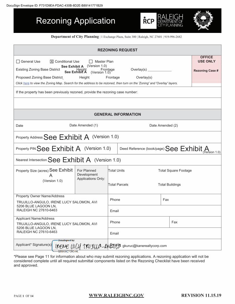
WWW.RALEIGHNC.GOV REVISION .15.19 PAGE 1 OF 1
_______ ______ _______
_ ___
Department of City Planning | 1 Exchange Plaza, Suite 300 | Raleigh, NC 27601 | 919-996-2682
REZONING REQUEST
OFFICE General Use Conditional Use Master Plan USE ONLY
Existing Zoning Base District Height Frontage Overlay(s)
Proposed Zoning Base District ___ Height __ Frontage Overlay(s)
Rezoning Case #
Click here to view the Zoning Map. Search for the address to be rezoned, then turn on the 'Zoning' and 'Overlay' layers.
If the property has been previously rezoned, provide the rezoning case number:
GENERAL INFORMATION
Date Date Amended (1) Date Amended (2)
Property Address
Property PIN Deed Reference (book/page)
Nearest Intersection
Property Size (acres) For Planned Development Applications Only:
Total Units Total Square Footage
Total Parcels Total Buildings
Phone Fax
Phone Fax
Signature Email
A rezoning application will not beconsidered complete until all required submittal components listed on the Rezoning Checklist have been receivedand approved.
Rezoning Application
See Exhibit ASee Exhibit A See Exhibit A
See Exhibit ASee ExhibitA
Property Owner /Address
TRUJILLO-ANGULO, IRENE LUCY SALOMON, AVI5206 BLUE LAGOON LN,RALEIGH NC 27610-6463
/Address TRUJILLO-ANGULO, IRENE LUCY SALOMON, AVI5206 BLUE LAGOON LN,RALEIGH NC 27610-6463
See Exhibit A (Version 1.0)
(Version 1.0)
(Version 1.0)
(Version 1.0)
(Version 1.0)
(Version 1.0)
(Version 1.0)
X
DocuSign Envelope ID: F731D9EA-FDAC-430B-8D2E-B89141771B29
mansolfj
Received

REZONING APPLICATION ADDENDUM #1
Comprehensive Plan Analysis
The applicant is asked to analyze the impact of the rezoning request and its consistency with the Comprehensive Plan. The applicant is also asked to explain how the rezoning request is reasonable and in the public interest.
STATEMENT OF CONSISTENCY
OFFICE USE ONLY
Rezoning Case#
Provide brief statements regarding whether the rezoning request is consistent with the future land use designation, the urban form map, and any applicable policies contained within the 2030 Comprehensive Plan.
1. The 2030 Comprehensive Plan identifies the subject properties as a high priority for redevelopment and reinvestment. Map ED-1 entitled Target Areas for Economic Development lists all three quadrants at the S. Saunders St. and 1-440 interchange as priorities for redevelopment. The proposed rezoning will lay the groundwork for reinvestment in these areas. 2. Similar1y, Policy ED 1.1 (Corridor Revitalization), Policy ED 1.3 (Gateway Reinvestment and Action) ED 1.1 (Strategic Revitalization Plans) encourage redevelopment of the S. Saunders gateway into the City. Tools include zoning, public investments in infrastructure and incentives. The proposed rezoning would address these policies by supporting higher densities and a mix of uses that bring together residents, jobs and retail amenities in an important location just south of Downtown. 3. Based on the unique facilities, scale and location of the proposed development, the rezoning meets a number of objectives under RegionalCoordination. The development will locate a soccer stadium serving the region near Downtown with access to a major interstate and regional transit. It also will bring jobs, housing and retail amenities to a location that minimizes vehicle miles traveled and reduces sprawl and environmental impacts at a regional level. 4. Much of the site also falls within Downtown Regional Center on the Growth Framework Map. As such, the Comprehensive Plan encourages significant infill development and redevelopment, particularly with an eye toward distinctive character through placemaking, transit and streetscape investments to encourage walkability. 5. The base zoning is consistent with the Future Land Use Map. The properties in the northeast quadrant of S. Saunders St. and 1-440 are designated Regional Mixed Use. The properties in the southwest quadrant are designated Office/Research and Development (ORD), and those at the southeast quadrant are Office and Residential Mixed Use (ORMU). CX is clearly appropriate for Regional Mixed Use. Given the proximity to a major interstate, ex is also appropriate for those designated ORMU and ORD. Note that these properties are already zoned CX or IX, which is inconsistent with the ORD and ORMU designation.
PUBLIC BENEFITS
Provide brief statements explaining how the rezoning request is reasonable and in the public interest.
1. Economic Revitalization. Based on the large assemblage of land on three quadrants of a major interchange, the siteoffers a unique opportunity to shape the future of Downtown Raleigh, expanding in a direction in greatest need ofinvestment. The scale and mix of uses will provide employment opportunities for the surrounding community and newamenities currently only available in other parts of the City.2. Infrastructure. The site is served by significant existing infrastructure, including a major highway and north-southcorridor. In addition, the site falls along a corridor identified for Bus Rapid Transit, where the most intense developmentshall occur. The level of infrastructure supports a large redevelopment project. The City recently completed theSouthern Gateway Corridor Study, which calls for more intense transit oriented development in this corridor.3. Stadium. The project envisions a stadium to accommodate soccer and other events throughout the year. Such amajor cultural/recreational investment at a strategic location near Downtown will add to the City's attractiveness foreconomic growth.4. Greenway. The Walnut Creek Greenway traverses the site. A large mixed use project will provide residents andpatrons with easy bike access to Downtown, Dix Park and the Neuse River Trail. Moreover, it will provide visitors anattractive destination along the greenway system.
PAGE3 OF 14 WWW,RALEIGHNC.GOV REVISION 11.15.19
DocuSign Envelope ID: F731D9EA-FDAC-430B-8D2E-B89141771B29

REZONING APPLICATION ADDENDUM #2
Impact on Historic Resources
The applicant is asked to analyze the impact of the rezoning request on historic resources. For the purposes of this section, a historic resource is defined as any site, structure, sign, or other feature of the property to be rezoned that is listed in the National Register of Historic Places or designated by the City of Raleigh as a landmark or contributing to a Historic Overlay District.
INVENTORY OF HISTORIC RESOURCES
OFFICE USE ONLY
Rezoning Case#
List in the space below all historic resources located on the property to be rezoned. For each resource, indicate how the proposed zoning would impact the resource.
N/A
PROPOSED MITIGATION
Provide brief statements describing actions that will be taken to mitigate all negative impacts listed above.
N/A
PAGE 4 OF 14 WWW.RALEIGHNC.Goy REVISION 11.15.19
DocuSign Envelope ID: F731D9EA-FDAC-430B-8D2E-B89141771B29

URBAN DESIGN GUIDELINES
The applicant must respond to the Urban Design Guidelines contained in the 2030 Comprehensive Plan if: a) The property to be rezoned is within a "City Growth Center" or "Mixed-Use Center" ,2!:b) The property to be rezoned is located along a "Main Street" or "Transit Emphasis Corridor''
as shown on the Urban Form Map in the 2030 Comprehensive Plan.
1.
2.
3.
4.
5.
6.
Urban Form Designation City Growth Center Click here to view the Urban Form Map.
All Mixed-Use developments should generally provide retail (such as eating establishments, food stores, and banks), and other such uses as office and residential within walking distance of each other. Mixed uses should be arranged in a compact and pedestrian friendly form.
Response:
Development will contain retail as well as other mixed uses in a walkable layout.
Within all Mixed-Use Areas buildings that are adjacent to lower density neighborhoods should transition (height, design, distance and/or landscaping) to the lower heights or be comparable in height and massing. Response:
Height map will provide that buildings adjacent to lower density neighborhoods will transition to lower heights.
A mixed use area's road network should connect directly into the neighborhood road network of the surrounding community, providing multiple paths for movement to and through the mixed use area. In this way, trips made from the surrounding residential neighborhood(s) to the mixed use area should be possible without requiring travel along a major thoroughfare or arterial. Response:
Given the large site area, the proposed development will create a new street system as well as connect into existing streets.
Streets should interconnect within a development and with adjoining development. Cul-de-sacs or dead-end streets are generally discouraged except where topographic conditions and/or exterior lot line configurations offer no practical alternatives for connection or through traffic. Street stubs should be provided with development adjacent to open land to provide for future connections. Streets should be planned with due regard to the designated corridors shown on the Thoroughfare Plan. Response:
Given the large site area, the proposed development will create a new street system as well as connect into existing streets.
New development should be comprised of blocks of public and/or private streets (including sidewalks). Block faces should have a length generally not exceeding 660 feet. Where commercial driveways are used to create block structure, they should include the same pedestrian amenities as public or private streets. Response:
Given the large site area, the proposed development will create a new street system as well as connect into existing streets.
A primary task of all urban architecture and landscape design is the physical definition of streets and public spaces as places of shared use. Streets should be lined by buildings rather than parking lots and should provide interest especially for pedestrians. Garage entrances and/or loading areas should be located at the side or rear of a property. Response:
Based on the urban frontage, buildings will line streets and provide interest for pedestrians with active uses.
PAGES OF 14 WWW,RALEIGHNC,GQV REVISION 11.15.19
DocuSign Envelope ID: F731D9EA-FDAC-430B-8D2E-B89141771B29

7.
8.
9.
Buildings should be located close to the pedestrian-oriented street (within 25 feet of the curb), with off-street parking behind and/or beside the buildings. When a development plan is located along a high volume corridor without on-street parking, one bay of parking separating the building frontage along the corridor is a preferred option. Response:
Based on the urban frontage, buildings will line streets and provide interest for pedestrians with active uses.
If the site is located at a street intersection, the main building or main part of the building should be placed at the corner. Parking, loading or service should not be located at an intersection. Response:
Based on the urban frontage, buildings will line streets and provide interest for pedestrians with active uses.
To ensure that urban open space is well-used, it is essential to locate and design it carefully. The space should be located where it is visible and easily accessible from public areas (building entrances, sidewalks). Take views and sun exposure into account as well. Response:
Given the outdoor amenity requirements and large site area, the proposed development will carefully locate public areas to maximize utilizations for pedestrians.
New urban spaces should contain direct access from the adjacent streets. They should be open along the adjacent sidewalks and allow for multiple points of entry. They should also be visually permeable from the sidewalk, allowing passersby to see
10• directly into the space. Response:
Given the outdoor amenity requirements and large site area, the proposed development will carefully locate public areas to maximize utilizations for pedestrians.
The perimeter of urban open spaces should consist of active uses that provide pedestrian traffic for the space including retail,
11. cafes, and restaurants and higher-density residential. Response:
Given the outdoor amenity requirements and large site area, the proposed development will carefully locate public areas to maximize utilizations for pedestrians.
A properly defined urban open space is visually enclosed by the fronting of buildings to create an outdoor "room" that is
12. comfortable to users. Response:
Given the outdoor amenity requirements and large site area, the proposed development will carefully locate public areas to maximize utilizations for pedestrians.
PAGE6 OF 14 WWW,RALEIGHNC,GQY REVISION 11.15.19
DocuSign Envelope ID: F731D9EA-FDAC-430B-8D2E-B89141771B29
New public spaces should provide seating opportunities. 13· Response:
The proposed development will activate open areas with outdoor seating.
Parking lots should not dominate the frontage of pedestrian-oriented streets, interrupt pedestrian routes, or negatively impact 14. surrounding developments.
Response:
The proposed development will contain structured parking compliant with urban frontage requirements and design standards for screening, and activation of the ground level.
Parking lots should be located behind or in the interior of a block whenever possible. Parking lots should not occupy more than
15. 1/3 of the frontage of the adjacent building or not more than 64 feet, whichever is less. Response:
The proposed development will contain structured parking compliant with urban frontage requirements and design standards for screening, and activation of the ground level.
Parking structures are clearly an important and necessary element of the overall urban infrastructure but, given their utilitarian elements, can give serious negative visual effects. New structures should merit the same level of materials and finishes as that
16· a principal building would, care in the use of basic design elements cane make a significant improvement. Response:
The proposed development will contain structured parking compliant with urban frontage requirements and design standards for screening, and activation of the ground level.
Higher building densities and more intensive land uses should be within walking distance of transit stops, permitting public
17. transit to become a viable alternative to the automobile. Response:
Given the high level of transit on S. Saunders Street and possibly on Wilmington Street, the proposed development will place intensity within walking distance of transit service.
Convenient, comfortable pedestrian access between the transit stop and the building entrance should be planned as part of the 18. overall pedestrian network.
Response:
Given the high level of transit on S. Saunders Street and possibly on Wilmington Street, the proposed development will place intensity within walking distance of transit service.
All development should respect natural resources as an essential component of the human environment. The most sensitive landscape areas, both environmentally and visually, are steep slopes greater than 15 percent, watercourses, and floodplains. Any development in these areas should minimize intervention and maintain the natural condition except under extreme
19· circumstances. Where practical, these features should be conserved as open space amenities and incorporated in the overall site design. Response:
Given the location of Walnut Creek, floodplains and existing greenway system, the proposed development will leverage these natural features as an asset for residents to enjoy and to access the surrounding area, including Downtown and Dix Park.
PAGE 7 OF 14 WWW,RALEIGHNC.Goy REVISION 11.15.19
DocuSign Envelope ID: F731D9EA-FDAC-430B-8D2E-B89141771B29

20.
21.
22.
23.
24.
25.
26.
It is the intent of these guidelines to build streets that are integral components of community design. Public and private streets, as well as commercial driveways that serve as primary pedestrian pathways to building entrances, should be designed as the main public spaces of the City and should be scaled for pedestrians. Response:
Based on the urban frontage, the proposed development will include public streets as an integral component to design.
Sidewalks should be 5-8 feet wide in residential areas and located on both sides of the street. Sidewalks in commercial areas and Pedestrian Business Overlays should be a minimum of 14-18 feet wide to accommodate sidewalk uses such as vendors, merchandising and outdoor seating. Response:
Based on the urban design guidelines, sidewalks will meet these dimensions.
Streets should be designed with street trees planted in a manner appropriate to their function. Commercial streets should have trees which complement the face of the buildings and which shade the sidewalk. Residential streets should provide for an appropriate canopy, which shadows both the street and sidewalk, and serves as a visual buffer between the street and the home. The typical width of the street landscape strip is 6-8 feet. This width ensures healthy street trees, precludes tree roots from breaking the sidewalk, and provides adequate pedestrian buffering. Street trees should be at least 6 1/4" caliper and should be consistent with the City's landscaping, lighting and street sight distance requirements. Response:
Based on the urban frontage, the proposed development will include street trees.
Buildings should define the streets spatially. Proper spatial definition should be achieved with buildings or other architectural elements (including certain tree plantings) that make up the street edges aligned in a disciplined manner with an appropriate ratio of height to width. Response:
Based on the urban frontage, the buildings will define the streets spatially.
The primary entrance should be both architecturally and functionally on the front facade of any building facing the primary public street. Such entrances shall be designed to convey their prominence on the fronting facade. Response:
Based on the urban frontage, the primary entrance of buildings will be street facing.
The ground level of the building should offer pedestrian interest along sidewalks. This includes windows entrances, and architectural details. Signage, awnings, and ornamentation are encouraged. Response:
Based on the urban frontage, the ground level of buildings will offer pedestrians interest along sidewalks.
The sidewalks should be the principal place of pedestrian movement and casual social interaction. Designs and uses should be complementary to that function. Response:
Based on the urban frontage, the sidewalks will be the principle place of pedestrian movement.
PAGES OF 14 WWW,RALEIGHNC,Goy REVISION 11.15.19
DocuSign Envelope ID: F731D9EA-FDAC-430B-8D2E-B89141771B29

REZONING APPLICATION SUBMITTAL REQUIREMENTS ("Rezoning Checklist")
TO BE COMPLETED BY APPLICANT COMPLETED BY
CITY STAFF
General Requirements - General Use or Conditional Use Rezoning YES N/A YES NO N/A
1. I have referenced this Rezoning Checklist and by using this as a guide,0 □ it will ensure that I receive a complete and thorough first review by the
City of Raleigh
2. Pre-Application Conference 0 □ 3. Neighborhood Meeting notice and report CJ" u
4. Rezoning application review fee (see E�� S,b1:1dul1:1 for rate) IZ] □ 5. Completed application, submitted through Permit & Development Portal IZI □
Completed Comprehensive Plan Consistency Analysis 0 □ Completed Response to the Urban Design Guidelines @ □
6. Two sets of stamped envelopes addressed to all property owners of area0 □ to be rezoned and properties within 500 feet of area to be rezoned
7. Trip Generation Study LI u
8. Traffic Impact Analysis □ □
For properties requesting a conditional use district:
9. Completed zoning conditions, signed by property owner(s) Lr □
If applicable (see Page 11 ):
10. Proof of power of attorney or owner affidavit □ 0
For properties requesting a Planned Development {PD) or Campus District (CMP):
10. Master Plan (see Master Plan Submittal Requirements) □ 121
For properties requesting an Accessory Dwelling Unit Overlay District (ADUOD):
15. Copy of ballot and mailing list □ Q/
PAGE9 OF 14 www,RALEIGHNC,GOY REVISION 11.15.19
DocuSign Envelope ID: F731D9EA-FDAC-430B-8D2E-B89141771B29
MASTER PLAN SUBMITTAL REQUIREMENTS
TO BE COMPLETED BY APPLICANT COMPLETED BY
CITY STAFF
General Requirements - Master Plan YES N/A YES NO N/A
1. I have referenced the Master Plan Checklist and by using this as a
□ [Z] guide, it will ensure that I receive a complete and thorough first review bythe City of Raleigh
2. Total number of units and square feet □ IZI 3. 12 sets of plans □ 0 4. Completed application; submitted through Permit & Development Portal □ 0
5. Vicinity Map □ 12] 6. Existing Conditions Map □ 0 7. Street and Block Layout Plan LJ 0
8. General Layout Map/Height and Frontage Map □ 12] 9. Description of Modification to Standards, 12 sets □ 0 10. Development Plan (location of building types) □ 0 11. Pedestrian Circulation Plan □ IZI 12. Parking Plan □ 0 13. Open Space Plan □ Lll 14. Tree Conservation Plan (if site is 2 acres or more) □ IZ) 15. Major Utilities Plan/Utilities Service Plan □ IZI 16. Generalized Stormwater Plan LI Lll 17. Phasing Plan □ 0
18. Three-Dimensional Model/renderings □ 0
19. Common Signage Plan □ (Z]
PAGElO OF14 WWW,RALEIGHNC,GQY REVISION 11.15.19
DocuSign Envelope ID: F731D9EA-FDAC-430B-8D2E-B89141771B29
Who can initiate a rezoning request?
If requesting to down-zone property, the rezoning application must be signed by all of the property owners whose property is subject to the down-zoning. Down-zoning is defined as a zoning ordinance that affects an area of land in one of the following ways:
1. By decreasing the development density of the land to be less dense than was allowed underits previous usage.
2. By reducing the permitted uses of the land that are specified in a zoning ordinance or landdevelopment regulation to fewer uses than were allowed under its previous usage.
If requesting to rezone property to a conditional district, the rezoning application must be signed by all owners of the property to be included in the district. For purposes of the application only (not the zoning conditions), the City will accept signatures on behalf of the property owner from the following:
1. the property owner;2. an attorney acting on behalf of the property owner with an executed power of attorney; or3. a person authorized to act on behalf of the property owner with an executed owner's affidavit.
An owner's affidavit must be made under oath, properly notarized and, at a minimum, include the following information:
■ The property owner's name and, if applicable, the property owner's title and organization name.■ The address, PIN and Deed Book/Page Number of the property.■ A statement that the person listed as the property owner is the legal owner of the property
described.■ The name of the person authorized to act on behalf of the property owner as the applicant. If
applicable, the authorized person's title and organization name.■ A statement that the property owner, as legal owner of the described property, hereby gives
authorization and permission to the authorized person, to submit to the City of Raleigh anapplication to rezone the described property.
■ A statement that the property owner understands and acknowledges that zoning conditions must besigned, approved and consented to by the property owner.
■ The property owner's signature and the date the property owner signed the affidavit.
If requesting to rezone property to a general use district that is not a down-zoning, the rezoning application may be signed, for the purposes of initiating the request, by property owners or third-party applicants.
PAGEll OF 14 WWW.RALEIGHNC.GOY REVISION 11.15.19
DocuSign Envelope ID: F731D9EA-FDAC-430B-8D2E-B89141771B29

� MORN NGSTAR ¥LAW GROUP
To: Neighboring Property Owner
From: Mack Paul
Date: February 7, 2020
Mack Paul I Partner 421 Fayetteville Street, Suite 530
Raleigh, NC 27601 919-590-0377
[email protected] www.morningstarlawgroup.com
Re: Notice of meeting to discuss potential rezoning of certain property described in the chart below (the "Property")
Property
See attached list.
We are counsel for Kane Realty Corporation ("Kane"), which plans to rezone the above-captioned Property. Currently, the Property is zoned IX-3, IX-3-PL, IX-4-PL, IH, and R6 respectively. Kane is considering rezoning the Property to Commercial Mixed Use, up to 40 stories with Urban Limited frontage (CX-40-UL). The purpose of the rezoning is to facilitate development of Downtown South, a large mixeduse development that will include a stadium and other public amenities.
You are cordially invited to attend a meeting to discuss the potential rezoning. We have scheduled a meeting with surrounding property owners on Wednesday, February 19, 2020, from 6:00 p.m. to 7:00 p.m. This meeting will be held in a room at Trophy Brewing, 656 Maywood Avenue.
The City of Raleigh requires a neighborhood meeting involving the owners of property within 500 feet of the site prior to filing a rezoning application. After the meeting, we will prepare a report for the Raleigh Planning Department regarding the items discussed at the meeting.
Please do not hesitate to contact me directly should you have any questions or wish to discuss any issues. I can be reached at 919.590.0377 or [email protected]. Also, for more information about the rezoning, you may visit www.raleighnc.gov or contact the Raleigh City Planning Department at (919) 996-2682 or [email protected].
DocuSign Envelope ID: F731D9EA-FDAC-430B-8D2E-B89141771B29

riawri T0IU0.'1.'iC .OPIJCWON PlN AilliESS CITY STAIE ZIP
a.JUE.'ff ro BE
�ZIHi) OWNER.NAME
1702381403 2400S SAUNDERSS'f lWlip NC
1703501032 IOOPENMARCDl IWeijt NC 1703406591 0 PENMARC D1 � NC 170340%66 201 PENMARC D.1l �l\'C 1701492952 1821 S SAUNDERS ST Roopi NC 1703402054 1801 S SAUNI>ERS sr l'Jlaip NC 1703402145 1811 S S.i\UNDERS ST !Weigh NC 17034-02242 1809S SAUNJ>fRSST � NC 1703402342 0 S SAUNDERS ST RaleiguNC 1703402#3 17}[ S Si\UNDERS ST l'wleigh NC 1703402539 1727 S SAUNDERS sr .r� NC 1703402735 1717 S SAUNDERS ST P.uigli NC 17034112838 17{Ji S SAUNDERS S! Raleigu NC 1703413123 1640 GREEN ST !Weigh NC 1703413159 1632 GREENST RaltipNC 1703413254 1628 GREEN ST lWeip.NC 1703413219 1624 GREEN ST blti!hNC 1703413440 1616 GREEN ST ]WlighNC
1703413593 201 GILBERT AVE Pwleigh NC 1703415274 1639 Gll.ENST lWlilii NC 170341S217 ISO PENMAR.C D1l lWei&hNC l703502S02 150 PENMAR.CDR bleJthNC 17035015!7 l20PENMARCDR Xal!ipNC 1703f.01307 125 BL'IIJF ST I'.aleigh NC
170J5W186 137 BLL'fF SY I'.alugh NC
1702494929 1813SSill1rlllmSt RaltighNC
1102691938 ms s v.� Si Raleigh NC
1703508002 201 V:alker St :iWeighNC
1701596769 2lOOSWi!miqtmSt f.alai!i NC
1703507332 212 Walbr St lW!ilh NC
17035052�7 218Wa!kerSt :l'.aleii!i .KC
1703505257 232 \\'alkerSt Pwleiih NC
17035-06166 235 W.>Um.ST P.aleigh NC
1703.505186 239WALm.ST 1'.w�NC
170360ml 95 Bluft'St l'.all!i!h NC
27603. D::s3
27603 IXc3 17603 Di:-3 27603 Di:-3 27603 IX-3-PL 27603 ix,3.pt 27603 Di:-3-PL .27603 Di:-3-PL 27603 Di:-3-PL 27603 Di:-3-PL 27603 ]Xs3-PL 27603. lX-3-PL 27603 Di:-3-PL 27603 R-6 27603 R-6 27603 R-6 27603 R-6 27603 R-6 27603 R-6 27603 l!.-6 27603 ]X.J 27603 lX-3 27003 lX-1 2i603 JXcJ
27603 IX-3
27603 lX-4-PL
27603 lH
27603 llf
27603 Di:-3-PL
27603 D:-3
27603 lX-3
27603 lX-3
27603 lH
27603 1H
27603 JX.j
CX4D-UL MKSOUIHllC
CX-40-UL :PENNY,AllCEW CX-40-UI. Pl!NNY, Al.ICE W 0::40-UI. PENNY,.WCr:W CX-40-UL POOY,AllCEW CX-40-UL POOY .• WCE W CX-40-UL Pl!NNY .• WCE W CX-40-UL mro',AllCEW CX-40-UL Pl!N!ff,AllCEW CX-40-UL PENNY,AlllW CX-40-UL �'Y,AllCEW CX-40-UL �'Y,AllCEW CX-40-UL PEI..�-, AI1CE W CX-40-UL Pm-.'l',AUCEW CX-40-UL P.00.'Y,AllCEW CX-40-tlI. P.00.'Y, Al!CE.W CX-4fl..UL moo•, ALICE\\" CX-4t�UL m.."rr, AllCE W -CX-4fl..UL PD..."{Y',IJlCEWCX-43-UL pm,.,Y,AUCEWCX..w.UL l'Bu'Y,AlJCE'\\'CX-4D-UL Pll<.W, lJlCE WCX-40-UL m..W,AIICEWCX-40-UL MKSOUIHilllCCX-40-UL MKSOUIHilllC
0::40-UL BWIWIU.C
CX-40-UL MKSOU1HilllC
CX-40-UL MKSOUIHllllC
CX-40-UL MKSOUDIIILLC
CX-40-UL MKSOUIHlrllC
CX-40-UI. MKSOU1Hl[ll£
0::40-UI. MKSOUIHllllC
CX-40-UL MK SOL'TiilI LLC
CX-4Q.UL MKSOUIHilllC
CX-40-UI. MKSOUTlll!llC
09.'NElUIDtfSS DEEDBOCK aossmm
A.'f:>PAGE
4521 u.ssrinATNOR.lHHlWA\I.E, STB250,IWEGH 17695/02495TsmndmSI/Hnbut StmlS. NC 2760SC5781 Sall!ldss St/ C.mlim Pill!sA\,e POBOY.37159,IW.FlGHNC 27627-7159 �14217102793 \l.'mWmhSt/PemmrcDr 120 Pl!NMAltCDlSTE H&, RALEIGH NC 27603-2400 (1142l7102Bl S. Sawulm SHPm:nm Dr 120PENMARCD1STE 118,.RAI.EGHNC27603.J400 014217102793 S. 5.imaa! I Pemmn: Dr 120PENMARC D1 STE 118, RAI.EGHNC 27603-2400 014217 / 02793 S. SEWlm./ Pemmn: Dr 120PENMAR.CD1STE HS,RAI.EGHNC 27603.,1400 014217/02793 S.Sm:.im/Pemmn:Dr no PENMt.RC m.m m, RAI.EGHh't 2760J-24()(t 0142171027Y5 S. Samulm/ PenmarcD: 120PENMARCDlSTE m, RAI.EGHNc:27603-2400 014217 I 02793 S. Smidm I Pemmn: Dt 120 PENMARC D1 �IE 116, RAIIIGHNC 27603-2400 014217/02793 S. Samms/P=Dz 120PENMAllCDR.SIE H&, RALEIGHNC2760J-2400 014217/0'lm S.Smidm/Pemmn:Dr POBO.X 3715S, RALEIGH NC 27627-7159 014217101793 S.. Sllllldm/Peimwd)r I-OBOX37159,RA1.EIGHNC27627-715!i 014117 /02793 s. Smidm/Pemmrc:Dr PO BOX 37159, RALEIGH NC 27627-1159 014217 /01793 S. Szmulm/Pemmrc:Dr PO BOY. 3715S, RA1.EIGHNC27627-7159 014217 /01N3 GreenSt/Pammcih PO BOX 37159, KAIEGHNC 27627-7159 014211/02793 GreenSt/Pammcih PO BOX 37159,BALEIGHNC 27627-7159 014217 / 02m Gleen Stl Fa1mard>r POBOX31159,RAI.EIGHNC27621-7159 Ol.S280/00776 GieenStf Peomarcih POBOY. 37159, RALFJGHNC 27E21-'il59 Ol602S1 010S2 G:m.St/ Gilbert A\1! PO BOX 37159 ,B.ALEJGH NC 27627-71'9 01662� I 01273 Gram: St/ Gilbert A\'l POBOY.37159, RALEIGH NC 27627-71'9 014217101793 Gram:St/PammcDr PO BOX 31159,RAimHNC 27627-'ilSSI 014217/02793 GieenSt/Peaman:Dr POBOX37159,.RAIEGHNC 276!i-'il59 014217/0lm Pt=Dr!WarWmbSt PO BOX 37159, RALEIG!INC 27627-7159 0021!/00480 Pe=DrJWooWmSt KA.'IEREALTI"CORPORATimi,4121 LAS5l'EEK.AT 01761J.i/01696 Bluft'StfPJumSt NOR1HHlllSA'v"i.,!tAlmlNC27W1-5780 KA.�JIEALTY CORPORATI<!f, 4321 LASSI'IEllAT 017695i02696 Bllli'St/PlllmS! NOl'!HHlllS AVE, iALEIGI NC 27609-5780 .5847 SAU mm; ST STE 4650, HOUSTONlX 710S7�127J 016015101801 s. Snmm/Pemmn:D:
KA.1'\EJIEAL'ITCORPOUIION,4321 LASSJ1ER.AT 01769S/02696 S. W�St/WmrSt NOR1HHlllS AVE.1'..ALErGHNC 276@-5780 KA.'iElF.AL'IT CORPOE.ATION, 43211.ASSllEllAT 01769.5/02696 S. WiimmgicmSt/WderSt NORIHHlllSAV!,1WfilGHNC27E�-5780 KA:.'IERF.ALTY CORPOllATIO:-, 4321 I.ASSl'IEltAT 0176!15 t 01696 S. \\'ilming:anSl/Ww: St NOR1HHlllS AVE,RAIEGHNC 27E$-5780 KANEiEALTYCORPORA'Im�4321 LASSl'IEltAT 01769S I 02696 Walliu St/ P"mm St NORIHHlllSAVE,1'J.lEIGHNC27�-5780 KA.'IEll/J.ITCORPOKA.mum I.ASSl1EltAT -017695/02636 Wa!brSt/P"J11JJ1St NOR1HHIU.SAVE,1'J;1E1GHNC27609-5780 KANE REALTY CORPORAl'ICE .. 4321 LASSl'IEltAT 017695102696 Wa!brSt/PlumSt NOR1HHIW AVE,iA!EGHNC 276l»-5780 KA.'IEllEALTYCORPORA'.IION, 4121 LW!mAT 017695/02696 Wa!lw-St/ PhunSt NOll'IH HlllS AVE, 1A1IIGHNC 276l»-5780 KAN1!1EALTYCORPORA'IION. 4321 LASSlmAT 01769.i/ 02696 Walbr St/ P"lllm St NOll'ffl HlllS AVE, lAlEIGH NC 276l»-5780 KANl!r.EALTYC�43llLASSI'IEllAT 017695 I 0269c Bid St/ Plum St N011H HIW AVE.,1'.AlEGHNC l76(1;-57S0
HIOl1BlY
�--�11 77.6-i
2'0Jl 6.0S s
0.13 0.34 O.HOJl
0.31 0.36 0.63 0.39
0.5S 034 0.17 0.16 0.17 0.28 0.1? I.SI1.99 2.01 195 0.1
0.09
2.1
3.81
2.S7
0.89
1.27
0.0S
0.1
0.08
0.26
1.46
DocuSign Envelope ID: F731D9EA-FDAC-430B-8D2E-B89141771B29

SUMMARY OF ISSUES
A neighborhood meeting was held on February 19, 2020 (date) to discuss a potential
rezoning located at See Exhibit A (property address).
Th . hb h d t· h Id t Trophy Brewing & Taproom, 656 Maywood Ave, Raleigh
(I t·
) e ne1g or oo mee rng was e a __________________ oca 10n .
There were approximately 58 (number) neighbors in attendance. The general issues
discussed were:
Summary of Issues:
Stormwater I Flooding:
Attendee asked about stormwater runoff in Tract A (adjacent to Caraleigh Mills).
Attendee asked if there would be a study on how Developer can mitigate stormwater in the area.
Attendee noted that stormwater on C drains into A and that Developer need to consider that (though in truth it drains in the opposite direction).
Attendee noted efforts of residents to ensure stormwater mitigation during development of townhomes along Maywood Avenue.
Attendee noted storms and flooding are becoming more frequent and Developer need to consider future changes to flood maps.
North Carolina Equipment Co. Tracts:
Attendee asked if Developer was aware of an old cemetery located on Tract A.
PAGE 13 OF 14 WWW.RALEIGHNC,GOV REVISION 11.15.19
DocuSign Envelope ID: F731D9EA-FDAC-430B-8D2E-B89141771B29
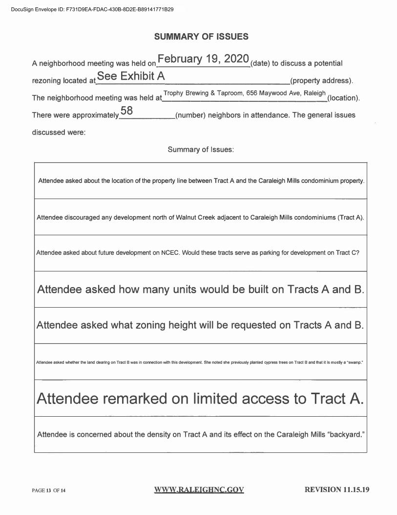
SUMMARY OF ISSUES
A neighborhood meeting was held on February 19, 2020 (date) to discuss a potential
rezoning located at See Exhibit A (property address).
Th . hb h d t· h Id t Trophy Brewing & Taproom, 656 Maywood Ave, Raleigh
(I t·
) e ne1g or oo mee mg was e a. _________________ oca 10n .
There were approximately 58 (number) neighbors in attendance. The general issues
discussed were:
Summary of Issues:
Attendee asked about the location of the property line between Tract A and the Caraleigh Mills condominium property.
Attendee discouraged any development north of Walnut Creek adjacent to Caraleigh Mills condominiums (Tract A).
Attendee asked about future development on NCEC. Would these tracts serve as parking for development on Tract C?
Attendee asked how many units would be built on Tracts A and B.
Attendee asked what zoning height will be requested on Tracts A and B.
Attendee asked whether the land clearing on Tract B was in connection with this development. She noted she previously planted cypress trees on Tract B and that it is mostly a "swamp."
Attendee remarked on limited access to Tract A.
Attendee is concerned about the density on Tract A and its effect on the Caraleigh Mills "backyard."
PAGE13 OF14 WWW.RALEIGHNC.GQY REVISION 11.15.19
DocuSign Envelope ID: F731D9EA-FDAC-430B-8D2E-B89141771B29

SUMMARY OF ISSUES
A neighborhood meeting was held on February 19, 2020 (date) to discuss a potential
rezoning located at See Exhibit A (property address).
Th . hb h d t· h Id t Trophy Brewing & Taproom, 656 Maywood Ave, Raleigh
(I t·
) e ne1g or oo mee mg was e a. __________________ oca 10n .
There were approximately 58 (number) neighbors in attendance. The general issues
discussed were:
Summary of Issues:
Traffic/ Infrastructure:
Attendee from Caraleigh Mills asked about traffic circulation along neighborhood streets.
Attendee requested consideration of traffic flow on Maywood Avenue, especially during sports/entertainment events in the development.
Attendee asked about a potential transportation link to Hammond Road to help distribute traffic.
Attendee asked that attention be focused on pedestrian connections and infrastructure improvements to connect the site to Downtown.
Rezoning I Included Properties:
Attendee asked about the proposed zoning designation and when the zoning would be filed with the City.
Attendee asked who is applying for the rezoning.
PAGE13 OF 14 www.RALEIGHNC,Goy REVISION 11.15.19
DocuSign Envelope ID: F731D9EA-FDAC-430B-8D2E-B89141771B29

SUMMARY OF ISSUES
A neighborhood meeting was held on February 19, 2020 (date) to discuss a potential
rezoning located at See Exhibit A (property address).
Th . hb h d t· h Id t Trophy Brewing & Taproom, 656 Maywood Ave, Raleigh
(I t·
) e ne1g or oo mee mg was e a. ____________________ oca 10n .
There were approximately 58 (number) neighbors in attendance. The general issues
discussed were:
Summary of Issues:
Attendee asked whether Kane Realty has closed on all the Tracts connected to the proposed developments and whether purchase contracts are contingent on rezoning.
Attendee asked whether the Shell Station on S Saunders Street would be part of the development.
Attendee asked if the historic waterworks building along Wilmington Street would be included in the development.
Attendee asked about how likely the City was to approve our rezoning and whether they may fight us on it.
Natural Areas I Greenway:
Attendee expressed a desire to maintain natural areas along the greenways so that wildlife can remain in the area.
Attendee expressed concern that the natural areas would not be suitable for wildlife after development.
Attendee emphasized the "natural backyard" behind the Caraleigh Mills condominiums and wanted to avoid manicured parks on that tract.
PAGE 13 OF 14 WWW,RALEIGHNC.GQY REVISION 11.15.19
DocuSign Envelope ID: F731D9EA-FDAC-430B-8D2E-B89141771B29

SUMMARY OF ISSUES
A neighborhood meeting was held on February 19, 2020 (date) to discuss a potential
rezoning located at See Exhibit A (property address).
Th . hb h d t· h Id t Trophy Brewing & Taproom, 656 Maywood Ave, Raleigh (I t
· ) e ne1g or oo mee mg was e a ________________ oca 10n .
There were approximately 58 (number) neighbors in attendance. The general issues
discussed were:
Summary of Issues:
Attendee asked how Developer planned to develop on wetlands.
Future Communications:
Attendee asked whether there would be future meetings with residents.
Attendee asked how Developer would notify them of future meetings.
Miscellaneous:
Attendee is fearful of what Developer is doing on Tract A without seeing a plan.
Attendee asked about the timeline for the development and when groundbreaking would occur.
Attendee asked about the cost of the overall development, the cost of the stadium and the source of funding for the stadium.
PAGE13 OF 14 WWW,RALEIGHNC.GOV REVISION 11.15.19
DocuSign Envelope ID: F731D9EA-FDAC-430B-8D2E-B89141771B29

SUMMARY OF ISSUES
A neighborhood meeting was held on February 19, 2020 (date) to discuss a potential
rezoning located at See Exhibit A (property address).
Th . hb h d t· h Id t Trophy Brewing & Taproom, 656 Maywood Ave, Raleigh
(I t·
) e ne1g or oo mee mg was e a. ________________ oca 10n .
There were approximately 58 (number) neighbors in attendance. The general issues
discussed were:
Summary of Issues:
Attendee asked about the reasons for moving the stadium from S. Saunders Street to Wilmington Street.
Attendee asked whether the site was in an Opportunity Zone.
Attendee asked whether there is a specific development plan for Tract C.
PAGE13 OF 14 WWW,RALEIGHNC,GQY REVISION 11.15.19
DocuSign Envelope ID: F731D9EA-FDAC-430B-8D2E-B89141771B29

ATTENDANCE ROSTER
NAME ADDRESS
r3/
PAGE130F11 WWW.RALEIGHNC.GOV REVISION 5.15.18
DocuSign Envelope ID: F731D9EA-FDAC-430B-8D2E-B89141771B29

ATTENDANCE ROSTl:R
NAME ADDRESS
l.C>oo
PAGE130Fll WWW.RALEIGHNC.GOV REVISION 5.15.18
DocuSign Envelope ID: F731D9EA-FDAC-430B-8D2E-B89141771B29

PAGE130Fll
ATTENDANCE. ROStER . . .· ·.:
. , . . ... : '
. .· . �- -
8.?ID Si7rz.t�4HtLL./W6-
WWW.RALEIGHNC.GOV REVISION 5.15.18
DocuSign Envelope ID: F731D9EA-FDAC-430B-8D2E-B89141771B29

109 BLANCHARD LLC
2000 GARDEN WALL CT
RALEIGH NC 27614-6851
562 GRANITE LLC
1606 KILDAIRE FARM RD
CARY NC 27511-6557
ABEBE, MOGES ARGA W, TENAGNE
1915 NEW BERN AVE
RALEIGH NC 27610-2426
ADAMS, KEITH TYRELL
1535 CARALEIGH MILLS CT APT 221 RALEIGH NC 27603-6458
AKINLADE, JOAN 0
1205 OLE CT
RALEIGH NC 27603-7727
ANDERSON, MEGAN MCCARTHY
1555 CARALEIGH MILLS CT APT 101
RALEIGH NC 27603-6459
AQUA EMPIRE LLC
133 FAYETTEVILLE ST STE 600
RALEIGH NC 27601-2911
BAILEY, ROSLYN MARKS BAILEY,
JOSEPH C 2506 SPRINGHILL A VE
RALEIGH NC 27603-2722
BBC MAYWOOD PROPERTIES LLC
301 FAYETTEVILLE ST UNIT 2808
RALEIGH NC 27601-2177
BECERRIL -A VILA, PABLO
5213 BLUE LAGOON LN
RALEIGH NC 27610-6462
2018-4 Ill BORROWER LP
INVITATION HOMES
1717 MAIN ST STE 2000
DALLAS TX 75201-4657
658 MAYWOOD A VE LLC
514 S HARRINGTON ST
RALEIGH NC 27601-2108
ACOSTA, BRADLEY
31 SUMMIT A VE
RALEIGH NC 27603-2449
ADAMS, KEITH TYRELL MILLS,
CORENTHIA JAPZON 1535 CARALEIGH MILLS CT APT 139 RALEIGH NC 27603-6454
ALTMAN, KIMBERLY LYNN ALTMAN,
LLOYD HAMPTON III
2504 VAN DYKE A VE
RALEIGH NC 27607-6938
ANDREWS, DAVID RAY JR ANDREWS,
BRENDA B
5405 CHASSCOT CT
RALEIGH NC 27606-5702
AQUAGROOM INC
1400 SMITH RENO RD
RALEIGH NC 27603-7732
BANKS, SHIRLEY HEIRS
PEGGY B LUCAS ADMIN
302PLAZA DR
GARNER NC 27529-2730
BEASLEY, RUTH N
5122 MIDLAND ST RALEIGH NC 27603-4234
BENNETT,KATHLEEN 1535 CARALEIGH MILLS CT APT 133
RALEIGH NC 27603-6454
41 EAST THIRTY FIRST ST CORP
1969 EMERSON COOK RD
PITTSBORO NC 27312-9268
A&A HOSPITALITY INC
2539 S SAUNDERS ST RALEIGH NC 27603-2843
ADAMS, DWIGHT T ADAMS, CHERYL B
138 GILBERT A VE
RALEIGH NC 27603-2420
AGUILAR, CONRRADO BENITEZ
GARCIA, MARIA TORRES 156 GILBERT A VE
RALEIGH NC 27603-2420
ANDERSON, JONATHAN W
PO BOX6356
RALEIGH NC 27628-6356
APPLE CAT REALTY LLC 212 MAYWOOD AVE
RALEIGH NC 27603-2440
ARMSTRONG, STEVEN A
ARMSTRONG, JACQUELINE L 2238 SPRINGHILL A VE
RALEIGH NC 27603-7728
BATES, DEBRA W BATES, WILLIAM C
JR 4612 SPRING CREST CT
FUQUAY VARINA NC 27526-8405
BEBCO
105 BERRY HILL DR
RALEIGH NC 27615-2060
BENNETT, SAMUELJ
1535 CARALEIGH MILLS CT APT 117
RALEIGH NC 27603-6452
DocuSign Envelope ID: F731D9EA-FDAC-430B-8D2E-B89141771B29

BEST, ADRIAN L BEST, ROSIE M 604 PARKANDER CT RALEIGH NC 27603-7725
BHOTHIPITI, LUKE BHOTHIPITI, LAUREN LUWISCH 609 MAYWOOD A VE RALEIGH NC 27603-2339
BLIGHT, MICHAEL J BLIGHT, SHERRI s
220 DEVANE ST FAYETTEVILLE NC 28305-5061
BRICK CLAN LLG 300 WINDCHASE LN WILMINGTON NC 28409-3028
BW RRI I LLC 5847 SAN FELIPE ST STE 4650 HOUSTON TX 77057-3277
CARALEIGH 144 LLC 4108 OAK PARK RD RALEIGH NC 27612-5625
CAROLINA BUILDERS RALEIGH PORTFOLIO SL LLC 3843 W CHESTER PIKE NEWTOWN SQUARE PA 19073-2304
CHAMCO II INC PO BOX 530710 BIRMINGHAM AL 35253-0710
CONOLOGUE, ERIC EDWARD 607 MAYWOOD A VE RALEIGH NC 27603-2339
CRUMPLER, CONNIE G 120 GILBERT A VE RALEIGH NC 27603-2420
BESTIMT, JASON MICHAEL GABRIAN, EMILY THERESA 1535 220 CARALEIGH MILLS CT RALEIGH NC 27603-6457
BIELEC, ADRIENNE S 1535 103 CARALEIGH CT RALEIGH NC 27603-6451
BOCCHINO, JOSEPH VINCENT BOCCHINO,LORETTA 1555 103 CARALEIGH MILLS CT RALEIGH NC 27603-6459
BURKETT, LAURA E 1535 CARALEIGH MILLS CT APT 136 RALEIGH NC 27603-6454
CAMERON, ROBERT H 742 MCKNIGHT DR STE 213 KNIGHTDALE NC 27545-7764
CARALEIGH MILLS CONDO ASSOC INC YORK PROPERTIES INC 2108 CLARK AVE RALEIGH NC 27605-1606
CARROLL, SHIRLEY W 2881 NC 42 HWY WILLOW SPRING NC 27592-7818
CIRKLE K STORES INC PROPERTY TAX DCl 7 PO BOX 52085 PHOENIX AZ 85072-2085
COWLEY, LISA M 1535 CARALEIGH MILLS CT APT 213 RALEIGH NC 27603-6457
DALAL, AMY GUPTA, HEMANSHU 1535 CARALEIGH MILLS CT APT 209 RALEIGH NC 27603-6456
BETTINGER, DOUGLAS 15160 EL CAMINO SENDA SARATOGA CA 95070-6208
BLANEY, ETHAN MOORE, MEREDITH 1535 216 CARALEIGH MILLS CT RALEIGH NC 27603-6457
BODLE, JOSEPHINE C 2301 SPRINGHILL A VE RALEIGH NC 27603-7724
BURNS, BRANDY LYNN 2513 SPRINGHILL AVE RALEIGH NC 27603-2721
CARALEIGH 119 LLC 4108 OAK PARK RD RALEIGH NC 27612-5625
CARALEIGH VILLAGE LLC 2901 TIMPANI TRL APEX NC 27539-3621
CHALCO, NATALIE 1535 134 CARALEIGH MILLS CT RALEIGH NC 27603-6454
CLARK STORES LLC PO BOX469 CLINTON NC 28329-0469
CROWN BUILDERS AND DEVELOPERS OF NC LLC 105 W WILLIAMS ST APEX NC 27502-1830
DALRYMPLE, JOHN THOMAS DALRYMPLE, AMY MCNEILL 1449 DALRYMPLE FARM RD SANFORD NC 27330-6494
DocuSign Envelope ID: F731D9EA-FDAC-430B-8D2E-B89141771B29

DANFORTH GABLES AND FROST LLC
1208 MANTRA CT
CARY NC 27513-9672
DA VIS, ELIJAH JR GLENN, JAMES
ALVIS
856 NEWCOMBE RD
RALEIGH NC 27610-4725
DEIHL, JENNIFER J
1535 CARALEIGH MILLS CT APT 126
RALEIGH NC 27603-6453
DEROSA, DANIEL G KAZAL,
ELIZABETH A
1619 ELLA WIGGINS WAY
RALEIGH NC 27603-6487
DICKERSON, ERIKA T
44 E 132ND ST APT 5A
NEW YORK NY 10037-2976
DUMONT, WILLIAM
303 BATHGATE LN
CARY NC 27513-5565
DUMONT, WILLIAM J DUMONT,
BARBARA
303 BATHGATE LN
CARY NC 27513-5565
DUO LLC
1535 114 CARALEIGH MILLS CT
RALEIGH NC 27603-6452
ECKENRODE,KYLE BURNS
135 MAYWOOD A VE
RALEIGH NC 27603-2437
FINLEY, JACK EDWARD GRAYSON,
WILLIAM 1535 CARALEIGH MILLS CT APT 226
RALEIGH NC 27603-6458
DANIELS, ELLYN E
500 W P ARK DR
RALEIGH NC 27605-1746
DA VIS, R EARL
PO BOX464
RALEIGH NC 27602-0464
DELGADO, MAX JANARELLA,
LAUREN
163 MAYWOOD AVE
RALEIGH NC 27603-2437
DEVINCENZO, BRUCE DEVINCENZO,
SONDRA
7912 RIVER RIDGE RD
WAKE FOREST NC 27587-9355
DOWNEY, RONALD E JR
601 OLEANDER RD
RALEIGH NC 27603-2713
DUMONT, WILLIAM DUMONT
BARBARA D
303 BATHGATE LN
CARY NC 27513-5565
DUMONT, WILLIAM J DUMONT,
BARBARAJ
303 BATHGATE LN
CARY NC 27513-5565
DUPREE, SHEILA
150 GILBERT AVE
RALEIGH NC 27603-2420
ESCALERA, PABLO G
615 PARK.ANDER CT
RALEIGH NC 27603-7725
FITCH, HENRY A MARCUS, LI A
608 PARK.ANDER CT
RALEIGH NC 27603-7725
DARRAH, KAREN L
501 TIPPED CT
RALEIGH NC 27603-7726
DEANE, DREW D
1535 CARALEIGH MILLS CT APT 109
RALEIGH NC 27603-6451
DEP ASQUA, LISA A
2617 SPRINGHILL A VE
RALEIGH NC 27603-2723
DEVINCENZO, BRUCE DEVINCENZO,
SONDRA M
7912 RIVER RIDGE RD
WAKE FOREST NC 27587-9355
DUKE ENERGY PROGRESS INC
TAXDEPT -DEC41B
550 S TRYON ST
CHARLOTTE NC 28202-4200
DUMONT, WILLIAM J
303 BATHGATE LN
CARY NC 27513-5565
DUMONT, WM J DUMONT, BARBARA
J
303 BATHGATE LN
CARY NC 27513-5565
DYNAMIC HANDS CONCRETE, INC.
YOLANDA HERRERA
1514 S SAUNDERS ST
RALEIGH NC 27603-2310
FENNER, DAUREEN FENNER,
GEORGE E
2309 SPRINGHILL A VE
RALEIGH NC 27603-7724
FLOWSERVE US INC
DELOITTE TAX LLP
222 W LAS CAROLINAS BL VD
IRVING TX 75039
DocuSign Envelope ID: F731D9EA-FDAC-430B-8D2E-B89141771B29

FMO REAL ESTATE LLC
LAMAR ADVERTISING COMPANY
5200 ATLANTIC AVE
RALEIGH NC 27616-1870
FRANK, DEREK T
2621 SPRINGHILL A VE
RALEIGH NC 27603-2723
FTPA STORAGE RALEIGH LLC
ANDOVER PROPERTIES LLC
215 E 58TH ST FL 4
NEW YORKNY 10022-1214
GAY, MARVIN E JR GAY, CYNTHIA W
1320 MEDFIELD RD
RALEIGH NC 27607-4720
GUERRA, ESAU DE JESUS VEASQUEZ,
MARJORIE ANTONELA
9017 BRITT FARM DR
RALEIGH NC 27603-9181
GUPTA, BHOLA N GUPTA, RADHA L
3316 BOULDER CT
RALEIGH NC 27607-3111
GUPTA, SANJAI K
3316 BOULDER CT
RALEIGH NC 27607-3111
HAAG, ELLIOT NICHOLAS
1535 CARALEIGH MILLS CT APT 211
RALEIGH NC 27603-6457
HARRIS, MATTHEW HARRIS,
TIMOTHY A 2505 SPRINGHILL A VE
RALEIGH NC 27603-2721
HEINZE, KAREN
609 P ARKANDER CT
RALEIGH NC 27603-7725
FOOD RUNNERS COLLABORATIVE
PO BOX 12501 RALEIGH NC 27605-2501
FRANSMAN, BRYAN 1535 CARALEIGH MILLS CT APT 218
RALEIGH NC 27603-6457
GAFFNEY, MARCUS LEONARD III
GAFFNEY, BRENDA LEE
149 MAYWOOD A VE
RALEIGH NC 27603-2437
GLADIEUX, CLAYTON COOK
809 E HARGETT ST
RALEIGH NC 27601-1631
GUPTA, ANGELA K
3316 BOULDER CT
RALEIGH NC 27607-3111
GUPTA, RADHA L GUPTA, BHOLA N
3316 BOULDER CT
RALEIGH NC 27607-3111
GUPTA, SANJAI K TRUSTEE WILSON
G. BANEGAS-GUPTA TRUST
3316 BOULDER CT
RALEIGH NC 27607-3111
HACHMEISTER, MARIAH C
147 GILBERT A VE
RALEIGH NC 27603-2419
HARVEY-HILLMAN, DEBORAH LYNN
1535 225 CARALEIGH MILLS CT
RALEIGH NC 27603-6458
HERNANDEZ,ADELAIDO
HERNANDEZ, SOFIA 2600 SPRINGHILL A VE
RALEIGH NC 27603-2724
FOX, LISA COURTNEY
27 SUMMIT AVE
RALEIGH NC 27603-2449
FROEHLING & ROBERTSON INC
3015 DUMBARTON RD
RICHMOND VA 23228-5831
GAUTHIER, SANDRA
111 GILBERT A VE
RALEIGH NC 27603-2419
GRAY, WALTER L
1535 204 CARALEIGH MILLS CT
RALEIGH NC 27603-6456
GUPTA, BHOLA N
3316 BOULDER CT
RALEIGH NC 27607-3111
GUPTA, SANJAI
3316 BOULDER CT
RALEIGH NC 27607-3111
GUY, SEAN GUY, LAUREN STANTON
2510 SPRINGHILL A VE
RALEIGH NC 27603-2722
HANLEY, MICHAEL T HANLEY,
SUSANM
1535 CARALEIGH MILLS CT APT 131
RALEIGH NC 27603-6454
HAWKES, CHRISTINE V
1535 135 CARALEIGH MILLS CT
RALEIGH NC 27603-6454
HERRERA, CRISTOBAL HERCULES,
MARTA
505 TIPPED CT
RALEIGH NC 27603-7726
DocuSign Envelope ID: F731D9EA-FDAC-430B-8D2E-B89141771B29

HILL,JAMIE
1535 212 CARALEIGH MILLS CT
RALEIGH NC 27603-6457
HOBBY FAMILY LLC
PO BOX 18506
RALEIGH NC 27619-8506
HOLLJES, ERIC
1535 CARALEIGH MILLS CT APT 230
RALEIGH NC 27603-6458
IRBY, WILLIAM S
442 EUREKA CHURCH RD
STATESBORO GA 30461-7671
JAENICKE, STEPHEN JAENICKE,
LAURA
114 CLYDESDALE RD
PEACHTREE CITY GA 30269-1813
JOHNSON, BENJAMIN CHRISTOPHER
1214 GIFFORD CT
CARY NC 27511-5113
JONES, NATHANIEL ANDREW
1555 CARALEIGH MILLS CT APT 104
RALEIGH NC 27603-6459
JPB HOLDINGS LLC
1615 OBERLIN RD
RALEIGH NC 27608-2039
KRAFTHEFER, KEVIN M
1535 CARALEIGH MILLS CT APT 232
RALEIGH NC 27603-6458
LASSITER, TRAVIS HEALEY, SARAH
1535 CARALEIGH MILLS CT APT 123
RALEIGH NC 27603-6453
HILL, STEVEN A HILL, MARNIE E
1535 CARALEIGH MILLS CT APT 229
RALEIGH NC 27603-6458
HODGE, RODERICK
3209 BARWELL RD
RALEIGH NC 27610-5405
HORTON, SHELLEY
549 GRANITE ST
RALEIGH NC 27603-2821
ISRAEL, AZOR S ISRAEL, JUDY
2500 SPRINGHILL A VE
RALEIGH NC 27603-2722
JAY DAN GIGEV REALTY 2501 LLC
RA VIRAJ G VIRADIY A
3120NEW BERN AVE
RALEIGH NC 27610-1217
JONES, ELEANOR THOMAS
1535 CARALEIGH MILLS CT APT 118
RALEIGH NC 27603-6452
JORDAN, CORDELL J
9531 PRINCE GEORGE LN APT F
RALEIGH NC 27615-2812
KIRBY, LINDA F KIRBY, GLORIA A
2409 SPRINGHILL A VE
RALEIGH NC 27603-7722
LAKE, SHERWIN C LAKE, JOYCE D
6525 WATERFALLS DRIVE
WAKE FOREST NC 27587
LAWSON, MICHAEL J JR
1535 CARALEIGH MILLS CT APT 202
RALEIGH NC 27603-6456
HOBBS, DAVID G HOBBS, HELEN R
414 PIERCE RD
GARNER NC 27529-7912
HOGLE,PAUL
2415 BANNER ST
DURHAM NC 27704-4449
INCE, SILASIA
600 P ARKANDER CT
RALEIGH NC 27603-7725
IVEY SELF STORAGE INC
225 PEEDIN RD
SMITHFIELD NC 27577-4719
JC LANDMARK PROPERTIES LLC
JANET CHRISTENSON MGR
PO BOX 12333
RALEIGH NC 27605-2333
JONES, LUCRATA L ALBRECHT,
SALLY LOU DENTON
107 MAYWOOD A VE
RALEIGH NC 27603-2437
JORDAN, VALERIE D
600 OLEANDER RD
RALEIGH NC 27603-2714
KOPSA, THOMAS A KOPSA, CHANCE
N
121 GILBERT AVE
RALEIGH NC 27603-2419
LANGDON, JOHN MARK LANGDON,
CYNTHIA SAIN
616 VELMA HOPKINS LN
RALEIGH NC 27603-6489
LEE, JOSEPH I III TRUSTEE THE
JOSEPH I LEE JR RVCBLE TRUST
501 MARLOWE RD
RALEIGH NC 27609-7019
DocuSign Envelope ID: F731D9EA-FDAC-430B-8D2E-B89141771B29

LEONARD, HALEIGH MORGAN
LEONARD, TIMOTHY C
2408 SPRINGHILL A VE
RALEIGH NC 27603-7721
LIGGINS, PERCY ROY JACKSON,
ANNIE P HEIRS
1605 THOMPSON ST
RALEIGH NC 27603-2353
LOPEZ, OCOTLAN SILVA
HERNANDEZ,ERNESTO PRUDENTE
533 GRANITE ST
RALEIGH NC 27603-2821
LUMPKIN, WILLIS GREEN BLIZZARD,
PAMELA LYNN
1535 140 CARALEIGH MILLS CT
RALEIGH NC 27603-6454
MACK, ANNIE TRUSTEE ANNIE
MACK TRUST
1535 111 CARALEIGH MILLS CT
RALEIGH NC 27603-6452
MARTIN, RICHARD H III MARTIN,
JODY
81332 CHENEL RD
FOLSOM LA 70437-5410
MATTHEW CHAPEL FULL
DELIVERANCE HOLINESS CHURCH
INC
1516 MONTROSE ST
RALEIGH NC 27603-2346
MCLAUGHIN, BRENDAN JAMES
1535 138 CARALEIGH MILLS CT
RALEIGH NC 27603-6454
MENDOZA, JAVIER BENITEZ
BENITEZ, ESPERANZA VASA VES
112 GILBERT A VE
RALEIGH NC 27603-2420
MILIAN, WAN CARLOS MILIAN,
ADRIENNE DANIELLE
142 MAYWOOD AVE
RALEIGH NC 27603-2438
LEWIS, LISA B LEWIS, CHARLES B
1620 GREEN ST
RALEIGH NC 27603-2432
LM BELTLINE CENTER LLC
LM ACQUISITIONS LLC
37 W 39TH ST RM 402
NEW YORK NY 10018-3888
LOVINGOOD, TRAVIS LOVINGOOD,
AMANDA PAIGE
2315 SPRINGHILL A VE
RALEIGH NC 27603-7724
LYLES, KASSANDRA L
2305 SPRINGHILL A VE
RALEIGH NC 27603-7724
MACNEILL, ROBERT ANDREW JR
INGRAM, PAUL ADAM
1535 CARALEIGH MILLS CT APT 108
RALEIGH NC 27603-6451
MASON CORP
PO BOX 530710
BIRMINGHAM AL 35253-0710
MATTHEWS, ROBERT GRADY
TRUSTEE
6209 MALIBU DR
RALEIGH NC 27603-4903
MEANEY, KATHLEEN T
1535 CARALEIGH MILLS CT APT 219
RALEIGH NC 27603-6457
MIGUEL, ELIA MIGUEL, DONATO
536 MARBLE ST
RALEIGH NC 27603-2824
MILIAN, JUAN CARLOS MILIAN,
ADRIENNE DANNIELLE
142 MAYWOOD AVE
RALEIGH NC 27603-2438
LI, HONG LECH, KRZYSZTOF A
712BRENT RD
RALEIGH NC 27606-2775
LONG, DANIEL
2629 SIERRA DR
RALEIGH NC 27603-2672
LOWY, ANDREW PATRICK
417 S HILL ST APT 401
LOS ANGELES CA 90013-1283
M BEST AND SONS, LLC
JACK BEST, MANAGING PARTNER
809 MILL RD
GOLDSBORO NC 27534-8947
MAKGILL, DIANE C
1535 CARALEIGH MILLS CT APT 141
RALEIGH NC 27603-6455
MASON, WLIA BUDJAN
1535 CARALEIGH MILLS CT APT 120
RALEIGH NC 27603-6452
MAUNEY, JOSHUA B MAUNEY,
LINDY J
1535 105 CARALEIGH MILLS CT
RALEIGH NC 27603-6451
MEARES, JAMIE C
1555 102 CARALEIGH MILLS CT
RALEIGH NC 27603-6459
MILIAN, ADRIENNE DANIELLE
GONZALEZ, WAN CARLOS MILIA
142 MAYWOOD AVE
RALEIGH NC 27603-2438
MINOR, DEBRA J
2401 SPRINGHILL AVE
RALEIGH NC 27603-7722
DocuSign Envelope ID: F731D9EA-FDAC-430B-8D2E-B89141771B29

MK SOUTH II LLC
KANE REALTY CORPORATION
4321 LASSITER AT NORTH HILLS AVE
RALEIGH NC 27609-5780
MONTAGUE, PETTIS MONTAGUE,
ROGER W
316 KETTLEBRIDGE DR
CARY NC 27511-6358
MOUNTAIN, BRIAN MOUNTAIN,
JAMIE 313 SHERWEE DR
RALEIGH NC 27603-3521
MURPHY, DANFORD MURPHY,
CLARAJ
604 OLEANDER RD
RALEIGH NC 27603-2714
NORDBY, ERIC C
517 GRANITE ST
RALEIGH NC 27603-2821
NORTH CAROLINA STATE OF C/O DOROTHEA DIX HOSPITAL
ADMIN
820 S BOYLAN A VE
RALEIGH NC 27603-2246
ONEILL, AGNES V HEIRS SANDRA O P ARKER
601 LAKEVIEW DR
RALEIGH NC 27603-4705
OZGUNDUZ, JOHN T OZGUNDUZ,
VERDA
2412 SPRINGHILL AVE
RALEIGH NC 27603-7721
PATEL, SACHIN A
1535 107 CARALEIGH MILLS CT
RALEIGH NC 27603-6451
PENNY, MARION C PENNY, ALICE W
120 PENMARC DR STE 118
RALEIGH NC 27603-2400
MKSOUTH LLC
STE 250
4321 LASSITER AT NORTH HILLS A VE
RALEIGH NC 27609-5782
MORRIS, MATTHEW M MORRIS,
JENNIFER M
1535 231 CARALEIGH MILLS CT
RALEIGH NC 27603-6458
MOXOM, JEREMY
264 7 VIA BERRENDA SANTA FE NM 87505-6731
NERREN, LISA G
500 CAROLINA PINES A VE
RALEIGH NC 27603-2814
NORTH CAROLINA STATE OF
STATE PROPERTY OFFICE
116 W JONES ST
RALEIGH NC 27603-1335
NORTH MAIN STREET INVESTMENTS,
LLC
147 CARNEGIE RD
RUTHERFORDTON NC 28139-2129
ONEILL, KENNETH ONEILL, TERESA
1601 THOMPSON ST
RALEIGH NC 27603-2353
PARK, CLAY D PARK, LISA C
8 COCONUT ROW
PORT ORANGE FL 32127-8316
PENALOZA, MARIA CONCEPCION
VALDE
159 MAYWOOD AVE
RALEIGH NC 27603-2437
PENNY, MARION C PENNY, ALICE W
POBOX37159
RALEIGH NC 27627-7159
MKSOUTH LLC STE 250
4321 LASSITER AT NORTH HILLS A VE
RALEIGH NC 27609-5782
MORRISON, JAMES DALE MORRISON,
DENISE W
3200 CLAVERACK WAY
RALEIGH NC 27613-8827
MUELLER, JASON W
1535 CARALEIGH MILLS CT APT 206
RALEIGH NC 27603-6456
NEW GROUP LLC
304 E JONES ST
RALEIGH NC 27601-1028
NORTH CAROLINA STATE OF
ATTN: STATE PROPERTY OFFICE
116 W JONES ST STE 4055
RALEIGH NC 27603-1335
O'BRIEN, DENIS C TRUSTEE O'BRIEN,
GEORGIA M TRUSTEE
8920 ROBIN HILL DR
WOODSTOCK IL 60098-7886
ONYENEKWE, JONATHAN S
2245 SPRINGHILL A VE
RALEIGH NC 27603-7729
PARTIN, DANIELLE HARRIS PARTIN,
DARRYL
613 MAYWOOD A VE
RALEIGH NC 27603-2339
PENNY, ALICE W
POBOX37159
RALEIGH NC 27627-7159
PEREZ, JOSE A PEREZ, TANJA PEREZ
2240 SPRINGHILL A VE RALEIGH NC 27603-7728
DocuSign Envelope ID: F731D9EA-FDAC-430B-8D2E-B89141771B29

PERKES, MARK ROBERT 1535 130 CARALEIGH MILLS CT RALEIGH NC 27603-6453
POWERS, CHRISTOPHER D 29 SUMMIT A VE RALEIGH NC 27603-2449
RALEIGH CITY OF PO BOX590 RALEIGH NC 27602-0590
RDC CAROLINA PINES LLC 333 FAYETTEVILLE ST STE 100 RALEIGH NC 27601-1882
REDAN ASSOCIATES LLC GEORGE LEE SINGLETON 2117 WHITE OAK RD RALEIGH NC 27608-1451
RICKETTS, DARYL L RICKETTS, LACHANTAL S 1204 OLE CT RALEIGH NC 27603-7727
RIGHT FORCE INC WILLIAM J DUMONT 303 BATHGATE LN CARY NC 27513-5565
ROBERT ROBERSON SS LLC PO BOX27705 RALEIGH NC 27611-7705
ROGERS, REBECCA ANN ONEILL, WARREN EARL JR 1304 PINEVIEW DR RALEIGH NC 27606-2558
ROUSSEAU, DANIEL R ROUSSEAU, DANYELLE 1535 124 CARALEIGH MILLS CT RALEIGH NC 27603-6453
PETERSON, STEVEN K 1535 CARALEIGH MILLS CT APT 115 RALEIGH NC 27603-6452
QUALITY OIL COMP ANY LLC 1540 SILAS CREEK PKWY WINSTON SALEM NC 27127-3758
RALEIGH DEVELOPMENT COMP ANY IV LLC 333 FAYETTEVILLE ST STE 100 RALEIGH NC 27601-1882
REAVES,MARGARET A 6320 ROCK QUARRY RD RALEIGH NC 27610-9606
REFERRAL REALTY US LLC 100 LYNN RD RALEIGH NC 27609-2835
RIGHT FORCE 303 BATHGATE LN CARY NC 27513-5565
RIGHTEOUS ART LLC PO BOX2194 CARY NC 27512-2194
ROBINSON, MICHAEL S ROBINSON, SARA P 19 SUMMIT A VE RALEIGH NC 27603-2449
ROLLINS CONTINENTAL INC 2170 PIEDMONT RD NE ATLANTA GA 30324-4135
ROWDY RIDGEBACKS HOLDINGS LLC 2500 MEDWAY DR RALEIGH NC 27608-1615
PHIPPS, JANE E 309 MAYWOOD A VE RALEIGH NC 27603-2333
RALEIGH CITY OF 222 W HARGETT ST RALEIGH NC 27601-1316
RANGEL, GAGNOLI GARCIA RESENDES, MARIA G PEREZ 1621 THOMPSON ST RALEIGH NC 27603-2353
REAVES, MARGARET W 604 SARDIS DR RALEIGH NC 27603-2716
REZELI, JEFFREY REZELI, DEBRA 1535 CARALEIGH MILLS CT APT 132 RALEIGH NC 27603-6454
RIGHT FORCE INC 303 BATHGATE LN CARY NC 27513-5565
ROBERSON, ROBERT PO BOX27705 RALEIGH NC 27611-7705
ROBINSON, MICHAEL S ROBINSON, SARAP 19 SUMMIT AVE RALEIGH NC 27603-2449
ROSSBACH, DAVID W JONES, RUTH 208 MAYWOOD A VE RALEIGH NC 27603-2440
RUBRIGHT, AMANDA ROSE LAMB, DANIEL JAMES 1535 147 CARALEIGH MILLS CT RALEIGH NC 27603-6455
DocuSign Envelope ID: F731D9EA-FDAC-430B-8D2E-B89141771B29

SAFARI TWO ASSET COMP ANY LLC
5001 PLAZA ON THE LK STE 200
AUSTIN TX 78746-1053
SAVCO C LLC
1406 SYCAMORE ST
RALEIGH NC 27604-1325
SELJENES, DANIELLE E. SELJENES,
HENNING A.
607 VELMA HOPKINS LN
RALEIGH NC 27603-6489
SHARIR, AMY SHARIR, NADA V
1535 CARALEIGH MILLS CT APT 205
RALEIGH NC 27603-6456
SMITH, JENNIFER LEIGH
2226 TOAD HOLLOW TRL
APEX NC 27502-9507
SMITH, SHEPHERD CONLON-SMITH,
ANN
1535 CARALEIGH MILLS CT APT 203
RALEIGH NC 27603-6456
SPEEDWAY LLC
539 S MAIN ST
FINDLAY OH 45840-3229
STEW ARD, JEREMIAH JEROME
LOPEZ, NORMA DERQUI
1535 210 CARALEIGH MILLS CT
RALEIGH NC 27603-6456
STURM, RHONDA L
204 KNIGHTSBRIDGE DR
MUNDELEIN IL 60060-3243
TAYLOR, WANITA C
570 GRANITE ST
RALEIGH NC 27603-2822
SAM'S REAL ESTATE BUSINESS TRUST REAL ESTATE ENTITY MGMT DEPT 9385 2001 SE 10TH ST BENTONVILLE AR 72712-6489
SA VCOMIL LLC
1406 SYCAMORE ST
RALEIGH NC 27604-1325
SHAIL INVESTORS AND DEVELOPERS
LLC
114 TEALIGHT LN
CARY NC 27513-5766
SIMMONS, TYRANIUS
116 MORELAND CT
CARY NC 27518-8644
SMITH,JOEL
1013 HAWSER CT
RALEIGH NC 27606-8076
SOUTHERN BELL TELEPHONE &
1155 PEACHTREE ST NE# 15H08
ATLANTA GA 30309-7629
STEPHENSON, SHAWN MICHAEL
1113 BEDSTONE CT
RALEIGH NC 27603-5196
STEW ART, ELIZA MAE
420 PEYTON ST
RALEIGH NC 27610-3435
SWEENEY, SEAN
1535 CARALEIGH MILLS CT APT 137
RALEIGH NC 27603-6454
THAIBAHAMAS LLC
605 MERCURY ST
RALEIGH NC 27603-2343
SANDERS, GREGORY L SANDERS,
LAUREL J
1535 106 CARALEIGH MILLS CT
RALEIGH NC 27603-6451
SCHMIDT, STEPHEN L SCHMIDT,
MICHELEF 1 CYPRESS ST
HOLLIDAYSBURG PA 16648-2705
SHARGEL, LEON
1535 CARALEIGH MILLS CT APT 228
RALEIGH NC 27603-6458
SKARDA, KAREN R
47 SUMMIT AVE
RALEIGH NC 27603-2460
SMITH, ROSETTA ROSS
554 GRANITE ST
RALEIGH NC 27603-2822
SPEEDWAY LLC
PROPERTY TAX DEPT
539 S MAIN ST
FINDLAY OH 45840-3229
STEVENS, DONALD A JR STEVENS,
WONDRA
2905 SIDNEY RD
RALEIGH NC 27603-4429
STUCKEY, THOMAS STUCKEY,
DONNA ELAINE
PO BOX817
GARNER NC 27529-0817
TA YBRAN RIDGE APARTMENTS LLC
1202 S SAUNDERS ST
RALEIGH NC 27603-2206
THOMPSON, WILLIAM DODDING
139 MAYWOOD AVE
RALEIGH NC 27603-2437
DocuSign Envelope ID: F731D9EA-FDAC-430B-8D2E-B89141771B29

TILLEY, LISA GRAY
1535 CARALEIGH MILLS CT APT 121
RALEIGH NC 27603-6453
TRUilLLO-ANGULO, IRENE LUCY
SALOMON, A VI
5206 BLUE LAGOON LN
RALEIGH NC 27610-6463
TUCKER, LYNN E
1117 FULLER ST
RALEIGH NC 27603-2217
VERNON, STACEY KRUG, BRIAN
131 MAYWOOD A VE
RALEIGH NC 27603-2437
VIV AS, ABEL ZENON VIV AS, MARIA
C
209 GILBERT AVE
RALEIGH NC 27603-2421
WASHINGTON, DONALD
WASHINGTON, MOIRA
4501 DURALEIGH RD
RALEIGH NC 27612-3533
WHETZEL, STEVEN
1535 128 CARALEIGH MILLS CT
RALEIGH NC 27603-6453
WIGGS, BRANDON PATRICK
FAULKNER,SARAHJANE
529 GRANITE ST
RALEIGH NC 27603-2821
WINDSOR CREST PROPERTIES INC
10014 CHAPEL HILL RD # A
MORRISVILLE NC 27560-9399
WINDSOR CREST PROPERTIES INC
BRIAN W DUMONT
10014A CHAPEL HILL RD
MORRISVILLE NC 27560-9399
TOLOUI, MANOUCHEHR ANSARI,
AFSANEH
1008 PARK TOP DR
CARY NC 27513-2115
TRUSTEE FOR JOSEPH I LEE JR
REVOCABLE LIVING TRUST
4200 GLEN LAUREL DR
RALEIGH NC 27612-3704
TURNER INVESTMENTS LLC
1404 SMITH RENO RD
RALEIGH NC 27603-7732
VESPER, PAMELA MARY
1535 CARALEIGH MILLS CT APT 222
RALEIGH NC 27603-6458
WAKE COUNTY
PO BOX550
RALEIGH NC 27602-0550
WASHINGTON, MORIA A
WASHINGTON, DONALD
4501 DURALEIGH RD
RALEIGH NC 27612-3533
WHITE OAK COMMERCIAL INC
403 E SIX FORKS RD
RALEIGH NC 27609-7829
WILLIAMS, JOEL L
1306 WALNUT ST
CARY NC 27511-4733
WINDSOR CREST PROPERTIES INC
10014 CHAPEL HILL RD STE A
MORRISVILLE NC 27560-9399
WINDSOR CREST PROPERTIES INC
BRIAN W DUNMONT
10014A CHAPEL HILL RD
MORRISVILLE NC 27560-9399
TORRES, MARIA
23300 N INTERSTATE 35
WEST TX 76691-1871
TRUSTEE OF CLARISTEEN REDFERN
TRUST
612 E EDENTON ST
RALEIGH NC 27601-1130
VANDERHORST, CURT C
VANDERHORST, MELANIE A
1535 CARALEIGH MILLS CT APT 208
RALEIGH NC 27603-6456
VINZANI, GILL T VINZANI,
CATHERINE O
5904 BAIRD DR
RALEIGH NC 27606-9444
WARNER, LAUREN
2300 SPRINGHILL A VE
RALEIGH NC 27603-7723
WEEKS, CHY ANNE
506 GRANITE ST
RALEIGH NC 27603-2822
WHITFIELD, ALISON
1200 OLE CT
RALEIGH NC 27603-7727
WINDSOR CREST PROPERTIES INC
10014 CHAPEL HILL RD
MORRISVILLE NC 27560-9399
WINDSOR CREST PROPERTIES INC
10014A
CHAPEL HILL RD
MORRISVILLE NC 27560
WISHART, CRAIG G TRUSTEE
408 BUCKINGHAM RD
PITTSBURGH PA 15215-1555
DocuSign Envelope ID: F731D9EA-FDAC-430B-8D2E-B89141771B29

WWW.RALEIGHNC.GOV REVISION 11.15.19 PAGE 13 OF 14
SUMMARY OF ISSUES
A neighborhood meeting was held on (date) to discuss a potential
rezoning located at (property address).
The neighborhood meeting was held at (location).
There were approximately (number) neighbors in attendance. The general issues
discussed were:
Summary of Issues:

WWW.RALEIGHNC.GOV REVISION 11.15.19 PAGE 14 OF 14
ATTENDANCE ROSTER
NAME ADDRESS

WWW.RALEIGHNC.GOV REVISION 11.15.19 PAGE 14 OF 14
ATTENDANCE ROSTER
NAME ADDRESS

WWW.RALEIGHNC.GOV REVISION 11.15.19 PAGE 14 OF 14
ATTENDANCE ROSTER
NAME ADDRESS

WWW.RALEIGHNC.GOV REVISION 11.15.19 PAGE 14 OF 14
ATTENDANCE ROSTER
NAME ADDRESS

1
Municipal Building 222 West Hargett Street Raleigh, North Carolina 27601 One Exchange Plaza 1 Exchange Plaza, Suite 1020 Raleigh, North Carolina 27601 City of Raleigh Post Office Box 590 • Raleigh North Carolina 27602-0590 (Mailing Address)
TO: Bynum Walter, AICP, Comprehensive Planning Supervisor Matt Klem, CZO, Senior Planner FROM: Eric J. Lamb, PE, Transportation Planning Manager DATE: December 3, 2020 SUBJECT: Traffic Impact Analysis Review for Z-13-20 – Downtown South (Revised) We have received and reviewed the updated the Traffic Impact Analysis (TIA) prepared by Kimley-Horn (KHA) for the Downtown South rezoning, case number Z-13-20. This revised TIA reflects reductions in maximum potential land uses on tracts A and B based on the most recent conditions submitted for the case. The following memorandum summarizes the most relevant information pertaining to the study as well as City Staff’s review of the analysis and recommendations. Updated Trip Generation KHA Updated the trip generation for each of the three tracts associated with the case. The updated peak trip generation for these land uses are indicated in the following three tables. For Tract C, it should be noted that ITE Land Use 710 (General Office Building) may not be the most appropriate category for analyzing a condition with over 9 million square feet of total office space. Observations for that category include single office buildings up to 1.2 million square feet. Based on LU 710, the daily trip generation for the Tract C would be over 86,000 trips per day (see Table 3). A related category would be ITE Land Use 750 (Office Park), however observations for that category also do not exceed 1 million total square feet. Under that category, the daily trip generation for Tract C would be 75,542 trips per day. For the AM and PM Peak Hour calculations for Tract C, KHA utilized the Dense Multi-Use Urban subcategory of LU 710. Reductions were allowed for each tract where a mix of uses created internal trip capture, for pass-by trips associated with retail, and for multimodal accessibility for sites with access to transit. A conservative 5% reduction for multimodal trips was allowed for Tracts B and C based on adjacent transit services. However, Tract C is planned to adjoin the proposed Wilmington Street Bus Rapid Transit (BRT) corridor, which will offer high-frequency, high-capacity transit service. This type of transit service directly adjacent to a high-density project like this will likely spur higher transit trips than those proposed here.

2
Table 1: Maximum Proposed Zoning Trip Generation – Tract A
Land Use ITE
Code Intensity
Daily Traffic (vpd)
AM Peak Hour PM Peak Hour
In Out Total In Out Total
Multifamily Housing (High
Rise) 222 500 DU 2,182 37 116 153 109 70 179
General Office Building
710 400,000
SF 4,071 346 56 402 68 357 425
General Retail 820 25,000
SF 2,342 58 36 94 94 101 195
Subtotal 8,595 441 208 649 271 528 799
Internal Capture -30 -30 -60 -52 -52 -104
Pass-By Site Trips - - - -26 -25 -51
Net New Total Trips 411 178 589 193 451 644
Table 2: Maximum Proposed Zoning Trip Generation – Tract B
Land Use ITE
Code Intensity
Daily Traffic (vpd)
AM Peak Hour PM Peak Hour
In Out Total In Out Total
Multifamily Housing (High
Rise) 222 900 DU 3,758 64 201 265 192 123 315
General Office Building
710 500,000
SF 5,055 427 69 496 84 441 525
General Retail 820 50,000
SF 3,752 69 43 112 156 169 325
Subtotal 12,565 560 313 873 432 733 1165
Internal Capture -38 -38 -76 -88 -88 -176
Pass-By Site Trips - - - -44 -41 -85
Bike/Ped/Transit Reductions -26 -14 -40 -15 -30 -45
Net New Total Trips 496 261 757 285 574 859
Table 3: Maximum Proposed Zoning Trip Generation – Tract C
Land Use ITE
Code Intensity
Daily Traffic (vpd)
AM Peak Hour PM Peak Hour
In Out Total In Out Total
General Office Building
710 9,298,187 SF 86,116 5,776 940 6,716 1236 6,489 7,725
Bike/Ped/Transit Reductions -289 -47 -336 -62 -324 -386
Net Total Trips 5,487 893 6,380 1,174 6,165 7,339

3
Results and Impacts
KHA included scenarios for direct impacts to the street network, but also considered a scenario where congested traffic conditions associated with the project would create large-scale traffic diversions to other major transportation facilities. This condition may have merit, and KHA has conducted analysis at North Hills and found similar diversions associated with Six Forks Road. Their diversion scenario assumed a redirection of 30% of existing trips to other streets. However, for the purpose of the review of this case and the inability to predict or measure impacts associated with any such diversions, staff has reviewed the 2030 buildout non-diversion scenario as a worst-case condition. Traffic generated by the site exacerbates current traffic challenges in the S. Saunders Street corridor, particularly with respect to the I-40 interchange. Many of the intersections in the corridor operate at a high LOS F under the proposed rezoning for all three tracts, as shown in Table 4. Table 4. Signalized Intersections operating at Overall LOS F (Control Delay Per Vehicle > 80 sec)
Intersection Buildout Current Zoning Buildout Proposed Zoning
AM Peak PM Peak AM Peak PM Peak US 401/Hubert/Water Works* B (10.6) B (16.4) D (39.3) F (232.9) US 401/Penmarc* A (6.5) A (4.7) E (74.8) F (203.6) US 401/I-40 Westbound Ramps C (25.0) C (21.3) F (204.4) F (258.7) US 401/I-40 Eastbound Ramps C (29.0) C (26.9) F (130.7) F (172.3) US 401/Carolina Pines/Pecan C (27.1) F (95.4) F (130.7) F (172.3) Wilmington/Fayetteville* B (10.9) A (9.5) F (144.3) E (68.9) Wilmington/Salisbury/MLK F (99.0) E (59.5) F (99.5) E (64.1)
* Assumes new traffic signal Study Recommendations KHA has proposed traffic improvements for many of these intersections, which were included in the analysis shown in Table 4. While helpful, these treatments do not fully mitigate the traffic impacts associated with the proposed rezoning. There has also not been any reconciliation for vehicular LOS mitigation versus improving the surrounding transportation system for bicycle, pedestrian, and transit integration (i.e., triple left turn lanes and dual right turn lanes can impede accessibility for pedestrians). The following changes are recommended by KHA for this case: S. Saunders Street at Maywood Avenue:
Construct an exclusive southbound right-turn lane on S. Saunders Street S. Saunders Street at Water Works Street/Hubert Street:
Reconfigure intersection to a left-out/right-in/right-out configuration Restripe existing through-left lanes on Water Works Street and Hubert Street to left-turn only
lanes Construct an additional exclusive westbound left-turn lane on Water Works Street to provide
dual left-turn lanes on this approach Construct an exclusive northbound right-turn lane Construct an additional westbound left-turn lane on Water Works Street to provide triple left-
turn lanes on that approach Install a traffic signal

4
S. Saunders Street at Penmarc Drive/Street 4: Reconfigure intersection to a left-in/right-in/right-out configuration Construct two southbound left-turn lanes on S. Saunders Street Construct a northbound right-turn lane on S. Saunders Street Construct an exclusive northbound U-Turn lane on S. Saunders Street Construct Street 4 with one ingress and one egress lane, including dual right-turn lanes on the
westbound approach Install a traffic signal
S. Saunders Street at I-40 Westbound Ramps:
Construct an exclusive southbound right-turn lane on S. Saunders Street Construct an additional eastbound right-turn lane on the I-40 Westbound-to-Southbound Off-
Ramp to provide triple right-turn lanes on this approach Construct an additional westbound right-turn lane on the I-40 Westbound-to-Northbound Off-
Ramp to provide triple right-turn lanes on this approach Modify the existing traffic signal to accommodate the recommended laneage
S. Saunders Street at I-40 Eastbound Ramps:
Construct an additional eastbound right-turn lane on the I-40 Eastbound-to-Southbound Off-Ramp to provide triple right-turn lanes on this approach
Construct an additional westbound right-turn lane on the I-40 Eastbound-to-Northbound Off-Ramp to provide triple right-turn lanes on this approach
Construct an exclusive northbound right-turn lane on S. Saunders Street Modify the existing traffic signal to accommodate the recommended laneage
S. Saunders Street at Carolina Pines Avenue/Granite Street:
Construct an additional exclusive eastbound left-turn lane on Carolina Pines Avenue to provide dual left-turn lanes on this approach
Modify the existing signal to provide protected side street left-turn phases S Wilmington Street at Fayetteville Street:
Construct an additional eastbound right-tune lane on Fayetteville Street to provide dual right-turn lanes on this approach
Install traffic signal Lake Wheeler Road at Maywood Avenue:
Restripe the existing exclusive westbound right-turn lane to a shared left-right turn lane Install traffic signal
S. Saunders Street at Street 3:
Construct Street 3 as a right-in/right-out access with one ingress lane and one egress lane Construct a northbound right-turn lane on S. Saunders Street
S. Saunders Street at Street 5:
Construct Street 5 as a right-in/right-out access with one ingress lane and one egress lane Construct a northbound right-turn lane on S. Saunders Street
S. Saunders Street at Tract B Driveway:
Construct driveway as a right-in/right-out access with one ingress lane and one egress lane Construct a southbound right-turn lane on S. Saunders Street

5
Maywood Avenue at Site Driveway: Construct an exclusive westbound left-turn lane on Maywood Avenue Construct an exclusive eastbound right-turn lane on Maywood Avenue Construct site driveway with one ingress and separate left and right-turn egress lanes
KHA recommends a number of these improvements in order to satisfy the buildout under the current zoning, however as many of the subject intersections operate at LOS E or better, they would not be required by the City but could be required by NCDOT as part of a site plan submittal. The recommendation to add a dual right turn lane at Fayetteville Street onto S. Wilmington is in conflict with the City’s plans to remove a travel lane along the corridor for the purpose of integrating BRT service. Conclusions The proposed rezoning will likely add roughly 90,000-100,000 vehicular trips for all three tracts. Tract C has an advantage of being served by high capacity transit, and as such this analysis may be very conservative. But regardless, the combination of all three tracts has substantial operational impacts on the S. Saunders Street/US 401 corridor that may require even more substantial mitigations than those proposed here, especially for the I-40 interchange. While there have been discussions regarding a potential soccer stadium associated with this site, that scenario is not included with this submittal. The construction of a soccer stadium could conceivably reduce the office yield for Tract C, thereby reducing the AM and PM peak hour impacts. But a stadium would generate its own special event traffic demands that would need to be analyzed separately. Such an analysis would occur at the time that a special use permit is pursued for the construction of a stadium at this location.