RIVERFRONT REDEVELOPMENT IN A MEDIUM-SIZED CITY
104
RIVERFRONT REDEVELOPMENT IN A MEDIUM-SIZED CITY: TAKING WHITE RIVER SITES IN DOWNTOWN INDIANAPOLIS AS AN EXAMPLE A CREATIVE PROJECT SUBMITTED TO THE GRADUATE SCHOOL IN PARTIAL FULFILLMENT OF THE REQUIREMENTS FOR THE DEGREE MASTER OF LANDSCAPE ARCHITECTURE BY JI JIN PROFESSOR MALCOLM CAIRNS – COMMITTEE CHAIR BALL STATE UNIVERSITY MUNCIE, INDIANA July, 2018
-
Upload
khangminh22 -
Category
Documents
-
view
1 -
download
0
Transcript of RIVERFRONT REDEVELOPMENT IN A MEDIUM-SIZED CITY

RIVERFRONT REDEVELOPMENT IN A MEDIUM-SIZED CITY:
TAKING WHITE RIVER SITES IN DOWNTOWN
INDIANAPOLIS AS AN EXAMPLE
A CREATIVE PROJECT
SUBMITTED TO THE GRADUATE SCHOOL
IN PARTIAL FULFILLMENT OF THE REQUIREMENTS
FOR THE DEGREE
MASTER OF LANDSCAPE ARCHITECTURE
BY
JI JIN
PROFESSOR MALCOLM CAIRNS – COMMITTEE CHAIR
BALL STATE UNIVERSITY
MUNCIE, INDIANA
July, 2018

i
ACKNOWLEDGEMENT
I would like to express my sincere gratitude to the committee members of my creative
project - Malcolm Cairns, Christopher Marlow, Lohren Deeg - for their patience and guidance.
Especially I would like to say thank you to Malcolm Cairns, my committee chair, who
encouraged and guided me to complete this creative project.
Secondly, I would like to express my appreciation to the faculty of the College of
Architecture and Planning. It is a wonderful experience during the time that learning and
researching in CAP.
Finally, I would like to say thank you to my parents and my husband Ji Zhang, who
encouraging and supporting me all the time. My special thanks to all the classmates, it is a
memorable journey to be friends with you guys during my lifetime.

ii
TABLE OF CONTENTS
ACKNOWLEDGEMENT ............................................................................................................... i
TABLE OF CONTENTS ................................................................................................................ ii
LIST OF FIGURES ...................................................................................................................... vii
CHAPTER 1. INTRODUCTION ................................................................................................ 1
1.1 PROJECT INTRODUCTION ............................................................................................................ 1
1.2 PROBLEM STATEMENT ............................................................................................................... 2
1.2.1 Major Problem ............................................................................................................... 2
1.2.2 Sub-Problems ................................................................................................................. 3
1.3 ASSUMPTIONS ............................................................................................................................ 4
1.4 DELIMITATIONS .......................................................................................................................... 5
1.5 METHODOLOGY ......................................................................................................................... 5
1.5.1 Literature review ............................................................................................................ 6
1.5.2 Case studies ................................................................................................................... 6
1.5.3 Field study ...................................................................................................................... 7

iii
1.6 DEFINITION OF TERMS ................................................................................................................ 8
CHAPTER 2. LITERATURE REVIEW .................................................................................... 9
INTRO – REUSE OF UNDERUTILIZED URBAN RIVERFRONT ............................................................... 9
2.1 URBAN DOWNTOWN RIVERFRONT DEVELOPMENT ...................................................................... 9
2.1.1 Urban downtown issues ............................................................................................... 10
2.1.2 Urban riverfront benefits ............................................................................................. 12
2.2 URBAN RIVERFRONT GREEN SPACES SYSTEM DEVELOPMENT ................................................... 12
2.2.1 Return Underutilized Sites to Local Community Uses ................................................. 12
2.2.2 Sustainable Site Design for Redeveloping Underutilized Urban River-Edge Sites ..... 16
2.2.3 Urban Spatial Design for Underutilized River-Edge Sites .......................................... 19
2.2.4 Cooperation with commercial development to facilitate the urban economic
development .......................................................................................................................... 22
2.3 THE IMPORTANCE AND BENEFITS OF RIVERFRONT REDEVELOPMENT ........................................ 25
CHAPTER 3. CASE STUDY ..................................................................................................... 27

iv
3.1 SHANGHAI HOUTAN PARK ....................................................................................................... 27
3.2 MILLENNIUM PARKLANDS ....................................................................................................... 33
3.3 CHEONGGYECHEON RESTORATION PROJECT ............................................................................ 38
CHAPTER 4. SITE INVENTORY & ANALYSIS .................................................................. 45
4.1 INTRODUCTION ......................................................................................................................... 45
4.2 SITE SELECTION ....................................................................................................................... 45
4.3 SITE LOCATION ........................................................................................................................ 46
4.4 SITE CONTEXT ......................................................................................................................... 48
4.4.1 Introduction .................................................................................................................. 48
4.4.2 Transportation Analysis ............................................................................................... 51
4.4.3 Land Use Analysis ........................................................................................................ 55
4.5 CURRENT SITE CONDITIONS ..................................................................................................... 57
4.5.1 South Edge View .......................................................................................................... 57
4.5.2 Condition of Northwest site ......................................................................................... 58
4.5.3 Abandoned railroad bridge .......................................................................................... 59
4.5.4 Condition near Republic Services ................................................................................ 60
4.6 CONCLUSION ............................................................................................................................ 60

v
4.6.1 Strengths ...................................................................................................................... 61
4.6.2 Problems ...................................................................................................................... 61
4.6.3 Opportunities ............................................................................................................... 61
CHAPTER 5. SITE DESIGN ..................................................................................................... 63
5.1 GOALS AND OBJECTIVES .......................................................................................................... 64
5.2 PROGRAMS ............................................................................................................................... 65
5.3 DESIGN CONCEPT ..................................................................................................................... 67
5.4 SITE DESIGN ............................................................................................................................. 69
5.4.1 Linkage Plan ................................................................................................................ 70
5.5 SITE DETAILED DESIGN ............................................................................................................ 72
5.5.1 Creek Recreation ......................................................................................................... 72
5.5.2 Canal Recreation ......................................................................................................... 76
5.5.3 Commercial Area ......................................................................................................... 78
5.5.4 Public Green Space ...................................................................................................... 80
5.5.5 Community Area .......................................................................................................... 83
5.5.6 Industry and Office Area .............................................................................................. 88

vi
CHAPTER 6. CONCLUSION ................................................................................................... 89
WORKS CITED .......................................................................................................................... 90

vii
LIST OF FIGURES
Figure 2-1 (CBECS, 2012) ……………….……………………………………………………. 11
Figure 2-2 (CBECS, 2012) ……………….……………………………………………………. 11
Figure 2-3. Comfortable Access to Local Community …………………………….………….. 14
Figure 2-4. Buffalo Bayou Promenade Masterplan ……………………………………..…….. 19
Figure 2-5. Before and After Construction of Buffalo Bayou Promenade Project ………..….. 19
Figure 2-6. Kenzo Tange. Expo 79. Osaka, Japan, 1970 …………………………..………….. 21
Figure 3-1. Master plan of Houtan Park and bird’s-eye view from southwest …………….….. 28
Figure 3-2. The pre-existing conditions of the project ………………………………..……..... 29
Figure 3-3. The water-cleaning mechanism of man-made wetlands ………………………….. 31
Figure 3-4. Terraces for Aeration and Bio-Purification & The hanging garden …………..….. 32
Figure 3-5. Birds-eye view of Millennium Parklands ……………………………………..….. 34
Figure 3-6. Before & After Comparison of Millennium Parklands ……………………….….. 35
Figure 3-7. Masterplan of Millennium Parklands …………………………………………..… 36
Figure 3-8. Night view of the Cheonggyecheon Stream ……………………………..……….. 39
Figure 3-9. Before & After Comparison of Cheonggyecheon Stream ……………….……….. 40
Figure 3-10. Conceptual site plan …………………………………………………….……….. 41
Figure 3-11. Site plan at the beginning of the Cheonggye Stream …………………...……….. 41
Figure 3-12. Safety problem of the aging elevated freeway …………………….…………….. 43

viii
Figure 3-13. Bridge, Terraced vertical walls, and Stepping stone bridge ………….………..… 44
Figure 4-1. Site Location …………………………………………………………………..….. 45
Figure 4-2. Indianapolis, Indiana ………………………………………………………….…… 47
Figure 4-3. Site Inventory ……………………………………………………………….…….. 47
Figure 4-4. Enlarged Site Inventory …………………………………………………………… 48
Figure 4-5. Site Surrounding Context ……………………………………………………..…… 49
Figure 4-6. Further Greenway Trail Connection Possibility ………..…………………….….. 51
Figure 4-7. Site Transportation …………………………….………………………………….. 53
Figure 4-8. Site Context: Transportation Map ……………………………………………….. 54
Figure 4-9. Land Use Map ……………………………………………….……………………. 56
Figure 4-10. South Edge (adjacent to Water Treatment Plant) ………………………………... 57
Figure 4-11. Abandoned rail ………………………………………………………………….. 58
Figure 4-12. Northwest part of the site ………………………………………………………… 58
Figure 4-13. Iron gate and overview of Fall Creek from the abandoned railroad …………….. 59
Figure 4-14. Trash Cans on site ……………………………………………………………….. 60
Figure 4-15. Site Opportunity Analysis…………………………………………………………63
Figure 5-1. Concept Plan ……………………………………………………………………… 68
Figure 5-2. Master Plan ……………………………………………………………………….. 69
Figure 5-3. Greenway Linkage Plan ……………………………...……………………………. 71
ix
Figure 5-4. Detailed Site Greenway Trails ……………………………………..…………….. 72
Figure 5-5. Creek Section – Amphitheater ……………………………………………………. 73
Figure 5-6. Creek Section – Fishing pier ………………………………………..…………….. 74
Figure 5-7. Creek Section – Greenway trails ……….………………………………………….. 75
Figure 5-8. Canal Section – Greenway trails……………………………...……………………. 76
Figure 5-9. Environment Around Canal area ……………………………………….………….. 77
Figure 5-10. Commercial Area – Welcome Center ………………………….……………….. 79
Figure 5-11. Public Green Space – Railway play trail ……………………….………………. 81
Figure 5-12. Public Green Space – Amphitheater ……………………………………………. 82
Figure 5-13. Community Area – Farmer’s Market & Grove ………………………………….. 84
Figure 5-14. Community Area – Greenway Trails ……………………………………………. 85
Figure 5-15. Natural Preserve Area……………..………………………………..…………….. 86
Figure 5-16. Plants that grow in natural preserved area……………………….……………….. 87

1
CHAPTER 1. INTRODUCTION
1.1 Project Introduction
Riverfront green spaces are essential to a city’s development because of their many benefits.
First is the environment advantage and human health. Riverfront green spaces can provide clean
recreational places for people, especially for efficient use in urban downtown area. Second is
their promotion of urban economic development. As the geographic center of a city, urban
riverfronts are often nearest to all residents. They are among the best places to gather people
together, and prepare for the city’s commercial development.
Indianapolis is the center of state of Indiana. Multiple famous historic and cultural museums
and structures are built in downtown area. The White River flows through Indianapolis
downtown areas. Some public landscape projects have developed maturely, such as the White
River Canal Walk. The Canal Walk is a 3-mile loop pedestrian friendly tourism site with
museums, public art, recreation, and parks all around. It attracts over 26 million visitors annually
that producing $4.4 billion in economic effect (thestatehousefile.com). Some public landscape
projects have been under construction, such as the 16 Tech project located in the southwest of
this creative project site. The 16 Tech is an intended Innovation Community that designed to
stimulate innovation in life sciences, technology and advanced manufacturing. It will create more
than 2,600 jobs in next 10 years (16tech.com). However, some vacant lots still exist along the
White River. Using landscape methods to connect these existing noted places, and redesign the

2
vacant lots along White River and its tributaries, is the major goal for this creative project.
1.2 Problem Statement
There are numerous small vacant lands along the White River and its branches in the core
area of Indianapolis. At the same time, there are multiple productive public green spaces along
the White River in downtown Indianapolis, such as White River State Park, Lilly Recreation
Park, Taggart Riverside Park, Indianapolis Museum of Art, and as well as some thriving
residential neighborhoods and developments. However, there are many vacant underutilized and
disturbed lands along the river corridor near these productive public green spaces. Indianapolis is
endeavoring to discover ways to transform these underutilized sites so they become a network of
rich and vital river-edge green spaces in the core of Indianapolis.
1.2.1 Major Problem
How can landscape architecture planning and design principles be applied to transform these
underutilized and troubled riverfront sites to healthy and productive private and public
landscapes?
How to revitalize the urban underutilized industrial land to healthy and productive public
space along the riverfront of Indianapolis?
3
1.2.2 Sub-Problems
a. How to optimize the urban green networks?
In reality, there is no integrated network to connect these underutilized sites with the green
spaces. The diversified riverfront site development along the White River and creeks should be
connected. How can these green spaces be unified in way they can promote the redevelopment of
the vacant lots and abandoned industrial sites?
b. How to stimulate the local economic development, and minimize the negative environmental
impacts to people’s life?
The majority of the underutilized sites have been polluted by urbanization and
manufacturing. How can these contaminated sites be cleaned up before secondary development
and utilization? In the meantime, how to avoid collateral contamination through the economic
development promotion?
c. How to attract people back to revitalize urban downtown area?
The other phenomenon is that more people move out from urban center, and live in the
suburban area due to the manufacturing decay following World War II. This phenomenon
decelerated economic development along the White River, and led to the evacuation of many
industrial factories from downtown area. This left behind many vacant sites, and strongly
influenced surrounding residents’ living qualities. Even though the Back-to-the-City Movement
has accelerated greatly since 2000, urban neighborhoods remain less affluent than the suburbs

4
(FLORIDA, 2016). Therefore, how can people be attracted back to the city in order to accelerate
revitalizing urban downtown area and make the downtown area develop balanced?
d. How could a riverfront green space network development improve local people’s life through
job creation, educational opportunities, history and cultural celebration events?
There are some parks in downtown area, but they still provide less indoor and outdoor
activity areas for people. How can more educational and recreational opportunities be provided
for local residents? How can the history and culture of the Indianapolis riverfront area influence
site design?
1.3 Assumptions
This project makes the following assumptions:
• The project site has already been restored by ecological methods, and the lands could
be served without any chemical harm to local residents and visitors after reconstruction
of the green space.
• Local government and residents will allow some streets to be redesigned that may be
necessary for this project.
• ALL existing structures and land uses that do not align with the determined design
program, goals, and objectives will be removed.
• Local government and residents are willing to see the reconstruction and improvement

5
of the underutilized site.
• Funding exists for the proposed project.
1.4 Delimitations
Due to time limits and resources, the following research issues will not fully address:
• Remediation of the disturbed lands through some physical or chemical methods will not
be considered in this project.
• The river-edge along the White River is long, and the project will chose one site in the
core area of downtown Indianapolis as an example guiding the following development
of the river-edge of White River.
• The project will not include cost estimation.
• The project will not consider further management and provide a maintenance program.
1.5 Methodology
Research methods used in this creative project include literature review, case studies and
field study. Literature review provides the background information on riverfront redevelopment
and the relationship to urban green networks development. Case studies focus on providing
integrated understanding of current theories and successful experiences and strategies for urban
riverfront redevelopment. Field study consists of site inventory and analysis and on-site

6
observation. Site inventory collects factual information about the site and surroundings including
site size, circulation, climate, history and existing environmental conditions. Data analysis and
on-site observation provide more information of current problems and provide evidence for
further design.
1.5.1 Literature review
Literature review as a method of researching this creative project includes two parts. One is
review of literature highlighting similar problems that this creative project planned to solve. This
part will include four sections: 1)Underutilized Urban/River-edge Sites – Returning to Local
Community Uses, 2) Sustainable Site Design for Redeveloping Underutilized Urban River-Edge
Sites, 3) Urban Spatial Design for Underutilized River-Edge Sites, 4) Cooperation with
commercial development to facilitate the urban economic development. A variety of sources will
be referenced, including relevant books, journal articles, magazines, websites, and historical and
governmental documents.
1.5.2 Case studies
The case studies will include both system planning, and specific site design projects. At the
system planning level, New York City and Philadelphia are classic case studies that illustrate
successful urban green space systems along rivers to establish urban green network. Specific

7
case studies includes Buffalo Bayou Promenade project, Shanghai Houtan park, Millennium
Parklands and Cheonggyecheon stream restoration project that will provide detailed design
guidelines for the creative project. Some of the projects focus on one problem, but most solve a
diversity of problems like those addressed in this project. The purpose of case studies is to find
the best system design and development strategies for selected sites.
1.5.3 Field study
Field study includes site inventory and analysis and on-site observation to help exploring
existing strengths, drawback, and potential opportunities of the site.
Site inventory collects general information about the site including the White River and
related creeks, site history, site size, circulation, climate, and existing environmental conditions.
The existing environmental conditions include vegetation, buildings, types of land use, and
facilities around the site. Average income, population, gender, and race will also be considered.
All of this data will be significant factors that influence the project design.
On-site observation is an important method used to collect site use information. Photography
and mapping addresses site scale, people’s behavior and activity, spatial relationships, and other
important site aspects. On-site observation is essential for learning the most current existing site
conditions, and the significance of site inventory data.

8
1.6 Definition of terms
New Urbanism: The most important urban design movement which raising our quality of life
through creating walkable and mixed-use neighborhoods containing a wide range of housing and
job types.
Microclimate: The climate of a small area that is different from the area around it.
Aesthetic: Popular ideas or opinions about landscape beauty.
Spatial: The relationship of vertical and horizontal development of a place and human’s
activities.
Urban Heat Island: a city or metropolitan area that is significantly warmer than its surrounding
rural areas due to human activities.

9
CHAPTER 2. LITERATURE REVIEW
Intro – Reuse of Underutilized Urban Riverfront
The urban riverfront is the dynamic area of cities where the city and river meets. It has been
among the richest areas of planning and development in our communities for years. However,
riverfronts have moved from prosperous and densely populated to economically depressed and
sparsely populated, particularly in Mid-western areas of United States. Industrial decline and the
closing of many factories had left behind contaminated lands and surrounding sites that are
unsafe for use.
In Indianapolis, there are many productive public green spaces and parks along the White
River and its tributaries. However, there is no complete system to connect these green spaces to
provide comprehensive benefits to people. Therefore, reuse of these underutilized urban
river-edge sites and creation of a complete system to connect the riverfront green spaces are
necessary. Prior to design, alternative review is needed. After reading related books and articles,
the literature includes the following four sections: 1)Urban downtown riverfront development, 2)
Urban riverfront green spaces system development, 3) Site Design Issues Related to Restoration
of Disturbed Conditions (Underutilized Urban River-edge Site), 4) The importance of riverfront
development.
2.1 Urban downtown riverfront development

10
2.1.1 Urban downtown issues
In fact, by the 1980’s, urban downtown area started the central revitalization plan around the
United States (U.S.) (Breen and Rigby 1994). However, why are there still so many vacant lots
and brownfields over 30 years later? Also there are more problems with crime, filth, drugs,
poverty, homelessness, and racial discord in downtown area. These issues have limited
downtown riverfront development greatly.
Another interesting phenomenon is the increasing construction of commercial buildings
around U.S. cities in the past 30 years. Between the first CBECS (conducted in 1979) and the
latest 2012 CBECS, the number of commercial buildings in the U.S. has increased from 3.8
million to 5.6 million, and the amount of commercial floor space has increased from 51 billion to
87 billion square feet (CBECS, 2012, Figure 2-1). Over 20 percent have been constructed in
downtown areas, with particular emphasis on hotels and retail facilities. So, bringing the center
back to life is important in solving the urban downtown problems.

11
Figure 2-1 (CBECS, 2012)
According to the U.S. National Academies of Sciences, Engineering, and Medicine
(Altshuler, 1999), suburbs increased their share from 15 to 31 to 46 percent from 1940 to 1990
period (see Figure 2-2). The increasing population of suburban areas resulted in the decreasing
population of central cities and vacant lots generation.
Figure 2-2 (CBECS, 2012)

12
2.1.2 Urban riverfront benefits
Urban riverfronts play a major role in the efforts to return the city center to economic,
emotional and social health. According to a report by the Center for Occupational and
Environmental Health at UCLA, urban river parkways are essential for community health
improvement. Creation of riverfront green space encourages recreation and connectivity to bring
people back to central downtowns and improves community quality of life. For example,
riverfront green space provides people activities space for walking, jogging, biking, and access to
natural areas. Urban riverfront revitalization also brings some economic benefits such as job
creation,government tax and investment increases. It is also a good method to facilitate the
city’s tourism development.
2.2 Urban riverfront green spaces system development
2.2.1 Return Underutilized Sites to Local Community Uses
Returning to local community use is one of the most basic and significant considerations in
reusing the underutilized urban river-edge sites for the creative project. This part will review
literature exploring three major functions of riverfront sites for local community: 1) recreation
opportunities, 2) accessibility, 3) enhancing local residents’ quality of life.
Craig-Smith, Stephen J. and Michael Fagence (1995) introduce the notable opportunities for
successful urban riverfront redevelopment and rehabilitation, and examine recreation

13
opportunities for local residents as a catalyst for the riverfront redevelopment. They also point
the way toward principles and guidelines for the accomplishment of functional and recreational
harmony in urban environments, which is important for connecting local community and
riverfronts. Finding new recreational development for water and riverfront sites can help to
enhance the city and preserve the riverfront, and also improve the function of river-edge sites for
local communities (Krieger, 2000).
The main problem and challenge of American’s riverfronts is the government’s hesitant
attitude to make changes from commerce to recreation and indicator of a community’s health (Is
Your Waterfront a Back Door or Front Door, 2013). Therefore, recreation is an important
function of river-edge sites to local community as well as the commercial development.
In order to benefit more with local residents, riverfronts need to provide both recreational
and educational opportunities for the residents. Ningbo Eco-Corridor provides recreational parks
and green space for local residents for family activities, community gathering, square dancing,
and many other group activities along the river-edge sites (ASLA 2013 Professional Awards,
2013).
Another key issue of river-edge sites redevelopment is to improve accessibility from the
urban riverfronts to local communities (Gordon, 1996). Rachel May (2006) indicated about the
importance of integrated riverfront ecosystems for human access to riverfronts. Public
accessibility to riverfronts has become a highlight in evaluating river-edge ecosystem

14
improvement. This public accessibility includes spatial accessibility, visual accessibility,
biological accessibility and entertainment accessibility. Spatial accessibility reflects riverfront
openness and main transportation convenience, and visual accessibility reflects visual field
openness (Che, Yang, Chen, Xu, 2011). Accessibility is related to the utilization of the
comfortable environmental river-edge sites, and various activities could attract residents to the
riverfronts. Comfort is another important feature that affects the accessibility of urban river-edge
sites (See Figure2-3). It includes safety, sanitary conditions, and entertainment. Access to
entertainment is also important, and includes consideration of how the elderly, children, and
special populations utilize sites (Yang, Chen, Liu, 2000).
Figure 2-3. Comfortable Access to Local Community (Yang, Chen, Liu, 2000)
Local residents’ quality of life also needs to be considered in river-edge redevelopment
project. David Gordon (1996) indicated that managing the quality of the physical environment of
urban riverfronts is essential to improve the local residents’ quality of life. He also emphasizes
managing the quality of public realm and the role of urban design guidelines to direct riverfront

15
development are also beneficial to the local residents’ quality of life. Ningbo Eco-corridor
(ASLA 2013 Professional Awards, 2013) shows a representative example of the riverfronts’
importance to enhance local residents’ quality of life. This project is located in a new town of the
medium-sized city Ningbo. Designers collected enough information about local history, culture,
and hydrological cycle and natural flow of water across the site, and applied them into the
riverfronts’ design to provide comfortable environment for local residents. This project also
provides both recreational and educational opportunities for local residents to enrich their life
activities.
Gastil (2002) has deep insights into the condition of the communities and public life, and he
mentioned that understanding the local history and development process is helpful for creating
better service of riverfronts for local community. Creating high-quality designs for riverfront
open spaces and neighborhoods includes diversity consideration, social, economic and ecological
factors lead to the quality and restructuring of local communities (Hölzer,2008). In the article
Brooklyn’s Vernacular Waterfront, Campo (2002) suggests using abandoned waterfront facilities
and infrastructure to create the local residents’ own productive and social environments. He also
points out the local informal mutual effects are significant to individuals and riverfront
residences. The role of community groups in riverfront change is significant (Hoyle, 1999). The
article clearly reflects humans’ needs in urban riverfront development, and provides more
detailed information for the creative project.

16
“Community group activists are frequently only too well aware that the problems they face
on their urban waterfronts are commonplace in port cities and other urban places, not only in
Canada but around the world.”
2.2.2 Sustainable Site Design for Redeveloping Underutilized Urban River-Edge Sites
Sustainable site design for underutilized urban river-edge sites redevelopment could be
classified into three categories: sustainability in ecology, society, and economy. Many waterfront
sites used to be industrial plants in North America, and the government has neglected cleaning
and managing the waterfronts for a long period of time. This extracts the significant problem –
sustainability, either in ecology, society or economy should be considered in further
underutilized urban river-edge redevelopment.
Material recycling is one of the vital elements in sustainability. Campo (2002) suggests an
idea that uses abandoned waterfront facilities and infrastructure to create the local residents’ own
productive and social environments. These uses include simple recreations such as fishing or bird
watching, and some organized events like art shows, concerts, and community gatherings. Using
recycled materials could reduce the waste materials in former industrial manufacturing facilites,
and reduce pollution to the environment.
Another significant element is dynamic development. The dynamic development of
waterfront area is valuable post-occupancy in urban riverfront design (Campo, 2002). Sufficient

17
former investigation and analysis could help reduce the unhealthy development of waterfronts.
However, dynamic development is also important to the variety of riverfront social and
economic environment sustainable development.
Urban nature is another important aspect for human well-being and for wildlife habitat
sustainability. In addition to environmental and ecological impacts, urban nature offers
significant social and psychological benefits to human societies. Riverfront nature area is the
urban nature that enriches human life (Chiesura, 2004).
River-edge sites have multi-functional and mixed impacts on human life. Riverfronts are the
key to connecting commercial and residential, public and private in cities. There is a variety of
effects of riverfronts on city development. Riverfronts could be recreation or tourism areas for
the city, and could be the link between commercial and residential areas. This is the social
sustainability of riverfronts.
Craig-Smith and Fagence (1995) point out the way toward principles and guidelines for the
accomplishment of multi-functional, aesthetic, and recreational harmony in urban environments.
They also provide a viewpoint that integrates function in the redevelopment of waterfront areas
that is highly significant for this creative project.
Accessibility is another vital function for riverfront areas, as it acts as a bridge to connect the
commercial and residential area. Gordon (1996) points out that the key issue for riverfront
redevelopment is improving physical accessibility to urban riverfronts. This function could be
18
improved through transportation, greenways, recreational trails, and/or bike trails.
Some riverfront sites could also show education and exhibition value to waterfront
redevelopment in urban areas. Goldhagen (2013) pointed out the terrace agricultural fields in
Houtan Park are a good example to show traditional agriculture, and have excellent education
meaning (See detailed case study information in Chapter 3.).
Shanley (2009) points out that from a sustainability perspective, dense urban environments
are more efficient in providing for growing populations, but cities must also be seen as attractive,
desirable places to live, and the linear riverfront parks contribute meaningfully to the urban
population. He indicates the methods to ‘fit’ multiple infrastructure systems in tighter and tighter
spaces provide potential choices for Indianapolis riverfronts. The Buffalo Bayou Promenade in
downtown Houston is a good example to support his opinion (See Figure 2-4, 2-5). The
designers create multiple recreational choices for people, such as greenway trails, sun garden,
shade garden, pedestrian footbridge, recreational trail system with decorative lighting and
interpretive signage(See Figure 2-4). In this project, recreational function, linking function, and
exhibition value combine to create a multi-functional urban waterfront.

19
Figure 2-4. Buffalo Bayou Promenade Masterplan Image source: http://www.landezine.com/
Figure 2-5. Before and After Construction of Buffalo Bayou Promenade Project (Shanley,2009)
2.2.3 Urban Spatial Design for Underutilized River-Edge Sites
Every modern city has an amazing amount of vacant, underutilized land in its downtown
core – hundreds of acres in most major American cities, especially along the river (Trancik,
1986). These vacant places could be redesigned for local resident use either in recreation,

20
education, or sports. How do we manage these different spaces and make them function well
individually? Spatial design for underused river-edge sites could help divide these different
spaces. Spatial design could be identified into three urban-design theories: 1) figure-ground
theory, 2) linkage theory, and 3) place theory (Trancik, 1986).
In chapter 4 of Finding Lost Space, Trancik (1986) introduces these theories of urban spatial
design for underused riverfronts. The figure-ground theory is founded on the study of the relative
land coverage of buildings and spaces, such as major landmarks or open spaces that provide
focal points and sub-centers within the field. Space is the medium of the urban experience,
providing the sequence between public, semi-public, and private domains. Therefore, open
spaces are important for people’s urban activity experience. However, the key of the
figure-ground theory is the manipulation and organization of riverfront buildings and open
spaces. If the relationship between buildings and open spaces is poorly balanced, fragments
become disjointed, falling outside the framework; it will be turned into lost space. In order to
manage the river-edge spaces well, building and open spaces should effectively coexist (Trancik,
1986).
Linkage theory is the “lines” that connect one element to another. These lines are streets,
pedestrian ways, greenways, or other linking elements that physically connect different spaces.
Linkage is the glue that connects open spaces. It is the act by which people unite all the layers of
activity and resulting physical form in the river-edge sites. Kenzo Tange proposed an idea about

21
using circulation systems to connect futuristic forms about new community (Trancik, 1986). This
is also useful for riverfront design. Using networks of pathways linked by experimental
structures at various levels help develop multi-level transportation of riverfronts and improve
recreational interests for local residents (See Figure 2-6). The spatial opportunities of urban
riverfront redevelopment need high technology domination and aesthetic support.
Figure 2-6. Kenzo Tange. Expo 79. Osaka, Japan, 1970.
Gospodini (2001) points out one consideration for the redesign of riverfront space is the
main morphological and spatial characteristics exhibited in common by urban cities and their
riverfronts. Cities have their own characteristic culture and history, which could be constructed

22
spatially for riverfront redevelopment.
The essence of place theory in spatial design lies in understanding the cultural and human
characteristics of physical space. Space could become place when it is given a contextual
meaning derived from cultural or regional content (Trancik, 1986). The riverfronts need a
relatively stable system of places to develop local residence, social lives, and local culture. This
stable system contains both spatial stability and horizontal stability. Spatial stability keeps the
cultural, social, or physical environment steady, and also provides a harmonious environment for
local community uses.
The urban riverfront is an interesting and complex spatial location, and industrial or vacant
river-edge sites need to undergo transformative processes to become livable human activity
places for local communities (Bunce, 2007). The riverfront is not only a single line along the
river. Another function of river-edge sites is the connection between the communities and
riverfronts (Can L'Enfant Plaza Become a Place for People?, 2013). How can we connect the
“urban garden promenades” and extend the riverfront so it can offer people a harmonious
experience in the urban environment? Spatial design provides an opportunity for connecting
urban space and the riverfronts.
2.2.4 Cooperation with commercial development to facilitate the urban economic development
Local community use is a major purpose for urban riverfront redevelopment. Commercial

23
and economic development cannot be ignored in the urban river-edge sites development process.
It could bring many benefits to the local community. Not only would it boost leisure and tourism,
but riverfront economic development can also make important contributions to human health,
well-being, and quality of life for local residents (Hopkins, 2005).
A notable opportunity for successful urban waterfront redevelopment and rehabilitation is
commercial development. This study examines recreation and tourism as a catalyst for
waterfront commercial redevelopment. Function combining with aesthetic in the commercial
redevelopment of riverfront area is highly significant for this creative project (Craig-Smith and
Fagence, 1995). Hölzer and Wiethüchter (2008) also suggest that economic factors lead to the
quality regeneration and restructuring of riverscapes. Commercial development could facilitate
economic development that leads to the improvement of local residents’ quality of life.
In the article Financing Urban Waterfront Redevelopment, Gordon (1997) states that huge
costs for site clearance and infrastructure need more input before significant project
implementation begins. All these need cash contributions from the sponsors/stakeholders.
Governments or public institutes may not have much money for the restoration and rehabilitation
of urban waterfront redevelopment or further maintenance. This means designers must
incorporate natural and social development with commercial development. Commercial
development could help the riverfronts support the maintenance fees through the commercial
activities and income. It is also beneficial for the long-term development for both riverfront

24
landscape and local community.
Besides creating the income through commercial development, there are some other
methods to reduce the river-edge site reconstruction costs. Reuse of industrial materials and
infrastructure from the local site can reduce transportation and production costs. It is also
essential for landscape designers to know more about how to achieve sustainable goals in all
aspects of the project (Design the Waterfront Park Infrastructure of the Future, 2012).
Cheonggyecheon stream restoration is a successful real project located in Seoul, Korea. This
project attracts many visitors and increases local income through effectively changing the
microclimate environment. It proves that it is not only important to consider the ecological
development, but also to care about the local economic development in urban riverfront
development (Landscape Architecture Foundation, 2014).
“The project attracts an average of 64,000 visitors daily. Of those, 1,408 are foreign tourists
who contribute up to 2.1 billion won ($1.9 million USD) in visitor spending to the Seoul
economy.”
“Increased number of businesses by 3.5% in Cheonggyecheon area during 2002-2003,
which was double the rate of business growth in downtown Seoul; increased the number of
working people in the Cheonggyecheon area by 0.8%, versus a decrease in downtown Seoul of
2.6%.”
New York City offers the “sustainable framework” that may optimize access to the

25
waterfront, creates new recreational spaces and natural habitats, enhances the use of water-based
transportation, and provides new opportunities for urban redevelopment. It contains the budget
for the program, and is helpful for measuring the feasibility of this creative project (NYC Creates
the Model Waterfront Plan, 2011).
2.3 The importance and benefits of riverfront redevelopment
Urban riverfront regeneration has been addressed by governments since 1960s. There are
several benefits of riverfront redevelopment/regeneration, such as increase urban values in
environment, history and culture, providing opportunities for new uses and activities, reforming
public transportation, and improve economic values of waterfront development.
Riverfront regeneration will increase urban values in three aspects: environmental values,
historic values, and cultural values. Replanning the communities along urban river will provide
construction opportunities for community parks, and increase green public space for local
residents. It will also called attention to the need for greater historic and cultural preservation for
the city.
Most riverfront redevelopment project sites used to be polluted or vacant land, however,
riverfront restoration will create green public spaces to attract people and business activity.
Besides that, it will also boost tourism development and attract new commercial opportunities.
For residential use, providing multi-purpose spaces are also encouraged besides parks, trails, and

26
playgrounds.
In order to provide better public services for people, designers need to reform the
transportation in riverfront redevelopment process. On the basis of traffic requirements,
designers will consider both motor vehicle routes and pedestrian routes. The Cheonggyecheon
restoration project is an excellent example in reforming the urban public transportation. In order
to finish the Cheonggyecheon restoration plan, the original 18 traffic lanes elevated highway was
demolished. Instead, the government recommended a mass transit-oriented system to solve the
problems. This was accomplished by increasing the capacity of buses and subways. Therefore,
the Cheonggyecheon restoration project prompted a fundamental transition to a public transit
system. The Cheonggyecheon restoration project also provides a significant connection between
various city attractions in addition to its importance as a pleasant place. Other attractions in
downtown area were connected through pedestrian roads, optimizing the overall value of the
public transportation. Reduced traffic volumes in the Cheonggyecheon area reinforced the living
quality in the downtown Seoul.
The redevelopment of urban riverfront areas will generate significant economic benefits
according to some existing projects. Similar to the redevelopment of Shanghai Xintiandi area
project, it is not only promoting and internationalizing the city by attracting and retaining
professionals, but also helped to raise revenues for local governments.

27
CHAPTER 3. CASE STUDY
This chapter contains three case studies that demonstrate multi-functional purposes such as
ecological, commercial, recreational, and educational, all of which are applicable to this creative
project. They are Shanghai Houtan Park, Millennium Parklands, and Cheonggyecheon
Restoration Project.
3.1 Shanghai Houtan Park
Location: Shanghai, 2010 Shanghai Expo Park, China
Size: 14 hectares (34.6 acres)
Start date: at the beginning of 2007
Completion date: October, 2009
Designer: Turenscape (Beijing Turen Design Institute)
Design Principal: Kongjian Yu, International ASLA
Client: Shanghai Expoland ltd.
Consultants: Su Shouliang, Shanghai Qite Landscape Company; Xu Lian, Shanghai Xiandai
Design Group
Land use type: Park/Open space, Waterfront redevelopment
Awards: 2010 Professional Awards, ASLA
Brief description:

28
Shanghai Houtan Park was a model “productive landscape” made by Kongjian Yu. It is
located near Shanghai Huangpu river, and built on a brownfield of a formerly garbage-strewn
industrial land. The park pumped water from Huangpu River, and cleaned the polluted water
after a series of bio-purification and filtration. The project contains artificial wetland, flood
control, ecological restoration, and reuse of industrial materials. This project shows a model that
landscape project is not only aesthetic, but has other functions like ecological restoration.
Figure 3-1. Master plan of Houtan Park and bird’s-eye view from southwest
Image source: https://www.asla.org/2010awards/006.html
Project background:

29
The project is designed for 2010 Shanghai World Expo, China. It used to be Iron and Steel
Plant, and Houtan Ship Repair Plant site. Before Houtan park built, the Binjiang ecosystems
were destroyed and the environment was polluted. Wastewater and the Pier storage yard
damaged the Binjiang fragile ecological system. There are only little wetland ecological
communities existing in the western part of the site.
Figure 3-2. The pre-existing conditions of the project
Image source: http://www.descroll.com/design/shanghai-houtan-park-by-turenscape
Design concept:
Biological water purification, flood control, and the local and cultural notion of water consist
of Houtan Park design concept. The Huangpu river water was pumped into the site and cleaned
after several biological processes. The wetland has two zones that are divided according to its
ecological functions. The outer zone is natural wetland, and the inner zone is artificial wetland.

30
The terrace agricultural fields are good example to show traditional agriculture, and have
excellent education meaning.
Significance:
• 500,000 gallons of water can be purified through ecological methods from Lower Grade V
to Grade III everyday.
• The project could save half a million dollars compared with traditional water disposal.
• The project attracts more plants species, birds species, insects species coming back, all these
species are disappeared for a long time.
• The project could also reduce flood beside the Huangpu river.
• The reclamation of industrial structures and materials shows the industrial spirit of Shanghai.
The project also saves money from disposing abandoned industrial materials.
Challenge:
• The Huangpu river was highly polluted, it is very difficult to purify the fetid water into
clean water. It is also hard to restore the degraded environment.
• The existing concrete floodwall was not suitable for protection the shoreline from erosion.
Improve flood control also faces many difficulties. The existing 22 feet high concrete
floodwall aimed to protect against 1000 year flood, but it is rigid and inanimate.
• The site is long (1 mile) and narrow shaped, it is difficult to completely treat the polluted
water in such a narrow long shaped site.

31
Figure 3-3. The water-cleaning mechanism of man-made wetlands
Image source: https://www.asla.org/2010awards/006.html
Target population:
• Visitors during 2010 Shanghai World Expo, residents and visitors after Shanghai Expo
Featured design:
• Terraces for Aeration and Bio-Purification
• The hanging garden-reused industrial structure
• Urban agricultural field that contains naturalistic bamboo, tall rustling grasses, green clover,
sunflowers and rice plants. This provides opportunities for residents and visitors know
about Shanghai agriculture heritage.

32
Figure 3-4. Terraces for Aeration and Bio-Purification & The hanging garden
Image source: https://www.asla.org/2010awards/006.html

33
3.2 Millennium Parklands
Project name: Millennium Parklands (Sydney Olympic Park)
Location: Sydney, Australia
Size: 1000 acres
Completion date: 2000
Designer: PWP Landscape Architecture
Design Principal: Peter Walker
Client: Sydney Olympic Park Authority
Consultants: Principal Concept Plan Leader: HASSELL; Engineering: David Abbey, Kinhill
Engineers; Lighting Design: Barry Webb and Associates; Planting Strategy: Bruce Mackenzie
Design
Land use type: Park/Open Space
Awards:
• 2000 AILA National Awards – Project Award in Landscape Architecture – Planning -
Master Planning;
• 2000 AILA National Awards – Project Award in Landscape Architecture – Design -
Rehabilitation and Conservation;
• 1999 AILA (NSW and ACT) Awards – Merit Award - Achievement in Landscape
Architecture - Master Planning

34
Brief description:
The Millennium Parklands is surrounding the Olympic Park to undertake the former and
connecting the site to Homebush Bay and the Paramatta River. The Millennium Parklands has a
plan schedule for over 20 years, and only some design completed in time for the 2000 Olympic
Game. The site used to be extremely contaminated with heavily metals, PCBs, and toxins. The
Parramatta River and creek are also polluted by chemical factory. Peter Walker and his team use
ecological method to clean the site. It is the recreational park for resident and visitors, and the
educational site for students now.
Figure 3-5. Birds-eye view of Millennium Parklands
Image source: http://www.pwpla.com/projects/millennium-parklands/#!/6
Project background:
The site used to be a monumental slaughterhouse in 19th century and the industrial precinct

35
of Sydney for a long time. It used to be heavily polluted. The Sydney government chose the site
Homebush Bay to be the 2000 Summer Olympics that surprised many people. They need to
change the heavily polluted brownfield into an inhabitable space.
Before
After
Figure 3-6. Before & After Comparison of Millennium Parklands Image source:
https://landscapeperformance.org/case-study-briefs/sydney-olympic-millennium-parklands
Design concept:
Before the park was built, it was heavily contaminated with industrial waste. The designers
need to use ecological restoration to clean the site and purify the river and creek. The method
was to create the self-purification system using technical water recycling system and native
plants. Then provide recreational and educational opportunities for visitors and resident.

36
Figure 3-7. Masterplan of Millennium Parklands Image source:
https://landscapeperformance.org/case-study-briefs/sydney-olympic-millennium-parklands
Significance:
• One significant aspect of the project is restoration and linkages of the native ecologies, like
recovery of the man-made Haslam’s creek, purification of the dirty water for irrigation, and

37
several wetlands.
• Another significance of the project is the network of pedestrian and bicycle paths through
the Millennium Parklands. This provides opportunities for visitors to experience the local
ecologies, the open space topography, and the waterfront boardwalk.
• The project also provides education opportunities for local students, they could attend the
environment education programs in the Millennium Parklands.
• The project also protects the endangered species, like the endangered frog was found in the
quarry, the Golden Orb spiders.
Challenge:
• The terribly polluted site needed to be excavated according to Peter Walker, but the
environment limitations lead the designers can only treat the soil on-site.
• Connecting the Millennium Parklands and Olympic Park with a common image is another
challenge for the designers. The designers need to unify Homebush Bay as a whole.
• 65% of the site soils need to be excavated and managed on-site.
Target population:
• Visitors, local resident, and school students
Featured design:
• Brick pit/art park – a viewscape for Olympic Park and a unique node of Millennium
Parklands
• The switchback bridges and ramps – designed according to the natural curves of the canyon
• Naturalistic pool – treat graywater cradles one edge of the site
• Geometric wetland – a physical barrier between the public space and the preserved habitat

38
3.3 Cheonggyecheon Restoration Project
Location: Cheonggyecheon stream, Seoul, South Korea
Length: 100 acres, 3.6 miles (5.84 km) long
Dates: 2000-2005
Cost: $380 million USD Total project; $120 million USD Landscape portion
Designer: SeoAhn Total Landscape
Design Principal: Mikyoung Kim
Client: Seoul Metropolitan Government
Consultants: Aqua-tech Inc. (Fountain); Rainbow Engineering (Irrigation); KECC Engineering
(Civil Engineer); CheongSuk Engineering (Structural Engineer); Suenghoi Kim (Bridge and
Walls); Crerux, Seam Lighting Inc. (Lighting)
Land use type: Park/Open space, Stream restoration
Awards: 2009 Professional Awards, ASLA
Brief description:
Cheonggyecheon Restoration Project flows across the Central Business District in Seoul.
The project aimed at improving people’s quality of life and promoting the importance of
functioning ecosystems. The project created both ecological and recreational opportunities along
the 3.6 miles corridor in the center of Seoul through demolished an elevated freeway and
uncovering a section of the historic Cheonggyecheon Stream. The Cheonggyecheon Restoration

39
Project has been facilitating and motivating the economic growth and development in an area of
Seoul in the past decade.
Figure 3-8. Night view of the Cheonggyecheon Stream
Image source: https://designtoimprovelife.dk/finalist2011-27/
Project background:
After the Korean War (1950 – 1953), more people moved to Seoul and settled down along
the Cheonggyecheon stream in temporary houses. This brings a lot of social problems, like trash,
environmental pollution, and hustle. The government decided to cover the stream with concrete
in 1958, and an elevated 12-lane highway was constructed in 1976. It made the situation more
seriously, such as degradation of surrounding area, poor water quality, poor quality of the natural
environment and lack of plant and wildlife, and the construction safety problems (Only small
cars were allowed to pass through the elevated highway from 1997).

40
Before
After
Figure 3-9. Before & After Comparison of Cheonggyecheon Stream Image source:
https://landscapeperformance.org/case-study-briefs/cheonggyecheon-stream-restoration#
Design concept:
The design has three concepts: history, urban and culture, and nature in the middle of the
city. The concepts reflect in the different region of the project. History reflected in the
underground waterways to create a new stream bed with landscaped banks. Former bridges were

41
transformed into decorative elements and seating to encourage people remaining in the space. In
the business center area of Seoul, the waterfront park was designed with environmentally
friendly materials, with artwork on walls along the river edge with recreation areas. In the middle
of the city, the design looks more nature and wetland assigned as an ecological conservation
area.
Figure 3-10. Conceptual site plan Image source:
https://landscapeperformance.org/case-study-briefs/cheonggyecheon-stream-restoration
Figure 3-11. Site plan at the beginning of the Cheonggye Stream
Image source: https://www.asla.org/2009awards/091.html

42
Significance:
• The first significance of the project is accelerating the urban renewal and revitalization, and
bringing economic growth at a high rate of speed and tourist attraction.
• The project shows the significant ecological improvement, and air and water quality
improved.
• Another significance is providing opportunities for public access to the river – fishing and
bathing.
• It is also providing educational resource for the public, and shows the historical and cultural
values reflected in design.
Challenge:
• Safety problems of the aging elevated freeway and concrete deck covering the
Cheonggyecheon stream needs to be solved.
• Connectivity between the city’s north and south sides needs to be improved.
• Traffic congestion and chaos in the northern end of the city will be increased after removing
the elevated freeway.
• It is difficult to create a consistent urban landscape since the water is not naturally present in
the Cheonggyecheon for most of the year except summer rainy season.

43
Figure 3-12. Safety problem of the aging elevated freeway
Image source: https://www.slideshare.net/simrc/cheong-gye-cheon-restoration-project
Target population:
• Visitors, local residents
Featured design:
• The 3.6-mile continuous green corridor for pedestrians, bicyclists, and wildlife.
• Adding 22 bridges (12 pedestrian, 10 for automobiles and pedestrians) to improve the
connectivity within the transportation network.
• Connections between waterways were reestablished through the restoration project. The
Cheonggyecheon runs into Jungraechon stream and finally flows into the Han River. At
their meeting point, it is designed as ecological conservation wetlands.
• 120,000 tons of water is pumped from the Han River and several subway pump stations and

44
treated to create a consistent flow with an average depth of 40 centimeters in
Cheonggyecheon. It is designed to solve the water shortage problems except summer rainy
season.
• Terraced vertical walls provide visitors access as water levels change, create seasonal
interest, and provide flood protection for the city.
• Natural stones bridge the stream banks, providing walkways for pedestrians and to helping
decrease water speeds.
• Reuse of the materials – construction materials were re-used from the concrete deck
structure and elevated highway demolition. 95% of concrete and asphalt and all of the scrap
iron were reused.
Figure 3-13. Bridge, Terraced vertical walls, and Stepping stone bridge
Image source:
https://landscapeperformance.org/case-study-briefs/cheonggyecheon-stream-restoration#
https://lacreekfreak.wordpress.com/2009/04/24/daylighting-in-the-heart-of-seoul-the-cheong-gye
-cheon-project/

45
CHAPTER 4. SITE INVENTORY & ANALYSIS
4.1 Introduction
The project site is located northwest quadrant of downtown Indianapolis (Figure 4-1),
between Fall Creek Blvd to the north and Central Canal to the south. It is underutilized land
surrounded by public services plants and manufacture plants. The proposed creative project aims
to redesign the abandoned site to provide the living, working and recreational opportunities for
both existing and further residents, and tourists.
Figure 4-1. Site Location
4.2 Site Selection
Indianapolis is a medium-sized city in the Midwest of the U.S., which has the White River
that flows through the downtown area. Like many other Midwest cities in the U.S., excellent
geographical location and environment circumstance facilitated the rapid industrial development
in the early 20th century. As time goes, the decline of industry in the middle of 20th century
creates lots of environment and social problems, such as riparian degradation, land

46
contamination, population loss, and increased crime. Since the 1980s, the government started
urban center revitalization plans around the U.S. However, there are still many contaminated
lands along riverfronts. Therefore, finding an appropriate solution to solve these problems is
necessary to provide a reference for other underutilized riverfronts around the U.S..
Many other cities also have similar riverfronts problems, like Minneapolis, San Antonio,
Philadelphia, and Pittsburgh. Some issues have been solved through riverfront landscape
regeneration, which would provide suggestions for this creative project. The contaminated and
underutilized lots along the White River and its tributaries in Indianapolis share a lot of problems
with other polluted riverfront sites in other Midwest cities around the U.S. Accordingly, it is
advantageous to select the contaminated and underutilized riverfront site along White River and
its branches to provide the demonstration to other similar projects.
4.3 Site Location
This creative project site is located on the northwest side of downtown Indianapolis, IN (see
figure 4-2). It is underutilized industrial land adjacent to I-65. The site’s boundary is between the
Fall Creek Blvd to the northwest side, the Central Canal to the south, and the Dr. M.L.K. Jr.
Street to the east.

47
Figure 4-2. Indianapolis, Indiana Image source: Googlemap.com
Figure 4-3. Site Inventory

48
4.4 Site Context
4.4.1 Introduction
Along the southeast boundary of the approximately 93-acre site are Republic Services waste
management, Moving & Storage warehouses,and the Home City Ice company. Parking lots and
abandoned plants occupy the majority area of the site (see figure 4-4). The area is well fenced
along the south side adjacent to the White Water Purification Plant and the Salvage Yard, as well
as the west side along Fall Creek (detailed photos see Part.4.5 Current Site Conditions).
Figure 4-4. Enlarged Site Inventory
The project site is surrounded by various land uses, including the White Water Purification
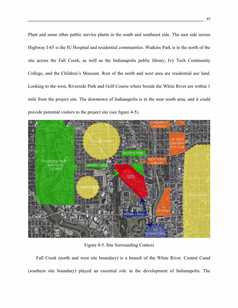
49
Plant and some other public service plants in the south and southeast side. The east side across
Highway I-65 is the IU Hospital and residential communities. Watkins Park is in the north of the
site across the Fall Creek, as well as the Indianapolis public library, Ivy Tech Community
College, and the Children’s Museum. Rest of the north and west area are residential use land.
Looking to the west, Riverside Park and Golf Course where beside the White River are within 1
mile from the project site. The downtown of Indianapolis is in the near south area, and it could
provide potential visitors to the project site (see figure 4-5).
Figure 4-5. Site Surrounding Context
Fall Creek (north and west site boundary) is a branch of the White River. Central Canal
(southern site boundary) played an essential role in the development of Indianapolis. The

50
Indianapolis Water Company started to use the canal water as a source for the White Water
Purification Plant from 1904. From there, the water from the canal was used for both drinking
and aquatic intentions, and the utilization of the Central Canal was maintained throughout the
next half century (historicindianapolis.com). Part of the Central Canal was covered between the
site and the Canal Walk starting point, which is partially similar to the Cheonggyecheon
Restoration Project. Since part of the canal was covered by I-65 and was not able to be exposed,
only partial canal as south boundary of the site will be uncovered as the landscape space of the
creative project.
There are no greenway trails that pass through the site. The nearest trails are the Fall Creek
Trail on the northeast side, Towpath Trail in the northwest along the White River, and the
downtown Canal Walk along Central Canal. The distance between the project site and all the
three trails is around 1 mile, and this could be easily connected with greenway trails in the future
(see figure 4-6)

51
Figure 4-6. Further Greenway Trail Connection Possibility
4.4.2 Transportation Analysis
The project site is surrounded by intricate traffic patterns including freeways, arterial streets,
local streets, railroads, and greenway trails.
The east of the site is Dr. M.L.K. Jr. Street and exit 115 of elevated I-65. These roads bring
more opportunities for vehicular traffic to visit the site. The current transportation situation of
this area is suitable for the main entrance and parking design on the east side of the project site
(See Figure 4-7).
The north boundaries of the site are Fall Creek Blvd and Burdsal Pkwy, which connect the

52
northern residential area with the site. They are not busy traffic streets. However, there is no
access from the roads to the site across Fall Creek. It is an opportunity to create an access for the
residents (See Figure 4-7).
An abandoned railroad comes from the northwest through a bridge above Fall Creek. The
security gate prevents people from entering the railroad bridge (See Figure 4-7).
There are several greenway trails around the site, including Fall Creek Trail, Towpath Trail,
White River Wapahani Trail, Canal Walk, and Indianapolis Cultural Trail. The site is a suitable
place to connect all the trails (See Figure 4-6).
From the site context transportation map (See Figure 4-8), there are five schools around the
site within 30 minutes walk or 5 minutes drive. There is a great potential to provide public open
space for activities and study area to welcome the nearby students to the site. The project will
resolve the public entrance problem along Fall Creek side since four schools and most neighbors
are located on the northwest side of the project site. The bus route #34 drives through the east
edge of the site, and there are three existing stops along the eastern edge of the site. It provides
more opportunities to bring people to the site.

53
Figu
re 4
-7. S
ite T
rans
porta
tion

54
Figu
re 4
-8. S
ite C
onte
xt: T
rans
porta
tion
Map

55
4.4.3 Land Use Analysis
The site is located in a mixed-use area, including the industrial area, mostly residential area,
commercial area, institutional area and partly green space (See Figure 4-9). Most west, north,
and east side of the site is the residential area. However, the south side adjacent to the site is
industrial land. According, the inner site spaces, to the south, east are mostly beneficial for office
and plant’s staff design. To the north and west, designers need to consider more about local
residents’ requirements, as well as comfortable access for surrounded residents to the site.
Commercial and institutional areas are located across from the industrial land in the southwest
direction, and the east side extends to the downtown area. Therefore, how to bring people from
these areas to the project site is another consideration of the project design.
Most of the site’s surrounding communities are low-income groups, and the lack of
supermarkets inside the community might make the living inconveniently. Therefore, the living
requirements from north, west and east communities are extremely significant in further site
design.

56
Figure 4-9. Land Use Map

57
4.5 Current Site Conditions
4.5.1 South Edge View
The south side of the project site is adjacent to the Indianapolis Water Treatment Plant, and
the connecting edge is well fenced and cannot be entered by visitors. Both sides of the Central
Canal are planted with tall grasses, and the grass height is already over people’s eye level vision
(See Figure 4-10). Therefore, the design should provide aesthetic value for visitors, and propose
a green buffer to prevent people entering the Water Treatment Plant.
Figure 4-10. South Edge (adjacent to Water Treatment Plant)

58
4.5.2 Condition of Northwest site
A large portion of the site is covered with
garbage and construction wastes (See Figure
4-12). Abandoned rails are covered by sandy
soils on site (See Figure 4-11). It is a potential
opportunity for further reuse in entertainment
design. As revitalization and sustainable
development of the White River and Fall Creek
riverfront, the designer should make full use of
the abandoned area to reclaim it to vibrant public
space. Figure 4-11. Abandoned rail
Figure 4-12. Northwest part of the site

59
4.5.3 Abandoned railroad bridge
Access to the abandoned railroad bridge is impeded by a massive iron gate, which happens
to be unlocked. The plants appear to be weedy and overgrown, and the landscape view is natural
feeling (See Figure 4-13). However, there is a 15-foot elevation difference from the bridge to the
water surface.
Figure 4-13. Iron gate and overview of Fall Creek from the abandoned railroad

60
4.5.4 Condition near Republic Services
There are many large trash bins that belong to Republic Services on the site (See Figure
4-14). Finding appropriate methods to arrange these trash bins is essential in further project
design process.
Figure 4-14. Trash Cans on site
4.6 Conclusion
Advantageous location makes the White River and Fall Creek riverfront site a unique choice
compared to other places along the White River and its branches. The current site conditions
provide the living, working and recreational opportunities to serve surrounded residents and

61
visitors. The requirements and demands of surrounded residents and visitors produce potential
development significance to the project site.
4.6.1 Strengths
• The project site is located on the northwest side of downtown Indianapolis within 5
minutes drive and surrounded by different traffic corridors.
• The current water quality of the Fall Creek is good, and there is no need to solve the
wastewater problem.
• The surrounding of the site are diverse areas including residential, commercial and
recreational area. The various areas bring further development values to the project
site.
4.6.2 Problems
• The existing greenway trail system does not pass through project site, which limits
people’s transportation choice to the site.
• Several industrial companies and plants are intricately distributed on site, which needs
to be planned according.
4.6.3 Opportunities

62
• Northwest neighborhood is a large community with fewer grocery stores and public
green spaces to satisfy their healthy living requirements. Their growing needs provide
potential opportunity to create multi-purpose space in the project site, such as outdoor
markets, festival spaces, picnics, or amphitheater for various events.
• Since there are several greenway trails and parks nearby, such as Towpath trail, Fall
Creek trail, White River trail, Canal Walk and Riverside Park. It is an opportunity to
provide more greenway trails on site to improve the greenway trail system.
• There is an abandoned railroad comes from the northwest through an elevated bridge
over Fall Creek. It is an opportunity to redesign the railroad and open the security gate
to keep the historical and cultural memory in site.

63
Figu
re 4
-15.
Site
Opp
ortu
nity
Ana
lysi
s

64
CHAPTER 5. SITE DESIGN
Based on the knowledge of Literature Review, Case study, and Site Inventory and Analysis,
the creative project develops a sustainable urban design plan for the site redevelopment in
Indianapolis. This chapter illustrates the design concept, introduces the design process and the
site design.
5.1 Goals and Objectives
In order to contribute to a successful redevelopment process, the goals and objectives are
listed below:
1. Providing more opportunities for surrounded residents and visitors to embrace the nature in
the urban area
1) Create a definite network to connect these underutilized sites with the green spaces
2) Provide enough multi-function green space in each community area to support
year-round outdoor activities (picnic, fishing, etc.)
3) Develop Urban agriculture to provide fresh food and practices opportunities for local
residents
4) Improve transportation accessibility through redesigning the road circulation and
reconstructing bridges
2. Revitalizing the urban economic development and improving residents’ quality of life

65
1) Create commercial district, like retails, restaurants, and art gallery to provide more job
opportunities for new residents
2) Proposed new affordable housing for new residents who work in the surrounded
commercial areas
3) Provide lighting, seating, recreational area, etc. along the river bank
4) Providing diversified opportunities of activities for the local community
5) Provide easy accessible fresh food
3. Improve the site environment through Increase biodiversity along the Fall Creek
1) Add native plant community
2) Create protected habitats for wildlife (Natural preserve area)
5.2 Programs
In order to achieve the goals and objectives listed above, the proposed programs are listed
below:
Public green space and outdoor activity area (Activity)
! Public Event Space
! Multifunction Plaza/stage
! Picnic area
! Fishing Piers

66
! Amphitheater (provide visitors access to water levels change, create seasonal
interest)
! Natural stone bridge (offer walkways to pedestrians)
Industry and Office area (Work)
! Office Building
! Parking lot
! Public Event Space/Outdoor Green Space
Commercial area (Shopping, Activity)
! Welcome Center
! Retails
! Parking lot
! Multi-purpose spaces (outdoor markets, food vendors, or festival spaces)
! Bike Share
Community area (Housing, Food)
! Community center
! Affordable Apartments/Townhouse
! Farmer’s market/Urban agriculture
! Playgrounds
! Sports area (Basketball, Tennis field)

67
Circulation redesign (Activity)
! Improve access convenience for north and west residents through connect
existing road and adding bridges
! Trail system redesign to connect existing Indy Greenway Trail
! Railway play trail
! Replanning parking lot on site
5.3 Design Concept
In order to improve the site environment and the surrounding community’s life quality,
redevelopment of the site is proposed. The mixed-use community is redeveloped to provide the
living, recreational opportunities, working opportunities, and traffic network to both local and
future residents.
The concept of this creative project is to create a small convenient community that provides
housing, food, open spaces and educational opportunities for people’s daily life according to
both local and future residents’ requirement. The site will comprise the residential area,
commercial area, working area, and public green space in the center to connect all other three
functional areas.

68
Figure 5-1. Concept Plan

69
5.4 Site Design
Figure 5-2. Master Plan
The land used to be a greyfield, and the final design provides the multi-functional riverfront
green spaces that are essential to Indianapolis city development. The site is divided into four
main areas - Public green space and outdoor activity area, Commercial area, Community area,

70
and Industry and Office area, all the four regions are connected by redesigned circulation. Public
green space is the green core area of the site, and it aims at extending people’s outdoor activity
area from rare green space to a centralized green core area. It emphasizes environment advantage
and human health through providing clean recreational places and sufficient green area to both
residents and visitors. The commercial area is located on the right side of main entrance. It
occupies an excellent geographic location of the site and is the best place to gather people
together. Community area and Office area are located in northwest and southeast side
respectively. They are connected by redesigned greenway trails and railway trail, which
improves people’s health through walking from home to workplace. It increases people’s amount
of exercise invisibly.
5.4.1 Linkage Plan
One of the project goals is creating a definite network to connect these underutilized sites
with the green spaces. Therefore, the proposed project designed to use greenways that connect
surrounding green spaces in Indianapolis.
There are several green spaces nearby, such as Riverside park, White River state park, and
Martin park. The surrounded greenway trails are Towpath trail, Fall Creek trail, White River
Wapahani trail, and Canal walk. All the greenway trails are within 1 mile from the project site,
so using appropriate greenway trails to connect these existing trails and green spaces are

71
essential to the project (See figure 5-3). The blue lines are the existing greenway trails from the
Greenway Linkage Plan, and red lines are the proposed greenway trails in the project.
Figure 5-3. Greenway Linkage Plan
Since using appropriate greenway trails to connect the existing greenway trails and open
spaces are essential to the project, detailed site greenway trails design are considerable in the
project design. The greenway trails connect all the functional areas, which provide walkable
community for both residents and visitors (See figure 5-4). The project also provides further
opportunities to connect surrounding greenway trails.

72
Figure 5-4. Detailed Site Greenway Trails
5.5 Site Detailed Design
5.5.1 Creek Recreation
As an essential component of the creative project, the Fall Creek is a tributary of the White

73
River. It used to provide water power for early industrial development in Indianapolis. It is
currently designed as water features for the site, redesigned circulation greenway trails beside the
creek provide an open view for people to enjoy the unique scenery across the Fall Creek. The
final design aims to provide a diverse experience for people to pass through the greenway trail
(See figure 5-5, 5-6, 5-7).
Figure 5-5. Creek Section – Amphitheater
This section shows the amphitheater seats in the north of public open space. The greenway
trail around the site is followed by amphitheater beside the Fall Creek. There are some stone
steps at the edge of the creek bank, which provide more opportunities for people to touch and
play with water. It is an excellent place for people’s chatting, meditation, sitting in the sun, and
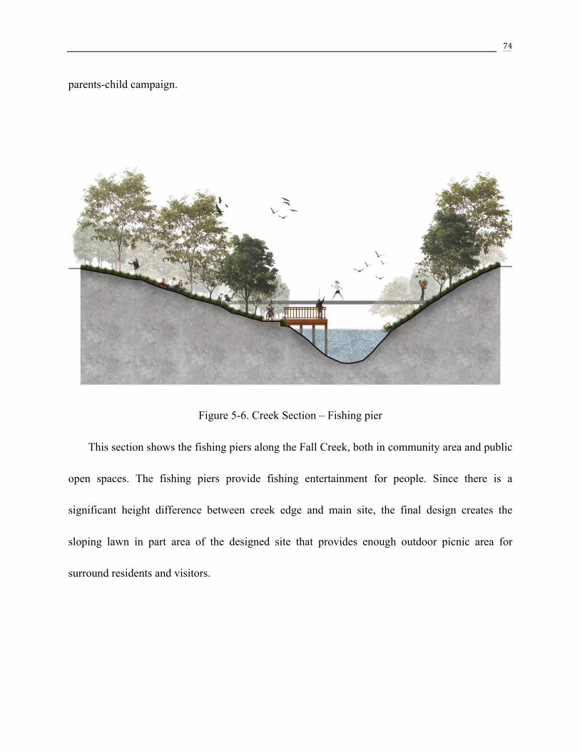
74
parents-child campaign.
Figure 5-6. Creek Section – Fishing pier
This section shows the fishing piers along the Fall Creek, both in community area and public
open spaces. The fishing piers provide fishing entertainment for people. Since there is a
significant height difference between creek edge and main site, the final design creates the
sloping lawn in part area of the designed site that provides enough outdoor picnic area for
surround residents and visitors.

75
Figure 5-7. Creek Section – Greenway trails
This section shows the greenway trails beside the creek with wall interests in the other side.
As mentioned above, there is a significant height difference between creek edge and main site.
So the design keeps the height difference in some area and creates vertical green plants on the
wall. There is also a green buffer between greenway trails and creek, which provides the more
natural environment for animals.

76
5.5.2 Canal Recreation
Canal in the south of the project site that is 15 feet higher than the Fall Creek water surface.
The function of the canal is different from the function of the Fall Creek. The canal provides
domestic water for people’s daily life, however, the Fall Creek could provide recreational place
for people to gather and play together. Therefore, the design for the two different water body is
diverse. The design uses grasses and shrubs to create green buffer between canal and greenway
trails. Lower grasses and shrubs will not hide people’s view sight, but will prevent access to the
canal.
Figure 5-8. Canal Section – Greenway trails

77
Figure 5-9. Environment Around Canal area

78
5.5.3 Commercial Area
The commercial area (the orange region)
is located on the northeast side of the site. It
is on the right side of the main entrance and
parking lot, which provides more access
opportunities for people to the commercial
area. This area consists of Welcome Center,
retails, art gallery, restaurants, multi-purpose
spaces, and parking lot, which provide
diverse study and entertainment opportunities for people and more job opportunities for
residents.

79
Figure 5-10. Commercial Area – Welcome Center
The welcome center is a diverse functional place that connects parking lot and retails. It
comprises of the reception area, bike share, multi-functional plaza, and food court. The
multi-functional plaza is in front of the welcome center, and it is a public place which provides
gathering, resting area, and food for people. It also provides introduction and consultation
services for visitors.

80
5.5.4 Public Green Space
Public green space and outdoor activity
area are located in the center of the project
site, which connects all other three areas –
commercial, community, and office area. It
includes public event space, amphitheater,
multifunction plaza, picnic area, railway
trail playground, and fishing piers. There are
varying pedestrian walkways in the open
green space that encourage people to explore all the public green space of the site.

81
Figure 5-11. Public Green Space – Railway play trail
The railway play trail is transformed from an abandoned railway that across the site. The
project redesigns the abandoned railways into the trail and establishes small plazas nearby for
people's resting and activity. In order to increase identification of the railway trail, the design
represents the rusted rails into a bright red color that increase the color interests of the site.

82
Figure 5-12. Public Green Space – Amphitheater
The amphitheater area is a great space for people's diverse activities, such as chatting,
meditation, sitting in the sun, and parents-child campaign. There is a pavilion beside the
amphitheater, and it is an area that provides shelter for people in rainy days and fishing activity.
There are also some stone steps along the edge of Fall Creek, and people could be close to the
water if walking on the stone steps.

83
5.5.5 Community Area
The community area is located in the
northwest of the site, and it is near the
existing communities which mostly
distributes in the north and west side of the
project site. It includes a community center,
affordable apartments, and townhouse,
playgrounds, sports area, greenway trails,
farmer's market and grove that is across Fall
Creek. In order to offer transportation convenience for the residents, the design adds two
entrances in north and northeast side. The north side design extends Rader Street and intersects
with Burdsal Pkwy. The northeast side design connects the existing Franklin Place and crosses
Fall Creek Blvd.

84
Figure 5-13. Community Area – Farmer’s Market & Grove
The farmer's market and the grove is located in the northwest corner of the site, which is
across the Fall Creek. It is an appropriate place for urban agriculture and farmer's market. It is
not only adjacent to the designed community area, but also near surrounding communities. The
goal that provides easily accessible fresh food is realized through the farmer's market and grove
production.

85
Figure 5-14. Community Area – Greenway Trails
Greenway trails are designed to connect existing Indy Greenway Trails - Towpath trail, Fall
Creek trail, Monon trail, Canal walk, White River Wapahani Trail, and Cultural Trail. It is an
effective method to improve access convenience for people to walking or running in Indianapolis
downtown area. It also provides more opportunities for people in the surrounding neighborhood
to enjoy the unique scenery around the Fall Creek and embrace the nature in the urban area.

86
Figure 5-15. Natural Preserve Area
The natural preserved area is located in the community area along Fall Creek. The landscape
planting design strategy in this area is to use Indiana native plants to create a protected habitate
for wildlife as well as increase biodiversity along the Fall Creek. There are a variety species of
trees, shrubs, grasses, and seasonal flowers to provide natural environment for wildlife (See
Figure 5-12).

87
Figure 5-16. Plants that grow in natural preserved area

88
5.5.6 Industry and Office Area
The industry and office area is located in
the south of the site. It contains office
buildings, parking lot, public outdoor green
space and sports area. Some existing office
buildings are scattering built on the site,
finding an appropriate area to gathering all
these companies together is essential in the
design process. There is a small outdoor
green space in the southwest corner of office area, which provides outdoor relaxation for office
workers.

89
CHAPTER 6. CONCLUSION
This creative project redevelops a riverfront site from underutilized and troubled land
to the healthy and productive urban land in downtown Indianapolis. It helps to promote
the urban economic development, as well as bring environment advantage to people’s life.
There are numerous small vacant or underutilized lands along White River and its
branches in the core area of Indianapolis. The goal of this creative project is to create an
easeful and fully functional living space for both residents and visitors. This project
analyzes the problems and conditions of current site environment. It also reviews the
literature and case studies to establish a reasonable design program for further
development. The design includes four functional spaces – public green space, commercial
area, community area, and office area, and one circulation redesign that in order to connect
existing green spaces and for further underutilized lands redesign.
The redesign of this creative project could serve as a prototype to other similar vacant
or underutilized riverfront lands redesign in Indianapolis urban area. These solutions can
also be applied or partially applied to other underutilized lands on the basis of land size in
all other similar medium-‐sized cities.

90
WORKS CITED
“A Brief History of Downtown Indy's Canal.” Historic Indianapolis | All Things Indianapolis
History, 30 July 2013,
historicindianapolis.com/a-brief-history-of-downtown-indys-canal/.
Altshuler, Alan A. Governance and opportunity in metropolitan America. National Academy of
Sciences, 1999.
Andersson, Thorbjorn. "Utopia in Green and Blue." Topos 2009: 64-70. Print.
Breen, Ann, and Dick Rigby. Waterfronts: Cities reclaim their edge. McGraw-Hill Companies,
1994. Print.
Bunce, Susannah, and Gene Desfor. "Introduction to “Political Ecologies of Urban Waterfront
Transformations”." Cities 24.4 (2007): 251-58. Web.
Campo, Daniel. "Brooklyn's Vernacular Waterfront." Journal of Urban Design 7.2 (2002):
171-199. Web.
"Can L'Enfant Plaza Become a Place for People?" The Dirt. N.p., 23 Dec. 2013. Web. 28 Feb.
2015.
http://dirt.asla.org/2013/12/23/can-lenfant-plaza-become-a-people-friendly-place/
Che, Yue, Kai Yang, Ting Chen, and Qixin Xu. "Assessing a Riverfront Rehabilitation Project
Using the Comprehensive Index of Public Accessibility." Ecological Engineering 40
(2012): 80-87. Web.

91
"Cheonggyecheon Stream Restoration Project." Landscape Architecture Foundation. LAF Blog
RSS. n.p., n.d. Web. 19 Nov. 2014.
<https://lafoundation.org/research/landscape-performance-series/case-studies/case-stu
dy/382/pdf/>.
“Cheonggyecheon Stream Restoration Project.” Landscape Performance Series, 22 Jan. 2015,
landscapeperformance.org/case-study-briefs/cheonggyecheon-stream-restoration#.
Chiesura, Anna. "The Role of Urban Parks for the Sustainable City." Landscape and Urban
Planning 68.1 (2004): 129-38. Web.
“ChonGae Canal Source Point Park: Sunken Stone Garden.” 2009 Professional Awards,
www.asla.org/2009awards/091.html.
Craig-Smith, Stephen J., and Michael Fagence. Recreation and Tourism as a Catalyst for Urban
Waterfront Redevelopment: An International Survey. Westport, CT: Praeger, 1995.
Print.
"Design the Waterfront Park Infrastructure of the Future." The Dirt. N.p., 21 Sept. 2012. Web. 28
Feb. 2015.
http://dirt.asla.org/2012/09/21/design-the-waterfront-park-infrastructure-of-the-future/
FLORIDA, RICHARD. “The Downsides of the Back-to-the-City Movement.” CityLab, 29 Sept.
2016,
www.citylab.com/equity/2016/09/downsides-of-the-back-to-the-city-movement/50147

92
6/.
Gastil, Raymond. Beyond the Edge: New York's New Waterfront. New York, NY: Princeton
Architectural, 2002. Print.
Goldhagen, Sarah Williams. "All Work - Houtan Park, in Shanghai, Is "Productive."if Only It
Were Seductive, Too." Landscape Architecture Magazine Feb. 2013: 70-79. Print.
Gordon, David L. A. "Financing Urban Waterfront Redevelopment." Journal of the American
Planning Association 63.2 (1997): 244-65. Web.
Gordon, David L. A. "Planning, Design and Managing Change in Urban Waterfront
Redevelopment." The Town Planning Review 67.3 (1996): 261-90. Web.
Gospodini, Aspa. "Urban Waterfront Redevelopment in Greek Cities." Cities 18.5 (2001):
285-95. Web.
Hersh, B.F. (2012). The complexity of urban waterfront redevelopment. Retrieved March 2014,
from
http://www.naiop.org/en/Research/Our-Research/Reports/The-Complexity-of-Urban-
Waterfront-Redevelopment.aspx
Hopkins, Louise. "Waterfront Renaissance." Green Places 05 Sept. 2005: 16-20. Print.
Hoyle, Brian. "Scale and Sustainability: The Role of Community Groups in Canadian Port-city
Waterfront Change." Journal of Transport Geography 7.1 (1999): 65-78. Web.
Hölzer, Christoph, and Annette Wiethüchter. Riverscapes: Designing Urban Embankments.

93
Basel: Birkhäuser, 2008. Print.
"Is Your Waterfront a Back Door or Front Door?" The Dirt. N.p., 27 June 2013. Web. 28 Feb.
2015. http://dirt.asla.org/2013/06/27/is-your-waterfront-a-back-door-or-front-door/
Jelacic, Matthew. “Portland Oregon: The New Model of Urban Redevelopment”
Architectural design 1 Mar. 2004: 7-11. Print.
Krieger, Alex. “On the Waterfront” Preservation(Washington, D.C.) 1 Mar. 2000: 36-41. Print.
May, Rachel. "“Connectivity” in Urban Rivers: Conflict and Convergence between Ecology and
Design." Technology in Society 28.4 (2006): 477-88. Web.
"MILLENNIUM PARKLANDS." PWP Landscape Architecture. PWPLA, n.p., n.d. Web. 19
Nov. 2014. <http://www.pwpla.com/projects/millennium-parklands/&details>.
"Ningbo Eco-Corridor - 3.3 Km Living FilterNingbo, China." ASLA 2013 Professional Awards.
N.p., n.d. Web. 28 Feb. 2015. http://www.asla.org/2013awards/253.html
"NYC Creates the Model Waterfront Plan." The Dirt. N.p., 17 Mar. 2011. Web. 28 Feb. 2015.
http://dirt.asla.org/2011/03/17/nyc-creates-the-model-waterfront-plan/
Shane, Grahame. “Recombinant Landscapes in the American City” Architectural
design 1 Mar. 2007: 24-35. Print.
"Shanghai Houtan Park: Landscape as a Living System." American Society of Landscape
Architects. ASLA, n.p., n.d. Web. 19 Nov. 2014.
http://www.asla.org/2010awards/006.html

94
Shanley, Kevin. "Infrastructure as Menity-Houston’s Bayou Becomes a Floodway-turned-Park."
Topos 2009: 32-37. Print.
“The Indy Canal Walk: Then & Now.” Indiana news powered by Franklin College journalism
students, thestatehousefile.com/23895-2/23895/.
Trancik, Roger. Finding Lost Space: Theories of Urban Design. New York: Van Nostrand
Reinhold, 1986. Print.
“U.S. Energy Information Administration - EIA - Independent Statistics and Analysis.” CBECS
2012: Building Stock Results,
www.eia.gov/consumption/commercial/reports/2012/buildstock/.
Yang, Kai, Ting Chen, and Lanlan Liu. "Research on Public Riverfront Accessibility in the
Developing Processes of Rural River." China Science and Technology (2005): n. pag.
Web.