MEDIUM-SIZED PROJECT BRIEF - IW:LEARN
40
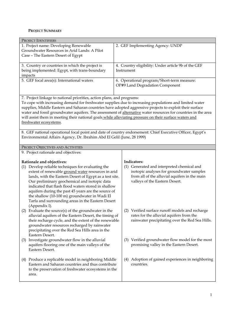
PROJECT SUMMARY PROJECT IDENTIFIERS 1. Project name: Developing Renewable Groundwater Resources in Arid Lands: A Pilot Case – The Eastern Desert of Egypt 2. GEF Implementing Agency: UNDP 3. Country or countries in which the project is being implemented: Egypt, with trans-boundary impacts 4. Country eligibility: Under article 9b of the GEF Instrument 5. GEF focal area(s): International waters 6. Operational program/Short-term measure: OP#9 Land Degradation Component 7. Project linkage to national priorities, action plans, and programs: To cope with increasing demand for freshwater supplies due to increasing populations and limited water supplies, Middle Eastern and Saharan countries have adopted aggressive projects to exploit their surface water and fossil groundwater aquifers. The assessment of alternative water resources for countries in the area will assist them in meeting their national goals while alleviating pressure on their surface waters and freshwater ecosystems . 8. GEF national operational focal point and date of country endorsement: Chief Executive Officer, Egypt’s Environmental Affairs Agency, Dr. Ibrahim Abd El Gelil (June, 28 1999) PROJECT OBJECTIVES AND ACTIVITIES 9. Project rationale and objectives: Rationale and objectives: (1) Develop reliable techniques for evaluating the extent of renewable ground water resources in arid lands, with the Eastern Desert of Egypt as a test site. Our preliminary geochemical and isotopic data indicated that flash flood waters stored in shallow aquifers during the past 45 years are the source of the shallow (10-100 m) groundwater in Wadi El Tarfa and surrounding areas in the Eastern Desert (Appendix I). (2) Evaluate the source(s) of the groundwater in the alluvial aquifers of the Eastern Desert, the timing of their recharge cycle, and the extent of the renewable groundwater resources recharged by rainwater precipitating over the Red Sea Hills area in the Eastern Desert. (3) Investigate groundwater flow in the alluvial aquifers flooring one of the main valleys of the Eastern Desert. (4) Produce a replicable model in neighboring Middle Eastern and Saharan countries and thus contribute to the preservation of freshwater ecosystems in the area. Indicators: (1) Generated and interpreted chemical and isotopic analyses for groundwater samples from all of the alluvial aquifers in the main valleys of the Eastern Desert. (2) Verified surface runoff models and recharge rates for the alluvial aquifers from the rainwater precipitating over the Red Sea Hills. (3) Verified groundwater flow model for the most promising valley in the Eastern Desert. (4) Adoption of gained experiences in neighboring countries. 1
-
Upload
khangminh22 -
Category
Documents
-
view
5 -
download
0
Transcript of MEDIUM-SIZED PROJECT BRIEF - IW:LEARN
PROJECT SUMMARY
PROJECT IDENTIFIERS 1. Project name: Developing Renewable Groundwater Resources in Arid Lands: A Pilot Case – The Eastern Desert of Egypt
2. GEF Implementing Agency: UNDP
3. Country or countries in which the project is being implemented: Egypt, with trans-boundary impacts
4. Country eligibility: Under article 9b of the GEF Instrument
5. GEF focal area(s): International waters
6. Operational program/Short-term measure: OP#9 Land Degradation Component
7. Project linkage to national priorities, action plans, and programs: To cope with increasing demand for freshwater supplies due to increasing populations and limited water supplies, Middle Eastern and Saharan countries have adopted aggressive projects to exploit their surface water and fossil groundwater aquifers. The assessment of alternative water resources for countries in the area will assist them in meeting their national goals while alleviating pressure on their surface waters and freshwater ecosystems. 8. GEF national operational focal point and date of country endorsement: Chief Executive Officer, Egypt’s Environmental Affairs Agency, Dr. Ibrahim Abd El Gelil (June, 28 1999) PROJECT OBJECTIVES AND ACTIVITIES 9. Project rationale and objectives: Rationale and objectives: (1) Develop reliable techniques for evaluating the
extent of renewable ground water resources in arid lands, with the Eastern Desert of Egypt as a test site. Our preliminary geochemical and isotopic data indicated that flash flood waters stored in shallow aquifers during the past 45 years are the source of the shallow (10-100 m) groundwater in Wadi El Tarfa and surrounding areas in the Eastern Desert (Appendix I).
(2) Evaluate the source(s) of the groundwater in the alluvial aquifers of the Eastern Desert, the timing of their recharge cycle, and the extent of the renewable groundwater resources recharged by rainwater precipitating over the Red Sea Hills area in the Eastern Desert.
(3) Investigate groundwater flow in the alluvial aquifers flooring one of the main valleys of the Eastern Desert.
(4) Produce a replicable model in neighboring Middle Eastern and Saharan countries and thus contribute to the preservation of freshwater ecosystems in the area.
Indicators: (1) Generated and interpreted chemical and
isotopic analyses for groundwater samples from all of the alluvial aquifers in the main valleys of the Eastern Desert.
(2) Verified surface runoff models and recharge rates for the alluvial aquifers from the rainwater precipitating over the Red Sea Hills.
(3) Verified groundwater flow model for the most promising valley in the Eastern Desert.
(4) Adoption of gained experiences in neighboring countries.
1
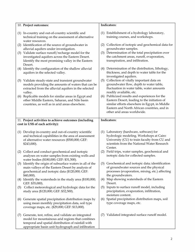
10. Project outcomes:
(1) In-country and out-of-country scientific and technical training on the assessment of alternative water resources.
(2) Identification of the source of groundwater in alluvial aquifers under investigation.
(3) Validate surface runoff/recharge model for the investigated aquifers across the Eastern Desert. Identify the most promising valley in the Eastern Desert.
(4) Identify the configuration of the shallow alluvial aquifers in the selected valley.
(5) Validate steady-state and transient groundwater models providing the amounts of waters that can be extracted from the alluvial aquifers in the selected valley.
(6) Replicable models for similar areas in Egypt and other Middle Eastern, Saharan, and Nile basin countries, as well as in arid areas elsewhere.
Indicators: (1) Establishment of a hydrology laboratory,
training courses, and workshops.
(2) Collection of isotopic and geochemical data for groundwater samples.
(3) Determination of the total precipitation over the catchment areas, runoff, evaporation, transpiration, and infiltration.
(4) Determination of the distribution, lithology, thickness, and depth to water table for the investigated aquifers.
(5) Collection of vitally important data on groundwater flow, depth to water table, fluctuation in water table, water amounts readily available, etc.
(6) Publicized results and experiences for the Eastern Desert, leading to the initiation of similar efforts elsewhere in Egypt, in Middle Eastern and North African countries, and in other arid areas worldwide.
11. Project activities to achieve outcomes (including cost in US$ of each activity): (1) Develop in-country and out-of-country scientific
and technical capabilities in the area of assessment of alternative water resources ($500,000; GEF: $243,000).
(2) Collect and conduct geochemical and isotopic analyses on water samples from existing wells and water bodies ($180,000; GEF: $31,500).
(3) Identify the origin of subsurface waters in all of the main valleys of the Eastern Desert by analysis of geochemical and isotopic data ($120,000; GEF: $40,000).
(4) Identify the watersheds in the study area ($100,000; GEF: $35,000).
(5) Collect meteorological and hydrologic data for the study area ($120,000; GEF: $32,500).
(6) Generate spatial precipitation distribution maps by using mean monthly precipitation data, soil type coverage maps, etc. ($29,000; GEF: $13,000).
(7) Generate, test, refine, and validate an integrated model for mountainous arid regions that combines temporal and spatial distribution of rainfall with appropriate basin unit hydrograph and infiltration
Indicators: (1) Laboratory (hardware, software) for
hydrologic modeling. Workshops at Cairo University (CU) to train faculty from CU and scientists from the National Water Research Center.
(2) Field trips, water samples, geochemical and isotopic data for collected samples.
(3) Geochemical and isotopic data; identification of groundwater sources and the physical processes (evaporation, mixing, etc.) affecting the groundwaters.
(4) Map showing watersheds of the Eastern Desert.
(5) Inputs to surface runoff model, including precipitation, evaporation, infiltration, moisture content.
(6) Spatial precipitation distribution maps, soil type coverage maps, etc.
(7) Validated integrated surface runoff model.
2
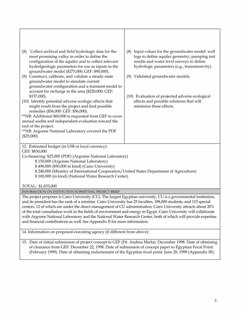
(8) Collect archival and field hydrologic data for the most promising valley in order to define the configuration of the aquifer and to collect relevant hydrolgeologic parameters for use as inputs to the groundwater model ($275,000; GEF: $90,000).
(9) Construct, calibrate, and validate a steady-state groundwater model to simulate current groundwater configuration and a transient model to account for recharge in the area ($220,000; GEF: $157,000).
(10) Identify potential adverse ecologic effects that might result from the project and find possible remedies ($56,000: GEF: $56,000).
**NB: Additional $60,000 is requested from GEF to cover annual audits and independent evaluation toward the end of the project. **NB: Argonne National Laboratory covered the PDF ($25,000).
(8) Input values for the groundwater model: well logs to define aquifer geometry; pumping test results and water level surveys to define hydrologic parameters (e.g., transmissivity).
(9) Validated groundwater models.
(10) Evaluation of projected adverse ecological effects and possible solutions that will minimize these effects.
12. Estimated budget (in US$ or local currency): GEF: $830,000 Co-financing: $25,000 (PDF) (Argonne National Laboratory) $ 150,000 (Argonne National Laboratory) $ 490,000 ($50,000 in kind) (Cairo University) $ 240,000 (Ministry of International Cooperation/United States Department of Agriculture) $ 100,000 (in kind) (National Water Research Center) TOTAL: $1,835,000 INFORMATION ON INSTITUTION SUBMITTING PROJECT BRIEF The project proposer is Cairo University (CU). The largest Egyptian university, CU is a governmental institution, and its president has the rank of a minister. Cairo University has 25 faculties, 188,000 students, and 115 special centers, 12 of which are under the direct management of CU administration. Cairo University attracts about 20% of the total consultation work in the fields of environment and energy in Egypt. Cairo University will collaborate with Argonne National Laboratory and the National Water Research Center, both of which will provide expertise and financial contributions as well. See Appendix II for more information. 14. Information on proposed executing agency (if different from above): 15. Date of initial submission of project concept to GEF (Dr. Andrea Merla): December 1998. Date of obtaining
of clearance from GEF: December 22, 1998. Date of submission of concept paper to Egyptian Focal Point: (February 1999). Date of obtaining endorsement of the Egyptian focal point: June 28, 1999 (Appendix III).
3

INFORMATION TO BE COMPLETED BY IMPLEMENTING AGENCY: 16. Project identification number: 17. Implementing Agency contact person: Marcel Alers, GEF Regional Coordinator, UNDP/RBAS 18. Project linkage to Implementing Agency program(s): This project conforms with the Country Cooperation Framework and is in line with other climate change activities being implemented by the UNDP country office in Egypt. The project also conforms with the UNDP efforts to participate in a large water management initiative among Nile basin countries.
4
PROJECT DESCRIPTION
PROJECT RATIONALE AND OBJECTIVES Project Rationale Demand for freshwater supplies in arid and semi-arid countries worldwide is on the rise because of increasing populations and limited water supplies. This problem is exemplified in countries of Saharan Africa (North Africa) and the Middle East, where scarcity of water resources is contributing to political instability, disputes, and conflicts. Sources of freshwater in these areas include surface runoff (e.g., Nile River in Egypt and Sudan) that generally originates from allochtonous precipitation over distant mountainous areas with wetter climatic conditions. Other sources of freshwater in these arid and semi-arid areas include nonrenewable groundwater resources originating as autochtonous precipitation that recharged the aquifers in previous wet climatic periods. For example, the Nubian aquifer that occupies large areas (~2 x 10⁵ km2) in northern Sudan, eastern Libya, and Egypt (Figure 1) (Hess et al., 1987) is believed to have been recharged during wet climatic conditions in the Quaternary (e.g., Thorweihe, 1982). These fossil waters are currently being used for irrigation purposes in the Dakhla, Kharga, and Farafra oases in Egypt, and an extensive program is being developed in Libya to extract and utilize these fossil waters from the Kufra, southeast-Sarra, Tazerbo, and Sarir areas. Because of the nonrenewable nature of these waters, the artesian wells fed by this aquifer are drying up, and the depth to the water table in these areas has been steadily increasing. The increasing demand on conventional freshwater supplies in Middle Eastern, Saharan, and some sub-Saharan countries could contribute to extreme stresses on the freshwater ecosystem (lakes, ponds, rivers, streams, wetlands, and groundwater), particularly the transboundary ecosystems. The preservation of freshwater ecosystems is important, given the diversity of the species they support. Only 1% of Earth’s surface is covered by inland waters, yet this area contains 12% of the total animal species. In contrast, the oceans, which cover 70% of Earth’s surface, support only 7% of its species (Gleick, 1993). Some authorities estimate that the total faunal diversity in rivers is over 60 times that of the sea (Stansbery, 1973; Moyle and Cech, 1982; Wootton, 1990). Unfortunately, freshwater aquatic habitats and their biota are being destroyed rapidly, principally because of competing demands for the limited water supplies. The assessment of alternative renewable water supplies proposed here, has the final objective of preventing further degradation of the fresh water ecosystems in arid and semi-arid areas of North Africa and the Middle East. This proposal aims in fact at developing and demonstrating ways to integrate renewable groundwater resources into the water budget of watersheds in arid regions, where extreme scarcity poses serious transboundary problems. For example, Egypt, Sudan, and a number of sub-Saharan countries share Nile waters; reducing the dependence of any of these countries on these waters could help to reduce tensions that might arise between the Nile basin states because of their increasing dependence on this limited water resource. The proposal aims at demonstrating the viability of alternative water resources, such as flash-flood-recharged alluvial aquifers that could complement or substitute for surface waters, thus easing use conflicts and allowing some water flow for the ecosystems. Project Objectives In many arid and semi-arid countries worldwide, sporadic precipitation occurs over mountainous areas and is channeled throughout extensive watersheds as surface runoff and subsurface groundwater flow. Within these watersheds, networks of minor valleys join into main valleys that ultimately drain into other water bodies (e.g., oceans, lakes, and rivers). Because some of the watersheds collect precipitation over large areas and channel it through a few main valleys, substantial amounts of freshwater could
5
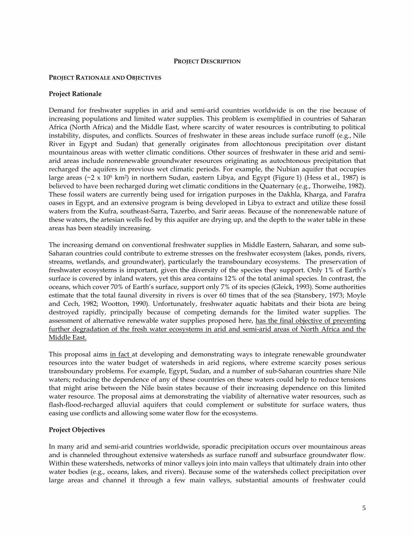
potentially recharge the alluvial aquifers flooring these main valleys during sporadic storms. We propose to conduct a comprehensive study to investigate the distribution of these alluvial aquifers and their recharge rates. We propose to use the Eastern Desert of Egypt as our test area. We refer to this alternative renewable groundwater resource hereinafter as “the alluvial aquifer groundwater resource.”
Figure 1. Location map.
Egypt was chosen as a test site for a number of reasons. First, Egypt’s landscape and its climatic and hydrologic settings are ideal for the study and resemble those in neighboring countries. Hence, results obtained in Egypt will be applicable to many neighboring countries. Networks of minor valleys dissect the Red Sea Hills and the surrounding Cretaceous and Tertiary outcrops and join into main valleys that ultimately drain into the Red Sea or the Nile River valley (e.g., Asyuti, Qena, and Hammamat; Figure 1). These networks of channels collect rainfall as surface runoff in the main valleys and as groundwater in the shallow alluvial and limestone aquifers flooring the main valleys. The large areal extent (e.g., 15,000 km2 for the Qena watershed) and extensive network of individual watersheds in the Eastern Desert are ideal for channeling rain precipitating over large domains into a limited number of main valleys and recharging the aquifers flooring these valleys. These topographic and climatic conditions are present along the Red Sea Hills in Egypt, Sudan, Somalia, Saudi Arabia, and Yemen. Similar conditions exist in mountainous areas in North Africa (e.g., Tibesti in Libya, Ennedi Mountains in Chad) as well. Second, like many of the world’s arid and semi-arid countries, Egypt relies almost exclusively on its surface water (Nile River) and its fossil groundwater (Nubian aquifer). Such practices have negative impacts on Egypt’s freshwater ecosystems. Third, our preliminary geochemical and isotopic studies (Appendix I) indicate that flash flood waters stored in shallow aquifers during the past 45 years appear to be the principal source of most of the analyzed groundwater samples in the Wadi El Tarfa and surrounding areas (Figure 1). This observation implies that the groundwater is a renewable resource. The magnitude of this resource is currently unknown, but it is likely to be considerable. Locally, these waters pool into shallow alluvial aquifers that are currently used to cultivate small areas within the main valleys (e.g., Wadi Asyuti and Wadi El Tarfa). The proposed project falls under article 9b of the GEF Instrument. We propose to conduct comprehensive studies leading to the development, validation, and demonstration of techniques for evaluating the extent of alternative renewable water resources arising from sporadic precipitation over large watersheds in arid and semi-arid mountainous areas, with the Eastern Desert of Egypt as our test site. The comprehensive techniques that we advocate encompass the use of various geochemical and isotopic techniques; surface and groundwater modeling; analysis of Landsat, digital elevation, seismic, and drilling data; and field observations. To the best of our knowledge, no such comprehensive studies have been applied previously in Saharan Africa and in neighboring arid and semi-arid countries, although they are required to evaluate renewable water resources. We will determine the source of the groundwater under investigation, evaluate the extent and
6

magnitude of alluvial groundwater that is recharged by rainwater precipitating over the Red Sea Hills area in the Eastern Desert (a largely untapped resource), and determine the timing of the recharge cycle. The results should be viewed as a model to be replicated in neighboring Middle Eastern and Saharan countries, as well as in Nile valley countries. CURRENT SITUATION (BASELINE COURSE OF ACTION) A number of Middle Eastern, Saharan and sub-Saharan African countries are currently undertaking major national projects to increase their water resources in order to cope with increasing demand on freshwater supplies resulting from increasing populations. These projects, as described earlier, largely depend on surface water and fossil groundwater. Less attention is being given to the renewable alluvial aquifer groundwater resource advocated in this proposal. We cite the current situation in Egypt, Sudan, and Libya as a demonstration of the baseline course of action there, which is typical of actions taken by neighboring countries. Egypt is embarking on projects to divert large volumes of water from the Nile River to reclaim lands in the Western Desert (Toshka project) and in Sinai (El Salam Canal). These projects could reduce waters flowing downstream, increase soil salinity, decrease sedimentation, increase coastal erosion and seawater intrusion, and negatively affect biodiversity in general and fisheries in particular. Similarly, most of the agricultural development plans of Sudan are concentrated on irrigated agriculture along the banks of the Nile. Sudan plans to raise storage capacity on the Nile by increasing the height of the Roseiris Dam to bring its capacity to 6.5 billion cubic meters (an increase of 3.8 billion cubic meters from the present capacity), building a dam at the Setite River (upper Atbara) with a capacity of 1.6 billion cubic meters, and constructing another dam on the Main Nile in Nubia at Merowe with a capacity of 1.6 billion cubic meters, to be increased to 7 billion cubic meters later (Said, 1993). The modification of free-flowing rivers for energy or water supply has many known adverse effects on ecosystems, including loss in species diversity and floodplain fertility (often resulting from silting behind the dams), decrease in flow of freshwater into natural ecosystems, toxic contamination of rivers, and natural drought made more severe by diversion of limited water. Current water resource management practices in Middle Eastern, Saharan and sub-Saharan countries might also affect the water levels and water quality of groundwater aquifers. For example, the introduction of a large volume of surface water through the Toshka Canal and El Salam Canal into the deserts of Egypt could significantly affect the water level and water quality of the underlying fossil waters of the Nubian aquifer in the Western Desert and in Sinai. The Nubian aquifer groundwaters are international waters shared by Egypt, Sudan, Libya, and Chad. Egypt and neighboring countries (e.g., Libya) are actively exploiting the fossil groundwater of the Nubian aquifer throughout the oases and lowlands of the Sahara. Because of excessive evaporation and poor drainage in these depressions, salinization of the soils and the groundwater is on the rise, and rapid depletion of this resource could occur. The present hydrologic conditions of the aquifer are still marked by natural flow to the oases. The assumed extraction plans are 2.8 billion cubic
Figure 2. Flood water accumulated behind (east of) the Beni Suef – El Minya highway after the November 1994 flood.
7

meters per year in Egypt and 2.2 billion cubic meters per year in Libya (Soliman et al., 1998). By the year 2070, deep drawdown cones are expected to have been formed, and the extensive interconnected basins that now exist within the aquifer will be dissected by interleaving dry areas (Soliman et al., 1998). Evidence that the alluvial aquifer groundwater resource is a viable alternative water resource in arid lands comes from field observations (Fig. 2), our geologic, hydrologic, geochemical, and isotopic investigations in the Wadi El Tarfa and surrounding areas in the Eastern Desert of Egypt (Appendix I). The main possibilities for the origin of groundwater in the alluvial aquifers flooring the main valleys in the study areas are that (1) the waters are related to the Nile River aquifer, (2) the waters are paleowaters discharged from the Nubian aquifer, or (3) the waters are flash flood waters from the Red Sea Hills east of the Nile River. The major stratigraphic units in the study area and the water table levels in relation to the Nile River water level are shown in Figure 3, a cross-section trending west-east and extending from the Nile River basin (west) to the Red Sea Hills (east). The Quaternary deposits comprise wadi (valley) and floodplain deposits. The wadi deposits, of variable composition, were eroded from the dissected plateau and the Red Sea Hills and were deposited within the valleys. The thickness of these deposits generally decreases toward the Red Sea Hills and increases toward the Nile River valley. The floodplain deposits of the Nile River valley are made up of relatively thin (7-m) Holocene deposits of fine mud and silt deposited by repeated
k m
0 1 2
-4 0
+ 8 0 m
+ 4 0
R iv e r N i leW a te r le v e l= + 3 1
W a te r ta b le= + 6 3 m
W a te r t a b le= + 7 8 m
P r e c ip i ta t io n
k m
0 2 0 4 0
K a r s t i f i e d L im e s to n e(E o c e n e & C r e ta c e o u s )
N u b ia n S a n d s to n e(P a le o z o ic & M e s o z o ic )
P r e c a m b r ia n F lo o d P la in D e p o s i t s( P l io c e n e & P le i s to c e n e )
S i l t a n d C la y( H o lo c e n e o r P a le o c e n e )
W a d i D e p o s i t s( Q u a te rn a r y )
G ro u n d w a te rf lo w d ir e c t io n
A
A`
F a u l t
Figure 3. Schematic W –E cross section (top) along the Wadi El-Tarfa and W–E cross section (bottom) from the Nile River to the Red Sea Hills (based on our field data and on published data [RIGW 1988]).
8

seasonal floods during the past 8000 years. The sediments are underlain by thicker (tens of meters in the study area to hundreds of meters) deposits of middle Pleistocene sand and gravel under the Nile River valley proper (Figure 3). The Quaternary deposits rest on karstified carbonates of Eocene and Upper Cretaceous ages. The carbonates are underlain by the Paleozoic-Mesozoic Nubian sandstones that host nonrenewable fossil waters under high pressure (Hess et al., 1987). The cross section shows that the groundwater table levels are higher than the Nile River water level, that the groundwater table levels increase with increasing distance from the Nile River, and that the general groundwater flow in the alluvial aquifers of the study area is from east to west. All of these observations suggest that the Nile River waters are unlikely to be the source of the investigated groundwaters and that their origin is more likely to be the rains precipitating over the Red Sea Hills to the east. The groundwaters residing in the alluvial aquifers of Wadi El Tarfa (Figure 1) and surrounding areas are renewable and of meteoric origin (Sultan et al., 1999b, 2000; Appendix I). The groundwaters in the shallow alluvial aquifers under investigation have total dissolved solids of 300-5,000 mg/L. The solutes are mostly sodium, calcium, sulfate, and chloride. Values of D and 18O range from -10 to +34‰ and -2 to +5.2‰, respectively, and define a line having a slope of 5.7 that intersects the meteoric water line at about D = -15‰ on a diagram of D vs. 18O, indicating that the waters might have been derived by evaporation of regional precipitation. Tritium activities of 0.04-12.9 TU indicate that all but one of the waters was derived at least partly from precipitation that occurred within the past 45 years. Sultan et al. (2000) concluded that the most likely source of these groundwaters is sporadic flash flood events yielding locally voluminous recharge that accumulates in coarse sediments and fractured rock beneath alluvial channels. We will conduct similar isotopic and geochemical investigations to examine the origin of groundwaters in all of the major alluvial aquifers flooring the Eastern Desert’s main valleys. None of the previous studies that examined the isotopic geochemistry of Eastern Desert groundwaters, whether they were of local (e.g., El Bakri et al., 1992) or of regional (nationwide) scope (e.g., Landis et al., 1995; Swanberg et al., 1988), specifically addressed the origin of the shallow groundwaters in the alluvial aquifers of the Eastern Desert. The proposed investigation will be the first of its kind to address this issue for the entire Eastern Desert. Furthermore, previous regional studies in the Eastern Desert did not apply the full set of geochemical and isotopic techniques we are proposing. One of the most important parameters needed to investigate the recharge of alluvial aquifers is the amount and frequency of precipitation over each of the identified catchments. Examination of archival precipitation data (Nicholson’s Africa Precipitation, 1993; Legates and Wilmott, 1997) shows that the rainy season generally starts in November and lasts through February, that regional floods occur once every two to four years, and that average annual precipitation ranges from 2 to 200 mm, depending on location. Considerable recharge of the alluvial aquifers under investigation occurs during storms of regional extent. Thus, it is important to understand the frequency of these large events. Examination of all available archival data (Nicholson’s Africa Precipitation, 1993) for stations in
9
0
1
2
3
4
5
6
Nu
mb
er
of
sta
tio
ns
0 100 200 300 400 500 600
Months (1927-1983)
Figure 4. Frequency of occurrence of regional storms. Regional events occured at two-thirds or more of the stations.

the northern and central Eastern Desert (El Tor, Giza, Qena, Quseir, Minia, Asyout) indicates that a regional storm event that affects at least four of the six examined stations happens once every 38 months. These results are portrayed in Figure 4. We will use this criterion to investigate the frequency of widespread storm events across the entire Eastern Desert, and we will refine our estimates by examining additional archival meteorological data to be purchased from the Egyptian Meteorological Authority. First-order estimates of precipitation over a few of the catchment areas under consideration were computed (Gheith and Sultan, 1999) for the northern part of the Eastern Desert by using mean annual precipitation data (Egyptian Meteorological Authority, 1996) averaged between 1961 and 1991 from 17 rain gauges. Annual precipitation in the Sannur, Tarfa, Asyuti, and Qena catchment areas is estimated at 15.5 x 10⁶, 21 x 106, 7.5 x 10⁶, and 58 x 106 cubic meters, respectively. These are lower-limit estimates, because none of the rain gauges is located on the mountains, which are expected to receive considerably more precipitation than the valleys. For example, across the Red Sea in Saudi Arabia, annual precipitation ranges from 100 mm at about 1000 m above sea level to 300 mm or more locally at higher elevations in the mountains, about 2400 m above sea level (Sorman and Abdulrazzak, 1993). Similarly, precipitation averages about 70 mm per year in Death Valley, whereas amounts of 300 mm or more occur over the mountains (Osterkamp et al., 1994). If five to ten times as much rain falls over the mountains, we estimate that the examined catchment areas could annually receive 37.5 x 10⁶, 176.5 x 10⁶, 77.7 x 10⁶, and 295.5 x 10⁶
cubic meters of total precipitation, respectively. To the south, precipitation rates are considerably higher (Legates and Wilmott, 1997), and catchment areas are generally larger; valleys to the south (Hamamat, Shait, Natesh, and Kherit valleys) are thus expected to receive even larger amounts of precipitation. EXPECTED PROJECT OUTCOMES, WITH UNDERLYING ASSUMPTIONS AND CONTEXT (ALTERNATIVE COURSE OF ACTION) 1. Develop, calibrate, and validate a surface runoff/recharge model for sporadic storms in mountainous
arid and semi-arid areas. The Eastern Desert of Egypt will be the test site. We will select the most promising valley for investigation and calibration of groundwater recharge and flow models.
2. Develop, calibrate, and validate a groundwater flow model for the alluvial aquifers in the most promising valley. We will identify the shallow alluvial aquifers that are recharged by renewable meteoric waters and will model recharge rates of these aquifers.
3. Provide in-country and out-of-country scientific, technical, and research-oriented training and outreach activities centering on the assessment of alternative water resources.
4. Provide a replicable model for similar projects elsewhere in Egypt. For example, the procedures we develop in the Eastern Desert could be used to assess the extent of the renewable water resources in northern and central Sinai areas, which have topographic features (valley networks collecting meteoric waters from mountainous areas) similar to those of the Eastern Desert.
5. Provide a replicable model for other Nile basin countries. The project will serve as an example for other Nile basin countries. Egypt has been and continues to be a leader in water management practices among the Nile basin countries. Thus, if Egypt develops successful procedures to assess the alluvial aquifers of the Eastern Desert, Nile basin countries could potentially use these procedures in their respective countries. The remaining Nile basin countries receive far more rainfall than Egypt does. By reducing the dependence of the Nile basin countries on Nile waters, the project will assist in the preservation of the freshwater ecosystems in these countries.
6. Generate a replicable model that could be used in other arid Middle Eastern and Saharan countries, as well as in arid and semi-arid countries worldwide.
ACTIVITIES AND FINANCIAL INPUTS NEEDED TO ENABLE CHANGES (INCREMENT)
10
Activity 1: Develop in-country and out-of-country scientific, technical, and research-oriented capabilities in the area of assessment of alternative water resources ($500,000, of which $243,000 is requested from GEF). In this activity, a hydrology laboratory (hardware, software) for hydrologic modeling will be initiated at Cairo University (CU). Egyptian scientists will be trained in the use of isotopic data to investigate the sources of groundwater and to understand the physical processes that affected these waters. Egyptian scientists will be also trained in the use of newly acquired hardware and software for analysis of satellite data and groundwater and surface water modeling. Appendix IV contains a list of the hardware and software that will be acquired to develop the hydrology laboratory. Additional field equipment will be purchased as needed. Workshops will be held at CU to train CU faculty, scientists from the National Water Research Center, and officials and scientists from neighboring countries in hydrologic modeling and the application of environmental isotopic and geochemical techniques. Activity 2: Collect and analyze geochemical and isotopic data for water and soil samples ($180,000, of which $31,500 is requested from GEF). Data will be gathered on several hundred groundwater samples from the study area. Samples will be analyzed at certified laboratories in the United States. Four samples will be collected at each location: (1) a filtered, acidified 60-mL sample for cation analyses; (2) an unfiltered, unacidified 125-mL sample for anion and alkalinity analyses; (3) an unfiltered, unacidified 30-mL sample for stable isotope ratio analyses for hydrogen and oxygen; and (4) an unfiltered, unacidified 500-mL sample for tritium analysis. Cations will be analyzed by inductively coupled plasma atomic emission spectrometry. Anions will be analyzed by ion chromatography. Alkalinity will be determined by titration. Hydrogen and oxygen isotope ratios will be determined by the methods of Coleman et al. (1982) and Socki et al. (1992), respectively. Hydrogen and oxygen isotope ratios will be expressed in the conventional (delta) notation, where
= [(Rsample/Rstandard) - 1] x 1000, [1] and R represents the ratio of D/H or 18O/16O, respectively, in the sample and the standard. The resulting values of D and 18O will be reported in units of ‰ (per mil) or parts per thousand deviation relative to the corresponding ratios in Standard Mean Ocean Water (V-SMOW; Coplen, 1993). Tritium activity will be determined by counting the water after tritium enrichment by electrolysis. A half-life of 12.43 years will be used to calculate the resulting TU (tritium unit) values, where 1 TU is equal to a tritium/hydrogen ratio of 10-18.
We will also use the chloride mass-balance approach to estimate recharge rates. This approach is based on the concept that the amount of water and chloride added at the surface should equal the amount of water and chloride percolating down (e.g., Allison and Hughes, 1978; Sharma, 1988). PClt = RCLsw [2] Here P is the average annual precipitation (mm/year), Clt is the average total chloride concentration in precipitation and dust (mg/L), R is the average recharge rate (mm/year), and CLsw is the average chloride concentration of the soil water.
11
To obtain the average chloride concentration of the soil water, we will drill a number of holes by using core recovery equipment. Holes will penetrate the water table. For each hole we will analyze the cored soil samples at intervals of approximately 0.5 m. Soil samples will be shaken with a known volume of distilled water for two days. Aliquots of the supernatant liquid will be titrated potentiometrically with standard silver nitrate to obtain chloride concentrations.
Activity 3: Address the origin of subsurface waters in all of the main valleys of the Eastern Desert by analysis of geochemical and isotopic (stable and radioactive) data ($120,000, of which $40,000 is requested from GEF). Stable isotope techniques will be used in conjunction with radioactive isotope data (especially carbon-14 and tritium) and solute concentrations to “fingerprint” different water bodies, map their geographic distributions, and decipher the nature of physical processes (e.g., evaporation, mixing) that have affected them. First, we will consider the isotope ratios of hydrogen and oxygen and their implications for the origin of the groundwaters. Second, we will consider the tritium data and their implications for the underground residence times of the groundwaters. Third, we will consider the solute chemistries of the waters and their bearing on the different sources of waters and their possible chemical evolution by evaporation or dissolution/precipitation of minerals.
Activity 4: Identify the watersheds in the study area by using digital terrain elevation data (DTED) with 85-m resolution ($100,000, of which $35,000 is requested from GEF). Landsat Thematic Mapper (TM) data with 30-m resolution will be used to map the distribution of ephemeral streams and recharge areas (e.g., alluvial fans). State-of-the-art Watershed Modeling System (WMS) software will be used to generate maps outlining the distribution of the watersheds of the Eastern Desert. To assess the amounts of recharge for the alluvial aquifers, one must first know the areas covered by the catchments. Previously, watersheds in the Eastern Desert were defined on a geomorphologic basis alone (e.g., Naim, 1994). First-order estimates of the catchment areas for Wadi El Tarfa (11,122 km2) and surrounding valleys (Sannur: 5480 km2; Asyuti: 6042 km2; Qena: 15,841 km2) in the northern part of the Eastern Desert were computed by using 1-km digital elevation data and the WMS software (Gheith and Sultan, 1999). The areas covered by the Eastern Desert catchments are generally large, giving rise to considerable surface runoff in the main valleys and recharge to the underlying alluvial aquifers. We will determine the precise areas covered by catchments in the entire Eastern Desert by using digital elevation data of higher resolution (85 m instead of 1 km).
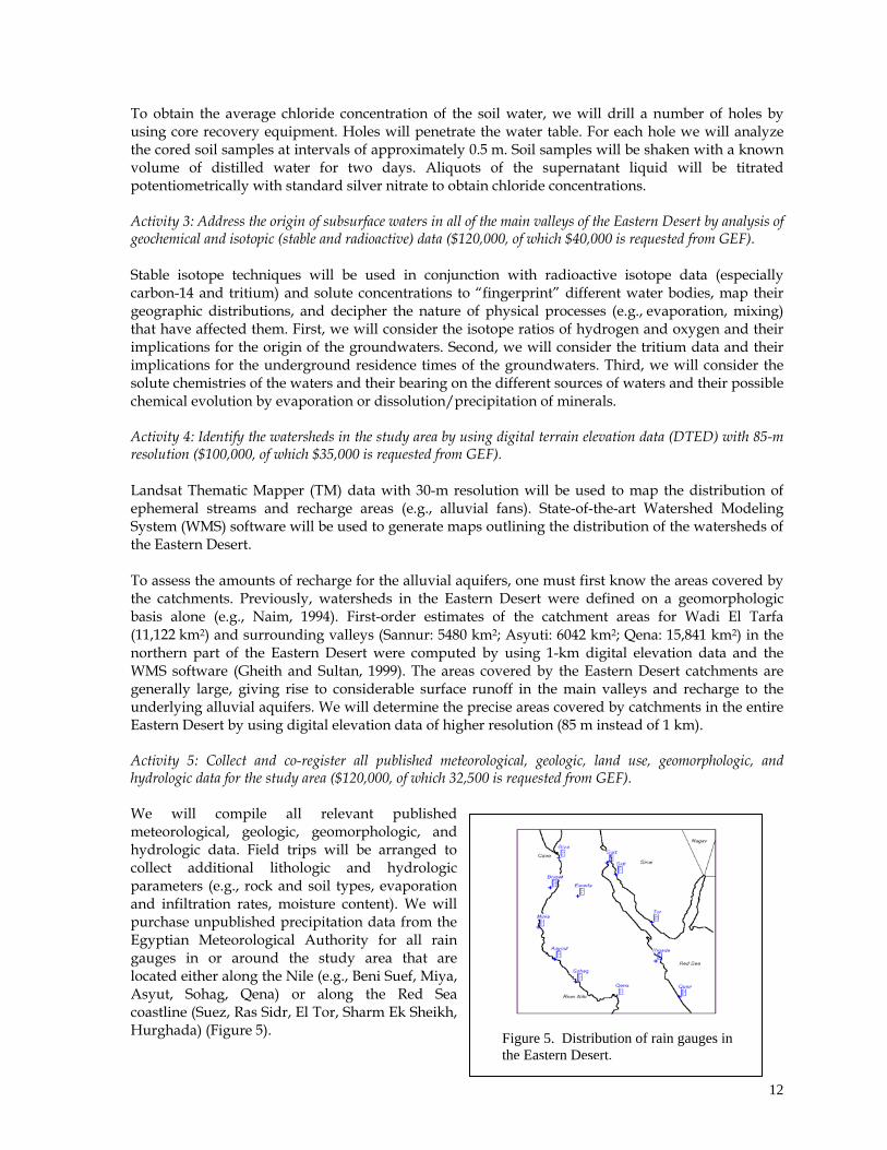
Activity 5: Collect and co-register all published meteorological, geologic, land use, geomorphologic, and hydrologic data for the study area ($120,000, of which 32,500 is requested from GEF). We will compile all relevant published meteorological, geologic, geomorphologic, and hydrologic data. Field trips will be arranged to collect additional lithologic and hydrologic parameters (e.g., rock and soil types, evaporation and infiltration rates, moisture content). We will purchase unpublished precipitation data from the Egyptian Meteorological Authority for all rain gauges in or around the study area that are located either along the Nile (e.g., Beni Suef, Miya, Asyut, Sohag, Qena) or along the Red Sea coastline (Suez, Ras Sidr, El Tor, Sharm Ek Sheikh, Hurghada) (Figure 5).
Figure 5. Distribution of rain gauges in the Eastern Desert.
12
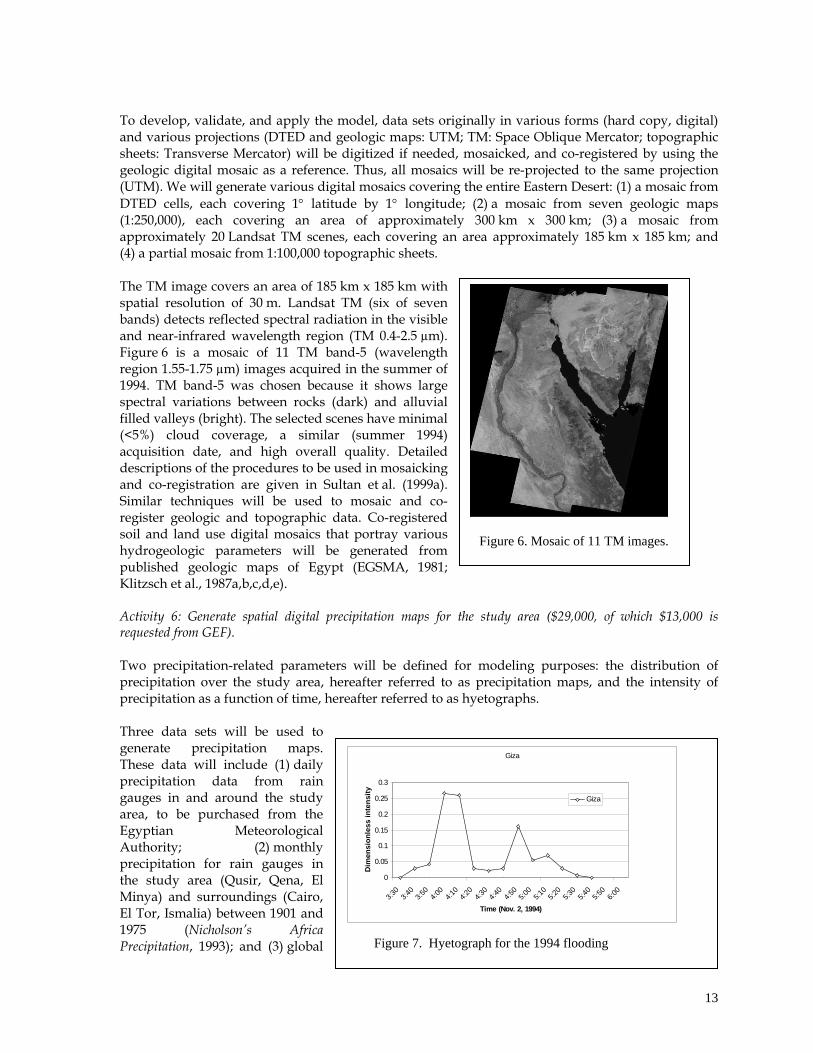
To develop, validate, and apply the model, data sets originally in various forms (hard copy, digital) and various projections (DTED and geologic maps: UTM; TM: Space Oblique Mercator; topographic sheets: Transverse Mercator) will be digitized if needed, mosaicked, and co-registered by using the geologic digital mosaic as a reference. Thus, all mosaics will be re-projected to the same projection (UTM). We will generate various digital mosaics covering the entire Eastern Desert: (1) a mosaic from DTED cells, each covering 1 latitude by 1 longitude; (2) a mosaic from seven geologic maps (1:250,000), each covering an area of approximately 300 km x 300 km; (3) a mosaic from approximately 20 Landsat TM scenes, each covering an area approximately 185 km x 185 km; and (4) a partial mosaic from 1:100,000 topographic sheets. The TM image covers an area of 185 km x 185 km with spatial resolution of 30 m. Landsat TM (six of seven bands) detects reflected spectral radiation in the visible and near-infrared wavelength region (TM 0.4-2.5 µm). Figure 6 is a mosaic of 11 TM band-5 (wavelength region 1.55-1.75 µm) images acquired in the summer of 1994. TM band-5 was chosen because it shows large spectral variations between rocks (dark) and alluvial filled valleys (bright). The selected scenes have minimal (<5%) cloud coverage, a similar (summer 1994) acquisition date, and high overall quality. Detailed descriptions of the procedures to be used in mosaicking and co-registration are given in Sultan et al. (1999a). Similar techniques will be used to mosaic and co-register geologic and topographic data. Co-registered soil and land use digital mosaics that portray various hydrogeologic parameters will be generated from published geologic maps of Egypt (EGSMA, 1981; Klitzsch et al., 1987a,b,c,d,e).
Figure 6. Mosaic of 11 TM images.
Activity 6: Generate spatial digital precipitation maps for the study area ($29,000, of which $13,000 is requested from GEF). Two precipitation-related parameters will be defined for modeling purposes: the distribution of precipitation over the study area, hereafter referred to as precipitation maps, and the intensity of precipitation as a function of time, hereafter referred to as hyetographs. Three data sets will be used to generate precipitation maps. These data will include (1) daily precipitation data from rain gauges in and around the study area, to be purchased from the Egyptian Meteorological Authority; (2) monthly precipitation for rain gauges in the study area (Qusir, Qena, El Minya) and surroundings (Cairo, El Tor, Ismalia) between 1901 and 1975 (Nicholson’s Africa Precipitation, 1993); and (3) global Figure 7. Hyetograph for the 1994 flooding
Giza
0
0.05
0.1
0.15
0.2
0.25
0.3
3:30
3:40
3:50
4:00
4:10
4:20
4:30
4:40
4:50
5:00
5:10
5:20
5:30
5:40
5:50
6:00
Time (Nov. 2, 1994)
Dim
en
sio
nle
ss
in
ten
sit
y
Giza
13
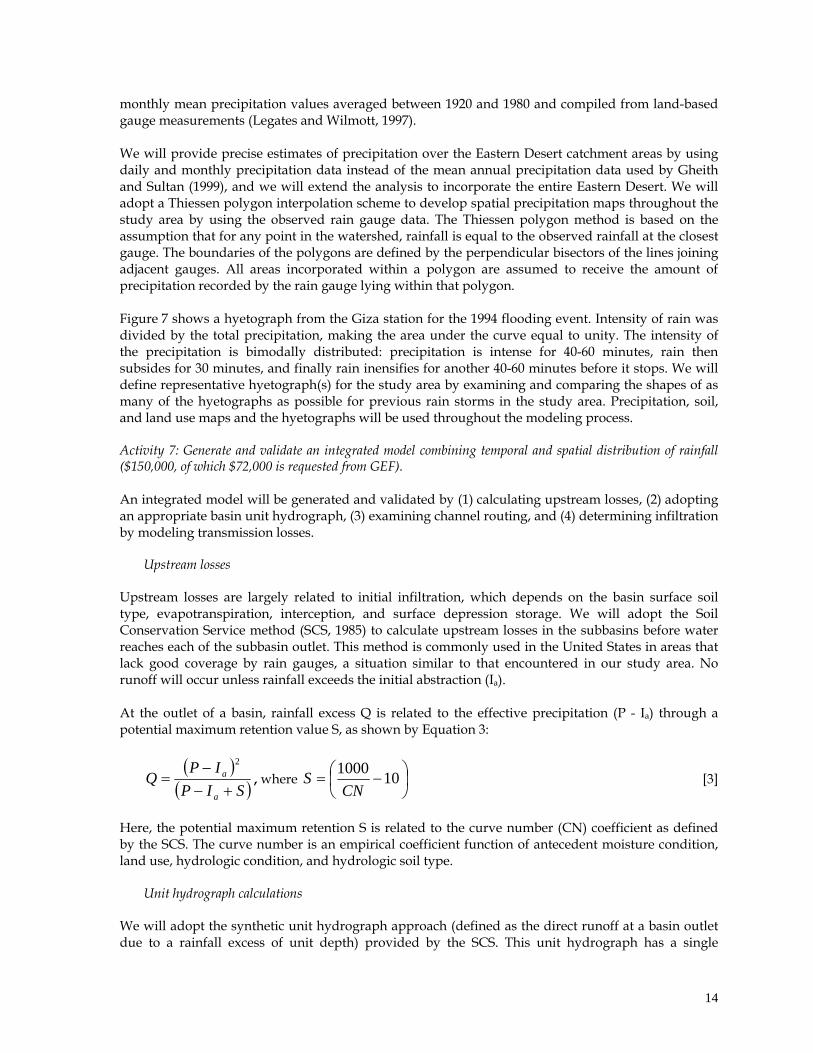
monthly mean precipitation values averaged between 1920 and 1980 and compiled from land-based gauge measurements (Legates and Wilmott, 1997). We will provide precise estimates of precipitation over the Eastern Desert catchment areas by using daily and monthly precipitation data instead of the mean annual precipitation data used by Gheith and Sultan (1999), and we will extend the analysis to incorporate the entire Eastern Desert. We will adopt a Thiessen polygon interpolation scheme to develop spatial precipitation maps throughout the study area by using the observed rain gauge data. The Thiessen polygon method is based on the assumption that for any point in the watershed, rainfall is equal to the observed rainfall at the closest gauge. The boundaries of the polygons are defined by the perpendicular bisectors of the lines joining adjacent gauges. All areas incorporated within a polygon are assumed to receive the amount of precipitation recorded by the rain gauge lying within that polygon. Figure 7 shows a hyetograph from the Giza station for the 1994 flooding event. Intensity of rain was divided by the total precipitation, making the area under the curve equal to unity. The intensity of the precipitation is bimodally distributed: precipitation is intense for 40-60 minutes, rain then subsides for 30 minutes, and finally rain inensifies for another 40-60 minutes before it stops. We will define representative hyetograph(s) for the study area by examining and comparing the shapes of as many of the hyetographs as possible for previous rain storms in the study area. Precipitation, soil, and land use maps and the hyetographs will be used throughout the modeling process.
Activity 7: Generate and validate an integrated model combining temporal and spatial distribution of rainfall ($150,000, of which $72,000 is requested from GEF). An integrated model will be generated and validated by (1) calculating upstream losses, (2) adopting an appropriate basin unit hydrograph, (3) examining channel routing, and (4) determining infiltration by modeling transmission losses.
Upstream losses Upstream losses are largely related to initial infiltration, which depends on the basin surface soil type, evapotranspiration, interception, and surface depression storage. We will adopt the Soil Conservation Service method (SCS, 1985) to calculate upstream losses in the subbasins before water reaches each of the subbasin outlet. This method is commonly used in the United States in areas that lack good coverage by rain gauges, a situation similar to that encountered in our study area. No runoff will occur unless rainfall exceeds the initial abstraction (Ia). At the outlet of a basin, rainfall excess Q is related to the effective precipitation (P - Ia) through a potential maximum retention value S, as shown by Equation 3:
SIP
IPQ
a
a
2
, where
101000
CNS [3]
Here, the potential maximum retention S is related to the curve number (CN) coefficient as defined by the SCS. The curve number is an empirical coefficient function of antecedent moisture condition, land use, hydrologic condition, and hydrologic soil type.
Unit hydrograph calculations We will adopt the synthetic unit hydrograph approach (defined as the direct runoff at a basin outlet due to a rainfall excess of unit depth) provided by the SCS. This unit hydrograph has a single
14
parameter, the lag time, defined as the interval from the midpoint of a storm event to the time of peak discharge response at the basin outlet. The Riverside County Flood Control and Water Conservation District (1978) developed three lag equations, corresponding to mountains, foothill, and valley areas, as follows:
38.0
24
S
LLnT ca
lag [4]
Here Tlag is the lag time in hours, L is the maximum flow length in miles, Lca is the length to the centroid in miles, S is the weighted slope along the maximum flow path length in ft/mile, and n is the estimated mean of the Manning coefficient. The Manning coefficient is averaged over all collection streams and channels within the subbasin.
Channel routing Routing parameters will be chosen to simulate the movement of a flood wave through the channel reaches. Hydrographs will be combined at each outlet and then routed to the next downstream outlet. Bed resistance, channel slope, and wetted perimeter affect the shape and timing of the flood wave. An increase in flow volume in a reach will result in an increase in transmission loss. Thus, for accurate prediction of groundwater recharge, correct timing and volume are required for hydrographs reaching the main valleys. The Muskingum River Routing method developed by McCarthy (1938) will be used for calculating channel routing. To estimate time span in a reach, the average Manning’s coefficient for gravel bed rivers will be calculated according to Jarrett (1984):
16.038.032.0 RSn [5] Inserting Equation 5 into Manning’s equation yields
12.0827.0125.3 SRv h , [6]
where Rh is the hydraulic radius and S is the slope.
Transmission losses Groundwater recharge in the study area is mainly due to transmission losses along stream reaches. Evaporation losses are negligible because of the short time duration of stream flow and cloudy weather during precipitation. Transmission losses are affected by factors such as channel geometry, upstream volume, duration of stream flow, bed material size, sediment load, and temperature. Published methods for calculating transmission losses in similar arid areas will be reviewed, and the most appropriate method will be selected. Among these methods is that of Savard (1997), who estimated a constant volume loss rate in Fortymile Wash in Yucca Mountain, Nevada, of 7300 m3/km. Another estimate that takes into account the duration of flow was suggested by Ben-Zvi (1996), who estimated infiltration losses at 7200 m3/km/hr. Neither estimate takes into account the effect of upstream volume. Walters (1990) proposed a set of regression equations to estimate transmission losses in arid environments by analyzing sets of data measured by gauges in southwest Saudi Arabia. The expressions he developed relate channel characteristics and upstream volume to infiltration loss.
Partial-area and lumped-parameter models
15
Efforts will be made to explore the use of partial-area models (e.g., Engman and Rogowski, 1974) and lumped-parameter (e.g., Boughton, 1965) models. The former models are based on the division of the watershed into areas that produce runoff and those that do not. The latter models are based on defining parameters that are specific to the studied areas. For example, the Boughton model requires knowledge of eight parameters (capacity of interception store, capacity of upper soil store, capacity of drainage store, capacity of lower soil store, maximum evapotranspiration rate when the relevant soil store is full, fraction of evapotranspiration from the upper soil store, daily infiltration rate when the lower soil store is empty, empirical constant). The use of these two types of models is often hindered by uncertainties associated with defining the required inputs (e.g., the eight parameters for the Boughton model).
Validating and calibrating the surface runoff model The runoff models will be calibrated against field records (Naim, 1994) for the 1994 flooding event. These records were compiled and published by the Egyptian Geological Survey and Minning Authority. Examples of data that could be used for calibration include precipitation data, duration of flooding in certain valleys, and amounts of water collected upstream. This information is available for a number of the main valleys including El Tarfa and Wadi Hammamat. We will select an appropriate runoff model that accounts for documented field records from the 1994 flooding event and for which fairly reliable input data are readily available. We will then select the most promising valley and will construct, calibrate, and validate groundwater simulation models for that valley. The selection criteria will include the amount of rainfall being channeled through the valley, the lithology and thickness of soils, accessibility, and availability of data. Activity 8: Collect archival and field hydrogeologic data for the selected valley ($275,000, of which $90,000 is requested from GEF). Archival and field hydrogeologic data will be collected, including aquifer testing results and water level surveys. Examples of these data are given in published maps and the associated explanatory notes (e.g., RIGW, 1988, 1989, 1990a,b, 1992, 1994). Field and archival data will serve as input for steady-state flow simulation of the existing groundwater regime via a coarsely discretized regional groundwater model. Activity 9: Construct, calibrate, and validate a groundwater model for the selected valley ($220,000, of which $157,000 is requested from GEF). The groundwater model will be used to simulate current groundwater flow in the area by employing MODFLOW numerical modeling computer program. The model will be tested and refined in the selected valley by using data from geophysical surveys and drilling. The model will be calibrated with a temporal subset of the water level data and validated with the remaining water level data. Thus, field and well data (e.g., lithology and water table) will be required to calibrate and validate the model. Steady-state and transient simulations of the effects of rainstorms and water pumping for irrigation will follow. Output from both the steady-state and transient models will provide a groundwater budget of the region, flow velocities, and flow paths. The model will be validated in one valley. Activity 10: Assessment of any adverse ecological effects that could result from the exploitation of the investigated freshwater resources ($56,000, of which $56,000 is requested from GEF). We will devote effort to identifying any potential adverse ecological effects accompanying use of the investigated renewable water resource and will find remedies to these expected adverse effects. For
16
example, the expected periodic drop in the water table as groundwater is being extracted from alluvial aquifers might deprive certain deep-rooted plant species of their water supply, and it could reduce groundwater flow from artesian wells and cause deterioration of ecosystems supported by the water supply. The use of the alluvial aquifer groundwater for land reclamation could also lead to the replacement of desert ecosystems by other ecosystems that are more adapted to agricultural environments. In our test area, invasive species will be most likely be pertinent to the Nile valley. Having said this, we do not anticipate that the use of the water resources of the alluvial aquifers will impose major negative impacts on the ecosystems of the surrounding deserts for a number of reasons. First, the aridity and scarcity of water and food supplies in these areas limit animal and plant populations in size and number. Second, the areas that could be reclaimed through the use of renewable groundwater resources in the Eastern Desert and in similar areas worldwide will be limited in areal extent. Most likely, these areas will be restricted to downstream parts of watersheds where the thickness of the alluvial aquifer is relatively large and the water table is shallow. The exploitation of the renewable groundwater resources downstream should not affect groundwater levels and ecosystems upstream. In other words, only a limited area in the downstream portion of a watershed could be used for agricultural development, leaving the vast majority of the watershed landscape and ecosystems intact. In the case of the test site, >95% of Egypt’s landscape is currently covered by deserts; because the areas under consideration are limited in size (<1% of Egypt’s deserts), the impact of this project on Egypt’s desert ecosystems will be negligible. Hence, we do not expect that the project will pose major threats to Egypt’s ecosystems or wildlife.
N.B.: An additional $60,000 is requested from GEF to cover annual audits and independent evaluation toward the end of the project.
SUSTAINABILITY ANALYSIS AND RISK ASSESSMENT
The following steps were taken to ensure that the project will attain its long-term objective, which is the development and use of methodologies to assess alternative renewable water resources in arid and semi-arid countries, with Egypt as the test site: Develop appropriate facilities and expertise at CU to enable replication of the methodologies
elsewhere in Egypt and in neighboring countries. A state-of-the-art computational facility for hydrologic modeling will be established. Faculty of CU will receive adequate training on the campus and in the field.
Adopt a policy of training the trainers. Scientists from CU will implement the project with their colleagues from the National Water Research Center (NWRC) and from Argonne. After receiving appropriate training, CU scientists will conduct workshops, short courses, etc. to transfer the acquired expertise locally and to interested researchers in neighboring countries as well. Cairo University is considered the leading university in Egypt and in the Middle East.
Implement the project in collaboration with scientists from the Ministry of Irrigation and Public Works. NWRC, the sole agency responsible for developing Egypt’s water resources, will be capable of conducting similar projects elsewhere in Egypt and in neighboring countries.
Involve the relevant governmental agencies (CU and NWRC) in Egypt and conduct the project at a critical time when Egypt and the neighboring countries are eager to develop their water resources. A successful demonstration of the proposed work will prompt the governments of Egypt and neighboring countries with similar topographic, climatic, and hydrologic conditions (e.g., Sudan, Ethiopia, Saudi Arabia, Yemen) to investigate and eventually use the largely untapped water resource in alluvial aquifers.
The project risks include the following:
17
Finding that, unlike the groundwater of the Wadi El Tarfa and surrounding valleys, the shallow
aquifers of the Eastern Desert are not all of meteoric origin. Alternative sources could include fossil waters or Nile River waters. Even if this occurs, we will determine the mixing proportions of the various water sources in the investigated aquifers.
Failure to obtain relevant hydrologic and meteorological data sets. In Egypt, valuable data sets are often unpublished. We will obtain such data sets by establishing collaborations with relevant parties or by purchase of data (e.g., meteorological data).
Lack of cooperation between scientists from CU and the NWRC. Teamwork involving more than one governmental agency is often hindered by bureaucracy and rivalries. So far, scientists from CU and NWRC have collaborated to develop the project and write the proposal. As described later, we plan to assemble a steering committee including a representative from each of the four participating agencies (CU, NWRC, UNDP, and Argonne) to foster collaboration between the participating agencies and will resolve potential problems.
Unforeseen need for funds beyond those listed in the proposal for verification of the generated model. For example, lack of data on the selected valley could necessitate the digging of additional wells. If this unlikely event occurs, the steering committee will prepare proposals to seek funding for the additional activities.
STAKEHOLDER INVOLVEMENT AND SOCIAL ASSESSMENT STAKEHOLDER INVOLVEMENT The stakeholders are (1) the NWRC, which is administered by the Egyptian Ministry of Irrigation and Public Works; (2) CU; and (3) educational and governmental institutions in neighboring third-world countries (particularly in North Africa and in the Middle East) that could benefit from the results by replicating the Egyptian model in their countries. The scientists of CU and the NWRC will receive training on applying the procedures described in this proposal and will conduct the tasks described in the proposal jointly with their colleagues from Argonne. After the completion of the project, the CU and NWRC scientists will be capable of providing scientific, technical, and practical guidance to their fellow citizens, as well as officials and scientists from neighboring countries, to apply the Egyptian model elsewhere. To broaden the adoption of the procedures developed in this proposal we will seek funding from the Arab Gulf Program for United Nations Development Organizations (AGFUND) to support the implementation of our methodologies. SOCIAL ASSESSMENT The realization that the availability of renewable water is finite, while population growth will continuously increase water demand, is starting to cause serious concern in developing nations, especially in the arid countries of North Africa and the Middle East. Studies have shown that the number of these countries unable to meet their water needs for self-reliant food production is increasing from 12 in 1993 to 16 in the year 2000, with a projected total of 18 by the year 2025, when only Iraq, Lebanon, and Mauritania will be immune to the water deficit common in this area. By 2025, average availability will have dropped to 535 cubic meters per capita year, less than half of what is considered necessary (IN-WARDAM, 1990). The development and demonstration of successful techniques for assessing alternative renewable freshwater resources in the arid countries of the Middle East and North Africa could alleviate water shortage problems that confront these nations. Competition among the nations of the Middle East for scarce water resources has already contributed to hostilities on a number of occasions. For example, in 1964 Israel launched a series of military strikes
18
against the diversion works of the headwaters in Jordan. In addition, a stumbling block in peace talks is the management of the occupied West Bank groundwater aquifer that supplies Israel with 25% of its water needs (Gleick, 1993). Such water-related disputes can lead to violent conflicts. Naturally, the development of alternative renewable water resources in the Middle East can ease some of these tensions. The use of the renewable water resource residing in the alluvial aquifers will appeal to the general public because it is cost-effective and requires modest capital investment: the targeted soils are fertile, and the investigated alluvial aquifers are generally shallow. Flash floods originating from mountainous areas usually nourish downstream valleys with nutrients (clays) carried from the hills over which the rainfall occurs.
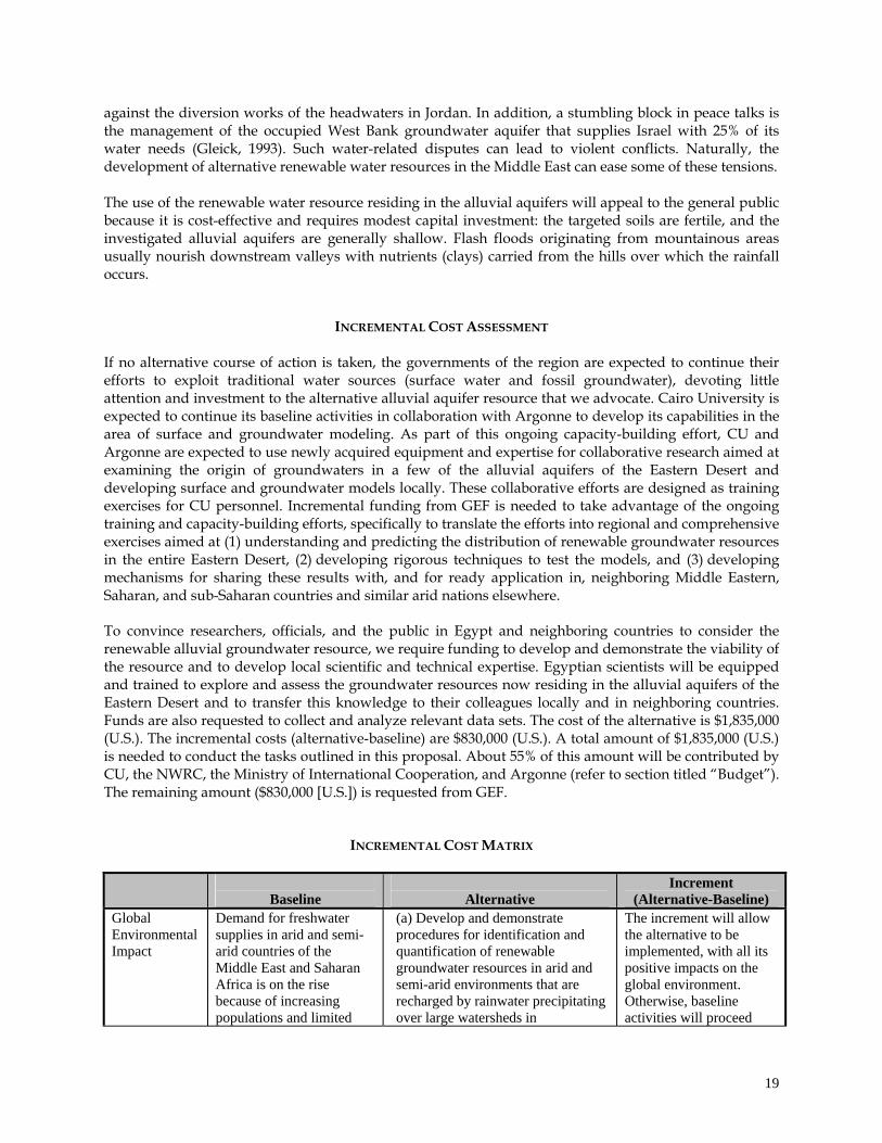
INCREMENTAL COST ASSESSMENT If no alternative course of action is taken, the governments of the region are expected to continue their efforts to exploit traditional water sources (surface water and fossil groundwater), devoting little attention and investment to the alternative alluvial aquifer resource that we advocate. Cairo University is expected to continue its baseline activities in collaboration with Argonne to develop its capabilities in the area of surface and groundwater modeling. As part of this ongoing capacity-building effort, CU and Argonne are expected to use newly acquired equipment and expertise for collaborative research aimed at examining the origin of groundwaters in a few of the alluvial aquifers of the Eastern Desert and developing surface and groundwater models locally. These collaborative efforts are designed as training exercises for CU personnel. Incremental funding from GEF is needed to take advantage of the ongoing training and capacity-building efforts, specifically to translate the efforts into regional and comprehensive exercises aimed at (1) understanding and predicting the distribution of renewable groundwater resources in the entire Eastern Desert, (2) developing rigorous techniques to test the models, and (3) developing mechanisms for sharing these results with, and for ready application in, neighboring Middle Eastern, Saharan, and sub-Saharan countries and similar arid nations elsewhere. To convince researchers, officials, and the public in Egypt and neighboring countries to consider the renewable alluvial groundwater resource, we require funding to develop and demonstrate the viability of the resource and to develop local scientific and technical expertise. Egyptian scientists will be equipped and trained to explore and assess the groundwater resources now residing in the alluvial aquifers of the Eastern Desert and to transfer this knowledge to their colleagues locally and in neighboring countries. Funds are also requested to collect and analyze relevant data sets. The cost of the alternative is $1,835,000 (U.S.). The incremental costs (alternative-baseline) are $830,000 (U.S.). A total amount of $1,835,000 (U.S.) is needed to conduct the tasks outlined in this proposal. About 55% of this amount will be contributed by CU, the NWRC, the Ministry of International Cooperation, and Argonne (refer to section titled “Budget”). The remaining amount ($830,000 [U.S.]) is requested from GEF.
INCREMENTAL COST MATRIX
Baseline
Alternative
Increment (Alternative-Baseline)
Global Environmental Impact
Demand for freshwater supplies in arid and semi-arid countries of the Middle East and Saharan Africa is on the rise because of increasing populations and limited
(a) Develop and demonstrate procedures for identification and quantification of renewable groundwater resources in arid and semi-arid environments that are recharged by rainwater precipitating over large watersheds in
The increment will allow the alternative to be implemented, with all its positive impacts on the global environment. Otherwise, baseline activities will proceed
19
water supplies. Increasing demand on conventional freshwater supplies (surface water, fossil groundwater) in these countries is contributing to extreme stresses on the global freshwater ecosystem. The preservation of these freshwater ecosystems is important, given the diversity of the animal and plant species they support.
mountainous areas and are channeled across across a limited number of main valleys as surface runoff and as groundwater flow. (b) Apply procedures to many similar arid and semi-arid countries in the Middle East, Sahara, and Nile valley. (c) Reduce stresses on the global freshwater ecosystem. This is important, given the diversity of the animal and plant species they support. (d) Assist in maintaining the current water flow levels of the Nile River and preserve its ecosystems, if our procedures were applied to Nile valley countries.
with their negative impacts. The increment will allow the translation of the modest research efforts currently underway into comprehensive regional exercises aimed at developing rigorous techniques to test, calibrate, and validate surface and groundwater recharge models and at developing mechanisms by which these results can be shared with, and readily applied to, other Middle Eastern, Saharan, and Nile valley countries.
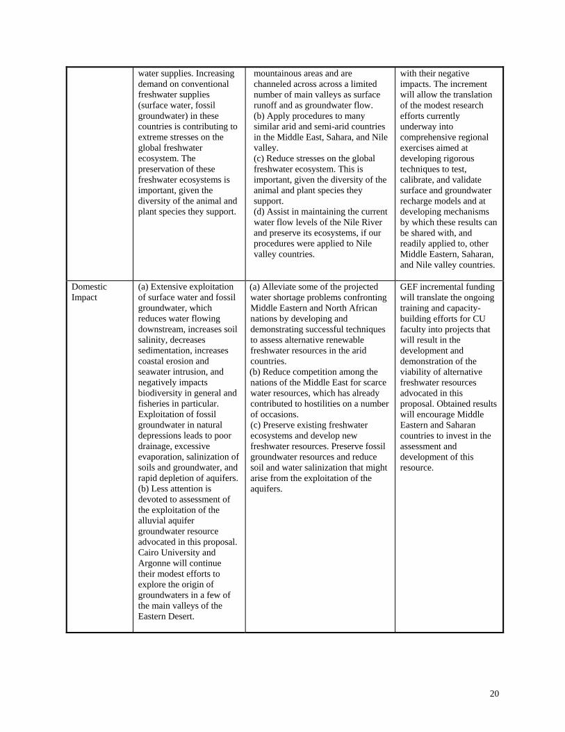
Domestic Impact
(a) Extensive exploitation of surface water and fossil groundwater, which reduces water flowing downstream, increases soil salinity, decreases sedimentation, increases coastal erosion and seawater intrusion, and negatively impacts biodiversity in general and fisheries in particular. Exploitation of fossil groundwater in natural depressions leads to poor drainage, excessive evaporation, salinization of soils and groundwater, and rapid depletion of aquifers. (b) Less attention is devoted to assessment of the exploitation of the alluvial aquifer groundwater resource advocated in this proposal. Cairo University and Argonne will continue their modest efforts to explore the origin of groundwaters in a few of the main valleys of the Eastern Desert.
(a) Alleviate some of the projected water shortage problems confronting Middle Eastern and North African nations by developing and demonstrating successful techniques to assess alternative renewable freshwater resources in the arid countries. (b) Reduce competition among the nations of the Middle East for scarce water resources, which has already contributed to hostilities on a number of occasions. (c) Preserve existing freshwater ecosystems and develop new freshwater resources. Preserve fossil groundwater resources and reduce soil and water salinization that might arise from the exploitation of the aquifers.
GEF incremental funding will translate the ongoing training and capacity-building efforts for CU faculty into projects that will result in the development and demonstration of the viability of alternative freshwater resources advocated in this proposal. Obtained results will encourage Middle Eastern and Saharan countries to invest in the assessment and development of this resource.
20

Costs US$
Task Baseline
Costs Alternative
Costs Incremental
Costs Develop scientific and technical capabilities 257,000 500,000 243,000 Collect and analyze water samples 148,500 180,000 31,500 Identify origin of groundwater 80,000 120,000 40,000 Identify watersheds 65,000 100,00 35,000 Collect surface data (meteorology, hydrology, etc.,) 87,500 120,000 32,500 Generate maps of precipitation, soil coverage, etc. 16,000 29,000 13,000 Construct a surface runoff model 78,000 150,000 72,000 Collect archival and field hydrogeologic data for the selected valley 185,000 275,000 90,000 Construct a groundwater model for selected valley 63,000 220,000 157,000 Assess any negative ecological effects and find remedies 0 56,000 56,000 Audit progress of work 0 60,000 60,000 Total 980,000 1,835,000 830,000 Total and PDF (25,000) = $1,835,000
21
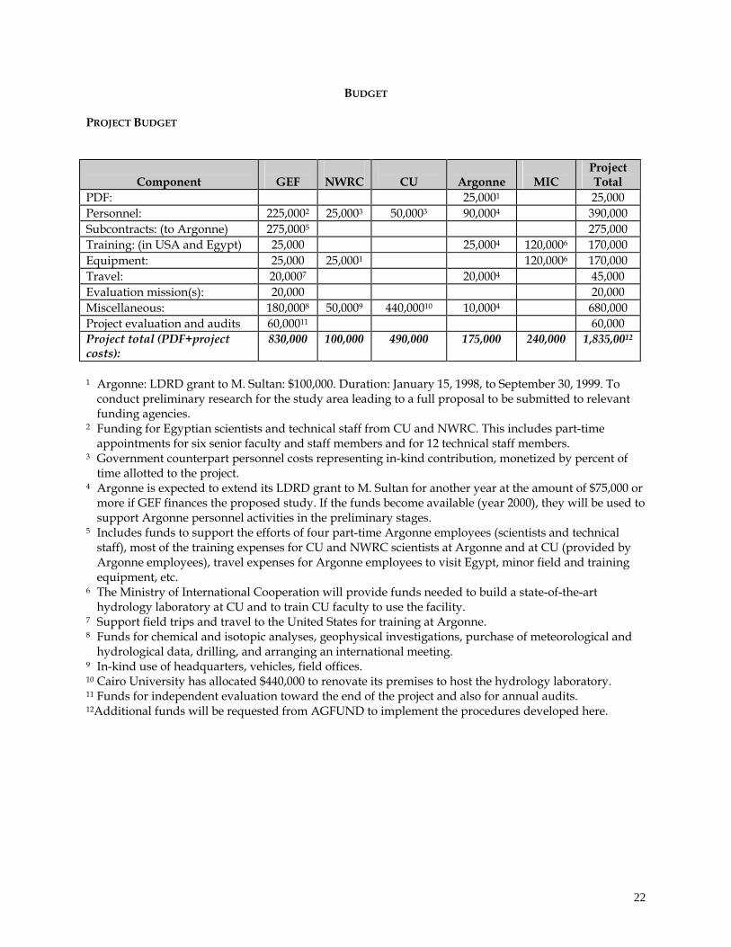
BUDGET PROJECT BUDGET
Component
GEF
NWRC
CU
Argonne
MIC
Project Total
PDF: 25,0001 25,000 Personnel: 225,0002 25,0003 50,0003 90,0004 390,000 Subcontracts: (to Argonne) 275,0005 275,000 Training: (in USA and Egypt) 25,000 25,0004 120,0006 170,000 Equipment: 25,000 25,0001 120,0006 170,000 Travel: 20,0007 20,0004 45,000 Evaluation mission(s): 20,000 20,000 Miscellaneous: 180,0008 50,0009 440,00010 10,0004 680,000 Project evaluation and audits 60,00011 60,000 Project total (PDF+project costs):
830,000 100,000 490,000 175,000 240,000 1,835,0012
1 Argonne: LDRD grant to M. Sultan: $100,000. Duration: January 15, 1998, to September 30, 1999. To
conduct preliminary research for the study area leading to a full proposal to be submitted to relevant funding agencies.
2 Funding for Egyptian scientists and technical staff from CU and NWRC. This includes part-time appointments for six senior faculty and staff members and for 12 technical staff members.
3 Government counterpart personnel costs representing in-kind contribution, monetized by percent of time allotted to the project.
4 Argonne is expected to extend its LDRD grant to M. Sultan for another year at the amount of $75,000 or more if GEF finances the proposed study. If the funds become available (year 2000), they will be used to support Argonne personnel activities in the preliminary stages.
5 Includes funds to support the efforts of four part-time Argonne employees (scientists and technical staff), most of the training expenses for CU and NWRC scientists at Argonne and at CU (provided by Argonne employees), travel expenses for Argonne employees to visit Egypt, minor field and training equipment, etc.
6 The Ministry of International Cooperation will provide funds needed to build a state-of-the-art hydrology laboratory at CU and to train CU faculty to use the facility.
7 Support field trips and travel to the United States for training at Argonne. 8 Funds for chemical and isotopic analyses, geophysical investigations, purchase of meteorological and
hydrological data, drilling, and arranging an international meeting. 9 In-kind use of headquarters, vehicles, field offices. 10 Cairo University has allocated $440,000 to renovate its premises to host the hydrology laboratory. 11 Funds for independent evaluation toward the end of the project and also for annual audits. 12Additional funds will be requested from AGFUND to implement the procedures developed here.
22
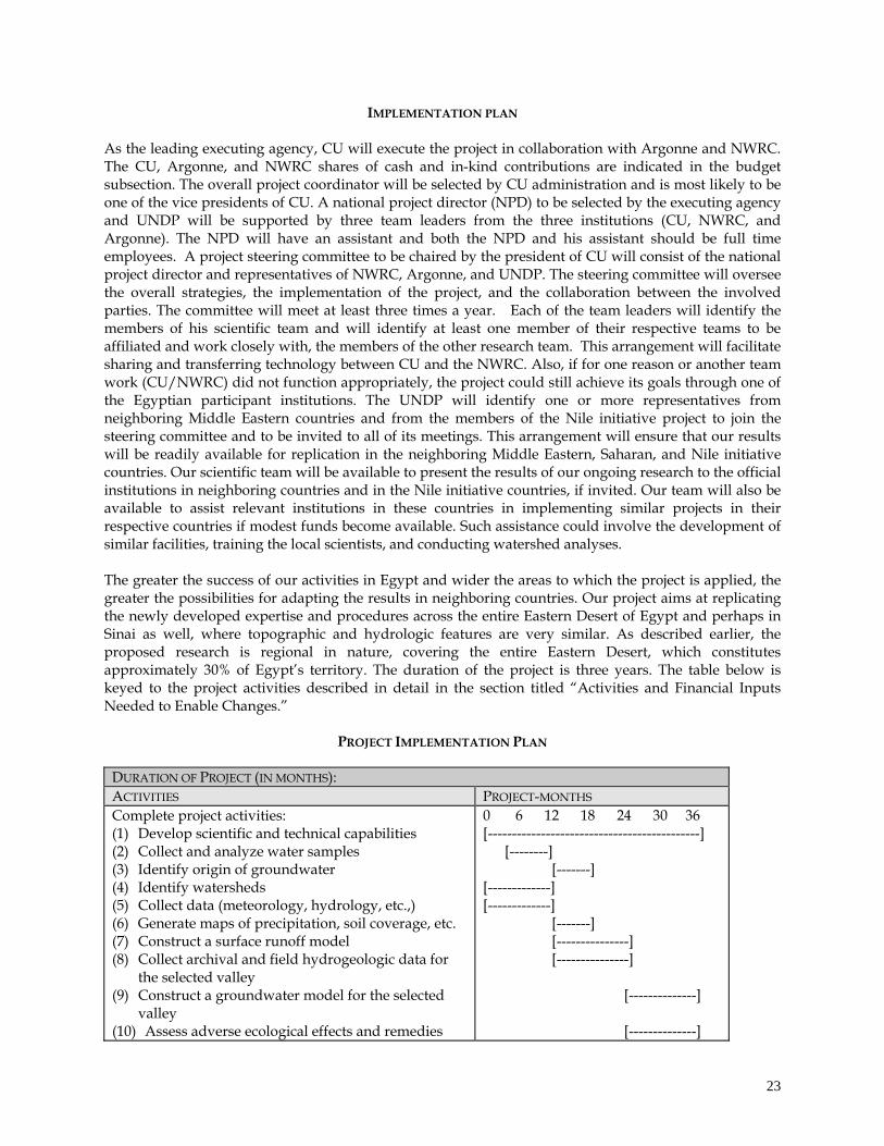
IMPLEMENTATION PLAN As the leading executing agency, CU will execute the project in collaboration with Argonne and NWRC. The CU, Argonne, and NWRC shares of cash and in-kind contributions are indicated in the budget subsection. The overall project coordinator will be selected by CU administration and is most likely to be one of the vice presidents of CU. A national project director (NPD) to be selected by the executing agency and UNDP will be supported by three team leaders from the three institutions (CU, NWRC, and Argonne). The NPD will have an assistant and both the NPD and his assistant should be full time employees. A project steering committee to be chaired by the president of CU will consist of the national project director and representatives of NWRC, Argonne, and UNDP. The steering committee will oversee the overall strategies, the implementation of the project, and the collaboration between the involved parties. The committee will meet at least three times a year. Each of the team leaders will identify the members of his scientific team and will identify at least one member of their respective teams to be affiliated and work closely with, the members of the other research team. This arrangement will facilitate sharing and transferring technology between CU and the NWRC. Also, if for one reason or another team work (CU/NWRC) did not function appropriately, the project could still achieve its goals through one of the Egyptian participant institutions. The UNDP will identify one or more representatives from neighboring Middle Eastern countries and from the members of the Nile initiative project to join the steering committee and to be invited to all of its meetings. This arrangement will ensure that our results will be readily available for replication in the neighboring Middle Eastern, Saharan, and Nile initiative countries. Our scientific team will be available to present the results of our ongoing research to the official institutions in neighboring countries and in the Nile initiative countries, if invited. Our team will also be available to assist relevant institutions in these countries in implementing similar projects in their respective countries if modest funds become available. Such assistance could involve the development of similar facilities, training the local scientists, and conducting watershed analyses. The greater the success of our activities in Egypt and wider the areas to which the project is applied, the greater the possibilities for adapting the results in neighboring countries. Our project aims at replicating the newly developed expertise and procedures across the entire Eastern Desert of Egypt and perhaps in Sinai as well, where topographic and hydrologic features are very similar. As described earlier, the proposed research is regional in nature, covering the entire Eastern Desert, which constitutes approximately 30% of Egypt’s territory. The duration of the project is three years. The table below is keyed to the project activities described in detail in the section titled “Activities and Financial Inputs Needed to Enable Changes.”
PROJECT IMPLEMENTATION PLAN
DURATION OF PROJECT (IN MONTHS): ACTIVITIES PROJECT-MONTHS Complete project activities: (1) Develop scientific and technical capabilities (2) Collect and analyze water samples (3) Identify origin of groundwater (4) Identify watersheds (5) Collect data (meteorology, hydrology, etc.,) (6) Generate maps of precipitation, soil coverage, etc. (7) Construct a surface runoff model (8) Collect archival and field hydrogeologic data for
the selected valley (9) Construct a groundwater model for the selected
valley (10) Assess adverse ecological effects and remedies
0 6 12 18 24 30 36 [--------------------------------------------] [--------] [-------] [-------------] [-------------] [-------] [---------------] [---------------] [--------------] [--------------]
23

PUBLIC INVOLVEMENT PLAN
STAKEHOLDER IDENTIFICATION The stakeholders are (1) the NWRC (Egyptian Ministry of Irrigation and Public Works), (2) CU, and (3) educational and governmental institutions in neighboring third-world countries (particularly in North Africa and in the Middle East) that could benefit from the results obtained by replicating the Egyptian model in their respective countries. The Ministry of Irrigation and Public Works in Egypt is the sole agency responsible for developing Egypt’s water resources. Cairo University is considered the leading university in Egypt. INFORMATION DISSEMINATION AND CONSULTATION We plan to disseminate the results of the project nationally and internationally through various channels. National avenues include the national newspapers (Al Ahram and Al Akhbar) and national television broadcasting. This will ensure that our results will be widely publicized. We will also generate an Internet home page on which scientific and technical details can be accessed by the researchers and interested parties. We will organize an international meeting in Cairo at the end of the project to present our results to the scientific community and to relevant governmental officials in Egypt and neighboring countries. Emphasis will be on inviting scientists and leading governmental officials from neighboring Middle Eastern, Saharan, and Nile valley countries. Results will be also summarized in leading scientific journals (e.g., Groundwater, Journal of Hydrology, Water Resources Research). STAKEHOLDER PARTICIPATION The participation of the stakeholders will be organized through the regular steering committee meetings and workshops. The steering committee will meet at least three times a year. Two workshops will be organized during the second and third years. SOCIAL AND PARTICIPATION ISSUES The social issues are the development of a mechanism by which officials from relevant educational and governmental institutions in Egypt and neighboring countries can participate in the ongoing activities, as well as the transfer of the technologies and expertise to these countries. MONITORING AND EVALUATION PLAN TPR: This project will be subject to annual project reviews, which take place once every 12 months. The participants to these Tripartite Reviews (TPR) will include representatives of the government, the executing agency, cooperating agencies, and UNDP. APR: The executing agency is responsible for preparing and submitting to each TPR an annual performance report (APR). Other evaluation reports may be requested, as needed, during the implementation of the project. Copies of the report will be provided to each of the project partners (government, UNDP, implementing agency, and GEF/UNDP).
24
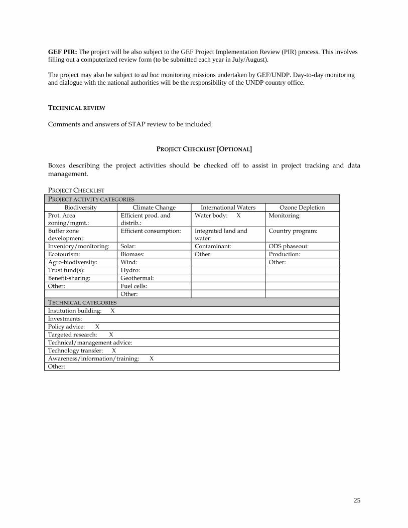
GEF PIR: The project will be also subject to the GEF Project Implementation Review (PIR) process. This involves filling out a computerized review form (to be submitted each year in July/August). The project may also be subject to ad hoc monitoring missions undertaken by GEF/UNDP. Day-to-day monitoring and dialogue with the national authorities will be the responsibility of the UNDP country office. TECHNICAL REVIEW Comments and answers of STAP review to be included.
PROJECT CHECKLIST [OPTIONAL] Boxes describing the project activities should be checked off to assist in project tracking and data management. PROJECT CHECKLIST PROJECT ACTIVITY CATEGORIES
Biodiversity Climate Change International Waters Ozone Depletion Prot. Area zoning/mgmt.:
Efficient prod. and distrib.:
Water body: X Monitoring:
Buffer zone development:
Efficient consumption: Integrated land and water:
Country program:
Inventory/monitoring: Solar: Contaminant: ODS phaseout: Ecotourism: Biomass: Other: Production: Agro-biodiversity: Wind: Other: Trust fund(s): Hydro: Benefit-sharing: Geothermal: Other: Fuel cells: Other: TECHNICAL CATEGORIES Institution building: X Investments: Policy advice: X Targeted research: X Technical/management advice: Technology transfer: X Awareness/information/training: X Other:
25
REFERENCES
Abdel Hady, Y., M. El Beheiry, M. El Difrawy, and M. El Anbeawy. 1995. Evaluation of the Ground Water Resources and Soil Classification in the Wadi El Tarfa, Eastern Desert, Egypt. Report 1. Egyptian Ministry of International Cooperation. Allison, G.B., and M.W. Hughes. 1978. The use of environmental chloride and tritium to estimate total recharge to an unconfined aquifer, Australian Journal Soil Research, v. 16, pp. 181-195. Ben-Zvi, A. 1996. Runoff, infiltration, and subsurface flow of water in arid and semi-arid regions, Quantitative prediction of runoff events, Water Science and Technology Library, v. 21, pp. 121-130, Kluwer Academic Publishers, Norwel, Mass. Boughton, W.C. 1965. A New Simulation Technique for Estimating Catchment Yield, Report 78, Water Research Laboratory, University of New South Wales, Manly Vale, Australia. Coleman, M.L., T.J. Shepherd, J.J. Durham, J.E. Rouse, and G.R. Moore. 1982. Reduction of water with zinc for hydrogen isotope analysis, Analytical Chemistry, v. 54, pp. 993-995. Coplen, T. 1993. Uses of environmental isotopes, In Regional Ground-Water Quality, ed. W.M. Alley, pp. 227-254. Van Nostrand Reinhold, New York. EGSMA. 1981. Geologic Map of Egypt. Scale: 1:2,000,000. Geological Survey of Egypt and Mining Authority, Cairo, Egypt. Egyptian Meteorological Authority. 1996. Climatic Atlas of Egypt. Ministry of Transport and Communications, Egypt. El Bakri, A., A. Tantawi, B. Blavoux, and M. Dray. 1992. Sources of water recharge identified by isotopes in El Minya Governate (Nile valley, Middle Egypt). In Proceedings of an International Symposium on Isotope Techniques in Water Resources Development 1991, pp. 643-645, International Atomic Energy Agency, Vienna. Engman, E.T., and A.S. Rogowski. 1974. A partial area model for storm flow synthesis, Water Resource Research, v. 10, no. 3, pp. 464-472. Geith, H., and M. Sultan. 1999. Preliminary assessment of the renewable ground water resources of the Eastern Desert, National Groundwater Annual Meeting Abstracts Book 1999, pp. 37-39, Nashville, Tenn. Gleick, P.H. 1993. Water in Crisis, Oxford University Press, New York. Hess, K.-H., A. Hissene, O. Kheir, E. Schnacker, M. Schneider, and U. Thorweihe. 1987. Hydrogeological investigations in the Nubian aquifer system, Eastern Sahara. In Research in Egypt and Sudan, ed. E. Klitzsch and E. Schrank, pp. 397-464, Verlag Von Dietrich Reimer, Berlin. IN-WARDAM. 1990. Water Assessment for Arab League Countries, no. 10, Islamic Network on Water Resources Development and Management, Amman, Jordan. Jarrett, R.D. 1984. Hydraulics of high-gradient streams, J. Hydraulic Engineering, v. 110, pp. 1519-1539. Klitzsch, E., F.K. List, and G. Pohlmann. 1987a. Geological Map of Egypt, Beni Suef Sheet. Scale 1:500,000. The Egyptian General Petroleum Corporation/Conoco, Cairo, Egypt.
26
Klitzsch, E., F.K. List, and G. Pohlmann. 1987b. Geological Map of Egypt, Asyut Sheet. Scale 1:500,000. The Egyptian General Petroleum Corporation/Conoco, Cairo, Egypt. Klitzsch, E., F.K. List, and G. Pohlmann. 1987c. Geological Map of Egypt, Luxor Sheet. Scale 1:500,000. The Egyptian General Petroleum Corporation/Conoco, Cairo, Egypt. Klitzsch, E., F.K. List, and G. Pohlmann. 1987d. Geological Map of Egypt, Gebel Hamata Sheet. Scale 1:500,000. The Egyptian General Petroleum Corporation/Conoco, Cairo, Egypt. Klitzsch, E., F.K. List, and G. Pohlmann. 1987e Geological Map of Egypt, Bernice Sheet. Scale 1:500,000. The Egyptian General Petroleum Corporation/Conoco, Cairo, Egypt. Landis, G.P., C.A. Swanberg, P. Morgan, F.K. Boulos, A.A. El Serif, A.A. El Sayed, N.Z. Basta, and Y.S. Melek. 1995. Reconnaissance hydrogen isotope geochemistry of Egyptian ground waters, Annals of the Geological Survey of Egypt, v. VXX, pp. 655-673. Legates, D.R., and C.J. Wilmott. 1997. Legates Surface and Ship Observation of Precipitation. ftp://daac.gsfc.nasa.gov/hydrology/precip/legates/README.legates_gauge_precip McCarthy, G.T. 1938. The unit hydrograph and flood routing, Conf. North Atlantic Div., U.S. Army Corps of Engineers, New London, Conn. Moyle, P.B., and J.I. Cech. 1982. Fishes: An Introduction to Ichthyology, Prentice-Hall, Englewood Cliffs, N.J. Nicholson’s Africa Precipitation. 1993. National Center for Atmospheric Research. http://www.scd.ucar.edu/dss/catalogs/precip.html; ftp://ncardata.edu/datasets/ds571.0/MASTER Naim, G. 1994. Floods of Upper Egypt Governorates, Egyptian Geological Survey and Minning Authority, Cairo, Egypt. Osterkamp, W.R., L.J. Lane, and C.S. Savard. 1994. Recharge estimates using a geomorphic/distributed-parameter simulation approach, Amargosa River basin, Water Resource Bulletin, v. 30, no. 3, pp. 493-507. RIGW (Research Institute for Groundwater). 1988. Hydrogeological Map of Egypt. Scale 1:2000,000. Ministry of Public Works and Water Resources, Cairo, Egypt. RIGW (Research Institute for Groundwater). 1989. Hydrogeological Map of Egypt, Mallawi. Scale 1:100,000. Ministry of Public Works and Water Resources, Cairo, Egypt. RIGW (Research Institute for Groundwater). 1990a. Hydrogeological Map of Egypt, Beni Suef. Scale 1:100,000. Ministry of Public Works and Water Resources, Cairo, Egypt. RIGW (Research Institute for Groundwater). 1990b. Hydrogeological Map of Egypt, Sohag. Scale 1:100,000. Ministry of Public Works and Water Resources, Cairo, Egypt. RIGW (Research Institute for Groundwater). 1992. Hydrogeological Map of Egypt, El Minya. Scale 1:100,000. Ministry of Public Works and Water Resources, Cairo, Egypt. RIGW (Research Institute for Groundwater). 1994. Hydrogeological Map of Egypt, Qena. Scale 1:100,000. Ministry of Public Works and Water Resources, Cairo, Egypt.
27

Riverside County Flood Control and Water Conservation District, 1978. Riverside County Hydrology Manual. Riverside County, California.
Said, R., 1993, The River Nile, geology, hydrology, and utilization, Pergamon Press, New York, USA. Savard, C.S. 1997. Estimated Ground-Water Recharge from Streamflow in Fortymile Wash near Yucca Mountain, Nevada, Water-Resources InvestigationsReport 97-4273, U.S. Geological Survey, pp. 1-30. SCS. 1985. National Engineering Handbook, Section 4-Hydrology, U.S. Department of Agriculture, Soil Conservation Service, Engineering Division, Washington, D.C. Sharma, M.L. 1988. Recharge estimation from the depth-distribution of environmental chloride in the unsaturated zone – Western Australia examples. In Estimation of Natural Groundwater Recharge, ed. I. Simmers, pp. 159-173. Reidel, Dordrecht. Soliman, M., P. LaMoreaux, B. Memon, F. Assaad, and J. LaMoreaux. 1998. Environmental Hydrogeology, Lewis Publishers, New York. Sorman, A., and M. Abdulrazzak. 1993. Infiltration-recharge through wadi beds in arid regions, Journal of Hydrological Sciences, v. 38, pp. 173-186. Socki, R. A., H.R. Karlsson, and E.K. Gibson. 1992. Extraction technique for the determination of oxygen-18 in water using pre-evacuated glass vials. Analytical Chemistry, v. 64, pp. 829-831. Stansbery, D.H. 1973. Why preserve rivers? The Explorer, v. 15, no. 3, pp. 14-16. Sultan, M., N. Sturchio, F.A. Hassan, M.A.R. Hamdan, A.M. Mahmood, Z. El Alfy, and T. Stein. 1997. Precipitation source inferred from stable isotopic composition of Pleistocene groundwater and carbonate deposits in the Western Desert of Egypt, Quaternary Geology, v. 4, pp. 29-37. Sultan, M., M. Fiske, T. Stein, M. Gamal, Y. Abdel Hady, H. El Araby, T. El Araby, A. Madani, S. Mehanee, and R. Becker. 1999a. Satellite-based monitoring of urbanization in the Nile Delta, Egypt, Ambio, v. 28, pp. 628-631. Sultan, M., N.C. Sturchio, Y. Abdel Hady, M. El Anbaawy, and O. El Bahar. 1999b. Preserving Nile water resources and ecosystems through the use of alternative renewable ground water resources: A pilot case – the Eastern Desert of Egypt. In Proceedings, Second International Conference and Trade Fair on Environmental Management and Technologies, pp. 703-712, Egyptian Environmental Affairs Agency, Cairo, Egypt. Sultan, M., N.C. Sturchio, H. Gheith, Y. Abdel Hady, and M. El Anbaawy. 2000. Chemical and isotopic constraints on the origin of Wadi El-Tarfa groundwater, Eastern Desert, Egypt. Ground Water, v. 38, pp. 743-751. Swanberg, C.A., P. Morgan, and F.K. Boulos. 1988. Geochemistry of the ground-waters of Egypt, Annals of the Geological Survey of Egypt, VXIV, pp. 127-150. Thorweihe, U. 1982. Hydrogeologie des Dakhla Bekens (Agypten). Berliner Geowiss. Abh., A38, pp. 1-53. Walters, M.O. 1990. Transmission losses in arid regions, Journal of Hydraulic Engineering, v. 116, no. 1, pp. 129-138. Wootton, R.J. 1990. Ecology of Teleost Fishes, Chapman and Hall, New York.
28
TARGETED RESEARCH ANNEX
PART I: SCIENTIFIC AND TECHNICAL MERIT
1. Research Hypothesis Because some of the watersheds in arid and semi-arid areas collect precipitation over large
areas and channel it through a few main valleys, substantial amounts of freshwater could
potentially recharge the alluvial aquifers flooring these main valleys during sporadic storms.
2. Issue(s) of scientific and technical merit the project will address (1) Identify the source and distribution of groundwater in the alluvial aquifers flooring the main valleys that collect surface runoff from extensive watersheds; (2) Develop methods (i.e., calibrated and surface runoff and groundwater flow models) that successfully predict the recharge of the aquifers in question; (3) Identify possible adverse ecological effects that might arise from the utilization of this resource and search for remedies to these effects.
PART II: SUPPORT TO GEF OPERATIONAL STRATEGY/PROGRAMME
3. Contribution the project results will make to increasing the effectiveness of the development and implementation of GEF projects and operational programmes
If the project can demonstrate that alluvial aquifers in arid and semi-arid areas can be successfully re-charged by inputs from sporadic storms, this result could be of significant value to the implementation of other GEF projects working on freshwater scarcity issues in similar climatic regimes, e.g. Lake Chad, Okavango, Nile Basin Initiative, etc. Project activities will be designed to ensure that lessons and best practices identified in this project are transferred to other GEF projects which could benefit from these results.
PART III: RESEARCH METHODOLOGY AND INSTITUTIONAL INVOLVEMENT
4. Research Methodology (11) Collect and conduct geochemical and isotopic analyses on water samples from existing
wells and water bodies to identify the origin of subsurface waters in all of the main valleys of the Eastern Desert;
(12) Identify the watersheds in the study area and collect meteorological and hydrologic data for the study area;
(13) Generate spatial precipitation distribution maps by using mean monthly precipitation data, soil type coverage maps;
(14) Generate, test, refine, and validate an integrated model for mountainous arid regions that
29
30
(15) Collect archival and field hydrologic data for the most promising valley in order to define the configuration of the aquifer and to collect relevant hydro-geologic parameters for use as inputs to the groundwater model;
(16) Construct, calibrate, and validate a steady-state groundwater model to simulate current groundwater configuration and a transient model to account for recharge in the area;
(17) Identify potential adverse ecologic effects that might result from the project and find possible remedies.
5. Collaborating Institutions Cairo University (Egypt) and the National Water Research Center (Egypt), which is administered by the Ministry of Irrigation and Public Works, and Argonne National Laboratory (USA). 6. Project achievements and implications for strengthening research capacity of the
participating developing country research institution(s).
A hydrology laboratory (hardware, software) for hydrologic modeling will be initiated at Cairo University. Egyptian scientists will be trained in the use of isotopic data to investigate the sources of groundwater and to understand the physical processes that affected these waters. Egyptian scientists will be also trained in the use of newly acquired hardware and software for analysis of satellite data and groundwater and surface water modeling. Additional field equipment will be purchased as needed. Workshops will be held at Cairo University to train their faculty, scientists from the National Water Research Center, and officials and scientists from neighboring countries in hydrologic modeling and the application of environmental isotopic and geo-chemical techniques.
APPENDIX I
CHEMICAL AND ISOTOPIC CONSTRAINTS ON THE ORIGIN OF WADI EL-TARFA GROUND WATER, EASTERN DESERT, EGYPT
Sultan, M., Sturchio, N.C., Gheith, H., Abdel Hady, Y., and El Anbaawy, M.,
Published in: GROUND WATER, volume 38, No. 5- pp. 743-751,
September/October Issue: Year 2000
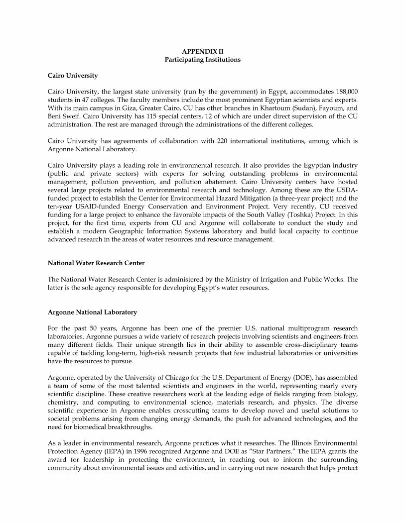
APPENDIX II Participating Institutions
Cairo University Cairo University, the largest state university (run by the government) in Egypt, accommodates 188,000 students in 47 colleges. The faculty members include the most prominent Egyptian scientists and experts. With its main campus in Giza, Greater Cairo, CU has other branches in Khartoum (Sudan), Fayoum, and Beni Sweif. Cairo University has 115 special centers, 12 of which are under direct supervision of the CU administration. The rest are managed through the administrations of the different colleges. Cairo University has agreements of collaboration with 220 international institutions, among which is Argonne National Laboratory. Cairo University plays a leading role in environmental research. It also provides the Egyptian industry (public and private sectors) with experts for solving outstanding problems in environmental management, pollution prevention, and pollution abatement. Cairo University centers have hosted several large projects related to environmental research and technology. Among these are the USDA-funded project to establish the Center for Environmental Hazard Mitigation (a three-year project) and the ten-year USAID-funded Energy Conservation and Environment Project. Very recently, CU received funding for a large project to enhance the favorable impacts of the South Valley (Toshka) Project. In this project, for the first time, experts from CU and Argonne will collaborate to conduct the study and establish a modern Geographic Information Systems laboratory and build local capacity to continue advanced research in the areas of water resources and resource management. National Water Research Center The National Water Research Center is administered by the Ministry of Irrigation and Public Works. The latter is the sole agency responsible for developing Egypt’s water resources. Argonne National Laboratory For the past 50 years, Argonne has been one of the premier U.S. national multiprogram research laboratories. Argonne pursues a wide variety of research projects involving scientists and engineers from many different fields. Their unique strength lies in their ability to assemble cross-disciplinary teams capable of tackling long-term, high-risk research projects that few industrial laboratories or universities have the resources to pursue. Argonne, operated by the University of Chicago for the U.S. Department of Energy (DOE), has assembled a team of some of the most talented scientists and engineers in the world, representing nearly every scientific discipline. These creative researchers work at the leading edge of fields ranging from biology, chemistry, and computing to environmental science, materials research, and physics. The diverse scientific experience in Argonne enables crosscutting teams to develop novel and useful solutions to societal problems arising from changing energy demands, the push for advanced technologies, and the need for biomedical breakthroughs. As a leader in environmental research, Argonne practices what it researches. The Illinois Environmental Protection Agency (IEPA) in 1996 recognized Argonne and DOE as “Star Partners.” The IEPA grants the award for leadership in protecting the environment, in reaching out to inform the surrounding community about environmental issues and activities, and in carrying out new research that helps protect

the environment. The award recognizes numerous Argonne and DOE environmental outreach activities, including work with industry to develop new environmentally friendly technologies, such as recycling metal and nonmetal parts of old cars and reducing the amount of copper in waste streams from circuit-board manufacturing; research to develop improved methods for studying the environment and remediating environmental problems; sponsorship of and participation in professional conferences that help spread new environmental science and technology to private industry and government agencies; educational contributions, such as workshops to help high school teachers improve their environmental science curricula; special Earth Day events for public schools and for Argonne and DOE employees; sponsorship of and participation in public meetings; and periodic open houses and public tours.

APPENDIX – III Endorsements for the proposed project from GEF and the Egyptian Government.
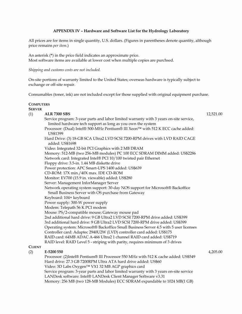
APPENDIX IV – Hardware and Software List for the Hydrology Laboratory
All prices are for items in single quantity, U.S. dollars. (Figures in parentheses denote quantity, although price remains per item.) An asterisk (*) in the price field indicates an approximate price. Most software items are available at lower cost when multiple copies are purchsed. Shipping and customs costs are not included. On-site portions of warranty limited to the United States; overseas hardware is typically subject to exchange or off-site repair. Consumables (toner, ink) are not included except for those supplied with original equipment purchase.
COMPUTERS SERVER (1) ALR 7300 SBS
Service program: 3-year parts and labor limited warranty with 3 years on-site service, limited hardware tech support as long as you own the system
Processor: (Dual) Intel® 500-MHz Pentium® III Xeon™ with 512 K ECC cache added: US$1399
Hard Drive: (3) 18-GB SCA Ultra2 LVD SCSI 7200-RPM drives with LVD RAID CAGE added: US$1698
Video: Integrated 32-bit PCI Graphics with 2 MB DRAM Memory: 512-MB (two 256-MB modules) PC 100 ECC SDRAM DIMM added: US$2286 Network card: Integrated Intel® PCI 10/100 twisted pair Ethernet Floppy drive: 3.5-in. 1.44 MB diskette drive Power protection: APC Smart-UPS 1400 added: US$639 CD-ROM: 17X min./40X max. IDE CD-ROM Monitor: EV700 (15.9 in. viewable) added: US$280 Server: Management InforManager Server Network operating system support: 30-day NOS support for Microsoft® Backoffice
Small Business Server with OS purchase from Gateway Keyboard: 104+ keyboard Power supply: 300-W power supply Modem: Telepath 56 K PCI modem Mouse: PS/2-compatible mouse; Gateway mouse pad 2nd additional hard drive: 9 GB Ultra2 LVD SCSI 7200-RPM drive added: US$399 3rd additional hard drive: 9 GB Ultra2 LVD SCSI 7200-RPM drive added: US$399 Operating system: Microsoft® Backoffice Small Business Server 4.5 with 5 user licenses Controller card: Adaptec 2940U2W (LVD) controller card added: US$175 RAID card: 64MB ADAC A-466 Ultra2 1 channel RAID card added: US$719 RAID level: RAID Level 5 - striping with parity, requires minimum of 3 drives
12,521.00
CLIENT (2) E-5200 550
Processor: (2)Intel® Pentium® III Processor 550 MHz with 512 K cache added: US$549 Hard drive: 27.3 GB 7200RPM Ultra ATA hard drive added: US$60 Video: 3D Labs Oxygen™ VX1 32 MB AGP graphics card Service program: 3-year parts and labor limited warranty with 3 years on-site service LANDesk software: Intel® LANDesk Client Manager Software v3.31 Memory: 256 MB (two 128-MB Modules) ECC SDRAM expandable to 1024 MB(1 GB)
4,205.00
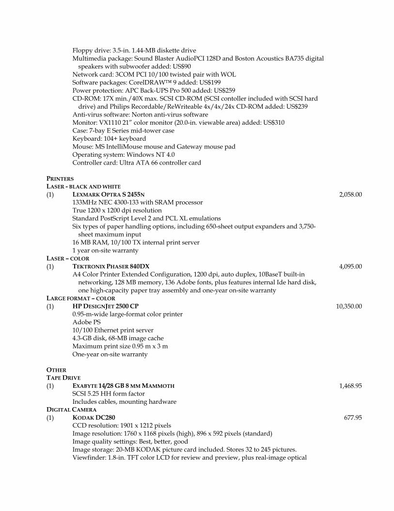
Floppy drive: 3.5-in. 1.44-MB diskette drive Multimedia package: Sound Blaster AudioPCI 128D and Boston Acoustics BA735 digital
speakers with subwoofer added: US$90 Network card: 3COM PCI 10/100 twisted pair with WOL Software packages: CorelDRAW™ 9 added: US$199 Power protection: APC Back-UPS Pro 500 added: US$259 CD-ROM: 17X min./40X max. SCSI CD-ROM (SCSI contoller included with SCSI hard
drive) and Philips Recordable/ReWriteable 4x/4x/24x CD-ROM added: US$239 Anti-virus software: Norton anti-virus software Monitor: VX1110 21” color monitor (20.0-in. viewable area) added: US$310 Case: 7-bay E Series mid-tower case Keyboard: 104+ keyboard Mouse: MS IntelliMouse mouse and Gateway mouse pad Operating system: Windows NT 4.0 Controller card: Ultra ATA 66 controller card
PRINTERS LASER - BLACK AND WHITE (1) LEXMARK OPTRA S 2455N
133MHz NEC 4300-133 with SRAM processor True 1200 x 1200 dpi resolution Standard PostScript Level 2 and PCL XL emulations Six types of paper handling options, including 650-sheet output expanders and 3,750-
sheet maximum input 16 MB RAM, 10/100 TX internal print server 1 year on-site warranty
2,058.00
LASER – COLOR (1) TEKTRONIX PHASER 840DX
A4 Color Printer Extended Configuration, 1200 dpi, auto duplex, 10BaseT built-in networking, 128 MB memory, 136 Adobe fonts, plus features internal Ide hard disk, one high-capacity paper tray assembly and one-year on-site warranty
4,095.00
LARGE FORMAT – COLOR (1) HP DESIGNJET 2500 CP
0.95-m-wide large-format color printer Adobe PS 10/100 Ethernet print server 4.3-GB disk, 68-MB image cache Maximum print size 0.95 m x 3 m One-year on-site warranty
10,350.00
OTHER TAPE DRIVE (1) EXABYTE 14/28 GB 8 MM MAMMOTH
SCSI 5.25 HH form factor Includes cables, mounting hardware
1,468.95
DIGITAL CAMERA (1) KODAK DC280
CCD resolution: 1901 x 1212 pixels Image resolution: 1760 x 1168 pixels (high), 896 x 592 pixels (standard) Image quality settings: Best, better, good Image storage: 20-MB KODAK picture card included. Stores 32 to 245 pictures. Viewfinder: 1.8-in. TFT color LCD for review and preview, plus real-image optical
677.95
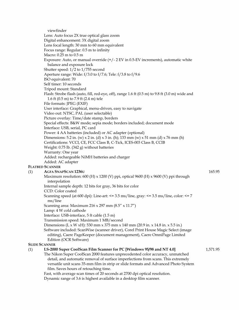
viewfinder Lens: Auto focus 2X true optical glass zoom Digital enhancement: 3X digital zoom Lens focal length: 30 mm to 60 mm equivalent Focus range: Regular: 0.5 m to infinity Macro: 0.25 m to 0.5 m Exposure: Auto, or manual override (+/- 2 EV in 0.5-EV increments), automatic white
balance and exposure lock Shutter speed: 1/2 to 1/755 second Aperture range: Wide: f/3.0 to f/7.6; Tele: f/3.8 to f/9.6 ISO equivalent: 70 Self timer: 10 seconds Tripod mount: Standard Flash: Strobe flash (auto, fill, red-eye, off), range 1.6 ft (0.5 m) to 9.8 ft (3.0 m) wide and
1.6 ft (0.5 m) to 7.9 ft (2.4 m) tele File formats: JPEG (EXIF) User interface: Graphical, menu-driven, easy to navigate Video out: NTSC, PAL (user selectable) Picture overlay: Time/date stamp, borders Special effects: B&W mode; sepia mode; borders included; document mode Interface: USB, serial, PC card Power: 4 AA batteries (included) or AC adapter (optional) Dimensions: 5.2 in. (w) x 2 in. (d) x 3 in. (h); 133 mm (w) x 51 mm (d) x 76 mm (h) Certifications: VCCI, CE, FCC Class B, C-Tick, ICES-003 Class B, CCIB Weight: 0.75 lb. (342 g) without batteries Warranty: One year Added: rechargeable NiMH batteries and charger Added: AC adapter
FLATBED SCANNER (1) AGFA SNAPSCAN 1236U
Maximum resolution: 600 (H) x 1200 (V) ppi, optical 9600 (H) x 9600 (V) ppi through interpolation
Internal sample depth: 12 bits for gray, 36 bits for color CCD: Color coated Scanning speed (at 600 dpi): Line-art: <= 3.5 ms/line, gray: <= 3.5 ms/line, color: <= 7
ms/line Scanning area: Maximum 216 x 297 mm (8.5” x 11.7”) Lamp: 4 W cold cathode Interface: USB-interface, 5 ft cable (1.5 m) Transmission speed: Maximum 1 MB/second Dimensions (L x W xH): 530 mm x 375 mm x 140 mm (20.9 in. x 14.8 in. x 5.5 in.) Software included: ScanWise (scanner driver), Corel Print House Magic Select (image
editing), Caere PageKeeper (document management), Caere OmniPage Limited Edition (OCR Software)
165.95
SLIDE SCANNER (1) LS-2000 Super CoolScan Film Scanner for PC [Windows 95/98 and NT 4.0]
The Nikon Super CoolScan 2000 features unprecedented color accuracy, unmatched detail, and automatic removal of surface imperfections from scans. This extremely versatile unit scans 35-mm film in strip or slide formats and Advanced Photo System film. Saves hours of retouching time.
Fast, with average scan times of 20 seconds at 2700 dpi optical resolution. Dynamic range of 3.6 is highest available in a desktop film scanner.
1,571.95
Multi-sample scanning feature gives you the quality of a drum scanner on your desktop. Nikon Color Management System provides vivid, extremely accurate color, ensures color
matching on monitors and printers, and allows users to work in sRGB, CMYK, Lch, and RGB color spaces.
Hot swappable adapters allows switching between film types without resetting scanner or software.
Unique auto slide feeder allows unattended batch scanning of up to 50 slides (optional). LED technology provides consistent, reliable color without recalibration. High-quality, high-resolution 36-bit color images at file sizes up to 56 MB. Revolutionary Digital ICE technology automatically removes surface defects such as
dust, scratches, and fingerprints from scans. NETWORK HUB AND CABLES (1) 3COM SUPERSTACK II SWITCH 3300
24-port 10/100 autosensing 24 25-m CAT 5 patch cables
3,000.00
LARGE-FORMAT SCANNER (1) CONTEX FSC 6010 DSP E-SIZE COLOR SCANNER
Triple tri-linear color CCD, 15,000 pixels 30-bit color capture 50 to 600 dpi, in 1-dpi increments 6.0- to 40-in. media width 36-in. scan width (length limited by computer memory, not scanner) Windows NT interface One-year factory warranty Floor stand
17,579.00
SOFTWARE ARC/INFO (1) ESRI ARC/INFO 8.0 for Widnows NT, floating single license 9,000.00 ENVI (1) ENVI/IDL 3.2 for Windows NT, floating single license 2,500.00 WMS / GMS (1) Boss International WMS Watershed Modeling Software (full license with all packages) 1,500.00 OTHER SOFTWARE (1) DRAFTSMAN PLUS 32
Raster to Vector conversion software (Palisades Research) 2,295.00
(2) MICROSOFT OFFICE 2000 PREMIUM MS Word 2000 MS Excel 2000 MS Outlook 2000 MS Publisher 2000 MS Small Business Tools 2000 MS Access 2000 MS PowerPoint 2000 MS FrontPage 2000 MS PhotoDraw 2000 New Features Include: Universal Document Viewing, Save to the Web, Web Themes,
Web Discussions, Outlook Web Shortcuts, Data Access Pages, Self-Repairing Applications, Collect and Paste, Floating Tables, Tri-Pane View, Language AutoDetect, Office E-mail
--------------------------------------------- Office 2000 automatically detects and fixes errors without a user even knowing about
673.95
them. For example, Office 2000 automatically verifies and reinstalls all of its files and registry entries, if necessary, to run successfully.
Detect and Repair: A new tool on the Help menu, Detect and Repair finds problems with non-critical files, such as fonts and templates, and repairs them.
Install on Demand: Programs and components are installed, as they are needed, saving space on the hard drive until the functionality is needed.
Save to the Web: Allows users to publish a copy of the current document in HTML format directly to a Webserver.
Office Web Editing: HTML files created in Office 2000 are easily edited using Office applications. Clicking on the Edit button in the browser will intelligently launch the Office 2000 application which created the HTML file.
Web Subscriptions and Web Notifications: Users can subscribe to a document or HTML page and indicate when they would like to be notified of changes to that document.
Self-repairing applications: Language AutoDetect: By automatically detecting the language user types in, Word 2000
can intelligently use the correct spelling, grammar checking, AutoCorrect and other proofing tools.
Year 2000 Compliance: Office 2000 provides a new set of tools, features, and safeguards for the new millennium, including support for an administrable four-digit-year cutoff.
Euro Currency Support: Excel 2000 supports the new Euro currency-both the symbol and the three-letter ISO code.
Small Business Customer Manager: Helps small businesses achieve more effective customer tracking, analysis, and communication by making use of data they already have.
Includes: Database wizard, filters, enhanced data fields, personalized settings, activity tracker, and more.
Business Planner: A set of tools, information, and templates to help grow and run a business. Combines content from the latest editions of 5 leading business reference books with over 100 productivity templates/worksheets, almost 700 Web links, and directory information.
Small Business Financial Manager: Works with Excel to help small business owners make better use of their accounting data. Easily create dynamic/customizable financial reports/charts, perform valuable “what-if” analyses, and “mine”accounting information to make better business decisions.
Microsoft Publisher: Improved Web site and quick publication, catalog, and pack and go wizards. Includes design sets, automatic bullets/numbering, office and commercial printing support, flip horizontal/vertical, automatic 4-color process conversion, font embedding, and more.
(0) COREL DRAW 9: INCLUDED IN WORKSTATION (CLIENT) PRICE
0.00
(1) NT Support software/utilities 1,000.00