Uplift Modeling for Online Advertising - Archives-Ouvertes.fr
RLS
KAa
Nb
c
d
a
ARRAA
KNTNBSM
1
cabnams
pK
h0
Precambrian Research 270 (2015) 226–245
Contents lists available at ScienceDirect
Precambrian Research
jo ur nal home p ag e: www.elsev ier .com/ locate /precamres
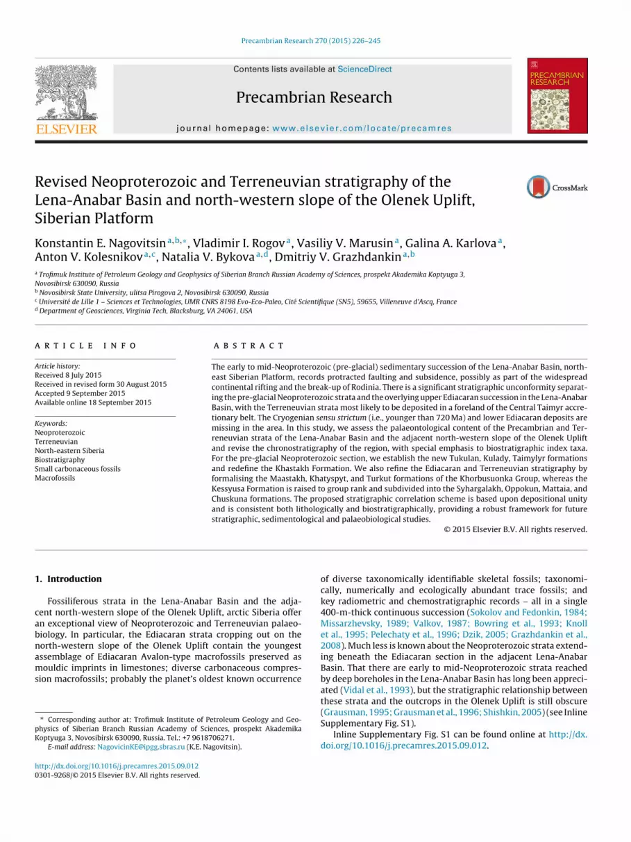
evised Neoproterozoic and Terreneuvian stratigraphy of theena-Anabar Basin and north-western slope of the Olenek Uplift,iberian Platform
onstantin E. Nagovitsina,b,∗, Vladimir I. Rogova, Vasiliy V. Marusina, Galina A. Karlovaa,nton V. Kolesnikova,c, Natalia V. Bykovaa,d, Dmitriy V. Grazhdankina,b
Trofimuk Institute of Petroleum Geology and Geophysics of Siberian Branch Russian Academy of Sciences, prospekt Akademika Koptyuga 3,ovosibirsk 630090, RussiaNovosibirsk State University, ulitsa Pirogova 2, Novosibirsk 630090, RussiaUniversité de Lille 1 – Sciences et Technologies, UMR CNRS 8198 Evo-Eco-Paleo, Cité Scientifique (SN5), 59655, Villeneuve d’Ascq, FranceDepartment of Geosciences, Virginia Tech, Blacksburg, VA 24061, USA
r t i c l e i n f o
rticle history:eceived 8 July 2015eceived in revised form 30 August 2015ccepted 9 September 2015vailable online 18 September 2015
eywords:eoproterozoicerreneuvianorth-eastern Siberiaiostratigraphymall carbonaceous fossils
a b s t r a c t
The early to mid-Neoproterozoic (pre-glacial) sedimentary succession of the Lena-Anabar Basin, north-east Siberian Platform, records protracted faulting and subsidence, possibly as part of the widespreadcontinental rifting and the break-up of Rodinia. There is a significant stratigraphic unconformity separat-ing the pre-glacial Neoproterozoic strata and the overlying upper Ediacaran succession in the Lena-AnabarBasin, with the Terreneuvian strata most likely to be deposited in a foreland of the Central Taimyr accre-tionary belt. The Cryogenian sensu strictum (i.e., younger than 720 Ma) and lower Ediacaran deposits aremissing in the area. In this study, we assess the palaeontological content of the Precambrian and Ter-reneuvian strata of the Lena-Anabar Basin and the adjacent north-western slope of the Olenek Upliftand revise the chronostratigraphy of the region, with special emphasis to biostratigraphic index taxa.For the pre-glacial Neoproterozoic section, we establish the new Tukulan, Kulady, Taimylyr formationsand redefine the Khastakh Formation. We also refine the Ediacaran and Terreneuvian stratigraphy by
acrofossils formalising the Maastakh, Khatyspyt, and Turkut formations of the Khorbusuonka Group, whereas theKessyusa Formation is raised to group rank and subdivided into the Syhargalakh, Oppokun, Mattaia, andChuskuna formations. The proposed stratigraphic correlation scheme is based upon depositional unityand is consistent both lithologically and biostratigraphically, providing a robust framework for futurestratigraphic, sedimentological and palaeobiological studies.
© 2015 Elsevier B.V. All rights reserved.
. Introduction
Fossiliferous strata in the Lena-Anabar Basin and the adja-ent north-western slope of the Olenek Uplift, arctic Siberia offern exceptional view of Neoproterozoic and Terreneuvian palaeo-iology. In particular, the Ediacaran strata cropping out on theorth-western slope of the Olenek Uplift contain the youngest
ssemblage of Ediacaran Avalon-type macrofossils preserved asouldic imprints in limestones; diverse carbonaceous compres-ion macrofossils; probably the planet’s oldest known occurrence
∗ Corresponding author at: Trofimuk Institute of Petroleum Geology and Geo-hysics of Siberian Branch Russian Academy of Sciences, prospekt Akademikaoptyuga 3, Novosibirsk 630090, Russia. Tel.: +7 9618706271.
E-mail address: [email protected] (K.E. Nagovitsin).
ttp://dx.doi.org/10.1016/j.precamres.2015.09.012301-9268/© 2015 Elsevier B.V. All rights reserved.
of diverse taxonomically identifiable skeletal fossils; taxonomi-cally, numerically and ecologically abundant trace fossils; andkey radiometric and chemostratigraphic records – all in a single400-m-thick continuous succession (Sokolov and Fedonkin, 1984;Missarzhevsky, 1989; Valkov, 1987; Bowring et al., 1993; Knollet al., 1995; Pelechaty et al., 1996; Dzik, 2005; Grazhdankin et al.,2008). Much less is known about the Neoproterozoic strata extend-ing beneath the Ediacaran section in the adjacent Lena-AnabarBasin. That there are early to mid-Neoproterozoic strata reachedby deep boreholes in the Lena-Anabar Basin has long been appreci-ated (Vidal et al., 1993), but the stratigraphic relationship betweenthese strata and the outcrops in the Olenek Uplift is still obscure
(Grausman, 1995; Grausman et al., 1996; Shishkin, 2005) (see InlineSupplementary Fig. S1).Inline Supplementary Fig. S1 can be found online at http://dx.doi.org/10.1016/j.precamres.2015.09.012.
brian R
AGIbtocZaMramRveVtrtictiNSt
ddKt1oetIctcbtant
2
(BmCaoraa(Keaea
K.E. Nagovitsin et al. / Precam
This territory was extensively studied in 1950–1970s by therctic Geology Research Institute (Saint Petersburg), the Aero-eological Industrial Association (Moscow), the Siberian Research
nstitute of Geology, Geophysics and Mineral Resources (Novosi-irsk), the Institute of Geology and Geophysics (Novosibirsk), andhe Institute of Geology (Yakutsk). Over a relatively short periodf time, the Precambrian and Lower Cambrian sedimentary suc-ession was subdivided into lithostratigraphic units (Gusev, 1950;huravlev and Sorokov, 1954; Krasil’shchikov and Biterman, 1970)nd investigated with respect to biostratigraphy (Komar, 1966;eshkova et al., 1973; Ogurtsova, 1975; Missarzhevsky, 1980). As a
esult of these studies, a regional stratigraphic scale was establishednd adopted in 1981 by the Interdepartmental Stratigraphic Com-ittee (Krasnov et al., 1983). The Upper Proterozoic Eonothem in
ussia is subdivided into the Burzyanian, Yurmatinian and Karata-ian erathems and the Vendian System on special terms of anrathem (Chumakov and Semikhatov, 1981). The Karatavian andendian together are regarded as a Neoproterozoic equivalent of
he Standard Global Chronostratigraphic Chart. According to theegional stratigraphic scale (Krasnov et al., 1983), the Karatavian inhe Lena-Anabar Basin and north-western slope of the Olenek Uplifts represented by the Khaipakh Formation, whereas the Vendianomprises the Maastakh, Khatyspyt, Turkut and Kessyusa forma-ions (Krasnov et al., 1983). The base of the Cambrian in Russias defined as the first appearance of small skeletal fossils of theochoroicyathus sunnaginicus Assemblage Zone of the Tommotiantage and is established in the mid-section of the Kessyusa Forma-ion.
In 1980s the Lenaneftegazgeologiya Geological Association con-ucted a common-depth-point seismic survey and drilled severaleep boreholes in the Lena-Anabar Basin, including Burskaya-3410,hastakhskaya-930 and Charchykskaya-1 that penetrated Neopro-
erozoic strata (Vidal et al., 1993; Grausman, 1995; Grausman et al.,996). It is only recently that the seismic data became the subjectf an integrated analysis using multifaceted approach (Kontorovicht al., 2013). The Neoproterozoic and Terreneuvian stratigraphy ofhis region, in contrast, is still in an incipient stage of development.n this study, we assess the palaeontological content of the Pre-ambrian and Terreneuvian strata of the Lena-Anabar Basin andhe north-western slope of the Olenek Uplift (Fig. 1) and revise thehronostratigraphy of the region (Fig. 2), with special emphasis toiostratigraphic index taxa. Detailed investigation of the sedimen-ological, stratigraphic, palaeoenvironmental and palaeontologicalspects of the Neoproterozoic and Terreneuvian sequences of theorth-western slope of the Olenek Uplift and taxonomic descrip-ion of the fossils will be published separately.
. Formalisation of units
Previous work on the north-western slope of the Olenek UpliftGusev, 1950; Zhuravlev and Sorokov, 1954; Krasil’shchikov anditerman, 1970) established stratigraphic units that were not for-ally defined to conform the specifications of the Stratigraphic
ode of Russia and the international standards. We here adoptnd formalise the Maastakh, Khatyspyt, and Turkut formationsf the Khorbusuonka Group, whereas the Kessyusa Formation isaised to group rank and subdivided into the Syhargalakh, Mattaia,nd Chuskuna formations. The stratiform tuff breccia tradition-lly referred to as the lower member of the Kessyusa FormationZhuravlev and Sorokov, 1954; Vodanjuk, 1987; Vodanjuk andarlova, 1988; Khomentovsky and Karlova, 1992, 1993; Bowring
t al., 1993; Knoll et al., 1995) is excluded from the Kessyusa Groupnd regarded as part of the Tas-Yuryakh Volcanic Complex (Rogovt al., 2015) (Fig. 2). In addition, we revised the Neoproterozoicnd Terreneuvian stratigraphy of the adjacent Lena-Anabar Basin,esearch 270 (2015) 226–245 227
redefined the Khastakh Formation, and established the Tukulan,Kulady, Taimylyr, and Oppokun formations (Fig. 2). The OppokunFormation is included into the Kessyusa Group as a stratigraphicequivalent of the Syhargalakh Formation. All previously publishedpalaeontological studies, with exception of reports by Vidal et al.(1993) and Vodanjuk (1989), are limited to lists of identified taxa,without illustration or formal systematic description. We could notindependently verify the reliability of these data.
2.1. Tukulan Formation
Name derivation: Tukulan Creek, left tributary of the Bur River.Type area: Lena-Anabar Basin.Unit and boundary reference section: Burskaya-3410 Borehole,
depths 3208–2860 m (Fig. 3). Cored intervals 3198.0–3192.0 m(recovered core 4.3 m), 3192.0–3182.8 m (recovered core 0.7 m),3125.4–3119.2 m (recovered core 2.6 m), 3066.0–3060.0 m (recov-ered core 6.0 m), 3006.6–2999.6 m (recovered core 7.0 m),2945.8–2940.4 m (recovered core 2.7 m), and 2898.5–2892.0 m(recovered core 1.5 m). The core is stored at the Yakutskge-ologiya Federal State Unitary Geological and Mining Enterprise(Yakutsk).
Unit description: Divided into two informal members (Fig. 3).Lower member in the reference section (Burskaya-3410 Bore-hole, depths 3208–2973 m) comprises grey to greenish grey thinsiltstone-shale alternations with lenticular interbeds of grey fine-and medium-grained quartzitic sandstone (up to 2 cm in thick-ness) and very thin (from 1–2 mm to 5–6 mm) interbeds ofgrey fine-grained dolostone and calcareous shale. Upper mem-ber (Burskaya-3410 Borehole, depths 2973–2860 m) consists oflight grey to reddish grey massive dolostones with anhydritenests. Apart from the Burskaya-3410 Borehole, the upper mem-ber has been penetrated by the Khastakhskaya-930 Borehole atdepths 3509.8–3505.6 m (recovered core 1.0 m), 3505.6–3498.3 m(recovered core 1.7 m) and 3474.0–3466.2 m (recovered core 0.3 m)where it similarly comprises light grey, reddish grey and green-ish grey fine-grained massive dolostones with anhydrite nests anddark grey shale interbeds (Fig. 3).
Thickness: 348 m.Palaeontological characteristics: Mostly long-ranging morpho-
logically simple carbonaceous microfossils including Chuariacircularis, Leiosphaeridia tenuissima, Leiosphaeridia jacutica, Pli-catidium latum; the upper part of the lower member yieldedTrachyhystrichosphaera aimika. Earlier in the study of the Burskaya-3410 Borehole, this very same interval albeit correlated with theKyutingde Formation of the Mesoproterozoic of the Olenek Uplift(see Inline Supplementary Fig. S1) yielded an assemblage of long-ranging small carbonaceous fossils (Grausman, 1995; Grausmanet al., 1996). The published list of taxa, without illustration, includesLeiosphaeridia crassa, Leiosphaeridia jacutica, Leiosphaeridia minutis-sima, Leiosphaeridia obsuleta, Leiosphaeridia simplex, Leiosphaeridiatenuissima, Satka squamifera, Satka favosa, Satka sp., Simia annulare,Tchuja zonalis, Polyedrixium sp., Floris sp.
2.2. Kulady Formation
Name derivation: Kulady Creek, left tributary of the Bur River.Type area: Lena-Anabar Basin.Unit and boundary reference section: Burskaya-3410 Borehole,
depths 2860–2570 m (Fig. 3). Cored intervals 2849.2–2843.1 m(recovered core 3.8 m), 2843.1–2835.9 m (recovered core 7.2 m),2835.9–2832.9 (recovered core 2.1 m), 2832.9–2825.7 m (recov-
ered core 7.2 m), 2825.7–2818.3 m (recovered core 7.4 m),2762.8–2755.4 m (recovered core 6.0 m), 2658.0–2650.0 m(recovered core 1.1 m), 2650.0–2642.0 m (recovered core 0.1 m),2599.0–2591.0 m (recovered core 2.1 m), 2591.0–2582.8 m
228 K.E. Nagovitsin et al. / Precambrian Research 270 (2015) 226–245
IIIII
I
I
II
III
Laptev Sea
100 km
S
N
Ole
nek
Lena
Tiksi
Borehole
Section
Olenek Uplift
Anabar Mega-anticline
Lena-Anabar Monocline1006
1016
1017
10071005
1008
Burskaya-3410
Charchykskaya-1
Khastakhskaya-930
09
34
1002
09
35
09
31
12
05
10
04
10
13
10
10
12
03
09
36
1220–1222
0601
06020605
0604
0603 0701
07020607
0903
0703 0909
07100709 0708
Olenek
Khor
busu
onka
Khorbusuonka
Yuesse-
Chuskuna
Kersyuke
Olenek
Bur
Kyra-Khos-Teryuttyakh
Noyuo
Ulakhan-Khos-Teryuttyakh
Khastakh
Ulakha
n-Yur
yage
Khastakh
Bur
10 km
Erkeket
Mattaia
Tas-Yuryakh
Anab
yl
Khatyspyt
Yuettekh
Burskaya-3410
Charchykskaya-1
Khastakhskaya-930
Olenek
50 km
he ad
(2U
Lcdm
Fig. 1. Study area of the south-eastern portion of the Lena-Anabar Basin and t
recovered core 0.3 m) and 2575.4–2567.0 m (recovered core.7 m). The core is stored at the Yakutskgeologiya Federal Statenitary Geological and Mining Enterprise (Yakutsk).
Unit description: Divided into two informal members (Fig. 3).
ower member in the reference section (depths 2860–2742 m)omprises interbedded greenish grey shales and reddish greyolostones (depths 2849.2–2843.1 m), reddish grey fine- toedium-grained thin-bedded and cross-bedded sandstones withjacent north-western slope of the Olenek Uplift, north east Siberian Platform.
very thin shale and dolostone interbeds and shale intraclasts(depths 2843.1–2818.3 m), interbedded greenish grey shalesand dolostones (2762.8–2755.4 m). In the Khastakhskaya-930Borehole the lower member (3420–3335 m) consists of interbed-
ded greenish grey fine- to coarse-grained sandstones, greyshales and limestones. Upper member in the reference section(2742–2570 m) is represented by grey, greenish grey, reddishgrey thin-bedded to aphanitic dolostones. In the uppermost
K.E. Nagovitsin et al. / Precambrian Research 270 (2015) 226–245 229
KhorbusuonkaKersyukeOlenekBurskaya-3410Charchykskaya-1Khastakhskaya-930
North-western slope of the Olenek UpliftLena-Anabar Basin
VE
ND
IAN
CA
MB
RIA
NS
yste
m
Se
rie
s
Sta
ge
Syste
m
Se
rie
s
Sta
ge
CA
MB
RIA
NE
DIA
CA
RA
NC
RY
OG
EN
IAN
TO
NIA
NT
EN
IAN
Up
pe
rLow
er
Lo
we
r
Te
rre
ne
uvia
n
Fo
rtu
nia
n
To
mm
otia
nN
em
akit-D
ald
yn
ian
ChuskunaFormation
MattaiaFormation
SyhargalakhFormation
Syhargalakh Fm Syhargalakh Fm
Syhargalakh Fm Syhargalakh Fm
Tas-YuryakhVolcanicComplex
Tas-YuryakhVolcanicComplex
SyhargalakhFormation
OppokunFormation
OppokunFormation
TurkutFormation
Turkut Formation
Alternatinglimestonesand shales
Alternatinglimestonesand shales
TurkutFormation
TurkutFormation
TurkutFormation
TurkutFormation
KhatyspytFormation
MaastakhFormation
KhaipakhFormation
MaastakhFormation
KhatyspytFormation
?
MattaiaFormation
MattaiaFormation
MattaiaFormation
MattaiaFormation
MattaiaFormation
ChuskunaFormation
ChuskunaFormation
ChuskunaFormation?
? ?
?
KuladyFormation
Kulady Formation
KhastakhFormation
Khastakh Formation
TaimylyrFormation
TukulanFormation
TukulanFormation
?
?
?
? ?
? ? ?
?
?
? ?
?
?
F ta of t
cdKcrb
cLLgcEe3TfGotilLzT
S
ig. 2. Stratigraphic correlation chart for the Neoproterozoic and Terreneuvian stra
ored interval (2575.4–2567.0 m) the upper member also includesolomitic mudstones with thin reddish grey shale interbeds. In thehastakhskaya-930 Borehole the upper member (3335–3102 m)onsists of interbedded grey fine-grained dolostones, dark grey toeddish grey fine- to coarse-grained limestones and pale green,rown and dark grey shales.
Thickness: 318 m in the Khastakhskaya-930 Borehole.Palaeontological characteristics: Cerebrosphaera buickii, Chuaria
ircularis, Comasphaeridium sp., Cymatiosphaeroides cf. C. kullingii,akhandinia prolata, Leiosphaeridia crassa, Leiosphaeridia jacutica,eiosphaeridia minutissima, Leiosphaeridia tenuissima, Obruchevellaigantea, Pseudodendron anteridium, Tawuia sp., Trachyhystri-hosphaera aimika, along with a range of new forms (Fig. 3).arlier in the study of the Khastakhskaya-930 Borehole, Vidalt al. (1993) reported Chuaria circularis (depths 3410.0–3403.5 m;286.6–3280.2 m; 3165.0–3158.0 m; 3111.9–3108.2 m) andawuia dalensis (depths 3286.6–3280.2 m; 3111.9–3108.2 m)rom the intervals that we correlate with the Kulady Formation.rausman (1995) and Grausman et al. (1996) published a listf taxa, without illustration, of small carbonaceous fossils fromhe Burskaya-3410 Borehole from the intervals that we herenclude into the Kulady Formation. The list consists of mostly
ong-ranging taxa Heliconema turukhanica, Leiosphaeridia obsuleta,eiosphaeridia minutissima, Leiosphaeridia exsculpta, Oscillatoriopsisilimica, Simia annulare, Siphonophycis attenuatum, Tortunema sp.,rachytrichoides ovalis.he Lena-Anabar Basin and the adjacent north-western slope of the Olenek Uplift.
2.3. Khastakh Formation
Name derivation: Khastakh River.Type area: Lena-Anabar Basin.Unit and boundary reference section: Erected by Shishkin
(1990) with stratotype in the Khastakhskaya-930 Borehole(depths 3132–2680 m). Cored intervals 3117.8–3111.9 m (recov-ered core 5.7 m), 3111.9–3108.2 m (recovered core 2.2 m),3054.4–3051.9 m (recovered core 2.5 m), 3051.9–3048.1 m (recov-ered core 3.2 m), 3002.4–29997.7 m (recovered core 4.7 m),2930.4–2926.6 m (recovered core 2.6 m), 2922.6–2916.7 m (recov-ered core 5.9 m), 2916.7–2910.0 m (recovered core 6.7 m),2910.0–2903.9 m (recovered core 5.0 m), 2857.4–2854.4 m (recov-ered core 3 m), and 2778.3–2776.4 m (recovered core 1.9 m). Thelowermost 30 m of the stratotype consisting of interbedded darkgrey fine- to coarse-grained thin-bedded limestones and dark greyshales are correlated with the Kulady Formation. We here modifythe lower boundary of the Khastakh Formation and establish it at adepth of 3102 m. The newly established lower boundary of the for-mation is clearly defined on gamma logs by the sharp contact witha more shaley interval. The uppermost 40 m of the stratotype con-sisting of pinkish and greenish grey finely laminated micritic and
sparitic dolostones with shale interbeds are here correlated withthe Turkut Formation of Ediacaran age (see Section 2.7). The upperboundary of the Khastakh Formation, therefore, is placed at a depthof 2720 m. The revised reference section of the Khastakh Formation
230 K.E. Nagovitsin et al. / Precambrian Research 270 (2015) 226–245
2100
2300
2500
2700
2900
3100
3300
3500
1600
2000
2200
2400
2600
2800
3000
3200
1800
Fo
rma
tio
n
Fo
rma
tio
n
Tu
ku
lan
Tu
ku
lan
Ku
lad
y
Ku
lad
yK
ha
sta
kh
Kh
asta
kh
Ta
imyly
r
Maastakh
Kh
aty
sp
yt
Tu
rku
tO
pp
oku
nM
att
aia
Chuskuna
Erk
eke
t
Ed
iaca
ran
To
nia
n
Gro
up
Syste
m
Era
the
m
Ca
mb
ria
n
Ne
op
rote
rozo
icP
ale
ozo
ic
kh
Ke
ssu
sa
An
ab
arite
s k
oro
bo
vi
Ch
an
ce
lloria
sp
.
Ca
mb
rotu
bu
lus s
p.
Ca
mb
rotu
bu
lus d
ecu
rva
tus
Ne
w b
ran
ch
ing
fila
me
nto
us f
orm
Tra
ch
yh
ystr
ich
osp
ha
era
aim
ica
Ta
wu
ia s
p.
Pse
ud
od
en
dro
n a
nte
rid
ium
Pro
tero
cla
du
s m
ajo
r
Oscu
losp
ha
era
sp
.
Ob
ruch
eve
lla g
iga
nte
a
Ch
ua
ria
circu
laris
Ce
reb
rosp
ha
era
sp
.
Ce
reb
rosp
ha
era
bu
ickii
Cym
atio
sp
ha
ero
ide
s c
f. C
. ku
llin
gii
Co
ma
sp
ha
erid
ium
sp
.
Pe
rfo
rate
d v
esic
les
Burskaya-3410 Khastakhskaya-930
Ed
iaca
ran
To
nia
nS
yste
m
0 6 12 18
Gamma LogµR/h
0 6 12 18
Gamma LogµR/h
Fig. 3. Tonian stratigraphy and distribution of stratigraphically important small carbonaceous fossils in the Khastakhskaya-930 and Burskaya-3410 boreholes. The overlyingEdiacaran and Terreneuvian strata and biostratigraphic index taxa of small skeletal fossils are included for completeness (refer to Fig. 1 for geographic position of the loggedsections, and to Fig. 4, for legend). The gamma ray logs are copied from primary reports by the Lenaneftegazgeologiya Geological Association. The Ediacaran–Cambrianboundary in the Khastakhskaya-930 Borehole is tentatively placed at the first appearance of small skeletal fossils of Anabarites korobovi. Abbreviations: kh – KhorbusuonkaGroup.

brian R
c9o(
hF1(2e2(tatE
rwpdtast(i
bsdsT(2vBftumLimlSapatg
tBaUaaiistct
K.E. Nagovitsin et al. / Precam
orresponds to the interval of 3102–2720 m in the Khastakhskaya-30 Borehole (Fig. 3). The core is stored at the Yakutskge-logiya Federal State Unitary Geological and Mining EnterpriseYakutsk).
The interval of 2570–2185 m in the Burskaya-3410 Bore-ole (Fig. 3) is proposed as a hypostratotype of the Khastakhormation. Cored intervals 2575.4–2567.0 m (recovered core.9 m), 2567.0–2564.0 m (recovered core 2.7 m), 2564.0–2557.0recovered core 5.3 m), 2520.0–2512.0 m (recovered core 7.3 m),465.0–2459.0 m (recovered core 5.0 m), 2413.0–2409.0 m (recov-red core 0.1 m), 2364.0–2356.0 m (recovered core 2.6 m),319.0–2312.0 m (recovered core 6.2 m) and 2252.0–2244.0 mrecovered core 7.8 m). The lower boundary of the Khastakh Forma-ion is represented by continuous core material and is clearly seent a depth of 2570 m in the hypostratotype. The core is stored athe Yakutskgeologiya Federal State Unitary Geological and Miningnterprise (Yakutsk).
Unit description: Alternating thin wavy and lenticular layers ofeddish grey and greenish grey sandstone, shale and dolostone,ith thicker beds of grey fine-grained thin-bedded sandstones andale brown shales. Also present are rare greenish grey aphaniticolostone nodules and interbeds. Sandstones are very common inhe stratotype, typically displaying poorly sorted varieties, withbundant gravel-size intraclasts. The hypostratotype contains lessandstone and more siltstone and shale compared to the strato-ype; the sandstone interbeds are characterised by less thickness0.5–5 cm, occasionally 15–20 cm), better sorting, wave-ripple lam-nation and wave-rippled tops.
Thickness: 385 m.Palaeontological characteristics: Shales yielded diverse small car-
onaceous fossils, including Cerebrosphaera buickii, Cerebrosphaerap., Chuaria circularis, Cymatiosphaeroides cf. C. kullingii, Lakhandiniailatata, Leiosphaeridia spp., Obruchevella gigantea, Osculosphaerap., Proterocladus major, Pseudodendron anteridium, Tawuia sp.,rachyhystrichosphaera aimika, along with a range of new formsFig. 3). The occurrence of Chuaria circularis (depths 2857–2854 m,778–2776 m) and Tawuia dalensis (depths 2778–2776 m) was pre-iously reported by Vidal et al. (1993) in the Kastakhskaya-930orehole. Grausman (1995) published a list of carbonaceous micro-
ossils identified from the interval herein included into the Khas-akh Formation. The taxa include Chuaria circularis, Germinosphaeranispinosa, Glomovertella sp., Leiosphaeridia crassa, Leiosphaeridiainutissima, Leiosphaeridia tenuissima, Leiosphaeridia jacutica,
eiosphaeridia obsuleta, Leiosphaeridia kulgunica, Nucellosphaerid-um sp., Octaedrixium truncatum, Oscillatoriopsis sp., Ostiania
icrocystis, Pellicularia tenera, Plicatidium latum, Politrichoidesineatus, Pterospermopsimorpha sp., Satka sp., Simia annulare,tictosphaeridium sp., Synsphaeridium sp., Trachyhystrichosphaeraimica, Trachyhystrichosphaera vidalii, and Valeria lophostriata. Thisublication, however, was devoid of either illustrations or system-tic descriptions of the identified microfossils. On the other hand,he presence of these taxa is compatible with the proposed strati-raphic subdivision and correlation.
Correlations: When originally proposed, the Khastakh Forma-ion was represented by a single section in the Khastakhskaya-930orehole and correlated with a succession of the Turkut, Kessyusand Erkeket formations in the north-western slope of the Olenekplift (Shishkin and Isaev, 1999). The correlation with the Vendiannd Lower Cambrian was based on the presence of a calcimicrobialssociation identified by V.A. Luchinina as Girvanella sp., Gemmanclusa, and Korilophyton inopinatum as well as poorly preservednternal moulds of gastropods and anabaritids, all confined to a
ingle dolostone interbed in the interval of 2910.0–2903.9 m inhe Khastakhskaya-930 Borehole (Shishkin and Isaev, 1999). Wean neither verify nor comment on these data because thin sec-ions have since been lost, whereas the original identification of theesearch 270 (2015) 226–245 231
fossil material is not accompanied by any taxonomic description orillustration.
2.4. Taimylyr Formation
Name derivation: Ulakhan-Taimylyr Creek, left tributary ofOlenek River.
Type area: Lena-Anabar Basin.Unit and boundary reference section: Burskaya-3410 Borehole,
depths 2185–1810 m (Fig. 3). Cored intervals 2158.0–2150.0 m(recovered core 3.5 m), 2049.0–2042.0 m (recovered core 3.5 m),1999.6–1990.6 m (recovered core 2.8 m), 1950.3–1942.8 m (recov-ered core 1.2 m), 1898.7–1890.4 m (recovered core 5.2 m),1890.4–1882.0 m (recovered core 8.0 m) and 1847.0–1841.0 m(recovered core 1.5 m). The core is stored at the YakutskgeologiyaFederal State Unitary Geological and Mining Enterprise (Yakutsk).
Unit description: Grey, pinkish grey microbially laminated dolo-stones with thin dolomitic shale interbeds. Dolostones includeexamples of both micritic and sparitic fabric, occasionally silicified.
Thickness: 375 m.Palaeontological characteristics: Grausman (1995) and Grausman
et al. (1996) reported mostly long-ranging carbonaceous micro-fossils including Leiosphaeridia crassa, Leiominuscula minuta(=Leiosphaeridia minutissima), Octaedrixium truncatum and Leiovaliasp. from the depth interval of 1897–1882 m and Stictosphaerid-ium sp. from the depth interval of 2049–2042 m. Our collection ofshales from the depth interval of 2049.0–2042.0 m yielded smallsphaeromorph acritarchs, Leiosphaeridia crassa and Leiosphaeridiaminutissima; rare poorly preserved fragmentary sheaths of fila-mentous cyanobacteria Siphonophycus sp.; and numerous bacterialcolonies Bavlinella sp. Coarse fraction of the residue contains large(>250 �m) homogeneous carbonaceous films of various thickness.
2.5. Maastakh Formation
Name derivation: Maastakh Creek, left tributary of the Khor-busuonka River.
Type area: North-western slope of the Olenek Uplift. Crops outalong the Khorbusuonka Valley and its tributaries, as well as alongthe Kyutingde Valley and its tributaries.
Unit and boundary reference section: Erected by Zhuravlev andSorokov (1954) with the reference to sections located along theKhorbusuonka River upstream from the mouth of Maastakh Creek(71◦10′27.51′′ N, 123◦45′34.83′′ E).
Unit description: Can be divided into 3 members. Lowermember (<27 m) comprises light yellowish grey, medium- andcoarse-grained, cross-bedded, mostly quartzitic sandstones withwell-rounded quartz pebbles (3–5 cm in diameter) and intraclastsderived from underlying rocks (Zhuravlev and Sorokov, 1954).Sandstone occurs as channelized bodies, with trough and tabularcross-stratified bed sets as much as 20–40 cm thick (Shpunt et al.,1979; Pelechaty et al., 1996). The lower member also includes var-iegated brownish-green, reddish-brown and maroon shales withhematitised quartz, chert, dolostone and sandstone pebbles (up to5 cm in diameter) (Zhuravlev and Sorokov, 1954). Middle mem-ber (>34 m) is exposed along the stretch of Khorbusuonka Rivervalley between the mouths of Khatyspyt and Khaipakh tribu-taries. In the studied sections, the middle member consists ofyellowish and reddish grey, fine-grained, microbially laminated,cross- and wavy-bedded, occasionally intraclastic, coarse-beddedand desiccation-cracked dolostones with black chert nodules andwhite “cauliflower” chert nodules (Knoll et al., 1995). Upper mem-
ber (12 m) is exposed only in small blocky felsenmeers, screes,and isolated outcrops consisting of sandstones, microbially lami-nated dolostones, and variegated laminated shales. The sandstonesare light grey, fine- to coarse-grained with gravel-size (<10 mm)
2 brian R
igisMooitmct
m1
Barag
2
b
atR
Shrbt(VpVl
d
t(gs(tsanlidsnlsStilt
32 K.E. Nagovitsin et al. / Precam
ntraclasts, planar- and hummocky-bedded, occasionally withraded bedding and trough cross-bedding (cross-sets reach 25 cmn thickness), erosional bases, and shale clasts (<10 cm in size). Theedimentary succession treated here as the upper member of theaastakh Formation has been traditionally regarded as part of the
verlying Khatyspyt Formation; however, the lateral distributionf this succession mirrors that of the Maastakh Formation evenn sections along the Ulakhan-Yuettekh and Balaganakh creeks ofhe Kyutingde Valley where the rest of the Khatyspyt Formation is
issing (Shpunt et al., 1979). In this revised stratigraphy, this suc-ession is excluded from the Khatyspyt Formation and included inhe Maastakh Formation.
Thickness: 75 m.Palaeontological characteristics: Poorly preserved sheaths of
at-forming cyanobacteria in black chert nodules (Knoll et al.,995).
Correlations: An interval of 1820–1740 m in the Burskaya-3410orehole characterised by markedly high radioactivity values on
gamma log is correlated with the Maastakh Formation. Theecovered core (8.0 m from depths 1793.0–1785.0 m) consists oflternating brown siltstone and greenish grey fine- to medium-rained wave-rippled sandstone.
.6. Khatyspyt Formation
Name derivation: Khatyspyt Creek, right tributary of the Khor-usuonka River.
Type area: North-western slope of the Olenek Uplift. Crops outlong the Khorbusuonka Valley and its tributaries, as well as alonghe Kersyuke and Erkeket valleys (right tributaries of the Olenekiver).
Unit and boundary reference section: Erected by Zhuravlev andorokov (1954) with no reference to any particular section. Weere designate a composite-lectostratotype consisting of threeeference sections: 0601 located in the right bank of Khor-usuonka River (71◦08′28.80′′ N, 123◦52′23.97′′ E), 0602 located inhe mouth of Anabyl Creek, left tributary of the Khorbusuonka River71◦12′02.25′′ N, 123◦43′34.40′′ E), and 0603 located in the Anabylalley (71◦13′4.86′′ N, 123◦30′7.55′′ E) (Figs. 1 and 4; see Inline Sup-lementary Fig. S2). Section 0604 in the right bank of Khatyspytalley (71◦10′0.75′′ N, 123◦47′55.29′′E) is here designated as the
ower boundary stratotype (Figs. 1 and 4).Inline Supplementary Fig. S2 can be found online at http://dx.
oi.org/10.1016/j.precamres.2015.09.012.Unit description: The Khatyspyt Formation is composed of light
o dark grey and dark greyish brown finely laminated limestonescalcimudstones); alternating thin layers of light brownish grey,reyish brown and very dark grey limestones (calcimudstones) andhales; greyish brown, grey and dark grey thick-bedded limestonessparstones); and dark grey to very dark greyish brown intraclas-ic dolomitized limestones (sparstones) (Fig. 4). In addition, theedimentary succession contains packages of shales (0.01–1.3 m)nd thin interbeds of volcanic tuffs (2–25 cm). The finely lami-ated limestones consist of alternating thin micrite and sparite
aminae, with abundant carbonaceous compressions along the lam-nae planes. The sparite laminae occasionally contain disseminatedolomitised oolite grains. In the thin limestone-shale couplets, thehales are calcareous, but also contain dispersed silt-size alumi-osiliciclastic angular to well-rounded grains. The thick-bedded
imestones are characterised by planar and wavy bedding planeseparated by thin interbeds of fine laminated limestones or shales.ome of the units preserve ripple cross-lamination (set thickness up
o 16 mm), gutter casts, and lag deposits of intraclasts (up to 10 mmn size). The intraclastic limestones consist of variously tilted angu-ar intraclasts (reaching 15 cm in length) of finely laminated andhick-bedded limestone (local rock types).esearch 270 (2015) 226–245
The formation is divided into four members (Fig. 4). The firstmember (25 m) comprises interbeds (from 3–9 cm to 25–40 cmin thickness) and packages (from 1.1–3.7 m to 7 m) of intraclasticdolomitized limestones interstratified with interbeds (0.8–1.8 m)of thick-bedded limestones and intervals (from 20–60 cm to 1.2 m)of finely laminated limestones. The packages of intraclastic lime-stones occur as channelised bodies up to 7 m thick, are laterallypersistent over tens to hundreds of metres and characterised byvarious soft-sediment deformation structures. The second mem-ber of Khatyspyt Formation (50 m) consists of intervals (from2–14 cm to 1.2–2.4 m) of alternating thin layers of limestones andshales interstratified with interbeds (from 3–8 cm to 16–23 cm)and packages (0.5–3.8 m) of finely laminated limestones, interbeds(8–25 cm) of thick-bedded limestones, and interbeds (8–95 cm)of intraclastic limestones. The third member (100 m) comprisesinterbeds and packages (from 15–25 cm to 2.5–3.6 m) of finelylaminated limestones interstratified with thick-bedded limestones(from 0.3–0.5 m to 2.2–2.6 m) and thin intervals (3–20 cm) ofalternating thin layers of limestones and shales. The fourth mem-ber (maximum measured thickness 17 m) consists of intraclasticdolomitized limestones (0.35–1.2 m), finely laminated limestones(0.1–1.37 m) and intervals of alternating thin layers of limestonesand shales.
Thickness: The formation is 190 m thick along the KhorbusuonkaRiver near the mouth of Anabyl Creek where both the lower andupper boundaries are exposed.
Palaeontological characteristics: Intervals of alternating thinlayers of limestones and shales yielded an assemblage of Avalon-type macrofossils preserved by authigenic carbonate precipitation(Sokolov and Fedonkin, 1984; Vodanjuk, 1989; Fedonkin, 1990;Grazhdankin et al., 2008) (Fig. 5). The fossil assemblage isrepresented by frondomorphs Hiemalora stellaris, Protodipleu-rosoma wardi, Aspidella terranovica, Aspidella karli, Mawsonitespleiomorphus, Mawsonites reticulatus and Khatyspytia grandis; arangeomorph Charnia masoni; palaeopascichnids; and micro-bial colonies. Packages of finely laminated limestones preserveabundant (both taxonomically and numerically) carbonaceouscompression macrofossils and also demonstrate an intensely bio-turbated ichnofabric associated with discrete identifiable tracefossils Nenoxites curvus (Rogov et al., 2012, 2013a,b) (Fig. 5).
Correlations: A thick succession of alternating layers of darkgrey dolomitized finely laminated micritic limestones and greenishgrey calcareous shales penetrated by the Burskaya-3410 (depths1740–1520 m) and Charchykskaya-1 (depths 3110–3000 m) bore-holes is regarded as a stratigraphic equivalent to the KhatyspytFormation. In 1992 V.A. Rudavskaya identified carbonaceousmicrofossils Conjunktiophucus sp., Leiosphaeridia sp., Leiotrichoidessp., Ostiania sp., Policavita sp., and Spumiosa rubiginosa fromthe depths of 1566–1561 m in the Burskaya-3410 Borehole(Grausman, 1995; Grausman et al., 1996). Acritarchs of the gen-era Conjunktiophucus, Ostiania and Polycavita represent fossilisedspherical, ellipsoidal and single-layered lamellar colonies of coc-coid organisms; Spumiosa rubiginosa comprises small opticallydense spherical aggregates with irregular pitted surface; andLeiotrichoides refers to fragmentary oscillatorian tufts. All these taxaare long-ranging.
2.7. Turkut Formation
Name derivation: Turkukut Creek, right tributary of the OlenekRiver.
Type area: North-western slope of the Olenek Uplift from the
mouth of Boroulakh Creek (left tributary of the Olenek River) in thesouthwest across the Erkeket and Kersyuke valleys to the mouthof Mattaia Creek (left tributary of the Khorbusuonka River) in thenortheast.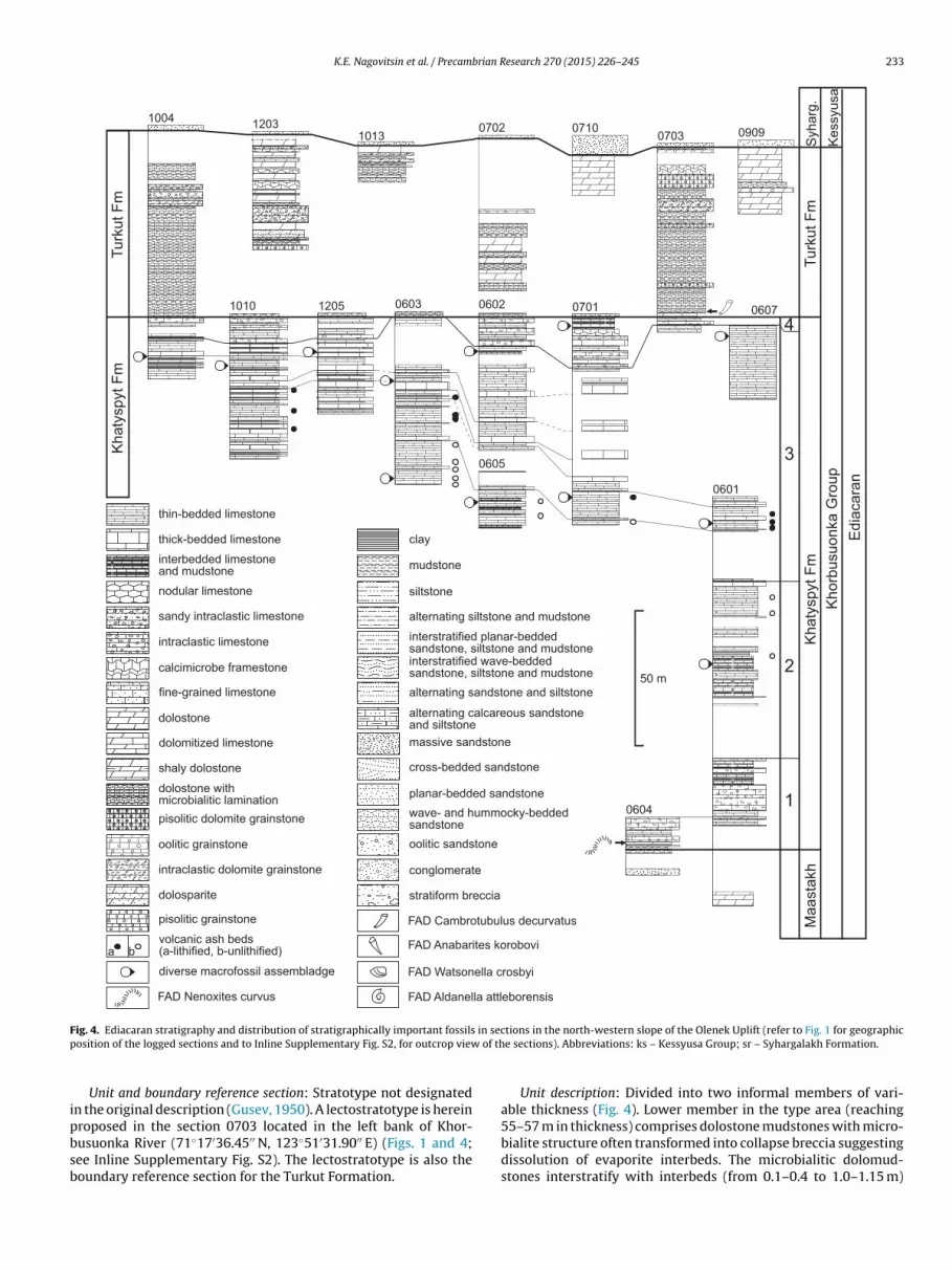
K.E. Nagovitsin et al. / Precambrian Research 270 (2015) 226–245 233
0601
0604
060206031010 1205
100407100702
07031203
09091013
0605
0701
thin-bedded limestone
pisolitic dolomite grainstone
thick-bedded limestone
interbedded limestone and mudstone
dolostone
dolostone withmicrobialitic lamination
intraclastic dolomite grainstone
mudstone
calcimicrobe framestone
siltstone
dolosparite
fine-grained limestone
sandy intraclastic limestone
intraclastic limestone
pisolitic grainstone
nodular limestone
clay
oolitic grainstone
dolomitized limestone
shaly dolostone
Ma
asta
kh
Kh
aty
sp
yt F
m1
2
3
Kh
orb
usu
on
ka
Gro
up
50 m
Kh
aty
sp
yt F
mT
urk
ut F
m
Tu
rkut F
m
Ke
ssyu
sa
4
Syh
arg
.
FAD Nenoxites curvus
diverse macrofossil assembladge
a bvolcanic ash beds(a-lithified, b-unlithified)
planar-bedded sandstone
interstratified wave-bedded sandstone, siltstone and mudstone
wave- and hummocky-beddedsandstone
oolitic sandstone
stratiform breccia
conglomerate
alternating siltstone and mudstone
massive sandstone
alternating calcareous sandstoneand siltstone
alternating sandstone and siltstone
interstratified planar-beddedsandstone, siltstone and mudstone
FAD Cambrotubulus decurvatus
FAD Watsonella crosbyi
FAD Anabarites korobovi
FAD Aldanella attleborensis
Ed
iaca
ran
cross-bedded sandstone
0607
F in secp of th
ipbsb
ig. 4. Ediacaran stratigraphy and distribution of stratigraphically important fossilsosition of the logged sections and to Inline Supplementary Fig. S2, for outcrop view
Unit and boundary reference section: Stratotype not designatedn the original description (Gusev, 1950). A lectostratotype is herein
roposed in the section 0703 located in the left bank of Khor-usuonka River (71◦17′36.45′′ N, 123◦51′31.90′′ E) (Figs. 1 and 4;ee Inline Supplementary Fig. S2). The lectostratotype is also theoundary reference section for the Turkut Formation.tions in the north-western slope of the Olenek Uplift (refer to Fig. 1 for geographice sections). Abbreviations: ks – Kessyusa Group; sr – Syhargalakh Formation.
Unit description: Divided into two informal members of vari-able thickness (Fig. 4). Lower member in the type area (reaching
55–57 m in thickness) comprises dolostone mudstones with micro-bialite structure often transformed into collapse breccia suggestingdissolution of evaporite interbeds. The microbialitic dolomud-stones interstratify with interbeds (from 0.1–0.4 to 1.0–1.15 m)
234 K.E. Nagovitsin et al. / Precambrian Research 270 (2015) 226–245
Fig. 5. Macrofossils from the Ediacaran strata of the north-western slope of the Olenek Uplift. (A) Palaeopacsichnus sp., upper part of the third member of the Khatyspyt Fm,section 1205; (B) Ediacaria flindersi, middle part of the second member of the Khatyspyt Fm, section 0601; (C) Aspidella terranovica, middle part of the second member ofthe Khatyspyt Fm, section 0601; (D) Nenoxites curvus, lower part of the third member of the Khatyspyt Fm, section 0605; (E) Mawsonites pleiomorphus, middle part of thesecond member of the Khatyspyt Fm, section 0601; (F) Hiemalora stellaris, upper part of the third member of the Khatyspyt Fm, section 0607; (G) Charnia masoni, middlepart of the second member of the Khatyspyt Fm, section 0601; (H–J) Miaohe-type fossils, lower part of the third member of the Khatyspyt Fm, section 0605: (H) tubular formJiuqunaoella simplicis; (I) colonial filaments Glomulus filamentum; (J) bundle of filaments Longifuniculum dissolute (refer to Fig. 4 for stratigraphy).

brian R
apdtbUdbpiIrmmreddg
Biv22cmao
i
tttCBh
2
R
B2(2eTG
pidt
tssc5ls
K.E. Nagovitsin et al. / Precam
nd packages (up to 4.95 m) of oolitic and pisolitic dolostones andackages (up to 4.o35 m) of intraclastic dolostones. The pisoliticolostones often occur as channelised bodies exhibiting mul-istoried cross stratification, with wavy and planar boundariesetween sets of cross beds (set thickness from 6–20 to 75 cm).pper member (15–60 m) comprises finely laminated micriticolostones interstratified with stromatolitic dolostones formingioherm series, intraclastic dolostones and occasional muddy andisolitic dolostones. The bioherms range from 10–15 cm to 0.8 m
n thickness and consist of columnar and branching stromatolites.n some of the sections, several bioherm series are separated byelatively thin interberds of finely laminated dolostone. The upperember is also characterised by the presence of 7–12 m thickicrite-dominated carbonate buildups interpreted as microbialite
eefs. The intraclastic dolostones (angular intraclasts reach sev-ral centimetres in size, subrounded intraclasts are up to 20 mm iniameter) occur as cross-bedded channelised bodies. The muddyolostones preserve salt crystal pseudomorphs, desiccation cracks,utter casts and flute casts with lag deposit.
The Turkut Formation extends across the Lena-Anabarasin, where it is penetrated by the Burskaya-3410 (recovered
nterval 1388.6–1382.0 m), Charchykskaya-1 (recovered inter-als 2999.6–2989.6 m, 2943.9–2942.9 m, 2872.8–2855.8 m and796.2–2784.0 m) and Khastakhskaya-930 (recovered intervals624.8–2618.0 m and 2708.0–2702.0 m) boreholes. The recoveredore is represented by pinkish and greenish grey finely laminatedicritic and sparitic dolostones and limestones. The lower bound-
ry of the formation is drawn at a sharp drop in radioactivity valuesn gamma logs.
Thickness: 80 m in the reference section, but reaches 120–210 mn the adjacent Lena-Anabar Basin.
Palaeontological characteristics: Small skeletal fossils of anabari-ids Cambrotubulus decurvatus (Fig. 6A–D). In the reference section,he lowermost Cambrotubulus decurvatus is found 1.4 m abovehe lower boundary of the Turkut Formation. The fossils ofambrotubulus decurvatus also occur in the Khastakhskaya-930orehole (depths 2624.8–2618 m) and in the Burskaya-3410 Bore-ole (depths 1388.6–1382.0 m).
.8. Oppokun Formation
Name derivation: Oppokun River, left tributary of the Charchykiver, Olenek drainage basin.
Type area: Lena-Anabar Basin.Unit and boundary reference section: Khastakhskaya-930
orehole, depths 2600–2310 m (Fig. 3). Cored intervals571.4–2567.9 m (recovered core 3.3 m), 2567.9–2560.5 mrecovered core 4.2 m), 2487.6–2482.1 m (recovered core 4.9 m),482.0–2477.6 m (recovered core 4.5 m), 2433.0–2425.0 m (recov-red core 8.0 m) and 2425.0–2419.0 m (recovered core 5.9 m).he core is stored at the Yakutskgeologiya Federal State Unitaryeological and Mining Enterprise (Yakutsk).
Unit description: The Oppokun Formation in the stratotype com-rises greenish grey and brownish grey finely laminated shales and
ntervals of graded siltstone-shale couplets with interbeds of grey,ark grey and brownish grey finely laminated micritic limestones,hin-bedded sandstones and greenish grey calcareous shales.
In the Charchykskaya-1 Borehole (2790–2630 m) the forma-ion consists of greenish grey and dark brown finely laminatedhales interstratified with grey thin-bedded and wave-rippledandstones, greenish grey micritic limestones, dolostones and cal-
areous shales. Individual bed thickness varies between 5 and0 cm. The core of the Charchykskaya-1 Borehole has been lost. Ear-ier Shishkin and Isaev (1999) erected the Charchyk Formation withtratotype in the Charchykskaya-1 Borehole, depths 2790–2540 m
esearch 270 (2015) 226–245 235
(Inline Supplementary Fig. S1). However, this name was preoccu-pied by a formation in the Lower Cretaceous.
Thickness: 160–290 m.Palaeontological characteristics: Grausman et al. (1996)
reported an assemblage of small carbonaceous fossils fromthe Charchykskaya-1 Borehole from an interval that we corre-late with the Oppokun Formation. The assemblage consists ofLeiosphaeridia gigantea, Leiosphaeridia pelucida, Leiosphaeridiacrassa, Leiosphaeridia minutissima, Leiosphaeridia tenuissima,Leiosphaeridia laminarita, Leiosphaeridia incrassatula, Leiosphaeridiabavlensis, Leiosphaeridia hyaline, Paracrassosphaera actinomorpha,Paracrassosphaera cf. P. dedalea, Ocraedrixium sp., Bailicania dili-gena, Baltisphaeridium primarium, Baltisphaeridium pilosiusculum,Baltisphaeridium cf. B. papilosum, Baltisphaeridium sp., Leiovaliacrassa, Leiovalia tenera, Tasmanites cf. T. medius, Granomarginataprima, Trachysphaeridium asaphum, Leiofusa sp., Nucellosphaerid-ium sp., Goniosphaeridium sp. The Latin names were published as alist of taxa, without illustration (Grausman et al., 1996). We couldneither revise nor verify these taxonomic identifications.
Our collection of shales of the Oppokun Formation from theKhastakhskaya-930 Borehole yielded small carbonaceous fossilsconfirming the presence of diverse acanthomorphic acritarchs thatrequire further study. Earlier in the study of the Khastakhskaya-930 Borehole, Grausman et al. (1996) mentioned the presence ofGranomarginata prima and Leiosphaeridia sp. Most important, andcentral to our argument, is that micritic limestones of the OppokunFormation from the interval of 2487.6–2482.1 m contain smallskeletal fossils of anabaritids Anabarites korobovi and Cambrotubu-lus sp. (Fig. 6H).
Correlations: Correlated with the Syhargalakh Formation of thenorth-western slope of the Olenek Uplift based on similarities intaxonomic composition of small skeletal fossil assemblages andstratigraphic position between the Turkut and Mattaia formations.
2.9. Syhargalakh Formation
Name derivation: Syhargalakh Creek, right tributary of theOlenek River.
Type area: The stretch of Olenek Valley between the mouths ofChuskuna and Syhargalakh creeks (right tributaries of the OlenekRiver).
Unit and boundary reference section: Composite-stratotype con-sisting of three reference sections (1005, 1006 and 1007) locatedalong the left bank of Olenek River 0.6–1.0 km downstream fromthe mouth of Ochchugui-Kersyuke Creek (left tributary of theOlenek River; 71◦04′28.08′′ N, 122◦30′0.82′′ E) (Figs. 1 and 7; seeInline Supplementary Fig. S3).
Inline Supplementary Fig. S3 can be found online at http://dx.doi.org/10.1016/j.precamres.2015.09.012.
Unit description: Can be divided into 2 members (Fig. 7).The lower member comprises a package of pale grey fine- tocoarse-grained sandstones with gravel/small pebble clasts, planarlamination, medium-scale (55–65 cm thickness) tabular and low-angle crossbeds, and wave-rippled tops. The lowermost sandstoneunit in the package fills palaeokarst caverns and sinkholes up to9 m deep formed within the underlying carbonates of the TurkutFormation. The lower member crops out in the type area, as well asalong the Kersyuke Valley and the stretch of Khorbusuonka Valleybetween the mouths of Anabyl and Mattaia creeks (left tributariesof the Khorbusuonka River). The upper member is exposed only inthe type area and consists of 10–35 cm beds and 0.7–1.5 m bed-sets of yellowish grey fine- and medium-grained finely laminated
calcareous sandstone and sandy calcimudstone, locally with con-volute lamination and hummocky stratification, 5–75 cm beds ofthick-bedded sparstone and sandy calcimudstone, and intervals(10–45 cm) of grey laminated shale and siltstone. The uppermost
236 K.E. Nagovitsin et al. / Precambrian Research 270 (2015) 226–245
Fig. 6. Small skeletal fossils of biostratigraphic index taxa from the Ediacaran and Terreneuvian strata of the Lena-Anabar Basin and the Olenek Uplift. (A–D) Cambrotubulusdecurvatus: (A) uppermost Turkut Fm, section 0710, 1 m below the boundary with the overlying Syhargalakh Fm; (B) upper Turkut Fm, Khastakhskaya-930 Borehole, depths2624.8–2618 m; (C) lowermost Turkut Fm, section 0702, 11 m above the base of the formation; (D) lowermost Turkut Fm, section 0702, 7.5 m above the base of the formation.( lex, sa ths 241 o Figs.
ub
sDttTooSsc(
L
2
b
Kwrb
E and G) Anabarites trisulcatus stratiform breccia of the Tas-Yuryakh volcanic compbove the base of the formation; (H) Oppokun Fm, Khastakhskaya-930 Borehole, dep002. (J) Watsonella crosbyi, upper member of the Mattaia Fm, section 1002 (refer t
nit of yellowish grey dolomitised calcarenite (2–4 m) is intensivelyioturbated.
Thickness: 27 m.Palaeontological characteristics: Trace fossils Bergaueria hemi-
pherica, Bergaueria perata, Curvolithus sp., Didymaulichnus cf.. tirasensis, Helminthoidichnites tenuis, Monomorphichnus linea-
us, Palaeophycus imbricatus, Palaeophycus striatus, Palaeophycusubularis, Planolites beverleyensis, Protospiralichnus circularus andreptichnus pedum (Fig. 8A, C, E). Composite moulds of vari-us compressed segmented tubes (Fig. 8B) and a frondomorphrganism Mawsonites sp. Problematic fossil Olenichnus irregularis.mall skeletal fossils: anabaritids Anabarites trisulcatus, Anabaritesignatus, Anabarites korobovi and Cambrotubulus decurvatus; proto-onodont elements Protohertzina anabarica; hyoliths Turcutheca sp.Fig. 6F)
Correlations: Correlated with the Oppokun Formation of theena-Anabar Basin.
.10. Stratiform breccia of the Tas-Yuryakh Volcanic Complex
Name derivation: Tas-Yuryakh Creek, left tributary of the Khor-usuonka River.
Type area: North-western slope of the Olenek Uplift from the
ersyuke River (right tributary of the Olenek River) in the south-est across the watershed between the Olenek and Khorbusuonkaivers to the mouth of Mattaia Creek (left tributary of the Khor-usuonka River) in the northeast.
ection 0903. (F and H) Anabarites korobovi: (F) Syhargalakh Fm, section 1005, 16 m87.6–2482.1 m. (I) Aldanella attleborensis, upper member of the Mattaia Fm, section
4 and 7 for stratigraphy).
Unit and boundary reference section: A section (0903) alongthe Tas-Yuryakh Creek, 5250 m from the mouth (71◦20′32.99′′ N,123◦49′55.76′′ E), is herein designated as a stratotype of the strati-form breccia (Fig. 1). In addition, a representative composite section(0931) of the breccia apron, with both lower and upper boundariesexposed, can be seen in a series of outcrops along the KersyukeRiver near the mouth of an unnamed left tributary (71◦04′57.42′′ N,122◦59′44.08′′ E) and is herein designated as a parastratotype.
Unit description: Rock fragments angular to subspherical andrange from 0.1 mm to 0.4–0.5 m, occasionally 1.0–1.5 m. Sand-size fragments consist of microbialitic dolomudstones, oolitic andpisolitic dolostones, finely laminated and bituminous limestones,finely laminated dolomudstones, basalts and laminated volcanictuffs. Thin sections show lineation of elongate fragments, rota-tional disintegration of angular fragments with formation of a clastand tail structure, crushed and deformed grains in grain-supportedareas. Coarse fragments consist primarily of Khatyspyt and Turkutrocks, occasionally sandstones and basalt with a recrystallisationrim. Some of the fragments exhibit parallel striation and slicken-sided surfaces. Matrix is poorly consolidated and represented bya greenish grey tuffaceous–calcareous material, with rare quartzgrains. In addition, the stratiform breccia also contains grey andbrownish-grey subspherical and ellipsoidal lapilli 1–20 mm in size.The lapilli consist of lithic clasts mantled by fine-grained carbonate
and feldspar rims. Pore space in the lapilli is filled with chlorite,calcite, occasionally zeolite.Distribution of the breccia is confined to areas around dia-tremes cutting the Khatyspyt and Turkut formations and the lower

K.E. Nagovitsin et al. / Precambrian Research 270 (2015) 226–245 237
Fig. 7. Terreneuvian stratigraphy and distribution of stratigraphically important fossils in sections in the north-western slope of the Olenek Uplift (refer to Fig. 1 for geographicposition of the logged sections, to Fig. 4, for legend, and to Inline Supplementary Figure 3, for outcrop view of the sections). Abbreviations: tr – Turkut Formation; er – ErkeketFormation.

238 K.E. Nagovitsin et al. / Precambrian Research 270 (2015) 226–245
Fig. 8. Selected body and trace fossils from the Terreneuvian strata of the Olenek Uplift. (A) Trace fossil Treptichnus pedum (hyporelief), uppermost Syhargalakh Fm, section1017; (B) mould of a compressed segmented tube Sabellidites sp. (hyporelief), uppermost Syhargalakh Fm, section 1006; (C) trace fossil Monomorphichnus lineatus (hyporelief),uppermost Syhargalakh Fm, section 1017; (D) trace fossil Rusophycus avalonensis (hyporelief), lowermost Mattaia Fm, section 0903; (E) trace fossil Protospiralichnus circularis( us mieR m, set
mtboIl
hyporelief), uppermost Syhargalakh Fm, section 1006; (F) trace fossil Didymaulichnhizocorallium commune (full relief, bottom view), middle member of the Mattaia Fhe Chuskuna Fm, section 1221 (refer to Fig. 7 for stratigraphy).
ember of Syhargalakh Formation. Furthermore, there is a grada-ional transition between the stratiform breccia and the explosive
reccia in the diatremes. The stratiform breccia rests conformablyn sandstones of the lower member of the Syhargalakh Formation.n the parastratotype, the lowermost ∼5 m of the breccia containarge (up to 1.4 m in thickness) blocks consisting of yellowish greyttensis (hyporelief), middle member of the Mattaia Fm, section 0709; (G) trace fossilction 0935; (H) trace fossil Heimdallia chatwini (full relief, side view), lower part of
fine laminated calcareous sandstones and sandy calcimudstonesand grey laminated shale of the upper member of the Syhargalakh
Formation. Bedding planes in the blocks are subparallel to eachother and to the overall stratification which is the evidence of onlyminor rotation or displacement during brecciation. Roundness ofthe blocks and baked margins, with breccia apophyses, suggest that
brian R
tus0tc1Tcfot
t(
2
b
mtC
c1oS
ci(trsohsws1mwMgac3TcFcw3lagUambSZ
K.E. Nagovitsin et al. / Precam
he fragments underwent mechanical abrasion during flowage ofnconsolidated matrix material as well as possible thermal corro-ion. The size of fragments decreases (predominant size is in the.1–0.2 m fraction), and the breccia is better sorted towards theop of the stratiform unit. The breccia is conformably overlain byonglomerates (0.5 m thick) consisting of flatten pebble-size (up to0 cm) limestone clasts derived from the Syhargalakh Formation.he conglomerates in turn are overlain by sandstones (0.4 m thick)orrelated with the uppermost Syhargalakh Formation. The strati-orm breccia, therefore, partially intruded into the upper memberf Syhargalakh Formation and accumulated as aprons surroundinghe Tas-Yuryakh volcanic complex (Rogov et al., 2015).
Fragments in the uppermost part of the stratiform breccia con-ain small skeletal fossils of the anabaritid Anabarites trisulcatusFig. 6E and G) first appearing in the Syhargalakh Formation.
Thickness: Thickness of the stratiform breccia reaches 25 m.
.11. Mattaia Formation
Name derivation: Mattaia Creek, left tributary of the Khor-usuonka River.
Type area: North-western slope of the Olenek Uplift from theouth of Boroulakh Creek (left tributary of the Olenek River) in
he southwest across the Kersyuke Valley to the mouth of Mattaiareek (left tributary of the Khorbusuonka River) in the northeast.
Unit and boundary reference section: Composite-stratotypeonsisting of two reference sections, 0934 (71◦4′21.50′′ N,23◦1′58.00′′ E) and 0935 (71◦4′38.21′′ N, 123◦0′39.89′′ E) locatedn opposite sides of the Kersyuke Valley (Figs. 1 and 7; see Inlineupplementary Figure 3).
Unit description: The Mattaia Formation represents aoarsening-upward sequence that can be divided into threenformal members (Fig. 7). The lower member comprises interbeds14–40 cm) and packages (0.5–4.8 m) of greenish grey fine-grainedhin-bedded and wave-rippled sandstones interbedded with darkeddish grey intervals (0.2–1.3 m up to 2.1 m thick) of gradediltstone-shale couplets. Thinner sandstone beds tend to consistf fine horizontal laminations. However, thicker units exhibitummocky stratification, convoluted laminations, amalgamationurfaces, ball-and-pillow structure, isolated shale clasts, andave ripple laminations. In addition, the intervals of graded
iltstone-shale couplets host isolated sandstone gutter casts (up to2 cm thick). In outcrops, at least the lowermost 25 m of the lowerember is covered by scree and vegetation, except for the contactith the Tas-Yuryakh volcanic complex. The middle member ofattaia Formation consists of reddish grey, greenish grey and light
reyish olive, fine- and medium-grained, planar-, hummocky-,nd wave-bedded sandstones. The wave-bedded sandstonesomprise thick, laterally persistent packages (from 1.2–1.9 m to.5–5.0 m, up to 17.8 m), extensively bioturbated at some levels.he planar- and hummocky-bedded sandstones form laterally dis-ontinuous bodies (3.6–5.0 m). The upper member of the Mattaiaormation comprises grey, medium-grained, planar-, hummocky-,ross-bedded, and wave-rippled sandstones (0.5–1.1 m thick),ith reworked calcite-cemented sandstone concretions (from
–7 cm to 12–15 cm in size), interstratified with light grey nodularimestones (0.2–1.4 m), light yellowish grey volcanic tuffs (0.2 m),nd medium-grained, trough cross-bedded, wave-rippled ooliticrainstones (1.9–3.3 m). Along the north-western slope of Olenekplift, between the mouth of the Mattaia Creek in the northeastnd the mouth of Kersyuke River in the southwest, the upper
ember is represented by a microbial-dominated, isolated car-onate platform (16.65 m thick) which has been referred to as theuordakh Member (Meshkova et al., 1973; Missarzhevsky, 1980;inchenko, 1985).
esearch 270 (2015) 226–245 239
The sedimentary succession of the Mattaia Formation alsoincludes laterally persistent conglomerates (10–27 cm in thick-ness) consisting of poorly sorted, flat pebble- and boulder-size(10–30 cm) reworked sandstone concretions and wave-beddedsandstone matrix. The conglomerates appear to cross lithologicalboundaries.
The Mattaia Formation extends across the Lena-AnabarBasin and maintains more or less uniform thickness 70–90 m(the reduced thickness is due to erosional truncation by theErkeket Formation). It is penetrated by the boreholes Burskaya-3410 (recovered intervals 1259.1–1252.5 m, 1246.7–1238.4 mand 1238.4–1232.2 m), Charchykskaya-1 (recovered inter-val 2582.0–2580.3 m) and Khastakhskaya-930 (without corerecovery).
Thickness: 92 m in the composite-stratotype.Palaeontological characteristics: Trace fossils include Arenico-
lites isp., Arthrophycus isp., Bergaueria hemispherica, Bergaueriaperata, Curvolithus isp., Didymaulichnus miettensis, Diplocraterionparallelum, Gyrolites polonicus, Heimdallia chatwini, Heimdallia cir-cinatus (Brongniart, 1828), Heimdallia isp. , Helminthoidichnitestenuis, Monocraterion tentaculatum, Monomorphichnus bilinearis,Monomorphichnus lineatus, Nereites isp., Palaeophycus imbricatus,Palaeophycus tubularis, Plagiogmus arcuatus, Planolites beverleyensis,Rhizocorallium commune, Rusophycus avalonensis, Skolithos linearis,Torrowangea rosei, Treptichnus arcus, Treptichnus bifurcus, Treptich-nus lublinensis, Treptichnus pedum, Zoophycos brianteus (Fig. 8D, Fand G).
Small skeletal fossils identified from sections along the Khor-busuonka Valley are represented by anabaritids Cambrotubulusdecurvatus, Anabarites trisulcatus, Anabarites tripartitus, Anabariteshexasulcatus, Anabarites valkovi, Anabarites tristichus, Anabariteskorobovi; hyolithelmints Hyolithellus annulatus, Hyolithellus isticus,Hyolithellus vitricus, Hyolithellus vladimirovae, Hyolithellus tenuis,Hyolithellus cf. H. micans, Torellella sp.; halkieriids Halkieria sp.;chancelloriids Chancelloria sp.; hyoliths Turcutheca sp., Conothecasp., Laratheca sp., Allatheca sp., Nikatheca sp., Loculitheca sp.,Ladatheca sp., Lenatheca sp., Obliquatheca sp.; molluscs Purellacristata, Purella antiqua, Igorella ungulata, Salanyella sp., Barskoviasp., Stenotheca sp.; lobopods Microdictyon sp. Sections along theOlenek Valley yielded a more diverse assemblage of small skeletalfossils (Missarzhevsky, 1980, 1982, 1989; Vasilieva, 1985; Valkov,1987); however, the published taxonomic identification needs tobe revised (Khomentovsky and Karlova, 1992). Only the occurrenceof molluscs Aldanella attleborensis and Watsonella crosbyi in thesame stratum in the upper member of Mattaia Formation in thesection 1002 in the right bank of the Olenek Valley near the mouthof Boroulakh Creek has been confirmed (Fig. 6I and J).
Ogurtsova (1975), Rudavskaya and Vasilieva (1985), Kir’yanov(1987) and Grausman et al. (1996) reported carbonaceous micro-fossils from stratigraphic intervals that we refer to as the MattaiaFormation; these reports are in need of taxonomic revision. Cal-cimicrobial association identified in the Suordakh Member includesRenalcis gelatinosus, Renalcis granosus, Korilophyton inopinatum,Botomaella zelenovii, Protoortonella flabellata and Girvanella sibirica(Meshkova et al., 1973; Luchinina, 1990).
2.12. Chuskuna Formation
Name derivation: Chuskuna Creek, right tributary of the OlenekRiver.
Type area: North-western slope of the Olenek Uplift from themouth of Boroulakh Creek (left tributary of the Olenek River) in
the southwest across the Kersyuke Valley to the mouth of MattaiaCreek (left tributary of the Khorbusuonka River) in the northeast.Unit and boundary reference section: A section 1221–1222in the upper reaches of the Kersyuke Creek (71◦3′43.08′′ N,

2 brian R
1(
bb3bs1tsagmawtcgeo
sthbostampb2Bss
rip1tpPaT(tN
3
3
aft(FlLt
40 K.E. Nagovitsin et al. / Precam
23◦4′49.08′′ E), with both lower and upper boundaries exposedFigs. 1 and 7).
Unit description: The Chuskuna Formation in the stratotype cane divided into three informal members (Fig. 7). The lower mem-er (10.2 m in thickness) comprises thick packages (0.6–1.4 m, up to.6 m) of greenish grey medium-grained planar- and hummocky-edded and wave-rippled sandstones, extensively bioturbated atome levels, interbedded with conglomerates (0.2–0.7 m, up to.1 m) consisting of reworked calcite-cemented sandstone concre-ions and flatten pebble-size limestone clasts. Locally, some of theandstones have calcareous cement and ooids. The lower memberlso includes a coarsening-upward package (105 cm in thickness) ofreenish grey laminated siltstone, with shale interbeds. The middleember of the Chuskuna Formation (8.7 m in thickness) represents
coarsening-upward sequence of greenish grey laminated shalesith fine-grained wave-rippled sandstone interbeds (from 3–4 cm
o 10–17 cm, up to 28 cm). The upper member (7.5 m in thickness)omprises packages (from 7–12 cm to 32–50 cm, up to 71 cm) ofreenish grey, medium-grained, planar- and hummocky-bedded,xtensively bioturbated sandstones. The uppermost part consistsf greenish grey, coarse-grained channelised sandstones.
The Chuskuna Formation extends across the north-westernlope of the Olenek Uplift. In the section near the mouth of Mat-aia Creek the formation is 11.7 m thick and consists of planar- andummocky bedded sandstones, wave-rippled sandstones, cross-edded oolitic grainstones, intraclastic limestones, and a packagef laminated shales with wave-rippled sandstone interbeds. Thisection is correlated with the lower member in the stratotype ofhe Chuskuna Formation, whereas the middle and upper membersre eroded away prior to deposition of the overlying Erkeket For-ation. The Chuskuna Formation was completely removed by the
re-Erkeket erosion in the Charchykskaya-1 and Burskaya-3410oreholes in the Lena-Anabar Basin; however, recovered intervals213.8–2206.5 m and 2206.5–2201.5 m in the Khastakhskaya-930orehole consisting of greenish or brownish grey finely laminatedhales and fine- to coarse-grained wave-rippled and cross-beddedandstones are correlated with the Chuskuna Formation.
Thickness: 26.4 m.Palaeontological characteristics: Trace fossils include Bergaue-
ia hemispherica, Bergaueria perata, Curvolithus simplex, Daedalussp., Didymaulichnus miettensis, Diplocraterion parallelum, Gyrolithesolonicus, Heimdallia chatwini, Heimdallia circinatus (Brongniart,828), Heimdallia isp., Helminthoidichnites tenuis, Monocraterionentaculatum, Monomorphichnus lineatus, Oldhamia radiata, Palaeo-hycus imbricatus, Palaeophycus striatus, Palaeophycus tubularis,hycodes cf. P. palmatus, Phycodes cf. P. parallelum, Plagiogmus arcu-tus, Planolites beverleyensis, Skolithos linearis, Treptichnus bifurcus,reptichnus pedum, Treptichnus rectangularis, Trichophycus venosusFig. 8H). The formation also yielded an assemblage of small skele-al fossils not enough studied but suggesting correlation with theochoroicyathus sunnaginicus Assemblage Zone.
. Discussion
.1. Tonian
The lowermost stratigraphic occurrence of the acanthomorphiccritarch Trachyhystrichosphaera aimika in the Lena-Anabar Basin isound in the upper part of the lower member of the Tukulan Forma-ion (Burskaya-3410 Borehole, depth interval of 3125.4–3119.2 m)Fig. 3). Apart from Trachyhystrichosphaera aimika, the Tukulan
ormation yielded a relatively depauperate diversity of simpleong-ranging taxa (Chuaria circularis, Leiosphaeridia tenuissima,eiosphaeridia jacutica, Plicatidium latum). Although Trachyhys-richosphaera aimika has been known to occur in the latestesearch 270 (2015) 226–245
Mesoproterozoic Lakhanda Group of Siberia (Timofeev et al., 1976;Rainbird et al., 1998), this taxon is regarded as a potential indexfossil to define and correlate the Tonian System (Butterfield et al.,1994; Tang et al., 2013). The Kulady Formation and the lowerpart of the Khastakh Formation contain a relatively diverse assem-blage of microfossils including large and morphologically complexforms such as Cerebrosphaera buickii, Comasphaeridium sp., Cyma-tiosphaeroides cf. C. kullingii, Lakhandinia dilatata, Lakhandiniaprolata, Obruchevella gigantea, Osculosphaera sp., Pseudodendronanteridium, Tawuia sp., Trachyhystrichosphaera aimika, macroscopicfilamentous fossils reaching 15 mm in length and characterised bycopious dichotomous branching, and vesicles perforated by smallround holes (Fig. 9A–F, J–L, P–S). The spheroidal vesicles withregularly and prominently wrinkled walls Cerebrosphaera buickiiare particularly ubiquitous in these strata. This taxon is knownglobally from preglacial (810–715 Ma) mid-Neoproterozoic strata(Gradstein et al., 2012). The stratigraphic range of Cerebrosphaerabuickii does not include the upper part of the Khastakh Forma-tion which instead contains Cerebrosphaera-like vesicles showingfine dense straight wrinkles (Fig. 9H and I). The presence ofProterocladus major (Fig. 9M–O), along with Chuaria circularis, Oscu-losphaera sp. (Fig. 9G), Tawuia sp. suggest that the entire KhastakhFormation is pre-glacial.
The Kulady and Khastakh formations are characterised bya fossil assemblage that includes acanthomorphic vesicles Tra-chyhystrichosphaera aimika, wrinkled Cerebrosphaera buickii, falsebranching filaments Pseudodendron anteridium, true branching fil-aments Proterocladus major, and vesicles with a single rimmedopening Osculosphaera sp. (Fig. 9A–C, E–G, K–O). This set of taxa alsooccurs in the microfossil assemblage of the Svanbergfjellet Forma-tion of Spitsbergen (Butterfield et al., 1994). Cerebrosphaera buickiiis a globally distributed taxon (Butterfield et al., 1994; Hill et al.,2000; Nagy et al., 2009). It was suggested as a potential early Cryo-genian index fossil, whereas the first appearance of Cerebrosphaerabuickii was proposed as a candidate for a boundary that could becorrelated globally (Grey et al., 2011; Gradstein et al., 2012). Shouldthe numerical age of 850 Ma be removed from the base of the Cryo-genian, and the Cryogenian GSSP be established with the emphasison glacial strata with the age of ∼720 Ma (Gradstein et al., 2012),the Tukulan, Kulady and Khastakh formations would be referred toas Tonian (Fig. 2).
Dolomitic shale of the Taimylyr Formation contains long-ranging small carbonaceous fossils. The homogeneous carbona-ceous films dominating the coarse fraction of the residue andabundant Bavlinella sp. in the fine fraction suggest bacterialdestruction of smothered microbial mats. The preserved micro-fossils are thought to represent planktic components of thebiota, whereas the low taxonomic diversity is most likely due toextremely shallow depositional setting of the Taimylyr Formation.Neither Ediacaran nor Cryogenian strata are known to occur in theregion below the Maastakh Formation. The Taimylyr Formationtherefore is tentatively regarded as Tonian (Fig. 2).
Previous researchers correlated the depth interval of3566–2900 m in the Khastakhskaya-930 Borehole with thesuccession of Debengde and Khaipakh formations in the north-western slope of the Olenek Uplift (Vidal et al., 1993; Grausman,1995; Grausman et al., 1996) (see Inline Supplementary Fig.S1). The age of the Debengde Formation has been constrainedby Rb–Sr and K–Ar dates ranging from 1211 to 1272 Ma on thecoarse-grained (0.6–5.0 �m) subfraction of illite (Gorokhov et al.,2006). Early diagenetic glauconite from the overlying KhaipakhFormation yielded a Rb–Sr date of 1170 ± 16 Ma and a K–Ar date of
1175 ± 44 Ma (Zaitseva et al., 2013). The Debengde and Khaipakhformations therefore are most likely to be Mesoproterozoic in age(Fig. 2) and older than the sections of the Khastakhskaya-930 andBurskaya-3410 boreholes.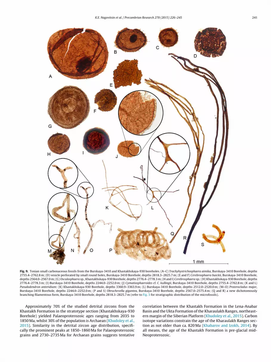
K.E. Nagovitsin et al. / Precambrian Research 270 (2015) 226–245 241
Fig. 9. Tonian small carbonaceous fossils from the Burskaya-3410 and Khastakhskaya-930 boreholes. (A–C) Trachyhystrichosphaera aimika, Burskaya-3410 Borehole, depths2755.4–2762.8 m; (D) vesicle perforated by small round holes, Burskaya-3410 Borehole, depths 2818.3–2825.7 m; (E and F) Cerebrosphaera buickii, Burskaya-3410 Borehole,depths 2564.0–2567.0 m; (G) Osculosphaera sp., Khastakhskaya-930 Borehole, depths 2776.4–2778.3 m; (H and I) Cerebrosphaera sp.: (H) Khastakhskaya-930 Borehole, depths2776.4–2778.3 m; (I) Burskaya-3410 Borehole, depths 2244.0–2252.0 m; (J) Cymatiosphaeroides cf. C. kullingii, Burskaya-3410 Borehole, depths 2755.4–2762.8 m; (K and L)P .9 m; (B a, Burb fer to
KB12cg
seudodendron anteridium: (K) Khastakhskaya-930 Borehole, depths 3360.9–3363urskaya-3410 Borehole, depths 2244.0–2252.0 m; (P and S) Obruchevella giganteranching filamentous form, Burskaya-3410 Borehole, depths 2818.3–2825.7 m (re
Approximately 70% of the studied detrital zircons from thehastakh Formation in the stratotype section (Khastakhskaya-930orehole) yielded Palaeoproterozoic ages ranging from 2035 to
850 Ma, whilst 30% of the population is Archaean (Khudoley et al.,015). Similarity in the detrital zircon age distribution, specifi-ally the prominent peaks at 1850–1860 Ma for Palaeoproterozoicrains and 2730–2735 Ma for Archaean grains suggests tentativeL) Burskaya-3410 Borehole, depths 2512.0–2520.0 m; (M–O) Proterocladus major,skaya-3410 Borehole, depths 2567.0–2575.4 m; (Q and R) a new dichotomously
Fig. 3 for stratigraphic distribution of the microfossils).
correlation between the Khastakh Formation in the Lena-AnabarBasin and the Ukta Formation of the Kharaulakh Ranges, northeast-ern margin of the Siberian Platform (Khudoley et al., 2015). Carbon
isotope variations constrain the age of the Kharaulakh Ranges sec-tion as not older than ca. 820 Ma (Khabarov and Izokh, 2014). Byall means, the age of the Khastakh Formation is pre-glacial mid-Neoproterozoic.
2 brian R
3
cf
spsbstatziao1
iSlsacTltle1pbtli1tusbaiif
fLslsomfbPRhe2tai2c
42 K.E. Nagovitsin et al. / Precam
.2. Ediacaran
The Ediacaran succession in the Lena-Anabar Basin and the adja-ent north-western slope of the Olenek Uplift consists of at leastour prograding sedimentary sequences.
The first sequence is 75–80 m thick and comprises sand-tones, shales and dolostones of the Maastakh Formation. Theebble-bearing trough and tabular cross-bedded channelised sand-tones in the lower part of the sequence are interpreted asraid plane facies, whereas the planar- and hummocky-beddedandstones in the upper part of the sequence record deposi-ion in a wave- and current-agitated setting. Wedged in-betweenre microbially laminated cross- and wavy-bedded dolostoneshat indicate deposition in the upper-intertidal to supratidalone. Desiccation cracks and extensive precipitation of silica,ncluding “cauliflower” chert nodules [that may have replacednhydrite (Milliken, 1979)], in the dolostones suggest an evap-rative tidal-flat setting (Knoll et al., 1995; Pelechaty et al.,996).
The second sequence (190–220 m thick) consists of finely lam-nated and thick-bedded limestones of the Khatyspyt Formation.ections along the Kersyuke River dominated by thick-beddedimestones appear to represent the most proximal facies of theequence. Wavy stratification, ripple cross-lamination, gutter casts,nd lag deposits of intraclasts in the thick-bedded limestones indi-ate deposition in wave- and current-agitated inner ramp setting.he thick-bedded limestones become thinner, less consistent andess common northeast of the Kersyuke River. Thus, sections alonghe Korbusuonka River and its tributaries consist primarily of finelyaminated, sometimes extensively bioturbated limestones (Rogovt al., 2012) that resemble distal ramp facies (Pelechaty et al.,996), although rare oolite grains in the sparite laminae indicateroximity of the shallow ramp environment. This is not surprisingecause within 30 km to the east from the Khorbusuonka River, inhe upper reaches of the Ulakhan-Sololi River, the finely laminatedimestones are again replaced by thick-bedded limestones of thenner ramp setting (Krasil’shchikov and Biterman, 1970; Yakshin,987). In addition, the lower part of the sequence in sections alonghe Khorbusuonka Valley includes several thick laterally contin-ous channelised bodies of intraclastic limestone, with variousoft-sediment deformation features, and the intervals of alternatingituminous calcimudstones and shales. This localised facies associ-tion is interpreted as a starved intracratonic rift basin developedn the inner ramp setting, with intraclastic limestones represent-ng debris flows deposited adjacent to the inferred syn-sedimentaryaults.
The depositional sequence of the Khatyspyt Formation extendsrom the north-western slope of the Olenek Uplift into the adjacentena-Anabar Basin where it is represented by a thick succes-ion of alternating dark grey dolomitized finely laminated micriticimestones and greenish grey calcareous shales thought to repre-ent distal facies of a carbonate ramp setting. Stratigraphic agef the sequence is constrained by the occurrence of a peculiareniscate structure in the Khatyspyt Formation (Fig. 5D). Apart
rom the Khatyspyt Formation, similar meniscate structure haseen described from southeast Siberia, China, Lesser Himalaya andodolia (Shen et al., 2007; Dong et al., 2008; Zhuravlev et al., 2009;ogov et al., 2013a; Tarhan et al., 2014). The meniscate structureas been variously named and interpreted as body fossils (Shent al., 2007; Dong et al., 2008; Meyer et al., 2012; Brasier et al.,013; Tarhan et al., 2014), and even as trace fossils of gigantic myce-ozoan pseudoplasmodia (Zhuravlev et al., 2009; Gámez Vintaned
nd Zhuravlev, 2013); however, we suggest that it represents anchnofabric produced by burrowing bilaterians (Rogov et al., 2012,013a,b). Regardless of the interpretation, the oldest such menis-ate structure is younger than 553–551 Ma and predates the firstesearch 270 (2015) 226–245
appearance of small skeletal fossils of the Anabarites trisulcatusAssemblage Zone (Grazhdankin, 2014; Rogov et al., 2015). Thisconstrains the maximum age of the Khatyspyt Formation and thedepositional sequence.
The third sequence (80 m thick in its proximal part, but reaches210 m in thickness in the distal facies) consists of dolostones anddolomudstones of the Turkut Formation. The lower part of theTurkut Formation in sections along the Khorbusuonka and Olenekrivers has been described as thick-laminated dolostones and inter-preted as distal ramp facies (Knoll et al., 1995; Pelechaty et al.,1996); however, our observations indicate that the sections consistof microbialitic dolomudstones, with dissolution-collapse breccia,and represent an evaporative peritidal environment. The chan-nelised cross-bedded oolitic and pisolitic dolostones, the finelylaminated micritic dolostones with salt crystal pseudomorphs,desiccation cracks and small gutter and flute casts, the micro-bialite reefs and bioherms higher in the sequence all suggesta restricted shallow subtidal and peritidal depositional environ-ment in a carbonate platform setting. Pelechaty et al. (1996)recognise tidal flat, lagoon and shoal facies in the upper TurkutFormation, which is in agreement with our observations. Atleast in the north-western slope of the Olenek Uplift, the topof the sequence is truncated by a palaeokarst surface with cav-erns and sinkholes up to 9 m deep filled with sandstone ofthe overlying Syhargalakh Formation. Small skeletal fossils ofthe anabaritid Cambrotubulus decurvatus found throughout theTurkut Formation (Fig. 6A–D) constrain the stratigraphic age of thesequence to the Anabarites trisulcatus Assemblage Zone of the latestEdiacaran.
Collectively, the Khatyspyt and Turkut formations have beenviewed by some researchers as a single stratigraphic sequence(Krasil’shchikov and Biterman, 1970; Yakshin and Vodanjuk, 1986;Vodanjuk, 1987; Yakshin, 1987; Knoll et al., 1995; Pelechaty et al.,1996). The boundary between the Khatyspyt and Turkut formationshas been variously, but always provisionally, placed at the con-tact between predominantly calcitic and predominantly dolomiticlithologies. We define the lower boundary of the Turkut Formationat the base of a thick (up to 51.8 m) unit of microbialitic dolostoneswhich in most of the studied sections transgressively overlies apackage of bituminous limestone-shale alternations with interbedsof intraclastic dolomitized limestones (Fig. 4). The intraclasticlimestones are interpreted as debris flow deposits, whereas thefine, non-bioturbated limestone-shale alternations are most likelyto represent deposition in a starved subtidal setting. The inter-vals of limestone-shale alternations often exhibit soft-sedimentslump and deformation structures in the form of olistoliths. Thisfacies association comprises Member 4 of the Khatyspyt Formation(Fig. 4). The Member 4 varies in thickness from 1.55 to 18.68 m insections along the Khorbusuonka River; however, this facies asso-ciation is missing in sections along the Anabyl Creek (e.g., section0603; Fig. 4), and the microbialitic dolostones of the Turkut For-mation overlie finely laminated limestones of the Member 3. Theobserved variation in thickness and the lithofacies characteristicssuggest deposition of the Member 4 in palaeotopographic troughsresulting from differential subsidence. We therefore consider theKhatyspyt and Turkut formations as two separate depositionalsequences (Fig. 2).
The fourth sequence is 160–290 m thick in the Lena-AnabarBasin, but thins down to 27 m in the north-western slope of theOlenek Uplift. Three facies associations are recognised. Finely lam-inated shales, graded siltstone-shale couplets, and interbeds offinely laminated micritic limestones, thin-bedded, wave-rippled
sandstones of the Oppokun Formation are interpreted as theproduct of progressive sorting of fine-grained material by storm-generated currents (sensu Swift and Thorne, 1991) suggestingdeposition in a low-energy sediment-starved shelf. This facies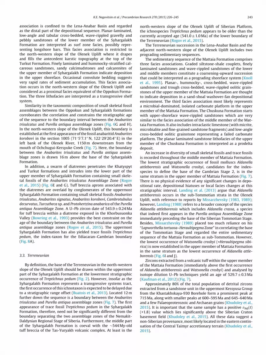
brian R
aalpFstaTctivtcts
acotIeklmbbF
autetStdafVaaSp(
3
spoSttftaFbDot
K.E. Nagovitsin et al. / Precam
ssociation is confined to the Lena-Anabar Basin and regardeds the distal part of the depositional sequence. Planar-laminated,ow-angle and tabular cross-bedded, wave-rippled gravelly andebbly sandstones of the lower member of the Syhargalakhormation are interpreted as surf zone facies, possibly repre-enting longshore bars. This facies association is restricted tohe north-western slope of the Olenek Uplift where it drapesnd fills the antecedent karstic topography at the top of theurkut Formation. Finely laminated and hummocky-stratified cal-areous sandstones, sandy calcimudstones and calcarenites ofhe upper member of Syhargalakh Formation indicate depositionn the upper shoreface. Occasional convolute bedding suggestsery rapid rates of sediment accumulation. This facies associa-ion occurs in the north-western slope of the Olenek Uplift andonsidered as a proximal facies equivalent of the Oppokun Forma-ion. The three lithofacies are interpreted as a transgressive shelfystem.
Similarity in the taxonomic composition of small skeletal fossilssemblages between the Oppokun and Syhargalakh formationsorroborates the correlation and constrains the stratigraphic agef the sequence to the boundary interval between the Anabaritesrisulcatus and Purella antiqua assemblage zones (Fig. 6G and H).n the north-western slope of the Olenek Uplift, this boundary isstablished at the first appearance of the fossil anabaritid Anabaritesorobovi in the section 1005 (71◦5′7.1′′ N, 122◦29′20.4′′ E) in theeft bank of the Olenek River, 1150 m downstream from the
outh of Ochchugui-Kersyuke Creek (Fig. 7). Here, the boundaryetween the Anabarites trisulcatus and Purella antiqua assem-lage zones is drawn 16 m above the base of the Syhargalakhormation.
In addition, a swarm of diatremes penetrates the Khatyspytnd Turkut formations and intrudes into the lower part of thepper member of Syhargalakh Formation containing small skele-al fossils of the Anabarites trisulcatus Assemblage Zone (Rogovt al., 2015) (Fig. 6E and G). Tuff breccia aprons associated withhe diatremes are overlaid by conglomerates of the uppermostyhargalakh Formation containing small skeletal fossils Anabaritesrisulcatus, Anabarites signatus, Anabarites korobovi, Cambrotubulusecurvatus, Turcutheca sp. and Protohertzina anabarica of the Purellantiqua Assemblage Zone. A U–Pb zircon date of 543.9 ± 0.24 Maor tuff breccia within a diatreme exposed in the Khorbusuonkaalley (Bowring et al., 1993) provides the best constraint on thege of the boundary between the Anabarites trisulcatus and Purellantiqua assemblage zones (Rogov et al., 2015). The uppermostyhargalakh Formation has also yielded trace fossils Treptichnusedum, the index-taxon for the Ediacaran–Cambrian boundaryFig. 8A).
.3. Terreneuvian
By definition, the base of the Terreneuvian in the north-westernlope of the Olenek Uplift should be drawn within the uppermostart of the Syhargalakh Formation at the lowermost stratigraphicccurrence of Treptichnus pedum (Fig. 2). However, insofar as theyhargalakh Formation represents a transgressive systems tract,he first occurrence of this ichnotaxon is expected to be delayed dueo a stratigraphic range offset (Buatois et al., 2013). Located 12 murther down the sequence is a boundary between the Anabaritesrisulcatus and Purella antiqua assemblage zones (Fig. 7). The firstppearance of trace fossil Treptichnus pedum in the Syhargalakhormation, therefore, need not be significantly different from the
oundary separating the two assemblage zones of the Nemakit-aldynian Regional Stage of Siberia. Furthermore, the middle partf the Syhargalakh Formation is coeval with the ∼544 My-olduff breccia of the Tas-Yuryakh volcanic complex. At least in theesearch 270 (2015) 226–245 243
north-western slope of the Olenek Uplift of Siberian Platform,the ichnospecies Treptichnus pedum appears to be older than thecurrently accepted age (541.0 ± 1.0 Ma) of the lower boundary ofthe Terreneuvian (Rogov et al., 2015).
The Terreneuvian succession in the Lena-Anabar Basin and theadjacent north-western slope of the Olenek Uplift includes twoprograding sedimentary sequences.
The sedimentary sequence of the Mattaia Formation comprisesthree facies associations. Graded siltstone-shale couplets, finelylaminated sandstones and wave-rippled sandstones of the lowerand middle members constitute a coarsening-upward successionthat could be interpreted as a prograding shoreface system (Knollet al., 1995). Planar-, hummocky-, cross-bedded, wave-rippledsandstones and trough cross-bedded, wave-rippled oolitic grain-stones of the upper member of the Mattaia Formation are thoughtto indicate deposition in a sand-shoal washover-fan depositionalenvironment. The third facies association most likely representsa microbial-dominated, isolated carbonate platform in the uppermember of the Mattaia Formation. The Chuskuna Formation startswith upper-shoreface wave-rippled sandstones which are verysimilar to the facies association of the middle member of the Mat-taia Formation. It also includes intraclastic limestone (with micrite,microbialite and fine-grained sandstone fragments) and low-anglecross-bedded oolitic grainstone representing a failed carbonateplatform. The planar laminated sandstone lithofacies of the uppermember of the Chuskuna Formation is interpreted as a prodeltadeposit.
An increase in diversity of small skeletal fossils and trace fossilsis recorded throughout the middle member of Mattaia Formation.The lowest stratigraphic occurrence of fossil molluscs Aldanellaattleborensis and Watsonella crosbyi, candidates for the index-species to define the base of the Cambrian Stage 2, is in thesame stratum in the upper member of Mattaia Formation (Fig. 7).There is no physical evidence of any significant changes in depo-sitional rate, depositional hiatuses or local facies changes at thisstratigraphic interval. Landing et al. (2013) argue that Aldanellaattleborensis occurs in the sub-Tommotian strata in the OlenekUplift, with reference to reports by Missarzhevsky (1983, 1989);however, Landing (1988) refers to a broader concept of the speciesAldanella attleborensis which includes Aldanella crassa, a speciesthat indeed first appears in the Purella antiqua Assemblage Zoneimmediately preceding the base of the Siberian Tommotian Stage.Besides, Missarzhevsky (1989) placed too much reliance on his“Lapworthella tortuosa–Heraultipegma Zone” in correlating the baseof the Tommotian Stage and regarded the entire sedimentarysequence of the Mattaia Formation as sub-Tommotian. However,the lowest occurrence of Watsonella crosbyi (=Heraultipegma sibi-rica) is now established in the upper member of Mattaia Formationin the same stratum as the lowest occurrence of Aldanella attle-borensis (Fig. 6I and J).
Zircons extracted from a volcanic tuff within the upper memberof the Mattaia Formation (immediately above the first occurrenceof Aldanella attleborensis and Watsonella crosbyi) and analysed byisotope dilution U–Pb techniques yield an age of 529.7 ± 0.3 Ma(Kaufman et al., 2012) (Fig. 7).
Approximately 80% of the total population of detrital zirconsextracted from a sandstone unit in the uppermost Kessyusa Groupfrom the Khastakhskaya-930 Borehole form a prominent peak at715 Ma, along with smaller peaks at 600–595 Ma and 645–640 Maand a few Palaeoproterozoic and Archaean grains (Khudoley et al.,2015). It is important that the same sample has a positive εNd(t)(+1.8) value which lies significantly above the Siberian Cratonbasement field (Khudoley et al., 2015). All these data suggest anon-Siberian provenance, most likely located in the eastern contin-
uation of the Central Taimyr accretionary terrain (Khudoley et al.,2015).
2 brian R
4
uaraa2sCbonKNitcszLdTlieet
A
dRmBwfWf
R
B
B
B
B
B
C
D
D
F
G
G
44 K.E. Nagovitsin et al. / Precam
. Conclusions
The proposed stratigraphic correlation scheme (Fig. 2) is basedpon depositional unity and is consistent both lithologicallynd biostratigraphically. The revised nomenclature provides aobust framework to base future stratigraphic, sedimentologicalnd palaeobiological studies on. Now that a Mesoproterozoicge is established for the Khaipakh Formation (Gorokhov et al.,006; Wingate et al., 2009), the early and mid-Neoproterozoictrata penetrated by the Burskaya-3410, Khastakhskaya-930, andharchykskaya-1 boreholes in the Lena-Anabar Basin can no longere correlated with the Sololi Group of the north-western slopef the Olenek Uplift. We therefore introduced a new stratigraphicomenclature for the pre-glacial Neoproterozoic and redefined thehastakh Formation (Fig. 2). The existence of a thick early to mid-eoproterozoic succession in the Lena-Anabar pericratonic basin
mplies the future northern margin of Siberia was affected by faul-ing and a long-term subsidence, possibly as part of the widespreadontinental rifting and the break-up of Rodinia. There is a significanttratigraphic unconformity separating the pre-glacial Neoprotero-oic strata and the overlying upper Ediacaran succession in theena-Anabar Basin, with the Terreneuvian strata most likely to beeposited in a foreland of the Central Taimyr accretionary belt.he Cryogenian sensu strictum (i.e., younger than 720 Ma) andower Ediacaran deposits are missing in the studied area. With thisnformation in hand, various aspects of Neoproterozoic tectonicvolution and palaeogeography can now be readdressed. What isvident is that fossils can be a reliable tool in integrated chronos-ratigraphic studies of the Neoproterozoic.
cknowledgements
The core of the study was funded by the Russian Science Foun-ation grant no. 14-17-00409 and the Russian Foundation for Basicesearch grant no. 13-05-00878. Our initial stratigraphic and sedi-entological work was supported by the Russian Foundation for
asic Research grant no. 12-05-00012. Fieldwork was conductedith the financial support of the National Geographic Committee
or Research and Exploration (grants 8227-07, 8637-09, 9031-11).e thank Andrei Khudoley and an anonymous reviewer for insight-
ul comments and valuable suggestions.
eferences
owring, S.A., Grotzinger, J.P., Isachsen, C.E., Knoll, A.H., Pelechaty, S.M., Kolosov, P.,1993. Calibrating rates of Early Cambrian evolution. Science 261, 1293–1298.
rasier, M.D., McIlroy, D., Liu, A.G., Antcliffe, J.B., Menon, L.R., 2013. The oldest evi-dence of bioturbation on Earth: comment. Geology 41 (5), e289, http://dx.doi.org/10.1130/G33606C.1.
rongniart, M.A., 1828. Historie des végétaux fossils ou recherches botaniques etgéologiques sur les végétaux renfermé dans les diverses couches du globe.Dufour & d’Ocagne, Paris, pp. 136.
uatois, L.A., Almond, J., Germs, G.J.B., 2013. Environmental tolerance andrange offset of Treptichnus pedum: implications for the recognition of theEdiacaran–Cambrian boundary. Geology 41 (4), 519–522.
utterfield, N.J., Knoll, A.H., Swett, K., 1994. Paleobiology of the NeoproterozoicSvanbergfjellet Formation, Spitsbergen. Fossils and Strata 34, 1–84.
humakov, N.M., Semikhatov, M.A., 1981. Riphean and Vendian of the USSR. Pre-cambrian Res. 15, 229–253.
ong, L., Xiao, S., Shen, B., Zhou, C., 2008. Silicified Horodyskia and Palaeopascichnusfrom upper Ediacaran cherts in South China: tentative phylogenetic interpreta-tion and implications for evolutionary stasis. Geol. Soc. Lond. J. 165, 367–378.
zik, J., 2005. Behavioral and anatomical unity of the earliest burrowing animalsand the cause of the “Cambrian explosion”. Paleobiology 31 (3), 503–521.
edonkin, M.A., 1990. Systematic description of Vendian Metazoa. In: Sokolov, B.S.,Iwanowski, A.B. (Eds.), The Vendian System. V. 2. Paleontology. Springer-Verlag,Berlin, Heidelberg, pp. 71–120.
ámez Vintaned, J.A., Zhuravlev, A.Y., 2013. The oldest evidence of bioturbation onEarth: comment. Geology 41 (9), e299, http://dx.doi.org/10.1130/G34085C.1.
orokhov, I.M., Semikhatov, M.A., Arakelyants, M.M., Fallick, E.A., Melnikova, N.N.,Turchenko, T.L., Ivanovskaya, T.A., Zaitseva, T.S., Kutyavin, E.P., 2006. Rb–Sr,K–Ar, H- and O-isotope systematics of the Middle Riphean shales from the
esearch 270 (2015) 226–245
Debengda Formation, the Olenek Uplift, North Siberia. Stratigr. Geol. Correl. 14(3), 260–274.
Gradstein, F., Ogg, J., Schmitz, M.D., Ogg, G. (Eds.), 2012. The Geologic Time Scale2012. Elsevier, Boston, p. 1144.
Grausman, V.V., 1995. Upper Precambrian of the Olenek Uplift from deep drillingdata. Tikhookean. Geol. 14 (4), 133–136 (in Russian).
Grausman, V.V., Rudavskaya, V.A., Vasilieva, N.I., 1996. Upper Precambrian andLower Cambrian stratigraphy of the Olenek Uplift. Otechestvennaya Geol. 8,30–35 (in Russian).
Grazhdankin, D., 2014. Patterns of evolution of the Edicaran soft-bodied biota. J.Paleontol. 88 (2), 269–283.
Grazhdankin, D.V., Balthasar, U., Nagovitsin, K.E., Kochnev, B.B., 2008. Carbonate-hosted Avalon-type fossils in arctic Siberia. Geology 36 (10), 803–806.
Grey, K., Hill, A.C., Calver, C., 2011. Biostratigraphy and stratigraphic subdivision ofCryogenian successions of Australia in a global context. In: Arnaud, E., Halverson,G.P., Shields-Zhou, G. (Eds.), The Geological Record of Neoproterozoic Glacia-tions. Geological Society, London, Memoirs 36. The Geological Society, London,pp. 113–134.
Gusev, A.I., 1950. The Geology. In: Coal- and Oil-Bearing Capacity in the LowerReaches of the Olenek River. Izdatel’stvo Glavsevmorputi, Leningrad, Moscow,pp. 100 (in Russian).
Hill, A.C., Cotter, K.L., Grey, K., 2000. Mid-Neoproterozoic biostratigraphy and isotopestratigraphy in Australia. Precambrian Res. 100, 281–298.
Kaufman, A.J., Peek, S., Martin, A.J., Cui, H., Grazhdankin, D., Rogov, V., Xiao, S.,Buchwaldt, R., Bowring, S., 2012. A shorter fuse for the Cambrian Explosion?Geological Society of America Abstracts with Programs 44 (7), 326.
Khabarov, E.M., Izokh, O.P., 2014. Sedimentology and isotope geochemistry of Riph-ean carbonates in the Kharaulakh Range of northern East Siberia. Russian Geol.Geophys. 55, 629–648.
Khomentovsky, V.V., Karlova, G.A., 1992. Lower boundary of the Cambrian and itsrationale in Siberia. Geologiya i Geofizika 11, 3–26 (in Russian).
Khomentovsky, V.V., Karlova, G.A., 1993. Biostratigraphy of the Vendian–Cambrianbeds and the Lower Cambrian boundary in Siberia. Geol. Mag. 130,29–45.
Khudoley, A., Chamberlain, K., Ershova, V., Sears, J., Prokopiev, A., MacLean, J., Kaza-kova, G., Malyshev, S., Molchanov, A., Kullerud, K., Toro, J., Miller, E., Veselovskiy,R., Li, A., Chipley, D., 2015. Proterozoic supercontinental restorations: constraintsfrom provenance studies of Mesoproterozoic to Cambrian clastic rocks, easternSiberian Craton. Precambrian Res. 259, 78–94.
Kir’yanov, V.V., 1987. A succession of acritarch assemblages inPrecambrian–Cambrian boundary strata in the East European and Siberianplatforms. In: The 3rd USSR Symposium on Precambrian and Early CambrianPalaeontology. Abstract Karel’skii Filial AN SSSR, Petrozavodsk, pp. 44–45 (inRussian).
Knoll, A.H., Grotzinger, J.P., Kaufman, A.J., Kolosov, P., 1995. Integrated approachesto terminal Proterozoic stratigraphy: an example from the Olenek Uplift, north-eastern Siberia. Precambrian Res. 73, 251–270.
Komar, V.A., 1966. Upper Precambrian stromatolites in the North of SiberianPlatform and their stratigraphic significance. Transactions of the GeologicalInstitute, 154. Nauka, Moscow, pp. 122 (in Russian).
Kontorovich, V.A., Kontorovich, A.E., Gubin, I.A., Zoteev, A.M., Lapkovsky, V.V., Maly-shev, N.A., Soloviev, M.V., Fradkin, G.S., 2013. The Neoproterozoic–Phanerozoicsection of the Anabar-Lena province: structural framework, geological model,and petroleum potential. Russian Geol. Geophys. 54, 980–996.
Krasil’shchikov, A.A., Biterman, I.M., 1970. Proterozoic Group of the Olenek Uplift.In: Markov, F.G. (Ed.), Geology of the USSR. Western Part of the Yakutian ASSR.Geological Description. Nedra, Moscow, pp. 91–100 (in Russian).
Krasnov, V.I., Savitsky, V.E., Tesakov, Yu.I., Khomentovsky, V.V. (Eds.), 1983. Res-olution of the USSR Stratigraphic Conference on the Precambrian, Palaeozoicand Quaternary Systems of Central Siberia. Part 1. Upper Precambrian. LowerPalaeozoic, Novosibirsk, p. 215 (in Russian).
Landing, E., 1988. Lower Cambrian of Eastern Massachusetts: stratigraphy and smallshelly fossils. J. Paleontol. 62 (5), 661–695.
Landing, E., Geyer, G., Brasier, M.D., Bowring, S.A., 2013. Cambrian evolutionary radi-ation: context, correlation, and chronostratigraphy – overcoming deficiencies ofthe first appearance datum (FAD) concept. Earth-Sci. Rev. 123, 133–172.
Luchinina, V.A., 1990. Subdivision and correlation of the Vendian–Cambrian bound-ary strata of the Siberian Platform based on calcareous algae. In: Repina, L.N.(Ed.), Cambrian Biostratigraphy and Palaeontology of Northern Asia. Nauka,Novosibirsk, pp. 32–43 (in Russian).
Meshkova, N.P., Zhuravleva, I.T., Luchinina, V.A., 1973. Lower Cambrian and thelower part of the Middle Cambrian of the Olenek Uplift. In: Zhuravleva, I.T. (Ed.),Problems of Palaeontology and Biostratigraphy in the Lower Cambrian of Siberiaand the Far-East. Nauka, Novosibirsk, pp. 194–214 (in Russian).
Meyer, M., Schiffbauer, J.D., Xiao, S., Cai, Y., Hua, H., 2012. Taphonomy of the UpperEdiacaran enigmatic ribbonlike fossil Shaanxilithes. Palaios 27, 354–372.
Milliken, K.L., 1979. The silicified evaporite syndrome – two aspects of silicifica-tion history of former evaporite nodules from southern Kentucky and northernTennessee. J. Sediment. Petrol. 49 (1), 245–256.
Missarzhevsky, V.V., 1980. Precambrian–Cambrian boundary strata in the westernslope of the Olenek Uplift (Olenek River). Byulleten’ Moskovskogo Obshchestva
Ispytatelei Prirody (Otdel Geologicheskii) 55 (4), 23–34 (in Russian).Missarzhevsky, V.V., 1982. Subdivision and correlation of Precambrian–Cambrianboundary strata based on various ancient groups of skeletal organisms. Byul-leten’ Moskovskogo Obshchestva Ispytatelei Prirody (Otdel Geologicheskii) 57(5), 52–67 (in Russian).

brian R
M
M
N
O
P
R
R
R
R
R
R
T
S
S
S
S
S
S
Slematic Ediacaran fossil Gaojiashania in Siberia and its origin. Geol. Mag. 146,
K.E. Nagovitsin et al. / Precam
issarzhevsky, V.V., 1983. Stratigraphy of the oldest Phanerozoic strata if the AnabarMassif. Sovetskaya Geol. 9, 62–73 (in Russian).
issarzhevsky, V.V., 1989. Oldest skeletal fossils and stratigraphy ofPrecambrian–Cambrian boundary strata. Transactions of the GeologicalInstitute, 443. Nauka, Moscow, pp. 221 (in Russian).
agy, R.M., Porter, S.M., Dehler, C.M., Shen, Y., 2009. Biotic turnover drivenby eutrophication before the Sturtian low-latitude glaciation. Nat. Geosci. 2,415–418.
gurtsova, R.N., 1975. Lontova acritarchs in Tommotian strata of the Olenek Uplift.Izvestiya Akademii Nauk SSSR. Seriya Geologicheskaya 11, 84–89 (in Russian).
elechaty, S.M., Grotzinger, J.P., Kashirtsev, V.A., Zhernovsky, V.P.,1996. Chemostratigraphic and sequence stratigraphic constraints onVendian–Cambrian basin dynamics, northeast Siberian Craton. J. Geol.104, 543–563.
ainbird, R.H., Stern, R.A., Khudoley, A.K., Kropachev, A.P., Heaman, L.M., Sukho-rukov, V.I., 1998. U–Pb geochronology of Riphean sandstone and gabbro fromsoutheast Siberia and its bearing on the Laurentia–Siberia connection. EarthPlanet. Sci. Lett. 164, 409–420.
ogov, V., Marusin, V., Bykova, N., Goy, Y., Nagovitsin, K., Kochnev, B., Karlova, G.,Grazhdankin, D., 2012. The oldest evidence of bioturbation on Earth. Geology 40(5), 395–398.
ogov, V., Marusin, V., Bykova, N., Goy, Y., Nagovitsin, K., Kochnev, B., Karlova, G.,Grazhdankin, D., 2013a. The oldest evidence of bioturbation on Earth: reply.Geology 41 (5), e290, http://dx.doi.org/10.1130/G34237Y.1.
ogov, V., Marusin, V., Bykova, N., Goy, Y., Nagovitsin, K., Kochnev, B., Karlova, G.,Grazhdankin, D., 2013b. The oldest evidence of bioturbation on Earth: reply.Geology 41 (5), e300, http://dx.doi.org/10.1130/G34594Y.1.
ogov, V.I., Karlova, G.A., Marusin, V.V., Kochnev, B.B., Nagovitsin, K.E., Grazhdankin,D.V., 2015. Duration of the first biozone in the Siberian hypostratotype of theVendian. Russian Geol. Geophys. 56, 573–583.
udavskaya, V.A., Vasilieva, N.I., 1985. Acritarchs and skeletal problematic fossilsfrom boundary strata of the Vendian and the Tommotian and Atdabanian stages.In: Late Precambrian Early Palaeozoic Stratigraphy of the Siberian Plsatform.VNIGRI, Leningrad, pp. 51–57 (in Russian).
imofeev, B.V., Hermann, T.N., Mikhailova, N.S., 1976. Precambrian. In: Cambrianand Ordovician Microphytofossils. Nauka, Leningrad, pp. 107 (in Russian).
hen, B., Xiao, S., Dong, L., Zhou, C., Liu, J., 2007. Problematic macrofossils from Edi-acaran successions in the North China and Chaidam blocks: implications for theirevolutionary roots and biostratigraphic significance. J. Paleontol. 81, 1396–1411.
hishkin, B.B., 1990. Precambrian stratigraphy of western Yakutia from deep drillingdata. In: Krasnov, V.I. (Ed.), Precambrian and Phanerozoic Stratigraphy andPalaeontology of Siberia. SNIIGGiMS, Novosibirsk, pp. 38–46 (in Russian).
hishkin, B.B., 2005. Lena-Anabar Region. In: Melnikov, N.V. (Ed.), Stratigraphy ofOil and Gas Basins of Siberia. Riphean and Vendian of Siberian Platform andthe Adjacent Folded Belts. Academic Publishing House “Geo”, Novosibirsk, pp.225–228 (in Russian).
hishkin, B.B., Isaev, A.V., 1999. Structural features of Precambrian and Cambrianstrata in the northeastern Siberian Platform. Geologiya i Geofizika 40 (12),1795–1807 (in Russian).
hpunt, B.R., Shapovalova, I.G., Shamshina, E.A., Lazebnik, K.A., Savvinov, V.T.,Permyakov, E.D., Kelle, E.Ya., Yankovsky, E.V., 1979. Proterozoic Strata in theNortheastern Margin of the Siberian Platform. Nauka, Novosibirsk, pp. 215 (inRussian).
okolov, B.S., Fedonkin, M.A., 1984. The Vendian System as the terminal system ofthe Precambrian. Episodes 7 (1), 12–19.
wift, D.J.P., Thorne, J.A., 1991. Sedimentation on continental margins I. A generalmodel for shelf sedimentation. In: Swift, D.J.P., Oertel, G.F., Tillman, R.W., Thorne,J.A. (Eds.), Shelf Sand and Sandstone Bodies: Geometry, Facies and SequenceStratigraphy. International Association of Sedimentologists Special PublicationNo. 14. Blackwell Scientific Publications, Oxford, pp. 3–31.
esearch 270 (2015) 226–245 245
Tang, Q., Pang, K., Xiao, S., Yuan, X., Ou, Z., Wan, B., 2013. Organic-walled microfos-sils from the early Neoproterozoic Liulaobei Formation in the Huainan regionof North China and their biostratigraphic significance. Precambrian Res. 236,157–181.
Tarhan, L.G., Hughes, N.C., Myrow, P.M., Bhargava, O.N., Ahluwalia, A.D., Kudryavtsev,A.B., 2014. Precambrian–Cambrian boundary interval occurrence and form ofthe enigmatic tubular body fossil Shaanxilithes ningqiangensis from the LesserHimalyaa of India. Palaeontology 57 (2), 283–298.
Valkov, A.K., 1987. Lower Cambrian Biostratigraphy in the East of Siberian Platform(Yudoma–Olenek Region). Nauka, Moscow, pp. 136 (in Russian).
Vasilieva, N.I., 1985. Biostratigraphy of lower Cambrian strata in the northeast ofSiberian Platform. In: Late Precambrian Early Palaeozoic Stratigraphy of theSiberian Plsatform. VNIGRI, Leningrad, pp. 5–15 (in Russian).
Vidal, G., Moczydłowska, M., Rudavskaya, V.A., 1993. Biostratigraphical implicationsof a Chuaria–Tawuia assemblage and associated acritarchs from the Neoprotero-zoic of Yakutia. Palaeontology 36 (2), 387–402.
Vodanjuk, S.A., 1987. Outstanding problems in Vendian stratigraphy of the Khor-busuonka River Basin (Olenek Basin). In: Khomentovsky, V.V., Shenfil, V.Yu.(Eds.), Late Precambrian and Early Palaeozoic of Siberia. The Siberian Platformand the Adjacent Southern Folded Belt. IGG SO AN SSSR, Novosibirsk, pp. 3–17(in Russian).
Vodanjuk, S.A., 1989. Non-skeletal fossil Metazoa from the Khatyspyt Formation ofthe Olenek Uplift. In: Khomentovsky, V.V., Sovetov, J.K. (Eds.), Late Precambrianand Early Palaeozoic of Siberia. Urgent Stratigraphic Problems. IGG SO AN SSSR,Novosibirsk, pp. 61–74 (in Russian).
Vodanjuk, S.A., Karlova, G.A., 1988. Kessyusa Formation of the Olenek Uplift. In:Khomentovsky, V.V., Shenfil, V.Yu. (Eds.), Late Precambrian and Early Palaeozoicof Siberia. Riphean and Vendian. IGG SO AN SSSR, Novosibirsk, pp. 3–20 (inRussian).
Wingate, M.T.D., Pisarevsky, S.A., Gladkochub, D.P., Donskaya, T.V., Konstantinov,K.M., Mazukabzov, A.M., Stanevich, A.M., 2009. Geochronology and paleomag-netism of mafic igneous rocks in the Olenek Uplift, northern Siberia: implicationsfor Mesoproterozoic supercontinents and paleogeography. Precambrian Res.170, 256–266.
Yakshin, M.S., 1987. Vendian of the Olenek Uplift. In: Khomentovsky, V.V., Shenfil,V.Yu. (Eds.), Late Precambrian and Early Palaeozoic of Siberia. The Siberian Plat-form and the Adjacent Southern Folded Belt. IGG SO AN SSSR, Novosibirsk, pp.18–30 (in Russian).
Yakshin, M.S., Vodanjuk, S.A., 1986. Khorbusuonka Group of the Khorbusuonka RiverBasin. In: Khomentovsky, V.V., Shenfil, V.Yu. (Eds.), Late Precambrian and EarlyPalaeozoic of Siberia. Stratigraphy and Palaeontology. IGG SO AN SSSR, Novosi-birsk, pp. 21–32 (in Russian).
Zaitseva, T.S., Semikhatov, M.A., Gorokhov, I.M., Melnikov, N.N., Ivanovskaya, T.A.,2013. Crystallochemical peculiarities and stratigraphic significance of Pb–Srand K–Ar ages of globular phyllosilicates: potential for calibrating chronos-tratigraphic scale of the Upper Proterozoic. In: Fedonkin, M.A. (Ed.), GeneralStratigraphic Scale of Russia: State of the Art and Ways of Perfection. Proceedingsof the All-Russian Conference (23–25 May, 2013). GIN RAS, Moscow, pp. 55–57(in Russian).
Zhuravlev, V.S., Sorokov, D.S., 1954. Lithostratigraphic subdivision of Cambrianstrata of the Olenek arched uplift. In: Tkachenko, B.V. (Ed.), Collected Workson Arctic Geology. Issue no. 3. Transactions of the Scientific Research Instituteof Arctic Geology 43, Vodtransizdat. Leningrad, Moscow, pp. 27–48 (in Russian).
Zhuravlev, A.Yu., Gámez Vintaned, J.A., Ivantsov, A.Yu., 2009. First finds of prob-
775–780.Zinchenko, V.N., 1985. Local stratigraphic subdivisions of the Cambrian of northeast-
ern Siberian Platform. In: Late Precambrian and Early Palaeozoic Stratigraphy.Collection of Research Papers. VNIGRI, Leningrad, pp. 15–22 (in Russian).
Copyright © 2022 FDOKUMEN