Restoration of ecosystems, integrated natural resource ...
70
Restoration of ecosystems, integrated natural resource management and promotion of SLM in Mbuluzi River Basin of Eswatini Part I: Project Information GEF ID 10695 Project Type FSP Type of Trust Fund GET CBIT/NGI CBIT No NGI No Project Title Restoration of ecosystems, integrated natural resource management and promotion of SLM in Mbuluzi River Basin of Eswatini Countries Eswatini Agency(ies) UNEP Other Executing Partner(s) Executing Partner Type Eswatini National Trust Commission Government
-
Upload
khangminh22 -
Category
Documents
-
view
4 -
download
0
Transcript of Restoration of ecosystems, integrated natural resource ...
Restoration of ecosystems, integrated natural resource management and promotion of SLM in Mbuluzi River Basin of Eswatini
Part I: Project Information
GEF ID10695
Project TypeFSP
Type of Trust FundGET
CBIT/NGICBIT NoNGI No
Project TitleRestoration of ecosystems, integrated natural resource management and promotion of SLM in Mbuluzi River Basin of Eswatini
CountriesEswatini
Agency(ies)UNEP
Other Executing Partner(s) Executing Partner TypeEswatini National Trust Commission Government
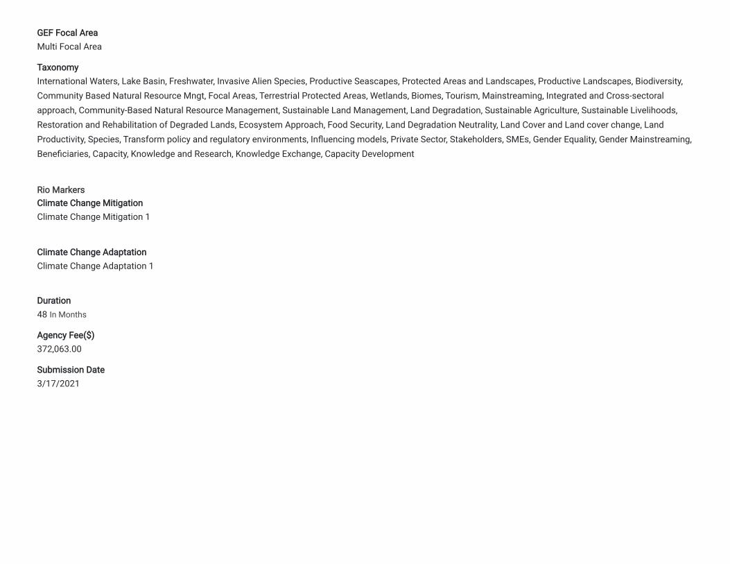
GEF Focal AreaMulti Focal Area
TaxonomyInternational Waters, Lake Basin, Freshwater, Invasive Alien Species, Productive Seascapes, Protected Areas and Landscapes, Productive Landscapes, Biodiversity,Community Based Natural Resource Mngt, Focal Areas, Terrestrial Protected Areas, Wetlands, Biomes, Tourism, Mainstreaming, Integrated and Cross-sectoralapproach, Community-Based Natural Resource Management, Sustainable Land Management, Land Degradation, Sustainable Agriculture, Sustainable Livelihoods,Restoration and Rehabilitation of Degraded Lands, Ecosystem Approach, Food Security, Land Degradation Neutrality, Land Cover and Land cover change, LandProductivity, Species, Transform policy and regulatory environments, In�uencing models, Private Sector, Stakeholders, SMEs, Gender Equality, Gender Mainstreaming,Bene�ciaries, Capacity, Knowledge and Research, Knowledge Exchange, Capacity Development
Rio MarkersClimate Change MitigationClimate Change Mitigation 1
Climate Change AdaptationClimate Change Adaptation 1
Duration48 In Months
Agency Fee($)372,063.00
Submission Date3/17/2021
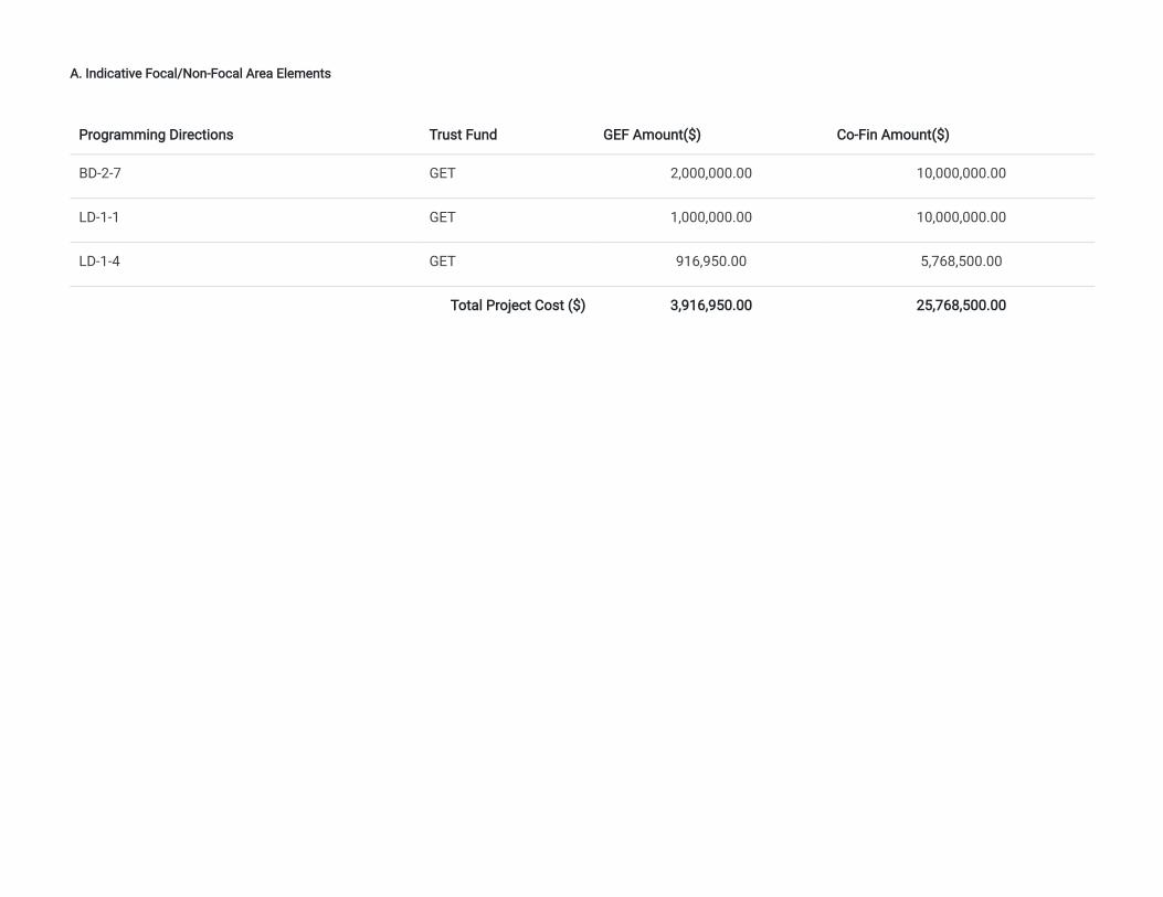
A. Indicative Focal/Non-Focal Area Elements
Programming Directions Trust Fund GEF Amount($) Co-Fin Amount($)
BD-2-7 GET 2,000,000.00 10,000,000.00
LD-1-1 GET 1,000,000.00 10,000,000.00
LD-1-4 GET 916,950.00 5,768,500.00
Total Project Cost ($) 3,916,950.00 25,768,500.00
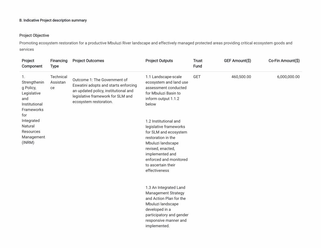
B. Indicative Project description summary
ProjectComponent
FinancingType
Project Outcomes Project Outputs TrustFund
GEF Amount($) Co-Fin Amount($)
1.Strengthening Policy,LegislativeandInstitutionalFrameworksforIntegratedNaturalResourcesManagement(INRM)
TechnicalAssistance
Outcome 1: The Government ofEswatini adopts and starts enforcingan updated policy, institutional andlegislative framework for SLM andecosystem restoration.
1.1 Landscape-scaleecosystem and land useassessment conductedfor Mbuluzi Basin toinform output 1.1.2below
1.2 Institutional andlegislative frameworksfor SLM and ecosystemrestoration in theMbuluzi landscaperevised, enacted,implemented andenforced and monitoredto ascertain theireffectiveness
1.3 An Integrated LandManagement Strategyand Action Plan for theMbuluzi landscapedeveloped in aparticipatory and genderresponsive manner andimplemented.
GET 460,500.00 6,000,000.00
Project Objective
Promoting ecosystem restoration for a productive Mbuluzi River landscape and effectively managed protected areas providing critical ecosystem goods andservices
1.4 SLM and ecosystemrestorationmainstreamed intoChiefdom SustainableDevelopment Plans andimplemented to scaleup their adoption in thebasin, usingparticipatoryapproaches
Component2. Ecosystemrestorationthroughcapacitystrengthening forPromotion ofsustainablelandmanagement(SLM)practices
TechnicalAssistance
Outcome 2: Reduced Landdegradation through capacitystrengthening for innovative SLMtechnologies in productive landscapesacross 60,700 ha of the Mbuluzi RiverBasin
[1] The term technologies is used herefollowing the standard WOCATde�nition, as in April 2014 UNCCDo�cially nominated the WorldOverview of Conservation Approachesand Technologies (WOCAT) database(hosted by CDE) as the primaryrecommended database on bestpractice and technologies ofsustainable land management (SLM),including catchment-based integratedwater resources management.
2.1 Capacity ofagriculture extensionworkers in SLM and allstaff in relevantministries anddepartmentsstrengthened
2.2. Training of trainersat local communitylevels includingchiefdoms conducted
2.3 Famer Field Schools(FFS) and SLMdemonstration sitesestablished for farmergroups and farmer open�eld-days organized
2.4 SLM practicesimplemented incommunities to improvesoil fertility and reduceland degradation for
GET 1,500,000.00 6,000,000.00
[1]
improved food securityand livelihoodstargeting maize andlegumes for crops andlivestock
2.5 Tree planting indegraded communallands and along riverineareas promoted toreduce landdegradation.
2.6 Capacity building ofCommunity ForestAssociations (CFAs) forcommunity biodiversityconservationenhancement
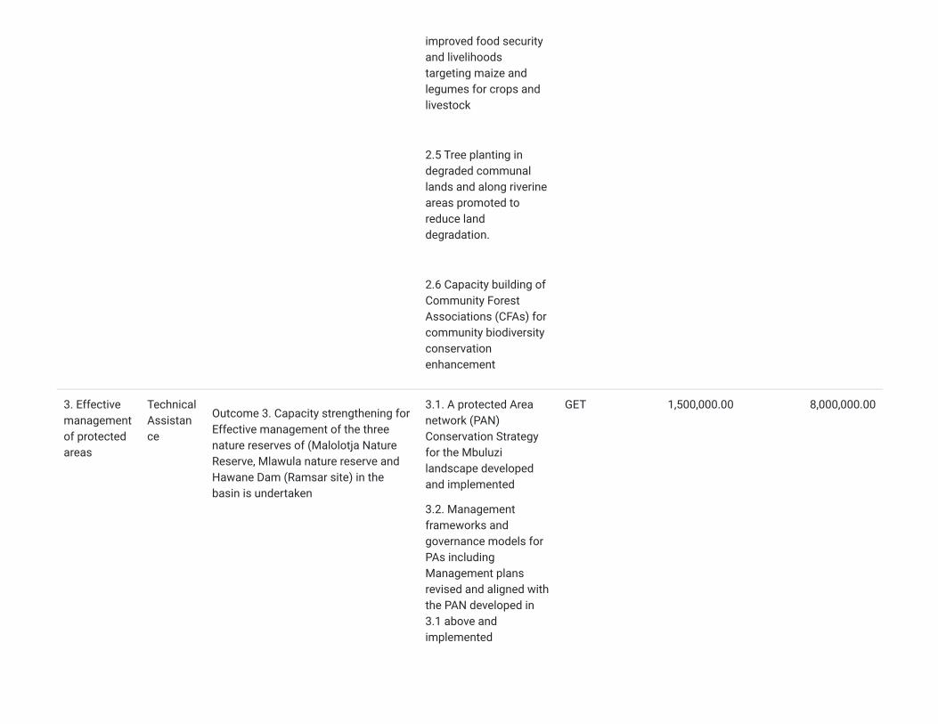
3. Effectivemanagementof protectedareas
TechnicalAssistance
Outcome 3. Capacity strengthening forEffective management of the threenature reserves of (Malolotja NatureReserve, Mlawula nature reserve andHawane Dam (Ramsar site) in thebasin is undertaken
3.1. A protected Areanetwork (PAN)Conservation Strategyfor the Mbuluzilandscape developedand implemented
3.2. Managementframeworks andgovernance models forPAs includingManagement plansrevised and aligned withthe PAN developed in3.1 above andimplemented
GET 1,500,000.00 8,000,000.00
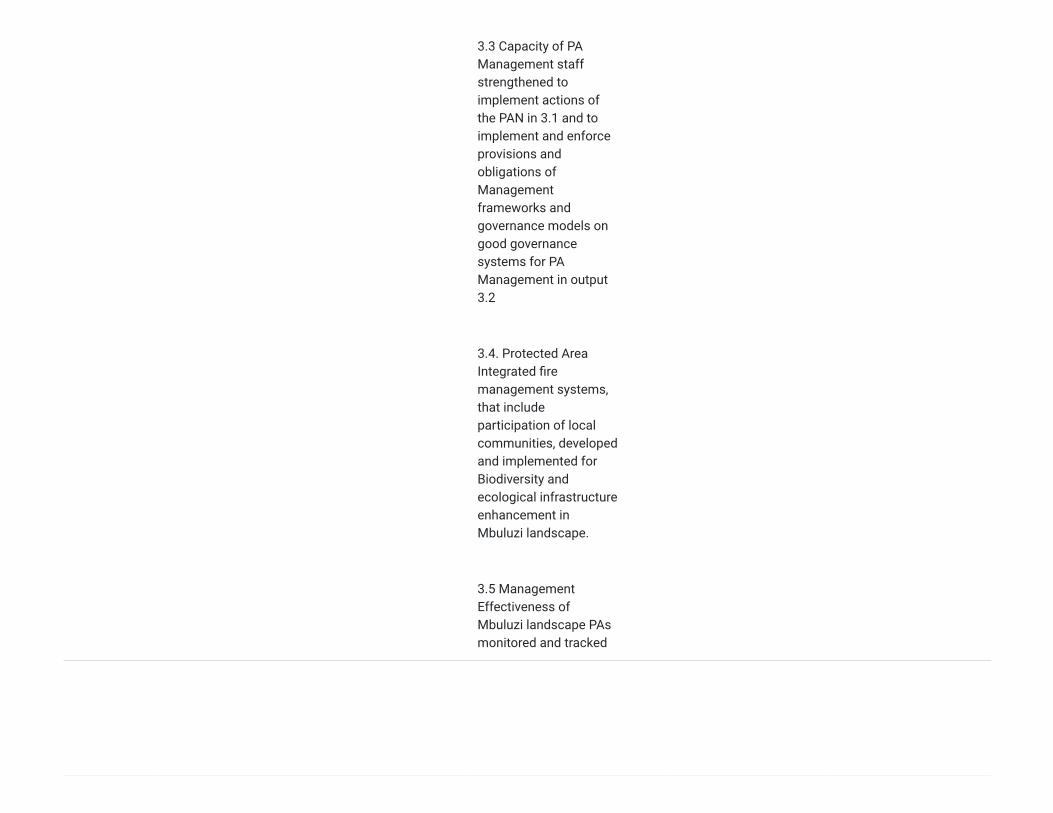
3.3 Capacity of PAManagement staffstrengthened toimplement actions ofthe PAN in 3.1 and toimplement and enforceprovisions andobligations ofManagementframeworks andgovernance models ongood governancesystems for PAManagement in output3.2
3.4. Protected AreaIntegrated �remanagement systems,that includeparticipation of localcommunities, developedand implemented forBiodiversity andecological infrastructureenhancement inMbuluzi landscape.
3.5 ManagementEffectiveness ofMbuluzi landscape PAsmonitored and tracked
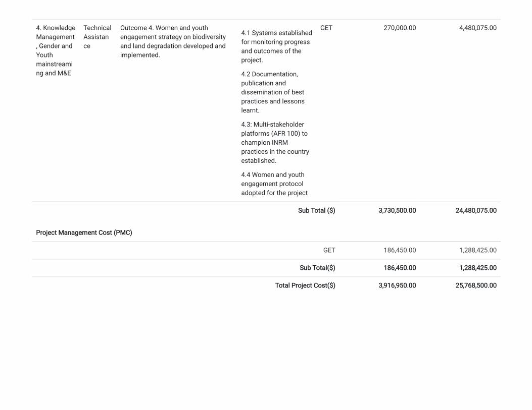
4. KnowledgeManagement, Gender andYouthmainstreaming and M&E
TechnicalAssistance
Outcome 4. Women and youthengagement strategy on biodiversityand land degradation developed andimplemented.
4.1 Systems establishedfor monitoring progressand outcomes of theproject.
4.2 Documentation,publication anddissemination of bestpractices and lessonslearnt.
4.3: Multi-stakeholderplatforms (AFR 100) tochampion INRMpractices in the countryestablished.
4.4 Women and youthengagement protocoladopted for the project
GET 270,000.00 4,480,075.00
Sub Total ($) 3,730,500.00 24,480,075.00
Project Management Cost (PMC)
GET 186,450.00 1,288,425.00
Sub Total($) 186,450.00 1,288,425.00
Total Project Cost($) 3,916,950.00 25,768,500.00
C. Indicative sources of Co-�nancing for the Project by name and by type
Sources of Co-�nancing Name of Co-�nancier Type of Co-�nancing
Investment Mobilized Amount($)
Recipient CountryGovernment
Eswatini National Trust Commission In-kind Recurrentexpenditures
7,150,000.00
Recipient CountryGovernment
Eswatini National Trust Commission Grant Recurrentexpenditures
2,500,000.00
Recipient CountryGovernment
Ministry of Agriculture In-kind Recurrentexpenditures
4,150,000.00
Recipient CountryGovernment
Ministry of Agriculture Grant Recurrentexpenditures
1,300,000.00
Recipient CountryGovernment
Ministry of Tinkhundla Administration and Development In-kind Recurrentexpenditures
1,000,000.00
Recipient CountryGovernment
Ministry of Tinkhundla Administration and Development Grant Recurrentexpenditures
1,000,000.00
Recipient CountryGovernment
National Maize Corporation In-kind Recurrentexpenditures
600,000.00
Recipient CountryGovernment
National Maize Corporation Grant Recurrentexpenditures
50,000.00
Recipient CountryGovernment
Ministry of Tourism and Environmental Affairs In-kind Recurrentexpenditures
3,500,000.00
Recipient CountryGovernment
Ministry of Tourism and Environmental Affairs Grant Recurrentexpenditures
1,668,000.00
Recipient CountryGovernment
Peak Timbers In-kind Recurrentexpenditures
100,500.00
Recipient CountryGovernment
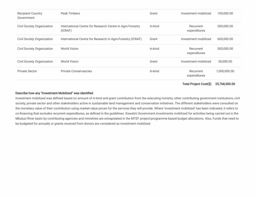
Peak Timbers Grant Investment mobilized 100,000.00
Civil Society Organization International Centre for Research Centre in Agro-Forestry(ICRAF)
In-kind Recurrentexpenditures
500,000.00
Civil Society Organization International Centre for Research in Agro-Forestry (ICRAF) Grant Investment mobilized 600,000.00
Civil Society Organization World Vision In-kind Recurrentexpenditures
500,000.00
Civil Society Organization World Vision Grant Investment mobilized 50,000.00
Private Sector Private Conservancies In-kind Recurrentexpenditures
1,000,000.00
Total Project Cost($) 25,768,500.00
Describe how any "Investment Mobilized" was identi�edInvestment mobilized was de�ned based on amount of in-kind and grant contribution from the executing ministry, other contributing government institutions, civilsociety, private sector and other stakeholders active in sustainable land management and conservation initiatives. The different stakeholders were consulted onthe monetary value of their contribution using market-value prices for the services they will provide. Where 'investment mobilized' has been indicated, it refers toco-�nancing that excludes recurrent expenditures, as de�ned in the guidelines. Eswatini Government investments mobilized for activities being carried out in theMbuluzi River basin by contributing agencies and ministries are extrapolated in the MTEF project/programme-based budget allocations. Also, Funds that need tobe budgeted for annually or grants received from donors are considered as investment mobilized
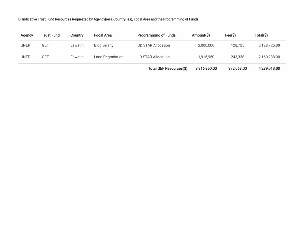
D. Indicative Trust Fund Resources Requested by Agency(ies), Country(ies), Focal Area and the Programming of Funds
Agency Trust Fund Country Focal Area Programming of Funds Amount($) Fee($) Total($)
UNEP GET Eswatini Biodiversity BD STAR Allocation 2,000,000 128,725 2,128,725.00
UNEP GET Eswatini Land Degradation LD STAR Allocation 1,916,950 243,338 2,160,288.00
Total GEF Resources($) 3,916,950.00 372,063.00 4,289,013.00
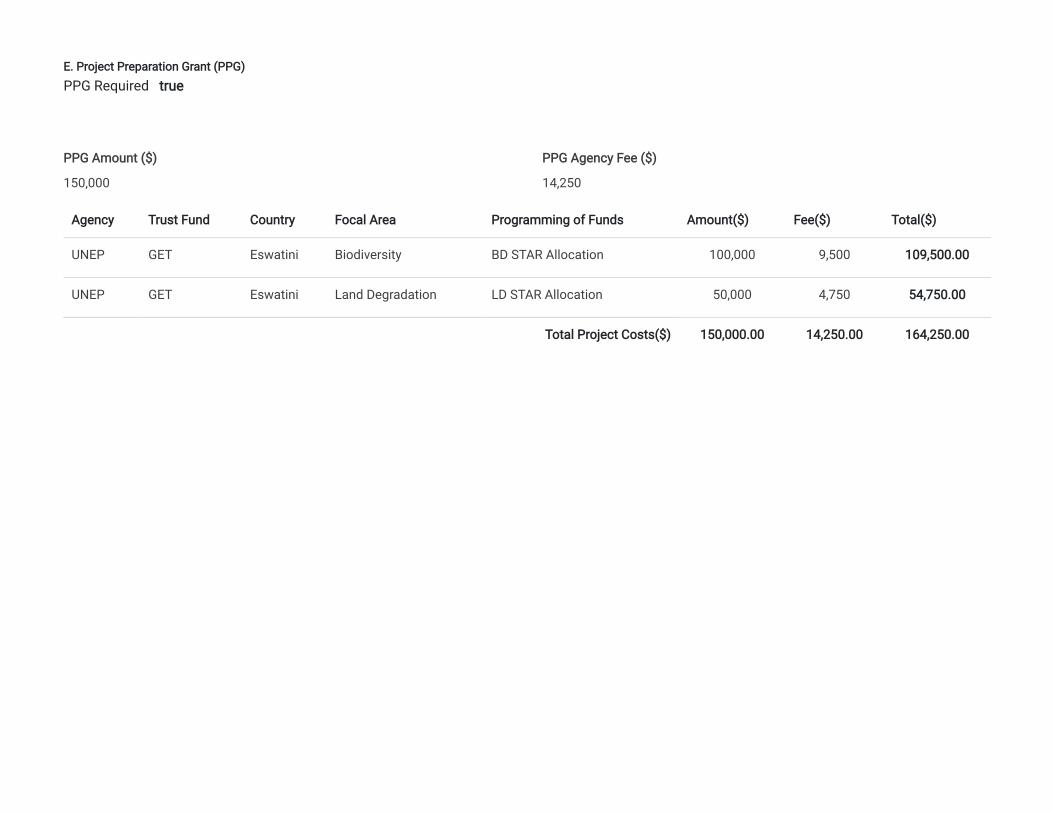
E. Project Preparation Grant (PPG)
Agency Trust Fund Country Focal Area Programming of Funds Amount($) Fee($) Total($)
UNEP GET Eswatini Biodiversity BD STAR Allocation 100,000 9,500 109,500.00
UNEP GET Eswatini Land Degradation LD STAR Allocation 50,000 4,750 54,750.00
Total Project Costs($) 150,000.00 14,250.00 164,250.00
PPG Required true
PPG Amount ($)
150,000
PPG Agency Fee ($)
14,250
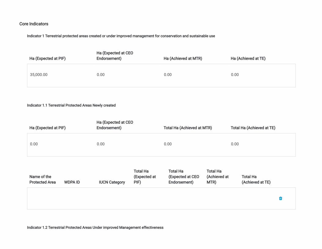
Core Indicators
Indicator 1 Terrestrial protected areas created or under improved management for conservation and sustainable use
Ha (Expected at PIF)Ha (Expected at CEOEndorsement) Ha (Achieved at MTR) Ha (Achieved at TE)
35,000.00 0.00 0.00 0.00
Indicator 1.1 Terrestrial Protected Areas Newly created
Ha (Expected at PIF)Ha (Expected at CEOEndorsement) Total Ha (Achieved at MTR) Total Ha (Achieved at TE)
0.00 0.00 0.00 0.00
Name of theProtected Area WDPA ID IUCN Category
Total Ha(Expected atPIF)
Total Ha(Expected at CEOEndorsement)
Total Ha(Achieved atMTR)
Total Ha(Achieved at TE)
Indicator 1.2 Terrestrial Protected Areas Under improved Management effectiveness
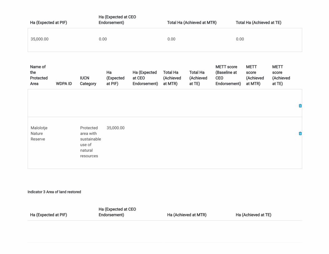
Ha (Expected at PIF)Ha (Expected at CEOEndorsement) Total Ha (Achieved at MTR) Total Ha (Achieved at TE)
35,000.00 0.00 0.00 0.00
Name oftheProtectedArea WDPA ID
IUCNCategory
Ha(Expectedat PIF)
Ha (Expectedat CEOEndorsement)
Total Ha(Achievedat MTR)
Total Ha(Achievedat TE)
METT score(Baseline atCEOEndorsement)
METTscore(Achievedat MTR)
METTscore(Achievedat TE)
MalolotjeNatureReserve
Protectedarea withsustainableuse ofnaturalresources
35,000.00
Indicator 3 Area of land restored
Ha (Expected at PIF)Ha (Expected at CEOEndorsement) Ha (Achieved at MTR) Ha (Achieved at TE)
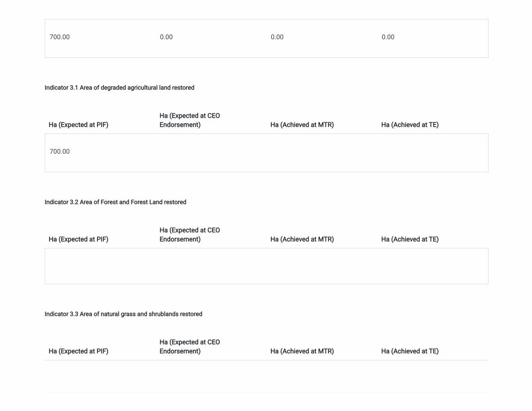
700.00 0.00 0.00 0.00
Indicator 3.1 Area of degraded agricultural land restored
Ha (Expected at PIF)Ha (Expected at CEOEndorsement) Ha (Achieved at MTR) Ha (Achieved at TE)
700.00
Indicator 3.2 Area of Forest and Forest Land restored
Ha (Expected at PIF)Ha (Expected at CEOEndorsement) Ha (Achieved at MTR) Ha (Achieved at TE)
Indicator 3.3 Area of natural grass and shrublands restored
Ha (Expected at PIF)Ha (Expected at CEOEndorsement) Ha (Achieved at MTR) Ha (Achieved at TE)
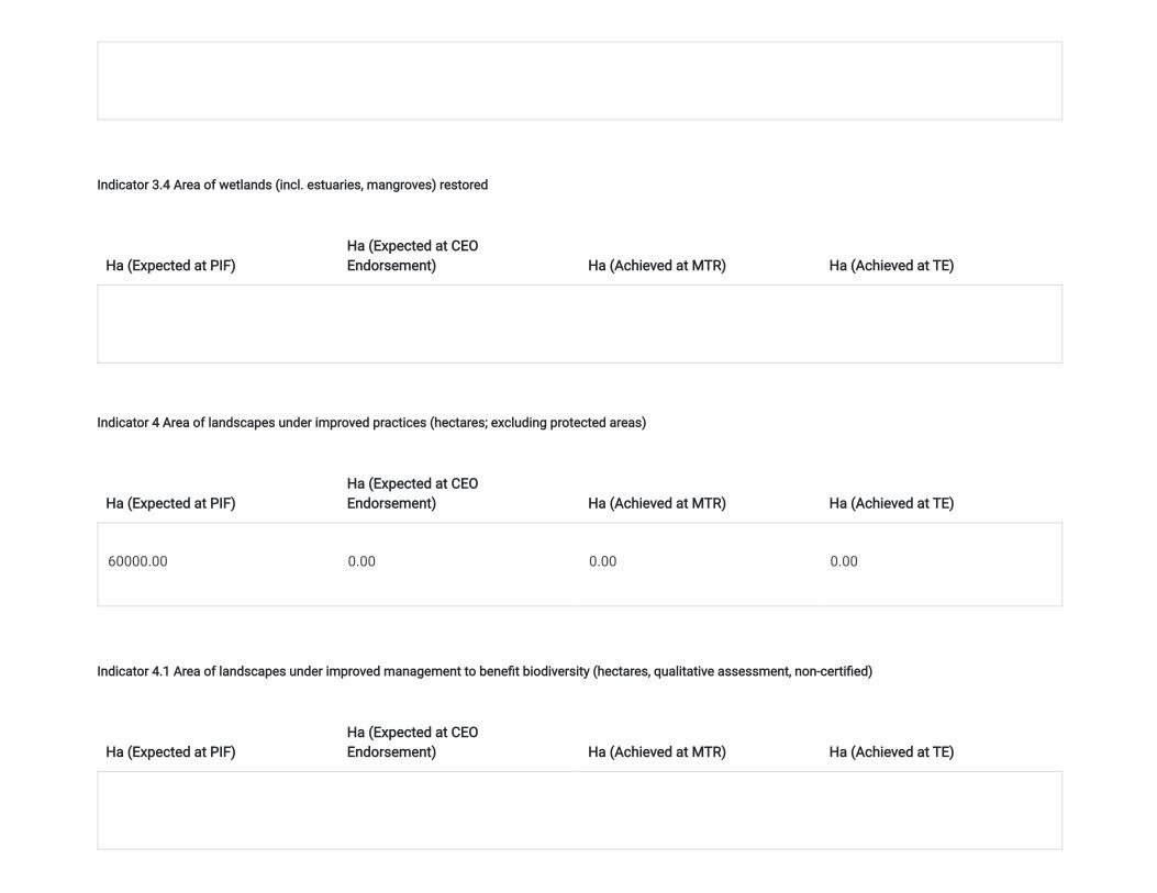
Indicator 3.4 Area of wetlands (incl. estuaries, mangroves) restored
Ha (Expected at PIF)Ha (Expected at CEOEndorsement) Ha (Achieved at MTR) Ha (Achieved at TE)
Indicator 4 Area of landscapes under improved practices (hectares; excluding protected areas)
Ha (Expected at PIF)Ha (Expected at CEOEndorsement) Ha (Achieved at MTR) Ha (Achieved at TE)
60000.00 0.00 0.00 0.00
Indicator 4.1 Area of landscapes under improved management to bene�t biodiversity (hectares, qualitative assessment, non-certi�ed)
Ha (Expected at PIF)Ha (Expected at CEOEndorsement) Ha (Achieved at MTR) Ha (Achieved at TE)
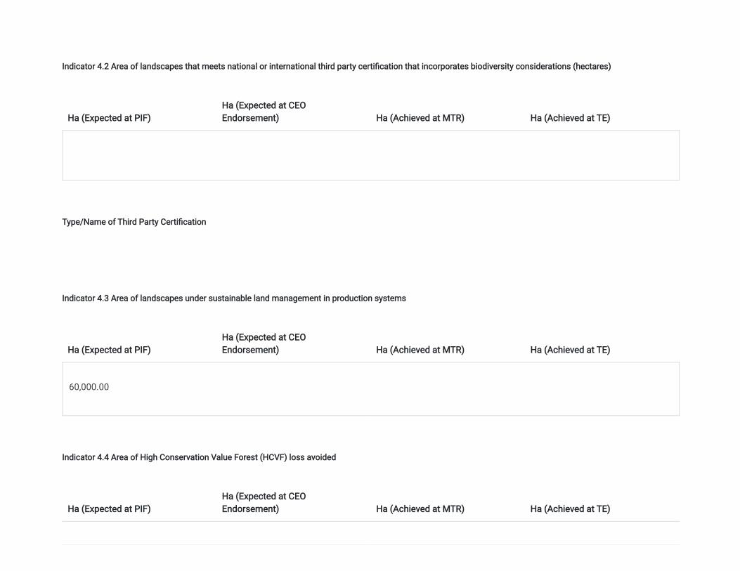
Indicator 4.2 Area of landscapes that meets national or international third party certi�cation that incorporates biodiversity considerations (hectares)
Ha (Expected at PIF)Ha (Expected at CEOEndorsement) Ha (Achieved at MTR) Ha (Achieved at TE)
Type/Name of Third Party Certi�cation
Indicator 4.3 Area of landscapes under sustainable land management in production systems
Ha (Expected at PIF)Ha (Expected at CEOEndorsement) Ha (Achieved at MTR) Ha (Achieved at TE)
60,000.00
Indicator 4.4 Area of High Conservation Value Forest (HCVF) loss avoided
Ha (Expected at PIF)Ha (Expected at CEOEndorsement) Ha (Achieved at MTR) Ha (Achieved at TE)
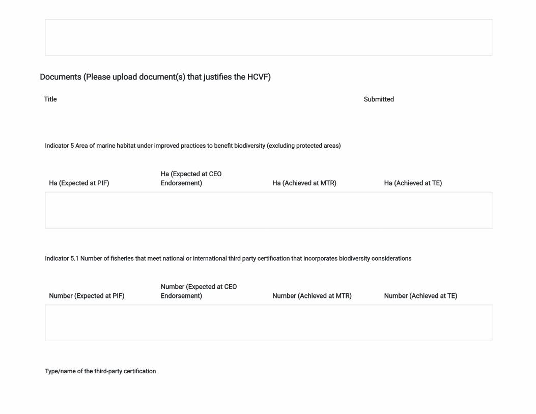
Documents (Please upload document(s) that justi�es the HCVF)
Title Submitted
Indicator 5 Area of marine habitat under improved practices to bene�t biodiversity (excluding protected areas)
Ha (Expected at PIF)Ha (Expected at CEOEndorsement) Ha (Achieved at MTR) Ha (Achieved at TE)
Indicator 5.1 Number of �sheries that meet national or international third party certi�cation that incorporates biodiversity considerations
Number (Expected at PIF)Number (Expected at CEOEndorsement) Number (Achieved at MTR) Number (Achieved at TE)
Type/name of the third-party certi�cation
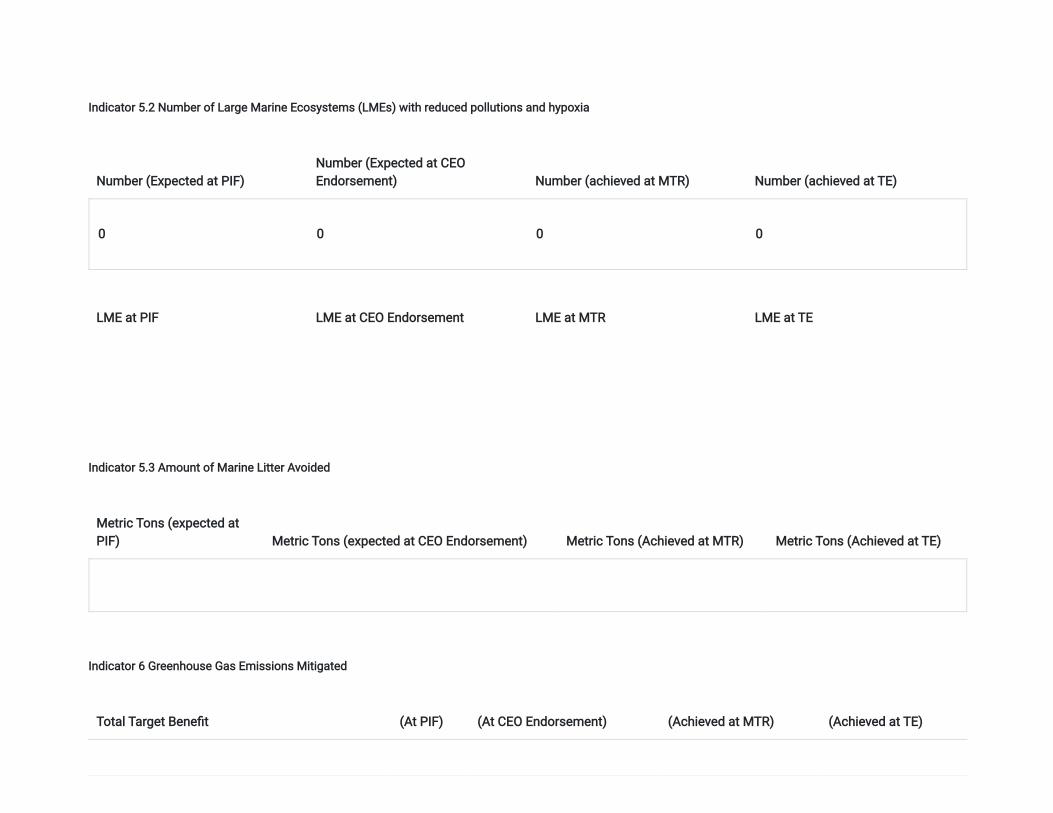
Indicator 5.2 Number of Large Marine Ecosystems (LMEs) with reduced pollutions and hypoxia
Number (Expected at PIF)Number (Expected at CEOEndorsement) Number (achieved at MTR) Number (achieved at TE)
0 0 0 0
LME at PIF LME at CEO Endorsement LME at MTR LME at TE
Indicator 5.3 Amount of Marine Litter Avoided
Metric Tons (expected atPIF) Metric Tons (expected at CEO Endorsement) Metric Tons (Achieved at MTR) Metric Tons (Achieved at TE)
Indicator 6 Greenhouse Gas Emissions Mitigated
Total Target Bene�t (At PIF) (At CEO Endorsement) (Achieved at MTR) (Achieved at TE)
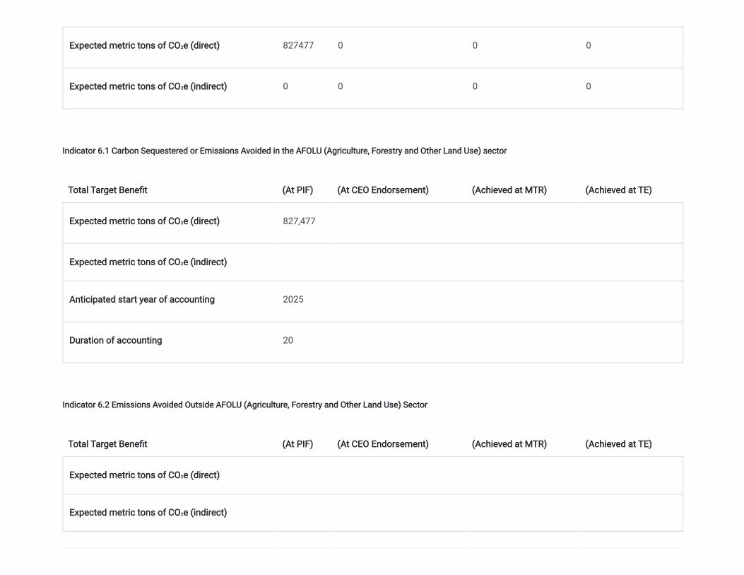
Expected metric tons of CO₂e (direct) 827477 0 0 0
Expected metric tons of CO₂e (indirect) 0 0 0 0
Indicator 6.1 Carbon Sequestered or Emissions Avoided in the AFOLU (Agriculture, Forestry and Other Land Use) sector
Total Target Bene�t (At PIF) (At CEO Endorsement) (Achieved at MTR) (Achieved at TE)
Expected metric tons of CO₂e (direct) 827,477
Expected metric tons of CO₂e (indirect)
Anticipated start year of accounting 2025
Duration of accounting 20
Indicator 6.2 Emissions Avoided Outside AFOLU (Agriculture, Forestry and Other Land Use) Sector
Total Target Bene�t (At PIF) (At CEO Endorsement) (Achieved at MTR) (Achieved at TE)
Expected metric tons of CO₂e (direct)
Expected metric tons of CO₂e (indirect)
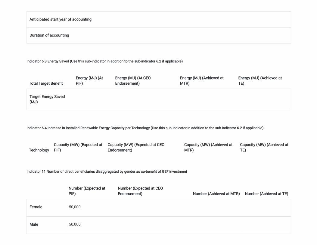
Anticipated start year of accounting
Duration of accounting
Indicator 6.3 Energy Saved (Use this sub-indicator in addition to the sub-indicator 6.2 if applicable)
Total Target Bene�tEnergy (MJ) (AtPIF)
Energy (MJ) (At CEOEndorsement)
Energy (MJ) (Achieved atMTR)
Energy (MJ) (Achieved atTE)
Target Energy Saved(MJ)
Indicator 6.4 Increase in Installed Renewable Energy Capacity per Technology (Use this sub-indicator in addition to the sub-indicator 6.2 if applicable)
TechnologyCapacity (MW) (Expected atPIF)
Capacity (MW) (Expected at CEOEndorsement)
Capacity (MW) (Achieved atMTR)
Capacity (MW) (Achieved atTE)
Indicator 11 Number of direct bene�ciaries disaggregated by gender as co-bene�t of GEF investment
Number (Expected atPIF)
Number (Expected at CEOEndorsement) Number (Achieved at MTR) Number (Achieved at TE)
Female 50,000
Male 50,000

Total 100000 0 0 0
Part II. Project Justi�cation
1a. Project Description
1a. Project Description. Brie�y describe: 1.1) The global environmental and/or adaptation problems, root causes and barriers that need to be addressed (systems description);
The Kingdom of Eswatini is a small land locked country of 1.15 million people, of which 53% are women. The country covers a total land mass of 17,364square kilometers bordering South Africa and Mozambique. It is divided into four administrative regions, namely: Hhohho in the north, Manzini in the center ofthe country, Shiselweni in the south and Lubombo in the east. Politically, the country is headed by a constitutional monarchy, assisted by a parliamentarysystem responsible to the King. At the sub-national level, the country is administered through a traditional leadership system which is represented by 55tinkundla (equivalent of counties) and 385 chiefdoms (equivalent of sub-counties), which exercise authority over land and other resources on behalf of themonarch.
Eswatini's economy is predominantly agriculture-based with 77% of the population residing in rural areas where they derive their livelihoods through rain-fedsubsistence agriculture. Poverty levels are estimated at 63% with high income inequality. Unemployment stood at 47.1% for the overall population in 2013 withthe majority of the unemployed being women and the youth. Poverty in rural Eswatini is closely correlated to the extent of food insecurity, which is caused byunsustainable farming techniques, low rainfall and limited access to good arable land.
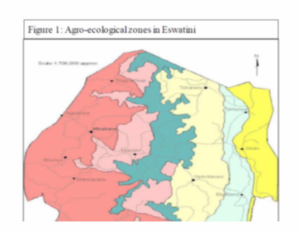
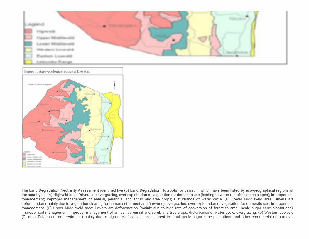
The country is divided into four distinct agro-ecological zones, based on elevation, landforms, geology, soils, and vegetation, as shown in Figure 1. Each of thethree regions, the Highveld, the Middle-veld, and the Lowveld, occupy about one-third of the country, whilst the Lubombo Range occupies less than one-tenthof the country. The Highveld is characterized by a humid to a near temperate climate where a variety of crops are grown, and higher yields are usually obtaineddue to the high rainfall and moderate temperatures. Maize is the dominant crop and other crops grown include sweet potato and a variety of legumes. TheMiddle-veld climate is subtropical and is suited for growing of maize, beans, and cowpeas, groundnuts, pineapples, and sweet potato. Drought tolerant cropssuch as cassava, sorghum and cotton are grown in the dry Middle-veld. The Lowveld has a semi-arid to arid climate and very prone to drought and cropsgrown here include cotton, citrus, while sugarcane is grown as an industrial crop under irrigation. The Lubombo plateau has a climate like that of the Middle-veld. The main crops grown include maize, grain legumes, sorghum, sweet potato, cassava and cotton. Livestock production is major agricultural activity andcattle are the prime investment asset in much of Eswatini with households deriving both income and food from their free-range animals .
There are four ecosystems in Eswatini: (1) montane grasslands, (2) savanna-woodland mosaic, (3) forests and (4) aquatic systems. The savanna-woodlandmosaic is the dominant ecosystem, covering the central and lower parts, followed by the montane grasslands (mainly in the Highveld); together, both theseecosystems comprise 94% of the country. Considering its small size, Eswatini is very rich in biodiversity, and species composition varies greatly betweenecosystems. To date, over 820 species of vertebrates and 2,414 species of plants have been recorded, including 18 endemic species of plants and oneendemic vertebrate .
[1] Mncube, T.L., Mloza-Banda, H.R., Kibirage, D., Khumalo, M.M., Mukambwe, W.O. & Dlamini, B.P. 2017. Composition and management of weed �ora insmallholder farmers’ �elds in Swaziland. African Journal of Rural Development.
[2] GFA Consulting Group. 2010. Strategic Environmental Assessment of the NAS.
[1]
[2]
The Land Degradation Neutrality Assessment identi�ed �ve (5) Land Degradation Hotspots for Eswatini, which have been listed by eco-geographical regions ofthe country as: (A) Highveld area: Drivers are overgrazing, over exploitation of vegetation for domestic use (leading to water run-off in steep slopes); Improper soilmanagement; Improper management of annual, perennial and scrub and tree crops; Disturbance of water cycle. (B) Lower Middleveld area: Drivers aredeforestation (mainly due to vegetation clearing for human settlement and �rewood); overgrazing; over exploitation of vegetation for domestic use; Improper soilmanagement. (C) Upper Middleveld area: Drivers are deforestation (mainly due to high rate of conversion of forest to small scale sugar cane plantations);improper soil management; improper management of annual, perennial and scrub and tree crops; disturbance of water cycle; overgrazing. (D) Western Lowveld(D) area: Drivers are deforestation (mainly due to high rate of conversion of forest to small scale sugar cane plantations and other commercial crops); over
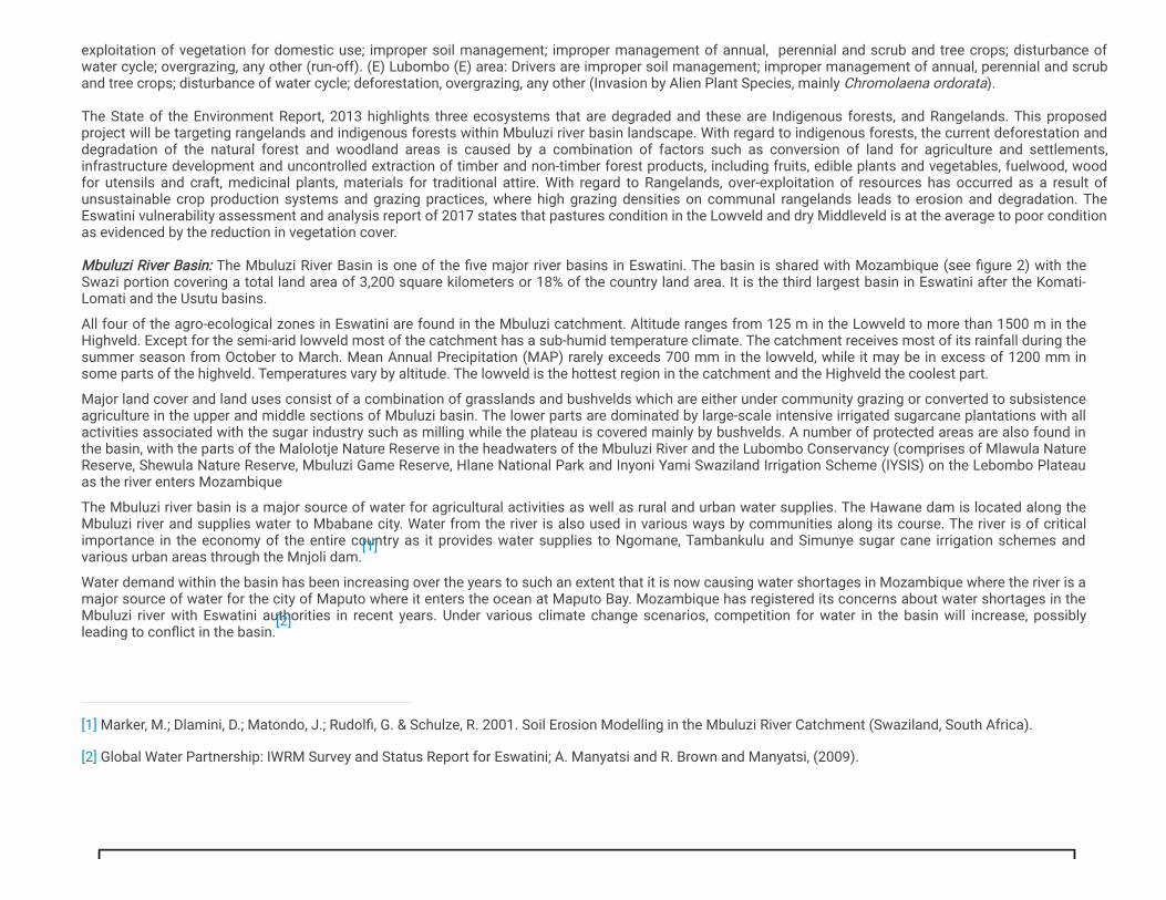
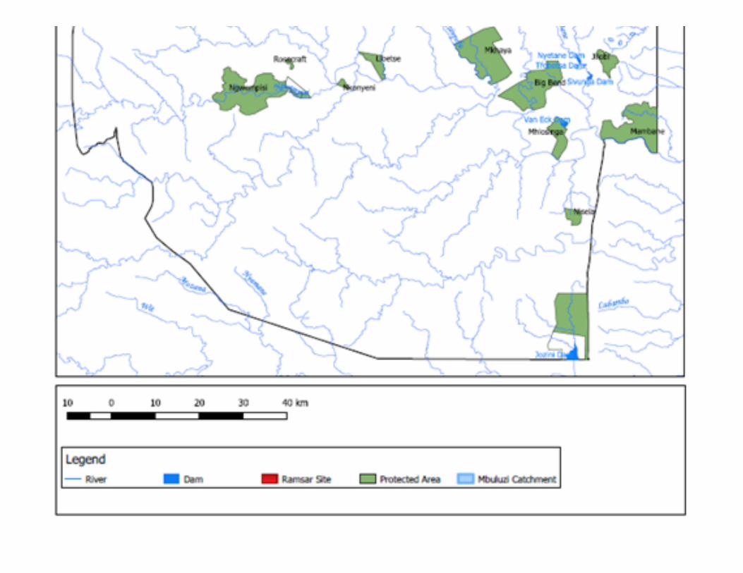
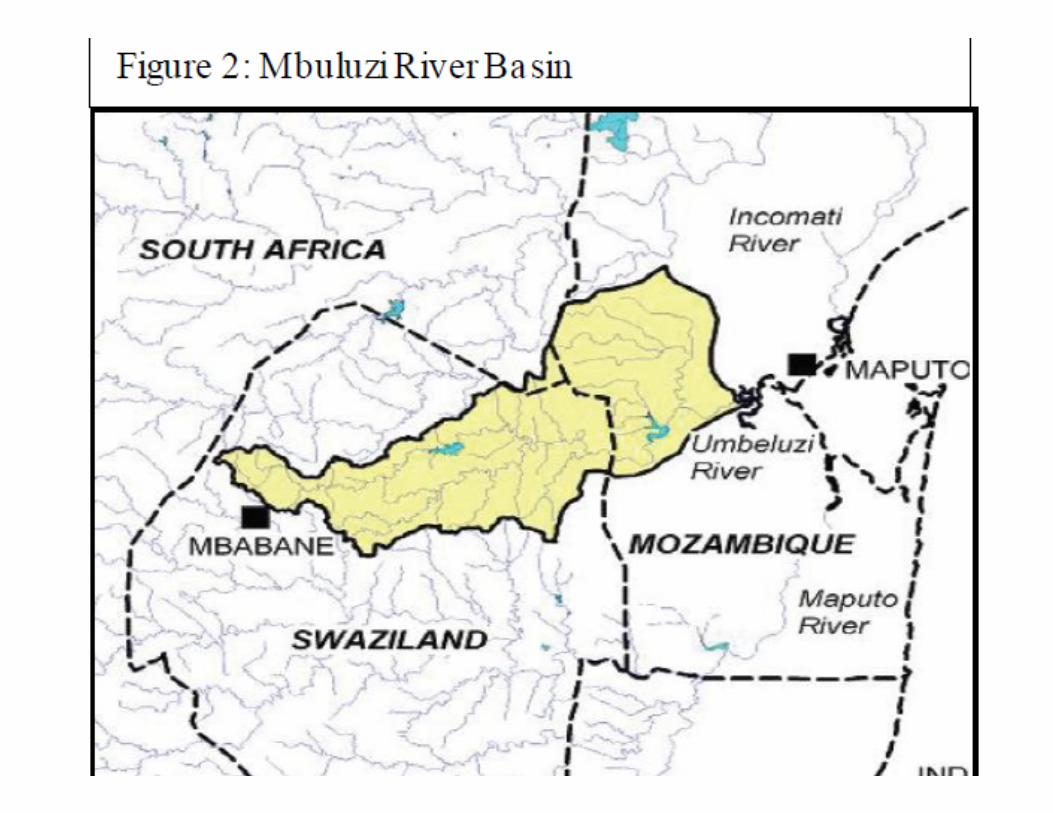
exploitation of vegetation for domestic use; improper soil management; improper management of annual, perennial and scrub and tree crops; disturbance ofwater cycle; overgrazing, any other (run-off). (E) Lubombo (E) area: Drivers are improper soil management; improper management of annual, perennial and scruband tree crops; disturbance of water cycle; deforestation, overgrazing, any other (Invasion by Alien Plant Species, mainly Chromolaena ordorata). The State of the Environment Report, 2013 highlights three ecosystems that are degraded and these are Indigenous forests, and Rangelands. This proposedproject will be targeting rangelands and indigenous forests within Mbuluzi river basin landscape. With regard to indigenous forests, the current deforestation anddegradation of the natural forest and woodland areas is caused by a combination of factors such as conversion of land for agriculture and settlements,infrastructure development and uncontrolled extraction of timber and non-timber forest products, including fruits, edible plants and vegetables, fuelwood, woodfor utensils and craft, medicinal plants, materials for traditional attire. With regard to Rangelands, over-exploitation of resources has occurred as a result ofunsustainable crop production systems and grazing practices, where high grazing densities on communal rangelands leads to erosion and degradation. TheEswatini vulnerability assessment and analysis report of 2017 states that pastures condition in the Lowveld and dry Middleveld is at the average to poor conditionas evidenced by the reduction in vegetation cover. Mbuluzi River Basin: The Mbuluzi River Basin is one of the �ve major river basins in Eswatini. The basin is shared with Mozambique (see �gure 2) with theSwazi portion covering a total land area of 3,200 square kilometers or 18% of the country land area. It is the third largest basin in Eswatini after the Komati-Lomati and the Usutu basins.
All four of the agro-ecological zones in Eswatini are found in the Mbuluzi catchment. Altitude ranges from 125 m in the Lowveld to more than 1500 m in theHighveld. Except for the semi-arid lowveld most of the catchment has a sub-humid temperature climate. The catchment receives most of its rainfall during thesummer season from October to March. Mean Annual Precipitation (MAP) rarely exceeds 700 mm in the lowveld, while it may be in excess of 1200 mm insome parts of the highveld. Temperatures vary by altitude. The lowveld is the hottest region in the catchment and the Highveld the coolest part.
Major land cover and land uses consist of a combination of grasslands and bushvelds which are either under community grazing or converted to subsistenceagriculture in the upper and middle sections of Mbuluzi basin. The lower parts are dominated by large-scale intensive irrigated sugarcane plantations with allactivities associated with the sugar industry such as milling while the plateau is covered mainly by bushvelds. A number of protected areas are also found inthe basin, with the parts of the Malolotje Nature Reserve in the headwaters of the Mbuluzi River and the Lubombo Conservancy (comprises of Mlawula NatureReserve, Shewula Nature Reserve, Mbuluzi Game Reserve, Hlane National Park and Inyoni Yami Swaziland Irrigation Scheme (IYSIS) on the Lebombo Plateauas the river enters Mozambique
The Mbuluzi river basin is a major source of water for agricultural activities as well as rural and urban water supplies. The Hawane dam is located along theMbuluzi river and supplies water to Mbabane city. Water from the river is also used in various ways by communities along its course. The river is of criticalimportance in the economy of the entire country as it provides water supplies to Ngomane, Tambankulu and Simunye sugar cane irrigation schemes andvarious urban areas through the Mnjoli dam.
Water demand within the basin has been increasing over the years to such an extent that it is now causing water shortages in Mozambique where the river is amajor source of water for the city of Maputo where it enters the ocean at Maputo Bay. Mozambique has registered its concerns about water shortages in theMbuluzi river with Eswatini authorities in recent years. Under various climate change scenarios, competition for water in the basin will increase, possiblyleading to con�ict in the basin.
[1] Marker, M.; Dlamini, D.; Matondo, J.; Rudol�, G. & Schulze, R. 2001. Soil Erosion Modelling in the Mbuluzi River Catchment (Swaziland, South Africa).
[2] Global Water Partnership: IWRM Survey and Status Report for Eswatini; A. Manyatsi and R. Brown and Manyatsi, (2009).
[1]
[2]
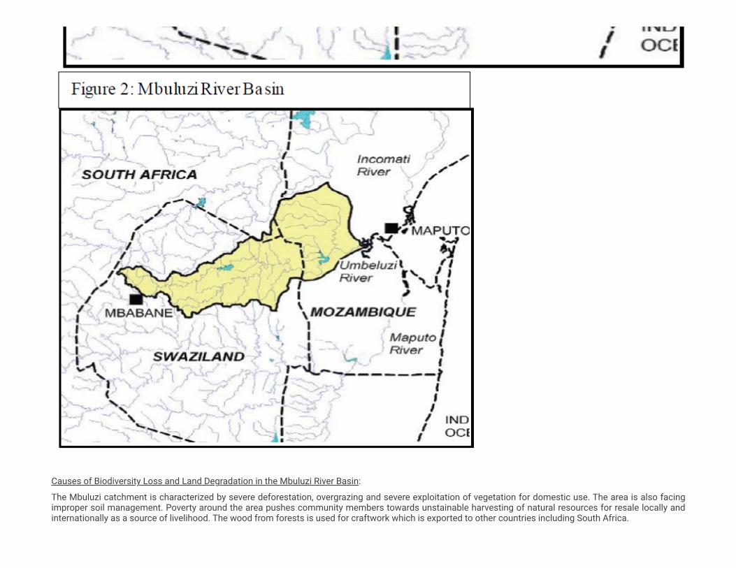
Causes of Biodiversity Loss and Land Degradation in the Mbuluzi River Basin:
The Mbuluzi catchment is characterized by severe deforestation, overgrazing and severe exploitation of vegetation for domestic use. The area is also facingimproper soil management. Poverty around the area pushes community members towards unstainable harvesting of natural resources for resale locally andinternationally as a source of livelihood. The wood from forests is used for craftwork which is exported to other countries including South Africa.

Overstocking is a common problem in the Mbuluzi catchment area. This is mainly due to the country’s traditional norm which values livestock as a measure ofwealth. This then leads to high numbers of livestock per homestead which exceeds the carrying capacity of grazing lands. Furthermore, the country’srangelands have witnessed bush encroachment which has made the conditions conducive for shrubs therefore reducing the country’s grazing capacity.
The source of the Mbuluzi river is characterized with the existence of special grasses that are used for handicrafts and other domestic uses including makingmats, house thatching but these grasses are over harvested annually.
Soil erosion is widespread in Eswatini and is very severe on small holder farms and communal grazing areas. The Middle veld of Eswatini is the most affected.Results indicate that soil erosion is widespread in the basin. Over 55% of the basin is affected by moderate erosion where estate farming and controlledgrazing are the main land uses. Very severe erosion takes place over almost 12% of the area where communal grazing and small holder farms arepredominant . The erosion upstream of drainage basins affects economic activities downstream especially irrigated agriculture because it contributessediment yield hence reducing the lifespan of dams and reservoirs. In situ damage caused by soil erosion includes the loss of crop production media,reduction of soil productivity as a result of lowered soil fertility, which may indirectly be perceived through decreased harvests. On the other hand, the productsof soil erosion, viz. sediments, have a bearing on water quality in a river network.
The importance of Trans-Frontier Conservation Areas (TFCAs) for collaboration is increasingly recognized and supported. This is an international agreementsigned by (Eswatini, South Africa & Mozambique) the respective countries to facilitate co-operation for conservation and tourism development within these areas.There are four core TFCAs involving Eswatini namely, Malolotja-Songimvelo; Lubombo Conservancy-Goba; Ndumu-Tembe-Futhi-Mambane; Jozini-Pongola. Itshould be noted that Malolotja-Songimvelo TFCA is located within Mbuluzi river basin. The project will work in 3 protected areas in these (Malolotja NatureReserve, Mlawula nature reserve and Hawane reserve all within the Malolotja-Songimvelo TFCA. The biodiversity survey conducted during the SNPAS (2016/17)base line highlights an increase in threatened species in this TFCA. Under this project, a protected Area network (PAN) Conservation Strategy for the Mbuluzilandscape developed and implemented and this will contribute to the efforts of the TFCA.
Policy and institutional set-up for management of land and water resources in the Mbuluzi River Basin:
The land use tenure system of the Kingdom of Eswatini is divided into three categories namely Swazi Nation Land (SNL), Tittle Deed and Crown land. SNL island held by the chiefs in trust for the King and Tittle Deed Land is privately owned land and Crown Land is held by the King in trust for the Swazi Nation. Inmost cases the SNL is where communities undertake their activities communally while Title Deed Land is mostly owned by the private sector and privateowner for speci�c purposes. The country’s land use is mainly small-scale subsistence crop agriculture, large scale commercial agriculture, extensivecommunal grazing, ranching, plantation forestry, parks: wildlife management, residential, industry, recreation and water reservoirs. Land management planningbegins at community-level through the Chiefdom Development Planning process. This process is led by community leaders (Chiefs) which work closely withthe Ministry of Tinkhundla Administration and Development.
The Ministry of Tinkhundla Administration and Development assists communities in the development of Chiefdom Development Plans. The ChiefdomDevelopment Plan is a local planning tool for communities that highlights their medium to long-term developmental priorities, document and undertakemapping of boundaries, infrastructure, and land resources for their developmental priorities to promote sustainable development in rural communities. This isa nationally adopted approach through the National Decentralization Policy and Strategy of 2002. Within the Chiefdom Plans, the environment sector iscustomized to include Community-Based Natural Resource Management (CBNRM) hence calling it the Chiefdom Sustainable Development Plans.
The Ministry of Tourism and Environmental Affairs (MTEA) promotes and supports the tourism industry and wildlife conservation within an environmentalframework that enhances amenities, conserves culture, sustains forest management, embraces meteorology and addresses climate change challenges tocontribute towards sustainable socio-economic development. Under MTEA, there is a Forestry Department which provide an oversight role, direction andguidance to forest development and management sector.
The Eswatini National Trust Commission (ENTC) is the parastatal organization responsible for the conservation of the country’s cultural and natural heritage.The Ministry of Natural Resources and Energy’s mission is to ensure sustainable development, use and management of natural resources (land, minerals,water and energy) and provides surveying, mapping, land and real rights registration and valuation services to the public and private sector in a transparentmanner. The obligation of the Ministry of Agriculture (MoA) is to ensure household food security and increased sustainable agricultural productivity throughdiversi�cation and enhancement of commercial agricultural activities. The Land Use and Development Department of the MoA is responsible for promotingrational land use and the development of agricultural land and water resources, particularly on SNL.
[1]
Big Game Parks (BGP) is a private non-pro�t Trust which manages three protected areas in Swaziland. BGP answers to the Head of State and performs itsmandate through the King’s O�ce.
Long-term Solution and Barriers:
The long-term solution is to facilitate a transformative shift from unsustainable to integrated sustainable land and forest management in the Mbuluzi RiverBasin in order to secure habitat for biodiversity conservation, to maintain a �ow of multiple ecosystem services and to support rural development oflivelihoods opportunities.
Barrier 1: Inadequate legal, regulatory and institutional framework for Integrated Natural Resource Management: The overall legal and policy framework for the management of natural resources in Eswatini suffers from insu�ciently clear and consistent policies and regulations that are a barrier to the sustainable useof these resources. The �nancial and human resources earmarked for baseline programmes related to agriculture and forestry in the Mbuluzi River Basin are deployed and managed by sectoral departments/institutions in silos. There is a need to harmonise and coordinate efforts across sectors, and spearhead innovative ways and means of enhancing ecosystem functioning and resilience in an integrated and coordinatedway that balances socio-economic and environmental objectives. Also, mandates for regulation of land and resource use are scattered among different authorities. Coordination among these regulatory authorities is weak. Decision-makers lack solid information on which to base decisions regarding land use allocation and management. Without a proper assessment, monitoring and planning regime for the maintenanceof ecosystem services, managers and users have a di�cult time effectively evaluating and integrating land degradation risks and threats to biodiversity with decision-making. The local authorities lack the capacity to generate, implement and enforce integrated land management plans. Thus in practice, land use allocation and use typically does not take into account the conservation values of forests and woodlands when assigning them to production purposes, nor does it incorporate the value of ecosystem goods and services that are delivered by intact natural areas. Land use planning also suffers from unclear divisions of responsibilities between relevant departments and poorly de�ned implementation and monitoring procedures and mechanisms at national, region, tinkundla and Chiefdom levels. The technical capacities and orientation of land use planning staff also needs to be improved; many government o�cers responsible working with communities on land use planning need training in order to replace a culture of top-down planningwith more participatory approaches.
Barrier 2: Inadequate demonstrated experiences in SLM approaches due to lack of capacity: Eswatini does not have operational examples of integrated sustainable land management at a landscape scale. Without access to know-how, proven through demonstration, government decision-makers and resource usersdo not have the tools and knowledge necessary to decrease land degradation and safeguard biodiversity.There is a critical need to showcase innovative management practices and scale up approaches for the livelihood bene�ts that it will realize.
Forest/Woodland Conservation and Restoration: In order to maximize on the services provided by proper functioning ecosystems, these need to be identi�ed and conserved. Areas where important services can be provided to the bene�t of local communities and where these services have been compromised need tobe identi�ed and restoration processes started.
Rangeland management: There is a need to reduce carrying capacity of cattle in ecologically sensitive areas and promote new husbandry measures such as rotational grazing.
Arable land: Overproduction of land and continually reducing the nutrient content in the soil will lead to reduced productivity of land in the long-term resulting in �nancial and economic losses. Sustainable land management practices increase yield and are in most cases water e�cient compared to other practices. Technologies are also available that can ensure similar or higher yields on the same land than conventionalagriculture methods, with the use of less water and with no negative effects e.g. erosion. Such practices need to be demonstrated to farmers in order to ensure uptake
eed to be demonstrated to farmers in order to ensure uptake.
Barrier 3: Ineffective wildlife protection and management of protected areas on the ground:
Protected area management: Management of protected areas is focused mainly on tourism regulation and anti-poaching activities. The maintenance of intact ecosystems and restoration of degraded ecosystems are seen as secondary activities and only necessary if funds are available. There is a strong need to maintain and restore the integrity of ecosystems in the protected areas and maximize the land use it was allocated.
A critical constraint to effective wildlife protection in Eswatini is the very limited information that exists onbiodiversity and the threats to biodiversity in the country.
This information gap is compounded by and contributes to the absence of a landscape-level approach toprotected areas including nature reserves and community conservancies and the lack of multi-sectoral land and resource use planning, which together greatly reduces the effectiveness of existing efforts to manage wildlife and preserve ecosystem services including critical habitat areas and the corridors between them. Most of the protected areas in the Mbuluzi ecosystem need to have a Protected areas Network strategy and action plan. Management of protected areas, and of the wildlife that resides within them, is furtherconstrained by the lack of management plans and the insu�cient technical capacities and resources of wildlife protection and PA staff. Most of the staff are essentially untrained in PA management, wildlife conservation, community engagement and collaboration and development of sustainable resource use / livelihoods programs, and in many cases, they are physically unable to execute their duties.
At the management level, on the other hand, many posts remain un�lled and key capacities, for example in ecological monitoring, are very weak. The PA units and wildlife conservation staff targeted under this project also suffer from inadequate equipment and infrastructure: in general access to many areas of critical habitat is extremely di�cult as there are few functioning vehicles; guard outposts are very poorly constructed; and �eld work and communications are greatly limited by a lack of radios, telephones, GPS units, binoculars, cameras, compasses, etc. Funding for wildlife protection and PA management is extremely limited and mostly allocated to salaries for rangers. Most of the biodiversity conservation funding in Eswatini over the past decade has come from the international donor community, but even the amount of these funds has been very limited. Finally, cooperation with the tourism sector on PA management and wildlife protection, as well as the generation of revenues / jobs for local communities, has been limited.
Barrier 4: Insu�cient Knowledge and Lessons Learned on INRM and Mainstreaming of Youth and Genderin ILM relevant activities in Eswatini: According to the Eswatini 6 National report to the CBD, the general level of understanding on sustainable utilization of ecosystems, biodiversity and resources is thought to be insu�cient, even though environmental issues receive some coverage in the media and forms part of the agenda in certain fora. In order to ensure that the ILM practices that are tested and showcased in Eswatini is broadly taken up by the population of the country and all bene�t equally from the provision of ecosystem services, it is necessary to mainstream youth and gender issues throughout the application and communication of results. This also applies to sensitize the population in general of the successes and valueof ecosystems and practices applied to restore such services. There is also a need to learn from other countries in the region on how they apply the practices and share Eswatini’s experiences in regional fora. Eswatini should also apply new monitoring tools to track progress on its application of ILM. The 6th Nationalreport to the CBD recommends that there is a need to monitor the current level of awareness on biodiversity in the country and work towards increasing it to the desired level. It further recommends that, to raise awareness, initiatives and institutions that deal with public awareness on environmental issues need to beempowered and capacitated. The curricula of schools and tertiary institutions must be revised to includeenvironmental issues. In addition, there should be clear uni�ed messages at the highest governance levelto instill behavioral change on issues of biodiversity and ecosystem services.
th
[1] Mushala, H.M. 2000. An investigation of the Spatial Distribution of Soil Erosion in the Mbuluzi River Basin of Swaziland. UNISWA Research Journal ofAgriculture Science and Technology.
1.2) THE BASELINE SCENARIO AND ANY ASSOCIATED BASELINE PROJECTS, Eswatini recognizes the challenges and costs of land degradation and biodiversity loss and is working towards improvement of environmental management,ecosystems restoration, water use e�ciency, agricultural production enhancement across the country through various initiatives as described below: The Eswatini national annual vulnerability assessment and analysis report assesses rangelands conditions (species, erosion, visible features, browsing potential).The project Lower Usuthu Smallholder Irrigation (LUSIP-GEF) Sustainable Land Management Project provides resources for the rangeland and livestock baselinedata collection to assist in rehabilitation of rangelands. The Department of Land Use Planning and Development under the Ministry of Agriculture (MoA) develops land use plans and maps for government farms whereit carries out (a) Soil surveys: to generate soil maps and accompanying reports that characterize the various soil types occurring in the survey area. (b) Generateland capability maps: to show different categories of land capability classes from prime arable land through marginal to non-arable land and (c) Develop land useplans: to cover resettlement plans, crops and forestry land suitability plans. Under this prosed project, this department will provide land us plans and maps forcommunal lands that the project will use to develop and implement chiefdom’s development plans. Without GEF intervention, the Department of Land UsePlanning will continue producing land use plans for government farms only and yet the highest levels of land degradation exist in communal lands. Conservation Agriculture (CA) was introduced into Eswatini by the Ministry of Agriculture (MOA) with support from FAO and the Cooperation of the Developmentof Emerging Countries (COSPE) in 2002. It was piloted in two sites i.e. Shewula community in the north-east of the country and Kambhoke community in thesouth. Under this project, climate smart agriculture will be upscaled to all smallholder farms within Mbuluzi landscape. Without GEF intervention, this goodtechnology for reducing land degradation will remain a preserve of the few areas. The Ministry of Agriculture (MoA) is implementing a farm input subsidy programme. This is meant to stimulate sustainable food production. The input subsidyhas a requirement that farmers must produce soil fertility test results for them to get inputs, this has seen the good practice of soil sampling for soil fertilitytesting increase from lows of 3758 in 2013/14 to 23,872 in 2017/18 but only in Government and large private farms. Also, the Government and private farmspromote the natural development of Panicum Maximum (Guinea grass) in the lowveld and in some farms Eragrostis curvula (weeping love grass) planted for haymaking. Under this GEF 7 proposed project, these initiatives will be scaled up to cover communal grazing lands and smallholder poor farmers. The forestry department under the Ministry is currently doing a nationwide tree planting initiative expected to plant a million trees every year. The initiative isestimated at US$500,000 over 3 years for the whole country. The Department is also formulating an Alien Invasive Species Management Strategy which is mainlyfocusing in the Mbuluzi river basin since recently concluded mapping exercise highlighted the basin as a hotspot for Chromoleana odorata as one of the leadingcauses of land degradation in this areas. The forestry department co-�nancing will directly contribute to component 2 of the project. The Department of Forestry annual budget allocation for year 2016-17 stood at US$ 500,000. Only 23% of the costs are allocated to professional services such asforest protection and management, removal of alien plant species across the country. It is estimated that 10% (US$ 50,000) is invested in the Mbuluzi River Basinon an annual basis. Afforestation activities for soil conservation are carried out and the department of forestry provides subtropical and tropical trees grown fromtheir nurseries. Co-�nancing from the Department of Forestry will contribute to both components 1 and 2 with a stronger attention on outputs 2.1.5 on Treeplanting in degraded communal lands and along riverine and 2.1.6 on Capacity building of Community Forest Associations (CFAs). The GEF �nancing will supportthe forestry department in expanding and establishing community nurseries to all chiefdoms and lower levels in the basin and identify and train communitymembers in nursery bed management. Without GEF intervention, tree nursery bed establishments will remain at the national and Tinkhundla levels only.
Peak Timbers is a state-owned company situated around the basin where it has commercial forest plantations. As part of its environmental requirements it has anumber of areas dedicated to conservation. The company carries out sustainable land management practices within the basin estimated at US$ 412,000annually. They also have an incentive scheme for local communities that provides them with livelihood opportunities like piggery, poultry and ranching to reducepressure on natural resources estimated at US$ 450,000 annually. Peak timbers will contribute to the project by providing technical support to communities underoutput 2.1.5 on Tree planting in degraded communal lands and along riverine The Ministry of Tinkhundla Administration and Development is Responsible for planning, implementing inclusive development; and mobilizing resources foreffective service delivery at provincial and community level. Currently helping communities undertake their chiefdom development planning process within andoutside the Mbuluzi catchment. The Ministry also has community development o�cers (5 within the catchment area) that assist with community initiatives. Itinvests and average of $330,000 per year. The Ministry of Tinkhundla Administration and Development co-�nancing will contribute to output 1.1.4 on developmentand implementation of Chiefdom Sustainable Development Plans but will also contribute to component 4 because it is this same ministry that houses the genderand labor and social development affairs department of the kingdom. Under the GEF project, chiefdom development planning process will be technicallysupported to include land degradation interventions and technologies for all the chiefdoms in the Mbuluzi basin. World Vision (WV) is an international NGO working in Eswatini whose objective is to promote community livelihood programmes to relive pressure from relianceon natural resources. Projects and activities include land rehabilitation, donga reclamation, tree planting, community gardens, portable water supply andsanitation. A total of US$20.793 million in annual operating budget was received from donors and a �fth of this goes to Mbuluzi river basin. World Vision co-�nancing will contribute to component 2 on supporting farmers on-farm training activities and food security and component 4 on youth and gender programmesand monitoring and documentation of best practices and lessons leant. The current coverage of WV is in a few Tinkhundla and chiefdoms. With GEF intervention,WV will be able to cover all the farmers in the basin and provide them with technical knowledge. They will assist in formation and training of farmer �led schoolsand demonstration sites. The communities around the Mbuluzi basin are undertaking environmental initiatives under the food for work programme. Their activities include dongarehabilitation, tree planting and grazeland management which has environmental bene�ts. Of note is the Majotini community, the Dvokolwako communities andthe Sihhoye community who have the food for work programme. They have invested about US$200,000 in 2019 and would continue to do so during the lifetime ofthis 8-year programme which ends in 2026 making a total of about USD 1.6 million. Their co-�nancing and participation will contribute to component 2 and 4. The Food and Agricultural Organization’s Eswatini Programme supports the Eswatini government to achieve household food security, increased sustainableagricultural productivity through diversi�cation and enhancement of commercial agricultural activities. Sustainable land Management is promoted in all the FAOprojects, which offers leveraging opportunities for LDN. The total national investment is US$ 2 Million and about 30% (US$600,000) is invested in the upperMbuluzi Basin in form of land management e.g conservation agriculture, soil erosion control and farm inputs NEPAD–CAADP Project “Promotion of Sustainable Feed and Fodder Production and Utilization” worth USD 1.7 million is being implemented in Mbuluzi river basinby the Eswatini Meat Industries Limited, state owned company.Eswatini Meat Industries Limited will work with the project to train livestock farmers on Sustainable Feed and Fodder Production and Utilization. Currently, thissupport is being given to large scale farmers but under the project, it will be extended to small scale livestock farmers including those in communal grazing lands. Eswatini National Trust Commission (ENTC) is a public enterprise responsible for conservation of Eswatini’s Natural and Cultural heritage. Its responsible formanagement of state protected areas and for oversight, supervision and regulation of privately owned protected areas. It has three conservation areas withinMbuluzi river basin namely, Malolotja Nature Reserve, Mlawula nature reserve and Hawane (Ramsar site). The commission invests an average of $322,000annually for staff salaries and maintenance work on park boundaries, routine patrols for these 3 PAs. The staff force comprises of 45 rangers, 1 law enforcemento�cer and 1 Park Warden. With the GEF funding, the staff will be trained and equipped with skills in effective management and monitoring of the protected areas.They will also be trained in effective �re management. Eswatini National Trust Commission (ENTC) co-�nancing will contribute to output 1.1.1 of component 1and all outputs of component 3 on the protected areas.The Ministry of Tourism and Environmental Affairs is responsible for Promotion of environmental sustainability and climate change resilience, while conservingbiodiversity to support livelihoods and economic bene�ciation through tourism. The Ministry invests approximately US$ 230,000 annually on tourism promotion.Has staff members dedicated for the Hhohho region which houses the basin drawing approximately US$ 265,000 annually. The Ministry of Tourism andEnvironmental Affairs co-�nancing will contribute to components 1 and 3 outcomes.
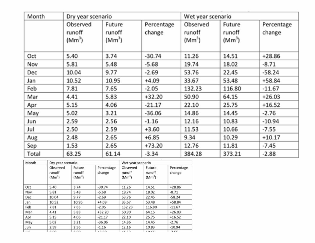
Mbuluzi Game Reserve is a privately owned reserve in Eswatini, within the Lubombo Conservancy, with an annual budget of about US$ 500,000, that supportscommunity development and sustainable livelihood programmes in a few selected communities; which include promotion of conservation agriculture, supply ofportable water, land rehabilitation, tree planting and encouraging sustainable use of natural resources to curb the challenge of poaching, unsustainable harvestingof natural resources. With GEF funding, this programme will be extended to all communities living around the 3 protected areas. Mbuluzi Game Reserve and theLubombo Conservancy co-�nancing will contribute to components 3 on PA management and also will support communities living around these PAs. Work is in progress on the project Strengthening the National Protected Areas System (SNPAS) of Eswatini which aims to strengthen the managementeffectiveness of existing PAs in addressing threats, while expanding the Protected Area (PA) estate to incorporate protection worthy areas that would haveprogressively been degraded as the pressures mount. Veld and forest �res monitoring is done using MODIS data in GIS which is housed at the Eswatini National Trust Commission (ENTC). The MODIS data using ageographic information system (GIS) is used to monitor incidences of veld and forest �res in the country and is useful for planning purposes. The implementationof the �re management strategy has been effective in minimizing occurrences of �re incidences in the country. Among the good initiatives done are trainings ofcommunity �re-brigades where the trainees were given �re�ghting gears. Also, �re belts are built in boundaries and borderlines of forest plantation companiesand some rangeland farms also do them. In the country’s regional �re hot spots, Fire Prevention Association were established to work in collaboration with �reprotection service providers. Forest plantations have adopted cold burning for their terraces and �re belt when the Fire Danger Index (FDI) is below danger zone inthe morning hours or cool evening hours. Mbuluzi landscape is among the �re hotspots in the country. The Ministry of Agriculture is continuing with maintainingand rehabilitating �re breaks in government farms and annually covering and maintains about 90 km (minimum) to 304 km (maximum) depending on machineryavailability. Private ranches and forest plantations do maintain �re breaks which are also grass land biodiversity areas. Currently there is limited capacity innational wildlife protected areas to manage �res. Therefore, under this GEF project, this level of �re management by forest plantations will be extrapolated tonational protected areas. The ministry of agriculture and the department of forestry will provide training to the staff of protected areas in �re management. Eswatini contains one of the largest remaining intact altitudinal gradients of natural ecosystems in Southern Africa and is the only place where this continuum isconcentrated in relatively short distance (of about 200 km). Such an intact gradient holds great signi�cance for biodiversity conservation because it allowsecological processes such as migration and gene �ow and provides the opportunity for population shift as an adaptation to climate change. This considerablebiodiversity is contained in four distinct ecosystems: namely montane grassland, savannah-woodland mosaic, forests and aquatic systems. Despite the globalsigni�cance of its biodiversity, Eswatini’s Protected Area (PA) estate is comprised of very small and vulnerable PAs poorly distributed across ecosystems andformal PAs cover only 4.26% of the country. There is, therefore, a need to expand the PA estate, while strengthening PA management competencies. This in turnwill require the participation of a broad range of stakeholders, including private landholders, local communities and the tourism industry to establish a new StatePA, private and community managed reserves. A landscape approach is needed to strategically place these different PAs in proximity to one another and manageland in immediately adjacent areas to reduce threats to biodiversity and improve connectivity between PA sites. The GEF5-funded project on Strengthening theNational Protected Areas System of Swaziland (SNPAS) was a step in achieving this target. This project sought to strengthen the existing protected area networkand improve the level of protection for biodiversity in reserves. It should be noted though that efforts are underway under the Lubombo Conservancy to establishan additional community conservation area in Mhlumeni. This GEF7 prosed project will add to these efforts by improving management effectiveness of threeprotected areas within the Mbuluzi river basin through landscape approach and by developing a protected area network strategy for the landscape. Thislandscape approach will bring together a broad range of stakeholders, including private landholders, local communities and the tourism industry to develop aprotected area network strategy and implement it in a participatory manner private and community managed reserves. Without this approach, the current littleconservation efforts will remain fragmented with no greater impact. The country is a net sink of GHG emissions. This means that while Eswatini emitted 4,861 Gg CO2e, thecountry’s natural �ora and farmed areas in the land use, land use change and forestry sectors sequestered emissions by 5,863 Gg CO2e, resulting in a net sinkstatus of -1,002 Gg CO2e.The Mbuluzi catchment is expected to be highly impacted by climate change. According to the Climate Change Vulnerability Assessment of the Water Sector andInfrastructure in Eswatini study commissioned under the Adapting National and Transboundary Water Resources project funded by the GEF under the SCCF; thefuture annual runoff is going to be less than the observed by 3.3% (2.11 Mm3) and 2.9% (11.07 Mm3) for the dry and wet year scenario respectively. This meansthat there will be less runoff in the Mbuluzi River basin in both dry and wet year scenarios given A2 climate change scenario. The magnitude of the annual runoff
decrease is similar in terms of percentage, but the magnitude of the change is high in the wet year scenario compared to the dry year scenario. The implicationhere is that there will be less water to store in the catchment given climate change and this will have a negative impact on irrigated agriculture in the country. Thetable below highlights the projected runoff under the two scenarios for the Mbuluzi catchment.
The Eswatini Government through the Komati Downstream Development Project (KDDP) and the Eswatini Water Development enterprise, is investing onprojects to enhance run-off in the Mbuluzi basin, however, there is need for a holistic approach that introduces interventions in the entire catchment toaddress critical drivers of change in runoff including addressing land degradation, grass/plant cover and alien invasive plant species. The project will utilizethe outcomes of the Adapting National and Transboundary water Resources Project to inform any interventions. This will ensure that interventions areresilience to climate change. Lessons learnt on the Lower Usuthu Sustainable Land Management Project under GEF 4, especially with regard to stakeholderengagement, women and youth engagement will be considered in the implementation of activities.
1.3) Proposed alternative scenario with a brief description of expected outcomes and components of the project
The proposed project will promote the adoption and application of integrated sustainable land management and ecosystem restoration technologies tosafeguard the integrity of key ecosystems in the Mbuluzi Catchment in Eswatini. It will focus on the interface between people and the ecosystems on whichthey depend for livelihoods. It will bring together all the people using land resources within the Mbuluzi River Basin to harness and manage their naturalresources more sustainably for optimum bene�ts. The project will ensure that the sustainable management of ecosystem goods and services is fullyintegrated into national and local level development planning. It is expected to yield multi-developmental bene�ts to Eswatini’s Vision 2022 6 pillar:Agriculture and Environmental Sustainability. It will also build upon the strong commitment by the Government of Eswatini to promote productivity throughimproved biomes and productive ecosystems in the Mbuluzi catchment. The project is fully aligned with Eswatini’s National Voluntary Targets on LandDegradation Neutrality. The Targets were de�ned during a LDN Target Setting Process, and seek to avoid, minimize and reverse land degradation; reducecurrent annual loss of forest to cropland; increase forest cover through afforestation and agroforestry programmes; increase land productivity in all thecountry’s four regions through SLM practices; increase the amount of land set aside for nature and wildlife conservation; rehabilitate degraded and abandonedland for crop production. The project will be implemented through the following Components: Component 1: Strengthening Policy, Legislative and Institutional Frameworks for integrated natural resources management in the Mbuluzi river catchmentarea. Output 1.1.1 Institutional and legislative framework for SLM and ecosystem restoration in the Mbuluzi landscape revised and implemented; under this output, theNational Policy and Legislative Framework Strengthened to Enable Effective Land-use planning and Management in the Mbuluzi basin, the national environmentpolicy and legislative framework will be strengthened to enable effective land use planning and management, aligned with existing LDN Targets. Particular focuswill be placed on the formulation of the comprehensive national environment policy, updating the Flora Protection Act of 2000, formulation of Integrated NaturalResources Strategy and Action Plan and the national forest regulations aimed at reducing continued loss of environmental resources. The project will support thedevelopment of Forest Management Regulations in support of the Forest Bill, which was developed in 2016 alongside a legal framework for the management andcontrol of alien invasive species. Eswatini National Trust Commission (ENTC) co-�nancing will contribute to output 1.1.1 of component 1 and all outputs ofcomponent 3 on the protected areas. Under Output 1.1.2; Landscape-scale ecosystems and Land-use assessment conducted for Mbuluzi basin, the state of the environment ecosystems,ecological values, forests, and productive areas that merit rehabilitation and restoration through SLM and ecosystem restoration will be identi�ed. Themapping will focus on the development of forest maps and wildlife maps etc. for the Mbuluzi basin which will be critical in informing future investments onthese ecosystems. In addition, a landscape-scale ecosystem and land use assessment will be conducted speci�cally for the Mbuluzi Basin, identifying thestate of the environment, and ecosystems, ecological values, forests, and productive areas that merit rehabilitation and restoration.
th
Under Output 1.1.3, Development of an Integrated Land Management Strategy and Action Plan for the Mbuluzi river Basin as a framework for effectivemanagement of the basin; a National Sustainable Land Management Strategy and Action Plan for the Mbuluzi Basin will be developed. Under Output 1.1.4 Mbuluzi Basin Chiefdom Sustainable Development Plans Developed and Strengthened to scale up the adoption of SLM and ecosystemrestoration using a participatory approach, the Mbuluzi Basin Chiefdom Sustainable Development Plans will be strengthened and implemented to scale upadoption of SLM and ecosystem restoration using participatory approaches. Tinkhundla Administration and Development Bill of 2015 acknowledges the need forChiefdom Development Planning (CDP) framework. The CDP is a participatory land-use planning process involving the participation of households in a chiefdomand led by a multi-disciplinary team comprising a team of Land Use Planner, Irrigation Engineer, Soil Specialist and Social Geographer and Gender specialists. Theteam compiles an inventory of existing land use, land holdings and related issues; and identi�cation of irrigation schemes, rainfed farming and livestock grazingareas, human settlements, rehabilitation sites and conservation areas. The CDP uses traditional and modern development approaches to equip rural householdswith the capacity to plan for community development. However, there is a limitation on �nancial and staff capacity of the EEA to carryout timely inspections.There are currently budgetary constraints to mainstream CDPs escalation countrywide in the Ministry of Tinkhundla, Development and Administration. Under thisproject, all the chiefdoms will be supported to develop CDPs with SLM and ecosystem restoration approaches and will be implemented. Component 2: Ecosystem restoration through capacity strengthening for Promotion of sustainable land management (SLM) practices The outcome of this component is Reduced Land degradation through capacity strengthening for innovative SLM technologies in productive landscapesacross 60,700 ha of the Mbuluzi River Basin.Under output 2.1.1 Capacity of agriculture extension workers in relevant ministries and departments will be strengthened with SLM technologies to be able todeliver them to sun-national level institutions including local communities at farm level, while under output 2.1.2. Training of trainers at local community levelsincluding chiefdoms will be conducted by the extension workers in output 2.1.1. Under output 2.1.3, Famer Field Schools (FFS) and SLM demonstration siteswill be established for farmer groups and farmer open �eld-days will be organized with technical backstopping by the capacity built in output 2.1.1.Eventually with the knowledge acquired and capacity built from the above outputs, then under output 2.1.4 SLM practices will be implemented in communitiesto improve soil fertility and reduce land degradation, increase farm yield and productivity for improved food security and livelihoods targeting maize andlegumes for crops and livestock at least 15,000 households from 60,000 ha of maize �elds and pasture lands. In addition, Under outputs 2.1.5 Tree planting in degraded communal lands and along riverine areas will be promoted to reduce land degradation and underoutput 2.1.6 Capacity building of Community Forest Associations (CFAs) for community biodiversity conservation will be enhanced for them to continue withthe forestry related activities at community level and consequently, indigenous forest/woodland restoration covering 700 ha in Mbuluzi catchment withlivelihood bene�ts will be undertaken. The Department of Forestry and forest companies like Peak Timbers will also be engaged to work with Chiefdoms in thebasin to re-establish the 700 hectares of indigenous forests and woodlands that had social and cultural signi�cance. This proposed initiative lends itself to theintroduction of farmer-managed regeneration of natural forests. Through this initiative, traditional forestry conservation and management strategies will bemobilized to promote ecosystems restoration and partnerships and collaborative initiatives will be established between forest companies and communities toenhance joint efforts in ecosystem restoration. Co-�nancing from the Department of Forestry will contribute to components 1 and 2 with a stronger attentionon outputs 2.1.5 on Tree planting in degraded communal lands and along riverine and 2.1.6 on Capacity building of Community Forest Associations (CFAs).Peak timbers will contribute to the project by providing technical support to communities under output 2.1.5 on Tree planting in degraded communal landsand along riverine Component 3. Effective management of 3 protected areas within the basin Under this component, a landscape protected Area network (PAN) Conservation Strategy for the Mbuluzi landscape will be developed and implemented.Therefore, Management frameworks and governance models for PAs including Management plans will be revised and aligned with the PAN developed andthese revised Management frameworks and governance models will be implemented. The Capacity of PA Management staff will be supported andstrengthened to implement actions of the PAN and also to implement and enforce provisions and obligations of Management frameworks and governancemodels that will have been developed/revised and aligned to the PAN. The PA staff will also be trained PA Management Effectiveness monitoring and they willbe equipped with monitoring and tracking tools. In order to enhance maintenance of the ecological integrity of the targeted PAs, Protected Area Integrated �remanagement systems, that include participation of local communities, will be developed and implemented. Mbuluzi landscape is among the �re hotspots in
the country and �res are a big threat to the wildlife protected areas therein. The current national efforts on �re management have been concentrated onforests. Therefore, this project will be a game changer in operations of the government by supporting it to expand its �re efforts from the forest estate to PAs.The �re target areas will also include communal lands around protected areas and hence reduce the land degradation therein. This means that efforts toreduce land degradation will be employed in PAs, communal lands and forestry and hence the government target of reducing land degradation in Mbuluzilandscape will be attained. Finally, the PA Management Effectiveness of the Mbuluzi landscape will be monitored and tracked and analyzed. Lesson learntfrom this monitoring system will be upscaled to other PAs nationally and regionally. Eswatini National Trust Commission (ENTC) co-�nancing will contribute toall outputs of component 3 on the protected areas because it is responsible for management of the 3 protected areas that the project will work in. Component 4: Knowledge Management, Gender and Youth mainstreaming and M&EThe 6th National report to the CBD recommends that there is a need to monitor the current level of awareness on biodiversity in the country and work towardsincreasing it to the desired level. It further recommends that, to raise awareness, initiatives and institutions that deal with public awareness on environmentalissues need to be empowered and capacitated. This component will ensure that implementation of Components 1, 2 and 3 is tracked using gender and youthdisaggregated statistics (inter alia the numbers of participants on training courses, numbers of bene�ciaries etc.) with a particular focus on ensuring thatwomen can participate at least on an equal basis to men (e.g. by ensuring training activities are held at times and in venues accessible to women and thedisabled, using training materials which are tailored to their needs and interests). During PPG, a full gender assessment will be undertaken, and a gendermainstreaming plan will be developed. However, working on gender and with youth will be integrated in all components, activities and results. World Vision co-�nancing will contribute to component 2 on supporting farmers on-farm training activities and food security and component 4 on youth and genderprogrammes and monitoring and documentation of best practices and lessons leant.Output 4.1.1 Appropriate systems will be adopted and implemented to monitor the progress and outcomes of the project also ensuring that lessons learnt areproperly documented. This output will focus on developing an interactive monitoring and evaluation system to track implementation of Biodiversity strategyand SLM in the country for purpose of upscaling. It will focus on identifying measures for success and to monitor the necessary governance frameworks foreffective implementation of integrated land management practices. Output 4.1.2 Documentation, publication and dissemination of best practices and lessons learnt: Su�cient information for adaptive management and learningcollated and disseminated with active participation of key stakeholders and project partners: this output will focus on development of the project’s youth andgender strategy which will identify youth and gender sensitive initiatives for the project and recommends effective measures to ensure that the youth andwomen effectively contribute to decision-making in the project at all levels. Lessons learned from the project are shared at national and international levelsincluding exchange visits hosted through south-south triangular cooperation: This output will ensure that best practices and lessons learned are collated,documented and disseminated at chiefdom, landscape and national levels to inform uptake of ILM practices in Eswatini and also to shares the project’sresults to enable others to bene�t (scaling-up achievements post-project). Output 4.1.3: will establish National multi-stakeholder platforms (AFR 100) to champion ILM practices in the country and to ensure that lessons learned fromthe project are shared at national and international levels. The momentum for large-scale restoration has never been stronger, as restoration is increasinglyrecognized as a key strategy to meet climate change and sustainable development goals. Eswatini can bene�t from linking with and sharing global andcontinental initiatives, such as the African Forest Landscape Restoration initiative (AFR100), which was launched at COP21, the Bonn Challenge and theLand Degradation Neutrality target working to accelerate sustainable landscape management. These highlight “No One Can Go It Alone on Restoration”,reinforcing the links across these initiatives is essential to derive maximum value from the considerable technical, human and �nancial resources associatedwith each, while effectively supporting countries in meeting their environment and development objectives. Under Output 4.1.4: A women and youth engagement protocol will be adopted for the project. Project gender and youth strategy implemented, monitored andreported. Theory of changeThe above alternative scenario can be summarized into a Theory of Change (described and graphically presented below):The intervention logic for the project is premised on the understanding that resources will be deployed to implement the interventions (activities) to deliveroutputs which in turn will lead to certain institutional and behavioral changes (outcomes) at the intermediate level provided that the assumptions and certainpre-conditions governing project implementation hold true. At the lowest level of the theory of change, necessary and su�cient interventions will be deployedto deliver outputs. The key assumptions underpinning this level of the theory of change is that there is political will for integrated landscape management,interest and commitment from the local communities. The next level of the theory of change, shows that outputs will lead directly to the delivery of the project
[1]
outcomes, namely: (a) the Government of Eswatini adopts and starts enforcing an updated policy, institutional and legislative framework for SLM andecosystem restoration (b) Reduced Land degradation through capacity strengthening for innovative SLM technologies in productive landscapes across 60,700ha of the Mbuluzi River Basin (c) Capacity strengthening for Effective management of the three nature reserves of (Malolotja Nature Reserve, Mlawula naturereserve and Hawane Dam (Ramsar site) in the basin is undertaken d) Active participation of women and youth in biodiversity conservation and integrated landmanagement will directly lead to an eco-resilient and highly productive Mbuluzi River landscape and effectively managed protected areas providing criticalecosystem goods and services (Project Objective). The underpinning assumption here is that government is fully committed to the conservation andsustainable use of the Mbuluzi river basin. The outputs are deemed as su�cient and adequate to deliver the stated outcomes if the following assumptions aretrue: (i) Stakeholders are willing to cooperate in the project; (ii) Local communities are cooperative; (iii) Local scientists and other professionals are willing topartner with local communities; (iv) Information dissemination pathways are readily available for awareness creation. It is anticipated that delivery of theproject objective will lead to the delivery of the anticipated project impact which is “Food security and natural resource management are improved andcontribute to rural livelihoods, national, regional and global environmental bene�ts”. In order to achieve the stated impact, factors/conditions (impact drivers)are necessary for the project to move from outcomes to delivery of impact: (i) target stakeholders exhibiting continuous commitment to integrated landscapemanagement approaches; (ii) continuous engagement and ultimate ownership/buy-in of project activities by stakeholders; and (iii) project partnerships andpersonnel with key institutions/policy champions to drive political will necessary for policy change are stable.
[1] The Bonn Challenge is a global effort to restore 150 million hectares of the world’s deforested and degraded land by 2020 and 350 million hectares by 2030. Itis an implementation vehicle for national priorities such as water and food security and rural development while contributing to the achievement of internationalCC, BD and LD commitments. Underlying the Bonn Challenge is the forest landscape restoration approach, which aims to restore ecological integrity at the sametime as improving human well-being through multifunctional landscapes.

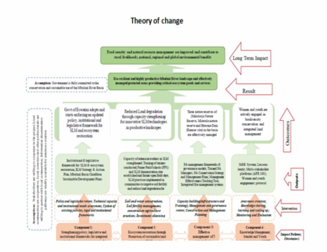
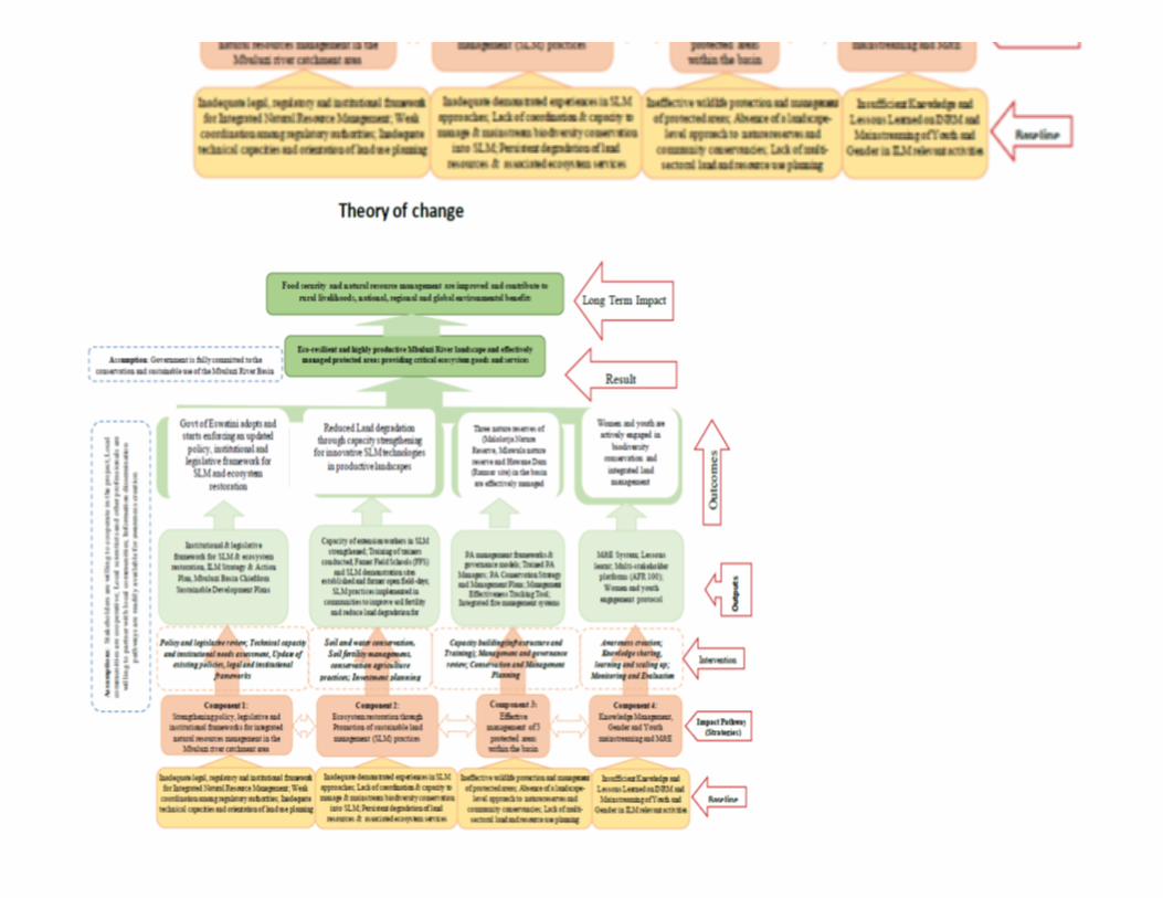
1.4) alignment with GEF focal area; The proposed project is designed to contribute to the GEF goals of land degradation and biodiversity focal areas.The project will aim at improving agro-ecosystem services and sustaining rural livelihoods through sustainable land management (LD 1-1), by bringingtogether local, sub-national and national stakeholders to jointly plan for and implement SLM measures, and in reducing competing land uses and increasingthe resilience in landscapes and their users (LD 1-4) by pooling resources for SLM and thus establishing a coordinated scheme for programming to attainintegrated sustainable land management in Mbuluzi River basin landscape. The project intervention strategy contributes to achieving the LDN targets set by the government of Eswatini for 2030, particularly target 2, rehabilitate 600,000hectares of degraded land to functionality by 2030. It is equally well-aligned to the LDN intervention strategies to achieve SDG 15.3 set by the parties to theUNCCD, such as a) rationalizing engagement with partners, overcoming fragmentation and systematically tapping into increasing �nance opportunities; b)designing and implementing bold LDN transformative projects that deliver multiple bene�ts; and c) tracking progress towards achieving the LDN targets. Theproject will be doing so by facilitating participatory land use planning and by contributing to resolve issues relating to competing land uses, while supportingsmallholders’ livelihoods; and by developing and strengthening capacities to sustainably continue these approaches to maintain functional landscapesproviding ecosystem services for all its users. Beyond the targeted focal areas under land degradation, the project will have important additional environmental co-bene�ts. In applying sustainable landmanagement approaches, the proposed project will contribute to the GEF biodiversity focal area strategy and the synergetic implementation of multipleobjectives and in particular SDG 15.3. Under component 3, the project will deliver global environmental bene�ts through improved management of 3 protected areas (Malolotja Nature Reserve,Mlawula nature reserve and Hawane Dam (Ramsar site) leading to species conservation in the basin. Hence making the project aligned with BD2.7. Inaddition, global environmental bene�ts will extend beyond these 3 Protected Areas, as efforts to scale up biodiversity conservation in Mbuluzi river landscapewill be attained through component 2; outputs 2.1.5 in which tree planting in degraded communal lands and along riverine areas will be promoted to reduceland degradation and also under output 2.1.6 in which Capacity building of Community Forest Associations (CFAs) for community biodiversity conservationwill be enhanced for them to continue with the forestry related activities at community level and consequently, indigenous forest/woodland restorationcovering 700 ha in Mbuluzi catchment with livelihood bene�ts will be undertaken. Reforestation of degraded communal lands and along riverine areas willcause biodiversity enrichment and the return of species in these areas.
Embedding activities of this proposed GEF project into the government frameworks and planning process including the Chiefdom Sustainable DevelopmentPlans, will strengthen its impact on fostering the resilience of smallholders, livelihoods, and against the adverse effects of climate change. The combinedlandscape and livelihoods approach including tree planting of degraded lands, through the local processes, will be used to promote alternative andsustainable energy sources and will also advance local level knowledge that will broaden the bene�ciaries’ adaptive capacities. 1.5) incremental/additional cost reasoning and expected contributions from the baseline, the GEFTF, LDCF, SCCF, and co-�nancing; Eswatini has completed the process of setting LDN Targets, through a participatory process that involved multiple stakeholders. In full alignment with theNational Targets, the project seeks to halt and reverse land degradation and promote the adoption of SLM in the Mbuluzi River Basin. Investing in restoration of ecosystems and the establishment of sustainable agricultural production systems are all cost effective measures as they contributeto the reduction in costs of reversing the impacts of land degradation and biodiversity loss. Land degradation and habitat loss all result in extensivedegradation of productive lands which could generate "environmental refugees" as communities move to �nd better lands. Such movements usually result incon�ict which can be costly in terms of losses of human lives and productive resources and assets.
Scenario without GEF:Without GEF-support, emphasis would be on supporting agricultural development and smallholders’ livelihoods, without an integrated landscape managementapproach, targeting improved ecosystem services as the underlying foundation for resource users’ livelihoods. Bene�ciaries would mainly derive localenvironmental bene�ts from local planning and co-management of natural resources, without realizing global environmental bene�ts through integratedplanning, policy and legal reforms and incorporation of community-led, district and national level natural resource management approaches. However, the GEFproject will not have a strong focus on governance reform, but the focus will be on bottom-up work and coalition building and bringing about solutions andimprovements at the local level, empowering communities and chiefdoms to address these issues. Where necessary, national level regulations and theirchanges will become part of the small sub-component on institutional work under component 1. Without GEF support, a global connection to best practiceswould be missing: globally used knowledge management on how to achieve the LDN targets and M&E tools for the land degradation would not be integratedinto the national strategies and local stakeholders would not be knowledgeable about the underlying concepts and how to meaningfully contribute their ownexpertise in providing data to these tools. Scenario with GEF:The GEF �nancing will facilitate the integration of initiatives on combating land degradation - extending integrated planning/management of natural resourcesto the landscape level - focusing on strategies and activities that generate bene�ts for the global environment contributing to the productive landscape andensuring food security for the targeted bene�ciaries and achievement of LDN. GEF resources will be used for connecting critical pieces of knowledge andinnovation globally to local application through SLM coalitions including Multi-stakeholder platforms (AFR 100) to champion INRM practices in the country,while in�uencing the enabling policy, legal and institutional framework to integrate lessons learned around local engagement in landscape managementapproaches. Proposed investment will be designed to strongly contribute to the national LDN goals, target the ecosystem restoration of the basin andensuring effective management of the 3 protected areas within the basin, while contributing to local resilience opportunities through improved food securityand livelihoods diversi�cation. The proposed alternative is based on a holistic and integrated landscapes and livelihoods approach with speci�c interventions.The high-level decision to adopt landscape management therefore presents tangible opportunities for the solutions to the landscape degradation problem tobe devised at the most appropriate level and for the speci�c environmental degradation problems to be well-understood before solutions are crafted. 1.6) global environmental bene�ts (GEFTF) and/or adaptation bene�ts (LDCF/SCCF); and The project is designed to support the country’s transformational agenda to achieve greater environmental and economic security. It will primarily supportboth government, NGOs and community-led efforts in sustainable land and biodiversity conservation and catalyze associated behavioural change within theMbuluzi River basin landscape, while raising capacities to promote long-term climate resilient development and to achieve biodiversity co-bene�ts throughapplied and integrated SLM approaches. It will take a landscape management approach, informed by lessons learned on the interlinked challenges of poverty,ecosystem services, climate change, biodiversity, institutional performance, governance, and community-based engagement and management. GEF supportwill be fully be blended with government and NGO resources to fund locally driven planning and replicable, innovative actions, that will lead to the attainmentof the following global environmental bene�ts:(a) the project will have impact over 95,700 hectares including:• 700 ha of forest restoration.
• 60,000 ha of restored agricultural land through SLM practices,
• 35,000 ha of terrestrial protected areas under improved management for conservation and sustainable use
(b) 100,000 bene�ciaries (50% ♂ and 50% ♀) are expected to bene�t from project activities The results of the proposed project will pave the way for similar improvements nation-wide leading to the achievement of LDN voluntary targets and improved�ow of ecosystems goods and services. The project will contribute to the following National Voluntary LDN Targets: (i) Reduce current annual loss of forest tocropland of 9.1 km to 4 km by 2022 and achieve 0 km forest loss by 2030; (ii) Increase forest cover through Afforestation/Agroforestry in existing forest;areas of shrubs/grassland; croplands by 465,290 ha; (iii) Improve by 50% productivity and SOC stocks in cropland and grasslands by 2030 as compared to2015; and (iv) Rehabilitate 115,000 ha of degraded and abandoned land for crop production by 2030.
2 2 2
More speci�cally, the project will lead to the development of chiefdom land use plans covering the basin. It will also lead to improved land managementintroducing and promoting the use of SLM and SFM practices. At least 100,000 people will bene�t directly from the project. Among the bene�ciaries, at leasthalf will be women. The project will also assist the country in combating land degradation and moving towards LDN. A knowledge management system towidely disseminate the lessons arising from the pilot tests will be carried out. The project will also bring about the protection of valuable ecological resourcessuch as arable land through the enforcement of land use plans, buffer zones, and riparian strips. This, in turn, will lead to the restoration and renewal of thenatural habitats of a number of plant and animal species and valuable ecosystem services. In addition, land productivity, in various forms, will be enhanced. Asa result, globally signi�cant biodiversity will be conserved, valuable ecosystem services will be safeguarded and land under sustainable agricultural productionwill be increased. The project will put in place measures to strengthen the enforcement of wildlife protection laws, with the main priority being the protection of globallysigni�cant and threatened species against poaching and illegal harvesting. This outcome of the project is expected to produce tangible conservation bene�tsfor endemic plant and animal species which are critically endangered such as Warburgia salutaris, Encephalartos striatus, Aloe albida, Protea comptonii andGardenia thunbergia that are under threat from poaching and overexploitation. The project will support Local communities to bene�t from enhanced servicesprovided by maintaining and enhancing the integrity of ecosystems. In addition, the project will support activities that will lead to improved management of atotal of 34,500 ha of protected areas. Improved management of these protected areas will help to maintain globally signi�cant biodiversity and ecosystemgoods and services. The project also will contribute to Eswatini’s achievement of the CBD 2020 Aichi Targets mainly through Target 12, as the project contributes to reducing theloss of known threatened species, and possibly preventing their extinction across the landscapes; and will also contribute to other Aichi targets as follows:Target 4, to the extent that the project will engage governments, business and various other stakeholders to manage biodiversity within safe ecological limits(e.g. through site management activities); Target 11, as the project will contribute to improving the management effectiveness of the PA system; and Targets14 and 15, as the project support the enhancement of ecosystems’ functions, structure and resilience, including in the face of climate change.The Global Environmental Bene�ts that will be generated from project implementation include the sustainable management of natural resources and criticalhabitats in an integrated manner providing development and environmental bene�ts. The implementation of the proposed project will have an immediateglobal environmental bene�t through the rehabilitation and restoration of degraded lands in the basin. 1.7) innovation, sustainability and potential for scaling up. The multisectoral approach used in designing this project will facilitate the collation and use of the outcomes and recommendations from a plethora of GEFfunded projects that have been implemented in Eswatini over the years to develop activities that enhance integrated management of common resources suchas land and forests for purposes of advancing local development. The project is therefore innovative in that it breaks out of the "silo mode" that mostdevelopment projects have been developed and implemented in over the years. This project will learn from the experiences of others who are alreadyimplementing the approach, mainstreaming the landscape approach into locally used systems of land use planning. It will also serve to build national capacityto implement Eswatini’s commitment to the Land Degradation Neutrality target of the UNCCD. The proposed project is intended to build upon prior investments through the GEF. Community members in the Mbuluzi have been sensitized to the need andvalue of local action through initiatives such as the construction of sand and earth dams to improve availability of water, and these techniques will now bedemonstrated though experiential hands-on learning. The project also includes training and capacity building of individual farmers and representatives ofinstitutions charged with planning and implementation of water and biodiversity management at the Basin level. This approach will ensure that actions takenunder this project will be developed with the full participation of bene�ciary communities sustained beyond its lifespan. The proposed documentation anddissemination of the results from project implementation is expected to facilitate scaling up of the project to other larger River Basins in Eswatini. It will alsoinform activities in neighbouring Mozambique, which forms part of the Mbuluzi river system. The project will provide a platform for strengthening coordination towards LDN and biodiversity conservation. In the face of growing challenges, there will be agrowing need for awareness on the importance and value of biodiversity conservation and environmental protection, particularly among local communitieswho are the custodians as well as consumers of wildlife products. Increasing greater participation of local communities in conservation purposes will beuseful to maintain the integrity of land, conserving biodiversity and achieving LDN in the future. Innovation through use of audio-visual, social media andinteractive materials on conservation issues for education, awareness and advocacy will be developed, involving community-based organizations and buildingtheir capacities to reach out to the communities.
SustainabilityAs the project builds a strong enabling environment taking into account the needs of the government sector and focusing on building their capacities for longterm effective management, the actions proposed are expected to be sustainable. The project will work closely and in full partnership with central and localgovernments and local communities and the parastatals, which will be reinforced and strengthened engagement with local farmers cooperatives in terms oftraining for new approaches and managing competing land uses. This will create a better climate for sustainability. Scaling upThe project approach is to develop the enabling environment and then test/demonstrate the resulting elements in pilot project situations. The SLM Pilotproject sites will be selected based on numerous factors including signi�cant tree cover loss, socio-economic, bio-physical and major agro-ecological zones.The pilot sites will be tried in various centers to understand the successes and challenges in implementing SLM measures. In order to be impactful, LDN willbe mainstreamed in development sectors resulting in investments in SLM/SFM by private sector developers like Teak Timbers, to prevent further landdegradation. Lessons learnt and experiences will be shared in order to reduce the cycle from innovation to replication. In order to do so, component 3, willensure the dissemination for replication and scaling up of results, innovative approaches and achievements. These mechanisms will provide the means forscaling-up and replicating best practices for rehabilitation of degraded land, the prevention of further degradation and achievement of land degradationneutrality.
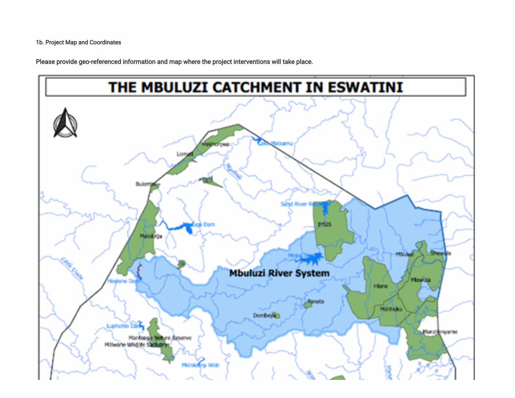
1b. Project Map and Coordinates
Please provide geo-referenced information and map where the project interventions will take place.
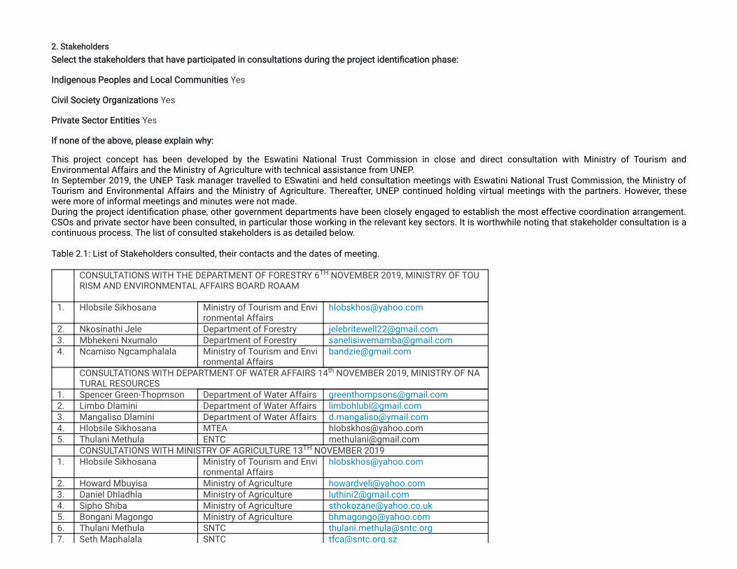
2. StakeholdersSelect the stakeholders that have participated in consultations during the project identi�cation phase:
Indigenous Peoples and Local Communities Yes
Civil Society Organizations Yes
Private Sector Entities Yes
If none of the above, please explain why:
This project concept has been developed by the Eswatini National Trust Commission in close and direct consultation with Ministry of Tourism andEnvironmental Affairs and the Ministry of Agriculture with technical assistance from UNEP.In September 2019, the UNEP Task manager travelled to ESwatini and held consultation meetings with Eswatini National Trust Commission, the Ministry ofTourism and Environmental Affairs and the Ministry of Agriculture. Thereafter, UNEP continued holding virtual meetings with the partners. However, thesewere more of informal meetings and minutes were not made.During the project identi�cation phase, other government departments have been closely engaged to establish the most effective coordination arrangement.CSOs and private sector have been consulted, in particular those working in the relevant key sectors. It is worthwhile noting that stakeholder consultation is acontinuous process. The list of consulted stakeholders is as detailed below. Table 2.1: List of Stakeholders consulted, their contacts and the dates of meeting.
CONSULTATIONS WITH THE DEPARTMENT OF FORESTRY 6 NOVEMBER 2019, MINISTRY OF TOURISM AND ENVIRONMENTAL AFFAIRS BOARD ROAAM
1. Hlobsile Sikhosana Ministry of Tourism and Environmental Affairs
2. Nkosinathi Jele Department of Forestry [email protected]. Mbhekeni Nxumalo Department of Forestry [email protected]. Ncamiso Ngcamphalala Ministry of Tourism and Envi
ronmental [email protected]
CONSULTATIONS WITH DEPARTMENT OF WATER AFFAIRS 14 NOVEMBER 2019, MINISTRY OF NATURAL RESOURCES
1. Spencer Green-Thopmson Department of Water Affairs [email protected]. Limbo Dlamini Department of Water Affairs [email protected]. Mangaliso Dlamini Department of Water Affairs [email protected]. Hlobsile Sikhosana MTEA [email protected]. Thulani Methula ENTC [email protected] CONSULTATIONS WITH MINISTRY OF AGRICULTURE 13 NOVEMBER 20191. Hlobsile Sikhosana Ministry of Tourism and Envi
ronmental [email protected]
2. Howard Mbuyisa Ministry of Agriculture [email protected]. Daniel Dhladhla Ministry of Agriculture [email protected]. Sipho Shiba Ministry of Agriculture [email protected]. Bongani Magongo Ministry of Agriculture [email protected]. Thulani Methula SNTC [email protected]. Seth Maphalala SNTC [email protected]
TH
th
TH
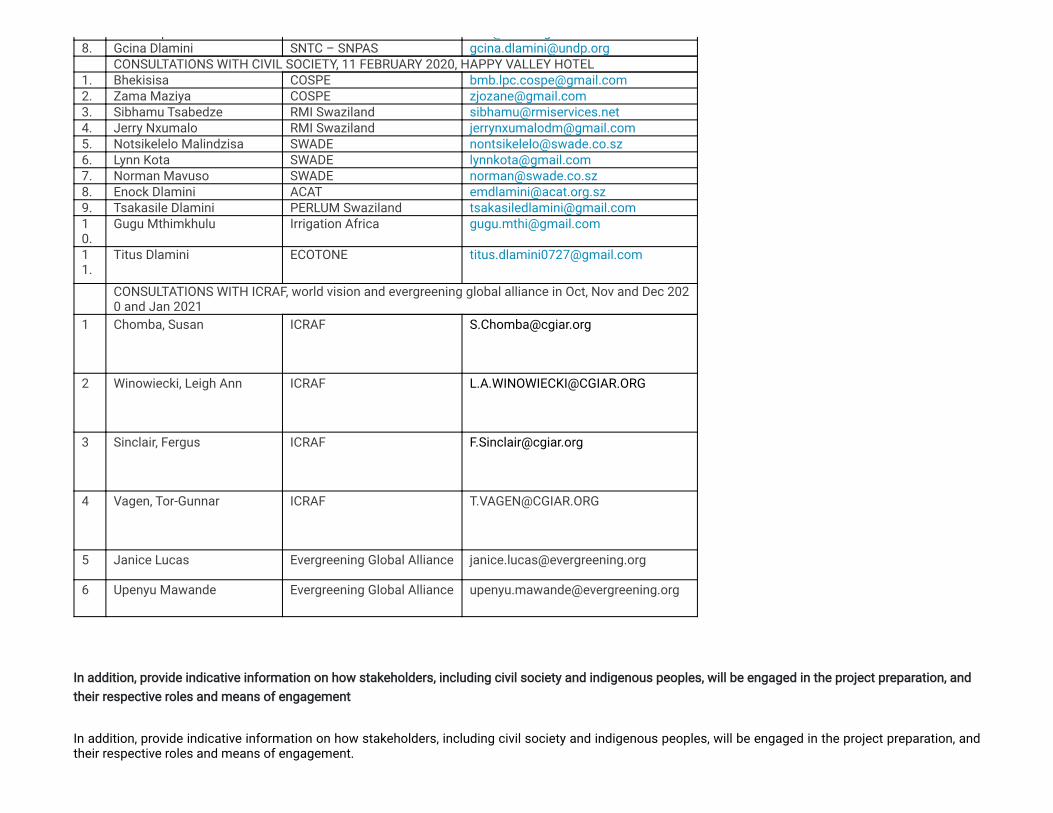
p @ g8. Gcina Dlamini SNTC – SNPAS [email protected] CONSULTATIONS WITH CIVIL SOCIETY, 11 FEBRUARY 2020, HAPPY VALLEY HOTEL1. Bhekisisa COSPE [email protected]. Zama Maziya COSPE [email protected]. Sibhamu Tsabedze RMI Swaziland [email protected]. Jerry Nxumalo RMI Swaziland [email protected]. Notsikelelo Malindzisa SWADE [email protected]. Lynn Kota SWADE [email protected]. Norman Mavuso SWADE [email protected]. Enock Dlamini ACAT [email protected]. Tsakasile Dlamini PERLUM Swaziland [email protected].
Gugu Mthimkhulu Irrigation Africa [email protected]
11.
Titus Dlamini ECOTONE [email protected]
CONSULTATIONS WITH ICRAF, world vision and evergreening global alliance in Oct, Nov and Dec 2020 and Jan 2021
1 Chomba, Susan
ICRAF [email protected]
2 Winowiecki, Leigh Ann
ICRAF [email protected]
3 Sinclair, Fergus
ICRAF [email protected]
4 Vagen, Tor-Gunnar ICRAF [email protected]
5 Janice Lucas Evergreening Global Alliance [email protected]
6 Upenyu Mawande Evergreening Global Alliance [email protected]
In addition, provide indicative information on how stakeholders, including civil society and indigenous peoples, will be engaged in the project preparation, andtheir respective roles and means of engagement
In addition, provide indicative information on how stakeholders, including civil society and indigenous peoples, will be engaged in the project preparation, andtheir respective roles and means of engagement.
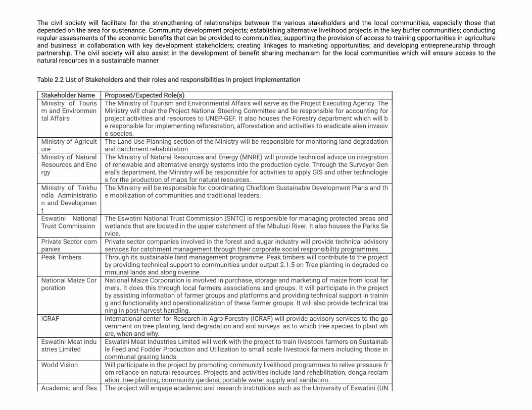
The civil society will facilitate for the strengthening of relationships between the various stakeholders and the local communities, especially those thatdepended on the area for sustenance. Community development projects; establishing alternative livelihood projects in the key buffer communities; conductingregular assessments of the economic bene�ts that can be provided to communities; supporting the provision of access to training opportunities in agricultureand business in collaboration with key development stakeholders; creating linkages to marketing opportunities; and developing entrepreneurship throughpartnership. The civil society will also assist in the development of bene�t sharing mechanism for the local communities which will ensure access to thenatural resources in a sustainable manner
Table 2.2 List of Stakeholders and their roles and responsibilities in project implementation
Stakeholder Name Proposed/Expected Role(s)Ministry of Tourism and Environmental Affairs
The Ministry of Tourism and Environmental Affairs will serve as the Project Executing Agency. TheMinistry will chair the Project National Steering Committee and be responsible for accounting forproject activities and resources to UNEP-GEF. It also houses the Forestry department which will be responsible for implementing reforestation, afforestation and activities to eradicate alien invasive species.
Ministry of Agriculture
The Land Use Planning section of the Ministry will be responsible for monitoring land degradationand catchment rehabilitation
Ministry of NaturalResources and Energy
The Ministry of Natural Resources and Energy (MNRE) will provide technical advice on integrationof renewable and alternative energy systems into the production cycle. Through the Surveyor General’s department, the Ministry will be responsible for activities to apply GIS and other technologies for the production of maps for natural resources.
Ministry of Tinkhundla Administration and Development
The Ministry will be responsible for coordinating Chiefdom Sustainable Development Plans and the mobilization of communities and traditional leaders.
Eswatini NationalTrust Commission
The Eswatini National Trust Commission (SNTC) is responsible for managing protected areas andwetlands that are located in the upper catchment of the Mbuluzi River. It also houses the Parks Service.
Private Sector companies
Private sector companies involved in the forest and sugar industry will provide technical advisoryservices for catchment management through their corporate social responsibility programmes.
Peak Timbers Through its sustainable land management programme, Peak timbers will contribute to the projectby providing technical support to communities under output 2.1.5 on Tree planting in degraded communal lands and along riverine
National Maize Corporation
National Maize Corporation is involved in purchase, storage and marketing of maize from local farmers. It does this through local farmers associations and groups. It will participate in the projectby assisting information of farmer groups and platforms and providing technical support in training and functionality and operationalization of these farmer groups. It will also provide technical training in post-harvest handling.
ICRAF International center for Research in Agro-Forestry (ICRAF) will provide advisory services to the government on tree planting, land degradation and soil surveys as to which tree species to plant where, when and why.
Eswatini Meat Industries Limited
Eswatini Meat Industries Limited will work with the project to train livestock farmers on Sustainable Feed and Fodder Production and Utilization to small scale livestock farmers including those incommunal grazing lands.
World Vision Will participate in the project by promoting community livelihood programmes to relive pressure from reliance on natural resources. Projects and activities include land rehabilitation, donga reclamation, tree planting, community gardens, portable water supply and sanitation.
Academic and Res The project will engage academic and research institutions such as the University of Eswatini (UN
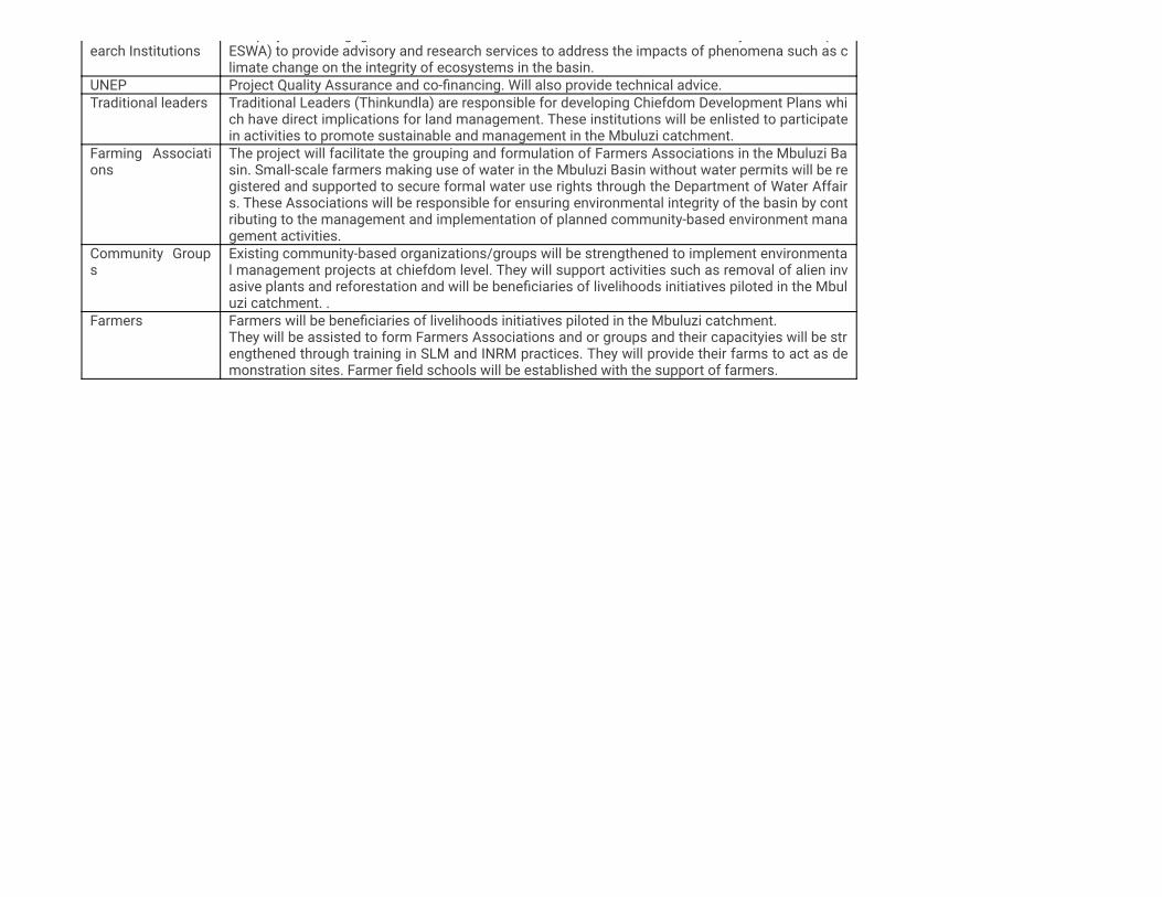
earch Institutionsp j g g y (
ESWA) to provide advisory and research services to address the impacts of phenomena such as climate change on the integrity of ecosystems in the basin.
UNEP Project Quality Assurance and co-�nancing. Will also provide technical advice.Traditional leaders Traditional Leaders (Thinkundla) are responsible for developing Chiefdom Development Plans whi
ch have direct implications for land management. These institutions will be enlisted to participatein activities to promote sustainable and management in the Mbuluzi catchment.
Farming Associations
The project will facilitate the grouping and formulation of Farmers Associations in the Mbuluzi Basin. Small-scale farmers making use of water in the Mbuluzi Basin without water permits will be registered and supported to secure formal water use rights through the Department of Water Affairs. These Associations will be responsible for ensuring environmental integrity of the basin by contributing to the management and implementation of planned community-based environment management activities.
Community Groups
Existing community-based organizations/groups will be strengthened to implement environmental management projects at chiefdom level. They will support activities such as removal of alien invasive plants and reforestation and will be bene�ciaries of livelihoods initiatives piloted in the Mbuluzi catchment. .
Farmers Farmers will be bene�ciaries of livelihoods initiatives piloted in the Mbuluzi catchment.They will be assisted to form Farmers Associations and or groups and their capacityies will be strengthened through training in SLM and INRM practices. They will provide their farms to act as demonstration sites. Farmer �eld schools will be established with the support of farmers.
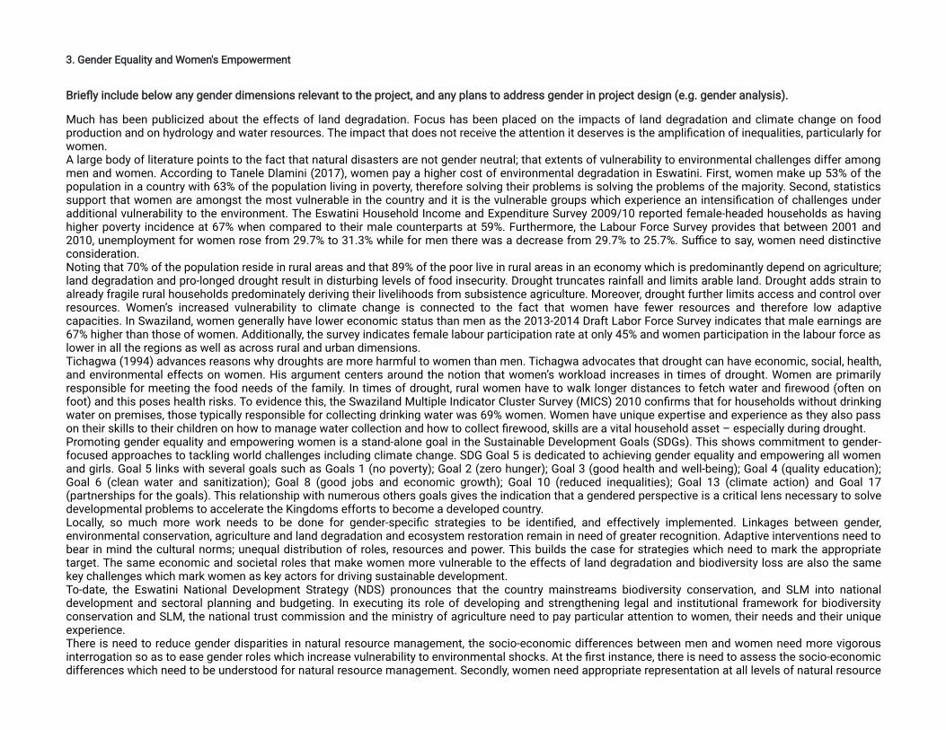
3. Gender Equality and Women's Empowerment
Brie�y include below any gender dimensions relevant to the project, and any plans to address gender in project design (e.g. gender analysis).
Much has been publicized about the effects of land degradation. Focus has been placed on the impacts of land degradation and climate change on foodproduction and on hydrology and water resources. The impact that does not receive the attention it deserves is the ampli�cation of inequalities, particularly forwomen.A large body of literature points to the fact that natural disasters are not gender neutral; that extents of vulnerability to environmental challenges differ amongmen and women. According to Tanele Dlamini (2017), women pay a higher cost of environmental degradation in Eswatini. First, women make up 53% of thepopulation in a country with 63% of the population living in poverty, therefore solving their problems is solving the problems of the majority. Second, statisticssupport that women are amongst the most vulnerable in the country and it is the vulnerable groups which experience an intensi�cation of challenges underadditional vulnerability to the environment. The Eswatini Household Income and Expenditure Survey 2009/10 reported female-headed households as havinghigher poverty incidence at 67% when compared to their male counterparts at 59%. Furthermore, the Labour Force Survey provides that between 2001 and2010, unemployment for women rose from 29.7% to 31.3% while for men there was a decrease from 29.7% to 25.7%. Su�ce to say, women need distinctiveconsideration.Noting that 70% of the population reside in rural areas and that 89% of the poor live in rural areas in an economy which is predominantly depend on agriculture;land degradation and pro-longed drought result in disturbing levels of food insecurity. Drought truncates rainfall and limits arable land. Drought adds strain toalready fragile rural households predominately deriving their livelihoods from subsistence agriculture. Moreover, drought further limits access and control overresources. Women’s increased vulnerability to climate change is connected to the fact that women have fewer resources and therefore low adaptivecapacities. In Swaziland, women generally have lower economic status than men as the 2013-2014 Draft Labor Force Survey indicates that male earnings are67% higher than those of women. Additionally, the survey indicates female labour participation rate at only 45% and women participation in the labour force aslower in all the regions as well as across rural and urban dimensions.Tichagwa (1994) advances reasons why droughts are more harmful to women than men. Tichagwa advocates that drought can have economic, social, health,and environmental effects on women. His argument centers around the notion that women’s workload increases in times of drought. Women are primarilyresponsible for meeting the food needs of the family. In times of drought, rural women have to walk longer distances to fetch water and �rewood (often onfoot) and this poses health risks. To evidence this, the Swaziland Multiple Indicator Cluster Survey (MICS) 2010 con�rms that for households without drinkingwater on premises, those typically responsible for collecting drinking water was 69% women. Women have unique expertise and experience as they also passon their skills to their children on how to manage water collection and how to collect �rewood, skills are a vital household asset – especially during drought.Promoting gender equality and empowering women is a stand-alone goal in the Sustainable Development Goals (SDGs). This shows commitment to gender-focused approaches to tackling world challenges including climate change. SDG Goal 5 is dedicated to achieving gender equality and empowering all womenand girls. Goal 5 links with several goals such as Goals 1 (no poverty); Goal 2 (zero hunger); Goal 3 (good health and well-being); Goal 4 (quality education);Goal 6 (clean water and sanitization); Goal 8 (good jobs and economic growth); Goal 10 (reduced inequalities); Goal 13 (climate action) and Goal 17(partnerships for the goals). This relationship with numerous others goals gives the indication that a gendered perspective is a critical lens necessary to solvedevelopmental problems to accelerate the Kingdoms efforts to become a developed country.Locally, so much more work needs to be done for gender-speci�c strategies to be identi�ed, and effectively implemented. Linkages between gender,environmental conservation, agriculture and land degradation and ecosystem restoration remain in need of greater recognition. Adaptive interventions need tobear in mind the cultural norms; unequal distribution of roles, resources and power. This builds the case for strategies which need to mark the appropriatetarget. The same economic and societal roles that make women more vulnerable to the effects of land degradation and biodiversity loss are also the samekey challenges which mark women as key actors for driving sustainable development.To-date, the Eswatini National Development Strategy (NDS) pronounces that the country mainstreams biodiversity conservation, and SLM into nationaldevelopment and sectoral planning and budgeting. In executing its role of developing and strengthening legal and institutional framework for biodiversityconservation and SLM, the national trust commission and the ministry of agriculture need to pay particular attention to women, their needs and their uniqueexperience.There is need to reduce gender disparities in natural resource management, the socio-economic differences between men and women need more vigorousinterrogation so as to ease gender roles which increase vulnerability to environmental shocks. At the �rst instance, there is need to assess the socio-economicdifferences which need to be understood for natural resource management. Secondly, women need appropriate representation at all levels of natural resource
management agreements in order to contribute their distinctive experience. Environmental conservation Projects and programme interventions must notexclude women as they are powerful change agents. Through a gendered review of strategies, Swaziland can address a range of environmental issues.Sustainability and effectiveness of natural resource management projects and policies can be strengthened through women’s greater participation. AsCarvajal-Escobar, Quintero-Angel & M. Garcia-Vargas (2008) put it, women tend to be very effective at mobilizing communities and have a clear understandingof what strategies are needed at the local level. This de�nes the next move that is necessary, it is to craft out women’s role in enhancing ecosystem restorationof Mbuluzi River landscape through promotion of SLM and effective management of protected areas within it. The population of Eswatini is predominantly rural (77%) with the majority being women. Women are therefore affected by the impacts of the weak nationaleconomy and high unemployment levels in a disproportionate manner. Productive resources like land are also unevenly distributed in favor of men therebycondemning women to the impacts of poverty and food insecurity. Recent trends increasingly recognize the role that women play in national developmentplanning. The proposed project recognizes the focus of His Majesty King Mswati III's Vision 2022 and the National Development Strategy both of which seekto promote gender equality and social integration in line with the provisions of the following SDG’s: poverty (1), gender equality (5), and inclusive andsustainable growth (8). To support this vision, during the PPG phase, a gender assessment will be undertaken and a project speci�c gender mainstreamingplan will be developed in close collaboration with women’s groups and associations in the country. A detailed analysis gender issues in the basin will beconducted during the PPG stage and a gender action plan for the project will be developed. The project recognizes the importance of both men and women’s active participation in adapting to the future changes the kingdom faces from environmentaldegradation and other external threats, and in addressing the ongoing challenge of securing rights to land and resources to provide sustainable livelihoods fortheir families and improving their ability to make strategic life choices. The project, also, recognizes the role of women, as primary users and stewards ofmany natural resources, in environmental protection, as well as in productive systems in sustainable agriculture and forestry. It supports actions to increasewomen’s voice in the dialogue and decision-making over natural resources. It will ensure that women are equally represented in governance bodies of the 3targeted protected areas. Additionally, while working to empower indigenous people and local communities living in and around protected areas, the projectwill give speci�c attention to include women as well as men. The project will seek to (a) analyze and identify any project-relevant gender differences as well asopportunities to empower women relevant to the project outcomes. There is inadequate knowledge from Eswatini on: (a) integration of indigenous women’s perceptions into policy; (b) resource data on access and ownership,especially within communal lands and impacts; and (c) forest con�icts and their impacts. The Project will participate in furthering the knowledge and �ndinginnovative ways of dealing with gender issues in the kingdom. The project will also develop gender sensitive strategies during project preparation. Moreparticularly, within each component, gender issues will be considered. For example, in Component 3, to strengthen protected area management and increaseparticipatory governance and planning, the program will use appropriate mechanisms to enroll women in protected area governance, as men are often seen asthe family representative, leaving no room for women’s participation in public spheres. Relative to Component 2, gaps will be identi�ed to ensure that technicalsupport for SLM is provided to both men and women alike and that women can participate, as women often have an important role traditionally inagroforestry, farming and land management. For Component 1, analysis of gaps in policies and legal frameworks will also identify gender gaps so thatimprovements include speci�c measures where needed for women and vulnerable groups, for example considering the issue that women are less likely tohave o�cial documents, which may impede their ownership of land. Component 4 and the coordination project will develop speci�c strategies and guidelinesfor ensuring projects develop gender sensitive activities. Speci�c gender related studies will be considered as deem appropriate during the project’simplementation and advised by the program steering committee. Program monitoring will measure number of female bene�ciaries and will aggregate othergender related indicators as speci�ed by each outcome.During the project preparation, these aspects will be further detailed. The project will help smallholder farmers produce more, higher-quality food and connect with new markets. The vast majority of Eswatini’s 1.2 million peopledepends on subsistence farming and the years of economic slowdown, a devastating AIDS pandemic and recent droughts linked to climate change havemade it increasingly hard for the rural population to live off the land. According to FAO’s most recent hunger �gures, one in three people in Swaziland isundernourished. Improving the food security and nutrition of vulnerable communities and helping small holder farmers move away from subsistence farmingare key objectives of the Eswatini Agricultural Development Project (SADP), which is focused on creating a vibrant commercial agricultural sector and theproject will strive to contribute to this. The project will focus on the most vulnerable, particularly the elderly, women and the youth. Household gardens allowvulnerable families to grow vegetables for their own consumption, or to sell within the community. Women and Youth groups will get technical assistance toset up small agribusinesses, including poultry farming, pig raising, or vegetable and crop production. Generally, the project will be disseminating good
agricultural practices among Swazi smallholders, helping them to grow more, better-quality produce while preserving the environment and reducing pressureon limited natural resources. Farmers will be trained in such good practices as conservation agriculture, agro-forestry and seed multiplication. In addition,construction and rehabilitation works in the livestock sector, water infrastructure and technical services will support farmers in increasing their output.Due to the division of labour between men and women, women are more likely to be in the household and charged with provision of food, water andmanagement of family health. This may increase their vulnerability to domestic violence as tensions mount up especially during the quarantine periods wheremeeting the daily requirements of the household becomes increasingly daunting. The collection and analysis of sex disaggregated data will be emphasizedduring project implementation. This will provide insight on how the impacts of COVID-19 have reshaped power relations between men and women as well ashow they use and manage the environment. This will particularly assist in identifying targeted actions to enable men and women to become key actors inhelping reduce the negative impact of COVID-19 on the environment both in the current and post COVID-19 era.
Does the project expect to include any gender-responsive measures to address gender gaps or promote gender equality and women empowerment? Yes
closing gender gaps in access to and control over natural resources; Yes
improving women's participation and decision-making; and/or Yes
generating socio-economic bene�ts or services for women. Yes
Will the project’s results framework or logical framework include gender-sensitive indicators?
Yes
4. Private sector engagement
Will there be private sector engagement in the project?
Yes Please brie�y explain the rationale behind your answer.
Private Sector InvolvementCollectively, the private sector has continuously invested in the natural resources management and promoted ecosystem services. This has been doneprimarily through development and maintenance of tourism facilities, protected areas planning, law enforcement and biodiversity monitoring and staffdevelopment. Involvement of the private sector in conservation has increased over the past decade and is set to increase further through initiatives such asthe landscape management structures, the OECMs and Biosphere Reserve initiatives. With �nancial and technical support from previous project/programmeinitiatives, this has seen an increase in the viability of ecotourism, increased �nancial returns to the investments in biodiversity conservation. The project willcultivate sustainable relationships with stakeholders, policymakers and community leaders in an effort to ensure that policies are in place and applied for theeffective management of the protection of the ecosystems. The private sector is expected to contribute towards the protection of the ecosystems as theybene�t immensely from the ecosystem services. During the project identi�cation stage, a brief consultation was undertaken with private sector companies like Peak Timbers, Royal Eswatini SugarCooperation and the National Meat Industries and the bank. Further consultations will be undertaken during PPG stage. Peak Timbers company Peak Timbers is a plantation forest and sawmilling company with commercial forest plantations within the basin. It will providetechnical support to local communities in forestry and ecosystem restoration activities especially re-forestation. The company has an incentive scheme forlocal communities that provides them with livelihood opportunities like piggery, poultry and ranching to reduce pressure on natural resources. Although Royal Eswatini Sugar Cooperation has its own sugar plantations, it also has a lot of smallholder farmers under its out-grower scheme within thebasin. The company will assist in mobilizing these farmers and will contribute to their training so that these smallholder famers can learn SLM/INRM practicesand adopt them either in their sugar plantations or in subsistence gardens of maize, sorghum and vegetables. Swaziland Meat Industries Limited already has a network of pastoralist and livestock farmers it is working with that have been formed into groups.Partnership with this company will make it easy to organize livestock farmers and the company will provide technical support and training. This is thecompany that buys meat from farmers in an organized way. Eswatini Bank is �nancing smallholder agricultural farms around the basin and the project will identify environmental activities that can be �nanced throughthis bank.
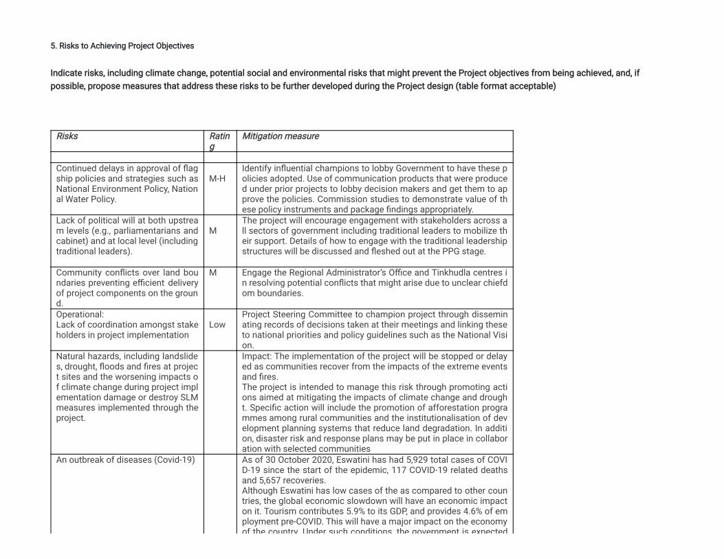
5. Risks to Achieving Project Objectives
Indicate risks, including climate change, potential social and environmental risks that might prevent the Project objectives from being achieved, and, ifpossible, propose measures that address these risks to be further developed during the Project design (table format acceptable)
Risks Rating
Mitigation measure
Continued delays in approval of �agship policies and strategies such asNational Environment Policy, National Water Policy.
M-H
Identify in�uential champions to lobby Government to have these policies adopted. Use of communication products that were produced under prior projects to lobby decision makers and get them to approve the policies. Commission studies to demonstrate value of these policy instruments and package �ndings appropriately.
Lack of political will at both upstream levels (e.g., parliamentarians andcabinet) and at local level (includingtraditional leaders).
M
The project will encourage engagement with stakeholders across all sectors of government including traditional leaders to mobilize their support. Details of how to engage with the traditional leadershipstructures will be discussed and �eshed out at the PPG stage.
Community con�icts over land boundaries preventing e�cient deliveryof project components on the ground.
M Engage the Regional Administrator’s O�ce and Tinkhudla centres in resolving potential con�icts that might arise due to unclear chiefdom boundaries.
Operational:Lack of coordination amongst stakeholders in project implementation
Low
Project Steering Committee to champion project through disseminating records of decisions taken at their meetings and linking theseto national priorities and policy guidelines such as the National Vision.
Natural hazards, including landslides, drought, �oods and �res at project sites and the worsening impacts of climate change during project implementation damage or destroy SLMmeasures implemented through theproject.
Impact: The implementation of the project will be stopped or delayed as communities recover from the impacts of the extreme eventsand �res.The project is intended to manage this risk through promoting actions aimed at mitigating the impacts of climate change and drought. Speci�c action will include the promotion of afforestation programmes among rural communities and the institutionalisation of development planning systems that reduce land degradation. In addition, disaster risk and response plans may be put in place in collaboration with selected communities
An outbreak of diseases (Covid-19) As of 30 October 2020, Eswatini has had 5,929 total cases of COVID-19 since the start of the epidemic, 117 COVID-19 related deathsand 5,657 recoveries.Although Eswatini has low cases of the as compared to other countries, the global economic slowdown will have an economic impacton it. Tourism contributes 5.9% to its GDP, and provides 4.6% of employment pre-COVID. This will have a major impact on the economyof the country Under such conditions the government is expected
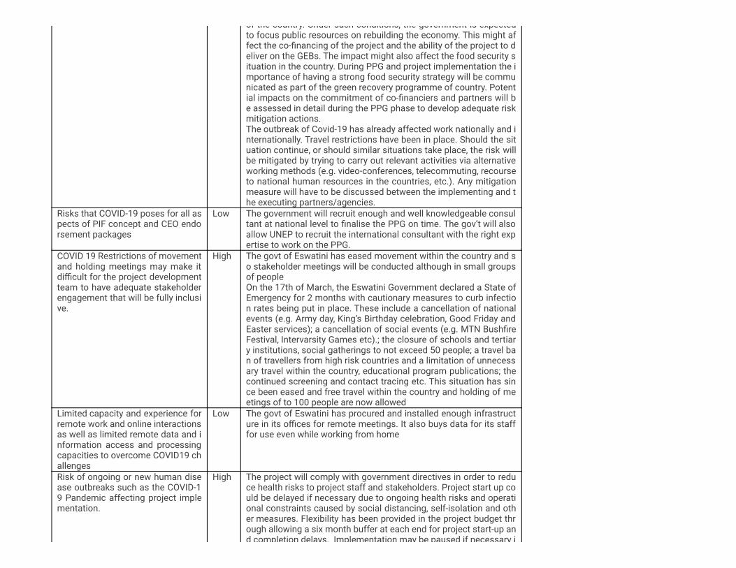
of the country. Under such conditions, the government is expectedto focus public resources on rebuilding the economy. This might affect the co-�nancing of the project and the ability of the project to deliver on the GEBs. The impact might also affect the food security situation in the country. During PPG and project implementation the importance of having a strong food security strategy will be communicated as part of the green recovery programme of country. Potential impacts on the commitment of co-�nanciers and partners will be assessed in detail during the PPG phase to develop adequate riskmitigation actions.The outbreak of Covid-19 has already affected work nationally and internationally. Travel restrictions have been in place. Should the situation continue, or should similar situations take place, the risk willbe mitigated by trying to carry out relevant activities via alternativeworking methods (e.g. video-conferences, telecommuting, recourseto national human resources in the countries, etc.). Any mitigationmeasure will have to be discussed between the implementing and the executing partners/agencies.
Risks that COVID-19 poses for all aspects of PIF concept and CEO endorsement packages
Low The government will recruit enough and well knowledgeable consultant at national level to �nalise the PPG on time. The gov’t will alsoallow UNEP to recruit the international consultant with the right expertise to work on the PPG.
COVID 19 Restrictions of movementand holding meetings may make itdi�cult for the project developmentteam to have adequate stakeholderengagement that will be fully inclusive.
High The govt of Eswatini has eased movement within the country and so stakeholder meetings will be conducted although in small groupsof peopleOn the 17th of March, the Eswatini Government declared a State ofEmergency for 2 months with cautionary measures to curb infection rates being put in place. These include a cancellation of nationalevents (e.g. Army day, King’s Birthday celebration, Good Friday andEaster services); a cancellation of social events (e.g. MTN Bush�reFestival, Intervarsity Games etc).; the closure of schools and tertiary institutions, social gatherings to not exceed 50 people; a travel ban of travellers from high risk countries and a limitation of unnecessary travel within the country, educational program publications; thecontinued screening and contact tracing etc. This situation has since been eased and free travel within the country and holding of meetings of to 100 people are now allowed
Limited capacity and experience forremote work and online interactionsas well as limited remote data and information access and processingcapacities to overcome COVID19 challenges
Low
The govt of Eswatini has procured and installed enough infrastructure in its o�ces for remote meetings. It also buys data for its stafffor use even while working from home
Risk of ongoing or new human disease outbreaks such as the COVID-19 Pandemic affecting project implementation.
High The project will comply with government directives in order to reduce health risks to project staff and stakeholders. Project start up could be delayed if necessary due to ongoing health risks and operational constraints caused by social distancing, self-isolation and other measures. Flexibility has been provided in the project budget through allowing a six month buffer at each end for project start-up and completion delays. Implementation may be paused if necessary i
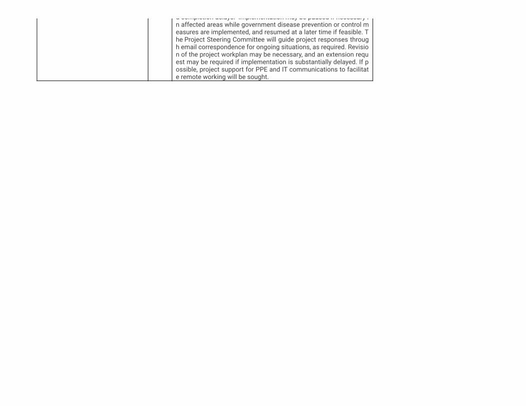
d completion delays. Implementation may be paused if necessary in affected areas while government disease prevention or control measures are implemented, and resumed at a later time if feasible. The Project Steering Committee will guide project responses through email correspondence for ongoing situations, as required. Revision of the project workplan may be necessary, and an extension request may be required if implementation is substantially delayed. If possible, project support for PPE and IT communications to facilitate remote working will be sought.
6. Coordination
Outline the institutional structure of the project including monitoring and evaluation coordination at the project level. Describe possible coordination with otherrelevant GEF-�nanced projects and other initiatives.
There are a range of other relevant GEF-�nanced biodiversity and climate change initiatives, that are recently completed, ongoing and in the planning pipe-line,which will be fully appraised and involved in this project to maximize synergies and avoid risk of duplication, namely:· The GEF- supported Lower Usuthu Smallholder Irrigation Project (LUSIP-GEF/LUSLM) (2009-2015) project supported the development of ChiefdomDevelopment Plans as vehicles for promoting sustainable land and resources management in the Usuthu River Basin.· The recently closed SCCF project ‘Adapting National and Transboundary Water Resources Management to Manage the Expected Climate Change Project’(2012-2016) sought to ensure that the management of Eswatini’s water resources was adapted to take into account the anticipated impacts of climatechange. Using the principles of Integrated Water Resource Management (IWRM), climate change risks were incorporated into a management approach tofacilitate this process through a national dialogue between a wide range of stakeholders from different sectors. Information generated and lessons learnedfrom pilot-scale adaptation measures funded by the project, assisted policy implementation for effective adaptation planning and climate risk management inthe water sector. The present project will pursue recommendations made by the Climate Change Vulnerability Assessment, and build on lessons learnedincluding the implementation of national transboundary strategy, which was developed to promote the effective management of the Mbuluzi Basin in order tomeet the transboundary agreement with Mozambique.· The UNDP GEF Strengthening National Protected Areas Systems Project (SNPAS) (2014-2020), which is about to undergo Terminal Evaluation—sought todevelop, expand and e�ciency manage Eswatini’s Protected Areas Network in order to protect globally signi�cant biodiversity. The PA system was intended toincrease from approximately 4% of the country’s total land area to 6%. The project is being implemented using the landscape approach across differentsectors, integrating land and natural resource management to transform the current PA patchwork into an integrated connected network that conservesbiodiversity, maintains ecosystems services and enhances vulnerability of communities livelihoods especially those that are adjacent to the PAs, while takingclimate change into consideration. The present project will build on the �ndings and recommendations of the Terminal Evaluation.· The GEF-funded Smallholder Market-Led Project (SMLP) (2016-2022) targets reducing poverty and food insecurity of poor rural dwellers throughinvestment supporting increased agricultural production and productivity and commercialization of smallholder agriculture. Production of commoditiessuitable both for household nutrition and market supply will be enhanced as will the linkages between markets and producers, resulting in improved foodsecurity and incomes. The project targets economically active poor households and food de�cit households in 37 chiefdoms located in within 12 Tinkhundlain the southeast of Eswatini. Project investments in systems for market linkage, land and water conservation and engagement of extension services havesigni�cance for national service delivery.
7. Consistency with National Priorities
Is the Project consistent with the National Strategies and plans or reports and assesments under relevant conventions?
If yes, which ones and how: NAPAs, NAPs, ASGM NAPs, MIAs, NBSAPs, NCs, TNAs, NCSAs, NIPs, PRSPs, NPFE, BURs, INDCs, etc
The National Development Strategy (NDS) which is implemented through three year rolling National Development Plans provides the overarching nationaldevelopment framework for Eswatini. The NSD focuses on improving the standard of living of the people of Eswatini through poverty eradication, employmentcreation, gender equality and environmental protection. In the National Development Strategy (NDS) Vision 2022, Chapter 3.7 of the key Macro Strategic Areas,the Government of Eswatini recognizes environmental management as a necessary condition for sustainable development. This entails the maintenance of anecological balance; accommodating environmental considerations in policies, strategies and programmes of both the public and private sectors; accommodateenvironmental compliance procedures; and ensuring that sector strategies for achieving the country's vision are environmentally friendly. The broad strategies ofenvironmental objectives ful�lment are:· Integration: Fully integrate environmental management and development planning in to ministries and initiate a collaborative coherent programme approachwith all sectoral ministries and departments, each contributing in their area of expertise.· Monitoring: Establish a national environmental mechanism for ensuring that the environmental priorities of national planning are observed and sought after.Coordinate monitor and control environmental protection measures.· Legislation: Strengthen or develop a comprehensive system of environmental laws and regulations and reinforce the enforcement capability of the EswatiniEnvironment Authority.· Capacity Building: Encourage popular participation and training, including embracing sectoral human resource development, education and training, publicinformation and public involvement.· Gender: Ensure a gender dimension in environmental management. Involve women actively in environmental decision-making at all levels.· Enforcement: Enforce all environmental laws. Ensure that enacted environmental laws and regulations are implemented.· Conservation: Curb and prevent the erosion of the soil, promote conservation and management of water and land resources, develop measures to conserveendangered animal and plant species, establish and promote the idea of botanic gardens.· Implementation: Implement the country’s Environment Action Plan, implement the national biodiversity strategy and action plan, initiate economic incentivesto promote environmental management.· Finance: Source �nancial resources needed for the introduction of the necessary institutional changes required for sustainable development, Establish anEnvironmental Fund. The Strategy for Sustainable Development and Inclusive Growth (SSDIG), which is the review of the National Development Strategy (NDS) 1997 – 2022, wascommissioned in 2013. The Government review took stock of the emerging challenges and opportunities that were not foreseen during NDS formulation in 1997.The revised strategy identi�ed four thematic areas as critical for the attainment of the Vision namely: Good governance, Vibrant and diverse economy,Environmental sustainability and Highest human capital and social development. The Government also developed and adopted the Poverty Reduction Strategy and Action Programme (PRSAP, 2006-2015) which serves as a critical means andguide to realizing the national vision and attain the Sustainable Development Goals. The Poverty Reduction Strategy and Action Plan (PRSAP) recognizesenvironmental management as pivotal to a sustainable increase in agricultural productivity. It recognizes that the underprivileged depend on the environment and
natural resources for their survival, therefore any meaningful poverty reduction strategy will have to address issues related to the environment. The strategyfurther acknowledges that the three critical environmental problems in country are soil erosion, deforestation and forest degradation (including both actual lossof trees and the changing composition and structure), and water and air pollution. The project is aligned with the National Biodiversity Strategy and Action Plan, which details the national strategy for conservation and management ofbiodiversity. As most of the country's population depend upon subsistence agriculture, development planning in eswatini recognizes the need for sustainable landmanagement as a vehicle for addressing poverty and managing biodiversity conservation at the community level. The propose project will contribute to target 9,10, 11 and 12 of the National Biodiversity Strategy and Action Plan (NBSAP) targets: By controlling and management of invasive plant species, in the Mbuluzicatchment area, the project will contribute to target 9 of Eswatini’s NBSAP which aims at ensuring that By 2020 invasive species that are alien to Eswatini andtheir pathways are identi�ed and prioritized and eradicated and management plans established. The control of alien invasive plant species is particularyimportant in this catchment for downstream availability of water. The project will also contribute to target 10 of the country’s NBSAP by controlling anderadicating pressures on Eswatinis’s most vulnerable ecosystem (grassland ecosystem) which the last grassland wilderness in the country. By enhancingmanagement effectiveness of nature reserves, the project will contribute to target 12 of the country’s NBSAP which aims at ensuring that by 2022, the extinctionof species known to be threatened in Eswatini has been prevented and their conservation status, particularly of those that are endemic and those most in decline,has been improved and sustained and target 11 of the NBSAP which aims at ensuring that By 2022, at least 20 per cent of Eswatini's land area is conservedthrough effectively and equitably managed, ecologically representative and well-connected systems of protected areas According to Eswatini’s LDN Target Setting Report; between 2000 and 2010, a total of 465,290 Ha of land was degraded, which makes up 27% of the country. Thereport further highlights areas in the Mbuluzi catchment like Mhlangatane, Mnjoli, Madlangempisi, Lomahasha and Sitsatsaweni, as hotspots for land degradationwhich is directly driven by Deforestation, Improper soil management; Improper management of annual, perennial and scrub and tree crops; Disturbance of watercycle and Overgrazing. The project is expected to contribute to Eswatini’s LDN speci�c targets of increasing by 10% net land productivity in all land covercategories through SLM practices. It will also contribute to the speci�c target of rehabilitating 115 000 ha of degraded and abandoned land by 2030. Other policies and strategies which are relevant to this proposed project are the Climate Change Policy and Strategy and the National Emergency ResponseMitigation and Adaptation Plan (2016-2022). These aim to provide the framework for addressing the impacts of climate change. Closely related to this is thecountry's participation in international initiatives to address climate change at the global level under the auspices of the United Nations Framework Convention onClimate Change (UNFCCC). As part of this engagement, the country produces National Communications and Nationally Determined Contributions to theConvention (NDC) which detail the strategies the country proposes to implement in order to meet its obligations under the Climate Change Convention. The lastNDC was submitted in 2015. National Climate Change Strategy and Action Plan, 2016 aims at Promoting adoption of sustainable land management practicessuch as the soil management, seed management, and adaptive capacity of smallholder farmers. The Natural Resources Management Act, 1951 prevents cultivation of crops within 33 meters of banks of public streams. It aims at Protecting the destruction ofbiodiversity rich ecosystems close to the riverbanks.The Environment Management Act, 2002 aims to provide and promote enhancement, protection and conservation of the environment and the sustainablemanagement of natural resources and to promote sustainable use of natural resources such as land considering the consequences for the present and futuregenerations. Several national policies are in the process of formulation to enable sustainable implementation of agricultural production and these are; (a) the NationalAgricultural Extension Policy Draft, (b) the Monitoring and Evaluation Policy, (c) the National Agricultural Research Policy, (d) the National Climate Change Policy,(e) the National Climate Change Strategy and Action Plan, (f) the National Wildlife Management Policy. Completed policies are (a) the Disaster Risk Management Policy, which aims to prevent and minimize the impact of disasters and (b) the Eswatini ResilienceStrategy and Action Plan. Proposed legislation that is in the process of its enaction to enable sustainable agricultural production are (a) the Plant Health Protection Bill, 2015 whichaims to prevent the introduction and spread of pests, facilitate trade in plants and plant products (b) the Eswatini National Research Authority Bill, 2015 (c) the
Dairy Act Amendment Bill, 2017 (d) the Seeds and Plant varieties (amendment) regulation 2017: amendment regulations of 2002 (e) the LivestockIdenti�cation and Traceability Regulations, 2015: to give effect to The Livestock Identi�cation Act 2001
8. Knowledge Management
Outline the knowledge management approach for the Project, including, if any, plans for the Project to learn from other relevant Projects and initiatives, toassess and document in a user-friendly form, and share these experiences and expertise with relevant stakeholders.
This project aims to transform the situation from the baseline—in which there is inadequate awareness and management of protected areas and highinfestation rate of invasive alien plant species in protected areas to a situation where protected areas along the basin are well managed, invasive plantspecies controlled and the Swazi population understands and accesses opportunities to use SLM technologies and biodiversity conservation in the RiverBasins. The knowledge shared via project activities will raise awareness of the importance of effective management of protected areas and will harmonizerelationships between communities and protected areas. It will also raise awareness on sustainable landscape restoration and management, whichcontributes to adapting to and mitigating the impacts of climate change, thus increasing the resilience of landscapes and subsistence livelihoods. Theknowledge sharing approaches catalyzed and supported by the project—including South-South cooperation—are designed to ensure that the project bene�tsfrom lessons of past projects, programmes and research to avoid reinventing the wheel, and it will share results (locally, nationally and internationally) toenable others to bene�t by scaling-up achievements post-project. As this project will be utilizing outcomes of two main projects: �rstly the Adapting Nationaland Transboundary Resources to the Impacts of Climate change which highlighted the need to address biodiversity loss and land degradation includingcontrol of invasive plant species and secondly the Lower Usuthu Sustainable Land Management Project that introduce similar activities in the Usuthu Basinwhich highlighted the need to introduce the same intervention for the Mbuluzi Basin.. Innovative methodologies will be used to track the country’s progressthe project’s contribution of the country’s national targets including targets under the NBSAP and the LDN.
9. Environmental and Social Safeguard (ESS) Risks
Provide information on the identi�ed environmental and social risks and potential impacts associated with the project/program based on yourorganization's ESS systems and procedures
Overall Project/Program Risk Classi�cation*
PIF CEO Endorsement/Approval MTR TE
Medium/Moderate
Measures to address identi�ed risks and impacts
Provide preliminary information on the types and levels of risk classi�cations/ratings of any identi�ed environmental and social risks and potentialimpacts associated with the project (considering the GEF ESS Minimum Standards) and describe measures to address these risks during theproject design.
The project is intended to manage this risk through promoting actions aimed at mitigating the impacts of climate change and drought. Speci�c action willinclude the promotion of use of renewable energy forms, removal of alien invasive species, promotion of afforestation programmes among rural communitiesand the institutionalization of development planning systems that reduce land degradation. Identify in�uential champions to lobby Government to have thesepolicies adopted. Use of communication products that were produced under prior projects to lobby decision makers and get them to approve the policies.Commission studies to demonstrate value of these policy instruments and package �ndings appropriately. The project will encourage engagement withstakeholders across all sectors of government including traditional leaders to mobilize their support. Details of how to engage with the traditional leadershipstructures will be discussed and �eshed out at the PPG stage. Engage the Regional Administrator’s O�ce and Tinkhudla centers in resolving potentialcon�icts that might arise due to unclear chiefdom boundaries. Project Steering Committee to champion project through disseminating records of decisionstaken at their meetings and linking these to national priorities and policy guidelines such as the National Vision. The government will recruit enough and wellknowledgeable consultant at national level to �nalize the PPG on time. The gov’t will also allow UNEP to recruit the international consultant with the rightexpertise to work on the PPG. The govt of Eswatini has eased movement within the country and so stakeholder meetings will be conducted although in smallgroups of people The govt of Eswatini has procured and installed enough infrastructure in its o�ces for remote meetings. It also buys data for its staff for useeven while working from home The project will comply with government directives in order to reduce health risks to project staff and stakeholders. Projectstart up could be delayed if necessary due to ongoing health risks and operational constraints caused by social distancing, self-isolation and other measures.Flexibility has been provided in the project budget through allowing a six month buffer at each end for project start-up and completion delays. Implementationmay be paused if necessary in affected areas while government disease prevention or control measures are implemented, and resumed at a later time iffeasible. The Project Steering Committee will guide project responses through email correspondence for ongoing situations, as required. Revision of theproject workplan may be necessary, and an extension request may be required if implementation is substantially delayed. If possible, project support for PPEand IT communications to facilitate remote working will be sought.
Supporting Documents
Upload available ESS supporting documents.
Title Submitted
SRIF Eswatini Mbuluzi river basin - signed by Yunae
Part III: Approval/Endorsement By GEF Operational Focal Point(S) And GEF Agency(ies)
A. RECORD OF ENDORSEMENT OF GEF OPERATIONAL FOCAL POINT (S) ON BEHALF OF THE GOVERNMENT(S): (Please attach the Operational Focal Point endorsement letterwith this template).
Name Position Ministry Date
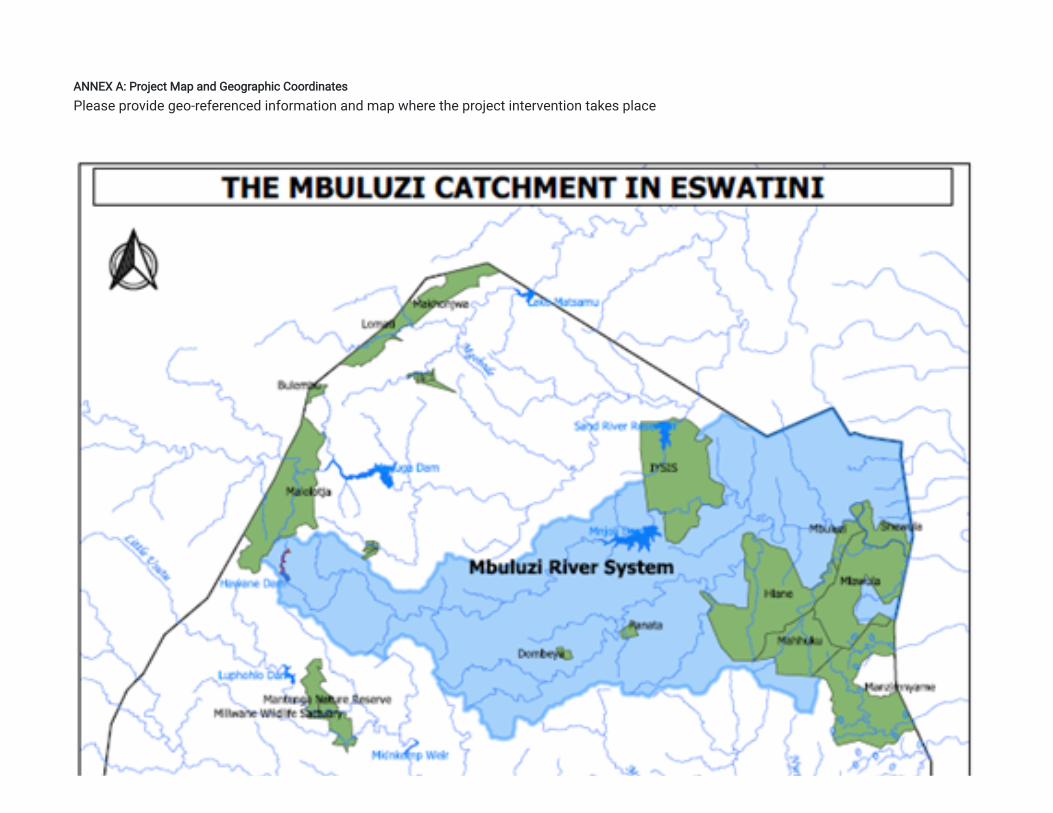
ANNEX A: Project Map and Geographic Coordinates
Please provide geo-referenced information and map where the project intervention takes place