Resource Potential of the Tana Basin with Particular Focus on the Bwathonaro Watershed, Kenya
15
Agwata Summer School 2006 FWU, Vol. 5, Participatory Watershed Management Plan 1 Resource Potential of the Tana Basin with Particular Focus on the Bwathonaro Watershed, Kenya Jones F. Agwata Department of Environmental Sciences, Kenyatta University, P. O. Box 43844, 00100 GPO Nairobi, Kenya; Email: [email protected] Abstract The Tana Basin of Kenya is one of the most important basins in the country comprising of several catchments that are endowed with diverse resources. The utilization of these resources is necessary to the development of the basin and the whole country. However, the way the various resources in the basin are used can have serious implications on the basin’s environment upon which the resources depend. Before resources in any basin can be put to use, it necessary and important to know the type of resources available in the basin and how use of the resources affects the basin or catchment. In this paper a general overview of the Tana Basin is provided and the resource potential in the Bwathonaro watershed, an important catchment in Meru North District in the upper parts of the basin, presented. The challenges of resource utilization in the watershed are examined and some of the interventions to the challenges suggested towards ensuring integrated and sustainable management of the resources in the watershed for continued development of the watershed and the entire basin. Introduction The Tana Basin shown as drainage Area 4 in Figure 1.1 is one of the five drainage basins in Kenya covering nearly 21% of the country’s total surface area and covers various agro-ecological zones. It has three major water towers namely Mt. Kenya
Transcript of Resource Potential of the Tana Basin with Particular Focus on the Bwathonaro Watershed, Kenya

Agwata Summer School 2006
FWU, Vol. 5, Participatory Watershed Management Plan 1
Resource Potential of the Tana Basin with Particular Focus on
the Bwathonaro Watershed, Kenya
Jones F. Agwata
Department of Environmental Sciences, Kenyatta University,
P. O. Box 43844, 00100 GPO Nairobi, Kenya;
Email: [email protected]
Abstract
The Tana Basin of Kenya is one of the most important basins in the country
comprising of several catchments that are endowed with diverse resources. The
utilization of these resources is necessary to the development of the basin and the
whole country. However, the way the various resources in the basin are used can
have serious implications on the basin’s environment upon which the resources
depend. Before resources in any basin can be put to use, it necessary and important
to know the type of resources available in the basin and how use of the resources
affects the basin or catchment. In this paper a general overview of the Tana Basin
is provided and the resource potential in the Bwathonaro watershed, an important
catchment in Meru North District in the upper parts of the basin, presented. The
challenges of resource utilization in the watershed are examined and some of the
interventions to the challenges suggested towards ensuring integrated and
sustainable management of the resources in the watershed for continued
development of the watershed and the entire basin.
Introduction
The Tana Basin shown as drainage Area 4 in Figure 1.1 is one of the five drainage
basins in Kenya covering nearly 21% of the country’s total surface area and covers
various agro-ecological zones. It has three major water towers namely Mt. Kenya

Summer School 2006 Agwata
2 FWU, Vol. 5, Participatory Watershed Management Plan
in the North and North East contributing about 49% of runoff, the Aberdare
Ranges to the West contributing about 42% and the Nyambene Hills to the East of
the basin contributing nearly 7% of the total runoff in the basin (WRMA, 2006).
The Tana is the main River traversing the basin and has many tributaries bringing
water to it. The basin enjoins twenty districts in four different provinces namely
Central, Eastern, North Eastern and Coast. It sustains a population of about five
million people.
The river has a total length of about 1,012 kilometers from the farthest source to
the Indian Ocean and has an annual mean discharge of five billion cubic meters
covering a total catchment area of about 126,000 km2. It is divided into three
catchments namely upper, middle and lower catchment areas. The upper catchment
covers about 15,000 km2 at an altitude of 1000 m above mean sea level whilst the
middle catchment covers an area of 15,700 km2 at an altitude of between 1,000 and
200 meters above mean sea level. The lower catchment covers about 95,300 km2 at
altitudes below 200 meters (Hirji et al., 1996).

Agwata Summer School 2006
FWU, Vol. 5, Participatory Watershed Management Plan 3
Figure 1.1: The drainage basins of Kenya with the Tana Basin
indicated as drainage Area 4 (Source: NEMA, 2003)
Since the basin traverses various regions of diverse agro-ecological zones, its
agricultural potential and production varies from one catchment to another with the
upper portions of the basin having the largest concentration of coffee and tea
farms. Horticultural crops and flowers, rice and food crops such as cereals, bananas
and potatoes are also produced in various parts of the basin. Livestock production
is also practiced for milk, beef and mutton while pig farming in the basin is
widespread (Hirji et al., 1996; Agwata, 2005b). Nearly 70% of the hydroelectricity
supply in the country is generated from the several dams located in the basin. This

Summer School 2006 Agwata
4 FWU, Vol. 5, Participatory Watershed Management Plan
hydropower potential is due to the many tributaries scattered in parts of the upper
portion of the basin with a hydropower potential estimated at 960 MW. Currently,
six dams are located at various points along the main Tana River.
Other economic activities within the basin include wildlife in the forests on the
mountains in the upper parts of the basin that serve as important wildlife
conservation sites with several game parks and tourism destination centers. The
lower parts serve as rich habitats for biodiversity which is important for
development of tourism activities in the basin. Since nearly 80% of the basin is
arid and semi arid and only 20% of the land is humid where rain fed agricultural
production is practiced, some form of supplemental water in order for any
meaningful socioeconomic activities to take place, increasing of both human and
livestock population puts increasing demand for various resources such as energy,
food and pasture in most parts of he basin (WRMA, 2005).
The agro-ecological zones in the basin are high potential zones in which coffee,
tea, pyrethrum, wheat and barley; dairy, sheep and poultry are practiced whilst the
medium potential zone maize, sunflower and beans as the major crops although
some poultry, sheep and dairy are also kept. The low potential zone has millet,
cotton, tobacco and sorghum as the main crops. The irrigation potential in the basin
is estimated at 132,000 hectares with the developed and planned irrigation schemes
covering an area of 54,676 ha. The irrigation practices found within the basin fall
under three categories namely small scale group based schemes dealing mainly
with horticulture and floriculture; individual holder schemes mainly for high cost
crops such as macadamia, floriculture and ornamental crops and the public
irrigation schemes that are managed by government agencies such as the National
Irrigation Board and the Agricultural Development Corporation.
The increasing population, expansion in industrial and commercial activities and
changes in land use practices in the basin has resulted in increasing demand for
various resources. For instance, increased demand for water resources causes
conflicts in water utilization due to competing interests. Utilization of the water
resources should be done such that conflicts arising out of resource use are

Agwata Summer School 2006
FWU, Vol. 5, Participatory Watershed Management Plan 5
minimal and are resolved amicably to reduce tensions that are likely to affect the
development of the basin and associated catchments. The major challenges
affecting the basin include over abstraction of water, poor water resources
management, pollution and basin degradation. To address some of these
challenges, various resources in the basin such as soils, forests, energy, wildlife,
minerals and water should be conserved to ensure continued availability for
various competing uses. All the stakeholders should also be encouraged to actively
participate in the management of the resources in the basin (Agwata, 2005a, b).
The Bwathonaro Watershed
The Bwathonaro watershed is a small catchment covering about 150 km2 located in
Meru North District in the Eastern Province of Kenya. It lies between
approximately 2,050 m above sea level in the upper sections and about 700 m
above sea level in the lower parts near the Meru National Park. On average, annual
rainfall in the catchment is ranging between 700 and 1300 mm per year and is
bimodally distributed in two seasons namely the long rainy season from March to
May and the short rainy season from October through December. The average
annual temperature over the catchment is about 18° C.
The population density in the catchment is about 350 persons per km2 with a total
population of about 46,000 people. About 45 water projects are operating in the
catchment with only fourteen having permits while the rest operate illegally. The
catchment has rich agricultural potential with both food and cash crops grown in
the area. The main cash crops include tea, coffee and miraa while the food crops
include maize, beans, sugarcane, and arrow roots. Many farmers plant trees such as
eucalyptus, gravellier next to the watercourses besides tilling the land near the
edges of the water. This leads to serious erosion in the catchment and siltation of
the River (WRMA, 2005, 206).

Summer School 2006 Agwata
6 FWU, Vol. 5, Participatory Watershed Management Plan
Resource Potential in the Watershed
The Bwathonaro watershed is endowed with various resources whose utilization
can have a positive or negative impact on the watershed. To appreciate the
implications of resource use in the watershed it is necessary to know what
resources are available in the watershed since the planning and management of the
resources significantly influences the social and economic development of the
watershed and the entire basin. On the other hand resource utilization in the
watershed can have implications on the adjacent watersheds and the entire basin
especially if there are some cases where certain areas are facing deficits in specific
resources due to natural or anthropogenic reasons.
The natural conditions in the Bwathonaro River watershed are influenced mainly
by the Nyambene hills which due to variations in altitude influence the
environmental conditions resulting in a wide variety of microclimates and agro-
ecological zones. The upper parts of the watershed are forested and provide
important catchments for the various resources such as water which is necessary
for commercial, domestic, irrigation and wildlife in the watershed. The watershed
and the district are endowed with diverse resources that have greatly contributed to
the socio-economic development of the area. Some of these resources include
water, land/soil, energy, forestry and wildlife.
In the following sections available resources in the watershed such as human,
water, land/soil, forests/wildlife and energy resources are presented.
(a) Human Resource
Bwathonaro watershed cuts across several divisions in Meru North District
including Igembe East, Central, North and South East; Ndoleli and Meru National
Park. The various divisions that form the watershed vary in area, population sizes
and densities. The total population is estimated at 46,000 people with a density of
350 persons/ km2. The divisions in the drier zones to the north of the watershed
have lesser population density.

Agwata Summer School 2006
FWU, Vol. 5, Participatory Watershed Management Plan 7
High levels of absolute poverty occur in some parts of the watershed with urban
slum dwellers located in towns and market centres in the watershed. Due to this,
cases of child labourers are found in khat growing parts of the watershed. This has
seriously affected enrolment levels particularly for boys in the primary schools.
Due to high population densities in the high potential areas, people have moved to
less populated areas, forested areas, steep hills, swamps, river banks causing
serious destabilization of the watershed ecosystem. This has caused serious cases
of environmental degradation in the watershed and affected other resources such as
water, land and soils and forests.
(b) Water Resources
The watershed is not well endowed with surface water resources especially in the
arid and semi arid zones of the area. The main water source in the area is River
Bwathonaro whose water is abstracted for various activities in the watershed. The
water from the river serves the people in the upper, middle and lower zones of the
watershed. The water is heavily abstracted from the river at various points and sold
to various users at KShs 70 per a 20 l jerry can.
About forty five water projects operate in the watershed although only fourteen are
licensed with the rest operating illegally. Other sources of water that have potential
include several springs most of which are not protected. Several swamps such as
Mporoko also exist in the watershed but have been encroached into and degraded
causing reduction of water into the river. Due to the degradation of the swamps, the
quality of the water in the springs and river has been affected although the exact
extent and nature of the pollution n terms of loadings and characteristics are not
known.
Information on the status of ground water resources in the watershed that can be
used to supplement surface water sources is generally not available.
(c) Land and Soil Resources
The watershed has land and soils that are useful for various agricultural activities.
Since most of the land in the watershed is trust government land, cases of
encroachment are high and the local administration has been involved in the past in
Summer School 2006 Agwata
8 FWU, Vol. 5, Participatory Watershed Management Plan
the subdivision and settlement of people in government land causing serious
degradation of the watershed. The subdivision of land to small parcels has reduced
economic viability of the land for various economic activities.
There is urgent need to move people from water catchment areas like swamps and
springs and have them resettled elsewhere. Concerted soil and land conservation
efforts and extension services to increase agricultural productivity of the land
should also be encouraged.
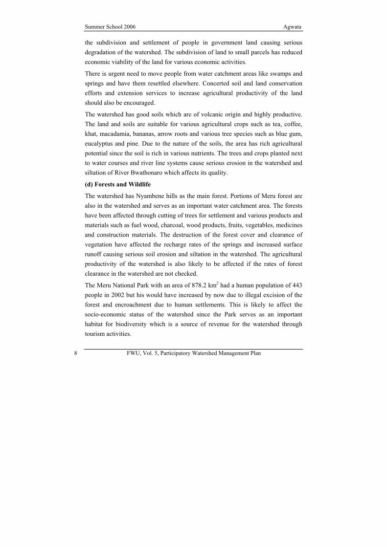
The watershed has good soils which are of volcanic origin and highly productive.
The land and soils are suitable for various agricultural crops such as tea, coffee,
khat, macadamia, bananas, arrow roots and various tree species such as blue gum,
eucalyptus and pine. Due to the nature of the soils, the area has rich agricultural
potential since the soil is rich in various nutrients. The trees and crops planted next
to water courses and river line systems cause serious erosion in the watershed and
siltation of River Bwathonaro which affects its quality.
(d) Forests and Wildlife
The watershed has Nyambene hills as the main forest. Portions of Meru forest are
also in the watershed and serves as an important water catchment area. The forests
have been affected through cutting of trees for settlement and various products and
materials such as fuel wood, charcoal, wood products, fruits, vegetables, medicines
and construction materials. The destruction of the forest cover and clearance of
vegetation have affected the recharge rates of the springs and increased surface
runoff causing serious soil erosion and siltation in the watershed. The agricultural
productivity of the watershed is also likely to be affected if the rates of forest
clearance in the watershed are not checked.
The Meru National Park with an area of 878.2 km2 had a human population of 443
people in 2002 but his would have increased by now due to illegal excision of the
forest and encroachment due to human settlements. This is likely to affect the
socio-economic status of the watershed since the Park serves as an important
habitat for biodiversity which is a source of revenue for the watershed through
tourism activities.
Agwata Summer School 2006
FWU, Vol. 5, Participatory Watershed Management Plan 9
The encroachment and destruction of the forest also has far reaching consequences
on water resource which is in great demand in the watershed.
(e) Energy Resources
River Bwathonaro is one of the tributaries of the Tana River which supplies water
to the several dams in the basin for hydropower generation. The river can also
serve as a source of water for small dams to store water for use in the production of
micro-hydropower in the watershed. There is potential for solar and wind energy
production in the arid and semi arid parts of the watershed but this needs to be
examined.
The possibility of biogas production as a source of energy using human and
agricultural wastes is another way to reduce pressure on forests and other resources
used as energy sources in the watershed.
Challenges of Resource Use in the Watershed
Utilization of various resources in the watershed has various implications and
challenges that need to be addressed to ensure sustainable and integrated use of the
resources. The major challenge in the watershed is resource degradation and
scarcity. For instance, water scarcity is a major issue in the watershed due to
increasing demand for competing uses such as irrigation, domestic and commercial
activities. In the watershed, there is increasing need for water for irrigation of khat
farms and other land use activities. This often leads to over abstraction of the water
from the main river in the watershed particularly in the dry season when there is
usually stiff competition for water among the various projects that require water. In
some cases some of the khat and eucalyptus farmers can abstract the water leaving
the river without any flow downstream. During the dry season, there is serious
water shortage in the watershed, which affects all categories of water users such as
the domestic, water vendors, residents in trading centers, those needing water for
irrigation, road construction, various farming activities and wildlife needs within
the area.
Summer School 2006 Agwata
10 FWU, Vol. 5, Participatory Watershed Management Plan
The various land use activities in the watershed require water for their operations
and since there is lack of sufficient quantities to satisfy all needs, there are serious
conflicts due to different water demands in the watershed. The first conflict due to
water scarcity and distribution is caused by the uneven spatial and temporal
distribution of water in the watershed which is aggravated by the fact that a large
percentage of the watershed is in arid and semi arid zone. This means that water
demands in these dry zones have to be met from areas with abundance and the
excess stored during the wet season for use in the dry season. Also, consumptive
uses such as irrigation are known to remove water from the watershed that would
otherwise be used for other functions.
The other challenge is deforestation and vegetation clearance of wetlands, springs
and swamps by way of cutting of indigenous trees in the catchment for settlements,
agriculture and commercial activities. The drainage of wetlands like the Mporoko
swamp, which is the main source of river Bwathonaro, is due to the need for
cultivation of arrow roots and yams (WRMA, 2005, 2006). The watershed also
faces serious environmental degradation due to wanton destruction of swamps,
springs and planting of tree species that use lots of water, encroachment of river
banks and planting of non water friendly trees near the river banks. The river can
easily dry up especially during drought conditions as a result of over abstraction
and the changes to the river course, leading to biodiversity loss in the river. The
degradation of the environment on which various resources depend may occur due
to poor land use activities leading into intensification in the demand for resources
within the watershed.
Another challenge is due to lack of sanitation and sewerage facilities especially in
urban centres and towns. This means that sewage and other pollutants from
commercial activities and agricultural produce such as coffee, tea, tobacco
processing and insecticides, herbicides and fertilizer use that produce effluents and
residues find their way into the Bwathonaro River and other streams causing water
pollution. The generation of domestic and sewage wastes also degrades the quality
of water in the rivers if these are not properly treated and disposed of. As a result
Agwata Summer School 2006
FWU, Vol. 5, Participatory Watershed Management Plan 11
of the poor quality of the water from the river and the streams, the water is
unusable for other purposes unless it is treated. The river and streams in the
watershed also receive lots of sediments and silt from erosion processes in the
watershed. The accumulation of the sediments and silt in the river courses and
steams reduces the amount of water available for various functions.
Interventions on Resource Use
Regulation in the Use of the Watershed’s Resources
The resources in the watershed should be managed in a sustainable and integrated
way by promoting their conservation and by protecting various areas across the
watershed. Besides helping to minimize the conflicts over resource use,
conservation measures will increase the availability of the resources in the
watershed for continued development of the area. In the case of water, water
permits should be issued and used in an organized manner so that there is water
available to all people at any given time to avoid conflicts among the various water
users. Measures that may be applied to avoid or minimize would include
construction of water storage facilities like dams and harvesting of water from
roofs and surface runoff, gazetting of the key water towers, springs and swamps in
the watershed, making laws to govern rivers, acting on illegal connections and
revocation of single permit users (Liniger, 1995; WRMA, 2005, 2006). There is
need to ensure comprehensive planning to ensure that water diversion upstream is
managed in an integrated manner.
To avoid some of the cases of environmental degradation in the catchment, there is
need to plants trees that do not consume lots of water, avoid farming along the
river line, setting up or rehabilitating the catchment rehabilitation projects and
mobilizing funds from all the stakeholders to rehabilitate the catchment area (MFP,
2002).

Summer School 2006 Agwata
12 FWU, Vol. 5, Participatory Watershed Management Plan
Control of Watershed Soil Erosion and Degradation
Soil erosion control measures and mechanisms should be put in place in the
watershed so that various land use practices such as agriculture, livestock
husbandry, forest resource utilization, settlements and infrastructure development
are carried out in a sustainable manner. Farmers and other stakeholders should be
encouraged to protect soils from erosion processes through provision of tree
seedlings to reduce destruction of forests and vegetation in the river catchment
areas. The protection of riverbanks to minimize changes in river line channels
should also be made an integral part of agricultural and other land use practices in
the watershed. In the case of destruction and encroachment of swamps and springs,
there is need to convert catchment areas into public utility places and promote
indigenous tree planting activities to conserve the watershed. The available springs
in the watershed should also be clearly demarcated and their conservation
promoted.
Other mitigation measures that may be applied to minimize the conflicts in
resource utilization include formation of joint committees for all the water users in
the watershed, giving responsibility of issuance and supervision of water permits to
registered water projects under the water user association, involving the
government in building capacity for the community living within the watershed,
training the selected committee on how to manage water and resolve conflicts,
rationing of water according to its availability and ensuring that those next to the
water courses allow easy access to the water users.
Control of Watershed Pollution
Water resources management in watershed and other catchments of the basin
should include the protection of water resources from pollution arising from
domestic, agricultural, commercial and industrial effluents. The location of various
domestic facilities such as pit latrines, abattoirs, coffee factories and other
polluting enterprises near water sources need to be discouraged and monitored to
avoid heavy pollution loads in the water courses. This can only work if statutory
powers to enforce effluent release standards are given to watershed user
Agwata Summer School 2006
FWU, Vol. 5, Participatory Watershed Management Plan 13
associations to carry out all aspects of pollution control such as river monitoring
and water pollution surveillance, among others. This requires training of personnel
from the associations and the building of capacity to undertake such activities.
Funding for Resources Management
There is need to address the issue of funding to ensure sustainable use of resources
and their management in the watershed. This is vital since resource availability
sustains the social and economic development of the people in the watershed. For
instance, since water plays an important role in agricultural development, industrial
production and commerce, it must be paid for appropriately. The payment for
water services provision should meet the costs of water conservation, river
regulation, infrastructure maintenance and development, pollution control
enforcement and acquisition of necessary data (Al-Mohannadi, et al., 2003).
Recommendations
Continued increase in population puts increasing demand for various resources to
meet various needs in the Tana Basin and the Bwathonaro watershed. The various
resources in the basin should therefore be managed in a sustainable and integrated
way since the social and economic development of the watershed and the basin
depends on the availability of the resources in the basin. For this to happen, it is
necessary to:
a. Evaluate the roles of various government agencies and other stakeholders to
ensure full benefits and responsibilities of integrated resources management
in the watershed and the basin
b. Built the necessary capacity in the local communities to meet the needs of
integrated resources management in their respective areas
c. Conduct environmental impact assessment of existing and proposed
development projects that are likely to negatively impact on the
environment upon which all resources depend
Summer School 2006 Agwata
14 FWU, Vol. 5, Participatory Watershed Management Plan
d. Promote multi- and inert-interdisciplinary approaches to planning, research,
implementation and monitoring of resource use practices within the basin
and catchment
e. Identify needs and potentials for education programs for the people at all
levels people in various catchment areas to inculcate the proper attitude
towards resource use
f. Develop a watershed management plan to guide the use of various resources
in the watershed
g. Encourage active participation of the local people in the management of
watershed resources to ensure sustainable use of the same
Conclusion
The Tana Basin generally and the Bwathonaro watershed in particular are endowed
with diverse resources such as water, land/soils, forestry and wildlife. The use of
these resources poses serious challenges in the leading to serious conflicts. It is
important that resource exploitation occurs in such away to avoid the degradation
of the watershed and the basin to ensure continued socio-economic development of
the people. This requires the participation of all the stakeholders in coming up with
appropriate strategies and mechanisms of ensuring integrated resource use through
suitable resource use plans.
Agwata Summer School 2006
FWU, Vol. 5, Participatory Watershed Management Plan 15
References
AGWATA, J. F. (2005a): The Characteristics of Hydrological Drought in the Upper
Parts of the Tana Basin, Kenya (Unpublished PhD thesis). Kenyatta
University, Nairobi.
AGWATA, J. F. (2005b): Water Resources Utilization, Conflicts and Interventions
in the Tana Basin of Kenya. In: G. Förch, R. Winnegge and S. Thiemann
(eds): Topics of Integrated Watershed Management, Water Resources
Publications, No 3. University of Siegen, Germany. Pp. 13-24.
AL-MOHANNAD, H. I., HUNT, C. O. AND WOOD, A. P. (2003): Controlling Water Demand in Qatar: An Assessment. In: AMBIO, No. 32. Pp. 362-366.
HIRJI, R., PARTONI, F. M. AND RUBIN, D. EDS. (1996): Proceedings of the Seminar
on Integrated Water Resources Management in Kenya. The Economic
Development Institute of the World Bank, Washington. Pp. 15-129.
LINIGER, H. (1995): Endangered Water: A global overview of degradation,
conflicts and strategies for improvement. Centre for Development and
Environment, Institute of Geography, University of Berne, Switzerland. Pp.
117.
MINISTRY OF FINANCE AND PLANNING (MFP) (2002): Meru North District Development Plan, 2002-2008. Government Press, Nairobi.
NATIONAL ENVIRONMENTAL MANAGEMENT AGENCY (NEMA) (2003): State of the
Environment Report, Kenya. Government Printer, Nairobi. Pp. 53-60.
WATER RESOURCES MANAGEMENT AUTHORITY (WRMA) (2005): Workshop on
the Formation of Buathonaro Water Users Association (Workshop Report).
Nairobi. Pp. 28.
WATER RESOURCES MANAGEMENT AUTHORITY (WRMA) (2006): Buathonaro
River Water Resources Users Association (BUAWRUA) Management Induction Workshop (Workshop Report), Nairobi. Pp. 48.