Resolution - Maui County
13
Resolution No. 05-88 ACCEPTING DEDICATION OF REAL PROPERTY SITUATE AT PULEHUNUI, WAILUKU, MAUl, HAWAII, FROM THE STATE OF HAWAII PURSUANT TO SECTION 3.44.015, MAUI COUNTY CODE WHEREAS, the State of Hawaii (hereinafter n State n) is the owner of that certain parcel of real property situate at Pulehunui, Wailuku, Maui, Hawaii, area of 222.626 acres, more particularly identified as TMK (2)3-8-008:001 (Por.) (hereinafter lithe Propertyll); and WHEREAS, on December 4,2003, the Honorable Linda Lingle, Governor of the State of Hawaii, by authority of Section 171- 11, Hawaii Revised Statutes, set aside the Property to the County of Maui by Executive Order No. 4024, for the public purposes of a public and recreational site, a true and correct copy of said Executive Order No. 4024 being attached hereto as Exhibit 11111; and WHEREAS, the County of Maui desires to accept dedication of the Property and take over the exclusive management and control of the Property! all in accordance with Section 171- 11, Hawaii Revised Statutes; and WHEREAS I pursuant to Maui County Code Section 3.44.015{C) I the County Council may accept gifts or donations of real property or any interest in real property by the passage of a resolution approved by a majority of its members; now, therefore, BE IT RESOLVED by the Council of the County of Maui: 1. That it hereby accepts the Property as described in Exhibit "1", pursuant to Section 3.44.015(C), Maui County Code; and 2. That it does hereby authorize the Mayor of the County of Maui to execute all necessary documents in connection with the acceptance of said dedication; and Resolution No. 05-88 ACCEPTING DEDICATION OF REAL PROPERTY SITUATE AT PULEHUNUI, WAILUKU, MAUl, HAWAII, FROM THE STATE OF HAWAII PURSUANT TO SECTION 3.44.015, MAUl COUNTY CODE WHEREAS, the State of Hawaii (hereinafter n State Il) is the owner of that certain parcel of real property situate at Pulehunui, Wailuku, Maui, Hawaii, area of 222.626 acres, more particularly identified as TMK (2)3-8-008:001 (Por.) (hereinafter lithe Propertyll); and WHEREAS, on December 4,2003, the Honorable Linda Lingle, Governor of the State of Hawaii, by authority of Section 171- 11, Hawaii Revised Statutes r set aside the Property to the County of Maui by Executive Order No. 4024, for the public purposes of a public and recreational site, a true and correct copy of said Executive Order No. 4024 being attached hereto as Exhibit 111"; and WHEREAS, the County of Maui desires to accept dedication of the Property and take over the exclusive management and control of the Property, all in accordance with Section 171- 11, Hawaii Revised Statutes; and WHEREAS I pursuant to Maui County Code Section 3.44.015{C) I the County Council may accept gifts or donations of real property or any interest in real property by the passage of a resolution approved by a majority of its members; now, therefore, BE IT RESOLVED by the Council of the County of Maui: 1. That it hereby accepts the Property as described in Exhibit "1", pursuant to Section 3.44.015(C), Maui County Code; and 2. That it does hereby authorize the Mayor of the County of Maui to execute all necessary documents in connection with the acceptance of said dedication; and
-
Upload
khangminh22 -
Category
Documents
-
view
0 -
download
0
Transcript of Resolution - Maui County

Resolution No. 05-88
ACCEPTING DEDICATION OF REAL PROPERTY SITUATE AT PULEHUNUI, WAILUKU, MAUl, HAWAII, FROM THE STATE
OF HAWAII PURSUANT TO SECTION 3.44.015, MAUI COUNTY CODE
WHEREAS, the State of Hawaii (hereinafter n State n) is the owner of that certain parcel of real property situate at Pulehunui, Wailuku, Maui, Hawaii, area of 222.626 acres, more particularly identified as TMK (2)3-8-008:001 (Por.) (hereinafter lithe Propertyll); and
WHEREAS, on December 4,2003, the Honorable Linda Lingle, Governor of the State of Hawaii, by authority of Section 171-11, Hawaii Revised Statutes, set aside the Property to the County of Maui by Executive Order No. 4024, for the public purposes of a public and recreational site, a true and correct copy of said Executive Order No. 4024 being attached hereto as Exhibit 11111; and
WHEREAS, the County of Maui desires to accept dedication of the Property and take over the exclusive management and control of the Property! all in accordance with Section 171-11, Hawaii Revised Statutes; and
WHEREAS I pursuant to Maui County Code Section 3.44.015{C) I the County Council may accept gifts or donations of real property or any interest in real property by the passage of a resolution approved by a majority of its members; now, therefore,
BE IT RESOLVED by the Council of the County of Maui:
1. That it hereby accepts the Property as described in Exhibit "1", pursuant to Section 3.44.015(C), Maui County Code; and
2. That it does hereby authorize the Mayor of the County of Maui to execute all necessary documents in connection with the acceptance of said dedication; and
Resolution No. 05-88
ACCEPTING DEDICATION OF REAL PROPERTY SITUATE AT PULEHUNUI, WAILUKU, MAUl, HAWAII, FROM THE STATE
OF HAWAII PURSUANT TO SECTION 3.44.015, MAUl COUNTY CODE
WHEREAS, the State of Hawaii (hereinafter n State Il) is the owner of that certain parcel of real property situate at Pulehunui, Wailuku, Maui, Hawaii, area of 222.626 acres, more particularly identified as TMK (2)3-8-008:001 (Por.) (hereinafter lithe Propertyll); and
WHEREAS, on December 4,2003, the Honorable Linda Lingle, Governor of the State of Hawaii, by authority of Section 171-11, Hawaii Revised Statutes r set aside the Property to the County of Maui by Executive Order No. 4024, for the public purposes of a public and recreational site, a true and correct copy of said Executive Order No. 4024 being attached hereto as Exhibit 111"; and
WHEREAS, the County of Maui desires to accept dedication of the Property and take over the exclusive management and control of the Property, all in accordance with Section 171-11, Hawaii Revised Statutes; and
WHEREAS I pursuant to Maui County Code Section 3.44.015{C) I the County Council may accept gifts or donations of real property or any interest in real property by the passage of a resolution approved by a majority of its members; now, therefore,
BE IT RESOLVED by the Council of the County of Maui:
1. That it hereby accepts the Property as described in Exhibit "1", pursuant to Section 3.44.015(C), Maui County Code; and
2. That it does hereby authorize the Mayor of the County of Maui to execute all necessary documents in connection with the acceptance of said dedication; and

Resolution No. 05-88 --....::~.....;:;..:::::---
30 That certified copies of this Resolution be transmitted to the Mayor of the County of Maui, the Director of Housing and Human Concerns, the Director of Parks and Recreation, the Director of Finance, the Director of Planning, the Director of Public Works and Environmental Management I and the Stateo
APPROVED AS TO FORM
;;;;ii2( EDWARD S. KUSHI, JR. Deputy Corporation Counsel County of Maui S,\ALL\ESK\RESO\State E.O. 4024; pulehunui.wpd

) } ) ) ) ) ) ) ) ) ) ) ) ) ) ) ) ) )
LAND COURT SYSTEM) REGULAR SYSTEM Return by Mail ( ) pl~c~k~u-p--~~~)--~T~O--:----------~----------------
FROM:
TO:
Total Number of Pages: Tax Map Key No. (2)3 -8 -008: Por. 001
STATE OF HAWAII BOARD OF LAND .AND NATURAL RESOURCES
COUNTY OF MAUl 200 South High Street Wailuku, Hawaii 96793
EXECUTIVE ORDER NO. 4.024 SETTING AS~DE LAND FOR PUBLIC PURPOSES
BY THIS EXECUTIVE ORDER, I, the undersigned, Governor of the State of Hawaii, by virtue of the au.thority in me vested by Section 171-11, Hawaii Revised Statutes, and every other aut.hority me hereunto enabling, do hereby order that the public 1 and her'einafter described be, and the same is, hereby set aside for the following public purposes:-
FOR PUBLIC AND RECREATIONAL SITE, to be under the control and management of the County of Maui, being that parcel of l.and situate at Pulehunui, Wailuku, Maui f Hawaii, identified
69205 1
DEPARTMENT OF LAND AND NATURAL RESOURCES LAND DIVISION
P.O. BOX 621

as "Public and Recreational Site," containing an area ,of 222.626 acres, more particularly described in Exhibit "A" and delineated on Exhibit "B," both of which are attached hereto and made parts hereof,' said exhibits being respectively , a survey description and survey map prepared by the Survey Division, Department of Accounting and_General Services, State of Hawaii, both being designated C.S.F. No. 23,'637 and dated October 13, 2003.
SUBJECT, HOWEVER, to the condition that upon cancellation of this executive order or in the event of non-use or abandonment of the premises or any portion thereof for a continuous period of one (1) year, or for any reason whatsoever, the County of Maui shall, within a reasonable time, restore the premises to a con.dition satisfactory and acceptable to the Department of Land and Natural Resources, State of Hawaii.
SUBJECT, FURTHER, to disapproval by the Legislature by two-thirds vote of either the Senate or the House of Representatives or by majority vote of both, in any regular or special session next following the date of this ~xecutive Order.
Sl]BJECT, Fp,R'l'HER, that four (4) acres of the subject lands shall' be provided to thePepartmentof Land and Natural Resources and shall. be exempt from its pro rata share of development costs involving the planned area.
IN WITNESS WHEREOF, I have hereunto set my hand and ' caused the Great Seal of the State of H~'f?}.i to be affixed. Done at the Capitol at Honolulu this 't~ day of
Vu/lllvb W , 2003.
APPROVED AS TO FORM: /
~,#.-~---~ ......... .., ...
;"' .. ", ~~ ~Pu~y Attor e Geleral \
i'i-,:<. :'.~: .. ,. ~i~'P·r.>. '\
Dated: 1/ /~/(}3 r I
2
DEPARTMENT OF LAND AND NATURAL RESOURCES LAND DIVISION
P.O. BOX 621
HONO ... ULU, HAWAII 96809
:..,.(!;,.: ;":1 ':..:!1;'! ,-,,! -,.1 o f • J l~~;:Y'- .:'. (·.~.i.t~'~ .. ";.!~ -'
as upublic and Recreational Site," containing an area of 222.626 acres, more particularly described in Exhibit UA" and delineated on Exhibit uB," both of which are attached hereto and made parts hereof, said exhibits being respectively, a survey description and survey map prepared by the Survey Division, Department of Accounting and_General Services, State of Hawaii, both being designated C.S.F. No. 23,'637 and dated October 13, 2003.
SUBJECT, HOWEVER, to the condition that upon cancellation of this executive order or in the event of non-use or abandonment of the premises or any portion thereof for a continuous period of one (1) year, or for any reason whatsoever, the County of Maui shall, within a reasonable time, restore the premises to a con.dition satisfactory and acceptable to the Department of Land and Natural Resources, State of Hawaii.
SUBJECT, FURTHER, to disapproval by the Legislature by two-thirds vote of either the Senate or the House of Representatives or by majority vote of both, in any regular or special session next following the date of this ~xecutive Order.
SlJBJECT, F'9R'l'HER, that four (4) acres of the subject lands shall· be provided to thePepartmentof Land and Natural Resources and shall. be exempt from its pro rata share of development costs involving the planned area.
IN WITNESS WHEREOF, I have hereunto set my hand and caused the Great Seal of the State of H~¥~i to be affixed. Done at the Capitol at Honolulu this Lf'l!.t day of
VultnvbW , 2003.
APPROVED AS TO FORM: /
~,#.-~---~ ......... .., ...
;"' .. •. , ~~~ ~Pu~y Attor e Geleral \
i'i-,:<. :.~: .... ~i~'P·r.>. '\
Dated: 1/ /~/(}3 r I
2
DEPARTMENT OF LAND AND NATURAL RESOURCES LAND DIVISION
P.O. BOX 621
HONO ... ULU, HAWAII 96809
:....(!;,.:i·:1':..::!1;.!,·.!-.. 1· f • J l~~;:Y'- .:'. ':·.~.i.t~'· .. ";.!~ -'
STATE OF HAWAII
Office of the Lieutenant Governor
THIS IS TO CER'rJFY.That the within is a true copy of Executive Order No. _ ~ 0 24 setting aside land for public purposes, the original of which is on file in this office.
69205 1
IN TESTIMONY WHEREOF, the Lieutenant Governor of the State of Hawaii, has hereunto subscribed his name and caused the Great Seal of the State ·to be affixed.
DEt 0 e ZII8
DONE in day of
___________________________ ~ _______ , A.D. 2003
3
DEPARTMENT OF LAND AND NATURAL- RESOURCES LAND DIVISION
P.O. BOX 621
................. ...,. ...... -~ ....... '
/
" , .. ~::

23,637 C ••• P'. NO __ -'--__
STATE OF HAWAII SURVEY DIVISION
DEPT. OF ACCOUNTING AND GENERAL. SERVICES
HONOLULU
PUBLIC AND RECREATIONAL SITE
Pulehunui, Wailuku, Maui, Hawaii'
October 13, 2003
Being a portion of Land Patent 8140, Land Commission Award 5230 to Keawearnahi conveyed to the Territory of Hawaii by Hawaiian Commercial and Sugar Company, Ljm~.~ by deed dated April 22, 1938 and recorded inL,ber 1436, Page 211 (Land Office Deed 5880) and by deed dated November 1, 1945:recordedin Liber 1918, Page 290 (Land Office Deed 7887).
Being also portions of Parcel 1 of Quitclaim Deed: United States of. America to the Territory of Hawaii dated December 31, 1948 and recorded in Liber 2200, Page 374 (Land Office Deed 8664) and Quitclaim Deed: United States of America to the Territory of Hawaii dated December 3.1, 1948 and recorded in Liber 2199, Pages 461-479 (Land Office Deed 8663).
Beginning at the northwest corner of this parcel ofland, the southwest
comer ofMaui Army National Guard Facility Site, Governor's Executive Order 3909 and
on the east side of Mokulele Highway, FA.P. No. NH-0900(59), the coordinates of said
point of beginning referred to Government Survey Triangulation Station
"PUU HELE" being 792.5! feet North and 12,887.29 feet East, the9-ce running by
azimuths measured clockwise from True South:-
1. 264 0 45' 20"
......
288.81 feet along Maui Army National Guard Facility Site, Governor's Executive Order 3909~
-1- EXHIBlT -"A~
23,637 C ••• P'. NO __ -'--__
STATE OF HAWAII SURVEY DIVISION
DEPT. OF ACCOUNTING AND GENERAL. SERVICES
HONOLULU
PUBLIC AND RECREATIONAL SITE
Pulehunui, Wailuku, Maui, Hawaii'
October 13, 2003
Being a portion of Land Patent 8140, Land Commission Award 5230 to Keawearnahi conveyed to the Territory of Hawaii by Hawaiian Commercial and Sugar Company, Ljm~.~ by deed dated April 22, 1938 and recorded inL,ber 1436, Page 211 (Land Office Deed 5880) and by deed dated November 1, 1945:recordedin Liber 1918, Page 290 (Land Office Deed 7887).
Being also portions of Parcel 1 of Quitclaim Deed: United States of. America to the Territory of Hawaii dated December 31, 1948 and recorded in Liber 2200, Page 374 (Land Office Deed 8664) and Quitclaim Deed: United States of America to the Territory of Hawaii dated December 3.1, 1948 and recorded in Liber 2199, Pages 461-479 (Land Office Deed 8663).
Beginning at the northwest corner of this parcel ofland, the southwest
comer ofMaui Army National Guard Facility Site, Governor's Executive Order 3909 and
on the east side of Mokulele Highway, FA.P. No. NH-0900(59), the coordinates of said
point of beginning referred to Government Survey Triangulation Station
"PUU HELE" being 792.51 feet North and 12,887.29 feet East, thep.ce running by
azimuths measured clockwise from True South:-
l. 264 0 45' 20"
......
288.81 feet along Maui Army National Guard Facility Site, Governor's Executive Order 3909~
-1- EXHIBlT -"A"

"
23,637 C.S.F. No. ____ _
October l3, 2003
2. Thence along Maui Army National Guard Facility Site, Governor's Executive Order 3909 on a curve to the left with a radius of 30.00 feet, the chord azimuth and distance being:
3. 1740 45' 20"
219 0 45' 20" 42.43 feet;
115.38 feet along Maui Army National Guard Facility Site, Governor's Executive Order 3909;
4. Thence along Maui Army National Guard Facility Site, 'Governor'sExecutive Order 3909 on a curve to the right with a radius of 145.00 feet, the chord azimuth and distance being:
5. 256" 19' 30"
6. 202 0 25'
7. 212" 24' 40"
8. 317" 50'
9. 324 0 30'
10. 250· 00'
11. 313 0 00'
12. 288 0 00'
215 0 32' 25'-' 189.43 feet;
214.75 feet along Maui Army National Guard Facility Site, Governor's Executive Order 3909;
781.79 feet along Maui Army National Guard Facility Site, Governor's Executive Order 3909;
, 795.93 feet along Maui Army National Guard Facility Site, Governor's Executive Order 3909;
208.00 feet along the remainder ofL.P. 8140, L.c.Aw. 5230 to Keaweamahi;
343.06 feet along the remainder ofL.P. 8140, L.C.Aw. 5230 to Keaw~amahi;
129.76 f~et along the remainder ofL.P. 8140, L.C.Aw. 5230 to Keaweamahi;
281.00 feet along the remainder ofL.P. 8140, L.C.Aw. 5230 to Kltaweamahi;
165.00 feet along the rem ..Ier ofL.P. 8140, L.C.Aw. 52: (Q Keaweamahi;
-2-
"
23,637 C.S.F. No. ____ _
October l3, 2003
2. Thence along Maui Army National Guard Facility Site, Governor's Executive Order 3909 on a curve to the left with a radius of 30.00 feet, the chord azimuth and distance being:
3. 1740 45' 20"
219 0 45' 20" 42.43 feet;
115.38 feet along Maui Army National Guard Facility Site, Governor's Executive Order 3909;
4. Thence along Maui Army National Guard Facility Site, 'Governor'sExecutive Order 3909 on a curve to the right with a radius of 145.00 feet, the chord azimuth and distance being:
5. 256" 19' 30"
6. 202 0 25'
7. 212" 24' 40"
8. 317" 50'
9. 324 0 30'
10. 250· 00'
11. 313· 00'
12. 288· 00'
215 0 32' 25'-' 189.43 feet;
214.75 feet along Maui Army National Guard Facility Site, Governor's Executive Order 3909;
781.79 feet along Maui Army National Guard Facility Site, Governor's Executive Order 3909;
, 795.93 feet along Maui Army National Guard Facility Site, Governor's Executive Order 3909;
208.00 feet along the remainder ofL.P. 8140, L.c.Aw. 5230 to Keaweamahi;
343.06 feet along the remainder ofL.P. 8140, L.C.Aw. 5230 to Keaw~amahi;
129.76 f~et along the remainder ofL.P. 8140, L.C.Aw. 5230 to Keaweamahi;
281.00 feet along the remainder ofL.P. 8140, L.C.Aw. 5230 to K€'aweamahi;
165.00 feet along the rem L.C.Aw.52:
-2-
..ler ofL.P. 8140, (0 Keaweamahi;
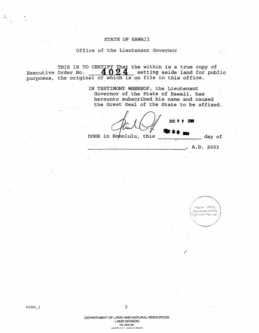
23,637· C.S.F. No. ____ _
October 13, 2003
13. 250" 30' 40~8.00 feet along the remainder ofL.P. 8140, >
L.C.Aw. 5230 to Keaweamahi;
14: 191 Q 00' 154.00 feet along the remainder ofL.P. 8140, L.C.Aw. 5230 to Keaweamahi;
15. 239· 20' 80.00 feet along the remainder ofL.P. 8140, L.C.Aw. 523() to Keaweamahi;
16. 283 Q 00' 212.00 feet along the remainder ofL.P. 8140, L.C.Aw. 5230 to Keaweamahi~
17. 165" 20' 300.00 feet along the remainder ofL.P. 8140, L.C.Aw. 5230 to.Keaweamahi;
18. 163" 00' 800.00 feet along the remainder ofL.P. 8140, L.C.Aw. 5230 to Keaweamahi;
19. 141" 30' 222,00 feet along the remainder ofL.P. 8140, L.C.Aw. 5230 to Keaweamahi;
20. 189 0 00' 170.00 feet along the remainder ofL.P. 8140, L.C.Aw. 5230 to Keaweamahi;
21. 278" 00' 205.00 feet along the remainder ofL.P.8140, L.C.Aw. 5230 to Keaweamahi~
22. 250" 00' 120.00 feet along the remainder ofL.P. 8140, L.C.Aw. 5230 to Keaweamahi;
23. 332" 30' 287.00 feet along the remainder ofL.P. SIAO, L.C.Aw. 5230 to Keaweamahi;
24. 264" 00' 202.00 feet along the remainder of L.P. 8140, L.C.Aw. 5230 to KeJweamahi;
25. 305· ~O' 725.00 feet along the remainder of L.P. 8140, L.C.Aw. 5230 to Keaweamahi;
26. 187· 20' 305.00 feet along the remainder of L.P. 8140, L.C.Aw. 5230 to Keaweamahi;
. ," ~ - '"'' ' .. . '.
-3-" .
23,637· C.S.F. No. ____ _
October 13, 2003
13. 250" 30' 40~8.00 feet along the remainder ofL.P. 8140, >
L.C.Aw. 5230 to Keaweamahi;
14: 191" 00' 154.00 feet along the remainder ofL.P. 8140, L.C.Aw. 5230 to Keaweamahi;
15. 239" 20' 80.00 feet along the remainder ofL.P. 8140, L.C.Aw. 5230 to Keaweamahi;
16. 283" 00' 212.00 feet along the remainder ofL.P. 8140, L.C.Aw. 5230 to Keaweamahi;
17. 165" 20' 300.00 feet along the remainder ofL.P. 8140, L.C.Aw. 5230 to.Keaweamahi;
18. 163" 00' 800.00 feet along the remainder ofL.P. 8140, L.C.Aw. 5230 to Keaweamahi;
19. 141 " 30' 222,00 feet along the remainder ofL.P. 8140, L.C.Aw. 5230 to Keaweamahi;
20. 189" 00' 170.00 feet along the remainder ofL-P. 8140, L.C.Aw. 5230 to Keaweamahi;
21. 278" 00' 205.00 feet along the remainder ofL.P.8140, L.C.Aw. 5230 to Keaweamahi;
22. 250" 00' 120.00 feet along the remainder ofL.P. 8140, L.C.Aw. 5230 to Keaweamahi;
23. 332" 30' 287.00 feet along the remainder ofL.P. 81AO, L.C.Aw. 5230 to Keaweamahi;
24. 264" 00' 202.00 feet along the remainder of L.P. 8140, L.C.Aw. 5230 to Ke,weamahi;
25. 305· 00' 725.00 feet along the remainder of L.P. 8140, L.C.Aw. 5230 to Keaweamahi;
26. 187· 20' 305.00 feet along the remainder of L.P. 8140, L.C.Aw. 5230 to Keaweamahi;
. ," ~ - '"'' ... ..•
-3-" .
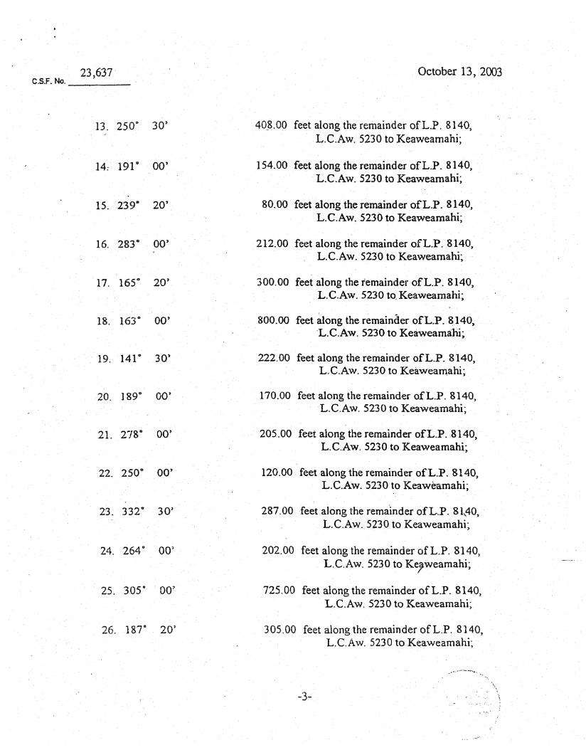
23,637 C.S.F. No. __ ~ __
October 13, 2003
27. 3020 30' 441.92 feet along the remaind~r ofL.P. 8140, L.C.Aw. 5230 to Keaweamahi;
28. 353 0 11' 3~'' 1675.09 feet along the remainder ofL.P. 8140, LC.Aw. 5230 to Keaweamahi;
29. 303 0 31' 260.70 feet along the remainder ofL.P. 8140, L.C.Aw. 5230 to Keaweamahi;
30. 3520 58' 1245.34 feet along the remainder ofL.P. 8140, . L.C.Aw. 5230 to Keaweamahi;
31. 59 0 00' 599.47 feet along the remain~er ofL.P. 8140, J,..C.Aw. 5230 to Keawcamahi;
-32. 3290 20' 1020.00 feet along the remainder ofL.P. 8140,
L.C.Aw. 5230 to Keaweamahi;
33. 352 0 50' 125.00 feet along the remainder ofL.P. 8140, L.C.Aw. 5230 to Keaweamahi;
34. 83" 00' 140.00 feet along the remainder ofL.P. 8140, L.C.Aw. 5230 to Keaweamahi;
35. lOr 20' 438.00 feet along theremainder ofL.P. 8140, L.C.Aw. 5230 to Keaweamahi;
36. 146 0 55' 2035.00 feet along the remainder ofL~P. 8140, L.C.Aw. 5230 to Keaweamahi;
37. 68° 20' 235.00 feet along the remainder ofL.P. 8140, L.C.Aw. 5230 to Keaweamahi;
38. 118 0 50' 390.00 feet along the remainder 9fL.P. 8140, L.C.Aw. 5230 to Keaweamahi;
39. 26 0 50' 375.00 feet along the remainder ofL.P. 8140, L.C.Aw. 5230 to Keaweamahi;
-4-
23,637 C.S.F. No. ____ _
October 13, 2003
27. 3020 30' 441.92 feet along the remainder ofL.P. 8140, L.C.Aw. 5230 to Keaweamahi;
28. 353" 11' 30" 1675.09 feet along the remainder ofL.P. 8140, L.C.Aw. 5230 to Keaweamahi;
29. 303 0 31 ' 260.70 feet along the remainder ofL.P. 8140, L.CAw. 5230 to Keaweamahi;
30. 3520 58' 1245.34 feet along the remainder ofL.P. 8140, . L.C.Aw. 5230 to Keaweamahi;
31. 59 0 ~O' 599.47 feet along the remain~er ofL.P. 8140, :I..C.Aw. 5230 to Keawcamahi;
-32. 3290 20' 1020.00 feet along the remainder ofL.P. 8140,
L.C.Aw. 5230 to Keaweamahi;
33. 352 0 50' 125.00 feet along the remainder ofL.P. 8140, L.C.Aw. 5230 to Keaweamahi;
34. 83" 00' 140.00 feet along the remainder ofL.P. 8140, L.C.Aw. 5230 to Keaweamahi;
35. 107 0 20' 438.00 feet along the remainder ofL.P. 8140, L.C.Aw. 5230 to Keaweamahi;
36. 146" 55' 2035.00 feet along the remainder ofL~P. 8140, L.C.Aw. 5230 to Keaweamahi;
37. 68° 20' 235.00 feet along the remainder ofL.P. 8140, L.C.Aw. 5230 to Keaweamahi;
38. 118 0 50' 390.00 feet along the remainder 9fL.P. 8140, L.C.Aw. 5230 to Keaweamahi;
39. 26° 50' 375.00 feet along the remainder ofL.P~ 8140, L.C.Aw. 5230 to Keaweamahi;
-4-
23;637 C.S.F. No. ____ _
40. 1160 50'
41. 358 0 10'
42. 112° 50'
43. 55° 45'
44. 133· 40'
45.104° 00'
46. 840 45' 20"
October 13, 2003
307.00 feet along the remainder ofL.P. 8140, L.C.Aw. 5230 toXeaweamahi;
400.00 feet along the remainderofL.P. 8140, L.C.Aw. 5230 to Keaweamahi;
275.00 feet along the remainder ofL.P. 8140, L.C.Aw. 5230 to Keaweamahi;
190.00 feet along the remainder ofL.P. 8140, L.C.Aw. 5230 to Keaweaq1ahi;
1000.00 feet along the remainder ofL.P. 8140, L.C.Aw. 5230 to Keaweamahi;
342.13 feet along the remainder ofL.P. 8140, L.C.Aw. 5230 to Keaweamahi;
404.86 feet along the remainder ofL.P. 8140, L.C.Aw. 5230 to Keaweamahi;
47,. Thence along the remainder ofL.P. 8140, L.C.Aw. 5230 ~o Keaweamahi on a curve , ' to the left with a radius of 110.00 feet, the
chord azimuth and distance being:
48. 6r 45'
74° 15' 10" 40.10 feet;
81.32 feet alonglhe remainder ofL.P. 8140, L.C.Aw. 5230 to Keaw,eamahi;
•
49. Thence along the remainder ofL.P. 8140, L.C.Aw. 5230 to Keaweamahi on a curve to the right with a radius of205.00 feet, the chord azimuth and distance being: 72 0 18' 30" 61. 0 1 feet; ,
50.-'186° 42' 83.12 feet along Mokulele Highway,F.A.P. No. NH-0900(59)~
"--"'-'"
'R\ : . ; : ":'". ). :';~: .,- '\
-5:-
23;637 C.S.F. No. __ ----:-_~
40. 116D 50'
41. 3580 10'
42. 112" 50'
43. 55° 45'
44. 133 D 40'
45;. 104·· 00'
46. 84° 45' 20"
October 13, 2003
307.00 feet along the remainder ofL.P. 8140, L.C.Aw. 5230 to,Keaweamahi;
400.00 feet along the remainderofL.P. 8140. L.C.Aw. 5230 to Keaweamahi;
275.00 feet along the remainder ofL.J:». 8140. L.C.Aw. 5230 to Keaweamahi;
190.00 feet along the remainder ofL.P. 8140, ·L.C.Aw. 5230 to Keawea~ahi;
1000.00 feet along the remainder ofL.P. 8140, L.C.Aw. 5230 to Keaweamahi;
342.13 feet along. the remainder ofL.P. 8140, L.C.Aw. 5230 to Keaweamahi;
404.86 feet along the remainder ofL.P. 8140, L.C~Aw. 5230 to Keaweamahi; .
47. Thence along the remainderofL.P.8140,L.C.Aw. 5230 to Keaweamahi on a curve . . to the left with a radius ofllO.OOfeet, the
chord azimuth imd distance being:
48. 6r 45'
74- 15' 10" 40.10 feet;
81.32 feet alonglhe remainder ofL.P. 8140, L.C.Aw. 5230 to Keaw,eamahi;
. ::.,
49. Thence along the remainder ofLP. 8140, L.C.Aw. 5230 to Keaweamahion a curve .. to the right with a radius 0(205.00 feet,
.. 50.-186°. 42'
the chord azimuth and distance being: 72° 18' 30" 6.1.01 feet; .
83.12 feet along Mokulele Highway,F.A.P. No. NH-0900(S9)~
-5:-
.-,;.-",' . """':""---....... -... , .. '.~
/ :'.,. 1.1 ..... ) :·l~:·': \ : :.. : ':.f :- .. : ....• :: ~~~~ . ! ~. : < .. '\.:. "'", ,~.. : .; .. ': . '.: ;i
" .
23,637 October 13, 2003 C.S.F. No. ____ ~
51. 1860 42' 28.92 feet along MokuieleHighway, F.A.P. No. NH-0900(59' to the point of beginning and containing an AREA OF 222.626 ACRES. .
SUBJECT~ HOWEVER, to Perpetual Non-Exclusive Access and Utility Easement A in favor ofMaui Army National9uard Facility Site, Governor's Executive Order 3909 and also in favor ofLot2-B-3 of Portion of the Land ofPulehunui as shown ori plan attached hereto and made a part hereof
, Vehicle access shall notbe permitted into and from the Mokulele Highway, F.A.P. No. NH-0900(59) over and across Course. 51 of the above-described Public and Recreational Site.
SURVEY DIVISION' DEPAR'Th1ENT OF ACCOUNTING AND GENERAL SERVICES
, STATE OF HAWAII
Compiled from maps and dese. prepared by R. T. Tanaka: Engineers, Inc. and other Govt. Records.
-6-
By: ~ ~,A~L Melvin M.'Masuda Land Surveyor gm
/
", J
0'" ... -.. .-.'-
23,637 October 13, 2003 C.S.F. No. ____ _
51. 1860 42' 28.92 feet along MokuieleHighway, F.A.P. No. NH-0900(59' to the point of beginning and containing an AREA OF 222.626 ACRES. .
SUBJECT~ HOWEVER, to Perpetual Non-Exclusive Access and Utility Easement A in favor ofMaui Army National9uard Facility Site, Governor's Executive Order 3909 and also in favor ofLot2-B-3 of Portion of the Land ofPulehunui as shoWn on plan attached hereto and made a part hereof
" Vehicle access shall notbe permitted into and from the Mokule1e Highway, F.A.P. No. NH-0900(59) over and across Cours~ 51 of the above-described Public and Recreational Site.
SURVEY DIVISION" DEPAR'Th1ENT OF ACCOl.JNTING AND GENERAL SERVICES
" STATE OF HAWAII
Compiled from maps and dese. prepared by R. T. Tanaka: Engineers, Inc. and other Govt. Records.
-6-
~; By: "~,A..~L
Melvin M."Masuda Land Surveyor gm
/
", J
0-" ... -.. .-.'-

, .. · ...
174'45'20-j I'" . 115.38 t.L.
<::r TRUE NORTH' _
fD co <::£ . TRUE NoRTH _
. SCALE:1Jn,.,000tt. .219'45'20') . ' .. 42.43 ··~JO.OO
~
JOB Ma-53(OJ)
C. BK.
TAX !.lAP 3-8-08: por.l
C.S.F. NO. 23,637
LOT 2-8-1 .
l .icc.n and'UtIIIly Eo ..... "'" B (40.00 It. wide) -----
LOT 2-8-3
R.IIO.DO ---------.:;::. .. ~~
-;';~~O· 40,10
.. ".;,.~.-~
I' \, :':.!',: "".- / .. ~Pi:'·Ti \
PUBLIC AND RECREATIONAL SITE ;.".1,.".', : .. 1::,. l .' .. :·~..:\:· .. :t ·":;'or·v..:,-rr.,! }
, Pulehunui,' Wailuku. Maui. Hawaii-" !
Scale 1 inch = 1000 feet REDUCED NOT·TQ .. sc~LE ~ Denotes no ,vehicle. occess permitted -L.b.... Denotes access permitted
SURVEY DIVISION DEPARTMENT OF ACCOUNTING' AND GENERAL SERVICES
STATE OF HAWAII JGl October 13. 2003

COUNCIL OF THE COUNTY OF MAUl
WAILUKU, HAWAII 96793
CERTIFICATION OF ADOPTION
It is HEREBY CERTIFIED that RESOLUTION NO. 05-88 was adopted by the Council of the County of Maui, State of Hawaii, on the 3rd day of June, 2005, by the following vote:
G. Riki Robert Michelle JoAnne DainP. Dennis A. MichaelJ. Joseph Charmaine MEMBERS HOKAMA CARROLL ANDERSON JOHNSON KANE MATEO MOLINA PONTANILLA TAVARES
Chair Vice-Chair
ROLLCALL Aye Aye Aye Aye Aye Aye Aye Aye Excused