Research on Conservation State and Preservation Conditions in Unsaturated Archaeological Deposits in...
13
© W. S. Maney & Son Ltd 2012 DOI 10.1179/1350503312Z.0000000007 conservation and mgmt of arch. sites, Vol. 14 Nos 1–4, 2012, 72–84 Research on Conservation State and Preservation Conditions in Unsaturated Archaeological Deposits in Oslo Vibeke Vandrup Martens NIKU — Norwegian Institute for Cultural Heritage Research, Norway Carl-Einar Amundsen and Ove Bergersen Bioforsk — Norwegian Institute for Agricultural and Environmental Research, Norway Archaeological, biological, and geochemical investigations of soil sample series from a section and five boreholes have been studied to evaluate the state of preservation at the time of investigation and the preservation conditions of urban archaeological deposits from medieval Oslo, Norway. Focus has been put on the most fragile deposits in the unsaturated and fluctuation zones. Even with limited investigations, it is possible to assess the archaeological conservation state and the preservation conditions. Fur- ther work should focus on interpreting measured results and on mitigation strategies. keywords medieval, Norway, in situ preservation, unsaturated zone, fluctua- tion zone, saturated zone Introduction Over the last few years, a large number of augered boreholes have penetrated the archaeological deposits of the protected heritage site of the medieval town of Oslo, Norway, mostly as a result of large development projects. The archaeological obser- vations and geochemical samples analysed from these investigations constitute the basic research material for evaluations of conservation state and preservation condi- tions. The data have been collected in collaboration between the Norwegian Institute for Cultural Heritage Research (NIKU) and Bioforsk. This paper presents the noted state of preservation of the archaeological deposits, groundwater levels, and assesses the conditions for continued in situ preservation. The question of in situ preservation is and has since the ratification of the Valletta treaty (Council of Europe, 1992) been a major concern to the Cultural Heritage Management authorities in Norway (cf.
Transcript of Research on Conservation State and Preservation Conditions in Unsaturated Archaeological Deposits in...
© W. S. Maney & Son Ltd 2012 DOI 10.1179/1350503312Z.0000000007
conservation and mgmt of arch. sites, Vol. 14 Nos 1–4, 2012, 72–84
Research on Conservation State and Preservation Conditions in Unsaturated Archaeological Deposits in OsloVibeke Vandrup Martens NIKU — Norwegian Institute for Cultural Heritage Research, Norway
Carl-Einar Amundsen and Ove Bergersen Bioforsk — Norwegian Institute for Agricultural and Environmental Research, Norway
Archaeological, biological, and geochemical investigations of soil sample series from a section and fi ve boreholes have been studied to evaluate the state of preservation at the time of investigation and the preservation conditions of urban archaeological deposits from medieval Oslo, Norway. Focus has been put on the most fragile deposits in the unsaturated and fl uctuation zones. Even with limited investigations, it is possible to assess the archaeological conservation state and the preservation conditions. Fur-ther work should focus on interpreting measured results and on mitigation strategies.
keywords medieval, Norway, in situ preservation, unsaturated zone, fl uctua-tion zone, saturated zone
Introduction
Over the last few years, a large number of augered boreholes have penetrated the
archaeological deposits of the protected heritage site of the medieval town of Oslo,
Norway, mostly as a result of large development projects. The archaeological obser-
vations and geochemical samples analysed from these investigations constitute the
basic research material for evaluations of conservation state and preservation condi-
tions. The data have been collected in collaboration between the Norwegian Institute
for Cultural Heritage Research (NIKU) and Bioforsk. This paper presents the noted
state of preservation of the archaeological deposits, groundwater levels, and assesses
the conditions for continued in situ preservation. The question of in situ preservation
is and has since the ratifi cation of the Valletta treaty (Council of Europe, 1992) been
a major concern to the Cultural Heritage Management authorities in Norway (cf.

73UNSATURATED ARCHAEOLOGICAL DEPOSITS IN OSLO
MD, 2010: 29–30), and is a prioritized area under the global challenges in the EU joint
programme, ‘Challenging Our Heritage’. International treaties and conventions are
designed to protect the archaeological heritage as a source of the European collective
memory and as an instrument for historical and scientifi c study. The Valletta treaty
calls for preservation of the archaeological heritage in situ. To ensure that in situ
preservation fulfi ls requirements of a sustainable strategy for archaeological remains,
knowledge about the present state of preservation as well as the physical and chemi-
cal conditions for future preservation capacity is necessary. Urban archaeological
deposits are very vulnerable to changes and degradation. Ultimately we seek to
develop mitigation strategies that reduce the impact of human activities on archaeo-
logical deposits, and the Norwegian Directorate of Cultural Heritage has been instru-
mental in the development of tools to assess the state of preservation and conditions
for continued in situ preservation, initiating two publications; The Monitoring
Manual (RA and NIKU, 2008) and a Norwegian Standard (NS 9451, 2009) on
sampling, monitoring, and assessing urban archaeological deposits. Much of this
work is the result of research and mitigation strategies for the World Heritage Site of
Bryggen in Bergen (see e.g. de Beer et al., 2008).
The Norwegian cultural heritage act protects listed monuments and demands that
developers pay for the disturbance or destruction of archaeological remains (see also
Petersén and Bergersen, in this volume). The law also opens up demands of sampling
and monitoring sites, and even these demands must be fi nanced by the developer.
Material
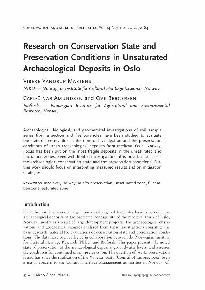
To demonstrate what is known so far about the present state of conservation and the
conditions for preservation, sites have been chosen from two different parts and land-
scapes of the listed monument of medieval Oslo. Oslo was founded in the late tenth
century AD on a peninsula deep within the Oslo fi ord. Today, ruins of the Church
of St Mary and the royal seat are still preserved, and an attempt has been made to
recreate the medieval coastline (see Figure 1 between the points Sørenga and MB14).
Other ruins of medieval churches, the cathedral, and the bishop’s palace are preserved
further NE, between Oslogate 6 and Arupsgate, and south of Oslogate 6. Archaeo-
logical deposits are preserved in varying thickness in the listed area, between 1 and
5.5 m. The two sites comprise four sample series from the NE part of medieval Oslo
(one excavation section, Arupsgate, one dipwell, Oslogate 6) and fi ve dipwells in the
SW part of town (S7, Sørenga, MB6, MB9 and MB14, Figure 1). The SW part is the
earliest settlement and original centre of the town, with the Church of St Mary and
the royal seat. This area is very close to the medieval coastline, and not far from the
modern one. The landscape is fl at, originally marine deposits. Parts are grass covered,
constituting a park with ruins and a reconstructed coastline. Other parts are covered
with asphalt (industrial area). The archaeological deposits vary in thickness between
2.5 and 5.5 m. The NE landscape is on the outskirts of the medieval town. This area
is on higher ground and on sloping terrain. Parts are grass covered, around medieval
ruins or in areas of previous excavations, and the deposit thickness is 1.5–3 m.
In the street, Arupsgate archaeological excavations were carried out in 2007, when
eighty-eight-year-old water pipelines needed renewal (Martens, 2010b). The street is
74 VIBEKE VANDRUP MARTENS et al.
fi gure 1 Aerial photograph of Oslo with boreholes and case sites marked. ‘Kartgrunnlag Statens kartverk, Geovekst, kommuner’. © NIKU
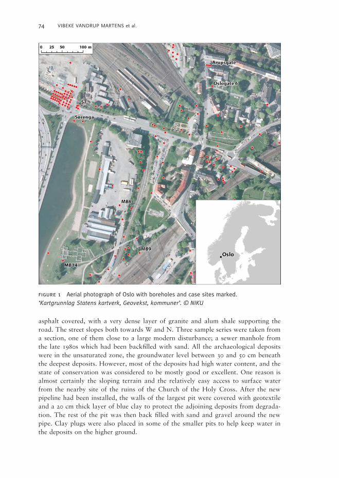
asphalt covered, with a very dense layer of granite and alum shale supporting the
road. The street slopes both towards W and N. Three sample series were taken from
a section, one of them close to a large modern disturbance; a sewer manhole from
the late 1980s which had been backfi lled with sand. All the archaeological deposits
were in the unsaturated zone, the groundwater level between 30 and 50 cm beneath
the deepest deposits. However, most of the deposits had high water content, and the
state of conservation was considered to be mostly good or excellent. One reason is
almost certainly the sloping terrain and the relatively easy access to surface water
from the nearby site of the ruins of the Church of the Holy Cross. After the new
pipeline had been installed, the walls of the largest pit were covered with geotextile
and a 20 cm thick layer of blue clay to protect the adjoining deposits from degrada-
tion. The rest of the pit was then back fi lled with sand and gravel around the new
pipe. Clay plugs were also placed in some of the smaller pits to help keep water in
the deposits on the higher ground.

75UNSATURATED ARCHAEOLOGICAL DEPOSITS IN OSLO
At Oslogate 6, large archaeological excavations were carried out in 1987–89 as part
of a development project. After the excavations, the development plans were aban-
doned, so the area was backfi lled with compact clay-silt masses and covered with
grass (RA, 1992; Wiberg, pers. comm.). Parts of the well-preserved medieval deposits
were left still standing, and it is in these that a dipwell was installed as part of a
research project concerning building on piles and preservation conditions (Bergersen
et al., 2009). The augering prior to installation was done under archaeological super-
vision, the deposits were documented and evaluated, and geochemical samples were
taken and analysed. The borehole was sealed with bentonite. This area also slants
towards the west, and medieval ruins east of the site with grass-covered surroundings
ensure that surface water may be fi ltered into the deposits.
As a part of that same project, the dipwell at Sørenga was installed (Bergersen
et al., 2009), whereas the wells MB6, 9, 14 and S7 all were installed in connection
with a large water pipe and sewage project called Midgardsormen (the Midgard
serpent, see Johansen et al., 2009). All these are on fl at terrain close to the sea, and
after augering and installation of dipwells, bentonite was used in an attempt to seal
the boreholes and secure the dipwells from direct surface water infi ltration.
Methods
Archaeological documentation and evaluationAll deposits were described according to the Monitoring Manual (RA and NIKU,
2008), defi ning the composition and content of each layer, and the state of conserva-
tion was determined in accordance with Norwegian Standard (Table 1), separating
the layers into the unsaturated (A), fl uctuation (B), or saturated (C) zones, that is,
above, partly in, or below groundwater level (and D, material later than 1900), and
grading them from 0 (indefi nable), 1 (lousy), 2 (poor), 3 (medium), and 4 (good) to 5
(excellent) (NS 9451, 2009: table 1; Martens, 2010a: table 8.1). To conduct this
evaluation, studies were made of, for example, odour, colour, and organic content of
each deposit.
Chemical analyses of samples Soil samples from archaeological deposits were taken at various depths. All sampled
deposits were subject to archaeological and chemical evaluations concerning both the
state and conditions for preservation. In sections, the samples were taken using a
hand auger with a cylinder diameter of 2.5 cm. The auger was horizontally driven
into the profi le and samples were taken from 20–50 cm within the deposits. At the
augered boreholes for dipwells, all samples were taken from the auger immediately
after archaeological cleansing and documentation. Soil samples were immediately
packed in 500 ml zipper bags that were packed in additional zipper bags containing
a sachet of Anaerocult A (VWR international). This ensures that the physical-
chemical properties of the samples do not change signifi cantly. All soil samples were
analysed according to the Norwegian Standard S2 package (NS 9451: 2009 — see
below for details on the analyses). Soil samples were stored at 4° C and opened in a
nitrogen atmosphere in a glove box to keep anaerobic samples free from oxygen. All
extractions of redox sensitive parameters were conducted in a nitrogen atmosphere.

76 VIBEKE VANDRUP MARTENS et al.
TABLE 1
STATE OF PRESERVATION SCALE (SOPS). AFTER NORWEGIAN STANDARD (NS 9451, 2009) (TOP) AND CONCENTRATION LEVELS FOR ANALYSIS S2 PARAMETERS USED TO EVALUATE PRESERVATION
CONDITIONS (BELOW)
Dry matter (105° C overnight) followed by loss on ignition (550° C in twelve hours)
were determined in the initial samples before redox sensitive parameters were ana-
lysed. pH and electric conductivity (Shirokova et al., 2000) was measured by mixing
samples with deionizer water (ratio 1:5 by volume). The pH was measured after
thirty minutes with a Ross electrode (Orion Instruments).
The soil samples were analysed for nitrate (NO3−), ammonium (NH4
+), reduced
(Fe2+) and oxidized iron (Fe3+) (Stookey, 1970), sulphate (SO42−), (acid volatile)
sulphide (S2−) (Rickard and Morse, 2005). Nitrate (NO3−), ammonium (NH4
+), and
sulphate (SO42−) were analysed at Eurofi ns Norsk Miljøanalyse AS. Ammonium
represents the major reduced species of nitrogen in natural environments, while
nitrate is the oxidized species. The ratio of molar concentrations of reduced and
oxidized species can be used to assess the redox conditions in natural environments
and addresses the predominant redox processes at a certain sampling point (Martens,
Preservation scale
Position related to 0 1 2 3 4 5 ground water Lousy Poor Medium Good Excellent
Saturated A0 A1 A2 A3 A4 A5
Fluctuation zone B0 B1 B2 B3 B4 B5
Unsaturated C0 C1 C2 C3 C4 C5
Material later than 1900 D0 D1 D2 D3 D4 D5
Nitrate Ammonium Sulphide Iron (II) Iron (III) Redox conditions Preservation
NO3- NH4
+ S2- Fe2+ Fe3+
Low Low Low Low High Oxidizing Lousy
High Low Low Low High Nitrate to oxidizing Poor
High Low Low High Low Nitrate to iron reducing Medium
Low Low Low High Low Ironreducing Medium
High High High Medium Low Nitrate to sulphatereducing Good
Low High High Medium Low Sulphatereducing Good
Low High High High Low Sulphatered. to methane prod. Excellent
Reduced conditionOxidized conditions

77UNSATURATED ARCHAEOLOGICAL DEPOSITS IN OSLO
2010a: table 8.2). The scale of assessing and monitoring depositional stability and
preservation conditions was performed after Norwegian Standard (NS 9451, 2009;
table 1; Martens, 2010a: table 8.1).
GroundwaterAt the sites with installed dipwells, dataloggers recorded groundwater level, tempera-
ture, and conductivity. These data were then compared to measured air temperatures
and precipitation. During 2011, the sensors were replaced to include redox measure-
ments.
Results
ArchaeologyThe samples from the NE part of town were almost all in the unsaturated zone
(Figure 2). In Arupsgate, the state of conservation or preservation of the deposits was
evaluated and graded between A1 (lousy) and A5 (excellent), with a clear majority of
fi gure 2 Comparing the state of preservation, preservation conditions, and scale of depo-sitional stability in section at Arupsgate (left) and dipwell at Oslogate 6 (right) in the slanting area. The depth of the section and the well is marked in a box with groundwater level. The fl uctuation zone is marked with arrow.
Slanting area
Level Preservation (masl)
State Conditions State Conditions State Conditions State Conditions
Oslo gt 613,5 A2 Poor13,0 A3 Poor12,5 A3 Good12,3 A4 Good12,0 A4 Good11,5 Profile Arups gt11,3 South east Middle South west A5 Excellent11,010,8 B4 Medium10,3 A4 Good A5 Good A4 Poor10,0 A5 Good A1 Good A3 Medium
dooG3A8,9dooG5AtnellecxE3A7,9
tnellecxE3AtnellecxE5A6,99,5 A3 Medium9,3 A4 Excellent A4 Excellent9,08,88,58,0
Low organic matter 10%Medium organic matter 10-20%High organic matter 20-30%Ground Water level Ground Water fluctuation sone

78 VIBEKE VANDRUP MARTENS et al.
grades A3 to A5 (medium, good, excellent) and the overall impression was that the
archaeological deposits in this area were very well preserved, with a high amount of
organic fi nds. Even though the archaeological deposits were all clearly in the unsatu-
rated zone, they had a high water content, which was probably partly due to heavy
rains all summer, but mostly because of dense, undisturbed deposits. Otherwise, one
could not have expected such a good state of conservation. This may be explained
by the fact that the original water pipe had been put in a manually dug ditch which
was then backfi lled with the dug up deposits, thus minimizing the change of soil
chemistry. Surprisingly, even the intrusion of the sewer manhole about twenty years
ago does not seem to have altered the state of preservation, except in the case of wood
immediately adjacent to it.
In Oslogate 6 much the same picture emerged (Figure 2). Most of the deposits were
in the unsaturated zone and were graded A2 (poor, top layer) to A5. One deposits
that was graded A4 turned out to be in the fl uctuation zone, and should have been
labelled B4. It is interesting to note that the conservation state was perceived as less
good in this deposit than in the one above, which was permanently unsaturated. It
would seem that the impact of the large excavation twenty years earlier was not as
bad as one might have feared for the remaining deposits. The material used for back
fi lling seems to have stabilized the whole area, as was intended.
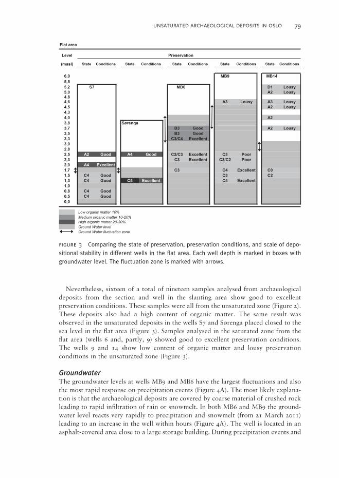
In the area to the SW, a great difference in state of preservation was noted between
the very well-preserved deposits at dipwell S7 and the bad ones at MB14 (Figure 3).
Well S7 had some deposits in the unsaturated zone (graded A2, poor, to A4, good),
a few in the fl uctuation zone and most in the saturated zone, all deemed good and
graded C4. Similarly, the Sørenga well had some deposits in the unsaturated zone,
graded A4, and some in the saturated zone which were graded C5, excellent.
The Midgard serpent dipwell 6 had top soil in the unsaturated zone, but no sam-
ples were analysed from these deposits. In the fl uctuation zone, the state of preserva-
tion was medium, graded B3, while the deposits below the groundwater table were
medium to good, C3–C4. The deposits in MB9 were medium (A3) in the unsaturated
and medium to good (C3–C4) in the saturated zone. In MB14, most of the deposits
were in the unsaturated zone and graded lousy to medium (D1 to A3), and even the
saturated deposits were poorly preserved (C2).
GeochemistryDuring the augering of the dipwells (MB6, MB9, MB14, Sørenga, and Oslogate 6) soil
samples were collected from some of the archaeological deposits. Preservation condi-
tions and present state of preservation were determined (Johansen et al., 2009; RA
and NIKU, 2008). Using data from the automatic monitoring of the groundwater
level in the wells shows that thirteen samples were from the unsaturated zone, eight
from deposits that are occasionally water saturated, and three samples from archaeo-
logical deposits being permanently water saturated (based upon groundwater fl uctua-
tions in the period May 2010–April 2011). The concentration level of reduced iron
(FeII) was signifi cantly (p<0.05; Kruskal-Wallis Test) higher in the saturated and
groundwater fl uctuation zone compared to the unsaturated zone. There was also a
clear tendency towards higher concentrations of ammonium and sulphide in the
saturated zone compared to the unsaturated and groundwater fl uctuation zones.
79UNSATURATED ARCHAEOLOGICAL DEPOSITS IN OSLO
Nevertheless, sixteen of a total of nineteen samples analysed from archaeological
deposits from the section and well in the slanting area show good to excellent
preservation conditions. These samples were all from the unsaturated zone (Figure 2).
These deposits also had a high content of organic matter. The same result was
observed in the unsaturated deposits in the wells S7 and Sørenga placed closed to the
sea level in the fl at area (Figure 3). Samples analysed in the saturated zone from the
fl at area (wells 6 and, partly, 9) showed good to excellent preservation conditions.
The wells 9 and 14 show low content of organic matter and lousy preservation
conditions in the unsaturated zone (Figure 3).
GroundwaterThe groundwater levels at wells MB9 and MB6 have the largest fl uctuations and also
the most rapid response on precipitation events (Figure 4A). The most likely explana-
tion is that the archaeological deposits are covered by coarse material of crushed rock
leading to rapid infi ltration of rain or snowmelt. In both MB6 and MB9 the ground-
water level reacts very rapidly to precipitation and snowmelt (from 21 March 2011)
leading to an increase in the well within hours (Figure 4A). The well is located in an
asphalt-covered area close to a large storage building. During precipitation events and
fi gure 3 Comparing the state of preservation, preservation conditions, and scale of depo-sitional stability in different wells in the fl at area. Each well depth is marked in boxes with groundwater level. The fl uctuation zone is marked with arrows.
Flat area
Level Preservation
(masl) State Conditions State Conditions State Conditions State Conditions State Conditions
6,0 MB9 MB145,55,2 S7 MB6 D1 Lousy5,0 A2 Lousy4,84,6 A3 Lousy A3 Lousy4,5 A2 Lousy4,34,0 A2
agnerøS8,3ysuoL2AdooG3B7,3
dooG3B5,3tnellecxE4C/3C3,3
3,02,82,5 A2 Good A4 Good C2/C3 Excellent C3 Poor
rooP2C/3CtnellecxE3C3,22,0 A4 Excellent
0CtnellecxE4C3C7,12C3CdooG4C5,1
1,3 C4 Good C5 Excellent C4 Excellent1,00,8 C4 Good0,5 C4 Good0,0
Low organic matter 10%Medium organic matter 10-20%High organic matter 20-30%Ground Water level Ground Water fluctuation zone

80 VIBEKE VANDRUP MARTENS et al.
fi gure 4 Groundwater level in dipwells at A: MB6, MB9, MB14, B: Oslogate 6 and Sørenga, Oslo, compared with precipitation in the period 13 May 2010–5 April 2011.
0
1
2
3
4
5
Gro
undw
ater
leve
l (m
eter
bel
ow g
roun
d)
0
10
20
30
40
50
60
70
80
Time (mnd)
Pre
cipi
pita
tion
(mm
)
MB6 MB9 MB14 Precipitation
A
0
1
2
3
4
50 4 8 12 16 20 24
0 4 8 12 16 20 24
Gro
undw
ater
leve
l (m
eter
bel
ow g
roun
d)
0
10
20
30
40
50
60
70
80
Time (mnd)
Pre
cipi
pita
tion
(mm
)
Sørenga Oslogate 6 Precipitation
B
snowmelt large amounts of water are collected at these dense surfaces and drained to
the groundwater through leak pipelines and cracks in the surface layer. Augering
prior to installation of MB6 showed that the upper 1.2 m consisted of coarse fi lling
materials, facilitating rapid penetration of water. Intense infi ltration of surface water
at particular spots close to the well and insuffi cient bentonite tightening around it
may explain the fl uctuation pattern in MB6.

81UNSATURATED ARCHAEOLOGICAL DEPOSITS IN OSLO
During wintertime (air temperature below 0° C) the groundwater level decreases
(Figure 5A). At Oslogate 6 the groundwater table was nearly 1 m lower in March
2011 than in August–November 2010 (Figure 4B). At the wells MB6 and 9, the
decrease during winter was about 0.5 m (Figure 4A), at Sørenga none. Sørenga had
the most stable groundwater level in the whole area (Figure 4B). Annual groundwater
fl uctuations seem to be smaller closer to the sea, probably stabilized by sea levels.
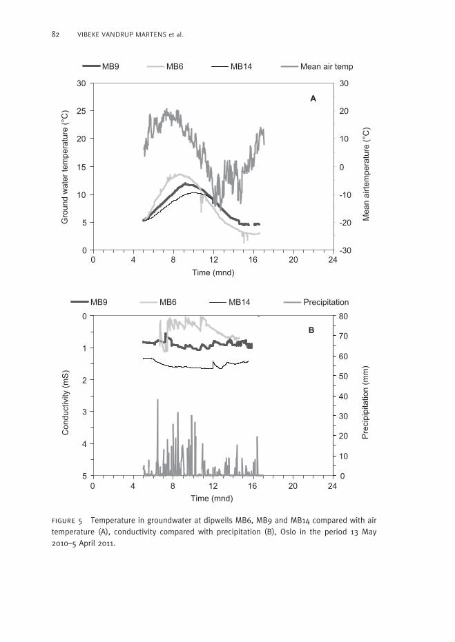
The temperature in the groundwater increases during spring and summer and
peaks in August–September (Figure 5A). The temperature is 3.5° C higher at MB6
(most elevated groundwater) compared to MB9 and MB14 (lowest groundwater
table). During high precipitation events temperature rises (during summer) or
decreases (autumn) at MP6, confi rming the rapid infi ltration of rainwater in this well.
Highest conductivity about 1.5 mS was observed in well MB14, while it was found
between 0.8 and 0.5 mS in well MB9 and MB6 (Figure 5B).
Discussion
Implications for the in situ preservation of archaeological depositsAutomatic and continuous monitoring has shown that the fl uctuations in ground-
water level in these two parts of medieval Oslo vary considerably between sites. Some
of the observed variations and fl uctuations are natural and some are due to infrastruc-
ture changes. The monitoring results so far (appr. one year) show that a fl uctuating
groundwater table does not necessarily result in worse preservation conditions (Oslogt
6, Figure 2) and (S7, MB6; Figure 3). Dense soil types having high water-holding
capacity (silt and clay) and high organic matter level, may contribute to good preser-
vation conditions also in the unsaturated zone. Materials used for back-fi lling inves-
tigated areas should be dense and stable and have high water holding capacity, to
ensure continued preservation of adjoining deposits. Areas with active degradation
should be monitored, and more work should be put into mitigation strategies.
The logging of water levels at dipwell MB6 shows that large amounts of surface
water may be transported rapidly to the groundwater in areas with ‘cracked’ dense
ground covers, large buildings and coarse deposit materials. This may wash out
archaeological remains and should be monitored. The monitoring data also indicate
that coarse fi lling materials above archaeological remains may result in larger annual
and short-term temperature fl uctuations in the groundwater (Figure 3). Knowing
that microbiological processes are often sensitive to temperature fl uctuations, the
signifi cance of these fl uctuations should be further investigated.
At MB9 the archaeological deposits in the fl uctuating zone were poor to medium
preserved (Figure 3; Johansen et al., 2009), but the preservation conditions are lousy,
probably because of low content of organic matter. The deepest saturated layers were
medium preserved but had excellent conditions for future preservation. In MB14 all
deposits, even in the saturated zone, were badly to medium preserved. Low content
of organic material in these deposits is the most likely explanation for the poor
state of preservation and lousy preservation conditions. Since MB14 is placed in the
cemetery right next to the St Mary church ruins, this result is most worrying and
implies an immediate need for mitigation.
82 VIBEKE VANDRUP MARTENS et al.
fi gure 5 Temperature in groundwater at dipwells MB6, MB9 and MB14 compared with air temperature (A), conductivity compared with precipitation (B), Oslo in the period 13 May 2010–5 April 2011.
0
5
10
15
20
25
30
Time (mnd)
Gro
und
wat
er te
mpe
ratu
re (°
C)
-30
-20
-10
0
10
20
30
Mea
n ai
rtem
pera
ture
(°C
)
MB9 MB6 MB14 Mean air temp
A
0 4 8 12 16 20 24
0
1
2
3
4
5
Con
duct
ivity
(mS
)
0
10
20
30
40
50
60
70
80
Time (mnd)
Pre
cipi
pita
tion
(mm
)
MB9 MB6 MB14 Precipitation
B
0 4 8 12 16 20 24
83UNSATURATED ARCHAEOLOGICAL DEPOSITS IN OSLO
In the investigated area, hydrostatic pressure from the sea results in more stable/less
fl uctuating groundwater (short term and annually) and may have resulted in better
preservation of archaeological deposits in areas close to the sea (e.g. Sørenga), both
in the unsaturated and saturated zones.
Redox conditions measured from autumn of 2011 show good to excellent preserva-
tion conditions in groundwater from wells: MB9 (-430mV), MB6 (-330mV), Sørenga
(-430mV) and Oslogt 6 (-356mV). In MB14 which contains archaeological deposits in
the unsaturated zone redox values are around 10mV which may explain the lousy
preservation conditions documented above.
Conclusion
Even with limited investigations as the above-described sites, it is possible to get a
fairly detailed impression of both the archaeological state of preservation and the
conditions for further in situ preservation of urban archaeological deposits. Monitor-
ing of groundwater temperature, fl uctuations and preferably also redox-conditions in
archaeological deposits in Oslo should continue and prevail in the future and more
efforts should be made to interpret results and evaluate the signifi cance of these
results for future mitigation. The ultimate goal should be to develop mitigation
strategies that reduce the impact of human activities on archaeological deposits.
Bibliography
Bergersen, O., Hartnik, T., and Molaug, P. B. 2009. Bevaringstilstand og bevaringsforhold i kulturlag fra Oslogate
6 og Sørenga. Rapport NIKU 7/2009.
de Beer, H., Christensson, A., Jensen, J. A., and Matthiesen, H. 2008. Bryggen World Heritage Site: A Numerical
Groundwater Model to Support Archaeological Preservation Strategies. In: H. Kars and R. M. Van Heeringen,
eds. Preserving Archaeological Remains In Situ: Proceedings of the 3rd Conference, 7–9 December 2006,
Amsterdam. Amsterdam: Institute for Geo and Bioarchaeology, pp. 95–100.
Johansen, L-M. B., Martens, V. V., Bergersen, O., and Hartnik, T. 2009. Grunnundersøkelse i forbindelse med
bygging av ny avløpsledning under Middelalderparken og Sørenga. Arkeologisk og jordfaglig undersøkelse i
miljøbrønner. Rapport NIKU 102/2009.
Martens, V. V. 2010a. Environmental Monitoring of Archaeological Deposits. In: S. Trow, V. Holyoak, and E.
Byrnes, eds. Heritage Management of Farmed and Forested Landscapes in Europe. Budapest: EAC Occasional
Papers 4, pp. 75–82.
Martens, V. V. 2010b. Arupsgate, Gamlebyen, Oslo. Arkeologisk undersøkelse og overvåking i forbindelse med
utskiftning av vannledning. Rapport NIKU 111/2010. Oslo.
MD, 2010. Miljøverndepartementet Parliamentary Report 2010, Miljøvernforvaltningens prioriterte forskningsbe-
hov 2010–2015. Oslo: Norwegian Ministry for the Environment.
NS 9451. 2009. Norwegian Standard. Kulturminner. Krav til miljøovervåking og -undersøkelse av kulturlag.
Standard Norge.
Rickard, D. and Morse, J. W. 2005. Acid volatile sulphide (AVS). Marine Chemistry, 97: 141–97.
RA 1992. Årsberetning 1991 fra Riksantikvarens utgravningskontor for Oslo.
RA and NIKU. 2008. The Monitoring Manual. Procedures and Guidelines for Monitoring, Recording and
Preservation Management of Urban Archaeological Deposits. Riksantikvaren and Norsk Institutt for
Kulturminneforskning.
Shirokova, Y., Forkutsa, I., and Sharafutdinova, N. 2000. Use of Electrical Conductivity Instead of Soluble Salts
for Soil Salinity Monitoring in Central Asia. Irrigation and Drainage Systems, 14: 199–205.
Stookey, L. L. 1970. Ferrozine — A New Spectrophotometric Reagent for Iron. Analytical Chemistry, 42:
779–81.

84 VIBEKE VANDRUP MARTENS et al.
Notes on contributors
Vibeke Vandrup Martens fi nished an MA on medieval pottery in 1998 (Aarhus
University). Worked as archaeologist in Denmark, Sweden, Finland (Aaland), and
Norway. Has worked at the Norwegian Institute for Cultural Heritage Research since
2006, focusing on urban archaeology and preservation conditions in archaeological
deposits.
Correspondence to: Vibeke Vandrup Martens, Norwegian Institute for Cultural
Heritage Research, Storgata 2, PO Box 726 Sentrum, N-0105 Oslo, Norway. Email:
Carl-Einar Amundsen fi nished his PhD on soil buffer processes related to acid rain in
1993 (Norwegian University of Science and Technology). Since then his main work
items have been mobility, leaching and toxicology of pollutants in soils (Norwegian
Institute for Agricultural and Environmental Research).
Correspondence to: Carl-Einar Amundsen, Bioforsk Soil and Environment
Division, Fredrik A Dahlsvei 20, N-1430 Ås, Norway. Email: Carl-einar.amundsen@
bioforsk.no
Ove Bergersen fi nished a PhD (Dr Scient) in ‘Molecular Genetics’ in the Departments
of Biochemistry and Animals Genetics, Norwegian College of Veterinary Medicine
1990. Main work as scientist at SINTEF ‘Environmental microbiology’ (e.g. degrada-
tion of oil, creosote, PCB, phthalates) to 2001 and ‘Environmental microbiology
and soil chemistry’, the last ten years as a senior scientist at Norwegian Institute for
Agricultural and Environmental Research.
Correspondence to: Ove Bergersen, Bioforsk Soil and Environment Division,
Fredrik A Dahlsvei 20, N-1430 Ås, Norway. Email: [email protected]