Republic of Lebanon - World Bank Documents & Reports
229
Republic of Lebanon - Council for Development and Reconstruction Road and Employment Project (REP) Environmental and Social Management Plan (ESMP) Final Report LOT 1: Caza of Kesrouane February 2020 Public Disclosure Authorized Public Disclosure Authorized Public Disclosure Authorized Public Disclosure Authorized
-
Upload
khangminh22 -
Category
Documents
-
view
0 -
download
0
Transcript of Republic of Lebanon - World Bank Documents & Reports

Republic of Lebanon - Council for Development and Reconstruction
Road and Employment Project (REP)
Environmental and Social Management Plan (ESMP)
Final Report
LOT 1: Caza of Kesrouane
February 2020
Pub
lic D
iscl
osur
e A
utho
rized
Pub
lic D
iscl
osur
e A
utho
rized
Pub
lic D
iscl
osur
e A
utho
rized
Pub
lic D
iscl
osur
e A
utho
rized
Geoflint s.a.r.l, Lebanon - P-1 -
Road and Employment Project (REP) ESMP Report
Kesrouane Caza Republic of Lebanon - Council for Development and Reconstruction
Dar Al Handasah Nazih Taleb & Partners
Table of Contents
Table of Contents ......................................................................................................................... 1
List of Tables ............................................................................................................................... 4
List of Figures ............................................................................................................................. 5
Abbreviations and Acronyms ...................................................................................................... 7
EXECUTIVE SUMMARY .......................................................................................................... 8
15 .............................................................................................................................. ملخص تنفيذي
1. Introduction ........................................................................................................................ 21
1.1 Project Background ................................................................................................... 21
1.2 Project Rationale ....................................................................................................... 22
1.3 Report Objectives ...................................................................................................... 23
1.4 Methodology ............................................................................................................... 24 1.4.1 Collection of Environmental and Social Baseline information .......................................................... 24 1.4.2 Methodology for Stakeholders Engagement ...................................................................................... 25
2. Existing Policies, Legal and Administrative Framework ................................................. 27
2.1 Applicable Legal and Regulatory Framework ....................................................... 27
2.2 Institutional Framework ........................................................................................... 32
2.3 Environmental Standards ......................................................................................... 33
2.4 World Bank Policies and Guidelines ....................................................................... 34 2.4.1 Safeguard Policies .............................................................................................................................. 34 2.4.2 Consultations and Disclosure Policy .................................................................................................. 35 2.4.3 Useful Guidelines and Manuals ......................................................................................................... 35
2.5 Gap Analysis .............................................................................................................. 36
2.6 International treaties and conventions .................................................................... 39
3. Description of the Proposed Project .................................................................................. 41
3.1 Roads Location and Classification ........................................................................... 43 3.1.1 Kesrouane R2a (Boukak El-Dine – El-Ekaibe – Nammoura et Kfar Jerif – Ghodrace – El-Kfour –
Fatka – Edma et Defne – Kferyacine) ............................................................................................................. 43 3.1.2 Kesrouane R2b (Ghosta – Maarab) .................................................................................................... 45 3.1.3 Kesrouane R2c (El-Kfour – Herhraya et Kattine) .............................................................................. 46 3.1.4 Kesrouane R7 (Mazraet Kfardebiane – Bekaatouta – Bekaatet Kenaan) ........................................... 47
3.2 Project Activities ........................................................................................................ 47 3.2.1 Kesrouane R2a ................................................................................................................................... 47 3.2.2 Kesrouane R2b ................................................................................................................................... 52 3.2.3 Kesrouane R2c ................................................................................................................................... 55 3.2.4 Kesrouane R7 ..................................................................................................................................... 58
3.3 Contractor’s Equipment and Materials .................................................................. 61
3.4 Site Rehabilitation Staffing ....................................................................................... 61
3.5 Site Facilities & Infrastructure ................................................................................ 62
4. Description of the Environment and Social Context ........................................................ 63

Geoflint s.a.r.l, Lebanon - P-2 -
Road and Employment Project (REP) ESMP Report
Kesrouane Caza Republic of Lebanon - Council for Development and Reconstruction
Dar Al Handasah Nazih Taleb & Partners
4.1 Physical Environment ............................................................................................... 63 4.1.1 Topography ........................................................................................................................................ 63 4.1.2 Geology .............................................................................................................................................. 64 4.1.3 Hydrogeology ..................................................................................................................................... 67 4.1.4 Climate and Meteorology ................................................................................................................... 70 4.1.5 Air quality and Noise ......................................................................................................................... 72
4.2 Biological Environment and Land use/Land Cover ............................................... 75 4.2.1 Field Survey ....................................................................................................................................... 75 4.2.2 Evaluation Criteria ............................................................................................................................. 76 4.2.3 Results ................................................................................................................................................ 76 4.2.4 Summary of Results ........................................................................................................................... 88
4.3 Socio-Economic Condition ........................................................................................ 90 4.3.1 Summary of Relevant Caza Background ........................................................................................... 90 4.3.2 Road Sensitive Receptors ................................................................................................................... 93 4.3.3 Traffic Survey .................................................................................................................................... 94
5. Potential Environmental and Social Impacts ................................................................... 96
5.1 Assessment Methodology .......................................................................................... 96
5.2 Potential Positive Impacts during Rehabilitation ................................................... 98 5.2.1 Potential Positive Social Impacts ....................................................................................................... 98
5.3 Potential Negative Impacts during Rehabilitation ................................................. 99 5.3.1 Potential Negative Environmental Impacts ........................................................................................ 99 5.3.2 Potential Negative Social Impacts during Rehabilitation ................................................................. 108
5.4 Potential Positive Impacts during Operation ........................................................ 110 5.4.1 Potential Positive Environmental Impacts........................................................................................ 110 5.4.2 Potential Positive Social Impacts ..................................................................................................... 111
5.5 Potential Negative Impacts during Operation ...................................................... 111 5.5.1 Potential Negative Environmental Impacts ...................................................................................... 111
5.6 Summary of Potential Environmental Impacts .................................................... 114
5.7 Summary of Potential Social Impacts .................................................................... 116
6. Mitigation of Environmental and Social Impacts .......................................................... 117
6.1 Mitigation Measures during Rehabilitation .......................................................... 117 6.1.1 Water and Soil Quality ..................................................................................................................... 117 6.1.2 Air Quality ....................................................................................................................................... 118 6.1.3 Acoustic Environment ...................................................................................................................... 119 6.1.4 Biodiversity ...................................................................................................................................... 119 6.1.5 Existing Infrastructure ...................................................................................................................... 120 6.1.6 Visual Amenity ................................................................................................................................ 120 6.1.7 Resources Consumption ................................................................................................................... 121 6.1.8 Health and Safety ............................................................................................................................. 121
6.2 Mitigation Measures during Operation ................................................................. 125 6.2.1 Water and Soil Quality ..................................................................................................................... 125 6.2.2 Air Quality ....................................................................................................................................... 126 6.2.3 Acoustic Environment ...................................................................................................................... 126 6.2.4 Biodiversity ...................................................................................................................................... 126 6.2.5 Energy Consumption ........................................................................................................................ 127 6.2.6 Public and Workers Health and Safety ............................................................................................. 127
6.3 Social Mitigation measures during rehabilitation ................................................ 127 6.3.1 Mitigation Measures on Socio-Economic Conditions of Surrounding Communities ...................... 127

Geoflint s.a.r.l, Lebanon - P-3 -
Road and Employment Project (REP) ESMP Report
Kesrouane Caza Republic of Lebanon - Council for Development and Reconstruction
Dar Al Handasah Nazih Taleb & Partners
6.3.2 Mitigation Measures on Socio-Economic Conditions of Labor ....................................................... 128
6.4 Social Mitigation Measures during Operation ..................................................... 130
7. Environmental and Social Management and Monitoring Plan..................................... 131
7.1 Institutional Setup and Capacity Building ............................................................ 131 7.1.1 Training ............................................................................................................................................ 132
7.2 Mitigation Plans ....................................................................................................... 133 7.2.1 Environmental and Social Mitigation Plans ..................................................................................... 134
7.3 Monitoring Plan ....................................................................................................... 149 7.3.1 Monitoring Plan Implementation ..................................................................................................... 149 7.3.2 Documentation and Reporting.......................................................................................................... 156 7.3.3 Guidelines for Health and Safety Plan during Rehabilitation .......................................................... 156
8. Consultation, Disclosure and GRM ................................................................................ 157
8.1 Public Consultation ................................................................................................. 157
8.2 Grievance Redress Mechanism (GRM) ................................................................. 159 8.2.1 GRM for Surrounding Communities ................................................................................................ 160 8.2.2 GRM for Workers ............................................................................................................................ 163
9. Conclusion ........................................................................................................................ 164
References ................................................................................................................................ 166
Annex ....................................................................................................................................... 168
Annex 1: Figures and Tables Related to Chapter 4 ........................................................ 168
Annex 2: Road Signs, Markings, Lights, and Barricades to be Used during Rehabilitation
Works ................................................................................................................................... 204
Annex 3: Code of Conduct ................................................................................................. 209
Annex 4: Public Consultation Notes, Presentation, Invitation Letters, and Attendance
Sheets ................................................................................................................................... 211
Annex 5: Complaint Register Form .................................................................................. 227

Geoflint s.a.r.l, Lebanon - S-4 -
Road and Employment Project (REP) ESMP Report
Kesrouane Caza Republic of Lebanon - Council for Development and Reconstruction
Dar Al Handasah Nazih Taleb & Partners
List of Tables
Table 2-1 National Applicable Legal Framework .............................................................. 28 Table 2-2 National Institutions in relation to REP project ................................................. 32
Table 2-3 The allowable contaminants concentration for wastewater when discharged into
different bodies ........................................................................................................... 33 Table 2-4 Maximum allowable limits for outdoor air pollutants ....................................... 33 Table 2-5 Sound pressure limits according to MoE Decision 52/1, 1996 .......................... 34 Table 2-6 Noise exposure limits ......................................................................................... 34
Table 2-7 Lebanese noise guidelines for different zones (MoE 52/1, 1996) ..................... 34
Table 2-8 Comparison of ambient air quality standards between Lebanese and WB standards
.................................................................................................................................... 36 Table 2-9 Comparison of allowable noise level standards between Lebanese and WB
standards ..................................................................................................................... 37 Table 2-10 Comparison of allowable wastewater discharge levels standards between
Lebanese and WB standards ...................................................................................... 37
Table 2-11 International Treaties and Conventions in relation to REP. ............................ 39 Table 2-12 Labors conventions .......................................................................................... 39 Table 3-1 Roads to be rehabilitated within Kesrouane Caza (refer to Figure 3-1 for road map
classification) ............................................................................................................. 41
Table 3-2 American Association of State Highway and Transportation Officials AASHTO
2018 ............................................................................................................................ 43
Table 3-3 Existing road condition survey – Kesrouane R2a .............................................. 49 Table 3-4 Existing road condition survey – Kesrouane R2b ............................................. 53
Table 3-5 Existing road condition survey – Kesrouane R2c .............................................. 56 Table 3-6 Existing road condition survey – Kesrouane R7 ............................................... 59
Table 3-7 Contractor’s Equipment to be used .................................................................... 61 Table 3-8 Quantities of main materials to be used during the whole period of the
rehabilitation works .................................................................................................... 61
Table 3-9 Contractor’s Personnel ....................................................................................... 61 Table 4-1 Mean sea level elevations of Kesrouane roads .................................................. 63 Table 4-2 Geological outcrops exposed along Kesrouane R2a alignment ......................... 64
Table 4-3 Geological outcrops exposed along Kesrouane R2b alignment ........................ 64
Table 4-4 Geological outcrops exposed along Kesrouane R2c alignment ......................... 65
Table 4-5 Geological outcrops exposed along Kesrouane R7 alignment .......................... 66 Table 4-6 Legend of the hydrogeology maps shown in Figure I, Figure J, Figure K,
andFigure L (in Annex 1) ........................................................................................... 69 Table 4-7 Wind direction, average monthly wind speed, and wind probability recorded at
Tripoli meteorological station from 6/2005 until 7/2011 ........................................... 71
Table 4-8 Ambient air quality in µg.m-3 for Kesrouane R2a, R2b & R2c ........................ 72 Table 4-9 Ambient air quality in µg.m-3 for Kesrouane R7 ............................................... 73 Table 4-10 Key Habitats adjacent to Kesrouane R2a ........................................................ 77 Table 4-11 List of main plant species recorded at the project area .................................... 77 Table 4-12 Key Habitats adjacent to Kesrouane R2b ........................................................ 79 Table 4-13 List of main plant species recorded at the project area .................................... 80
Table 4-14 Key Habitats encountered along Kesrouane R2c ............................................ 82 Table 4-15 Key Habitats recorded along Kesrouane R7 .................................................... 84
Table 4-16 Main tree species recorded in the study area ................................................... 85 Table 4-17 List of bird species present in the study area ................................................... 86

Geoflint s.a.r.l, Lebanon - S-5 -
Road and Employment Project (REP) ESMP Report
Kesrouane Caza Republic of Lebanon - Council for Development and Reconstruction
Dar Al Handasah Nazih Taleb & Partners
Table 5-1 Classification of impacts .................................................................................... 96 Table 5-2 Significance Impact Matrix ............................................................................... 98 Table 5-3 Emission factors for construction equipment (Ahn, Pan, et.al, 2010) ............. 102 Table 5-4 Sources of acoustic pollution during road operation ....................................... 112
Table 5-5 Summary of potential negative environmental impacts during rehabilitation . 114 Table 5-6 Summary of potential negative environmental impacts during operation ....... 115 Table 5-7 Summary of positive environmental impacts during operation ....................... 115 Table 5-8 Summary of potential positive and negative social impacts during rehabilitation
.................................................................................................................................. 116
Table 5-9 Summary of potential positive social impacts during operation ...................... 116
Table 7-1 Environmental Management Plan in Rehabilitation Phase .............................. 134
Table 7-2 Environmental Management Plan in Operation Phase .................................... 145 Table 7-3 Key performance indicators for the monitoring plan ....................................... 149 Table 7-4 Environmental Monitoring Plan in Rehabilitation Phase ................................ 151 Table 7-5 Environmental Monitoring Plan in Operation Phase ....................................... 155 Table 8-1 List of Contacted Local NGOs ........................................................................ 158
Table 8-2: Consulted International NGOs and their Activities ........................................ 158
List of Figures
Figure 1-1 Lot 1 – Roads Key Plan Drawing (Kesrouane roads) ...................................... 26
Figure 3-1 Classification of road segments among Kesrouane roads ................................ 42 Figure 3-2 Satellite image showing Kesrouane R2a alignment with surveyed stations .... 44
Figure 3-3 Satellite image showing Kesrouane R2b alignment with surveyed stations .... 45 Figure 3-4 Satellite image showing Kesrouane R2c alignment with surveyed stations .... 46
Figure 3-5 Satellite image showing Kesrouane R7 alignment with surveyed stations ...... 47 Figure 3-6 Work stations along with road rehabilitation activities along Kesrouane R2a
alignment .................................................................................................................... 51 Figure 3-7 Work stations along with road rehabilitation activities along Kesrouane R2b
alignment .................................................................................................................... 54
Figure 3-8 Work stations along with road rehabilitation activities along Kesrouane R2c
alignment .................................................................................................................... 57 Figure 3-9 Work stations along with road rehabilitation activities along Kesrouane R7
alignment .................................................................................................................... 60
Figure 4-1 Air quality cells of Roads R2a, R2b & R2c ..................................................... 72
Figure 4-2 Ambient air quality cells of Kesrouane R 7 ..................................................... 73 Figure 4-3 Dense woodland recorded in Ghodrace (Station 7+100) ................................. 78
Figure 4-4 Wild pine forest surrounding the road in Edma et Defne ................................. 78 Figure 4-5 Adjacent ecosystem to the road segement passing in Ghosta (residential houses)
.................................................................................................................................... 80
Figure 4-6 Station 1+600 – Maarab (riparian habitat) ....................................................... 80 Figure 4-7 Umbrella pine tree bordering the road .............................................................. 81 Figure 4-8 Road segment in Maarab bordered by olive groves and Km away from Chnaniir
Nature Reserve ........................................................................................................... 81 Figure 4-9 Road surrounded by cultivated trees and residential houses (station 1+000) .. 82 Figure 4-10 Road surrounded by residential and commercial buildings ........................... 83
Figure 4-11 Wild pine patch intermixed with cultivated umbrella pine (overall ecosystem
between stations 2+500 and 4+700) ........................................................................... 83
Figure 4-12 Wild pine, cypress, and cultivated trees bordering the road (station 4+700) . 83 Figure 4-13 Kfardebiane overall ecosystem ....................................................................... 86

Geoflint s.a.r.l, Lebanon - S-6 -
Road and Employment Project (REP) ESMP Report
Kesrouane Caza Republic of Lebanon - Council for Development and Reconstruction
Dar Al Handasah Nazih Taleb & Partners
Figure 4-14 Riparian thickets near Naher el Kaleb River (culvert/bridge location) .......... 86 Figure 4-15 Riparian habitat where the road and river intersect (between station 0+600 and
station 2+800) ............................................................................................................. 87 Figure 4-16 Agricultural terraces bordering the road in Kfardebiane ................................ 87
Figure 4-17 Quercus infectoria tree adjacent to the road (wooded slope) ......................... 87 Figure 4-18 The overall ecosystem in Kfardebiane ........................................................... 88 Figure 4-19 Rural settlements surrounding the road in Bekaatouta ................................... 88 Figure 4-20 Cultivated lands surrounding the road in Bekaatouta ..................................... 88 Figure 7-1 Institutional setup ........................................................................................... 132
Figure 8-1 Schematic illustration of the GRM ................................................................. 162

Geoflint s.a.r.l, Lebanon - S-7 -
Road and Employment Project (REP) ESMP Report
Kesrouane Caza Republic of Lebanon - Council for Development and Reconstruction
Dar Al Handasah Nazih Taleb & Partners
Abbreviations and Acronyms
CDR Council for Development and Reconstruction
CoC Code of Conduct
CoM Council of Ministers
DLIPS Department of Labour Inspection, Prevention and Safety
EHS
ESMP
Environment Health and Safety
Environmental and Social Management Plan
EIA Environmental Impact Assessment
EMoP Environmental Monitoring Plan
ESMF Environmental and Social Management Framework
EU European Union
GBV Gender Based Violence
GDP Gross Domestic Product
GOL Government of Lebanon
GRM Grievance Redress Mechanism
IFC
IUCN
International Finance Cooperation
International Union for Conservation of Nature and Natural Resources
ILO International Labour Organization
LULC Land Use Land Cover Map
MoA Ministry of Agriculture
MOE Ministry of Environment
MoIM Ministry of Interior and Municipalities
MoL Ministry of Labour
MOPH Ministry of Public Health
MOPWT Ministry of Public Works and Transportation
MoSA Ministry of Social Affairs
NGOs Non-Governmental Organizations
OP Operational Plan
OHS Occupational Health and Safety
PAPs Project Affected Persons
PAs Protected Areas
PHS Public Health and Safety
PIU
PM
Project Implementation Unit
Particulate Matter
REP Roads and Employment Project
SAP Safeguards Action Plan
SEA Sexual Exploitation and Abuse
SH Sexual Harassment.
UNESCO United Nations Educational, Scientific and Cultural Organization
WB World Bank
WBG World Bank Group
WEF World Economic Forum
WWTP Waste Water Treatment Plant

Geoflint s.a.r.l, Lebanon - S-8 -
Road and Employment Project (REP) ESMP Report
Kesrouane Caza Republic of Lebanon - Council for Development and Reconstruction
Dar Al Handasah Nazih Taleb & Partners
EXECUTIVE SUMMARY
Introduction
Lebanon Roads and Employment Project (REP) funded by the World Bank (WB) aims to
improve the roads conditions and traffic safety by rehabilitation of road networks in Lebanon,
especially in rural lagging regions and to create job opportunities for displaced Syrians and
Lebanese citizens through the labor-intensive works of rehabilitation.
The project works will be executed on the main road network which is under the jurisdiction of
the Ministry of Public Works and Transportation (MoPWT). In this context, the Lebanese
Council for Development and Reconstruction (CDR) will implement Lebanon REP on behalf of
the government/MoPWT.
Considering that the anticipated civil works will result in environmental and social impacts, an
Environmental and Social Management Plan (ESMP) shall be prepared under the requirements
of OP4.01 that classifies the project as Category B to limit potential implications. Accordingly,
Dar Al Handasah Nazih Taleb & Partners developed in this report a specific ESMP for Kesrouane
Caza.
The objective of the ESMP is to identify and assess the potential environmental and social
impacts of REP and consult relevant stakeholders to prepare a management plan that includes
mitigation measures for the expected social and environmental risks and a monitoring plan, as
well as to define responsibilities in the operationalization of the ESMP.
Project Description
The project covers classified roads in 25 Cazas throughout Lebanon with an expected total length
of 835 km. Four of the proposed roads fall in Kesrouane Caza.
This ESMP is specific to four selected roads for rehabilitation in Kesrouane with a total length
of around 32.63 km.
• Kesrouane Road 2a (R2a) consists of a single alignment that has a total length of 19.1
km. It starts at Boukak El-Dine continues upward, passing through El-Ekaibe Nammoura
et Kfar Jerif and Ghodrace, until it reaches El-Kfour. Then, it descends, passing through
Fatka and Edma et Defne, until it ends in Kferyacine.
• Kesrouane Road 2b (R2b) consists of a single alignment with a total length of 2.4 km.
It starts at Ghosta reaching Maarab.
• Kesrouane Road 2c (R2c) is located in Kesrouane Caza and consists of a single
alignment with a total length of 5.13 km. It starts at El-Kfour, at an elevation of 687 m,
ascends to a maximum elevation of 796 m, then descends while passing into Herhraya et
Kattine to reach a minimum of 597 m and end there at an elevation of 603 m.
• Kesrouane Road 7 (R7) consists of a single alignment with a total length of 6 km. It
starts at Mazraet Kfardebiane, passes by Bekaatouta and ends at Bekaatet Kenaan.

Geoflint s.a.r.l, Lebanon - S-9 -
Road and Employment Project (REP) ESMP Report
Kesrouane Caza Republic of Lebanon - Council for Development and Reconstruction
Dar Al Handasah Nazih Taleb & Partners
Road upgrading activities are limited to maintenance, minor construction, as well as to traffic
management and regulation. In the case of Kesrouane Caza, rehabilitation activities to be
performed vary between Kesrouane R2a, Kesrouane R2b, Kesrouane R2c and Kesrouane R7;
depending on the current state of each surveyed road. In summary, activities to be performed
Kesrouane Caza include pavement works (complete reconstruction when needed and milling and
overlay for roads that are in better condition); improvement and installation of drainage facilities,
construction of retaining walls and installation of safety barriers, marking and signing. The
rehabilitation works for Kesrouane roads will involve 176 workers and require a total of 18
months.
Legal Framework
This ESMP was conducted in accordance with the World Bank safeguards and the Lebanese laws
and regulations namely Law No. 444 (2002) about Environmetal Protection.
Two World Bank safeguards policies apply to Lebanon Roads and Employment Project: OP 4.01
Environmental Assessment and OP 4.12 Involuntary Resettlement. Given that the planned
project will mainly focus on the rehabilitation of roads, the work in these areas will be done under
OP 4.01.
Despite that OP 4.12 was triggered by this project, in the case of Kesrouane and in accordance
with site specific plans, no involuntary resettlement or land acquisition will take place. In other
words, there will be no displaced persons by the project activities (this includes locals and Syrian
refugees).
Consultation
Consulting with the main stakeholders and ensuring they agree on sensitive issues improve the
chances that the project will not be subject to last-minute dispute.
This ESMP was publicly consulted where three public participation meetings were arranged for
Kesrouane Caza. The first public participation meeting was held at the Municipality of Jounieh
on Thursday December 12 addressing all Kesrouane roads. However, given the circumstances in
the Country (revolution started in October 17, 2019 and roads were obstructed), only 10 people
attended the meeting. In this context, two additional public meetings were set for Kesrouane
caza. The first meeting was held in Kfour Municipality on Friday December 27 addressing
Kesrouane R2a and R2c, whereas the second meeting was held at Kfardebiane Municipality on
Friday January 3, 2019 addressing Kesrouane R2b and R7. The number of attendees at Kfour
was 27, of which 9 were women. At Kfardebiane, the total number of attendees was 18, of which
5 were women.
During the meetings, attendees were informed about the project objectives, the identified natural,
economic, and social resources of importance in the area, the project’s possible environmental
and social risks, the planned mitigation measures and Grievance Redress Mechanism (GRM).
During the meeting at Kfour Municipality, generally, attendees were worried about the start day
of the project. More specifically, the female attendees were worried about the coordination with
relevant authorities, especially with respect to public works (i.e. wastewater and water
infrastructure, etc.). Women were worried whether there would be coordination among ministries

Geoflint s.a.r.l, Lebanon - S-10 -
Road and Employment Project (REP) ESMP Report
Kesrouane Caza Republic of Lebanon - Council for Development and Reconstruction
Dar Al Handasah Nazih Taleb & Partners
and infrastructural institutions before the project implementation to avoid re-excavations of roads
and further disturbances and pressures. In this context, the public was informed that CDR will
ensure that a full coordination among municipalities and authorities prior to project execution.
Finally the consultant mentioned that the implementation of the project is expected to start in
spring 2020.
During the second meeting held at Kfardebiane, the main concern was in relation to the road
starting at Feytroun leading to Kfardebiane that is not integrated in this project. According to the
attendees, namely the head of Kfardebiane Municipality, Aajltoun-Feytorun road is a key entry
road to Kesrouane villages and in great need for rehabilitation. Similarly, the Mekhtar of Maarab
mentioned as well the road from Maarab to Dlebta that needs rehabilitation and is not integrated
in REP. In this context, attendees asked if they can still suggest alternative roads for rehabilitation
under the project. Accordingly, the consultant and the CDR Representative explained that the
project cannot integrate any alternative roads, however, they can send their requests in relation
to alternative roads to the MoPWT for future projects.
During both meetings, attendees were worried about the monitoring process of rehabilitation
works. In this context, the consultant and CDR Representative explained the monitoring process
for this project and highlighted the role of municipalities and local communities in monitoring
the process of work during rehabilitation. Further, the CDR explained that this ESMP include a
GRM to ensure the management of any project-related complaints.This GRM was communicated
to the attendees.
As for NGOs Consultation, this ESMP has targeted them according to their position in Lebanon.
They consist of two levels as follows: (1) Local: they are specific to each Caza. Their mission is
to address different concerns and issues among the local society including social, economic,
gender equality, environment, poverty, women empowerment, etc. and (2) International: They
are covering the whole country and their consultation will be applied to all the ESMPs of the
REP. When the crisis in Syria erupted in early 2011, numerous International NGOs responded
to the humanitarian crisis and worked directly with the Syrian in Lebanon by providing aid and
responding to their critical situation.
Baseline assessment
The environmental and social assessment recorded the existing conditions within the project area
including physical, biological and socioeconomic conditions prior the project implementation
and operation. Baseline data and field surveys were conducted to describe the status of the
following environmental and socio-economic receptors: air quality, water quality, soil quality,
geological conditions, climate and meteorology, natural habitats and biodiversity, land-use/land-
cover, acoustic environment, cultural resources, and socio-economic conditions (employment
opportunities, labor influx, social tensions, labor induced Sexual Exploitation and Abuse (SEA)
Sexual Harassment (SH), occupational health and safety).
The geology of the studied roads was investigated for outcropping formations, subsurface
stratigraphy, structure (faults, folds, seismic, etc.), hydrogeology (groundwater and sea water
intrusions) and hydrology (surface water). Assessments showed that Kesrouane roads mostly fall
on a karstic limestone formation. The system is characterized by a significant amount of
groundwater flowing in channels, faults and fractures. The transmissivity of these formations is

Geoflint s.a.r.l, Lebanon - S-11 -
Road and Employment Project (REP) ESMP Report
Kesrouane Caza Republic of Lebanon - Council for Development and Reconstruction
Dar Al Handasah Nazih Taleb & Partners
generally high and water table is shallow. In other words, the studied roads in Kesrouane lie on
permeable formations which expose the groundwater aquifers to possible contamination.
More specifically, the outcropping lithological formations in and around the study area belong to
multiple geological time periods namely, to the Cretaceous and Quaternary geological time
periods (R2a), Cretaceous and Jurassic geological time periods (R2b and R7) and Cretaceous
geological time period (R2c). The area surrounding R2a and R2c is very rich in winter drainage
channels that discharge downstream to “Wadi Tabarja” and “Wadi Ghazir”. In specific,
Kesrouane R2a is in close proximity to “Wadi Tabarja” and to Ibrahim River. Kesrouane R2b as
well encounters several drainage channels that discharge to “Wadi Jounieh”. Moreover,
Kesrouane R7 is surrounded by several surface winter drainage channels which lead downstream
to “El Kaleb” river, in addition to the presence of many nearby springs namely Ain el Qattara,
Ain el Libne and Ain Bqaatouta.
Air quality is also an essential component in assessing social wellbeing and health status of a
community. The study relied on UNDP/MoE project “Air quality assessment in an East
Mediterranean country: the case of Lebanon” and showed that the levels of CO, SO2, O3, NO2,
and PM10 are within the national limit values (Decision 52/1 dated 1996) confirming that the
studied areas for the four roads do not include major air polluting activities.
Regarding natural habitats and biodiversity, given the nature of the project, the direct influence
area concerns existing roads. Consequently, a rapid biological assessment has been carried out
to draw the ecological profile of the adjacent areas to the concerned roads to assess habitats and
and species that are at added risk from the proposed project. The assessment showed that
Kesrouane R2a and Kesrouane R7 involve rich ecosystems. More specifically, some adjacent
areas to Kesrouane R2a and Kesrouane R7 consist of wild pine forests (short segment in Edma
et Defne), oak woodlands (in Ghodrace), and riparian forest where the road and river intersect
(i.e Kesrouane R7 and Naher el Kaleb River intersect). These ecosystems constitute a dynamic
hideout for numerous reptiles, mammals, and birds.
Finally, a socio-economic survey was conducted in the project area to map the demographic,
social and economic baseline conditions at the level of Kesrouane Caza. A set of social indicators
were investigated including Kesrouane’s demographic profile (age and gender distribution),
employment and livelihood, the availability of public and private education and health
institutions, the global level of education (educational attainment) and standards of public health,
access to public utility and community services, land use patterns, archeology and cultural
heritage, and impacts of the Syrian crisis. The assessment allowed drawing conclusions regarding
the project’s potential impacts on the socioeconomic conditions of the study area. In specific,
Road 2a is surrounded by residential agglomerations and other nearby sensitive receptors
(schools and places of worship) at a distance of less than 10 m. Similarly, residential units,
schools and places of worship surround Kesrouane R7 and Kesrouane R2c. However, regarding
Kesrouane R2b, the recorded sensitive receptors (school and church) are not directly adjacent to
the road and the noted residential units are concentrated in a very short segment of the road.
Finally, Kesrouane R7 is critical as it is surrounded by agricultural lands.
Impacts Evaluation
The purpose of this section is to identify and quantify all potential impacts, both adverse and
beneficial, of the project on the existing environment during both rehabilitation and operational

Geoflint s.a.r.l, Lebanon - S-12 -
Road and Employment Project (REP) ESMP Report
Kesrouane Caza Republic of Lebanon - Council for Development and Reconstruction
Dar Al Handasah Nazih Taleb & Partners
phases. The assessment studied the impacts of the proposed project on air quality, water quality,
soil quality, acoustic environment, visual intrusion, land-use/land- cover and socio-economic
impacts.
Regarding the operation phase, the assessment entails the “Defects Liability Period’ during
which the Contractor is responsible for maintenance activities.
Given that the project aims to upgrade existing roads, the environmental impacts are expected to
include dust raised during rehabilitation, increase in noise pollution derived from construction
machinery, degradation of water quality, disruption to traffic movement, potential damages to
existing utilities, and disturbance of local biodiversity. During the rehabilitation phase, impacts
on air and water quality have been evaluated as direct and irreversible. The rehabilitation phase
requires the use of many heavy machinery and equipment which are usually associated with
impacts on air quality. Dust and odor emissions are expected to be high during this phase.
Moreover, potential impacts on water quality from rehabilitation activities are aligned with
accidental spillages and contaminated storm water runoff.
Finally, in addition to the expected temporary disturbance of the natural ecosystems (noise
pollution and potential soil and water contamination), direct destruction of vegetation and
population might occur if waste (excavated materials) was discharged directly into the roadside
shrub-lands and riparian ecosystems. However, given that the concerned roads generally involve
paths that are already under anthropogenic influences, the potential impacts of the project on the
local biodiversity are expected to be limited to disturbance of the natural ecosystems and local
fauna (noise pollution) when roads are surrounded by forest and maquis ecosystems (short
segments in Kesrouane R7 and Kesrouane R2 a, potential illegal dumping and discharge of
wastes into streams and river (all roads namely R7) that can lead to direct destruction of local
biodiversity and natural habitats (including reproduction sites for amphibians), and finally, dust
accumulation on nearby vegetation and agricultural lands (namely Kesrouane R7).
Potential social risks related to this project include (1) labor influx (in case the contractor doesn’t
recruit labor from the surrounding community) and potential risk of labor induced SH towards
female workers and SEA towards women in the surrounding community (due to the close
proximity of residents and schools to the roads to be rehabilitated); (2) Potential risk of child
labor; (3) Poor labor conditions; (4) Dissatisfaction with job allocation; (5) Risk of under-
participation or underemployment of women; (6) Nuisance and traffic disturbance; and (7)
Temporary obstruction of access routes to sensitive receptors, specifically, residential units and
churches along Kesrouane R2a.
Whereas, the potential positive impacts of the project are to create direct and indirect short-term
jobs for Lebanese and Syrians living in the surrounding community and enhance the economic
development and livelihood opportunities.
Once roads are rehabilitated, the project is expected to improve drainage systems (less runoff
water), road safety conditions, reduce traffic accidents and traffic congestion, and ultimately
enhance livelihood opportunities. On the other hand, the main expected environmental impacts
on water and soil could result in from maintenance activities during the “Defects Liability
Period’ during which the Contractor is responsible for maintenance activities, if not managed
properly.

Geoflint s.a.r.l, Lebanon - S-13 -
Road and Employment Project (REP) ESMP Report
Kesrouane Caza Republic of Lebanon - Council for Development and Reconstruction
Dar Al Handasah Nazih Taleb & Partners
Development of the ESMP
An ESMP is essential to ensure that the identified impacts are maintained within the allowable
levels, unanticipated impacts are mitigated at an early stage, and the expected project benefits
are realized. Thus, to mitigate the identified impacts/risks, the prepared ESMP for roads in
Kesrouane Caza was prepared before initiating any civil works. The aim of this ESMP is to assist
in the systematic and prompt recognition of problems, encouraging effective actions to correct
them and ultimately achieve the goal of good environmental and social performance. A sound
understanding of environmental priorities and policies, properly managing the project,
acknowledging the regulatory requirements and keeping updated operational information are
fundamental to ensure the effective and satisfactory environmental performance.
A proper management plan was provided for specific concerns regarding the roads in Kesrouane,
as shown in the conducted environmental and social assessment. The plan includes measures and
equipment to control exhaust emissions, dust and odor emissions, and soil manipulation activities
during the rehabilitation phase. Moreover, proper measures and guidelines on the control of
accidental spills of construction material were provided to prevent soil contamination. Any
accidental spillage of wastewater onto open ground can easily infiltrate the karstic limestone and
is highly likely to pollute water present in the subsurface. Moreover, any discharge of wastewater
into the winter channels will mainly lead to adverse impacts to the downstream “Wadi Tabarja”,
“Wadi Ghazir”, Ibrahim River (R2a, R2c), to “Wadi Jounieh” (R2b) and to “El Kaleb” river
(Kesrouane R7).
Regarding biodiversity, recommendations are provided to guide the project contractor in
reducing the negative impacts on natural habitats and biodiversity. Mitigation actions suggested
in this ESMP included recommendations regarding rehabilitation work and solid waste
management in order to avoid degrading the sites or disturbing the local fauna. Despite that the
concerned roads are mainly under anthropogenic influences, contractors must be careful during
the rehabilitation work so that the direct impacts (direct destruction) on ecosystems and
associated fauna would be minimal. Waste management plan must be adopted to avoid soil and
water contamination that could have irreversible impacts on biodiversity. More specifically,
rehabilitation debris should not be dumped into the natural habitat (e.g. streams and water
channels encountered in Kesrouane Caza along the studied roads).
The social risks of this project can be mitigated through periodic monitoring of labor conditions,
specific required clauses within contracts that will be required to protect workers and the Code
of Conduct (CoC) for Gender Based Violence (GBV) issues. This ESMP guides the contractor
(1) to preferably hire local workers, (2) not to hire individuals below the legal working age in
accordance with the labor law of Lebanon (3) ensure proper compliance and implementation of
the CoC. Similarly, close coordination with the affected municipalities is recommended in
relation to road obstruction issues. In addition, a robust GRM must be clearly communicated to
all project affected persons during and before project implementation.
Further, the ESMP generated key project indicators to monitor project implementation success.
It is designed to guarantee effectiveness in the measurement of major project outcomes and
outputs based on measurable indicators. The risk of environmental and social impacts can be
monitored (e.g. monitoring of solid waste disposal and wastewater discharge, monitoring of
underage labor, and monitoring of workers behaviors during the rehabilitation work.). Project
monitoring will be undertaken by the implementing agency (CDR) to ensure the project is being

Geoflint s.a.r.l, Lebanon - S-14 -
Road and Employment Project (REP) ESMP Report
Kesrouane Caza Republic of Lebanon - Council for Development and Reconstruction
Dar Al Handasah Nazih Taleb & Partners
implemented in line with the proposed objectives and is on track to achieve expected results.
Project progress reports will be prepared by CDR and submitted to the Bank for review.
Finally, a multi‐layer GRM was established for the concerned roads in Kesrouane Caza.
Procedures of GRM were explained during consulatation session. It will ensure that any
complaint is identified and handled properly.
Conclusion
Assessments showed that the proposed project has potential implications, both adverse and
beneficial, on the social and environmentalframeworks. In this context, the contractor shall be
committed to putting in place several measures to mitigate the negative environmental and social,
safety, health and social impacts associated with the development cycle of the project adhering
to WB social and environmental standards and policies.

Geoflint s.a.r.l, Lebanon - S-15 -
Road and Employment Project (REP) ESMP Report
Kesrouane Caza Republic of Lebanon - Council for Development and Reconstruction
Dar Al Handasah Nazih Taleb & Partners
ملخص تنفيذي
مقدمة
إعادة الممول من البنك الدولي إلى تحسين أحوال الطرق والسالمة المرورية من خالل يهدف مشروع الطرق والعمالة في لبنان
لمواطنين اللبنانيين للق فرص عمل النائية، كما ويهدف إلى خ، وخاصة في المناطق الريفية تأهيل شبكة الطرق في لبنان
.أعمال إعادة التأهيلفي العمالةمشاركة لنازحين السوريين من خالل وا
في هذا السياق، سينفذ . شبكة الطرق الرئيسية الخاضعة لسلطة وزارة األشغال العامة والنقل ضمن تنفيذ أعمال المشروع سيتم
.والنقل ن الحكومة / وزارة األشغال العامنيابة عالمشروع بالاإلعمار و اإلنماءمجلس
جب إعداد خطة وعليه و، سلبية مرافقة ألعمال التنفيذاعية تؤدي إلى آثار بيئية واجتمقد أن األعمال المتوقعة تجدر اإلشارة إلى
، والتي تصنف المشروع على أنه الفئة (OP4.01في البنك الدولي رقم ) وفقا لمتطلبات سياسة العمليات إدارة بيئية واجتماعية
B ت . وبناء على ذلك ، طورابيةالممكن حدوثها وتخفيف األثار السلبية وتطوير األثار اإليجلحد من التداعيات وذلك من أجل ا
قضاء مخصصة لتأهيل الطرقات ضمن دار الهندسة نزيه طالب وشركاه في هذا التقرير خطة إدارة بيئية واجتماعية شركة
.كسروان
مع حثوالتبالمشروع هو تحديد وتقييم التأثيرات البيئية واالجتماعية المحتملة لـ إن الهدف من خطة اإلدارة البيئية واالجتماعية
كما وتطوير طر االجتماعية والبيئية المتوقعة، التخفيف من المخاوسبل المعنيين إلعداد خطة إدارة تتضمن تدابير األطراف
.، باإلضافة إلى تحديد المسؤوليات في تفعيل خطة اإلدارة البيئية واالجتماعيةومراقبةخطة رصد
وصف المشروع
تقريبا، بحيث كم 835 يصل إلى حواليقضاء في جميع أنحاء لبنان بطول إجمالي 25المشروع الطرق المصنفة في يشمل
.كسروانمقترحة في قضاء طرق أربعة يوجد
بطول إجمالي كسروانفي قضاء لطريقا مخصصة ألعمال التأهيل ضمن هذهخطة اإلدارة البيئية واالجتماعية تم تطوير
:تقربيا، مقسمة على الشكل التالي كم 32.63 ييصل إلى حوال
كم 19.1بطول إجمالي يبلغ متد على طريق واحد ي( بحيث Kesrouane R2aالمسمى ) كسروانطريق .1 إن . تقريبا
الكفور. ثم تنحدر إلى الدين مرورا بالقيبة نمورة وكفار جريف وغدرايس حتى يصل بقاقيستمر الطريق يمر عبر
تنتهي في كفرياسين. و الدفنا وإدما قتمر عبر فتل
كم 2.4بطول إجمالي يبلغ متد على طريق واحد ي( بحيث Kesrouane R2bالمسمى ) كسروانطريق .2 إن . تقريبا
.يبدأ عند غوسطا وينتهي بمعرابالطريق
كم 5.13بطول إجمالي يبلغ متد على طريق واحد ي( بحيث Kesrouane R2cالمسمى ) كسروانطريق .3 إن . تقريبا
أثناء ينحدرم ومن ثم 796عند حواليم ويصل إلى أقصى ارتفاع 687 جوالي يبدأ في الكفور على ارتفاعالطريق
م. 603 حوالي م على األقل وينتهي عند ارتفاع 597 إرتفاع حوالي إلى ليصاتين قطحرايا و إلى
كم 6بطول إجمالي يبلغ متد على طريق واحد ي( بحيث Kesrouane R7المسمى )( 7) كسروانطريق .4 إن . تقريبا
.يبدأ عند مزرعة كفردبيان ويمر في بقعتوتة وينتهي في بقعاتة كنعانالطريق
5.
وكذلك على إدارة وتنظيم حركة المرور. في قضاء ة،البسيط شاءنوبعض أعمال اإلتطوير الطرق على الصيانة أعمالتقتصر
لحالة الحالية نظرا ؛ R7 وكسروان R2c كسروان , R2b وكسروان R2a كسروان، تتنوع أنشطة إعادة التأهيل بين كسروان
للطرق التي تم مسحها.
عند الطريق كاملعلى مثال رصف )اإلسفلتي تشمل أعمال الرصف كسروان القيام بها في قضاء فإن األنشطة التي يتعين لذلك
وتحسين اإلضاءة وتوفير أعمدة جديدة عند الحاجة( ، أعمدة( ؛ أعمال اإلنارة )إعادة تأهيل وإزالت األسفلت القديمالحاجة

Geoflint s.a.r.l, Lebanon - S-16 -
Road and Employment Project (REP) ESMP Report
Kesrouane Caza Republic of Lebanon - Council for Development and Reconstruction
Dar Al Handasah Nazih Taleb & Partners
سوف . وإشارة المرور، ووضع العالمات حواجز األمان، وتركيب الدعم ، وبناء الجدران الصرف الصحيمجاري وتركيب
ا إلنهاء األعمال.شهر 18جوالي تتطلب سوف عامال و 176 فرص عمل لحوالي أعمال إعادة التأهيل توفر
ر القانونياطاال
وال سيماللبنانية ، ا واألنظمةالقوانين بحسب البنك الدولي و لسياساتتم تنفيذ خطة اإلدارة البيئية واالجتماعية وفقا سوف ي
(. حماية البيئة)قانون 2002/ 444القانون رقم
OPرقم )التقييم البيئي هما سياسة البنك الدولي سياسات سياستان وقائيتان من يتبعمشروع الطرق والعمالة في لبنان إن
شكل يركز ب المنوي إنشائهأن المشروع وحيث. (OP 4.12( رقم )غير الطوعي)إعادة التوطين القسري سياسةو ( 4.01
رئيسي على إعادة تأهيل الطرق رقم التقييم البيئي المرتبطة ب سياسة العملياتإتباع يتم العمل في فإنه سوف ، موجودة سابقا
(OP 4.01. .)
لن يكون ف ، وعليهي. أراض إستمالكلن تتم إعادة التوطين القسري أو فإنه وفقا لمكونات مشروع التأهيل في قضاء كسروان
مما ال يتطلب السوريين(الال جئيين المحليين و السكانبسبب أنشطة المشروع )وهذا يشمل و/أو مهجرين هناك أي نازحين
.(OP 4.12( رقم )غير الطوعي)إعادة التوطين القسري سياسةتطبيق
العامة مشاورة
تحسين ألجل الحساسة القضايا على موافقتهم مدى من التأكد هو المعنيين العالقة أصحاب مع لتشاورل الرئيئسي الهدف إن
.نزاعات تؤدي لتوقفة و/او إلغائهوخلق لمشروع لفرص عدم تعرض
مشاركة اجتماعات ثالثة ترتيب تم حيثب المعنيين مع يعلن بشكل واالجتماعية البيئية اإلدارة خطةالمناقشة والتباحث في تمت
/ األول كانون 12 بتاريخ الموافق الخميس يوم في جونيه بلدية في العامة للمشاركة اجتماع أول عقد كسروان. لقضاء عامة
سيرا بقطع المرتبطة الراهنة للظروف نظرا أنه إال كسروان. قضاء ضمن تأهيلها المقترح طرقال كافة الشرح تناولو ،ديسمبر
يتمكن لم ،2019 أكتوبرأول/ تشرين 17 بتاريخ بدأ الذي المعيشة غالء على الشعبي اإلحتجاج أحداث ضمن الطرقات على
عقد كسروان. اءلقض إضافيين علنيين اجتماعين ديدتح تم ،السياق هذا في .االجتماع حضور من أشخاص عشرة من أكثر
R2a كسروان طريقي مكونات لعرض ديسمبر / األول كانون 27 بتاريخ موافقال الجمعة يوم كفور بلدية في األول االجتماع
طريقي مكونات لعرض 2019 يناير 3 بتاريخ الموافق الجمعة يوم كفردبيان بلدية في الثاني االجتماع عقد ثم ومن ، R2c و
27 كفورال إجتماع في الحاضرين عدد بلغ . R7 و R2b كسروان لحاضرين ا عدد بلغو سيدات 9 بينهم من كان بحيث شخصا
18 كفرذبيان إجتماع في .نساء 5 بينهم من كان بحيث شخصا
ذات لمحددةا واالجتماعية واالقتصادية الطبيعية الموارد عرض وتم االجتماعات خالل المشروع بأهداف الحضور إبالغ تم
معالجة وآلية لها المخطط التخفيف وإجراءات للمشروع ةالمحتمل واالجتماعية البيئية والمخاطر كما ،المنطقة في األهمية
.المظالم
من اعدد كانت أخص وبشكل المشروع. بدء تاريخ لناحية قلقين المشاركون كان ،كفور بلدية في عقد الذي األول اجتماع خالل
الصحي فالصر مياه )مثل العامة باألشغال يتعلق فيما وخاصة المختصة السلطات مع التنسيق شأنب ينقلق لنسائي الحضور
قبل العامة ومؤسسات الوزارات بين تنسيق هناك سيكون كان إذا ما بشأن قلقهن وأبدوا كما ذلك(. إلى وما للمياه التحتية والبنية
سيضمن واإلعمار اإلنماء مجلس نبأ الجمهور إبالغ تم عليهو .اإلزعاج من والمزيد الطرق حفر إعادة لتجنب المشروع تنفيذ
في المشروع تنفيذ يبدأ أن المتوقع من أنه لىإ ةشاراإل تم أخيرا المشروع. تنفيذ قبل كافة والسلطات البلديات بين الكامل التنسيق
.2020 ربيع
لى إويصل رونطفي في بدأي طريقب قيتعل للحضور الشاغل غلالش كان كفردبيان، في عقد الذي انيثال ماعاالجت خالل أما
هو نطروفي-عجلتون طريق فإن كفردبيان، بلدية رئيس ومنهم الحضور بحسب شروع.الم هذا في إدراجه يتم ولم كفردبيان
من يمتد طريق إلى أيضا بامعر مختار أشار ،وبالمثل التأهيل. إلعادة ماسة جةوبحا كسروان قرى إلى رئيسي دخول طريق
إلى يحتاج الذي دلبتا إلى بامعر ،السياق هذا في و .المقترحة المشروع طرق ضمن مدمج غير هوو تأهيل إعادة إلى أيضا
قبل من اإليجابه وتمت ،المشروع إطار في التأهيل إلعادة بديلة طرق اقتراح بإمكانهم يزال ال كان إذا عما الحضور سأل
Geoflint s.a.r.l, Lebanon - S-17 -
Road and Employment Project (REP) ESMP Report
Kesrouane Caza Republic of Lebanon - Council for Development and Reconstruction
Dar Al Handasah Nazih Taleb & Partners
يمكن أنه إال المشروع، هذا ضمن جديدة طرق أي إستبدال و/أو إضافة يمكن ال هأن واإلعمار اإلنماء مجلس وممثل اإلستشاري
.المستقبلية المشاريع ضمن لتلحظ العامة األشغال زارةو إلى بديلة بطرق يتعلق فيما طلباتهم إرسال للمعنيين
من قبل الشركة شرح ، مما أوجب تقديم مراقبةال خطة من فعاليةبشكل رئيسي قلقهمالحاضرون أبدا ،االجتماعين خالل
دور البلديات ، كما وتم التذكير بعملية المراقبة لهذا المشروععن ممثل مجلس اإلنماء واإلعمار اإلستشارية بمساعدة
مجلسممثل ، أوضح . عالوة على ذلكلزيادة نسبة الفعالية مراقبة خالل مرحلة إعادة تأهيل المشروعالوالمجتمعات المحلية في
ن متابعتها بشكل صحيح ضمامن أجل الشكاوىتتضمن آلية لمعالجة اإلنماء واإلعمار أن خطة اإلدارة البيئية واالجتماعية
.ومرضي
وصف البيئة المحيطة
وقبل في الوضع الحالي منطقة المشروع ضمن والبيولوجية واالجتماعية واالقتصادية البيئة الفيزيائية والكيميائيةتمت دراسة
البيئية التالية: جودة الهواء وجودة للعناصرالمسح الميداني إجراء البيانات األساسية و قام فريق العمل بجمعإذ المشروع. تنفيذ
واستخدام ائل الطبيعية والتنوع البيولوجيوالمو المناخ واألرصاد الجويةوضع المياه وجودة التربة والظروف الجيولوجية و
وتوفر اليد فرص العمل ) الموارد الثقافية والظروف االجتماعية االقتصاديةو ونسبة الضوضاء األرضيألراضي / الغطاء ا
والصحة والسالمة التحرش الجنسيو االنتهاك الجنسيين الناجمين عن العملأو /واالستغالل واالجتماعية العاملة والمشاكل
(.المهنية
الطبقات الجوفية المقترحة لناحية الطبقات الصخرية المتكشفة وق الطرضمن ولوجيجيال نصت الدراسة على أن الوضع
)المياه الجوفية ومياه البحر( والهيدرولوجيا الهيدروجيولوجيا، إلخ( ، الوضع الزلزاليطيات ، ، فوالق) والتكوينات التكتونية
الحقبة طقة الدراسة وحولها تنتمي إلى أن التكوينات الصخرية البارزة في منب الدراسات(. أظهرت واألنهر )المياه السطحية
عبر الشقوقكبيرة من المياه الجوفية المتدفقة اتبكمي هذه الطبقاتتميز ت. الحجر الجيري الكارستيالمسماه الزمنية الجيولوجية
عالية الطبقات هيهذه المياه ضمن . إن قابلية انتقال الناتجة عن عوامل التعرية والتجويه وباألخص على المرتفعات والكسور
فإن الطرق المدروسة في كسروان تقع على . بعبارة أخرى موجودة على أعماق قريبة من السطحجوفية المياه البشكل عام و
جوفية إلى تلوث محتمل.تشكيالت قابلة للنفاذ تعرض طبقات المياه ال
. بحيث يمر إلى فترات زمنية جيولوجية متعددةالصخرية البارزة في منطقة الدراسة وحولها الطبقات، تنتمي بشكل أكثر تحديدا
ة، أما الرباعيالتموضعات الفترات الزمنية الجيولوجية الطباشيرية و ضمن طبقات جيولوجية تمنتمي إلى (R2a)الطريق
. أم الطريق الفترات الزمنية الجيولوجية الطباشيرية والجوراسية( فإنها تم عبر الطبقات التي تنتمي إلى R7 و R2bالطرقيين)
(R2c فيمر عبر طبقات جيولوجية تنمتي إلى )الطريقيين تعتبر المنطقة المحيطة ب. الفترة الزمنية الجيولوجية الطباشيرية
R2a و R2c وادي طبرجا" و"وادي غازير". على نهر لشتوية التي تصب في اتجاه مجرى ف ايصرتغنية جدا بقنوات ال"
كسروان يتواجد بالفرب من طريقعلى مقربة من "وادي طبرجا" ونهر إبراهيم. كما R2a كسروانطريق ، تقع وجه التحديد
R2b ."فإن كسروان وباإلضافةالعديد من قنوات الصرف التي تصب في "وادي جونيه R7 لعديد من قنوات الصرف محاط با
عين القطارة وعين وجود العديد من الينابيع القريبة وهي، كما ويلى مجرى النهر إلى نهر "الكلب"السطحية الشتوية التي تؤدي إ
.ةتوتاللبن وعين بق
معطيات الدراسة على تعتبر جودة الهواء أيضا عنصرا أساسيا في تقييم الرفاهية االجتماعية والحالة الصحية للمجتمع. اعتمدت
الوضع في "تقييم جودة الهواء في دولة شرق البحر األبيض المتوسط: البيئةمشروع برنامج األمم المتحدة اإلنمائي / وزارة
نسبة وثاني أكسيد النيتروجين و واألزونأكسيد الكربون وثاني أكسيد الكبريت حاديأأظهرت أن مستويات ، والتي لبنان"
. تجدر اإلشارة إلى أن (1996بتاريخ 52/1القرار المحددة بموجب وطنية )القيم الحدية الهي ضمن PM10تطاير الغبائر
.تلوث الهواءأعمال تؤدي لتشمل نلضمن أعمال التأهيل األنشطة الرئيسية
حيث المباشر تتعلق بالطرق القائمةر ، فإن منطقة التأثيرا لطبيعة المشروعنظو وائل الطبيعية والتنوع البيولوجيفيما يتعلق بالم
أظهر المقترحة.البيئية للمناطق المجاورة للطرق عن الموارد سريع لرسم الصورة بشكل بيولوجي للوضع التم إجراء تقييم
كسروانطريق تتكون بعض المناطق المجاورة لو كمايشتمالن على أنظمة بيئية غنية. R7 و R2a كسروانطريق التقييم أن
R2a كسروانطريق و R7 من غابات الصنوبر البرية Edma et Defne) والغابات النهرية في غدراس طووغابات البل
اإليكولوجيةتشكل هذه النظم . ونهر الكلب R7 كسروانطريق عند .للعديد من الزواحف والثدييات والطيور ملجا

Geoflint s.a.r.l, Lebanon - S-18 -
Road and Employment Project (REP) ESMP Report
Kesrouane Caza Republic of Lebanon - Council for Development and Reconstruction
Dar Al Handasah Nazih Taleb & Partners
المشروع لرسم خرائط لخط األساس الديمغرافي واالجتماعي واالقتصادي أخيرا ، تم إجراء مسح اجتماعي اقتصادي في منطقة
على مستوى قضاء كسروان. تم التحقيق في مجموعة من المؤشرات االجتماعية بما في ذلك مالمح كسروان الديموغرافية
مستوى العالمي للتعليم )العمر والجنس( ، والعمالة وسبل العيش ، وتوافر التعليم العام والخاص والمؤسسات الصحية ، وال
)التحصيل العلمي( ومعايير الصحة العامة ، والوصول إلى المرافق العامة والخدمات المجتمعية وأنماط استخدام األراضي
وعلم اآلثار والتراث الثقافي وآثار األزمة السورية. سمح التقييم باستخالص استنتاجات بشأن اآلثار المحتملة للمشروع على
أ تجمعات سكنية ومستقبالت 2تماعية واالقتصادية لمنطقة الدراسة. على وجه الخصوص ، يحيط بالطريق الظروف االج
م. وبالمثل ، تحيط الوحدات السكنية والمدارس وأماكن 10حساسة أخرى قريبة )المدارس وأماكن العبادة( على مسافة أقل من
، فإن المستقبالت الحساسة المسجلة )المدرسة R2b بقصروان ومع ذلك ، فيما يتعلق .R2c وكسروان R7 العبادة بكسروان
والكنيسة( ليست مجاورة مباشرة للطريق وتتركز الوحدات السكنية الملحوظة في جزء قصير جدا من الطريق. وأخيرا ، فإن
.أمر بالغ األهمية ألنه محاط باألراضي الزراعية R7 كسروان
االجتماعيةو البيئيةوصف األثار
خالل مرحلتي يالبيئ الوضع للمشروع على واإليجابية، السلبية ديد وتقدير جميع اآلثار المحتملةمن هذا القسم هو تح الهدف إن
مشروع المقترح على جودة الهواء وجودة المياه وجودة التربة وجودة تقييم آثار ال ةس ادرولذلك تم إعادة التأهيل والتشغيل.
.واآلثار االجتماعية واالقتصاديةتخدام األراضي / الغطاء األرضي واس والتلوث النظري ونسبة الضوضاءالهواء
.نشطة الصيانة" التي يتحمل خاللها المقاول مسؤولية أالضمانفيما يتعلق بمرحلة التشغيل ، يستلزم التقييم "فترة
اتج أثناء أعمال فمن المتوقع أن تشمل اآلثار البيئية الغبار الن ،إلى تحديث الطرق القائمة بشكل أساسي المشروع يهدفكون
ضرار المحتملة واأللضوضائي الناتج عن آالت البناء وتدهور جودة المياه وتعطيل حركة المرور وزيادة التلوث ا إعادة التأهيل
ضطراب التنوع البيولوجي. للمرافق القائمة وا
. تتطلب يمكن عكسهاعلى نوعية الهواء والماء على أنها مباشرة وال التأهيلتم تقييم اآلثار خالل مرحلة إعادة وعليه فإنه
مما يؤدي إلى التأهيل استخدام العديد من اآلالت والمعدات الثقيلة التي ترتبط عادة بالتأثيرات على جودة الهواءمرحلة إعادة
اآلثار المحتملة على جودة المياه من أنشطة إعادة التأهيل أماخالل هذه المرحلة. المزعجة غبار والروائح للانبعاثات حدوث توقع
.ةالسطحيالمياه جريان وعند رضية فهي مرتبطة بحدوث تسرب ملوثات ع
ألنظمة البيئية الطبيعية )التلوث الضوضائي والتلوث المحتمل للتربة ا ة علىالمتوقع المؤقتةاالضطراب بعض باإلضافة إلى
راضي األ ضمن مباشربشكل ( الحفرياتالنفايات ) إلقاءلنباتات والسكان إذا تم على امباشر تأثير سلبيقد يحدث ، فإنه ه(والميا
من ن إفنشاطات بشرية، تتضمن عموما المقترحةنظرا ألن الطرق و إال أنه. الشاطئيةالنظم البيئية عند الطريق و يلى جانبع
نظم البيئية الطبيعية للاضطراب عبر حدوثالمتوقع أن تقتصر التأثيرات المحتملة للمشروع على التنوع البيولوجي المحلي
R7 طريق كسروان أجزاء قصيرة فيهلى مثال اإليكولوجية والنظم عندما تكون الطرق محاطة بالغابات والحيوانات المحلية
على طول بشكل غير قانوني في الجداول واألنهار ) الردميات والنفاياتإلقاء من جراء . كما وقد تنتج تأثرات سلبيةR2 aو
للتنوع البيولوجي المحلي والموائل الطبيعية )بما في ذلك مواقع التكاثر ( والتي يمكن أن تؤدي إلى تدمير مباشر R7 الطريق
.تات واألراضي الزراعية المجاورةللبرمائيات( وأخيرا تراكم الغبار على النبا
:تشمل المخاطر االجتماعية المحتملة المتعلقة بالمشروع
منتجاه العامالت لمجتمع المحيط بها( والمخاطر المحتملة ( تدفق اليد العاملة )في حالة عدم توظيف المقاول للعمالة من ا1)
( الخطر المحتمل لعمل األطفال 2النساء في المجتمع المحيط )بسبب قرب السكان والمدارس من الطرق المراد إصالحها( ؛ )
قدير دور قلة ت( خطر نقص مشاركة المرأة أو 5( عدم الرضا عن تخصيص الوظائف ؛ )4( ظروف العمل السيئة ؛ )3؛ )
، خاصة المناطق الحساسة المواقعالوصول إلى لسهولة( عرقلة مؤقتة 7؛ ) مروراإلزعاج بشكل عام وإضطراب ال( 6؛ ) النساء
.R2aالسكنية والكنائس على طول طريق كسروان
قصيرة األجل للسكان من المتوقع أن تخلق اآلثار االجتماعية اإليجابية للمشروع فرص عمل أما من الناحية اإليجابية فإنه
.المحليين والالجئين السوريين الذين سيقومون بأنشطة إعادة التأهيل
من حوادث والحد تحسين ظروف السالمة على الطرق إلىالمشروع يؤدي من المتوقع أن إتمام أعمال التأهيل، فإنه بمجرد
حية أخرى ، يمكن أن تنتج اآلثار البيئية المتوقعة وفي نهاية المطاف تعزيز فرص كسب العيش. من نا المرور وازدحام المرور

Geoflint s.a.r.l, Lebanon - S-19 -
Road and Employment Project (REP) ESMP Report
Kesrouane Caza Republic of Lebanon - Council for Development and Reconstruction
Dar Al Handasah Nazih Taleb & Partners
ة إذا " التي يتحمل خاللها المقاول مسؤولية أنشطة الصيانالضمانالرئيسية على المياه والتربة من أنشطة الصيانة خالل "فترة
يح.لم تتم إدارتها بشكل صح
خطة اإلدارة البيئية
وتخفيف حددة ضمن المستويات المسموح بهاخطة اإلدارة البيئية واالجتماعية ضرورية لضمان الحفاظ على التأثيرات الم تعتبر
السلبية لتخفيف من اآلثار ا فإنه من أجل وتحقيق فوائد المشروع المتوقعة. وبالتالي مبكرة غير المتوقعة في مرحلةالسلبية اآلثار
إن نية. اقبل الشروع في أي أعمال مد كسروانم إعداد خطة اإلدارة البيئية واالجتماعية لطريق ت ، فقدالمخاطر المحددة و/أو
وتشجيع اإلجراءات الفعالة على المشكالت هو المساعدة في التعرف السريع الهدف من خطة اإلدارة البيئية واالجتماعية
يم لألولويات والسياسات البيئية هاية المطاف. إن الفهم السلفي ن ةواالجتماعي ةالبيئي من تطبيق الخطةهدف اللتصحيحها وتحقيق
هي أمور أساسية لضمان المتعلقة بفترة التشغيلالمعلومات وتحديثالمتطلبات التنظيمية وتحديد وإدارة المشروع بشكل صحيح
.األداء البيئي الفعال والمرضي
الموضحة في التقييم البيئي واالجتماعي الذي تم كسروانرق طضمن مشروع محددة لمتطلباتقد تم توفير خطة إدارة مناسبة
وأنشطة معالجة التربة خالل ادم وانبعاثات الغبار والروائحودات للتحكم في انبعاثات العإجراؤه. تتضمن الخطة تدابير ومع
العرضية لمواد البناء لمنع سرباتالت، تم توفير التدابير التوجيهية المناسبة للسيطرة على لة إعادة التأهيل. عالوة على ذلكمرح
والمياه الجوفية. تلوث التربة
على أرض مفتوحة يمكن أن يتسلل بسهولة ملوثة )كالصرف الصحي و/أو الزيوت و/أو الوقود(عرضي لمياه إن أي تسرب
إلى ملوثةن أي تصريف لمياه كما وأ الموجودة في باطن األرض. الجوفية لمياه للوث ت ويسبب ةالكارستي ةالجيري عبر الطبقات
"وادي طبرجا" و "وادي غازير" ونهر إبراهيم ينهريسي إلى تأثيرات ضارة على مجرى القنوات الشتوية سيؤدي بشكل رئ
ضمن قضاء كسروان. "الكلب" و نهر "وادي جونيهو
ت لتوجيه مقاول المشروع في الحد من اآلثار السلبية على الموائل الطبيعية فيما يتعلق بالتنوع البيولوجي ، يتم تقديم التوصيا
صيات بشأن أعمال إعادة والتنوع البيولوجي. تضمنت إجراءات التخفيف المقترحة في خطة اإلدارة البيئية واالجتماعية تو
المقاولون يلتزمالحيوانات المحلية. يجب أن وإدارة النفايات الصلبة لتجنب تدهور المواقع أو إزعاج التأهيل والجداول الزمنية
بيئية والحيوانات المرتبطة بها ضئيلة. يجب اعتماد النظمة األأثناء أعمال إعادة التأهيل حتى تكون اآلثار المباشرة على بالحذر
، أخصوبشكل ع البيولوجي. التنو خطة إدارة النفايات لتجنب تلوث التربة والمياه التي يمكن أن يكون لها آثار ال رجعة فيها على
والقنوات المائية في قضاء كسروان على طول الطرق المائية في الموائل الطبيعية )مثل الجداول حفرياتال يجب إلقاء بقايا
.(المؤهله
المطلوبة والبنود المحددةراقبة الدورية لظروف العمل يمكن التخفيف من المخاطر االجتماعية لهذا المشروع من خالل الم
مقاول لل ةواالجتماعي ةالبيئي توجد الخطة القواعد السلوكية . عنف القائم على نوع الجنسال وتجنب ةلحماية العمالضمن العقود
على النحو التالي:
( ضمان 3ني وفقا لقانون العمل في لبنان )( عدم توظيف أفراد دون سن العمل القانو2( األفضل توظيف عمال محليين ، )1)
وبالمثل ، يوصى بالتنسيق الوثيق مع البلديات المتضررة فيما يتعلق بقضايا عرقلة قواعد السلوكلاالمتثال والتنفيذ المناسبين
اء تنفيذ المشروع بوضوح لجميع األشخاص المتأثرين بالمشروع أثن معالجة المظالمالطرق. باإلضافة إلى ذلك ، يجب إبالغ آلية
.وقبله
ي مصممة وه لمشروع لرصد نجاح تنفيذ المشروع، أنتجت خطة اإلدارة البيئية واالجتماعية مؤشرات رئيسية لعالوة على ذلك
لضمان الفعالية في قياس النتائج الرئيسية للمشروع على أساس مؤشرات قابلة للقياس. يمكن رصد مخاطر اآلثار البيئية
ومراقبة لصلبة وتصريف مياه الصرف الصحي ومراقبة العمالة القاصرة ثل مراقبة التخلص من النفايات اواالجتماعية )م
بما يتماشى الخطةبمراقبة المشروع لضمان تنفيذ مجلس اإلنماء واإلعمار سلوكيات العمال أثناء أعمال إعادة التأهيل.(. ستقوم
بإعداد التقارير المرحلية للمشروع سيقومكما ومع األهداف المقترحة وأنه يسير على الطريق الصحيح لتحقيق النتائج المتوقعة.
.للمراجعةالدولي وتقديمها إلى البنك
تحديد أي شكوى والتعامل ضمن بحيث تت. كسروانللطرق المعنية في قضاء تعددة البنودم معالجة المظالمآلية وأخيرا ، تم إنشاء
.معها بشكل صحيح وضمن الجدول الزمني المحدد

Geoflint s.a.r.l, Lebanon - S-20 -
Road and Employment Project (REP) ESMP Report
Kesrouane Caza Republic of Lebanon - Council for Development and Reconstruction
Dar Al Handasah Nazih Taleb & Partners
الخالصة
.األطر االجتماعية والبيئيةكافة لى ع على حد سواء وإيجابيةأظهرت التقييمات أن للمشروع المقترح آثارا محتملة، سلبية
واالجتماعية والسالمة العامة البيئية واالجتماعية والصحية بيةآلثار السلل يةلتخفيفاتدابير ال بتنفيذ المعتهدلتزم جب أن ي، يوعليه
للبنك الدوليالمشروع مع االلتزام بالمعايير والسياسات االجتماعية والبيئية بعملالمرتبطة

Geoflint s.a.r.l, Lebanon - S-21 -
Road and Employment Project (REP) ESMP Report
Kesrouane Caza Republic of Lebanon - Council for Development and Reconstruction
Dar Al Handasah Nazih Taleb & Partners
1. Introduction
1.1 Project Background
The Roads and Employment Project (REP) funded by the World Bank (WB) aims to improve
the efficiency of road sector expenditures through the prioritization of road works and the
improvement of road asset management techniques.
The project will have the following components:
• Component 1: Roads Rehabilitation and Maintenance
• Component 2: Improving Road Emergency Response Capacity
• Component 3: Capacity Building and Implementation Support
This ESMP report only deals with the first component of the REP project. This includes the
rehabilitation and maintenance of primary, secondary, and tertiary roads, including road safety
and spot improvements. The investments under this component will improve transport
connectivity and create jobs for Lebanese and Syrians.
A set of criteria were decided upon to objectively select the roads to be rehabilitated. The main
criteria are pavement and road safety condition; traffic level; road functional classification;
fairness in road distribution between different towns; and finally, potential for job creation and
other socioeconomic benefits.
The project covers classified roads in 25 Cazas1 throughout Lebanon with an expected total
length of 835 km and grouped into six lots as follows:
- Lot 1: roads in Cazas of Jbeil, Kesrouane and El Metn
- Lot 2: roads in the Cazas of Aley, Baabda, Chouf and Zahle.
- Lot 3: roads in the Cazas of Bent Jbeil, Hasbaya, Jezzine, Marjaoun, Nabatiye,
Rachaya, Saida, Sour and Bekaa West.
- Lot 4: roads in the Cazas of Akkar, Minieh-Danniyeh and Zgharta.
- Lot 5: roads in the Cazas of Batroun, Bcharre, Koura and Tripoli.
- Lot 6: roads in the Cazas of Baalbeck and Hermel.
The maintenance and rehabilitation activities include asphalt overlays, drainage works, base and
subbase reconstruction on selected sections, slope stabilization works, retaining walls, road
safety activities (edge safety barriers, marking, signing, etc...) as well as roadside improvements.
Considering that the anticipated civil works will result in environmental and social impacts, an
environmental and social management plan (ESMP) shall be prepared under the requirements of
OP4.01, that classifies the project as Category B. Accordingly, Dar Al Handasah Nazih Taleb &
Partners will develop an Environmental and Social Management Plan for Lot 1 and Lot 2 as it
1 Caza is a synonym of District: Second largest administrative division below the national level. Each governorate
is divided into districts or cazas (REACH, 2015). Lebanon is divided into six administrative regions (called
Governorate or Mouhafaza) and 25 sub-regions (called Caza) not including Beirut.

Geoflint s.a.r.l, Lebanon - S-22 -
Road and Employment Project (REP) ESMP Report
Kesrouane Caza Republic of Lebanon - Council for Development and Reconstruction
Dar Al Handasah Nazih Taleb & Partners
was assigned by the CDR to prepare all the tender documents needed for the rehabilitation of
roads included in these lots under CDR contracts No.20373 and No.20374.
This report is the specific ESMP for Kesrouane Caza (LOT 1) and is structured as follows:
Executive Summary
Chapter 1 – Introduction;
Chapter 2 – Existing Policies and Regulatory Framework
Chapter 3 –Description of the Proposed Project
Chapter 4 – Description of the Environment and Social Context
Chapter 5 –Potential Environmental and Social Impact
Chapter 6 – Mitigation of Environmental and Social Impacts
Chapter 7– Environmental and social Management and Monitoring Plan
Chapter 8 – Consultation, Disclosure and GRM
Chapter 9–Conclusion
References
Annexes
1.2 Project Rationale
According to the World Economic Forum’s (WEF) Competitiveness Index 3 Lebanon’s
infrastructure is the second main restriction to growth and its supply and quality is substantially
below various sets of comparator countries. This situation can further threaten the country’s
delicate political, social, and economic situation. As the influx of Syrian refugees continues to
increase, the capacity of the existing and rotting infrastructure will no longer be appropriate to
meet the excess demand, and pressing public investments will be needed. In other words, road
rehabilitation needs have been heightened by the influx of Syrian refugees, which has
substantially increased traffic demand and the utilization of the road network.
More specifically, according to the Global Competitiveness Report of the World Economic
Forum in year 2018, Lebanon ranks as the 127th for quality of roads out of 140 studied countries,
and achieved a very low score of 2.6 out of 7. Moreover, in terms of road connectivity, Lebanon
ranked 95 and achieved a poor connectivity score index of 48.7 out of 100 (Schwab, 2017). In
terms of road conditions, approximately 95% of the roads are paved but lack proper maintenance.
In Lebanon, road traffic injuries are growing to be a public health and developmental concern.
Yearly, more than 1,000 people are killed due to road conditions, where one-third of the mortality
cases happen to pedestrians, motorcyclists, and other vulnerable groups (Choueiri et al., 2013).
Moreover, Lebanon has one of the highest per capita rates of road accidents in the world. The
World Health Organization estimated that the total number of road traffic fatalities in 2015 to be
1,088, and their associated economic cost is between 3 percent and 5 percent of GDP (World
Bank, 2017).
To deal with increasing road traffic and safety challenges, the Lebanese Government announced
the implementation of “Road and Employment Project" which aims to improve transport
connectivity and to create direct and indirect jobs for Lebanese and Syrians.
However, infrastructure projects can exert a substantial strain on the environment and natural
resources. Sustainable infrastructure designs are the only solution to reduce the built-up pressure
and promote the well-being of local communities. With sustainable practices and proper waste

Geoflint s.a.r.l, Lebanon - S-23 -
Road and Employment Project (REP) ESMP Report
Kesrouane Caza Republic of Lebanon - Council for Development and Reconstruction
Dar Al Handasah Nazih Taleb & Partners
management plans enforced, the burden on the environment can be reduced. Sustainable
construction can generally be defined and achieved by satisfying the following criteria: increase
the lifetime; limit material consumption; use durable materials; and; consider the environmental
impact of the construction process (Hoeckman et al, 2012). Similarly, the socio-economic effects
of infrastructure projects can be reduced through transparency and fair compensation processes
(Morris, 2007). In this context, integrating environmental and social issues and concerns in
development plans and strategies would be crucial in the context of Lebanon’s commitment to
sustainable development. This ESMP prepared for economic decisions and development to go
hand in hand with environmental and social protection. Accordingly, the developed ESMP should
be viewed as a decision-making instrument for growth and environmental protection and should
not be considered as a development restraint.
1.3 Report Objectives
The main aim of this study is to bring into focus all the environmental and social aspects that
could affect directly and indirectly the project area and the society. This study will enable the
project developers and the authorities to consider the potential environmental and social
consequences, and accordingly ensure that mitigation measures, monitoring plans and
contingency strategies are provided to mitigate these identified negative impacts.
This ESMP for Kesrouane Caza was developed in accordance with environmental laws and
regulations in Lebanon and WB guidelines to ensure that all environmental and social
requirements related to the project are properly implemented by the selected contractor during
the rehabilitation phase of the project and by the concerned municipalities and MoPWT during
the operation of the project.
The specific objectives of this ESMP are to:
1. Establish environmental and socio-economic baseline
2. Set the Legal, Institutional, Standards & Policies Frameworks
3. Conduct an inclusive public consultation session that takes into consideration the views
of PAPs to feed into project design
4. Identify potential social and environmental impacts caused by the project
5. Manage the various environmental and social impacts by specifying several project
specific mitigation measures, as stated in the Environmental and Social Management
Framework (ESMF) document prepared by CDR;
6. Achieve feasible and applicable mitigation measures during all the project’s phases;
7. Provide appropriate compensation for any loss caused by project implementation;
8. Emphasize, improve, and enhance the positive outcomes of the project;
9. Guide on creating short term jobs for communities within a gender workforce equality
environment;
10. Identify the responsible authorities and assign roles for different organizations in the
efficient implementation of this ESMP.
11. Ensure transparency throughout the project preparation and implementation
12. Implement a robust GRM that is clearly communicated to all project affected people.

Geoflint s.a.r.l, Lebanon - S-24 -
Road and Employment Project (REP) ESMP Report
Kesrouane Caza Republic of Lebanon - Council for Development and Reconstruction
Dar Al Handasah Nazih Taleb & Partners
1.4 Methodology
This ESMP report was prepared by Geoflint s.a.r.l at the request of Dar Al Handasah Nazih Taleb
& Partners, as a fulfillment of the environmental and social requirements stated in component 1
of the REP project (Road Rehabilitation and Maintenance).
The report (1) provides the relevant information regarding the environmental and social baseline
conditions prevailing along the chosen roads to be rehabilitated in Kesrouane (Kesrouane R2a,
R2c, R2b, R7 that are part of Lot1 and have a total length of 32.63 km, refer to Figure 1-1, (2)
discusses the project activities, (3) identifies the possible adverse impacts during both roads
rehabilitation and operation, and (4) sets out an ESMP for the four roads within Kesrouane Caza
to alleviate or prevent any likely negative impacts on the local environment.
The methods used for data collection and stakeholders’ engagement are elaborated in this chapter.
1.4.1 Collection of Environmental and Social Baseline information
Baseline data (environmental and social baseline information) were collated in conjunction with
the project design concept and plans to highlight issues and opportunities identified within the
site location and to inform the project proponents about any constraints or potential impacts.
Available data was collected from concerned municipalities, literature review, and field survey
and side meetings when needed for the social assessment.
Meteorological data, which play a vital role in transport and dispersion of air pollutants, were
investigated and collected in shape of a statistical distribution of weather conditions over a period
of time. Also, the ambient air quality for the targeted areas was acquired from the Ministry of
Environment (MoE) in order to assess the social wellbeing and health status of the communities.
In addition, water quality of nearby water resources was investigated in order to accurately assess
the potential impacts of the rehabilitation works. The geology, hydrogeology and seismicity of
the targeted areas were studied in order to identify any viable water resources and define the level
of seismic hazards of the area.
Site visits were conducted for road, social, acoustic environment and natural habitat assessments.
Regarding natural habitat assessment, a single field visit was set for each road (given the limited
timeframe of this study). The field investigation did not aim for an exhaustive inventory of the
biodiversity of the project area but a general overview of present species (mainly flora) and key
habitats. This general approach allows the identification of the conservation status of the natural
habitats. Walking transects were recognized to obtain an understanding of the vegetation
communities in the area and record existing species. Knowing that a single visit is not enough,
the study had to consider some species as potentially present and it was difficult to perform a
complete faunal survey. Further, Land Use Land Cover (LULC) maps were generated for the
concerned areas.
Regarding the social assessment, socio-economic information about the area was obtained from
several national sources and studies, as well as from the Ministry of Social Affairs (MoSA), and
informal meetings with municipal council members during the field visits. Moreover, sensitive
receptor maps were generated for the concerned roads in Kesrouane for a better understanding
of the project potential social implications.

Geoflint s.a.r.l, Lebanon - S-25 -
Road and Employment Project (REP) ESMP Report
Kesrouane Caza Republic of Lebanon - Council for Development and Reconstruction
Dar Al Handasah Nazih Taleb & Partners
1.4.2 Methodology for Stakeholders Engagement
According to Bourne (2016), every stakeholder and every stakeholder community is unique and
has their own distinct set of expectations and perceptions. Engaging with and influencing such
diverse parts within a community through a traditional “one-size-fits-all” approach is no longer
deemed effective. As a result, an operative communication strategy was set, accounting for the
complexity of the people whose support and involvement are vital to project success.
Multiple communication means were used to secure stakeholder involvement. The aim was that
project’s stakeholders become aware of the project’s components and results, and that they get
prepared to have the needed involvement in the work.
The Stakeholder Circle methodology was used as it provides a flexible approach for defining the
stakeholder community, and recognizing the information and communication needed to
influence each stakeholder’s prospects and actions.
The five steps to the Stakeholder Circle methodology (Bourne, 2016) were conducted and are
listed below.
1. Identification of all stakeholders
2. Prioritization to determine who is important
3. Visualization to understand the overall stakeholder community
4. Engagement through effective communications
5. Monitoring the effect of the engagement.
The aim was to understand stakeholders’ needs, identify support from the key positive
stakeholders, dissiminate Project design and reduce opposition from negative stakeholders.
Subsequently, a directed communication with the identified important stakeholders was
conducted. The aim was to make as much information as possible easily accessible. Additional
different channels to deliver information were used (this includes formal and informal channels
like phone calls and whatsapp messages).
Emails and direct phone calls to personalize the direct communication with identified
stakeholders were adopted. Further, formal invitation letters were sent to these stakeholders for
the arranged two public meetings in Kfour and Kfardebiane.

Geoflint s.a.r.l, Lebanon - P-26 -
Road and Employment Project (REP) ESMP Report
Kesrouane Caza Republic of Lebanon - Council for Development and Reconstruction
Dar Al Handasah Nazih Taleb & Partners
Figure 1-1 Lot 1 – Roads Key Plan Drawing (Kesrouane roads)
Source: Geoflint s.a.r.l. & Dar Al Handasah Nazih Taleb & Partners, 2019

Geoflint s.a.r.l, Lebanon - P-27 -
Road and Employment Project (REP) ESMP Report
Kesrouane Caza Republic of Lebanon - Council for Development and
Reconstruction
Dar Al Handasah Nazih Taleb & Partners
2. Existing Policies, Legal and Administrative Framework
The environmental, economic and social implications of the proposed project must be addressed
within the context of applicable legal and policy framework impacting the decision-making
process at the national, regional and international levels. More specifically, the ESMP is
conducted in accordance with the World Bank Safeguards and national and international
laws/regulations that are related to social and environmental impact assessments.
The project must comply with environmental regulations, labor and occupational health and
safety laws to avoid adverse impacts on the environment, health and safety of workers and
affected communities. More specifically, it must comply with Lebanese Labor laws, ILO Labor
standards, applicable collective agreements and international Human rights conventions.
2.1 Applicable Legal and Regulatory Framework
This section detailing the applicable legal provisions aims to provide a review of relevant national
and international legal instruments as well as legislation, regulations, and policy documents,
which are applicable to the proposed project in the Republic of Lebanon. The following table
presents an overview of the main Lebanese environmental legislations dealing with the
management of natural resources, solid waste and wastewater as well as air quality and pollution
control. Moreover, laws, decisions in relation labors, human rights and biodiversity are
elaborated in this section as well.

Geoflint s.a.r.l, Lebanon - P-28 -
Road and Employment Project (REP) ESMP Report
Kesrouane Caza Republic of Lebanon - Council for Development and Reconstruction
Dar Al Handasah Nazih Taleb & Partners
Table 2-1 National Applicable Legal Framework
Relevant Sector Legislation Date Brief Description Relevance to The Project
Environment
Decree 2761 19/12/1933 Guidelines related to Wastewater
Management and Disposal
Wastewater generated by the project activities
should be managed and disposed of according
to this decree.
This decree provides guidelines related to
wastewater management and disposal to avoid
pollution caused by the discharge of liquid
waste illegally into water streams and valleys.
Decree 8735 23/081974
All generated rehabilitation solid wastes
are to be properly collected, handled and
disposed
Solid wastes generated by project activities
should by managed according to guidelines set
in this decree.
Law 558 24/071996 Law for the protection of forests The requirements of the law shall be adhered
to for the protection of forests.
MoE Decision 52/1 29/06/1996
Environment quality standards and
criteria for air, water and soil pollution.
Revised standards for water, air and soil
pollution (partly updated in Decision 8/1
dated 30/1/2001).
Decision 52/1 was referenced in the study to
specify the National Standards for
Environmental Quality and the
Environmental Limit Values for Air and
Water.
The described decision (Annex 12 in decision
52/1) was used for monitoring air emissions.
MoE Decision 8/1 30/01/2001
Amendment to part of MoE Decision
52/1 dated 29/6/1996. National Standards
for Environmental Quality (NSEQ) that
covered air and liquid emissions for all
sectors.
This decision will be used to monitor air and
water quality during implementation of
project activities.
Law 444 29/07/2002
Environment Protection Law:
Fundamental principles and public rules
(7 parts, 68 articles), Organization of
environmental protection, Environmental
information system and participation in
the management and protection of the
environment, Environmental Impact
Assessment, Protection of environmental
It is essential for the proposed project as the
protection of the environment is a must
throughout all of the steps of the project.

Geoflint s.a.r.l, Lebanon - P-29 -
Road and Employment Project (REP) ESMP Report
Kesrouane Caza Republic of Lebanon - Council for Development and Reconstruction
Dar Al Handasah Nazih Taleb & Partners
media, Responsibilities and fines, Other
regulations (miscellaneous, institutional).
Decree 8803/2002 and its
amendments 04/10/2002
Organizes the activity of quarries and
crushers, licensing procedures, as well as
the operation, management and
rehabilitation of quarries.
Ensures the provision of construction
material and the disposal of construction
waste comply with the decree
Law 77 13/04/2018 Water Resources Law Penalizes unauthorized discharges or disposal
of any kind of waste in water resources
Law 78 13/04/2018 Law for the protection of air quality
The requirements of the law shall be adhered
to for the management of air emissions from
the project
Law 80 10/10/2018
Integrated Solid Waste Management
which sets integrated solid waste
management principles and provides
guidelines for the management of waste.
Solid waste generated during the project
should be managed in accordance with Law
80, which includes limiting quantities
generated when possible, as well as properly
disposing of any generated waste.
Health and safety
Law 64 12/8/1988
Protection against hazardous wastes that
could harm air, water, biodiversity, soil,
and people.
Precautionary measures should be taken to
limit any potential damage from generated
hazardous wastes (if any)
Decree 11802 30/01/2004 Occupational health and safety decree
The occupation health and safety conditions
during the rehabilitation period should
comply with this decree.
Labor Laws
Labor Law 23/09/1946
Labor Law that sets basic labor rights in
Lebanon including minimum working
age, working and resting hours etc.…
It protects employees from any sort of
violations dictated in this law
Law 335 2/8/2001
This law is the ratification of ILO
convention No. 182: The agreement
required the ratifying country to take
immediate and effective measures to
prohibit the worst forms of labor and
eliminate it and specify the types of work
that harm the health, safety or ethical
behavior of children and their location.
Does not allow the employment of children
and protects them from engaging in any work
activities that could harm their health and
safety.

Geoflint s.a.r.l, Lebanon - P-30 -
Road and Employment Project (REP) ESMP Report
Kesrouane Caza Republic of Lebanon - Council for Development and Reconstruction
Dar Al Handasah Nazih Taleb & Partners
Law 400 5/6/2002
This law is the ratification of ILO
convention No. 138: This agreement aims
to develop a general instrument on the
subject of minimum age for employment
to gradually replace the instruments
applied in specific economic sectors,
aiming to completely eliminate child labor
Minimum age of employment on tasks and
works that pose risks or hazards to health and
safety
Decree 8987 29/09/2012
Prohibition of employment of minors
under the age of 18 in work that may harm
their health, safety or morals
Adhere to the requirements of this decree
with regards to employment for this project.
Decree 3791 30/06/2016 Sets minimum wage for employees and
workers
Adhere to the requirements of this decree
with regards to wages of employees on this
project.
Traffic Law 243 22/10/2012
Aims at the elimination of any kind of
traffic violations such as: exceeding the
speed limit, driving without a license or
driving under any substance alternating
the normal mental and physical state.
All transportation vehicles utilized during
project implementation should abide by the
general rules specified in Law 243.
General
Decree law 166 7/11/1933 Antiquity law Defines chance find procedures that should
be followed in case antiquities were
identified in the project site
Decree 340 01/03/1943
The text of Article 522 of the Lebanese
Penal Code, applies to cases of assault of
women, by force, violence, and
manipulations which are acts that affect a
woman's dignity, physical health,
psychological state, and moral integrity.
This law was mentioned as the project may
hold risks on women during rehabilitation
work.
Law 118 30/06/1977 Municipalities Law. It stipulates the role
of the Municipalities and Municipalities
councils.
Defines the roles of municipalities in the
provision of environmental services such as
solid waste management, wastewater
management, etc.
Law 58 29/05/1991 Law of properties and expropriation
Despite that no expropriation activities will
be done; this law is added because OP 4.12
was triggered by the project

Geoflint s.a.r.l, Lebanon - P-31 -
Road and Employment Project (REP) ESMP Report
Kesrouane Caza Republic of Lebanon - Council for Development and Reconstruction
Dar Al Handasah Nazih Taleb & Partners
Law 53 14/09/2017
Abolishment of article 522 of the penal
code that exempts a rapist from
punishments if he marries a victim
This law was mentioned as the project may
hold risks on women during rehabilitation
works (influx of workers (men) to the
concerned area).
*Lebanon’s legislative body is represented by the Lebanese Parliament that approves and issues Laws. Lebanon’s executive body is represented by the Council of Ministers
(COM) and is headed by the Presidency of the Council of Ministers. The COM enacts regulations in the form of Decisions (denoted COM Decision Number) and Decrees.
Decisions are issued by a specific minister and are limited to the affairs of the ministry that promulgated it.Ministerial Decisions are subject specific.

Geoflint s.a.r.l, Lebanon - P-32 -
Road and Employment Project (REP) ESMP Report
Kesrouane Caza Republic of Lebanon - Council for Development and
Reconstruction
Dar Al Handasah Nazih Taleb & Partners
2.2 Institutional Framework
The project works will be executed on the main road network which is under the jurisdiction of
the Ministry of Public Works and Transport (MoPWT). MoPWT is in charge of the construction
and maintenance of the main road network, consisting of the primary, secondary, and tertiary
roads.
In Lebanon, donor-funded road works projects are implemented by CDR upon the request of the
Council of Ministers (CoM). Therefore, in the context of REP project, CDR will execute the
project on behalf of the government/MoPWT.
The main national institutions that are in relation to this project and their corresponding mandates
are presented in the table below.
Table 2-2 National Institutions in relation to REP project
Institutions Roles and Responsibilities
MoPWT
MoPWT is responsible for the management of public roads, and for developing a
sustainable strategy for the transportation sector within the urban and rural areas.
• MoPWT will work closely with CDR during project implementation to ensure that
important decisions on road (selection priorities, road designs, equipment
specifications, and road asset management) are well coordinated.
• MoPWT will be responsible to manage the rehabilitated roads upon the completion
of the project.
CDR
The Council for Development and Reconstruction is a public institution established through
Decree No. 5 dated 31st January 1977. CDR’s main responsibilities is to:
• Coordinate with relevant government agencies and with the relevant government
agencies, particularly MoPWT, regarding roads priorities, technical aspects, and
project’s requirements.
• Monitor the project. In particular, every six months CDR must submit to the Bank
project progress reports summarizing all project aspects and progress achieved in
project implementation.
Municipalities2
• Municipalities are responsible for their municipal area. According to Decree
118/1977, municipalities are responsible for supervising projects’ implementation
in their municipal territories. In this context they were consulted for this project.
•
Ministry of
Environment
(MoE)
• MoE is responsible for planning and monitoring of environmental issues.
• MoE is in charge of protecting the environment in general, setting regulations and
standards, and advising on implementing projects and programs in a sustainable
manner. Accordingly, this ESMP must comply with the Lebanese environmental
standards and regulations issued by MoE.
Ministry of
Agriculture
(MoA)
• MoA is responsible for monitoring all activities related to forestry and agriculture.
It regulates the introduction of new species in agriculture and livestock, protects,
supervises and manages natural resources and provide technical assistance
whenever necessary.
• The REP will not involve the construction of new roads or widening of existing
ones (i.e. no tree cutting will occur). However, in the context of building retaining
walls, if the contractor had to cut native trees, the MoA must be consulted. Tree
cutting permits are provided by MoA.
2 Concerned Municipalities in Kesrouane Caza: Kesrouane R2a: Boukak El-Dine, El-Ekaibe Nammoura et Kfar Jerif, Ghodrace, El-Kfour, Fatka,
Edma et Defne, and Kferyacine. / Kesrouane R2b: Ghosta and Maarab. / Kesrouane R2c: El-Kfour, Herhraya et Kattine / Kesrouane R7 Mazraet
Kfardebiane, Bekaatouta and Bekaatet Kenaan.

Geoflint s.a.r.l, Lebanon - P-33 -
Road and Employment Project (REP) ESMP Report
Kesrouane Caza Republic of Lebanon - Council for Development and
Reconstruction
Dar Al Handasah Nazih Taleb & Partners
Ministry of
Labour(MoL)
• MoL is responsible for all labour and employment issues. Labour inspection is the
responsibility of the Department of Labour Inspection, Prevention and Safety
(DLIPS) under the Labour Relations Authority of the MoL.
• DLIPS supervises the implementation of all laws, regulations, decrees and rules
pertaining to the terms and conditions of employment, and the protection of
workers in the workplace, including the provisions of international labour
Conventions ratified. Labour inspectors ensure the supervision of compliance with
regulations regarding conditions of employment and protection of workers
including occupational safety and health. This ESMP must be in accordance with
labor laws, regulations and conventions.
In addition to the national public insititutions, the local community represented by the Non-
Governmental Organizations (NGOs) were consulted (refer to Table 8-1 and 8-2 in Section 8.1).
2.3 Environmental Standards
The National emission levels for effluent discharges, ambient noise, and ambient air quality are
provided in this section.
Wastewater Discharge Targets
The allowable contaminants concentration for wastewater when discharged into the sewage
network, sea or surface water are indicated in the MoE decision 8/1 dated 30/1/2001. The table
below shows a list of allowable contaminants concentrations.
Table 2-3 The allowable contaminants concentration for wastewater when discharged into different bodies
Contaminants Surface Water Sewage Network Sea Water
pH 6 – 9 6 – 9 6 – 9
BOD mg/l 25 125 25
COD mg/l 125 500 125
temperature Co 30 35 35
Total nitrogen mg/l 30 60 30
Total phosphorus mg/l 10 10 10
Oil and grease mg/l 30 50 30
Mercury mg/l 0.05 0.05 0.05
Total suspended solids mg/l 60 600 60
Total coliform bacteria (Most Probable
Number/100 ml) 2,000 - 2,000
Air Emissions Targets
The maximum allowable limits for outdoor air pollutants are specified in Annex 14 of the MoE
Decision No. 52/1 dated 1996. The table below shows the list of allowable criteria pollutants
concentrations.
Table 2-4 Maximum allowable limits for outdoor air pollutants
Pollutants Maximum Limit (μg/m3) Exposure duration
Sulphur dioxide (SO2)
350 1 hr
120 24 hrs
80 1 yr
Nitrogen dioxide (NO2) 200 1 hr
150 24 hrs

Geoflint s.a.r.l, Lebanon - P-34 -
Road and Employment Project (REP) ESMP Report
Kesrouane Caza Republic of Lebanon - Council for Development and
Reconstruction
Dar Al Handasah Nazih Taleb & Partners
100 1 yr
Ozone (O3) 150 1 hr
100 8 hrs
Carbon monoxide (CO) 30,000 1 hr
10,000 8 hrs
Total Suspended Particles (TSP) 120 24 hrs
PM10 80 24 hrs
Lead (Pb) 1 1 yr
Benzene 5 ppb 1 yr
Noise Emissions Targets
The expected noise pollution levels should not exceed the values listed in the MoE Decision 52/1
dated 1996. The limited; values are presented in the table below.
Table 2-5 Sound pressure limits according to MoE Decision 52/1, 1996
Phase Sound Pressure Level dB(A)
Working Location (less than 8 working hrs.) 90
Working Location (requires good speech hearing) 80
Therefore, the maximum national standard of 90 (dB) for occupational noise exposure limits
should not exceed an average duration of 8 hours working days. If the limits are higher than the
acceptable limits, then the exposure duration should be reduced as mentioned in the table below.
Table 2-6 Noise exposure limits
Sound Pressure Level dB(A) Exposure Duration (hrs.)
95 4
100 2
105 1
110 0.5
115 0.25
Moreover, the following table indicates the Lebanese noise guidelines in different zones and at
different periods of the day.
Table 2-7 Lebanese noise guidelines for different zones (MoE 52/1, 1996)
Area classification Maximum accepted noise level dB(A)
Day1 Evening2 Night3
Residential area with few construction sites, activities or on a
highway 50 – 60 45 – 55 40 – 50
Urban residential area 45 – 55 40 – 50 35 – 45
Residential suburb 40 – 50 35 – 45 30 – 40
Rural residential, hospital, public garden 35 – 45 30 – 40 25 – 35 (1) 7 a.m. to 6 p.m. (2) 6 p.m. to 10 p.m. (3) 10 p.m. to 7 a.m.
2.4 World Bank Policies and Guidelines
2.4.1 Safeguard Policies
In addition to the Lebanese legislation, two safeguards policies apply to Lebanon Road and
Employment Project (1) OP 4.01 Environmental Assessment and OP 4.12 and (2) Involuntary
Resettlement.

Geoflint s.a.r.l, Lebanon - P-35 -
Road and Employment Project (REP) ESMP Report
Kesrouane Caza Republic of Lebanon - Council for Development and
Reconstruction
Dar Al Handasah Nazih Taleb & Partners
OP 4.01 Environmental Assessment.
The ESMP for the selected roads in Kesrouane should comply with the safeguard policy of the
World Bank, specifically, the OP/BP 4.01 regarding Environmental Assessment. The OP 4.01 is
triggered as the project could have impacts on the environment due to the rehabilitation of roads
infrastructures and associated civil works.
Under the requirements of OP4.01, the proposed project is classified as Category B (impacts are
localized, short-term, and reversible and have no severe effects on the environment). Simple and
low/moderate cost mitigation measures will be sufficient to restore the potential damage or keep
it to the lowest possible) since the environmental impacts are expected to be minimal, during the
rehabilitation phase, and can be mitigated via an environmental management plan.
OP 4.12 Involuntary Resettlement.
Despite that OP 4.12 was triggered by this project, in the case of Kesrouane and in accordance
with site specific plans, no involuntary resettlement or land acquisition will take place. In other
words, the project will be implemented primarily within the existing “right of way” there will be
no displaced persons by the project activities (this includes local and Syrian refugees).
2.4.2 Consultations and Disclosure Policy
Transparency is essential to building and maintaining communal dialogue, and increasing public
awareness about the WBG’s development role and mission. It is also critical for enhancing good
governance, accountability, and development effectiveness.
Openness promotes engagement with stakeholders, which, in turn, improves the design and
implementation of projects and policies, and strengthens development outcomes. In this context,
a formal consultation process with the public took place during the preparation of this ESMP for
Kesrouane Caza. Two public meetings were set for Kesrouane caza. The first meeting was held
in Kfour Municipality on Friday December 27 addressing Kesrouane R2a and R2c, whereas the
second meeting was held at Kfardebiane Municipality on Friday January 3, 2019 addressing
Kesrouane R2b and R7. The number of attendees at Kfour was 27, of which 9 were women. At
Kfardebiane, the total number of attendees was 18, of which 5 were women (see more details in
Section 8.1)
Finally, this ESMP will be disclosed on CDR’s and concerned municipalities’ website.
2.4.3 Useful Guidelines and Manuals
This ESMP was based on Environment Health and Safety (EHS) Guidelines that are referred to
in the WB’s Environmental and Social Framework. The EHS Guidelines contain the performance
levels and measures that are normally acceptable to the WB Group, and that are generally
considered to be achievable.

Geoflint s.a.r.l, Lebanon - P-36 -
Road and Employment Project (REP) ESMP Report
Kesrouane Caza Republic of Lebanon - Council for Development and
Reconstruction
Dar Al Handasah Nazih Taleb & Partners
The management plan must meet as well the IFC Performance Standard 6 (PC6) in relation to
Biodiversity Conservation and Sustainable Management of Living Natural Resources (IFC,
2012). Finally, guidelines from World Bank handbook on roads and environment were used for
this ESMP.
2.5 Gap Analysis
The only national Decree 8633 in relation to social and environmental impact assessment does
not impose any environmental study for road rehabilitation projects, however, WB guidelines
impose conducting an ESMP for such projects.
Moreover, some of the WB’s policies and emission limits are more stringent than those of the
Lebanese Government. The Lebanese wastewater emission standards are less strict than World
Bank standards, but more strict for ambient air quality and similar for noise. In this context, the
more strict limits will prevail. Refer to the tables below.
Table 2-8 Comparison of ambient air quality standards between Lebanese and WB standards
Pollutants
Lebanese Standards WHO Standards
Maximum Limit
(μg/m3)
Exposure
duration
Maximum Limit
(μg/m3)
Exposure
duration
Sulfur dioxide (SO2)
350 1 hr 500 10 mins
120 24 hrs 20 24 hrs
80 1 yr - -
Nitrogen dioxide
(NO2)
200 1 hr 200 1 hr
150 24 hrs - -
100 1 yr 40 1 yr
Ozone (O3) 150 1 hr - -
100 8 hrs 100 8 hrs
Carbon monoxide
(CO)
30,000 1 hr 30,000 1 hr
10,000 8 hrs 10,000 8 hrs
Total Suspended
Particles 120 24 hrs - -
PM2.5 - - 25 24 hrs
- - 10 1 yr
PM10 80 24 hrs 50 24 hrs
Lead (Pb) 1 1 yr 0.5 1 yr
Benzene 5 ppb 1 yr 1.7 1 yr
Benzo[a]Pyrene (BaP) - - 0.00012 1 yr
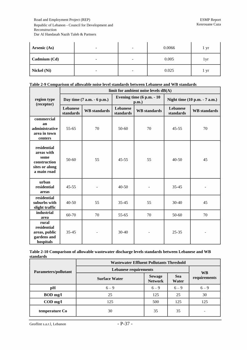
Geoflint s.a.r.l, Lebanon - P-37 -
Road and Employment Project (REP) ESMP Report
Kesrouane Caza Republic of Lebanon - Council for Development and
Reconstruction
Dar Al Handasah Nazih Taleb & Partners
Arsenic (As) - - 0.0066 1 yr
Cadmium (Cd) - - 0.005 1yr
Nickel (Ni) - - 0.025 1 yr
Table 2-9 Comparison of allowable noise level standards between Lebanese and WB standards
region type
(receptor)
limit for ambient noise levels dB(A)
Day time (7 a.m. - 6 p.m.) Evening time (6 p.m. - 10
p.m.) Night time (10 p.m. - 7 a.m.)
Lebanese
standards WB standards
Lebanese
standards WB standards
Lebanese
standards WB standards
commercial
an
administrative
area in town
centers
55-65 70 50-60 70 45-55 70
residential
areas with
some
construction
sites or along
a main road
50-60 55 45-55 55 40-50 45
urban
residential
areas
45-55 - 40-50 - 35-45 -
residential
suburbs with
slight traffic
40-50 55 35-45 55 30-40 45
industrial
area 60-70 70 55-65 70 50-60 70
rural
residential
areas, public
gardens and
hospitals
35-45 - 30-40 - 25-35 -
Table 2-10 Comparison of allowable wastewater discharge levels standards between Lebanese and WB
standards
Parameters/pollutant
Wastewater Effluent Pollutants Threshold
Lebanese requirements WB
requirements Surface Water Sewage
Network
Sea
Water
pH 6 – 9 6 – 9 6 – 9 6 – 9
BOD mg/l 25 125 25 30
COD mg/l 125 500 125 125
temperature Co 30 35 35 -

Geoflint s.a.r.l, Lebanon - P-38 -
Road and Employment Project (REP) ESMP Report
Kesrouane Caza Republic of Lebanon - Council for Development and
Reconstruction
Dar Al Handasah Nazih Taleb & Partners
Total nitrogen mg/l 30 60 30 10
Total phosphorus mg/l 10 10 10 2
Oil and grease mg/l 30 50 30 10
Mercury mg/l 0.05 0.05 0.05 0.01
Total suspended solids
mg/l 60 600 60 50
Total coliform bacteria
(Most Probable
Number/100 ml)
2000 - 2000 400

Geoflint s.a.r.l, Lebanon - P-39 -
Road and Employment Project (REP) ESMP Report
Kesrouane Caza Republic of Lebanon - Council for Development and
Reconstruction
Dar Al Handasah Nazih Taleb & Partners
2.6 International treaties and conventions
The main international treaties and conventions in relation to REP are listed in this section.
Table 2-11 International Treaties and Conventions in relation to REP.
Date Convention/Agreement Status Relevance to Project
1992 United Nations Framework
Convention on Climate Change.
Covered by Law No.
359 dated 11th August
1994.
This project must control activities that
release green-house gases such as
emissions from machineries used (most
of which rely on fuel) and excavation
activities, among others (refer to section
5.3.1.3).
1992 Rio de Janeiro Convention on
Biological Diversity.
Covered by Law No.
360 dated 11th August
1994.
This project should abide by this
convention to avoid or control activities
that may pose a threat on biodiversity at
all levels, since improvement of roads
sometimes leads, directly or indirectly,
to the loss and degradation of natural
habitats and biodiversity (refer to
section 5.3.1.6).
Table 2-12 Labors conventions
ILO
Convention Name
Entry into
force
Ratification
Date Description
Relevance to
Project
ILO no. 29
Convention
Concerning
Forced or
Compulsory
Labor
01/05/1932 25/06/1977
Its object and purpose are to
suppress the use of forced
labor in all its forms
irrespective of the nature of
the work or the sector of
activity in which it may be
performed. With some
exceptions such as military
service.
This project
should abide by
this convention
to protect
employees from
being forced into
any type of work
activity that they
do not want to
engage in.
ILO no. 105
Abolition of
Forced Labor
Convention
17/01/1959 25/06/1977
Aims at the elimination of
forced labor and cancels
certain forms of forced labor
still allowed under the Forced
Labor Convention of 1930
This project
should comply
with the
guidelines of this
convention in
order to protect
employees from
being forced into
any type of work
activity without
their will.
ILO no. 111
Discrimination
(Employment
and
Occupation)
Convention
15/06/1960 25/06/1977
Enable legislation which
prohibits all discrimination
and exclusion on any basis
including of race/color, sex,
religion, political opinion,
national or social origin in
employment.
This project
should abide by
this convention
to ensure a
healthy
environment
between the
employees and
between the
employer and
employees in the

Geoflint s.a.r.l, Lebanon - P-40 -
Road and Employment Project (REP) ESMP Report
Kesrouane Caza Republic of Lebanon - Council for Development and
Reconstruction
Dar Al Handasah Nazih Taleb & Partners
work place by
enforcing
equality and
respect between
them.
ILO no. 122
Employment
Policy
Convention
09/07/1965 25/06/1977
Aim at ensuring that there is
freedom of choice of
employment and the fullest
possible opportunity for each
worker to qualify for, and to
use his skills and
endowments in, a job for
which he is well suited,
irrespective of race, color,
sex, religion, political
opinion, national extraction
or social origin.
This project
should comply
with the
guidelines of this
convention to
ensure that
employees are
given the right
opportunities,
based on their
qualifications,
irrespective of
their origin,
affiliations.
ILO no. 138
Minimum Age
Convention for
Admission to
Employment
and Work
19/06/1976 25/06/1977
It stipulates that States should
progressively raise
the minimum age to a level
consistent with the fullest
physical and mental
development of young
people. It establishes 15 as
the minimum age for work in
general and 18 as the
minimum age for hazardous
work.
This project
should abide by
this convention
in order to
abolish the
employment of
children below
the specified
minimum age.

Geoflint s.a.r.l, Lebanon - P-41 -
Road and Employment Project (REP) ESMP Report
Kesrouane Caza Republic of Lebanon - Council for Development and
Reconstruction
Dar Al Handasah Nazih Taleb & Partners
3. Description of the Proposed Project
The first element of the REP includes the rehabilitation and maintenance of primary, secondary,
and tertiary roads, including road safety and spot improvements. As mentioned before, the
subject of this report is the selected roads for rehabilitation in Kesrouane Caza.
The first element of the REP includes the rehabilitation and maintenance of primary, secondary,
and tertiary roads, including road safety and spot improvements. As mentioned before, the
subject of this report is the selected roads for rehabilitation in Kesrouane Caza.
Four roads with a total length of 32.63 km will be rehabilitated in Kesrouane caza, the subject
of this report (Table 3-1).
Table 3-1 Roads to be rehabilitated within Kesrouane Caza (refer to Figure 3-1 for road map
classification)
Caza Road
Code Cadastral Borders
Length
(km)
Road
Classification
Kesrouane
2a
Boukak El-Dine – El-Ekaibe –
Nammoura et Kfar Jerif – Ghodrace –
El-Kfour – Fatka – Edma et Defne –
Kferyacine
19.1 Secondary & Local
2b Ghosta – Maarab 2.4 Secondary
2c El-Kfour – Herhraya et Kattine 5.13 Primary & Secondary
7 Mazraet Kfardebiane – Bekaatouta –
Bekaatet Kenaan 6 Primary

Geoflint s.a.r.l, Lebanon - P-42 -
Road and Employment Project (REP) ESMP Report
Kesrouane Caza Republic of Lebanon - Council for Development and Reconstruction
Dar Al Handasah Nazih Taleb & Partners
Figure 3-1 Classification of road segments among Kesrouane roads
Source: & Dar Al Handasah Nazih Taleb & Partners, processed by Geoflint, 2019

Geoflint s.a.r.l, Lebanon - P-43 -
Road and Employment Project (REP) ESMP Report
Kesrouane Caza Republic of Lebanon - Council for Development and
Reconstruction
Dar Al Handasah Nazih Taleb & Partners
3.1 Roads Location and Classification
3.1.1 Kesrouane R2a (Boukak El-Dine – El-Ekaibe – Nammoura et Kfar Jerif –
Ghodrace – El-Kfour – Fatka – Edma et Defne – Kferyacine)
Kesrouane R2a is located in Kesrouane Caza and consists of a single alignment that has a total
length of 19.1 km. It starts at Boukak El-Dine at an elevation of 23 m and continues upward,
passing through El-Ekaibe, Nammoura et Kfar Jerif, and Ghodrace, until it reaches El-Kfour at
an elevation of 685 m. Then, it descends, passing through Fatka and Edma et Defne, until it ends
in Kferyacine at an elevation of 47 m.
It is classified as a Secondary road for around 10 km and a Local road for around 9 km, that
passes through residential areas and other less populated areas, where secondary roads have a
roadway width varying between 5 m and 8 m, and local sections have a width varying between
4 m and 6 m, as shown in Table 3-2. Refer to Figure 3-2 for the road alignment.
Table 3-2 American Association of State Highway and Transportation Officials AASHTO 2018
Classification Width (m)
International Roads 10-14
Local Roads 4-6
Primary Roads 8-10
Primary Roads (highways) 10-14
Secondary Roads 5-8
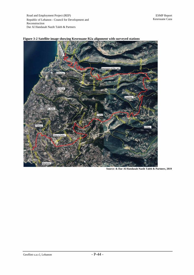
Geoflint s.a.r.l, Lebanon - P-44 -
Road and Employment Project (REP) ESMP Report
Kesrouane Caza Republic of Lebanon - Council for Development and
Reconstruction
Dar Al Handasah Nazih Taleb & Partners
Figure 3-2 Satellite image showing Kesrouane R2a alignment with surveyed stations
Source: & Dar Al Handasah Nazih Taleb & Partners, 2019
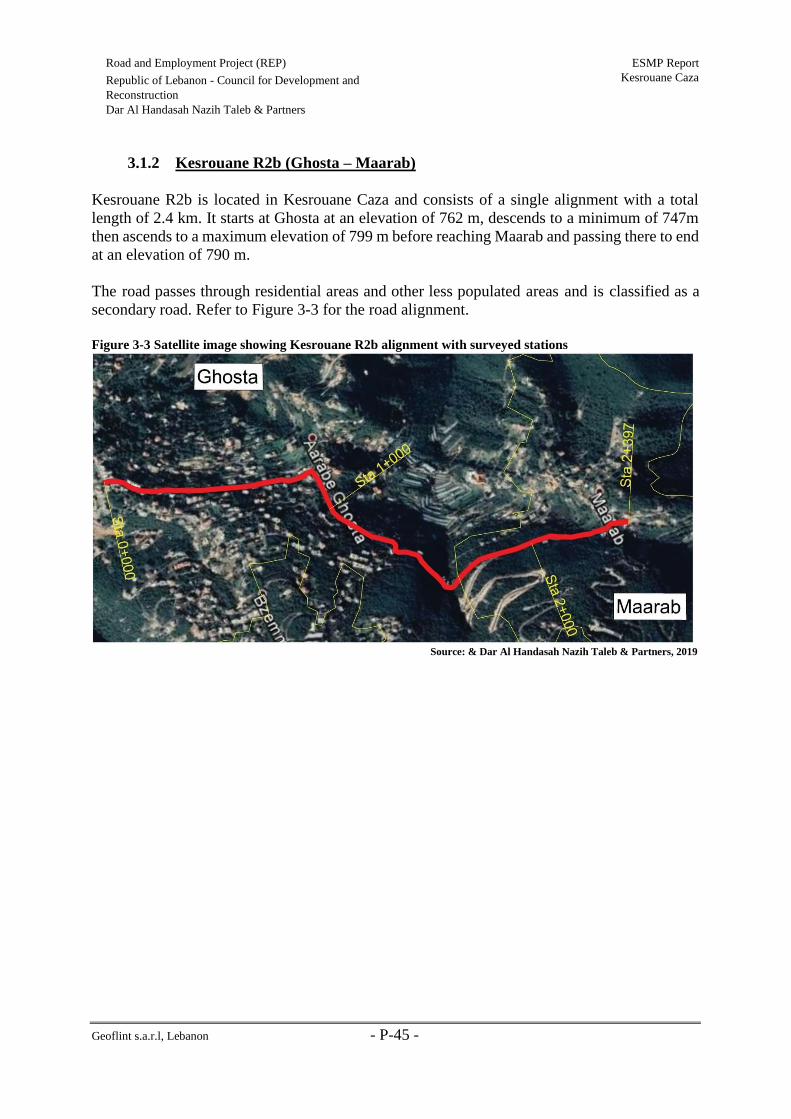
Geoflint s.a.r.l, Lebanon - P-45 -
Road and Employment Project (REP) ESMP Report
Kesrouane Caza Republic of Lebanon - Council for Development and
Reconstruction
Dar Al Handasah Nazih Taleb & Partners
3.1.2 Kesrouane R2b (Ghosta – Maarab)
Kesrouane R2b is located in Kesrouane Caza and consists of a single alignment with a total
length of 2.4 km. It starts at Ghosta at an elevation of 762 m, descends to a minimum of 747m
then ascends to a maximum elevation of 799 m before reaching Maarab and passing there to end
at an elevation of 790 m.
The road passes through residential areas and other less populated areas and is classified as a
secondary road. Refer to Figure 3-3 for the road alignment.
Figure 3-3 Satellite image showing Kesrouane R2b alignment with surveyed stations
Source: & Dar Al Handasah Nazih Taleb & Partners, 2019
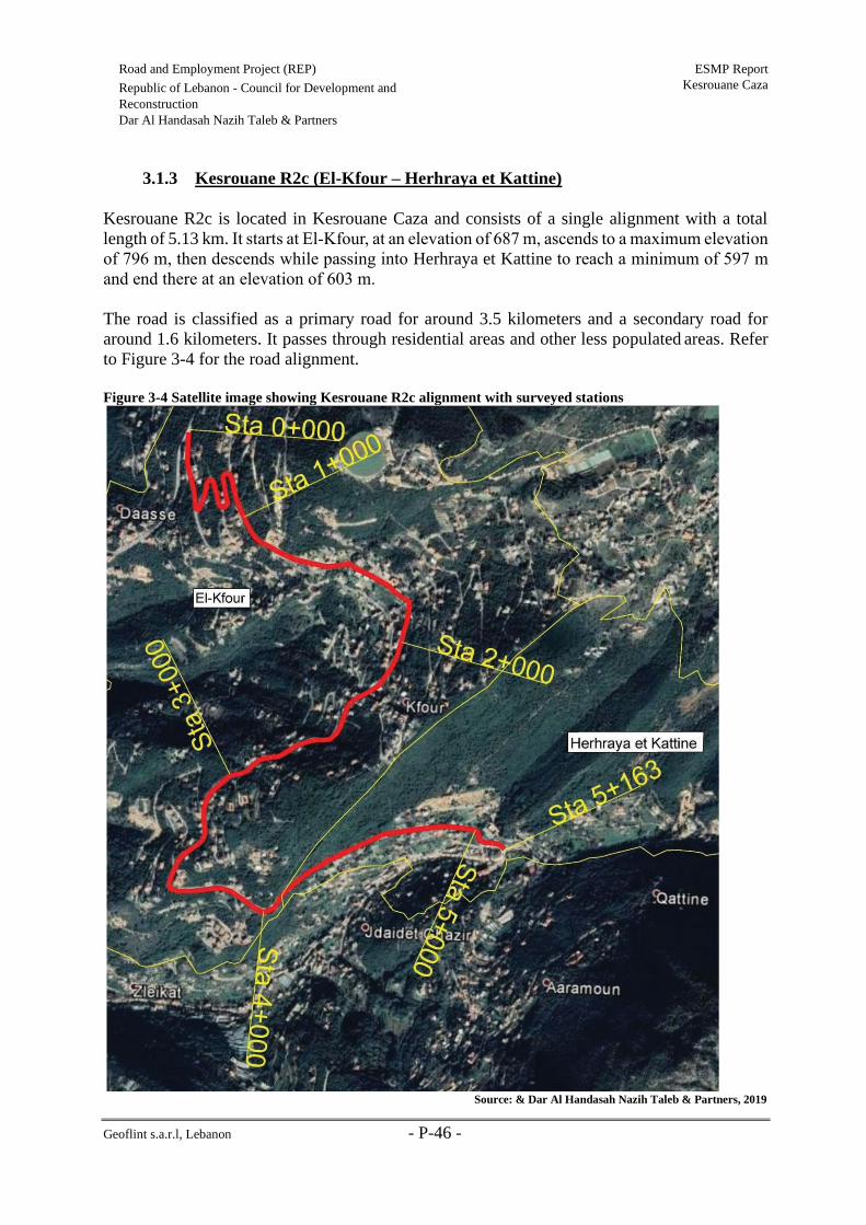
Geoflint s.a.r.l, Lebanon - P-46 -
Road and Employment Project (REP) ESMP Report
Kesrouane Caza Republic of Lebanon - Council for Development and
Reconstruction
Dar Al Handasah Nazih Taleb & Partners
3.1.3 Kesrouane R2c (El-Kfour – Herhraya et Kattine)
Kesrouane R2c is located in Kesrouane Caza and consists of a single alignment with a total
length of 5.13 km. It starts at El-Kfour, at an elevation of 687 m, ascends to a maximum elevation
of 796 m, then descends while passing into Herhraya et Kattine to reach a minimum of 597 m
and end there at an elevation of 603 m.
The road is classified as a primary road for around 3.5 kilometers and a secondary road for
around 1.6 kilometers. It passes through residential areas and other less populated areas. Refer
to Figure 3-4 for the road alignment.
Figure 3-4 Satellite image showing Kesrouane R2c alignment with surveyed stations
Source: & Dar Al Handasah Nazih Taleb & Partners, 2019

Geoflint s.a.r.l, Lebanon - P-47 -
Road and Employment Project (REP) ESMP Report
Kesrouane Caza Republic of Lebanon - Council for Development and
Reconstruction
Dar Al Handasah Nazih Taleb & Partners
3.1.4 Kesrouane R7 (Mazraet Kfardebiane – Bekaatouta – Bekaatet Kenaan)
Kesrouane R7 is located in Kesrouane Caza and consists of a single alignment with a total length
of 6 km. It starts at Mazraet Kfardebiane, at an elevation of 1,285 m, passes by Bekaatouta where
it reaches a maximum elevation of 1,298 m, and descends until ends at Bekaatet Kenaan at its
lowest elevation of 1,178 m.
The road passes through residential areas and other less populated areas and is classified as a
primary road. Refer to Figure 3-5 for the road alignment.
Figure 3-5 Satellite image showing Kesrouane R7 alignment with surveyed stations
Source: & Dar Al Handasah Nazih Taleb & Partners, 2019
3.2 Project Activities
3.2.1 Kesrouane R2a
The road cross sections and safety conditions assessment are provided in a separate technical
report provided by the engineers (Dar Al Handasah Nazih Taleb).
In summary, most sections of the road have a narrow width which classifies this road as very
critical from the safety point of view. The improvement of this section requires widening the
existing road from the cut side, however the existing project is limited to road rehabilitation

Geoflint s.a.r.l, Lebanon - P-48 -
Road and Employment Project (REP) ESMP Report
Kesrouane Caza Republic of Lebanon - Council for Development and
Reconstruction
Dar Al Handasah Nazih Taleb & Partners
which excludes road widening activities. It consists of primary and local roads and of urban and
rural areas. It also has a single carriageway all throughout.
Moreover, regarding the safety assessment:
• The sight distance in both horizontal and vertical alignments is not respected at some
curves and some crests.
• A lack of safety barriers is observed along the road (especially between Nammoura et
Kfar Jerif and El-Kfour) as well as the need to build new retaining walls, footwalls and
slope protection on the cut side of the road.
• The absence of signing and marking all over the road, including relevant intersections,
is well noticed.
• The absence of proper lighting is witnessed, most notably in the final 4 km (between
Edma et Defne and Kferyacine.
As for pavement conditions, most sections require milling and overlay, barring the final part
(from Edma et Defne onwards) which is good condition and in Choueir which is deemed to have
its pavement in a good condition and a few other sections which require pavement
reconstruction.
For relevant data regarding this road, refer to Table 3-3 and Figure 3-6.

Geoflint s.a.r.l, Lebanon - P-49 -
Road and Employment Project (REP) ESMP Report
Kesrouane Caza Republic of Lebanon - Council for Development and
Reconstruction
Dar Al Handasah Nazih Taleb & Partners
Table 3-3 Existing road condition survey – Kesrouane R2a
Beg End Cadaster
Location
Road
Classification
Urban /
Rural
Existin
g Road
Width
(m)
Single / Dual
Carriageway
Traveled
Way
Width (m)
Cross-
Sections
Assessment
Pavement
Assessment
Road Safety
Assessment
00+000 00+800 Boukak El-
Dine Secondary Urban 5.6 - 6 Single 5.6 - 6
Critical
width at
some
locations
Milling &
Overlay Acceptable
00+800 01+500 Boukak El-
Dine Secondary Urban 3 - 4.5 Single 3 - 4.5
Critical
width
< 4.5m
Reconstructi
on Acceptable
01+500 03+500 Boukak El-
Dine Secondary Urban 4.5 - 5.5 Single 4.5 - 5.5
Critical
width at
some
locations
Milling &
Overlay Acceptable
03+500 04+300 El Ekaibé Secondary Urban 5.5 - 6 Single 5.5 - 6
Critical
width at
some
locations
Milling &
Overlay
Needs Safety
Barrier
04+300 06+400 Nammoura et
Kfar Jerif Secondary Rural
varia
ble
width
5
Single 3 - 5.5
* 4+500 to
5+100:
width 4m
* 5+900 to
6+400
width: 2.5-
3m
Reconstructi
on
Needs Safety
Barrier
06+400 07+100 Ghodrace Secondary Rural ≈ 4-5 Single ≈ 4
Critical
width
< 4.5m
Reconstructi
on
Needs Safety
Barrier
07+100 07+900 Ghodrace Secondary Rural 5 - 6 Single 5 - 6
Critical
width
< 4.5m
Milling &
Overlay
Needs Safety
Barrier
07+900 09+100 Ghodrace Secondary Rural 5 - 6 Single 5 - 6
Critical
width
< 4.5m
Milling &
Overlay
Needs Safety
Barrier

Geoflint s.a.r.l, Lebanon - P-50 -
Road and Employment Project (REP) ESMP Report
Kesrouane Caza Republic of Lebanon - Council for Development and
Reconstruction
Dar Al Handasah Nazih Taleb & Partners
09+100 09+900 El-Kfour Secondary Rural 5 - 6 Single 5 - 6
Critical
width
< 4.5m
Milling &
Overlay
Needs Safety
Barrier
09+900 11+000 El-Kfour Local Rural 14 Single 2*3.5 Acceptable Milling &
Overlay Acceptable
11+000 13+750 Fatka Local Rural 14 Single 2*3.5 Acceptable Milling &
Overlay Acceptable
13+750 14+350 Edma et Defné Local Rural 14 Single 2*3.5 Acceptable Milling &
Overlay Acceptable
14+350 15+000 Edma et Defné Local Urban 7 Single 7 - 8 Acceptable Milling &
Overlay Acceptable
15+000 17+700 Edma et Defné Local Urban 7 Single 7 - 8 Acceptable Good
Condition Acceptable
17+700 18+900 Kferyacine Local Urban 7 Single Under
study
Acceptable Good
Condition Acceptable
Source: Dar Al Handasah Nazih Taleb & Partners

Geoflint s.a.r.l, Lebanon - P-51 -
Road and Employment Project (REP) ESMP Report
Kesrouane Caza Republic of Lebanon - Council for Development and
Reconstruction
Dar Al Handasah Nazih Taleb & Partners
Figure 3-6 Work stations along with road rehabilitation activities along Kesrouane R2a alignment
Source: Geoflint s.a.r.l. &
Dar Al Handasah Nazih
Taleb & Partners, 2019

Geoflint s.a.r.l, Lebanon - P-52 -
Road and Employment Project (REP) ESMP Report
Kesrouane Caza Republic of Lebanon - Council for Development and
Reconstruction
Dar Al Handasah Nazih Taleb & Partners
3.2.2 Kesrouane R2b
In summary, the road section is very narrow at some points. A lack of safety barriers and the
absences of signing and marking are both observed all along the road. The need to build new
retaining walls, footwalls and slope protection on the cut side of the road has also become
necessary. As for pavement condition, milling and overlay is required throughout the road’s
length.
For relevant data regarding this road, refer to Table 3-4 and Figure 3-7.

Geoflint s.a.r.l, Lebanon - P-53 -
Road and Employment Project (REP) ESMP Report
Kesrouane Caza Republic of Lebanon - Council for Development and Reconstruction
Dar Al Handasah Nazih Taleb & Partners
Table 3-4 Existing road condition survey – Kesrouane R2b
Beginning End Cadaster
Location
Road
Classification
Urban /
Rural
Existing
Road
Width (m)
Single / Dual
Carriageway
Traveled
Way Width
(m)
Cross-
Sections
Assessment
Pavement
Assessment
Road Safety
Assessment
0+000 1+600 Ghosta Secondary Rural 5.5 - 6 Single 5.5-6 Critical Width Milling &
Overlay
Needs Safety
Barrier
1+600 2+500 Maarab Secondary Rural 5.6 - 6 Single 5.6-6 Critical Width Milling &
Overlay
Needs Safety
Barrier Source: Dar Al Handasah Nazih Taleb & Partners

Geoflint s.a.r.l, Lebanon - P-54 -
Road and Employment Project (REP) ESMP Report
Kesrouane Caza Republic of Lebanon - Council for Development and Reconstruction
Dar Al Handasah Nazih Taleb & Partners
Figure 3-7 Work stations along with road rehabilitation activities along Kesrouane R2b alignment
Source: Geoflint s.a.r.l. & Dar Al Handasah Nazih Taleb & Partners, 2019

Geoflint s.a.r.l, Lebanon - P-55 -
Road and Employment Project (REP) ESMP Report
Kesrouane Caza Republic of Lebanon - Council for Development and
Reconstruction
Dar Al Handasah Nazih Taleb & Partners
3.2.3 Kesrouane R2c
In summary, some sections of the road have a very narrow width. A lack of safety barriers and
slope protection is observed along the road. Moreover, the need to build new retaining walls and
footwalls on the cut side of the road is obligatory. As for pavement conditions, milling and
overlay is required all throughout the road’s length.
For relevant data regarding this road, refer to Table 3-5 and Figure 3-8.
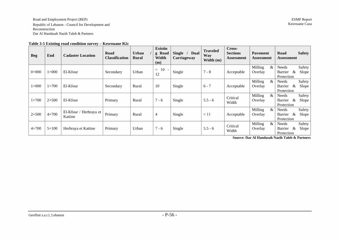
Geoflint s.a.r.l, Lebanon - P-56 -
Road and Employment Project (REP) ESMP Report
Kesrouane Caza Republic of Lebanon - Council for Development and
Reconstruction
Dar Al Handasah Nazih Taleb & Partners
Table 3-5 Existing road condition survey – Kesrouane R2c
Beg End Cadaster Location Road
Classification
Urban /
Rural
Existin
g Road
Width
(m)
Single / Dual
Carriageway
Traveled
Way
Width (m)
Cross-
Sections
Assessment
Pavement
Assessment
Road Safety
Assessment
0+000 1+000 El-Kfour Secondary Urban ≈ 10 -
12 Single 7 - 8 Acceptable
Milling &
Overlay
Needs Safety
Barrier & Slope
Protection
1+000 1+700 El-Kfour Secondary Rural 10 Single 6 - 7 Acceptable
Milling &
Overlay
Needs Safety
Barrier & Slope
Protection
1+700 2+500 El-Kfour Primary Rural 7 - 6 Single 5.5 - 6 Critical
Width
Milling &
Overlay
Needs Safety
Barrier & Slope
Protection
2+500 4+700 El-Kfour / Herhraya et
Kattine Primary Rural 4 Single ≈ 11 Acceptable
Milling &
Overlay
Needs Safety
Barrier & Slope
Protection
4+700 5+100 Herhraya et Kattine Primary Urban 7 - 6 Single 5.5 - 6 Critical
Width
Milling &
Overlay
Needs Safety
Barrier & Slope
Protection Source: Dar Al Handasah Nazih Taleb & Partners

Geoflint s.a.r.l, Lebanon - P-57 -
Road and Employment Project (REP) ESMP Report
Kesrouane Caza Republic of Lebanon - Council for Development and
Reconstruction
Dar Al Handasah Nazih Taleb & Partners
Figure 3-8 Work stations along with road rehabilitation activities along Kesrouane R2c alignment
Source: Geoflint s.a.r.l. & Dar Al Handasah Nazih Taleb & Partners, 2019

Geoflint s.a.r.l, Lebanon - P-58 -
Road and Employment Project (REP) ESMP Report
Kesrouane Caza Republic of Lebanon - Council for Development and
Reconstruction
Dar Al Handasah Nazih Taleb & Partners
3.2.4 Kesrouane R7
In summary, the road is a bit narrow (critical width) at some locations. A lack of safety barriers
and footwalls is observed along the majority of the road length. Sight-distance is inadequate and
needs improvement, especially form station 02+800 onwards. As for pavement condition, most
of the road pavement is in good condition, barring most of the section that falls in Mazraet
Kfardebiane where pavement reconstruction is required.
For relevant data regarding this road, refer to Table 3-6 and Figure 3-9.

Geoflint s.a.r.l, Lebanon - P-59 -
Road and Employment Project (REP) ESMP Report
Kesrouane Caza Republic of Lebanon - Council for Development and
Reconstruction
Dar Al Handasah Nazih Taleb & Partners
Table 3-6 Existing road condition survey – Kesrouane R7
Beginning End Cadaster
Location
Road
Classification
Urban /
Rural
Existing
Road
Width (m)
Single / Dual
Carriageway
Traveled
Way
Width (m)
Cross-
Sections
Assessment
Pavement
Assessment
Road Safety
Assessment
0+000 0+600 Mazraet
Kfardebiane Primary Rural - Single - Acceptable
Good
Condition
Needs Safety
Barrier
0+600 2+800 Mazraet
Kfardebiane Primary Rural
5.5-7.5 Single 5.5-7.5 Critical Width Reconstruction
Needs Safety
Barrier
2+800 5+000 Bekaatouta
Primary Rural -
- - Acceptable Good
Condition Acceptable
5+000 5+900 Bekaatet
Kenaan Primary Rural
10 Single 8 Acceptable
Good
Condition
Needs Safety
Barrier Source: Dar Al Handasah Nazih Taleb & Partners, 2019

Geoflint s.a.r.l, Lebanon - P-60 -
Road and Employment Project (REP) ESMP Report
Kesrouane Caza Republic of Lebanon - Council for Development and
Reconstruction
Dar Al Handasah Nazih Taleb & Partners
Figure 3-9 Work stations along with road rehabilitation activities along Kesrouane R7 alignment
Source: Geoflint s.a.r.l. & Dar Al Handasah Nazih Taleb & Partners, 2019

Geoflint s.a.r.l, Lebanon - P-61 -
Road and Employment Project (REP) ESMP Report
Kesrouane Caza Republic of Lebanon - Council for Development and
Reconstruction
Dar Al Handasah Nazih Taleb & Partners
3.3 Contractor’s Equipment and Materials
The contactor’s equipment needed for the rehabilitation activities are presented in Table 3-7.
The quantities of raw materials to be used during the rehabilitation phase are presented in Table
3-8).
Table 3-7 Contractor’s Equipment to be used
Contractor’s Equipment
Description No
Excavator 4
Shovel 4
Bob cat 4
Pick-up 4
Truck 6
Water tank 4
Steel roller 3
Conc. transit mixer 3
Asphalt cutter 4
4x4 Vehicles 4
Vehicles 6
Plate compactor 6
Asphalt Paver 1
Jack Hammer 3
Table 3-8 Quantities of main materials to be used during the whole period of the rehabilitation works
Material Unit Quantity
Sub-base and base Course m3 30000
Bituminous Material m3 70500
Reinforced Concrete m3 5400
Clearing and Grubbing m2 61000
Lighting Columns Number 41
Lighting Brackets Number 15
3.4 Site Rehabilitation Staffing
It is estimated that rehabilitation works for Kesrouane roads will require a total of 18 months
(with 12 months defects liability period subsequent to end of works). It is estimated that 176
workers will be involved in the rehabilitation work. Refer to Table 3-9.
Table 3-9 Contractor’s Personnel
Contractor’s Personnel
Project Manager 1
Civil Engineer 4
Surveyor 4
Foreman 4
Watchman 4
Skilled labor 30
Labor 80
Steel fixer 10
Carpenter 10
Operator 25

Geoflint s.a.r.l, Lebanon - P-62 -
Road and Employment Project (REP) ESMP Report
Kesrouane Caza Republic of Lebanon - Council for Development and
Reconstruction
Dar Al Handasah Nazih Taleb & Partners
Office boy 4
Total 176
3.5 Site Facilities & Infrastructure
The Project site will not include any facilities on-site including site offices for Engineers and
for the Contractor, laborers camps, lodging on site, containers, power generators and repair
garages.
During the work implementation, the Contractor will have to rent a flat located in the Project
area to serve as a Project Offices. These offices will be used by the Contractor Engineers,
technical skilled workers and Supervising Consultants. The flat will be equipped with toilet,
kitchen (including drinking water and appliances), lockers and other supplies needed for the
daily administrative activities. It might also serve as a meeting point for all Project workers at
the start and end of their shifts.
The work implementation will also require unskilled workers (laborers) needed to perform
earthworks on-site. The Contractor will be encouraged to hire laborers from the local
community living in the Project area. During working hours, laborers will be entitled with a
one-hour break on-site. Usually, every laborer brings from home his own food and drinking
water. The on-site rest point will be decided by the Contractor at the time of works.
The Contractor will have to service the on-site with portable cabin toilet. The porta cabin will
be mobile and its placement depends on the length of the work zone. Accordingly, the
Contractor will have to move it based on the progress of rehabilitation works. The Contractor
should link the porta cabin toilet to the existing wastewater network. In case the network is not
available within the work zone, the Contractor will need to link it to a polyethylene storage
tank and the Supervising Consultant shall inspect it on a regular basis and ensure the application
of proper mitigation measures.
For vehicles and equipment, the Contractor will have to rent a land within the Project area.
This land should be fenced and used for parking purpose only. The Contractor shall not perform
any repair on site and is obliged to execute vehicles and equipment maintenance in a repair
shop preferably located within the Project area.

Geoflint s.a.r.l, Lebanon - P-63 -
Road and Employment Project (REP) ESMP Report
Kesrouane Caza Republic of Lebanon - Council for Development and
Reconstruction
Dar Al Handasah Nazih Taleb & Partners
4. Description of the Environment and Social Context
The environmental and social baseline assessment is a key component in any ESMP study. This
assessment will grant an initial assessment of all existing phenomena and conditions in the
study area and within the area of influence before the implementation of the project. The aim
is to identify key environmental and social issues/impacts that need to be mitigated and
monitored during project implementation.
4.1 Physical Environment
4.1.1 Topography
Roads under consideration are Kesrouane Roads 2a, 2b, 2c, and 7 located in Kesrouane caza.
The variation in elevation of the vertical alignments are shown in Table 4-1 and the elevation
contour lines are shown in Figure A, Figure B, Figure C, and Figure D (in Annex 1).
Table 4-1 Mean sea level elevations of Kesrouane roads
Road Altitude approximate range (m)
Kesrouane Road 2a 0 – 695
Kesrouane Road 2b 745 - 805
Kesrouane Road 2c 560 - 820
Kesrouane Road 7 1180 - 1300
Geoflint s.a.r.l, Lebanon - P-64 -
Road and Employment Project (REP) ESMP Report
Kesrouane Caza Republic of Lebanon - Council for Development and
Reconstruction
Dar Al Handasah Nazih Taleb & Partners
4.1.2 Geology
The geology of the studied roads was investigated for outcropping formations, subsurface
stratigraphy, structure (faults, folds, seismic, etc.), hydrogeology (groundwater and sea water
intrusions) and hydrology (surface water).
(1)Kesrouane R2a
The outcropping lithological formations in and around the study area belong to the Cretaceous
and Quaternary geological time periods (Figure E in Annex 1). The road crosses the formations
shown in Table 4-2.
Table 4-2 Geological outcrops exposed along Kesrouane R2a alignment
Geology Name Description
C4
Sannine
Limestone, of
Cenemonain age
(C4); this unit is divided into three subunits:
C4a: Dolomitic Limestone, within this formation, geodes of different sizes filled
or voided can be recorded. Thickness of this unit is about 300 meters.
C4b: Bluish marl and shale containing crystals of quartz, chert nodules and
bands form. Thickness of this unit is about 100 meters.
C4c: Limestone and dolomitic limestone white to brown in color. Limestone is
highly karstified. Thickness of this unit is about 300 meters.
C5 Maameltain /
Ghazir Limestone
Mainly composed of hard crystalline and micritic limestone to dolomitic
limestone, creamish white to brown in color, while the weathered color is
mainly gray. Limestone / dolomitic limestone are highly karstified and within
this formation, geodes of different sizes filled or voided are recorded. This
formation is combined with C4c outcrop and can only be distinguished by
microfossils.
Q
Quaternary
formation
belonging to the
Quaternary age
This formation can reach a thickness of 100 m and typically consists of sandy
beaches, detrital LS, conglomerates, volcanic coastal or alluvial deposits
Source: Dubertret, (1945)
(2)Kesrouane R2b
The outcropping lithological formations in and around the study area belong to the Cretaceous
and Jurrasic geological time periods (Figure F in Annex 1). The road crosses the formations
shown in Table 4-3.
Table 4-3 Geological outcrops exposed along Kesrouane R2b alignment
Geology Name Description
J6
Bikfaya
Limestone,
Portlandian
epoch
Finely crystalline, massive, cliffy Limestone that includes trace to abundant brown
chert nodules. This formation is chemically deposited with smooth fresh fracture.
The thickness of this unit is ranging from 60 to 65 m and Type section is Bikfaya.
C1
Chouf
Sandstone
(Grés de
Base),
Varicoloured, cross bedded Sandstone with inter-beds of shale; contains heavy
minerals; color depends upon percentage of hematite and presence of volcanics
giving purplish color; Sand is sometimes white; contains coal seams and traces of
brittle amber. This formation can reach 300 meters in thickness.

Geoflint s.a.r.l, Lebanon - P-65 -
Road and Employment Project (REP) ESMP Report
Kesrouane Caza Republic of Lebanon - Council for Development and
Reconstruction
Dar Al Handasah Nazih Taleb & Partners
Neocomian-
Barremian
Source: Dubertret, (1945)
(3)Kesrouane R2c
The outcropping lithological formations in and around the study area belong to the Cretaceous
geological time period (Figure G in Annex 1). The road crosses the formations shown in Table
4-4.
Table 4-4 Geological outcrops exposed along Kesrouane R2c alignment
Geology Name Description
C4
Sannine
Limestone, of
Cenemonain
age
(C4); this unit is divided into three subunits:
C4a: Dolomitic Limestone, within this formation, geodes of different sizes filled
or voided can be recorded. Thickness of this unit is about 300 meters.
C4b: Bluish marl and shale containing crystals of quartz, chert nodules and bands
form. Thickness of this unit is about 100 meters.
C4c: Limestone and dolomitic limestone white to brown in color. Limestone is
highly karstified. Thickness of this unit is about 300 meters.
C3
Hammana
Formation,
Albian
Green Marl (containing glauconite) intercalated with thick layers of marly
Limestone forming cliffs 3 - 4 m in height; may contain some thin sand layers in
the lower part of the formation. This formation can reach 150 meters in
thickness.
C2a
Abey
Formation,
Lower Aptian
Clastic: mixture of clay, sand and calcareous material in varying proportions
forming clay, sandy clay, marl, marly limestone etc. The calcareous material
may be slightly to moderately indurated. Where marl prevails, its fresh color is
bluish, weathering to creamish brown. This formation can reach 125 meters in
thickness.
C2b
Hammana
Formation,
Upper Aptian
Marl intercalated with marly Limestone with thick layers of Sand on top; layers
of ferro-oolitic limestone sometimes overlie the sand. This formation can reach
20 meters in thickness.
C1
Chouf
Sandstone
(Grés de
Base),
Neocomian-
Barremian
Varicoloured, cross bedded Sandstone with inter-beds of shale; contains heavy
minerals; color depends upon percentage of hematite and presence of volcanics
giving purplish color; Sand is sometimes white; contains coal seams and traces
of brittle amber. This formation can reach 300 meters in thickness.
Source: Dubertret, (1945
(4)Kesrouane R7
The outcropping lithological formations in and around the study area belong to the Cretaceous
and Jurrasic geological time period (Figure H in Annex 1). The road crosses the formations
shown in Table 4-5.

Geoflint s.a.r.l, Lebanon - P-66 -
Road and Employment Project (REP) ESMP Report
Kesrouane Caza Republic of Lebanon - Council for Development and
Reconstruction
Dar Al Handasah Nazih Taleb & Partners
Table 4-5 Geological outcrops exposed along Kesrouane R7 alignment
Geology Name Description
J6
Bikfaya
Limestone,
Portlandian
epoch
Finely crystalline, massive, cliffy Limestone that includes trace to abundant brown
chert nodules. This formation is chemically deposited with smooth fresh fracture.
The thickness of this unit is ranging from 60 to 65 m and Type section is Bikfaya.
J7
Salima
Limestone,
Portlandian
epoch
Composed of Chocolate brown Shale and bluish Marl, in many parts it’s
intercalated with thick oolitic Limestone bed. The marl weathers to a creamish,
ochre color and Crinoids fossil can be recorded in this formation. Thickness varies
from zero-few meters to 150 m. Type section is Salima.
C1
Chouf
Sandstone
(Grés de Base),
Neocomian-
Barremian
Varicoloured, cross bedded Sandstone with inter-beds of shale; contains heavy
minerals; color depends upon percentage of hematite and presence of volcanics
giving purplish color; Sand is sometimes white; contains coal seams and traces of
brittle amber. This formation can reach 300 meters in thickness.
Bj6 Black Basalt
Volcanic formation with about 50 m of thickness, overlapping J6 (Bikfaya
Limestone). This type is an impermeable rock, aquiclude layer that results in
seasonal spring discharges.
Source: Dubertret, (1945

Geoflint s.a.r.l, Lebanon - P-67 -
Road and Employment Project (REP) ESMP Report
Kesrouane Caza Republic of Lebanon - Council for
Development and Reconstruction
Dar Al Handasah Nazih Taleb &
Partners
4.1.3 Hydrogeology
Geological units can be defined as aquifer or aquiclude in terms of storing and transmitting
water, and these types depend on the geological environment in which they occur.
An aquifer can be a subsurface rock or sediment unit that is porous and permeable, high enough
that it stores and transmits useful quantities of water. Aquifers are divided into the following
categories:
➢ Confined: overlain by an impermeable rock unit,
➢ Unconfined: that is not overlain by an -impermeable rock unit, where the water in this
aquifer is under atmospheric pressure and is recharged by precipitation that falls on the
land surface directly above the aquifer,
➢ or Semi-confined: partially confined, or overlain, by gravel, sand, silt or soil layers of
low permeability through which recharge and discharge can still occur.
Aquiclude is a geological formation which, although porous and capable of absorbing water,
does not permit its movement at rates sufficient to furnish an appreciable supply for a well or
spring. Alternatively, it could be an impermeable body of rock or stratum of sediment that acts
as a barrier to the flow of groundwater.
The study area for Kesrouane caza roads is characterized by the presence of aquifer, aquiclude
and open semi-aquifers within the various formations:
➢ Aquifers in the area are Sannine Limestone (C4) and Mdeirej Limestone, Lower Aptian
(C2a2). The limestone formation forms a main part to the study area and is the most
important karstic system in the study area characterized by a significant amount of
groundwater flowing in channels, faults and fractures. These fractures include solution
joints, solution pits, lapiaz, grooves and sinkholes. Cavities in the rocks are often filled
with calcite and cave deposits.
➢ Aquicludes formations along the area are the Hammana Formation, Albian (C3). These
deposits constitute an aquiclude due to the presence of marls and marlstones with low
hydraulic conductivity. However, low to medium discharge springs are present in this
formation.
➢ Semi-Aquifers in the area are the Chouf Sandstone (C1), Abey Formation, Lower Aptian
(C2a1) and Hammana Formation, Upper Aptian (C2b), and Bikfaya Limestone (J6), which
is composed of sand, with very high permeability, and clay, with low permeability are
present within these deposits. In relation to permeability and porosity, there are no
important fractures or joints within these formations that is why they are classified as a
semi-aquifer.

Geoflint s.a.r.l, Lebanon - P-68 -
Road and Employment Project (REP) ESMP Report
Kesrouane Caza Republic of Lebanon - Council for
Development and Reconstruction
Dar Al Handasah Nazih Taleb &
Partners
(1)Kesrouane Roads 2a & 2c
The area surrounding Kesrouane R2a is very rich in winter drainage channels that discharge
downstream to “Wadi Tabarja”, “Wadi Ghazir”, and Ibrahim rivers. At some sections, the road
is less than 40m away from Tabarja river, and about 60 m and 135 m from Ghazir and Ibrahim
River. Kesrouane R2c also is rich in winter drainage channels and at one section, the road is
less than 30m away from “Wadi Ghazir”.
In terms of hydrostratigraphy, the road falls on a karstic limestone formation represented as 2
in Figure I and Figure J (in Annex 1) and described in Table 4-6, which is the most important
karstic system in the study area. The system is characterized by a significant amount of
groundwater flowing in channels, faults and fractures. The transmissivity of these formations is
generally high and water table is shallow. Any accidental spillage of wastewater onto open
ground can easily infiltrate the karstic limestone and is highly likely to pollute water present in
the subsurface. Moreover, it is prohibited to discharge any solid waste or wastewater into the
winter channels as this will lead to adverse impacts on the neighboring rivers.
(2)Kesrouane Road 2b
Similar to Kesrouane R2a, Kesrouane R2b road encounters several drainage channels that
discharge to “Wadi Jounieh” river as shown in Figure K (in Annex 1). Discharge of solid waste
or wastewater at these locations is prohibited.
(3)Kesrouane Road 7
This road (Figure L in Annex 1) falls on a highly karstified Jurrasic formation rich in subsurface
water aquifers. The surrounding is characterized by very high permeability and subsurface
transmissivity, with a high and shallow water table.
Moreover, the road is surrounded by several surface winter drainage channels which lead
downstream to “El Kaleb” and “Wadi Jounieh” rivers, in addition to presence of many nearby
springs namely Ain el Qattara, Ain el Libne and Ain Bqaatouta. Further, the road and El Kaleb
River intersect (between stations 0+600 and 2+800, Kfardebiane Culvert/bridge location).
Therefore, accidental spillages of any polluting material are highly likely to infiltrate and
degrade the surface and groundwater quality in the area. Special attention should be taken to
limit discharge of contaminated water or random disposal of solid waste generated from the
rehabilitation works.
It is important to mention that Naher Ibrahim and Naher el Kaleb rivers are both protected by
the MoE under decision No. 34 (dated 1997) and decision No. 97 (dated 1998) respectively.

Geoflint s.a.r.l, Lebanon - P-69 -
Road and Employment Project (REP) ESMP Report
Kesrouane Caza Republic of Lebanon - Council for Development and
Reconstruction
Dar Al Handasah Nazih Taleb & Partners
Table 4-6 Legend of the hydrogeology maps shown in Figure I, Figure J, Figure K, andFigure L (in Annex 1)
Geology Class Groundwater Sheets
Lithology
Age Flows of the
sources I/sec.
Probable instantaneous
flows of the works I/sec.
Transmissivity
m2/sec
Facies
1
In karstic formations
Wide and rich water table
Massive limestones
and dolomitic
limestones with
intercal. Marls
Thickness: >1000 m.
JURASSIC
Bathonien-
Portlandien
<100
100-1000
>1000
>100 10-2≤ T ≤ 1
Generally high
2
Limestone regularly
bedding
Thickness: 800 to
1,000 m.
CretaceousCenoman
ian -Turonian
< 100
100-1000
>1000
>100 10-2 ≤ T ≤ 1
Generally high
10 Local or discontinuous water
table
Sandstone Thickness
: 150 à 250 m. Cretaceous <10 <10
10-5 ≤ T ≤ 10-4
Poor with weak
16 Areas generally without water
table or a very local water
table
Alternations of clay-
sandy, limestone
beds and marl
Thickness: 300 to
400 m.
Cretaceousaptian_al
bian
<5 (Sources
intermittentes) <5 Weak with very weak
22 Basaltes
Variable thickness
Cretaceousinf.
Miocene pliocene
QUATERNARY
_ Very weak Very weak
Road
(Kesrouane)
Geology Class
1 2 10 16 22
The roads lie on the
following geology
classes
2a ✓
2c ✓ ✓
2b ✓ ✓ ✓ ✓
7 ✓ ✓ ✓

Geoflint s.a.r.l, Lebanon - P-70 -
Road and Employment Project (REP) ESMP Report
Kesrouane Caza Republic of Lebanon - Council for
Development and Reconstruction
Dar Al Handasah Nazih Taleb &
Partners
4.1.4 Climate and Meteorology
The climate and meteorological parameters play a vital role in transport and dispersion of
pollutants in the atmosphere. Thus, the collection and analysis of meteorological information,
including primarily precipitation, ambient temperature, wind direction and speed, are essential
data for adequately assessing environmental impacts. The most significant meteorological
parameters that influence the direct environmental impacts at the proposed project are: wind
due to its ability to carry dust and odors to nearby communities; and precipitation due to its
ability to enhance the infiltration of accidental spills and contaminated rehabilitation wastewater
within the area depending on site operation procedures. Meteorological data are obtained either
from the closest available stations and whenever not available satellite data are used and
referenced in the text.
(1)Kesrouane R2a & R2c
Precipitation rates
Precipitation in the summer season between the month of June and September are negligible (~
11 mm) along the road (Figure M in Annex 1). The highest precipitation is recorded in January
with an average value of 202 mm and the total annual precipitation is approximately 1,040 mm.
Temperature (Land Surface)
The hottest month in the area is August (30.1 oC) and coldest month is January (7.7 oC).
Fluctuations in the temperature values are shown in Figure N (in Annex 1).
(2)Kesrouane R2b
Precipitation Rates
Precipitation in the summer season between the month of June and September are negligible
(~11mm) along Kesrouane R2b (Figure O in Annex 1). The highest precipitation is recorded in
January with an average value of 191 mm and the total annual precipitation is 926 mm.
Temperature (Land Surface)
The hottest month in the area is August (29.7 oC) and coldest month is January (6.8 oC).
Fluctuations in the temperature values are shown in Figure P (in Annex 1).
(3)Kesrouane R7
Precipitation in the summer season between the month of June and September are negligible
along Kesrouane R7 (Figure Q in Annex 1). The highest precipitation is recorded in January
with an average value of 209 mm and the total annual precipitation is 950 mm.
Temperature (Land Surface)

Geoflint s.a.r.l, Lebanon - P-71 -
Road and Employment Project (REP) ESMP Report
Kesrouane Caza Republic of Lebanon - Council for
Development and Reconstruction
Dar Al Handasah Nazih Taleb &
Partners
The hottest month in the area is August (28.6 oC) and coldest month is January (1.6 oC).
Fluctuations in the temperature values are shown in Figure R (in Annex 1).
Wind records
In general, wind speed and direction vary with time and location depending on season and
location. Dominant winds directions on the Lebanese coast are westerly and southern westerly
(blowing from west to east and south-west directed to the north-east). Wind speed varies
throughout the year and is as low as 2.5 m/s to a high of 4.15 m/s.
Table 4-7 Wind direction, average monthly wind speed, and wind probability recorded at Tripoli
meteorological station from 6/2005 until 7/2011
Month of year Jan Feb Mar Apr May Jun Jul Aug Sep Oct Nov Dec
Dominant Wind
direction
Wind probability
> = 4 Beaufort (%) 9 13 13 12 8 11 13 16 10 7 6 7
Average
Wind speed (m/s) 3.1 3.6 3.6 3.6 3.6 4.15 4.15 4.15 3.6 3.05 2.5 3.05
Source : Tripoli Meteorological Station

Geoflint s.a.r.l, Lebanon - P-72 -
Road and Employment Project (REP) ESMP Report
Kesrouane Caza Republic of Lebanon - Council for Development and
Reconstruction
Dar Al Handasah Nazih Taleb & Partners
4.1.5 Air quality and Noise
Air Quality
Air quality is an essential component in assessing social wellbeing and health status of a
community. Developing baseline information will help in comparing the impacts of the project
relative to the existing conditions. Ambient air quality data was gathered from the UNDP project
“Air quality assessment in an East Mediterranean country: the case of Lebanon” which is based
at the Ministry of Environment. The UNDP/MoE monitors the criteria pollutants: Particulate
Matter (PM), Ozone (O3), Carbon monoxide (CO), Nitrogen dioxide (NO2), Sulfur dioxide
(SO2) which are recognized by national and international organizations as good indicators of
anthropogenic emissions.
Figure 4-1 Air quality cells of Roads R2a, R2b & R2c
Source: MoE, 2019
Table 4-8 Ambient air quality in µg.m-3 for Kesrouane R2a, R2b & R2c
Cell ID NO2 O3 PM10 PM2.5 SO2 CO
2 41.129 65.620 23.887 20.403 21.871 832.666
4 34.112 74.886 24.891 20.799 25.733 497.242
5 50.259 59.031 26.234 22.809 27.304 1013.951
6 24.086 78.958 20.634 18.005 17.082 447.778
Lebanese
Ambient Air
Quality
standards,
100 100 80 - 80 10,000

Geoflint s.a.r.l, Lebanon - P-73 -
Road and Employment Project (REP) ESMP Report
Kesrouane Caza Republic of Lebanon - Council for Development and
Reconstruction
Dar Al Handasah Nazih Taleb & Partners
Decision
52/1
NAAQS,
EPA 107.6 147.7 150 35 84.6 11,070
Exposure
Duration 1 year 8 hours 24 hours 24 hours 1 year 8 hours
Figure 4-2 Ambient air quality cells of Kesrouane R 7
Source: MoE, 2019
Table 4-9 Ambient air quality in µg.m-3 for Kesrouane R7
Cell ID NO2 O3 PM10 PM2.5 SO2 CO
1 14.604 86.468 18.077 15.811 11.993 311.692
2 15.251 86.880 18.128 15.870 11.832 327.293
Lebanese
Ambient Air
Quality
standards,
Decision
52/1
100 100 80 - 80 10,000
NAAQS,
EPA 107.6 147.7 150 35 84.6 11,070
Exposure
Duration 1 year 8 hours 24 hours 24 hours 1 year 8 hours
Concentrations of chosen criteria pollutants presented in Table 4-8 and Table 4-9 show that
ambient air quality concentrations along Kesrouane roads are compliant with the national
guidelines (Decision 52/1) and the international USEPA National Ambient Air Quality
Standards (NAAQS) standards.

Geoflint s.a.r.l, Lebanon - P-74 -
Road and Employment Project (REP) ESMP Report
Kesrouane Caza Republic of Lebanon - Council for Development and
Reconstruction
Dar Al Handasah Nazih Taleb & Partners
Noise
Noise levels were measured at each of the road sections using a handheld decibel meter. The
meter used is of type Nady DSM-1X Specs having an accuracy of ±1.4 dB with a frequency
range of 31.5 to 8,000 Hz.
Regarding Kesrouane roads, measurement were taken based on the working stations assigned
by Dar Al Handasah Nazih Taleb. The schedule of the acoustic survey was planned based on
availability of transportation, availability of the handheld decibel meter, availability of staff,
and availability of time.
Kesrouane Roads 2a & 2c
Results are reported in Table A (in Annex 1), showing minimum, equivalent continuous A-
weighted sound level, maximum, allowable noise level according to Lebanese guidelines, and
date and time of acquisition per road work station. Measured sound exposure levels varied from
as low as 34.7 decibels (dB) to as high as 88.3 (dB), where the equivalent continuous noise level
(Leq) varied between 38.5 (dB) and 76.2 (dB) along the whole road section. The road has an
average Leq of 64 (dB).
A study done in 2004 aimed at comparing magnitudes of different sound pressure values (dB)
with the noise generated from an ordinary conversation (refer to Table D in Annex 1). In this
context, on average, a person maneuvering Road 2a&2c will experience an average sound
magnitude of 64 (dB), which is approximately equivalent to the sound pressure generated by an
ordinary conversation.
Kesrouane R2b
Similar to the above, measured sound exposure levels (Table B in Annex 1) varied from as low
as 38.1 decibels (dB) to as high as 83.6 (dB), where the equivalent continuous noise level (Leq)
has an average of 62 (dB).
Similarly, with reference to Table D (in Annex 1), a person maneuvering Kesrouane road 2b
will experience a sound magnitude of 62 (dB), which is equivalent to the sound generated by
an ordinary conversation.

Geoflint s.a.r.l, Lebanon - P-75 -
Road and Employment Project (REP) ESMP Report
Kesrouane Caza Republic of Lebanon - Council for Development and
Reconstruction
Dar Al Handasah Nazih Taleb & Partners
Kesrouane R7
Similar to the above, measured sound exposure levels (Table C in Annex 1) varied from as low
as 36.6 decibels (dB) to as high as 72.4(dB), where the equivalent continuous noise level (Leq)
varied between 53.2 (dB) and 79 (dB) along the whole road section. The road has an average
Leq of 70 (dB).
On average, a person maneuvering Kesrouane R7 will experience a sound magnitude of 70
(dB), which is approximately twice as loud as the sound pressure generated by an ordinary
conversation (refer to Table D in Annex 1).
4.2 Biological Environment and Land use/Land Cover
In the context of this ESMP for the road rehabilitation project in Kesrouane Caza, the direct
influence area concerns existing roads. Consequently, a rapid biological assessment has been
carried out to draw the ecological profile of the adjacent areas to the concerned road, assess key
habitats and flora diversity to identify those species endangered or IUCN-listed that are at added
risk from the proposed project. This will serve the management plan and the mitigation
measures that will be taken in order to reduce the project’s potential impact on the local
environment.
The assessment was based on field surveys and generated Land use/Land Cover (LULC) maps
for each studied road.
4.2.1 Field Survey
Dates, Methodology, and Limitations
Given the limited timeframe of this study, a single field visit was set for each road (not
necessarily during the best period for field visits due to time limitations). The field investigation
did not aim for an exhaustive inventory of the biodiversity of the project area but a general
overview of present species (mainly flora) and habitats. This general approach allows the
identification of the conservation status of the natural habitats.
Moreover, LULC maps were generated for each road and compiled with site visits observations
with respect to adjacent key habitats to the concerned roads.
Walking transects were recognized to obtain an understanding of the vegetation communities
in the area and record existing species. Knowing that a single visit is not enough, the study had
to consider some species as potentially present. Moreover, it was difficult to perform a complete
faunal survey. Thus, information on fauna does not only include the encountered species during
the field visit, but also potential species were considered in this assessment (fauna listing is
only provided for roads that involve rich habitats). The potentiality of presence of a species was
based on: (a) the occurrence of the species habitat; (b) observations of the species near the study
area; (c) the fact that the study area is in the distribution range of the species; and (d) related
scientific papers.

Geoflint s.a.r.l, Lebanon - P-76 -
Road and Employment Project (REP) ESMP Report
Kesrouane Caza Republic of Lebanon - Council for Development and
Reconstruction
Dar Al Handasah Nazih Taleb & Partners
4.2.2 Evaluation Criteria
Various regulatory and scientific criteria allow organizing in a hierarchy the importance of
habitats and species observed in a given area. These criteria include the endemism, rarity, the
ecological importance (key species, specialized species, etc.); the biological status (migratory
species, breeding species, etc.); and the biological susceptibility.
There is no list of protected species in Lebanon. The protected species are therefore considered
based on international conventions for which Lebanon is part of and the IUCN Middle East red
list. In this assessment, the ecological value of species was based on their local ecological
importance (distribution of species and degree of endemism (Tohmé and Tohmé, 2014) and
IUCN classification).
4.2.3 Results
4.2.3.1 Kesrouane 2a Boukak El-Dine – El-Ekaibe – Nammoura et Kfar Jerif –
Ghodrace – El-Kfour – Fatka – Edma et Defne – Kferyacine)
Study Area
Project settlement
The studied Kesrouane 2a consists of a single alignment that has a total length of 19.1 km. It
starts at Boukak El-Dine at an elevation of 23 m and continues upward, passing through El-
Ekaibe, Nammoura et Kfar Jerif and Ghodrace, until it reaches El-Kfour at an elevation of 685
m. Then, it descends, passing through Fatka and Edma et Defne, until it ends in Kferyacine at
an elevation of 47 m.
The road is settled at an altitude ranging between 23 and 685 meters, thus the studied area covers
‘Thermo-Mediterranean’, ‘EU-Mediterranean’ and ‘Supra-Mediterranean’ zones. According to
CORINE classification, ‘Thermo-Mediterranean’ zone ranges from 0 to 500 meters, ‘EU-
Mediterranean’ zone ranges from 500 to 1000 meters, whereas, Supra-Mediterranean zone
ranges from 1,000 to 1,500. The altitudinal range plays an important role in plant composition
(Abi Saleh, 1996).
Natural Habitats, Flora, and Fauna
Key Habitats
The main encountered habitats that are adjacent to Kesrouane R2a are primarily artificial areas,
woodlands, and grasslands as per field visit and the LULC map provided by the National Center
for Scientific Research. Refer to Figure S (in Annex 1) and Table 4-10.
At two segments of Kesrouane Ra, the road is surrounded by rich woodlands. In specific, a wild
pine forest was recorded in Edma et Defne (Figure 4-4) and a dense woodland dominated by
oak was recorded in Ghodrace at station 7+100 (Figure 4-3).

Geoflint s.a.r.l, Lebanon - P-77 -
Road and Employment Project (REP) ESMP Report
Kesrouane Caza Republic of Lebanon - Council for Development and
Reconstruction
Dar Al Handasah Nazih Taleb & Partners
Wet habitats (grasslands) were noticed near Wadi Tabarja and along the road as it is rich in
streams mainly in Edma et Defne (after station 15+000) and Nammoura et Kfar Jerif stations
7+700 and 7+900. Table 4-10 Key Habitats adjacent to Kesrouane R2a
Habitats types in LULC
Map
Field visit observation
Wooded lands
• Mediterranean oak woodland
• Wild pine forest
• Open garrigue vegetation, discontinuous bushy associations of the
Mediterranean calcareous plateaus.
• Riparian thickets including species such as Platanus orientalis, Salix
sp., Celtis australis intermixed with Hedera helix, and shrubby
vegetation including Rubus hedycarpus
Grasslands • Wet meadows and dense grasslands
Artificial areas • Residential and industrial areas
In terms of flora, the two segments of the road that involve rich habitats are mostly bordered by
Calabrian pine (Pinus brutia), Viscous inula (Inula viscosa), Kermes oak (Quercus
calliprinos), Tanner’s sumac (Rhus coriaria), and Pistachio trees (Pisatcia palaestina). The
list of main species recorded at the study area is presented in Table 4-11.
Table 4-11 List of main plant species recorded at the project area
* Eastern Mediterranean Region (EMR)
Regarding the local fauna, the recorded pine forest is likely to harbor a large variety of fauna
including the Free-tailed Bat (Tadarida teniotis) and the weasel (Mustela nivalis) that are
critically endangered mammals in Lebanon. Regarding reptiles, the Bridled Mabuya
(Trachylepis vittata), categorized as being of least concern in the IUCN list of threatened
species, is potentially present in the study area. Moreover, the potential birds (passage migrant
through the studied area) include the Common Cuckoo (Cuculus canorus), Common Quail
(Coturnix coturnix), Yellow-vented Bulbul (Pycnonotus xanthopygos), and the Dunnock
(Prunella modularis), present during the winter up to mid-February. According to Birdlife, the
common Cuckoo and the Dunnock are rare species at the local level, whereas, the common
Quail is an introduced species that is near threatened at the local level.
Species Habitat Distribution (Tohmé)
Quercus calliprinos Woodlands and rocky hill slopes EMR *
Pinus brutia Various soils EMR
Pinus pinea Sandstone Mediterranean
Pistacia terebinthus palaestina Woodlands and rocky hill slopes EMR
Rhus coriaria Roadsides Common
Inula viscosa Roadsides and waste ground Very common
Platanus orientalis Riparian and lacustrine Common
Rubus hedycarpus Wet Soil common Common

Geoflint s.a.r.l, Lebanon - P-78 -
Road and Employment Project (REP) ESMP Report
Kesrouane Caza Republic of Lebanon - Council for Development and
Reconstruction
Dar Al Handasah Nazih Taleb & Partners
Figure 4-3 Dense woodland recorded in Ghodrace (Station 7+100)
Figure 4-4 Wild pine forest surrounding the road in Edma et Defne

Geoflint s.a.r.l, Lebanon - P-79 -
Road and Employment Project (REP) ESMP Report
Kesrouane Caza Republic of Lebanon - Council for Development and
Reconstruction
Dar Al Handasah Nazih Taleb & Partners
4.2.3.2 Kesrouane R2b (Ghosta-Maarab)
Study area – Project settlement
Kesrouane R2b consists of a single alignment with a total length of 2.4 km. It starts at Ghosta
at an elevation of 762 m, descends to a minimum of 747m then ascends to a maximum elevation
of 799 before reaching Maarab at an elevation of 790 m.
According to CORINE classification, this makes the studied area a ‘Supra-Mediterranean’ zone
since its altitude falls between 1000 and 1,500 meters.
Distance regarding Nature reserve
Chnaniir Nature Reserve is 1km away from the concerned Kesrouane R2b. the reserve was
founded in July 29, 2010 following Law no. 122. It covers a surface area of 300,000 m2 and is
situated between 450 to 700 m above sea level. Chnaniir represents an important stop for
migratory birds. It contains mainly wild pines (Pinus brutia), umbrella pines (Pinus pinea), oak
(Quercus calliprinos) and arbutus trees. Little is known regarding its flora and fauna.
Natural Habitats, Flora, and Fauna
Kesrouane R2b passes through woodlands and artificial areas as per field visit and the LULC
map provided by the National Center for Scientific Research (Table 4-12 and Figure T in Annex
1, 2017).
The segment of the road that passes through Ghosta is surrounded by degraded lands due to
human activities (agricultural and residential area), whereas, in Maarab the road is surrounded
by wooded lands intermixed with residential areas and cultivated lands (mainly olive groves).
Table 4-12 Key Habitats adjacent to Kesrouane R2b
Habitats types in LULC
map
Field visit observation
Wooded lands • Mediterranean oak woodland, dominated by the evergreen oak species
Quercus calliprinos, with a scattering of deciduous oak Quercus
infectoria and other tree species.
• Open garrigue vegetation
• Riparian thickets including species such as Platanus orientalis, Salix
sp., Celtis australis intermixed with Hedera helix, and shrubby
vegetation including Rubus hedycarpus
Artificial areas • Rural settlements (agricultural and residential areas)
In terms of flora, the road is mostly bordered by species of the Supra-Mediterranean zone
including Kermes oak (Quercus calliprinos) and its degradation stages Pistachio trees
(Pisatcia palaestina), Cyprus oak (Quercus infectoria) and Whitehorn (Cartageous
monogyna). Mediterrnean buckthorn trees (Rahmnus alaternus) were recorded as well in the
study area. The list of main species recorded at the study area is presented in Table 4-13.
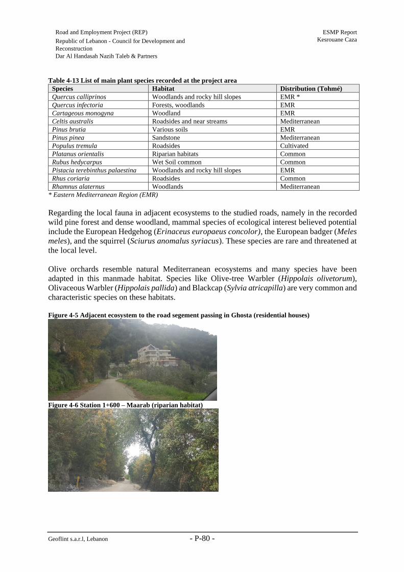
Geoflint s.a.r.l, Lebanon - P-80 -
Road and Employment Project (REP) ESMP Report
Kesrouane Caza Republic of Lebanon - Council for Development and
Reconstruction
Dar Al Handasah Nazih Taleb & Partners
Table 4-13 List of main plant species recorded at the project area
* Eastern Mediterranean Region (EMR)
Regarding the local fauna in adjacent ecosystems to the studied roads, namely in the recorded
wild pine forest and dense woodland, mammal species of ecological interest believed potential
include the European Hedgehog (Erinaceus europaeus concolor), the European badger (Meles
meles), and the squirrel (Sciurus anomalus syriacus). These species are rare and threatened at
the local level.
Olive orchards resemble natural Mediterranean ecosystems and many species have been
adapted in this manmade habitat. Species like Olive-tree Warbler (Hippolais olivetorum),
Olivaceous Warbler (Hippolais pallida) and Blackcap (Sylvia atricapilla) are very common and
characteristic species on these habitats.
Figure 4-5 Adjacent ecosystem to the road segement passing in Ghosta (residential houses)
Figure 4-6 Station 1+600 – Maarab (riparian habitat)
Species Habitat Distribution (Tohmé)
Quercus calliprinos Woodlands and rocky hill slopes EMR *
Quercus infectoria Forests, woodlands EMR
Cartageous monogyna Woodland EMR
Celtis australis Roadsides and near streams Mediterranean
Pinus brutia Various soils EMR
Pinus pinea Sandstone Mediterranean
Populus tremula Roadsides Cultivated
Platanus orientalis Riparian habitats Common
Rubus hedycarpus Wet Soil common Common
Pistacia terebinthus palaestina Woodlands and rocky hill slopes EMR
Rhus coriaria Roadsides Common
Rhamnus alaternus Woodlands Mediterranean

Geoflint s.a.r.l, Lebanon - P-81 -
Road and Employment Project (REP) ESMP Report
Kesrouane Caza Republic of Lebanon - Council for Development and
Reconstruction
Dar Al Handasah Nazih Taleb & Partners
Figure 4-7 Umbrella pine tree bordering the road
Figure 4-8 Road segment in Maarab bordered by olive groves and Km away from Chnaniir Nature
Reserve

Geoflint s.a.r.l, Lebanon - P-82 -
Road and Employment Project (REP) ESMP Report
Kesrouane Caza Republic of Lebanon - Council for Development and Reconstruction
Dar Al Handasah Nazih Taleb & Partners
4.2.3.3 Kesrouane R2c (El-Kfour – Herhraya et Kattine)
Study Area
Project settlement
Kesrouane R2c consists of a single alignment with a total length of 5.13 km. It starts at El-
Kfour, at an elevation of 687 m, ascends to a maximum elevation of 796 m, then descends while
passing into Herhraya et Kattine to reach a minimum of 597 m.
The road is settled at an altitude ranging between 597 and 796 meters which makes the studied
area an Eu-Mediterranean zone (‘‘EU-Mediterranean’ zone ranges from 500 to 1000 meters,
Corine classification). The altitudinal range plays an important role in plant composition (Abi
Saleh, 1996).
Natural habitats and Associated Flora
The main habitats encountered along Kesrouane R2c fall into two main types (wooded lands
and artificial areas) as per field visit (refer to Table 4-14) and LULC map provided by the
National Center for Scientific Research (2017). Refer to Figure U (in Annex 1).
The studied road involves a path that is already under anthropogenic influences. The road is
mainly bordered by human settlements, wild pine (Pinus brutia) patches intermixed with
cultivated trees including umbrella pine trees (Pinus pinea), olive trees (Olea europaea) and
cypress (Cupressus sempervirens), or degraded ecosystems with low vegetation cover
(garrigues vegetation mainly characterized by dwarf shrubs).
Table 4-14 Key Habitats encountered along Kesrouane R2c
Habitats types in LULC
map
Field visit observations (
Wooded lands • Open woodland with some scrubby vegetation
• Wild pine dense patched intermixed with cultivated trees
Artificial areas • Residential areas and commercial shops
• Cultivated lands
Figure 4-9 Road surrounded by cultivated trees and residential houses (station 1+000)

Geoflint s.a.r.l, Lebanon - P-83 -
Road and Employment Project (REP) ESMP Report
Kesrouane Caza Republic of Lebanon - Council for Development and Reconstruction
Dar Al Handasah Nazih Taleb & Partners
Figure 4-10 Road surrounded by residential and commercial buildings
Figure 4-11 Wild pine patch intermixed with cultivated umbrella pine (overall ecosystem between stations
2+500 and 4+700)
Figure 4-12 Wild pine, cypress, and cultivated trees bordering the road (station 4+700)

Geoflint s.a.r.l, Lebanon - P-84 -
Road and Employment Project (REP) ESMP Report
Kesrouane Caza Republic of Lebanon - Council for Development and Reconstruction
Dar Al Handasah Nazih Taleb & Partners
4.2.3.4 Kesrouane R7 (Mazraet Kfardebiane – Bekaatouta – Bekaatet Kenaan)
Study Area
Kesrouane R7 consists of a single alignment with a total length of 6 km. It starts at Mazraet
Kfardebiane, at an elevation of 1285 m, passes by Bekaatouta where it reaches a maximum
elevation of 1,298 m, and ends at Bekaatet Kenaan at its lowest elevation of 1,178 m.
According to CORINE classification, this makes the studied area a ‘Supra-Mediterranean’ zone
since its altitude falls between 1,000 and 1,500 meters.
Natural habitats and Associated Flora and Fauna
According to site visits and the LULC map provided by the National Center for Scientific
Research (2017), the main habitats encountered along Kesrouane R7 include agricultural areas
and wooded lands (open or dense woodland and riparian habitats). Refer to Table 4-15 and
Figure V (in Annex 1).
Generally, the concerned community is a rural community where adjacent ecosystems to the
road are comprised of agricultural lands (i.e. agricultural terraces and exploited lands). The
overall ecosystem is under clear anthropogenic influences with a resulted monotonous
vegetation cover (involving resilient species). This includes, fruit trees (mainly apple trees),
Kermes oak (Quercus calliprinos), Cyprus oak (Quercus infectoria), Calibrian pine (Pinus
brutia), Furrowed thorny broom (Callicotome villosa) and evergreen Cypress (Cupressus
sempervirens).
In Kfardebiane, Mediterranean maquis intermixed with residential and agricultural areas were
recorded. Maquis or shrub-lands, remain critically rich ecosystems throughout the country. Due
to their density and difficulty of access, they constitute a dynamic hideout for numerous reptiles,
mammals, and birds. The mix between wooded slopes, calcareous outcrops, Quercus cerris
stands, and wet meadow is particularly remarkable in Kfardebiane. Calcareous rock cliffs are
expected to harbour endemic and rare vegetal species typical to the mountainous area.
Further, when the road and river (Naher el Kaleb) intersect (between station 0+600 and station
2+800), and near springs in Bekaatouta (near Ain Bekaatouta) and in Kfardebiane (near Ain el
Qattara and Ain el Libne, station 0+000), particular biotopes, riparian forests including Oriental
Plane (Platanus orientalis) and Willow trees (Salix spp.) were noted. Further, vegetation was
that of mountainous wetlands dominated by Juncus spp., Scirpus spp.and Equisetum. Riparian
habitats are important refuge for amphibians, birds and reptiles.
Table 4-15 Key Habitats recorded along Kesrouane R7
Habitats types in LULC
map
Field visit observations
Agricultural Areas • Agricultural lands (namely terraces)
Wooded lands • Dense woodland dominated by Kermes Oak (Quercus calliprinos)
and the Karst in Kfardebiane
• Riparian habitats including species such as Platanus orientalis, Salix
sp., Celtis australis intermixed with Hedera helix, and shrubby
vegetation including Rubus hedycarpus

Geoflint s.a.r.l, Lebanon - P-85 -
Road and Employment Project (REP) ESMP Report
Kesrouane Caza Republic of Lebanon - Council for Development and Reconstruction
Dar Al Handasah Nazih Taleb & Partners
• Wet habitats covered by willows and grassland
Artificial areas • Rural residential areas
• Resorts and hotels in Kfardebiane
• Agricultural lands
The main plant species recorded at the project site are listed in Table 4-16.
Table 4-16 Main tree species recorded in the study area
* Eastern Mediterranean Region (EMR)
Concerning the fauna, the area is expected to be rich especially with respect to invertebrates
(insects and butterflies) and vertebrates specifically birds of various habitats (mid-mountain,
forests, open lands), reptiles and amphibians.This study will list reptiles, amphibians and birds
that are likely to present in the study area (based on recorded natural habitats and previous
biological assessment of the area). Concerning mammals, no species were spotted on site. Bats
are the most sensitive mammal species. However, no cutting of trees will occur to affect this
group of animals.
During the field study, suitable habitats for the reproduction of amphibians were encountered
where the river and road intersect (at the culvert location). Species that are likely to be present
in the study area include the Eastern Green frog (Pelophylax bedriagae), the Middle East Green
toad (Bufo viridis = Bufo variabilis), the Savigny Frog-tree (Hyla savignyi), which are common
species throughout Lebanon and the terrestrian salamander (Salamandra infraimmaculata).
The study area is expected to be rich from an herpetological point of view. In fact, rocky habitats
in Kfardebiane are important refuge for reptiles. Species that are likely to be present are
common throughout Lebanon and occur from the coast line to the mountainous ecosystems, as
long as their habitat is present. Species, habitat, and status are as follows:
• Star Agama (Laudakia stellio) - Well-exposed rocky habitats, rivers banks-Least
Concern (IUCN)
• Levant lizard (Phoenicolacerta laevis), Treed areas, Least Concern (IUCN)
• Oriental Green lizard (Lacerta media), meadows, Least Concern (IUCN)
• Eastern Montpellier snake (Malpolon insignitus), Wooded slopes, Least Concern
(IUCN)
Species Habitat Distribution (Tohmé)
Quercus calliprinos Woodlands and rocky hill slopes EMR *
Quercus infectoria Forests, woodlands EMR
Cotoneaster nummulria Rocks at altitude Common
Celtis australis Roadsides and near streams Mediterranean
Platanus orientalis Riparian and lacustrine Common
Rubus hedycarpus Wet Soil common Common
Pistacia terebinthus palaestina woodlands and rocky hill slopes EMR
Callicatome villosa Degraded woodland Common
Salix acmophylla riparian Common

Geoflint s.a.r.l, Lebanon - P-86 -
Road and Employment Project (REP) ESMP Report
Kesrouane Caza Republic of Lebanon - Council for Development and Reconstruction
Dar Al Handasah Nazih Taleb & Partners
Bird species that are potentially present in the study area along with their habitat are presented
in table Table 4-17. These birds are common in Lebanon and all of them of least concern
according to IUCN.
Table 4-17 List of bird species present in the study area
English name Scientific name Habitat
Great tit Parus major Forest and woods
Sombre tit Poecile lugubris woods
Eurasian Jay Garrulus glandarius Oak forest
Eurasian Blackbird Turdus merula Clearing woods
House Sparrow Passer domesticus Near habitations
Northern Wheatear Oenanthe oenanthe Rocky slopes
Common Whitethroat Sylvia communis hedgerow
Cetti's Warbler Cettia cetti River banks
Western Rock Nuthatch Sitta neumayer Rocky slopes
Northern Wren Troglodytes troglodytes Woods
Short-toed Snake-eagle Circaetus gallicus Passenger bird
Figure 4-13 Kfardebiane overall ecosystem
Figure 4-14 Riparian thickets near Naher el Kaleb River (culvert/bridge location)

Geoflint s.a.r.l, Lebanon - P-87 -
Road and Employment Project (REP) ESMP Report
Kesrouane Caza Republic of Lebanon - Council for Development and Reconstruction
Dar Al Handasah Nazih Taleb & Partners
Figure 4-15 Riparian habitat where the road and river intersect (between station 0+600 and station 2+800)
Figure 4-16 Agricultural terraces bordering the road in Kfardebiane
Figure 4-17 Quercus infectoria tree adjacent to the road (wooded slope)

Geoflint s.a.r.l, Lebanon - P-88 -
Road and Employment Project (REP) ESMP Report
Kesrouane Caza Republic of Lebanon - Council for Development and Reconstruction
Dar Al Handasah Nazih Taleb & Partners
Figure 4-18 The overall ecosystem in Kfardebiane
Figure 4-19 Rural settlements surrounding the road in Bekaatouta
Figure 4-20 Cultivated lands surrounding the road in Bekaatouta
4.2.4 Summary of Results
In summary, the assessment showed that two segments of Kesrouane R2a are surrounded by
rich woodlands. In specific, a wild pine forest was recorded in Edma et Defne and a dense
woodland dominated by oak was recorded in Ghodrace. Further, wet habitats (grasslands) were
noticed near Wadi Tabarja and along the Kesrouane R2a as it is rich in streams mainly in Edma
et Defne and Nammoura et Kfar Jerif. Regarding Kesrouane R2b, the segment of the road that
passes through Ghosta is surrounded by degraded lands due to human activities (agricultural
and residential area), whereas, in Maarab the road is surrounded by wooded lands intermixed
with residential areas and cultivated lands (mainly olive groves). The road involves a path that
is already under anthropogenic influences. It is mainly bordered by human settlements, wild
pine patches intermixed with cultivated trees including umbrella pine trees, olive trees and
cypress or degraded ecosystems with low vegetation cover (garrigues vegetation mainly

Geoflint s.a.r.l, Lebanon - P-89 -
Road and Employment Project (REP) ESMP Report
Kesrouane Caza Republic of Lebanon - Council for Development and Reconstruction
Dar Al Handasah Nazih Taleb & Partners
characterized by dwarf shrubs). Finally, Kesrouane R7 road consists of critical segment in
Kfardebiane, where Mediterranean maquis intermixed with residential and agricultural areas.
Maquis or shrub-lands, remain critically rich ecosystems throughout the country. Due to their
density and difficulty of access, they constitute a dynamic hideout for numerous reptiles,
mammals, and birds. The mix between wooded slopes, calcareous outcrops, Quercus cerris
stands, and wet meadow is particularly significant in Kfardebiane. Calcareous rock cliffs are
expected to harbour endemic and rare vegetal species typical to the mountainous area. Further,
when the road and river (Naher el Kaleb) intersect, and near springs in Bekaatouta (near Ain
Bekaatouta) and in Kfardebiane (near Ain el Qattara and Ain el Libne, particular biotopes,
riparian forests were noted. Riparian habitats are important refuge for amphibians, birds and
reptiles.
Geoflint s.a.r.l, Lebanon - P-90 -
Road and Employment Project (REP) ESMP Report
Kesrouane Caza Republic of Lebanon - Council for Development and
Reconstruction
Dar Al Handasah Nazih Taleb & Partners
4.3 Socio-Economic Condition
This section describes the social and economic conditions of Kesrouane Caza where Kesrouane
R2a, R2b, R2c, and R7 will be rehabilitated.
4.3.1 Summary of Relevant Caza Background
The district of Kesrouane is one out of the 26 districts of Lebanon, occupying 344 km2 out of
the 10,452 km2 surface of Lebanon.
One of the major problems facing Lebanon is the proper management of its wastewater.
According to the Central Administration of Statistics (ACS), less than 60% of the buildings
have connections to public sanitation (Geara-Matta, 2010). Since the civil war, pre-existing
wastewater treatment plants (WWTP) were destroyed and remained non-operational. As such,
the habit of directing the wastewater directly from septic tanks and dumping it in the sea
drastically increased (Geara-Matta, 2010). Although the government, with the help of the MOE,
MOEW, and CDR, have developed an action plan for the construction of WWTP’s, the
wastewater management is still ineffective and needs a lot of work.
The absence of appropriate infrastructures for the wastewater disposal in most areas of
Kesrouane district leads to small floods and runoff of wastewater, releasing unpleasant odors,
visual pollution and environmental degradation. The presence of heavy metals, pathogenic
organisms and other pollutants within the effluents have contaminated the water in the area,
imposing health threats and a variety of diseases on the residents.
According to a survey done in 2000, there are approximately 53 outfalls along the coast, 16 of
which are located between Dbayeh (North of Beirut) and Ghadir (South of Beirut). Six of the
outfalls are located in Kesrouane district.

Geoflint s.a.r.l, Lebanon - P-91 -
Road and Employment Project (REP) ESMP Report
Kesrouane Caza Republic of Lebanon - Council for Development and
Reconstruction
Dar Al Handasah Nazih Taleb & Partners
(1)Demographical Aspect
In 2017, Kesrouane caza has a total population of 168,176 (excluding Syrians displaced),
accounting for 11.26 % of the total national population. A total of 16,326 Syrians are displaced
in Kesrounace caza and Palestinian camps are absent. According to UNDP (2008), the overall
headcount poverty within Kesrouane is 15%, compared to Lebanon’s average of 27%.
Approximately 25,978 Syrian refugees are registered in Kesrouane (MOE/EU/UNDP, 2014),
with absence of displaced Palestinians (OCHA, 2016). The average family size is around 3.96
individuals. The percent of total population of Kesrouane compared to the total population in
Lebanon decreased from 4.15% in 2010 to 3.81% in 2017 (refer to Table E in Annex 1). This
decrease in population number is attributed to immigration of Kesrouane’s citizen to other
regions/countries. Local inhabitants are mainly from the active population with the majority
are in the middle age (Figure W in Annex 1). Finally, according to MoPH in 2016, it was
registered that 53.2% of the population belongs to the male group and the remaining 46.8% are
females.
(2)Housing Conditions
The majority of the houses in Kesrouane caza are either owned by the families or rented. The
majority of the housing infrastructure is used for residential purposes. Negligible number of
housing infrastructure is used for commercial, non-residential use. Around 50% of the non-
residential units are used for commercial/ industrial purposes. Refer to Table F (in Annex 1).
(3)Transport
According to the Analysis of Accident Patterns in Lebanon in 2010, 50% of road traffic
accidents occurred on two-way undivided roads. The least number of road traffic accidents
(21%) occurred on divided roads. About three quarters of the road traffic accidents in Lebanon
take place on urban roads, due to the fact that, with a centralized government, people are forced
to drive to cities to take care of their businesses.
Similar to other districts in Lebanon, the road network in Kesrouane caza suffers from
inadequate maintenance, low traffic capacity leading to slow traffic flows and congestion, and
poor road safety conditions. The majority of roads in the caza are paved. The major roads
sustain a medium-high load during weekdays and more traffic jam during weekends, since the
area is occupied with many commercial, educational, residential and touristic facilities.
Although major roads in the district are well-developed and maintained, a transportation vision
is absent for the caza. Public transportation is not considered and the number of private cars is
significantly increasing. Currently, the only forms of public transport include small privately-
run minivans and limited public taxis or so-called “services”. Moreover, the rural roads in the
villages of the caza are suffering from poor conditions and limited maintenance.
(4)Electricity
Similar to other regions in the South, the electricity network suffers from poor distribution, in
addition to the problems of power shortages. In general, electricity is supplied through
Electricité du Liban (EDL), an autonomous state owned entity under the jurisdiction of the
Geoflint s.a.r.l, Lebanon - P-92 -
Road and Employment Project (REP) ESMP Report
Kesrouane Caza Republic of Lebanon - Council for Development and
Reconstruction
Dar Al Handasah Nazih Taleb & Partners
Ministry of Energy and Water (MoEW). Although EDL provides the electrical power to
Kesrouane, however not all houses are connected to the electricity grid. The region witnesses
frequent power outages and weak electricity supply. Significant instabilities and power supply
interruptions are common.
(5)Water Infrastructure
Kesrouane district is one of the advantaged districts in Lebanon in terms of water supply. The
district has the highest rate of connection to the water network, 94% (Matta, Darine, et.al.
2010). The connection rates for the caza are listed in Table G (in Annex 1).
It is important to mention that the one of the major dam, Chabrouh Dam, in Lebanon is located
within Kesrouane caza. Chabrouh Dam helped solve the chronic water shortage in the upper
Kesrouane region. With a static storage capacity of 8 million m3 and a dynamic storage capacity
of 15 million m3 (and a total cost of about $60 million), the dam is expected to meet drinking
water demand until 2025.
(6)Wastewater Infrastructure
In Lebanon, most towns and villages lack public wastewater drainage and infrastructure. In
Mount Lebanon, which includes Kesrouane caza, the rate of connection to sewerage network
is 74.9% (CAS, 2004). The non-connected areas drain wastewater in wells or use septic tanks.
Two major wastewater treatment units exist in Kesrouane caza. Refer to Table G, Table H, and
Table I (in Annex 1). Finally, several projects are to be implemented or under construction as
reported by the CDR progess report (refer to Table P in Annex 1).
(7)Solid Waste Management Infrastructure
Municipal solid waste management practices vary in the different regions in Lebanon. Illegal
dumping and open burning of MSW are common where most towns or cities operate open
dumps within their jurisdictions. Kesrouane caza used to depend on two sanitary landfills for
the management of solid waste, Naameh and Bsalim landfills. Moreover, open dumping is also
practiced where 12 open dumps exist in 12 different villages in the caza. However, since June
2015, the Naameh landfill has closed leading to a solid waste crisis in the country. Solid waste
is now being sent to Burj Hammoud landfill.
(8)Health Services
The health services in Kesrouane caza are relatively good compared to other districts in
Lebanon. The number of health services registered in Kesrouane region is listed in Table J (in
Annex 1).
(9)Education
According to a study conducted by UNDP and Ministry of Social Affairs (1998), Kesrouane
caza is the least deprived Caza in Lebanon. It is characterized by low illiteracy rate (7.9%),

Geoflint s.a.r.l, Lebanon - P-93 -
Road and Employment Project (REP) ESMP Report
Kesrouane Caza Republic of Lebanon - Council for Development and
Reconstruction
Dar Al Handasah Nazih Taleb & Partners
high school enrollment ratios for children aged 6-12 years (90.1%). There are 82 schools in the
caza of Kesrouane. Closest schools in the are reported in section 4.3.2.
(10)Economic Background
According to a study conducted by UNDP and Ministry of Social Affairs (2010), Kesrouane
caza is the least deprived caza in Lebanon. It is characterized by high incomes, low average
household size of 3.96 and a low age dependency rate according to others cazas in Lebanon
(43.7 %).
Types and number of commercial/industrial institutes in Kesrouane are:
• Farming and metal extraction = 81
• Hotels and restaurants = 908
• Health and social services = 508
• Tobacco and food production = 217
• Manufacturing of metallic goods = 212
• Furniture manufacturing = 191
• Leather production (tanneries) = 193
• Fishing =160
• Wood and pulp manufacturing = 69
• Printing press = 72
Total number of productive institutes = 8,740
• 14.75% are in the high lands area.
• 37.6% of total number of institutes in the caza of Kesrouane deal with trading,
• 10.7% are hotels and restaurants,
• 5.9% deal with health and social works,
• 5.1% general services.
(11)Impacts of Syrian Crisis
The Syrian crisis had detrimental effects on Lebanon (UNHCR, UNDP & MoSA, 2016). The
increase in the population, due to the Syrian displaced influx in addition to the Palestinian
camps, raised financial burdens on the Municipalities in the Kesrouane area. The sudden
increase in the population surge is inevitably exerting pressure on the public services which
were already deficient.
Based on national study conducted by UNDP in 2013, the most significant impact of the
displaced people, as graded by the host community, is on electricity, cost of goods and services,
education, solid waste, and sanitation (UNDP, 2013). Refer to Table K (in Annex 1) for
displaced Syrians.
4.3.2 Road Sensitive Receptors
Sensitive receptors were collected during the field visits and previous surveys for similar
projects. The data was analyzed using ArcGIS. Categories considered as sensitive receptors
during road rehabilitation are schools, churches, hospitals, mosques, closest residential

Geoflint s.a.r.l, Lebanon - P-94 -
Road and Employment Project (REP) ESMP Report
Kesrouane Caza Republic of Lebanon - Council for Development and
Reconstruction
Dar Al Handasah Nazih Taleb & Partners
buildings, and other archeological features (refer to Figure X, Figure Y, Figure Z, and Figure
AA in Annex 1).
The main sensitive receptors encountered along the Kesrouane roads are presented as follows:
Kesrouane Road 2a:
• Two archeological sites
• Residential agglomerations and nearby schools and places of worship specifically
from station 0+000 to 4+300 and from station 14+350 to 18+900 (urban settlements)
• Dispersed residential units and places of worship from station 4+300 to 14+350 (rural
settlements)
Kesrouane Road 2c:
• Residential units surrounding both urban and rural areas
• Nearby churches and places of worship from, specifically, from station 1+700 to
2+500
Kesrouane Road 2b:
• Residential units specifically from station 0+000 to 1+600
• Sensitive receptors (school and church) are located in the surrounding communities of
the road and not directly along the borders of the road
Kesrouane Road 7:
• Nearby residential units in addition to schools and places of worship from station
0+000 to station 0+600 and from station 2+800 to 5+000
• Agricultural terraces
A summary of the nearby schools and places of worship surrounding the studied roads along
with their respective distances is shown in Table L, Table M, Table N, and Table O (in Annex
1).
4.3.3 Traffic Survey
For the purpose of road rehabilitation; which requires pavement analysis and design, a traffic
survey was conducted by Dar Al Handasah Nazih Taleb & Partners. The survey focused on the
gathering of baseline data for the existing road conditions, and the Average Daily Traffic
(ADT) was the main parameter collected. In addition, the types of vehicles maneuvering the
two roads were also examined.
The data collection program consists of automatic classified counts with wide range of traffic
count conditions and road characteristics. All long road segments (more than 10 km) required
more than one count station one at the beginning and at the end as well an intermediate location
where this road link intersect with a higher rank road (example: Secondary intersecting with

Geoflint s.a.r.l, Lebanon - P-95 -
Road and Employment Project (REP) ESMP Report
Kesrouane Caza Republic of Lebanon - Council for Development and
Reconstruction
Dar Al Handasah Nazih Taleb & Partners
Primary) while for short road segments one classified count is carried out at the middle of the
road link, which is defined as follow:
• For Primary roads, a link is defined as the road section between two consecutive
intersections with primary or secondary roads.
• For secondary roads, a link is defined as the road section between two consecutive
intersections with primary, secondary or tertiary roads.
The distribution of the ATC Stations throughout Kesrouane caza is shown in Figure BB (in
Annex 1).
Kesrouane 2a & 2c (R2a & 2c)
Three ATC stations were installed along Kesrouane roads 2a & 2c in order to determine level
of traffic. The ADT counts showed a minimum of 135, a maximum of 5,250, and an average
of 2,232 vehicles per day (refer to Table Q in Annex 1). Moreover, the type and classification
of vehicles were determined, where it was revealed that a passenger car was the main vehicle
type (91.8 %) maneuvering the road, followed by a motorcycle (3.9 %) (refer to Table R in
Annex 1).
Kesrouane road 2b (R2b)
One ATC station was installed along Kesrouane road 2b in order to determine level of traffic.
The ADT counts showed a minimum of 918, a maximum of 922, and an average of 920 vehicles
per day (refer to Table S in Annex 1). Moreover, the type and classification of vehicles were
determined, where it was revealed that a passenger car was the main vehicle type (92.7 %)
maneuvering the road, followed by a motorcycle (4.5 %) (refer to Table T in Annex 1).
Kesrouane Road 7 (R7)
OneATC stations was installed along Kesrouane road 7 in order to determine level of traffic.
The ADT counts showed a minimum of 987, a maximum of 1,009, and an average of 998
vehicles per day (refer to Table U in Annex 1). Moreover, the type and classification of vehicles
were determined, where it was revealed that a passenger car was the main vehicle type (90.7
%) maneuvering the road, followed by a four-tire truck (3.2 %) (refer to Table V in Annex 1).

Geoflint s.a.r.l, Lebanon - P-96 -
Road and Employment Project (REP) ESMP Report
Kesrouane Caza Republic of Lebanon - Council for Development and
Reconstruction
Dar Al Handasah Nazih Taleb & Partners
5. Potential Environmental and Social Impacts
The expected social and environmental impacts were assessed during both the rehabilitation
and operation phases of the project. Regarding the operation phase, this assessment entails the
“Defects Liability Period’ during which the Contractor is responsible for maintenance
activities.
Regarding the social assessment, potential beneficiaries of the project and the adversely
affected groups, including Lebanese and Syrians involved in the project and/or living in the
surrounding communities of Kesrouane R2a, R2b, R2c and R7 were considered in this
assessment.
Moreover, during the site visits to Kesrouane R2a, R2b, R2c and R7, refugee camps of
vulnerable groups such as Syrians were not observed. As such, impacts on socio economic
conditions of vulnerable groups were assessed as part of the impacts on the surrounding
residential areas, as in this case displaced Syrians are not living in specific camps, and thus are
considered as part of the local communities of Kesrouane. Moreover, it is important to mention
that rehabilitation and maintenance works in Kesrouane R2a, R2b, R2c and R7 will not require
land acquisition, therefore, vulnerable groups along the roads to be rehabilitated in Kesrouane
Caza will not be resettled.
5.1 Assessment Methodology
The assessment followed the Lebanese MoE grading methodology stated in Decree 260/1,
dated 2015. The impact grading methodology is explained in this section.
This approach was adopted in order to address the several sources of impacts from the project’s
rehabilitation and operational phases. The stages of the evaluation process are the following:
1. Identification of project-related activities (sources) and environmental aspects.
2. Identification of potential impacts to the environment (physical, biological, human,
cultural).
3. Evaluation and assessment of the related unmitigated impact significance.
Impacts are first classified as shown in the table below:
Table 5-1 Classification of impacts
Matrix Classification Criteria
N
(Nature)
P
(Positive) • The proposed activity offers benefits for the overall project
N
(Negative) • Impacts having minimal to major negative influence
D
(Direct) • Impact arising directly from the project activities
I
(Indirect) • Impacts arising from activities not directly related to the
project development
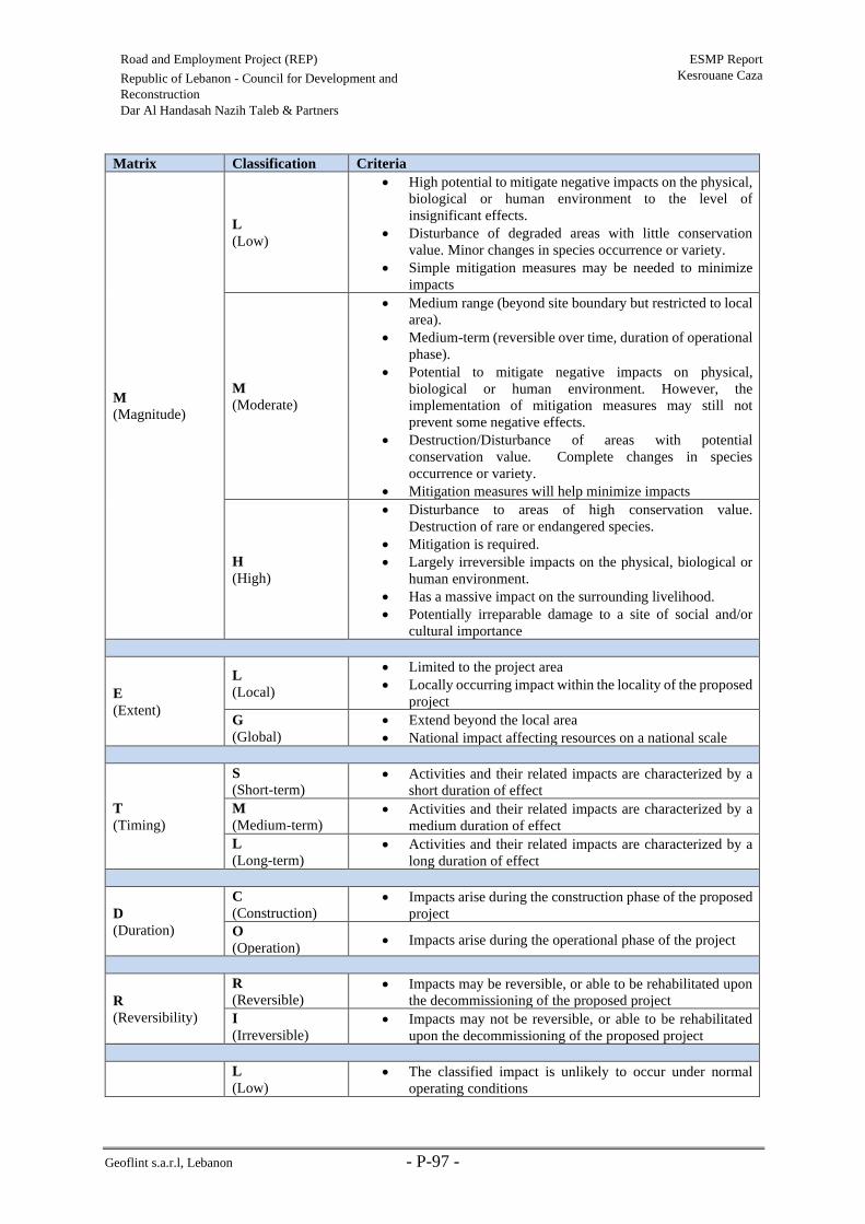
Geoflint s.a.r.l, Lebanon - P-97 -
Road and Employment Project (REP) ESMP Report
Kesrouane Caza Republic of Lebanon - Council for Development and
Reconstruction
Dar Al Handasah Nazih Taleb & Partners
Matrix Classification Criteria
M
(Magnitude)
L
(Low)
• High potential to mitigate negative impacts on the physical,
biological or human environment to the level of
insignificant effects.
• Disturbance of degraded areas with little conservation
value. Minor changes in species occurrence or variety.
• Simple mitigation measures may be needed to minimize
impacts
M
(Moderate)
• Medium range (beyond site boundary but restricted to local
area).
• Medium-term (reversible over time, duration of operational
phase).
• Potential to mitigate negative impacts on physical,
biological or human environment. However, the
implementation of mitigation measures may still not
prevent some negative effects.
• Destruction/Disturbance of areas with potential
conservation value. Complete changes in species
occurrence or variety.
• Mitigation measures will help minimize impacts
H
(High)
• Disturbance to areas of high conservation value.
Destruction of rare or endangered species.
• Mitigation is required.
• Largely irreversible impacts on the physical, biological or
human environment.
• Has a massive impact on the surrounding livelihood.
• Potentially irreparable damage to a site of social and/or
cultural importance
E
(Extent)
L
(Local)
• Limited to the project area
• Locally occurring impact within the locality of the proposed
project
G
(Global)
• Extend beyond the local area
• National impact affecting resources on a national scale
T
(Timing)
S
(Short-term) • Activities and their related impacts are characterized by a
short duration of effect
M
(Medium-term) • Activities and their related impacts are characterized by a
medium duration of effect
L
(Long-term) • Activities and their related impacts are characterized by a
long duration of effect
D
(Duration)
C
(Construction) • Impacts arise during the construction phase of the proposed
project
O
(Operation) • Impacts arise during the operational phase of the project
R
(Reversibility)
R
(Reversible) • Impacts may be reversible, or able to be rehabilitated upon
the decommissioning of the proposed project
I
(Irreversible) • Impacts may not be reversible, or able to be rehabilitated
upon the decommissioning of the proposed project
L
(Low) • The classified impact is unlikely to occur under normal
operating conditions

Geoflint s.a.r.l, Lebanon - P-98 -
Road and Employment Project (REP) ESMP Report
Kesrouane Caza Republic of Lebanon - Council for Development and
Reconstruction
Dar Al Handasah Nazih Taleb & Partners
Matrix Classification Criteria
L
(Likelihood of
occurrence)
M
(Medium) • The classified impact may possibly occur
H
(High) • The classified impact is unlikely to occur under normal
operating conditions
S
(Significance)
L
(Low) • Results in no substantial adverse change to existing
environmental conditions
M
(Medium)
• Substantial adverse change to existing environmental
conditions
• Can be mitigated to less-than-significant levels by
implementation of proposed potentially feasible mitigation
measures or by the selection of an environmentally superior
project alternative
H
(High)
• Substantial adverse change to existing environmental
conditions
• Cannot be fully mitigated by implementation of all feasible
mitigation measures
The environmental significance matrix adopted is based on the well-known “weighted scoring”
or “weighing and scoring” method used as a tool in various decision analysis applications. In
this method, the following steps takes place:
1. Attributes relevant to the project are chosen
2. Weights or numerical values are assigned to each attribute depending on its
importance (values should be based on objective data or expert opinion to exclude
subjectivity during the process).
3. Scores are allocated to each option to reflect its status with respect to each attribute
The final result is a single weighted score for each option, which is used to quantify its overall
performance/significance. As such, the adopted matrix is designed to allow subjective
conclusions to be numerically recorded or quantified, therefore providing at the same time an
impact evaluation and quantitative record to revert to in the future:
Table 5-2 Significance Impact Matrix
Magnitude x Extent x Duration
Lik
elih
oo
d
x
Fre
qu
ency
1 2 3 4 5 6 7 8 9
2 4 6 8 10 12 14 16 18
3 6 9 12 15 18 21 24 27
4 8 12 16 20 24 28 32 36
5 10 15 20 25 30 35 40 45
6 12 18 24 30 36 42 48 54
Yellow: Negligible / Green: Low significance / Blue: Medium significance / Red: High significance
5.2 Potential Positive Impacts during Rehabilitation
5.2.1 Potential Positive Social Impacts

Geoflint s.a.r.l, Lebanon - P-99 -
Road and Employment Project (REP) ESMP Report
Kesrouane Caza Republic of Lebanon - Council for Development and
Reconstruction
Dar Al Handasah Nazih Taleb & Partners
Positive socio-economic impacts, during rehabilitation, is creating direct and indirect short term
jobs for Lebanese and Syrians living in the community around the selected roads. In turn, local
economic development and livelihood opportunities will be enhanced. Direct job opportunities
at the selected road rehabilitation sites will be offered to poor communities and vulnerable
groups (low skilled Lebanese and Syrians) in order to enhance their socio-economic conditions.
The roads rehabilitation project will also create indirect jobs for low skilled Lebanese and
Syrians in supporting industries and services (such as production of construction materials at
local shops and factories, transportation of materials, maintenance of equipment).
Moreover, the road rehabilitation project will also enhance the local economic development of
the surrounding community in the following three cases:
• Knowing that the Contractor will not perform vehicle and equipment repair onsite,
preferably maintenance activities will be done in repair shops surrounding the selected
roads in Kesrouane.
• The Contractor will rent a fenced land in the surrounding area of the selected Kesrouane
roads
• The Contractor might rent an apartment for the low skilled workers (in case hiring of
low skilled workers from the surrounding community is not possible) form the nearby
community.
Further, Lebanese and Syrian workers’ skills and experience in road rehabilitation and
maintenance will be strengthened, as a result of the learning and training programs of the job
onsite.
5.3 Potential Negative Impacts during Rehabilitation
5.3.1 Potential Negative Environmental Impacts
Negative impacts that may derive from the project rehabilitation phase are namely adverse
impacts on the local environment. This section elaborates the potential impacts on each
environmental component.
5.3.1.1.Impacts on Water Quality
The outcropping lithological formations in and around the study area belong to multiple
geological time periods namely, to the Cretaceous and Quaternary geological time periods
(R2a), Cretaceous and Jurrasic geological time periods (R2b and R7) and Cretaceous geological
time period (R2c).
The area surrounding R2a and R2c is very rich in winter drainage channels that discharge
downstream to “Wadi Tabarja” and “Wadi Ghazir”. In specific, Kesrouane R2a is in close
proximity to “Wadi Tabarja” between stations 14+350 and 15+000 and to Ibrahim River at
stations 0+000 and at station 0+800. Kesrouane R2b as well encounters several drainage
channels that discharge to “Wadi Jounieh”.
Geoflint s.a.r.l, Lebanon - P-100 -
Road and Employment Project (REP) ESMP Report
Kesrouane Caza Republic of Lebanon - Council for Development and
Reconstruction
Dar Al Handasah Nazih Taleb & Partners
Moreover, Kesrouane R7 is surrounded by several surface winter drainage channels which lead
downstream to “El Kaleb” river (the river and road intersect between stations 0+600 and 2+800
– Culvert location), in addition to the presence of many nearby springs namely Ain el Qattara,
Ain el Libne and Ain Bqaatouta.
Further, most of the roads in Kesrouane Caza fall on karstic formations and are characterized
by significant amount of groundwater flowing in channels, faults and fractures. The
transmissivity of these formations is generally high and water table is shallow.
Thus, direct pollution (accidental spillages of any polluting material) of the surrounding
streams leading to downstream rivers namely, “Wadi Tabarja”, “Wadi Ghazir”, “Wadi
Jounieh” and “El Kaleb” river (shown in Figure X, Figure Y, Figure Z, and Figure AA in Annex
1) and of groundwater resources in the study area is anticipated, if proper management practices
are not practiced.
The major impacts on groundwater and surrounding streams and rivers during the rehabilitation
works can be associated with the following activities:
• During installation of concrete barriers, on-site concrete pouring may leach and get
deposited in nearby streams and the intersection of Nahr el Kaleb in R7.
• During paving of road, any accidental deposition of toxic asphalt substances into nearby
streams can cause pollution of surface water and underground aquifers since most of
the road alignments fall on a karst aquifers (shown in Figure X, Figure Y, Figure Z, and
Figure AA in Annex 1)
• During installation of road markings, spillage of chemical paint substances can also
pollute open channel watercourses.
• Excavations, drilling, and milling produce substantial amounts of dust and scattered
pavement materials. Dust can enter water courses when it is mixed and directed by rain
or it can be deposited naturally. This can cause cloudiness and increased water turbidity.
• The portacabin toilet is a source of wastewater generation. Improper management of
the generated waste will pollute nearby surface water bodies, streams and underground
aquifers since most of the road alignment falls on a karst limestone acquifers. This
means that transmissivity is high in the project area, thus, proper management practices
should be implemented to avoid contamination of surface and groundwater resources.
• Contaminated storm-water runoff along with sediment transport from the rehabilitation
site into the surrounding streams is possible. Storm water runoff or a direct point source
discharge can transport pollutants, deposits and residues as well as eroded materials
from the site into the receiving environment. Storm water may carry with it the
following:
- Spilled fuels
- Slurry from pavement milling, drillings, and excavations for drainage ditches
- Suspended particles, such as sand, slits, bentonite, cements
- Solid waste, such as plastic, paper, bottles, wood

Geoflint s.a.r.l, Lebanon - P-101 -
Road and Employment Project (REP) ESMP Report
Kesrouane Caza Republic of Lebanon - Council for Development and
Reconstruction
Dar Al Handasah Nazih Taleb & Partners
All of the aforementioned discharges can significantly impact water quality in the area. Proper
management modalities would be crucial in order to reduce and prevent contamination of water
resources surrounding the roads to be rehabilitated in Kesrouane Caza.
Accordingly, the impacts on water quality are assessed as: direct, moderate, local, short-term,
irreversible, of high likelihood of occurrence and of medium significance.
5.3.1.2.Impacts on Soil Quality
Excavation
Excavation of soil to install new drainage ditches will result in disturbance of soil structure and
thus may cause an increase in soil erosion and release of sediments. This will permanently
change the structure of the soil and surface geology.
Mismanagement of Solid Waste and Wastewater
Rehabilitation activities, specifically pavement reconstruction will result in the generation of
solid and hazardous wastes; mainly rehabilitation waste such as old asphalt layers, crushed sub
base aggregates, etc…Improper management of the waste generated from the rehabilitation
works and direct disposal of the domestic-like solid waste (mainly plastic, paper, bottles…)
and the direct discharge of domestic-like wastewater (from the portable toilet) generated by the
engineers and workers onsite will significantly impact soil quality.
Accidental Leakages
Accidental spills of bituminous materials with construction runoff and storm water might result
in soil quality deterioration.
Accordingly, the impacts on soil quality are assessed as: direct, moderate, local, short-term,
irreversible, of high likelihood of occurrence and of medium significance.
5.3.1.3.Impacts on Air Quality
Exhaust emissions
Impacts on air quality during the rehabilitation works include exhaust emissions of CO, CO2,
NOx, and SO2 due to increased traffic flow, combustion of diesel for the movement of
vehicles/machinery. Construction vehicles involved in pavement works include but are not
limited to:
- Excavators (emission factors presented in (Table 5-3) - Vehicles transporting workers to/from site (i.e. buses, mini-vans, cars).
- Delivery vehicles (i.e. aggregate delivery trucks, and light delivery vehicles)
Combustion and vehicle exhaust gases constitute a complex mixture of organic and inorganic
substances such as: PM10, NO2, SO2 Toluene, Xylenes, and Ozone. These combustion sources

Geoflint s.a.r.l, Lebanon - P-102 -
Road and Employment Project (REP) ESMP Report
Kesrouane Caza Republic of Lebanon - Council for Development and
Reconstruction
Dar Al Handasah Nazih Taleb & Partners
are likely to be extremely difficult to quantify due to the unpredicted operational needs
throughout the rehabilitation process.
Table 5-3 Emission factors for construction equipment (Ahn, Pan, et.al, 2010)
Equipment HC (g/hr) CO (g/hr) NOx (g/hr) PM (g/hr) CO2 (g/hr)
Bulldozer 130.09 270.01 806.53 5.56 55.13
Dumper 100.53 272.45 962.29 8.78 83.44
Excavator 56.78 128.26 385.64 2.94 28.84
Grader 75.52 200.45 655.43 5.86 56.48
All equipment 18.34 63.00 105.96 0.367 6.72
Dust emissions
Dust is an almost inevitable consequence of roadwork. Gravel and crushed gravel and hard
rock aggregates always contain a proportion of fines, and if the material is dry, a fairly heavy
dust cloud can be raised when it is mobilized.
The following activities associated with the rehabilitation phase are anticipated to lead to the
generation of dust:
- Excavation and leveling works
- Movement of raw materials transporting vehicles on unpaved surfaces
- Unloading of raw materials
- Open storage of raw materials
- Disturbances to material stockpiles by local winds and material handling, which is of
great significance depending on the road location.
- Wind blow during transportation of materials by vehicles and specifically when
transporting on unpaved roads.
Dust emissions from each of the sources described above will be largely dictated by the wind
conditions in the area. Emission of large quantities of fugitive dust may adversely impact air
quality, construction workers and surrounding communities.
Nearby receptors such as churches, schools and residential buildings (shown in Figure X,
Figure Y, Figure Z, and Figure AA in Annex 1) to be disturbed by the generated fugitive
emissions are presented in section 4.3.2.
In specific, Road 2a is surrounded by residential agglomerations and nearby schools and places
of worship from station 0+000 to 4+300 and from station 14+350 to 18+900 (urban
settlements). The sensitive receptors that are at a distance of less than 10 m namely, Mar Gerges
Church (3 m away), Mzar Mar Rafqa (4 m away), Mar Charbel Church (8 m away), Mzar Al
Saydet (10 m away) are highly impacted by the fugitive emissions. As for the two archeological
sites in the surrounding area of Kesrouane R2a, rehabilitation works will not impact these sites,
knowing that Fatqa Archaeological House 1 and Fatqa Archaeological House 2 are 494 m and
363 m away from R2a respectively.
Other residential units, nearby schools and places of worship that might be impacted by the
generated air emissions surround the roads from station 0+000 to station 0+600 and from

Geoflint s.a.r.l, Lebanon - P-103 -
Road and Employment Project (REP) ESMP Report
Kesrouane Caza Republic of Lebanon - Council for Development and
Reconstruction
Dar Al Handasah Nazih Taleb & Partners
station 2+800 to station 5+000 of Kesrouane R7, from station 1+700 to station 2+500 of
Kesrouane R2c. Moreover, regarding Kesrouane R2b, sensitive receptors (school and church)
are located in the surrounding communities of the road and not directly along the borders of
the road and residential units are found specifically from station 0+000 to station 1+600.
Further, it is important to note that Kesrouane R7 is surrounded by agricultural lands.
Therefore, fugitive dust emissions might highly impact the nearby agricultural areas.
Odor emission
Odors from asphalt fumes can cause unpleasant smells to the surrounding. Sensitive receptors
such as churches and schools near the roads at a distance of less than 10 m (Table L in Annex
1) can be highly affected.
Accordingly, the impacts on air quality can be assessed as: direct, high, local, medium-term,
irreversible, of high likelihood of occurrence and of high significance.
5.3.1.4.Impacts on Acoustic Environment
A significant increase in noise is expected during pavement reconstruction along the road
sections. Rehabilitation activities may create a problem of noise and vibration generated by
construction equipment, truck traffic, and other similar sources. Noise will be mainly generated
while mobilizing equipment for the transportation, excavation of land, and raw material
transportation.
The road rehabilitation noise and vibration levels highly depend on the type of the
equipment/heavy machinery, magnitude and duration of the rehabilitation activities. The main
sources of noise are heavy machinery such as, excavators, bob cat, steel roller, pick- up, dump
trucks, etc… Noise generating activities, such as pavement milling and drilling, can cause
unpleasant noise levels and disrupt teaching activities at nearby schools. The potential impact
depends on the magnitude and duration of rehabilitation-related activities. Works such as road
markings, signing, etc…, do not generate high noise levels and do not disturb the surrounding
environment.
Nearby receptors such as churches, schools and residential buildings (shown in Figure X,
Figure Y, Figure Z, and Figure AA in Annex 1) to be disturbed by the generated noise are
presented in section 4.3.2. For instance, residential agglomerations, nearby schools and places
of worship from station 0+000 to 4+300 and from station 14+350 to 18+900 (urban settlements)
of Kesrouane R2a will be adversely impacted by the noise emissions of the rehabilitation
works. In specific, the sensitive receptors that are at a distance of less than 10 m (refer to)
namely, Mar Gerges Church (3 m away), Mzar Mar Rafqa (4 m away), Mar Charbel Church (8
m away), Mzar Al Saydet (10 m away) will be highly impacted by the noise emissions. As for
the two archeological sites in the surrounding area of Kesrouane R2a, rehabilitation works will
not impact these sites, knowing that Fatqa Archaeological House 1 and Fatqa Archaeological
House 2 are 494 m and 363 m away from R2a respectively.
Other residential units, nearby schools and places of worship that might be impacted by the
high noise levels surround the roads from station 0+000 to station 0+600 and from station

Geoflint s.a.r.l, Lebanon - P-104 -
Road and Employment Project (REP) ESMP Report
Kesrouane Caza Republic of Lebanon - Council for Development and
Reconstruction
Dar Al Handasah Nazih Taleb & Partners
2+800 to station 5+000 of Kesrouane R7, from station 1+700 to station 2+500 of Kesrouane
R2c. Moreover, regarding Kesrouane R2b, sensitive receptors (school and church) are located
in the surrounding communities of the road and not directly along the borders of the road and
residential units are found specifically from station 0+000 to station 1+600. Therefore, impact
of noise emissions on the surrounding schools and places of worship of Kesrouane R2b will be
minimal.
Therefore, high noise levels should be minimized to avoid nuisance of the surrounding residents
and minimize the health effects of vibration and high noise levels on the construction workers.
Accordingly, the impacts on the acoustic environment are assessed as: direct, moderate, local,
short-term, reversible, of high likelihood of occurrence and of moderate significance.
5.3.1.5.Impacts on Visual Intrusion
Visual impacts relate to changes in available views of the landscape, and the effect of those
changes on the surrounding environment. Visual intrusion during road rehabilitation works is
unlikely to be significant. The road already exists and no major excavation works will be taking
place to block a natural scenery view. Impacts on visual intrusion are of very low significance.
Accordingly, the impacts on visual intrusion are assessed as: direct, low, local, short-term,
reversible, of low likelihood of occurrence and of negligible significance
5.3.1.6.Impacts on Biodiversity
Given that the project aims to upgrade existing roads by improving drainage, slopes,
embankments, traffic signs, shoulders, and other structures; strengthening pavements; and
completing resurfacing (i.e. no widening of roads will take place), expected impacts on natural
habitats are potential spillages of wastes, dust raised, and increase in noise, light, and traffic
movement during rehabilitation work.
In particular, direct effects on wildlife include the generation of emissions and disturbances
such as noise, dust, and pollutants in the soil and vegetation (Rajvanshi et al. 2001). In fact, it
was shown that dust particles reduce the pigmentation in plant leaves (affect photosynthesis
and growth rate of plants) and dust fall on open lands reduces their fertility (Supe et al, 2013).
Similarly, noise from construction equipment influences animal behavior, altering activity
patterns, and causing stress, loss of reproductive success, and physiological disturbance.
Normally, some animals may vacate the area, while, others may get used to the noise (responses
may vary among species). Further, wastewater discharge and illegal dumping of solid waste
into the roadside scrublands and riparian habitats can severely affect the local fauna and flora
and eventually lead to population destruction. In addition, given that lighting poles will be
rehabilitated when needed, additional lighting might affect local fauna in sensitive habitats.
Finally, during rehabilitation, there is an increase in traffic movement; this can induce increased
roadkills (i.e. mortality due to vehicular collisions). Animals that are attracted to roads or that
need to cross them are more vulnerable.

Geoflint s.a.r.l, Lebanon - P-105 -
Road and Employment Project (REP) ESMP Report
Kesrouane Caza Republic of Lebanon - Council for Development and
Reconstruction
Dar Al Handasah Nazih Taleb & Partners
However, given that the concerned roads generally involve paths that are already under
anthropogenic influences, the potential impacts of the project on the local biodiversity are
expected to be limited to disturbance of local fauna only when roads are surrounded by wild
pine forest (Kesrouane R2a in Edma et Defne), dense woodland dominated by oak (Kesrouane
R2a in Ghodrace and Kesrouane R2b in Maarab), potential illegal dumping and discharge of
wastes into streams (namely Kesrouane R2a, Kesrouane R2b and Kesrouane R7 when the road
and river (Naher el Kaleb) intersect (between station 0+600 and station 2+800), and near
springs in Bekaatouta (near Ain Bekaatouta) and in Kfardebiane (near Ain el Qattara and Ain
el Libne, station 0+000)) and dust accumulation on nearby vegetation and agricultural lands
(mainly Kesrouane R7 and Kesrouane R2b ).
Accordingly, the impacts on biodiversity are assessed as: direct, moderate, local, short-term,
irreversible, of medium likelihood of occurrence and of medium significance
5.3.1.7.Impacts on Existing Infrastructure
The road rehabilitation works might have adverse impacts on the existing infrastructure
including underground cables, sewage network, and water network existing under the road
pavement. Random digging and milling of deteriorated road pavement, without previous
investigation of possible existence of underground appliances, may interfere with any existing
infrastructure; that is possibly serving nearby surrounding residential and agricultural areas.
Damage of existing infrastructure, for instance wastewater infrastructure or water networks,
can cause several undesirable impacts such as cutting off water supply for irrigation, generation
of bad smells, and attraction of water borne diseases and vectors due contaminated water
accumulation.
Several measures must be taken to alleviate traffic in the area. This includes dividing the roads
into segments in a way not to block the whole route. Moreover, a well-defined schedule based
on traffic movement must be set for rehabilitation works.
Accordingly, impacts on existing infrastructure are assessed as direct, moderate, local, short-
term, reversible, of medium likelihood of occurrence, and of low significance
5.3.1.8.Impacts on Resources Consumption
Freshwater Demand
During the rehabilitation phase, water will be supplied by the Water Establishment of Mount
Lebanon by tankers, if needed. Freshwater will be mainly used for dust suppression of the
temporary stockpiles onsite.
Worker camps will not be installed since the Contractor will employ low skilled Syrians and
Lebanese from the surrounding communities of Kesrouane R2a, R2b, R2c and R7. As a result,
the unskilled workers will get their food and water supply from their homes. In addition, the
nearby office will provide water for the Contractor’s engineers, technical/skilled labor, and the
supervising consultants. Consequently, water resources will not be required for domestic
purposes.

Geoflint s.a.r.l, Lebanon - P-106 -
Road and Employment Project (REP) ESMP Report
Kesrouane Caza Republic of Lebanon - Council for Development and
Reconstruction
Dar Al Handasah Nazih Taleb & Partners
Water consumption varies and it cannot be estimated as it highly depends on the rehabilitation
activities, working days per year and other factors. Rehabilitation activities will consume
moderate volumes of water; it will only be for a relatively short finite period.
Energy Demand
During the rehabilitation phase, required works will require the use of several heavy
equipment/machinery that highly consume energy in the form of fossil fuel, leading to the
depletion of fossil fuel resources. However, the rehabilitation phase will be of short-term.
Raw Materials Demand
During the rehabilitation phase, required works will require the use of raw material (refer to
Table 3-8), leading to depletion of natural resources.
Accordingly, the impacts on resources are assessed as: direct, moderate, local, short-term,
irreversible, of high likelihood of occurrence and of medium significance.
5.3.1.9.Impacts on Public and Workers Health and Safety
(1) Occupational Health and Safety
Occupational hazards during the rehabilitation works are associated with working in all weather
conditions, handling heavy machinery and other sophisticated rehabilitation equipment and
long hours of work. In addition, continuous exposure to environmental emissions resulting
from the rehabilitation activities can induce health problems. Moreover, a badly planned site
can increase the risk of accidents and injuries from falls of materials and collisions between
workers and machinery or equipment. Finally, prevention and protective measures should be
introduced according to priorities. The potential types of occupational hazards that might occur
during the rehabilitation works of the roads include the following:
Physical hazards
Physical hazards are potential accidents or injuries or illnesses that occur due to repetitive
exposure to mechanical action or work activity (IFC, 2007). Forms of physical hazards are but
not limited to the following:
Slips, Trips and Falls: Slips, trips and falls have been identified as being the most hazardous feature
of survey sites. Occasionally, as a survey progresses, increasing numbers of people crossing these
areas results in gradually worsening conditions.
Unplanned Trenching: Vibration may be caused from heavy equipment or from street traffic.
Moving heavy equipment may include bulldozers, backhoes, loaders, and/or dump trucks.
Equipment and materials may collapse trench walls if operated or stored too close to the trench
edge. Water and temperature changes can pose a serious threat to excavations and trenches. Sources
of water on job sites include surface water, the level of the water table, moisture content, rain, and
cities with existing utilities in the right-of-way.

Geoflint s.a.r.l, Lebanon - P-107 -
Road and Employment Project (REP) ESMP Report
Kesrouane Caza Republic of Lebanon - Council for Development and
Reconstruction
Dar Al Handasah Nazih Taleb & Partners
Environment Hazard: those types of hazards are due to environmental factors like the weather,
sun and similar factors and they may lead to the following:
• Hypothermia and Hyperthermia due to sun exposure or sudden temperature change
• Hypotension and Hypertension due to lack of nutrients and medical history
• Dehydration lost due to lack of fluids and excess loss of body water through urine, tears,
stool and sweat. An individual can sweat an average of 1.1 liters / hour when exposed
to sun.
• Fire caused by accident or ignited by outsiders that will lead to external and internal
burns.
• Bites and stings from the wilderness and most common are bees and snakes.
Noise: Extended exposure to excessive noise levels can cause noise-induced hearing loss
specifically noise levels above 85 (dB) can cause hearing loss.
Vibrations: Earthwork activities and material loading / unloading activities generate levels of
vibrations. Exposure to high level of vibrations for a significant duration will affect workers’
health such as carpal tunnel syndrome and permanent damage to the nerves. Whole-body
vibration can occur from operating large mobile equipment such as drillers, air hammers, pile
drivers, tractors, graders, excavators and many more. Hand-arm vibration can result from using
hand-held equipment such as drills, hammers and disc grinders. Hand-arm vibration may cause
carpal tunnel syndrome, a disease that affects the fingers and hands.
Vehicle Hazards
Vehicles transporting personnel and equipment to the study area are subject to vehicle hazards
(transport impacts, road accidents, vehicle crashes). Vehicle crashes can be divided into the
following types:
- Frontal and rear impact
- Rotational impact
- Rollover
Chemical Hazards
Chemical hazards occur due to exposure to toxic, corrosive, sensitizing or oxidative substances.
During rehabilitation activities, employees are mainly at risk of being exposed to asphalt fumes
from pavement works among other solvents. Exposure to asphalt fumes is linked to acute
effects such as headache, fatigue, reduced appetite, breathing problems, and skin irritation
(Norseth et al, 1991).
Ergonomic Hazard
Ergonomic factors, such as repetitive motion, overexertion, and manual handling lead to
occupational injuries such as strains, low back pain, fatigue and others. According to Sang et
al (2007), there has been, for years, an increase in rates of work-related musculoskeletal

Geoflint s.a.r.l, Lebanon - P-108 -
Road and Employment Project (REP) ESMP Report
Kesrouane Caza Republic of Lebanon - Council for Development and
Reconstruction
Dar Al Handasah Nazih Taleb & Partners
disorders in highway construction specifically and the construction industry in general.
Common causes are manual material handling and awkward postures, especially when lifting.
(2) Public Health and Safety
Most of the potential impacts on public health and safety comprise of those described in the
previous sections. For instance, the impacts on water quality and availability, air quality soil
quality, etc… all have consequences on human health. Nonetheless, some potential impacts,
which were not yet discussed, are addressed in this section. First, during the rehabilitation
activities, risk of road traffic accidents might increase in between vehicles, pedestrians and
vehicles, specifically in highly populated areas surrounded by residential buildings and schools.
Second, the proximity of the roads to communities and the open access to rehabilitation sites
consist of a potential risk to the public, namely the risk of injuries as a consequence of falls or
contact with heavy equipment. This might occur in case of unauthorized or accidental entry of
residents into areas where the rehabilitation activities are taking place. This risk, however, is
commonly encountered in cases of road rehabilitation projects and will be addressed through a
standard set of best practices. This includes the usage of proper signage and barriers, in addition
to flagmen and temporary traffic signs when necessary (refer to section 6.1.8)
Accordingly, impacts on health and safety are assessed as: negative, moderate, local, short-
term, irreversible, of high likelihood of occurrence and of medium significance
5.3.2 Potential Negative Social Impacts during Rehabilitation
Generally, during the rehabilitation activities, adverse impacts on socio-economic conditions
are associated with nuisance, traffic disturbance, potential labor influx and increase in GBV
risks mainly SEA and SH, inappropriate labor conditions and obstruction of temporary access
routes to sensitive receptors and others. Therefore, the potential impacts on socio-economic
conditions of laborers onsite and the residents of the surrounding communities of Kesrouane
R2a, R2b, R2c and R7 are presented below.
These expected adverse impacts of the project on socio-economic conditions will be temporary
in nature, however, implementing appropriate measures to mitigate these impacts is the core
responsibility of the Contractor.
5.3.2.1.Impacts on Socio-Economic Conditions of Surrounding Communities
(1) Traffic Disturbance and Nuisance
During the rehabilitation works of Kesrouane R2a, R2b, R2c and R7, potential socioeconomic
impacts include, nuisance and traffic disturbance from the rehabilitation activities onsite. The
most significant sources of noise and traffic are heavy machinery and the movement of
transport vehicles into and from the rehabilitation site, leading to increase in commuting time
and inconvenience to roads users.
(2) Labor Influx and Labor Induced SEA

Geoflint s.a.r.l, Lebanon - P-109 -
Road and Employment Project (REP) ESMP Report
Kesrouane Caza Republic of Lebanon - Council for Development and
Reconstruction
Dar Al Handasah Nazih Taleb & Partners
Potential labor influx will increase the risk of labor induced SEA towards women in the
surrounding communities. SEA is defined as “any actual or attempted abuse of a position of
vulnerability, differential power, or trust, for sexual purposes, including, but not limited to,
profiting monetarily, socially or politically from the sexual exploitation of another”. Sexual
abuse is further defined as “the actual or threatened physical intrusion of a sexual nature,
whether by force or under unequal or coercive conditions” (World Bank, 2018). In this context,
project beneficiaries or members of project-affected communities may experience SEA (World
Bank, 2018).
Knowing that the project is expected to employ low skilled Syrians and Lebanese already living
in the community around the selected roads for rehabilitation, large labor influx of outsiders
into the communities might not occur. Therefore, SEA risks towards women in the surrounding
community is anticipated to be low.
(3) Obstruction of Access Routes to Sensitive Receptors
Moreover, impacts on sensitive receptors include temporary obstruction of access routes to
residential units, schools, places of worship and hospitals (refer to Figure X, Figure Y, Figure
Z, and Figure AA in Annex 1), as presented in section 4.3.2.
The assessment showed that the most urbanized roads to be affected by the temporary
obstruction of sensitive receptors are from station 0+000 to 4+300 and from station 14+350 to
18+900 of Kesrouane R2a, from station 0+000 to station 0+600 and from station 2+800 to
station 5+000 of Kesrouane R7, from station 1+700 to station 2+500 of Kesrouane R2c, and
from station 0+000 to station 1+600 of Kesrouane R2b.
In specific, the sensitive receptors that are at a distance of less than 10 m (refer to Figure X in
Annex 1) namely, Mar Gerges Church (3 m away), Mzar Mar Rafqa (4 m away), Mar Charbel
Church (8 m away), Mzar Al Saydet (10 m away) of Kesrouane R2a will be highly impacted
by the temporary obstruction of routes. As for the two archeological sites in the surrounding
area of Kesrouane R2a, temporary obstruction of these sites is not anticipated, knowing that
Fatqa Archaeological House 1 and Fatqa Archaeological House 2 are 494 m and 363 m away
from Kesrouane R2a respectively.
5.3.2.2. Impacts on Socio-Economic Conditions of Labor
(1) Labor Induced SH
The employment of both men and women in REP project might increase the risk of SH towards
female employees at the workplace. SH is defined as “Unwelcome sexual advances, requests
for sexual favors, and other unwanted verbal or physical conduct of a sexual nature occurring
between personnel/staff working on the project” (World Bank, 2018).
(2) Child Labor

Geoflint s.a.r.l, Lebanon - P-110 -
Road and Employment Project (REP) ESMP Report
Kesrouane Caza Republic of Lebanon - Council for Development and
Reconstruction
Dar Al Handasah Nazih Taleb & Partners
The immense needs of vulnerable communities may result in underage workers making
themselves available for work. This could result in the employment of child laborers.
Employment of underage labors is a violation of the Lebanese Law No. 0 dated 1946. Given
the type of planned rehabilitation works, children can get injured in the workplace. In this
context, employers are subject to the youth employment provisions under Law No. 0.
(3) Inadequate Labor Conditions
The project can result in poor labor conditions in the case of the violation of labor law. The
project beneficiaries, Lebanese and Syrian communities, might not have work permissions or
contractual protections with contractors and their wages are to be set by the market. While
Contractors should follow local labor laws, in Lebanon, monitoring of whether local labor laws
are followed is not always performed. Therefore, large and vulnerable population of
beneficiaries may be at risk of working for wages that are less than those recognized by the law
and may be forced into accords that are not consistent with the law (e.g. work schedules or rest
periods).
(4) Social tensions and conflict over job-sharing and dissatisfaction with allocation
of project-generated jobs.
The project is expected provide job opportunities for both Syrians and low-skilled Lebanese in
host communities. Syrians already tend to work in low-paid work, often decreasing the rate of
salaries in the formal labor market and inducing conflicts within local communities. Moreover,
potential perceptions that project employment ratios favor Syrian communities might further
worsen the social tensions between the two groups.
(5) Risk of under-participation or underemployment or discrimination of women
The risk of under-participation or underemployment or discrimination of women in the context
of REP project will be high, if the Contractor doesn’t set specific percentage of women
employment to benefit from the project. Moreover, women’s engagement in construction works
is not common and also not encouraged, according to Lebanon’s social and cultural norms.
5.4 Potential Positive Impacts during Operation
5.4.1 Potential Positive Environmental Impacts
The potential positive environmental impacts of the project are associated with enhanced road
conditions.
First, improved drainage helps in decreasing contaminated storm water run-off and
consequently helps limit the impact on the streams surrounding Kesrouane R2a, R2b, R2c and
R7. Further, slope stabilization activities will result in a positive impact as it decreases the
chances of soil erosion. Improved drainage decreases likelihood of run-off water to reach and
contaminate nearby soil. As a result, the project is expected to have a positive impact on soil
quality during operation. Finally, the proposed rehabilitation works will result in less
congestion and delays. Moreover, it is predicted that the project will increase the average speed

Geoflint s.a.r.l, Lebanon - P-111 -
Road and Employment Project (REP) ESMP Report
Kesrouane Caza Republic of Lebanon - Council for Development and
Reconstruction
Dar Al Handasah Nazih Taleb & Partners
per vehicle and reduce travel time which would typically improve the overall air quality through
potential reduction in CO2 emissions.
5.4.2 Potential Positive Social Impacts
The social benefits of the rehabilitation works, during operation, include transport connectivity
and easier access to rural, peri-urban and urban areas. Additionally, the rehabilitated roads will
result in potential reduction in traffic congestion, reduced travel time and transport cost. The
improvement in the safety conditions of the roads (due to improved drainage and lighting,
additional safety barriers, and slope protection measures) will lead to potential reduction in
road accidents, during the operation of the Kesrouane R2a, R2b, R2c and R7. In turn, this will
result in economic savings from the reduced cost of road crash injuries and fatalities. Moreover,
employment opportunities will be offered for a short period of time, knowing that the
Contractor will be responsible for the routine maintenance of the roads, during the one year of
Defects Liability Period (post rehabilitation phase).
5.5 Potential Negative Impacts during Operation
The negative impacts assessment, during the operation phase, mainly focuses on the
maintenance activities that might be required during the Defects Liability Period (one-year
period). However, it is important to mention that the Contractor might not perform any
maintenance activities, if not necessary.
5.5.1 Potential Negative Environmental Impacts
5.5.1.1.Impacts on Water and Soil Quality
Potential impacts on water quality should be considered due to the particularity of the project
area, knowing that Kesrouane R2a, R2b, R2c and R7 are surrounded by streams and most of
the roads fall on karstic formation that generally has high transmissivity. Spills of chemicals
and pollutantsduring maintenance activities can affect soil and water quality, if such activities
are not managed properly.
Accordingly, impacts on water and soil quality are assessed as: direct, moderate, long-term,
local, irreversible, of medium likelihood of occurrence, and of medium significance
5.5.1.2.Impacts on Air Quality and Odor Emission
During the operation phase of the project, impacts on air quality are associated with
maintenance activities and movement of vehicles. This includes dust and exhaust emissions.
The extent of the impact will depend on type and duration of required maintenance activities.
Moreover, the main expected vehicle emissions are (World Bank, 1997):
• Nitrogen oxides (NOx) which is a by-product of fuel combustion in combustion
chambers, under conditions of extreme heat and pressure,

Geoflint s.a.r.l, Lebanon - P-112 -
Road and Employment Project (REP) ESMP Report
Kesrouane Caza Republic of Lebanon - Council for Development and
Reconstruction
Dar Al Handasah Nazih Taleb & Partners
• Hydrocarbons (HC) which are produced due to the incomplete combustion of fuel and
its evaporation. The emissions of hydrocarbons are strongly correlated with the type of
fuel used. The most notorious HC produced are benzene and ethylene.
• Carbon monoxide (CO) which is the result of incomplete combustion in engines
• Sulfur dioxides (SOx) emissions which are directly linked to the sulfur content of the
fuel.
Accordingly, impacts on air quality are assessed as: direct, moderate, short-term, local, and
irreversible, of medium likelihood of occurrence and of medium significance
5.5.1.3.Impacts on Acoustic Environment
The operational phase is expected to be associated with increased noise levels during
maintenance activities. Noise is mainly associated with four main sources: a) vehicles noise, b)
friction between vehicles and the road surface, c) driver behavior, and d) maintenance activities
(Table 5-4) (World Bank, 1997).
Table 5-4 Sources of acoustic pollution during road operation
Noise Source Impacts
Vehicle noise
Transportation vehicles generally produce noise from the engine, transmission,
suspension, braking, and stop-and go traffic conditions.
The noise levels are expected to increase with the poor maintenance of vehicles
accessing the road.
Road noise
Contact between tires and pavement significantly contributes to overall traffic
noise. The level depends on the type and condition of tires and pavement. The
frictional noise increases with higher speed and during sudden braking.
Driver behaviour Vehicles’ horns, loud music, shouting, sudden braking or accelerating contributes
to traffic noise.
Road maintenance
Periodically, road maintenance is generally required. Such activities will utilize
heavy machinery which will contribute to noise pollution.
The exposure to increased noise levels can affect the welfare of local residents, both
physiologically and psychologically. Noise exposure is considered a source of annoyance
which might result in increased stress levels and health impacts. It can cause auditory fatigue,
temporary and permanent lessening of hearing ability and sleep disorders (World Bank, 1997).
Accordingly, impacts on acoustic environment are assessed as: direct, moderate, short-term,
local, and reversible, of high likelihood of occurrence and of medium significance
5.5.1.4.Impacts on Biodiversity
During the operation phase of the project, in general, the impacts on biodiversity are expected
to be very limited as no additional roads will be built. On the contrary, rehabilitation of existing
roads will probably improve the conditions of adjacent lands and plant communities (the
impacts of vehicle-generated dust from unpaved roads will be reduced).
The main expected impacts during operation on the local ecosystem include (1) the potential
sedimentation of heavy metals due to surface runoff (Batool et al, 2012) if drainage systems

Geoflint s.a.r.l, Lebanon - P-113 -
Road and Employment Project (REP) ESMP Report
Kesrouane Caza Republic of Lebanon - Council for Development and
Reconstruction
Dar Al Handasah Nazih Taleb & Partners
were not fixed; (2) the potential spills during maintenance activities, and (3) the increase in
light pollution levels, when roads are equipped with additional light (the project will involve
the rehabilitation of lighting poles on all Kesrouane roads and additional poles will be provided
for Kesrouane R2a, R2b, and R7).
However, light pollution can be reduced if the contractor used green lights when new lights
deemed necessarily. Moreover, given that the concerned roads generally involve paths that are
already under anthropogenic influences, potential impacts are expected to be of low
significance. Only limited segments of ecological significance can witness further disturbance
from the project. These segments are surrounded by wild pine forest (short segment, Kesrouane
R2a in Edma et Defne (Figure 4-4), dense woodland dominated by oak (Kesrouane R2a in
Ghodrace (station 7+100 (Figure 4-3), Kesrouane R2b in Maarab), and when the road and river
(Naher el Kaleb) intersect (Kesrouane R7 between station 0+600 and station 2+800).
Accordingly, impacts on biodiversity are assessed as: direct, moderate, local, long-term,
irreversible, of high likelihood of occurrence, and of medium significance
5.5.1.5.Impacts on Energy Consumption
Energy consumption is expected to be high during the operation phase of the project due to
additional lightings. Moreover, maintenance works will require the use of several heavy
equipment/machinery that highly consume energy in the form of fossil fuel, leading to the
depletion of fossil fuel resources.
Accordingly, impacts on energy consumption were assessed as: direct, low, short-term, local,
reversible, of moderate likelihood of occurrence and of medium significance.
5.5.1.6.Impacts on Public and Workers Health and Safety
During the operation phase of the project, occupational health hazards can be attributed to
maintenance-related accidents. Proper supervision and the implementation of adequate safety
measures will limit the occurrence of accidents from maintenance activities. Any maintenance
works and their potential impacts are expected to be similar in nature to those of this project’s
rehabilitation phase (disturbance of traffic and road accidents).
Accordingly, impacts on health and safety are assessed as: direct, moderate, local, short-term,
reversible, of medium likelihood of occurrence and of medium significance

Geoflint s.a.r.l, Lebanon - P-114 -
Road and Employment Project (REP) ESMP Report
Kesrouane Caza Republic of Lebanon - Council for Development and
Reconstruction
Dar Al Handasah Nazih Taleb & Partners
5.6 Summary of Potential Environmental Impacts
Rehabilitation phase
During the rehabilitation phase of the project, the impact on air quality is expected to be of high
significance.
Table 5-5 Summary of potential negative environmental impacts during rehabilitation
Environmental
Receptor Impact Significance
Acc
iden
tal
leak
ages
of
con
cret
e p
ou
ring
, to
xic
asp
hal
t
sub
stan
ces
, ch
emic
al p
ain
ts
Ex
cav
atio
ns
, m
illi
ng a
nd
dri
llin
gs
Co
nta
min
ated
sto
rm w
ater
ru
no
ff
Do
mes
tic-
lik
e so
lid
was
te (
pla
stic
, p
aper
, bo
ttle
s an
d o
ther
s )
Was
te s
uch
as
old
asp
hal
t la
yer
s, c
rush
ed s
ub
bas
e ag
gre
gat
es
Veh
icle
s tr
ansp
ort
ing
w
ork
ers
Del
iver
y v
ehic
les
Un
load
ing
an
d o
pen
sto
rag
e of
raw
mat
eria
ls
Od
ors
fro
m a
sph
alt
fum
es
Mo
bil
izat
ion
an
d u
se o
f a
re h
eav
y m
ach
iner
y
Ch
ang
es i
n a
vai
lab
le v
iew
s o
f th
e la
nd
scap
e
Ex
po
sure
to
en
vir
on
men
tal
emis
sio
ns
Ro
ad t
raff
ic a
ccid
ents
Han
dli
ng
hea
vy
mac
hin
ery
Ph
ysi
cal,
ch
emic
al,
bio
log
ical
an
d e
rgo
nom
ic h
azar
ds
Water Quality x x x x
Soil Quality x x x x x
Air Quality x x x x x
Acoustic
Environment x x x x
Biodiversity x x x x x x
Visual Amenity x
Existing
Infrastructure x
Resources
Consumption x
Health and
Safety x x x x

Geoflint s.a.r.l, Lebanon - P-115 -
Road and Employment Project (REP) ESMP Report
Kesrouane Caza Republic of Lebanon - Council for Development and
Reconstruction
Dar Al Handasah Nazih Taleb & Partners
Operation phase
Summary of negative environmental impacts during the operation phase are presented in Table
5-6.
Table 5-6 Summary of potential negative environmental impacts during operation
Environmental Receptor Impact Significance
Acc
iden
tal
spil
ls o
f ch
emic
als
and
po
llu
tan
ts
Du
st a
nd
ex
hau
st e
mis
sio
ns
Use
of
veh
icle
s h
eavy
eq
uip
men
t an
d m
ach
iner
y
Acc
iden
ts f
rom
Han
dli
ng
of
hea
vy
mac
hin
ery
Dis
turb
ance
of
traf
fic
and
ro
ad a
ccid
ents
Lig
ht
and
no
ise
po
llu
tion
Water and Soil Quality x
Air Quality x x
Acoustic Environment x
Biodiversity x x x
Resources Consumption x
Health and Safety x x
Significance
High
Medium
Low
Negligible
During the operation phase of the project, the main environmental positive impacts are
presented in Table 5-7.
Table 5-7 Summary of positive environmental impacts during operation
Environmental Component Positive Impacts
Water quality Decreased contaminated storm-water runoff due to the
improved drainage
Soil quality Decreased chances of soil erosion due to slope
stabilization
Air quality
Improvement in the overall air quality through
potential reduction in CO2 emissions, as a result of
increased the average speed per vehicle and reduced
travel time

Geoflint s.a.r.l, Lebanon - P-116 -
Road and Employment Project (REP) ESMP Report
Kesrouane Caza Republic of Lebanon - Council for Development and
Reconstruction
Dar Al Handasah Nazih Taleb & Partners
5.7 Summary of Potential Social Impacts
Rehabilitation Phase
Summary of expected positive and negative social impacts of the project during its
rehabilitation are presented in Table 5-8.
Table 5-8 Summary of potential positive and negative social impacts during rehabilitation
Potential Positive Social Impacts
• Creating direct and indirect short term jobs for Lebanese and Syrians living in the surrounding
community
• Enhancing economic development and livelihood opportunities
• Strengthening Lebanese and Syrian workers’ skills and experience in road rehabilitation and
maintenance
Potential Negative Social Impacts
• Labor influx (in case the contractor doesn’t recruit labor from the surrounding community) and
potential risk of labor induced SH towards female workers and SEA towards women in the
surrounding community (due to the close proximity of residents and schools to the roads to be
rehabilitated).
• Potential risk of child labor
• Poor labor conditions
• Dissatisfaction with job allocation
• Risk of under-participation or underemployment of women
• Nuisance and traffic disturbance
• Temporary obstruction of access routes to sensitive receptors
Operation Phase
Summary of expected positive social impacts of the project during its operation are presented
in and Table 5-9.
Table 5-9 Summary of potential positive social impacts during operation
Potential Positive Social Impacts
• Enhanced transport connectivity
• Potential reduction in traffic congestion, reduced travel time and transport cost
• Potential reduction in road accidents
• Economic savings from the reduced cost of road crash injuries and fatalities
• Short-term employment opportunities for routine maintenance (during the first year of operation)

Geoflint s.a.r.l, Lebanon - P-117 -
Road and Employment Project (REP) ESMP Report
Kesrouane Caza Republic of Lebanon - Council for Development and
Reconstruction
Dar Al Handasah Nazih Taleb & Partners
6. Mitigation of Environmental and Social Impacts
6.1 Mitigation Measures during Rehabilitation
As part of the ESMP, mitigation refers to the set of measures taken to eliminate, reduce, or
remedy potential undesirable effects resulting from the rehabilitation of the proposed project.
Generally, mitigation measures are to be considered in all the developmental stages of the
project. Mitigation is a description of the measures visualized in order to avoid, reduce and
where practicable remedy significant adverse impacts. Moreover, it includes decisions about
the modification of proposed development avoid, reduce or remedy the adverse environmental
impacts that are identified.
6.1.1 Water and Soil Quality
Impacts on water and soil quality were assessed as: direct, high, local, short-term, irreversible,
of high likelihood of occurrence and of medium significance. Thus, the proposed mitigation
measures include:
Control of Soil Manipulation Activities
• Installation of retaining walls before starting with drainage ditch excavations to block
soil erosion
• Excavations for drainage channels should be carried out in complete precision
• Placement of geotextile silt traps as appropriate, especially in areas close to water bodies
(when Kesrouane R2a, R2b, R2c and R7 are in close proximity to nearby streams and
rivers).
Control of Accidental Spills
• All refueling and maintenance operations shall take place off-site, vehicles should be
fueled up before arriving to the road section
• A spill response plan shall be in place and all workers should be trained on its
implementation.
Management of Solid Waste and Wastewater
• Good site practices including the effective disposal of all wastes generated on-site
should be adopted.
• The generated waste onsite should be properly segregated at source into recyclables and
organic waste in appropriately labelled waste bins. Sorting at source of domestic and
general waste should be implemented.
• Sufficient waste disposal points must be provided and regular collection for disposal
must take place near the road.
• Adequate bins for collection and storage of waste materials should be provided.
• Prevent the overfilling of the waste containers.
Geoflint s.a.r.l, Lebanon - P-118 -
Road and Employment Project (REP) ESMP Report
Kesrouane Caza Republic of Lebanon - Council for Development and
Reconstruction
Dar Al Handasah Nazih Taleb & Partners
• Wastewater shall not be discharged onto the open ground or into any water body. In
case the portacabin toilet is not close enough to the existing network to be linked
directly to it, the portacabin toilet will be linked to a polyethylene storage tank. If so,
the following should be done:
o A specialized contractor will be selected to periodically collect (pump out) the
wastewater from the polyethylene tank.
o The supervising consultant should inspect it regularly to check for any
leakages and to ensure that the generated wastewater is properly collected
before it’s full.
• Domestic-like waste shall be removed daily from the site.
• Excavated soil should be stored and transported offsite to a nearest licensed dumpsite
due to possible heavy metal contamination.
• Any excavated unsuitable material should be removed from site within 24 hours. Reuse
of contaminated soil material is prohibited and random disposal of this material in open
abandoned areas is never allowed.
Control of Storm-water Runoff
• In case of temporary storage of excavated materials, accidental contamination or spills
of the removed soil should be avoided to limit contamination of storm water runoff and
in turn the surrounding streams.
• Any stockpiled construction material should be covered with an impermeable layer to
avoid contamination of storm-water runoff.
6.1.2 Air Quality
Impacts on air quality were assessed as: direct, high, local, medium-term, irreversible, of high
likelihood of occurrence and of high significance. Thus, the proposed mitigation measures
include:
Control of Exhaust Emissions
• Ensuring maintenance of all construction equipment regularly, at least once a month.
• Machinery and equipment should be equipped with air pollution control equipment that
should be monitored regularly to ensure its effective operation.
• Avoiding idling time of machinery.
• Ensuring regular maintenance of vehicles.
Control of Dust Emissions
• Using dust-suppression methods to reduce emission of particulate matter into the
surroundings.
• Prohibit dust-generating activities during excessively windy periods.
• Prohibit burning of generated waste material.
• Covering raw materials stockpiles with plastic impermeable layers, when raw materials
are not in use.
• Avoid excessive vehicular movement on unpaved roads.

Geoflint s.a.r.l, Lebanon - P-119 -
Road and Employment Project (REP) ESMP Report
Kesrouane Caza Republic of Lebanon - Council for Development and
Reconstruction
Dar Al Handasah Nazih Taleb & Partners
• Vehicle maximum speed limit in work zones should be decreased to 25 km/hr.
• Trucks hauling raw materials into the rehabilitation site should be covered properly with
tarpaulins.
• All trucks and vehicles exiting the rehabilitation site should be dust-free.
• Stockpiles of fine material such as topsoil material, aggregates etc. shall be protected
from wind.
• In case of asphalt milling, spray water on exposed surfaces during dry periods especially
near schools, hospitals, rural communities, agricultural areas, etc…
• Maintaining stockpiles at minimum heights
• Contractors shall regularly inspect stockpiles, exposed work areas and rehabilitation
work practices.
• Spills or leakages are effectively recorded and reported to the adequate management
entity, along with immediate clean-up.
• Daily cleaning of streets and pathways in vicinity of rehabilitation site that are affected
by soil and dust
Control of Odor Emissions
• Transport trucks, specifically trucks transporting asphalt, are to be tightly covered at all
hauling times to reduce as much as possible release of unpleasant odors.
6.1.3 Acoustic Environment
Impacts on acoustic environment were assessed as: direct, moderate, local, short-term,
reversible, of high likelihood of occurrence and of medium significance. Thus, the proposed
mitigation measures include:
During the road bypass rehabilitation works, excessive noise emissions can be reduced by
adopting the following measures:
• Applying an appropriate schedule to avoid any works that may cause noise and
vibration, specifically during 8 am to 4 pm. Any nighttime activities should be done
using noise reducing means or low-noise technologies.
• Using vehicles and equipment that meet national standards for noise and vibration.
• Regular maintenance of the machinery, equipment and vehicle should be carried out to
prevent excessive noise.
• Publishing and registering allowed working time of construction machines with local
authorities and ensuring strict compliance with set times.
• Restricting the use of noisy machines and/or adopting noise-reducing means (silencers)
for construction machines, especially near sensitive areas.
6.1.4 Biodiversity
Impacts on the biodiversity were assessed as: direct, moderate, local, medium-term,
irreversible, of medium likelihood of occurrence and of medium significance. Thus, the
proposed mitigation measures are:
Geoflint s.a.r.l, Lebanon - P-120 -
Road and Employment Project (REP) ESMP Report
Kesrouane Caza Republic of Lebanon - Council for Development and
Reconstruction
Dar Al Handasah Nazih Taleb & Partners
Induced negative impacts of road projects on biodiversity can be minimized by taking special
care when passing through rich or critical natural ecosystems (valleys, wooded lands,
rivers...etc.).
• A waste management plan must be adopted to avoid contaminating the soil and water
and hence affecting the local biota;
• Workers should be instructed to protect flora and fauna when feasible as well as their
habitats;
• Washing of vehicles and machinery should be done offsite and away from particular
biotopes (wooded lands and riparian ecosystems);
• Solid waste, rehabilitation debris should not be dumped into the natural habitat;
• Restricting the use of noisy machines and/or adopting noise-reducing means (silencers)
for rehabilitation machines, especially near sensitive areas (maquis ecosystems and
riparian habitats (short segment, Kesrouane R2a in Edma et Defne, dense woodland
dominated by oak (Kesrouane R2a in Ghodrace, Kesrouane R2b in Maarab, and when
the road and river (Naher el Kaleb) intersect (Kesrouane R7 between station 0+600 and
station 2+800);
• Water spraying must be done frequently in order to avoid dust accumulation on adjacent
vegetation (namely for Kesrouane R7 that involves numerous agricultural lands).
• Green lights are recommended (when additional lighting is deemed necessary during
the rehabilitation phase) for the road segments that are bordered by;
• Road cross-section must be fixed during the rehabilitation phase to reduce the impact
on biodiversity, for example, by flattening side slopes. This makes crossing easier for
animals that find roads a physical barrier (WB). Also, providing longer sight lines for
drivers is recommended as it can reduce collisions with animals by allowing more
reaction time.
6.1.5 Existing Infrastructure
The impacts on the existing infrastructure were assessed as direct, moderate, local, short-term,
reversible, of medium likelihood of occurrence, and of low significance. Following are the
mitigation measures:
• Prepare procedures for rapid notification to the concerned Municipality or public entity
and assistance with re-instatement, in the event of any disruption of public utilities.
• Splitting works into the road segments will be done to ensure quick progression through
road while causing minimal disruption to traffic.
6.1.6 Visual Amenity
The impacts on visual intrusion were assessed as of negligible significance. Thus, the proposed
mitigation measures are:
• Covering of temporary stockpiled excavations on the side of the road
• Ensuring that the light source is the minimum intensity for the required purpose;
• Ensuring that lights are turned off by timer or manually when they are not needed;
• Ensuring that fittings are chosen that direct light accurately to where it is needed;

Geoflint s.a.r.l, Lebanon - P-121 -
Road and Employment Project (REP) ESMP Report
Kesrouane Caza Republic of Lebanon - Council for Development and
Reconstruction
Dar Al Handasah Nazih Taleb & Partners
• Ensuring that the type of light chosen is the least likely to cause light pollution;
6.1.7 Resources Consumption
Impacts on resources consumption were assessed as: direct, high, moderate, short-term,
irreversible, of high likelihood of occurrence and of medium significance. Thus, the proposed
mitigation measures include:
Energy Demand Control
• Ensuring that equipment that are not in use are turned off.
• Conducting regular maintenance and efficient operation of machinery.
• Vehicles should not be allowed to remain idle for long periods.
• Recording monthly fuel consumption.
Raw Material Demand Control
In the context of the project, the Contractor must acquire the required raw materials from a
licensed quarry.
6.1.8 Health and Safety
6.1.8.1.Occupational Health and Safety (OHS)
Impacts on health and safety were assessed as: negative, moderate, local, short-term,
irreversible, of high likelihood of occurrence and of medium significance.
According to IFC (2007), preventive and protective measures should be introduced according
to the following order of priority:
• Elimination through eradicating the activity or source of risk from the work process,
such as by substituting a hazardous chemical by a safer chemical.
• Control through adopting engineering controls at the source of impact, such as by
acoustic insulation.
• Minimization through designing safe work systems and administrative or institutional
control measures, such as by job rotation or training safe work procedures.
• Limitation through providing, using, and maintaining appropriate PPE in conjunction
with training, such as by using masks and gloves.
Specific measures according to IFC (2007) to limit impacts due to the open nature of
rehabilitation sites and their proximity to the community include:
• Measures to prevent unauthorized access to dangerous areas should be in place
• Openings should be sealed by gates or removable chains
• Fall prevention and protection measures should be implemented, such as the installation
of guardrails with mid-rails and toe boards at the edge of any fall hazard area

Geoflint s.a.r.l, Lebanon - P-122 -
Road and Employment Project (REP) ESMP Report
Kesrouane Caza Republic of Lebanon - Council for Development and
Reconstruction
Dar Al Handasah Nazih Taleb & Partners
• Signage should be in accordance with international standards and be well known to, and
easily understood by workers, visitors and the general public as appropriate
• Marking all energized electrical devices and lines with warning signs
• Establishing rights-of-way, site speed limits, vehicle inspection requirements, operating
rules and procedures, and control of traffic patterns or direction
Training of Personnel
Training is an essential component of safety and health management since workers who
perform tasks without adequate training can cause themselves or others serious injuries or even
death. Therefore, the following trainings should be implemented (Muiruri & Mulinge, 2014):
• Ensure that all workers are given proper site-specific instructions on occupational health
and safety prior to commencing work.
• The Occupational Health and Safety training should consist of hazard awareness and
control measures.
• The training should ensure proper usage of personal protective equipment (PPE).
• The trainees should acquire knowledge of emergency procedures and preventive
actions.
• There should also be job-specific health and safety training.
• Additional training should be provided if risks change.
• Refresher training should be provided periodically, if skills are not frequently used.
Noise Emissions
According to IFC (2007), the following should be implemented:
• Employees should not be exposed to a noise level greater than 85 dB (A) for a duration
of more than 8 hours per day without hearing protection.
• Another way of protection can be achieved through limiting the duration of noise
exposure. For instance, for every 3 dB (A) increase in sound levels, the allowed
exposure period should be reduced by 50 percent.
• Periodic medical hearing checks should be performed on employees who are exposed
to high noise levels.
Health and Safety Signs
Examples of signs that must be present at the rehabilitation site include but are not limited to
the following (DOLIDAR, 2017):
• Wear safety helmets and reflective jackets
• Permit to work areas
• Falling Hazard, Use safety belt
• Watch for moving equipment
• Wear safety footwear
• Wear hearing protection

Geoflint s.a.r.l, Lebanon - P-123 -
Road and Employment Project (REP) ESMP Report
Kesrouane Caza Republic of Lebanon - Council for Development and
Reconstruction
Dar Al Handasah Nazih Taleb & Partners
• Wear eye protection
• First aid
• Danger of electricity
• No smoking
• Work in progress
• Stop and go
First Aid and Injuries
The availability of first aid kits and the adoption of the following recommendations is essential
in order to respond quickly and efficiently to any accident or injury:
• At least one laborer per each group of workers onsite should be appointed to respond to
emergency cases, on condition that adequate first aid training is provided.
• One employee for every 25 employees on site should be trained in first aid. The assigned
personnel should be provided with appropriate identification, including a red hard hat
with a white "red cross" symbol and an identification badge (CDR, 2007).
• All workers onsite should know where the first aid facilities are located and how to
adequately use first aid kits.
• A full list of nearby hospitals, medical centers and emergency contact numbers should
be provided to workers onsite.
• All injuries or accidents at the rehabilitation site should be reported immediately and
the contractor should maintain and keep a record of accidents or illnesses.
• Designing machines to eliminate trap hazards and ensuring that extremities are kept out
of harm’s way under normal operating conditions.
• Turning off or disconnecting machinery with exposed moving parts.
• Marking all energized electrical devices and lines with warning signs.
• Checking all electrical cords, cables and hand power tools for frayed and exposed cords
and following manufacture recommendations for maximum permitted operational
voltage.
• Protecting power cords and extensions from physical damages like traffic and
environmental factors like getting wet from rain.
• Use mechanical assists to eliminate or reduce exertions required to lift heavy material,
hold tools and work objects.
Personal Protective Equipment (PPE)
Proper use of PPEs is essential to limit the occurrence of occupational hazards. Accordingly,
the following should be implemented (DOLIDAR, 2017):
• An adequate supply of suitable personnel protective equipment (PPE) such as hard hats,
safety boots, reflective jackets, and others should be maintained.
• The PPEs (specifically hard hat and reflective jacket) provided to managers and safety
officers should have a different color than the PPEs of the rehabilitation workers onsite.
• Ensure that workers wear PPEs all the time during working hours.

Geoflint s.a.r.l, Lebanon - P-124 -
Road and Employment Project (REP) ESMP Report
Kesrouane Caza Republic of Lebanon - Council for Development and
Reconstruction
Dar Al Handasah Nazih Taleb & Partners
• Workers must be trained on the proper and effective use of personal protective
equipment.
• Workers should be aware of the potential risks that they might encounter, in case of not
wearing their PPEs.
• Where there is a risk of injury from falling objects, safety helmets must be provided,
and worn by the workers.
• Adequate eye protection should be provided and worn whenever there is a possibility
of eye injuries.
• When working in an area or with machines that have high noise levels, hearing
protection must be worn.
• Gloves must be provided to the workers and the type of the gloves must be appropriate
to the type of work being executed.
• Respiratory protection appropriate to a given working activity should be provided to
the workers who are exposed to respiratory hazards.
The following PPE should be used when handling and working with asphalt (NIOSH, 2003):
• Wearing thermally insulated gloves to keep asphalt from burning or irritating the skin.
• Wearing long-sleeve shirts and long pants without cuffs and keeping the sleeves rolled
down and close to the collar.
• Wearing Steel-toed safety shoes.
• Wearing a face shield, not just safety glasses.
The following mitigation measures should be adopted by labor when handling and working
with asphalt (NIOSH, 2003):
• Never stick your head in an asphalt tank or mixing container.
• Never lean over a kettle. Stay upwind from asphalt if possible.
• Enclosing mixing and stirring operations.
• Stop what you’re doing if you notice symptoms. Ask your foreman for advice.
• Keep asphalt off your skin and out of your eyes.
• If you do get asphalt in your eyes, flush with water for 15 minutes.
• Eating, drinking and smoking are prohibited during any asphalt activity.
6.1.8.2.Public Health and Safety (PHS)
Site Layout and Planning
• Designing carefully the rehabilitation site in order to avoid or reduce accidents due to
trips, slips, and collisions (General layouts are set in Annex 2).
• Providing roads within the zones being rehabilitated with speed limits signs of 25 km/hr
to decrease risks of collisions and accidents.
• Restricting access to the zones of unfinished works and providing guards to control
entrances and exits.

Geoflint s.a.r.l, Lebanon - P-125 -
Road and Employment Project (REP) ESMP Report
Kesrouane Caza Republic of Lebanon - Council for Development and
Reconstruction
Dar Al Handasah Nazih Taleb & Partners
• No work activities are to be conducted without the presence of barriers, temporary
traffic lights, and flagmen if necessary, which are required to warn the public of the
existing rehabilitation site and its activities.
Traffic Diversion
Exact locations and distances of detours are to be set by the site engineer. These points are set
according to work progress, location and traffic. Moreover, illustrated detour signage should
be displayed around the site as necessary. In addition, the approximate location of signs is
shown on the drawings (Annex 2). Exact locations are to be determined on site upon engineer’s
approval.
• The contractor has to ensure access diversions for traffic at each stage of work and to
provide all necessary requirements to facilitate the continuity of traffic circulation.
• Prior to any works, the contractor shall submit to the engineer a detailed method
statement showing and describing the following:
o The division of the works into phases and sections
o The various traffic diversions related to each phase of the works.
o The temporary diversion of the different services and utilities (avoid continuous
disturbance).
• Adequate warning signs and security of the site, namely through barriers, should be
provided during non-working hours.
• Where the pavement crosses service entrances (houses or shops) which are higher or
lower than the pavement edge level, the contractor has to construct concrete steps as
directed by the engineer on site. Steps are constructed wherever the difference in
elevation between the entrance and pavement levels are more than 250 mm.
• In case where the pavement edge limit crosses a parking or a pedestrian footpath, a
depressed sidewalk curb shall be applied as shown on drawings (Annex 2) and directed
by the engineer.
Noise Emissions
• Noise levels should be maintained within the national permissible limits (presented in
Table 2-4) and limited to working hours as allowed by obtained permits.
• Transportation of rehabilitation material during regular working hours should be
minimized, when possible.
6.2 Mitigation Measures during Operation
6.2.1 Water and Soil Quality
The impacts of the project on water and soil quality were assessed as: direct, moderate, long-
term, local, and irreversible, of medium likelihood of occurrence and of moderate significance.
Therefore, the proposed mitigation measures include the following:

Geoflint s.a.r.l, Lebanon - P-126 -
Road and Employment Project (REP) ESMP Report
Kesrouane Caza Republic of Lebanon - Council for Development and
Reconstruction
Dar Al Handasah Nazih Taleb & Partners
• All refueling and maintenance operations shall take place off-site, vehicles should be
fueled up before arriving to the road section
• A spill response plan shall be in place and all workers should be trained on its
implementation.
• Provision of adequate bins for collection and storage of waste material including
litterbins and waste skips
• Preventing the overfilling of the waste containers placed on the road
6.2.2 Air Quality
The impacts on the air quality were assessed as: direct, moderate, short-term, local, and
irreversible, of medium likelihood of occurrence and of medium significance. Therefore, the
proposed mitigation measures include the following:
• Ensuring maintenance of all construction equipment regularly, at least once a month.
• Machinery and equipment should be equipped with air pollution control equipment that
should be monitored regularly to ensure its effective operation.
• Avoiding idling time of machinery.
• Using dust-suppression methods to reduce emission of particulate matter into the
surroundings.
• Prohibit dust-generating activities during excessively windy periods.
• Vehicle maximum speed limit in work zones should be decreased to 25 km/hr.
6.2.3 Acoustic Environment
The impacts on the acoustic environment were assessed as: direct, moderate, short-term, local,
and reversible, of high likelihood of occurrence and of medium significance. Therefore, the
main proposed mitigation measure includes applying an appropriate schedule for maintenance
activities to avoid any works that may cause noise and vibration, specifically during 8 am to 4
pm. Any nighttime activities should be done using noise reducing means or low-noise
technologies.
6.2.4 Biodiversity
Impacts were assessed as direct, moderate, local, long-term, irreversible, of high likelihood of
occurrence, and of medium significance. In this context, mitigation measures include:
During the operation of the project, maintenance activities must be conducted properly in order
to avoid spillages and natural habitats contamination. Moreover, given that light pollution will
increase as lighting poles will be fixed, however, if green lights are to be used, the local fauna
will be less disturbed.
Finally, road cross-section must be fixed during the rehabilitation phase to reduce the impact
on biodiversity when roads are operational, for example, by flattening side slopes. This makes
crossing easier for animals that find roads a physical barrier (WB). Also, providing longer sight
lines for drivers is recommended as it can reduce collisions with animals by allowing more
reaction time.

Geoflint s.a.r.l, Lebanon - P-127 -
Road and Employment Project (REP) ESMP Report
Kesrouane Caza Republic of Lebanon - Council for Development and
Reconstruction
Dar Al Handasah Nazih Taleb & Partners
6.2.5 Energy Consumption
The impacts on energy consumption were assessed as: direct, low, short-term, local, reversible,
of moderate likelihood of occurrence, and of medium significance. Therefore, in order to reduce
energy consumption, the following should be applied:
• Equipment should be turned off when not in use.
• Vehicles should not be allowed to remain idle for long periods.
• Recording monthly fuel consumption.
6.2.6 Public and Workers Health and Safety
The impacts on health and safety are assessed as: direct, low, local, short-term, reversible, of
medium likelihood of occurrence and of medium significance. Thus, in order to reduce the
impacts on health and safety, the following mitigation measures should be applied:
• Ensure that during maintenance all employees utilize appropriate personal protective
equipment (e.g. hard hats, steel toe boots, respirators) and are well trained on
occupational health and safety.
• Ensure public safety by informing local citizens of the maintenance activities to be
performed provided through the use of media, public announcements, and signage.
6.3 Social Mitigation measures during rehabilitation
6.3.1 Mitigation Measures on Socio-Economic Conditions of Surrounding
Communities
(1)Traffic Disturbance and Nuisance
In order to reduce the impact of traffic disturbance and nuisance on the surrounding
communities, the following measures should be implemented:
• Adequate warning, signing, delineation and channeling at least 500 m down and up-
gradient from the rehabilitation site must be provided by the project proponents.
• Movement of delivery vehicles outside the site should be restricted to off-peak traffic
hours.
• Speed limitation signs should be installed at the access points.
• Full road closures won’t be done as all closures will be of partial nature; detours will
comprise of merely temporary diversions. In this context, the contractor has to prepare
rehabilitation methods and program of work taking into consideration safety and non-
stop traffic along the road (refer to Annex 2).
• Commencement works should not be allowed prior to placing all the required temporary
signs, traffic lights, flagmen, etc… wherever and whenever required. Typical signs used
are those that indicate the presence of a diversion ahead, the end of diversion, in addition
to signs indicating there are works ahead, among others.
• The contractor has to ensure access diversions for traffic at each stage of work and to
provide all necessary requirements to facilitate the contuity of traffic circulation.

Geoflint s.a.r.l, Lebanon - P-128 -
Road and Employment Project (REP) ESMP Report
Kesrouane Caza Republic of Lebanon - Council for Development and
Reconstruction
Dar Al Handasah Nazih Taleb & Partners
(2)Labor Influx and Labor Induced SEA
Although SEA risks towards women in the surrounding community is anticipated to be low,
implementing measure to avoid the risk of SEA is essential.
Avoiding the risk of SEA will ensure that labor uphold acceptable behavioral manners when
interacting with local communities. Therefore, in order to avoid the risk of SEA incidents
towards female inhabitants of the surrounding communities, the following measures are highly
recommended:
• Providing workers with the necessary training and awareness raising session on issues
regarding SEA, prior to signing the CoC
• Obliging employees to attend an induction training course prior to commencing work
on site to ensure they are familiar with the company’s commitments to address GBV, in
specific, SEA and the project’s CoC.
• Repeating training and awareness raising on a regular basis as new staff commence
work on the project.
• Informing laborers regarding national laws that prosecute perpetrators of SEA
• Providing CoC in a language understood by the workers who will sign the CoC.
• Ensuring requirements in CoCs are clearly understood by those signing it.
• Ensuring that the sanctions embodied in the CoC are be clearly explained.
• Ensuring that workers at the rehabilitation site sign the Code of Conduct (CoC) (refer
to Annex 3) that targets GBV risks, specifically SEA induced by labor influx, and
penalizes the perpetrators of SEA.
• Verifying that GRM (refer to section 8.2) is adequately implemented to record
complaints from the surrounding communities, to find adequate resolutions and
implement corrective actions.
(3)Obstruction of Access Routes to Sensitive Receptors
In order to minimize the temporary obstruction of access routes to residential units, schools,
places of worship and hospitals, the contractor should ensure adequate and timely
communication with the concerned municipalities and dissemination of project-related work
schedule with the surrounding community. In other words, the nearby communities will be
informed of the exact timing of activities prior to the commencement of works. Additionally,
GRM should be clearly communicated and adequately disseminated.
Further the rehabilitation works should not be performed during peak traffic hours (e.g. works
can take place when students are already at school). It is preferable to perform some of the
works that are not noisy at night to ensure that access to surrounding schools and residential
areas is not hindered. Also, during rehabilitation of long roads, the contractor should work on
one small segment at a time, to avoid disturbance of the surrounding sensitive receptors for a
long period of time.
6.3.2 Mitigation Measures on Socio-Economic Conditions of Labor

Geoflint s.a.r.l, Lebanon - P-129 -
Road and Employment Project (REP) ESMP Report
Kesrouane Caza Republic of Lebanon - Council for Development and
Reconstruction
Dar Al Handasah Nazih Taleb & Partners
(1)Labor Induced SH
Although women participation in rehabilitation works is expected to be low, adequate measures
should be addressed to avoid the risk for labor induced SH.
Therefore, laborers should be provided with training sessions and awareness campaigns on SH
to ensure that they are aware of issues related to women, social norms and the importance of
maintaining and respecting gender equality.
The CoC should be enforced to project laborers (in a language understood by all workers).
Additionally, the Contractor should ensure that CoC requirements and sanctions to be applied,
if breached, are well understood by signatories, prior to signing the CoC. Further, it is important
to ensure that a proper GRM is established to address any kind of violations to the signed CoC.
(2)Child labor
The project should closely monitor the risk of child labor and should have measures in contracts
to ensure that those below the working age are not hired and ensure that labor law of Lebanon
is followed. In this context, a labor registry and age verification must be maintained during the
whole rehabilitation phase. Also, penalty provisions should be available for hiring child labor.
Additionally, during the employment procedure, the contractor or subcontractor should abide
by the Lebanese Law No.0 dated 1946.
(3)Inadequate Labor Conditions
Safety and protection of workers should be ensured within the contracts provided by the
contractor and continuous monitoring is required to maintain adequate labor conditions.
Further, in order to counter inadequate working circumstances that would make both Syrian
and low-skilled Lebanese worker at higher risk of exploitation, appropriate rules and
regulations should be implemented in order to ensure the protection of laborers.
Contractors should be forced to abide by the specified Lebanese law determining the minimum
wage and minimum working age for children, as per the law, and to comply with, working
conditions and hours (as specified in the legal section). Further, the Contractor must comply
with Decision 29/1 dated 2018 which restricts significant number of jobs to Lebanese only and
allows Syrians to occupy jobs that are not restricted to Lebanese.
(4)Social tensions and conflict over job-sharing and dissatisfaction with allocation of
project-generated jobs.
Clear criteria for job selection and allocation should be adopted accounting for the ratio of
Syrian and Lebanese community workers in Kesrouane Caza and types of positions available.
Moreover, it is important to avoid competition between Syrian workforce willing to accept
lower wages and skilled Lebanese labor. Hence, the Contractor should ensure a fair allocation
of job opportunities, and most importantly non-discrimination and fair treatment (such as equal
wages/benefits and working conditions) should be ensured among workers. In this context,

Geoflint s.a.r.l, Lebanon - P-130 -
Road and Employment Project (REP) ESMP Report
Kesrouane Caza Republic of Lebanon - Council for Development and
Reconstruction
Dar Al Handasah Nazih Taleb & Partners
clear communication with all affected workers and a robust GRM are essential to mitigate the
potential risk of social tensions or dissatisfaction among Syrian and Lebanese workers.
(5)Under-participation or underemployment or discrimination of women
The following measures should be adopted to ensure women employment by the Contractor:
• Setting minimum percentage of women at the employment phase.
• The project should ensure that gender equality is attained when it comes to recruitment,
salary levels and others
• Promoting the employment of females in appropriate jobs such as managerial or
administrative positions and giving the opportunity to women to decide the suitable
operations that they can perform
• Encouraging women through awareness campaigns on the importance of employment
in such project in order to enhance their livelihoods.
6.4 Social Mitigation Measures during Operation
Rehabilitation works under RAP will lead to positive social impacts due to improvement in
road conditions such as lighting. This will increase visibility which will contribute to safer
environment for women and reduce the probability of SEA.However, some measures are
necessary to ensure that positive impacts are maximized. These measures include the following:
• Ensure that workers during the maintenance phase are trained and well understood prior
to signing the CoC that targets GBV risks (mainly SEA and SH) and penalizes the
perpetrators of GBV.
• Ensure that GRM mechanism is functional to receive any public concerns throughout
this phase and to address the receive complaints within the set timeframe (specified in
section 8.2)

Geoflint s.a.r.l, Lebanon - P-131 -
Road and Employment Project (REP) ESMP Report
Kesrouane Caza Republic of Lebanon - Council for Development and
Reconstruction
Dar Al Handasah Nazih Taleb & Partners
7. Environmental and Social Management and Monitoring Plan
Environmental and social management and monitoring are essential to ensure that the identified
impacts are maintained within the allowable levels, unanticipated impacts are mitigated at an
early stage, and the expected project benefits are realized. Thus, the main aim is to assist in the
systematic and prompt recognition of problems, encouraging effective preventive and
mitigation measures and ultimately achieving the goal of good environmental and social
performance. A sound understanding of environmental priorities and policies, properly
managing the project, acknowledging the regulatory requirements and keeping updated
operational information are fundamental to ensure the effective and satisfactory environmental
performance.
7.1 Institutional Setup and Capacity Building
The project works will be executed on the main road network which is under the jurisdiction
of the MoPWT. In Lebanon, donor-funded road works projects are implemented by CDR upon
the request of the Council of Ministers (CoM). Therefore, in the context of REP project, CDR
(Road and Transport Department) will execute the project on behalf of the
government/MoPWT.
In order to achieve proper environmental management and monitoring, a clear, functional
institutional structure was defined (refer to Figure 7-1). During the rehabilitation phase, the
contractor would be the primary actor; ensuring compliance of works with the different items
specified in the environmental and social management plan. Accordingly, the contractor will
be supervised by several entities appointed by CDR. CDR will be responsible for constant
monitoring of the rehabilitation works through weekly reports (sent by the contractor) and site
visits, ensuring and enforcing mitigation measures.
More specifically, the CDR will develop a Project Implementation Unit (PIU) dedicated to the
project, which includes social and environmental specialists to monitor and evaluate the
project. Moreover, it will engage a supervising consultant to directly monitor the contractor. In
this context, planning, implementation and supervision of environmental safeguards will thus
take place at different stages (a) PIU, (b) Supervising Consultant, and (c) Contractor.
PIU will be responsible for providing the overall plan direction, technical support, appraisal
and validation of environmental and social management plans, and monitoring of
environmental compliance and progress reporting to the World Bank. The responsibility of
implementation and management of environmental/social safeguards by the PIU will be
coupled with the assignment of supervising consultant (focal point(s) for environmental and
social safeguards) who will be in charge of ensuring sound application of the ESMP. Finally,
implementation of the ESMPs will mainly be the contractors’ duty and consequently the
contractor will have to appoint qualified environmental, health and safety consultant and a
social development consultant in order to ensure compliance with the ESMPs during the
rehabilitation phase of the project.

Geoflint s.a.r.l, Lebanon - P-132 -
Road and Employment Project (REP) ESMP Report
Kesrouane Caza Republic of Lebanon - Council for Development and
Reconstruction
Dar Al Handasah Nazih Taleb & Partners
The main concerned municipalities will be involved in managing and communicating citizens’
potential complaints to the CDR (PIU).
Figure 7-1 Institutional setup
7.1.1 Training
Despite the institutions’ previous experiences in implementing similar projects, institutional
capacity development would be beneficial to ensure proper implementation and supervision of
the suggested mitigation measures and monitoring program. For instance, human resources can
be improved through training and regular follow-up.
In order to ensure safeguard procedure, instruments and monitoring needs of the REP are well
understood by the contractor staff, CDR (i.e. the supervising consultant) will provide trainings.
Trainings will aim to familiarize the contractor’s staff on the following guidelines and
instruments:
(i) World Bank’s safeguard policies;
(ii) National environmental regulations (the main social and environmental legal texts
listed in the legal section of this ESMP);
(iii) Safeguards planning, management and monitoring requirements of the REP as
specified in the ESMP;
Government of Lebanon
Ministry of Public Works & Transport
World BankCouncil of Development
& Reconstruction
Project ImplementationUnit
Road & Transport Department
Supervising Consultant
Contractor
Local Community
GRM
Geoflint s.a.r.l, Lebanon - P-133 -
Road and Employment Project (REP) ESMP Report
Kesrouane Caza Republic of Lebanon - Council for Development and
Reconstruction
Dar Al Handasah Nazih Taleb & Partners
(iv) GRM
7.2 Mitigation Plans

Geoflint s.a.r.l, Lebanon - P-134 -
Road and Employment Project (REP) ESMP Report
Kesrouane Caza Republic of Lebanon - Council for Development and Reconstruction
Dar Al Handasah Nazih Taleb & Partners
7.2.1 Environmental and Social Mitigation Plans
Table 7-1 Environmental Management Plan in Rehabilitation Phase
Source of Impact Project Activities Proposed Mitigation Measures Responsibility Cost Estimation
(USD)
Emission
Air Emissions/Odors
Generation of dusts,
exhaust gases, and odors
from pavement
reconstruction and others
activities
• Ensuring maintenance of all construction equipment regularly, at least
once a month.
• Machinery and equipment should be equipped with air pollution
control equipment that should be monitored regularly to ensure its
effective operation.
• Avoiding idling time of machinery.
• Ensuring regular maintenance of vehicles.
Project
contractors /
consultant
Included in the
rehabilitation Cost
Acoustic
Environment
Construction equipment
noise and vibrations,
earth manipulating
activities from pavement
milling and drainage
excavations
• Applying an appropriate schedule for maintenance activities, for
instance from 8 am to 4 pm in order to avoid any works that may
cause noise and vibration during nighttime.
• Nighttime activities should be done using noise reducing means or
low-noise technologies.
• Using vehicles and equipment that meet national standards for noise
and vibration.
• Regular maintenance of the machinery, equipment and vehicle should
be carried out to prevent excessive noise.
• Publishing and registering allowed working time of construction
machines with local authorities and ensuring strict compliance with
set times.
• Restricting the use of noisy machines and/or adopting noise-reducing
means (silencers) for construction machines, especially near sensitive
areas.
Project
contractors /
consultant
Included in the
rehabilitation Cost
Solid Waste and
Wastewater
Generation
Generation of
rehabilitation wastes and
domestic-like wastes and
wastewater
• Good site practices including the effective disposal of all wastes
generated on-site should be adopted.
• The generated waste onsite should be properly segregated at source
into recyclables and organic waste in appropriately labelled waste
bins. Sorting at source of domestic and general waste should be
implemented.
• Sufficient waste disposal points must be provided and regular
collection for disposal must take place near the road.
Project
contractors /
consultant
Included in the
rehabilitation Cost

Geoflint s.a.r.l, Lebanon - P-135 -
Road and Employment Project (REP) ESMP Report
Kesrouane Caza Republic of Lebanon - Council for Development and Reconstruction
Dar Al Handasah Nazih Taleb & Partners
• Adequate bins for collection and storage of waste materials should be
provided.
• Prevent the overfilling of the waste containers.
• Domestic-like waste shall be removed daily from the site and should
be collected by either the concerned municipality or the waste
collection company (either RAMCO or City Blue)..
• Excavated soil should be stored and transported offsite to a nearest
licensed dumpsite to possible heavy metal contamination.
• Any excavated unsuitable material should be removed from site
within 24 hours. Reuse of contaminated soil material is prohibited and
random disposal of this material in open abandoned areas is never
allowed.
• In case of linking the portacabin toilet to a polyethylene storage tank,
the following should be done:
o A specialized contractor should be selected to periodically collect
the wastewater from the polyethylene tank.
o The supervising consultant should inspect it regularly to check for
any leakages and to ensure that the generated wastewater is
properly collected before it’s full.
Accidental Releases
Accidental spills of
construction materials,
and storm water runoff
Control of Accidental Spills
• All refueling and maintenance operations shall take place off-site,
vehicles should be fueled up before arriving to the road section
• A spill response plan shall be in place and all workers should be
trained on its implementation.
Control of Stormwater Runoff
• In case of temporary storage of excavated materials, accidental
contamination or spills of the removed soil should be avoided to limit
contamination of storm water runoff and in turn the surrounding
streams.
• Any stockpiled construction material should be covered with an
impermeable layer to avoid contamination of stormwater runoff.
Project
contractors /
consultant
Included in the
rehabilitation Cost
Soil Manipulation Soil erosion and
sedimentation from
• Installation of retaining walls before starting with drainage ditch
excavations to block soil erosion
• Excavations for drainage channels should be carried out in complete
Project
contractors /
consultant
Included in the
rehabilitation Cost

Geoflint s.a.r.l, Lebanon - P-136 -
Road and Employment Project (REP) ESMP Report
Kesrouane Caza Republic of Lebanon - Council for Development and Reconstruction
Dar Al Handasah Nazih Taleb & Partners
drainage or sidewalks
excavations
precision
• Placement of geotextile silt traps as appropriate, especially in areas
close to water bodies (namely Kesrouane R7)
Existing
Infrastructure
Interference of pavement
drilling and milling with
infrastructure
• Prepare procedures for rapid notification to the concerned
Municipality or public entity and assistance with re-instatement, in the
event of any disruption of public utilities.
• Splitting works into the road segments will be done to ensure quick
progression through road while causing minimal disruption to traffic.
Project
contractors /
consultant
Included in the
rehabilitation Cost
Resources
Consumption Increase energy demand
• Ensuring that equipment that are not in use are turned off.
• Conducting regular maintenance and efficient operation of machinery.
• Vehicles should not be allowed to remain idle for long periods.
Project
contractors /
consultant
Included in the
rehabilitation Cost
Biological Resources Changes in natural habitat
and biodiversity
• A waste management plan must be adopted to avoid contaminating
the soil and water and hence affecting the local biota;
• Workers should be instructed to protect flora and fauna when feasible
as well as their habitats;
• Washing of vehicles and machinery should be done offsite and away
from particular biotopes (wooded lands and riparian ecosystems);
• Solid waste, rehabilitation debris should not be dumped into the
natural habitat;
• Restricting the use of noisy machines and/or adopting noise-reducing
means (silencers) for rehabilitation machines, especially near sensitive
areas (maquis ecosystems and riparian habitats (short segment,
Kesrouane R2a in Edma et Defne, dense woodland dominated by oak
(Kesrouane R2a in Ghodrace, Kesrouane R2b in Maarab, and when
the road and river (Naher el Kaleb) intersect (Kesrouane R7 between
station 0+600 and station 2+800);
• Water spraying must be done frequently in order to avoid dust
accumulation on adjacent vegetation (namely for Kesrouane R7 that
involves numerous agricultural lands).
• Green lights are recommended (when additional lighting is deemed
necessary during the rehabilitation phase) for the road segments that
are bordered by;
• Road cross-section must be fixed during the rehabilitation phase to
reduce the impact on biodiversity, for example, by flattening side
slopes. This makes crossing easier for animals that find roads a
physical barrier (WB). Also, providing longer sight lines for drivers is
recommended as it can reduce collisions with animals by allowing
Project
contractors /
consultant
Included in the
rehabilitation Cost

Geoflint s.a.r.l, Lebanon - P-137 -
Road and Employment Project (REP) ESMP Report
Kesrouane Caza Republic of Lebanon - Council for Development and Reconstruction
Dar Al Handasah Nazih Taleb & Partners
more reaction time.
Visual intrusion Day time and night time
rehabilitation works
• Covering of temporary stockpiled excavations on the side of the road
• Ensuring that the light source is the minimum intensity for the
required purpose;
• Ensuring that lights are turned off by timer or manually when they are
not needed;
• Ensuring that fittings are chosen that direct light accurately to where it
is needed;
• Ensuring that the type of light chosen is the least likely to cause light
pollution;
Project
contractors /
consultant
Included in the
rehabilitation Cost
Social Risks
• Labor influx and
Labor-induced SH
and SEA
• Workers tension
(Syrian/Lebanese
ratio)
• Child labor
• Inadequate labor
conditions
• Traffic disturbance
• Obstruction of
Access Routes to
Sensitive Receptors
Socio-Economic Conditions of Surrounding Communities
Traffic Disturbance and Nuisance
• Adequate warning, signing, delineation and channeling at least 500 m
down and up-gradient from the rehabilitation site must be provided by
the project proponents.
• Movement of delivery vehicles outside the site should be restricted to
off-peak traffic hours.
• Speed limitation signs should be installed at the access points.
• Full road closures won’t be done as all closures will be of partial
nature; detours will comprise of merely temporary diversions. In this
context, the contractor has to prepare rehabilitation methods and
program of work taking into consideration safety and non-stop traffic
along the road (refer to Annex 2)
• Commencement of works should not be allowed prior to placing all
the required temporary signs, traffic lights, flagmen, etc… wherever
and whenever required. Typical signs used are those that indicate the
presence of a diversion ahead, the end of diversion, in addition to
signs indicating there are works ahead, among others.
• The contractor has to ensure access diversions for traffic at each stage
of work and to provide all necessary requirements to facilitate the
continuity of traffic circulation.
Labor Influx and Labor Induced SEA
• Providing workers with the necessary training and awareness raising
Project
contractors /
consultant
Included in the
rehabilitation Cost

Geoflint s.a.r.l, Lebanon - P-138 -
Road and Employment Project (REP) ESMP Report
Kesrouane Caza Republic of Lebanon - Council for Development and Reconstruction
Dar Al Handasah Nazih Taleb & Partners
session on issues regarding SEA, prior to signing the CoC
• Obliging employees to attend an induction training course prior to
commencing work on site to ensure they are familiar with the
company’s commitments to address GBV, in specific, SEA and the project’s CoC.
• Repeating training and awareness raising on a regular basis as new
staff commence work on the project.
• Informing laborers regarding national laws that prosecute perpetrators
of SEA
• Providing CoC in a language understood by the workers who will sign
the CoC.
• Ensuring requirements in CoCs are clearly understood by those
signing it.
• Ensuring that sanctions embodied in the CoC are be clearly explained.
• Ensuring that workers at the rehabilitation site sign the Code of
Conduct (CoC) (refer to Annex 3) that targets GBV risks, specifically
SEA induced by labor influx, and penalizes the perpetrators of SEA.
• Verifying that GRM is adequately implemented to record complaints
from the surrounding communities, to find adequate resolutions and
implement corrective actions.
Obstruction of Access Routes to Sensitive Receptors
• In order to minimize the temporary obstruction of access routes to
residential units, schools, places of worship and hospitals, the
contractor should ensure adequate and timely communication with the
concerned municipalities and dissemination of project-related work
schedule with the surrounding community.
• Nearby communities should be informed of the exact timing of
activities prior to the commencement of works.
• The rehabilitation works should not be performed during peak traffic
hours (e.g. works can take place when students are already at school).
• It is preferable to perform some of the works that are not noisy at
night to ensure that access to surrounding schools and residential
areas is not hindered.
• During rehabilitation of long roads, the contractor should work on one
small segment at a time, to avoid disturbance of the surrounding

Geoflint s.a.r.l, Lebanon - P-139 -
Road and Employment Project (REP) ESMP Report
Kesrouane Caza Republic of Lebanon - Council for Development and Reconstruction
Dar Al Handasah Nazih Taleb & Partners
sensitive receptors for a long period of time.
Socio-Economic Conditions of Labor
Labor Induced SH
• Laborers should be provided with training sessions and awareness
campaigns on SH
• CoC should be enforced to project laborers (in a language understood
by all workers).
• The Contractor should ensure that CoC requirements and sanctions to
be applied, if breached, are well understood by signatories, prior to
signing the CoC.
• The Contractor should ensure that a proper GRM is established to
address any kind of violations to the signed CoC.
Child Labor
• The project should closely monitor the risk of child labor and should
have measures in contracts to ensure that those below the working age
are not hired and ensure that labor law of Lebanon is followed.
• Labor registry and age verification must be maintained during the
whole rehabilitation phase.
• Penalty provisions should be available for hiring child labor.
• During the employment procedure, the contractor or subcontractor
should abide by the Lebanese Law No.0 dated 1946.
Inadequate Labor Conditions
• Safety and protection of workers should be ensured within the
contracts provided by the contractor
• Continuous monitoring is required to maintain adequate labor
conditions.
• Appropriate rules and regulations should be implemented in order to
ensure the protection of laborers.
• Contractors should be forced to abide by the specified Lebanese law

Geoflint s.a.r.l, Lebanon - P-140 -
Road and Employment Project (REP) ESMP Report
Kesrouane Caza Republic of Lebanon - Council for Development and Reconstruction
Dar Al Handasah Nazih Taleb & Partners
determining the minimum wage and minimum working age for
children.
• Contractor must comply with Decision 29/1 dated 2018 which
restricts significant number of jobs to Lebanese only and allows
Syrians to occupy jobs that are not restricted to Lebanese.
Social tensions and conflict over job-sharing and dissatisfaction with
allocation of project-generated jobs.
• Clear criteria for job selection and allocation should be adopted
accounting for the ratio of Syrian and Lebanese community workers
in Kesrouane Caza and types of positions available.
• It is important to avoid competition between Syrian workforce willing
to accept lower wages and skilled Lebanese labor.
• The Contractor should ensure a fair allocation of job opportunities,
and most importantly non-discrimination and fair treatment should be
ensured among workers (such as equal contractual wages/benefits and
working conditions) should be also ensured among workers).
• Clear communication with all affected workers and a robust GRM are
essential to mitigate the potential risk of social tensions or
dissatisfaction among Syrian and Lebanese workers.
Under-participation or underemployment or discrimination of women
• Setting minimum percentage of women at the employment phase.
• The project should ensure that gender equality is attained when it
comes to recruitment, salary levels and others
• Promoting the employment of females in appropriate jobs such as
managerial or administrative positions and giving the opportunity to
women to decide the suitable operations that they can perform
• Encouraging women through awareness campaigns on the importance
of employment in such project in order to enhance their livelihoods.
Occupational Health
and Safety Hazards Rehabilitation activities
Specific measures according to IFC (2007) to limit impacts due to the
open nature of rehabilitation sites and their proximity to the community
include:
• Measures to prevent unauthorized access to dangerous areas should be
Project
contractors /
consultant
Included in the
rehabilitation Cost

Geoflint s.a.r.l, Lebanon - P-141 -
Road and Employment Project (REP) ESMP Report
Kesrouane Caza Republic of Lebanon - Council for Development and Reconstruction
Dar Al Handasah Nazih Taleb & Partners
in place
• Openings should be sealed by gates or removable chains
• Fall prevention and protection measures should be implemented, such
as the installation of guardrails with mid-rails and toe boards at the
edge of any fall hazard area
• Signage should be in accordance with international standards and be
well known to, and easily understood by workers, visitors and the
general public as appropriate
• Marking all energized electrical devices and lines with warning signs
• Establishing rights-of-way, site speed limits, vehicle inspection
requirements, operating rules and procedures, and control of traffic
patterns or direction
Training of Personnel
The following trainings should be implemented (Muiruri & Mulinge,
2014):
• Ensure that all workers are given proper site-specific instructions on
occupational health and safety prior to commencing work.
• The Occupational Health and Safety training should consist of hazard
awareness and control measures.
• The training should ensure proper usage of personal protective
equipment (PPE).
• The trainees should acquire knowledge of emergency procedures and
preventive actions.
• Refresher training should be provided periodically, if skills are not
frequently used.
Noise Emissions
According to IFC (2007), the following should be implemented:
• Employees should not be exposed to a noise level greater than 85 dB
(A) for a duration of more than 8 hours per day without hearing
protection.
• Another way of protection can be achieved through limiting the

Geoflint s.a.r.l, Lebanon - P-142 -
Road and Employment Project (REP) ESMP Report
Kesrouane Caza Republic of Lebanon - Council for Development and Reconstruction
Dar Al Handasah Nazih Taleb & Partners
duration of noise exposure. For instance, for every 3 dB (A) increase
in sound levels, the allowed exposure period should be reduced by 50
percent.
• Periodic medical hearing checks should be performed on employees
who are exposed to high noise levels.
Health and Safety Signs
Examples of signs that must be present at the rehabilitation site include
but are not limited to the following (DOLIDAR, 2017):
• Wear safety helmets and reflective jackets
• Permit to work areas
• Falling Hazard, Use safety belt
• Watch for moving equipment
• Wear safety footwear
• Wear hearing protection
• Wear eye protection
• First aid
• Danger of electricity
• No smoking
• Work in progress
• Stop and go
First Aid and Injuries
The availability of first aid kits and the adoption of the following
recommendations is essential in order to respond quickly and efficiently
to any accident or injury:
• At least one laborer per each group of workers onsite should be
appointed to respond to emergency cases, on condition that adequate
first aid training is provided.
• One employee for every 25 employees on site should be trained in
first aid. The assigned personnel should be provided with appropriate
identification, including a red hard hat with a white "red cross"
symbol and an identification badge (CDR, 2007).
Geoflint s.a.r.l, Lebanon - P-143 -
Road and Employment Project (REP) ESMP Report
Kesrouane Caza Republic of Lebanon - Council for Development and Reconstruction
Dar Al Handasah Nazih Taleb & Partners
• All workers onsite should know where the first aid facilities are
located and how to adequately use first aid kits.
• A full list of nearby hospitals, medical centers and emergency contact
numbers should be provided to workers onsite.
• All injuries or accidents at the rehabilitation site should be reported
immediately and the contractor should maintain and keep a record of
accidents or illnesses.
• Turning off or disconnecting machinery with exposed moving parts.
• Marking all energized electrical devices and lines with warning signs.
• Checking all electrical cords, cables and hand power tools for frayed
and exposed cords and following manufacture recommendations for
maximum permitted operational voltage.
• Use mechanical assists to eliminate or reduce exertions required to lift
heavy material, hold tools and work objects.
Personal Protective Equipment (PPE)
Proper use of PPEs is essential to limit the occurrence of occupational
hazards. Accordingly, the following should be implemented (DOLIDAR,
2017):
• An adequate supply of suitable personnel protective equipment (PPE)
such as hard hats, safety boots, reflective jackets, and others should be
maintained.
• The PPEs (specifically hard hat and reflective jacket) provided to
managers and safety officers should have a different color than the
PPEs of the rehabilitation workers onsite.
• Ensure that workers wear PPEs all the time during working hours.
The following PPE should be used when handling and working with
asphalt (NIOSH, 2003):
• Wearing thermally-insulated gloves to keep asphalt from burning or
irritating the skin.
• Wearing long-sleeve shirts and long pants without cuffs and keeping
the sleeves rolled down and close to the collar.
• Wearing Steel-toed safety shoes.

Geoflint s.a.r.l, Lebanon - P-144 -
Road and Employment Project (REP) ESMP Report
Kesrouane Caza Republic of Lebanon - Council for Development and Reconstruction
Dar Al Handasah Nazih Taleb & Partners
• Wearing a face shield, not just safety glasses.
The following mitigation measures should be adopted by labor when
handling and working with asphalt (NIOSH, 2003):
• Never stick your head in an asphalt tank or mixing container.
• Never lean over a kettle. Stay upwind from asphalt if possible.
• Enclosing mixing and stirring operations.
• Stop what you’re doing if you notice symptoms. Ask your foreman
for advice.
• Keep asphalt off your skin and out of your eyes.
• If you do get asphalt in your eyes, flush with water for 15 minutes.
• Eating, drinking and smoking are prohibited during any asphalt
activity.
Public Health and
Safety Rehabilitation activities
Site Layout and Planning
• Designing carefully the rehabilitation site in order to avoid or reduce
accidents due to trips, slips, and collisions
• Providing roads within the zones being rehabilitated with speed limits
signs of 25 km/hr to decrease risks of collisions and accidents.
• Restricting access to the zones of unfinished works and providing
guards to control entrances and exits.
• No work activities are to be conducted without the presence of
barriers, temporary traffic lights, and flagmen if necessary, which are
required to warn the public of the existing rehabilitation site and its
activities
Traffic Diversion
• Exact locations and distances of detours are to be set by the site
engineer. These points are set according to work progress, location
and traffic. Moreover, illustrated detour signage should be displayed
around the site as necessary. In addition, the approximate location of
signs are shown on the drawings (annex 2). Exact locations are to be
determined on site upon engineer’s approval.
• The contractor has to ensure access diversions for traffic at each stage
of work and to provide all necessary requirements to facilitate the
Project
contractors /
consultant
Included in the
rehabilitation Cost

Geoflint s.a.r.l, Lebanon - P-145 -
Road and Employment Project (REP) ESMP Report
Kesrouane Caza Republic of Lebanon - Council for Development and Reconstruction
Dar Al Handasah Nazih Taleb & Partners
continuity of traffic circulation.
• Prior to any works, the contractor shall submit to the engineer a
detailed method statement showing and describing the following:
o The division of the works into phases and sections
o The various traffic diversions related to each phase of
the works.
o The temporary diversion of the different services and
utilities (avoid continuous disturbance).
• Adequate warning signs and security of the site, namely through
barriers, should be provided during non-working hours.
• Where the pavement crosses service entrance (houses or shops) which
are higher or lower than the pavement edge level, the contractor has to
construct concrete steps as directed by the engineer on site. Steps are
constructed wherever the difference in elevation between the entrance
and pavement levels are more than 250 mm.
• In case where the pavement edge limit crosses a parking or a
pedestrian footpath, depressed sidewalk curb shall be applied as
shown on drawings (annex 2) and directed by the engineer.
Noise Emissions
• Noise levels should be maintained within the national permissible
limits (presented in Table 2-4) and limited to working hours as
allowed by obtained permits.
Transportation of construction material during regular working hours
should be minimized, when possible.
Table 7-2 Environmental Management Plan in Operation Phase
Source of
Impact Project Activities Mitigation Measures Residual Impacts Responsibility
Cost Estimation
(USD)
Emission

Geoflint s.a.r.l, Lebanon - P-146 -
Road and Employment Project (REP) ESMP Report
Kesrouane Caza Republic of Lebanon - Council for Development and Reconstruction
Dar Al Handasah Nazih Taleb & Partners
Air Emissions Dust and exhaust
emissions
• Ensuring maintenance of all construction equipment (eg.
Shovel, steel roller, excavator) regularly, at least once a
month.
• Machinery and equipment should be equipped with air
pollution control equipment that should be monitored regularly
to ensure its effective operation.
• Avoiding idling time of machinery.
• Using dust-suppression methods to reduce emission of
particulate matter into the surroundings.
• Prohibit dust-generating activities during excessively windy
periods.
• Vehicle maximum speed limit in work zones should be
decreased to 25 km/hr.
• Potential health-
related problems
• Air quality
deterioration
Project contractors /
consultant
Included in the
rehabilitation
Cost
Acoustic
pollution
Vehicle and
equipment noise
from
maintenance
activity
• Applying an appropriate schedule for maintenance activities,
for instance from 8 am to 4pm, in order to avoid any works
that may cause noise and vibration during nighttime
• Nighttime activities should be done using noise reducing
means or low-noise technologies.
• Health-related
problems (i.e.
hearing loss,
stress, high blood
pressure, sleep
loss, distraction...)
• Wildlife
disturbance
• Contractor during
the first year
• Municipalities and
MoPWT after the
one-year period
Secured by
responsible party
Solid waste and
Wastewater
Generation
Accidental spills
and
Generated
domestic solid
waste and
wastewater during
maintenance
• All refueling and maintenance operations shall take place off-
site, vehicles should be fueled up before arriving to the road
section
• A spill response plan shall be in place and all workers should
be trained on its implementation.
• Provision of adequate bins for collection and storage of waste
material including litterbins and waste skips
• Preventing the overfilling of the waste containers placed on
the road
• Proper disposal of any generated wastewater during
maintenance activities
• Degradation of
water and soil
quality
• Negative
implications on
public health
• Contractor during
the first year
• Municipalities and
MoPWT after the
one-year period
Secured by
responsible party
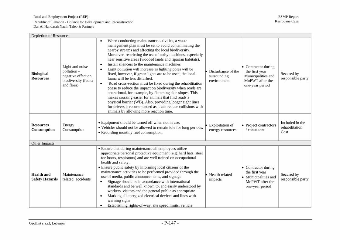
Geoflint s.a.r.l, Lebanon - P-147 -
Road and Employment Project (REP) ESMP Report
Kesrouane Caza Republic of Lebanon - Council for Development and Reconstruction
Dar Al Handasah Nazih Taleb & Partners
Depletion of Resources
Biological
Resources
Light and noise
pollution –
negative effect on
biodiversity (fauna
and flora)
• When conducting maintenance activities, a waste
management plan must be set to avoid contaminating the
nearby streams and affecting the local biodiversity.
Moreover, restricting the use of noisy machines, especially
near sensitive areas (wooded lands and riparian habitats).
• Install silencers to the maintenance machines
• Light pollution will increase as lighting poles will be
fixed, however, if green lights are to be used, the local
fauna will be less disturbed.
• Road cross-section must be fixed during the rehabilitation
phase to reduce the impact on biodiversity when roads are
operational, for example, by flattening side slopes. This
makes crossing easier for animals that find roads a
physical barrier (WB). Also, providing longer sight lines
for drivers is recommended as it can reduce collisions with
animals by allowing more reaction time.
• Disturbance of the
surrounding
environment
• Contractor during
the first year
Municipalities and
MoPWT after the
one-year period
Secured by
responsible party
Resources
Consumption
Energy
Consumption
• Equipment should be turned off when not in use.
• Vehicles should not be allowed to remain idle for long periods.
• Recording monthly fuel consumption.
• Exploitation of
energy resources
• Project contractors
/ consultant
Included in the
rehabilitation
Cost
Other Impacts
Health and
Safety Hazards
Maintenance
related accidents
• Ensure that during maintenance all employees utilize
appropriate personal protective equipment (e.g. hard hats, steel
toe boots, respirators) and are well trained on occupational
health and safety.
• Ensure public safety by informing local citizens of the
maintenance activities to be performed provided through the
use of media, public announcements, and signage
• Signage should be in accordance with international
standards and be well known to, and easily understood by
workers, visitors and the general public as appropriate
• Marking all energized electrical devices and lines with
warning signs
• Establishing rights-of-way, site speed limits, vehicle
• Health related
impacts
• Contractor during
the first year
• Municipalities and
MoPWT after the
one-year period
Secured by
responsible party

Geoflint s.a.r.l, Lebanon - P-148 -
Road and Employment Project (REP) ESMP Report
Kesrouane Caza Republic of Lebanon - Council for Development and Reconstruction
Dar Al Handasah Nazih Taleb & Partners
inspection requirements, operating rules and procedures,
and control of traffic patterns or direction
• Ensure that all workers are given proper site-specific
instructions on occupational health and safety prior to
commencing work.
• The Occupational Health and Safety training should
consist of hazard awareness and control measures.
• The training should ensure proper usage of personal protective
equipment (PPE).
Social GBV risks and
public complaints
• Ensure that workers during the maintenance phase sign the
CoC that targets GBV risks and penalizes the perpetrators of
GBV.
• Ensure that GRM mechanism is functional to receive any
public concerns throughout this phase
• Impacts on
workers and local
community
• Contractor during
the first year
• Municipalities and
MoPWT after the
one-year period
Secured by
responsible party

Geoflint s.a.r.l, Lebanon - P-149 -
Road and Employment Project (REP) ESMP Report
Kesrouane Caza Republic of Lebanon - Council for Development and
Reconstruction
Dar Al Handasah Nazih Taleb & Partners
7.3 Monitoring Plan
Environmental and social monitoring is one of the most important parts of an efficient and
coherent operation of a project. All environmental and social requirements and restrictions from
authorities, project owners and local communities are interlinked and form the primary
reference for monitoring and evaluation. In other words, monitoring aims to ensure that all
project activities undertaken are environmentally and socially sound, while considering the
mitigation measures discussed in the previous section.
It does so by defining a clear set of measurable indicators in an attempt to properly evaluate the
project’s performance from both an environmental and a social aspect. These indicators, also
known as Key Performance Indicators (KPIs), can then be used to assess the project’s
implementation in a timely manner. Consequently, they assist in the early detection of any
deviations from the project’s goals. It is important to note that the assessment of all proposed
measures is vital to ensure their proper implementation and the optimal operation of the project.
This allows the involved parties to take any corrective measures and limit any unsatisfactory
performance if such a case arises. It also allows them to accurately communicate the
performance of the project with regulators, the public, or other stakeholders.
Monitoring involves the observation, review, and assessment of onsite activities (including
parameters) to ensure adherence to regulatory standards and the suggestions made to lessen
negative impacts.
7.3.1 Monitoring Plan Implementation
Contractors shall employ qualified environmental and health officers/inspectors responsible for
monitoring project activities. Their aim is to ensure that the proposed activities, including the
suggested mitigation measures, are properly implemented during the rehabilitation phase. The
relevant ministries would also be expected to follow up, if deemed necessary, on the proper
implementation and abidance by the relevant laws and regulations.
Monitoring during the operational phase is mainly the responsibility of CDR and any concerned
local authorities, namely the relevant municipalities.
The KPIs for this project are listed in Table 7-3.
Table 7-3 Key performance indicators for the monitoring plan
Parameter Standard/Indicator Phase
Air quality Lebanese Stack Emission Standards
Lebanese Exhaust Emissions Standards for Vehicles
Rehabilitation and post
rehabilitation phase
Occupational health
and safety
Number of accidents and working days lost
Health and Safety Guidelines
Compliance with Lebanese Labor Law
Public safety Number of accidents involving public safety
Noise levels Lebanese Noise Emission Limits for Outdoor Areas
Soil and water
quality
Compliance with Lebanese Standards for the Discharge of
wastewater to sewage network/ surface water

Geoflint s.a.r.l, Lebanon - P-150 -
Road and Employment Project (REP) ESMP Report
Kesrouane Caza Republic of Lebanon - Council for Development and
Reconstruction
Dar Al Handasah Nazih Taleb & Partners
The monitoring requirements associated with the management strategies which should be
implemented during rehabilitation and operation are outlined in Table 7-4 and 7-5
Others
Labor age, labor wage, percentage of women in labor, work
injuries, code of conduct trainings, number of grievances
(internal and/or external)

Geoflint s.a.r.l, Lebanon - P-151 -
Road and Employment Project (REP) ESMP Report
Kesrouane Caza Republic of Lebanon - Council for Development and Reconstruction
Dar Al Handasah Nazih Taleb & Partners
Table 7-4 Environmental Monitoring Plan in Rehabilitation Phase
Impact Parameters to
Monitor Frequency Monitoring Location
Monitoring
Method
Standard/Guidelines
National/International
Institutional
Follow-up
Approximat
e Cost
(USD/year)
Air
Emissions/G
HG/Dust
PM2.5-10, SOx,
NOx, O3, CO, Total
Suspended Particles
(TSP)
Testing
once during
the project
life and
weekly
inspection
• Construction
vehicles exhaust
• Around
rehabilitation site
for dust
• Single point
sampling (at
one quarter the
diameter across
the
stack/source)
• Visual opacity
measurement
(smoke
inspection)
Particulate Matter (PM<10)
80 μg/m3
Sulfur dioxide (SO2) 120
μg/m3
Nitrogen dioxide (NO2) 150
μg/m3
CDR
104,000
(2000 per
test)
Noise Noise levels (Lmin,
Lmax, and Leq)
Monthly
during
noisy
operation
Around the
rehabilitation site,
especially near loud
machinery and major
rehabilitation activities
One sample per
location (near
sensitive receptors)
Refer to Table 2-7 CDR
Included in
rehabilitation
Cost
WW
Generation
pH, Temperature:
max, BOD, COD,
Sulfate, Fecal
Coliform, Total
Coliform,
Suspended solids,
Oil and grease
Before
commence
ment of
work and
bi-annually
Sediment trap at
downstream assigned
for contaminated
stormwater runoff
Two samples at
effluent of chosen
sediment trap
pH: 6-9
Temperature: max 30 C
BOD: 25 mg/L
COD: 125 mg/L
Sulfate: 1 mg/L
Fecal Coliform: 0
CFU/100ml
Total Coliform:
0CFU/100ml at 370C
Suspended solids: 60 mg/L
Oil and grease: 50 mg/L
CDR 600

Geoflint s.a.r.l, Lebanon - P-152 -
Road and Employment Project (REP) ESMP Report
Kesrouane Caza Republic of Lebanon - Council for Development and Reconstruction
Dar Al Handasah Nazih Taleb & Partners
Impact Parameters to
Monitor Frequency Monitoring Location
Monitoring
Method
Standard/Guidelines
National/International
Institutional
Follow-up
Approximat
e Cost
(USD/year)
Domestic-like
wastewater Daily
Polyethylene storage
tank (in case portacabin
toilet is not linked to
WW network)
Visual inspection
• Prohibit leaks from tank
• Prohibit overfilling of
tank
CDR
Included in
rehabilitation
Cost
Accidental
Releases
Number of
spills/leaks (of
lubricants, oil, fuel,
or other chemicals)
Weekly
Around the
rehabilitation site,
especially near
equipment, material,
and storage tanks
Visual inspection N.A. CDR
Included in
rehabilitation
Cost
Energy
Resources
Fuel consumption
rates Monthly
At fuel storage tanks
area
Respective to fuel
consumed N.A
CDR Included in
rehabilitation
Cost
Biological
Resources
Ecological audit for
particular biotopes Weekly
Riparian habitats near
water channels and
streams
Samples and photos
per location and
GPS point
N.A
CDR Included in
rehabilitation
Cost
GBV
• Code of
conduct
trainings
• Signed forms
• Dates of
training
Bi-annually At training locations
Respective to the
amounts of trainings
conducted
N.A. CDR
Included in
rehabilitation
Cost
• GBV-related
internal
grievances
Monthly At each rehabilitation
zone
• Received
complaints and
GRM records
N.A. CDR
Included in
rehabilitation
Cost
OHS
• Total number
of work
injuries
• OHS-related
internal
grievances
Continuous
ly
At each rehabilitation
zone
Visual inspection
Employee records N.A. CDR
Included in
rehabilitation
Cost

Geoflint s.a.r.l, Lebanon - P-153 -
Road and Employment Project (REP) ESMP Report
Kesrouane Caza Republic of Lebanon - Council for Development and Reconstruction
Dar Al Handasah Nazih Taleb & Partners
Impact Parameters to
Monitor Frequency Monitoring Location
Monitoring
Method
Standard/Guidelines
National/International
Institutional
Follow-up
Approximat
e Cost
(USD/year)
• OHS-related
trainings
• Visual field
inspections
• Verbal
complaints by
workers
• Ensure use of
PPE
Continuous
ly
Around rehabilitation
site and used roads
Continuous visual
inspection N.A CDR
Included in
rehabilitation
Cost
Social
Tensions and
Conflicts over
Job-Sharing
• Number of
related
grievances
• Percentage of
workers (based
on gender,
nationality)
Monthly
• Around the
rehabilitation sites
• Employee records
Received
complaints and
records
N.A. CDR -
Obstructing
Access to
Amenities
Type, location, and
duration of amenity
to which access
was obstructed
Daily At rehabilitation sites Visual inspection N.A. CDR
Included in
rehabilitation
Cost
Working
conditions Labor’s wages Monthly Laborers’ contracts
Workers complaints
records
Labor law
verification
N.A. CDR -
Child labor Labor’s age Monthly Laborers’ records/
files
Labor registry and
age verification
Labor law
verification
N.A.
CDR
-

Geoflint s.a.r.l, Lebanon - P-154 -
Road and Employment Project (REP) ESMP Report
Kesrouane Caza Republic of Lebanon - Council for Development and Reconstruction
Dar Al Handasah Nazih Taleb & Partners
Impact Parameters to
Monitor Frequency Monitoring Location
Monitoring
Method
Standard/Guidelines
National/International
Institutional
Follow-up
Approximat
e Cost
(USD/year)
Underemploy
ment of
Women
Percentage of
female employees
in workforce
Bi-annually Laborers’ records/
files Labor registry N.A.
CDR
-
Other
Grievances
Internal and
external grievance
reports
Weekly or
upon
grievance
occurrence
At each rehabilitation
zone Complaints records N.A.
CDR Included in
rehabilitation
Cost
Visual
intrusion
Dust pollution
(opacity) Daily
At dust generating
activities
Several photographs
per location +
opacity
measurement
N.A
CDR Included in
rehabilitation
Cost
Damage to
existing
infrastructure
Type, size, and
number of damaged
infrastructure
entities
Daily Around the
rehabilitation site. Visual inspection N.A.
CDR
-

Geoflint s.a.r.l, Lebanon - P-155 -
Road and Employment Project (REP) ESMP Report
Kesrouane Caza Republic of Lebanon - Council for Development and Reconstruction
Dar Al Handasah Nazih Taleb & Partners
Table 7-5 Environmental Monitoring Plan in Operation Phase
Impacts Parameters to
Monitor Frequency Monitoring Location
Monitoring
Method
Standard/Guidelines
National/International
Approximate
Cost (USD/year)
Noise Noise levels (Lmin,
Lmax, and Leq)
Bi-annually or upon
complaints
Along the two
concerned roads near
sensitive receptors and
complainers
One sample per
location Refer to Table 2-7
Included in
rehabilitation Cost
WW Generation
Leakages, spillages,
improper discharges,
etc.
Annually
Upon maintenance
routine, at wastewater
piping system
Visual
Inspection N.A.
Included in
rehabilitation Cost
Social Satisfaction External complaints or
grievances
Bi-annually or upon
complaints
Along the two
concerned roads
Received
complaints and
records
N.A. Included in
rehabilitation Cost
Road Safety
Accidents: number,
dates, frequency, and
causes
Annually Along the two
concerned roads
Visual
inspection (of
accident logs
containing the
mentioned data)
N.A. Included in
rehabilitation Cost

Geoflint s.a.r.l, Lebanon - P-156 -
Road and Employment Project (REP) ESMP Report
Kesrouane Caza Republic of Lebanon - Council for Development and
Reconstruction
Dar Al Handasah Nazih Taleb & Partners
7.3.2 Documentation and Reporting
Monitoring yields lots of data regarding project performance. As a result, proper documentation
is necessary for two reasons: first to prepare and send performance reports to the concerned
parties and second to analyze the acquired data and implement changes when necessary.
In this context, monitoring reports will take place as described below.
• Contractor’s Health and Safety officers submit compliance reports to the Environmental
Supervision Consultants on a monthly basis.
• The Environmental Supervision Consultants review and approve contractor reports and
submit them to PIU on a monthly basis.
• PIU submits environmental/social progress as part of their quarterly project progress reports
to the WB on a quarterly basis.
• In case of severe incidents (eg. Fatality on-site), immediate reporting within 24 hours to
CDR and within 48 hours to the WB must be done.
7.3.3 Guidelines for Health and Safety Plan during Rehabilitation
An effective Occupational Health and Safety Plan, in line with World Bank guidelines, for
rehabilitation be submitted by the Contractor and approved by the appointed supervising
Consultant prior commencement of works. The plan should should include at least the following
components:
• Proper signage in and around the sites (local language to be understood by all);
• Fire response and spill response measures;
• Proper storage and signage of materials including Material Safety Data Sheets;
• Safety measures according to type of equipment;
• Train workers on lifting and material handling techniques;
• Plan work site layout to reduce the need for manual transfer of heavy objects,
• Personal safety equipment;
• Medical services which includes first aid kits;
• Mobile sanitary facilities;
• Safe drinking water in accordance with regulations.
In addition, the plan should also incorporate all of the previously mentioned measures stated in
section Error! Reference source not found. which address in great detail OHS and PHS m
easures. All rehabilitation staff should be trained on the Health & Safety Plan and the specific
safety measures related to their own activities.

Geoflint s.a.r.l, Lebanon - P-157 -
Road and Employment Project (REP) ESMP Report
Kesrouane Caza Republic of Lebanon - Council for Development and
Reconstruction
Dar Al Handasah Nazih Taleb & Partners
8. Consultation, Disclosure and GRM
8.1 Public Consultation
Project‐affected groups, mainly municipalities and NGOs were consulted on the project’s
environmental and social aspects.
Three public participation meetings were arranged for Kesrouane Caza. The first public
participation meeting was held at the Municipality of Jounieh on Thursday December 12
addressing all Kesrouane roads. However, given the circumstances in the Country (revolution
started in October 17, 2019 and roads were obstructed), only 10 persons attended the meeting.
In this context, two additional public meetings were set for Kesrouane caza. The first meeting
was held in Kfour Municipality on Friday December 27 addressing Kesrouane R2a and R2c,
whereas the second meeting was held at Kfardebiane Municipality on Friday January 3, 2019
addressing Kesrouane R2b and R7. During the meetings, attendees were informed about the
project objectives, Project Design, the identified natural, economic, and social resources of
importance in the area, the project’s possible environmental and social risks, and the planned
mitigation measures.
Invitations were sent by the consultant on behalf of CDR to concerned municipalities and
NGOs through official letters, emails and direct phone calls. The invitation letter that was sent
to the concerned stakeholders is attached in Annex 4. Invitations were sent at least one week
(between one and two weeks) prior to the public participation meeting.
During the public participation, project details and design, impacts and mitigation measures
were presented in a 35-minute presentation (see more details in Annex 4), which has followed
by an open discussion with the attendees. In particular, the consultant informed the attendees
about the project objectives, the identified natural, economic, and social resources of
importance in the area, the project’s possible environmental and social risks, and the planned
mitigation measures.
The main attendees of the meeting were namely the heads of concerned municipalities, citizens
and relevant NGOs (refer to the lists of attendees in Annex 4). The number of attendees at
Kfour was 27, of which 9 were women. At Kfardebiane, the total number of attendees was 18,
of which 5 were women.
As for NGOs Consultation, this ESMP has targeted them according to their position in
Lebanon. They consist of two levels as follows:
a) Local NGOs: they are specific to each Caza. Their mission is to address different
concerns and issues among the local society including social, economic, gender
equality, environment, poverty, women empowerment, etc.
Local NGOs were invited to the public hearings. Table 8-1 represents the name of the
invited NGOs and their field of activity. Those local NGOs may play a role of advocates
to reduce projects’ social and environmental risks.

Geoflint s.a.r.l, Lebanon - P-158 -
Road and Employment Project (REP) ESMP Report
Kesrouane Caza Republic of Lebanon - Council for Development and
Reconstruction
Dar Al Handasah Nazih Taleb & Partners
Table 8-1 List of Contacted Local NGOs
Organization Phone Number Activities
Women in Front 04-521096 Created in 2012, “Women in Front” aims at empowering women and
increasing their participation in political and public life
Les Scouts du
Liban (SDL),
Kfardebian
76-102937 Spread throughout Lebanon, SDL is generally composed of groups
from the local community and for the local community. Their various
activities allow the young volunteers to explore their community and
help the locals around them.
Amel
Association
01-317293 Since its creation, in 1979, Amel has opened field hospitals,
maternities, development and medical centers in addition to
cooperatives in several areas, regardless of their political or religious
affiliations. As part of its support to refugees program, it provides
humanitarian aid to refugee communities, irrelevant of nationality.
across the entire country.
Frontiers’ Rights
(Rouwad
Houkouk)
01-383556 Ruwad was founded in 2014 after long years of advocacy work
launched by its activists in 1999. The association defends the
fundamental rights of marginalized groups in Lebanon, focusing on
three areas: statelessness, right to asylum, and right to personal
freedom, safety and non-refoulement (non-forced return to home
country).
b) International NGOs: they are covering the whole country and their
consultation will be applied to all the ESMPs of the REP. They provide relief and
developmental aid to many developing countries. They support the society in
responding to crises and helps people whose lives and livelihoods are shattered by
conflict and disaster to survive, recover and gain control of their future. When the
crisis in Syria erupted in early 2011, numerous International NGOs responded to the
humanitarian crisis and worked directly with the Syrian in Lebanon by providing aid
and responding to their critical situation.
This ESMP consulted International NGOs (see Table 8-2) to inform them about the
Project, disseminate it, ask them to circulate its impacts and activities among Syrian
and tell them that they can inquire about additional information and/or submit a
complaint (if any) by contacting the Grievance Redress Mechanism (GRM) Unit on
01980096 ext:317 or send an Email to [email protected] or register by hand an
official letter at the CDR .
In Kesrouane Caza, the total number of registered Syrian is 16,326 individuals
(UNHCR, 2017). They were contacted through the International NGOs to seek their
feedback about the Project. Accordinlgy, this ESMP did not receive any concern
about the Project.
Table 8-2: Consulted International NGOs and their Activities
NGO Name Contacts Intervention Sector(s) Comments
ANERA
Lebanon
Mrs. Dima Zayat
Deputy Country Director
T: 01382590 (ext: 105)
M: 70051813
• Children &
Youth
• Development
• Education
• Relief Services
• Water sanitation
and hygiene
Mrs. Zayat received
the Project
information sheet
and explained that
recently Anera
operations in
Lebanon have grown
substantially to cope

Geoflint s.a.r.l, Lebanon - P-159 -
Road and Employment Project (REP) ESMP Report
Kesrouane Caza Republic of Lebanon - Council for Development and
Reconstruction
Dar Al Handasah Nazih Taleb & Partners
with the Syrian crisis.
they have six offices
throughout Lebanon.
She welcomed the
idea of the Project
and will disseminate
it across her
organization.
ACTED Mr. Jack French
Deputy Country Director
T: 01324331
M: 79160375
• Development
• Infrastructure &
Services
Rehabilitation
• Labor &
Livelihoods
• Shelter
• Water sanitation
and hygiene
Mr. French received
the Project
information sheet
and explained that
ACTED is working
with Syrian in Beirut
and northern districts
of Mount Lebanon
(Baabda, Metn,
Keserwane and
Jbeil), as well as in
Akkar District. He
welcomed the idea of
the Project and will
disseminate it across
his organization.
Danish
Refugee
Council
(DRC)
Mr. Rickard Hartmann
Country Director
T: 01339052 (ext: 201)
E:
• Direct
Assistance
• Protection
• Shelter
• Community
Empowerment
and Livelihoods
Mr. Hartmann Mr.
French received the
Project information
sheet and explained
that DRC is working
with Syrian on many
sectors in different
locations across
Lebanon including
Beirut, Tripoli,
Kobayat and Zahle.
He welcomed the
idea of the Project
and will disseminate
it across his
organization.
8.2 Grievance Redress Mechanism (GRM)
The project will include a project‐wide GRM that will register and address grievances and
complaints from individuals and households who are affected by the project. Anonymous

Geoflint s.a.r.l, Lebanon - P-160 -
Road and Employment Project (REP) ESMP Report
Kesrouane Caza Republic of Lebanon - Council for Development and
Reconstruction
Dar Al Handasah Nazih Taleb & Partners
grievances will be addressed in both GRMs for communities and workers. The maximum
anticipated time needed to close a GRM case is 45 days.
8.2.1 GRM for Surrounding Communities
The primary purpose of the GRM will be to provide clear and accountable means for project
beneficiaries and affected persons to raise concerns of possible tensions and feelings of
exclusion and complaints and seek solutions when they believe they have been harmed by the
project. As such, the GRM will allow citizens to directly voice concerns or grievances to the
implementing agency and ensure that these concerns are responded to and addressed in a timely
manner.
The key objectives of the GRM are:
• Record, categorize and prioritize the grievances;
• Resolve the grievances via consultation with all stakeholders (and notify those
stakeholders of the resolutions)
• Relay any unresolved cases to the relevant authority.
The GRM will be accessible to all relevant stakeholders who can use this mechanism to send
their suggestions, concerns and complaints related to the project. The complaints, suggestions
and concerns can be sent by email, mail, phone (through a hotline), in person and other means
such as a grievance compliant logging sheet where grievances are registered in writing and
maintained as a database. The phone number, e-mail address, and address for receiving
complaints will be disclosed among the population and will be posted at the rehabilitation sites
in Kesrouane Caza, before commencement of project implementation. Moreover, the
information on how to access the GRM should be available through billboards, CDR website,
etc.
The GRM levels of the project are the following (Figure 8-1):
Level 1: If any person has any complaint, concern or suggestion regarding the project
implementation, he or she can lodge an oral or written grievance through e-mail
([email protected]), phone call or text message (01980096 ext:317), or website link
(http://www.cdr.gov.lb/study/RoadsEmp/RoadsEmp.htm) to the site engineer or manager of
the roads to be rehabilitated in Kesrouane Caza. In case an oral complaint is made, it should be
written on paper by the receiving unit. The above issue will be resolved within a maximum
duration of one week.
Level 2: If the person is not satisfied with the action of the site manager’s Office, he or she can
bring the complaint to the attention of the Social Specialist of the PIU for the project. The issue
shall be resolved within a maximum of two weeks.
Level 3: If the person is not satisfied with the decision of the Social Specialist of PIU, he or she
can bring the complaint to the attention of the PIU Director’s Office. Once the PIU Director
receives the complaint, it needs to be resolved within a maximum of two weeks.

Geoflint s.a.r.l, Lebanon - P-161 -
Road and Employment Project (REP) ESMP Report
Kesrouane Caza Republic of Lebanon - Council for Development and
Reconstruction
Dar Al Handasah Nazih Taleb & Partners
Meanwhile, it is recommended that the aggrieved party is consulted and be informed of the
course of act ion being taken, and when a result may be expected.
Moreover, reporting of the complaints to the PIU should be done regularly. The designated
person at each level should report to the PIU on the number and subject of new complaints
received, and the status of the already existing complaints, if any. The report should also inform
the PIU of complaints that could not be resolved at the lower levels and are being elevated to
the PIU Director’s attention. The PIU aggregates information received into a status report each
quarter, indicating the number and subject of complaints. The quarterly status report also
provides up-to-date information on the number and subject of complaints that have been
resolved, and the manner in which they have been resolved. This information will be shared
with the Bank.
The Complaints Register form (refer to Annex 5) includes the following:
i) details and nature of the complaint
ii) the complainant name and their contact details
iii) date
iv) Corrective actions taken in response to the complaint.
The GRM does not exclude the formal legal process of the national law. If a grievance remains
unresolved following application of the project GRM process, the affected person can initiate
legal proceedings in accordance with national law and may have recourse to the Appeals Court
as warranted.

Geoflint s.a.r.l, Lebanon - P-162 -
Road and Employment Project (REP) ESMP Report
Kesrouane Caza Republic of Lebanon - Council for Development and
Reconstruction
Dar Al Handasah Nazih Taleb & Partners
Figure 8-1 Schematic illustration of the GRM
A written complaint or concern or
suggestion is lodged to the site
engineer or manager
Is the complainant satisfied with
the actions of the site engineer or
manager?
Must be written down by the site
engineer or manager
Site manager or engineer should
carry out the necessary actions to
resolve the issue within a
maximum period of one week
An oral complaint or concern or
suggestion is lodged to the site
engineer or manager
Issue is resolved Is the complainant satisfied with
the actions of the social specialist?
The social should carry out the
necessary actions to resolve the
issue within a maximum period of
two weeks
The complainant brings the issue
to the attention of the social
specialist of the PIU
Issue is resolved
Director of the PIU should carry
out the necessary actions to
resolve the issue within a
maximum period of two weeks
The complainant brings the issue
to the attention of the Director of
the PIU
Level 1
Level 3
Level 2 No
Yes
No
Yes

Geoflint s.a.r.l, Lebanon - P-163 -
Road and Employment Project (REP) ESMP Report
Kesrouane Caza Republic of Lebanon - Council for Development and
Reconstruction
Dar Al Handasah Nazih Taleb & Partners
8.2.2 GRM for Workers
Similar to the GRM for surrounding communities, a GRM for internal employees, namely the
labors onsite is also necessary. It aims to allow labors to report any wrongdoings in their favor
or important concerns they might have. This internal GRM is similar in nature to the one
previously discussed (in terms of accessibility, reporting means, etc…). The only main
difference is the contact people for each level. In this context, the first level involves reporting
to the health and safety officer and has a duration of one week. The second level involves
reporting to the PIU Director and should be resolved within one weeks. It also follows the
Complaints Register form (refer to Annex 5).

Geoflint s.a.r.l, Lebanon - P-164 -
Road and Employment Project (REP) ESMP Report
Kesrouane Caza Republic of Lebanon - Council for Development and
Reconstruction
Dar Al Handasah Nazih Taleb & Partners
9. Conclusion
The ESMP identified and assessed the potential environmental and social impacts of REP and
consulted relevant stakeholders when preparing the management plan.
In specific this ESMP report addresses four selected roads for rehabilitation in Kesrouane with
a total length of around 32.63 km. Activities to be performed include pavement works
(complete reconstruction when needed and milling and overlay for roads that are in better
condition); improvement and installation of drainage facilities, construction of retaining walls
and installation of safety barriers, marking and signing. The rehabilitation works for Kesrouane
roads will involve 176 workers and require a total of 18 months.
Road rehabilitation activities are expected to incur environmental impacts that are similar
among all Kesrouane roads.Common impacts include fugitive dust emissions, increase in
noise, contaminaton of water quality, disruption to traffic movement, potential damages to
existing utilities, and disturbance of local biodiversity. Once roads are rehabilitated, the project
is expected to improve drainage systems (less runoff water), road safety conditions, reduce
traffic accidents and traffic congestion, and ultimately enhance livelihood opportunities. On
the other hand, the main expected environmental impacts on water and soil could result from
maintenance activities if not managed properly during the “Defects Liability Period’ during
which the Contractor is responsible for maintenance activities.
In this context the contractor must implement proper waste and safety plans and all the
environmental mitigation measures provided in this ESMP.
A proper management plan was provided for specific concerns regarding the roads in
Kesrouane. The plan includes measures to control exhaust emissions, dust and odor emissions,
and soil manipulation activities during the rehabilitation phase. Moreover, proper measures and
guidelines on the control of accidental spills of construction material were provided to prevent
soil contamination. Any accidental spillage of wastewater onto open ground can easily infiltrate
the karstic limestone and is highly likely to pollute water present in the subsurface. Moreover,
any discharge of wastewater into the winter channels will mainly lead to adverse impacts to the
downstream “Wadi Tabarja”, “Wadi Ghazir”, Ibrahim River (R2a, R2c), to “Wadi Jounieh”
(R2b) and to “El Kaleb” river (Kesrouane R7). Regarding biodiversity, recommendations are
provided to guide the project contractor in reducing the negative impacts on natural habitats
and biodiversity. Although the concerned roads are mainly under anthropogenic influences,
contractors must be careful during the rehabilitation work so that the direct impacts (direct
destruction) on ecosystems and associated fauna would be minimal. Waste management plan
must be adopted to avoid soil and water contamination that could have irreversible impacts on
biodiversity. More specifically, rehabilitation debris should not be dumped into the natural
habitat (e.g. streams and water channels encountered in Kesrouane Caza along the studied
roads).
The social risks of the project include potential risk of labor induced SH towards female
workers and SEA towards women in the surrounding community, potential risk of child labor
and poor labor conditions; unfair job allocation; underemployment of women; traffic
disturbance; and provisional obstruction of access routes to sensitive receptors specifically,

Geoflint s.a.r.l, Lebanon - P-165 -
Road and Employment Project (REP) ESMP Report
Kesrouane Caza Republic of Lebanon - Council for Development and
Reconstruction
Dar Al Handasah Nazih Taleb & Partners
residential units and churches along Kesrouane R2a. In this context, the ESMP provided
measures to mitigate these risks through periodic monitoring of labor conditions, specific
required clauses within contracts that aim to protect workers, and the CoC for GBV issues. In
addition, a robust GRM must be clearly communicated to all project-affected persons before
and during project implementation.
Moreover, a monitoring plan was set along with defined responsibilities for the
operationalization of the ESMP. In other words, the ESMP generated key project indicators to
monitor project implementation success. It is designed to guarantee effectiveness in the
measurement of major project outcomes and outputs based on measurable indicators.
Lastly, a Construction Environmental and Social Management Plan must be prepared once the
contractors are appointed. This CESMP must account as well for the recommendations and
guidelines provided within this ESMP to ensure protection of the surrounding environment and
the society.

Geoflint s.a.r.l, Lebanon - P-166 -
Road and Employment Project (REP) ESMP Report
Kesrouane Caza Republic of Lebanon - Council for Development and
Reconstruction
Dar Al Handasah Nazih Taleb & Partners
References
Abdallah, S. M., Habib, R. R., Nuwayhid, R. Y., Chatila, M., & Katul, G. (2007).
Abi-Saleh, B., Safi, S. et al. 1996. La Flore Terrestre: Habitats Forestiers et Ecosystèmes
Naturels. In: UNDP - Ministère de l’Agriculture (Liban), Étude de la Diversité
Biologique du Liban, T. III, Projet PNUE / GF / 6105-92-72.
Ahn, C., Pan, W., Lee, S., & Peña-Mora, F. (2010). Enhanced estimation of air emissions from
construction operations based on discrete-event simulation. In Proceedings of the
International Conference on Computing in Civil and Building Engineering,
Nottingham, UK (Vol. 30).
Bourne, L. (2016). Targeted communication: The key to effective stakeholder engagement.
Procedia-Social and Behavioral Sciences, 226, 431-438.
Council for Development and Reconstruction (CDR). (2007). Safety, Health and
Environmental Regulations. Beirut, Lebanon.
DOLIDAR (2017). Occupational Safety and Health Guidelines. Government of Nepal
Gerilla, G. P., Takeyama, Y., & Inamura, H. (2000). Environmental impacts of the road and
building construction industry in Japan. In Proceedings of the International Symposium
on Lowland Technology (pp. 4-6).
International Finance Corporation (IFC). (2007). Environmental, Health, and Safety (EHS)
Guidelines GENERAL EHS GUIDELINES: OCCUPATIONAL HEALTH AND
SAFETY.
International Labour Office (ILO). (1999). Safety, health and welfare on construction sites: A
training manual. Geneva: ILO.
Ledec, G., and Posas, P. 2003. Biodiversity conservation in road projects: lessons from World
Bank experience in Latin
Mao, P., Li, J., Jin, L., & Qi, J. Evaluation on Effects of Construction Dust Pollution on
Economic Loss. In ICCREM 2017 (pp. 346-353).
MOEW, UNDP, (2014). “Assessment of Groundwater Resources of Lebanon”
Muiruri, G., & Mulinge, C. (2014). Health and safety management on construction project sites
in Kenya. A Case Study of Construction Projects in Nairobi County, Engaging the
Challenges–Enhancing the Relevance, 16-21.
Norseth T, Waage J, and Dale I. (1991). Acute Effects and Exposure to Organic Compounds
in Road Maintenance Workers Exposed to Asphalt. Am J Ind Med.

Geoflint s.a.r.l, Lebanon - P-167 -
Road and Employment Project (REP) ESMP Report
Kesrouane Caza Republic of Lebanon - Council for Development and
Reconstruction
Dar Al Handasah Nazih Taleb & Partners
Poot H, Ens BJ, Vries HDe, Donners MAH, Wernand MR, Marquenie JM. 2008. Green light
for nocturnally migrating birds. Ecol. Soc. 13, 47
Rich, C., and Longcore T. (2006). Ecological consequences of artificial night lighting. Island
Press, Washington, D.C.
Sang D. CHOI, Lisa HUDSON, Peter KANGAS, Brett JUNGEN, Jennifer MAPLE and
Chevon BOWEN. (2007). Occupational Ergonomic Issues in Highway Construction
Surveyed in Wisconsin, United States. Industrial Health 2007, 45, 487–493
Schwab, K. (2017). The Global Competitiveness Report 2017✹ 2018. World Economic
Forum.
Supe, S.M. Gawande (2013). Effect of dust fall on vegetation. International
Journal of Science and Research (IJSR) 4: 2319 7064.
Tohmé G, Tohmé H. (1985). Les Mammifères Sauvages du Liban. Publications de l’Université
Libanaise, Beirut, 189 pp.
Tohmé G, Tohmé H. (2014). Illustrated Flora of Lebanon, CNRS publications
UNDP. (2008). “Poverty, Growth & Income Distribution in Lebanon”
UNHCR. (2017). “Vulnerability Assessment of Syrian Refugees in Lebanon 2017”
World Bank (2018). Good Practice Note Addressing Gender Based Violence in Investment
Project Financing involving Major Civil Works.

Geoflint s.a.r.l, Lebanon - P-168 -
Road and Employment Project (REP) ESMP Report
Kesrouane Caza Republic of Lebanon - Council for Development and
Reconstruction
Dar Al Handasah Nazih Taleb & Partners
Annex
Annex 1: Figures and Tables Related to Chapter 4
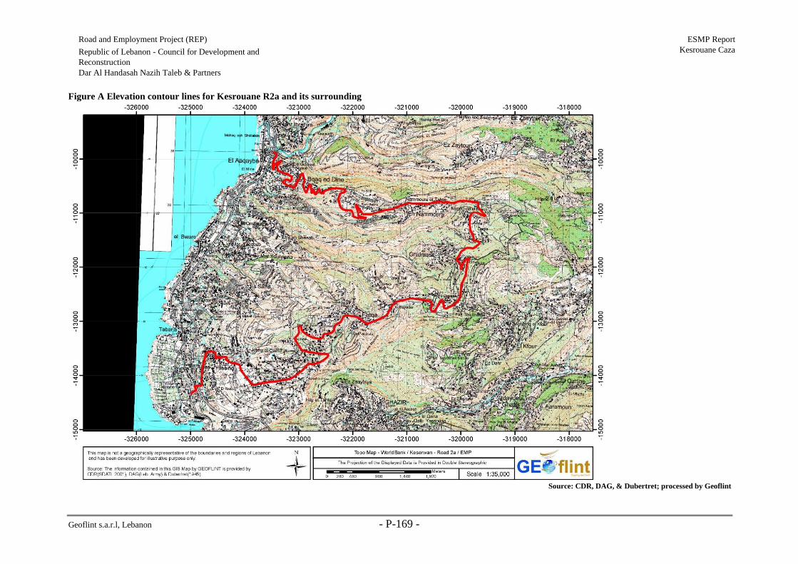
Geoflint s.a.r.l, Lebanon - P-169 -
Road and Employment Project (REP) ESMP Report
Kesrouane Caza Republic of Lebanon - Council for Development and
Reconstruction
Dar Al Handasah Nazih Taleb & Partners
Figure A Elevation contour lines for Kesrouane R2a and its surrounding
Source: CDR, DAG, & Dubertret; processed by Geoflint

Geoflint s.a.r.l, Lebanon - P-170 -
Road and Employment Project (REP) ESMP Report
Kesrouane Caza Republic of Lebanon - Council for Development and
Reconstruction
Dar Al Handasah Nazih Taleb & Partners
Figure B Elevation contour lines for Kesrouane R2b and its surrounding
Source: CDR, DAG, & Dubertret; processed by Geoflint

Geoflint s.a.r.l, Lebanon - P-171 -
Road and Employment Project (REP) ESMP Report
Kesrouane Caza Republic of Lebanon - Council for Development and
Reconstruction
Dar Al Handasah Nazih Taleb & Partners
Figure C Elevation contour lines for Kesrouane R2c and its surrounding
Source: CDR, DAG, & Dubertret; processed by Geoflint

Geoflint s.a.r.l, Lebanon - P-172 -
Road and Employment Project (REP) ESMP Report
Kesrouane Caza Republic of Lebanon - Council for Development and
Reconstruction
Dar Al Handasah Nazih Taleb & Partners
Figure D Elevation contour lines for Kesrouane R7 and its surrounding
Source: CDR, DAG, & Dubertret; processed by Geoflint

Geoflint s.a.r.l, Lebanon - P-173 -
Road and Employment Project (REP) ESMP Report
Kesrouane Caza Republic of Lebanon - Council for Development and
Reconstruction
Dar Al Handasah Nazih Taleb & Partners
Figure E General Geological map of Kesrouane R2a and its surrounding (surface outcrops)
Source: CDR, DAG, & Dubertret; processed by Geoflint

Geoflint s.a.r.l, Lebanon - P-174 -
Road and Employment Project (REP) ESMP Report
Kesrouane Caza Republic of Lebanon - Council for Development and Reconstruction
Dar Al Handasah Nazih Taleb & Partners
Figure F General Geological map of Kesrouane R2b and its surrounding (surface outcrops)
Source: CDR, DAG, & Dubertret; processed by Geoflint

Geoflint s.a.r.l, Lebanon - P-175 -
Road and Employment Project (REP) ESMP Report
Kesrouane Caza Republic of Lebanon - Council for Development and
Reconstruction
Dar Al Handasah Nazih Taleb & Partners
Figure G General Geological map of Kesrouane R2c and its surrounding (surface outcrops)
Source: CDR, DAG, & Dubertret; processed by Geoflint

Geoflint s.a.r.l, Lebanon - P-176 -
Road and Employment Project (REP) ESMP Report
Kesrouane Caza Republic of Lebanon - Council for Development and Reconstruction
Dar Al Handasah Nazih Taleb & Partners
Figure H General Geological map of Kesrouane R7 and its surrounding (surface outcrops)
Source: CDR, DAG, & Dubertret; processed by Geoflint

Geoflint s.a.r.l, Lebanon - P-177 -
Road and Employment Project (REP) ESMP Report
Kesrouane Caza Republic of Lebanon - Council for Development and
Reconstruction
Dar Al Handasah Nazih Taleb & Partners
Figure I Hydrogeological map of Kesrouane R2a and its surrounding (map showing water potential of the subsurface). Refer to Table 4 6 for description of
hydrogeology classes. Work stations are shown along the road alignment.
Source: CDR, DAG, & Dubertret; processed by Geoflint

Geoflint s.a.r.l, Lebanon - P-178 -
Road and Employment Project (REP) ESMP Report
Kesrouane Caza Republic of Lebanon - Council for Development and
Reconstruction
Dar Al Handasah Nazih Taleb & Partners
Figure J Hydrogeological map of Kesrouane R2c and its surrounding (map showing water potential of the subsurface). Refer to Table 4 6 for description of
hydrogeology classes. Work stations are shown along the road alignment.
Source: CDR, DAG, & Dubertret; processed by Geoflint

Geoflint s.a.r.l, Lebanon - P-179 -
Road and Employment Project (REP) ESMP Report
Kesrouane Caza Republic of Lebanon - Council for Development and
Reconstruction
Dar Al Handasah Nazih Taleb & Partners
Figure K Hydrogeological map of Kesrouane R2b and its surrounding (map showing water potential of the subsurface). Refer to Table 4 6 for description of
hydrogeology classes. Work stations are shown along the road alignment.
Source: CDR, DAG, & Dubertret; processed by Geoflint

Geoflint s.a.r.l, Lebanon - P-180 -
Road and Employment Project (REP) ESMP Report
Kesrouane Caza Republic of Lebanon - Council for Development and
Reconstruction
Dar Al Handasah Nazih Taleb & Partners
Figure L Hydrogeological map of Kesrouane R7 and its surrounding (map showing water potential of the subsurface). Refer to Table 4 6 for description of
hydrogeology classes. Work stations are shown along the road alignment.
Source: CDR, DAG, & Dubertret; processed by Geoflin
t

Geoflint s.a.r.l, Lebanon - P-181 -
Road and Employment Project (REP) ESMP Report
Kesrouane Caza Republic of Lebanon - Council for Development and
Reconstruction
Dar Al Handasah Nazih Taleb & Partners
Figure M Precipitations values along Kesrouane R2a & R2c alignments (period extending between 1996-
2018) CHIRPS satellite 4.5 km spatial resolution
Source : CHIRPS satellite

Geoflint s.a.r.l, Lebanon - P-182 -
Road and Employment Project (REP) ESMP Report
Kesrouane Caza Republic of Lebanon - Council for Development and
Reconstruction
Dar Al Handasah Nazih Taleb & Partners
Figure N Land surface temperature variation for Kesrouane R2a & Kesrouane R2c (period extending between 2000-2018) MODIS satellite 1km spatial resolution
Source: MODIS satellite

Geoflint s.a.r.l, Lebanon - P-183 -
Road and Employment Project (REP) ESMP Report
Kesrouane Caza Republic of Lebanon - Council for Development and
Reconstruction
Dar Al Handasah Nazih Taleb & Partners
Figure O Precipitations values for Kesrouane R2b (1996-2018) CHIRPS satellite 4.5km spatial resolution
Source: CHIRPS satellite

Geoflint s.a.r.l, Lebanon - P-184 -
Road and Employment Project (REP) ESMP Report
Kesrouane Caza Republic of Lebanon - Council for Development and Reconstruction
Dar Al Handasah Nazih Taleb & Partners
Figure P Temperature variation for Kesrouane R2b (period extending between 2000-2018) MODIS satellite 1km spatial resolution
Source: MODIS satellite

Geoflint s.a.r.l, Lebanon - P-185 -
Road and Employment Project (REP) ESMP Report
Kesrouane Caza Republic of Lebanon - Council for Development and Reconstruction
Dar Al Handasah Nazih Taleb & Partners
Figure Q Precipitations values for Kesrouane R7 (1996-2018) CHIRPS satellite 4.5km spatial resolution
Source: CHIRPS satellite
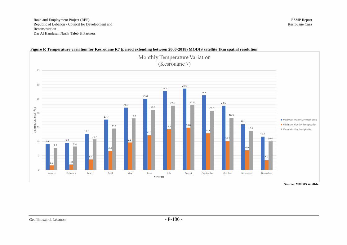
Geoflint s.a.r.l, Lebanon - P-186 -
Road and Employment Project (REP) ESMP Report
Kesrouane Caza Republic of Lebanon - Council for Development and
Reconstruction
Dar Al Handasah Nazih Taleb & Partners
Figure R Temperature variation for Kesrouane R7 (period extending between 2000-2018) MODIS satellite 1km spatial resolution
Source: MODIS satellite

Geoflint s.a.r.l, Lebanon - P-187 -
Road and Employment Project (REP) ESMP Report
Kesrouane Caza Republic of Lebanon - Council for Development and
Reconstruction
Dar Al Handasah Nazih Taleb & Partners
Table A Kesrouane R2a & Kesrouane R2c existing acoustic conditions (location of stations shown in
Figure S and Figure U)
December 3,
2018
Time Road
Section Station Min
(dB)
Leq (avg)
(dB)
Max
(dB)
Allowable
Noise Level
11:10
Road 2a
00+000 47.1 68.2 77.4
Refer to
Table 2-6
11:18 00+800 50.7 63.7 72
11:28 01+500 46.1 61.6 70.9
11:36 03+500 45.8 59.8 67.7
11:44 04+300 40.5 59.6 70.8
11:57 06+400 47.5 61.3 72.1
12:05 07+100 50.1 65.5 75.1
12:31 07+900 58 74.2 82.9
12:43 09+100 38.6 63.1 78
12:59 09+900 40.7 47.6 54.2
13:23 11+000 39.7 60.5 72.2
13:42 13+750 33.5 38.5 46.2
14:00 14+350 51.5 61.8 70.5
14:49 15+000 58.1 76.2 88.3
15:24 17+700 34.7 45.6 53.9
15:44 18+900 44.1 62.5 71.2
16:25
Road 2c
0+000 40.7 55 64.8
16:36 1+000 42.9 55.5 62.1
16:56 1+700 46.2 73.5 82.2
17:04 2+500 60.5 76.3 82.6
17:15 4+700 70.3 78.3 83.5
17:30 5+100 56.2 63.5 72.2 Source: Geoflint acoustic survey, 2018
Table B Kesrouane R2b existing acoustic conditions (location of stations shown in Figure T)
November 29, 2018
Time Section Min
(dB)
Leq (avg)
(dB)
Max
(dB)
Allowable
Noise
Level
11:09 0+000 44.9 64.4 76.5 Refer to
Table 2-6 11:27 1+600 38.1 47 57.9
12:16 2+500 45.4 74.3 83.6
Source: Geoflint acoustic survey, 2018
Table C Kesrouane R7 existing acoustic conditions (location of stations shown in Figure V)
November 30, 2018
Time Section Min
(dB)
Leq (avg)
(dB)
Max
(dB)
Allowable
Noise
Level
12:05 0+000 58 79 72.4 Refer to
Table 2-6 12:18 0+600 36.6 77.3 71.5
12:34 2+800 52.7 73.8 71.8

Geoflint s.a.r.l, Lebanon - P-188 -
Road and Employment Project (REP) ESMP Report
Kesrouane Caza Republic of Lebanon - Council for Development and
Reconstruction
Dar Al Handasah Nazih Taleb & Partners
12:58 5+000 55.3 68.1 64.9
13:14 5+900 38.9 53.2 51.5
Source: Geoflint acoustic survey, 2018
Table D Comparing decibel measurements to an ordinary conversation (Trace R&D Center University
of Wisconsin-Madison, 2004)
Sound Environment Sound Pressure Level (dB)
Approximate loudness with
regard to ordinary
conversation
Threshold of hearing 0 Don’t hear anything
Broadcast studio interior or resulting leaves 10 1/32nd as loud as conversation
Quiet house interior or rural night-time 20 1/16th as loud
Quiet office interior or watch ticking 30 1/8th as loud
Quiet rural area and small theatre 40 1/4th as loud
Quiet suburban area of dishwasher in next
room 50 ½ as loud
Office interior or ordinary conversation 60 Ordinary conversation
Vacuum cleaner at 10 ft 70 Twice as loud
Passing car at 10ft or garbage disposal at 3ft 80 4 times as loud
Passing bus or truck at 10ft or food blender
at 3ft 90 8 times as loud
Passing subway train at 10ft 100 16 times as loud
Nigh club with band playing 110 32 times as loud
Threshold of pain 120 64 times as loud as conversation
Source: Trace R&D Center University of Wisconsin-Madison, 2004

Geoflint s.a.r.l, Lebanon - P-189 -
Road and Employment Project (REP) ESMP Report
Kesrouane Caza Republic of Lebanon - Council for Development and Reconstruction
Dar Al Handasah Nazih Taleb & Partners
Figure S LULC map with work stations shown in red along Kesrouane R2a alignment

Geoflint s.a.r.l, Lebanon - P-190 -
Road and Employment Project (REP) ESMP Report
Kesrouane Caza Republic of Lebanon - Council for Development and Reconstruction
Dar Al Handasah Nazih Taleb & Partners
Figure T LULC map with work stations shown in red along Kesrouane R2b alignment

Geoflint s.a.r.l, Lebanon - P-191 -
Road and Employment Project (REP) ESMP Report
Kesrouane Caza Republic of Lebanon - Council for Development and Reconstruction
Dar Al Handasah Nazih Taleb & Partners
Figure U LULC map with work stations shown in red along Kesrouane R2c

Geoflint s.a.r.l, Lebanon - P-192 -
Road and Employment Project (REP) ESMP Report
Kesrouane Caza Republic of Lebanon - Council for Development and Reconstruction
Dar Al Handasah Nazih Taleb & Partners
Figure V LULC map with work stations shown in red along Kesrouane R7 alignment

Geoflint s.a.r.l, Lebanon - P-193 -
Road and Employment Project (REP) ESMP Report
Kesrouane Caza Republic of Lebanon - Council for Development and
Reconstruction
Dar Al Handasah Nazih Taleb & Partners
Table E Resident population, 2010-2017
Kesrouane Caza Demographic Profile*
Percent of total population
Year Value
2010 4.15%
2017 3.81%
Population
2010 164,489
2011 165,216
2012 165,875
2013 166,480
2014 167,039
2015 167,584
2016 168,176
2017 168,678
*Excluding Palestinian camps and Syrian displaced Source: MoPH; 2017
Figure W Age distribution in Kesrouane caza
Source: MoPH; 2017
Table F Distribution of families in accordance with type of housing and occupancy
Item
House Total
Building Detached
Number % Number % Number %
Owned by family 17781 71.91 5496 85.65 23287 74.58
Partly owned 331 1.34 135 2.1 466 1.49
Rented 5268 21.31 414 6.45 5693 18.23
Other 1345 5.44 373 5.81 1780 5.70
Total 24726 100 6417 100 31226 100
0 2 4 6 8 10 12
0-4
10-14
20-24
30-37
40-44
50-54
60-64
70-74
80-84
Percentage (%)
Ag
e D
istr
ibu
tio
n

Geoflint s.a.r.l, Lebanon - P-194 -
Road and Employment Project (REP) ESMP Report
Kesrouane Caza Republic of Lebanon - Council for Development and
Reconstruction
Dar Al Handasah Nazih Taleb & Partners
Source: RELK, 2017
Table G Kesrouane connection rates
Caza Well Water Network Sewerage Network
Unknown Yes No Yes No Yes No
Kesrouane 508 23,576 23,657 427 5,772 18,312 789 Source: RELK, 2014
Table H Wastewater management in Kesrouane caza
Source
House Total
In a building Detached
Count % Count % Count %
Public wastewater
network 11458 46.34 838 13.06 12297 39.38
Septic tank 12668 51.23 5537 86.03 18278 58.26
Open channels 103 0.42 21 0.32 124 0.40
No network 24726 100 6417 100 31226 100
Source: RELK, 2014
Table I Major wastewater treatment units
Location Treatment Level Capacity (m3/day) Population Served
Hrajel Secondary 6,000 37,000
Mairouba Secondary + biofiltration 70,000 505,000
Source: Geoflint, 2016
Table J Health services in Kesrouane
Item Count
Hospitals number 2
Pharmacies number 29
Infirmaries number 15 Source: Geoflint, 2016
Table K Number of Syrians Displaced as per UNHCR
Caza Total No. of Persons Total No. of Families
Kesrouane 16,326 4,608
Source: UNHCR, 2016
Table L Relevant sensitive receptors encountered along and near Kesrouane R2a
Category Label Distance (m)
Church Mar Gerges Church (St George Church) 3
Shrine Mzar Mar Rafqa (Saint Rafqa Shrine) 4
Place of worship Church 7
Church Mar Charbel Church (St Charbel Church) 8
Shrine Mzar Al Saydet (Our Lady Shrine) 10
Church Church 13
Shrine Mzar Al Saydet (Our Lady Shrine) 31

Geoflint s.a.r.l, Lebanon - P-195 -
Road and Employment Project (REP) ESMP Report
Kesrouane Caza Republic of Lebanon - Council for Development and
Reconstruction
Dar Al Handasah Nazih Taleb & Partners
School First Bishopric School 31
Church Mar Youhanna Church (St John Church) 32
Church Saydet Al Maounate Church (Our Lady Of Care Church) 33
Church Mar Gerges Church (St George Church) 36
Church Saint Jane Church 38
Church Saydet Al Aataya Church (Our Lady Of Al-Aataya Church) 80
School Adma International School - Mar Nouhra 156
Church Saydet Al Wardieh Church (Our Lady Of The Rosary Church) 165
School School of Adma 231
Church Saydet Al Najat Church (Our Lady Of Deliverance Church) 277
Church Sayde al kwali Church 308
Place of worship Georges Nakhoul 314
Monastery Deir Mar Yaaqoub (St Jacob Monastery) 322
Place of worship Church 324
Hospital Qartbawi For Medical Rehabilitation Hospital 333
Church Mar Sassine Church (St Sassine Church) 343
Archeological Fatqa Archaeological House 2 363
Shrine Mzar Saydet Al Khalass (Our Lady Of Salvation Shrine) 367
Church Mar Elias Church (St Elias Church) 374
School Nahr Ibrahim Mixed Public Middle School 460
School Garderie Baby Power 486
Archeological Fatqa Archaeological House 1 494
Church Al Saydeh Church (Our Lady Church) 499
Source: Geoflint s.a.r.l. survey results, 2019
Table M Relevant sensitive receptors encountered along and near Kesrouane R2b
Category Label Distance (m)
Church Church 111
Church Church 162
Church Saydet Nisbay Church (Saydet Al Nasser Church) 165
Church Mar Elias Church (St Elias Church) 173
Church Mar Gerges Church (St George Church) 191
School Ain Al Waraka Convent And School 216
Church Mar Joachim Church (St Joachim Church) 235
School Ghosta Public Secondary School 247
Church El Moukhalles Church (Holy Savior Church) 444
Monastery Deir Al Karim (Al Karim Monastery) 458
Church Saydet Al Ouata Church (Our Lady Of Al-Ouata Church) 498
Source: Geoflint s.a.r.l. survey results, 2019
Table N Relevant sensitive receptors encountered along and near Kesrouane R2c
Category Label Distance (m)
Church Mar Gerges Church (St George Church) 18
Monastery Deir Mar Abda (St Abdon Monastery) 61

Geoflint s.a.r.l, Lebanon - P-196 -
Road and Employment Project (REP) ESMP Report
Kesrouane Caza Republic of Lebanon - Council for Development and
Reconstruction
Dar Al Handasah Nazih Taleb & Partners
Church Al Saydeh Church (Our Lady Church) 70
Church Mar Charbel Church (St Charbel Church) 80
School Kfour Mixed Public School 88
School Kfour Mixed Public Secondary School 100
Place of worship Saaideh Church 102
Church Mar Antonios Church (St Anthony Church) 172
Church Al Saydeh Church (Our Lady Church) 191
Church Mar Youhanna Church (St John Church) 203
Church Mar Mikhael Church (St Michael Church) 352
Monastery Deir Mar Nqoula (St Nicholas Monastery) 468
Church Mar Nicolas Church (St Nicolas Church) 470
School 484
Source: Geoflint s.a.r.l. survey results, 2019
Table O Relevant sensitive receptors encountered along and near Kesrouane R7
Category Label Distance (m)
Church Saydet Al Najat Church (Our Lady Of Deliverance Church) 19
Church Deir Saydet Al Wardieh (Our Lady Of Al Wardieh Convent) 42
School Kfar Dibiane Public Middle School 87
Church Saydet En Niyah Monastery 107
Church Mar Gerges Church (St George Church) 151
School Sayedat Al Niyah Mixed Public School Bqaatouta 206
Church Mar Antonios Church (St Anthony Church) 215
Church Mar Ifram Al Syriani Church 318
Place of worship Mar Ephrem Church 327
Church St. Youssef El Ksar Church 405
Source: Geoflint s.a.r.l. survey results, 2019
Table P Wastewater related acitivities in Kesrouane caza
Project Estimated
value
(US$
million)
Source of Funding Start
Date
Estimated
Completion
Date
Execution of the emergency
wastewater
sea outfall in the coastal
region of Kesrouane
1,563 Local Funding
December
2017
Nov-19
Construction of sewer networks and
two wastewater treatment plants in
Kesrouane coastal region (Ghazir)
175
European Investment
Bank
and French Development
Agency + EU + NIF
Jun-19 Dec-22
Construction of sewer networks and
a treatment plant for Hrajel region
- Kesrouane
24 Italian Protocol Sep-18 December
2021
Construction of sewer networks and
a treatment plant for Jeita region
- Keserwan (Sections 1, 2 and 3)
38 German Agency, KFW
and local, funding Dec-18 Jun-21
Source: CDR progress report 2017
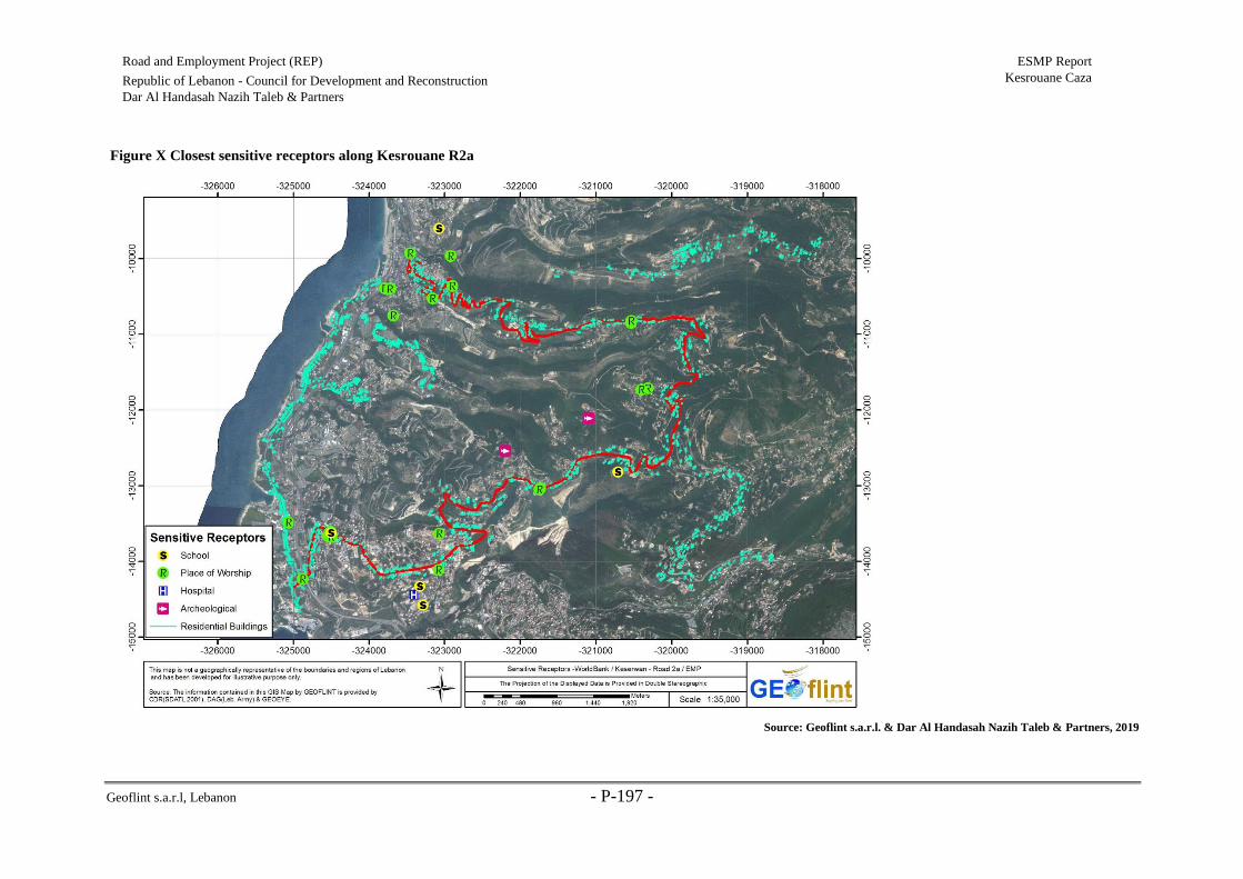
Geoflint s.a.r.l, Lebanon - P-197 -
Road and Employment Project (REP) ESMP Report
Kesrouane Caza Republic of Lebanon - Council for Development and Reconstruction
Dar Al Handasah Nazih Taleb & Partners
Figure X Closest sensitive receptors along Kesrouane R2a
Source: Geoflint s.a.r.l. & Dar Al Handasah Nazih Taleb & Partners, 2019

Geoflint s.a.r.l, Lebanon - P-198 -
Road and Employment Project (REP) ESMP Report
Kesrouane Caza Republic of Lebanon - Council for Development and Reconstruction
Dar Al Handasah Nazih Taleb & Partners
Figure Y Closest sensitive receptors along Kesrouane R2b
Source: Geoflint s.a.r.l. & Dar Al Handasah Nazih Taleb & Partners, 2019

Geoflint s.a.r.l, Lebanon - P-199 -
Road and Employment Project (REP) ESMP Report
Kesrouane Caza Republic of Lebanon - Council for Development and Reconstruction
Dar Al Handasah Nazih Taleb & Partners
Figure Z Closest sensitive receptors along Kesrouane R2c
Source: Geoflint s.a.r.l. & Dar Al Handasah Nazih Taleb & Partners, 2019

Geoflint s.a.r.l, Lebanon - P-200 -
Road and Employment Project (REP) ESMP Report
Kesrouane Caza Republic of Lebanon - Council for Development and Reconstruction
Dar Al Handasah Nazih Taleb & Partners
Figure AA Closest sensitive receptors along Kesrouane R7
Source: Geoflint s.a.r.l. & Dar Al Handasah Nazih Taleb & Partners, 2019

Geoflint s.a.r.l, Lebanon - P-201 -
Road and Employment Project (REP) ESMP Report
Kesrouane Caza Republic of Lebanon - Council for Development and Reconstruction
Dar Al Handasah Nazih Taleb & Partners
Figure BB Distribution of ATC Stations throughout Kesrouane Caza
Source: Dar Al Handasah Nazih Taleb & Partners, 2019

Geoflint s.a.r.l, Lebanon - P-202 -
Road and Employment Project (REP) ESMP Report
Kesrouane Caza Republic of Lebanon - Council for Development and
Reconstruction
Dar Al Handasah Nazih Taleb & Partners
Table Q ADT values for Kesrouane roads 2a & 2c
Caza Road Station Direction ADT
(veh/day)
Kesrouane Roads 2a & 2c
K2a-2 Eastbound 5,250
Westbound 5,006
K2a-3 Northbound 1,415
Southbound 1,435
K2a-4 Eastbound 149
Westbound 135
Table R Type of vehicles passing Kesrouane Roads 2a & 2c
Kesrouane roads 2a&2c
Vehicle Class Type Percentage (%)
Class 1 Motorcycles 3.9
Class 2 Passenger Cars 91.8
Class 3 4-tire trucks 2.7
Class 4 Buses 0
Class 5 2-axle (6 tire trucks) 0.8
Class 6 3-axle trucks 0.3
Class 7 4+ axle trucks 0.3
Class 8 3-4 axle single-trailer combinations 0.1
Class 9 5-axle single-trailer combinations 0
Class 10 6+ axle single-trailer combinations 0
Class 11 5- axle multi-trailer combinations 0
Class 12 6- axle multi-trailer combinations 0
Class 13 7+ axle multi-trailer combinations 0
Others - 1.5
Table S ADT values for Kesrouane R2b
Caza Road Station Direction ADT
(veh/day)
Kesrouane Road 2b K2b-1 Northbound 918
Southbound 922
Table T Type of vehicles passing Kesrouane R2b
Kesrouane road 2b
Vehicle Class Type Percentage (%)
Class 1 Motorcycles 4.5
Class 2 Passenger Cars 92.7
Class 3 4-tire trucks 1.7
Class 4 Buses 0
Class 5 2-axle (6 tire trucks) 0.8
Class 6 3-axle trucks 0..1
Class 7 4+ axle trucks 0.1
Class 8 3-4 axle single-trailer combinations 0
Class 9 5-axle single-trailer combinations 0

Geoflint s.a.r.l, Lebanon - P-203 -
Road and Employment Project (REP) ESMP Report
Kesrouane Caza Republic of Lebanon - Council for Development and
Reconstruction
Dar Al Handasah Nazih Taleb & Partners
Class 10 6+ axle single-trailer combinations 0
Class 11 5- axle multi-trailer combinations 0
Class 12 6- axle multi-trailer combinations 0
Class 13 7+ axle multi-trailer combinations 0
Others - 1.7
Table U ADT values for Kesrouane R7
Caza Road Station Direction ADT
(veh/day)
Kesrouane Road 7 K7-1 Eastbound 1,009
Westbound 987
Table V Type of vehicles passing Kesrouane R7
Kesrouane road 7
Vehicle Class Type Percentage (%)
Class 1 Motorcycles 2.3
Class 2 Passenger Cars 90.7
Class 3 4-tire trucks 3.2
Class 4 Buses 0
Class 5 2-axle (6 tire trucks) 1.8
Class 6 3-axle trucks 1.4
Class 7 4+ axle trucks 0.6
Class 8 3-4 axle single-trailer combinations 0
Class 9 5-axle single-trailer combinations 0
Class 10 6+ axle single-trailer combinations 0
Class 11 5- axle multi-trailer combinations 0
Class 12 6- axle multi-trailer combinations 0
Class 13 7+ axle multi-trailer combinations 0
Others - 0

Geoflint s.a.r.l, Lebanon - P-204 -
Road and Employment Project (REP) ESMP Report
Kesrouane Caza Republic of Lebanon - Council for Development and Reconstruction
Dar Al Handasah Nazih Taleb & Partners
Annex 2: Road Signs, Markings, Lights, and Barricades to be Used during Rehabilitation Works

Geoflint s.a.r.l, Lebanon - P-205 -
Road and Employment Project (REP) ESMP Report
Kesrouane Caza Republic of Lebanon - Council for Development and Reconstruction
Dar Al Handasah Nazih Taleb & Partners

Geoflint s.a.r.l, Lebanon - P-206 -
Road and Employment Project (REP) ESMP Report
Kesrouane Caza Republic of Lebanon - Council for Development and Reconstruction
Dar Al Handasah Nazih Taleb & Partners

Geoflint s.a.r.l, Lebanon - P-207 -
Road and Employment Project (REP) ESMP Report
Kesrouane Caza Republic of Lebanon - Council for Development and Reconstruction
Dar Al Handasah Nazih Taleb & Partners
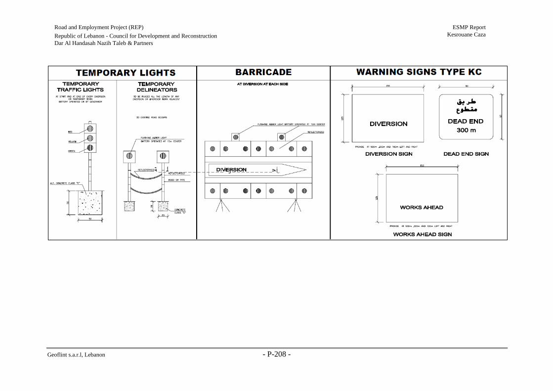
Geoflint s.a.r.l, Lebanon - P-208 -
Road and Employment Project (REP) ESMP Report
Kesrouane Caza Republic of Lebanon - Council for Development and Reconstruction
Dar Al Handasah Nazih Taleb & Partners

Geoflint s.a.r.l, Lebanon - P-209 -
Road and Employment Project (REP) ESMP Report
Kesrouane Caza Republic of Lebanon - Council for Development and
Reconstruction
Dar Al Handasah Nazih Taleb & Partners
Annex 3: Code of Conduct
Table W Contractor Code of Conduct Form
Contractor Code of Conduct:
1. All employees, associates, and representatives commit to treating women, children (under the age of
18), and men with respect, regardless of race; color; language; religion; political or other opinion;
national, ethnic or social origin; sexual orientation or gender identity; disability; birth or other status.
2. GBV constitutes acts of gross misconduct and is therefore grounds for sanction, which may include
penalties and/or termination of employment. All forms of GBV are unacceptable, regardless of
whether they take place on the worksite, the worksite surroundings, or off-site. In addition to the
potential sanctions listed above, legal prosecution will be pursued, if appropriate, for any employees,
associates, and representatives alleged to have committed GBV.
3. Demeaning, threatening, harassing, abusive, or sexually provocative language and behavior are
prohibited among all company employees, associates, and representatives.
4. Sexual favors, making promises or favorable treatment dependent on sexual acts are prohibited.
5. Unless there is the full consent by all parties involved, sexual interactions between the company’s
employees (at any level) and members of the surrounding communities are prohibited. This includes
relationships involving the withholding or promise of any kind of reward.
6. All employees, including volunteers and sub-contractors are expected to report suspected or actual
GBV by a fellow worker, whether in the same company or not. Reports must be made in accordance
with GBV allegation procedures.
7. All employees are required to attend an induction training course prior to commencing work on site
to ensure they are familiar with the GBV Code of Conduct.
8. All employees must attend a mandatory training course once a month for the duration of the contract
starting from the first induction training prior to commencement of work to reinforce the
understanding of the institutional GBV Code of Conduct.
9. All employees will be required to sign an individual code of conduct confirming their agreement to
support GBV activities.
I do hereby acknowledge that I have read the foregoing GBV Code of Conduct, and on behalf of the company
agree to comply with the standards contained therein. I understand my role and responsibilities to prevent and
respond to GBV. I understand that any action inconsistent with this Code of Conduct or failure to take action
mandated by this Code of Conduct may result in disciplinary action.
Company Name:
Signed by:
Title:
Date:

Geoflint s.a.r.l, Lebanon - P-210 -
Road and Employment Project (REP) ESMP Report
Kesrouane Caza Republic of Lebanon - Council for Development and
Reconstruction
Dar Al Handasah Nazih Taleb & Partners
Table X Individual Code of Conduct Form
• This individual Code of Conduct should be signed by all employees, from senior managers through
the operational staff, and should also be required from any contractors working with the company.
• I, acknowledge that preventing gender-based violence (GBV) is important, and
that preventing it is my responsibility. At [Company], GBV activities constitute acts of gross
misconduct and are therefore grounds for sanctions, penalties or potential termination of employment.
All forms of GBV are unacceptable, be it on the worksite, the worksite surroundings, or in the
community. Prosecution of those who commit GBV may be pursued if appropriate.
• I agree that while working on the [Project], I will:
• Consent to a police background check.
• Treat women, children (persons under the age of 18), and men with respect regardless of race; color;
language; religion; political or other opinion; national, ethnic or social origin; sexual orientation or
gender identity; disability; birth or other status.
• Not use language or behavior towards women, children or men that is inappropriate, harassing,
abusive, sexually provocative, demeaning or culturally inappropriate.
• Not request or engage in sexual favors—for instance, making promises or favorable treatment
dependent on sexual acts.
• Understand that unless there is the full consent by all parties involved, sexual interactions between the
company’s employees (at any level) and members of the surrounding communities are prohibited. This
includes relationships involving the withholding or promise of monetary or non-monetary reward.
• Attend and actively partake in training courses related to HIV/AIDS and GBV as requested by my
employer.
• Report through the grievance redress mechanism or to my manager any suspected or actual GBV by
a fellow worker, whether in my company or not, or any breaches of this Code of Conduct.
Sanctions
[Company] has established a grievance redress mechanism for receiving, reviewing, and addressing
allegations of GBV. If an employee has breached the Code of Conduct, the employer will take disciplinary
action which could include:
• Informal warning
• Formal warning
• Additional training
• Loss of up to one week’s salary
• Suspension of employment (without payment of salary), for a minimum period of one month up
to a maximum of six months
• Termination of employment
In addition to the above, if warranted, [Company] will report the employee to the police as per local legal
regulations.
I understand that it is my responsibility to use common sense and avoid actions or behaviors that could be
construed as GBV or breach this Code of Conduct. I do hereby acknowledge that I have read the foregoing
Code of Conduct, do agree to comply with the standards contained therein and understand my roles and
responsibilities to prevent and respond to GBV. I understand that any action inconsistent with this Code of
Conduct or failure to take action mandated by this Code of Conduct may result in disciplinary action and may
affect my ongoing employment.
Individual Name:
Signed by:
Title:
Date:

Geoflint s.a.r.l, Lebanon - P-211 -
Road and Employment Project (REP) ESMP Report
Kesrouane Caza Republic of Lebanon - Council for Development and
Reconstruction
Dar Al Handasah Nazih Taleb & Partners
Annex 4: Public Consultation Notes, Presentation, Invitation Letters, and Attendance
Sheets
Notes:
Kfour Meeting
During the meeting at Kfour Municipality, generally, attendees were worried about the start
day of the project. More specifically, Women, who were consulted seperatly after the meeting,
were worried about the coordination with relevant authorities, especially with respect to public
works (i.e. wastewater and water infrastructure, etc.). Women were worried whether there
would be coordination among ministries and infrastructural institutions before the project
implementation to avoid re-excavations of roads and further disturbances and pressures. In this
context, the public was informed that CDR will ensure that a full coordination among
municipalities and authorities prior to project execution. Finally, the consultant mentioned that
the implementation of the project is expected to start in spring 2020.
Some technical concerns where revealed as well during the meeting including whether the
scope of work encompasses installing new drainage systems when needed and fixing retaining
walls that are in bad conditions. In this context, the consultant explained that, when needed,
proper drainage systems will be installed and existing retaining walls will be improved.
Kfardebian Meeting
During the second meeting held at Kfardebiane, the main concern was in relation to the road
starting at Feytroun and leading to Kfardebian and the concerned towns and villages that is not
integrated in this project. According to the attendees, namely the head of Kfardebiane
Municipality, Aajaltoun-Feytroun road is a key entry road to Kesrouane villages and in great
need for rehabilitation. Similarly, the Mekhtar of Maarab mentioned as well the road from
Maarab to Dlebta that needs rehabilitation and is not integrated in REP. In this context,
attendees asked if they can still suggest alternative roads for rehabilitation under the project.
Accordingly, the consultant and the CDR Representative explained that the project cannot
integrate any alternative roads, however, they can send their requests in relation to alternative
roads to the MoPWT for future projects.
The common concerns of attendees in the two arranged meetings for Kesrouane caza include:
(1) The concerned municipalities were firstly interested regarding their main role in this project
and in monitoring any potential law violations by the contractor during the rehabilitation
phase. The heads of municipalities mentioned that during previous projects, they faced
problems with contractors dumping rehabilitation wastes near the rehabilitation site (e.g.
near streams). They were worried to witness similar behavior during the REP project. In
particular, they asked about the procedure of sending their complaints in case the contractor
did not abide by the ESMP guidelines. In this context, the consultant and the representative
of CDR explained that as head of municipalities their main role is to inform people about
the project and at a later stage, they have a major role in assisting CDR in monitoring the

Geoflint s.a.r.l, Lebanon - P-212 -
Road and Employment Project (REP) ESMP Report
Kesrouane Caza Republic of Lebanon - Council for Development and
Reconstruction
Dar Al Handasah Nazih Taleb & Partners
contractor during project implementation. Any violation observed must be reported to
CDR. Moreover, the representative of CDR explained to the concerned parties that:
• The project will include a grievance redress mechanism (GRM) that will
register and address grievances and complaints from individuals and
households who are affected by the project. Any complaints must be
reported to CDR.
• Project monitoring and verification will be undertaken by CDR, the
implementing agency, to ensure the project is being implemented in line
with the proposed objectives (a supervisory consultant will be monitoring
the contractor during the rehabilitation phase ensuring he is abiding by the
ESMP). Moreover, it was explained that if the contractor did not comply
with the set social and environmental guidelines, they will face penalties.
• Progress reports will be prepared by CDR to the Bank for review. Moreover,
the World Bank will ensure continuous implementation support.
• World Bank specialists who are based in Beirut will have regular interaction
with CDR. This will allow the Bank to perform continuous monitoring of
works.
(2) Second, local authorities present at both meetings were not satisfied about the selection of
roads within the scope of REP. According to them, there are roads that are in greater need
for rehabilitation. They asked about the selection process as they were not consulted at the
beginning of the project. In this context, the consultant explained that the Government
prioritized roads in Kesrouane Caza based on municipalities’ official requests beside
several technical criteria.

Geoflint s.a.r.l, Lebanon - P-213 -
Road and Employment Project (REP) ESMP Report
Kesrouane Caza Republic of Lebanon - Council for Development and
Reconstruction
Dar Al Handasah Nazih Taleb & Partners
Photos:
Public Participation meeting at Jounieh Municipality
Public Participation meeting at Kfour Municipality (1)

Geoflint s.a.r.l, Lebanon - P-214 -
Road and Employment Project (REP) ESMP Report
Kesrouane Caza Republic of Lebanon - Council for Development and
Reconstruction
Dar Al Handasah Nazih Taleb & Partners
Public Participation meeting at Kfour Municipality (2)

Geoflint s.a.r.l, Lebanon - P-215 -
Road and Employment Project (REP) ESMP Report
Kesrouane Caza Republic of Lebanon - Council for Development and
Reconstruction
Dar Al Handasah Nazih Taleb & Partners
Public Participation meeting at Kfardebiane Municipality

Geoflint s.a.r.l, Lebanon - P-216 -
Road and Employment Project (REP) ESMP Report
Kesrouane Caza Republic of Lebanon - Council for Development and Reconstruction
Dar Al Handasah Nazih Taleb & Partners

Geoflint s.a.r.l, Lebanon - P-217 -
Road and Employment Project (REP) ESMP Report
Kesrouane Caza Republic of Lebanon - Council for Development and Reconstruction
Dar Al Handasah Nazih Taleb & Partners
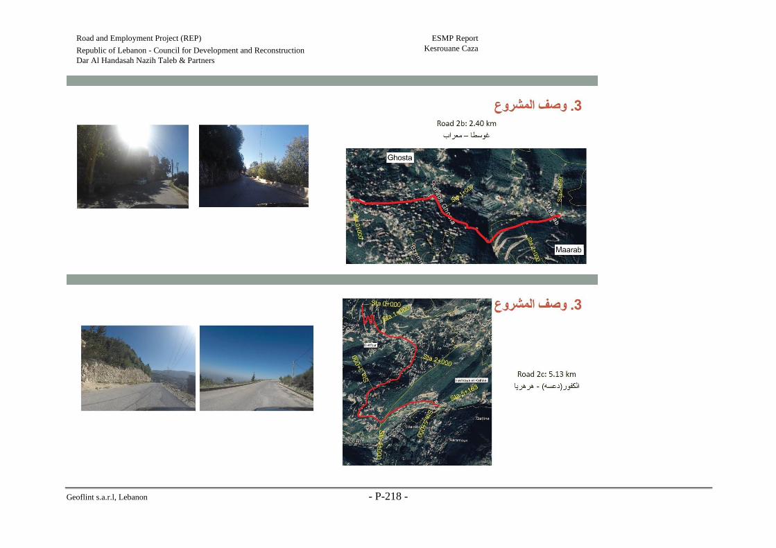
Geoflint s.a.r.l, Lebanon - P-218 -
Road and Employment Project (REP) ESMP Report
Kesrouane Caza Republic of Lebanon - Council for Development and Reconstruction
Dar Al Handasah Nazih Taleb & Partners
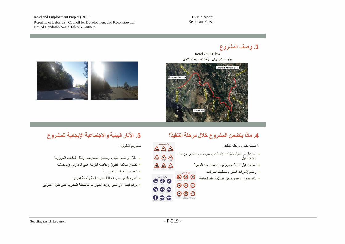
Geoflint s.a.r.l, Lebanon - P-219 -
Road and Employment Project (REP) ESMP Report
Kesrouane Caza Republic of Lebanon - Council for Development and Reconstruction
Dar Al Handasah Nazih Taleb & Partners

Geoflint s.a.r.l, Lebanon - P-220 -
Road and Employment Project (REP) ESMP Report
Kesrouane Caza Republic of Lebanon - Council for Development and Reconstruction
Dar Al Handasah Nazih Taleb & Partners
Geoflint s.a.r.l, Lebanon - P-221 -
Road and Employment Project (REP) ESMP Report
Kesrouane Caza Republic of Lebanon - Council for Development and Reconstruction
Dar Al Handasah Nazih Taleb & Partners

Geoflint s.a.r.l, Lebanon - P-222 -
Road and Employment Project (REP) ESMP Report
Kesrouane Caza Republic of Lebanon - Council for Development and Reconstruction
Dar Al Handasah Nazih Taleb & Partners

Geoflint s.a.r.l, Lebanon - P-223 -
Road and Employment Project (REP) ESMP Report
Kesrouane Caza Republic of Lebanon - Council for Development and Reconstruction
Dar Al Handasah Nazih Taleb & Partners

Geoflint s.a.r.l, Lebanon - P-224 -
Road and Employment Project (REP) ESMP Report
Kesrouane Caza Republic of Lebanon - Council for Development and Reconstruction
Dar Al Handasah Nazih Taleb & Partners

Geoflint s.a.r.l, Lebanon - P-225 -
Road and Employment Project (REP) ESMP Report
Kesrouane Caza Republic of Lebanon - Council for Development and Reconstruction
Dar Al Handasah Nazih Taleb & Partners

Geoflint s.a.r.l, Lebanon - P-226 -
Road and Employment Project (REP) ESMP Report
Kesrouane Caza Republic of Lebanon - Council for Development and Reconstruction
Dar Al Handasah Nazih Taleb & Partners

Geoflint s.a.r.l, Lebanon - P-227 -
Road and Employment Project (REP) ESMP Report
Kesrouane Caza Republic of Lebanon - Council for Development and Reconstruction
Dar Al Handasah Nazih Taleb & Partners
Annex 5: Complaint Register Form
Table Y Complaints Registration Form
Name, phone
and address of
Complainant
Date of the
complaint
Complaint
issue and
action taken
Corrective
Action
Name of
employer/
representative
notified of
complaint
Type of
Complaint
Date
of
close
out

Geoflint s.a.r.l, Lebanon - P-228 -
Road and Employment Project (REP) ESMP Report
Kesrouane Caza Republic of Lebanon - Council for Development and Reconstruction
Dar Al Handasah Nazih Taleb & Partners