reported exposures of paleozoic rocks in michigan and type ...
126
Publication 50 -- Reported Exposures of Paleozoic Rocks - Subject Index – Page 1 of 126 State of Michigan DEPARTMENT OF CONSERVATION Gerald E. Eddy, Director GEOLOGICAL SURVEY DIVISION William L. Daoust, State Geologist Publication 50 AN INDEX of the GEOLOGY OF MICHIGAN 1823-1955 Copyrighted by Michigan Department of Conservation 1956 SPEAKER-HINES & THOMAS, INC., STATE PRINTERS, LANSING, MICH., 1956 CONTENTS Reported Exposures of Paleozoic Rocks in Michigan ...... 1 Northern Peninsula ........................................................ 1 Southern Peninsula ..................................................... 12 Progress of Topographic Mapping in Michigan............... 24 Miscellaneous Contributions to Michigan Geology in Department of Conservation Reports ............................. 27 Land Economic Survey................................................ 27 Section Engineering and Architecture ......................... 28 Michigan Conservation (Public Education in Geology).28 References to Michigan Geology and Mineral Resources, Muriel Tara Straight ..................................... 29 Author Index ................................................................ 33 Subject Index ............................................................. 106 FIGURES 12. Map showing progress of topographic mapping, 15-minute quadrangles....................................................................24 13. Map showing progress of topographic mapping, 7½- minute quadrangles. .......................................................25 REPORTED EXPOSURES OF PALEOZOIC ROCKS IN MICHIGAN AND TYPE LOCALITIES This list of reported Paleozoic exposures was compiled from Michigan Geological Survey publications, from card files, open file reports, manuscripts and field notes in the Survey offices. As neither time nor budget permitted a field check of the exposures, without doubt some localities are omitted. However, this compilation should prove useful and errors will be corrected as exposures are checked in the field and as readers of this volume notify the Survey of omissions. See Index to Nomenclature. Cambrian: Alger, Baraga, Chippewa, Dickinson, Gogebic, Houghton, Iron, Keweenaw, Luce, Marquette, Ontonagon counties. Ozarkian: Alger, Dickinson, Marquette, Menominee counties. Ordovician: Alger, Chippewa, Delta, Iron, Menominee counties. Silurian: Chippewa, Delta, Houghton, Luce, Mackinac, Monroe, Schoolcraft counties. Devonian: Alpena, Antrim, Charlevoix, Cheboygan, Emmet, Leelanau, Monroe, Presque Isle, Wayne counties. Mississippian: Antrim, Arenac, Branch, Calhoun, Charlevoix, Eaton, Hillsdale, Huron, Iosco, Jackson, Kent, Ogemaw, Sanilac, Tuscola counties. Pennsylvanian: Arenac, Calhoun, Clinton, Huron, Ingham, Ionia, Jackson, Saginaw, Shiawassee counties. NORTHERN PENINSULA ALGER COUNTY Mathias Twp., W½ sec. 6, T44N, R20W. Exposure extends N into sec. 31, T45N, R20W. Black River. Mathias Twp., SW NW sec. 4, T44N, R21W. Black River. Mathias Twp., NW NW sec. 7, T44N, R21W. Black River. Mathias Twp., S½ sec. 7 and N½ sec. 18, T44N, R21W. Black River. Mathias Twp., sec. 12, E½ sec. 13, and sec. 24, T44N, R21W. Trenton. Mathias Twp., near W-line NW sec. 14, T44N, R21W. Trenton. Mathias Twp., SW SW sec. 15, T44N, R21W. On E side of road. Black River. Mathias Twp., E½ sec. 19, T44N, R21W. Near Trenary; also SW sec. 19, along Whitefish River. Trenton. Mathias Twp., SW sec. 20, T44N, R21W. Trenton. Mathias Twp., SW sec. 21, T44N, R21W. Trenton. Mathias Twp., SW sec. 22, T44N, R21W. Trenton. Mathias Twp., sec. 25 and E½ sec. 36, T44N, R21W. Trenton. Mathias Twp., sec. 30, T44N, R21W. Aband. quarry ¼ mi. S of Trenary; in bed of Whitefish River and along banks 100 yds. above bridge, US-41; in old RR cut just S of Trenary; also extends S through sec. 31. Trenton, Black River. Limestone Twp., NW sec. 9, T44N, R22W. Along Whitefish River. Black River.
-
Upload
khangminh22 -
Category
Documents
-
view
0 -
download
0
Transcript of reported exposures of paleozoic rocks in michigan and type ...

Publication 50 -- Reported Exposures of Paleozoic Rocks - Subject Index – Page 1 of 126
State of Michigan
DEPARTMENT OF CONSERVATION Gerald E. Eddy, Director
GEOLOGICAL SURVEY DIVISION William L. Daoust, State Geologist
Publication 50
AN INDEX of the
GEOLOGY OF MICHIGAN 1823-1955
Copyrighted by
Michigan Department of Conservation 1956
SPEAKER-HINES & THOMAS, INC., STATE PRINTERS, LANSING, MICH., 1956
CONTENTS Reported Exposures of Paleozoic Rocks in Michigan ...... 1
Northern Peninsula........................................................ 1 Southern Peninsula ..................................................... 12
Progress of Topographic Mapping in Michigan............... 24 Miscellaneous Contributions to Michigan Geology in Department of Conservation Reports ............................. 27
Land Economic Survey................................................ 27 Section Engineering and Architecture ......................... 28 Michigan Conservation (Public Education in Geology).28
References to Michigan Geology and Mineral Resources, Muriel Tara Straight ..................................... 29
Author Index ................................................................ 33 Subject Index............................................................. 106
FIGURES 12. Map showing progress of topographic mapping, 15-minute
quadrangles....................................................................24
13. Map showing progress of topographic mapping, 7½-minute quadrangles. .......................................................25
REPORTED EXPOSURES OF PALEOZOIC ROCKS IN MICHIGAN
AND TYPE LOCALITIES This list of reported Paleozoic exposures was compiled from Michigan Geological Survey publications, from card files, open file reports, manuscripts and field notes in the Survey offices. As neither time nor budget permitted a field check of the exposures, without doubt some localities are omitted. However, this compilation should prove useful and errors will be corrected as exposures are checked in the field and as readers of this volume notify the Survey of omissions.
See Index to Nomenclature.
Cambrian: Alger, Baraga, Chippewa, Dickinson, Gogebic, Houghton, Iron, Keweenaw, Luce, Marquette, Ontonagon counties.
Ozarkian: Alger, Dickinson, Marquette, Menominee counties.
Ordovician: Alger, Chippewa, Delta, Iron, Menominee counties.
Silurian: Chippewa, Delta, Houghton, Luce, Mackinac, Monroe, Schoolcraft counties.
Devonian: Alpena, Antrim, Charlevoix, Cheboygan, Emmet, Leelanau, Monroe, Presque Isle, Wayne counties.
Mississippian: Antrim, Arenac, Branch, Calhoun, Charlevoix, Eaton, Hillsdale, Huron, Iosco, Jackson, Kent, Ogemaw, Sanilac, Tuscola counties.
Pennsylvanian: Arenac, Calhoun, Clinton, Huron, Ingham, Ionia, Jackson, Saginaw, Shiawassee counties.
NORTHERN PENINSULA ALGER COUNTY
Mathias Twp., W½ sec. 6, T44N, R20W. Exposure extends N into sec. 31, T45N, R20W. Black River.
Mathias Twp., SW NW sec. 4, T44N, R21W. Black River. Mathias Twp., NW NW sec. 7, T44N, R21W. Black River. Mathias Twp., S½ sec. 7 and N½ sec. 18, T44N, R21W. Black
River. Mathias Twp., sec. 12, E½ sec. 13, and sec. 24, T44N, R21W.
Trenton. Mathias Twp., near W-line NW sec. 14, T44N, R21W. Trenton. Mathias Twp., SW SW sec. 15, T44N, R21W. On E side of
road. Black River. Mathias Twp., E½ sec. 19, T44N, R21W. Near Trenary; also
SW sec. 19, along Whitefish River. Trenton. Mathias Twp., SW sec. 20, T44N, R21W. Trenton. Mathias Twp., SW sec. 21, T44N, R21W. Trenton. Mathias Twp., SW sec. 22, T44N, R21W. Trenton. Mathias Twp., sec. 25 and E½ sec. 36, T44N, R21W. Trenton. Mathias Twp., sec. 30, T44N, R21W. Aband. quarry ¼ mi. S of
Trenary; in bed of Whitefish River and along banks 100 yds. above bridge, US-41; in old RR cut just S of Trenary; also extends S through sec. 31. Trenton, Black River.
Limestone Twp., NW sec. 9, T44N, R22W. Along Whitefish River. Black River.

Publication 50 -- Reported Exposures of Paleozoic Rocks - Subject Index – Page 2 of 126
Limestone Twp., SW sec. 10, T44N, R22W. Whitefish Falls on W Branch White-fish River. Black River. Hermansville.
Limestone Twp., sec. 14 and N½ sec. 15, T44N, R22W. Black River.
Limestone Twp., N½ sec. 24, T44N, R22W. Whitefish River. Black River.
Limestone Twp., NE sec. 26, T44N, R22W. Black River. Limestone Twp., SE sec. 29, T44N, R22W. Black River. Limestone Twp., NE NE sec. 1, T45N, R21W. On both sides
of road. Hermansville? Rock River Twp., W-line sec. 3, T45N, R21W. On both sides
of road, approx. 1 8/10 mi. S. of Chatham. Hermansville ? Limestone Twp., E½ sec. 13, T45N, R21W. Hermansville. Limestone Twp., S½ sec. 19, T45N, R21W, and S½ sec. 24,
T45N, R22W. Hermansville. Limestone Twp., sec. 29 and 30, T45N, R21W. Many
exposures, Black River. Hermansville. Limestone Twp., 31 and 32, T45N, R21W. Scattered
exposures. Black River. Limestone Twp., sec. 21, 22, 23, 24, 25, 27, 35, and 36, T45N,
R22W. Hermansville. Limestone Twp., sec. 26, 27, 35 and 36, T45N, R22W. Large
area of outcrops. Hermansville, Black River. Munising Twp., SE SW sec. 26, T46N, R17W. N of road in
area where soil has been stripped. Hermansville. Munising Twp., SW SE sec. 26, T46N, R17W. In ditches along
both sides of road for approx. 25 ft. Hermansville. Munising Twp., C sec. 35, T46N, R18W. Hermansville. Munising Twp., SE NW sec. 1, T46N, R19W. Tannery Falls.
Hermansville at brink of falls. Munising Twp., SW SE sec. 11, T46N, R19W. Alger Falls.
Hermansville at brink of falls. Munising Twp., NW NE sec. 14, T46N, R19W. Wagner Falls.
Hermansville. Lake Superior Sandstone: Munising. Au Train Twp., NW SE sec. 31, T46 N, R20W. Au Train Falls.
Hermansville. Cambrian. Onota Twp., sec. 5 and 6, T46N, R21W. Extends NW into
T47N, R22W. Camb-brian. Onota Twp., S½ sec. 9, T46N, R21W. Lake Superior
Sandstone. Rock River Twp., sec. 14, 15 and 16, T46N, R21W.
Hermansville. Lake Superior Sandstone. Rock River Twp., sec. 17 and 18, T46N, R21W. Approx. 2½
mi. N of Eben Junction in top of bluff on N side of creek. Hermansville.
Rock River Twp., sec. 17, 19, 20, 21, 26, 28, 29, 30, 33, 34, 35, and 36, T46N, R21W. Area of shallow drift. Hermansville.
Rock River Twp., C E-line sec. 18, T46N, R21W. In cut on both sides of road, N of Eben Junction. Hermansville.
Rock River Twp., C sec. 28, T46N, R21W. On both sides of road. Hermansville ?
Rock River Twp., sec. 29 and 30, T46N, R21W. Numerous exposures, vicinity of Eben Junction. Hermansville.
Rock River Twp., SE sec. 30, T46N, R21W. Quarry S of Eben. Hermansville.
Rock River Twp., C W-line sec. 34, T46N, R21W. On both sides of road. Hermansville ?
Onota Twp., W½ sec. 1, T46N, R22W. Extends W into sec. 2 and N into sec. 36, T47N, R22W. Cambrian.
Onota Twp., SW SW NE sec. 3, T46N, R22W. W side Laughing Whitefish Lake; also, NE SW sec. 3, SW side Laughing Whitefish Lake; NE SW SW sec. 3, W side Laughing Whitefish River. Lake Superior Sandstone. Jacobsville—Munising contact.
Onota Twp., sec. 3 and 9, T46N, R22W. Whitefish River. Cambrian: Lake Superior Sandstone.
Onota Twp., N½ sec. 6, T46N, R22W. Cambrian: Onota.
Onota Twp., N½ sec. 6, T46N, R22W. Cambrian. Rock River Twp., sec. 13, 14, 15, 23, 24, and 25, T46N,
R22W. Area of shallow drift and rock exposures. Rock River Twp., sec. 16, T46N, R22W. Lake Superior
Sandstone. Rock River Twp., NE NW SW sec. 16, T46N, R22W. Laughing
Whitefish Falls. Cambrian. Approx. ⅛ mi. upstream from falls. Hermansville in river bed.
Rock River Twp., C sec. 17, T46N, R22W. Cambrian. Rock River Twp., sec. 19, 20, and 29, T46N, R22W. River and
creek. Area of shallow drift and rock exposures. Hermansville.
Munising Twp., sec. 6, T47N, R18W. Grand Island, along W side Trout Point. Cambrian: Dresbach.
Munising Twp., SE NE NE sec. 15, T47N, R18W. Miner's Falls. Hermansville. Cambrian.
Munising Twp., SE sec. 17, T47N, R18W to SE sec. 12, T48N, R17W. Pictured Rocks. Nearly continuous exposure of Lake Superior Sandstone along shore. Cambrian: Jordan, Trempealeau, Mazomanie, Dresbach. Jacobsville.
Grand Island, sec. 1, 2, NW sec. 4, sec. 9, 12, SE sec. 15, sec. 16, NE sec. 22, and NE sec. 24, T47N, R19W. Grand Island, along shore. Cambrian: Lake Superior Sandstone.
Au Train Twp., sec. 6, T47N, R19W. Wood Island, along shore E side. Cambrian: Lake Superior Sandstone.
Au Train Twp., sec. 18, 19, and 27, T47N, R19W. Shore Lake Superior and W into sec. 24, T47N, R20W. Lake Superior Sandstone. Cambrian: Mazomanie, Dresbach.
Munising Twp., NE SW SE sec. 36, T47N, R19W. Munising Falls. Hermansville. Lake Superior Sandstone.
Au Train Twp., E-line sec. 13, T47N, R20W to C sec. 28, T47N, R20W. Along shore. Lake Superior Sandstone. Cambrian: Mazomanie, Dresbach. Au Train Twp., sec. 13, 14, 15, 21, 23, 24, and 28, T47N, R20W. Shore Lake Superior. Lake Superior Sandstone. Cambrian: Mazomanie, Dresbach.
Au Train Twp., sec. 13, 14, NE sec. 23, sec. 24, T47N, R20W. Lake Superior Sandstone.
Au Train Twp., SE sec. 24 and NE sec. 25, T47N, R20W. Sandstone ridges. Lake Superior Sandstone.
Onota Twp., sec. 5, T47N, R21W. Shore Lake Superior. Lake Superior Sandstone: Jacobsville.
Onota Twp., SW sec. 6, NE sec. 7, and SE sec. 8, T47N, R21W. N side of road. Jacobsville.
Onota Twp., sec. 7, 8, 16, 17, 18, 20, and 21, T47N, R21W. Lake Superior Sandstone.
Onota Twp., NE sec. 12, SW sec. 14, SW sec. 20, T47N, R21W. S side of road. Jacobsville.
Onota Twp., S-line sec. 9, T47N, R21W to W-line sec. 30, T48N, R21W. Along shore. Lake Superior Sandstone.
Onota Twp., sec. 11, T47N, R21W. Au Train Island, along E shore. Lake Superior Sandstone.
Onota Twp., SW sec. 14, T47N, R21W. S side of road. Jacobsville.
Onota Twp., NE NE sec. 17, T47N, R21W. Road cut. Jacobsville.
Onota Twp., SE SE SE sec. 19, T47N, R21W. Silver Falls. Lake Superior Sandstone.
Onota Twp., SW sec. 20, T47N, R21W. Jacobsville. Onota Twp., sec. 25, 26, 27, 35, and 36, T47N, R21W. Quarry
in sec. 26. Lake Superior Sandstone. Jacobsville. Onota Twp., NE NW sec. 26, T47N, R21W. In shallow ditches
on both sides of road. Lake Superior Sandstone: Jacobsville.
Onota Twp., SE NE sec. 26, T47N, R21W. Brownstone quarry. Lake Superior Sandstone: Jacobsville.
Onota Twp., sec. 26, T47N, R21W. Quarry. Jacobsville. Onota Twp., sec. 36, T47N, R21W. Roadside. Jacobsville.

Publication 50 -- Reported Exposures of Paleozoic Rocks - Subject Index – Page 3 of 126
Onota Twp., NE sec. 36, T47N, R21W. S side road. Jacobsville.
Onota Twp., NE and SW sec. 5, SE sec. 6, SW sec. 12, NE and SW sec. 14, E½ sec. 20, W½ sec. 21, NE sec. 28, and SW SW SE sec. 34, T47N, R22W. On W side of Laughing Whitefish Lake. Area of shallow drift, numerous rock exposures. Jacobsville.
Onota Twp., NE NE NW sec. 34, T47N, R22W. Sandstone in rapids. Lake Superior Sandstone. Probably Jacobsville.
Munising Twp., sec. 28, T48N, R17W. Chapel Falls, S end of Chapel Lake. Lake Superior Sandstone. Hermansville upstream from falls. Lake Superior below and to Lake Superior.
Munising Twp., SW sec. 16 and NE sec. 20, T48N, R19W. Grand Island, along shore. Lake Superior Sandstone. Jacobsville and Munising.
Au Train Twp., sec. 36, T48N, R20W. Wood Island, along shore. Lake Superior Sandstone.
Onota Twp., sec. 30, 31, and 32, T48N, R21W. Shore Lake Superior Lake Superior Sandstone.
Onota Twp., sec. 25, 26, 27, 32, and 34, T48N, R22W. Shore Lake Superior. Lake Superior Sandstone.
Onota Twp., sec. 35 and 36, T48N, R22W. Scattered exposures. Lake Superior Sandstone.
Burt Twp., NW SW sec. 5, T49N, R13W. Chipmunk Creek, exposure a few hundred rods S of W Bay Shore. Lake Superior Sandstone.
Burt Twp., SE corner sec. 6, T49N, R13W. In S part of Grand Marais. Lake Superior Sandstone.
Burt Twp., C sec. 8, T49N, R13W. Along road. Hermansville. Burt Twp., SW sec. 8, T49N, R13W. Hermansville. Burt Twp., N½ sec. 14, T49N, R13W. Possible contact of
Hermansville with Lake Superior Sandstone. Burt Twp., SW SW sec. 1, T49N, R14W. In road cut.
Hermansville. Burt Twp., SE sec. 2, T49N, R14W. Sable Falls. Lake
Superior Sandstone. Hermansville upstream from falls. Burt Twp., sec. 1, 2, 3, and 12, T49N, R15W. Along shore of
Au Sable Point. Lake Superior Sandstone. Burt Twp., sec. 2, T49N, R15W. Along shore for approx. ½ mi.
near lighthouse. Lake Superior Sandstone. Munising Twp., sec. 34, T49N, R16W. Along shore. Lake
Superior Sandstone.
BARAGA COUNTY Baraga Twp., sec. 1, T50N, R34W. Along highway.
Jacobsville. L'Anse Twp., sec. 18, T51N, R31W. At mouth of Silver River.
Jacobsville. L'Anse Twp., SW sec. 25, T51N, R33W. Aband. quarry; also
exposures along shore. Jacobsville. Type locality. Jacobsville.
L'Anse Twp., sec. 35 and 36, T51N, R33W. Along shore, Jacobsville.
Baraga Twp., SW sec. 8, T51N, R34W. Banks of Sturgeon River and in bed of small stream. Jacobsville.
Baraga Twp., sec. 8, T51N, R34W. Sherman Hill. Black River. Arvon Twp., T52N, R30W. Along shore between E-line sec. 11
and C sec. 17. Jacobsville. Arvon Twp., S-line sec. 4, T52N, R31W to NW sec. 29, T53N,
R30W. Along E shore Keweenaw Bay. Jacobsville. Arvon Twp., sec. 12, T52N, R31W to sec. 29, T53N, R30W.
Along W side Huron Bay. Jacobsville. Arvon Twp., sec. 18, T52N, R31W. Along E shore Keweenaw
Bay. Jacobsville. Arvon Twp., sec. 31 and 32, T52N, R31W. In intermittent
stream valley Jacobsville.
L'Anse Twp., NE NE sec. 2, T52N, R33W. Five small quarries along shore cliff. Jacobsville.
L'Anse Twp., sec. 2, 11, 14, and 27, T52N, R33W. Along shore. Jacobsville.
L'Anse Twp., sec. 10, T52N, R33W. Aband. quarry vicinity of Arnheim. Jacobsville.
CHIPPEWA COUNTY Detour Twp., sec. 10, T41N, R3E. Shore at tip of Point Detour.
Engadine. Detour Twp., sec. 13, T41N, R3E. Along E shore of peninsula
approx. ¾ mi. N of St. Vital Point, and on very small islands just offshore, approx ⅓ mi. N of point. Manistique. Cordell.
Raber Twp., sec. 6, 7, 8, and NW sec. 9, T42N, R2E. Engadine.
Raber Twp., SW sec. 13 and sec. 24, T42N, R2E. Engadine. Raber Twp., S½ sec. 14, sec. 23 and 26, T42N, R2E.
Engadine. Detour Twp., sec. 4, T42N, R3E. Along north side east and
west road and at short distances north and south of road. Burnt Bluff: Hendricks.
Detour Twp., sec. 5 and 8, T42N, R3E. High ridge approx. ⅓ mi. E of Goetzville. Engadine.
Detour Twp., NE NE sec. 6, T42N, R3E. Small outlier just W of sec. corner. Engadine.
Detour Twp., SE sec. 23 and SW sec. 24, T42N, R3E. Ridge. Engadine.
Detour Twp., SW SW sec. 24, T42N, R3E. Engadine. Detour Twp., C S½ sec. 26, T42N, R3E. Engadine. Detour Twp., C E½ sec. 20, T42N, R4E. Also sec. 21.
Engadine. Detour Twp., sec. 20, S½ sec. 27, sec. 28 and 29, T42N, R4E.
Engadine. Detour Twp., sec. 34, T42N, R4E. Along N sec. line.
Engadine. Detour Twp., NW sec. 35, T42N, R4E. Contact, Engadine and
Manistique: Cordell in N part of Detour. Also Engadine in small aband. quarry in NW corner sec. 35.
Pickford Twp., sec. 19, 20, 27, 28, 29, 30, and 34, T43N, R1E. Escarpments. Manistique-Engadine.
Pickford Twp., sec. 20, T43N, R1E. At Taylor's Mill, approx. 4 mi. SE of Pickford. Manistique: Cordell, Lower and Upper Pentamerus dolomite.
Pickford Twp., SE sec. 24, T43N, R1E. Engadine. Pickford Twp., SE SW sec. 30 and NW NW sec. 31, T43N,
R1E. Quarries, escarpment and highway cut at Rockview. Numerous exposures in area adjacent to escarpment, extending SE from Rockview for approx. 8 mi. Engadine, Manistique.
Pickford Twp., S½ sec. 33, T43N, R1E. Engadine. Raber Twp., sec. 8. T43N, R2E. Engadine. Raber Twp., NW sec. 30, T43N, R2E. Burnt Bluff. Raber Twp., sec. 33, T43N, R3E. Raber escarpment
extending SE across S part sec. 33, T43N, R3E, NE part sec. 4, T42N, R3E, and W side of sec. 3, T42N, R3E. Manistique: Cordell, Lower Pentamerus, Upper Pentamerus. Burnt Bluff. In upper part of escarpment 75 ft. of Manistique in NE sec. 4, T42N, R3E.
Trout Lake Twp., SW sec. 29, T44N, R4W. Inland Lime & Stone Co. quarry (Scott's quarry) just S of Cordell. Manistique: Cordell, Upper Pentamerus in path leading to old crusher area. Type locality Cordell.
Trout Lake Twp., NW SE sec. 29, T44N, R4W, and point ⅓ mi. to NE, in glacial-lake terrace. Burnt Bluff: Hendricks. Probably not far below Hendricks-Manistique contact.
Trout Lake Twp., SE sec. 19, T44N, R5W. Approx. 100 ft. N of S sec. line. Manistique.

Publication 50 -- Reported Exposures of Paleozoic Rocks - Subject Index – Page 4 of 126
Trout Lake Twp., sec. 20, T44N, R5W. Escarpment 3½ mi. E of Trout Lake. Engadine, Manistique: Cordell. Sharp contact Engadine-Cordell in places.
Trout Lake Twp., sec. 18, T44N, R6W. Test pit at lumber camp, approx. 4 mi. W of Trout Lake. Burnt Bluff: Hendricks, Fiborn. Top of small knoll approx. 100 ft. S of pit, and near edge of swamp approx. 500 ft. N of pit. Burnt Bluff.
Trout Lake Twp., sec. 19, T44N, R6W. Burnt Bluff: Hendricks, Fiborn.
Bruce Twp., T45N, R2E. West Neebish channel. Rock blasted from channel to make improved passage for boats. Piled along channel. Black River? Blocks of Trenton nearby indicate this is not far from the stratigraphic boundary.
Superior Twp., NW sec. 29, T46N, R2W. In Waiska River. Black River: Bony Falls.
Bay Mills Twp., SW NW sec. 18, T47N, R4W. Salt Point, Cambrian-Hermansville.
Bay Mills Twp., NE corner sec. 30, T47N, R4W. Exposure from this point along shore almost to N-line sec. 19. Lake Superior Sandstone? Hermansville. Ophileta.
Bay Mills Twp., sec. corner sec. 8, 9, 16, and 17 (?), T47N, R5W. Sandstone ledges in stream. Hermansville?
Whitefish Twp., NE NW sec. 32, T49N, R7W. Lower Tahquamenon Falls. Lake Superior Sandstone.
Soo Twp., sec. 6, T47N, R1E. Rapids of the St. Marys River (called St. Marys Falls) at Sault Ste. Marie. Lake Superior Sandstone.
Drummond Island: NW sec. 1, and sec. 12, T41N, R4E. Along shore.
Engadine. SW sec. 2, T41N, R5E. Engadine. C sec. 6, T41N, R5E. Engadine. SW sec. 11, T41N, R5E. Two exposures. Engadine. NE sec. 12, and sec. 13, T41N, R5E. Shore. Engadine. E-W through C sec. 1 and 2, T41N, R6E and sec. 6, T41N,
R7E. Escarpment. Engadine. C sec. 6, T41N, R6E. Engadine. C N½ sec. 7, T41N, R6E. Engadine. sec. 9, T41N, R6E. Extends NE and S into adjacent
sections. Engadine. sec. 13, T41N, R6E. Vicinity of Johnswood. Engadine. S½ sec. 15, and sec. 21, T41N, R6E. Shore. Engadine. NW sec. 3, T41N, R7E. Manistique: Lower and upper
Pentamerus beds. SW and NE sec. 4, T41N, R7E. Manistique. C W-line sec. 6, T41N, R7E. Manistique. W½ sec, 6, T41N, R8E. Two escarpments that extend N into
sec. 1, T42N, R8E. Manistique. Sec. 36, T42N, R4E. Quarry, Drummond Dolomite, Inc.
Engadine. SW sec. 36, T42N, R4E. Cliff short distance from shore.
Engadine. Along shore in E-central part of sec. Manistique. Near top of Cordell.
NE SE sec. 23, T42N, R5E. Sommes quarry, aband. Burnt Bluff, Hendricks. Also, in woods at top of hill E of quarry. Manistique, Schoolcraft.
SE NW sec. 24, T42N, R5E. L. Seaman quarry, aband., and bluffs above quarry. Manistique: Schoolcraft. Burnt Bluff: Hendricks.
Sec. 25, 26, 34 and 36, T42N, R5E. Escarpments. Burnt Bluff, Manistique.
SW sec. 26, T42N, R5E. In cliff. Manistique. NW sec. 30, T42N, R5E. Along shore. Manistique. Lower
and upper Pentamerus. Higher Schoolcraft and Lower Cordell for ½ mile along shore.
Sec. 3, T42N, R6E. Along S side of marsh in N part of sec., and at lake level in SW sec. 3, Manitoulin ? Mayville ?
C sec. 9, T42N, R6E. Mayville. Sec. 17 and 18, T42N, R6E. Along shore. Manistique.
Burnt Bluff, Hendricks. NE SW sec. 18, T42N, R6E. Aband. lime kiln quarry and
bluffs above quarry, the highest beds exposed being about ½ mi. SE of quarry. Manistique, Schoolcraft, Burnt Bluff, Hendricks.
SE sec. 19, T42N, R6E. Bluff approx. 1 mi. SE of Drummond. Manistique Cordell.
NE sec. 19, T42N, R6E. Manistique Schoolcraft. Upper Pentamerus capping.
Sec. 21, 22, 23, 25, and 26, T42N, R6E. Escarpment. Burnt Bluff.
NW sec. 26, T42N, R6E. Victor Hilden ranch. Manistique: Upper Pentamerus. Burnt Bluff.
C S½ sec. 31, T42N, R6E. Manistique. C S½ sec. 32, T42N, R6E. Extends S into sec. 5, T41N,
R6E. Engadine. SW sec. 34, T42N, R6E. Engadine? Sec. 26 and 36, T42N, R7E. Along shore from Pilot Harbor
NW to Glen Point. Burnt Bluff: Byron? Blocks of Mayville along shore.
Sec. 30, T42N, R7E. Escarpment runs NW SE through W½; also E and S into sec. 29, 31, and 32. Manistique?
Sec. 31, T42N, R8E. At Marblehead in bluff, in small aband. quarry at base of bluff, and along shore from quarry to approx. 1½ mi. NW of quarry. Manistique: Schoolcraft. Burnt Bluff: Hendricks.
SE SE sec. 19, T43N, R6E. Chippewa Point, along shore N side of point. Richmond.
Sec. 24, T43N, R6E. Poe Point, along shore. Richmond. Sec. 29 and 30, T43N, R7E. Along shore at Raynolds Point,
immediately E of Raynolds Bay, and ¾ mi. W of Raynolds Bay. Richmond.
NE SE sec. 32, T43N, R7E. Along shore and in bluff just E of C sec. 32. Richmond.
Several exposures along S shore. Engadine, Manistique Cordell.
Lime Island: Sec. 26, T43N, R3E. Approx. ⅓ mi. NE of old quarry. Burnt
Bluff. Approx. ¼ mi. N of coaling wharf, Pittsburgh Coal Co., adjacent to quarry. Burnt Bluff, Mayville.
Neebish Island: Sec. 36, T45N, R2E and sec. 31, T45N, R3E. Floor of small
stream channel which separates Neebish Island from Sailors' Encampment Island during highwater. Trenton.
Sugar Island: T46N, R2E. Cambrian.
DELTA COUNTY Fairbanks Twp., sec. 4 and 5, T37N, R19W. In glacial lake
terraces, vicinity of Fairport. Manistique: Schoolcraft. Fairbanks Twp., sec. 10, T37N, R19W. Along shore, approx.
½ mi. NW of Point Detour. Manistique: Cordell. Fairbanks Twp., near Fayette T38N, R19W. Shore Middle
Bluff, Manistique: Schoolcraft, Burnt Bluff: Hendricks. Fairbanks Twp., sec. 13 and 24, T38N, R20W. Burnt Bluffs,
along Big Bay de Noc., approx. 248 ft. high. Burnt Bluff, Manistique. Type locality Burnt Bluff. Manistique: Schoolcraft (Lower Pentamerus). Burnt Bluff: Hendricks, Byron.
Bay de Noc Twp., sec. 7, T38N, R21W. In road bed and in ditch along N side of road, approx. ⅜ mi. W of West Wilsey Bay. Richmond: Stonington.
Bay de Noc Twp., sec. 8, T38N, R21W. Along NE shore of West Wilsey Bay. Richmond, Big Hill.

Publication 50 -- Reported Exposures of Paleozoic Rocks - Subject Index – Page 5 of 126
Ford River Twp., sec. 24, T38N, R22W. Series of outcrops, extending N from Peninsula Point Lighthouse for 8 mi. along E shore of Little Bay de Noc. Richmond, Stonington.
Ford River Twp., sec. 5, T38N, R23W. Along banks of Ford River. Trenton: Groos Quarry.
Ford River Twp., SE NE sec. 6, T38N, R23W. Along Ford River, approx. 2 mi. SE of Hyde. Trenton.
Ford River Twp., SW SE sec. 9, T38N, R23W. Approx. 1½ mi. NW of Ford River. Trenton.
Bark River Twp., SW sec. 5, T38N, R24W. Just E of Bark River on S side of highway. Trenton: Chandler Falls.
Garden Twp., C sec. 5, T39N, R18W. Shore Garden Bay. SE of Ansel Point, Mayville.
Garden Twp., sec. 7, T39N, R18W. In cliff just NW of Vans Harbor, contact between Manistique: Schoolcraft and Burnt Bluff: Hendricks.
Garden Twp., sec. 17, T39N, R18W. Vicinity of Garden, many exposures along roads. Manistique: Schoolcraft. Some Cordell along roads leading E from Garden.
Garden Twp., W½ sec. 18, T39N, R18W. Many exposures along roads. Manistique: Schoolcraft.
Fairbanks Twp., sec. 10, 11, and 15, T39N, R19W. Along shore, Garden Bluff. Burnt Bluff: Hendricks.
Fairbanks Twp., sec. 14, T39N, R19W. Aband. quarry near shore of Goully's Harbor, approx. ¾ mi. E of Garden Bluff. Burnt Bluff: Hendricks. Lower Pentamerus of Schoolcraft. Member caps flat land back of bluff near quarry.
Fairbanks Twp., sec. 23, T39N, R19W. Thickly wooded N-S cliff along E side of South River Bay. Burnt Bluff Hendricks.
Fairbanks Twp., SW sec. 33, T39N, R19W. At Middle Bluff, along Big Bay de Noc, approx., 135 ft. high. Manistique: Burnt Bluff.
Bay de Noc Twp., NE SW sec. 11, T39N, R21W to SE SW sec. 23, T40N, R21W. From Hinkin's Hill N for approx. 4 mi., nearly continuous exposures in shallow ditches along road. Richmond: Big Hill, Stonington? Also, outcrop on S slope of Hinkin's or Big Hill. Type locality Big Hill.
Bay de Noc Twp., NW NE sec. 28, T39N, R21W. On S side of road. Richmond. Big Hill.
Wells Twp., sec. 7, T39N, R22W. Approx. 3 mi. N of Escanaba; along W side Escanaba River below power plant. Trenton: Chandler Falls member. Type locality.
Bay de Noc Twp., SE NE sec. 11 and SW NW sec. 12, T39N, R22W. Loose slabs shale in bed of Squaw Creek. Richmond: Bill's Creek.
Bay de Noc Twp., NW SW sec. 12, T39N, R22W. In shallow ditch on E side of road. Richmond: Stonington.
Bay de Noc Twp., Sec. 14-23, T39N, R22W. Road between sections. Richmond: Stonington, Bay de Noc, Bill's Creek.
Bay de Noc Twp., sec. 23, T39N, R22W to sec. 35, T39N, R22W. Many exposures along shore. Richmond: Stonington, Bill's Creek.
Bay de Noc Twp., SW NW sec. 24, T39N, R22W. Along E side of road. Richmond: Stonington, Bay de Noc. In SW sec. 24 along N side of road large amounts of Stonington blasted from ditch.
Bay de Noc Twp., SW NW sec. 25, T39N, R22W. In field just E of Swedish church. Richmond: Stonington.
Bay de Noc Twp., SE sec. 26, T39N, R22W. Along shore. Richmond: Stonington, Ogontz, Bay de Noc.
Wells Twp., SW NE sec. 1, T39N, R23W. Island in Escanaba River % mile NE of Groos quarry. Trenton: Groos Quarry.
Wells Twp., C SW sec. 1, T39N, R23W. Groos quarry (Bichler quarry). Trenton. Groos Quarry member. Type locality.
Wells Twp., SW SW sec. 19, T39N, R23W. In Ford River, 1½ mi. N of Hyde. Trenton: Groos Quarry.
Wells Twp., sec. 31, T39N, R23W. Below bridge across Ford River. Trenton: Groos Quarry.
Bark River Twp., SE NE sec. 19, T39N, R24W. Along road ½ mi. W of Schaffer. Trenton.
Bark River Twp., sec. 19 and 20, T39N, R24W. Along road ½ mi. NW of Schaffer. Trenton.
Wells Twp., NE corner sec. 29, T39N, R24W. Road and RR cut. Trenton?
Bark River Twp., sec. 31 and 32, T39N, R24W. Along both sides of road, 2 mi. N of Bark River. Trenton.
Bark River Twp., NE NE sec. 33, T39N, R24W. Along road, approx. 2 mi. SE of Schaffer. Trenton.
Garden Twp., NW sec. 32, T40N, R18W. In Bluff, Kates Bay. Burnt Bluff: Hendricks.
Nahma Twp., SW NE sec. 2, T40N, R19W. Approx. ½ mi. S of Isabella, aband. quarry, test pit, and old lime kiln. Mayville.
Nahma Twp., NE NW sec. 3, T40N, R19W. In escarpment, approx. ⅓ mi. N of RR; in SE NW sec. 3, in RR cut; SE NW sec. 3, near SE corner Moss Lake, in escarpment. Mayville.
Nahma Twp., NW sec. 11, T40N, R19W. Along Nahma-Isabella road, approx. 1½ mi. S of Isabella. Mayville.
Nahma Twp., sec. 15, T40N, R19W. In fields both sides of Isabella-Nahma road. Mayville.
Ensign Twp., SW NW sec. 4, T40N, R20W. From bridge over Ogontz River for ¼ mi. E. Richmond.
Ensign Twp., NE NW sec. 3, T40N, R21W. On S side of road 1 mi. N and ¼ mi. W of Alton. Richmond: Bill’s Creek.
Ensign Twp., SW sec. 4, T40N, R21W. On George Demitt farm, along E side of road. Richmond: Stonington, Bill's Creek. Along small stream 1½ mi. W of Alton in sec. 4. Richmond.
Ensign Twp., NW sec. 10, T40N, R21W. Bluff along small creek. Richmond: Stonington, Bill's Creek.
Ensign Twp., NW SE sec. 15, T40N, R21W. Small hillside exposure N of road. Richmond: Big Hill.
Brampton Twp., NW NW sec. 2, T40N, R22W. In bed of Days River just W of bridge on US-2. Also aband. quarry on E river bank about 300 paces from RR. Trenton.
Cornell Twp., near C N½ sec. 6, T40N, R23W. Roadside exposure. Trenton.
Escanaba Twp., NE NW sec. 6, T40N, R23W. Along Escanaba River, 1½ mi. E of Cornell. Trenton.
Escanaba Twp., SW SE sec. 16, T40N, R23W. Aband. quarry 7.6 mi. SE of Cornell. Trenton.
Escanaba Twp., N-line SE sec. 25, T40N, R23W. Chandler Falls. Trenton. Black River.
Escanaba Twp., NE NW sec. 25, T40N, R23W. River bank. Trenton.
Escanaba Twp., sec. 35 and 36, T40N, R23W. Dam No. 2 on Escanaba River. Trenton.
Nahma Twp., SW sec. 12, T41N, R19W. Delta Co. Road Commission dolomite quarry. Gypsum also exposed. Mayville?
Nahma Twp., sec. 13, 24, and 25, T41N, R19W. Scattered exposures and in bottom of springs. Mayville.
Nahma Twp., C E½ sec. 17, T41N, R19W at "10 Mile Rapids" ledges and loose blocks in bed of Sturgeon River. Richmond: Big Hill.
Nahma Twp., SE SE sec. 35, T41N, R19W. About ⅔ mi. N of RR, very small road quarry on top of escarpment beside a little used N-S road. Mayville.
Masonville Twp., NW sec. 7, T41N, R20W. Along Bill's Creek. Richmond: Bill's Creek. Type locality Bill's Creek beds.
Masonville Twp., E½ sec. 12, T41N, R21W. Along Bill's Creek. Richmond. Bill's Creek.
Publication 50 -- Reported Exposures of Paleozoic Rocks - Subject Index – Page 6 of 126
Masonville Twp., SE SW sec. 20, T41N, R21W. In bed of Rapid River, N of Rapid River, and for 250 yds. below river bridge. Trenton.
Masonville Twp., SW SE SW sec. 20, T41N, R21W. Along road at intersection.
Trenton. Masonville Twp., NE SW sec. 30, T41N, R21W. Along both sides of US-41, just N of Masonville. Trenton.
Ensign Twp., NW SE sec. 35, T41N, R21W. In RR cut 1½ mi. W of Ensign. Richmond: Bill's Creek.
Ensign Twp., NE SE sec. 36, T41N, R21W. Approx. ½ mi. N of Ensign. Richmond: Stonington.
Baldwin Twp., SE NE sec. 5, T41N, R22W. Aband. quarry just N of M-35 and ¼ mi. W of Perkins. Trenton: Groos Quarry member.
Brampton Twp., C SW sec. 21, T41N, R22W. Along M-35, at Brampton. Trenton.
Baldwin Twp., SW NW sec. 8, T41N, R23W. Poor exposure along Escanaba River. Black River.
Baldwin Twp., near C of W ¼-line sec. 17, T41N, R23W. At mouth of Hunters Brook, Hunters Brook Falls. Black River.
Baldwin Twp., NW NE sec. 29, and W-line sec. 32, T41N, R23W. Extends for 1 mi. along E bank Escanaba River, N from concrete bridge. Trenton. Black River.
Baldwin Twp., SE SE sec. 31, T41N, R23W. Near RR crossing. Trenton. Black River.
Baldwin Twp., sec. 32 and S-line SW sec. 33, T41N, R23W. Escanaba River. Trenton: Chandler Falls, Maclurits zone.
Baldwin Twp., C S-line SE SW sec. 1, T41N, R24W. Exposure at Bony Falls. Black River: Bony Falls.
Cornell Twp., C E½ sec. 2, T41N, R24W. Bony Falls Dam on Escanaba River; below dam, rocks exposed in vertical banks for 200 yds. Trenton, Black River.
Cornell Twp., NW sec. 25, T41N, R24W. On E side of road. Trenton.
Garden Twp., C sec. 19, T42N, R18W. Mayville ? Nahma Twp., SE sec. 29, T42N, R19W. River runs over
ledges and loose blocks of Richmond: Big Hill. Masonville Twp., sec. 19, T42N, R20W. Along Haymeadow
Creek; also Hay-meadow Creek Falls. Richmond: Bill's Creek. Trenton: Haymeadow. Type locality Haymeadow.
Masonville Twp., SE NW sec. 19, T42N, R20W. Along road. Trenton.
Masonville Twp., NE sec. 19, T42N, R21W. Rapid River Falls County Park. Richmond.
Masonville Twp., C S-line SW sec. 20, T42N, R21W. Along road. Trenton.
Masonville Twp., C W½ sec. 24, T42N, R21W. Along banks of Whitefish River, 7 mi. NE of Rapid River. Trenton.
Nahma Twp., sec. 2, T43N, R20W, Whitefish River and in channel southward. Trenton.
Maple Ridge Twp., SW NE sec. 6, T43N, R23W. Quarry at Lathrop, E side of M-35. Black River.
Gull Island, sec. 13, T36N, R20W. Along E shore. Manistique: Cordell.
Little Gull Island, sec. 24, T36N, R20W. Manistique: Cordell. Little Summer Island, SE sec. 18, T37N, R19W. Contact on S
shore between Manistique: Schoolcraft and Burnt Bluff: Hendricks. Most of island composed of Burnt Bluff.
Poverty Island, entire island underlain by Engadine. Nearly continuous exposures on E, S, and W shores.
St. Martin Island, NW sec. 15, to SW sec. 21, T36N, R20W. Nearly continuous exposures along N and W shores. Burnt Bluff: Hendricks.
St. Martin Island, NE sec. 22, T36N, R20W. Contact between Manistique, Schoolcraft (Lower and Upper Pentamerus) and Burnt Bluff: Hendricks. S of St. Martin Island Lighthouse.
Summer Island, SW sec. 33, T37N, R19W. Along shore. Engadine and Manistique. Engadine exposed in many places along N, E, and S shores of island.
DICKINSON COUNTY Waucedah Twp., SE NE sec. 11, T39N, R28W. Dolomite on
both sides of road. Hermansville. Waucedah Twp., NW SW sec. 14, T39N, R28W. Sandstone
on W side of road; also, SW SW sec. 14, along N side of road. Cambrian: Dresbach?
Waucedah Twp., SW SE SE sec. 14, T39N, R28W. Hermansville. Also, along W-line SE NW sec. 14, both sides of road. Hermansville. Near contact with Cambrian?
Waucedah Twp., SE NW SW sec. 15, T39N, R28W. Roadside. Cambrian?
Waucedah Twp., SW SE sec. 15, T39N, R28W. On N side of US-2. Hermansville?
Waucedah Twp., NW NE sec. 20, T39N, R28W. Sandstone along N side of road. Cambrian.
Waucedah Twp., NE NE sec. 22, T39N, R28W. Breen mine, sandstone in pit, and road cut. Cambrian: Dresbach?
Waucedah Twp., NW NE sec. 23, T39N, R28W. For 50 ft. on both sides of E-W road. Hermansville Oneota.
Norway Twp., sec. 9 and 10, T39N, R29W. Sandstone capping upturned truncated iron formations. Cambrian.
Waucedah Twp., SW NW sec. 2, T40N, R28W. Hermansville. Breitung Twp., sec. 23, 29, 30, and 36, T40N, R30W.
Sandstone capping upturned truncated iron formations. Cambrian.
Breitung Twp., sec. 32, T40N, R30W. Limestone exposures in large, deep pit. Hermansville: Oneota, overlying Cambrian sandstone.
Breen Twp., SW sec. 7, T41N, R27W. In bluff S of Foster City. Cambrian: Jordan underlying Hermansville.
Breen Twp., SW NW sec. 8, T41N, R27W. On N side of road, approx. 1 mi. E of Foster City. Cambrian: Jordan below Hermansville.
Breen Twp., C N½ NW sec. 15, T41N, R27W. Along N side of road. Hermansville: Oneota.
Breen Twp., N-line SW SE sec. 18, T41N, R27W. Along trail. Hermansville: Oneota.
Breen Twp., NW SW sec. 18, T41N, R27W. On E side of road approx. 1.7 mi. S of Foster City. Hermansville: Oneota.
Breen Twp., NE sec. 18, T41N, R27W. Along N bank of creek, for ½ mi. Hermansville: Oneota.
Breen Twp., NE NW sec. 24, T41N, R27W. In ditch along N side of road for ¼ mi. and along RR. Hermansville: Oneota.
Breen Twp., C E-line SE sec. 1, T41N, R28W. Sandstone on both sides of road. Cambrian: Jordan.
Breen Twp., NE NW sec. 4, T41N, R28W. In road for 100 yds. Hermansville.
Breen Twp., C NE sec. 8, T41N, R28W. Along winding road approx. 2.9 mi. S of Felch. Hermansville? Overlying Cambrian: Jordan.
Breen Twp., C E-line NE sec. 24, T41N, R28W. At top of ridge on W side of road, approx. 2 mi. S of Foster City. Hermansville? Cambrian: Jordan.
Felch Twp., NW NW sec. 31, T42N, R28W. In road cut on N-S road leading to fire tower. Cambrian: Jordan.
Felch Twp., C W½ sec. 31, T42N, R28W. On steep slope S of ridge. Hermansville: Oneota, Cambrian: Jordan.
Felch Twp., NW NW sec. 32, T42N, R28W. Along W side of hill, along NE-SW road, just N of RR crossing. Cambrian: Jordan.
Felch Twp., NW NW sec. 33, T42N, R28W. Sandstone on both sides of road, about ¼ mi. SE of Felch. Cambrian: Jordan.
Publication 50 -- Reported Exposures of Paleozoic Rocks - Subject Index – Page 7 of 126
Felch Twp., SE SW sec. 25, T42N, R29W. At intersection with N-S road; also in low E-W ridge along N-line NE sec. 25. Cambrian: Jordan.
Felch Twp., N½ sec. 31, T42N, R29W. Sandstone exposures. Also in places in sec. 34, 35, and 36 of the same township. Cambrian: Jordan.
Felch Twp., NE NW sec. 36, T42N, R29W. Along N-line. "Lake Superior sandstone" or Hermansville?
Felch Twp., NW sec. 4, T42N, R30W. Highway cut. Cambrian: Jordan.
Felch Twp., sec. 29, T43N, R28W. Sandstone exposures. Cambrian: Jordan.
GOGEBIC COUNTY Wakefield Twp., C sec. 13, T46N, R41W. Bed of Ontonagon
River and downstream (Huronian in NW SW sec 13, T46N, R41W and Keweenawan SE, sec 11, T46N, R41W). Cambrian.
HOUGHTON COUNTY Laird Twp., NW NE sec. 17, T49N, R35W. Sturgeon Falls.
Cambrian. Lake Superior Sandstone: Jacobsville. Laird Twp., sec. 13, 14, 23 and 24, T51N, R35W. Limestone
Mountain. Niagaran: Mayville. Richmond. Trenton. Black River. Jacobsville.
Chassell Twp., NE SW sec. 8, T53N, R32W. Aband. quarry. Jacobsville. Type locality of Jacobsville.
Chassell Twp., sec. 8 and 17, T53N, R32W. Along shore. Jacobsville.
Chassell Twp., SW sec. 18, T53N, R32W. Aband. quarry. Jacobsville.
Chassell Twp., NE SW sec. 26, T53N, R33W. Small aband. sandstone quarry. Jacobsville.
Chassell Twp., sec. 35, T53N, R33W. Along shore. Jacobsville.
Torch Lake Twp., sec. 10 and 11, T54N, R33W. Along shore of Portage Lake. Jacobsville.
Torch Lake Twp., sec. 21 and 26, T55N, R31W. Along shore at Traverse Point. Jacobsville.
Osceola Twp., sec. 1, T55N, R33W. Torch Lake quarry. Jacobsville.
Osceola Twp., SE SE SE sec. 11, T55N, R33W. Hungarian Falls on Hungarian River (called Dover Creek on latest U.S.G.S. map). Jacobsville.
Osceola Twp., NE sec. 27, T55N, R33W. Along road. Jacobsville.
Osceola Twp., SW SW NW sec. 16, T56N, R32W. Small exposures in stream. Jacobsville.
Schoolcraft Twp., sec. 20, T56N, R32W. Walled Ravine. Jacobsville.
Schoolcraft Twp., sec. 19, 20, 29, T56N, R32W. St. Louis Ravine. Jacobsville.
Calumet Twp., sec. 31, T56N, R32W and SE SE NE sec. 36, T56N, R33W. Douglass Houghton Ravine and Douglass Houghton Falls. Jacobsville.
IRON COUNTY Stambaugh Twp., NE sec. 20, T42N, R35W. Conglomerate on
Sheridan Hill. Sandstone and conglomerate in aband. pit. Ordovician.
Stambaugh Twp., SW sec. 27, T42N, R35W. Limestone exposures in river bed. Black River. The Stambaugh Twp. exposures were named the Sheridan fm. by R. C. Allen.
Iron River Twp., SE sec. 24, T44N, R35W. Sandstone exposure. Ordovician.
Iron River Twp., N½ sec. 24, T44N, R35W. Red sandstone.
Iron River Twp., SE sec. 24, T44N, R35W. Coal. Upper Huronian Michigamme.
KEWEENAW COUNTY Sherman Twp., sec. 20, T56N, R30W. At mouth of Tobacco
River. Jacobsville. Sherman Twp., NE sec. 6, T56N, R31W. Aband. sandstone
quarry. Jacobsville. Sherman Twp., NE NW NW sec. 6, T56N, R31W. Aband.
Hebard quarry near Hebards. Jacobsville. Grant Twp., sec. 14, T57N, R29W. Along shore at Point
Isabelle. Jacobsville. Eagle Harbor Twp., C W½ SE SW sec. 5, T57N, R30W. Along
road. Jacobsville. Eagle Harbor Twp., NW SE NE sec. 7, T57N, R30W. Along
intermittent stream valley. Jacobsville. Eagle Harbor Twp., NW NW NW and C NW sec. 18, T57N,
R30W. Along intermittent stream valley. Jacobsville. Houghton Twp., C NE NE, NE SE NW, and NW SE NW sec.
13, T57N, R31W. Jacobsville. Houghton Twp., SE NE NW sec. 13, T57N, R31W. Contact,
Jacobsville and Keweenawan. Houghton Twp., NW sec. 14, T57N, R31W. Altered sandstone
in stream bed. Jacobsville. Houghton Twp., NW SE SE sec. 20, T57N, R31W. Two
separate outcrops. Jacobsville. Houghton Twp., NW SE sec. 21, T57N, R31W. In intermittent
stream valley. Jacobsville. Houghton Twp., NW NW NE, SE NE NW, SE SE NW and SW
SE NW sec. 22, T57N, R31W. Scattered exposures along trails and in stream valley. Jacobsville.
Grant Twp., C E½ sec. 29, T58N, R28W. Along shore. Jacobsville.
Grant Twp., C S½ sec. 30, T58N, R28W. Along shore. Jacobsville.
Grant Twp., SW SW sec. 25, T58N, R29W. Along shore. Jacobsville.
Grand Twp., SE SE SE sec. 26, T58N, R29W. Along shore. Jacobsville.
LUCE COUNTY Pentland Twp., sec. 35, 36, T45N, R9W, McCloud Lumber Co.
quarry. Burnt Bluff: Hendricks. Fiborn. Lakefield Twp., SE SE sec. 19, T45N, R12W. Dolomite on E
side of small brook. Mayville? Lakefield Twp., SW sec. 29, NE NE sec. 30, T45N, R12W.
Shore Manistique Lake. Mayville. McMillan Twp., NE SE NE sec. 11, T48N, R8W. Upper Falls of
the Tahquamenon. Lake Superior Sandstone. McMillan Twp., NW sec. 9, T48N, R10W. Red sandstone in pit
under shallow drift cover. Lake Superior Sandstone. McMillan Twp., W½ SW sec. 18, T49N, R11W. N-S ledge.
"Lake Superior Sandstone"?
MACKINAC COUNTY St. Ignace Twp., sec. 18, T40N, R3W. Strata in contact with
indurated breccia of small hill approx. 200 ft. W of Mich. State Police substation at St. Ignace. St. Ignace.
St. Ignace Twp., NE sec. 19, T40N, R3W. In ditches along Church St., W boundary of St. Ignace State Park. St. Ignace.
St. Ignace Twp., sec. 20, T40N, B3W. Hombach quarry, aband., 500 ft. S-SE of intersection Hombach and Pero St., St. Ignace. St. Ignace. In type area St. Ignace fm.
Moran Twp., T40N, R4W. In E wall of approach to proposed ferry terminal, 1 mi. W of St. Ignace. St. Ignace.
Moran Twp., SW NW sec. 5, T40N, R4W. Old gypsum quarry opened in 1850’s. Pointe aux Chenes.
Publication 50 -- Reported Exposures of Paleozoic Rocks - Subject Index – Page 8 of 126
Moran Twp., SE sec. 8, T40N, R4W. Along wagon road from a point ⅛ mi. NE of Catholic church in Gros Cap to US-2. St. Ignace, Pointe aux Chenes.
Moran Twp., E part NW sec. 9, T40N, R4W. Along private road. St. Ignace. Pointe aux Chenes. Also, in knoll about ⅛ mi. SW.
Moran Twp., SE SW sec. 9, T40N, R4W. In road cut along US-2. Pointe aux Chenes. In type area Pointe aux Chenes.
Moran Twp., Near C NW sec. 15, T40N, R4W. In road cut along US-2. Pointe aux Chenes.
Marquette Twp., T41N, R2E. Many exposures of Engadine along Lake Huron shore.
St. Ignace Twp., SE SW sec. 4, T41N, R3W. SE shore of Grosse Point. Gypsum exposure. Pointe aux Chenes.
St. Ignace Twp., sec. 30, T41N, R3W. Above aband. lime kiln on S side of narrow ridge, approx. ⅛ mi. SE of highest point on Rabbit's Back. St. Ignace. Also in sec. 30, along S shore Rabbit's Back Point, gypsum near water's edge and under water. Pointe aux Chenes.
Moran Twp., SW and NW SE sec. 31, T41N, R4W. Aband. gypsum pits. Also, shale exposures in SW SE sec. 31. Pointe aux Chenes.
Moran Twp., NW NE sec. 36, T41N, R4W. At and in the vicinity of Castle Rock. St. Ignace. Pointe aux Chenes.
Moran Twp., SW sec. 23, T41N, R5W. Along US-2, a few hundred yds. W of crossroad to N. Pointe aux Chenes. SE sec. 23, and in SE SW slightly less than ¼ mi. W of C sec. 23, (shale pit, Round Lake CCC Camp). Pointe aux Chenes. SW NW sec. 23. St. Ignace? Pointe aux Chenes.
Moran Twp., sec. 36, T41N, R5W. Along lake shore. Pointe aux Chenes.
Clark Twp., T42N, R1E. Many exposures along Lake Huron shore. Engadine.
Clark Twp., sec. 10, T42N, R1E. Port Dolomite quarry, Michigan Limestone Div. Engadine.
Clark Twp., Many exposures in sec. 1, 2, 3, 4, 5, 10, 11, 20, 21, 28, and 29, T42N, R1E. Engadine.
Clark Twp., sec. 21 and 22, T42N, R1W. Approx. ¾ mi. N of Hessel, prominent E-W trending ridge. Engadine.
Marquette Twp., S-line sec. 3, T42N, R2W. Along highway. Engadine.
Marquette Twp., S-line sec. 6, T42N, R2W. Along highway. Engadine.
Marquette Twp., sec. 15, T42N, R2W. Low S-facing bluff nearly ¾ mi. long. Engadine.
Marquette Twp., NE sec. 34, T42N, R2W. Along shore of St. Martin Bay. Pointe aux Chenes.
St. Ignace Twp., T42N, R3W. Low bluff along shore of Lake Huron, extending from S-central part sec. 11 to NW sec. 13; a second higher bluff farther inland in sec. 11, and also in E part sec. 11 and W part sec. 12. Engadine.
St. Ignace Twp., NW NE sec. 20, T42N, R3W. On S bank of Carp River, approx. ½ mi. from its mouth. Pointe aux Chenes.
St. Ignace Twp., S-line sec. 30, T42N, R3W. Approx. ½ mi. W of US-2, in roadside ditches. Pointe aux Chenes.
St. Ignace Twp., sec. 29, 30 and 31, T42N, R3W. Along US-2 in ditches where highway crosses ridge between 1 and 2 mi. S of Carp River. Pointe aux Chenes.
St. Ignace Twp., sec. 12, T42N, R4W. S of C of sec., in Forest Service road at the crossings of two minor tributaries to Carp River. Pointe aux Chenes.
Brevoort Twp., S-line sec. 32, T42N, R4W. Roadside ditches between Allenville and a point ⅓ mi. to W. Pointe aux Chenes.
Brevoort Twp., SE SW sec. 35, T42N, R5W. In path leading to small wharf, S shore Brevoort Lake, about 100 yds. E of Massey's Hotel. Pointe aux Chenes.
Moran Twp., sec. 3, T42N, R6W. South side of a marsh. Manitoulin?
Moran Twp., NE SE sec. 9, T42N, R6W. Mayville. Hendricks Twp., sec. 9, T42N, R7W. Along E shore of Epoufette Point. Engadine.
Hendricks Twp., sec. 10 and 11, T42N, R7W. Along lake shore, approx. 1 mi. SE of Epoufette. Engadine.
Newton Twp., sec. 5, 8, and 17, T42N, R11W. Along road on E side of sec. Manistique: Cordell. Contact, Manistique and Engadine crosses road near SE corner sec. 17.
Newton Twp., sec. 12, 14, and 22, T42N, R11W. Many exposures over large area, approx. ¾ mi. wide extending from NE sec. 22 to W part of sec. 12. Engadine.
Newton Twp., W½ sec. 20, T42N, R11W. Engadine at or near surface. Also, SE sec. 20, several sinks formed in dolomite.
Newton Twp., E½ sec. 21, T42N, R11W. Engadine dolomite at or near surface.
Newton Twp., NW sec. 28, T42N, R11W. Engadine dolomite at or near surface.
Newton Twp., NE sec. 29, T42N, R11W. Engadine dolomite at or near surface.
Newton Twp., sec. 5 and 6, T42N, R12W. Many exposures in most of sec. 6 and SE sec. 5. Burnt Bluff: Hendricks. Also, in sec. 6, Inland Lime & Stone Co. quarry.
Newton Twp., sec. 7, T42N, R12W. In fields near W-line sec. 7 at points ¼ and ½ mi. N of Hunt Spur. Manistique: Cordell.
Marquette Twp., sec. 3, T43N, R2W. High N-facing escarpment in W part of sec. Engadine, Manistique.
Marquette Twp., NE NE sec. 11, T43N, R2W. In and along road, in aband. quarry W of road, and in low ridge crossing road. Manistique, Burnt Bluff.
St. Ignace Twp., sec. 8 and 9, T43N, R3W. Along both sides of N-S road. Manistique.
Brevoort Twp., NE SW sec. 27, T43N, R4W. In ditches of Moran-East Lake road. Engadine. Contact with Pointe aux Chenes probably just south of these exposures.
Brevoort Twp., sec. 28 and 29, T43N, R4W. N-line sec. 28 and 29, extensive pavement-like exposures on both sides of road. Engadine. (Guelph fossils in top.)
Moran Twp., NE NW sec. 8, T43N, R5W. Ozark quarry. Engadine.
Moran Twp., SW NE sec. 17, T43N, R5W. In RR cut; at surface on both sides of cut; in Marstone quarry E of RR. Engadine.
Moran Twp., sec. 19 and 30, T43N, R5W. In E part sec. 19 and 30. Engadine.
Moran Twp., NE sec. 28, T43N, R5W. In RR cut just S of Kenneth, and in small aband. quarry E of cut. Engadine.
Moran Twp., sec. 29, T43N, R5W. Many exposures over large part of sec. Engadine.
Moran Twp., SE SW sec. 30, T43N, R5W. Along banks of Carp River in vicinity of small dam. Engadine.
Garfield Twp., southern ⅔ of T43N, R10W. Engadine. Type locality.
Garfield Twp., sec. 4 and 9, T43N, R10W. Along roads on sides of and through sections. Manistique.
Newton Twp., NE sec. 5, T43N, R11W. Along roadside approx. 4 mi. N of Gould City. Burnt Bluff: Hendricks.
Newton Twp., SW sec, 13 and NW sec. 24, T43N, R11W. In low bluff approx. 1 mi. NE of Hazelmere. Engadine, Manistique. Also, in fields W of bluff.

Publication 50 -- Reported Exposures of Paleozoic Rocks - Subject Index – Page 9 of 126
Newton Twp., sec. 19, 20, 29, and 30, T43N, R11W. S parts of sec. 19 and 20, and N parts of sec. 29 and 30. Burnt Bluff: Hendricks.
Newton Twp., SE sec. 29, T43N, R11W. In ridge ⅛ mi. N of S sec. line. Manistique. Cordell. Ridge continues S through E part of sec. 32 and crosses road into sec. 33 approx. 1½ mi. S of Gould City.
Newton Twp., SW NW sec. 35, T43N, R11W. McEachern quarry. Manistique.
Newton Twp., E part sec. 25, 36, S part sec. 30, 31 and SW sec. 32, T43N, R12W. Many exposures. Burnt Bluff: Hendricks.
Hendricks Twp., SE sec. 16, T44N, R7W. Fiborn quarry. Exposures in Sec. 15, 16, 20, 21, 24. Burnt Bluff: Hendricks. Mayville. Type locality of Fiborn beds.
Hudson Twp., NW sec. 6, T44N, R8W. Hendricks quarry. Quarry extends into NE sec. 1, T44N, R9W. Burnt Bluff: Hendricks. Mayville. Type locality Hendricks.
Garfield Twp., sec. 29, T44N, R10W. Under thin drift, in shallow wells. Fiborn.
Bois Blanc Island: Type area Bois Blanc fm. Sec. 1. Poor exposures along shore at LaFayette Point.
Bois Blanc. Sec. 7. Along shore in NW part of sec. Bois Blanc, St.
Ignace. Sec. 8. Between point on N shore near aband. house and
dock and point on little-used road approx. 600 ft. inland. Bois Blanc, St. Ignace.
NE sec. 9. In cliffs along shore. Bois Blanc, St. Ignace. Sec. 14. In cliff along shore, approx. 500 ft. S of W point of
island. St. Ignace. Sec. 17. Zela Point, approx. 3 mi. NW of Point aux Pins.
Bois Blanc. Sec. 27. Along shore between Rosie and Packard points.
Bois Blanc. Sec. 33. Along shore approx. 1½ mi. NW of Point aux Pins.
Bois Blanc. Goose Island:
T41N, R1W. Gypsum at depths of 8 to 10 ft. in bottom of Lake Huron, adjacent to Goose Island. Pointe aux Chenes.
Mackinac Island: In ravine just E of reservoir, approx. 200 ft. N of Fort Holmes.
Bois Blanc, St. Ignace. In old quarry, 750 ft. E of old lime kiln on E side of Fort
Mackinac-Sugarloaf road. St. Ignace. In cliff S of Dwightwood Spring. St. Ignace, Pointe aux
Chenes. Along road approx. ½ mi. S of British Landing. Pointe aux
Chenes. Approx. 800 ft. N of Dwightwood Spring and 200 ft. N of base
of Arch Rock. Pointe aux Chenes. Round Island:
Cliff on NE side of island, approx. ¼ mi. NW of NE point of island. St. Ignace.
St. Martin Island: Sec. 12, T41N, R3W. In low lands adjacent to S shore.
Pointe aux Chenes.
MARQUETTE COUNTY Wells Twp., sec. 23, T42N, R25W. Shallow roadside ditch.
Maclurites zone. Trenton. Wells Twp., SW SW sec. 29, T42N, 25W. On both sides of
road. Hermansville. Wells Twp., NW sec. 5, T42N, R26W. Just N of road on E
edge of Northland. Hermansville. Wells Twp., SE NE sec. 6, T42N, R26W. Hermansville.
Wells Twp., E ½ sec. 24, T43N, R26W. Escanaba River. Hermansville.
Turin Twp., SW NE sec. 3, T44N, R24W. Cambrian. Turin Twp., SW SW sec. 13, T44N, R24W. Along E side of
road. Hermansville. Turin Twp., C E½ sec. 25, T44N, R24W. On E side of M-35.
Black River. U. Decorah. Abandoned quarry near McFarland. Trenton: Chandler Falls.
Forsyth Twp., NE SE sec. 7 and SW SW sec. 8, T45N, R24W. Lake Superior Sandstone?
Forsyth Twp., SE SW SE sec. 10, T45N, R24W. Along trail. Lake Superior Sandstone.
Forsyth Twp., NW SE NW and C N½ N½ sec. 15, T45N, R24W. NW of trail. Lake Superior Sandstone.
Forsyth Twp., C N½ NE sec. 19, T45N, R24W. 250 yds. N of road. Hermansville? Lake Superior Sandstone. Jordan.
Forsyth Twp., NW SW sec. 21, T45N, R24W. Along road. 1 mi. SE of Little Lake. Lake Superior Sandstone?
Forsyth Twp., SE SE NE sec. 19, T45N, R25W. Hermansville. Forsyth Twp., C S½ NW sec. 20, T45N, R25W. On both sides
of road just W of RR and for ¼ mi. S of road. Hermansville. Skandia Twp., SW SW SW sec. 29, T46N, R23W. On W side
of road Skandia to Chatham in ditch. Lake Superior Sandstone?
Skandia Twp., NW NE sec. 34, T46N, R23W. In shallow ditches along road for 200 yds. Hermansville?
West Branch Twp., NW sec. 36, T46N, R24W. Upper Falls Chocolay River. Lake Superior Sandstone.
West Branch Twp., NW SE NE sec. 36, T46N, R24W. Road exposure?
Chocolay Twp., SW SE sec. 25, T47N, R24W. Rapids in Chocolay River. Jacobsville.
Marquette Twp., NW sec. 1, T48N, R25W. Along W side Presque Isle Point. Jacobsville contact with pre-Cambrian.
Marquette Twp., NW sec. 26, T48N, R25W. Quarry. Jacobsville?
Marquette Twp., NE sec. 36, T48N, R25W. Along road, and along lake shore. Contact with Huronian. Jacobsville?
Marquette Twp., sec. 17, T49N, R25W. On SE side of Little Presque Isle. Jacobsville.
Marquette Twp., SE sec. 19, and sec. 20, and NW sec. 29, T49N, R25W. Along shore. Jacobsville.
Marquette Twp., sec. 20, T49N, R25W. Along shore at Granite Point. Jacobsville.
Marquette Twp., SE and NW sec. 2, NE sec. 11, and NE sec. 13, T49N, R26W. Cliffs along shore. Jacobsville.
Marquette Twp., sec. 19, T49N, R26W. Along County Highway 550. Jacobsville.
Powell Twp., W½ sec. 8, E½ sec. 21, NW sec. 27, and W½ sec. 35, T50N, R26W. Cliffs along shore. Jacobsville.
Powell Twp., sec. 17, 20, 21, SW sec. 27, and E part sec. 34, T51N, R26W. Along shore and inland. Jacobsville.
Powell Twp., sec. 1 and 12, T51N, R27W. Along shore on both sides of Big Bay Point. Jacobsville.
Powell Twp., SE sec. 4 and NE sec. 9, T51N, R27W. Along shore. Jacobsville.
Powell Twp., C E½ sec. 30, T52N, R27W. Quarry. Jacobsville.
Powell Twp., N and E parts sec. 30 and 33, N½ sec. 32, T52N, R27W. Along shore, Salmon Trout Point. Jacobsville.
Powell Twp., sec. 21, shore Pine Lake and sec. 19, S shore Rush Lake, T52N, R28W. Cambrian.
Powell Twp., NW sec. 21, T52N, R28W to NE sec. 15, T52N, R29W. Along shore. Jacobsville.
Powell Twp., NE sec. 22, N½ sec. 23, and S½ sec. 24, T52N, R28W. Along shore N side of Pine River Point. Jacobsville.

Publication 50 -- Reported Exposures of Paleozoic Rocks - Subject Index – Page 10 of 126
Powell Twp., NW sec. 17, T52N, R29W. Along shore. Jacobsville.
Garlic Island: NW sec. 27, T50N, R26W. Cliffs along shore. Jacobsville.
Partridge Island: SE sec. 34, T49N, R25W. Along SE shore. Jacobsville.
MENOMINEE COUNTY Menominee City, sec. 5, T31N, R27W. Menominee River.
Trenton. Menominee City, NW sec. 14, T32N, R27W. Quarry. Trenton. Menominee City, C NW sec. 24, T32N, R28W. Chappee Falls,
Menominee River. Black River. Mellon Twp., NE NW sec. 2, T34N, R27W. Little Cedar River.
Trenton. Mellon Twp., sec. 5 and NW sec. 9, T34N, R27W. Menominee
River. Trenton. Grand Rapids of Menominee. 3 mi. long. Type locality of Hermansville, below Black River (Rominger).
Mellon Twp., E½ SW sec. 21, T34N, R27W. Roadway. Trenton.
Cedarville Twp., W½ W½ SW sec. 2, T35N, R25W. Cedar River. Trenton.
Stephenson Twp., NW sec. 20, T35N, R26W. East of roadway. Trenton.
Lake Twp., NE sec. 18, T35N, R27W. Four exposures crossing N-line of sec. Hermansville.
Stephenson Twp., NE sec. 24, T35N, R27W. Near roads. Trenton.
Stephenson Twp., NW sec. 25, T35N, R27W. Across W-line. Trenton.
Lake Twp., C SE sec. 32, T35N, R27W. Crosses road. Trenton.
Lake Twp., near C S ¼-line sec. 1, T35N, R28W. Roadway. Hermansville.
Lake Twp., NE sec. 13, T35N, R28W. Three exposures crossing road on N-line. Hermansville.
Lake Twp., near C sec. 14, T35N, R28W. Crossing road. Hermansville.
Lake Twp., S½ sec. 23, T35N, R28W. Hermansville. Lake Twp., SE corner sec. 23, T35N, R28W. Cross road.
Hermansville. Cedarville Twp., NW sec 18, T36N, R24W. Trenton. Cedarville Twp., S½ sec. 21, T36N, R25W. Cedar River.
Trenton. Cedarville Twp., NE corner sec. 28, T36N, R25W. Cedar
River. Trenton. Nadeau Twp., SW sec. 5, T36N, R26W. Trenton. Nadeau Twp., NW sec. 1, T36N, R27W. Along Little Cedar
River. Hermansville. Nadeau Twp., SW sec. 12, T36N, R27W. Trenton. Holmes Twp., NW sec. 19, T36N, R27W. Hermansville. Daggett Twp., S½ sec. 26, T36N, R27W. Cross RR. Trenton. Holmes Twp., SW sec. 32, T36N, R27W. Hay Creek and also
along roadside. Also, C NE sec. 32. Hermansville. Holmes Twp., N½ sec. 35, T36N, R27W. Cross RR. Trenton. Holmes Twp., NE NW sec. 12, T36N, R28W. Along both sides
of road, approx. 3.6 mi. S of Nathan. Hermansville. Holmes Twp., SE sec. 23, T36N, R28W. Escarpment E into
sec. 24 and S into sec. 26. Hermansville. Holmes Twp., SW sec. 24, T36N, R28W. Hermansville. Holmes Twp., NE NE sec. 24, T36N, R28W. Along road for
approx. ¾ mi. Hermansville. Also, SE SE sec. 24. Holmes Twp., sec. 25, T36N, R28W. Goes N-S in W½ of sec.
Hermansville. Holmes Twp., SE and NE sec. 26, T36N, R28W.
Hermansville.
Holmes Twp., C SE and C S ¼-line sec. 36, T36N, R28W. Two exposures in roadway. Hermansville.
Holmes Twp., NW sec. 36, T36N, R28W. Circular depression—outcrop? Hermansville.
Gouley Twp., SE sec. 3, T37N, R25W. Cedar River. Trenton. Nadeau Twp., W½ sec. 6, T37N, R26W. Along stream.
Hermansville. Nadeau Twp., N½ sec. 20, T37N, R26W. Approx. ½ mi. E of
Carney. Trenton. Faithorn Twp., S½ sec. 8, T37N, R27W. Hermansville. Nadeau Twp., near N-line sec. 13, T37N, R27W.
Hermansville. Nadeau Twp., near N-line sec. 15, T37N, R27W. Little Cedar
River. Hermansville. Holmes Twp., NW sec. 17, T37N, R27W. Hermansville. Holmes Twp., W-line sec. 18, T37N, R27W. Hermansville. Holmes Twp., S-line SE sec. 19, T37N, R27W. Along road.
Hermansville. Nadeau Twp., SE SW and SE SE sec. 23, T37N, R27W.
Along N side of road. Hermansville. Nadeau Twp., NW SE sec. 24, T37N, R27W.
Along S side of road for approx. 40 yds. Hermansville. Nadeau Twp., NW SE sec. 25, T37N, R27W.
Along road, approx. 7.5 mi. S. of Nathan. Hermansville. Holmes Twp., NE NE sec. 30, T37N, R27W. Along S side of
road. Hermansville. Nadeau Twp., SW sec. 36, T37N, R27W. Little Cedar River.
Also, NW sec. 36, stream. Hermansville. Holmes Twp., SE SW sec. 24, T37N, R28W. Along road.
Hermansville. Also, SE corner sec. 24. Holmes Twp., NW SE sec. 36, T37N, R28W. Along road,
approx. 1.6 mi. S of Nathan. Hermansville. Harris Twp., NW and C sec. 2, T38N, R25W. Trenton. Harris Twp., W½ sec. 7, T38N, R25W. Trenton. Harris Twp., sec. 9, T38N, R25W. Along road, 2 mi. E and 1
mi. S of Wilson. Trenton: Chandler Falls, Maclurites zone. Harris Twp., SW NE and SW NW sec. 11, T38N, R25W.
Trenton. Harris Twp., SE NW sec. 12, T38N, R25W. Along highway.
Trenton: Groos Quarry. Harris Twp., NW sec. 15, T38N, R25W. Trenton. Harris Twp., C N½ sec. 16, T38N, R25W. Roadside. Trenton:
Chandler Falls. Harris Twp., S½ sec. 21, T38N, R25W. Stream bed. Trenton. Harris Twp., SE sec. 29, T38N, R25W. Trenton. Spalding Twp., S½ sec. 3, T38N, R26W. Trenton. Spalding Twp., N-S ¼-line sec. 5, T38N, R26W. On both sides
of road. Hermansville. Spalding Twp., NW sec. 7, T38N, R26W. Hermansville. Spalding Twp., NW NW sec. 9, T38N, R26W. E of road. SE
NW sec. 9, and NW SW sec. 9 in shallow ditch along road. Black River.
Spalding Twp., S½ sec. 10, T38N, R26W. In ditch along US-2 approx. ¾ mi. E of Spalding. Black River.
Spalding Twp., C sec. 11, T38N, R26W. Along RR. Black River.
Spalding Twp., S½ sec. 24, T38N, R26W. Trenton. Spalding Twp., NW sec. 27, T38N, R26W. Also, sec. 22 and
28. Trenton. Meyer Twp., NW NW sec. 2, T38N, R27W. On both sides of
road for approx. 100 yds. Hermansville: Oneota. Meyer Twp., N-line sec. 4, T38N, R27W. Hermansville:
Oneota. Meyer Twp., E-line sec. 5, T38N, R27W. Hermansville:
Oneota. Meyer Twp., sec. 8, T38N, R27W. Four exposures—2 in C
part of sec. and 2 on W-line. Hermansville: Oneota. Meyer Twp., SE sec. 14, T38N, R27W. Hermansville: Oneota.

Publication 50 -- Reported Exposures of Paleozoic Rocks - Subject Index – Page 11 of 126
Meyer Twp., NW sec. 16, T38N, R27W. Also, 2 exposures on S-line and 1 on E-line. Hermansville.
Meyer Twp., SW sec. 17, T38N, R27W. Also, N-line of sec. Hermansville.
Meyer Twp., S½ SE sec. 23, T38N, R27W. Hermansville. Meyer Twp., SW sec. 25, T38N, R27W. Hermansville. Meyer Twp., NE sec. 28, T38N, R27W. Hermansville. Meyer Twp., NE sec. 33, T38N, R27W. Hermansville. Meyer Twp., NE sec. 35, T38N, R27W. Hermansville. T38N, R27W and T39N, R28W are type areas of
Hermansville (Van Hise and Bayley). Faithorn Twp., SE SW sec. 1, T38N, R28W. Along road.
Hermansville. Harris Twp., E½ sec. 3, T39N, R25W. Along Ten Mile Creek.
Trenton. Harris Twp., S½ sec. 15, T39N, E25W. Along stream. Also,
NW sec. 15. Trenton. Harris Twp., C sec. 25, T39N, R25W. Trenton. Spalding Twp., C line sec. 4 and 9, T39N, R26W.
Hermansville. Spalding Twp., NE sec. 12, T39N, R26W. Hermansville. Spalding Twp., N½ sec. 32, T39N, R26W. Hermansville. Meyer Twp., sec. 8, T39N, R27W. Hermansville. Meyer Twp., N-line sec. 10, T39N, R27W. Hermansville. Meyer Twp., sec. 18, T39N, R27W. Hermansville. Meyer Twp., SW NW and SW SE sec. 29, T39N, R27W. On N
side of road. Hermansville: Oneota. Meyer Twp., S½ sec. 35, T39N, R27W. Hermansville. Harris Twp., SE sec. 23 and SW sec. 24, T40N, R25W.
Trenton. Harris Twp., sec. 34, T40N, R25W. In roadside ditch 1 mi. E of
Whitney. Black River: Bony Falls. Spalding Twp., NE NW sec. 4, T40N, R26W. Along W side of
road for 25 yds. Probably basal Black River at top of Hermansville: Oneota.
Spalding Twp., sec. 4, T40N, R26W. Along N-line of sec. 4. Also in sec. 35, T41N, R26W. Hermansville.
Harris Twp., sec. 2, T41N, R25W. Ford River. Hermansville. Harris Twp., sec. 4, T41N, R25W. Ford River. Hermansville. Harris Twp., sec. 11, T41N, R25W. Along river. Hermansville. Harris Twp., sec. 14, T41N, R25W. Ford River. Hermansville. Spalding Twp., SW sec. 30, T41N, R26W. Hermansville.
Along Highway 69, .8 mi. northwest of Faunus. Spalding Twp., S¼ sec. 35, T41N, R26W. Also, sec. 5, T40N,
R26W, near river. Black River.
ONTONAGON COUNTY Haight Twp., NW SW sec. 1, T46N, R39W. Bond Falls.
Cambrian Sandstone. Interior Twp., C SW sec. 8, T47N, R38W. Agate Falls.
Cambrian. Rockland Twp., C S-line SW sec. 11, T49N, R39W.
Okundekin Falls (?) on Baltimore River. Cambrian. Matchwood Twp., sec. 2, T49N, R40W. Along Ontonagon
River, Cambrian sandstone. Matchwood Twp., SW SW SW sec. 9, T49N, R41W. Cascade
Falls. Cambrian. Keweenawan? Rockland Twp., sec. 23 and 24, T50N, R39W. Along small
stream. Cambrian. Rockland Twp., sec. 31, T50N, R39W. Falls of the Ontonagon.
Victoria Dam. Cambrian.
SCHOOLCRAFT COUNTY Mueller Twp., T41N, R13W. Along side of Seul Choix Point
Peninsula, and along lake shore NE of Seul Choix Point. Engadine.
Mueller Twp., sec. 2, T41N, R13W. Inland Lime and Stone Co. quarry. Engadine.
Mueller Twp., sec. 6, T41N, R13W. Along S and SW shore of McDonald Lake. Manistique: Cordell.
Doyle Twp., NW sec. 1, T41N, R14W. In NW-SE trending ridge approx. 1 mi. SE of Whitedale. Manistique: Cordell.
Manistique Twp., SW SW sec. 1, T41N, R15W. Baker quarry. Manistique.
Hiawatha Twp., SW NE sec. 2, T41N, R16W. In area of 3 to 4 acres immediately N of Indian River and E of road. Burnt Bluff: Hendricks.
Hiawatha Twp., NE SW see. 2, T41N, R16W. Along Shingleton-Manistique highway, less than ¼ mi. S of Indian River. Manistique.
Hiawatha Twp., sec. 2, T41N, R16W, and sec. 34 and 35, T42N, R16W. In bottom of Indian River between Indian Lake and Shingleton-Manistique highway. Burnt Bluff: Hendricks.
Hiawatha Twp., sec. 12, T41N, R16W. Aband. Inland Lime and Stone Co. quarry at Manistique. Manistique.
Hiawatha Twp., sec. 13, T41N, R16W. Along Manistique River between mouth and plant of Charcoal Iron Co., and along Lake Michigan shore S and SE of Manistique. Manistique.
City of Manistique, T41N, R16W. Aband. White Marble Lime Co. quarry north edge of town. Manistique. Type locality with other exposures in area.
Thompson Twp., SW SW sec. 8, T41N, R17W. In road approx. 100 ft. E of SW corner sec. 8. Burnt Bluff: Hendricks.
Thompson Twp., SW sec. 8 and NW sec. 17, T41N, R17W. In low ridge which crosses E-W road. Burnt Bluff.
Thompson Twp., SW SW see. 9, T41N, R17W. Along road just E of sec. corner and in nearby fields on both sides of road N of SW sec. corner. Burnt Bluff: Hendricks.
Thompson Twp., SE SW sec. 9, T41N, R17W. In small quarry approx. 100 yds. N of road. Burnt Bluff: Hendricks.
Thompson Twp., SW SW sec. 17, T41N, R17W. Holbin quarry. Manistique.
Thompson Twp., SW sec. 17, SE sec. 18, NE sec. 19, and NW sec. 20, T41N, R17W. At or near surface over much of this area. Manistique.
Thompson Twp., NW SW sec. 18, T41N, R17W. In low NE-SW bluff which crosses road approx. ⅓ mi. N or SW sec. corner. Manistique.
Thompson Twp., S-central sec. 20 and N-central sec. 29, T41N, R17W. Manistique.
Mueller Twp., T42N, R13W. Many exposures in N part sec. 1, N sec. 2, all of sec. 3, E and S sec. 4, SE sec. 5, SE sec. 6, N sec. 8, and N part sec. 9. Burnt Bluff: Hendricks, Fiborn.
Mueller Twp., sec. 3, T42N, R13W. Nicholsonville quarry (also known as Calspar quarry, Blaney quarry, Inland Lime and Stone Co. quarry). Burnt Bluff: Hendricks, Fiborn.
Mueller Twp., SE sec. 6, T42N, R13W. In small quarry in ridge. Burnt Bluff.
Mueller Twp., sec. 30 and 31, T42N, R13W. Along N shore of McDonald Lake. Manistique: Cordell.
Doyle Twp., sec. 4, 9, and 17, T42N, R14W. In escarpment extending from the NE sec. 17 to SW sec. 4. Burnt Bluff: Hendricks.
Doyle Twp., SW sec. 8, T42N, R14W. In upper part of "Ninety-foot Bluff" escarpment. Burnt Bluff: Hendricks.
Doyle Twp., S½ sec. 8, T42N, R14W. Natural rock pavement over much of the area. Burnt Bluff: Hendricks.
Doyle Twp., W¼ sec. 9, T42N, R14W. "Sixty-foot Bluff" escarpment. Burnt Bluff.
Doyle Twp., NE sec. 11, T42N, R14W. In road, approx. 40 rods W of NE sec. corner. Burnt Bluff: Hendricks, Fiborn. Manistique in fields at higher level and in shallow quarry 60 rods SE.
Publication 50 -- Reported Exposures of Paleozoic Rocks - Subject Index – Page 12 of 126
Doyle Twp., SE. SE sec. 12, T42N, R14W. Along road approx. ⅛ mi. N of SE sec. corner. Burnt Bluff: Hendricks.
Doyle Twp., E-line sec. 28, T42N, R14W. On both sides of low ridge crossing road near NE corner of sec. Manistique.
Doyle Twp., S½ sec. 31, T42N, R14W. Along road. Manistique: Cordell, Schoolcraft.
Doyle Twp., NW SE sec. 83, T42N, R14W. Stewart quarry. Manistique.
Doyle Twp., E½ sec. 33 and W½ sec. 34, T42N, R14W. Exposures over much of the area. Manistique.
Doyle Twp., sec. 35, T42N, R14W. At Gulliver (Whitedale). Manistique: Cordell. At or near surface of land adjacent to two outliers of Engadine.
Manistique Twp., sec. 22, T42N, R15W, to sec. 34, T43N, R14W. N and NW facing escarpment ¼ to ¾ mi. S and SE of Manistique River. Burnt Bluff: Hendricks.
Manistique Twp., NE SE sec. 27, T42N, R15W. Along road in small low ridge which crosses road, and in aband. quarry on E side of ridge and S of road. Burnt Bluff: Hendricks.
Manistique Twp., SE sec. 35, T42N, R15W. Aband. Marblehead Quarry and fields north and east. Manistique.
Manistique Twp., sec. 36, T42N, R15W. Inland Lime and Stone Co. quarry at Marblehead. Manistique: Cordell, Schoolcraft (Lower and Upper Pentamerus) Type locality Schoolcraft.
Manistique Twp., SE sec. 36, T42N, R15W. On S side of road. Manistique (contact Cordell and Schoolcraft).
Hiawatha Twp., SE SW sec. ¼, T42N, R16W. Sawheidle quarry. In road cut approx. ¼ mi. S of C sec. ¼. Burnt Bluff: Hendricks.
Hiawatha Twp., T42N, R16W. "Big Hill Bluff". Burnt Bluff. Hiawatha Twp., SW SW sec. 26, T42N, R16W. Quarry? Burnt
Bluff. Hiawatha Twp., sec. 27 and 34, T42N, R16W. Along NE shore
of Indian Lake, and in low cliff E of shore between outlet to Indian River and point 1 mi. NE. Burnt Bluff.
Thompson Twp., SW sec. 28, T42N, R17W. Small road metal quarry in side of low E-W ridge. Burnt Bluff: Hendricks.
Mueller Twp., SW NE sec. 29, T43N, R13W. Blaney quarry. Burnt Bluff.
Mueller Twp., SE sec. 34, T43N, R13W. At base of very low bluff. Burnt Bluff: Hendricks.
Mueller Twp., sec. 34, 35, and 36, T43N, R13W. Many exposures in S parts of these sections. Burnt Bluff: Hendricks.
SOUTHERN PENINSULA ALPENA COUNTY
Green Twp., E-line NE sec. 20, T30N, R6E. Roadside. Antrim.
Alpena Twp., SE sec. 11, T30N, R8E. Traverse: Thunder Bay. Type locality Thunder Bay.
Alpena Twp., sec. 10, 11, and 14, T30N, R8E. Along shore of Partridge Point. Traverse: Squaw Bay, Thunder Bay. Type locality Squaw Bay, ledges on beach, Sec. 10. Type locality Thunder Bay, cliff Sec. 11, 14.
Alpena Twp., NE sec. 22, T30N, R8E. Ledges along road and lake shore. Antrim.
Long Rapids Twp., NE sec. 4, T31N, R6E. South Branch Thunder Bay River. Also along river into sec. 12. Traverse: Thunder Bay.
Long Rapids Twp., sec. 15, T31N, R6E. Antrim. Green Twp., NW NW sec. 21, T31N, R6E. In ditch along road
approx. ¼ mi. S of Lachine. Antrim. Green Twp., SE sec. 36, T31N, R6E. Dump by old "gold mine"
shaft. Traverse: Squaw Bay. Antrim.
Maple Ridge Twp., C S-line sec. 1, T31N, R7E. In low cuts and ditches along road, approx. ½ mi. NW of Seven Mile or Norway Point Dam. Traverse: Norway Point. Four Mile Dam.
Maple Ridge Twp., C S-line sec. 9, T31N, R7E. Extends south into sec. 16, along lower South Branch Thunder Bay River. Traverse: Thunder Bay.
Maple Ridge Twp., NE sec. 12, T31N, R7E. In banks and bed of Thunder Bay River below Norway Point or Seven Mile Dam. Traverse: Norway Point.
Maple Ridge Twp., C N½ NE sec. 16, T31N, R7E. In bed of river. Traverse: Thunder Bay.
Maple Ridge Twp., C sec. 17, T31N, R7E. Traverse: Squaw Bay; SE NW sec. 17, Thunder Bay; and NE SE sec. 17 Squaw Bay drift. Thunder Bay. Good collecting in stone piles ⅛ mi. S of center sec. 17, Antrim. Contact Antrim and Squaw Bay in vicinity.
Wilson Twp., SE NE sec. 19, T31N, R7E. Antrim. Wilson Twp., E½ SW sec. 21, T31N, R7E. In bed of Thunder
Bay River. Traverse: Alpena. Wilson Twp., NE sec. 30, T31N, R7E. Paxton quarry (Huron
Portland Cement Co. quarry), and roadside north of quarry. Antrim.
Wilson Twp., SW NE sec. 31, T31N, R7E. Antrim. Alpena Twp., SE sec. 1, T31N, R8E. Aband. Collins quarry.
Traverse: Alpena? Alpena Twp., E sec. corner sec. 1 and 12, T31N, R8E.
Traverse: Alpena. Alpena Twp., E-line sec. 3, T31N, R8E. N from ¼ corner.
Traverse: Alpena. Bioherm. Alpena Twp., NW sec. 3, T31N, R8E. Bioherm on W side of
highway. Traverse: Alpena. Alpena Twp., S½ SE sec. 4, T31N, R8E. Road cut 2½ mi. N of
Chisholm St. Bridge on US-23. Traverse: Alpena. Bioherm and flank beds.
Alpena Twp., NW sec. 4, T31N, R8E. Traverse: Alpena. Alpena Twp., SE NW sec. 5, T31N, R8E. Traverse: Alpena. Alpena Twp., NE NE sec. 6, T31N, R8E. Traverse: Alpena. Alpena Twp., sec. 7, T31N, R8E. ¼ mi. S of C sec. 7 in river
bed and along banks. Traverse: Norway Point. Four Mile Dam. Type locality Four Mile Dam fm. foot of at Four Mile Dam, and Potter Farm fm. lower beds.
Alpena Twp., sec. 7, 17, 18, T31N, R8E. Terrace along Thunder Bay River. Traverse: Thunder Bay.
Alpena Twp., SE sec. 8, T31N, R8E. Traverse: Thunder Bay. Alpena Twp., sec. 9 and 16, T31N, R8E. In ditches along US-23 and French Road extending NW from SE sec. 16. Traverse: Norway Point.
Alpena Twp., sec. 13, T31N, R8E. Huron Portland Cement Co. quarry (Mich. Alkali Co. quarry). Traverse: Four Mile Dam. Alpena, Newton Creek. Genshaw. Type locality Newton Creek, of Genshaw beds 15-16, and of Alpena.
Alpena Twp., NW sec. 13, T31N, R8E. Quarry Michigan Alkali Co. Traverse: Genshaw, Newton Creek, Alpena. Type locality Newton Creek.
Alpena Twp., NE sec. 14, T31N, R8E. Aband. quarries. Traverse. Also SE sec. 14, Thunder Bay quarry. Traverse: Four Mile Dam. Alpena incl. Dock Street Clay member. Type locality Dock Street Clay.
Alpena Twp., SE NW sec. 15, T31N, R8E. S of RR. Traverse: Alpena incl. Dock Street Clay member.
Alpena Twp., N½ SE sec. 16, T31N, R8E. Cut along aband. RR, and field outcrops to N and W side of US-23. Traverse: Norway Point.
Alpena Twp., NW sec. 17, T31N, R8E. NW sec. 17, E½ sec. 18, E½ sec. 19, all but NE sec. 20. Exposure on hills. Traverse: Potter Farm, Norway Point. Type locality Potter Farm.

Publication 50 -- Reported Exposures of Paleozoic Rocks - Subject Index – Page 13 of 126
Alpena Twp., N-S line through C sec. 18, T31N, R8E. Shale bank S side Thunder Bay River 1 mi. below Four Mile Dam. Road cuts and ledges on and near N-S road. Traverse: Potter Farm Norway Point. Also E½ sec. 18,
especially C E-line. Traverse: Potter Farm. Norway Point. Type locality lower Potter Farm.
Alpena Twp., SE SW sec. 19, T31N, R8E. Aband. quarry approx. 2 mi. W Alpena Cemetery. Traverse: Potter Farm. Also C N½ N½ sec. 19, roadside exposure Potter Farm and E½ sec. 19. Potter Farm. Norway Point.
Alpena Twp., SE SW sec. 19, T31N, R8E. Aband. quarry on Alpena-Hillman highway. Traverse: Potter Farm.
Alpena Twp., NW sec. 20, TS1N, R8E. Cut along aband. RR and nearby field exposures; SE sec. 20, on E slope of hill just W of Alpena Cemetery "Silo Terrace" of Ver Wiebe; S-line sec. 20, road cuts on Alpena-Hillman road ½ to 1 mi. W of Alpena Cemetery. Traverse: Potter Farm.
Alpena Twp., SW sec. 21, T31N, R8E. Small shale pit at NW corner of cemetery. Traverse: Potter Farm. Type locality upper beds of Potter Farm.
Alpena Twp., SW SW sec. 27, T31N, R8E. Traverse: Potter Farm.
Alpena Twp., SE NE sec. 28, T31N, R8E. Aband. Warner's Brick Yard. Traverse: Potter Farm.
Alpena Twp., NW sec. 29, T31N, R8E, and C S½ NE sec. 29. Aband. Nicholson quarry. Traverse: Potter Farm.
Alpena Twp., SE sec. 33, T31N, R8E. Shore terraces. Traverse: Thunder Bay.
Alpena Twp., NW sec. 34, T31N, R8E. Excavations at Alpena City Waterworks and ledges along beach at Stony Point. Traverse: Potter Farm.
Alpena Twp., C sec. 4, T31N, R9E, and along N-S sec. line, sec. 4 and 5. Traverse. Genshaw.
Alpena Twp., C W½ NE sec. 10, T31N, R9E. Aband. quarry, El Cajon Cement Co. Traverse: Genshaw lower beds.
Alpena Twp., NW SW sec. 15, T31N, R9E. Sinkhole, El Cajon Bay a small inlet at head of Misery Bay, and above Killians in SE SW sec. 15. Traverse: Genshaw.
Wellington Twp., C NW sec. 25, T32N, R5E. Along W side of road; also W½ NE sec. 25. Traverse: Genshaw, Killians.
Wellington Twp., C N½ NE sec. 35, T32N, R5E. Traverse. Wellington Twp., S½ NW sec. 36, T32N, R5E. Along N-S road
just N of schoolhouse. Traverse. Long Rapids Twp., C E½ sec. 5, T32N, R6E; also C W½ sec.
5, and S⅛ corner of sec. line, sec. 4 and 5. Traverse: Alpena.
Long Rapids Twp., S½ NW sec. 9, T32N, R6E. Traverse: Alpena.
Long Rapids Twp., NW sec. 16, T32N, R6E. Sinkholes. Traverse: Alpena.
Long Rapids Twp., NW sec. 21, T32N, R6E. On S side of road. Traverse: Alpena? Potter Farm?
Long Rapids Twp., NW SE sec. 25, T32N, R6E. Traverse: Potter Farm.
Long Rapids Twp., NE NW sec. 27 and NE sec. 28, T32N, R6E. Along sec. line N of school. Traverse.
Long Rapids Twp., E½ sec. 34, T32N, R6E. Sinkhole on Marston farm. Traverse.
Long Rapids Twp., SW SW SW sec. 34, T32N, R6E. Thunder Bay River near road. Traverse.
Maple Ridge Twp., S½ sec. 1, T32N, R7E. Traverse. Genshaw?
Maple Ridge Twp., SE sec. 2, T32N, R7E. Traverse. Maple Ridge Twp., N-line sec. 3, T32N, R7E. Traverse. Maple Ridge Twp., NE NE sec. 4 and SE SW sec. 4, T32N,
R7E. Traverse.
Maple Ridge Twp., SE SW sec. 5, T32N, R7E. Aband. Griffin or Balton quarry, and adjacent field outcrops, SW side of RR, 1¼ mi. NW of Bolton. Traverse: Alpena.
Maple Ridge Twp., S⅛ corner sec. 9 and 10, and E⅛ corner sec. 9 and 16, T32N5 R7E. Traverse.
Maple Ridge Twp., NW sec. 11, T32N, R7E. Sinkhole SE of Polish School, Traverse: Genshaw incl. Killians member.
Maple Ridge Twp., sec. 14, T32N, R7E. In sinkhole. Traverse.
Maple Ridge Twp., sec. 17, T32N, R7E. Traverse: Alpena. Maple Ridge Twp., S-line SE sec. 16, T32N, R7E, and SW NW
sec. 16. Traverse. Maple Ridge Twp., SW NE sec. 20, T32N, R7E. Traverse. Maple Ridge Twp., NE SW sec. 23, T32N, R7E. Traverse. Maple Ridge Twp., near C sec. 29, T32N, R7E. On bank of
river. Traverse: Norway Point, Four Mile Dam. Maple Ridge Twp., E-line SE SW sec. 30, T32N, R7E. Along
N-S road extending N for ¼ mi. from corner. Traverse: Potter Farm.
Norway Point. Maple Ridge Twp., near C S½ NW sec. 31, T32N, R7E. On hillside on N side of Alpena-Long Rapids Road, and S½ NE sec. 31. Traverse: Potter Farm. Gastropod beds, N line sec. 81 compound Cystiphyllum beds.
Maple Ridge Twp., N½ sec. line, sec. 33 and 34, T32N, R7E, and SE SW sec. 34. Traverse.
Maple Ridge Twp., SE SE sec. 35, T32N, R7E. Traverse. Alpena Twp., NE½, T32N, R8E. Traverse: Genshaw. Type
locality Genshaw. Alpena Twp., NE NE sec. 2, T32N, R8E. Test pit 1½ mi. NE of
Lakewood. Traverse: Genshaw. Alpena Twp., SE sec. 3, T32N, R8E. Traverse. Alpena Twp.,
SW SW sec. 5, T32N, R8E. Road cut on county road. Traverse: Genshaw.
Alpena Twp., N½ sec. line, sec. 5 and 6, C S½ sec. 7, T32N, R8E. Traverse. Four Mile Dam?
Alpena Twp., C E-line sec. 8 (French Road), T32N, R8E. Road cut ½ to ¼ mi. S of Killians Resort on Long Lake. Traverse: Alpena Is., Genshaw, incl. Killians member. Also E sec. corner, sec. 8 and 17. Traverse. Type locality of Genshaw beds 9-14. Type locality Killians.
Alpena Twp., E-W ¼-line, sec. 12, T32N, R8E. Along road. Traverse.
Alpena Twp., SW NE sec. 14, T32N, R8E. Traverse. Alpena Twp., Long Lake Road, sec. 15 and 22, T32N, R8E.
Genshaw, beds 5-9. Alpena Twp., NE sec. 16, T32N, R8E, and E⅛ corner sec. 16
and 21. Traverse: Genshaw. Alpena Twp., E sec. 17, T32N, R8E. Drift on sides of French
Road. Newton Creek. Alpena Twp., NW NW sec. 19, T32N, R8E, and at sec. corner
sec. 17, 18, 19 and 20. Traverse. Alpena? Alpena Twp., S¼ corner sec. 20 and 21, T32N, R8E, and E of
W sec. corner, sec. 20 and 29. Traverse. Alpena? NE sec. 21 Genshaw.
Alpena Twp., NE sec. 22, T32N, R8E. In ditches along Long Lake Road. Traverse: Genshaw. Type locality Genshaw beds 6-11.
Alpena Twp., SW SE sec. 23, T32N, R8E. Sinkhole and outcrops along shore, S end of Devils Lake, approx. ½ mi. S of "The Narrows". Traverse: Genshaw.
Alpena Twp., NE sec. 24, T32N, R8E. Bank on S side Long Lake Creek (Hell Creek) at private bridge. Traverse: Genshaw.
Alpena Twp., NW SW sec. 25, T32N, R8E. Along Wessel road, approx. 1¼ mi. S of bridge at "The Narrows". Traverse: Genshaw incl. Killians member. Also SW SE sec. 25, aband. quarry. Traverse.
Publication 50 -- Reported Exposures of Paleozoic Rocks - Subject Index – Page 14 of 126
Alpena Twp., along sec. line, sec. 26 and 27, T32N, R8E. Traverse. Locality of Long Lake shales and limestones of Grabau.
Alpena Twp., Along sec. line, sec. 28 and 29, T32N, R8E. Traverse: Alpena?
Alpena Twp., E⅛ corner sec. 29 and 32, T32N, R8E. Reef limestone. Traverse: Alpena?
Alpena Twp., SE SW sec. 31, T32N, R8E. Traverse: Alpena. Alpena Twp., SW sec. 34, T32N, R8E. Road cut and field
exposures, approx. 3½ mi. N of Chisholm St. Bridge, Alpena. Traverse: Alpena. Bioherm.
Alpena Twp., SW SW sec. 35, NE sec. 35, and NW sec. 35, T32N, R8E. Traverse: Alpena.
Alpena Twp., NE SE sec. 36, T32N, R8E. Traverse. Alpena? Alpena Twp., sec. 6, T32N, R9E. Aband. Rockport Stone
Quarry. Traverse: Ferron Point, Rockport Quarry, Bell shale. Type locality of Rockport Quarry and Ferron Point.
Alpena Twp., SE SE sec. 18, T32N, R9E. Alpena Portland Cement Co. quarry. Traverse: Genshaw, Ferron Point. Also E½ of S-line, sec. 18, roadside exposures; and SW NW sec. 18. Traverse. Type locality Genshaw beds 1-7.
Alpena Twp., SW sec. 19, T32N, R9E. Traverse. Genshaw. Alpena Twp., NW SE sec. 27, T32N, R9E. Shore south of
Nine Mile Point. Traverse. Alpena Twp., C N½ sec. 31, T32N, R9E. Traverse: contact
Genshaw-Alpena. Alpena Twp., N½ sec. 32, T32N, R9E. Two exposures.
Traverse: Genshaw. Alpena Twp., sec. 3, 4, 9 and 10, T32N, R9E. Along N, E, and
S shores of Middle Island. Rogers City. Sulphur Island, SW sec. 13, T30N, R8E. Antrim. Thunder Bay Island. Approx. 4 mi. 1 of North Point. Killians or
Rockport.
ANTRIM COUNTY Kearney Twp., NW, NE, and N½ SE sec. 6, T30N, R7W.
Ellsworth. Kearney Twp., NE SE sec. 21, T30N, R7W. Shale, RR cut.
Ellsworth. Kearney Twp., NE SW sec. 22, T30N, R7W. Shale, stream
cut? Ellsworth. Kearney Twp., W½ sec. 32, T30N, R7W. Shale, road cut N-S.
Ellsworth. Forest Home Twp., NE NE sec. 3, T30N, R8W. Shale, road
cut. Ellsworth. Forest Home Twp., NW NW SW and NE SW sec. 13, T30N,
R8W. Shale. Ellsworth. Jordan Twp., SW sec. 9, T31N, R6W. Shale overlaps into sec.
16. Ellsworth. Jordan Twp., W½ sec. 18, T31N, R6W. Shale overlaps into
sec. 19. Ellsworth. Jordan Twp., C N½ sec. 30, T31N, R6W. Ellsworth. Echo Twp., on N-line NW sec. 2, T31N, R7W. Shale in
drumlin. Ellsworth. Echo Twp., C NE sec. 10, T31N, R7W. Shale in drumlin.
Ellsworth. Echo Twp., C SW sec. 17, T31N, R7W. West of road.
Ellsworth. Echo Twp., NE NE sec. 27, T31N, R7W. Shale NE side of
road. Ellsworth. Central Lake Twp., sec. 7, T31N, R8W. Along shore of Torch
Lake. Ellsworth. Central Lake Twp., C N-line sec. 22, T31N, R8W. Shale in
bottom of gravel pit in village of Central Lake; extends into sec. 16. Ellsworth.
Torch Lake Twp., sec. 12, T31N, R9W. Along shore, approx. 1 mi. SW of Eastport. Ellsworth.
Torch Lake Twp., SE sec. 3, T32N, R9W. Shore and bluffs along bay. Antrim.
Banks Twp., SW NE sec. 13 and SW NE sec. 14, T32N, R8W. Antrim.
Banks Twp., SE sec. 23, T32N, R8W. Along Ellsworth Lake, approx. 1 mi. S of Ellsworth, Petoskey Portland Cement Co. quarry. Ellsworth.
Banks Twp., NE NE sec. 26, T32N, R8W. Quarry Petoskey Portland Cement Co. Type locality Ellsworth.
Banks Twp., W½ W½ sec. 25; E½ E½ sec. 35; sec. 26 and sec. 36, T32N, R8W. Several exposures. Antrim.
ARENAC COUNTY Standish Twp., T18N, R5E. Along Lake Huron shore;
sinkholes apparently produced by dissolving out of gypsum. Also exposures of gypsum in lake bed.
Au Gres Twp., NE sec. 1, T18N, R6E. Bayport. Au Gres Twp., sec. 6, T18N, R7E. Along E side of Point au
Gres extending approx. ½ mi.; also NW NW NW sec. 6. Bayport. Type locality Point aux Gres limestone.
Deep River Twp., SE NE NE sec. 2, T19N, R4E. Small exposure E-line of sec., N bank of Rifle River; also NW sec. 2, scattered outcrops near bridge and ¼ mi. E of bridge on S bank of river. Saginaw.
Deep River Twp., sec. 3, T19N, R4E. In bed and banks of Rifle River; SW NE sec. 3, on N bank of river; and old mine shaft on S side of river. Saginaw.
Deep River Twp., sec. 3 and 4, T19N, R4E. Along S bank of Rifle River, near sec. line. Saginaw.
Deep River Twp., sec. 33, T19N, R4E. In bed of creek for more than ⅛ mi. Saginaw.
Deep River Twp., NE sec. 34 and N½ N½ sec. 35, T19N, R4E. Along North Branch Pine River. Saginaw.
Arenac Twp., NE sec. 1, T19N, R5E. Approx. ⅛ mi. S of Big Creek along W side of M-65. Michigan.
Arenac Twp., NW sec. 1, T19N, R5E. Griffin quarry; and SE sec. 1, Burt quarry. Bayport.
Arenac Twp., NE sec. 3, T19N, R5E. Bayport. Arenac Twp., NE sec. 8, T19N, R5E. Aband. shale pit along S
bank of Rifle River. Saginaw. Arenac Twp., NE sec. 8 and NW sec. 9, T19N, R5E. Shale
and sandstone beds in banks and bed of Rifle River. Saginaw.
Arenac Twp., NW SE sec. 15, T 19N, R5E. Bed Rifle River. Bayport, Michigan. Saginaw 100 yds. downstream.
Arenac Twp., S½ sec. 15, T19N, R5E. Along Rifle River at Omer. Saginaw.
Arenac Twp., sec. 22, T19N, R5E. Sandstone in drainage ditch S of Rifle River. Exposures in Saverine Creek to SW sec. 22. Saginaw.
Arenac Twp., NW sec. 25, T19N, R5E. In bed of Rifle River. Saginaw.
Au Gres Twp., NE NE sec. 16, T19N, R6E. Dug from roadside ditch N side of road. Bayport.
Au Gres Twp., near E¼ corner sec. 17, T19N, R6E. Vaughn's quarry. Bayport.
Au Gres Twp., approx. C sec. 26, T19N, R6E. Bayport. Au Gres Twp., C E-line sec. 27, T19N, R6E. Bayport. Au Gres Twp., N½ NW sec. 27, T19N, R6E. Short distance W
of school; also S½ E-line sec. 27. Bayport. Au Gres Twp., S½ sec. 30, T19N, R6E. Along creek at low
water. Bayport. Au Gres Twp., SE SE SE sec. 36, T19N, R6E; C N½ sec. 36;
and N½ W-line sec. 36. Bayport. Sims Twp., NW NE sec. 5, T19N, R7E; and C NW sec. 5.
Arenac County quarry. Bayport. Sims Twp., SW SW SW sec. 31, T19N, R7E. Bayport.
Publication 50 -- Reported Exposures of Paleozoic Rocks - Subject Index – Page 15 of 126
Clayton Twp., SW sec. 7, T20N, R4E. In bed of Rifle River. Marshall. Also exposure in NE SE sec. 12, T20N, R3E.
Mason Twp., SW SE sec. 23, T20N, R5E. Several small test pits dug for gypsum. Michigan.
Mason Twp., sec. 30, T20N, R5E. Bayport. Mason Twp., SE sec. 34, T20N, R5E. Kaven's quarry, near E
sec. line just N of fire tower. Bayport. Mason Twp., S½ sec. 35, T20N, R5E. Bayport. Turner Twp., SE SE SE sec. 8, T20N, R6E. Exploratory pit for
gypsum. Michigan. Turner Twp., SW NW sec. 14, T20N, R6E, and SE NE sec. 15.
Michigan. Turner Twp., SE SW sec. 20, T20N, R6E. Michigan. Turner Twp., SE SE sec. 21, T20N, R6E. Michigan. Turner Twp., SW SW sec. 22, T20N, R6E. Michigan. Turner Twp., N½ N½ sec. 27, T20N, R6E. Michigan. Turner Twp., NW SW sec. 29, T20N, R6E. Michigan? Whitney Twp., SW SW sec. 11, T20N, R7E. In dredged
roadside ditch. Michigan. Whitney Twp., sec. 13, T20N, R7E. Several exposures along
shore. Bayport, Michigan. Whitney Twp., NE SE sec. 13, T20N, R7E (near E¼ post).
Aband. Chas. Whittemore gypsum quarry opened in 1870. Bayport, Michigan.
Whitney Twp., SE SE sec. 14, T20N, R7E. Aband. Harmon City quarry; and along small creek near E-line sec. 14. Bayport.
Whitney Twp., sec. 24, T20N, R7E. Along lake shore. Bayport.
Whitney Twp., SW sec. 23 and SE sec. 24, T20N, R7E. Several exposures along ridge. Bayport.
Whitney Twp., sec. 25, T20N, R7E. Along shore from N sec. line S ¾ mi. to Whitestone Point. Bayport.
Whitney Twp., NW SW sec. 27, T20N, R7E. Iosco County limestone quarry. Bayport.
Whitney Twp., N½ SW sec. 28, T20N, R7E. Bayport. Whitney Twp., SW SE sec. 29, T20N, R7E; and NE SE sec.
29. Bayport. Whitney Twp., C W-line sec. 33, T20N, R7E. Bayport.
BRANCH COUNTY Union Twp., SW SW sec. 10, T5S, R7W. Aband. quarry of
Peerless Portland Cement Co., W bank of Coldwater River. Coldwater. Type locality Coldwater in banks of Coldwater River sec. 10 and 15.
Union Twp., NE sec. 16, T5S, R7W. Peerless Portland Cement Co. shale quarry, approx. 2 mi. S of Union City. Coldwater.
Coldwater Twp., NE sec. 24, T6S, R6W. Aband. quarry on N side of small stream. Coldwater.
Coldwater Twp., SW sec. 29, T6S, R6W. Aband. brickyard pit, badly weathered and slumped. Coldwater.
Coldwater Twp., NW sec. 30, T6S, R6W. Aband. brickyard and shale quarry on W side of road; also aband. cement company quarry immediately N of brickyard quarry. Coldwater.
Coldwater Twp., NW sec. 32, T6S, R6W. Wolverine Portland Cement Co. shale quarry. Coldwater.
Batavia Twp., SE NE sec. 33, T6S, R7W. In NE angle made by intersection of road and RR, aband. shaft of Bronson Portland Cement Co. Coldwater.
Algansee Twp., NE NE sec. 16 and SE SE sec. 9, T7S, R5W. Along drainage ditch, Fisher Creek. Coldwater.
Algansee Twp., approx. C sec. 10, T7S, R5W. Along Pencil Creek between C sec. 10 and point ¼ mi. W. Coldwater.
Algansee Twp., NW sec. 14, T7S, R5W. Along brook, near N sec. line. Coldwater.
Algansee Twp., SE SW sec. 23, T7S, R5W. In banks of small creek near S sec. line. Coldwater.
Algansee Twp., NW SW sec. 24, T7S, R5W. Along brook, just S of E-W ¼-line and in vicinity of W sec. line. Coldwater.
Algansee Twp., N½ sec. 25, T7S, R5W. Along brook which was dug deeper for drainage purposes. Coldwater.
CALHOUN COUNTY Sheridan Twp., cor. sec. 1, 2, 11, 12, T2S, R4W. Parma. Sheridan Twp., SE SE sec. 2, T2S, R4W. Parma. Sheridan Twp., near C sec. 30, T2S, R4W. On S bank of
Kalamazoo River. Marshall. Sheridan Twp., N½ sec. 32, T2S, R4W. In road cut (1 mi. SE
of exposure in sec. 30). Marshall. Marengo Twp., sec. 13, T2S, R5W. Along Rice Creek,
Marshall. Sandstone blasted from creekbed. Marengo Twp., SW SE sec. 26, SE SW sec. 25, T2S, R5W.
"Indian Mills". Marshall. Marshall Twp., NE SW sec. 25, T2S, R6W. Quarry at
Marshall. Marshall. Type locality. Emmett Twp., sec. 5, T2S, R7W. Approx. 100 ft. upstream
from Emmett St. Bridge in Battle Creek. Marshall. This is the locality Winchell originally named the type locality and from which many of his type fossils were obtained.
Emmett Twp., SW SE sec. 15, T2S, R7W. Aband. Clark quarry, N side of Kalamazoo River. Marshall.
Emmett Twp., NW NW sec. 18, T2S, R7W. Marshall. Emmett Twp., NE NW sec. 22, T2S, R7W. Craft Stone quarry
(Beard quarry), N bank of Kalamazoo River. Marshall. Emmett Twp., SE SW sec. 23, T2S, R7W. Quarry Park quarry,
S side of Kalamazoo River. Marshall. Also NW SW (?) sec. 23, Ground Stone Co. quarry (Acme), N side of river. Marshall.
Emmett Twp., SW SW sec. 24, T2S, R7W. Quarry on N side of Kalamazoo River, 1 mi. W of Ceresco. Marshall.
Emmett Twp., SE NE sec. 25, T2S, R7W. In small test pit dug into S river bank, about ¼ mi. downstream from bridge. Marshall.
Albion Twp., NE sec. 20, T3S, R4W. Aband. quarry on W bank of river. Marshall.
Athens Twp., NE corner of SW SW sec. 24, T4S, R8W. On N side of Nottawassepee Creek. Coldwater.
Athens Twp., NE NE sec. 26, (?) T4S, R8W. Along N side of Nottawassepee Creek. Coldwater.
CHARLEVOIX COUNTY Boyne Valley Twp., SW SE sec. 21, T32N, R5W. Shale
exposures. Ellsworth. Boyne Valley Twp., SE SE sec. 22, T32N, R5W. Shale
exposures. Also, SE NW sec. 22, aband. brickyard. Ellsworth.
Boyne Valley Twp., NE NE sec. 24, T32N, R5W. Shale exposures. Also, NE NW sec. 24, aband. shale pit. Ellsworth.
Wilson Twp., NW NW sec. 14, T32N, R6W. Antrim. South Arm Twp., C W½ sec. 18, T32N, R7W. Antrim. South Arm Twp., NW sec. 24, T32N, R7W. Ellsworth. South Arm Twp., SE NE sec. 27, T32N, R7W. Shale
exposures. Antrim. Melrose Twp., SE sec. 4, T33N, R5W. In RR cut. Antrim. Melrose Twp., NE SE sec. 9, T33N, R5W. Shale exposures.
Antrim. Melrose Twp., SW SW sec. 10, T33N, R5W. In road cut.
Antrim. Melrose Twp., SW SW sec. 15 and NW NW sec. 22, T33N,
R5W. In ditch beside N-S road parallel to RR. Antrim. Melrose Twp., NE SE sec. 16, T33N, R5W. Shale exposure.
Antrim.
Publication 50 -- Reported Exposures of Paleozoic Rocks - Subject Index – Page 16 of 126
Melrose Twp., SE SE sec. 21, T33N, R5W. Antrim. Evangeline Twp., SW sec. 6, T33N, R6W. Along lake shore.
Traverse: Petoskey, upper part. Evangeline Twp., SW sec. 25, T33N, R6W. Aband. shale pit,
Boyne City Brick Co. Ellsworth. Evangeline Twp., NE SE sec. 30, T33N, R6W. On both sides
of road, along Lake Charlevoix. Antrim. Evangeline Twp., SW NW sec. 3, T33N, R7W. Aband. quarry
at Kamp Kairphree on shore of Lake Charlevoix; also SE NW (?) sec. 3, in ravine. Antrim. (Norwood).
Norwood Twp., SE sec. 22 to NE sec. 28, T33N, R9W. Road cut and ledges and bluffs along Lake Michigan. Traverse: Gravel Point. Petoskey beds at south with anthracolite concretions weathered from succeeding Antrim shale.
Norwood Twp., N½ sec. 26, T33N, R9W. Small pits near C N-line. Traverse-Antrim contact.
Norwood Twp., near center N-line sec. 26, T33N, R9W. Traverse: Petoskey, upper part.
Norwood Twp., NE sec. 27, T33N, R9W. Scenic road near Lake Michigan. Norwood. Type locality.
Hayes Twp., SE sec. 1, T34N, R7W. Aband. Northern Lime Company Quarry. Shore bluffs near village of Bay shore. Traverse: Charlevoix, Petoskey.
Hayes Twp., SE sec. 2, T34N, R7W. Aband. Superior quarry of Northern Lime Co. at 9 Mile Point. Traverse: Charlevoix, Petoskey.
Hayes Twp., sec. 3, 4, and 9, T34N, R7W. Along shore, from Nine Mile Point for 2½ mi. W. Traverse: Charlevoix, Petoskey, Gravel Point.
Hayes Twp., sec. 7, T34N, R7W. Along shore, Big Rock Point. Traverse: Charlevoix.
Hayes Twp., SW SW sec. 10, T34N, R7W. Traverse: Charlevoix.
Charlevoix Twp., SE SE sec. 28, T34N, R8W. Aband. No. 1 quarry Charlevoix Rock Products Co. quarries. Traverse: Gravel Point and Charlevoix.
Charlevoix Twp., N of S center line, sec. 28, T34N, R8W. Aband. No. 2 quarry Charlevoix Rock Products Co. Traverse: Petoskey.
Charlevoix Twp., sec. 28 and 29, T34N, R8W. Ledges and bluffs along shore from South Point SW for approx. 1 mi. Traverse: Gravel Point. "Emmetensis Zone," "Large Atrypa" Zone. Type locality Gravel Point.
Charlevoix Twp., S½ SE sec. 29, T34N, R8W. Aband. Wolverine Lime Co. quarry. Traverse: Gravel Point.
Charlevoix Twp., NW NW NE sec. 33, T34N, R8W. Aband. Charlevoix City quarry. City Dump. Traverse: Petoskey, possibly upper part Charlevoix fm.
Beaver Island, sec. 23, T39N, R10W. Along shore approx. ⅔ mi. NE of Beaver Island Coast Guard Station. Bois Blanc.
Garden Island, sec. 7, T39N, R9W. Along E shore, approx. ⅓ mi. NW of SE point of island. Bois Blanc.
Garden Island, SW sec. 3, T39N, R10W. Along N cape of Indian Bay. Garden Island. Type locality Garden Island.
Garden Island, NW sec. 13 and NE sec. 14, T39N, R10W. Just above lake level, and on lake bottom. Bois Blanc.
Garden Island, sec. 27, T40N, R10W. Along shore, northernmost point. St. Ignace.
Gull Island, T38N, R10W. Along W shore about ½ mi. S of N end. Bois Blanc.
Squaw Island, T40N, R10W. Several pavement-like exposures. St. Ignace.
Trout Island, T39N, R11W. Along S shore. Bois Blanc. Whiskey Island, T40N, R11W. Along S and W shores. St.
Ignace.
CHEBOYGAN COUNTY Forest Twp., E½ sec. line, sec. 1 and 12, T34N, R1E.
Discontinuous exposures along M-33, on both sides of road. Traverse: Alpena. Genshaw, Killians.
Forest Twp., sec. 3, T34N, R1E. Along Black River below Tower Dam. SE NE sec. 3, along road. Traverse: Genshaw.
Forest Twp., SW NW NW sec. 5, T34N, R1E. In upper part of bluff. Traverse: Afton. Koehler.
Forest Twp., SW sec. 6, T34N, R1E. Below water level of Milligan Creek where M-33 crosses, and along roadside to E. Traverse: Genshaw, Killians member. Also, SE sec. 6. Koehler.
Forest Twp., NW NE sec. 8, T34N, R1E. In ditch S side of M-33, opposite dead end road. Traverse: Genshaw, Afton.
Forest Twp., NW corner sec. 9, T34N, R1E. In roadside ditch. Traverse: Genshaw. Killians member.
Forest Twp., SE sec. 13, T34N, R1E. Below water level of Black River. Traverse: Genshaw, Killians member.
Walker Twp., NW NE sec. 3, T34N, R1W. In road bed of M-33, approx. ⅔ mi. E of SE corner sec. 33, T35N, R1W. Traverse: Gravel Point, Koehler.
Walker Twp., SE sec. 6, T34N, R1W. Along NE trending scarp. Traverse: Gravel Point.
Walker Twp., NE sec. 7, T34N, R1W. Marvin quarry; also along N sec. line, sec. 7 as far E as the school. Traverse: Gravel Point, Koehler.
Walker Twp., ⅛ mi. S of ¼-line sec. 17 and 18, T34N, R1W. In bottom of ravine which crosses sec. line. Traverse: Gravel Point.
Walker Twp., SE sec. 18, T34N, R1W. Along roadside and in fields ¼ mi. to N. Traverse: Gravel Point, Gorbut member.
Walker Twp., SW NW SW sec. 29, T34N, R1W. Near crossing of aband. RR with sec. line between sec. 29 and 30. Traverse: Gravel Point.
Ellis Twp., SW SW sec. 1, T34N, R2W. Discontinuous exposures for 1,500 ft. below old Elmer Dam. Traverse: Genshaw.
Ellis Twp., NE sec. 2, T34N, R2W. Along N bank Pigeon River. Traverse: Genshaw. Also SE sec. 2, Sorenson's quarry on W side of road. Traverse: Koehler.
Ellis Twp., S½ (?) sec. 6, T34N, R2W. On hillside by twin pines, Hatch farm. Antrim.
Ellis Twp., T34N, R2W. Sorenson quarries and along highway ¼ to ¾ mile of NW corner, sec. 12. Traverse: Genshaw.
Ellis Twp., sec. line, sec. 13 and 14, T34N, R2W. Along road, especially on W side. Traverse: Beebe School, Gravel Point.
Ellis Twp., SE NE and E-W¼ sec. line, sec. 14, T34N, R2W. Exposure Beebe school yard and 550 ft. along road W of school. Traverse: Beebe School. Includes Norway Point fm. Along road 1,050 ft. W of school. Antrim. Type area Beebe School fm.
Mentor Twp., SW sec. 1, T34N, R3W. In bed of small stream in ravine, White farm. Antrim.
Waverly Twp., NE SE SE sec. 21, T35N, R1E. On E-W bluff locally known as Limestone Hill. Best exposure along sec. line between sec. 21 and 22. Traverse: Genshaw.
Waverly Twp., C sec. 22, T35N, R1E. In bed of intermittent creek in glacial lake plain N of bluff. Traverse: Rockport Quarry.
Waverly Twp., SW SW sec. 23, T35N, R1E. Traverse: Ferron Point.
Waverly Twp., SE sec. 25, T35N, R1E. In E-W trending escarpment. Traverse: Genshaw.
Waverly Twp., SE NE NE sec. 26, T35N, R1E. In excavation. Traverse: Ferron Point?

Publication 50 -- Reported Exposures of Paleozoic Rocks - Subject Index – Page 17 of 126
Waverly Twp., sec. 28 and 33, T35N, R1E. In bed and along banks of Black River for approx. 1 mi., Shanty Rapids. Traverse: Genshaw. Rockport Quarry.
Waverly Twp., sec. 29, 31, and 32, T35N, R1E. Along bed and banks, and in places along valley walls of Milligan Creek. Traverse: Genshaw. Ferron Point. Also, exposure where RR crosses bridge, sec. 29. Rockport Quarry.
Waverly Twp., SW SW sec. 30, T35N, R1E. Small exposure in miniature sinkhole on N side of road, 900 ft. E of school. Traverse: Genshaw. Ferron Point.
Waverly Twp., C and NE SW sec. 34, T35N, R1E. Road cut. Traverse: Gravel Point.
Waverly Twp., E½ SE sec. 36, T35N, R1E. Along roadside ¼ mi. S of NE corner sec. 34. Traverse: Genshaw, Killians.
Koehler Twp., S-line sec. 19, T35N, R1W. In road cuts. Traverse: Lower Genshaw-Killians contact.
Koehler Twp., NW SE sec. 28, T35N, R1W. Legrand quarry. Traverse: Gravel Point, Koehler.
Koehler Twp., sec. 28, 29, and 33, T35N, R1W. Along escarpment S of Legrand extending from just S of Legrand to nearly ¼ mi. S of Gorbut school. Traverse: Gravel Point, Koehler.
Koehler Twp., NW NW sec. 30, T35N, R1W. Approx. 100 ft. S of NW corner in low ridge. Traverse: Genshaw, Killians member. Also ¼ mi. E of NW corner sec. 30. Genshaw.
Koehler Twp., SE and NW sec. 33, T35N, R1W. Along banks and in bed of small stream. Traverse: Gravel Point, Koehler.
Koehler Twp., C N½ N½ sec. 33, T35N, R1W. In aband. RR cut. Traverse: Gravel Point.
Koehler Twp., W-line sec. 24, T35N, R2W. Where S branch of Little Pigeon River crosses sec. line. Traverse: Genshaw. Also, S-line sec. 24, in road cuts. Traverse: Genshaw-Killians contact.
Koehler Twp., N-line, NE sec. 25, T35N, R2W. Road cut. Traverse: Genshaw, Killians member.
Koehler Twp., sec. 25 and 36, T35N, R2W. Afton limestone quarry. Traverse: Gravel Point.
Koehler Twp., SE SE sec. 35, T35N, R2W. Approx. 1,000 ft. N and 50 ft. W of SE sec. corner. Traverse: Genshaw, Killians member.
Koehler Twp., E½ sec. 36, T35N, R2W. On slope of valley which cuts diagonally across E½ of sec. Traverse: Koehler.
Koehler Twp., NE sec. 36, T35N, R2W. Campbell Stone Quarry. Traverse.
Mackinaw Twp., SW SW sec. 19, T39N, R3W. In road cut on E side of highway. Bois Blanc.
Mackinaw Twp., sec. 27 and 28, T39N, R3W. (In Private Claim No. 334). In Mill Creek between mouth and top of quarry 1/10 mi. upstream. Bois Blanc. Also, along creek into SE sec. 28.
Mackinaw Twp., C E½ sec. 29, T39N, R3W. In shallow trench. Bois Blanc. Test pit at top of upland approx. ⅛ mi. S of trench in C E½ sec. 29. Detroit River?
Mackinaw Twp., NE NE sec. 30, T39N, R3W. In ditch on W side of road, approx. ¼ mi. S of NE corner sec. 30. In low ridges and mounds NW of roadside exposure. Detroit River.
CLINTON COUNTY Eagle Twp., SW SE sec. 14, T5N, R4W. Small exposure in
bed of creek discharging into Looking Glass River. Eaton. Eagle Twp., SE NE sec. 32, T5N, R4W. On SW bank of Grand
River, 12 ft. above level, close to where river crosses sec. line. Saginaw: ss, sh, and Verne Is.
Eagle Twp., SE sec. 33, T5N, R4W. Along S bank Grand River. Saginaw.
Eagle Twp., approx. C sec. 34 and SW sec. 34, T5N, R4W. Shale quarries Exposures along S bank of Grand River. Saginaw.
EATON COUNTY Bellevue Twp., NE sec. 22, T1N, R6W. Holden quarry.
Bayport, Bellevue Twp., SE sec. 28, and S½ sec. 28, T1N, R6W.
Bayport limestone quarries. Exposure at dam on Battle Creek, in the NE SE NE sec 28 and the SE SW NW sec. 28. Bayport.
Bellevue Twp., NW SE sec. 29, T1N, R6W. Cheney Limestone Co. quarry. Bayport.
Bellevue Twp., SW SE NE sec. 32, T1N, R6W. Aband. road-stone quarry. NW SE sec. 32. NE SW NE sec. 32, in aband. quarry on S side of RR Bayport.
Bellevue Twp., NE SW sec. 33, TIN, R6W. Aband. quarry on White farm Bayport.
Eaton Rapids Twp., NW NW sec. 2, T2N, R3W. Saginaw. Benton Twp., sec. 22, T3N, R4W. Near mouth of Grindstone
Creek, coal? Saginaw. Chester Twp., SE SW sec. 14, T3N, R5W. Coal stripping pit.
Saginaw. Chester Twp., W⅛ corner sec. 14 and 23, T3N, R5W. Coal,
along road. Saginaw. Chester Twp., NE SE sec. 28, T3N, R5W. Coal stripping pit.
Saginaw. Oneida Twp., sec. 2 and 3, T4N, R4W. Many exposures along
both sides of Grand River. Saginaw. Grand River. Type locality Eaton.
Oneida Twp., sec. 2, 11, T4N, R4W. Valley of creek tributary to Grand River. Eaton. Saginaw.
Oneida Twp., NE sec. 3, T4N, R4W. Grand Ledge Face Brick Co. quarry on N side of Grand River. Eaton. Saginaw.
Oneida Twp., sec. 3, T4N, R4W. Grand Ledge Clay Products Co. quarry, American Vitrified Products Co. quarry, and several aband. quarries on S side of Grand River. Eaton. Saginaw.
EMMET COUNTY Resort Twp., sec. 1 and 2, T33N, R6W. On N side of Walloon
Lake. Antrim. Bear Creek Twp., sec. 6, T34N, R5W. Antrim Lime Co. quarry.
Traverse. Resort Twp., SE sec. 1, T34N, R6W. Aband. Antrim Lime Co.
quarry. Traverse: Charlevoix, Gravel Point in pit. Charlevoix.
Resort Twp., sec. 1 and 2, T34N, R6W. Along shore. Traverse: Gravel Point.
Resort Twp., SE SE sec. 2, T34N, R6W. Roadside Walloon Lake Road. Traverse: basal Charlevoix.
Resort Twp., SE SW sec. 2, T34N, R6W. Petoskey Crushed Stone Co. quarry. Also exposures along road. Traverse: Basal beds Charlevoix.
Resort Twp., SW sec. 2 and SE sec. 3, T34N, R6W. Petoskey Portland Cement Co. quarry. Traverse: Petoskey, Charlevoix. "Emmetensis Zone" "Large Atrypa zone".
Resort Twp., SW sec. 6, T34N, R6W. "Bay Shore Quarries," shore bluffs. Traverse: Petoskey, Charlevoix. "Fenestella zone" "Cyrtina-Gypidula zone"; Charlevoix: "Brown Bed," "Pelecypod-Gastropod Bed," "Dumose Favosites Bed", "Blue Shale." Type locality Petoskey.
Resort Twp., NE sec. 8 and NW sec. 9, T34N, R6W. Aband. Bell quarry and ledges about 2 mi. E of Bayshore. Traverse: Charlevoix. "Dumose Favosites bed", "Laminated Bed"; Gravel Point, "Blue Shale".
Resort Twp., NW NE sec. 9, T34N, R6W. Aband. quarry. Traverse: Gravel Point "Lower Blue Shale".

Publication 50 -- Reported Exposures of Paleozoic Rocks - Subject Index – Page 18 of 126
Resort Twp., NW NE sec. 10, T34N, R6W. Aband. quarry, Petoskey Stone and Lime Co. Traverse.
Resort Twp., S line sec. 36, T34N, R6W. Pit along road west from Lake Garden. Antrim (Norwood).
Bear Creek Twp., SE SW sec. 27, T35N, R5W. Kegomic quarry on S shore of Mud Lake, just E of Harbor Springs road (M-131). Traverse: Petoskey. G. petoskeyensis zone and Potter Farm fauna.
Bear Creek Twp., sec. 32, T35N, R5W. Northern Lime Co. quarries, along shore in Petoskey. Traverse: Petoskey, Charlevoix. Type locality.
Bear Creek Twp., near C E-line sec. 32, T35N, R5W. Section exposed in 1933 in ditch on E side Encampment Ave., Bay View, but paved over in 1938. Section extended from end of Encampment Ave. on US-31 to point approx. 50 yds. to S. Traverse: Petoskey 35-45' above Gravel Point. Near center E line sec. 32. Petoskey. G. petoskeyensis zone and Potter Farm fauna.
Bear Creek Twp., NW sec. 32, 33, T35N, R5W. Ledges along shore of Little Traverse Bay at Penn. RR station. Exposures SW NE sec. 33. "Pelecypod-Gastropod Bed", "Dumose Favosites Bed", "Laminated Bed"; Traverse: Charlevoix. Gravel Point, Blue Shale, "Conocardium Bed".
Bear Creek Twp., sec. 34, T35N, R5W. Highway shoulder and creek bed on S side of US-31, 200 ft. E of junction with M-131. Traverse: Petoskey. "Gypidula Bed". G. petoskeyensis zone.
Carp Lake Twp., NE NW sec. 2, T38N, R4W. Poor exposures in small low mounds and a few test pits approx. ⅛ mi. S of N sec. line. Detroit River.
Wa-watam Twp., sec. 10, 11, 14, and 15, T39N, R4W. McGulpin Point. Small disconnected exposures at lake level between NE SW sec. 11 and NW NW sec. 15. Bois Blanc.
Wa-watam Twp., SW SE sec. 11, T39N, R4W. Just N of house on Pierce and Son dairy farm. Bois Blanc.
Wa-watam Twp., SW SW sec. 14, T39N, R4W. Along N-S road close to sec. corner. Bois Blanc.
Wa-watam Twp., NW NW sec. 15, T39N, R4W. Bois Blanc. Wa-watam Twp., NE SE sec. 24, T39N, R4W. Bioherm in road
cut W side of US-31, .75 mile south of Mackinaw City. Exposure approx. 150 ft. S in ditch on W side of highway. Bois Blanc.
Bliss Twp., sec. 21, T39N, R5W. Along shore ⅝ mi. NW of Laway's pier, and in E half of sec. Bois Blanc.
Bliss Twp., sec. 31, T39N, R5W. Limestone rubble probably from lake bed ledges. Bois Blanc.
Waugoshance Island, T39N, R6W. Along S shore. Bois Blanc.
Ile aux Galets, T38N, R7W. Limestone of storm beaches and lake bed ledges along north side of Island. Detroit River.
GENESEE COUNTY Mount Morris Twp., NE corner sec. 4, T8N, R5E. Along river.
Saginaw. Mount Morris Twp., sec. 15, T8N, R5E. Along Flint River near
S sec. line. Saginaw. Mount Morris Twp., near C sec. 22, T8N, R5E. Aband. pit of
Saginaw Clay Manufacturing Co. on right bank of Flint River. Saginaw.
Mount Morris Twp., SW sec. 24, T8N, R5E. Saginaw. Mount Morris Twp., NW sec. 36, T8N, R5E. Along banks of
small creek joining Flint River. Saginaw.
HILLSDALE COUNTY Somerset Twp., NW NW SE sec. 7, T5S, R1W. In new
pipeline ditch. Marshall.
Scipio Twp., sec. 2, T5S, R3W. In road cuts near Mosherville Station. Marshall.
Scipio Twp., N-line NE sec. 10, T5S, R3W. Road cuts near top of hill. Marshall.
Scipio Twp., SW sec. 18, T5S, R3W. In road cut 3 mi. E of Litchfield. Marshall.
Fayette Twp., sec. 4, T6S, R3W. Aband. quarry at S edge of Jonesville city limits on E bank of old mill race, approx. 200 ft. N of mill pond. Marshall.
Fayette Twp., SW sec. 22, T6S, R3W. Aband. quarry within Hillsdale city limits. Marshall.
Jefferson Twp., NW corner sec. 4, T7S, R2W. Marshall. Reading Twp., SE NE sec. 8, T7S, R4W. Along brook
between E sec. line and point 50 paces W. Coldwater. Reading Twp., NW SW sec. 9, T7S, R4W. Along road, in road
cut, just S of where brook crosses road. Coldwater. Reading Twp., SW NW sec. 9, T7S, R4W. Along brook
between W sec. line and point ¼ mi. E. Coldwater. Reading Twp., N½ sec. 15, T7S, R4W. Along brook, between
points 800 and 1,200 paces W of where brook crosses E-line sec. 15. Coldwater.
Reading Twp., SE SE sec. 15, T7S, R4W. Along road immediately south of brook crossing. SE SW sec. 15, along brook; N bank of brook, about ½ mi. E of W sec. line and ⅛ mi. N of S sec. line; approx. 10 paces upstream from 36 ft. bank, exposure on S side of valley in meander. Coldwater.
Reading Twp., NE SE sec. 16, T7S, R4W. S bank of brook about ⅛ mi. W of E sec. line; NW sec. 16 along brook between W sec. line and ¼ mi. upstream (E); S-line sec. 16, along E-W road on S sec. line. Coldwater.
Reading Twp., sec. 21, T7S, R4W. Along brook which flows through NW and SE of sec. Coldwater.
Reading Twp., NE and NW sec. 31, T7S, R4W. Along brook immediately S of N sec. line. Coldwater.
Reading Twp., NE SW sec. 32, T7S, R4W. Along road approx. ⅓ mi. N of S sec. line, and along brook which crosses road approx. ⅓ mi. N of S sec. line. Coldwater.
HURON COUNTY Brigham Twp., SE SW sec. 34, T15N, R13E. Marshall. Sherman Twp., sec. 32, T15N, R16E. In bed of stream, E of
highway; also shore Lake Huron. Coldwater. Fairhaven Twp., W½ sec. 14, T16N, R9E. Slabby pavement in
valley of Shebeon Creek. Bayport. Fairhaven, McKinley, and Caseville Twps., T 16, 17 and 18 N,
R9E. Along S shore Wildfowl Bay and along shores of Stony and North islands, and Charity Islands. Bayport.
Fairhaven Twp., sec. 23 and 24, T16N, R9E. Sandstone reported in bed of Shebeon Creek. Michigan.
Winsor Twp., SW NE sec. 5, T16N, R10E. Wallace Stone Co. quarry. Bayport. Type locality of Bayport.
Winsor Twp., C SE sec. 9, T16N, R10E. Bayport. Winsor Twp., NE NW sec. 15, T16N, R10E. Aband. quarry.
Bayport. Sand Beach Twp., sec. 18 and 19, T16N, R16E; also C E-line
sec. 30. Along shore. Coldwater. Fairhaven Twp., NE SE NE and NE SE sec. 35, T17N, R9E.
Shore. Bayport. Fairhaven Twp., NW SW NW sec. 36, T17N, R9E. Along
shore. C N½, SW SE NE, and SE NE SE sec. 36. Bayport.
Chandler Twp., C N½ NW and C S½ NE sec. 24, T17N, R11E. Along creek. Michigan.
Meade Twp., near C sec. 5, T17N, R12E. In bed of small creek. Marshall.
Meade Twp., C NW sec. 15, T17N, R12E. Marshall. Meade Twp., N-line NW sec. 16, T17N, R12E. Marshall.
Publication 50 -- Reported Exposures of Paleozoic Rocks - Subject Index – Page 19 of 126
Meade Twp., SW SE and NE SE SW sec. 18, T17N, R12E. Michigan.
Meade Twp., NE SW sec. 19, T17N, R12E. Along creek. Michigan.
Sand Beach Twp., sec. 35, T17N, R15E. North of Harbor Beach, W of Highway 23 in fields. Marshall.
Caseville Twp., sec. 24, T18N, R10E. Along shore at Oak Point. Michigan.
Lake Twp., sec. 16, T18N, R11E. Aband. Babbitt quarry between old E-W road and present highway. Marshall.
Lake Twp., sec. 22, 23 and 27, T18N, R11E. Along N and S shores of Rush Lake. Marshall.
Hume Twp., sec. 2, T18N, R12E. Aband. grindstone quarry on both sides of present highway. Marshall.
Hume Twp., sec. 7, T18N, R12E. Along shore at Hat Point. Marshall.
Hume Twp., NE sec. 20, T18N, R12E. Along Taft Drain. Marshall.
Dwight Twp., NW NW sec. 1, T18N, R13E. Marshall. Dwight Twp., C N½ SE sec. 24, T18N, R13E. Marshall. Dwight Twp., N-line NE sec. 35, T18N, R13E. Marshall. Huron Twp., sec. 2, T18N, R14E. At old lighthouse near
shore. Coldwater. Huron Twp., SW sec. 2, T18N, R14E. Contact Marshall and
Coldwater? Huron Twp., C E½ sec. 3, T18N, R14E. Marshall. Huron Twp., sec. 4, 8 and 9, T18N, R14E. Along Willow
Creek, upstream from Huron City. Marshall. Coldwater. Huron Twp., NW SW SW sec. 19, T18N, R14E. Marshall. Huron Twp., NW sec. 27, T18N, R14E. Willow Creek.
Coldwater. Huron Twp., SE sec. 32, T18N, R14E. Willow Creek.
Coldwater. Port Austin Twp., sec. 25, T19N, R12E. Along shore from Flat
Rock Point to Port Austin. Marshall. Port Austin Twp., sec. 35, T19N, R12E. At Hardwood Point.
Marshall. Port Austin Twp., NE SE sec. 35, T19N, R12E. One mile
south of Flat Rock Point. Marshall. Port Austin Twp., NE NW sec. 36, T19N, R12E. Marshall. Port Austin Twp., sec. 21, T19N, R13E. Sandstone cliffs at
Pointe aux Barques. Marshall. Port Austin Twp., SE SE sec. 22, T19N, R13E. Several
exposures. Marshall. Port Austin Twp., C SE sec. 23, T19N, R13E. Abandoned
quarry. Marshall. Port Austin Twp., sec. 23 and 24, T19N, R13E, and sec. 30,
T19N, R14E. Along shore. Marshall. Coldwater. Port Austin Twp., NW NW sec. 25, T19N, R13E. Abandoned
quarry. Marshall. Port Austin Twp., SW NE sec. 26, T19N, R13E. On N side of
road 200 ft. E of intersection with N-S road. Marshall. Port Austin Twp., C sec. 31, T19N, R13E. Several small
exposures. Marshall. Port Austin Twp., sec. 30 and 32, T19N, R14E. Aband.
Johnson, Pier and Wallace quarry along shore. Coldwater.
INGHAM COUNTY Onondaga Twp., NE SE SE sec. 29, T1N, R2W. Bed of creek
tributary to the Grand River. Saginaw. Alaiedon Twp., SE NE sec. 33, T3N, R1W. Coal strip pit.
Drainage ditch. Saginaw. Delhi Twp., NE SW sec. 2, T3N, R2W. On W side of
Sycamore Creek. Along creek in SE SW sec. 2. Grand River.
Wheatfield Twp., NW NE sec. 1, T3N, R1E. Michigan Clay Products Co. shale pit. Saginaw.
Williamston Twp., SW SE sec. 36, T4N, R1E. Stripping pit of Cedar River strip coal mine. Saginaw.
IONIA COUNTY Keene Twp., W½ sec. 22 and SE SE sec. 23, T7N, R6W.
Exposures in a number of quarries. Grand River: Ionia. Type locality Ionia.
IOSCO COUNTY Burleigh Twp., sec. 1, T21N, R5E. Gypsum along Au Gres
River. Also SW sec. 1, in road cut down to Au Gres River 1½ mi. E of Whittemore. Michigan.
Burleigh Twp., SW NE sec. 1, T21N, R5E. Limestone quarry. Also NE NW sec. 1, limestone quarry; SE NW sec. 1, limestone quarry. Bayport. Michigan.
Burleigh Twp., SE SW sec. 20, T21N, R5E. In bed of Cranner Creek, just W of junction with Johnson Creek; also exposure at aband. lumber dam, just below junction of creeks. Michigan.
Burleigh Twp., SE NW (?) sec. 30, T21N, R5E. At Keystone Dam on Johnson Creek. Bayport.
Burleigh Twp., SW SE sec. 36, T21N, R5E. Approx. ¼ mi. NE of county line, along D & M RR. Gypsum in NW NW sec. 36. Michigan.
Sherman Twp., SW sec. 16, NE sec. 20 and NW sec. 21, T21N, R6E. National Gypsum Co. quarry. Michigan.
Sherman Twp., W½ sec. 31, T21N, R6E. Michigan. Alabaster Twp., SW sec. 22, 26, and NW sec. 27, T21N, R7E.
U. S. Gypsum Co. quarry. Michigan. Reno Twp., SE part T22N, R5E. Along Au Gres River.
Michigan. Reno Twp., sec. 12, T22N, R5E. Michigan. Reno Twp., sec. 24, T22N, R5E. Michigan. Reno Twp., SE SE sec. 27, T22N, R5E. In bank of Au Gres
River, ¼ mi. from SE sec. corner. Michigan. Grant Twp.3 NE SW sec. 28, T22N, R6E. Approx. ⅛ mi. N of
Glendon Dam on E bank of Au Gres River. Michigan.
JACKSON COUNTY Henrietta Twp., C NW SW sec. 6, T2S, R1E. Aband. quarry.
Bayport. Blackman Twp., C SW SE sec. 1, T2S, R1W. Aband. quarries.
Bayport. Blackman Twp., NE SE SE sec. 2, T2S, R1W. Peck quarry.
Bayport. Blackman Twp.5 C S½ S½ sec. 10, T2S, R1W. Along US-127
N of small creek in road cut. Parma. Blackman Twp., SE SE and NW SE NE sec. 11, T2S, R1W.
Aband. shale pits. Saginaw. NE NE sec. 11, NW SE sec. 13. Limestone at surface. Bayport.
Blackman Twp., NW NE SE sec. 21, T2S, R1W. Shale and sandstone in bed of stream. Saginaw.
Blackman Twp., NE NE SW sec. 22, T2S, R1W. Stream bed. Rapids in Grand River north of Sewage Disposal Plant. Bayport.
Blackman Twp., SE SW SE sec. 27, T2S, R1W. Sandstone bluff on Grand River north of West North St., Jackson, E side of RR near aband. coal mine. Saginaw.
Blackman Twp., SE SE SW sec. 31, T2S, R1W. Intersection Eaton Rapids and Eve Roads. Saginaw.
Blackman Twp., SW NE SW sec. 34, T2S, R1W. Jackson and W. Trail St. and Ganson St. bridge, shale. Saginaw.
Sandstone Twp., SE NE SW sec. 8, T2S, R2W. Road cut. Saginaw.
Sandstone Twp., NE SW NW sec. 9, T2S, R2W. Sandstone exposure on Wilcox farm. Saginaw.

Publication 50 -- Reported Exposures of Paleozoic Rocks - Subject Index – Page 20 of 126
Sandstone Twp., NE SW and SE SW NW sec. 14, T2S, R2W. Sandstone along bank of Well’s Creek. NE SW NW valley for Wolverine pipeline. Saginaw.
Sandstone Twp., NE sec. 22, T2S, R2W. Bed of Grand River. Bayport.
Sandstone Twp., NE sec. 25, T2S, R2W. Old mine and dump. Woodville.
Sandstone Twp., SW sec. 27, T2S, R2W. Along N-S road intermittently for approx. ½ mi. NW SE SW sec. 27. Old quarry near Sandstone Cr. Parma.
Sandstone Twp., NE NW sec. 29, T2S, R2W. Aband. Titus quarry NE of Parma. Parma.
Sandstone Twp., NE NE sec. 30, T2S, R2W. Jeffery quarry. Bayport.
Sandstone Twp., NW NE sec. 30, T2S, R2W. Limestone in road cut. Bayport.
Sandstone Twp., NW NW sec. 31, T2S, R2W. Old mine. Woodville. Type locality of Winchell for Woodville s.s.
Sandstone Twp., N½ NE NW NW sec. 33, T2S, R2W. Quarries and exposures. Parma.
Sandstone Twp., SW NE NW sec. 34, T2S, R2W. In small stream. SW NE NW sec. 34, in Sandstone Creek. Bayport. C SE NW sec. 34, sandstone in RR cut; N½ NE NW sec. 34, sandstone along Sandstone Creek; NW NW sec. 34, west side of road; SW SE NW sec. 34, near barn; SE NW SW sec. 34, road cut. Also, SE NE NE sec. 34. Aband. sandstone quarries N of Sandstone Creek. Parma. Type locality Parma. Saginaw?
Sandstone Twp., W½ SE SW NW sec. 35, T2S, R2W. Bayport limestone and Saginaw sandstone S of river NW of aband. coal mine. S½ NW SW sec. 35. Strip coal mine. Saginaw. Bayport.
Parma Twp., sec. 6, T2S, R3W. S of Devereaux. Parma? Parma Twp., SW SW sec. 17, T2S, R3W. Along roadside.
Parma. Parma Twp., C sec. 18, T2S, R3W. Along roadside 150 ft. SW
of bridge across Rice Creek. Parma. NE sec. 18. Road cut. Saginaw?
Parma Twp., SW NW NE sec. 19, T2S, R3W. Fisk quarry; also, C N½ sec. 19, in road cut on both sides of road. Saginaw.
Parma Twp., NW SE NE sec. 19, T2S, R3W. In ditch. Saginaw.
Parma twp., NW NW sec. 20, T2S, R3W. Roadside. Saginaw. Parma Twp., NE SE NE and SE SE NE sec. 20, T2S, R3W.
Aband. sandstone quarries. Saginaw. Parma Twp., NW NE sec. 21, T2S, R3W. Road cut. Saginaw. Parma Twp., SE SW NW sec. 22, T2S, R3W. Roadside
exposure. Saginaw. Summit Twp., SW NW sec. 2, T3S, R1W. NW corner
Milwaukee and Franklin Sts., Jackson; shale and sandstone. Saginaw.
Summit Twp., NW SE sec. 13, T3S, R1W. RR cut, (aband. quarry filled). Bayport.
Summit Twp., NE NW SE sec. 24, T3S, R1W. US-127 road cut. Napoleon.
Grass Lake Twp., sec. 31, T3S, R2E. Quarries at Napoleon. Aband. quarry east edge of town. Type locality Napoleon.
Grass Lake Twp., C NW SW SE sec. 31, T3S, R2E. Stave quarry. Napoleon.
Spring Arbor Twp., C SW SE sec. 1, T3S, R2W. First coal mine. Original description of "Coal Measures". Saginaw.
Spring Arbor Twp., NW SE NW sec. 17, T3S, R2W. Roberts quarry. Bayport.
Concord Twp., SW NE NE sec. 11, T3S, R3W. Bayport. Columbia Twp., NW NE SW sec. 7, T4S, R1E. Road cut.
Marshall.
Columbia Twp., SE SE NW sec. 24, T4S, R1E. North gully of Goose Creek. Napoleon.
Columbia Twp., C W-line sec. 29, T4S, R1E. Road cut. Marshall.
Napoleon Twp., NE NW sec. 6, T4S, R2E. Wood and Rays quarries. Napoleon. Marshall.
Hanover Twp., sec 27 and SE NE sec. 19, T4S, R2W. Marshall.
Hanover Twp., SE NW sec. 31, T4S, R2W. Aband. Stony Point quarry and nearby old road cuts. Marshall. C NW SW SE sec. 31, T3S, R2E. Stave quarry. Marshall.
Hanover Twp., C NW sec. 33, T4S, R2W. Sandstone road cut. Marshall.
Pulaski Twp., NW NW NW sec. 2, and NE NE NE sec. 3, T4S, R3W. Aband. Sanusker quarries. Napoleon.
KENT COUNTY Wyoming Twp., T6N, R12W. Gypsum quarry, at Plaster
Creek, S side Grand River. Michigan. Wyoming Twp., NW NE NW sec. 2, T6N, R12W. Alabastine
Co. gypsum quarry; also SW NE SE sec. 2, aband. gypsum quarry on Plaster Creek. Michigan.
Wyoming Twp., sec. 3, T6N, R12W. Extensive gypsum quarries on N side of river. Michigan.
Wyoming Twp., SE sec. 7, T6N, R12W. Sandstone exposure on right bank of Grand River, 1 mi. N of Grandville. Marshall.
Wyoming Twp., SW SW sec. 17, T6N, R12W. Durr quarry. Michigan.
Wyoming Twp., SE SE sec. 18, T6N, R12W. Durr quarry; also NW SE sec. 18, Durr mine shaft. Michigan.
Wyoming Twp., NE NE NE sec. 19, T6N, R12W. Aband. Redmill gypsum quarry. Michigan.
Wyoming Twp., NW NW NW sec. 20, T6N, R12W. White Mill gypsum quarry. Michigan.
Grand Rapids Twp., SW NE sec. 25, T7N, R12W. On W bank of Grand River, approx. midway between Pearl and Fulton St.; near W end of G.R. & I. RR bridge. Michigan.
Grand Rapids Twp., NE NE SE sec. 32, T7N, R12W. Godfrey gypsum quarry. Michigan.
Grand Rapids Twp., NE sec. 34, T7N, R12W. Grand Rapids Plaster Co. mine-shaft No. 1 SE NE NE; shaft No. 2 SW SE NE. Michigan.
Grand Rapids Twp., NE NW SE sec. 34, T7N, R12W. Shaft of English gypsum mine (U.S. Gypsum Co.). Michigan.
Grand Rapids Twp., NW NE SE sec. 34, T7N, R12W. Aband. quarry, Midland Plaster Co. Michigan.
LEELANAU COUNTY North Fox Island, sec. 11, T35N, R13W. Northeast shore of
island. Bois Blanc.
MONROE COUNTY Exeter Twp., NE SE sec. 29, T5S, R8E. Woolmith quarry.
Detroit River. Ash Twp., SE SE sec. 34, T5S, R9E. L. Smith quarry. Bass
Island. Dundee Twp., sec. 13, T6S, R6E. Dundee quarry on N bank
of Raisin River. Dundee. Dundee Twp., SW SW sec. 5, T6S, R7E. Macon
quarry. Dundee. Type locality, Dundee. Dundee Twp., NE sec. 8, T6S, R7E. Aband. Christiancy
Quarry. Dundee. Raisinville Twp., SW NE sec. 13, T6S, R7E. Claim 516,
excavations on both sides of highway; SW NE sec. 13, Claim 428 just W of claim 516 on S side of highway; and claim 685, Fritz Rath quarry S of Raisin River. Detroit River.

Publication 50 -- Reported Exposures of Paleozoic Rocks - Subject Index – Page 21 of 126
Raisinville Twp., SE SW sec. 13 and NE NW sec. 24, T6S, R7E. Natural exposure with three small excavations. Detroit River.
Raisinville Twp., SW NW sec. 24, T6S, R7E. Small quarry on lower portion of claim 685 and also in claim 683. Detroit River.
Raisinville Twp., SW sec. 2, T6S, R8E. Sylvania exposed, or very lightly covered-over area of 8-10 acres to N and W of "Blue Bush Cemetery". Detroit River: Sylvania.
Raisinville Twp., SE SE SW sec. 21, T6S, R8E. Detroit River: Sylvania.
Raisinville Twp., SW SW sec. 22, T6S, R8E. Detroit River: Sylvania.
Frenchtown Twp., SW SE NE sec. 27, T6S, R8E. At mouth of Willow Run. Detroit River.
Frenchtown Twp., NW NW sec. 36, T6S, R8E. Opposite claim 88 in Raisin River. Detroit River.
Berlin Twp., NE sec. 1, T6S, R9E. In bed and banks of Swan Creek in village of Newport; also, NE SE sec. 1, quarry just S of Newport, W side of M.C. RR. Bass Island: Raisin River.
Frenchtown Twp., sec. 24 and 25, T6S, R9E. Along Stony Creek at Brest, claim 532. Bass Island: Raisin River.
Frenchtown Twp., NE sec. 25, T6S, R9E. In bed and along banks of Stony Creek at Brest, small quarry. Bass Island: Raisin River.
Frenchtown Twp., NE SW sec. 33, T6S, R9E. Monroe Stone Co. quarry; and SW NE sec. 33, approx. 1 mi. N of Monroe near Shoreline RR, Shoreline Stone Co. Bass Island: Raisin River. Type locality Raisin River, (also quarry NE sec. 7, T7S, R9E).
Frenchtown Twp., NW SE sec. 19, T6S, R10E. SW of Sissung quarry, claim 529. Bass Island.
Frenchtown Twp., NW NW sec. 20, T6S, R10E. Sissung quarry, S of Swan Creek, claim 529. Bass Island: Raisin River.
Ida Twp., SW NE sec. 4, T7S, R7E. North Davis quarry, S of RR and E of N-S ¼-line; NE NW sec. 4, Voight quarry; and SE NW sec. 4, Wilcox quarry. Detroit River.
Ida Twp., NW NW sec. 16, T7S, R7E. Lulu quarry. Detroit River.
La Salle Twp., SE SE sec. 15, T7S, R8E. In bed of Otter Creek, just W of P.M. RR bridge; NE SW sec. 15, in Otter Creek; and NW SE sec. 15 (16?), claim 436, small amount of stone removed from S bank of creek. Bass Island.
La Salle Twp., sec. 20, T7S, R8E. In S branch of Otter Creek; and NW NE sec. 20, J. Clock quarry along S branch Otter Creek. Bass Island.
La Salle Twp., S½ sec. 29, and N½ N½ sec. 32, T7S, R8E. Along Muddy Creek, rock blasted in deepening stream. Bass Island.
La Salle Twp., NW SE sec. 32, T7S, R8E. West Green quarry; SW SE sec. 32, East Green quarry; and NW SW sec. 32, South Cousino quarry. Bass Island.
La Salle Twp., SW SW sec. 33, T7S, R8E. East Cousino quarry. Bass Island.
Monroe Twp., sec. 5 and 6, T7S, R9E. Rock quarried in bed of Raisin River at Monroe and for 3-4 mi. above at intervals. Bass Island.
Monroe Twp., NE NE sec. 6, T7S, R9E. In Raisin River, opposite claim 65. Bass Island.
Monroe Twp., NE sec. 7, T7S, R9E. France Stone Co. quarry, S side of Plum Creek; A. T. Navarre quarry, 200 paces S of Plum Creek quarries, on claim 498; D. Navarre quarry 100 paces SW of A. T. Navarre quarry; along Tamarack Creek; SW NE sec. 7, on banks of Tamarack Creek, claim 498; NE NE sec. 7, A. & M. Navarre quarry, N side of Plum Creek;
and SE NW sec. 7, claim 230. Bass Island. Type locality Raisin River (also quarry NE SW sec. 33, T6S, R9E.
Monroe Twp., SW NW sec. 8, T7S, R9E. Mich. Stone & Supply Co. quarry, S side of Plum Creek between 2 RR tracks. Bass Island.
Whiteford Twp., SE SE sec. 2, T8S, R6E. Little Sink quarry. Detroit River: Amherstberg.
Whiteford Twp., SE SE sec. 7, T8S, R6E. Exposure at high water level, small quarry; and Daniels and Kane quarries. Detroit River.
Whiteford Twp., C W½ sec. 8, T8S, R6E. Quarries. Detroit River.
Whiteford Twp., SW NE sec. 10, T8S, R6E. Rabideau quarry; also small sink. Detroit River.
Whiteford Twp., SE SE sec. 19, T8S, R6E. Inlet quarry. Detroit River.
Whiteford Twp., SW SE sec. 25, T8S, R6E. Michigan Stone Co. quarry. Bass Island: Raisin River.
Whiteford Twp., sec. 25, T8S, R6E. Rock blasted from Halfway Creek E of Bush quarry. Bass Island.
Bedford Twp., SE SE sec. 1, T8S, R7E. C. L. Osgood quarry. Bass Island.
Bedford Twp., SW SW sec. 10, T8S, R7E. W. Dunbar quarry. Bass Island.
Bedford Twp., NE NE sec. 12, T8S, R7E. T. Blouch quarry, and in Bay Creek ditch. Bass Island.
Bedford Twp., SW NE sec. 12, T8S, R7E. M. Butler quarry. Bass Island.
Bedford Twp., C NW sec. 15, T8S, R7E. Ferguson quarry; Willis quarry; and White quarry. Bass Island.
Bedford Twp., NE NE sec. 16, T8S, R7E. Elisha Sorter quarry, on ridge. Bass Island.
Bedford Twp., NE sec. 21, T8S, R7E. George Carr quarry. Bass Island.
Whiteford Twp., NE NE sec. 4, T9S, R6E. S. Young quarry. Bass Island.
OGEMAW COUNTY Mills Twp., SE SE sec. 9, T21N, R3E. In Rifle River at bridge
on S sec. line. Sandstone exposed for approx. ⅓ mi. Marshall.
Mills Twp., NE sec. 16, T21N, R3E. In bed of Rifle River. Marshall.
Mills Twp., SW SE sec. 28 and 33, T21N, R3E. In bed of Rifle River at "Limestone Rapids" along S sec. line. Bayport?
Mills Twp., C SE sec. 28, T21N, R3E. Along banks of Rifle River at West Branch bridge. Marshall?
Mills Twp., NE sec. 33, T21N, R3E. In Rifle River. Bayport.
OTTAWA COUNTY Holland Twp., NW NE sec. 21, T5N, R15W. Aband. water-
filled quarry approx. 700 paces W from E-line sec. 21. Marshall.
Holland Twp., SW SE and NE SE sec. 21, T5N, R15W. Sandstone in bed of small stream. Marshall.
Holland Twp., sec. 22, T5N, R15W. Aband. quarry. Marshall. Holland Twp., C W½ SW sec. 22, T5N, R15W. Aband.
sandstone quarry. Marshall. Tallmadge Twp., sec. 15 (?), T7N, R13W. Sandstone
fragments along wagon road Grand Haven to Grand Rapids where it crosses Sand Creek 4 mi. E of Lamont. Marshall.
Allendale Twp., sec. 12 (?), T7N, R14W. In cut in wagon road, Grand Haven to Grand Rapids where it crosses Deer Creek valley. Marshall.

Publication 50 -- Reported Exposures of Paleozoic Rocks - Subject Index – Page 22 of 126
PRESQUE ISLE COUNTY Metz Twp., SE SE sec. 12, T33N, R5E. Traverse. Posen Twp., E½ NW sec. 3, T33N, R6E. Traverse. Posen Twp., E½ SE sec. 7, T33N, R6E. Traverse. Posen Twp., N½ NW sec. 14, T33N, R6E. Traverse. Posen Twp., NE SE sec. 31, T33N, R6E. Traverse. Posen Twp., NW SW sec. 32, T33N, R6E. Sinkhole at W end
of Sunken Lake. Fletcher State Park. Traverse: Alpena. Presque Isle Twp., sec. 1 and 2, T33N, R8E. Along Lake
Huron shore. Rogers City. Krakow Twp., SE SE sec. 4, T33N, R7E. Limestone bluff.
Traverse. Krakow Twp., S½ SE sec. 30, T33N, R7E. Traverse. Presque Isle Twp., E½ sec. 2, T33N, R8E. Presque Isle Corp.
quarry (Lake of the Woods quarry). Rogers City. Presque Isle Twp., SW NW sec. 8, T33N, R8E. In bluff W side
Grand Lake. Genshaw. Presque Isle Twp., S line sec. 8, T33N, R8E. Road cut.
Rockport Quarry. Presque Isle Twp., SW sec. 11, T33N, R8E. Shallow aband.
pits on E side of Co. Road 405, 1½ mi. SE Fireside Inn; and SE sec. 11. Bell shale. Type locality.
Presque Isle Twp., C line sec. 10 and 11. Hill capped by Rockport Quarry. Bell sh. on logging road down hill.
Presque Isle Twp., NE SE sec. 13, T33N, R8E. Along shore. Rogers City.
Presque Isle Twp., C E line sec. 19, T33N, R8E. Rockport Quarry over green shale, Bell?
Presque Isle Twp., N½ S½ sec. 20, T33N, R8E. Genshaw? Presque Isle Twp., SW SW sec. 24, T33N, R8E. Cut along RR
approx. 1 mi. S of Bell. Bell shale. Presque Isle Twp., NW sec. 25, T33N, R8E. Cut along RR.
Bell shale (middle of fm.) Presque Isle Twp., NW sec. 28, T33N, R8E. Road cut and
ditches. Genshaw. Presque Isle Twp., S½ NE sec. 31, T33N, R8E. Small
exposure on SW side of Co Road 634, approx. ¼ mi. W of LeRoy resort. Traverse: Genshaw.
Presque Isle Twp., W¼ sec. 32, T33N, R8E. Traverse: Genshaw.
Presque Isle Twp., E-line SE sec. 34, T33N, R8E. Cut along Co. Road 405, approx. 3/10 mi. N of S line of Presque Isle Co. Traverse: Genshaw. Exposures of Ferron Point reported along road.
Presque Isle Twp., sec. 36, T33N, R8E. Along lake shore approx. ⅛ to ½ mi. N of county line to Ferron Point; and near sec. line sec. 36, and sec. 31, T33N, R9E. Rogers City.
Presque Isle Twp., NW sec. 36, T33N, R8E. Test pit in clearing. Traverse: Genshaw.
Presque Isle Twp., W½ E½ sec. 7, T33N, R9E. Along lake shore. Rogers City, Dundee.
Presque Isle Twp., N½ SW sec. 18, T33N, R9E. Along lake shore. Rogers City.
Presque Isle Twp., sec. 31, T33N, R9E. Along lake shore and near W sec. line north of Rockport Quarry. Rogers City.
Allis Twp., sec. 6, T34N, R2E. In RR cut, 300 ft. E of C W-line sec. 6. Traverse: Gravel Point.
Allis Twp., SW NE sec. 14, T34N, R2E. RR bridge over stream on limestone. Genshaw?
Belknap Twp., NE SE sec. 8, T34N, R5E. Road cut County Road 451. Genshaw.
Belknap Twp., W-line SW NW sec. 9, T34N, R5E. Road cut. Traverse. Genshaw.
Belknap Twp., NE sec. 21, T34N, R5E. Traverse. Belknap Twp., SW SW sec. 22, T34N, R5E. Traverse.
Pulawski Twp., sec. 1, T34N, R6E. Along lake shore. SE NW sec. 1, rock turned up by fallen tree. Dundee.
Pulawski Twp., N½ sec. 3, T34N, R6E. Rock near surface exposed by fallen trees. Dundee.
Pulawski Twp., NW NE sec. 4, T34N, R6E. In bluff at W end of swale. Rogers City.
Pulawski Twp., SW sec. 5 and SE sec. 6, T34N, R6E. A 20-30 ft. bluff. Traverse.
Pulawski Twp., S-line SE sec. 14, T34N, R6E. Road cut on US-23, 1 mi. E of Trout River and 4 mi. E of Liske. Traverse: Rockport Quarry.
Pulawski Twp., E½ SE sec. 15, T34N, R6E. Road cut ½ mi. W of Trout Creek and 10 mi. SE of Rogers City. Traverse: Rockport Quarry, black coral beds.
Pulawski Twp., ¼ mi. E of C sec. 16, T34N, R6E. Road cut and ditch on US-23, 1 mi. W of Trout Creek. Traverse: Ferron Point.
Pulawski Twp., NE NW sec. 17. Ledges on bank of Swan Creek and near W-line NE sec. 17, T34N, R6E. Road cut and ditch on US-23. Traverse: Genshaw.
Pulawski Twp., NE NE sec. 23 and NW NW sec. 24, T34N, R6E. Traverse: Rockport Quarry. Black shaly bryozoan beds.
Pulawski Twp., sec. 34, 35 and 36, T34N, R6E. Limestone bluff trending NW-SE. Rockport Quarry.
Krakow Twp., sec. 6, 7 and 8, T34N, R7E. Along lake shore from Observatory Point for 2 mi. to the NW. Rogers City, Dundee. Also, in small syncline NW sec. 8. Rogers City.
Krakow Twp., sec. 8 and 9, T34N, R7E. Along shore on W side of Thompson's Harbor. Rogers City.
Krakow Twp., NE SW sec. 9, T34N, R7E. Along shore on point of land extending into Thompson's Harbor. Dundee. Krakow Twp., sec. 10, 11, 14 and 15, T34N, R7E. Rock bluff and ledge along shore. Dundee.
Krakow Twp., E½ SW sec. 11, T34N, R7E. Submerged ledges approx. 2 ft. below lake level and 15 ft. from shore. Dundee.
Krakow Twp., sec. 11 and 12, T34N, R7E. Along shore at Black Point. Dundee.
Krakow Twp., C sec. line, sec. 19 and 20, T34N, R7E. Limestone bluff 80 ft. high. Traverse: Rockport Quarry.
Krakow Twp., SW sec. 34, T34N, R7E. Traverse: Rockport Quarry?
Presque Isle Twp., sec. 8 and 17, T34N, R8E. Along shore of Lake Huron. Polock Bay, Presque Isle Pt. Rogers City, Dundee.
Presque Isle Twp., NW sec. 18, T34N, R8E. Along shore. Rogers City.
Presque Isle Twp., sec. 27 and 35, T34N, R8E. Along shore for approx. 4 mi. in vicinity of Wreck Point. Rogers City.
Presque Isle Twp., SW SW sec. 31, T34N, R8E. Bluffs and ledges W shore Grand Lake. Traverse: Rockport Quarry.
North Allis Twp., NW sec. 7, T35N, R2E. Aband. quarry of Onaway Limestone Co., shore of Black Lake. Traverse: Genshaw, Ferron Point, Rockport Quarry. Poor exposures of Traverse, Ferron Point, along E-W road through C sec. 7. Genshaw in slope above quarry.
North Allis Twp., N of ¼ post sec. 13 and 14, T35N, R2E. Traverse: Genshaw.
North Allis Twp., SW sec. 16, T35N, R2E. Traverse: Genshaw.
North Allis Twp., NW sec. 16 and NE sec. 17, T35N, R2E. Traverse: Genshaw.
North Allis Twp., sec. 17 and 20, T35N, R2E. In valley near ¼ corner. Traverse: Genshaw.
North Allis Twp., sec. 21, T35N, R2E. Road cut. Traverse: Genshaw.
Publication 50 -- Reported Exposures of Paleozoic Rocks - Subject Index – Page 23 of 126
North Allis Twp., sec. 22 and 27, T35N, R2E. Near ¼ corner. Traverse: Genshaw.
North Allis Twp., sec. 23 and 24, T35N, R2E. In valley near ¼ corner. Traverse: Genshaw.
North Allis Twp., sec. 26 and 35, T35N, R2E. Along Rainy River. Traverse: Genshaw, Ferron Point, Rockport Quarry.
North Allis Twp., at sec. corner, sec. 26 and 36, T35N, R2E. Traverse: Genshaw.
North Allis Twp., sec. 28 and 33, T35N, R2E. Near E ⅛ corner. Traverse: Genshaw, Killians.
North Allis Twp., sec. 29, T35N, R2E. Along banks of small stream and in road ditches at culvert. Traverse: Genshaw, Killians.
North Allis Twp., sec. 29, T35N, R2E. W side of Stoney Creek valley, N of Rowe School. Traverse: Genshaw.
North Allis Twp., sec. 30, T35N, R2E. Intermittent exposures along E-W escarpment extending from SE sec. 25, T35N, R1E to E ¼-corner sec. 30, T35N, R2E. Traverse: Genshaw.
North Allis Twp., NE NE NE sec. 31, T35N, R2E. Traverse: Genshaw, Killians member.
North Allis Twp., NW SW sec. 32, T35N, R2E. Along M-211. Traverse: Genshaw, Killians.
North Allis Twp., NW NE sec. 34, T35N, R2E. In ditch. Traverse: Genshaw.
North Allis Twp., NE NW NW sec. 35, T35N, R2E. Rainy River Falls. Traverse: Genshaw.
Ocqueoc Twp., SE sec. 20, T35N, R3E. Traverse: Genshaw. Ocqueoc Twp., SW SW sec. 21, T35N, R3E. Traverse:
Rockport Quarry. Ocqueoc Twp., SW sec. 22, T35N, R3E. Traverse. Also C S-
line sec. 22, along Ocqueoc River-Ocqueoc Falls. Traverse: Rockport Quarry.
Ocqueoc Twp., C S½ sec. 24, T35N, R3E and NW sec. 24, along, and highway east of, Little Ocqueoc River. Traverse: Genshaw.
Ocqueoc Twp., SW sec. 27, T35N, R3E. Along Ocqueoc River. Traverse.
Ocqueoc Twp., SE SE sec. 29, T35N, R3E. Traverse. Ocqueoc Twp., NW NW sec. 33, T35N, R3E. Road cut.
Traverse: Genshaw. Rogers Twp., SE SW sec. 16, T35N, R5E. Aband. logging
road 0.4 mi. W of US-23. Dundee. Rubble of Dundee bedrock near surface.
Rogers Twp., SE SE sec. 21, T35N, R5E. In ditches and fields along M-68. Dundee. Rogers City.
Rogers Twp., sec. 23, 25 and 26, T35N, R5E. Michigan Limestone and Chemical Co. Quarry. Bell shale, Rogers City, Dundee, Detroit River. Type locality Rogers City.
Rogers Twp., NW NW, SW NW sec. 29, T35N, R5E. Road cut on M-68 approx. 2½ mi. W of Rogers City. Bell shale.
Rogers Twp., SE NE sec. 31, T35N, R5E. In bank of creek. Bell shale.
Rogers Twp., C W½ sec. 32, T35N, R5E. Traverse. Bell shale?
Rogers Twp., SW sec. 35, T35N, R5E. Along M-65. Traverse: Rockport Quarry.
Rogers Twp., sec. 36, T35N, R5E, and sec. 31, T35N, R6E. Michigan Limestone and Chemical Co. quarry. Rogers City. Dundee.
Pulawski Twp., SW SE sec. 19, T35N, R6E. Bluff along Swan Bay. Dundee.
Pulawski Twp., sec. 20 and 21, T35N, R6E. Along shore of Adams Point. Rogers City. Dundee.
Pulawski Twp., sec. 27, 34 and 35, T35N, R6E. Along shore between outlet of Little Trout Lake and point 1½ mi. NW. Dundee.
Pulawski Twp., NW sec. 32, T35N, R6E. On W side of RR. Dundee.
Pulawski Twp., SE NW and SW NE sec. 34, T35N, R6E. In rock ledge near top of bluff. Also in SE SW sec. 34? Dundee.
Pulawski Twp., NE SE sec. 35, T35N, R6E. Ledges in bed of Trout Creek. Dundee.
SAGINAW COUNTY Chesaning and St. Charles Twps., T 9 and 10 N, R3E (?).
Exposures at several points along river. Saginaw. Type locality for Saginaw fm., originally named Jackson, in
aband. coal mines of Jackson County. Albee Twp., sec. 23, T10N, R4E. Aband. Verne mine. Type
locality Verne limestone.
ST. JOSEPH COUNTY Leonidas Twp., SW NW sec. 12, T5S, R9W. Hillside on W
side N-S road, shale near surface—indicated by clay which seems to be weathered product of grayish-green shale. Coldwater?
SANILAC COUNTY Evergreen Twp., sec. 7, T13N, R12E. In bluffs along side of
Cass River, Indian Rapids. Marshall. Evergreen Twp., SE sec. 7, T13N, R12E. Marshall. Argyle Twp., NE corner sec. 19, T13N, R13E. Marshall. Argyle Twp., NE corner sec. 28, T13N, R13E. Rocks dredged
out and dumped along the banks of a small stream at this locality consist of blue-gray shale and fine-grained, greenish-brown sandstone. Marshall.
Greenleaf Twp., C sec. 11, T14N, R12E. On bank of stream. Marshall.
Greenleaf Twp., NW corner sec. 13, T14N, R12E. Along N bank of small stream. Marshall.
Austin Twp., sec. 1, T14N, R13E. Village of Tyre. Marshall. Austin Twp., NW sec. 17, T14N, R13E. Aband. sandstone
quarry. Marshall.
SHIAWASSEE COUNTY Caledonia Twp., NE SE sec. 22, T7N, R3E. Shale pit,
Michigan Vitrified Tile Co.; SE NW sec. 22, aband. York pit; and W½ NE sec. 22, aband. Barry pit. Saginaw.
Caledonia Twp., SE sec. 22, T7N, R3E. Sandstone along river at crossing of RR bridge. Saginaw.
Caledonia Twp., NW NW sec. 23, T7N, R3E. Aband. pit. Saginaw.
Caledonia Twp., approx. C E½ E½ sec. 26, T7N, R3E. Sandstone along Shiawassee River. Saginaw.
Caledonia Twp., sec. 36, T7N, R3E. Along banks of Shiawassee River. Saginaw.
New Haven Twp., sec. 18, T8N, R3E. Along Six Mile Creek. Saginaw.
TUSCOLA COUNTY Tuscola Twp., SW sec. 29, T11N, R7E. On left bank of Cass
River approx. ½ mi. below bridge at Tuscola. Saginaw. Novesta Twp., SW sec. 1, T13N, R11E. Along banks of Cass
River. Marshall. Novesta Twp., sec. 6, T13N, R11E. Along Cass River.
Marshall. Novesta Twp., sec. 12, T13N, R11E. On county line on E side
of sec. 12 where road crosses the river. Marshall.
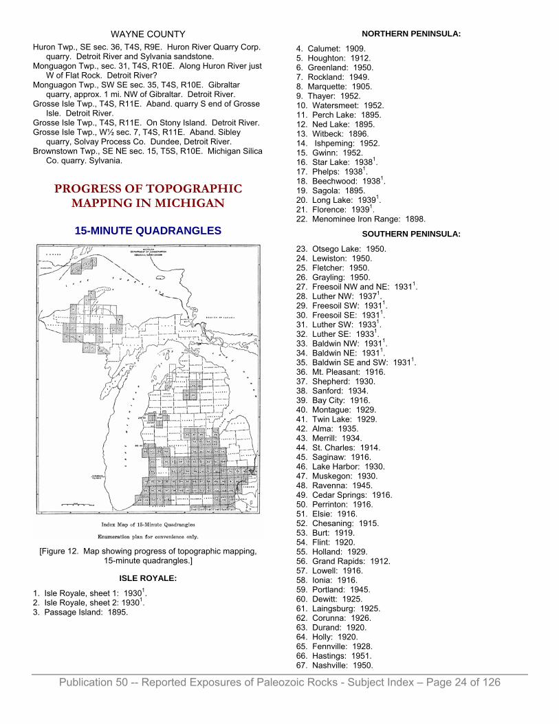
Publication 50 -- Reported Exposures of Paleozoic Rocks - Subject Index – Page 24 of 126
WAYNE COUNTY Huron Twp., SE sec. 36, T4S, R9E. Huron River Quarry Corp.
quarry. Detroit River and Sylvania sandstone. Monguagon Twp., sec. 31, T4S, R10E. Along Huron River just
W of Flat Rock. Detroit River? Monguagon Twp., SW SE sec. 35, T4S, R10E. Gibraltar
quarry, approx. 1 mi. NW of Gibraltar. Detroit River. Grosse Isle Twp., T4S, R11E. Aband. quarry S end of Grosse
Isle. Detroit River. Grosse Isle Twp., T4S, R11E. On Stony Island. Detroit River. Grosse Isle Twp., W½ sec. 7, T4S, R11E. Aband. Sibley
quarry, Solvay Process Co. Dundee, Detroit River. Brownstown Twp., SE NE sec. 15, T5S, R10E. Michigan Silica
Co. quarry. Sylvania.
PROGRESS OF TOPOGRAPHIC MAPPING IN MICHIGAN
15-MINUTE QUADRANGLES
[Figure 12. Map showing progress of topographic mapping,
15-minute quadrangles.]
ISLE ROYALE:
1. Isle Royale, sheet 1: 19301. 2. Isle Royale, sheet 2: 19301. 3. Passage Island: 1895.
NORTHERN PENINSULA:
4. Calumet: 1909. 5. Houghton: 1912. 6. Greenland: 1950. 7. Rockland: 1949. 8. Marquette: 1905. 9. Thayer: 1952. 10. Watersmeet: 1952. 11. Perch Lake: 1895. 12. Ned Lake: 1895. 13. Witbeck: 1896. 14. Ishpeming: 1952. 15. Gwinn: 1952. 16. Star Lake: 19381. 17. Phelps: 19381. 18. Beechwood: 19381. 19. Sagola: 1895. 20. Long Lake: 19391. 21. Florence: 19391. 22. Menominee Iron Range: 1898.
SOUTHERN PENINSULA:
23. Otsego Lake: 1950. 24. Lewiston: 1950. 25. Fletcher: 1950. 26. Grayling: 1950. 27. Freesoil NW and NE: 19311. 28. Luther NW: 19371. 29. Freesoil SW: 19311. 30. Freesoil SE: 19311. 31. Luther SW: 19331. 32. Luther SE: 19331. 33. Baldwin NW: 19311. 34. Baldwin NE: 19311. 35. Baldwin SE and SW: 19311. 36. Mt. Pleasant: 1916. 37. Shepherd: 1930. 38. Sanford: 1934. 39. Bay City: 1916. 40. Montague: 1929. 41. Twin Lake: 1929. 42. Alma: 1935. 43. Merrill: 1934. 44. St. Charles: 1914. 45. Saginaw: 1916. 46. Lake Harbor: 1930. 47. Muskegon: 1930. 48. Ravenna: 1945. 49. Cedar Springs: 1916. 50. Perrinton: 1916. 51. Elsie: 1916. 52. Chesaning: 1915. 53. Burt: 1919. 54. Flint: 1920. 55. Holland: 1929. 56. Grand Rapids: 1912. 57. Lowell: 1916. 58. Ionia: 1916. 59. Portland: 1945. 60. Dewitt: 1925. 61. Laingsburg: 1925. 62. Corunna: 1926. 63. Durand: 1920. 64. Holly: 1920. 65. Fennville: 1928. 66. Hastings: 1951. 67. Nashville: 1950.

Publication 50 -- Reported Exposures of Paleozoic Rocks - Subject Index – Page 25 of 126
68. Charlotte: 1946. 69. Lansing: 1910. 70. Mason: 1909. 71. Fowlerville: 1908. 72. Howell: 1907. 73. Milford: 1908, 1954. 74. Pontiac: 19162. 75. Rochester: 1916. 76. Mt. Clemens: 1929. 77. Algonac2. 78. Marine City. 79. South Haven: 1928. 80. Bangor: 1927. 81. Gobies: 1946. 82. Kalamazoo: 1916. 83. Galesburg: 1917, 1947. 84. Battle Creek: 1917, 1947. 85. Marshall: 1921. 86. Springport: 1919. 87. Rives Junction: 1919. 88. Stockbridge: 1912, 1919. 89. Dexter: 1902*. 90. South Lyon: 1902*. 91. Plymouth: 1905**. 92. Detroit: 19052**. 93. Grossepoint: 1905**. 94. Benton Harbor: 1927. 95. Hartford: 1927. 96. Marcellus: 1944. 97. Schoolcraft: 1920. 98. Leonidas: 1918, 1947. 99. Union City: 1918, 1947. 100. Homer: 1948. 101. Spring Arbor: 1948. 102. Jackson: 1935. 103. Manchester: 1948. 104. Saline: 1902*. 105. Ypsilanti: 1902*. 106. Romulus: 1906**. 107. Wyandotte: 19052**. 108. Three Oaks: 1927. 109. Niles: 1927. 110. Cassopolis: 1945. 111. Vandalia: 1945. 112. Three Rivers: 1914. 113. Blissfield: 1939. 114. Dundee: 1939. 115. Wyandotte.
OHIO-MICHIGAN:
116. Pioneer: 1911. 117. Alvordton: 1911. 118. Wauseon: 1911. 119. Swanton: 1911. 120. Toledo: 1952. 121. Maumee: 1951. 1Planemetric. 2Out of print.
*Ann Arbor Folio.
**Detroit Folio.
PROGRESS OF TOPOGRAPHIC MAPPING IN MICHIGAN
7½-MINUTE QUADRANGLES
[Figure 13. Map showing progress of topographic mapping,
7½-minute quadrangles.]
NORTHERN PENINSULA:
1. Phoenix: 1946. 2. Eagle Harbor: 1946, 3. Delaware: 1948. 4. Lake Medora: 1948. 5. Port Wilkins: 1948. 6. Manitou Island: 1948. 7. Muggins Creek: 1946. 8. Ahmeek: 1946. 9. Mohawk: 1946. 10. Bruneau Creek: 1946. 11. Deer Lake: 1948. 12. Point Isabelle: 1948. 13. Oskar: 1954. 14. Hancock: 1946. 15. Laurium: 1946. 16. Rice Lake: 1954. 17. Graveraet River: 1954. 18. South Range: 1948. 19. Chassell: 1948. 20. White Pine: 1948. 21. Bergland: 1948. 22. Matchwood: 1948. 23. Gibbs City: 1945. 24. Sunset Lake: 1945. 25. Amasa: 1945. 26. Kelso Junction: 1945.

Publication 50 -- Reported Exposures of Paleozoic Rocks - Subject Index – Page 26 of 126
27. Kiernan: 1945. 28. Iron River: 1944. 29. Gaastra: 1944. 30. Fortune Lakes: 1944. 31. Crystal Falls: 1944. 32. Lake Mary: 1945. 33. Naults: 1945. 34. Stager: 1945. 35. Commonwealth: 1945. 36. Marquette NW: 1953. 37. Negaunee SW: 1954. 38. Negaunee: 1953. 39. Marquette: 1954. 40. Ishpeming: 1952. 41. Palmer: 1952. 42. Sands: 1952. 43. Gwinn: 1952. 44. Vermilion: 1951. 45. Whitefish Point: 1951. 46. Sheephead Lake: 1951. 47. Shelldrake: 1951. 48. Timberlost: 1951. 49. Emerson: 1951. 50. Big Beaver Creek: 1951. 51. Piatt Lake: 1951. 52. McNearney Lake: 1951. 53. Pendills Lake: 1951. 54. Dollar Settlement: 1951. 55. Hulbert: 1951. 56. Eckerman: 1951. 57. Strongs: 1951. 58. Sullivan Creek: 1951. 59. Raco: 1951. 60. Fibre, 1953. 61. Rudyard: 1953. 62. Pickford NW: 1953. 63. Pickford: 1953. 64. Munuscong: 1953. 65. Munuscong NE: 1953.
SOUTHERN PENINSULA:
66. Otsego Lake: 1950. 67. Turtle Lake: 1950. 68. Johannesburg: 1950. 69. Lewiston: 1950. 70. Big Bradford Lake: 1950. 71. K.P. Lake: 1950. 72. Lovells: 1950. 73. Comstock Hills: 1950. 74. Black Creek: 1950. 75. Lake Margrethe: 1950. 76. Grayling: 1950. 77. Wakeley Lake: 1950. 78. Fletcher: 1950. 79. Cote Dame Marie: 1950. 80. Pere Cheney: 1950. 81. Roscommon N: 1950. 82. Delton: 1947. 83. Banfield: 1947. 84. Bedford: 1947. 85. Bellevue: 1947. 86. Galesburg: 1947. 87. Augusta: 1947. 88. Battle Creek: 1947. 89. Ceresco: 1947. 90. Hadley: 1943. 91. Metamora: 1943. 92. Thornville: 1943.
93. Almont: 1943. 94. Allenton: 1943, 1952. 95. Memphis: 1943, 1952. 96. Goodells: 1937, 1952. 97. Smith Creek: 1937, 1952. 98. Port Huron: 1937, 1952. 99. Davisburg: 1942. 100. Ortonville: 1943. 101. Oxford: 1943. 102. Lake Orion: 1943. 103. Romeo: 1943. 104. Armada: 1942, 1952. 105. Richmond: 1942, 1952. 106. Adair: 1937, 1952. 107. Rattle Run: 1939, 1952. 108. St. Clair: 1937, 1952. 109. Highland: 1942. 110. Clarkston: 1941, 1952. 111. Pontiac N: 1941, 1952. 112. Rochester: 1943, 1952. 113. Utica: 1944, 1952. 114. Waldenburg: 1952. 115. New Haven: 1952. 116. New Baltimore: 1937, 1952. 117. Marine City: 1937, 1952. 118. Wixom: 1945. 119. Walled Lake: 1942, 1952. 120. Pontiac S: 1941, 1952. 121. Birmingham: 1948, 1952. 122. Warren: 1944, 1952. 123. Mt. Clemens W: 1952. 124. Mt. Clemens E: 1952. 125. St. Clair Flats: 1937, 1952. 126. Algonac: 1937, 1952. 127. Salem: 1942, 1953. 128. Northville: 1942, 1952. 129. Redford: 1939, 1952. 130. Royal Oak: 1939, 1952. 131. Highland Park: 1933, 1952. 132. Grosse Pointe: 1939, 1952. 133. Denton: 1940, 1953. 134. Wayne: 1941, 1952. 135. Inkster: 1940, 1952. 136. Dearborn: 1939, 1952. 137. Detroit: 1938, 1952. 138. Belle Isle: 1938, 1952. 139. Ypsilanti E: 1940, 1953. 140. Belleville: 1940, 1952. 141. Wayne County Airport: 1940, 1952. 142. Wyandotte: 1940, 1952. 143. Maybee: 1940. 144. Carleton: 1940, 1952. 145. Flat Rock: 1940, 1952. 146. Rockwood: 1941, 1952. 147. Ida: 1939. 148. Monroe: 1940, 1952. 149. Stony Point: 1940, 1952. 150. Estral Beach: 1940, 1952. 151. Samaria: 1939. 152. Erie: 1940, 1952.
OHIO-MICHIGAN:
153. Berkey: 1951. 154: Sylvania: 1934, 1951. 155. Toledo: 1934, 1952. 156: Point Place: 1934, 1952. 157. Maumee: 1934, 1951.

Publication 50 -- Reported Exposures of Paleozoic Rocks - Subject Index – Page 27 of 126
MISCELLANEOUS CONTRIBUTIONS TO MICHIGAN GEOLOGY
in Department of Conservation Reports
LAND ECONOMIC SURVEY Reports and maps of the Land Economic Survey have not been issued as formal publications. Blue line prints and mimeographed copies of the reports may be obtained from the Lands Division of the Department of Conservation or may be consulted in the Open File of the Geological Survey and Lands Divisions.
Alger County, Field Work 1923. Soils, cover. Map. Surface geology. Map. S. G. Bergquist. Surface and hardrock formations. Map.
Alpena County, Field Work 1924. Geological resources of Alpena County, W. A. Ver Wiebe, S.
G. Bergquist. Geology of Alpena County, Frank Leverett, L. R.
Schoenman. Soils, cover. Map. Surface and hardrock formations. Map. Surface formations. Map. Water resources of the Thunder Bay region, C. O. Wisler.
Antrim County, Field Work 1923. Geology of Antrim County, Frank Leverett. Lake Survey. Map. Soils, cover. Map. Water resources of Antrim County, C. O. Wisler.
Charlevoix County, Field Work 1922. Geology of Charlevoix County, Frank Leverett. Surface geology. Map. Water power of Charlevoix County, C. O. Wisler.
Chippewa County, Field Work 1925. Geology, W. A. Ver Wiebe. Lakes of. Map. Surface and hardrock formations. Map. Surface formations. Map. Water resources of the Carp River, C. O. Wisler. Water resources of the Munuscong and Waiska Rivers, C. O.
Wisler. Water resources of the Pine River, C. O. Wisler. Water resources of the Tahquamenon River, C. O. Wisler.
Crawford County, Field Work 1927. Geological resources of, W. A. Ver Wiebe and S. G.
Bergquist. Geology of, W. A. Ver Wiebe. Lakes. Map. Soils, cover. Maps. Water power of, C. O. Wisler.
Iron County, Field Work 1930. Soils, cover. Map. Surface and hardrock formations. Map. Surface formations. Map.
Kalkaska County, Field Work 1927. Geological resources of Kalkaska County, W. A. Ver Wiebe
and S. G. Bergquist. Geology of Kalkaska County, W. A. Ver Wiebe. Soils, cover. Map. Surface formations. Map. Water power, C. O. Wisler.
Luce County, Field Work 1929. Soils, cover. Map. Surface formations. Map.
Menominee County, Field Work 1925. Geology of, W. A. Ver Wiebe. Surface and hardrock formations. Map. Surface formations. Map. Water power, C. O. Wisler.
Montmorency County, Field Work 1930. Lakes. Map. Soils, cover. Map. Surface and hardrock formations. Map. (The L.E.S. geological report on Montmorency County by S.
G. Bergquist was published in Papers, Mich. Acad. Sci., Arts and Lett. (1939), Vol. 25.)
Ogemaw County, Field Work 1936-37. Geology of, Frank Leverett. Lakes. Map. Surface formations. Map. Water resources of Ogemaw County, C. O. Wisler. Water resources of the Manistee River above Sherman, C.
O. Wisler.
Roscommon County, Field Work 1924. Geology of, W. A. Ver Wiebe. Lakes. Map. Soils, cover. Map. Surface formations. Map.
Schoolcraft County, Field Work 1932. Geology of, O. F. Poindexter. Surface formations. Map.
Wexford County Water resources of the Manistee River above Sherman, C.
O. Wisler.
The Land Economic Survey, its history, purpose, scope: Open File Report.

Publication 50 -- Reported Exposures of Paleozoic Rocks - Subject Index – Page 28 of 126
SECTION ENGINEERING AND ARCHITECTURE PRELIMINARY
ENGINEERING INVESTIGATIONS Geologic and hydrologic data pertinent to the study are included in the reports of the following lakes.
Au Gres Trout Pond, Iosco and Arenac counties.
Barroh, Cass County. Big, Osceola County. Black, Cheboygan County. Brevort, Mackinac County. Brooks, Newaygo County. Brown and West Twin, Alcona
County. Cadillac and Mitchell,
Wexford County. Cedar, Alcona County. Clam River Improvement,
Wexford County. Clare Reservoir, Clare
County. Clear, St. Joseph County. Corey, St. Joseph County. Crystal, Benzie County. Emma, Presque Isle County. Four Mile, Washtenaw
County. Fremont, Newaygo County. Garver, Cass County. Glen, Leelanau County. Grand, Presque Isle County. Grass, Montmorency County. Gravel, Van Buren County. Gun, Barry County. Higgins, Roscommon County. Hiland (with Portage),
Livingston County. Homer Mill Pond, Calhoun
County. Horseshoe, Washtenaw
County. Houghton, Roscommon
County. Indian Lake, Chain, Iosco
County. Indian, Kalamazoo County. Indian, Schoolcraft County. Jordan, Ionia and Barry
counties.
Kaiser, St. Joseph County. Lake of the Woods, Van
Buren County. Little, Branch County. Long, Clare County. Margarete, Crawford County. McCormac, Montmorency
County. Mitchell, Wexford County. Mud, Branch County. Mud, St. Joseph County. Mullet, Cheboygan County. Narrow, Eaton County. North Manistique, Luce
County. Park, Clinton County. Paw Paw, Berrien County. Pipestone, Berrien County. Ponemah, Genesee County. Pontiac—Oxbow, Oakland
County. Portage (with Hiland),
Washtenaw County. Posey, Lenawee County. Potter, Genesee County. Pugsley, Van Buren County. Rock, Montcalm County. Rose, Branch County. Rush, Montmorency County. Sage's, Ogemaw County. St. Helens, Roscommon
County. Silver, Van Buren County. Upper Herring, Benzie
County. Tawas, Iosco County. Van Auken, Van Buren
County. Van Etten, Iosco County. Wall, Barry County. West, Kalamazoo County. Whitmore, Washtenaw
County.
MICHIGAN CONSERVATION MAGAZINE Contributions to Public Education in Geology.
Billings, Norman F. 1. Exercise caution when selecting location on a lake: Vol.
14, No. 4, 1945. 2. Ways sought to control wave action: Vol. 15, No. 7,
1946. 3. Is it true what they say about water?: Vol. 18, No. 4, 5,
1949; Vol. 19, No. 1, 2, 1950, 4. Who's who in water: Vol. 19, No. 3, 1950. 5. Ground water: Vol. 24, No. 5, 1955.
Boehler, Charles* 6. Tahquamenon Falls: Vol. 6, No. 5, 1936.
Daoust, William L. 7. Salts of the earth: Vol. 22, No. 1, 1953.
Deason, H. J.* 8. Upper Peninsula once bed of Inland Sea: Vol. 6, No. 4,
1936.
Eddy, Gerald E. 9. Metals for tomorrow: Vol. 24, No. 4, 1955.
Fontanna, Stanley G.* 10. Michigan's water problems are studied: Vol. 15, No. 6,
1946.
Grant, Rex P. 11. Michigan petroleum producing industry: Vol. 17, No. 4,
1948. 12. Liquid gas is stored in "tailormade" caves: Vol. 22, No.
3, 1953. 13. Michigan oil—its past, present, future: Vol. 24, No. 4,
1955.
Hoffmaster, P. J.* 14. Time to do something about water: Vol. 13, No. 2,
1944. 15. Michigan's oil and gas: Vol. 15, No. 9, 1946.
Houghton, Douglass 16. Tahquamenon—Taquiomenon. From field notebook:
Vol. 7, No. 11, 1938. 17. Sketch of State Geologist Houghton: Vol. 14, No. 10,
1945.
Hubbard, Bela. 18. Pictures in the rocks (Pictured Rocks). From field
notebook: Vol. 7, No. 11, 1935. 19. Journal of Mus-co-ma-in-gun. From field notebook of
Hubbard: Vol. 5, No. 6, 1935; No. 12, 1936; Vol. 6, No. 1, 4, 1936.
Humphreys, C. R.* 20. Treasure by the ton: Vol. 22, No. 3, 1953.
Jamison, Knox*. 21. Base and Principal Meridian lines in Michigan: Vol. 14,
No. 3, 1945. 22. Mines of the Porcupine Mountains: Vol. 16, No. 3,
1947.
Kennedy, Bruce E. 23. "Forty-Niner" fever: Vol. 18, No. 6, 1949.
Martin, Helen M. 24. 100 years of Michigan geology: Vol. 7, Nos. 1, 2, 4,
1937. 25. The Ice Age in Michigan: Vol. 7, Nos. 7, 9, 1938. 26. War Jobs for Michigan minerals: Vol. 11, No. 7, 1942. 27. Have we enough oil?: Vol. 11, No. 8, 1942. 28. Sleeping Bear dune: Vol. 11, No. 11, 1942. 29. Magnesium ore: Vol. 12, No. 1, 1943. 30. Those useless scientific facts: Vol. 12, No. 6, 1943. 31. Yankee Springs: Vol. 12, No. 7, 1943. 32. From Michigan's coral seas: Vol. 12, No. 8, 1943. 33. Our untouched wilderness (Porcupines): Vol. 12, No.
8, 1943. 34. The romance of copper: Vol. 13, Nos. 1, 2, 1944. 35. More about our most important resource—water: Vol.
13, No. 4, 1944. 36. Michigan's iron: Vol. 13, Nos. 5, 6, 1944. 37. When Paleontologist and Photographer meet: Vol. 13,
No. 8, 1944. 38. Salt for a million years: Vol. 13, No. 11, 1944.
Publication 50 -- Reported Exposures of Paleozoic Rocks - Subject Index – Page 29 of 126
39. Geology to Archeology: Vol. 14, No. 3, 1945. 40. Maps: Vol. 14, Nos. 8, 9, 1945. 41. Douglass Houghton (1809-1845): Vol. 14, No. 10,
1945. 42. Minerals find new use in nylon: Vol. 15, No. 4, 1946. 43. R. A. Smith is retiring on August 1: Vol. 15, No. 6,
1946. 44. Michigan story: Vol. 19, No. 2, 1950. 45. Those busy bacteria: Vol. 19, No. 6, 1950. 46. How old is Michigan?: Vol. 20, No. 1, 1951. 47. From arbutus to ethyl: Vol. 20, No. 2, 1951. 48. No empty lands!: Vol. 21, No. 3, 1952. 49. Romance of the pipelines: Vol. 22, No. 5, 1953. 50. Common stuff: Vol. 22, No. 6, 1953. 51. Fuels—power: Vol. 23, No. 2, 1954. 52. Those marble halls (with H. O. Sorensen): Vol. 23, No.
3, 1954. 53. Rambling rocks: Vol. 23, No. 4, 1954. 54. How it all began: Vol. 23, No. 5, 1954. 55. The Pictured Rocks—then and now: Vol. 23, No. 6,
1954. 56. Mastodons, Mammoths, Elephants: Vol. 24, No. 2,
1955. 57. Water then—and now: Vol. 24, No. 5, 1955.
Miller, Lee S. 58. Why oil proration?: Vol. 12, No. 9, 1943. 59. A shot in the arm for oil fields: Vol. 22, No. 2, 1953. 60. Why oil proration?: Vol. 23, No. 3, 1954.
Osgood, Wayland* 61. Lowered lake levels result in sub-normal rainfall: Vol.
5, No. 3, 1935.
Pardee, Franklin G. 62. Michigan's mythical gold mines: Vol. 14, No. 11, 1945. 63. Iron ore reserves in Michigan: Vol. 17, No. 9, 1948.
Poindexter, O. F. 64. Fire plugs in State forests: Vol. 5, No. 1, 1935. 65. Michigan highlands: Vol. 9, No. 4, 1940. 66. Ground water table at 5-year low: Vol. 9, No. 8, 1940. 67. Something can be done about lake levels: Vol. 11, No.
2, 1942. 68. Water is a vital resource: Vol. 12, No. 2, 1943.
Riggs, H. 69. The oil man's nightmare (salt water): Vol. 12, No. 1,
1943.
Smith, Richard A. 70. Michigan minor minerals: Vol. 10, No. 8, 1941. 71. Saginaw Valley brines pose problems: Vol. 14, No. 12,
1945. Sketch of in R. A. Smith is retiring: Vol. 15, No. 6, 1946.
Warren, Ebb* 72. Deep drilling in Michigan: Vol. 16, No. 6, 1947.
Wender, Carl* 73. Speeding the search for oil: Vol. 12, No. 1, 1943. 74. Those 'Lake Bottom' leases: Vol. 15, No. 3, 1946.
*Not on the staff of the Geological Survey Division.
The titles of P.E.G. (Public Education in Geology) articles do not always indicate content, therefore the following index to subject matter is appended. The numbers refer to the article number.
Age of Michigan: 46. Altitudes: 65. Cambrian: 18, 55. Copper: 20, 22, 34. Conservation and geology:
41, 44, 48. Dunes: 28. Geological Survey: 17, 19,
24, 30, 43. Glaciation: 25, 31, 50, 53. Gold: 62. Gravel: 39, 50, 53. Iron: 36, 63. Lakes and shores, lake levels:
1, 2, 61, 67, 74. Limestone: 32. Magnesium: 29. Maps: 21, 40. Marble: 52. Mastodon, mammoth: 56. Minerals and mineral industry:
9, 26, 29, 30, 34, 36, 38, 39, 42, 45, 47, 62, 70.
Mines: 22, 34, 62. Paleozoic of Northern
Peninsula: 8. Paleontology: 37. Petroleum and natural gas: 7,
11, 12, 13, 15, 27, 47, 49, 51, 58, 59, 60, 69, 71, 72, 73.
Pictured Rocks: 18, 55. Porcupine Mountains: 22, 33,
34. Rivers: 6, 16. Salt: 7, 38. Salt water, brine: 7, 71. Scenic features, recreation
areas: 3, 6, 16, 28, 31. Tahquamenon: 6, 16. Uranium: 23. Water: 3, 4, 5, 10, 14, 35, 57,
64, 66, 68. Yankee Springs: 31.
REFERENCES TO MICHIGAN GEOLOGY AND MINERAL
RESOURCES By
MURIEL TARA STRAIGHT As geologic studies continue and more papers are published it becomes increasingly difficult to keep abreast of the geologic information available for any one area. For several years some kind of author-subject index of papers pertaining to Michigan geology has been needed—hence this compilation. Several published bibliographies were examined and it seemed that the style used by the U. S. Geological Survey in the Bibliography of North American geology is the most useful. Therefore, this compilation is patterned after the U. S. Geological Survey bibliography.
Many references were obtained from the Bibliography of North American geology. Other sources of information were: Dr. Duncan Stewards progress bibliography of Michigan geology issued by Michigan State College1, Dept. of Geology and Geography; the files of the Michigan Geological Survey, Lansing; Michigan State College1 Library, East Lansing; Department of Geology and Geography, Michigan State College1, East Lansing; Michigan State Library, Lansing; other published bibliographies; and lists of published and unpublished doctoral and masters theses furnished by the geology and physics departments of several colleges and universities. The cooperation of these departments of the several colleges aided greatly in obtaining references not found in any published bibliography and for this gracious cooperation the writer expresses thanks.
Publication 50 -- Reported Exposures of Paleozoic Rocks - Subject Index – Page 30 of 126
Many papers with only brief mention of Michigan are not included, as Stewards bibliography gives a more comprehensive coverage. The references listed herein were checked for accuracy with the actual papers whenever possible. Not all the papers could be found, however, with the facilities available.
This compilation is in two parts: An alphabetical list of authors with titles and complete bibliographic references and, a subject index. Annotations for a few papers are given in the author index. If followed by "U.S.G.S.", "U.S.B.M.", or "M.L.F." the annotations are from the Bibliography of North American geology, 1950 (U.S. Geological Survey), the List of publications of the Bureau of Mines, July 1, 1910 to January 1, 1949 (U.S. Bureau of Mines) or from bibliographic indices on ground water, Water-Supply Paper 120 by M. L. Fuller, and 163 by M. L. Fuller et al (U.S. Geological Survey). 1Now Michigan State University
The subject index, exclusive of county headings, is divided into the following major categories: Bibliography Biography Deep borings Economic geology Explorations and surveys General Geological survey Historical geology Isle Royale Lake Superior region Maps Meteorites Mineral lands
Mineral resources and mineral industries
Mineralogy Mining Northern Peninsula Paleontology Petrography and petrology Physical geology Sedimentation Soils Southern Peninsula Stratigraphy Water resources
A few examples may aid in making best use of the subject index. Suppose information regarding the geology of the Marquette iron range is desired. Iron, a mineral resource, is in the category MINERAL RESOURCES AND MINERAL INDUSTRIES. Further subdivisions:
MINERAL RESOURCES AND MINERAL INDUSTRIES Iron
Geology of Marquette range: Derby, E. L., Jr., 1; Hotchkiss, W.
O., 7; Kimball, J. P., 1; Mich. Acad. Sci., 5; etc. Gwinn district: Allen, R. C., 11.
References to the Devonian Traverse group of Michigan are subdivisions of STRATIGRAPHY and listed as follows:
STRATIGRAPHY Paleozoic
Devonian Traverse: Davies, W. E., 1(th); Grabau, A. W., 2(a),
9(a), 12(a); etc. Afton-Onaway area: Kelly, W. A., 10, 12. Alpena area: Mich. Acad. Sci., 3.
Items of a somewhat general nature are under the appropriate major heading. For example:
ECONOMIC GEOLOGY
Deposition of ores, principles of: Van Hise, C. R., 17(*). Enrichment of ore deposits: Emmons, W. H., 1(*).
The number (or numbers) after the author's name corresponds to a number in the author index. An (a) following the number indicates that the paper is an abstract, an (*) has only brief mention of Michigan, an (f) is written in a foreign language, and a (th) is a thesis. The complete bibliographic reference is found by turning to the corresponding author and number in the author index.
ABBREVIATIONS A.A.P.G.—American Association of Petroleum Geologists abs.—abstract, abstracts Agr.—agriculture Am.—America, American Ann.—annual approx.—approximately Apr.—April art.—article Assoc.—association Aug.—August
Bot.—botanical, botany Bull.—bulletin Bur.—bureau
Calif.—California chap.—chapter circ.—circular Co.—company Comm.—commission, commissioner Conf.—conference Cong.—congress Conserv.—conservation Coun.—council
Dec.—December Dept.—department Div.—division Doc.—document
ed.—edition Educ.—education Eng.—engineering Ex.—executive Explor.—exploration extr.—extract, extracts
Feb.—February fig., figs.—figure, figures
Geog.,—geography Geol.—geology, geologic, geological Geophys.—geophysical
Ill.—Illinois illus.—illustrated incl.—including Ind.—Indiana Inst.—institute Internat.—international Inv.—investigation, investigations

Publication 50 -- Reported Exposures of Paleozoic Rocks - Subject Index – Page 31 of 126
Jan.—January Jour.—journal
Kans.—Kansas
Leg.—Legislature
Mar.—March Mass.—Massachusetts mem.—memoir Mich.—Michigan mimeo.—mimeographed Min.—mining mineralog.—mineralogy, mineralogical min. res.—mineral resources Minn.—Minnesota M.L.F.—Myron L. Fuller mtg.—meeting
N. C.—North Carolina Nat.—natural, naturalist Natl.—national no., nos.,—number, numbers Nov.—November
Oct.—October Okla.—Oklahoma
p., pp.—page, pages Pa.—Pennsylvania Paleont.—paleontological petrol.—petroleum pl., pls.—plate, plates P. N.—printed notice prelim.—preliminary Proc.—proceedings prosp.—prospecting pt.—part, parts pub.—publication
rec.—record, records rev.—review rpt.—report
sec.—section, sections S. E. G.—Society of Economic Geologists S. E. P. M.—Society of Economic Paleontologists Meeting Sept.—September ser.—series Sess.—session Soc.—society, societies Spec.—special strat.—stratigraphic, stratigraphical summ.—summary suppl.—supplement
Tech.—technology topog.—topographic, topographical
Univ.—university U. S.—United States U. S. B. M.—United States Bureau of Mines U. S. G. S.—United States Geological Survey
v.—volume, volumes
Wash.—Washington Wis.—Wisconsin
PUBLICATION ABBREVIATIONS Acad. Nat. Sci. Phila. Proc.—Acadamy of Natural Sciences of
Philadelphia Proceedings. Agr. Eng.—Agricultural Engineering. A.I.M.E. Bi-monthly Bull., Bull., Contr., Geophys. Prosp., Tech.
Pub., Trans., Yearb.—American Institute of Mining Engineers, or American Institute of Mining and Metallurgical Engineers Bi-monthly Bulletin, Bulletin, Contributions, Geophysical Prospecting, Technical Publication, Transactions, Yearbook.
Am. Acad. Arts and Sci. Proc.—American Academy of Arts and Sciences Proceedings.
Am. Assoc. Adv. Sci. Proc.—American Association for the Advancement of Science Proceedings.
Am. Assoc. Petrol. Geol. Bull.—American Association of Petroleum Geologists Bulletin.
Am. Geol.—American Geologist. Am. Geophys. Union Trans.—American Geophysical Union
Transactions. Am. Jour. Bot.—American Journal of Botany. Am. Jour. Sci.—American Journal of Science. Am. Meteorol. Soc. Bull.—American Meteorological Society
Bulletin. Am. Midland Nat.—American Midland Naturalist. Am. Mirieralog.—American Mineralogist. Am. Mus. Nat. Hist. Novitates—American Museum of Natural
History Novitates. Am. Mus. Novitates—American Museum Novitates. Am. Nat.—American Naturalist. Am. Philos. Soc. Trans.—American Philosophical Society
Transactions. Am. Water Works Assoc. Jour.—American Water Works
Association Journal. Assoc. Am. Geol. and Nat. Rpt.—Association of American
Geologists and Naturalists Report. Assoc. Am. State Geol. Jour.—Association of American State
Geologists Journal. Boston Jour. Nat. History—Boston Journal of Natural History. Boston Soc. Nat. Hist. Proc.—Boston Society of Natural
History Proceedings. Bot. Gaz.—Botanical Gazette. British Assoc. Adv. Sci. Rpt.—British Association for the
Advancement of Science Report. Butler Univ. Bot. Studies—Butler University Botanical Studies. Calif. Univ., Dept. Geol. Bull.—California University,
Department of Geology Bulletin. Canada Dept. Mines, Geol. Survey Mem.—Canada
Department of Mines, Geological Survey Memoir. Canadian Geol. Survey Mem., Rept. Prog., Summ. Rpt.—
Canadian Geological Survey Memoir, Report of Progress, Summary Report.
Canadian Inst. Proc., Trans.—Canadian Institute Proceedings, Transactions.
Canadian Inst. Min. Met. Trans.; Bull.—Canadian Institute of Mining and Metallurgy Transactions; Canadian Mining and Metallurgical Bulletin.
Canadian Min. Inst. Jour., Quart. Bull.—Canadian Mining Institute Journal, Quarterly Bulletin.
Canadian Min. Jour.—Canadian Mining Journal. Canadian Nat. and Geol. and Proc. Nat. Hist. Soc. Montreal—
Canadian Naturalist and Geologist and Proceedings of the Natural History Society of Montreal.
Carnegie Mus. Annals—Carnegie Museum Annals. Chicago Acad. Sci. Bull.—Chicago Academy of Science
Bulletin. Compass—The Compass.

Publication 50 -- Reported Exposures of Paleozoic Rocks - Subject Index – Page 32 of 126
Cranbrook Inst. Sci. Bull.—Cranbrook Institute of Science Bulletin.
Davenport Acad. Sci. Proc.—Davenport Academy of Science Proceedings.
Denison Univ. Bull., Sci. Lab. Jour.—Denison University Bulletin, Scientific Laboratories Journal.
Earth Sci. Digest—The Earth Science Digest. Ecol. Mon.—Ecological Monograph. Econ. Geog.—Economic Geography. Econ. Geol.—Economic Geology. Edinburgh, New Philos. Jour.—Edinburgh, New Philosophical
Journal. Eng. Mag.—Engineering Magazine. Eng. Min. Jour.—Engineering Mining Journal. Eng. News—Engineering News. Eng. Rec.—Engineering Record. Fed. Inst. Min. Eng. Trans.—Federated Institute of Mining
Engineers Transactions. Field Columbia Mus. Pub.—Field Columbia Museum
Publication. Franklin Inst. Jour.—Franklin Institute Journal. Geog. Rev.—Geographical Review. Geol. Mag.—Geological Magazine. Geol. Soc. Am. Bull., Proc.—The Geological Society of
American Bulletin, Proceedings. Geol. Soc. London Quart. Jour., Trans.—Geological Society of
London Quarterly Journal, Transactions. Geophys.—Geophysics. Harpers Mag.—Harpers Magazine. Harvard College Mus. Comp. Zool. Bull.—Harvard College
Museum of Comparative Zoology Bulletin. Ill. Acad. Sci. Trans.—Illinois State Academy of Science
Transactions. Ind. Acad. Sci. Proc.—Indiana Academy of Science
Proceedings. Ind. Dept. Conserv., Div. Geol., Pub.—Indiana Department of
Conservation, Division of Geology, Publication. Inst. Min. and Met. Trans.—Institute of Mining and Metallurgy
Transactions. Jour. Geol.—Journal of Geology. Jour. Geomorphology—Journal of Geomorphology. Jour. Mammalogy—Journal of Mammalogy. Jour. Paleont.—Journal of Paleontology. Jour. Sed. Petr.—Journal of Sedimentary Petrography. Kans. Acad. Sci. Trans.—Kansas Academy of Science
Transactions. Kans. Geol. Soc., Field Conf. Guidebook—Kansas Geological
Society, Field Conference Guidebook. Kent Scientific Inst. Misc. Papers—Kent Scientific Institute
Miscellaneous Papers. Lake Superior Min. Inst. Proc.—Lake Superior Mining Institute
Proceedings. Lyceum Nat. Hist. N. Y. Annals—Lyceum of Natural History of
New York Annals. Merchants Mag.—Merchants Magazine. Mich. Acad. Sci. Ann. Rept., Field Excur., Papers, Rpt.—
Michigan Academy of Science Arts and Letters Annual Report, Field Excursion, Papers, Report.
Mich. College Min. Tech. Bull.—Michigan College of Mining and Technology Bulletin.
Mich. Conserv.—Michigan Conservation. Mich. Eng.—Michigan Engineer. Mich. Geol. and Biol. Survey Pub.—Michigan Geological and
Biological Survey Publication. Mich. Geol. Survey Ann. Rpt., Prog. Rpt., Pub., Summ. Rpt.,
Tech. Rpt.—Michigan Geological Survey Annual Report, Progress Report, Publication, Summary Report, Technical Report.
Mich. Hist. Mag.—Michigan History Magazine. Mich. Manufacturer and Financial Rec.—Michigan
Manufacturer and Financial Record. Mich. Miner—Michigan Miner. Mich. Mineralog. Soc. Pub., Yearb.—Michigan Mineralogical
Society Publication, Yearbook. Mich. Pioneer Coll.—Michigan Pioneer Collection. Mich. Polit. Sci. Assoc. Pub.—Michigan Political Science
Association Publication. Mich. State Agr. Soc. Trans.—Michigan State Agricultural
Society Transactions. Mich. State Board Agr., Ann. Rept.—Michigan State Board of
Agriculture, Annual Report. Mich. State Geol. Ann. Rpt.—Michigan State Geologists
Annual Report. Mich. Univ., Alum. Quart. Rev.; Eng. Research Bull.; Eng.
Research Inst., Lake Hydraulics Lab., Research Pub.; Mus. Geol. Contr.; Mus. Paleont. Contr.; Mus. Zool. Occ. Papers—Michigan University, Alumnus Quarterly Review; Engineer Research Bulletin; Engineer Research Institute, Lake Hydraulics Laboratory; Research Publication; Museum of Geology Contributions; Museum of Paleontology Contributions; Museum of Zoology Occasional Papers.
Midwest Geol.—The Midwest Geologist. Milwaukee Public Mus. Yearb.—Milwaukee Public Museum
Yearbook. Mineralog.—The Mineralogist. Mineralog. Soc. Am.—Mineralogical Society of America. Min. Cong. Jour.—Mining Congress Journal. Min. Eng.—Mining Engineering. Min. Mag.—Mining Magazine. Min. and Met.—Mining and Metallurgy. Min. and Sci. Press—Mining and Scientific Press. Min. Sci.—Mining Science. Min. World—Mining World. Minn. Geol. Survey Ann. Rept.—Minnesota Geological Survey
Annual Report. Mysore Geol. Dept. Rec.—Mysore Geological Department
Records. Nat. Hist.—Natural History. Nat. Hist. Soc. Montreal—Natural History Society of Montreal. Natl. Oil Scouts Assoc. Yearb.—National Oil Scouts
Association Yearbook. Natl. Oil Scouts and Landmens Assoc. Yearb.—National Oil
Scouts and Landmens Association Yearbook. Nautilus—The Nautilus. Northwestern Univ. Summ. Doc., Dissert.—Northwestern
University Summary Document, Dissertation. N. Y. Acad. Sci. Annals—New York Academy of Science
Annals. Ohio Geol. Survey Bull.—Ohio Geological Survey Bulletin. Oil and Gas Jour.—Oil and Gas Journal. Okla. Acad. Sci. Proc.—Oklahoma Academy of Science
Proceedings. Ontario Bur. Mines Ann. Rpt., Rpt.—Ontario Bureau of Mines
Annual Report, Report. Ottawa Nat.—Ottawa Naturalist. Pan Am. Geol.—Pan American Geologist. Petrol. Eng.—The Petroleum Engineer. Philos. Soc. Wash. Bull.—Philosophical Society of Washington
Bulletin. Pop. Astronomy—Popular Astronomy. Pop. Sci. Monthly—Popular Science Monthly. Proc. Nat. Hist. Soc. Montreal—Proceedings of the Natural
History Society of Montreal. Quart. Colo. School of Mines—Quarterly Colorado School of
Mines.
Publication 50 -- Reported Exposures of Paleozoic Rocks - Subject Index – Page 33 of 126
Quart. Jour. Sci.—Quarterly Journal of Science. Rochester Acad. Sci. Proc.—Rochester Academy of Science
Proceedings. Royal Geol. Soc. Cornwall Trans.—Royal Geological Society
of Cornwall Transactions. Royal Inst. Great Britain Proc.—Royal Institute of Great Britain
Proceedings. Royal Soc. Canada Proc. and Trans.—Royal Society of
Canada Proceedings and Transactions. School of Mines Quart., Columbia Univ.—School of Mines
Quarterly, Columbia University. Sci.—Science. Sci. Am. Suppl.—Scientific American Supplement. Sci. Monthly—The Scientific Monthly. Sci. Rev.—Metropolitan Detroit Science Review. Seismol. Soc. Am. Bull.—Seismological Society of America
Bulletin. Smithsonian Inst. Ann. Rpt., Contr. to Knowledge, Explor. and
Field Work, Misc. Coll.—Smithsonian Institution Annual Report, Contributions to Knowledge, Exploration and Field Work, Miscellaneous Collections.
Soil Sci.—Soil Science. Tenn. Acad. Sci. Jour.—Tennessee Academy of Science
Journal. U. S. Bur. Mines Bull., Inf. Circ., Rpt. Inv., Tech. Paper—United
States Bureau of Mines Bulletin, Information Circular, Report of Investigations, Technical Paper.
U. S. General Land Office Rpt.—United States General Land Office Report.
U. S. Geol. Survey Ann. Rpt., Atlas, Bull., Circ., Geol. Quad, maps, Geophys. Inv., Min. Res., Mon., Oil and Gas Inv., Prelim. Rpt., Prof. Paper, Strategic Min. Inv., Water-Supply Paper—United States Geological Survey Annual Report, Atlas, Bulletin, Circular, Geological Quadrangle maps, Geophysical Investigations, Mineral Resources, Monograph, Oil and Gas Investigations, Preliminary Report, Professional Paper, Strategic Minerals Investigation, Water-Supply Paper.
U. S. Natl. Mus. Ann. Rpt., Bull., Proc.—United States National Museum Annual Report, Bulletin, Proceedings.
Wash. Acad. Sci. Jour.—Washington [D.C.] Academy of Science Journal.
Wis. Acad. Sci. Trans.—Wisconsin Academy of Science, Arts and Letters Transactions.
Wis. State Hist. Soc. Coll.—Wisconsin State Historical Society Collections.
World Petrol.—World Petroleum.
AUTHOR INDEX Ackermann, Hermann W.
1. Die Kupferführenden Schichten am Lake Superior [The copper-bearing veins near Lake Superior]: Naturwissenschaftliche Gesellschaft Isis in Dresden, Sitzungsberichte 1875, pp. 101-105, 1876.
Adams, C. L. 1. Copper concentrating practice at the Mohawk mill: Lake
Superior Min. Inst. Proc., v. 27, pp. 98-104, 1929.
Adams, Frank Dawson 1. On the geology of the St. Clair tunnel: Royal Soc.
Canada Proc. and Trans., v. 9, pt. IV, pp. 67-73, 1892.
Adams, George I. 1. (and others) Gypsum deposits in the United States: U.
S. Geol. Survey Bull. 223, 1904. 129 pp. Contains: Gypsum deposits in Michigan, by G. P. Grimsley, pp. 45-47.
Adams, R. N. 1. Amygdaloid tailings: Lake Superior Min. Inst. Proc., v,
28, pp. 192-198, 1930.
Addison, Carl C. 1. Buckeye oil field, Gladwin County, Michigan: Am.
Assoc. Petrol. Geol. Bull., v. 24, no. 10, pp. 1950-1982, 9 figs., incl. index and isopach maps, Nov. 1940; abs., Oil and Gas Jour., v. 38, no. 48, p. 50, Apr. 11, 1940.
Adler, Joseph Leopold 1. Stratigraphic zones in the Negaunee iron formation of
Marquette County, Michigan: Jour. Geol., v. 43, no. 2, pp. 113-132, 7 pls., Feb.-Mar. 1935.
Agassiz, Alexander 1. On the position of the sandstone of the southern slope
of a portion of Keweenaw Point, Lake Superior: Boston Soc. Nat. Hist. Proc. (1866-68), v. 11, pp. 244-246, 1868.
2. On underground temperatures at great depths: Am. Jour. Set, ser. 3, v. 50 (v.150), no. 300, pp. 503-504, 1895.
Agassiz, Louis 1. The terraces and the ancient river bars, drift, boulders,
and polished surfaces of Lake Superior [abs.]: Am. Assoc. Adv. Sci. Proc. (1848), v. 1, pp. 68-70, 1849.
2. The erratic phenomena about Lake Superior in Lake Superior . . . , chap. X, pp. 395-416; also Am. Jour. Sci., ser. 2, v. 10 (v.60), pp. 83-101, 1850; Archives des sciences physiques et naturelles, v. 16, pp. 5-34, 1851.
Albright, J. C. 1. Separation and disposal of salt waiter in Michigan fields:
Petrol. Eng., v. 8, no. 6, pp. 47-49, Mar. 1937.
Aldrich, Henry Ray—See also Hotchkiss, W. O., 7. *1. A demonstration of the reflection of geologic conditions
in observed magnetic intensity: A.I.M.E. Trans., v. 81, Geophys. Prosp., pp. 385-400, 4 figs., 1929. A discussion of observations made over the Lake Superior syncline in northern Wisconsin.
Alessi, A. Joseph 1. Serpentine at Ishpeming, Michigan: Rocks and
Minerals, v. 11, no. 1, p. 11, Jan. 1936.
2. Hunting agates around Lake Superior: Rocks and Minerals, v. 11, no. 9, p. 139, Sept.-Oct. 1936.
3. Some minerals of Ishpeming, Michigan: Rocks and Minerals, v. 12, no. 7, p. 209, July 1937.
4. Chloride garnets of Michigan: Mineralog., v. 6, no. 6, pp. 9-10, June 1938.
Allen, Charles W. 1. Subsidence resulting from the Athens system of mining
at Negaunee, Michigan [with discussion]: A.I.M.E. Trans., v. 109, pp. 195-202, 1934.
2. Blasting practice at a Michigan iron ore pit: Lake Superior Min. Inst. Proc., v. 29, pp. 108-117, illus., 1936. Discusses mining operations at the Tilden mine, Marquette range, which began in 1929 with a production of 440,000 tons.
3. Combating sulphur dioxide gas at the Spies-Virgil mine: Lake Superior Min. Inst. Proc., v. 30, pp. 33-36, 1939.

Publication 50 -- Reported Exposures of Paleozoic Rocks - Subject Index – Page 34 of 126
Allen, Rolland Craten 1. The Iron River iron-bearing district of Michigan: Mich.
Geol. and Biol. Survey, pub. 3, geol. ser. 2, 18 figs., 17 pls., incl. map, 1910. 151 pp.
2. Progress of the Geological and Biological Survey of Michigan; geology and topography: Mich. Acad. Sci. Rpt., v. 13, pp. 69-78, 1911; v. 14, pp. 33-36, 1912.
3. (director) Mineral resources of Michigan with statistical tables of production and value of mineral products for 1910 and prior years: Mich. Geol. and Biol. Survey, pub. 8, geol. ser. 6, 19 figs., 21 pls., 1912. 465 pp. Contains: The copper industry of Michigan, by R. E. Hore, pp. 15-115; The iron mining industry of Michigan, pp. 117-219; The pig iron industry of Michigan, by A. E. White, pp. 221-244; The Jones step process, by A. E. White, pp. 245-256; Michigan coal, by R. A. Smith, pp. 257-303; Michigan gypsum, by R. A. Smith, pp. 305-314; The salt industry of Michigan, by C. W. Cook, pp. 315-336; Michigan cement, by C. W. Cook, pp. 337-354; Michigan gold, pp. 355-366; Oil and gas in Michigan, by R. A. Smith, pp. 367-397; Directory of mineral producers of Michigan, pp. 399-429; Statistical tables of various non-metallic products, pp. 431-456.
4. (director) Mineral resources of Michigan with statistical tables of production and value of mineral products for 1912 and prior years: Mich. Geol. and Biol. Survey, pub. 13, geol. ser. 10, 1 fig., 8 pls., 1913. 255 pp. Contains: The copper industry of Michigan, by R. E. Hore, pp. 11-92; Notes on potash, sand and gravel, limestone, pp. 93-98; Statistical tables, pp. 99-193; Directory of mineral producers of Michigan for 1912, pp. 194-248.
5. (director) Mineral resources of Michigan with statistical tables of production and value of mineral products for 1913 and prior years: Mich. Geol. and Biol. Survey, pub. 16, geol. ser. 13, 1914. 150 pp. Contains: The Michigan copper industry in 1913, by R. E. Hore, pp. 11-37; The iron ore reserves of Michigan, pp. 39-77; Non-metallic minerals, by R. A. Smith, pp. 81-128; Directory of mineral producers of Michigan for 1913, pp. 129-141.
6. Biennial report of the director, 1912-1914: Mich. Geol. and Biol. Survey, pub. 17, geol. ser. 14, map, 1914. 104 pp.
7. Michigan iron-ore reserves; methods of appraisal for taxation: Lake Superior Min. Inst. Proc., v. 19, pp. 229-244, 1914.
8. (director) Mineral resources of Michigan with statistical tables of production and value of mineral products for 1914 and prior years: Mich. Geol. and Biol. Survey, pub. 19, geol. ser. 16, 24 figs., 18 pls., 1915. 359 pp. Contains: Michigan copper deposits, by R. E. Hore, pp. 21-161; The copper industry in 1914, by W. E. Hopper, pp. 165-220; Statistical tables, iron ore, pp. 222-243; Non-metallic minerals, including coal in Michigan, by R. A. Smith, pp. 247-329; Directory of mineral producers of Michigan for 1914, pp. 334-351.
9. (and Barrett, L. P.) Evidence of the Middle-Upper Huronian unconformity in the quartzite hills at Little Lake, Michigan: Jour. Geol., v. 22, no. 6, pp. 574-581, 1914; Mich. Geol. and Biol. Survey, pub. 18, geol. ser. 15, pp. 153-159, 1915.
10. Relative to an extension of the Menominee iron range eastward from Waucedah to Escanaba, Michigan: Econ. Geol., v. 9, no. 3, pp. 236-238, 1914; Mich. Geol. and Biol. Survey, pub. 18, geol. ser. 15, pp. 161-164, 1915.
11. Correlation and structure of the pre-Cambrian formations of the Gwinn iron-bearing district of Michigan: Jour. Geol., v. 22, no. 6, pp. 560-573, map, 1914; Mich. Geol. and Biol. Survey, pub. 18, geol. ser. 15, pp. 141-152, 1915.
12. (and Barrett, L. P.) Contributions to the pre-Cambrian geology of northern Michigan and Wisconsin: Mich. Geol. and Biol. Survey, pub. 18, geol. ser. 15, pp. 13-164, 11 figs., 12 pls., incl. maps, 1915.
13. (and Barrett, L. P.) A revision of the sequence and structure of the pre-Keweenawan formations of the eastern Gogebic iron range of Michigan: Mich. Geol. and Biol. Survey, pub. 18, geol. ser. 15, pp. 33-61, map, 1915; in part, with discussion by C. K. Leith and R. C. Allen, Jour. Geol., v. 23, no. 8, pp. 689-729, map, 1915.
14. (and Smith, R. A.; Barrett, L. P.) Geological map of Michigan: Mich. Geol. and Biol. Survey, pub. 23, geol. ser. 19, scale 1:750,000, 1916.
15. (director) Mineral resources of Michigan with statistical tables of production and value of mineral products for 1915 and prior years: Mich. Geol. and Biol. Survey, pub. 21, geol. ser. 17, illus., 1916. 402 pp. Contains: Michigan copper industry in 1915, by W. E. Hopper, pp. 11-56; Iron industry, pp. 57-100; Limestones of Michigan, by R. A. Smith, pp. 101-311; Miscellaneous non-metallic minerals, by R. A. Smith, pp. 315-361; Directory of mineral producers in Michigan for 1915, pp. 365-383.
16. (and others) Biennial report of the Director, 1914-1916, and report o retracement and permanent monumenting of the Michigan-Ohio boundary: Mich. Geol. and Biol. Survey, pub. 22, geol. ser. 18, illus., 1917. 118 pp.
17. (director) Mineral resources of Michigan with statistical tables of production and value of mineral products for 1916 and prior years: Mich. Geol. and Biol. Survey, pub. 24, geol. ser. 20, 7 figs., 1917. 291 pp. Contains: Michigan copper industry in 1916, by W. E. Hopper, pp. 15-65; Iron ore industry, pp. 67-112; Portland cement industry, by R. A. Smith, pp. 117-151; Miscellaneous non-metallic minerals, by R. A. Smith, pp. 155-205; Results of deep borings, by R. A. Smith, pp. 211-256; Directory of mineral producers in Michigan for 1916, pp. 257-276.
18. (director) Mineral resources of Michigan with statistical tables of production and value of mineral products for 1917 and prior years: Mich. Geol. and Biol. Survey, pub. 27, geol. ser. 22, 2 figs., 1918. 225 pp. Contains: Michigan copper industry in 1917, by W. E. Hopper, pp. 13-76; Iron ore industry, pp. 77-131; Non-metallic minerals of Michigan, by R. A. Smith, pp. 135-192; Directory of mineral producers in Michigan for 1917, pp. 195-212.
19. (executive officer) Board of Geological Survey Report to Budget Commission 1918.
20. (and Arnold, Ralph) Principles of mining taxation: A.I.M.E. Trans., v. 61, pp. 649-661, 1920.

Publication 50 -- Reported Exposures of Paleozoic Rocks - Subject Index – Page 35 of 126
21. (director) Mineral resources of Michigan with statistical tables of production and value of mineral products for 1918 and prior years: Mich. Geol. and Biol. Survey, pub. 29, geol. ser. 24, 4 figs., 1920. 214 pp. Contains: Michigan copper industry in 1918, by L. P. Barrett, pp. 15-57; Michigan iron ore industry in 1918, by O. R. Hamilton, pp. 61-114; Non-metallic minerals industry of Michigan 1918, by H. M. Martin, pp. 117-181; Directory of mineral producers in Michigan for 1918, pp. 183-200.
22. Correlation of formations of Huronian group in Michigan [with discussion]: A.I.M.E. Bull., no. 135, pp. 2579-2594, 1 fig., Sept. 1919; Bull, no. 156, pp. 3113-3115, Dec. 1919; Trans., v. 63, pp. 188-212, 1920; Min. and Met., v. 1, no. 157, sec. 12, pp. 1-6, Jan. 1920.
23. (and Martin, H. M.) A brief history of the Geological and Biological Survey of Michigan; 1837 to 1872 by R. C. Allen, 1872 to 1920 by H. M. Martin: Mich. Hist. Mag., v. 6, no. 4, pp. 675-750, portraits, 1922; in part, by H. M. Martin, Mich. Acad. Sci. Papers (1921), v. 1, pp. 224-247, 2 pls., 1923.
Alty, Stella West 1. Secondary crystallization of tourmaline in Lower
Devonian sediments in Michigan, U.S.A. [abs.]: British Assoc. Adv. Sci. Rpt., Ann. Mtg., 1932 (102d year), p. 330, 1932; Pan Am. Geol., v. 58, no. 3, pp. 235-236, Oct. 1932.
2. Report of an investigation of Sylvania rocks in oil wells of the Michigan Basin: Mich. Acad. Sci. Papers (1932), v. 18, pp. 289-300, 2 figs., 1933. Report discusses an attempt at correlation by mineral counts and insoluble residues.
3. Some properties of authigenic tourmaline from Lower Devonian sediments: Am. Mineralog., v. 18, no. 8, pp. 351-355, 1 fig., Aug. 1933.
Anderson, Alfred L. *1. Memorial of Heinrich Ries: Am. Mineralog., v. 37, nos.
3-4, pp. 264-275, portrait, Mar.-Apr. 1952.
Andress, John Edward 1. Michigan's copper country, Keweenaw Peninsula, Lake
Superior region: Rocks and Minerals, v. 19, no. 1, pp. 3-6, Jan. 1944.
Andrews, Roger M. 1. Department of mineral statistics, annual report 1909,
Menominee, 1910. 154 pp.
Anonymous 1. Atlas of Tuscola County, Michigan: Published by H. S.
Hadsell, Vassar, and E. R. Cookingham, Caro, Tuscola County, Mich., no date.
2. A memoir of Dr. Douglass Houghton; late State Geologist, and Professor of Geology and Chemistry in the University of Michigan: Am. Jour. Sci., ser. 2, v. 5 (v.55), no. 14, pp. 217-227, 1848.
3. The silver of the Lake Superior mineral region: Min. Mag., v. 1, pp. 447-454, 1853.
4. The copper mines of Lake Superior: Hyde Park, Printed at Norfolk County Gazette Office, 1873.
5. Gogebic iron ore mines: Eng. Min. Jour., v. 43, p. 182, 1887.
6. Atlas of Genesee County, Michigan: Published by E. R. Cookingham, Caro, Mich., 1889.
7. Alexander Winchell, an editorial tribute: Am. Geol., v. 9, no. 2, pp. 71-148, 1892.
8. Geological writings of Alexander Winchell: Geol. Soc. Am. Bull., v. 5, pp. 557-564, 1894. A bibliography of some of Alexander Winchell's articles. Supplementary lists of the writings of Alexander Winchell: Am. Geol., v. 9, pp. 273-276, 1892.
9. The county of Bay, Michigan; maps, history, illustrations and statistics: Bay City, D. A. Bullock & Co., 1896.
10. The Lake Huron region; an early geographical sketch of Lake Huron with accompanying map of interest: Mich. Miner, v. 3, no. 12, pp. 9-14, Nov. 1901.
11. Shaft sinking for salt [Detroit]: Eng. Min. Jour., v. 80, pp. 972-973, 1 fig., Nov. 25, 1905. Describes the encountering of large quantities of strong sulphur water. M. L. F.
12. Waterworks of Saugatuck, Mich.: Eng. Rec., v. 52, pt. II, no. 24, pp. 665-666, Dec. 9, 1905. Detailed description of the water supply of this village, which is obtained from four wells driven along the bank of the Kalamazoo River. M. L. F.
13. Experimental work with wells at Battle Creek, Michigan: Eng. Rec., v. 51, pt. II, no. 17, p. 502, Apr. 29, 1905. Describes the sinking of wells, the materials passed through, the flow, analyses of the water, and the effect of pumping on the level of the water table at Battle Creek, Mich. The Marshall sandstone is mentioned as containing water-bearing strata. M. L. F.
14. Raphael Pumpelly: A.I.M.E. Trans., v. 70, p. 1228, 1924.
15. Obituary of "Jake" Poindexter: Mich. Conserv., v. 14, no. 1, Jan. 1945.
Archibald, Ralph S. 1. Exploration for iron ore in the Lake Superior district:
Lake Superior Min. Inst. Proc., v. 24, pp. 280-288, 1925.
2. (and Chabot, L. S., Jr.) Development, equipment and operation of the Blueberry mine, Marquette iron district: A.I.M.E. Trans., v. 126, pp. 9-26, 9 figs., 1937.
Armstrong, F. H.—See Kelly, William, 4; Orbison, T. W., 1. Arnold, Chester Arthur
1. A petrified lepidophyte cone from the Pennsylvanian of Michigan: Am. Jour. Bot., v. 17, no. 10, pp. 1028-1032, 3 figs., Dec. 1930.
2. Cordaitean wood from the Pennsylvanian of Michigan and Ohio: Bot. Gaz., v. 91, no. 1, pp. 77-87, 10 figs., Mar. 1931.
3. On Callixylon newberryi (Dawson) Elkins et Wieland: Mich. Univ. Mus. Paleont. Contr., v. 3, no. 12, pp. 207-232, 7 pls., 9 figs., Dec. 18, 1931.
4. A sphenopterid fructification from the Pennsylvanian of Michigan: Bot. Gaz., v. 94, no. 4, pp. 821-825, 3 figs., 1933.
5. A preliminary study of the fossil flora of the Michigan coal basin: Mich. Univ. Mus. Paleont. Contr., v. 4, no. 11, pp. 177-204, 7 pls., map, Jan. 15, 1934.
6. Paleobotanical studies in Michigan: Mich. Acad. Sci. Papers (1937), v. 23, pp. 95-99, 1938.

Publication 50 -- Reported Exposures of Paleozoic Rocks - Subject Index – Page 36 of 126
7. A heterosporous species of Bowmanites from the Michigan coal basin: Am. Jour. Bot., v. 31, no. 8, pp. 466-469, 9 figs., Oct. 1944; abs., suppl., p. 7, 1944.
8. (and Stanley, G. M.) Pennsylvanian plants from the glacial drift near Jackson, Michigan: Mich. Acad. Sci. Papers (1945), v. 31, pp. 247-250, index map, 1947.
9. Fossil flora of the Michigan coal basin: Mich. Univ. Mus. Paleont. Contr., v. 7, no. 9, pp. 131-269, 34 pls., 2 figs., maps, Dec. 29, 1949.
10. Megaspores from the Michigan coal basin: Mich. Univ. Mus. Paleont. Contr., v. 8, no. 5, pp. 59-111, 18 pls., June 2, 1950. Contains systematic descriptions of 15 species of spores, six of which are new, from the coals and shales of the Saginaw and Grand River groups of Pennsylvanian age. Sections on the classification and terminology of spores and on the technique of examination are included. U.S.G.S.
Arnold, Ralph—See Allen, R. C., 20. Ash, Arlington D.—See U. S. Geological Survey, 12. Ashley, George H.
*1. (and Fisher, C. A.) The valuation of public coal lands: U. S. Geol Survey Bull. 424, 1910. 75 pp.
*2. Cannel coal in the United States: U. S. Geol. Survey Bull. 659, 1918. 127 pp. Mentions the occurrence of cannel coal in Michigan (p. 69).
Atwater, Gordon Ingham 1. A summary of the stratigraphy and structure of the
Gogebic iron range. Michigan and Wisconsin, in Kan. Geol. Soc. [Guidebook], Upper Mississippi Valley, 9th Ann. Field Conf., pp. 417-420, 4 figs., 1935.
2. Correlation of the Tyler and the Copps formations of the Gogebic iron district: Geol. Soc. Am. Bull., v. 49, no. 2, pp. 151-194, 2 pls., 5 figs., incl. geol. map, Feb. 1, 1938; abs., Proc. (1935), p. 63, June 1936.
Averitt, Paul 1. (and Berryhill, L. R.) Coal resources of the United
States; a progress report, Nov. 1, 1950: U. S. Geol. Survey Circ. 94, illus., Dec. 1950. 33 pp. Continued work has resulted in a re-appraisal of coal reserves, with more detailed estimates of the reserves of Michigan . . . U.S.G.S.
Avery, William M. 1. Sand and gravel plant reflects owner's mechanical
ingenuity: Pit and Quarry, v. 46, no. 2, pp. 97-100, Aug. 1953. Discusses operation of a gravel pit near Traverse City, Michigan.
2. Aetna Portland Cement adds fourth kiln at Bay City: Pit and Quarry, v. 47, no. 1, pp. 71-74, July 1954.
Ayer, F. A. 1. White Pine mine, potential major copper producer: Min.
Cong. Jour., v. 36, pp. 26-30, 55, 1950.
Ayres, Vincent L.—See also Snelgrove, A. K., 2. 1. (and Higgins, W. D.) Differentiation in xenolithic
lamprophyre dikes at Marquette, Michigan: Jour. Geol., v. 47, no. 6, pp. 561-582, 10 figs., Aug.-Sept. 1939.
2. Stilpnomelane, nontronite, and halloysite from northern Michigan [abs.]: Am. Mineralog., v. 24, no. 12, pt. II, p. 2, Dec. 1939; v. 25, no. 3, p. 203, Mar. 1940.
3. Mineral notes from the Michigan iron country: Am. Mineralog., v. 25, no. 6, pp. 432-434, June 1940.
Bacon, L. O. 1. (and Wyble, D. O.) Gravity investigations in the Iron
River-Crystal Falls mining district of Michigan: A.I.M.E. Trans., v. 193 (mining branch), pp. 973-979, 7 figs., 1952; Min. Eng., Oct. 1952.
Bacon, Leslie R. 1. Minerals in the dolomite at Monroe, Michigan: Mich.
Mineralog. Soc. Yearb. 1946, pp. 10-11, 1 fig., 1946.
Badenoch, Byrne M.—See Case, E. C., 5. Bagg, Rufus Mather
*1. Well, well, well! The story of three extraordinary holes that were dug in the ground: Nat Hist., v. 53, no. 10, pp. 455, 483, 1 fig., Dec. 1944. This article, written in popular style, briefly discusses the George Fuhriman well, Rapid River, Michigan.
Baker, Frank Collins 1. Notes on postglacial Mollusca; I Emmet Co., Michigan; II
Waukesha Co., Wisconsin: Nautilus, v. 27, pp. 7-8, 68, 1913.
Baldwin, Donald Carl 1. Late Pleistocene clays of the Sault Ste. Marie area and
vicinity: Thesis for Degree of Master of Science, Dept. of Geol., Univ. of Ill., Urbana, 1951. 60 pp. Unpublished.
Ball, Max Waite 1. (and others) Shoestring gas fields of Michigan, in
Stratigraphic type oil fields, Levorsen ed., pp. 237-266, 14 figs., incl. index and isopach maps: Am. Assoc. Petrol. Geol., 1941; abs., Oil and Gas Jour., v. 39, no. 47, p. 66, Apr. 3, 1941; Am. Assoc. Petrol. Geol. Bull., v. 25, no. 5, pp. 942-943, May 1941.
Ballard, Norval 1. Stratigraphy and structural history of east-central United
States: Am. Assoc. Petrol. Geol. Bull., v. 22, no. 11, pp. 1519-1559, 3 figs., correlation tables, Nov. 1938.
Balsley, James Robinson, Jr.—See also Dutton, C. E., 5; U. S. Geological Survey, 13; Wier, K. L., 3. 1. (and James, H. L.; Wier, K. L.) Aeromagnetic survey of
parts of Baraga, Iron and Houghton counties, Michigan, with preliminary geologic interpretation: U. S. Geol. Survey, Geophys. Inv., profiles and text, 1949.
Barnes, George Orville 1. Field notes . . . on the Ontonagon district [Lake Superior
region]: U. S. 31st Cong., 1st Sess., Senate Ex. Doc. 1, pt. Ill; House Ex. Doc. 5, pt. Ill, pp. 627-636, 1849.
2. Report [on field work in Keweenaw Point region, Lake Superior]: U. S. 31st Cong., 1st Sess., Senate Ex. Doc. 1, pt. Ill; House Ex. Doc. 5, pt. Ill, pp. 509-514, 1849.
Barrett, Leslie Park—See also Allen, R. C., 9, 12, 13, 14, 21; Smith, R. A., 4, 7, 8; U. S. Geological Survey, 13. 1. Michigan iron mining industry: Lake Superior Min. Inst.
Proc., v. 24, pp. 182-199, 1925.
2. Huronian slate areas of northeastern Baraga County [abs.]: Geol. Soc. Am. Bull., v. 38, no. 1, p. 117, Mar. 30, 1927; Pan Am. Geol., v. 47, no. 1, pp. 68-69, Feb. 1927.

Publication 50 -- Reported Exposures of Paleozoic Rocks - Subject Index – Page 37 of 126
3. (and Pardee, F. G.; Osgood, Wayland) Geological map of Iron County, scale 1 inch=2 miles: Mich. Geol. Survey, 1929.
Barris, Willis Hervey 1. Description of some new blastoids from the Hamilton
group: Ill. Geol. Survey, v. 7, pp. 357-364, illus., 1883; Davenport Acad. Sci. Proc., v. 4, pp. 88-94, illus., 1884.
2. Description of some new crinoids from the Hamilton group [of Michigan]: Davenport Acad. Sci. Proc., v. 4, pp. 98-101, illus., 1884.
Bartlett, Harley Harris 1. Fossils of the Carboniferous coal pebbles of the glacial
drift at Ann Arbor: Mich. Acad. Sci. Papers (1928), v. 9, pp. 11-28, 23 pls., Mar. 1929.
Bartley, Melville William—See Roberts, H. M., 1. Bassett, Charles Fernando
1. Stratigraphy and paleontology of the Dundee limestone of southeastern Michigan: Geol. Soc. Am. Bull., v. 46, no. 3, pp. 425-462, 1 fig., 7 pls., Mar. 31, 1935; abs., Proc. (1933), p. 379, June 1934. Thesis for Degree of Doctor of Philosophy, Dept. of Geol., Univ. of Mich., Ann Arbor, 1933.
Bassler, Ray S. *1. Bibliographic index of American Ordovician and
Silurian fossils: U. S. Natl. Mus. Bull. 92, 2 v., 1915. 1521 pp.
Bath, Gordon D. 1. Magnetic base stations in Lake Superior iron districts:
U. S. Bur. Mines Rpt. Inv. 4804, Sept. 1951. 16 pp.
Bauerman, Hilary 1. Remarks on the copper mines of the state of Michigan:
Geol. Soc. London Quart. Jour., v. 22, pp. 448-463, 1866; abs., Geol. Mag., v. 3, pp. 225-226, 1866.
Baxter, Charles H. 1. Diversion of the Sturgeon River at the Loretto mine:
Lake Superior Min. Inst. Proc., v. 16, pp. 168-170, 1911.
2. (and others) Mining methods on the Menominee iron range: Lake Superior Min. Inst. Proc., v. 21, pp. 8-60, 258-259, illus., 1917. Contains: Methods of mining at the Chapin mine, by W. C. Gordon, pp. 9-24; The block-caving system used at the Pewabic mine, by A. J. Myers, pp. 25-28; The method of mining at the Loretto mine, by C. H. Baxter, pp. 29-32; Mining methods in the Iron River district of Michigan, by Rudolph Ericson, pp. 33-39; The method of opening and mining the Davidson No. 2 mine, by Rudolph Ericson, pp. 40-45; The sub-stoping method of mining as used at the Chatham mine, by F. J. Smith, pp. 46-49; Mining methods in the Crystal Falls, Amasa and Florence districts, by M. E. Richards, pp. 50-51; Sub-stoping at the Amasa-Porter mine, by M. E. Richards, pp. 52-55; Mining methods in the Florence district, by J. M. Riddell, pp. 56-60; Mining methods used at the Bristol mine, Crystal Falls, Michigan, by Arvid Bjork, pp. 258-259.
Bay, James William 1. Abandoned channels of the lower Huron River,
Michigan: Mich. Acad. Sci. Papers (1934), v. 20, pp. 435-438, map, 1935.
2. Glacial-lake levels indicated by terraces of the Huron, Rouge, and Clinton rivers, Michigan: Mich. Acad. Sci.
Papers (1936), v. 22, pp. 411-419, 4 pls., 2 figs., incl. geol. and index maps, 1937.
3. Glacial history of the streams of southeastern Michigan: Cranbrook Inst. Sci. Bull. 12, 4 pls., 11 figs., incl. geol. maps, May 1938. 68 pp.
4. Minerals in the sandstone at Rockwood, Michigan: Mich. Mineralog. Soc. Yearb. 1946, pp. 8-9, 1 fig., 1946.
Bayley, William Shirley—See also Clements, J. M., 5; Van Hise, C. R., 15, 16. *1. The basic massive rocks of the Lake Superior region:
Jour. Geol., v. 1, no. 5, pp. 433-456, no. 6, pp. 587-596, no. 7, pp. 688-716, 1893; v. 2, no. 8, pp. 814-825, 1894; v. 3, no. 1, pp. 1-20, 1895.
2. The geological features of the Menominee iron district of Michigan [abs.]: Am. Assoc. Adv. Sci. Proc., v. 49, pp. 189-190, 1900; Sci., new ser., v. 12, no. 313, pp. 992-993, 1900.
3. The Menominee iron-bearing district of Michigan: U. S. Geol. Survey Mon. 46, maps, 1904. 513 pp.
Beauclair, W. A. 1. Paleontology and stratigraphy of two well cores in the
Middle Devonian rocks of Clare County, Michigan: Thesis for Degree of Master of Science, Dept. of Geol., Univ. of Mich., Ann Arbor, June 1951. Unpublished.
Becker, Hans 1. Die präkambrische Geschichte des Lake Superior-
Gebietes, Nordamerika [The pre-Cambrian history of the Lake Superior area, North America]: Geologische Rundschau, Band 22, Heft 6, pp. 385-411, 4 figs., 1 pl., incl. map, Dec. 12, 1931.
Beeker, Ralph E. 1. Chemical variations in Dundee brine and their relation to
structure: Thesis for Degree of Master of Science, Dept. of Geol., Univ. of Mich., Ann Arbor, Sept. 1940. Unpublished.
Beers, C. M.—See Steele, G. E., 1. Beers, Roland F.
1. Radioactivity and organic content of some Paleozoic shales: Am. Assoc. Petrol. Geol. Bull., v. 29, no. 1, pp. 1-22, Jan. 1945. Contains analyses of Coldwater, Sunbury, Antrim and adjacent formations.
Bell, Robert 1. Notes on a visit to Michigan, U.S.A. regarding geological
nomenclature. Geol. Sur. of Canada. Pub. 353, 1894.
2. The geological history of Lake Superior: Can. Inst. Trans., v. 6, pp. 45-60, 1899.
Bell, William H. 1. Mineral lands of the upper Mississippi: U. S. 28th
Cong., 1st Sess., House Ex. Doc. 43, 1844. 52 pp.
Benedict, A. C. 1. The Bayport, Michigan quarries: Stone, v. 17, pp. 153-
164, 1898.
Benedict, C. H. 1. (and Kenny, H. C.) Ammonia leaching of Calumet and
Hecla tailings: A.I.M.E. Trans., v. 70, pp. 595-610, 1924.
2. Calumet & Hecla reclamation plant: Lake Superior Min. Inst. Proc., v. 24, pp. 68-88, 1925.

Publication 50 -- Reported Exposures of Paleozoic Rocks - Subject Index – Page 38 of 126
3. Milling method and cost at the Conglomerate mill of the Calumet and Hecla Consolidated Copper Co.: U. S. Bur. Mines Inf. Circ. 6364, 11 figs., 1930. 22 pp. Gives detailed account of various steps in milling practice at establishment with capacity of 33,000 tons of ore daily. U.S.B.M.
4. Methods and costs of treatment at the Calumet and Hecla reclamation plant: U. S. Bur. Mines Inf. Circ. 6357, 3 figs., 1930. 11 pp. Describes milling methods evolved during 15 years of operation. Plant discussed is one of the largest devoted to treatment of concentrator wastes. U.S.B.M.
Bennett, W. R.—See Lane, A. C., 68. Bergquist, Stanard Gustaf—See also Poindexter, O. F., 12.
1. Some aspects of marl deposits in Oceana County: Mich. Acad. Sci. Papers (1927), v. 8, pp. 279-284, 1928; Thesis for Degree of Master of Science, entitled Report on marl deposits of Oceana County, Dept. of Geol., Univ. of Mich., Ann Arbor, June 1927.
2. The occurrence of glauconite in the Hermansville formation of Alger County, Michigan: Mich. Acad. Sci. Papers (1929), v. 12, pp. 231-237, 1930.
3. Surface geology of Luce County, Michigan: Mich. Acad. Sci. Papers (1930), v. 14, pp. 437-452, 1 fig., 6 pls., incl. map, 1931.
4. Glacial geology of Iron County, Michigan: Mich. Acad. Sci. Papers (1931), v. 16, pp. 363-372, 7 pls., incl. maps, 1932.
5. Unconformities in the valley-train deposition cycle in northern Michigan [abs.]: Geol. Soc. Am. Proc. (1933), p. 65, 1934.
6. Valley-train deposits in the Northern Peninsula of Michigan: Mich. Acad. Sci. Papers (1934), v. 20, pp. 439-447, 4 pls., incl. geol. map, 1935.
7. The Pleistocene history of the Tahquamenon and Manistique drainage region of the Northern Peninsula of Michigan, in Occasional papers on the geology of Michigan: Mich. Geol. Survey, pub. 40, geol. ser. 34, pt. I, pp. 7-148, 7 pls., 59 figs., incl. geol. and index maps, 1936; rev., Am. Assoc. Petrol. Geol. Bull., v. 21, no. 12, pp. 1597-1600, Dec. 1937. Thesis for Degree of Doctor of Philosophy, Dept. of Geol., Univ. of Mich., Ann Arbor, 1933.
8. The Grand Sable dunes on Lake Superior, Alger County, Michigan: Mich. Acad. Sci. Papers (1935), v. 21, pp. 429-438, 5 pls., 4 figs., incl. geol. map, 1936.
9. Mineral resources, in Michigan Today, pp. 65-109: Mich. Dept. Public Instruction, Bull. no. 307, 1937.
10. The Cambrian-Ozarkian contact in Alger County, Michigan: Mich. Acad. Sci. Papers (1936), v. 22, pp. 421-435, 8 pls., 1 fig., incl. geol. and index maps, 1937.
11. Relic flora in relation to glaciation in the Keweenaw Peninsula of Michigan: Sci., new ser., v. 86, no. 2220, pp. 53-55, July 16, 1937.
12. Presidential Address, "Natural gas developments in Michigan": Mich. Acad. Sci. 40th Ann. Rpt., pp. 47-68, Mar. 1938.
13. The occurrence of spore coal in the Williamston basin, Michigan: Jour. Sed. Petr., v. 9, no. 1, pp. 14-19, 7 figs., incl. index map, Apr. 1939.
14. Surface geology of Montmorency County, Michigan: Mich. Acad. Sci. Papers (1939), v. 25, pp. 453-463, 8 figs., incl. maps, 1940.
15. Glacial evolution of Michigan [abs.]: Geol. Soc. Am. Bull., v. 52, no. 12, pt. II, p. 2022, Dec. 1, 1941.
16. The distribution of drumlins in Michigan: Mich. Acad. Sci. Papers (1941), v. 27, pp. 451-464, 2 figs., 1942. Contains a bibliography on drumlins.
17. New drumlin areas in Cheboygan and Presque Isle counties, Michigan: Mich. Acad. Sci. Papers (1942), v. 28, pp. 481-485, index map, 1943.
18. Memorial to Frank Leverett: Sci., v. 99, no. 2573, pp. 312-313, Apr. 21, 1944.
19. High-level clays in the Port Huron morainic system in Michigan [abs.]: Geol. Soc. Am. Bull., v. 57, no. 12, pt. II, p. 1263, Dec. 1946; Proc. (1947), p. 264, 1946.
20. Glacial evolution of the Grand River in Michigan [abs.]: Geol. Soc. Am. Bull., v. 59, no. 12, pt. II, p. 1311, Dec. 1948; Proc. (1948), p. 7, 1949.
21. Pleistocene complex in the northern rim of the Southern Peninsula of Michigan [abs.]: Geol. Soc. Am. Bull., v. 63, no. 12, pt. II, pp. 1234-1235, Dec. 1952.
22. An unusual occurrence of varved deposits in southwestern Michigan: Mich. Acad. Sci. Papers (1950), v. 36, pp. 197-202, 1 fig., 2 pls., 1952.
23. Red drift of the Manistee moraine in Michigan [abs.]: Geol. Soc. Am. Bull., v. 64, no. 12, pt. II, pp. 1394-1395, Dec. 1953.
Berkey, Charles P. *1. Paleogeography of Saint Peter time: Geol. Soc. Am.
Bull., v. 17, 6 figs., 1 pl., pp. 229-250, June 8, 1906.
Berner, Paul C. 1. The petrography and structure of "Bald Knob", Huron
Mountains, Michigan: Thesis for Degree of Master of Science, Dept. of Geol., Wayne Univ., Detroit, Jan. 1952. Unpublished.
Berner, Ruth E. 1. New species of Favosites from the Niagaran series of
Michigan: Thesis for Degree of Doctor of Philosophy, Dept. of Geol., Univ. of Mich., Ann Arbor, 1930. Unpublished.
Berryhill, Louise Russell—See Averitt, Paul, 1. Berteling, John F.
1. Notes on mining the North Palms ore body: Lake Superior Min. Inst. Proc., v. 25, pp. 52-62, illus., 1926.
Best, Byron G. 1. The Gogebic range mines of the Oliver Iron Mining
Company: Lake Superior Min. Inst. Proc., v. 25, pp. 75-111, 22 figs., 1926.
Beutner, Edward Louis—See also Kelly, W. A., 4. 1. Intrusive rocks of the Marenisco range, Michigan and
Wisconsin: Thesis for Degree of Master of Science, Dept. of Geol., Northwestern Univ., Evanston, Ill., 1932. 51 pp. Unpublished.

Publication 50 -- Reported Exposures of Paleozoic Rocks - Subject Index – Page 39 of 126
Bhatt, Kireet J. 1. Geology of Mount Bohemia, Michigan: Thesis for
Degree of Master of Science, Dept. of Geol. Eng., Mich. College Min. Tech., Houghton, 1952. 53 pp. Unpublished.
Biddle, H. C. 1. The deposition of copper by solutions of ferrous salts:
Jour. Geol., v. 9, no. 5, pp. 430-436, 1901. An explanation of the genesis of the large deposits of native copper.
Bignell, L. G. E. 1. Michigan limestone formations suited for salt water
disposal: Oil and Gas Jour., v. 36, no. 30, pp. 55, 57, Dec. 9, 1937.
Bigsby, John Jeremiah 1. Geological and mineralogical observations along
northwest portion of Lake Huron: Am. Jour. Sci., v. 3, pp. 254-272, 1821.
2. Notes on the geography and geology of Lake Huron [region]: Geol. Soc. London Trans., ser. 2, v. 1, pp. 175-209, 1824.
3. Notes on the geography and geology of Lake Superior [region]: Quart. Jour. Sci., v. 18, pp. 1-34, 228-269, 1824-1825; abs., Bull, des sciences naturelles et de geologie, v. 7, pp. 8-13, 1826.
4. On the physical geography, geology, and commercial resources of Lake Superior [region]: Royal Inst. Great Britain Proc., v. 1, pp. 154-162, 1852; Edinburgh, New Philos. Jour., v. 53, pp. 55-62, 1852.
5. Region of Lake Superior: Am. Jour. Sci., ser. 2, v. 14 (v.64), no. 40, p. 138, 1852.
Billings, Norman F.—See also U. S. Geological Survey, 12. 1. Ways sought to control wave action: Mich. Conserv., v.
15, no. 7, pp. 5, 11, Aug. 1946. Article written in popular style.
2. Relation of geology to ground water in Michigan: Am. Water Works Assoc. Jour., v. 38, no. 12, pp. 1373-1379, geol. map., Dec. 1946.
3. Is it true what they say about water? Mich. Conserv., v. 18, nos. 4-5, July-Aug., Sept.-Oct. 1949; v. 19, nos. 1-2, Jan.-Feb., Mar.-Apr. 1950. Article written in popular style.
Bingham, Marjorie T. 1. Surface formations of Oakland County, in The flora of
Oakland County, Michigan: Cranbrook Inst. Sci. Bull. 22, map, scale approx. 1 inch = 2 miles, May 1945.
Birch, Francis 1. Thermal conductivity, climatic variations, and heat flow
near Calumet, Michigan: Am. Jour. Sci., v. 252, no. 1, pp. 1-25, 5 figs., Jan. 1954.
Birdseye, C. H. 1. (and others) Triangulation and primary traverse, 1916-
1918: U. S. Geol. Survey Bull. 709, 1923. 914 pp. Contains: Primary traverse in Michigan, pp. 187-209 (Bull. 709 F).
Birkinbine, John 1. The resources of the Lake Superior region: A.I.M.E.
Trans., v. 16, pp. 168-203, 1887.
2. The iron ore supply: A.I.M.E. Trans., v. 27, pp. 519-528, 1897.
*3. The United States iron industry from 1871-1910: A.I.M.E. Trans., y. 42, pp. 222-235, 1911.
*4. The reserves of iron ore for the United States: A.I.M.E. Trans., v. 50, pp. 197-203, 1914.
Bishop, Margaret Stearns—See also Stearns, M. D., 1, 2. 1. Isopachous studies of Ellsworth to Traverse limestone
section of southwestern Michigan: Am. Assoc. Petrol. Geol. Bull., v. 24, no. 12, pp. 2150-2162, 8 figs., incl. index and isopach maps, Dec. 1940; abs., Oil and Gas Jour., v. 38, no. 48, p. 50, Apr. 11, 1940.
Bjork, Arvid—-See Baxter, C. H., 2, Black well, Frank—See also Olsen, O. E., 1.
1. The sinking of a vertical shaft at the Palms mine of the Newport Mining Co., at Bessemer, Michigan [with discussion]: Lake Superior Min. Inst. Proc., v. 19, pp. 116-130, illus., 1914.
Blake, W. P. 1. The mass copper of the Lake Superior mines, and the
method of mining it: A.I.M.E. Trans., v. 4, pp. 110-112, 1876.
Blandy, John F.—See also Williams, C. P., 1. 1. Topography with especial reference to the Lake
Superior copper district: A.I.M.E. Trans., v. 1, pp. 75-82, 1873.
2. Stamp mills of Lake Superior: A.I.M.E. Trans., v. 2, pp. 208-215, 1874.
3. The origin of the native copper in the Michigan deposits: Eng. Min. Jour., v. 70, pp. 278-279, 1900.
Bond, William, Capt. 1. Sinking "C" shaft, West Vulcan: Lake Superior Min. Inst.
Proc., v. 2, pp. 105-110, 1894.
Booth, John C. 1. (and Hulbert, E. J.) Geological and topographical map of
the mineral district of Lake Superior, Michigan, New York, 1855.
Borie, Jules 1. Notice sur le lac Supérieur et ses mines de cuivre de la
rive américaine [Notice of Lake Superior and the copper mines of the American shore]: Société de l'industrie minérale Bull. 6, pp. 233-284, 1860; Bull. 7, pp. 185-251, 1861; Bull. 8, pp. 270-271, 1862; Allegemeine berg-und hüttenmännische Zeitung 4, pp. 448-450, 457-460, 469-471, 1862.
Boss, C. M. 1. Some dike features of the Gogebic iron range [with
discussion]: A.I.M.E. Trans. (1897), v. 27, pp. 556-563, 978, 1898.
Bowers, R. W. 1. Method of sampling ores on the Marquette range:
A.I.M.E. Trans., v. 72, pp. 657-658, 1925.
Bowman, Isaiah 1. A typical case of stream capture in Michigan: Jour.
Geol., v. 12, no. 4, pp. 326-334, map, 1904.
Publication 50 -- Reported Exposures of Paleozoic Rocks - Subject Index – Page 40 of 126
Bownocker, J. A.—See Campbell, M. R., 1. Brabb, Earl E.
1. Description of Whittlesey beach sediments, Ann Arbor area, Michigan: Thesis for Degree of Master of Science, Dept. of Geol., Univ. of Mich., Ann Arbor, June 1952. Unpublished.
Bradish, Alva 1. Memoir of Douglass Houghton, first State Geologist of
Michigan; with an appendix containing reports or abstracts of the first geological survey, a chronological statement of the progress of geological exploration in Michigan, portrait, Detroit, 1889. 302 pp.
Brady, Michael B. 1. A petrographic and structural study of an area in the
Huron Mountains, Michigan: Thesis for Degree of Master of Science, Dept. of Geol., Wayne Univ., Detroit, June 1952. Unpublished.
Branson, E. B. *1. Origin of thick gypsum and salt deposits: Geol. Soc.
Am. Bull., v. 26, pp. 231-242, 5 figs., June 28, 1915.
Brater, Ernest Frederick 1. Beach erosion in Michigan: Mich. Univ., Eng. Research
Inst., Lake Hydraulics Lab., Research Pub. 2, illus., Nov. 1, 1950. 39 pp. General comments and notes on beach erosion processes, waves, currents, protective and remedial measures, and research at the Lake Hydraulics Laboratory, with particular attention to the problems of Michigan shore lines. U.S.G.S.
Bretz, J. Harlen 1. Glacial features of Genesee County: The
Schoolmaster, pp. 482-487, 530-539, Feb.-Mar., no date.
2. Geology of the beach phenomena of Lake Michigan [with discussion]: Shore and Beach, v. 12, no. 2, pp. 31-40, Oct. 1944.
3. The stages of Lake Chicago; their causes and correlations: Am. Jour. Sci., v. 249, no. 6, pp. 401-429, 2 figs., June 1951.
4. Causes of the glacial lake stages in Saginaw basin, Michigan: Jour. Geol., v. 59, no. 3, pp. 244-258, 3 figs., 1951.
5. Glacial Grand River, Michigan: Mich. Acad. Sci. Papers (1952), v. 38, pp. 359-382, 4 figs., 1953.
Brewer, Carl 1. List of iron mining properties of Michigan and
Wisconsin: Lake Superior Min. Inst. Proc., v. 19, pp. 252-268, 1914.
Briggs, Louis I., Jr.—See also Dellwig, L. F., 1. 1. (and Lucas, P. T.) Mechanism of Salina salt deposition
in the Michigan Basin [abs.]: Geol. Soc. Am. Bull., v. 65, no. 12, pt. II, p. 1233, Dec. 1954.
Brigham, Edward Morris 1. Concerning a granite pebble included in a varved pre-
Cambrian sediment: Mich. Acad. Sci. Papers (1931), v. 16, pp. 373-378, 1 fig., 1 pl., 1932.
Brinsmade, Robert Bruce 1. The great iron fields of the Lake Superior district: Min.
Sci., v. 58, pp. 425-427, 444-446, 465-467, 484-485, 505-507, 528-530, 1908; v. 59, pp. 127-129, 149-151, 304-306, 325-327, map, 1909.
2. The Michigan copper mines and methods: Min. World, v. 32, pp. 549-552, 1910.
Bristol, T. W.—See Houghton, Jacob, Jr., 2. Broan, J. M.
1. Sinking of the Woodbury shaft at the Newport mine, Ironwood, Michigan [with discussion]: Lake Superior Min. Inst. Proc., v. 20, pp. 37-53, illus., 1915.
Broderick, Thomas Monteith—See also Hotchkiss, W. O., 7. 1. (and Hohl, C. D.) Geophysical methods applied to
exploration and geologic mapping in the Michigan copper district: Econ. Geol., v. 23, no. 5, pp. 489-514, 1928; Lake Superior Min. Inst. Proc., v. 26, pp. 65-84, 1926; a communication, Magnetic surveys in Michigan copper country, Econ. Geol., v. 34, no. 5, p. 581, 1939.
2. Zoning in Michigan copper deposits and its significance: Econ. Geol., v. 24, no. 2, pp. 149-162, 3 figs., Mar.-Apr. 1929; no. 3, pp. 311-326, 5 figs., May 1929; discussion, v. 25, no. 3, pp. 285-286, May 1930. A study of the changes of the ratio of arsenic to copper with depth and its use in placing the lode deposits of native copper in zonal relationship to each other. Includes genetic classification of Michigan copper deposits.
3. (and Hohl, C. D.) Geology and exploration in the Michigan copper district: Min. Cong. Jour., v. 17, no. 10, pp. 478-481, 486, 2 figs., Oct. 1931.
4. Fissure vein and lode relations in Michigan copper deposits: Econ. Geol., v. 26, no. 8, pp. 840-856, 7 figs., Dec. 1931.
5. Differentiation in lavas of the Michigan Keweenawan: Geol. Soc. Am. Bull., v. 46, no. 4, pp. 503-558, 22 figs., Apr. 30, 1935; Mich. College Min. Tech. Bull., new ser., v. 8, no. 4, pp. 503-558, 22 figs., July 1935; abs., with discussion, Geol. Soc. Am. Proc. (1933), pp. 69-70, June 1934.
6. (and Hohl, C. D.) Differentiation in traps and ore deposition: Econ. Geol., v. 30, no. 3, pp. 301-312, 2 figs., May 1935; Mich. College Min. Tech. Bull., new ser., v. 8, no. 4; pp. 301-312, 2 figs., July 1935; discussion, Econ. Geol., v. 30, no. 8, pp. 924-927, 1935. Discusses differentiation in the Keweenawan lava flows and its bearing on copper deposition.
7. (and Hohl, C. D.) The Michigan copper district, in Copper resources of the world, pp. 271-284, 2 figs., incl. geol. map, 16th Internal Geol. Gong., Washington, D. C., 1935.
8. Application of geology to problems of iron ore concentration [with discussion]: Mich. College Min. Tech. Bull., v. 6, no. 4, July 1933; A.I.M.E. Trans., v. 115, pp. 273-289, 7 figs., 1935; Contr., no. 20, 7 figs., 1933. 17 pp.
9. Geology of the Ropes gold mine, Marquette County, Michigan: Econ. Geol., v. 40, no. 2, pp. 115-128, 1945; abs., v. 34, no. 8, pp. 939-940, Dec. 1939.
10. (and Hohl, C. D.; Eidemiller, H. N.) Recent contributions to the geology of the Michigan copper district: Econ. Geol., v. 41, no. 7, pp. 675-725, 11 figs., incl. index maps, Nov. 1946.
Publication 50 -- Reported Exposures of Paleozoic Rocks - Subject Index – Page 41 of 126
11. The origin of Michigan copper deposits [with discussion]: Econ. Geol., v. 47, no. 2, pp. 215-219, Mar.-Apr. 1952.
Broman, William H. 1. Geophysical investigation of the Bear Lake area,
Houghton County, Michigan: Thesis for Degree of Master of Science, Dept. of Phys., Mich. College Min. Tech., Houghton, 1953. 68 pp. Unpublished.
Brooke, Gerald L. 1. Sub-Huronian (Timiskaming) sediments of the Lake
Enchantment area, Marquette County, Michigan: Thesis for Degree of Master of Science, Dept. of Geol. and Geog., Mich. State College, East Lansing, 1951. 44 pp. Unpublished.
Brooks, Thomas Benton 1. On the use of the magnetic needle in mineral
explorations on Lake Superior: Paper read before Am. Philos. Soc., Apr. 1872.
2. An analysis of the cost and description of the methods of mining employed in the Marquette iron region, Lake Superior, Michigan: Paper read before Am. Soc. Civil Eng., Mar. 6, 1872.
3. (and Pumpelly, Raphael) On the age of the copper-bearing rocks of Lake Superior: Am. Jour. Sci., ser. 3, v. 3 (v.103), no. 18, pp. 428-432, 1872.
4. The method and cost of mining the red specular and magnetic ores of the Marquette iron region of Lake Superior [with discussion]: A.I.M.E., v. 1, pp. 193-202, 1873.
5. (and Julien, A. A.; and others) Upper Peninsula; pt. I, Iron-bearing rocks (economic): Mich. Geol. Survey, v. 1, 1873. 319 pp. Correction, entitled Geology of the Marquette iron range, Am. Jour. Sci., ser. 3, v. 41 (v.141), no. 242, p. 160, 1891. Pt. II, v. 2, appendices to pt. I, v. 1, is largely lithologic descriptions of hand specimens. 1873. 298 pp.
6. On the youngest Huronian rocks south of Lake Superior and the age of the copper-bearing series: Am. Jour. Sci., ser. 3, v. 11 (v.111), no. 63, pp. 206-211, 1876; note, no. 66, p. 493, 1876.
7. Classified list of the rocks observed in the Huronian series, south of Lake Superior, with remarks on their abundance, transitions, and geographical distribution; also a tabular presentation of the sequence of the beds, with an hypothesis of equivalency: Am. Jour. Sci., ser. 3, v. 12 (v. 112), no. 69, pp. 194-204, 1876.
8. Huronian rocks of the Lake Superior region described by Major Brooks: Am. Jour. Sci., ser. 3, v. 13 (v.113), no. 75, p. 245, 1877. Title, and reference to 30 thin sections.
9. Sketch of the Laurentian rocks of Michigan, in The geology of the Menominee iron region, Oconto County, Wisconsin; pt. VII, Geology of Wisconsin: Wis. Geol. Survey, v. 3, pp. 661-663, 1880.
Broughton, Samuel H. 1. Remarks on the mining interest and details of the
geology of Ontonagon County, map, Philadelphia, 1863. 24 pp.
Brown, E. A.—See also Stuart, W. T., 6. 1. (and Stuart, W. T.) Ground-water resources of the
glacial deposits, Bessemer area, Michigan: Mich. Geol. Survey Prog. Rpt. 14, prepared in cooperation with U. S. Geol. Survey, 8 figs., incl. index map, 6 tables, June 1951. 68 pp.
Brown, E. F. 1. Distribution of phosphorus and system of sampling at
the Pewabic mine, Iron Mountain, Michigan: Lake Superior Min. Inst. Proc., v. 3, pp. 49-55, 1895.
2. A system of mining ore bodies of uniform grade: Lake Superior Min. Inst. Proc., v. 5, pp. 40-45, 1898.
Brown, George Granger 1. Clays and shales of Michigan and their uses: Mich.
Geol. Survey, pub. 36, geol. ser. 30, 69 figs., 41 pls., incl. map, 1926. 444 pp.
2. Molding sands of Michigan and their uses: Mich. Geol. Survey, pub. 41, geol. ser. 35, 31 figs., tables, 1936. 262 pp.
Brown, Julia Wilson—See Ehlers, G. M., 12. Browne, David H.
1. The distribution of phosphorus in the Ludington mine, Iron Mountain, Michigan; a study in isochemic lines: A.I.M.E. Trans., v. 17, pp. 616-632, 1889; Am. Jour. Sci., ser. 3, v. 37 (v.137), pp. 299-310, 1889; abs., entitled Isochemic lines in ore deposits, Eng. Min. Jour., v. 49, pp. 446-448, 1890.
Bruce, E. L. *1. Pre-Cambrian iron formations: Geol. Soc. Am. Bull., v.
56, no. 6, pp. 589-602, June 1945.
Buell, John L. 1. Menominee range: Lake Superior Min. Inst. Proc., v.
11, pp. 38-49, 1906.
Burbank, Wilbur Swett—See Butler, B. S., 1. Burchard, E. F.—See McCasky, H. D., 1. Burgess, Curtis W.
1. Devonian stratigraphy and faunas of two cores from Antrim and Crawford counties, Michigan: Thesis for Degree of Master of Science, Dept. of Geol., Univ. of Mich., Ann Arbor, Dec. 1950. Unpublished.
Burr, Floyd L. 1. Square set mining at the Vulcan mines: Lake Superior
Min. Inst. Proc., v. 16, pp. 144-155, 5 figs., 1911.
Burt, E. M.—See Ferris, J. G., 4. Burt, William A.—See also Houghton, Jacob, Jr., 2.
1. Topography and geology of the survey of a district of township lines, south of Lake Superior, 1845: U. S. 29th Cong., 1st Sess., Senate Ex. Doc. 357, pp. 2-19, 1846.
2. Geological report of survey [in Lake Superior region]: U. S. 31st Cong., 1st Sess., Senate Ex. Doc. 1, pt. Ill; House Ex. Doc. 5, pt. Ill, pp. 811-832, 842-875, 933-935, maps, 1849.
Butler, Bert Sylvenus—See also Gardner, E. D., 1. 1. (and Burbank, W. S.; and others) The copper deposits
of Michigan: U. S. Geol. Survey Prof. Paper 144, 18 figs., 75 pls., incl. maps, 1929. 238 pp. Rev., Lake Superior Min. Inst. Proc., v. 37, pp. 76-83, 1929.
Publication 50 -- Reported Exposures of Paleozoic Rocks - Subject Index – Page 42 of 126
Cahn, Alvin Robert 1. Records and distribution of the fossil beaver
Castoroides ohioensis: Jour. Mammalogy, v. 13, no. 3, pp. 229-241, 1932.
2. Further notes on the giant beaver [Castoroides ohioensis]: Jour. Mammalogy, v. 17, no. 1, pp. 66-67, Feb. 1936.
Cain, Louise G.—See Cain, S. A., 2. Cain, Stanley Adair
1. Pollen grains write history: Earth Sci. Digest, v. 2, no. 5, pp. 9-11, illus., Jan.-Feb. 1948.
2. (and Cain, L. G.; Slater, J. V.) Palynological studies at Sodon Lake, Michigan; pt. I, Size-frequency study of fossil spruce pollen: Sci., v. 108, no. 2796, pp. 115-117, illus., incl. index map, July 30, 1948. Pt. II, Size-frequency studies of pine pollen, fossil and modern: Am. Jour. Bot., v. 35, no. 9, pp. 583-590, illus., Nov. 1948. Pt. Ill, The sequence of pollen spectra, profile 1: Ecology, v. 29, no. 4, pp. 492-500, illus., Oct. 1948.
Callender, John A. 1. The Lake Superior copper mines: Min. Mag., v. 2, pp.
249-253, 1854.
Calver, James Lewis 1. Roundness of grains in western Michigan dune sands:
Mich. Acad. Sci. Papers (1939), v. 25, pp. 465-471, 3 figs., 1940.
2. The glacial and post-glacial history of the Platte and Crystal lake depressions, Benzie County, Michigan, in Occasional papers for 1946 on the geology of Michigan: Mich. Geol. Survey, pub. 45, geol. ser. 38, pt. II, illus., incl. geol. map, 1947. 70 pp. Thesis for Degree of Doctor of Philosophy, Dept. of Geol., Univ. of Mich., Ann Arbor, Feb. 1942.
Calvert, Floyd A. 1. Legal history of conservation of oil and gas in Michigan,
in Legal history of conservation of oil and gas, a symposium, pp. 75-90, Section of Mineral Law, American Bar Association, Dec. 1938.
Campau, Donald Edmund 1. The stratigraphic distribution of Ostracoda within the
Traverse formation of the Michigan Basin: Thesis for Degree of Master of Science, Dept. of Geol. and Geog., Mich. State College, East Lansing, 1950. 50 pp. Unpublished.
Campbell, Colin A. 1. (and Van Evera, R. W.) Recent drilling trends at
Calumet & Hecla: Min. Cong. Jour., v. 40, no. 5, pp. 26-28, 79, May 1954.
Campbell, James M.—See Slaughter, J. L., 1. Campbell, Marius R.
*1. (and Bownocker, J. A.) The coal fields of the United States: U. S. Geol. Survey Prof. Paper 100, 1929. 101 pp.
Campbell, Robert E. 1. Geophysical investigation of the Silver Mountain area,
Houghton County, Michigan: Thesis for Degree of Master of Science, Dept. of Phys., Mich. College Min. Tech., Houghton, 1952. 64 pp. Unpublished.
Carlson, Charles Gordon 1. Geology of the Saginaw oil field, Michigan, and
discussion of Michigan's oil prospects, in Structure of typical American oil fields, v. 1, pp. 105-111, 3 figs.: Am. Assoc. Petrol. Geol., 1929; Am. Assoc. Petrol. Geol. Bull., v. 11, no. 9, pp. 959-965, 3 figs., Sept. 1927.
2. Bitumen in Nonesuch formation of Keweenawan series of northern Michigan: Am. Assoc. Petrol. Geol. Bull., v. 16, no. 8, pp. 737-740, 2 figs., Aug. 1932.
3. Important Michigan production: World Petrol., pp. 211-214, July 1933.
Carlson, Emery T.—See Sorensen, H. O., 1. Carman, J. Ernest
1. Sylvania sandstone of northwestern Ohio: Geol. Soc. Am. Bull., v. 47, no. 2, pp. 253-266, 1 pl., 5 figs., Feb. 29, 1936. Contains also some discussion of the Sylvania in Michigan.
Case, Ermine Cowles 1. On a nearly complete skull of Symbos cavifrons Leidy
from Michigan: Mich. Univ. Mus. Zool. Occ. Papers, no. 13, illus., 1915. 3 pp.
2. (and Robinson, W. I.) The geology of Limestone Mountain and Sherman Hill in Houghton County, Michigan: Mich. Geol. and Biol. Survey, pub. 18, geol. ser. 15, pp. 165-181, 1915; in part, Jour. Geol., v. 23, no. 3, pp. 256-260, 1915. A discussion of three Paleozoic outliers of residual dolomite; faunal lists.
3. The coral seas of Michigan: Nat. Hist., v. 27, no. 5, pp. 420-429, 7 figs., Sept.-Oct. 1927.
4. Arthrodiran remains from the Devonian of Michigan: Mich. Univ. Mus. Paleont. Contr., v. 3, no. 9, pp. 163-182, 13 figs., 5 pls., Dec. 18, 1931.
5. (and Scott, I. D.; Badenoch, B. M.; White, T. E.) Discovery of Elephas primigenius americanus in the bed of glacial Lake Mogodore, in Cass County, Michigan: Mich. Acad. Sci. Papers (1934), v. 20, pp. 449-454, 2 figs., maps, 1935.
6. (and Stanley, G. M.) The Bloomfield Hills mastodon: Cranbrook Inst. Sci. Bull. 4, 5 pls., 1 fig., Oct. 1935. 8 pp.
Case, Leslie Cline 1. Exceptional Silurian brine near Bay City, Michigan: Am.
Assoc. Petrol. Geol. Bull., v. 29, no. 5, pp. 567-570, May 1945.
Catlin, J. Mortimer 1. Large mass of native copper: Am. Jour. Sci., v. 27, no.
2, p. 381, 1835.
Cayeux, L. 1. Existence de restes organiques dans les roches
ferrugineuses associeés aux minerais de fer huroniens des États-Unis [Existence of organic remains in the ferruginous rocks associated with the Huronian iron minerals of the United States]: Académie des sciences, Comptes rendus, v. 153, pp. 910-912, Paris, 1911.

Publication 50 -- Reported Exposures of Paleozoic Rocks - Subject Index – Page 43 of 126
Chabot, L. S., Jr.—See also Archibald, R. S., 2. 1. Field blasting at the Volunteer mine: Lake Superior Min.
Inst. Proc., v. 27, pp. 259-270, 1929.
2. The development, mining and caving of the east orebody Blueberry mine: Lake Superior Min. Inst. Proc., v. 29, pp. 124-130, 1936.
Chamberlain, Leonard C., Jr. 1. (and Fitzgerald, P. E.) Acidizing in Michigan, 1932-37:
Mich. Acad. Sci. Papers (1937), v. 23, pp. 409-417, 7 figs., 3 pls., 1938.
Chamberlin, Rollin Thomas 1. The gases in rocks: Jour. Geol., v. 17, no. 6, pp. 534-
568, 1909. Contains analyses of some Michigan rocks; abs., Sci., new ser., v. 27, pp. 731-732, 1908.
2. Shifting orogenic belts of the southern Canadian Shield: Jour. Geol., v. 45, no. 6, pp. 663-681, 1937.
Chamberlin, Thomas Chrowder—See also Irving, R. D., 10, 11. 1. Preliminary paper on the terminal moraine of the second
glacial epoch: U. S. Ceol. Survey, 3d Ann. Rpt., pp. 291-402, 1881-1882.
2. The copper-bearing series of Lake Superior: Sci., v. 1, pp. 453-455, 1883.
3. Roland Duer Irving: Am. Geol., v. 3, no. 1, pp. 1-6, 1889; Wis. Acad. Sci. Trans., v. 8, pp. 433-437, portrait, 1892.
Channing, J. Parke 1. Address by the President [mine accidents]: Lake
Superior Min. Inst. Proc., v. 3, pp. 34-48, 1895.
2. The caving system of mining in Lake Superior iron mines [with discussion]: Lake Superior Min. Inst. Proc., v. 19, pp. 245-251, 1914.
Channing, William F. 1. [St. Marys River, Michigan]: U. S. General Land Office
Rpt. 1847 (U. S, 30th Cong., 1st Sess., Senate Ex. Doc. 2), pp. 199-209, 1847.
Chapman, Donald H. *1. Late-glacial and postglacial history of the Champlain
valley: Am. Jour. Sci., ser. 5, v. 34 (v.234), no. 200, pp. 89-124, 1937. Thesis for Degree of Doctor of Philosophy, Dept. of Geol., Univ. of Mich., Ann Arbor, June 1931.
Chapman, Rodger H. 1. Seismic depth to ledge studies as related to water
problems at Morris mine, Ishpeming, Michigan: Thesis for Degree of Master of Science, Dept. of Phys., Mich. College Min. Tech., Houghton, 1952. 51 pp. Unpublished.
Chapman, William B. 1. (and Fitzpatrick, R. C.) Terrestrial tides as determined
from deviations of gravity at Ann Arbor, Michigan: Thesis for Degree of Master of Science, Dept. of Geol., Univ. of Mich., Ann Arbor, June 1950. Unpublished. Note: both M. S. candidates.
Cheimeour, R. J.—See Elliott, S. R., 3. Chester, Albert H.
1. On the percentage of iron in certain ores: A.I.M.E. Trans., v. 4, pp. 219-220, 1876.
Chynoweth, Clyde E. 1. The petrography of some Huronian rocks in Baraga
County, Michigan: Thesis for Degree of Master of Science, Dept. of Geol., Wayne Univ., Detroit, Oct. 1951. Unpublished.
Clancey, Thomas 1. Charcoal humor: Lake Superior Min. Inst. Proc., v. 25,
pp. 252-258, 1926. Article relates some tales of the days when charcoal furnaces flourished in Marquette County.
Clapp, Frederick G.—See Fuller, M. L., 1. Clark, Inez Margaret
1. Two new paleobotanical records for the Antrim shale of Michigan: Mich. Acad. Sci. Papers (1933), v. 19, pp. 59-64, 2 pls., 1934.
Clark, Lorin Delbert—See James, H. L., 1, 7. Clarke, Frank Wigglesworth
*1. A report of the work done in the division of chemistry and physics, mainly during the fiscal year 1888-89: U. S. Geol. Survey Bull. 64, 1890 (contains metamorphic rock from Pigeon Point and diabase from Penokee-Gogebic range); mainly during the fiscal year 1887-88, Bull. 60, 1890 (contains novaculite from Marquette); mainly during the fiscal year 1885-86, Bull. 42, 1887 (contains Grand Rapids meteorite); mainly during the fiscal year 1884-85, Bull. 27, 1886 (contains sandstone from Michigan).
*2. (and Hillebrand, W. F.) Analyses of rocks, with a chapter on analytical methods, laboratory of the United States Geological Survey, 1880 to 1896: U. S. Geol. Survey Bull. 148, 1897. 306 pp. Contains analyses of rocks from Lake Superior region, and of carbonate rocks from Michigan.
*3. (chief chemist) Contributions to chemistry and mineralogy from the laboratory of the United States Geological Survey: U. S. Geol. Survey Bull. 167, 1900.
*4. (chief chemist) Mineral analyses from the laboratories of the United States Geological Survey, 1880 to 1903: U. S. Geol. Survey Bull. 220, 1903. 119 pp. Contains analysis of gypsum from Alabaster, Michigan, p. 104.
*5. (chief chemist) Analyses of rocks from the laboratory of the United States Geological Survey, 1880 to 1903: U. S. Geol. Survey Bull. 228, 1904; 1880 to 1899, Bull. 168, 1900. Contains analyses of rocks from the Lake Superior region; a stony meteorite from Allegan; carbonate rocks, slates and shales.
*6. (chief chemist) Water analyses from the laboratory of the United States Geological Survey: U. S. Geol. Survey Water-Supply Paper 364, 1914. 40 pp.
*7. (chief chemist) Analyses of rocks and minerals from the laboratory of the United States Geological Survey, 1880 to 1914; U. S. Geol. Survey Bull. 591, 1915; 1880 to 1908, Bull. 419, 1910. Contains analyses of crystalline and igneous rocks from the Lake Superior region; of sandstones, cherts and sinters, carbonate rocks, slates and shales; and of a stony meteorite from Allegan.
Clarke, Robert E. 1. Notes from the copper region [Lake Superior]: Harpers
Mag., v. 6, pp. 433-448, 577-588, 1853.
Publication 50 -- Reported Exposures of Paleozoic Rocks - Subject Index – Page 44 of 126
Classen, Edo 1. Mineralogical notes: (1) Analysis of orthoclase from
Ishpeming, Marquette County, Michigan; (2) On regular polyhedral cavities in hematite: Am. Jour. Sci., ser. 3, v. 23 (v.123), no. 133, p. 67, 1882.
Claypole, E. W. *1. Evidence from the drift of Ohio, Indiana and Illinois, in
support of the preglacial origin of the basins of lakes Erie and Ontario: Am. Assoc. Adv. Sci. Proc. (1881), v. 30, pp. 147-159, 1882.
Clements, Donald 1. Later S phases of the Michigan earthquake of August 9,
1947: Thesis for Degree of Master of Science, Dept. of Geol., Univ. of Mich., Ann Arbor, June 1952. Unpublished.
Clements, J. Morgan 1. The volcanics of the Michigamme district of Michigan:
Jour. Geol., v. 3, no. 7, pp. 801-822, map 1:250,000, 1895.
2. Some stages in the development of rivers as illustrated by the Deer River, Michigan [abs.]: Am. Geol., v. 17, no. 2, pp. 126-127, 1896.
3. A study of some examples of rock variation: Jour. Geol., v. 6, no. 4, pp. 372-392, 1898. Rocks discussed occur in Michigan, in the vicinity of Crystal Falls.
4. A contribution to the study of contact metamorphism: Am. Jour. Sci., ser. 4, v. 7 (v.157), no. 38, pp. 81-91, 1899. The results of the intrusion of basic dikes into some Lower Huronian iron-bearing formations of the Crystal Falls district.
5. (and Smyth, H. L.) The Crystal Falls iron-bearing district of Michigan; with a chapter on the Sturgeon River tongue, by W. S. Bayley, and an introduction, by C. R. Van Hise: U. S. Geol. Survey Mon. 36, maps, 1899. 512 pp. In part, U. S. Geol. Survey Ann. Rpt., v. 19, pt. Ill, pp. 19-151, maps, 1899; abs., Am. Jour. Sci., ser. 4, v, 9 (v.159), no. 54, pp. 451-455, 1900.
6. Ellipsoidal structure in pre-Cambrian rocks of Lake Superior region [abs.]: Sci., new ser., v. 16, pp. 260-261, 1902; Geol. Soc. Am. Bull., v. 14, p. 8, 1903.
Cochran, Robert 1. New plant successfully floats Michigan jasper: Eng.
Min. Jour., v. 155, no. 8, pp. 100-104, 114, Aug. 1954.
Cohee, George Vincent—See also U. S. Geological Survey, 4, 5, 6, 8, 10, 11, 14, 15,17. 1. Cambrian and Ordovician rocks in recent wells in
southeastern Michigan: Am. Assoc. Petrol. Geol. Bull., v. 31, no. 2, pp. 293-307, 5 figs., incl. maps, Feb. 1947; abs., v. 30, no. 5, p. 752, May 1946.
2. Lower and Middle Silurian rocks in Michigan Basin [abs.]: Am. Assoc. Petrol. Geol. Bull., v. 32, no. 2, p. 305, Feb. 1948.
3. Cambrian and Ordovician rocks in Michigan Basin and adjoining areas: Am. Assoc. Petrol. Geol. Bull., v. 32, no. 8, pp. 1417-1448, illus., incl. index and isopach maps, Aug. 1948.
4. (and others) Coal resources of Michigan: U. S. Geol. Survey Circ. 77, prepared in cooperation with Mich. Geol. Survey and Univ. of Mich., 1 pl., 37 figs., 6 tables, June 1950. 56 pp. With the exception of a few introductory pages, the circular consists of 36 maps of various townships and ranges showing reserves by depth and thickness, and several tables of mines, production, and reserve data. A map of the Michigan coal basin shows the area of reserves and thickness of glacial drift. Total reserves as of January 1950 are placed at 220 million tons. U.S.G.S.
Cole, Leon J. 1. The delta of the St. Clair River: Mich. Geol. Survey, v.
9, pt. I, 2 figs., 4 pls., 1903. 28 pp.
Coleman, A. P. *1. The Huronian question: Am. Geol., v. 29, no. 6, pp.
325-334, 1902.
Coley, Tyrol B. *1. A study of the stratigraphic distribution and correlation
of some Middle Devonian Ostracoda: Thesis for Degree of Master of Science, Dept. of Geol., Wayne Univ., Detroit, 1949. Published in part; see below.
*2. Stratigraphic distribution and correlation of some Middle Devonian Ostracoda: Jour. Paleont., v. 28, no. 4, pp. 452-464, 2 figs., 1 pl., July 1954.
Collins, W. D. *1. The industrial utility of public water supplies in the
United States: U. S. Geol. Survey Water-Supply Paper 496, 1923. 59 pp.
*2. Temperature of water available for industrial use in the United States, in Contributions to the hydrology of the United States, 1923-1924: U. S. Geol. Survey Water-Supply Paper 520, pp. 97-104 (Paper 520 F), 1925.
*3. (and Howard, C. S.) Index of analyses of natural waters in the United States, in Contributions to the hydrology of the United States, 1925: U. S. Geol. Survey Water-Supply Paper 560, pp. 53-85, 1925.
*4. Relations between quality of water and industrial development in the United States: U. S. Geol. Survey Water-supply Paper 559, 1926. 43 pp.
*5. (and Howard, C. S.) Index of analyses of natural waters in the United States, 1926-31, in Contributions to the hydrology of the United States, 1932: U. S. Geol. Survey Water-Supply Paper 659, pp. 191-209, 1932.
*6. (and Lamar, W. L.; Lohr, E. W.) The industrial utility of public water supplies in the United States, 1932: U. S. Geol. Survey Water-Supply Paper 658, 1934. 135 pp.
Colwell, Alfred B. 1. Notes on the geology of the Michigamme River: Thesis
for Degree in Mining Engineering, Mich. College Min. Tech., Houghton, 1895. 35 pp.
Conibear, William 1. All accidents, Lake Superior mining industry, 1911-
1923, inclusive [with discussion]: Lake Superior Min. Inst. Proc., v. 24, pp. 314-322, 1925.
2. Development of safety in the iron mines of Michigan: Lake Superior Min. Inst. Proc., v. 29, pp. 180-184, 1936.
Publication 50 -- Reported Exposures of Paleozoic Rocks - Subject Index – Page 45 of 126
Conlin, Thomas 1. (and O'Brien, P.) Historical sketch of Menominee range:
Lake Superior Min. Inst. Proc., v. 16, pp. 7-16, 1911.
Conrad, Malcolm A. 1. Contact metamorphic effects of three pegmatitic dikes in
the Upper Peninsula of Michigan: Thesis for Degree of Master of Science, Dept. of Geol. Eng., Mich. College Min. Tech., Houghton, 1952. 31 pp. Unpublished.
Cook, Charles Wilford—See also Allen, R. C., 3; Stearns, M. D., 1. 1. Preliminary report on the salt industry of Michigan:
Mich. Acad. Sci. Rpt., v. 13, pp. 81-86, 1911.
2. The brine and salt deposits of Michigan: their origin, distribution and exploitation: Mich. Geol. and Biol. Survey, pub. 15, geol. ser. 12, 47 figs., 15 pls., 1914. 188 pp.
3. The influence of joints in the formation of the islands at the western end of Lake Erie: Mich. Acad. Sci. Papers (1925), v. 5, pp. 243-251, 5 figs., 1926.
Cooke, Harold Caswell 1. "Between the Archean and Keweenawan is the
Huronian": Royal Soc, Canada Proc. and Trans., ser. 3, v. 20, sec. 4, pp. 17-37, 1 fig., 1926.
Cookingham, E. R. 1. Atlas of Sanilac County, Michigan: Philadelphia, J. L.
Smith, 1894.
Cooley, Gerald A. 1. Insoluble residues of Detroit River and Dundee
formations: Thesis for Degree of Master of Science, Dept. of Geol, Univ. of Mich., Ann Arbor, June 1947. Unpublished.
Cooley, Mary E.—See Ehlers, G. M., 10. Cooper, Chalmer L.
*1. Occurrence and stratigraphic distribution of Paleozoic ostracodes: Jour. Paleont., v. 16, no. 6, pp. 764-776, 9 figs., 1942.
Cooper, Gustav Arthur—See also Warthin, A. S., Jr., 3, 4, 6. 1. (and Warthin, A. S., Jr.) New correlations of Hamilton
rocks [abs.]: Geol. Soc. Am. Proc. (1935), pp. 376-377, 1936.
2. (and Warthin, A. S., Jr.) New Middle Devonian stratigraphic names: Wash. Acad. Sci. Jour., v. 31, no. 6, pp. 259-260, June 15, 1941.
3. (and Warthin, A. S., Jr.) New Devonian (Hamilton) correlations: Geol. Soc. Am. Bull., v. 53, no. 6, pp. 873-888, 3 figs., June 1, 1942.
Cooper, James B. 1. Historical sketch of smelting and refining lake copper:
Lake Superior Min. Inst. Proc., v. 7, pp. 44-49, 1901.
Cooper, William Funk—See also Fuller, M. L., 2; Lane, A. C., 17, 35, 37, 50. 1. The coal formation of Bay County: Mich. Miner, v. 7,
nos. 9-12, 1905.
2. Geology and physical geography of Michigan: Mich. Acad. Sci. Rpt., v. 9, pp. 136-144, 1907. An attempt to show the close relationships between geology and physical geography.
3. Pleistocene beaches of Saginaw County: Mich. Acad. Sci. Rpt., v. 10, pp. 90-98, 1908.
Cordier, Louis 1. Note sur une masse de cuivre natif provenant des rives
du lac Supérieur aux États-Unis d'Amérique [Notice of a mass of native copper originating on the shores of Lake Superior in the United States of America]: Académie des sciences, Comptes rendus, v. 28, pp. 161-162, Paris, 1849.
Corey, G. W. 1. The Nonesuch sandstone: Eng. Min. Jour., v. 82, p.
778, Oct. 26, 1906.
Cornwall, Henry R.—See also White, W. S., 2; Wright, J. C., 2. 1. (and Runner, J. J.; Stromquist, A. A.; Swanson, R. W.;
White, W. S.) Detailed geologic maps of recently active copper mines, Houghton and Keweenaw counties, Michigan: U. S. Geol. Survey, Strategic Min. Inv., 24 pls., 1949. 43 pp. Open file report, Mich. Geol. Survey, Lansing.
2. Differentiation in lavas of the Keweenawan series and the origin of the copper deposits of Michigan: Geol. Soc. Am. Bull., v. 62, pp. 159-202, 9 figs., 4 pls., Feb. 1951; rev., Econ. Geol., v. 46, no. 6, pp. 658-659, Sept.-Oct. 1951.
3. Differentiation in magmas of the Keweenawan series: Jour. Geol., v. 59, pp. 151-172, Mar. 1951; rev., Econ. Geol., v. 46, no. 6, pp. 658-659, Sept.-Oct. 1951.
4. Ilmenite, magnetite, hematite, and copper in lavas of the Keweenawan series: Econ. Geol., v. 46, no. 1, pp. 51-67, 1951.
5. Bedrock geology of the Lake Medora quadrangle, Michigan: U. S. Geol. Survey, Geol. Quad, maps, GQ 52, with text, 1954.
6. Bedrock geology of the Delaware quadrangle, Michigan: U. S. Geol. Survey, Geol. Quad, maps, GQ 51, with text, 1954.
*7. (and White, W. S.) Native copper deposits [abs.]: Geol. Soc. Am. Bull., v. 65, no. 12, pt. II, pp. 1242-1243, Dec. 1954.
8. (and Wright, J. C.) Bedrock geology of the Eagle Harbor quadrangle, Michigan: U. S. Geol. Survey, Geol. Quad, maps, GQ 36, with text, 1954.
9. Bedrock geology of the Phoenix quadrangle, Michigan: U. S. Geol. Survey, Geol. Quad, maps, GQ 34, with text, 1954.
Coupal, Frank E. 1. Stratigraphy and paleontology of a well core from
Sharon Township, Washtenaw County, Michigan: Thesis for Degree of Master of Science, Dept. of Geol., Univ. of Mich., Ann Arbor, June 1954.
Courtis, William Munroe—See Lane, A. C., 45. Cowpland, C. C.
1. A résumé of the early history of the explosives industry in Marquette County: Lake Superior Min. Inst. Proc., v. 29, pp. 21-28, 1936.
Crane, W. R. 1. Mining methods and practice in the Michigan copper
mines: U. S. Bur. Mines Bull. 306, 1929. 192 pp.

Publication 50 -- Reported Exposures of Paleozoic Rocks - Subject Index – Page 46 of 126
Crawford, F. S. 1. Safety education in and around iron mines in the Lake
Superior region: U. S. Bur. Mines Inf. Circ. 6520, 1931. 15 pp. Reviews safety-education methods of some Lake Superior companies and outlines a course in safety as taught at the Bessemer Township schools on the Gogebic iron range of Michigan. U.S.B.M.
2. Safety in iron mines of Menominee range, Michigan: U. S. Bur. Mines Inf. Circ. 6521, 1931. 28 pp. A study of safety methods used by various companies. U.S.B.M.
Crawford, Lawrence C.—See Williams, G. R., 2. Credner, Hermann
1. Beschreibung einiger charakteristischer Vorkommen des gediegenen Kupfers auf Keweenaw Point am Oberen See Nord-Amerika's [Description of some characteristic occurrences of pure copper on the Keweenaw Point near Lake Superior in North America]: Neues Jahrbuch für Mineralogie, Geologie, und Paläontologie, pp. 1-14, 1869.
2. Die vorsilurischen Gebilde der "Oberen Halbinsel von Michigan" en iNord-Amerika [The pre-Silurian structures of the Upper Peninsula of Michigan in North America]: Deutsche geologische Gesellschaft, Zeitschrift 21, pp. 516-554, 1869.
3. Ueber nordamerikanische Schieferporphyroide [The North American schist porphyroids]: Neues Jahrbuch für Mineralogie, Geologie, und Paläontologie, pp. 970-984, 1870.
4. Gewaltige Kupfermassen an Lake Superior [Immense copper masses near Lake Superior]: Neues Jahrbuch für Mineralogie, Geologie, und Paläontologie, p. 86, 1870.
Creveling, J. G. 1. The peridotite of Presque Isle, Michigan; a study in
serpentinization: Am. Jour. Sci., ser. 5, v. 12 (v.212), pp. 515-521, Dec. 1926.
Cromwell, Benedict 1. Methods of sampling at Lake Superior iron mines: Lake
Superior Min. Inst. Proc., v. 17, pp. 76-93, 1912.
Crooks, Harold Fordyce—See also Savage, T. E., 1. 1. On the Lower Paleozoic stratigraphy of the Northern
Peninsula of Michigan: Thesis for Degree of Master of Science, Dept. of Geol., Univ. of Ill., Urbana, 1918. Unpublished.
Crosthwaite, E. G.—See Ferris, J. G., 4. Crowell & Murray
1. The iron ores of Lake Superior; containing facts of interest relating to mining, beneficiation and shipping of the ore and location of principal mines (7th ed.): Cleveland, Prenton Press Co., 1930. 332 pp.
Crump, Robert Myres 1. Origin of hard iron ores of the Marquette district: Thesis
for Degree of Doctor of Philosophy, Dept. of Geol., Univ. of Wis., Madison, 1948. 87 pp. Unpublished.
Cumings, Edgar Roscoe *1. (and Shrock, R. R.) The geology of the Silurian rocks
of northern Indiana: Ind. Dept. Conserv., Div. Geol., Pub. 75, 1928. 226 pp.
*2. (and Shrock, R. R.) Niagaran coral reefs of Indiana and adjacent states and their stratigraphic relations: Geol. Soc. Am. Bull., v. 39, 12 figs., pp. 579-619, 1928.
3. Two Fort Wayne wells in the Silurian, and their bearing on the Niagaran of the Michigan Basin: Ind. Acad. Sci. Proc. (1929), v. 39, pp. 183-199, 4 figs., 1930.
4. Silurian of the Michigan Basin [abs.]: Geol. Soc. Am. Proc. (1937), pp. 319-320, June 1938.
Curren, Robert F. 1. An investigation of some methods of chemical
precipitation in the artificial growth of calcite: Thesis for Degree of Master of Science, Dept. of Geol. and Geog., Mich. State College, East Lansing, 1953. 27 pp. Unpublished.
Dana, Edward S. 1. On the crystallization of native copper: Am. Jour. Sci.,
ser. 3, v. 32 (v.132), no. 192, pp. 413-429, 1886.
Dana, James D. 1. Apophyllite from the Cliff mine, Lake Superior region,
Michigan: Am. Jour. Sci., ser. 2, v. 18 (v.68), no. 54, p. 419, 1854.
Daoust, William L. 1. Salts of the earth: Mich. Conserv., v. 22, no. 1, pp. 23-
24, Jan.-Feb. 1953. Article, written in popular style, is a discussion of the oilmen's headache—brine disposal.
Darton, N. H. 1. Preliminary list of deep borings in the United States; pt.
I, Alabama-Montana: U. S. Geol. Survey Water-Supply Paper 57, 1902. 60 pp. Pages 53-54 concern Michigan.
2. Preliminary list of the deep borings in the United States: U. S. Geol. Survey Water-Supply Paper 149, 1905. 175 pp. Pages 65-69 concern Michigan.
3. Geothermal data of the United States, including many original determinations of underground temperature: U. S. Geol. Survey Bull. 701, 1920. 97 pp. Pages 50-54 concern Michigan.
Daugherty, Carroll Roop *1. (and Horton, A. H.; Davenport, R. W.) Power capacity
and production in the United States: U. S. Geol. Survey Water-Supply Paper 579, 1928. 210 pp. Contains information regarding the development of water power.
Davenport, R. W.—See Daugherty, C. R., 1. Davies, William E.
1. Stratigraphic significance of crinoidal columns of the Traverse of Michigan: Thesis for Degree of Master of Science, Dept. of Geol. and Geog., Mich. State College, East Lansing, 1941. 45 pp. Unpublished.
Davis, Charles Albert—See also Lane, A. C., 45, 46, 50. 1. A remarkable marl lake [Littlefield Lake, Isabella
County]: Jour. Geol., v. 8, no. 6, pp. 498-503, 1900.
2. A contribution to the natural history of marl: Mich. Geol. Survey, v. 8, pt. Ill, pp. 65-96, 1903; Jour. Geol., v. 8, no. 6, pp. 485-497, 1900; Jour. Geol., v. 9, no. 6, pp. 491-506, 1901.
3. Some interesting glacial phenomena in the Marquette region: Mich. Acad. Sci. Rpt., v. 9, pp. 132-135, 1907.
*4. Peat deposits as geological records: Mich. Acad. Sci. Rpt., v. 10, pp. 107-112, 1908.
Publication 50 -- Reported Exposures of Paleozoic Rocks - Subject Index – Page 47 of 126
Davis, Darrell H. 1. A study of river meanders on the Middle Rouge: Jour.
Geol., v. 16, no. 8, pp. 755-764, 1908.
Davis, Dorothy W. 1. Oil production from Traverse group of southwestern
Michigan: Am. Assoc. Petrol. Geol. Bull., v. 36, no. 8, pp. 1642-1644, Aug. 1952.
Decker, Charles Elijah 1. Ordovician graptolites from well-core, Calhoun County,
Michigan: Am. Assoc. Petrol. Geol. Bull., v. 34, no. 9, pp. 1903-1909, illus., Sept. 1950. Graptolites and associated forms from the Utica shale of Ordovician age, in Calhoun County, Michigan, are listed and illustrated. The significance of each form is indicated briefly. U.S.G.S.
*2. Stratigraphic significance of graptolites of Athens shale: Am. Assoc. Petrol. Geol. Bull., v. 36, no. 1, pp. 1-145, Jan. 1952. Contains reference to collection in Calhoun County, Michigan (p.105).
Deiss, Charles Frederick 1. A description and stratigraphic correlation of the
Fenestellidae from the Devonian of Michigan: Mich. Univ. Mus. Paleont. Contr., v. 3, no. 13, pp. 233-275, 14 pls., Apr. 9, 1932. Thesis for Degree of Doctor of Philosophy, Dept. of Geol., Univ. of Mich., Ann Arbor, June 1928.
Dellwig, Louis F. 1. (and Briggs, L. I., Jr.) Textural relationships in the
Salina salt of Michigan [abs.]: Geol. Soc. Am. Bull., v. 63, no. 12, pt. II, p. 1242, Dec. 1952.
2. Origin of the Salina salt of Michigan: Thesis for Degree of Doctor of Philosophy, Dept. of Geol., Univ. of Mich., Ann Arbor, 1953. 94 pp. Unpublished.
Denning, Reynolds M. 1. The petrology of the Jacobsville sandstone, Lake
Superior: Thesis for Degree of Master of Science, Dept. of Geol. Eng., Mich. College Min. Tech., Houghton, 1949. 71 pp. Unpublished.
2. Geology of the Ishpeming gold range [Marquette County]: Mich. Geol. Survey, prepared in cooperation with Mich. College Min. Tech., maps., 1948. 17 pp. Open file report, Mich. Geol. Survey, Lansing.
Denton, F. W. 1. Development and extraction methods for Lake Superior
copper deposits [with discussion]: Lake Superior Min. Inst. Proc., v. 22, pp. 46-62, 1922.
Derby, E. L., Jr.—See also Elliott, S. R., 3. 1. Geology of ores on the Marquette range: Min. Cong.
Jour., v. 15, no. 10, pp. 731-733, Oct. 1929.
Deroux, H. 1. Die Kupfergruben des Oberen See's (Lake Superior)
[The copper mines of Lake Superior]: Berg-und hüttenmännische Zeitung, v. 20, pp. 305-307, 329-331, 1861; From Journal des Mines, v. 7, no date.
Desollar, T. C. 1. Rockhouse practice of the Quincy Mining Company:
Lake Superior Min. Inst. Proc., v. 17, pp. 217-226, 1912.
2. Handling underground waste rock through underground skip dump, Quincy Mining Company: Lake Superior Min. Inst. Proc., v. 22, pp. 42-45, illus., 1922.
Desor, Édouard 1. [On clay and drift deposits in the vicinity of Lake
Superior]: Boston Soc. Nat. Hist. Proc. (1848-51), v. 3, pp. 235-236, 1851.
2. [On the sand dunes of Lake Superior]: Boston Soc. Nat. Hist. Proc. (1848-51), v. 3, p. 207, 1851.
3. On the superficial deposits of this district, in Report on the geology of the Lake Superior land district, J. W. Foster and J. D. Whitney, pt. II (U. S. 32nd Cong., Spec. Sess., Senate Ex. Doc. 4), pp. 232-270, 1851; in part, entitled On the drift of Lake Superior, Am, Jour. Sci., ser. 2, v. 13 (v.63), no. 37, pp. 93-109, 1852.
4. [On the origin of some of the elements of the so-called Tertiary or drift of Lake Superior]: Boston Soc. Nat. Hist. Proc. (1851-54), v. 4, pp. 28-29, 1854.
5. [On the existence of dunes on the shores of the upper American lakes]: Boston Soc. Nat. Hist. Proc. (1851-54), v. 4, pp. 41-42, 1854.
Dibble, Oliver A. 1. Clay-mining methods and costs at the Corunna (Mich.)
pit of the Aetna Portland Cement Co.: U. S. Bur. Mines Inf. Circ. 6657, 2 figs., 1932. 7 pp. Describes open-pit recovery of clay and cites costs. U.S.B.M.
Dickenson, George J. 1. [Report on Isle Royale]: U. S. 31st Cong., 1st Sess.,
Senate Ex. Doc. 1, pt. Ill; House Ex. Doc. 5, pt. Ill, pp. 503-506, 1849.
Dickey, Robert McCullough 1. The granitic sequence in the southern complex of Upper
Michigan: Jour. Geol., v. 44, no. 3, pp. 317-340, 4 figs., incl. geol. map, Apr.-May 1936.
2. Present trends in studies of Michigan Huronian: Mich. Acad. Sci. Papers (1937), v. 23, pp. 419-426, 1938.
3. The Ford River granite of the southern complex of Upper Michigan: Jour. Geol., v. 46, no. 3, pp. 321-835, 2 figs., index and geol. maps, Apr.-May 1938.
4. (and Young, D. S.) Relations between granite and slate in the Eureka mine, Ramsey, Michigan: Mich. Acad. Sci. Papers (1938), v. 24, pp. 43-49, 1939. Contact between granite and Palms quartz slate dominantly one of erosion, modified by hydrothermal waters rising along the contact.
Diehl, O. C. 1. Gypsum [in Michigan and Utah]: Mich. Miner, v. 6, no.
6, pp. 21-24, 1904.
Din, Min 1. Microfossils of the Middle and Upper Ordovician
formations in deep wells of Alpena, Ogemaw, Bay and Ingham counties of Michigan: Thesis for Degree of Master of Science, Dept. of Geol. and Geog., Mich. State College, East Lansing, 1950. 58 pp.
Dole, R. B. 1. The quality of surface waters in the United States; pt. I,
Analyses of water east of the 100th meridian: U. S. Geol. Survey Water-Supply Paper 236, 1909. 123 pp. Contains analyses of waters of the Great Lakes.

Publication 50 -- Reported Exposures of Paleozoic Rocks - Subject Index – Page 48 of 126
Douglas, Edward M. 1. Boundaries, areas, geographic centers and altitudes of
the United States and the several states, with a brief record of important changes in their territory: U. S. Geol. Survey Bull. 689, 1923. Pages 172-175 concern Michigan. Second edition, U. S. Geol. Survey Bull. 817, 1930. Pages 195-197 concern Michigan.
Douglas, James 1. The native copper mines of Lake Superior: Quart. Jour.
Sci., v. 11, pp. 162-180, 1874; Canadian Nat. and Geol. and Proc. Nat. Hist. Soc. Montreal, new ser., v. 7, pp. 318-336, 1874.
2. The copper resources of the United States: A.I.M.E. Trans., v. 19, pp. 678-704, 1891.
Douglass, Columbus C.—See also Houghton, Douglass, 3. 1. Report [on Ingham County, and parts of Eaton and
Jackson counties]: Mich. State Geol. Ann. Rpt., v. 2, pp. 66-77, 1839; Mich. State Agr. Soc. Trans. 1854, v. 6, pp. 261-271, 1855.
2. Report [on Jackson, Calhoun, Kalamazoo, Eaton, Ionia, Kent, Ottawa, VanBuren, and Allegan counties]: Mich. State Geol. Ann. Rept., v. 3, pp. 53-75, 1840; Mich. State Agr. Soc. Trans. 1854, v. 6, pp. 271-290, 1855.
3. Report [on the northern portion of the Southern Peninsula]: Mich. State Geol. Ann. Rept., v. 4, pp. 97-111, 1841.
4. Rocks of Michigan: Mich. State Agr. Soc. Trans. 1854, v. 6, pp. 290-303, 1855.
Dow, Kenneth W.—See also Scott, I. D., 7. 1. The origin of perched dunes on the Manistee moraine,
Michigan: Mich. Acad. Sci. Papers (1937), v. 23, pp. 427-440, 3 pls., 3 figs., incl. sketch maps, 1938.
2. Some examples of ventifacts from Sleeping Bear Point, Leelanau County, Michigan: Mich. Acad. Sci. Papers (1939), v. 25, pp. 473-476, 2 pls., 1940.
Duncan, Helen Margaret 1. Taxonomy of Devonian Trepostomata [abs.]: Geol. Soc.
Am. Proc. (1937), pp. 276-277, June 1938.
2. Trepostomatous Bryozoa from the Traverse group of Michigan: Mich. Univ. Mus. Paleont. Contr., v. 5, no. 10, pp. 171-270, 16 pls., map, July 1, 1939; abs., Geol. Soc. Am. Proc. (1937), p. 277, June 1938.
Duparc, Louis 1. Note sur la région cuprifère de l'extrémité nord-est de la
péninsule de Keweenaw (Lac Supérieur) [Notice of the copper region of the north-east extremity of the Keweenaw Peninsula, Lake Superior]: Archives des sciences physiques et naturelles, ser. 4, v. 10, pp. 518-538, 1900.
Dupee, J. A. 1. [On copper deposits of Keweenaw Point, Lake
Superior]: Boston Soc. Nat. Hist. Proc. (1855-56), v. 5, pp. 279-280, 1856.
Dustin, Fred 1. The gems of Isle Royale, Michigan: Mich. Acad. Sci.
Papers (1931), v. 16, pp. 383-398, 1932.
2. The gems of Isle Royale, Michigan; the chlorastrolite: Mineralog., v. 3, no. 2, pp. 5-6, 31, Feb. 1935.
3. A study of the Bayport chert: Mich. Acad. Sci. Papers (1934), v. 20, pp. 465-475, 1935.
4. Agates of the Lake Superior region: Rocks and Minerals, v. 11, no. 9, pp. 152-155, Sept.-Oct. 1936.
5. Mineral collecting in unpromising localities: Rocks and Minerals, v. 17, no. 3, pp. 86-89, 1942.
Dutton, Carl Evans—See also James, H. L., 6; Lamey, C. A., 13, 14. 1. (and Lamey, C. A.) Geology of the Menominee range,
Dickinson County: Mich. Geol. Survey Prog. Rpt. 5, geol. map, Dec. 1939. 10 pp.
2. Structural revisions in the Norway district, Menominee range, Michigan [abs.]: Geol. Soc. Am. Bull., v. 49, no. 12, pt. II, p. 1879, Dec. 1, 1938.
3. Recent geological work in Dickinson County: Lake Superior Min. Inst. Proc., v. 30, pp. 119-126, 1939.
4. Economic geology of a part of the Menominee range, Dickinson County: Mich. Geol. Survey Prog. Rpt. 9, 2 pls., geol. maps, Nov. 1942. 27 pp.
5. (and Park, C. F., Jr.; Balsley, J. R.? Jr.) General character and succession of tentative divisions in the stratigraphy of Mineral Hills district, Iron County, Michigan: U. S. Geol. Survey Prelim. Rpt., 1945. 4 pp.
6. Geology of the central part of the Iron River district, Iron County, Michigan: U. S. Geol. Survey Circ. 43, illus., incl. index and geol. maps, Nov. 1949. 9 pp.
7. Progress of geologic work in Iron and Dickinson counties, Michigan: U. S. Geol. Survey Circ. 84, illus., incl. geol. maps, Sept. 1950. 7 pp. In northern Michigan, recent work has considerably advanced knowledge of the stratigraphy and structure of the highly deformed Huronian iron-bearing sedimentary rocks. The strata, structures, and results of aero-magnetic surveys are described briefly and preliminary maps are included. U.S.G.S.
Eastman, John Robie 1. A new meteorite (Grand Rapids, Michigan): Am. Jour.
Sci., ser. 3, v. 28 (v. 128), pp. 299-300, 1884; abs., Philos. Soc. Wash. Bull., v. 7, p. 32, 1884 (Smithsonian Misc. Coll., v. 33, Art. II, 1888).
Eaton, Lucien—See also Hayden, J. E., 2. 1. Methods of stocking ore on the Marquette range: Lake
Superior Min. Inst. Proc., v. 19, pp. 72-99, illus., 1914.
2. Equipping and sinking the No. 1 shaft at the Holmes mine: Lake Superior Min. Inst. Proc., v. 21, pp. 106-124, illus., 1917.
3. Mechanical ventilation at Lake mine: Lake Superior Min. Inst. Proc., v. 22, pp. 106-112, illus., 1922.
4. Present scraping practice at the Cliffs Shaft mine: Lake Superior Min. Inst. Proc., v. 24, pp. 121-125, 1925.
5. Mining soft hematite at Mine No. 2 of the Marquette range, Mich.: U. S. Bur. Mines Inf. Circ. 6179, 7 figs., 1929. 15 pp. Outlines history, geology, methods of prospecting, and estimation of tonnages and values, methods of development and mining, contract system, ventilation system, fire-prevention methods, and safety work. U.S.B.M.

Publication 50 -- Reported Exposures of Paleozoic Rocks - Subject Index – Page 49 of 126
6. Mining soft hematite by open stopes at Mine No. 1, Menominee range, Mich.: U. S. Bur. Mines Inf. Circ. 6180, 6 figs., 1929. 10 pp. Outlines history, geology, and physical characteristics of ore, methods of prospecting, sampling, and estimation of tonnage. Describes methods of development, underground transportation, and ventilation. U.S.B.M.
7. Method and cost of mining hard specular hematite on the Marquette range, Michigan: Lake Superior Min. Inst. Proc., v. 27, pp. 190-209, 10 figs., 1929; U. S. Bur. Mines Inf. Circ. 6138, 7 figs., 1929. 14 pp. Discusses methods of prospecting and exploration, sampling and estimating tonnage and values and development methods. Gives data regarding percentage of ore extraction and costs in units of labor, fuel, and supplies. U.S.B.M.
Eckel, Edwin Clarence—See also Emmons, S. F., 3. 1. Cement materials and industry of the United States: U.
S. Geol. Survey Bull. 243, 1905. 395 pp. Pages 189-206 concern Michigan.
2. (and others) Portland cement materials and industry in the United States: U. S. Geol. Survey Bull. 522, maps, 1913. 401 pp. Pages 208-224 concern Michigan.
Eddy, Gerald Ernest—See also U. S. Geological Survey, 12. 1. A study of the insoluble residues of the Lower Traverse,
Bell, and Upper Dundee formations of Michigan: Mich. Acad. Sci. Papers (1932), v. 18, pp. 345-361, 2 figs., 8 pls., 1933. Thesis for Degree of Master of Science, Dept. of Geol., Univ. of Mich., Ann Arbor, Apr. 1932.
2. Magnetic surveying of the copper country of northern Michigan: Compass, v. 13, no. 3, pp. 117-119, Mar. 1933.
3. Geology of the Crystal oil field, Montcalm County, Michigan: Mich. Geol. Survey Prog. Rpt. 1, 2 pls., incl. structural contour map, July 1936. 8 pp. Oil and Gas Jour., v. 35, no. 16, pp. 32, 35, 38, 3 figs., Sept. 3, 1936.
Edwards, James P. 1. Mines and mineral statistics [Ann. Rpt., Comm. Mineral
Statistics, 1891]: Lansing, 1892. 138 pp.
Eggleston, G. C.—See Keck, W. E., 3. Egleston, Thomas
1. Copper mining on Lake Superior: A.I.M.E. Trans., v. 6, pp. 275-312, 1879.
2. Copper refining in the United States: A.I.M.E. Trans., v. 9, pp. 678-730, 1881.
Ehlers, George Marion—See also Landes, K. K., 3; Ruedemann, Rudolf, 1. 1. An interesting illustration of a process of destruction of a
glaciated surface: Mich. Acad. Sci. Ann. Rpt., v. 20, pp. 59-63, 2 pls., 2 figs., 1918. Area discussed is near Seul Choix Pointe, approximately fifteen miles east of Manistique.
2. Heterolasma foerstei, a new genus and species of Tetracoralla from the Niagaran of Michigan: Am. Jour. Sci., ser. 4, v. 48 (v.198), pp. 461-467, 3 figs., Dec. 1919.
3. Notes on the stratigraphy of the Racine formation of the Northern Peninsula of Michigan: Mich. Acad. Sci. Ann. Rpt., v. 21, pp. 87-90, 1920.
4. Niagaran rocks of the Northern Peninsula of Michigan [abs.]: Geol. Soc. Am. Bull., v. 32, no. 1, pp. 129-130, Mar. 31, 1921.
5. (and Hussey, R. C.) A new gastropod and a new cephalopod from the Devonian of Michigan: Mich. Acad. Sci. Papers (1921), v. 1, pp. 248-252, 2 pls., 1923.
6. (and Leighly, J. B.) Lipsanocystis traversensis, a new cystid from the Devonian of Michigan: Mich. Acad. Sci. Papers (1922), v. 2, pp. 155-160, 3 figs., 1 pl., 1923.
7. The presence of Cataract strata in Michigan supported by fossil evidence: Mich. Acad. Sci. Papers (1923), v. 3, pp. 281-283, 1924.
8. An Ordovician reef on Sulphur Island, Lake Huron: Mich. Acad. Sci. Papers (1924), v. 4, pp. 425-429, 1 fig., 3 pls., 1925.
9. Two new crinoids from the Devonian of Michigan: Mich. Univ. Mus. Geol. Contr., v. 2, no. 6, pp. 99-104, 1 pl., June 3, 1925; abs., Pan Am. Geol., v. 44, no. 2, p. 60, Sept, 1925.
10. (and Cooley, M. E.) Discovery of a Hamilton fauna in southeastern Michigan: Mich. Univ. Mus. Geol. Contr., v. 2, no. 13, pp. 231-236, Aug. 3, 1927.
11. Stratigraphy of the Niagaran series of the Northern Peninsula of Michigan: Thesis for Degree of Doctor of Philosophy, Dept. of Geol., Univ. of Mich., Ann Arbor, June 1930. Unpublished.
12. (and Brown, J. W.) Graptolites of the Niagaran strata of Michigan [abs.]: Geol. Soc. Am. Bull., v. 42, no. 1, p. 351, Mar. 31, 1931; Pan Am. Geol., v. 55, no. 2, pp. 151-152, Mar. 1931.
13. (and White, T. E.) Cylindrophyllum panicum (Winchell) and Cylindrophyllum hindshawi sp. nov., Tetracoralla from the Traverse group of Michigan: Mich. Univ. Mus. Paleont. Contr., v. 4, no. 4, pp. 93-100, 5 pls., Dec. 1, 1932.
14. (and Kline, V. H.) Revision of Alexander Winchell’s types of brachiopods from the Middle Devonian Traverse group of rocks of Michigan: Mich. Univ. Mus. Paleont. Contr., v. 4, no. 10, pp. 143-176, 2 figs., 4 pls., Jan. 15, 1934; abs., Geol. Soc. Am. Proc. (1933), p. 347, June 1934. Also, thesis by V. H. Kline for Degree of Master of Science, Dept. of Geol., Univ. of Mich., Ann Arbor, 1933.
15. (and Radabaugh, R. E.) The Rogers City limestone, a new Middle Devonian formation in Michigan: Mich. Acad. Sci. Papers (1937), v. 23, pp. 441-446, 2 pls., 1938.
16. (and Humphrey, W. E.) Revision of E. A. Strong's species from the Mississippian Point au Gres limestone of Grand Rapids, Michigan: Mich. Univ. Mus. Paleont. Contr., v. 6, no. 6, pp. 113-130, 3 pls., Feb. 10, 1944. Also, thesis by W. E. Humphrey for Degree of Master of Science, entitled Revision of A. E. Strong's types from the Mississippian Point au Gres limestone at Grand Rapids, Dept. of Geol., Univ. of Mich., Ann Arbor, June 1940.

Publication 50 -- Reported Exposures of Paleozoic Rocks - Subject Index – Page 50 of 126
17. Classification of the Upper Silurian and Middle Devonian strata of the Mackinac region [abs.]: Geol. Soc. Am. Bull., v. 55, no. 12, pt. II, pp. 1475-1476, Dec. 1944.
18. (and Stumm, E. C.) Corals of the Devonian Traverse group of Michigan; pt. I, Spongophyllum: Mich. Univ. Mus. Paleont. Contr., v. 7, no. 8, pp. 123-130, 3 pls., May 13, 1949. Pt. II, Cylindrophyllum, Depasophyllum, Disphyllum, Eridophyllum, and Synaptophyllum, v. 8, no. 3, pp. 21-41, 8 pls., Nov. 22, 1949. Pt. Ill, Antholites, Pleurodictyum, and Procteria, v. 8, no. 8, pp. 205-220, 5 pls., Aug. 11, 1950. Pt. IV, Billingsastraea, v. 9, no. 3, pp. 83-92, 3 pls., July 11, 1951. Abs., pt. I., Geol, Soc. Am. Bull., v. 59, no. 12, pt. II, p. 1319, Dec. 1948; Proc. (1948), p. 6, 1949.
Eidemiller, H. N.—See Broderick, T. M., 10. Eights, James
1. Outlines of the geological structure of Lake Superior mineral region belonging to the New York and Lake Superior Mining Company, Albany, 1846. 21 pp. Appendix to New York and Lake Superior Mining Company, 1st Ann. Rpt., Albany, 1846.
Eisenlohr, William S.—See Williams, G. R., 2. Elias, Maxim Konrad
1. Fenestella deissi (new name) from the Middle Devonian of Michigan, and related forms: Jour. Paleont., v. 24, no. 3, pp. 390-392, May 1950. Because Fenestella foraminosa Deiss is preoccupied, it is renamed F. deissi Elias. Its relation to other forms is indicated. U.S.G.S.
Élie de Beaumont, Léonce 1. [On the age of the Lake Superior sandstone]: Société
geologie de France Bull., ser. 2, v. 7, p. 209, 1850.
El-Khalidi, Hatern Hussein 1. A field and petrographic study of the sandstones and
conglomerates of the Porcupine Mountains, Ontonagon County, Michigan: Thesis for Degree of Master of Science, Dept. of Geol. and Geog., Mich. State College, East Lansing, 1950. 110 pp. Unpublished.
Elkington, Robert B. 1. Structure of the Michigamme slate along the Huron
River, Baraga County, Michigan: Thesis for Degree of Master of Science, Dept. of Geol., Wayne Univ., Detroit, June 1952. Unpublished.
Ellard, H. F. 1. Sinking and equipping No. 9 shaft, Ashland mine [with
discussion]: Lake Superior Min. Inst. Proc., v. 9, pp. 24-38, 1903.
Eller, Eugene Rudolph 1. Scolecodonts from the Potter Farm formation of the
Devonian of Michigan: Carnegie Mus. Annals, v. 27, art. 17, pp. 275-286, 2 pls., Oct. 22, 1938.
2. Scolecodonts from well cuttings [abs.]: Geol. Soc. Am. Bull., v. 56, no. 12, pt. II, p. 1157, Dec. 1945. Description of cuttings from the 2859-2938 foot depth from a well at Kawkawlin, Michigan.
Elliott, S. R. 1. Method of raising, sinking and concreting No. 3 shaft,
Negaunee mine: Lake Superior Min. Inst. Proc., v. 17, pp. 260-282, 1912.
2. Spies open-stope system of mining: Lake Superior Min. Inst. Proc., v. 22, pp. 113-118, illus., 1922: A.I.M.E. Trans., v. 68, pp. 282-286, 5 figs., 1923.
3. (and Jopling, J. E.; Chenneour, B. J.; Derby, E. L., Jr.) Mining methods of Marquette district, Michigan: A.I.M.E. Trans., v. 72, pp. 122-138, 8 figs., 1925.
Ely, Northcutt 1. The oil and gas conservation statutes: Federal Oil
Conservation Board, Washington, D. C., 1933. Pages 195-217 concern Michigan.
Emmons, S. F.—See also Leith, C. K., 9. *1. (and Hayes, C. W.; and others) Contributions to
economic geology, 1902: U. S. Geol. Survey Bull. 213, 1903. Contains: Coal fields of the United States, pp. 257-269; Geologic work in the Lake Superior iron district during 1902, by C. K. Leith, pp. 247-250.
2. (and Hayes, C. W.; and others) Contributions to economic geology, 1903: U. S. Geol. Survey Bull. 225, 1904. Contains: The Lake Superior region during 1903, by C. K. Leith, pp. 215-220.
*3. (and Hayes, C. W.; and others) Contributions to economic geology, 1904: U. S. Geol. Survey Bull. 260, 1905. 620 pp. Contains: The production of gold in the United States in 1904, by Waldemar Lindgren, pp. 32-38; The copper production of the United States, by W. H. Weed, pp. 211-216; Iron and manganese ores of the United States, by E. C. Eckel, pp. 317-320; The American cement industry, by E. C. Eckel, pp. 496-505.
Emmons, William Harvey *1. The enrichment of ore deposits: U. S. Geol. Survey
Bull. 625, 1917. 530 pp.
Engel, Theodore, Jr. 1. The stratigraphy and petrography of the Holyoke meta-
sediments of the Dead River basin, Marquette County, Michigan: Thesis for Degree of Master of Science, Dept. of Geol. and Geog., Mich. State College, East Lansing, 1954. 74 pp. Unpublished.
Engels, William Louis 1. Two new records of the Pleistocene beaver Castoroides
ohioensis: Am. Midland Nat., v. 12, no. 12, pp. 529-532, 3 figs., Nov. 1931.
Engineering and Mining Journal 1. A new mine for Michigan's Gogebic range—The
Peterson: Eng. Min. Jour., v. 154, no. 9, pp. 76-79, 1 fig., Sept. 1953.
Enyert, Richard L. 1. Middle Devonian sandstones of the Michigan Basin:
Thesis for Degree of Doctor of Philosophy, Dept. of Geol., Univ. of Mich., Ann Arbor, Feb. 1950. Unpublished. Microfilmed.
Erickson, Ralph LeRoy—See also Sandefur, B. T., 1. 1. A petrographical investigation of the longitudinal
deposition within the Mason esker relative to its origin: Thesis for Degree of Master of Science, Dept. of Geol. and Geog., Mich. State College, East Lansing, 1948. 27 pp. Unpublished.
Ericson, Rudolph—See Baxter, C. H., 2.
Publication 50 -- Reported Exposures of Paleozoic Rocks - Subject Index – Page 51 of 126
Espenshade, Edward B., Jr. 1. An intensive study of the sphericity and roundness of
beach and dune sands of the south of Lake Michigan: Thesis for Degree of Master of Science, Dept. of Geol., Univ. of Chicago, Chicago, Ill., June 1932. Unpublished. Microfilmed.
Evans, Oren Frank 1. Bathymetric studies of the Lake Michigan basin: Geog.
Rev., v. 25, no. 4, pp. 667-670, 2 figs., incl. index map, Oct. 1935; abs., entitled Bathymetric map of Lake Michigan, Okla. Acad. Sci. Proc. (1934), v. 15, pp. 80-81, 1935.
2. Origin of the harbor lakes of western Michigan [abs.]: Okla. Acad. Sci. Proc. (1935), v. 16, p. 74, 1936.
3. Origin of the coastal lakes of western Michigan: Geog. Rev., v. 27, no. 1, pp. 136-137, Jan. 1937.
4. Transportation of sediments on fresh-water surfaces by flotation: Jour. Sed. Petr., v. 8, no. 1, pp. 33-35, 1938.
5. The undertow: Sci., v. 88, no. 2282, pp. 279-281, Sept. 23, 1938. Contains studies of subsurface currents in lakes of western Michigan.
6. Mass transportation of sediments on subaqueous terraces: Jour, Geol., v. 47, no. 3, pp. 325-334, 3 figs., Apr.-May 1939.
7. The low and ball of the eastern shore of Lake Michigan: Jour. Geol., v. 48, no. 5, pp. 476-511, 6 figs., incl. aerial photograph, July-Aug. 1940; abs., Geol. Soc. Am. Bull., v. 51, no. 12, pt. II, pp. 2039-2040, Dec. 1, 1940; Jour. Geomorphology, v. 4, no. 4, p. 339, Dec. 1941. Thesis for Degree of Doctor of Philosophy, Dept. of Geol., Univ. of Mich., Ann Arbor, Mar. 1940.
8. The classification of wave-formed ripple marks: Jour, Sed. Petr., v. 11, no. 1, pp. 37-41, 2 figs., Apr. 1941.
9. The relation between the size of wave-formed ripple marks, depth of water, and size of generating waves: Jour. Sed. Petr., v. 12, no. 1, pp. 31-35, Apr. 1942.
10. The origin of spits, bars, and related structures: Jour. Geol., v. 50, no. 7, pp. 846-865, 10 figs., Oct.-Nov. 1942; abs., Okla. Acad. Sci. Proc., v. 22, p. 144, 1942; Pan Am. Geol., v. 77, no. 3, p. 235, Apr. 1942; Geol. Soc. Am. Bull., v. 52, no. 12, pt. II, p. 1999, Dec. 1, 1941.
11. Effect of change of wave size on the size and shape of ripple marks: Jour. Sed. Petr., v. 13, no. 1, pp. 35-39, Apr. 1943.
12. Some structural differences between wind-laid and water-laid deposits on the west shore of Lake Michigan: Jour. Sed. Petr., v. 14, no. 2, pp. 94-96, 2 figs., Aug. 1944.
13. The classification and origin of beach cusps: Jour. Geol., v. 46, no. 4, pp. 615-627, 2 figs., May-June 1938; further observations, Jour. Geol., v. 53, no. 6, pp. 403-404, 1945.
14. On the action of waves breaking against the edge of a submerged shelf: Jour. Geol., v. 58, no. 3, pp. 281-282, May 1950. Observations on a submerged shelf in Crystal Lake, Michigan, show that over a 60-year period no ridge has been formed at the outer edge of the shelf by waves moving sediment shoreward. U.S.G.S.
Eveland, Harmon Edwin, Jr. 1. Topographic expression of geology in the Lake Huron
basin: Thesis for Degree of Master of Science, Dept. of Geol., Univ. of Ill., Urbana, 1948. 18 pp. Unpublished.
Everhart, H. A. 1. A trip to Michigan's Upper Peninsula: Rocks and
Minerals, v. 21, no. 9, p. 570, 1946.
Everts & Stewart 1. New historical atlas of Washtenaw County, Michigan:
Chicago, Everts & Stewart, 1874.
Exworthy, Alice 1. Enormous salt deposits in Michigan: Mineralog., v. 3,
no. 4, p. 22, Apr. 1935.
Fairbairn, Harold Williams 1. Deformation lamellae in quartz from the Ajibik formation,
Michigan: Geol. Soc. Am. Bull., v. 52, no. 8, pp. 1265-1277, 2 pls., 7 figs., Aug. 1, 1941; abs., v. 51, no. 12, pt. II, pp. 1925-1926, Dec. 1, 1940.
Faul, Henry 1. Prismatophyllum in the Traverse group of north central
Michigan: Thesis for Degree of Master of Science, Dept. of Geol. and Geog., Mich. State College, East Lansing, 1942. 46 pp. Unpublished.
2. Growth-rate of a Devonian reef-coral (Prismatophyllum): Am. Jour. Sci., v. 241, no. 9, pp. 579-582, 1 pl., 1943.
3. Fossil burrows from the pre-Cambrian Ajibik quartzite of Michigan: Jour. Paleont., v. 24, no. 1, pp. 102-106, illus., Jan. 1950; abs., entitled, Pre-Cambrian fossil trails from the Ajibik quartzite in Michigan, Geol. Soc. Am. Bull., v. 59, no. 12, pt. II, pp. 1320-1321, Dec. 1948; a brief summary, Nature, v. 164, no. 4157, p. 32, illus., July 2, 1949. Markings found on the surfaces of the Ajibik mid-Huronian quartzite north of Ishpeming, Michigan, are interpreted as burrows made by a small, unknown organism. U.S.G.S.
Fauser, W. B., Jr. 1. Paleontology and stratigraphy of well cores from
Garfield Twp., Newaygo County, Michigan: Thesis for Degree of Master of Science, Dept. of Geol., Univ. of Mich., Ann Arbor, 1951 [?]. Unpublished.
Fay, Albert Hill 1. Shaft of the Detroit Salt Company: Eng. Min. Jour., v.
91, pp. 565-569, 8 figs., Mar. 18, 1911.
2. Mine accidents classified by mining methods, for Lake Superior district, 1915: Lake Superior Min. Inst. Proc., v. 21, pp. 65-70, 1917.
Fenton, Carroll Lane—See also Fenton, M. A., 4. 1. (and Fenton, M. A.) Studies on the genus Atrypa: Am.
Midland Nat., v. 12, no. 1, pp. 1-18, 2 figs., 2 pls., Jan. 1930.
*2. Niagaran stromatoporoid reefs of the Chicago region: Am. Midland Nat., v. 12, no. 7, pp. 203-212, Jan. 1931.
3. (and Fenton, M. A.) Some snail borings of Paleozoic age: Am. Midland Nat., v. 12, no. 12, pp. 522-528, 1 fig., 1 pl., Nov. 1931.
Fenton, Mildred Adams—See also Fenton, C. L., 1, 3. 1. True reef formed by stromatoporoids [abs.]: Geol. Soc.
Am. Bull., v. 40, no. 1, p. 244, Mar. 30, 1929; Pan Am. Geol., v. 51, no. 3, p. 237, Apr. 1929.
Publication 50 -- Reported Exposures of Paleozoic Rocks - Subject Index – Page 52 of 126
2. A Devonian stromatoporoid reef [Petoskey, Michigan]: Am. Midland Nat., v. 12, no. 7, pp. 195-202, 2 figs., 2 pls., Jan. 1931.
3. Species of Aulopora from the Traverse and Hamilton groups: Am. Midland Nat., v. 18, no. 1, pp. 115-119, 4 figs., Jan. 1937.
4. (and Fenton, C. L.) Aulopora, a form-genus of tabulate corals and bryozoans: Am. Midland Nat., v. 18, no. 1, pp. 109-115, 1 fig., Jan. 1937.
Fernekes, Gustave—See also Lane, A. C., 41. 1. Precipitation of copper from chloride solutions by means
of ferrous chloride: Econ. Geol., v. 2, no. 6, pp. 580-584, 1907.
Ferris, John G.—See also U. S. Geological Survey, 12. 1. Ground-water hydraulics as a geophysical aid: Mich.
Geol. Survey Tech. Rpt. 1, prepared in cooperation with U. S. Geol. Survey, 11 figs., Mar. 1948. 12 pp.
2. A quantitative method for determining ground-water characteristics for drainage design: Agr. Eng., v. 31, no. 6, pp. 285-289, 291, June 1950.
3. Ground-water resources of the Holland area, Ottawa County, Michigan: U. S. Geol. Survey, Ground Water Branch, Lansing, Michigan; prepared in cooperation with Mich. Dept. Conserv., Mich. Water Resources Comm., and Holland Dept. Public Works, 29 figs., May 1953. 29 pp. Open file report, Mich. Geol. Survey, Lansing.
4. (and Burt, E. M.; Stramel, G. J.; Crosthwaite, E. G.) Ground-water resources of southeastern Oakland County, Michigan: Mich. Geol. Survey Prog. Rpt. 16, prepared in cooperation with U. S. Geol. Survey, 6 pls., 44 figs., 9 tables, 1954. 158 pp.
Fieldner, A. C. 1. (and others) Analyses of Michigan, North Dakota, South
Dakota, and Texas coals: U. S. Bur. Mines Tech. Paper 700, 2 figs., 3 pls., 1948. 106 pp.
Finlay, James R. *1. Valuation of iron-mines [with discussion]: A.I.M.E.
Trans., v. 45, pp. 282-326, 1913; Trans., v. 50, pp. 184-196, 1914.
Fisher, Cassius A.—See Ashley, G. H., 1. Fisher, James—See also Hotchkiss, W. O., 6.
1. Historical sketch of the Lake Superior copper district: Lake Superior Min. Inst. Proc., v. 27, pp. 54-67, 1929.
2. (and others) Recent geothermal measurements in the Michigan copper district [with discussion]: A.I.M.E. Trans., v. 110, Geophys. Prosp., pp. 528-545, 6 figs., 1934; A.I.M.E. Tech. Pub. 481, 4 figs., July 1932, 11 pp.
3. Geophysical prospecting and some of its applications in the Lake Superior district: Lake Superior Min. Inst. Proc., v. 30, pp. 47-60, 1939.
Fitzgerald, Paul Eugene—See also Chamberlain, L. C., Jr., 1; Love, W. W., 1. 1. (and Thomas, W. A.) The occurrence of fluorite in the
Monroe formation of the Mount Pleasant oil pool: Mich. Acad. Sci. Papers (1931), v. 16, pp. 415-420, 2 pls., incl. map, 1932; abs., Am. Assoc. Petrol. Geol. Bull, v. 16, no. 1, pp. 91-92, 1932.
2. Memorial—Alfred Church Lane: Am. Assoc. Petrol. Geol. Bull., v. 32, no. 11, pp. 2168-2170, 1948.
Fitzpatrick, R. C.—See Chapman, W. B., 1. Flanagan, J. M.—See Foss, A. L., 1. Fleener, Frank
*1. Silver Islet—Bonanza: Earth Sci. Digest, v. 6, no. 5, pp. 20-25, Mar. 1953.
Flint, Richard Foster *1. (and others) Pleistocene research; a review by the
members of the committee on inter-relations of Pleistocene research, National Research Council: Geol. Soc. Am. Bull., v. 60, no. 9, pp. 1305-1525, illus., Sept. 1949,
2. Probable Wisconsin sub-stages and late-Wisconsin events in northeastern United States and southeastern Canada: Geol. Soc. Am. Bull., v. 64, pp. 897-920, 3 pls., Aug. 1953.
Foerste, August Frederick 1. The Richmond faunas of Little Bay de Noquette in
northern Michigan: Ottawa Nat., v. 31, no. 91, pp. 97-103, illus., Dec. 1917; v. 31, no. 10, pp. 121-127, Jan. 1918.
2. Silurian cephalopods of northern Michigan: Mich. Univ. Mus. Geol. Contr., v. 2, no. 3, pp. 19-120, 2 figs., 17 pls., July 10, 1924; abs., Am. Jour. Sci., ser. 5, v. 8 (v.208), no. 46, pp. 348-349, 1924.
3. Notes on American Paleozoic cephalopods: Denison Univ. Sci. Lab. Jour., v. 20, pp. 193-267, 22 pls., Dec. 1924.
4. Devonian cephalopods from Alpena in Michigan: Mich. Univ. Mus. Geol. Contr., v. 2, no. 9, pp. 189-208, 5 pls., Aug. 3, 1927.
*5. The color patterns of fossil cephalopods and brachiopods, with notes on gastropods and pelecypods: Mich. Univ. Mus. Paleont. Contr., v. 3, no. 6, pp. 109-150, 5 pls., Feb. 20, 1930.
6. Additional notes on Nephriticerina: Mich. Univ. Mus. Paleont. Contr., v. 3, no. 7, pp. 151-154, 1 fig., 1 pl., Feb. 20, 1930.
7. Black River and other cephalopods from Minnesota, Wisconsin, Michigan, and Ontario, pt. I: Reprinted from Denison Univ. Bull, (v.32) Sci. Lab. Jour., v. 27, pp. 47-136, 37 pls., Dec. 1932; pt. II, Denison Univ. Bull. (v.33) Sci. Lab. Jour., v. 28, pp. 1-146, Apr. 1933.
Folger, Anthony 1. (and others) Geologic descriptions of states included in
central United States cross section: Reprint, Guidebook, 5th Ann. Field Conf., Kan. Geol. Soc., Sept. 1931. 93 pp.
Fontanna, Stanley G. 1. Michigan's water problems are studied: Mich. Conserv.,
v. 15, no. 6, July 1946.
Foote, C. M. 1. (and Hood, E. C.) Plat book of Isabella County,
Michigan: Minneapolis, C. M. Foote Publishing Co., 1899.
Foote, E. B. 1. (and others) Plat book of Tuscola County, Michigan:
Philadelphia, Monarch Publishing Co., 1902.
Forsyth, A. C.—See Schwartz, G. M., 1.

Publication 50 -- Reported Exposures of Paleozoic Rocks - Subject Index – Page 53 of 126
Forsythe, James T. 1. Pre-glacial drainage of central southern Michigan:
Thesis for Degree of Master of Science, Dept. of Geol., Univ. of Mich., Ann Arbor, June 1952. Unpublished.
Foshag, William Frederick 1. (and Larsen, E. S., Jr.) Eakleite from Isle Royale,
Michigan: Am. Mineralog., v. 7, no. 2, pp. 23-24, Feb. 1922.
Foss, A. L.—See also Nilsen, N. E., 1. 1. (and Flanagan, J. M.) Shaft sinking at the Eureka mine:
Lake Superior Min. Inst. Proc., v. 25, pp. 39-51, illus., 1926.
Foster, John Wells—See also Desor, Édouard, 3; Hall, James, 1, 2; Whitney, J. D., 9, 11, 12, 19. 1. (and Whitney, J. D.) Synopsis of the explorations . . . in
the Lake Superior land district in the Northern Peninsula of Michigan: U. S. 31st Cong., 1st Sess., Senate Ex. Doc. 1, pt. Ill; House Ex. Doc. 5, pt. Ill, pp. 605-626, maps, 1849.
2. (and Hill, S. W.) Statistics of the mines of Keweenaw Point, Michigan: U. S. 31st Cong., 1st Sess., Senate Ex. Doc. 1, pt. Ill; House Ex. Doc. 5, pt. Ill, pp. 759-765, 1849.
3. [Field notes of work in Lake Superior region]: U. S. 31st Cong., 1st Sess., Senate Ex. Doc. 1, pt. Ill; House Ex. Doc. 5, pt. Ill, pp. 766-801, 1849.
4. [Report of field work in the Lake Superior land district]: U. S. 30th Cong., 2d Sess., Senate Ex. Doc. 2, pp. 159-163, 1849.
5. (and Whitney, J. D.) On the different systems of elevation which have given configuration to North America with an attempt to identify them with those of Europe: Am. Assoc. Adv. Sci. Proc., v. 5, pp. 136-138, 1851. Three grand systems of elevation in North America; Lake Superior, Appalachian, and Rocky Mountain systems; and two lesser systems—Kaministiquia, and Isle Royale and Keweenaw Point.
6. (and Whitney, J, D.) On the Azoic system, as developed in the Lake Superior land district [abs.]: Am. Assoc. Adv. Sci. Proc., v. 5, pp. 4-7, 1851.
7. (and Whitney, J. D.) On the age of the sandstone of Lake Superior, with a description of the phenomena of the association of igneous rocks: Am. Assoc. Adv. Sci. Proc., v. 5, pp. 22-38, 1851.
8. (and Whitney, J. D.; and others) Report on the geology and topography of a portion of the Lake Superior land district in the state of Michigan; pt. I, Copper lands: U. S. 31st Cong., 1st Sess., House Ex. Doc. 69, maps, 1850. 224 pp. Pt. II, The iron region, together with the general geology: U. S. ,32d Cong., Spec. Sess., Senate Ex. Doc. 4, v. 16, illus., maps, 1851. 406 pp. Extr., Am. Jour. Sci., ser. 2, v. 17 (v.67), pp. 11-13, 1854; notice, v. 15 (v.65), no. 44, pp. 295-296, 1853; v. 12 (v.62), no, 35, pp. 222-239, 1851.
9. (and Whitney, J. D.) [Mineralogical notes]: Am. Jour. Sci., ser. 2, v. 15 (v.65), no. 45, p. 434 (Limestones, marble of Lake Superior region), p. 439 (Honeslate or novaculite), p. 440 (Feldspar of the granite of the Lake Superior region), p. 440 (Leonhardite of Copper Falls, Lake Superior region), p. 444 (On the iron ores of the Lake Superior region), p. 446 (Native copper of the Lake Superior region), 1853. See also J. W. Foster, 8.
10. (and Whitney, J. D.) Pitchstone from the trap of Isle Royale: Am. Jour. Sci., ser. 2, v. 17 (v.67), no. 49, p. 128, 1854.
11. (and Kimball, J. P.) Geology and metallurgy of the iron ores of Lake Superior, Iron Cliffs Company, New York, 1865. 89 pp. Report, by J. W. Foster, addressed to the Board of Directors of the Iron Cliffs Company, New York, 1865. 16 pp.
Fowle, J. C. 1. Magnetic concentration at the Michigamme iron-mine,
Lake Superior: A.I.M.E. Trans., v. 19, pp. 62-70, 1890.
Frantti, Gordon E. 1. Geophysical investigations in Upper Peninsula of
Michigan: Thesis for Degree of Master of Science, Dept. of Phys., Mich. College Min. Tech., Houghton, 1954. 75 pp. Unpublished.
Franz, Harvey—See also Hill, Jeff, 3. 1. Fulgurites in Michigan: Rocks and Minerals, v. 21, no.
6, pp. 354-355, June 1946.
Fraser, Lee 1. Coal mining in Michigan: Eng. Min. Jour., v. 48, pp.
594-595, 1024-1027, 1907.
Fritts, Crawford E. 1. A petrologic study of the Mount Houghton felsite,
Keweenaw Peninsula: Thesis for Degree of Master of Science, Dept. of Geol. Eng., Mich. College Min. Tech., Houghton, 1952. 42 pp. Unpublished.
Fritz, Madeleine Alberta *1. Devonian fossil zones in wells from southwestern
Ontario: Geol. Soc. Am. Bull., v. 50, no. 1, 3 figs., pp. 79-88, Jan. 1, 1939.
Fry, William H. 1. Sections of two Michigan salt wells: Jour. Geol., v. 21,
no. 4, pp. 320-322, 1913.
2. Log of well of Pennsylvania Salt Company, Detroit, Michigan: Jour, Geol., v. 21, no. 7, p. 671, 1913.
Frye, F. R.—See Smith, R. A., 11. Fugate, Ross J.
1. Developments in Michigan in 1952: Am. Assoc. Petrol. Geol. Bull., v. 37, no. 6, pp. 1315-1328, June 1953.
2. (and Sleight, G. C.) Developments in Michigan in 1953: Am. Assoc. Petrol. Geol. Bull., v. 38, no. 6, pp. 1091-1106, 3 figs., 7 tables, June 1954.
Fuller, George Damon 1. Postglacial vegetation of the Lake Michigan region:
Ecology, v. 16, no. 3, pp. 473-487, 8 figs., incl. geol. map, July 1, 1935; abs., Am. Meteorol. Soc. Bull., v. 19, no, 5, pp. 187-188, May 1938.

Publication 50 -- Reported Exposures of Paleozoic Rocks - Subject Index – Page 54 of 126
Fuller, Myron Leslie—See also Lane, A. C., 36. 1. (and Clapp F. G.; Johnson, B. L.) Bibliographic review
and index of underground-water literature published in the United States in 1905: U. S. Geol. Survey Water-Supply Paper 163, 1906. 130 pp.
2. (and others) Contributions to hydrology of eastern United States, 1903: U. S. Geol. Survey Water-Supply Paper 102, 1904. 522 pp. Contains: Lower Michigan, by W. F. Cooper, pp. 489-512.
3. Artesian flows from unconfined sandy strata: Eng. News., v. 53, no. 13, pp. 329-330, 3 figs., Mar. 30, 1905. Describes examples on Long Island, New York, and in Michigan and offers an explanation of the cause.
4. Bibliographic review and index of papers relating to underground waters published by the United States Geological Survey 1879-1904: U. S. Geol. Survey Water-Supply Paper 120, 1905. 128 pp.
5. Underground waters of eastern United States: U. S. Geol. Survey Water-Supply Paper 114, 1905. 285 pp. Contains: Lower Michigan, compiled from report by A. C. Lane, pp. 242-247.
*6. (and Lines, E. F.; Veatch, A. C.) Record of deep-well drilling for 1904: U. S. Geol. Survey Bull. 264, 1905. 106 pp.
7. Contributions to the hydrology of eastern United States 1905: U. S. Geol. Survey Water-Supply Paper 145, 1905. Contains: A ground-water problem in southeastern Michigan, pp. 129-147.
*8. (and Sanford, Samuel) Record of deep-well drilling for 1905: U. S. Geol. Survey Bull. 298, 1906. 299 pp.
Fulton, John 1. Mode of deposition of the iron ores of the Menominee
range, Michigan: A.I.M.E. Trans. (1887-88), v. 16, pp. 525-536, 9 figs., incl. map, 1887.
2. Methods of mining in the Menominee range, Michigan: A.I.M.E. Trans. (1887-88), v. 16, pp. 891-905, 8 figs., 1888.
Gacek, Walter F. 1. Mechanical analyses of sediments from southwest Lake
Erie: Thesis for Degree of Master of Science, Dept. of Geol., Univ. of Mich., Ann Arbor, June 1951. Unpublished.
Gannett, Henry 1. Results of primary triangulation: U. S. Geol. Survey
Bull. 122, 1894. 412 pp. Pages 117-119 concern Michigan.
2. Summary of the primary triangulation executed by the United States Geological Survey between the years 1882 and 1894: U. S. Geol. Survey Ann. Rpt., v. 16, pt. I, pp. 875-885, 1894-1895.
3. (compiler) A dictionary of geographic positions in the United States: U. S. Geol. Survey Bull. 123, 1895. 183 pp. Pages 107-112 concern Michigan.
4. Magnetic decimation in the United States: U. S. Geol. Survey Ann. Rpt., v. 17, pt. I, pp. 203-440, 1896.
5. Boundaries of the United States and of the several States and Territories with an outline of the history of all important changes of territory (1st ed.): U. S. Geol. Survey Bull. 13, 1885. 135 pp. 2d ed., Bull. 171, 1900. 142 pp. 3d ed., Bull. 226, 1901. 145 pp.
6. The origin of certain place names in the United States (2d ed.): U. S. Geol. Survey Bull. 258, 1905. 334 pp. 1st ed., Bull. 197, 1902. 280 pp.
7. (compiler) A dictionary of altitudes in the United States (4th ed.): U. S. Geol. Survey Bull. 274, 1906. 1072 pp. Pages 445-471 concern Michigan. 3d ed., Bull. 160, 1899. 775 pp. Pages 297-319 concern Michigan.
8. The areas of the United States, the States, and the Territories: U. S. Geol. Survey Bull. 302, 1906. 9 pp.
Gannett, Samuel S. 1. Results of primary triangulation and primary traverse,
fiscal year 1902-03: U. S. Geol. Survey Bull. 216, 1903; for 1903-04, Bull. 245, 1904; for 1905-06, Bull. 310, 1907.
Gardner, E. D. *1. (and Johnson, C. H.; Butler, B. S.) Copper mining in
North America: U. S. Bur. Mines Bull. 405, 1938. 300 pp.
Garner, H. F.—See Miller, A. K., 1, 2. 1. Lower Mississippian orthoconic nautiloid cephalopods of
Michigan: Thesis for Degree of Master of Science, Dept. of Geol., State Univ. of Iowa, Iowa City, 3 pls., 1951. 72 pp. Published in part; see Miller, A. K., 1, 2.
2. Lower Mississippian cephalopods of Michigan, coiled nautiloids and ammonoids: Thesis for Degree of Doctor of Philosophy, Dept. of Geol., State Univ. of Iowa, Iowa City, 11 pls., 1953. 201 pp. Published in part; see Miller, A. K., 1, 2.
Garrigues, S. S.—See Rominger, C. L., 3. Garton, E. L.
1. Analyses of crude oils from some fields of Michigan: U. S. Bur. Mines Rpt. Inv. 3346, May 1937. 28 pp. Discusses briefly oil fields of Michigan and characteristics of crude oils produced from them. Gives analyses of 15 samples of crude. U.S.B.M.
Gates, David M. 1. A deposit of mammal bones under Sleeping Bear dune:
Kan. Acad. Sci. Trans., v. 42, pp. 337-338, 1 fig., 1939.
Gates, Frank C. 1. The disappearing Sleeping Bear dune: Ecology, v. 31,
no. 3, pp. 386-392, 13 figs., July 1950. Sleeping Bear dune, about 25 miles west of Traverse City, Michigan, is perched on a glacial moraine overlooking Lake Michigan to the west. Formerly covered by vegetation, the dune is now being eroded away by the wind as a result of activity within the past 20 years which has destroyed the protective vegetative covering. Variations in the measurements from 1928 to the present time are given. U.S.G.S.
Gates, William B. 1. Michigan copper and Boston dollars: Cambridge,
Mass., Harvard Univ. Press. 1951. Rev., Econ. Geol., v. 47, no. 2, pp. 227-229, Mar.-Apr. 1952.

Publication 50 -- Reported Exposures of Paleozoic Rocks - Subject Index – Page 55 of 126
Geijer, Per 1. Lake Superior områdets prekambriska järnformationer
[Pre-Cambrian iron formation, Lake Superior district]: Geologiska Föreningens i Stockholm, Förhandlingar 35, pp. 439-483, 1914.
Genth, F. A. 1. Contributions to mineralogy; Whitneyite, a new species:
Am. Jour. Sci., ser. 2, v. 27 (v.77), no. 81, p. 400, 1859; Whitneyite, v. 28 (v.78), no. 83, p. 247, 1859; Arsenides of copper, v. 33 (v.83), no. 98, pp. 191-194, 1862.
Gibbs, Clifford J. 1. The influence of sub-surface geology upon the
propagation of electromagnetic waves: Thesis for Degree of Master of Science, Dept. of Geol. and Geog., Mich. State College, East Lansing, 1939. 55 pp. Unpublished.
Gibson, Thomas G. *1. Principles of mining taxation [with discussion]: A.I.M.E.
Trans., v. 61, pp. 639-648, 709-711, 1919.
Gidley, James Williams 1. Descriptions of two new species of Pleistocene
ruminants of the genera Ovibos and Boötherium, with notes on the latter genus: U. S. Natl. Mus. Proc., v. 34, pp. 681-684, illus., 1908. Specimen of Boötherium obtained from post-glacial swamp near Grand Rapids.
Gilbert, Grove Karl 1. Recent earth movement in the Great Lakes region: U.
S. Geol. Survey Ann. Rpt., v. 18, pt. II, pp. 595-647, 1897; in part, Am. Jour. Sci., ser. 4, v. 7 (v.157), no. 39, pp. 239-241, 1899.
Glock, Waldo S. *1. Algae as limestone makers and climatic indicators:
Am. Jour. Sci., ser. 5, v. 6 (v.206), no. 35, pp. 377-408, Nov. 1923. This paper might be of value in determining the origin of some Michigan marls.
Goetz, G. W. 1. Analyses of Lake Superior iron-ores: A.I.M.E. Trans., v.
19, pp. 59-61, 1890.
Goldthwait, James Walter *1. Correlation of the raised beaches on the west side of
Lake Michigan: Jour. Geol., v. 14, no. 5, pp. 411-424, 1906.
2. A reconstruction of water planes of the extinct glacial lakes in the Lake Michigan basin: Jour. Geol., v. 16, no. 5, pp. 459-476, 1908; abs., Sci., new ser., v. 27, pp. 724-725, 1908.
3. Isobases of the Algonquin and Iroquois beaches, and their significance: Geol. Soc. Am. Bull., v. 21, pp. 227-248, 1910.
4. The altitude of the Algonquin beach and its significance [abs.]: Sci., new ser., v. 28, pp. 382-383, 1908.
5. Isobases of post-Algonquin elevation across lakes Michigan and Huron [abs.]: Sci., new ser., v. 29, p. 754, 1909.
Good, Stanley Edgar 1. (and Pettijohn, F. J.) Magnetic survey and geology of
the Stager area, Iron County, Michigan: U. S. Geol. Survey Circ. 55, prepared in cooperation with Mich. Geol. Survey, illus., incl. index and geol. maps, Aug. 1949. 4 pp.
Goodell, Edwin B. *1. A review of the laws forbidding pollution of inland
waters in the United States (2d ed.): U. S. Geological Survey Water-Supply Paper 152, 1905. 149 pp. Pages 36-38 concern Michigan.
Goodman, Robert J. 1. The future of iron mining on the Marquette range,
Marquette County, Michigan: Mich. Acad. Sci. Papers (1949), v. 35, pp. 189-195, 5 figs., 1951.
2. The discovery and early exploitation of iron ore on the Marquette range, Marquette County, Michigan: Mich. Acad. Sci. Papers (1951), v. 37, pp. 161-165, 1 fig., 1952.
Gordon, Charles Henry—See also Lane, A. C., 27. 1. Geological report on Sanilac County, Michigan: Mich.
Geol. Survey, v. 7, pt. Ill, 5 pls., 2 figs., incl. map, 1900. 34 pp.
2. Notes on the Kalamazoo and other old glacial outlets in southern Michigan: Jour. Geol., v. 6, no. 5, pp. 477-482, map, 1898.
Gordon, W. C.—See also Baxter, C. H., 2; Lane, A. C., 45. 1. The Black River section near Bessemer: Mich. Acad.
Sci. Rpt., v. 7, pp. 188-195, 1905.
Grabau, Amadeus William—See also Lane, A. C., 27; Sherzer, W. H., 6, 8. 1. A preliminary geologic section in Alpena and Presque
Isle counties, Michigan: Am. Geol., v. 28, no. 3, pp. 177-189, 1901.
2. Traverse group of Michigan [abs.]: Sci., new ser., v. 15, p. 83, 1902; Geol. Soc. Am. Bull., v. 13, p. 519, 1903.
3. Limestone regions of Michigan [abs.]: N. Y. Acad. Sci. Annals, v. 15, no. 1, p. 81, 1903.
4. Paleozoic coral reefs: Geol. Soc. Am. Bull., v. 14, pp. 337-352, 2 pls., 1903.
*5. Types of sedimentary overlap: Geol. Soc. Am. Bull., v. 17, pp. 567-636, 17 figs., Dec. 31, 1906.
6. Subaerial erosion cliffs and talus in the lower Devonic of Michigan [abs.]: Sci., new ser., v. 25, pp. 295-296, 1907.
7. The Sylvania sandstone; a study in paleogeography [abs.]: Sci., new ser., v. 26, p. 832, 1907; note, N. Y. Acad. Sci. Annals, v. 18, p. 344, 1908.
8. Devonic elements in the late Siluric fauna of southern Michigan [abs.]: Sci., new ser., v. 27, p. 726, 1908.
9. Notes on the Traverse group of Michigan [abs.]: Sci., new ser., v. 27, p. 726, 1908.
10. Discovery of the Schoharie fauna in Michigan [abs.]: Sci., new ser., v. 23, p. 467, 1906; Geol. Soc. Am. Bull., v. 17, pp. 718-719, 1906; N. Y. Acad. Sci. Annals, v. 18, p. 267, 1908.
11. (and Sherzer, W. H.) The Monroe formation of southern Michigan and adjoining regions: Mich. Geol. and Biol. Survey, pub. 2, geol. ser. 1, illus., 1910. 248 pp.
12. Subdivisions of the Traverse group of Michigan and its relation to the other mid-Devonic formations [abs.]: Geol. Soc. Am. Bull., v. 27, p. 159, 1916.

Publication 50 -- Reported Exposures of Paleozoic Rocks - Subject Index – Page 56 of 126
Grabau, Warren Edward 1. The significance of oriented coral sections: Thesis for
Degree of Master of Science, Dept. of Geol. and Geog., Mich. State College, East Lansing, 1950. 53 pp. Unpublished.
Graff, W. W. 1. Mining practices, methods, and costs at Mine No. 5 of
the Marquette range, Mich.: U. S. Bur. Mines Inf. Circ. 6380, 5 figs., 1930. 10 pp. Describes working of mine by top-slicing system. Discusses methods of prospecting, developing, mining, and haulage. U.S.B.M.
2. Mining practices, methods, and costs, Mine No. 4 of the Marquette range, Mich.: U. S. Bur. Mines Inf. Circ. 6390, 3 figs., 1930. 8 pp. Describes mining methods used for sernihard hematite ore. U.S.B.M.
Grant, Rex Potter 1. Oil and gas developments in Michigan during 1941:
Am. Assoc. Petrol. Geol. Bull., v. 26, no. 6, pp. 1097-1109, 1 fig., index map, June 1942; abs., no. 5, p. 914, May 1942; in 1940, v. 25, no. 6, pp. 1125-1134, June 1941; abs., v. 25, no. 5, p. 944, May 1941.
2. Recent developments in western Michigan [abs.]: Am. Assoc. Petrol. Geol. Bull., v. 32, no. 2, p. 305, Feb. 1948.
3. The petroleum producing industry in Michigan: Compass, v. 25, no. 3, pp. 113-120, Mar. 1948.
4. Michigan's petroleum-producing industry: Mich. Conserv., v. 17, no. 4, pp. 8-9, 14-15, Apr. 1948.
5. Liquid gas is stored in "Tailor-Made" caves: Mich. Conserv., v. 22, no. 3, pp. 24-27, May-June 1953. Liquefied petroleum gas is being stored in Michigan in caves dissolved out of natural salt beds. Article is written in popular style.
Grant, Ulysses Sherman 1. The name of the copper-bearing rocks of Lake Superior:
Am. Geol., v. 15, no. 3, pp. 192-194, 1895.
2. Investigations on the Lake Superior iron-ore deposits: Min. Mag., v. 10, pp. 175-183, 1904.
Graton, Louis Caryl 1. Memorial to Henry Lloyd Smyth: Geol. Soc. Am. Proc.
(1947), pp. 177-190, portrait, May 1948.
Gray, A. B. 1. [Mineral lands of Lake Superior region]: U. S. 28th
Cong., Spec. Sess., Senate Ex. Doc. 175, pp. 14-22, 1845.
2. Report on mineral lands on Lake Superior: U. S. 29th Cong., 1st Sess., House Ex. Doc. 211, map, 1846. 23 pp.
Greenman, Norman N. 1. The origin of the Randville dolomite of Dickinson and
Iron counties, Michigan: Thesis for Degree of Doctor of Philosophy, Dept. of Geol., Univ. of Chicago, Chicago, Ill., no date. Unpublished. Microfilmed.
Gregory, W. M.—See also Grimsley, G. P., 1; Lane, A. C., 27, 35. 1. Geological report on Arenac County: Mich. Geol. and
Biol. Survey, pub. 11, geol. ser. 8, 6 pls., 18 figs., incl. map, 1912. 146 pp.
Gresley, W. S. 1. Organic markings in Lake Superior iron ores: Sci., new
ser., v. 3, pp. 622-623, 1896.
2. Traces of organic remains from the Huronian (?) series, at Iron Mountain, Michigan, etc.: A.I.M.E. Trans., v. 26, pp. 527-534, illus., 1896.
Griffin, A. M.—See Hearn, W. E., 1. Grimsley, G. P.—See also Adams, G. I., 1.
1. The gypsum of Michigan and the plaster industry: Mich. Geol. Survey, v. 9, pt. II, 49 figs., 29 pls., incl. maps, 1904. 246 pp. Contains: The Alabaster area, by W. M. Gregory, pp. 60-77.
2. A theory of origin for the Michigan gypsum deposits: Am. Geol., v. 34, no. 6, pp. 378-387, 1904.
3. Origin of gypsum, with special reference to the origin of the Michigan deposits: Kan. Acad. Sci. Trans. (1904), v. 19, pp. 110-117, 1905.
Gritzner, G. F. 1. Vacation prospecting in Michigan: Rocks and Minerals,
v. 24, nos. 1-2, pp. 38-39, 1949.
Grout, Frank Fitch—See also Hotchkiss, W. O., 7; Tyler, S. A., 3. *1. Contribution to the petrography of the Keweenawan:
Jour. Geol., v. 18, no. 7, pp. 633-657, 1910.
*2. Keweenawan copper deposits: Econ. Geol., v. 5, no. 5, pp. 471-476, 1910.
Gruner, John Walter—See also Hotchkiss, W. O., 7. 1. Hydrothermal oxidation and leaching experiments; their
bearing on the origin of Lake Superior hematite-limonite ores: Econ. Geol., v. 25, nos. 7-8, pp. 697-719, 837-867, 12 figs., Nov.-Dec. 1930.
2. Magnesiosussexite, a new mineral from a Michigan iron mine, isomorphous with sussexite and camsellite: Am. Mineralog., v. 17, no. 11, pp. 509-513, Nov. 1932.
3. Additional notes on secondary concentration of Lake Superior iron ores: Econ. Geol., v. 27, no. 2, pp. 189-205, 1932; discussion, v. 27, no. 5, pp. 487-491, 1932; v. 28, no. 3, p. 293, 1933.
4. Hydrothermal leaching of iron ores of the Lake Superior type; a modified theory: Econ. Geol., v. 32, no. 2, pp. 121-130, 3 figs., Mar.-Apr. 1937; discussion, v. 32, no. 3, pp. 389-392; no. 6, pp. 855-857, 1937.
5. Dickite and chromium silicate in the iron ores of the Marquette and Gogebic ranges, Michigan [abs.]: Am. Mineralog., v. 31, nos. 3-4, p. 195, Mar.-Apr. 1946; Mineralog. Soc. Am., Program 26th Ann. Mtg., pp. 12-13, Dec. 1945.
Guck, Homer 1. Geology of the Michigan copper district: Eng. Min.
Jour., v. 108, no. 23, pp. 948-949, Dec. 27, 1919.
Gulley, M. G. 1. Petroleum development in Michigan and the "Trenton
Rock" fields of northwestern Ohio and northern Indiana, 1931 [with discussion]: A.I.M.E. Trans., v. 98, pp. 208-215, 1 fig., 1932.
Publication 50 -- Reported Exposures of Paleozoic Rocks - Subject Index – Page 57 of 126
Gutenberg, B. 1. Tilting due to glacial melting: Jour. Geol., v. 41, no. 5,
pp. 449-467, July-Aug. 1933. Contains a discussion of the Great Lakes region.
Hager, Dorsey 1. Tectonics of North Central States: Am. Assoc. Petrol.
Geol. Bull., v. 33, no. 7, pp. 1198-1205, 1949; abs., v. 32, no. 2, pp. 296-297, 1948.
Hagni, Richard D. 1. Petrology and origin of the Kitchi conglomerite,
Marquette County, Michigan: Thesis for Degree of Master of Science, Dept. of Geol. and Geog., Mich. State College, East Lansing, 1954. 45 pp. Unpublished.
Hake, Benjamin Franklin 1. (and Maebius, J. B.) Lithology of the Traverse group of
central Michigan: Mich. Acad. Sci. Papers (1937), v. 23, pp. 447-461, 4 pls., incl. index map, 1938.
2. Geologic occurrence of oil and gas in Michigan: Am. Assoc. Petrol. Geol. Bull., v. 22, no. 4, pp. 393-415, 5 figs., incl. index map, Apr. 1938; abs., World Petrol., v. 9, no. 6, p. 50, June 1938.
Hale, David J. 1. (and others) Marl (bog lime) and its application to the
manufacture of Portland cement: Mich. Geol. Survey, v. 8, pt. Ill, 23 pls., 44 figs., incl. maps, 1903. 399 pp. Abs., Mich. Miner, v. 3, no. 11, pp. 11-14, 1901. Contains: Uses of marl; The use of marl for cement manufacture; Theories of origin; A contribution to the natural history of marl; Shells of marl; Manufacture of Portland cement; Notes on the origin of Michigan bog limes; List of localities and mills; and Marls and clays in Michigan.
Hale, Lucille 1. Study of sedimentation and stratigraphy of Lower
Mississippian in western Michigan: Am. Assoc. Petrol. Geol. Bull., v. 25, no. 4, pp. 713-723, 5 figs., incl. index and geol. maps, Apr. 1941; abs., Oil and Gas Jour., v. 38, no. 48, p. 52, Apr. 11, 1940.
Hall, James 1. Description of new or rare species of fossils from the
Paleozoic series, in Report on the geology and topography of the Lake Superior land district, J. W. Foster and J. D. Whitney, pt. II, (U. S. 32d Cong., Spec. Sess., Senate Ex. Doc. 4), pp. 203-231, illus., 1851.
2. Lower Silurian system; Upper Silurian and Devonian series, in Report on the geology and topography of the Lake Superior land district, J. W. Foster and J. D. Whitney, pt. II, (U. S. 32d Cong., Spec. Sess., Senate Ex. Doc. 4), pp. 140-166, 1851; in part, entitled On the Silurian system of the Lake Superior region, Am. Jour. Sci., ser. 2, v. 17 (v.67), no. 50, pp. 181-194, 1854.
Haller, F. J. 1. Wire netting in top slicing operations in The Cleveland-
Cliffs Iron Company's Negaunee district: Lake Superior Min. Inst. Proc., v. 30, pp. 160-167, 1939.
Hamberg, Lawrence R. 1. Paleontology and stratigraphy of two well cores in the
Devonian rocks of Bay and Arenac counties in Michigan: Thesis for Degree of Master of Science, Dept. of Geol., Univ. of Mich., Ann Arbor, 1953. 22 pp. Unpublished.
Hamilton, O. R.—See Allen, R. C., 21. Handley, Charles O., Jr.
1. Marine mammals in Michigan Pleistocene beaches: Jour. Mammalogy, v. 34, no. 2, pp. 252-253, May 1953.
Hanna, Tom A. 1. Mines and mineral statistics: Ann. Rpt., Comm. Mineral
Statistics, 1901, Marquette, 1902. 148 pp.
1. Mines and mineral statistics: Ann. Rpt., Comm. Mineral Statistics, 1902-03, 1903. 162 pp.
Hansen, Ethel B. 1. A postglacial plant succession at Ann Arbor, Michigan,
dating from the highest Lake Maumee level: Mich. Acad. Sci. Papers (1946), v. 32, pp. 47-75, 7 figs., 9 pls., tables, 1948.
Hard, Edward Wilhelin 1. Mississippian gas sands of central Michigan area: Am.
Assoc. Petrol. Geol. Bull., v. 22, no. 2, pp. 129-174, 17 figs., incl. index and isopach maps, Feb. 1938. Thesis for Degree of Doctor of Philosophy, Dept. of Geol., Univ. of Mich., Ann Arbor, June 1937.
Hardenberg, Harry J. 1. Developments [oil and gas] in Michigan in 1942: Am.
Assoc. Petrol. Geol. Bull., v. 27, no. 6, pp. 822-834, June 1943; in 1943, v. 28, no. 6, pp. 760-766, 1 fig., index map, June 1944; in 1944, v. 29, no. 6, pp. 693-700, 1 fig., index map, June 1945; abs., Dallas Digest, p. 71, Dallas, Texas, 1944.
2. Michigan's oil and gas industry: Mich. Manufacturer and Financial Rec., 23rd Annual Book of Michigan Industry, May 1946.
3. Developments [oil and gas] in Michigan in 1945: Am. Assoc. Petrol. Geol. Bull., v. 30, no. 6, pp. 886-894, 1 fig., index map, June 1946; in 1946. v. 31, no. 6, pp. 988-998, 1 fig., index map, 6 tables, June 1947; abs., AAPG-SEPM-SEG., Joint Ann. Mtg., Los Angeles, pp. 36-37, Mar. 24-27, 1947.
4. Michigan's mineral industries, [1946]: Mich. Geol. Survey, Lansing, 1948. 10 pp.
5. (and Rosenau, J. C.) Michigan's mineral industries, 1948: Mich. Geol. Survey, Lansing, Jan. 1950; for 1949, Mich. Geol. Survey, Dec. 1950. The 1948 report includes summary statistics for 1947.
Hardenburgh, L. M. 1. The Pewabic concentrating works: Lake Superior Min.
Inst. Proc., v. 6, pp. 23-26, 1900.
Harder, Edmund Cecil—See also Leith, C. K., 6. *1. Manganese deposits of the United States, with sections
on foreign deposits, chemistry, and uses: U. S. Geol. Survey Bull. 427, 1910. 298 pp. Contains production figures and some analyses of Lake Superior manganiferous iron ores, pp. 127-129, 275.
Harger, Charles 1. Electrical power in mining on the Menominee range:
Lake Superior Min. Inst. Proc., v. 21, pp. 103-113, 1917.
Hart, W. C. 1. The opening of the Wakefield mine [with discussion]:
Lake Superior Min. Inst. Proc., v. 20, pp. 103-113, 1915.

Publication 50 -- Reported Exposures of Paleozoic Rocks - Subject Index – Page 58 of 126
Halt, Robert Torrens 1. History of the Cranbrook mineral collection: Midwest
Geol., v. 1, no. 2, p. 5, July 1947.
Hautau, Gordon Henry 1. The Richfield challenge; a review of the Richfield
developments in Michigan: Mich. Geol. Survey Prog. Rpt. 15, June 1952. 15 pp.
2. Richfield is a major oil zone for Michigan: World Oil, v. 139, no. 7, pp. 100, 102-104, 3 figs., Dec. 1954.
Hawes, Charles C. 1. Vitiated air in the Spies-Virgil mine-Iron River district:
Lake Superior Min. Inst. Proc., v. 30, pp. 109-113, 1939.
Hawes, E. L. *1. The development of the rock drill and its relation to the
Lake Superior mining district: Lake Superior Min. Inst. Proc., v. 28, pp. 171-191, 1930.
Hawes, George W. 1. On zonochlorite and chlorastrolite; contributions from
the Sheffield Laboratory of Yale: Am. Jour. Sci., ser. 3, v. 10, (v.110), no. 55, pp. 24-26, 1875.
Hayden, J. E. 1. Rock drifting in the Morris-Lloyd mine, The Cleveland
Cliffs Iron Co.: Lake Superior Min. Inst. Proc., v. 20, pp. 142-147, 1915.
2. (and Eaton, Lucien) Building reinforced-concrete shaft houses: Lake Superior Min. Inst. Proc., v. 22, pp. 124-134, illus., 1922.
Hayes, Augustus Allen 1. On the occurrence of massive datolite in the mines of
Lake Superior: Boston Soc. Nat. Hist. Proc. (1861-62), v. 8, pp. 62-64, 1862.
Hayes, Charles Willard—See also Emmons, S. F., 1, 2, 3. 1. (compiler) The state geological surveys of the United
States: U. S. Geol. Survey Bull. 465, 1911. 177 pp. Pages 76-79 concern Michigan.
Hayes, E. L. 1. Atlas of Gratiot County, Michigan: Philadelphia, Lake &
Hayes, 1889.
Hearding, John H. 1. Reminiscences of the early days on the Gogebic range:
Lake Superior Min. Inst. Proc., v. 16, pp. 251-257, 1911.
2. Early methods of transporting iron ore in the Lake Superior region: Lake Superior Min. Inst. Proc., v. 29, pp. 174-179, 1936.
Hearn, W. Edward 1. (and Griffin, A. M.) Soil survey of the Alma area,
Michigan: Field Operations, U. S. Dept. Agr., Bur. Soils, pp. 639-664, 1 map, 1 fig., 1905. Mentions occurrence of artesian and ordinary wells, and depths to water. M. L. F.
Heath, George L. *1. The testing and control of the product in a modern
copper refinery [with discussion]: Lake Superior Min. Inst. Proc., v. 7, pp. 68-82, 1901.
Helland, Randolph O.—See Jones, B. E., 1.
Henderson, Janet 1. Ostracod fauna of the Bell shale formation of Michigan:
Thesis for Degree of Master of Science, Dept. of Geol., Univ. of Mich., Ann Arbor, June 1951. Unpublished.
Henrich, Carl 1. Faulting and accompanying features observed in glacial
gravel and sand in southern Michigan: A.I.M.E. Trans., v. 26, pp. 460-464, 1896,
Henry, William Waldo 1. An investigation of sub-surface reef conditions in the
Traverse group of Michigan: Thesis for Degree of Master of Science, Dept. of Geol. and Geog., Mich. State College, East Lansing, 1949. 22 pp. Unpublished.
Henwood, William Jory 1. On the native copper of Lake Superior: Royal Geol.
Soc. Cornwall Trans., v. 8, pp. 385-489, 1871.
Herndon, Thomas 1. Niagaran reefs: Thesis for Degree of Master of
Science, Dept. of Geol., Univ. of Mich., Ann Arbor, 1951 [?]. Unpublished.
Herringshaw, D. E. 1. (and MeGowan, D.) Burying gas in Michigan: Public
Utilities Fortnightly, v. 40, pp. 471-475, Oct. 9, 1947.
Heyman, Louis 1. A loess-like silt in Ann Arbor, Michigan: Thesis for
Degree of Master of Science, Dept. of Geol., Univ. of Mich., Ann Arbor, June 1949. Unpublished.
Hibbard, Claude W. 1. Animal Life in Michigan During the Ice Age: Mich. Alum.
Quar. Rev. (1951), v. 57, no. 18, pp. 200-208, illus.
2. Remains of the barren ground caribou in Pleistocene deposits of Michigan: Mich. Acad. Sci. Papers (1951), v. 37, pp. 235-237, 1 fig., 1952.
Higgins, Edwin 1. Ventilation in the iron mines of the Lake Superior district
[with discussion]: Lake Superior Min. Inst. Proc., v. 19, pp. 154-176, 1914.
2. The safety movement in the Lake Superior iron region: A.I.M.E. Trans., v. 50, pp. 755-770, 1914.
Higgins, James W. 1. Structural petrology of the Pine Creek area, Dickinson
County, Michigan: Thesis for Degree of Doctor of Philosophy, Dept. of Geol., Univ. of Chicago, Chicago, Ill., Aug. 1947. Microfilmed. In part, Jour. Geol., v. 55, no. 6, pp. 476-489, 1 pl., 15 figs., incl. index and geol. sketch maps, Nov. 1947.
Higgins, Samuel Gaty 1. The salt industry in Michigan: Mich. Polit. Sci. Assoc.
Pub., v. 4, Ann Arbor, 1900 [?].
Higgins, William D.—See Ayres, V. L., 1. Hildebrand, F. A.—See Pettijohn, F. J., 2. Hill, Jeff
1. Something new in fulgurites [lightning bolt on concrete sidewalk, Detroit]: Rocks and Minerals, v. 22, no. 10, p. 923, Oct. 1947.
2. A report on unusual limonite forms from Van Buren County, Michigan: Rocks and Minerals, v. 23, nos. 9-10, pp. 802-806, illus., Sept.-Oct. 1948.
Publication 50 -- Reported Exposures of Paleozoic Rocks - Subject Index – Page 59 of 126
3. (and Franz, Harvey) A second report on unusual limonite forms from Van Buren County, Michigan: Rocks and Minerals, v. 24, nos. 9-10, pp. 458-461, illus., Sept.-Oct. 1949.
Hill, S. W.—See Foster, J. W., 2; Williams, C. P., 2. Hillebrand, W. F.—See Clarke, F. W., 2. Hobbs, Robert Adalbert
1. The application of roundness and sphericity measurements to subsurface samples of the Marshall formation of western Michigan: Thesis for Degree of Master of Science, Dept. of Geol. and Geog., Mich. State College, East Lansing, 1949. 36 pp. Unpublished.
Hobbs, William Herbert 1. Mineralogical notes: Am. Jour. Sci., ser. 3, v. 50
(v.150), no. 296, pp. 121-128, 1895. Contains: Barite and manganite from the Lucy mine, Negaunee, Michigan, pp. 123-125; Chloritoid from blocks on the south shore of Michigamme Lake, Michigamme, Michigan, pp. 125-127 (with correction, ser. 4, v. 2 (v.152), p. 87, 1896).
2. The diamond field of the Great Lakes: Jour. Geol., v. 7, no. 4, pp. 375-388, 1899.
3. The late glacial and postglacial uplift of the Michigan Basin: Mich. Geol. and Biol. Survey, pub. 5, geol. ser. 3, pp. 11-68, 1911.
4. Earthquakes in Michigan: Mich. Geol. and Biol. Survey, pub. 5, geol. ser. 3, pp. 69-87, 2 pls., 5 figs., incl. maps, 1911.
5. The southwestern Michigan meteor of November 26, 1919: Mich. Acad. Sci. Papers (1921), v. 1, pp. 253-268, 3 figs., 1923.
6. Memorial of Charles Wilford Cook: Geol. Soc. Am. Proc. (1933), pp. 181-184, portrait, 1934.
Hodge, James Thacher 1. On the mineral region of Lake Superior: Am. Assoc.
Adv. Sci. Proc. (1849), v. 2, pp. 301-308, 1850.
Hoffman, George Albert 1. The correlation by petrographic methods of dikes
designated as numbers five and six in the Newport mine, Ironwood, Michigan: Thesis for Degree of Master of Science, Dept. of Geol. and Geog., Mich. State College, East Lansing, 1950. 44 pp. Unpublished.
Hoffmaster, P. J. 1. Michigan's oil and gas: Mich. Conserv., v. 15, no. 9, pp.
6, 14, Oct. 1946.
Hofstra, Warren Elwin 1. The effects of washing oil well cuttings from rotary and
cable tool wells as related to sample losses: Thesis for Degree of Master of Science, Dept. of Geol. and Geog., Mich. State College, East Lansing, 1949. 84 pp. Unpublished.
Hohl, C. D.—See Broderick, T. M., 1, 3, 6, 7, 10. Hohlt, Richard B.
*1. The nature and origin of limestone porosity: Quart. Colo. School of Mines, v. 43, no. 4, Oct. 1948. 51 pp.
Holder, Clayton E. 1. Salt at Detroit: Mich. Mineralog. Soc. Pub. 2, 1947
Annual, pp. 14-16, illus., [1948?].
Holland, William T. 1. (and Jarvis, C. S.) Inventory of unpublished hydrologic
data: U. S. Geol. Survey Water-Supply Paper 837, 1938. 77 pp.
Holmberg, Clyde Laurence—See Zinner, Paul, 1. Holmes, Charles
1. Coal and coal mining in Michigan: Eng. Min. Jour., v. 68, pp. 335-336, 1899.
Holmquest, Harold John, Jr. 1. A statistical morphologic classification of the Paleozoic
Ostracoda: Thesis for Degree of Master of Science, Dept. of Geol. and Geog., Mich. State College, East Lansing, 1952. 32 pp. Unpublished.
Holway, William 1. The origin and occurrence of specular hematite
(specularite) in the Lower Huronian of the Marquette district, Michigan: Thesis for Degree of Master of Science, Dept. of Geol. and Geog., Mich. State College, East Lansing, 1952. 46 pp. Unpublished.
Hood, E. C.—See Foote, C. M., 1. Hopper, Walter E.—-See Allen, R. C., 8, 15, 17, 18. Hore, Reginald E.—See also Allen, R. C., 3, 4, 5, 8.
1. In the Michigan copper country: Canadian Min. Jour., v. 30, pp. 421-422, 1909.
2. The copper-mining industry of Michigan: Min. World, v. 36, pp. 601-603, 656-658, 707-710, 763-767, 1912.
Hornstein, Owen Merle 1. A field and petrographic study of some extrusive and
sedimentary rocks along the Carp and Little Carp rivers in Ontonagon and Gogebic counties, Michigan: Thesis for Degree of Master of Science, Dept. of Geol. and Geog., Mich. State College, East Lansing, 1950. 55 pp. Unpublished.
Horton, A. H.—See Daugherty, C. R., 1. Hotchkiss, William Otis
1. (and Ingersoll, L. R.) Post-glacial time calculations from recent geo-thermal measurements in the Calumet copper mines: Jour. Geol., v, 42, no. 2, pp. 113-122, 3 figs., 1934.
2. Exploration methods on the Gogebic range: A.I.M.E. Trans., v. 68, pp. 287-293, 1923; preprint no. 995, 1920. 7 pp. Abs., Min. and Met., no. 163, pp. 29-30, July 1910 [?].
3. Geology of the Gogebic range and its relation to recent mining developments: Eng. Min. Jour., v. 108, no. 11, pp. 443-452, no. 12, pp. 501-507, no. 13, pp. 537-541, no. 14, pp. 577-582, 35 figs., Sept.-Oct. 1919.
4. Recent developments in the geology of the Gogebic range [with discussion]: Lake Superior Min. Inst. Proc., v. 23, pp. 47-55, 1923.
5. The Lake Superior geosyncline: Geol. Soc. Am. Bull., v. 34, no. 4, pp. 669-678, Dec. 30, 1923; Lake Superior Min. Inst. Proc., v. 24, pp. 140-148, 1925.
6. (and Fisher, James; Rooney, W. J.) Earth-resistivity measurements in the Lake Superior copper country: A.I.M.E., Geophys. Prosp., pp. 51-67, 5 figs., 1929.

Publication 50 -- Reported Exposures of Paleozoic Rocks - Subject Index – Page 60 of 126
7. (and others) Lake Superior Region: 16th Internat. Geol. Cong., United States, 1933; Guidebook 27, Excursion C-4, 22 figs., 8 pls., incl. geol. maps, 1933. 101 pp. Contains: Introduction, by C. K. Leith, pp. 1-10; Geology of the Marquette range, by C. O. Swanson, pp. 10-21; Mining on the Marquette range, by F. G. Pardee, pp. 21-29; Geology, exploration and mining in the Michigan copper district, by T. M. Broderick, pp. 29-49; The Gogebic range, by W. O. Hotchkiss, pp. 49-59; Mining on the Gogebic range, by F. G. Pardee, pp. 60-65; Gogebic range to Duluth, by H. R. Aldrich, pp. 66-67; Duluth rocks and structure, by F. F. Grout, pp. 67-72; The Cuyuna iron-ore district, by Carl Zapffe, pp. 72-88; The Mesabi range, by J. W. Gruner, pp. 88-101.
8. Memorial to Holland Craten Allen: Geol. Soc. Am. Proc. (1948), pp. 111-116, portrait, May 1949.
Houdek, Paul King 1. Pollen statistics for two bogs in southwestern Michigan:
Mich. Acad. Sci. Papers (1934), v. 20, pp. 49-56, 2 figs., 1935.
Hough, Jack Luin 1. The mechanical composition of the deposits of southern
Lake Michigan: Thesis for Degree of Master of Science, Dept. of Geol., Univ. of Chicago, Chicago, Ill., no date. Unpublished. Microfilmed.
2. The bottom deposits of southern Lake Michigan: Jour. Sed. Petr., v. 5, no. 2, pp. 57-80, 4 figs., incl. sketch maps, Aug. 1935; abs., Ill. Acad. Sci. Trans., v. 28, no. 2, p. 197, Dec. 1935.
3. Fathogram indications of bottom materials in Lake Michigan: Jour. Sed. Petr., v. 22, no. 3, pp. 162-172, 8 figs., Sept. 1952.
4. Post-glacial low-water stage of Lake Michigan indicated by bottom sediments [abs.]: Geol. Soc. Am. Bull., v. 63, no. 12, pt. II, p. 1265, Dec. 1952.
5. Post-Gary glacial substages and lake levels of the Lake Michigan basin [abs.]: Geol. Soc. Am. Bull., v. 63, no. 12, pt. II, p. 1382, Dec. 1952.
6. Pleistocene chronology of the Great Lakes region: Office of Naval Research, Contract No. N6ori-07133, Project NR-018-122, Final Rpt., Univ. of Ill., Urbana, Jan. 31, 1953. 108 pp.
Houghton, Douglass—See also Hubbard, Bela, 7; Williams, H. S., 1. 1. [Remarks on the metalliferous veins of the Northern
Peninsula of Michigan], presented before the Assoc. Am. Geol., 1841: Am. Jour. Sci., v. 41, pp. 183-186, 1841; Assoc. Am. Geol. and Nat. Rpt, pp. 35-38, 1843.
2. Report on. the copper of Lake Superior, in Narrative of an expedition through the Upper Mississippi to Itasca Lake, H. R. Schoolcraft, pp. 287-292: New York, 1834. Also in Summary narrative, H. R. Schoolcraft, pp. 526-531: Philadelphia, 1855.
3. (and others) Geological reports of Douglass Houghton, first State Geologist of Michigan, 1837-1845; edited by George N. Fuller, 8 pls., incl. portrait and maps, Mich. Hist. Comm., Lansing, 1928. 700 pp. For the original publications see the State Legislative documents. Detailed reference to these is contained in the Catalog and table of contents of the publications of the Geological and Biological Survey Division of the Michigan Department of Conservation . . . 1838-1922, and in the Index of Geological Survey publications.
Houghton, Jacob, Jr. 1. The mineral region of Lake Superior: Buffalo, Oliver G.
Steele, 1846. 191 pp.
2. (and Bristol, T. W.) Reports of Wm. A. Burt, and Bela Hubbard on the geography, topography, and geology . . . of the south shore of Lake Superior . . . , map: Detroit, 1846. 109 pp.
3. The ancient copper mines of Lake Superior: Wis. State Hist. Soc. Coll., v. 8, pp. 140-151, 1879.
Hovey, Edmund Otis 1. An analcite copper boulder from the Keweenaw range,
Michigan: Sci., v. 22, p. 93, 1893.
2. Aerolite from Rose City, Michigan: Am. Mus. Novitates, no. 52, 3 figs., Nov. 23, 1922. 7 pp. Abs., Geol. Soc. Am. Bull., v. 34, no. 1, p. 97, Mar. 30, 1923.
3. A new meteorite from Michigan: Nat. Hist., v. 23, no. 1, pp. 87-88, Jan.-Feb. 1923.
Howard, C. S.—See Collins, W. D., 3, 5. Howard, W. V.
*1. A classification of limestone reservoirs: Am. Assoc. Petrol. Geol. Bull., v. 12, no. 12, pp. 1153-1161, 1928.
2. Two recent discoveries may signal Michigan's comeback: Oil and Gas Jour., v. 39, p. 31, Aug. 15, 1940. The discoveries were Rayburn's No. 1 Yenior, Arenac County and Sun's No. 1, J. F. McKenna, Gladwin County.
Hoyt, John C. 1. Drought of 1936, with discussion on the significance of
drought in relation to climate: U. S. Geol. Survey Water-Supply Paper 820, 1938. 62 pp. Contains numerous tables which give data on rainfall for Michigan as well as other states.
Hubbard, Bela—See also Houghton, Douglass, 3; Houghton, Jacob, Jr., 2. 1. General observations upon the geology and topography
of the district south of Lake Superior: U. S. 29th Cong., 1st Sess., Senate Ex. Doc. 357, pp. 20-29, 1846.
2. Geological report [of field work in Lake Superior land district]: U. S. 31st Cong., 1st Sess., Senate Ex. Doc. 1, pt. Ill, and House Ex. Doc. 5, pt. Ill, pp. 833-842, 882-932, 1849.
3. Report [on the geology of the organized counties of Michigan]: Mich. State Geol. Ann. Rpt., v. 4, pp. 113-146, 1841; Mich. State Agr. Soc. Trans. (1853), v. 5, pp. 312-339, 1854.
4. Report [on Lenawee, Hillsdale, Branch, St. Joseph, Cass, Berrien, Washtenaw, Oakland, and Livingston counties]: Mich. State Geol. Ann. Rpt., v. 3, pp. 77-111, 1840; Mich. State Agr. Soc. Trans. (1853), v. 5, pp. 279-312, 1854.
Publication 50 -- Reported Exposures of Paleozoic Rocks - Subject Index – Page 61 of 126
5. Report [on Wayne and Monroe counties]: Mich. State Geol. Ann. Rpt., v. 2, pp. 79-114, 1839; Mich. State Agr. Soc. Trans. (1855), v. 7, pp. 355-386, 1856.
6. A Michigan geological expedition in 1837 [in Saginaw Valley, Michigan]: Mich. Pioneer Coll., v. 3, pp. 189-201, 1881.
7. The journal of Mus-co-me-in-gun: Mich. Conserv., v. 5, nos. 6, 12, Nov. 1935, May 1936; v. 6, no. 1, June 1936. Excerpts from Hubbard's notebooks describing the expedition made in 1840 by the State Geologist, Douglass Houghton, to the Lake Superior region.
Hubbard, Lucius Lee—See also Koenig, G. A., 1; Lane, A. C., 3; Wadsworth, M. E., 14. 1. Two new geological cross-sections of Keweenaw Point:
Lake Superior Min. Inst. Proc., v. 2, pp. 79-96, 1894.
2. The relation of the vein at the Central mine, Keweenaw Point to the Kearsarge conglomerate: Lake Superior Min. Inst. Proc., v. 3, pp. 74-83, 4 pls., 1895.
3. Keweenaw Point, with particular reference to the felsites and their associated rocks: Mich. Geol. Survey, v. 6, pt. II, 10 pls., 11 figs., incl. maps, 1898. 155pp.
4. Sixth annual report of the State Geologist [extr.]: Ann. Rpt. of the State Geologist of Michigan, Lansing, 1899. 9 pp.
5. Work of the Geological Survey in the Upper Peninsula: Mich. Miner, v. 3, no. 3, p. 9, 1901.
6. Foot wall shafts in Lake Superior mines [with discussion]: Lake Superior Min. Inst. Proc., v. 17, pp. 144-161, 1912.
7. In the Lake Superior area what influence, if any, did the thickness and contour of foot wall beds have upon the subsequent deposition and distribution of copper in overlying beds? [with discussion]: Lake Superior Min. Inst. Proc., v. 17, pp. 227-237, 1912.
Hubbard, Oliver P. 1. Notice of Geological Surveys; I, of the State of Ohio; II,
of Indiana; II, of Michigan: Am. Jour. Sci., v. 40, pp. 126-137, 1841.
Hubbert, M. King *1. Strength of the earth: Am. Assoc. Petrol. Geol. Bull., v,
29, no. 11, pp. 1630-1653, 3 figs., Nov. 1945. Brief mention is made of the uplift of the land surface in the Great Lakes region following retreat of the Pleistocene ice sheet.
Hubbs, Carl Leavitt 1. The cranium of a fresh-water sheepshead from post-
glacial marl in Cheboygan County, Michigan: Mich. Acad. Sci. Papers (1939), v. 25, pp. 293-296, 1 pl., 1940.
Hulst, Harry T. 1. (and Jackson, G. R.; Siebenthal, W. A.) Mining
methods on the Marquette range [with discussion]: Lake Superior Min. Inst. Proc., v. 19, pp. 131-141, 1914.
2. Brief history of some of the abandoned mines of the Marquette iron range: Lake Superior Min. Inst. Proc., v. 29, pp. 168-173, 1936.
Hulst, Nelson P. 1. President's address [historical review, mining industry]:
Lake Superior Min. Inst. Proc., v. 2, pp. 11-22, 1894.
2. The geology of that portion of the Menominee range east of Menominee River: Lake Superior Min. Inst. Proc., v. 1, pp. 19-29, map, 1893; abs., Eng. Min. Jour., v. 55, p. 366, 1893.
3. Moisture in Lake Superior iron ores [with discussion]: Lake Superior Min. Inst. Proc., v. 8, pp. 21-32, 1902.
Hulbert, E. J.—See Booth, J. C., I. Humphrey, W. E.—See Ehlers, G. M., 16. Humphrys, C. R.
1. Treasure by the ton: Mich. Conserv., v. 22, no. 3, pp. 3-7, May-June 1953. Operations are again started on the White Pine copper deposit. This article, written in popular style, gives a brief review of the development of copper mining in Michigan.
Hunt, Hubert B. 1. A regional magnetometer survey of the Pinckney area,
Michigan: Thesis for Degree of Master of Science, Dept. of Geol., Univ. of Mich., Ann Arbor, June 1952. Unpublished.
Hunt, T. Sterry *1. Contributions to the chemistry of natural waters; pt. II,
analyses of various natural waters: Am. Jour. Sci., ser. 2, v. 40 (v.90), no 118 pp. 43-60, 1865.
*2. Notes on the geology of southwestern Ontario: Am. Jour. Sci., ser. 2, v. 46 (v.96), no. 138, pp. 355-362, 1868.
Hunt, W. P.—-See Kraus, E. H., 3. Hurd, Paul
1. Fulgurites: Rocks and Minerals, v. 25, nos. 3-4, p. 135, Mar.-Apr. 1950. Fulgurites occur in the sands of dunes near Stevensville and Riverside on Lake Michigan. U.S.G.S.
Hussey, Russell Claudius—See also Ehlers, G. M., 5; Kesling, R. V., 10. 1. The Richmond formation of Michigan: Mich. Univ. Mus.
Geol. Contr., v. 2, no. 8, pp. 113-187, 1 fig., 11 pls., July 15, 1926. Thesis for Degree of Doctor of Philosophy, Dept. of Geol., Univ. of Mich., Ann Arbor, June 1925.
2. Cystoids from the Trenton rocks of Michigan: Mich. Univ. Mus. Paleont. Contr., v. 3, no. 4, pp. 77-79, 1 pl., Nov. 10, 1928.
3. The Trenton and Black River rocks of Michigan, in Occasional papers on the geology of Michigan: Mich. Geol. Survey, pub. 40, geol. ser. 34, pt. Ill, pp. 227-260, 8 figs., 1936; rev., Am. Assoc. Petrol. Geol. Bull., v. 21, no. 12, pp. 1597-1600, Dec. 1937.
4. New species of fossils from the Middle Ordovician of Michigan: Mich. Acad. Sci. Papers (1940), v. 26, pp. 445-448, 1 pl., 1941.
5. The Middle and Upper Ordovician rocks of Michigan: Mich. Geol. Survey, pub. 46, geol. ser. 39, 10 pls., 11 figs., 1952. 89 pp.
Hussey, W. J. 1. List of earthquake shocks recorded at the observatory of
the University of Michigan, Ann Arbor, during 1910: Seismol. Soc. Am. Bull., v. 1, pp. 83-84, 1911.

Publication 50 -- Reported Exposures of Paleozoic Rocks - Subject Index – Page 62 of 126
Imbrie, John 1. Population studies in Strophodonta from the Michigan
Devonian [abs.]. Geol. Soc. Am. Bull., v. 64, no. 12, pt. II, p. 1439, Dec. 1953.
Imlay, Ralph Willard 1. Gypidula petoskeyensis, sp. nov., a new brachiopod
from the Traverse group of Michigan: Mich. Univ. Mus, Paleont. Contr., v. 4, no. 5, pp. 101-104, 1 pl., Dec. 1, 1932.
Imperial Publishing Co. 1. The county of Saginaw, Michigan; topography, history,
art folio: Saginaw, Imperial Publishing Co., 1896.
Ingersoll, Leonard Rose—See Hotchkiss, W. O., 1. Irvin, W. C.—See also Williams, G. H., 2.
1. The topographic expression of the sub-lacustrine geology of the Lake Superior basin: Thesis for Degree of Master of Science, Dept. of Geol., Univ. of Ill., Urbana, 1948. 18 pp. Unpublished.
Irving, Roland Duer 1. On the age of the copper-bearing rocks of Lake
Superior; and on the westward continuation of the Lake Superior synclinal: Am. Jour. Sci., ser. 3, v. 8 (v.108), no. 43, pp. 46-56, map, 1874.
2. Note on the stratigraphy of the Huronian series of northern Wisconsin; and on the equivalency of the Huronian of the Marquette and Penokee districts: Am. Jour. Sci., ser. 3, v. 17 (v.117), no. 101, pp. 393-398, 1879.
3. On the paramorphic origin of the hornblende of the crystalline rocks of the Northwestern States: Am. Jour. Sci., ser. 3, v. 26 (v.126), nos. 151, 154, pp. 27-32, 321-322, 1883; suppl., v. 27 (v.127), no. 158, pp. 130-134, 1884; notes, ser. 3, v. 26 (v. 126), no. 152, p. 155, 1883.
4. (and Van Hise, C. R.) On secondary enlargement of mineral fragments in certain rocks: U. S. Geol. Survey Bull. 8, 1884. 56 pp. Contains discussion of some rocks from the Lake Superior region.
5. Preliminary paper on an investigation of Archean formations of the Northwestern States: U. S. Geol. Survey Ann. Rpt., v. 5, pp. 175-242, 1883-1884.
6. Divisibility of the Archean in the northwest: Am. Jour. Sci., ser. 3, v. 29 (v.129), no. 171, pp. 237-249, 1885. Discussion of Penokee-Gogebic iron region.
7. The copper-bearing rocks of Lake Superior: U. S. Geol. Survey Mon. 5, maps, 1883. 464 pp. In part, U. S. Geol. Survey Ann. Rpt., v. 3, (1881-82), pp. 89-188, map, 1883; abs., Sci., v. 1, pp. 140-141, 359-360, 422, 1883; Am. Jour. Sci., ser. 3, v. 28 (v.128), no. 168, pp. 462-464, 1884; v. 29 (v.129), no. 169, pp. 67-68, no. 171, pp. 258-259, 1885.
8. Origin of the ferruginous schists and iron ores of the Lake Superior region: Am. Jour. Sci., ser. 3, v. 32 (v.132), no. 190, pp. 255-272, 1886; Eng. Min. Jour., v. 42, pp. 347-349, 1886.
9. Is there a Huronian group?: Am. Jour. Sci., ser. 3, v. 34 (v.134), no. 201, pp. 204-216, no. 202, pp. 249-263, no. 203, pp. 365-374, 1887.
10. (and Chamberlin, T. C.) Observations on the junction between the eastern sandstone and the Keweenaw series on Keweeiiaw Point, Lake Superior: U. S. Geol. Survey Bull. 23, 1885. 124 pp. Rev., Am. Geol., v. 1, no. 1, pp. 44-57, 1888.
11. (and Chamberlin, T. C.; and others) The crystalline schists of the Lake Superior district: 4th Internat. Geol. Cong., London, 1888, Comptes rendus, pp. 156-170, 1891.
12. (and Van Hise, C. R.) The Penokee iron-bearing series of Michigan and Wisconsin: U. S. Geol. Survey Mon. 19, maps, 1892. 534 pp. In part, U. S. Geol. Survey Ann. Rpt., v. 10, pt. I, pp. 341-507, map, 1890.
Ives, L. E. 1. Finding the Judson ore body [iron deposits near Crystal
Falls]: Eng. Min. Jour., v. 99, pp. 443-445, 1915.
Jackson, Charles F.—See Mendelsohn, Albert, 2. Jackson, Charles Thomas
1. [On minerals from Keweenaw Point, Lake Superior]: Boston Soc. Nat. Hist. Proc. 1841-44, v. 1, p. 203, 1844.
2. Sur le gisement de cuivre et d'argent natifs des bords du lac Supérieur [On the deposit of native copper and silver on the borders of Lake Superior]: Académie des sciences, Comptes rendus, v. 20, pp. 593-595, Paris, 1845; Société géologique de France Bull., ser. 2, v. 2, pp. 317-319, 1845; abs., Neues Jahrbuch für Mineralogie, Geologie und Paläontologie, pp. 479-480, 1845.
3. On the copper and silver of Keweenaw Point, Lake Superior: Am. Jour. Sci., v. 49, no. 1, pp. 81-93, 1845; Assoc. Am. Geol. and Nat. Proc., v. 6, pp. 53-61, 1845.
4. Ores and minerals of Lake Superior: Am. Jour. Sci., ser. 25 v. 2 (v.52), no. 4, pp. 118-119, 1846.
5. Chemical analyses of the [copper] ores [of the Lake Superior region]: U. S. 29th Cong., 1st Sess., House Rpt. no. 591, pp. 38-44, 1846.
6. [Report on the survey of the mineral lands in Michigan]: U. S. General Land Office Rpt. 1847 (U. S. 30th Cong., 1st Sess., Senate Ex. Doc. 2), pp. 175-183, 1847.
7. [On the copper and silver ores of the Lake Superior region]: Boston Soc. Nat. Hist. Proc. (1845-48), v. 2, pp. 57-58, 110-114, 1848.
8. Report on the geological and mineralogical survey of the mineral lands of the United States in the state of Michigan . . . : U. S. 31st Cong., 1st Sess., Senate Ex. Doc. 1, pt. Ill, House Ex. Doc. 5, pt. Ill, pp. 371-502, maps, 1849.
9. Copper of the Lake Superior region [correspondence]: Am. Jour. Sci., ser. 2, v. 7 (v.57), no. 20, pp. 286-287, 1849.
10. On the geological structure of Keweenaw Point: Am. Assoc. Adv. Sci. Proc. (1849), v. 2, pp. 288-301, 1850; Am. Jour. Sci., ser. 2, v. 10 (v.60), no. 28, pp. 65-77, 1850; Annales des mines, Paris, ser. 4, v. 17, pp. 103-115, 1850.
11. Remarks on the geology, mineralogy, and mines of Lake Superior: Am. Assoc. Adv. Sci. Proc. (1849), v. 2, pp. 283-287, 1850; Société géologique de France Bull., ser. 2, v. 7, pp. 667-673, 1850.

Publication 50 -- Reported Exposures of Paleozoic Rocks - Subject Index – Page 63 of 126
12. [Notes on the Lake Superior region]: Boston Soc. Nat. Hist. Proc. (1848-51), v. 3, pp. 76-77, 228, 1851.
13. Analyses of pitchstone porphyry from Isle Royale, and a crystal of phosphate of lime from Hurdstown, New Jersey: Boston Soc. Nat. Hist. Proc. (1851-54), v. 4, pp. 39-41, 1854; Am. Jour. Sci., ser. 2, v. 11 (v.61), no. 33, pp. 401-403, 1851.
14. Ueber den Metall-führenden Distrikt am Oberen See in Staate Michigan [The ore bearing area near Lake Superior in the state of Michigan]: Archiv für Mineralogie, Geognosie, Bergbau und Hüttenkunde, v. 25, pp. 656-667, 1853.
15. Geology, mineralogy, and topography of the lands around Lake Superior: U. S. 32d Cong., 1st Sess., Senate Ex. Doc. 112, pp. 232-244, 1853.
16. Observations sur quelques mines des États-Unis et sur le gres rouge du lac Supérieur [Observations on several mines of the United States and on the red sandstones of Lake Superior]: Académie des sciences, Comptes rendus, v. 39, pp. 803-807, Paris, 1854.
17. Catalogue of rocks, minerals, and ores collected during the years 1847 and 1848, on the Geological Survey of the United States mineral lands in Michigan; Smithsonian Inst. Ann. Rpt. (1854), v. 9, pp. 338-367, 1855.
18. [On copper deposits, Lake Superior region]: Boston Soc. Nat. Hist. Proc. (1855-56), v. 5, pp. 280-281, 1856.
19. [On the genesis of the native copper and silver of Lake Superior]: Boston Soc. Nat. Hist. Proc. (1859-61), v. 7, p. 31, 1861.
20. [A discussion, On the age of the red sandstones of Perry, Maine, Nova Scotia, and Keweenaw Point]: Boston Soc. Nat. Hist. Proc. (1859-61), v. 7, pp. 396-398, 1861.
21. [A communication, On domeykite from the vicinity of Portage Lake, Lake Superior region]: Boston Soc. Nat. Hist. Proc. (1861-62), v. 8, p. 258, 1862.
22. Sur les mines de cuivre du lac Supérieur et sur un nouveau gisement d'etain dans l’état du Maine [On the copper mines of Lake Superior and on a new deposit of tin in the state of Maine]: Académie des sciences, Comptes rendus, v. 69, pp. 1082-1083, Paris, 1869.
Jackson, G. R.—See Hulst, H. T., 1. Jackson, J. F.
1. Copper mining in Upper Michigan; a description of the region, mines and some methods and machinery used: Mines and Minerals, v. 23, pp. 535-540, 1903.
2. Five years of progress in the Lake Superior copper country [with discussion]: Lake Superior Min. Inst. Proc. (1906), v. 12, pp. 143-153, 1907.
Jackson, Kern C. 1. A heavy mineral study of the Ajibik and Mesnard
quartzites of Marquette County, Michigan: Thesis for Degree of Master of Science, Dept. of Geol. Eng., Mich. College Min. Tech., Houghton, 7 maps, 1950. 11 pp. Unpublished.
Jacobson, R. C. 1. Stratigraphy and fauna of two cores penetrating Middle
Devonian formations of Missaukee County, Michigan: Thesis for Degree of Master of Science, Dept. of Geol., Univ. of Mich., Ann Arbor, 1951 [?]. Unpublished.
James, Harold Lloyd—See also Balsley, J. R., Jr., 1. 1. (and Clark, L. D.; Smith, L. E.) Magnetic survey and
geology of the Ice Lake-Chicagon Creek area, Iron County, Michigan: U. S. Geol. Survey, Strategic Min. Inv., Prelim. Rpt. 3-213, 6 pls., incl. geol. maps, 1947. 11 pp. Prepared in cooperation with the Mich. Geol. Survey. Accompanied by P. N. 29712, dated Dec. 11, 1947.
2. (and Wier, K. L.) Magnetic survey and geology of the eastern and southeastern parts of the Iron River district, Iron County, Michigan: U. S. Geol. Survey Circ. 26, illus., incl. index and geol. maps, July 1948. 18 pp.
3. Current U. S. Geological Survey investigations in the iron ranges of northern Michigan [abs.]: Econ. Geol., v. 45, no. 4, pp. 385-386, June-July 1950.
4. Iron formation and associated rocks in the Iron River district, Michigan: Geol. Soc. Am. Bull., v. 62, no. 3, pp. 251-266, 1 fig., 4 pls., Mar. 1951; abs., v. 60, no. 12, pt. II, pp. 1899-1900, Dec. 1949.
5. Sedimentary facies of the Lake Superior iron-bearing formations, and their relation to volcanism and geosynclinal development, [abs.]: Geol. Soc. Am. Bull., v. 62, no. 12, pt. II, p. 1452, 1951.
6. (and Dutton, C. E.) Geology of the northern part of the Iron River district, Iron County, Michigan: U. S. Geol. Survey Circ. 120, prepared in cooperation with the Mich. Geol. Survey, 3 figs., maps, Sept. 1951. 12pp.
7. (and Clark, L. D.; Lamey, C. A.) Pre-Huronian ("Archean") sedimentary and volcanic sequence in northern Michigan [abs.]: Geol. Soc. Am. Bull., v. 63, no. 12, pt. II, p. 1267, Dec. 1952.
8. Zones of regional metamorphism in the pre-Cambrian of northern Michigan [abs.]: Geol. Soc. Am. Bull., v. 64, no. 12, pt. II, pp. 1440-1441, Dec. 1953.
9. Sedimentary facies of iron-formation: Econ. Geol., v. 49, no. 3, pp. 235-293, 33 figs., May 1954.
Jamison, Knox 1. Mines of the Porcupine Mountains: Mich. Conserv., v.
16, no. 3, pp. 6, 13, Mar.-Apr. 1947.
Jarvis, Clarence S.—See Holland, W. T., 1. Jasberg, Paul—See Keck, W. E., 1, 2. Jefferson, Mark Sylvester William
1. Some phenomena on Lake Huron [rev.]: Jour. Geol., v. 11, pp. 123-124, 1903; abs., entitled Some shore features of Lake Huron, Sci., new ser., V. 17, p. 221, 1903; Sci. Am. Suppl., v. 55, p. 22647, 1903,
2. The scaurs on the River Rouge: Sci., new ser., v. 19, pp. 150-151, 1904.
3. Lateral erosion on some Michigan rivers: Geol. Soc. Am. Bull., v. 18, pp. 333-350, 5 figs., 1907.
Jenny, William Paul 1. Magnetic vector study of Kentucky and southern
Michigan: Am. Assoc. Petrol. Geol. Bull., v. 18, no. 1, pp. 97-105, 4 figs., incl. maps, Jan. 1934.
Publication 50 -- Reported Exposures of Paleozoic Rocks - Subject Index – Page 64 of 126
Jodry, Richard Louis 1. A rapid method for determining the magnesium/calcium
ratios of well samples and its use as an aid in predicting structure and secondary porosity in calcareous formations: Thesis for Degree of Master of Science, Dept. of Geol. and Geog., Mich. State College, East Lansing, 1954. 49 pp. Unpublished.
Johnson, B. L.—-See Fuller, M. L., 1. Johnson, C. H.—See Gardner, E. D., 1. Johnson, Douglas Wilson
*1. Relation of the law to underground waters: U. S. Geol. Survey Water-Supply Paper 122, 1905. 5 pp.
Jones, Benjamin E. 1. (and Helland, R. O.) Preliminary index to river surveys
made by the U. S. Geological Survey and other agencies: U. S. Geol. Survey Water-Supply Paper 558, 1926. 108 pp. Revised to July 1, 1947, Water-Supply Paper 995, 1948. 145 pp.
Jones, John T. 1. Unwatering the Hamilton mine: Eng. Min. Jour., v. 80,
pp. 867-868, Nov. 11, 1905. Describes the encountering of a water cavern while drilling in one of the shafts, the immense head on the water, the drainage of water from higher level of a near-by mine, the subsequent filling of both mines by the water, and the steps taken to exhaust the contents of the cavity, after which the flow of water was normal. M.L.F.
2. The unwatering of the Hamilton and Ludington mines: Lake Superior Min. Inst. Proc. (1905), v. 11, pp. 139-145, 1906.
Jopling, J. E.—See also Elliott, S. R., 3. 1. The Marquette range; its discovery, development, and
resources: A.I.M.E. Trans., v. 27, pp. 541-555, 1897.
2. Personal experiences as mining engineer in the Marquette district: Lake Superior Min. Inst. Proc., v. 24, pp. 335-342, 1925.
3. Charcoal furnaces of Michigan: Lake Superior Min. Inst. Proc., v. 25, pp. 249-251, 1926.
Joy, Charles A. 1. Examination of a few American minerals: Lyceum Nat.
Hist. N. Y. Annals, v. 8, pp. 120-125, 1867. Contains chrysocolla and black oxide of copper from Copper Harbor.
Joyce, J. Wallace—See Stratton, E. F., 1. Julien, Alexis Anastay—See also Brooks, T. B., 5.
1. Note on a feldspar from the Calumet copper mine, Keweenaw Point, Michigan [abs.]: Sci., new ser., v. 9, p. 719, 1899; N. Y. Acad. Sci. Annals, v. 12, no. 15, pp. 650-654, June 2, 1900.
Kaufmann, Dale W. 1. (and Slawson, C. B.) Ripple mark in rock salt of the
Salina formation: Jour. Geol., v. 58, no. 1, pp. 24-29, illus., Jan. 1950. Extensive series of ripple mark at various horizons have been observed in Silurian rock salt of the Salina formation, Michigan, and anhydrite lamellae which show similar ripple mark have been noted in the clear salt mass. These are the first such observations on a large scale. U.S.G.S.
Kay, George Marshall 1. Distribution of Escharopora hogbeni Fritz: Jour.
Paleont., v. 18, no. 6, pp. 560-561, Nov. 1944.
Keck, W. E. 1. (and Jasberg, Paul) A study of the flotative properties of
gypsum: A.I.M.E. Trans., v. 129, pp. 218-234, 12 figs., 1938. A description of part of a general investigation on the flotation of Michigan's potential iron ores.
2. (and Jasberg, Paul) A study of the flotative properties of magnetite [with discussion]: A.I.M.E. Trans., v. 134, pp. 129-145, 1939. A description of part of a general investigation on the flotation of Michigan's potential iron ores.
3. (and Eggleston, G. C.; Lowry, W. W.) A study of the flotative properties of hematite [with discussion]: A.I.M.E. Trans., v. 134, pp. 102-128, 1939. A description of part of a general investigation on the flotation of Michigan's potential iron ores.
Keck, William G. 1. Geophysical measurements in Livingston County,
Michigan: Mich. Acad. Sci. Papers (1937), v. 23, pp. 463-471, 4 figs., 1938.
Keller, Harry F.—See Lane, A. C., 1, 2. Kelley, Robert W.
*1. Silurian stratigraphy of Cockburn Island, Ontario: Thesis for Degree of Master of Science, Dept. of Geol., Wayne Univ., Detroit, June 1949. 97 pp., 12 tables, 10 pls. Unpublished.
Kelly, William 1. Sinking through wet gravel and quicksand near Norway,
Michigan: A.I.M.E. Trans. (1891), v. 20, pp. 188-195, 1892.
2. A mine-dam: A.I.M.E. Trans., v. 27, pp. 400-404, 1897. A method of closing off the water encountered in the Curry mine.
3. Address of President William Kelly [a discussion of the mining industry]: Lake Superior Min. Inst. Proc., v. 6, pp. 13-22, 1900.
4. (and Armstrong, F. H.) Use of electricity at the Penn and Republic iron mines, Michigan: A.I.M.E. Trans., v. 48, pp. 262-294, 23 figs., 1914.
Kelly, William Aultin 1. The Carboniferous fauna of Grand Ledge: Mich. Acad.
Sci. Papers (1927), v. 8, pp. 293-295, 1928.
2. Lower Pennsylvanian faunas from Michigan: Jour. Paleont., v. 4, no. 2, pp. 129-151, 2 pls., June 1930; abs., Pan Am. Geol., v. 53, no. 2, p. 160, Mar. 1930; Geol. Soc. Am. Bull., v. 41, no. 1, pp. 205-206, Mar. 31, 1930.
3. A review of the stratigraphy of the Saginaw formation: Mich. Acad. Sci. Papers (1930), v. 14, pp. 453-469, 1 fig., 1931.
4. (and Beutner, E. L.) Heavy minerals from some Pennsylvanian sandstones of Michigan: Mich. Acad. Sci. Papers (1930), v. 14, pp. 471-474, 1 fig., 1931.
5. Erosional record during the Pennsylvanian period at Grand Ledge, Michigan [abs.]: Geol. Soc. Am. Bull., v. 43, no. 1, p. 276, Mar. 1932; Pan Am. Geol., v. 57, no. 2, pp. 155-156, Mar. 1932.
Publication 50 -- Reported Exposures of Paleozoic Rocks - Subject Index – Page 65 of 126
6. Pennsylvanian stratigraphy near Grand Ledge, Michigan: Jour. Geol., v. 41, no. 1, pp. 77-88, 4 figs., Jan.-Feb. 1933.
7. Pennsylvanian Mollusca from Michigan [abs.]: Geol. Soc. Am. Bull., v. 44, pt. I, p. 204, Feb. 28, 1933.
8. The Pennsylvanian system of Michigan, in Occasional papers on the geology of Michigan: Mich. Geol. Survey, pub. 40, geol. ser. 34, pt. II, pp. 149-226, 6 pls., incl. geol. and index maps, 9 figs., 3 tables, 1936; rev., Am. Assoc. Petrol. Geol. Bull., v. 21, no. 12, pp. 1597-1600, Dec. 1937.
9. Tar as a trap for unwary humans: Am. Jour. Sci., v. 238, no. 6, pp. 451-452, 1940.
10. Afton-Onaway district: Guidebook, 10th Ann. Geol. Excursion, Mich. Acad. Sci., 12 pls., incl. index and geol. maps, May 1940.
11. Cirques in northwestern Michigan [abs.]: Geol. Soc. Am. Bull., v. 56, no. 12, pt. II, p. 1173, Dec. 1945; Proc. (1945), p. 12, 1946.
12. (and Smith, G. W.) Stratigraphy and structure of Traverse group in Afton-Onaway area, Michigan: Am. Assoc. Petrol. Geol. Bull., v. 31, no. 3, pp. 447-469, 6 figs., incl. geol. and isopach maps, Mar. 1947.
13. The Traverse group of the northern part of the Southern Peninsula of Michigan: [Guidebook], Ann. Geol. Excur., Mich. Geol. Soc., well logs, maps, June 1949.
Kemp, C. Ernest 1. Geiger counter reconnaissance in upper Michigan,
1948: Mich. College Min. Tech., Conf. on Radioactive Ores, May 6, 1949, pp. 25-26, 1949.
Kennedy, Bruce E.—See also Wier, K. L., 1. 1. A guide to uranium prospectors in Michigan [revised]:
Mich. Dept. Conserv., Geol. Survey Div., in cooperation with Lands and Educ. Div., July 1949. 20 pp.
2. "Forty-Niner" fever: Mich. Conserv., v. 18, no. 6, Nov.-Dec. 1949. An article, written in popular style, concerning the search for uranium.
Kenny, H. C.—-See Benedict, C. H., 1. Kersting, Cecil C.
1. Stratigraphy of the Delray core, Wayne County, Michigan: Thesis for Degree of Master of Science, Dept. of Geol., Univ. of Mich., Ann Arbor, Feb. 1953. Unpublished.
Kesling, Robert V. 1. A new genus and species of primitiopsid ostracod from
the Devonian Traverse group of Michigan: Mich. Univ. Mus. Paleont. Contr., v. 8, no. 9, pp. 221-230, 3 pls., 1 fig., Jan. 19, 1951.
2. (and McMillan, G. W.) Ostracods of the family Hollinidae from the Bell shale of Michigan: Mich. Univ. Mus. Paleont. Contr., v. 9, no. 2, pp. 45-81, 7 pls., 2 figs., map, July 11, 1951.
3. (and Tabor, N. R.) Two new species of ostracods from the Genshaw formation (Middle Devonian) of Michigan: Jour. Paleont., v. 26, no. 5, pp. 761-763, 1 pl., Sept. 1952.
4. (and Kilgore, J. E.) Ostracods of the families Leperditellidae, Drepanellidae, Glyptopleuridae, Kloedenellidae, Bairdiidae, Barychilinidae, and Thlipsuridae from the Genshaw formation of Michigan: Mich. Univ. Mus. Paleont. Contr., v. 10, no. 1, pp. 1-19, 4 pls., Oct. 31, 1952.
5. Ostracods of the families Leperditellidae, Primitiidae, Drepanellidae, Aechminidae, and Kirkbyidae from the Middle Devonian Bell shale of Michigan: Mich. Univ. Mus. Paleont. Contr., v. 10, no. 2, pp. 21-44, 5 pls., Oct. 31, 1952.
6. Ostracods of the family Hollinidae from the Ferron Point formation of Michigan: Mich. Univ. Mus. Paleont. Contr., v. 10, no. 3, pp. 45-57, 2 pls., Oct. 31, 1952.
7. (and Tabor, N. R.) Ostracods of the family Hollinidae from the Genshaw formation of Michigan: Mich. Univ. Mus. Paleont. Contr., v. 10, no. 5, pp. 83-100, 3 pls., Feb. 15, 1953.
8. A new beyrichiid ostracod from the Middle Devonian Rockport Quarry limestone of Michigan: Mich. Univ. Mus. Paleont. Contr., v. 10, no. 10, pp. 221-229, 2 pls., 1 fig., Apr. 30, 1953.
9. (and Weiss, Martin) Ostracods from the Norway Point formation of Michigan: Mich. Univ. Mus. Paleont. Contr., v. 11, no. 3, pp. 33-76, 5 pls., July 31, 1953.
10. (and Hussey, R. C.) A new family and genus of ostracod from the Ordovician Bill's Creek shale of Michigan: Mich. Univ. Mus. Paleont. Contr., v. 11, no. 4, pp. 77-95, 2 pls., 1 fig., Nov. 16, 1953.
11. A new species of Phlyctiscapha from the Middle Devonian Ferron Point formation of Michigan: Mich. Univ. Mus. Paleont. Contr., v. 11, no. 9, pp. 187-192, 1 pl. 1954.
Keyes, Charles Rollin 1. American copper mining in the Stone Age: Pan Am.
Geol., v. 40, no. 2, pp. 158-160, 1923.
2. Raphael Pumpelly; premier explorer: Pan Am. Geol., v. 40, no. 4, pp. 241-250, portrait, Nov. 1923.
3. Horace Vaughan Winchell; mining geologist: Pan Am. Geol., v. 40, no. 3, pp. 161-180, portrait, Oct. 1923.
Kilbourne, Deane Earle 1. Origin of the Howell anticline: Compass, v. 25, no. 3,
pp. 132-138, illus., geol. map, Mar. 1948. Thesis for Degree of Master of Science, entitled The origin and development of the Howell anticline in Michigan, Dept. of Geol. and Geog., Mich. State College, East Lansing, 1948. 120 pp.
Kilgore, John E.—-See also Kesling, R. V., 4. 1. Ostracods of the families Leperditellidae, Drepanellidae,
Glyptopleuridae, Kloedenellidae, Bairdiidae, Barychilinidae and Thlipsuridae from the Genshaw formation of Michigan: Thesis for Degree of Master of Science, Dept. of Geol., Univ. of Mich., Ann Arbor, Aug. 1951. Published in part; see Kesling, R. V., 4.
Kimball, James Putnam—See also Foster, J. W., 11. 1. On the iron ores of Marquette, Michigan: Am. Jour. Sci.,
ser. 2, v. 39 (v.89), no. 117, pp. 290-303, 1865.

Publication 50 -- Reported Exposures of Paleozoic Rocks - Subject Index – Page 66 of 126
Kindle, Edward Martin 1. The physical and biological characteristics of certain
types of marlite balls from Manitoba and Michigan: Royal Soc. Canada Proc. and Trans., ser. 3, v. 17, sec. 4, pp. 105-114, 3 pls., May 1923.
Kirk, Edwin 1. Four new genera of Camerate crinoids from the
Devonian: Am. Jour. Sci., v. 243, no. 6, pp. 341-355, 1945.
2. A new species of Dolatocrinus from the Traverse (Middle Devonian) of Michigan: Jour. Paleont., v. 20, no. 3, pp. 267-268, May 1946.
3. Two new inadunate crinoid genera from the Middle Devonian: Am. Jour. Sci., v. 246, no. 11, pp. 701-710, 1948.
Kirkham, Virgil Raymond Drexel 1. Unconformity at the top of the Traverse formation in
Michigan [abs.]: Geol. Soc. Am. Bull., v. 43, no. 1, pp. 136-137, Mar. 1932; Pan Am. Geol., v. 57, no. 1, p. 66, Feb. 1932.
2. Unconformity at the top of the Marshall formation in Michigan [abs.]: Geol. Soc. Am. Bull., v. 43, no. 1, pp. 137-138, Mar. 1932; Pan Am. Geol., v. 57, no. 1, p. 66, Feb. 1932.
3. Possibility of future oil production in Michigan: Oil and Gas Jour., v. 35, no. 52, pp. 45-46, May 13, 1937; abs., Drilling and Production Practice 1937, p. 443, 1938.
Klein, Ira 1. Microcline in the native copper deposits of Michigan:
Am. Mineralog., v. 24, no. 10, pp. 643-650, 5 figs., Oct. 1939.
Kline, Virginia Harriet—See also Ehlers, G. M., 14. 1. Stratigraphy and paleontology of the Silica formation of
southeastern Michigan: Thesis for Degree of Doctor of Philosophy, Dept. of Geol., Univ. of Mich., Ann Arbor, June 1935. Unpublished.
Knight, James Brooks *1. Bellerophont muscle scars: Jour. Paleont., v. 21, no. 3,
pp. 264-267, 1 pl., May 1947.
Knoll, W. A. 1. Shaft sinking on the Gogebic iron range [with
discussion]: A.I.M.E. Trans., v. 141, pp. 128-145, 1940.
Knowlton, Fred G. 1. Drift or float copper [north-central U. S.]: Rocks and
Minerals, v. 21, no. 8, pp. 491-492, 1946.
Koch, Friedrich Karl Ludwig 1. [Copper and iron ores near Lake Superior]: Deutsche
geologische Gesellschaft Zeitschrift, v. 3, pp. 355-358, 1851.
2. Die Mineralgegenden der Vereinigten Staaten Nord-Amerikas am Lake Superior [The mineral area of the United States of North America near Lake Superior], Göttingen, 1851. 72 pp.
3. Die Mineral-Regionen der obern Halbinsel Michigan's (N. A.) am Lake Superior und die Isle Royale [The mineral areas of the Upper Peninsula of Michigan (N. A.) near Lake Superior and Isle Royale], map, Göttingen, 1852. 248 pp. Göttingischer Verein bergmännischer Freunde (J.F.L. Hausmann), Studien, v. 6, pp. 1-248, map, 1854; abs., Min. Mag., v. 1, pp. 261-268, 1853.
Koenig, George Augustus 1. (and Hubbard, L. L.) On powellite from a new locality
[Houghton County]: Am. Jour. Sci., ser. 3, v. 46 (v.146), no. 275, pp. 356-358, 1893; Zeitschrift für Krystallographie und Mineralogie, v. 22, pp. 463-466,1894.
2. On mohawkite, stibio-domeykite, domeykite, algodonite and some artificial copper-arsenides: Am. Jour. Sci., ser. 4, v. 10 (v.160), no. 60, pp. 439-448, 1900; Zeitschrift für Krystallographie und Mineralogie, v. 34, pp. 67-77, 1901.
3. The crystallization of mohawkite, domeykite and other similar arsenides: Lake Superior Min. Inst. Proc., v. 7, pp. 62-64, 1901.
4. On the new species melanochaleite and keweenawite; with notes on some other known species: Am. Jour. Sci., ser. 4, v. 14 (v.164), no. 84, pp. 404-416, 1902.
Koepel, Edward 1. Copper concentrating practice on amygdaloid rock at
the Champion Copper Company's stamp mill: Lake Superior Min. Inst. Proc., v. 27, pp. 112-130, illus., 1929.
*2. The annual production of copper and the yearly average price of copper: Lake Superior Min. Inst. Proc., v. 27, pp. 147-149, 1929; v. 28, pp. 220-222, 1930.
Kornfeld, Joseph A. 1. Gas-storage center: Oil and Gas Jour., v. 51, no. 51, p.
123, 1953. Gas storage in central Michigan basin aids companies in supplying the Great Lakes industrial centers.
Kramer, James R. 1. The spectrochemical analysis of limestone and
dolomite: Thesis for Degree of Master of Science, Dept. of Geol., Univ. of Mich., Ann Arbor, June 1954. Unpublished.
Kraskovsky, S. A. 1. Geotermicheskie ezmereniya v mednykh rudnikakh u
verkhnego Ozera [Geothermal temperatures in copper mines at Lake Superior]: Priroda Akad. Nauk., U.S.S.R., no. 5, pp. 18-21, 1935.
Kraus, Edward Henry 1. On the origin of the sulphur deposits at the Woolmith
quarry, Monroe Co., Michigan: Mich. Acad. Sci. Rpt., v. 7, pp. 26-29, 1905.
2. Occurrence and distribution of celestite-bearing rocks: Am. Jour. Sci., ser. 4, v. 19 (v.169), no. 112, pp. 286-293, 1905; abs., Am. Geol., v. 35, no. 2, p. 130, 1905; Geol. Soc. Am. Bull., v. 16, p. 574, 1905; Sci. Am. Suppl., v. 59, p. 24326, 1905; Mich. Acad. Sci. Rpt., v. 7, p. 29, 1905.

Publication 50 -- Reported Exposures of Paleozoic Rocks - Subject Index – Page 67 of 126
3. (and Hunt, W. F.) The occurrence of sulphur and celestite at Maybee, Michigan: Am. Jour. Sci., ser. 4, v. 21 (v.171), no. 123, pp. 237-244, 1906; Zeitschrift für Krystallographie und Mineralogie, v. 42, pp. 1-12, 1906.
4. Some unusual specimens of "float" copper: Am. Mineralog., v. 9, no. 2, pp. 23-26, 6 figs., Feb. 1924.
5. (and Seaman, W. A.; Slawson, C. B.) Seamanite, a new manganese phosphoborate from Iron County, Michigan: Am. Mineralog., v. 15, no. 6, pp. 220-225, 1 fig., June 1930.
Krimmel, Carl Peter 1. The serpentinite of Presque Isle, Marquette County,
Michigan: Thesis for Degree of Master of Science, Dept. of Geol., Northwestern Univ., Evanston, Ill., 1941. 62 pp. Unpublished.
Kropschot, Robert E. 1. A quantitative sedimentary analysis of the Mississippian
deposits in the Michigan basin: Thesis for Degree of Master of Science, Dept. of Geol. and Geog., Mich. State College, East Lansing, 1953. 57 pp. Unpublished.
Krumbeln, William Christian 1. Textural and lithological variations in glacial till: Jour.
Geol., v. 41, no. 4, pp. 382-408, 10 figs., May-June 1933.
Lachlan, Major 1. On the periodical rise and fall of the Lakes: Am. Jour.
Sci., ser. 2, v. 19 (v.69), nos. 55-56, pp. 60-71, 164-175, 1855; v. 20 (v.70), no. 58, pp. 45-53, 1855.
Lahee, Frederic Henry *1. Further data on wildcat drilling in 1937: Am. Assoc.
Petrol. Geol. Bull., v. 22, no. 9, pp. 1231-1235, 1 fig., Sept. 1938.
*2. Wildcat drilling in 1940: Am. Assoc. Petrol. Geol. Bull., v. 25, no. 6, pp. 997-1003, 1941; in 1939, v. 24, no. 6, pp. 953-958, 1940; in 1938, v. 23, no. 6, pp. 789-794, 1939.
*3. Wildcat drilling in 1941 with comments on discovery rate: Am. Assoc. Petrol. Geol. Bull., v. 26, no. 6, pp. 969-982, June 1942; abs., entitled, Discovery rate and relation of wildcatting to the discovery of new reserves, v. 26, no. 5, p. 904, May 1942.
*4. Wildcat drilling in 1942: Am. Assoc. Petrol. Geol. Bull., v. 27, no. 6, pp. 715-729, 1943.
*5. Review of exploratory drilling statistics, 1938-1944: Am. Assoc. Petrol. Geol. Bull, v. 29, no. 11, pp. 1581-1592, 1 fig., Nov. 1945.
*6. Exploratory drilling in 1953: Am. Assoc. Petrol. Geol. Bull., v. 38, no. 6, pp. 971-987, 3 figs., 13 tables, June 1954; in 1952, v. 37, no. 6, pp. 1193-1210, June 1953; in 1951, v. 36, no. 6, pp. 977-995, June 1952; in 1950, v. 35, no. 6, pp. 1123-1141, June 1951; in 1949, v. 34, no. 6, pp. 995-1013, June 1950; in 1948, v. 33, no. 6, pp. 783-804, June 1949; in 1947, v. 32, no. 6, pp. 851-868, June 1948; in 1946, v. 31, no. 6, pp. 917-930, June 1947; in 1945, v. 30, no. 6, pp. 813-828, June 1946; in 1944, v. 29, no. 6, pp. 629-645, June 1945; in 1943, v. 28, no. 6, pp. 701-721, June 1944.
Laird, L. B.—See Wisler, C. O., 1.
Lake, M. C. 1. The future of the Lake Superior district: Lake Superior
Min. Inst. Proc., v. 24, pp. 48-67, 1925.
Lake Superior Iron Ore Association 1. Lake Superior iron ores, illus., incl. maps: Cleveland,
Lake Superior Iron Ore Assoc., 1938. 364 pp. 2d ed., Lake Superior iron ores; mining directory and statistical record of the Lake Superior iron ore district of the United States and Canada, illus., 1952. 334 pp.
Lake Superior Mining Institute 1. Institute trip to the different mines, mills and smelters:
Lake Superior Min. Inst. Proc., v. 12, pp. 25-49, 1907.
2. The Gogebic range; brief description of its discovery and development: Lake Superior Min. Inst. Proc., v. 10, pp. 158-162, 1904; v. 15, pp. 10-26, 1910.
3. Description of mines on the Menominee range: Lake Superior Min. Inst. Proc., v. 16, pp. 17-41, 1911.
4. Geological notes of the Lake Superior copper formation: Lake Superior Min. Inst. Proc., v. 17, pp. 9-49, 1912. Contains descriptions of the equipment and a list of the active mining companies of the Lake Superior copper district of Michigan.
5. The founding of the Calumet and Hecla mine, 1866-1916: Lake Superior Min. Inst. Proc., v. 21, pp. 71-78, 1917.
6. Extracts from the Proceedings of the Lake Superior Mining Section National Safety Council, Duluth, Minnesota, Aug. 28-29, 1923: Lake Superior Min. Inst. Proc., v. 23, pp. 117-146, 1923.
7. The Menominee range: Lake Superior Min. Inst. Proc., v, 26, pp. 7-12, 1928.
Lamar, W. L.—See Collins, W. D., 6. Lamey, Carl Arthur—See also Dutton, C. E., 1; James, H.
L., 7. 1. Granite intrusions in the Huronian formations of northern
Michigan: J our. Geol., v. 39, no. 3, pp. 288-295, 4 figs., Apr.-May 1931.
2. The intrusive relations of the Republic granite: Jour. Geol., v. 41, no, 5, pp. 487-500, 7 figs., July-Aug. 1933.
3. The intrusive relations and metamorphic effects of the Republic granite: Thesis for Degree of Doctor of Philosophy, Dept. of Geol., Northwestern Univ., Evanston, Ill., 1933. 238 pp. In part, Northwestern Univ., Summ. Doc. Dissert., v. 1, pp. 207-215, 1933. Also represented in part by a number of papers published in scientific journals.
4. What is the Palmer gneiss? [abs.]: Geol. Soc. Am. Proc. (1933), p. 92, June 1934.
5. Some metamorphic effects of the Republic granite: Jour. Geol., v. 42, no. 3, pp. 248-263, 10 figs., Apr.-May 1934.
6. Mineral resources of Michigan: Federal Emergency Relief Administration Project, Houghton, Michigan, Feb. 1935. Unpublished.
7. Lead-silver veins of Michigan; Federal Emergency Relief Administration Project, Houghton, Michigan, Feb. 1935. Unpublished.

Publication 50 -- Reported Exposures of Paleozoic Rocks - Subject Index – Page 68 of 126
8. The Palmer gneiss: Geol. Soc. Am. Bull., v. 46, no. 7, pp. 1137-1162, 1 pl., 8 figs., incl. geol. map, July 31, 1935.
9. Republic granite or basement complex?: Jour. Geol., v. 45, no. 5, pp. 487-510, 3 figs., incl. geol. sketch maps, July-Aug. 1937.
10. A dip-needle survey of the Toivola-Challenge mine area, Michigan: Econ. Geol., v. 33, no. 6, pp. 635-646, 2 figs., index and geol. maps, Sept.-Oct. 1938.
11. Recent geological surveying in the Michigan copper district: Lake Superior Min. Inst. Proc., v. 30, pp. 90-94, 1939.
12. Metamorphic contrasts in Minnesota and Michigan [abs.]: Geol. Soc. Am. Bull., v. 50, no. 12, pt. II, p. 2000, Dec. 1, 1939.
13. (and Dutton, C. E.) Geology of the Menominee range, vicinity of Iron Mountain: Mich. Geol. Survey Prog. Rpt. 6, geol. map, Mar. 1941. 14 pp.
14. (and Dutton, C. E.) Geology of the Menominee range, Norway to Waucedah: Mich. Geol. Survey Prog. Rpt. 8, geol. map, Apr. 1942. 20 pp.
15. Geology of an area southwest of Randville, Dickinson County, Michigan: U. S. Geol. Survey, in cooperation with Mich. Geol. Survey, 2 pls., [Apr. 19, 1946]. 8 pp. Open file report, Mich. Geol. Survey, Lansing.
16. Geology of a part of the Felch Mountain iron range, Michigan: U. S. Geol. Survey, 2 pls., maps, 1949. 19 pp. Open file report, Mich. Geol. Survey, Lansing.
Land Economic Survey 1. Land Economic Survey Reports: Mich. Dept. Conserv.,
Lands Div., Lansing. Contain water-power reports for the following counties: Alger (fieldwork in 1923), Alpena (1924), Antrim (1923), Charlevoix (1922), Chippewa (1925), Crawford (1927), Kalkaska (no date), Menominee (1925), Ogemaw (1936-37).
2. Land Economic Survey Reports: Mich. Dept. Conserv., Lands Div., Lansing. Contain geological reports for the following counties: Alger (field-work in 1923), Alpena (1924), Antrim (1923), Charlevoix (1922), Chippewa (1925), Crawford (1927), Iron (1930), Kalkaska (no date), Luce (1929), Menominee (1925), Montmorency (1930), Ogemaw (1936-37), Roscommon (1924), Schoolcraft (1932).
Landes, Kenneth Knight—See also U. S. Geological Survey, 7, 9. 1. Porter oil field, Midland County, Michigan: Am. Assoc.
Petrol. Geol. Bull., v. 28, no. 2, pp. 173-196, 6 figs., incl. index and structure maps, Feb. 1944.
2. (and Wilson, J. T.) Ground-water exploration by earth-resistivity methods: Mich. Acad. Sci. Papers (1943), v. 29, pp. 345-354, 7 figs., incl. index map, 1944. Plymouth district chosen as test area. Discusses a method of finding low-resistivity areas in buried sediments.
3. (and Ehlers, G. M.; Stanley, G. M.) Geology of the Mackinac Straits region and subsurface geology of the northern part of the Southern Peninsula: Mich. Geol. Survey, pub. 44, geol. ser. 37, 20 pls., 14 figs., 1945. 204 pp.
4. Origin of Mackinac breccia [abs.]: Geol. Soc. Am. Bull., v. 55, no. 12, pt. II, p. 1479, 1944.
5. Porosity through dolomitization: Am. Assoc. Petrol. Geol. Bull., v. 30, no. 3, pp. 305-318, 1 fig., Mar. 1946.
6. Salt basin rim collapse [abs.]: Geol. Soc. Am. Bull., v. 59, no. 12, pt. II, p. 1334, Dec. 1948. Reference to the Salina salt basin.
7. Deep River oil field, Arenac County, Michigan, in Structure of typical American oil fields, v. 3, pp. 299-304, illus.: Am. Assoc. Petrol. Geol., 1948.
8. Detroit River group in the Michigan basin: U. S. Geol. Survey Circ. 133, 12 figs., Sept. 1951. 23 pp.
Lane, Alfred Church—See also Fuller, M. L., 5; Powers, Sidney, 1; Wadsworth, M. E., 14. 1. (and Keller, H. F.; Sharpless, F. F.) Notes on Michigan
minerals: Am. Jour. Sci., ser. 3, v. 42 (v.142), no. 252, pp. 499-508, 1891. Contains chloritoid, grünerite and riebeckite.
2. (and Keller, H. F.) Chloritoid von Champion, Michigan, U.S.A.: Zeitschrift für Krystallographie und Mineralogie, v. 19, pp. 383-385, 1891.
3. The geology of lower Michigan with reference to deep borings (edited from notes of C. E. Wright): Mich. Geol. Survey, v. 5, pt. II, 74 pls., incl. well logs, cross sections, maps, 1895. 100 pp. Contains: Introduction, on the origin of salt, gypsum and petroleum, by L. L. Hubbard. Rev., Am. Jour. Sci., ser. 3, v. 50 (v.150), no. 295, pp. 71-72, 1895.
4. Crystallized slags from copper smelting [abs.]: Geol. Soc. Am. Bull., v. 6, pp. 469-470, 1895.
5. The drainage of the Saginaw Valley [note]: Sci., new ser., v. 5, p. 553, 1897.
6. Geological report on Isle Royale, Michigan: Mich. Geol. Survey, v. 6, pt. I, 16 pls., 29 figs., incl. map, 1898. 281 pp.
7. Magrnatic differentiation in rocks of the copper-bearing series [abs.]: Geol. Soc. Am. Bull, v. 10, pp. 15-18, 1899.
8. Note on a method of stream capture: Geol. Soc. Am. Bull., v. 10, pp. 12-15, 1899.
9. Water resources of the Lower Peninsula of Michigan: U. S. Geol. Survey Water-Supply Paper 30, maps, 1899. 97 pp.
10. Lower Michigan mineral waters, a study into the connection between their chemical composition and mode of occurrence: U. S. Geol. Survey Water-Supply Paper 31, maps, 1899. 97 pp.
11. Coal in lower Michigan: Mich. Miner, v. 1, no. 3, pp. 9-13; no. 4, pp. 9-16; no. 5, pp. 9-12; no. 6, pp. 9-12; no. 7, pp. 9-12; no. 8, pp. 9-12; no. 9, pp. 9-12; no. 10, pp. 9-12, 1899. Reprint, [Saginaw 1899] 36 pp.
12. Isle Royale; what has been accomplished in unearthing its mineral wealth: Mich. Miner, v. 1, no. 11, pp. 18-21; no. 12, pp. 14-18, 1899.
13. Dr. L. L. Hubbard: Mich. Miner, v. 3, no. 1, pp. 14-15, portrait, 1900.

Publication 50 -- Reported Exposures of Paleozoic Rocks - Subject Index – Page 69 of 126
14. The geological survey; annual report of the State Geologist for the year ending December 31, 1899: Mich. Miner, v. 2, no. 3, pp. 9-13, 1900.
15. The coal basin of Michigan: Eng. Min. Jour., v. 69, pp. 767-768; v. 70, p. 12, 1900.
16. The geothermal gradient in Michigan: Am. Jour. Sci., ser. 4, v. 9 (v.159), no. 54, pp. 434-438, 1900.
17. Geological report on Huron County, Michigan: Mich. Geol. Survey, v. 7, pt. II, 11 pls., 12 figs., incl. maps, tables, 1900. 329 pp. Contains: Geological column; Physical geography; Formation of soils and subsoils; Stratigraphy; Distribution and structure of the rocks; Wells and borings; Economic geology; Recent shells, by Bryant Walker and A. C. Lane; Fossils of the Marshall and Coldwater, by W. F. Cooper and A. C. Lane.
18. Michigan limestones and their uses: Eng. Min. Jour., v. 71, pp. 662-663, 693-694, 725, 1901.
19. The pre-glacial surface deposits of lower Michigan [abs.]: Sci., new ser., v. 14, pp. 798-799, 1901.
20. Annual report of the State Geologist [for 1900]: Mich. Miner, v. 3, no. 2, pp. 13-21, 1901.
21. [Suggested changes in nomenclature of Michigan formations]: Mich. Miner, v. 3, no. 10, p. 9, 1901.
22. The economic geology of Michigan in its relation to the business world: Mich. Miner, v. 4, no. 1, pp. 9-15, Dec. 1901.
23. The northern interior coal field: U. S. Geol. Survey Ann. Rpt., v. 22, pt. Ill, pp. 307-331, map, 1901.
24. Asphalt in Delta County, Michigan: Eng. Min. Jour., v. 73, p. 50, 1902.
25. Recent work of the geological survey: Mich. Acad. Sci. Rpt., v. 3, pp. 38-39, 1902.
26. Coal of Michigan; its mode of occurrence and quality: Mich. Geol. Survey, v. 8, pt. II, 9 pls., 9 figs., incl. map, 1902. 233 pp. Abs., Am. Jour. Sci., ser. 4, v. 13 (v.163), no. 78, p. 475, 1902.
27. (and others) Third annual report of the State Geologist for the year 1901: Mich. Geol. Survey Ann. Rpt. 1901, maps, 1902. 304 pp. Abs., Am. Jour. Sci., ser. 4, v. 14 (v.164), no. 83, p. 393, 1902. Contains: Preliminary report on Arenac County and parts of Ogemaw, Iosco, and Alcona counties, by W. M. Gregory, pp. 9-29 (extr., Mich. Miner, v. 4, no. 3, pp. 11-15, Feb. 1902); Report on Alcona County, surface geology by Frank Leverett, sub-surface geology by A. C. Lane, pp. 35-76; Reports on Alpena, Kent, Muskegon and Washtenaw counties, by B. E. Livingston, C. D. McLouth, and others, pp. 77-108; Surface geology of Lapeer County, Michigan, by F. B. Taylor, pp. 111-117; Economic geology, pp. 121-137; Limestones, pp. 139-159; Stratigraphy of the Traverse group of Michigan, by A. W. Grabau, pp. 163-210; Deep wells and prospects for oil and gas, pp. 211-237; Salt, pp. 241-242; Meteorites, p. 243; Geothermal gradient, pp. 244-251 (also, Am. Jour. Sci., ser. 4, v. 9 (v.159), no. 54, pp. 434-438,1900); The Port Huron oil field, by C. H. Gordon, pp. 269-281; Wave cutting on west shore of Lake Huron, by C. H. Gordon, pp. 283-290 (also, Mich. Miner, v. 4, no. 12, pp. 10-14, 1902).
28. Variation of geothermal gradient in Michigan [abs.]: Sci., new ser., v. 15, p. 88, 1902; Geol. Soc. Am. Bull., v. 13, pp. 528-529, 1903.
29. Studies of the grain of igneous intrusives: Geol. Soc. Am. Bull., v. 14, pp. 369-384, 1903; abs., Sci., new ser., v. 17, p. 296, 1903. Contains studies of the diabase dike at Lighthouse Point, Marquette.
30. Annual report geological survey of Michigan [for 1902]: Mich. Miner, v. 5, no. 2, pp. 16-26, (reprinted, map, 26 pp.), 1903.
31. The economic geology of Michigan [abs.]: Sci., new ser., v. 17, p. 218, 1903; Eng. Min. Jour., v. 75, p. 152, 1903; Sci. Am. Suppl., v. 55, p. 22666, 1903.
32. Historical review of the geology of Michigan: Mich. Acad. Sci. Rpt., v. 5, pp. 184-195, 1904.
33. Magnetic phenomena around deep borings: Mich. Acad. Sci. Rpt., v. 4, pp. 166-167, 1904.
34. The coarseness of igneous rocks and its meaning: Am. Geol., v. 35, no. 2, pp. 65-72, 1905.
35. (and others) Fifth annual report of the State Geologist for the year 1903: Mich. Geol. Survey Ann. Rpt. 1903, maps, 1905. 342 pp. Contains: Relation of soils to natural vegetation in Roscommon and Crawford counties, Michigan, by B. E. Livingston, pp. 9-31; Report of progress in the Porcupines, by F. E. Wright, pp. 33-44; Water supply of the Lower Peninsula of Michigan, by W. F. Cooper, pp. 47-109; Waters of the Upper Peninsula of Michigan, pp. 113-167; Limestone, pp. 169-174; Building and road materials, pp. 182-193 (also Mich. Miner, v. 6, no. 5, pp. 9-12; no. 6, pp. 9-11, 1904); Theory of copper deposition, pp. 239-249 (also, Mich. Miner, v. 6, no. 2, pp. 9-11; no. 3, pp. 9-11, 1904; Am. Geol., v. 34, no. 5, pp. 297-309, 1904); The Tamarack mine cross section and the Keweenawan lodes, pp. 251-270; Deep borings for oil and gas, pp. 271-294; Peat, pp. 294-301; and Recent shore forms, by W. M. Gregory, pp. 301-305.
36. (and others) Sixth annual report of the State Geologist for the year 1904: Mich. Geol. Survey Ann. Rpt. 1904, maps, 1905. 182 pp. Contains: Failure of wells along the lower Huron River, Michigan, in 1904, by M. L. Fuller, pp. 1-32; A geological reconnaissance along the north shore of lakes Huron and Michigan, by I. C. Russell, pp. 33-112; Notes on clays and shales, sand brick, cement, peat, coal, surface geology of the Upper Peninsula, stratigraphy of the iron-bearing rocks, Lake Superior gold mining, Black River work, drill-core preservation, wells and borings, pp. 113-168.
37. (and others) Seventh annual report of the State Geologist for the year 1905; Mich. Geol. Survey Ann. Rpt. 1905, illus., maps, 1906. 638 pp. Contains: Geological report on Bay County, by W. F. Cooper, pp. 135-426 (abs., Am. Jour. Sci., ser. 3, v. 23 (v.123), no. 135, p. 227, 1907); An illustrated catalogue of the Mollusca of Michigan, by Bryant Walker, pp. 427-534; Notes on the origin of strontium, on wells, artesian and mineral waters, building material, marl, shale, sand-lime brick, road metal, gypsum, paint, iron, and coal, pp. 535-571.

Publication 50 -- Reported Exposures of Paleozoic Rocks - Subject Index – Page 70 of 126
38. The geology of Keweenaw Point; a brief description: Lake Superior Min. Inst. Proc. (1906), v. 12, pp. 81-104, 1907; abs., Mines and Minerals, v. 27, pp. 204-206, 1906.
39. Die Korngrösse der Auvergnosen [The grain size of the auvergnoses], Stuttgart, 1906. 19 pp.
40. Salt water in the Lake mines: Lake Superior Min. Inst. Proc. (1906), v. 12, pp. 154-163, 1907.
41. The formation of Lake Superior copper: Sci., new ser., v. 25, p. 589, 1907. Contains in part a letter of G. Fernekes regarding copper deposition.
42. Chemical evolution of the ocean [abs.]: Geol. Soc. Am. Bull., v. 17, p. 691, 1907. Tests taken of deepest known waters from formations of the Michigan basin to determine if any progressive chemical change in the ocean could be detected.
43. Genetic relations of some granitic dikes: Geol. Soc. Am. Bull., v. 18, pp. 644-648, 1908; abs., Sci., new ser., v. 25, p. 774, 1907. Dikes discussed are in Huron Mountains. Hornblende gneisses and schists are cut by a series of red granitic dikes.
44. Mine waters: Lake Superior Min. Inst. Proc., v. 13, pp. 63-152, 1908.
45. (and others) Eighth annual report of the State Geologist for the year 1906: Mich. Geol. Survey Ann. Rpt. 1906, maps, 1907. 602 pp. Abs., Am. Jour. Sci., ser. 4, v. 25 (v.175), no. 148, p. 354, 1908. Contains: The surface geology of portions of Menominee, Dickinson, and Iron counties, Michigan, by I. C. Russell, pp. 7-92; Peat, essays on its origin, uses and distribution in Michigan, by C. A. Davis, pp. 93-396 (rev., Econ. Geol., v. 3, no. 3, pp. 248-251; no. 5, pp. 431-432, 1908); A geological section from Bessemer down Black River, by W. C. Gordon, pp. 397-508; Notes on gold in Michigan (by W. M. Courtis), limestone, earthquakes, molding sand, clay, water and water supplies, coal, oil and gas, sand-lime brick, and biological and topographical surveys, pp. 573-594.
46. (and others) Ninth annual report of the State Geologist for the year 1907: Mich. Geol. Survey Ann. Rpt. 1907, maps, 1908. 288 pp. Contains: Notes on topographic survey, leasing of state lands for oil and gas, exploration, peat, coal and coal analyses, limestone, cement and lime, tests, and analyses, pp. 3-32; Foundry sands, by Heinrich Ries and J. A. Rosen, pp. 33-88; Summary of the surface geology of Michigan, pp. 89-152; Physiography and geology [of Walnut Lake], by C. A. Davis, pp. 164-173.
47. (and others) Nomenclature and subdivision of the upper Siluric strata of Michigan, Ohio, and western New York [abs.]: Geol. Soc. Am. Bull., v. 19, pp. 553-556, 1909; Sci., new ser., v. 27, p. 409, 1908.
48. The decomposition of a boulder in the Calumet and Hecla conglomerate, and its bearing on the distribution of copper in the Lake Superior copper lodes as indicating the trend and characters of the waters forming the chute: Econ. Geol., v. 4, no. 2, pp. 158-173, 1909.
49. Geology of the Porcupine Mountains, Michigan: Min. World, v. 30, pp. 1115-1117, 1909.
50. (and others) Tenth annual report of the State Geologist for the year 1908: Mich. Geol. Survey Ann. Rpt. 1908, maps, 1909. 402 pp. Contains: Notes on water, sand-lime brick, peat and salt licks, pp. 1-20; Notes on the geological section of Michigan for geologists, teachers, and drillers, Pt. I, The pre-Ordovician, pp. 21-42 (also, Jour. Geol., v. 15, no. 7, pp. 680-695, 1907), Pt. II, From the St. Peters up, pp. 43-120 (also, Jour. Geol., v. 18, no. 5, pp. 393-429, 1910), by A. C. Lane and A. E. Seaman; Report on the geology of Tuscola County, Michigan, by C. A. Davis, W. F. Cooper, and A. C. Lane, pp. 121-354; The intrusive rocks of Mount Bohemia, Michigan, by F. E. Wright, pp. 355-402; Preliminary geological map of the Porcupine Mountains and vicinity, by F. E. Wright and A. C. Lane, pl. 1.
51. Michigan iron mines and their mine waters: Canadian Min. Inst. Jour., v. 12, pp. 114-129, 1910; Min. World, v. 31, pp. 413-416, 1909.
52. Native copper deposits: Canadian Min. Inst. Quart. Bull., v. 13, pp. 81-87, 1911; Jour., v. 14, pp. 316-322, 1912; reprinted, in Types of ore deposits (edited by H. F. Bain), pp. 133-139, 1911.
53. The Keweenaw series of Michigan: Mich. Geol. and Biol. Survey, pub. 6, geol. ser. 4, 2 v., 69 figs., 15 pls., incl. maps, 1911. 983 pp. Contains: The development of the copper mines of Lake Superior and their geological relations, by A. H. Meuche, pp. 887-931.
54. Unexplored parts of the copper range of Keweenaw Point [with discussion]: Lake Superior Min. Inst. Proc., v. 17, pp. 127-143, 1912.
55. The age of the Keweenawan series [abs.]: Mich. Acad. Sci. Rpt., v. 14, pp. 107-108, 1912.
56. New light on the Keweenawan fault [abs.]: Geol. Soc. Am. Bull., v. 24, p. 718, 1913.
57. Mine water composition an index to the course of ore-bearing currents: Econ. Geol., v. 9, no. 3, pp. 239-263, 1914.
58. Keweenaw fault: Geol. Soc. Am. Bull., v. 27, pp. 93-100, 1916.
59. The origin of the mirabilite from the Isle Royale mine: Am. Mineralog., v. 2, no. 5, pp. 63-64, May 1917.
60. Memorial of Charles A. Davis: Geol. Soc. Am. Bull., v. 28, pp. 14-40, 1917.
61. Lawson's correlation of the pre-Cambrian era: Am. Jour. Sci., ser. 4, v. 43 (v.193), no. 253, pp. 42-48, 1 pl., 1917.
62. Keweenaw geothermal gradients and the ice age [abs.]: Geol. Soc. Am. Bull., v. 34, no. 1, p. 86, Mar. 30, 1923.
63. Solvents and precipitants in the Michigan copper lodes [abs.]: Geol. Soc. Am. Bull., v. 34, no. 1, p. 100, Mar. 30, 1923.
64. Geotherms of Lake Superior copper country: Geol. Soc. Am. Bull., v. 34, no. 4, pp. 703-720, 1 pl., Dec. 30, 1923.
65. Memorial of Marshman E. Wadsworth: Geol. Soc. Am. Bull., v. 35, pp. 15-24, 1924.
Publication 50 -- Reported Exposures of Paleozoic Rocks - Subject Index – Page 71 of 126
*66. Calcium chloride waters, connate and diagenetic: Am. Assoc. Petrol. Geol. Bull., v. 11, no. 12, pp. 1283-1305, 1927; abs., Geol. Soc. Am. Bull., v. 38, p. 123, 1927.
67. (and Newcombe, R. J. B.; Thomas, W. A.) Geological significance of water analyses [abs.]: Geol. Soc. Am. Bull., v. 41, no. 1, pp. 54-55, Mar. 31, 1930; Pan Am. Geol., v. 53, no. 1, p. 78, Feb. 1930.
68. (and Bennett, W. R.) Location of fault by radioactivity [abs.]: Geol. Soc. Am. Proc. (1933), pp. 92-93, 1934. Reference is to Howell anticline.
69. (and Urry, W. D.) Ages by the Helium method; pt. I Keweenawan: Geol. Soc. Am. Bull., v. 46, no. 7, pp. 1101-1120, July 31, 1935; abs., with discussion, Proc. (1934), pp. 88-90, 1935; abs., Proc. (1935), p. 114, 1936.
70. Geologic significance of a geothermal gradient curve [discussion]: Am. Assoc. Petrol. Geol. Bull., v. 21, no. 11, p. 1494, 1937.
71. Memorial to Arthur Edward Seaman: Geol. Soc. Am. Proc. (1937), pp. 191-194, 1938.
Lang, S. S. 1. Porphyry intrusions of the Michigan copper district:
Eng. Min. Jour., v. 107, p. 452, Mar. 8, 1919.
2. Copper deposits of Lake Superior: Min. Sci. Press, v. 121, pp. 407-408, Sept. 18, 1920.
La Rocque, J. Aurèle 1. New genera and species of Mollusca from the Middle
Devonian of Michigan and Manitoba: Thesis for Degree of Master of Science, Dept. of Geol., Univ. of Mich., Ann Arbor, 1946. Unpublished.
2. New uncoiled gastropods from the Middle Devonian of Michigan and Manitoba: Mich. Univ. Mus. Paleont. Contr., v. 7, no. 7, pp. 113-122, 3 pls., May 13, 1949.
3. Pre-Traverse Devonian pelecypods of Michigan: Mich. Univ. Mus. Paleont. Contr., v. 7, no. 10, pp. 271-366, 19 pls., Mar. 29, 1950. Contains systematic descriptions of 23 genera, including three new genera, Diodontopteria, Liromytilus, and Phenacocyclas. Several new species are described. A section on the stratigraphic distribution of the pelecypod faunas and an extensive bibliography are included. U.S.G.S. Thesis for Degree of Doctor of Philosophy, Dept. of Geol., Univ. of Mich., Ann Arbor, June 1948.
Larsen, Esper S., Jr.—See also Foshag, W. F., 1. 1. Memorial of Alfred Church Lane: Am. Mineralog., v. 34,
nos. 3-4, pp. 249-252, portrait, Mar.-Apr. 1949.
Larsson, Per 1. The Chapin iron mine, Lake Superior: A.I.M.E. Trans.,
v. 16, pp. 119-128, map, 1887; Eng. Min. Jour., v. 44, pp. 346-347, 394-395, 1887.
2. Soft ore mining on Lake Superior [with discussion]: Lake Superior Min. Inst. Proc., v. 1, pp. 13-18, 1893.
Lasky, Bernard H. 1. Surface minerals reveal Michigan structures: World Oil,
v. 137, no. 7, pp. 100-106, 3 figs., Dec. 1953.
Lawrence, Charles E. 1. Drag-line stripping and mining, Balkan mine, Alpha,
Michigan, Menominee range, Mastodon district: Lake Superior Min. Inst. Proc., v. 20, pp. 174-180, 1915.
*2. Progress of mining in Lake Superior district; 1894 to 1917: Lake Superior Min, Inst. Proc., v. 21, pp. 276-279, 1917.
Lawson, Andrew Cowper—See also Lane, A. C., 61; Winchell, Alexander, 30. 1. The correlation of the pre-Cambrian rocks of the region
of the Great Lakes: Calif. Univ., Dept. of Geol., Bull. no. 10, pp. 1-19, 1916.
Lawton, Charles D. 1. Mineral resources [Ann. Rpt., Comm. Mineral Statistics,
1885]: Lansing, 1886. 288 pp.
2. Sketch of the life and character of Charles E. Wright, late State Geologist of Michigan: Am. Geol., v. 2, no. 5, pp. 307-311, 1888.
3. Mines and mineral statistics: Ann. Rpt., Comm. Mineral Statistics, 1890, Lansing, 1891; also reports for 1889, 1888, 1887, and 1886.
4. "Broken Chords" [memorial to Douglass Houghton and Charles Eugene Wright]: Mich. Miner, v. 4, no. 3, pp. 22-24, Feb. 1902.
Leedy, Forrest 1. The Clarksburg intrusives and their significance: Thesis
for Degree of Master of Science, Dept. of Geol. Eng., Mich. College Min. Tech., Houghton, 1930. 20 pp. Unpublished.
Lehner, Robert 1. A study of part of the gneissic complex north of the
Felch Mountain district, Michigan: Thesis for Degree of Master of Science, Dept. of Geol., Ohio State Univ., Columbus, 1951. 74 pp. Unpublished.
Leighly, John B.—See Ehlers, G. M., 6. Leighton, M. O.—See Leverett, Frank, 7. Leith, Andrew—See Leith, C. K., 16. Leith, Charles Kenneth—See also Allen, R. C., 13;
Emmons, S. F., 1, 2; Hotchkiss, W. O., 7; Van Hise, C. R., 22, 23. 1. Summaries of current North American pre-Cambrian
literature: Jour. Geol., v. 6, no. 7, pp. 739-753, 1898.
2. A comparison of the origin and development of the iron ores of the Mesabi and Gogebic iron ranges: Lake Superior Min. Inst. Proc., v. 8, pp. 75-81, 1902.
3. Genesis of Lake Superior iron ores: Econ. Geol., v. 1, pp. 47-66, 1905.
4. An Algonkian basin in Hudson Bay; a comparison with the Lake Superior basin: Econ. Geol., v. 5, no. 3. pp. 227-246, map, 1910.
5. Lake Superior type of iron-ore deposits, in Types of ore deposits (edited by H. F. Bain), pp. 53-76, 1911.
6. (and Harder, E. C.) Hematite ores of Brazil and a comparison with hematite ores of Lake Superior: Econ. Geol., v. 6, no. 7, pp. 670-686, 1911.
7. The use of geology in iron ore exploration: Econ. Geol., v. 7, no. 7, pp. 662-675, 1912.

Publication 50 -- Reported Exposures of Paleozoic Rocks - Subject Index – Page 72 of 126
8. Iron-ore reserves of Michigan: U. S. Geol. Survey Min. Res. 1911, pt. I, pp. 175-190, 1912.
9. A summary of Lake Superior geology with special reference to recent studies of the iron-bearing series: A.I.M.E. Bi-monthly Bull. 3, pp. 453-507, map, 1905; Trans., v. 36, pp. 101-153, map, 1906; Reprinted, in part, in Ore deposits, S. F. Emmons, pp. 633-656, map, 1913.
10. Pre-Cambrian correlation from a Lake Superior standpoint: 12th Internat. Geol. Cong., 1913; Comptes rendus, pp. 409-421, 1914.
11. Notes on conservation of Lake Superior iron ores: A.I.M.E. Bull. 86, pp. 247-250, 1914; Trans. (1914), v. 50, pp. 231-235, 1915.
12. Memorial of Charles Richard Van Hise: Geol. Soc. Am. Bull., v. 31, pp. 100-110, 1920.
13. Lake Superior pre-Cambrian [abs.]: Geol. Soc. Am. Bull., v. 38, pp. 110-111, 749-752, 1927; Pan Am. Geol., v. 47, no. 1, pp. 66, Feb. 1927.
14. Secondary concentration of Lake Superior iron ores: Econ. Geol., v. 26, no. 3, pp. 274-288, May 1931.
15. The pre-Cambrian: Geol. Soc. Am. Proc. (1933), pp. 151-180, 1 fig., 1934.
16. (and Lund, R. J.; Leith, Andrew) Pre-Cambrian rocks of the Lake Superior region; a review of newly discovered geologic features with a revised geologic map: U. S. Geol. Survey Prof. Paper 184, 2 pls., incl. geol. map, 1935. 34 pp.
Leverett, Frank—See also Lane, A. C., 27; Russell, I. C., 8. 1. On the correlation of moraines with raised beaches of
Lake Erie: Am. Jour. Sci., ser. 3, v. 43 (v.143), no. 256, pp. 281-301, 1892.
*2. The Pleistocene features and deposits of the Chicago area: Chicago Acad. Sci., Bull. no. 11, 4 pls., 8 figs., May 1897. 86 pp.
3. Glacial formations and drainage features of the Erie and Ohio basins: U. S. Geol. Survey Mon. 41, maps, 1902. 802 pp.
4. Glacial features of lower Michigan [abs.]: Sci., new ser., v. 17, p. 224, 1903; rev., Jour. Geol., v. 11, no. 1, pp. 117-118, 1903.
5. Review of the glacial geology of the Southern Peninsula of Michigan: Mich. Acad. Sci. Ann. Rpt., v. 6, pp. 100-110, 1904.
6. Drumlins in the Grand Traverse region of Michigan [abs.]: Geol. Soc. Am. Bull., v. 16, p. 577, 1905; Sci., new ser., v. 21, p. 220, 1905; Sci. Am. Suppl., v. 59, p. 24326, 1905.
7. (and others) Symposium on water supplies in Michigan: Mich. Acad. Sci. Ann. Rpt., v. 8, pp. 99-136, 1906. Contains: Geological conditions of municipal and institutional water supplies in Michigan; Shall pollution of Michigan streams be permitted?, by M. O. Leighton; Purification of municipal water supplies, by G. S. Williams; and Ideals concerning municipal water supplies, by I. C. Russell.
8. Flowing-well districts in the eastern part of the Northern Peninsula of Michigan, in Underground water papers: U. S. Geol. Survey Water-Supply Paper 160, pp. 29-53, 1906.
9. (and others) Flowing wells and municipal water supplies in the southern portion of the Southern Peninsula of Michigan: U. S. Geol. Survey Water-Supply Paper 182, map, 1906. 292 pp.
10. (and others) Flowing wells and municipal water supplies in the middle and northern portions of the Southern Peninsula of Michigan: U. S. Geol. Survey Water-Supply Paper 183, 1907. 393 pp.
11. Outline of the history of the Great Lakes: Mich. Acad. Sci. Ann. Rpt., v. 12, pp. 19-42, 1910.
12. Glacial investigations in the Lake Superior region in 1909 [abs.]: Geol. Soc. Am. Bull., v. 21, p. 762, 1910.
13. Map of the surface formations of the Northern Peninsula of Michigan, scale 1:380,160: Lansing, Mich. Geol. Survey, 1911.
14. Surface geology of the Northern Peninsula of Michigan with notes on agricultural conditions and water power: Mich. Geol. and Biol. Survey, pub. 7, geol. ser. 5, map, 1911. 91 pp.
15. Surface geology and agricultural conditions of the Southern Peninsula of Michigan, with a chapter on climate by C. F. Schneider: Mich. Geol. and Biol. Survey, pub. 9, geol. ser. 7, maps, 1912. 144 pp.
16. Correlation of Lake Agassiz with glacial lakes in Great Lakes basins [abs.]: Mich. Acad. Sci. Ann. Rpt., v. 14, p. 115, 1912.
17. Remarkable deformation of the Algonquin beach [abs.]: Geol. Soc. Am. Bull., v. 24, p. 697, 1913.
18. Time relations of glacial lakes in the Great Lakes region [abs.]: Wash. Acad. Sci. Jour., v. 3, pp. 237-238, 1913.
19. (and Taylor, F. B.) The Pleistocene of Indiana and Michigan and the history of the Great Lakes: U. S. Geol. Survey Mon. 53, maps, 1915. 529 pp. Abs., Wash. Acad. Sci. Jour., v. 6, pp. 18-20, 1916.
20. Surface geology and agricultural conditions of Michigan with a chapter on climate by C. F. Schneider: Mich. Geol. and Biol. Survey, pub. 25, geol. ser. 21, map, 1917. 223 pp.
21. Glacial lakes and their correlative ice-borders in the Superior basin [abs.]: Mich. Acad. Sci. Ann. Rpt., v. 19, pp. 101-102, 1917.
22. The country around Camp Custer [text on back of topographic map]: Camp Custer quadrangle, U. S. Geol. Survey, 1918; abs., entitled Features of the country around Camp Custer, Mich. Acad. Sci. Ann. Rpt., v. 20, pp. 53-54, 1918.
23. Glacial lakes of Saginaw basin in relation to uplift [abs.]: Geol. Soc. Am. Bull., v. 29, p, 75, 1918.
24. Drainage features and uplift of shore lines in Elsie and Perrinton quadrangles [abs.]: Mich. Acad. Sci. Ann. Rpt., v. 20, p. 55, 1918.

Publication 50 -- Reported Exposures of Paleozoic Rocks - Subject Index – Page 73 of 126
25. Glacial and glacial lake features in the vicinity of Kalamazoo [abs.]: Mich. Acad. Sci. Ann. Rpt., v. 21, pp. 91-92, 1919.
26. Studies on the shore lines of the Saginaw basin [abs.]: Mich. Acad. Sci. Ann. Rpt., v. 22, p. 89, 1921.
27. Results of glacial studies in the Northern Peninsula of Michigan in 1919 [abs.]: Mich. Acad. Sci. Ann. Rpt, v. 22, pp. 89-90, 1921.
28. Map of the surface formations of the Southern Peninsula of Michigan, scale 1:750,000: Lansing, Mich. Geol. Survey, 1924.
29. Moraines and shore lines of the Lake Superior basin, in Shorter contributions to general geology, 1928: U. S. Geol. Survey Prof. Paper 154, pp. 1-72, 10 figs., 8 pls., incl. map, Feb. 9, 1929.
30. (and MacLachlan, D. C.) Pleistocene shore lines and correlative moraines in the Huron and the Saginaw basins [abs.]: Geol. Soc. Am. Proc. (1933), p. 94, June 1934.
31. (and MacLachlan, D. C.) Variations in tilt lines in the Huron-Erie district [abs.]: Sci., new ser., v. 80, no. 2085, p. 550, Dec. 14, 1934.
32. Correlation of beaches with moraines in the Huron and Erie basins: Am. Jour. Sci., v. 237, no. 7, pp. 456-475, 1 pl., geol. map, July 1939.
Lewis, J. Volney *1. Origin of pillow lavas: Geol. Soc. Am. Bull., v. 25, pp.
591-654, 11 pls., 1914. Contains reference to Lake Superior region.
Lindberg, George David—See also Newcombe, R. J. B., 10. 1. Deerfield oil field, Monroe County, Michigan, in
Structure of typical American oil fields, v. 3, pp. 305-318, 7 figs., incl. maps: Am. Assoc. Petrol. Geol., 1948.
Lindgren, Waldemar—See also Emmons, S. F., 3. *1. (and others) Contributions to economic geology, 1911;
pt. I, Metals and non-metals except fuels: U. S. Geol. Survey Bull. 530, 1913. 400 pp. Contains the occurrence of potash salts in the bitterns of the eastern United States, by W. C. Phalen, pp. 313-329. Reference to the Salina.
Lines, E. F.—See Fuller, M. L., 6. Linsley, Robert M.
1. New gastropods from the Middle Devonian Anderdon limestone of Michigan, Ohio and Ontario: Thesis for Degree of Master of Science, Dept. of Geol., Univ. of Mich., Ann Arbor, 1953. 37 pp. Unpublished.
Livingston, Burton Edward—See Lane, A. C., 27, 35. Locke, John
1. Observations made . . . to determine the magnetical dip and the intensity of magnetical force, in several parts of the United States [includes notes on geology of stations]: Am. Philos. Soc. Trans., new ser., v. 9, pp. 283-328, 1846.
2. [Geological observations in the Upper Peninsula of Michigan]: U. S. General Land Office Rpt. 1847 (U. S. 30th Cong., 1st Sess., Senate Ex. Doc. 2, pp. 183-199, 1847).
3. Catalogue of specimens [and report of field work in Lake Superior region]: U. S. 31st Cong., 1st Sess., Senate Ex. Doc. 1, pt. Ill; House Ex. Doc. 5, pt. Ill, pp. 563-605, 1849.
4. Catalogue of rocks, minerals, ores and fossils collected by Dr. John Locke [Lake Superior region]: Smithsonian Inst. Ann. Rpt. (1854), v. 9, pp. 367-383, 1855.
Lockett, J. R, *1. Development of structures in basin areas of
northeastern United States: Am. Assoc. Petrol. Geol. Bull., v. 31, no. 3, pp. 429-446, 4 figs., 1947.
Lohr, E. W.—See Collins, W. D., 6. Long, Joseph Bacon
1. The paleogeology of central Michigan: Thesis for Degree of Master of Science, Dept. of Geol. and Geog., Mich. State College, East Lansing, 1952. 17 pp. Unpublished.
Longyear, John M. 1. Reminiscences of the development of the Lake Superior
iron districts: Lake Superior Min. Inst. Proc., v. 21, pp. 92-105, 1917.
Love, W. W. *1. (and Fitzgerald, P. E.) Importance of geological data in
acidizing of wells: Am. Assoc. Petrol. Geol. Bull., v. 21, no. 5, pp. 616-626, 4 figs., May 1937.
Lowenstam, Heinz A. 1. Niagaran reefs of the Great Lakes area: Jour. Geol., v.
58, no. 4, pp. 430-487, 11 figs., 5 pls., July 1950.
Lowry, W. W.—See Keck, W. E., 3. Lucas, Peter T.—See also Briggs, L. I., Jr., 1.
1. Environment of Salina salt deposition: Thesis for Degree of Master of Science, Dept. of Geol., Univ. of Mich., Ann Arbor, June 1954.
Lund, Richard Jacob—See Leith, C. K., 16. Luoma, Henry L.
1. Did nature wield a soldering iron? [Copper-silver nuggets, Keweenaw Peninsula, Mich.]: Mineralog., v. 13, no. 10, pp. 377-378, 1 fig., Oct. 1945.
2. Description and occurrence of Keweenaw agate: Mineralog., v. 13, no. 7, pp. 269-271, July 1945.
3. New chlorastrolite find [Mich.]: Mineralog., v. 14, no. 8, pp. 399-400, Aug. 1946.
4. Chrysocolla in conglomerate, Michigan: Mineralog., v. 15, no. 6, pp. 286-288, June 1947.
Luoma, William E. 1. Mineral collecting in northern Michigan: Rocks and
Minerals, v. 21, no. 10, pp. 664-665, Oct. 1946.
Lutz, Harold John 1. The nature and origin of layers of fine-textured material
in sand dunes: Jour. Sed. Petr., v. 11, no. 3, pp. 105-123, 12 figs., Dec. 1941.
Lyon, Norman X. 1. Michigan outlook promising due to late 1936
developments: Oil Weekly, v. 84, no. 7, p. 82, Jan. 25, 1937.
2. Michigan revived; Buckeye is most important of several discoveries: Oil Weekly, v. 84, p. 84, May 24, 1937.

Publication 50 -- Reported Exposures of Paleozoic Rocks - Subject Index – Page 74 of 126
3. Southwest Michigan offers attractive pay out rates: Oil Weekly, v. 94, no. 6, pp. 16-22, July 17, 1939.
4. Michigan gets its first natural flowing Trenton lime well: Oil Weekly, v. 96, no. 1, pp. 36-40, Dec. 11, 1939.
5. Michigan's petroleum industry: Mich. Hist. Mag., v. 24, no. 3, pp. 345-359, 1940.
6. Michigan alarmed over lag in discoveries: Oil Weekly, v. 98, no. 2, pp. 30-42, June 17, 1940.
7. Recover over mile of drill pipe against difficult odds: Oil Weekly, v. 101, no. 5, pp. 28-34, Apr. 7, 1941.
8. Michigan oil exploration more important in wartime: Oil Weekly, v. 107, no. 8, Oct. 26, 1942.
MacAlpin, Archie Justus 1. A census of mastodon remains in Michigan: Mich.
Acad. Sci. Papers (1939), v. 25, pp. 481-490, index map, 1940. Gives locations of finds of mastodon remains.
McCallum, Marjorie Louise 1. A petrographie investigation of vertical deposition within
the Mason esker relative to its origin: Thesis for Degree of Master of Science, Dept. of Geol. and Geog., Mich. State College, East Lansing, 1949. 39 pp. Unpublished.
McCaskey, H. D. *1. (and Burchard, E. F.; and others) Our mineral
supplies: U. S. Geol. Survey Bull. 666, 1919. 278 pp. A discussion of the mineral resources of the United States.
McConnell, Duncan 1. (and Pondrom, W. L., Jr.) X-ray crystallography of
seamanite: Am. Mineralog., v. 26, no. 7, pp. 446-447, 1 fig., July 1941. Crystals used were from the Chicagon mine, near Iron River, Michigan.
McCracken, Stephen B. 1. The State of Michigan, embracing sketches of its
history, position, resources, and industries [incl. mineral resources, pp. 48-73], Lansing, Michigan, 1876. 136 pp.
MacCurdy, H. M. 1. Mastodon remains found in Gratiot County, Michigan:
Mich. Acad. Sci. Ann. Rpt., v. 21, pp. 109-110, 1919.
McDermott, Walter *1. The Silver Islet vein, Lake Superior: Eng. Min. Jour., v.
23, pp. 54-55, 70-71, 1877; Inst. Min. Met. Trans., v. 18, pp. 220-231, 1909; Canadian Min. Jour., v. 30, pp. 135-138, 1909.
MacDonald, G. C. 1. Deep rotary drilling in Michigan: Oil and Gas Jour., v.
40, no. 49, pp. 39-41, Apr. 16, 1942.
McDonald, P. B. 1. History of the Cascade iron range of Michigan: Min.
World, v. 37, pp. 902-905, 1912.
2. Applied geology, Michigan iron ranges: Eng. Min. Jour., v. 96, pp. 208-210, 1913.
McEachern, William A. 1. Top slicing at the Caspian mine: Lake Superior Min.
Inst. Proc., v. 16, pp. 239-243, 1911.
Macfarlane, Thomas 1. On the rocks and cupriferous beds of Portage Lake,
Michigan: Canadian Geol. Survey Rpt. Prog., 1863-1866, pp. 149-164, 1866; Canadian Nat. and Geol. and Proc. Nat. Hist. Soc. Montreal, new ser., v. 3, pp. 1-18, 1866.
2. On the geological formations of Lake Superior: Canadian Nat. and Geol. and Proc. Nat. Hist. Soc. Montreal, new ser., v. 3, pp. 177-201, 241-256, 1867-1868.
MeGregor, Duncan J. 1. Stratigraphic analysis of Upper Devonian and
Mississippian rocks in Michigan basin: Am. Assoc. Petrol. Geol. Bull., v. 38, no. 11, pp. 2324-2356, 17 figs., Nov. 1954. Thesis for Degree of Doctor of Philosophy, Dept. of Geol., Univ. of Mich., Ann Arbor, May 25, 1953. 86 pp.
McGowan, D.—See Herringshaw, D. E., 1. McGuinness, Charles Lee
1. Brief review of ground-water conditions in Michigan [abs.]: Geol. Soc. Am. Bull., v. 50, no. 12, pt. II, p. 1985, Dec. 1, 1939.
2. Hydrologic problems in the Ohio and Michigan basins; a brief review of ground-water conditions in Michigan: Am. Geophys. Union Trans., 21st Ann. Mtg., pt. II, pp. 1122-1126, Natl. Research Coun., Sept. 1940.
3. (and Poindexter, O. F.; Otton, E. G.) Ground-water supplies of the Ypsilanti area, Michigan: U. S. Geol. Survey Water-Supply Paper 1087, illus., incl. geol. map, 1949. 105 pp.
*4. The water situation in the United States with special reference to ground water; with a summary of the current water situation by states based on data supplied by field offices of the Water Resources Division: U. S, Geol. Survey Circ. 114, June 1951. 127 pp.
Macintosh, Albert N. 1. Stratigraphy of the Negaunee iron formation: Thesis for
Degree of Master of Science, Dept. of Geol. Eng., Mich. College Min. Tech., Houghton, 1929. Unpublished.
MacLachlan, Donald B. 1. Warren shore line in Ontario and in the thumb of
Michigan, and its deformation: Thesis for Degree of Doctor of Philosophy, Dept. of Geol., Univ. of Mich., Ann Arbor, Feb. 1939. Abstract published; see MacLachlan, D. B., 2.
2. Structure in southeastern Ontario and the thumb of Michigan as revealed by late Quaternary warping [abs.]: Oil and Gas Jour., v. 38, no. 48, p. 50, Apr. 11, 1940. Paper presented at the 25th Ann. Mtg., Am. Assoc. Petrol. Geol., Chicago, Ill., 1940.
MacLachlan, Donald C.—See Leverett, Frank, 30, 31. McLeod, B. H.
1. Microscopic examination of pilot-plant products from White Pine ore, 1952. Private report to White Pine Copper Co.
McLouth, C. D.—See Lane, A. C., 27.
Publication 50 -- Reported Exposures of Paleozoic Rocks - Subject Index – Page 75 of 126
McMillan, Gordon W.—See also Kesling, R. V., 2. 1. Ostracods of the family Hollinidae from the Bell shale of
Michigan: Thesis for Degree of Bachelor of Science, Dept. of Geol., Univ. of Mich., Ann Arbor, 1949. Published in part; see Kesling, R. V., 2.
McNair, Andrew Hamilton 1. Cryptostomatous Bryozoa from the Middle Devonian
Traverse group of Michigan: Mich. Univ. Mus. Paleont. Contr., v. 5, no. 9, pp. 103-170, 14 pls., 1 fig., Oct. 30, 1937. Thesis for Degree of Doctor of Philosophy, Dept. of Geol., Univ. of Mich., Ann Arbor, June 1935.
McNamee, Robert L. 1. The surface waters of Michigan; hydrology and
qualitative characteristics and purification for public use: Mich. Univ., Eng. Research Bull, no. 16, June 1930. 323 pp.
Macco, Albrecht 1. Die Eisenerzlagerstätten am Lake Superior [The iron
ore deposits near Lake Superior]: Zeitschrift für praktische Geologic, v. 12, pp. 48-53, 377-399, map, 1904.
Maebius, Jed Barnes—See also Hake, B. F., 1. 1. Temple field, Freeman-Redding pools, Clare County,
Michigan [abs.]: Oil and Gas Jour., v. 38, no. 48, p. 50, Apr. 11, 1940. Paper presented at the 25th Ann. Mtg., Am. Assoc. Petrol. Geol., Chicago, Ill., 1940.
2. The results of the drilling of a deep test near Bay City, Michigan [abs.]: Am. Assoc. Petrol. Geol. Bull., v. 26, no. 5, p. 915, May 1942.
Mandarino, Joseph A. 1. The minerals of the Champion, Michigan, area: Rocks
and Minerals, v. 25, nos. 11-12, pp. 563-565, illus., Nov.-Dec. 1950. Brief notations on the minerals collected from the Beacon mine dumps and the Phoenix pits near Champion, on the Upper Peninsula of Michigan. Pyrite, hematite, siderite, magnetite, goethite, chlorite, tourmaline and quartz are among those listed. U.S.G.S.
Mann, Virgil I. 1. The relation of oxidation to the origin of soft iron ores of
Michigan: Econ. Geol., v. 48, no. 4, pp. 251-281, 8 figs., June-July 1953; discussion, v. 48, no. 8, pp. 726-728, Dec. 1953; v. 49, no. 4, pp. 439-440, June-July 1954.
Manulik, A. J. 1. Stratigraphy and paleontology of the Sun Oil Company,
Bradley #4, Newaygo County, Michigan: Thesis for Degree of Master of Science, Dept. of Geol., Univ. of Mich., Ann Arbor, Sept. 1950. Unpublished.
Marcou, Jules 1. Réponse à la lettre de MM. Foster et Whitney sur le lac
Supérieur [Response to a letter of Messrs. Foster and Whitney on Lake Superior]: Societé Géologique de France Bull., ser. 2, v. 8, pp. 101-105, 1851.
Marschner, Arthur W. 1. A method for the size analysis of sand on a number
frequency basis: Jour. Sed. Petr., v. 23, no. 1, pp. 49-59, Mar. 1953. Thesis for Degree of Master of Science entitled, A method for the size analysis of sand on a frequency basis, Dept. of Geol., Wayne Univ., Detroit, June 1952.
Marsden, Ralph Walter—See also Tyler, S. A., 1, 2, 3. 1. Correlation of the Precambrian rocks of the south shore
of the Lake Superior region [abs.]: Geol. Soc. Am. Bull., v. 64, no. 12, pt. II, p. 1451, Dec. 1953
Marshall, R. B. 1. Results of triangulation and primary traverse for the
years 1909 and 1910: U. S. Geol. Survey Bull. 496, 1912. 392 pp. For the years 1906, 1907, and 1908; Bull. 440, 1910. 688 pp.
2. Results of spirit leveling in Michigan and Wisconsin 1897 to 1909 inclusive: U. S. Geol. Survey Bull. 461, 1911. 64 pp. Work in Michigan from 1901 to 1909, inclusive, done in cooperation with the state.
3. Results of spirit leveling in Michigan, 1911 and 1913: U. S. Geol. Survey Bull. 559, 1914. 79 pp.
4. Results of triangulation and primary traverse, 1911 and 1912: U. S. Geol. Survey Bull. 551, 1914. 396 pp. Pages 185-211 concern Michigan.
5. Triangulation and primary traverse, 1913-1915: U. S. Geol. Survey Bull. 644, 1916. 655 pp. Pages 303-345 (Bull. 644 F) concern Michigan.
Martin, Helen M.—See also Allen, R. C., 21, 23; Pomdexter, O. F., 12; Rawlins, E. L., 1; Smith, R. A., 4, 6. 1. The centennial geological map of Michigan (2 sheets,
Southern and Northern Peninsula): Mich. Geol. Survey, pub. 39, geol. ser. 33, 1936; rev., Am. Assoc. Petrol. Geol. Bull., v. 21, no. 12, pp. 1800-1601, Dec. 1937.
2. The geological and physical features of Michigan, in Michigan Today, pp. 11-41: Mich. Dept. Public Instruction, Bull. no. 307, 1937.
3. A hundred years of geological survey in Michigan: Mich. Conserv., v. 7, nos. 1, 2, 4, 1937. Discusses the history of the Michigan Geological Survey.
4. The Michigan Geological Survey: Assoc. Am. State Geol. Jour., v. 8, no. 3, pp. 3-15, July 1, 1937.
5. The ice age and Michigan: Mich. Conserv., v. 7, nos. 7-9, Mar.-May 1938.
6. Ne-Saw-Je-Won; a tale of the waters that run down from Lake Superior to the sea: Cleveland, William Feather Company, 1939. 82 pp.
7. (editor) They need not vanish; a discussion of the natural resources of Michigan: Lansing, Mich. Dept. Conserv., illus., 1942. 294 pp.
8. Have we enough oil?: Mich. Conserv., v. 11, no. 8, Sept. 1942. A brief discussion of Michigan's oil industry.
9. War jobs for Michigan minerals: Mich. Conserv., v. 11, no. 7, July-Aug. 1942. A brief discussion on the role of Michigan's mineral resources during World War II.
10. From Michigan's coral seas: Mich. Conserv., v. 12, no. 8, Oct. 1943. A discussion of Michigan's limestones.
11. Magnesium ore: Mich. Conserv., v. 12, no. 1, Jan. 1943. An article, in popular style, concerning the dolomite deposits of Michigan.
12. Salt for a million years: Mich. Conserv., v. 13, no. 11, pp. 4-5, 11, geol. map, Dec. 1944. A discussion of Michigan's salt deposits.

Publication 50 -- Reported Exposures of Paleozoic Rocks - Subject Index – Page 76 of 126
13. Michigan's iron: Mich. Conserv., v. 13, no. 5, pp. 4-5, 8, 3 figs., incl. index map, June 1944; no. 6, pp. 6-7, 10, 5 figs., incl. index map, July 1944.
14. More about our most important resource—water: Mich. Conserv., v. 13, no. 4, pp. 6-7, May 1944. Article written in popular style.
15. The romance of copper: Mich. Conserv., v. 13, no. 1, pp. 4-5, 11, Jan. 1944; v. 13, no. 2, pp. 7, 10-11, Feb. 1944.
16. Douglass Houghton (1809-1845): Mich. Conserv., v. 14, no. 10, p. 11, Oct. 1945.
17. Oscar Floyd Poindexter: Sci., new ser., v. 101, no. 2620, pp. 264-265, Mar. 16, 1945.
18. Geology to archeology: Mich. Conserv., v. 14, no. 3, pp. 3, 10, Mar. 1945. A discussion of some of the relationships of settlement of Michigan to its surface geology.
19. The biology of the past; prehistoric life in Michigan: Sci. Rev., pp. 14-17, 46-47, May 1946; pp. 32-35, 43, Sept.-Oct. 1946.
20. R. A. Smith is retiring on August 1st: Mich. Conserv., v. 15, no. 6, pp. 5, 14, July 1946.
21. Those busy bacteria: Mich. Conserv., v. 19, no. 6, pp. 11-12, Nov.-Dec. 1950: An article, in popular style, on the importance of bacteria in the formation of iron, petroleum, soil, coal, etc.
22. Michigan story: Mich. Conserv., v. 19, no. 2, pp. 5-8, Mar.-Apr. 1950. A brief history of the development of some of Michigan's mineral resources.
23. Geology of Michigan [abs.]: Geol. Soc. Am. Bull., v. 61, no. 12, pt. II, p. 1570, Dec. 1950.
24. How old is Michigan?: Mich. Conserv., v. 20, no. 1, pp. 9-10, 20, Jan.-Feb. 1951.
25. Romance of the pipelines: Mich. Conserv., v. 22, no. 5, pp. 15-20, Sept.-Oct. 1953. Article, written in popular style, tells a little about the Lake Head Pipeline from Superior, Wisconsin to Sarnia, Ontario.
26. How it all began: Mich. Conserv., v. 23, no. 5, pp. 7-10, Sept.-Oct. 1954. A brief geologic history, written in popular style.
Marvine, Archibald Robertson—See Pumpelly, Raphael, 2. Matelski, Roy P.
1. (and Turk, L. M.) Heavy minerals in some podzol soil profiles in Michigan: Soil Sci., v. 64, no. 6, pp. 469-487, 4 figs., 10 tables, Dec. 1947.
Mather, W. G. 1. Charcoal iron industry of the Upper Peninsula of
Michigan: Lake Superior Min. Inst. Proc., v. 9, pp. 63-93, 1903.
Mather, William W. 1. Notes and remarks connected with meteorology on
Lake Superior, and on the variations in its level by barometric causes, and variations in the season: Am. Jour. Sci., ser. 2, v. 6 (v.56), no. 16, pp. 1-20, 1848.
Mathews, Albert A. 1. The gypsum industry of Grand Rapids, Michigan: Min.
and Met., v. 17, no. 357, pp. 427-430, 6 figs., incl. geol. map, Sept. 1936.
Matson, Robert C. 1. Scraping practice in the Michigan iron mines of the Lake
Superior district: Lake Superior Min. Inst. Proc., v. 26, pp. 198-270, illus., 1928.
Mattice, Asa Edson 1. How Michigan was made: Mich. Miner, v. 2, no. 1, pp.
15-17; no. 2, pp. 9-14; no. 3, pp. 13-17; no. 4, pp. 20-22; no. 5, p. 9; 1899-1900.
Meads, Alfred 1. The copper district on Lake Superior: Eng. Min. Jour.,
v. 70, p. 694, 1900.
2. (and others) Reminiscences; historical sketch of copper mining on Lake Superior: Lake Superior Min. Inst. Proc., v. 14, pp. 202-215, 1909.
Melhorn, Wilton N. 1. A quantitative analysis of Silurian sediments in the
Michigan basin: Thesis for Degree of Master of Science, Dept. of Geol. and Geog., Mich. State College, East Lansing, 1951. 58 pp. Unpublished.
Meinzer, Oscar Edward 1. Bibliography and index of the publications of the United
States Geological Survey relating to ground water: U. S. Geol. Survey Water-Supply Paper 427, 1918, 169 pp. Contains references to several papers pertaining to Michigan.
*2. The occurrence of ground water in the United States, with a discussion of principles: U. S. Geol. Survey Water-Supply Paper 489, 1923. 321 pp.
Mendelsohn, Albert 1. Mining methods and costs at the Champion copper
mine, Painesdale, Mich.: U. S. Bur. Mines Inf. Circ. 6515, 17 figs., Sept. 1931. 16 pp. Describes practice and equipment at a property mining copper ore by inclined cut and fill, partly from sublevels, on retreat. U.S.B.M.
2. (and Jackson, C. F.) The sublevel inclined cut-and-fill stoping system: A.I.M.E. Trans., v. 102, pp. 43-58, 1932.
Mercer, H. T. 1. Rockhouse practice of the Copper Range Consolidated
Company: Lake Superior Min. Inst. Proc., v. 17, pp. 283-289, 1912.
Merrill, George Perkins 1. Preliminary note on new meteorites from Allegan,
Michigan and Mart, Texas: Sci., new ser., v. 10, no. 256, pp. 770-771, 1899.
2. (and Stokes, H. N.) A new stony meteorite from Allegan, Michigan, and a new iron meteorite from Mart, Texas: Wash. Acad. Sci. Proc., v. 2, pp. 41-68, July 25, 1900.
3. Carl Ludwig Rominger: Smithsonian Misc. Coll. (1908-09), v. 52, pp. 79-82, portrait, 1910.
4. Contributions to a history of American state geological and natural history surveys: U. S. Natl. Mus. Bull. 109, 1920; Am. Jour. Sci., ser. 4, v. 50 (v.200), no. 299, pp. 395-596, 1920.
5. Heretofore undescribed meteoric irons from (1) Bolivia, South America, (2) western Arkansas, and (3) Seneca Township, Michigan: U. S. Natl. Mus. Proc., v. 72, art. 4, 2 pls., 1927. 4 pp.
Publication 50 -- Reported Exposures of Paleozoic Rocks - Subject Index – Page 77 of 126
Meuche, A. H.—See Lane, A. C., 53. Michigan Academy of Science—See also Kelly, W. A., 10.
1. A study of the Lucas County, Ohio-Monroe County, Michigan monocline and stratigraphy of northwestern Ohio and southeastern Michigan, May 1935. 7 pp.
2. A study of the Fort Wayne outlet of the early glacial lakes and the Niagaran strata of Northern Indiana: [Guidebook], 6th Ann. Field Trip, Mich. Acad. Sci., Sec. Geol. and Mineralog., May 1936. 3 pp.
3. [Traverse formation, Alpena area]: [Guidebook], 7th Ann. Field Excur., Mich. Acad. Sci., Sec. Geol. and Mineralog., illus., map, May 1937.
4. [Pleistocene and Paleozoic geology of the northern part of the Southern Peninsula]: [Guidebook], 8th Ann. Field Excur., Mich. Acad. Sci., Sec. Geol. and Mineralog., illus., maps, May 1938. 15 pp.
5. Marquette and Menominee districts: [Guidebook], 9th Ann. Field Excur., Mich. Acad. Sci., Sec. Geol. and Mineralog., illus., May 1939. 20 pp.
6. St. Ignace and Mackinac Island: [Guidebook], 11th Ann. Geol. Excur., Mich. Acad. Sci., illus., May-June 1941. 22 pp.
7. (and Mich. Geol. Soc.) Copper country field trip: [Guidebook], Ann. Field Trip, Mich. Acad. Sci., Mich. Geol. Soc., 1 diagram, maps, June 1947. 27 pp.
8. (and Mich. Geol. Soc.) Pleistocene and early Paleozoic of the eastern part of the Northern Peninsula of Michigan: [Guidebook], Ann. Geol. Excur., Mich. Acad. Sci., Mich. Geol. Soc., illus., June 1948. 28 pp.
Michigan Biological Survey—See Michigan Geological Survey, 3.
Michigan College of Mining and Technology 1. Notes on the rocks and minerals of Michigan; to
accompany the loan collection issued by the college of mines: Prepared by Dept. of Geol., Mich. College Min. Tech., Houghton, 1905.
Michigan Council of Defense 1. Michigan copper survey: Mich. Coun. Defense, Aug.
1941. 37 pp.
Michigan Department of Conservation—See also Michigan State Planning Commission, 1. 1. Act no. 194, Public Acts 1939, Inland lake levels:
Lansing, Mich. Dept. Conserv., no date. Mimeo.
2. Act no. 61, Public Acts 1939, as amended [this act provides for a supervisor of wells]: Lansing, Mich. Dept. Conserv., no date. Mimeo.
3. Act. no. 326, Public Acts 1937, as amended [this act provides for a supervisor of natural dry gas wells]: Lansing, Mich. Dept. Conserv., no date. Mimeo.
4. General regulations governing oil and gas operations in the state of Michigan: Lansing, Mich. Dept. Conserv., June 9, 1949. Mimeo.
5. General regulations governing the spacing, drilling, deepening and plugging of wells for natural dry gas: Lansing, Mich. Dept. Conserv., June 9, 1949. Mimeo.
Michigan Geological Society—See also Michigan Academy of Science, 7, 8. 1. The Traverse group of the northern part of the Southern
Peninsula of Michigan: [Guidebook], Ann. Geol. Excur., Mich. Geol. Soc., well logs, maps, June 1949.
2. The Ordovician rocks of the Escanaba-Stonington area: [Guidebook], Ann. Geol. Excur., Mich. Geol. Soc., 3 pls., map, June 1950. 24 pp.
*3. The Devonian and Silurian rocks of parts of Ontario, Canada and western New York: [Guidebook], Ann. Geol. Excur., Mich. Geol. Soc., illus., June 1951. 26 pp.
4. Stratigraphy and structure of the Devonian rocks in southeastern Michigan and northwestern Ohio: [Guidebook], Ann. Geol. Excur., Mich. Geol. Soc., illus., June 1952. 40 pp.
Michigan Geological Survey 1. Sample library, field and wildcat: Lansing, Mich. Geol.
Survey. Cuttings are available for approximately 5,000 wells.
2. Well logs, oil and gas: Lansing, Mich. Geol. Survey. Logs are available for approximately 22,000 wells.
3. (and Biological Survey) Catalog and table of contents of the publications of the Geological and Biological Survey division of the Michigan Department of Conservation with a list of publications of the U. S. Geological Survey relating to Michigan: Mich. Geol. and Biol. Survey, 1838-1922, 1 pl., [ca. 1923]. 36 pp.
4. Michigan copper production, costs and general facts pertaining to copper mining industry for 1929: Lake Superior Min. Inst. Proc., v. 28, pp. 238-240, 1930.
5. Summary of facts of Michigan iron ore production, costs, valuations and reserves: Lake Superior Min. Inst. Proc., v. 28, pp. 231-237, 1930.
6. Geological cross section of lower Michigan, from South Bend, Indiana to Manitoulin Island, Ontario, vertical scale 1 inch = 500 feet: Lansing, Mich. Geol. Survey, Feb. 25, 1936.
7. Trend map of anticlinal folding, Southern Peninsula, scale 1 inch — 8 miles: Lansing, Mich. Geol. Survey, Dec. 15, 1937.
8. Drift thickness map [of Southern Peninsula], scale 1 inch = 8 miles: Lansing, Mich. Geol. Survey, Sept. 1938.
9. Topographic map of the bedrock surface of the Southern Peninsula of Michigan, scale 1 inch = 8 miles: Lansing, Mich. Geol. Survey, Jan. 1943.
10. Oil production declines slightly in 1946 as gas output sets new record: Mich. Manufacturer and Financial Rec., 24th Annual Book of Michigan Industry, May 1947.
11. Wildcat well map [of Southern Peninsula], scale 1 inch = 6 miles: Lansing, Mich. Geol. Survey, Jan. 1955.
12. Oil and gas field map, scale 1 inch = 8 miles: Lansing, Mich. Geol. Survey, Apr. 1954.
13. Statistics covering costs and production of Michigan iron mines: Lansing, Mich. Geol. Survey, 1954. These statistics have been published each year since 1926.

Publication 50 -- Reported Exposures of Paleozoic Rocks - Subject Index – Page 78 of 126
14. Topographic progress, 2 sheets, Oct. 1954. These index maps show the extent of topographic coverage of Michigan by the U. S. Geological Survey topographic quadrangles.
15. Summary of operations, oil and gas fields, for 1954: Lansing, Mich. Geol. Survey. Summaries of operations were also published for 1946-1953, inclusive. Statistical tables were issued as mimeographed sheets for 1934-1945, inclusive.
16. Oil and gas maps; scale, county maps 1 inch = 1 mile, township maps 4 inches = 1 mile: Lansing, Mich. Geol. Survey, Apr. 1954. County and township maps have been published for the following: Allegan, Arenac, Barry, Bay, Clare, Crawford, Gladwin, Gratiot, Isabella, Kent, Livingston, Mason, Mecosta, Midland, Missaukee, Monroe, Montcalm, Muskegon, Newaygo, Oakland, Oceana, Ogemaw, Oseeola, Ottawa, Roscommon, Saginaw, Tuscola, and Van Buren. County maps only have been published for the following: Berrien, Ionia, Kalamazoo, Kalkaska, Lake, Lapeer and Washtenaw. Some maps give only partial coverage of the county or township.
17. List of publications, revised: Lansing, Mich. Geol. Survey, July 1954,
18. Large wildcat map of Southern Peninsula, scale ¼ inch = 1 mile: Lansing, Mich. Geol. Survey. Posted to date.
Michigan Legislature 1. Report of the committee on salines, relative to the saline
resources of the State of Michigan: Mich. Legislature 1865, House Doc. no. 37, 1865. 20 pp.
Michigan Pioneer and Historical Collections 1. [Subject and author index to Michigan Pioneer and
Historical Collections, v. 1-39]: Mich. Pioneer and Hist. Coll., v. 39, 1915.
Michigan State College—See Michigan State Planning Commission, 1.
Michigan State Planning Commission 1. (and Mich. Dept. Conserv.; Mich. State College; Univ. of
Mich.) Michigan's water problems: Water Conservation Conference, Lansing, Michigan, Jan. 28, 1944. 118 pp.
Michigan Stream Control Commission 1. Saginaw Valley report: Lansing, Mich. Stream Control
Comm., May 1937. 104 pp., incl. 75 figs.
Micks [Milks?], Roy 1. Brine deposits of Michigan: Compass, v. 25, no. 3. pp.
121-132, illus, Mar. 1948.
Mikami, Harry M. *1. World iron-ore map: Econ. Geol., v. 39, no. 1, pp. 1-
24, 1944.
Miller, A. K. 1. (and Garner, H. F.) Lower Mississippian nautiloid
cephalopods of Michigan; pt. I, Orthoconic nautiloids: Mich. Univ. Mus. Paleont Contr., v. 10, no. 7, 3 pls., 1 fig., pp. 159-192, Apr. 10, 1953; abs., Geol. Soc. Am. Bull., v. 62, no. 12, pt. II, p. 1464, Dec. 1951.
2. (and Garner, H. F.) Lower Mississippian cephalopods of Michigan; pt. II, Coiled nautiloids: Mich. Univ. Mus. Paleont. Contr., v. 11, no. 6, pp. 111-151, 4 pls., 1954.
Miller, Dalton G. 1. (and Simons, P. T.) Drainage in Michigan: Mich. Geol.
and Biol. Survey, pub. 28, geol. ser. 23, 13 pls., 5 figs., 1918. 133 pp. This paper is a discussion of artificial drainage.
Miller, Lee S. 1. Why oil proration?: Mich. Conserv., v. 12, no. 9, pp. 4-
5, 11, Nov. 1943.
2. A shot in the arm for oil fields: Mich. Conserv., v. 22, no. 2, pp. 22-25, Mar.-Apr. 1953. A brief discussion of pressure maintenance in oil production. Article is written in popular style.
3. Michigan basin holds development promise: Petrol. Eng., v. 26, no. 1, pp. a-35-a-45, Jan. 1954.
4. Why oil proration?: Mich. Conserv., v. 23, no. 3, pp. 27-30, May-June 1954.
5. Michigan hopes rise with three 1954 discoveries: Oil and Gas Jour., v. 53, no. 22, pp. 204-205, 207, 3 figs., Oct. 4, 1954. Trenton production in Washtenaw County has rejuvenated drilling in the state, and may become an important oil-producing zone.
6. Oil and gas conservation in Michigan: Mich. Geol. Survey, pub. 47, 1954. 29 pp.
Mining World 1. White Pine uses new methods and equipment for mine
development: Min. World, v. 16, no. 4, pp. 34-38, Apr. 1954.
2. C & H pumps gas-laden corrosive water from deep Osceola lode: Min. World, v. 16, no. 12, pp. 38-45, Nov. 1954.
3. Sinking thru quicksand at Cannon: Min. World, v. 16, no. 13, pp. 34-38, Dec. 1954.
Mixer, C. T. 1. Methods of sampling iron ore: Lake Superior Min. Inst.
Proc., v. 4, pp. 27-33, 1896.
Monnett, Victor Brown 1. Mississippian Marshall formation of Michigan: Am.
Assoc. Petrol. Geol. Bull., v. 32, no. 4, pp. 629-688, 15 figs., incl. maps, Apr. 1948. Thesis for Degree of Doctor of Philosophy, Dept. of Geol., Univ. of Mich., Ann Arbor, June 1947.
Moore, Charles 1. The Ontonagon copper bowlder in the U. S, National
Museum: U. S. Natl. Mus. Ann. Rpt., pp. 1023-1030, 1895.
Moore, Elwood S. 1. Deep oxidation in the Canadian Shield: Canadian Inst.
Min. Met. Trans. 1938, v. 41, pp. 172-183, 5 figs., incl. geol. sketch map, Bull. 313, May 1938.
Moore, Sherman 1. Crustal movement in the Great Lakes area: Geol. Soc.
Am. Bull., v. 59, no. 7, pp. 697-710, 2 figs., 1 pl., 1948; discussion, Jour. Geol., v. 57, no. 3, pp. 312-314, 1 fig., May 1949.
Morrison, Paul Cross 1. The Michigan limestone industry: Econ. Geog., v. 18,
no. 3, pp 259-274, July 1942.

Publication 50 -- Reported Exposures of Paleozoic Rocks - Subject Index – Page 79 of 126
2. Michigan limestone in the Great Lakes stone trade: Econ. Geog., v. 18, no. 4, pp. 413-427, Oct. 1942.
3. Cement production and trade on the Great Lakes: Econ. Geog., v. 20, no. 1, pp. 37-53, Jan. 1944.
4. Cement plant migration in Michigan: Econ. Geog., v 21 no. 1 pp. 1-16, Jan. 1945.
Morse, M. Louise 1. Conodonts from the Norwood and Antrim shales of
Michigan: Thesis for Degree of Doctor of Philosophy, Dept. of Geol., Univ. of Mich., Ann Arbor, 1938. Unpublished.
Mosler, Chr. 1. Der Kupferbergbau am Obern See in Nord-Amerika
[Copper mining near Lake Superior, North America]: Zeitschrift fur das Berg-, Hütten-und Salinen-Wesin, v. 25, pp. 203-221, map, 1877; v. 27, pp. 77-97, 1879-v. 28, pp. 210-236, 1880.
Mozola, Andrew J. 1. The hydrologic units in Oakland County, Michigan:
Mich. Acad. Sci. Papers (1953), v. 39, pp. 367-386, 5 figs., 1954.
2. A survey of groundwater resources in Oakland County, Michigan, in Occasional papers on the geology of Michigan for 1954: Mich. Geol. Survey, pub. 48, pt. II, pp. 97-348, 31 figs., 12 tables, 1954. Thesis for Degree of Doctor of Philosophy, Dept. of Geol., Syracuse Univ., Syracuse, N. Y., 1953.
Mudge, E. H. 1. Observations along the valley of Grand River, Michigan:
Am. Geol., v. 12, no, 5, pp. 284-288, 1893.
2. Drainage systems of the Carboniferous area of Michigan: Am Geol v. 14, no. 5, pp. 301-308, 1894.
3. Central Michigan and the post-glacial submergence: Am. Jour. Sci., ser. 3, v. 50 (v.150), no. 300, pp. 442-445, 1895.
4. Some features of pre-glacial drainage in Michigan: Am. Jour. Sci., ser. 4, v. 4 (v.154), no. 23, pp. 383-386, 1897.
5. The mouth of Grand River: Am. Jour. Sci., ser. 4, v. 8 (v. 158) no 43, pp. 31-34, 1899.
6. Further notes on pre-glacial drainage in Michigan: Am. Jour. Sci., ser. 4, v. 10 (v.160), no. 56, pp. 158-160, 1900.
Müller, Albrecht 1. Ueber die Kupferminen am Obern See im Staate
Michigan, Nordamerika [The copper mines near Lake Superior in the State of Michigan]: Naturforschende Gesellschaft zu Leipzig [?], Verh 1, pp. 411-438, 1857; abs., Neues Jahrbuch für Mineralogie, Geologic, und Paläontologie pp 79-81, 589-590, 1857.
Munroe, H. S. 1. The losses in copper dressing at Lake Superior:
A.I.M.E. Trans v. 8 pp. 409-451, 1879.
Murphy, Edward Charles 1. (and others) Destructive floods in the United States in
1905, with a discussion of flood discharge and frequency, and an index to flood literature: U. S. Geol. Survey Water-Supply Paper 162, 1905. 101 pp. Contains: Flood on Grand River, Michigan (pp. 20-21).
Murray, A. N. *1. Limestone oil reservoirs of the northeastern United
States and of Ontario, Canada: Econ. Geol., v. 25, no. 5, pp. 452-469, 3 figs., 1930.
Murray, Raymond C. *1. The petrology of the Gary and Valders tills of
northeastern Wisconsin: Am. Jour. Sci., v. 251, no. 2, pp. 140-155, 4 figs., Feb. 1953.
Musselman, George H. 1. Ground water resources of the Ann Arbor area: Thesis
for Degree of Master of Science, Dept. of Geol., Univ. of Mich., Ann Arbor, May 4, 1953. 21 pp. Unpublished.
Myers, A. J.—See Baxter, C. H., 2. Nankervis, James L.
1. Mines and mineral statistics: Ann. Rpt., Comm. Mineral Statistics, 1908, Houghton, 1909; also reports for 1907, 1906, and 1905.
National Conservation Commission 1. Papers on the conservation of mineral resources (reprint
from Rpt. Natl. Conserv. Comm., Feb. 1907): U. S. Geol. Survey Bull. 394, 1909. 214 pp. Contains notes on Michigan's coal, copper, iron and natural gas.
National Oil Scouts Association of America 1. Oil and gas developments [in 1938]: Natl. Oil Scouts
Assoc. Yearb., v. 9, 1939; [in 1937], Yearb., v. 8, 1938. Each publication contains a chapter on Michigan.
National Oil Scouts and Landmen's Association 1. Oil and gas field development in United States, 1949:
Natl. Oil Scouts and Landmen's Assoc. Yearb., v. 20, 1950; in 1948, Yearb., v. 19, 1949; in 1947, Yearb., v. 18, 1948; in 1946, Yearb., v. 17, 1947; in 1945, Yearb., v. 16, 1946; in 1944, Yearb., v. 15, 1945; in 1943, Yearb., v. 14, 1944; in 1942, Yearb., v. 13, 1943; in 1941, Yearb., v. 12, 1942; in 1940, Yearb., v. 11, 1941; in 1939, Yearb., v. 10, 1940. These publications all contain a chapter on Michigan.
2. Oil and gas field development in United States and Canada, 1952: Natl. Oil Scouts and Landmen's Assoc. Yearb., v. 23, 1953; in 1951, v. 22, 1952; in 1950, v. 21, 1951. Each contains a chapter on Michigan.
Nattress, Thomas 1. The geological continuity of Essex and Kent counties,
Ontario, and Monroe and Wayne counties, Michigan: Mich. Acad. Sci. Ann. Rpt., v. 9, pp. 177-184; map, 1907.
2. The contour of the Sylvania sandrock and related strata in the Detroit River area: Mich. Acad. Sci. Ann. Rpt., v. 12, pp. 47-50, 1910.
3. Geology of the Detroit River area: Ontario Bur. Mines Ann. Rpt., v, 21, pt. I, pp. 281-287, map, 1912; additional notes on the geology of the Detroit River area; Mich. Acad. Sci. Ann. Rpt., v. 14, pp. 109-113, 1912.
4. On the prospect of oil being found under the Ontario-Ohio-Michigan section of Lake Erie: Mich. Acad. Sci. Ann. Rpt., v. 19, pp. 87-94, 1917.
Newberry, John Strong 1. On the origin and drainage of the basins of the Great
Lakes: Am. Philos. Soc. Proc., v. 20, no. Ill, pp. 91-95, 1882.

Publication 50 -- Reported Exposures of Paleozoic Rocks - Subject Index – Page 80 of 126
2. The Paleozoic fishes of North America: U. S. Geol. Survey Mon, 16, 1889. 340 pp.
Newcombe, Robert John Burgoyne—See also Lane, A. C., 67; Smith, R. A., 9. 1. Structural influences on recent Michigan oil
development: Mich. Acad. Sci. Papers (1928), v. 10, pp. 209-215, Apr. 1929.
2. Correlating geological markers in Michigan section: Mich. Acad. Sci. Papers (1928), v. 10, pp. 205-208, Apr. 1929.
3. Interpretation of recent discoveries in the salt-bearing rocks of Michigan: Mich. Acad. Sci. Papers (1929), v. 12, pp. 239-250, 6 figs., 1930.
4. Middle Devonian unconformity in Michigan: Geol. Soc. Am. Bull., v. 41, no. 4, pp. 725-737, 2 pls., 4 figs., Dec. 31, 1930.
5. Petroleum production in middle western states, 1930: A.I.M.E. Trans., v. 92, pp. 386-392, 1931.
6. Geology of Muskegon oil field, Muskegon, Michigan: Am. Assoc. Petrol. Geol. Bull., v. 16, no. 2, pp. 153-168, 4 figs., Feb. 1932.
7. Oil and gas fields of Michigan; a discussion of depositional and structural features of the Michigan basin: Mich. Geol. Survey, pub. 38, geol. ser. 32, 10 pls., 41 figs., incl. cross sections and maps, 23 tables, 1933. 293 pp. Thesis for Degree of Doctor of Philosophy, entitled, Deposition and structural features of the Michigan synclinal basin, Dept. of Geol., Univ. of Mich., Ann Arbor, June 1931.
8. Structure and accumulation in the Michigan "basin" and its relation to the Cincinnati Arch, in Problems of petroleum geology (Sidney Powers memorial volume), pp. 531-556, 3 maps: Am. Assoc. Petrol. Geol., 1934.
9. Natural gas fields of Michigan, in Geology of natural gas, pp. 787-812, 3 pls., 3 figs., incl. maps: Am. Assoc. Petrol. Geol., 1935; abs., Pan Am. Geol., v. 57, no. 4, p. 312, May 1932.
10. (and Lindberg, G. D.) Glacial expression of structural features in Michigan; preliminary study: Am. Assoc. Petrol. Geol. Bull., v. 19, no. 18, pp. 1173-1191, 4 figs., incl. maps, Aug. 1935.
11. General features of Michigan structural geology: Oil and Gas Jour., v. 37, no. 18, pp. 24-26, 2 figs., incl. geol. map, Sept. 15, 1938.
12. Geology of the Clare County field in Michigan: Oil and Gas Jour., v. 37, no. 21, pp. 25-27, 34, 2 figs., incl. index and isopach maps, Oct. 6, 1938.
13. Geology of Allegan County and the surrounding district in southwestern Michigan: Oil and Gas Jour., v. 37, no. 29, pp. 32-34, 1 fig., index map, Dec. 1, 1938.
14. Developments in Michigan during 1939: Am. Assoc. Petrol. Geol. Bull., v. 24, no. 6, pp. 974-993, 2 figs., index maps, June 1940; abs., Oil and Gas Jour., v. 38, no. 48, p. 50, Apr. 11, 1940.
Newell, Frederick Haynes 1. Report of progress of stream measurements for the
calendar year 1898: U. S. Geol. Survey Ann. Rpt. (1899), v. 20, pt. IV, pp. 1-562, 1900. Contains Great Lakes drainage.
2. Report of progress of stream measurements for the calendar year 1900: U. S. Geol. Survey Ann. Rpt. (1900-1901), v. 22, pt. IV, pp. 9-506, 1902. Contains the Grand, Muskegon, Huron, Thunder Bay, St. Joseph and Kalamazoo rivers.
Newett, George A. 1. The Marquette iron range of Michigan: Lake Superior
Min. Inst. Proc., v. 4, pp. 87-108, 1896.
2. Mines and mineral statistics: Ann. Rpt., Comm. Mineral Statistics, 1898, Ishpeming, 1899; also reports for 1896, 1895.
3. The Marquette iron range: Lake Superior Min. Inst. Proc., v. 14, pp, 19-26, 1909.
4. The early history of the Marquette iron ore range: Lake Superior Min. Inst. Proc., v. 19, pp. 297-304, 1914.
5. The Marquette iron ore range: Lake Superior Min. Inst. Proc., v. 24, pp. 209-233, 1925.
Newland, D. H. *1. Geology of gypsum and anhydrite: Econ. Geol., v. 16,
no. 6, pp. 393-404, 1921.
Newman, Einer Adolph 1. Geology of Ogemaw County and West Branch oil field:
Mich. Geol, Survey Prog. Rpt. 2, 3 pls., incl. geol. and isopach maps, Aug. 1936. 17 pp.
2. Recent developments [oil and gas] in Michigan basin: Am. Assoc. Petrol, Geol. Bull., v. 22, no. 6, pp. 659-665, 2 figs., incl. geol. sketch map, June 1938; abs., Oil and Gas Jour., v. 36, no. 44, p. 55, Mar. 17, 1938.
Nichols, Henry Windsor 1. New forms of concretions: Field Columbian Mus. Pub.,
geol. ser. 3, pp. 25-54, 1906.
Nichols, J. B. 1. Michigan copper arsenides and historical mineralogy:
Mineralog., v. 10, no. 4, pp. 113-114, 128-129, Apr. 1942.
Nickell, Walter P. 1. Gypsum at Grand Rapids and Alabaster: Mich.
Mineralog. Soc. Pub. 2, 1947 Annual, pp. 8-9, illus., 1948.
Nicolson, C. W. 1. Guniting in the Athens mine shaft, at Negaunee,
Michigan: Lake Superior Min. Inst. Proc., v. 23, pp. 103-110, 1923.
2. Mine ventilation—Marquette range [Extr., Proc. Lake Superior Min. Sec., Natl. Safety Council, Hibbing, Minn., Aug. 25-26, 1925]: Lake Superior Min. Inst. Proc., v. 24, pp. 293-301, 1925.
Nilsen, N. E. 1. (and Foss, A. L.) Rapid crosscutting at the Eureka mine:
Lake Superior Min. Inst. Proc., v. 27, pp. 284-292, 1929.
Nishio, Keijiro 1. Native copper and silver in the Nonesuch formation,
Michigan: Econ. Geol., v. 14, no. 4, pp. 324-334, 1 pl., 1 fig., June 1919.
Noble, James A. *1. Evidence for a steepening of geothermal gradients in
some deep mines and drill holes: Am. Jour. Sci., v. 246, no. 7, pp. 426-440, 3 figs., 1948.
Publication 50 -- Reported Exposures of Paleozoic Rocks - Subject Index – Page 81 of 126
Noecker, M.—See U. S. Geological Survey, 12. Noggerath, Johann Jacob
1. Gediegen Kupfer und Silber von Lake Superior [Pure copper and silver near Lake Superior]: Neues Jahrbuch für Mineralogie, Geologie und Palaontologie, p. 555. 1848.
Notman, Arthur *1. The outlook for copper: Econ. Geol., v. 27, no. 3, pp.
219-230, 1932.
O'Brien, P.—-See Conlin, Thomas, 1. Oden, Arlo Leigh
1. The occurrence of Mississippian brachiopods in Michigan: Thesis for Degree of Master of Science, Dept. of Geol. and Geog., Mich. State College, East Lansing, 1952. 52 pp. Unpublished.
Odendall, Leonhard 1. Die Kupfererzlagerstätten in Nord-amerika [The copper
ore deposits in North America]: Inaugural Dissertation, Univ. Bonn, Köln, 1909. 63 pp.
Oehler, E. T. 1. Geology of the Black Creek area, Dickinson County,
Michigan: Thesis for Degree of Master of Science, Dept. of Geol., Univ. of Chicago, Chicago, Ill., no date. Unpublished. Microfilmed.
Oetking, Philip F. 1. The relation of the lower Paleozoic to the older rocks in
the Northern Peninsula of Michigan: Thesis for Degree of Doctor of Philosophy, Dept. of Geol., Univ. of Wis., Madison, 1952. Unpublished.
O'Hara, Norbert W. 1. A statistical and mechanical analysis of the Marshall
sandstone in western Michigan to determine the environmental pattern of the deposit: Thesis for Degree of Master of Science, Dept. of Geol. and Geog., Mich. State College, East Lansing, 1954. 142 pp. Unpublished.
Oil and Gas Journal 1. Southern Michigan shallow oil production attracting
attention of operators: Oil and Gas Jour., v. 37, pp. 14-16, Apr. 6, 1939.
2. Walker-Wyoming limit not yet reached: Oil and Gas Jour., v. 38, pp. 28-29, Aug. 24, 1939.
3. Service on active fields; Walker field, Kent and Ottawa counties, Michigan: Oil and Gas Jour., v. 39, pp. 25-27, Aug. 1, 1940.
4. Well logs and field data of active oil areas; southwestern Michigan: Oil and Gas Jour., v. 39, no. 24, pp. 36B-36C, geol. map, column and correlation chart, Oct. 24, 1940.
5. Service on active fields; Reed City field, Osceola County, Michigan: Oil and Gas Jour., v. 40, no. 14, pp. 39-40, Aug. 14, 1941.
6. U. S. pool maps, principal oil and gas areas; map no. 16, Michigan: Oil and Gas Jour., v. 51, no. 47, Mar. 30, 1953.
Olsen, O. E. 1. (and Schaus, O. M.; Blackwell, Frank) Mining methods
on the Gogebic range [with discussion]: Lake Superior Min. Inst. Proc., v. 20, pp. 54-64, 1915.
O'Neil, F. W. 1. The Champion mill intake tunnel: Lake Superior Min.
Inst. Proc., v. 9, pp. 127-139, 1903.
Orajaka, Stephen O. 1. A geological, geochemical and radiometric investigation
of the Huron River and part of the Huron Mountain area, Baraga and Marquette counties, Michigan: Thesis for Degree of Master of Science, Dept. of Geol. Eng., Mich. College Min. Tech., Houghton, 1951. 82 pp. Unpublished.
Orbison, Thomas W. 1. (and Armstrong, F. H.) The hydro-electric plant of Penn
Iron Mining Co., at Vulcan, Michigan: Lake Superior Min. Inst, Proc., v. 13, pp. 153-181, 1908.
Orton, Edward *1. (and Van Hise, C. R.; White, C. A.) Eulogium of
Alexander Winchell: Geol. Soc. Am. Bull., v. 3, pp. 56-58, 1892.
Osbon, C. C.—See Soper, E. K., 1. Osgood, Manley, Jr.
1. Developments in Michigan in 1948: Am. Assoc. Petrol. Geol. Bull., v. 33, no. 6, pp. 877-882, 1 fig., 4 tables, June 1949.
Osgood, Wayland—See also Barrett, L. P., 3; U. S. Geological Survey, 13. 1. Michigan oil and gas development and possibilities:
Lake Superior Min. Inst. Proc., v. 27, pp. 160-165, 1 fig., 1929.
2. (and Poindexter, O. F.) Production and value of minerals and mineral products in Michigan, 1927 to 1931 and prior years: Mich. Geol. Survey Summ. Rpt. no. 1, prepared in cooperation with U. S. Bur. Mines, May 1, 1933. 46 pp. For 1930 to 1934 and prior years, Summ. Rpt. no. 2, 1936.
Osvald, Hugo 1. A bog at Hartford, Michigan: Ecology, v. 16, no. 3, pp.
520-528, 4 figs., July 1, 1935.
Otton, Edmond George—See McGuinness, C. L., 3. Page, Lincoln R.
*1. The deposition of native copper under hydrothermal conditions: Econ. Geol., v. 33, no. 5, pp. 522-541, 1938.
Paige, David Stanley 1. A rapid method for the correlation of fine-grained
sediments with the aid of the spectrograph as applied to the Mississippian-Devonian sequence in Clare County, Michigan: Thesis for Degree of Master of Science, Dept. of Geol. and Geog., Mich. State College, East Lansing, 1952. 34 pp. Unpublished.
Palache, Charles 1. The crystallization of the calcite from the copper mines
of Lake Superior [appendix]: Mich. Geol. Survey, v. 6, pt. II, pp. 161-184, 6 pls., 1898.
2. Powellite crystals from Michigan: Am. Jour. Sei., ser. 4, v. 7 (v.157), no. 41, pp. 367-369, 1899; Zeitsehrift für Krystallographie und Mineralogie, v. 31, pp. 529-531, 1899.

Publication 50 -- Reported Exposures of Paleozoic Rocks - Subject Index – Page 82 of 126
3. (and Vassar, H. E.) Some minerals of the Keweenawan copper deposits; pumpellyite, a new mineral; sericite; saponite: Am. Mineralog., v. 10, no. 11, pp. 412-418, Nov. 1925.
4. Crystallography of calcite from Lake Superior copper mines: Am. Mineralog., v. 29, nos. 1-2, pp. 35-48, 12 figs., Jan.-Feb. 1944.
Pardee, Franklin G.—-See also Barrett, L. P., 3; Hotchkiss, W. O., 7; Smith, R. A., 9; U. S. Geological Survey, 13. 1. Michigan iron mining industry: Lake Superior Min. Inst.
Proc., v. 26, pp. 182-195, 1928.
2. Recent work of the state geological surveys in Huronian and Keweenawan areas; (A) Michigan Geological Survey: Lake Superior Min. Inst. Proc., v. 27, pp. 166-172, 1929.
3. Michigan's mythical gold mines: Mich. Conserv., v. 14, no. 11, pp. 5, 9-10, Nov. 1945.
4. Iron ore reserves in Michigan: Min. and Met., v. 29, no. 503, pp. 613-614, illus., Nov. 1948; Mich. Conserv., v. 17, no. 9, pp. 10-11, illus., Sept. 1948.
Park, C. F., Jr.—See Dutton, C. E., 5. Parker, E. W.
1. Salt: U. S. Geol. Survey Ann. Rpt. (1896-97), v. 18, pt. V, pp. 1273-1313, 1897. Contains history of the salt industry in Michigan, pp. 1303-1305.
Parker, Richard A. 1. The new Michigan gold fields [Ishpeming district]: Eng.
Min. Jour., v. 46, pp. 238-239, 1888.
2. The iron ore region of Lake Superior: Eng. Mag., v. 6, pp. 152-175, 285-303, 1893.
Parkins, Almon Ernest 1. A waste filled valley [abs.]: Mich. Acad. Sci. Ann. Rpt.,
v. 12, p. 53, 1910. Concerns intermittent streams along Huron River.
2. Valley filling by intermittent streams: Jour. Geol., v. 19, no. 3, pp. 217-222, 1911. Jewell’s Creek, tributary to the Huron River, is discussed in this article.
3. The sand dunes of Lake Michigan: Tenn. Acad. Sci. Jour., v 1, no. 3, pp. 12, 15, July 1936.
Parks, Roland D. 1. Recent developments in methods of mining in the
Michigan iron mines: Lake Superior Min. Inst. Proc., v. 26, pp. 115-152, 1928.
Parnall, W. E., Jr. 1. No. 5 shaft at the Tamarack mine [with discussion]:
Lake Superior Min. Inst. Proc., v. 7, pp. 50-61, illus., 1901.
Parsons, Willard Hall 1. Michigan mineral localities: Midwest Geol., v. 1, no. 2,
pp. 8-9, 1 pl. index map, July 1947.
2. Geology of the Michigan gypsum deposits: Mich. Mineralog. Soc. Pub. 2, 1947 Annual, pp. 4-7, illus., 1948.
Patton, Horace Bushnell—See Wadsworth, M. E., 14. Peale, Albert C.
1. Lists and analyses of the mineral springs of the United States (a preliminary study): U. S. Geol. Survey Bull. 32, 1886. 235 pp. Pages 145-150 concern Michigan.
2. Natural mineral waters of the United States: U. S. Geol. Survey Ann. Rpt., v. 14, pt. II, pp. 49-88, 1894. Discusses the history, origin, flow, source of mineralization, relation to geology and geologic structure, classification, temperature, composition, distribution, uses of springs, and their development as resorts. M. L. F. Has reference to several mineral springs in Michigan.
Pearl, Holman I. *1. A new aid to exploration in the Lake Superior district
[with discussion]: Lake Superior Min. Inst. Proc., v. 28, pp. 85-98, 223-224, 1930. Article is a discussion of the Hotchkiss Superdip.
Peck, Albert B. 1. Mirabilite from the Isle Royale copper mine, Houghton,
Michigan: Am. Mineralog., v. 2, no. 5, pp. 62-63, May 1917.
Penfield, Samuel L. 1. Crystals of analcite from the Phoenix mine, Lake
Superior copper region: Am. Jour. Sci., ser. 3, v. 30 (v.130), no. 176, pp. 112-113, 1885.
2. (and Sperry, F. L.) Pseudomorphs of garnet from Lake Superior and Salida, California: Am. Jour. Sci., ser. 3, v. 32 (v.132), no. 190, pp. 307-311, 1886.
Pepper, James F. 1. Some features in the occurrence of marl noted during
the field season of 1925: Thesis for Degree of Master of Science, Dept. of Geol., Univ. of Mich., Ann Arbor, 1925. Unpublished.
Perry, Stuart Hoffman 1. The Seneca Township [Michigan] meteorite: Pop.
Astronomy, v. 47, no. 4, pp. 183-193, 17 figs., Apr. 1939.
Persons, Hubert C. 1. Besser celebrates Golden Anniversary [Concrete block
producers, cement officials, N.C.M.A. officers and Alpena Chamber of Commerce help celebrate 50 years of service to industry; break ground for block manufacturers' school.]: Rock Products, v. 57, no. 7, pp. 119-122, 131, July 1954. Article gives history of industry.
Petti John, Francis John—See also Good, S. E., 1. 1. Petrography of the beach sands of southern Lake
Michigan: Jour. Geol., v. 39, no. 5, pp. 432-455, 10 figs., July-Aug. 1931.
2. (and Hildebrand, F. A.) Archean-Huronian unconformity on the Menominee iron range, Michigan [abs.]: Geol. Soc. Am. Bull., v. 52, no. 12, pt. II, p. 1927, Dec. 1, 1941.
3. Basal Huronian conglomerates of Menominee and Calumet districts, Michigan: Jour. Geol., v. 51, no. 6, pp. 387-397, 4 figs., geol. maps, Aug.-Sept. 1943; abs., Geol. Soc. Am. Bull., v. 53, no. 12, pt. II, pp. 1806-1807, Dec. 1, 1942.
4. Geology of the Crystal Falls-Alpha iron-bearing district, Iron County, Michigan: U. S. Geol. Survey, Strategic Min. Inv., Prelim. Map 3-181, Geol. map with text (revised ed.), index map and strat. column, scale 1 inch to 12,000 feet, 1946. Accompanied by P.N. 2917, dated Aug. 14, 1946.
Publication 50 -- Reported Exposures of Paleozoic Rocks - Subject Index – Page 83 of 126
5. Magnetic and geologic data of parts of the Crystal Falls-Alpha iron district, Iron County, Michigan: Mich. Geol. Survey, prepared in cooperation with U. S. Geol. Survey, 3 sheets, 9 pls., index and geol. maps, magnetic anomalies, [1948?].
6. Geology and magnetic anomalies of T. 42 N., R. 30 W., Dickinson County, Michigan: U. S. Geol. Survey, in cooperation with Mich. Geol. Survey, 3 pls., 1 fig., Oct. 4, 1951. 30 pp. Open file report, Mich. Geol. Survey, Lansing.
7. Pre-Cambrian tillite, Menominee district, Michigan [abs.]: Geol. Soc. Am. Bull., v. 63, no. 12, pt. II, p. 1289, Dec. 1952.
8. Geology of the northern Crystal Falls area, Iron County, Michigan: U. S. Geol. Survey Circ. 153, 8 pls., 1 fig., tables, 1952. 17 pp.
Pettit, William 1. Remarks respecting the copper district of Lake Superior:
Franklin Inst. Jour., ser. 3, v. 13, pp. 338-345, map, 1847.
Phalen, William Clifton—See also Lindgren, Waldemar, 1. 1. Salt resources of the United States: U. S. Geol. Survey
Bull. 669, 17 pls., incl. maps, 16 figs., 1919. 284 pp. Pages 44-68 concern Michigan. Records of several Michigan wells are given. Abs., Wash. Acad. Sci. Jour., v. 9, no. 19, p. 600, Nov. 19, 1919.
Phelps, Frank B. 1. The copper region of Michigan: Eng. Mag., v. 4, pp. 47-
63, 1892.
Phinney, Harry K. 1. A peculiar lake sediment of algal origin [Douglas Lake,
Cheboygan County]: Am. Midland Nat., v. 35, no. 2, pp. 453-459, Mar. 1946.
Pierce, James 1. Notice of the peninsula of Michigan, in relation to its
topography, scenery, agriculture, population, resources, etc.: Am. Jour. Sci., v. 10, pp. 304-319, 1826.
Piggot, Aaron Snowden 1. History of the copper region of Lake Superior: Min.
Mag., v. 10, pp. 124-142, 1858; from The chemistry and metallurgy of copper, A. S. Piggot, pp. 216-254, Philadelphia, 1858.
Pirtle, George W. 1. Michigan structural basin and its relationship to
surrounding areas: Am. Assoc. Petrol. Geol. Bull., v. 16, no. 2, pp. 145-152, 1 fig., Feb. 1932.
Pit and Quarry 1. Michigan Limestone Div. to open Port Dolomite as major
shipping point: Pit and Quarry, v. 47, no. 2, p. 93, Aug. 1954. Discussion of a new limestone quarry and port in the Northern Peninsula, 34 miles south of Sault Ste. Marie.
Pogue, Joseph E. 1. Economic effects of oil discoveries in Illinois and
Michigan: Oil and Gas Jour., v. 38, p. 59, Sept. 21, 1939.
Pohl, Erwin Robert 1. Geological explorations in Michigan: Smithsonian Inst.,
Explor. and Field Work in 1927, (Pub. 2957), pp. 27-32, 6 figs., 1928.
2. The Middle Devonian Traverse group of rocks in Michigan; a summary of existing knowledge: U. S. Natl. Mus. Proc., v. 76, art. 14, no. 2811, 2 pls., 1930. 34 pp.
Poindexter, Oscar Floyd—See also McGuinness, C. L., 3; Osgood, Wayland, 2; Smith, R. A., 9. 1. Geology of Schoolcraft County, manuscript files, Mich.
Geol. Survey, Lansing, no date. 70 pp.
2. Geologic resources of Alpena County, manuscript files, Mich. Geol. Survey, Lansing, 1931.
3. The non-metallic mineral resources of Michigan: Pit and Quarry, v. 22, no. 11, pp. 27-32, 34, 1 fig., Aug. 26, 1931.
4. Geology of Michigan, manuscript files, Mich. Geol. Survey, Lansing, [ca 1932]. 91 pp.
5. A study of underground waters bearing on the source of "Big Spring", Schoolcraft County, Michigan: Mich. Acad. Sci. Papers (1934), v. 20, pp. 477-483, 1 pl., 1935.
6. Sinkholes in the Indian Lake region, Schoolcraft County and other Michigan sinks: Mich. Acad. Sci. Papers (1935), v. 21, pp. 439-444, 3 pls., 2 figs., incl. index maps, 1936.
7. (and Smith, R. A.) Salt resources of Michigan [abs.]: Geol. Soc. Am. Bull., v. 50, no. 12, pt. II, p. 1987, Dec. 1, 1939.
8. Mineral industries of Michigan, 1934 to 1938 and prior years: Mich. Geol. Survey, prepared in cooperation with U. S. Bur. Mines, illus., 1940. 53 pp.
9. Michigan's highlands—a geologist looks at a relief map: Mich. Conserv., v. 9, no. 4, Jan. 1940. A brief article of some of the elevations in Michigan.
10. Ground water table at 5-year low: Mich. Conserv., v. 9, no. 8, May-June 1940.
11. Water is a vital resource: Mich. Conserv., v. 12, no. 2, Feb.-Mar. 1943.
12. (and Martin, H. M..; Bergquist, S. G.) Rocks and minerals of Michigan: Mich. Geol. Survey, pub. 42, 3d ed., revised, 2d printing, 21 pls., 5 figs., 1953. 124 pp.
Pondrom, Walter L., Jr.—See McConnell, Duncan, 1. Pope, Graham
1. Some early mining days at Portage Lake [with discussion]: Lake Superior Min. Inst. Proc., v. 7, pp. 17-31, 1901.
Porturas, Plaza Antonio 1. Granitization in the Lake Pelesier area, formerly known
as Lake Mary, Marquette County, Michigan: Thesis for Degree of Master of Science, Dept. of Geol. Eng., Mich. College Min. Tech., Houghton, 1945. 65 pp. Unpublished.
Posselt, C. 1. Die Küpfer-Distrikte des Obersee's, Lake Superior [The
copper areas near Lake Superior]: Neues Jahrbuch für Mineralogie, Geologic, und Palaontologie, pp. 1-10, 1856.
Potzger, John Ernest—See also Wilson, I. T., 1. 1. Succession of forests as indicated by fossil pollen from
a northern Michigan bog: Sci., new ser., v. 75, no. 1944, p. 366, 1 fig., Apr. 1, 1932.

Publication 50 -- Reported Exposures of Paleozoic Rocks - Subject Index – Page 84 of 126
2. (and Wilson, I. T.) Post-Pleistocene forest migration as indicated by sediments from three deep inland lakes [Ind.-Mich.]: Am. Midland Nat., v. 25, no. 2, pp. 270-289, 5 tables, 3 figs., Mar. 1941.
3. Pollen spectra from four bogs on the Gillen Nature Reserve, along the Michigan-Wisconsin state line: Am. Midland Nat., v. 28, no. 2, pp. 501-511, Sept. 1942.
4. Phytosociology of the primeval forest in central-northern Wisconsin and upper Michigan, and a brief post-glacial history of the lake forest formation: Ecol. Mon., v. 16, no. 3, pp. 211-250, 31 figs., incl. index map, July 1946.
5. A pollen study in the tension zone of lower Michigan: Butler Univ. Bot. Studies, v. 8, no. 14, pp. 161-177, illus., May 1948.
Powell, Louise M. 1. Calcium carbonate-magnesium ratios in the Rogers City
and Dundee formations of the Pinconning field: Thesis for Degree of Master of Science, Dept. of Geol., Univ. of Mich., Ann Arbor, June 1950. Unpublished.
Powers, Sidney *1. (and Lane, A. C.) Magnetic differentiation in effusive
rocks [with discussion]: A.I.M.E. Trans., v. 54, pp. 442-455, 1917; A.I.M.E. Bull. 110, pp. 535-548, 1916.
*2. Occurrence of petroleum in North America [with discussion]: A.I.M.E. Trans., v. 96, pp. 489-533, 1931.
Pratt, William P.—See Wier, K. L., 3. Preble, H. Douglas
1. Paleontology and stratigraphy of a well core from Garfield Township, Newaygo County, Michigan: Thesis for Degree of Master of Science, Dept. of Geology, Univ. of Mich., Ann Arbor, Feb. 1951. Unpublished.
Pressprich, Otto C. 1. Michigan crude production rose to an all time high in
1939: Oil and Gas Jour., v. 38, pp. 184-185, Jan. 25, 1940.
Preston, H. L. 1. Reed City meteorite: Jour. Geol., v. 11, no, 2, pp, 230-
233, 1903; Rochester Acad. Sci. Proc., v. 4, pp. 89-91, 1903.
Price, Lyle W. 1. Developments [oil and gas] in Michigan in 1947: Am.
Assoc. Petrol. Geol. Bull., v. 32, no. 6, pp. 931-939, index map, tables, June 1948.
Pringle, Gordon H. 1. Geology of Arenac County: Mich. Geol. Survey Prog.
Rpt, 3, 6 pls., incl. structural contour and geol. maps, May 1937. 31 pp.
Prinz, William 1. The geology of a portion of the Quinnesec igneous
complex south of Iron Mountain, Michigan: Thesis for Degree of Master of Science, Dept. of Geol., Ohio State Univ., Columbus, 1952. 90 pp. Unpublished.
Pumpelly, Raphael—See also Brooks, T. B., 3. 1. The paragenesis and derivation of copper and its
associates on Lake Superior: Am. Jour. Sci., ser. 3, v. 2 (v.102), no. 9, pp. 188-198; no. 10, pp. 243-258; no. 11, pp. 347-355, 1871.
2. Upper Peninsula, pt. II; Copper district: Mich. Geol. Survey, v. 1, 1873. 143 pp. Contains: Correlation of rocks of Houghton and Keweenaw counties, the general structure and lithology of the Eagle River section, and descriptive cross section, Eagle River, by A. R. Marvine.
3. On pseudomorphs of chlorite after garnet at the Spurr Mountain iron mine, Lake Superior: Am. Jour. Sci., ser. 3, v. 10 (v.110), no. 55, pp. 17-21, 1875.
4. The iron district of Michigan, Centennial Committee, A.I.M.E., Philadelphia, 1876. 5 pp.
5. Metasomatic development of the copper-bearing rocks of Lake Superior: Am. Acad. Arts and Sci. Proc., v. 13, pp. 253-309, 1878; discussion, entitled Eruptive copper-bearing rocks of Lake Superior, Am. Jour. Sci., ser. 3, v. 16 (v.116), no. 92, pp. 143-144, 1878.
Putnam, Bayard T. 1. Notes on the samples of iron ore collected in
Connecticut and Massachusetts; . . . New York; . . . New Jersey; . . . Michigan and northern Wisconsin; . . . west of the one-hundredth meridian: U. S. 10th Census, v. 15, pp. 83-87, 89-177, 179-221, 421-455, 469-505, maps, 1886.
Quayle, S. E. 1. Some gases encountered in the iron mines of the Lake
Superior District: Lake Superior Min. Inst. Proc., v. 28, pp. 199-204, 1930.
Quine, John T. 1. Mine accidents: Lake Superior Min. Inst. Proc., v. 14,
pp. 71-81, 1909.
Quirke, Terence T., Jr. 1. A preliminary investigation of the geology of the north
Michigamme area of the Marquette range, Michigan: Thesis for Degree of Master of Science, Dept. of Geol. and Mineralog., Univ. of Minn., Minneapolis, 1953. 76 pp. Unpublished.
Raasch, Gilbert O. 1. Fossil collecting in Michigan and Ontario: Milwaukee
Public Mus, Yearb, 1927, v. 7, pp. 81-90, 6 figs., June 1, 1928.
2. Current evaluation of the Cambrian-Keweenawan boundary: Ill. Acad, Sci. Trans., v. 43, pp. 137-150, 8 figs., 1950.
Radabaugh, Robert Eugene—See also Ehlers, G. M., 15. 1. Dundee and Rogers City limestones of the northern part
of the Southern Peninsula of Michigan: Thesis for Degree of Master of Science, Dept. of Geol., Univ. of Mich., Ann Arbor, 1937. Unpublished.
2. Middle Devonian Rogers City limestone and its gastropod fauna: Thesis for Degree of Doctor of Philosophy, Dept. of Geol., Univ. of Mich., Ann Arbor, May 1942. Unpublished.
Rama Rao, B.—See also Hotchkiss, W. O., 7. 1. The 16th International Geological Congress and two of
its organized excursions: Mysore Geol. Dept. Rec., v. 33, 1934, pp. 44-79, 1935.
Ramsdell, L. S. 1. An x-ray study of the domeykite group: Am. Mineralog.,
v. 14, no. 5, pp. 188-196, May 1929.

Publication 50 -- Reported Exposures of Paleozoic Rocks - Subject Index – Page 85 of 126
Rantsey, R. H. 1. White Pine copper; mine, mill, and smelter construction
stepped up as new Michigan project nears production stage: Eng. Min. Jour., v. 154, no. 1, pp. 72-87, illus., Jan. 1953.
Randall, Clarence B. 1. New limestone quarry development of the Inland Steel
Company at Manistique: Lake Superior Min. Inst. Proc., v. 27, pp. 150-154, 1929.
Rath, Gerhard von 1. Ein ausgezeichneter Kalkspathkrystall vom Oberen See
in Nordamerika [An excellent calcite from Lake Superior, North America]: Annalen der Physik und Chemie, v. 152, pp. 17-21, 1874.
2. Einige krystallographische Beobachtungeii am Kupfer vom Obern See [Some crystallographic observations on the copper of Lake Superior]: Zeitschrift für Krystallographie und Mineralogie, v. 2, pp. 169-173, 1878.
Rawlins, Edwin Lee 1. (and Schellhardt, M. A.) Extent and availability of
natural-gas reserves in Michigan "Stray" sandstone horizon of central Michigan: U. S. Bur. Mines Rpt. Inv. 3313, 16 pls., incl. geol. map by Helen M. Martin, July 1936. 139 pp. Rev., Am. Assoc. Petrol. Geol. Bull., v. 21, no. 1, pp. 123-124, 1937.
Read, Thomas Thornton 1. Copper mining in Michigan: Min. Mag., v. 12, pp. 220-
224, 1915.
Rhodehamel, Edward Charles—See also Stuart, W. T., 6. 1. An interpretation of the pre-Pleistocene geomorphology
of a portion of the Saginaw lowland: Thesis for Degree of Master of Science, Dept. of Geol. and Geog., Mich. State College, East Lansing, 1951. 163 pp. Unpublished.
Rice, Claude T. 1. Copper mining at Lake Superior: Eng. Min. Jour., v. 94,
pp. 119-124, 1912.
Rice, George S. 1. Ground movement from mining in Brier Hill mine,
Norway, Michigan [with discussion]: A.I.M.E. Trans., v. 109, pp. 118-152, 1934.
Richards, F. B. *1. Some aspects of the iron ore situation: Lake Superior
Min. Inst. Proc., v. 28, pp. 35-38, 1930.
Richards, Joseph W. 1. "Mohawkite": Am. Jour. Sci., ser. 4, v. 11 (v.161), no.
66, pp. 457-458, 1901.
Richards, M. E.—See Baxter, C. H., 2. Richardson, Eugene Stanley, Jr.
1. Some Lower Huronian stromatolites of northern Michigan: Fieldiana; Geology v. 10, no. 8, pp. 47-62, illus., Aug. 26, 1949.
Richardson, W. D. 1. The singing sands of Lake Michigan: Sci., new ser., v.
50, no. 28, pp. 493-495, 1919.
Richarz, Stephen 1. The amphibole grtinerite of the Lake Superior region:
Am. Jour. Sci., ser. 5, v. 14 (v.214), pp. 150-154, 1927. Discusses chemical and mineralogical properties of the grünerite.
2. Grünerite rocks of the Lake Superior region and their origin: Jour. Geol., v. 35, no. 8, pp. 690-707, Nov.-Dec. 1927.
3. Metamorphism of the Lake Superior iron formations [abs.]: Geol. Soc. Am. Bull., v. 39, pp. 165-166, 1928.
4. Note on grünerite from the Lake Superior region: Am. Mineralog., v. 17, no. 9, pp. 437-442, 1 fig., Sept. 1932.
Rickard, Thomas Arthur 1. The copper mines of Lake Superior, New York, 1905.
164 pp. Appeared serially in Eng. Min. Jour., v. 78, 1904.
Riddell, J. M.—See Baxter, C. H., 2. Ries, Heinrich—See also Lane, A. C., 46.
1. The clays of the United States east of the Mississippi River: U. S. Geol. Survey Prof. Paper 11, 1903. 298 pp.
2. The origin, properties, and use of shale: Mich. Geol. Survey Ann. Rpt., 1899 [reprinted from Mich. Miner, v. 1, no. 12, pp. 11-13; v. 2, no. 1, pp. 31-32, no. 3, pp. 21-23, 1899-1900].
3. Clays and shales of Michigan; their properties and uses: Mich. Geol. Survey, v. 8, pt. I, 4 pls., 6 figs., 1900. 67 pp.
4. The shales of Michigan: Stone, v. 21, pp. 20-24, 1900.
Riggs, Calvin Harold 1. Geology of the Hart oil field: Mich. Acad. Sci. Papers
(1934), v. 20, pp. 485-496, 7 figs., 1935.
2. Geology of Allegan County: Mich. Geol. Survey Prog. Rpt. 4, 13 pls., incl. geol. and isopach maps, Dec. 1938. 29 pp.
3. Geology of the Walker oil field [abs.]: Oil and Gas Jour., v. 38, no. 48, p. 50. Apr. 11, 1940. Paper presented before the 25th Ann. Mtg., Am. Assoc. Petrol. Geol., Chicago, Ill., 1940.
4. Oil man's nightmare: Mich. Conserv., v. 12, no. 1, Jan. 1943. A brief discussion of the problem of salt water in oil wells.
Riggs, R. B. 1. The Grand Rapids meteorite: Am. Jour. Sci., ser. 3, v.
30 (v.130), no 178, p. 312, 1885.
Rivot, L. E. 1. Sur le gisement du cuivre natif au lac Supérieur, États-
Unis d'Amerique [On the deposit of native copper at Lake Superior, United States of America]: Académie des sciences Paris, Comptes rendus, v. 40, pp. 1306-1309, 1855.
2. Ueber die Kupfererz-Lagerstätten am Obern See in den Nordamerikanischen Greistaaten [The copper ore deposits near Lake Superior in North American strip mining states]: Berg-und Hüttenmännische, Zeitung 15, pp. 261-263, 269-271, 277-279, 293-295, 314-315, 317-318, 325-328, 333-334, 341-343, 349-351, 357-359, 365-367, 381-382, 1856.

Publication 50 -- Reported Exposures of Paleozoic Rocks - Subject Index – Page 86 of 126
3. Notice sur le lac Supérieur [Notice on Lake Superior]: Annales des Mines, ser. 5, v. 10, pp. 365-474, 1856.
4. Voyage au lac Supérieur [Voyage on Lake Superior]: Annales des Mines, ser. 5, v. 7, pp. 173-328, 1855; Min. Mag., v. 6, pp. 28-37, 99-106, 207-213, 414-418; v. 7, pp. 249-255, 359-367; v. 9, pp. 60-65, 1856-1857.
Roberts, Ellis 1. Geology of the Alston district, Houghton and Baraga
counties, Michigan: Thesis for Degree of Master of Science, Dept. of Geol., Calif. Inst. Tech., Pasadena, 1940. 42 pp. Unpublished.
2. New data on some problems of Keweenaw Point, Lake Superior [abs.]: Geol. Soc. Am. Bull., v. 51, no. 12, pt. II, p. 1962, Dec. 1, 1940.
Roberts, Fred C. 1. Block caving and sub-stope system at the Tobin mine,
Crystal Falls, Michigan: Lake Superior Min. Inst. Proc., v. 16, pp. 218-226, 1911.
Roberts, Hugh Marine 1. (and Bartley, M. W.) Hydrothermal replacement in deep
seated iron ore deposits of the Lake Superior region: Econ. Geol., v. 38, no. 1, pp. 1-24, 6 figs., incl. index and geol. maps, Jan.-Feb. 1943.
Robinson, W. I.—See also Case, E. C., 2; Smith, R. A., 4. 1. Folds resulting from vertically acting forces: Jour. Geol.,
v. 31, no. 4, pp. 336-343, 2 figs., 1923.
2. Geological report on oil and gas possibilities in Delta, Schoolcraft, Mackinac and Chippewa counties: Detroit, Hiawatha Development Company, 1930. 31 pp., 10 maps. Supplemental report by R. A. Smith.
Rock Products 1. One man per shift operates 265 T.P.H. sand and gravel
plant: Rock Products, v. 57, no. 6, pp. 86-87, 162, 164, June 1954. Pit is near Ransom, Michigan. Operating procedures at the plant are described in the article.
Rockwood, D. N. 1. Oil and gas occurrence in Gratiot County, Michigan:
Thesis for Degree of Master of Arts, Dept. of Geol., Univ. of Mich., Ann Arbor, June 1938. Unpublished.
Rogers, Henry Darwin 1. [On the geology and mineralogy of the southern shore
of Lake Superior]: Boston Soc. Nat. Hist. Proc. (1845-1848), v. 2, pp. 124-125, 1848.
Rolker, Charles M. 1. The Allouez mine and ore dressing, as practiced in the
Lake Superior copper district: A.I.M.E. Trans., v. 5, pp. 585-611, 1877.
Rominger, Carl Ludwig—See also State Board of Geological Survey, 1. 1. Description of Calamoporae found in the gravel deposits
near Ann Arbor, Michigan, with some introductory remarks: Am. Jour. Sci., ser. 2, v. 34 (v.84), no. 102, pp. 389-400, 1862.
2. Upper Peninsula; pt. Ill, Paleozoic rocks: Mich. Geol. Survey, v. 1, 1873. 105 pp.
3. Lower Peninsula: Mich. Geol. Survey, v. 3, pt. I, Geology, map, 1876. 225 pp. Pt. II, Palaeontology, fossil corals, illus., 1876. 161 pp. Pt. I contains: Observations on the Ontonagon silver mining district, and the slate quarries of Huron Bay, pp. 151-166 (appendix A); Report on the salt manufacture of Michigan, by S. S. Garrigues, pp. 167-225 (appendix B).
4. Upper Peninsula: Mich. Geol. Survey, v. 4, pt. I, Marquette iron region, pp. 1-154, map, 1881; pt. II, Menominee iron region, pp. 155-241, 1881.
5. Geological report on the Upper Peninsula of Michigan; iron and copper regions: Mich. Geol. Survey, v. 5, pt. I, map, cross sections, 1895. 179 pp. Rev., Am. Jour. Sci., ser. 3, v. 50 (v.150), no. 295, pp. 71-72, 1895.
Rooney, William Joseph—See Hotchkiss, W. O., 6. Rose, Hugh
1. Tidal gravity measurements at Ann Arbor, Michigan: Thesis for Degree of Master of Science, Dept. of Geol., Univ. of Mich., Ann Arbor, May 1952. Unpublished.
Rose, Robert Seldon 1. The geology of some of the lands in the Upper
Peninsula: Lake Superior Min. Inst. Proc., v. 10, pp. 88-102, 1904; Min. World, v. 21, pp. 205-207, 1904; abs., Eng. Min. Jour., v. 78, pp. 343-344, 1904. Contains the following districts: Humboldt-Champion, Michigamme, L'Anse, Republic, Crystal Falls, Amasa.
Roseboom, Eugene 1. Geology of part of the granitic complex south of the
Felch Mountain range, Michigan: Thesis for Degree of Master of Science, Dept. of Geol., Ohio State Univ., Columbus, 1951. 74 pp. Unpublished.
Rosen, J. A.—See Lane, A. C., 46. Rosenau, J. C.—See Hardenberg, H. J., 5.
Ross, A. R. 1. Pleistocene and Recent sediments in western Lake
Erie: Thesis for Degree of Doctor of Philosophy, Dept. of Geol., Univ. of Mich., Ann Arbor, 1950. Unpublished. Microfilmed.
Rothwell, Richard P. 1. Systems of mining in large bodies of soft ore: A.I.M.E.
Trans. v 16, pp. 862-870, 1888.
Rowe, Dean E. 1. An isopachous and structural map study of the Allegan
area of southwestern Michigan: Thesis for Degree of Master of Science, Dept. of Geol., Wayne Univ., Detroit, May 1951. Unpublished.
Royce, Stephen 1. General description of the Gogebic range: Lake
Superior Min. Inst. Proc., v. 20, pp. 22-30, 1915.
2. Certain advances in geological information relative to the Lake Superior iron deposits: Lake Superior Min. Inst. Proc., v. 24, pp. 149-181, 1925.
3. Geology of the Lake Superior iron deposits: Lake Superior Min. Inst. Proc., v. 29, pp. 68-107, 1936; Min. Cong. Jour., v. 22, no. 3, pp. 16-30, 41, 14 figs., Mar. 1936.
4. Geology of the iron ranges; the influence of geological conditions on mining practice, in Lake Superior iron ores, pp. 27-61, 11 figs.: Cleveland, Lake Superior Iron Ore Assoc., 1938.
Publication 50 -- Reported Exposures of Paleozoic Rocks - Subject Index – Page 87 of 126
5. Iron ranges of the Lake Superior district, in Ore deposits as related to structural features, W. H. Newhouse editor, pp. 54-63, 10 figs.: Princeton, Princeton Univ. Press, 1942.
6. Memorial to Professor Henry Lloyd Smyth: Econ. Geol., v. 39, no. 8, pp. 600-601, 1944.
Ruedemann, Rudolf 1. (and Ehlers, G. M.) Occurrence of the Collingwood
formation in Michigan: Mich. Univ. Mus. Geol. Contr., v. 2, no. 2, pp. 13-18, July 10, 1924; abs., Geol. Soc. Am. Bull., v. 35, no. 1, p. 186, Mar. 30, 1924.
Ruggles, Daniel 1. Considerations respecting the copper mines of Lake
Superior: Am. Jour. Sci., v. 49, no. 1, pp. 64-72, 1845.
Runner, J. J.—See Cornwall, H. R., 1. Russell, Israel Cook—See also Lane, A. C., 36, 45;
Leverett, Frank, 7. 1. Deposits of calcareous marl in Michigan [abs.]: Sci.,
new ser., v. 11. p. 102, 1900.
2. The Portland cement industry in Michigan: U. S. Geol. Survey Ann. Rpt., v. 22, pt. Ill, pp. 629-685, 1901.
3. Douglass Houghton: Mich. Acad. Sci. Ann. Rpt., v. 4, pp. 160-162, portrait, 1904.
4. Bela Hubbard: Mich. Acad. Sci. Ann. Rpt., v. 4, pp. 163-165, portrait, 1904.
5. The influence of caverns on topography: Sci., new ser., v. 21, pp. 30-32, 1905. Describes hills left in relief owing to subterranean drainage and gives examples at Luray, Virginia, Mackinac Island, Michigan and at Gibraltar. M.L.F.
6. Drumlin areas in northern Michigan: Mich. Acad. Sci. Ann. Rpt., v. 7, pp. 36-37, 1905; abs., Geol. Soc. Am. Bull., v. 16, pp. 577-578, 1905; Am. Geol., v. 35, no. 3, pp. 177-179, 1905; Sci., new ser., v. 21, pp. 220-221, 1905; Sci. Am. Suppl., v. 59, p. 24326, 1905.
7. Drumlins of Michigan [abs.]: Geol. Soc. Am. Bull., v. 17, p. 707, 1906.
8. (and Leverett, Frank) Description of the Ann Arbor quadrangle, [Includes portions of Livingston, Lenawee, Monroe, Wayne and Oakland counties]: U. S. Geol. Survey Atlas, Folio no. 155, Ann Arbor, text, maps, 1908. 15 pp.
Russell, James 1. Mines and mineral statistics: Ann. Rpt., Comm. Mineral
Statistics, 1900, Marquette, Mining Jour. Press, 1901. 136 pp. Also report for 1899. 490 pp.
Sampson, John 1. Transportation of Lake Superior iron ores from mines to
furnaces: Lake Superior Min. Inst. Proc., v. 25, pp. 160-169, 1926.
Sandefur, Bennett T. 1. (and Erickson, R. L.; Schmitt, G. T.) Petrographical and
statistical investigation of deposition within a group of eskers in southern Michigan [abs.]: Geol. Soc. Am. Bull, v. 63, no, 12, pt. II, p. 1294, Dec. 1952.
Sanders, George N. 1. [Mineral region of Lake Superior]: U. S. 28th Cong., 2d
Sess., Senate Ex. Doc. 117, pp. 3-9, 1845; 28th Cong., Spec. Sess., Senate Ex. Doc. 175, pp. 8-14, 1845.
Sanders, T. P. 1. Salt-water disposal is serious problem in Michigan
fields: Oil and Gas Jour., v. 35, no. 34, pp. 47, 49, Jan. 7, 1937.
Sanford, Samuel—See also Fuller, M. L., 8; Schrader, F. C., 1. *1. (and Stone, R. W.) Useful minerals of the United
States: U. S. Geol. Survey Bull. 585, 1914. 250 pp. Pages 97-100 concern Michigan.
Sanger, Willard A. 1. Developments in Michigan in 1951: Am. Assoc. Petrol.
Geol. Bull., v. 36, no. 6, pp. 1091-1097, 1 fig., June 1952; in 1950, v. 35, no. 6, pp. 1219-1226, June 1951.
Santmyers, R. M. 1. Development of the gypsum industry by states: U. S.
Bur. Mines Inf. Circ. 6173, Oct. 1929. 44 pp. Pages 16-19 concern Michigan.
Saunders, Jack M. 1. Lithology and insoluble residues of a core from the
Detroit River group: Thesis for Degree of Master of Science, Dept. of Geol., Univ. of Mich., Ann Arbor, Aug. 1948. Unpublished.
Sauvage, E. 1. Notice sur les minerais de fer du Lac Supérieur [Notice
of the iron minerals of Lake Superior]: Annales des Mines, ser. 7, v. 8, pp. 1-35, 1875.
Savage, Thomas Edmund 1. (and Crooks, H. F.) Early Silurian rocks of the Northern
Peninsula of Michigan: Am. Jour. Sci., ser. 4, v. 45 (v.195), no. 265, pp. 59-64, 1918.
Savicki, William V. 1. Geological survey of Michigan; report of field work for
1900: Mich. Miner, v. 3, no. 3, pp. 9-11, 1901.
Schacht, W. H. 1. The mining methods of the Copper Range Company,
Houghton County, Michigan: Lake Superior Min. Inst. Proc., v. 22, pp. 76-99, illus., 1922.
2. Mining methods of the Copper Range Co.: A.I.M.E. Trans., v. 72, pp. 346-370, 1925.
Schaller, Waldemar Theodore 1. The supposed vanadic acid from Lake Superior is
copper oxide: Am. Jour. Sci., ser. 4, v. 39 (v.189), no. 232, pp. 404-406, 1915.
Schapiro, Norman 1. The geology of a part of the Quinnesec greenstone
complex, Dickinson County, Michigan: Thesis for Degree of Master of Science, Dept. of Geol., Ohio State Univ., Columbus, 1952. 78 pp. Unpublished.
Schaus, O. M.—See also Olsen, O. E., 1. 1. Method and cost of mining hematite at the Eureka-
Asteroid mine on the Gogebic range, Gogebic County, Mich.: U. S. Bur. Mines Inf. Circ. 6348, 6 figs., 1930. 13 pp. Describes geology and prospecting methods, and discusses mining methods and costs at a property that has been operated 40 years.
Schellhardt, M. A.—See Rawlins, E. L., 1. Schermerhorn, L. Y.
1. Physical characteristics of the northern and northwestern lakes: Am. Jour. Sci., ser. 3, v. 33 (v.133), no. 196, pp. 278-284, 1887.
Publication 50 -- Reported Exposures of Paleozoic Rocks - Subject Index – Page 88 of 126
Schmitt, George Theodore—See also Sandefur, B. T., 1. 1. A petrographic investigation of the relationship of
deposition of sediments in a group of eskers related to the Charlotte till plain: Thesis for Degree of Master of Science, Dept. of Geol. and Geog., Mich. State College, East Lansing, 1949. 52 pp. Unpublished.
Schneider, C. F.—See Leverett, Frank, 15, 20. Schoeneck, W. E.
1. Injection of water into underground reservoirs in the state of Michigan: Preprint, Paper presented before Am. Petrol. Inst., 25th Ann. Mtg., Chicago, Nov. 14, 1945; Oil and Gas Jour., v. 44, no. 28, pp. 193-203. Nov. 17, 1945.
Schoolcraft, Henry Rowe—See also Houghton, Douglass, 2. 1. Account of the native copper on the southern shore of
Lake Superior with historical citations and miscellaneous remarks in a report to the Department of War: Am. Jour. Sci., v. 3, pp. 201-216, 1821; Translation in Beitrage zur Mineralogie und Geologic des nordlichen Amerikas, H. von Struve, pp. 23-49, Hamburg, 1822.
2. On the number, value, and position of the copper mines on the southern shore of Lake Superior: U. S. 17th Cong., 2d Sess., Senate Doc. 5, 1822. 33 pp.
3. Bericht uber das gediegene Kupfer das sich an der Südküste des Ober-Sees in Nord-Amerika in grossen Massen findet [Report about the pure copper such as it is found in large quantities on the southern shore of Lake Superior, North America]: Annalen der Physik und Chemie (Gilbert), v. 70, pp. 337-348, 1822.
4. Notice of a recently discovered copper mine on Lake Superior, with several other localities of minerals: Am. Jour. Sci., v. 7, pp. 43-49, 1824.
5. Remarks on native silver from Michigan: Lyceum of Nat. Hist. N. Y. Annals, v. 1, pp. 247-248, 1824.
Schrader, Frank C. *1. (and Stone, R. W.; Sanford, Samuel) Useful minerals
of the United States: U. S. Geol. Survey Bull. 624, 1917. 412 pp. (A revision of Bull. 585; see Sanford, Samuel). Pages 163-168 concern Michigan.
Schroeder, M. J. 1. Development of the pumping at the West Vulcan mine:
Lake Superior Min. Inst. Proc., v. 26, pp. 85-87, 1928.
Schubert, George P. 1. Development of copper smelting practice at Michigan
smelter: Lake Superior Min. Inst. Proc., v. 27, pp. 231-247, 1929.
Schuchert, Charles 1. A synopsis of American fossil Brachiopoda, including
bibliography and synonymy: U. S. Geol. Survey Bull. 87, 1897. 464 pp.
2. On the faunal provinces of the middle Devonic of America and the Devonic coral sub-provinces of Russia, with two paleographic maps: Am. Geol., v. 32, no. 3, pp. 137-162, 1903.
Schwartz, George M. 1. (and Forsyth, A. C.) Natural versus artificial textures of
copper arsenides: Econ. Geol., v. 32, no. 7, pp. 896-905, 5 figs., Nov. 1937.
Scott, Irving Day—See also Case, E. C., 5. 1. Inland lakes of Michigan: Mich. Geol. and Biol. Survey,
pub. 30, geol. ser. 25, 93 figs., 20 pls., 1921. 383 pp.
2. Ice action on inland lakes [abs.]: Geol. Soc. Am. Bull., v. 34, p. 92, 1923.
3. Ice-push on lake shores: Mich. Acad. Sci. Papers (1926), v. 7, pp. 107-123, 3 pls., 1927. Ice action on inland lakes is quite prevalent as borne out by several years' study of a large number of inland lakes in Michigan.
4. Physiography of some Michigan dunes [abs.]: Geol. Soc. Am. Bull., v. 38, pp. 140-141, 1927; Pan Am. Geol., v. 47, no. 2, pp. 149-150, Mar. 1927.
5. Dunes of Lake Michigan [abs.]: Pan Am. Geol., v. 53, no. 2, p. 128, Mar. 1930; Geol. Soc. Am. Bull., v. 41, p. 83, Mar. 31, 1930.
6. History of the strand dunes of the Michigan basin [abs.]: Geol. Soc. Am. Proc. (1933), p. 107, June 1934.
7. (and Dow, K. W.) Dunes of the Herring Lake embayment, Michigan: Mich. Acad. Sci. Papers (1936), v. 22, pp. 437-450, 1 pl., 6 figs., maps, 1937.
8. Significance of form and arrangement of strand dunes [abs.]: Geol. Soc. Am. Bull., v. 49, no. 12, pt. II, p. 1899, Dec. 1938.
9. Methods of correlation of strand dunes of the Lake Michigan basin [abs.]: Geol. Soc. Am. Bull., v. 50, no. 12, pt. II, pp. 2008-2009, Dec. 1, 1939.
Seaman, A. E.—See also Lane, A. C., 50; Stevens, H. J., 1. 1. A new locality for Silurian limestone in northern
Michigan: Am. Jour. Sci., ser. 3, v. 48 (v.148), no. 284, p. 173, 1894.
Seaman, Wyllys Arthur—See also Kraus, E. H., 5; Snelgrove, A. K., 2. 1. Geological and magnetic field work in the Keweenawan
of the Michigan copper country: Lake Superior Min. Inst. Proc., v. 27, pp. 155-159, map, 1929.
2. Geology of the Spruce River and Peshekee River areas, Baraga and Marquette counties, 1944: Mich. Geol. Survey Prog. Rpt. 11, prepared in cooperation with Mich. College Min. Tech., 2 pls., geol. sketch maps, Sept. 1945. 12 pp.
3. Geology of the Lake Michigamme area, Marquette and Baraga counties: Mich. Geol. Survey, in cooperation with Mich. College Min. Tech., 1947. 119 pp. Open file report, Mich. Geol. Survey, Lansing.
Seeber, R. R. 1. Winona stamp-mill: Lake Superior Min. Inst. Proc., v. 18,
pp. 43-62, 1913.
Separk, Edward A. 1. Some aspects of the analyzing and grading of iron ores
of the Gogebic range [with discussion]: Lake Superior Min. Inst. Proc., v. 10, pp. 103-126, 1904.
Shaler, N. S. 1. The geological history of harbors: U. S. Geol. Survey
Ann. Rpt., v. 13, pt. II, pp. 93-209, 1891-1892.

Publication 50 -- Reported Exposures of Paleozoic Rocks - Subject Index – Page 89 of 126
Sharpless, F. F.—See also Lane, A. C., 11. 1. Ore dressing on Lake Superior: Lake Superior Min.
Inst. Proc., v. 2, pp. 97-104, 1894. Discusses Lake Superior copper deposits.
Shepherd, Forrest 1. Remarks on a boulder mass of native copper from the
southern shore of Lake Superior: Am. Jour. Sci., ser. 2, v. 4 (v.54), no. 10, pp. 115-116, 1847.
2. Observations on the drift furrows, grooves, scratches, and polished surfaces of the rocks of Lake Superior: Am. Jour. Sci., ser. 2, v. 4 (v.54), no. 11, pp. 282-283, 1847.
Sherzer, William Hittell—See also Grabau, A. W., 11. 1. New characters of Diphyphyllum simcoense (Bill.) Rom.:
Am. Geol., v. 4, no. 2, pp. 93-95, 1889.
2. Native sulphur in Michigan: Am. Jour. Sci., ser. 3, v. 50 (v.150), no. 297, pp. 246-248, 1895.
3. Limestones of southeastern Michigan, with their associated sandstone, salt and gypsum [abs.]: Geol. Soc. Am. Bull., v. 9, pp. 10-11, 1897; Am. Geol., v. 20, p. 195, 1897; abs., entitled Exposures near Detroit of Helderberg limestones and associated gypsum, salt and sandstones, Sci., new ser., v. 6, p. 692, 1897.
4. Geological report on Monroe County, Michigan: Mich. Geol. Survey, v. 7, pt. I, illus., map, 1900. 240 pp. Abs., Mich. Miner, v. 2, no. 10, pp. 9-13, 1900.
5. Ice work in southeastern Michigan: Jour. Geol., v. 10, no. 2, pp. 194-216, map, 1902.
6. (and Grabau, A. W.) New Upper Siluric fauna from southern Michigan: Geol. Soc. Am. Bull., v. 19, pp. 540-553, 1909; abs., entitled A new Siluric fauna from Michigan, Sci., new ser., v. 27, p. 408, 1908.
7. Criteria for the recognition of the various types of sand grains [and application to the Sylvania sandstone]: Geol. Soc. Am. Bull., v. 21, pp. 625-662, 5 pls., Nov. 1910; discussion, pp. 775-776; abs., Sci., new ser., v. 32, p. 190, 1910.
8. Geological report on Wayne County: Mich. Geol. and Biol. Survey, pub. 12, geol. ser. 9, 32 pls., 22 figs., incl. maps, 1913. 388 pp. Contains: Preliminary report on the fauna of the Dundee limestone, by A. W. Grabau.
9. Detroit folio; Wayne, Detroit, Grosse Point, Romulus and Wyandotte quadrangles, Michigan: U. S. Geol. Survey Atlas, Folio no. 205, text, maps 1:62,500, 1917. 22 pp.
10. A new find of the woolly elephant in Michigan: Sci., new ser., v. 65, p. 616, June 24, 1927.
Shields, R. H. 1. Organization, reorganization and consolidation of the
Arcadian mine: Lake Superior Min. Inst. Proc., v. 22, pp. 100-105, 1922.
Shrock, Robert R.—See Cumings, E. R., 1, 2. Shufeldt, George A.
1. On the subterranean sources of the waters of the Great Lakes: Am. Jour. Sci., ser. 2, v. 43 (v.93), no. 128, pp. 193-197, 1867. An attempt to account for the source of water in the Great Lakes.
Shumway, W. A. 1. (and others) The Marquette iron region: School of
Mines Quart., Columbia Univ., v. 3, pp. 35-48, 103-117, 197-207, 243-253, 1881-1882.
Siebenthal, W. A.—See also Hulst, H. T., 1. 1. Methods of iron ore analysis used in the laboratories of
the iron mining companies of the Lake Superior mining region: Lake Superior Min. Inst. Proc., v. 11, pp. 71-138, 1906.
Simons, Harry F. 1. Combination drilling method used at Van Horn,
Michigan: Oil and Gas Jour., v. 37, pp. 34-35, Apr. 13, 1939.
2. Revived interest in Michigan as new prospects open: Oil and Gas Jour., v. 38, pp. 18-19, illus., June 29, 1939.
3. Low cost drilling for Michigan operators: Oil and Gas Jour., v. 38, pp. 12-13, map, July 6, 1939.
4. Deep Michigan test uses new mud system and treatment: Oil and Gas Jour., v. 40, pp. 34-35, 38, May 29, 1941.
Simons, Merton E. 1. Insoluble residues of the Traverse group in the
Charlevoix-Petoskey area, Michigan: Thesis for Degree of Master of Science, Dept. of Geol., Wayne Univ., Detroit, Jan. 1949. Unpublished.
2. Insoluble residues of the Devonian Traverse group, Michigan: Thesis for Degree of Doctor of Philosophy, Dept. of Geol., Univ. of N. C., Chapel Hill, 1952. Unpublished.
Simons, Perry T.—See Miller, D. G., 1. Singewald, Joseph T., Jr.
1. A genetic comparison of the Michigan and Bolivian copper deposits: Econ. Geol., v. 23, no. 1, pp. 55-61, 1928.
Slater, J. V.—See Cain, S. A., 2. Slaughter, Arthur Edwin
1. The stratigraphic value of certain cryptostomatous Bryozoa of the Traverse formation, Middle Devonian age of Michigan: Thesis for Degree of Master of Science, Dept. of Geol. and Geog., Mich. State College, East Lansing, 1950. 37 pp. Unpublished.
Slaughter, Jean L. 1. (and Campbell, J. M.) You never miss the water; a few
pointers on ground water supplies: Lansing, Mich. Geol. Survey, illus., 1952. A booklet written for laymen.
Slawson, Chester Baker—See also Kaufmann, D. W., 1; Kraus, E. H., 5. 1. The jasper conglomerate, an index of drift dispersion:
Jour. Geol., v. 41, no. 5, pp. 546-552, 1933.
2. Sussexite from Iron County, Michigan: Am. Mineralog., v. 19, no. 12, pp. 575-578, Dec. 1934; abs., Geol. Soc. Am. Proc. (1933), pp. 440-441, June 1934.
3. High iron tourmaline from the Marquette iron range [abs.]: Am. Mineralog., v. 21, no. 3, p. 195, Mar. 1936.
4. The occurrence of large halite crystals [abs.]: Am. Mineralog., v. 22, no. 12, pt. II, p. 14, Dec. 1937; v. 23, no, 3, p. 179, Mar. 1938.
Publication 50 -- Reported Exposures of Paleozoic Rocks - Subject Index – Page 90 of 126
Sleight, Glenn C.—See Fugate, R. J., 2. Sloss, Laurence L.
1. Devonian rugose corals from the Traverse beds of Michigan: Thesis for Degree of Doctor of Philosophy, Dept. of Geol., Univ. of Chicago, Chicago, Ill., June 1937. Microfilmed. In part, Jour. Paleont., v. 13, no. 1, pp. 52-73, 4 pls., 8 figs., Jan. 1939.
Smith, F. J.—See Baxter, C. H., 2. Smith, George Wendell—See also Kelly, W. A., 12.
1. The Ferron Point and Genshaw formations in Cheboygan and western Presque Isle counties, Michigan: Thesis for Degree of Master of Science, Dept. of Geol. and Geog., Mich. State College, East Lansing, 1942. 76 pp. Unpublished.
Smith, Harold Theodore Uhr 1. Dune form and wind direction along southern shore of
Lake Michigan [abs.]: Geol. Soc. Am. Bull., v. 51, no. 12, pt. II, p. 1947, Dec. 1940.
Smith, Henry Carl, Jr. *1. Sedimentary fabrics in unconsolidated sands: Thesis
for Degree of Master of Science, Dept. of Geol. and Geog., Mich. State College, East Lansing, 1952. 28 pp. Unpublished.
Smith, J. P. 1. The Carboniferous ammonoids of America: U. S. Geol.
Survey Mon. 42, 1903. 211 pp.
Smith, Lawrence Elias—See James, H. L., 1. Smith, Richard A.—See also Allen, R. C., 3, 5, 8, 14, 15, 17,
18; Poindexter, O. F., 7; Stone, R. W., 1. 1. The Saginaw oil field: Mich. Acad. Sci. Ann. Rpt., v. 15,
pp. 33-38, 1913.
2. The occurrence of oil and gas in Michigan: Mich. Geol. and Biol. Survey, pub. 14, geol. ser. 11, 19 figs., 3 pls., incl. maps, 1914. 281 pp.
3. Limestones of Michigan: Mich. Geol. and Biol. Survey, pub. 21, geol. ser. 17, pp. 103-311, map, 1916.
4. (director) Mineral resources of Michigan with statistical tables of production and value of mineral products for 1920 and prior years: Mich. Geol. Survey, pub. 32, geol. ser. 26, 1922. 145 pp. Contains: Michigan copper industry 1919-1920, by L. P. Barrett, pp. 9-22; Michigan iron ore industry 1919-1920, statistical tables, by L. P. Barrett, pp. 23-34; Non-metallic minerals, by H. M. Martin, pp. 35-100; Possibilities of oil and gas in Michigan, by W. I. Robinson, pp. 101-121; Directory of non-metallic mineral producers in Michigan, 1920, pp. 123-135.
5. Oil developments in Michigan and the anticline at Seul Choix Point: Mich. Acad. Sci. Papers (1921), v. 1, pp. 269-272, 1923.
6. (director) Mineral resources of Michigan with statistical tables of production and value of mineral products for 1921 and prior years: Mich. Geol. Survey, pub. 33, geol. ser. 27, 1923. 138 pp. Contains: The Michigan copper industry in 1921, pp. 11-35; Iron industry, pp. 39-47; Non-metallic minerals, by H. M. Martin, pp. 51-113; Directory of non-metallic mineral producers in Michigan, 1921, pp. 107-129.
7. (director) Mineral resources of Michigan with statistical tables of production and value of mineral products for 1922 and prior years: Mich. Geol. Survey, pub. 34, geol. ser. 28, 1924. 146 pp. Contains: The copper industry, by L. P. Barrett, pp. 11-29; The iron industry, by L. P. Barrett, pp. 33-45; Non-metallic minerals, pp. 49-121; Directory of non-metallic mineral producers in Michigan, 1922, pp. 125-134.
8. (director) Mineral resources of Michigan with statistical tables of production and value of mineral products for 1923 and prior years: Mich. Geol. Survey, pub. 35, geol. ser. 29, 1925. 115 pp. Contains: The copper industry, by L. P. Barrett, pp. 11-22; The iron industry, by L. P. Barrett, pp. 23-29; Non-metallic minerals, pp. 33-91; Directory of non-metallic mineral producers in Michigan 1923, pp. 95-107.
9. (director) Mineral resources of Michigan with statistical tables of production and value of mineral products for 1924, 1925, 1926, and prior years: Mich. Geol. Survey, pub. 37, geol. ser. 31, 1928. 321 pp. Contains: Discussion of Michigan iron ore production for the years 1924, 1925 and 1926, by F. G. Pardee, pp. 9-25; Copper production in Michigan, by F. G. Pardee, pp. 28-58; Non-metallic minerals, by O. F. Poindexter and R. B. Newcombe, pp. 61-139; Oil and gas developments in Michigan, by R. B. Newcombe, pp. 142-299; Directory of non-metallic mineral producers in Michigan, 1926, pp. 305-314.
10. Certain newer aspects of the Michigan basin: Oil and Gas Jour., v. 36, no. 46, pp. 65-66, 3 figs., Mar. 31, 1938; abs., Geol. Soc. Am. Proc. (1937), p. 326, June 1938.
11. (and Frye, F. R.) Saginaw Valley brines pose problems: Mich. Conserv., v. 14, no. 12, p. 12, Dec. 1945. A problem in pollution of fresh water due to brines.
Smyth, Bernard B. 1. The closing of Michigan glacial lakes: Kan. Acad. Sci.
Trans. (1895-96), v. 15, pp. 23-27, 1898.
Smyth, Henry Lloyd—See also Clements, J. M., 5; Van Hise, C. R., 15. 1. A contact between the Lower Huronian and the
underlying granite in the Republic trough, near Republic, Michigan: Jour. Geol., v. 1, no. 3, pp. 268-274, 2 figs., 1893.
2. The quartzite tongue at Republic, Michigan: Jour. Geol., v. 2, no. 7, pp. 680-691, 1894.
3. Relations of the lower Menominee and lower Marquette series in Michigan: Am. Jour. Sci., ser. 3, v. 47 (v.147), pp. 216-223, 1894.
4. On the origin of the copper deposits of Keweenaw Point [abs.]: Sci., new ser., v. 3, pp. 251-252, 1896.
5. Magnetic observations in geological mapping: A.I.M.E. Trans. (1896), v. 26, pp. 640-709, 1897.
Snelgrove, Alfred Kitchener 1. (editor) Upper Peninsula of Michigan Mineral Industries
Conference: Mich. College Min. Tech., Houghton, 1942. 21 pp.

Publication 50 -- Reported Exposures of Paleozoic Rocks - Subject Index – Page 91 of 126
2. (and Seaman, W. A.; Ayres, V. L.; and others) Strategic minerals investigations in Marquette and Baraga counties, 1943: Mich. Geol. Survey Prog. Rpt. 10, prepared in cooperation with Mich. College Min. Tech., 1944. 69 pp. Contains: Summary of the geology of the Marquette iron range, pp. 11-17; Lake Michigamme area, pp. 18-30; Republic area, pp. 31-46; Ishpeming gold range, pp. 47-55; Beneficiation tests on some low-grade iron ores of the Marquette iron range, by F. J. Tolonen, pp. 56-59; Distribution and quantitative occurrence of minor or rare elements of possible economic significance in Marquette and Baraga counties, pp. 60-67.
Snodgrass, Donald Blaine 1. A study of Lake Michigan bottom sediments: Thesis for
Degree of Master of Science, Dept. of Geol., Univ. of Ill., Urbana, 1952. 35 pp. Unpublished.
Soper, E. K. 1. (and Osbon, C. C.) The occurrence and uses of peat in
the United States: U. S. Geol. Survey Bull. 728, 1922. 207 pp. Pages 96-102 concern Michigan.
Sorensen, Harry O. 1. (and Carlson, E. T.) Michigan's mineral industries, 1952:
Lansing, Mich. Geol. Survey, June 1954; for 1951, Lansing, Mich. Geol. Survey, June 1953.
Soyster, H. B. 1. (and others) Review of the petroleum industry in the
United States: U. S. Geol. Survey Circ. 11, Apr. 1934. 50 pp. Mimeo.
Spencer, Joseph William Winthrop 1. On the Nipigon or copper-bearing rocks of Lake
Superior: Canadian Nat. and Geol. and Proc. Nat. Hist. Soc. of Montreal, new ser., v. 8, pp. 55-81, 1876.
*2. A short study of the features of the region of the lower Great Lakes during the great river age; or notes on the origin of the Great Lakes of North America: Am. Assoc. Adv. Sci. Proc. (1881), v. 30, pp. 131-146, 1882.
3. Notes on the origin and history of the Great Lakes of North America [abs.]: Am. Assoc. Adv. Sci. Proc. (1888), v. 37, pp. 197-199, 1889.
4. High level shores in the region of the Great Lakes, and their deformation: Am. Jour. Sci., ser. 3, v. 41 (v.141), no. 243, pp. 201-211, 1891.
5. Origin of the basins of the Great Lakes of America: Am. Geol., v. 7, no. 2, pp. 86-97, 1891.
6. Deformation of the Algonquin beach, and birth of Lake Huron: Am. Jour. Sci., ser. 3, v. 41 (v.141), no. 241, pp. 12-21, 1891.
7. A review of the history of the Great Lakes: Am. Geol., v. 14, no. 5, pp. 289-301, 1894; abs., entitled Duration of Niagara Falls, Am. Assoc. Adv. Sci. Proc. (1894), v. 43, pp. 244-246, 1895.
8. The geological survey of the Great Lakes: Am. Assoc. Adv. Sci. Proc. (1894), v. 43, pp. 237-243, 1895.
9. An account of the researches relating to the Great Lakes: Am. Geol., v. 21, no. 2, pp. 110-123, 1898.
Sperr, F. W. 1. Failures of the rule of following the hanging, in the
development of Lake Superior copper mines [with discussion]: Lake Superior Min. Inst. Proc., v. 17, pp. 238-246, 1912.
Sperry, F. L.—See Penfield, S. L., 2. Spindle, J. E.
1. Michigan natural gas storage project: Am. Gas Assoc. Proc., 26th Ann. Mtg., May 11-13, p. 121, 1944.
Spiroff, Kiril 1. An unusual occurrence of halite [at 85th level of the
Quincy mine]: Rocks and Minerals, v. 12, no. 6, p. 176, June 1937; Am. Mineralog., v. 22, no. 8, pp. 931-933, 1 fig., Aug. 1937.
2. A mineralogical trip through the Michigan copper country: Rocks and Minerals, v. 13, no. 5, pp. 133-143, 7 figs., incl. index maps, May 1938.
3. A mineralogical trip through the Michigan iron range: Rocks and Minerals, v. 15, no. 9, pp. 291-297, Sept. 1940.
4. Dip-needle survey of Wyandotte-Winona area, Houghton County, and Cherokee area, Ontonagon County: Mich. Geol. Survey Prog. Rpt. 7, 3 pls., incl. geol. sketch maps, July 1941. 17 pp.
5. Seneca calcite: Rocks and Minerals, v. 25, nos. 9-10, p. 466, Sept.-Oct. 1950. Reports on the recent deposition of calcite coatings on the lava walls in deep levels of the Seneca copper mine, on the Kearsarge lode, Keweenaw County, Michigan. U.S.G.S.
6. Geology of the copper country and its history: Midwest Geol., v. 5, no. 1, June 1951. 6 pp.
Spurr, Josiah Edward 1. The original source of the Lake Superior iron ores: Am.
Geol., v. 29, no. 6, pp. 335-349, 1902.
2. The copper ores of Lake Superior: Eng. Min. Jour., v. 110, no. 8, pp. 355-357, 1 fig., Aug. 21, 1920.
Staack, J. G. 1. Spirit leveling in Michigan, 1896-1938: U. S. Geol.
Survey Bull. 919, 1941. 523 pp.
Stallman, R. W.—See Stuart, W. T., 2. Stanley, George Mahon—See also Arnold, C. A., 8; Case,
E. C., 6; Landes, K. K., 3; Stuart, W. T., 4. 1. Abandoned strands of Isle Royale and northeastern
Lake Superior: Thesis for Degree of Doctor of Philosophy, Dept. of Geol., Univ. of Mich., Ann Arbor, 1932. Unpublished.
2. Abrupt decline of the Whittlesey beach at Birmingham, Michigan: Mich. Acad. Sci. Papers (1935), v. 21, pp. 445-452, 1 pl., 4 figs., incl. geol. maps, 1936.
3. The geology of the Cranbrook area: Cranbrook Inst. Sci. Bull. 6, 12 pls., incl. geol. map, 12 figs., Mar. 1936. 56 pp.
4. Lower Algonquin beaches of the upper Great Lakes [abs.]: Geol. Soc. Am. Proc. (1935), p. 107, 1936.
5. The submerged valley through Mackinac Straits: Jour. Geol., v. 46, no. 7, pp. 966-974, 1938.
Publication 50 -- Reported Exposures of Paleozoic Rocks - Subject Index – Page 92 of 126
6. Amazing hiatus (Algonquin-Nipissing) in later history of the Great Lakes [abs.]: Geol. Soc. Am. Bull., v. 50, no. 12, pt. II, p. 2011, Dec. 1939.
7. Pre-historic Mackinac Island: Mich. Geol. Survey, pub. 43, geol. ser. 36, 1 pl., 31 figs., incl. index, geol. maps, 1945. 74 pp.
State Board of Geological Survey 1. Report of the State Board of Geological Survey for the
years 1891 and 1892, Lansing, 1893. 192 pp. Contains: Report of the State Geologist, for 1881-2, 1882-3, C. L. Rominger; for 1885-8, C. E. Wright; for 1889, 1890, 1891, 1892, M. E. Wadsworth; and A sketch of the geology of the iron, gold and copper districts of Michigan, by M. E. Wadsworth. Abs., Am. Jour. Sci., ser. 3, v. 45 (v.145), no. 268, p. 354, 1893.
2. Report State Board of Geological Survey, R. C. Allen, executive officer to the Budget Commission, 1918.
Stauffer, Clinton Raymond *1. The Hamilton in Ohio: Jour. Geol., v. 15, no. 6, pp.
590-596, 1907. Discusses briefly some of the relationships to Michigan.
*2. The Middle Devonian of Ohio: Ohio Geol. Survey Bull., ser. 4, no. 10, 17 pls., 1909. 204 pp. Abs., Am. Jour. Sci., ser. 4, v. 30 (v.180), no. 179, p. 354, 1910. Paper includes a discussion of the relationships of the Middle Devonian of Ohio to contiguous areas.
*3. The Devonian of southwestern Ontario: Canadian Geol. Survey, Mem. 34, 20 pls., 1 map, 1915. 341 pp. Abs., Am. Jour. Sci., ser. 4, v. 41 (v.191), no. 242, pp. 221-222, 1916.
4. Relative age of the Detroit River series [with discussion]: Geol. Soc. Am. Bull., v. 27, pp. 72-78, 1916.
5. Descriptions of some new species of Devonian fossils: Jour. Geol., v. 26, no. 6, pp. 555-560, illus., 1918. A study of materials collected from the Detroit River of Michigan and the Onondaga of Ontario.
Stead, Frank Walter 1. (and others) Airborne radioactivity survey of parts of
Marquette, Dickinson, and Baraga counties, Michigan: U. S. Geol. Survey, in cooperation with U. S. Atomic Energy Comm., map with text, scale 1 inch = 2 miles, 1950. A map showing the location of radioactivity anomalies in the central part of the Upper Peninsula of Michigan. Brief explanatory notes are given. U.S.G.S.
Stearns, Margaret Dorothy—See also Bishop, M. S., 1. 1. (and Cook, C. W.) A petrographic study of the Marshall
formation and its relation to the sand of the Michigan series formation: Mich. Acad. Sci. Papers (1931), v. 16, pp. 429-437, 1 fig., 1932. Also, Thesis, by M. D. Stearns, for Degree of Doctor of Philosophy, Dept. of Geol., Univ. of Mich., Ann Arbor, 1933; and, by C. W. Cook, for Degree of Master of Science, Dept. of Geol., Univ. of Mich., Ann Arbor, 1933.
2. The petrology of the Marshall formation of Michigan: Jour. Sed. Petr., v. 3, no. 3, pp. 99-112, 3 figs., incl. geol. map, Dec. 1933.
Steele, George E. 1. (and Beers, C. M.) New atlas directory of Grand
Traverse County, Michigan: Traverse City, Seymour E. Pond & Co., 1895.
Steidtmann, Edward 1. Summaries of pre-Cambrian literature of North America
for 1909, 1910, 1911, and part of 1912; pt. Ill, Lake Superior region and isolated pre-Cambrian areas of the Mississippi: Jour. Geol., v. 23, no. 3, pp. 261-271, 1915.
*2. Summaries of pre-Cambrian literature of North America: Jour. Geol., v. 28, no. 6, pp. 558-568, no. 7, pp. 643-658, no. 8, pp. 743-751, 1920; v. 29, no. 1, pp. 81-86, no. 2, pp. 173-187, 1921.
Steiner, Waldon W. 1. An interpretation of size analyses of a beach sand,
Sterling State Park, Monroe County, Michigan: Thesis for Degree of Master of Science, Dept. of Geol., Wayne Univ., Detroit, June 1952. Unpublished.
Stevens, Horace Jared 1. (and Seaman, A. E.) First annual review of the copper
mining industry of Lake Superior: Marquette, Min. Jour. Co., Ltd., 1899. 189 pp.
2. Eighth annual review of the Lake Superior copper industry: Mich. Miner, v. 4, no. 3, pp. 16-18, Feb. 1902.
3. General information of the geology and mines of the Lake Superior copper district: A.I.M.E. Bi-monthly Bull. 1, pp. 208-222, map, 1905.
4. Mines of the Lake Superior copper district: Lake Superior Min. Inst. Proc., v. 12, pp. 8-24, 1907.
5. (editor) The copper handbook; a manual of the copper industry of the world, v. 10, Houghton, Michigan, 1910-1911. 1902 pp. Volumes also published from 1900 to 1910. For continuation see Weed, W. H., 2, 3,
Stevens, Richard P. 1. Description of new Carboniferous fossils from the
Appalachian, Illinois, and Michigan coal fields: Am. Jour. Sci., ser. 2, v. 25 (v.75), no. 74, pp. 258-265, 1858.
Stevens, William H.—See also Williams, C. P., 2. 1. The prospects of the Lake Superior mining region: Min.
Mag., v. 2, pp. 149-153, 1854.
Stevenson, Ellen B. 1. The dunes of the Manistique area: Mich. Acad. Sci.
Papers (1930), v. 14, pp. 475-485, 5 figs., 1931.
Stewart, David Perry 1. The surface geology of Wexford County, Michigan:
Mich. Acad. Sci. Papers (1947), v. 33, pp. 233-242, 4 pls., geol. map, 1949. Thesis for Degree of Master of Science, Dept. of Geol. and Geog., Mich. State College, East Lansing, 1948. 32 pp. Unpublished.
Stewart, Duncan, Jr. 1. An occurrence of detrital authigenic feldspar: Am.
Mineralog., v. 22, no. 9, pp. 1000-1003, 1 fig., Sept. 1937.
2. Michigan geology; Progress bibliography, pt, I: Mich. State College, Dept. of Geol. and Geog., East Lansing, Michigan, Mar. 1937, 23 pp. pt. II, May 1938, 20 pp.; pt. Ill, May 1939, 30 pp.; pt. IV, Jan. 1942, 22 pp.; pt. V, Mar. 1943, 22 pp.; pt. VI, Mar. 1950, 12 pp. This bibliography is most definitive in that it includes many papers with only brief mention of Michigan.

Publication 50 -- Reported Exposures of Paleozoic Rocks - Subject Index – Page 93 of 126
Stewart, Grace A. *1. Ostracodes of the Silica shale, Middle Devonian, of
Ohio: Jour. Paleont., v. 10, no. 8, pp. 739-763, 3 pls., Dec. 1936. Contains the zonal distribution of ostracode species in the Traverse group.
Stockton, John 1. [Mineral lands of Lake Superior region]: U. S. 28th
Cong., Spec. Sess., Senate Ex. Doc. 175, pp. 2-4, 1845.
Stoek, Harry Harkness 1. Marquette range caving method: Mines and Minerals, v.
30, pp. 193-200, 1909.
Stokes, Charles 1. On some species of Orthocerata, Lake Huron Region:
Geol. Soc. London Trans., 2d ser., v. 15, pp. 705-714, 1840.
Stokes, H. N.—See Merrill, G. P., 2. Stokstad, O. L.
1. Geologic problems in the design and construction of highways in Michigan [abs.]: Geol. Soc. Am. Bull., v. 62, no. 12, pt. II, p. 1483, Dec. 1951.
Stone, Ralph Walter—See also Sanford, Samuel, 1; Schrader, F. C., 1. 1. (and others) Gypsum deposits of the United States: U.
S. Geol. Survey Bull. 697, 37 pls., 57 figs., 1920. 326 pp. Contains: Gypsum deposits in Michigan, by R. A. Smith, pp. 122-129.
Stose, G. W.—See Willis, Bailey, 2. Stramel, G. J. —See Ferris, J. G., 4; Wisler, C. O., 1. Stratton, E. F.
1. (and Joyce, J. W.) A magnetic study of some iron deposits: U. S. Bur. Mines Tech. Paper 528, 20 figs., 1932. 32 pp. Contains description of some magnetic work on the Menominee range.
Stratton, Hazel J. 1. (and Winslow, M. E.) List of publications of the Bureau
of Mines July 1, 1910—January 1, 1949: U. S. Dept. of Interior, Bur. Mines.
Streeter, Floyd Benjamin 1. Michigan bibliography, 2 v.: Lansing, Mich. Hist.
Comm., 1921.
Stromquist, A. A.—See Cornwall, H. R., 1. Strong, E. A.
1. Notes upon the fossil remains of the Lower Carboniferous limestone exposed at Grand Rapids, Michigan: Kent Scientific Inst., Misc. Papers no. 3, Grand Rapids, 1872. 6 pp.
Stuart, Wilbur Tennant—See also Brown, E. A., 1; U. S. Geological Survey, 12. 1. Ground-water resources of the Lansing area, Michigan:
Mich. Geol. Survey Prog. Rpt. 13, prepared in cooperation with U. S. Geol. Survey, 11 figs., incl. index maps, June 1945. 33 pp.
2. (and Stallman, R. W.) Ground-water resources of the Benton Harbor area, Michigan: Mich. Geol. Survey Prog. Rpt. 12, prepared in cooperation with U. S. Geol. Survey, 4 figs., incl. index map, June 1945. 29 pp.
3. (and Theis, C. V.) Ground-water investigations in the Iron River mining district, Michigan [abs.]: Econ. Geol., v. 42, no. 4, p. 410, June-July 1947.
4. (and Theis, C. V.; Stanley, G. M.) Ground-water problems of the Iron River district: Mich. Geol. Survey Tech. Rpt. 2, prepared in cooperation with U. S. Geol. Survey, 15 tables, 16 figs., incl. index map, June 1948. 59 pp. Contains: Glacial geology study in the Iron River district, Michigan, by G. M. Stanley, pp. 6-18.
5. Progress report on ground-water conditions at the Cayia mine near Crystal Falls, Mich.: U. S. Geol. Survey, 10 figs., July 1953. 27 pp. Open file report, Mich. Geol. Survey, Lansing.
6. (and Brown, E. A.; Rhodehamel, E. C.) Ground water investigations of the Marquette iron-mining district: Mich. Geol. Survey Tech. Rpt. 3, prepared in cooperation with U. S. Geol. Survey, 8 figs., 20 tables, 1954. 92 pp.
Stumm, Erwin Charles—See also Ehlers, G. M., 18. 1. The priority of Dana, 1846-48, versus Hall, 1847, and of
Rominger, 1876, versus Hall, 1876 (? 1877): Mich. Univ. Mus. Paleont. Contr., v. 7, no. 1, pp. 1-6, June 10, 1948.
2. Lower Middle Devonian species of the Tetracoral genus Hexagonaria of east-central North America: Mich. Univ. Mus. Paleont. Contr., v. 7, no. 2, pp. 7-49, 14 pls., July 20, 1948.
3. Three new Devonian species of Microcyclus from Michigan and Ontario: Jour. Paleont., v. 23, no. 5, pp. 507-509, 1 pl., Sept. 1949.
4. Check list of fossil invertebrates described from the Middle Devonian Traverse group of Michigan: Mich. Univ. Mus. Paleont. Contr., v. 9, no. 1, pp. 1-44, July 6, 1951.
*5. Species of the Siluarian rugose coral Triplasma from North America: Jour. Paleont., v. 26, no. 5, pp. 841-843, 1 pl., Sept, 1952.
6. Trilobites of the Devonian Traverse group of Michigan: Mich. Univ. Mus. Paleont. Contr., v. 10, no. 6, pp. 101-157, 12 pls., 1 map, Mar. 25, 1953.
7. Lower Middle Devonian proetid trilobites from Michigan, southwestern Ontario, and northern Ohio: Mich. Univ. Mus. Paleont. Contr., v. 11, no. 2, pp. 11-31, 4 pls., June 15, 1953.
8. Four new species of Rugose corals of the Middle Devonian genus Eridophyllum, from New York, Michigan, and Ohio: Mich. Univ. Mus. Paleont. Contr., v. 12, no. 1, pp. 1-11, 2 pls., July 23, 1954.
9. Lower Middle Devonian phacopid trilobites from Michigan, southwestern Ontario, and the Ohio valley: Mich. Univ. Mus. Paleont. Contr., v. 11, no. 11, pp. 201-221, 4 pls., Oct. 15, 1954.
10. Three new cystids from the Devonian Traverse group of Michigan [abs.]: Geol. Soc. Am. Bull., v. 65, no. 12, pt. II, p. 1311, Dec. 1954.
Sullivan, J. C. 1. Sinking a mine shaft half a mile deep: Lake Superior
Min. Inst. Proc., v. 30, pp. 181-198, 1939.
Publication 50 -- Reported Exposures of Paleozoic Rocks - Subject Index – Page 94 of 126
Sundius, N. 1. The optical properties of manganese-poor grtinerites
and cummingtonites compared with those of manganiferous members: Am. Jour. Sci., ser. 5, v. 21 (v.221), no. 124, pp. 330-344, Apr. 1931. An analysis of some griinerites, including griinerites from the Lake Superior region.
2. The grünerite from Mount Humboldt, Michigan: Geol. Forening Stockholm Forhandlingar, Band 56, Heft 1, no. 396, pp. 98-100, Jan.-Feb. 1934.
Sutton, William John 1. Geology of the Penokee-Gogebic iron-bearing district:
Thesis for Degree in Mining Engineering, Mich. College Min. Tech., Houghton, 1898. 26 pp.
Swann, David Henry 1. The Favosites alpenensis lineage in the Middle
Devonian Traverse group of Michigan: Mich. Univ. Mus. Paleont. Contr., v. 6, no. 9, pp. 235-318, 17 pls., 1 fig., Apr. 15, 1947. Thesis for Degree of Doctor of Philosophy, Dept. of Geol., Univ. of Mich., Ann Arbor, 1940.
Swanson, Clarence Otto—See also Hotchkiss, W. O., 7. 1. Report on the portion of the Marquette range covered by
the Michigan Geol. Survey in 1929: Mich. Geol. Survey, 2 maps, blue prints, no date, 1930 [?]. 15 pp. Mimeo.
2. Use of magnetic data in Michigan iron ranges [with discussion]: A.I.M.E. Trans., v. 110, pp. 290, 311, 1934; Geophys. Prosp., pp. 290-312, 10 figs., 1934; abs., [A.I.M.E. Yearb., p. 91, 1935].
Swanson, Roger W.—See Cornwall, H. R., 1; White, W. S., 2.
Swartz, Charles K. *1. (and others) Correlation of the Silurian formations of
North America: Geol. Soc. Am. Bull., v. 53, no. 4, pp. 533-538, 1 pl., Apr. 1, 1942.
Swartz, Daniel H. 1. The "Red Beds" of Michigan: Thesis for Degree of
Master of Science, Dept. of Geol., Univ. of Mich., Ann Arbor, June 1951. Unpublished.
Sweet, A. T. 1. The year's research on iron ore beneficiation at the
Michigan College of Mining and Technology: Lake Superior Min. Inst. Proc., v. 28, pp. 62-66, 1930.
Sweetser, Ralph H. 1. Beneficiation of iron ores from the blast furnace
viewpoint: Lake Superior Min. Inst. Proc., v. 28, pp. 74-84, 1930.
Swineford, Alfred P. 1. Swineford's history of the Lake Superior iron district; its
mines and furnaces: 2d ed., containing report for 1870, Marquette, Min. Jour. Office, 1871. 98 pp.
2. Appendix to Swineford's history of the Lake Superior iron district, being a review of its mines and furnaces for 1871: Marquette, Min. Jour. Office, 1872, 33 pp. . . . for 1872, Marquette, Min. Jour. Office, 1872. 71 pp.
3. Appendix to Swineford's history of the Lake Superior iron district, being a review of its mines and furnaces for 1873: Marquette, Min. Jour. Office, 1873. 80 pp. Contains: Silver mines in Ontonagon County; Huron Bay slate quarries; and Building stone.
4. History of the discovery and workings of the silver mines in the Iron River district, Ontonagon County: Ontonagon, Ontonagon Miner Office, 1875. 13pp.
5. History and review of the copper, iron, silver, slate, and other material interests of the south shore of Lake Superior, Marquette, Michigan, 1876. 280 pp. Contains: Geology of the Lake Superior iron region, by C. E. Wright, pp. 132-150.
6. The Menominee iron range; history of its mines, when and by whom discovered, their present condition and future prospects: Marquette, Min. Jour., June 1880. 44 pp.
7. Annual review of the iron mining and other industries of the Upper Peninsula for the year ending Dec. 31, 1881: Min. Jour., 1882. 193 pp. For the year ending Dec. 31, 1880, Min. Jour., 1881. 177 pp.
8. Annual report of the commissioner of mineral statistics of the State of Michigan for 1884: Marquette, 1884. 117 pp.
Tabor, Norman R.—See also Kesling, R. V., 3, 7. 1. Ostracods of the family Hollinidae from the Genshaw
formation of Michigan: Thesis for Degree of Master of Science, Dept. of Geol., Univ. of Mich., Ann Arbor, Sept. 1951. Published in part; see Kesling, R. V., 7.
Tague, Glenn Charles 1. An occurrence of nonwetting sand at Muskallonge Lake,
Luce County, Michigan: Mich. Acad. Sci. Papers (1937), v. 23, pp. 497-502, 1 pl., 1 fig., index map, 1938.
2. The post-glacial geology of the Grand Marais embayment in Berrien County, Michigan, in Occasional papers for 1946 on the geology of Michigan: Mich. Geol. Survey, pub. 45, geol. ser. 38, pt. I, illus., incl. index and geol. maps, 1947. 82 pp. Thesis for Degree of Doctor of Philosophy, Dept. of Geol., Univ. of Mich., Ann Arbor, Oct. 1942.
Tara, Muriel Elizabeth 1. The geology and petrography of Little Presque Isle,
Marquette County, Michigan: Thesis for Degree of Master of Science, Dept. of Geol. and Geog., Mich. State College, East Lansing, 1950. 31 pp. Unpublished.
Tarbell, Eleanor 1. Antrim-Ellsworth-Coldwater shale formations in
Michigan: Am. Assoc. Petrol. Geol. Bull., v. 25, no. 4, pp. 724-733, 3 figs., incl. index map, Apr. 1941. Thesis for Degree of Master of Arts in Library Science, Univ. of Mich., Ann Arbor, 1945.
Tassin, Wirt 1. On the occurrence of calcium sulphide (oldhamite) in
the Allegan meteorite: U. S. Natl. Mus. Proc., v. 34, no. 1622, pp. 433-434, 1908.
Taylor, Carrol C. 1. The Gogebic iron ore range: Lake Superior Min. Inst.
Proc., v. 25, pp. 30-38, 1926.
Taylor, F. C. 1. Pontiac, Michigan, report on water supply; pt. Ill,
Ground-water sources: Pontiac, Dept. of Water Supply, Oct. 1930. 133 pp.
Publication 50 -- Reported Exposures of Paleozoic Rocks - Subject Index – Page 95 of 126
Taylor, Frank Bursley—See also Lane, A. C., 27; Leverett, Frank, 19. 1. The highest old shore line on Mackinac Island: Am.
Jour. Sci., ser. 3, v. 43 (v.143), no. 255, pp. 210-218, 1892; abs., Am. Geol., v. 8, pp. 235-236, 1891; Am. Assoc. Adv. Sci. Proc., v. 40, pp. 260-261,1892.
2. A reconnaissance of the abandoned shore lines of the south coast of Lake Superior: Am. Geol., v. 13, no. 6, pp. 365-383, map, 1894.
3. A reconnaissance of the abandoned shore lines of Green Bay [Wisconsin and Michigan]: Am. Geol., v. 13, no. 5, pp. 316-327, map, 1894.
4. Niagara and the Great Lakes: Am. Jour. Sci., ser. 3, v. 49 (v.149), no. 292, pp. 249-270, 1895; a correction, Am. Geol., v. 15, no. 6, pp. 394-395, 1895.
*5. The Nipissing beach on the north Superior shore: Am. Geol., v. 15, no. 5, pp. 304-314, 1895.
*6. The Munuscong Islands: Am. Geol., v. 15, no. 1, pp. 24-33, 1895.
7. Changes of level in the region of the Great Lakes in recent geological time: Am. Jour. Sci., ser. 3, v. 49 (v.149), no. 289, pp. 69-71, 1895.
8. The second Lake Algonquin: Am. Geol., v. 15, no. 2, pp. 100-120, no. 3, pp. 162-179, map, no. 6, pp. 394-395, 1895.
9. Preliminary notes on studies of the Great Lakes made in 1895 [correspondence]: Am. Geol., v. 17, no. 4, pp. 253-257, 1896; note, Sci., new ser., v. 3, no. 68, p. 602, 1897.
10. The Algonquin and Nipissing beaches [correspondence]: Am. Geol., v. 17, no. 6, pp. 397-400, 1896.
11. Moraines of recession and their significance in glacial theory: Jour. Geol., v. 5, no. 5, pp. 421-465, July-Aug. 1897; abs., Am. Geol., v. 19, no. 4, p. 290, 1897; Sci., new ser., v. 5, na 107, pp. 90-91, 1897.
*12. Notes on the abandoned beaches of the north coast of Lake Superior: Am. Geol., v. 20, no. 2, pp. 111-128, 1897.
13. Notes on the glacial succession in eastern Michigan [abs.]: Am. Geol., v. 18, pp. 234-236, 1896; Sci., new ser., v. 4, p. 284, 1896.
14. Correlation of Warren beaches with moraines and outlets in southeastern Michigan [abs.]: Am. Geol., v. 18, no. 4, pp. 233-234, 1896.
15. Correlation of Erie-Huron beaches with outlets and moraines in southeastern Michigan: Geol. Soc. Am. Bull., v. 8, pp. 31-58, map, 1897.
16. Some features of the recent geology around Detroit [abs.]: Am. Assoc. Adv. Sci. Proc. (1897), v. 46, pp. 201-202, 1898; Sci., new ser., v. 6, pp. 688-689, 1897; Am. Geol., v. 20, p. 196, 1897.
17. The lower abandoned beaches of southeastern Michigan [abs.]: Sci., new ser., v. 6, p. 689, 1897.
18. The great ice-dams of lakes Maumee, Whittlesey and Warren: Am. Geol., v. 24, no. 1, pp. 6-38, 1899.
19. Relation of Lake Whittlesey to the Arkona beaches: Mich. Acad. Sci. Ann. Rpt., v. 7, pp. 29-36, 1905; abs., Geol. Soc. Am. Bull., v. 16, pp 587-589, 1905.
20. Distribution of drumlins and its bearing on their origin [abs.]: Geol. Soc. Am. Bull., v. 17, p. 726, 1907.
21. A review of the Great Lakes history, with special reference to the deformation of the ancient water planes [abs.]: Sci., new ser., v. 27 pp. 725-726, 1908.
22. Study of ice-sheet erosion and deposition in the region of the Great Lakes [abs.]: Geol. Soc. Am. Bull., v. 22, pp. 727-729, 1911.
23. Map of the old distributaries of the St. Clair and Detroit rivers [abs.]: Mich. Acad. Sci. Ann. Rpt., v. 14, p. 142, 1912.
24. Time measures in the Niagara Gorge and their application to Great Lake history [abs.]: Geol. Soc. Am. Bull., v. 25, pp. 35-36, 1914.
25. The present and recent rate of land-tilting in the region of the Great Lakes: Mich. Acad. Sci. Papers (1926), v. 7, pp. 145-157, 3 figs., 1927.
26. Evidence of recurrent depression and resilience in the region of the Great Lakes: Mich. Acad. Sci. Papers (1926), v. 7, pp. 135-143, 1 fig., 1927. Depression and resilience occurred in connection with the last three Pleistocene ice sheets and probably the first one also. Thus, we have the gorge of the Wisconsin Niagara now in the making, the gorge of the Illinoian Niagara (buried St. Davids Gorge), and the gorge of the Kansan Niagara (Spencer's Erigan Canyon).
27. The status of Lake Erie in present and recent land tilting: Mich. Acad. Sci. Papers (1928), v. 10, pp. 251-260, 1 fig., Apr. 1929; abs., Pan Am. Geol., v. 47, no. 1, p. 74, 1927; Geol. Soc. Am. Bull., v. 38, p. 128, 1927.
28. Correlations of the Port Huron morainic system of Michigan in Ontario and western New York: Am. Jour. Sci., v. 237, no. 6, pp. 375-388, 1 pl., geol. map, June 1939.
29. Geological story of the Great Lakes: Sci. Monthly, v. 49, no. 1, pp. 49-56, 2 figs., index and geol. sketch maps, July 1939.
Terry, Owen W.—See Zinner, Paul, 1. Terwilliger, F. Wells
1. Oil-gas drilling operations decline in 1951: Mich. Manufacturer and Financial Rec., v. 89, no. 5, May 1952.
2. Eight new oil fields opened during 1952: Mich. Manufacturer and Financial Rec., v. 91, no. 5, pp. 26, 32, May 1953.
3. Nine new state oil fields opened in 1953: Mich. Manufacturer and Financial Rec., v. 93, no. 5, pp. 34, 63, May 1954.
4. The glacial geology and groundwater resources of Van Buren County, Michigan; in Occasional papers on the geology of Michigan for 1954: Mich. Geol. Survey, pub. 48, pt. I, pp. 1-96, 1 pl., 24 figs., 1954. Thesis for Degree of Master of Science, Dept. of Geol. and Geog., Mich. State College, East Lansing, 1952.

Publication 50 -- Reported Exposures of Paleozoic Rocks - Subject Index – Page 96 of 126
Teschemacher, James Englebert 1. On the vanadium minerals from Lake Superior: Am.
Jour. Sci., ser. 2, v. 11 (v.61), no. 32, pp. 233-234, 1851.
Thaden, Robert Emerson 1. The Porcupine Mountain "Red Rock": Thesis for
Degree of Master of Science, Dept. of Geol. and Geog., Mich. State College, East Lansing, 1950. 104 pp. Unpublished.
Tharp, Marie 1. Subsurface studies of the Detroit River series: Thesis
for Degree of Master of Arts, Dept. of Geol., Univ. of Mich., Ann Arbor, Feb. 1945. Unpublished.
Theis, Charles Vernon—See Stuart, W. T., 3, 4. Theodosis, Steven Daniel
1. Metamorphism of the Randville dolomite in the Felch Mountain range, Michigan: Thesis for Degree of Master of Science, Dept. of Geol., Northwestern Univ., Evanston, Ill., 1948. 68 pp. Unpublished.
Thiel, George Alfred—See Tyler, S. A., 3. Thomas, William A.—See also Fitzgerald, P. E., 1; Lane, A.
C., 67. 1. A study of the Marshall formation in Michigan: Mich.
Acad. Sci. Papers (1938), v. 14, pp. 487-498, 3 figs., 1931.
Thompson, J. R. 1. The hoisting problem: Lake Superior Min. Inst. Proc., v.
10, pp. 72-87, 1904.
Thwaites, Fredrik Turville *1. The origin and significance of pitted outwash: Jour.
Geol., v. 34, no. 4, pp. 308-319, 1926.
2. Well logs in the Northern Peninsula of Michigan, showing the Cambrian section: Mich. Acad. Sci. Papers (1933), v. 19, pp. 413-426, 1 fig., 1934.
3. Stratigraphic work in northern Michigan 1933-1941: Mich. Acad. Sci. Papers (1942), v. 28, pp. 487-502, 2 figs., 1943.
4. Geomorphology of the basin of Lake Michigan: Mich. Acad. Sci. Papers (1947), v. 33, pp. 243-251, illus., 1949.
Tolonen, F. J.—See also Snelgrove, A. K., 2. 1. Gravity concentration of Ironwood formation: Lake
Superior Min. Inst. Proc., v. 30, pp. 199-244, 1939.
Townsend, J. B. 1. Large mass of native copper: Am. Jour. Sci., ser. 2, v.
37 (v.87), no. Ill, p. 431, 1864.
Trauffer, W. E. *1. Unusual methods used to supply limestone for
Michigan cement plant: Pit and Quarry, v. 46, no. 2, pp. 78-90, Aug. 1953. Limestone from a quarry site at Paulding, Ohio is used to supply the needs of the Consolidated Cement Corporation's plant at Cement City.
Trow, James William 1. Geologic map of the falls of the Sturgeon area,
Menominee district, Michigan, scale 1:1200, [Part of Thesis for PhD., Univ. of Chicago], 1945. Open file report, Mich. Geol. Survey, Lansing.
2. Geologic map of the Sturgeon quartzite of the Menominee district, Michigan, scale approx. 3 inches to the mile, [Part of Thesis for PhD., Univ. of Chicago], 1946. Open file report, Mich. Geol. Survey, Lansing.
3. The Sturgeon quartzite of the Menominee district, Michigan: Thesis for Degree of Doctor of Philosophy, Dept. of Geol., Univ. of Chicago, Chicago, Ill., 1948. 60 pp. Unpublished. Microfilmed.
4. Pre-Huronian glaciation and early Huronian weathering and sedimentation in the Menominee district, Michigan [abs.]: Geol. Soc. Am. Bull., v. 62, no. 12, pt. II, p. 1486, Dec. 1951.
Turk, L. M.—See Matelski, R. P., 1. Twenhofel, William Henry—See also Tyler, S. A., 5.
1. Pre-Cambrian and Carboniferous algal deposits: Am. Jour. Sci., ser. 4, v. 48 (v.198), no. 287, pp. 339-352, 5 figs., Nov. 1919.
Tyler, Stanley Allen 1. (and Marsden, R. W.) The nature of leucoxene: Jour.
Sed. Petr., v. 8, no. 2, pp. 55-58, 1938.
2. (and Marsden, R. W.) Heavy mineral methods applied to the pre-Cambrian rocks of the south shore of Lake Superior [abs.]: Am. Mineralog., v. 22, no. 12, pt. II, p. 15, Dec. 1937; v. 23, no. 3, p. 180, Mar. 1938; Geol. Soc. Am. Bull., v. 49, no. 12, pt. II, p. 1943, Dec. 1, 1938.
3. (and Marsden, R. W.; Grout. F. F.; Thiel, G. A.) Studies of the Lake Superior pre-Cambrian by accessory mineral methods: Geol. Soc. Am. Bull., v. 51, no. 10, pp. 1429-1537, 4 pls., 20 figs., incl. index maps, Oct. 1, 1940.
4. Development of Lake Superior soft iron ores from metamorphosed iron formation: Geol. Soc. Am. Bull., v. 60, no. 7, pp. 1101-1124, 2 figs., July 1949.
5. (and Twenhofel, W. H.) Sedimentation and stratigraphy of the Huronian of upper Michigan: Am. Jour. Sci., v, 250, no. 1, pp. 1-27, Jan. 1952; v. 250, no. 2, pp. 118-151, Feb. 1952.
Uhri, Duane C. 1. The correlation of Cincinnatian environments by
spectrographic analyses of associated fossils: Thesis for Degree of Master of Science, Dept. of Geol. and Geog., Mich. State College, East Lansing, 1954. 54 pp. Unpublished.
Ulrich, Edward Oscar 1. Black shale problem in Michigan: Paper read before the
18th Mtg., Paleont. Soc. Am., Madison, 1926. (Not published, but conclusion affirmed later in letter to C. A. Arnold, dated Dec. 26, 1930).
Underwood, Lloyd Bradish—See U. S. Geological Survey, 5, 8.
United States Geological Survey 1. Bibliography of North American geology: U. S. Geol.
Survey Bull., nos. 746-747 (1785-1918), 823 (1919-1928), 937 (1929-1939), 938 (1940-1941), 949 (1942-1943), 952 (1944-1945), 958 (1946-1947), 968 (1948), 977 (1949), 985 (1950), 1025 (1951).

Publication 50 -- Reported Exposures of Paleozoic Rocks - Subject Index – Page 97 of 126
2. Water levels and artesian pressures in observation wells in the United States in 1950; pt. I, Northeastern States: U. S. Geol. Survey Water-Supply Paper 1165; in 1949, no. 1156; in 1948, no. 1126; in 1947, no. 1096; in 1946, no. 1071; in 1945, no. 1023; in 1944, no. 1016; in 1943, no. 986; in 1942, no. 944; in 1940, no. 906; in 1939, no. 886; in 1938, no. 845; in 1937, no. 840; in 1936, no. 817; in 1935, no. 777.
3. Surface-water supply of the United States; pt. IV, St. Lawrence River basin, 1952: U. S. Geol. Survey Water-Supply Paper 1237; for 1951, no. 1207; for 1950, no. 1174; for 1949, no. 1144; for 1948, no. 1114; for 1947, no. 1084; for 1946, no. 1054; for 1945, no. 1034; for 1944, no. 1004; for 1943, no. 974; for 1942, no. 954; for 1941, no. 924; for 1940, no. 894; for 1939, no. 874; for 1938, no. 854; for 1937, no. 824; for 1936, no. 804; for 1935, no. 784; for 1934, no. 759; for 1933, no. 744; for 1932, no. 729; for 1931, no. 714; for 1930, no. 699; for 1929, no. 684; for 1928, no. 664; for 1927, no. 644; for 1926, no. 624; for 1925, no. 604; for 1924, no. 584; for 1923, no. 564; for 1922, no. 544; for 1921, no. 524; for 1919-20, no. 504; for 1918, no. 474; for 1917, no. 454; for 1916, no. 434; for 1915, no. 404; for 1914, no. 384; for 1913, no. 354; for 1912, no. 324; for 1911, no. 304; for 1910, no. 284; for 1909, no. 264; for 1907-08, no. 244; for 1906, no. 206; for 1905, no. 170; for 1904, no. 129; for 1903, no. 97; for 1902, no. 83; for 1901, no. 65; for 1900, no. 49. Some of the earlier Water-Supply Papers have a different title from that given above but are essentially the same thing and can easily be found by the number of the paper.
4. Thickness and character of the Traverse group and Dundee formation in southwestern Michigan, by G. V. Cohee: U. S. Geol. Survey, Oil and Gas Inv., Prelim. Chart no. 4, index, geol. and topog. maps, correlation charts, 1944. Text on map. Accompanied by P.N. 102239, dated Nov. 21, 1944.
5. Map and sections of the Berea sandstone of eastern Michigan, by G. V. Cohee and L. B. Underwood: U. S. Geol. Survey, Oil and Gas Inv., Prelim. Map no. 17, index, geol. and topog. maps, columnar sections, 1944. Text on map. Accompanied by P.N. 101836, dated Nov. 13, 1944.
6. Geology and oil and gas possibilities of south-central Michigan, by G. V. Cohee: U. S. Geol. Survey, Oil and Gas Inv., Prelim. Map no. 11, scale 1 inch to 10 miles, index, isopach and geol. maps, geol. column, 1944. Text on map. Accompanied by P.N. 49495, dated Sept. 30, 1944.
7. Geology and oil and gas possibilities of Sylvania and Bois Blanc formations of Michigan, by K. K. Landes: U. S. Geol. Survey, Oil and Gas Inv., Prelim. Map no. 28, scale approx. 1 inch to 16 miles, 1945. Text on map. Accompanied by P.N. 111997, dated May 19, 1945.
8. Lithology and thickness of the Dundee formation and the Rogers City limestone in the Michigan basin, by G. V. Cohee and L. B. Underwood: U. S. Geol. Survey, Oil and Gas Inv., Prelim. Map no. 38, isopach maps, scales vary, index maps, 1945. Text on map. Accompanied by P.N. 118180, dated Sept. 19, 1945.
9. The Salina and Bass Island rocks in the Michigan basin, by K. K. Landes: U. S. Geol. Survey, Oil and Gas Inv., Prelim. Map no. 40, scales vary, 1945. Text on map. Accompanied by P.N. 117549, dated September 5, 1945.
10. Sections and maps of Lower Ordovician and Cambrian rocks in the Michigan basin, Michigan and adjoining areas, by G. V. Cohee: U. S. Geol. Survey, Oil and Gas Inv., Prelim. Chart no. 9, index and isopach maps, scales vary, 1945. Text on chart. Accompanied by P.N. 108846, dated Mar. 15, 1945.
11. Geology and oil and gas possibilities of Trenton and Black River limestones of the Michigan basin, Michigan and adjacent areas, by G. V. Cohee: U. S. Geol. Survey, Oil and Gas Inv., Prelim. Chart no. 11, index and isopach maps, 1945. Text on chart. Accompanied by P.N. 111659, dated May 14, 1945.
12. Proceedings East Central Branch Conference of the Water Resources Branch, U. S. Geological Survey, Department of Interior, Nov. 7-9, 1946, Indianapolis, Indiana, 1946. Contains: Water resources investigation program—Michigan, by G. E. Eddy, pp. 35-38; Ground-water investigations—Michigan, by J. G. Ferris, pp. 38-41; Lake stabilization program— Michigan, by A. D. Ash, pp. 41-45; Development of water resources in the Northern Peninsula of Michigan, by M. Noecker, pp. 45-48; The mine drainage investigation—Iron River, Michigan, by W. T. Stuart, pp. 48-51; Proposed water-resources legislation—Michigan, by N. F. Billings, pp. 52-54.
13. Sample aeromagnetic surveys of Iron County, Michigan, Mangum, Oklahoma area, and Naval Petroleum Reserve no. 4, Alaska: U. S. Geol. Survey, Geophys. Inv., Prelim. Map no. 3, 3 sheets, 1946. Accompanies Prelim. Rpt. no. 3. Maps and data compiled by J. R. Balsley, Jr., L. P. Barrett, F. G. Pardee, Wayland Osgood, and others. Accompanied by P.N. 200, dated July 3, 1946.
14. Lithology and thickness of the Traverse group in the Michigan basin, by G. V. Cohee: U. S. Geol. Survey, Oil and Gas Inv., Prelim. Chart no. 28, index, geol., isopach and thickness maps, charts, sections, scales vary, 1947. Text on chart. Accompanied by P.N. 20303, dated May 14, 1947. Abs., Oil and Gas Jour., v. 46, no. 9, pp. 90-92, topog. map, July 1947.
15. Thickness and lithology of Upper Ordovician, and Lower and Middle Silurian rocks in the Michigan basin, by G. V. Cohee: U. S. Geol. Survey, Oil and Gas Inv., Prelim. Chart no. 33, 2 sheets, correlation chart, tables, index and isopach maps, sections, scales vary, 1948. Text on chart. Abs., Am. Assoc. Petrol. Geol. Bull., v. 32, no. 2, p. 305, Feb. 1948.
16. Geologic and water-supply reports on Michigan: U. S. Geol. Survey, May 1949. An index to reports published by the U. S. Geological Survey, relating to the topography, geology, and mineral resources of Michigan.
17. Thickness and lithology of Upper Devonian and Carboniferous rocks in Michigan, by G. V. Cohee and others: U. S. Geol. Survey, Oil and Gas Inv., Chart Oc 41, 5 sheets, 26 figs., incl. sections, index, isopach and thickness maps, 1 table, 1951. Text on chart.
Publication 50 -- Reported Exposures of Paleozoic Rocks - Subject Index – Page 98 of 126
University of Michigan—See also Michigan State Planning Commission, 1. 1. Bibliography on beach erosion and related subjects:
Eng. Research Inst., Research Pub. no. 1, Lake Hydraulics Lab., Dept. of Civil Eng., Mar. 1950. 86 pp.
Upham, Warren 1. Altitudes between Lake Superior and the Rocky
Mountains: U. S. Geol. Survey Bull. 72, 1891. 229 pp. Contains Michigan in part.
2. Departure of the ice-sheet from the Laurentian lakes [abs.]: Geol. Soc. Am. Bull., v. 6, pp. 21-27, 1894.
3. Beaches of lakes Warren and Algonquin [correspondence]: Am. Geol., v. 17, no. 6, pp. 400-402, 1896.
*4. The work of N. H. Winchell in glacial geology and archaeology: Econ. Geol., v. 11, no. 1, pp. 63-72, portrait, 1916. Article contains a brief quote concerning the ancient miners of Lake Superior copper.
Urry, William Donald—See also Lane, A. C., 69. 1. The radium content of the Keweenawan basalts and
some accessory minerals: Am. Acad. Arts and Sci. Proc., v. 68, no. 4, pp. 125-136, 2 figs., Mar. 1933.
Utterback, Donald Desmond 1. A study of outcropping bituminous limestones and
sandstones with reference to porosity and to the origin and migration of petroleum [abs.]: Thesis for Degree of Doctor of Philosophy, Dept. of Geol., Univ. of Ill., Urbana, 1936. 5 pp. Unpublished.
Vallat, B. W. 1. The Newport iron mine: A.I.M.E. Bull., v. 59, pp. 903-
921, 1911; Trans. (1911), v. 42, pp. 676-694, 1912.
Van Altena, Peter J. 1. Some Keweenawan sediments of Ontonagon County,
Michigan: Thesis for Degree of Master of Science, Dept. of Geol. Eng., Mich. College Min. Tech., Houghton, 1951. 47 pp. Unpublished.
Vanderwilt, John W. 1. A drill core section of the Salina below the salt bed of
the Detroit Rock Salt Company mine: Mich. Acad. Sci. Papers (1923), v. 3, pp. 285-287, 1 fig., 1924.
Van Evera, Robert W.—See Campbell, C. A., 1. Van Hise, Charles Richard—See also Clements, J. M., 5;
Irving, R. D., 4, 12; Orton, Edward, 1. 1. On secondary enlargements of feldspar fragments in
certain Keweenawan sandstones: Am. Jour. Sci., ser. 3, v. 27 (v.127), pp. 399-403, 1884.
2. Upon the origin of the mica schists and black mica slates of the Penokee-Gogebic iron-bearing series: Am. Jour. Sci., ser. 3, v. 31 (v.131), no. 186, pp. 453-459, map, 1886.
3. Note on the enlargement of hornblendes and augites in fragmental and eruptive rocks: Am. Jour. Sci., ser. 3, v. 33 (v.133), no. 197, pp. 385-388, 1887.
4. The iron ores of the Penokee-Gogebic series of Michigan and Wisconsin: Am. Jour. Sci., ser. 3, v. 37 (v.137), no. 127, pp. 32-48, 1889; rev., Am. Geol., v. 3, no. 3, pp. 197-198, 1889.
5. An attempt to harmonize some apparently conflicting views of Lake Superior stratigraphy: Am. Jour. Sci., ser. 3, v. 41 (v.141), no. 242, pp. 117-137, 1891; discussion, entitled Lake Superior stratigraphy, Am. Geol., v. 7, no. 5, pp. 320-327; no. 6, pp. 383-386, 1891.
6. Correlation papers—Archean and Algonkian: U. S. Geol. Survey Bull. 86, 1892. 549 pp. Abs., Am. Assoc. Adv. Sci. Proc. (1891), v. 40, p. 260, 1892.
7. The iron ores of the Marquette district of Michigan: Am. Jour. Sci., ser. 3, v. 43 (v.143), no. 254, pp. 116-132, 1892; abs., Eng. Min. Jour., v. 54, p. 29, 1892.
8. The iron ores of the Lake Superior region: Wis. Acad. Sci. Trans. (1888-91), v. 8, pp. 219-227, 1892.
9. Sketch of the pre-Cambrian geology south of Lake Superior, with references to illustrative localities: 5th Internat. Geol. Cong., Washington, 1891, Comptes rendus, pp. 489-512, maps, 1893.
10. An historical sketch of the Lake Superior region to Cambrian time: Jour. Geol., v. 1, no. 2, pp. 113-128, map, 1893.
11. The succession in the Marquette iron district of Michigan [abs.]: Geol. Soc. Am. Bull., v. 5, pp. 5-6, 1893.
12. The Huronian volcanics south of Lake Superior [abs.]: Geol. Soc. Am. Bull., v. 4, pp. 435-436, 1893.
13. Character of folds in the Marquette iron district [abs.]: Am. Assoc. Adv. Sci. Proc. (1893), v. 42, p. 171, 1894.
14. A northern Michigan base-level: Sci., new ser., v. 4, pp. 217-220, 1896.
15. (and Bayley, W. S.) The Marquette iron-bearing district of Michigan, including a chapter on the Republic trough, by H. L. Smyth: U. S. Geol. Survey Mon. 28, atlas, 1897. 608 pp. In part, U. S. Geol. Survey Ann. Rpt., v. 15, pp. 477-650, maps, 1895.
16. (and Bayley, W. S.) Description of the Menominee quadrangle: U. S. Geol. Survey, Geol. Atlas, Folio no. 62, Menominee, text, 1900. 13 pp.
*17. Some principles controlling the deposition of ores: A.I.M.E. Trans., v. 30, pp. 27-177, 1900; v. 31, pp. 284-302, 1901.
18. (and others) The iron ore deposits of the Lake Superior region: U. S. Geol. Survey Ann. Rpt., v. 21, pt. Ill, pp. 305-434, maps, 1901. Rev., Am. Geol., v, 29, no. 1, pp. 47-51, 1902; extr., Am. Geol., v. 28, no. 6, pp. 385-388, 1901.
19. Geological work in the Lake Superior region: Lake Superior Min. Inst. Proc., v. 8, pp. 62-69, 1902; abs., Min. World, v. 21, pp. 197-198, map, 1904.
20. (and others) Report of the special committee for the Lake Superior region pre-Cambrian nomenclature: Jour. Geol., v. 13, no. 2, pp. 89-104, 1905; Ontario Bur. Mines Rpt., 1905, v. 14, pt. I, pp. 269-277, 1905; Mich. Geol. Survey Ann. Rpt. 1904, pp. 133-143, 1905; Canadian Geol. Survey, Summ. Rpt. 1904 (Ann. Rpt., v. 16, 1904), pp. XX A—XXVII A, 1905: Comments, Jour. Geol., v. 13, no. 5, pp. 457-461, 1905; v. 14, no. 1, pp. 60-64, 1906.

Publication 50 -- Reported Exposures of Paleozoic Rocks - Subject Index – Page 99 of 126
*21. The problem of the pre-Cambrian: Geol. Soc. Am. Bull., v. 19, pp. 1-28, Mar. 30, 1908.
22. (and Leith, C. K.) Pre-Cambrian geology of North America: U. S. Geol. Survey Bull. 360, 1909. 939 pp.
23. (and Leith, C. K.) The geology of the Lake Superior region: U. S. Geol. Survey Mon. 52, maps, 1911. 641 pp. Abs., Wash. Acad. Sci. Jour., v. 1, pp. 157-160, 1911.
Van Pelt, Herberta Lillian 1. Some ostracodes from the Bell shale, Middle Devonian
of Michigan: Jour. Paleont., v. 7, no. 3, pp. 325-342, 1 pl., Sept. 1933.
Vassar, Helen E.—See Palache, Charles, 3. Veatch, A. C.—See Fuller, M. L., 6. Veatch, Jethro Otto
1. Geology as a factor in soil classification: Mich. Acad. Sci. Papers (1925), v. 5, pp. 287-296, 1926.
2. Geology in relation to pedology: Mich. Acad. Sci. Papers (1937), v. 23, pp. 503-505, 1 pl., geol. map, 1938.
3. Pedologic evidence of changes of climate in Michigan: Mich. Acad. Sci. Papers (1937), v. 23, pp. 385-390, 1 pl., 3 figs., 1938.
4. Soil profiles in relation to the recession and extinction of Michigan lakes: Soil Sci., v. 50, no. 2, pp. 103-110, 2 pls., 4 figs., Aug. 1940.
Verhoeven, Cornelius Simon 1. Possibility of determining restricted reef conditions from
the areal distribution of the widely distributed contemporaneous detrital and lagunal fades: Thesis for Degree of Master of Science, Dept. of Geol. and Geog., Mich. State College, East Lansing, 1948. 32 pp. Unpublished.
Ver Wiebe, Walter A. 1. The stratigraphy of Alpena County, Michigan: Mich.
Acad. Sci. Papers (1926), v. 7, pp. 181-192, 1 fig., map, 1927.
2. Surface geology of Menominee County, Michigan: Mich. Acad. Sci. Papers (1926), v. 7, pp. 167-179, 1 pl., 1927.
3. Geology of Roscommon County, Michigan: Mich. Acad. Sci. Papers (1926), v. 7, pp. 159-166, 1 fig., map, 1927. Paper discusses only surface geology.
4. Stratigraphy of Chippewa County, Michigan: Mich. Acad. Sci. Papers (1927), v. 8, pp. 309-331, 3 figs., incl. map, 1928.
Vietzke, Werner J. 1. Uranium in upper Michigan: Mineralog., v. 18, no. 6, pp.
298, 300, 302, illus., June 1950. A popular account of the geologic history of northern Michigan as background for discoveries of radioactive minerals. U.S.G.S.
Vivian, Harry 1. The Calumet and Hecla 81st level project: Lake
Superior Min. Inst. Proc., v. 27, pp. 92-97, 1929.
2. Deep mining methods, Conglomerate mine of the Calumet and Hecla Consolidated Copper Co.: U. S. Bur. Mines Inf. Circ. 6526, 18 figs., 1931. 20 pp. Deals with an application of re-treating method of mining at great depth. U.S.B.M.
Wachsmuth, Charles 1. On a new genus and species of blastoids
[Heteroschisma gracile]: Davenport Acad. Sci. Proc., v. 4, pp. 76-87, illus., 1884.
2. Description of a new crinoid from the Hamilton group of Michigan [Megistocrinus concavus]: Davenport Acad. Sci. Proc., v. 4, ptd 95-97 illus., 1884.
Wadsworth, Marshman Edward—See also State Board of Geological Survey, 1. 1. Notes on the geology of the iron and copper districts of
Lake Superior: Harvard College Mus. Comp. Zool. v. 7, geol. ser. 1, pp. 1-157, July 1880; in part, entitled On the jasper and iron ore of the Marquette region, Am. Jour. Sci., ser. 3, v. 22 (v.122), no. 131, pp. 403-408, 1881.
2. On the origin of the iron ores of the Marquette district, Lake Superior: Boston Soc. Nat. Hist. Proc. (1878-1880), v. 20, pp. 470-479, 1881; discussion, Am. Jour. Sci., ser. 3, v. 22 (v.122), nos. 130-131, pp. 320-321, 402-403, 1881.
3. On the filling of amygdaloidal cavities and veins in the Keweenaw Point district of Lake Superior; a reply to Prof. James D. Dana: Boston Soc. Nat. Hist. Proc. (1880-1882), v. 21, pp. 91-103, 1883.
4. On the age of the copper-bearing rocks of Lake Superior [abs.]: Am. Assoc. Adv. Sci. Proc. (1880), v. 29, pp. 429-430, 1881; Eng. Min. Jour., v. 32, p. 270, 1881.
5. Keweenaw-Point geology [correspondence]: Sci., v. 1, pp. 248-249, 1883.
6. United States geologists, sandstones, and the Keweenawan series: Sci., v. 1, p. 307, 1883.
7. On the relation of the "Keweenawan series" to the eastern sandstone in the vicinity of Torch Lake, Michigan: Boston Soc. Nat. Hist. Proc. (1884-1888), v. 23, pp. 172-180, 1885; abs., Sci., v. 3, p. 553, 1888.
8. On a supposed fossil from the copper-bearing rocks of Lake Superior: Boston Soc. Nat. Hist. Proc. (1884-1888), v. 23, pp. 208-212, 1888.
9. The Keweenawan system: Sci., v. 10, p. 166, 1887.
10. A sketch of the geology of the Marquette and Keweenawan districts, in Along the bowstring or south shore of Lake Superior, by Julian Ralph, pp. 63-82; copyrighted by C. B. Hibbard of the Duluth, South Shore and Atlantic Railway, 1890; 2d ed., pp. 75-99, 1891.
11. The relation of the eastern sandstone of Keweenaw Point to the Lower Silurian limestones: Sci., v. 18, p. 25, 1891; Am. Jour. Sci., ser. 3, v. 42 (v.142), no. 248, pp. 170-171, 1891.
12. The south trap range of the Keweenawan series: Am. Jour. Sci., ser. 3, v. 42 (v.142), no. 251, pp. 417-419, 1891.
13. Subdivisions of the Azoic or Archean in northern Michigan: Sci., v. 20, p. 355, 1892; Am. Jour. Sci., ser. 3, v. 45 (v.145), no. 265, pp. 72-73, 1893.

Publication 50 -- Reported Exposures of Paleozoic Rocks - Subject Index – Page 100 of 126
14. A sketch of the geology of the iron, gold, and copper districts of Michigan: State Board of Geol. Survey Rpt. 1891-1892, pp. 75-186, 1893; abs., Geol. Mag., ser. 3, v. 9, pp. 571-572, 1892. Contains: Macroscopic minerals of Michigan, by L. L. Hubbard, pp. 174-176; Microscopic characters of rocks and minerals of Michigan, by A. C. Lane, pp. 176-183; Microscopic study of some Michigan rocks, by H. B. Patton, pp. 184-186.
15. The copper deposits of Michigan: Geol. Mag., ser. 4, v. 3, pp. 20-23, 1896.
16. The origin and mode of occurrence of the Lake Superior copper deposits: A.I.M.E. Trans. (1897), v. 27, pp. 669-696, 1898.
Wagner, George 1. Observations on Platygonus compressus Leconte:
Jour. Geol., v. 11, no. 8, pp. 777-782, illus., 1903.
Walcott, Charles D. *1. The North American continent during Cambrian time:
U. S. Geol. Survey Ann. Rpt., v. 12, pt. I, pp. 523-568, 1890-1891.
*2. Pre-Cambrian fossiliferous formations: Geol. Soc. Am. Bull., v. 10, pp. 199-244, 7 pls., Apr. 6, 1899; notice, Am. Jour. Sci., ser. 4, v. 8 (v.158), no. 43, pp. 78-79, 1899.
*3. Cambrian Brachiopoda: U. S. Geol. Survey Mon. 51, in 2 parts, 1912. 1235 pp.
Walker, Bryant—See also Lane, A. C., 17, 37. 1. The Unione fauna of the Great Lakes [preglacial
distribution]: Nautilus, v. 27, pp. 18-23, 29-34, 40-47, 56-59, illus., 1913.
Walsworth, Kenneth G. 1. General information pertaining to Michigan's oil and gas
industry: Lansing, Mich. Geol. Survey, Apr. 1950. 14 pp. Mimeo.
Ward, Frederic L. 1. Methods and costs of mining and preparing sand and
gravel at the plant of the Ward Sand & Gravel Co., Oxford, Mich.: U. S. Bur. Mines Inf. Circ. 6580, 12 figs., 1932. 16 pp. Describes a dredging operation with many unique features. U.S.B.M.
Ward, Henry L. 1. Notice of an aerolite that recently fell at Allegan,
Michigan: Am. Jour. Sci., ser. 4, v. 8 (v.158), no. 48, pp. 412-414, 1899.
Ward, L. F. 1. The geographical distribution of fossil plants: U. S.
Geol. Survey Ann. Rpt., v. 8, pp. 663-960, 1886-1887.
Warren, Ebb 1. Deep drilling in Michigan: Mich. Conserv., v. 16, no. 6,
July 1947. A pictorial article on rotary drilling.
Warren, John Collins 1. Supernumerary tooth in Mastodon giganteus: Am. Jour.
Sci., ser. 2, v. 19 (v.69), pp. 349-353, 1855. Jaw containing tooth was found at Terre Coupie, Michigan in 1854.
Warthin, Aldred Scott, Jr.—See also Cooper, G. A., 1, 2, 3. 1. Traverse-Hamilton ostracode correlations [abs.]: Geol.
Soc. Am. Bull., v. 44, p. 197, Feb. 28, 1933.
2. Common Ostracoda of the Traverse group: Mich. Univ. Mus. Paleont. Contr., v. 4, no. 12, pp. 205-226, 1 pl., Jan. 15, 1934.
3. (and Cooper, G. A.) Devonian studies in southwestern Ontario and Michigan: Smithsonian Inst. Explor. and Field Work 1934, Pub. 3300, pp. 13-16, 2 pls., 1935; abs., entitled Hamilton correlations in Ontario and Michigan, Geol. Soc. Am. Proc. (1934), pp. 362-363, June 1935.
4. (and Cooper, G. A.) New formation names in the Michigan Devonian: Wash. Acad. Sci. Jour., v. 25, no. 12, pp. 524-526, Dec. 15, 1935.
5. The bearing of the Detroit River series on Devonian correlations: Mich. Acad. Sci. Papers (1938), v. 24, pp. 75-78, 1939.
6. (and Cooper, G. A.) Traverse rocks of Thunder Bay region, Michigan: Am. Assoc. Petrol. Geol. Bull., v. 27, no. 5, pp. 571-595, 8 figs., incl. index maps, May 1943.
Washington, Henry Stephens *1. Chemical analyses of igneous rocks published from
1884 to 1900, with a critical discussion of the character and use of analyses: U. S. Geol. Survey Prof. Paper 14, 1903. 495 pp. From 1884 to 1913, inclusive, Prof. Paper 99, 1917. 1201 pp.
Wasson, Theron 1. Oil and gas development in Michigan during 1944:
A.I.M.E. Trans., v. 160, pp. 398-406, 1945; during 1943, v. 155, pp. 386-396, 1944; during 1942, v. 151, pp. 393-399, 1943; during 1941, v. 146, pp. 348-354, 1942; during 1940, v. 142, pp. 347-351, 1941; during 1939, v. 136, pp. 332-336, 1940; during 1938, v. 132, pp. 352-357, 1939; during 1937, v. 127, pp. 438-443, 1938; during 1936, v. 123, pp. 397-403, 1937; during 1935, v. 118, pp. 298-304, 1936; during 1934, v. 114, pp. 332-336, 1935; during 1933, v. 107, pp. 253-258, 1934; during 1932, v. 103, pp. 285-290, 1933.
Water Resources Commission 1. Report on the water resources of the Clinton River
basin: Lansing, Water Resources Comm., 1953. 47 pp.
Watson, Thomas L. 1. Native copper deposits of the South Atlantic States
compared with those of Michigan: Econ. Geol., v. 18, no. 8, pp. 732-752, 1 fig., 1923.
Weed, Walter Harvey—See also Emmons, S. F., 3. 1. The copper mines of the United States in 1905: U. S.
Geol. Survey Bull. 285, pp. 93-124, 1906.
2. The copper handbook; a manual of the copper mining industry of the world, v. 11, 1912-1913, Houghton, Michigan, 1914. 1413 pp.
3. The mines handbook, an enlargement of the copper handbook; a manual of the mining industry of North America, v. 13, New York, 1918. 1896 pp. V. 12, New York, 1916. 1699 pp.
Weinberg, Edgar Leon 1. Deep water sediments of western Lake Huron: Thesis
for Degree of Master of Science, Dept. of Geol., Univ. of Ill., Urbana, 1948. 20 pp. Unpublished.
Publication 50 -- Reported Exposures of Paleozoic Rocks - Subject Index – Page 101 of 126
Weiss, Martin—See also Kesling, R. V., 9. 1. Ostracod fauna of the Norway Point formation of
Michigan: Thesis for Degree of Master of Science, Dept. of Geol., Univ. of Mich., Ann Arbor, Jan. 1951. Published in part; see Kesling, R. V., 9.
Wellman, Dean C. 1. Insoluble residues of Dundee and Detroit River (Upper
Monroe) formations of central Michigan: Am. Assoc. Petrol. Geol. Bull., v. 21, no. 3, pp. 317-332, 2 pls., 3 figs., incl. index map, Mar. 1937; abs., World Petrol., v. 8, no. 5, p. 60, May 1937.
Wells, Roger C. 1. Chemical suggestions concerning the origin of the Lake
Superior copper ores [abs.]: Geol. Soc. Am. Bull., v. 34, p. 100, 1923.
2. Chemistry of deposition of native copper from ascending solutions: U. S. Geol. Survey Bull. 778, 1925. 71 pp.
Wender, Carl 1. Speeding the search for oil: Mich. Conserv., v. 12, no.
1, Jan. 1943.
2. Those "Lake Bottom" leases: Mich. Conserv., v. 15, no. 3, Mar.-Apr. 1946.
Wesley, Richard H. 1. Geophysical exploration in Michigan: Econ. Geol., v.
47, no. 1, pp. 57-63, 3 figs., Jan.-Feb. 1952.
West, G. A. 1. Copper, its mining and use by the aborigines of the
Lake Superior region; report of the McDonald-Massee Isle Expedition, 1928: Milwaukee Public Mus. Bull., v. 10, no. 1, May 29, 1929. 182 pp.
West, Gladys F. 1. A postglacial fossil florula near Forester, Michigan:
Mich. Acad. Sci. Papers (1946), v. 32, pp. 151-186, 1 fig., 16 pls., 1948.
Wheeler, H. A. 1. Temperature observations at the Lake Superior copper
mines: Am. Jour. Sci., ser. 3, v. 32 (v.132), no. 188, pp. 125-129, 1886.
White, A. E.—See Allen, R. C., 3. White, C. A.—See Orton, Edward, 1. White, E. E.
1. Analysis of slate and dike [Marquette range, Michigan]: Eng. Min. Jour., v. 101, pp. 433-434, 1916.
White, Peter 1. The iron region of Lake Superior: Mich. Pioneer Coll., v.
8, pp. 145-161, 1886.
2. A brief attempt at the history of the mining industry of northern Michigan: Mich. Polit. Sci. Assoc. Pub., v. 3, Ann Arbor, 1900 [?].
White, Theodore Elmer—See Case, E. C., 5; Ehlers, G. M., 13.
White, Walter S.—See also Cornwall, H. R., 1, 7. 1. Imbrication and initial dip in a Keweenawan
conglomerate bed: Jour. Sed. Petr., v. 22, no. 4, pp. 189-199, 6 figs., Dec. 1952.
2. (and Cornwall, H. R.; Swanson, R. W.) Bedrock geology of the Ahmeek quadrangle, Michigan: U. S. Geol. Survey, Geol. Quad, maps, GQ 27, with text, 1953.
3. (and Wright, J, C.) Stratigraphic sections in the vicinity of the White Pine copper mine, Ontonagon County, Michigan: U. S. Geol. Survey, Prelim. Rpt., 19 maps and sections, June 1, 1953. Open file report, Mich. Geol. Survey, Lansing.
4. Copper shales of Germany and Michigan [abs.]: Geol. Soc. Am. Bull., v. 64, no. 12, pt. II, p. 1491, Dec. 1953.
5. (and Wright, J. C.) The White Pine copper deposit, Ontonagon County, Michigan: Econ. Geol., v. 49, no. 7, pp. 675-716, 11 figs., Nov. 1954.
Whiting, Henry 1. Remarks on the supposed tides, and periodical rise and
fall of the North American lakes: Am. Jour. Sci., v. 20, no. 2, pp. 205-219, 1831.
Whitney, Josiah Dwight—See also Desor, Edward, 3; Foster, J. W., 1, 5, 6, 7, 8, 9, 10. 1. Description and analysis of three minerals from Lake
Superior: Boston Jour. Nat. Hist., v. 5, pp. 486-489, 1847; Am. Jour. Sci., ser. 2, v. 6 (v.56), no. 17, pp. 269-270, 1848.
2. [Report of work in the Upper Peninsula of Michigan]: U. S. General Land Office Rpt., 1847 (U. S. 30th Cong., 1st Sess., Senate Ex. Doc. 2), pp. 221-230, 1847.
3. [On jacksonite, a new mineral from the Lake Superior region]: Boston Soc. Nat. Hist. Proc. (1848-1851), v. 3, pp. 5-6, 1851.
4. Black oxyd of copper of Lake Superior: Am. Jour. Sci., ser. 2, v 8 (v 58) no. 23, pp. 273-274, 1849.
5. [Report of field work in the Lake Superior land district]: U. S. 30th Cong., 2d Sess., Senate Ex. Doc. 2, pp. 154-159, 1849.
6. Notes on the topography, soil, geology, etc. of the district between Portage Lake and the Ontonagon [Lake Superior region]: U. S. 31st Cong., 1st Sess., Senate Ex. Doc. 1, pt. Ill, and House Ex. Doc. 5, pt. Ill, pp. 649-701, 1849.
7. Field notes for 1847 [in the Lake Superior region]: U. S. 31st Cong., 1st Sess., Senate Ex. Doc. 1, pt. Ill, and House Ex. Doc. 5, pt. Ill pp 713-758, 1849.
8. [On a black oxide of copper from Copper Harbor, Lake Superior]: Boston Soc. Nat. Hist. Proc. (1848-1851), v. 3, pp. 100-103, 1851.
9. (and Foster, J. W.) Mineral reports [Lake Superior land district]: U. S 31st Cong., 2d Sess., House Ex. Doc. 9, (Land Office Rpt., 1850), pp. 147-152, 1850.
10. [On the mineral lands of the Lake Superior region]: Boston Soc Nat Hist. Proc. (1848-1851), v. 3, pp. 210-212, 1851.
11. (and Foster, J. W.) Sur les terrains siluriens du district métallifere du lac Supérieur [On the Silurian rocks of the metalliferous district of Lake Superior]: Société géologique de France Bull., ser. 2, v. 8, pp. 89-100, 1851.

Publication 50 -- Reported Exposures of Paleozoic Rocks - Subject Index – Page 102 of 126
12. (and Foster, J. W.) Geological map of the district between Keweenaw Bay and Chocolate River, Lake Superior, Michigan, scale 3 miles to the inch, New York, [1851].
13. Catalogue of the rocks, minerals, etc., collected on the district between Portage and Montreal River, during the years 1847 and 1848: Smithsonian Inst. Ann. Rpt. (1854), v. 9, pp. 387-392, 1855.
14. Remarks on some points connected with the geology of the north shore of Lake Superior [abs.]: Am. Assoc. Adv. Sci. Proc. (1855), v. 9 pp 204-209, 1856.
15. On the occurrence of the ores of iron in the Azoic system: Am Assoc Adv. Sci. Proc. (1855), v. 9, pp. 209-216, 1856.
16. Remarks on the Huronian and Laurentian systems of the Canada Geological Survey: Am. Jour. Sci., ser. 2, v. 23 (v.73), no. 69, pp. 305-314, 1857.
17. Notice of new localities and interesting varieties of minerals in the Lake Superior region: Am. Jour. Sci., ser. 2, v. 28 (v.78), no. 82, pp. 8-20, 1859; Min. Mag., ser. 2, v. 1, pp. 32-47, 1859. This is supplementary to the chapter on the same subject in part II of the Foster and Whitney report. See Foster, J. W., 8.
18. Note on the geological position of the Lake Superior sandstone: Min Mag., ser. 2, v. 1, pp. 435-446, 1860.
19. (and Foster, J. W.) On the origin and stratigraphical relations of the trappean rocks of Lake Superior [abs.]: Annual of Scientific Discovery for 1861, p. 285, 1861.
Whittemore, Charles A. 1. The sub-carboniferous limestone exposure at Grand
Rapids, Michigan: Mich. Acad. Sci. Ann. Rpt., v. 1, pp. 62-65, 1900.
Whittlesey, Charles 1. Copper regions of Lake Superior, 1846. 64 pp.
2. On the "superficial deposits" of the northwestern part of the United States: Am. Assoc. Adv. Sci. Proc., v. 5, pp. 54-57, 1851.
3. Drift etchings, Lake Superior: Annals of Science, v. 2, pp. 57-59, Cleveland, 1854.
4. Fluctuations of level in the North American lakes: Am. Assoc. Adv. Sci. Proc. (1857), v. 11, pp. 154-160, 1858.
5. On the ancient mining operations of Lake Superior [abs.]: Am. Assoc. Adv. Sci. Proc. (1857), v. 11, pt. II, pp. 42-44, 1858.
6. On the origin of the Azoic rocks of Michigan and Wisconsin: Am. Assoc. Adv. Sci. Proc. (1859), v. 13, pp. 301-308, 1860.
7. Ancient mining on the shores of Lake Superior: Smithsonian Contr. to Knowledge, v. 13, art. 4 (155), map, 1863. 29 pp.
8. On the cause of the transient fluctuations of level in Lake Superior: Am. Assoc. Adv. Sci. Proc. (1873), v. 22, sec. B, pp. 42-46, 1874.
9. Physical geology of Lake Superior: Am. Assoc. Adv. Sci. Proc. (1875), v. 24, sec. B, pp. 60-72, 1876.
10. Iron River silver district, south shore of Lake Superior: Eng. Min. Jour., v. 23, pp. 254, 278-279, 1877.
11. Preglacial channel of Eagle River, Keweenaw Point, Lake Superior: Am. Jour. Sci., ser. 3, v. 29 (v.129), no. 173, pp. 392-397, 1885; abs., entitled Preglacial channel of Eagle River, Michigan, Am. Assoc. Adv. Sci. Proc. (1882), v. 31, p. 352, 1883.
Wichman, Arthur 1. A microscopical study of some Huronian clay slates:
Geol. Soc. London, Quart. Jour., v. 35, pp. 156-164, 1879.
2. Microscopical observations of the iron-bearing (Huronian) rocks from the region south of Lake Superior, in Geology of Wisconsin: Wis. Geol. Survey, v. 3, pp. 600-656, 1880.
Wienert, F. 1. Formation of martite and other iron oxides in sideritic
ore of the Mar-quette district, Michigan: Econ. Geol., v. 28, no. 1, pp. 68-74, 4 figs., Jan.-Feb. 1933.
Wier, Kenneth L.—See also Balsley, J. R., Jr., 1; James, H. L., 2. 1. (and Kennedy, B. E.) Geologic and magnetic data of
the Sholdeis-Doane and Red Rock explorations, Iron County, Michigan: U. S. Geol. Survey, in cooperation with Mich. Geol. Survey, 5 pls., maps, no date. 19 pp. Open file report, Mich. Geol. Survey, Lansing.
2. Comparisons on some aeromagnetic profiles with ground magnetic profiles: Am. Geophys. Union Trans., v. 31, no. 2, pp. 191-195, illus., Apr. 1950. Discusses magnetic surveys and geologic conditions in the Iron River district, Michigan. U.S.G.S.
3. (and Balsley, J. R., Jr.; Pratt, W. P.) Aeromagnetic survey of part of Dickinson County, Michigan, with preliminary geologic interpretation: U. S. Geol. Survey, Geophys. Prosp., Map GP 115, 1953. Prepared in cooperation with Mich. Geol. Survey. Text on map.
Wight, Harry R. 1. Michigan's retiring state geologist [A. C. Lane]: Mich.
Miner, v. 11, no. 9, pp. 9-10, Aug. 1909.
Williams, Charles P. 1. (and Blandy, J. P.) Some contributions to a knowledge
of the constitution of the copper range of Lake Superior: Am. Jour. Sci., ser. 2, v. 34 (v.84), no. 100, pp. 112-120, 1862.
2. (and Stevens, W. H.; Hill, S. W.) Geological map of the trap range of Keweenaw Point, Lake Superior, Philadelphia, 1863.
Williams, G. S.—See Leverett, Frank, 7. Williams, George Huntington
1. Some examples of the dynamic metamorphism of the ancient eruptive rocks on the south shore of Lake Superior [abs.]: Am. Assoc. Adv. Sci. Proc. (1887), v. 36, pp. 225-226, 1888.
2. The greenstone schist areas of the Menominee and Marquette regions of Michigan; a contribution to the subject of dynamic metamorphism in eruptive rocks with an introduction by R. D. Irving: U. S. Geol. Survey Bull. 62, maps, 1890. 241 pp. Abs., Am. Jour. Sci., ser. 3, v. 42 (v.142), no. 249, pp. 259-260, 1891.
Publication 50 -- Reported Exposures of Paleozoic Rocks - Subject Index – Page 103 of 126
Williams, Gordon R. 1. (and others) Natural water loss in selected drainage
basins: U. S. Geol. Survey Water-Supply Paper 846, 1940. 62 pp.
2. (and Crawford, L. C.) Maximum discharges at stream-measurement stations through Dec. 31, 1937, with a supplement including additions and changes through Sept. 30, 1938 by W. S. Eisenlohr: U. S. Geol. Survey Water-Supply Paper 847, 1942. 226 pp.
Williams, Henry Shaler 1. Correlation papers—Devonian and Carboniferous: U.
S. Geol. Survey Bull. 80, 1891. 279 pp. Contains reference to Michigan coal formations (p. 41), Houghton's succession of strata (p. 175) and Alexander Winchell on rocks of Michigan (pp. 177-178).
2. The correlation of geological faunas, a contribution to Devonian paleontology: U. S. Geol. Survey Bull. 210, 1903. 147 pp.
Williams, M. Y. 1. The Silurian geology and faunas of Ontario Peninsula,
and Manitoulin and adjacent islands: Canada Dept. Mines, Geol. Survey Mem. Ill, geol. ser. no. 91, 1919; abs., Am. Jour. Sci., ser. 4, v. 49 (v.199), no. 289, p. 83, 1920.
Williams, P. S. 1. Underground methods of mining used on the Gogebic
range [with discussion]: Lake Superior Min. Inst. Proc., v. 15, pp. 179-194, 1910.
Willis, Bailey 1. Memoir of Israel C. Russell: Geol. Soc. Am. Bull., v. 18,
pp. 582-592, portrait, 1908.
2. Index to the stratigraphy of North America; accompanied by a geologic map of North America, compiled by the U. S. Geol. Survey in cooperation with the Geol. Survey of Canada and the Institute Geologico de Mexico, under the supervision of Bailey Willis and G. W. Stose: U S Geol. Survey Prof. Paper 71, 1912. 894 pp.
3. Memorial of Raphael Pumpelly: Geol. Soc. Am. Bull., v. 36, pp. 45-84, portrait, 1925.
Willmott, A. B. 1. The nomenclature of the Lake Superior formations:
Jour. Geol. v. 10, no. 1, pp. 67-76, 1902.
Wilson, H. M. 1. (and others) Triangulation and spirit leveling: U. S.
Geol. Survey Ann. Rpt., v. 20, pt. I, pp. 211-530, 1898-99.
2. (and others) Triangulation, primary traverse, and spirit leveling: U. S. Geol. Survey Ann. Rpt., v. 21, pt. I, pp. 205-582, 1899-1900.
3. (and others) Results of primary triangulation and primary traverse, fiscal year 1901-02: U. S. Geol. Survey Bull. 201, 1902. 164 pp.
Wilson, Ira Templin—See also Potzger, J. E., 2. 1. (and Potzger, J. E.) Pollen study of sediments from
Douglas Lake, Cheboygan County and Middle Fish Lake, Montmorency County, Michigan: Ind. Acad. Sci. Proc., v. 52, pp. 87-92, 1 fig., 1943.
2. Some post-glacial time determinations from laminations in sediment [abs.]: Geol. Soc. Am. Bull., v. 55, no. 12, pt. II, p. 1486, 1944.
3. A study of the sediment in Douglas Lake, Cheboygan County, Michigan: Mich. Acad. Sci. Papers (1944), v. 30, pp. 391-419, 5 figs., incl. index maps, 1945.
Wilson, James Gracie 1. Geophysical investigations of Perkins area, Michigan:
Thesis for Degree of Master of Science, Dept. of Phys., Mich. College Min. Tech., Houghton, 1952. 20 pp. Unpublished.
Wilson, James Tinley—See Landes, K. K., 2; Zumberge, J. H., 1, 2.
Winchell, Alexander—See also Anonymous, 8; Williams, H. S., 1. 1. First biennial report of the progress of the geological
survey of Michigan embracing observations on the geology, zoology, and botany of the Lower Peninsula (1860), Lansing, 1861. 344 pp.
2. Salt manufacture of the Saginaw Valley, Michigan: Merchants Mag., Sept. 1862.
3. Notice of the rocks lying between the Carboniferous limestone of the Lower Peninsula of Michigan and the limestones of the Hamilton group; with descriptions of some cephalopods supposed to be new to science: Am. Jour. Sci., ser. 2, v. 33 (v.83), no. 99, pp. 352-366, 1862.
4. On the saliferous rocks and salt springs of Michigan: Am. Jour. Sci., ser. 2, v. 34 (v.84), no. 102, pp. 307-311, 1862.
5. Descriptions of fossils from the Marshall and Huron groups of Michigan: Acad. Nat. Sci. Phila. Proc., pp. 405-430, 1862.
6. Notice of a small collection of fossils from the Potsdam sandstone of Wisconsin and the Lake Superior sandstone of Michigan: Am. Jour. Sci., ser. 2, v. 37 (v.87), no. 110, pp. 226-232, 1864.
7. Notice of the remains of a mastodon recently discovered in Michigan: Am. Jour. Sci., ser. 2, v. 38 (v.88), no. 113, pp. 223-224, 1864.
8. On the oil formation in Michigan and elsewhere: Am. Jour. Sci., ser. 2, v. 39 (v.89), no. 117, pp. 350-353, 1865.
9. Some indications of a northward transportation of drift materials in the Lower Peninsula of Michigan: Am. Jour. Sci., ser. 2, v. 40 (v.90), no. 120, pp. 331-338, 1865.
10. Descriptions of new species of fossils from the Marshall group, and its supposed equivalent, in other states . . . : Acad. Nat. Sci. Phila. Proc., pp. 109-133, 1865.
11. The soils and subsoils of Michigan . . ., Lansing, 1865. 30 pp.
12. The Grand Traverse region; a report on the geological and industrial resources of the counties of Antrim, Grand Traverse, Benzie, and Leelanau in the Lower Peninsula of Michigan, map, Ann Arbor, 1866. 97 pp.
Publication 50 -- Reported Exposures of Paleozoic Rocks - Subject Index – Page 104 of 126
13. Map of the State of Michigan colored to show the geological formations: 15 by 18 inches, not printed, no date, [1864?]: Notice, Neues Jahrbuch für Mineralogie, Geologic, und Paläontologie, pp. 99-101, 1868.*
14. Outline of a proposed final report of a survey of the State of Michigan . . ., Ann Arbor, 1869. 8 pp.
15. On the geological age and equivalents of the Marshall group: Am Philos Soc. Proc., v. 11, no. 81, pp. 57-82, 1869; pp. 385-418, 1870; abs., Am. Nat. v. 2, p. 445, 1868.
16. Notes on some post-Tertiary phenomena in Michigan [abs.]: Am Nat v. 4, pp. 504-505, 1870.
17. Notices and descriptions of fossils from the Marshall group of the western states: Am. Philos. Soc. Proc., v. 11, pp. 245-260, 1871.
18. Report on the progress of the state geological survey of Michigan . . ., Lansing, 1871. 64 pp.
19. Geology of Berrien Co., in Berrien County directory and history, E. B. Cowles, pp. 21-26, Buchanan, Michigan, 1871.
20. Atlas of the State of Michigan; including statistics and descriptions of its topography, hydrogeography, climate, natural and civil history, railways, educational institutions, material resources, etc.: Detroit R. M. and S. T. Tackabury, Publishers, 1873.
21. The diagonal system in the physical features of Michigan: Am Jour Sci., ser. 3, v. 6 (v.106), no. 31, pp. 36-40, 1873.
22. Michigan; being condensed popular sketches of the topography, climate and geology of the state (extr., Walling's Atlas of Michigan), maps, Claremont, New Hampshire 1873. 121 pp. Abs., Am. Jour. Sci ser 3 v. 10 (v.110), no. 55, p. 60, 1875.'
23. Syllabus of a course of lectures on geology to be delivered in the Syracuse University during the winter term of 1874-1875, Syracuse, N. Y., 1875. 32 pp.
24. Supposed agency of ice floes in the Champlain period: Am. Jour. Sci., ser. 3, v. 11 (v.111), no. 63, pp. 225-228, 1876; Sci. Monthly, v. 1, pp. 14-17, 1875.
25. Rectification of the geological map of Michigan: Am. Assoc. Adv Sci Proc. (1875), v. 24, pp. 27-43, 1876.
26. Geology of Washtenaw County, Michigan, in History of Washtenaw County, pp. 141-172, Chicago, 1881.
27. On the geology of Ann Arbor, Michigan [abs.]: Am. Jour. Sci., ser. 3 v. 30 (v.130), no. 178, p. 315, 1885.
28. Charles Whittlesey: Am. Geol., v. 4, no. 5, pp. 257-268, portrait, 1889.
29. Douglass Houghton: Am. Geol., v. 4, no. 3, pp. 129-139, portrait, 1889.
30. [Foliation and sedimentation in the Lake Superior region]: Am. Geol., v. 3, pp. 193-195, 1889. A reply to an article, Foliation and Sedimentation, by A. C. Lawson, Am. Geol., v. 3, no. 31, pp. 169-178, 1889.
31. Field studies in the Archean rocks of Minnesota, with accessory observations in Ontario, Michigan, and Wisconsin: Ann Arbor, Michigan, 1889. 504 pp. (reprint of reports in Minn. Geol. Survey, 1886 and 1887).
32. A last word with the Huronian: Geol. Soc. Am. Bull., v. 2, pp. 85-124, 1891.
*This map was published in Walling's (Tackabury's) Atlas in 1873.
Winchell, Alexander Newton 1. Review of nomenclature of Keweenawan igneous rocks:
Jour. Geol., v. 16, no. 8, pp. 765-774, 1908. Changes in nomenclature necessary as petrographic methods of study develop. Article contains chemical analyses of rocks. U.S.G.S. Mon. 52, pp. 395-407, 1911.
2. (and others) Handbook of mining in the Lake Superior region prepared for the Lake Superior Mtg., A.I.M.E., Aug. 1920, illus., inch maps., Minneapolis, 1920. 260 pp.
3. Isotropic quartz: Am. Mineralog., v. 9, no. 12, pp. 235-237, 2 figs., Dec. 1924. Rock sample from Bates iron mine, Iron River, Michigan.
Winchell, Horace Vaughan 1. A bit of iron range history: Am. Geol., v. 13, no. 3, pp.
164-170, 1894.
2. Partial bibliography of the history of mining on Lake Superior: Lake Superior Min. Inst. Proc., v. 2, pp. 71-78, 1894.
3. Historical sketch of the discovery of mineral deposits in the Lake Superior region: Lake Superior Min. Inst. Proc., v. 2, pp. 33-70, 1894; Minn. Geol. Survey Ann. Rpt., v. 23, pp. 116-155, 1895.
4. The Lake Superior iron-ore region, U.S.A.: Fed. Inst. Min. Eng. Trans., v. 13, pp. 493-562, map, 1898.
Winchell, Newton Horace 1. The glacial features of Green Bay of Lake Michigan,
with some observations on a probable former outlet of Lake Superior: Am. Jour. Sci., ser. 3, v. 2 (v.102), no. 7, pp. 15-19, 1871.
2. The economical geology of the region of Cheboygan and Old Mackinac in the counties of Presque Isle, Cheboygan, and Emmet, State of Michigan: Mich. State Board Agr. Ann. Rpt., 1873, pp. 103-107, 1875.
3. On the parallelism of Devonian outcrops in Michigan and Ohio: Am. Assoc. Adv. Sci. Proc. (1875), v. 24, sec. B, pp. 57-59, 1876.
4. The crystalline rocks of the Northwest: Am. Assoc. Adv. Sci. Proc. (1884), v. 33, pp. 363-379, 1885.
5. The granite and quartzite contact at the Aurora mine, Gogebic iron range, at Ironwood, Michigan [abs.]: Am. Assoc. Adv. Sci. Proc. (1887), v. 36, p. 211, 1888.
6. Methods of stratigraphy in studying the Huronian: Am. Geol., v. 4, no. 6, pp. 342-357, 1889.
7. Memorial sketch of Alexander Winchell: Geol. Soc. Am. Bull., v. 3, pp. 3-13, 1892.
8. Frondescent hematite: Am. Geol., v. 11, no. 1, pp. 20-21, 2 pls., 1893. Specimen discussed came from Vulcan mine, Michigan.
*9. The synchronism of the Lake Superior region with other portions of the North American Continent: Am. Geol., v. 16, no. 4, pp. 205-213, 1895.
*10. The Keweenawan according to the Wisconsin geologists: Am. Geol., v. 16, no. 2, pp. 75-86, 1895.

Publication 50 -- Reported Exposures of Paleozoic Rocks - Subject Index – Page 105 of 126
*11. A rational view of the Keweenawan: Am. Geol., v. 16, no. 3, pp. 150-162, 1895.
12. Steps of progressive research in the geology of the Lake Superior region prior to the late Wisconsin survey: Am. Geol., v. 16, no. 1, pp. 12-20, 1895.
13. The latest eruptives of the Lake Superior region: Am. Geol., v. 16, no. 5, pp. 269-274, 1895.
14. Comparative taxonomy of the rocks of the Lake Superior region: Am. Geol., v. 16, no. 6, pp. 331-337, 1895.
15. Thomsonite and lintonite from the north shore of Lake Superior: Am. Geol., v. 22, no. 6, pp. 347-349, 1898.
16. Chlorastrolite and zonochlorite from Isle Royale: Am. Geol., v. 23, no. 2, pp. 116-118, 1899.
17. The optical characters of jacksonite: Am. Geol., v. 23, no. 4, pp. 250-251, 1899.
18. Adularia and other secondary minerals of the copper-bearing rocks: Am. Geol., v. 23, no. 5, pp. 317-318, 1899.
19. Progress of opinion as to the origin of the Lake Superior iron ores: Geol. Soc. Am. Bull., v. 23, pp. 317-328, 1912.
Winslow, Donald C. 1. Laboratory study of lake ice: Thesis for Degree of
Master of Science, Dept. of Geol., Univ. of Mich., Ann Arbor, Sept, 29, 1952. 36 pp. Unpublished.
Winslow, Mabel E.—See Stratton, H. J., 1. Wisler, C. O.
1. (and Stramel, G. J.; Laird, L. B.) Water resources of the Detroit area, Michigan: U. S. Geol. Survey Circ. 183, 4 pls., 30 figs., 9 tables, 1952. 36 pp.
Wolcott, Richard Hastings 1. Coldwater field, Isabella County, Michigan [abs.]: Am.
Assoc. Petrol Geol. Bull., v. 32, no. 2, p. 306, Feb. 1948.
2. Developments in Michigan in 1949: Am. Assoc. Petrol. Geol. Bull., v 34, no. 6, pp. 1090-1096, 1 fig., June 1950.
Wolff, J. F. 1. Estimating on the Gogebic range: A.I.M.E. Trans., v.
72, pp. 653-656, 1925.
2. Ore estimation on the Menominee range, including Iron River, Crystal Falls, and Florence districts: A.I.M.E. Trans., v. 72, pp. 659-660, 1925.
Wood, Alvinus Brown 1. The ancient copper-mines of Lake Superior: A.I.M.E.
Trans., v. 37 pp 288-296, 1907.
Wood, B. D. 1. Gaging stations maintained by the United States
Geological Survey, 1888-1910, and Survey publications relating to water resources: U. S. Geol. Survey Water-Supply Paper 280, 1912. 102 pp. Contains records on Great Lakes' drainage basins.
2. Stream gaging stations and publications relating to water resources: U. S. Geol. Survey Water-Supply Paper 340, 1916. 195 pp. Pt. IV concerns the St. Lawrence River basin, pp. 43-52 (Water-Supply Paper 340-D.).
Wood, Elvira 1. On new and old Middle Devonic crinoids: Smithsonian
Misc. Coll. (1904), v. 47, no. 1471, pp. 56-84, 2 pls., 1905.
Woods, Thomas S. 1. The porphyry intrusions of the Michigan copper district:
Eng. Min. Jour., v. 107, pp. 299-302, 3 figs., Feb. 15, 1919.
Woodworth, J. B. *1. Charles Thomas Jackson: Am. Geol., v. 20, no. 2, pp.
69-110, portrait, 1897.
Wooldridge, C. W. 1. Recent geological changes in western Michigan: Pop.
Sci. Monthly, v. 24, pp. 826-830, 1884.
2. The post-glacial geology of Ann Arbor, Michigan: Am. Geol., v. 2, no. 1, pp. 35-89, 1888; correspondence, p. 62, 1888.
3. The river-lake system of western Michigan: Am. Geol., v. 1, no. 3, pp. 143-146, 1888.
Wooster, L. C. 1. Kames near Lansing, Michigan: Sci., v. 3, p. 4, 1884.
2. An esker at Mason, Michigan: Kan. Acad. Sci. Trans. (1909-10), v. 23-24, pp. 91-94, 2 pls., 1911.
Woolen, Maria Jane 1. The Coldwater formation in the area of the type locality:
Thesis for Degree of Master of Science, Dept. of Geol., Wayne Univ., Detroit, Apr. 1951. Unpublished.
Wortley, R. B. 1. Method of sub-level stoping at the Carpenter mine,
Crystal Falls, Michigan: Lake Superior Min. Inst. Proc., v. 26, pp. 48-53, 1928.
Wright, Charles E.—See also Lane, A. C., 3; State Board of Geological Survey, 1; Swineford, A. P., 5. 1. First annual report of the commissioner of mineral
statistics of the State of Michigan for 1877-78 and previous years, Marquette, 1879. 229 pp.
2. Annual report of the commissioner of mineral statistics of the State of Michigan for 1882, Lansing, 1883. Also reports for 1880 and 1881.
Wright, Fred Eugene—See Lane, A. C., 35, 50. Wright, G. Frederick
1. Explanation of the abandoned beaches about the south end of Lake Michigan: Geol. Soc. Am. Bull., v. 29, pp. 235-244, 3 figs., June 1918.
Wright, James C.—See also Cornwall, H. R., 8; White, W. S., 3, 5. 1. A magnetic anomaly near Bear Lake, Houghton County,
Michigan: U. S. Geol. Survey, 2 figs., [ca 1951], 7 pp. Mimeo. Open file report, Mich. Geol. Survey, Lansing.
2. (and Cornwall, H. R.) Bedrock geology of the Bruneau Creek quadrangle, Michigan: U. S. Geol. Survey, Geol. Quad, maps, GQ 35, with text, 1954.
Wright, James North 1. The development of the copper industry of northern
Michigan: Mich. Polit. Sci. Assoc. Pub., v. 3, no. 5, Ann Arbor, 1899.

Publication 50 -- Reported Exposures of Paleozoic Rocks - Subject Index – Page 106 of 126
Wuckert, Arthur Emil 1. Bioseries of the ostracode Ponderodictya in the
Traverse group of Michigan: Thesis for Degree of Master of Science, Dept. of Geol. and Geog., Mich. State College, East Lansing, 1950. 38 pp. Unpublished.
Wulfman, Carl E. 1. Anthraconite near Norwood, Michigan: Rocks and
Minerals, v. 20, no. 10, p. 483, Oct. 1945.
Wyble, D. O.—See also Bacon, L. O., 1. 1. A study of the regional gravity of southwestern end of
the Iron River district, Iron River, Michigan: Thesis for Degree of Master of Science, Dept. of Phys., Mich. College Min. Tech., Houghton, 1950. 30 pp. Unpublished.
Young, Dan S.—See Dickey, R. M., 4. Young, Olin H.
1. The tariff on iron ore: Lake Superior Min. Inst. Proc., v. 14, pp. 179-193, 1909.
Zapffe, Carl—See also Hotchkiss, W. O., 7. 1. Reserves of Lake Superior manganiferous iron ores
[with discussion]: A.I.M.E. Trans., v. 75, pp. 346-371, 1927; Min. and Met., May 1927.
2. Discovery and early development of the iron ranges, in Lake Superior iron ores, pp. 13-26: Cleveland, Lake Superior Iron Ore Assoc., 1938.
Zavoico, Basil B. 1. Geology and economic significance of central Michigan
fields: World Petrol., v. 6, no. 5, pp. 309-324, 16 figs., incl. geol. map, May 1935.
Zinn, Justin 1. Petrography of the Keweenawan lava flows of Michigan:
Thesis for Degree of Master of Science, Dept. of Geol. Eng., Mich. College Min Tech., Houghton, 1930. 26 pp. Unpublished.
2. Report on the portion of the Marquette range between Humboldt and Lake Michigamme covered by the Michigan Geological Survey in 1930: [Mich. Geol. Survey], blueprint map, 1931. 18 pp. Mimeo.
3. Correlation of the Upper Huronian of the Marquette and Crystal Falls districts: Mich. Acad. Sci. Papers (1932), v. 18, pp. 437-456, 1 fig., correlation chart, 1933.
4. The Adventure mining property, 1942. Open file report, Mich. Geol. Survey, Lansing.
5. Graphite deposits of the Taylor mine area, [Baraga County], 1942 [?]. Open file report, Mich. Geol. Survey, Lansing.
Zinn, R. P. 1. Sub-level mining practice at the Newport mine: Lake
Superior Min. Inst. Proc., v. 25, pp. 149-153, illus., 1926.
Zinner, Paul 1. (and Holmberg, C. L.; Terry, O. W.) Investigation of the
iron-bearing formation of Iron County, Michigan, utilizing geophysical and other methods: U. S. Bur. Mines Rpt. Inv. 4583, illus., Nov. 1949. 40 pp.
Zirbel, N. N. 1. Michigan weathering: Geophys., v. 5, no. 4, pp. 382-
384, 2 figs., Oct. 1940; abs., Oil and Gas Jour., v. 38, no. 48, p. 72, Apr. 11, 1940.
Zodac, Peter 1. Trip to Detroit: Rocks and Minerals, v. 22, no. 11, pp.
1011-1017, 1947.
Zuidema, Henry P. 1. Michigan minerals: Earth Sci. Digest, v. 1, no. 7, pp. 3-
6, 12-14, 2 figs., Feb. 1947.
Zumberge, James H. 1. (and Wilson, J. T.) Ice-push studies on Wamplers Lake,
Michigan [abs.]: Geol. Soc. Am. Bull., v. 63, no. 12, pt. II, p. 1318, Dec. 1952.
2. (and Wilson, J. T.) Quantitative studies on thermal expansion and contraction of lake ice: Jour. Geol., v. 61, no. 4, pp. 374-383, 4 figs., 2 pls., July 1953.
3. Pollen Profiles, Radio-carbon dating and Geologic Chronology of Lake Michigan Basin: Sci., v. 121, no. 3139, pp. 374-383, Feb. 25, 1955.
SUBJECT INDEX Acidizing: Chamberlain, L. C., Jr., 1; Love, W. W., 1(*).
Aerolites: See Meteorites
Aeromagnetic Surveys: See Explorations and Surveys
Alcona County: Lane, A. C., 27.
Alger County Geology of: Land Econ. Survey, 2.
Cambrian-Ozarkian contact: Bergquist, S. G., 10. Grand Sable dunes: Bergquist, S. G., 8. Hermansville, glauconite in: Bergquist, S. G., 2.
Water power of: Land Econ. Survey, 1.
Allegan County: Douglass, C. C., 2. Geology of: Newcombe, R. J. B., 13; Riggs, C. H., 2.
Isopachous and structural study, Allegan area: Rowe, D. E., 1(th).
Meteorites from: Merrill, G. P., 1, 2; Tassin, W., 1; Ward, H. L., 1.
Oil and gas maps: Mich. Geol. Survey, 16.
Alpena County: Lane, A. C., 27. Geology of: Grabau, A. W., 1; Land Econ. Survey, 2;
Poindexter, O. F., 2. Microfossils in deep well: Din, M., 1(th). Stratigraphy: Ver Wiebe, W. A., 1.
Water power of: Land Econ. Survey, 1.
Antrim County Geology of: Land Econ. Survey, 2.
Devonian stratigraphy and faunas, well cores: Burgess, C. W., 1(th).
Resources of: Winchell, A., 12. Water power of: Land Econ. Survey, 1.
Arenac County: Lane, A. C., 27. Deep River oil field: Landes, K. K., 7. Geology of: Gregory, W. M., 1; Pringle, G. H., 1.
Devonian paleontology and stratigraphy, well cores: Hamberg, L. R., 1(th).
Oil and gas maps: Mich. Geol. Survey, 16.

Publication 50 -- Reported Exposures of Paleozoic Rocks - Subject Index – Page 107 of 126
Baraga County Aeromagnetic survey: Balsley, J. R., Jr., 1. Geology of
Alston district: Roberts, E., 1(th). Huronian: Barrett, L. P., 2(a); Chynoweth, C. E., 1(th);
Elkington, R. B., 1(th). Huron River and Huron Mountain area: Orajaka, S. O.,
1(th). Lake Michigamme area: Seaman, W. A., 3. Spruce and Peshekee river areas: Seaman, W. A., 2.
Radioactivity survey in: Stead, F. W., 1. Strategic minerals: Snelgrove, A. K., 2.
Barry County Oil and gas maps: Mich. Geol. Survey, 16.
Bay County Atlas of: Anonymous, 9. Coal of: Cooper, W. F., 1. Geology of: Lane, A. C., 37.
Devonian paleontology and stratigraphy, well cores: Hamberg, L. R., 1(th).
Microfossils in deep well: Din, M., 1(th). Oil and gas maps: Mich. Geol. Survey, 16.
Benzie County Dunes, Herring Lake: Scott, I. D., 7. Platte and Crystal lake depressions: Calver, J. L., 2. Resources of: Winchell, A., 12.
Berrien County: Hubbard, B., 4. Geology of: Winchell, A., 19.
Post-glacial, Grand Marais embayment: Tague, G. C., 2. Ground water resources, Benton Harbor area: Stuart, W. T.,
2. Oil and gas map: Mich. Geol. Survey, 16.
Bibliography Beach erosion: Univ. of Mich., 1. Ground water: Fuller, M. L., 1, 4; Meinzer, O. E., 1. History of mining: Winchell, H. V., 2. Michigan: Stewart, D., Jr., 2; Streeter, F. B., 1; U. S. Geol.
Survey, 16; Michigan Pioneer and Hist. Coll., 1. North American geology: U. S. Geol. Survey, 1. Ordovician and Silurian fossils: Bassler, R. S., 1(*). Publications, Mich. Geol. Survey: Mich. Geol. Survey, 3, 17. Publications, U. S. Bur. Mines: Stratton, H. J., 1. Writings, Alexander Winchell: Anonymous, 8.
Biography Allen, Rolland Craten: Hotchkiss, W. O., 8. Cook, Charles Wilford: Hobbs, W. H., 6. Davis, Charles A.: Lane, A. C., 60. Houghton, Douglass: Anonymous, 2; Bradish, A., 1; Lawton,
C. D., 4; Martin, H. M., 16; Russell, I. C., 3; Winchell, A., 29.
Hubbard, Bela: Russell, I. C., 4. Hubbard, Lucius Lee: Lane, A. C., 13. Irving, Roland Duer: Chamberlin, T. C., 3. Jackson, Charles Thomas: Woodworth, J. B., 1(*). Lane, Alfred Church: Fitzgerald, P. E., 2; Larsen, E. S., Jr., 1;
Wight, H. R., 1. Leverett, Frank: Bergquist, S. G., 18. Poindexter, O. F.: Anonymous, 15; Martin, H. M., 17. Pumpelly, Raphael: Anonymous, 14; Keyes, C. R., 2; Willis,
B., 3. Ries, Heinrich: Anderson, A. L., 1(*). Rominger, Carl Ludwig: Merrill, G. P., 3. Russell, Israel C.: Willis, B., 1. Seaman, Arthur Edward: Lane, A. C., 71.
Smith, R. A.: Martin, H. M., 20. Smyth, Henry Lloyd: Graton, L. C., 1; Royce, S., 6. Van Hise, Charles Richard: Leith, C. K., 12. Wadsworth, Marshman E.: Lane, A. C., 65. Whittlesey, Charles: Winchell, A., 28. Winchell, Alexander: Anonymous, 7; Orton, E., 1(*);
Winchell, N. H., 7. Winchell, Horace Vaughan: Keyes, C. R., 3. Wright, Charles E.: Lawton, C. D., 2, 4.
Branch County: Hubbard, B., 4.
Brine: See Mineral Resources and Mineral Industries
Calhoun County: Douglass, C. C., 2. Graptolites from: Decker, C. E., 1, 2(*).
Cass County: Hubbard, B., 4. Elephas primigenius americanus, discovery of: Case, E. C.,
5.
Cement: See Mineral Resources and Mineral Industries
Charlevoix County Geology of: Land Econ. Survey, 2. Water power of: Land Econ. Survey, 1.
Cheboygan County Drumlins in: Bergquist, S. G., 17. Economic geology, notes on: Winchell, N. H., 2. Fresh-water sheepshead, discovery of: Hubbs, C. L., 1. Sediments, Douglas Lake: Phinney, H. K., 1; Wilson, I. T., 1,
3. Traverse-Ferron Point and Genshaw: Smith, G. W., 1(th).
Chippewa County Geology of: Land Econ. Survey, 2.
Stratigraphy: Ver Wiebe, W. A., 4. Oil and gas possibilities: Robinson, W. L, 2. Water power of: Land Econ. Survey, 1.
Clare County Clare County oil field, geology of: Newcombe, R. J. B., 12. Correlation, Mississippian-Devonian sediments: Paige, D.
S., 1(th). Devonian paleontology and stratigraphy, well cores:
Beauclair, W. A., 1(th). Oil and gas maps: Mich. Geol. Survey, 16. Temple oil field: Maebius, J. B., 1(a).
Clay: See Mineral Resources and Mineral Industries
Coal: See Mineral Resources and Mineral Industries
Copper: See Mineral Resources and Mineral Industries
Crawford County Geology of: Land Econ. Survey, 2.
Devonian stratigraphy and faunas, well cores: Burgess, C. W., 1(th).
Oil and gas maps: Mich. Geol. Survey, 16. Soils, relation to vegetation: Lane, A. C., 35. Water power of: Land Econ. Survey, 1.
Deep Borings: Allen R. C., 17; Darton, N. H., 1, 2; Fuller, M. L., 6(*), 8(*); Lane, A. C., 3, 17, 27, 33, 35, 36, 37.
Delta County Asphalt in: Lane, A. C., 24. Geophysical investigations, Perkins area: Wilson, J. G.,
1(th). Oil and gas possibilities: Robinson, W. L, 2.
Publication 50 -- Reported Exposures of Paleozoic Rocks - Subject Index – Page 108 of 126
Dickinson County Aeromagnetic survey: Wier, K. L., 3. Geology of: Dutton, C. E., 3, 7; Lamey, C. A., 15; Pettijohn,
F. J., 6. Black Creek area: Oehler, E. T., 1(th). Glacial: Lane, A. C., 45. Pine Creek area, structural petrology of: Higgins, J. W.,
1. Quinnesec area: Prinz, W., 1(th); Schapiro, N., 1(th). Randville dolomite, origin of: Greenman, N. N., 1(th).
Magnetic anomalies in: Pettijohn, F. J., 6. Menominee range: See Mineral Resources and Mineral
Industries, iron. Radioactivity survey: Stead, F. W., 1.
Dip-Needle Surveys: See Explorations and Surveys
Earthquakes: See Physical Geology
Eaton County: Douglass, C. C., 1, 2.
Economic Geology: See also Mineral Resources and Mineral Industries
Bituminous limestones and sandstones: Utterback, D. D., 1(a,th).
Classification of limestone reservoirs: Howard, W. V., 1(*). Deep oxidation in Canadian Shield: Moore, E. S., 1. Deposition of ores, principles of: Van Hise, C. R., 17(*). Enrichment of ore deposits: Emmons, W. H., 1(*). General: Lane, A. C., 17, 22, 27, 31 (a); Winchell, N. H., 2. Mine water composition, index to ore-bearing currents: Lane,
A. C., 57. Nature and origin of limestone porosity: Hohlt, R. B., 1(*). Porosity through dolomitization: Landes, K. K., 5.
Emmet County Economic geology of: Winchell, N. H., 2. Mollusca, post-glacial: Baker, F. C., 1.
Explorations and Surveys Aeromagnetic surveys
Baraga, Iron, and Houghton counties: Balsley, J. R., Jr., 1.
Dickinson County: Dutton, C. E., 7; Wier, K. L., 3. Iron County: Balsley, J. R., Jr., 1.; Dutton, C. E., 7; U. S.
Geol. Survey, 13. Altitudes in United States: Douglas, E. M., 1; Gannett, H., 7;
Upham, W., 1. Areas of United States, States, Territories: Douglas, E. M.,
1; Gannett, H., 8. Boundaries, United States, States, Territories: Douglas, E.
M., 1; Gannett, H., 5. Dip-needle surveys
Cherokee area: Spiroff, K., 4. Toivola-Challenge mine area: Lamey, C. A., 10. Wyandotte-Winona area: Spiroff, K., 4.
Earth-resistivity measurements, copper country: Hotchkiss, W. O., 6.
Elevations: Poindexter, O. F., 9. Geiger counter reconnaissance, northern Michigan: Kemp,
C. E., 1. General: Pohl, E. R., 1. Geographic positions in United States: Gannett, H., 3. Geophysical investigations: Wesley, R. H., 1.
Bear Lake area, Houghton County: Broman, W. H., 1(th). Lake Superior district: Fisher, J., 3. Livingston County: Keck, W. G., 1. Methods, copper district: Broderick, T. M., 1. Northern Peninsula: Frantti, G. E., 1(th). Perkins area: Wilson, J. G., 1(th).
Silver Mountain area, Houghton County: Campbell, R. E., 1(th).
Gravity concentration, Ironwood formation: Tolonen, F. J., 1. Gravity investigations, Iron River-Crystal Falls district:
Bacon, L. O., 1. Hotchkiss superdip, Lake Superior region: Pearl, H. I., 1(*). Lake Superior region: See Lake Superior Region Location of fault by radioactivity: Lane, A. C., 68(a). Magnetic declination, United States: Gannett, H., 4. Magnetic surveys: Brooks, T. B., 1.
Base stations, iron districts: Bath, G. B., 1. Bear Lake area, Houghton County: Wright, J. C., 1, Copper country: Eddy, G. E., 2; Seaman, W. A., 1. Crystal Falls-Alpha area: Pettijohn, F. J., 5. Dickinson County: Pettijohn, F. J., 6. Ice Lake-Chicagon Creek area: James, H. L., 1. Iron County: Good, S. E., 1; Wier, K. L., 1.
Iron River district: James, H. L., 2; Wier, K. L., 2. Stager area: Good, S. E., 1.
Iron ranges: Swanson, C. O., 2. Lake Superior syncline: Aldrich, H. R., 1(*). Magnetical observations: Locke, J., 1; Smyth, H. L., 5. Menominee range: Stratton, E. F., 1. Pinckney area: Hunt, H. B., 1(th). Vector study, southern Michigan: Jenny, W. P., 1.
Michigan-Ohio boundary, monumenting of: Allen, R. C., 16. Primary traverse: Birdseye, C. H., 1; Gannett, S. S., 1;
Marshall, R. B., 1, 4, 5; Wilson, H. M., 2, 3. Propagation of electromagnetic waves, influence of geology
on: Gibbs, C. J., 1(th). Radioactivity survey, Marquette, Baraga and Dickinson
counties: Stead, F. W., 1. Radiometric investigations, Huron River and Huron Mountain
area: Orajaka, S. O., 1(th). Regional gravity, Iron River district: Wyble, D. O., 1(th). Saginaw Valley: Hubbard, B., 6. Spirit leveling: Marshall, R. B., 2, 3; Staack, J. G., 1; Wilson,
H. M., 1, 2. Tidal gravity measurements, Ann Arbor: Rose, H., 1(th). Topographic surveys: Burt, W. A., 1; Foster, J. W., 8;
Houghton, J., Jr., 2; Hubbard, B., 1; Lane, A. C., 45, 46. Triangulation: Birdseye, C. H., 1; Gannett, H., 1, 2; Gannett,
S. S., 1; Marshall, R. B., 1, 4, 5; Wilson, H. M., 1, 2, 3.
General: Cooper, W. F., 2; Folger, A., 1; Gannett, H., 6; McCracken, S. B., 1; Martin, H. M., 18, 24; Mather, W. W., 1; Mattice, A. E., 1; Pierce, J., 1; Stokstad, O. L., 1; Winchell, A., 14, 22, 23.
Genesee County Atlas of: Anonymous, 6. Glacial geology of: Bretz, J. H., 1.
Geologic Maps: See Maps
Geological Survey: Hayes, C. W., 1; Hubbard, O. P., 1; Martin, H. M., 4.
History of: Allen, R. C., 19, 23; Martin, H. M., 3; Merrill, G. P., 4.
Progress of: Allen, R. C., 2, 18; Lane, A. C., 35; Winchell, A., 18.
Reports of: State Board of Geol. Survey, 1. Annual: Houghton, B., 3; Hubbard, L. L., 4; Lane, A. C.,
14, 20, 27, 30, 35, 36, 37, 45, 46, 50. Biennial: Allen, R. C., 6, 16; Winchell, A., 1. Counties, notes on: Douglass, C. C., 1, 2; Hubbard, B.,
3, 4, 5. Work of: Hubbard, B., 6; Hubbard, L. L., 5; Lane, A. C., 25;
Pardee, F. G., 2; Savicki, W. V., 1.
Publication 50 -- Reported Exposures of Paleozoic Rocks - Subject Index – Page 109 of 126
Lake Superior region: See Lake Superior Region
Geophysical Explorations: See Explorations and Surveys
Geothermal Data: See Physical Geology Glacial
Geology: See Physical Geology
Gladwin County Buckeye oil field: Addison, C. C., 1. Oil and gas maps: Mich. Geol. Survey, 16.
Gogebic County Extrusive and sedimentary rocks, petrographic study of:
Hornstein, O. M., 1(th). Ground-water resources and glacial deposits, Bessemer
area: Brown, E. A., 1. Iron of: See Mineral Resources and Mineral Industries, iron.
Gold: See Mineral Resources and Mineral Industries
Grand Traverse County Atlas of: Steele, G. E., 1. Resources of: Winchell, A., 12.
Gratiot County Atlas of: Hayes, E. L., 1. Mastodon remains: MacCurdy, H. M., 1. Oil and gas maps: Mich. Geol. Survey, 16. Oil and gas occurrence: Rockwood, D. N., 1(th).
Gravel: See Mineral Resources and Mineral Industries
Great Lakes: See Physical Geology
Gypsum: See Mineral Resources and Mineral Industries
Hillsdale County: Hubbard, B., 4.
Historical Geology: See also Physical Geology; Stratigraphy Alston district, Houghton and Baraga counties: Roberts, E.,
1(th). Ann Arbor quadrangle: Russell, I. C., 8. Black Creek area, Dickinson County: Oehler, E. T., 1(th). Black River area: Gordon, W. C., 1; Lane, A. C., 36, 45. Cincinnatian environments: Uhri, D. C., 1(th). Coldwater formation: Wooten, M. J., 1(th). Copper country: See Lake Superior Region; Mineral
Resources and Mineral Industries, copper. County reports: See the county, e.g., Alpena, Bay, etc. Cranbrook area: Stanley, G. M., 3. Detroit folio: Sherzer, W. H., 9. Detroit River area: Nattress, T., 1, 2, 3. Devonian, Ohio: Stauffer, C. R., 1(*), 2(*). Devonian sandstones: Enyert, R. L., 1(th). Dundee: Radabaugh, R. E., 1(th). East-central United States: Ballard, N., 1. Elevation systems, North America: Foster, J. W., 5. Genetic relations, granitic dikes: Lane, A. C., 43. Glacial: See Physical Geology Gogebic range: See Mineral Resources and Mineral
Industries, iron. Grand Marais embayment: Tague, G. C., 2. Great Lakes: See Physical Geology Huron Mountains: Berner, P. C., 1(th); Brady, M. B., 1(th);
Lane, A. C., 43. Isle Royale: Lane, A. C., 6. Keweenaw Peninsula: See Lake Superior Region. Kitchi conglomerite, origin of: Hagni, R. D., 1(th). Lake Enchantment area: Brooke, G. L., 1(th). Lake Superior geosyncline: Hotchkiss, W. O., 5. Lake Superior region: See Lake Superior Region. Limestone Mountain and Sherman Hill: Case, E. C., 2.
Little Presque Isle: Tara, M. E., 1(th). Mackinac breccia, origin of: Landes, K. K., 4(a). Mackinac Island: Mich. Acad. Sci., 6; Stanley, G. M., 7. Mackinac Straits region: Landes, K. K., 3; Mich. Acad. Sci.,
6. Marquette and Keweenawan districts: Wadsworth, M. E., 10. Marquette range: See Mineral Resources and Mineral
Industries, iron. Marshall formation: Monnett, V. B., 1; O'Hara, N. W., 1(th);
Thomas, W. A., 1. Menominee-Marquette series: Smyth, H. L., 3. Menominee quadrangle: Van Hise, C. R., 16. Menominee range: See Mineral Resources and Mineral
Industries, iron. Michigamme area: Colwell, A. B., 1(th); Quirke, T. T., Jr.,
1(th); Seaman, W. A., 3; Snelgrove, A. K., 2. Michigan: Lane, A. C., 32, 50; Long, J. B., 1(th); Martin, H.
M., 1, 2, 7, 19, 23(a), 26; Poindexter, O. F., 4. Basin, structures of: MacLachlan, D. B., 2; Newcombe,
R. J. B. 1, 11; Pirtle, G. W., 1; Smith, R. A., 10. Monroe formation: Grabau, A. W., 11. Mount Bohemia: Bhatt, K. J., 1(th); Lane, A. C., 50. Munuscong Islands: Taylor, F. B., 6(*). North American Continent, Cambrian time: Walcott, C. D.,
1(*). Northeastern United States, basin areas: Lockett, J. R., 1(*). Northern Peninsula: See Northern Peninsula. Ocean, chemical evolution of: Lane, A. C., 42(a). Ontario: Hunt, T. S., 2(*); MacLachlan, D. B., 1(th), 2;
Stauffer, C. R., 3(*). Ordovician: Hussey, R. C., 1, 3, 5. Paleogeography
Saint Peter time: Berkey, C. P., 1(*). Sylvania sandstone: Grabau, A. W., 7.
Peat deposits as geological records: Davis, C, A., 4(*). Pine Creek area: Higgins, J. W., 1.
Platte and Crystal lake depressions: Calver, J. L., 2. Porcupine Mountains: El-Khalidi, H. H., 1(th); Hornstein, O.
M., 1(th); Lane, A. C., 49; Thaden, R. E., 1(th). Pre-Cambrian: Allen, R. C., 12; Becker, H., 1(f); Brooks, T.
B., 9; James, H. L., 7(a), 8(a); Leith, C. K., 1, 9, 10, 13(a), 15, 16; Steidtmann, E., 1, 2(*); Van Hise, C. R., 9, 21(*), 22; Whittlesey, C., 6; Winchell, A., 31.
Clarksburg intrusives, significance of: Leady, F., 1(th). Gneissic complex, north of Felch Mountain area: Lehner,
R., 1(th). Granitic complex, south of Felch Mountain: Roseboom,
E., 1(th). Granitic sequence, southern complex: Dickey, R. M., 1. Huronian: Brooks, T. B., 6; Coleman, A. P., 1(*); Irving,
R. D., 9; Winchell, A., 32. Conglomerates, Menominee-Calumet districts:
Pettijohn, F. J., 3. Granite contact with: Smyth, H. L., 1. Granite intrusions into: Lamey, C. A., 1. Michigamme slate: Elkington, R. B., 1(th). Unconformity, quartzite hills, Little Lake: Allen, R. C.,
9. Volcanics: Van Hise, C. R., 12(a). Weathering and sedimentation, Menominee district:
Trow, J. W., 4(a). Keweenawan: Lane, A. C., 53, 55(a), 69; Wadsworth, M.
E., 6, 9, 12; Winchell, N. H., 10 (*), 11(*). Marenisco range, intrusives of: Beutner, E. L., 1(th). Palmer gneiss: Lamey, C. A., 4(a), 8. Quinnesec greenstone complex: Schapiro, N., 1(th). Quinnesec igneous complex: Prinz, W., 1(th). Randville dolomite, origin of: Greenman, N. N., 1(th).
Publication 50 -- Reported Exposures of Paleozoic Rocks - Subject Index – Page 110 of 126
Republic granite: Lamey, C. A., 2, 3, 9. Republic quartzite: Smyth, H. L., 2. Sturgeon quartzite, Menominee district: Trow, J. W., 1, 2,
3(th). Sturgeon River tongue: Clements, J. M., 5. Trappean rocks, Lake Superior, origin of: Whitney, J. D.,
19. Pre-glacial surface deposits: Lane, A. C., 19(a). Pre-Silurian structures: Credner, H., 2(f). "Red Beds": Swartz, D. H., 1(th). Republic area: Snelgrove, A. K., 2. Rogers City limestone: Radabaugh, R. E., 1(th), 2(th). Salina salt: Briggs, L. I., Jr., 1(a); Dellwig, L. F., 2(th); Lucas,
P. T., 1(th). Shifting orogenic belts, Canadian Shield: Chambeiiin, R. T.,
2. Silurian, Ontario Peninsula, Manitoulin: Williams, M. Y., 1. Southern Peninsula: See Southern Peninsula. Spruce-Peshekee river area: Seaman, W. A., 2. St. Clair tunnel: Adams, F. D., 1. St. Marys River: Channing, W. F., 1. Tectonics, North Central States: Hager, D., 1.
Houghton County Aeromagnetic survey of: Balsley, J. R., Jr., 1. Copper of: See Mineral Resources and Mineral Industries,
copper. Dip-needle survey, Wyandotte-Winona area: Spiroff, K., 4. Geology of: Pumpelly, R., 2.
Ahmeek quadrangle: White, W. S., 2. Alston district: Roberts, E., 1(th). Limestone Mountain and Sherman Hill: Case, E. C., 2.
Geophysical investigations Bear Lake area: Broman, W. H., 1(th). Magnetic anomaly, Bear Lake: Wright, J. C., 1. Silver Mountain area: Campbell, R. E., 1(th).
Huron County: Lane, A. C., 17.
Hydrogeology: See Water Resources
Ingham County: Douglass, C. C., 1. Ground water resources, Lansing area: Stuart, W. T., 1. Microfossils in deep well: Din, M., 1(th).
Insoluble Residues: See Petrography and Petrology
Ionia County: Douglass, C. C., 2. Oil and gas map: Mich. Geol. Survey, 16.
Iosco County: Lane, A. C., 27.
Iron: See Mineral Resources and Mineral Industries
Iron County Aeromagnetic survey of: Balsley, J. R., Jr., 1; U. S. Geol.
Survey, 13. Geology of: Barrett, L. P., 3; Dutton, C. E., 7; Land Econ.
Survey, 2; Zinner, P., 1. Crystal Falls-Alpha district: Pettijohn, F. J., 4, 5. Crystal Falls area: Pettijohn, F. J., 8. Glacial: Bergquist, S. G., 4; Lane, A. C., 45; Stuart, W.
T., 4. Ice Lake-Chicagon Creek area: James, H. L., 1. Iron River district: Allen, R. C., 1; Dutton, C. E., 6;
James, H, L., 2, 4, 6; Stuart, W. T., 4; Wier, K. L,, 1, 2. Mineral Hills district, stratigraphy of: Dutton, C. E., 5. Randville dolomite, origin of: Greenman, N. N., 1(th). Stager area: Good, S. E., 1.
Gravity investigations, Iron River-Crystal Falls district: Bacon, L. O., 1.
Ground water in: Stuart, W. T., 3(a), 4, 5; U. S. Geol. Survey, 12.
Iron River district Geology of: Allen, R. C., 1; Dutton, C. E., 6; James, H.
L., 2, 4, 6; Stuart, W. T., 4; Wier, K. L., 1, 2. Ground water in: Stuart, W. T., 3(a), 4. Magnetic data: James, H. L., 2; Wier, K. L., 1, 2. Mine drainage: U. S. Geol. Survey, 12. Regional gravity of: Wyble, D. O., 1(th).
Magnetic surveys in Crystal Falls-Alpha district: Pettijohn, F. J., 5. Ice Lake-Chicagon Creek area: James, H. L., 1. Iron River district: James, H. L., 2; Wier, K. L., 1, 2. Stager area: Good, S. E., 1.
Menominee range: See Mineral Resources and Mineral Industries, iron.
Iron River District: See Iron County
Isabella County Coldwater field: Wolcott, R. H., 1(a). Marl lake in: Davis, C. A., 1. Oil and gas maps: Mich. Geol. Survey, 16. Plat book of: Foote, C. M., 1.
Isle Royale: Dickenson, G. J., 1. Abandoned strands of: Stanley, G. M., 1(th). Geology of: Lane, A. C., 6. Minerals of: Foshag, W. F., 1; Koch, F. K. L., 3(f); Lane, A.
C., 12. Gems of: Dustin, F., 1, 2. Pitchstone from: Foster, J. W., 10; Jackson, C. T., 13.
Jackson County: Douglass, C. C., 1, 2.
Kalamazoo County: Douglass, C. C., 2. Oil and gas map: Mich. Geol. Survey, 16.
Kalkaska County Geology of: Land Econ. Survey, 2. Oil and gas map: Mich. Geol. Survey, 16. Water power of: Land Econ. Survey, 1.
Kent County: Douglass, C. C., 2; Lane, A. C., 27. Oil and gas maps: Mich. Geol. Survey, 16. Walker field: Oil and Gas Jour., 3; Riggs, C. H., 3(a). Walker-Wyoming limit: Oil and Gas Jour., 2.
Keweenaw County Ahmeek quadrangle: White, W. S., 2. Bruneau Creek quadrangle: Wright, J. C., 2. Copper of: See Mineral Resources and Mineral Industries,
copper. Correlation of rocks of: Pumpelly, R., 2. Delaware quadrangle: Cornwall, H. R., 6. Eagle Harbor quadrangle: Cornwall, H. R., 8. Lake Medora quadrangle: Cornwall, H. R., 5. Mount Bohemia, geology of: Bhatt, K. J., 1(th); Lane, A. C.,
50. Phoenix quadrangle: Cornwall, H. R., 9.
Keweenaw Peninsula: See Lake Superior Region
Lake County Oil and gas map: Mich. Geol. Survey, 16.
Publication 50 -- Reported Exposures of Paleozoic Rocks - Subject Index – Page 111 of 126
Lake Superior Region: See also Historical Geology, Pre-Cambrian.
Copper deposits of: See Mineral Resources and Mineral Industries, copper; Petrography and Petrology.
General: Bigsby, J. J., 3, 4, 5; Houghton, J., Jr., 2; Jackson, C. T., 12; Lake, M. C., 1; Rivot, L. E., 3(f), 4(f).
Geological explorations and surveys in: Barnes, G. 0., 1, 2; Brooks, T. B., 1; Burt, W. A., 1, 2; Fisher, J., 3; Foster, J. W., 1, 3, 4, 8; Houghton, J., Jr., 2; Hubbard, B., 2, 7; Locke, J., 3; Whitney, J. D., 5, 7.
Geology of: Allen, R. C., 12; Bayley, W. S., 1(*); Becker, H., l(f); Bigsby, J. J., 3, 4; Burt, W. A., 1, 2; Eights, J., 1; Emmons, S. F., 2; Foster, J. W., 6(a), 8; Hall, J., 1, 2; Houghton, J., Jr., 2; Hubbard, B., 1; Jackson, C. T., 11, 15; Leith, C. K., 9, 10, 13(a), 15, 16; Lewis, J. V., 1(*); Macfarlane, T., 2; Rama Rao, B., 1; Rogers, H. D., 1; Steidtmann, E., 1; Swineford, A. P., 5; Tyler, S. A., 2, 3; Van Hise, C. R., 9, 10, 19, 22, 23; Whitney, J. D., 6, 11, 12, 14(a); Winchell, A., 30; Winchell, N. H., 4, 9(*), 12.
Crystalline schists of: Irving, R. D., 11. Eruptives: Winchell, N. H., 13. Glacial: Leverett, F., 12(a). Lake Superior syncline: Hotchkiss, W. O., 5. Sandstone of: Agassiz, A., 1; Foster, J. W., 7; Irving, R.
D., 10; Jackson, C. T., 16, 20; Wadsworth, M. E., 7, 11; Whitney, J. D., 18.
Stratigraphy: Van Hise, C. R., 5, 6, 20. Iron deposits: See Mineral Resources and Mineral
Industries, iron. Keweenaw Peninsula
Copper deposits: See Mineral Resources and Mineral Industries, copper.
Field work in: Barnes, G. O., 2. Geology of: Hubbard, L. L., 1; Jackson, C. T., 10; Lane,
A. C., 38; Pumpelly, R., 2; Roberts, E., 2(a); Wadsworth, M. E., 5; Whittlesey, C., 11; Williams, C. P., 2.
Felsites and associated rocks: Hubbard, L. L., 3. Mount Houghton felsite: Fritts, C. E., 1(th). Sandstone of: Agassiz, A., 1; Irving, R. D., 10;
Jackson, C. T., 20; Wadsworth, M, E., 7, 11. Mineralogy: See Mineralogy Mines of: Poster, J. W., 2.
Mineral lands of: Bigsby, J. J., 4; Birkinbine, J., 1; Booth, J. C., 1; Eights, J., 1; Gray, A. B., 1, 2; Hodge, J. T., 1; Houghton, J., Jr., 1; Jackson, C. T., 4, 14, 15; Koch, F. K. L., 2(f), 3(f); Sanders, G. N., 1; Stockton, J., 1; Whitney, J. D., 9, 10; Winchell, H. V., 3.
Mineralogy of: See Mineralogy Mining on: Jackson, C. T., 11; Lawrence, C. E., 2(*);
Stevens, W. H., 1; White, P., 2; Winchell, A. N., 2; Winchell, H. V., 2.
Petrography, rock analyses: Clarke, F. W., 2(*), 5(*), 7(*). Topography of: Blandy, J. F., 1; Burt, W. A., 1; Foster, J. W.,
8; Houghton, J., Jr., 2; Hubbard, B., 1; Jackson, C. T., 15; Whitney, J. D., 6.
Lapeer County Glacial geology of: Lane, A. C., 27. Oil and gas map: Mich. Geol. Survey, 16.
Leelanau County Resources of: Winchell, A., 12. Ventifacts, Sleeping Bear Point: Dow, K. W., 2.
Lenawee County: Hubbard, B., 4.
Limestone: See Mineral Resources and Mineral Industries
Livingston County: Hubbard, B., 4. Geophysical measurements in: Keck, W. G., 1. Oil and gas maps: Mich. Geol. Survey, 16. Pinckney area, magnetometer survey: Hunt, H. B., 1(th).
Luce County Geology of: Land Econ. Survey, 2.
Glacial: Bergquist, S. G., 3. Nonwetting sand, Muskallonge Lake: Tague, G. C., 1.
Mackinac County Oil and gas possibilities: Robinson, W. L, 2.
Magnetic Surveys: See Explorations and Surveys
Maps Aeromagnetic surveys: Balsey, J. R., Jr., 1; U. S. Geol.
Survey, 13; Wier, K. L., 3. Anomalies, radioactivity survey: Stead, F. W., 1. Anticlinal folding, trend of: Mich. Geol. Survey, 7. Bay County, atlas of: Anonymous, 9. Drift thickness: Mich. Geol. Survey, 8. Genesee County, atlas of: Anonymous, 6. Geologic
Ahmeek quadrangle: White, W. S., 2. Ann Arbor quadrangle: Russell, I. C., 8. Bruneau Creek quadrangle: Wright, J. C., 2. Copper mines: Cornwall, H. R., 1. Cross-section, Southern Peninsula: Mich. Geol. Survey,
6. Crystal Falls-Alpha iron-bearing district: Pettijohn, F. J.,
4, 5. Delaware quadrangle: Cornwall, H. R., 6. Detroit folio: Sherzer, W. H., 9. District between Keweenaw Bay and Chocolate River:
Whitney, J. D., 12. Eagle Harbor quadrangle: Cornwall, H. R., 8. Falls of the Sturgeon area: Trow, J. W., 1, 2. Iron County: Barrett, L. P., 3. Lake Medora quadrangle: Cornwall, H. R., 5. Lake Superior mineral district: Booth, J. C., 1. Menominee quadrangle: Van Hise, C. R., 16. Michigan: Allen, R. C., 14; Martin, H. M., 1; Winchell, A.,
13, 25. North America: Willis, B., 2. Oakland County, surface geology of: Bingham, M. T., 1. Phoenix quadrangle: Cornwall, H. R., 9. Porcupine Mountains: Lane, A. C., 50. Surface formations: Leverett, F., 13, 28. Trap range, Keweenaw Point: Williams, C. P., 2.
Grand Traverse County, atlas of: Steele, G. E., 1. Gratiot County, atlas of: Hayes, E. L., 1. Index maps, topographic progress: Mich. Geol. Survey, 14. Magnetic, Crystal Falls-Alpha area: Pettijohn, F. J., 5. Michigan, atlas: Winchell, A., 20. Oil and gas: Oil and Gas Jour., 6.
County and township: Mich. Geol. Survey, 16. Wildcat: Mich. Geol. Survey, 11, 18.
Oil and gas fields: Mich. Geol. Survey, 12. Oil and gas investigations of
Bass Island rocks: U. S. Geol. Survey, 9. Berea sandstone: U. S. Geol. Survey, 5. Black River formation: U. S. Geol. Survey, 11. Bois Blanc formation: U. S. Geol. Survey, 7. Cambrian rocks: U. S. Geol. Survey, 10. Carboniferous rocks: U. S. Geol. Survey, 17. Devonian, Upper: U. S. Geol. Survey, 17. Dundee formation: U. S. Geol. Survey, 4, 8. Ordovician rocks: U. S. Geol. Survey, 10, 15.

Publication 50 -- Reported Exposures of Paleozoic Rocks - Subject Index – Page 112 of 126
Rogers City limestone: U. S. Geol. Survey, 8. Salina rocks: U. S. Geol. Survey, 9. Silurian, Lower and Middle: U. S. Geol. Survey, 15. South-central Michigan: U. S. Geol. Survey, 6. Sylvania formation: U. S. Geol. Survey, 7. Traverse group: U. S. Geol. Survey, 4, 14. Trenton limestone: U. S. Geol. Survey, 11.
Plat book, Isabella County: Foote, C. M., 1. Plat book, Tuscola County: Foote, E. B., 1. Saginaw County, atlas of: Imperial Publishing Co., 1. Sanilac County, atlas of: Cookingham, E. R., 1. Topographic
Bedrock surface: Mich. Geol. Survey, 9. Index of coverage: Mich. Geol. Survey, 14. Lake Superior mineral district: Booth, J. C., 1.
Tuscola County, atlas of: Anonymous, 1. Washtenaw County, atlas of: Everts & Stewart, 1. World, iron-ore: Mikami, H. M., 1(*).
Marl: See Mineral Resources and Mineral Industries
Marquette County Explosives industry, early history: Cowpland, C. C., 1. Geology of
Bald Knob, Huron Mountains: Berner, P. C., 1(th). Glacial phenomena, Marquette region: Davis, C. A., 3. Granitization, Lake Pelesier area: Porturas, P. A., 1(th). Ground water investigations: Stuart, W. T., 6. Heavy mineral study, Ajibik and Mesnard quartzite:
Jackson, K. C., 1(th). Holyoke meta-sediments, Dead River basin: Engel, T.,
Jr., 1(th). Huron River and Huron Mountain area: Orajaka, S. O.,
1(th). Kitchi conglomerite, origin of: Hagni, R. D., 1(th). Lake Enchantment area: Brooke, G. L., 1(th). Lake Michigamme area: Seaman, W. A., 3. Little Lake, Middle-Huronian unconformity: Allen, R. C.,
9. Little Presque Isle: Tara, M. E., 1(th). Negaunee iron formation: Adler, J. L., 1. Presque Isle, serpentinite of: Krimmel, C. P., 1(th). Ropes gold mine: Broderick, T. M., 9. Spruce River and Peshekee River areas: Seaman, W.
A., 2. Strategic minerals investigation: Snelgrove, A. K., 2. Xenolithic lamprophyre dikes, differentiation in: Ayres, V.
L., 1. Gold of: Broderick, T. M., 9; Denning, R. M., 2; Snelgrove, A.
K., 2. Iron of: See Mineral Resources and Mineral Industries, iron. Minerals of
Ishpeming: Alessie, A. J., 1, 3. Strategic: Snelgrove, A. K., 2.
Radioactivity survey, airborne: Stead, F. W., 1.
Mason County Oil and gas maps: Mich. Geol. Survey, 16.
Mecosta County Oil and gas maps: Mich. Geol. Survey, 16.
Menominee County Geology of: Land Econ. Survey, 2.
Glacial: Lane, A. C., 45; Ver Wiebe, W. A., 2. Menominee quadrangle: Van Hise, C. R., 16. Water power of: Land Econ. Survey, 1.
Meteorites Aerolite: Hovey, E. O., 2; Ward, H, L., 1. Allegan: Merrill, G. P., 1, 2; Tassin, W., 1; Ward, H. L., 1. Grand Rapids: Clarke, F. W., 1(*); Eastman, J. R., 1; Riggs,
R. B., 1. Michigan: Hobbs, W. H., 5; Hovey, E. O., 3; Lane, A. C., 27. Reed City: Preston, H. L., 1. Seneca Township: Merrill, G. P., 5; Perry, S. H., 1.
Midland County Oil and gas maps: Mich. Geol. Survey, 16. Porter oil field: Landes, K. K., 1.
Mineral Lands: See also Lake Superior Region Michigan: Jackson, C. T., 6, 8, 17. Upper Mississippi: Bell, W. H., 1.
Mineral Resources and Mineral Industries Asphalt, Delta County: Lane, A. C., 24. Brick: Lane, A. C., 36, 37, 45, 50. Brine: Cook, C. W., 2; Micks, R., 1.
Dundee, chemical variations in: Beeker, R. E., 1(th). Silurian, near Bay City: Case, L. C., 1.
Building stone: Lane, A. C., 35, 37; Swineford, A. P., 3. Cement: Allen, R. C., 3; Lane, A. C., 36, 46.
Industry: Eckel, E. C., 1; Emmons, S. F., 3(*); Morrison, P. C., 3, 4; Trauffer, W. E., 1(*).
Concrete block, producers, history of industry: Persons, H. C., 1.
Portland cement: Allen, R. C., 17; Avery, W. M., 2; Eckel, E. C., 2; Hale, D. J., 1; Russell, I. C., 2.
Clay: Brown, G. G., 1; Hale, D. J., 1; Lane, A. C., 36, 45; Ries, H., 1, 3.
Mining methods and costs, Corunna pit: Dibble, O. A., 1. Coal: Allen, R. C., 3, 8; Averitt, P., 1; Cohee, G. V., 4;
Holmes, C., 1; Lane, A. C., 11, 15, 23, 26, 36, 37, 45, 46; Natl. Conserv. Comm., 1.
Analyses of: Fieldner, A. C., 1; Lane, A. C., 46. Bay County: Cooper, W. F., 1. Cannel: Ashley, G. H., 2(*). Mining: Fraser, L., 1; Holmes, C., 1. Spore coal, Williamston basin: Bergquist, S. G., 13. United States: Averitt, P., 1; Campbell, M. R., 1(*);
Emmons, S. F., 1(*). Valuation of coal lands: Ashley, G. H., 1(*).
Copper: Ackermann, H. W., 1(f); Blandy, J. F., 1; Clarke, R. E., 1; Cornwall, H. R., 4; Douglas, J., 2; Duparc, L., 1(f); Dupee, J. A., 1; Hore, R. E., 1; Houghton, D., 2; Jackson, C. T., 2(f), 3, 7, 9, 18; Koch, F. K. L., 1; Lane, A. C., 54; Lang, S. S., 2; Macfarlane, T., 1; Meads, A., 1; Natl. Conserv. Comm., 1; Noggerath, J. J., 1(f); Odendall, L., 1(f); Pettit, W., 1; Phelps, F. B., 1; Piggot, A. S., 1; Posselt, C., 1(f); Rivot, L. E., 2(f); Spurr, J. E., 2; Wadsworth, M. E., 15; Whittlesey, C., 1.
Analyses of: Jackson, C. T., 5. Arsenides: Nichols, J. B., 1. Exploration for: Broderick, T. M., 1, 3; Hotchkiss, W. O.,
7; Lamey, C. A., 10, 11. Earth resistivity measurements: Hotchkiss, W. O., 6. Magnetic work: Eddy, G. E., 2; Seaman, W. A., 1.
Geology of: Allen, R. C., 8; Broderick, T. M., 3, 4, 7, 10; Butler, B. S., 1; Chamberlin, T. C., 2; Cornwall, H. R., 1; Foster, J. W., 8; Grout, F. F., 2(*); Guck, H., 1; Hotchkiss, W. O., 7; Hubbard, L. L., 2, 7; Irving, R. D., 7; Lake Superior Min. Inst., 4; Lane, A. C., 7, 41, 53; Mich. Acad. Sci., 7; Pumpelly, R., 2; Rominger, C. L., 5; Seaman, W. A., 1; Spencer, J. W. W., 1; Sperr, F. W.,

Publication 50 -- Reported Exposures of Paleozoic Rocks - Subject Index – Page 113 of 126
1; Spiroff, K., 6; State Board Geol. Survey, 1; Stevens, H. J., 3; Wadsworth, M. E., 1, 14; Williams, C. P., 1, 2.
Age of: Brooks, T. B., 3, 6; Irving, R. D., 1; Wadsworth, M. E., 4(a).
Ahmeek quadrangle: White, W. S., 2. Bruneau Creek quadrangle: Wright, J. C., 2. Comparison with other deposits: Singewald, J. T., Jr.,
1; Watson, T. L., 1; White, W. S., 4(a). Delaware quadrangle: Cornwall, H. R., 6. Eagle Harbor quadrangle: Cornwall, H. R., 8. Fissure vein and lode relations: Broderick, T. M., 4. Geothermal measurements: Fisher, J., 2. Lake Medora quadrangle: Cornwall, H. R., 5. Native: Blake, W. P., 1; Catlin, J. M., 1; Cordier, L.,
1(f); Cornwall, H. R., 7(*,a); Credner, H., 1(f), 4(f); Henwood, W. J., 1; Lane, A. C., 52; Nishio, K., 1; Rivot, L. E., 1(f); Schoolcraft, H. R., 1, 3(f); Shepherd, F., 1; Townsend, J. B., 1.
Origin of: Biddle, H. C., 1; Blandy, J. F., 3; Broderick, T. M., 5, 6, 11; Cornwall, H. R., 2, 7(*,a); Dana, E. S., 1; Fernekes, G., 1; Jackson, C. T., 19; Lane, A. C., 35, 41, 48; Page, L. R., 1(*); Pumpelly, R., 1, 5; Smyth, H. L., 4(a); Wadsworth, M. E., 16; Wells, R. C., 1, 2.
Phoenix quadrangle: Cornwall, H. R., 9. Porphyry intrusions: Lang, S. S., 1; Woods, T. S., 1. Solvents and precipitates in: Lane, A. C., 63(a). White Pine deposit: White, W. S., 3, 5. Zoning in: Broderick, T. M., 2.
Industry: Allen, R. C., 3, 4, 5, 8, 15, 17, 18, 21; Emmons, S. F., 3(*); Hore, R. E., 2; Koepel, E., 2(*); Mich. Council Defense, 1; Mich. Geol. Survey, 4; Notman, A., 1(*); Smith, R. A., 4, 6, 7, 8, 9; Stevens, H. J., 1, 2, 5; Weed, W. H., 2, 3; Wright, J. N., 1.
History of: Cooper, J. B., 1; Fisher, J., 1; Gates, W. B., 1; Houghton, J., Jr., 3; Hulst, N. P., 1; Jackson, J. F., 2; Keyes, C. R., 1; Lake Superior Min. Inst., 1; Martin, H. M., 15; Meads, A., 2; Pope, G., 1; Spiroff, K., 6; Swineford, A. P., 5; Upham, W., 4(*); West, G. A., 1; Whittlesey, C., 5(a), 7; Winchell, H. V., 2; Wood, A. B., 1.
Milling and smelting Concentrating practices: Adams, C. L., 1; Koepel, E.,
1. Ore dressing: Munroe, H. S., 1; Rolker, C. M., 1;
Sharpless, F. F., 1. Reclamation plant: Benedict, C. H., 2, 4. Refining: Cooper, J. B., 1; Egleston, T., 2; Heath, G.
L., 1(*). Smelting: Cooper, J. B., 1; Lane, A. C., 4(a);
Schubert, G. P., 1. Stamp mills: Benedict, C. H., 3; Blandy, J. F., 2;
O'Neil, F. W., 1; Seeber, R. R., 1. Tailings: Adams, R. N., 1; Benedict, C. H., 1.
Mining: Anonymous, 4; Bauerman, H., 1; Borie, J., 1(f); Brinsmade, R. B., 2; Callender, J. A., 1; Deroux, H., 1(f); Douglas, J., 1; Egleston, T., 1; Foster, J. W., 2; Gardner, E. D., 1(*); Hotchkiss, W. O., 7; Jackson, C. T., 22 (f); Jackson, J. F., 1; Kelly, W., 3; Lake Superior Min. Inst., 4; Mosler, C., 1(f); Miiller, A., 1(f); Pope, G., 1; Read, T. T., 1; Rice, C. T., 1; Rickard, T. A., 1; Ruggles, D., 1; Schoolcraft, H. R., 2, 4; Sperr, F. W., 1; Stevens, H. J., 3, 4, 5; Weed, W. H., 1, 2, 3.
Adventure mining property: Zinn, J., 4. Allouez mine: Rolker, C. M., 1. Ancient: Houghton, J., Jr., 3; Keyes, C. R., 1; Upham,
W., 4(*); West, G. A., 1; Whittlesey, C., 5(a), 7; Wood, A. B., 1.
Arcadian mine: Shields, R. H., 1. Calumet & Hecla: Campbell, C. A., 1; Lake Superior
Min. Inst., 5; Mining World, 2; Vivian, H., 1, 2. Champion mine: Mendelsohn, A., 1, 2. Development and geologic relations of: Lane, A. C.,
53. Geologic maps, recently active mines: Cornwall, H.
R., 1. Methods: Blake, W. P., 1; Brinsmade, R. B., 2;
Crane, W. R., 1; Denton, F. W., 1; Desollar, T. C., 1, 2; Hubbard, L. L., 6; Mercer, H. T., 1: Schacht, W. H., 1, 2; Vivian, H., 2.
Mine temperatures: Kraskovsky, S. A., 1(f); Wheeler, H. A., 1.
Porcupine Mountains: Jamison, K., 1. Salt water in: Lane, A. C., 40. Tamarack mine: Lane, A. C., 35; Parnall, W. E., Jr.,
1. White Pine: Ayer, F. A., 1; Humphrys, C. R., 1;
McLeod, B. H., 1; Mining World, 1; Ramsey, R. H., 1; White, W. S., 3, 5.
Ontonagon boulder: Moore, C., 1. Dolomite: Martin, H. M., 11. Explosives industry: Cowpland, C. C., 1. Gas: See oil and gas. General: Allen, R. C., 3, 4, 5, 8, 15, 17, 18, 21; Bergquist, S.
G., 9; Lamey, C. A., 6; MeCaskey, H. D., 1(*); McCracken, S. B., 1; Martin, H. M., 7, 9, 21, 22; Poindexter, O. F., 3; Sanford, S., 1(*); Schrader, F. C., 1(*); Smith, R. A., 4, 6, 7, 8, 9; Snelgrove, A. K., 2; Zuidema, H. P., 1.
Gold: Allen, R. C., 3; Emmons, S. F., 3(*); Lane, A. C., 36, 45; State Board Geol. Survey, 1; Wadsworth, M. E., 14.
Ishpeming district: Denning, R. M., 2; Parker, R. A., 1; Snelgrove, A. K., 2.
Ropes mine, geology of: Broderick, T. M., 9. Mythical mines: Pardee, F. G., 3.
Graphite deposits, Taylor mine area: Zinn, J., 5. Gravel: See sand and gravel. Gypsum: Adams, G. L, 1; Allen, R. C., 3; Diehl, O. C., 1;
Grimsley, G. P., 1; Lane, A. C., 37; Nickell, W. P., 1; Sherzer, W. H., 3(a); Stone, R. W., 1.
Analysis of: Clarke, F. W., 4(*). Geology of: Newland, D. H., 1(*); Parsons, W. H., 2. Industry: Grimsley, G. P., 1; Mathews, A. A., 1;
Santmyers, R. M., 1. Origin of: Branson, E. B., 1(*); Grimsley, G. P., 2, 3;
Lane, A. C., 3. Industries: Hardenberg, H. J., 4, 5; Osgood, W., 2;
Poindexter, O. F., 8; Sorensen, H. O., 1; Swineford, A. P., 5, 7.
Annual report, Commissioner Mineral Statistics: Andrews, R. M., 1; Edwards, J. P., 1; Hanna, T. A., 1, 2; Lawton, C. D., 1, 3; Nankervis, J. L., 1; Newett, G. A., 2; Russell, J., 1; Swineford, A. P., 8; Wright, C. E., 1, 2.
Mineral producers: Allen, R. C., 3, 4, 5, 8, 15, 17, 18, 21; Hardenberg, H. J., 5; Smith, R. A., 4, 6, 7, 8, 9; Sorensen, H. O., 1.
Non-metallic: Allen, R. C., 3, 4, 5, 8, 15, 17, 18, 21; Poindexter, O. F., 3; Smith, R. A., 4, 6, 7, 8, 9.
Northern Peninsula: Snelgrove, A. K., 1. Iron: Brinsmade, R. B., 2; Crowell & Murray, 1; Emmons, S.
F., 3(*); Grant, U. S., 2; Koch, F. K. L., 1(f); Lake Superior Iron Ore Assoc., 1; Lane, A. C., 37; McDonald, P. B., 2; Macco, A., 1(f); Mikami, H. M., 1(*); Pumpelly, R., 4; Rama Rao, B., 1; Richards, F. B., 1(*); Sauvage, E., 1(f); White, P., 1; Winchell, H. V., 4.
Conservation of: Leith, C. K., 11; Natl. Conserv. Comm., 1.
Publication 50 -- Reported Exposures of Paleozoic Rocks - Subject Index – Page 114 of 126
Exploration for: Archibald, R. S., 1; James, H. L., 3(a); Leith, C. K., 7.
Gogebic range, methods of: Hotchkiss, W. O., 2. Magnetic data: Bath, G. D., 1; Good, S. E., 1; James,
H. L., 1, 2; Pettijohn, F. J., 5; Stratton, E. F., 1; Swanson, C. O., 2; U. S, Geol. Survey, 13; Weir, K. L., 1, 2, 3.
Menominee range: Stratton, E. F., 1; Zinner, P., 1. Geology of: Brooks, T. B., 5; Bruce, E. L., 1(*); Emmons,
S. F., 1(*); Foster, J. W., 8, 11; Geijer, P., 1(f); James, H. L., 5(a), 9; Lane, A. C., 36; Leith, C. K., 5, 9; Parker, R. A., 2; Richarz, S., 3(a); Rominger, C. L., 5; Rose, R. S., 1; Royce, S., 2, 3, 4, 5; State Board Geol. Survey, 1; Swineford, A. P., 5; Van Hise, C. R., 8, 18; Wadsworth, M. E., 1, 14.
Comparison with other deposits: Leith, C. K., 6. Concentration of: Broderick, T. M., 8; Gruner, J. W.,
3; Leith, C. K., 14. Gogebic range: Allen, R. C., 13; Atwater, G. I., 1, 2;
Boss, C. M., 1; Dickey, R. M., 4; Hoffman, G. A., 1(th); Hotchkiss, W. O., 3, 4, 7; Royce, S., 1; Taylor, C. C., 1; Winchell, N. H., 5(a).
Penokee-Gogebic iron-bearing series: Irving, R. D., 6, 12; Sutton, W. J., 1(th); Van Hise, C. R., 2, 4.
Hydrothermal leaching: Gruner, J. W., 1, 4. Hydrothermal replacement of: Roberts, H. M., 1.
Marquette range: Derby, E. L., Jr., 1; Hotchkiss, W. O., 7; Kimball, J. P., 1; Mich. Acad. Sci., 5; Newett, G. A., 1, 3, 5; Quirke, T. T., Jr., 1(th); Rominger, C. L., 4; Shumway, W. A., 1; Snelgrove, A. K., 2; Swanson, C. O., 1; Van Hise, C. R., 7, 11(a), 13(a), 15; Wadsworth, M. E., 1, 10; Williams, G. H., 2; Zinn, J., 2, 3.
Gwinn district: Allen, R. C., 11. Martite and iron oxides in sideritic ore: Wienert, F., 1. Negaunee iron formation: Adler, J. L., 1; Macintosh,
A. N., 1(th). Republic area: Snelgrove, A. K., 2.
Menominee range: Allen, R. C., 10; Bayley, W. S., 2(a), 3; Buell, J. L., 1; Dutton, C. E., 1, 2(a), 4, 7; Hulst, N. P., 2; Lake Superior Min. Inst., 7; Lamey, C. A., 13, 14, 15; Mich. Acad. Sci., 5; Pettijohn, F. J., 2(a), 3, 6; Rominger, C. L., 4; Trow, J. W., 1, 2, 3(th), 4(a); Williams, G. H., 2; Zinner, P., 1.
Crystal Falls-Alpha area: Pettijohn, F. J., 4, 5. Crystal Falls area: Clements, J. M., 5; Pettijohn, F. J.,
8; Zinn, J., 3. Felch Mountain area: Lamey, C. A., 16. Gravity investigations: Bacon, L. O., 1. Ice Lake-Chicagon Creek area: James, H. L., 1. Iron River district: Allen, R. C., 1; Dutton, C. E., 6;
James, H. L. 2 4, 6; Wier, K. L., 1, 2. Judson ore body: Ives, L. E., 1. Magnetic data: Good, S. E., 1; James, H. L., 1, 2;
Pettijohn, F. J 5; Stratton, E. F., 1; U. S. Geol. Survey, 13; Wier, K. L., 1, 2, 3.
Mineral Hills district: Dutton, C. E., 5. Stager area: Good, S. E., 1.
Origin of: Gruner, J. W., 1, 3, 4; Irving, R. B., 8; James, H. L., 5(a), 9-Leith, C. K., 3; Mann, V. I., 1; Spurr, J. E., 1; Tyler, S. A., 4-Whitney, J. B., 15; Winchell, N. H., 19.
Gogebic range: Leith, C. K., 2. Marquette range: Crump, R. M., 1(th); Holway, W.,
1(th); Wadsworth, M. E., 2. Menominee range: Fulton, J., 1.
History of development: Clancey, T., 1; Hearding, J. H., 2; Hulst, N. P., 1; Jopling, J. E., 3; Longyear, J. M., 1; Martin,
H. M., 13; Mather, W. G. 1; Swineford, A. P., 1, 2, 3, 5; Winchell, H. V., 1, 2; Zapffe, C., 2.
Gogebic range: Hearding, J. H., 1; Lake Superior Min. Inst., 2; Leith, C. K., 2.
Marquette range: Goodman, R. J., 2; Hulst, H. T., 2; Jopling, J. E. 1, 2; Newett, G. A., 4.
Cascade range: McDonald, P. B., 1. Menominee range: Conlin, T., 1; Swineford, A. P., 6.
Industry: Allen, R. C., 3, 4, 8, 15, 17, 18, 21; Barrett, L. P., 1; Birkinbine, J., 3(*); Crowell & Murray, 1; Kelly, W., 3; Mich. Geol. Survey, 5, 13; Pardee, F. G., 1; Smith, R. A., 4, 6, 7, 8, 9; Swineford, A. P., 1, 2, 3, 5, 7.
Beneficiation, low grade ores: Cochran, R., 1; Crowell & Murray, 1; Snelgrove, A. K., 2; Sweet, A. T., 1; Sweetser, R. H., 1.
Furnaces: Clancey, T., 1; Jopling, J. E., 3; Mather, W. G., 1; Swineford, A. P., 1, 2, 3, 5.
Mines: Crowell & Murray, 1; Lane, A. C., 51. Gases in: Quayle, S. E., 1. Gogebic range: Anonymous, 5; Best, B. G., 1.
Ashland, sinking and equipping: Ellard, H. F., 1. Aurora: Winchell, N. H., 5(a). Eureka: Dickey, R. M., 4; Foss, A. L., 1; Nilsen, N. E.,
1. Eureka-Asteroid: Schaus, O. M., 1. Newport: Broan, J. M., 1; Hoffman, G. A., 1(th);
Vallat, B. W., 1; Zinn, R. P., 1. Palms: Blackwell, F., 1. Peterson: Eng. Min. Jour., 1. Wakefield: Hart, W. C., 1.
Marquette range Abandoned, history of: Hulst, H. T., 2. Athens: Allen, C. W., 1; Nicolson, C. W., 1. Blueberry: Archibald, R. S., 2; Chabot, L. S., Jr., 2. Cliff: Eaton, L., 4; Hayden, J. E., 2. Curry, water in: Kelly, W., 2. Holmes: Eaton, L., 2. Lake, mechanical ventilation at: Eaton, L., 3. Michigamme, magnetic concentration at: Fowle, J.
C., 1. Morris: Chapman, R. H., 1(th); Hayden, J. E., 1. Negaunee, No. 3 shaft: Elliott, S. R., 1. Republic, electricity at: Kelly, W., 4. Tilden: Allen, C. W., 2. Ventilation in: Nicolson, C. W., 2. Volunteer, blasting at: Chabot, L. S., Jr., 1.
Menominee range: Lake Superior Mining Inst., 3. Amasa-Porter, sub-stoping: Baxter, C. H., 2. Balkan, drag-line stripping and mining: Lawrence, C.
E., 1. Brier Hill, ground movement from mining: Rice, G, S.,
1. Bristol: Baxter, C. H., 2. Cannon shaft: Mining World, 3. Carpenter, sub-level stoping: Wortley, R. B., 1. Caspian, top slicing at: McEachern, W. A., 1. Cayia, water in: Stuart, W. T., 5. Chapin: Baxter, C. H., 2; Larsson, P., 1. Chatham, sub-stoping: Baxter, C. H., 2, Bavidson No. 2: Baxter, C. H., 2. Hamilton, unwatering of: Jones, J. T., 1, 2. Loretto: Baxter, C. H., 1, 2. Ludington: Browne, B. H., 1; Jones, J. T., 2. Penn, electricity at: Kelly, W., 4. Pewabic: Baxter, C. H., 2; Brown, E. F., 1. Safety in: Crawford, F. S., 2. Spies-Virgil: Allen, C. W., 3; Elliott, S. R., 2; Hawes,
C. C,, 1,

Publication 50 -- Reported Exposures of Paleozoic Rocks - Subject Index – Page 115 of 126
Tobin, block caving and sub-stope system: Roberts, F. C., 1.
Vulcan, square-set mining: Burr, F. L., 1. West Vulcan: Bond, W., Capt., 1; Schroeder, M. J., 1.
Safety in: Conibear, W., 2; Crawford, F. S., 1, 2; Higgins, E., 2; Lake Superior Min. Inst., 6.
Valuation of: Allen, R. C., 7, 20; Finlay, J. R, 1(*). Ventilation in: Eaton, L., 3; Higgins, E., 1; Nicolson, C.
W., 2. Waters in: Chapman, R. H., 1(th); Jones, J. T., 1, 2;
Kelly, W., 2; Lane, A. C., 40, 51; Stuart, W. T., 5. Mining: Crowell & Murray, 1.
Costs and production: Brooks, T. B., 2; Mich. Geol. Survey, 5, 13.
Gogebic range: Hotchkiss, W. O., 3, 7. Methods: Knoll, W. A., 1; Nilsen, N. E., 1; Olsen, O.
E., 1; Schaus, O. M., 1; Sullivan, J. C., 1; Williams, P. S., 1; Zinn, R. P., 1.
North Palms orebody: Berteling, J. F., 1. Influence of geology on: Royce, S., 4. Jones step process: Allen, R. C., 3. Marquette range: Hotchkiss, W. O., 7.
Future of: Goodman, R. J., 1. Methods: Allen, C. W., 2; Brooks, T. B., 2, 4; Eaton,
L., 5, 7; Elliott, S. R., 3; Graff, W. W., 1, 2; Haller, F. J., 1; Hulst, H. T., 1; Stoek, H. H., 1.
Soft hematite: Eaton, L., 5. Specular, and magnetic ores: Brooks, T. B., 4; Eaton,
L., 7. Menominee range
Electrical power in: Harger, C., 1; Orbison, T. W., 1. Methods: Baxter, C. H., 1, 2; Fulton, J., 2. Mine drainage investigation: U. S. Geol. Survey, 12. Pewabic concentrating works: Hardenburgh, L. M., 1. Sinking shaft through wet gravel and quicksand:
Kelly, W., 1. Soft hematite: Eaton, L., 6.
Methods: Allen, C. W., 2; Baxter, C. H., 1, 2; Brooks, T. B., 2, 4; Channing, J. P., 2; Eaton, L., 5, 7; Elliott, S. R., 3; Fulton, J., 2; Graff, W. W., 1, 2; Haller, F. J., 1; Hulst, H. T., 1; Kelly, W., 1, 2; Knoll, W. A., 1; Matson, R. C., 1; Nilsen, N. E., 1; Olsen, O. E., 1; Parks, R. B., 1; Schaus, O. M., 1; Stoek, H. H., 1; Sullivan, J. C., 1; Williams, P. S., 1; Zinn, R. P., 1.
Ore bodies of uniform grade: Brown, E, F., 2, Properties: Brewer, C., 1. Soft ores: Eaton, L., 5, 6; Larsson, P., 2; Eothwell, R,
P., 1. Ores
Analysis of: Chester, A. H., 1; Goetz, G. W., 1; Harder, E. C., 1(*); Separk, E. A., 1; Siebenthal, W. A., 1.
Beneficiation of: Cochran, R., 1; Crowell & Murray, 1; Snelgrove, A. K., 2; Sweet, A. T., 1; Sweetser, R. H., 1.
Estimation of: Wolff, J. F., 1, 2. Grading of: Separk, E. A., 1. Manganiferous: Harder, E. C., 1(*); Zapffe, C., 1. Moisture in: Hulst, N. P., 3. Phosphorus in: Brown, E. F., 1; Browne, D. H., 1. Potential ores, flotation of: Keck, W. E., 1, 2, 3. Sampling of: Bowers, R. W., 1; Brown, E. F., 1;
Cromwell, B., 1; Mixer, C. T., 1; Putnam, B. T., 1. Stocking of: Eaton, L., 1. Taxation of: Allen, R. C., 7; Young, O. H., 1. Transportation of: Crowell & Murray, 1; Hearding, J.
H., 2; Sampson, J., 1.
Reserves: Allen, R. C., 5, 7; Birkinbine, J., 2, 4(*); Leith, C. K., 8; Mich. Geol. Survey, 5; Pardee, F. G., 4; Richards, F. B., 1(*); Zapffe, C., 1.
Lake Superior region: See Lake Superior Region Lead-silver veins: Lamey, C. A., 7. Limestone: Allen, R. C., 4, 15; Grabau, A. W., 3(a); Lane, A.
C., 18, 27, 35, 45, 46; Martin, H. M., 10; Sherzer, W. H., 3(a); Smith, R. A., 3; Trauffer, W. E., 1(*); Whittemore, C. A., 1.
Industry: Morrison, P. C., 1, 2. Quarries: Benedict, A. C., 1; Pit and Quarry, 1; Randall,
C. B., 1. Marl: Bergquist, S. G., 1; Davis, C. A., 1, 2; Glock, W. S.,
1(*); Hale, D. J., 1; Lane, A. C., 37; Pepper, J. F., 1(th); Russell, I. C., 1(a).
Molding sand: See sand and gravel. Non-metallic: Allen, R. C., 3, 4, 5, 8, 15, 17, 18, 21;
Hardenberg, H. J., 4, 5; Poindexter, O. F., 3; Smith, R. A., 4, 6, 7, 8, 9; Sorensen, H. O., 1.
Oil and Gas Acidizing: Chamberlain, L. C., Jr., 1; Love, W. W., 1(*). Bitumen, Nonesuch formation: Carlson, C. G., 2. Conservation of, legal history: Calvert, F. A., 1; Ely, N., 1;
Miller, L. S., 6. Crude oils, analyses of: Garton, E. L., 1. Developments of: Fugate, R. J., 1, 2; Grant, R. P., 1,
2(a); Gulley, M. G., 1; Hardenberg, H. J., 1, 3; Mich. Geol. Survey, 10, 15; Miller, L. S., 3; Natl. Oil Scouts Assoc., 1; Natl. Oil Scouts and Landmen's Assoc., 1, 2; Newcombe, R. J. B., 14; Newman, E. A., 2; Osgood, M., Jr., 1; Osgood, W., 1; Price, L. W., 1; Sanger, W. A., 1; Smith, R. A., 5, 9; Terwilliger, F. W., 1, 2, 3; Wasson, T., 1; Wolcott, R. H., 2.
Discoveries: Howard, W. V., 2; Lyon, N. X., 2. Economic effects of: Pogue, J. E., 1. In salt-bearing rocks: Newcombe, R. J. B., 3. Lag in: Lyon, N. X., 6.
Drilling Deep tests: Lane, A. C., 27, 35; MacDonald, G.
C., 1; Maebius, J. B., 2; Warren, E., 1. Drill pipe, recovery of: Lyon, N. X., 7. Exploratory: Lahee, F. H., 1(*), 2(*), 3(*), 4(*),
5(*), 6(*). Low costs: Simons, H. F., 3. Methods: Simons, H. F., 1, 4. Well cuttings: Hofstra, W. E., 1(th).
Exploration for: Lyon, N. X., 8; Wender, C., 1. By surface minerals: Lasky, B. H., 1.
Industry: Grant, R. P., 3, 4; Hardenberg, H. J., 2; Hoffmaster, P. J., 1; Lyon, N. X., 5, 8; Walsworth, K. G., 1.
Future of: Kirkham, V. R. D., 3; Lane, A. C., 27; Lyon, N. X., 1; Martin, H. M., 8; Simons, H. F., 2; Smith, R. A., 4.
United States: Soyster, H. B., 1. Influence of structure: Newcombe, R. J. B., 1. Leasing for: Lane, A. C., 46; Wender, C., 2. Production: Carlson, C. G., 3; Pressprich, O. C., 1.
Middle western states: Newcombe, R. J. B., 5. Pay out rates, southwestern Michigan: Lyon, N. X., 3. Pressure maintenance in: Miller, L. S., 2. Proration: Miller, L. S., 1, 4. Regulations: Mich. Dept. Conserv., 2, 3, 4, 5. Richfield: Hautau, G. H., 1, 2. Saltwater disposal: Albright, J. C., 1; Bignell, L. G. E.,
1; Daoust, W. L., 1; Riggs, C. H., 4; Sanders, T. P., 1.
Shallow: Oil and Gas Jour., 1.
Publication 50 -- Reported Exposures of Paleozoic Rocks - Subject Index – Page 116 of 126
Statistics: Mich. Geol. Survey, 15. Traverse: Davis, D. W., 1. Water injection, underground reservoirs: Schoeneck,
W. E., 1. Fields: Newcombe, R. J. B., 7; Oil and Gas Jour., 6;
Terwilliger, F. W., 2, 3. Buckeye: Addison, C. C., 1; Lyon, N. X., 2. Central Michigan fields: Zavoico, B. B., 1. Clare County: Newcombe, R. J. B., 12. Coldwater: Wolcott, R. H., 1(a). Crystal: Eddy, G. E., 3. Deep River: Landes, K. K., 7. Deerfield: Lindberg, G. D., 1. Hart: Riggs, C. H., 1. Muskegon: Newcombe, R. J. B., 6. Northville: Miller, L. S., 5. Pinconning, CaCO3-Mg ratios, Rogers City and
Dundee: Powell, L. M., 1(th). Porter: Landes, K. K., 1. Port Huron: Lane, A. C., 27. Reed City: Oil and Gas Jour., 5. Saginaw: Carlson, C. G., 1; Smith, R. A., 1. Southern Michigan: Oil and Gas Jour., 1. Southwestern Michigan: Oil and Gas Jour., 4. Temple: Maebius, J. B., 1(a). Walker: Oil and Gas Jour., 3; Riggs, C. H., 3(a). Walker-Wyoming limit: Oil and Gas Jour., 2. West Branch: Newman, E. A., 1.
Gas: Bergquist, S. G., 12. Conservation of: Calvert, F. A., 1; Natl. Conserv.
Comm., 1. Fields: Newcombe, R. J. B., 9. Gas sands, Mississippian: Hard, E. W., 1. Liquid gas, underground storage of: Grant, R. P., 5. Reserves: Rawlins, E. L., 1. Shoestring fields: Ball, M. W., 1. Storage of: Grant, R. P., 5; Herringshaw, D. E., 1;
Kornfeld, J. A., 1; Spindle, J. E., 1. Limestone porosity: Hohlt, R. B., 1(*). Limestone reservoirs: Howard, W. V., 1(*); Murray, A. N.,
1(*). Maps: Mich. Geol. Survey, 12, 16.
Oil and gas investigations: U. S. Geol. Survey, 4, 5, 6, 7, 8, 9, 10, 11, 14, 15, 17.
Wildcat: Mich. Geol. Survey, 11, 18. Occurrence: Allen, R. C., 3; Hake, B. P., 2; Hoffmaster,
P. J., 1; Lane, A. C., 45; Smith, R. A., 2; Winchell, A., 8. Accumulation and structure: Newcombe, R. J. B., 8. Gratiot County: Rockwood, D. N., 1(th). Investigations for: U. S. Geol. Survey, 4, 5, 6, 7, 8, 9,
10, 11, 14, 15, 17. North America: Powers, S., 2(*). Possibilities of: Lane, A. C., 27; Nattress, T., 4;
Robinson, W. I., 2; Smith, R. A., 4. Origin of: Lane, A. C., 3; Utterback, D. D., 1 (a, th). Pipelines: Martin, H. M., 25. Porosity through dolomitization: Landes, K. K., 5. Wells
Bradley No. 4, Newaygo: Manulik, A. J., 1(th). Natural flowing, Trenton lime: Lyon, N. X., 4.
Well logs: Mich. Geol. Survey, 2. Well samples: Mich. Geol. Survey, 1.
Magnesium/calcium ratios, method of determination: Jodry, R. L., 1(th).
Peat: Lane, A. C., 35, 36, 45, 46, 50; Soper, E. K., 1. Deposits as geological records: Davis, C. A., 4(*).
Petroleum: See oil and gas Potash, notes on: Allen, R. C., 4; Lindgren, W., 1(*).
Road metal: Lane, A. C., 35, 37. Salt: Exworthy, A., 1; Holder, C. E., 1; Lane, A. C., 27, 50;
Martin, H. M, 12; Mich. Leg., 1; Phalen, W. C., 1; Poindexter, O. F., 7(a); Sherzer, W H., 3(a); Winchell, A., 4.
Industry: Allen, R. C., 3; Cook, C. W., 1, 2; Higgins, S. G., 1; Parker, E. W., 1; Rominger, C. L., 3; Winchell, A., 2.
Mine: Anonymous, 11; Fay, A. H., 1. Origin of: Branson, E. B., 1(*); Cook, C. W., 2; Dellwig, L.
F., 2(th); Lane, A. C., 3. Wells: Fry, W. H., 1, 2.
Sand and gravel: Allen, R. C., 4. Foundry sand: Lane, A. C., 46. Molding sand: Brown, G. G., 2; Lane, A. C., 45. Production of: Avery, W. M., 1; Rock Products, 1; Ward,
F. L., 1. Shale: Brown, G. G., 1; Lane, A. C., 36, 37; Ries, H., 2, 3, 4. Silver: Anonymous, 3; Jackson, C. T., 2, 3, 7; Nishio, K., 1;
Noggerath, J. J., 1(f); Schoolcraft, H. R., 5; Swineford, A. P., 5; Winchell, H. V., 2.
Iron River district: Swineford, A. P., 3, 4; Whittlesey, C., 10.
Ontonagon district: Rominger, C. L., 3. Origin of: Jackson, C. T., 19. Silver Islet: Fleener, F., 1(*); McDermott, W., 1(*).
Slate: Rominger, C. L., 3; Swineford, A. P., 3, 5. Stone, Bayport: Benedict, A. C., 1. Uranium: Kennedy, B. E., 1, 2; Vietzke, W. J., 1. Water: See Water Resources
Mineralogy Adularia: Winchell, N. H., 18. Agate: Alessi, A. J., 2; Dustin, F., 4; Luoma, H. L., 2. Algodonite: Koenig, G. A., 2. Analcite: Hovey, E. O., 1; Penfield, S. L., 1. Anthraconite, near Norwood: Wulfman, C. E., 1. Apophyllite, Cliff mine: Dana, J. D., 1. Barite: Hobbs, W. H., 1. Calcite: Palache, C., 1, 4; Rath, G. von, 1(f); Spiroff, K., 5. Celestite: Kraus, E. H., 2, 3. Champion area: Mandarine, J. A., 1. Chlorastrolite: Dustin, F., 2; Hawes, G. W., 1; Luoma, H. L.,
3; Winchell, N. H., 16. Chlorite, pseudomorphs of: Pumpelly, R., 3. Chloritoid: Hobbs, W. H., 1; Lane, A. C., 1, 2. Chrysocolla: Joy, C. A., 1; Luoma, H. L., 4. Copper: Cornwall, H. R., 4; Rath, G. von, 2(f). Copper arsenides: Genth, F. A., 1; Koenig, G. A., 2, 3;
Nichols, J. B., 1; Schwartz, G. M., 1. Copper oxides: Joy, C. A., 1; Schaller, W. T., 1; Whitney, J.
D., 4, 8. Copper-silver nugget: Luoma, H. L., 1. Cranbrook collection: Hatt, R. T., 1. Datolite: Hayes, A. A., 1. Diamond field, Great Lakes region: Hobbs, W. H., 2. Dickite and chromium silicate, in iron ores: Gruner, J. W.,
5(a). Domeykite: Jackson, C. T., 21; Koenig, G. A., 2, 3. Eakleite, Isle Royale: Foshag, W. F., 1. Feldspar: Classen, E., 1; Julien, A. A., 1; Stewart, D., Jr., 1. Float copper: Knowlton, F. G., 1; Kraus, E. H., 4. Fluorite, Monroe formation: Fitzgerald, P. E., 1. Fulgurites: Franz, H., 1; Hill, J., 1; Kurd, P., 1. Garnet: Alessi, A. J., 4; Penfield, S. L., 2. Gems, Isle Royale: Dustin, F., 1, 2. Glauconite, in Hermansville: Bergquist, S. G., 2. Grünerite: Lane, A. C., 1; Richarz, S., 1, 2, 4. Halite: Slawson, C. B., 4(a); Spiroff, K., 1.

Publication 50 -- Reported Exposures of Paleozoic Rocks - Subject Index – Page 117 of 126
Halloysite: Ayres, V. L., 2(a). Heavy minerals, podzol soils: Matelski, R. P., 1. Hematite: Classen, E., 1; Cornwall, H. R., 4; Winchell, N. H.,
8. Ilmenite: Cornwall, H. R., 4. Jacksonite: Whitney, J. D., 3; Winchell, N. H., 17. Keweenawite: Koenig, G. A., 4. Limonite, Van Buren County: Hill, J., 2, 3. Lintonite: Winchell, N. H., 15. Magnesiosussexite: Gruner, J. W., 2. Magnetite: Cornwall, H. R., 4. Manganite: Hobbs, W. H., 1. Martite, in sideritic ore: Wienert, F., 1. Melanochalcite: Koenig, G. A., 4. Michigan: Bigsby, J. J., 1; Dustin, F., 5; Gritzner, G. F., 1;
Jackson, C. T., 17; Mich. College Min. Tech., 1; Parsons, W. H., 1; Poindexter, O. F., 12; Wadsworth, M. E., 14; Wright, F. E., 1; Zuidema, H. P., 1.
Microcline, native copper: Klein, L, 1. Mineral collecting: Dustin, F., 5; Gritzner, G. F., 1; Luoma,
W. E., 1. Minerals in dolomite, Monroe, Michigan: Bacon, L. R., 1. Minerals in sandstone, Rockford, Michigan: Bay, J. W., 4. Mirabilite, Isle Royale mine: Lane, A. C., 59; Peck, A. B., 1. Mohawkite: Koenig, G. A., 2, 3; Richards, J. W., 1. Nontronite: Ayres, V. L., 2(a). Northern Peninsula: Ayres, V. L., 2(a); Brooks, T. B., 5;
Cornwall, H. R., 4; Everhart, H. A., 1; Jackson, C. T., 17; Koch, F. K. L., 3; Luoma, W. E., 1.
Iron country: Alessi, A. J., 1, 3; Ayres, V. L., 3; Classen, E., 1; Spiroff, K., 3.
Isle Royale: Dustin, F., 1, 2; Foshag, W. F., 1; Foster, J. W., 10; Koch, F. K. L., 3; Winchell, N. H., 16.
Keweenaw Peninsula: Andress, J. E., 1; Cornwall, H. R., 4; Jackson, C. T., 1; Lane, A. C., 59; Mandarino, J. A., 1; Palache, C., 1, 3, 4; Peck, A B., 1; Spiroff, K., 2, 5.
Lake Superior region: Andress, J. E., 1; Ayres, V. L., 3; Foster, J. W., 9; Jackson, C. T., 1, 4, 11, 15; Koch, F. K. L., 2, 3; Locke, J., 3, 4; Richarz', S., 1, 2, 4; Rogers, H. D., 1; Spiroff, K., 2, 3; Teschemacher, J. E., 1: Whitney, J. D., 1, 13, 17; Winchell, N. H., 15.
Oldhamite, in Allegan meteorite: Tassin, W., 1. Powellite: Koenig, G. A., 1; Palache, C., 2. Quartz, isotropic: Winchell, A. N., 3. Radium, Keweenawan basalts: Urry, W. D., 1. Riebeckite: Lane, A. C., 1. Seamanite: Kraus, E. H., 5; McConnell, D., 1. Serpentine, Ishpeming: Alessi, A. J., 1. Stibio-domeykite: Koenig, G. A., 2. Stilpnomelane: Ayres, V. L., 2(a). Sulphur: Kraus, E. H., 1, 3; Sherzer, W. H., 2. Sussexite, Iron County: Slawson, C. B., 2. Thomsonite: Winchell, N. H., 15. Tourmaline: Alty, S. W., 1(a), 3; Slawson, C. B., 3(a). Vanadium minerals: Teschemacher, J. E., 1. Whitneyite: Genth, F. A., 1. Zonochlorite: Hawes, G. W., 1; Winchell, N. H., 16.
Mining Accidents: Channing, J. P., 1; Conibear, W., 1; Fay, A. H., 2;
Quine, J. T., 1. Concrete shaft houses: Hayden, J. E., 2. Cut-and-fill stoping system: Mendelsohn, A., 2. Hoisting problem: Thompson, J. R., 1. Lake Superior region: Jackson, C. T., 11; Lawrence, C. E.,
2(*); Stevens W. H., 1; White, P., 2; Winchell, A. N., 2; Winchell, H. V., 2.
Mine taxation: Allen, R. C«, 7, 20; Gibson, T. G., 1(*); Young, O. H., 1.
Mine waters: Chapman, R. H., 1(th); Jones, J. T., 1, 2; Kelly, W., 2; Lane, A. C., 40, 44, 51, 57; Stuart, W. T., 5.
Ontonagon County: Broughton, S. H., 1. Rock drill, development of: Hawes, E. L., 1(*).
Missaukee County Devonian stratigraphy and fauna, from cores: Jacobson, R.
C., 1(th). Oil and gas maps: Mich. Geol. Survey, 16.
Monroe County: Hubbard, B., 5. Deerfield oil field: Lindberg, G. D., 1. Geology of: Nattress, T., 1; Sherzer, W. H., 4. Mineralogy: Bacon, L. R., 1; Kraus, E. H., 1, 3. Oil and gas maps: Mich. Geol. Survey, 16. Size analysis, beach sand, Sterling State Park: Steiner, W.
W., 1(th).
Montcalm County Crystal oil field, geology of: Eddy, G. E., 3. Oil and gas maps: Mich. Geol. Survey, 16.
Montmorency County Geology of: Land Econ. Survey, 2.
Glacial: Bergquist, S. G., 14. Pollen studies, Middle Fish Lake: Wilson, I. T., 1.
Muskegon County: Lane, A. C., 27. Muskegon oil field: Newcombe, R. J. B., 6. Oil and gas maps: Mich. Geol. Survey, 16.
Newaygo County Oil and gas maps: Mich. Geol. Survey, 16. Well cores, Garfield Township, stratigraphy and
paleontology: Fauser, W. B., Jr., 1(th); Manulik, A. J., 1(th); Preble, H. D., 1(th).
Northern Peninsula: See also Lake Superior Region; Mineral Resources and Mineral Industries, copper, iron; Petrography and Petrology.
Geology of: Hubbard, L. L., 5; Locke, J., 2; Whitney, J. D., 2. Glacial: Lane, A. C., 36; Leverett, F., 13, 14, 27(a); Mich.
Acad. Sci., 8. Metalliferous veins of: Houghton, D., 1. Paleozoic: Crooks, H. F., 1(th); Ehlers, G. M., 3, 4(a),
11(th); Mich. Acad. Sci., 8; Rominger, C. L., 2; Savage, T. E., 1.
Pre-Silurian structures: Credner, H., 2(f). Geophysical investigations and magnetic surveys: See
Explorations and Surveys. Mineral industries: Snelgrove, A. K., 1. Mineralogy: See Mineralogy Water resources: Brown, E. A., 1; Lane, A. C., 35;
Poindexter, O. F., 5; Stuart, W. T., 3(a), 4, 6; U. S. Geol. Survey, 12.

Publication 50 -- Reported Exposures of Paleozoic Rocks - Subject Index – Page 118 of 126
Oakland County: Hubbard, B., 4. Ground-water resources: Ferris, J. G., 4; Mozola, A. J., 1, 2. Oil and gas maps: Mich. Geol. Survey, 16. Surface geology of: Bingham, M. T., 1.
Oceana County Hart oil field: Riggs, C. H., 1. Marl deposits: Bergquist, S. G., 1. Oil and gas maps: Mich. Geol. Survey, 16.
Ogemaw County: Lane, A. C., 27. Geology of: Land Econ. Survey, 2; Newman, E. A., 1. Microfossils in deep well: Din, M., 1(th). Oil and gas maps: Mich. Geol. Survey, 16. Water power of: Land Econ. Survey, 1. West Branch oil field: Newman, E. A., 1.
Oil and Gas: See Mineral Resources and Mineral Industries
Ontonagon County Dip-needle survey, Cherokee area: Spiroff, K., 4. Extrusive and sedimentary rocks, petrographic study of:
Hornstein, O. M., 1(th). Keweenawan sediments of: Van Altena, P. J., 1(th). Mining interests and geology of: Broughton, S. H., 1. Mines of: Jamison, K., 1. Notes on: Barnes, G. O., 1; White, W. S., 4(a). Porcupine Mountains, geology of: El-Khalidi, H. H., 1(th);
Lane, A. C., 49; Thaden, R. E., 1(th). Silver in: Swineford, A. P., 3, 4, 5. White Pine: Ayer, F. A., 1; Humphrys, C. R., 1; McLeod, B.
H., 1; Mining World, 1; Ramsey, R. H., 1; White, W. S., 3, 5.
Osceola County Oil and gas maps: Mich. Geol. Survey, 16. Reed City field: Oil and Gas Jour., 5.
Ottawa County: Douglass, C. C., 2. Ground-water resources, Holland area: Ferris, J. G., 3. Oil and gas maps: Mich. Geol. Survey, 16. Walker field: Oil and Gas Jour., 3; Riggs, C. H., 3(a). Walker-Wyoming limit: Oil and Gas Jour., 2.
Paleontology Algae
As limestone markers: Glock, W. S., 1(*). Lake sediment, algal origin: Phinney, H. K., 1. Pre-Cambrian and Carboniferous: Twenhofel, W. H., 1. Stromatolites: Richardson, E. S., Jr., 1.
Blastoids Hamilton group: Barris, W. H., 1. Heteroschisma gracile: Wachsmuth, C., 1.
Brachiopoda American, synopsis of: Schuchert, C., 1. Atrypa: Fenton, C. L., 1. Cambrian: Walcott, C. D., 3(*). Color patterns of: Foerste, A. F., 5(*). Mississippian: Oden, A. L., 1(th). Strophodonta: Imbrie, J., 1(a). Traverse group, Gypidula petoskeyensis: Imlay, R. W., 1. Winchell’s types, revision of: Ehlers, G. M., 14.
Bryozoan Devonian
Cryptostomata, from Traverse group: McNair, A. H., 1; Slaughter, A. E., 1(th).
Fenestella deissi: Elias, M. K., 1. Fenestellidae, stratigraphic correlation: Deiss, C. F.,
1. Trepostomata: Duncan, H. M., 1(a), 2. Escharopora hogbeni, distribution of: Kay, G. M., 1.
Carboniferous: Stevens, R. P., 1. Ammonoids, America: Smith, J. P., 1. Coal pebbles in glacial drift, Ann Arbor: Bartlett, H. H., 1. Fauna, Grand Ledge: Kelly, W. A., 1.
Conodonts, Norwood and Antrim shales: Morse, M. L., 1(th). Corals: Rominger, C. L., 3.
Aulopora: Fenton, M. A., 3, 4. Calamoporae, in gravel deposits: Rominger, C. L., 1. Devonian
Eridophyllum: Stumm, E. C., 8. Hexagonaria: Stumm, E. C., 2. Microcyclus: Stumm, E. C., 3. Traverse group: Ehlers, G. M., 13, 18; Sloss, L. L., 1.
Favosites alpenensis: Swann, D. H., 1. Prismatophyllum: Faul, H., 1(th), 2.
Diphyphyllum simcoense: Sherzer, W. H., 1. Niagaran
Favosites, new species: Berner, R. E., 1(th). Heterolasma foerstei: Ehlers, G. M., 2.
Oriented sections, significance of: Grabau, W. E., 1(th). Reefs of: Grabau, A. W., 4.
Devonian: Faul, H., 2. Niagaran: Cumings, E. R., 2(*).
Seas: Case, E. C., 3. Triplasma, Silurian rugose coral: Stumm, E. C., 5(*).
Crinoids Devonian: Ehlers, G. M., 9; Kirk, E., 1, 3; Wood, E., 1.
Hamilton group: Barris, W. H., 2. Megistocrinus concavus: Wachsmuth, C., 2.
Traverse Dolatocrinus: Kirk, E., 2. Stratigraphic significance of: Davies, W. E., 1(th).
Cystoids Devonian: Stumm, E. C., 10(a). Lipsanocystis traversensis: Ehlers, G. M., 6. Trenton: Hussey, R. C., 2.
Devonian Arthrodiran remains: Case, E. C., 4. Blastoids: Barris, W. H., 1. Brachiopoda: Ehlers, G. M., 14; Imbrie, J., 1(a); Imlay, R.
W., 1. Bryozoa: Deiss, C. F., 1; Duncan, H. M., 1(a), 2; Elias,
M. K., 1; McNair, A. H., 1; Slaughter, A. E., 1(th). Corals: Ehlers, G. M., 13, 18; Faul, H., 1(th), 2; Fenton,
M. A., 3; Sloss, L. L., 1; Stumm, E. C., 2, 3, 8; Swann, D. H., 1.
Crinoids: Barris, W. H., 2; Davies, W. E., 1(th); Ehlers, G. M., 9; Kirk, E., 1, 2, 3; Wachsmuth, C., 2; Wood, E., 1.
Cystoids: Ehlers, G. M., 6; Stumm, E. C., 10(a). Detroit River: Stauffer, C. R., 5. Dundee limestone: Bassett, C. F., 1; Sherzer, W. H., 8. Fauna: Burgess, C. W., 1(th); Ehlers, G. M., 10; Grabau,
A. W., 10(a); Schuchert, C., 2; Sherzer, W. H., 8; Stumm, E. C., 4; Williams, H. S., 2.
Fossils, spectrographic analysis of: Uhri, D. C., 1(th). Fossil zones in wells, southwestern Ontario: Fritz, M. A.,
1(*). Mollusca: La Rocque, J. A., 1(th).
Cephalopoda: Ehlers, G. M., 5; Foerste, A. F., 4. Gastropoda: Ehlers, G. M., 5; La Rocque, J. A., 2;
Linsley, R. M., 1(th); Radabaugh, R. E., 2(th). Pelecypoda: La Rocque, J. A., 3.
Ostracodes: Campau, D. E., 1(th); Coley, T. B., 1(*,th), 2(*); Henderson, J., 1(th); Kesling, R. V., 1, 2, 3, 4, 5, 6, 7, 8, 9, 11; Kilgore, J. E., 1(th); McMillan, G. W., 1(th); Stewart, G. A., 1(*); Tabor, N. R., 1(th); Van Pelt, H. L., 1; Warthin, A. S., Jr., 1(a), 2; Weiss, M., 1(th); Wuckert, A. E., 1(th).

Publication 50 -- Reported Exposures of Paleozoic Rocks - Subject Index – Page 119 of 126
Reefs: Faul, H., 2; Henry, W. W., 1(th). Silica formation: Kline, V. H., 1(th). Stromatoporoid reef: Fenton, M. A., 2. Traverse-Ferron Point and Genshaw: Smith, G. W.,
1(th). Trilobites: Stumm, E. C., 6, 7, 9. Well cores: Beauclair, W. A., 1(th); Burgess, C. W., 1(th);
Hamberg, L. R., 1(th); Jacobson, R. C., 1(th). Fauna
Carboniferous, Grand Ledge: Kelly, W. A., 1. Devonian: Burgess, C. W., 1(th); Jacobson, R. C., 1(th);
Stumm, E. C., 4; Williams, H. S., 2. Dundee limestone: Bassett, C. F., 1; Sherzer, W. H.,
8. Faunal provinces, America: Schuchert, C., 2. Hamilton, southeastern Michigan: Ehlers, G. M., 10. Schoharie: Grabau, A. W., 10(a). Traverse: Stumm, E. C., 4.
Faunal lists, Limestone Mountain and Sherman Hill: Case, E. C., 2.
Microfossils, deep wells: Din, M., 1(th). Pennsylvanian: Kelly, W. A., 1, 2. Richmond: Foerste, A. F., 1. Silurian, Ontario Peninsula, Manitoulin: Williams, M. Y.,
1. Siluric: Grabau, A. W., 8(a); Sherzer, W. H., 6. Unione, Great Lakes, preglacial distribution of: Walker,
B., 1. Flora
Bowmanites: Arnold, C. A., 7. Callixylon newberryi: Arnold, C. A., 3. Cordaitean wood: Arnold, C. A., 2. Geographical distribution of: Ward, L. F., 1. Lepidophyte cone: Arnold, C. A., 1. Megaspores: Arnold, C. A., 10. Paleobotanical studies: Arnold, C. A., 6.
Antrim shale: Clark, I. M., 1. Pennsylvanian: Arnold, C. A., 1, 2, 4, 5, 7, 8, 9, 10. Pollen: Cain, S. A., 1.
Bogs: Houdek, P. K., 1; Potzger, J. E., 1, 3. Forest succession indicated by pollen: Potzger, J. E.,
1, 2. Lake sediments: Cain, S. A., 2; Potzger, J. E., 2;
Wilson, I. T., 1, 3. Tension zone, lower Michigan: Potzger, J. E., 5.
Postglacial: Fuller, G. D., 1; Hansen, E. B., 1; Potzger, J. E., 4; West, G. F., 1.
Relic, Keweenaw Peninsula: Bergquist, S. G., 11. Sphenopterid fructification: Arnold, C. A., 4. Spore coal: Bergquist, S. G., 13.
Fossil burrows, Ajibik quartzite: Faul, H., 3. Fossil collecting: Raasch, G. O., 1. Graptolites
Niagaran: Ehlers, G. M., 12(a). Ordovician, Calhoun County, stratigraphic significance:
Decker, C. E., 1, 2(*). Huron group: Winchell, A., 5. Lake Superior region: Hall, J., 1; Locke, J., 3, 4.
Lake Superior sandstone: Winchell, A., 6. Michigan: Martin, H. M., 19. Mississippian
Brachiopoda: Oden, A. L., 1(th). Cephalopoda: Garner, H. F., 1(th), 2(th); Miller, A. K., 1,
2. Coldwater: Lane, A. C., 17. Limestone exposures at Grand Rapids, fossils in: Strong,
E. A., 1. Marshall: Lane, A. C., 17; Winchell, A., 5, 10, 17.
Point au Gres, revision of E. A. Strong's species: Ehlers, G. M., 16.
Mollusca: Lane, A. C., 37. Cephalopoda: Winchell, A., 3.
Black River: Foerste, A. F., 7. Carboniferous ammonoids, America: Smith, J. P., 1. Color patterns: Foerste, A. F., 5(*). Devonian: Ehlers, G. M., 5; Foerste, A. F., 4. Mississippian: Garner, H. F., 1(th), 2(th); Miller, A. K,
1, 2. Nephriticerina: Foerste, A. F., 6. Paleozoic, America: Foerste, A. F., 3. Silurian: Foerste, A. F., 2.
Devonian: La Rocque, J. A., 1(th). Gastropoda: Foerste, A. F., 5(*).
Bellerophont muscle scars: Knight, J. B., 1(*). Devonian: Ehlers, G. M., 5; La Rocque, J. A., 2;
Linsley, R. M., 1(th). Rogers City limestone: Radabaugh, R. E., 2(th).
Snail borings: Fenton, C. L., 3. Pelecypoda: Foerste, A. F., 5(*).
Devonian: La Rocque, J. A., 3. Pennsylvanian: Kelly, W. A., 7(a). Postglacial: Baker, F. C., 1.
Monroe formation: Grabau, A. W., 11. Nomenclature, priority: Stumm, E. C., 1. Ordovician: Hussey, R. C., 4.
Bibliographic index: Bassler, R. S., 1(*). Cephalopoda: Foerste, A. F., 7. Cystoids, Trenton: Hussey, R. C., 2. Graptolites: Decker, C. E., 1, 2(*). Microfossils of, in deep wells: Din, M., 1(th). Ostracodes: Kesling, R. V., 10. Reef, Sulphur Island: Ehlers, G. M., 8. Richmond fauna: Foerste, A. F., 1.
Organic markings, iron ores: Gresley, W. S., 1. Organic remains, Huronian: Cayeux, L., 1(f); Gresley, W. S.,
2. Ostracodes
Devonian: Bell shale: Henderson, J., 1(th); Kesling, R. V., 5;
Van Pelt, H. L., 1. Hollinidae: Kesling, R. V., 2; McMillan, G. W.,
1(th). Stratigraphic distribution of: Campau, D. E., 1(th);
Coley, T. B., 1(*,th), 2(*). Traverse group: Kesling, R. V., 1; Warthin, A. S., Jr.,
2. Ferron Point: Kesling, R. V., 6, 11. Genshaw: Kesling, R. V., 3, 4, 7; Kilgore, J. E.,
1(th); Tabor, N. R., 1(th). Norway Point: Kesling, R. V., 9; Weiss, M., 1(th). Ponderodictya, bioseries of: Wuekert, A. E., 1(th). Rockport Quarry limestone: Kesling, R. V., 8. Stratigraphic distribution of: Campau, D. E., 1(th). Zonal distribution of: Stewart, G. A., 1(*).
Traverse-Hamilton correlations: Warthin, A. S., Jr., 1(a).
Ordovician: Kesling, R. V., 10. Paleozoic
Occurrence and distribution of: Cooper, C. L., 1(*). Statistical morphological classification of: Holmquest,
H. J., Jr., 1(th). Paleozoic: Case, E. C., 2; Hall, J., 1. Pennsylvanian: See also Carboniferous.
Faunas: Kelly, W. A., 1, 2. Flora: Arnold, C. A., 1, 2, 4, 5, 7, 8, 9, 10; Bergquist, S.
G., 13.

Publication 50 -- Reported Exposures of Paleozoic Rocks - Subject Index – Page 120 of 126
Mollusca: Kelly, W. A., 7(a). Pollen: See Flora Pre-Cambrian: Walcott, C. D., 2(*). Reefs
Devonian: Faul, H., 2; Henry, W. W., 1(th). Niagaran: Cumings, E. R., 2(*); Herndon, T., 1(th);
Lowenstam, H. A., 1. Ordovician, Sulphur Island: Ehlers, G. M., 8. Paleozoic: Grabau, A. W., 4. Restricted conditions: Verhoeven, C. S., 1(th). Stromatoporoid: Fenton, C. L., 2(*); Fenton, M. A., 1(a),
2. Scolecodonts: Eller, E. R., 1, 2. Silurian
Bibliographic index: Bassler, R. S., 1(*). Cataract strata: Ehlers, G. M., 7. Cephalopoda: Foerste, A. F., 2. Corals: Berner, R. E., 1(th); Ehlers, G. M., 2; Stumm, E.
C., 5(*). Fauna: Grabau, A. W., 8(a); Sherzer, W. H., 6; Williams,
M. Y., 1. Graptolites: Ehlers, G. M., 12(a). Reefs: Cumings, E. R., 2(*); Herndon, T., 1(th);
Lowenstam, H. A., 1. Stromatoporoid, Niagaran: Fenton, C. L., 2(*).
Stromatolites, Lower Huronian: Richardson, E. S., Jr., 1; See also algae.
Stromatoporoid reef: Fenton, C. L., 2(*); Fenton, M. A., 1(a), 2.
Supposed fossil from copper-bearing rocks: Wadsworth, M. E., 8.
Trilobites, Devonian: Stumm, E. C., 6, 7, 9. Vertebrates
Arthrodiran remains: Case, E. C., 4. Beaver: Cahn, A. R., 1, 2; Engels, W. L., 1. Boötherium: Gidley, J. W., 1. Caribou, barren ground: Hibbard, C. W., 1. Elephas primigenius americanus: Case, E. C., 5. Fishes, Paleozoic: Newberry, J. S., 2. Fresh-water sheepshead, Cheboygan County: Hubbs, C.
L., 1. Mammal bones, Sleeping Bear dune: Gates, D. M., 1. Marine mammals in Pleistocene beaches: Handley, C.
O., Jr., 1. Mastodon: Case, E. C., 6; MacAlpin, A. J., 1; MacCurdy,
H. M., 1; Warren, J. C., 1; Winchell, A., 7. Ovibos: Gidley, J. W., 1. Platygonus compressus: Wagner, G., 1. Symbos cavifrons: Case, E. C., 1. Woolly elephant: Sherzer, W. H., 10.
Well cores Antrim and Crawford counties: Burgess, C. W., 1(th). Bay and Arenac counties: Hamberg, L. R., 1(th). Clare County: Beauclair, W. A., 1(th). Microfossils, deep wells: Din, M., 1(th). Missaukee County: Jacobson, R. C., 1(th). Newaygo County: Fauser, W. B., Jr., 1(th); Manulik, A.
J., 1(th); Preble, H. D., 1(th). Washtenaw County: Coupal, F. E., 1(th).
Petrography and Petrology Accessory minerals, pre-Cambrian: Tyler, S. A., 3; Urry, W.
D., 1. Amygdules, Keweenaw district: Wadsworth, M. E., 3. Analyses, rocks and minerals: Chamberlin, R. T., 1; Clarke,
F. W., 1(*), 2(*), 3(*), 4(*), 5(*), 7(*); Sundius, N., 1; Washington, H. S., 1(*); Winchell, A. N., 1.
Calcium carbonate-magnesium ratios, Dundee-Rogers City: Powell, L. M., 1(th).
Pitchstone porphyry, Isle Royale: Jackson, C. T., 13. Slate and dike, Marquette range: White, E. E., 1.
Auvergnose rocks: Lane, A. C., 39. Baraga County, Huronian rocks: Chynoweth, C. E., 1(th). Basic massive rocks, Lake Superior region: Bayley, W. S.,
1(*). Bayport chert: Dustin, F., 3. Calcite: Curren, R. F., 1(th); Palache, C., 1, 4. Clay slates, Huronian: Wichman, A., 1. Crystal Falls district: Clements, J. M., 3, 4, 5. Deformation lamellae in quartz, Ajibik formation: Fairbairn,
H. W., 1. Detroit River series: Tharp, M., 1(th). Dikes:
Intrusion of into Lower Huronian: Clements, J. M., 4. Lighthouse Point: Lane, A. C., 29. Newport mine: Hoffman, G. A., 1(th). Pegmatite dikes, contact metamorphic effects of:
Conrad, M. A., 1(th). Domeykite group, x-ray study of: Ramsdell, L. S., 1. Eagle River district: Pumpelly, R., 2. Extrusive and sedimentary rocks, Ontonagon and Gogebic
counties: Hornstein, O. M., 1(th). Ellipsoidal structure, pre-Cambrian: Clements, J. M., 6. Felch Mountain district, gneissic complex: Lehner, R., 1(th). Feldspar, secondary enlargement of: Van Hise, C. R., 1. Ford River granite: Dickey, R. M., 3. General: Wadsworth, M. E., 14. Geochemical and radiometric investigations: Orajaka, S. O.,
1(th). Grain size, igneous rocks: Lane, A. C., 29, 34. Granite-slate contact, Eureka mine: Dickey, R. M., 4. Granitization, Lake Pelesier area: Porturas, P. A., 1(th). Grünerite: Richarz, S., 1, 2, 4; Sundius, N., 1, 2. Heavy mineral studies
Ajibik and Mesnard quartzites: Jackson, K. C., 1(th). Pennsylvanian sandstones: Kelly, W. A., 4. Podzol soil profiles: Matelski, R. P., 1. Pre-Cambrian: Tyler, S. A., 2.
Holyoke meta-sediments, Dead River basin: Engel, T., Jr., 1(th).
Hornblende, paramorphic origin of: Irving, R. D., 3. Hornblendes and augites, enlargement of: Van Hise, C. R.,
3. Huron Mountains: Berner, P. C., 1(th); Brady. M. B., 1(th);
Orajaka, S. O., 1(th). Huronian: Brooks, T. B., 7, 8; Chynoweth, C. E., 1(th);
Clements, J. M., 4; Elkington, R. B., 1(th); Pettijohn, F. J., 3; Wichman, A., 1, 2.
Insoluble residues Bell: Eddy, G. E., 1. Detroit River: Cooley, G. A., 1(th); Saunders, J. M., 1(th);
Wellman, D. C., 1. Dundee: Cooley, G. A., 1(th); Eddy, G. E., 1; Wellman,
D. C., 1. Sylvania: Alty, S. W., 2. Traverse: Eddy, G. E., 1; Simons, M. E., 1(th), 2(th).
Intrusives

Publication 50 -- Reported Exposures of Paleozoic Rocks - Subject Index – Page 121 of 126
Clarksburg: Leedy, F., 1(th). Grain studies of: Lane, A. C., 29. Marenisco range: Beutner, E. L., 1(th). Mount Bohemia: Lane, A. C., 50.
Isle Royale: Lane, A. C., 6. Jacksonite, optical characters of: Winchell, N. H., 17. Jacobsville sandstone: Denning, R. M., 1(th). Keweenawan: Broderick, T. M., 5, 6; Cornwall, H. R., 2, 3;
Grout, F. F., 1(*); Lane, A. C., 53, 69; Urry, W. D., 1; Van Altena, P. J., 1(th); Winchell, A. N., 1; Zinn, J., 1(th).
Keweenaw Point: Hubbard, L. L., 3. Kitchi conglomerite: Hagni, R. D., 1(th). Lake Enchantment area, sub-Huronian sediments: Brooke,
G. L., 1(th). Lake Superior region: Bayley, W. S., 1(*); Brooks, T. B., 7, 8;
Credner, H., 3(f); Wadsworth, M. E., 14; Whitney, J. D., 19; Winchell, N. H., 14.
Laurentian: Brooks, T. B., 9. Leucoxene, nature of: Tyler, S. A., 1. Little Preque Isle: Tara, M. E., 1(th). Magmatic differentiation
Copper-bearing series: Lane, A. C., 7. Effusive rocks: Powers, S., 1(*). Keweenawan lavas: Broderick, T. M., 5, 6; Cornwall, H.
R., 2, 3. Xenolithic lamprophyre dikes: Ayres, V. L., 1.
Magnesium/calcium ratios, well samples: Jodry, R. L., 1(th). Marenisco range, intrusives of: Beutner, E. L., 1(th). Marquette district: Van Hise, C. R., 15; Williams, G. H., 2. Marshall: Hobbs, R. A., 1(th); O'Hara, N. W., 1(th); Stearns,
M. D., 1, 2. Menominee district: Williams, G. H., 2. Michigamme district, volcanics of: Clements, J. M., 1. Mineral fragments, secondary enlargement: Irving, R. D., 4. Mount Bohemia, intrusives: Lane, A. C., 50. Mount Houghton felsite: Fritts, C. E., 1(th). Northern Peninsula: Allen, R. C., 12; Brooks, T. B., 5. Peridotite, Presque Isle: Creveling, J. G., 1. Pine Creek area: Higgins, J. W., 1. Pitchstone: Foster, J. W., 10; Jackson, C. T., 13. Porcupine Mountain area: El-Khalidi, H. H., 1(th); Hornstein,
O. M., 1(th); Thaden, R. E., 1(th). Quinnesec complex: Prinz, W., 1(th). Radium, Keweenawan basalts: Urry, W. D., 1. Randville dolomite: Theodosis, S. D., 1(th). "Red Rock", Porcupine Mountains: Thaden, R. E., 1(th). Salina salt, textural relationships: Dellwig, L. F., 1(a). Sedimentary
Beach sands: Espenshade, E. B., Jr., 1(th); Pettijohn, F. J., 1; Steiner, W. W., 1(th).
Cary and Valders till, northeastern Wisconsin: Murray, R. C., 1(*).
Dune sands: Calver, J. L., 1; Espenshade, E. B., Jr., 1(th); Lutz, H. J., 1.
Eskers, analyses of: Erickson, R. L., 1(th); McCallum, M. L., 1(th); Sandefur, B. T., 1 (a); Schmitt, G. T., 1 (th).
Fine-grained, correlation of: Paige, D. S., 1(th). Keweenawan, Ontonagon County: Van Altena, P. J.,
1(th). Lake Erie, mechanical analyses of: Gacek, W. F., 1(th). Marshall: Hobbs, R. A., 1(th); O'Hara, N. W., 1(th);
Stearns, M. D., 1, 2. Mississippian, analysis of: Kropschot, R. E., 1(th). Sand grains, types of: Sherzer, W. H., 7. Sand, nonwetting, Muskallonge Lake: Tague, G. C., 1. Sand, size analyses of: Marschner, A. W., 1; Steiner, W.
W., 1(th). Silurian, analysis of: Melhorn, W. N., 1(th).
Sphericity and roundness of: Calver, J. L., 1; Espenshade, E. B., Jr., 1(th), Hobbs, R. A., 1(th).
Unconsolidated sands, petrofabrics of: Smith, H. C., Jr., 1(*,th).
Whittlesey beach sediments: Brabb, E. E., 1(th). Serpentinite, Presque Isle: Krimmel, C. P., 1(th). Shales, radioactivity and organic content of: Beers, R. F., 1. Spectrochemical analysis, limestone and dolomite: Kramer,
J. R., 1(th). Sylvania: Alty, S. W., 2; Carman, J. E., 1.
Petroleum: See Mineral Resources and Mineral Industries
Physical Geology: See also Sedimentation Base level, northern Michigan: Van Hise, C. R., 14. Bog, Hartford: Osvald, H., 1. Camp Custer area: Leverett, F., 22. Caverns, influence on topography: Russell, I. C., 5. Chemical evolution, ocean: Lane, A. C., 42. Cirques, northwestern Michigan: Kelly, W. A., 11 (a). Climatic changes, pedologic evidence of: Veatch, J. O., 3. Coastal lakes, origin of: Evans, O. F., 3. Drainage features
Artificial: Miller, D. G., 1. Carboniferous area: Mudge, E. H., 2. Delta, St. Clair River: Cole, L. J., 1. Distributaries St. Clair and Detroit rivers: Taylor, F. B.,
23(a). Elsie and Perrinton quadrangles: Leverett, F., 24(a). Glacial
Abandoned channels, lower Huron: Bay, J. W., 1. Erie-Ohio basins: Leverett, F., 3. Fort Wayne outlet: Mich. Acad. Sci., 2. Grand River, evolution of: Bergquist, S. G., 20(a);
Bretz, J. H., 5. Great Lakes basins: Newberry, J. S., 1. Kalamazoo and other old outlets: Gordon, C. H., 2. Probable outlet, Lake Superior: Winchell, N. H., 1. Southeastern Michigan: Bay, J. W., 3. Submerged valley, Mackinac Straits: Stanley, G. M.,
5. Tahquamenon and Manistique: Bergquist, S. G., 7.
Grand River: Bergquist, S. G., 20(a); Mudge, E. H., 1, 5. Great Lakes basins: Newberry, J. S., 1. Lateral erosion: Jefferson, M. S. W., 3. Meanders, Middle Rouge: Davis, D. H., 1. Pre-glacial: Forsythe, J. T., 1(th); Mudge, E. H., 4, 6;
Whittlesey, C., 11. River development, Deer River. Clements, J. M., 2(a). Saginaw Valley: Lane, A. C., 5. Scaurs, River Rouge: Jefferson, M. S. W., 2. St. Marys River: Channing, W. F., 1. Stream capture: Bowman, I., 1; Lane, A. C., 8. Valley filling: Parkins, A. E., 1 (a), 2. Western Michigan: Wooldridge, C. W., 3.
Drift deposits: Winchell, A., 16(a), 24. Cary and Valders, northeastern Wisconsin: Murray, R.
C., 1(*). Faulting and accompanying features in: Henrich, C., 1. Jasper conglomerate, index of drift dispersion: Slawson,
C. B., 1. Lake Superior region: Agassiz, L., 1, 2; Desor, E., 1, 3, 4;
Shepherd, F., 2; Whittlesey, C., 3. Lithological and textural variations in: Krumbein, W. C.,
1. Northward transportation of: Winchell, A., 9. Northwest United States: Whittlesey, C., 2. Red, Manistee area: Bergquist, S. G., 23(a).
Drumlins: Russell, L C., 7(a).
Publication 50 -- Reported Exposures of Paleozoic Rocks - Subject Index – Page 122 of 126
Cheboygan and Presque Isle counties: Bergquist, S. G., 17.
Distribution of: Bergquist, S. G., 16; Taylor, F. B., 20(a). Grand Traverse region: Leverett, F., 6(a). Northern Michigan: Russell, I. C., 6.
Dunes Along shores, upper American lakes: Desor, E., 5. Fine-textured material in: Lutz, H. J., 1. Form and wind direction of: Smith, H. T. U., 1. Grain roundness of, western Michigan: Calver, J. L., 1. Grand Sable: Bergquist, S. G., 8. Herring Lake embayment: Scott, I. D., 7. Lake Michigan: Parkins, A. E., 3; Scott, I. D., 5(a). Lake Superior: Bergquist, S. G., 8; Desor, E., 2. Manistique area: Stevenson, E. B., 1. Perched, Manistee moraine: Dow, K. W., 1. Physiography of: Scott, I. D., 4(a). Sleeping Bear: Gates, F. C., 1. Strand: Scott, I. D., 6(a), 8(a), 9(a). Ventifacts, Sleeping Bear Point: Dow, K. W., 2.
Earthquakes: Hobbs, W. H., 4; Hussey, W. J., 1; Lane, A. C., 45.
Later S phases of: Clements, D., 1(th). Elevation systems, North America: Foster, J. W., 5. Erosion cliffs and talus, lower Devonic: Grabau, A. W., 6. Eskers: Sandefur, B. T., 1(a); Schmitt, G. T., 1(th).
Mason: Erickson, R. L., 1(th); McCallum, M. L., 1(th); Wooster, L. C., 2.
Faulting, glacial sand and gravel: Henrich, C., 1. Foliation and sedimentation, Lake Superior region: Winchell,
A., 30. Folds resulting from vertically acting forces: Robinson, W. I.,
1. General
Diagonal system in physical features: Winchell, A., 21. Geology, factor in soil classification: Veatch, J. O., 1. Geology, relation to pedology: Veatch, J. O., 2.
Geothermal data: Agassiz, A., 2; Barton, N. H., 3 Copper district: Birch, F., 1; Fisher, J., 2; Hotchkiss, W.
O., 1; Kraskovsky, S. A., 1(f); Lane, A. C., 62(a), 64; Wheeler, H. A., 1.
Gradients: Lane, A. C., 16, 27, 28(a), 62(a), 70; Noble, J. A., 1(*).
Post-glacial time calculations from: Hotchkiss, W. O., 1.
Glacial: Bergquist, S. G., 15(a); Lane, A. C., 46; Leverett, F., 19, 20; Martin, M. M., &, 5, 6, 7.
Alcona County: Lane, A. C., 27. Bessemer area: Brown, E. A., 1. Champlain valley: Chapman, D. H., 1(*). Chicago area: Leverett, F., 2(*). Dickinson County: Lane, A. C., 45. Douglas Lake, Cheboygan County: Wilson, I. T., 3. Erie-Ohio basins: Leverett, F., 3. Expression of structural features: Newcombe, R. J. B.
10. Genesee County: Bretz, J. H., 1. Great Lakes region: Hough, J. L., 6; Spencer, J. W. W.,
2(*); Taylor, F. B., 4, 21(*), 22(*), 24(a), 26, 29. Iron County: Bergquist, S. G., 4; Lane, A. C., 45.
Iron River district: Stuart, W. T., 4. Kalamazoo, vicinity of: Leverett, F., 25(a). Lake Superior region: Agassiz, L., 1, 2; Leverett, F., 12;
Shepherd, F., 2 Lapeer County: Lane, A. C., 27. Luce County: Bergquist, S. G., 3. Marquette region: Davis, C. A., 3.
Menominee County: Lane, A. C., 45; Trow, J. W., 4(a); Ver Wiebe, W. A., 2.
Montmorency County: Bergquist, S. G., 14. Northern Peninsula: Lane, A. C., 36; Leverett, F., 13, 14,
27(a); Mich. Acad. Sci., 8. Northwestern United States: Whittlesey, C., 2. Oakland County: Bingham, M. T., 1. Pitted outwash: Thwaites, F. T., 1(*). Platte and Crystal lake depressions: Calver, J. L., 2. Pleistocene research: Flint, R. F., 1(*). Pleistocene sediments, Lake Erie: Ross, A. R., 1(th). Post-Gary glacial substages: Hough, J. L., 5. Pre-Cambrian tillite: Pettijohn, F. J., 7(a). Pre-Huronian, Menominee district: Trow, J. W., 4(a). Relationship to settlement: Martin, H. M., 18. Roscommon County: Ver Wiebe, W. A., 3. Sault Ste. Marie area, Pleistocene clays of: Baldwin, D.
C., 1(th). Southern Peninsula: Bergquist, S. G., 21(a); Leverett, F.,
4(a), 5, 15, 28; Mich. Acad. Sci., 4. Succession, eastern Michigan: Taylor, F. B., 13(a). Van Buren County: Terwilliger, F. W., 4. Wexford County: Stewart, D. P., 1. Wisconsin substages and late Wisconsin events: Flint, R.
F., 2. Grand Marais embayment: Tague, G. C., 2. Great Lakes
Drainage basins of: Newberry, J. S., 1. Erie
Islands in, formation of: Cook, C. W., 3. Origin of, preglacial: Claypole, E. W., 1(*). Pleistocene and recent sediments of: Ross, A. R.,
1(th). Status of in land tilting: Taylor, F. B., 27.
Glacial Algonquin: Stanley, G. M., 6(a); Taylor, F. B., 8. Beaches of
Abandoned: Goldthwait, J. W., 2; Stanley, G. M., 1(th); Taylor, F. B., 2, 3, 12(*), 17(a); Wright, G. F., 1.
Algonquin: Goldthwait, J. W., 3, 4(a); Leverett, F., 17(a); Spencer, J. W. W., 6; Stanley, G. M., 4(a); Taylor, F. B., 10; Upham, W., 3.
Arkona: Taylor, F. B., 19. Correlation of: Goldthwait, J. W., 1(*); Leverett,
F., 1, 30(a), 32; Taylor, F. B., 14(a), 15. Erie basin: Leverett, F., 1, 32; Taylor, F. B., 15. High level: Spencer, J. W. W., 4. Huron basin: Leverett, F., 30(a), 32; Taylor, F. B.,
15. Iroquois: Goldthwait, J. W., 3. Isle Royale: Stanley, G. M., 1(th). Lake Superior basin: Leverett, F., 29; Stanley, G.
M., 1(th); Taylor, F. B., 2, 5(*), 12(*). Mackinac Island: Taylor, F. B., 1. Marine mammals in: Handley, C. O., Jr., 1. Nipissing: Taylor, F. B., 5(*), 10. Saginaw basin: Leverett, F., 26(a), 30(a). Saginaw County: Cooper, W. F., 3. Warren: MacLachlan, D. B., 1(th); Taylor, F. B.,
14(a); Upham, W., 3. Whittlesey: Brabb, E. E., 1(th); Stanley, G. M., 2.
Chicago, stages of: Bretz, J. H., 3. Closing of: Smyth, B. B., 1. Correlation with Lake Agassiz: Leverett, F., 16(a). Correlative ice borders, Superior basin: Leverett, F.,
21 (a). Departure of ice sheet from: Upham, W., 2(a).
Publication 50 -- Reported Exposures of Paleozoic Rocks - Subject Index – Page 123 of 126
Isobases of: Algonquin and Iroquois: Goldthwait, J. W., 3. Huron-Erie district: Leverett, F., 31 (a). Post-Algonquin: Goldthwait, J. W., 5(a).
Levels, indicated by river terraces: Bay, J. W., 2. Maumee: Taylor, F. B., 18. Michigan lake basin, levels of: Goldthwait, J. W., 2;
Hough, J. L., 5. Nipissing: Stanley, G. M., 6(a). Saginaw basin: Bretz, J. H., 4; Leverett, F., 23(a). Time relations of: Leverett, F., 18(a). Warren: Taylor, F. B., 18. Whittlesey: Taylor, F. B., 18, 19.
Harbors, history of: Shaler, N. S., 1. History of: Leverett, F., 11; Martin, H. M., 6; Spencer, J.
W. W., 3(a), 7, 8; Taylor, F. B., 21(a), 24(a), 29. Huron: Anonymous, 10; Jefferson, M. S. W., 1.
Along shore of: Bigsby, J. J., 1; Lane, A. C., 36. Deep water sediments: Weinberg, E. L., 1(th). Topographic expression of geology in: Eveland, H.
E., Jr., 1(th). Wave cutting: Lane, A. C., 27.
Levels of: Hough, J. L., 4; Lachlan, Major, 1; Mather, W. W., 1; Taylor, F. B., 7; Whiting, H., 1; Whittlesey, C., 4, 8.
Michigan Bathymetric studies: Evans, O. F., 1. Bottom deposits: Hough, J. L., 1(th), 2, 3; Snodgrass,
D. B., 1(th). Geomorphology of basin: Thwaites, F. T., 4. Low water stage, postglacial: Hough, J. L., 4. Shore features of: Bretz, J. H., 2; Evans, O. F., 7, 12.
North shore, lakes Huron and Michigan: Lane, A. C., 36. Ontario, preglacial origin of: Claypole, E. W., 1. Origin of: Newberry, J. S., 1; Spencer, J. W. W., 2(*),
3(a), 5. Sources of water, subterranean: Shufeldt, G. A., 1. Studies of: Spencer, J. W. W., 8, 9; Taylor, F. B., 9. Superior: Marcou, J., 1(f); Rivot, L. E., 3(f), 4(f);
Whittlesey, C., 9. Basin of: Leith, C. K., 4. Geologic history of: Bell, R., 1. Levels of: Mather, W. W., 1; Whittlesey, C., 8. Sublacustrine geology of: Irvin, W. C., 1(th).
Harbor lakes, origin of: Evans, O. F., 2(a). Howell anticline
Location by radioactivity: Lane, A. C., 68(a). Origin of: Kilbourne, D. E., 1(th).
Huronian weathering and sedimentation: Trow, J. W., 4(a). Ice work: Scott, I. D., 2(a), 3; Sherzer, W. H., 5; Winslow, D.
C., 1(th); Zumberge, J. H., 1(a), 2. Imbrication and initial dip, Keweenawan: White, W. S., 1. Influence of subsurface geology on electromagnetic waves:
Gibbs C. J., 1(th). Inland lakes: Scott, I. D., 1. Kames, near Lansing: Wooster, L. C., 1. Keweenaw fault: Lane, A. C., 56(a), 58. Lake Huron region, geology and geography of: Bigsby, J. J.,
1, 2. Lake Superior geosyncline: Hotchkiss, W. O., 5. Limonite-sand concretions, Spring Lake: Nichols, H. W., 1. Loess-like silt, Ann Arbor: Heyman, L., 1(th). Mackinac Straits, submerged valley: Stanley, G. M., 5. Marlite balls: Kindle, E. M., 1. Metamorphism: Clements, J. M., 4; Lamey, C. A., 12(a);
Williams, G. H., 1, 2. Randville dolomite: Theodosis, S. D., 1(th). Regional, pre-Cambrian: James, H. L., 8(a).
Republic granite: Lamey, C. A., 2, 3, 5. Moraines
Correlative beaches of: Leverett, F., 1, 30(a), 32; Taylor, F. B., 14(a), 15.
Lake Superior basin: Leverett, F., 29. Port Huron system: Bergquist, S. G., 19(a); Taylor, F. B.,
28. Recessional, significance of: Taylor, F. B., 11. Terminal, second glacial epoch: Chamberlin, T. C., 1.
Nonwetting sand, Muskallonge Lake: Tague, G. C., 1. Northern and northwestern lakes: Schermerhorn, L. Y., 1. Postglacial
Ann Arbor: Wooldridge, C. W., 2. Central Michigan, submergence: Mudge, E. H., 3. Champlain valley, history of: Chapman, D. H., 1(*). Detroit: Taylor, F. B., 16(a). Lake Michigan, low-water stage: Hough, J. L., 4. Platte and Crystal lake depressions: Calver, J. L., 2. Time determinations from sediments: Wilson, I. T., 2(a). Western Michigan: Wooldridge, C. W., 1.
Pre-Pleistocene geomorphology, Saginaw lowland: Rhodehamel, E. C., 1(th).
Recession of lakes, relation to soil profiles: Veatch, J. O., 4. Ripple marks
Salina formation: Kaufmann, D. W., 1. Wave formed: Evans, O. F., 8, 9, 11.
Salina salt basin, rim collapse: Landes, K. K., 6(a). Salina salt deposition: Briggs, L. L, Jr., 1(a); Lucas, P. T.,
1(th). Sedimentary overlap: Grabau, A. W., 5(*). Sediments, transportation of: Evans, O. F., 4, 6. Shore features
Beach cusps, origin and classification: Evans, O. F., 13. Beach erosion: Billings, N. F., 1; Brater, E. F., 1; Univ. of
Mich., 1. Lake Huron: Jefferson, M. S. W., 1.
Wave cutting: Lane, A. C., 27. Lake Michigan: Bretz, J. H., 2; Evans, O. F., 12.
Low and ball, eastern shore: Evans, O. F., 7. Recent: Lane, A. C., 35. Spits, bars, etc., origin of: Evans, O. F., 10.
Singing sands: Richardson, W. D., 1. Sinkholes: Poindexter, O. F., 5, 6. Subsurface currents in lakes: Evans, O. F., 5. Surface deposits, pre-glacial: Lane, A. C., 19(a). Tar as trap for humans: Kelly, W. A., 9. Terrestrial tides determined from gravity deviations:
Chapman, W. B., 1(th). Tidal gravity measurements: Rose, H., 1(th). Uplift
Due to glacial melting: Gutenberg, B., 1. Elsie and Perrinton quadrangles: Leverett, F., 24(a). Glacial and postglacial: Hobbs, W. H., 3. Great Lakes region: Gilbert, G. K., 1; Hubbert, M. K.,
1(*); Moore, S., 1; Taylor, F. B., 25, 26. Relation to glacial lakes, Saginaw basin: Leverett, F.,
23(a). Status of Lake Erie in: Taylor, F. B., 27.
Valley train deposits: Bergquist, S. G., 5(a), 6. Varved deposits: Bergquist, S. G., 22.
Pre-Cambrian, granite pebble in: Brigham, E. M., 1. Walnut Lake, Oakland County: Lane, A. C., 46. Wave action, on submerged shelf: Evans, O. F., 14. Weathering: Ehlers, G. M., 1; Zirbel, N. N., 1. Weathering and sedimentation, Menominee district: Trow, J.
W., 4(a).
Publication 50 -- Reported Exposures of Paleozoic Rocks - Subject Index – Page 124 of 126
Presque Isle County Drumlins in: Bergquist, S. G., 17. Geology of: Grabau, A. W., 1; Winchell, N. H., 2.
Ferron Point and Genshaw formations in: Smith, G. W., 1(th).
Reefs: See Paleontology
Roscommon County Geology of: Land Econ. Survey, 2; Ver Wiebe, W, A., 3. Oil and gas maps: Mich. Geol. Survey, 16. Soils, relation of vegetation to: Lane, A. C., 35.
Saginaw County Atlas of: Imperial Publishing Co., 1. Oil and gas maps: Mich. Geol. Survey, 16. Pleistocene beaches of: Cooper, W. F., 3. Saginaw oil field: Carlson, C. G., 1; Smith, R. A., 1.
St. Joseph County: Hubbard, B., 4.
Salt: See Mineral Resources and Mineral Industries
Sand: See Mineral Resources and Mineral Industries
Sanilac County Atlas of: Cookingham, E. R., 1. Geology of: Gordon, C. H., 1.
Schoolcraft County Big Spring: Poindexter, O. F., 5. Geology of: Land Econ. Survey, 2; Poindexter, O. F., 1. Oil and gas possibilities: Robinson, W. I., 2. Sinkholes, Indian Lake region: Poindexter, O. F., 5, 6.
Sedimentary Geology: See Petrography and Petrology; Physical Geology
Shale: See Mineral Resources and Mineral Industries
Silver: See Mineral Resources and Mineral Industries
Soils: Lane, A. C., 17, 35; Winchell, A., 11. Alma area: Hearn, W. E., 1. Classification, geology factor in: Veatch, J. O., 1, Heavy minerals in podzol soils: Matelski, R. P., 1. Loess-like silt, Ann Arbor: Heyman, L., 1(th). Pedologic evidence of climatic changes: Veatch, J. O., 3. Pedology, relation to geology: Veatch, J. O., 2. Soil profiles, relation to lakes: Veatch, J. O., 4.
Southern Peninsula: See also Mineral Resources and Mineral Industries; Stratigraphy, Paleozoic
Geology of: Lane, A. C., 3; Mich. Acad. Sci., 4; Rominger, C. L., 3.
Surface: Bergquist, S. G., 21(a); Leverett, F., 4(a), 5, 15, 28; Mich. Acad. Sci., 4.
Notes on: Douglass, C. C., 3. Water resources of: Fuller, M. L., 2, 5; Lane, A. C., 9, 10, 35.
Stratigraphy: See also Historical Geology Afton-Onaway area: Kelly, W. A., 10, 12. Alpena County: Grabau, A. W., 12; Mich. Acad. Sci., 3; Ver
Wiebe, W. A., 1. Cambrian-Keweenawan boundary: Raasch, G. O., 2. Chippewa County: Ver Wiebe, W. A., 4. East-central United States: Ballard, N., 1. Escanaba-Stonington area: Mich, Geol. Soc., 2. Facies deposition, reef conditions determined from:
Verhoeven, C. S., 1(th). General: Lane, A. C., 45, 50; U. S. Geol. Survey, 6. Huron County: Lane, A. C., 17.
Keweenaw Point, sandstone of: Agassiz, A., 1; Jackson, C. T., 20; Wadsworth, M. E., 11.
Newaygo County, well records: Fauser, W. B., Jr., 1(th); Manulik, A. J., 1(th); Preble, H. D., 1(th).
Nomenclature Devonian: Cooper, G. A., 2; Warthin, A. S., Jr., 4. Pre-Cambrian: Grant, U. S., 1; Van Hise, C. R., 20;
Willmott, A, B., 1; Winchell, A. N., 1. Suggested changes: Lane, A. C., 21. Upper Siluric: Lane, A. C., 47(a).
North America: Willis, B., 2. Northern Peninsula: Thwaites, F. T., 2, 3. Ontonagon County, White Pine area: White, W. S., 3. Paleozoic: Mich. Acad. Sci., 1, 4, 6, 8; Oetking, P. F., 1(th);
Rominger, C. L., 2; Winchell, A., 3. Antrim: Tarbell, E., 1. Black shale problem: Ulrich, E. O., 1. Cambrian: Cohee, G. V., 3; U. S. Geol. Survey, 10.
In well logs, Northern Peninsula: Thwaites, F. T., 2. Southeastern Michigan: Cohee, G. V., 1.
Cambrian-Ozarkian contact: Bergquist, S. G., 10. Carboniferous, thickness and lithology of: U. S. Geol.
Survey, 17. Correlations: Newcombe, R. J. B., 2; Williams, H. S., 1. Devonian: McGregor, D. J., 1; U. S. Geol. Survey, 17;
Warthin, A. S., Jr., 3; Winchell, N. H., 3. Bois Blanc: U. S. Geol. Survey, 7. Correlations, bearing of Detroit River series on:
Warthin, A. S., Jr., 5. Detroit River: Landes, K. K., 8; Saunders, J. M., 1(th).
Age of: Stauffer, C. R., 4. Subsurface studies of: Tharp, M., 1(th).
Dundee: Bassett, C. F., 1; Radabaugh, R. E., 1(th); U. S. Geol. Survey, 4, 8.
Hamilton correlations: Cooper, G. A., 1(a), 3. Mackinac region: Ehlers, G. M., 17(a). New York: Mich. Geol. Soc., 3(*). Nomenclature: Cooper, G. A., 2; Warthin, A. S., Jr.,
4. Ohio: Carman, J. E., 1; Mich. Geol. Soc., 4; Stauffer,
C. R., 1(*), 2(*). Ontario: Mich. Geol. Soc., 3(*); Stauffer, C. R., 3(*);
Warthin, A. S., Jr., 3. Rogers City: Ehlers, G. M., 15; Radabaugh, R. E.,
1(th), 2(th); U. S. Geol. Survey, 8. Sandstones of: Enyert, R. L., 1(th). Silica formation: Kline, V. H., 1(th). Southeastern Michigan: Mich. Geol. Soc., 4. Sylvania: Carman, J. E., 1; Nattress, T., 2; U. S.
Geol. Survey, 7. Traverse: Davies, W. E., 1(th); Grabau, A. W., 2(a),
9(a), 12(a); Hake, B. F., 1; Kelly, W. A., 12, 13; Lane, A. C., 27; Mich. Geol. Soc., 1; Pohl, E. R., 2; U. S. Geol. Survey, 4, 14.
Afton-Onaway area: Kelly, W. A., 10, 12. Alpena area: Mich. Acad. Sci., 3. Ferron Point and Genshaw formations: Smith, G.
W., 1(th). Isopachous studies: Bishop, M. S., 1. Sub-surface reef conditions in: Henry, W. W.,
1(th). Thunder Bay region: Warthin, A. S., Jr., 6. Unconformity at top of: Kirkham, V. R. D., 1(a).
Unconformity: Newcombe, R. J. B., 4. Well cores
Antrim and Crawford counties: Burgess, C. W., 1(th).
Bay and Arenac counties: Hamberg, L. R., 1(th).

Publication 50 -- Reported Exposures of Paleozoic Rocks - Subject Index – Page 125 of 126
Clare County: Beauclair, W. A., 1(th). Missaukee County: Jacobson, R. C., 1(th).
Mississippian: McGregor, D. J., 1. Berea: U. S. Geol. Survey, 5. Coldwater: Tarbell, E., 1; Wooten, M. J., 1(th). Ellsworth: Bishop, M. S., 1; Tarbell, E., 1. Gas sands of: Hard, E. W., 1. Limestone, Grand Rapids: Whittemore, C. A., 1. Mackinac breccia: Landes, K. K., 4(a). Marshall: Monnett, V. B., 1; Winchell, A., 15. Unconformity at top of: Kirkham, V. R. D., 2(a). Western Michigan: Hale, L., 1.
Newaygo County, well cores: Fauser, W. B., Jr., 1(th); Manulik, A. J., 1(th); Preble, H. D., 1(th).
Northern Peninsula: Crooks, H. F. 1(th); Mich. Acad. Sci., 8; Rominger, C. L., 2.
Ordovician: Cohee, G. V., 3; Hussey, R. C., 5; U. S. Geol. Survey, 10, 15.
Black River: Hussey, R. C., 3; Lane, A. C., 36; U. S. Geol. Survey, 11.
Cincinnatian environments, correlation of: Uhri, D. C., 1(th).
Collingwood formation, occurrence of: Ruedemann, R., 1.
Escanaba-Stonington area: Mich. Geol. Soc., 2. Reef, Sulphur Island: Ehlers, G. M., 8. Richmond: Hussey, R. C., 1. Saint Peter, paleogeography of: Berkey, C. P., 1(*). Southeastern Michigan: Cohee, G. V., 1. Trenton: Hussey, R. C., 3; U. S. Geol. Survey, 11.
Pennsylvanian: Kelly, W. A., 5(a), 6, 8. Saginaw formation: Kelly, W. A., 3.
"Red Beds": Swartz, D. H., 1(th). Relation to older rocks, Northern Peninsula: Oetking, P.
F., 1(th). Silurian: Cohee, G. V., 2(a); Cumings, E. R., 3, 4(a);
Lane, A. C., 47(a); U. S. Geol. Survey, 15. Bass Island: U. S. Geol. Survey, 9. Cataract strata, supported by fossil evidence: Ehlers,
G. M., 7. Lake Superior region: Hall, J., 2. Mackinac region: Ehlers, G. M., 17(a). New York: Mich. Geol. Soc., 3(*). Niagaran: Ehlers, G. M., 4(a), 11(th).
Indiana: Mich. Acad. Sci., 2. Reefs: Cumings, E. R., 2(*).
North America, correlation of: Swartz, C. K., 1(*). Northern Indiana: Cumings, E. R., 1(*). Northern Peninsula: Ehlers, G. M., 3, 4(a), 11(th);
Savage, T. E., 1; Seaman, A. E., 1. Ontario: Kelley, R. W., 1(*,th); Mich. Geol. Soc., 3(*);
Williams, M. Y., 1. Racine formation: Ehlers, G. M., 3. Salina: U. S. Geol. Survey, 9; Vandervilt, J. W., 1.
Southeastern Michigan: Mich. Acad. Sci., 1. St. Ignace-Mackinac Island: Mich. Acad. Sci., 6.
Pre-Cambrian: Whitney, J. D., 16. Archean: Irving, R. D., 5, 6.
Field studies in: Winchell, A., 31. Laurentian rocks, sketch of: Brooks, T. B., 9. Sedimentary and volcanic sequence: James, H. L.,
7(a). Archean-Algonkian, correlation of: Van Hise, C. R., 6. Azoic: Foster, J. W., 6(a); Whittlesey, C., 6. Azoic or Archean: Wadsworth, M. E., 13. Contact, Lower Huronian and underlying granite: Smyth,
H. L., 1.
Correlation of: Allen, R. C., 11; Lane, A. C., 61; Lawson, A. C., 1; Leith, C. K., 10; Marsden, R. W., 1(a).
Gogebic range: Atwater, G. L, 1, 2. Granitic sequence, southern complex: Dickey, R. M., 1. Huronian: Allen, R. C., 9,11, 12, 13, 22; Brooks, T. B., 6,
7; Coleman, A. P., 1(*); Cooke, H. C., 1; Dickey, R. M., 2; Irving, R. D., 2, 9; Tyler, S. A., 5; Winchell, N. H., 6.
Correlation of: Allen, R. C., 22; Zinn, J., 3. Holyoke meta-sediments: Engel, T., Jr., 1(th). Iron-bearing rocks: James, H. L., 5(a), 9; Lane, A. C.,
36. Menominee and Marquette series: Smyth, H. L., 3. Negaunee formation: Adler, J. L., 1; Macintosh, A. N.,
1(th). Slate areas, Baraga County: Barrett, L. P., 2(a). Tyler and Copps formations: Atwater, G. L, 2.
Keweenawan: Lane, A. C., 53. Nomenclature: Grant, U. S., 1; Winchell, A. N., 1. Nonesuch formation: Corey, G. W., 1. Relation to eastern sandstone: Irving, R. D., 10;
Wadsworth, M. E., 7, 11. South trap range: Wadsworth, M. E., 12.
Lake Enchantment area: Brooke, G. L., 1(th). Lake Superior region: Leith, C. K., 10, 13(a), 16; Van
Hise, C. R., 5, 6, 20; Whitney, J. D., 19. Literature: Leith, C. K., 1; Steidtmann, E., 1, 2(*). Mineral Hills district: Dutton, C. E., 5. Nomenclature: Grant, U. S., 1; Van Hise, C. R., 20;
Willmott, A, B., 1; Winchell, A. N., 1. Pre-Keweenawan, eastern Gogebic range: Allen, R. C.,
13. Quartzite tongue at Republic: Smyth, H. L., 2. Republic granite: Lamey, C. A., 2, 3, 9. Trappean rocks, Lake Superior region: Whitney, J. D.,
19. Presque Isle County: Grabau, A. W., 1. Sandstones, Lake Superior region: Agassiz, A., 1; Élie de
Beaumont, L., 1; Foster, J. W., 7; Irving, R. D., 10; Jackson, C. T., 16(f), 20; Wadsworth, M. E., 7, 11; Whitney, J. D., 18.
Washtenaw County, well core: Coupal, F. E., 1(th). Wayne County, Delray core: Kersting, C. C., 1(th).
Tuscola County Atlas of: Anonymous, 1. Geology of: Lane, A. C., 50. Oil and gas maps: Mich. Geol. Survey, 16. Plat book of: Foote, E. B., 1.
Van Buren County: Douglass, C. C., 2. Geology of, surface: Terwilliger, F. W., 4. Ground water resources of: Terwilliger, F. W., 4. Limonite from: Hill, J., 2, 3. Oil and gas maps: Mich. Geol. Survey, 16.
Washtenaw County: Hubbard, B., 4; Lane, A. C., 27. Atlas of: Everts & Stewart, 1. Fossils in coal pebbles of drift, Ann Arbor: Bartlett, H. H., 1. Geology of: Winchell, A., 26, 27(a).
Post-glacial, Ann Arbor: Wooldridge, C. W., 2. Oil and gas map: Mich. Geol. Survey, 16. Water resources, Ann Arbor area: Musselman, G. H., 1(th). Well core, Sharon Township: Coupal, F. E., 1(th).

Publication 50 -- Reported Exposures of Paleozoic Rocks - Subject Index – Page 126 of 126
Water Resources: Billings, N. F., 3; Fontanna, S. G., 1; Lane, A. C., 45, 50; Leverett, F., 7; Martin, H. M., 14; Mich. State Planning Comm., 1; Poindexter, O. F., 11; Slaughter, J. L., 1; U. S. Geol. Survey, 12, 16.
Analyses of: Clarke, F. W., 6(*); Collins, W. D., 3(*), 5(*); Dole, R. B., 1; Hunt, T. S., 1(*); Lane, A. C., 67(a); Peale, A. C., 1.
Detroit area: Wisler, C. O., 1. Ground water
A few pointers on supplies: Slaughter, J. L., 1. Alma area: Hearn, W. E., 1. Ann Arbor area: Musselman, G. H., 1(th). Artesian flows: Fuller, M. L., 3; Hearn, W. E., 1; Lane, A.
C., 37. Artesian pressures: U. S. Geol. Survey, 2. Battle Creek, experimental work with wells: Anonymous,
13. Benton Harbor area: Stuart, W. T., 2. Bessemer area: Brown, E. A., 1. Bibliography and index of papers relating to: Fuller, M.
L., 1, 4; Meinzer, O. E., 1. Big Spring, study of: Poindexter, O. F., 5. Characteristics, for drainage design: Ferris, J. G., 2. Exploration, earth resistivity methods: Landes, K. K., 2. Holland area: Ferris, J. G., 3. Hydraulics, as geophysical aid: Ferris, J. G., 1. Iron River district: Stuart, W. T., 3(a), 4; U. S. Geol,
Survey, 12. Lansing area: Stuart, W. T., 1. Law: Johnson, D. W., 1(*). Lower Michigan: Fuller, M. L., 2, 5. Marquette iron-mining district: Stuart, W. T., 6. Michigan: McGuinness, C. L., 1(a), 2; U. S. Geol.
Survey, 12. Mineral waters: Lane, A. C., 37.
Calcium chloride waters: Lane, A. C., 66(*). Lower Michigan: Lane, A. C., 10. United States: Peale, A. C., 1, 2.
Mine waters: Anonymous, 11; Chapman, R. H., 1(th); Jones, J. T., 1, 2; Lane, A. C., 40, 57; Stuart, W. T., 5; U. S, Geol. Survey, 12.
Oakland County: Ferris, J. G., 4; Mozola, A. J., 1, 2. Pontiac, sources of: Taylor, F. C., 1. Relation of geology to: Billings, N. F., 2. Saugatuck, waterworks of: Anonymous, 12. Southeastern Michigan: Fuller, M. L., 7. Table at 5-year low: Poindexter, O. F., 10. United States, occurrence of: Meinzer, O. E., 2(*). Van Buren County: Terwilliger, F. W., 4. Water levels: U. S. Geol. Survey, 2. Well drilling, deep: Fuller, M. L., 6(*), 8(*). Wells
Alma area: Hearn, W. E., 1. Experimental, Battle Creek: Anonymous, 13. Failure of, along Huron River: Lane, A. C., 36. Flowing: Leverett, F., 8, 9, 10. George Fuhriman well, Rapid River: Bagg, R. M., 1.
Ypsilanti area: McGuinness, C. L., 3. Hydrologic data, unpublished: Holland, W. T., 1. Industrial use of: Collins, W. D., 1(*), 2(*), 6(*).
Relation to quality of water: Collins, W. D., 4(*). Temperature of water available: Collins, W. D., 2(*).
Legislation: Johnson, D. W., 1(*); U. S. Geol. Survey, 12. Mineral water: See ground water. Municipal supplies: Leverett, F., 7, 9, 10. Northern Peninsula: Lane, A. C., 35; U. S. Geol. Survey, 12. Pollution, inland waters: Goodell, E. B., 1(*); Leverett, F., 7.
Pollution caused by brine: Smith, R. A., 11. Power capacity and production: Daugherty, C. R., 1(*). Saginaw Valley report: Mich. Stream Control Comm., 1. Southern Peninsula: Fuller, M. L., 2, 5; Lane, A. C., 9, 35. Surface water: McNamee, R. L., 1.
Clinton River basin: Water Resources Comm., 1. Drought of 1936: Hoyt, J. C., 1. Flood, Grand River: Murphy, E. C., 1. Lake levels: Mich. Dept. Conserv., 1; U. S. Geol. Survey,
12. Quality of: Dole, R. B., 1. River surveys, index to: Jones, B. E., 1. Stream measurements: Newell, F. H., 1, 2; Williams, G.
R., 2; Wood, B. D., 1, 2. Supplies, United States: U. S. Geol. Survey, 3. Water loss, selected drainage basins: Williams, G. R., 1.
United States: McGuinness, C. L., 4(*); Meinzer, O. E., 1, 2(*).
Water power: Land Econ. Survey, 1.
Wayne County: Hubbard, B., 5. Delray core, stratigraphy of: Kersting, C. C., 1(th). Geology of: Nattress, T., 1; Sherzer, W. H., 8, 9; Taylor, F.
B., 16(a). Water resources: Wisler, C. O., 1.
Wexford County Surface geology of: Stewart, D. P., 1.