Report PPT
25
Summer Internship Report on Application of GIS in creating Hazard Profile of Meerut City
Transcript of Report PPT

Summer Internship Report on
Application of GIS in creating Hazard
Profile of Meerut City

Project work carried out at
Under the guidance of Mr. Jitin Sharma
(Head of Engineering Department)

Meerut CityMeerut, a metropolitan city and a municipal corporation in Meerut district in the Indian state of Uttar Pradesh is considered one of the largest producers of sports goods, and the largest producer of musical instruments in India. It is the second largest city in the National Capital Region of India (the largest being Delhi), the 16th largest metropolitan area and 25th largest city in India.
Therefore both economically and socially Meerut is an important city of the country which when struck with a disaster could prove to be crucially fatal for not only the city but also the country.

City Geography Meerut lies between 28°57’ to 29°02’N latitude and 77°40’ to 77°45’E longitude in the Indo-Gangetic plains of India. It is bound on the north by Muzaffarnagar, in the south by Bulandshehr while Ghaziabad and Baghpat districts form the southern and western limits.

District Male Female Total
Population
18,29,192
16,18,213
34,47,405
Literacy 82.91% 65.69% 74.80%
District Information (2011 Census)

State Population growth 2001-2011

State Population density 2011
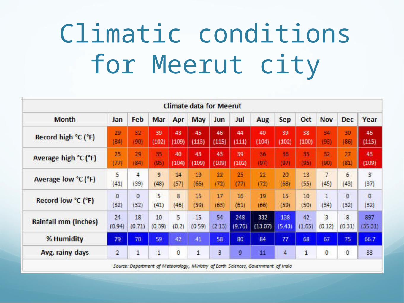
Climatic conditions for Meerut city

Item Characteristics/ItemValue/
Quantity/Numbers
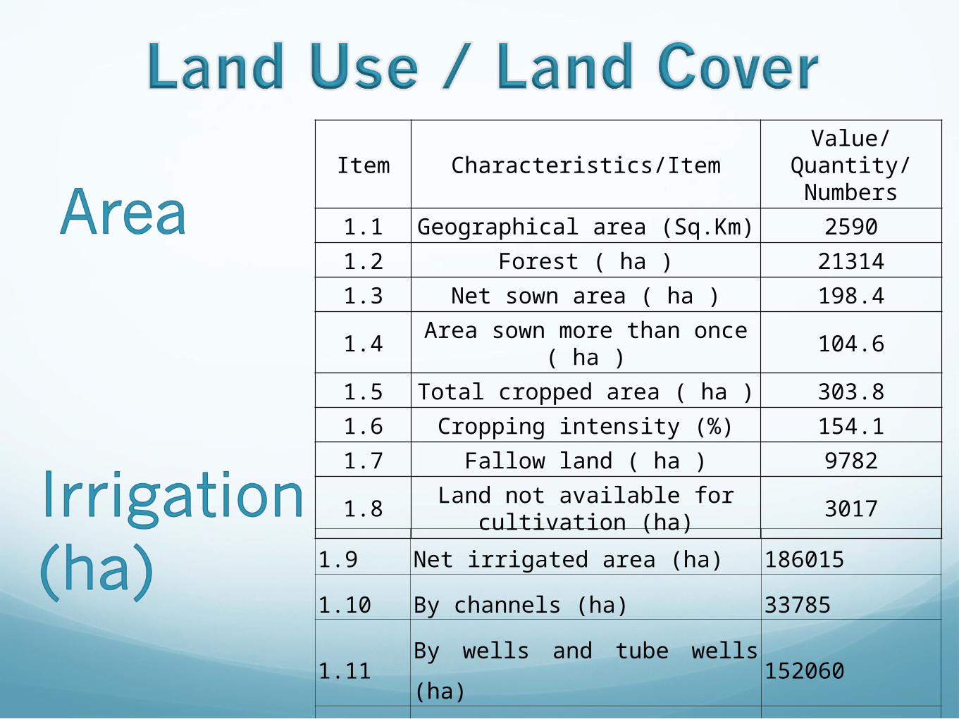
1.1 Geographical area (Sq.Km) 25901.2 Forest ( ha ) 213141.3 Net sown area ( ha ) 198.4
1.4 Area sown more than once ( ha ) 104.6
1.5 Total cropped area ( ha ) 303.81.6 Cropping intensity (%) 154.11.7 Fallow land ( ha ) 9782
1.8 Land not available for cultivation (ha) 3017
1.9 Net irrigated area (ha) 186015
1.10 By channels (ha) 33785
1.11By wells and tube wells (ha)
152060
1.12 By other sources 170

Administrative 2 2.1 No of blocks 12
2.2 No of villages inhabited and electrified
776 villages electrified out of
883
2.3 No of villages with potable water supply 883
3 Rainfall (mm) 665
4 Agro-climatic region and zone Upper Gangetic plain region, Western plain
5
PopulationMaleFemale
Population below poverty linePopulation Density (per sq km)
2973.81588.91384.9195431347
6 Literacy (%)
Male (%)Female (%)
53.661.944.0
7 7.1 Nationalized bank branches 187 7.2 Cooperative Banks 29
7.3 Cooperative and Village Development Bank 4
8 8.18.2
CultivatorOf whom small & marginal ones 1,81,817
8.3 Agricultural labourers 65486 8.4 Artisans 8.5 Household/cottage industries 32460

Hazard Hazard may be defined as “a dangerous condition or
event, that threat or have the potential for causing injury to life or damage to property or the environment.” The word ‘hazard’ owes its origin to the word ‘hasard’ in old French and ‘az-zahr’ in Arabic meaning ‘chance’ or ‘luck’
A disaster happens when a hazard impacts on the vulnerable population and causes damage, casualties and disruption. Following fig. would give a better illustration.

Types of Hazards

Meerut is vulnerable to the following
hazards:Geological hazards: EarthquakeWater and Climate Hazards: Floods, Droughts, Stroms, Cold/Heat waves
Environment and Biological hazardsChemical, Industrial and Nuclear hazards
Accidents

Geological Hazard: Earthquake
Earthquake is one of the most destructive natural hazards. They may occur at any time of the year, day or night, with sudden impact and little warning. They can destroy buildings and infrastructure in seconds, killing or injuring the inhabitants.
According to Building Material and Technology Promotion Council(BMTPC) Atlas, Meerut comes under a high risk zone IV.

Uttar Pradesh Earthquake Zone

Water and Climate Hazards: Flood
Flood is a state of high water level along a river channel or on the coast that leads to inundation of land, which is not usually submerged. Floods occur in almost all the river basins of the country. Around 12 per cent (40 million hectare) of land in India is prone to floods. According to Building Material and Technology Promotion Council (BMTPC) Atlas, around 12.3 % of area of Meerut comes under flood and has been observed under Very High Risk zone.
Map showing Flood zones in India

Wind Hazards Meerut comes under very high risk zone for the wind hazards with wind velocity of 47m/s. The following map shows the risk zone for Uttar Pradesh.
State wind hazard map

Disaster Profile : Meerut
The infamous Meerut Fire 2006 case that swept through a consumer electronics fair (Brand India Fair) in Victoria Park, killing at least 100 people and injuring 150 others, caused widespread loss to the human resource, economic revenues and social aspects.
It was received by shock and mourning by all the people of the nation and also internationally. Moreover it led to the truth that city has negligible preparedness regarding disasters so fatal as Meerut fire of 2006 and that the Disaster Management cell in the city was still in infancy.
Disaster Profile : Meerut
According to current status, the Disaster Management Cell in Meerut is held single handedly by one officer and that no relevant statistical data for the city’s disaster events is available at th office (source: DM Office).

Past Disasters in Meerut
No. Disaster Event Date Casualties Damage Caused1 STRUCT COLLAPSE 9/3/1995 40 ?2 STRUCT COLLAPSE 3/1/1996 1 ?3 EXPLOSION 4/27/1996 144 EXPLOSION 3/3/19975 FOOD POISONING 6/8/1992 1 100 girls fell ill6 EPIDEMIC 2/7/19927 EXPLOSION 10/21/1992 28 FOOD POISONING 11/12/1991 29 EPIDEMIC 7/4/1994 4610 FOOD POISONING 10/16/1991 611 EXPLOSION 5/19/1993 512 FIRE 1/7/199413 EPIDEMIC 6/21/1996 814 STRUCT COLLAPSE 7/21/1998 1
15 FOOD POISONING 8/16/1998 4 All people of the same family died
16 STRUCT COLLAPSE 7/22/1997 1017 COLD WAVE 1/17/1999 118 FOOD POISONING 11/25/2005 Adulteration Of milk19 EPIDEMIC 5/20/2002 320 FOOD POISONING 5/21/2002 421 EXPLOSION 5/18/2002 122 EXPLOSION 10/9/2002 2

23 FIRE 10/5/2002 5
24 EPIDEMIC 12/1/2002 2
25 COLD WAVE 1/5/2003 1
26 ACCIDENT 12/29/2002 2
27 EXPLOSION 12/16/2003 Explosion in a army core.
28 FLOOD 29/8/1995 5 i) Several Kutcha houses collapsed
29 HEAVY RAINS 3/9/1995 40 One five storied building (Shere Punjab) razed to ground
30 COLD WAVE 16/12/1996
31 COLD WAVE 31/1/1994 18
32 SEVERE FLOODS _/7/1993 35
i) 9.3 lakh people affectedii) 1.35 lakh hectare land floodediii) 314 houses completely and 3,067 partially damagediv) 407 cattle heads perished
33 SEVER FLOODS _/9/1993 171 1940 cattle heads perished
34 SEVERE HEAT WAVE 26/5/1998 33
35 SEVERE HEAT WAVE 1-4/06/1998 96
36 FIRE 10/4/2006 110
Past Disasters in Meerut

Conclusion & Recommendations
Meerut city is highly vulnerable to many natural and man- made hazards that have potential to turn into fatal disasters and cause widespread destruction and disruption of life and other activities.
Meerut comes under earthquake zone IV, very high flood risk zone and very high wind hazard risk zone along with strings of human induced disasters. It not only disrupts human life but also adversely affects the socio- economic nature of the city, considering that Meerut contributes significantly to the nation’s economy

Currently, the city has District Disaster Management Cell, controlled single handedly by an officer appointed. The cell lacks the statistical data of the past disaster events in Meerut. Moreover it seems to be less capable of providing mitigation, preparedness, recovery and relief features against disasters for the economically and socially important city Meerut.
Therefore it is important that Meerut should have a District Disaster Management plan as mandated by the DM Act, 2005, and constitute a District Disaster Management authority to look after the district disaster prevention, mitigation, relief, recovery and preparedness measures. And hence by making Meerut a disaster free and safe city, contribute to the nation’s development significantly.