Report on the joint UNESCO-ICOMOS Reactive Monitoring ...
43
REPORT ON THE JOINT UNESCO-ICOMOS REACTIVE MONITORING MISSION TO LOWER VALLEY OF THE OMO WORLD HERITAGE PROPERTY FEDERAL DEMOCRATIC REPUBLIC OF ETHIOPIA 13 - 19 APRIL 2015
-
Upload
khangminh22 -
Category
Documents
-
view
1 -
download
0
Transcript of Report on the joint UNESCO-ICOMOS Reactive Monitoring ...

REPORT ON THE JOINT UNESCO-ICOMOS REACTIVE MONITORING MISSION TO
LOWER VALLEY OF THE OMO WORLD HERITAGE PROPERTY FEDERAL DEMOCRATIC REPUBLIC OF ETHIOPIA
13 - 19 APRIL 2015

2
TABLE OF CONTENTS ACKNOWLEDGEMENTS ........................................................................................................................... 4
EXECUTIVE SUMMARY AND LIST OF RECOMMENDATIONS .................................................................... 5
1 BACKGROUND TO THE MISSION ..................................................................................................... 8
1.1 Inscription history .......................................................................................................................... 8
1.2 Statement of Outstanding Universal Value ................................................................................... 8
1.3 Authenticity issues raised in the ICOMOS evaluation report at time of inscription ................. 9
1.4 Examination of the State of Conservation by the World Heritage Committee and its Bureau (refer to previous State of Conservation reports etc.) ........................................................................ 9
1.5 Justification of the mission .......................................................................................................... 10
2 NATIONAL POLICY FOR THE PRESERVATION AND MANAGEMENT OF THE WORLD HERITAGE PROPERTY .............................................................................................................................................. 10
2.1 Heritage legislation ...................................................................................................................... 10
2.3 Management structure ............................................................................................................... 11
3 IDENTIFICATION AND ASSESSMENT OF ISSUES / THREATS ........................................................... 12
3.1 Management effectiveness ......................................................................................................... 12
3.2 Nature and extent of threats to the property, taking into consideration the criteria and attributes for which the property was inscribed and specific issues outlined by the World Heritage Committee ......................................................................................................................................... 12
3.3 Positive or negative developments in the conservation of the property since the last report to the World Heritage Committee ......................................................................................................... 16
3.4 Information on any threat or damage to or loss of Outstanding Universal Value, integrity and/or authenticity for which the property was inscribed ............................................................... 17
3.5 Findings and observations ........................................................................................................... 17
4 ASSESSMENT OF THE STATE OF CONSERVATION OF THE PROPERTY ........................................... 18
4.1 Review whether the attributes of Outstanding Universal Value, on the basis of which the property was inscribed on the World Heritage List, and the conditions of integrity and authenticity are being maintained ........................................................................................................................ 18
4.2 Review any follow-up measures to previous decisions of the World Heritage Committee on the state of conservation of the property and measures which the State Party plans to take to protect the Outstanding Universal Value of the property ............................................................................. 19
5 CONCLUSIONS AND RECOMMENDATIONS ................................................................................... 20
5.1 Summary of findings .................................................................................................................... 20
5.2 Recommendations for any additional action to be taken by the State Party, including draft recommendations to the World Heritage Committee ...................................................................... 20

3
5.3 Recommendation as to whenever further action is needed, with clear benchmarks indicating the corrective measures to be taken in order to improve the state of conservation and management of the property ............................................................................................................ 21
5.4 Recommendation as to whether the level of threats to the property warrants the property being placed on the List of World Heritage in Danger ...................................................................... 22
6. ANNEXES ............................................................................................................................................ 23
Terms of reference and composition of mission team
1. Itinerary and programme 2. List and contact details of people met 3. Maps 4. Photographs and other graphical material 5. Decisions of the World Heritage Committee 6. References 7. Correspondence re: Missing Documentation

4
ACKNOWLEDGEMENTS The mission team would like to thank the Federal Republic of Ethiopia for extending the invitation for this joint World Heritage Centre-ICOMOS Reactive Monitoring Mission to the Lower Valley of the Omo World Heritage property. The hospitality of the Ministry of Culture and Tourism, which was extended through the Authority for Research and Conservation of Cultural Heritage (AARCH), was deeply appreciated by the mission team. In particular, our sincere thanks go out to Mr. Amin Abdulkadir, Minister of Culture and Tourism, Mr. Yonas Desta, Director-General of AARCH, and Ms. Tsehay Eshetie, Director for National and World Heritage Management. The participation of Mr. Taye Duresa and Mr. Ekal Nettir from the Ethiopian Sugar Corporation offered the mission team valuable insights into the Kuraz project during the site visit. We were also pleased to have Mr. Mulugeta Zewdie, Deputy Chief of Cabinet from the Office of the State Minister in the Ministry of Foreign Affairs, accompanying our mission team on the site visit. All three professional helped our mission team to overcome obstacles and to gain clarity about the Kuraz project and the World Heritage site throughout our mission. We would also like to acknowledge the contribution of Mr. Tadesse Kayi and Mr. Lore Kakuta, Administrators from the Gnangatom District, who accompanied our site visits and answered our numerous questions. We were grateful for the time that the State Minister of the Ministry of Foreign Affairs, H.E. Mr. Berhane Berbe-Christos, devoted to our mission team prior to the site visit. His insights into the national policies and priorities for heritage protection and development were instrumental in our evaluation. We are also indebted to Mr. Mulugeta Seid Damtew, State Minister of the Ministry of Culture and Tourism and Mr. Getnet Yigzaw, Senior Tourism facilitation expert, for their open dialogue prior to our site visit. Lastly, the UNESCO Office in Addis Ababa provided valuable support before and after the mission, which helped guarantee the success of the mission. Our sincere gratitude go out to all of you. Karalyn Monteil & John Kinahan, 2 May 2015

5
EXECUTIVE SUMMARY AND LIST OF RECOMMENDATIONS Following Decision 38 COM 7B.48 of the World Heritage Committee at its 38th session in Doha (June 2014) requesting the State Party of Ethiopia to invite a joint UNESCO World Heritage Centre- International Council of Monuments and Sites (ICOMOS) Reactive Monitoring Mission to the Lower Omo Valley to consider the conservation issues raised by the Committee in its previous decisions regarding the potential impact of the Kuraz Ethiopian Sugar Development Corporation Project, the mission team travelled to Ethiopia from 13 to 19 April 2015 to meet with national authorities and representative of the Ethiopian Sugar Corporation, and to visit the World Heritage property. The mission was tasked with obtaining an overview of the Kuraz development project and understanding its progress as well as reviewing the detailed cultural heritage impact assessment based on the precise details of the Kuraz project and the precise attributes of the Outstanding Universal Value of the property in order to understand its potential impact on OUV. The mission aimed to evaluate the progress made by the State Party in assessing fossil-bearing sediments in order to clearly define the areas of potential archaeological importance. They were also charged with discussing the European Union-funded project for geo-mapping of the Lower Omo Valley and clarifying the boundaries of the property. The team undertook a site visit to the World Heritage property in order to assess the general impact of the Kuraz project and its relationship to the boundary of the property as well as to its setting and wider context. As a UNESCO mission had not visited the Lower Omo Valley since 2004 (Stott and van Regteren Altena), this joint World Heritage Centre-ICOMOS Reactive Monitoring Mission provided not only an opportunity to review the potential impact of the Kuraz sugar development project on the World Heritage property but also an opportunity to review the overall state of conservation of the property.
The mission confirmed that the boundaries of the property as well as its wider context and setting are still undefined. In view of the proposed development of the Kuraz project, which may involve large-scale irrigation as well as the development of dams, roads and settlements, the integrity of the property could be considered to be imminently vulnerable. There is no evidence, however as to show that the property is actually being damaged by this project, nor is the authenticity of the property, at present, is subject to physical destruction or encroachment.
Protected until recently by its remote location, the Lower Valley of the Omo could be under imminent threat from the Kuraz project. The property has no established boundary, and it has neither management plan nor an on-site manager. Planning of the large-scale Kuraz sugar project had reached an advanced stage before an HIA was undertaken, and the resulting report provides an inadequate means to advise and guide the development project to a path of least impact for the property. While the legal and institutional frameworks for the protection of the property are in place, their functioning seems to be subordinate to the prerogatives of development.
6
Despite this imminent threat, the property currently shows no obvious signs of damage and it cannot therefore be said that the Ethiopian authorities have failed to protect the property. Nevertheless, there are concerns that the development of the Kuraz project has been based on inadequate documentation of the property, in relation to the known fossil-bearing outcrops and potential areas of archaeological importance, to known and potential increases in soil salinization for which no possible mitigating measures have been considered so far, and to possible changes in river levels resulting from dam construction that could lead to exposure of underlying fossil-bearing deposits. Furthermore, currently no clear plans have been provided to indicate the precise siting of the project, or its design criteria for the positioning of the sugar mills. Its visual impact on the property, particularly from the extent and height of the sugar mills, is not known.
Permission has already been granted for agricultural development without apparent consideration of the implications for the OUV of the Valley of the Lower Omo property. Related decisions that have potentially serious implications for the OUV of the property include: permission for the commencement of physical works including dam construction, planning of the spatial extent of the sugar plantation area, final design of the new road link from Omo Rate to Kangaten, and granting of fossil fuel exploration rights over the entire area containing the property, again without prior assessment of potential impacts.
No detailed plans of the Kuraz project were made available to the mission, only a general map was provided, indicating the position of the fossil-bearing outcrops in relation to the provisional development plan for the Kuraz project. Despite repeated requests no further concrete information was forthcoming.
Measures to, establish the boundary and a site management plan, are to be undertaken in the near future through a European Union-funded project to be implemented in partnership with the UNESCO Office in Addis-Ababa. There is an urgent need for on-site management of the property to be put in place, based on adequate documentation of the property and agreed constraints for the Kuraz project.
The main concern of the mission is that development work on the Kuraz project is likely to commence before these measures are undertaken, in the case of the boundary, before formal clarification by the World Heritage Committee, and, in the case of the management plan, before its implementation, and that irreversible harm may be done to the property and its landscape setting. It is considered essential to the conservation of the property if all developments that might encroach on the proposed boundaries of the property – as provisionally outlined in this report – were delayed until the completion of the EU project.
The mission team therefore recommends that:
1. Final planning of the extent of the Kuraz project should await the results of the EU-funded boundary project, the submission of the proposed boundaries of the property to the World Heritage Centre for independent review in relation to the Lower Valley of the Omo SOUV, and their approval by the World Heritage Committee.
2. Meanwhile all existing details of the Kuraz project should be submitted to the World Heritage Centreas soon as possible for review by the Advisory Bodies;

7
3. At present, the envisaged piecemeal exclusion of fossil-bearing outcrops from the Kuraz project does not constitute adequate protection of the property in relation to its OUV as the known fossil-bearing outcrops do not in themselves define the extent of the property. Equally important fossil and archaeological material lies unexposed in the area surrounding the visible outcrops. Definition of the property in terms of the visible outcrops alone does not therefore reflect its scientific potential as envisaged at the time of inscription of the property.
4. A property boundary (exclusion zone) should be established with the purpose of preserving the property as an unbroken landscape unit with its archaeological attributes within a visually coherent landscape. Any compromise of this principle (i.e. fragmentation through cultivation or development of ground between outcrops) would be considered as a potential threat to the OUV of the property, in which case the World Heritage status of the property could in that case be subject to review.
5. A site management plan for the Lower Valley of the Omo should be developed that covers the necessary constraints for the envisaged Kuraz project and the intended development of appropriate paleo-tourism in the area, and thus should include a risk management component. The management plan should be based on the agreed boundary, on detailed mapping and inventories, on practical liaison with the Kuraz project, and on the promotion of local community involvement in both site management and tourism.
6. AARCH and the UNESCO Office in Addis Ababa, as the implementation partners for the EU project benefitting Lower Omo Valley, should liaise closely with the UNESCO World Heritage Centre and the Advisory Bodies for technical support and guidance.
In addition, the mission further recommends:
1. A soil erosion monitoring baseline should be established on the property as a matter of priority. The baseline will involve a grid or series of transects (whichever is appropriate) with fixed points at which the change in the surface elevation will be measured at determined intervals.
2. Where appropriate, soil erosion control measures such as rock-filled gabions should be installed at the head of gullies where erosion poses a threat to known fossil-bearing deposits.
3. If these do not already exist, protocols should be drawn up for the back-filling and rehabilitation of research excavations, and all open research excavations should be back-filled as a matter of urgency, both with adequate archaeological supervision. All new archaeological research projects must include an obligation for consolidation to be undertaken within an agreed timescale.
4. A soil salinization monitoring baseline should be established as a matter or priority. This will involve a grid or series of transects (whichever is appropriate) with fixed points at which the change in the soil salinity will be measured at determined intervals.
5. A soil salinity baseline should be established for areas of planned irrigation adjacent to the property and the soil salinity should be monitored as regularly as needed.
6. The Kuraz project should actively investigate the potential for salt tolerant plants to be planted between the areas of irrigation and down-gradient fossil outcrops. This will have the effect of removing soluble salts from near surface soil, which could threaten fossils.

8
7. The Kuraz project should actively investigate the possibility that fluctuations in the level of the Omo River as a result of damming will accelerate erosion of fossil outcrops adjacent to the river. Such investigation should consider the use of erosion control bunds at critical points.
1 BACKGROUND TO THE MISSION
1.1 Inscription history The Lower Valley of the Omo was inscribed on the World Heritage List in 1980 as a cultural property. It is the most remote of all the Ethiopian World Heritage sites, located 25 km from the border with Kenya but over 550 km from Addis Ababa. Its brief description upon inscription is as follows: A prehistoric site near Lake Turkana, the Lower Valley of the Omo is renowned the world over. The discovery of many fossils there, especially Homo gracilis, has been of fundamental importance in the study of human evolution.
1.2 Statement of Outstanding Universal Value Statement of Outstanding Universal Value (adopted in 2012): The Lower Valley of the Omo is located in south-western Ethiopia. It extends over an area of 165 km2. The age old sedimentary deposits in the Lower Omo Valley are now world renowned for the discovery of many hominid fossils, that have been of fundamental importance in the study of human evolution. The Lower Omo Valley includes the Konso and Fejej paleontological research locations with sedimentary deposit going back to the plio-pleistocene period. These have produced numerous hominid and animal fossils, including fragments of Australopithecus. The deposits of human vertebrae fauna, and paleo-environmental evolution, shed light on the earliest stages of the origins and development of Homo sapiens of Africa. The discoveries of ancient stone tools in an encampment also offers evidence of the oldest known technical activities of prehistoric beings, thus making the property one of the most significant for mankind. To ensure Omo’s position as the yardstick against which all other ancient deposits in East Africa are measured, researched evidence from the site has established bio-stratigraphical, radiometric and magneto-stratigraphical scales spanning between one and 3.5 million years. Since 1966, scientific research has proved that the site significantly contributes to prominent archaeological, geological, paleo-anthropological and paleo-environmental studies. Criterion (iii): Evidence from the Lower Omo Valley pre-historic and paleo-anthropological site have provided a unique insight into the oldest known technical activities by pre-historic beings. Criterion (iv): Discoveries from the Lower Omo Valley represent exceptional developments in the domain of cultural activities in the pre-historic time.

9
1.3 Authenticity issues raised in the ICOMOS evaluation report at time of inscription
At the time of inscription it was reported that the sites where discoveries were made remained intact, as did their context. Overall the areas that might provide further evidence of early man were then undisturbed.
1.4 Examination of the State of Conservation by the World Heritage Committee and its Bureau (refer to previous State of Conservation reports etc.)
Please see: http://whc.unesco.org/en/list/17/documents/ for the full reports of the Committee. Below is a summary of the latest Committee decisions concerning Lower Valley of the Omo: 2013 The World Heritage Committee expressed its concern over the Kuraz Sugar Cane Development Projects, which may have a negative impact on the Outstanding Universal Value (OUV) of the Lower Valley of the Omo, if located within or near the property. The Committee regretted that the State Party has not replied to letters requesting clarification on the projects and their location in relation to the boundaries of the property, and requested that details on all planned development projects, and documents on the Kuraz projects, including the Environmental Impact Assessment (EIA) carried-out in 2011. They also asked the State Party to carry-out Heritage Impact Assessments (HIA) on the roads and sugar development projects before work commences and before any irreversible commitments are made. The Committee also expressed its concern over the absence of a management plan, and the lack of clarification of the boundaries and buffer zone for the property. 2014 The World Heritage Committee welcomed the Heritage Impact Assessment (HIA) on the potential impacts of the Ethiopian Sugar Development Corporation Project (Kuraz project). The HIA indicates the potential for massive adverse impacts on the property from the irrigation and excavations associated with the development of sugar plantations, settlements and access routes, and also notes that there is conflicting information on the precise extent and location of the Kuraz project. The Committee urged the State Party to provide as soon as possible clear documentation on the scope and extent of the project and its precise location with regards to the property, in order to clarify whether it is within the property or its buffer zone; and requests clear information on the impact on pastoral communities with regards to resettlement schemes. The Committee recalled its request for the final report of the Environmental Impact Assessment carried out in 2011, and requested the State Party to improve the HIA with a detailed cultural heritage assessment based on the precise details of the Kuraz project and the precise attributes of the property, as well as to carry out an assessment of fossil-bearing sediments in order to more clearly define areas of potential archaeological importance. The European Union project for the boundary delineation and the management plan were acknowledged as well as the Paleo-tourism potential of the property.

10
Lastly, the Committee requested the State Party to invite a joint UNESCO/ICOMOS reactive monitoring mission to the property to consider the above issues and the potential impact of the Kuraz project.
1.5 Justification of the mission Following the request of the World Heritage Committee at its 38th session in Doha (June 2014) for the State Party of Ethiopia to invite a joint World Heritage Centre ICOMOS reactive monitoring mission to the Lower Omo Valley to consider the conservation issues raised by the Committee and the potential impact of the Kuraz Ethiopian Sugar Development Corporation Project (Decision 38 COM 7B.48), and following the letters of invitation for this mission sent by the State Party of Ethiopia on 8 January 2015, 13 March and 27 March 2015, the mission team travelled to Ethiopia from 13 to 19 April 2015. Please see annexes for the terms of reference, itinerary, programme and composition of the mission team. As a UNESCO mission has not visited the property since 2004, this joint reactive monitoring mission also provided an opportunity to review the overall state of conservation of the property.
2 NATIONAL POLICY FOR THE PRESERVATION AND MANAGEMENT OF THE WORLD HERITAGE PROPERTY
2.1 Heritage legislation
The UNESCO Database of National Cultural Heritage Laws contains the following list of Ethiopian heritage legislation (ref http://www.unesco.org/culture/natlaws/) Normes constitutionelles africaines relatives à la culture et à la sauvegarde du patrimoine
1966 Proclamation N.229 pf 1966 to provide for the protection and preservation of antiquities
1976 Charte culturelle de l'Afrique
1981 Charte africaine des droits de l'homme et des peuples
1985 Protocole relatif aux zones protégées ainsi qu'à la faune et la flore sauvages dans la région de l'Afrique orientale (Nairobi-1985)
1989 Déclaration des Etats d'Afrique, des Caraibes et du Pacifique (ACP) sur le retour ou la restitution des biens culturels
2000 Proclamation 209/2000 to provide for research and conservation of cultural heritage
2000 Accord de partenariat entre les Etats d'Afrique, de Caraibes et du pacifique (ACP) et la Communauté européenne et ses Etats membres en date du 23 juin 2000 dit "Accord de Cotonou"
2002 Droit et Patrimoine en Afrique 1: de l'Afrique du Sud à l'Ethiopie
2003 Convention africaine sur la conservation de la nature et des ressources naturelles
11
2003 Accession to the Convention for the protection of Cultural Property in the event of Armed Conflict and its first protocol, Proclamation No. 373/2003
2014 Cultural Heritage Classification into National and Regional cultural heritage, Proclamation No. 839/2014
2014 Directive on the Conservation Laboratory service No.17/2014 2014 Directive for Heritage Accession and Collection No. 16/2014 2014 Directive for Heritage Loan No.15/2014 2014 Directive Heritage Transfer and Removal No.10/2014
2.2. Institutional framework
The World Heritage property falls under the responsibility of the Authority for Research and Conservation of Cultural Heritage within the Ministry of Culture and Tourism of the Federal Democratic Republic of Ethiopia.
2.3 Management structure The Authority for Research and Conservation of Cultural Heritage (AARCH) was established through the By-law for “Research and Conservation of Cultural Heritage Proclamation No. 209/2000”. Its mandate includes protecting cultural heritage by authorizing and providing technical support for cultural heritage restoration and conservation works (art. 6.7 and 6.10 of the Proclamation). The property was placed under the protection of the Administration of Antiquities in 1969 through the National Law of 1968. No special legal framework is provided to protect the Lower Omo Valley, except for the general law, Proclamation No. 209/2000, which established the Authority for Research and Conservation of Cultural Heritage as the institute in charge. Currently the zonal and regional Information and Culture Departments perform the management functions. A management plan has not yet been established and, due to the extreme geographical difficulties involved, no attempt has yet been made to define the boundary of the property or its buffer zone; however, funding received from the European Union in 2015 shall go towards the development of maps of the property and buffer zone boundaries with GPS coordinates, based on detailed surveys. A site manager, Mr. Dagnenet Lake, was appointed for the World Heritage property by AARCH. He is based in Jinka, but he was not present during the Reactive Monitoring Mission.
12
3 IDENTIFICATION AND ASSESSMENT OF ISSUES / THREATS
3.1 Management effectiveness
There is a high level of awareness in the Ethiopian government regarding the value of the property, which is viewed as a valuable asset and as a responsibility borne on behalf of humanity. This awareness and the existence of appropriate legal protection, form the necessary basis of effective management. Ethiopia also has legal provisions for the control of research and for the assessment of potential impacts by development, tourism and other possible threats. The property falls under the control of a site manager based in Jinka, and is visited at intervals by officials accompanying foreign research expeditions. Unfortunately, the mission team did not meet the site manager, and he did not participate in the site visits. However, we were informed by AARCH that he drafts the state of conservation reports on the property, which are submitted to the World Heritage Committee.
The existence and value of the property is also reflected in the planning of the Kuraz project. Maps produced by the project management include the outlines of the site outcrop areas, as well as suggested buffer zones to ensure the protection of the sites.
The effectiveness of site management is however compromised by a number of factors. The most important of these is the absence of a delineated boundary for the property as a management area. The fact that the property itself is indicated only as a single geographical point in its nomination file and inscription is problematic. The furthermost fossil outcrop lies approximately 65km north of the designated property position (Annex 4 Fig 1). Furthermore, this extensive area cannot be effectively controlled by a site manager who is himself based elsewhere in the region. Although officials visiting the area during research expeditions are able to monitor the property on an occasional basis this does not constitute a regular management programme. It appears that de facto management of the property area is carried out at the moment by the Kuraz project, which is at the same time the most immediate threat to the integrity of the property.
An important consideration with regard to management effectiveness is that the Ethiopian government perspective on the property differs in some critical respects from the stated World Heritage nomination description and SOUV. Thus, while the government and Kuraz perspective is focused on the known fossil-bearing outcrops as a series of discrete features, the nomination description emphasizes the importance of the “wider context and setting” of the property. In this regard it is noteworthy that the need for a boundary survey and management plan was expressed under the section Protection and Management Requirements of the SOUV, in 1996. There is still neither a boundary nor a management plan nineteen years later, despite the imminent threat of encroachment on the property. Nevertheless, funds have been obtained from the European Union to address this in 2015-2016.
3.2 Nature and extent of threats to the property, taking into consideration the criteria and attributes for which the property was inscribed and specific issues outlined by the World Heritage Committee

13
The HIA prepared by the State Party in 2014 identifies the development of agriculture, principally in the form of the Kuraz project, as the most urgent threat to the property. The HIA specifies that nature of the threat as encroachment on the fossil outcrops through the establishment of extensive irrigated sugarcane plantations, and associated infrastructure including large-scale settlement for workers, as well as roads and pipelines. The HIA envisages damage to the fossil-bearing sediments through impact by heavy machinery, and direct disturbance as a result of deep excavation. The HIA also identifies pillage of fossil specimens from the unprotected outcrops as a significant threat.
A report prepared by Dr Jean-Renaud Boissiere in 2011 identified five specific threats to the World Heritage property, namely: the grant by the Ethiopian Government of an agricultural development area without apparent consideration of the implications for the property; the commencement of physical works including dam construction, evidently without prior assessment of potential impacts on the property; planning of the spatial extent of the sugar plantation area without prior assessment of potential impacts on the property; final design of the new road link from Omo Rate to Kangaten without prior assessment of potential impacts on the property; granting by the Ethiopian Government of fossil fuel exploration rights over the entire area containing the property, again without prior assessment of potential impacts.
Intervention by the responsible authority, ARCCH, supported by the French research expedition, has provided some, albeit belated, mitigation of these threats. Principally, the existence and extent of the fossil outcrops is indicated on the current Kuraz project planning, together with some proposed buffer zones. It is now possible to state that the property – as a spatial entity – is integrated in the project planning. Furthermore, local administration personnel in Kangaten, as well as Kuraz project personnel are clearly aware of the World Heritage property and its importance. The Deputy Director General of the Irrigation and Housing Infrastructure for the Ethiopian Sugar Corporation as well as the Kuraz project coordinator both assured the mission team that if any threats are identified to the World Heritage property then they will modify their project to protect it. The intervention by ARCCH has also extended to the planning of the Omo Raten to Kangaten road alignment. However, it must be said that these responses are reactive rather than proactive, and given the scale of the Kuraz project and the absence of clear property demarcation and on-the-ground site management, the threats to the property remain serious and inadequately addressed.
The present reactive monitoring mission provided an opportunity to examine the physical fabric of the property and to gain some direct insight into the intended project. As a result, a number of further threats were identified. The two principal physical threats include accelerated erosion of the fossil exposures due in some measure to the periodic lowering of the Omo River base-level, and the destruction of fossil material in situ as a result of increased salinization of soils under irrigation in the area adjacent to the fossil outcrops. To these may be added the threat of visual intrusion resulting from the construction of large installations such as sugar mills, and the visual fragmentation of the unique physical setting of the property. It is envisaged that these physical and visual threats will directly undermine the stated aim of the Ethiopian Government to develop the scientific and tourism potential of the property.

14
Sheet and gully erosion are a function of gradient and rainfall, amplified in the case of unconsolidated sediments without sufficient vegetation cover. These conditions are prevalent on the Lower Omo Valley, where Plio-Pleistocene volcanic ashfall deposits have been exposed beneath more recent illuvial sediments covering much of the valley floor and representing what was evidently an extensive inland delta until the end of the Last Glacial Maximum (LGM) about 15 000 years ago. Deep incision by the Omo River, relative to the base-level of Lake Turkana has resulted in lateral erosion of the river course, thus exposing the underlying fossil-bearing deposits. These deposits are only partially exposed, their greater extent being sealed beneath the overlying illuvium (Annex 4 Fig 4).
The Lower Valley of the Omo receives between 150 and 350mm rainfall per year, usually in the form of isolated heavy showers. On average, the gradient of exposed sediments adjacent to the lower Omo is 1:100 (based on elevation data Ethiopian Mapping Authority ETH4 0536 C3), sufficiently steep to ensure both high flow velocity and erosive potential. As a consequence, and in the absence of vegetation cover, the exposed sediments are vulnerable to displacement from their geological context by sheet and gully erosion. This process would be accelerated by an increase in either rainfall or gradient, and the lowering of the Omo base-level due to upstream dam construction and interrupted flow is therefore expected to result in an increase in erosion of the sites.
There are at present no measurements available for the rate of sheet and gully erosion on the property and it is consequently not possible to state whether this represents an imminent threat to the integrity of the fossil-bearing deposits. However, noting the physical processes outlined here, and the highly eroded appearance of the exposed deposits it is expected that measurement of erosion rates would indicate a high level of threat (Annex 5 Fig 2).
Soil salinization is a common consequence of large-scale irrigation, especially under hot tropical conditions. Dissolved salts are also subject to movement under gravity and given the gradient conditions just described for the Lower Valley of the Omo, it is to be expected that capilliary groundwater would move downslope from areas of cultivation towards the lowest point of the valley. This means that irrigation water, carrying an undetermined quantity of dissolved salts would move across the fossil-bearing sediments en route to the Omo. Natural surface movement of water results in surface ponding of saline water, and the formation of a superficial salt crust, but where irrigation results in soil saturation, saline water would move beneath the soil surface. Under high temperature conditions such as are prevalent in the Lower Valley of the Omo, evaporation would draw the saline solution to the soil surface creating an enriched salinity in near surface soil. Where saline soil water penetrates fissures and hairline cracks in fossil material, deliquescence and the crystallization of salts will result in mechanical fracturing and progressive fragmentation of the fossil material.
No data are available from the Kuraz project to indicate the natural level of salinity in the soil of the Lower Valley of the Omo, but the presence of minor surface crusting in the fossil bearing sediments is consistent with relatively high levels of salinity in the weathering products of volcanic ash soils. There are similarly no data available on the salinity of irrigation water, so it is not possible at this point to determine the degree of risk posed by an increase in soil salinity. However, given the known effects of soil salinity on the preservation of fossil material it is expected that this will become a matter for concern. As far as could be
15
determined during the reactive monitoring mission neither the effect of soil salinization nor the adoption of possible mitigating measures have been considered so far by the Kuraz project.
Visual intrusion in the vicinity of the property will negatively affect the wider context and setting of the fossil-bearing deposits, and this will have a direct negative impact on their tourism potential. The Lower Valley of the Omo is generally flat, with little positive relief. This means that infrastructure related to the Kuraz project will be highly visible. Sugar mills are the largest infrastructure component of sugar farming on the scale envisaged by the Kuraz project. On average sugar mills have an overall footprint of 40 000m2, with a large roofed surface, and a chimney-stack height of around 25m. Given these figures and the flat terrain of the project area, it is to be expected that a sugar mill will be plainly visible within a radius of approximately 30km, or over an area of approximately 2 800km2. It is understood that a number of sugar mills will be established by the Kuraz project in the Valley of the Lower Omo (Annex 4 Fig 5).
Neither the design criteria nor the positioning of the Kuraz project sugar mills are known at present. However, given that the context and setting of the property is considered to be an essential component of its integrity, visual intrusion on the scale indicated here must be considered a serious threat to the OUV of the property.
Landscape fragmentation of the property is likely to result from optimal use of the surrounding area for cultivation and associated infrastructure of the Kuraz project. The Valley of the Lower Omo property comprises three main outcrop areas, representing the Kibish, Mursi, Usno and Shungura Formations. These are spread over a distance of 65km. The Kibish, which includes the Mursi within its spatial extent is bisected by the Omo and covers a total area of about 40km2; the Usno, consisting of two discrete outcrop areas, covers about 10km2, while the Shungura exhibits broken margin reflecting severe gully erosion, and covers nearly 200km2. The World Heritage property is however defined by a single point (North Latitude 4°48’; East Longitude 35°58’) near the southern end of the Shungura. The Kibish Formation lies 65km north of this point, and the Usno 60km to the northeast.
If the very extensive and apparently arable area between these outcrops is put under cultivation it will disrupt the landscape setting of the property, reducing it to a series of discrete fossil occurrences. It should be noted that since the property is inscribed as a single entity (rather than a serial nominated site), cultivation of the area between the outcrops will result in its effective fragmentation. The fact that the property has no delineated boundary has meant that the layout of the Kuraz project has been able to proceed without such hindrance. If the property has no delineated boundary, cultivation of the area in between the outcrops will represent a threat to the context and setting of the property, which is considered to be an essential component of its integrity, visual intrusion on the scale indicated here must be considered a serious threat to the OUV of the Valley of the Lower Omo.
Direct physical impact is discussed at some length in the HIA and in the 2011 report of Dr Boisserie. The physical impact that is considered likely includes direct damage resulting from deep excavation in the course of development work, and indirect damage resulting from the movement of heavy vehicles over buried fossil deposits. The HIA cites soil erosion and

16
pillage of fossils as threats that exist independently of the Kuraz project although both could be exacerbated by the project.
The HIA prepared by the State Party in 2014 indicates that the property itself (meaning, presumably, the outcrops just described) is considered by the Kuraz project to be unsuitable for cultivation, so that the likelihood of direct damage through excavation should be discounted. However, the likelihood of excavation damage resulting from road construction and other activities would obviously remain, together with the threat of damage from the movement of heavy vehicles. The HIA does not propose any solution to the soil erosion threat. The HIA emphasizes that the fossil deposits are legally protected.
Although sheet and gully erosion pose a severe threat to the property, the absence of a monitoring baseline makes it difficult to assess the areas at greatest risk. Likewise, the degree of soil salinity within and adjacent to the property has not been determined and it is therefore not possible to suggest a likely threshold point for the impact of salinization on the property. With regard to the visual impacts, there do not appear to exist any guidelines to measure or mitigate the visual encroachment of the Kuraz project; and the visual fragmentation of the physical setting of the property has also evidently not been considered in the light of, especially, the aim to develop the tourism potential of the property. Some proposed measures are set out in the Conclusions and Recommendations (Section 5 below) to establish a simple erosion and salinization monitoring baseline; to determine the visual impact of the Kuraz infrastructure, and to suggest objectively based boundaries for the property.
3.3 Positive or negative developments in the conservation of the property since the last report to the World Heritage Committee
In response to the World Heritage Committee Decision (37 COM 7B 39) of 2013, the State Party has addressed eight specific concerns, including the lack of clarity concerning the potential impacts of the Kuraz project on the Outstanding Universal Value (OUV) of the Lower Valley of the Omo; the lack of a Heritage Impact Assessment (HIA) of developments associated with the Kuraz project; as well as the absence of a formal property boundary and site management plan. The responses of the State Party while in themselves positive developments, are lacking in substance. The response of the State Party to each of the specific concerns raised by the WHC is generally bland assurance rather than substantive consideration. Where, for example, the World Heritage Committee decision (para 5) asks for “details on all planned development projects”, the State Party response is to state that “all components of the project are designed to take place outside the World Heritage property”. This is in spite of the fact that the boundaries of the property are undefined. Considering the World Heritage Committee Decision, the State Party response lacks transparency and appears more concerned with managing outside perceptions of the Kuraz project than it is with managing the actual threats which the Kuraz project poses to the property. This was clearly apparent in the course of the present reactive monitoring mission where the information requested from the State Party prior to the mission was largely

17
withheld, making it very difficult to arrive at an informed assessment. There were at the same time repeated statements made to the mission team claiming that the Kuraz project would have little or no impact on the property.
3.4 Information on any threat or damage to or loss of Outstanding Universal Value, integrity and/or authenticity for which the property was inscribed
The present reactive monitoring mission confirmed that the boundaries of the property as well as its wider context and setting (SOUV: Integrity) are still undefined. In view of the proposed development of the Kuraz project, the integrity of the property is considered to be imminently vulnerable. This situation is discussed further in Assessment of the State of Conservation of the Property (Section 4 below). There is no evidence as yet to show that the property is actually being damaged by this project, however, so the authenticity of the property is not at present subject to physical destruction or encroachment.
3.5 Findings and observations
Protected until recently by its remote location the Lower Valley of the Omo is under imminent threat from the Kuraz project. The property has no established boundary, and it has neither management plan nor on-site manager. Planning of the large-scale Kuraz sugar project had reached an advanced stage before an HIA was undertaken, and the resulting report provides an inadequate means to advise and guide the development project to a path of least impact. While the legal and institutional frameworks for the protection of the property are in place, their functioning seems to be subordinate to the prerogatives of development.
Despite this imminent threat (specified elsewhere in the report) the property shows no obvious signs of damage and it cannot therefore be said that the Ethiopian authorities have failed to protect the property. Additional measures, including the establishment of a boundary and a site management plan, are to be undertaken in the near future. The concern at the moment is that development work on the Kuraz project is likely to commence before these measures are taken and that irreversible harm may be done to the property and its landscape setting. It would be desirable for the Ethiopian authorities to delay at least some components of the project until these measures were in place.
During our meetings with the Ministry of Foreign Affairs and the Ministry of Culture and Tourism, the mission team was also presented with information on the Government’s current efforts to relocate, on a voluntary basis, pastoral communities living in the Lower Omo Valley onto designated agricultural plots or into urban environments away from the World Heritage property and the Kuraz development projects. As valorizing these communities and bringing them direct economic benefits from tourism development activities at the World Heritage property are an integral part of the EU-funded project for the Lower Omo Valley, it is important that AARCH and the UNESCO Office in Addis Ababa, as the implementation partners for the project, liaise closely with the national authorities regarding their actions with the local communities living around the World Heritage property.

18
4 ASSESSMENT OF THE STATE OF CONSERVATION OF THE PROPERTY
4.1 Review whether the attributes of Outstanding Universal Value, on the basis of which the property was inscribed on the World Heritage List, and the conditions of integrity and authenticity are being maintained
The Ethiopian Government has granted permission for agricultural development in the form of the Kuraz project, without apparent consideration of the implications for the OUV of the Valley of the Lower Omo property. Related decisions that have potentially serious implications for the OUV of the property include: permission for the commencement of physical works including dam construction, planning of the spatial extent of the sugar plantation area, final design of the new road link from Omo Rate to Kangaten, and granting by the Ethiopian Government of fossil fuel exploration rights over the entire area containing the property, again without prior assessment of potential impacts. Although it can be argued that these actions have not resulted in any direct impacts on the property, the situation is potentially serious. It is of concern that while the focus of conservation is on the known fossil-bearing outcrops, these do not in themselves define the extent of the World Heritage property.
The Valley of the Lower Omo property is identified as a single geographical co-ordinate point (North Latitude 4°48’; East Longitude 35°58’). However, in its adopted Statement of Outstanding Universal Value, the property is described as: “The Lower Valley of the Omo is unlike any other place on Earth in that so many different types of people have inhabited such a small area of land over many millennia. It is believed that it was the crossroads of a wide assortment of cultures where early humans of many different ethnicities passed as they migrated to and from lands in every direction. As a result, the Lower Valley of the Omo, which is a prehistoric site near Lake Turkana, is renowned the world over.” The description of the property is therefore not limited to the visible surface outcrops.
Concerning this description, the following two points are relevant to review whether the attributes of OUV as well as the integrity and authenticity of the property, are being maintained:
1. Since the description of the Lower Valley of the Omo property is not restricted to the known and documented outcrops of fossil-bearing deposits, and clearly includes the physical and biotic setting of the property, conservation and heritage management of the property must take a broad perspective that properly reflects the SOUV.
2. The description suggests that physical disruption, visual intrusion and fragmentation of the property are antithetical to maintaining its integrity and authenticity. It also suggests that relocation of traditional communities, as is intended by the Kuraz project, would undermine the unique character of the property.
Focusing specifically on the World Heritage criteria under which the property is inscribed, it is clear that the property has a unique place in the fossil record of humanity. This value is based on scientific results from a very limited part of the exposed fossil-bearing deposits,

19
without any investigation of the deposits underlying the surface illuvium. On the basis of finds from the exposed deposits it is reasonable to suggest that:
1. Equally important fossil material lies unexposed in the area surrounding the visible outcrops
2. Definition of the property in terms of the visible outcrops alone does not reflect the scientific potential of the site.
4.2 Review any follow-up measures to previous decisions of the World Heritage Committee on the state of conservation of the property and measures which the State Party plans to take to protect the Outstanding Universal Value of the property
The response of the State Party dated January 2014 states that the “area inside the world heritage property” will not be affected by the Kuraz project. This assurance is problematic, given the fact that the area boundary of the property has not been determined. Had the State Party provided in its response a copy of the Kuraz project plan made available for the present reactive monitoring mission, the threat posed by the project would have been clearly visible to evaluate.
The HIA report submitted as an annexure to the response of January 2014 falls far short of the standard required by ICOMOS. The report consists largely of background descriptive detail that has no direct bearing on the assessment; furthermore, it is mainly derived from the report furnished earlier by Dr. Boisserie, although there is no acknowledgement of this source; it leaves out specific concerns raised by Dr. Boisserie and presents an overall impression that the threats to the property are relatively minor. The fact that the HIA was prepared internally by ARCCH which is also the regulating authority is a concern because it is not independent of the relationship between the project proponent and the regulating authority (both of which are effectively government bodies).
The State Party response of January 2014 states that a series of consultations had been held with stakeholders (mainly Kuraz) in Ethiopia. This had contributed to a better understanding of the value of the property and had helped to “mitigate any problem that would occur in (sic) the property in relation to the activity of the Kuraz project”. It appears from both the State Party response and the HIA that this statement refers to the fact that since the soil conditions on the property are unsuitable for sugar cultivation, the property will not be affected by the project. The State Party response does not refer to any specific delineation of the property, so encroachment or the absence thereof cannot be compared to an agreed boundary. Neither does it refer to the need for a protective buffer zone, although this is indicated on the map supplied by the Kuraz project. There is no systematic consideration of site management and conservation in the State Party response and the HIA, such that threats including the lack of adequate management structures, the absence of a delineated property boundary and the lack of any detailed review of threats to the property are hardly addressed.
The commencement of an EU-funded geo-mapping project (also involving UNESCO) is a positive development, although it is a matter for concern that critical issues needing to be considered before the Kuraz project is launched are effectively deferred. The results of the EU-funded project will not be available for at least one year, yet there appears to be no

20
undertaking to synchronize the EU-funded project and the Kuraz project. Effectively, therefore, the Kuraz project may commence without having to consider the findings of the EU-funded project, and it is to be expected that some serious negative impacts will have occurred before these findings become available. There is, therefore, a danger that some of these impacts will affect the Outstanding Universal Value (OUV) of the property, compromising the values for which the property was inscribed on the World Heritage List.
5 CONCLUSIONS AND RECOMMENDATIONS
5.1 Summary of findings The Lower Valley of the Omo is a unique World Heritage property of irreplaceable value to global understanding of human history. The property has been effectively protected by virtue of its remote location, lack of tourism infrastructure, and by the existence of protective legislation enacted by the Ethiopian government. In recent decades the lower Omo has attracted the attention of both fossil fuel exploration projects and the planning of large-scale irrigation projects. Of the latter, the Kuraz Sugar Project is the most actively engaged, with an area of operation that effectively encompasses the World Heritage property. With the emergence of these development initiatives, several pressing concerns arose, the two most important being the absence of a delineated property boundary and the lack of a site management plan. The present reactive monitoring mission was intended to independently gauge both the level of threat to the property and the degree of progress towards addressing the boundary and management plan concerns.
Prior to the mission persistent attempts were made to obtain detailed information on the planning of the Kuraz project, maps, and the state of management of the property. Only during the mission itself was a general map provided, indicating the position of the fossil-bearing outcrops in relation to the provisional development plan for the Kuraz project. Despite repeated requests no further concrete information was provided. In the case of the boundary and site management concerns, it emerged that clearance has been granted for the commencement of an EU-funded geo-mapping project (with UNESCO support) that will address some of the conservation problems at the property, particularly the boundary and site management concerns. However, it is a general concern that the implementation of the Kuraz project will commence before the results of the EU project will be available to guide it with respect to the conservation of the property.
5.2 Recommendations for any additional action to be taken by the State Party, including draft recommendations to the World Heritage Committee
In light of the above-mentioned circumstances, it is recommended that:
1. Final planning of the extent of the Kuraz project should await the results of the EU funded boundary project, the submission of the proposed boundaries of the property to the World Heritage Centre for independent review in relation to the Lower Valley of the Omo SOUV, and their approval by the World Heritage Committee.

21
2. Meanwhile all existing details of the Kuraz project should be submitted as soon as possible for review.
3. At present, the envisaged piecemeal exclusion of fossil-bearing outcrops from the Kuraz project does not constitute adequate protection of the property in relation to its OUV as the known fossil-bearing outcrops do not in themselves define the extent of the property. Equally important fossil and archaeological material lies unexposed in the area surrounding the visible outcrops. Definition of the property in terms of the visible outcrops alone does not therefore reflect its scientific potential as envisaged at the time of inscription of the property.
4. A property boundary (exclusion zone) should be established with the purpose of preserving the property as an unbroken landscape unit with its archaeological attributes within a visually coherent landscape. Any compromise of this principle (i.e. fragmentation through cultivation or development of ground between outcrops) would be considered as a potential threat to the property, in which case the World Heritage status of the property could in that case be subject to review.
5. A site management plan for the Lower Valley of the Omo should be developed that covers the necessary constraints for the envisaged Kuraz project and the intended development of appropriate paleo-tourism in the area, and thus should include a risk management component. The management plan should be based on the agreed boundary, on detailed mapping and inventories, on practical liaison with the Kuraz project, and on the promotion of local community involvement in both site management and tourism.
6. AARCH and the UNESCO Office in Addis Ababa, as the implementation partners for the EU project benefitting Lower Omo Valley, should liaise closely with the UNESCO World Heritage Centre and the Advisory Bodies for technical support and guidance.
5.3 Recommendation as to whenever further action is needed, with clear benchmarks indicating the corrective measures to be taken in order to improve the state of conservation and management of the property
1. A soil erosion monitoring baseline should be established on the property as a matter of priority. The baseline will involve a grid or series of transects (whichever is appropriate) with fixed points at which the change in the surface elevation will be measured at determined intervals.
2. Where appropriate, soil erosion control measures such as rock-filled gabions should be installed at the head of gullies where erosion poses a threat to known fossil-bearing deposits.
3. If these do not already exist, protocols should be drawn up for the back-filling and rehabilitation of research excavations, and all open research excavations should be back-filled as a matter of urgency, both with adequate archaeological supervision. All new archaeological research projects must include an obligation for consolidation to be undertaken within an agreed timescale.

22
4. A soil salinization monitoring baseline should be established as a matter or priority. This will involve a grid or series of transects (whichever is appropriate) with fixed points at which the change in the soil salinity will be measured at determined intervals.
5. A soil salinity baseline should be established for areas of planned irrigation adjacent to the property and the soil salinity should be monitored as regularly as needed.
6. The Kuraz project should actively investigate the potential for salt tolerant plants to be planted between the areas of irrigation and down-gradient fossil outcrops. This will have the effect of removing soluble salts from near surface soil, which could threaten fossils.
7. The Kuraz project should actively investigate the possibility that fluctuations in the level of the Omo River as a result of damming will accelerate erosion of fossil outcrops adjacent to the river. Such investigation should consider the use of erosion control bunds at critical points.
5.4 Recommendation as to whether the level of threats to the property warrants the property being placed on the List of World Heritage in Danger
The mission team does not consider the level of threats to the property as warranting the property being placed on the List of World Heritage in Danger at this time.

23
6. ANNEXES
ANNEX I: DRAFT TERMS OF REFERENCE
Joint UNESCO/ICOMOS Reactive Monitoring Mission
Lower Omo Valley – Ethiopia
13 to 19 April 2015
Following the request of the World Heritage Committee at its 38th session in Doha (June 2014) for the State Party of Ethiopia to invite a joint World Heritage/ICOMOS reactive monitoring mission to the Lower Omo Valley to consider the conservation issues raised by the Committee and the potential impact of the Kuraz Ethiopian Sugar Development Corporation Project (Decision 38 COM 7B.48), and following the letters of invitation for this mission sent by the State Party of Ethiopia on 8 January 2015, 13 March and 27 March 2015, the mission team will travel to Ethiopia to carry-out the following tasks:
• Prior to undertaking the mission, review documentation requested by the World Heritage Committee and provided by the State Party;
• Meet with the national authorities to view a presentation of the Kuraz development project in order to get an overview of the project and understanding of its progress; as well as to review the detailed cultural heritage assessment based on the precise details of the Kuraz project and the precise attributes of the Outstanding Universal Value of the property;
• Evaluate the progress made by the State Party in this assessment of fossil-bearing sediments, in order to define clearly the areas of potential archaeological importance;
• Discuss the proposed workshop and work plan related to a project for geo-mapping of the Lower Omo Valley, defining the attributes of OUV, and delineating precisely the boundary of the property and its setting, as well as the rationale for a serial approach that is apparently being considered;
• Visit the World Heritage property to assess the general impact of the Kuraz project and its relationship to the boundary of the property and its wider context and setting
• Prepare a joint mission report, following the attached format in Annex 2, in English, for review by the World Heritage Committee at its 39th Session (Bonn, 2015).

24
The State Party will facilitate necessary field visits to key locations and also kindly arrange all the meetings with the relevant institutions and communities involved in the management of the World Heritage property, including the following:
• Site manager of Lower Omo Valley or person responsible for the property in the regional (Awassa City) and Zonal (Jinca) Bureau of Culture and Tourism as well as the Bureau of Investement in Awassa.;
• Ethiopian Sugar Corporation (Mr. Kiros, Head of the Corporation and Mr. Abay Tsehaye, Board Chairman of the Corporation);
• The cities of Awassa and Jinca, as well as the communities living in and around the World Heritage property;
• The International Omo Research Expedition (IORE, contact: Dr. Jean-Renaud Boisserie, [email protected] ) and French Center for Ethiopian Studies;
In addition, at least one month prior to the mission, the State Party shall submit clear documentation to the World Heritage Centre (copied to ICOMOS), on the scope and extent of the Kuraz project and its precise location with regards to the property, in order to clarify whether it is within the property or its buffer zone; and also provide clear information on the impact on pastoral communities with regards to resettlement schemes. The final report of the Environmental Impact Assessment (EIA) carried out in 2011 should also be provided prior to the mission. In addition, this information should also be presented to the mission team on the first day of the mission as part of the overall presentation on the Kuraz project.
COMPOSITION OF THE MISSION TEAM:
Ms. Karalyn Monteil, representing the Africa Unit of the World Heritage Centre
Dr. John Kinahan, representing ICOMOS

25
ANNEX 2: PROGRAMME
UNESCO- ICOMOS Reactive Monitoring Mission to Lower Omo Valley (Ethiopia)
Date Activities
13 April 2015 Mission team arrival in Addis Ababa
14 April 2015
Meeting with State Minister, Ministry of Foreign Affairs H.E. Mr. Berhane Bebre-Christos Meeting with State Minister, Ministry of Culture and Tourism Mr. Mulugeta Seid Damtew Air travel to Arba Minch and road travel to Konso
15 April 2015
Road travel to Kangaten Meeting with Administrators from Gnangatom Site visit to the Shungura Formation
16 April 2015 Site visit to the Kibish and Usno Formations Road travel to Jinka
17 April 2015 Road travel to Arba Minch and air travel to Addis Ababa Meeting with Deputy Director General of Irrigation and Housing Infrastructure for the Ethiopian Sugar Corporation Mr. Kiros Desta Debriefing Meeting with Director General of AARCH Mr. Yonas Desta Courtesy visit with Minister of Culture and Tourism Mr. Amin Abdulkadir Evening departure of UNESCO representative
19 April 2015
Morning departure of ICOMOS representative
26
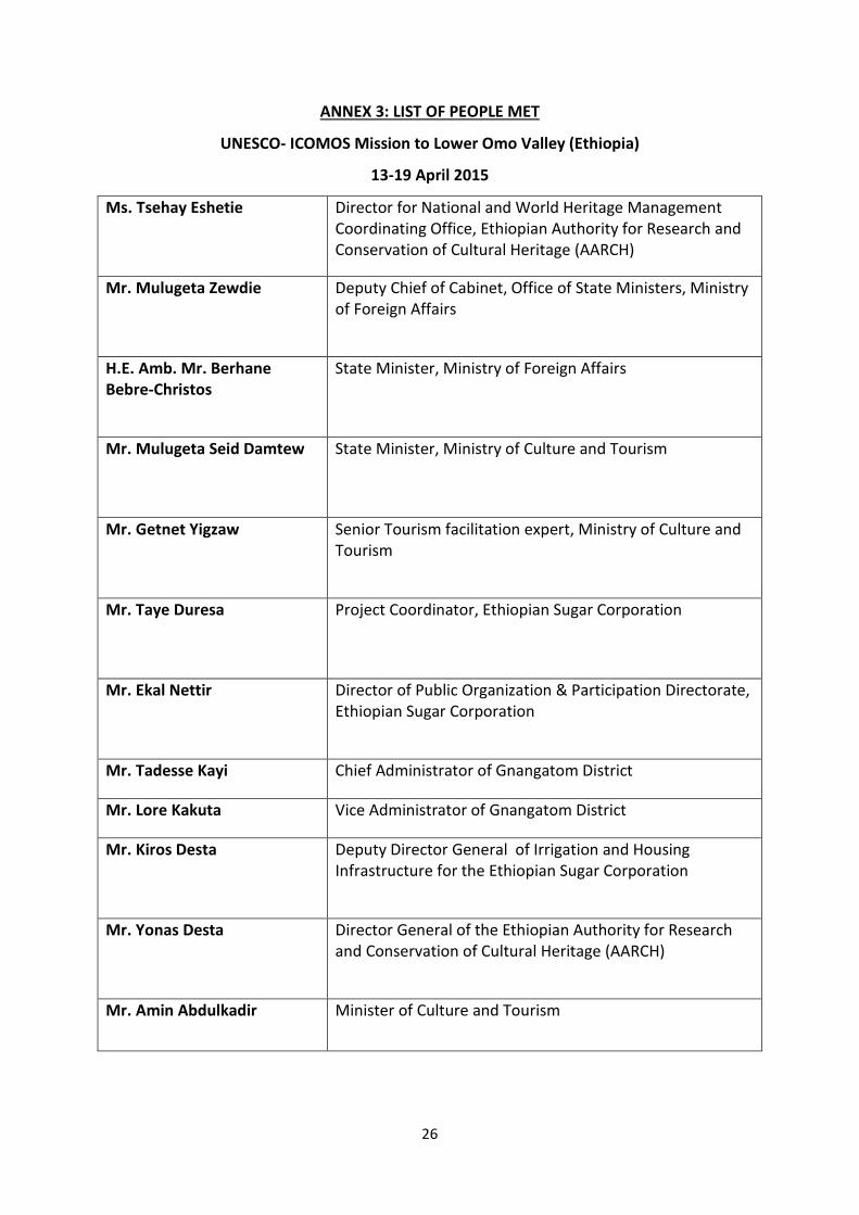
ANNEX 3: LIST OF PEOPLE MET
UNESCO- ICOMOS Mission to Lower Omo Valley (Ethiopia)
13-19 April 2015
Ms. Tsehay Eshetie Director for National and World Heritage Management Coordinating Office, Ethiopian Authority for Research and Conservation of Cultural Heritage (AARCH)
Mr. Mulugeta Zewdie Deputy Chief of Cabinet, Office of State Ministers, Ministry of Foreign Affairs
H.E. Amb. Mr. Berhane Bebre-Christos
State Minister, Ministry of Foreign Affairs
Mr. Mulugeta Seid Damtew
State Minister, Ministry of Culture and Tourism
Mr. Getnet Yigzaw Senior Tourism facilitation expert, Ministry of Culture and Tourism
Mr. Taye Duresa Project Coordinator, Ethiopian Sugar Corporation
Mr. Ekal Nettir Director of Public Organization & Participation Directorate, Ethiopian Sugar Corporation
Mr. Tadesse Kayi Chief Administrator of Gnangatom District
Mr. Lore Kakuta Vice Administrator of Gnangatom District
Mr. Kiros Desta
Deputy Director General of Irrigation and Housing Infrastructure for the Ethiopian Sugar Corporation
Mr. Yonas Desta
Director General of the Ethiopian Authority for Research and Conservation of Cultural Heritage (AARCH)
Mr. Amin Abdulkadir
Minister of Culture and Tourism

27
ANNEX 4: MAPS
Figure 1: Lower Valley of the Omo World Heritage property, location and geology of fossil-bearing deposits. Spatial extent of deposits digitized from a map supplied by the Kuraz project.

28
Figure 2: Lower Valley of the Omo World Heritage property, with 1km exclusion zones around fossil-bearing outcrops.

29
Figure 3: Lower Valley of the Omo World Heritage property with suggested site boundary based on minimum enclosure distance within a 5km radius buffer zone. The calculation is based on planar distance in the projection WGS 84.

30
Figure 4: Cross-section through the outcrop of the Kibish Formation, to illustrate the elevation of the incised Omo River in relation to the surrounding terrain. The section is based on 30m SRTM data and shown here with 5x vertical exaggeration.

31
Figure 5: Lower Valley of the Omo World Heritage site with simulated viewscape from a sugar mill (height 25m) positioned equidistant from all outcrops. A sugar mill of the type shown in the inset and in that position would be clearly visible throughout the area shown in white. The viewscape was generated from 30m SRTM data, using Global Mapper software.

32
ANNEX 5: PHOTOGRAPHS
1. View of exposed Usno Formation 2. Fragment of elephant humerus showing effect of sheet erosion on exposed surface (pen for scale)
3. Shungura Formation 4. Kibish Formation
5. A community living near the Kibish Formation 6. Soil salinity at the Kibish Formation
33
ANNEX 6: DECISIONS OF THE WORLD HERITAGE COMMITTEE
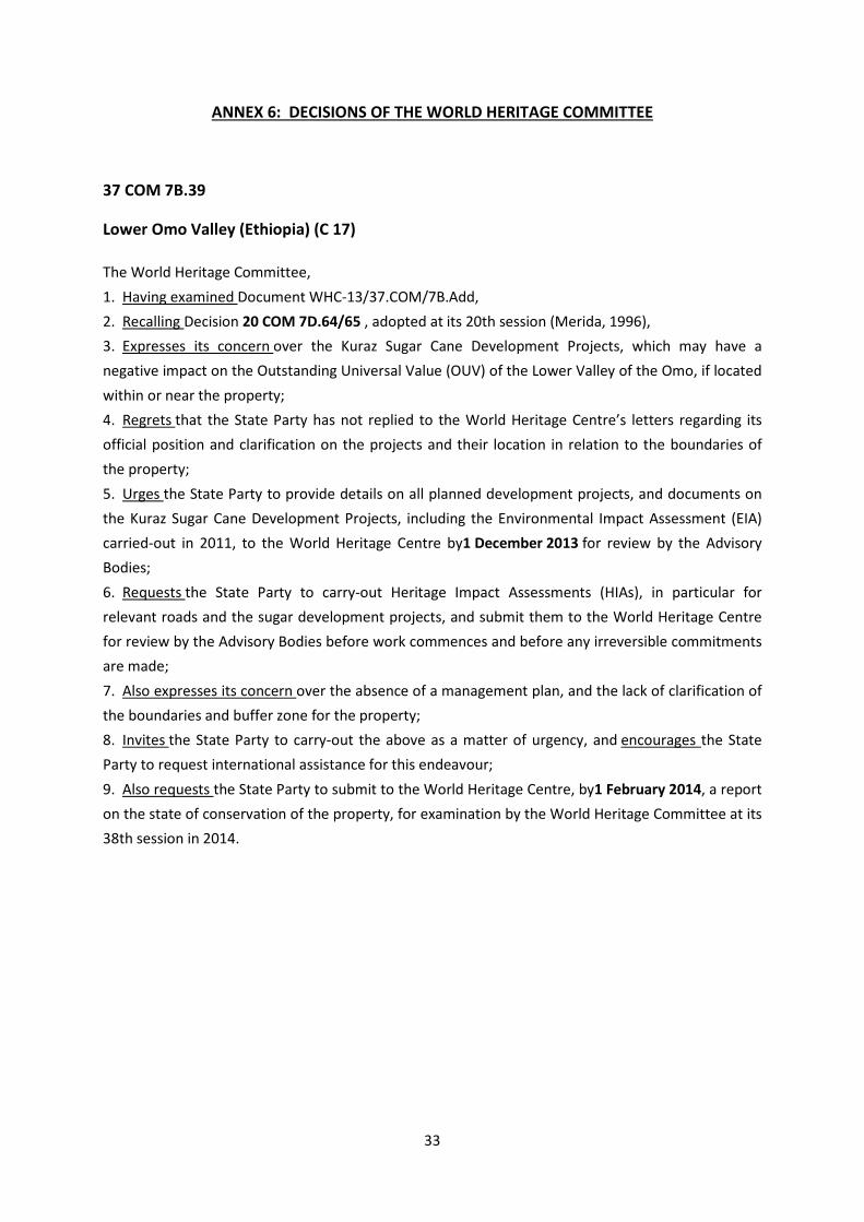
37 COM 7B.39
Lower Omo Valley (Ethiopia) (C 17)
The World Heritage Committee, 1. Having examined Document WHC-13/37.COM/7B.Add, 2. Recalling Decision 20 COM 7D.64/65 , adopted at its 20th session (Merida, 1996), 3. Expresses its concern over the Kuraz Sugar Cane Development Projects, which may have a negative impact on the Outstanding Universal Value (OUV) of the Lower Valley of the Omo, if located within or near the property; 4. Regrets that the State Party has not replied to the World Heritage Centre’s letters regarding its official position and clarification on the projects and their location in relation to the boundaries of the property; 5. Urges the State Party to provide details on all planned development projects, and documents on the Kuraz Sugar Cane Development Projects, including the Environmental Impact Assessment (EIA) carried-out in 2011, to the World Heritage Centre by1 December 2013 for review by the Advisory Bodies; 6. Requests the State Party to carry-out Heritage Impact Assessments (HIAs), in particular for relevant roads and the sugar development projects, and submit them to the World Heritage Centre for review by the Advisory Bodies before work commences and before any irreversible commitments are made; 7. Also expresses its concern over the absence of a management plan, and the lack of clarification of the boundaries and buffer zone for the property; 8. Invites the State Party to carry-out the above as a matter of urgency, and encourages the State Party to request international assistance for this endeavour; 9. Also requests the State Party to submit to the World Heritage Centre, by1 February 2014, a report on the state of conservation of the property, for examination by the World Heritage Committee at its 38th session in 2014.

34
38 COM 7B.48
Lower Omo Valley (Ethiopia) (C 17)
The World Heritage Committee, 1. Having examined Document WHC-14/38.COM/7B.Add, 2. Recalling Decision 37 COM 7B.39, adopted at its 37th session (Phnom Penh, 2013), 3. Welcomes the Heritage Impact Assessment (HIA) on the potential impacts of the Ethiopian Sugar
Development Corporation Project (Kuraz project) on the Lower Omo Valley; 4. Notes that this HIA indicates the potential for massive adverse impacts on the property from the
irrigation and excavations associated with the development of sugar plantations, settlements and access routes, and also notes that there is conflicting information on the precise extent and location of the Kuraz project;
5. Strongly urges the State Party to provide as soon as possible clear documentation on the scope and extent of the project and its precise location with regards to the property, in order to clarify whether it is within the property or its buffer zone; and requests clear information on the impact on pastoral communities with regards to resettlement schemes;
6. Also recalls its request to the State Party to submit the final report of the Environmental Impact Assessment (EIA) carried out in 2011 to the World Heritage Centre for review by the Advisory Bodies;
7. Also requests the State Party to improve the HIA with a detailed cultural heritage assessment based on the precise details of the Kuraz project and the precise attributes of the property and to submit these to the World Heritage Centre for review by the Advisory Bodies before any irreversible decisions are made;
8. Further notes that the State Party has obtained funding from the European Union Development Project, which will enable the boundary delineation and management plan to be developed in 2014/2015;
9. Encourages the State Party to carry out an assessment of fossil-bearing sediments, as recommended by the HIA, in order to more clearly define areas of potential archaeological importance;
10. Further requests the State Party to invite a joint UNESCO/ICOMOS reactive monitoring mission to the property to consider the above issues and the potential impact of the Kuraz project;
11. Recognizes the high “Paleo-tourism” potential of the property noted in the HIA, and recommends that the State Party seek funding to test new tourism management tools, which have been developed recently through the World Heritage Sustainable Tourism Programme;
12. Acknowledges the State Party’s urgent wish for international assistance for the site management plan and a possible extension of the property, and also encourages the submission of an International Assistance request to the World Heritage Fund before the next annual deadline of 31 October 2014;
13. Requests furthermore the State Party to submit to the World Heritage Centre, by 1 December 2015, a report, including a 1-page executive summary, on the state of conservation of the property, for examination by the World Heritage Committee at its 40th session in 2016.

35
ANNEX 7: REFERENCES
WORLD HERITAGE SITE INFORMATION
Nomination file on the Lower Valley of the Omo submitted to the World Heritage Centre in 1979
World Heritage Centre web page on the Lower Valley of the Omo World Heritage property
Statement of Outstanding Universal Value of the Lower Valley of the Omo
WORLD HERITAGE COMMITTEE DECISIONS
36th session of the World Heritage Committee (2012), Decision 36 COM 8E, Adoption of retrospective Statements of Outstanding Universal Value 37th session of the World Heritage Committee (2013), Decision 37 COM 7B.39 on the State of Conservation of the Lower Valley of the Omo 38th session of the World Heritage Committee (2014), Decision 38 COM 7B.48 on the State of Conservation of the Lower Valley of the Omo LEGISLATION
UNESCO Database of National Cultural Heritage Laws
DOCUMENTS PROVIDED BY THE STATE PARTY
PowerPoint presentation entitled “Gibe III impounding, foreseen downstream impacts and management”, 2015
PowerPoint presentation entitled “Kuraz Project and local community", 2015
“Water balance Issues of Kuraz Sugar Project: Impact of Kuraz Diversion to Lake Level Fluctuation”, (document not signed or dated, received from State Party in April 2015)
Word document entitled “Heritage” containing various maps and photographs provided to the mission team on 14 April 2015 by Mr. Taye Duresa, Project Coordinator, Ethiopian Sugar Corporation 2014 Legislation:
• Cultural Heritage Classification into National and Regional cultural heritage, Proclamation No. 839/2014
• Directive on the Conservation Laboratory service No.17/2014 • Directive for Heritage Accession and Collection No. 16/2014 • Directive for Heritage Loan No.15/2014 • Directive Heritage Transfer and Removal No.10/2014

36
PROJECT DOCUMENTS
International Assistant project from the World Heritage Fund for “Defining the Boundary and Geo-mapping the Lower Omo Valley world heritage property” (15,018 USD), 2015 European Union project for “Promoting the Contribution of World Heritage for Sustainable Development and Reinforcing Capacities for Protection and Conservation of Paleontological Sites in Ethiopia” (400,000 Euros), 2015
FDRE Sugar Corporation Environmental Issue of Kuraz Integrated Sugar Development Project, 2015 (document not signed or dated, received from State Party in April 2015)
African Studies Centre, University of Oxford project: Landscape, people and parks: Environmental change in the Lower Omo Valley, Southwestern Ethiopia, (2007-2010)
REPORTS
Ethiopian Electric Power Report on “Gibe III impact on Lake Turkana”, 2015
Delagnesa, Anne, Boisserie, Jean-Renaud, Beyened, Yonas, Chuniaude, Kristell, Guillemot, Claude and Schuster, Mathieu, “Archaeological investigations in the Lower Omo Valley (Shungura Formation, Ethiopia): New data and perspectives”, 2014
Kinahan, John, Azania: Archaeological Research in Africa: The sixteenth-century ritual precinct at Koticha Kesi in the Gilgel Gibe Valley, Southern Ethiopia, 2013
Boisserie, Jean-Renaud, Report on “Heritage conservation in the Lower Omo Valley”, 2012
Ato Cherie Enawgaw, Ato Derbe Deksios and Ato Girma Timer, Ethiopian Wildlife Conservation Authority (EWCA) report “Existing Challenges: Plantation Development versus Wildlife Conservation in the Omo-Tama-Mago Complex”, 2012
Human Right Watch Report on “What Will Happen if Hunger Comes? Abuses against the Indigenous Peoples of Ethiopia’s Lower Omo Valley”, 2012
Avery, Sean, Report on “Lake Turkana & the Lower Omo: Hydrological Impact of Major Dam & Irrigation Developments” Volume I, African Studies Centre, 2012
Avery, Sean, Annexes on “Lake Turkana & the Lower Omo: Hydrological Impact of Major Dam & Irrigation Developments” Volume II, African Studies Centre, 2012
Shea, John, The Middle Stone Age archaeology of the Lower Omo Valley Kibish Formation: Excavations, lithic assemblages, and inferred patterns of early Homo sapiens behavior, Journal of Human Evolution, 15 May 2008
Stott, Peter and Van Regteren Altena, Flora, Mission report to Ethiopia to conduct a workshop on Management Plans for World Heritage sites and to examine the current status of World Heritage sites in Ethiopia, 2004

37
CORRESPONDENCE
29 July 2015, Letter (Ref: CLT/HER/WHC/ETH/15/120/KM) from the Director of the World Heritage Centre to the Director-General of Ethiopian Authority for Research and Conservation of Cultural Heritage regarding: “Documentation not yet received on the Kuraz project for the joint UNESCO/ICOMOS Reactive Monitoring Mission to the Lower Valley of the Omo (Ethiopia).”
8 January 2015, Letter (Ref: 01/14-1/004) from the Director-General of Ethiopian Authority for Research and Conservation of Cultural Heritage to the Director of the World Heritage Centre regarding: “State of Conservation of the property Lower Omo Valley.”
31 of March 2014, Letter (Ref: CLT/WHC/74/ETH/14/03/SK) from Director of World Heritage Centre to the Permanent Delegate of Ethiopia to UNESCO regarding: “State of Conservation of the Lower Omo Valley and Lake Turkana National Parks World Heritage properties”
28 of January 2014, Letter (Ref: 01/A-02/020) from the Director-General of Ethiopian Authority for Research and Conservation of Cultural Heritage to the Director of the World Heritage Centre regarding: “Response to the World Heritage Committee Decision.”
25 of March 2013, Letter (Ref: CLT/WHC/74/ETH/13/08/LE) from Director of the World Heritage Centre to the Director-General of Ethiopian Authority for Research and Conservation of Cultural Heritage regarding: “State of Conservation of the Lower Valley of the Omo.”
22 September 2011, Letter (Ref: CLT/WHC/74/ETH/11/11/LF/LE) from Director of the World Heritage Centre to the Minister of Culture and Tourism of Ethiopia regarding: “Request for Official Information – Lower Valley of the Omo”
21 July 2011, Letter (Ref: WHC/74/ETH/11/09/BL/LE) from Director of the World Heritage Centre to Ambassador Extraordinary and Plenipotentiary of Ethiopia to France regarding: “Concern about a Kuraz Sugar Industry which could affect four World Heritage sites in Ethiopia and Kenya”
25 of May 2010, Letter from Director of Survival International to the Director of the World Heritage Centre regarding: “Threat to two UNESCO heritage sites, Lower Valley of the Omo and Lake Turkana, from Gibe 3 dam project”
MEDIA
Vidal, John, The Guardian, “Ethiopian dam’s ecological and human fallout could echo Aral Sea Disaster” 5 March 2015
Vidal, John, The Guardian, “Ethiopia dam will turn Lake Turkana into 'endless battlefield, locals warn,” 13 January 2015
Balancing Economic Development and Protecting the Cradle of Mankind – Lake Turkana Basin, UNEP Global Environmental Alert Service, June 2013
“Gibe 3 dam, Ethiopia”, International Rivers web site
“Omo Valley Tribes,” Survival International web site

38
ANNEX 7: REFERENCES
WORLD HERITAGE SITE INFORMATION
Nomination file on the Lower Valley of the Omo submitted to the World Heritage Centre in 1979
World Heritage Centre web page on the Lower Valley of the Omo World Heritage property
Statement of Outstanding Universal Value of the Lower Valley of the Omo
WORLD HERITAGE COMMITTEE DECISIONS
36th session of the World Heritage Committee (2012), Decision 36 COM 8E, Adoption of retrospective Statements of Outstanding Universal Value 37th session of the World Heritage Committee (2013), Decision 37 COM 7B.39 on the State of Conservation of the Lower Valley of the Omo 38th session of the World Heritage Committee (2014), Decision 38 COM 7B.48 on the State of Conservation of the Lower Valley of the Omo LEGISLATION
UNESCO Database of National Cultural Heritage Laws
DOCUMENTS PROVIDED BY THE STATE PARTY
PowerPoint presentation entitled “Gibe III impounding, foreseen downstream impacts and management”, 2015
PowerPoint presentation entitled “Kuraz Project and local community", 2015
“Water balance Issues of Kuraz Sugar Project: Impact of Kuraz Diversion to Lake Level Fluctuation”, (document not signed or dated, received from State Party in April 2015)
Word document entitled “Heritage” containing various maps and photographs provided to the mission team on 14 April 2015 by Mr. Taye Duresa, Project Coordinator, Ethiopian Sugar Corporation 2014 Legislation:
• Cultural Heritage Classification into National and Regional cultural heritage, Proclamation No. 839/2014
• Directive on the Conservation Laboratory service No.17/2014 • Directive for Heritage Accession and Collection No. 16/2014 • Directive for Heritage Loan No.15/2014 • Directive Heritage Transfer and Removal No.10/2014

39
PROJECT DOCUMENTS
International Assistant project from the World Heritage Fund for “Defining the Boundary and Geo-mapping the Lower Omo Valley world heritage property” (15,018 USD), 2015 European Union project for “Promoting the Contribution of World Heritage for Sustainable Development and Reinforcing Capacities for Protection and Conservation of Paleontological Sites in Ethiopia” (400,000 Euros), 2015
FDRE Sugar Corporation Environmental Issue of Kuraz Integrated Sugar Development Project, 2015 (document not signed or dated, received from State Party in April 2015)
African Studies Centre, University of Oxford project: Landscape, people and parks: Environmental change in the Lower Omo Valley, Southwestern Ethiopia, (2007-2010)
REPORTS
Ethiopian Electric Power Report on “Gibe III impact on Lake Turkana”, 2015
Delagnesa, Anne, Boisserie, Jean-Renaud, Beyened, Yonas, Chuniaude, Kristell, Guillemot, Claude and Schuster, Mathieu, “Archaeological investigations in the Lower Omo Valley (Shungura Formation, Ethiopia): New data and perspectives”, 2014
Kinahan, John, Azania: Archaeological Research in Africa: The sixteenth-century ritual precinct at Koticha Kesi in the Gilgel Gibe Valley, Southern Ethiopia, 2013
Boisserie, Jean-Renaud, Report on “Heritage conservation in the Lower Omo Valley”, 2012
Ato Cherie Enawgaw, Ato Derbe Deksios and Ato Girma Timer, Ethiopian Wildlife Conservation Authority (EWCA) report “Existing Challenges: Plantation Development versus Wildlife Conservation in the Omo-Tama-Mago Complex”, 2012
Human Right Watch Report on “What Will Happen if Hunger Comes? Abuses against the Indigenous Peoples of Ethiopia’s Lower Omo Valley”, 2012
Avery, Sean, Report on “Lake Turkana & the Lower Omo: Hydrological Impact of Major Dam & Irrigation Developments” Volume I, African Studies Centre, 2012
Avery, Sean, Annexes on “Lake Turkana & the Lower Omo: Hydrological Impact of Major Dam & Irrigation Developments” Volume II, African Studies Centre, 2012
Shea, John, The Middle Stone Age archaeology of the Lower Omo Valley Kibish Formation: Excavations, lithic assemblages, and inferred patterns of early Homo sapiens behavior, Journal of Human Evolution, 15 May 2008
Stott, Peter and Van Regteren Altena, Flora, Mission report to Ethiopia to conduct a workshop on Management Plans for World Heritage sites and to examine the current status of World Heritage sites in Ethiopia, 2004
CORRESPONDENCE

40
29 July 2015, Letter (Ref: CLT/WHC/74/ETH/15/120/KM) from Director of World Heritage Centre to the Director of Ethiopian Authority for Research and Conservation of Cultural Heritage regarding: “Documentation not yet received on the Kuraz project for the joint UNESCO/ICOMOS Reactive Monitoring Mission to the Lower Valley of the Omo (Ethiopia)”.
8 January 2015, Letter (Ref: 01/14-1/004) from the General Director of Ethiopian Authority for Research and Conservation of Cultural Heritage to the Director of the World Heritage Centre regarding: “State of Conservation of the property Lower Omo Valley.”
31 of March 2014, Letter (Ref: CLT/WHC/74/ETH/14/03/SK) from Director of World Heritage Centre to the Permanent Delegate of Ethiopia to UNESCO regarding: “State of Conservation of the Lower Omo Valley and Lake Turkana National Parks World Heritage properties”
28 of January 2014, Letter (Ref: 01/A-02/020) from the General Director of Ethiopian Authority for Research and Conservation of Cultural Heritage to the Director of the World Heritage Centre regarding: “Response to the World Heritage Committee Decision.”
25 of March 2013, Letter (Ref: CLT/WHC/74/ETH/13/08/LE) from Director of the World Heritage Centre to the Director of Ethiopian Authority for Research and Conservation of Cultural Heritage regarding: “State of Conservation of the Lower Valley of the Omo.”
22 September 2011, Letter (Ref: CLT/WHC/74/ETH/11/11/LF/LE) from Director of the World Heritage Centre to the Minister of Culture and Tourism of Ethiopia regarding: “Request for Official Information – Lower Valley of the Omo”
21 July 2011, Letter (Ref: WHC/74/ETH/11/09/BL/LE) from Director of the World Heritage Centre to Ambassador Extraordinary and Plenipotentiary of Ethiopia to France regarding: “Concern about a Kuraz Sugar Industry which could affect four World Heritage sites in Ethiopia and Kenya”
25 of May 2010, Letter from Director of Survival International to the Director of the World Heritage Centre regarding: “Threat to two UNESCO heritage sites, Lower Valley of the Omo and Lake Turkana, from Gibe 3 dam project”
MEDIA
Vidal, John, The Guardian, “Ethiopian dam’s ecological and human fallout could echo Aral Sea Disaster” 5 March 2015
Vidal, John, The Guardian, “Ethiopia dam will turn Lake Turkana into 'endless battlefield, locals warn,” 13 January 2015
Balancing Economic Development and Protecting the Cradle of Mankind – Lake Turkana Basin, UNEP Global Environmental Alert Service, June 2013
“Gibe 3 dam, Ethiopia”, International Rivers web site
“Omo Valley Tribes,” Survival International web site

41
ANNEX 8: CORRESPONDENCE REGARDING MISSING DOCUMENTATION

42

43