Remote Sensing and Ground-truthing of a Medieval Mound (Tuscany - Italy)
6
491 Remote Sensing and Ground-Truthing of a Medieval Mound (Tuscany - Italy) S. Campana, 1 R. Francovich, 2 L. Marasco 3 1 University of Siena, Department of Archaeology and History of Arts, Landscape Archaeology, (LAP&T) [email protected] 2 University of Siena, Department of Archaeology and History of Arts, Medieval Archaeology [email protected] 3 University of Siena, Department of Archaeology and History of Arts, PhD Student, (LAP&T) [email protected] 1 Introduction The site which we propose to discuss in this paper was ‘discovered’ from the air in the summer of 2005 during the University of Siena’s XIV th International Summer School in Archaeology. It lies close to the castle of Scarlino, facing the sea on the west coast in the province of Grosseto. The landscape of this area has been studied by the University of Siena’s Department of Archaeology since 1979, when Riccardo Francovich started archaeological excavations at the castle of Scarlino (Francovich 1985). Shortly after the start of the excavations, work also began on a programme of field-walking survey that has helped to make this one of the best-studied landscapes in the province of Grosseto (Cucini 1985). The site had already been identified at an earlier stage through the air photo interpretation of vertical historical coverage (Cosci 2005). Unfortunately the absence of a detailed map of the features and the unavailability at the time of these earlier studies of GPS navigation made the identification of the evidence in the field extremely difficult. Field-walking survey and ground-truthing variously suggested a positioning either one side or other of the apparent air photo location, without ever revealing its true position or scale (Chapman 2001; Campana 2005). Although analysis of the aerial photographs allowed the site to be interpreted as a triple enclosure, the lack of its correspondence on the ground with any artefactual evidence prevented us from obtaining any understanding of its chronology or of its potential contribution to the development of new settlement patterns in the area. In this context we should perhaps Figure 1 Overview of the landscape
Transcript of Remote Sensing and Ground-truthing of a Medieval Mound (Tuscany - Italy)
491
Remote Sensing and Ground-Truthing of a Medieval Mound
(Tuscany - Italy)
S. Campana,1 R. Francovich,
2L. Marasco
3
1 University of Siena, Department of Archaeology and History of Arts, Landscape Archaeology, (LAP&T)
[email protected] University of Siena, Department of Archaeology and History of Arts, Medieval Archaeology
[email protected] University of Siena, Department of Archaeology and History of Arts, PhD Student, (LAP&T)
1 Introduction
The site which we propose to discuss in this paper was
‘discovered’ from the air in the summer of 2005 during
the University of Siena’s XIVth International Summer
School in Archaeology. It lies close to the castle of
Scarlino, facing the sea on the west coast in the province
of Grosseto.
The landscape of this area has been studied by the
University of Siena’s Department of Archaeology since
1979, when Riccardo Francovich started archaeological
excavations at the castle of Scarlino (Francovich 1985).
Shortly after the start of the excavations, work also began
on a programme of field-walking survey that has helped
to make this one of the best-studied landscapes in the
province of Grosseto (Cucini 1985).
The site had already been identified at an earlier stage
through the air photo interpretation of vertical historical
coverage (Cosci 2005). Unfortunately the absence of a
detailed map of the features and the unavailability at the
time of these earlier studies of GPS navigation made the
identification of the evidence in the field extremely
difficult. Field-walking survey and ground-truthing
variously suggested a positioning either one side or other
of the apparent air photo location, without ever revealing
its true position or scale (Chapman 2001; Campana
2005). Although analysis of the aerial photographs
allowed the site to be interpreted as a triple enclosure, the
lack of its correspondence on the ground with any
artefactual evidence prevented us from obtaining any
understanding of its chronology or of its potential
contribution to the development of new settlement
patterns in the area. In this context we should perhaps
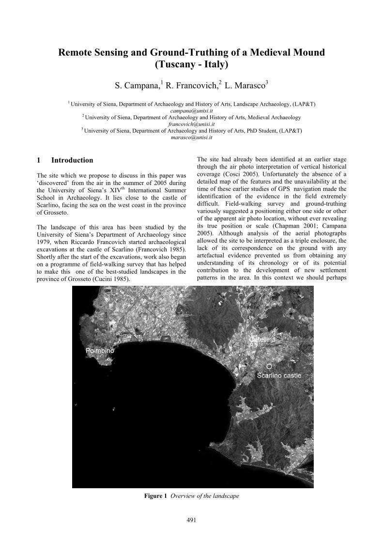
Figure 1 Overview of the landscape

FROM SPACE TO PLACE
492
note the difference in familiarity with this kind of site in
Italy as compared with other parts of Continental Europe
or the United Kingdom. In Germany or England, for
instance, archaeologists would find it quite easy to
interpret this kind of feature without the need for ground-
truthing, but in Tuscany this kind of evidence has no
immediate parallels or comparisons.
In this paper we will show how the quality and the
quantity of the information was supplements by more
recent studies. Using this new evidence we will then
discuss the new perspective which this opens up for
archaeological research in the surrounding landscape.
2 The local landscape and historical
background
The site, whose placename Castellina indicates its
possible relationship with a castle, is set at the centre of a
large area of lowland fronting onto the Gulf of Follonica.
The area may have been characterised in the past by a
wide brackish lake. Attempts at reconstruction of the
ancient lake boundary would set our site close to the
ancient coastline (Bartolini et al 1977).
The shoreline extended approximately from our site to
the base of the hill on which stands the castle of Scarlino.
The navigability of this salty lake is still documented in
the late Middle Ages but was impeded in the following
centuries by a progressive dessication of the area,
creating an un-navigable swamp. The archaeological
study of the site is still in its early stages but there
appears at first glance to be a clear relationship with the
surrounding landscape context and with the development
of economic activity in the area. Past researches have
concentrated on interpretation of the medieval landscape
as being focused, from the early Middle Ages, around the
hilltop village of Scarlino. Here the archaeological
excavations, above settlement evidence from the Bronze
Age to the days of imperial Rome, revealed firstly the
remains of an open village, later converted into a curtis in
the ninth century AD and finally transformed into a castle
settlement from the end of the tenth century onwards
(Francovich 1985).
More recently a new study of the archaeological data
from the Scarlino excavation has furnished interesting
comparisons for the pottery recovered from the site
(Marasco forthcoming). Furthermore, the archaeological
evidence has been supplemented by a rich archive of
early medieval documentary sources relating to the
Bishopric of Lucca. The integration of the various
information sources has allowed us to recognise that,
after the crisis of the Late Roman period, the rural
landscape of this area was characterised between the
seventh and eighth centuries by the presence of villages.
The development of the settlement pattern at the
beginning of the early Middle Ages followed two main
paths: the concentration of population centres and the
beginnings of hilltop villages.
Figure 2 Oblique air photograph of the cropmark features and their relationship to the central place of
Scarlino
The archaeological excavations at the castle of Scarlino –
and at many other excavations – allow us to describe
some aspects of these villages during the seven to eighth
and ninth centuries AD. They consist mainly of wooden
huts, organised into a central nucleus and sometimes
defended by palisades or other forms of enclosure.
During the eighth century the documentary sources attest
to the growth of a new form of resource-management and
exploitation, the curtis system. The archaeological
investigations show the overlap between these new
system and the preceding settlement pattern. In the same
century the archaeological sources show the
transformation of the villages and it is now possible to
recognize evidence of spatial organisation related to the
exercise of management and power.
However, many hilltop villages did not succeed in taking
on the role of centres of human aggregation, perhaps
because of the weakness of the local aristocracy or
because of competition with other developing centres.
The site that we discuss in this paper is one of these latter
cases – a failure site. The site evidence represents an
early Middle Age survival – not necessarily a direct one –

S. CAMPANA, R. FRANCOVICH, L. MARASCO: REMOTE SENSING AND GROUND-TRUTHING OF A MEDIEVAL MOUND
493
of the lowland population pattern, probably related to
specific natural or man-made features – swamp-land or
road systems etc.
Lorenzo Marasco
3 Air photo survey to study the site
The new episode of research in this area started with the
XIVth International School in Archaeology, organised in
collaboration with the Culture 2000 project Europeanlandscapes: past, present and future (www.e-
landscapes.com). Within this project, in the spring of
2005, the University of Siena, in collaboration with
English Heritage and the international Aerial
Archaeology Research Group (AARG), conducted an
Aerial Archaeology Research School at Grosseto
Figure 3 Detail of the features, from an oblique air photograph taken in the summer of 2005.
During the School, through repeated flights in light
aircraft, oblique air-photo records were made of a
distinctive group of archaeological cropmarks, illustrated
in Fig.3 above. The features consisted of a triple
concentric circular enclosure with a fourth mark in the
centre and a fifth on the left-hand side of the second
enclosure. In addition, there were traces of a number of
parallel linear cropmarks, overlapping the enclosures.
Mapping of the new air-photo evidence against the
historical and technical national cartography (IGM
1:25.000 and CTR 1:10.000) revealed the that the closest
placename (less than 500 m away) was Podere Castellina,
now attached to an old agricultural building but possibly
preserving the memory of a former medieval castle
somewhere in the area. This interpretation could be in
keeping with the reading of the air photo data. The
circular enclosures – encompassing an area of almost one
hectare – could be interpreted as concentric ditches
and/or palisades. The marks inside and outside the
smallest enclosure could be related to buildings. The
linear features – visible also on the IGM 1:25.000
historical maps – are probably related to an ancient road
system.
Figure 4 GIS based interpretation (polygon) and hypothesis (line)
The mapping process permitted a better understanding of
the site and overcame the problem pointed out at the
beginning of this article – the absence of evidence on the
ground. Earlier examination of vertical air photographs
from 1954 had been successful in detecting the site but
the absence then of appropriate mapping procedures,
along with the use of a base-map at the relatively small
scale of 1:25.000, had shifted the site-positioning 150
metres to the north-east of the true location revealed by
the more recent studies.
4 Field-walking and DGPD survey
Ground-examination in 2005 brought an immediate
understanding of the high archaeological and historical
value of the site. The survey was carried out in the month
of September, immediately after ploughing and in good
lighting conditions, creating excellent archaeological
visibility and allowing the recovery of a large quantity of
artefacts. The first survey results showed that some of the
pottery could be dated to the early Middle Ages. But
bearing in mind the poor understanding of the material
culture of this period we felt the need for caution and
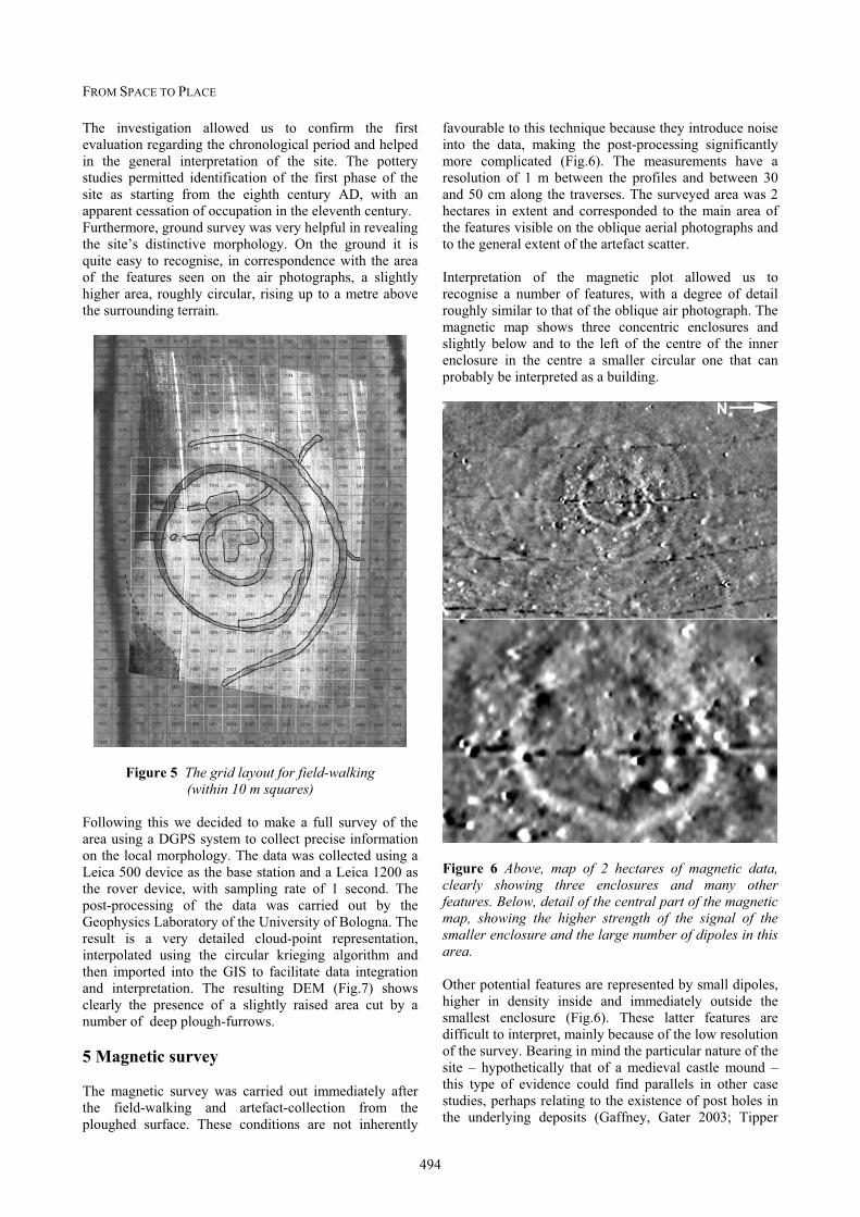
therefore organised a more intensive grid-collection
within 10 m by 10 m squares (Fig.5).
FROM SPACE TO PLACE
494
The investigation allowed us to confirm the first
evaluation regarding the chronological period and helped
in the general interpretation of the site. The pottery
studies permitted identification of the first phase of the
site as starting from the eighth century AD, with an
apparent cessation of occupation in the eleventh century.
Furthermore, ground survey was very helpful in revealing
the site’s distinctive morphology. On the ground it is
quite easy to recognise, in correspondence with the area
of the features seen on the air photographs, a slightly
higher area, roughly circular, rising up to a metre above
the surrounding terrain.
Figure 5 The grid layout for field-walking (within 10 m squares)
Following this we decided to make a full survey of the
area using a DGPS system to collect precise information
on the local morphology. The data was collected using a
Leica 500 device as the base station and a Leica 1200 as
the rover device, with sampling rate of 1 second. The
post-processing of the data was carried out by the
Geophysics Laboratory of the University of Bologna. The
result is a very detailed cloud-point representation,
interpolated using the circular krieging algorithm and
then imported into the GIS to facilitate data integration
and interpretation. The resulting DEM (Fig.7) shows
clearly the presence of a slightly raised area cut by a
number of deep plough-furrows.
5 Magnetic survey
The magnetic survey was carried out immediately after
the field-walking and artefact-collection from the
ploughed surface. These conditions are not inherently
favourable to this technique because they introduce noise
into the data, making the post-processing significantly
more complicated (Fig.6). The measurements have a
resolution of 1 m between the profiles and between 30
and 50 cm along the traverses. The surveyed area was 2
hectares in extent and corresponded to the main area of
the features visible on the oblique aerial photographs and
to the general extent of the artefact scatter.
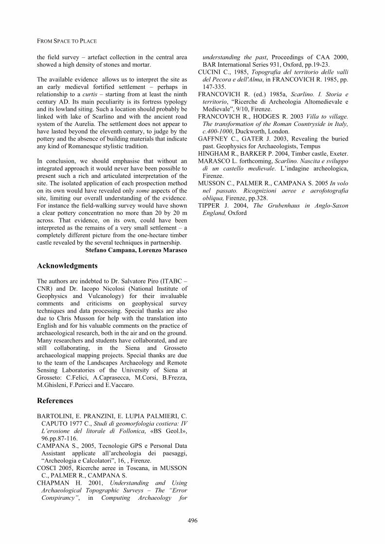
Interpretation of the magnetic plot allowed us to
recognise a number of features, with a degree of detail
roughly similar to that of the oblique air photograph. The
magnetic map shows three concentric enclosures and
slightly below and to the left of the centre of the inner
enclosure in the centre a smaller circular one that can
probably be interpreted as a building.
Figure 6 Above, map of 2 hectares of magnetic data, clearly showing three enclosures and many other features. Below, detail of the central part of the magnetic map, showing the higher strength of the signal of the smaller enclosure and the large number of dipoles in this area.
Other potential features are represented by small dipoles,
higher in density inside and immediately outside the
smallest enclosure (Fig.6). These latter features are
difficult to interpret, mainly because of the low resolution
of the survey. Bearing in mind the particular nature of the
site – hypothetically that of a medieval castle mound –
this type of evidence could find parallels in other case
studies, perhaps relating to the existence of post holes in
the underlying deposits (Gaffney, Gater 2003; Tipper

S. CAMPANA, R. FRANCOVICH, L. MARASCO: REMOTE SENSING AND GROUND-TRUTHING OF A MEDIEVAL MOUND
495
Figure 7 Integrated analysis of the site
2004). To obtain a better understanding of the site it
would be useful, in the near future, to repeat the magnetic
survey, increasing the resolution between profiles to
between 50 to 20 cm.
Stefano Campana
6 Data integration and conclusion
On the evidence so far collected we feel confident about
our general interpretation. We have probably located the
first known lowland castle-mound in Tuscany.
The chronology suggested by the finds – from the eighth
to ninth centuries through to the eleventh century – is also
consistent with the data drawn from the air photographs,
magnetic mapping and DGPS survey (Fig.7). Taken
together, the various kinds of evidence point to features
that it is possible to interpret as a lowland timber castle
characterised by at least three concentric defensive
features, presumably ditches or palisades.
As is well-known from other parts of Europe, a mound or
motte of this kind is a typical form of medieval
fortification, consisting of a raised earthen mound,
resembling a small hill, usually artificial or at least
artificially enhanced and topped with a wooden or stone
structure. The earth for the mound would be taken from
the ditch around the motte itself and perhaps from other
ditches around the castle as a whole. The outer surface of
the mound might in some instances have been covered
with clay or strengthened with wooden supports
(Hingham, Barker 2004). This kind of castle, however,
can exhibit a wide range of variability.
In our case the aerial photographs show evidence that,
even without other information, we can interpret with
some confidence as ditches. The magnetic map is
superficially similar in appearance to the aerial
photograph, showing three circular traces. But we should
be carefully in drawing conclusions from this similarity –
aerial reconnaissance relies on phenomena that are quite
different from those involved in the interpretation of
magnetic data. Archaeologists are mainly used to
interpreting features through their shape and size. We
should bear in mind, however, that there is a significant
difference between the meaning of the two soil
measurements, the first related to the growth and colour
of the overlying crop, the second to the magneticproperties of the underlying deposits. While
acknowledging this difference there is a remarkable
degree of similarity between the air photo evidence and
the magnetic map. The magnetic measurements for the
smaller enclosure show a very high and consistent signal,
probably indicating the presence of a higher
concentration of organic material, perhaps related to the
former presence of a timber palisade or to a concentration
of organic or other rubbish thrown out from the central
enclosure.
The air-photo evidence in the central part of the mound,
possibly indicating a masonry building, is also reflected
in the magnetic map and even more so in the results of
FROM SPACE TO PLACE
496
the field survey – artefact collection in the central area
showed a high density of stones and mortar.
The available evidence allows us to interpret the site as
an early medieval fortified settlement – perhaps in
relationship to a curtis – starting from at least the ninth
century AD. Its main peculiarity is its fortress typology
and its lowland siting. Such a location should probably be
linked with lake of Scarlino and with the ancient road
system of the Aurelia. The settlement does not appear to
have lasted beyond the eleventh century, to judge by the
pottery and the absence of building materials that indicate
any kind of Romanesque stylistic tradition.
In conclusion, we should emphasise that without an
integrated approach it would never have been possible to
present such a rich and articulated interpretation of the
site. The isolated application of each prospection method
on its own would have revealed only some aspects of the
site, limiting our overall understanding of the evidence.
For instance the field-walking survey would have shown
a clear pottery concentration no more than 20 by 20 m
across. That evidence, on its own, could have been
interpreted as the remains of a very small settlement – a
completely different picture from the one-hectare timber
castle revealed by the several techniques in partnership.
Stefano Campana, Lorenzo Marasco
Acknowledgments
The authors are indebted to Dr. Salvatore Piro (ITABC –
CNR) and Dr. Iacopo Nicolosi (National Institute of
Geophysics and Vulcanology) for their invaluable
comments and criticisms on geophysical survey
techniques and data processing. Special thanks are also
due to Chris Musson for help with the translation into
English and for his valuable comments on the practice of
archaeological research, both in the air and on the ground.
Many researchers and students have collaborated, and are
still collaborating, in the Siena and Grosseto
archaeological mapping projects. Special thanks are due
to the team of the Landscapes Archaeology and Remote
Sensing Laboratories of the University of Siena at
Grosseto: C.Felici, A.Caprasecca, M.Corsi, B.Frezza,
M.Ghisleni, F.Pericci and E.Vaccaro.
References
BARTOLINI, E. PRANZINI, E. LUPIA PALMIERI, C.
CAPUTO 1977 C., Studi di geomorfologia costiera: IV L’erosione del litorale di Follonica, «BS Geol.I»,
96.pp.87-116.
CAMPANA S., 2005, Tecnologie GPS e Personal Data
Assistant applicate all’archeologia dei paesaggi,
“Archeologia e Calcolatori”, 16, , Firenze.
COSCI 2005, Ricerche aeree in Toscana, in MUSSON
C., PALMER R., CAMPANA S.
CHAPMAN H. 2001, Understanding and Using Archaeological Topographic Surveys – The “Error Conspirancy”, in Computing Archaeology for
understanding the past, Proceedings of CAA 2000,
BAR International Series 931, Oxford, pp.19-23.
CUCINI C., 1985, Topografia del territorio delle valli del Pecora e dell'Alma, in FRANCOVICH R. 1985, pp.
147-335.
FRANCOVICH R. (ed.) 1985a, Scarlino. I. Storia e territorio, “Ricerche di Archeologia Altomedievale e
Medievale”, 9/10, Firenze.
FRANCOVICH R., HODGES R. 2003 Villa to village. The transformation of the Roman Countryside in Italy, c.400-1000, Duckworth, London.
GAFFNEY C., GATER J. 2003, Revealing the buried
past. Geophysics for Archaeologists, Tempus
HINGHAM R., BARKER P. 2004, Timber castle, Exeter.
MARASCO L. forthcoming, Scarlino. Nascita e sviluppo di un castello medievale. L’indagine archeologica,
Firenze.
MUSSON C., PALMER R., CAMPANA S. 2005 In volo nel passato. Ricognizioni aeree e aerofotografia obliqua, Firenze, pp.328.
TIPPER J. 2004, The Grubenhaus in Anglo-Saxon England, Oxford