Regional Mitigation Plan Update - Northwest Florida Water ...
12
Regional Mitigation Plan Update February 2019 Northwest Florida Water Management District 81 Water Management Drive Havana, FL 32333-4712 Program Development Series 19-01
-
Upload
khangminh22 -
Category
Documents
-
view
1 -
download
0
Transcript of Regional Mitigation Plan Update - Northwest Florida Water ...

Regional Mitigation Plan Update
February 2019
Northwest Florida Water Management District
81 Water Management Drive
Havana, FL 32333-4712
Program Development Series 19-01

NORTHWEST FLORIDA WATER MANAGEMENT DISTRICT
GOVERNING BOARD
George Roberts Chair, Panama City
Jerry Pate Vice Chair, Pensacola
John Alter Secretary-Treasurer, Malone
Gus Andrews
DeFuniak Springs Jon Costello Tallahassee
Bo Spring Port St. Joe
Ted Everett
Chipley
Nick Patronis Panama City Beach
Brett J. Cyphers Executive Director
Headquarters
81 Water Management Drive Havana, Florida 32333-4712
(850) 539-5999 www.nwfwater.com
Crestview
180 E. Redstone Avenue Crestview, Florida 32539
(850) 683-5044
Econfina
6418 E. Highway 20 Youngstown, FL 32466
(850) 722-9919
Milton
5453 Davisson Road Milton, FL 32583 (850) 626-3101
i
Contents
Contents ......................................................................................................................................................... i
Introduction .................................................................................................................................................. 1
Consideration of Private Mitigation Banks ................................................................................................... 1
2019 Project Update ..................................................................................................................................... 2
Conclusion ..................................................................................................................................................... 3
For More Information ................................................................................................................................... 4
Figure 1. Mitigation Service Areas in Northwest Florida ............................................................................. 5
Figure 2. Map of FDOT Impacts and Identified Mitigation Options ............................................................. 6
Table 1. Mitigation and Impact Project Overview ....................................................................................... 7
Table 2. Mitigation Plan Overview ............................................................................................................... 8
Table 3. Cost Estimates of Mitigation Plan .................................................................................................. 9

Page | 1
Introduction Section 373.4137(4), Florida Statutes (F.S.), requires the Northwest Florida Water Management District (NWFWMD or District), in consultation with the Florida Department of Environmental Protection (FDEP); the United States Army Corps of Engineers (USACE); the Florida Department of Transportation (FDOT); other appropriate federal, state, and local governments; and other interested parties, to develop and approve an annual regional mitigation plan before March 1st of each year for FDOT mitigation needs submitted to the District. Although FDOT is not required to participate in the District mitigation program (section 373.4137(2)(a), F.S.), FDOT District Three opts to mitigate through the District when use of a private mitigation bank is not feasible. This Regional Mitigation Plan Update satisfies the requirements of section 373.4137(4), F.S., to annually develop a mitigation plan for submittal to, and approval by, FDEP. To facilitate a policy-level review, FDEP guidance requests that regional mitigation plan submittals be in the form of a summary and only address new projects; detailed information and permit-level project plans are posted at the District website (www.nwfwater.com/Water-Resources/Regional-Wetland-Mitigation-Program). Approval from FDEP is obtained prior to implementation of mitigation.
Consideration of Private Mitigation Banks Per section 373.4137(2)(c), F.S., FDOT must investigate use of a mitigation bank before including a project on the environmental impact inventory (Inventory) submitted to the District. If the District identifies use of a mitigation bank to offset an FDOT impact included on the Inventory, the District shall exclude that project from the mitigation plan and FDOT shall be responsible for purchase of bank credits (section 373.4137(3)(d), F.S.). Private mitigation bank service areas cover approximately one-third of northwest Florida (Figure 1). The District strongly encourages the development of private mitigation banks, especially in areas not currently served by private banks. The District does not compete with private mitigation banks and will develop or provide mitigation to FDOT only when use of a private mitigation bank is not feasible. Use of a mitigation bank as offsetting mitigation for an FDOT impact is dependent upon approval by state and federal permitting authorities. Consideration of current service area coverages, as indicated in Figure 1, suggests that development of additional credits within several regions of northwest Florida may be needed to support future transportation improvements. Additional palustrine credits within the Blackwater River and Yellow River basins and additional estuarine credits districtwide may be particularly useful to support future transportation needs.

Page | 2
2019 Project Update This Regional Mitigation Plan Update addresses the wetland mitigation needs of five FDOT road projects. Since approval of the 2018 Regional Mitigation Plan Update (approved by NWFWMD 3/12/2018; approved by FDEP 3/21/2018), FDOT has added four projects to the FDOT District Three Inventory that may require mitigation through the District (Figure 2). Additionally, mitigation for one FDOT project added to the Inventory in 2017 is included in this plan due to the lack of private-sector estuarine credits.1 The total direct wetland impact associated with these projects that may be mitigated in whole or part through the NWFWMD program is estimated by FDOT at 9.14 acres. These impacts and possible mitigation are summarized below. Additional information on impacts and proposed mitigation is posted at www.nwfwater.com/Water-Resources/Regional-Wetland-Mitigation-Program. Four projects included in this Regional Mitigation Plan Update (I-10 at SR 4, FPID 407918-5; Quincy Bypass from SR 12 to SR 267, FPID 218946-6; SR 292 at Choctaw Ave., FPID 220876-9; US 90A from US 90 to CR 99, FPID 218605-5) occur outside the service area of any private mitigation bank. One project (US 98 Multiuse Path from CR 372 to Tower Road; FPID 439926-2), although located within a private mitigation bank service area, requires estuarine credits which are, at this time, not available from the private sector.
FDOT Transportation Projects
Projects Outside of Private Mitigation Bank Service Areas
• I-10 at SR 4; FDOT FPID 407918-5. This project consists of construction of a new interchange in Okaloosa County west of Crestview in the Yellow River watershed (Pensacola Bay System). Impacts to wetlands are currently estimated at 5.00 acres, although evaluation of aerial photography indicates that this value may be reduced as planning and permitting proceed. Estimates of UMAM functional loss have not been provided. This impact is not within the service area of any private mitigation bank. Proposed mitigation is to be determined, with options in the Yellow River watershed being investigated. The NWFWMD will obtain FDEP approval before proceeding with mitigation. Additional information as plans are developed will be posted at https://www.nwfwater.com/Water-Resources/Regional-Wetland-Mitigation-Program/Umbrella-Plan/FDOT-Impacts/Pensacola-Watershed-Impacts/I-10-at-SR-4-Antioch-Road-New-Interchange-
407918-5.
• Quincy Bypass from SR 12 to SR 267; FDOT FPID 218946-6. This project, located in the Ochlockonee River watershed, consists of construction of a new highway footprint in Gadsden County northeast of Quincy. Impacts to jurisdictional wetlands are estimated as 1.90 acres. Estimates of UMAM functional loss have not been provided. This impact is not within the service area of any private mitigation bank. Proposed mitigation is use of mitigation credits from the Shuler Unit of the NWFWMD In-Lieu Fee mitigation program (26.70 Palustrine Forested UMAM credits currently available). Additional information, as this project proceeds, will be posted at https://www.nwfwater.com/Water-Resources/Regional-Wetland-Mitigation-Program/Umbrella-
Plan/FDOT-Impacts/Ochlockonee-Watershed-Impacts/Quincy-Bypass-from-SR-12-to-SR-267-218946-6.
1 US 98 Multiuse Path from CR 372 to Tower Road (FPID 439926-2) was originally anticipated to be mitigated wholly
by FDOT via purchase of private-sector mitigation credits. It is included in this plan because impacts to 0.89 acres of
estuarine wetlands have been identified and type-for-type mitigation may be required. No estuarine credits are
available from any private mitigation bank in northwest Florida.

Page | 3
• SR 292 at Choctaw Avenue; FDOT FPID 220876-9. This project consists of road improvements in Escambia County west of Pensacola. An estimated 0.35 acres will be impacted by this project. UMAM functional loss estimates have not been provided. This impact is not within the service area of any private mitigation bank. Proposed mitigation is use of mitigation credits from the Dutex Unit of the NWFWMD In-Lieu Fee mitigation program (39.13 UMAM credits currently available). Additional information, as this project proceeds, will be posted at https://www.nwfwater.com/Water-Resources/Regional-Wetland-Mitigation-Program/Umbrella-Plan/FDOT-Impacts/Perdido-Watershed-Impacts/SR-292-at-Choctaw-Ave.-220876-9.
• US 90A from US 90 to CR 99; FDOT FPID 218605-5. This project consists of road improvements in Escambia County northwest of Pensacola. An estimated 1.00 acres will be impacted by this project. UMAM functional loss estimates have not been provided. This impact is not within the service area of any private mitigation bank. Proposed mitigation is use of mitigation credits from the Dutex Unit of the NWFWMD In-Lieu Fee mitigation program (39.13 UMAM credits currently available). Additional information, as this project proceeds, will be posted at https://www.nwfwater.com/Water-Resources/Regional-Wetland-Mitigation-Program/Umbrella-Plan/FDOT-Impacts/Perdido-Watershed-Impacts/US-90A-from-US-90-to-CR-99-218605-5.
Project Within a Private Mitigation Bank Service Area (No Estuarine Credits Available)
• US 98 Multiuse Path from CR 372 to Tower Road; FDOT FPID 439926-2. This project consists of construction of a multiuse path adjacent to US 98 in Wakulla County. Total wetland impacts are estimated at 3.048 acres (2.156 acres of palustrine wetlands; 0.892 acres of estuarine wetlands). Mitigation for palustrine impacts is anticipated to consist of FDOT purchase of credits from a private mitigation bank. Permitters have indicated type-for-type mitigation will be required for the estuarine impacts (estimated 0.65 UMAM functional loss). If necessary for this road project to move forward, the District will develop an estuarine mitigation project. Options at Mashes Sands County Park and Ochlockonee River State Park in Wakulla County are being investigated. Proposed mitigation is to be determined. The NWFWMD will obtain FDEP approval before proceeding with mitigation. Additional information, as this project proceeds, will be posted at https://www.nwfwater.com/Water-Resources/Regional-Wetland-Mitigation-Program/Umbrella-Plan/FDOT-Impacts/St.-Marks-Watershed-Impacts/US-98-Multiuse-Path-from-CR-372-to-Tower-Road-439926-2.
Conclusion The District concludes that this Regional Mitigation Plan Update complies with the mitigation requirements of section 373.4137, F.S., and 33 USC Section 344, subject to approval by FDEP, for the five projects described above and included in the FDOT Inventory. Approval by the Governing Board of the District or its designee and FDEP shall authorize the activities proposed in the mitigation plan, and no other state, regional or local permit or approval shall be necessary. Per section 373.4137(5), F.S., the District, upon notice and coordination with FDOT, may deviate from the approved mitigation plan to comply with federal permitting requirements.

All Regional Mitigation Plan documents may be accessed online at https://www.nwfwater.com/WaterResources/Regional-Wetland-Mitigation-Program . Copies may be obtained from the Resource Management Division, Northwest Florida Water Management District, 81 Water Management Drive, Havana, FL 32333-4712.
Pursuant to sections 373.4137(4) and (6), F.S., the District hereby approves modifications to the Regional Mitigation Plan for five FOOT impacts identified in the FOOT District Three Inventory. The Regional Mitigation Plan includes the Sand Hill Lakes Mitigation Bank (owned and operated by the District), the District's In-Lieu Fee (ILF) Program, and other mitigation projects implemented by the District.
Modifications to the District-approved Regional Mitigation Plan may not be implemented before approval by FDEP. Through consultation with the aforementioned entities, the District's Regional Mitigation Plan has been designed and evaluated to meet state and federal mitigation requirements (section 373.4137, F.S., and 33 United State Code section 1344); however, it is the responsibility of FOOT to propose offsetting mitigation to state and federal permitters.
APPROVED this 25th day of February 2019
Brett J. Cyphers xecut v Direc r Northwest Florida Water Management District 81 Water Management District Drive Havana, Florida 32333-4712
For More Information
Website: https://www.nwfwater.com/Water-Resources/Regional-Wetland-Mitigation-Program
Staff Contact: Robert Lide, Environmental Scientist Ill Northwest Florida Water Management District (850) 539-5999 [email protected]
Page I 4

Page | 5
Figure 1. Mitigation Service Areas in Northwest Florida

Page | 6
Figure 2. Map of FDOT Impacts and Identified Mitigation Options

Page | 7
Table 1. Mitigation and Impact Project Overview
Mitigation and Impact Project Overview - February 20191
Mitigation Name
Impact Project
Impact Location Habitat / Community
Type Impact
Type Acres
Impact
Total Impact Acres2
T/E Species
County Drainage Basin
TBD3 I-10 at SR 4 (New Interchange; FPID
407918-5) Okaloosa
Pensacola Bay System
Watershed (Yellow River)
Palustrine 5.00 5.00 TBD
Shuler In-Lieu Fee
Mitigation Area
Quincy Bypass (from SR 12 to SR 267; FPID
218946-6) Gadsden
Ochlockonee River and Bay
Watershed Palustrine 1.90 1.90 TBD
Dutex In-Lieu Fee
Mitigation Area
US 90A (from US 90 to CR 99; FPID 218605-5)
Escambia Perdido River
and Bay Watershed
Palustrine 1.00 1.00 TBD
SR 292 at Choctaw Ave. (FPID 220876-9)
Escambia Perdido River
and Bay Watershed
Palustrine 0.35 0.35 TBD
TBD4 US 98 Multiuse Path
(from CR 372 to Tower Road; FPID 439926-2)
Wakulla St. Marks
Watershed Estuarine 0.89 0.89 TBD
Estimated Total Direct Wetland Impact Acres: 9.14
Notes to Table 1 - Mitigation and Impact Project Overview:
1Impacts listed in this table were submitted from FDOT to NWFWMD via the Environmental Mitigation Escrow Report. Per section 373.4137, FS, NWFWMD may provide mitigation for FDOT impacts only when FDOT is unable to purchase credits from a mitigation bank to meet federal and/or state permit conditions. The NWFWMD mitigation program, established under section 373.4137, FS, does not compete with private mitigation banks.
2Direct wetland impact acres as listed on the most recent FDOT District 3 Environmental Mitigation Escrow Report. The NWFWMD mitigation program relies upon FDOT to provide all information associated with their wetland impacts; it does not quantify or otherwise assess wetland impacts for FDOT. Impact acreage frequently changes during the project planning and permitting process.
3The I-10 at SR 4 impact does not occur within any private mitigation bank service area. At this time, the NWFWMD has not identified potential mitigation for this impact. Potential mitigation sites in the Yellow River watershed are being investigated. If or when potential mitigation for this impact is identified, the NWFWMD will seek FDEP approval before proceeding with implementation. The NWFWMD encourages the development of private mitigation banks in areas not currently served by private banks.
Page | 8
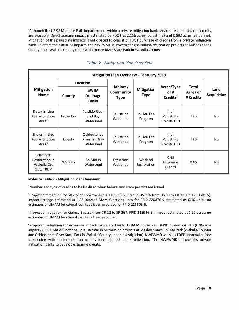
4Although the US 98 Multiuse Path impact occurs within a private mitigation bank service area, no estuarine credits are available. Direct acreage impact is estimated by FDOT as 2.156 acres (palustrine) and 0.892 acres (estuarine). Mitigation of the palustrine impacts is anticipated to consist of FDOT purchase of credits from a private mitigation bank. To offset the estuarine impacts, the NWFWMD is investigating saltmarsh restoration projects at Mashes Sands County Park (Wakulla County) and Ochlockonee River State Park in Wakulla County.
Table 2. Mitigation Plan Overview
Mitigation Plan Overview - February 2019
Mitigation Name
Location Habitat /
Community Type
Mitigation Type
Acres/Type or #
Credits1
Total Acres or # Credits
Land Acquisition County
SWIM Drainage
Basin
Dutex In-Lieu Fee Mitigation
Area2 Escambia
Perdido River and Bay
Watershed
Palustrine Wetlands
In-Lieu Fee Program
# of Palustrine
Credits TBD TBD No
Shuler In-Lieu Fee Mitigation
Area3 Liberty
Ochlockonee River and Bay
Watershed
Palustrine Wetlands
In-Lieu Fee Program
# of Palustrine
Credits TBD TBD No
Saltmarsh Restoration in Wakulla Co. (Loc. TBD)4
Wakulla St. Marks
Watershed Estuarine Wetlands
Wetland Restoration
0.65 Estuarine
Credits 0.65 No
Notes to Table 2 - Mitigation Plan Overview:
1Number and type of credits to be finalized when federal and state permits are issued.
2Proposed mitigation for SR 292 at Choctaw Ave. (FPID 220876-9) and US 90A from US 90 to CR 99 (FPID 218605-5). Impact acreage estimated at 1.35 acres; UMAM functional loss for FPID 220876-9 estimated as 0.10 units; no estimates of UMAM functional loss have been provided for FPID 218605-5.
3Proposed mitigation for Quincy Bypass (from SR 12 to SR 267; FPID 218946-6). Impact estimated at 1.90 acres; no estimates of UMAM functional loss have been provided.
4Proposed mitigation for estuarine impacts associated with US 98 Multiuse Path (FPID 439926-5) TBD (0.89-acre impact / 0.65 UMAM functional loss; saltmarsh restoration projects at Mashes Sands County Park (Wakulla County) and Ochlockonee River State Park in Wakulla County under investigation). NWFWMD will seek FDEP approval before proceeding with implementation of any identified estuarine mitigation. The NWFWMD encourages private mitigation banks to develop estuarine credits.

Page | 9
Table 3. Cost Estimates of Mitigation Plan
Table 3. Cost of Mitigation Plan - February 2019
Mitigation Name Planning /
Design Cost
Construction Cost
Acquisition or Credit Purchase
Cost
Management Cost1
Total Cost2
Mitigation Cost per Acre of Impact3
Dutex In-Lieu Fee Mitigation Area4
$0 $0 $41,143 $0 $158,694 $117,551
Shuler In-Lieu Fee Mitigation Area5
$0 $0 223,347 $0 $223,347 $117,551
Wakulla County Saltmarsh Restoration6
$5,231 $88,927 $0 $10,462 $104,620 $117,551
TBD7 TBD TBD TBD TBD $587,755 $117,551
Totals: $5,231 $88,927 $41,143 $10,462 $1,074,416
Notes to Table 3 – Cost Estimates of Mitigation Plan:
1Funds reserved for ecological management in perpetuity.
2Estimated total mitigation cost based on acreage of direct wetland impact as reported in the most recent FDOT District 3 Environmental Mitigation Escrow Report; impact-acreage estimates subject to modification by state and/or federal permitters.
3The current FDOT per-acre funding for wetland impacts associated with transportation projects, in accordance with section 373.4137, FS, is $117,551 (valid through 6/30/2019; value is adjusted annually based on the federal Consumer Price Index).
4Mitigation for SR 292 at Choctaw Ave. (FPID 220876-9), an estimated 0.35-acre impact (0.35 acres x $117,551 = $41,143), and mitigation for US 90A from US 90 to CR 99 (FPID 218605-5), an estimated 1.00-acre impact (1.00 x $117,551 = $117,551).
5Mitigation for impacts associated with Quincy Bypass (from SR 12 to SR 267; FPID 218946-6). At this time, estimates of impact acreage and UMAM functional loss have not been provided to the NWFWMD.
6Mitigation for US 98 Multiuse Path (FPID 439926-2), an estimated 0.892-acre impact (0.65 UMAM functional loss) to estuarine wetlands (0.892 acres x $117,551 = $104,620).
7Mitigation for I-10 at SR 4 (FPID 407918-5). Estimates of UMAM functional loss have not been provided. Aerial photography suggests impact acreage may be substantially reduced from the current estimate of 5.00 acres. If impact acreage is reduced, cost estimates will be reduced accordingly.