Regional habitat pattern of the Danube-Tisza Interfluve in Hungary, I: The landscape structure and...
37
Acta Botanica Hungarica 49(3–4), pp. 267–303, 2007 DOI: 10.1556/ABot.49.2007.3-4.4 REGIONAL HABITAT PATTERN OF THE DANUBE–TISZA INTERFLUVE IN HUNGARY, I The landscape structure and habitat pattern; the fen and alkali vegetation M. BIRÓ, A. RÉVÉSZ, ZS. MOLNÁR and F. HORVÁTH Institute of Ecology and Botany, Hungarian Academy of Sciences H-2163 Vácrátót, Hungary; E-mail: [email protected] (Received 20 February, 2006; Accepted 30 June, 2006) As a result of the groundwater level decline observed in the last two decades and the socio-economic changes, we assume that a drastic alteration begins in the landscape pattern of Danube–Tisza Interfluve (Duna–Tisza köze, Kiskunság s. l.). It demands the documenta- tion of the actual state of vegetation in this region, and its quantitative analysis, as well. In the first of the two articles presenting our results we discuss the regional habitat-pattern of the landscape, the background factors determining it, and the basic features of fen and al- kali vegetation. In the second part, this will be completed by the sand, riverine and steppe vegetation and the data on habitat-devastation on the regional scale. During our study we determined the Danube–Tisza Interfluve (with a total extension of nearly 1.4 million ha) in the geographical sense. The analysis of the present habitat-pat- tern of the region was based on data of the actual (1996–2000) habitat map of Danube–Tisza Interfluve (Molnár et al. 2000, Biró et al. 2000) and on our experience during the field survey. We compared our data to surface-geographical, pedological and hydrological works, to maps from the 18–19th centuries on land-use, to botanical studies accomplished in the 19–20th centuries and to the results of other related sciences. The quantitative analysis of the vegetation pattern was carried out considering the vegetation subregions. About half (49.4%) of the surveyed, not cultivated habitats of the Danube–Tisza Interfluve is in a natural, semi-natural state, and nearly a quarter of them (23.8%) is essen- tially disturbed or under deep human impact. During the one-and-a-half decades between the topographical mapping of the mid-1980s and the habitat mapping (D-TMap), 14.7% of the surveyed habitats disappeared, and appr. 12.1% is now in the state of regeneration after the disturbance of the distant or the recent past. Today, fen vegetation (including the vege- tation of non-alkali swamps and uncharacteristic fen vegetation that is drying out at pres- ent) is predominant among the studied habitats of the region (it covers 95,135 ha), that is fol- lowed by alkali vegetation with an extension of about half of the former one (47,226 ha). 0236–6495/$ 20.00 © 2007 Akadémiai Kiadó, Budapest
-
Upload
independent -
Category
Documents
-
view
0 -
download
0
Transcript of Regional habitat pattern of the Danube-Tisza Interfluve in Hungary, I: The landscape structure and...
Acta Botanica Hungarica 49(3–4), pp. 267–303, 2007DOI: 10.1556/ABot.49.2007.3-4.4
REGIONAL HABITAT PATTERN OF THEDANUBE–TISZA INTERFLUVE IN HUNGARY, I
The landscape structure and habitat pattern;the fen and alkali vegetation
M. BIRÓ, A. RÉVÉSZ, ZS. MOLNÁR and F. HORVÁTH
Institute of Ecology and Botany, Hungarian Academy of SciencesH-2163 Vácrátót, Hungary; E-mail: [email protected]
(Received 20 February, 2006; Accepted 30 June, 2006)
As a result of the groundwater level decline observed in the last two decades and thesocio-economic changes, we assume that a drastic alteration begins in the landscape patternof Danube–Tisza Interfluve (Duna–Tisza köze, Kiskunság s. l.). It demands the documenta-tion of the actual state of vegetation in this region, and its quantitative analysis, as well. Inthe first of the two articles presenting our results we discuss the regional habitat-pattern ofthe landscape, the background factors determining it, and the basic features of fen and al-kali vegetation. In the second part, this will be completed by the sand, riverine and steppevegetation and the data on habitat-devastation on the regional scale.
During our study we determined the Danube–Tisza Interfluve (with a total extensionof nearly 1.4 million ha) in the geographical sense. The analysis of the present habitat-pat-tern of the region was based on data of the actual (1996–2000) habitat map of Danube–TiszaInterfluve (Molnár et al. 2000, Biró et al. 2000) and on our experience during the field survey.We compared our data to surface-geographical, pedological and hydrological works, tomaps from the 18–19th centuries on land-use, to botanical studies accomplished in the19–20th centuries and to the results of other related sciences. The quantitative analysis ofthe vegetation pattern was carried out considering the vegetation subregions.
About half (49.4%) of the surveyed, not cultivated habitats of the Danube–TiszaInterfluve is in a natural, semi-natural state, and nearly a quarter of them (23.8%) is essen-tially disturbed or under deep human impact. During the one-and-a-half decades betweenthe topographical mapping of the mid-1980s and the habitat mapping (D-TMap), 14.7% ofthe surveyed habitats disappeared, and appr. 12.1% is now in the state of regeneration afterthe disturbance of the distant or the recent past. Today, fen vegetation (including the vege-tation of non-alkali swamps and uncharacteristic fen vegetation that is drying out at pres-ent) is predominant among the studied habitats of the region (it covers 95,135 ha), that is fol-lowed by alkali vegetation with an extension of about half of the former one (47,226 ha).
0236–6495/$ 20.00 © 2007 Akadémiai Kiadó, Budapest
The joint vegetation categories (sand, fen, alkali and riverine vegetation) of the regioncompose vegetation zones running north and south. So, on the two sides of the Sand Ridgevegetation zones dominated by fen habitats lie, which is followed by the zone of alkali habi-tats; finally, the riverine vegetation prevails along the rivers Danube and Tisza. From theabiotic factors determining these zones we emphasised the hydrodynamic characteristics –that play recently the most essential role. As a result of the analysis of landscape pattern, itbecame obvious, that the natural habitats – similarly to the hydraulically continuousgroundwater flow systems – of the Danube–Tisza Interfluve compose hierarchical systems,basically on three different levels (on the local, intermediate and regional scale). In thispoint of view, those areas are considered as a certain system, where the underground waterflow (recharge, throughflow and discharge) forms a uniform flow system. We approachedto the survey of the actual vegetation of the Danube–Tisza Interfluve with this viewpoint ofthe hierarchically structured habitat pattern.
Key words: GIS database, habitat mapping, hydrogeology, habitat mosaic, landscape change,regional discharge, regional recharge, throughflow area
INTRODUCTION
The Pannonian continental sand region of the Danube–Tisza Interfluve(Duna–Tisza köze, Kiskunság s. l.) is one of the most characteristic landscapeof the Great Hungarian Plain. The mosaic of different vegetations and the du-alism of wetlands and the vegetation of the extremely arid sand give the pecu-liarity of this sand dune region covered by humid habitats, fens and alkaliplains, and somewhere even having semi-desert character. If we consider thislandscape and its habitats as a hierarchical structure, beside the local level wecan analyse their pattern also on a coarser (regional or landscape) scale (Ko-vács-Láng et al. 1998). By interconnecting the different scales, the local alter-ations of the habitats and the communities are examined in a new context. Inaddition to the pattern and changes of local site conditions and the processesof community dynamics, the effect of abiotic constraints of the landscape leveland the previous and actual anthropogenic factors influencing the pat-tern-transformation of the different levels also becomes emphasised (Pickett etal. 1989, Molnár 1997, Virágh 2000, Bartha 2000). The hierarchical approach ofvegetation dynamics means the inclusion of the spatial scale (fine and coarse,local and regional) and the time scale (ecological, historical or evolutional) intothe surveys and the ecological models, as well (Kotliar and Wiens 1990, Levin1992, Virágh 2000). Such view on the vegetation patterns aids the spatio-tem-poral analysis of the patch-mosaic, and also the understand of its internal in-teractions, the early recognition of habitat-degradation, the speedup of regen-eration processes, the prediction of the future processes and with the aim of
268 BIRÓ, M., RÉVÉSZ, A., MOLNÁR, ZS. and HORVÁTH, F.
Acta Bot. Hung. 49, 2007
these all, it will support the sustaining function of nature conservation (Kovács-Láng et al. 1998).
The main processes of landscape transformation, that led to the actualnatural state of the Danube–Tisza Interfluve, can be traced in details from the18th century (Vidéki 1993, Biró and Molnár 1998, Biró in Molnár 2003). Al-ready the earliest botanical works indicated the landscape altering effect ofputting areas under crop cultivation, that accelerated in the 19th century, orthe draining of inland water that began at the dawn of the 20th century, just forthe purpose of agriculture (Bernátsky 1911, Lányi 1915, Rapaics 1927, Boros1935, 1936). “As a result of the forced development of agriculture, forests and waterswill disappear, thus the grassland-cover of the Great Plain, being so arid even now,will be altered significantly. Whoever knows whether white open alkali soil surface orwheatland will cover the area of meadows in the Kiskunság, after a hundred years?” –put Gusztáv Moesz the question, in 1935. However, then the struggle againstthe “natural forces”, as moving sand, alkali soil and inland water (most ofwhich are defeated today) was in the focus of those, who wanted to put aswide area as possible under agricultural or forest cultivation (Herke 1934,Moesz 1935, Kiss 1944).
In the second half of the 20th century, such effects joined the drainage ofwaters considered to be harmful like the decreasing annual rainfall, the heavyexploitation of underground water for industrial purposes and irrigation,hydrocarbon drilling, channel-building and the afforestation of vast regions(Pálfai 1994, Ráth 1994, Kákonyi 1994). These together led to permanent andextreme decrease in the groundwater level. The most obvious consequence ofwhich was the alteration of the temporary salt lakes of the ridge (IványosiSzabó 1994, Bagi and Bagi 1995, Boros 1999, Boros and Biró 1999, Molnár 2003).From the 1980s, the bowls of these lakes became permanently dried out, hencethey leached out in a single decade, and their surface is mainly covered by un-characteristic, arid short-grassed communities with no our slight alkali charac-ter (Bagi 1997a, Fehér 2004, Molnár and Varga 2006). In the last two decadesother humid habitats, such as fens and fen meadows, vanished from the ridge,one after the other, therefore the habitat diversity of the landscape notably de-creased.
Having experienced the rapid devastation and the increased endanger-ment of the habitats, we accomplished landscape-level habitat mapping on theDanube–Tisza Interfluve between 1996 and 2000 (Molnár et al. 2000, Biró et al.2000, 2006b). Our aim was to document the natural and disturbed habitats andtheir state of naturalness as accurately as possible, in this rather complex anddiverse-structured landscape, the area of which had never been mapped be-fore as a whole.
REGIONAL HABITAT PATTERN OF THE DANUBE–TISZA INTERFLUVE, I 269
Acta Bot. Hung. 49, 2007
We predict the beginning of further serious alterations in the landscapepattern, as a joined consequence of aridification and the changes of the socio-economic structure of the 1990s, which led to accelerated ploughing-in andbuilding-in processes. This prediction calls for the documentation of the actualhabitat-pattern and the vegetation of the landscape, and also the quantitativeanalyses of them.
The survey of the landscape-level habitat pattern can only be approachedwith a multidisciplinary aspect, since in the interrelationship between vegeta-tion and the abiotic environmental factors, on this level the geological struc-ture, the surface morphology and the hydrogeological traits also have crucialimportance in addition to the soil types. These influence the vegetation, thehigh-scale pattern of the coverage and the landscape structure, together withthe anthropogenic landscape-altering effects. The aim of our work was tostudy the actual pattern of the natural, semi-natural vegetation with such acomplex approach, obtaining knowledge on the hierarchical pattern of the ac-tual vegetation; moreover, we also wanted to delineate the regional zones thatcan be related to the hydrodynamic system. A subsequent aim of our survey isto support the conservational activity with the documentation of landscape-al-teration (basically degradation) and habitat-devastation, as well as the under-stand of the actual landscape pattern and the abiotic constraints of this region.
RESEARCH HISTORY
The determining role of surface morphology, soil and water household inthe establishment of certain vegetation types was already recognised by thosebotanists who described the plant-alliances, and formations (communities),such as Kerner, Borbás, Rapaics and Tuzson (Bernátsky 1911, Lányi 1915,Tuzson 1915, Rapaics 1927, Moesz 1935, Boros 1952, Kerner in Oroszi 2004).The relationship between the vegetation type and the soil quality (importantfor tree-cultivation) was documented by forestry studies dealing with site con-ditions in connection with the afforestation ambitions on the sand areas (Kiss1892, Vadas 1898, Szodfridt 1974, Babos 1955, Magyar 1961). In the second halfof the 20th century ecological researches also began on the relationship be-tween the water household of the soil, the soil type and the vegetation estab-lished on it, and on the local changes of vegetation determined by abiotic fac-tors (e.g. Simon and Kovács-Láng 1964, Kovács-Láng and Szabó 1971, Bodrog-közy 1977, Bagi 1989, Körmöczi and Balogh 1990, Margóczi 1993, Kovács-Lánget al. 1999, Deák and Keveiné Bárány 2006).
Today, the mainstream long-term surveys of pedology, phytosociologyand vegetation dynamics focus on the effects of the decline of groundwater
270 BIRÓ, M., RÉVÉSZ, A., MOLNÁR, ZS. and HORVÁTH, F.
Acta Bot. Hung. 49, 2007
level and the climatic change, the alteration of the alkali vegetation and its soilof the last two decades, and the modification of the arid sand vegetation(Fekete 1992, Harmati 1994, Körmöczi 1996, Margóczi et al. 1997, Bagi 1997b,Kröel-Dulay and Coffin 1998, Kovács-Láng et al. 1998, Fekete et al. 1999, Borosand Biró 1999, Kovács-Láng et al. 2000, Molnár 2000, Bagi 2000, Margóczi 2001,Halassy 2001, Csecserits and Rédei 2001, Bakacsi 2001, Tóth and Kuti 2002,Kertész 2002, Fekete et al. 2002, Molnár 2003).
Owing to its unique geographical traits, the Danube–Tisza Interfluve is afrequented region of the geographical, pedological, geological and hydrologi-cal surveys. The works summarising the formation, geology, pedology andthe geomorphology of the surface were written already in the 1950–70s(Sümeghy 1951, Pécsi 1960, Miháltz 1966, Pécsi 1967, Molnár 1977, Kuti 1977,Borsy 1977, Szabolcs 1979, Várallyay et al. 1984). Surveys and descriptionsdealing with the landscape- and vegetation-development in a geographical as-pect and those discussing the establishment and landscape history of thewhole area of the Danube–Tisza Interfluve bear outstanding importance(Iványosi Szabó 1979, Keveiné Bárány 1988, Aradi and Iványosi Szabó 1996,Rakonczai and Szabó 1996, Rakonczai 2001, Deák 2005, Deák and KeveinéBárány 2006).
The study of the early 20th century on the alkali habitats states the unam-biguous role that subsurface waters play in the establishment of the soil and thevegetation (Herke 1934, Moesz 1940). Hydrological, hydrogeological andhydrodynamical studies accelerated by the description of the groundwater flowsystems on the Danube–Tisza Interfluve was put into focus as a result of the se-rious decline of the groundwater level of the recent past (Erdélyi 1967, Rónai1985, Tóth 1963, 1995, Pálfai 1994, Almási 2001, Mádlné Szőnyi et al. 2005).
METHODS
The methods of the survey
Under the term “habitat” we consider the natural (meaning of natural andclose to natural, semi-natural habitats) and disturbed stands of vegetation (notunder cultivation). We define the term “vegetation” in a similar way. The ex-pression “destroyed habitats” is used for habitats that was covered by grass-lands, wetlands or scattered woodlands in the 1980s, but has completelyploughed or disappeared since then. The habitats devastated after the 1980s,but since then abandoned, are considered as “regenerating habitats”, on onehand. On the other hand, those formerly cultivated areas are also classified
REGIONAL HABITAT PATTERN OF THE DANUBE–TISZA INTERFLUVE, I 271
Acta Bot. Hung. 49, 2007
into this category, which were already mapped as grasslands or wetlands inthe 1980s (Biró et al. 2006b).
The actual habitat pattern of the landscape was analysed on the groundsof the data of the actual habitat map of the Danube–Tisza Interfluve and theexperience gathered during the field survey (Molnár et al. 2000, Biró et al. 2003,2006b). We compared our data to surface-geographical, pedological, hydro-logical works and maps, to maps showing the land-use of the 18th and 19thcenturies (Biró 1999, Biró and Gulyás 2003), botanical results from the 19–20thcenturies and the results of other related sciences – such as history of forestry,history of water-management, hydrogeology and pedology. We put emphasison the hydrodynamic models when analysing the regional habitat pattern andthe basic characteristics of the regions.
For the detailed description of the methods applied in the habitat-map-ping process (D-TMap) on the Danube–Tisza Interfluve see the authors’ previ-ous article (Biró et al. 2006b). The grounds for the statistics on the habitats pre-sented in the recent publication are the regional data of the polygon database(Biró et al. 2005). The overall extension of the patches recorded as grasslands,wetlands, open forests or grasslands with scattered trees and shrub patches inthe 1980s is 272,387 ha. This is the area the proportions of the vegetationmapped at the turn of the millennium can be compared to. This layer digitisedfrom the Gauss-Krüger topographical map (Horváth and Révész 2000) wasconsidered as the area to be mapped (so-called layer of mapping area, Table 1).The layer was completed by the localisation of further 9,765 ha of natural habi-tats that lay outside the layer (for details see Biró et al. 2006b). Our statistics on
272 BIRÓ, M., RÉVÉSZ, A., MOLNÁR, ZS. and HORVÁTH, F.
Acta Bot. Hung. 49, 2007
Table 1Natural, disturbed and cultural landscape types and their extension in the actual habitat
mapping (D-TMap) of the Danube–Tisza Interfluve
“Habitat examined”(“habitats”, “vegeta-tion”)
Area to be mapped (272,387 ha)– grasslands, wetlands or scat-tered woodlands in the 1980s
Natural habitats (134,479 ha)Disturbed habitats (64,769 ha)Destroyed habitats (40,074 ha)Regenerating habitats (33,065 ha)
Mapped natural habitats outside the area to be mapped (9,765 ha)Cultural landscapetypes
Mapped degraded or regenerat-ing habitats outside the area tobe mapped (4,335 ha)
Disturbed habitats outside theareaRegenerating habitats outsidethe area to be mapped
Not mapped landscape types(appr. 1,110,000 ha)
Arable fields, vineyards, or-chards, settlements, closedwoodlands, tree plantations,abandoned fields, routs, rail-ways, etc.
the fen, alkali, sand, riverine and steppe vegetation was calculated for this ex-tension (282,152 ha), while the landscape level changes of the areas since the1980s were related to the uncompleted extension of the layer of mapping area.For the categories of the disturbed, destroyed and regenerating vegetationonly the data from the layer of mapping area were considered, as well (wehave not calculated with its 4,335 ha, outside the mapping area). Numericaldata of the habitats were related to the extension of the vegetation subregionsdelineated on the base of the actual habitat pattern of the landscape (Molnár2003, Biró et al. 2006b).
The regional zones of the Danube–Tisza Interfluve were mainly delin-eated on the basis of the actual pattern of the examined habitats (see Biró et al.2006b). For this process we also applied the pattern of the coverage outlined onthe maps of the late 18th and 19th centuries (Biró 1999, Biró and Gulyás 2003).For uncertain areas the determination was also supported by surface geologi-cal (MÁFI) and pedological (Agrotopo, TAKI) maps and the pattern of the cul-tivated areas recognised on the satellite images (SPOT 4, FÖMI) (digital reliefmaps were not applied).
Delineation and brief description of the study area
In the survey, the region of the Danube–Tisza Interfluve (with the exten-sion of 1.4 million ha) was defined in the geological sense (Marosi and Somo-gyi 1990), consisting of the area between the rivers Danube and Tisza, thePesti-sík and the Gerje–Perje-sík. Our work did not include those parts of thesand ridge of the Interfluve that extends over the border, into the Vojvodina(for details see Biró et al. 2006b). The geological and geomorphological con-struction of the Danube–Tisza Interfluve consists of the Danube valley, theRidge of the interfluvial region emerging from it, Upper Bácska and the lowerreaches of the Tisza. The sand covers the major part of the Ridge is the allu-vium of the Danube, which was piled up and assorted several times by thewind. The sand mingled and formed a variety of strata with the aeolian loessdeposit of the Pleistocene (Pécsi 1967, Molnár 1979). The surface is covered bysand, loess or the different transitional forms of them (Miháltz 1966, Rónai1985). Although they are geographically continuous, concerning their compo-sition the Ridge of the Interfluve separates from the loess ridge of Bácska com-piled by the Old-Sárvíz, the sand dunes of which are loess-covered and alsohave loess strata within (Pécsi 1957, Borsy 1982).
The Danube had been depositing its alluvial talus with varying intensityand onto an ever-decreasing area, presumably until the middle of the UpperPleistocene (Molnár 1977, Borsy 1982). On the elevated plain of the talus theriver had retreated from, the aeolian transformation may begin already in the
REGIONAL HABITAT PATTERN OF THE DANUBE–TISZA INTERFLUVE, I 273
Acta Bot. Hung. 49, 2007
first temperature depression (22–27,000 yr) of the Würm glacial. The move-ments of the sand demolished and cut through the abandoned riverbeds of thetalus, thus creating a diversified wind-eroded surface with sand dunes. Thesand expelled from the blowout depressions accumulated on vast fields with adiameter of several km (Borsy 1982).
On those regions where the fluvial activity had ceased in the early Pleisto-cene, the sand movement moderated owing to a slight climatic melioration(app. 20–22,000 yr). The establishing steppe vegetation bound the heaviestpart of the moving sand, and the deposition of the falling dust began. The loesscover of several dunes commenced to develop, that served later as local barriersagainst the movements of the moving sand (Pécsi 1960, Borsy 1977, IványosiSzabó 1979).
The borderline between the edge of the Ridge and the Danube valley canbe delineated at the height of 100 m a.s.l. To the west more rows of dunes arerunning in southeastern direction, that constituted once a part of the Ridge.The arched depressions among them indicate the former branches of the Dan-ube (Molnár 1979, Molnár and Kuti 1983, Kuti 1986, Kuti and Kőrössy 1991).The Danube retrieving after having constructed the Ridge, together with theerosive activity of the Tisza entering onto the talus before the Northern Hun-garian Mountains established huge alluvial plains surrounding the Ridge,emerging by 70–80 metres above them on the eastern and western sides (Borsy1982, 1996).
In the arid- and warm-climated boreal era of the Holocene, the sand of the el-evated deposit areas began its movements again (Borsy 1977). On the loess-cov-ered dunes (e.g. the loess ridge of Bácska) and those with elevated level ofgroundwater covered by closed vegetation (on the lower eastern and southeast-ern parts of the talus) no significant movements of sand occurred. The latestmovements happened as the consequence of the environment modifying humanactivity, basically the spread of the grazing habit during the migration period andin the 17–18th centuries (Borsy 1996, Biró and Molnár 1998, Molnár 2003).
As a result of sand movements, the major part of the Ridge is a region ofsand dunes rich in different geomorphological forms (Kádár 1956, Borsy 1977,1982). The reason for this diversity is the fact, that each of the three stages ofsand movements built up geological forms of different sizes; moreover, evenforms and form-groups developed in the same stage differ significantly (Borsy1977). Among the dunes, in the pits – that are close to the groundwater – waterponds and tussocks can be found. Among the larger groups of dunes wetplains – that are currently drying out –, fen meadows with alkali soil and tem-porary salt lakes established. At the end of the 18th century 174 salt lakes wereto be found on the Danube–Tisza Interfluve (altogether covering about 7,000ha); nevertheless, their survival has become endangered by the permanently
274 BIRÓ, M., RÉVÉSZ, A., MOLNÁR, ZS. and HORVÁTH, F.
Acta Bot. Hung. 49, 2007
decreased level of groundwater of the last two decades (Iványosi Szabó 1994,Boros and Biró 1999).
The Ridge of the Danube–Tisza Interfluve belongs to the warm temperateclimatic zone as defined by Köppen, in its climate the dominance of the moder-ately arid years of the woody steppe region is characteristic. Besides, being sit-uated in a basin, Hungary has a semiaridity gradient from the northwesternregions to the southeastern parts that joins with the gradual decrease of thefrequency of the years having the sub-Mediterranean distribution of rainfall(Borhidi 1993, Kovács-Láng et al. 1998, Kun 2001). The annual average temper-ature is 10.2–10.8 °C, the annual rainfall is 5–600 mm on the majority of the area(Borhidi 1993). In the last decades, the considerable decrement of the winterrainfall – together with other, anthropogenic effects – led to crucial alterationsin the water-household of the region (Pálfai 1994).
The last natural plant cover of the Danube–Tisza Interfluve was the woodysteppe vegetation, while on the alluvial plains it was the riverine willow-pop-lar and oak-elm-ash woodlands (Boros 1952, 1958, Zólyomi 1958, 1989, Soó1965, Járai-Komlódi 1966, Simon 1979). However, due to its transitional cli-mate and the poor water-retentive ability of the coarse-grained sand, onlyazonal vegetation could have established on some certain parts of the aridsand dunes with poor water-household and on the lower areas that are deeplyinfluenced by the groundwater (Fekete 1992).
In the soil development of the Danube–Tisza Interfluve – and thus in theestablishment of the vegetation formed on them – the subsurface waters of theregion play an essential role (Várallyai et al. 1984). Since there are no continu-ous aquifers or impermeable layers in the fluvial deposit accumulated in thePleistocene and the Holocene, the groundwaters of the region form a hydrauli-cally continuous groundwater flow system. This system spreading over thewhole territory of the Interfluve (Tóth 1963, Erdélyi 1967, 1979, Tóth 1995,Almási 2001, Tóth and Almási 2001). The regional groundwater flow system ofthe Interfluve connects the Ridge and the lower edges of the ridge lying on theeastern and western sides. The gravitational flow regime is recharged by mete-oric water on the uppermost topographical levels (i.e. the interfluvial Ridge asa regional recharge area), and forward subsurface water (gravity flows) in thedirection of the alluvial plains of the eastern and western rivers. Therefore, thethroughflow and discharge areas of the gravitational groundwater flow sys-tem lies on the two sides of the Ridge, in the Danube valley and on the easternslope of the Ridge (Almási 2001, Tóth and Almási 2001, Mádlné Szőnyi et al.2005). Superimposed on this regional system, the nested groundwater flowsrunning shorter distances from the elevations to the depressions constitute theflow systems of the intermediate and local scale, altogether creating a hierar-
REGIONAL HABITAT PATTERN OF THE DANUBE–TISZA INTERFLUVE, I 275
Acta Bot. Hung. 49, 2007
chical structure in the region. The gravity flow regime is hydraulically perchedby ascending flows from the Pre-Neogene basement (Tóth and Almási 2001).
The scales of the study on the Danube–Tisza Interfluve
Several different factors play significant role in the establishment and sur-vival of the hierarchical mosaic pattern of the vegetation. They become pre-dominant on different levels of pattern hierarchy owing to their differingscale, intensity, duration and mechanism.
In a regional-scale survey concerning the Danube–Tisza Interfluve, thestudy of the area between the rivers Danube and Tisza is expedient, which canbe completed with works on the areas of Pesti-sík derived from the Danube,and the area of Gerje–Perje that is partially derived from the Old-Zagyva (socomposing a region of the geological sense (Marosi and Somogyi 1990)). Theintermediate, landscape level is represented by works on the geological subre-gions or areas delineated on the basis of the vegetation (Marosi and Somogyi1990, Molnár 2003, Biró et al. 2006b), or anything other criteria, but always cov-ering at least some thousand hectares (e.g. the sand dunes of Zsana or Szank,the 5 km × 5 km sized relevés of NBmR or the D-TMap sites). For the local levelof the survey on the landscape pattern any habitat complex can be chosenwithin the region that is under some hundred hectares, e.g. a habitat-mosaiccomplex delineated on a certain sand dune, a basin on the ridge, a single saltlake, a bog hollow or even any smaller fragment of them.
RESULTS AND DISCUSSION
Extension of habitat types
Today, 85% of the almost 1.4 million hectare-wide area of the Danube–TiszaInterfluve is under cultivation (Molnár et al. 2000). In the 1980s, 272,387 ha ofthe region were mapped (by Gauss-Krüger topographical method) as grass-lands, wetlands, opened woodlands or grasslands with shrubs (the area to bemapped in the actual habitat mapping, Biró et al. 2006b). Based on the habitatmap of the Danube–Tisza Interfluve we can state, that about 14.7% (40,074 ha)of the mentioned habitats vanished between the middle 1980s and the actualmapping project of 1998–2000. About 12.1% of the habitats (33,065 ha) are ap-parently in the state of regeneration after the disturbance of the recent or for-mer past. Nowadays, approximately half of the area to be mapped can be in-terpreted as close to natural (we call it “natural”) (134,479 ha; 49.4%), andabout a quarter of it is under severe disturbance or deep human influence
276 BIRÓ, M., RÉVÉSZ, A., MOLNÁR, ZS. and HORVÁTH, F.
Acta Bot. Hung. 49, 2007
(64,769 ha; 23.8%). Though we have no numerical data on the state of natural-ness from the 1980s, but a significant part of the vegetation must have been ofdisturbed or secondary type, just in the state of regeneration.
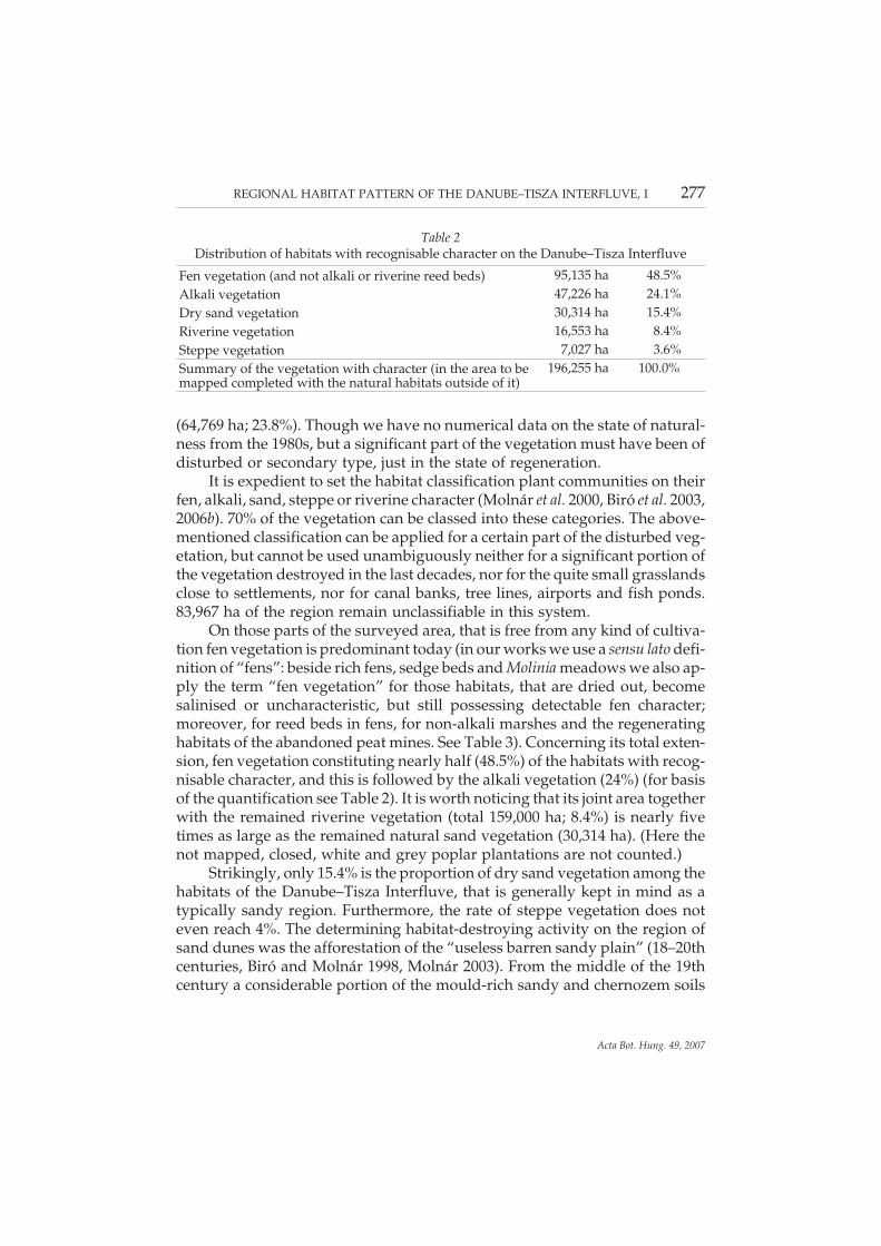
It is expedient to set the habitat classification plant communities on theirfen, alkali, sand, steppe or riverine character (Molnár et al. 2000, Biró et al. 2003,2006b). 70% of the vegetation can be classed into these categories. The above-mentioned classification can be applied for a certain part of the disturbed veg-etation, but cannot be used unambiguously neither for a significant portion ofthe vegetation destroyed in the last decades, nor for the quite small grasslandsclose to settlements, nor for canal banks, tree lines, airports and fish ponds.83,967 ha of the region remain unclassifiable in this system.
On those parts of the surveyed area, that is free from any kind of cultiva-tion fen vegetation is predominant today (in our works we use a sensu lato defi-nition of “fens”: beside rich fens, sedge beds and Molinia meadows we also ap-ply the term “fen vegetation” for those habitats, that are dried out, becomesalinised or uncharacteristic, but still possessing detectable fen character;moreover, for reed beds in fens, for non-alkali marshes and the regeneratinghabitats of the abandoned peat mines. See Table 3). Concerning its total exten-sion, fen vegetation constituting nearly half (48.5%) of the habitats with recog-nisable character, and this is followed by the alkali vegetation (24%) (for basisof the quantification see Table 2). It is worth noticing that its joint area togetherwith the remained riverine vegetation (total 159,000 ha; 8.4%) is nearly fivetimes as large as the remained natural sand vegetation (30,314 ha). (Here thenot mapped, closed, white and grey poplar plantations are not counted.)
Strikingly, only 15.4% is the proportion of dry sand vegetation among thehabitats of the Danube–Tisza Interfluve, that is generally kept in mind as atypically sandy region. Furthermore, the rate of steppe vegetation does noteven reach 4%. The determining habitat-destroying activity on the region ofsand dunes was the afforestation of the “useless barren sandy plain” (18–20thcenturies, Biró and Molnár 1998, Molnár 2003). From the middle of the 19thcentury a considerable portion of the mould-rich sandy and chernozem soils
REGIONAL HABITAT PATTERN OF THE DANUBE–TISZA INTERFLUVE, I 277
Acta Bot. Hung. 49, 2007
Table 2Distribution of habitats with recognisable character on the Danube–Tisza Interfluve
Fen vegetation (and not alkali or riverine reed beds) 95,135 ha 48.5%Alkali vegetation 47,226 ha 24.1%Dry sand vegetation 30,314 ha 15.4%Riverine vegetation 16,553 ha 8.4%Steppe vegetation 7,027 ha 3.6%Summary of the vegetation with character (in the area to bemapped completed with the natural habitats outside of it)
196,255 ha 100.0%
of good site conditions (formed on loessy sand, sandy loess and loess) wasbrought under cultivation (crop boom, emancipation of serfs), which initiatedthe quite fast deterioration of the natural habitats. Astonishingly high is theproportion of the cultivable mouldy sand areas on those parts of the Ridge(appr. 200,000 ha), that are considered as wind-blown sand regions in the com-mon knowledge. As a consequence, at the turn of the millennium only 15% ofthe Danube–Tisza Interfluve was covered by natural habitats and their more-or-less disturbed stands.
Mainly the uncultivable moving sand, the alkali and the humid habitats(e.g. water-rich fens, salt lakes that dries out by the summer and the temporarywet meadows) avoided ploughing in. Indicative of this is the fact, thatwetlands and water-influenced habitats compose the main proportion (78.3%)of the natural habitats survived until now. (By today, as a result of the ground-water loss some of these habitats dried out or its water-supply permanentlydecreased.) About 30% of the non-water-influenced natural habitats is repre-sented by alkali steppes, 50% of them are covered by open sand vegetation.Approximately 20% is the proportion of the closed sand habitats and the vege-tation, that are transitional to the fen and steppe habitats.
Excluding the riverine vegetation, majority of the recent natural wetlands(70%) lies on the discharge and throughflow areas (Mádlné Szőnyi et al. 2005).The local pattern of the humid habitats has altered on wide areas due to the in-land water management. Previously, sand deflation, translocation of the saltlake beds to smaller or longer distance and the alluviation resulted in localhabitat rearrangements. Nevertheless, the pattern of the humid habitats on theregional and the landscape level endured right till the latest decades owing totheir persistent geomorphological state. Because of the habitat devastationand alteration caused by the water deficiency, the peculiarity of the regionalpattern seems to be vanishing. This means an especially great loss of value be-cause this pattern has been relatively consistent in the whole landscape (in-cluding the sand ridges and the edges, as well), due to the stability of the hy-drodynamic circumstances for thousands of years. Many of the salt lakes onthe ridge and fen basins of the edge (e.g. Szappan-szék, Kerek-tó, Vörös-mo-csár, Kolon-tó) are proved to have been continuously wetlands since the“Corylus era”, not considering here some certain rude anthropogenic impactsof the 20th century (Andó 1975, Molnár et al. 1979, Fényes 1983, Molnár 1983,Jakab 2005). For instance, the surface of the eastern slope of the Ridge hasgained its final morphology mainly as a consequence of the proximity of thegroundwater and the network of humid habitats, established as a result (Borsy1977, 1996).
278 BIRÓ, M., RÉVÉSZ, A., MOLNÁR, ZS. and HORVÁTH, F.
Acta Bot. Hung. 49, 2007
Landscape pattern on the regional scale
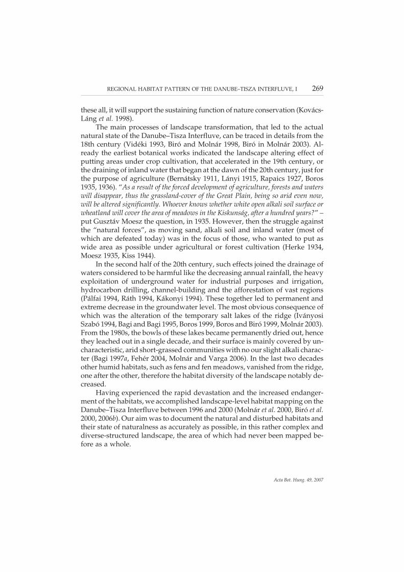
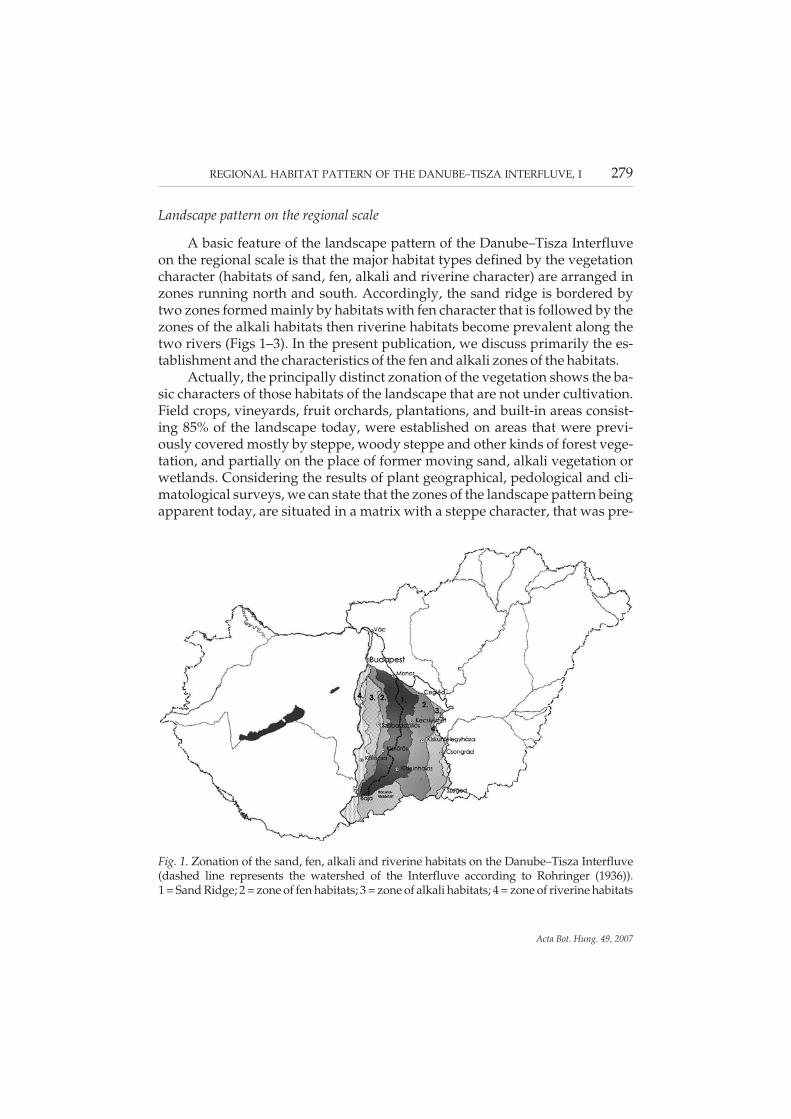
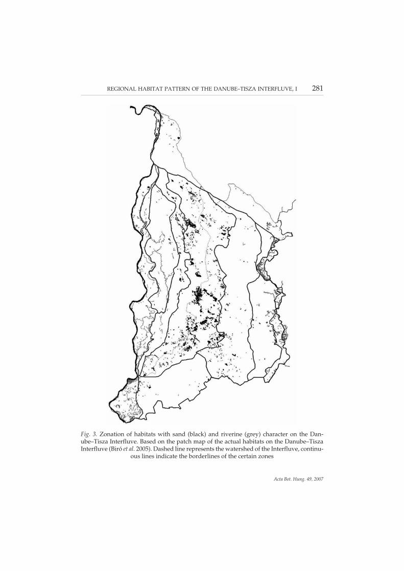
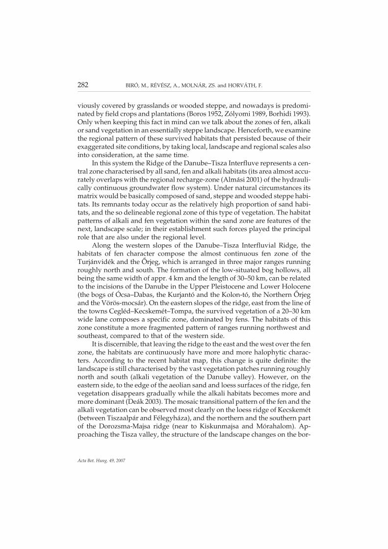
A basic feature of the landscape pattern of the Danube–Tisza Interfluveon the regional scale is that the major habitat types defined by the vegetationcharacter (habitats of sand, fen, alkali and riverine character) are arranged inzones running north and south. Accordingly, the sand ridge is bordered bytwo zones formed mainly by habitats with fen character that is followed by thezones of the alkali habitats then riverine habitats become prevalent along thetwo rivers (Figs 1–3). In the present publication, we discuss primarily the es-tablishment and the characteristics of the fen and alkali zones of the habitats.
Actually, the principally distinct zonation of the vegetation shows the ba-sic characters of those habitats of the landscape that are not under cultivation.Field crops, vineyards, fruit orchards, plantations, and built-in areas consist-ing 85% of the landscape today, were established on areas that were previ-ously covered mostly by steppe, woody steppe and other kinds of forest vege-tation, and partially on the place of former moving sand, alkali vegetation orwetlands. Considering the results of plant geographical, pedological and cli-matological surveys, we can state that the zones of the landscape pattern beingapparent today, are situated in a matrix with a steppe character, that was pre-
REGIONAL HABITAT PATTERN OF THE DANUBE–TISZA INTERFLUVE, I 279
Acta Bot. Hung. 49, 2007
Fig. 1. Zonation of the sand, fen, alkali and riverine habitats on the Danube–Tisza Interfluve(dashed line represents the watershed of the Interfluve according to Rohringer (1936)).1 = Sand Ridge; 2 = zone of fen habitats; 3 = zone of alkali habitats; 4 = zone of riverine habitats
280 BIRÓ, M., RÉVÉSZ, A., MOLNÁR, ZS. and HORVÁTH, F.
Acta Bot. Hung. 49, 2007
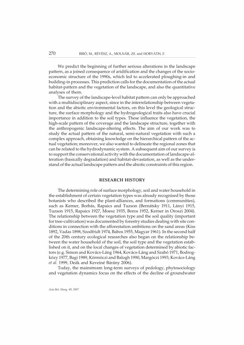
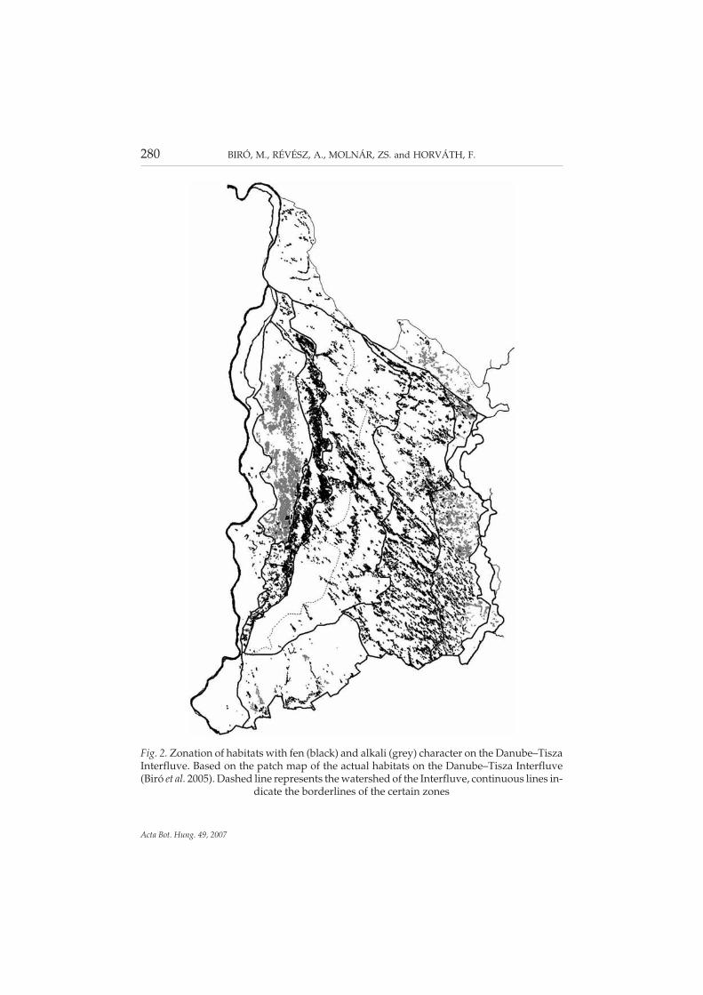
Fig. 2. Zonation of habitats with fen (black) and alkali (grey) character on the Danube–TiszaInterfluve. Based on the patch map of the actual habitats on the Danube–Tisza Interfluve(Biró et al. 2005). Dashed line represents the watershed of the Interfluve, continuous lines in-
dicate the borderlines of the certain zones
REGIONAL HABITAT PATTERN OF THE DANUBE–TISZA INTERFLUVE, I 281
Acta Bot. Hung. 49, 2007
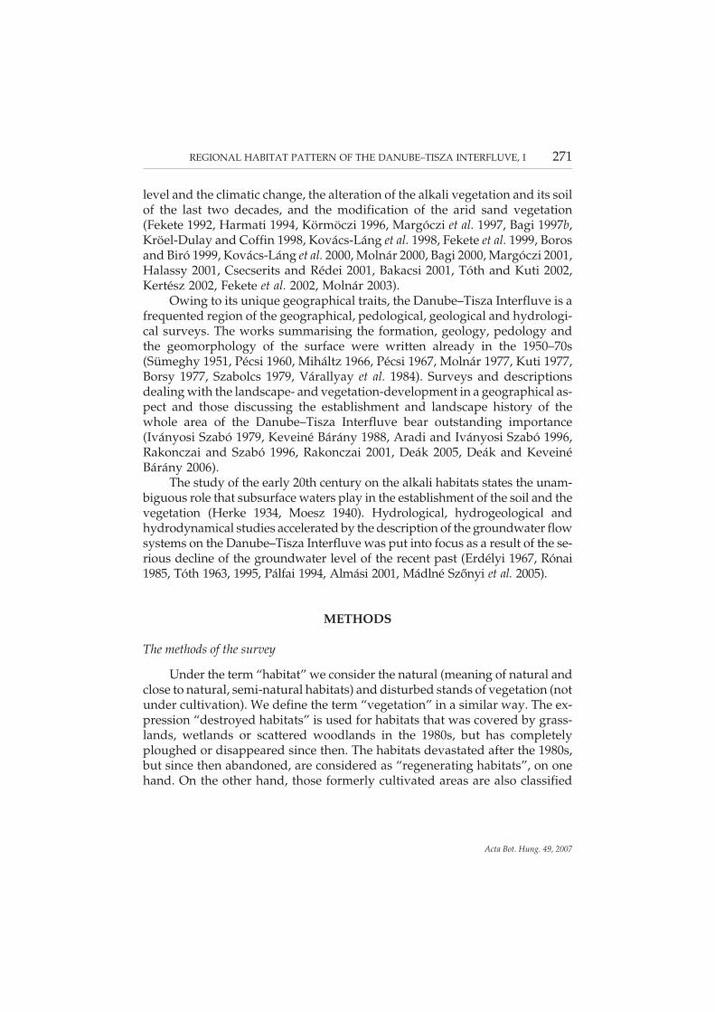
Fig. 3. Zonation of habitats with sand (black) and riverine (grey) character on the Dan-ube–Tisza Interfluve. Based on the patch map of the actual habitats on the Danube–TiszaInterfluve (Biró et al. 2005). Dashed line represents the watershed of the Interfluve, continu-
ous lines indicate the borderlines of the certain zones
viously covered by grasslands or wooded steppe, and nowadays is predomi-nated by field crops and plantations (Boros 1952, Zólyomi 1989, Borhidi 1993).Only when keeping this fact in mind can we talk about the zones of fen, alkalior sand vegetation in an essentially steppe landscape. Henceforth, we examinethe regional pattern of these survived habitats that persisted because of theirexaggerated site conditions, by taking local, landscape and regional scales alsointo consideration, at the same time.
In this system the Ridge of the Danube–Tisza Interfluve represents a cen-tral zone characterised by all sand, fen and alkali habitats (its area almost accu-rately overlaps with the regional recharge-zone (Almási 2001) of the hydrauli-cally continuous groundwater flow system). Under natural circumstances itsmatrix would be basically composed of sand, steppe and wooded steppe habi-tats. Its remnants today occur as the relatively high proportion of sand habi-tats, and the so delineable regional zone of this type of vegetation. The habitatpatterns of alkali and fen vegetation within the sand zone are features of thenext, landscape scale; in their establishment such forces played the principalrole that are also under the regional level.
Along the western slopes of the Danube–Tisza Interfluvial Ridge, thehabitats of fen character compose the almost continuous fen zone of theTurjánvidék and the Őrjeg, which is arranged in three major ranges runningroughly north and south. The formation of the low-situated bog hollows, allbeing the same width of appr. 4 km and the length of 30–50 km, can be relatedto the incisions of the Danube in the Upper Pleistocene and Lower Holocene(the bogs of Ócsa–Dabas, the Kurjantó and the Kolon-tó, the Northern Őrjegand the Vörös-mocsár). On the eastern slopes of the ridge, east from the line ofthe towns Cegléd–Kecskemét–Tompa, the survived vegetation of a 20–30 kmwide lane composes a specific zone, dominated by fens. The habitats of thiszone constitute a more fragmented pattern of ranges running northwest andsoutheast, compared to that of the western side.
It is discernible, that leaving the ridge to the east and the west over the fenzone, the habitats are continuously have more and more halophytic charac-ters. According to the recent habitat map, this change is quite definite: thelandscape is still characterised by the vast vegetation patches running roughlynorth and south (alkali vegetation of the Danube valley). However, on theeastern side, to the edge of the aeolian sand and loess surfaces of the ridge, fenvegetation disappears gradually while the alkali habitats becomes more andmore dominant (Deák 2003). The mosaic transitional pattern of the fen and thealkali vegetation can be observed most clearly on the loess ridge of Kecskemét(between Tiszaalpár and Félegyháza), and the northern and the southern partof the Dorozsma-Majsa ridge (near to Kiskunmajsa and Mórahalom). Ap-proaching the Tisza valley, the structure of the landscape changes on the bor-
282 BIRÓ, M., RÉVÉSZ, A., MOLNÁR, ZS. and HORVÁTH, F.
Acta Bot. Hung. 49, 2007
der of the vast solonetz steppes (Törtel, alkali steppes around Jászkarajenő,Csongrád and Szeged): the fragmented landscape is replaced by the hugesteppes or salt lakes, fens vanish, solonchak steppes are replaced by solonetzsteppes (cf. plant geographic isolation line running from Szeged to Újszász;Rapaics 1930). Nevertheless, the sand area at some certain places directlyreaches the floodplain of the Tisza (e.g. between Sándorfalva and Pusztaszeror Tiszaalpár and Tiszajenő). In these territories the sand areas including thehabitats of fen character reaches the natural floodplain of the Tisza without theinclusion of any vast alkali steppe.
The zonation of the habitats of the Ridge and the slopes on the regionalscale assumes a complex system of the abiotic factors, the area of which ex-pands from the Danube right to the Tisza. According to our opinion, the vege-tation pattern observed on the regional scale can be related principally to thelandscape geomorphology, the geological structure and the water flow rela-tionships. Presumably, the vegetation zones on the eastern and western sidescomposed of the alkali and fen habitats may overlap with the regional dis-charge areas of the hydraulically continuous groundwater flow system of theDanube–Tisza Interfluve (Almási 2001). On the landscape level, the alkali andfen character of the habitat zones may be developed principally by the differ-ent mineral composition of the waters deriving from the interfluvial Ridge (asthe regional recharge area) and those ascending from the Pre-Neogene,Pannonian basement (cf. Tóth and Almási 2001, Mádlné Szőnyi et al. 2005). Thepicture is fined by the hydrodynamic processes of the intermediary and localscale, resulting a characteristic hierarchical structure that also influences thevegetation.
The soil types, established as a result of the climatic relations, the geologi-cal and hydrogeological structure differs on the landscape level, which leadsto the division of the region into smaller, landscape level subunits. These back-ground factors together with the human landscape-altering effects give a finerstructure of the regional vegetation pattern.
The habitat pattern and the hierarchical structure of the hydrodynamic systems
The water household of the fen vegetation is principally determined bythe waters draining out of the Ridge. Waters arriving in quick and relativelyshort way from the Ridge keep up a permanent high level of groundwater inthe bog hollows of the western side, under natural circumstances. Conse-quently, there is no significant evaporation and salt accumulation within thefens. According to the latest results, on the western side the diluted mineralcontent of the waters from the ridge even arriving onto the alkali zone is withorders of magnitude lower, than the ascending basinal flow (Mádlné Szőnyi et
REGIONAL HABITAT PATTERN OF THE DANUBE–TISZA INTERFLUVE, I 283
Acta Bot. Hung. 49, 2007
al. 2005). Actually, the basinal flow is diluted by those arriving from the ridge.The borderline, between the area solely influenced by the basinal flow and thatof the gravity flow of the ridge, runs east from the Kelemen-szék (MádlnéSzőnyi et al. 2005). The habitats indicate this borderline with the accuracy ofsome hundred metres (field observation). Based on their regional scale pat-tern, the similarly sharp border of the fen and alkali vegetation can be tracedbetween Fülöpszállás and Csornapuszta, running definitely north and southfor as long as 20 km.
On the gradually descending eastern side of the ridge groundwaters runlonger distances and reach the surface more slowly because of the smaller dif-ference in levels, therefore they accumulate ever increasing amount of salt(Aradi and Iványosi Szabó 1996). Experts observed already in the first half ofthe 20th century that the proportion of highly sodic, solonchak habitats is con-tinuously grows approaching to Szeged (Lányi 1915, Rapaics 1927, Herke1934). The series of habitats form lines in the vales, the lower part of them hav-ing smaller descent. “… consequently, both surface and underground waters leakslowly over, and a major part of them cannot flow on and evaporates… The upper partsof the individual vales are covered primarily by sodic soils with less salt content, thanon the lower parts of the vales” (Herke 1934, cf. Deák 2003). The same phenome-non is observed in the case of the longitudinal fen series running from Bugac toPéteri-tó and Szentlászló-tó, where the fens are replaced by alkali habitats onthe lower parts (Herke 1934).
Similarly to the complex groundwater flow systems, the habitats of thenatural landscape of the Danube–Tisza Interfluve comprise habitat-systemsessentially on three levels of the landscape – on the local, intermediate and re-gional scale. In this context, those areas can be considered as “habitat-sys-tems”, where a unit of water circulation (recharge, throughflow and dis-charge) is realised determining and maintaining the site conditions spreadsover each habitats. These seem to be fractal-like structures on the differentscales (cf. hierarchical pattern-structure), the future study of which may be-come a stirring field for the cooperation of botany and related sciences.
Consequently, a unit of the local habitat-pattern can be for example theinterconnected habitat-system of a certain sand dune (or a smaller sand ridge)and a neighbouring depression; here the area of recharge is the dune itself, andthe water leaks out in the interdune depressions (cf. catena concept of Babos1958), while the interfluvial area represents the same on the regional scale. Thewetlands of the Dorozsma-Majsa Ridge can serve as an example for the hierar-chical structure of the vegetation pattern of the local and regional scale, wherethe humid habitats established in the rows of small interdune deflations. In thevales of sometimes several 10 km length, the seemingly isolated wetland habi-tats are connected to each other by water streams beneath the surface
284 BIRÓ, M., RÉVÉSZ, A., MOLNÁR, ZS. and HORVÁTH, F.
Acta Bot. Hung. 49, 2007
(Halaváts 1894, Lányi 1915, Herke 1934). The rows of interdune wetlands formhabitat-chains on the landscape level. The landscape level of the habitat-pat-tern is represented as their vegetation character, which is rather fen-like in thebeginning, but gradually turns alkaline subsequently (cf. Deák 2005); yet, inthis case the same feature is responsible for the regional pattern, as well. Sub-ordinated to the landscape level pattern develops the vegetation of the blow-out depressions, where the water collected on the surface (groundwater, rain-fall) cannot drain. Here water evaporates, thus fen and alkali habitats often oc-cur together, close to each other. According to Deák’s observations, a certaintendency is in these depressions that the groundwater effluencing out of thedunes at first generates fen, then alkali vegetation: “It is typical, that Moliniameadows develop on the northwestern, slightly elevated parts of the depression, whileon the southeastern parts saline meadows, Puccinellia swards and salt marshes estab-lish.” (Deák 2003). In our view, such pattern of the habitats within the depres-sions represents the local level of the complex groundwater flow system. Thelocal pattern of the vegetation – similarly to the regional one – has a fen profileat the beginning that turns into alkali character later on. However, the basis ofthis situation is the interaction between waters arriving from the ridge andthose ascending from the depth with high salt content (cf. the rate of the alkalihabitats tendentially increases towards Szeged): “Salt accumulation was alsosupported by the fact, that an essential proportion of the waters of the area arrives fromhigher territories and holds the ions leached over there.” (Herke 1934). According toour opinion, these might be the first recognitions of the regional groundwatersystems and their role in the vegetation establishment.
As a consequence of the hierarchical landscape structure of the Dan-ube–Tisza Interfluve, the sequential series of fen and alkali vegetation one af-ter the other, can be observed not only on the regional and the local scale, butalso in the intermediate, landscape patterns (cf. Herke 1934). The hierarchicgroundwater flow system of this intermediate level that influences the vegeta-tion on this scale consists of a row or group of dunes (as recharge area) and theadjacent larger bowls, vales or foreground dunes (as discharge area). Accord-ing to personal communications, publications and our field observations, thealkali and fen habitats of the depressions of the Ridge are often not independ-ent from each other (Herke 1934, personal communication of Kákonyi Árpádand the habitants of Fülöpháza). They constitute systems, where the mineralcomposition of the water draining out of the dunes establish fen habitats atfirst and alkali ones later: “The surface waters are running northwards, in the direc-tion of Bócsa. The soil of the depressions on the south contains a lower amount of so-dium carbonate and other kinds of minerals, but going northwards more sodic-alkalicsoils also turn up (e.g. Beniczky-water).” (Herke 1934). Such habitat-pattern com-
REGIONAL HABITAT PATTERN OF THE DANUBE–TISZA INTERFLUVE, I 285
Acta Bot. Hung. 49, 2007
posed of the sequences of fen and alkali vegetation patches can be found, forinstance, around the village of Fülöpháza (Biró et al. 2006a).
In the environment of Bócsa, but also in the majority of basins among thelarger dune areas of the ridge, only the remains of the formerly water-influ-enced habitats can be found, being in the permanent state of water-loss. Nev-ertheless, based on the surveys on the hydraulically continuous groundwaterflow systems (Tóth 1963, 1995, Mádlné Szőnyi et al. 2005), we assume thatthese groundwater influenced habitats are the discharge areas of the rainwaterpercolated on the dunes (intermediate groundwater flow system). This is thereason for their so quick aridification (in contrast to the regional discharge ar-eas). Such areas are, e.g. the fen meadows of Ágasegyháza, surrounding thesand dunes of Orgovány, the alkali habitats of the Csira-szék, or the former fenhabitats of Nagyrét on the edge of the sand dunes of Bugac. The former rich,peaty cottongrass fen meadows of Harkakötöny can be related to the waterseffluencing from the dunes of Tázlár (Bodrogközy 1977). Conversely, the wa-ters deriving from the dunes of Pirtó-Halas still today feeds the rich fens andfen meadows of the Fejeték.
THE REGIONAL PATTERNS ANDQUANTITATIVE ANALYSIS OF THE ACTUAL ALKALI
AND FEN VEGETATION OF THE LANDSCAPE
The fen vegetation
Cumulative regional extension data
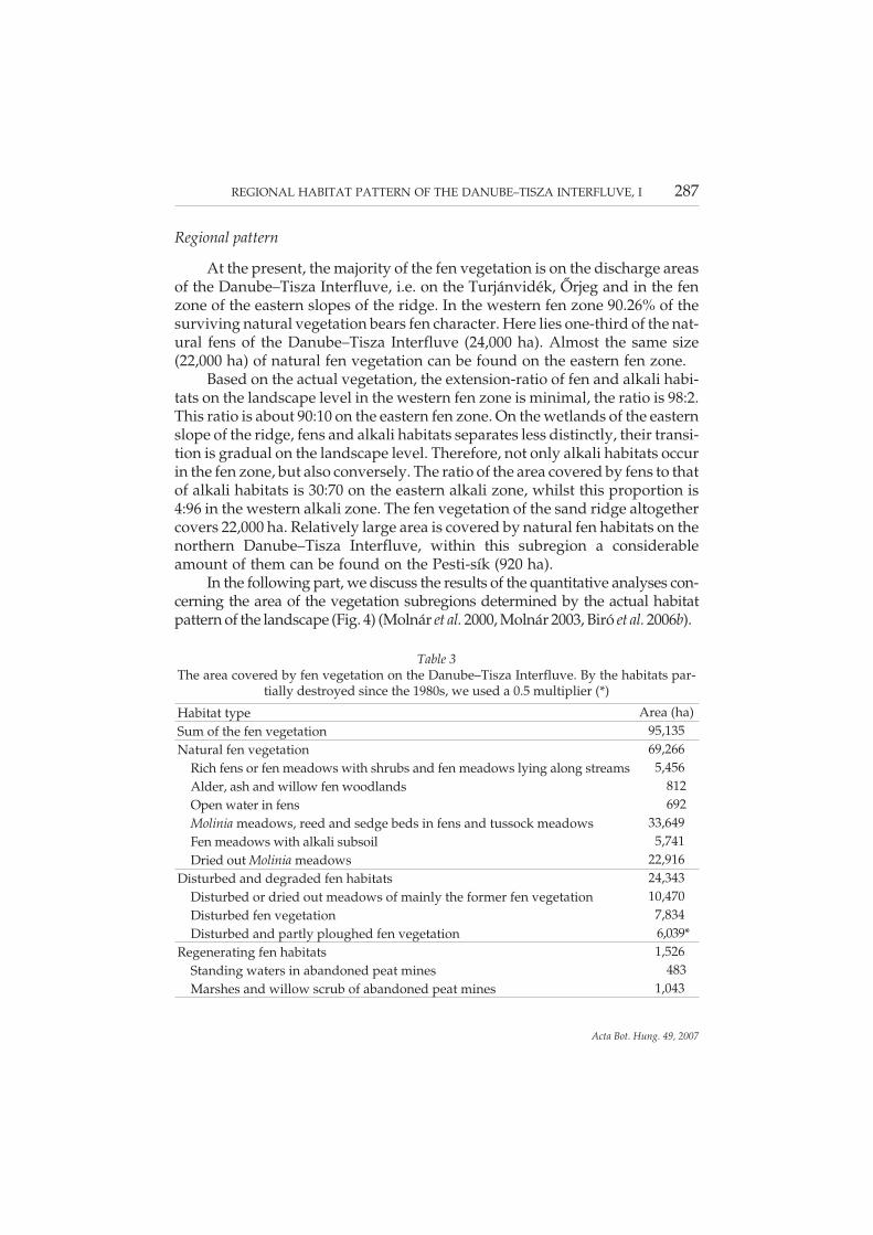
The total extension of the areas covered by fen vegetation on the Dan-ube–Tisza Interfluve (here using the sensu lato definition of fen vegetation, seeabove) reached 95,000 ha (Table 3) on the turn of the millennium. Approxi-mately 73% of them (69,266 ha) can be considered as natural. The disturbedand even partially destroyed fen habitats were mapped to cover 24,343 ha, therecently regenerating fen vegetation, that were formerly transformed into peatmines, cover 1,526 ha. The actually existing habitats of fen character (notploughed-in or destroyed in any other way) extend over 92,100 ha, today. Thiscomprises the 44% of the survived natural vegetation of the Danube–TiszaInterfluve, that might be disturbed to various extend, but having not ploughed.The reference area (209,013 ha) is the whole territory of the area to be mapped(272,387 ha, supplemented by further 9,765 ha that lies outside the layer ofmapping area, see Methods), with the elimination of the area of habitats regen-erating and having destroyed since 1980.
286 BIRÓ, M., RÉVÉSZ, A., MOLNÁR, ZS. and HORVÁTH, F.
Acta Bot. Hung. 49, 2007
Regional pattern
At the present, the majority of the fen vegetation is on the discharge areasof the Danube–Tisza Interfluve, i.e. on the Turjánvidék, Őrjeg and in the fenzone of the eastern slopes of the ridge. In the western fen zone 90.26% of thesurviving natural vegetation bears fen character. Here lies one-third of the nat-ural fens of the Danube–Tisza Interfluve (24,000 ha). Almost the same size(22,000 ha) of natural fen vegetation can be found on the eastern fen zone.
Based on the actual vegetation, the extension-ratio of fen and alkali habi-tats on the landscape level in the western fen zone is minimal, the ratio is 98:2.This ratio is about 90:10 on the eastern fen zone. On the wetlands of the easternslope of the ridge, fens and alkali habitats separates less distinctly, their transi-tion is gradual on the landscape level. Therefore, not only alkali habitats occurin the fen zone, but also conversely. The ratio of the area covered by fens to thatof alkali habitats is 30:70 on the eastern alkali zone, whilst this proportion is4:96 in the western alkali zone. The fen vegetation of the sand ridge altogethercovers 22,000 ha. Relatively large area is covered by natural fen habitats on thenorthern Danube–Tisza Interfluve, within this subregion a considerableamount of them can be found on the Pesti-sík (920 ha).
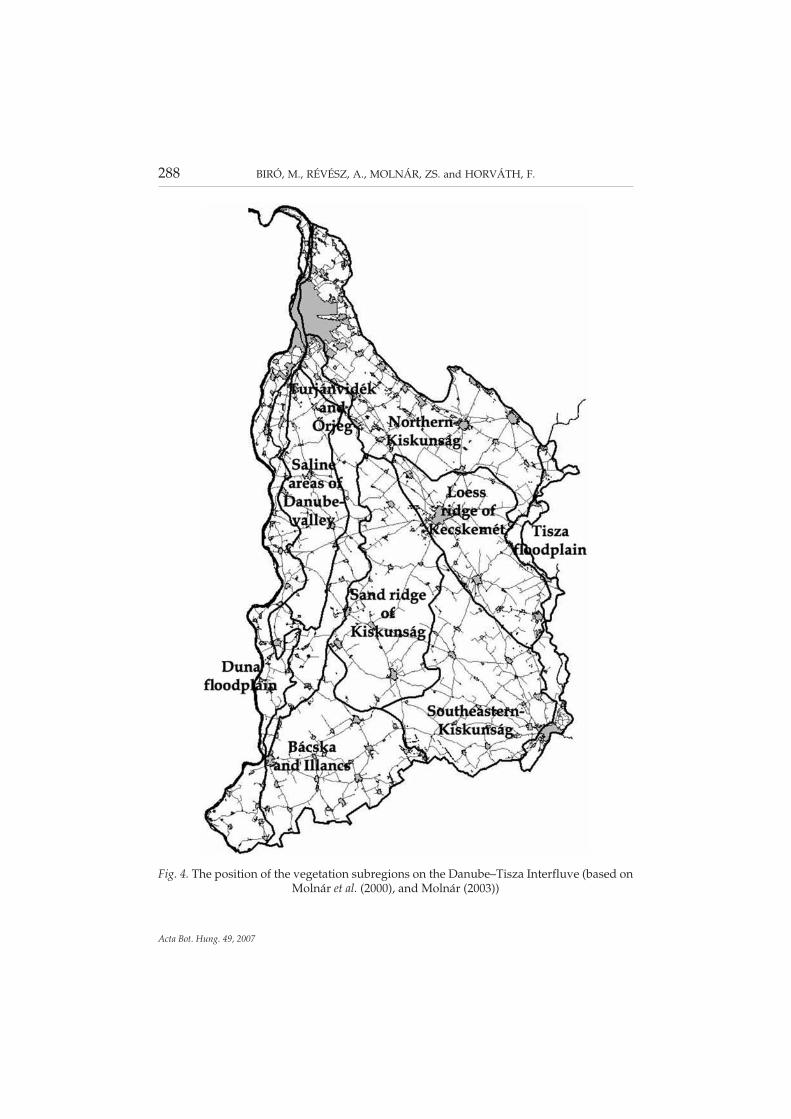
In the following part, we discuss the results of the quantitative analyses con-cerning the area of the vegetation subregions determined by the actual habitatpattern of the landscape (Fig. 4) (Molnár et al. 2000, Molnár 2003, Biró et al. 2006b).
REGIONAL HABITAT PATTERN OF THE DANUBE–TISZA INTERFLUVE, I 287
Acta Bot. Hung. 49, 2007
Table 3The area covered by fen vegetation on the Danube–Tisza Interfluve. By the habitats par-
tially destroyed since the 1980s, we used a 0.5 multiplier (*)
Habitat type Area (ha)Sum of the fen vegetation 95,135Natural fen vegetation 69,266
Rich fens or fen meadows with shrubs and fen meadows lying along streams 5,456Alder, ash and willow fen woodlands 812Open water in fens 692Molinia meadows, reed and sedge beds in fens and tussock meadows 33,649Fen meadows with alkali subsoil 5,741Dried out Molinia meadows 22,916
Disturbed and degraded fen habitats 24,343Disturbed or dried out meadows of mainly the former fen vegetation 10,470Disturbed fen vegetation 7,834Disturbed and partly ploughed fen vegetation 6,039*
Regenerating fen habitats 1,526Standing waters in abandoned peat mines 483Marshes and willow scrub of abandoned peat mines 1,043
288 BIRÓ, M., RÉVÉSZ, A., MOLNÁR, ZS. and HORVÁTH, F.
Acta Bot. Hung. 49, 2007
Fig. 4. The position of the vegetation subregions on the Danube–Tisza Interfluve (based onMolnár et al. (2000), and Molnár (2003))
The proportion of the area, the regional andthe landscape pattern of the habitat types
One-third of the fen habitats, slightly more than 33,600 ha, are covered byfen meadows, sedge and reed beds or tussock meadows (Fig. 5A). Noteworthyis the fact, that this kind of habitat has the highest proportion (12%) among allthe habitats studied by us on the Danube–Tisza Interfluve. According to ourassumptions, cca one-third of them represent a considerably high conserva-tional value (these are the rich fens, Molinia meadows, tussock sedge commu-nities, tussock meadows, sedge beds, swamp woodlands, willow woodlands,boggy brooklets of the Danube, etc.). They principally occur in the eastern andwestern fen zones, but they have a considerable coverage on the middle partsof the sand ridge (4,680 ha), on the Pesti-sík (433 ha) and the areas of the bor-der-line in Bácska (833 ha).
A considerable part of fen vegetation is becoming seriously arid andsteppe-like. This is revealed in the high proportion of the dried out or dryingout meadows and the “lake steppes” of the former fen habitats – with the areaof 23,000 ha, they are the second most frequent habitat-types of the Dan-ube–Tisza Interfluve. In spite of its basically fen origin, this vegetation type,composing one quarter of the total fen vegetation, rather relates to the steppemeadows (Hargitai 1940, Fekete 1992, Molnár and Varga 2006). It consistentlyoccurs in the whole territory, but for the alkali and riverine areas; its landscapepattern joins with the more humid fen habitats.
The arid years and regional groundwater level decline of the last decades,caused serious aridification of fen vegetation and also led to changes in thespecies composition (Bagi 1997a, Bodrogközy 1977, Margóczi 2001, Deák2005). Such transitional state or transforming vegetation is that of the dried outmeadows of mainly the former fen vegetation, that are becoming uncharacter-istic (10,470 ha). They are principally to be found on the ridge (4,900 ha) and onthe throughflow and discharge regions of the eastern slope (5,500 ha) havingbetter water supply. Their occurrence on the ridge can be related to the inter-mediate and local discharge areas of the regional recharge area that has hadwater deficiency for years (Fig. 5D). Therefore, vast areas are covered by themon the deeply altered and dried out discharge zone of the sand dunes of Bócsa(Bócsa-Fischerbócsa), around Lajosmizse and Kerekegyháza, Bugac andMonostor. Larger landscape level groups of the former fen and mesotrophicmeadows on the eastern slope of the ridge are discernible on the loess ridge ofKiskunfélegyháza, on the former fen habitats between Kocsér and Jászkara-jenő and on the foreground of the dunes around Zsana and Balotaszállás. Thestriking absence of fen meadows from the latter area is also proved by the fieldobservations (Deák 2005). The possible reason for this serious aridification is,
REGIONAL HABITAT PATTERN OF THE DANUBE–TISZA INTERFLUVE, I 289
Acta Bot. Hung. 49, 2007

290 BIRÓ, M., RÉVÉSZ, A., MOLNÁR, ZS. and HORVÁTH, F.
Acta Bot. Hung. 49, 2007
Fig. 5. Regional pattern of fen vegetations, on the Danube–Tisza Interfluve (black colour).Based on the patch map of the actual habitats on the Danube–Tisza Interfluve (Biró et al.2005). A = Molinia meadows, reed and sedge beds in fens and tussock meadows; B = richfens or fen meadows with shrubs and fen meadows lying along streams; C = fen meadowswith alkali subsoil; D = disturbed or dried out meadows of mainly the former fen vegetation
that this territory was the discharge area of the above-mentioned dunes, whilstit is a throughflow zone on the regional scale (cf. the hydrodynamic map ofAlmási (2001), Herke 1934). Nevertheless, it is observable that only few suchuncharacteristic dried out meadows turn up on the eastern slope, on the south-eastern side of the line of Balástya and Pusztamérges. The reason for this phe-nomenon is that the environment of Szeged is relatively rich even today in wa-ters draining out of the ridge (and the aridification process does not affect thelowest-lying, discharge areas).
Fen and mesotrophic meadows with alkali subsoil cover more than 5,700ha. 80% of them can be found on the eastern slope of the ridge (4,500 ha). Theyturn up there basically in such areas where the fens intermingle with the alkalihabitats (e.g. along Gerje, around Kiskunfélegyháza and on the whole terri-tory of southeastern Kiskunság) (cf. Lányi 1915, Rapaics 1927, Deák 2003).However, they are completely missing from the solonetz zone of the saltsteppes lying over the isolation line running from Szeged to Újszász (Fig. 5C).869 ha of them can be found on the Kiskunság Sand Ridge. Astonishingly,wider patches of mesotrophic and fen meadows with alkali subsoil, that arecharacteristic even on the landscape level, are missing from the Turjánvidék,Őrjeg, Bácska, but even from the northern Danube–Tisza Interfluve, while onthe local level their small patches occur scattered in the whole landscape.
Brushes of rich fens and fen meadows lying along streams represent 87%(5,500 ha) of the woody fen vegetation. Characteristically, huge areas are cov-ered by them on the Turjánvidék and the Őrjeg, but they have scatteredpatches on the whole southeastern Kiskunság, around Móricgát-Monostor,along the Gerje and on the Pesti-sík (Fig. 5B). As a consequence of the land-usechanges in the last decades, the more humid fen vegetation, especially thelarge sedge beds and Molinia meadows, having been mowed for centuries, areever more heavily intruded by reed and bushes (e.g. the fens around Homok-mégy and Hillye, Cegléd, Sarlósár, Páhi and Móricgát). Fen habitats along thestreams on the Pesti-sík were degraded by the invasion of Solidago species inslightly more than a decade (e.g. the valley of the Rákos-patak). In most cases,these are the characteristic species of the regenerating vegetation of the aban-doned peat mines as well (covering 1,526 ha).
Ninety percent (720 ha) of the alder and ash fen woodlands lie in the west-ern fen zone of the Danube–Tisza Interfluve. They also turn up on the regionaldischarge areas of the eastern side, as secondary vegetation on the border ofZsombó, Kelebia and Pusztamérges, and also near Lakitelek, as a consequenceof the waters draining out of the ridge.
REGIONAL HABITAT PATTERN OF THE DANUBE–TISZA INTERFLUVE, I 291
Acta Bot. Hung. 49, 2007
Disturbances, endangering factors
The occurrence of disturbed fen vegetations (see Table 3) coincides withthe habitats of fen character of the Danube–Tisza Interfluve. The most impor-tant endangering factor on the landscape level is the permanent water defi-ciency, and the dismissal of the former land-use. This latter led to the spread ofshrubs, reed and invasive plants. As a consequence of aridification, the extendof plough-in and build-in activity increased, which foretells further alterationsin the landscape structure. This process can be moderated by nature conserva-tion activity only within certain limits, since just a small part of fen vegetationis under protection (and only the most valuable fen habitats were put under exlege protection).
Devastation
The trend of devastation of habitats with fen character experienced in thelast 15 years reveals the beginning of the above-mentioned process. Giving nu-merical data on the habitat devastation of the era between 1980 and the millen-nium is difficult, since no habitat map was drawn in the 1980s. The character(and thus the extension) of the disturbed and partially ploughed grasslandssince the 1980s can be an acceptable accuracy. About 60.2% of them were fenvegetation, formerly. Presumably, a similar proportion of completely ploughed-in habitats was fen vegetation.
Based on our calculations, in the last 15 years 11.9% of former fen habitatsdevastated – principally owing to plough-in (this means approx. 12,800 ha offen vegetation) (for details see Biró et al. 2007).
The alkali vegetation
Cumulative regional extension data
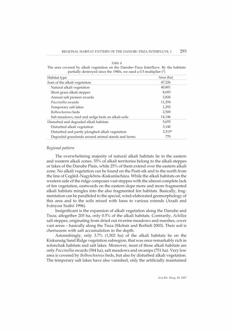
Alkali vegetation covers a complete area of 47,226 ha on the Danube–TiszaInterfluve (Table 4), the majority of them are still natural (nearly 41,000 ha),and 6,500 ha of them are disturbed or even partially devastated. The actuallyexisting (i.e. not ploughed-in or destroyed any other way) alkali habitat is only45,969 ha today. This comprises 22% of the cumulative area of the habitats ofthe Interfluve.
292 BIRÓ, M., RÉVÉSZ, A., MOLNÁR, ZS. and HORVÁTH, F.
Acta Bot. Hung. 49, 2007
Regional pattern
The overwhelming majority of natural alkali habitats lie in the easternand western alkali zones. 55% of alkali territories belong to the alkali steppesor lakes of the Danube Plain, while 25% of them extend over the eastern alkalizone. No alkali vegetation can be found on the Pesti-sík and to the north fromthe line of Cegléd–Nagykőrös–Kiskunlacháza. While the alkali habitats on thewestern side of the ridge composes vast steppes with the almost complete lackof fen vegetation, eastwards on the eastern slope more and more fragmentedalkali habitats mingles into the also fragmented fen habitats. Basically, frag-mentation can be paralleled to the special, wind-elaborated geomorphology ofthis area and to the soils mixed with loess to various extends (Aradi andIványosi Szabó 1996).
Insignificant is the expansion of alkali vegetation along the Danube andTisza; altogether 205 ha, only 0.5% of the alkali habitats. Contrarily, Achilleasalt steppes, originating from dried out riverine meadows and marshes, covervast areas – basically along the Tisza (Molnár and Borhidi 2003). Their soil ischernozem with salt accumulation in the depth.
Astonishingly, only 3.7% (1,502 ha) of the alkali habitats lie on theKiskunság Sand Ridge vegetation subregion, that was once remarkably rich insolonchak habitats and salt lakes. Moreover, most of these alkali habitats areonly Puccinellia swards (584 ha), salt meadows and swamps (751 ha). Very lowarea is covered by Bolboschoenus beds, but also by disturbed alkali vegetation.The temporary salt lakes have also vanished, only the artificially maintained
REGIONAL HABITAT PATTERN OF THE DANUBE–TISZA INTERFLUVE, I 293
Acta Bot. Hung. 49, 2007
Table 4The area covered by alkali vegetation on the Danube–Tisza Interfluve. By the habitats
partially destroyed since the 1980s, we used a 0.5 multiplier (*)
Habitat type Area (ha)Sum of the alkali vegetation 47,226
Natural alkali vegetation 40,801Short grass alkali steppes 8,693Annual salt pioneer swards 2,826Puccinellia swards 11,294Temporary salt lakes 1,292Bolboschoenus beds 2,500Salt meadows, reed and sedge beds on alkali soils 14,146
Disturbed and degraded alkali habitats 5,655Disturbed alkali vegetation 3,140Disturbed and partly ploughed alkali vegetation 2,515*Degraded grasslands around animal stands and farms 770
former salt lakes (Kunfehértó, Vadkerti-tó and Halasi-Sós-tó) fed by ground-water serve as reminders of them (cf. Andó 1975, Kiss 1976, Molnár 1990,Iványosi Szabó 1994, Bagi 1997a, Boros and Biró 1999). A proper example ofthe above-mentioned process is the environment of Lajosmizse, which wasonce considerably rich in salt lakes. At the beginning of the 20th century 61 saltlakes were to be found on the area between Kecskemét and Felsőlajos. Today,only two dozens of Puccinellia covered plains, a few alkali swamps and somedisturbed alkali patches lie here. 2.5% of interfluvial alkali habitats are withinthe territory of Bácska and Illancs, that are extraordinarily poor in habitats.They turn up in the round bowl-shaped depressions among the loess coveredsand dunes of Bácska, chiefly around Gara and Madaras. Noteworthy is thefact, that this very low amount of alkali vegetation (970 ha) comprises 30% ofthe natural vegetation of this area.
As a conclusion of the observations mentioned above, we can state thatabout 90% of the alkali habitats of the Danube–Tisza Interfluve gather in fourmajor alkali territories (their cumulative area – including both natural and dis-turbed areas – is approx. 40,860 ha):
1. the alkali habitats of the Danube Plain: alkali steppes around Apaj-Sza-badszállás and Akasztó,
2. the steppes around Cegléd and Jászkarajenő (Gerje–Perje-sík)3. the steppes between Gátér and Pusztaszer,4. the alkali vegetation in the environs of Szeged.On the steppes of Gátér-Pusztaszer lies the 16.5% of the alkali vegetation,
on the Gerje–Perje-sík a subsequent 9.2%, in the environs of Szeged 11.7% ofthem. The areas mentioned above are the regional discharge areas of the Ridgeof Danube–Tisza Interfluve, but for the Gerje–Perje-sík, that belongs to the wa-ter system of the Old Tápió.
The proportion of the area, the regional andthe landscape pattern of the habitat types
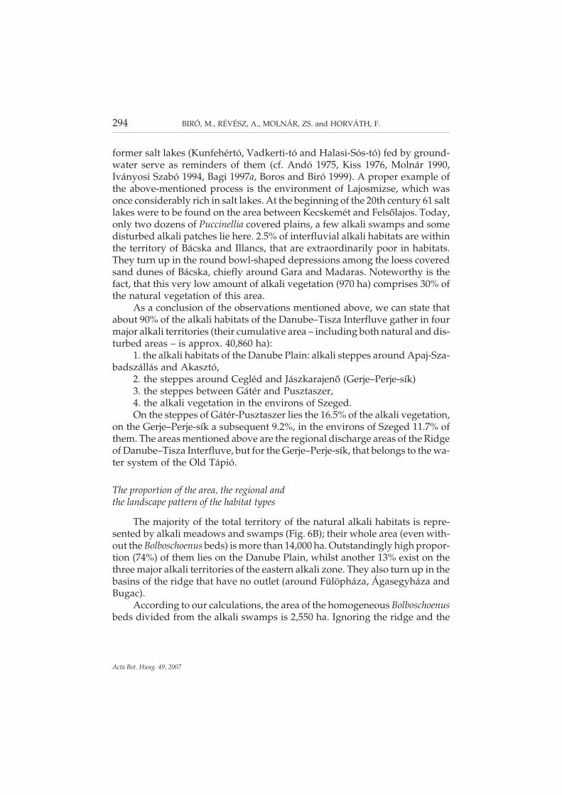
The majority of the total territory of the natural alkali habitats is repre-sented by alkali meadows and swamps (Fig. 6B); their whole area (even with-out the Bolboschoenus beds) is more than 14,000 ha. Outstandingly high propor-tion (74%) of them lies on the Danube Plain, whilst another 13% exist on thethree major alkali territories of the eastern alkali zone. They also turn up in thebasins of the ridge that have no outlet (around Fülöpháza, Ágasegyháza andBugac).
According to our calculations, the area of the homogeneous Bolboschoenusbeds divided from the alkali swamps is 2,550 ha. Ignoring the ridge and the
294 BIRÓ, M., RÉVÉSZ, A., MOLNÁR, ZS. and HORVÁTH, F.
Acta Bot. Hung. 49, 2007
REGIONAL HABITAT PATTERN OF THE DANUBE–TISZA INTERFLUVE, I 295
Acta Bot. Hung. 49, 2007
Fig. 6. Regional pattern of alkali vegetations, on the Danube–Tisza Interfluve (black colour).Based on the patch map of the actual habitats on the Danube–Tisza Interfluve (Biró et al.2005). A = short grass alkali steppes; B = salt meadows, reed and sedge beds on alkali soils;
C = Puccinellia swards; D = Bolboschoenus beds
Gerje–Perje-sík where only few patches of them occur, their presence coin-cides mainly with that of the alkali meadows and swamps (Fig. 6D).
The Puccinellia swards cover 11,294 ha. In addition to the alkali territoriesof the Danube valley, the majority of them lie on the Gerje-sík, the loess ridgeof Kecskemét and the Dorozsma-Majsa ridge (Fig. 6C).
Interestingly, rather small is the area of the arid alkali steppes (appr. 5,000ha) on the Danube Plain relative to the other kinds of alkali vegetation, whilefor example the area covered by alkali meadows and swamps is twice as largeas the previous (11,733 ha). 96% of the short grass alkali steppes lie on the fourterritories dominated by alkali vegetation (Fig. 6A). Their extension had a sim-ilar pattern two hundred years ago like today, but in a more humid, oftenflooded landscape (Biró 1999). While on the area covered by alkali habitatslinked to the excess water is much (appr. three times) wider than the area ofthe arid alkali steppes, this ratio seems to be reverse on the alkali territoriesover the Tisza. We think that the reason for this phenomenon roots in the dif-fering water household of solonchak and solonetz soils (Várallyay 1993).
The total extension of annual salt pioneer swards and salt lakes is 4,118ha, that constitutes 10% of the natural alkali vegetation. Their area partially co-incides with the arid salt steppes. They also have considerable coverage in thesoutheastern Kiskunság (especially around Majsa, Kistelek, Szeged andÁsotthalom) (Lányi 1915, Rapaics 1927, Margóczi 2001, Deák 2005). However,they almost completely disappeared from the Sand Ridge, by today (Bagi1997a, Boros and Biró 1999).
Salt lakes can only be found on the regional discharge areas, today (in theenvirons of Szabadszállás, Pusztaszer and Szeged, and on the alkali habitatsaround Jászkarajenő). According to estimations, they covered a total area of6,819 ha in the 18th century on the Danube–Tisza Interfluve, in comparisonwith their actual area being appr. 1,200 ha (Boros and Biró 1999).
Disturbances, endangering factors
92% of the disturbed alkali habitats lie on the four wide territories of al-kali steppes. The weedy tall herb communities around animal stands coincidewith the area of the vast, grazed alkali steppes: steppes around Apaj-Szabad-szállás and Akasztó, the steppes between Gátér and Pusztaszer and thesteppes between Cegléd and Jászkarajenő.
The most important endangering factors are the leaching of the solonchakalkali soil and the discontinuation of grazing, both resulting the gradual in-volvement of the fragmented patches in cultivation. This process has begun inspite of the ex lege protection of salt lakes, what is revealed by the quantitativedata on the devastation.
296 BIRÓ, M., RÉVÉSZ, A., MOLNÁR, ZS. and HORVÁTH, F.
Acta Bot. Hung. 49, 2007
Devastation
About 25% of the habitats devastated in the last 15 years of the 20th cen-tury are alkali habitat. Based on this data, it can be assumed that also one quar-ter of the vegetation patches destroyed completely by ploughing-in was alkalivegetation. This altogether means the devastation of appr. 6,000 ha of alkalihabitats in the recent past. In the view of the habitat distribution of themid-1980s, this implies the ploughing-in of the 10.2% of the area of the alkalihabitats of that time.
CONCLUDING REMARKS
The survey on the habitat pattern of the Danube–Tisza Interfluve on theregional and landscape level revealed that astonishing fact, that fen habitatsrepresent the majority of the vegetation survived till our days, that is followedby the alkali vegetation. However, the decline of the groundwater level ob-served in the last decades affects partially the fen vegetation itself, which in-nately needs continuous water supplement during the whole year. Nowa-days, the dried out fen habitats are not protected by law, and ever more area ofthem is ploughed in. Moreover, the re-structure and devastation of alkali habi-tats was also noteworthy and striking in the last decades. That is why we re-vealed the outstanding role that fen and alkali vegetation play in the sandlandscape. Since groundwater flow systems play the primary role in the estab-lishment and sustenance of the regional, landscape and local patterns of the al-kali and fen habitats, we think that the expedient future research on them musttake the hydrodynamic surveys of regional and intermediate level into consid-eration, and the interconnection of these two fields is also desirable.
*
Acknowledgements – We thank Mádlné Judit Szőnyi, Keveiné Ilona Bárány, IstvánBagi, András Iványosi Szabó, Árpád Kákonyi, András Máté, Gábor Fekete, GyörgyKröel-Dulay and Bálint Czúcz for their comments in the work or for the manuscript. Herewe would like to acknowledge once more to all participating botanists, conservationists,soil scientists, zoologists, biology teachers and other colleagues for their role in the ActualHabitat Map Program of the Danube–Tisza Interfluve region. With their active work, help,data collection, offering of their former field data, help in map preparation, thoughts, ad-vice and supervision contributed the elaboration of the map and this paper; Réka Aszalós,István Bagi, Sándor Barabás, Sándor Bartha, István Beliczai, Csaba Bíró, Attila Borhidi, EmilBoros, János Bölöni, György Büttner, Anikó Csecserits, Ágnes Csomós, István Dancza,Konstantin Dobolyi, Gábor Fekete, Béla Gaskó, Attila Gergely, Györgyi Gulyás, István
REGIONAL HABITAT PATTERN OF THE DANUBE–TISZA INTERFLUVE, I 297
Acta Bot. Hung. 49, 2007

Hahn, Melinda Halassy, András Horváth, Tünde Horváth, Zoltán Horváth, András Ivá-nyosi Szabó, Annamária Jankó, Béla Kalocsa, Miklós Kertész, Alexandra Kormos, Éva Ko-vács, Kovácsné Edit Láng, László Körmöczi, György Kröel-Dulay, András Kun, László Kuti,Katalin Margóczi, András Máté, Edit Molnár, Ferenc Németh, Ferenc Pál-Szabó, László Pász-tor, Gyula Pinke, Tamás Rédei, János Sára, Zoltán Sebestyén, Tibor Seregélyes, Ferenc Si-pos, Katalin Sipos, István Somodi, József Szabó, Réka Szabó, Mária Szabó, György Szollát,László Tajti, Dóra Tatár, Jenő Ternyák, Sándor Urbán, Zoltán Vajda, Csaba Varga and RóbertVidéki. This research was supported by the Alföld Program of the Ministry of Environment.
REFERENCES
Almási, I. (2001): Petroleum hydrogeology of Great Hungarian Plain, Eastern Pannonian Basin,Hungary. – PhD thesis, Univ. Alberta, US.
Andó, M. (1975): A dél-alföldi szikes tavak természeti földrajzi adottságai. – Hidrol. Közl. 1:27–35.
Aradi, Cs. and Iványosi Szabó, A. (1996): Az Alföld természeti szépségei. – In: Rakonczai, J. andSzabó, F. (eds): A mi Alföldünk. Nagyalföld Alapítvány, Békéscsaba, pp. 17–24.
Babos, I. (1955): A Duna–Tisza közi homokhát termőhelyfeltárása. – Erd. Kut. 2: 3–53.Babos, I. (1958): Site-chains on sand soils. – Acta Agronomica 8(1–2): 142–159.Bagi, I. (1989): A Gypsophila muralis L. kiskunsági szikeseken való előfordulásának talajta-
ni okai és természetvédelmi vonatkozásai. – Bot. Közlem. 76: 51–63.Bagi, I. (1997a): A vegetációtérképezés elméleti kérdései. – Kand. ért., JATE, Szeged, 102 pp.Bagi, I. (1997b): Átalakuló homoki vegetáció a Duna–Tisza közén. – Kitaibelia 2(2): 253–264.Bagi, I. (2000): A Cleistogenes serotina inváziójának dokumentumai a Kiskunsági Nemzeti
Park „Fülöpházi homokbuckák” UNESCO bioszféra-rezervátum magterületein,1975–1999. – In: Virágh, K. and Kun, A. (eds): Vegetáció és dinamizmus. A 70 évesFekete Gábort köszöntik barátai és munkatársai. MTA ÖBKI, Vácrátót, pp. 147–156.
Bagi, I. and Bagi, B. (1995): Vegetációátalakulási folyamatok a Kiskunsági Nemzeti ParkSzappan-széki területén, 1987–1994. – Bot. Közlem. 82: 142.
Bakacsi, Zs. (2001): Agrogeológiai és talajtani elemzések Apajpusztán, a feltételezett talajvízszintváltozások várható következményei. – Doktori ért., ELTE TTK, Budapest, 145 pp.
Bartha, S. (2000): In vivo társuláselmélet. – In: Virágh, K. and Kun, A. (eds): Vegetáció ésdinamizmus. A 70 éves Fekete Gábort köszöntik barátai és munkatársai. MTA ÖBKI,Vácrátót, pp. 101–140.
Bernátsky, J. (1911): A Magyar Alföld pusztai és erdei növényzetéről. – Földr. Közl. 5: 261–277.Biró, M. (1999): The vegetation of the Danube–Tisza Interfluve in the 18th century (original scale:
1: 100,000). – In: Kovács-Láng, E., Molnár, E., Kröel-Dulay, Gy. and Barabás, S. (eds):Long term ecological research in the Kiskunság, Hungary. IEB HAS, Vácrátót, p. 17.
Biró, M. and Gulyás, Gy. (2003): The vegetation of the Duna–Tisza köze at the end of the 19th cen-tury (original scale: 1: 25,000). – In: Molnár, Zs. (ed.): A Kiskunság száraz homokinövényzete. TermészetBÚVÁR Alapítvány Kiadó, Budapest, p. 32.
Biró, M. and Molnár, Zs. (1998): A Duna–Tisza köze homokbuckásainak tájtípusai, azokkiterjedése, növényzete és tájtörténete a XVIII. századtól. (Vegetation and land-usehistory in the sand dunes of the Duna–Tisza köze from the 18th century and mappingof landscape types of the late 18th century.) – Történeti Földrajzi Füzetek 5: 1–34.
298 BIRÓ, M., RÉVÉSZ, A., MOLNÁR, ZS. and HORVÁTH, F.
Acta Bot. Hung. 49, 2007
Biró, M. et al. (2003): A Duna–Tisza köze aktuális élőhelytérképe. (Actual vegetation map of theDuna–Tisza köze, Hungary. Scale: 1: 400,000). – In: Molnár, Zs. (ed.): A Kiskunságszáraz homoki növényzete. TermészetBÚVÁR Alapítvány Kiadó, Budapest, p. 36.
Biró, M. et al. (2005): A Duna–Tisza köze aktuális élőhelytérképe. Áttekintő folttérkép. (Actualvegetation map of the Duna–Tisza köze, Hungary. Poligon version. Scale: 1: 400,000).– MTA ÖBKI, Vácrátót.
Biró, M., Papp, O., Horváth, F., Bagi, I., Molnár, Zs. and Czúcz, B. (2006a): Élőhelyváltozásokaz idő folyamán. – In: Török, K. and Fodor, L. (eds): A Nemzeti Biodiverzitás Monito-rozás Eredményei I. KvKM TVH, Budapest, pp. 51–66.
Biró, M., Révész, A., Horváth F. and Molnár, Zs. (2006b): Point based mapping of the actualvegetation of a large area in Hungary – description, usability and limitation of themethod. – Acta Bot. Hung. 48: 247–269.
Biró, M., Révész, A., Molnár, Zs., Horváth F. and Czúcz, B. (2007): Regional habitat patternof the Duna–Tisza köze in Hungary II. The sand, the steppe and the riverine vegeta-tion; degraded and ruined habitats. – Acta Bot. Hung. 49: (in press)
Bodrogközy, Gy. (1977): A pannonicum halophyton társulásainak rendszere és synökológiája. –Kandidátusi értekezés, JATE, Szeged, 144 pp.
Borhidi, A. (1993): Characteristics of the climate of the Danube–Tisza Mid-Region. – In: Szujkó-Lacza, J. and Kováts, D. (eds): The flora of the Kiskunság National Park. MagyarTermészettudományi Múzeum, Budapest, pp. 9–20.
Boros, Á. (1935): Menyanthes trifoliata mint drogszolgáltató növény Magyarországon. –Gyógynöv.kís. Közlem. 38(3–4): 1–4.
Boros, Á. (1936): A Duna–Tisza köze kőriserdői és zsombékosai. – Bot. Közlem. 33: 84–97.Boros, Á. (1952): A Duna–Tisza köze növényföldrajza. – Földr. Ért. 1: 39–53.Boros, Á. (1958): A magyar puszta növényzetének származása. (The origin of the Hungar-
ian “puszta”.) – Földr. Ért. 7: 33–52.Boros, E. (1999): A magyarországi szikes tavak és vizek ökológiai értékelése. – Acta Biol.
Debr. Oecol. Hung. 9: 13–80.Boros, E. and Biró, Cs. (1999): A Duna–Tisza közi szikes tavak ökológiai állapotváltozásai. –
Acta Biol. Debr. Oecol. Hung. 9: 81–105.Borsy, Z. (1977): A Duna–Tisza közi hátság homokformái és a homokmozgás szakaszai.
(Sand formations of the Duna–Tisza köze and periods of sand movement.) – AlföldiTanulmányok 1: 43–54.
Borsy, Z. (1982): Az Alföld hordalékkúpjainak fejlődéstörténete. – In: Frisnyák, S. (ed.): Földrajz.Nyíregyháza, pp. 5–42.
Borsy, Z. (1996): Az alföldi táj és átalakulása. – In: Rakonczai, J. and Szabó, F. (eds): A miAlföldünk. Nagyalföld Alapítvány, Békéscsaba, pp. 5–16.
Csecserits, A. and Rédei, T. (2001): Secondary succession on sandy old-fields in Hungary. –Appl. Veget. Sci. 4: 63–74.
Deák, J. Á. (2003): Landscape changes of the Lódri-tó – Kisiván-szék – Subasa area in theDorozsma-Majsaian sandlands. – Acta Climatol. Chorol. Univ. Szeged. 36–37: 27–36.
Deák, J. Á. (2005): A Dorozsma-Majsai homokhát táji mintázata és veszélyeztető tényezői. – Akörnyezettudomány elmélete és gyakorlata konferencia, Szeged. (in press).
Deák, J. Á. and Keveiné Bárány, I. (2006): A talaj és a növényzet kapcsolata, tájváltozás,antropogén veszélyeztettség a Dorozsma-Majsai homokhát keleti részén. – Tájökol.Lapok [in press]
Erdélyi, M. (1967): A Duna–Tisza közének vízföldtana. – Hidrol. Közl. 6: 331–340.Erdélyi, M. (1979): A magyar medence hidrodinamikája. – Vituki Közlem. 18: 1–82.
REGIONAL HABITAT PATTERN OF THE DANUBE–TISZA INTERFLUVE, I 299
Acta Bot. Hung. 49, 2007
Fehér, B. (2004): A fülöpházi szikes tavak vegetációtörténete. – Szakdolgozat, Szegedi Egyetem,Szeged, 61 pp.
Fekete, G. (1992): The holistic view of succession reconsidered. – Coenoses 7: 21–30.Fekete, G., Kun, A. and Molnár, Zs. (1999): Floristic characteristics of the forest-steppe in the
Duna–Tisza Interfluve. – In: Kovács-Láng, E., Molnár, E., Kröel-Dulay, Gy. and Bara-bás, S. (eds): Long term ecological research in the Kiskunság, Hungary. IEB HAS,Vácrátót, pp. 13–14.
Fekete, G., Molnár, Zs., Kun, A. and Botta-Dukát, Z. (2002): On the structure of the Pan-nonian forest steppe: grasslands on sand. – Acta Zool. Acad. Sci. Hung. 48: 137–150.
Fényes, J. (1983): A Duna–Tisza közi tőzeges tavak fejlődéstörténete mollusca-fauna vizsgá-latok alapján. – Alföldi Tanulmányok 7: 7–27.
Halassy, M. (2001): Possible role of the seed bank in the restoration of open sand grasslandin old fields. – Community Ecol. 2: 101–108.
Halaváts, Gy. (1894): Az Alföld Duna–Tisza közötti részének földtani viszonyai. – M. Kir.Földt. Int. Évk. 11: 103–173.
Hargitai, Z. (1940): Nagykőrös növényvilága. II. A homoki növényszövetkezetek. – Bot.Közlem. 37: 205–240.
Harmati, I. (1994): A Duna–Tisza köze vízháztartása és a mezőgazdasági tevékenységek közöttikölcsönhatás. – In: Pálfai, I. (ed.): A Duna–Tisza közi Hátság vízgazdálkodásiproblémái. Nagyalföld Alapítvány, Budapest, pp. 37–53.
Herke, S. (1934): Szeged-Kiskunhalas környéke belvizes és szikes területeinek talajviszonyai. – In:Sajó, E. and Trummer, Á. (eds): A magyar szikesek. Pátria Nyomda, Budapest, 487 pp.
Horváth, F. and Révész, A. (2000): A Duna–Tisza köze digitális gyeptérképe az 1980-as évek 1:25 000-es méretarányú katonai térképe alapján. – In: Molnár, Zs. et al. (eds): A Duna–Tiszaköze élőhely-térképezése (D-TMap 1996–2000). KNP–MTA ÖBKI, Kecskemét,Vácrátót, 31 pp.
Iványosi Szabó, A. (1979): A Duna–Tisza köze felszíne. – In: Tóth, K. (ed.): Nemzeti park aKiskunságban. Natura, Budapest, pp. 74–89.
Iványosi Szabó, A. (1994): A Duna–Tisza közi Hátságon bekövetkezett talajvízszint-süllyedéshatása természetvédelmi területeinkre. (Effects of the sinking soil water table on the na-ture reserves in Duna–Tisza köze.) – In: Pálfai, I. (ed.): A Duna–Tisza közi Hátságvízgazdálkodási problémái. Nagyalföld Alapítvány, Budapest, pp. 77–87.
Jakab, G. (2005): Növényi makrofosszília vizsgálati módszerek kidolgozása negyedidőszaki üledékekpaleobotanikai leírására. – PhD thesis, Szegedi Tudományegyetem, Szeged, 15 pp.
Járai-Komlódi, M. (1966): Adatok az Alföld negyedkori klíma és vegetációtörténetéhez. –Bot. Közlem. 53: 191–201.
Kádár, L. (1956): Futóhomoktanulmányok a Duna–Tisza közén. (Moving sand of theDuna–Tisza köze.) – Földr. Közlem. 2: 113–163.
Kákonyi, Á. (1994): Természetvédelmi nézőpontú ajánlások a Duna–Tisza közi hátságvízháztartási problémáinak enyhítésére. – In: Pálfai, I. (ed.): A Duna–Tisza közi Hátságvízgazdálkodási problémái. Nagyalföld Alapítvány, Budapest, pp. 87–93.
Kertész, M. (2002): Hosszú távú ökológiai vizsgálatok (LTER). – In: Fekete, G. (ed.): A MagyarTudományos Akadémia 50 éve: 1952–2002. MTA ÖBKI, Vácrátót, pp. 115–132.
Keveiné Bárány, I. (1988): Talajföldrajzi vizsgálatok Szeged környékén. – Alföldi Tanulmá-nyok 12: 25–33.
Kiss, F. (1892): A Szeged-vidéki homokterület beerdősítéséről. – Erd. Lapok 5: 279–299, 6:385–405.
Kiss, F. (1944): Harc az elemi csapásokkal a Duna–Tisza közi homokterületen. – Erd. Lapok83: 1–108.
300 BIRÓ, M., RÉVÉSZ, A., MOLNÁR, ZS. and HORVÁTH, F.
Acta Bot. Hung. 49, 2007
Kiss, I. (1976): Magyarország szikes tavainak áttekintése szikes tájcsoportok szerint. –Hidrol. Tájékoztató 16: 18–26.
Kotliar, N. B. and Wiens, J. A. (1990): Multiple scales of patchiness and patch structure: a hi-erarchical framework for the study of heterogenity. – Oikos 59: 253–260.
Kovács-Láng, E. and Szabó, M. (1971): Changes of soil humidity and its correlation tophytomass production in sandy meadow associations. – Ann. Univ. Budapest., Sect.Biol. 13: 115–126.
Kovács-Láng, E., Fekete, G. and Molnár, Zs. (1998): Mintázat, folyamat, skála: hosszú távúökológiai kutatások a Kiskunságban. (Patterns, process, scale: long term ecological inves-tigation in the Kiskunság.) – In: Fekete, G. (ed.): A közösségi ökológia frontvonalai.Scientia, Budapest, pp. 209–224.
Kovács-Láng, E., Molnár, E., Kröel-Dulay, Gy. and Barabás, S. (eds) (1999): Long term eco-logical research in the Kiskunság, Hungary. – IEB HAS, Vácrátót, 64 pp.
Kovács-Láng, E., Kröel-Dulay, Gy., Kertész, M., Fekete, G., Bartha, S., Mika, J., Dobi-Wantuch, I., Rédei, T., Rajkai, I. and Hahn, I. (2000): Changes in the composition ofsand grasslands along a climatic gradient in Hungary and implications for climatechange. – Phytocoenologia 30: 385–407.
Körmöczi, L. (1996): Spatio-temporal patterns and pattern transformation in sand grass-land communities. – Acta Biol. Szeged 41: 103–108.
Körmöczi, L. and Balogh, A. (1990): The analysis of pattern change in a Hungarian sandygrassland. – In: Krahulec, F., A. D. Q., Agnew, S., Agnew, J. A. and Williams (eds):Spatial processes in plant communities, pp. 49–58.
Kröel-Dulay, Gy. and Coffin, D. P. (1998): Egy egyedalapú szimulációs modell alkalmazása évelőnyílt homokpusztagyepekre. – In: Fekete G. (ed.): A közösségi ökológia frontvonalai.Sciencia, Budapest, pp. 197–207.
Kun, A. (2001): Analysis of precipitation year types and their regional frequency distribu-tions in the Danube–Tisza Mid-Region, Hungary. – Acta Bot. Hung. 43(1–2): 175–187.
Kuti, L. (1977): Kecskemét környékének agrogeologiai térképezése. – Doktori dissz., JATE, Szeged.Kuti, L. (1986): Magyarország Földtani Atlasza. Dabas. – MÁFI, Budapest.Kuti, L. and Kőrössy, L. (1991): Magyarország Földtani Atlasza. Kiskunhalas. – MÁFI, Budapest.Lányi, B. (1915): Csongrád megye flórájának előmunkálatai. – Magyar Bot. Lapok 13: 232–274.Levin, S. A. (1992): The problem of pattern and scale in ecology. – Ecology 73: 1043–1967.Mádlné Szőnyi, J., Simon, Sz., Tóth, J. and Pogácsás, Gy. (2005): Felszíni és felszín alatti
vizek kapcsolata a Duna–Tisza közi Kelemen-szék és Kolon-tó esetében. – Ált. Földt.Szemle 30: 93–110.
Magyar, P. (1961): Alföldfásítás. – Akadémiai Kiadó, Budapest, 622 pp.Margóczi, K. (1993): Comparative analysis of successional stages of sandy vegetation: a case
study. – Tiscia 27: 3–8.Margóczi, K. (2001): A vegetációtan természetvédelmi alkalmazása. – Kand. ért., JATE, Szeged,
103 pp.Margóczi, K., Körmöczi, L. and Kincsek, I. (1997): Regeneration of sand grasslands: case studies
in two different scales. – In: Tóth, E. and Horváth, R. (eds): Proceedings, Conference on“Research, Conservation, and Management”, Aggtelek, Vol. I, pp. 233–239.
Marosi, S. and Somogyi, S. (eds) (1990): Magyarország kistájainak katasztere I–II. – MTAFöldrajztud. Kut. Int., Budapest, 1023 pp.
Miháltz, I. (1966): Az Alföld déli részének földtani és vízföldtani viszonyai. – Hidrol. Tájékoz-tató 6: 107–119.
Moesz, G. (1935): A Kiskunság rétségei. – Term.tud. Közl. 8: 3–4.
REGIONAL HABITAT PATTERN OF THE DANUBE–TISZA INTERFLUVE, I 301
Acta Bot. Hung. 49, 2007
Moesz, G. (1940): A Kiskunság és a Jászság szikes területeinek növényzete. – Acta Geobot.Hung. 3: 100–115.
Molnár, B. (1977): A Duna–Tisza köze felsőpliocén (levantei) és pleisztocén földtanifejlődéstörténete. – Föld. Közl. 107: 1–16.
Molnár, B. (1979): A Duna–Tisza köze kialakulása és földtani felépítése. – In: Tóth, K. (ed.):Nemzeti park a Kiskunságban. Natura, Budapest, pp. 64–73.
Molnár, B. (1983): A Duna–Tisza közi tavak keletkezése, fejlődéstörténete és hasznosítása. –Doktori dissz. téz., Szeged, 143 pp.
Molnár, B. (1990): A Duna–Tisza közi hátság vízháztartási viszonyainak értekelése a sekélyföldtani ku-tatási eredmények alapján, különös tekintettel a szikes tavakra. – In: Duna–Tisza közi hátságvízgazdálkodása. MTESZ Csongrád megyei Szerv. Munkacsop., Szeged, pp. 157–180.
Molnár, B. and Kuti, L. (1983): Az ágasegyházi és orgoványi tavak kialakulása és limnogeo-lógiai fejlődése. – Hidrol. Közl. 63: 225–230.
Molnár, B., Iványosi Szabó, A. and Fényes, J. (1979): A Kolon-tó kialakulása és limnogeo-lógiai fejlődése. – Hidrol. Közl. 59: 649–560.
Molnár, E. (2000): Egy őshonos növényfajunk Duna–Tisza közi terjedése. – In: Virágh, K. andKun, A. (eds): Vegetáció és dinamizmus. A 70 éves Fekete Gábort köszöntik barátai ésmunkatársai. MTA ÖBKI, Vácrátót, pp. 141–146.
Molnár, Zs. (1997): The land-use historical approach to study vegetation history at the centuryscale. – In: Tóth, E. and Horváth, R. (eds): Proceedings, Conference on “Research, Con-servation, and Management”, Aggtelek, Vol. I, pp. 345–354.
Molnár, Zs. (ed.) (2003): A Kiskunság száraz homoki növényzete. (Sanddunes in Hungary,Kiskunság.) – TermészetBÚVÁR Alapítvány Kiadó, Budapest, 159 pp.
Molnár, Zs. and Borhidi, A. (2003): Continental alkali vegetation in Hungary: syntaxon-omy, landscape history, vegetation dynamics and conservation. – Phytocoenologia 21:235–245.
Molnár, Zs. and Varga, Z. (2006): A Dunai Alföld növényzete és tájtörténete. – In: Fekete, G.(ed.): Magyarország nagytájainak növényzete. MTA, Budapest, 460 pp.
Molnár, Zs. et al. (2000): A Duna–Tisza köze élőhely-térképezése (D-TMap 1996–2000). –Kutatási jelentés. KNP–MTA ÖBKI, Kecskemét, Vácrátót, 31 pp.
Oroszi, S. (ed.) (2004): A Duna-menti országok növényvilága. A magyar Alföld és a Bihar-hegység.(Das Pflanzenleben der Donauländer.) – Erdészettörténeti Közlemények 62. Buda-pest, 120 pp.
Pálfai, I. (1994): Összefoglaló tanulmány a Duna–Tisza közi talajvízszint-süllyedés okairól és avízhiányos helyzet javításának lehetőségeiről. (Reasons of the decrease of soil water tableand possibilities of corrections.) – In: Pálfai, I. (ed.): A Duna–Tisza közi Hátság víz-gazdálkodási problémái. Nagyalföld Alapítvány, Békéscsaba, pp. 111–123.
Pécsi, M. (1957): Kalocsa és Kecel-Kiskőrös környékének geomorfológiai kérdései. – Földr.Ért. 6: 421–442.
Pécsi, M. (1960): A Duna–Tisza köze geomorfológiai problémái. – Földr. Közlem. 1: 23–29.Pécsi, M. (1967): A dunai Alföld. – Akadémiai Kiadó, Budapest, 358 pp.Pickett, S. T. A., Kolasa, J., Armesto, J. J. and Collins, S. L. (1989): The ecological concept of
disturbance and its expression at different hierarchical levels. – Oikos 54: 129–136.Rakonczai, J. (2001): Szép vagy Alföld. Képes krónika a Nagyalföldről. – Nagyalföld Alapítvány,
Békéscsaba, 175 pp.Rakonczai, J. and Szabó, F. (eds) (1996): A mi Alföldünk. – Nagyalföld Alapítvány, Békés-
csaba, 224 pp.
302 BIRÓ, M., RÉVÉSZ, A., MOLNÁR, ZS. and HORVÁTH, F.
Acta Bot. Hung. 49, 2007
Rapaics, R. (1927): A szegedi és csongrádi sós és szikes talajok növénytársulásai. – Bot.Közlem. 24: 12–29.
Rapaics, R. (1930): Az Újszász–szegedi választóvonal. – Föld és Ember, Szeged, 10(1): 1–7.Ráth, I. (1994): Kritikus vízháztartási helyzet a Duna–Tisza közi hátságban. – ÖKO 5: 29–36.Rohriger, S. (1936): Talajvízszín tanulmányok a Duna–Tisza közén. – Vízügyi Közlem. 18:
31–46.Rónai, A. (1985): Az Alföld negyedidőszaki földtana. – Műszaki Kiadó, Budapest, 480 pp.Simon, T. (1979): A Duna–Tisza köze növénytakarójának történeti kialakulása. – In: Tóth, K. (ed.):
Nemzeti park a Kiskunságban. Natura, Budapest, pp. 165–178.Simon, T. and Kovács-Láng, E. (1964): Relationship of plant communities and soil types on
the nature conservation area of Csévharaszt. – Acta Biol. Acad. Sci. Hung., Suppl. 6:25–26.
Soó, R. (1965): Növényföldrajz. – Tankönyvkiadó, Budapest, 152 pp.Sümeghy, J. (1951): A Duna–Tisza közének földtani vázlata. – Földr. Könyv- és Térképtári Ért.
2: 75–100.Szabolcs, I. (1979): A nemzeti park talajviszonyai. – In: Tóth, K. (ed.): Nemzeti park a Kiskun-
ságban. Natura, Budapest, pp. 93–106.Szodfridt, I. (1974): Termőhelytípusok és vegetáció kapcsolata a Duna–Tisza közi homok-
háton. – Abstracta Botanica 2: 35–37.Tóth, J. (1963): A theoretical analysis of groundwater flow in small drainage basins. – J.
Geophys. Res. 67: 4375–4387.Tóth, J. (1995): A nagy kiterjedésű üledékes medencék felszín alatti vizeinek hidraulikai
folytonossága. – Hidrol. Közl. 75: 153–160.Tóth, J. and Almási, I. (2001): Interpretation of observed fluid potential patterns in a deep
sedimentary basin under tectonic compression: Hungarian Great Plain, Pannonianbasin. – Geofluids 1: 11–36.
Tóth, T. and Kuti, L. (2002): A talaj sótartalom-változás tényezői a kiskunsági Apajon. – Tud. ülésösszefogl., Talaj és Környezet konf., Debrecen, pp. 106–115.
Tuzson, J. (1914): A Magyar Alföld növényformációi. – Bot. Közlem. 3: 1–7.Vadas, J. (1898): A futóhomok megkötéséről. – Erd. Lapok 37: 8–36.Várallyay, Gy. (1993): Soils in the region between the rivers Danube and Tisza (Hungary). – In:
Szujkó-Lacza, J. and Kováts, D. (eds): The flora of the Kiskunság National Park. Mag-yar Természettudományi Múzeum, Budapest, pp. 21–42.
Várallyay, Gy., Molnár, E. and Rajkai, K. (1984): Talajtani kutatások a Kiskunsági Nemzeti Park-ban. – In: Tóth, K. (ed.): Tudományos kutatások a Kiskunsági Nemzeti Parkban 1975–84.Hungexpo, Budapest, pp. 59–95.
Vidéki, R. (1993): A társadalmi beavatkozások hatása a Duna–Tisza köze geomorfológiai, vízrajzi,növénytani viszonyaira. – Kézirat, Kiskunfélegyháza, 34 pp.
Virágh, K. (2000): Vegetációdinamika és szukcessziókutatás az utóbbi 15 évben. Gondolatok a kuta-tási trendekről és módszerekről. – In: Virágh, K. and Kun, A. (eds): Vegetáció és dinamiz-mus. A 70 éves Fekete Gábort köszöntik barátai és munkatársai. MTA ÖBKI, Vácrátót,pp. 53–77.
Zólyomi, B. (1958): Budapest és környékének természetes növénytakarója. – In: Pécsi M. (ed.): Bu-dapest természeti képe. Akadémiai Kiadó, Budapest, pp. 508–642.
Zólyomi, B. (1989): Magyarország természetes növényzete. (Natural vegetation of Hungary.) –In: Pécsi, M. (ed.): Magyarország nemzeti atlasza. Kartográfiai Vállalat, Budapest, p. 89.
REGIONAL HABITAT PATTERN OF THE DANUBE–TISZA INTERFLUVE, I 303
Acta Bot. Hung. 49, 2007