Reconstruction of equilibrium-line altitudes for tropical and sub-tropical glaciers
14
Quaternary International 138–139 (2005) 8–21 Reconstruction of equilibrium-line altitudes for tropical and sub-tropical glaciers Douglas I. Benn a, , Lewis A. Owen b , Henry A. Osmaston c , Geoffrey O. Seltzer { , Stephen C. Porter d , Bryan Mark e,f a School of Geography and Geosciences, University of St Andrews, KY16 9AL, UK b Department of Earth Sciences, University of California, Riverside, CA 92521-0423, USA c Thwaite End, Finsthwaite, Ulverston, Cumbria LA12 8BN, UK d Department of Earth and Space Sciences, University of Washington, Seattle, WA 98195-1310, USA e Max-Planck Institute for Biogeochemistry, Jena D-07701, Germany f Department of Geography, The Ohio State University, 1136 Derby Hall, 154 N. Oval Mall, Columbus, OH 43210, USA Available online 9 June 2005 Abstract Past fluctuations of tropical and sub-tropical glaciers provide important palaeoclimate proxies for regions where other forms of evidence are rare. However, published equilibrium-line altitude (ELA) estimates for tropical and sub-tropical glaciers at the LGM vary widely, reflecting the diversity of methods and approaches employed by different research groups. This complicates regional and global comparisons of ELA estimates, and emphasises the need for standardised methods. The distinctive character of tropical and sub-tropical glaciers, however, means that standard methods for reconstructing former glacier limits, ELAs, and palaeoclimate need to be adapted for local conditions. Many methods of ELA reconstruction explicitly or implicitly make assumptions about glacier mass balance gradients, and care needs to be taken that the choice of accumulation area ratios (AARs), balance ratios (BRs) and terminus-to-head ratios (THARs) is appropriate, as such indices are influenced by climatic regime, debris cover and other factors. ELA reconstructions should employ multiple methods, and should be cross-checked and fully reported, to allow assessment of the accuracy of ELA estimates. Reliable glacier chronologies are equally important. Dating should be based on multiple radiometric techniques wherever possible, and method of dating, the type of material dated, and the context of the date must all be reported. r 2005 Elsevier Ltd and INQUA. All rights reserved. 1. Introduction Glaciers of the tropics and sub-tropics occur at high altitudes, and differ in important ways from mid- and high-latitude glaciers in lower topographic settings. First, the tropical and sub-tropical climatic environment results in distinctive glacier mass balance characteristics. Second, high-altitude tropical and sub-tropical glaciers produce glacial landsystems and sedimentary lithofacies associations that contrast with those of valley glaciers in mid- and high-latitudes. Third, in contrast to glacial systems in higher latitude regions, dating glacial land- forms and sediments in tropical and sub-tropical settings is more problematic because the standard technique of radiocarbon dating can rarely be applied due to the scarcity of suitable organic deposits. Consequently, the methods used to reconstruct and interpret former glacier equilibrium-line altitudes (ELAs) in low-latitude regions need to be tailored to local conditions, as methods and protocols developed for other settings may not be appropriate. Problems associated with reconstructing ELAs of low-latitude glaciers have been discussed in some detail in recent reviews (Benn and Lehmkuhl, ARTICLE IN PRESS 1040-6182/$ - see front matter r 2005 Elsevier Ltd and INQUA. All rights reserved. doi:10.1016/j.quaint.2005.02.003 Corresponding author. E-mail address: [email protected] (D.I. Benn). { Deceased, formerly Department of Earth Sciences, 204 Heroy Geology Lab, Syracuse University, New York 13244, USA.
-
Upload
independent -
Category
Documents
-
view
0 -
download
0
Transcript of Reconstruction of equilibrium-line altitudes for tropical and sub-tropical glaciers
ARTICLE IN PRESS
1040-6182/$ - se
doi:10.1016/j.qu
�CorrespondE-mail addr
{Deceased, f
Geology Lab, S
Quaternary International 138–139 (2005) 8–21
Reconstruction of equilibrium-line altitudes for tropicaland sub-tropical glaciers
Douglas I. Benna,�, Lewis A. Owenb, Henry A. Osmastonc, Geoffrey O. Seltzer{,Stephen C. Porterd, Bryan Marke,f
aSchool of Geography and Geosciences, University of St Andrews, KY16 9AL, UKbDepartment of Earth Sciences, University of California, Riverside, CA 92521-0423, USA
cThwaite End, Finsthwaite, Ulverston, Cumbria LA12 8BN, UKdDepartment of Earth and Space Sciences, University of Washington, Seattle, WA 98195-1310, USA
eMax-Planck Institute for Biogeochemistry, Jena D-07701, GermanyfDepartment of Geography, The Ohio State University, 1136 Derby Hall, 154 N. Oval Mall, Columbus, OH 43210, USA
Available online 9 June 2005
Abstract
Past fluctuations of tropical and sub-tropical glaciers provide important palaeoclimate proxies for regions where other forms of
evidence are rare. However, published equilibrium-line altitude (ELA) estimates for tropical and sub-tropical glaciers at the LGM
vary widely, reflecting the diversity of methods and approaches employed by different research groups. This complicates regional
and global comparisons of ELA estimates, and emphasises the need for standardised methods. The distinctive character of tropical
and sub-tropical glaciers, however, means that standard methods for reconstructing former glacier limits, ELAs, and palaeoclimate
need to be adapted for local conditions. Many methods of ELA reconstruction explicitly or implicitly make assumptions about
glacier mass balance gradients, and care needs to be taken that the choice of accumulation area ratios (AARs), balance ratios (BRs)
and terminus-to-head ratios (THARs) is appropriate, as such indices are influenced by climatic regime, debris cover and other
factors. ELA reconstructions should employ multiple methods, and should be cross-checked and fully reported, to allow assessment
of the accuracy of ELA estimates. Reliable glacier chronologies are equally important. Dating should be based on multiple
radiometric techniques wherever possible, and method of dating, the type of material dated, and the context of the date must all be
reported.
r 2005 Elsevier Ltd and INQUA. All rights reserved.
1. Introduction
Glaciers of the tropics and sub-tropics occur at highaltitudes, and differ in important ways from mid- andhigh-latitude glaciers in lower topographic settings.First, the tropical and sub-tropical climatic environmentresults in distinctive glacier mass balance characteristics.Second, high-altitude tropical and sub-tropical glaciersproduce glacial landsystems and sedimentary lithofacies
e front matter r 2005 Elsevier Ltd and INQUA. All rights
aint.2005.02.003
ing author.
ess: [email protected] (D.I. Benn).
ormerly Department of Earth Sciences, 204 Heroy
yracuse University, New York 13244, USA.
associations that contrast with those of valley glaciers inmid- and high-latitudes. Third, in contrast to glacialsystems in higher latitude regions, dating glacial land-forms and sediments in tropical and sub-tropical settingsis more problematic because the standard technique ofradiocarbon dating can rarely be applied due to thescarcity of suitable organic deposits. Consequently, themethods used to reconstruct and interpret former glacierequilibrium-line altitudes (ELAs) in low-latitude regionsneed to be tailored to local conditions, as methods andprotocols developed for other settings may not beappropriate. Problems associated with reconstructingELAs of low-latitude glaciers have been discussed insome detail in recent reviews (Benn and Lehmkuhl,
reserved.
ARTICLE IN PRESSD.I. Benn et al. / Quaternary International 138– 139 (2005) 8–21 9
2000; Porter, 2001; Kaser and Osmaston, 2002). In thispaper, we focus on the climatic and topographiccharacteristics of tropical and sub-tropical glaciers, theaccurate reconstruction of former extent and timing ofglaciation, and the implications for ELA reconstruction.
Fig. 1. Idealised annual mass balance cycles for glaciers in (A) mid
latitudes, (B) inner tropics, and (C) outer tropics (from Kaser and
Osmaston, 2002).
2. Climatic settings
Within the astronomical tropics, the mid-day sun isoverhead at least once a year, and is never less than 431above the horizon. This results in high solar radiationreceipts throughout the year; consequently, annualvariations in mean daily temperatures are smallerthan diurnal temperature ranges (Hastenrath, 1985;McGregor and Nieuwolt, 1998; Kaser and Osmaston,2002). The thermal homogeneity of the tropics is insharp contrast to the mid- and high latitudes, whereannual temperature fluctuations are larger than diurnalvariations. The constancy of mean daily temperatures inthe tropics means that the 0 1C atmospheric isothermmaintains a fairly constant altitude, and ablation occurson the lower parts of glaciers all year. Accumulationcycles reflect the annual migration of the IntertropicalConvergence Zone (ITCZ). In the humid inner tropics(e.g. the mountains of East Africa), precipitation occursall year, but with two maxima in the spring and autumnas the ITCZ passes north and south, respectively.Further from the Equator (e.g. the Peruvian andBolivian Andes), there tend to be distinct wet (summer)and dry (winter) seasons, the relative durations of whichvary spatially and year to year (Fig. 1).The range of influence of the ITCZ is not coincident
with the astronomical tropics, however. Some parts ofthe tropics are permanently arid or semi-arid (e.g. thecentral Andes), whereas in parts of the Himalaya, theITCZ extends as far as �301N in the summer months.Consequently, glaciers in the eastern and central parts ofthe main Himalayan chain (Bhutan, Nepal, Garhwal)receive most snowfall during the summer monsoon(Benn and Owen, 1998). Precipitation totals declinerapidly northward onto and across the Tibetan Plateau.In contrast, the more western parts of the Himalaya(Ladakh, Karakoram, Hindu Kush) have winter pre-cipitation maxima, and are climatically similar to mid-latitude mountain ranges. All parts of the Himalayaexperience pronounced annual temperature variations,with cold winters and a distinct ablation season duringthe warmer months (April–October). The annual massbalance cycles of tropical and sub-tropical glaciers arethus highly variable (Kaser, 1995; Kaser and Osmaston,2002; Fig. 1).Vertical mass balance profiles are also influenced by
climatic setting (Fig. 2). In the humid tropics, ablationgradients tend to be steeper than in drier environments,due to altitudinal variations in the amount of snow,
sleet, and rain falling on the ablation zone during thewet months. In contrast, ablation gradients in the aridsub-tropics are expected to be less steep than in mid-latitudes, because of the importance of solar radiation inglacier energy budgets in cold, high-altitude environ-ments (Kaser, 2001).Accumulation gradients tend to be small in the
tropics, because most snow accumulation is associatedwith large convective systems. Where mountain summitsextend higher than the general height of free convection,accumulation totals may decline at the highest altitudes.In the mid- and high latitudes (including the westernHimalayan chain) most snow accumulation occurs inassociation with travelling depressions, and tends toincrease approximately linearly with altitude. Thus, themass–balance profiles of tropical glaciers tend to exhibita sharper inflection at the equilibrium line than those ofmid-latitude glaciers (Fig. 2). This characteristic can bequantified using the balance ratio (BR),
BR ¼ ba=bc,
ARTICLE IN PRESS
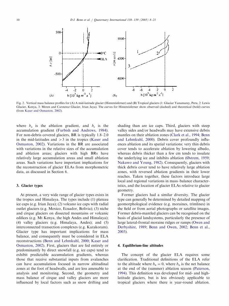
Fig. 2. Vertical mass balance profiles for (A) A mid-latitude glacier (Hintereisferner) and (B) Tropical glaciers (1: Glaciar Yanamarey, Peru, 2: Lewis
Glacier, Kenya, 3: Meren and Carstensz Glacier, Irian Jaya). The curves for Hintereisferner show observed (dashed) and theoretical (bold) curves
(from Kaser and Osmaston, 2002).
D.I. Benn et al. / Quaternary International 138– 139 (2005) 8–2110
where ba is the ablation gradient, and bc is theaccumulation gradient (Furbish and Andrews, 1984).For non-debris covered glaciers, BR is typically 1.8–2.0in the mid-latitudes and 43 in the tropics (Kaser andOsmaston, 2002). Variations in the BR are associatedwith variations in the relative sizes of the accumulationand ablation areas; glaciers with high BRs haverelatively large accumulation areas and small ablationareas. Such variations have important implications forthe reconstruction of glacier ELAs from morphometricdata, as discussed in Section 6.
3. Glacier types
At present, a very wide range of glacier types exists inthe tropics and Himalaya. The types include (1) plateauice caps (e.g. Irian Jaya); (2) volcano ice caps with radialoutlet glaciers (e.g. Mexico, Ecuador, Bolivia); (3) nicheand cirque glaciers on dissected mountains or volcanicedifices (e.g. Mt Kenya, the high Andes and Himalaya);(4) valley glaciers (e.g. Himalaya, Andes); and (5)interconnected transection complexes (e.g. Karakoram).Glacier type has important implications for massbalance, and consequently must be considered in ELAreconstructions (Benn and Lehmkuhl, 2000; Kaser andOsmaston, 2002). First, glaciers that are fed entirely orpredominantly by direct snowfall (e.g. ice caps) tend toexhibit predictable accumulation gradients, whereasthose that receive substantial inputs from avalanchescan have accumulation focused in narrow altitudinalzones at the foot of headwalls, and are less amenable toanalysis and monitoring. Second, the geometry andmass balance of cirque and valley glaciers are moreinfluenced by local factors such as snow drifting and
shading than are ice caps. Third, glaciers with steepvalley sides and/or headwalls may have extensive debrismantles on their ablation zones (Clark et al., 1994; Bennand Lehmkuhl, 2000). Debris cover profoundly influ-ences ablation and its spatial variations: very thin debriscover tends to accelerate ablation by lowering albedo,whereas debris thicker than a few cm tends to insulatethe underlying ice and inhibits ablation (Østrem, 1959;Nakawo and Young, 1982). Consequently, glaciers withthick debris cover tend to have relatively large ablationzones, with reversed ablation gradients in their lowerreaches. Taken together, these factors introduce largelocal and regional variations in mass–balance character-istics, and the location of glacier ELAs relative to glaciergeometry.Former glaciers had a similar diversity. The glacier
type can generally be determined by detailed mapping ofgeomorphological evidence (e.g. moraines, trimlines) inthe field or from aerial photographs or satellite images.Former debris-mantled glaciers can be recognised on thebasis of glacial landsystems, particularly the presence oflarge lateral-frontal moraine ridges or ramps (Owen andDerbyshire, 1989; Benn and Owen, 2002; Benn et al.,2003).
4. Equilibrium-line altitudes
The concept of the glacier ELA requires someclarification. Traditional definitions of the ELA referto the altitude where bn ¼ 0, where bn is the net balanceat the end of the (summer) ablation season (Paterson,1994). This definition was developed for mid- and high-latitude glaciers, but is less obviously applicable totropical glaciers where there is year-round ablation.
ARTICLE IN PRESSD.I. Benn et al. / Quaternary International 138– 139 (2005) 8–21 11
Where there is a distinct dry season, the end of the dryseason provides a convenient end point for the balanceyear. The altitude of the equilibrium line is rarelyconstant across a glacier, but varies with patterns ofsnow accumulation, shading, and other factors. AnnualELAs reflect transient climatic conditions, and theglacier as a whole may have gained or lost mass overthe preceding year. The steady-state ELA is the averagealtitude at which bn ¼ 0, for a glacier with zero netbalance as a whole, and thus represents a glacier with aparticular geometry that is in equilibrium with climate.This definition of the ELA most closely corresponds tothe ‘‘theoretical ELAs’’ calculated for former glaciers.Steady-state ELAs have been established for some
tropical and Himalayan glaciers where mass balancerecords are available. For example, Kulkarni (1992) andWagnon et al. (2001) plotted net glacier mass balance(bn) against annual ELA for multiple years, and theELA for which bn ¼ 0 was found by interpolation. Thisprocedure is useful where both positive and negativebalance years have occurred, but where glaciers are inconstant retreat, the modern steady-state ELA is not aparticularly useful concept, since it invokes somehypothetical climate for which a glacier of a given sizewould be at equilibrium. At times of rapid climatechange, such a hypothetical steady state is meaningless.Therefore, ‘‘present day’’ ELA must be defined withreference to one particular year or group of years.Needless to say, ‘‘present-day’’ ELAs cited in theliterature are not standardised to a common timeperiod, and frequently the year or years for which theELA applies is not stated. Standardisation of proce-dures for determining modern ELAs is a very importantgoal, and will require dedicated research effort. Ideally,ELAs should be established for a ‘‘standard decade’’, tominimise the influence of anomalous years, becausetropical and sub-tropical glaciers commonly have largeinter-annual variations in the length of the ablationseason. In the monsoonal Himalaya, for example,autumn cyclonic snowfalls may shorten the ablationseason by a month or more (Benn et al., 2001).Establishing theoretical modern ELAs in regions with
no modern glaciers presents a different set of problems.A commonly used approach is to assume that, in thetropics, the ELA coincides with the 01 mean July (ormean annual) isotherm, which can be determined fromradiosonde data (e.g. Porter, 1979, 2001). This assump-tion is broadly true for the humid inner tropics, but isunlikely to be so in the outer tropics and sub-tropics,where significant ablation can occur during the dryseason and the ELA may lie substantially higher thanthe 0 1C isotherm. For such regions, estimates of themodern ELA can be made by projecting meteorologicaldata up temperature and precipitation gradients inthe atmosphere, to levels where the paired variablessatisfy established relationships between ablation season
temperatures and snow accumulation at glacier ELAs.Such relationships can be determined using empiricalcurves (e.g. Ohmura et al., 1992) or analytical models(e.g. Seltzer, 1994; Kaser, 2001). It must be emphasised,however, that individual glacier ELAs may deviatesignificantly from climatic ideals due, for example, topatterns of shading, and snow redistribution by windand avalanching.
5. Glacier reconstruction and dating
The accurate reconstruction of past ELAs requiresthat the extent and morphology of the former glacierscan be accurately determined. Furthermore, the age ofthe reconstructed glacier needs to be determined toenable researchers to use the ELAs as proxies for pastclimatic conditions. The relative morphostratigraphiccontext of glacial deposits provides an essential firstorder chronological framework. Yet without absolutedates to constrain the precise age of the deposits, it isimpossible to make regional and global comparisons.Both landform identification and dating present parti-cular challenges in these environments, and adhering toa critical evaluation of field evidence and methodologi-cal assumptions is vital to the climatic interpretation ofreconstructed ELAs.Reconstructing the former extent of glaciers requires
detailed geomorphic mapping and the analysis oflandforms and sediments. The most accurate methodsalso require that there is sufficient geomorphic evidence,usually lateral-terminal moraines and trimlines, to allowthe shape of the former glacier to be reconstructed.However, glacial moraine evidence is by nature dis-continuous; and relatively younger and larger advancesof a glacier will destroy moraines deposited in older,less-extensive advances, leaving an incomplete geo-morphic record. Lake sediments down-valley from themoraines may provide an important source of data tohelp reconstruct glacier front oscillations, but it cannotautomatically be assumed that clastic sediment peaks inlacustrine records correspond to glacial maxima, ratherthan paraglacial sediment reworking during deglaciation(Ballantyne, 2002).Careful consideration of the evidence is critical for
evaluating the timing and extent of glacier advances.This is frequently challenging in high-energy tropicaland sub-tropical settings where denudation is intense,glacial landforms are easily destroyed and sediments arerapidly redeposited or transferred within and/or out ofthe mountains. Furthermore, many tropical and sub-tropical glacial environments are characterised byabundant debris produced by mass movement processesfrom steep, long valley slopes. As a consequence, massmovement and glacial landforms and sediments in theseregions may be easily misinterpreted because the
ARTICLE IN PRESSD.I. Benn et al. / Quaternary International 138– 139 (2005) 8–2112
sediments and landforms produced by mass movementand glacial processes can look very similar. In parti-cular, misinterpretations commonly arise because in-tense fluvial and glacial erosion often destroysdiagnostic morphologies of glacial and mass movementlandforms, making their identification difficult. Inaddition, the diamictons that comprise mass movementand glacial landforms have very similar sedimentarystructures and have similar particle size distributionsand particle shapes. Furthermore, there are few pub-lished data for contemporary glacial and mass move-ment environments to provide analogues and aidcomparisons (Benn and Owen, 2002). Many researchershave highlighted the problem of misinterpretation ofglacial and non-glacial landforms and sediments, andhave described situations where the reconstructions ofthe former extent of glaciers may be erroneous becauseof little detailed geomorphic and sedimentologicalanalysis (Derbyshire, 1983, 1996; Fort, 1986, 1988,1989, 1995; Fort and Derbyshire, 1988; Derbyshire andOwen, 1990, 1997; Lehmkuhl and Portge, 1991; Hewitt,1999). Clearly, to make accurate reconstructions offormer ELAs there should be no ambiguity about theextent of past glaciers and there should be sufficientevidence for a former glacier to be reconstructed indetail.Defining the age of landforms and sediments used
to reconstruct former Late Quaternary glaciers intropical and sub-tropical settings is difficult because ofthe lack of suitable organic material for radiocarbondating. The majority of studies have relied on estimatesof the timing of glaciation by comparison withchronologies in higher latitude regions and/or usingrelative dating techniques such as comparison of soilchronosequences and weathering characteristics (e.g.Burbank and Kang, 1991; Baumler et al., 1997;Guggenberger et al., 1998). Newly developing techni-ques that include luminescence and cosmogenic radio-nuclide (CRN) surface exposure dating are beginning toallow glacial successions throughout the tropics andsub-tropics to be dated and regional correlations arebeing attempted (Phillips et al., 2000; Richards et al.,2000a, b; Owen et al., 2001, 2002; Smith et al., 2001,2002; Tsukamoto et al., 2002).Brigham-Grette (1996) provides a useful summary of
the various numerical dating methods that may be usedto date glacial landforms. Included are discussions oftephrochronology, lichenometry, and dendrochronol-ogy, which are widely used methods for dating Holocenemoraines. Benn and Owen (2002) describe the applic-ability and the application of luminescence and CRNtechniques to dating glacial landforms in high-altitudeenvironments with specific reference to the Himalaya. Auseful summary of the methods and problems ofapplying luminescence techniques in Himalayan envir-onments is provided by Richards (2000).
Many of the high glaciated mountain peaks in thetropics and sub-tropics are Quaternary volcanoes, theeruptive products of which may be interstratified withglacial deposits. Limiting and constraining ages forglacial units can be obtained by dating associated lavaflows or pyroclastic units. In Hawaii, for example, theages of moraines and related drifts of three Middle andLate Pleistocene glaciations have been bracketed by K/Ar ages of basaltic and alkalic lavas (Wolfe et al., 1997).The latter lithologies have higher K contents, andtherefore provide ages with smaller standard errors.Under favourable conditions, such radiometric ages canoverlap the range of radiocarbon dating (Porter, 1979).Zircon fission-track dates can also provide limiting agesfor pyroclastic units of early Late Pleistocene age andolder (e.g. Herd and Naeser, 1974). Unrealised oppor-tunities for dating Pleistocene volcanic rocks associatedwith moraines on recently active low-latitude volcanoesexist in Mexico and the northern and central Andes.Most studies that have applied numerical dating
techniques present rather limited data sets and in mostcases only one dating method is applied. This makes itdifficult to assess the validity of the numerical dating. Inparticular, where radiocarbon methods have been used,the limited number of dates does not permit testingwhether the organic material (often charcoal) is in situand is a true reflection of the age of the sediment and/orlandform. Similarly, in studies where only a few CRNages have been undertaken on moraine boulders it is notalways possible to determine whether these ages areinfluenced by the inheritance of CRN on derivedboulders and/or if weathering or exhumation hasresulted in ages significantly younger than the true ageof the moraine (Phillips et al., 2000). Owen et al. (2002)discuss some of these problems and provide an exampleof a sampling strategy for CRN dating of high-altitudeglacial landforms in their study of the glacial successionin the Karakoram Range.The validity and quality of luminescence dating is
difficult to assess, especially if full location, samplingmethods and analytical data are not presented (Richardset al., 2001). Richards et al. (2000a, b) provide a usefulmodel for applying luminescence methods to date glaciallandforms in the Himalaya. In particular, differentluminescence techniques on different mineralogies andparticle sizes within the same sample are used to provideconfidence in the dating.There are few studies that have attempted to test
previous numerical dating or assess the validity of themethods. Finkel et al. (2003) provide an example of astudy that tests luminescence and radiocarbon dates inthe Khumbu Himal. In their study, they apply CRNmethods to redate moraines and successfully confirm theprevious dating. Given the uncertainty inherent in mostnumerical dating techniques, it is important to usemultiple dating techniques and to produce large datasets
ARTICLE IN PRESSD.I. Benn et al. / Quaternary International 138– 139 (2005) 8–21 13
to provide confidence in the dating and hence provide areliable age on the landform and reconstructed ELA.Overall, it is valuable to consider the quality ofdating control in terms of both the relative precision,and methodology used on a valley-specific basis. Ifmoraines are assigned ages on the basis of morpho-stratigraphic correlations, it is important to considerthe distance from directly dated features. Morpho-stratigraphy is a valid technique within limited geogra-phical areas, but becomes much less certain withincreasing distance, particularly where climatic gradientsare large.The main geochronological techniques used to date
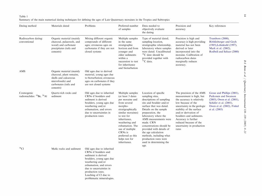
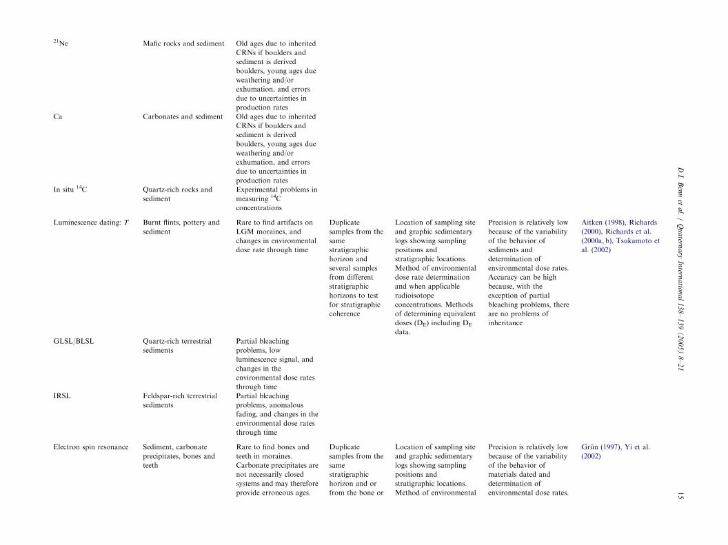
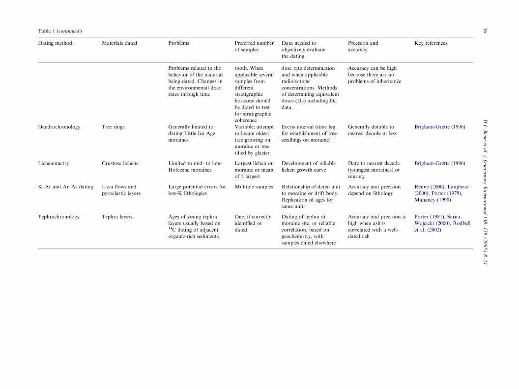
Late Quaternary age moraines in the tropics and sub-tropics are summarised in Table 1, which describesthe types of material, problems encountered and thedata needed to adequately evaluate the validity of thedating.
6. Methods of ELA reconstruction
The range of methods for reconstructing formerglacier ELAs has been the subject of several extensivereviews (e.g. Meierding, 1982; Torsnes et al., 1993;Porter, 2001; Kaser and Osmaston, 2002), and details ofeach method are not repeated here. Methods in commonuse are: (1) Accumulation Area Ratios (AAR); (2)Area–Altitude Balance Ratios (AABR); (3) MaximumElevation of Lateral Moraines (MELM); (4) Terminusto Head Altitude Ratios (THAR); and (5) grossmorphological indices such as glaciation threshold andcirque floor altitudes. The first two methods are basedon assumed forms of the glacier mass–balance gradient,and are therefore broadly compatible with the conceptof the steady-state ELA as defined above. MELMmakes use of the fact that formation of moraines onlyoccurs below the contemporary ELA, and thereforegives a minimum altitude. THAR invokes generalrelationships between glaciers and basin relief, butwithout reference to assumed mass–balance curves.Each method is discussed in turn below.
6.1. AAR method
This method assumes that, under steady-state condi-tions, the accumulation area of the glacier occupiessome fixed proportion of the glacier area. Steady-stateAARs for mid- and high-latitude glaciers lie in the range0.5–0.8 (Meier and Post, 1962; Hawkins, 1985), withtypical values around 0.55–0.65 (Porter, 1975). Becauseglaciers in the humid tropics have steeper ablationgradients and less steep accumulation gradients thanmid- and high-latitude glaciers, they tend to have highersteady-state AARs (�0.8; Kaser and Osmaston, 2002).However, the effect of extensive debris cover lowers the
steady-state AAR, because a larger ablation area isrequired to balance accumulation. Values for moderndebris-covered glaciers in the Himalaya are around0.2–0.4 (Muller, 1980; Kulkarni, 1992), so it is impor-tant to determine whether former glaciers had a debriscover (Clark et al., 1994; Benn and Lehmkuhl, 2000;Kaser and Osmaston, 2002). Former steady-state AARsmay have differed substantially from modern values inthe same region, due to changes in climatic regime,debris cover, or glacier hypsometry, so care is requiredto choose the most suitable ratio. An interesting solutionto this problem has been developed by Kaser andOsmaston (2002). Former ELAs are calculated forhomogeneous groups of glaciers using a range of AARs.The AAR that results in the lowest variance ofcalculated ELAs is then assumed to be the mostappropriate value. Applying this method to formerglaciers in the Rwenzori, Kaser and Osmaston (2002)determined an ‘‘optimum’’ AAR of 0.65–0.70, lowerthan that expected for clean tropical glaciers, butcompatible with tropical debris-covered glaciers. Geo-morphological evidence also indicates that the glaciershad extensive debris covers, supporting this approach tothe AAR method.Traditionally, the AAR method has been used to
calculate glacier ELAs using the map area of glaciersurfaces, excluding valley sides. However, where ava-lanching provides an important source of snow accu-mulation, glacier mass balance is strongly influenced bythe form and altitude of valley sides, and AAR methodsneed to be modified accordingly. Owen and Benn (2005)provide an example of AAR methods based on whole-catchment hypsometry, and highlight the need forfurther research into methods of ELA reconstructionin high-relief catchments.
6.2. AABR methods
AABR methods (Kaser and Osmaston, 2002; alsoknown as Balance Ratio or BR methods: Furbish andAndrews, 1984; Benn and Gemmell, 1997; Benn andEvans, 1998) takes account of both mass balancegradients and reconstructed glacier hypsometry. Wheregood topographic maps and air photograph coverageare available, this method is more rigorous than anyother, but where they are not available, it offers noparticular advantages.An Excel spreadsheet for the calculation of ELAs
using the method of Furbish and Andrews (1984) waspublished by Benn and Gemmell (1997). However,Osmaston (2005) has shown that this is prone tosystematic errors, and overestimates the ELA by a smallamount. An improved method of calculation, and auseful review of AABR methods is provided byOsmaston (2005).
ARTIC
LEIN
PRES
STable 1
Summary of the main numerical dating techniques for defining the ages of Late Quaternary moraines in the Tropics and Subtropics
Dating method Materials dated Problems Preferred number
of samples
Data needed to
objectively evaluate
the dating
Precision and
accuracy
Key references
Radiocarbon dating:
conventional
Organic material (mainly
charcoal, palaeosols, and
wood) and carbonate
precipitates (tufa and
cements)
Mixing different organic
compounds of different
ages; erroneous ages on
carbonates if they are not
closed systems
Multiple samples
in the same
stratigraphic
horizon and from
younger and
older sediments
within a
succession to test
for inheritance
and bioturbation
Type of material dated,
sampling location,
stratigraphic relationship,
laboratory where samples
were dated. Uncalibrated14C date should be
provided together with13C data.
Precision is high and
accuracy is high providing
material has not been
derived or later
incorporated into the
moraine. Calibration of
radiocarbon dates
marginally reduces
accuracy.
Trumbore (2000),
Rothlisberger and Geyh
(1985),Lehmkuhl (1997),
Mark et al. (2002),
Rodbell and Seltzer (2000)
AMS Organic material (mainly
charcoal, plant remains,
shells and calcareous
microfossils) and
carbonates (tufa and
cements)
Old ages due to derived
material, young ages due
to bioturbation; erroneous
ages on carbonates if they
are not closed systems
Cosmogenic
radionuclides: 10Be, 26Al
Quartz-rich rocks and
sediment
Old ages due to inherited
CRNs if boulders and
sediment is derived
boulders, young ages due
weathering and/or
exhumation, and errors
due to uncertainties in
production rates
Multiple samples
(at least 3 dates
per moraine and
from several
morpho-
stratigraphically
similar moraines)
to test for
inheritance,
weathering and
exhumation. The
use of multiple
CRNs is
preferred as this
helps test for
inheritance.
Location of specific
sampling sites,
descriptions of sampling
site and boulder and/or
surface that was dated.
Details on the sample
preparation, the
laboratory where the
AMS measurements were
made. CRN
concentrations should be
provided with details of
the age calculation
methods, including what
production rates were
used in determining the
age.
The precision of the AMS
measurement is high, but
the accuracy is relatively
low because of the
uncertainty in the geologic
stability of the surface
and/or derivation of
boulders and sediments.
Accuracy is further
reduced because of the
uncertainty in production
rates
Gosse and Phillips (2001),
Putkonen and Swanson
(2003), Owen et al. (2001),
Schafer et al. (2001),
Owen et al. (2002), Finkel
et al. (2003)
36Cl Mafic rocks and sediment Old ages due to inherited
CRNs if boulders and
sediment is derived
boulders, young ages due
weathering and/or
exhumation, and errors
due to uncertainties in
production rates.
Leaching of Cl due to
problematic mineralogies.
D.I.
Ben
net
al.
/Q
ua
ternary
Intern
atio
na
l1
38
–1
39
(2
00
5)
8–
21
14
ARTIC
LEIN
PRES
S21Ne Mafic rocks and sediment Old ages due to inherited
CRNs if boulders and
sediment is derived
boulders, young ages due
weathering and/or
exhumation, and errors
due to uncertainties in
production rates
Ca Carbonates and sediment Old ages due to inherited
CRNs if boulders and
sediment is derived
boulders, young ages due
weathering and/or
exhumation, and errors
due to uncertainties in
production rates
In situ 14C Quartz-rich rocks and
sediment
Experimental problems in
measuring 14C
concentrations
Luminescence dating: T Burnt flints, pottery and
sediment
Rare to find artifacts on
LGM moraines, and
changes in environmental
dose rate through time
Duplicate
samples from the
same
stratigraphic
horizon and
several samples
from different
stratigraphic
horizons to test
for stratigraphic
coherence
Location of sampling site
and graphic sedimentary
logs showing sampling
positions and
stratigraphic locations.
Method of environmental
dose rate determination
and when applicable
radioisotope
concentrations. Methods
of determining equivalent
doses (DE) including DE
data.
Precision is relatively low
because of the variability
of the behavior of
sediments and
determination of
environmental dose rates.
Accuracy can be high
because, with the
exception of partial
bleaching problems, there
are no problems of
inheritance
Aitken (1998), Richards
(2000), Richards et al.
(2000a, b), Tsukamoto et
al. (2002)
GLSL/BLSL Quartz-rich terrestrial
sediments
Partial bleaching
problems, low
luminescence signal, and
changes in the
environmental dose rates
through time
IRSL Feldspar-rich terrestrial
sediments
Partial bleaching
problems, anomalous
fading, and changes in the
environmental dose rates
through time
Electron spin resonance Sediment, carbonate
precipitates, bones and
teeth
Rare to find bones and
teeth in moraines.
Carbonate precipitates are
not necessarily closed
systems and may therefore
provide erroneous ages.
Duplicate
samples from the
same
stratigraphic
horizon and or
from the bone or
Location of sampling site
and graphic sedimentary
logs showing sampling
positions and
stratigraphic locations.
Method of environmental
Precision is relatively low
because of the variability
of the behavior of
materials dated and
determination of
environmental dose rates.
Grun (1997), Yi et al.
(2002)
D.I.
Ben
net
al.
/Q
ua
ternary
Intern
atio
na
l1
38
–1
39
(2
00
5)
8–
21
15
ARTIC
LEIN
PRES
STable 1 (continued )
Dating method Materials dated Problems Preferred number
of samples
Data needed to
objectively evaluate
the dating
Precision and
accuracy
Key references
Problems related to the
behavior of the material
being dated. Changes in
the environmental dose
rates through time
tooth. When
applicable several
samples from
different
stratigraphic
horizons should
be dated to test
for stratigraphic
coherence
dose rate determination
and when applicable
radioisotope
concentrations. Methods
of determining equivalent
doses (DE) including DE
data.
Accuracy can be high
because there are no
problems of inheritance
Dendrochronology Tree rings Generally limited to
dating Little Ice Age
moraines
Variable; attempt
to locate oldest
tree growing on
moraine or tree
tilted by glacier
Ecesis interval (time lag
for establishment of tree
seedlings on moraine)
Generally datable to
nearest decade or less
Brigham-Grette (1996)
Lichenometry Crustose lichens Limited to mid- to late-
Holocene moraines
Largest lichen on
moraine or mean
of 5 largest
Development of reliable
lichen growth curve
Date to nearest decade
(youngest moraines) or
century
Brigham-Grette (1996)
K–Ar and Ar–Ar dating Lava flows and
pyroclastic layers
Large potential errors for
low-K lithologies
Multiple samples Relationship of dated unit
to moraine or drift body.
Replication of ages for
same unit.
Accuracy and precision
depend on lithology
Renne (2000), Lanphere
(2000), Porter (1979),
Mahaney (1990)
Tephrochronology Tephra layers Ages of young tephra
layers usually based on14C dating of adjacent
organic-rich sediments.
One, if correctly
identified or
dated
Dating of tephra at
moraine site, or reliable
correlation, based on
geochemistry, with
samples dated elsewhere
Accuracy and precision is
high when ash is
correlated with a well-
dated ash
Porter (1981), Sarna-
Wojcicki (2000), Rodbell
et al. (2002)
D.I.
Ben
net
al.
/Q
ua
ternary
Intern
atio
na
l1
38
–1
39
(2
00
5)
8–
21
16
ARTICLE IN PRESSD.I. Benn et al. / Quaternary International 138– 139 (2005) 8–21 17
6.3. MELM
The maximum altitude of lateral moraines provides asecure means of determining the minimum altitude offormer glacier ELAs. However, where moraine pre-servation potential is low, as is often the case in high-relief, high-altitude catchments, this altitude may lieconsiderably below the true value. The maximumaltitude of lateral moraines may also lie well belowglacier ELAs where the only moraines are frontal ratherthan lateral (e.g. as on plateau or volcano ice caps) andpartly or completely encircle the ice mass. However, inbasins where moraines are well preserved, MELM canbe more reliable than other methods, particularly whereAARs or BRs are poorly constrained (Richards et al.,2000a).
6.4. THAR
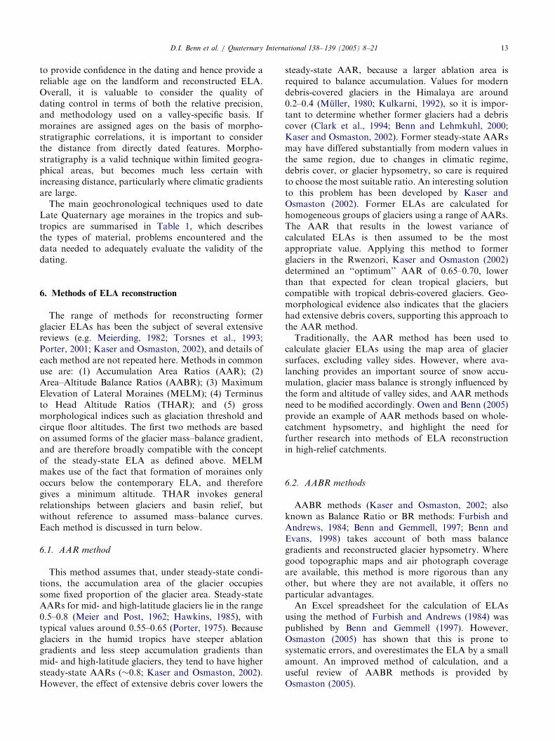
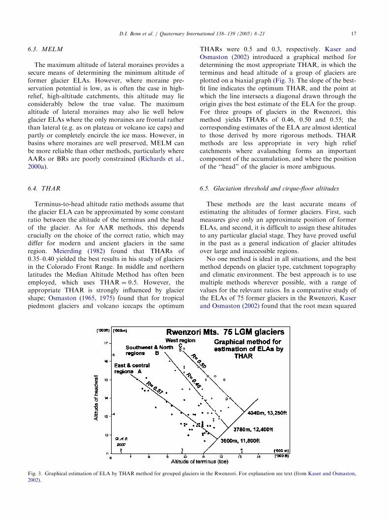
Terminus-to-head altitude ratio methods assume thatthe glacier ELA can be approximated by some constantratio between the altitude of the terminus and the headof the glacier. As for AAR methods, this dependscrucially on the choice of the correct ratio, which maydiffer for modern and ancient glaciers in the sameregion. Meierding (1982) found that THARs of0.35–0.40 yielded the best results in his study of glaciersin the Colorado Front Range. In middle and northernlatitudes the Median Altitude Method has often beenemployed, which uses THAR ¼ 0.5. However, theappropriate THAR is strongly influenced by glaciershape; Osmaston (1965, 1975) found that for tropicalpiedmont glaciers and volcano icecaps the optimum
Fig. 3. Graphical estimation of ELA by THAR method for grouped glaciers
2002).
THARs were 0.5 and 0.3, respectively. Kaser andOsmaston (2002) introduced a graphical method fordetermining the most appropriate THAR, in which theterminus and head altitude of a group of glaciers areplotted on a biaxial graph (Fig. 3). The slope of the best-fit line indicates the optimum THAR, and the point atwhich the line intersects a diagonal drawn through theorigin gives the best estimate of the ELA for the group.For three groups of glaciers in the Rwenzori, thismethod yields THARs of 0.46, 0.50 and 0.55; thecorresponding estimates of the ELA are almost identicalto those derived by more rigorous methods. THARmethods are less appropriate in very high reliefcatchments where avalanching forms an importantcomponent of the accumulation, and where the positionof the ‘‘head’’ of the glacier is more ambiguous.
6.5. Glaciation threshold and cirque-floor altitudes
These methods are the least accurate means ofestimating the altitudes of former glaciers. First, suchmeasures give only an approximate position of formerELAs, and second, it is difficult to assign these altitudesto any particular glacial stage. They have proved usefulin the past as a general indication of glacier altitudesover large and inaccessible regions.No one method is ideal in all situations, and the best
method depends on glacier type, catchment topographyand climatic environment. The best approach is to usemultiple methods wherever possible, with a range ofvalues for the relevant ratios. In a comparative study ofthe ELAs of 75 former glaciers in the Rwenzori, Kaserand Osmaston (2002) found that the root mean squared
in the Rwenzori. For explanation see text (from Kaser and Osmaston,
ARTICLE IN PRESSD.I. Benn et al. / Quaternary International 138– 139 (2005) 8–2118
(RMS) deviation of the individual ELA estimates byAAR (0.67) from the population mean was 200m. Bygrouping them into four homogeneous groups based onaspect and location, the deviations from the differinggroup means were reduced to c.100m, by both AAR(0.67) and AABR methods, thus yielding more preciseestimates of the mean ELA at the locations of thesegroups. By taking the ELAs of individual glaciersestimated by AABR and using these to derive asymmetrical domed ELA trend surface, computed witha cubic regression, the RMS deviations from it werereduced to 86m. However, a surface fitted manually tothe same points, taking into account its departure fromsymmetry, reduced the RMS deviations to a mere 35m.Where sufficient glaciers are available, precision andinterpretation will almost always be improved bydividing them into groups, or by deriving ELA profilesacross a mountain range, or best by deriving an ELAtrend surface.
7. Should former ELAS be corrected for sea level change?
Broecker (1997) argued that, because global sea levelduring the last glaciation was at least 100m lower than itis today, former glacier ELAs should be adjustedaccordingly, because the glaciers were effectively athigher altitudes. Furthermore, this appears to imply thatcalculated temperature changes relative to the presentshould be adjusted correspondingly, since part of thetemperature change is attributable to the altitude effect,rather than global climate change (Porter, 2001).However, Osmaston (submitted for publication) hasshown that temperatures are not significantly depressedat altitude due to a reduction in glacio-eustatic sea level.This is because the volume vacated by falling sea level isclose to that displaced by ice sheets, when densitychanges are taken into account. Therefore, the atmo-sphere as a whole does not fall to a lower level due toglacio-eustatic sea level fall. In the absence of externalclimatic change, temperatures at any given level willremain constant, because the mass of the overlyingatmosphere is unchanged. Conversely, temperature atthe new, lowered sea level will be higher than that at the‘old’ sea level, due to higher atmospheric pressure andadiabatic warming.In contrast, in a cooler world, some additional
temperature changes will occur at a given level due tothermal contraction of the oceans, because the atmo-sphere as a whole does move closer to the centre of theEarth in this case. The effect, however, is small, and iswell within the errors associated with ELA estimates,and hence can safely be ignored. Climatic cooling alsoresults in thermal contraction of the atmosphere,resulting in steeper adiabatic lapse rates and additionalcooling at altitude. Although significant, this effect will
be spatially and temporally variable, and does notappear to justify ‘‘correcting’’ ELA estimates.
8. Meaning of changes in ELA
The difference in altitude between modern and formerELAs (DELA) has been widely used to estimate climatechange. A factor that is often not considered whencalculating DELA is that modern and former ELAs arecommonly determined for different points in space.Where ELA surfaces are sloping, as is usually the case,this introduces a source of error in DELA over andabove that associated with the modern and former ELAestimates (Osmaston, 1965, 1975; Porter, 2001; Kaserand Osmaston, 2002). Where possible, trend surfaces ofpresent and former ELAs should be calculated to obtainthe most accurate estimates of DELA.The simplest assumption is that all DELA can be
attributed to changes in temperature, which can beestimated by using an assumed average environmentallapse rate in the atmosphere. However, if there wereassociated changes in precipitation, the estimatedtemperature change would be different. This pointapplies even in the humid tropics. For example, Kaserand Osmaston (2002) found that 20th century changesin the ELAs of glaciers in the Cordillera Blanca cannotbe explained by temperature changes alone, but werealso influenced by changes in humidity. The meaning ofDELA is clearest where independent temperature orprecipitation proxies are available, although this iscommonly not the case. However, the difficulty ofseparating out the temperature and precipitation signalsneed not negate the usefulness of DELA in providingpalaeoclimatic information. Currently available atmo-spheric general circulation models commonly yielddiffering climatic scenarios for a given region. Thesemodels can be tested against DELA data to determinewhich models yield temperature/precipitation combina-tions compatible with former glacier distributions, andlimnological, palaeobotanical, geochemical, and sedi-mentological evidence.
9. Summary and recommendations
The determination of DELAs for a glaciated region inthe tropics, subs-tropics, and Himalaya should followthese basic guidelines:
1.
Careful mapping and dating should be conducted inorder to determine the past extent of a glacier and thechronology of glaciation. In terms of chronology,the method of dating, the type of material dated, andthe context of the date (e.g. does it date glacieradvance, retreat, or something else) must all be
ARTICLE IN PRESSD.I. Benn et al. / Quaternary International 138– 139 (2005) 8–21 19
reported (see Table 1). Sampling strategy andlaboratory methods and assumptions should berecorded in full.
2.
Modern ELA needs to be determined for the valley orarea where the DELA estimate will be made. Again,the method must be reported so that the accuracy ofthe modern ELA estimate can be assessed.3.
The determination of the palaeo-ELA should ideallyincorporate several of the methods mentioned inSection 5. By this means a more accurate palaeo-ELAmay be approached.4.
Climatic interpretation of DELA should provide arange of possible scenarios that include, among theprincipal factors, changes in temperature, snowfall,humidity, radiation balance, and wind speed. In theabsence of close control on past climatic variations,any climatic assessment of DELA for a region shouldbe considered provisional.It is our hope that by following these guidelines,sufficient rigor will be introduced to DELA calculationsand their climatic interpretation that such studies will beuseful for comparison with other proxies for late-Quaternary climatic change and the outcome of experi-ments with atmospheric general circulation models.
References
Aitken, M.J., 1998. An Introduction to Optical Dating. Oxford
University Press, Oxford 267pp.
Ballantyne, C.K., 2002. Paraglacial geomorphology. Quaternary
Science Reviews 21, 1935–2017.
Baumler, R., Madhikermi, D.P., Zech, W., 1997. Fine silt and clay
mineralogical changes of a soil chronosequence in the Langtang
Valley (Central Nepal). Zeitschrift fur Pflanzenernahrung und
Bodenkunde 160, 413–421.
Benn, D.I., Evans, D.J.A., 1998. Glaciers and Glaciation. Edward
Arnold, London 734pp.
Benn, D.I., Gemmell, A.M.D., 1997. Calculating equilibrium-line
altitudes of former glaciers: a new computer spreadsheet. Glacial
Geology and Geomorphology Web Site http://ggg.qub.ac.uk/ggg.
Benn, D.I., Lehmkuhl, F., 2000. Mass balance and equilibrium-line
altitudes of glaciers in high mountain environments. Quaternary
International 65/66, 15–29.
Benn, D.I., Owen, L.A., 1998. The role of the Indian summer monsoon
and the mid-latitude westerlies in Himalayan glaciation: review and
speculative discussion. Journal of the Geological Society London
155, 353–363.
Benn, D.I., Owen, L.A., 2002. Himalayan glacial sedimentary
environments: a framework for reconstructing and dating former
glacial extents in high mountain regions. Quaternary International
97/98, 3–25.
Benn, D.I., Kirkbride, M.P., Owen, L.A., Brazier, V., 2003. Glaciated
valley landsystems. In: Evans, D.J.A. (Ed.), Glacial Landsystems.
Arnold, London, pp. 372–406.
Benn, D.I., Wiseman, S., Hands, K., 2001. Growth and drainage of
supraglacial lakes on the debris-mantled Ngozumpa Glacier,
Khumbu Himal. Journal of Glaciology 47, 626–638.
Brigham-Grette, J., 1996. Geochronology of glacial deposits. In:
Menzies, J. (Ed.), Past Glacial Environments: Sediments, Forms
and Techniques. Wiley, Chichester, pp. 213–238.
Broecker, W.S., 1997. Mountain glaciers: recorders of atmo-
spheric water vapor content? Global Biogeochemical Cycles 11,
589–597.
Burbank, D.W., Kang, Jian-Cheng, 1991. Relative dating of Qua-
ternary moraines, Rongbuk Valley, Mount Everest, Tibet: implica-
tions for an ice sheet on the Tibetan Plateau. Quaternary Research
36, 1–18.
Clark, D.H., Clark, M.M., Gillespie, A.R., 1994. Debris-covered
glaciers in the Sierra Nevada, California, and their implications for
snowline reconstructions. Quaternary Research 41, 139–153.
Derbyshire, E., 1983. The Lushan dilemma: Pleistocene glaciation
south of the Chang Jiang (Yangtze River). Zeitschrift fur
Geomorphologie 27, 445–471.
Derbyshire, E., 1996. Quaternary glacial sediments, glaciation style,
climate, and uplift in the Karakoram and Northwest Himalayas:
review and speculations. Palaeogeography, Palaeoclimatology,
Palaeoecology 120, 147–157.
Derbyshire, E., Owen, L.A., 1990. Quaternary alluvial fans in the
Karakoram Mountains. In: Rachocki, A.H., Church, M. (Eds.),
Alluvial Fans: A Field Approach. Luley, Chideler, Wiley,
Chichester, pp. 27–53.
Derbyshire, E., Owen, L.A., 1997. Quaternary glacial history of the
Karakoram Mountains and Northwest Himalayas: a review.
Quaternary International 38/39, 85–102.
Finkel, R.C., Owen, L.A., Barnard, P.L., Caffee, M.W., 2003.
Beryllium-10 dating of Mount Everest morianes indicates a strong
monsoonal influence and glacial synchroneity throughout the
Himalaya. Geology 31, 561–564.
Fort, M., 1986. Glacial extension and catastrophic dynamics along the
Annapurna Front, Nepal Himalaya. Gottinger Geographische
Abhandlungen 81, 105–121.
Fort, M., 1988. Catastrophic sedimentation and morphogenesis along
the High Himalayan Front, implications for palaeoenvironmental
reconstructions. In: Whyte, P. (Ed.), The Palaeoenvironments of
East Asia from Mid-Tertiary. Centre of Asian Studies, Hong
Kong, pp. 170–194.
Fort, M., 1989. The Gongba conglomerates: glacial or tectonic?
Zeitschrift fur Geomorphologie 76 (Suppl.), 181–194.
Fort, M., 1995. The Himalayan glaciation: myth and reality. Journal
of Nepal Geological Society Special Issue 11, 257–272.
Fort, M., Derbyshire, E., 1988. Some characteristics of tills in the
Annapurna Range, Nepal. In: Whyte, P. (Ed.), The Palaeoenvir-
onment of East Asia from the Mid-Tertiary. Centre of Asian
Studies, Hong Kong, pp. 195–214.
Furbish, D.J., Andrews, J.T., 1984. Use of hypsometry to indicate
long-term stability and response of valley glaciers to changes in
mass transfer. Journal of Glaciology 30, 199–211.
Gosse, J.C., Phillips, F.M., 2001. Terrestrial in situ cosmogenic
nuclides: theory and application. Quaternary Science Reviews 20,
1475–1560.
Grun, R., 1997. Electron spin resonance dating. In: Taylor, R.E.,
Aitken, M.J. (Eds.), Chronometric Dating in Archaeology. Plenum
Press, New York, pp. 217–260.
Guggenberger, G., Baumler, R., Zech, W., 1998. Weathering of soils
developed in eolian material overlying glacial deposits in eastern
Nepal. Soil Science 163, 325–337.
Hastenrath, S., 1985. Climate and Circulation of the Tropics. Reidel,
Dordrecht 455pp.
Hawkins, F.F., 1985. Equilibrium-line altitudes and palaeoenviron-
ments in the Merchants Bay area, Baffin Island, NWT, Canada.
Journal of Glaciology 31, 205–213.
Herd, D.G., Naeser, C.W., 1974. Radiometric evidence for pre-
Wisconsin glaciation in the northern Andes. Geology 2, 603–604.
Hewitt, K., 1999. Quaternary moraines vs catastrophic rock
avalanches in the Karakoram Himalaya, northern Pakistan.
Quaternary Research 51, 220–237.
ARTICLE IN PRESSD.I. Benn et al. / Quaternary International 138– 139 (2005) 8–2120
Kaser, G., 1995. How do tropical glaciers behave? Some comparisons
between tropical and mid-latitude glaciers. In: Ribstein, P.,
Francou, B. (Eds.), Aguas Glaciares y Cambios Climaticos en los
Andes Tropicales. Conferencias y Posters del Semenairo Inter-
nacional, La Paz, 13–16 Junio 1995, pp. 207–218.
Kaser, G., 2001. Glacier–climate interaction at low latitudes. Journal
of Glaciology 47, 195–204.
Kaser, G., Osmaston, H., 2002. Tropical Glaciers. Cambridge
University Press, Cambridge 207pp.
Kulkarni, A.V., 1992. Mass balance of Himalayan glaciers using AAR
and ELA methods. Journal of Glaciology 38, 101–104.
Lanphere, M.A., 2000. Comparison of conventional K–Ar and40Ar/39Ar dating of young mafic volcanic rocks. Quaternary
Research 53, 294–301.
Lehmkuhl, F., 1997. Late Pleistocene, Late-Glacial and Holocene
glacier advances on the Tibetan Plateau. Quaternary International
38/39, 77–83.
Lehmkuhl, F., Portge, K.-H., 1991. Hochwasser, Muren und
Rutschungen in den Randbereichen des tibetanischen Plateaus.
Zeitschrift fur Geomorphologie 89 (Suppl.), 143–155.
Mahaney, W.C., 1990. Ice on the Equator: Quaternary Geology of
Mount Kenya, East Africa. Wm Caxton Ltd., Sister Bay, WI
386pp.
Mark, B.G., Seltzer, G.O., Rodbell, D.T., Goodman, A.Y., 2002.
Rates of deglaciation during the last glaciation and Holocene in the
Cordillera Vilcanota-Quelccaya Ice Cap region, southeastern Peru.
Quaternary Research 57, 287–298.
McGregor, G.R., Nieuwolt, S., 1998. Tropical Climatology: An
Introduction to the Climates of the Low Latitudes. Wiley, New
York 339pp.
Meier, M.F., Post, A.S., 1962. Recent variations in mass net budgets of
glaciers in western North America. Symposium of Obergurgl, 1962,
IASH-AISH Publication 58, pp. 63–77.
Meierding, T.C., 1982. Late Pleistocene glacial equilibrium-line in the
Colorado Front Range: a comparison of methods. Quaternary
Research 18, 289–310.
Muller, F., 1980. Present and Late Pleistocene Equilibrium Line
Altitudes in the Mt Everest Region—An Application of the Glacier
Inventory. IAHS-AISH Publication 126, pp. 75–94.
Nakawo, M., Young, G.J., 1982. Estimate of glacier ablation under
debris layer from surface temperature and meteorological vari-
ables. Journal of Glaciology 28, 29–34.
Ohmura, A., Kasser, P., Funk, M., 1992. Climate at the equilibrium
line of glaciers. Journal of Glaciology 38, 397–411.
Osmaston, H., 1965. The past and present climate and vegetation of
Rwenzori and its neighbourhood. Ph.D. Thesis, University of
Oxford.
Osmaston, H., 1975. Models for the estimation of firnlines of present
and Pleistocene glaciers. In: Peel, R.F., Chisholm, M.D.I., Haggett,
P. (Eds.), Processes in Physical and Human Geography: Bristol
Essays. Heinemann Educational, London, pp. 218–245.
Osmaston, H., 2005. Estimates of glacier equilibrium line altitudes by
the Area�Altitude, the Area�Altitude Balance Ratio and the
Area�Altitude Balance Index methods and their validation.
Quaternary International, this volume, doi:10.1016/j.quaint.2005.
02.004.
Osmaston, H., submitted for publication. Wrong and right corrections
to glacial and other montane data for inferring Quaternary climate
changes. Quaternary Research.
Østrem, G., 1959. Ice melting under a thin layer of moraine and the
existence of ice cores in moraine ridges. Geografiska Annaler 41,
228–230.
Owen, L.A., Benn, D.I., 2005. Equilibrium-line altitudes of the Last
Glacial Maximum for the Himalaya and Tibet: an assessment and
evaluation of methods and results. Quaternary International, this
volume, doi:10.1016/j.quaint.2005.02.006.
Owen, L.A., Derbyshire, E., 1989. The Karakoram glacial depositional
system. Zeitschrift fur Geomorphologie 76 (Suppl.), 33–73.
Owen, L.A., Gualtieri, L., Finkel, R.C., Caffee, M.W., Benn, D.I.,
Sharma, M.C., 2001. Cosmogenic radionuclide dating of glacial
landforms in the Lahul Himalaya, Northern India: defining the
timing of late Quaternary glaciation. Journal of Quaternary
Science 16, 555–563.
Owen, L.A., Finkel, R.C., Caffee, M.W., Gualtieri, L., 2002. Timing of
multiple glaciations during the Late Quaternary in the Hunza
Valley, Karakoram Mountains, Northern Pakistan: defined by
cosmogenic radionuclide dating of moraines. Geological Society of
America Bulletin 114, 593–604.
Paterson, W.S.B., 1994. The Physics of Glaciers, third ed. Pergamon,
Oxford 480pp.
Phillips, W.M., Sloan, V.F., Shroder Jr., J.F., Sharma, P., Clarke,
M.L., Rendell, H.M., 2000. Asynchronous glaciation at Nanga
Parbat, northwestern Himalaya Mountains, Pakistan. Geology 28,
431–434.
Porter, S.C., 1975. Equilibrium line altitudes of late Quaternary
glaciers in the Southern Alps, New Zealand. Quaternary Research
5, 27–47.
Porter, S.C., 1979. Hawaiian glacial ages. Quaternary Research 12,
161–186.
Porter, S.C., 1981. Use of tephrochronology in the Quaternary geology
of the United States. In: Self, S., Sparks, R.S.J. (Eds.), Tephra
Studies. Reidel, Dordrecht, pp. 135–160.
Porter, S.C., 2001. Snowline depression in the tropics during the last
glaciation. Quaternary Science Reviews 20, 1067–1091.
Putkonen, J., Swanson, T., 2003. Accuracy of cosmogenic ages for
moraines. Quaternary Research 59, 255–261.
Renne, P.R., 2000. K–Ar and 40Ar/39Ar dating. In: Noller, J.S.,
Sowers, J.M., Lettis, W.R. (Eds.), Quaternary Geochronology:
Methods and Applications. AGU Reference Shelf 4, pp. 77–100.
Richards, B.W.M., 2000. Luminescence dating of Quaternary sedi-
ments in the Himalaya and High Asia: a practical guide to its use
and limitations for constraining the timing of glaciation. Quatern-
ary International 65/66, 49–61.
Richards, B.W.M., Benn, D.I., Owen, L.A., Rhodes, E.J., Spencer,
J.Q., 2000a. Timing of late Quaternary glaciations south of Mount
Everest in the Khumbu Himal, Nepal. Geological Society of
America Bulletin 112, 1621–1632.
Richards, B.W.M., Owen, L.A., Rhodes, E.J., 2000b. Timing of Late
Quaternary glaciations in the Himalayas of northern Pakistan.
Journal of Quaternary Science 15, 283–297.
Richards, B.W.M., Owen, L.A., Rhodes, E.J., 2001. Asynchronous
glaciation at Nanga Parbat, northwestern Himalaya Mountains,
Pakistan: Comment. Geology 29, 287.
Rodbell, D.T., Seltzer, G.O., 2000. Rapid ice margin fluctuations
during the Younger Dryas in the Tropical Andes. Quaternary
Research 54, 328–338.
Rodbell, D.T., Bagnato, S., Nebolini, J.C., Seltzer, G.O., Abbott,
M.B., 2002. A late glacial-Holocene tephrochronology for
glacial lakes in Southern Ecuador. Quaternary Research 57,
343–354.
Rothlisberger, F., Geyh, M.A., 1985. Glacier variations in Himalayas
and Karakoram. Zeitschrift fur Gletscherkunde und Glazialgeolo-
gie 21, 237–249.
Sarna-Wojcicki, A.M., 2000. Tephrochronology. In: Noller, J.S.,
Sowers, J.M., Lettis, W.R., William, R. (Eds.), Quaternary
Geochronology: Methods and Applications. AGU Reference Shelf
4, pp. 357–377.
Schafer, J.M., Tschudi, S., Zhao, Z.Z., Wu, X.H., Ivy-Ochs, S.,
Wieler, R., Baur, H., Kubik, P.W., Schluchter, C., 2001.
The limited influence of glaciation in Tibet on global climate over
the past 170,000 yr. Earth and Planetary Science Letters 194,
287–297.
ARTICLE IN PRESSD.I. Benn et al. / Quaternary International 138– 139 (2005) 8–21 21
Seltzer, G.O., 1994. Climatic interpretation of alpine snowline
variations on millennial time scales. Quaternary Research 41,
154–159.
Smith, J.A., Seltzer, G.O., Rodbell, D.T., Finkel, R.C., Farber, D.L.,
2001. Cosmogenic dating of glaciation in the Peruvian Andes:
4400 10Be ka to last glacial maximum. Geological Society of
America Abstracts with Programs 33 (6), 441.
Smith, J.A., Seltzer, G.O., Rodbell, D.T., Finkel, R.C., Farber, D.L.,
2002. Moraine preservation and boulder erosion in the Peruvian
Andes. Geological Society of America Abstracts with Programs 34
(6), 131.
Torsnes, I., Rye, N., Nesje, A., 1993. Modern and Little Ice Age
equilibrium-line altitudes on outlet valley glaciers from Jostedals-
breen, western Norway: an evaluation of different approaches to
their calculation. Arctic and Alpine Research 25, 106–116.
Trumbore, S.E., 2000. Radiocarbon geochronology. In: Noller, J.S.,
Sowers, J.M., Lettis, W.R. (Eds.), Quaternary Geochronol-
ogy: Methods and Applications. AGU Reference Shelf 4,
pp. 41–60.
Tsukamoto, S., Asahi, K., Watanabe, T., Kondo, R., Rink, W.J.,
2002. Timing of past glaciation in Kanchenjunga Himal, Nepal by
optically stimulated luminescence dating of tills. Quaternary
International 97/98, 57–67.
Wagnon, P., Ribstein, P., Francou, B., Sicart, J.E., 2001. Anomalous
heat and mass budget of Glaciar Zongo, Bolivia, during the 1997/
98 El Nino year. Journal of Glaciology 47, 21–28.
Wolfe, E.W., Wize, W.S., Dalrymple, G.B., 1997. The geology and
petrology of Mauna Kea volcano, Hawaii—a study of postshield
volcanism. US Geological Survey Professional Paper, Report
P1557, Government Printing Office, Washington, 129pp.
Yi, C., Jiao, K., Lui, K., He, Y., Ye, Y., 2002. ESR dating of the
sediments of the Last Glaciation at the source area of the Urumqi
River, Tian Shan Mountains, China. Quaternary International 97/
98, 141–146.