Reconnaissance isotopic and hydrochemical study of Cuatro Ciénegas groundwater, Coahuila, México
10
Reconnaissance isotopic and hydrochemical study of Cuatro Cie ´negas groundwater, Coahuila, Me ´xico Karen H. Johannesson a, * , Alejandra Corte ´s b , Kathryn C. Kilroy c a Department of Geology, The University of Texas at Arlington, Arlington, TX 76019-0049, USA b Instituto de Geofı ´sica, Universidad Nacional Auto ´noma de Me ´xico, 04510 Me ´xico, D.F., Mexico c Department of Geology, Miami University, Oxford, OH 45056, USA Received 30 June 2002; accepted 30 January 2004 Abstract The springs of the Cuatro Cie ´negas bolson (Four Marshes basin), Coahuila, Me ´xico, support more than 70 endemic species of biota. The specifics of the groundwater flow regime, however, remain a mystery. Water samples were collected from a series of springs and pools and one canal in the Cuatro Cie ´negas bolson and analyzed for field parameters (temperature, pH, conductivity, alkalinity) and stable oxygen and hydrogen isotopes in an attempt to begin a systematic study of the hydrogeology of the region. Groundwaters discharging directly along a fault-controlled spring line in Cretaceous carbonate rocks of the Cupido-Aurora aquifer are the most dilute (lowest conductivities) and warmest of those sampled. Cuatro Cie ´negas waters are characterized by circumneutral pH (6.9 – 7.7) and reasonably low alkalinity (160 – 215 mg/kg as HCO 3 ). The d 18 O values of Cuatro Cie ´negas waters range from 2 8.2 to 2 5.7‰, with a mean of 2 6.5 ^ 0.82‰, whereas dD ranges from 2 52 to 2 43‰, with a mean of 2 46.6 ^ 3.2‰. The majority of the water samples plot subparallel and beneath the local meteoric water line; those samples collected farthest from the spring line exhibit the most enriched d 18 O and dD values. The stable isotope data indicate that isotopic enrichment of groundwaters by evaporation following discharge and subsequent surface flow is an important process within the Cuatro Cie ´negas bolson. The isotope data also suggest that a fraction of Cuatro Cie ´negas groundwater originates with local recharge in mountains surrounding the bolson. Those springs that issue from the western base of the Sierra de San Marcos mountain range are recharged in part in these mountains, whereas groundwaters discharging from Laguna Anteojo in the northern part of the bolson are more likely recharged in the higher San de la Madera mountain range. An estimate of the water balance suggests that interbasin flow also may contribute to the considerable groundwater discharge. q 2004 Elsevier Ltd. All rights reserved. Keywords: Groundwater; Interbasin flow; Semiarid regions; Cuatro Cie ´negas; Me ´xico 1. Introduction Understanding groundwater flow systems in arid and semiarid regions is of great importance to human popu- lations and indigenous biota that rely on the associated water resources. Furthermore, springs in dry regions commonly harbor endemic species that are remnants of previous pluvial climates (Dudley and Larson, 1976; Contreras-Balderas, 1984; Contreras-Balderas and Loza- no-Vilano, 1996). Such endemic biota can be especially sensitive to perturbations in their habitat that result from decreases in groundwater flow and changes in water quality, both of which can be strongly affected by human population growth. Moreover, the ongoing detrimental effects of human populations on arid region aquifers may be exacerbated by climate changes resulting from global warming. For example, the forecasted effects on the carbonate Edwards aquifer (Texas, USA) predicted to result from doubling current atmospheric CO 2 concentrations include desiccation of large discharge springs, decreases in potable water supplies and water quality, and the disap- pearance of endemic species (Loa ´iciga et al., 2000). These climate change scenarios are particularly compelling for arid-region aquifers that supply water to large urban areas, that contain springs with unique or especially endemic biota, and whose hydrogeology is poorly understood. The Cupido-Aurora carbonate aquifer of northeastern Me ´xico, which provides water to more than 4 million people, sustains as many as 70 different endemic species of biota 0895-9811/$ - see front matter q 2004 Elsevier Ltd. All rights reserved. doi:10.1016/j.jsames.2004.01.002 Journal of South American Earth Sciences 17 (2004) 171–180 www.elsevier.com/locate/jsames * Corresponding author. Tel.: þ 1-757-683-3281; fax: þ1-757-683-5303. E-mail address: [email protected] (K.H. Johannesson).
-
Upload
independent -
Category
Documents
-
view
1 -
download
0
Transcript of Reconnaissance isotopic and hydrochemical study of Cuatro Ciénegas groundwater, Coahuila, México
Reconnaissance isotopic and hydrochemical study of Cuatro Cienegas
groundwater, Coahuila, Mexico
Karen H. Johannessona,*, Alejandra Cortesb, Kathryn C. Kilroyc
aDepartment of Geology, The University of Texas at Arlington, Arlington, TX 76019-0049, USAbInstituto de Geofısica, Universidad Nacional Autonoma de Mexico, 04510 Mexico, D.F., Mexico
cDepartment of Geology, Miami University, Oxford, OH 45056, USA
Received 30 June 2002; accepted 30 January 2004
Abstract
The springs of the Cuatro Cienegas bolson (Four Marshes basin), Coahuila, Mexico, support more than 70 endemic species of biota. The
specifics of the groundwater flow regime, however, remain a mystery. Water samples were collected from a series of springs and pools and
one canal in the Cuatro Cienegas bolson and analyzed for field parameters (temperature, pH, conductivity, alkalinity) and stable oxygen
and hydrogen isotopes in an attempt to begin a systematic study of the hydrogeology of the region. Groundwaters discharging directly
along a fault-controlled spring line in Cretaceous carbonate rocks of the Cupido-Aurora aquifer are the most dilute (lowest conductivities)
and warmest of those sampled. Cuatro Cienegas waters are characterized by circumneutral pH (6.9–7.7) and reasonably low alkalinity
(160–215 mg/kg as HCO3). The d 18O values of Cuatro Cienegas waters range from 28.2 to 25.7‰, with a mean of 26.5 ^ 0.82‰,
whereas dD ranges from 252 to 243‰, with a mean of 246.6 ^ 3.2‰. The majority of the water samples plot subparallel and beneath
the local meteoric water line; those samples collected farthest from the spring line exhibit the most enriched d 18O and dD values. The
stable isotope data indicate that isotopic enrichment of groundwaters by evaporation following discharge and subsequent surface flow is an
important process within the Cuatro Cienegas bolson. The isotope data also suggest that a fraction of Cuatro Cienegas groundwater
originates with local recharge in mountains surrounding the bolson. Those springs that issue from the western base of the Sierra de San
Marcos mountain range are recharged in part in these mountains, whereas groundwaters discharging from Laguna Anteojo in the northern
part of the bolson are more likely recharged in the higher San de la Madera mountain range. An estimate of the water balance suggests that
interbasin flow also may contribute to the considerable groundwater discharge.
q 2004 Elsevier Ltd. All rights reserved.
Keywords: Groundwater; Interbasin flow; Semiarid regions; Cuatro Cienegas; Mexico
1. Introduction
Understanding groundwater flow systems in arid and
semiarid regions is of great importance to human popu-
lations and indigenous biota that rely on the associated
water resources. Furthermore, springs in dry regions
commonly harbor endemic species that are remnants of
previous pluvial climates (Dudley and Larson, 1976;
Contreras-Balderas, 1984; Contreras-Balderas and Loza-
no-Vilano, 1996). Such endemic biota can be especially
sensitive to perturbations in their habitat that result from
decreases in groundwater flow and changes in water quality,
both of which can be strongly affected by human population
growth. Moreover, the ongoing detrimental effects of
human populations on arid region aquifers may be
exacerbated by climate changes resulting from global
warming. For example, the forecasted effects on the
carbonate Edwards aquifer (Texas, USA) predicted to result
from doubling current atmospheric CO2 concentrations
include desiccation of large discharge springs, decreases in
potable water supplies and water quality, and the disap-
pearance of endemic species (Loaiciga et al., 2000). These
climate change scenarios are particularly compelling for
arid-region aquifers that supply water to large urban areas,
that contain springs with unique or especially endemic
biota, and whose hydrogeology is poorly understood. The
Cupido-Aurora carbonate aquifer of northeastern Mexico,
which provides water to more than 4 million people,
sustains as many as 70 different endemic species of biota
0895-9811/$ - see front matter q 2004 Elsevier Ltd. All rights reserved.
doi:10.1016/j.jsames.2004.01.002
Journal of South American Earth Sciences 17 (2004) 171–180
www.elsevier.com/locate/jsames
* Corresponding author. Tel.: þ1-757-683-3281; fax: þ1-757-683-5303.
E-mail address: [email protected] (K.H. Johannesson).

and is stratigraphically correlative with the Edwards-Trinity
aquifer of Texas (Lesser Jones, 1967; Minckley, 1969,
1984; Winsborough, 1990; Barker and Ardis, 1996).
Previous conceptual groundwater flow models for the
Cupido-Aurora aquifer in the vicinity of Monterrey, Nuevo
Leon, Mexico, have invoked recharge through exposed
carbonate rocks as far as 80–150 km west of the city, within
the Sierra Madre Oriental (elevation to 3500 m), and/or
within a more enigmatic region to the west-northwest of
Monterrey, as typified by the Bolson de Mapimi, the Sierra
de Parras (the Cross ranges), and the western ranges of the
Sierra Madre Oriental (Fig. 1; Lesser Jones, 1967; Fish,
1977; Lesser and Lesser, 1988). Recharged groundwater has
been hypothesized to flow down the hydrologic gradient
from the Sierra Madre Oriental to the east-southeast
and the lower Gulf coastal plain region. Because of the
resulting hydrostatic pressure, the limestones of the Cupido-
Aurora aquifer have produced flowing, artesian wells in the
region around Monterrey and the coastal plain to the east of
the city (Lesser Jones, 1967). Specifics about the recharge
region or regions, however, have not been addressed, nor
have the early conceptual flow models been adequately
tested. For example, it is not known whether groundwaters
of the Cupido-Aurora aquifer are only recharged within the
Sierra Madre Oriental, if they originate in the Bolson de
Mapimi or Sierra de Parras, or if they represent complex
mixtures of these and other potential source regions
(Brouste et al., 1997).
Furthermore, the early conceptual hydrogeologic models
do not readily explain the large discharge springs associated
Fig. 1. Location of the Cuatro Cienegas bolson in Coahuila, Mexico. Large map shows regional geographic features, including the Sierra Madre Occidental,
Sierra Madre Oriental, and the Bolson de Mapimi. Insert map shows details of the Cuatro Cienegas bolson, including location of springs, pools, and canals
sampled in this study, as well as springs examined in previous investigations.
K.H. Johannesson et al. / Journal of South American Earth Sciences 17 (2004) 171–180172

with the Cupido-Aurora aquifer in the vicinity of the cities
of Monclova, Muzquiz, and Cuatro Cienegas, Coahuila
(Fig. 1). Although in each case fractures that penetrate the
Cupido-Aurora aquifer are thought to give rise to springs
in these discharge zones (Lesser and Lesser, 1988), the
groundwater flow regime in their vicinity is largely
unknown. All three discharge regions, for example, are
located north and west of the high ranges of the Sierra
Madre Oriental and are chiefly surrounded by lower
elevation, basin and range-style mountains. Consequently,
their geographic locations are not consistent with recharge
that occurs dominantly in the high Sierra Madre Oriental or
flow of this recharged water toward the Gulf coastal plain to
the south and east (e.g. Lesser Jones, 1967; Fish, 1977;
Lesser and Lesser, 1988). The lack of adherence to the early
conceptual flow models is especially apparent for the
springs of the Cuatro Cienegas bolson, which straddle the
physiographic boundary between the Sierra Madre Oriental
and the Bolson de Mapimi and therefore are located in the
opposite direction of the suggested dominant groundwater
flow direction (i.e. east-directed flow from the crest of the
Sierra Madre Oriental to the Gulf of Mexico; Lesser Jones,
1967; Lesser and Lesser, 1988). The existence of the Cuatro
Cienegas springs indicates instead that the groundwater flow
regime in the region is complex.
Unfortunately, insufficient data currently exist in the
literature to (1) ascertain the groundwater flow directions in
the Cuatro Cienegas region or (2) confidently delineate the
extent of the hydrogeologic basin that supplies water to this
important desert oasis. The carbonate rocks from which the
Cuatro Cienegas spring issues are exposed throughout much
of state of Coahuila and portions of Chihuahua, Durango,
Nuevo Leon, and Tamaulipas, as well as in Texas (Baker,
1970; Smith, 1970; Fish, 1977; SARH, 1980; Padilla y
Sanchez, 1982; Barker and Ardis, 1996; Small and Lambert,
1998). However, because these carbonate rocks are folded
and deformed by basin- and range-style faulting (Padilla y
Sanchez, 1982; McKee et al., 1990), the hydrologic flow
regime is likely exceptionally complex, as is the case for
similarly deformed rocks of southern Nevada’s carbonate-
rock aquifers (Winograd and Thordarson, 1975; Thomas
et al., 1996).
It is important to note that groundwaters from the
Cupido-Aurora aquifer in the Torreon area, less than
200 km southwest of Cuatro Cienegas, range from modern
precipitation to waters as old as 30,000 years (Brouste et al.,
1997). The paleowaters contrast with previous observations
of the rapid response of the Cupido-Aurora aquifer in the
Monterrey region to storm events that suggest rapid
through-flow of recharge waters (Lesser Jones, 1967; Lesser
and Lesser, 1988; Worthington and Ford, 1995). Although
the differences in groundwater ages may reflect different
flow systems, the paleowaters of the Cupido-Aurora aquifer
in the Torreon region raise questions about the age of the
Cuatro Cienegas groundwaters. In this study, we employ
existing hydrochemical data for the Cupido-Aurora aquifer
and new field parameter and stable oxygen and hydrogen
isotope data for spring waters and related surface waters
from the Cuatro Cienegas bolson to suggest a preliminary
hydrogeologic model for the groundwaters discharging
from the Cupido-Aurora aquifer. This contribution is the
first in a series of planned studies that will include
hydrogeologic investigations, as well as new major and
minor solute chemical data, additional stable isotope data,
groundwater age dating, and trace element analysis of the
waters discharging in the Cuatro Cienegas bolson and
surrounding regions.
2. Regional setting
The Cuatro Cienegas bolson (Four Marshes basin), a
1200 km2 Chihuahuan desert basin located in the northeast
Mexican state of Coahuila, is one of the most important
discharge zones of the Cupido-Aurora aquifer in terms of
the number of springs in the basin and the multitude of
endemic species that they support (Minckley, 1969, 1984;
Fig. 1). Cuatro Cienegas is situated on the eastern edge of
the larger Bolson de Mapimi, an approximately 26,000 km2
area of internal drainage. Geologically, the Cuatro Cienegas
bolson is located within the Coahuila marginal folded belt
(Laramide) on the eastern flank of the Sierra Madre Oriental
(Murray, 1961; Baker, 1970; Lehmann et al., 1999). The
region is characterized by steeply folded Cretaceous marine
sedimentary rocks (principally limestones; Lesser Jones,
1967). Both normal and thrust faults are associated with
some of these folds (INEGI, 1975). Fold axes trend
northwest, and associated axial planes dip to the southwest,
similar to other Laramide structures in North America
(Murray, 1961; Lehmann et al., 1999). Laramide reactiva-
tion along the San Marcos fault during the Tertiary uplifted
the north block, juxtaposing Jurassic with Cretaceous
(chiefly carbonate) strata. The San Marcos fault defines, in
part, the southern edge of the Sierra de San Marcos, which
transects the Cuatro Cienegas bolson from the southeast
(Fig. 1; McKee et al., 1990; Lehmann et al., 1999). This
transcurrent fault likely plays an important hydrogeologic
role, because many springs occur along its trace southeast of
the bolson (INEGI, 1991). In addition, a west-dipping
normal fault is mapped along the entire western base of the
Sierra de San Marcos. A segment of another east-dipping,
normal fault is mapped along a portion of the east side of the
Sierra de San Marcos range, from just south of Pozos Azules
to approximately Laguna Santa Tecla (Fig. 1; INEGI, 1975).
This normal fault disappears beneath alluvium near Pozos
Azules and Laguna Santa Tecla. The Coahuila fold belt is
displaced by basin and range normal faults of Miocene or
younger age, some of which have reactivated older
Laramide reverse faults. Rocks cropping out in the
mountains adjacent to Cuatro Cienegas are primarily
Mesozoic and early Tertiary carbonates and shales with
minor coarse clastic, coal, and evaporite units.
K.H. Johannesson et al. / Journal of South American Earth Sciences 17 (2004) 171–180 173

The principal aquifers in the study region include
shallow, alluvial basin-fill systems and the regional
Cupido-Aurora carbonate aquifer (Lesser Jones, 1967).
The Cupido-Aurora aquifer consists of the Early Aptian
(Lower Cretaceous) Cupido limestone and the younger
Albian-Cenomanian Aurora limestone, both of which are
characterized by karst features, including solution channels
(Smith, 1970). Although the percentage of carbonate rocks
that are karst has not been quantified in Cuatro Cienegas,
some recharge likely occurs directly through such features
with minimal loss of volume due to evaporation. The Aurora
limestone may be equivalent to the Tamaulipas Superior
limestone of the Monterrey region or correlative with the
Glen Rose (limestone) Formation of Texas (Smith, 1970;
Padilla y Sanchez, 1982). Many investigators place the Glen
Rose Formation stratigraphically below the Lower Cretac-
eous Edwards Group, to which the Edwards aquifer of
Texas belongs (Small and Lambert, 1998). However, Smith
(1970) indicates that the Edwards limestone, the overlying
McKnight and Georgetown (limestones) Formations, and
the underlying Glen Rose Formation are correlative with the
Aurora limestone. The Glen Rose Formation commonly is
placed in the Trinity strata of the overall Edwards-Trinity
aquifer system (e.g. Barker and Ardis, 1996).
Mean annual precipitation on the floor of the bolson is
less than 200 mm, whereas potential evapotranspiration
exceeds 2000 mm/yr (Garcia et al., 1975; Caran and
Winsborough, 1986). Similar mean annual evapotranspira-
tion has been reported for nearby San Luis Potosi
(1930 mm/yr; Carrillo-Rivera et al., 1992). Precipitation in
the region is seasonal, dominated by the Gulf of Mexico
during the summer (June–September) and the Pacific Ocean
during the winter (October–May; Brouste et al., 1997). The
floor of the bolson averages 740 m above mean sea level
(amsl), and the surrounding mountains reach elevations as
high as 3000 m (Minckley, 1969; Baker, 1970). The
majority of the springs in the Cuatro Cienegas bolson
consist of pools ( pozas), some of which contain more than
1000 m3 of water. However, larger, spring-fed pools or
shallow lakes (lagunas) are also common (Minckley and
Cole, 1968; Rodriguez-Almaraz et al., 1997; Contreras-Ar-
quieta, 1998). Springs occur along both the eastern and
western base of the Sierra de San Marcos (Fig. 1), as well as
at the base of the Sierra de la Madera (e.g. Laguna Anteojo).
Groundwater that discharges from many of the springs
typically flows through marshy areas into large, shallow
pools or lagunas (e.g. Laguna Grande, Laguna de los
Burros). Due to time constraints and other logistical issues
(e.g. locked gates), we concentrated on sampling the most
accessible springs. Future investigations will include the
numerous springs that issue from the eastern base of the
Sierra de San Marcos (Fig. 1).
The largest spring in the Cuatro Cienegas bolson dis-
charges groundwater at roughly 4 m3/s or 1.26 £ 108 m3/yr
(SARH, 1980). Using the discharge from this spring, the
estimated annual precipitation (,200 mm/yr), and potential
evapotranspiration (2000 mm/yr), a rudimentary hydrologic
budget can be calculated for the 1200 km2 Cuatro Cienegas
bolson, assuming that precipitation and evapotranspiration
are uniformly distributed. The calculation suggests a total
precipitation value of 2.4 £ 108 m3/yr, whereas the basin-
wide evapotranspiration, in conjunction with the ground-
water issuing from the largest spring, gives an estimated
discharge of 2.5 £ 109 m3/yr, or a factor of more than 10
greater than the precipitation. Again, this estimate only
includes one spring; hence, the actual basin discharge is even
greater, especially because the density of springs and seeps
along the alluvial fans of the Sierra de San Marcos is as high as
12–15 springs per square kilometer (Winsborough, 1990).
Although admittedly crude, our preliminary hydrologic
budget estimate suggests that a component of water
discharging from the Cuatro Cienegas springs may originate
outside the bolson. Whether the possible interbasin flow
originates from the east in the Sierra Madre Oriental, north
from the Sierra del Burro, west from the Bolson de Mapimi, or
south from the Sierra de Parras (Fig. 1) is unknown. However,
the early conceptual flow models that suggest groundwater is
recharged in the Sierra Madre Oriental and subsequently only
flows east toward the Gulf coastal plain appear to be in need of
revision. The relatively poor understanding of the hydro-
geology of the Cupido-Aurora aquifer in the vicinity of the
Cuatro Cienegas bolson warrants additional study, especially
in light of the growing local populations, increasing
agricultural irrigation in the region, and the endemic biota
supported by the bolson’s spring waters.
3. Methods
Groundwater samples were collected from a series of
springs in the Cuatro Cienegas bolson in January 1999 for
stable oxygen and hydrogen isotope analysis. For the
isotope samples, we used 1 l borosilicate glass bottles with
Teflonw lined caps. To eliminate any potential contami-
nants that remained in the bottles from their manufacture,
prior to sample collection, we triple-rinsed them with
MilliQ water (18 mV-cm) and then filled them with a 50%,
v/v solution of reagent-grade HCl and MilliQ water. The
bottles were allowed to sit with the HCl solution for
approximately 6 h before the acid was removed, and then
they were triple-rinsed with MilliQ water. At this point, the
bottles were placed in a laminar flow hood and allowed to
dry overnight before being placed in plastic, zip-style bags.
Stable isotope samples were collected from 6 springs
(Laguna del Garabatal, Laguna del Juan Santos, Poza de la
Becerra, Pozos Bonitos, Poza Caballo Cojo, and Laguna
Anteojo), one of the shallow lakes (Laguna de los Burros),
and the Saca del Fuente canal (Fig. 1). The waters flowing in
Saca del Fuente, as well as those sampled from Laguna de
los Burros and Poza Caballo Cojo, are thought to be part
of the Rio Mesquites drainage system, which includes
the springs that discharge from the western base of
K.H. Johannesson et al. / Journal of South American Earth Sciences 17 (2004) 171–180174
the Sierra de San Marcos (Laguna del Garabatal, Laguna del
Juan Santos, Poza de la Becerra, Pozos Bonitos; Fig. 1).
Laguna Anteojo discharges to the north and at the base of
the Sierra de la Madera (Fig. 1). Unfortunately, again owing
to time constraints and logistical difficulties encountered
during the sample collection trip, we did not collect samples
from the springs that discharge along the eastern front of the
Sierra de San Marcos (Laguna Escobeda, Laguna Tio
Candido, Pozos Azules, Laguna Quintero, Laguna Los
Fresnos, Laguna Santa Tecla; Fig. 1). Future investigations
will include these and possibly other springs along the
eastern base of the Sierra de San Marcos range.
Water samples for the stable isotope analyses were
collected by immersing the 1 l sample bottles in the spring
waters (hands were covered with polyethylene gloves) and
filling the bottle below the water surface. Before each
sample was collected, the sample bottle was rinsed three
times with the sample water for conditioning. With the
fourth filling, the bottle was capped tightly, placed back the
plastic bag, and then placed in a cooler to keep the samples
cool and in the dark until they could be stored in a laboratory
refrigerator until the analysis. For each sample collection
site, pH, conductivity, and alkalinity were measured on site
using standard field procedures. The alkalinity was
determined at each site by titration, using phenolphthalein
and bromcresol green-methyl red. The isotope samples
were measured at Geochron Laboratories in Cambridge,
Massachusetts.
4. Results
Stable oxygen and hydrogen isotope data for waters from
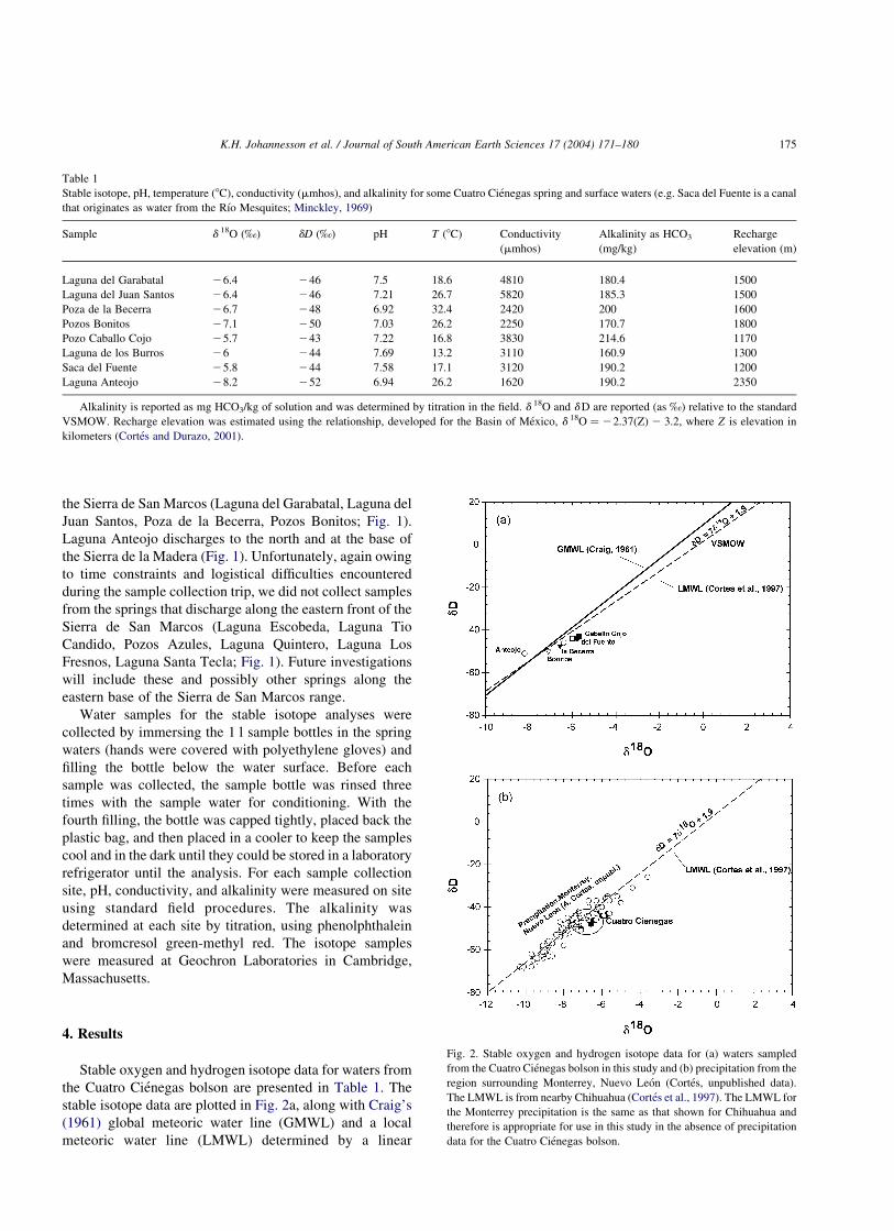
the Cuatro Cienegas bolson are presented in Table 1. The
stable isotope data are plotted in Fig. 2a, along with Craig’s
(1961) global meteoric water line (GMWL) and a local
meteoric water line (LMWL) determined by a linear
Table 1
Stable isotope, pH, temperature (8C), conductivity (mmhos), and alkalinity for some Cuatro Cienegas spring and surface waters (e.g. Saca del Fuente is a canal
that originates as water from the Rıo Mesquites; Minckley, 1969)
Sample d 18O (‰) dD (‰) pH T (8C) Conductivity
(mmhos)
Alkalinity as HCO3
(mg/kg)
Recharge
elevation (m)
Laguna del Garabatal 26.4 246 7.5 18.6 4810 180.4 1500
Laguna del Juan Santos 26.4 246 7.21 26.7 5820 185.3 1500
Poza de la Becerra 26.7 248 6.92 32.4 2420 200 1600
Pozos Bonitos 27.1 250 7.03 26.2 2250 170.7 1800
Pozo Caballo Cojo 25.7 243 7.22 16.8 3830 214.6 1170
Laguna de los Burros 26 244 7.69 13.2 3110 160.9 1300
Saca del Fuente 25.8 244 7.58 17.1 3120 190.2 1200
Laguna Anteojo 28.2 252 6.94 26.2 1620 190.2 2350
Alkalinity is reported as mg HCO3/kg of solution and was determined by titration in the field. d 18O and dD are reported (as ‰) relative to the standard
VSMOW. Recharge elevation was estimated using the relationship, developed for the Basin of Mexico, d 18O ¼ 22.37(Z) 2 3.2, where Z is elevation in
kilometers (Cortes and Durazo, 2001).
Fig. 2. Stable oxygen and hydrogen isotope data for (a) waters sampled
from the Cuatro Cienegas bolson in this study and (b) precipitation from the
region surrounding Monterrey, Nuevo Leon (Cortes, unpublished data).
The LMWL is from nearby Chihuahua (Cortes et al., 1997). The LMWL for
the Monterrey precipitation is the same as that shown for Chihuahua and
therefore is appropriate for use in this study in the absence of precipitation
data for the Cuatro Cienegas bolson.
K.H. Johannesson et al. / Journal of South American Earth Sciences 17 (2004) 171–180 175

regression of more than 20 years of data from the nearby
International Atomic Energy Agent (IAEA) station at
Chihuahua, Mexico (IAEA, 1981; Cortes et al., 1997). In
addition, multiyear stable oxygen and hydrogen isotope data
for precipitation from Monterrey, Nuevo Leon (Cortes,
unpublished data) are plotted in Fig. 2b. Although dD and
d 18O have not been measured for precipitation within the
Cuatro Cienegas bolson, precipitation from Chihuahua and
Monterrey (Fig. 2b), which geographically bound it (Fig. 1),
define essentially the same meteoric water line (Chihuahua,
dD ¼ 7d18O þ 1:9; n ¼ 121; Monterrey, dD ¼ 6:8d18O þ
1:85; n ¼ 102), which suggests that the LMWL is appro-
priate for modern precipitation. Furthermore, the identical
LMWLs for Chihuahua and Monterrey strongly suggest that
both cities receive seasonally influenced precipitation from
the same sources: the Gulf of Mexico in the summer and the
Pacific during the winter.
In addition to the stable oxygen and hydrogen isotope
data, pH, temperature (8C), conductivity (mmhos), and
alkalinity (as mg/kg HCO32) data for the water samples are
presented in Table 1. All samples are of circumneutral pH.
The groundwaters discharging directly from the subsurface
along the base of local mountain ranges (Poza de la Becerra,
Pozos Bonitos, Laguna Anteojo; Fig. 1) have the lowest pH
values and exhibit the lowest conductivities (2420, 2250, and
1620 mmhos, respectively). Moreover, except for Laguna
del Juan Santos, waters issuing from these three springs are
warmer than other waters sampled from the Cuatro Cienegas
bolson (Table 1). Consequently, of the water samples
collected, these three springs discharge waters that most
closely reflect the composition of groundwater in the
Cupido-Aurora aquifer. In other words, the other collected
water samples likely were modified by evapotranspiration,
interaction with surficial deposits, and/or cooling subsequent
to issuing from the Cupido-Aurora aquifer.
5. Discussion
5.1. Stable isotopes
All of the Cuatro Cienegas water samples but one
(Laguna Anteojo) plot below and subparallel to the LMWL
(Fig. 2a). These waters are shifted toward heavier d 18O
values, which suggests they are enriched by evapotranspira-
tion. The waters farthest from the spring line, along the
western base of the Sierra de San Marcos (Poza Caballo
Cojo, Laguna de los Burros, Saca del Fuente; Figs. 1 and 2),
exhibit the greatest stable isotope enrichments, consistent
with a greater degree of evaporation following discharge
along the western base of the Sierra de San Marcos and
subsequent flow, as surface waters, toward the central
region of the Cuatro Cienegas bolson. Linear regression of
the data (without Laguna Anteojo) gives a slope of 4.9 for
the hypothesized evaporation line (Fig. 3). Extrapolation of
the evaporation curve back to the LMWL reveals that these
spring waters could be evaporated meteoric water that
had original d 18O and dD values of 28.1 and 2 54.5‰,
respectively (Fig. 3).
Laguna Anteojo water is the most depleted sample in
terms of d 18O and dD and does not plot on the hypothesized
evaporation line (Figs. 2 and 3). However, Laguna Anteojo
water falls within the range reported for modern precipi-
tation from the Monterrey region (Fig. 2b). Compared with
the other Cuatro Cienegas waters, Laguna Anteojo ground-
water plots above both the LMWL and the GMWL (Fig. 2a).
Thus, it is possible that Laguna Anteojo water reflects either
the natural variation of local precipitation or reevaporated,
reprecipitated meteoric water. Evaporation of local meteoric
waters could produce water vapor depleted in d 18O and dD
compared with the LMWL (e.g. Ingraham and Matthews,
1988; Lauriol and Clark, 1993). If this water vapor were to
condense before reequilibrating with the atmosphere (Clark
and Fritz, 1997), the corresponding precipitation would be
depleted and plot above the LMWL. However, if this is the
case, Laguna Anteojo water should plot along the extension
of the evaporation line (though to the left of the LMWL)
defined by the other Cuatro Cienegas waters. It is clear that
from Fig. 3 that Laguna Anteojo water does not. Another
possibility is that Laguna Anteojo water is different from
those that discharge along the western spring line. For
example, Laguna Anteojo could represent local precipi-
tation that recharged the Cupido-Aurora aquifer at a
different elevation, time of the year, or climate conditions
(i.e. paleowaters) than that of those that issue along the
western base of the Sierra de San Marcos.
If the relationship between recharge elevation and d 18O
developed for the basin of Mexico (Cortes and Durazo,
2001; d18O ¼ 22:37Z 2 3:2; where Z ¼ elevation in
Fig. 3. Details of the Cuatro Cienegas stable isotope data presented in Fig. 2
showing the projection of the linear regression line through the data and
back to the LMWL. The intersection of these lines occurs at the point
d 18O ¼ 28.1‰, dD ¼ 254:5‰: We interpret the regression line through
our data as an evaporation line of local precipitation with stable oxygen and
hydrogen isotope values equal to the values defined by the intersection of
the evaporation line and the LMWL.
K.H. Johannesson et al. / Journal of South American Earth Sciences 17 (2004) 171–180176

kilometers) can be applied to the Cuatro Cienegas bolson
to estimate the recharge elevations for the local
groundwaters, values of 1200–2400 m amsl, with a mean
of 1552.5 ^ 385 m, are obtained (Table 1). However, the
estimated elevation of recharge for Laguna Anteojo spring
water is substantially higher than that of the other Cuatro
Cienegas water samples (2350 m; Table 1). If Laguna
Anteojo water is not considered, the mean elevation of
recharge for the Cuatro Cienegas waters is 1436 ^ 228 m
(Table 1). In addition, the estimated recharge elevation of
the hypothesized, preevaporated meteoric water source of
the bulk of the Cuatro Cienegas samples would be 2070 m
(d 18O ¼ 28.1‰), or 280 m lower than the estimated
recharge elevation for Laguna Anteojo water. On the basis
of the stable isotope data alone, the recharge elevation
estimates suggest that the bulk of the Cuatro Cienegas
groundwaters could represent recharge in the surrounding
mountains (i.e. Sierra de San Marcos, Sierra de la Madera,
Sierra de Menchaca; Fig. 1). The mean estimated recharge
elevation value (not including Laguna Anteojo) of 1436 m,
along with the proximity of these springs to the base of the
Sierra de San Marcos range, points to recharge in these
mountains. The Laguna Anteojo spring waters discharge at
the base of the Sierra de la Madera, which ranges up to
3020 m in elevation (INEGI, 1975). The higher estimated
recharge elevation for Laguna Anteojo water thus is
consistent with recharge in the higher Sierra de la Madera
range.
However, it is critical to point out that other mountains
ranges, such as the Sierra del Burro, Sierra Madre Oriental,
and Sierra de Parras, cannot be ruled out as potential
recharge areas of Cuatro Cienegas groundwaters on the
basis of the existing stable isotope data. For example, peaks
within the Sierra Madre Oriental attain elevations of
3140–3500 m amsl, whereas the Sierra de Parras ranges
up to 3120 amsl (INEGI, 1975). Furthermore, the tempera-
ture of Laguna Anteojo, Pozos Bonitos, and Poza del la
Becerra water (32.4 EC; Table 1) is consistent with deep,
regional groundwater flow (e.g. Winograd and Thordarson,
1975; Thomas et al., 1996). Finally, our crude water budget
estimate for the Cuatro Cienegas bolson (again, based on
only one spring) suggests that a component of groundwater
discharging within the bolson may originate outside the
basin, which would constitute interbasin flow. However,
more study, including additional stable isotope, geochem-
ical, and hydrogeologic data, is needed before the
groundwater flow regime in Cuatro Cienegas can be
delineated with confidence.
Table 2
Summary of preexisting major solute data (in mg/kg) for groundwaters from the Cupido-Aurora aquifer system from the Cuatro Cienegas bolson in Coahuila
(Winsborough, 1990), the Comarca Lagunara in Durango (Brouste et al., 1997), and the portion of the Sierra Madre Oriental in Tamaulipas, Mexico (Hose,
1996). Alkalinity is presented as mg/kg of HCO3
Ca Mg Na K Cl Alkalinity SO4
Cuatro Cienegasa
Pozos Bonitosb 440 54 140 9.3 108 171 1250
Laguna Grande 588 262 373 29.9 307 116 2900
Pozo de la Becerrab 360 105 142 14.8 104 200 1262
Rio Mequites 440 151 213 22.5 157 150 1750
El Mojarral (west) 347 101 160 8.9 110 163 1225
Escobeda 353 100 116 11.6 107 167 500
Tio Candido 335 91 145 11.5 119 143 1000
Laguna Anteojob 232 63 29 5.3 17 190 706
Laguna Santa Tecla 128 41 38 3.5 29 227 225
Laguna de los Fresnos 168 44 85 5.5 48 317 281
Laguna Tio Quintero 240 63 85 9.3 68 318 625
Laguna Salada 1232 14,414 6000 1250 10,200 512 66,500
Laguna del Garabatalb 393 124 186 11 121 180 1547
Comarca Lagunerac
Recent groundwater 112 20 94 5 43 304 264
Intermed. groundwater 156 28 141 5 56 170 576
Old groundwater 121 21 176 5 77 137 517
Tamaulipasd
Allarines 105 5 4 0.5 50 85 4
Conrado Castillo Well 104 7 1 1.9 50 85 1
Canon El Infiernillo 73 18 1 0.5 50 73 2
Los Hervores 90 17 1 0.5 50 85 1
Some surface waters (e.g. Rio Mesquites) are included from the Cuatro Cienegas bolson for comparison.a Winsborough (1990).b Alkalinity values from this study (Table 1).c Brouste et al. (1997).d Hose (1996).
K.H. Johannesson et al. / Journal of South American Earth Sciences 17 (2004) 171–180 177
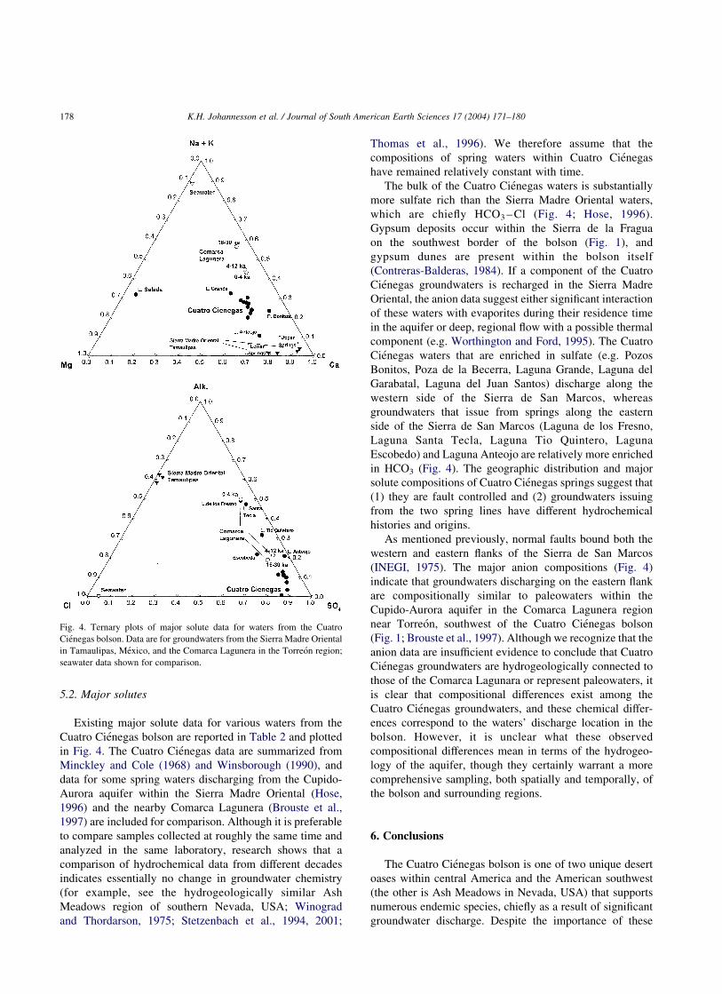
5.2. Major solutes
Existing major solute data for various waters from the
Cuatro Cienegas bolson are reported in Table 2 and plotted
in Fig. 4. The Cuatro Cienegas data are summarized from
Minckley and Cole (1968) and Winsborough (1990), and
data for some spring waters discharging from the Cupido-
Aurora aquifer within the Sierra Madre Oriental (Hose,
1996) and the nearby Comarca Lagunera (Brouste et al.,
1997) are included for comparison. Although it is preferable
to compare samples collected at roughly the same time and
analyzed in the same laboratory, research shows that a
comparison of hydrochemical data from different decades
indicates essentially no change in groundwater chemistry
(for example, see the hydrogeologically similar Ash
Meadows region of southern Nevada, USA; Winograd
and Thordarson, 1975; Stetzenbach et al., 1994, 2001;
Thomas et al., 1996). We therefore assume that the
compositions of spring waters within Cuatro Cienegas
have remained relatively constant with time.
The bulk of the Cuatro Cienegas waters is substantially
more sulfate rich than the Sierra Madre Oriental waters,
which are chiefly HCO3 – Cl (Fig. 4; Hose, 1996).
Gypsum deposits occur within the Sierra de la Fragua
on the southwest border of the bolson (Fig. 1), and
gypsum dunes are present within the bolson itself
(Contreras-Balderas, 1984). If a component of the Cuatro
Cienegas groundwaters is recharged in the Sierra Madre
Oriental, the anion data suggest either significant interaction
of these waters with evaporites during their residence time
in the aquifer or deep, regional flow with a possible thermal
component (e.g. Worthington and Ford, 1995). The Cuatro
Cienegas waters that are enriched in sulfate (e.g. Pozos
Bonitos, Poza de la Becerra, Laguna Grande, Laguna del
Garabatal, Laguna del Juan Santos) discharge along the
western side of the Sierra de San Marcos, whereas
groundwaters that issue from springs along the eastern
side of the Sierra de San Marcos (Laguna de los Fresno,
Laguna Santa Tecla, Laguna Tio Quintero, Laguna
Escobedo) and Laguna Anteojo are relatively more enriched
in HCO3 (Fig. 4). The geographic distribution and major
solute compositions of Cuatro Cienegas springs suggest that
(1) they are fault controlled and (2) groundwaters issuing
from the two spring lines have different hydrochemical
histories and origins.
As mentioned previously, normal faults bound both the
western and eastern flanks of the Sierra de San Marcos
(INEGI, 1975). The major anion compositions (Fig. 4)
indicate that groundwaters discharging on the eastern flank
are compositionally similar to paleowaters within the
Cupido-Aurora aquifer in the Comarca Lagunera region
near Torreon, southwest of the Cuatro Cienegas bolson
(Fig. 1; Brouste et al., 1997). Although we recognize that the
anion data are insufficient evidence to conclude that Cuatro
Cienegas groundwaters are hydrogeologically connected to
those of the Comarca Lagunara or represent paleowaters, it
is clear that compositional differences exist among the
Cuatro Cienegas groundwaters, and these chemical differ-
ences correspond to the waters’ discharge location in the
bolson. However, it is unclear what these observed
compositional differences mean in terms of the hydrogeo-
logy of the aquifer, though they certainly warrant a more
comprehensive sampling, both spatially and temporally, of
the bolson and surrounding regions.
6. Conclusions
The Cuatro Cienegas bolson is one of two unique desert
oases within central America and the American southwest
(the other is Ash Meadows in Nevada, USA) that supports
numerous endemic species, chiefly as a result of significant
groundwater discharge. Despite the importance of these
Fig. 4. Ternary plots of major solute data for waters from the Cuatro
Cienegas bolson. Data are for groundwaters from the Sierra Madre Oriental
in Tamaulipas, Mexico, and the Comarca Lagunera in the Torreon region;
seawater data shown for comparison.
K.H. Johannesson et al. / Journal of South American Earth Sciences 17 (2004) 171–180178
groundwater discharges, little is currently known about the
Cuatro Cienegas groundwater flow regime. The preliminary
environmental isotope data presented here suggest that a
significant component of Cuatro Cienegas groundwaters
may be recharged in the local mountain ranges surrounding
the bolson.
Furthermore, these data are consistent with that for water
that discharges from springs along the western base of the
Sierra de San Marcos, which originate by recharge in the
Sierra de San Marcos range, whereas the d 18O and dD data
for Laguna Anteojo in the northern part of the bolson is
consistent with recharge in the higher San de la Madera
range. However, a crude water balance estimate for the
Cuatro Cienegas bolson indicates that groundwater orig-
inating outside of the basin probably contributes to the
abundant spring discharge within it. Regional groundwater
flow is also supported by the relatively warm temperatures
of some of the groundwaters issuing from the Cupido-
Aurora aquifer within the Cuatro Cienegas bolson. Existing
major solute data indicate that compositional differences
exist among groundwater discharging within the Cuatro
Cienegas bolson, though these differences have not yet been
interpreted in terms of the hydrogeology. Additional
investigation could identify and better constrain the
hydrogeology of the Cupido-Aurora aquifer in Cuatro
Cienegas.
Acknowledgements
This project was supported in part by NSF grant INT-
9912159 to KHJ.
References
Baker, C.L., 1970. Geologic reconnaissance in the Eastern Cordilleran of
Mexico. Geological Society of America, Special Paper 131.
Barker, R.A., Ardis, A.F., 1996. Hydrogeologic framework of the Edwards-
Trinity aquifer system, west-central Texas. United States Geological
Survey Professional Paper 1421-B.
Brouste, L., Marlin, C., Dever, L., 1997. Geochemistry and residence time
estimation of groundwater from the upper aquifer of the Chihuahua
desert (Comarca Lagunera, Northern Mexico). Applied Geochemistry
12, 775–786.
Caran, S.C., Winsborough, B.M., 1986. Depositional environments of the
Cuatro Cienegas basin, northeastern Mexico-Inland ‘Sabkhas’ and
stromatolitic lakes. Geological Society of America Abstracts with
Programs, 557.
Carrillo-Rivera, J.J., Clark, I.D., Fritz, P., 1992. Investigating recharge of
shallow and paleogroundwaters in the Villa de Reyes Basin, SLP,
Mexico, with environmental isotopes. Applied Hydrogeology 4, 35–48.
Clark, I., Fritz, P., 1997. Environmental Isotopes in Hydrogeology. Lewis
Publishers, Boca Raton, FL, 328pp.
Contreras-Arquieta, A., 1998. New records of the snail Melanoides
tuberculata (Muller, 1774) (Gastropoda: Thiaridae) in the Cuatro
Cienegas basin, and its distribution in the state of Coahuila, Mexico.
The Southwestern Naturalist 43, 283–286.
Contreras-Balderas, S., 1984. Environmental impacts in Cuatro Cienegas,
Coahuila, Mexico: a commentary. Journal of the Arizona-Nevada
Academy of Science 19, 85–88.
Contreras-Balderas, S., Lozano-Vilano, M.L., 1996. Extinction of most
Sandia and Potosı valleys (Nuevo Leon, Mexico) endemic pupfishes,
crayfishes and snails. Ichthyological Exploration of Freshwaters 7,
33–40.
Cortes, A., Durazo, J., 2001. Tendencia del Oxıgeno-18 en la precipitation
del centro de Mexico. Revista Ingenierıa Hidraulica en Mexico 26,
93–102.
Cortes, A., Durazo, J., Farvolden, R.N., 1997. Studies of isotopic hydrology
of the basin of Mexico and vicinity: annotated bibliography and
interpretation. Journal of Hydrology 198, 346–376.
Craig, H., 1961. Isotopic variations in meteoric waters. Science 133,
1702–1703.
Dudley, W.W., Larson, J.D., 1976. Effects of Irrigation Pumping on Desert
Pupfish Habitats in Ash Meadows, Nye County, Nevada. United States
Geological Survey Professional Paper 927, Washington, DC..
Fish, D.C., 1977. Karst hydrogeology of Valles-San Luis Potosi region,
Mexico. Doctoral Dissertation, McMaster University, Canada.
Garcia, E., Vidal, R., Tamayo, L.M., Reyna, T., Sanchez, R., Soto, M.,
Soto, E., 1975. Precipitation y probabilidad de la Lluvia en la Republica
Mexicana y su evaluation. Comision de Estudios del Territorio
Nacional, Instituto de Geografia, Universidad Nacional Autonoma de
Mexico.
Hose, L.D., 1996. Hydrology of a large, high relief, subtropical cave
system: Sistema Purificacion, Tamaulipas, Mexico. Journal of Caves
and Karst Studies 58, 22–29.
IAEA, 1981. Statistical Treatment of Environmental Isotopes in Precipi-
tation. Technical Report Series No. 206, International Atomic Energy
Agency (IAEA), Vienna.
INEGI, 1975. Carta Geologica, Cuatro Cienegas G13B59. Instituto
Nacional de Estadistica Geografia e Informatica, Comision de Estudios
del Territorio Nacional, 1:50,000.
INEGI, 1991. Carta Geologica, Monclova G14-4. Instituto Nacional de
Estadistica Geografia e Informatica, Comision de Estudios del
Territorio Nacional, 1:250,000.
Ingraham, N.L., Matthews, R.A., 1988. Fog drip as a source of groundwater
recharge in northern Kenya. Water Resources Research 24, 1406–1410.
Lauriol, B., Clark, I.D., 1993. An approach to determine the origin and age
of massive ice blockages in two Arctic caves. Permafrost Periglacial
Processes 4, 77–85.
Lehmann, C., Osleger, D.A., Montanez, I.P., Sliter, W., Arnaud-Vanneau,
A., Banner, J., 1999. Evolution of the Cupido and Coahuila carbonate
platforms, early Cretaceous, northeastern Mexico. Geological Society
of America Bulletin 111, 1010–1029.
Lesser, J.M., Lesser, G., 1988. Region 9, Sierra Madre Oriental. In: Back,
W., Rosenhein, J.S., Seaber, P.R. (Eds.), Hydrogeology. The Geology
of North America. vol. O-2. Geological Society of America, Boulder,
pp. 89–92.
Lesser Jones, H., 1965. Confined fresh water aquifers in limestone,
exploited in the north of Mexico with deep wells below sea level. In:
Proceedings Dubrovnik Symposium, 1965, Hydrology of Fractured
Rocks. vol. 2. International Association of Scientific Hydrology,
pp. 526–539.
Loaiciga, H.A., Maidment, D.R., Valdes, J.B., 2000. Climate-change
impacts in a regional karst aquifer, Texas, USA. Journal of Hydrology
227, 173–194.
McKee, J.W., Jones, N.W., Long, L.E., 1990. Stratigraphy and provenance
of strata along the San Marcos fault, central Coahuila, Mexico.
Geological Society of America Bulletin 102, 593–614.
Minckley, W.L., 1969. Environments of the Bolson of Cuatro Cienegas,
Coahuila, Mexico, with special reference to the aquatic biota.
University of Texas El Paso Science Series. Texas Western Press,
El Paso.
K.H. Johannesson et al. / Journal of South American Earth Sciences 17 (2004) 171–180 179

Minckley, W.L., 1984. Cuatro Cienegas fishes: research review of a local
test of diversity versus habitat size. Journal of Arizona-Nevada
Academy of Science 19, 13–21.
Minckley, W.L., Cole, G.A., 1968. Preliminary limnologic information on
waters of the Cuatro Cienegas Basin, Coahuila, Mexico. The Southwest
Naturalist 13, 421–431.
Murray, G.E., 1961. Geology of the Atlantic and Gulf Coastal Province of
North America. Harper and Brothers, New York.
Padilla y Sanchez, R.J., 1982. Geologic evolution of the Sierra Madre
Oriental between Linares, Concepcion del Oro, Saltillo, and Monterrey,
Mexico. Doctoral dissertation, University of Texas, Austin.
Rodriguez-Almaraz, G., Gonzales-Aquilar, J.A., Mendoza-Alfraro, R.,
1997. Biological and ecological notes of Palaemonetes suttkusi
(Crustacea: Palaemonidae) from Cuatro Cienegas basin, Coahuila,
Mexico. The Southwestern Naturalist 42, 501–503.
SARH, 1980. Estudios geohidrologico preliminar de la zona Cuatro
Cienegas-Ocampo, Coahuila. Secretaria de Agricultura y Recursos
Hidraulica, Direccion General de Programa Infraestructura Hidraulica,
Subdireccion de Geohidrologia y de Zona Aridas, Ininsa, S.A., Contrato
GZA-80-4-6D.
Small, T.A., Lambert, R.B., 1998. Geologic framework and hydrogeologic
characteristics of the outcrops of the Edwards and Trinity Aquifers,
Medina Lake area, Texas. United States Geological Survey, Water-
Resources Investigations Report 97-4290, Washington, DC.
Smith, C.I., 1970. Lower Cretaceous stratigraphy, northern Coahuila,
Mexico. Bureau of Economic Geology, Report of Investigations No. 65,
University of Texas, Austin.
Stetzenbach, K.J., Amano, M., Kreamer, D.K., Hodge, V.F., 1994. Testing
the limits of ICP-MS determination of trace elements in ground water at
the parts-per-trillion level. Ground Water 32, 976–985.
Stetzenbach, K.J., Hodge, V.F., Guo, C., Farnham, I.M., Johannesson,
K.H., 2001. Geochemical and statistical evidence of deep carbonate
groundwater within overlying volcanic rock aquifers/aquitards of
southern Nevada, USA. Journal of Hydrology 243, 254–271.
Thomas, J.M., Welch, A.H., Dettinger, M.D., 1996. Geochemistry and
isotopic hydrology of representative aquifers in the Great Basin region
of Nevada, Utah, and adjacent states. United States Geological Survey
Professional Paper 1409-C, Washington, DC.
Winograd, I.J., Thordarson, W., 1975. Hydrogeologic and hydrochemical
framework, south-central Great Basin, Nevada-California, with special
reference to the Nevada Test Site. United States Geological Survey
Professional Paper 712-C, Washington, DC.
Winsborough, B.M., 1990. Some ecological aspects of modern fresh water
stromatolites in lakes and streams of the Cuatro Cienegas Basin,
Coahuila, Mexico. Doctoral dissertation, University of Texas, Austin.
Worthington, S.R.H., Ford, D.C., 1995. High sulfate concentrations in
limestone springs: an important factor in conduit initiation? Environ-
mental Geology 25, 9–15.
K.H. Johannesson et al. / Journal of South American Earth Sciences 17 (2004) 171–180180