
Roll Failures Manual - Karl Buch Walzengiesserei GmbH & Co ...

www.elsevier.com/locate/enggeo
Engineering Geology 74 (2004) 103–112
Recent tectonics and slope failures in the Western Carpathians
L. Petroa,*, J. Vlckob, R. Ondrasikb, E. Polascinovaa
aGeological Survey of the Slovak Republic, Kosice, Jesenskeho 8, SK-040 01 Kosice, SlovakiabDepartment of Engineering Geology, Faculty of Natural Sciences, Comenius University Bratislava, Slovakia
Received 17 January 2003; accepted 8 March 2004
Available online 27 April 2004
Abstract
We describe several examples of recent tectonics and related slope failures from the Western Carpathians of Slovakia. The
monitoring data confirm the idea of non-uniform geodynamic behaviour of individual tectonic units as well as the idea that even
an extremely low rate of displacement both in landslides and along active faults may endanger human life and property. The
crack-gauge TM-71 is adopted as the monitoring device in our study, and we confirm its reliability for measuring in-plane
displacements in severe conditions with a resolution of 0.1 mm/year, simple manipulation, minimum maintenance requirements
and reasonable price.
D 2004 Elsevier B.V. All rights reserved.
Keywords: Western Carpathians; Recent tectonics; Slope failures; Lateral spreading; Monitoring; Crack-gauge
1. Introduction
The Western Carpathians constitutes a part of the
European Alpine orogenic belt. The Mesozoic folding
and overthrusting have resulted in a very complicated
structure. Landslides are linked to the particular geo-
morphic and geologic units, primarily to intra-montane
basins and tectonic depressions (Fig. 1). According to
the most recent data (Liscak and Caudt, 1997), nearly
15000 landslides have been registered in the Slovak
part of the Western Carpathians and cover about 3.8%
of the total area of Slovakia. The largest number of
landslides has been found in the region of Flysch Zone
0013-7952/$ - see front matter D 2004 Elsevier B.V. All rights reserved.
doi:10.1016/j.enggeo.2004.03.004
* Corresponding author. Tel.: +421-55-6250045; fax: +421-55-
6250044.
E-mail addresses: [email protected], [email protected] (L. Petro).
and along foothills consisting of Neogene volcanic
rocks (>10% of the area, Fig. 1).
As systematic study—an inventory of landslides in
Slovakia — started with the Handlova landslide
disaster in 1961. This study was carried out in three
stages, beginning in 1962 and ending in 1991. The
aim of this inventory was to complete landslides
records and to create a database serving as a practical
tool in the preparation of different derivative land use
maps applied to various urban purposes. A large
number of different types of landslides have been
studied in Slovakia (e.g., Nemcok, 1982; Mahr, 1977;
Malgot, 1977; Malgot and Baliak, 2000), mainly with
respect to their movement mechanism and typology.
Most studies, however, lack data indicating movement
magnitude. We thus focus our attention on this aspect.
Our data were obtained during medium-term moni-
toring of extremely slow forms of landslides (in terms

Fig. 1. Distribution of landslides in Slovakia expressed by percentage of delimited areas (after Nemcok, 1982) with location of selected
monitoring sites. 1—Kosicky Klecenov landslide, 2—Demanova cave of Liberty, 3—Branisko pilot tunnel, 4—Skalka Monastery.
L. Petro et al. / Engineering Geology 74 (2004) 103–112104
of Cruden and Varnes, 1996) and from the sites
affected by recent tectonism. The sites selected are
of great public interest (cultural and natural heritage
sites, important infrastructure facilities) and are in-
cluded in the monitoring net created within a national
programme sponsored by the Slovak Ministry of the
Environment.
2. Basic features of neotectonic evolution of the
Western Carpathians
The fundamental features of the Western Carpathi-
ans are the results of the alpine mountain-forming
processes, which took place in the Cretaceous and
Tertiary, characterized by folding and overthrusting,
generally toward the northern border of the Carpathi-
ans. Two basic geotectonic units—the Externides and
Internides—can be distinguished. The Internides con-
sist of older Palaeozoic and Proterozoic predominantly
crystalline rocks and younger Palaeozoic as well as
Mesozoic sedimentary complexes, partly in over-
thrusted position. They create a wide belt of highlands
separated by intra-mountain basins filled mainly by
Paleogene flysch-like sediments or separated by Neo-
gene tectonic depressions filled by loose soils. Bade-
nian to Sarmatian neovolcanic sequences, frequently
deposited on ductile Tertiary clays, are found in the
inner part of the Carpathian arc. The Externides consist
predominantly of folded and overthrusted Cretaceous
and Paleogene Flysch strata (Flysch belt) and extreme-
ly folded Jurassic and Early Cretaceous limestones,
marlstones and shales (Klippen belt).
During the geotectonic evolution of theWest Carpa-
thians, several transpression and transtension phases
(Kovac et al., 1994) alternated. The last change in the
nature of tectonic movements took place in the late
Tertiary, with transtension as the prevailing regimewith
dominant vertical differential movements. The total
uplift of mountains ranged from 1600 to 2000 m.
Simultaneously, the southernpart ofDanubianLowland
subsided as much as 5000 m since the Upper Badenian
(Kopecky, 1972). The rate of vertical displacement
within different geotectonic units varied temporally
and spatially. As far as the geological and geomorphic
data are concerned, the River Danube terraces reach the
height of 130 m (above that of the recent flood plain) as
compared to their equivalents deposited in the central
part of Danubian Lowland (Gabcikovo depression),
which can be found at the depth of 500 m (Maglay et
al., 1999; Scharek et al., 1998). Thus, the final differ-
ential subsidence in Danubian Lowland within last 1.6
Ma has been estimated as much as 600 m. Interestingly,
according to the results of geophysical and geological
survey within the last 0.7 Ma, no activity along young
faults has been confirmed in this area (Maglay, 1999).
Late tectonics is fundamental for creation of certain
type of topography with slopes susceptible to land-

Fig. 2. An example of complex spreading in the massif with neotectonic pattern (Mala Fatra Mountains). 1—Middle Triassic limestones, 2—
Upper Triassic claystones with sandstone and dolomite interbeds, 3—Jurassic limestones, 4—Jurassic claystones with limestone and sandstone
intercalations, 5—Middle and Upper Triassic marly limerstones and marlstones, 6—Middle Triassic limestones and dolomites (after Ondrasik,
1997).
L. Petro et al. / Engineering Geology 74 (2004) 103–112 105
slides (Zischinski, 1966, 1969; Varnes, 1978; Bisci et
al., 1996). Typical zones with differential tectonic
movements influencing the stability of slopes can be
observed in several highlands (Fig. 2).
3. Monitoring results from selected sites
Different techniques can be applied for the moni-
toring of extremely slow movements (displacements).
At present, the most frequent of these are GPS sur-
veying, precise levelling using electro-optical range-
finder and/or similar high precision levelling
techniques, terrestrial photogrammetry, terrestrial
interferrometry, etc. Micro-displacements can be mea-
sured by extensometers of various types, e.g., based
upon the linear variable displacement transducer
(LVDT) system or by three-dimensional crack-gauges.
The LVDT has the potential to measure the displace-
ment along one axis or can be configured to measure
the displacement along all three Cartesian axes. The
selection of an appropriate measuring device for
detecting of the micro-displacement depends not only
on the required accuracy but also upon the possibility
to install the device at the observation site (e.g.,
orientation and spacing of the discontinuity, accessi-
bility to the site as well as the resistance to outdoor
conditions).
For monitoring of extremely slow forms, e.g., lateral
spreads (mm/year) and/or tectonic movements, we ap-
plied the monitoring device TM-71 constructed by
Kostak (1969). This device is capable of detecting
movements and micro-displacements in three dimen-
sions. It works on the principle of optical interference—
moire pattern—which records displacement as a fringe
pattern on superposed optical grids that are mechanical-
ly connected to opposite crack faces. Data are obtained
in three Cartesian coordinates (x—across joint/crack
enabling to measure compression or extension of a
joint/crack width, y—horizontal (shear) displacement
along crack and z—vertical (shear) displacement) cal-
culated from recorded interference patterns. This mea-
suring device has been successfully employed in several
countries like Bulgaria (Kostak and Avramova-
Tacheva, 1988; Avramova-Tacheva and Kostak,
1995), Canada (Kostak and Cruden, 1990), Peru (Kos-
tak et al., 2002), Czech Republic (e.g., Zvelebil and
Stemberk, 2000) and Slovakia (Vlcko et al., 1998; Petro
et al., 1999;Vlcko, 2001, 2002;Vlcko andPetro, 2002).
Application of the TM-71 as a monitoring device in
Slovakia started almost three decades ago inMala Fatra
Mountains (Kostak, 1993), followed by Spis Castle, a
World Cultural Heritage historic site and at Orava
Castle. Later on, it was employed at several sites of
great historic and natural value (e.g., Strecno and
Lietava Castles, Skalka Monastery, Kostolany Church,
Demanova Cave of Liberty), as well as at three sites
from the Eastern volcanic region (e.g., Kosicky Klece-
nov, Velka Izra and Sokol) and two important construc-
tion sites (Ipel and Branisko exploration galleries).

Fig. 3. Kosicky Klecenov landslide. (A) The TM-71 three-dimensional crack-gauge; (B) geological cross-section of the Strechov ch stratovolcano with lateral spreading position
and location of crack-gauges KK-1 and KK-2. 1—diorite porphyrite intrusion, 2—alternation of lava flows and pyroclastics ( vided), 3—andesite lava flow, 4—pyroclastics
(undivided), 5—redeposited andesite pyroclastics, 6—Neogene clays, 7—redeposited andesite tuffs, 8—debris with fine soil ma 9—active fault, 10—location of crack-gauges
KK-1 and KK-2. (C) Displacement records of block movements monitoring by crack-gauge KK-1 during the period 1990–200
L.Petro
etal./Engineerin
gGeology74(2004)103–112
106
y vr
undi
trix,
3.

Fig. 5. Charming room of the Demanova cave of Liberty—a TM-71
crack-gauge location.
L. Petro et al. / Engineering Geology 74 (2004) 103–112 107
3.1. Kosicky Klecenov Landslide
The site is located in the central part of the neo-
volcanic region of Slanske vrchy Mountains at the
western margin of the Strechovy vrch stratovolvano
near Kosicky Klecenov village (Fig. 1). The largest
landslide in the area of Slanske vrchy Mountains (11.2
km2) represents a typical complex spreading created
by two different litho-structural units (Fig. 3). The
central part of the stratovolcano is built by volcanic
sequences (extrusions, intrusions, dykes, lava flows,
pyroclastic deposits, etc.), proximal part by blocky
lava flows, debris flows, lahar deposits, medial and
distal parts by redeposited airfall deposits covered
very often by Neogene and Quaternary soils. The
lava flow deposits overlay the plastic clays and/or
hydrothermally altered volcaniclastic rocks. The low-
er part of slope represents a large slide. Tectonic
contacts between volcanic complexes and sedimenta-
Fig. 4. A stalagnate damaged by freshly opened cracks inside the
Charming room of the Demanova cave of Liberty (The National
Nature Monument, Low Tatra Mountains).
ry layers as well as vertical tension cracks are mor-
phologically distinctive (Fig. 3).
A couple of TM-71 crack-gauges (KK-1 and KK-
2) were installed at this site in 1990 and 1995. Both
devices are situated inside wide N–S-oriented tension
cracks in the marginal part of the lava flow. Monitor-
ing results confirmed the displacement of the rock
blocks. More than 4 mm total vertical uplift of the
marginal block has been recorded since 1990 by the
KK-1 crack-gauge (Fig. 3). According to obtained
data and relating to the geological structure, the results
indicate a bulging as a main cause of the vertical uplift
of marginal blocks developed in front of a several
hundred meters long lateral spread (Fig. 3). The
explanation is inferred from the observation that no
widening of the cracks along the x axis was estimated,
and very small rotations of blocks along the z axis
were confirmed. From the regional point of view, the
landslide activity is closely connected with the neo-
tectonic uplift of the Slanske vrchy Mountains along
N–S-oriented normal faults (Janocko, 1989; Kaliciak
et al., 1991).
3.2. Demanova Cave of Liberty
The underground karst system of Demanova River
valley consists of 28 caves with a total length of 8400
m (1800 m accessible for public). The National
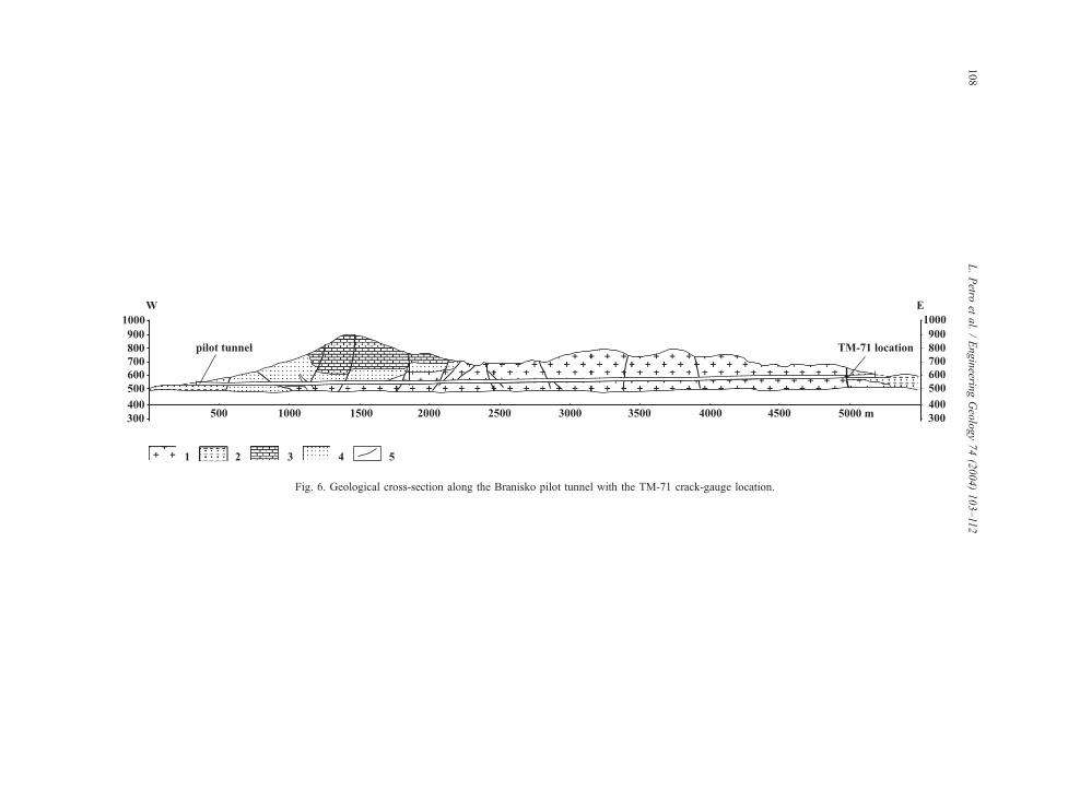
Fig. 6. Geological cross-section along the Branisko pilot tunnel with the TM-71 crack-gauge location.
L.Petro
etal./Engineerin
gGeology74(2004)103–112
108

Fig. 7. The TM-71 monitoring site inside the Branisko pilot tunnel.
Fig. 8. Displacement records of block movements monitoring by
TM-71 crack-gauge inside the Branisko pilot tunnel.
L. Petro et al. / Engineering Geology 74 (2004) 103–112 109
Nature Monument Demanova Cave of Liberty, the
largest one among the cave system was discovered in
1921. The cave is located in the northern part of the
Low Tatra Mountains National Park (Fig. 1). The
mountains are the second most uplifted structural unit
of West Carpathians (Maglay et al., 1999). The cave
was formed in the Middle Triassic limestones (Krizna
nappe). The underground cavities are concentrated
along the NNW–SSE-oriented faults crossing the
cave. The faults are quasi-parallel with an active fault
in the Demanova valley (Hok et al., 2000) and are
supposed to be the relevant cause of freshly opened
cracks that bring the damage to stalagnates (Fig. 4) in
one of the most beautiful parts of the cave in so-called
Charming room. For this reason, the site was selected
for monitoring and TM-71 crack-gauge inside the
cave was installed at the end of August 2001 (Fig. 5).
An interpretation of actual measurements with
respect of stabile climatic conditions inside the cave
(temperature range from 6.1 to 7.0 jC, and relative
humidity from 94% to 99%) revealed a very small
displacements along the z axis (vertical displacement
0.15 mm per 2 years) and the y axis (horizontal
displacement 0.08 mm along the crack). From the
short monitoring period, the estimated kinematics
correspondents with the orientation of crack’s origin
inside damaged stalagnates. Despite the fact that a
substantionally and widely acceptable interpretation
of the results needs longer monitoring, the data that
we gained confirmed the activity of a fault running
through Demanova valley.
3.3. Branisko tunnel
A highway tunnel and parallel running pilot tunnel
with the total length of 4800 m, are located in the
central part of Branisko Mountains (Fig. 1), a moun-
tain range with a complicated geological structure. The
Branisko Mountains, one of the most uplifted struc-
tural units of the Western Carpathians, is from both
sides separated by normal faults (Maglay et al., 1999).
In the central part of the mountain range, the lithology
is formed by various crystalline rocks (gneisses, gran-
ites, amphibolites, aplites, schists) that are overlaid by
Late Palaeozoic and Mesozoic complexes (Fig. 6). A
comprehensive geological investigation for the tunnel
construction revealed a fault contact between migma-
tites and Paleogene sandstones and conglomerates
near the eastern tunnel mouth (Figs. 6 and 7). The
normal fault according to latest Quaternary research
supposed to be active (Maglay et al., 1999). For that
reason, we installed in December 2000 the TM-71
crack-gauge inside the pilot tunnel at the site indicat-
ing 0.6-m-thick tectonic contact (Fig. 7).
The interpretation of preliminary results indicates
mostly a small vertical displacement (z axis) in Fig. 8.
The displacement may reflect the deformations of
rock massif due to highway tunnel construction (end
of 2002) in the excavation damage zone (EDZ).
Explanation of several fresh cracks in the concrete

Fig. 10. Rate of displacement records at the Skalka Monastery.
L. Petro et al. / Engineering Geology 74 (2004) 103–112110
tunnel tube as well as confirmation the tectonic
activity of the fault probably requires greater number
of readings, over a longer monitoring period.
3.4. Skalka Monastery
The Skalka Monastery is a well-known place of
religious interest in Slovakia. The site is located near
the city of Trencın in the Biele Karpaty Mountains
(Fig. 1) at a height of 250 m above sea level. Some of
the six different buildings on the site had deteriorated
to a ruinous state because of prolonged neglect
extending over a period of at least 140 years. The
region belongs to the contact zone of the Central West
Carpathians and the Pieniny Klippen belt. A compli-
cated geological– tectonic structure with a highly
dissected relief developed because of intensive neo-
tectonic movements associated with an uplift of the
Biele Karpaty Mountains as well as with a differen-
tiated subsidence of the River Vah valley.
The Monastery is situated on a steep ranging cliff
composed of Cretaceous marly limestones with chert
(Fig. 9). The discontinuities (fault lines, cracks and
Fig. 9. Skalka Monastery cross-section with location TM-71 crack-
gauge (after Vlcko et al., 1996).
joints) are in general widely spaced, persistent, open,
karstified and unfilled, with a rough surface.
A cave developed along the prevailing fault lines,
reaching 35 m in length and 4 m in width. In certain
places, the cave had been excavated, which provides
the only way of access to the Baroque chapel. Major
gravitational–tectonic lines of N–S to NNE–SSW
direction cut the bedrock beneath the northern part of
the chapel and caused open cracks in the monastery
walls and the deformation of a Gothic entrance to the
cave. No distinct displacement was recorded since
1995, the time when TM-71 device was installed. The
displacements along the y axis indicate constant
tendency to horizontal slip. The total recorded dis-
placement up to year 2003 is 0.28 mm (Fig. 10).
4. Conclusions
A systematic monitoring of landslides and small
displacements along active tectonic faults has been
carried out in the Western Carpathians (Slovakia)
within several national projects (e.g., ‘‘Partial moni-
toring system of geological factors of the environment
in Slovakia’’, sub-Project ‘‘Monitoring of landslides
and other slope deformations’’), and since 2000
(COSTAction 625 ‘‘3-D monitoring of active tectonic
structures’’).
Monitoring of extremely slow movements both in
landslides and along active faults confirmed the dan-
ger to human life and property and proved the
legitimacy of the research that we carried out.

L. Petro et al. / Engineering Geology 74 (2004) 103–112 111
The crack-gauge TM-71 we adopted confirmed the
reliability of the device for measuring in-plane dis-
placements in severe outdoor conditions with a reso-
lution of 0.1 mm/year, temperature corrections, simple
manipulation, minimum maintenance requirements
and reasonable price.
The monitoring data (rate of displacement) can be:
(i) implemented as the input data in numerical
modelling enabling to predict the landslide failure
mechanism and to create the time scale for
potential ongoing failure, and
(ii) applied in stability calculations as a reliable tool to
design geotechnical stabilization measures and
thus significantly contribute to the hazard/risk
assessment.
Acknowledgements
This summary paper was prepared as part of the
framework of ’’Partial monitoring system of geo-
logical factors of the environment in Slovakia’’
project, VEGA grant project No. 1/9159/02 as well
as No. 1/9160/02. The authors are thankful to the
Ministry of the Environment of the Slovak Republic,
Geological Survey of Slovak Republic as well as
grant agency VEGA for their kind support. The
authors are also thankful to Mr. Kostak for the
valuable help in interpretations of some monitoring
data.
References
Avramova-Tacheva, E., Kostak, B., 1995. Local three-dimensional
extensometric measurements for the determination of displace-
ments in the Krupnik fault zone. Acta Montana, IRSM ASCR,
Ser. A 8 (97), 87–98.
Bisci, C., Dramis, F., Sorriso-Valvo, M., 1996. Rockflow (Sackung).
In: Dikau, R., Brunsden, D., Schrott, L., Ibsen, M.L. (Eds.),
Landslide Recognition. Willey, Chichester, pp. 150–160.
Cruden, D.M., Varnes, D.J., 1996. Landslide types and processes.
In: Turner, A.K., Schuster, R.L. (Eds.), Landslides, Investigation
and Mitigation. Spec. Report, vol. 247. Nat. Academy Press,
Washington, DC, pp. 36–71.
Hok, J., Bielik, M., Kovac, P., Sujan, M., 2000. Neotektonicky
charakter uzemia Slovenska. Mineralia Slovaca 32 (5), 459–
470 (in Slovak with English summary).
Janocko, I., 1989. Vplyv kvarternej tektoniky na vyvoj uzemia v
severnej casti Kosickej kotliny. Mineralia Slovaca 21 (6), 549–
554 (in Slovak with English summary).
Kaliciak, M., Banacky, V., Jacko, S., Janocko, J., Karoli, S., Molnar,
J., Petro, L., Spisak, Z., Vozar, J., Zec, B., 1991. Geological map
of the Slanske vrchy Mts. and Kosicka kotlina depression—
northern part 1:50000. Publ. GSSR, Bratislava.
Kopecky, A., 1972. Hlavni rysy neotektoniky Ceskoslovenska. Sb.
Geol. Ved., J.A., vol. 6. Prague, Czech Rep., pp. 77–155. (In
Czech).
Kostak, B., 1969. A new device for in-situ movement detection and
measurement. Experimental Mechanics. SESA (American Soci-
ety for Experimental Stress Analysis) Journal 9, 374–379.
Kostak, B., 1993. Deformation effects on cracks in massifs and
their interpretation. In: Novosad, S., Wagner, P. (eds.) Proceed-
ings of the 7th ICFL, Bratislava, Slovakia, Balkema, Rotterdam,
pp. 161-168.
Kostak, B., Avramova-Tacheva, E., 1988. A method for contempo-
rary displacement measurement on a tectonic fault. Journal of
Geodynamics 10, 115–125.
Kostak, B., Cruden, D.M., 1990. The Moire crack gauges on the
crown of the Frank Slide. Can. Geotech. J. 27, 835–840
(Ottawa).
Kostak, B., Vilimek, V., Zapata, M.L., 2002. Registration of micro-
displacements at a Cordillera Blanca fault scarp. Acta Montana,
IRSM ASCR, Ser. A 19 (123), 61–74.
Kovac, M., Kral, J., Marton, E., Plasienka, D., Uher, P., 1994. Alpine
uplift of the Central Western Carpathians: geochronological,
peleomagnetic, sedimentary and structural data. Geol. Carpath.
45 (2), 83–96.
Liscak, P., Caudt, 1997. Atlas map stability uzemia Slovenska.
Project proposal of Geological Survey of Slovak Republic. Bra-
tislava. (In Slovak).
Maglay, J., 1999. Explanation text to the Neotectonic map of Slo-
vakia (in Slovak). Publ. Geol. Surv. of Slovak Rep., Bratislava.
48 pp.
Maglay, J., Halouzka, R., Banacky, V., Pristas, J., Janocko, J., 1999.
Neotectonic map of Slovakia. Bratislava (Slovak and English
version). Ministry of the Environment of the Slovak Rep.
Mahr, T., 1977. Deep reaching gravitational deformations of high
mountain slopes. Bull. IAEG 16, 121–127.
Malgot, J., 1977. Deap-seated gravitational slope deformations
in neovolcanic mountain ranges of Slovakia. Bull. IAEG 16,
106–109.
Malgot, J., Baliak, F., 2000. Landslides in Slovakia, their effects on
the environment and on important engineering structures. Min-
eralia Slovaca 32 (4), 341–350; Ondrasik, R., Durmekova, T.
(Eds.), Landslides Symposium. Proc. of Int. Symp.
Nemcok, A., 1982. Zosuvy v slovenskych Karpatoch Publ. VE-
DA, Bratislava, Slovak Rep. 318 pp., (in Slovak with English
summary).
Ondrasik, R., 1997. Engineering geology and geomorphological
processes in the Slovakian Carpathians. In: Marinos, P.G.,
Koukis, G.C., Tsiambaos, G.C., Stournaras, G.C. (Eds.), Pro-
ceedings of the Engineering Geology and the Environment,
Athens, Balkema, Rotterdam, pp. 293–298.
Petro, L., Kostak, B., Polascinova, E., Spisak, Z., 1999. Monitoring

L. Petro et al. / Engineering Geology 74 (2004) 103–112112
blokovych pohybov v Slanskych vrchoch. Miner. Slov. 31 (5–6),
549–554 (in Slovak with English summary).
Scharek, P., Herrmann, P., Kaiser, M., Pristas, J., Tkacova, H.,
1998. Danube region Vienna–Bratislava–Budapest. Map of ge-
netic types and thickness of Quaternary sediments 1:200000.
DANREG. Publ. Geol. Inst. of Hungary, Budapest.
Varnes, D.J., 1978. Slope movement types and processes. In:
Schuster, R.L., Krizek, R.J. (Eds.), Special Report 176: Land-
slides: Analysis and Control TRB. National Research Council,
Washington, DC, pp. 11–33.
Vlcko, J., 2001. Engineering geological problems related to pres-
ervation of UNESCO sites in Slovakia. In: Sassa, K. (Ed.),
Proceedings of the UNESCO/IGCP Symposium on Landslide
Risk Mitigation and Protection of Cultural and Natural Heritage,
Tokyo, Japan. UNESCO/Kyoto Univ. Press, Kyoto, pp. 35–48.
Vlcko, J., 2002. Monitoring—an effective tool in safeguarding the
historic structures. In: Sassa, K. (Ed.), Proceedings of the Inter-
national Symposium onLandslide RiskMitigation and Protection
of Cultural and Natural Heritage, Kyoto, Japan. UNESCO/Kyoto
Univ. Press, Kyoto, pp. 267–278.
Vlcko, J., Petro, L., 2002. Monitoring of subgrade movements
beneath historic structures. In: van Roy, J.L., Jermy, C.A.
(Eds.), Proc. of 9th Int. Congr. IAEG, Durban, South Africa.
South African Institute of Engineering and Environmental Geol-
ogists, Pretoria, pp. 1432–1437.
Vlcko, J., Wagner, P., Mika, R., 1996. The destruction of the Skalka
Monastery as a result of deep-seated deformations. In: Chacon,
J., Irigaray, C., Fernandez, T. (Eds.), Proceedings of the 8th
ICFL. Granada, Spain, pp. 79–88.
Vlcko, J., Petro, L., Kostak, B., 1998. Monitorovanie pohybov skal-
nych blokov na Spisskom hrade. In: Wagner, P., Durmekova, T.
(Eds.), Zbor. z konf. Geologia a zivotne prostredie. Geol. Survey
of Slovak Republic, Bratislava, pp. 102–104. (in Slovak).
Zischinski, U., 1966. On the deformation of high slopes. Proc. 1st
Congress of the Int. Soc. Rock. Mech., vol. 2. Int. Society for
Rock Mechanics, Lisban, Portugal, pp. 179–185.
Zischinski, U., 1969. Sackungen. Rock Mech. 1, 30–52.
Zvelebil, J., Stemberk, J., 2000. Slope monitoring applied to rock
fall management in NW Bohemia. In: Bromhead, E., Dixon, N.,
Ibsen, M.L. (Eds.), Landslides in Research, Theory and Practice.
Proc. 8th Int. Symp. on Landslides, vol. 3. Thomas, Telford,
London, pp. 1659–1664.
Copyright © 2022 FDOKUMEN


![Credit ratings failures and policy options [with Discussion]](https://static.fdokumen.com/doc/165x107/633fd3e6d10f841e2f086984/credit-ratings-failures-and-policy-options-with-discussion.jpg)