RANCHO BERNARDO - City of San Diego
85
- i -
-
Upload
khangminh22 -
Category
Documents
-
view
0 -
download
0
Transcript of RANCHO BERNARDO - City of San Diego

- i -


- i -
RANCHO
BERNARDO
COMMUNITY PLAN
Printed on recycled paper.
This information, or this document (or portions thereof), will be made available in alternative formats upon request.

- ii -
RANCHO BERNARDO COMMUNITY PLAN
The following amendments have been incorporated into this July 2018 posting of this Plan:
Amendment Date Approved
by Planning Commission
Resolution Number
Date Adopted by City Council
Resolution Number
Rancho Bernardo Community Plan approved.
February 2, 1978 1176 March 28, 1978 R-220568
Preserve existing scale and character of Rancho Bernardo and approve widening of Rancho Bernardo Road.
October 6, 1988 R-0270-PC December 18, 1988 R-272586
Redesignate a parcel of Bernardo Heights Parkway from private recreation to low-density residential.
November 14, 1989 R-274733
Redesignate 5.7 acres from industrial to specialized commercial.
July 29, 1997 R-289015
Redesignate 34.46 acres from agricultural to residential land use. Modify the boundaries of areas designated for agricultural, residential and open space to allow the proposed Saddle Club Estates development.
January 11, 1999 R-291151
Redesignate 10.88 acres at 16061 Avenida Venusto from educational to low-density residential land use to allow the proposed Silvergate Rancho Bernardo residential care facility.
August 2, 2016 R-310663June 30, 2016 PC-4646

- iii -
MAYOR Maureen O’Connor
CITY COUNCIL Abbe Wolfsheimer Ron Roberts Gloria D. McColl Wes Pratt Ed Struiksma Bruce Henderson Judy McCarty Bob Filner
CITY ATTORNEY John W. Witt
CITY MANAGER John Lockwood
PLANNING COMMISSION Karl ZoBell, Chairman Lynn Benn Chris Calkins Albert Kercheval Yvonne Larsen Paul Oquita Ralph Pesquiera
PLANNING DEPARTMENT Robert P. Spaulding, Planning Director Michael Stepner, Assistant Planning Director Mary Lee Balko, Deputy Director Bill Levin, Senior Planner James L. Overstreet, Project Planner Leo DeJesus, Graphics Peggy Cooper, Word Processing

- iv -
This Plan that follows has been prepared with the cooperation of the following groups and individuals. The Planning Department extends special thanks to these groups and individuals for their valuable input and time commitments in the planning process.
RANCHO BERNARDO UPDATE COMMITTEE
Dr. Ora Peckham, Chairperson Gary A. Kreitzer Charles J. Jacobs J. E. (Ed) Matson Thomas W. Bilhorn
RANCHO BERNARDO COMMUNITY PLANNING BOARD
The Planning Board was formed under City Council Policy 600-24 to advise the City on long-range planning issues.
Irving Rosen, Chairman Thomas W. Bilhorn, Vice-Chairman Clayton Morehead, Secretary Mel D. Compton, Treasurer
Phyllis Johnson Mirian Sherrard John J. Tucka Carrol A. Badeau David R. Wilkins Robert C. Mitchell Ramona Salisbury Robert C. Parsons John Maloney C. H. ZondagRobert P. Dahlquist Kenneth LewellynRaymond K. Locke Howard FreyenseeVictoria Touchstone David W. PhelpsLaurence B. Henkin Paul ZimmerTom Parsons

- v -
P.O. Box 85271-230, San Diego, CA 92138
Dear Community Resident: The goal of the Rancho Bernardo Community Planners is a Plan which provides for the health, safety and welfare of the existing and future residents and maintains the area as a desirable community in which to live. The Plan is a cross section of community opinion and desires blended with professional knowledge and sound planning policy. Throughout many months, volunteer members of the Community Planning Board met with the City Planning Department staff in workshops with representatives of various City, School and State Departments. Many ideas and concepts were considered and refined to meet the needs of the community, some were rejected. The Plan presented is a comprehensive, long-range policy guide for the Rancho Bernardo Community. It discusses residential, commercial, industrial, open space, circulation, and community facilities in terms of existing conditions, states projected needs, objectives and proposals for each. We hope you will take advantage of the detailed information to better understand the suggestions for the future of the community. For the Plan to serve as a useful document, statements were made as precise as possible. Tables, charts, etc., were included where necessary for explanation and reference. The end result does give the Plan a technical textbook appearance, but it makes material available where and when it is needed. The Rancho Bernardo Community Plan is simply a first step in the never ending desire of the citizens to participate in the design of their community. We are grateful for your interest in the community and hope you will continue to actively support and participate in the community planning process. Respectfully,
RANCHO BERNARDO COMMUNITY PLANNING BOARD

THIS PAGE INTENTIONALLY LEFT BLANK.

- vii -
INTRODUCTION Scope and Purpose of This Plan................................................................................................ 1 The Planning Area .................................................................................................................... 2 Legislative Framework ............................................................................................................. 3 Planning Background ................................................................................................................ 4 Existing Development - 1988 ................................................................................................... 5
OVERALL PLANNING GOALS AND GENERAL DEVELOPMENT PROPOSALS Planning Goals .......................................................................................................................... 9 General Development Proposals ............................................................................................. 10
COMMUNITY PLAN ELEMENTS Housing and Residential Land Use Element .......................................................................... 13 Commercial Element .............................................................................................................. 21 Industrial Element ................................................................................................................... 29 Circulation Element ................................................................................................................ 31 Community Facilities Element ............................................................................................... 47 Open Space, Parks and Recreation Element ........................................................................... 53
IMPLEMENTATION ELEMENT Introduction ............................................................................................................................. 61 Generalized Implementation Process Recommendations ....................................................... 61 Summary of Plan Proposals .................................................................................................... 67
RANCHO BERNARDO COMMUNITY PLAN MAP Rancho Bernardo Community Plan Map ................................................................................ 72
Figure 1. Location Map .......................................................................................................... x Figure 2. Residential Areas – Land Use Density Designations ........................................... 12 Figure 3. Undeveloped and Developing Residential Areas ................................................. 14 Figure 4. Commercial Areas ................................................................................................ 20 Figure 5. Community Plan Implementation Overlay Zone .................................................. 25 Figure 6. Industrial Areas ..................................................................................................... 28 Figure 7. Functional Street System at Buildout ................................................................... 32 Figure 8. 1987 Average Daily Traffic .................................................................................. 34 Figure 9. Traffic Forecast at Buildout .................................................................................. 36 Figure 10. Traffic Signals ....................................................................................................... 38 Figure 11. Bicycle and Equestrian Trails ............................................................................... 40 Figure 12. Facilities Classifications ....................................................................................... 42 Figure 13. Community Facilities ............................................................................................ 48 Figure 14. Open Space, Park and Recreation Proposals ........................................................ 54

- viii -
Table 1. Summary of Residential Proposals ...........................................................................18 Table 2. Land Use Recommendations: Summary .................................................................. 73


- x -
FIGURE 1. LOCATION MAP

- 1 -
INTRODUCTION SCOPE AND PURPOSE OF THIS PLAN
The Rancho Bernardo Community Plan (Plan) has been prepared to serve as a guide for future public and private development within the area through 1995, or until it is fully developed. Once this Plan is adopted by the City Council, any amendments, additions or deletions, will require that the Planning Commission and City Council follow the same public hearing procedure as was required in the initial adoption of the Plan. While this Plan sets forth many proposals for implementation, it does not establish new regulations or legislation, nor does it rezone property. However, it must be clearly pointed out that adoption of this Plan may require subsequent public hearings be held to determine whether or not to rezone property so that it is consistent with Plan proposals. This requirement for consistency between zoning regulations and adopted plans is set forth within Section 65860 of the California Governmental Code. The amendment of other development controls must also be enacted separately through the regular legislative process. It should also be understood that this Plan is not precise in every minute detail and reasonable interpretation of this Plan, which may cause minor adjustments, is expected. Proposals within this Plan have been coordinated with the City of San Diego Progress Guide and General Plan (General Plan). There is conformity between the goals and policies of this Plan and those of the City and region. Should differences occur between this Plan and the General Plan, they may be resolved during the course of related public hearings. This procedure conforms to the intent of City Council Policy 600-7. In addition, periodic comprehensive reviews of the General Plan may produce recommendations for changes in this Plan. Again, the normal procedure for legislative action, including public hearings, must be followed before changes to either of these documents can be accomplished. Future development based on this Plan shall be undertaken in compliance with all existing City policies and all applicable City ordinances with respect to providing necessary public facilities. During Plan preparation, the relationship with planning programs and development patterns in surrounding areas was considered. This analysis included coordination with the adopted San Pasqual and Rancho Peñasquitos Community Plans, and surrounding land uses. Proposals of the San Diego Association of Government's Regional Comprehensive Plan and the adopted San Diego County General Plan have also been considered. The Plan is not an end in itself, nor is it a static document. Two additional steps will follow Plan adoption: implementation and review. Implementation means putting the Plan policies and recommendations into effect. The Plan provides guidelines for implementation, but the actual work must be based on a cooperative effort of private citizens, developers, City officials and other agencies. This Plan is intended to be a development guide for the future. Community conditions and the legislative framework must be continually monitored to ensure that the Plan remains timely. If major Plan amendments are necessary, they would follow the same legislative process required for adoption.

- 2 -
THE PLANNING AREA
Rancho Bernardo is the northernmost residential community within the City of San Diego. It is centered on Interstate 15 (I-15) just south of Lake Hodges and the San Pasqual Valley. The community planning area encompasses about 6,511 gross acres consisting of: 1) approximately 6,107 gross acres containing the developed Rancho Bernardo community and other adjacent land proposed for development originally under the ownership of Avco Community Developers Inc., and 2) 404 gross acres of adjacent City-owned lands lying in the northwest quadrant of the plan area, west of I-15. The existing Rancho Bernardo community and properties can be developed independently of the other areas; however, their close physical relationship dictates an integrated planning approach. For lands lying outside the planning area it was assumed that:
1. The San Pasqual Valley will be maintained as a permanent open space area characterized by agricultural and recreational uses developed in accordance with the adopted San Pasqual Valley Area Plan.
2. The rugged hills and topographic breaks along the westerly and southwesterly boundaries of the Plan area will act to provide open space separations between Rancho Bernardo and adjacent lands thus giving definition to the community.
3. The Poway General Plan will provide for low-density residential, rural-residential, and commercial office uses within areas lying adjacent to the easterly boundary of Rancho Bernardo.
4. The Carmel Mountain Ranch Community Plan designates the area south of Rancho Bernardo and east of I-15 for industrial, commercial and residential land uses.
5. On the west side of I-15 and south of the Rancho Bernardo boundary, the Plan provides for primarily low-density residential land use.

- 3 -
LEGISLATIVE FRAMEWORK
The planning process must respond to a number of laws enacted at federal, state and local levels. Some of the more significant legislation is discussed as follows: • Section 65450 of the Government Code of the State of California, and Section 41(c) of the
Charter of the City of San Diego give authority for the preparation of community plans. More specifically, Section 65450 states, “After the legislative body has adopted a general plan, the planning agency may, or if so directed by the legislative body shall, prepare specific plans for the systematic implementation of the general plan for all or part of the area covered by the general plan.” Sections 65451 through 65454 of this law define the Scope, Implementation and Administration of Specific Plans and Regulations.
• The California Environmental Quality Act of 1970 (CEQA) was enacted in response to
increasing public concern over the environment. In a 1972 landmark case, Friends of Mammoth et al. vs. Board of Supervisors of Mono County et al., the California Supreme Court ruled that Environmental Impact Reports, (EIRs) must be prepared for both public and private projects having a significant effect on the environment. Environmental Impact Reports must be prepared for all community plans. Separate, detailed EIRs are also required for all significant projects, including those implementing this Plan.
• The citywide Zoning and Subdivision Ordinances serve to regulate the use of land. These
are amended from time to time to resolve problems as they are identified, enhance the environment and encourage imaginative approaches to development design.
• In addition to legislation, the City Council utilizes a set of officially designated and
numbered policies as a guideline in the decision-making process. Many of the policies relate directly to planning issues and should be used in implementing Plan recommendations. These are discussed within the Implementation Element of this Plan.

- 4 -
PLANNING BACKGROUND
In 1962, the San Diego City Council adopted the original Plan for Rancho Bernardo. Since then, the Plan has undergone revisions in 1966, 1971 and 1978. The two early revisions were made based upon findings of coordinated public agency and community developer planning studies. Shifts in land use involved agreements between developers and the City. In 1978, the format of the Plan was changed to that of a community plan rather than a development plan. The revisions recognized the changing character and growth in the community as reflected in the quickening tempo of development and increased diversity in land use, population and lifestyles. The revisions included in this document represent the fourth update of the Plan and are considered essential if the Plan is to continue to serve as an effective guide to public and private development decisions. The Plan that follows respects existing patterns of development while incorporating the five amendments to the Plan since the 1978 revision, as well as new data from recent studies of environmental, economic, land use and transportation factors. The following is a synopsis of the amendments to the Plan since its adoption in 1978. The San Diego City Council adopted the Plan on March 28, 1978, by City Council Resolution No. 220568. On March 16, 1981, by Resolution No. 253790-1, the City Council unanimously approved an amendment in the southern portion of the Plan to redesignate 30 acres of residentially-designated land to industrial use. The City Council, on June 16, 1981, adopted an amendment by Resolution No. 254458 that: 1) redesignated an elementary school site east of I-15 and north of Bernardo Center Drive to
low-medium density residential use (nine to 14 dwelling units per net acre),
2) redesignated an elementary school site in the southeast quadrant of the planning area to low-density residential use (one to nine dwelling units per net acre), and
3) revised the proposed residential and open space land uses in the Westwood area without an increase in residential density.
On March 9, 1982, by Resolution No. 255968, the City Council approved an amendment to the Circulation Element to the Plan. This amendment included the following revisions: 1) the deletion of Escala Drive extension under I-15 to West Bernardo Drive,
2) the extension of West Bernardo Drive to Pomerado Road as a four-lane major street, and
3) the extension of Bernardo Center Drive as a six-lane major street and Rancho Bernardo Road as a four-lane major street to the western boundary of the Plan area.

- 5 -
The City Council, on April 1, 1986, adopted by Resolution No. 265356, an amendment to the Plan to redesignate the elementary school site at the southeast corner of the intersection of Pomerado Road and Escala Road to low-density residential use (one to nine dwelling units per net acre).
On March 3, 1987, the City Council approved by Resolution No. 267821, an amendment to the Plan to redesignate the proposed intermediate school site and one elementary school site in the Westwood Valley area to low-density residential use (one to nine dwelling units per net acre). All amendments are on file in the office of the City Planning Department.
On August 2, 2016, the City Council approved by Resolution No. 310663, an amendment to the Plan to redesignate the elementary school site in the Bernardo Heights area to low-density residential use (one to nine dwelling units per net acre).
EXISTING DEVELOPMENT - 1988
Rancho Bernardo is characterized by rolling hills, ridges and knolls rising from valley and canyon floors. While some areas to the south drain into La Jolla Canyon, most lands are tributary to the San Pasqual Valley. Vegetation outside of developed areas is largely confined to range grasses which historically supported cattle grazing within the Rancho. Geologically, there are five distinct formations lying below the soil mantle. They vary from friable clay layers and conglomerates to hard, dense igneous and metamorphic rocks.
Approximately 4,560 net acres, or 70 percent of the Plan area, have been developed with a mix of recreational, residential, commercial and industrial uses.
Residential uses currently occupy about 2,437 net acres and consist of about 13,854 dwellings. Approximately 7,975 of these dwellings are single-family homes with the remainder in multifamily residential developments. The average residential density developed within the community is 5.7 dwelling units per net acre excluding streets and open space.
Commercial activity is concentrated around the town center located in the vicinity of Rancho Bernardo Road and Bernardo Center Drive. Approximately 44 acres of the 53-acre town center have been developed with a variety of uses including a major food market, drug store, numerous retail commercial businesses, service and financial institutions and a retirement facility. Approximately 55 acres of the area west of Bernardo Center Drive are developed with a diversity of uses such as a post office, library, fire station, theatre, financial institutions, auto service centers, restaurants and a hotel. An additional seven acres of financial institutions and restaurants are located to the south on Bernardo Center Drive east of the I-15 off-ramp.
Five neighborhood commercial centers have also been developed in the community. One is located at Rancho Bernardo and Pomerado Roads and consists of six acres. It is the site of a major food store, a hardware store and other various service establishments. Four other neighborhood commercial centers provide convenience goods and services to the community. They include a one-acre center on Oaks North Drive just east of Pomerado Road, a six-acre center at Duenda Road and West Bernardo Drive, a six-acre center at Pomerado Road and Bernardo Heights Parkway and a two-acre site in the High Country West area near the intersection of Maturin Drive and Bernardo Center Drive.

- 6 -
Specialized commercial areas include visitor-oriented and special community-serving commercial activities. In Rancho Bernardo, these uses are located in the vicinity of the I-15/Rancho Bernardo Road interchange and include such uses as motels, restaurants, service stations and retail shops. There are significant lodging, convention, restaurant, entertainment and recreation facilities in the Compri Hotel and the Rancho Bernardo Inn. Industrial activity in Rancho Bernardo occupies 618 acres located in two industrial parks. Bernardo Industrial Park, located on the west side of I-15 between Rancho Bernardo Road, Bernardo Center Drive and Camino del Norte, contains approximately 588 acres. Major users such as UNISYS (Burroughs Corporation), National Cash Register, Hewlett Packard and Sony Tomura Electric, along with numerous industrial support activities, occupy about 370 acres. The other industrial park, Bernardo Heights Corporate Park, occupies approximately 30 acres and is located southeast of the intersection of I-15 and Camino del Norte. Currently, the major user at this location is Gould Electronics, which occupies approximately 5.4 acres.


- 9 -
OVERALL PLANNING GOALS AND GENERAL DEVELOPMENT PROPOSALS
PLANNING GOALS
Plan goals are designed to give direction to future growth and development. They also link the past to the present and future by providing a sense of continuity between the original concept of a New Town, the reality of today and the prospects for the future. Most of the following goals were originally stated in the first Plan document. They are: 1. Preserve and enhance the high quality and character of the Rancho Bernardo community,
including its neighborhood identities. 2. Develop the community's image as an important housing, employment, trade and
recreational center. 3. Develop an attractive community that takes advantage of natural and man-made amenities
while respecting the environmental assets and constraints inherent in the Rancho Bernardo setting.
4. Ensure a balanced community. Provide for a wide variety of housing types, densities, unit
sizes and prices, with densities consistent with the Plan designations and aesthetically compatible with the surrounding neighborhood.
5. Provide areas for shopping, service and community facilities that are closely related and
easily accessible to community residential areas. 6. Provide a circulation system to safely and adequately accommodate traffic within the
community and establish linkages with other planned metropolitan road systems. 7. Provide adequate schools, parks and community facilities integrated with a planned open
space system. 8. Support utilization of crime prevention techniques such as neighborhood alert units and
crime-free design techniques.

- 10 -
GENERAL DEVELOPMENT PROPOSALS
The Plan Goals outlined above cannot happen by themselves. Development proposals must be formulated and acted upon to accomplish the desired end. The General Development proposals listed below have been designed and are being implemented to accomplish the Plan Goals. They include: 1. Provide for a community focal point. An intensive commercial development complex
located in the vicinity of the I-15/Rancho Bernardo Road interchange provides this focus. The Bernardo Town Center brings together, in an integrated design, those shopping, office, institutional, medical, entertainment and other community facilities necessary to meet diverse community needs. Areas westerly of the Town Center and Bernardo Center Drive accommodate a variety of uses including public facilities, offices, sites for highway-oriented commercial activity and other specialized commercial establishments. While the Bernardo Town Center and related areas will accommodate higher intensity uses, site development should continue to be characterized by low-profile structures, not exceeding three stories in height and incorporating open space areas.
2. Provide a wide variety of housing. Housing types, ranging from detached, single-family
homes through cluster housing and townhouses to medium-density apartments are identified in the Plan. Residential complexes are designed to meet varying needs and lifestyles in the community. Many are oriented toward recreational facilities and environmental features, while others are clustered in close proximity to the Town Center, neighborhood commercial centers and the industrial park complex.
3. Ensure that convenience shopping centers, schools, recreational areas and institutional
facilities are closely integrated with neighborhoods and housing complexes. Open space systems provide excellent opportunities for visual and circulation linkages between neighborhoods, commercial, recreational and other activity centers. Parts of the system should extend to the San Pasqual Valley regional open space area.
4. Design a circulation system that provides for “safe” internal community traffic
movements, links with adjacent communities and provides adequate access to the freeway system in the area. Topographic conditions have been respected in balancing the allocation of use areas and the design of supporting traffic systems. Forced development of arterials and collectors through rugged topography has been avoided in order to minimize costly and unsightly cuts and fills and to avert future development problems in highway-adjacent areas.
5. Housing located along segments of I-15 should be separated from the adverse effects of
freeway traffic by horizontal and vertical breaks, as well as through site planning, landscaping, construction techniques, air conditioning and interior design.


FIGURE 2. RESIDENTIAL AREAS – LAND USE DENSITY DESIGNATION

- 13 -
HOUSING AND RESIDENTIAL LAND USE ELEMENT EXISTING CONDITIONS – 1988 Approximately 2,948 acres of the Rancho Bernardo community are proposed for residential development. The Plan proposes a mix of housing types and densities to provide suitable housing for all segments of the community. When fully developed, Rancho Bernardo will house a projected population of about 41,200 people in approximately 17,900 dwellings. Approximately 33,250 people live in Rancho Bernardo presently. About 2,437 acres, or 83 percent of the designated residential area, have been developed with more than 13,854 units for an average density of 5.7 units per net acre. Some 7,975 of the existing dwellings are single-family detached homes located on approximately 1,882 acres. These homes serve as the core of the Rancho Bernardo residential community. The remaining 5,879 units consist of a mix of single-family attached homes, condominiums and apartment units on about 554 acres and built to an average density of 10.6 units per acre. These higher density neighborhoods serve a diverse population expressing a variety of lifestyles and needs. Existing and proposed developments of this nature are clustered around commercial and community centers with good access to major street systems. RESIDENTIAL OBJECTIVES • To develop a high quality residential environment. • To encourage a housing inventory consisting of a wide variety of housing types and
prices. • To utilize imaginative concepts in residential construction. Crime-free design techniques
and high quality hardware should be promoted in all new construction. • To maintain the existing quality and character of Rancho Bernardo in all new
development. • To create and maintain a residential community adequately served by public facilities,
commercial and industrial establishments and a balanced transportation system. • To encourage innovative housing design and siting, to provide reasonable land utilization
and at the same time optimize the usable open space within the density limitations proposed in the Plan.
• To encourage residential design which will provide optimum interior and outdoor privacy
and protection or screening from external noise.

- 14 -

- 15 -
RESIDENTIAL PROPOSALS • General
The proposed land use plan assumes that there will be approximately 17,900 dwelling units in Rancho Bernardo. This represents an increase of about 1,200 dwelling units over the estimate in the 1978 Plan Revision. The projected number of dwelling units would accommodate a population of approximately 41,200 based upon a projected 1995 family size of 2.3 persons per household (Source: SANDAG - 1995 Series 6 Projections - Family Size Factors). To ensure that adequate public facilities are available to future residents in the community, new home construction has been made subject to agreements with the City concerning sewer construction and capacity, Council Policies 600-10 and 600-22. Council Policy 600-10 requires that other public services be provided concurrently with need. Council Policy 600-22 requires that a letter of school availability be provided by the various school districts within the City of San Diego for consideration in determining the effect on the public health, safety and general welfare when deciding zone changes or the approval of residential development which generate additional school-age children in a given area. In addition, State Legislation AB 2926 and SB 327, requires payment of school impact fees for residential, commercial and industrial development. These fees are due and payable to the subject school district before a building permit can be issued. The development and growth rate of the Rancho Bernardo area must be coordinated with the City's overall growth management policies. Residential development must be consistent with the growth management policies of the General Plan. Rancho Bernardo is classified as a Planned Urbanizing Community in the General Plan. The objectives for planned urbanizing areas include the utilization of additional revenue sources such as special assessment districts, impact fees and developer contributions to complete development in the City’s suburban communities. Residential development in Rancho Bernardo comprises four land use designations with densities based on the number of dwelling units per net residential acre (DU/NRA). The density proposals for this Plan are: Very Low (0-1 DU/NRA), Low (1-9 DU/NRA), Low-Medium (9-14 DU/NRA) and Medium (14-29 DU/NRA). Net density represents the number of dwelling units per net residential acre. Net acreage excludes dedicated public streets and generally, areas designated as open space in the Plan. In a Planned Residential Development (PRD), the density regulations of a zone are applied to the total area including private streets, public streets which the City Engineer may determine to serve that project only, common open space and on-site recreation facilities.

- 16 -
• Very Low-Density Development (0-1 DU/NRA)
Extremely low densities are proposed in the Trails area where large acreage lots will permit the keeping of horses. This area is located in the northeasterly portion of the community overlooking the San Pasqual Valley. Approximately 280 lots are proposed to be located within the Trails development which will contain some 369 acres. To be consistent with the plan-adopted density for this area, the existing A-l-l zoning should be retained.
• Low-Density Development (1-9 DU/NRA)
Approximately 2,114 acres are proposed for development at low-residential densities. As the single largest land use category, low-density residential accounts for about 32 percent of the total area in the Rancho Bernardo community. The allocation of land is based on a combination of factors including physical environment and the capacities of proposed circulation and utility systems. The existing R1-5,000 and R1-20,000 zones in Rancho Bernardo accommodate this land use designation. While the densities in areas with these zones vary from 1-9 DU/NRA, the low-density designation has been developed at an average density of 5.3 DU/NRA. The existing density should be maintained to ensure preservation of the existing character of the community. Dwelling units in low-density areas should be characterized by single-family detached structures on lots meeting or exceeding standard dimensions. However, this should not prohibit imaginative design concepts where a number of single-family dwellings are grouped in two, three or four unit structures or designed as clusters. These types of development can be accommodated through the City's Planned Residential Development Ordinance. Such development however should be confined to hillsides, rugged terrain and areas with sufficient adjoining open space to maintain an overall low density. As a major land use pattern, low-density residential development is well distributed throughout the community. It should be noted that all such areas are proposed to have access or adjacency to planned open space and recreational areas.
• Low-Medium-Density Development (9-14 DU/NRA)
The Plan sets aside approximately 369 acres for development of residential units at densities from 9-14 DU/NRA. The density assigned to this land use conforms to the R-3000 zone. These areas have developed at an average overall density of 10.4 DU/NRA. This density should be maintained to ensure preservation of the existing character of the community.
This area affords the developer a unique opportunity to be both flexible and creative in what is designed. A wide variety of housing types and site designs can be accommodated. Such units can be conventional detached single-family dwellings and attached single-family dwellings in structures of two, three or four units. Clustered, detached dwellings,

- 17 -
patio houses and townhouses can also be accommodated within the low-medium-density development range. PRD permits are encouraged in these density ranges.
Low-medium-density areas can take advantage of environmental settings by maximizing open space areas, minimizing grading, preserving environmentally prominent features such as hills, knolls and natural rock outcroppings and environmentally sensitive areas such as natural watercourses and riparian areas. Low-medium-density areas may also take advantage of view areas on ridges and lands with frontage on, or in close proximity to, open space systems and recreational areas. Development of townhouses or cluster development on ridges would offer special development advantages over conventional subdivision techniques. Grouped dwellings, institutional facilities and retirement facilities can be designed to optimize view potentials. Site preparation should be confined to ridges rather than spread to adjoining canyons or draws. Architecturally pleasing design and ridge profiles should be established. Such development, however, should be sensitive to the visual impact of the project on the community. Developments should be aesthetically pleasing when viewed up close or from afar. Development on cropped hilltops and visually prominent or unsightly silhouettes should be avoided. In addition, great care must be given to the project’s design to ensure that the project is compatible with that of the surrounding neighborhood. This is particularly important for multi-story developments. With these considerations in mind, selective use of low-medium-density dwellings in certain areas may permit better environmental design and respect for landforms than would be possible if lower density, detached single-family units were constructed throughout a greater area.
• Medium-Density Development (14-29 DU/NRA)
About 96 acres are allocated for rental or condominium development within a densityrange consistent with the R-1500 zone of 14 to 29 DU/NRA. An average density of 20DU/NRA should be maintained. In order to ensure project designs that are consistent withthe quality of development throughout the community and to ensure that the averagedensity in these areas does not exceed 20 DU/NRA, PRD permits are recommended forany projects with a density that exceeds 14 DU/NRA. The allocation of land is projectedto meet future demands for housing by small families, couples and individuals. Increasingemployment opportunities in industrial, office, retail, service and governmental sectors ofthe community economy will heighten the demand.
Apartments are necessary not only for new residents but also for community residentswhose family composition and housing needs shift over time. An example of this type ofdevelopment is the Casitas Apartments located north of Rancho Bernardo Road and westof I-15. It consists of 368 units developed to a density of 18 DU/NRA. Apartmentdevelopments have been planned for areas closely related to shopping, office andrecreational complexes. These sites have good accessibility to the regional andinter-community transportation systems. Emphasis has been placed on locating medium-density developments in ways that will minimize walking and vehicular travel times tocommunity activity centers.

- 18 -
Multifamily developments should reflect the community character. Their design should be in keeping with the design theme of Rancho Bernardo. It is recommended that such developments be processed as PRDs in order to ensure design compatibility with the surrounding community. Through the PRD process, recreational facilities and open areas should be required in all apartment and multifamily projects. While apartment units may be designed largely for the rental market, some medium-density projects should provide for condominium ownership.
TABLE 1 SUMMARY OF RESIDENTIAL PROPOSALS
DENSITY PROPOSALS NET AREA NO. OF DWELLINGS
Very Low-Density: 0-1 DU/NRA 369 280 Low-Density: 1-9 DU/NRA 2,114 11,430 Low-Medium Density: 9-14 DU/NRA 369 4,110 Medium-Density: 14-29 DU/NRA 96 2,080
Total 2,948 acres 17,900 units
The total number of residential units in the planning area should not exceed approximately 17,900 units as described in Table 1. Residential properties shall not exceed the densities for which they have been approved in the adopted 1988 Plan. Residential properties shall not exceed the number of dwelling units permitted as of April 1988 by approved subdivision maps or PRD permits for these properties. Revisions or amendments to these maps and permits which propose to increase the number of residential units beyond the previously approved total (per Table 1 above) should not be approved. Figure 3 indicates the number of residential units approved for each of the residentially-designated areas throughout Rancho Bernardo which had not been completed as of April 1988. Any proposal to exceed the number of dwelling units indicated on Figure 3 will be considered contrary to the intent of this Plan and should be denied.
In the event that a Plan amendment removes an area from the residential designation, the proposed dwelling units for that property shall be deducted by that amendment from the total dwelling unit count for the community. Transferring of dwelling units to other projects will not be permitted.
Included in the Implementation Element are procedures for monitoring the number of units for which final approval is given and for ensuring that the total unit count of approximately 17,900 is not exceeded without an amendment to this Plan.
• Balanced Community
One of the primary goals of the Plan is to foster a community that provides equalopportunity in housing. To accomplish this, efforts should be made to explore thefeasibility of various housing programs and to implement them so as to meet growingdemands for lower cost housing.
- 19 -
Efforts should be made to supply apartments, townhouses, single-family dwellings and other housing types to satisfy a broad range of consumer preferences and budgets. Housing complexes should be adapted to physical conditions and developed to take advantage of existing amenities.
• Retirement Housing Facilities
Two retirement care facilities have been established in Rancho Bernardo to serve the twoadult communities and large population of senior citizens in the community. TheRemington Club, located on Acena Drive, is a retirement community consisting of 146dwelling units and a 59-bed skilled nursing facility. The Casa de las Campañas is a lifecare retirement center consisting of 426 units and a 99-bed care facility located on WestBernardo Drive, north of the Westwood area, overlooking Lake Hodges. A thirdretirement care facility is planned on the eight-acre site adjacent to and north of theRemington Club. This new facility will consist of 100 dwelling units and a 100-bedassisted care facility. The Remington Club and the new facility are located in the TownCenter Commercial Area under a Conditional Use Permit (CUP). Silvergate RanchoBernardo is another retirement community in Rancho Bernardo located in BernardoHeights consisting of 200 assisted living units as a state licensed residential care facilityapproved with a Conditional Use Permit (CUP). These retirement housing facilitiesprovide a level of sheltered living that was once lacking in Rancho Bernardo.
Retirement housing projects should be compatible with the existing neighborhood andshould be evaluated as to height, bulk, scale, setback, open space, landscaping, parkingand architectural quality. Projects that are not compatible and contain structures thatoverwhelm other buildings, open spaces and natural landforms, block views and/or disruptthe community's character, should not be permitted.

- 20 -
FIGURE 4. COMMERCIAL AREAS

- 21 -
COMMERCIAL ELEMENT
EXISTING CONDITIONS - 1988
The Plan designates 204 acres for commercial uses ranging from a 53-acre Town Center to several neighborhood shopping centers conveniently located within the community. The area designated for commercial use represents approximately three percent of the total land area in the Plan.
Presently, 187.5 acres have been developed for commercial use. The largest concentration is in the vicinity of Rancho Bernardo Road and Bernardo Center Drive where there are approximately 108 acres developed. Development on the Town Center site consists of a shopping center, restaurants, financial and institutional uses and a retirement facility.
Specialized commercial uses and business office complexes are oriented toward visitor and special community activities and have easy access to I-15. These uses include banks, savings and loans, service stations, a hotel, post office, fire station, branch library and telephone exchange. The Mercado, located on a 7.5-acre lot north of Bernardo Center Drive and Rancho Bernardo Road, includes retail shops and restaurants.
A five-acre commercial site at West Bernardo Drive and Rancho Bernardo Road has been developed with a service station, a restaurant and a motel. A motel, restaurant and three service stations occupy 5.5 acres in the industrial area south of Rancho Bernardo Road. A hotel is planned on a 3.5-acre site on West Bernardo Court. These freeway-oriented facilities provide food and lodging to persons conducting business in the community. Development in the Town Center and surrounding specialized commercial areas continues.
A corporate office complex has been developed on a 20-acre parcel located north of the Mercado between I-15 and Bernardo Center Drive. This complex has been sensitively sited on a prominent knoll within the community.
Five neighborhood commercial centers on 21 acres presently serve the community. One, located at Rancho Bernardo and Pomerado Roads, consists of six acres and offers a variety of commercial goods and services, including a major food store. A 1.3-acre neighborhood center providing convenience goods is located on Oaks North Drive just east of Pomerado Road. A six-acre neighborhood center has been developed west of I-15 on West Bernardo Drive. A six-acre site at Bernardo Heights Parkway and Pomerado Road is developed with an assortment of commercial establishments including neighborhood retail uses, financial institutions, restaurants and a major food store. A fifth neighborhood center is located on a two-acre site at Bernardo Center Drive and Maturin Drive.

- 22 -
COMMERCIAL OBJECTIVES • To accommodate commercial retail and office uses that serve the community, as well as
provide an employment base for area residents. • To provide commercial facilities necessary to serve the needs of travelers and visitors to
the area. • To design commercial developments so as to incorporate attractive lighting, landscaped
parking, screening of loading and service areas, architecturally compatible buildings and to provide safe and convenient bicycle and pedestrian access to these facilities.
• To provide a focal point for the community in the town center and to encourage a mix of
commercial, office, financial, governmental, entertainment and cultural uses. • To encourage commercial facilities to be designed so as to reduce the potential for
criminal activity. • To ensure that any redevelopment of commercial retail or office use is sensitive to the
needs and conditions of the community. COMMERCIAL PROPOSALS • Bernardo Town Center
The 53-acre Town Center should function as a focal point for the Rancho Bernardo community. It should accommodate a diverse array of facilities and services including:
- A community shopping area devoted to stores and shops providing groceries,
convenience and other shoppers’ goods; - Personal, professional and financial service establishments; - Restaurants and entertainment centers; - Public and semi-public institutions and cultural and social facilities; and - Two residential retirement facilities consisting of 246 dwelling units, a 59-bed skilled
nursing facility and 100 assisted care units.
The zoning on the Town Center site should be changed from CA-S to CA-RR. The CA-RR zone permits development of community and regional commercial uses by right while permitting residential uses only if a Planned Commercial Development (PCD) permit is obtained. Application of the CA-RR zone to the Town Center would, therefore, ensure that residential uses could not be developed without an opportunity for the Planning Department and the Rancho Bernardo Community Planning Board to review a residential

- 23 -
proposal and participate in a public hearing on the merits of the proposal. However, the City would be under no obligation to approve proposals for any additional residential units in the Town Center if the CA-RR zone were applied to this property. The CA-RR zone is necessary to prevent residential uses from usurping land needed for commercial uses to serve the community. Residential development, which is permitted by right in the existing CA-S zone, could exceed the projected total unit count for this community and could strain roadways and other public services. While the Bernardo Town Center will draw trade from outside the community, it is not intended to be a full-fledged regional center. Shopping facilities should offer depth, variety and choice in various lines (e.g., wearing apparel), but should not be dominated by major department stores and large appliance and automotive establishments. The development should be characterized by shops and establishments which meet the diverse needs and tastes of community residents rather than the demands of large regional markets. The Town Center is centrally located and provides a focus to the community. It has excellent accessibility to the community circulation system, as well as to the interchanges of I-15. Direct access to the site is available from Rancho Bernardo Road, Bernardo Center Drive and Lomica Drive. The perimeter of the site is developed and landscaped to complement adjacent residential areas. Within the site, building areas are oriented to interior pedestrian movements through malls, plazas or paseos or toward view potentials. Site planning accommodates parking, interior circulation and landscaping criteria within a low-profile architectural development concept. Emphasis should continue to be placed on achieving a mix of uses capable of sustaining lively day and evening activities.
• Specialized Commercial Development
Commercial areas which accommodate visitor-oriented, commercial-recreation and special community-serving commercial activities are grouped in one land use category. In general, these use areas provide sites for establishments that are primarily highway-oriented and serve a trade area extending beyond the community. The Plan allocates 112 acres to specialized commercial uses. The zoning in the specialized commercial areas east of I-15 should be changed from CA-S to CA-RR for the reasons stated in the Town Center discussion in this Plan. Application of the CA-RR zone would help to ensure that the commercial uses in this area would not be usurped by residential development. Residential development should not be permitted under any circumstances on the specialized commercial areas west of I-15. These areas should be preserved for commercial-recreation and special community-serving commercial uses. The CR and CV zones should be retained in these areas. Existing development is centered around the I-15/Rancho Bernardo Road interchange area. Visitor-oriented uses (motels, restaurants, service stations) are primarily located on the west side of the freeway in the vicinity of Rancho Bernardo Road and West Bernardo Drive. In this area, establishments have good access and visibility to regional routes and
- 24 -
are well located to serve the industrial park. Significant hotel, convention, restaurant, entertainment and recreational facilities are located east of I-15 at the Compri Hotel and the Rancho Bernardo Inn complex. Other visitor-oriented uses are provided within the Mercado shopping area and in connection with restaurant development in the Town Center. The specialized commercial area lying between I-15 and Bernardo Center Drive provides for such uses as automobile agencies, furniture stores, commercial-recreation facilities, financial institutions, offices, clinics and similar establishments. Most of these facilities provide essential community services while also serving an extended trade area. Development in these areas should not occur without recognizing the functional relationships and visual effects such development would have on adjacent use areas and arterials. A privately-developed park has been provided in association with the specialized commercial development west of Bernardo Center Drive. This area, known as Webb Park, is well integrated with the commercial development and includes a small lake. This 4.63-acre private park is an important amenity in the commercial area and should be retained. For many years, the park has provided a visual amenity and an outdoor activity area for the users of the commercial facilities surrounding it. Any future development plans for this area should include this open area as an important element of the design concept. The development standards of the underlying commercial zone do not provide sensitive site design guidelines which would ensure preservation of a park-like environment on the Webb Park site if future redevelopment is proposed for this property. In order to ensure that development of the site will retain an open, park-like character, a Community Plan Implementation Overlay Zone (CPIOZ), Type B should be applied to the property. The CPIOZ permit should require the preservation and enhancement of the park-like atmosphere and ensure that redevelopment be in conformance with all the guidelines of the PCD Ordinance (see Figure 5). As the needs of the community and the region change, and/or the needs of the businesses change, these specialized commercial developments may expand or redevelop. Proposals for expansion or redevelopment should be processed in association with PCD permits to ensure the incorporation of appropriate uses into the project, as well as to provide for community-wide review of design, compatibility with adjacent uses and potential impacts to the circulation system.
• Office Development
While professional and business offices should locate within the Town Center and other commercial areas within the community, a regional office complex of 20 acres has been developed north of the Mercado between I-15 and Bernardo Center Drive. This area is intended for use by corporate offices wishing to locate within the community. The development at this site is characterized by two and three-story buildings in a campus-like

- 25 -
environment. Expansion or redevelopment of the existing facilities should maintain the overall characteristics of the existing development. The area is well served by the circulation system and has close proximity to the Town Center, major community facilities, the industrial park and adjacent higher-density housing areas.
The existing development occupies a prominent knoll adjacent to I-15 and is visible from many areas within the community. As a result of the site’s visual prominence, it is important that any redevelopment of the site preserve the topographic character of the knoll, as well as retain the open, uncluttered nature of the site. Such sensitive site design is not guaranteed through the development standards of the underlying CO (Commercial Office) zone. Under the existing CO zone the property could redevelop with a permitted residential density of 29 DU/NRA. This would be inconsistent with the densities in the surrounding neighborhood. The intended use for this site is business and professional office use. These uses should not be preempted by residential uses. The CO zone also permits development at a scale and bulk that could conflict with the character and visual amenities of the neighborhood. In order to ensure compatibility with the surrounding neighborhood, to enhance and preserve the scale and character of the neighborhood, and to preclude residential uses, discretionary review of development is necessary. Therefore, the CPIOZ should be applied to the property. (See Figure 5)
Figure 5. Community Plan Implementation Overlay Zone

- 26 -
The CPIOZ will establish guidelines for review relating to architectural design, building scale, site coverage, permitted uses, landscaping, trip generation, parking, signage and roof treatment for the purpose of preserving the visual quality of the site. The Type B CPIOZ permit procedure (Municipal Code Section 101.0457.2) would require a discretionary development permit and a public hearing process for an expansion or redevelopment on this property. The Type B CPIOZ development permit would be required to address the following issues:
1. Architectural Design: The proposed development should include a building design that
is compatible in style, as well as in terms of bulk and scale, with surrounding developments in the area. The maximum height of the buildings should also be determined based on compatibility with surrounding development, as well as the visual prominence of the site. Development should be consistent with the design, landscaping and signage guidelines of this Plan.
2. Site Planning: Buildings should be sited so as to complement the existing topography and provide landscaped setbacks (minimum of 50 feet) adjacent to I-15 and Bernardo Center Drive. Site development should continue to be characterized by low-profile structures not exceeding three stories in height and incorporating open space areas. A campus-like environment should be maintained by fully integrating site planning, architectural and landscape design considerations into a unified development proposal. Vehicular access should be aligned to complement the existing topography. Vehicular use areas should be sited to minimize their visual prominence.
Due to the necessity of maintaining a campus-like environment and the height and setback limitations, it should not be assumed that the maximum site coverage and floor area ratio permitted by the underlying zone would be permitted. However, use of underground or structured parking may make it possible to achieve these maximums.
3. Permitted Uses: The Plan designates this site for commercial office uses. However, other commercial uses may be considered, through a PCD Permit, provided it can be demonstrated that there are adequate facilities (including transportation facilities) available to serve the proposed development and that the uses can be provided without compromising the overall site design. Residential development on this site should be prohibited. This is the only site in Rancho Bernardo that is designated and zoned specifically for commercial office use. This site is needed to provide for business and professional offices and should not be preempted by residential uses.
4. Landscape Architectural Design: Landscape design should address, but not be limited to, the following:
• Views of the site from Bernardo Center Drive, I-15 and all other significant vantage points within one-half mile;
• Views from the site;
• The natural character of the site;
• The architectural style and function of proposed structures;
• The existing design character of the surrounding community.

- 27 -
Specifically, street frontages (public and private) shall be designed with street trees in a parkway. Views of parking areas from public rights-of-way should be effectively screened and plantings within parking lots shall meet or exceed the requirements of the Citywide Landscape Ordinance. For purposes of water conservation, extensive use of turf grass shall be avoided.
5. Signage: Signage on the site should be limited to two monument signs; one located
adjacent to I-15 and the other adjacent to Rancho Bernardo Road. 6. Roof Treatment: All rooftop equipment shall be completely screened from view. Roof
design should be consistent with that of the surrounding community. • Neighborhood Centers
The Plan identifies five neighborhood shopping centers to meet the daily convenience needs of local residents. While sites should customarily contain six usable acres, the exact sizes were determined on the basis of specific planning considerations. The five neighborhood centers in the Rancho Bernardo community consist of 21 acres and range in size from six acres to one acre.
Typically single-story in construction, the centers provide ample parking, landscaping and screening of service areas and show design sensitivity in relationship to adjacent residential areas. While these sites may be located at intersections of arterial or collector streets, they must be convenient to local neighborhoods. Since the neighborhood centers provide necessary services to the community, they should not be preempted by noncommercial uses. Residential development in the neighborhood centers should not be considered as an acceptable land use and proposals for residential development on any of the neighborhood commercial sites should be denied.

- 28 -
FIGURE 6. INDUSTRIAL AREAS

- 29 -
INDUSTRIAL ELEMENT INTRODUCTION The Plan sets aside approximately 612 net acres for the development of two industrial parks. Bernardo Industrial Park, the larger site, consists of 588 acres, excluding streets and those areas considered to be specialized commercial. This industrial park, located south of Rancho Bernardo Road and west of I-15, is, for the most part, topographically separated from the adjacent community. Substantial development of manufacturing, distribution and research and development facilities within the park has already taken place. Major firms including National Cash Register, UNISYS (Burroughs Corporation), Sony Tomura Electric and Hewlett Packard, along with numerous smaller firms and industrial support facilities, have acquired and developed individual sites containing a total of 370 acres. The second industrial area, containing approximately 30 acres, is the Bernardo Heights Corporate Park located southeast of the I-15 and Camino del Norte intersection. Currently, 14 acres have been developed. The major user in this park is Gould Electronics, located on about 5.4 acres. These industrial parks presently employ a combined total of approximately 8,100 persons. INDUSTRIAL OBJECTIVES • To establish two viable industrial parks consisting of large and small industrial firms
engaged in a wide variety of non-polluting industrial activities. • To protect the designated industrial areas from encroachment by non-industrial uses by
prohibiting residential uses and non-ancillary uses in industrially-designated areas. • To discourage the development of industrial operations which would create heavy truck
traffic in adjacent streets and highways. • To encourage the establishment of labor-intensive industry to broaden the employment
base in the community. • To provide a pleasant working environment through performance standards and criteria
related to architectural and site design. • To provide environmental protection to adjacent residential property through site design
measures.

- 30 -
INDUSTRIAL PROPOSALS The industrial lands presently vacant are proposed to be used for research and development facilities, manufacturing establishments and ancillary industrial activities commensurate with modern electronics and advanced technologies. While major users will occupy relatively large acreage sites, areas are proposed for smaller firms, incubator industries, day care center and recreational facilities, mini-warehouses and recreational vehicles and other such establishments providing support services to major residents of the industrial park and the community. Appropriate industrial zoning which will accommodate special services such as mini-warehouses should be allowed, provided that it can be demonstrated that there is a community need for such special services. Further, such uses in the industrial area should be minimized to ensure adequate acreage for purely industrial park development. It is recommended that any development proposals within the industrial areas that would not be regulated by the M-IP zone should be processed with a Planned Industrial Development (PID) permit to ensure site development that is consistent with the strict standards of the M-IP zone. The industrial parks in Rancho Bernardo contribute significant acreage to the total industrial market for technology-based industry in the North City area. As a result, these industrially-designated lands should be protected from encroachment by non-industrial uses. Some encroachment has already occurred in the vicinity of West Bernardo Court. No further erosion of the industrially-designated areas should be permitted. Development of the Bernardo Industrial Park should continue to be controlled through performance standards and criteria related to architectural and site design, parking, access, landscaping and signs as required by the M-IP zone. It is estimated that the industrial parks will eventually employ as many as 13,000 workers. This assumes an average employment density of 21 workers per acre. When fully developed, the industrial parks in Rancho Bernardo should contain one of the largest concentrations of high technology industrial employment in San Diego County.

- 31 -
CIRCULATION ELEMENT INTRODUCTION The basic purpose of a circulation system is to provide for safe and convenient movement within a community and access to points beyond its boundaries, all without undue congestion. This requires a fully integrated transportation system incorporating automotive, transit, bicycle, pedestrian and parking facilities that allow the individual a choice of modes of travel. The existing circulation system in the Rancho Bernardo community is a complex interconnection of local, collector and major streets and an expressway joined at four points to the regional transit corridor known as I-15. Council Policies 200-1 and 600-4 identify six classifications of streets, including: freeway, expressway, primary arterial, major street, collector street and local street. These categories are defined as follows: 1. Freeway: Freeways, which are under the jurisdiction of the State Department of
Transportation, have full access control with full grade separation, ramp connections and are usually four lanes or more divided roadways. Their primary purpose is the longer distance movement of traffic. Interstate 15 serves this purpose for the Rancho Bernardo Community. Access to and from I-15 is provided at four freeway interchanges within the community. The most southerly, at Camino Del Norte, provides access to both industrial sites and to the High Country West residential area. The Bernardo Center Drive interchange provides access to the Town Center area. The most central and heavily used interchange is located at Rancho Bernardo Road in the heart of the community. The fourth and most northerly interchange is located at Pomerado Road. This point serves north and southbound traffic.
2. Expressway: A divided highway whose only purpose is to carry through traffic and to
provide a network connecting to the State Highway System. An expressway has full control of access and may have grade separations at selected intersections. Expressways are located so as to serve travel demand corridors that exceed the vehicle-carrying capacity of an arterial street. Camino Del Norte functions as an expressway in Rancho Bernardo.
3. Primary Arterial: A six-lane divided highway with some access control and possibly grade
separations. Its main function is to carry through traffic and to provide a network connecting to the State Highway System. At the present time there are no streets in the planning area that are performing as, and are classified as a primary arterial.
4. Major Street: A four- or six-lane divided highway designed to interconnect major activity
areas in the city and to provide a network connecting to the State Highway System. Providing direct access to abutting property is a secondary function. Several streets within the community are presently functioning, and are classified as majors. An example is Bernardo Center Drive.

- 32 -
FIGURE 7. FUNCTIONAL STREET SYSTEM AT BUILDOUT

- 33 -
5. Collector Street: A two- or four-lane street which serves to move traffic in local areas and carry it to major streets. Collector streets are also designed to provide direct access to abutting properties. Bernardo Oaks Drive is an example of this type of street.
6. Local Street: A local street is designed primarily to provide access to adjoining property
with the movement of traffic given secondary importance. Most residential streets within the community are designated as local streets. These streets are not shown on the Circulation Element Map, Figure 7.
Camino Del Norte provides access from Rancho Bernardo to the I-15 corridor and portions of the City of Poway. Within the community, Camino Del Norte provides access to both industrial areas, the High Country West and Camino Bernardo residential areas and the Bernardo Heights Residential Area. Public transit, or bus service, available to the Rancho Bernardo community, is being provided by the Metropolitan Transit Development Board (MTDB) and the County Transit System (CTS). MTDB Route 20 provides express service between downtown San Diego and Rancho Bernardo with stops at Fashion Valley, Clairemont, Kearny Mesa, Miramar Naval Air Station, Mira Mesa and Rancho Peñasquitos. The MTDB has extended its services to the North County Fair Shopping Center in Escondido where transfers may be obtained for trips to downtown Escondido. The CTS provides service between Poway and Rancho Bernardo at the intersection of Rancho Bernardo Road and Pomerado Road. Bicycles and electric golf carts have become an important form of transportation for many residents of the area, especially for short trips to stores or neighborhood activity centers. Therefore, a need exists to develop a bikeway system to minimize the conflicts that presently exist between bicycles, electric carts, pedestrians and cars.

- 34 -
Figure 8. 1987 Average Daily Traffic
- 35 -
TRANSPORTATION OBJECTIVES The primary goal for the Rancho Bernardo transportation system is THE SAFE, ORDERLY, EFFECTIVE, EFFICIENT AND CONVENIENT MOVEMENT OF PEOPLE AND GOODS WITHIN THE COMMUNITY AND TO PROVIDE ACCESS TO THE REGIONAL TRANSPORTATION SYSTEM. In the past, developing communities have relied almost totally on the automobile. However, a transportation system designed primarily for the automobile cannot meet the total transportation needs of Rancho Bernardo or the San Diego region. While other transportation modes are needed, autos and buses are expected to remain the dominant mode of urban mobility. The auto circulation system will be determined primarily by travel demands generated by the intensities and allocations of the land uses within the community and the surrounding fringe areas. The following objectives are added for further definition of the primary Circulation Element goal. • To regard transportation facilities as an integral part of the landscape in which they are
sited. • To provide a system that minimizes areas of conflict between pedestrians, bicycles and
motor vehicle traffic while adequately serving all three transportation modes. • To provide aesthetically pleasing transportation facilities with landscaped medians as a
design element on major streets. Landscaped medians should conform to Engineering Department policies and practices.
• To provide a coordinated system of transportation that will safely and efficiently
accommodate traffic generated within Rancho Bernardo and minimize negative impacts from adjoining communities.
• To avoid single-family housing fronting and deriving access from major streets. • To ensure that project approvals are conditioned upon provision of noise mitigation
measures to achieve compatibility with existing and projected land uses. • To minimize the environmental impact of street construction. • To provide for effective utilization of public transit facilities and services coordinated with
regional transit services to provide convenient travel within Rancho Bernardo and throughout the region.
STREET AND TRANSIT PROPOSALS The existing transportation network provides Rancho Bernardo with an acceptable level of service. The proposed improvements to the system will maintain an acceptable level of service as the community continues to develop.

- 36 -
FIGURE 9. TRAFFIC FORECAST AT BUILDOUT

- 37 -
Development of the system has been based on vehicular traffic assignment for the community which reflect the land use designations of this Plan. Basic factors considered were population, employment, development characteristics, topographic considerations and a trip generation and distribution analysis of both the community and the region. The circulation system is based on roadway development concepts which will achieve desirable levels of service for the community. More specific proposals are as follows: • Bernardo Center Drive: Widen to a six-lane major street from north of West Bernardo
Drive to Camino del Norte. • Bernardo Center Drive: Construct a median from the intersection with West Bernardo
Drive to I-15. • Bernardo Center Drive: Improve to six-lane major street from I-15 to north of Lomica
Drive within existing right-of-way by narrowing median and prohibiting parking. Dual left-turn lanes may require additional right-of-way at intersections.
• Bernardo Center Drive: Install a traffic signal interconnect from Rancho Bernardo Road to
Bernardo Heights Parkway to coordinate the stoplights along Bernardo Center Drive. • Bernardo Center Drive: Construct a six-lane major street between the westerly community
boundary and Camino del Norte. • Rancho Bernardo Road: Install a traffic signal interconnect from West Bernardo Drive to
Bernardo Center Drive to coordinate the stoplights along Rancho Bernardo Road. • Rancho Bernardo Road: Widen a portion of Rancho Bernardo Road to a six-lane major
street from an area approximately 150 feet easterly of Bernardo Center Drive to an area approximately 150 feet westerly of West Bernardo Drive. Any replacement costs or damage repairs, whether landscaping or otherwise, incurred during the construction of the improvements, particularly in the medians, will be a cost of the improvements and not at the cost or expense of the Maintenance District. In addition, any improvements would be subject to prior approval of the precise improvement plans by the Rancho Bernardo Planning Board or its successor entity.
• West Bernardo Drive: Widen to a four-lane major street between Andanza Way and I-15. • Camino del Norte: Widen and otherwise improve to a six-lane expressway. Provide an
interchange at Bernardo Center Drive. • Duenda Road: Construct as a two-lane collector from its westerly terminus at Matinal
Circle to the future Poblado Road.
- 38 -
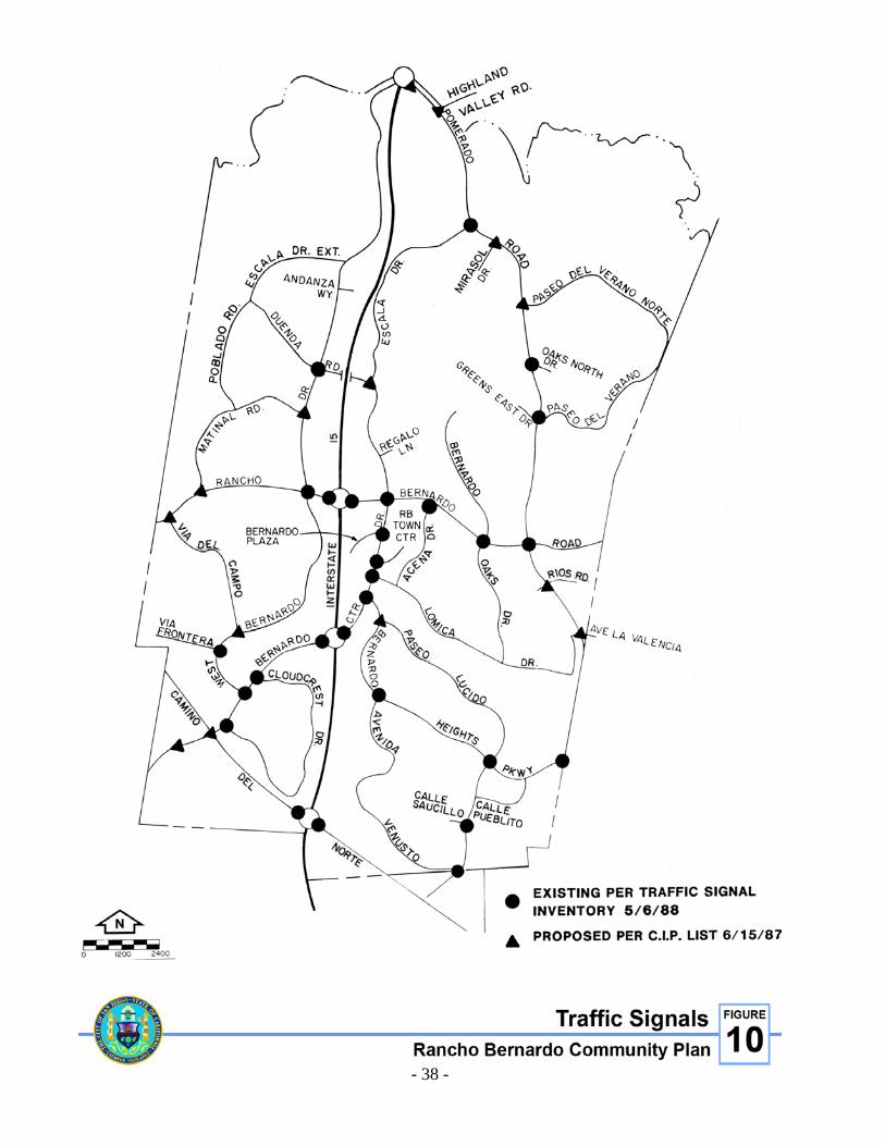
FIGURE 10. TRAFFIC SIGNALS

- 39 -
• Poblado Road: Complete improvements to two-lane collector from Matinal Road to northerly terminus at Carranza Drive. Construct as a two-lane collector from Carranza Drive to the future Duenda Road.
• Rancho Bernardo Road: Widen to a four-lane major street west of Matinal Road to the
westerly community boundary. • Via del Campo: Restripe to three-lane collector. • West Bernardo Drive: Restripe to four-lane major street between Rancho Bernardo Road
and Andanza Way. Street or intersection widenings should proceed only after traffic studies indicate a need for such improvements and should be constructed in such a manner as to minimize the loss of olive trees and on-street parking.
STUDIES AND GENERAL RECOMMENDATIONS • Interstate 15: Caltrans should study possible improvements to the interchange at I-15 and
Camino Del Norte. • Interstate 15: Caltrans should study the addition of a half-diamond interchange at Duenda
Road for entrance to I-15 in the northbound direction and exit from I-15 in the southbound direction.
• Interstate 15: Caltrans should study and program the improvements needed at the
I-15/Pomerado/ Highland Valley Road interchange. • Development in the Future Urbanizing Area (La Jolla Valley and 4-S Ranch) should be
carefully monitored in order to minimize its potential impacts on Rancho Bernardo Road and the need for a grade separated interchange at the Camino Del Norte/Bernardo Center Drive intersection.
• Caltrans should continue to monitor future growth within the I-15 corridor and provide
high occupancy vehicle (HOV) lanes on I-15 when they are appropriate for the Rancho Bernardo area.
• The City should continue to monitor the necessity for street widening at major
intersections for dual left-turn lanes, right-turn lanes and/or through lanes to provide and maintain an acceptable level of service. See the Functional Street System map for locations, Figure 7.
• Proposals for street widening at intersections and the Average Daily Trip count should be
reviewed periodically by the City and the Rancho Bernardo Planning Board to promote improvements in traffic circulation commensurate with development in the community and the adjoining areas.

- 40 -
FIGURE 11. BICYCLE AND EQUESTRIAN TRAILS

- 41 -
PUBLIC TRANSIT FACILITIES • Expansion of public transit service to the community should be encouraged. Frequent
express bus service on the I-15 corridor should be maintained.
The San Diego Association of Governments (SANDAG), the designated regional Planning agency for San Diego County, is engaged in the planning of a regional public transit system for the San Diego Region. SANDAG has adopted a Regional Transit Plan which includes a transit corridor along I-15 through the Ranch Bernardo community. The MTDB, however, will be refining and conducting additional studies related to the development of a fixed-rail system and expanded bus services. The fixed-rail system in conjunction with extended local and express bus service would eventually provide good public transit throughout the region.
• Consideration should be given to development of park-and-ride facilities within the
Rancho Bernardo community. This concept allows the commuter to drive, be driven, or ride a bicycle to a low-cost or no-cost suburban parking site and board an express transit vehicle to major urban activity centers. Park-and-ride facilities should be considered for sites shown in the MTDB’s Short Range Transit Plan. The Planning Department and the Rancho Bernardo Planning Board should work with MTDB on an ongoing basis to determine locations for park-and-ride facilities.
• The Metropolitan Transit Development Board and the CTS should continue to reexamine
and modify existing bus routes on an annual basis. The concern for energy conservation, higher fuel cost and clean air provide strong stimuli for more transit usage. The MTDB has responded to these needs by increasing bus service and realigning routes to serve more people at a greater level of efficiency.
TRAFFIC SIGNALS Traffic signals should be provided and installed as development progresses to ensure the highest degree of traffic safety and reasonable traffic flow. Currently, a total of 42 traffic signals have been identified as needed in Rancho Bernardo and 28 have been installed. Signal lights are financed by 1) developers through the subdivision process; 2) a traffic signal charge as a condition of a subsequent tentative map approval and; 3) the City Capital Improvements Program in the developed areas. The proposed and existing traffic signals are shown on Figure 10. All traffic signals in Rancho Bernardo should have bicycle-sensitive detectors installed so as to be able to detect bicyclists, especially in left-turn pockets. Consideration should be given to adding traffic signals along West Bernardo Drive at the entrance to the Casa de Las Campañas retirement facility and either Aquamiel Road or Escala Drive Extension when it is completed. Traffic Engineering requirements for installation must be met before traffic signals are installed at these or any other locations in the Rancho Bernardo area.

- 42 -
FIGURE 12. FACILITIES CLASSIFICATIONS

- 43 -
BIKEWAYS The increased usage of bicycles throughout San Diego County has created the demand for a coordinated bikeway system. This system will include bike lanes striped within the roadway and separate facilities constructed outside the roadway-bike paths. In response to this demand the City Council adopted a citywide bikeway system for inter-city travel on March 15, 1973. Local communities were requested to expand the system by developing local bikeway plans for their respective communities. On August 18, 1983, the Rancho Bernardo Community Planning Board in liaison with the City adopted a revised Bikeway Element for Rancho Bernardo. The bike plan discussed below and exhibited on Figure 11 is a revision to the 1983 plan. The Master Bikeway Plan for the City of San Diego is in the process of being revised. The revised Bikeway Plan proposes improved bikeways to business districts, improved bikeway signing and a combination of bike racks and lockers at major activity centers. The Rancho Bernardo bikeway system should be reviewed for conformance with the revised Master Bikeway Plan when adopted. BIKEWAY CLASSIFICATIONS Generally speaking, local bikeways refer to all facilities that explicitly provide bicycle travel and can range from fully separated facilities to a simple signed street. These bikeways can utilize existing streets that connect parks, open space and schools to the residential areas and to the citywide system. The City recognizes three categories of bikeways which are defined and applied to Rancho Bernardo as follows: 1. Class I Bike Path - A completely separated right-of-way designated for the exclusive use
of bicycles. There are no facilities of this type planned for Rancho Bernardo. 2. Class II Bike Lane - A restricted right-of-way designated for the exclusive or semi-
exclusive use of bicycles. Crossflows by motorists and pedestrians may be allowed. The following Class II bike lanes are proposed for Rancho Bernardo in the Master Bikeway Plan.
Pomerado Road: From the I-15 interchange south to the intersection with Pomerado Court, then from Rios Road south to the City limits. Bernardo Center Drive: Southwesterly from the intersection with Bernardo Heights Parkway, under I-15, to intersection with West Bernardo Drive and beyond (eventual link to Peñasquitos as shown on Figure 11). West Bernardo Drive: Entire length from I-15 interchange on the north to interchange with Bernardo Center Drive to the south. This will require interaction with the San Diego Police Department to permit parking adjacent to the Westwood Community Center on those occasions when special events suggest the advisability of maximizing parking availability.

- 44 -
Rancho Bernardo Road: Westerly from the eastern city limits to the intersection with Pomerado Road and westerly from Bernardo Center Drive to the western city limits. Bernardo Heights Parkway: Westerly from the intersection with Pomerado Road to the intersection with Bernardo Center Drive. Duenda Road: Westerly from Bernardo Center Drive to the intersection with West Bernardo Drive. Paseo Lucido: Northerly from the Rancho Bernardo community limits to the intersection with Bernardo Heights Parkway. Camino del Norte: Westerly from the southern Rancho Bernardo community limits to the western city limits. Interstate 15: Northerly from Pomerado Road beyond the northern city limits to Via Rancho Parkway in Escondido. Bicyclists are allowed to use the freeway shoulders to cross Lake Hodges because no parallel alternative route to I-15 exists. Interstate 15 is under Caltrans jurisdiction.
3. Class III Bike Route - A shared right-of-way designated as such by signs placed on
vertical posts or stenciled on the pavement. The following Class III bike lanes are proposed for Rancho Bernardo in the Master Bikeway Plan.
Lomica Drive: Westerly from Pomerado Road on Higa Place, south on Gabarda Road to the intersection with Lomica Drive, westerly on Lomica Drive to the intersection with Bernardo Center Drive. Avenida Venusto: From the intersection with Bernardo Heights Parkway southerly and easterly to the intersection with Paseo Lucido; north on Paseo Lucido to the intersection with Bernardo Heights Parkway. Via del Campo: Northerly from the intersection with West Bernardo Drive to the intersection with Rancho Bernardo Road. Matinal Road: Northerly from the intersection with Rancho Bernardo Road to the intersection with Poblado Road. Poblado Road: Westerly from West Bernardo Drive to eventual intersection with Duenda Road. Duenda Road: Westerly from West Bernardo Drive to the intersection with Poblado Road. Aguamiel Road: Northerly from the intersection with Duenda Road to the intersection with West Bernardo Drive. Paseo del Verano Norte: Easterly from the intersection with Pomerado Road to the intersection with Paseo Del Verano.

- 45 -
Paseo del Verano: Easterly from the intersection with Pomerado Road to the intersection with Paseo Del Verano Norte. Bernardo Center Drive: Northerly from the intersection with Bernardo Heights Parkway to the intersection with Duenda Road. Rancho Bernardo Road: Westerly from Pomerado Road to the intersection with Bernardo Center Drive. Greens East Road: Westerly from the intersection with Pomerado Road to its terminus at the Rancho Bernardo Inn. Escala Drive: Northerly from the intersection with Duenda Road to the intersection with Pomerado Road. Mirasol Drive: Southerly from Pomerado Road to its terminus at Sintonte Drive. Sintonte Drive: Southerly from Mirasol Drive to its terminus at the Rancho Bernardo Inn. Bernardo Oaks Drive: Northerly from Lomica Drive to its terminus at the Rancho Bernardo Inn. Pomerado Road: From the intersection with Pomerado Court south to the intersection with Rios Road.
PROPOSALS • The bikeway plan, as shown on the map and described in the foregoing section should be
developed. • Priority should be given to the completion of a Class II bike lane on Pomerado Road,
linking the Rancho Bernardo community with Escondido to the north and Poway to the south.
BICYCLE PARKING FACILITIES Bicycle Parking Facilities consist of bicycle racks and bicycle lockers. Bicycle racks should not require the use of chains or cables to secure them as chains and cables are easily cut by thieves using bolt cutters. It is recommended that bicyclists use U-shaped high security locks (e.g., Kryptonite, Citadel, Gorilla brands) to lock bicycles. Bicycle lockers should be provided for employees arriving by bicycle at major activity centers. A combination of bike racks and lockers should be provided at transit centers. Bicycle parking facilities should be identified by bicycle parking signs. Bicycle parking signs with directional arrows should be used to guide bicyclists to locations where bicycle parking facilities are provided, such as shopping centers, schools, golf courses, transit centers, park-and-ride lots and recreation centers.

- 46 -
EQUESTRIAN TRAILS The existing rural character of the Rancho Bernardo area lends itself to equestrian recreation. “A Plan for Equestrian Trails and Facilities,” adopted by the San Diego City Council in 1975, includes several trails in the Rancho Bernardo area, including the Los Peñasquitos Trail, the Lake Hodges Trail and the Black Mountain Trail. The Los Peñasquitos Trail connects the San Vicente and El Camino Real major trails. It is designed to serve the large horse population in Los Peñasquitos Canyon and Sorrento Valley and provide access to Torrey Pines State Park. The Lake Hodges Trail would be part of a regional trail extending from the county fairgrounds in Del Mar to the Pacific Crest Trail near Julian. The Black Mountain Trail would connect the Lake Hodges and Los Peñasquitos Trails by use of the Open Space System in the area. PROPOSALS • Implement the plan for Equestrian Trails and Facilities Report. The report proposes that
within Rancho Bernardo, the Black Mountain Trail should connect with the Los Peñasquitos Trail and the Lake Hodges Trail should be constructed.
• The trails should retain a natural appearance. Wherever feasible, the trails should be
located along open space corridors or along other public and semipublic corridors (e.g., gas and electric right-of-ways, aqueducts, etc.). This will also reduce the expense of acquiring rights-of-way.
• The City should cooperate with the county or other municipalities when the opportunity
arises to construct equestrian trails that cross jurisdictional boundaries. • Construction of equestrian trails should be a shared responsibility of the City, county and
developers of equestrian-oriented subdivisions.

- 47 -
COMMUNITY FACILITIES ELEMENT INTRODUCTION Community facilities and services include police, fire, post office, library, schools and public utilities. Parks, open space and transportation are also community facilities but are considered as separate elements of the Plan due to their magnitude. COMMUNITY FACILITIES OBJECTIVES • To provide a high level of community service using as a minimum the standards set forth
in the General Plan and to ensure that necessary facilities are conveniently located and readily accessible to citizens requiring services.
• To locate facilities in structures that enhance the character of the community and
recognize the human need and appreciation for aesthetics. COMMUNITY FACILITIES PROPOSALS • Police
At the present time, police protection is dispatched from a temporary substation located at 13396 Salmon River Road in the Rancho Peñasquitos community. This substation is approximately six miles from Rancho Bernardo. A permanent station at this location, containing approximately 16,500 square feet, is under construction and will accommodate up to 200 officers and staff. It will be ready for occupancy by March 1, 1989. This facility will provide service to Rancho Bernardo, San Pasqual Valley, Carmel Mountain Ranch, Sabre Springs, Rancho Peñasquitos, Scripps Ranch and Mira Mesa. It is anticipated that this facility will provide adequate space for police services through the year 2010. The police provide law enforcement services via one-officer patrol vehicles. A majority of the time, two vehicles are assigned to Rancho Bernardo with backup from the Rancho Peñasquitos Police Station. These patrol vehicles serve the community 24 hours a day. Because the police may be called first to an emergency scene, they are charged with many related responsibilities. They provide first aid, assist in evacuation, supervise and control traffic and provide security. The San Diego Police Department has determined from response time and calls for service that the level of service is adequate. However, future growth in the area will require the addition of more patrol beats to meet increased calls for service.
• Fire Protection
Rancho Bernardo is served by Engine Company 33 which is located at 16966 Bernardo Center Drive.
The maximum response time within the community is six minutes or less as required by the City Council.

- 48 -

- 49 -
Fire protection in this area is enhanced by an automatic aid agreement with the City of Poway Fire Department and the addition of Fire Station No. 42 in the Carmel Mountain Ranch Community. Fire Station No. 42 is located south of Rancho Bernardo and is projected to be operational by 1989. Future development west of Rancho Bernardo could impact the existing level of fire protection in the area. Additional stations may be required depending on the density and extent of the development. The paramedics stationed with Engine Company 33 share the responsibility of providing service for life-threatening emergencies along the I-15 corridor with the paramedics stationed at Fire Station No. 38 in the Mira Mesa community.
The Institutional Overlay Zone should be applied to Engine Company No. 33.
• Postal Service
Public postal delivery service to the Rancho Bernardo community is provided through a post office substation located on Bernardo Center Drive in the commercial area. In addition, a limited-service station is located in the Rancho Bernardo Pharmacy on Rancho Bernardo Road. With the projected increase in population, additional limited-service stations should be encouraged. The Institutional Overlay Zone should be applied to the post office site.
• Library
The Rancho Bernardo Library is located at 16840 Bernardo Center Drive at the intersection with Bernardo Plaza Court. The 8,000-square-foot library was opened in 1977 and serves the existing population of Rancho Bernardo plus the neighboring communities of Poway and Rancho Peñasquitos. The Master Plan for the San Diego Public Library states that each branch should provide .33 square feet of library space per capita. By these standards the branch library is too small for the present (1988) community population of 33,250. With the current overcrowded conditions of the library and the predicted growth in population to 41,200 at buildout, library service should be reviewed and plans implemented for expansion of library facilities. Expansion of this facility could occur at the present location or at another site in the community. According to San Diego Public Library Master Plan standards, a minimum 15,000-square-foot library is needed. Financing for the expanded facility may be provided by special assessment district, private grant or other local financing sources. Community participation in any future decisions concerning expansion or relocation of library facilities should be encouraged. The Institutional Overlay Zone should be applied to the Rancho Bernardo Branch Library. Implementation of the overlay zone should not occur until a site for the library is approved by the City.

- 50 -
• Schools
The Rancho Bernardo community is served by the Poway Unified School District which encompasses a substantial area within the City of San Diego as well as the City of Poway. Currently, elementary students living in the western portion of the community attend the Westwood Elementary School located westerly of West Bernardo Drive on Matinal Road. Elementary students living in the eastern portion of the community and middle and high school students living in Rancho Bernardo attend schools located easterly and southerly of the community. These schools include Painted Rock and Chaparral Elementary, Meadowbrook and Black Mountain Middle Schools and Poway and Mt. Carmel High Schools. The Community Plan allocates 96 acres for schools within Rancho Bernardo. In 1988, Westwood Elementary School, located on a 12-acre site, was the only school in operation. The other three school sites include a 12-acre elementary school site in High Country West, a 72-acre site in Bernardo Heights for a middle school and a high school. The Poway Unified School District has an additional ten acres in the adjoining Carmel Mountain Ranch community for the intermediate and high school sites. The Poway Unified School District is in the process of reviewing the two remaining elementary school sites in the Rancho Bernardo area and is compiling a long-range master plan for the school district. This information will be used to make final adjustments in the number and location of elementary school sites in the Rancho Bernardo community. The proposed number and locations of school facilities are based upon standards of the General Plan. Determination of the timing of development of schools requires analysis by the Poway Unified School District. This analysis should make use of the most recent available data concerning community growth and student generation rates. To accommodate elementary, middle school and high school students, the Poway Unified School District has approved the development of the Turtleback Elementary School in the High Country West area, and Bernardo Heights Middle School and Rancho Bernardo High School in the Bernardo Heights area of Rancho Bernardo. These schools are scheduled to open in the 1989/90 and 1990/91 school year. The elementary school is located in the southwestern portion of the community, west of I-15. The high school and middle school are located in the southeastern corner of the community and east of the I-15 freeway. All sites are well located to serve future population growth, with the middle school and high school located to serve growth south of the Rancho Bernardo area as well as the Rancho Bernardo community. The Institutional Overlay Zone should be applied to all public school sites in Rancho Bernardo.

- 51 -
• School Sites
Any public school site in Rancho Bernardo, not needed for a school, should be considered first for a community park or recreation facility. School sites should be considered for residential housing only if the City determines, after a public hearing, that a particular site is not currently needed and will not, in the foreseeable future, be needed for public use. Any residential use of a school property should be further conditioned upon a determination that adequate public facilities exist to serve the additional units proposed and that there would be no significant traffic impacts from the proposed development. A PRD permit should be obtained for any residential development proposed on a site currently designated for school use. Any use other than a school will require an amendment to the Plan.
• Institutional Sites
Seven sites consisting of 39 acres are designated for institutional use in this Plan. Four of these sites are occupied by religious facilities and another religious facility is planned for a fifth site. The sixth site remains vacant. It is anticipated that religious facilities will continue to occupy these sites in the future. The existing recreation facilities offer meeting rooms, day care programs and educational programs for various age groups. A 305-bed, skilled nursing facility is located near the intersection of Bernardo Center Drive and Camino del Norte. The 6.7-acre site was developed under a conditional use permit and has a residential emphasis that lends a scale, identity and sense of recognition to nursing home life. The residential style de-emphasizes the impersonal nature of the nursing home lifestyle.
• Utilities
An extensive system of utilities has been developed in Rancho Bernardo. The Wastewater Reclamation Facility located within the community was closed when the Water Quality Control Board determined that the facility and the method of disposal were not suitable for the region. Therefore, the City of San Diego negotiated an agreement in 1972 to have Rancho Bernardo sewage processed at Escondido’s Hale Avenue Treatment Plant. Some areas in the southern portion of the community have their sewage treated at the City of San Diego facility at Point Loma. Water is provided to the community through a water main originating at the Miramar Filtration Plant and from several reservoirs established in the Plan area. The provision of water to the Rancho Bernardo community is of vital concern, as it is to all communities in southern California. The availability of water to Rancho Bernardo is expected to be provided for the full development of the community, assuming massive water use industries do not locate in the industrial area. Major gas and electric facilities serve the area. San Diego Gas & Electric Company (SDG&E) operates and maintains an electric substation located adjacent to the west boundary of the plan on the south side of Rancho Bernardo Road. An overhead 69 KV

- 52 -
transmission line extends north two miles from the electric substation. Also, the area is traversed by a 16-inch H.P. gas transmission line. San Diego Gas & Electric holds right-of-way easements for these transmission facilities. Recreation or other suitable uses that do not interfere with the purposes of the easements are encouraged. Electric distribution serving residential, commercial and industrial customers is underground. This policy should be continued for future development of the community as further extensions of these systems are required.
• Flood Control
No significant flood potential is evident in Rancho Bernardo. The northwestern and southern drainage areas should be served by courses and channels within open space areas and minor drainage structures. Other development areas will only be affected by local drainage which can be accommodated by minor facilities. Where open space areas are used for drainage, the drainage channel and/or flow area should be maintained free of obstructions which would restrict the design flow of these channels.
• Solid Waste Management
The existing (1988) residential population of 33,250 generates approximately 9,700 tons of refuse per year. This amount of refuse requires 20 one-man refuse crews and two two-man crews, collecting one day per week. The increase in population will increase the amount of residential refuse generated annually to approximately 14,300 tons. Using current productivity figures, approximately six one-man collection crews/vehicles, collecting five days a week, will be required to service Rancho Bernardo. In addition to the City-operated residential refuse collection, private refuse firms provide collection services for the industrial and commercial firms in Rancho Bernardo. The nearest disposal site is approximately 20 miles away, which is beyond the “break-even” point for transfer station operations. Because of the projected increase in growth and consequent increase in the amount of refuse to be handled, consideration should be given to resolving the issue of utilizing transfer facilities. Determination as to need, desirability and compatibility will be the subject of further studies.

- 53 -
OPEN SPACE, PARKS AND RECREATION ELEMENT INTRODUCTION The Rancho Bernardo community identifies strongly with its natural and topographic environment. It is adjacent to the San Pasqual Valley and Lake Hodges on the north and is surrounded on the east, south and west by hills, ridges and canyons which successfully buffer the community from neighboring urban developments. The community has thus far successfully taken advantage of the area’s many assets through imaginative development concepts. Ridges, slopes and canyon lands provide many opportunities to relate development to the environment and to develop natural and manicured open space systems that link activity centers and create an atmosphere of serenity and quality to the community. OPEN SPACE, PARK AND RECREATION OBJECTIVES The Plan proposes that about 1,543 acres be reserved for open space, park and recreational uses. The objectives of this Plan are:
• To provide for the preservation of natural open space areas throughout the community. • To provide park and recreation facilities that meet the needs of all age groups and interests
in the Rancho Bernardo community and meet or exceed citywide standards. • To promote the use of school recreation facilities for public use when they are not being
used for school purposes. • To establish an open space system that provides linkage between various elements of the
community. Such linkages should facilitate pedestrian, bicycle and golf cart movement between recreational facilities, commercial centers, neighborhoods, schools and parks.
• To support the creation of a regional park in the Lake Hodges area. OPEN SPACE, PARK AND RECREATIONAL PROPOSALS • Open Space System
Approximately 508 acres are designated for open space. This open space system includes the undeveloped slopes, canyon bottoms and natural drainage areas within the community. Prominent examples are the slopes of Battle Mountain and the Montelena area in the northeastern portion of the community, the hills and canyons of the Westwood Valley area to the northwest and the hills, slopes and riparian areas in the Camino Bernardo portion to the southwest. In addition, large open space areas in the Bernardo Heights and High Country West areas in the southern portion of the community have been established through open space easements and are owned and maintained by private homeowner associations. All such natural and landscaped areas in the Rancho Bernardo community should remain as open space.

- 54 -
FIGURE 14. OPEN SPACE, PARK AND RECREATION PROPOSALS

- 55 -
An additional 369 acres of open space, excluding the 35-acre community park, are located south of Lake Hodges in the northwest corner of the community and consist of City-owned lands. These lands are temporarily designated for open space. The City should retain ownership of this area until its relationship to San Pasqual Valley, the proposed San Dieguito Regional Park and the future use of Lake Hodges is determined. Appropriate zoning, dedication to the City, open space easements and assessment districts should be investigated for their use in assuring open space within the Rancho Bernardo community. Segments of the open space system should be developed with pedestrian and bicycle paths and riding trails to provide links between neighborhoods and community facilities. Open space areas, parks and recreational facilities should interrelate and supplement one another. There are many opportunities available for selective development of passive recreational uses such as benches and picnic facilities in these areas. Precise delineation of the open space areas (both natural and developed) should be defined in the design stages of preliminary development plans. The future preservation of such spaces can be ensured by the establishment of open space easements with the underlying ownership being held in common by adjoining property owners or given to the City. Maintenance and enhancement of these areas could be accomplished through resident associations or park districts. In any case, an ongoing maintenance program should be established for all open space areas with responsibilities clearly defined and agreed to. The City owns over 400 acres of land in the area bordered by Lake Hodges on the north and I-15 on the east. Most of this area is expected to remain in its natural state. A Plan for Equestrian Trails and Facilities (1975), developed by the City of San Diego, identifies a number of recreational uses in this area. They include an equestrian center, campgrounds and hiking trails. The development of activity areas shall preserve, to the extent possible, the area's natural state and should also be consistent with a comprehensive plan for Lake Hodges as part of the San Dieguito Regional Park planning effort. Development of these facilities should occur in such a manner as to protect the natural and topographic character, environmental resources and aesthetic qualities of the area. Development should conform with the intent of the Hillside Review (HR) and Resource Protection Overlay Zones (RPOZ) to encourage sensitive forms of development which complement the natural and visual character of the area. The San Dieguito River Regional Plan was adopted by the San Diego City Council in 1984. The San Dieguito River Regional Plan encompasses the 40-mile river basin that extends from the Sutherland Reservoir northeast of Ramona to the beach at the City of Del Mar. The general aim of the plan is to preserve the San Dieguito River Basin’s recreation and open space potential. The plan recommends coordination of goals and policies of all jurisdictions that have an interest in the future of the San Dieguito River Basin. The 404 acres of City-owned land south of Lake Hodges in the Rancho Bernardo community is included in Subarea III of the San Dieguito River Regional Plan.

- 56 -
Recommendations of the San Dieguito River Regional Plan for City-owned property include the following:
• Provide pedestrian access from adjacent residential areas to the recreational areas.
• Prepare a study of the potential for establishing an archaeological interpretive site near Rancho Bernardo Park.
• Preserve oak and riparian woodlands to the maximum extent feasible.
The Plan also supports the City's A Plan for Equestrian Trails and Facilities and further recommends the interconnection of pedestrian and equestrian trails with adjacent communities. All proposed developments under the San Dieguito River Regional Plan for the Lake Hodges area in the Rancho Bernardo community should be considered in terms of planning maximum recreational and cultural facilities, preservation of open space and compatibility with the Rancho Bernardo Community Plan. If hiking, bicycle and equestrian trails are to be developed in the open space areas, they should be carefully designed to act as linkages between the various community activity centers, and, where possible, should connect with public parks in adjoining communities. Where appropriate, trailheads should be improved with a shaded rest area including benches and picnic tables. A map and directions regarding the trail system should be displayed at these trail heads.
• Park and Recreational Facilities
Rancho Bernardo is unique in that the primary developer (AVCO), in accordance with City Council Policy regarding parks within this community, accepted full responsibility for the provision of community recreational facilities (Neighborhood Parks) in accordance with the standards of the General Plan. To date, these facilities include an extensive inventory which exceeds what is normally provided in standard neighborhood parks. According to existing City Council Policy, the developer has not been required to provide standard Neighborhood Parks so long as all the facilities required are provided in some of the private recreational areas. This policy has permitted flexible development of facilities and activity centers in keeping with the needs and interests of various groups in different geographic areas of Rancho Bernardo. This concept should apply to all developers within the Rancho Bernardo community and should assure that each resident of Rancho Bernardo has adequate privately provided park and recreation facilities.
Private Recreation Facilities
Privately developed recreation centers have been established on approximately 54 acres throughout the community and are owned and maintained by the homeowners associations. The major community centers include the Westwood Club (12.8 acres), Seven Oaks (4.7 acres), Oaks North (6.5 acres), Rancho Bernardo Swim and Tennis (10.3 acres), High Country West (6.3 acres), Bernardo Heights Recreation Center (7.2 acres) and Camino Bernardo Recreation Center (1.5 acres).

- 57 -
The Eastview Club (2.7 acres) and the Las Brisas Bernardo Club (1.7 acres) provide special recreation centers restricted to local residents.
Although not shown on the Parks and Recreation map, other private recreational facilities including swimming pools, tennis courts and play areas, have been planned or developed in multifamily residential projects throughout the community. Privately developed recreational facilities include Lucido Park, a 4.8-acre semi-developed park and a 5.7-acre recreational site in Bernardo Heights. Four golf courses containing about 523 acres have been developed within the community. Two 18-ho1e courses are privately owned and maintained for the exclusive use of members. In addition, an 18-hole golf course and a 27-hole executive golf course have been developed and are open for public use. Commercial recreational uses and meeting areas are encouraged to locate in private facilities such as the Rancho Bernardo Inn.
Public Community Park
In the northwest quadrant of Rancho Bernardo, the City of San Diego has developed a 35-acre community park utilizing park fees from the entire community. This park is partially developed with eight ball fields, parking facilities, restrooms and landscaping. Additional site development, including tennis courts, lawn bowling greens, lighting and other park amenities, is scheduled for construction in 1988. Construction of a community building and swimming pool are scheduled in the six-year Capital Improvements Program. Provision should be allowed for expansion of the Rancho Bernardo Community Park, regardless of what other uses are made of the Lake Hodges area, to handle increased parking and other public recreational uses. All developed private recreation centers and facilities, golf courses and equestrian recreation areas, as well as partially developed private and public parks, should be retained. Furthermore, the proposed private recreational facilities in the developed and undeveloped residential areas should be developed to ensure that all residents have privately-provided park and recreational facilities. As membership in private clubs reaches capacity, developers of new areas of residential development should be required to provide on-site recreational facilities.

THIS PAGE INTENTIONALLY LEFT BLANK.


- 61 -
IMPLEMENTATION ELEMENT INTRODUCTION The Plan sets forth guidelines for the development of the community. The Plan, however, is only a first step in the process of achieving the most desirable living environment possible for the area. The success rate of implementing the goals and proposals stated within the Plan will determine whether or not Rancho Bernardo becomes the type of community its residents desire. The implementation of these proposals requires a high degree of coordination between community residents, development interests and various levels of government. The following section of the Plan contains generalized implementation process recommendations which attempt to clarify the citizen’s role in assuring the fulfillment of the community goals set forth in this Plan. GENERALIZED IMPLEMENTATION PROCESS RECOMMENDATIONS • Community Planning Board
The Community Planning Board should be involved and active in the implementation of the Plan. Its work should include initiating action based upon Plan proposals, monitoring development activity in Rancho Bernardo and periodically conducting general meetings within the community so as to raise the consciousness of the people relative to planning and implementation efforts. It should also function to obtain public opinion, to act as liaison between the residents, developer and City government, and to maintain the Plan on a contemporary basis by periodic review and updating. Conversely, all governmental agencies should solicit Planning Board and community input before making decisions that affect the Plan.
• Monitoring of Development Activity
The Community Planning Board should review public facility improvements, tentative maps, rezonings, subdivisions, hillside review permits, conditional use permits, Plan amendments, planned residential and commercial developments and other proposed developments affecting the community, and make recommendations to the appropriate governmental agency regarding the individual project’s conformance to the goals and objectives of the Plan. Of specific concern is the implementation of the residential and commercial objectives of the Plan. Although these types of objectives can be achieved through good design and concern on the part of the developers, it is highly recommended that residential and commercial development utilize the planned residential development and planned commercial development procedures. Such procedures will help to retain the high standard of development found in the community and will ensure that development is sensitive to existing topography and surrounding land uses. To further ensure compliance with the Plan, the Planning Board may utilize the standard City processes identified in the Tools of Compliance and Implementation Section of this element. Through these processes it is hoped that the objectives of the Plan can be realized.

- 62 -
• Capital Improvements Review
Each year, the City prepares a Capital Improvements Program which lists projects that are proposed to be financed within the next six-year period. The first year of this program is formally adopted by the City Council. The Capital Improvements Program should be used to implement the goals, objectives and proposals of the Plan. The Planning Board, through its Chairman and committees, should review the Capital Improvements Program on an annual basis to guarantee maximum community input regarding the funding and timely completion of the Program’s projects. The written recommendation and findings of the Board should be provided to the City.
• Plan Review and Update Procedures
This Plan should not be considered as a static document. It is the intent of the Plan to provide guidance for orderly growth and to respond to changing environmental, social and economic conditions. In order to accomplish these aims the Plan must be continually monitored and amended by the Community Planning Board and the Planning Department so that it remains relevant to community and City needs. Of particular importance is the maintenance of adequate public facilities and services such as library, police and fire protection, sewage and roads. A general review of the Plan will be a joint task between the Planning Board and City staff and will involve major update and Plan revisions on an as needed basis.
• Tools of Compliance and Implementation
The following methods and procedures are identified as controls and input opportunities regarding development proposals. The Planning Board should view these processes as opportunities and tools to ensure compliance with the Plan.
a. Subdivision Map Act and Local Subdivision Ordinance. These laws, as enforced by
City staff, Planning Commission and City Council, are intended to ensure provision of on-site improvements, enforcement of matters dealing with public health, safety and welfare, and provision of those off-site public facilities directly related to the needs of the subdivision. The subdivision process can also be used to create open space areas, varied setbacks and public park dedications.
4. Open Space Maintenance District. Open Space Maintenance Districts can be created
(subject to City Council approval) to maintain additions to the open space system. The subdivision process will ensure the improvement and dedication of such open space. Districts should be established as needed to cover new development areas subject to review by the Rancho Bernardo Community Planning Board and approval by the City Council.
5. Park Service District. The population-based park service districts established by the
City permit collection of fees during the development process which can be used for the acquisition and improvement of neighborhood and community park facilities.

- 63 -
6. Hillside Review Permits. This process provides citizens with an opportunity to review and comment on development proposals for areas with slopes exceeding 25 percent which meet the criteria of the Hillside Review Overlay Zone.
7. Planned Commercial, Industrial and Residential Developments. The Planned
Commercial Development (PCD), Planned Industrial Development (PID) and Planned Residential Development (PRD) Ordinances permit flexible approaches to achieve the design goals of this Plan. These processes involve a public hearing, at which public comment and participation are sought regarding the proposed project.
8. Rezoning Procedures. Because the City Council must approve a rezoning for most of
the additional development in Rancho Bernardo, a full public hearing through the Council is required.
9. Environmental Review. Under the terms of the California Environmental Quality Act
(CEQA) and the City Code, all rezonings, subdivisions, use permits, hillside permits and other discretionary acts required for implementation of this Plan are subject to environmental review. This review includes City staff analysis of the proposed projects and their impacts, as well as a public review period. It also considers alternatives to the proposed projects.
10. Subdivision Law. This state law, which must be differentiated from the Map Act, is
administered by the Commission of Real Estate. Its basic purpose is to eliminate fraud by assuring that all required or promised facilities, both public and private, will be provided. This must be determined prior to public announcement of the sale or rental of property.
11. City Council Policy 600-10. Because of limits inherent in the Subdivision Map Act,
the City Council has adopted and continues to endorse this policy. Before an applicant is granted approval for a tentative map, use permit or rezoning, he must show that all necessary public facilities will be furnished at the time of need. Proof of such provision may take the form of letters from other public agencies, such as Poway Unified School District, or written offers by the applicant which are then incorporated in the approvals as voluntary but absolute requirements of development.
12. Appeal. When the Planning Board takes a position contrary to that of the Planning
Director, Planning Department or the Subdivision Review Board and any other decision-making body, the Planning Board may appeal the decision to the Planning Commission and City Council.
• Conformance to State, Federal and Local Planning Legislation
In recent years, a new understanding of planning principles has developed throughout the nation which not only recognizes the importance of land use relationships, but stresses the preservation of the community’s environment. Fostered by the problems associated with uncontrolled urbanization, this new attitude has come about because of peoples’ concern over the threatened loss of the intrinsic values they are increasingly unwilling to forfeit.

- 64 -
These national concerns have been reflected at the federal legislative level with the formation in 1970 of the Environmental Protection Agency (EPA) and the creation of the Clean Air Act of 1970. The EPA has been delegated the task of reducing air pollution under this Act. Some of the initial recommendations considered for San Diego were mass transit priority, parking surcharge and management, as well as limitations on gasoline. The move to decrease dependence on the automobile is balanced by the increased importance of public transportation and the bicycle as an alternate means of transportation. Several important environmental laws have been passed in California. The California Environmental Quality Act of 1970 is aimed at determining the extent of environmental damage, if any, created by the completion of proposed projects which require Environmental Impact Reports. Also, State Assembly Bill 1301 (Section 65860 of the Government Code) was passed in 1971 and amended in 1972; and is intended to create consistency between land use proposals, zoning regulations and long-range plans. According to A.B. 1301, the zoning ordinance must be consistent with the General Plan. There are also several City Council Policies that apply citywide and hence, are of significance in Rancho Bernardo. Policy 600-6 (1967) states that zoning should be used to implement proposals in adopted community plans. This policy is an indication of the City’s intent to follow through on its proposed plans and is also supportive of A.B. 1301. Policy 600-19 (1972) calls for the fostering of balanced community development through the provision of adequate housing for all segments of the population. As provided for in Section 91.01, paragraph two, of the Uniform Building Code; if a determination is made at a public hearing that issuance of a building permit or permits would detrimentally affect the public health, safety or general welfare of the citizens of the City of San Diego, an ordinance may be adopted by the City Council limiting or preventing the issuance of any type, number or geographical distribution of permits for construction of any facility for which a permit is required. Any such ordinance imposing a limitation shall specify: the type of construction, the geographic area, the period the limitation shall be imposed and the facts which require the adoption of such an ordinance. Council Policy 600-10 (1971) seeks to avoid utilization of Section 91.01 by stating development can proceed only if adequate public facilities are assured. As such, Council Policy 600-10 serves as a regulator of growth. Coupled with this policy is the closely related issue of school availability. Council Policy 600-22 (1977 revised) states that the availability of schools shall be considered as an important factor in determining the effect on the public health, safety and general welfare when deciding rezoning or the approval of developments which will generate more school-age children. California Government Code Section 53080, Chapter 888, effective January 1, 1987, authorizes school districts to levy a fee, charge, dedication, or other form of requirement, upon development projects for the construction or reconstruction of school facilities.

- 65 -
In order to effectively monitor the adequacy and availability of public facilities, a current tabulation of building permit applications will be made available to the Planning Board and appropriate governmental agencies so that they will be able to quickly report to the City Council any circumstances which would warrant prompt City Council action. The existence of these federal, state and City measures is certain to have substantial effects on Rancho Bernardo for years to come. These measures will not be replaced by the Plan. Rather, they are supplemented by the criteria within the Plan itself to best achieve the implementation of the Plan’s proposals.

THIS PAGE INTENTIONALLY LEFT BLANK.

- 67 -
SUMMARY OF PLAN PROPOSALS The recommendations of the Plan are summarized in the tables included in this section of the Plan. An effort has been made to assign priorities to all proposals in terms of their overall importance relative to community need.
HOUSING AND RESIDENTIAL ELEMENT Proposal Priority Action Responsibility Maintain a range of residential densities as shown on the Plan Map. Minor variations are expected to occur based upon more precise studies. However, the wide density average should remain consistent with the Plan.
Continuing Initiate rezonings to conform to the Plan.
Developer Planning Commision City Council
Use PRD permits whenever possible. Develop design criteria for use as guidelines in processing PRD permits. Design and construction of residential units should blend with existing housing patterns.
Immediate Work with property owners, realtors and developers.
Planning Board Planning Department Owner/Developer
Relate dwelling units to topography.
Immediate Work with property owners, realtors and developers to strongly encourage the use of PRD concepts.
Planning Board Planning Department Developer
Vary housing types and densities to create interest and provide a mix of economic and social characteristics.
Immediate Work with property owners, realtors and developers to encourage a balanced community concept.
Planning Board Planning Department Owner/Developer

- 68 -
COMMERCIAL ELEMENT Proposal Priority Action Responsibility Continue development of Town Center and specialized commercial areas. Encourage a mix of commercial and cultural uses in the Town Center to provide a truly versatile and active focus to the community.
According to need
a. Work with owners, realtors and developers.
b. Maintain existing
zoning.
Planning Board Developer
Promote design of structures, lighting and displays in keeping with desired quality environment.
Immediate Continuing
a. Monitor compliance. b. Work with realtors,
owners.
Community action
Use PCD permits for development or redevelopment projects whenever possible.
Immediate Continuing
Work with owners, realtors and developers.
Planning Board Planning Department Owner/Developer
Apply the Community Plan Implementation Overlay Zone (CPIOZ) to the “Webb Park” site and to the area designated for commercial office use.
Immediate Continuing
a. Monitor compliance. b. Work with owner,
developer to achieve.
Planning Board Planning Department Owner/Developer
Apply the CA-RR zone to the Town Center and the specialized commercial areas east of I-15.
Immediate Initiate rezoning. Planning Department Planning Commission City Council
INDUSTRIAL ELEMENT Proposal Priority Action Responsibility Industrial rezonings should be restricted to the M-1B and M-1P zones.
Continuing Future rezonings in accordance with Plan proposals.
Planning Commission City Council
Day care centers and recreation facilities should be incorporated into the industrial area.
Continuing Work with owners, developers and realtors.
Private
Extensive landscaping should be utilized in all development that has frontage on West Bernardo Drive and Bernardo Center Drive.
Continuing Work with owners and developers.
Planning Commission
Monitor development proposals not regulated by the M-1P zone. Recommend they develop under a Planned Industrial Development (PID) permit.
Continuing Work with owners, developers and realtors.
Planning Board Planning Department Owner/Developer

- 69 -
COMMUNITY FACILITIES ELEMENT Proposal Priority Action Responsibility
Police: Monitor adequacy of service provided by the northern substation in Rancho Peñasquitos.
Continuing Notify appropriate City representative of service needs and follow up as needed.
Community action Planning Board City Manager
Fire: Monitor adequacy of service provided by station located in community. Apply the Institutional Overlay Zone.
Continuing Immediate
Notify appropriate City representative of service needs and follow up as needed with staff and/or Council.
Community action Planning Board City Manager Planning Department
Schools: Locate and construct school facilities.
As needed Citizens committee and developer advise and work with Poway Unified School District.
Poway Unified School District Planning Board
Apply the Institutional Overlay Zone to public schools.
Immediate Citizens committee and City Planning work with Poway Unified School District.
Planning Board Planning Department
Library: Apply the Institutional Overlay Zone.
Immediate Follow through for implementation.
Planning Board Planning Department
Water: Monitor adequacy of service. Continuing Notify appropriate City staff of service needs and follow up as needed with staff and/or Council.
Planning Board City Manager Community action Citizens committee
Sewer: Monitor adequacy of service. Continuing Notify appropriate City staff of service needs and follow up as needed with staff and/or Council.
Citizens committee Community action Planning Board City Manager
Public Transportation: Continue bus service from Rancho Bernardo to downtown San Diego.
Continuing express
Monitor and determine ongoing.
Transit Corporation needs
Bikeways and Equestrian Trails: Develop community bikeway and equestrian trails system coordinated with regional system.
Immediate Follow through for implementation of approved plans.
Planning Board City Manager
Open Space: establish and maintain open space system throughout the community.
Continuing Monitor development plan proposals for preservation of natural amenities. Initiate action to ensure perpetuity and maintenance of open space areas.
Developer Planning Board Planning Department Planning Commission City Council Citizens committee
Park and Recreation Facilities: Provide recreational facilities in developing neighborhoods as identified on the Plan Map.
Contingent upon future
Construct improvements and ensure maintenance and operation.
Developer
Provide and maintain recreational facilities at the community park.
As soon as possible
Complete construction of recreation facilities.
Rancho Bernardo Recreation Council Park and Rec. Dept. City Council
Cable TV: Improve service. Continuing Monitor existing service and determine ongoing service to provide acceptable service level.
Citizens committee City Manager

THIS PAGE INTENTIONALLY LEFT BLANK.


- 72 -
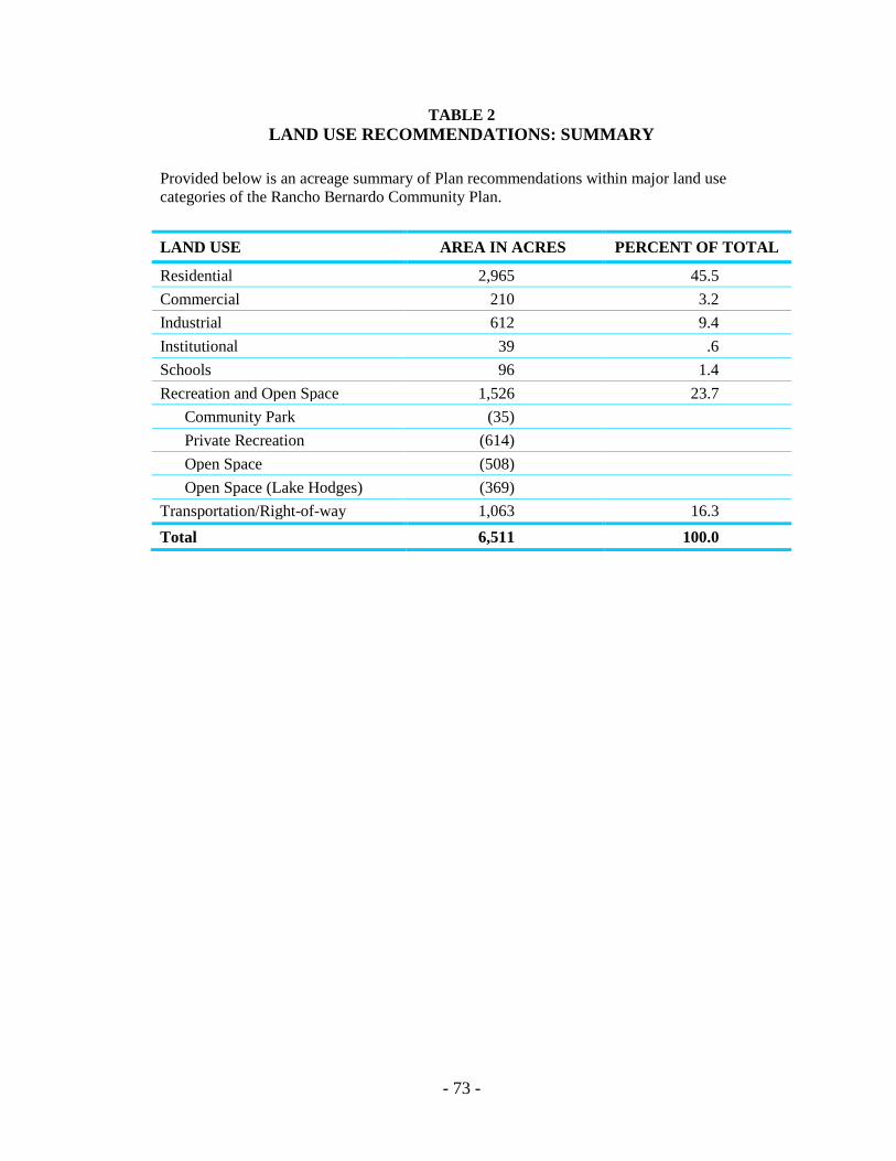
- 73 -
TABLE 2 LAND USE RECOMMENDATIONS: SUMMARY
Provided below is an acreage summary of Plan recommendations within major land use categories of the Rancho Bernardo Community Plan.
LAND USE AREA IN ACRES PERCENT OF TOTAL
Residential 2,965 45.5 Commercial 210 3.2 Industrial 612 9.4 Institutional 39 .6 Schools 96 1.4 Recreation and Open Space 1,526 23.7
Community Park (35) Private Recreation (614) Open Space (508) Open Space (Lake Hodges) (369)
Transportation/Right-of-way 1,063 16.3 Total 6,511 100.0