QUIRINO, NEGRI, SESANA 2010, The GIS Project for the Temple of Millions of Years of Amenhotep II:...
15
MEMNONIA C AHIER SU p PLÉMENTA I R E N° 2 LES TEMPLES DE MILLIONS D'ANNÉES ET LE POUVOIR ROYAL À THÈBES AU NOUVEL EMPIRE SCIENCES ET NOUVELLES TECHNOLOGIES APPLlQUÉES À L'ARCHÉOLOGIE THE TEMPLES OF MILLIONS OF YEARS AND THE ROYAL POWER AT THEBES IN NEW KINGDOM SCIENCE ANO NEW TECHNOLOGIES APPLlEO TO ARCHAEOLOGY
-
Upload
beniculturali -
Category
Documents
-
view
5 -
download
0
Transcript of QUIRINO, NEGRI, SESANA 2010, The GIS Project for the Temple of Millions of Years of Amenhotep II:...
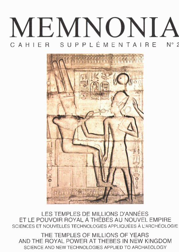
MEMNONIAC A H I E R S U p P L É M E N T A I R E N° 2
LES TEMPLES DE MILLIONS D'ANNÉESET LE POUVOIR ROYAL À THÈBES AU NOUVEL EMPIRE
SCIENCES ET NOUVELLES TECHNOLOGIES APPLlQUÉES À L'ARCHÉOLOGIE
THE TEMPLES OF MILLIONS OF YEARSAND THE ROYAL POWER AT THEBES IN NEW KINGDOM
SCIENCE ANO NEW TECHNOLOGIES APPLlEO TO ARCHAEOLOGY
COLLOQUE INTERNATIONAL - INTERNATIONAL COLLOQUIUMSCA - CNRS - MAEE - LUXOR GOVERNORATE
LES TEMPLES DE MILLIONS D'ANNÉESET LE POUVOIR ROYAL À THÈBES AU NOUVEL EMPIRE
SCIENCES ET NOUVELLES TECHNOLOGIES APPLlQUÉES À L'ARCHÉOLOGIE
THE TEMPLES OF MILLIONS OF YEARSAND TUE ROYAL POWER AT THEBES IN THE NEW KINGDOM
SCIENCE AND NEW TECHNOLOGIES APPLIED 'l'O ARCHAEOLOGY
~I~;}....o~w~..u..1AlJ..ùl>ui~I ~_,.wl J)u~\ J-s- ~ J ~..lJ-\ 4. _,.J ~\) ~p\
BIBLlOTHÈQUE PUBLIQUE MOUBARAK / MUBARAK PUBLIC LlBRARYLOUQSOR - 3-5 JANVIER 2010
LES ORGANISATEURS DU COLLOQUE INTERNATIONAL
LES TEMPLES DE MILLIONS D'ANNÉESET LE POUVOIR ROYAL À THÈBES AU NOUVEL EMPIRESCIENCES ET NOUVELLES TECHNOLOGIES APPLlQUÉESÀ L'ARCHÉOLOGIE
tiennent à remercier pour leur appréciable soutien
LE CONSEIL SUPREME DES ANTIQUITÉS DE L'ÉGYPTE (SCA)LE CNRS - INSTITUT DES SCIENCES DE L'HOMME ET DE LA SOCIÉTÉ (INSHS)LE MJNISTÈRE FRANCAIS DES AFFAIRES ÉTRANGÈRES ET EUROPÉENNES(MAEE)LE GOUVERNORAT DE LOUQSORLA BIBLlOTHÈQUE PUBLlQUE MOUBARAKLE CENTRE FRANçAIS DE CULTURE ET DE COOPÉRATIONDE L'AMBASSADE DE FRANCE AU CAIRE (CFCC)LA NATIONAL SOCIÉTÉ GÉNÉRALE BANK - LE CAIRE (NSGB)L'ASSOCIATION POUR LA SAUVEGARDE DU RAMESSEUM (ASR).
Les auteurs sont responsables des opinions qu'ils expriment dans ce volume au travers deleurs écrits. lIs sont en outre responsables des conclusions qu'ils émettent et de l'exactitudede toutes leurs références.
Editeurs du volume: Christian LEBLANC, Gihane ZAKI.Maquette et coordination : Isabelle SIMOES-HALFLANTS, Ossa ma KHAIRY.Impression : PRINTOGRAPH - Ossama KHAIRY.LE CAIRE / RÉPUBLIQUE ARABE D'ÉGYPTE.ISBN: 1110-4910 - DAR EL-KUTUB - DÉPOT LÉGAL N° : 24968/20 IO

THE GIS PROJECT FOR THE TEMPLE OFMILLIONS OFYEARSOF AMENHOTEP II : DATA COLLECTION, ANALYSIS AND 3DRECONSTRUCTION HYPOTHESIS [PI. LXI-LXV]
Tommaso QUIRINO *, Elio NEGRI ** and Angelo SESANA ***
During the l l" CEFB field seasons - and the parallel studies of thefinds - at Amenhotep Il's Tempie of Millions of Years we have also spenttime researching the best methods to collect and manage the excavation data.At the moment the documentation of the excavation has been undertakenentirely using electronic means. This choice was imposed both by the need tokeep up with the most recent methodological developments and by the needto manage a mass of heterogeneous data coming frorn a site of about Il,000square metres.
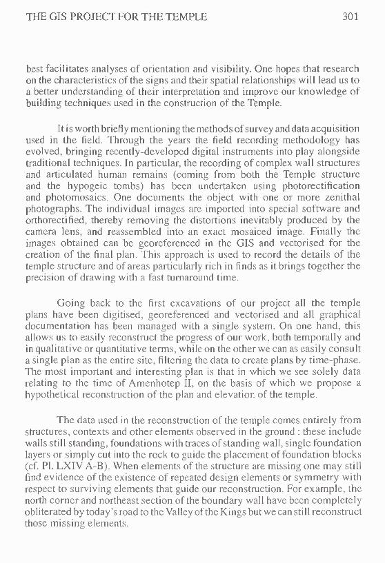
Since thc beginning of the excavations in 1997 the entire findscatalogue has been maintained in digitai form, even if with relatively simpletools, and the plans of the Tempie have been created with cornputer-aideddrawing packages. However, since 2005, ali graphical and alphanumeric dataha ve been cntcrcd into a purpose-built IT system, cornprising a relationaldatabase (cf. PI. LXI) and a linked GIS (Geographic Information System),together with a multimedia database containing hundreds of images indexedby keyword.
During the construction of the IT system particular attention was paidto the design of the Microsoft Access™ relational database for managing theexcavation data. The alphanumeric database is a necessary foundation forthe construction of a fully functional GIS (I). Well-organised and structured
* Dr. Tommaso QUIRINO is archcologist and lnforrnatics Support Director ltalian ArchaeologicalMission Tempie of Amcnhotep II. [Centro di Eginologia Francesco Ballerini / CEFB. Como] :fmgian i (algmai 1.(.:0111
** Dr. Elio NEGRI is architcct. in Field Director. CEFB - Italian Archaeological Mission Tempieor Arncnhoicp II. COJllO. Italy .. [Centro di Egittologia Francesco Ballerini / CEFB, Como] :archCwnegriel io. 191.il
*** Dr. Angelo SESANA is an Egypotologisi, Director or the Italian Archaeological Mission Tempieor Amcnhotcp II. CEFB. Como. Italy. [Centro di Egittologia Francesco Ballerini / CEFB, Corno] :giuseppesesana Caltiseali. il
(I) We would like to thank Craig Alexander Ior thc English translation or this text. G. Mantegari, T.Quirino, "Frorn a relational database to an intcgratcd systcrn : a Milan University project", in Beyondthe Artifact, Proceedings 0/2004 CAA (Computer Application iII Archaeology) Congress, Prato /3-/7Apri! 2004, in presso
298 MEMNONIA - CAHIER SUPPLÉMENTAIRE 2
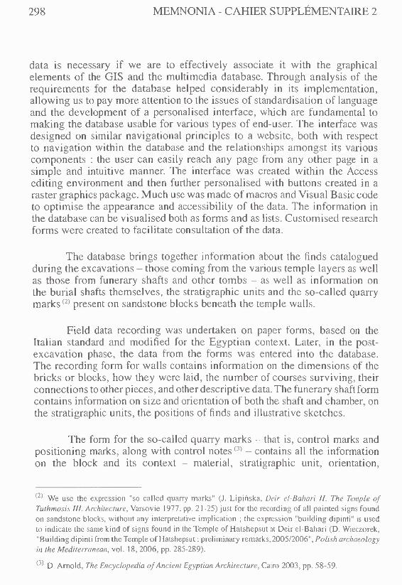
data is necessary if we are to effectively associate it with the graphicalelements of the GIS and the multimedia database. Through analysis of therequirements for the database helped considerably in its implementation,allowing us to pay more attention to the issues of standardisation of languageand the development of a personalised interface, which are fundamental tomaking the database usable for various types of end-user, The interface wasdesigned on similar navigational principles to a website, both with respectto navigation within the database and the relationships amongst its variouscomponents : the user can easily reach any page from any other page in asimple and intuiti ve manner. The interface was created within the Accessediting environment and then further personalised with buttons created in araster graphics package. Much use was made of macros and Visual Basic codeto opti mise the appearance and accessibility of the data. The information inthe database can be visualised both as forms and as lists. Customised researchforms were created to facilitate consultation of the data.
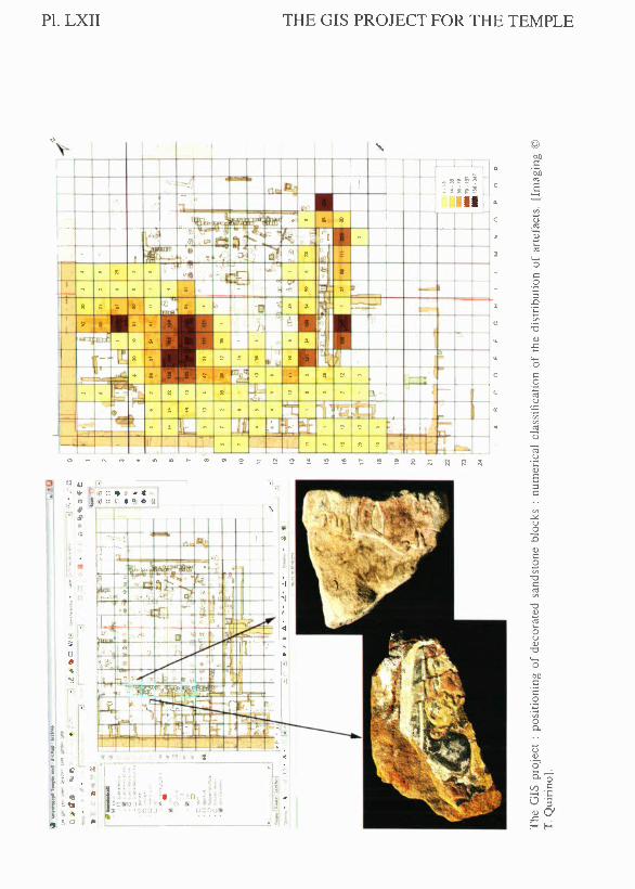
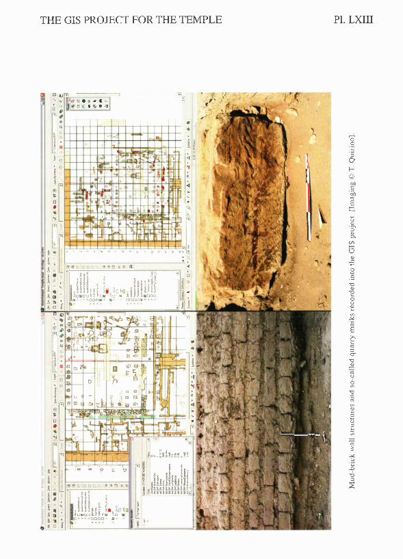
The database brings together information about the finds cataloguedduring the excavations - those coming from the various tempie layers as wellas those from funerary shafts and other tombs - as well as information onthe burial shafts themselves, the stratigraphic units and the so-called quarrymarks (2) present on sandstone blocks beneath the temple walls.
Field data recording was undertaken on paper forms, based on theItalian standard and modified for the Egyptian context. Later, in the post-excavation phase, the data from the forms was entered into the database.The recording form for walls contains information on the dimensions of thebricks or blocks, how they were laid, the number of courses surviving, theirconnections to other pieces, and other descriptive data. The funerary shaft formcontains information on size and orientation of both the shaft and chamber, onthe stratigraphic units, the positions of finds and illustrative sketches.
The form for the so-cali ed quarry marks - that is, control marks andpositioning marks, along with control notes (3) - contains all the informationon the block and its context - material, stratigraphic unit, orientation,
(2) We use the expression "so called quarry marks" (J. Lipinska, Deir el-Bahari Il. The Tempie ofTuthmosis III. Archuecture, Yarsovie 1977, pp. 21-25) just for thc recording of ali painted signs foundon sandstone blocks, without any intcrprctative implication ; the expression "building dipinti" is usedto indicate the same kind of signs found in the TempIe of Hatshepsut at Deir el-Bahari (D. Wieczorek,"Building dipinti from thc TempIe of Hatshepsut : preliminary rernarks, 2005/2006", Polish archaeologyin the Mediterranean, voI. 18,2006, pp. 285-289).
(3) D. Arnold, The Encyclopedia oJ Ancient Egyptian Architecture, Cairo 2003, pp. 58-59.
TRE GIS PROJECT FOR TRE TEMPLE 299
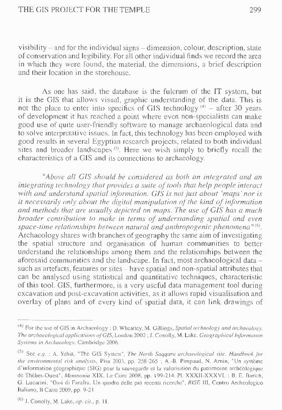
visibility - and for the individuai signs - dimension, colour, description, stateof conservation and legibility. For ali other individuai finds we record the areain which they were found, the material, the dimensions, a brief descriptionand their location in the storehouse.
As one has said, the database is the fulcrum of the IT system, butit is the GIS that allows visual, graphic understanding of the data. This isnot the piace to enter into specifics of GIS technology (4) - after 30 yearsof development it has reached a point where even non-specialists can makegood use of quite user-friendly software to manage archaeological data andto solve interpretative issues. in fact, this technology has been employed withgood results in several Egyptian research projects, related to both individuaisites and broader landscapes (5). Here we wish simply to briefly recall thecharacteristics of a CIS and its connections to archaeology.
"Above 011CIS should he considered as both an integrated and anintegrating technology that provides a suite of tools that help people interactwitn and understand spatial information. CIS is notjust about 'maps' nor isit necessarily only about the digitai manipulation of the kind of informationand methods that are usually depicted on maps. The use of CIS has a muchbroader contribution lo make in terms of understanding spatial and evenspace-time relationships between natural and anthropogenic phenomena" (6).
Archaeology shares with branches of geography the sa me aim of investigatingthe spatial structurc and organisation of human communities to betterunderstand the relationships among them and the relationships between theaforesaid communities and the landscape. In fact, most archaeological data-such as artefacts, features or sites - have spatial and non-spatial attributes thatcan be analysed using statistical and quantitative techniques, characteristicof this tool. GIS, furthermore, is a very useful data management tool duringexcavation and post-excavation activities, as it allows rapid visualisation andoverlay of plans and of every kind of spatial data, it can link drawings of
(4) For the use or GIS in Archacology : D. Whcatlcy, M. Gillings, Spatial technology and archoeology.The archaeological applications o/CIS. London 2002 ; J. Conolly, M. Lakc, Geographical InformanonSystems in Archaeology, Cambridge 2006.
(5) See e.g. : A. Ychia, "Thc GIS Systcm", The North Saqqara archaeological sile. Handbook [orthe environrnental risk analysis, Pisa 2003, pp. 258-265 ; A.-B. Pirnpaud, N. Arnin, "Un systèmcd'jnforrnation géographiquc (SIG) pour la sauvcgarde cl la valorisation du patrimoine archéologiquede Thèbes-Ouest", Memnonia XIX. Le Caire 200R, pp. 199-214. PI. XXXII-XXXVI. ; B. E. Barich,G. Lucarini, "Oasi di Farafru. Un quadro delle più recenti ricerche", RISE III, Centro ArcheologicoItaliano, Il Cairo 2009, pp. 9-21.
(6) J. Conolly, M. Lake, op. cit., p. Il.

300 MEMNONIA - CAHIER SUPPLÉMENTAIRE 2
features and artefacts - appropriately georeferenced - directly to databaserecords and it enables the visualisation of data patterns at or soon after theircollection (7).
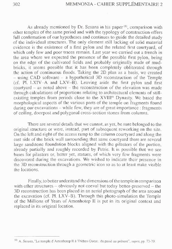
The GIS Project for the TempIe of Millions of Years of Amenhotep IIhas two spatial scales : the macro scale includes the entire structure of theTempIe and its topographic location and relationships with other monumentson the west bank at Thebes ; the micro scale allows one to drill down to singlewall units with details of how the bricks were laid and also within tombs to thelevel of individuaI skeletal remains. The GlS collects the spatial informationrelating to each entity in the relational database and contains links back tothose entities (cf. PI. LXll-LXIH).
The GIS can be used for various ends : the simple archiving andorganisation of data, creation of information and assessment of hypothesesabout the data and analytic and decision support in planning furtherarchaeological work. The specific analytical functionality of the GIS isexploited in various research areas: from the study of finds to the study ofwallstructures, from the study of human remains to the study of technical aspectsrelating to the so-cali ed quarry marks. Finds are conveniently linked in thedatabase to the area in which they were found : for these catalogued items onecan look up ali the characteristics recorded on the relevant form, whereas foreverything else one can access only quantitative data. Once excavation hasbeen completed it will be possible, through the ITsystem, to create distributionmaps for each c1ass of material : for example, particular concentrations offragments of sandstone rather than of granite could suggest the presencewithin the tempIe of statues or other architectonic elements. Visualising theposition and distribution 01' single blocks or fragments of decorated sandstoneone could attempt to reconstruct what scenes might have decorated the wallsof the column courtyard or the inner part of the tempIe. The mud-brick wallstructures are recorded in the GIS as polygons, to make them and their positionmore easily visible, to avoid errors of digitisation and to permit analysis oftheir topological characteristics. Filtering the information according to thecharacteristics of the bricks, the presence of cartouches or other informationrelating to chronology, allows the construction of thematic maps and plans ofsuccessive phases of occupation. The so-cali ed quarry marks are recorded intwo distinct layers : as polygons - emphasising the block on which they arefound - and as lines - recording the surface on which the sign is found. This
(7) J. Conolly, M. Lake, op. cit., pp. 12,37.
THE GIS PROJECT FOR THE TEMPLE 301
best facilitates analyses of orientation and visibiIity. One hopes that researchon the characteristics ofthe signs and their spatial relationships willIead us toa better understanding of their interpretation and improve our knowIedge ofbuiIding techniques used in the construction of the TempIe.
It is worth briefly mentioning the methods of survey and data acquisitionused in the fieId. Through the years the fieId recording methodology hasevolved, bringing recently-developed digitaI instruments into pIay alongsidetraditional techniques. In particuIar, the recording of complex waIl structuresand articulated human remains (coming from both the TempIe structureand the hypogeic tombs) has been undertaken using photorectificationand photomosaics. One documents the object with one or more zenithalphotographs. The individuai images are imported into special software andorthorectified, thereby removing the distortions inevitably produced by thecamera lens, and reassembled into an exact mosaiced image. Finally theimages obtained can be georeferenced in the GIS and vectorised for thecreation of the final pian. This approach is used to record the details of thetempie structure and of areas particularly rich in finds as it brings together theprecision of drawing with a fast turnaround ti me.
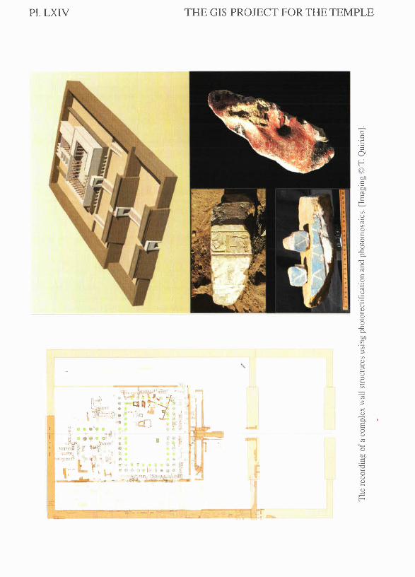
Going back to the first excavations of our project ali the tempieplans have been digitised, georeferenced and vectorised and all graphicaldocumentation has been managed with a single system. On one hand, thisallows us to easily reconstruct the progress of our work, both temporally andin qualitative or quantitative terms, while on the other we can as easily consulta single pian as the entire site, filtering the data to create plans by tirne-phase.The most important and interesting pian is that in which we see solely datarelating to the time of Amenhotep II, on the basis of which we propose ahypothetical reconstruction of the pian and elevation of the tempie.
The data used in the reconstruction of the tempie comes entirely fromstructures, contexts and other elements observed in the ground : these includewalls stili standing, foundations with traces of standing wall, single foundationIayers or simply cut into the rock to guide the placement of foundation blocks(cf. PI. LXIV A-B). When elements of the structure are missing one may stilifind evidence of the existence of repeated design elements or symmetry withrespect to surviving elements that guide our reconstruction. For exampIe, thenorth corner and northeast section ofthe boundary wall have been completelyobliterated by today's road to the Valley ofthe Kings but we can stili reconstructthose missing elements.
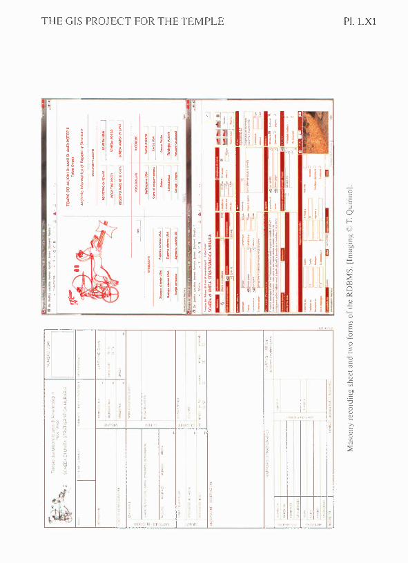
302 MEMNONIA - CAHIER SUPPLÉMENTAlRE 2
As already mentioned by Dr. Sesana in his paper!", comparison withother temples of the sarne peri od and with the typology of construction offersfull confirmation of our hypotheses and continues to guide the detailed studyof the individuaI structures. The only element stilI lacking of solid materialevidence is the existence of a first pylon and the related first courtyard, ofwhich only few and poor traces remain. Last year we carried out a trench inthe area where we expected the presence of the possible first pylon, beingon the edge of the cultivated fields and probably originally made of mud-bricks, it seems possible that it has been completely obliterated throughthe action of continuous floods. Taking the 20 pIan as a basis, we created- using CAD software - a hypothetical 3D reconstruction of the TempIe(cf. PI. LXIV-A and LXV-B). Leaving aside the first pylon and firstcourtyard - as noted above - the reconstruction of the elevation was madethrough calculations of proportions relating to architectural elements of still-existing temples from periods dose to the XVII!''' Dynasty. We based thernorphological aspects of the various parts of the tempIe on fragments foundduring our excavations - while few, they are of great importance : fragmentsof ceiling, doorpost and polygonal cross-section stones from colurnns.
There are several details that we cannot, as yet, be sure belonged to theoriginaI structure or were, instead, part of subsequent reworking on the site.On the left and right of the access ramp to the column courtyard and along theeast side of the brick wall surrounding that same courtyard there are severallarge sandstone foundation blocks aligned with the pilasters of the portico,already partially and roughly recorded by Petrie. It is possible that we seebases for pilasters or, better yet, statues, of which very few fragments werediscovered during the excavations. We wished to indicate their presence inthe 3D reconstruction through a geometrie icon so as to at least make visiblethe locations.
Finally, to better understand the dimensions of the tempIe in comparisonwith other structures - obviously not coeval but today better-preserved - the3D reconstruction has been placed in an aeri al photograph of the area aroundthe excavation (cf. PI. LXV-B). Through this photo-simulation the TempIeof the Millions of Years of Amenhotep II is put in its originaI context andreplaced in its originaI location.
(8) A. Sesana, "Le tempIe d' Amenhotcp Il à Thèbes-Ouest : du passé au présent", SI/pro, pp. 73-79.
THE GIS PROJECT FOR THE TEMPLE 303
RÉSUMÉ
La documentation complète de la fouille conduite sur le tempie de millionsd 'années d' Amenhotep ll estenregistrée avec des outi Is informatiques, indispensablespour mieux gérer une quantité de données de plus en plus nombreuses et hétérogènes.Depuis le début des fouilles, en 1997, les relevés topographiques et tout le cataloguedes objets ont été confiés à des outils numériques ; cependant, à partir de 2005, toutesles données alphanumériques et graphiques ont été introduites dans un systèmeunique d'information, spécialement mis en piace, qui se compose d'une base dedonnées relationnelle et d'un SIG (Système d'lnformation Géographique). Dans labase de données convergent les informations sur les objets catalogués au cours desmissions, provenant soit des niveaux archéologiques pertinents du tempie, soit despuits funéraires ou d'autres sépultures, les données sur les unités stratigraphiquesdes murs et celles liées aux prétendues marques de carrière, trouvées sur les blocsen grès dans les fondations des murs du tempie. Dans le SrG sont plutòt recueilliesles inforrnations spatiales de ces mérnes entités, dOment liées aux donnéesalphanumériques présentes dans les archives.
Au fil des années la méthodologie des relevés sur le terrain a aussi évolué,joignant de nouveaux instrurnents numériques, com me la photomosalque, auxtechniques traditionnelles.
THE GIS PROJECT FOR THE TEMPLE
"-c~ '"!~ 7t. ~c ~
.% ''I.
'M '11 :~f~) ~2 J ~,~. ::~ :;~ ~~ ~
,,> </"
..~,
:,- ~
" ~
",)olI II'Iv' J :
.-
iI ~
li!I;,
, ,
"
'1_' Xt. 1,1,1'11,':,';
Pl. LXI
Qc.::
b')C
bI)
'"E
bI)C
Pl. LXII THE GIS PROJECT FOR THE TEMPLE
"
'.
~l;D
"..'"-r-
l\~lS li IQ >f If " J ,
i ~•r~'~~)~, o IO
i •."i·!
_ . ..:..!-.
@
~'00
~vi
c U~l)
;::
'"'-ot:.g::l.o
'Cc ~
"OQ)
-5'-o
c t:.2~o
<):;'<ii
V>co"O(iio'CQ)
E::lc:
V>..:.:ooz<l.)c:o;;,
"Ot:coV>
"O<l.)
<ii•...o(.)Q)
"O
"-ooDc:c:.g
. <iiOQ.
UQ)
O'5. 'iv: c'-< :~O :lQ) os: ~:-
THE GIS PROJECT FOR THE TEMPLE Pl. LXIII
ti(1)
.~
c,C/l
G(1)
.;:o.5
Pl. LXIV THE GIS PROJECT FOR THE TEMPLE
Qc0;::::0:;
CI~©bI)C
° bI)
'"~v5u
° Cii
'"OEO(5
..c:O-
"O
'"'"o~
""U<.C
U~O(5.s:O-bI)
'"0;n::>'"(1)•..::>U::>t;ca:::><(1)
'Ci.- EOu
l '"4-<Ob~C
F :o•..Ou(1)•..(1)
..c:E--<~-

THE GIS PROJECT FOR THE TEMPLE Pl. LXV
(Lt~f: -j- tE ii-;'_1 J t 1}- J, )--LI
A.- 2D pian of the Tempie anel hypothetieal 3D reconstruction : the morphologieal aspecrs of thevarious parts of the tempie are bascd on architectural elements found during excavations. [Imaging ©E. Negri].
B.- Photo-sirnulation of the position of Arnenhotep II's Tempie of Millions of Years. [Imaging ©E. Negri].