Quaternary deformations along the ‘Engadine–Gruf tectonic system’, Swiss–Italian Alps
13
Quaternary deformations along the ‘Engadine–Gruf tectonic system’, Swiss–Italian Alps ALESSANDRO TIBALDI 1,2 * and FEDERICO A. PASQUARE ` 3 1 Dipartimento di Scienze Geologiche e Geotecnologie, Universita ` degli Studi di Milano Bicocca, Milan, Italy 2 Centro Universitario di Datazioni di Milano Bicocca, CUDaM, Milan, Italy 3 Dipartimento di Scienze Chimiche e Ambientali, Universita ` degli Studi dell’Insubria, Como, Italy Tibaldi, A. and Pasquare `, F. A. 2007. Quaternary deformations along the ‘Engadine–Gruf tectonic system’, Swiss–Italian Alps. J. Quaternary Sci., Vol. 23 pp. 475–487. ISSN 0267-8179. Received 8 December 2006; Revised 12 July 2007; Accepted 17 July 2007 ABSTRACT: The Engadine Line (EL) is a seismically active fault in southeastern Switzerland. In the field we studied its western segment, presently not affected by seismicity but characterised by features suggesting neotectonic motions, and the coterminous Gruf Line. Uphill- and downhill-facing scarps, offset rivers, non-equilibrium hydrological conditions and aligned deep-seated gravitational slope deformations are dominant in the western sector of the EL in the Inn Valley. Landform offsets and the most recent fault striations point to oblique left-lateral strike-slip. Close to the EL, at the Maloja Pass, a huge collapse beheaded the Inn Valley. Trench excavation with palaeoseismic analysis, stratigraphic correlations of Quaternary deposits and optically stimulated luminescence dating indicate that the collapse and faulting mostly occurred in the Late Pleistocene. In the Bregaglia Valley, the Gruf Line stretches along the southwestern extension of the EL. Six deep-seated gravitational slope deformations developed along the Gruf Line and were dated to pre- and post-Last Glacial Maximum times. We suggest that the western sector of the EL moved also in a Pleistocene time interval during which tectonic forces in the area were probably larger than at present, favouring local uplift, widespread gravity deformation, and retrogressive slope failure at the Inn Valley head. Copyright # 2007 John Wiley & Sons, Ltd. KEYWORDS: Engadine Line; Gruf Line; Quaternary faults; LGM; OSL. Introduction The NE-striking Engadine Line, located in southern Switzerland (Fig. 1), is considered to be a seismogenetic structure, although with low magnitude historical events (Albini et al., 1988; ISMES, 1994). Westwards, in the Inn Valley, the fault trace is known but seismicity disappears. Further westwards another main fault, known as the Gruf Line (Berger et al., 1996), is located on the hypothetical extension of the Engadine Line. The Gruf Line runs from ENE to E–W along the southern slope of the Bregaglia Valley, in Swiss and Italian territories. The ‘Engadine– Gruf tectonic system’, a definition that is hereby proposed only for possible Quaternary deformations, shows a complex architecture, influenced by several deformation phases that affected the area in pre-Alpine and Alpine times (Merle and Guillier, 1989; Steck and Hunziker, 1994; Maxelon and Mancktelow, 2005). The southern flank of the Bregaglia Valley is characterized by numerous uphill- and downhill-facing scarps, tilted ancient topographic surfaces, aligned landslides, double crests and trenches. The valley is a hydrogeologic- hazard prone area, as dramatically testified to by catastrophic events that resulted in casualties and huge economic losses. In the past, little or no attention has been devoted by the scientific community to the above-mentioned features in the Bregaglia Valley. The area of connection between the Engadine and Gruf Lines (Maloja Pass) also displays a peculiar morphology, i.e. the presence of obsequent rivers, a sudden 400 m high scarp separating the Bregaglia and the Inn valley floors, and the absence of the glacier cirque from which the glacial tongue of the Inn Valley was generated. Serious problems exist in recognizing potential seismoge- netic faults in the Alps, mainly due to: (1) the rapid succession of glacial and water run-off events that affected the mountain belt during Quaternary times, whose action hindered the preservation of field evidence, (2) the widespread occurrence of landslides and deep-seated gravity slope deformations (DGSD) that also contribute to masking recent tectonic faulting processes, (3) the paucity/lack of precise historical documents reporting pre-instrumental earthquakes, due to the sparse JOURNAL OF QUATERNARY SCIENCE (2008) 23(5) 475–487 Copyright ß 2007 John Wiley & Sons, Ltd. Published online 11 October 2007 in Wiley InterScience (www.interscience.wiley.com) DOI: 10.1002/jqs.1150 * Correspondence to: A. Tibaldi, University of Milan-Bicocca, Department of Geological Science and Geotechnologies, Piazza della Scienza 4, Milan, Italy. E-mail: [email protected]
Transcript of Quaternary deformations along the ‘Engadine–Gruf tectonic system’, Swiss–Italian Alps

Quaternary deformations along the‘Engadine–Gruf tectonic system’,Swiss–Italian AlpsALESSANDRO TIBALDI1,2* and FEDERICO A. PASQUARE31 Dipartimento di Scienze Geologiche e Geotecnologie, Universita degli Studi di Milano Bicocca, Milan, Italy2 Centro Universitario di Datazioni di Milano Bicocca, CUDaM, Milan, Italy3 Dipartimento di Scienze Chimiche e Ambientali, Universita degli Studi dell’Insubria, Como, Italy
Tibaldi, A. and Pasquare, F. A. 2007. Quaternary deformations along the ‘Engadine–Gruf tectonic system’, Swiss–Italian Alps. J. Quaternary Sci., Vol. 23 pp. 475–487.ISSN 0267-8179.
Received 8 December 2006; Revised 12 July 2007; Accepted 17 July 2007
ABSTRACT: The Engadine Line (EL) is a seismically active fault in southeastern Switzerland. In thefield we studied its western segment, presently not affected by seismicity but characterised by featuressuggesting neotectonic motions, and the coterminous Gruf Line. Uphill- and downhill-facing scarps,offset rivers, non-equilibrium hydrological conditions and aligned deep-seated gravitational slopedeformations are dominant in the western sector of the EL in the Inn Valley. Landform offsets and themost recent fault striations point to oblique left-lateral strike-slip. Close to the EL, at the Maloja Pass, ahuge collapse beheaded the Inn Valley. Trench excavation with palaeoseismic analysis, stratigraphiccorrelations of Quaternary deposits and optically stimulated luminescence dating indicate that thecollapse and faulting mostly occurred in the Late Pleistocene. In the Bregaglia Valley, the Gruf Linestretches along the southwestern extension of the EL. Six deep-seated gravitational slope deformationsdeveloped along the Gruf Line and were dated to pre- and post-Last Glacial Maximum times. Wesuggest that the western sector of the EL moved also in a Pleistocene time interval during whichtectonic forces in the area were probably larger than at present, favouring local uplift, widespreadgravity deformation, and retrogressive slope failure at the Inn Valley head. Copyright # 2007 JohnWiley & Sons, Ltd.
KEYWORDS: Engadine Line; Gruf Line; Quaternary faults; LGM; OSL.
Introduction
The NE-striking Engadine Line, located in southern Switzerland(Fig. 1), is considered to be a seismogenetic structure, althoughwith low magnitude historical events (Albini et al., 1988;ISMES, 1994). Westwards, in the Inn Valley, the fault trace isknown but seismicity disappears. Further westwards anothermain fault, known as the Gruf Line (Berger et al., 1996), islocated on the hypothetical extension of the Engadine Line. TheGruf Line runs from ENE to E–W along the southern slope of theBregaglia Valley, in Swiss and Italian territories. The ‘Engadine–Gruf tectonic system’, a definition that is hereby proposed onlyfor possible Quaternary deformations, shows a complexarchitecture, influenced by several deformation phases thataffected the area in pre-Alpine and Alpine times (Merle andGuillier, 1989; Steck and Hunziker, 1994; Maxelon andMancktelow, 2005). The southern flank of the Bregaglia Valley
is characterized by numerous uphill- and downhill-facingscarps, tilted ancient topographic surfaces, aligned landslides,double crests and trenches. The valley is a hydrogeologic-hazard prone area, as dramatically testified to by catastrophicevents that resulted in casualties and huge economic losses. Inthe past, little or no attention has been devoted by the scientificcommunity to the above-mentioned features in the BregagliaValley. The area of connection between the Engadine and GrufLines (Maloja Pass) also displays a peculiar morphology, i.e. thepresence of obsequent rivers, a sudden 400m high scarpseparating the Bregaglia and the Inn valley floors, and theabsence of the glacier cirque from which the glacial tongue ofthe Inn Valley was generated.Serious problems exist in recognizing potential seismoge-
netic faults in the Alps, mainly due to: (1) the rapid successionof glacial and water run-off events that affected the mountainbelt during Quaternary times, whose action hindered thepreservation of field evidence, (2) thewidespread occurrence oflandslides and deep-seated gravity slope deformations (DGSD)that also contribute to masking recent tectonic faultingprocesses, (3) the paucity/lack of precise historical documentsreporting pre-instrumental earthquakes, due to the sparse
JOURNAL OF QUATERNARY SCIENCE (2008) 23(5) 475–487Copyright � 2007 John Wiley & Sons, Ltd.Published online 11 October 2007 in Wiley InterScience(www.interscience.wiley.com) DOI: 10.1002/jqs.1150
*Correspondence to: A. Tibaldi, University of Milan-Bicocca, Department ofGeological Science and Geotechnologies, Piazza della Scienza 4, Milan, Italy.E-mail: [email protected]

human settlement of the Alps in ancient times, and (4) thegenerally low seismic magnitude in wide sectors of the Alps.However, seismic events of significant magnitude do take placein the central Alps too, such as the 1295 earthquake at Chur-walden, Grisons, located about 35 km from the Engadine Line,for which an epicentral intensity (EMS-98) of VIII has beenrecently assessed (Schwarz-Zanetti et al., 2004). More recently,a M 5.0 earthquake followed by several aftershocks occurredon 20 November 1991 near Vaz, just 7 km south of Chur-walden; its source was most likely located at a depth of 6–7 km(Marone, 1999). The Mw¼ 4.9 Bormio event of December1999, whose epicentre was located 33 km from the studiedarea, reached themaximum intensities of IV–V in Swiss territory(Fah et al., 2003). All these and several minor events could notbe attributed to any specific fault.Our case study demonstrates that the scenario of recent
deformations can be better understood through a holistic app-roach based on the collection and analysis of multidisciplinarydata. In the present paper we provide the first study of theQuaternary deformations in the Bregaglia–Inn Valleys (Italyand Switzerland). First we describe the general features of thearea; then we illustrate in detail some key areas located alongthe Gruf Line and the western sector of the Engadine Line,where we collected field structural data, stratigraphic data onglacial and fluvial deposits, palaeoseismic data (obtained in
artificial trenches excavated across key structures), geomor-phological data on the main glacial modelling phases and dataon seismicity. Furthermore, we performed optically stimulatedluminescence (OSL), 14C and dendrochronological dating oflandforms and recent deposits, which allowed us to constrainthe age of deformations that affected them. The work wasmainly carried out by means of field surveys integrated withinterpretation of large-scale (1:10 000 scale) stereoscopic aerialphotos. Tectonic structures have been distinguished fromgravity-induced features based on their orientation, kinematicsand geomorphological characteristics (for detailed explanationon the methodology see Forcella and Tibaldi, 1998).
This work enabled us to reconstruct the geometry, kinema-tics and age of the most recent tectonic and gravity-drivenstructures. Our successful dating of gravitational structures alsoshows that the application of palaeoseismic techniques(normally applied to the study of earthquake-induced defor-mations) to the DGSD is feasible and promising (McCalpin andIrvine, 1995; Tibaldi et al., 1998, 1999).
This work highlights that the amount of anomalousmorphostructures and evidence of recent deformations alignedalong the Engadine–Gruf tectonic system is too significant torepresent just a coincidence. Also, due to the seismic activity ofthe coterminous segments of the Engadine Line, the hypothesisthat the structure moved in a time interval of the Pleistocene
Figure 1 Geological framework of the study area. The main nappe units are represented, as well as the major tectonic lineaments in the Central Alps.Modified from Trumpy and Trommsdorff (1980)
Copyright � 2007 John Wiley & Sons, Ltd. J. Quaternary Sci., Vol. 23(5) 475–487 (2008)DOI: 10.1002/jqs
476 JOURNAL OF QUATERNARY SCIENCE

when tectonic forces were possibly larger than at present in thispart of the Alps cannot be ruled out. If this hypothesis is correct,prehistoric earthquakes might have contributed to trigger thedevelopment of these DGSD.
Geological framework
The study area, stretching from the Upper Engadine to theBregaglia Valley, partly in Swiss and partly in Italian territory, isdominated by the presence of spectacular recumbent folds, ornappes, that represent typical features of the Alpine belt. TheBregaglia Valley and the Upper Engadine were carved mostlyinto the Penninic and Austroalpine nappe units (Fig. 1). ThePenninic units, composed of crystalline basement plus meta-morphosed Mesozoic carbonate and ophiolite cover, are hererepresented (from SW to the NE, from the deeper one to theshallower one) by the Adula nappe (Lower Penninic), and bythe Tambo and the Suretta nappes (Middle Penninic) in theBregaglia area. The Margna unit, belonging to the Austroalpinedomain, crops out extensively in the Maloja region. Ophioliticzones, derived from ancient ocean basins and containingmetamorphosed mafics and ultramafics, occur between thecrystalline nappes. This is the case of the Chiavenna ophiolitecomplex, positioned between the Tambo nappe and the Grufmigmatite complex (Lower Penninic). In the southwesternsector of the study area, the Penninic units are intruded by theBergell granitoids (age 30Ma), the largest of the Periadriaticintrusive bodies (Laubscher, 1983) located north of the InsubricLine. The emplacement of the pluton occurred in a compres-sional tectonic regime (Berger et al., 1996) that continued alsoafterwards (Davidson et al., 1996).Two major tectonic lineaments are illustrated in Fig. 1: the
Insubric (or Periadriatic) Line and the Engadine–Gruf Line. TheInsubric (or Periadriatic) Line (Heitzmann, 1987; Schmid et al.,1989) separates the pre-Alpine metamorphic basement plus theweakly metamorphosed Mesozoic cover of the Southern Alpsfrom the high-grade Alpine (Tertiary) metamorphosed Penninicbasement and Mesozoic units. Its right-lateral strike-slip
movement is attested to by the narrow ‘tail’ in the Bergellpluton, elongated towards the west (Fig. 1). The Engadine Lineand the Gruf Line are alpine structures whose deformationsmostly belong to the brittle domain and to the deeperbrittle–ductile domain, respectively (Trumpy, 1977; Spicher,1980; Wenk, 1984; Schmid and Froitzheim, 1993; Schmidet al., 1996; Berger et al., 1996). Trumpy (1977) first describedthe Engadine Line as a left-lateral strike-slip fault with lateraldisplacements ranging from 3–6 km in the Upper Engadine toabout 20 km in the Lower Engadine. Schmid and Froitzheim(1993) applied a block rotation model based on large-scalenappe correlations in the Upper Engadine and retrodeformationof movement along the Engadine Line together with palaeos-tress analyses focusing on minor faults linked to the masterfault. Their study indicates a left-lateral strike-slip componentalong with downfaulting of the southeastern block along the NEsegment of the Engadine Line, pure strike-slip displacementbetween St Moritz and Samedan (central segment), and aleft-lateral strike-slip component with a relative uplift of thesoutheastern block in the Maloja Pass area (western segment).Wenk (1984) proposed a brittle–ductile transition from discretedisplacements along the Engadine Line to a zone of distributedstrain along the Bregaglia Valley, dominated by the Gruf Line(Schmid et al., 1996; Berger et al., 1996). The interferencebetween right-lateral strike-slip displacement along theInsubric Line and left-lateral strike-slip displacement alongthe Engadine–Gruf Line, enhanced by their geometric conver-gence towards the SW, caused important movements of thecrustal block delimited by the two major faults (Ratschbacheret al., 1991).
Structure of the Engadine–Gruftectonic system
General geometry
In the Inn Valley the western sector of the Engadine Line isexpressed at the surface by a series of fault segments defining a
Figure 2 Main most recent brittle structures along the western sector of the Engadine Line, Switzerland
Copyright � 2007 John Wiley & Sons, Ltd. J. Quaternary Sci., Vol. 23(5) 475–487 (2008)DOI: 10.1002/jqs
QUATERNARY DEFORMATIONS ALONG THE ENGADINE–GRUF TECTONIC SYSTEM 477

NE-elongated deformation zone (Fig. 2). The main segmentsstrike NE, are 0.5–9 km long, and are mostly rectilinear in planview. These tectonic features are too long to represent joints; infact, their length typically corresponds to fault segmentationnear the surface (McCalpin, 1996). The intersections betweenfault traces and the topography suggest a vertical dip of the faultplanes. The reciprocal arrangement of these faults is mostlyleft-stepping in plan view. A series of shorter fault segments,whose trace is 0.3–2 km long, strike about E–W and locallyconnect the main NE-striking faults. The E–W segments aregenerally expressed by scarps associated to morphologicalhighs or depressions. Most of the depressions are presentlyfilled with several lakes (mostly E–W elongated) that lie nestedin the Inn Valley floor and are neither moraine-dammed norlandslide-dammed lakes. The E–W faults show steeply dippingplanes and dip to the south or to the north with no preferentialdip. Approaching the Maloja Pass, only one main NE-strikingfault extends further southwestwards. Close to the central lakeof Fig. 2, on the southern flank of the Inn Valley, the slopeprofile is convex in its lower portion, whereas in its upperportion it is segmented by a series of small uphill- anddownhill-facing scarps. The area affected by these morphos-tructures is horseshoe-shaped in plan view, open towards thevalley bottom (VIII in Fig. 2). These clues suggest that this area isaffected by a deep-seated gravity slope deformation (DGSD).The uppermost boundary of this DGSD coincides exactly withthe trace of one of the main segments of the Engadine Line.West of theMaloja Pass, the Engadine Line can be recognised
along 4 km of the southern flank of the Bregaglia Valley, whereit strikes NE (Fig. 3). Here, one more area is characterized by aconvex slope profile and uphill- and downhill-facing scarps,bounded by a series of slip planes whose general trace ishorseshoe-shaped in plan view and open towards the valleybottom. These observations suggest that this area is alsoaffected by a DGSD (VII in Fig. 3). West of DGSD VII, theEngadine Line trace disappears underneath the recent sedi-ments of the Bregaglia Valley floor. Further west, the trace of theGruf Line crops out and cross-cuts a mountain crest, at whichpoint the fault starts to bend, gradually acquiring an E–W trend.In this area, the Gruf Line steeply dips northwards (76–898). Allalong its trace, several slope anomalies indicate the presence ofsix aligned DGSD (I–VI in Fig. 3). Between DGSD I and II, theGruf Line abruptly bends to the SE, in agreement with the trend
of the tectonic contact between the Tambo nappe plus theChiavenna ophiolite complex to the north, and the Grufmigmatite complex to the south. However, the swarm of faultsand fractures that characterizes the E–W trace of the Gruf Lineextends further westwards, maintaining the same geometry andbounding also DGSD I. This extension of the fault/fractureswarm is drawn with a discontinuous line in Fig. 3.
Most recent deformations along the westernsector of the Engadine Line
During this work the western sector of the Engadine Line hasbeen studied in detail in the area of the Maloja Pass (Fig. 3).Here, the fault is marked by a swarm of closely spaced (dm) slipplanes, mostly vertical and strikingN 40–508. Outcrops of thesebrittle structures can be found at the intersection between theOrlegna River (Forno Valley) and the Engadine Line trace (Figs 4and 5) and at places where the fault is associated with uphill- ordownhill-facing scarps. These fault planes reveal several phasesof deformation, as attested to by superimposed different layersof fault-rock, ranging from breccia, to cataclasite, to thinpolished surfaces, and superimposed striations with differenttrends. Polished surfaces locally bear evidence of the latestmotions, withmost of the striations dipping towards theNEwitha pitch of 40–558, i.e. they were produced by left-lateralstrike-slip motions with a component of relative upthrow of thenorthwestern block (e.g. Schmidt stereogram in Fig. 5(A)).These striations are superimposed on local remnants ofprevious motions with different pitches: from horizontalstriations (showing pure left-lateral strike-slip) to striationswith a dip towards the southwest (i.e. left-lateral strike-slipmotions with a component of relative downthrow of thenorthwestern block).
East of the Forno Valley the Engadine Line is expressed at thesurface by a sharp N 458-striking rectilinear scarp, facingdownhill (i.e. to the NW). The outcrops along this segment arehighly fractured and the fracture spacing decreases away fromthe scarp (from a dm to several m spacing). Approaching theForno Valley, an uphill-facing scarp (i.e. to the SE) matches thefault trace close to a classical shutter ridge (Figs 5(B) and (C))that interrupts the natural downward orientation of the river
Figure 3 Main most recent deformations associated to the westernmost Engadine Line and the Gruf Line (Switzerland and Italy). In the BregagliaValley, the Engadine Line can be tracked across the Maloja Pass, west of which it disappears under the valley floor’s recent sediments. NumerousQuaternary DGSD (numbered from I to VII) are aligned and partially mask the possible evidence of Quaternary fault motions. However, a series ofENE-striking slip planes dissect these DGSD. The eastern Bregaglia Valley is also characterised by three obsequent rivers (arrows). Numbers in whitecircles refer to datings of Table 1. Box shows the location of Fig. 4
Copyright � 2007 John Wiley & Sons, Ltd. J. Quaternary Sci., Vol. 23(5) 475–487 (2008)DOI: 10.1002/jqs
478 JOURNAL OF QUATERNARY SCIENCE

gully. Since the shutter ridge is composed of bedrock, thepossibility that this valley anomaly was produced by a glacial orlandslide deposit should be ruled out. Furthermore, lithologicalanalyses show that the shutter ridge is composed of the samelithotypes as the adjoining blocks: thus, the possible hypothesisthat the shutter ridge was produced by differential erosionshould also be regarded as unlikely. The shutter ridge can beinterpreted in terms of dominant transcurrent motions thatinduced a left-lateral offset of the valley floor and the OrlegnaRiver. Finally, all the area in proximity to the shutter ridge issubject to a very accelerated erosion rate and to over-excavation by the Orlegna River, presently flowing within adeep gorge (Fig. 6(F)).West of the Forno Valley, the neotectonic evidence of the
Engadine Line can be recognised along a few kilometres as analignment of downhill-facing scarps (Fig. 7). Here the faultseparates (to the north) a large block rising as a morphologicalhigh. This is consistent with the most recent motions recordedon the fault planes (i.e. left-lateral motions with relativeupthrow of the northwestern block) (Fig. 5(A)). This block alsoshows evidence of deep-seated gravity slope deformationswhich indicate that it has been subjected to a very strong gravityinstability. Further to westward, the fault trace intersects theBregaglia Valley groundfloor and disappears.
Figure 4 Detailed map of the morphostructures along the EngadineLine trace at the intersection with the Forno Valley. The shutter ridgewith transcurrent left-lateral offset of the Orlegna River gully is high-lighted. Evidence of two main glacial pulses has been found along thevalley floor. See Fig. 3 for location
Figure 5 (A) Near the Orlegna River, the Engadine Line exhibitspolished surfaces locally bearing evidence of the latest motions,represented by thin, cm-long, striae. In this case they show transcurrentleft-lateral motions with an important component of vertical slip of thenorthwestern block. The Schmidt stereogram, lower hemisphere, showsan example of the most recent striations measured along the EngadineLine. (B) Photo of the shutter ridge transversally interrupting the FornoValley. (C) Photo of the left-lateral offset of the Orlegna River gorgeinduced by the western sector of the Engadine Line. The shutter ridge islocated to the right side of the picture
Figure 6 (A) The Forno Valley bottom is characterised by glacial striaebelonging to two main glacial pulses. The older (white arrows) indicateglacial flow towards the Inn Valley, i.e. here toward NNW to N; theyounger (black arrows) towards the Bregaglia Valley, i.e. towards NW).(B) Closer view of the younger glacial striations. (C) Widespread glacialstriae, roches moutonnees and more glacial features on the bedrock’sglacially erased surfaces in the westernmost part of the Inn Valley,clearly indicate the ancient presence of a major glacial tongue flowingtowards the NE (white arrows). Presently the Inn Valley bottom isabruptly interrupted at the Maloja Pass, indicating the ‘decapitation’of the valley head. (D) Closer view of the Inn Valley glacial floor, withthe large arrow pointing to the NE representing the main glacial flow,truncated by the Maloja collapse. Lines and the half arrow indicatecollapse-related slip surfaces. (E) View, from the Maloja Pass, of theNE-trending obsequent valley with indication of the original glacialfloor which should have been connected to the Inn Valley. (F) Somesecondary river gullies in the Forno Valley close to the Engadine Linetrace were cut by the Orlegna River, attesting to its recent, acceleratederosion
Copyright � 2007 John Wiley & Sons, Ltd. J. Quaternary Sci., Vol. 23(5) 475–487 (2008)DOI: 10.1002/jqs
QUATERNARY DEFORMATIONS ALONG THE ENGADINE–GRUF TECTONIC SYSTEM 479

In order to date the possible recent motions of the EngadineLine, we carried out, in the Forno Valley, stratigraphic andmorphological observations on the distribution of the glacialdeposits and landforms (Figs 4 and 6). The Forno Valley wasaffected by at least two main glacial pulses in recent times,expressed by the presence of two superimposed orders ofglacial erosion surfaces, confirmed by the morphology of thevalley, the slopes of which are U-shaped in section view butwhose valley floor was reshaped by the action of a younger, andsmaller, glacial tongue. This evidence is also strengthened bythe presence of twomain series of glacial striations affecting thelower slopes and the valley floor (Figs 6(A–C)). Older glacialstriae point towards NNW to N, indicating a glacial tongueflowing in that direction. At that time, therefore, the FornoValley was a tributary of the main Inn Valley. Younger striaeand roches moutonnees clearly indicate another glacial pulsewith a smaller glacial tongue flowing towards NW, i.e. towardsthe Bregaglia Valley. The landforms left by these glacial tonguesdo not show evidence of having been offset by the EngadineLine.
The artificial trenches excavated in the connection zonebetween the Forno and the Inn valleys show the bedrockoverlayered by recent glacial deposits, most of which arefaulted by slip planes striking N–S and steeply dipping to the W(Fig. 8). In the longer trench exposure (Fig. 8(A)), the bedrock isoffset with downthrow of the western block, which is tiltedeastwards by 128. The bedrock is also dissected by a 2m widefissure filled with glacial deposits that possibly slid down intothe fissure after their original deposition. The upper bedrocksurface is polished, with glacial striae at both sides of thefissure, whereas neither the fissure walls nor the infilling showany signs of glacial abrasion. These data indicate that the offsetis younger than the glacial pulse responsible for producing theglacial surface and the related deposit. Moreover, the lack ofevidence of ice friction along the fissure walls indicates that itcannot be regarded as a glacially induced structure. The easternwall of the fissure coincides with a main fault plane to which asecondary fault plane is associated. The main fault ischaracterized by a laminated contact between the infilling ofthe fissure and the bedrock. This fault can be traced upward,where it deformed several strata with different offsets. A faultdebris wedge is observed in the uppermost portion of thesedimentary succession (3 in Fig. 8(A)), whereas a lacustrinedeposit is bounded by the fault. The secondary fault does notaffect a layer which instead is offset by the main fault. All theseobservations indicate that the two faults moved several timesand that at least one of these motions occurred with a suddenincremental offset, as testified by the debris wedge. Also theshorter trench illustrated in Fig. 8(B) displays a fault with rotatedclasts aligned along the fault plane, a typical occurrence whenfaulting involves unconsolidated, or poorly consolidated,young deposits (Fig. 8(C)). Also here, fault-induced bendingof the strata indicates normal motions with downthrow of thewestern block.
Most recent deformations along the Gruf Line
The Gruf Line is represented by a zone of intense ductileshearing most likely corresponding to the verticalized tectoniccontact between the Tambo nappe–Chiavenna ophiolitecomplex to the N and the Gruf migmatite complex to the S(Schmid et al., 1996). A swarm of steep brittle fracture planes issuperimposed on this zone. Anomalous recent morphostruc-tures are here represented by the six aligned major DGSD (I–VI,Figs 3 and 9). The DGSD numbered III, V and VI are exactlybounded by the Gruf Line. DGSD II and IV originated above thefault trace and partially extend a few hundred metres upward.The ‘Sackung Denc da Luf’ (DGSD V) and the ‘Sackung MonteRossaccio’ (DGSD IV) were described in detail by Pasquare(2001), who interpreted them as post-LGM gravitationalfeatures connected with the reactivation of faults of the GrufLine system.
In the present work we studied DGSD III in detail throughstructural-geological field surveys, trench excavation coupledwith application of palaeoseismological techniques, 14C anddendrochronological age determinations, in order to define themain deformative phases and individuate the Holocene andhistoric deformations. Detailed structural-geological surveysallowed us to subdivide the DGSD into four main blocks,separated by three slip planes dipping at high angle towards thevalley floor (Fig. 10). The blocks are internally dissected bypervasive, subsidiary slip planes. The strike of the planesguiding the DGSD is parallel to subparallel to the trace of theGruf Line. The studied DGSD might be defined of the ‘blockslide’ type (Varnes, 1978) in view of the following: (a) the basal
Figure 7 Photo of the westernmost segment of the Engadine Line,immediately west of the Maloja Pass, on the southern flank of theBregaglia Valley, Switzerland. Observe the presence of a large block inthe forefront that is consistent with left-lateral motions with relativeupthrow of the northwestern block, as indicated also by the striations ofFig. 5(A). This block also shows evidence of deep-seated gravity slopedeformations
Figure 8 (A) Photo of the artificial trench exposed at the connectionbetween the Forno and the Inn valleys. The bedrock and recent glacialdeposits are offset along N–S-striking planes with downthrow of thewestern block. The bedrock and a glacial surface are tilted eastwardsand dissected by a 2m wide fissure. A fault debris wedge is present inthe uppermost portion of the sedimentary succession (3). (B) One moretrench, located a few metres from the trench portrayed in part (A), alsobears evidence of recent offset along N–S-striking planes. (C) Detail ofthe trench wall (B) with evidence of rotation of clasts that are alignedalong the slip plane. We suggest that these offsets have been mainlyinduced by gravity instability linked to the beheading of the Inn Valley
Copyright � 2007 John Wiley & Sons, Ltd. J. Quaternary Sci., Vol. 23(5) 475–487 (2008)DOI: 10.1002/jqs
480 JOURNAL OF QUATERNARY SCIENCE

Figure 9 Photos of part of the alignment of DGSD along the southern flank of the Bregaglia Valley, Switzerland and Italy. Six main DGSD are alignedin a continuous succession along the Gruf Line. The zone of detachment of all DGSD, with no exception, is located exactly along the brittle fault/fracture swarms locally representing the tectonic system. (A) and (B) represent the eastern and western part, respectively, of the alignment. Numberlocation in Fig. 3
Figure 10 (A) Photo of the DGSD (III in Figs 3 and 9) studied in detail in the present paper. TheDGSD is subdivided into four main blocks by three slipplanes dipping at high angle towards the valley floor. Arrows indicate the relative block movements. (B) Geological-structural section across theDGSD. The location of the artificial trench of Figs 11 and 12 is shown
Copyright � 2007 John Wiley & Sons, Ltd. J. Quaternary Sci., Vol. 23(5) 475–487 (2008)DOI: 10.1002/jqs
QUATERNARY DEFORMATIONS ALONG THE ENGADINE–GRUF TECTONIC SYSTEM 481

sliding surface is well defined; (b) movement of the DGSD hasbeen mainly translative; (c) internal slip planes subdivide theDGSD into different blocks; (d) horst and graben type structuresare observable close to the head of the gravitational defor-mation (Fig. 10(B)).We also applied palaeoseismological techniques to the study
of the selected DGSD, as already done by a few authors in thepast (Forcella et al., 1998, 2001; Tibaldi et al., 2004). Particularcare was taken in the choice of a suitable site where to dig thetrench: the selected site is characterised by an ENE-striking,uphill-facing scarp cut in the bedrock (Fig. 10 for location;Fig. 11). The complete log of the wall exhumed by the artificialtrench (Fig. 12) enabled us to identify a series of slide surfacesoffsetting the bedrock and the sedimentary infill of thedepression induced by the uphill-facing scarp. Multistagedeformation of the DGSD proceeded with decreasing incre-
mental offsets (older layers were affected by more significantdisplacements), up to very recent deformations with very smalloffsets, of the order of a few decimetres. It is also important toobserve that some scarps of this DGSD offset a glaciatedsurface, whereas others were abraded by the same glacialpulse.
Age determinations
In order to date the most recent phases of deformation along theEngadine–Gruf tectonic system, a wide range of datingtechniques were applied in combination with the above-described stratigraphic, morphological and structural obser-
Figure 11 Photo of the site of excavation of the trench on the DGSD where palaeoseismological techniques have been applied. The site ischaracterised by an ENE-striking, uphill-facing scarp cut in bedrock. The sliding plane of the DGSD is highlighted. Location of the site in Fig. 10(B)
Figure 12 (A) Photo of a portion of the wall exhumed during the excavation of the artificial trench and (B) complete log of the same wall. A series ofslide surfaces offset the bedrock and the sedimentary infill of the depression induced by the uphill-facing scarp. Notice that offset increases withincreasing age of the layers
Copyright � 2007 John Wiley & Sons, Ltd. J. Quaternary Sci., Vol. 23(5) 475–487 (2008)DOI: 10.1002/jqs
482 JOURNAL OF QUATERNARY SCIENCE
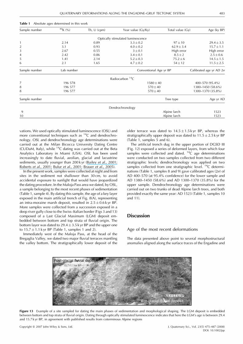
vations. We used optically stimulated luminescence (OSL) andmore conventional techniques such as 14C and dendrochro-nology. OSL and dendrochronology age determinations werecarried out at the Milan Bicocca University Dating Centre(CUDaM, Italy), while 14C dating was carried out at the BetaAnalytics Laboratory in Miami (USA). OSL has been usedincreasingly to date fluvial, aeolian, glacial and lacustrinesediments, usually younger than 200 k yr (Bailey et al., 2001;Roberts et al., 2001; Bulur et al., 2001; Brauer et al., 2005).In the present work, samples were collected at night and from
sites in the sediment not shallower than 30 cm, to avoidaccidental exposure to sunlight that would have jeopardizedthe dating procedure. In theMaloja Pass area we dated, byOSL,a sample belonging to the most recent phases of sedimentation(Table 1, sample 4). By dating this sample, the age of a key layerexposed in the main artificial trench of Fig. 8(A), representingan intra-moraine marsh deposit, resulted in 2.5� 0.6 k yr BP.More samples were collected from a succession exposed in adeep river gully close to the Swiss–Italian border (Figs 3 and 13)composed of a Last Glacial Maximum (LGM) deposit em-bedded between bottom and top strata of fluvial origin. Thebottom layer was dated to 29.4� 3.5 k yr BP and the upper oneto 15.7� 1.1 k yr BP (Table 1, samples 1 and 2).Immediately west of the Maloja Pass, at the head of the
Bregaglia Valley, we dated two major fluvial terraces mantlingthe valley bottom. The stratigraphically lower deposit of the
older terrace was dated to 14.5� 1.5 k yr BP, whereas thestratigraphically upper deposit was dated to 11.5� 2.5 k yr BP(Table 1, samples 5 and 6).The artificial trench dug in the upper portion of DGSD III
(Fig. 12) exposed a series of deformed layers, from which foursamples were collected and dated. 14C age determinationswere conducted on two samples collected from two differentstratigraphic levels; dendrochronology was applied on twosamples collected from one stratigraphic level. 14C determi-nations (Table 1, samples 8 and 9) gave calibrated ages (2s) ofAD 400–570 (at 95.4% confidence) for the lower sample andAD 1380–1450 (58.6%) and AD 1300–1370 (35.8%) for theupper sample. Dendrochronology age determinations werecarried out on two trunks of dead Alpine larch trees, and bothprovided exactly the same year: AD 1523 (Table 1, samples 10and 11).
Discussion
Age of the most recent deformations
The data presented above point to several morphostructuralanomalies aligned along the surface traces of the Engadine and
Table 1 Absolute ages determined in this work
Sample number 40K (%) Th, U (cpm) Year value (Gy/Ky) Total value (Gy) Age (ky BP)
Optically stimulated luminescence1 2.14 0.89 3.3� 0.2 97�10 29.4� 3.52 3.1 0.93 4.0� 0.2 62.9�3.4 15.7� 1.13 2.67 0.55 3� 0.1 High error High error4 2.42 0.86 3.4� 0.1 8.5� 2 2.5�0.65 1.41 2.14 5.2� 0.3 75.2� 6 14.5� 1.56 2.1 1.65 4.7� 0.2 54�12 11.5� 2.5
Sample number Lab number Conventional Age yr BP Calibrated age yr AD 2s
Radiocarbon 14C7 196 578 1580�40 400–570 (95.4%)8 196 577 570� 40 1380–1450 (58.6%)8 196 577 570� 40 1300–1370 (35.8%)
Sample number Tree type Age yr AD
Dendrochronology9 Alpine larch 1523
10 Alpine larch 1523
Figure 13 Example of a site sampled for dating the main phases of sedimentation and morphological shaping. The LGM deposit is embeddedbetween bottom and top strata of fluvial origin. Dating through optically stimulated luminescence indicates that here the LGM’s age is between 29.4and 15.7 k yr BP, in agreement with published results from coterminous Alpine regions
Copyright � 2007 John Wiley & Sons, Ltd. J. Quaternary Sci., Vol. 23(5) 475–487 (2008)DOI: 10.1002/jqs
QUATERNARY DEFORMATIONS ALONG THE ENGADINE–GRUF TECTONIC SYSTEM 483

Gruf lines. From a structural point of view, both structures arealso characterised by a dense swarm of faults and fracturesmostly vertical or steeply dipping northwards. The maindifference between these two major structures lies in the factthat, along the western sector of the Engadine Line, the offset ofthe landforms is coherent with a kinematics of sensu strictotectonic origin, whereas the Gruf Line trace is mostly hidden byan impressive alignment of gravity deformations. We point outthat the alignment of landslides along a fault trace is one of thekey pieces of evidence for recent/present fault activity (e.g.McCalpin, 1996, and references therein). Moreover, theEngadine Line, east of the studied area, is seismically active(Albini et al., 1988; ISMES, 1994). In order to reconstruct theage of the tectonic deformations along the western sector ofthe Engadine Line and to understand whether the gravitydeformations along the Gruf Line were triggered by ancientearthquakes as well, it would be necessary to know whetherthey have the same age. Since no related studies have ever beenconducted in the area, the following discussion is aimed attaking a first step towards this goal, although we are aware thatmore age determinations will be necessary to provide acomplete picture.The key layer, exposed in the main artificial trench illustrated
in Fig. 8(A) and dated to 2.5� 0.6 k yr BP, represents a marshthat was formed in an already faulted depression since it occurswithin a morphological low, above the fault debris wedge (3 inFig. 8(A)). This layer was deposited above a glacial till which, inturn, directly rests above a surface of glacial erosion cut into thebedrock. Since this trench is located at the edge of the frontalmoraines linked to the N-directed, relatively small, glacialtongue of the Forno Valley, the age of the till can be linked to alocal post-LGM pulse. This till rests above the surface of glacialerosion where we measured three different sets of glacialstriations; the oldest ones point towards NE following thegeneral gentle dip of the Inn Valley floor. Based on the InnValley width, thickness of the original glacial flow and presenceof the oldest glacial striae, we believe the valley floor wasmainly modelled during the LGM, the age of which wasconstrained, in the study area, by dating the fluvial and glacialsuccession exposed close to the Swiss–Italian border (Figs 3and 13). Here, the age of the LGM is bracketed between the age(29.4� 3.5 k yr BP) of the bottom layer and the age (15.7�1.1 k yr BP) of the top layer (Table 1, samples 1 and 2). Thesetwo dates, which are consistent with other age determinationsfor the LGM in the Alps (Florineth, 1998; Florineth andSchluchter, 2000, and references therein), together with thefault layers cross-cutting relationships described in Section 3.1,indicate that normal slip at Maloja Pass took place after15.7 k yr BP (post-LGM), producing the deformation of the basallayer exposed at the trench of Fig. 8(A),whosematerial slid downinto the 2mwide fissure. This episodewas followed by a series ofincremental offsets occurring between 15.7 and 2.5 k yr BP,followed by very small (cm) deformation events. The causes ofall these events will be discussed in the next chapter.As regards the age of the Inn Valley decapitation and the
capture of the Orlegna tributary, we can also take into accountthe age determinations we performed at the foot of theescarpment cutting the Inn Valley. Immediately west ofthe Maloja Pass, and thus at the head of the Bregaglia Valley,the two dated main fluvial terraces (14.5� 1.5 k yr BP and11.5� 2.5 k yr BP) clearly postdate the Maloja scarp formationand thus the beheading of the Inn Valley. More dating could beuseful to better reconstruct the evolution of the area, but thepresently available evidence suggests that the beheading ofthe Inn Valley might have taken place between the LGM andthe capture of the Orlegna River, i.e. between 29.4 and14.5 k yr BP.
As regards the age of the most recent strike-slip faultingacross the Forno Valley, the cross-cutting relationships betweenthe glacial landforms and the fault scarp suggest that most ofthe deformation occurred before the two locally recordedglacial pulses (i.e. glacial striations pointing towards N to NNWand NW). Nevertheless, the time elapsed from the latestmain transcurrent motions was not long enough to allowfor the natural rectification of the river, which is also affectedby strong hydrological non-equilibrium conditions. Based onthe aforementioned correlations of landforms and deposits,we suggest that offset of the Forno Valley along the EngadineLine occurred before 14.5 k yr BP and within Late Pleistocenetimes.
The most recent deformations along the Gruf Line areessentially represented by several DGSD that hinder theobservation of pieces of evidence such as those observed atthe Maloja Pass–Forno Valley area. Some frontal portions of theDGSD are overlayered by glacial deposits of the BregagliaValley bottom, attesting to the fact that they started movingprior to the time interval 29.4–15.7 k yr BP. This is consistentwith the fact that some uphill-facing scarps along the southernslope of the Bregaglia Valley were eroded by glacial activity.Other uphill- or downhill-facing scarps do not bear any sign ofglacial erosion, although they are located at altitudes which arelower than those reached by the glacial tongues. The trenchexcavated within DGSD III indicates that the deformationdeveloped with decreasing incremental offsets. Consideringthat some scarps of this DGSD offset a glaciated surface fromthe last glacial pulse and that other ones were abraded by thesame glacial tongue, and based on the stratigraphic correlationswith the dated pre- and post-LGM deposits, we suggest that thisDGSD started to move during pre-LGM times, followed byvarious incremental motions of post-LGM times up to the mostrecent deformations dated to the last millennium. Dendro-chronology gave the most satisfactory results, enabling us torefer the latest local gravity small (dm) movements to thepost-AD 1523.
Summarising the above, absolute dating of some key layers,as well as stratigraphic correlations, indicate that most faultscarps of the Engadine Line have a pre-LGM age, whereasthe normal slip planes exhumated in the artificial trenchhave an age bracketed between the LGM and 2.5 k yr BP.Along the Gruf Line trace, evidence of Quaternary defor-mation is provided only by the alignment of a few DGSDthat moved in pre-LGM and post-LGM times. The DGSDstudied in detail exhibits deformations of just a fewdecimetres during the last millennium. Six DGSD are alignedalong the western sector of the Gruf Line, whereas close to thezone of beheading of the Inn Valley only one poorlydeveloped DGSD is observable (Fig. 3). Our data, as a firstworking hypothesis, suggest that the beheading took place inthe Maloja Pass area between 29.4 and 14.5 k yr BP. If that istrue, the six aligned DGSD could be the expression of slopedeformations with a longer history, dating back also topre-LGM times, whereas when approaching the head of thepresent Bregaglia Valley (i.e. eastwards), landforms haveyounger ages.
Kinematics of the most recent deformations
Above we documented the presence, both along the westernsector of the Engadine Line and the Gruf Line, of deformationsof late Quaternary age. These could lead to hypothesizeneotectonic fault activity, although prudence is required toprecisely date the various deformation phases and their causes.
Copyright � 2007 John Wiley & Sons, Ltd. J. Quaternary Sci., Vol. 23(5) 475–487 (2008)DOI: 10.1002/jqs
484 JOURNAL OF QUATERNARY SCIENCE

Some preliminary datings indicate that deformations did occurin pre-LGM and post-LGM times at both faults, and thatdeformations get younger eastward. This pattern is consistentwith the distribution of the present seismicity, which iswidespread along the central and eastern Engadine fault traceand diminishes in frequency and magnitude southwestwards(Fig. 14). However, we point out that some of the recentdeformations we discovered might be purely gravitational inorigin. Therefore, in order to better understand this pattern, it isnecessary to discuss the kinematics of the studied structures.The structures with evidence of Quaternary motions in the
Inn Valley are represented by NE-striking left-lateral transcur-rent faults and about E–W-striking shorter faults with vertical(dip-slip) motions. The distribution of structural highs anddepressions bounded by the E–W-striking faults and thestepping arrangement of the NE-striking transcurrent faultssuggest the possible presence of rhomboidal pull-apart basins(Fig. 2) whose distribution is consistent with a generalleft-lateral transcurrent tectonics. Since most of the fault scarpsare glacially eroded, their formation should pre-date the LGMor subsequent local glacial pulses; however, fault activitycannot be totally pre-Quaternary in age, because in such a caseincremental glacial and fluvial erosion would have completelydeleted these fault scarps. The Inn Valley floor, in fact, stretchesabove 1800–2000m of altitude, i.e. in a strongly multi-glaciated environment. In the Maloja Pass area, where analysisof the artificial trenches and offset morphostructures suggestsLate Pleistocene–early Holocene faulting, oblique left-lateralstrike-slip motions on a main NE-striking fault and normalmotions onN–S-strikingminor faults occurred. The stress tensorcomputed for the transcurrent faults with the most recent striaeresults in an N–S-trending horizontal greatest principal stress
(s1) and an E–W-trending horizontal least principal stress (s3)(Fig. 5). The stress tensor computed for the normal faults gives aN–S-trending horizontal intermediate principal stress (s2) andan E–W-trending sub-horizontal s3 (Fig. 8(A)). The two faultsets are thus compatible with a stable E–W extension and arotation of s1 that interchanged with s2. Both of the stresstensor arrangements could have a tectonic origin, although wesuggest that dip-slip movement on the N–S-striking planesmight be linked to the westward collapse, and hencedebuttressing, of the head of the Inn Valley.This collapse is probably one of the major late Quaternary
morphostructural events of this zone of the Alps, and tectonicmotions along the western sector of the Engadine Line mightwell have played a triggering role for this event. The areabetween the upper Bregaglia Valley and the Maloja Pass ischaracterised by three main valleys with obsequent rivers(Fig. 15), two of which point upstream (i.e. to the NNE) withrespect to the river flow of the main Bregaglia Valley (i.e. to theWSW). The third obsequent valley, located north of theBregaglia Valley (Figs 15 and 6(E)), points toward NE, just likethe Inn Valley. It is likely that the original head of the Inn Valleywas located west of the present location, as illustrated inFig. 15. These three (now obsequent) valleys could haverepresented the source areas for the glacial tongues that fed themain Inn Valley glacier. The beheading of the Inn Valley mighthave occurred through retrogressive, multiple failures, fol-lowed by intense erosion that removed the collapsed material.All these processes can be explained in terms of a veryaccelerated erosion and gravitational instability that followed ageneral recent uplift of this area. If the trace of the previouslyactive westernmost sector of the Engadine Line was bentwestward, as illustrated in Fig. 15, this would have produced a
Figure 14 Map illustrating the epicentres of earthquakes (from AD 1258 to 2006) in the study area. Most of the hypocentres are 2–15km deep. Faultlines shown in white, drawn on the basis of the present work and from Albini (1988) in the adjoining sectors
Copyright � 2007 John Wiley & Sons, Ltd. J. Quaternary Sci., Vol. 23(5) 475–487 (2008)DOI: 10.1002/jqs
QUATERNARY DEFORMATIONS ALONG THE ENGADINE–GRUF TECTONIC SYSTEM 485

restraining bend with consequent local transpression and upliftof the sector north of the bended fault segment. This uplift isalso consistent with the most recent tectonic striations dippingto the NE found on the NE-striking fault planes near the OrlegnaRiver (Fig. 5). The proposed E–W-striking fault termination isalso consistent with the presence of approximatelyE–W-trending morphological highs in the area and with thelocal E–W trend of the Bregaglia Valley floor. Our reconstruc-tion does not contradict the findings of Schmid and Froitzheim(1993), who suggested uplift of the southeastern block along thewestern segment of the Engadine Line; in fact, we found olderstriae dipping towards the SW along NE-striking faults. Wesuggest that there has been a change of motion along this sectorof the Engadine Line: within the general and continuousleft-lateral transcurrence, the uplift component probably shiftedfrom the southeastern block to the northwestern block.Several DGSD are aligned along the described faults; one is
located along the Engadine Line in the Inn Valley (Fig. 2), one afew kilometres west of the Maloja Pass, while in the westernBregaglia Valley an impressive alignment of six major DGSDalong the Gruf Line is observable. DGSD are classicallyconsidered to be produced by debuttressing following fusion/retreat of valley glacial tongues (Berrisford and Matthews,1997; Haeberli et al., 1997; Holm et al., 2004). Since theseDGSD moved both in pre-LGM and post-LGM times, the
glacial retreat can be regarded as a predisposing factor, but alsoancient earthquakes might initially have played a triggeringrole. The further development of the DGSD may have beenproduced by pure gravity coupled with debuttressing. In orderto validate this working hypothesis, more detailed data on theage of the deformations of the several DGSD will have to becollected in the future.
Conclusions
The main outcomes of the present study can be summarised asfollows:
� The western sector of the Engadine Line bears evidence ofQuaternary left-lateral transcurrent motions, consistent withthe kinematics of the seismically active central–eastern seg-ments. In particular, where the Forno Valley is cross-cut bythis fault, a shutter ridge left-laterally offsets the Orlegna rivergully and the valley bottom.
� These motions mostly occurred in pre-LGM times.� A huge westward collapse occurred at the head of the Inn
Valley, in the Maloja Pass area, a few hundreds of metresfrom the Engadine Line, between the LGM and 15 k yr BP.
� The latest main deformations in the Maloja Pass area areexpressed by west-dipping normal slip planes which arecompatible with the debuttressing following the westwardcollapse. This slip mostly took place in the interval15.7–2.5 k yr BP (followed by minor offsets), consistent withthe LGM–15 k yr BP age of the previous rock mass removal.
� Six aligned DGSD developed along the Gruf Line duringpre-LGM and post-LGM times. Similarly, two more DGSDdeveloped along the western sector of the Engadine Line; allof them have been geometrically controlled by the vertical tosub-vertical parallel faults and fractures which in part shouldbe related to the post-Alpine history of the Engadine and Gruflines.
This work highlights the fact that the amount of anomalousstructures/morphostructures and pieces of evidence of recentdeformations aligned along the Engadine–Gruf system is toosignificant to represent just a coincidence. Also due to theseismic activity of the coterminous segments of the EngadineLine, the hypothesis that the structure moved in a time intervalof the Pleistocene when tectonic forces were possibly largerthan at present in this part of the Alps cannot be ruled out. If thishypothesis is correct, prehistoric earthquakes might haveinitially contributed to the triggering of the DGSD. Pleistocenetectonic movements along the possibly bended western termin-ation of the Engadine Line might account for local transpressionand uplift. These in turn produced a strong hydrographicnon-equilibrium that induced westward-directed failures andstrong erosion that caused the decapitation of the Inn Valley.This scenariomight explain the presence of the three obsequentvalleys, the absence of the glacier cirque that fed the glaciatedInn Valley, the large difference in altitude between the present-day Bregaglia and the Inn valley floors, and the high escarp-ment at the Maloja Pass.
The present study also shows the usefulness of an approachbased on the combination of different dating techniques withartificial trenching across faults and DGSD, and application ofpalaeoseismic methodologies. The systematic use of thisapproach might help provide a more complete picture ofrecent deformations along the Engadine–Gruf tectonic system.
Figure 15 Suggested, westwardly bended, possible trace of the wes-ternmost Engadine Line, active during the Pleistocene. This restrainingbend caused local transpression and uplift of the sector north of thebended fault segment, consistent with the most recent left-lateraloblique (NE-dipping) tectonic striations found along the western sectorof the Engadine Line. The proposed E–W fault termination is alsoconsistent with the presence of E–W-trending morphological highsand with the local E–W orientation of the Bregaglia Valley floor (dashedlines). The uplift caused very accelerated erosion and gravitationalinstability, which in turn can account for retrogressive, multiple failuresfollowed by strong erosion of the collapsed material in the upperBregaglia Valley. This also explains the presence of the three obsequentrivers (arrows) which originally were tributaries of the Inn Valley. Theasterisked line illustrates the most likely original position of the head ofthe Inn Valley
Copyright � 2007 John Wiley & Sons, Ltd. J. Quaternary Sci., Vol. 23(5) 475–487 (2008)DOI: 10.1002/jqs
486 JOURNAL OF QUATERNARY SCIENCE

Acknowledgements We acknowledge D. Rust for his useful sugges-tions on an earlier version of the manuscript. We also acknowledge M.Martini and his staff of the ‘Centro Universitario di Datazioni di MilanoBicocca’ (Italy) for OSL dating and L. Fasani for dendrochronologicaldating. This work has been carried out with partial funding from anInterreg IIIA 2002 Italy–Switzerland project andMIUR ex-60%.We alsothank E. Fiorini for the seismic maps she provided.
References
Albini P, Bellani A, Stucchi M. 1988. Terremoti e frane nelle AlpiCentrali. In Atti del 7 - Convegno annuale del GNDTS, Rome, Vol. 1;129–146.
Bailey SD, Wintle AG, Duller GA, Bristow CS. 2001. Sand depositionduring the last millennium at Aberffraw, Anglesey, North Wales asdetermined by OSL dating of quartz. Quaternary Science Reviews20: 701–704.
Berger A, Rosenberg C, Schmid SM. 1996. Ascent, emplacement andexhumation of the Bergell plutonwithin the Southern steep belt of theCentral Alps. Schweizerische Mineralogische Petrographische Mit-teilungen 76: 357–382.
Berrisford MS, Matthews JA. 1997. Phases of enhanced rapid massmovement and climatic variation during the Holocene: a synthesis.In Rapid Mass Movement as a Source of Climatic Evidence forHolocene, Matthews JA, Brunsden D, Frenzel B, Glaser B,Weiß MM (eds). Gustav Fisher: Stuttgart; 409–440.
Brauer A, Tempelhoff K, Murray A. 2005. OSL-dating of fine-grainedsand deposits and its implications for glacial stratigraphy and land-scape evolution: research results from Stolzenhagen, northeasternBrandenburg. Die Erde 136: 15–35.
Bulur E, Duller GAT, Solongo S, Bøtter-Jensen L, Murray AS. 2001.LM-OSL from single grains of quartz: a preliminary study. RadiationMeasurements 35: 79–85.
Davidson C, Rosemberg C, Schmid SM. 1996. Synmagmatic folding ofthe base of the Bergell pluton, Central Alps. Tectonophysics 265:213–238.
Fah D, Giardini D, Bay F, Bernardi F, Braunmiller J, Deichmann N,Furrer M, Gantner L, Gisler M, Isenegger D, Jimenez MJ, Kaestli P,Koglin R, Masciadri V, Rutz M, Scheidegger C, Schibler R, Schor-lemmer D, Schwarz-Zanetti G, Steimen S, Sellami S, Wiemer S,Woessner J. 2003. Earthquake Catalogue of Switzerland (ECOS) andthe related macroseismic database. Eclogae Geologicae Helvetiae96: 219–236.
Florineth D. 1998. Surface geometry of the Last Glacial Maximum(LGM) in the southeastern Swiss Alps (Graubunden) and its paleo-climatological significance. Eiszeitalter und Gegenwart 48: 23–37.
Florineth D, Schluchter C. 2000. Alpine evidence for atmosphericcirculation patterns in Europe during the Last Glacial Maximum.Quaternary Research 54: 295–308.
Forcella F, Tibaldi A. 1998. Geomorphological expression of Alpinefaults, Orobic Alps, Italy: Late Quaternary reactivation or glacialmodelling? Bollettino della Societa Geologica Italiana 117: 643–655.
Forcella F, Onida M, Tibaldi A. 1998. Risultati preliminari di un’in-dagine di tipo paleosismologico applicata allo studio di deformazionirecenti in ambiente alpino, alta Valtellina (Alpi Centrali, Italia).Geologia Insubrica 3: 63–72.
Forcella F, Tibaldi A, Onida M, Galadini F. 2001. Tecniche paleosis-mologiche per lo studio di deformazioni gravitative profonde diversante in ambiente alpino: esempi nella Valle del Foscagno e alPasso del Mortirolo (Alpi Centrali, Italia). In Tettonica Recente eInstabilita di Versante nelle Alpi Centrali, Pasquare G (ed.). CAR-IPLO: Milan; 103–149.
Haeberli W, Wegmann M, Von der Muhll D. 1997. Slope stabilityproblems related to glacier shrinkage and permafrost degradation inthe Alps. Ecologae Geologicae Helvetiae 90: 407–414.
Heitzmann P. 1987. Evidence of the late Oligocene early Miocenebackthrusting in the Central Alpine ‘root zone’.Geodinamica Acta 1:183–192.
Holm K, Bovis M, Jakob M. 2004. The landslide response of alpinebasins to post-Little Ice Age glacial thinning and retreat in south-western British Columbia. Geomorphology 57: 201–216.
ISMES. 1994. Studi sismici in alta Valtellina. I quaderni dell’ISMES 336,Bergamo, Italy.
Laubscher HP. 1983. The late alpine (Periadriatic) intrusion and theInsubric Line. Memorie della Societa Geologica Italiana 26: 21–30.
Marone F. 1999. Das Magnitude 5 Beben von Vaz (Graubuenden) von1991: Seismotektonik und Auswertung der Nachbeben. Diplomar-beit, Institut fur Geophysik, ETH-Zuerich.
Maxelon M, Mancktelow NS. 2005. Three-dimensional geometry andtectonostratigraphy of the Pennine zone, Central Alps, Switzerlandand Northern Italy. Earth Science Reviews 71: 171–227.
McCalpin JP (ed.). 1996. Paleoseismology. Academic Press: SanDiego, CA.
McCalpin JP, Irvine JR. 1995. Sackungen at AspdenHighlands Ski Area,Pitkin County, Colorado. Environmental and EngineeringGeoscience 1: 277–290.
Merle O, Guillier B. 1989. The building of the Central Swiss Alps: anexperimental approach. Tectonophysics 165: 41–56.
Pasquare G. 2001. Evoluzione geologica e geomorfologica quaternariadella Val Bregaglia tra Bondo e Castasegna. In Tettonica Recente eInstabilita di Versante nelle Alpi Centrali, Pasquare G (ed.). CAR-IPLO: Milan; 165–174.
Ratschbacher L, FrischW, Linzer HG, Merle O. 1991. Lateral extrusionin the Eastern Alps. Part 2: structural analysis. Tectonics 10: 697–718.
Roberts HM, Wintle AG, Maher BA, Hu MY. 2001. Holocene sedi-ment-accumulation rates in the western Loess Plateau, China, and a2500-year record of agricultural activity, revealed byOSL dating. TheHolocene 11: 477–483.
Schmid SM, Froitzheim N. 1993. Oblique slip and block rotation alongthe Engadine Line. Eclogae Geologicae Helvetiae 86: 569–593.
Schmid SM, Aebli H, Heller F, Zingg A. 1989. The role of the Peria-driatic Line in the tectonic evolution of the Alps. In Alpine Tectonics,Coward M, Dietrich D, Park R (eds). Geological Society SpecialPublications 45, London; 153–171.
Schmid SM, Berger A, Davidson C, Giere R, Hermann J, Nievergelt P,Puschnig AR, Rosenberg C. 1996. The Bergell pluton (southernSwitzerland, northern Italy): overview accompanying a geological-tectonicmap of the intrusion and surrounding country rocks. Schwei-zerische Mineralogische und Petrographische Mitteilungen 76:329–355.
Schwarz-Zanetti G, Deichmann N, Fah D, Masciadri V, Goll J. 2004.The earthquake in Churwalden (CH) of September 3, 1295. EclogaeGeologicae Helvetiae 97: 255–264.
Spicher A. 1980. Tektonische Karte del Schweiz, 1:500.000. Schwei-zerische Geologische Kommission: Bern.
Steck A, Hunziker JC. 1994. The Tertiary structural and thermalevolution of the Central Alps: compressional and extensional struc-tures in an orogenic belt. Tectonophysics 238: 229–254.
Tibaldi A, Onida M, Pasquare G, Forcella F. 1998. Trenching andpalaeoseismic researches along Holocene deformation zones in theupper Valtellina region, Central Alps (Italy). 3rd Workshop on AlpineGeological Studies, Oropa-Biella, 29 Sept.–1Oct. 1997.Quaderni diGeodinamica Alpina e Quaternaria 4: 219–220.
Tibaldi A, Onida M, Forcella F. 1999. Evidenze geologiche di defor-mazioni oloceniche in alta Valtellina, Alpi Centrali, e applicazioni ditecniche di paleosismologia. In Atti Congresso Nazionale FIST,Bellaria; 365–366.
Tibaldi A, Rovida A, Corazzato C. 2004. A giant deep-seated slopedeformation in the Italian Alps studied by paleoseismological andmorphometric techniques. Geomorphology 58: 27–47.
Trumpy R. 1977. The Engadine Line: a sinistral wrench fault in theCentral Alps. Memoirs of the Geological Society of China 2: 1–12.
Trumpy R, Trommsdorff V. 1980. Alps of Eastern Switzerland. In 26thInternational Geological Congress. Schweizerische GeologischeKommission. Wepf: Basel.
Varnes DJ. 1978. Slope movements types and processes. In Landslides,Analysis and Control, Schuster RL, Krizek RJ (eds). Special Report176, National Academy of Sciences: Washington, DC; 11–33.
Wenk HR. 1984. Brittle-ductile transition in the Northern Bergell Alps.Geologische Rundschau 73: 419–431.
Copyright � 2007 John Wiley & Sons, Ltd. J. Quaternary Sci., Vol. 23(5) 475–487 (2008)DOI: 10.1002/jqs
QUATERNARY DEFORMATIONS ALONG THE ENGADINE–GRUF TECTONIC SYSTEM 487