Germanium-silicon fractionation in the weathering environment
Upload
independentCategory
view
4download
0
Geomorphology 102 (2008) 307–324
Contents lists available at ScienceDirect
Geomorphology
j ourna l homepage: www.e lsev ie r.com/ locate /geomorph
The role of climate and vegetation in weathering and clay mineral formation in lateQuaternary soils of the Swiss and Italian Alps
Markus Egli a,⁎, Aldo Mirabella b, Giacomo Sartori c
a Department of Geography, University of Zürich, Winterthurerstrasse 190, 8057 Zürich, Switzerlandb Istituto Sperimentale per lo Studio e la Difesa del Suolo, Piazza D'Azeglio 30, 50121 Firenze, Italyc Museo Tridentino di Scienze Naturali, Via Calepina 14, 38100 Trento, Italy
⁎ Corresponding author. Tel.: +41 44 635 51 14; fax: +E-mail address: [email protected] (M. Egli).
0169-555X/$ – see front matter © 2008 Elsevier B.V. Aldoi:10.1016/j.geomorph.2008.04.001
A B S T R A C T
A R T I C L E I N F OArticle history:
Interactions between clima Received 30 November 2007Received in revised form 31 March 2008Accepted 1 April 2008Available online 8 April 2008Keywords:Chemical weatheringClay mineralsSmectiteAlpine soilsClimate
te and soil remain ambiguous, particularly when silicate weathering and claymineral formation and transformation rates are considered in relation to global climate changes. Recentstudies suggest that climate affects weathering rates much less than previously thought. Here we show thatthe climate in the central European Alps has a significant, but indirect, influence on the weathering of soilsthrough vegetation. The pattern of element leaching and mineral transformations is not only due toprecipitation and temperature. Element leaching was greatest in subalpine forests near the timberline;weathering is lessened at higher and lower altitudes. Vegetation, therefore, contributes significantly toweathering processes. The highest accumulation of organic matter was found in climatically cooler sites(subalpine range) where the production of organic ligands, which enhance weathering, is greatest. Patternsof smectite formation and distribution had strong similarities to that of the elemental losses of Fe and Al(R=0.69; Pb0.01) or base cations (R=0.58; Pb0.05). Higher precipitation rates and the production of organicchelating compounds in the soil promoted the appearance of smectites. The relationship between climate,element leaching (Fe, Al, Ca, Mg, K, Na), and smectite formation is strongly nonlinear and driven by thepodzolisation process, which is more pronounced near the timberline because of the bioclimaticconstellation. Climate warming will probably, in the future, lead to a decrease in SOM stocks in thesubalpine to alpine range because of more favourable conditions for biodegradation that would also affectweathering processes.
© 2008 Elsevier B.V. All rights reserved.
1. Introduction
Climate change can have significant impacts on the globalbiogeochemical cycle by altering the type and rate of soil processes,weathering, and mineral formation or transformation (Dahlgren et al.,1997; Richter et al., 2007). Soils play a major role in the biogeochem-ical cycle, including weathering, and the storage of nutrients andcarbon. Chemical weathering includes the partial dissolution of bed-rock by surficial fluids and removal of soluble ions in solution (vonBlanckenburg, 2005). Physical weathering processes expose fresh rockand surfaces to chemical weathering whereas chemical weatheringreduces the strength of rock, making it more susceptible to physicalbreakdown (Anderson et al., 2002). Denudation fluxes (D) cangenerally be subdivided into physical erosion fluxes (E) and chemicalweathering fluxes (W) with D =E+W (see Riebe et al., 2004a). Rocksformed beneath the earth's surface are unstable when raised tothe surface. Soil is a transition phase as the rocks will change to more
41 44 635 68 48.
l rights reserved.
stable chemical states (Bohn et al., 1985). Weathering includes,furthermore, the process of mineral alteration and transformationto mineral phases that are more stable at the earth's surface. Clayminerals are often a weathering product of the near-surface. Theformation and stability of the clays is dependent on the precursorminerals and the surrounding environmental conditions (Velde,1995). Chemical weathering fluxes are ultimately coupled to mineralformation and transformation processes. The weathering of silicatesand formation or transformation of minerals theoretically dependon mineral reactivity, the supply of minerals, water, acid reactants,ligands, and an Arrhenius rate law (Lasaga et al., 1994; West et al.,2005). Parent material lithology determines the physical andmineralogical nature and, thus, the reactivity of the weatheringcolumn. Acidity and the availability of (organic) ligands that derivefrom biotic activities promote the dissolution reactions of primaryminerals and govern the transformation into secondary minerals.To a great extent, element leaching and consequently weathering isgoverned by temperature, precipitation, runoff, and erosion rates.Vegetation, which is, among others, dependent on the temperature,influences weathering reactions through the production of acidity
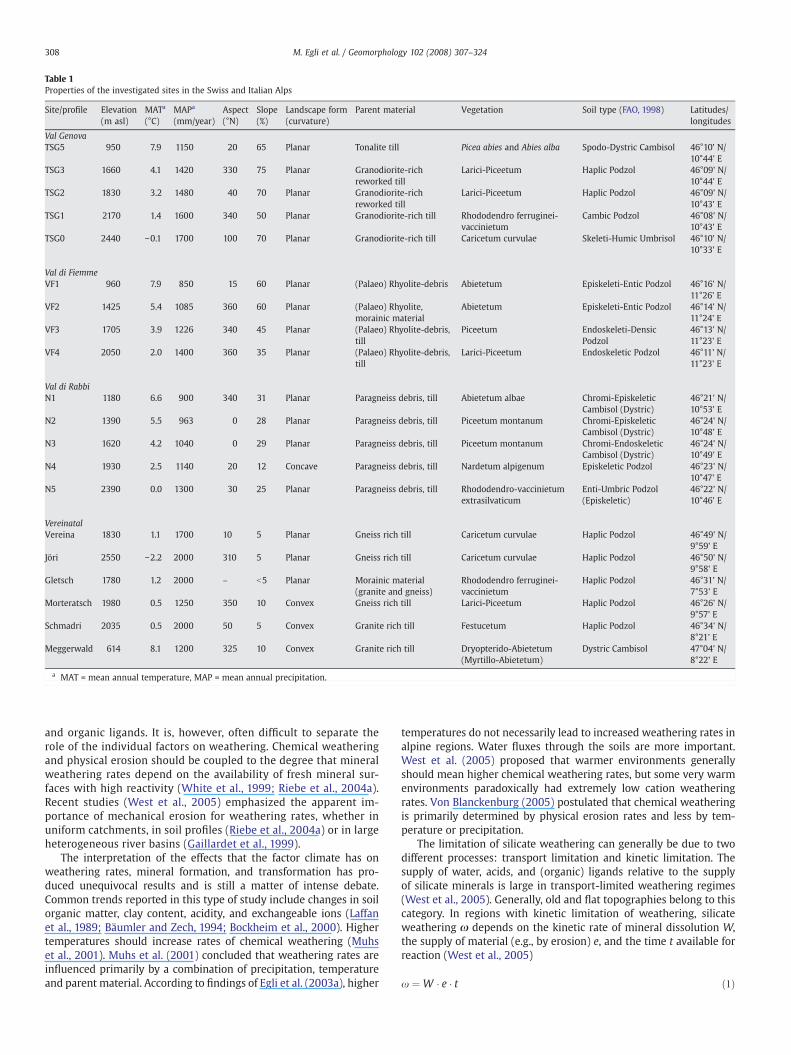
Table 1Properties of the investigated sites in the Swiss and Italian Alps
Site/profile Elevation(m asl)
MATa
(°C)MAPa
(mm/year)Aspect(°N)
Slope(%)
Landscape form(curvature)
Parent material Vegetation Soil type (FAO, 1998) Latitudes/longitudes
Val GenovaTSG5 950 7.9 1150 20 65 Planar Tonalite till Picea abies and Abies alba Spodo-Dystric Cambisol 46°10' N/
10°44' ETSG3 1660 4.1 1420 330 75 Planar Granodiorite-rich
reworked tillLarici-Piceetum Haplic Podzol 46°09' N/
10°44' ETSG2 1830 3.2 1480 40 70 Planar Granodiorite-rich
reworked tillLarici-Piceetum Haplic Podzol 46°09' N/
10°43' ETSG1 2170 1.4 1600 340 50 Planar Granodiorite-rich till Rhododendro ferruginei-
vaccinietumCambic Podzol 46°08' N/
10°43' ETSG0 2440 −0.1 1700 100 70 Planar Granodiorite-rich till Caricetum curvulae Skeleti-Humic Umbrisol 46°10' N/
10°33' E
Val di FiemmeVF1 960 7.9 850 15 60 Planar (Palaeo) Rhyolite-debris Abietetum Episkeleti-Entic Podzol 46°16' N/
11°26' EVF2 1425 5.4 1085 360 60 Planar (Palaeo) Rhyolite,
morainic materialAbietetum Episkeleti-Entic Podzol 46°14' N/
11°24' EVF3 1705 3.9 1226 340 45 Planar (Palaeo) Rhyolite-debris,
tillPiceetum Endoskeleti-Densic
Podzol46°13' N/11°23' E
VF4 2050 2.0 1400 360 35 Planar (Palaeo) Rhyolite-debris,till
Larici-Piceetum Endoskeletic Podzol 46°11' N/11°23' E
Val di RabbiN1 1180 6.6 900 340 31 Planar Paragneiss debris, till Abietetum albae Chromi-Episkeletic
Cambisol (Dystric)46°21' N/10°53' E
N2 1390 5.5 963 0 28 Planar Paragneiss debris, till Piceetum montanum Chromi-EpiskeleticCambisol (Dystric)
46°24' N/10°48' E
N3 1620 4.2 1040 0 29 Planar Paragneiss debris, till Piceetum montanum Chromi-EndoskeleticCambisol (Dystric)
46°24' N/10°49' E
N4 1930 2.5 1140 20 12 Concave Paragneiss debris, till Nardetum alpigenum Episkeletic Podzol 46°23' N/10°47' E
N5 2390 0.0 1300 30 25 Planar Paragneiss debris, till Rhododendro-vaccinietumextrasilvaticum
Enti-Umbric Podzol(Episkeletic)
46°22' N/10°46' E
VereinatalVereina 1830 1.1 1700 10 5 Planar Gneiss rich till Caricetum curvulae Haplic Podzol 46°49' N/
9°59' EJöri 2550 −2.2 2000 310 5 Planar Gneiss rich till Caricetum curvulae Haplic Podzol 46°50' N/
9°58' EGletsch 1780 1.2 2000 – b5 Planar Morainic material
(granite and gneiss)Rhododendro ferruginei-vaccinietum
Haplic Podzol 46°31' N/7°53' E
Morteratsch 1980 0.5 1250 350 10 Convex Gneiss rich till Larici-Piceetum Haplic Podzol 46°26' N/9°57' E
Schmadri 2035 0.5 2000 50 5 Convex Granite rich till Festucetum Haplic Podzol 46°34' N/8°21' E
Meggerwald 614 8.1 1200 325 10 Convex Granite rich till Dryopterido-Abietetum(Myrtillo-Abietetum)
Dystric Cambisol 47°04' N/8°22' E
a MAT = mean annual temperature, MAP = mean annual precipitation.
308 M. Egli et al. / Geomorphology 102 (2008) 307–324
and organic ligands. It is, however, often difficult to separate therole of the individual factors on weathering. Chemical weatheringand physical erosion should be coupled to the degree that mineralweathering rates depend on the availability of fresh mineral sur-faces with high reactivity (White et al., 1999; Riebe et al., 2004a).Recent studies (West et al., 2005) emphasized the apparent im-portance of mechanical erosion for weathering rates, whether inuniform catchments, in soil profiles (Riebe et al., 2004a) or in largeheterogeneous river basins (Gaillardet et al., 1999).
The interpretation of the effects that the factor climate has onweathering rates, mineral formation, and transformation has pro-duced unequivocal results and is still a matter of intense debate.Common trends reported in this type of study include changes in soilorganic matter, clay content, acidity, and exchangeable ions (Laffanet al., 1989; Bäumler and Zech, 1994; Bockheim et al., 2000). Highertemperatures should increase rates of chemical weathering (Muhset al., 2001). Muhs et al. (2001) concluded that weathering rates areinfluenced primarily by a combination of precipitation, temperatureand parent material. According to findings of Egli et al. (2003a), higher
temperatures do not necessarily lead to increased weathering rates inalpine regions. Water fluxes through the soils are more important.West et al. (2005) proposed that warmer environments generallyshould mean higher chemical weathering rates, but some very warmenvironments paradoxically had extremely low cation weatheringrates. Von Blanckenburg (2005) postulated that chemical weatheringis primarily determined by physical erosion rates and less by tem-perature or precipitation.
The limitation of silicate weathering can generally be due to twodifferent processes: transport limitation and kinetic limitation. Thesupply of water, acids, and (organic) ligands relative to the supplyof silicate minerals is large in transport-limited weathering regimes(West et al., 2005). Generally, old and flat topographies belong to thiscategory. In regions with kinetic limitation of weathering, silicateweathering ω depends on the kinetic rate of mineral dissolution W,the supply of material (e.g., by erosion) e, and the time t available forreaction (West et al., 2005)
x ¼ W � e � t ð1Þ

Fig. 1. Location of the investigation sites. 1=Val Genova, 2=Val di Fiemme, 3=Val di Rabbi, 4=Vereinatal, 5=Morteratsch, 6=Schmadri, 7=Gletsch, 8=Meggerwald.
309M. Egli et al. / Geomorphology 102 (2008) 307–324
where the value W depends on environmental conditions such astemperature and runoff (or precipitation). Additionally, the weath-ering rate of a mineral or rock decreases with the time (West et al.,2005) that the mineral spends in the weathering environment, asωV∝ tk with ωV = instantaneous volumetric weathering rate, k =(erosion) exponent. The influence of climatic factors on weatheringand mineral formation or transformation can consequently then bedetected when weathering is kinetically limited.
The prerequisites for identifying any climate-dependent variationin soil properties are that the parent material, the age of the soils, and
Fig. 2. Vegetation and climatic zones alo
exposure must be similar and the influence of erosion negligible orsimilar at all sites (see Jenny, 1941). Any comparison of different siteshas to take these prerequisites and the well-known paradigm of Jenny(1980) into account. Among the state factors (topography, climate,time, parent material), the vegetation factor is not a fully independentone as it varies, for example, with climate. In empirical field studies,clearly separating the influence of both vegetation and climate on soildevelopment is very difficult.
Our work focuses on the Alps (Swiss and Italian). The central Alpshave been perturbed by “short-term” overprinting of the topography
ng the investigated toposequences.
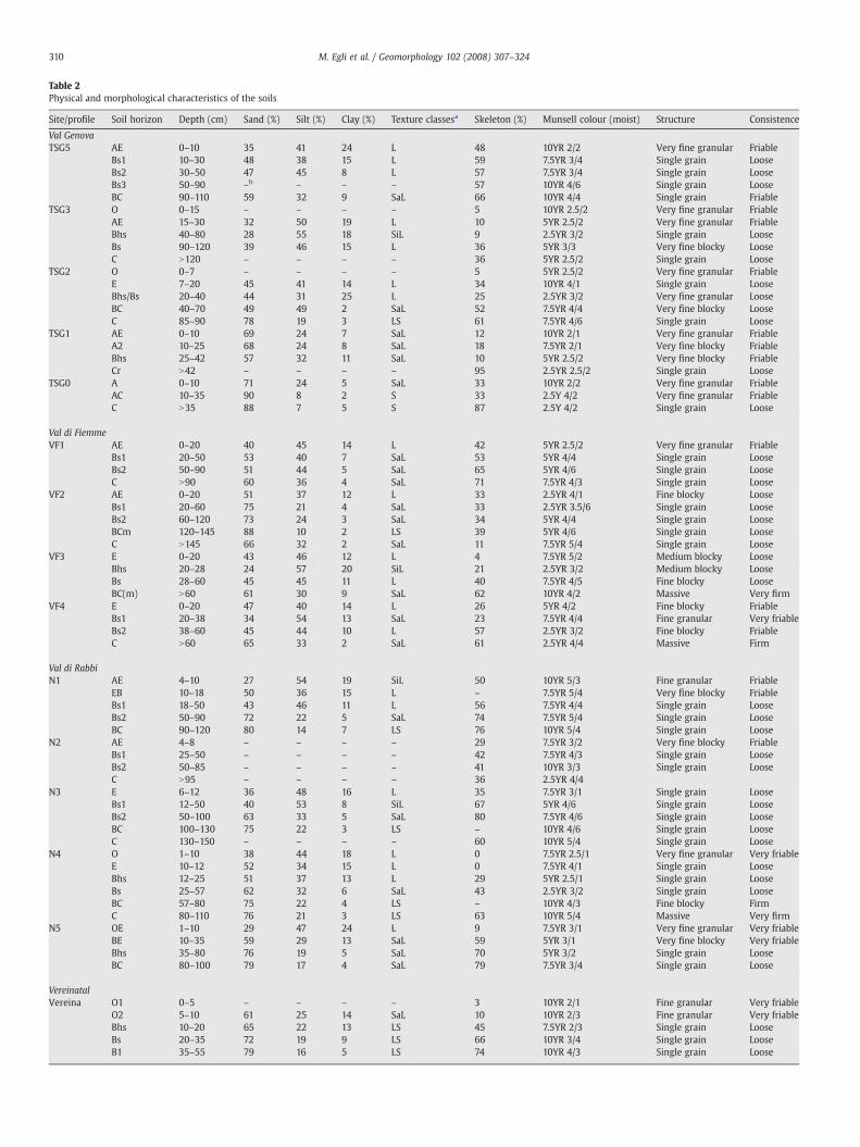
Table 2Physical and morphological characteristics of the soils
Site/profile Soil horizon Depth (cm) Sand (%) Silt (%) Clay (%) Texture classesa Skeleton (%) Munsell colour (moist) Structure Consistence
Val GenovaTSG5 AE 0–10 35 41 24 L 48 10YR 2/2 Very fine granular Friable
Bs1 10–30 48 38 15 L 59 7.5YR 3/4 Single grain LooseBs2 30–50 47 45 8 L 57 7.5YR 3/4 Single grain LooseBs3 50–90 –b – – – 57 10YR 4/6 Single grain LooseBC 90–110 59 32 9 SaL 66 10YR 4/4 Single grain Friable
TSG3 O 0–15 – – – – 5 10YR 2.5/2 Very fine granular FriableAE 15–30 32 50 19 L 10 5YR 2.5/2 Very fine granular FriableBhs 40–80 28 55 18 SiL 9 2.5YR 3/2 Single grain LooseBs 90–120 39 46 15 L 36 5YR 3/3 Very fine blocky LooseC N120 – – – – 36 5YR 2.5/2 Single grain Loose
TSG2 O 0–7 – – – – 5 5YR 2.5/2 Very fine granular FriableE 7–20 45 41 14 L 34 10YR 4/1 Single grain LooseBhs/Bs 20–40 44 31 25 L 25 2.5YR 3/2 Very fine granular LooseBC 40–70 49 49 2 SaL 52 7.5YR 4/4 Very fine blocky LooseC 85–90 78 19 3 LS 61 7.5YR 4/6 Single grain Loose
TSG1 AE 0–10 69 24 7 SaL 12 10YR 2/1 Very fine granular FriableA2 10–25 68 24 8 SaL 18 7.5YR 2/1 Very fine blocky FriableBhs 25–42 57 32 11 SaL 10 5YR 2.5/2 Very fine blocky FriableCr N42 – – – – 95 2.5YR 2.5/2 Single grain Loose
TSG0 A 0–10 71 24 5 SaL 33 10YR 2/2 Very fine granular FriableAC 10–35 90 8 2 S 33 2.5Y 4/2 Very fine granular FriableC N35 88 7 5 S 87 2.5Y 4/2 Single grain Loose
Val di FiemmeVF1 AE 0–20 40 45 14 L 42 5YR 2.5/2 Very fine granular Friable
Bs1 20–50 53 40 7 SaL 53 5YR 4/4 Single grain LooseBs2 50–90 51 44 5 SaL 65 5YR 4/6 Single grain LooseC N90 60 36 4 SaL 71 7.5YR 4/3 Single grain Loose
VF2 AE 0–20 51 37 12 L 33 2.5YR 4/1 Fine blocky LooseBs1 20–60 75 21 4 SaL 33 2.5YR 3.5/6 Single grain LooseBs2 60–120 73 24 3 SaL 34 5YR 4/4 Single grain LooseBCm 120–145 88 10 2 LS 39 5YR 4/6 Single grain LooseC N145 66 32 2 SaL 11 7.5YR 5/4 Single grain Loose
VF3 E 0–20 43 46 12 L 4 7.5YR 5/2 Medium blocky LooseBhs 20–28 24 57 20 SiL 21 2.5YR 3/2 Medium blocky LooseBs 28–60 45 45 11 L 40 7.5YR 4/5 Fine blocky LooseBC(m) N60 61 30 9 SaL 62 10YR 4/2 Massive Very firm
VF4 E 0–20 47 40 14 L 26 5YR 4/2 Fine blocky FriableBs1 20–38 34 54 13 SaL 23 7.5YR 4/4 Fine granular Very friableBs2 38–60 45 44 10 L 57 2.5YR 3/2 Fine blocky FriableC N60 65 33 2 SaL 61 2.5YR 4/4 Massive Firm
Val di RabbiN1 AE 4–10 27 54 19 SiL 50 10YR 5/3 Fine granular Friable
EB 10–18 50 36 15 L – 7.5YR 5/4 Very fine blocky FriableBs1 18–50 43 46 11 L 56 7.5YR 4/4 Single grain LooseBs2 50–90 72 22 5 SaL 74 7.5YR 5/4 Single grain LooseBC 90–120 80 14 7 LS 76 10YR 5/4 Single grain Loose
N2 AE 4–8 – – – – 29 7.5YR 3/2 Very fine blocky FriableBs1 25–50 – – – – 42 7.5YR 4/3 Single grain LooseBs2 50–85 – – – – 41 10YR 3/3 Single grain LooseC N95 – – – – 36 2.5YR 4/4
N3 E 6–12 36 48 16 L 35 7.5YR 3/1 Single grain LooseBs1 12–50 40 53 8 SiL 67 5YR 4/6 Single grain LooseBs2 50–100 63 33 5 SaL 80 7.5YR 4/6 Single grain LooseBC 100–130 75 22 3 LS – 10YR 4/6 Single grain LooseC 130–150 – – – – 60 10YR 5/4 Single grain Loose
N4 O 1–10 38 44 18 L 0 7.5YR 2.5/1 Very fine granular Very friableE 10–12 52 34 15 L 0 7.5YR 4/1 Single grain LooseBhs 12–25 51 37 13 L 29 5YR 2.5/1 Single grain LooseBs 25–57 62 32 6 SaL 43 2.5YR 3/2 Single grain LooseBC 57–80 75 22 4 LS – 10YR 4/3 Fine blocky FirmC 80–110 76 21 3 LS 63 10YR 5/4 Massive Very firm
N5 OE 1–10 29 47 24 L 9 7.5YR 3/1 Very fine granular Very friableBE 10–35 59 29 13 SaL 59 5YR 3/1 Very fine blocky Very friableBhs 35–80 76 19 5 SaL 70 5YR 3/2 Single grain LooseBC 80–100 79 17 4 SaL 79 7.5YR 3/4 Single grain Loose
VereinatalVereina O1 0–5 – – – – 3 10YR 2/1 Fine granular Very friable
O2 5–10 61 25 14 SaL 10 10YR 2/3 Fine granular Very friableBhs 10–20 65 22 13 LS 45 7.5YR 2/3 Single grain LooseBs 20–35 72 19 9 LS 66 10YR 3/4 Single grain LooseB1 35–55 79 16 5 LS 74 10YR 4/3 Single grain Loose
310 M. Egli et al. / Geomorphology 102 (2008) 307–324
B2 55–110 – – – – 73 10YR 4/3 Single grain LooseC 110–120 81 14 5 LS 87 10YR 5/3
Jöri O 0–5 64 23 13 SaL 5 10YR 2/1 Very fine granular Very friableE 5–10 68 20 12 LS 25 10YR 3/2 Single grain LooseBs 10–30 74 18 8 LS 42 7.5YR 3/3 Single grain LooseB 30–80 78 17 5 LS 47 10YR 4/4 Single grain LooseC 80–100 80 15 5 LS 58 10YR 5/3 Single grain Loose
GletschO 0–10 – – – – 6 10YR 2/1 Very fine granular Very friableE 10–20 65 32 2 SaL 51 10YR 3/2 Single grain LooseBhs 20–30 76 22 2 LS 75 7.5YR 2/2 Single grain LooseBs 30–50 84 15 1 LS 66 7.5YR 3/2 Single grain LooseB 50–95 91 8 1 LS 46 7.5YR 3/4 Single grain LooseBC 95–105 81 8 1 LS 67 10YR 6/4 Single grain Loose
MorteratschO 0–5 – – – – 14 7.5YR 3/1 Very fine granular Very friableE 5–15 54 38 8 SaL 30 7.5YR 4/3 Single grain LooseBs1 15–25 79 18 3 LS 55 7.5YR 4/4 Very fine blocky FriableBs2 25–65 – – – – 57 10YR 4/6 Very fine blocky FriableBC 65–105 78 19 3 LS 53 10YR 6/4 Single grain LooseC N105 78 19 3 LS 67 10YR 6/3 Single grain Loose
SchmadriO 0–10 – – – – 0 10YR 2/1 Very fine granular Very friableE 10–16 54 33 13 SaL 7 7.5YR 4/2 Single grain LooseBhs 16–24 49 31 19 L 23 7.5YR 2/2 Single grain LooseBs 24–55 – – – – 25 7.5YR 3/4 Single grain LooseBC 55–105 74 21 5 LS 26 10YR 5/4 Single grain LooseC N105 82 13 5 LS 42 10YR 6/4 Single grain Loose
MeggerwaldA 0–20 48 35 17 L 4 7.5YR 2/3 Fine granular FriableBw1 20–50 46 39 15 L 5 10YR 4/4 Fine granular FriableBw2 50–80 49 38 14 L 10 10YR 4/4 Fine granular FriableBC 80–150 – – – – – 10YR 5/4 Single grain Loose2C N150 63 28 10 SaL 15 10YR 6/4 Single grain Loose
a L = loam, SiL = silt loam, SaL = sandy loam, LS = loamy sand, S = sand.b No data available.
Table 2 (continued)
Site/profile Soil horizon Depth (cm) Sand (%) Silt (%) Clay (%) Texture classesa Skeleton (%) Munsell colour (moist) Structure Consistence
VereinatalVereina
311M. Egli et al. / Geomorphology 102 (2008) 307–324
by glaciation that covered much of the region up to 15 ky ago and, inlarge parts, has deposited young, morainic materials. Consequently,weathering is predominantly kinetically limited. We explored theeffect of the climate and, also implicitly, vegetation on the weatheringof soils and smectite formation. Our focus is on chemical weatheringand mineral formation and transformation (clay fraction). We haveassembled published (Egli et al., 2003a, 2004a) and unpublished datato make a new synthesis on the weathering behaviour of alpine soilsas a function of the climate. Previous investigations referred to singlevalleys. In this study, a much larger data set covering a wide portion ofthe Alps was used. This allowed us to test whether some observedtrends found in single and small valleys represent a general tendencyin the alpine environment as a whole or whether they are restrictedonly to small areas.
The expected new insights from this study together with existingdata sets should lead to a better understanding of the weatheringprocesses in high mountain soils and are a further step toward im-proving knowledge of climate-related phyllosilicate formation ortransformation and, thus, to weathering mechanisms.
2. Materials and methods
2.1. Study sites
The results of 20 soil profiles from eight different sites (four ofthem having an altitudinal sequence) in the siliceous Swiss and ItalianAlps ranging from 600 to 2400 m asl, and thus subjected from a
moderate to a cold and high-alpine climate, have been considered. Thesites were NW–NE facing (except TSG0, Table 1) or were found in a flatposition (no orientation). A compilation of the site description isprovided in Table 1 and Figs. 1 and 2. The onset of deglaciation ofalpine glaciers was around 20,000 years BP (Ivy-Ochs et al., 2004). Thehighest sites were close to the Egesen stadial, thus having a minimumage of around 12,000 years (cf. Baroni and Carton, 1990; Kerschner,2000). The valleys remained glaciated until the oldest Dryas (about16,000 years BP; cf. Oetheimer, 1990; Filippi et al., 2007). The ages ofthe soils can be estimated to be about 12,000–16,000 years (Hantke,1978; Baroni and Carton, 1990). All the soils developed on morainicparent material consisting of granite (or palaeorhyolite), gneiss, orparagneiss. The soil profiles were selected from an existing soilcartography study and soil inventory (Sartori et al., 2005). The studiedsoil profiles are assumed to be representative of the altitude zones(well-developed soil profiles; no sign of erosion). According to SoilTaxonomy (Soil Survey Staff, 2006), the soil moisture regime is udic(humid conditions, b90 days/year with a dry soil) at all sites and thesoil temperature regime varies between frigid (mean annual tem-perature b8 °C) and cryic (mean annual temperature b8 °C, nopermafrost; Fig. 2). Highest precipitation during the year occurs at allsites in the summer months.
2.2. Soil sampling
Special attention was given to ensure that the soil profiles showedan undisturbed evolution (according to their macromorphology) with
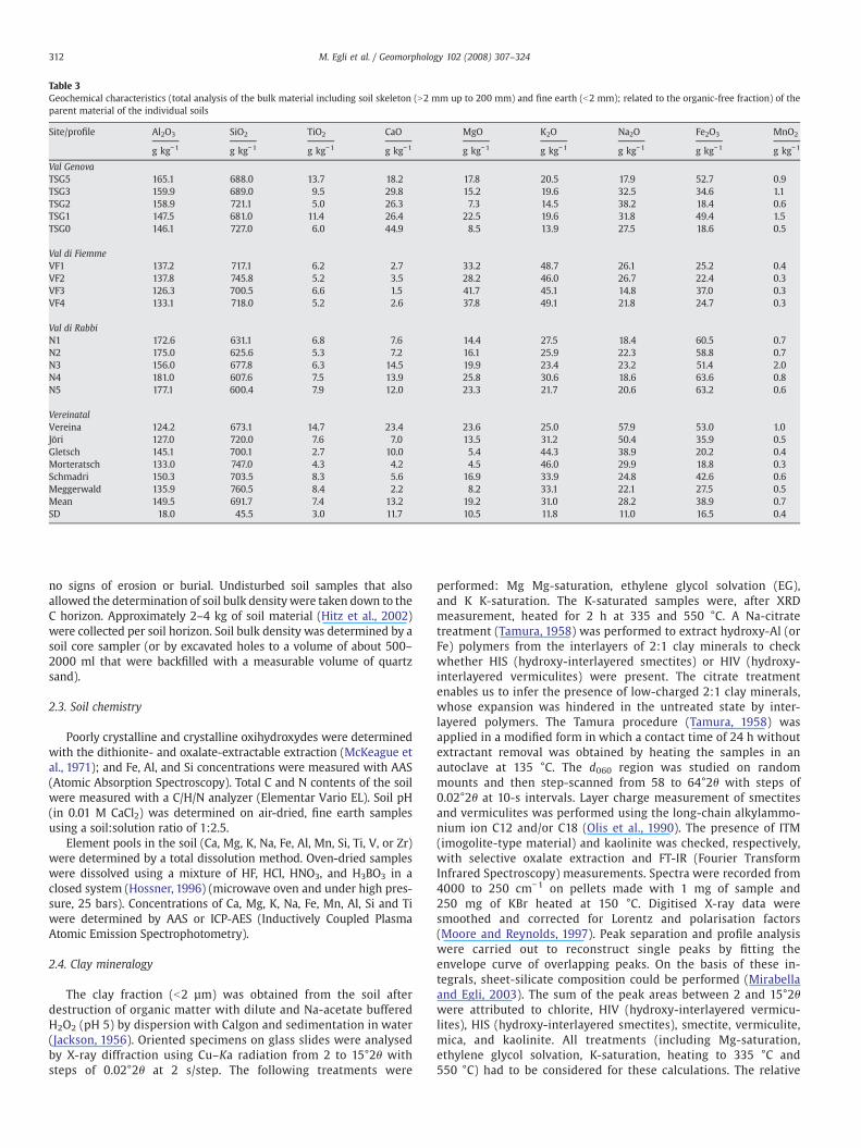
Table 3Geochemical characteristics (total analysis of the bulk material including soil skeleton (N2 mm up to 200 mm) and fine earth (b2 mm); related to the organic-free fraction) of theparent material of the individual soils
Site/profile Al2O3 SiO2 TiO2 CaO MgO K2O Na2O Fe2O3 MnO2
g kg−1 g kg−1 g kg−1 g kg−1 g kg−1 g kg−1 g kg−1 g kg−1 g kg−1
Val GenovaTSG5 165.1 688.0 13.7 18.2 17.8 20.5 17.9 52.7 0.9TSG3 159.9 689.0 9.5 29.8 15.2 19.6 32.5 34.6 1.1TSG2 158.9 721.1 5.0 26.3 7.3 14.5 38.2 18.4 0.6TSG1 147.5 681.0 11.4 26.4 22.5 19.6 31.8 49.4 1.5TSG0 146.1 727.0 6.0 44.9 8.5 13.9 27.5 18.6 0.5
Val di FiemmeVF1 137.2 717.1 6.2 2.7 33.2 48.7 26.1 25.2 0.4VF2 137.8 745.8 5.2 3.5 28.2 46.0 26.7 22.4 0.3VF3 126.3 700.5 6.6 1.5 41.7 45.1 14.8 37.0 0.3VF4 133.1 718.0 5.2 2.6 37.8 49.1 21.8 24.7 0.3
Val di RabbiN1 172.6 631.1 6.8 7.6 14.4 27.5 18.4 60.5 0.7N2 175.0 625.6 5.3 7.2 16.1 25.9 22.3 58.8 0.7N3 156.0 677.8 6.3 14.5 19.9 23.4 23.2 51.4 2.0N4 181.0 607.6 7.5 13.9 25.8 30.6 18.6 63.6 0.8N5 177.1 600.4 7.9 12.0 23.3 21.7 20.6 63.2 0.6
VereinatalVereina 124.2 673.1 14.7 23.4 23.6 25.0 57.9 53.0 1.0Jöri 127.0 720.0 7.6 7.0 13.5 31.2 50.4 35.9 0.5Gletsch 145.1 700.1 2.7 10.0 5.4 44.3 38.9 20.2 0.4Morteratsch 133.0 747.0 4.3 4.2 4.5 46.0 29.9 18.8 0.3Schmadri 150.3 703.5 8.3 5.6 16.9 33.9 24.8 42.6 0.6Meggerwald 135.9 760.5 8.4 2.2 8.2 33.1 22.1 27.5 0.5Mean 149.5 691.7 7.4 13.2 19.2 31.0 28.2 38.9 0.7SD 18.0 45.5 3.0 11.7 10.5 11.8 11.0 16.5 0.4
312 M. Egli et al. / Geomorphology 102 (2008) 307–324
no signs of erosion or burial. Undisturbed soil samples that alsoallowed the determination of soil bulk density were taken down to theC horizon. Approximately 2–4 kg of soil material (Hitz et al., 2002)were collected per soil horizon. Soil bulk density was determined by asoil core sampler (or by excavated holes to a volume of about 500–2000 ml that were backfilled with a measurable volume of quartzsand).
2.3. Soil chemistry
Poorly crystalline and crystalline oxihydroxydes were determinedwith the dithionite- and oxalate-extractable extraction (McKeague etal., 1971); and Fe, Al, and Si concentrations were measured with AAS(Atomic Absorption Spectroscopy). Total C and N contents of the soilwere measured with a C/H/N analyzer (Elementar Vario EL). Soil pH(in 0.01 M CaCl2) was determined on air-dried, fine earth samplesusing a soil:solution ratio of 1:2.5.
Element pools in the soil (Ca, Mg, K, Na, Fe, Al, Mn, Si, Ti, V, or Zr)were determined by a total dissolution method. Oven-dried sampleswere dissolved using a mixture of HF, HCl, HNO3, and H3BO3 in aclosed system (Hossner, 1996) (microwave oven and under high pres-sure, 25 bars). Concentrations of Ca, Mg, K, Na, Fe, Mn, Al, Si and Tiwere determined by AAS or ICP-AES (Inductively Coupled PlasmaAtomic Emission Spectrophotometry).
2.4. Clay mineralogy
The clay fraction (b2 µm) was obtained from the soil afterdestruction of organic matter with dilute and Na-acetate bufferedH2O2 (pH 5) by dispersion with Calgon and sedimentation in water(Jackson, 1956). Oriented specimens on glass slides were analysedby X-ray diffraction using Cu–Ka radiation from 2 to 15°2θ withsteps of 0.02°2θ at 2 s/step. The following treatments were
performed: Mg Mg-saturation, ethylene glycol solvation (EG),and K K-saturation. The K-saturated samples were, after XRDmeasurement, heated for 2 h at 335 and 550 °C. A Na-citratetreatment (Tamura, 1958) was performed to extract hydroxy-Al (orFe) polymers from the interlayers of 2:1 clay minerals to checkwhether HIS (hydroxy-interlayered smectites) or HIV (hydroxy-interlayered vermiculites) were present. The citrate treatmentenables us to infer the presence of low-charged 2:1 clay minerals,whose expansion was hindered in the untreated state by inter-layered polymers. The Tamura procedure (Tamura, 1958) wasapplied in a modified form in which a contact time of 24 h withoutextractant removal was obtained by heating the samples in anautoclave at 135 °C. The d060 region was studied on randommounts and then step-scanned from 58 to 64°2θ with steps of0.02°2θ at 10-s intervals. Layer charge measurement of smectitesand vermiculites was performed using the long-chain alkylammo-nium ion C12 and/or C18 (Olis et al., 1990). The presence of ITM(imogolite-type material) and kaolinite was checked, respectively,with selective oxalate extraction and FT-IR (Fourier TransformInfrared Spectroscopy) measurements. Spectra were recorded from4000 to 250 cm−1 on pellets made with 1 mg of sample and250 mg of KBr heated at 150 °C. Digitised X-ray data weresmoothed and corrected for Lorentz and polarisation factors(Moore and Reynolds, 1997). Peak separation and profile analysiswere carried out to reconstruct single peaks by fitting theenvelope curve of overlapping peaks. On the basis of these in-tegrals, sheet-silicate composition could be performed (Mirabellaand Egli, 2003). The sum of the peak areas between 2 and 15°2θwere attributed to chlorite, HIV (hydroxy-interlayered vermicu-lites), HIS (hydroxy-interlayered smectites), smectite, vermiculite,mica, and kaolinite. All treatments (including Mg-saturation,ethylene glycol solvation, K-saturation, heating to 335 °C and550 °C) had to be considered for these calculations. The relative
Table 4Chemical characteristics of the fine earth (b2 mm) of the soils
Site/profile Soil horizon Depth (cm) pH (CaCl2) Org. C % Org. N % Al(o)a (g/kg) Al(d)b (g/kg) Fe(o)a (g/kg) Fe(d)b (g/kg) Si(o)a (g/kg) ITMc (%)
GenovaTSG5 AE 0–10 3.70 9.57 0.47 15.00 10.00 8.40 12.90 0.77 0.55
Bs1 10–30 4.30 4.86 0.25 18.20 11.60 8.60 10.30 2.15 1.53Bs2 30–50 4.35 6.08 0.25 17.60 12.70 7.50 18.40 1.97 1.40Bs3 50–90 4.50 4.87 0.23 –d 14.70 – 11.80 5.49 3.90BC 90–110 4.60 – – 18.30 9.80 4.20 6.60 6.35 4.51
TSG3 O 0–15 3.15 22.37 0.93 – 7.30 – 12.90 0.04 0.03AE 15–30 3.70 13.51 0.46 2.90 21.10 5.00 10.90 0.45 0.32Bhs 40–80 4.20 8.26 0.24 17.20 25.60 19.30 19.10 0.52 0.37Bs 90–120 4.50 2.62 0.05 31.20 16.90 11.00 6.20 4.14 2.94C N120 4.80 – – – 4.50 – 2.40 2.56 1.82
TSG2 O 0–7 3.35 14.70 0.76 – 7.30 – 15.70 0.08 0.06E 7–20 3.85 9.64 0.43 3.30 19.80 7.40 14.00 0.70 0.50Bhs/Bs 20–40 4.30 7.92 0.27 26.30 31.90 13.30 23.20 2.75 1.95BC 40–70 4.60 1.75 0.04 22.80 10.40 3.00 4.20 3.76 2.67C 85–90 4.80 0.56 0.01 – 4.40 – 1.90 1.62 1.15
TSG1 AE 0–10 3.80 6.51 0.33 – 5.40 6.90 7.40 0.03 0.02A2 10–25 4.30 5.50 0.23 9.30 9.60 9.40 8.40 0.23 0.16Bhs 25–42 4.30 5.42 0.23 24.00 21.40 13.50 13.60 1.10 0.78Cr N42 4.70 0.50 0.00 – 1.50 – 1.70 0.30 0.21
TSG0 A 0–10 3.90 2.30 0.13 1.30 3.80 1.30 2.80 0.59 0.42AC 10–35 4.30 0.58 0.01 3.30 2.10 1.60 2.10 0.44 0.31C N35 4.60 0.47 0.01 – 0.50 – 0.70 0.14 0.10
Val di FiemmeVF1 AE 0–20 4.70 6.32 0.31 0.34 0.32 0.28 1.08 0.32 0.23
Bs1 20–50 4.50 2.43 0.11 0.94 0.62 0.35 1.14 2.65 1.88Bs2 50–90 4.80 1.51 0.06 1.04 0.54 0.48 1.14 3.65 2.59C N90 4.50 0.37 0.00 0.20 0.16 0.12 0.86 0.39 0.28
VF2 AE 0–20 3.20 5.82 0.25 0.15 0.16 0.11 0.85 0.01 0.01Bs1 20–60 4.50 3.24 0.11 1.44 0.97 0.54 0.96 3.99 2.83Bs2 60–120 4.70 0.60 0.01 0.70 0.41 0.22 0.64 2.38 1.69BCm 120–145 4.90 0.40 0.01 0.43 0.31 0.09 0.51 1.66 1.18C N145 4.70 0.28 0.02 0.31 0.22 0.08 0.61 0.97 0.69
VF3 E 0–20 3.00 4.86 0.22 0.12 0.10 0.07 0.59 0.01 0.01Bhs 20–28 3.50 11.56 0.44 1.13 1.22 1.86 2.62 0.28 0.20Bs 28–60 3.90 7.49 0.25 1.64 1.58 1.35 1.93 0.85 0.60BC (m) N60 3.90 7.83 0.24 1.53 1.46 0.93 1.61 0.45 0.32
VF4 E 0–20 3.50 3.68 0.15 0.13 0.15 0.15 0.70 0.01 0.01Bs1 20–38 3.80 4.51 0.16 0.70 0.72 0.93 1.17 0.06 0.04Bs2 38–60 4.10 8.86 0.31 2.57 2.53 1.50 2.32 0.66 0.47C N60 4.40 0.95 0.01 0.45 0.46 0.12 0.99 0.62 0.44
RabbiN1 AE 4–10 3.50 2.55 0.12 2.65 19.58 3.45 9.11 0.96 0.68
EB 10–18 – 1.96 0.09 – – – – – 0.00Bs1 18–50 4.00 1.49 0.04 3.34 18.45 3.40 6.97 0.84 0.60Bs2 50–90 4.30 0.69 0.04 2.83 23.74 2.70 6.07 0.52 0.37BC 90–120 4.10 0.37 0.04 1.26 27.57 1.01 3.75 0.22 0.16
N2 AE 4–8 3.80 3.85 0.13 4.45 24.04 3.22 7.25 0.20 0.14Bs1 25–50 4.60 1.49 0.04 9.60 33.84 11.13 15.20 2.63 1.87Bs2 50–85 4.90 0.94 0.02 6.88 23.81 9.55 5.01 3.15 2.24C N95 4.90 0.40 – 2.54 12.76 2.92 1.26 1.15 0.82
N3 E 6–12 3.00 5.65 0.25 2.75 23.72 3.12 6.56 0.24 0.17Bs1 12–50 4.20 2.31 0.08 6.79 38.43 5.78 9.53 1.00 0.71Bs2 50–100 4.60 1.60 0.06 8.89 40.81 11.14 13.16 3.33 2.36BC 100–130 – 0.44 0.02 – – – – – –
C 130–150 4.70 0.27 0.01 1.73 13.55 2.12 2.53 0.51 0.36N4 O 1–10 3.90 19.42 1.12 8.68 15.14 9.70 11.56 0.11 0.80
E 10–12 – 8.20 0.36 – – – – – –
Bhs 12–25 4.00 6.64 0.27 14.59 31.58 13.50 20.16 0.37 2.60Bs 25–57 4.30 2.80 0.10 15.29 23.71 14.46 12.45 1.33 9.40BC 57–80 – 1.01 0.05 – – – – – –
C 80–110 4.50 0.72 0.03 3.73 15.46 3.38 3.86 0.98 0.70N5 O 1–10 3.50 15.14 0.78 2.66 15.61 2.80 5.39 b0.02
BE 10–35 4.10 6.93 0.31 8.01 33.20 9.00 17.45 0.12 0.90Bhs 35–80 4.30 3.88 0.15 9.97 33.25 10.12 16.03 0.60 4.30BC 80–100 4.60 1.84 0.09 6.60 27.22 7.22 5.05 1.49 1.06
VereinatalVereina O1 0–5 3.50 38.90 1.90 1.09 1.56 1.60 1.96 0.01 0.00
O2 5–10 3.40 21.17 0.64 1.94 2.62 1.86 3.07 0.02 0.01Bhs 10–20 3.70 13.87 0.48 15.62 15.34 8.36 11.94 0.09 0.06Bs 20–35 4.00 7.31 0.19 14.35 14.84 13.87 15.85 0.37 0.26B1 35–55 4.20 4.16 0.11 10.12 12.43 4.27 5.81 1.01 0.72
(continued on next page)(continued on next page)
313M. Egli et al. / Geomorphology 102 (2008) 307–324
Table 4 (continued)
Site/profile Soil horizon Depth (cm) pH (CaCl2) Org. C % Org. N % Al(o)a (g/kg) Al(d)b (g/kg) Fe(o)a (g/kg) Fe(d)b (g/kg) Si(o)a (g/kg) ITMc (%)
B2 55–110 4.60 0.59 0.01 2.31 2.57 1.00 2.21 0.71 0.50C 110–120 4.70 0.37 0.01 1.61 1.10 1.30 3.02 0.71 0.50
Jöri O 0–5 3.50 19.30 0.95 – 2.02 – 4.35 0.01 0.01E 5–10 3.60 5.63 0.34 1.78 2.62 2.65 6.06 0.02 0.01Bs 10–30 4.20 3.55 0.17 3.64 5.88 2.83 6.83 0.10 0.07B 30–80 4.60 0.32 0.01 0.93 1.51 1.20 6.00 0.19 0.14C 80–100 4.60 0.37 0.01 1.05 1.24 1.41 4.52 0.21 0.15
GletschO 0–10 3.50 21.76 1.34 – 2.26 – 2.57 – –
E 10–20 3.80 1.38 0.08 – 2.12 – 2.46 0.02 0.01Bhs 20–30 4.00 5.87 0.29 – 8.06 – 2.87 0.14 0.10Bs 30–50 4.40 1.59 0.06 – 7.01 – 1.81 0.28 0.20B 50–95 4.55 1.10 0.04 – 4.92 – 1.51 0.45 0.32BC 95–105 5.10 0.51 0.01 – 1.71 – 1.76 – –
MorteratschO 0–5 3.30 17.64 0.65 0.56 0.76 0.69 3.47 – –
E 5–15 3.30 1.64 0.07 0.58 0.75 0.27 3.87 – –
Bs1 15–25 4.40 0.89 0.05 5.37 3.56 1.40 5.01 1.71 1.21Bs2 25–65 4.70 0.17 0.00 1.80 1.44 0.82 3.78 0.60 0.43BC 65–105 4.90 0.00 0.00 1.16 1.11 0.39 3.47 0.40 0.28C N105 4.90 0.00 0.00 0.90 0.83 0.34 3.28 0.27 0.19
SchmadriO 0–10 3.90 38.33 1.80 2.10 2.71 3.26 4.59 – –
E 10–16 3.70 2.23 0.08 0.84 0.77 0.45 1.83 – –
Bhs 16–24 3.80 11.31 0.48 10.21 10.91 29.65 46.23 0.09 0.07Bs 24–55 4.10 4.26 0.15 19.50 23.62 11.43 18.30 1.10 0.78BC 55–105 4.50 0.95 0.02 4.48 4.37 2.67 7.83 0.85 0.60C N105 4.70 0.22 0.00 1.48 1.65 1.23 4.84 0.32 0.22
MeggerwaldA 0–20 3.80 3.50 – 4.75 5.78 5.51 10.91 0.19 0.13Bw1 20–50 4.10 1.10 – 3.41 4.10 3.89 11.13 0.25 0.18Bw2 50–80 4.30 0.60 – 3.71 4.60 3.01 10.35 0.49 0.35BC 80–150 4.00 0.20 – 1.96 2.59 2.27 8.91 0.10 0.072C N150 4.40 0.00 – 0.91 1.21 0.83 4.78 0.05 0.04
a Oxalate-extractable content.b Dithionite-extractable content.c Imogolite-type material.d No data available.
VereinatalVereina
Site/profile Soil horizon Depth (cm) pH (CaCl2) Org. C % Org. N % Al(o)a (g/kg) Al(d)b (g/kg) Fe(o)a (g/kg) Fe(d)b (g/kg) Si(o)a (g/kg) ITMc (%)
Table 4 (continued)
314 M. Egli et al. / Geomorphology 102 (2008) 307–324
change of the areas, with respect to the treatments, enabled theabove mineral phases to be distinguished. For the Mg-saturatedand for the ethylene glycol solvation treatments, the area of the
Fig. 3.Differences (mean values) in the oxalate- and dithionite-extractable content of Al,Fe, and Si (only oxalate) between the topsoil (A, AE, E, or O horizon) and the subsoil (B orAC horizon).
following peaks (d-spacings) had to be corrected by a weighting factorF: 1.65 nm with F=0.453, 1.4 nm with F=0.478, and 0.71 nm withF=0.16 (Gjems, 1967; Laves and Jahn,1972; Niederbudde and Kussmaul,1978; Schwertmann and Niederbudde, 1993). This procedure allowedthe estimation of the relative concentrations of sheet silicates in the clayfraction.
After a pretreatment of the samples with H2O2 (3%), particle sizedistribution of the soils was measured by a combined method con-sisting of sieving the coarser particles (2000–32 µm) and the mea-surement of the finer particles (b32 µm; dispersion with calgon andultrasonic treatment) by means of an X-ray sedimentometer (Sedi-Graph, 5100).
2.5. Mass balances
Long-term weathering rates of soils were derived from the cal-culations of enrichment/depletion factors determined using immobileelement contents (Brimhall and Dietrich, 1987; Chadwick et al., 1990;Egli and Fitze, 2000). In this investigation, Ti was used as an immobileelement. Volumetric changes that occur during pedogenesis weredetermined by adopting the classical definition of strain, εi,w (Brimhalland Dietrich, 1987):
ei;w ¼ DzwDz
� 1 ð2Þ
315M. Egli et al. / Geomorphology 102 (2008) 307–324
with Δz as the columnar height (m) of a representative elementaryvolume of protore (or unweathered parent material) p, and Δzw is theweathered equivalent height (m) w. The calculation of the open-system mass transport function sj,w is defined by (Chadwick et al.,1990):
sj;w ¼ qwCj;w
qpCj;pei;w þ 1� � !
� 1 ð3Þ
where Cj,p (kg/t) is the concentration of element j in protolith (e.g.,unweathered parent material, bedrock), Cj,w is the concentration ofelement j in the weathered product (kg/t), and with ρp and ρwrepresent the bulk density (t/m3) of the protolith and the weatheredsoil, respectively.
With n soil layers, the calculation of changes in mass of element j isgiven by (Egli and Fitze, 2000)
Pmj;flux zwð Þ ¼
Xna¼1
Cj;pqp1
ei;w þ 1
� �sj;wDzw ð4Þ
where sj,w corresponds to the mass transport function εi,w to thestrain, and Δz to the weathered equivalent of the columnar height (m)of a representative elementary volume.
3. Results
3.1. Weathering
According to the WRB classification (FAO, 1998), the soils werepredominantly Cambisols and Podzols (Table 1). The thickest soilprofiles were usually found at altitudes of 1400–2000 m asl. The soilshad a comparatively high proportion of soil skeleton (material havinga diameter of N2 mm) that can be up to 80% of the mass (Table 2). Allinvestigated soils had a sandy to silty–sandy texture (Table 2). Grainsizes usually decreased from the parent material to the surface soilhorizon where the highest clay and silt contents are found. The de-
Table 5The total amount of element losses (given in kg/m2) of the soil profiles: these losses are sta
Site/profile Altitude Al Si Ca Mg K Na
m asl kg/m2 kg/m2 kg/m2 kg/m2 kg/m2 kg/m
Val GenovaTSG5 950 3.11 13.58 1.08 0.78 0.72 0.92TSG3 1660 8.06 24.02 2.92 1.14 1.44 3.21TSG2 1830 19.96 79.27 6.01 0.91 2.95 8.61TSG1 2170 12.00 43.70 4.99 0.84 3.53 5.18TSGO 2440 10.62 42.09 4.58 0.25 3.07 3.63
Val di FiemmeVF1 960 −0.21 1.23 −0.05 2.31 0.06 0.55VF2 1425 4.45 13.03 0.27 1.64 2.29 2.32VF3 1705 6.98 27.27 0.04 6.57 5.12 1.28VF4 2050 12.67 47.57 0.58 5.69 7.79 4.15
Val di RabbiN1 1200 5.27 9.66 −0.88 0.48 1.68 0.54N2 1390 8.76 21.35 0.70 0.46 1.98 0.11N3 1620 10.08 38.26 1.62 1.97 2.50 3.67N4 1930 4.71 13.39 0.57 1.86 2.04 1.77N5 2390 4.45 0.00 0.05 1.28 0.24 1.39
VereinatalVereina 1830 4.37 18.78 1.20 1.57 2.00 5.33Jöri 2550 13.91 62.84 1.13 2.16 4.80 8.55Gletsch 1780 5.22 22.45 0.21 0.37 2.22 2.95Morteratsch 1980 4.84 14.83 0.64 0.31 2.48 1.52Schmadri 2035 9.90 39.16 0.67 1.85 3.83 4.05Meggerwald 614 1.86 0 0.16 0.31 0.10
a BC = base cations (equivalent sum of Ca, Mg, K, and Na).
crease of the grain sizes was predominantly a concomitant effect ofweathering. A part of it could also be derived from eolian depositions(Küfmann, 2003; Muhs and Benedict, 2006). Significant eolian de-posits are, however, rather limited to the plains (Mailänder and Veit,2001). An eolian addition after the retreat of the glaciers (~15,000–17,000 years BP) in the last glaciation phase (cf. Bäumler and Zech,1994) or by southern winds carrying Sahara dust cannot fully beexcluded. Absolute homogeneity of the parent material or a lack ofeolian contributions is probably never encountered. Investigations ofcalcareous alpine soils in Trentino showed that eolian attributionswere almost not detectable and, thus, rather of minor importance forpedogenesis (Egli et al., 2008).
The main geochemical composition of the parent material is givenin Table 3. The composition of the investigated material primarilyreflects its Si-rich and granitic character. In general, the parent ma-terial of the soils had a more or less similar chemical composition.There were, however, some minor differences in the chemical compo-sition of the C horizons between the sites, especially regarding the CaO(slightly higher content at the site Val Genova), MgO (slightly highercontent in the soils of Val di Fiemme, Gletsch, and Morteratsch), andFe2O3 (slightly higher content at the site Val di Rabbi) content.
Except at the lowest altitudes, the podzolisation process, with thetranslocation of Alo, Ald, Feo, and Fed was evident in all soil profiles(Table 4). Eluviation and illuviation of Alo, Ald, Feo, and Fed wasgreatest in the high subalpine range (Fig. 3; 1800–2200 m asl; sta-tistically significant with Pb0.01 using the U-test) where very distinctdifferences of secondary Fe and Al forms between the top- and subsoilwere measured. At lower and at higher elevations, the typical pod-zolisation process (eluviation and illuviation of Fe and Al) was lesspronounced. Translocation of Sio in the soil profiles was more intenseat low to mid mid-elevations and distinctly decreased at climaticallycold sites. Oxalate-soluble Si primarily refers to imogolite and allo-phanes (poorly crystalline, short-range order minerals; Schulze,1989).
Similar to the translocation of secondary phases, element leaching(calculated with Eq. (4)) was usually greatest in the range of the
ndardised to the initial columnar height (25 cm) of the elementary volume (Eq. (2))
Fe Mn Al+Fe BCa Al+Fe BC
2 kg/m2 kg/m2 molc/m2 molc/m2 molc/m2/year molc/m2/year
2.19 0.02 462 177 0.0309 0.01180.78 0.11 939 416 0.0624 0.02771.26 0.12 2286 825 0.1632 0.05891.00 0.14 1389 633 0.1158 0.05280.54 0.05 1209 485 0.1008 0.0405
−0.69 −0.01 −60 213 −0.0045 0.01520.07 0.03 498 308 0.0384 0.02373.72 0.04 975 729 0.0813 0.06082.37 0.02 1536 877 0.1395 0.0797
3.26 0.00 762 62 0.0507 0.00412.27 0.01 1095 128 0.0729 0.00852.29 0.21 1245 466 0.0888 0.0333
−0.47 0.02 498 311 0.0384 0.02396.02 0.00 819 174 0.0630 0.0134
1.11 0.06 546 472 0.0420 0.03635.98 0.09 1869 729 0.1557 0.06070.88 0.02 627 226 0.0522 0.01880.63 0.04 573 187 0.0477 0.01560.24 0.11 1113 460 0.0927 0.03830.13 213 25 0.0135 0.0016
Table 6Phyllosilicatesa in the clay fraction in the soils of the investigation sites
Site/profile Horizon Smec Smec–verm Smec–mica Verm Verm–mica Mica–HIVor HIS
Mica–chlor HIV Verm, HIV orHIS–chlor
HIS Chlor Mica Kaol MLCb
GenovaTSG5 A xc x (x)d x N0.75; 0.41
Bs1 x x (x) xBs2 x x (x) xBC x x (x) x N0.75
TSG3 AE x x x (x) x N0.75; 0.25; 0.21Bhs x x x (x) xBs (x) x x (x) (x) xC x x x x x N0.75
TSG2 E x x x (x) x N0.75; 0.25; 0.21Bhs x x x (x) x xBs x x x (x) x xBC x x x x x
TSG1 AE x x x x x x N0.75; 0.41; 0.24A2 x x x x xBhs (x) x x x x x
TSG0 A x x x x x x x N0.75; 0.37AC x x x x x x
Val di FiemmeVF1 AE x x (x) x (x) x x N0.75; 0.29
Bs1 (x) x x x x N0.75; 0.45; 0.27Bs2 (x) x x x x N0.75; 0.26C (x) (x) (x) x x N0.75; 0.32
VF2 AE x x (x) x x x N0.75; 0.30Bs1 (x) x x x x N0.75; 0.32Bs2 (x) x x x x N0.75; 0.30BCm (x) x x x N0.75; 0.32C (x) x x N0.75; 0.44
VF3 E x x (x) x x x N0.75; 0.29Bhs x x (x) x x x N0.75; 0.30Bs (x) x (x) x x x N0.75; 0.31BC (m) (x) (x) x x x N0.75; 0.30
VF4 E x x x x x N0.75; 0.32Bs1 x x x x x N0.75; 0.29Bs2 x x x x x N0.75; 0.54; 0.41; 0.27C (x) x x x N0.75; 0.56; 0.33
Val di RabbiN1 AE x x x (x) x x N0.75; 0.27
EB x (x) (x) x x x xBs1 x x x x xBs2 x x (x) x (x)BC x x (x) x (x)
N2 AE x x x x x (x) x xC x x x x (x)
N3 E x x x (x) x N0.75; 0.28Bs1 (x) (x) (x) x x (x) xBs2 (x) (x) (x) x x (x) (x) xBC x x x x (x)C x x x x (x) N0.75
N4 O x x x x (x) x x N0.75; 0.28E x (x) x x x (x) x xBhs (x) x x x xBs x x x xBC x x x xC x x x x N0.75
N5 O x x x x x x N0.75; 0.28BE x x x (x) x xBhs x x x x (x)BC x x x x (x)
VereinatalVereina O2 x x x x x x x 0.68; 0.37; 0.24
Bhs (x) x (x) x x 0.68B1 (x) x (x) x x 0.68C (x) x (x) x x N0.75
Jöri E x x x x x x x 0.70; 0.27Bs (x) x (x) x x x 0.70C (x) (x) (x) x x 0.70
GletschE x (x) (x) (x) x (x) x xBhs x x (x) x x x xB x x x x x x x
316 M. Egli et al. / Geomorphology 102 (2008) 307–324
MorteratschOE x x x (x) N0.75; 0.28Bs1 (x) (x) x x x x x (x) x (x) N0.75; 0.75; 0.4Bs2 (x) (x) x x x x x (x) x (x)BC N0.75; 0.75C (x) (x) (x) x x (x) N0.75; 0.75
SchmadriE x x x x (x)Bhs x x (x) x x (x)BC x xC x x
MeggerwaldA x (x) (x) x x x x (x) x N0.75; 0.28Bw1 x (x) x x x x x x x N0.75; 0.28Bw2 (x) (x) x x x x x x x N0.75; 0.70; 0.28BC x (x) x x x (x) x x x N0.75; 0.282C x x (x) x x x (x) x x N0.75; 0.28
a Verm = vermiculite, smec = smectite, chlor = chlorite, HIV = hydroxy-interlayered vermiculite, HIS = hydroxy-interlayered smectite, smec–verm = interstratified smectite–vermiculite.
b MLC = total mean layer charge per O10(OH)2.c Major component.d Minor component or traces.
Table 6 (continued)
Vereinatal
Site/profile Horizon Smec Smec–verm Smec–mica Verm Verm–mica Mica–HIVor HIS
Mica–chlor HIV Verm, HIV orHIS–chlor
HIS Chlor Mica Kaol MLCb
317M. Egli et al. / Geomorphology 102 (2008) 307–324
subalpine forest (1400–2200 m asl), and weathering rates were lowerat both high and low altitudes (Egli et al., 2004a) (Table 5).
3.2. Clay mineralogy
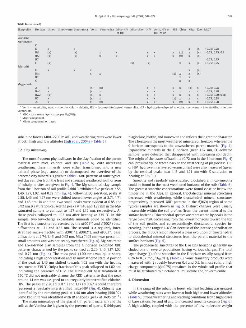
The most frequent phyllosilicates in the clay fraction of the parentmaterial were mica, chlorite, and HIV (Table 6). With increasingweathering, these minerals were either transformed into a newmineral phase (e.g., smectite) or decomposed. An overview of thedetected clayminerals is given in Table 6. XRD patterns of some typicalsoil clay samples from the least and strongest weathered soil horizonsof subalpine sites are given in Fig. 4. The Mg-saturated clay samplefrom the E horizon of soil profile Rabbi 3 exhibited five peaks at 2.55,1.46, 1.27, 1.02, and 0.72 nm (Fig. 4). Following EG solvation, peaks at2.55, 1.46 and 1.27 nm were shifted toward lower angles at 2.74, 1.71,and 1.46 nm; in addition, two small peaks were evident at 0.85 and0.92 nm. K saturation caused the peaks at 1.46 and 1.27 nm in theMg-saturated sample to contract to 1.27 and 1.12 nm, respectively. Allthese peaks collapsed to 1.02 nm after heating at 335 °C. In thissample, two low-charge expandable minerals could be identified.The first is a smectite represented by the d(001⁎) and d(002⁎) basaldiffractions at 1.71 and 0.85 nm. The second is a regularly inter-stratified mica–smectite with d(001⁎), d(002⁎), and d(003⁎) basaldiffractions at 2.74, 1.46, and 0.92 nm. Mica (1.02 nm) was present insmall amounts and was noticeably weathered (Fig. 4). Mg-saturatedand EG-solvated clay samples from the C horizon exhibited XRDpatterns characterised by the peaks centred at 2.20, 1.46, 1.17, 1.02,and 0.72 nm (Fig. 4). The mica peak (1.00 nm) was quite sharp,indicating a high concentration and an unweathered state. A portionof the peak at 1.46 nm shifted towards 1.02 nm with the heatingtreatment at 335 °C. Only a fraction of this peak collapsed to 1.02 nm,indicating the presence of HIV. The subsequent heat treatment at550 °C did not noticeably change the XRD pattern, so that the peakaround 1.1 nmwas assigned to an irregularly interstratified chlorite-HIV. The peaks at 2.20 (d(001⁎)) and 1.17 (d(002⁎)) could thereforerepresent a regularly interstratified mica-HIV (Fig. 4). Chlorite wasidentified by the remaining peak at 1.46 nm after heating (550 °C).Some kaolinite was identified with IR analyses (peak at 3695 cm−1).
The main mineralogy of the glacial till (parent material) and thesoils at the Vereina site is given by the presence of quartz, K-feldspars,
plagioclase, biotite, andmuscovite and reflects their granitic character.The E horizon is themost weatheredmineral soil horizon, whereas theC horizon corresponds to the unweathered parent material (Fig. 4).Expandable minerals in the E horizon (near 1.67 nm, EG-solvatedsample) were detected that disappeared with increasing soil depth.The origin of the traces of kaolinite (0.72 nm in the E horizon; Fig. 4)can, presumably, be traced back to the weathering of plagioclase. HISor HIV (hydroxy-interlayered vermiculites) were also measured (givenby the residual peaks near 1.13 and 1.21 nm with K saturation orheating at 335 °C).
Smectite and regularly interstratified dioctahedral mica–smectitecould be found in the most weathered horizons of the soils (Table 6).The greatest smectite concentrations were found close or below thetimberline in the Alps. In general, trioctahedral mineral structuresdecreased with weathering, while dioctahedral mineral structuresprogressively increased. XRD patterns in the d(060) region of sometypical samples are shown in Fig. 5. Distinct changes were usuallymeasurable within the soil profiles (from the parent material to thesurface horizon). Trioctahedral species are represented by peaks in therange 59–61°2θ, decreasing from the lowest horizons toward the topof the soil profile, and correspondingly, dioctahedral species in-creasing, in the range 61–63°2θ. Because of the intense podzolisationprocess, the d(060) region showed a clear evolution of trioctahedralto dioctahedral mineral structures from the parent material to thesurface horizons (Fig. 5).
The pedogenetic smectites of the E or Bhs horizons generally in-cluded one or several populations having various charges. The totallayer charge (ξ) of the smectites in the E horizon usually ranged from0.26 to 0.32 molc/O10(OH)2 (Table 6). Some transitory products weremeasured with ξ roughly between 0.4 and 0.5. In most soils, a highcharge component (ξN0.75) remained in the whole soil profile thatmust be attributed to dioctahedral muscovite and/or vermiculite.
4. Discussion
In the range of the subalpine forest, element leaching was greatestwhile weathering rates were lower at both higher and lower altitudes(Table 5). Strongweathering and leaching conditions led to high lossesof base cations, Fe, and Al and to increased smectite contents (Fig. 6).A high acidity, coupled with the presence of low molecular weight
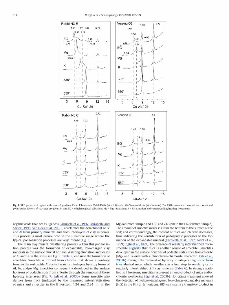
Fig. 4. XRD patterns of typical soil clays (b2 µm) in a C and E horizon at Val di Rabbi (site N3) and at the Vereinatal site (site Vereina). The XRD curves are corrected for Lorentz andpolarization factors; d-spacings are given in nm; EG = ethylene glycol solvation; Mg = Mg-saturation; K = K-saturation and corresponding heating treatments.
318 M. Egli et al. / Geomorphology 102 (2008) 307–324
organic acids that act as ligands (Carnicelli et al., 1997; Mirabella andSartori, 1998; van Hees et al., 2000), accelerates the detachment of Feand Al from primary minerals and from interlayers of clay minerals.This process is most pronounced in the subalpine range where thetypical podzolisation processes are very intense (Fig. 3).
The main clay mineral weathering process within this podzolisa-tion process was the formation of expandable, low-charged clayminerals in the surface eluvial horizon. A strong eluviation and lossesof Al and Fe in the soils (see Fig. 3; Table 5) enhance the formation ofsmectites. Smectite is formed from chlorite that shows a contrarytrend in the soil profile. Chlorite has in its interlayers hydroxy forms ofAl, Fe, and/or Mg. Smectites consequently developed in the surfacehorizons of podzolic soils from chlorite through the removal of thesehydroxy interlayers (Fig. 7; Egli et al., 2003b). Some smectite alsoderives from mica (indicated by the measured interstratificationof mica and smectite in the E horizon: 1.24 and 2.34 nm in the
Mg-saturated sample and 1.38 and 2.63 nm in the EG-solvated sample).The amount of smectite increases from the bottom to the surface of thesoil; and correspondingly, the content of mica and chlorite decreases,thus indicating the contribution of pedogenetic processes to the for-mation of the expandable mineral (Carnicelli et al., 1997; Gillot et al.,1999; Righi et al., 1999). The presence of regularly interstratified mica–smectite suggests that mica is another source of smectite. Smectitesdeveloped in the surface horizons of podzolic soils either from chlorite(Mg- and Fe-rich with a clinochlore–chamosite character; Egli et al.,2003b) through the removal of hydroxy interlayers (Fig. 8) or fromtrioctahedral mica, which weathers in a first step to regularly or ir-regularly interstratified 2:1 clay minerals (Table 6). In strongly acidi-fied soil horizons, smectites represent an end-product of mica and/orchlorite weathering (Egli et al., 2003b). Hot citrate treatment allowedthe detection of hydroxy-interlayered low-charge expandable minerals(HIS) in the Bhs or Bs horizons. HIS was mostly a transitory product in
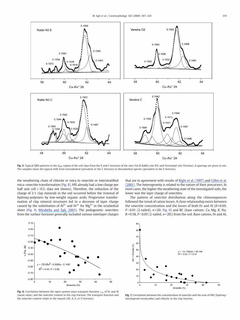
Fig. 5. Typical XRD patterns in the d060 region of the soil clays from the E and C horizons of the sites Val di Rabbi (site N3) and Vereinatal (site Vereina); d-spacings are given in nm.The samples show the typical shift from trioctahedral (prevalent in the C horizon) to dioctahedral species (prevalent in the E horizon).
319M. Egli et al. / Geomorphology 102 (2008) 307–324
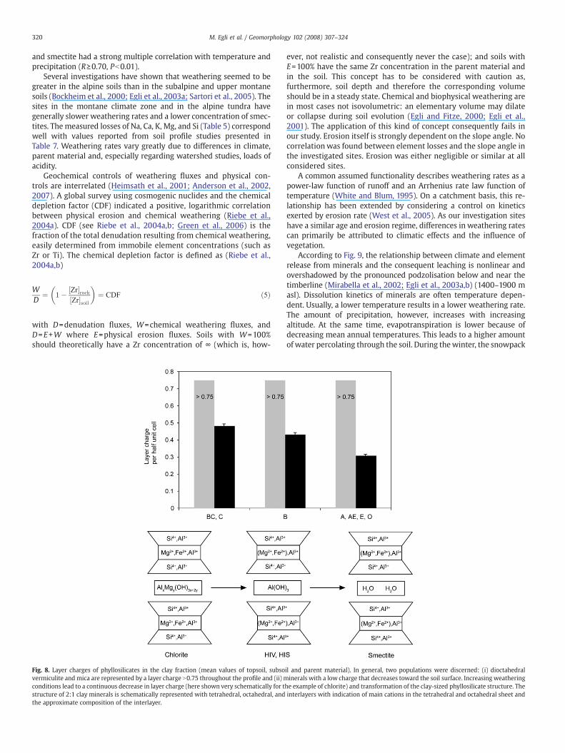
the weathering chain of chlorite or mica to smectite or interstratifiedmica–smectite transformation (Fig. 8). HIS already had a low charge perhalf unit cell (b0.5; data not shown). Therefore, the reduction of thecharge of 2:1 clay minerals in the soil occurred before the removal ofhydroxy-polymers by low-weight organic acids. Progressive transfor-mation of clay mineral structures led to a decrease of layer chargecaused by the substitution of Al3+ and Fe3+ for Mg2+ in the octahedralsheet (Fig. 8; Mirabella and Egli, 2003). The pedogenetic smectitesfrom the surface horizons generally included various interlayer charges
Fig. 6. Correlation between the open-system mass transport function sj,w of Fe and Al(mean value) and the smectite content in the clay fraction. The transport function andthe smectite content relate to the topsoil (AE, A, E, or O horizon).
that are in agreement with results of Righi et al. (1997) and Gillot et al.(2001). The heterogeneity is related to the nature of their precursors. Inmost cases, the higher theweathering state of the investigated soils, thelower was the layer charge of smectites.
The pattern of smectite distribution along the climosequencesfollowed the trend of cation losses. A close relationship exists betweenthe smectite concentration and the losses of both Fe and Al (R=0.69,Pb0.01 (2-tailed), n=20; Fig. 9) and BC (base cations: Ca, Mg, K, Na;R=0.58, Pb0.05 (2-tailed, n=20)) from the soil. Base cations, Fe and Al,
Fig. 7. Correlation between the concentration of smectite and the sum of HIV (hydroxy-interlayered vermiculite) and chlorite in the clay fraction.
320 M. Egli et al. / Geomorphology 102 (2008) 307–324
and smectite had a strong multiple correlation with temperature andprecipitation (R≥0.70, Pb0.01).
Several investigations have shown that weathering seemed to begreater in the alpine soils than in the subalpine and upper montanesoils (Bockheim et al., 2000; Egli et al., 2003a; Sartori et al., 2005). Thesites in the montane climate zone and in the alpine tundra havegenerally slower weathering rates and a lower concentration of smec-tites. The measured losses of Na, Ca, K, Mg, and Si (Table 5) correspondwell with values reported from soil profile studies presented inTable 7. Weathering rates vary greatly due to differences in climate,parent material and, especially regarding watershed studies, loads ofacidity.
Geochemical controls of weathering fluxes and physical con-trols are interrelated (Heimsath et al., 2001; Anderson et al., 2002,2007). A global survey using cosmogenic nuclides and the chemicaldepletion factor (CDF) indicated a positive, logarithmic correlationbetween physical erosion and chemical weathering (Riebe et al.,2004a). CDF (see Riebe et al., 2004a,b; Green et al., 2006) is thefraction of the total denudation resulting from chemical weathering,easily determined from immobile element concentrations (such asZr or Ti). The chemical depletion factor is defined as (Riebe et al.,2004a,b)
WD
¼ 1� Zr½ �rockZr½ �soil
� �¼ CDF ð5Þ
with D=denudation fluxes, W=chemical weathering fluxes, andD=E+W where E=physical erosion fluxes. Soils with W=100%should theoretically have a Zr concentration of ∞ (which is, how-
Fig. 8. Layer charges of phyllosilicates in the clay fraction (mean values of topsoil, subsovermiculite and mica are represented by a layer charge N0.75 throughout the profile and (ii) mconditions lead to a continuous decrease in layer charge (here shown very schematically for tstructure of 2:1 clay minerals is schematically represented with tetrahedral, octahedral, andthe approximate composition of the interlayer.
ever, not realistic and consequently never the case); and soils withE=100% have the same Zr concentration in the parent material andin the soil. This concept has to be considered with caution as,furthermore, soil depth and therefore the corresponding volumeshould be in a steady state. Chemical and biophysical weathering arein most cases not isovolumetric: an elementary volume may dilateor collapse during soil evolution (Egli and Fitze, 2000; Egli et al.,2001). The application of this kind of concept consequently fails inour study. Erosion itself is strongly dependent on the slope angle. Nocorrelationwas found between element losses and the slope angle inthe investigated sites. Erosion was either negligible or similar at allconsidered sites.
A common assumed functionality describes weathering rates as apower-law function of runoff and an Arrhenius rate law function oftemperature (White and Blum, 1995). On a catchment basis, this re-lationship has been extended by considering a control on kineticsexerted by erosion rate (West et al., 2005). As our investigation siteshave a similar age and erosion regime, differences in weathering ratescan primarily be attributed to climatic effects and the influence ofvegetation.
According to Fig. 9, the relationship between climate and elementrelease from minerals and the consequent leaching is nonlinear andovershadowed by the pronounced podzolisation below and near thetimberline (Mirabella et al., 2002; Egli et al., 2003a,b) (1400–1900 masl). Dissolution kinetics of minerals are often temperature depen-dent. Usually, a lower temperature results in a lower weathering rate.The amount of precipitation, however, increases with increasingaltitude. At the same time, evapotranspiration is lower because ofdecreasing mean annual temperatures. This leads to a higher amountof water percolating through the soil. During thewinter, the snowpack
il and parent material). In general, two populations were discerned: (i) dioctahedralinerals with a low charge that decreases toward the soil surface. Increasing weathering
he example of chlorite) and transformation of the clay-sized phyllosilicate structure. Theinterlayers with indication of main cations in the tetrahedral and octahedral sheet and
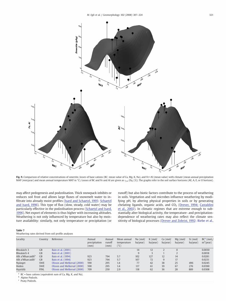
Fig. 9. Comparison of relative concentrations of smectite, losses of base cations (BC; mean value of Ca, Mg, K, Na), and Fe+Al (mean value) with climate (mean annual precipitationMAP (mm/year) and mean annual temperature MAT in °C). Losses of BC and Fe and Al are given as sj,w (Eq. (3)). The graphs refer to the soil surface horizons (AE, A, E, or O horizon).
321M. Egli et al. / Geomorphology 102 (2008) 307–324
may affect pedogenesis and podzolisation. Thick snowpack inhibits orreduces soil frost and allows large fluxes of snowmelt water to in-filtrate into already moist profiles (Isard and Schaetzl, 1995; Schaetzland Isard, 1996). This type of flux (slow, steady, cold water) may beparticularly effective in the podzolisation process (Schaetzl and Isard,1996). Net export of elements is thus higher with increasing altitudes.Weathering is not only influenced by temperature but also by mois-ture availability: similarly, not only temperature or precipitation (or
Table 7Weathering rates derived from soil profile analyses
Locality Country Reference Annualprecipitation(mm)
Annualrunoff(mm)
Mt(
Bhealaich 3 GB Bain et al. (2001)Bhealaich 4 GB Bain et al. (2001)Allt a'Mharcaidhb GB Bain et al. (1994) 923 794 5Allt a'Mharcaidhc GB Bain et al. (1994) 923 794 5Nyänget SWE Olsson and Melkerud (2000) 590 295 1Heden SWE Olsson and Melkerud (2000) 590 295 1Hyytiälä FINL Olsson and Melkerud (2000) 709 250 2
a BC = base cations (equivalent sum of Ca, Mg, K, and Na).b Alpine Podzols.c Peaty Podzols.
runoff) but also biotic factors contribute to the process of weatheringin soils. Vegetation and soil microbes influence weathering by modi-fying pH, by altering physical properties in soils or by generatingchelating ligands, organic acids, and CO2 (Drever, 1994; Castaldiniet al., 2002). In climatic regimes that are extreme enough to sub-stantially alter biological activity, the temperature- and precipitation-dependence of weathering rates may also reflect the climate sen-sitivity of biological processes (Drever and Zobrist, 1992; Riebe et al.,
ean annualemperature°C)
Na (mol/ha/year)
K (mol/ha/year)
Ca (mol/ha/year)
Mg (mol/ha/year)
Si (mol/ha/year)
BCa (molc/m2/year)
14 12 2 0 0.00309 3 1 2 0.0018
.7 102 127 12 14 0.0281
.7 107 72 9 17 0.0231.4 77 42 38 25 496 0.0245.4 117 61 39 67 276 0.0390.9 118 62 36 28 889 0.0308
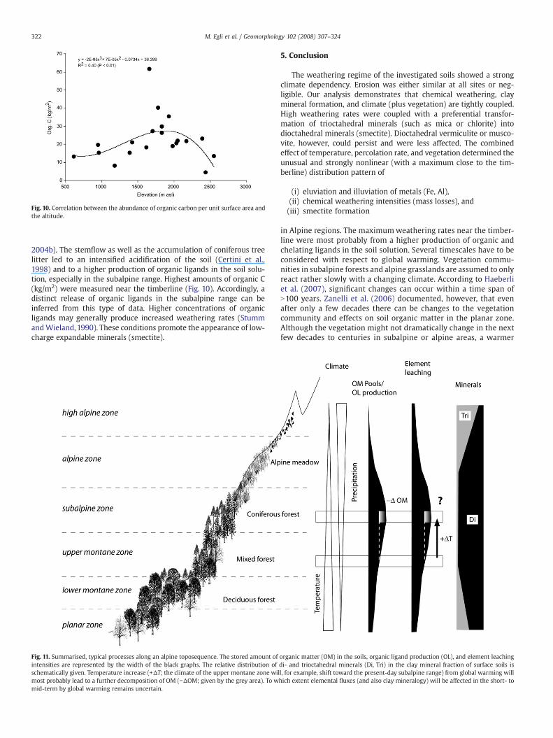
Fig. 10. Correlation between the abundance of organic carbon per unit surface area andthe altitude.
322 M. Egli et al. / Geomorphology 102 (2008) 307–324
2004b). The stemflow as well as the accumulation of coniferous treelitter led to an intensified acidification of the soil (Certini et al.,1998) and to a higher production of organic ligands in the soil solu-tion, especially in the subalpine range. Highest amounts of organic C(kg/m2) were measured near the timberline (Fig. 10). Accordingly, adistinct release of organic ligands in the subalpine range can beinferred from this type of data. Higher concentrations of organicligands may generally produce increased weathering rates (StummandWieland, 1990). These conditions promote the appearance of low-charge expandable minerals (smectite).
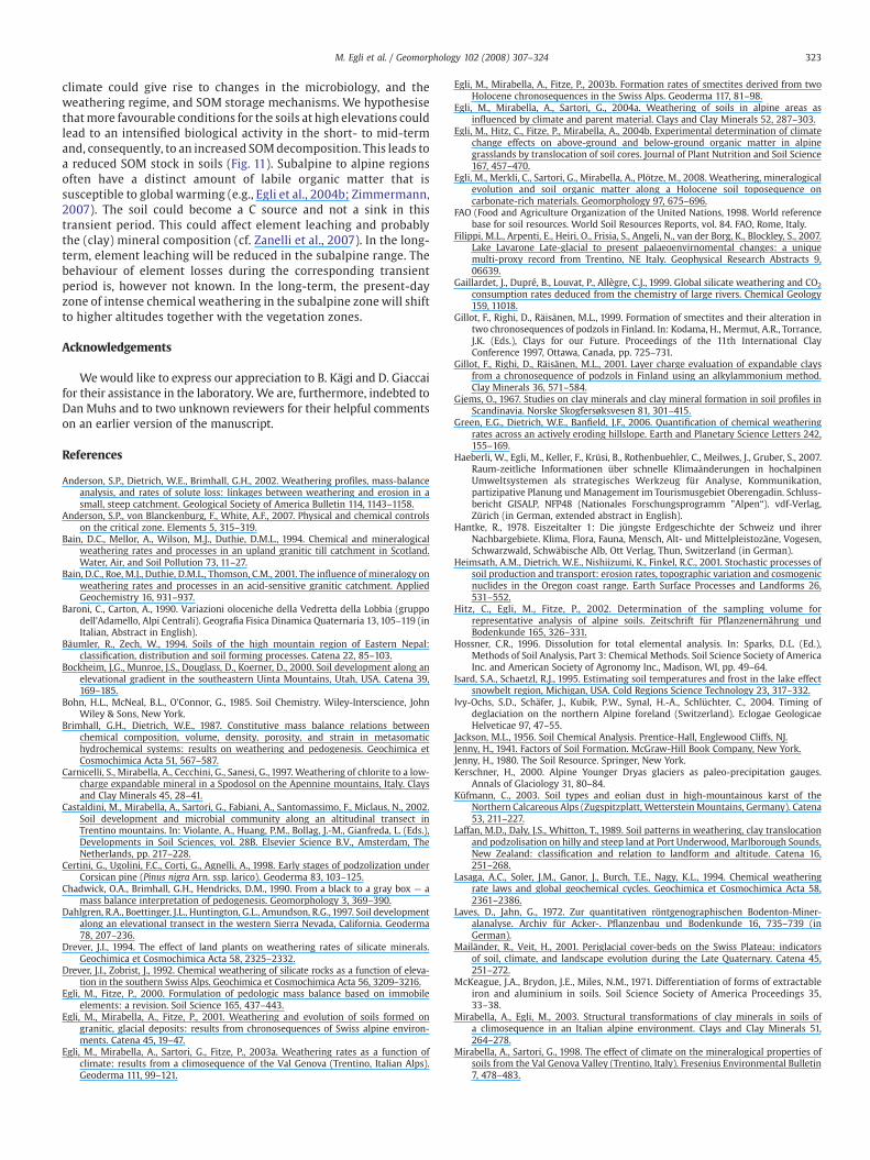
Fig. 11. Summarised, typical processes along an alpine toposequence. The stored amount ofintensities are represented by the width of the black graphs. The relative distribution ofschematically given. Temperature increase (+ΔT; the climate of the upper montane zone wilmost probably lead to a further decomposition of OM (−ΔOM; given by the grey area). To wmid-term by global warming remains uncertain.
5. Conclusion
The weathering regime of the investigated soils showed a strongclimate dependency. Erosion was either similar at all sites or neg-ligible. Our analysis demonstrates that chemical weathering, claymineral formation, and climate (plus vegetation) are tightly coupled.High weathering rates were coupled with a preferential transfor-mation of trioctahedral minerals (such as mica or chlorite) intodioctahedral minerals (smectite). Dioctahedral vermiculite or musco-vite, however, could persist and were less affected. The combinedeffect of temperature, percolation rate, and vegetation determined theunusual and strongly nonlinear (with a maximum close to the tim-berline) distribution pattern of
(i) eluviation and illuviation of metals (Fe, Al),(ii) chemical weathering intensities (mass losses), and(iii) smectite formation
in Alpine regions. The maximumweathering rates near the timber-line were most probably from a higher production of organic andchelating ligands in the soil solution. Several timescales have to beconsidered with respect to global warming. Vegetation commu-nities in subalpine forests and alpine grasslands are assumed to onlyreact rather slowly with a changing climate. According to Haeberliet al. (2007), significant changes can occur within a time span ofN100 years. Zanelli et al. (2006) documented, however, that evenafter only a few decades there can be changes to the vegetationcommunity and effects on soil organic matter in the planar zone.Although the vegetation might not dramatically change in the nextfew decades to centuries in subalpine or alpine areas, a warmer
organic matter (OM) in the soils, organic ligand production (OL), and element leachingdi- and trioctahedral minerals (Di, Tri) in the clay mineral fraction of surface soils isl, for example, shift toward the present-day subalpine range) from global warming willhich extent elemental fluxes (and also clay mineralogy) will be affected in the short- to
323M. Egli et al. / Geomorphology 102 (2008) 307–324
climate could give rise to changes in the microbiology, and theweathering regime, and SOM storage mechanisms. We hypothesisethatmore favourable conditions for the soils at high elevations couldlead to an intensified biological activity in the short- to mid-termand, consequently, to an increased SOMdecomposition. This leads toa reduced SOM stock in soils (Fig. 11). Subalpine to alpine regionsoften have a distinct amount of labile organic matter that issusceptible to global warming (e.g., Egli et al., 2004b; Zimmermann,2007). The soil could become a C source and not a sink in thistransient period. This could affect element leaching and probablythe (clay) mineral composition (cf. Zanelli et al., 2007). In the long-term, element leaching will be reduced in the subalpine range. Thebehaviour of element losses during the corresponding transientperiod is, however not known. In the long-term, the present-dayzone of intense chemical weathering in the subalpine zone will shiftto higher altitudes together with the vegetation zones.
Acknowledgements
Wewould like to express our appreciation to B. Kägi and D. Giaccaifor their assistance in the laboratory. We are, furthermore, indebted toDan Muhs and to two unknown reviewers for their helpful commentson an earlier version of the manuscript.
References
Anderson, S.P., Dietrich, W.E., Brimhall, G.H., 2002. Weathering profiles, mass-balanceanalysis, and rates of solute loss: linkages between weathering and erosion in asmall, steep catchment. Geological Society of America Bulletin 114, 1143–1158.
Anderson, S.P., von Blanckenburg, F., White, A.F., 2007. Physical and chemical controlson the critical zone. Elements 5, 315–319.
Bain, D.C., Mellor, A., Wilson, M.J., Duthie, D.M.L., 1994. Chemical and mineralogicalweathering rates and processes in an upland granitic till catchment in Scotland.Water, Air, and Soil Pollution 73, 11–27.
Bain, D.C., Roe, M.J., Duthie, D.M.L., Thomson, C.M., 2001. The influence of mineralogy onweathering rates and processes in an acid-sensitive granitic catchment. AppliedGeochemistry 16, 931–937.
Baroni, C., Carton, A., 1990. Variazioni oloceniche della Vedretta della Lobbia (gruppodell'Adamello, Alpi Centrali). Geografia Fisica Dinamica Quaternaria 13, 105–119 (inItalian, Abstract in English).
Bäumler, R., Zech, W., 1994. Soils of the high mountain region of Eastern Nepal:classification, distribution and soil forming processes. Catena 22, 85–103.
Bockheim, J.G., Munroe, J.S., Douglass, D., Koerner, D., 2000. Soil development along anelevational gradient in the southeastern Uinta Mountains, Utah, USA. Catena 39,169–185.
Bohn, H.L., McNeal, B.L., O'Connor, G., 1985. Soil Chemistry. Wiley-Interscience, JohnWiley & Sons, New York.
Brimhall, G.H., Dietrich, W.E., 1987. Constitutive mass balance relations betweenchemical composition, volume, density, porosity, and strain in metasomatichydrochemical systems: results on weathering and pedogenesis. Geochimica etCosmochimica Acta 51, 567–587.
Carnicelli, S., Mirabella, A., Cecchini, G., Sanesi, G., 1997. Weathering of chlorite to a low-charge expandable mineral in a Spodosol on the Apennine mountains, Italy. Claysand Clay Minerals 45, 28–41.
Castaldini, M., Mirabella, A., Sartori, G., Fabiani, A., Santomassimo, F., Miclaus, N., 2002.Soil development and microbial community along an altitudinal transect inTrentino mountains. In: Violante, A., Huang, P.M., Bollag, J.-M., Gianfreda, L. (Eds.),Developments in Soil Sciences, vol. 28B. Elsevier Science B.V., Amsterdam, TheNetherlands, pp. 217–228.
Certini, G., Ugolini, F.C., Corti, G., Agnelli, A., 1998. Early stages of podzolization underCorsican pine (Pinus nigra Arn. ssp. larico). Geoderma 83, 103–125.
Chadwick, O.A., Brimhall, G.H., Hendricks, D.M., 1990. From a black to a gray box — amass balance interpretation of pedogenesis. Geomorphology 3, 369–390.
Dahlgren, R.A., Boettinger, J.L., Huntington, G.L., Amundson, R.G., 1997. Soil developmentalong an elevational transect in the western Sierra Nevada, California. Geoderma78, 207–236.
Drever, J.I., 1994. The effect of land plants on weathering rates of silicate minerals.Geochimica et Cosmochimica Acta 58, 2325–2332.
Drever, J.I., Zobrist, J., 1992. Chemical weathering of silicate rocks as a function of eleva-tion in the southern Swiss Alps. Geochimica et Cosmochimica Acta 56, 3209–3216.
Egli, M., Fitze, P., 2000. Formulation of pedologic mass balance based on immobileelements: a revision. Soil Science 165, 437–443.
Egli, M., Mirabella, A., Fitze, P., 2001. Weathering and evolution of soils formed ongranitic, glacial deposits: results from chronosequences of Swiss alpine environ-ments. Catena 45, 19–47.
Egli, M., Mirabella, A., Sartori, G., Fitze, P., 2003a. Weathering rates as a function ofclimate: results from a climosequence of the Val Genova (Trentino, Italian Alps).Geoderma 111, 99–121.
Egli, M., Mirabella, A., Fitze, P., 2003b. Formation rates of smectites derived from twoHolocene chronosequences in the Swiss Alps. Geoderma 117, 81–98.
Egli, M., Mirabella, A., Sartori, G., 2004a. Weathering of soils in alpine areas asinfluenced by climate and parent material. Clays and Clay Minerals 52, 287–303.
Egli, M., Hitz, C., Fitze, P., Mirabella, A., 2004b. Experimental determination of climatechange effects on above-ground and below-ground organic matter in alpinegrasslands by translocation of soil cores. Journal of Plant Nutrition and Soil Science167, 457–470.
Egli, M., Merkli, C., Sartori, G., Mirabella, A., Plötze, M., 2008. Weathering, mineralogicalevolution and soil organic matter along a Holocene soil toposequence oncarbonate-rich materials. Geomorphology 97, 675–696.
FAO (Food and Agriculture Organization of the United Nations, 1998. World referencebase for soil resources. World Soil Resources Reports, vol. 84. FAO, Rome, Italy.
Filippi, M.L., Arpenti, E., Heiri, O., Frisia, S., Angeli, N., van der Borg, K., Blockley, S., 2007.Lake Lavarone Late-glacial to present palaeoenvirnomental changes: a uniquemulti-proxy record from Trentino, NE Italy. Geophysical Research Abstracts 9,06639.
Gaillardet, J., Dupré, B., Louvat, P., Allègre, C.J., 1999. Global silicate weathering and CO2
consumption rates deduced from the chemistry of large rivers. Chemical Geology159, 11018.
Gillot, F., Righi, D., Räisänen, M.L., 1999. Formation of smectites and their alteration intwo chronosequences of podzols in Finland. In: Kodama, H., Mermut, A.R., Torrance,J.K. (Eds.), Clays for our Future. Proceedings of the 11th International ClayConference 1997, Ottawa, Canada, pp. 725–731.
Gillot, F., Righi, D., Räisänen, M.L., 2001. Layer charge evaluation of expandable claysfrom a chronosequence of podzols in Finland using an alkylammonium method.Clay Minerals 36, 571–584.
Gjems, O., 1967. Studies on clay minerals and clay mineral formation in soil profiles inScandinavia. Norske Skogfersøksvesen 81, 301–415.
Green, E.G., Dietrich, W.E., Banfield, J.F., 2006. Quantification of chemical weatheringrates across an actively eroding hillslope. Earth and Planetary Science Letters 242,155–169.
Haeberli, W., Egli, M., Keller, F., Krüsi, B., Rothenbuehler, C., Meilwes, J., Gruber, S., 2007.Raum-zeitliche Informationen über schnelle Klimaänderungen in hochalpinenUmweltsystemen als strategisches Werkzeug für Analyse, Kommunikation,partizipative Planung und Management im Tourismusgebiet Oberengadin. Schluss-bericht GISALP, NFP48 (Nationales Forschungsprogramm ”Alpen“). vdf-Verlag,Zürich (in German, extended abstract in English).
Hantke, R., 1978. Eiszeitalter 1: Die jüngste Erdgeschichte der Schweiz und ihrerNachbargebiete. Klima, Flora, Fauna, Mensch, Alt- und Mittelpleistozäne, Vogesen,Schwarzwald, Schwäbische Alb, Ott Verlag, Thun, Switzerland (in German).
Heimsath, A.M., Dietrich, W.E., Nishiizumi, K., Finkel, R.C., 2001. Stochastic processes ofsoil production and transport: erosion rates, topographic variation and cosmogenicnuclides in the Oregon coast range. Earth Surface Processes and Landforms 26,531–552.
Hitz, C., Egli, M., Fitze, P., 2002. Determination of the sampling volume forrepresentative analysis of alpine soils. Zeitschrift für Pflanzenernährung undBodenkunde 165, 326–331.
Hossner, C.R., 1996. Dissolution for total elemental analysis. In: Sparks, D.L. (Ed.),Methods of Soil Analysis, Part 3: Chemical Methods. Soil Science Society of AmericaInc. and American Society of Agronomy Inc., Madison, WI, pp. 49–64.
Isard, S.A., Schaetzl, R.J., 1995. Estimating soil temperatures and frost in the lake effectsnowbelt region, Michigan, USA. Cold Regions Science Technology 23, 317–332.
Ivy-Ochs, S.D., Schäfer, J., Kubik, P.W., Synal, H.-A., Schlüchter, C., 2004. Timing ofdeglaciation on the northern Alpine foreland (Switzerland). Eclogae GeologicaeHelveticae 97, 47–55.
Jackson, M.L., 1956. Soil Chemical Analysis. Prentice-Hall, Englewood Cliffs, NJ.Jenny, H., 1941. Factors of Soil Formation. McGraw-Hill Book Company, New York.Jenny, H., 1980. The Soil Resource. Springer, New York.Kerschner, H., 2000. Alpine Younger Dryas glaciers as paleo-precipitation gauges.
Annals of Glaciology 31, 80–84.Küfmann, C., 2003. Soil types and eolian dust in high-mountainous karst of the
Northern Calcareous Alps (Zugspitzplatt, WettersteinMountains, Germany). Catena53, 211–227.
Laffan, M.D., Daly, J.S., Whitton, T., 1989. Soil patterns in weathering, clay translocationand podzolisation on hilly and steep land at Port Underwood, Marlborough Sounds,New Zealand: classification and relation to landform and altitude. Catena 16,251–268.
Lasaga, A.C., Soler, J.M., Ganor, J., Burch, T.E., Nagy, K.L., 1994. Chemical weatheringrate laws and global geochemical cycles. Geochimica et Cosmochimica Acta 58,2361–2386.
Laves, D., Jahn, G., 1972. Zur quantitativen röntgenographischen Bodenton-Miner-alanalyse. Archiv für Acker-. Pflanzenbau und Bodenkunde 16, 735–739 (inGerman).
Mailänder, R., Veit, H., 2001. Periglacial cover-beds on the Swiss Plateau: indicatorsof soil, climate, and landscape evolution during the Late Quaternary. Catena 45,251–272.
McKeague, J.A., Brydon, J.E., Miles, N.M., 1971. Differentiation of forms of extractableiron and aluminium in soils. Soil Science Society of America Proceedings 35,33–38.
Mirabella, A., Egli, M., 2003. Structural transformations of clay minerals in soils ofa climosequence in an Italian alpine environment. Clays and Clay Minerals 51,264–278.
Mirabella, A., Sartori, G., 1998. The effect of climate on the mineralogical properties ofsoils from the Val Genova Valley (Trentino, Italy). Fresenius Environmental Bulletin7, 478–483.
324 M. Egli et al. / Geomorphology 102 (2008) 307–324
Mirabella, A., Egli, M., Carnicelli, S., Sartori, G., 2002. Influence of parentmaterial on clayminerals formation in podzols of Trentino — Italy. Clay Minerals 37, 699–707.
Moore, D.M., Reynolds, R.C., 1997. X-ray Diffraction and the Identification and Analysisof Clay Minerals, 2nd ed. Oxford University Press, New York.
Muhs, D.R., Benedict, J.B., 2006. Eolian Additions to Late Quaternary Alpine Soils, IndianPeaks Wilderness Area, Colorado Front Range. Arctic, Antarctic, and AlpineResearch 38, 120–130.
Muhs, D.R., Bettis, E.A., Been, J., McGeehin, J.P., 2001. Impact of climate and parentmaterial on chemical weathering in loess-derived soils of the Mississippi rivervalley. Soil Science Society of America Journal 65, 1761–1777.
Niederbudde, E.A., Kussmaul, H., 1978. Tonmineraleigenschaften und -Umwandlungenin Parabraunerde-Profilpaaren unter Acker und Wald in Süddeutschland. Geo-derma 20, 239–255 (in German, abstract in English).
Oetheimer, C., 1990. La foresta sommersa del Lago di Tovel (Trentino): reinterpretazionee datazione dendrocronologica. Studi trentini di scienze naturali. Acta Geologica 67,3–23 (in Italian, abstract in English).
Olis, A.C., Malla, P.B., Douglas, L.A., 1990. The rapid estimation of the layer charges of 2:1expanding clays from a single alkylammonium ion expansion. Clay Minerals 25,39–50.
Olsson, M.T., Melkerud, P.-A., 2000. Weathering in three podzolized pedons on glacialdeposits in northern Sweden and central Finland. Geoderma 94, 149–161.
Richter, D.D., Hofmockel, M., Callaham, M.A., Powlson, D.S., Smith, P., 2007. Long-termsoil experiments: keys to managing Earth's rapidly changing ecosystem. SoilScience Society of America Journal 71, 266–279.
Riebe, C.S., Kirchner, J.W., Finkel, R.C., 2004a. Erosional and climatic effects on long-termchemical weathering rates in granitic landscapes spanning diverse climate regimes.Earth and Planetary Science Letters 224, 547–562.
Riebe, C.S., Kirchner, J.W., Finkel, R.C., 2004b. Sharp decrease in long-term chemicalweathering rates along an altitudinal transect. Earth and Planetary Science Letters218, 421–434.
Righi, D., Räisänen, M.L., Gillot, F., 1997. Clay mineral transformations in podzolized tillsin central Finland. Clay Minerals 32, 531–544.
Righi, D., Huber, K., Keller, C., 1999. Clay formation and podzol development frompostglacial moraines in Switzerland. Clay Minerals 34, 319–332.
Sartori, G., Mancabelli, A., Wolf, U., Corradini, F., 2005. Atlante dei suoli del ParcoNaturale Adamello-Brenta. Suoli e paesaggi. MuseoTridentino di Scienze Naturali—Monografie II, Trento (in Italian).
Schaetzl, R.J., Isard, S.A., 1996. Regional-scale relationships between climate andstrength of podzolization in the Great Lakes Region, North America. Catena 28,47–69.
Schulze, D.G., 1989. An introduction to soil mineralogy. In: Dixon, J.B., Weed, S.B. (Eds.),Minerals in Soil Environments, vol. 1. Soil Science Society of America Inc., Madison,WI, pp. 1–34. Book Series No.
Schwertmann, U., Niederbudde, E.A., 1993. Tonmineralbestimmung in Böden. In:Jasmund, K., Lagaly, G. (Eds.), Tonminerale und Tone. Struktur, Eigenschaften,Anwendung und Einsatz in Industrie und Umwelt. Steinkopff Verlag, Darmstadt,Germany, pp. 255–265 (in German).
Soil Survey Staff, 2006. Keys to Soil Taxonomy, 10th ed. US Department of Agriculture,National Resources Conservation Service, Washington, DC.
Stumm, W., Wieland, E., 1990. Dissolution of oxide and silicate minerals: rates dependon surface speciation. In: Stumm, W. (Ed.), Aquatic Chemical Kinetics: ReactionRates of Processes in Natural Waters. Wiley-Interscience, New York, pp. 367–398.
Tamura, T., 1958. Identification of clay minerals from acid soils. Journal of Soil Science 9,141–147.
van Hees, P.A.W., Lundström, U.S., Giesler, R., 2000. Lowmolecular weight organic acidsand their Al-complexes in soil solution — composition, distribution and seasonalvariation in three podzolized soils. Geoderma 94, 173–200.
Velde, B., 1995. Origin and mineralogy of clays. Clays and the Environment. Springer-Verlag, Berlin Heidelberg, Germany.
von Blanckenburg, F., 2005. The control mechanisms of erosion and weathering at basinscale from cosmogenic nuclides in river sediments. Earth and Planetary ScienceLetters 237, 462–479.
West, A.J., Galy, A., Bickle, M., 2005. Tectonic and climatic controls on silicateweathering. Earth and Planetary Science Letters 235, 211–228.
White, A.F., Blum, A.E., 1995. Effects of climate on chemical weathering in watersheds.Geochimica et Cosmochimica Acta 59, 1729–1747.
White, A.F., Blum, A.E., Bullen, T.D., Vivit, D.V., Schulz, M., Fitzpatrick, J., 1999. The effectof temperature on experimental and natural chemical weathering rates of granitoidrocks. Geochimica et Cosmochimica Acta 63, 3277–3291.
Zanelli, R., Egli, M., Fitze, P., Giaccai, D., Mirabella, A., 2006. Influence of laurophyllousspecies, chestnut and native vegetation on organic matter in soils in southernSwitzerland and northern Italy. Geoderma 136, 723–737.
Zanelli, R., Egli, M., Mirabella, A., Giaccai, A., Abdelmoula, M., 2007. Vegetation effects onpedogenetic forms of Fe, Al and Si and on clay minerals in soils in southernSwitzerland and northern Italy. Geoderma 141, 119–129.
Zimmermann, M., 2007. Spectroscopic quantification of soil organic carbon fractionsthat can be related to model pools. Schriftenreihe Physische Geographie,Bodenkunde und Biogeographie 56, Zürich, Switzerland.
Copyright © 2022 FDOKUMEN