QGIS Server 3.16 User Guide
82
QGIS Server 3.16 User Guide QGIS Project 13.01.2022
-
Upload
khangminh22 -
Category
Documents
-
view
3 -
download
0
Transcript of QGIS Server 3.16 User Guide

QGIS Server 3.16 User Guide
QGIS Project
13.01.2022


Inhaltsverzeichnis
1 Einführung 1
2 Der erste Einstieg 32.1 Installation on Debian-based systems . . . . . . . . . . . . . . . . . . . . . . . . . . . . . . . . . 3
2.1.1 Apache HTTP Server . . . . . . . . . . . . . . . . . . . . . . . . . . . . . . . . . . . . 42.1.2 NGINX HTTP Server . . . . . . . . . . . . . . . . . . . . . . . . . . . . . . . . . . . . 62.1.3 Xvfb . . . . . . . . . . . . . . . . . . . . . . . . . . . . . . . . . . . . . . . . . . . . . 11
2.2 Installation on Windows . . . . . . . . . . . . . . . . . . . . . . . . . . . . . . . . . . . . . . . 122.3 Serve a project . . . . . . . . . . . . . . . . . . . . . . . . . . . . . . . . . . . . . . . . . . . . 142.4 Configure your project . . . . . . . . . . . . . . . . . . . . . . . . . . . . . . . . . . . . . . . . 15
2.4.1 WMS capabilities . . . . . . . . . . . . . . . . . . . . . . . . . . . . . . . . . . . . . . 172.4.2 WFS capabilities . . . . . . . . . . . . . . . . . . . . . . . . . . . . . . . . . . . . . . 182.4.3 WCS capabilities . . . . . . . . . . . . . . . . . . . . . . . . . . . . . . . . . . . . . . 182.4.4 Fine tuning your OWS . . . . . . . . . . . . . . . . . . . . . . . . . . . . . . . . . . . 18
2.5 Integration with third parties . . . . . . . . . . . . . . . . . . . . . . . . . . . . . . . . . . . . . 182.5.1 Integration with QGIS Desktop . . . . . . . . . . . . . . . . . . . . . . . . . . . . . . . 182.5.2 Integration with MapProxy . . . . . . . . . . . . . . . . . . . . . . . . . . . . . . . . . 182.5.3 Integration with QWC2 . . . . . . . . . . . . . . . . . . . . . . . . . . . . . . . . . . . 19
3 Services 213.1 Web Map Service (WMS) . . . . . . . . . . . . . . . . . . . . . . . . . . . . . . . . . . . . . . 21
3.1.1 GetMap . . . . . . . . . . . . . . . . . . . . . . . . . . . . . . . . . . . . . . . . . . . 223.1.2 GetFeatureInfo . . . . . . . . . . . . . . . . . . . . . . . . . . . . . . . . . . . . . . . 293.1.3 GetPrint . . . . . . . . . . . . . . . . . . . . . . . . . . . . . . . . . . . . . . . . . . . 323.1.4 GetLegendGraphics . . . . . . . . . . . . . . . . . . . . . . . . . . . . . . . . . . . . . 343.1.5 GetProjectSettings . . . . . . . . . . . . . . . . . . . . . . . . . . . . . . . . . . . . . . 35
3.2 Web Feature Service (WFS) . . . . . . . . . . . . . . . . . . . . . . . . . . . . . . . . . . . . . 353.2.1 GetFeature . . . . . . . . . . . . . . . . . . . . . . . . . . . . . . . . . . . . . . . . . . 36
3.3 Web Map Tile Service (WMTS) . . . . . . . . . . . . . . . . . . . . . . . . . . . . . . . . . . . 383.3.1 GetCapabilities . . . . . . . . . . . . . . . . . . . . . . . . . . . . . . . . . . . . . . . 383.3.2 GetTile . . . . . . . . . . . . . . . . . . . . . . . . . . . . . . . . . . . . . . . . . . . 393.3.3 GetFeatureInfo . . . . . . . . . . . . . . . . . . . . . . . . . . . . . . . . . . . . . . . 41
3.4 WFS3 (OGC API Features) . . . . . . . . . . . . . . . . . . . . . . . . . . . . . . . . . . . . . 433.4.1 Resource representation . . . . . . . . . . . . . . . . . . . . . . . . . . . . . . . . . . . 433.4.2 Endpoints . . . . . . . . . . . . . . . . . . . . . . . . . . . . . . . . . . . . . . . . . . 443.4.3 Pagination . . . . . . . . . . . . . . . . . . . . . . . . . . . . . . . . . . . . . . . . . . 483.4.4 Objektfiltrierung . . . . . . . . . . . . . . . . . . . . . . . . . . . . . . . . . . . . . . . 483.4.5 Feature sorting . . . . . . . . . . . . . . . . . . . . . . . . . . . . . . . . . . . . . . . 493.4.6 Attribute selection . . . . . . . . . . . . . . . . . . . . . . . . . . . . . . . . . . . . . . 493.4.7 Customize the HTML pages . . . . . . . . . . . . . . . . . . . . . . . . . . . . . . . . . 50
3.5 Extra parameters supported by all request types . . . . . . . . . . . . . . . . . . . . . . . . . . . 51
i

3.6 REDLINING . . . . . . . . . . . . . . . . . . . . . . . . . . . . . . . . . . . . . . . . . . . . . 513.7 External WMS layers . . . . . . . . . . . . . . . . . . . . . . . . . . . . . . . . . . . . . . . . . 533.8 QGIS Server catalog . . . . . . . . . . . . . . . . . . . . . . . . . . . . . . . . . . . . . . . . . 53
4 Plugins 574.1 Installation . . . . . . . . . . . . . . . . . . . . . . . . . . . . . . . . . . . . . . . . . . . . . . 574.2 HTTP Server configuration . . . . . . . . . . . . . . . . . . . . . . . . . . . . . . . . . . . . . . 57
4.2.1 Apache . . . . . . . . . . . . . . . . . . . . . . . . . . . . . . . . . . . . . . . . . . . 574.3 How to use a plugin . . . . . . . . . . . . . . . . . . . . . . . . . . . . . . . . . . . . . . . . . . 58
5 Advanced configuration 595.1 Logging . . . . . . . . . . . . . . . . . . . . . . . . . . . . . . . . . . . . . . . . . . . . . . . . 595.2 Environment variables . . . . . . . . . . . . . . . . . . . . . . . . . . . . . . . . . . . . . . . . 595.3 Settings summary . . . . . . . . . . . . . . . . . . . . . . . . . . . . . . . . . . . . . . . . . . . 615.4 Short name for layers, groups and project . . . . . . . . . . . . . . . . . . . . . . . . . . . . . . 625.5 Connection to service file . . . . . . . . . . . . . . . . . . . . . . . . . . . . . . . . . . . . . . . 625.6 Add fonts to your linux server . . . . . . . . . . . . . . . . . . . . . . . . . . . . . . . . . . . . 62
6 Development Server 65
7 Containerized deployment 677.1 Simple docker images . . . . . . . . . . . . . . . . . . . . . . . . . . . . . . . . . . . . . . . . . 67
7.1.1 First run . . . . . . . . . . . . . . . . . . . . . . . . . . . . . . . . . . . . . . . . . . . 697.1.2 Usable sample . . . . . . . . . . . . . . . . . . . . . . . . . . . . . . . . . . . . . . . . 697.1.3 Cleanup . . . . . . . . . . . . . . . . . . . . . . . . . . . . . . . . . . . . . . . . . . . 70
7.2 Docker stacks . . . . . . . . . . . . . . . . . . . . . . . . . . . . . . . . . . . . . . . . . . . . . 707.2.1 Swarm/docker-compose . . . . . . . . . . . . . . . . . . . . . . . . . . . . . . . . . . . 707.2.2 Kubernetes . . . . . . . . . . . . . . . . . . . . . . . . . . . . . . . . . . . . . . . . . 71
7.3 Cloud deployment . . . . . . . . . . . . . . . . . . . . . . . . . . . . . . . . . . . . . . . . . . 757.3.1 AWS usecase . . . . . . . . . . . . . . . . . . . . . . . . . . . . . . . . . . . . . . . . 75
8 Frequently Asked Question 77
ii

KAPITEL1
Einführung
QGIS Server is an open source WMS, WFS, OGC API for Features 1.0 (WFS3) and WCS implementation that, inaddition, implements advanced cartographic features for thematicmapping. QGIS Server is a FastCGI/CGI (CommonGateway Interface) application written in C++ that works together with a web server (e.g., Apache, Nginx). It hasPython plugin support allowing for fast and efficient development and deployment of new features.QGIS Server uses QGIS as back end for the GIS logic and for map rendering. Furthermore, the Qt library is used forgraphics and for platform-independent C++ programming. In contrast to other WMS software, the QGIS Server usescartographic rules as a configuration language, both for the server configuration and for the user-defined cartographicrules.As QGIS desktop and QGIS Server use the same visualization libraries, the maps that are published on the web lookthe same as in desktop GIS.In the following sections, we will provide a sample configuration to set up a QGIS Server on Linux (Debian, Ubuntuand derivatives) and onWindows. For more information about server plugin development, please read server_plugins.
1

QGIS Server 3.16 User Guide
2 Kapitel 1. Einführung

KAPITEL2
Der erste Einstieg
2.1 Installation on Debian-based systems
We will give a short and simple installation how-to for a minimal working configuration on Debian based systems(including Ubuntu and derivatives). However, many other distributions and OSs provide packages for QGIS Server.
Bemerkung: In Ubuntu you can use your regular user, prepending sudo to commands requiring admin permissions.In Debian you can work as admin (root), without using sudo.
Requirements and steps to add official QGIS repositories to install QGIS Server on aDebian based system are providedin QGIS installers page. You may want to install at least the latest Long Term Release.Once the target version repository is configured and QGIS Server installed, you can test the installation with:
/usr/lib/cgi-bin/qgis_mapserv.fcgi
If you get the following output, the server is correctly installed.
Bemerkung: Depending on the version of QGIS, you might see slightly different output reported when you runqgis_mapserv.fcgi.
QFSFileEngine::open: No file name specifiedWarning 1: Unable to find driver ECW to unload from GDAL_SKIP environment variable.Warning 1: Unable to find driver ECW to unload from GDAL_SKIP environment variable.Warning 1: Unable to find driver JP2ECW to unload from GDAL_SKIP environment␣↪→variable.Warning 1: Unable to find driver ECW to unload from GDAL_SKIP environment variable.Warning 1: Unable to find driver JP2ECW to unload from GDAL_SKIP environment␣↪→variable.Content-Length: 206Content-Type: text/xml; charset=utf-8
<ServiceExceptionReport version="1.3.0" xmlns="https://www.opengis.net/ogc"><ServiceException code="Service configuration error">Service unknown or␣↪→unsupported</ServiceException></ServiceExceptionReport>
3

QGIS Server 3.16 User Guide
Bemerkung: As seen below, QGIS reports a Status 400 code, which correctly identifies the request has failed becausethere is no active http session. This is not a bug and indicates the server is functioning properly.
Application path not initializedApplication path not initializedWarning 1: Unable to find driver ECW to unload from GDAL_SKIP environment variable.Warning 1: Unable to find driver ECW to unload from GDAL_SKIP environment variable.Warning 1: Unable to find driver JP2ECW to unload from GDAL_SKIP environment␣↪→variable."Loading native module /usr/lib/qgis/server/libdummy.so""Loading native module /usr/lib/qgis/server/liblandingpage.so""Loading native module /usr/lib/qgis/server/libwcs.so""Loading native module /usr/lib/qgis/server/libwfs.so""Loading native module /usr/lib/qgis/server/libwfs3.so""Loading native module /usr/lib/qgis/server/libwms.so""Loading native module /usr/lib/qgis/server/libwmts.so"QFSFileEngine::open: No file name specifiedContent-Length: 102Content-Type: application/jsonServer: QGIS FCGI server - QGIS version 3.16.6-HannoverStatus: 400[{"code":"Bad request error","description":"Requested URI does not match any␣↪→registered API handler"}]
Let’s add a sample project. You can use your own, or one from Training demo data:
mkdir /home/qgis/projects/cd /home/qgis/projects/wget https://github.com/qgis/QGIS-Training-Data/archive/release_3.16.zipunzip release_3.16.zipmv QGIS-Training-Data-release_3.16/exercise_data/qgis-server-tutorial-data/world.↪→qgs .mv QGIS-Training-Data-release_3.16/exercise_data/qgis-server-tutorial-data/↪→naturalearth.sqlite .
Of course, you can use your favorite GIS software to open this file and take a look at the configuration and availablelayers.To properly deploy QGIS server you need a HTTP server. Recommended choices are Apache or NGINX.
2.1.1 Apache HTTP Server
Bemerkung: In the following, please replace qgis.demo with the name or IP address of your server.
Install Apache and mod_fcgid:
apt install apache2 libapache2-mod-fcgid
You can run QGIS Server on your default website, or configure a virtualhost specifically for this, as follows.In the /etc/apache2/sites-available directory let’s create a file called qgis.demo.conf, with thiscontent:
<VirtualHost *:80>ServerAdmin webmaster@localhostServerName qgis.demo
(Fortsetzung auf der nächsten Seite)
4 Kapitel 2. Der erste Einstieg

QGIS Server 3.16 User Guide
(Fortsetzung der vorherigen Seite)DocumentRoot /var/www/html
# Apache logs (different than QGIS Server log)ErrorLog ${APACHE_LOG_DIR}/qgis.demo.error.logCustomLog ${APACHE_LOG_DIR}/qgis.demo.access.log combined
# Longer timeout for WPS... default = 40FcgidIOTimeout 120
FcgidInitialEnv LC_ALL "en_US.UTF-8"FcgidInitialEnv PYTHONIOENCODING UTF-8FcgidInitialEnv LANG "en_US.UTF-8"
# QGIS logFcgidInitialEnv QGIS_SERVER_LOG_STDERR 1FcgidInitialEnv QGIS_SERVER_LOG_LEVEL 0
# default QGIS projectSetEnv QGIS_PROJECT_FILE /home/qgis/projects/world.qgs
# QGIS_AUTH_DB_DIR_PATH must lead to a directory writeable by the Server's FCGI␣↪→process userFcgidInitialEnv QGIS_AUTH_DB_DIR_PATH "/home/qgis/qgisserverdb/"FcgidInitialEnv QGIS_AUTH_PASSWORD_FILE "/home/qgis/qgisserverdb/qgis-auth.db"
# Set pg access via pg_service fileSetEnv PGSERVICEFILE /home/qgis/.pg_service.confFcgidInitialEnv PGPASSFILE "/home/qgis/.pgpass"
# if qgis-server is installed from packages in debian based distros this is␣↪→usually /usr/lib/cgi-bin/# run "locate qgis_mapserv.fcgi" if you don't know where qgis_mapserv.fcgi isScriptAlias /cgi-bin/ /usr/lib/cgi-bin/<Directory "/usr/lib/cgi-bin/">AllowOverride NoneOptions +ExecCGI -MultiViews -SymLinksIfOwnerMatchOrder allow,denyAllow from allRequire all granted
</Directory>
<IfModule mod_fcgid.c>FcgidMaxRequestLen 26214400FcgidConnectTimeout 60</IfModule>
</VirtualHost>
Further readings:• QGIS Server logging
• pg-service-file in QGIS ServerYou can do the above in a linux Desktop system by pasting and saving the above configuration after doing:
nano /etc/apache2/sites-available/qgis.demo.conf
Bemerkung: Some of the configuration options are explained in the Server environment variables section.
Let’s now create the directories that will store the QGIS Server logs and the authentication database:
2.1. Installation on Debian-based systems 5

QGIS Server 3.16 User Guide
mkdir -p /var/log/qgis/chown www-data:www-data /var/log/qgismkdir -p /home/qgis/qgisserverdbchown www-data:www-data /home/qgis/qgisserverdb
Bemerkung: www-data is the Apache user on Debian based systems and we need Apache to have access to thoselocations or files. The chown www-data... commands change the owner of the respective directories and filesto www-data.
We can now enable the virtual host, enable the fcgid mod if it’s not already enabled:
a2enmod fcgida2ensite qgis.demo
Now restart Apache for the new configuration to be taken into account:
systemctl restart apache2
Now that Apache knows that he should answer requests to http://qgis.demo we also need to setup the client systemso that it knows who qgis.demo is. We do that by adding 127.0.0.1 qgis.demo in the hosts file. We cando it with sh -c "echo '127.0.0.1 qgis.demo' >> /etc/hosts". Replace 127.0.0.1 with theIP of your server.
Bemerkung: Remember that both the qgis.demo.conf and /etc/hosts files should be configured for yoursetup to work. You can also test the access to your QGIS Server from other clients on the network (e.g. Windowsor macOS machines) by going to their /etc/hosts file and point the myhost name to whatever IP the servermachine has on the network (not 127.0.0.1 as it is the local IP, only accessible from the local machine). On*nix machines the hosts file is located in /etc, while on Windows it’s under the C:\Windows\System32\drivers\etc directory. Under Windows you need to start your text editor with administrator privileges beforeopening the hosts file.
QGIS Server is now available at http://qgis.demo. To check, type in a browser, as in the simple case:
http://qgis.demo/cgi-bin/qgis_mapserv.fcgi?SERVICE=WMS&VERSION=1.3.0&↪→REQUEST=GetCapabilities
2.1.2 NGINX HTTP Server
Bemerkung: In the following, please replace qgis.demo with the name or IP address of your server.
You can also use QGIS Server with NGINX. Unlike Apache, NGINX does not automatically spawn FastCGIprocesses. The FastCGI processes are to be started by something else.Install NGINX:
apt install nginx
• As a first option, you can use spawn-fcgi or fcgiwrap to start and manage the QGIS Server processes. OfficialDebian packages exist for both. When you have no X server running and you need, for example, printing, youcan use xvfb.
• Another option is to rely on Systemd, the init system for GNU/Linux that most Linux distributions use today.One of the advantages of this method is that it requires no other components or processes. It’s meant to besimple, yet robust and efficient for production deployments.
6 Kapitel 2. Der erste Einstieg

QGIS Server 3.16 User Guide
NGINX Configuration
The include fastcgi_params; used in the previous configuration is important, as it adds the parameters from /etc/nginx/fastcgi_params:
fastcgi_param QUERY_STRING $query_string;fastcgi_param REQUEST_METHOD $request_method;fastcgi_param CONTENT_TYPE $content_type;fastcgi_param CONTENT_LENGTH $content_length;
fastcgi_param SCRIPT_NAME $fastcgi_script_name;fastcgi_param REQUEST_URI $request_uri;fastcgi_param DOCUMENT_URI $document_uri;fastcgi_param DOCUMENT_ROOT $document_root;fastcgi_param SERVER_PROTOCOL $server_protocol;fastcgi_param REQUEST_SCHEME $scheme;fastcgi_param HTTPS $https if_not_empty;
fastcgi_param GATEWAY_INTERFACE CGI/1.1;fastcgi_param SERVER_SOFTWARE nginx/$nginx_version;
fastcgi_param REMOTE_ADDR $remote_addr;fastcgi_param REMOTE_PORT $remote_port;fastcgi_param SERVER_ADDR $server_addr;fastcgi_param SERVER_PORT $server_port;fastcgi_param SERVER_NAME $server_name;
# PHP only, required if PHP was built with --enable-force-cgi-redirectfastcgi_param REDIRECT_STATUS 200;
Moreover, you can use some Environment variables to configure QGIS Server. In the NGINX configuration file, /etc/nginx/nginx.conf, you have to use fastcgi_param instruction to define these variables as shownbelow:
location /qgisserver {gzip off;include fastcgi_params;fastcgi_param QGIS_SERVER_LOG_STDERR 1;fastcgi_param QGIS_SERVER_LOG_LEVEL 0;fastcgi_pass unix:/var/run/qgisserver.socket;
}
FastCGI wrappers
Warnung: fcgiwrap is easier to set up than spawn-fcgi, because it’s already wrapped in a Systemd service. Butit also leads to a solution that is much slower than using spawn-fcgi. With fcgiwrap, a new QGIS Server process iscreated on each request, meaning that the QGIS Server initialization process, which includes reading and parsingthe QGIS project file, is done on each request. With spawn-fcgi, the QGIS Server process remains alive betweenrequests, resulting in much better performance. For that reason, spawn-fcgi is recommended for production use.
spawn-fcgi
If you want to use spawn-fcgi, the first step is to install the package:
apt install spawn-fcgi
Then, introduce the following block in your NGINX server configuration:
2.1. Installation on Debian-based systems 7

QGIS Server 3.16 User Guide
location /qgisserver {gzip off;include fastcgi_params;fastcgi_pass unix:/var/run/qgisserver.socket;
}
And restart NGINX to take into account the new configuration:
systemctl restart nginx
Finally, considering that there is no default service file for spawn-fcgi, you have to manually start QGIS Server inyour terminal:
spawn-fcgi -s /var/run/qgisserver.socket \-U www-data -G www-data -n \/usr/lib/cgi-bin/qgis_mapserv.fcgi
QGIS Server is now available at http://qgis.demo/qgisserver.
Bemerkung: When using spawn-fcgi, you may directly define environment variables before running the server. Forexample: export QGIS_SERVER_LOG_STDERR=1
Of course, you can add an init script to start QGIS Server at boot time or whenever you want. For example withsystemd, edit the file /etc/systemd/system/qgis-server.service with this content:
[Unit]Description=QGIS serverAfter=network.target
[Service];; set env var as needed;Environment="LANG=en_EN.UTF-8";Environment="QGIS_SERVER_PARALLEL_RENDERING=1";Environment="QGIS_SERVER_MAX_THREADS=12";Environment="QGIS_SERVER_LOG_LEVEL=0";Environment="QGIS_SERVER_LOG_STDERR=1";; or use a file:;EnvironmentFile=/etc/qgis-server/env
ExecStart=spawn-fcgi -s /var/run/qgisserver.socket -U www-data -G www-data -n /usr/↪→lib/cgi-bin/qgis_mapserv.fcgi
[Install]WantedBy=multi-user.target
Then enable and start the service:
systemctl enable --now qgis-server
Warnung: With the above commands spawn-fcgi spawns only one QGIS Server process.
8 Kapitel 2. Der erste Einstieg
QGIS Server 3.16 User Guide
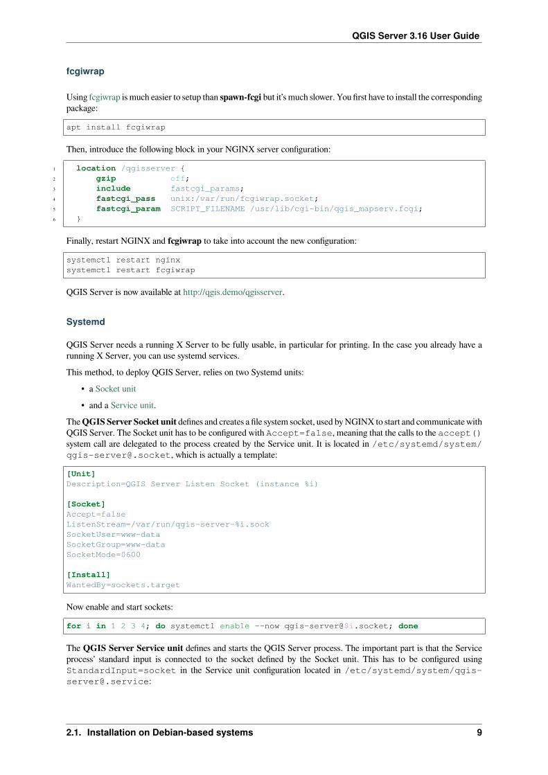
fcgiwrap
Using fcgiwrap is much easier to setup than spawn-fcgi but it’s much slower. You first have to install the correspondingpackage:
apt install fcgiwrap
Then, introduce the following block in your NGINX server configuration:
1 location /qgisserver {2 gzip off;3 include fastcgi_params;4 fastcgi_pass unix:/var/run/fcgiwrap.socket;5 fastcgi_param SCRIPT_FILENAME /usr/lib/cgi-bin/qgis_mapserv.fcgi;6 }
Finally, restart NGINX and fcgiwrap to take into account the new configuration:
systemctl restart nginxsystemctl restart fcgiwrap
QGIS Server is now available at http://qgis.demo/qgisserver.
Systemd
QGIS Server needs a running X Server to be fully usable, in particular for printing. In the case you already have arunning X Server, you can use systemd services.This method, to deploy QGIS Server, relies on two Systemd units:
• a Socket unit• and a Service unit.
TheQGISServer Socket unit defines and creates a file system socket, used byNGINX to start and communicate withQGIS Server. The Socket unit has to be configured with Accept=false, meaning that the calls to the accept()system call are delegated to the process created by the Service unit. It is located in /etc/systemd/system/[email protected], which is actually a template:
[Unit]Description=QGIS Server Listen Socket (instance %i)
[Socket]Accept=falseListenStream=/var/run/qgis-server-%i.sockSocketUser=www-dataSocketGroup=www-dataSocketMode=0600
[Install]WantedBy=sockets.target
Now enable and start sockets:
for i in 1 2 3 4; do systemctl enable --now qgis-server@$i.socket; done
The QGIS Server Service unit defines and starts the QGIS Server process. The important part is that the Serviceprocess’ standard input is connected to the socket defined by the Socket unit. This has to be configured usingStandardInput=socket in the Service unit configuration located in /etc/systemd/system/[email protected]:
2.1. Installation on Debian-based systems 9

QGIS Server 3.16 User Guide
[Unit]Description=QGIS Server Service (instance %i)
[Service]User=www-dataGroup=www-dataStandardOutput=nullStandardError=journalStandardInput=socketExecStart=/usr/lib/cgi-bin/qgis_mapserv.fcgiEnvironmentFile=/etc/qgis-server/env
[Install]WantedBy=multi-user.target
Bemerkung: The QGIS Server environment variables are defined in a separate file, /etc/qgis-server/env.It could look like this:
QGIS_PROJECT_FILE=/etc/qgis/myproject.qgsQGIS_SERVER_LOG_STDERR=1QGIS_SERVER_LOG_LEVEL=3
Now start socket service:
for i in 1 2 3 4; do systemctl enable --now qgis-server@$i.service; done
Finally, for the NGINX HTTP server, lets introduce the configuration for this setup:
upstream qgis-server_backend {server unix:/var/run/qgis-server-1.sock;server unix:/var/run/qgis-server-2.sock;server unix:/var/run/qgis-server-3.sock;server unix:/var/run/qgis-server-4.sock;
}
server {…
location /qgis-server {gzip off;include fastcgi_params;fastcgi_pass qgis-server_backend;
}}
Now restart NGINX for the new configuration to be taken into account:
systemctl restart nginx
Thanks to Oslandia for sharing their tutorial.
10 Kapitel 2. Der erste Einstieg

QGIS Server 3.16 User Guide
2.1.3 Xvfb
QGIS Server needs a running X Server to be fully usable, in particular for printing. On servers it is usuallyrecommended not to install it, so you may use xvfb to have a virtual X environment.If you’re running the Server in graphic/X11 environment then there is no need to install xvfb. More info at https://www.itopen.it/qgis-server-setup-notes/.To install the package:
apt install xvfb
Create the service file, /etc/systemd/system/xvfb.service, with this content:
[Unit]Description=X Virtual Frame Buffer ServiceAfter=network.target
[Service]ExecStart=/usr/bin/Xvfb :99 -screen 0 1024x768x24 -ac +extension GLX +render -↪→noreset
[Install]WantedBy=multi-user.target
Enable, start and check the status of the xvfb.service:
systemctl enable --now xvfb.servicesystemctl status xvfb.service
Then, according to your HTTP server, you should configure the DISPLAY parameter or directly use xvfb-run.
With Apache
Then you can configure the DISPLAY parameter.With Apache you just add to your FastCGI configuration (see above):
FcgidInitialEnv DISPLAY ":99"
Now restart Apache for the new configuration to be taken into account:
systemctl restart apache2
With NGINX
Then you can directly use xvfb-run or configure the DISPLAY parameter.• With spawn-fcgi using xvfb-run:
xvfb-run /usr/bin/spawn-fcgi -f /usr/lib/cgi-bin/qgis_mapserv.fcgi \-s /tmp/qgisserver.socket \-G www-data -U www-data -n
• With the DISPLAY environment variable in the HTTP server configuration.
fastcgi_param DISPLAY ":99";
2.1. Installation on Debian-based systems 11

QGIS Server 3.16 User Guide
2.2 Installation on Windows
QGIS Server can also be installed on Windows systems. While the QGIS Server package is available in the 64 bitversion of the OSGeo4W network installer (https://qgis.org/en/site/forusers/download.html) there is no Apache (orother web server) package available, so this must be installed by other means.A simple procedure is the following:
1. Download the XAMPP installer (https://www.apachefriends.org/download.html) for Windows and installApache
2. Download the OSGeo4W installer, follow the „Advanced Install“ and install both the QGIS Desktop and QGISServer packages
12 Kapitel 2. Der erste Einstieg

QGIS Server 3.16 User Guide
3. Edit the httpd.conf file (C:\xampp\apache\conf\httpd.conf if the default installation paths havebeen used) and make the following changes:From:
ScriptAlias /cgi-bin/ "C:/xampp/cgi-bin/"
To:
ScriptAlias /cgi-bin/ "C:/OSGeo4W64/apps/qgis/bin/"
From:
<Directory "C:/xampp/cgi-bin">AllowOverride NoneOptions NoneRequire all granted
</Directory>
To:
<Directory "C:/OSGeo4W64/apps/qgis/bin">SetHandler cgi-scriptAllowOverride NoneOptions ExecCGIOrder allow,denyAllow from allRequire all granted
</Directory>
From:
AddHandler cgi-script .cgi .pl .asp
To:
AddHandler cgi-script .cgi .pl .asp .exe
4. Then at the bottom of httpd.conf add:
2.2. Installation on Windows 13

QGIS Server 3.16 User Guide
SetEnv GDAL_DATA "C:\OSGeo4W64\share\gdal"SetEnv QGIS_AUTH_DB_DIR_PATH "C:\OSGeo4W64\apps\qgis\resources"SetEnv PYTHONHOME "C:\OSGeo4W64\apps\Python37"SetEnv PATH "C:\OSGeo4W64\bin;C:\OSGeo4W64\apps\qgis\bin;C:\OSGeo4W64\apps\Qt5\↪→bin;C:\WINDOWS\system32;C:\WINDOWS;C:\WINDOWS\System32\Wbem"SetEnv QGIS_PREFIX_PATH "C:\OSGeo4W64\apps\qgis"SetEnv QT_PLUGIN_PATH "C:\OSGeo4W64\apps\qgis\qtplugins;C:\OSGeo4W64\apps\Qt5\↪→plugins"
5. Restart the Apache web server from the XAMPP Control Panel and open browser window to testing aGetCapabilities request to QGIS Server
http://qgis.demo/cgi-bin/qgis_mapserv.fcgi.exe?SERVICE=WMS&VERSION=1.3.0&↪→REQUEST=GetCapabilities
2.3 Serve a project
Now that QGIS Server is installed and running, we just have to use it.Obviously, we need a QGIS project to work on. Of course, you can fully customize your project by defining contactinformation, precise some restrictions on CRS or even exclude some layers. Everything you need to know about thatis described later in Configure your project.But for now, we are going to use a simple project already configured and previously downloaded in /home/qgis/projects/world.qgs, as described above.By opening the project and taking a quick look on layers, we know that 4 layers are currently available:
• airports• places• countries• countries_shapeburst
You don’t have to understand the full request for now but you may retrieve a map with some of the previous layersthanks to QGIS Server by doing something like this in your web browser to retrieve the countries layer:
http://qgis.demo/qgisserver?MAP=/home/qgis/projects/world.qgs&LAYERS=countries&SERVICE=WMS&VERSION=1.3.0&REQUEST=GetMap&CRS=EPSG:4326&WIDTH=400&HEIGHT=200&BBOX=-90,-180,90,180
If you obtain the next image, then QGIS Server is running correctly:
14 Kapitel 2. Der erste Einstieg

QGIS Server 3.16 User Guide
Abb. 2.1: Server response to a basic GetMap request
Note that you may defineQGIS_PROJECT_FILE environment variable to use a project by default instead of givingaMAP parameter (see Environment variables).For example with spawn-fcgi:
export QGIS_PROJECT_FILE=/home/qgis/projects/world.qgsspawn-fcgi -f /usr/lib/bin/cgi-bin/qgis_mapserv.fcgi \
-s /var/run/qgisserver.socket \-U www-data -G www-data -n
2.4 Configure your project
To provide a new QGIS Server WMS, WFS or WCS, you have to create a QGIS project file with some data or useone of your current project. Define the colors and styles of the layers in QGIS and the project CRS, if not alreadydefined.
2.4. Configure your project 15

QGIS Server 3.16 User Guide
Abb. 2.2: Definitions for a QGIS Server WMS/WFS/WCS project
Then, go to the QGIS Server menu of the Project► Properties… dialog and provide some information about the OWSin the fields under Service Capabilities. This will appear in the GetCapabilities response of the WMS, WFS or WCS.If you don’t check Service capabilities, QGIS Server will use the information given in the wms_metadata.xmlfile located in the cgi-bin folder.
16 Kapitel 2. Der erste Einstieg

QGIS Server 3.16 User Guide
2.4.1 WMS capabilities
In theWMS capabilities section, you can define the extent advertised in theWMSGetCapabilities response by enteringthe minimum and maximum X and Y values in the fields under Advertised extent. Clicking Use Current Canvas Extent
sets these values to the extent currently displayed in the QGIS map canvas. By checking CRS restrictions, youcan restrict in which coordinate reference systems (CRS) QGIS Server will offer to render maps. It is recommendedthat you restrict the offered CRS as this reduces the size of the WMS GetCapabilities response. Use the buttonbelow to select those CRSs from the Coordinate Reference System Selector, or click Used to add the CRSs used inthe QGIS project to the list.If you have print layouts defined in your project, they will be listed in the GetProjectSettings response, andthey can be used by the GetPrint request to create prints, using one of the print layouts as a template. This is a QGIS-specific extension to the WMS 1.3.0 specification. If you want to exclude any print layout from being published bythe WMS, check Exclude layouts and click the button below. Then, select a print layout from the Select printlayout dialog in order to add it to the excluded layouts list.
If you want to exclude any layer or layer group from being published by the WMS, check Exclude Layers andclick the button below. This opens the Select restricted layers and groups dialog, which allows you to choose thelayers and groups that you don’t want to be published. Use the Shift or Ctrl key if you want to select multipleentries. It is recommended that you exclude from publishing the layers that you don’t need as this reduces the size ofthe WMS GetCapabilities response which leads to faster loading times on the client side.
If you check Use layer ids as name, layer ids will be used to reference layers in the GetCapabilities responseor GetMap LAYERS parameter. If not, layer name or short name if defined (see vectorservermenu) is used.You can receive requested GetFeatureInfo as plain text, XML and GML. The default is XML.
If you wish, you can check Add geometry to feature response. This will include the bounding box for each featurein the GetFeatureInfo response. See also theWITH_GEOMETRY parameter.As many web clients can’t display circular arcs in geometries you have the option to segmentize the geometry beforesending it to the client in a GetFeatureInfo response. This allows such clients to still display a feature’s geometry (e.g.for highlighting the feature). You need to check the Segmentize feature info geometry to activate the option.You can also use the GetFeatureInfo geometry precision option to set the precision of the GetFeatureInfo geometry.This enables you to save bandwidth when you don’t need the full precision.If you want QGIS Server to advertise specific request URLs in the WMS GetCapabilities response, enter thecorresponding URL in the Advertised URL field.Furthermore, you can restrict the maximum size of the maps returned by the GetMap request by entering themaximum width and height into the respective fields under Maximums for GetMap request.You can change the Quality for JPEG images factor. The quality factor must be in the range 0 to 100. Specify 0 formaximum compression, 100 for no compression.You can change the limit for atlas features to be printed in one request by setting the Maximum features for Atlasprint requests field.When QGIS Server is used in tiled mode (see TILED parameter), you can set the Tile buffer in pixels. Therecommended value is the size of the largest symbol or line width in your QGIS project.If one of your layers uses the Map Tip display (i.e. to show text using expressions) this will be listed inside theGetFeatureInfo output. If the layer uses a Value Map for one of its attributes, this information will also be shown inthe GetFeatureInfo output.
2.4. Configure your project 17

QGIS Server 3.16 User Guide
2.4.2 WFS capabilities
In the WFS capabilities area you can select the layers you want to publish as WFS, and specify if they will allowupdate, insert and delete operations. If you enter a URL in the Advertised URL field of the WFS capabilities section,QGIS Server will advertise this specific URL in the WFS GetCapabilities response.
2.4.3 WCS capabilities
In the WCS capabilities area, you can select the layers that you want to publish as WCS. If you enter a URL inthe Advertised URL field of the WCS capabilities section, QGIS Server will advertise this specific URL in the WCSGetCapabilities response.
2.4.4 Fine tuning your OWS
For vector layers, the Fields menu of the Layer ► Layer Properties dialog allows you to define for each attribute ifit will be published or not. By default, all the attributes are published by your WMS and WFS. If you don’t want aspecific attribute to be published, uncheck the corresponding checkbox in theWMS orWFS column.You can overlay watermarks over the maps produced by your WMS by adding text annotations or SVG annotationsto the project file. See the sec_annotations section for instructions on creating annotations. For annotations to bedisplayed as watermarks on the WMS output, the Fixed map position checkbox in the Annotation text dialog must beunchecked. This can be accessed by double clicking the annotation while one of the annotation tools is active. ForSVG annotations, you will need either to set the project to save absolute paths (in the General menu of the Project►Properties… dialog) or to manually modify the path to the SVG image so that it represents a valid relative path.
2.5 Integration with third parties
QGIS Server provides standard OGC web services like WMS, WFS, etc. thus it can be used by a wide variety of enduser tools.
2.5.1 Integration with QGIS Desktop
QGIS Desktop is the map designer where QGIS Server is the map server. The maps or QGIS projects will be servedby the QGIS Server to provide OGC standards. These QGIS projects can either be files or entries in a database (byusing Project ► Save to ► PostgreSQL in QGIS Desktop).Furthermore, dedicated update workflow must be established to refresh a project used by a QGIS Server (ie. copyproject files into server location and restart QGIS Server). For now, automated processes (as server reloading overmessage queue service) are not implemented yet.
2.5.2 Integration with MapProxy
MapProxy is a tile cache server and as it can read and serve anyWMS/WMTSmap server, it can be directly connectedto QGIS server web services and improve end user experience.
18 Kapitel 2. Der erste Einstieg

QGIS Server 3.16 User Guide
2.5.3 Integration with QWC2
QWC2 is a responsive web application dedicated to QGIS Server. It helps you to build a highly customized mapviewer with layer selection, feature info, etc.. Also many plugins are available like authentication or print service, thefull list is available is this repository.
2.5. Integration with third parties 19

QGIS Server 3.16 User Guide
20 Kapitel 2. Der erste Einstieg

KAPITEL3
Services
QGIS Server is able to serve data according to standard protocols as described by theOpen Geospatial Consortium(OGC):
• WMS 1.1.1 and 1.3.0• WFS 1.0.0 and 1.1.0• OGC API - Features (WFS3)• WCS 1.1.1• WMTS 1.0.0
Extra vendor parameters and requests are supported in addition to the original standard that greatly enhance thepossibilities of customizing its behavior thanks to the QGIS rendering engine.
3.1 Web Map Service (WMS)
The 1.1.1 and 1.3.0WMS standards implemented in QGIS Server provide a HTTP interface to request map or legendimages generated from a QGIS project. A typical WMS request defines the QGIS project to use, the layers to renderas well as the image format to generate. Basic support is also available for Styled Layer Descriptor (SLD).Specifications:
• WMS 1.1.1• WMS 1.3.0• SLD 1.1.0 WMS profile
Standard requests provided by QGIS Server:
Request BeschreibungGetCapabilities Returns XML metadata with information about the serverGetMap Returns a mapGetFeatureInfo Retrieves data (geometry and values) for a pixel locationGetLegendGraphics Returns legend symbols
Vendor requests provided by QGIS Server:
21

QGIS Server 3.16 User Guide
Request BeschreibungGetPrint Returns a QGIS compositionGetProjectSettings Returns specific information about QGIS Server
3.1.1 GetMap
Standard parameters for the GetMap request according to the OGC WMS 1.1.1 and 1.3.0 specifications:
Parameter Required BeschreibungSERVICE Yes Name of the service (WMS)VERSION Yes Version of the serviceREQUEST Yes Name of the request (GetMap)LAYERS No Layers to displaySTYLES No Layers‘ styleSRS / CRS Yes Coordinate reference systemBBOX No Map extentWIDTH Yes Width of the image in pixelsHEIGHT Yes Height of the image in pixelsFORMAT No Image formatTRANSPARENT No Transparent backgroundSLD No URL of an SLD to be used for stylingSLD_BODY No In-line SLD (XML) to be used for styling
In addition to the standard ones, QGIS Server supports the following extra parameters:
Parameter Required BeschreibungMAP Yes Specify the QGIS project fileBGCOLOR No Specify the background colorDPI No Specify the output resolutionIMAGE_QUALITY No JPEG compressionOPACITIES No Opacity for layer or groupFILTER No Subset of featuresSELECTION No Highlight featuresFILE_NAME No File name of the downloaded file
Only for FORMAT=application/dxfFORMAT_OPTIONS No Options of the specified file format
Only for FORMAT=application/dxfTILED No Working in tiled mode
URL example:
http://localhost/qgis_server?SERVICE=WMS&VERSION=1.3.0&REQUEST=GetMap&MAP=/home/qgis/projects/world.qgs&LAYERS=mylayer1,mylayer2,mylayer3&STYLES=style1,default,style3&OPACITIES=125,200,125&CRS=EPSG:4326&WIDTH=400&HEIGHT=400&FORMAT=image/png&TRANSPARENT=TRUE
(Fortsetzung auf der nächsten Seite)
22 Kapitel 3. Services

QGIS Server 3.16 User Guide
(Fortsetzung der vorherigen Seite)&DPI=300&TILED=TRUE
SERVICE
This parameter has to be WMS.For example:
http://localhost/qgisserver?SERVICE=WMS&...
VERSION
This parameter allows to specify the version of the service to use. Available values for the VERSION parameter are:• 1.1.1
• 1.3.0
According to the version number, slight differences have to be expected as explained later for the next parameters:• CRS / SRS• BBOX
REQUEST
This parameter is GetMap in case of the GetMap request.
LAYERS
This parameter allows to specify the layers to display on the map. Names have to be separated by a comma.In addition, QGIS Server introduced some options to select layers by:
• a short name• the layer id
The short name of a layer may be configured through Properties ► Metadata in layer menu. If the short name isdefined, then it’s used by default instead of the layer’s name:
http://localhost/qgisserver?SERVICE=WMS&REQUEST=GetMap&LAYERS=mynickname1,mynickname2&...
Moreover, there’s a project option allowing to select layers by their id in OWS Server►WMS capabilitiesmenu of theProject ► Properties… dialog. To activate this option, the checkbox Use layer ids as names has to be selected.
http://localhost/qgisserver?SERVICE=WMS&REQUEST=GetMap&LAYERS=mylayerid1,mylayerid2&...
3.1. Web Map Service (WMS) 23
QGIS Server 3.16 User Guide
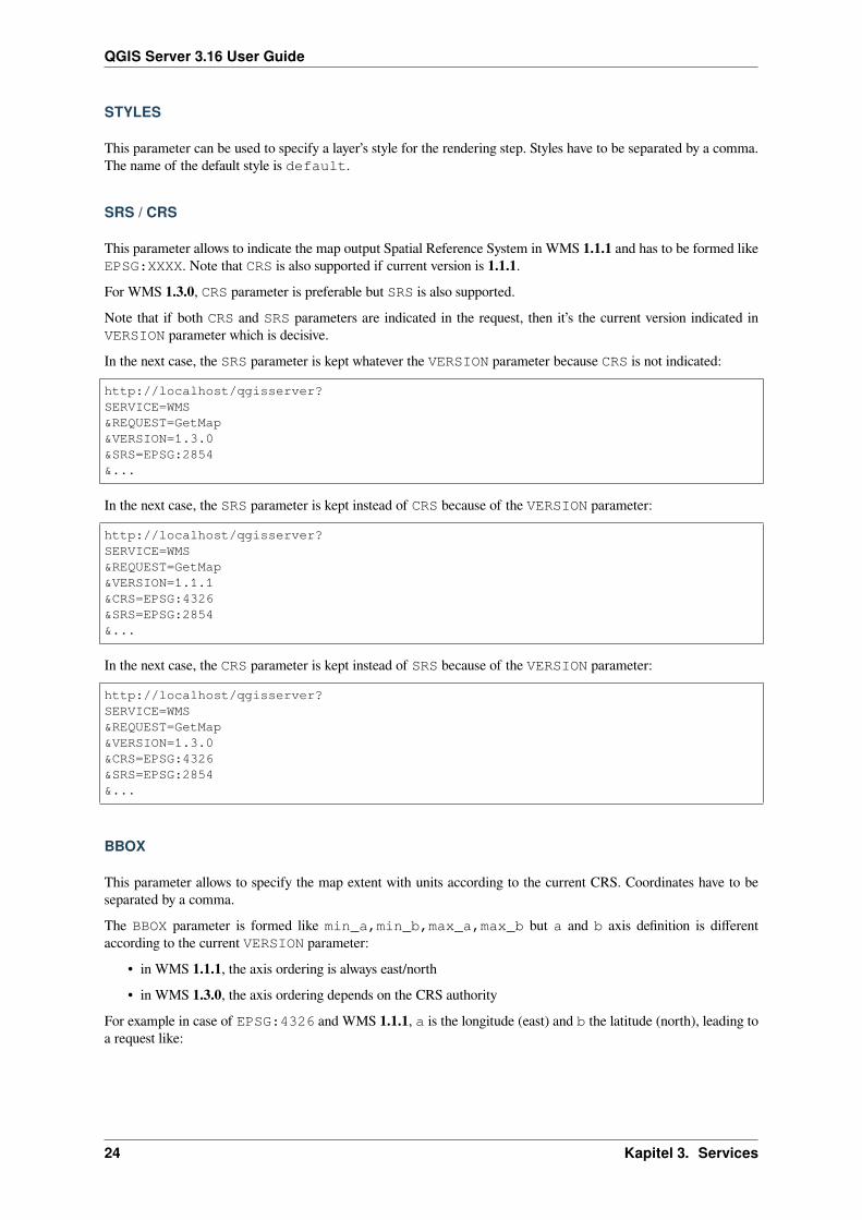
STYLES
This parameter can be used to specify a layer’s style for the rendering step. Styles have to be separated by a comma.The name of the default style is default.
SRS / CRS
This parameter allows to indicate the map output Spatial Reference System in WMS 1.1.1 and has to be formed likeEPSG:XXXX. Note that CRS is also supported if current version is 1.1.1.For WMS 1.3.0, CRS parameter is preferable but SRS is also supported.Note that if both CRS and SRS parameters are indicated in the request, then it’s the current version indicated inVERSION parameter which is decisive.In the next case, the SRS parameter is kept whatever the VERSION parameter because CRS is not indicated:
http://localhost/qgisserver?SERVICE=WMS&REQUEST=GetMap&VERSION=1.3.0&SRS=EPSG:2854&...
In the next case, the SRS parameter is kept instead of CRS because of the VERSION parameter:
http://localhost/qgisserver?SERVICE=WMS&REQUEST=GetMap&VERSION=1.1.1&CRS=EPSG:4326&SRS=EPSG:2854&...
In the next case, the CRS parameter is kept instead of SRS because of the VERSION parameter:
http://localhost/qgisserver?SERVICE=WMS&REQUEST=GetMap&VERSION=1.3.0&CRS=EPSG:4326&SRS=EPSG:2854&...
BBOX
This parameter allows to specify the map extent with units according to the current CRS. Coordinates have to beseparated by a comma.The BBOX parameter is formed like min_a,min_b,max_a,max_b but a and b axis definition is differentaccording to the current VERSION parameter:
• in WMS 1.1.1, the axis ordering is always east/north• in WMS 1.3.0, the axis ordering depends on the CRS authority
For example in case of EPSG:4326 and WMS 1.1.1, a is the longitude (east) and b the latitude (north), leading toa request like:
24 Kapitel 3. Services
QGIS Server 3.16 User Guide
http://localhost/qgisserver?SERVICE=WMS&REQUEST=GetMap&VERSION=1.1.1&SRS=epsg:4326&BBOX=-180,-90,180,90&...
But in case of WMS 1.3.0, the axis ordering defined in the EPSG database is north/east so a is the latitude and b thelongitude:
http://localhost/qgisserver?SERVICE=WMS&REQUEST=GetMap&VERSION=1.3.0&CRS=epsg:4326&BBOX=-90,-180,90,180&...
WIDTH
This parameter allows to specify the width in pixels of the output image.
HEIGHT
This parameter allows to specify the height in pixels of the output image.
FORMAT
This parameter may be used to specify the format of map image. Available values are:• jpg
• jpeg
• image/jpeg
• image/png
• image/png; mode=1bit
• image/png; mode=8bit
• image/png; mode=16bit
• application/dxf Only layers that have read access in the WFS service are exported in the DXF format.URL example:
http://localhost/qgisserver?SERVICE=WMS&VERSION=1.3.0&REQUEST=GetMap&FORMAT=application/dxf&LAYERS=Haltungen,Normschacht,Spezialbauwerke&STYLES=&CRS=EPSG%3A21781&BBOX=696136.28844801,245797.12108743,696318.91114315,245939.↪→25832905&WIDTH=1042&HEIGHT=811&FORMAT_OPTIONS=MODE:SYMBOLLAYERSYMBOLOGY;SCALE:250&FILE_NAME=plan.dxf
3.1. Web Map Service (WMS) 25

QGIS Server 3.16 User Guide
TRANSPARENT
This boolean parameter can be used to specify the background transparency. Available values are (not case sensitive):• TRUE
• FALSE
However, this parameter is ignored if the format of the map image indicated with FORMAT is different from PNG.
MAP
This parameter allows to define the QGIS project file to use.As mentioned in GetMap parameters table, MAP is mandatory because a request needs a QGIS project to actuallywork. However, the QGIS_PROJECT_FILE environment variable may be used to define a default QGIS project.In this specific case, MAP is not longer a required parameter. For further information you may refer to Advancedconfiguration.
BGCOLOR
This parameter allows to indicate a background color for the map image. However it cannot be combined withTRANSPARENT parameter in case of PNG images (transparency takes priority). The colour may be literal or inhexadecimal notation.URL example with the literal notation:
http://localhost/qgisserver?SERVICE=WMS&REQUEST=GetMap&VERSION=1.3.0&BGCOLOR=green&...
URL example with the hexadecimal notation:
http://localhost/qgisserver?SERVICE=WMS&REQUEST=GetMap&VERSION=1.3.0&BGCOLOR=0x00FF00&...
DPI
This parameter can be used to specify the requested output resolution.
IMAGE_QUALITY
This parameter is only used for JPEG images. By default, the JPEG compression is -1.You can change the default per QGIS project in theOWS Server►WMS capabilitiesmenu of the Project► Properties…dialog. If you want to override it in a GetMap request you can do it using the IMAGE_QUALITY parameter.
26 Kapitel 3. Services

QGIS Server 3.16 User Guide
OPACITIES
Comma separated list of opacity values. Opacity can be set on layer or group level. Allowed values range from 0(fully transparent) to 255 (fully opaque).
FILTER
A subset of layers can be selected with the FILTER parameter. The syntax is basically the same as for the QGISsubset string. However, there are some restrictions to avoid SQL injections into databases via QGIS Server. If adangerous string is found in the parameter, QGIS Server will return the next error:
<ServiceExceptionReport><ServiceException code="Security">The filter string XXXXXXXXX has been rejected␣
↪→because of security reasons.Note: Text strings have to be enclosed in single or double quotes. A space␣
↪→between each word / special character is mandatory.Allowed Keywords and special characters are IS,NOT,NULL,AND,OR,IN,=,<,=<,>,>=,!=,
↪→',',(,),DMETAPHONE,SOUNDEX.Not allowed are semicolons in the filter expression.</ServiceException>
</ServiceExceptionReport>
URL example:
http://localhost/qgisserver?SERVICE=WMS&REQUEST=GetMap&LAYERS=mylayer1,mylayer2,mylayer3&FILTER=mylayer1:"col1";mylayer1,mylayer2:"col2" = 'blabla'&...
In this example, the same filter (field col2 equals the string blabla) is applied to layers mylayer1 andmylayer2, while the filter on col1 is only applied to mylayer1.
Bemerkung: It is possible to make attribute searches via GetFeatureInfo and omit the X/Y parameter if a FILTERis there. QGIS Server then returns info about the matching features and generates a combined bounding box in theXML output.
SELECTION
The SELECTION parameter can highlight features from one or more layers. Vector features can be selected bypassing comma separated lists with feature ids.
http://localhost/qgisserver?SERVICE=WMS&REQUEST=GetMap&LAYERS=mylayer1,mylayer2&SELECTION=mylayer1:3,6,9;mylayer2:1,5,6&...
The following image presents the response from a GetMap request using the SELECTION option e.g. http://myserver.com/...&SELECTION=countries:171,65.As those features id’s correspond in the source dataset to France and Romania they’re highlighted in yellow.
3.1. Web Map Service (WMS) 27

QGIS Server 3.16 User Guide
Abb. 3.1: Server response to a GetMap request with SELECTION parameter
FORMAT-OPTIONS
This parameter can be used to specify options for the selected format. Only for FORMAT=application/dxf. Alist of key:value pairs separated by semicolon:
• SCALE: to be used for symbology rules, filters and styles (not actual scaling of the data - data remains in theoriginal scale).
• MODE: corresponds to the export options offered in the QGIS Desktop DXF export dialog. Possible valuesare NOSYMBOLOGY, FEATURESYMBOLOGY and SYMBOLLAYERSYMBOLOGY.
• LAYERSATTRIBUTES: specify a field that contains values for DXF layer names - if not specified, the originalQGIS layer names are used.
• USE_TITLE_AS_LAYERNAME: if enabled, the title of the layer will be used as layer name.• CODEC: specify a codec to be used for encoding. Default is ISO-8859-1 check the QGIS desktop DXFexport dialog for valid values.
• NO_MTEXT: Use TEXT instead of MTEXT for labels.• FORCE_2D: Force 2D output. This is required for polyline width.
28 Kapitel 3. Services

QGIS Server 3.16 User Guide
TILED
For performance reasons, QGIS Server can be used in tiled mode. In this mode, the client requests several small fixedsize tiles, and assembles them to form the whole map. Doing this, symbols at or near the boundary between two tilesmay appeared cut, because they are only present in one of the tile.Set the TILED parameter to TRUE to tell QGIS Server to work in tiled mode, and to apply the Tile buffer configuredin the QGIS project (see Configure your project).When TILED is TRUE and when a non-zero Tile buffer is configured in the QGIS project, features outside the tileextent are drawn to avoid cut symbols at tile boundaries.TILED defaults to FALSE.
3.1.2 GetFeatureInfo
Standard parameters for the GetFeatureInfo request according to the OGC WMS 1.1.1 and 1.3.0 specifications:
Parameter RequiredBeschreibungSERVICE Yes Name of the service (WMS)VERSION No Version of the serviceREQUEST Yes Name of the request (GetFeatureInfo)QUERY_LAYERSYes Layers to queryLAYERS Yes Layers to display (identical to QUERY_LAYERS)STYLES No Layers‘ styleSRS /CRS
Yes Coordinate reference system
BBOX No Map extentWIDTH Yes Width of the image in pixelsHEIGHT Yes Height of the image in pixelsTRANSPARENTNo Transparent backgroundINFO_FORMATNo Output formatFEATURE_COUNTNo Maximum number of features to returnI No Pixel column of the point to queryX No Same as I parameter, but in WMS 1.1.1J No Pixel row of the point to queryY No Same as J parameter, but in WMS 1.1.1WMS_PRECISIONNo The precision (number of digits) to be used when returning geometry (see how to add
geometry to feature response). The default value is -1 meaning that the precision definedin the project is used.
In addition to the standard ones, QGIS Server supports the following extra parameters:
Parameter Required BeschreibungMAP Yes Specify the QGIS project fileFILTER No Subset of featuresFI_POINT_TOLERANCE No Tolerance in pixels for point layersFI_LINE_TOLERANCE No Tolerance in pixels for line layersFI_POLYGON_TOLERANCE No Tolerance in pixels for polygon layersFILTER_GEOM No Geometry filteringWITH_MAPTIP No Add map tips to the outputWITH_GEOMETRY No Add geometry to the output
URL example:
3.1. Web Map Service (WMS) 29

QGIS Server 3.16 User Guide
http://localhost/qgisserver?SERVICE=WMS&VERSION=1.3.0&REQUEST=GetMap&MAP=/home/qgis/projects/world.qgs&LAYERS=mylayer1,mylayer2,mylayer3&CRS=EPSG:4326&WIDTH=400&HEIGHT=400&INFO_FORMAT=text/xml&TRANSPARENT=TRUE&QUERY_LAYERS=mylayer1&FEATURE_COUNT=3&I=250&J=250
REQUEST
This parameter is GetFeatureInfo in case of the GetFeatureInfo request.
INFO_FORMAT
This parameter may be used to specify the format of the result. Available values are:• text/xml
• text/html
• text/plain
• application/vnd.ogc.gml
• application/json
QUERY_LAYERS
This parameter specifies the layers to display on the map. Names are separated by a comma.In addition, QGIS Server introduces options to select layers by:
• short name• layer id
See the LAYERS parameter defined in GetMap for more information.
FEATURE_COUNT
This parameter specifies the maximum number of features per layer to return. For example if QUERY_LAYERS isset to layer1,layer2 and FEATURE_COUNT is set to 3 then a maximum of 3 features from layer1 will bereturned. Likewise a maximun of 3 features from layer2 will be returned.By default, only 1 feature per layer is returned.
30 Kapitel 3. Services

QGIS Server 3.16 User Guide
I
This parameter, defined in WMS 1.3.0, allows you to specify the pixel column of the query point.
X
Same parameter as I, but defined in WMS 1.1.1.
J
This parameter, defined in WMS 1.3.0, allows you to specify the pixel row of the query point.
Y
Same parameter as J, but defined in WMS 1.1.1.
FI_POINT_TOLERANCE
This parameter specifies the tolerance in pixels for point layers.
FI_LINE_TOLERANCE
This parameter specifies the tolerance in pixels for line layers.
FI_POLYGON_TOLERANCE
This parameter specifies the tolerance in pixels for polygon layers.
FILTER_GEOM
This parameter specifies a WKT geometry with which features have to intersect.
WITH_MAPTIP
This parameter specifies whether to add map tips to the output.Available values are (not case sensitive):
• TRUE
• FALSE
WITH_GEOMETRY
This parameter specifies whether to add geometries to the output. To use this feature you must first enable the Addgeometry to feature response option in the QGIS project. See Configure your project.Available values are (not case sensitive):
• TRUE
• FALSE
3.1. Web Map Service (WMS) 31

QGIS Server 3.16 User Guide
3.1.3 GetPrint
QGIS Server has the capability to create print layout output in pdf or pixel format. Print layout windows in thepublished project are used as templates. In the GetPrint request, the client has the possibility to specify parametersof the contained layout maps and labels.Parameters for the GetPrint request:
Parameter Required BeschreibungMAP Yes Specify the QGIS project fileSERVICE Yes Name of the service (WMS)VERSION No Version of the serviceREQUEST Yes Name of the request (GetPrint)LAYERS No Layers to displayTEMPLATE Yes Layout template to useSRS / CRS Yes Coordinate reference systemFORMAT No Output formatATLAS_PK No Atlas featuresSTYLES No Layers‘ styleTRANSPARENT No Transparent backgroundOPACITIES No Opacity for layer or groupSELECTION No Highlight featuresmapX:EXTENT No Extent of the map ‚X‘mapX:LAYERS No Layers of the map ‚X‘mapX:STYLES No Layers‘ style of the map ‚X‘mapX:SCALE No Layers‘ scale of the map ‚X‘mapX:ROTATION No Rotation of the map ‚X‘mapX:GRID_INTERVAL_X No Grid interval on x axis of the map ‚X‘mapX:GRID_INTERVAL_Y No Grid interval on y axis of the map ‚X‘
URL example:
http://localhost/qgisserver?SERVICE=WMS&VERSION=1.3.0&REQUEST=GetPrint&MAP=/home/qgis/projects/world.qgs&CRS=EPSG:4326&FORMAT=png&TEMPLATE=Layout%201&map0:EXTENT=-180,-90,180,90&map0:LAYERS=mylayer1,mylayer2,mylayer3&map0:OPACITIES=125,200,125&map0:ROTATION=45
Note that the layout template may contain more than one map. In this way, if you want to configure a specific map, youhave to use mapX: parameters where X is a positive number that you can retrieve thanks to the GetProjectSettingsrequest.For example:
<WMS_Capabilities>...<ComposerTemplates xsi:type="wms:_ExtendedCapabilities"><ComposerTemplate width="297" height="210" name="Druckzusammenstellung 1"><ComposerMap width="171" height="133" name="map0"/><ComposerMap width="49" height="46" name="map1"/></ComposerTemplate></ComposerTemplates>...</WMS_Capabilities>
32 Kapitel 3. Services

QGIS Server 3.16 User Guide
REQUEST
This parameter has to be GetPrint for the GetPrint request.
TEMPLATE
This parameter can be used to specify the name of a layout template to use for printing.
FORMAT
This parameter specifies the format of map image. Available values are:• png (default value)• image/png
• jpg
• jpeg
• image/jpeg
• svg
• image/svg
• image/svg+xml
• application/pdf
If the FORMAT parameter is different from one of these values, then an exception is returned.
ATLAS_PK
This parameter allows activation of Atlas rendering by indicating which features we want to print. In order to retrievean atlas with all features, the * symbol may be used (according to the maximum number of features allowed in theproject configuration).When FORMAT is pdf, a single PDF document combining the feature pages is returned. For all other formats, asingle page is returned.
mapX:EXTENT
This parameter specifies the extent for a layout map item as xmin,ymin,xmax,ymax.
mapX:ROTATION
This parameter specifies the map rotation in degrees.
3.1. Web Map Service (WMS) 33

QGIS Server 3.16 User Guide
mapX:GRID_INTERVAL_X
This parameter specifies the grid line density in the X direction.
mapX:GRID_INTERVAL_Y
This parameter specifies the grid line density in the Y direction.
mapX:SCALE
This parameter specifies the map scale for a layout map item. This is useful to ensure scale based visibility of layersand labels even if client and server may have different algorithms to calculate the scale denominator.
mapX:LAYERS
This parameter specifies the layers for a layout map item. SeeGetMap Layers for more information on this parameter.
mapX:STYLES
This parameter specifies the layers‘ styles defined in a specific layout map item. See GetMap Styles for moreinformation on this parameter.
3.1.4 GetLegendGraphics
Several additional parameters are available to change the size of the legend elements:• BOXSPACE space between legend frame and content (mm)• FORMAT, image/jpeg, image/png or application/json. For JSON, symbols are encoded withBase64 and most other options related to layout or fonts are not taken into account because the legend must bebuilt on the client side.
• LAYERSPACE vertical space between layers (mm)• LAYERTITLESPACE vertical space between layer title and items following (mm)• SYMBOLSPACE vertical space between symbol and item following (mm)• ICONLABELSPACE horizontal space between symbol and label text (mm)• SYMBOLWIDTH width of the symbol preview (mm)• SYMBOLHEIGHT height of the symbol preview (mm)
These parameters change the font properties for layer titles and item labels:• LAYERFONTFAMILY / ITEMFONTFAMILY font family for layer title / item text• LAYERFONTBOLD / ITEMFONTBOLD TRUE to use a bold font• LAYERFONTSIZE / ITEMFONTSIZE Font size in point• LAYERFONTITALIC / ITEMFONTITALIC TRUE to use italic font• LAYERFONTCOLOR / ITEMFONTCOLOR Hex color code (e.g. #FF0000 for red)• LAYERTITLE FALSE to get only the legend graphics without layer title• RULELABEL:
– FALSE legend graphics without item labels– AUTO hide item label for layers with Single symbol rendering
34 Kapitel 3. Services
QGIS Server 3.16 User Guide
Content based legend. These parameters let the client request a legend showing only the symbols for the featuresfalling into the requested area:
• BBOX the geographical area for which the legend should be built• CRS / SRS the coordinate reference system adopted to define the BBOX coordinates• SRCWIDTH / SRCHEIGHT if set these should match theWIDTH and HEIGHT parameters of the GetMaprequest, to let QGIS Server scale symbols according to the map view image size.
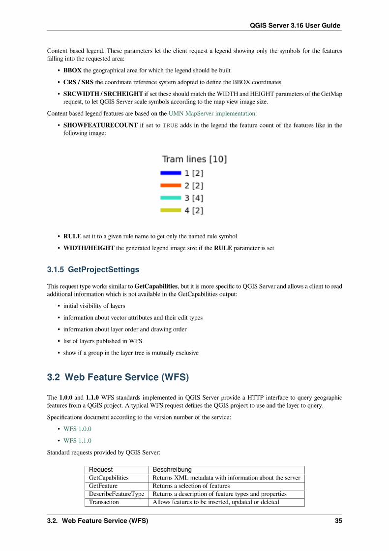
Content based legend features are based on the UMN MapServer implementation:• SHOWFEATURECOUNT if set to TRUE adds in the legend the feature count of the features like in thefollowing image:
• RULE set it to a given rule name to get only the named rule symbol• WIDTH/HEIGHT the generated legend image size if the RULE parameter is set
3.1.5 GetProjectSettings
This request type works similar toGetCapabilities, but it is more specific to QGIS Server and allows a client to readadditional information which is not available in the GetCapabilities output:
• initial visibility of layers• information about vector attributes and their edit types• information about layer order and drawing order• list of layers published in WFS• show if a group in the layer tree is mutually exclusive
3.2 Web Feature Service (WFS)
The 1.0.0 and 1.1.0 WFS standards implemented in QGIS Server provide a HTTP interface to query geographicfeatures from a QGIS project. A typical WFS request defines the QGIS project to use and the layer to query.Specifications document according to the version number of the service:
• WFS 1.0.0• WFS 1.1.0
Standard requests provided by QGIS Server:
Request BeschreibungGetCapabilities Returns XML metadata with information about the serverGetFeature Returns a selection of featuresDescribeFeatureType Returns a description of feature types and propertiesTransaction Allows features to be inserted, updated or deleted
3.2. Web Feature Service (WFS) 35

QGIS Server 3.16 User Guide
3.2.1 GetFeature
Standard parameters for the GetFeature request according to the OGC WFS 1.0.0 and 1.1.0 specifications:
Parameter Required BeschreibungSERVICE Yes Name of the serviceVERSION No Version of the serviceREQUEST Yes Name of the requestTYPENAME No Name of layersOUTPUTFORMAT No Output FormatRESULTTYPE No Type of the resultPROPERTYNAME No Name of properties to returnMAXFEATURES No Maximum number of features to returnSRSNAME No Coordinate reference systemFEATUREID No Filter the features by idsFILTER No OGC Filter EncodingBBOX No Map ExtentSORTBY No Sort the results
In addition to the standard ones, QGIS Server supports the following extra parameters:
Parameter Required BeschreibungMAP Yes Specify the QGIS project fileSTARTINDEX No PagingGEOMETRYNAME No Type of geometry to returnEXP_FILTER No Expression filtering
SERVICE
This parameter has to be WFS in case of the GetFeature request.For example:
http://localhost/qgisserver?SERVICE=WFS&...
VERSION
This parameter allows to specify the version of the service to use. Available values for the VERSION parameter are:• 1.0.0
• 1.1.0
If no version is indicated in the request, then 1.1.0 is used by default.URL example:
http://localhost/qgisserver?SERVICE=WFS&VERSION=1.1.0&...
36 Kapitel 3. Services
QGIS Server 3.16 User Guide
REQUEST
This parameter is GetFeature in case of the GetFeature request.URL example:
http://localhost/qgisserver?SERVICE=WFS&VERSION=1.1.0&REQUEST=GetFeature&...
RESULTTYPE
This parameter may be used to specify the kind of result to return. Available values are:• results: the default behavior• hits: returns only a feature count
URL example:
http://localhost/qgisserver?SERVICE=WFS&VERSION=1.1.0&REQUEST=GetFeature&RESULTTYPE=hits&...
GEOMETRYNAME
This parameter can be used to specify the kind of geometry to return for features. Available values are:• extent
• centroid
• none
URL example:
http://localhost/qgisserver?SERVICE=WFS&VERSION=1.1.0&REQUEST=GetFeature&GEOMETRYNAME=centroid&...
STARTINDEX
This parameter is standard in WFS 2.0, but it’s an extension for WFS 1.0.0. Actually, it can be used to skip somefeatures in the result set and in combination with MAXFEATURES, it provides the ability to page through results.URL example:
http://localhost/qgisserver?SERVICE=WFS&VERSION=1.1.0&REQUEST=GetFeature&STARTINDEX=2&...
3.2. Web Feature Service (WFS) 37

QGIS Server 3.16 User Guide
3.3 Web Map Tile Service (WMTS)
The 1.0.0 WMTS standard implemented in QGIS Server provides a HTTP interface to request tiled map imagesgenerated from a QGIS project. A typical WMTS request defined the QGIS project to use, some WMS parameterslike layers to render, as well as tile parameters.Specifications document of the service:
• WMTS 1.0.0Standard requests provided by QGIS Server:
Request BeschreibungGetCapabilities Returns XML metadata with information about the serverGetTile Returns a tileGetFeatureInfo Retrieves data (geometry and values) for a pixel location
3.3.1 GetCapabilities
Standard parameters for the GetCapabilities request according to the OGC WMTS 1.0.0 specifications:
Parameter Required BeschreibungSERVICE Yes Name of the service (WMTS)REQUEST Yes Name of the request (GetCapabilities)
In addition to the standard ones, QGIS Server supports the following extra parameters:
Parameter Required BeschreibungMAP Yes Specify the QGIS project file
URL example:
http://localhost/qgisserver?SERVICE=WMTS&REQUEST=GetCapabilities&MAP=/home/qgis/projects/world.qgs
SERVICE
This parameter has to be WMTS in case of the GetCapabilities request.
REQUEST
This parameter is GetCapabilities in case of the GetCapabilities request.
38 Kapitel 3. Services

QGIS Server 3.16 User Guide
MAP
This parameter allows to define the QGIS project file to use.
3.3.2 GetTile
Standard parameters for the GetTile request according to the OGC WMTS 1.0.0 specifications:
Parameter Required BeschreibungSERVICE Yes Name of the service (WMTS)REQUEST Yes Name of the request (GetTile)LAYER Yes Layer identifierFORMAT Yes Output format of the tileTILEMATRIXSET Yes Name of the pyramidTILEMATRIX Yes MeshingTILEROW Yes Row coordinate in the meshTILECOL Yes Column coordinate in the mesh
In addition to the standard ones, QGIS Server supports the following extra parameters:
Parameter Required BeschreibungMAP Yes Specify the QGIS project file
URL example:
http://localhost/qgisserver?SERVICE=WMTS&REQUEST=GetTile&MAP=/home/qgis/projects/world.qgs&LAYER=mylayer&FORMAT=image/png&TILEMATRIXSET=EPSG:4326&TILEROW=0&TILECOL=0
SERVICE
This parameter has to be WMTS in case of the GetTile request.
REQUEST
This parameter is GetTile in case of the GetTile request.
LAYER
This parameter allows to specify the layer to display on the tile.In addition, QGIS Server introduced some options to select a layer by:
• a short name• the layer id
The short name of a layer may be configured through Properties ► Metadata in layer menu. If the short name isdefined, then it’s used by default instead of the layer’s name:
3.3. Web Map Tile Service (WMTS) 39

QGIS Server 3.16 User Guide
http://localhost/qgisserver?SERVICE=WMTS&REQUEST=GetTile&LAYER=mynickname&...
Moreover, there’s a project option allowing to select layers by their id in OWS Server►WMS capabilitiesmenu of theProject ► Project Properties dialog. To activate this option, the checkbox Use layer ids as names has to be selected.
http://localhost/qgisserver?SERVICE=WMTS&REQUEST=GetTile&LAYER=mylayerid1&...
FORMAT
This parameter may be used to specify the format of tile image. Available values are:• jpg
• jpeg
• image/jpeg
• image/png
If the FORMAT parameter is different from one of these values, then the default format PNG is used instead.
TILEMATRIXSET
This parameter defines the CRS to use when computing the underlying pyramid. Format: EPSG:XXXX.
TILEMATRIX
This parameter allows to define the matrix to use for the output tile.
TILEROW
This parameter allows to select the row of the tile to get within the matrix.
TILECOL
This parameter allows to select the column of the tile to get within the matrix.
MAP
This parameter allows to define the QGIS project file to use.As mentioned in GetMap parameters table, MAP is mandatory because a request needs a QGIS project to actuallywork. However, the QGIS_PROJECT_FILE environment variable may be used to define a default QGIS project.In this specific case, MAP is not longer a required parameter. For further information you may refer to Advancedconfiguration.
40 Kapitel 3. Services

QGIS Server 3.16 User Guide
3.3.3 GetFeatureInfo
Standard parameters for the GetFeatureInfo request according to the OGC WMTS 1.0.0 specification:
Parameter Required BeschreibungSERVICE Yes Name of the service (WMTS)REQUEST Yes Name of the request (GetFeatureInfo)LAYER Yes Layer identifierINFOFORMAT No Output formatI No X coordinate of a pixelJ No Y coordinate of a pixelTILEMATRIXSET Yes See GetTileTILEMATRIX Yes See GetTileTILEROW Yes See GetTileTILECOL Yes See GetTile
In addition to the standard ones, QGIS Server supports the following extra parameters:
Parameter Required BeschreibungMAP Yes Specify the QGIS project file
URL example:
http://localhost/qgisserver?SERVICE=WMTS&REQUEST=GetFeatureInfo&MAP=/home/qgis/projects/world.qgs&LAYER=mylayer&INFOFORMAT=image/html&I=10&J=5
SERVICE
This parameter has to be WMTS in case of the GetFeatureInfo request.
REQUEST
This parameter is GetFeatureInfo in case of the GetFeatureInfo request.
MAP
This parameter allows to define the QGIS project file to use.As mentioned in GetMap parameters table, MAP is mandatory because a request needs a QGIS project to actuallywork. However, the QGIS_PROJECT_FILE environment variable may be used to define a default QGIS project.In this specific case, MAP is not longer a required parameter. For further information you may refer to Advancedconfiguration.
3.3. Web Map Tile Service (WMTS) 41

QGIS Server 3.16 User Guide
LAYER
This parameter allows to specify the layer to display on the tile.In addition, QGIS Server introduced some options to select a layer by:
• a short name• the layer id
The short name of a layer may be configured through Properties ► Metadata in layer menu. If the short name isdefined, then it’s used by default instead of the layer’s name:
http://localhost/qgisserver?SERVICE=WMTS&REQUEST=GetFeatureInfo&LAYER=mynickname&...
Moreover, there’s a project option allowing to select layers by their id in OWS Server►WMS capabilitiesmenu of theProject ► Project Properties dialog. To activate this option, the checkbox Use layer ids as names has to be selected.
http://localhost/qgisserver?SERVICE=WMTS&REQUEST=GetFeatureInfo&LAYER=mylayerid1&...
INFOFORMAT
This parameter allows to define the output format of the result. Available values are:• text/xml
• text/html
• text/plain
• application/vnd.ogc.gml
The default value is text/plain.
I
This parameter allows to define the X coordinate of the pixel for which we want to retrieve underlying information.
J
This parameter allows to define the Y coordinate of the pixel for which we want to retrieve underlying information.
42 Kapitel 3. Services

QGIS Server 3.16 User Guide
3.4 WFS3 (OGC API Features)
WFS3 is the first implementation of the new generation of OGC protocols. It is described by the OGCAPI - Features- Part 1: Core document.Here is a quick informal summary of the most important differences between the well known WFS protocol andWFS3:
• WFS3 is based on a REST API• WFS3 API must follow the OPENAPI specifications• WFS3 supports multiple output formats but it does not dictate any (only GeoJSON and HTML are currentlyavailable in QGISWFS3) and it uses content negotiation to determine which format is to be served to the client
• JSON and HTML are first class citizens in WFS3• WFS3 is self-documenting (through the /api endpoint)• WFS3 is fully navigable (through links) and browsable
Wichtig: While the WFS3 implementation in QGIS can make use of the MAP parameter to specify the project file,no extra query parameters are allowed by the OPENAPI specification. For this reason it is strongly recommendedthat MAP is not exposed in the URL and the project file is specified in the environment by other means (i.e. settingQGIS_PROJECT_FILE in the environment through a web server rewrite rule).
Bemerkung: The API endpoint provides comprehensive documentation of all supported parameters and outputformats of your service. The following paragraphs will only describe the most important ones.
3.4.1 Resource representation
The QGIS Server WFS3 implementation currently supports the following resource representation (output) formats:• HTML• JSON
The format that is actually served will depend on content negotiation, but a specific format can be explicitly requestedby appending a format specifier to the endpoints.Supported format specifier extensions are:
• .json
• .html
Additional format specifier aliases may be defined by specific endpoints:• .openapi: alias for .json supported by the API endpoint• .geojson: alias for .json supported by the Features and Feature endpoints
3.4. WFS3 (OGC API Features) 43

QGIS Server 3.16 User Guide
3.4.2 Endpoints
The API provides a list of endpoints that the clients can retrieve. The system is designed in such a way that everyresponse provides a set of links to navigate through all the provided resources.Endpoints points provided by the QGIS implementation are:
Name Path BeschreibungLandingPage
/ General information about the service and provides linksto all available endpoints
Conformance/conformance Information about the conformance of the service to thestandards
API /api Full description of the endpoints provided by the serviceand the returned documents structure
Collections /collections List of all collections (i.e. ‚vector layers‘) provided by theservice
Collection /collections/{collectionId}
Information about a collection (name, metadata, extentetc.)
Funktionalitäten/collections/{collectionId}/items
List of the features provided by the collection
Feature /collections/{collectionId}/items/{featureId}
Information about a single feature
Landing Page
Themain endpoint is theLanding Page. From that page it is possible to navigate to all the available service endpoints.The Landing Page must provide links to
• the API definition (path /api link relations service-desc and service-doc),• the Conformance declaration (path /conformance, link relation conformance), and• the Collections (path /collections, link relation data).
Abb. 3.2: Server WFS3 landing page
44 Kapitel 3. Services

QGIS Server 3.16 User Guide
API Definition
The API Definition is an OPENAPI-compliant description of the API provided by the service. In its HTMLrepresentation it is a browsable page where all the endpoints and their response formats are accurately listed anddocumented. The path of this endpoint is /api.The API definition provides a comprehensive and authoritative documentation of the service, including all supportedparameters and returned formats.
Bemerkung: This endpoint is analogue to WFS’s GetCapabilities
Collections list
The collections endpoint provides a list of all the collections available in the service. Since the service „serves“ asingle QGIS project the collections are the vector layers from the current project (if they were published as WFS inthe project properties). The path of this endpoint is /collections/.
Abb. 3.3: Server WFS3 collections list page
Collection detail
While the collections endpoint does not provide detailed information about each available collection, that informationis available in the /collections/{collectionId} endpoints. Typical information includes the extent, adescription, CRSs and other metadata.The HTML representation also provides a browsable map with the available features.
3.4. WFS3 (OGC API Features) 45

QGIS Server 3.16 User Guide
Abb. 3.4: Server WFS3 collection detail page
Features list
This endpoint provides a list of all features in a collection knowing the collection ID. The path of this endpoint is/collections/{collectionId}/items.The HTML representation also provides a browsable map with the available features.
Bemerkung: This endpoint is analogue to GetFeature in WFS 1 and WFS 2.
46 Kapitel 3. Services

QGIS Server 3.16 User Guide
Abb. 3.5: Server WFS3 features list page
Feature detail
This endpoint provides all the available information about a single feature, including the feature attributes and itsgeometry. The path of this endpoint is /collections/{collectionId}/items/{itemId}.The HTML representation also provides a browsable map with the feature geometry.
Abb. 3.6: Server WFS3 feature detail page
3.4. WFS3 (OGC API Features) 47

QGIS Server 3.16 User Guide
3.4.3 Pagination
Pagination of a long list of features is implemented in the OGC API through next and prev links, QGIS serverconstructs these links by appending limit and offset as query string parameters.URL example:
http://localhost/qgisserver/wfs3/collection_one/items.json?offset=10&limit=10
Bemerkung: The maximum acceptable value for limit can be configured with theQGIS_SERVER_API_WFS3_MAX_LIMIT server configuration setting (see: Environment variables).
3.4.4 Objektfiltrierung
The features available in a collection can be filtered/searched by specifying one or more filters.
Date and time filter
Collections with date and/or datetime attributes can be filtered by specifying a datetime argument in the querystring. By default the first date/datetime field is used for filtering. This behavior can be configured by setting a „Date“or „Time“ dimension in the QGIS Server ► Dimension section of the layer properties dialog.The date and time filtering syntax is fully described in the API Definition and also supports ranges (begin and endvalues are included) in addition to single values.URL examples:Returns only the features with date dimension matching 2019-01-01
http://localhost/qgisserver/wfs3/collection_one/items.json?datetime=2019-01-01
Returns only the features with datetime dimension matching 2019-01-01T01:01:01
http://localhost/qgisserver/wfs3/collection_one/items.json?datetime=2019-01-↪→01T01:01:01
Returns only the features with datetime dimension in the range 2019-01-01T01:01:01 - 2019-01-01T12:00:00
http://localhost/qgisserver/wfs3/collection_one/items.json?datetime=2019-01-↪→01T01:01:01/2019-01-01T12:00:00
Bounding box filter
A bounding box spatial filter can be specified with the bbox parameter:The order of the comma separated elements is:
• Lower left corner, WGS 84 longitude• Lower left corner, WGS 84 latitude• Upper right corner, WGS 84 longitude• Upper right corner, WGS 84 latitude
48 Kapitel 3. Services

QGIS Server 3.16 User Guide
Bemerkung: The OGC specifications also allow a 6 item bbox specifier where the third and sixth items are the Zcomponents, this is not yet supported by QGIS server.
URL example:
http://localhost/qgisserver/wfs3/collection_one/items.json?bbox=-180,-90,180,90
If the CRS of the bounding box is not WGS 84, a different CRS can be specified by using the optional parameterbbox-crs. The CRS format identifier must be in the OGC URI format:URL example:
http://localhost/qgisserver/wfs3/collection_one/items.json?bbox=913191,5606014,↪→913234,5606029&bbox-crs=http://www.opengis.net/def/crs/EPSG/9.6.2/3857
Attribute filters
Attribute filters can be combined with the bounding box filter and they are in the general form: <attributename>=<attribute value>. Multiple filters can be combined using the AND operator.URL example:filters all features where attribute name equals „my value“
http://localhost/qgisserver/wfs3/collection_one/items.json?attribute_one=my%20value
Partial matches are also supported by using a * („star“) operator:URL example:filters all features where attribute name ends with „value“
http://localhost/qgisserver/wfs3/collection_one/items.json?attribute_one=*value
3.4.5 Feature sorting
It is possible to order the result set by field value using the sortby query parameter.The results are sorted in ascending order by default. To sort the results in descending order, a boolean flag(sortdesc) can be set:
http://localhost/qgisserver/wfs3/collection_one/items.json?sortby=name&sortdesc=1
3.4.6 Attribute selection
The feature attributes returned by a Features list call can be limited by adding a comma separated list of attributenames in the optional properties query string argument.URL example:returns only the name attribute
http://localhost/qgisserver/wfs3/collection_one/items.json?properties=name
3.4. WFS3 (OGC API Features) 49

QGIS Server 3.16 User Guide
3.4.7 Customize the HTML pages
The HTML representation uses a set of HTML templates to generate the response. The template is parsed by atemplate engine called inja. The templates can be customized by overriding them (see: Template overrides). Thetemplate has access to the same data that are available to the JSON representation and a few additional functions areavailable to the template:
Custom template functions
• path_append( path ): appends a directory path to the current url• path_chomp( n ): removes the specified number „n“ of directory components from the current url path• json_dump( ): prints the JSON data passed to the template• static( path ): returns the full URL to the specified static path. For example: „static( „/style/black.css“)“ with a root path „http://localhost/qgisserver/wfs3“ will return „http://localhost/qgisserver/wfs3/static/style/black.css“.
• links_filter( links, key, value ): Returns filtered links from a link list• content_type_name( content_type ): Returns a short name from a content type, for example„text/html“ will return „HTML“
Template overrides
Templates and static assets are stored in subdirectories of the QGIS server default API resource directory (/usr/share/qgis/resources/server/api/ on a Linux system), the base directory can be customizedby changing the environment variable QGIS_SERVER_API_RESOURCES_DIRECTORY.A typical Linux installation will have the following directory tree:
/usr/share/qgis/resources/server/api/└── ogc
├── schema.json├── static│ ├── jsonFormatter.min.css│ ├── jsonFormatter.min.js│ └── style.css└── templates
└── wfs3├── describeCollection.html├── describeCollections.html├── footer.html├── getApiDescription.html├── getFeature.html├── getFeatures.html├── getLandingPage.html├── getRequirementClasses.html├── header.html├── leaflet_map.html└── links.html
To override the templates you can copy the whole tree to another location and pointQGIS_SERVER_API_RESOURCES_DIRECTORY to the new location.
50 Kapitel 3. Services

QGIS Server 3.16 User Guide
3.5 Extra parameters supported by all request types
The following extra parameters are supported by all protocols.• FILE_NAME: if set, the server response will be sent to the client as a file attachment with the specified filename.
Bemerkung: Not available for WFS3.
• MAP: Similar to MapServer, the MAP parameter can be used to specify the path to the QGIS project file. Youcan specify an absolute path or a path relative to the location of the server executable (qgis_mapserv.fcgi). If not specified, QGIS Server searches for .qgs files in the directory where the server executable islocated.Example:
http://localhost/cgi-bin/qgis_mapserv.fcgi?\REQUEST=GetMap&MAP=/home/qgis/projects/world.qgs&...
Bemerkung: You can define a QGIS_PROJECT_FILE as an environment variable to tell the server executablewhere to find the QGIS project file. This variable will be the location where QGIS will look for the project file. If notdefined it will use the MAP parameter in the request and finally look at the server executable directory.
3.6 REDLINING
This feature is available and can be used with GetMap and GetPrint requests.The redlining feature can be used to pass geometries and labels in the request which are overlapped by the server overthe standard returned image (map). This permits the user to put emphasis or maybe add some comments (labels) tosome areas, locations etc. that are not in the standard map.The GetMap request is in the format:
http://qgisplatform.demo/cgi-bin/qgis_mapserv.fcgi?map=/world.qgs&SERVICE=WMS&↪→VERSION=1.3.0&REQUEST=GetMap...&HIGHLIGHT_GEOM=POLYGON((590000 5647000, 590000 6110620, 2500000 6110620, 2500000␣↪→5647000, 590000 5647000))&HIGHLIGHT_SYMBOL=<StyledLayerDescriptor><UserStyle><Name>Highlight</Name>↪→<FeatureTypeStyle><Rule><Name>Symbol</Name><LineSymbolizer><Stroke><SvgParameter␣↪→name="stroke">%23ea1173</SvgParameter><SvgParameter name="stroke-opacity">1</↪→SvgParameter><SvgParameter name="stroke-width">1.6</SvgParameter></Stroke></↪→LineSymbolizer></Rule></FeatureTypeStyle></UserStyle></StyledLayerDescriptor>&HIGHLIGHT_LABELSTRING=Write label here&HIGHLIGHT_LABELSIZE=16&HIGHLIGHT_LABELCOLOR=%23000000&HIGHLIGHT_LABELBUFFERCOLOR=%23FFFFFF&HIGHLIGHT_LABELBUFFERSIZE=1.5
The GetPrint equivalent is in the format (note that mapX: parameter is added to tell which map has redlining):
http://qgisplatform.demo/cgi-bin/qgis_mapserv.fcgi?map=/world.qgs&SERVICE=WMS&↪→VERSION=1.3.0&REQUEST=GetPrint...
(Fortsetzung auf der nächsten Seite)
3.5. Extra parameters supported by all request types 51

QGIS Server 3.16 User Guide
(Fortsetzung der vorherigen Seite)&map0:HIGHLIGHT_GEOM=POLYGON((590000 5647000, 590000 6110620, 2500000 6110620,␣↪→2500000 5647000, 590000 5647000))&map0:HIGHLIGHT_SYMBOL=<StyledLayerDescriptor><UserStyle><Name>Highlight</Name>↪→<FeatureTypeStyle><Rule><Name>Symbol</Name><LineSymbolizer><Stroke><SvgParameter␣↪→name="stroke">%23ea1173</SvgParameter><SvgParameter name="stroke-opacity">1</↪→SvgParameter><SvgParameter name="stroke-width">1.6</SvgParameter></Stroke></↪→LineSymbolizer></Rule></FeatureTypeStyle></UserStyle></StyledLayerDescriptor>&map0:HIGHLIGHT_LABELSTRING=Write label here&map0:HIGHLIGHT_LABELSIZE=16&map0:HIGHLIGHT_LABELCOLOR=%23000000&map0:HIGHLIGHT_LABELBUFFERCOLOR=%23FFFFFF&map0:HIGHLIGHT_LABELBUFFERSIZE=1.5
Here is the image outputed by the above request in which a polygon and a label are drawn on top of the normal map:
Abb. 3.7: Server response to a GetMap request with redlining parameters
You can see there are several parameters in this request:• HIGHLIGHT_GEOM: You can add POINT, MULTILINESTRING, POLYGON etc. It supports multipartgeometries. Here is an example: HIGHLIGHT_GEOM=MULTILINESTRING((0 0, 0 1, 1 1)). Thecoordinates should be in the CRS of the GetMap/GetPrint request.
• HIGHLIGHT_SYMBOL: This controls how the geometry is outlined and you can change the stroke width,color and opacity.
• HIGHLIGHT_LABELSTRING: You can pass your labeling text to this parameter.
52 Kapitel 3. Services

QGIS Server 3.16 User Guide
• HIGHLIGHT_LABELSIZE: This parameter controls the size of the label.• HIGHLIGHT_LABELFONT: This parameter controls the font of the label (e.g. Arial)• HIGHLIGHT_LABELCOLOR: This parameter controls the label color.• HIGHLIGHT_LABELBUFFERCOLOR: This parameter controls the label buffer color.• HIGHLIGHT_LABELBUFFERSIZE: This parameter controls the label buffer size.
3.7 External WMS layers
QGIS Server allows including layers from external WMS servers in WMSGetMap andWMSGetPrint requests. Thisis especially useful if a web client uses an external background layer in the web map. For performance reasons, suchlayers should be directly requested by the web client (not cascaded via QGIS server). For printing however, theselayers should be cascaded via QGIS server in order to appear in the printed map.External layers can be added to the LAYERS parameter as EXTERNAL_WMS:<layername>. The parameters forthe external WMS layers (e.g. url, format, dpiMode, crs, layers, styles) can later be given as service parameters<layername>:<parameter>. In a GetMap request, this might look like this:
http://localhost/qgisserver?SERVICE=WMS&REQUEST=GetMap...&LAYERS=EXTERNAL_WMS:basemap,layer1,layer2&STYLES=,,&basemap:url=http://externalserver.com/wms.fcgi&basemap:format=image/jpeg&basemap:dpiMode=7&basemap:crs=EPSG:2056&basemap:layers=orthofoto&basemap:styles=default
Similarly, external layers can be used in GetPrint requests:
http://localhost/qgisserver?SERVICE=WMS...&REQUEST=GetPrint&TEMPLATE=A4&map0:layers=EXTERNAL_WMS:basemap,layer1,layer2&map0:EXTENT=<minx,miny,maxx,maxy>&basemap:url=http://externalserver.com/wms.fcgi&basemap:format=image/jpeg&basemap:dpiMode=7&basemap:crs=EPSG:2056&basemap:layers=orthofoto&basemap:styles=default
3.8 QGIS Server catalog
The QGIS Server Catalog is a simple catalog that shows the list of QGIS projects served by the QGIS Server. Itprovides a user-friendly fully browsable website with basicmapping capabilities to quickly browse the datasets exposedthrough those QGIS projects.The QGIS Server catalog uses the variables QGIS_SERVER_LANDING_PAGE_PROJECTS_DIRECTORIES andQGIS_SERVER_LANDING_PAGE_PROJECTS_PG_CONNECTIONS (see Environment variables)
3.7. External WMS layers 53

QGIS Server 3.16 User Guide
Abb. 3.8: Server Catalog project list page
You can consult the metadata associated to a project and the services that it provides. Links to those services are alsogiven.
Abb. 3.9: Server Catalog, metadata associated to a project and services (links to) that it provides.
By browsing a project, it is listed the dataset that it serves.
54 Kapitel 3. Services

QGIS Server 3.16 User Guide
Abb. 3.10: Browsing a dataset served by a project in the Server Catalog
Use Right click on a layer to display the attribute table associated to it.
Abb. 3.11: Attribute table associated to a layer
It is possible to consult information of the elements in the map as shown in the image below:
3.8. QGIS Server catalog 55
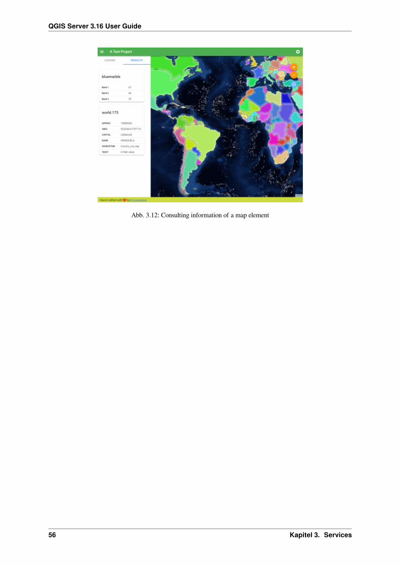
QGIS Server 3.16 User Guide
Abb. 3.12: Consulting information of a map element
56 Kapitel 3. Services

KAPITEL4
Plugins
4.1 Installation
To install the HelloWorld example plugin for testing the servers, you firstly have to create a directory to hold serverplugins. This will be specified in the virtual host configuration and passed on to the server through an environmentvariable:
mkdir -p /var/www/qgis-server/pluginscd /var/www/qgis-server/pluginswget https://github.com/elpaso/qgis-helloserver/archive/master.zipunzip master.zipmv qgis-helloserver-master HelloServer
4.2 HTTP Server configuration
4.2.1 Apache
To be able to use server plugins, FastCGI needs to know where to look. So, we have to modify the Apacheconfiguration file to indicate the QGIS_PLUGINPATH environment variable to FastCGI:
FcgidInitialEnv QGIS_PLUGINPATH "/var/www/qgis-server/plugins"
Moreover, a basic HTTP authorization is necessary to play with the HelloWorld plugin previously introduced. So wehave to update the Apache configuration file a last time:
# Needed for QGIS HelloServer plugin HTTP BASIC auth<IfModule mod_fcgid.c>
RewriteEngine onRewriteCond %{HTTP:Authorization} .RewriteRule .* - [E=HTTP_AUTHORIZATION:%{HTTP:Authorization}]
</IfModule>
Then, restart Apache:
systemctl restart apache2
57

QGIS Server 3.16 User Guide
4.3 How to use a plugin
Test the server with the HelloWorld plugin:
wget -q -O - "http://localhost/cgi-bin/qgis_mapserv.fcgi?SERVICE=HELLO"HelloServer!
You can have a look at the default GetCapabilities of the QGIS server at:
http://localhost/cgi-bin/qgis_mapserv.fcgi?SERVICE=WMS&VERSION=1.3.0&↪→REQUEST=GetCapabilities
58 Kapitel 4. Plugins

KAPITEL5
Advanced configuration
5.1 Logging
To log requests sent to the server, you have to set the following environment variable:• QGIS_SERVER_LOG_STDERR
With the following variables the logging can be further customized:• QGIS_SERVER_LOG_LEVEL
• QGIS_SERVER_LOG_PROFILE
5.2 Environment variables
You can configure some aspects of QGIS Server by setting environment variables.According to the HTTP server and how you run QGIS Server, there are several ways to define these variables. Thisis fully described in Apache HTTP Server.
59

QGIS Server 3.16 User Guide
Name Beschreibung Default ServicesQGIS_OPTIONS_PATH Specifies the path to the directory with
settings. It works the same way asQGIS application --optionspathoption. It is looking for settings file in<QGIS_OPTIONS_PATH>/QGIS/QGIS3.ini.
‚‘ All
QGIS_PLUGINPATH Useful if you are using Python pluginsfor the server, this sets the folder that issearched for Python plugins.
‚‘ All
QGIS_PROJECT_FILE The .qgs or .qgz project file, normallypassed as a parameter in the query string(with MAP), you can also set it as anenvironment variable (for example by usingmod_rewrite Apache module).Note that you may also indicate aproject stored in PostgreSQL, e.g.postgresql://localhost:5432?sslmode=disable&dbname=mydb&schema=myschema&project=myproject.
‚‘ All
QGIS_SERVER_API_RESOURCES_DIRECTORYBase directory for all OGC API (suchas OAPIF/WFS3) static resources (HTMLtemplates, CSS, JS, …)
depends onpackaging
WFS
QGIS_SERVER_API_WFS3_MAX_LIMITMaximum value for limit in a featuresrequest.
10000 WFS
QGIS_SERVER_CACHE_DIRECTORYSpecifies the network cache directory on thefilesystem.
cachein profiledirectory
All
QGIS_SERVER_CACHE_SIZE Sets the network cache size in MB. 50 MB AllQGIS_SERVER_DISABLE_GETPRINTThis is an option at the project level to
improve project read time by disablingloading of layouts.Activating this option disables the QGISWMS GetPrint request. Set this QGISproject flag to not load layouts.
false WMS
QGIS_SERVER_IGNORE_BAD_LAYERS„Bad“ layers are layers that cannot beloaded. The default behavior of QGISServer is to consider the project as notavailable if it contains a bad layer.The default behavior can be overridden bysetting this variable to 1 or true. In thiscase, „bad“ layers will just be ignored, andthe project will be considered valid andavailable.
false All
QGIS_SERVER_LANDING_PAGE_PROJECTS_DIRECTORIESDirectories used by the landing page serviceto find .qgs and .qgz projects
/qgis/server_projects_directoriesAll
QGIS_SERVER_LANDING_PAGE_PROJECTS_PG_CONNECTIONSPostgreSQL connection strings used by thelanding page service to find projects
/qgis/server_projects_pg_connectionsAll
QGIS_SERVER_LOG_FILESpecify path and filename. Make sure thatserver has proper permissions for writingto file. File should be created automatically,just send some requests to server. If it’s notthere, check permissions.
Warnung:QGIS_SERVER_LOG_FILEisdeprecatedsinceQGIS3.4,useQGIS_SERVER_LOG_STDERRinstead.FileloggingsupportwillberemovedinQGIS4.0.
‚‘ All
QGIS_SERVER_LOG_LEVELSpecify desired log level. Available valuesare:
• 0 or INFO (log all requests)• 1 or WARNING• 2 or CRITICAL (log just criticalerrors, suitable for productionpurposes)
0 All
QGIS_SERVER_LOG_PROFILEAdd detailed profile informationto the logs, only effective whenQGIS_SERVER_LOG_LEVEL=0
/qgis/server_log_profileAll
QGIS_SERVER_LOG_STDERRActivate logging to stderr. Thisvariable has no effect whenQGIS_SERVER_LOG_FILE is set.
• 0 or false (case insensitive)• 1 or true (case insensitive)
false All
QGIS_SERVER_MAX_THREADSNumber of threads to use when parallelrendering is activated. If value is -1 it usesthe number of processor cores.
-1 All
QGIS_SERVER_OVERRIDE_SYSTEM_LOCALESets LOCALE to be used by QGIS server.The default value is empty (no override).Example: de_CH.utf8
‚‘ All
QGIS_SERVER_PARALLEL_RENDERINGActivates parallel rendering for WMSGetMap requests. It’s disabled (false) bydefault. Available values are:
• 0 or false (case insensitive)• 1 or true (case insensitive)
false WMS
QGIS_SERVER_SHOW_GROUP_SEPARATORDefines whether a group separator (e.g.thousand separator) should be used fornumeric values (e.g. in GetFeatureInforesponses). The default value is 0.
• 0 or false (case insensitive)• 1 or true (case insensitive)
false WMS
QGIS_SERVER_TRUST_LAYER_METADATAThis is an option at the project levelto improve project read time by usingthe vector layer extents defined in theproject metadata and disabling the checkfor PostgreSQL/PostGIS layer primary keyuniqueness.Trusting layer metadata can be forcedby setting this variable to 1 or true.The vector layer’s extent will then bethe one defined in the project, and thePostgreSQL/PostGIS layer’s primary keydefined in the data source is considered asunique without a check.Do not use it if layers‘ extent is not fixedduring the project’s use.
false All
QGIS_SERVER_WMS_MAX_HEIGHT/QGIS_SERVER_WMS_MAX_WIDTH
Maximumheight/width for aWMS request.The most conservative between this and theproject one is used. If the value is -1, itmeans that there is no maximum set.
-1 WMS
QUERY_STRING The query string, normally passed by theweb server. This variable can be usefulwhile testing QGIS server binary from thecommand line.For example for testing a GetCapabilitiesrequest on the command line to a projectthat also requires a PostgreSQL connectiondefined in a pg_service.conf file:PGSERVICEFILE=/etc/pg_service.↪→conf \QUERY_STRING="MAP=/home/qgis/↪→projects/world.qgs&↪→SERVICE=WMS&↪→REQUEST=GetCapabilities" \/usr/lib/cgi-bin/qgis_mapserv.↪→fcgi
The result should be either the contentof the GetCapabilities response or, ifsomething is wrong, an error message.
‚‘ All
60 Kapitel 5. Advanced configuration
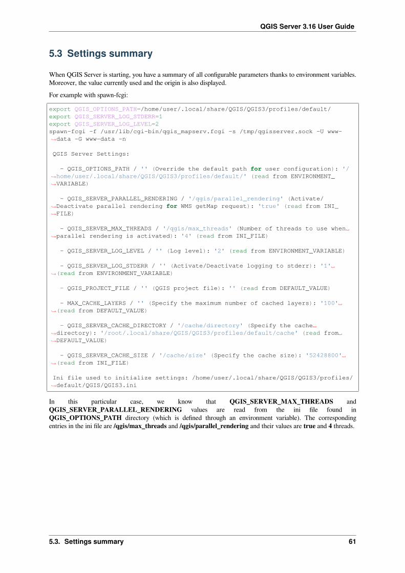
QGIS Server 3.16 User Guide
5.3 Settings summary
When QGIS Server is starting, you have a summary of all configurable parameters thanks to environment variables.Moreover, the value currently used and the origin is also displayed.For example with spawn-fcgi:
export QGIS_OPTIONS_PATH=/home/user/.local/share/QGIS/QGIS3/profiles/default/export QGIS_SERVER_LOG_STDERR=1export QGIS_SERVER_LOG_LEVEL=2spawn-fcgi -f /usr/lib/cgi-bin/qgis_mapserv.fcgi -s /tmp/qgisserver.sock -U www-↪→data -G www-data -n
QGIS Server Settings:
- QGIS_OPTIONS_PATH / '' (Override the default path for user configuration): '/↪→home/user/.local/share/QGIS/QGIS3/profiles/default/' (read from ENVIRONMENT_↪→VARIABLE)
- QGIS_SERVER_PARALLEL_RENDERING / '/qgis/parallel_rendering' (Activate/↪→Deactivate parallel rendering for WMS getMap request): 'true' (read from INI_↪→FILE)
- QGIS_SERVER_MAX_THREADS / '/qgis/max_threads' (Number of threads to use when␣↪→parallel rendering is activated): '4' (read from INI_FILE)
- QGIS_SERVER_LOG_LEVEL / '' (Log level): '2' (read from ENVIRONMENT_VARIABLE)
- QGIS_SERVER_LOG_STDERR / '' (Activate/Deactivate logging to stderr): '1'␣↪→(read from ENVIRONMENT_VARIABLE)
- QGIS_PROJECT_FILE / '' (QGIS project file): '' (read from DEFAULT_VALUE)
- MAX_CACHE_LAYERS / '' (Specify the maximum number of cached layers): '100'␣↪→(read from DEFAULT_VALUE)
- QGIS_SERVER_CACHE_DIRECTORY / '/cache/directory' (Specify the cache␣↪→directory): '/root/.local/share/QGIS/QGIS3/profiles/default/cache' (read from␣↪→DEFAULT_VALUE)
- QGIS_SERVER_CACHE_SIZE / '/cache/size' (Specify the cache size): '52428800'␣↪→(read from INI_FILE)
Ini file used to initialize settings: /home/user/.local/share/QGIS/QGIS3/profiles/↪→default/QGIS/QGIS3.ini
In this particular case, we know that QGIS_SERVER_MAX_THREADS andQGIS_SERVER_PARALLEL_RENDERING values are read from the ini file found inQGIS_OPTIONS_PATH directory (which is defined through an environment variable). The correspondingentries in the ini file are /qgis/max_threads and /qgis/parallel_rendering and their values are true and 4 threads.
5.3. Settings summary 61

QGIS Server 3.16 User Guide
5.4 Short name for layers, groups and project
A number of elements have both a <Name> and a <Title>. TheName is a text string used for machine-to-machinecommunication while the Title is for the benefit of humans.For example, a dataset might have the descriptive Title “Maximum Atmospheric Temperature” and be requestedusing the abbreviated Name “ATMAX”. The user can set the title for layers, groups and projects.OWS name is based on the name used in the layer tree. This name is more a label for humans than a name formachine-to-machine communication. You can set a Short name for layers, groups or projects, to be used by QGISServer as the layer identification name (in LAYERS parameter for instance ).You can set title, short name and abstract for:
• Layers: right-click on a layer and choose Properties… ► QGIS Server ► Description.• Groups: right-click on a group and select Set Group WMS data
Abb. 5.1: Set group WMS data dialog
• Project: go to Project ► Properties… ► QGIS Server ► Service Capabilities.
5.5 Connection to service file
In order to make apache aware of the PostgreSQL service file (see the pg-service-file section) you need to make your*.conf file look like:
SetEnv PGSERVICEFILE /home/web/.pg_service.conf
<Directory "/home/web/apps2/bin/">AllowOverride None
.....
5.6 Add fonts to your linux server
Keep in mind that you may use QGIS projects that point to fonts that may not exist by default on other machines.This means that if you share the project, it may look different on other machines (if the fonts don’t exist on the targetmachine).In order to ensure this does not happen you just need to install the missing fonts on the target machine. Doing this ondesktop systems is usually trivial (double clicking the fonts).For linux, if you don’t have a desktop environment installed (or you prefer the command line) you need to:
• On Debian based systems:
62 Kapitel 5. Advanced configuration

QGIS Server 3.16 User Guide
sudo sumkdir -p /usr/local/share/fonts/truetype/myfonts && cd /usr/local/share/fonts/↪→truetype/myfonts
# copy the fonts from their locationcp /fonts_location/* .
chown root *cd .. && fc-cache -f -v
• On Fedora based systems:
sudo sumkdir /usr/share/fonts/myfonts && cd /usr/share/fonts/myfonts
# copy the fonts from their locationcp /fonts_location/* .
chown root *cd .. && fc-cache -f -v
5.6. Add fonts to your linux server 63
QGIS Server 3.16 User Guide
64 Kapitel 5. Advanced configuration
KAPITEL6
Development Server
A production installation and deployment of QGIS Server usually involves setting up a web server component (e.g.Apache or Nginx) that can forward the HTTP requests coming from the clients to the QGIS Server FastCGI binaryapplication.If you want to quickly test QGIS Server on your local machine without configuring and installing a full web serverstack you can use the QGIS Development Standalone server.This is an independent application that provides a very simple web server ready to serve your project files.
Warnung: The Standalone Development Server has not been developed with the purpose of being used inproduction, it was not checked for security vulnerabilities or for other stress conditions that normally will occuron a publicly exposed server.
To launch the server:
$ qgis_mapserver
The default port the Development Server listens to is 8000. Example output:
QGIS Development Server listening on http://localhost:8000CTRL+C to exit127.0.0.1 [lun gen 20 15:16:41 2020] 5140 103ms "GET /wfs3/?MAP=/tests/testdata/↪→qgis_server/test_project.qgs HTTP/1.1" 200127.0.0.1 [lun gen 20 15:16:41 2020] 3298 2ms "GET /wfs3/static/jsonFormatter.min.↪→js HTTP/1.1" 200127.0.0.1 [lun gen 20 15:16:41 2020] 1678 3ms "GET /wfs3/static/jsonFormatter.min.↪→css HTTP/1.1" 200127.0.0.1 [lun gen 20 15:16:41 2020] 1310 5ms "GET /wfs3/static/style.css HTTP/1.1↪→" 200127.0.0.1 [lun gen 20 15:16:43 2020] 4285 13ms "GET /wfs3/collections?MAP=/tests/↪→testdata/qgis_server/test_project.qgs HTTP/1.1" 200
The server has a few options that can be passed as command line arguments. You can see them all by invoking theserver with -h.
Usage: qgis_mapserver [options] [address:port]QGIS Development Server
(Fortsetzung auf der nächsten Seite)
65

QGIS Server 3.16 User Guide
(Fortsetzung der vorherigen Seite)
Options:-h, --help Displays this help.-v, --version Displays version information.-l <logLevel> Sets log level (default: 0)
0: INFO1: WARNING2: CRITICAL
-p <projectPath> Path to a QGIS project file (*.qgs or *.qgz),if specified it will override the query string MAP argumentand the QGIS_PROJECT_FILE environment variable
Arguments:addressAndPort Listen to address and port (default: "localhost:8000")
address and port can also be specified with the environmentvariables QGIS_SERVER_ADDRESS and QGIS_SERVER_PORT
66 Kapitel 6. Development Server

KAPITEL7
Containerized deployment
There are many ways to use containerized application, from the most simple (simple Docker images) to sophisticated(Kubernetes and so on).
Bemerkung: This kind of deployment needs the docker application to be installed and running. Check this tutorial.
Hinweis: Docker run pre packaged application (aka images) which can be retrieved as sources (Dockerfile andresources) to build or already built from registries (private or public).
Bemerkung: QGIS Debian-Ubuntu package downloads need a valid gpg authentication key. Please refer to theinstallation pages to update the following Dockerfile with the latest key fingerprint
7.1 Simple docker images
As the docker image does not exist in a public registry. you will need to build it. To do so create a directory qgis-server and within its directory:
• create a file Dockerfile with this content:
FROM debian:buster-slim
ENV LANG=en_EN.UTF-8
RUN apt-get update \&& apt-get install --no-install-recommends --no-install-suggests --allow-
↪→unauthenticated -y \gnupg \ca-certificates \wget \locales \
&& localedef -i en_US -f UTF-8 en_US.UTF-8 \
(Fortsetzung auf der nächsten Seite)
67

QGIS Server 3.16 User Guide
(Fortsetzung der vorherigen Seite)# Add the current key for package downloading - As the key changes every year␣
↪→at least# Please refer to QGIS install documentation and replace it with the latest one&& wget -O - https://qgis.org/downloads/qgis-2020.gpg.key | gpg --import \&& gpg --export --armor F7E06F06199EF2F2 | apt-key add - \&& echo "deb http://qgis.org/debian buster main" >> /etc/apt/sources.list.d/
↪→qgis.list \&& apt-get update \&& apt-get install --no-install-recommends --no-install-suggests --allow-
↪→unauthenticated -y \qgis-server \spawn-fcgi \xauth \xvfb \
&& apt-get remove --purge -y \gnupg \wget \
&& rm -rf /var/lib/apt/lists/*
RUN useradd -m qgis
ENV TINI_VERSION v0.17.0ADD https://github.com/krallin/tini/releases/download/${TINI_VERSION}/tini /tiniRUN chmod +x /tini
ENV QGIS_PREFIX_PATH /usrENV QGIS_SERVER_LOG_STDERR 1ENV QGIS_SERVER_LOG_LEVEL 2
COPY cmd.sh /home/qgis/cmd.shRUN chmod -R 777 /home/qgis/cmd.shRUN chown qgis:qgis /home/qgis/cmd.sh
USER qgisWORKDIR /home/qgis
ENTRYPOINT ["/tini", "--"]
CMD ["/home/qgis/cmd.sh"]
• create a file cmd.sh with this content:
#!/bin/bash
[[ $DEBUG == "1" ]] && env
exec /usr/bin/xvfb-run --auto-servernum --server-num=1 /usr/bin/spawn-fcgi -p 5555␣↪→-n -d /home/qgis -- /usr/lib/cgi-bin/qgis_mapserv.fcgi
• build the image with:
docker build -f Dockerfile -t qgis-server ./
68 Kapitel 7. Containerized deployment

QGIS Server 3.16 User Guide
7.1.1 First run
To run the server you will need a QGIS project file. You can use one of yours or pick this sample.To do so, create a directory data within the directory qgis-server and copy your file in it. To comply with thefollowing explanations, rename it to osm.qgs.
Bemerkung: You may need to add advertised URLs under the QGIS Server tab of the Project ► Properties if theGetCapabilites are broken. For example if your server is exposed on port 8080, you will put this for advertised URLhttp://localhost:8080/qgis-server/. More information available in section Configure your projectand subsequent.
Now, you can run the server with:
docker network create qgisdocker run -d --rm --name qgis-server --net=qgis --hostname=qgis-server \
-v $(pwd)/data:/data:ro -p 5555:5555 \-e "QGIS_PROJECT_FILE=/data/osm.qgs" \qgis-server
Options used:• -d: run in the background• –rm: remove the container when it is stopped• –name: name of the container to be created• –net: (previously created) sub network• –hostname: container hostname, for later referencing• -v: local data directory to be mounted in the container• -p: host/container port mapping• -e: environment variable to be used in the container
To check, type docker ps | grep qgis-server and you should see a line with qgis-server:
CONTAINER ID IMAGE COMMAND CREATED STATUS ␣↪→ PORTS NAMES4de8192da76e qgis-server "/tini -- /home/qgis…" 3 seconds ago Up 2 seconds␣↪→ 0.0.0.0:5555->5555/tcp qgis-server
7.1.2 Usable sample
As the server is only accepting fastcgi connections, you need an HTTP server that handles this protocol. To do so wehave to create a simple Nginx configuration file and start a Nginx image.Create a file nginx.conf in the current directory with this content:
server {listen 80;server_name _;location / {root /usr/share/nginx/html;index index.html index.htm;
}location /qgis-server {proxy_buffers 16 16k;proxy_buffer_size 16k;
(Fortsetzung auf der nächsten Seite)
7.1. Simple docker images 69

QGIS Server 3.16 User Guide
(Fortsetzung der vorherigen Seite)gzip off;include fastcgi_params;fastcgi_pass qgis-server:5555;
}}
And type this command:
docker run -d --rm --name nginx --net=qgis --hostname=nginx \-v $(pwd)/nginx.conf:/etc/nginx/conf.d/default.conf:ro -p 8080:80 \nginx:1.13
To check capabilities availability, type in a browser http://localhost:8080/qgis-server/?SERVICE=WMS&VERSION=1.3.0&REQUEST=GetCapabilities
7.1.3 Cleanup
To cleanup the running images, type:
docker stop qgis-server nginx
7.2 Docker stacks
The previous method is scriptable, but not easily packageable nor standardized or easily manageable.To work with a docker image set you could use a docker stack managed by an orchestrator. In a stack, the images areworking in the same private network, and you can start / stop the whole stack or deploy the stack to other workers.There are many orchestrators, for example Swarm, Kubernetes and Mesos.In the following, we will present simple configurations for testing purposes. They are not suitable for production.
7.2.1 Swarm/docker-compose
Docker now has its own orchestrator: Swarm (compatible with docker-compose files). You have to enable it (the Macversion will also work with Linux).
Stack description
Now that you have Swarm working, create the service file (see Deploy to Swarm) qgis-stack.yaml:
version: '3.7'
services:qgis-server:# Should use version with utf-8 locale support:image: qgis-server:latestvolumes:- REPLACE_WITH_FULL_PATH/data:/data:roenvironment:- LANG=en_EN.UTF-8- QGIS_PROJECT_FILE=/data/osm.qgs- QGIS_SERVER_LOG_LEVEL=0 # INFO (log all requests)- DEBUG=1 # display env before spawning QGIS Server
nginx:
(Fortsetzung auf der nächsten Seite)
70 Kapitel 7. Containerized deployment

QGIS Server 3.16 User Guide
(Fortsetzung der vorherigen Seite)image: nginx:1.13ports:- 8080:80volumes:- REPLACE_WITH_FULL_PATH/nginx.conf:/etc/nginx/conf.d/default.conf:rodepends_on:- qgis-server
To deploy (or update) the stack, type:
docker stack deploy -c qgis-stack.yaml qgis-stack
Check the stack deployment status until you obtain 1/1 in the replicas column:
docker stack services qgis-stack
Something like:
ID NAME MODE REPLICAS ␣↪→IMAGE PORTSgmx7ewlvwsqt qgis_nginx replicated 1/1 ␣↪→nginx:1.13 *:8080->80/tcpl0v2e7cl43u3 qgis_qgis-server replicated 1/1 ␣↪→qgis-server:latest
To check WMS capabilities, type in a web browser http://localhost:8080/qgis-server/?SERVICE=WMS&VERSION=1.3.0&REQUEST=GetCapabilities
Cleanup
To cleanup, type:
docker stack rm qgis-stack
7.2.2 Kubernetes
Installation
If you have a Docker Desktop installation, using Kubernetes (aka k8s) is pretty straight forward: enable k8s.If not, follow the minikube tutorial or microk8s for Ubuntu.As Kubernetes installation can be really complex, we will only focus on aspects used by this demo. For further /deeper information, check the official documentation.
microk8s
microk8s needs extra steps: you have to enable the registry and tag the qgis-server image in order to have Kubernetesto find the created images.First, enable the registry:
microk8s enable dashboard dns registry
Then, tag and push the image to your newly created registry:
7.2. Docker stacks 71

QGIS Server 3.16 User Guide
docker tag qgis-server 127.0.0.1:32000/qgis-server && docker push 127.0.0.1:32000/↪→qgis-server
Finally, add or complete the /etc/docker/daemon.json to have your registry 127.0.0.1:32000 listed in theinsecure-registries field:
{"insecure-registries": ["127.0.0.1:32000"]
}
Creating manifests
Kubernetes describes the objects to deploy in yaml manifests. There are many different kinds, but we will only usedeployments (handle pods, i.e. docker images) and services to expose the deployments to internal or external purposes.
Deployment manifests
Create a file deployments.yaml with this content:
apiVersion: apps/v1kind: Deploymentmetadata:
name: qgis-servernamespace: default
spec:replicas: 1selector:matchLabels:
myLabel: qgis-servertemplate:metadata:
labels:myLabel: qgis-server
spec:containers:
- name: qgis-serverimage: localhost:32000/qgis-server:latestimagePullPolicy: IfNotPresentenv:
- name: LANGvalue: en_EN.UTF-8
- name: QGIS_PROJECT_FILEvalue: /data/osm.qgs
- name: QGIS_SERVER_LOG_LEVELvalue: "0"
- name: DEBUGvalue: "1"
ports:- containerPort: 5555
volumeMounts:- name: qgis-datamountPath: /data/
volumes:- name: qgis-datahostPath:path: REPLACE_WITH_FULL_PATH/data
---apiVersion: apps/v1
(Fortsetzung auf der nächsten Seite)
72 Kapitel 7. Containerized deployment

QGIS Server 3.16 User Guide
(Fortsetzung der vorherigen Seite)kind: Deploymentmetadata:
name: qgis-nginxnamespace: default
spec:replicas: 1selector:matchLabels:
myLabel: qgis-nginxtemplate:metadata:
labels:myLabel: qgis-nginx
spec:containers:
- name: qgis-nginximage: nginx:1.13ports:- containerPort: 80
volumeMounts:- name: nginx-confmountPath: /etc/nginx/conf.d/default.conf
volumes:- name: nginx-confhostPath:path: REPLACE_WITH_FULL_PATH/nginx.conf
Service manifests
Create a file services.yaml with this content:
apiVersion: v1kind: Servicemetadata:
name: qgis-servernamespace: default
spec:type: ClusterIPselector:myLabel: qgis-server
ports:- port: 5555
targetPort: 5555---apiVersion: v1kind: Servicemetadata:
name: qgis-nginxnamespace: default
spec:type: NodePortselector:myLabel: qgis-nginx
ports:- port: 80
targetPort: 80nodePort: 30080
7.2. Docker stacks 73

QGIS Server 3.16 User Guide
Deploying manifests
To deploy the images and services in Kubernetes, one can use the dashboard (click on the + on the upper right) orthe command line.
Bemerkung: When using the command line with microk8s you will have to prefix each command with microk8s.
To deploy or update your manifests:
kubectl apply -k ./
To check what is currently deployed:
kubectl get pods,services,deployment
You should obtain something like:
NAME READY STATUS RESTARTS AGEpod/qgis-nginx-54845ff6f6-8skp9 1/1 Running 0 27mpod/qgis-server-75df8ddd89-c7t7s 1/1 Running 0 27m
NAME TYPE CLUSTER-IP EXTERNAL-IP PORT(S) ␣↪→ AGEservice/Kubernetes ClusterIP 10.152.183.1 <none> 443/TCP ␣↪→ 5h51mservice/qgis-exec-server ClusterIP 10.152.183.218 <none> 5555/TCP ␣↪→ 35mservice/qgis-nginx NodePort 10.152.183.234 <none> 80:30080/TCP␣↪→ 27mservice/qgis-server ClusterIP 10.152.183.132 <none> 5555/TCP ␣↪→ 27m
NAME READY UP-TO-DATE AVAILABLE AGEdeployment.apps/qgis-nginx 1/1 1 1 27mdeployment.apps/qgis-server 1/1 1 1 27m
To read nginx/qgis logs, type:
kubectl logs -f POD_NAME
To check WMS capabilities, type in a web browser http://localhost:30080/qgis-server/?SERVICE=WMS&VERSION=1.3.0&REQUEST=GetCapabilities
Cleanup
To clean up, type:
kubectl delete -n default service/qgis-server service/qgis-nginx deployment/qgis-↪→nginx deployment/qgis-server
74 Kapitel 7. Containerized deployment
QGIS Server 3.16 User Guide
7.3 Cloud deployment
Managing your own cluster of servers to handle the deployment of containerized applications, is a complex job. Youhave to handle multiple issues, such as hardware, bandwidth and security at different levels.Cloud deployment solutions can be a good alternative when you do not want to focus on infrastructure management.A cloud deployment may use proprietary mechanisms, but they are also compatible with the stages explainedpreviously (docker images and stack management).
7.3.1 AWS usecase
With Amazon AWS, through ECS (Elastic Container Service) functionalities, you can use docker-compose orKubernetes compatible wrappers to manage your stack. You will have to create an image registry for your customimages to be accessible.To use docker-compose alike functionalities, you need to install the ecs-cli client and have proper permissions / roles.Then, with the help of the ecs-cli compose commands (see the ecs-cli compose manual and ecs-cli tutorial), you canreuse the stack description.To use Kubernetes, you can use the AWSweb console or the command line tool eksctl and have the proper permissions/ roles. Then with a well configured kubectl environment, you can reuse the Kubernetes manifests.
7.3. Cloud deployment 75

QGIS Server 3.16 User Guide
76 Kapitel 7. Containerized deployment

KAPITEL8
Frequently Asked Question
• Was sind die Unterschiede zwischen QGIS Desktop und QGIS Server?
QGIS Desktop hat eine grafische Benutzeroberfläche und dient dem Erstellen und Ändern von Karten. QGISServer ist einer Serveranwendung, die QGIS Projekte für Endbenutzeranwendungen via OGC Web Serviceswie WMS, WFS, etc. bereitstellt.
• Was ist OGC?
Das OGC (Open Geospatial Consortium) ist eine internationale, gemeinnützige Organisation, die sich dafüreinsetzt, Qualitätsstandards für die globale Geodatengemeinschaft zu schaffen.
• Gibt es andere Web Map server?
ArcGIS server, Geoserver, Mapserver, Mapnik etc.• Wie vergleiche ich den QGIS-Server mit anderen Web-Mapping-Servern? (2021/01/01)
Features QGIS Server GeoServer ArcGIS ServerSeit 2006 2001 1999Lizenz GPL GPL KommerziellKommerzieller Support Viele Anbieter Viele Anbieter ESRI und das Netzwerk
seiner AnbieterTechnologie C++/python Java C++Tile cache Ja Ja (via
GeoWebCache)Ja
3D Nein Nein JaAbfragen FES (2.0) und OGC (1.0)
FilterCQL und OGCFilter
OGC Filter
Report Erzeugung Ja Ja JaSerververwaltet Ja, durch Drittanbieter
(LizMap, QWC2, etc.)web + APIREST
web + API REST
GIS ProjektLayer/SymbolDefinition
Komplett über dedizierteGUI
einfach per WebInterface
Komplett über dedizierteGUI
• Welche Versionen der OGC Spezifikationen unterstützt QGIS Server im Vergleich zu anderen Web Map Servern?
77

QGIS Server 3.16 User Guide
OGC Standards QGIS Server GeoServer ArcGIS ServerWMS (Web Map Service) 1.3.0 - 1.1.1 1.3.0 - 1.1.1 1.3.0 - 1.1.1WFS (Web Feature Service) 1.1.0 - 1.0.0 2.0.0 - 1.0.0 2.0.0 - 1.0.0OAPIF (aka WFS3) 1.0.0 Nein NeinWMTS (Web Map Tile Service) 1.0.0 1.0.0 1.0.0WCS (Web Coverage Service) 1.0.0 2.0.1 - 1.0.0 2.0.1 - 1.0.0WPS (Web Processing Service) Nein 1.0.0 1.0.0CSW (Catalogue Service for the Web) Nein 2.0.2 NeinSLD (Styled Layer Descriptor) Ja Ja Ja
• Was ist ein tile cache?
Karten sind oft statisch. Da die meisten Mapping-Clients bei jeder Abfrage WMS-Daten (Web Map Service)rendern, kann dies zu unnötiger Verarbeitung und längeren Wartezeiten führen.Der tile-Cache optimiert dieses Verfahren, indem erKartenbilder oder Kacheln nach Bedarf speichert (caching)und so als Proxy zwischen Client (wie OpenLayers oder Google Maps) und Server (jedemWMS-kompatiblenServer) fungiert. Wenn neue Karten und Kacheln angefordert werden, fängt der QGIS-Server diese Aufrufeab und gibt vorgerenderte Kacheln zurück, falls sie gespeichert sind, oder ruft die QGIS-Engine auf, um beiBedarf neue Kacheln zu rendern. Sobald Kacheln gespeichert sind, erhöht sich die Geschwindigkeit des Karten-Renderings um ein Vielfaches, was zu einer erheblich verbesserten Benutzererfahrung führt.
• Was ist PostgreSQL?
PostgreSQL ist ein leistungsstarkes, objektrelationales Open Source-Datenbanksystem für QGIS.• Was ist PostGIS?
PostGIS ist eine räumliche Datenbank-Erweiterung für die objektrelationale PostgreSQL-Datenbank. Es bietetUnterstützung für geografische Objekte, sodass Standortabfragen in SQL ausgeführt werden können.
• Fortsetzung folgt …
78 Kapitel 8. Frequently Asked Question