qatar university - CORE
157
QATAR UNIVERSITY COLLEGE OF ENGINEERING TOWARDS INTEGRATED SOCIO-CULTURAL SPACE IN “FAREEJ OLD AL- HITMI” NEIGHBORHOOD IN DOHA BY SARA IBRAHIM NAFI' A Thesis Submitted to the Faculty of the College of Engineering in Partial Fulfillment of the Requirements for the Degree of Masters of Science in Urban Planning and Design June 2017 © 2017 Sara Nafi'. All Rights Reserved.
-
Upload
khangminh22 -
Category
Documents
-
view
3 -
download
0
Transcript of qatar university - CORE
QATAR UNIVERSITY
COLLEGE OF ENGINEERING
TOWARDS INTEGRATED SOCIO-CULTURAL SPACE IN “FAREEJ OLD AL-
HITMI” NEIGHBORHOOD IN DOHA
BY
SARA IBRAHIM NAFI'
A Thesis Submitted to the Faculty of
the College of Engineering
in Partial Fulfillment
of the Requirements
for the Degree of
Masters of Science in Urban Planning and Design
June 2017
© 2017 Sara Nafi'. All Rights Reserved.
ii
COMMITTEE PAGE
The members of the Committee approve the Thesis of Sara Nafi' defended
on 25/05/2017.
Dr. Anna Grichting
Thesis/Dissertation Supervisor
Prof. Emeritus Brian W Edwards
Committee Member
Dr. Djamel Ouahrani
Committee Member
Approved:
Khalifa Al-Khalifa, Dean, College of Engineering

iii
ABSTRACT
NAFI, SARA, I., Masters: June : 2017,
Masters of Science in Urban Planning and Design
Title: Towards Integrated Socio-Cultural Space in “Fareej Old Al-Hitmi” Neighborhood
in Doha
Supervisor ofThesis: Dr. Anna Grichting.
In the face of rapid urban development, population growth, and socio-cultural changes,
most historic districts in the Gulf are experiencing difficulties in making the necessary
adaptation and adjustments to the present needs and changes. On the one hand, most of
these districts are suffering from decay and dilapidation. On the other hand, many of
them are being erased and replaced by new business districts. Consequently, historic
districts are being neglected and are losing their identity. Doha, the capital of the state of
Qatar, is experiencing a rapid growth in its economy and population, resulting in the
transformation of its built environment. This transformation is characterized by multiple
construction projects and the abandonment of old historic neighborhoods.
The aim of this thesis is to examine the impact of this rapid urban development on the
socio-cultural spaces in Doha‟s historic neighborhoods, focusing on „Fareej Old Al-
Hitmi‟. This is an old neighborhood in Doha that contains the rich history of the Al-Hitmi
family, and which has a coherent fabric with authentic old houses of different characters
and types. Old Al-Hitmi neighborhood is one of the spaces that is currently being
iv
neglected and is losing its cultural identity. The main objective deals with the evaluation
of the current socio-cultural spaces within the study area, and examining different
methods to enhance the social interaction and connectivity between the neighborhood
users.
To achieve the aim of this research study, a mixed methods approach involving a
combination of both quantitative and qualitative analyses were adopted and developed.
(1) Theoretical study, by reviewing different topics and disciplines (2) Applied and
analytical study, through site observation, field notes and photographs (3) Structured
questioners and interviews with planners and design professionals from the Ministry of
Municipality and Environment (MME), Qatar Museum Authority (QMA), Engineering
consultant companies and Qatar Rail (QR). As an outcome, this research study attempts
to develop an approach to enhance the socio-cultural spaces, and promote social
interaction and engagement in urban life through a set of recommendations and design
guidelines.
v
DEDICATION
I dedicate my work to
Ibrahim Nafi’
Salha Khalifa
my parents who have supported me throughout my life. Their love, encouragement, and
prayers empowered me to achieve such success.
I also dedicate my thesis to my beloved sisters and brothers for their sincere love and
encouragement
Thank you, my beloved family.
vi
ACKNOWLEDGMENTS
In the name of Allah, the Compassionate, the Merciful. I would like to express my
gratefulness to everyone who supported me throughout my Master‟s thesis. I am thankful
for their aspiring guidance, invaluably constructive criticism and friendly advice. I am
sincerely grateful to them for sharing their truthful and illuminating views on a number of
issues related to the thesis.
I would like to express my sincere gratitude to my advisor Dr. Anna Grichting for her
continuous support and guidance throughout my academic years, for her patience,
immense knowledge, and her motivation to keep challenging myself throughout the entire
process.
A warm thank to my parents, sisters and brothers. I am thankful to my family that blessed
me with lots of encouragement. I express gratitude to my friends, for there continued love
and support.
vii
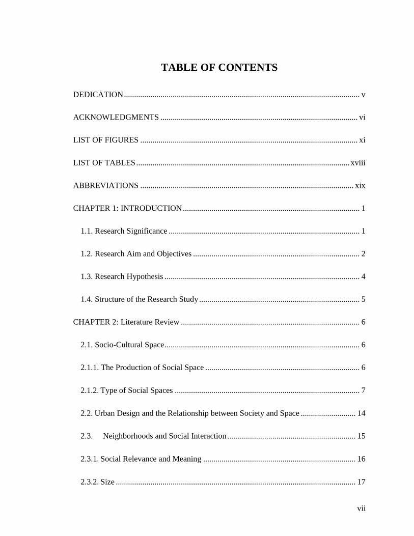
TABLE OF CONTENTS
DEDICATION .................................................................................................................... v
ACKNOWLEDGMENTS ................................................................................................. vi
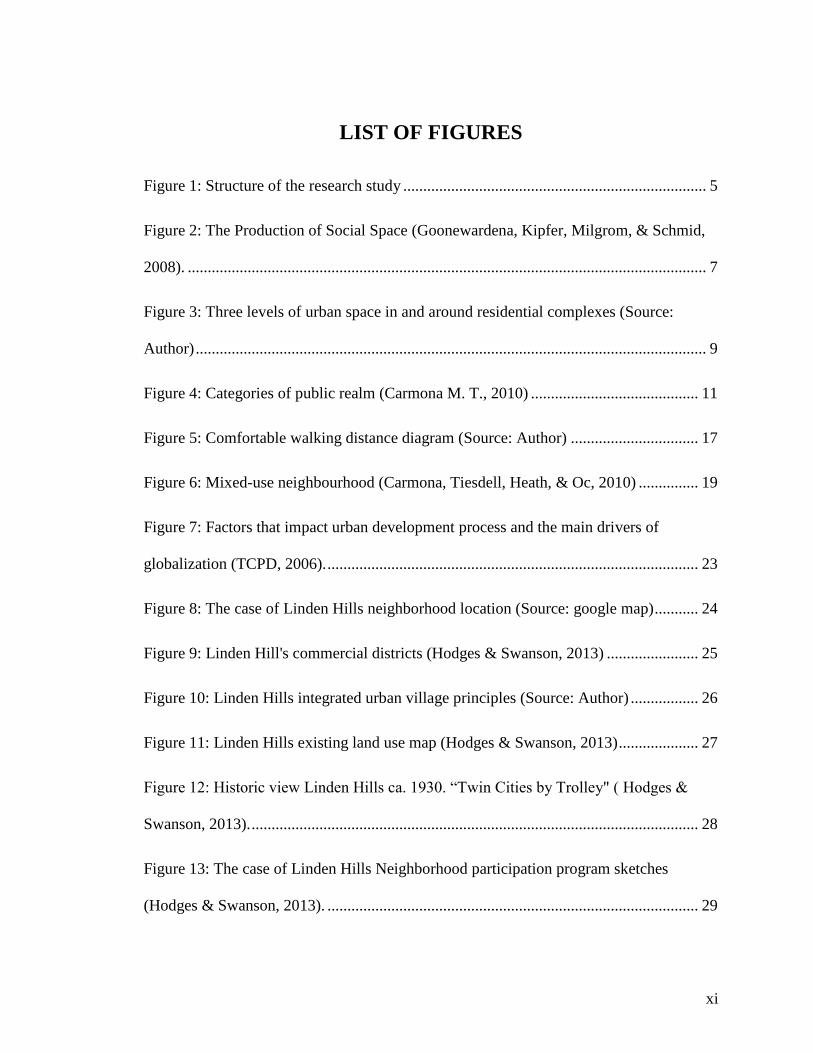
LIST OF FIGURES ........................................................................................................... xi
LIST OF TABLES ......................................................................................................... xviii
ABBREVIATIONS ......................................................................................................... xix
CHAPTER 1: INTRODUCTION ....................................................................................... 1
1.1. Research Significance .............................................................................................. 1
1.2. Research Aim and Objectives .................................................................................. 2
1.3. Research Hypothesis ................................................................................................ 4
1.4. Structure of the Research Study ............................................................................... 5
CHAPTER 2: Literature Review ........................................................................................ 6
2.1. Socio-Cultural Space ................................................................................................ 6
2.1.1. The Production of Social Space ............................................................................ 6
2.1.2. Type of Social Spaces ........................................................................................... 7
2.2. Urban Design and the Relationship between Society and Space ........................... 14
2.3. Neighborhoods and Social Interaction ............................................................... 15
2.3.1. Social Relevance and Meaning ........................................................................... 16
2.3.2. Size ...................................................................................................................... 17
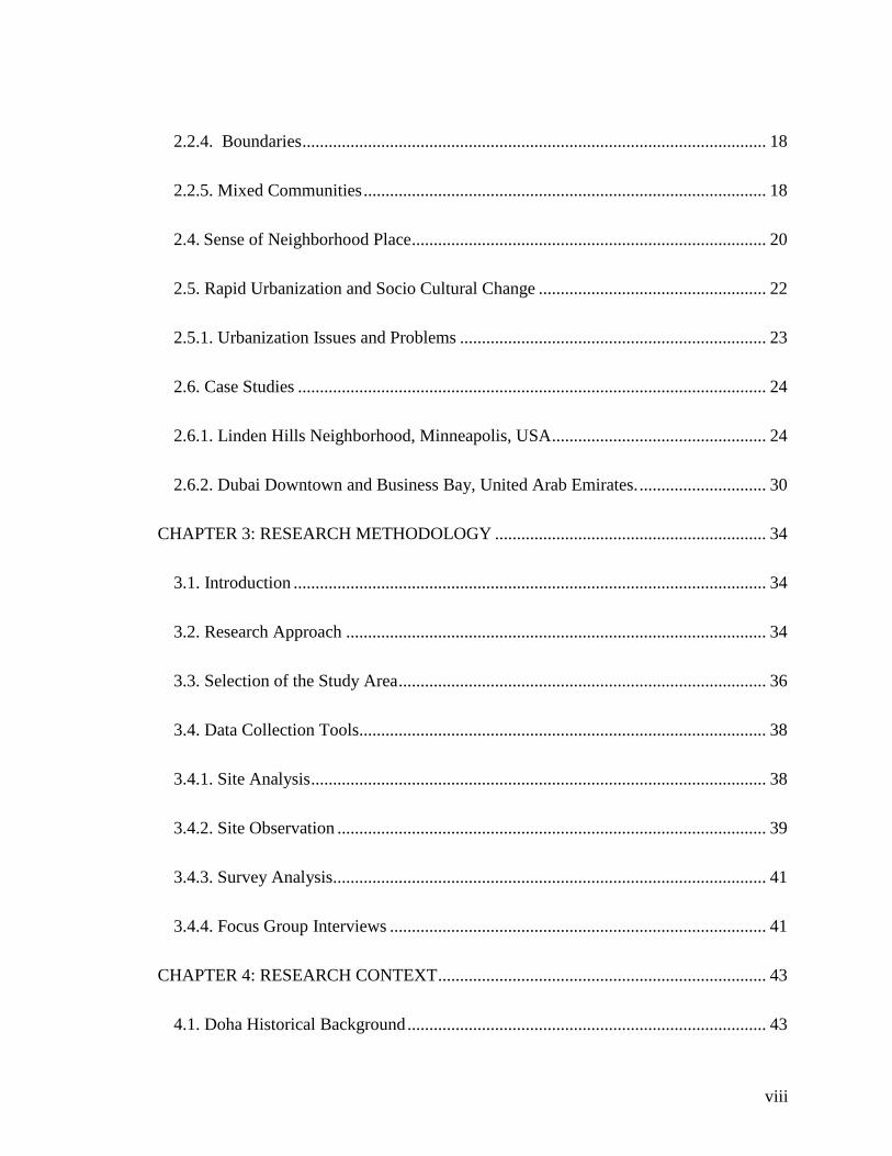
viii
2.2.4. Boundaries .......................................................................................................... 18
2.2.5. Mixed Communities ............................................................................................ 18
2.4. Sense of Neighborhood Place ................................................................................. 20
2.5. Rapid Urbanization and Socio Cultural Change .................................................... 22
2.5.1. Urbanization Issues and Problems ...................................................................... 23
2.6. Case Studies ........................................................................................................... 24
2.6.1. Linden Hills Neighborhood, Minneapolis, USA ................................................. 24
2.6.2. Dubai Downtown and Business Bay, United Arab Emirates. ............................. 30
CHAPTER 3: RESEARCH METHODOLOGY .............................................................. 34
3.1. Introduction ............................................................................................................ 34
3.2. Research Approach ................................................................................................ 34
3.3. Selection of the Study Area .................................................................................... 36
3.4. Data Collection Tools............................................................................................. 38
3.4.1. Site Analysis ........................................................................................................ 38
3.4.2. Site Observation .................................................................................................. 39
3.4.3. Survey Analysis................................................................................................... 41
3.4.4. Focus Group Interviews ...................................................................................... 41
CHAPTER 4: RESEARCH CONTEXT ........................................................................... 43
4.1. Doha Historical Background .................................................................................. 43
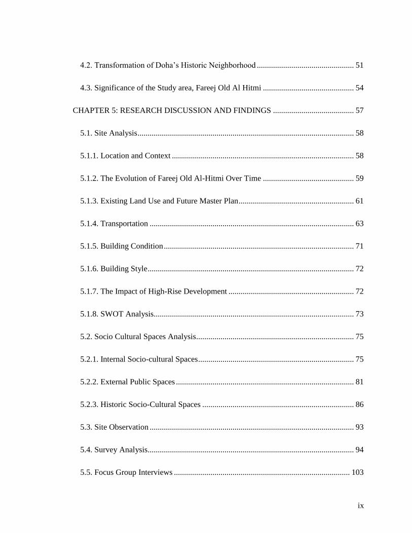
ix
4.2. Transformation of Doha‟s Historic Neighborhood ................................................ 51
4.3. Significance of the Study area, Fareej Old Al Hitmi ............................................. 54
CHAPTER 5: RESEARCH DISCUSSION AND FINDINGS ........................................ 57
5.1. Site Analysis ........................................................................................................... 58
5.1.1. Location and Context .......................................................................................... 58
5.1.2. The Evolution of Fareej Old Al-Hitmi Over Time ............................................. 59
5.1.3. Existing Land Use and Future Master Plan ......................................................... 61
5.1.4. Transportation ..................................................................................................... 63
5.1.5. Building Condition .............................................................................................. 71
5.1.6. Building Style ...................................................................................................... 72
5.1.7. The Impact of High-Rise Development .............................................................. 72
5.1.8. SWOT Analysis................................................................................................... 73
5.2. Socio Cultural Spaces Analysis.............................................................................. 75
5.2.1. Internal Socio-cultural Spaces ............................................................................. 75
5.2.2. External Public Spaces ........................................................................................ 81
5.2.3. Historic Socio-Cultural Spaces ........................................................................... 86
5.3. Site Observation ..................................................................................................... 93
5.4. Survey Analysis...................................................................................................... 94
5.5. Focus Group Interviews ....................................................................................... 103
x
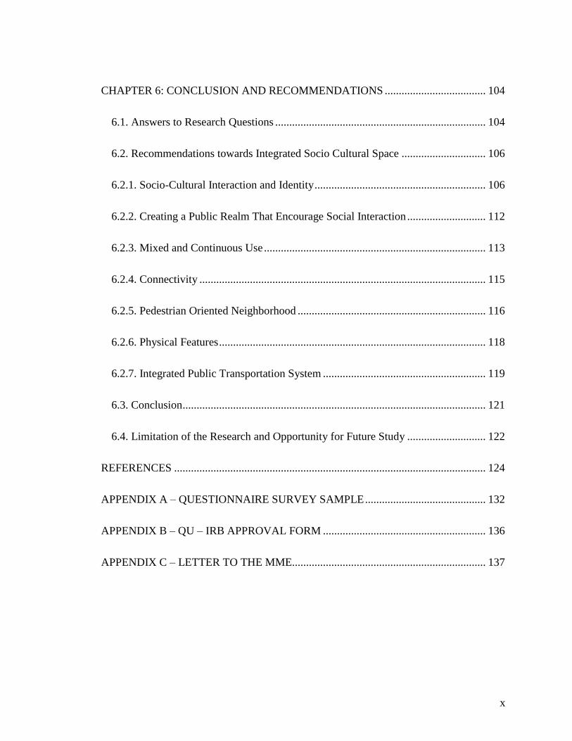
CHAPTER 6: CONCLUSION AND RECOMMENDATIONS .................................... 104
6.1. Answers to Research Questions ........................................................................... 104
6.2. Recommendations towards Integrated Socio Cultural Space .............................. 106
6.2.1. Socio-Cultural Interaction and Identity ............................................................. 106
6.2.2. Creating a Public Realm That Encourage Social Interaction ............................ 112
6.2.3. Mixed and Continuous Use ............................................................................... 113
6.2.4. Connectivity ...................................................................................................... 115
6.2.5. Pedestrian Oriented Neighborhood ................................................................... 116
6.2.6. Physical Features ............................................................................................... 118
6.2.7. Integrated Public Transportation System .......................................................... 119
6.3. Conclusion ............................................................................................................ 121
6.4. Limitation of the Research and Opportunity for Future Study ............................ 122
REFERENCES ............................................................................................................... 124
APPENDIX A – QUESTIONNAIRE SURVEY SAMPLE ........................................... 132
APPENDIX B – QU – IRB APPROVAL FORM .......................................................... 136
APPENDIX C – LETTER TO THE MME..................................................................... 137
xi
LIST OF FIGURES
Figure 1: Structure of the research study ............................................................................ 5
Figure 2: The Production of Social Space (Goonewardena, Kipfer, Milgrom, & Schmid,
2008). .................................................................................................................................. 7
Figure 3: Three levels of urban space in and around residential complexes (Source:
Author) ................................................................................................................................ 9
Figure 4: Categories of public realm (Carmona M. T., 2010) .......................................... 11
Figure 5: Comfortable walking distance diagram (Source: Author) ................................ 17
Figure 6: Mixed-use neighbourhood (Carmona, Tiesdell, Heath, & Oc, 2010) ............... 19
Figure 7: Factors that impact urban development process and the main drivers of
globalization (TCPD, 2006). ............................................................................................. 23
Figure 8: The case of Linden Hills neighborhood location (Source: google map) ........... 24
Figure 9: Linden Hill's commercial districts (Hodges & Swanson, 2013) ....................... 25
Figure 10: Linden Hills integrated urban village principles (Source: Author) ................. 26
Figure 11: Linden Hills existing land use map (Hodges & Swanson, 2013) .................... 27
Figure 12: Historic view Linden Hills ca. 1930. “Twin Cities by Trolley" ( Hodges &
Swanson, 2013). ................................................................................................................ 28
Figure 13: The case of Linden Hills Neighborhood participation program sketches
(Hodges & Swanson, 2013). ............................................................................................. 29
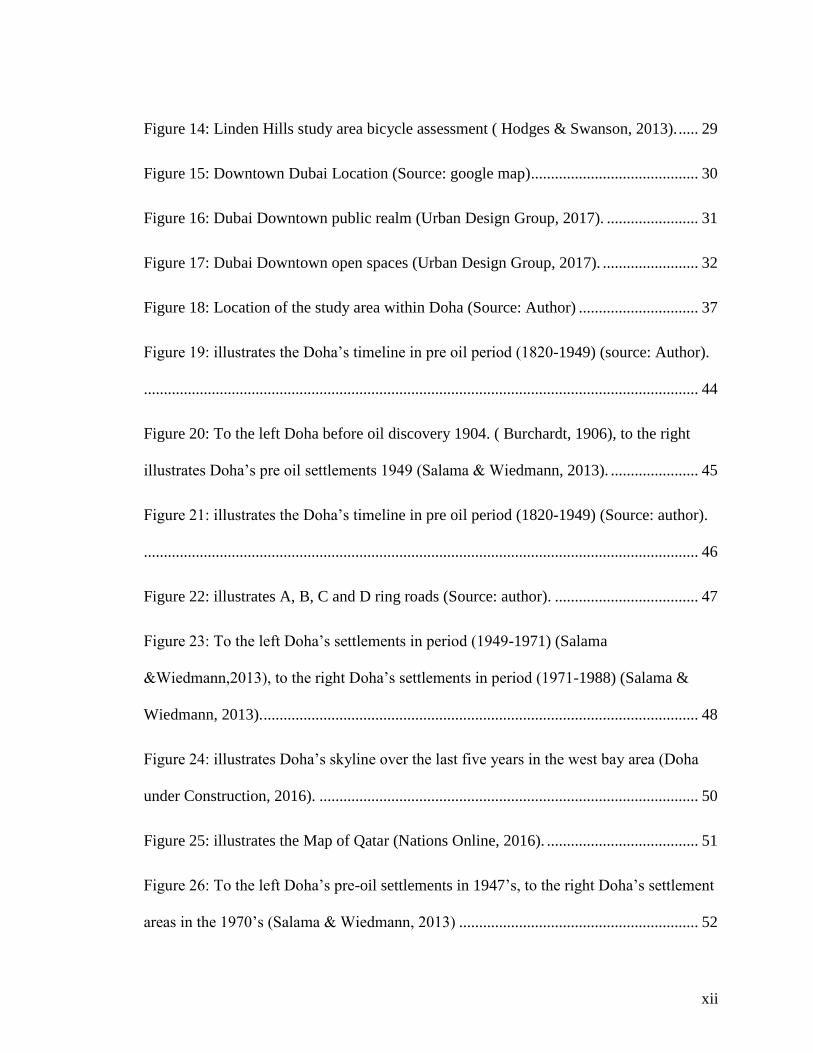
xii
Figure 14: Linden Hills study area bicycle assessment ( Hodges & Swanson, 2013). ..... 29
Figure 15: Downtown Dubai Location (Source: google map).......................................... 30
Figure 16: Dubai Downtown public realm (Urban Design Group, 2017). ....................... 31
Figure 17: Dubai Downtown open spaces (Urban Design Group, 2017). ........................ 32
Figure 18: Location of the study area within Doha (Source: Author) .............................. 37
Figure 19: illustrates the Doha‟s timeline in pre oil period (1820-1949) (source: Author).
........................................................................................................................................... 44
Figure 20: To the left Doha before oil discovery 1904. ( Burchardt, 1906), to the right
illustrates Doha‟s pre oil settlements 1949 (Salama & Wiedmann, 2013). ...................... 45
Figure 21: illustrates the Doha‟s timeline in pre oil period (1820-1949) (Source: author).
........................................................................................................................................... 46
Figure 22: illustrates A, B, C and D ring roads (Source: author). .................................... 47
Figure 23: To the left Doha‟s settlements in period (1949-1971) (Salama
&Wiedmann,2013), to the right Doha‟s settlements in period (1971-1988) (Salama &
Wiedmann, 2013). ............................................................................................................. 48
Figure 24: illustrates Doha‟s skyline over the last five years in the west bay area (Doha
under Construction, 2016). ............................................................................................... 50
Figure 25: illustrates the Map of Qatar (Nations Online, 2016). ...................................... 51
Figure 26: To the left Doha‟s pre-oil settlements in 1947‟s, to the right Doha‟s settlement
areas in the 1970‟s (Salama & Wiedmann, 2013) ............................................................ 52

xiii
Figure 27: To the left the past ten year‟s settlement expansion (Salama & Wiedmann,
2013), to the right the settlement areas in the 1990s (Salama & Wiedmann, 2013) ........ 52
Figure 28: To the left residential & establishment buildings1986, 1997, 2004 & 2010, to
the right population growth, population by Municipality 1997, 2004 & 2010. (Source:
Qatar Atlas 2013). ............................................................................................................. 53
Figure 29: Fareej Al-Hitmi Evolution 1949 - 1990 (Source: Author) .............................. 55
Figure 30: Fareej Old Al Hitmi Location Map (Source: Author) ..................................... 58
Figure 31: The Evolution of Fareej Old Al-Hitmi (2003 – 2017) (Source: Author) ........ 60
Figure 32: Fareej Old Al Hitmi Existing Land Use Map (Source: MME) ....................... 61
Figure 33: Fareej Old Al-Hitmi Future Master Plan (Source: MME) .............................. 62
Figure 34: Fareej Old Al Hitmi Bus Stop (Source: Author) ............................................. 63
Figure 35: The study area surrounding Metro Stations (Source: Qatar Rail) ................... 64
Figure 36: Qatar National Museum Station (Qatar Rail, 2016) ........................................ 65
Figure 37: Qatar Rail Development Program (Qatar Rail, 2016) .................................... 66
Figure 38: Qatar Metro Stations (Qatar Rail, 2016) ......................................................... 67
Figure 39: Doha Metro for 2022 and 2026 (Qatar Rail, 2016) ......................................... 67
Figure 40: The gold line phase (Qatar Rail, 2016) ........................................................... 68
Figure 41: lacks of adequate parking space in the study area (Source: Author) ............... 70
Figure 42: Fareej Old Al-Hitmi Buildings Condition (Source: Author) ........................... 71

xiv
Figure 43: The study area building style (Source: Author) .............................................. 72
Figure 44: Impact of the high-rise development (Source: Author)................................... 73
Figure 45: SWOT Analysis (Source: Author) .................................................................. 74
Figure 46: Internal Socio-Cultural Spaces (Source: Author) ............................................ 75
Figure 47: Dar Al-Kutub Al-Qatariyya (Source: Author) ............................................... 76
Figure 48: Qatar National Museum (Source: Author) ...................................................... 77
Figure 49: National Museum Metro Station design (Qatar Rail, 2016) ........................... 78
Figure 50: Surrounding Socio-Cultural Spaces 2017 (Source: Author) ........................... 79
Figure 51: Sana Souq (Source: Author) ............................................................................ 80
Figure 52: Oriental Pearl Restaurant (TripAdvisor LLC, 2017) ....................................... 80
Figure 53: External Public Space (Source: Author) ......................................................... 81
Figure 54: Doha Sport Stadium (Europlan, 2015) ............................................................ 82
Figure 55: Random parking in the study area (Source: Author) ....................................... 83
Figure 56: The study area urban corridor (Source: Author) ............................................. 84
Figure 57: Mixed use development in the study area (Source: Author) ........................... 84
Figure 58: illustrate the absence of sense of place and safety in the study area (Source:
Author) .............................................................................................................................. 85
Figure 59: Surrounding old socio-cultural spaces 2003 (Source: Author) ....................... 86
Figure 60: Old Remaining Socio-Cultural Spaces 2017 (Source: Author)....................... 87
xv
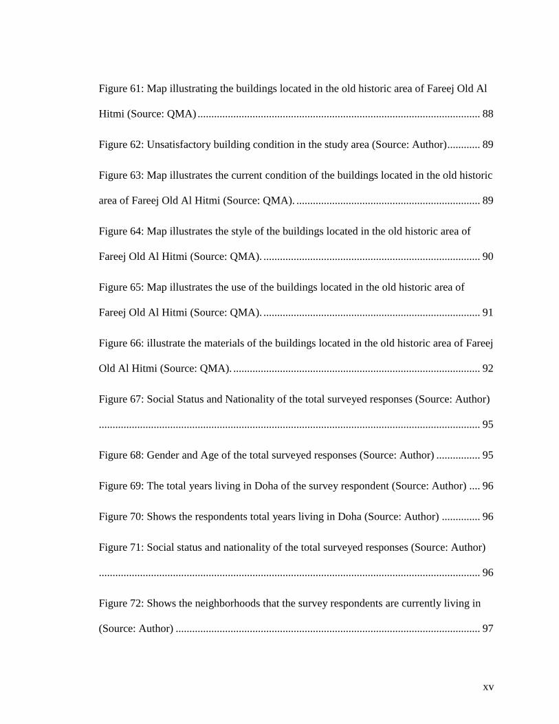
Figure 61: Map illustrating the buildings located in the old historic area of Fareej Old Al
Hitmi (Source: QMA) ....................................................................................................... 88
Figure 62: Unsatisfactory building condition in the study area (Source: Author) ............ 89
Figure 63: Map illustrates the current condition of the buildings located in the old historic
area of Fareej Old Al Hitmi (Source: QMA). ................................................................... 89
Figure 64: Map illustrates the style of the buildings located in the old historic area of
Fareej Old Al Hitmi (Source: QMA). ............................................................................... 90
Figure 65: Map illustrates the use of the buildings located in the old historic area of
Fareej Old Al Hitmi (Source: QMA). ............................................................................... 91
Figure 66: illustrate the materials of the buildings located in the old historic area of Fareej
Old Al Hitmi (Source: QMA). .......................................................................................... 92
Figure 67: Social Status and Nationality of the total surveyed responses (Source: Author)
........................................................................................................................................... 95
Figure 68: Gender and Age of the total surveyed responses (Source: Author) ................ 95
Figure 69: The total years living in Doha of the survey respondent (Source: Author) .... 96
Figure 70: Shows the respondents total years living in Doha (Source: Author) .............. 96
Figure 71: Social status and nationality of the total surveyed responses (Source: Author)
........................................................................................................................................... 96
Figure 72: Shows the neighborhoods that the survey respondents are currently living in
(Source: Author) ............................................................................................................... 97

xvi
Figure 73: Survey Result (Source: Author) ...................................................................... 98
Figure 74: Frequently used mode of travel of the survey respondents (Source: Author) . 99
Figure 75: Survey Result (Source: Author) ...................................................................... 99
Figure 76: The activities in common outdoor spaces that the of the survey respondents
practice in their neighborhood (Source: Author) ............................................................ 100
Figure 77: The time of the survey respondents practicing the outdoor activity in their
neighborhood (Source: Author) ...................................................................................... 100
Figure 78: Survey Results (Source: Author) ................................................................... 101
Figure 79: The survey respondents of the activities that make the space attractive
(Source: Author) ............................................................................................................. 102
Figure 80: Proposed 'Baharaat' (open spaces between homes) located in a small number
throughout Fareej Old Al Hitmi (Source: Author) ......................................................... 108
Figure 81: Proposed open spaces in Fareej Old Al Hitmi (Source: Author) .................. 109
Figure 82: Proposed „Sikka‟ a narrow a street that links the neighborhoods together (Abu
Dhabi Urban Planning Council, 2011)............................................................................ 109
Figure 83: Proposed integrated Socio-Cultural spaces in Fareej Old Al Hitmi (Source:
Author) ............................................................................................................................ 110
Figure 84: Proposal towards integrated socio-cultural space in the study area (Source:
Author) ............................................................................................................................ 111
xvii
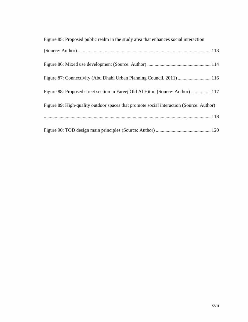
Figure 85: Proposed public realm in the study area that enhances social interaction
(Source: Author). ............................................................................................................ 113
Figure 86: Mixed use development (Source: Author) .................................................... 114
Figure 87: Connectivity (Abu Dhabi Urban Planning Council, 2011) ........................... 116
Figure 88: Proposed street section in Fareej Old Al Hitmi (Source: Author) ................ 117
Figure 89: High-quality outdoor spaces that promote social interaction (Source: Author)
......................................................................................................................................... 118
Figure 90: TOD design main principles (Source: Author) ............................................. 120
xviii
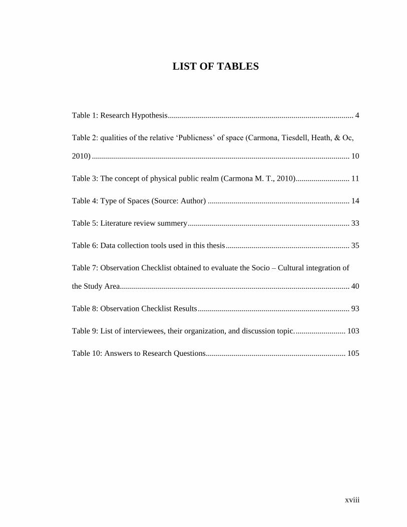
LIST OF TABLES
Table 1: Research Hypothesis ............................................................................................. 4
Table 2: qualities of the relative „Publicness‟ of space (Carmona, Tiesdell, Heath, & Oc,
2010) ................................................................................................................................. 10
Table 3: The concept of physical public realm (Carmona M. T., 2010) ........................... 11
Table 4: Type of Spaces (Source: Author) ....................................................................... 14
Table 5: Literature review summery ................................................................................. 33
Table 6: Data collection tools used in this thesis .............................................................. 35
Table 7: Observation Checklist obtained to evaluate the Socio – Cultural integration of
the Study Area................................................................................................................... 40
Table 8: Observation Checklist Results ............................................................................ 93
Table 9: List of interviewees, their organization, and discussion topic. ......................... 103
Table 10: Answers to Research Questions ...................................................................... 105

xix
ABBREVIATIONS
MME Ministry of Municipality and Environment
QMA Qatar Museums Authority
QU Qatar University
DAUP
NMoQ
Department of Architecture and Urban Planning
National Museum of Qatar
QNMP Qatar National Master Plan
QNV Qatar National Vision
QNDF 2032
QRDP
Qatar National Development Framework 2032
Qatar Rail Development Program
SG Smart Growth
NU New Urbanism
CHAPTER 1: INTRODUCTION
1.1 . Research Significance
Due to the rapid urbanization nowadays, most historic neighborhoods in the Gulf are
struggling to adapt and cope with the present changes. Many of these neighborhoods are
either being occupied by low-income workers or are being replaced by new business
districts, which in turn are affecting the cultural identity negatively. Over the past few
years, Doha has been experiencing a rapid growth in its economy, population, and its
built environment is being transformed drastically. This is characterized by a major drive
towards the execution of multi construction projects and the negligence of the old historic
neighborhood, which is resulting in the loss of its identity.
Old neighborhoods in Doha should be known as a valuable resource for future
development and sustained for the present and future generations, since they are
considered as the reflection of Qatar‟s cultural identity. Even though the rapid urban
development is beneficial in several ways, it is still a challenge in the face of cultural
neighborhoods. Nonetheless, it is of great importance to recognize the opportunities of
new planning approaches that challenge the traditional city development models. Cities
that are experiencing a period of rapid urbanization can consequently create enhanced
ways of adaptation to the urban development. The challenge lies in enhancing and
promoting the socio-cultural capital of each city, where inhabitants can sustain a sense of
identity.
2
Neighborhoods are the basis of the ongoing development of cities. Societies tend to build
their neighborhoods in relation to their socio - cultural necessities. In the Gulf region, the
design of the neighborhoods shows this socio- cultural implication in the Fereej which is
the fundamental space for social interaction and engagement. Nowadays, rapid urban
developments have significantly impacted the neighborhood fabric, discouraging social
engagements and interactions. Fareej Old Al-Hitmi is an old neighborhood of Doha that
contains a significant history of the Al Hitmi family and it has a coherent fabric of old
houses of different characters and types. The significance of Fareej Old Al-Hitmi‟s
location, history, society, and architecture make it worth studying, in order to be able to
maintain it for coming generations by developing it as a socio-cultural and livable
neighborhood that enhances social interactions and engagements.
1.2 . Research Aim and Objectives
The aim of this thesis is to investigate the impact of the rapid urban development on the
socio-cultural areas and spaces in Doha‟s historic neighborhoods, focusing on „Fareej Old
Al-Hitmi‟.
The main objective of this thesis is to evaluate the current socio-cultural spaces within the
study area. The second objective is to develop an approach to enhance the socio-cultural
spaces, and to promote social interaction and engagement in urban life over a set of
design guidelines and recommendations.
The following research questions intend to respond to the above mentioned aims and
objectives of the thesis.
3
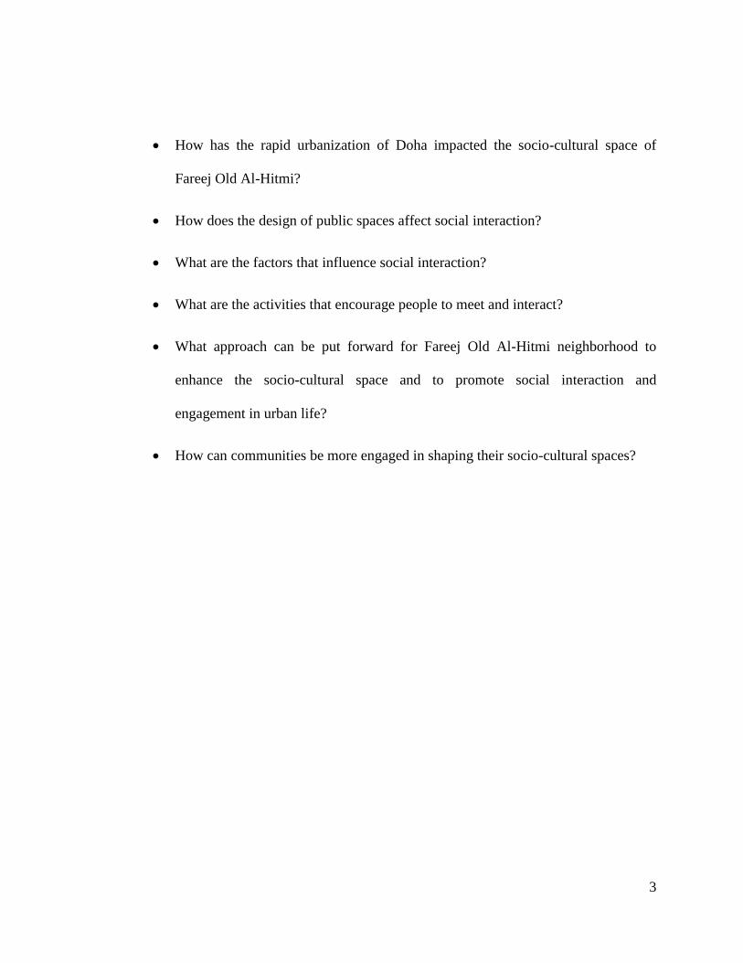
How has the rapid urbanization of Doha impacted the socio-cultural space of
Fareej Old Al-Hitmi?
How does the design of public spaces affect social interaction?
What are the factors that influence social interaction?
What are the activities that encourage people to meet and interact?
What approach can be put forward for Fareej Old Al-Hitmi neighborhood to
enhance the socio-cultural space and to promote social interaction and
engagement in urban life?
How can communities be more engaged in shaping their socio-cultural spaces?
4
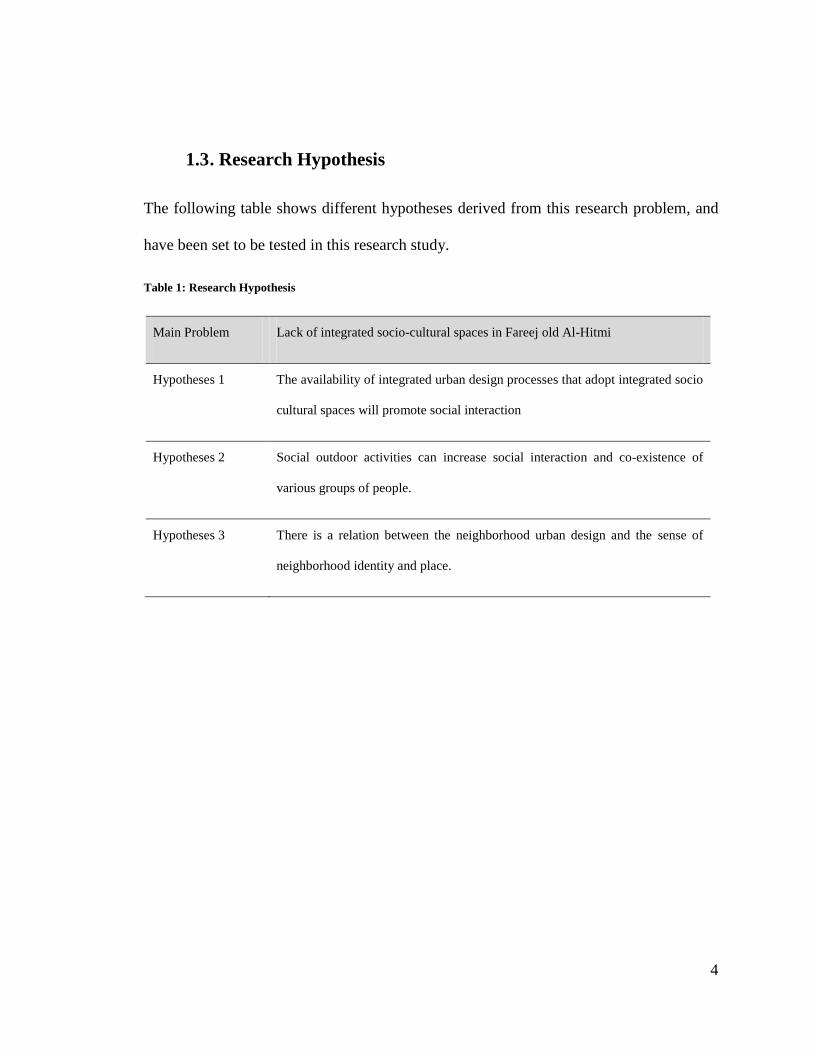
1.3 . Research Hypothesis
The following table shows different hypotheses derived from this research problem, and
have been set to be tested in this research study.
Table 1: Research Hypothesis
Main Problem Lack of integrated socio-cultural spaces in Fareej old Al-Hitmi
Hypotheses 1 The availability of integrated urban design processes that adopt integrated socio
cultural spaces will promote social interaction
Hypotheses 2 Social outdoor activities can increase social interaction and co-existence of
various groups of people.
Hypotheses 3 There is a relation between the neighborhood urban design and the sense of
neighborhood identity and place.
5
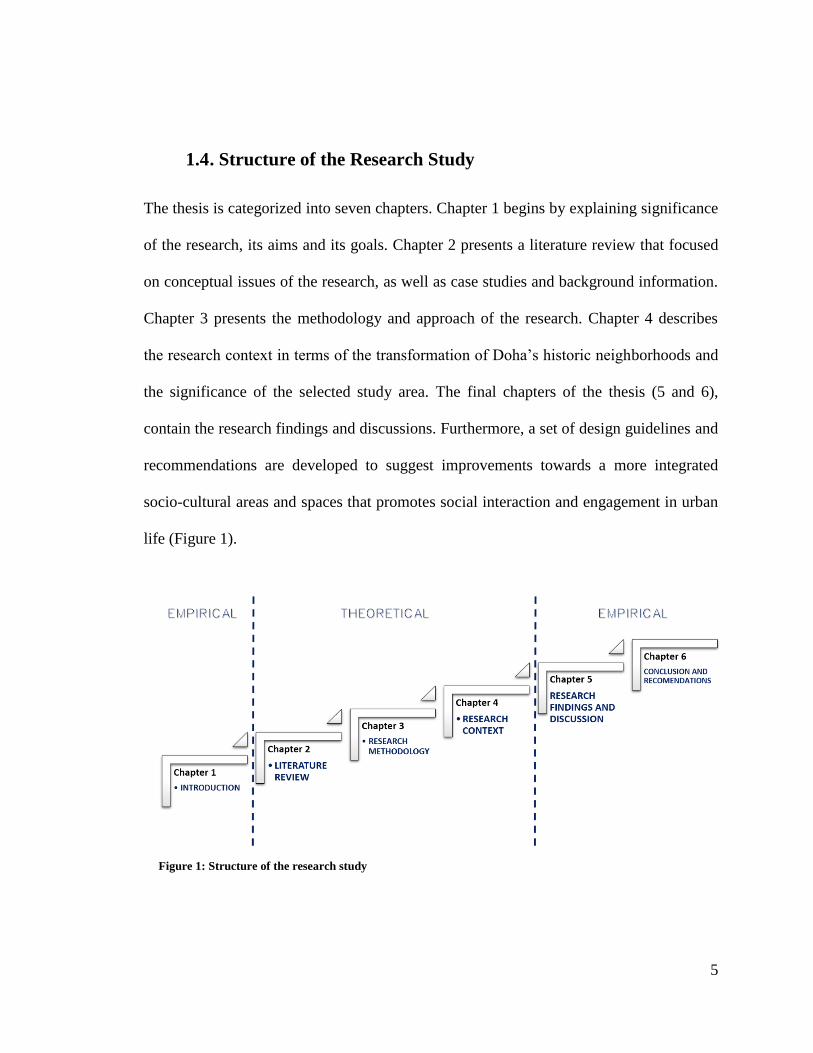
1.4 . Structure of the Research Study
The thesis is categorized into seven chapters. Chapter 1 begins by explaining significance
of the research, its aims and its goals. Chapter 2 presents a literature review that focused
on conceptual issues of the research, as well as case studies and background information.
Chapter 3 presents the methodology and approach of the research. Chapter 4 describes
the research context in terms of the transformation of Doha‟s historic neighborhoods and
the significance of the selected study area. The final chapters of the thesis (5 and 6),
contain the research findings and discussions. Furthermore, a set of design guidelines and
recommendations are developed to suggest improvements towards a more integrated
socio-cultural areas and spaces that promotes social interaction and engagement in urban
life (Figure 1).
Figure 1: Structure of the research study
6
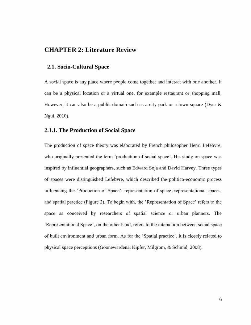
CHAPTER 2: Literature Review
2.1. Socio-Cultural Space
A social space is any place where people come together and interact with one another. It
can be a physical location or a virtual one, for example restaurant or shopping mall.
However, it can also be a public domain such as a city park or a town square (Dyer &
Ngui, 2010).
2.1.1. The Production of Social Space
The production of space theory was elaborated by French philosopher Henri Lefebvre,
who originally presented the term „production of social space‟. His study on space was
inspired by influential geographers, such as Edward Soja and David Harvey. Three types
of spaces were distinguished Lefebvre, which described the politico-economic process
influencing the „Production of Space‟: representation of space, representational spaces,
and spatial practice (Figure 2). To begin with, the ‟Representation of Space‟ refers to the
space as conceived by researchers of spatial science or urban planners. The
„Representational Space‟, on the other hand, refers to the interaction between social space
of built environment and urban form. As for the „Spatial practice‟, it is closely related to
physical space perceptions (Goonewardena, Kipfer, Milgrom, & Schmid, 2008).
7
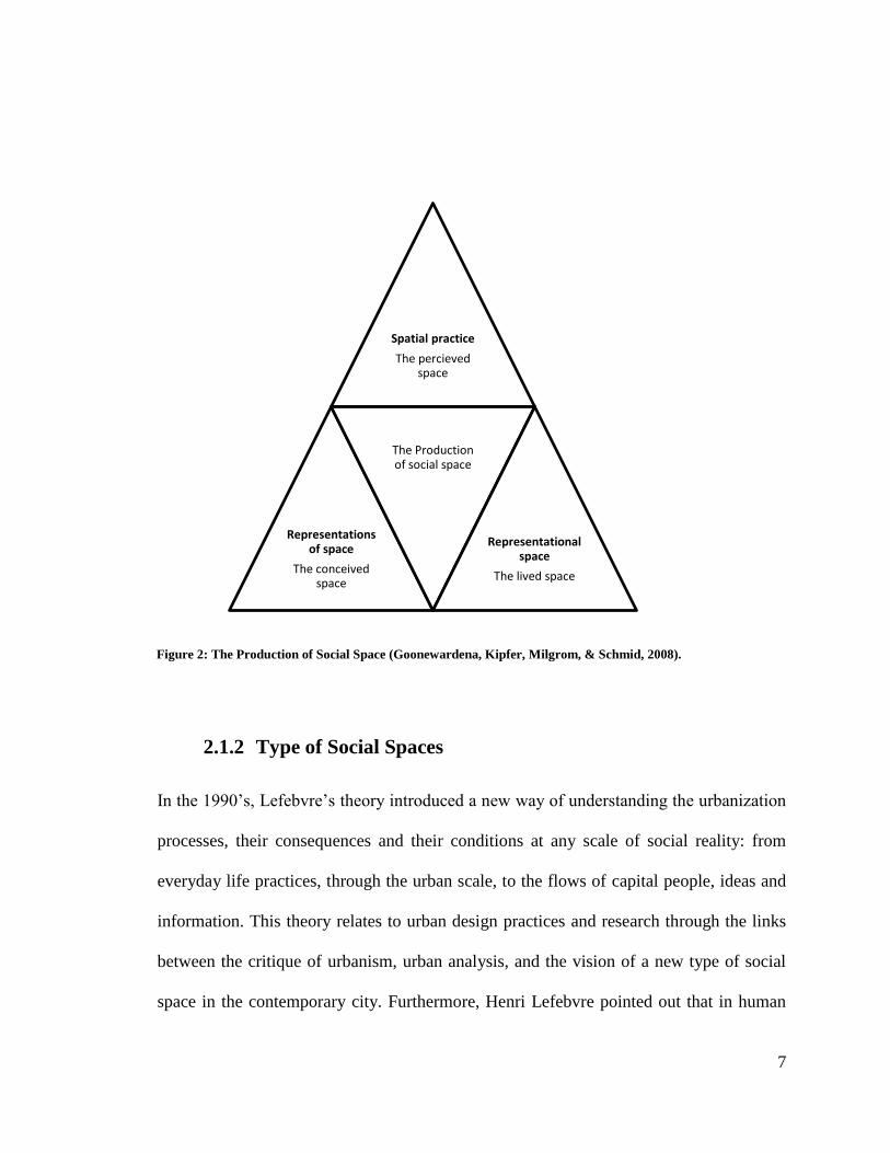
2.1.2 Type of Social Spaces
In the 1990‟s, Lefebvre‟s theory introduced a new way of understanding the urbanization
processes, their consequences and their conditions at any scale of social reality: from
everyday life practices, through the urban scale, to the flows of capital people, ideas and
information. This theory relates to urban design practices and research through the links
between the critique of urbanism, urban analysis, and the vision of a new type of social
space in the contemporary city. Furthermore, Henri Lefebvre pointed out that in human
Spatial practice
The percieved space
Representations of space
The conceived space
The Production of social space
Representational space
The lived space
Figure 2: The Production of Social Space (Goonewardena, Kipfer, Milgrom, & Schmid, 2008).

8
society all “space is social, it involves assigning more or less appropriated places to
social relations, social space has thus always been a social product” (Lefebvre, 2009).
As mentioned by Lefebvre, each aspect of the society; a family, schools, workplaces and
so on, possesses an "appropriate" space, for a specified use within the labor social
division. A space in which 'a system of "adapted" expectations and responses - rarely
articulated as such because they seem obvious - acquire a quasi-natural self-evidence in
everyday life and common sense'. Therefore, Lefebvre refers to the post office, the town
hall, the grocery store, the police station, the bus as well as the train and its stations, as
the main features of a social space. (Brenner & Elden, 2012).
In the groundbreaking book “Formes Urbaines”, architects Castex and Panerai together
with sociologist DePaule presented the productivity of Lefebvre‟s approach through
studies of several European cities, focusing on both the social and spatio-physical effects
of the transformation of the traditional urban housing block into the open building forms
of modernist urban design (i.e. Le Corbusier et. al.) between 1850 and 1960. For this
purpose, three classifications of urban space in and around residential complexes where
distinguished by the French researchers: collective, private and public space (Figure 3).
Each classification is connected to a specific form of social use („practice‟). Each of these
categories of urban space is related to a specific form of social use („practice‟). These
studies point out the delicacy and necessity of the physical boundaries between these
different types of urban space and their specific social practices (Claessens, 2005).
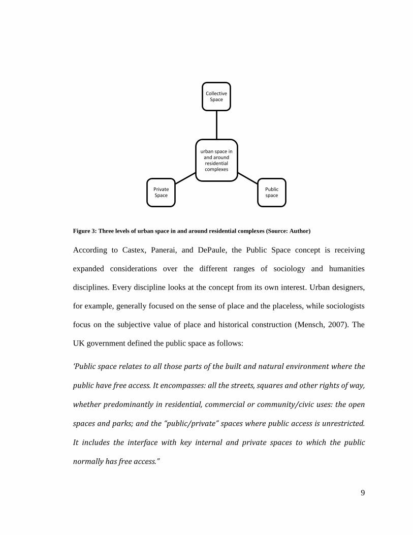
9
Figure 3: Three levels of urban space in and around residential complexes (Source: Author)
According to Castex, Panerai, and DePaule, the Public Space concept is receiving
expanded considerations over the different ranges of sociology and humanities
disciplines. Every discipline looks at the concept from its own interest. Urban designers,
for example, generally focused on the sense of place and the placeless, while sociologists
focus on the subjective value of place and historical construction (Mensch, 2007). The
UK government defined the public space as follows:
‘Public space relates to all those parts of the built and natural environment where the
public have free access. It encompasses: all the streets, squares and other rights of way,
whether predominantly in residential, commercial or community/civic uses: the open
spaces and parks; and the “public/private” spaces where public access is unrestricted.
It includes the interface with key internal and private spaces to which the public
normally has free access.”
urban space in and around residential complexes
Collective Space
Public space
Private Space
10
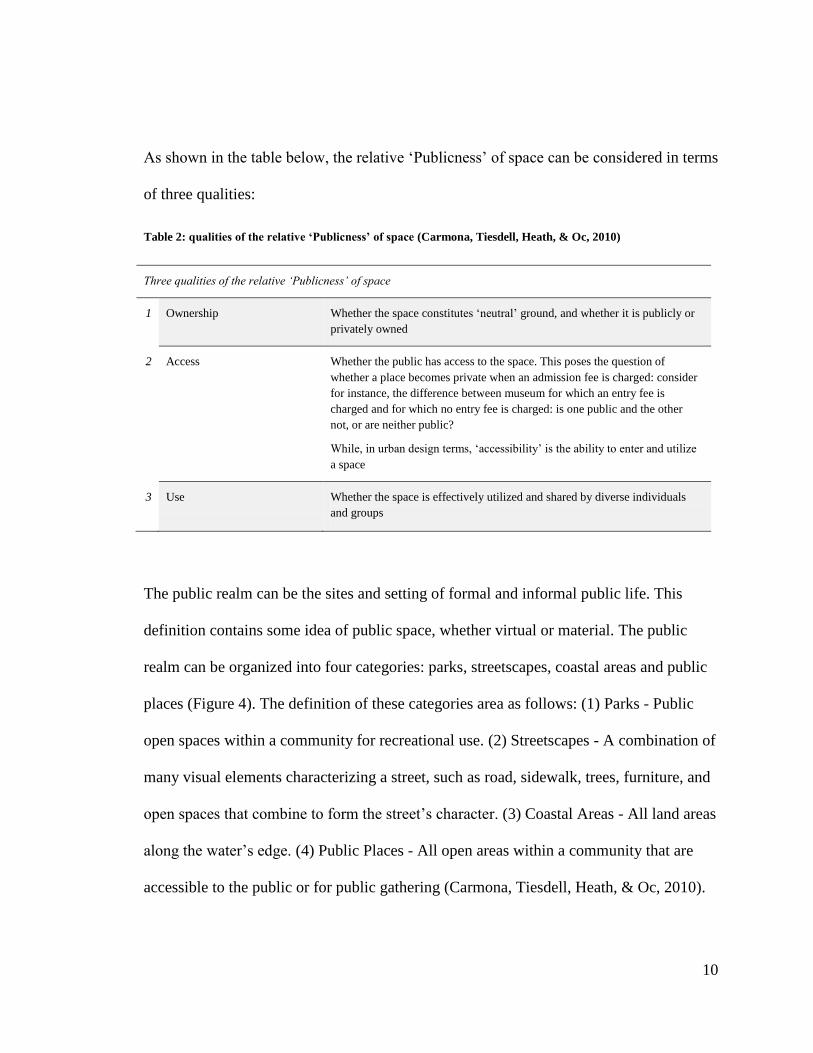
As shown in the table below, the relative „Publicness‟ of space can be considered in terms
of three qualities:
Table 2: qualities of the relative ‘Publicness’ of space (Carmona, Tiesdell, Heath, & Oc, 2010)
Three qualities of the relative ‘Publicness’ of space
1 Ownership Whether the space constitutes „neutral‟ ground, and whether it is publicly or
privately owned
2 Access Whether the public has access to the space. This poses the question of
whether a place becomes private when an admission fee is charged: consider
for instance, the difference between museum for which an entry fee is
charged and for which no entry fee is charged: is one public and the other
not, or are neither public?
While, in urban design terms, „accessibility‟ is the ability to enter and utilize
a space
3 Use Whether the space is effectively utilized and shared by diverse individuals
and groups
The public realm can be the sites and setting of formal and informal public life. This
definition contains some idea of public space, whether virtual or material. The public
realm can be organized into four categories: parks, streetscapes, coastal areas and public
places (Figure 4). The definition of these categories area as follows: (1) Parks - Public
open spaces within a community for recreational use. (2) Streetscapes - A combination of
many visual elements characterizing a street, such as road, sidewalk, trees, furniture, and
open spaces that combine to form the street‟s character. (3) Coastal Areas - All land areas
along the water‟s edge. (4) Public Places - All open areas within a community that are
accessible to the public or for public gathering (Carmona, Tiesdell, Heath, & Oc, 2010).
11
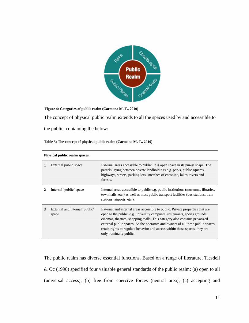
The concept of physical public realm extends to all the spaces used by and accessible to
the public, containing the below:
Table 3: The concept of physical public realm (Carmona M. T., 2010)
Physical public realm spaces
1 External public space
External areas accessible to public. It is open space in its purest shape. The
parcels laying between private landholdings e.g. parks, public squares,
highways, streets, parking lots, stretches of coastline, lakes, rivers and
forests.
2 Internal „public‟ space Internal areas accessible to public e.g. public institutions (museums, libraries,
town halls, etc.) as well as most public transport facilities (bus stations, train
stations, airports, etc.).
3 External and internal „public‟
space
External and internal areas accessible to public. Private properties that are
open to the public, e.g. university campuses, restaurants, sports grounds,
cinemas, theatres, shopping malls. This category also contains privatized
external public spaces. As the operators and owners of all these public spaces
retain rights to regulate behavior and access within these spaces, they are
only nominally public.
The public realm has diverse essential functions. Based on a range of literature, Tiesdell
& Oc (1998) specified four valuable general standards of the public realm: (a) open to all
(universal access); (b) free from coercive forces (neutral area); (c) accepting and
Figure 4: Categories of public realm (Carmona M. T., 2010)
12
accommodating difference (comprehensive and pluralism); and (d) symbolic and
representative of the sociability and of the collective (rather than privacy and
individuality) (Tiesdell & Oc, 1998).
The democratic nature of public spaces is referred to urban design literature. Frederick J
Olmstead, for instance, considered public open parks as a means of enhancing social
interaction and allowing different social classes to mix, whereas, Lynch discussed in
1972 that open spaces are at hand of all human actions, whether voluntary or spontaneous
and are one of the „essential values‟.
Similarly, Loukaitou-Sideris & Banerjee (1998) specified three vital functions of public
space: (a) common or neutral base – for societal engagement, and connection; (b) a
political convention, for political display, representation and action; and (c) a forum for
personal development, information exchange and social learning.
It is perhaps more adequate to say that the public realm contains some elements of public
sphere and of public space. Rather than public realm, Habermas used the term „public
sphere‟. By contrast, the concept of public realm bridges public space and public sphere
(Habermas, 1962). Low & Smith (2006: 5) argued the relationship between public sphere
and public realm, seen as a key political concept.
13
They note the considerable literature regarding the public sphere, which
‘….. emphasizes the media, ideas, institutions, and practices that all
promote the generation of something that we can call the public
opinions, and the work is generally settled both in a larger historical
framework regarding the state and the transformation of bourgeois
social relations and in a normative search for moral and political
effectiveness. ….’
The authors also mention that, everyone has discussed public space at once, urbanist,
planners, architects, geographers, anthropologists, and others.
‘This work is explicitly spatial, seeking to comprehend the ways in which social and
political, and economic and cultural processes and relations make specific public places
and landscapes, and the ways in which, in turn, these geographies reaffirm, contradict,
or alter their constituent social and political relations.’ (Low & Smith, 2006)
They conclude that, while these public spaces and public sphere literatures overlap, they
occupy separate disciplines: ‘The public sphere remains essentially ungrounded while
public space discussions insufficiently connect to mediations on the public sphere.’ (Low
& Smith, 2006).
14
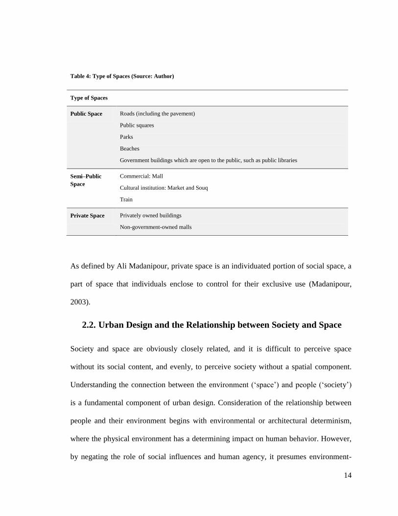
Table 4: Type of Spaces (Source: Author)
Type of Spaces
Public Space Roads (including the pavement)
Public squares
Parks
Beaches
Government buildings which are open to the public, such as public libraries
Semi–Public
Space
Commercial: Mall
Cultural institution: Market and Souq
Train
Private Space Privately owned buildings
Non-government-owned malls
As defined by Ali Madanipour, private space is an individuated portion of social space, a
part of space that individuals enclose to control for their exclusive use (Madanipour,
2003).
2.2. Urban Design and the Relationship between Society and Space
Society and space are obviously closely related, and it is difficult to perceive space
without its social content, and evenly, to perceive society without a spatial component.
Understanding the connection between the environment („space‟) and people („society‟)
is a fundamental component of urban design. Consideration of the relationship between
people and their environment begins with environmental or architectural determinism,
where the physical environment has a determining impact on human behavior. However,
by negating the role of social influences and human agency, it presumes environment-
15
people integration is a one-way process. Similarly, Kashef describes an attitude within
social science that sees space ‘…as a backdrop or a neutral container for economic and
social activity (i.e. urban space may be configured and reconfigured by societal and
cultural changes but not vice versa).’ (Kashef, 2008).
People are active and they are known to change and influence the environment as it
influences and changes them. Therefore, it is a constant two-way operation in which
people modify and create spaces, and are also simultaneously being influenced in
different ways by those spaces. Social process usually take place neither in a vacuum, nor
against a neutral backdrop, therefore, the built environment is the outcome of and the
medium for social change and processes.
Urban designers influence patterns of social life and human activity by shaping the built
environment, and for instance, social relation can be: (1) Facilitated by space – where the
friction of inhibits or distance facilitates the development of various social practices. (2)
Constrained by space – where the physical environment obstructs or facilitates human
activity. (3) Constituted through space – where the characteristic of site influence the
settlement form (Wolch & Dear, 2014).
2.3. Neighborhoods and Social Interaction
Neighborhoods are the basis of dynamic development of cities. Individuals usually shape
their neighborhoods as per their socio-cultural demands. Neighborhoods can be planned
and designed in a way that enhances a sense of place, and as an area of identity.
16
While this may be a quite superficial sense of identity with the area‟s physical character,
it may also be a deeper and more expressive sense of identity with the place‟s socio
cultural character.
In addition, a neighborhood can be designed as an area that enhances social interaction.
Blowers (1973) identified four different types of neighborhoods. The first type is the
ecological and ethnological neighborhood with a common environment and identity. The
second type is the homogeneous neighborhood, inhabited by ethnic groups. The third
type is the functional neighborhood, derived from the geographical mapping of service
provision. Lastly, the forth type, and which only has an attribute to a community, is the
community neighborhood, where a close-knit, socially homogeneous group engages in
primary contacts. The fundamental issues concerning the neighborhood design concept
can be reviewed under four headings – Social relevance; Size; boundaries; and mixed
communities.
2.3.1 Social Relevance and Meaning
The concept of self-sufficient neighborhoods has been criticized for being outmoded and
having limited relevance to modern society. It is mostly in reflection to increased
mobility, specifically car-based mobility, and mobility empowered by electronic
communications. Also, even though communities-of-place still occur, they have been
displaced by communities-of-interest that are detached from any specific locale.
In addition, it is argued that the rapid urbanization affects people‟s perceptions of the
sense of community and place. They are not geographically limited to the local area or
17
neighborhood and they have the chance to choose their entertainment destinations,
workplace, shopping and their children‟s schools, from different parts of the city.
Whether individuals have certain socio-cultural traits or not, neighborhoods contain
places with distinct characteristics that individuals can recognize and gain a sense of
belonging from.
2.3.2 Size
The neighborhood preferred size can be derived from the catchment population for a
primary or elementary school or, in the case of transit oriented development (TOD), the
population required to make public transit viable. The preferred size is also restricted to
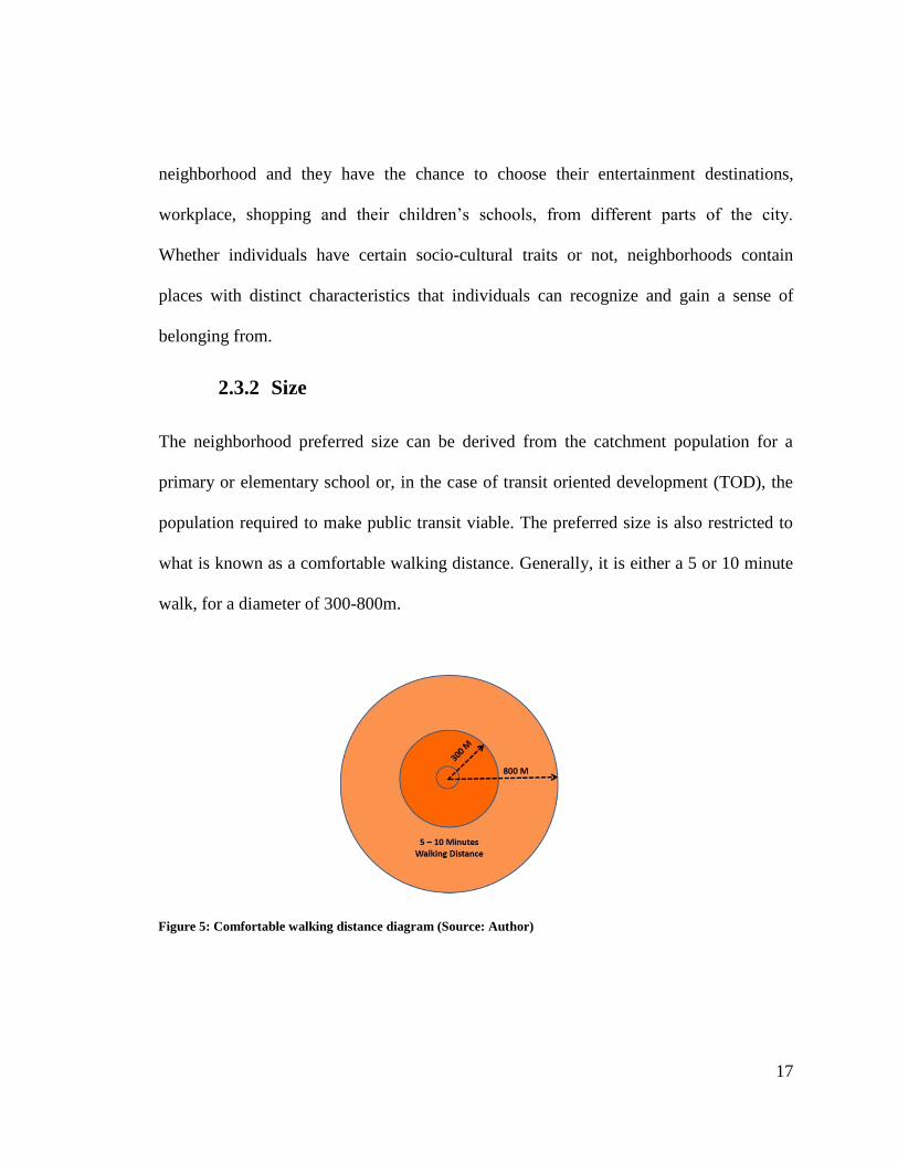
what is known as a comfortable walking distance. Generally, it is either a 5 or 10 minute
walk, for a diameter of 300-800m.
Figure 5: Comfortable walking distance diagram (Source: Author)
18
2.2.4 Boundaries
A common concept is that clear boundaries to neighborhoods will promote social and
functional interaction, identity, and sense of community within those boundaries.
However, different thoughts have been expressed concerning the value of such
boundaries. Jacobs (1961) argued in contrast with identifying the boundaries, and stated
that neighborhoods functioned best when they had no beginnings or ends, and that their
success relied on interweaving and overlapping. In addition, Lynch argued that planning
a city as a series of neighborhoods would promote social segregation, as any perfect city
has a continuous fabric, rather than a cellular one.
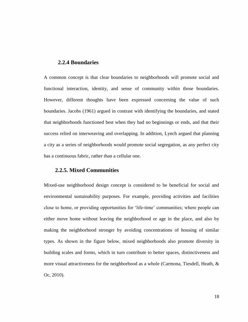
2.2.5. Mixed Communities
Mixed-use neighborhood design concept is considered to be beneficial for social and
environmental sustainability purposes. For example, providing activities and facilities
close to home, or providing opportunities for „life-time‟ communities; where people can
either move home without leaving the neighborhood or age in the place, and also by
making the neighborhood stronger by avoiding concentrations of housing of similar
types. As shown in the figure below, mixed neighborhoods also promote diversity in
building scales and forms, which in turn contribute to better spaces, distinctiveness and
more visual attractiveness for the neighborhood as a whole (Carmona, Tiesdell, Heath, &
Oc, 2010).
19
In the Gulf region, the design of the neighborhood verifies this cultural sense, as the
Fereej is the central place for social interaction, which is defined as a traditional
neighbourhood system home are built as the courtyard style to the edge of the plot to
define the public realm and maximise the use of land. In addition, small paths, known as
Sikkak, connect the neighbouring homes to public spaces and community facilities
known as Barahaat, as well as larger open spaces known as Meyadeen (Abu Dhabi Urban
Planning Council, 2011). However, at the present time, rapid development forces have
significantly impacted the design of the neighborhood, which discourage social
interactions. Today, neighborhoods in the city of Doha are typically not pedestrian-
friendly and interrupt the promotion of sustainable development aspects.
Figure 6: Mixed-use neighbourhood (Carmona, Tiesdell, Heath, & Oc, 2010)
20
2.4. Sense of Neighborhood Place
The sense of place represents an important component within a neighborhood, which
contributes to promoting the sense of security and lessening crime rates in a community.
As mentioned by Lynch (1981) “ Sense is the interaction between individual and place,
depends on spatial form and quality, culture, experience and current purpose of the
observer”. A sense of place can be “created by the pattern of reactions that a setting
stimulates for a person”. These responses are a creation of both the situation‟s
characteristics and personal features that are carried in by users. . An individual‟s sense
of place is shaped by the experience they obtain in a specific situation, and how that
situation makes them feel. Identity could be defined as the basic form of sense and is the
extent to which an individual can recall a place as being distinctive from other places; or
in other words, the place is unique and sustains a character of its own, which makes it
stand out amongst other areas. People continue to recognize themselves with places by
calling them home, and using these places to provide a kind of symbolic identity that
differentiates them from others (Lynch, 1981).
Obviously, every neighborhood has its particular sense of place. Whenever individuals
think about the neighborhood in which they were brought up in, they will recall its unique
physical appearance and human atmosphere. Sense of neighborhood place has been
commonly seen as good for places and people, creating a source of identity and security.
For places, sense of neighborhood place is connected with an increased social solidarity,
community participation and local networks (O'Sullivan, 2009). To the residents, it
21
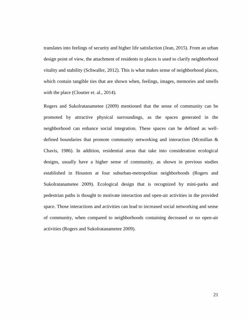
translates into feelings of security and higher life satisfaction (Jean, 2015). From an urban
design point of view, the attachment of residents to places is used to clarify neighborhood
vitality and stability (Schwaller, 2012). This is what makes sense of neighborhood places,
which contain tangible ties that are shown when, feelings, images, memories and smells
with the place (Cloutier et. al., 2014).
Rogers and Sukolratanametee (2009) mentioned that the sense of community can be
promoted by attractive physical surroundings, as the spaces generated in the
neighborhood can enhance social integration. These spaces can be defined as well-
defined boundaries that promote community networking and interaction (Mcmillan &
Chavis, 1986). In addition, residential areas that take into consideration ecological
designs, usually have a higher sense of community, as shown in previous studies
established in Houston at four suburban-metropolitan neighborhoods (Rogers and
Sukolratanametee 2009). Ecological design that is recognized by mini-parks and
pedestrian paths is thought to motivate interaction and open-air activities in the provided
space. Those interactions and activities can lead to increased social networking and sense
of community, when compared to neighborhoods containing decreased or no open-air
activities (Rogers and Sukolratanametee 2009).

22
2.5. Rapid Urbanization and Socio Cultural Change
As defined by Gyabaah, urbanization is the migration and movement of people in large
numbers from a rural society to an urban one. This includes an increase in the amount of
people in urban areas and mostly happens due to the concentration of resources and
facilities in cities. Urbanization is also the consequence of political, social, and economic
growth that leads to the urban transformation from rural to metropolitan pattern of
governance and to the urban concentration and expansion of large cities (Nsiah-Gyabaah,
u.d.). In addition, urbanization is also defined as the growth of cities. In general,
urbanization is linked to industrialization, modernization and the sociological processes
of rationalization (Molla, 2015).
The factors that cause urbanization can be classified into three categories, namely,
economic opportunities, proper infrastructure and utilities and availability of public
facilities (Molla, 2015). Regarding economic opportunities, most people prefer the great
variety of jobs and countless opportunities offered in the city, to the standard way of
living in rural areas. As for the proper infrastructure and utilities category, the urban area
is ordinarily equipped with better utilities and infrastructure, such as, water, electricity,
roads and transportation. Finally, there is more availability of public facilities in cities
than in rural areas, such as education and health. In addition, the provision of recreation
facilities, entertainment destinations, park and service areas are attracting more people to
live in cities and are meeting the needs of the urban community.
23
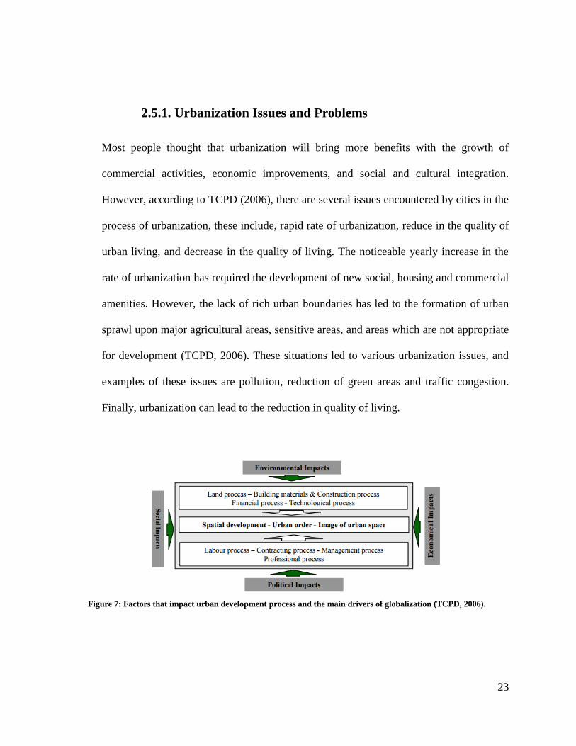
Figure 7: Factors that impact urban development process and the main drivers of globalization (TCPD, 2006).
2.5.1. Urbanization Issues and Problems
Most people thought that urbanization will bring more benefits with the growth of
commercial activities, economic improvements, and social and cultural integration.
However, according to TCPD (2006), there are several issues encountered by cities in the
process of urbanization, these include, rapid rate of urbanization, reduce in the quality of
urban living, and decrease in the quality of living. The noticeable yearly increase in the
rate of urbanization has required the development of new social, housing and commercial
amenities. However, the lack of rich urban boundaries has led to the formation of urban
sprawl upon major agricultural areas, sensitive areas, and areas which are not appropriate
for development (TCPD, 2006). These situations led to various urbanization issues, and
examples of these issues are pollution, reduction of green areas and traffic congestion.
Finally, urbanization can lead to the reduction in quality of living.
24
2.6. Case Studies
For the aim of this thesis, and in order to develop an approach to enhance integrated
socio-cultural spaces and promote social interaction in the area, two case studies were
selected from different cities in the world. From Linden Hills Neighborhood in the United
States, to Dubai Downtown and Business Bay in the United Arab Emirates, the selection
of the cases was based on a hierarchy of contextual relevance, from international to
regional.
2.6.1. Linden Hills Neighborhood, Minneapolis, USA
- Overview
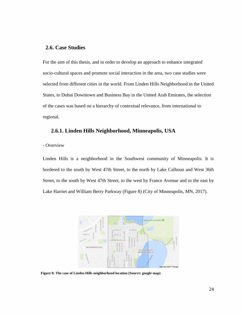
Linden Hills is a neighborhood in the Southwest community of Minneapolis. It is
bordered to the south by West 47th Street, to the north by Lake Calhoun and West 36th
Street, to the south by West 47th Street, to the west by France Avenue and to the east by
Lake Harriet and William Berry Parkway (Figure 8) (City of Minneapolis, MN, 2017).
Figure 8: The case of Linden Hills neighborhood location (Source: google map)
25
- Project Area Description
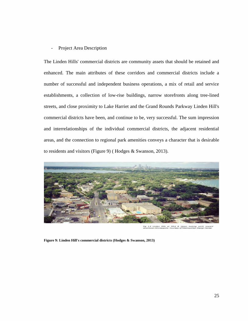
The Linden Hills' commercial districts are community assets that should be retained and
enhanced. The main attributes of these corridors and commercial districts include a
number of successful and independent business operations, a mix of retail and service
establishments, a collection of low-rise buildings, narrow storefronts along tree-lined
streets, and close proximity to Lake Harriet and the Grand Rounds Parkway Linden Hill's
commercial districts have been, and continue to be, very successful. The sum impression
and interrelationships of the individual commercial districts, the adjacent residential
areas, and the connection to regional park amenities conveys a character that is desirable
to residents and visitors (Figure 9) ( Hodges & Swanson, 2013).
Figure 9: Linden Hill's commercial districts (Hodges & Swanson, 2013)
26
Figure 10: Linden Hills integrated urban village principles (Source: Author)
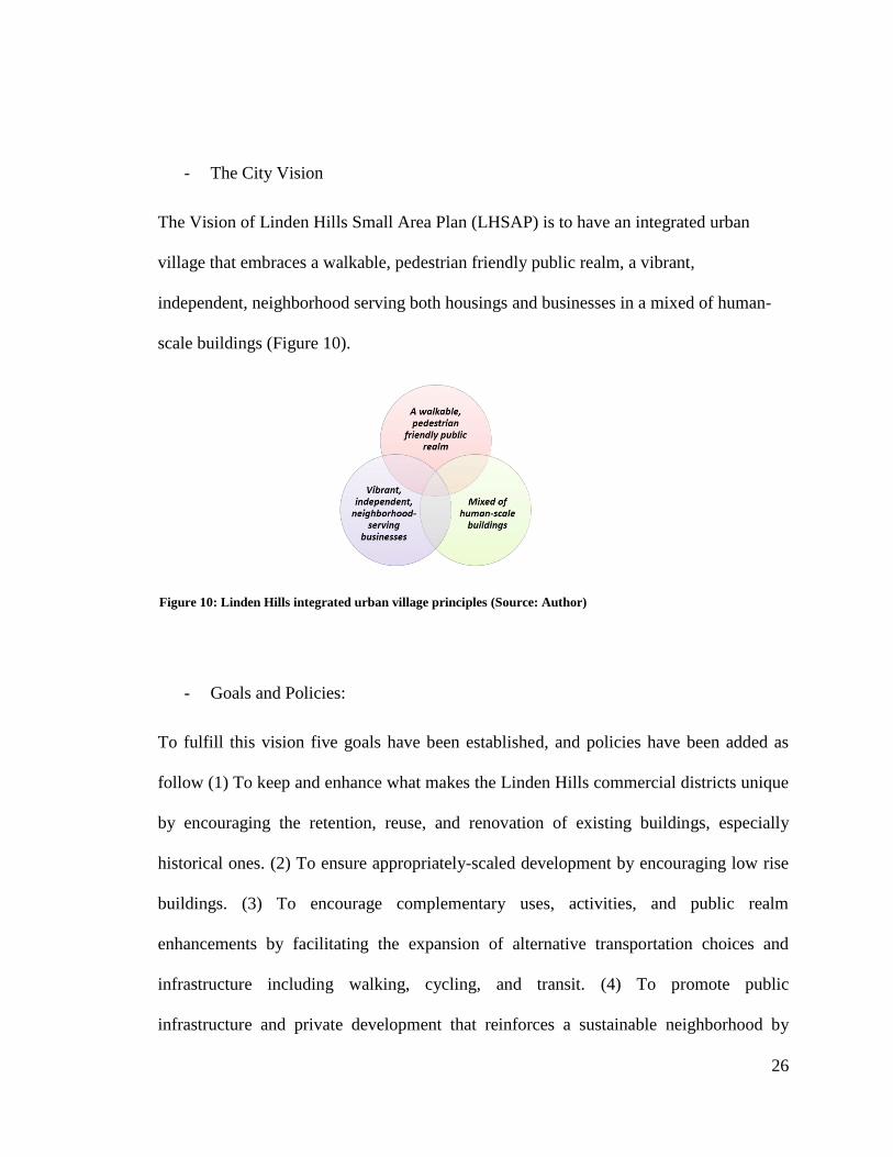
- The City Vision
The Vision of Linden Hills Small Area Plan (LHSAP) is to have an integrated urban
village that embraces a walkable, pedestrian friendly public realm, a vibrant,
independent, neighborhood serving both housings and businesses in a mixed of human-
scale buildings (Figure 10).
- Goals and Policies:
To fulfill this vision five goals have been established, and policies have been added as
follow (1) To keep and enhance what makes the Linden Hills commercial districts unique
by encouraging the retention, reuse, and renovation of existing buildings, especially
historical ones. (2) To ensure appropriately-scaled development by encouraging low rise
buildings. (3) To encourage complementary uses, activities, and public realm
enhancements by facilitating the expansion of alternative transportation choices and
infrastructure including walking, cycling, and transit. (4) To promote public
infrastructure and private development that reinforces a sustainable neighborhood by
27
encouraging infill developments. (5) To Support the development of a broad spectrum of
life-cycle housing options by promoting housing options that meet the needs and desires
of people throughout their lives (from young adults to seniors). Also, by encouraging a
mix of dwelling unit type and sizes within new or renovated multi-family buildings (
Hodges & Swanson, 2013).
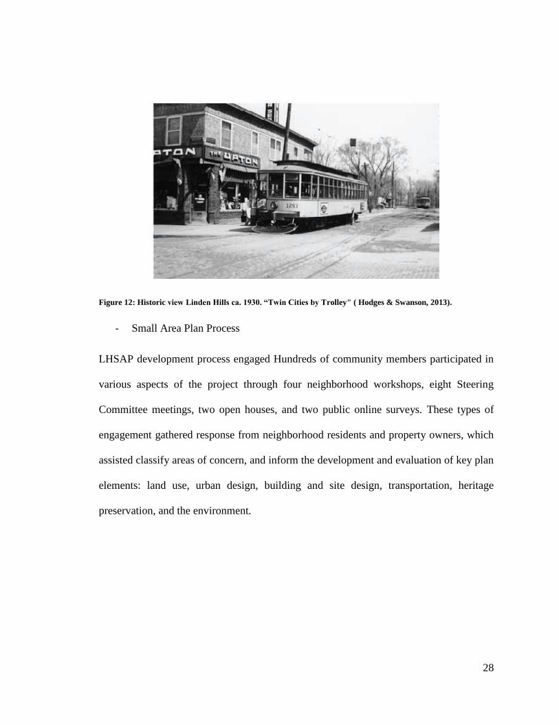
- Development Patterns
Understanding the history of development in the Linden Hills neighborhood. The primary
influence was the streetcar line that ran through the neighborhood. The presence of the
streetcar encouraged a certain type of commercial development that was oriented toward
pedestrians. The pattern is evident in the location and size of commercial lot. The small
scale of buildings, characterized by modest width and height, create a pedestrian friendly,
human-scale character that community wants to preserve and enhance ( Hodges &
Swanson, 2013)
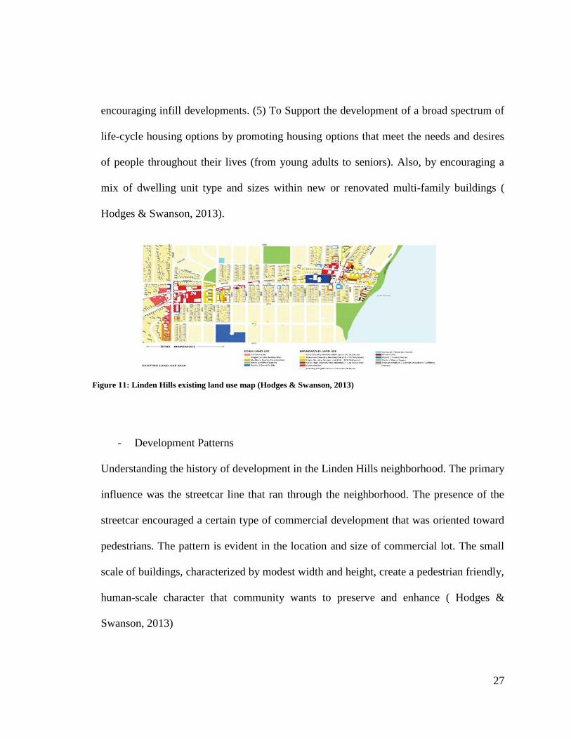
Figure 11: Linden Hills existing land use map (Hodges & Swanson, 2013)
28
Figure 12: Historic view Linden Hills ca. 1930. “Twin Cities by Trolley" ( Hodges & Swanson, 2013).
- Small Area Plan Process
LHSAP development process engaged Hundreds of community members participated in
various aspects of the project through four neighborhood workshops, eight Steering
Committee meetings, two open houses, and two public online surveys. These types of
engagement gathered response from neighborhood residents and property owners, which
assisted classify areas of concern, and inform the development and evaluation of key plan
elements: land use, urban design, building and site design, transportation, heritage
preservation, and the environment.
29
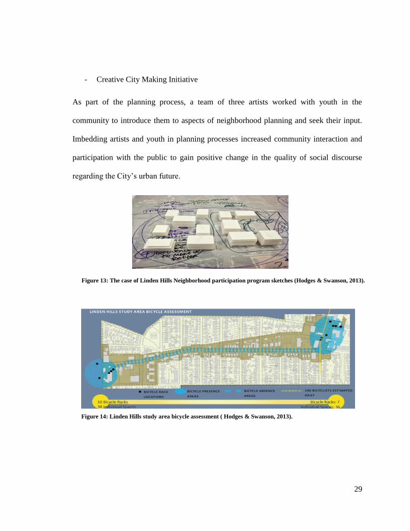
- Creative City Making Initiative
As part of the planning process, a team of three artists worked with youth in the
community to introduce them to aspects of neighborhood planning and seek their input.
Imbedding artists and youth in planning processes increased community interaction and
participation with the public to gain positive change in the quality of social discourse
regarding the City‟s urban future.
Figure 13: The case of Linden Hills Neighborhood participation program sketches (Hodges & Swanson, 2013).
Figure 14: Linden Hills study area bicycle assessment ( Hodges & Swanson, 2013).
30
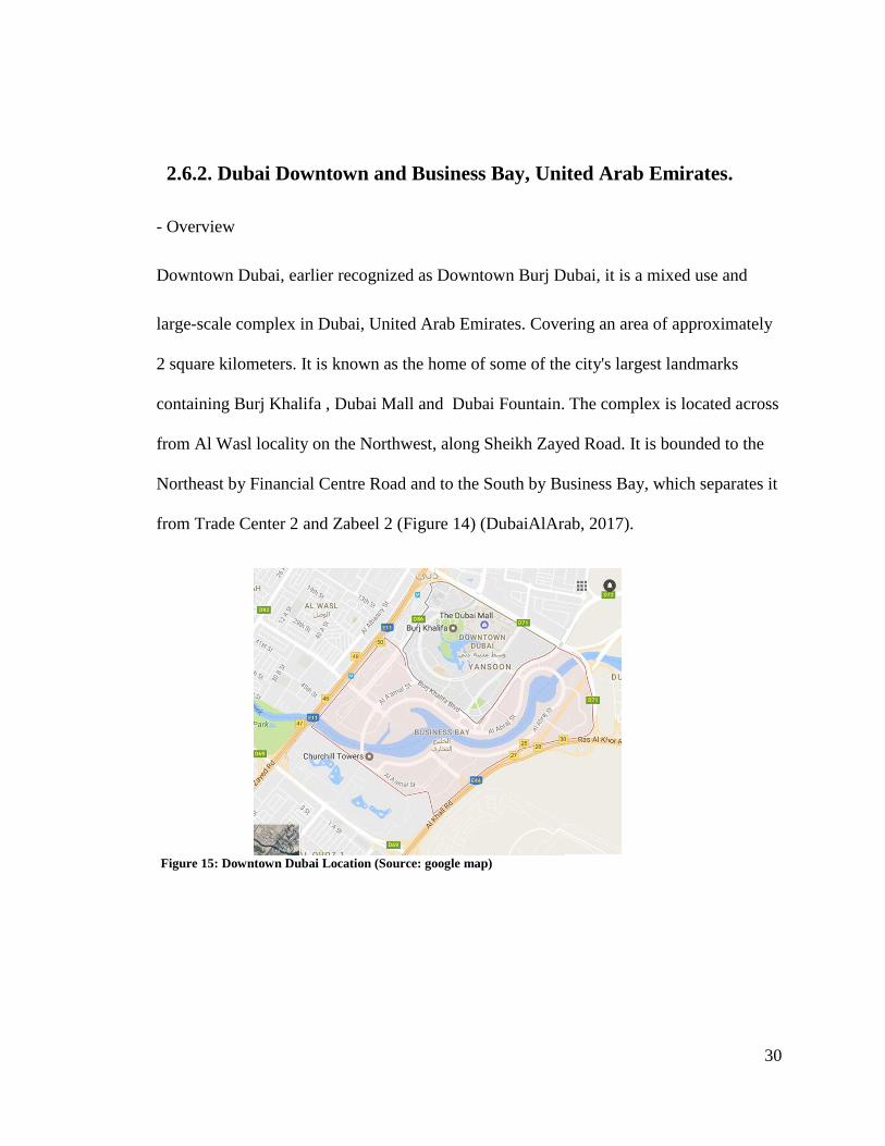
2.6.2. Dubai Downtown and Business Bay, United Arab Emirates.
- Overview
Downtown Dubai, earlier recognized as Downtown Burj Dubai, it is a mixed use and
large-scale complex in Dubai, United Arab Emirates. Covering an area of approximately
2 square kilometers. It is known as the home of some of the city's largest landmarks
containing Burj Khalifa , Dubai Mall and Dubai Fountain. The complex is located across
from Al Wasl locality on the Northwest, along Sheikh Zayed Road. It is bounded to the
Northeast by Financial Centre Road and to the South by Business Bay, which separates it
from Trade Center 2 and Zabeel 2 (Figure 14) (DubaiAlArab, 2017).
Figure 15: Downtown Dubai Location (Source: google map)
31
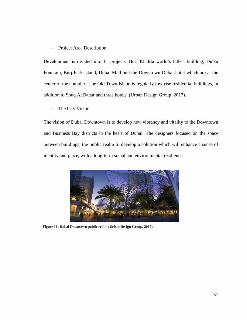
- Project Area Description
Development is divided into 11 projects. Burj Khalifa world‟s tallest building, Dubai
Fountain, Burj Park Island, Dubai Mall and the Downtown Dubai hotel which are at the
center of the complex. The Old Town Island is regularly low-rise residential buildings, in
addition to Souq Al Bahar and three hotels. (Urban Design Group, 2017).
- The City Vision
The vision of Dubai Downtown is to develop new vibrancy and vitality to the Downtown
and Business Bay districts in the heart of Dubai. The designers focused on the space
between buildings, the public realm to develop a solution which will enhance a sense of
identity and place, with a long-term social and environmental resilience.
Figure 16: Dubai Downtown public realm (Urban Design Group, 2017).

32
- Development Patterns
The vision has developed the following strategies (1) Mixed land use development
includes commercial, residences, retail, hotels and community space. (2) Provided a
new cultural center that will be home to art galleries and museums. (3) Provided a
cohesive master plan design which will enhance connectivity for cyclists and
pedestrians. (4) Integrated socio-cultural spaces that will promote social interaction
and engagement in the area.
Figure 17: Dubai Downtown open spaces (Urban Design Group, 2017).
33
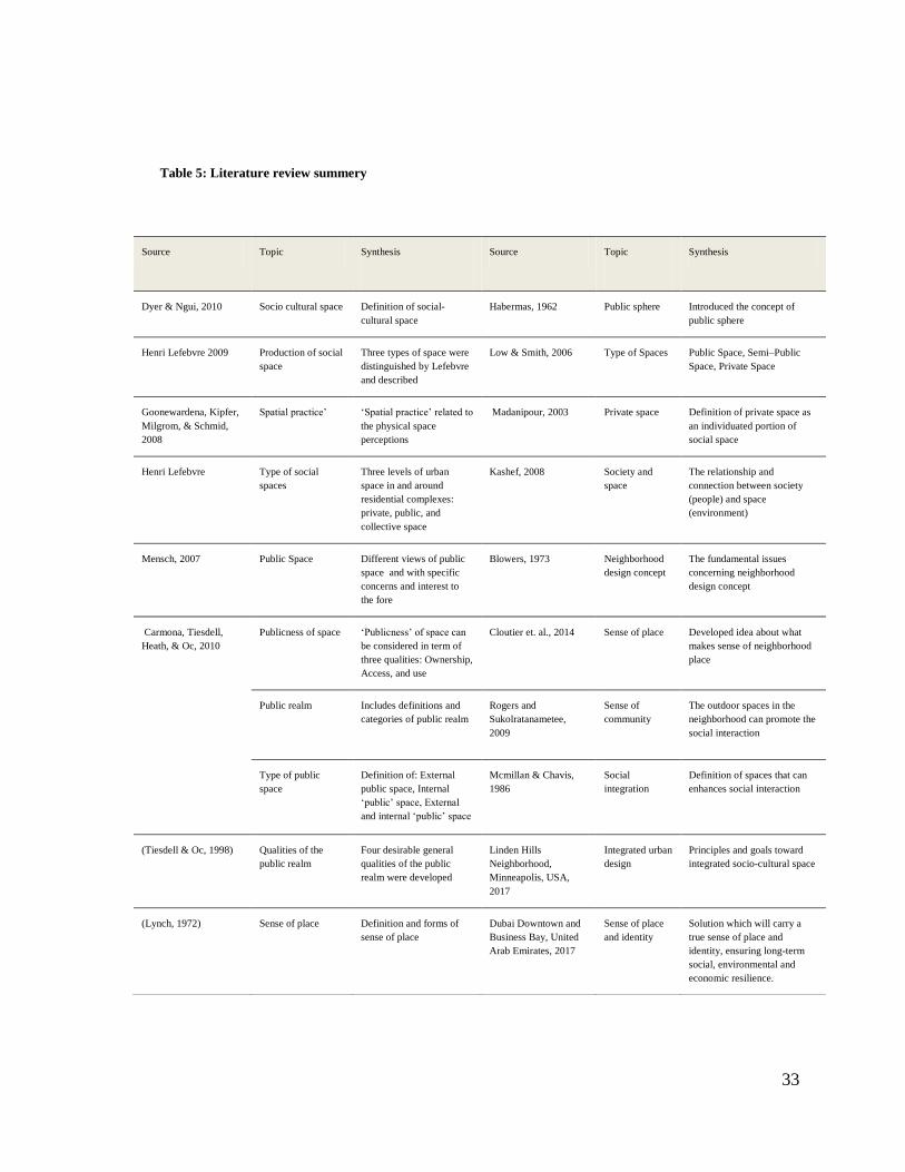
Table 5: Literature review summery
Source Topic Synthesis
Source Topic
Synthesis
Dyer & Ngui, 2010 Socio cultural space Definition of social-
cultural space
Habermas, 1962 Public sphere Introduced the concept of
public sphere
Henri Lefebvre 2009 Production of social
space
Three types of space were
distinguished by Lefebvre
and described
Low & Smith, 2006 Type of Spaces Public Space, Semi–Public
Space, Private Space
Goonewardena, Kipfer,
Milgrom, & Schmid,
2008
Spatial practice‟ „Spatial practice‟ related to
the physical space
perceptions
Madanipour, 2003 Private space Definition of private space as
an individuated portion of
social space
Henri Lefebvre
Type of social
spaces
Three levels of urban
space in and around
residential complexes:
private, public, and
collective space
Kashef, 2008 Society and
space
The relationship and
connection between society
(people) and space
(environment)
Mensch, 2007
Public Space Different views of public
space and with specific
concerns and interest to
the fore
Blowers, 1973
Neighborhood
design concept
The fundamental issues
concerning neighborhood
design concept
Carmona, Tiesdell,
Heath, & Oc, 2010
Publicness of space „Publicness‟ of space can
be considered in term of
three qualities: Ownership,
Access, and use
Cloutier et. al., 2014 Sense of place Developed idea about what
makes sense of neighborhood
place
Public realm Includes definitions and
categories of public realm
Rogers and
Sukolratanametee,
2009
Sense of
community
The outdoor spaces in the
neighborhood can promote the
social interaction
Type of public
space
Definition of: External
public space, Internal
„public‟ space, External
and internal „public‟ space
Mcmillan & Chavis,
1986
Social
integration
Definition of spaces that can
enhances social interaction
(Tiesdell & Oc, 1998) Qualities of the
public realm
Four desirable general
qualities of the public
realm were developed
Linden Hills
Neighborhood,
Minneapolis, USA,
2017
Integrated urban
design
Principles and goals toward
integrated socio-cultural space
(Lynch, 1972) Sense of place Definition and forms of
sense of place
Dubai Downtown and
Business Bay, United
Arab Emirates, 2017
Sense of place
and identity
Solution which will carry a
true sense of place and
identity, ensuring long-term
social, environmental and
economic resilience.
34
CHAPTER 3: RESEARCH METHODOLOGY
3.1. Introduction
This chapter establishes the methodological framework of this thesis. A mixed methods
approach involving a combination of both quantitative and qualitative analyses were used
in this thesis to answer the research questions and examine the impact of development on
the socio-cultural fabric and spaces in Doha‟s historic neighborhoods, focusing on „Fareej
Old Al Hitmi‟ in Doha. The first part includes the research approach which contains
developing an explanation of different topics, which in turn contributed to the
development of a conceptual framework for this thesis. The second part includes the
research study tools, data collection, and gathered data for the site analysis.
3.2. Research Approach
To achieve the aim of this research study, a mixed-methods approach involving a
combination of both quantitative and qualitative analyses were adopted and developed
through three steps: (1) Theoretical study, by examining different topics and disciplines
(2) Applied and analytical study through site observation, field notes, and photographs
(3) Structured questionnaires and interviews with professionals from local planning
authorities and engineering companies.
The table below summarizes the data collection tools used in this thesis.
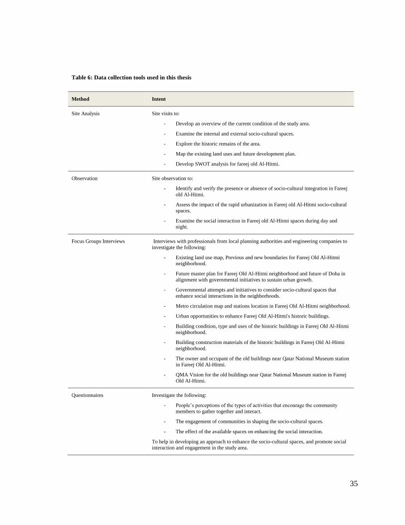
35
Table 6: Data collection tools used in this thesis
Method Intent
Site Analysis Site visits to:
- Develop an overview of the current condition of the study area.
- Examine the internal and external socio-cultural spaces.
- Explore the historic remains of the area.
- Map the existing land uses and future development plan.
- Develop SWOT analysis for fareej old Al-Hitmi.
Observation Site observation to:
- Identify and verify the presence or absence of socio-cultural integration in Fareej
old Al-Hitmi.
- Assess the impact of the rapid urbanization in Fareej old Al-Hitmi socio-cultural
spaces.
- Examine the social interaction in Fareej old Al-Hitmi spaces during day and night.
Focus Groups Interviews Interviews with professionals from local planning authorities and engineering companies to
investigate the following:
- Existing land use map, Previous and new boundaries for Fareej Old Al-Hitmi neighborhood.
- Future master plan for Fareej Old Al-Hitmi neighborhood and future of Doha in
alignment with governmental initiatives to sustain urban growth.
- Governmental attempts and initiatives to consider socio-cultural spaces that
enhance social interactions in the neighborhoods.
- Metro circulation map and stations location in Fareej Old Al-Hitmi neighborhood.
- Urban opportunities to enhance Fareej Old Al-Hitmi's historic buildings.
- Building condition, type and uses of the historic buildings in Fareej Old Al-Hitmi
neighborhood.
- Building construction materials of the historic buildings in Fareej Old Al-Hitmi
neighborhood.
- The owner and occupant of the old buildings near Qatar National Museum station in Fareej Old Al-Hitmi.
- QMA Vision for the old buildings near Qatar National Museum station in Fareej
Old Al-Hitmi.
Questionnaires Investigate the following:
- People‟s perceptions of the types of activities that encourage the community
members to gather together and interact.
- The engagement of communities in shaping the socio-cultural spaces.
- The effect of the available spaces on enhancing the social interaction.
To help in developing an approach to enhance the socio-cultural spaces, and promote social interaction and engagement in the study area.
36
3.3. Selection of the Study Area
Due to the rapid urbanization, most historic neighborhoods in Doha are experiencing
difficulties to adapt with these changes. Many of these neighborhoods are either being
replaced by new business districts or occupied by low-income workers, which in turn are
affecting the cultural identity negatively. Old neighborhoods in Doha should be known as
a valuable resource for future development and sustained for the present and future
generations, since they are considered as the reflection of the identity and culture of
Qatar‟s.
Fareej old Al Hitmi is an old neighborhood of Doha that contains a rich history of Al
Hitmi family and has a fabric with numerous blocks of authentic old houses of different
characters and types. Today, in the face of rapid urban development and people‟s
changing lifestyles, old Al Hitmi has experienced problems in making the necessary
adjustments and adaptation to the present needs and change. In addition, Old Al Hitmi
district is suffering from decay and dilapidation due to over occupation by low income
Asian workers, and certain areas are neglected, with a loss of place identity and
integrated socio-cultural spaces.
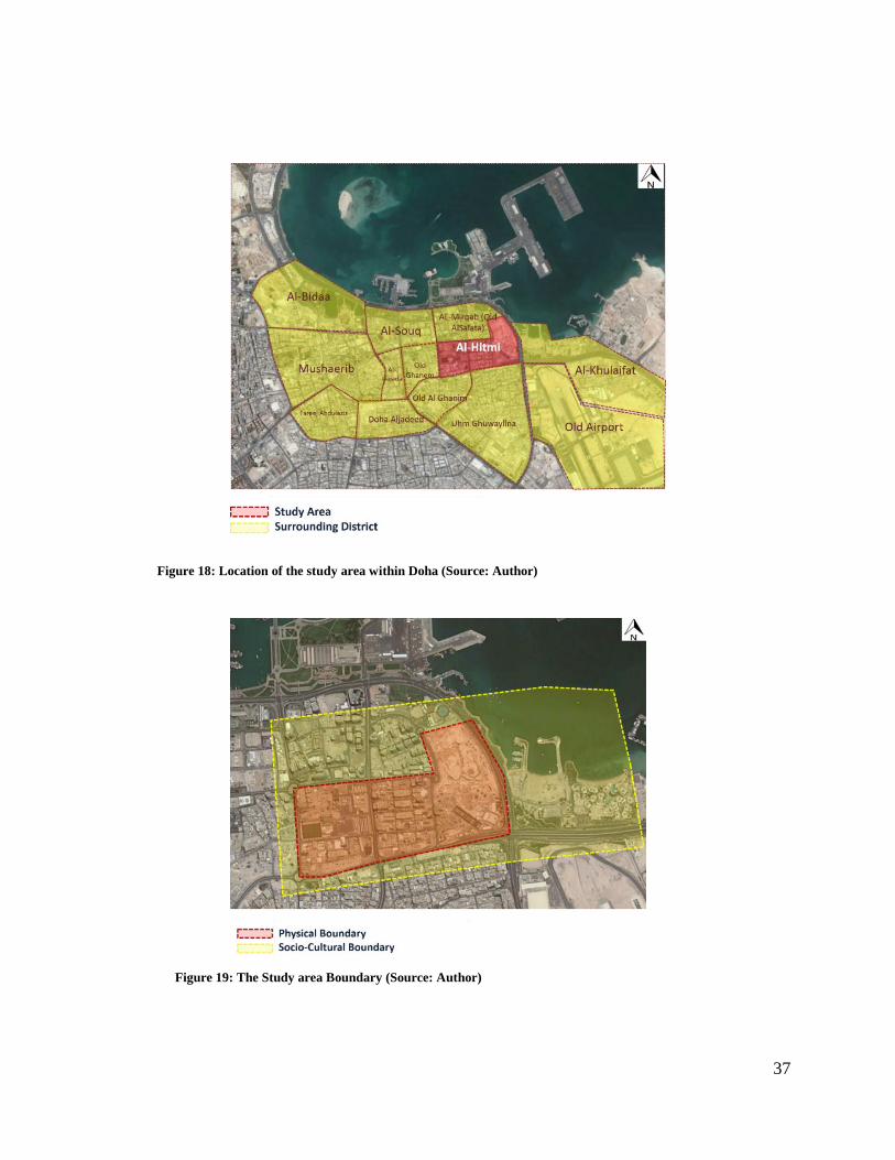
Fareej Old AL-Hitmi is located in the central of Doha, the capital of Qatar and it is
surrounded by Doha‟s old neighborhoods such as, Umm Ghuwaylina, Old Al Ghanim,
Al-Khulaifat and AL-Mirqab (Old AlSalata) Neighborhoods (Figures 18 & 19).
37
Figure 18: Location of the study area within Doha (Source: Author)
Figure 19: The Study area Boundary (Source: Author)

38
3.4. Data Collection Tools
The data was collected by four main tools, including: site analysis, site observation,
questionnaire survey and focus group interviews with professionals from local planning
authorities and engineering companies. These tools have been developed based on the
established definition of integrated socio-cultural spaces which requires qualitative data
and quantitative data. Qualitative data was gathered from site analysis and observations
of Fareej old Al-Hitmi neighborhood‟s socio-cultural and physical spaces, in addition to
the interviews with professional from local planning authorities and engineering
companies. Meanwhile, quantitative data was achieved through the questionnaire survey
that was directed to the neighborhoods‟ residents. Respectively, each method was
selected specifically to help answer the research questions.
3.4.1. Site Analysis
Preliminary site visits were conducted to develop an overview of the study area current
condition and to collect data that would support in the site analysis. The site visits
assisted direct the scope of research and to identify the type of data required for the site
analysis. Furthermore, this data assisted in formulating the research questions by
providing a balance between the literature review and the current situation of socio-
cultural integration and social interaction in real practice. Also, it assisted in exploring
the old remaining historic buildings and examines the internal and external public spaces
as well as developing a SWOT analysis for the study area.
39
3.4.2. Site Observation
Observations in the study area were conducted during the day as well as at night to
observe and document the behavior of people in the neighborhood and the social
interaction in the study area during day and night. Photographs of external and internal
spaces were taken to facilitate a visual analysis of the current situation of socio-cultural
integration and social interaction in the study area. The study area was visited during
different times of the day to gain a comprehensive idea of the site condition. Notes were
taken, conversant using the socio-cultural space integration checklist (Table 7), which
helped in formulating the survey questions.
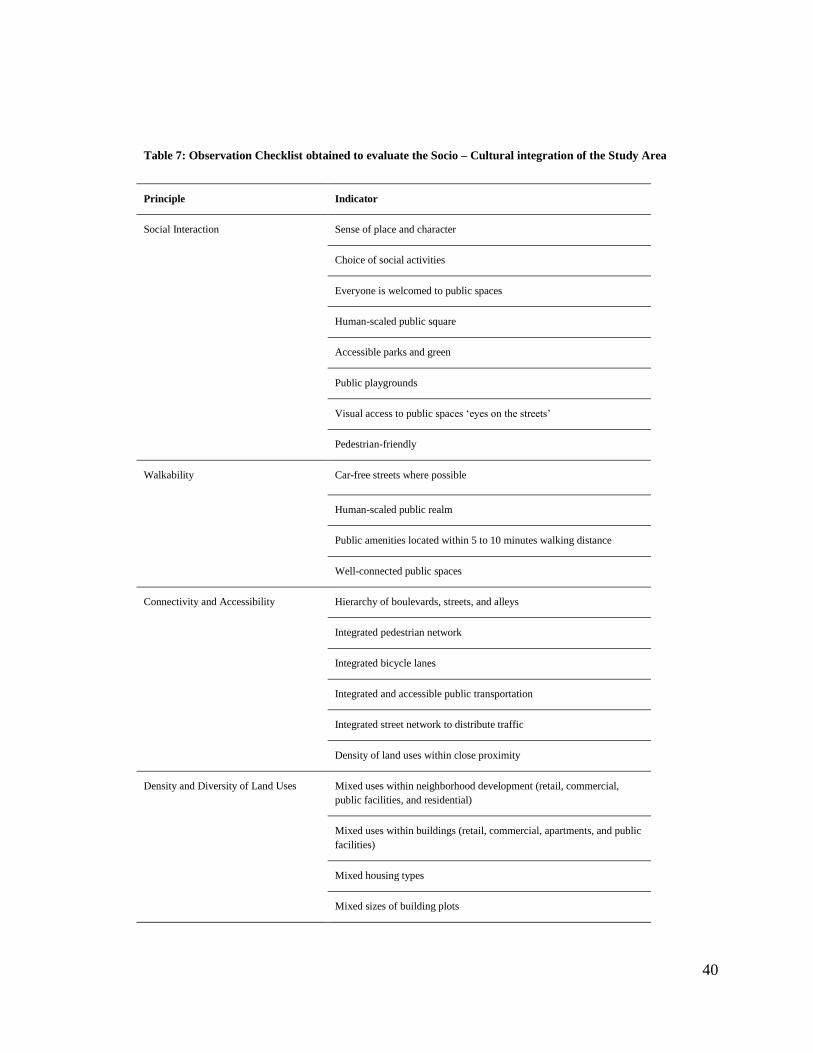
40
Table 7: Observation Checklist obtained to evaluate the Socio – Cultural integration of the Study Area
Principle Indicator
Social Interaction Sense of place and character
Choice of social activities
Everyone is welcomed to public spaces
Human-scaled public square
Accessible parks and green
Public playgrounds
Visual access to public spaces „eyes on the streets‟
Pedestrian-friendly
Walkability Car-free streets where possible
Human-scaled public realm
Public amenities located within 5 to 10 minutes walking distance
Well-connected public spaces
Connectivity and Accessibility Hierarchy of boulevards, streets, and alleys
Integrated pedestrian network
Integrated bicycle lanes
Integrated and accessible public transportation
Integrated street network to distribute traffic
Density of land uses within close proximity
Density and Diversity of Land Uses Mixed uses within neighborhood development (retail, commercial,
public facilities, and residential)
Mixed uses within buildings (retail, commercial, apartments, and public
facilities)
Mixed housing types
Mixed sizes of building plots
41
3.4.3. Survey Analysis
A questionnaire survey was conducted to examine the residents‟ perception of their
neighborhoods, their level of satisfaction, and what the neighborhood required in order to
have integrated socio-cultural spaces. Also surveyed was the people‟s perception of the
social activities that encourage the community to gather together and interact.
The questions were developed to investigate the opinions and perceptions regarding
personal use of the neighborhood‟s physical environment, preferences of living, and
rating of the neighborhood‟s overall social and physical environment. This input from
existing users will be used to develop an approach to enhance the socio-cultural spaces,
and promote social interaction and engagement in urban life of the neighborhood. The
questionnaire is divided into two distinctive sections, the first section includes the
personal information of the respondent, while the second section includes information
regarding the socio-cultural spaces and social interactions in the neighborhood. Samples
were taken from a random selection of respondents from varied backgrounds including
managerial, supervisory, technical, and operational.
3.4.4. Focus Group Interviews
Interviews with planners and design professionals from the Ministry of Municipality and
Environment (MME), Qatar Museum Authority (QMA), engineering consultant
companies and Qatar Rail (QR) were conducted to gain a wide knowledge of the
planning process of the neighborhoods in Doha. Socio-cultural aspects of the study area
were the focus of the discussions.
42
Local authorities were recognized as being responsible for the urban design and planning
of the neighborhoods of Doha: Authority of Urban Planning in the Ministry of
Municipality and Environment, and Qatar Museums Authority (QMA) in addition to
Qatar Rail and private consultant engineering companies. The main topics of discussions
were focused on the socio-cultural aspect of neighborhoods and how it addresses the
desires of local society and their potential activities.
43
CHAPTER 4: RESEARCH CONTEXT
4.1. Doha Historical Background
Doha city is the capital of Qatar and its largest city as well, covering area of 243 square
kilometers. More than 80% of Qatar's population lives in Doha and its suburbs, the
reason being that Doha is the economic center and all the governmental authorities and
municipalities are located in Doha. The population of Doha is 956,457 persons according
to 2015 census (Boussaa, 2014) (Brinkhoff, 2016). As mentioned earlier, this paper
examines the development of Doha city tackling: a) pre-oil period (1820-1949), b) post
oil period (1950-1990), and c) globalization period (1990-present).
- Pre-oil period (1820-1949):
In 1825, the city of Doha was known as Al Bidda, Doha is derived from Arabic name
meaning “big standing tree at the sea shore” or “bay” referring to the corniche bay (Al
Buainain, 1999). The leading family in Qatar, Al Thani is part of Al Maadhid tribe
changed their location multiple times. In the early 18th
century they moved from central
Arabia to settle down in the northern coast near Zubara. In 1847, Al Maadhid tribe ruled
by Shiekh Mohammed bin Thani moved to Al Bidda (eastern coast of the peninsula), as a
result to tribal conflicts with Al Khalifa tribe. The reasons behind choosing this location
is the water source (Wadi Sail) and the shape of the coastline that protects from sea attack
(Adham, 2008).
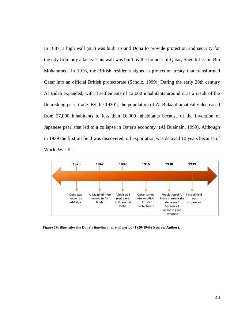
44
In 1887, a high wall (sur) was built around Doha to provide protection and security for
the city from any attacks. This wall was built by the founder of Qatar, Sheikh Jassim Bin
Mohammed. In 1916, the British residents signed a protection treaty that transformed
Qatar into an official British protectorate (Scholz, 1999). During the early 20th century
Al Bidaa expanded, with 8 settlements of 12,000 inhabitants around it as a result of the
flourishing pearl trade. By the 1930's, the population of Al Bidaa dramatically decreased
from 27,000 inhabitants to less than 16,000 inhabitants because of the invention of
Japanese pearl that led to a collapse in Qatar's economy (Al Buainain, 1999). Although
in 1939 the first oil field was discovered, oil exportation was delayed 10 years because of
World War II.
Figure 19: illustrates the Doha’s timeline in pre oil period (1820-1949) (source: Author).
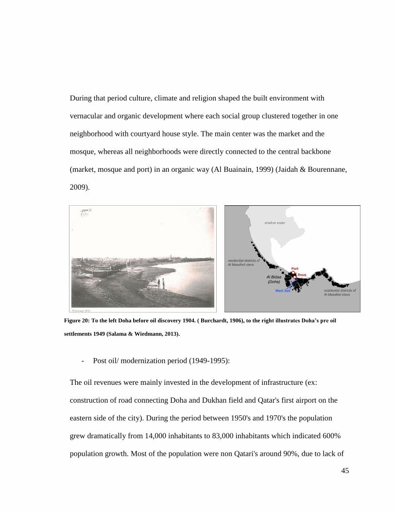
45
During that period culture, climate and religion shaped the built environment with
vernacular and organic development where each social group clustered together in one
neighborhood with courtyard house style. The main center was the market and the
mosque, whereas all neighborhoods were directly connected to the central backbone
(market, mosque and port) in an organic way (Al Buainain, 1999) (Jaidah & Bourennane,
2009).
- Post oil/ modernization period (1949-1995):
The oil revenues were mainly invested in the development of infrastructure (ex:
construction of road connecting Doha and Dukhan field and Qatar's first airport on the
eastern side of the city). During the period between 1950's and 1970's the population
grew dramatically from 14,000 inhabitants to 83,000 inhabitants which indicated 600%
population growth. Most of the population were non Qatari's around 90%, due to lack of
Figure 20: To the left Doha before oil discovery 1904. ( Burchardt, 1906), to the right illustrates Doha’s pre oil
settlements 1949 (Salama & Wiedmann, 2013).
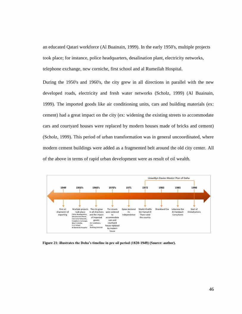
46
an educated Qatari workforce (Al Buainain, 1999). In the early 1950's, multiple projects
took place; for instance, police headquarters, desalination plant, electricity networks,
telephone exchange, new corniche, first school and al Rumeilah Hospital.
During the 1950's and 1960's, the city grew in all directions in parallel with the new
developed roads, electricity and fresh water networks (Scholz, 1999) (Al Buainain,
1999). The imported goods like air conditioning units, cars and building materials (ex:
cement) had a great impact on the city (ex: widening the existing streets to accommodate
cars and courtyard houses were replaced by modern houses made of bricks and cement)
(Scholz, 1999). This period of urban transformation was in general uncoordinated, where
modern cement buildings were added as a fragmented belt around the old city center. All
of the above in terms of rapid urban development were as result of oil wealth.
Figure 21: illustrates the Doha’s timeline in pre oil period (1820-1949) (Source: author).

47
On September 3rd
1971 the state of Qatar declared its independence and Sheikh Khalifa
bin Hamad Al Thani ruled the country on 1972 (Zahlan , 1979). At the same year the
first master plan for Qatar‟s capital, Doha, was prepared by the British firm Llewellyn-
Davies. The main idea of the proposal was to decentralize the city with a series of ring
roads (A, B, C and D ring roads) (Figure 23). Adding to this, the shallow water was
reclaimed to locate the ministries on the water front in the corniche (Lockerbie J. , 2016;
Salama & Wiedmann, Demystifying Doha On Architecture and Urbanism in an
Emerging City, 2013).
Figure 22: illustrates A, B, C and D ring roads (Source: author).
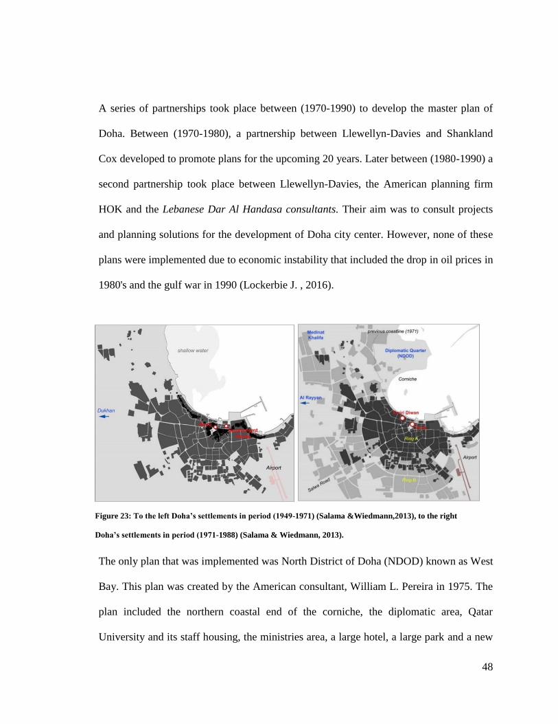
48
A series of partnerships took place between (1970-1990) to develop the master plan of
Doha. Between (1970-1980), a partnership between Llewellyn-Davies and Shankland
Cox developed to promote plans for the upcoming 20 years. Later between (1980-1990) a
second partnership took place between Llewellyn-Davies, the American planning firm
HOK and the Lebanese Dar Al Handasa consultants. Their aim was to consult projects
and planning solutions for the development of Doha city center. However, none of these
plans were implemented due to economic instability that included the drop in oil prices in
1980's and the gulf war in 1990 (Lockerbie J. , 2016).
The only plan that was implemented was North District of Doha (NDOD) known as West
Bay. This plan was created by the American consultant, William L. Pereira in 1975. The
plan included the northern coastal end of the corniche, the diplomatic area, Qatar
University and its staff housing, the ministries area, a large hotel, a large park and a new
Figure 23: To the left Doha’s settlements in period (1949-1971) (Salama &Wiedmann,2013), to the right
Doha’s settlements in period (1971-1988) (Salama & Wiedmann, 2013).
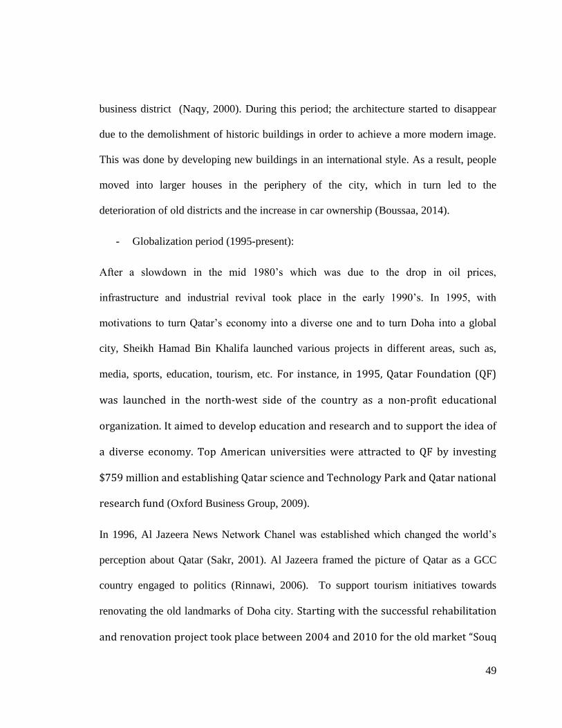
49
business district (Naqy, 2000). During this period; the architecture started to disappear
due to the demolishment of historic buildings in order to achieve a more modern image.
This was done by developing new buildings in an international style. As a result, people
moved into larger houses in the periphery of the city, which in turn led to the
deterioration of old districts and the increase in car ownership (Boussaa, 2014).
- Globalization period (1995-present):
After a slowdown in the mid 1980‟s which was due to the drop in oil prices,
infrastructure and industrial revival took place in the early 1990‟s. In 1995, with
motivations to turn Qatar‟s economy into a diverse one and to turn Doha into a global
city, Sheikh Hamad Bin Khalifa launched various projects in different areas, such as,
media, sports, education, tourism, etc. For instance, in 1995, Qatar Foundation (QF)
was launched in the north-west side of the country as a non-profit educational
organization. It aimed to develop education and research and to support the idea of
a diverse economy. Top American universities were attracted to QF by investing
$759 million and establishing Qatar science and Technology Park and Qatar national
research fund (Oxford Business Group, 2009).
In 1996, Al Jazeera News Network Chanel was established which changed the world‟s
perception about Qatar (Sakr, 2001). Al Jazeera framed the picture of Qatar as a GCC
country engaged to politics (Rinnawi, 2006). To support tourism initiatives towards
renovating the old landmarks of Doha city. Starting with the successful rehabilitation
and renovation project took place between 2004 and 2010 for the old market “Souq
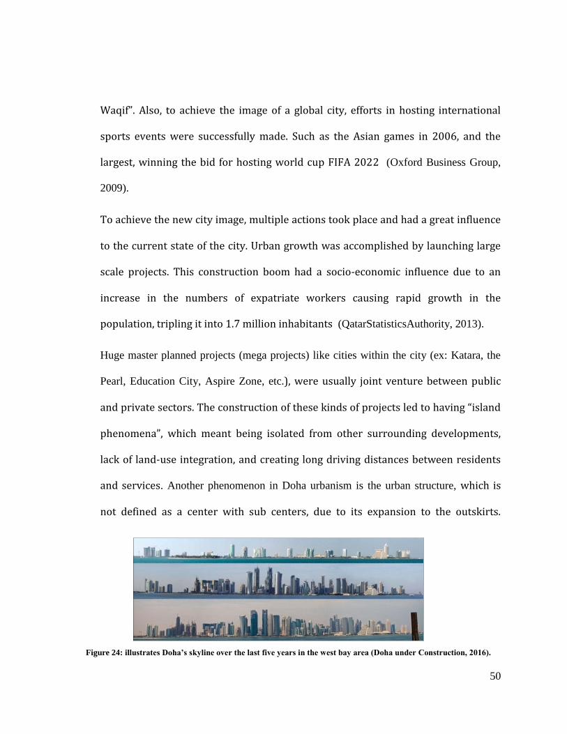
50
Waqif”. Also, to achieve the image of a global city, efforts in hosting international
sports events were successfully made. Such as the Asian games in 2006, and the
largest, winning the bid for hosting world cup FIFA 2022 (Oxford Business Group,
2009).
To achieve the new city image, multiple actions took place and had a great influence
to the current state of the city. Urban growth was accomplished by launching large
scale projects. This construction boom had a socio-economic influence due to an
increase in the numbers of expatriate workers causing rapid growth in the
population, tripling it into 1.7 million inhabitants (QatarStatisticsAuthority, 2013).
Huge master planned projects (mega projects) like cities within the city (ex: Katara, the
Pearl, Education City, Aspire Zone, etc.), were usually joint venture between public
and private sectors. The construction of these kinds of projects led to having “island
phenomena”, which meant being isolated from other surrounding developments,
lack of land-use integration, and creating long driving distances between residents
and services. Another phenomenon in Doha urbanism is the urban structure, which is
not defined as a center with sub centers, due to its expansion to the outskirts.
Figure 24: illustrates Doha’s skyline over the last five years in the west bay area (Doha under Construction, 2016).
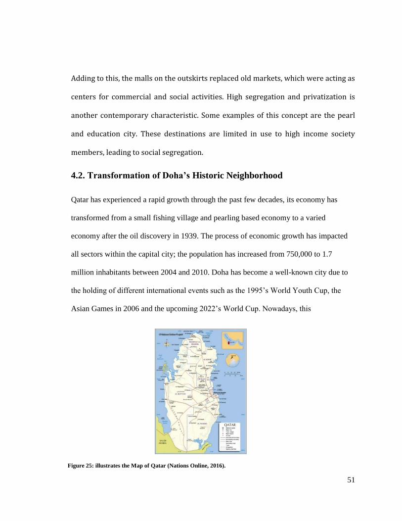
51
Figure 25: illustrates the Map of Qatar (Nations Online, 2016).
Adding to this, the malls on the outskirts replaced old markets, which were acting as
centers for commercial and social activities. High segregation and privatization is
another contemporary characteristic. Some examples of this concept are the pearl
and education city. These destinations are limited in use to high income society
members, leading to social segregation.
4.2. Transformation of Doha’s Historic Neighborhood
Qatar has experienced a rapid growth through the past few decades, its economy has
transformed from a small fishing village and pearling based economy to a varied
economy after the oil discovery in 1939. The process of economic growth has impacted
all sectors within the capital city; the population has increased from 750,000 to 1.7
million inhabitants between 2004 and 2010. Doha has become a well-known city due to
the holding of different international events such as the 1995‟s World Youth Cup, the
Asian Games in 2006 and the upcoming 2022‟s World Cup. Nowadays, this
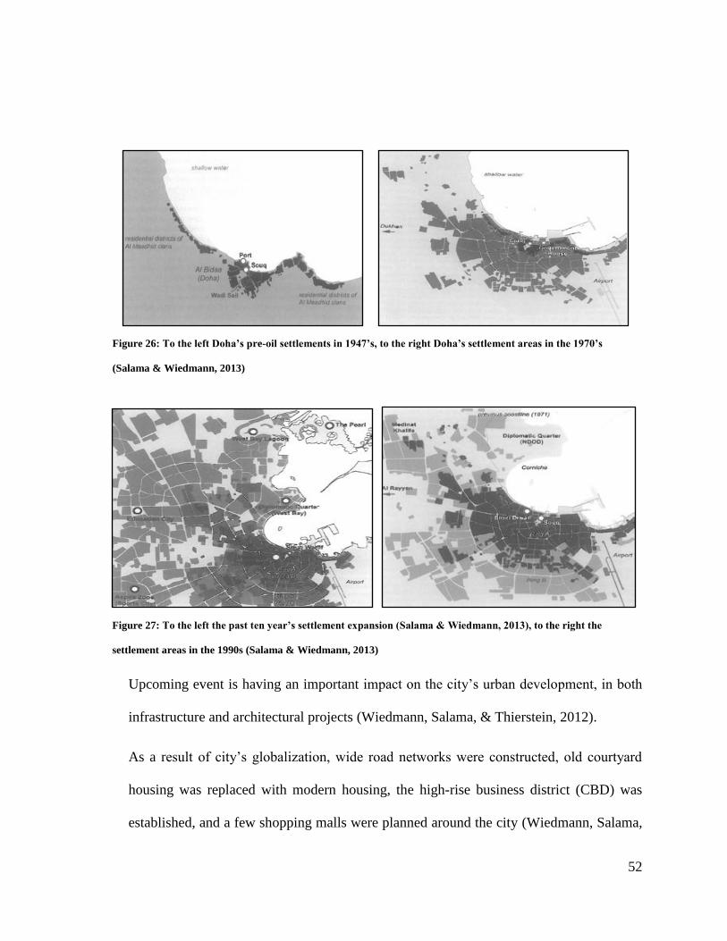
52
Upcoming event is having an important impact on the city‟s urban development, in both
infrastructure and architectural projects (Wiedmann, Salama, & Thierstein, 2012).
As a result of city‟s globalization, wide road networks were constructed, old courtyard
housing was replaced with modern housing, the high-rise business district (CBD) was
established, and a few shopping malls were planned around the city (Wiedmann, Salama,
Figure 26: To the left Doha’s pre-oil settlements in 1947’s, to the right Doha’s settlement areas in the 1970’s
(Salama & Wiedmann, 2013)
Figure 27: To the left the past ten year’s settlement expansion (Salama & Wiedmann, 2013), to the right the
settlement areas in the 1990s (Salama & Wiedmann, 2013)
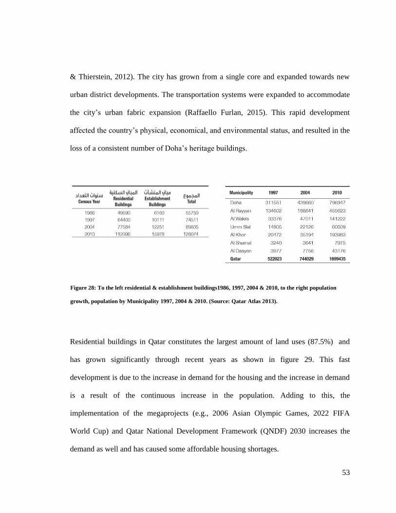
53
& Thierstein, 2012). The city has grown from a single core and expanded towards new
urban district developments. The transportation systems were expanded to accommodate
the city‟s urban fabric expansion (Raffaello Furlan, 2015). This rapid development
affected the country‟s physical, economical, and environmental status, and resulted in the
loss of a consistent number of Doha‟s heritage buildings.
Residential buildings in Qatar constitutes the largest amount of land uses (87.5%) and
has grown significantly through recent years as shown in figure 29. This fast
development is due to the increase in demand for the housing and the increase in demand
is a result of the continuous increase in the population. Adding to this, the
implementation of the megaprojects (e.g., 2006 Asian Olympic Games, 2022 FIFA
World Cup) and Qatar National Development Framework (QNDF) 2030 increases the
demand as well and has caused some affordable housing shortages.
Figure 28: To the left residential & establishment buildings1986, 1997, 2004 & 2010, to the right population
growth, population by Municipality 1997, 2004 & 2010. (Source: Qatar Atlas 2013).
54
During the period (1950-1980) little attention was paid regarding saving the cultural
heritage until the first legislative law was established in 1980 considering archaeological
sites and single buildings preservation. However, no real attention was given to historical
monuments until the recent actions during the past decade by the government of Qatar.
Starting with the most important historic site in Qatar the '' Souq Waqif '' rehabilitation
project (2004-2010) and the ongoing Msheireb project (2008-2016) to regenerate the old
heart of Doha. These two projects were derived to recover the identity of the city which
was lost due to globalization and re-development.
4.3. Significance of the Study area, Fareej Old Al Hitmi
Fareej (district) old Al Hitmi is an old neighborhood of Doha, the capital city and the
state of Qatar, dating back to 1930. The name was derived from Al-Hitmi family, which
is a branch of the main Ali Bin Ali tribe. Fareej Old Al Hitmi contains a very rich history
of Al Hitmi Family. It has a more coherent fabric with numerous blocks of authentic old
houses of different characteristics and types.
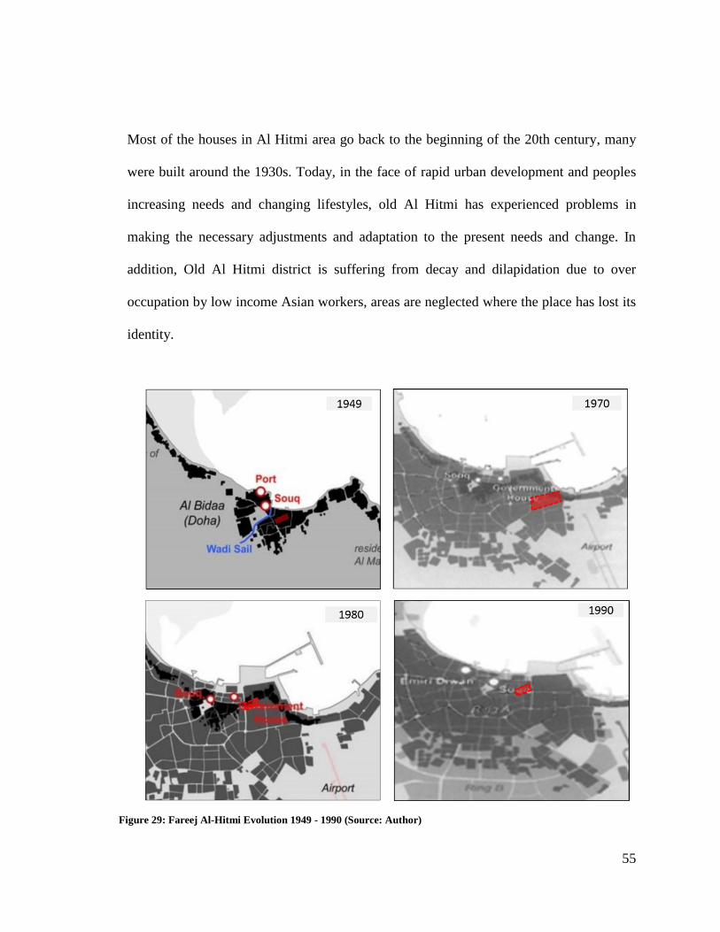
55
Most of the houses in Al Hitmi area go back to the beginning of the 20th century, many
were built around the 1930s. Today, in the face of rapid urban development and peoples
increasing needs and changing lifestyles, old Al Hitmi has experienced problems in
making the necessary adjustments and adaptation to the present needs and change. In
addition, Old Al Hitmi district is suffering from decay and dilapidation due to over
occupation by low income Asian workers, areas are neglected where the place has lost its
identity.
Figure 29: Fareej Al-Hitmi Evolution 1949 - 1990 (Source: Author)
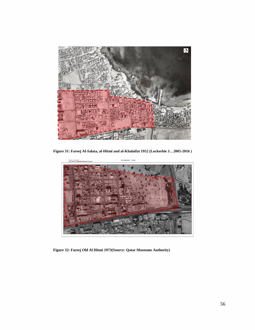
56
Figure 31: Fareej Al-Salata, al-Hitmi and al-Khalaifat 1952 (Lockerbie J. , 2005-2016 )
Figure 32: Fareej Old Al Hitmi 1973(Source: Qatar Museums Authority)
57
CHAPTER 5: RESEARCH DISCUSSION AND FINDINGS
Fareej old Al-Hitmi was investigated from various research stages. The first part is the
site analysis, where Fareej old Al-Hitmi was analyzed and investigated in term of
location and context, existing land use, future master plan, building condition and style,
the impact of new development and a SWOT analysis was developed in the study area.
The second part is investigating the socio cultural spaces in term of internal and external
public spaces as well as the historic socio-cultural spaces.
Following these investigations, an observation checklist was used during both day and
night to check perceptions and behaviors of people in the neighborhood and the social
interactions in the study area both during the day and at night. Additionally, photographs
of internal and external spaces were taken to facilitate a visual analysis of the current
situation of the socio-cultural integration, and social interaction in the study area.
Finally, a questionnaire survey was distributed to residents living in different
neighborhoods around Doha. The decision to target different districts was taken in order
to gain a wider knowledge of the society‟s perception in regards to the activities that
encourage social interaction.
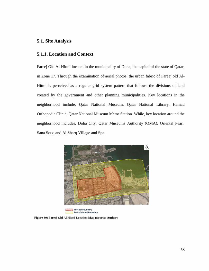
58
5.1. Site Analysis
5.1.1. Location and Context
Fareej Old Al-Hitmi located in the municipality of Doha, the capital of the state of Qatar,
in Zone 17. Through the examination of aerial photos, the urban fabric of Fareej old Al-
Hitmi is perceived as a regular grid system pattern that follows the divisions of land
created by the government and other planning municipalities. Key locations in the
neighborhood include, Qatar National Museum, Qatar National Library, Hamad
Orthopedic Clinic, Qatar National Museum Metro Station. While, key location around the
neighborhood includes, Doha City, Qatar Museums Authority (QMA), Oriental Pearl,
Sana Souq and Al Sharq Village and Spa.
Figure 30: Fareej Old Al Hitmi Location Map (Source: Author)
59
5.1.2. The Evolution of Fareej Old Al-Hitmi Over Time
Initially, Fareej Old Al-Hitmi started with scattered residential buildings developments
and a small number of individual villas in the older sections as well as Qatar old National
Museums, with an abundance of surrounding vacant land. Later, the buildings expanded
in number and size to form their current cluster of today, containing dense mixed used
developments such as hospital, commercial, schools, library, museums and metro station.
The figure below illustrates the urban evolution of Fareej Old Al-Hitmi from 2003 until
2017.
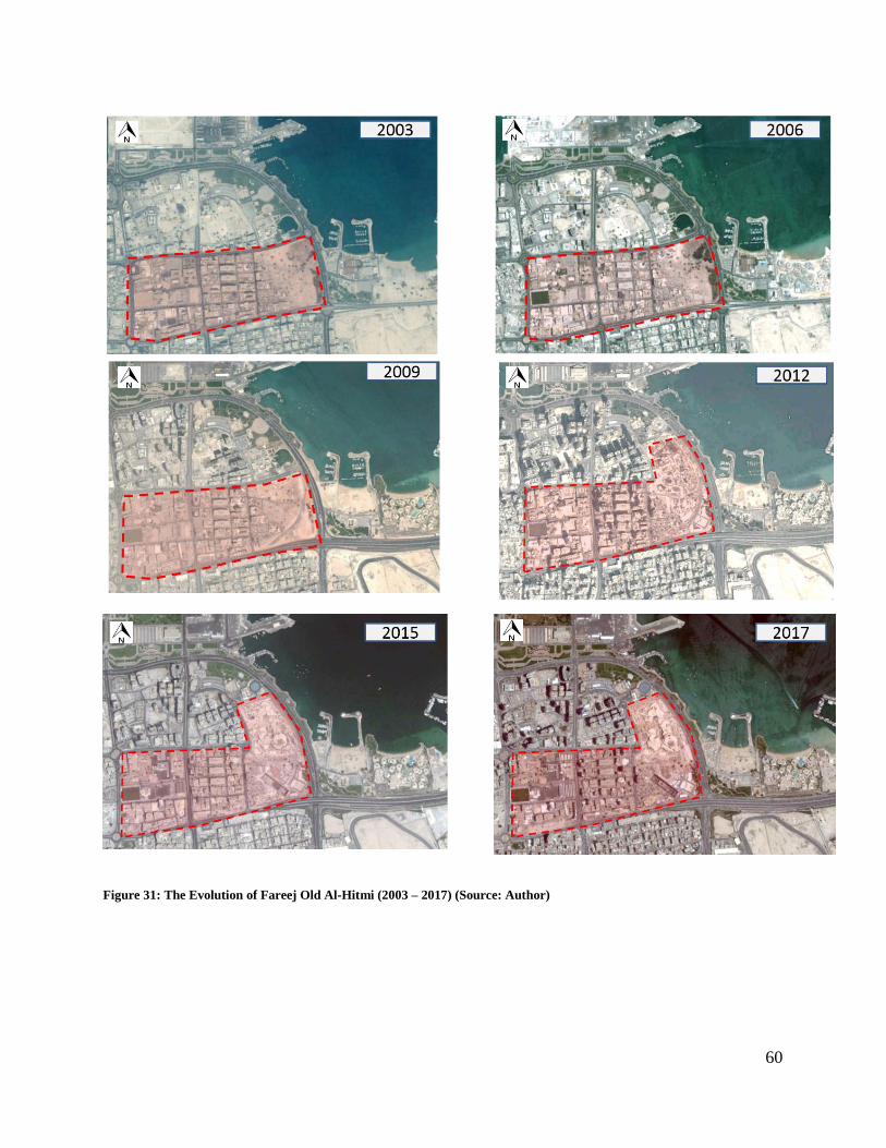
60
Figure 31: The Evolution of Fareej Old Al-Hitmi (2003 – 2017) (Source: Author)
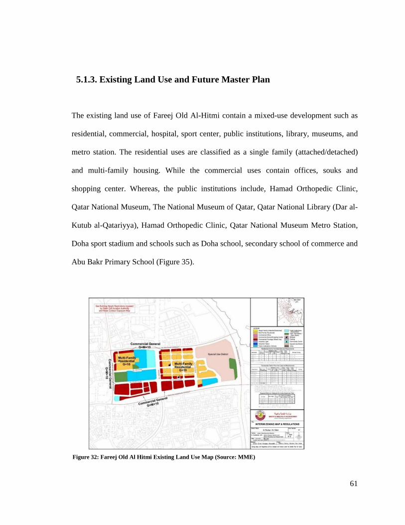
61
5.1.3. Existing Land Use and Future Master Plan
The existing land use of Fareej Old Al-Hitmi contain a mixed-use development such as
residential, commercial, hospital, sport center, public institutions, library, museums, and
metro station. The residential uses are classified as a single family (attached/detached)
and multi-family housing. While the commercial uses contain offices, souks and
shopping center. Whereas, the public institutions include, Hamad Orthopedic Clinic,
Qatar National Museum, The National Museum of Qatar, Qatar National Library (Dar al-
Kutub al-Qatariyya), Hamad Orthopedic Clinic, Qatar National Museum Metro Station,
Doha sport stadium and schools such as Doha school, secondary school of commerce and
Abu Bakr Primary School (Figure 35).
Figure 32: Fareej Old Al Hitmi Existing Land Use Map (Source: MME)
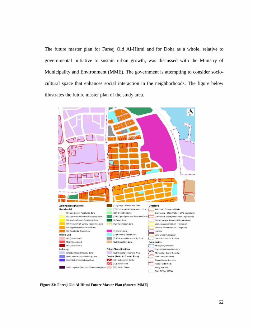
62
The future master plan for Fareej Old Al-Hitmi and for Doha as a whole, relative to
governmental initiative to sustain urban growth, was discussed with the Ministry of
Municipality and Environment (MME). The government is attempting to consider socio-
cultural space that enhances social interaction in the neighborhoods. The figure below
illustrates the future master plan of the study area.
Figure 33: Fareej Old Al-Hitmi Future Master Plan (Source: MME)
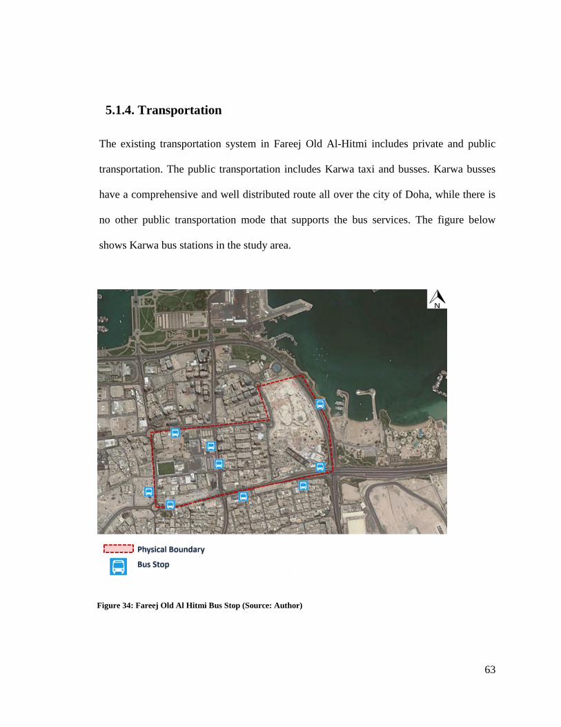
63
5.1.4. Transportation
The existing transportation system in Fareej Old Al-Hitmi includes private and public
transportation. The public transportation includes Karwa taxi and busses. Karwa busses
have a comprehensive and well distributed route all over the city of Doha, while there is
no other public transportation mode that supports the bus services. The figure below
shows Karwa bus stations in the study area.
Figure 34: Fareej Old Al Hitmi Bus Stop (Source: Author)
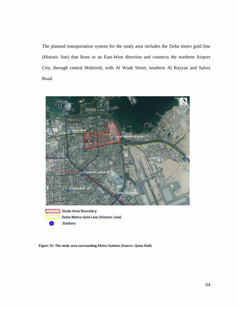
64
The planned transportation system for the study area includes the Doha metro gold line
(Historic line) that Runs in an East-West direction and connects the northern Airport
City, through central Msheireb, with Al Waab Street, southern Al Rayyan and Salwa
Road.
Figure 35: The study area surrounding Metro Stations (Source: Qatar Rail)
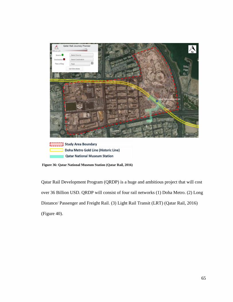
65
Qatar Rail Development Program (QRDP) is a huge and ambitious project that will cost
over 36 Billion USD. QRDP will consist of four rail networks (1) Doha Metro. (2) Long
Distance/ Passenger and Freight Rail. (3) Light Rail Transit (LRT) (Qatar Rail, 2016)
(Figure 40).
Figure 36: Qatar National Museum Station (Qatar Rail, 2016)

66
As mentioned above, the rail network that runs along the study area is the Doha Metro
that will connect the center of the city within itself, and its outskirts and will be
subdivided into four lines (a) Red Line (Coast Line): North-South Line connecting Al
Khor, Mesaieed in the south via Lusail, West Bay, Msheireb and the New Doha
International Airport (b) Green Line (Education Line): The Green Line follows Al
Rayyan Road and connects Education City with the central Doha. It also links to Umm
Slal and the Industrial Area in the South (c) Gold Line (Historic Line): Runs in an East-
West direction and connects the northern Airport City via central Msheireb with Al Waab
Street, Al Rayyan South and Salwa Road. (d) Blue Line (City Line): Connecting the
residential and commercial areas of West Bay and the northern Airport City along the
main C-Ring Road. There will be approximately 100 stations built for the entire Metro
Network and these will include two major stations built in Msheireb and Education City
(Figure 41 - 42).
Figure 37: Qatar Rail Development Program (Qatar Rail, 2016)
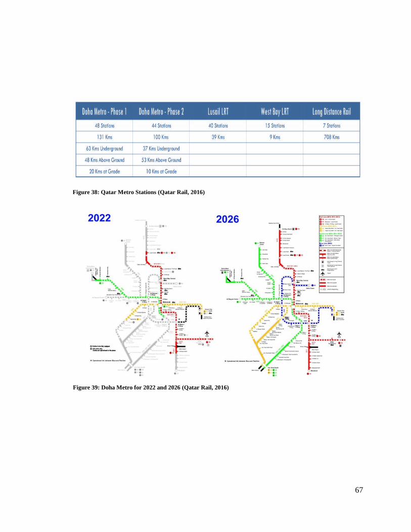
67
Figure 39: Doha Metro for 2022 and 2026 (Qatar Rail, 2016)
Figure 38: Qatar Metro Stations (Qatar Rail, 2016)
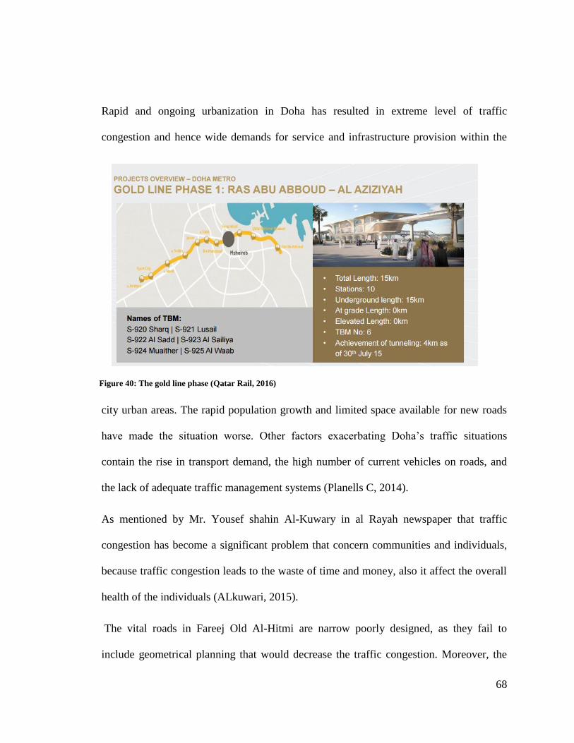
68
Rapid and ongoing urbanization in Doha has resulted in extreme level of traffic
congestion and hence wide demands for service and infrastructure provision within the
city urban areas. The rapid population growth and limited space available for new roads
have made the situation worse. Other factors exacerbating Doha‟s traffic situations
contain the rise in transport demand, the high number of current vehicles on roads, and
the lack of adequate traffic management systems (Planells C, 2014).
As mentioned by Mr. Yousef shahin Al-Kuwary in al Rayah newspaper that traffic
congestion has become a significant problem that concern communities and individuals,
because traffic congestion leads to the waste of time and money, also it affect the overall
health of the individuals (ALkuwari, 2015).
The vital roads in Fareej Old Al-Hitmi are narrow poorly designed, as they fail to
include geometrical planning that would decrease the traffic congestion. Moreover, the
Figure 40: The gold line phase (Qatar Rail, 2016)
69
concentrations of the vital facilities that have huge demand are in one place, which
increases the traffic congestion, such as the concentration of schools or service
complexes in one place. Fareej Old Al-Hitmi also lacks of adequate parking space and
sufficient public transportation (Figure 44).
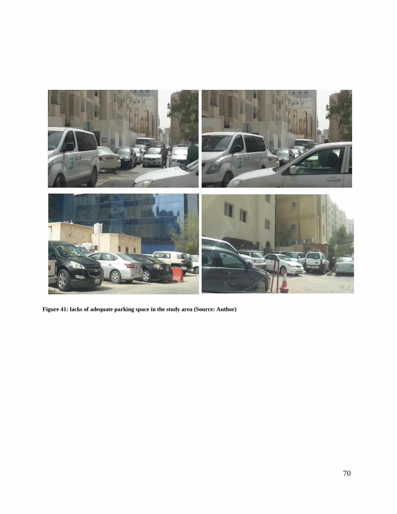
70
Figure 41: lacks of adequate parking space in the study area (Source: Author)

71
5.1.5. Building Condition
The building conditions of Fareej Old Al Hitmi range between good to bad conditions,
while taking into consideration that some buildings are still under construction. The
buildings that are considered to be in good condition take up around 40% of the area,
while the buildings suffering from bad conditions make up around 30%. The remaining
30% of the area is occupied by the buildings that are still being constructed (Figure 45).
Figure 42: Fareej Old Al-Hitmi Buildings Condition (Source: Author)

72
5.1.6. Building Style
The buildings in Fareej Old Al Hitmi includes mixed of styles such as early modern,
mixed traditional-early modern, modern, traditional with arcades and traditional with
interior courtyard (Figure 46).
5.1.7. The Impact of High-Rise Development
Due to the rapid urban development, many high-rise buildings have been constructed in
the study area without taking into consideration the existing premises, which resulted in a
non-integrated development. The image below clearly illustrates the relation between the
old and new structures and the extent to which the area is lacking integration.
Figure 43: The study area building style (Source: Author)
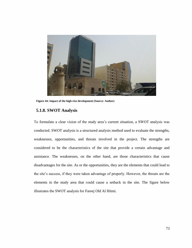
73
5.1.8. SWOT Analysis
To formulate a clear vision of the study area‟s current situation, a SWOT analysis was
conducted. SWOT analysis is a structured analysis method used to evaluate the strengths,
weaknesses, opportunities, and threats involved in the project. The strengths are
considered to be the characteristics of the site that provide a certain advantage and
assistance. The weaknesses, on the other hand, are those characteristics that cause
disadvantages for the site. As or the opportunities, they are the elements that could lead to
the site‟s success, if they were taken advantage of properly. However, the threats are the
elements in the study area that could cause a setback in the site. The figure below
illustrates the SWOT analysis for Fareej Old Al Hitmi.
Figure 44: Impact of the high-rise development (Source: Author)

74
Figure 45: SWOT Analysis (Source: Author)
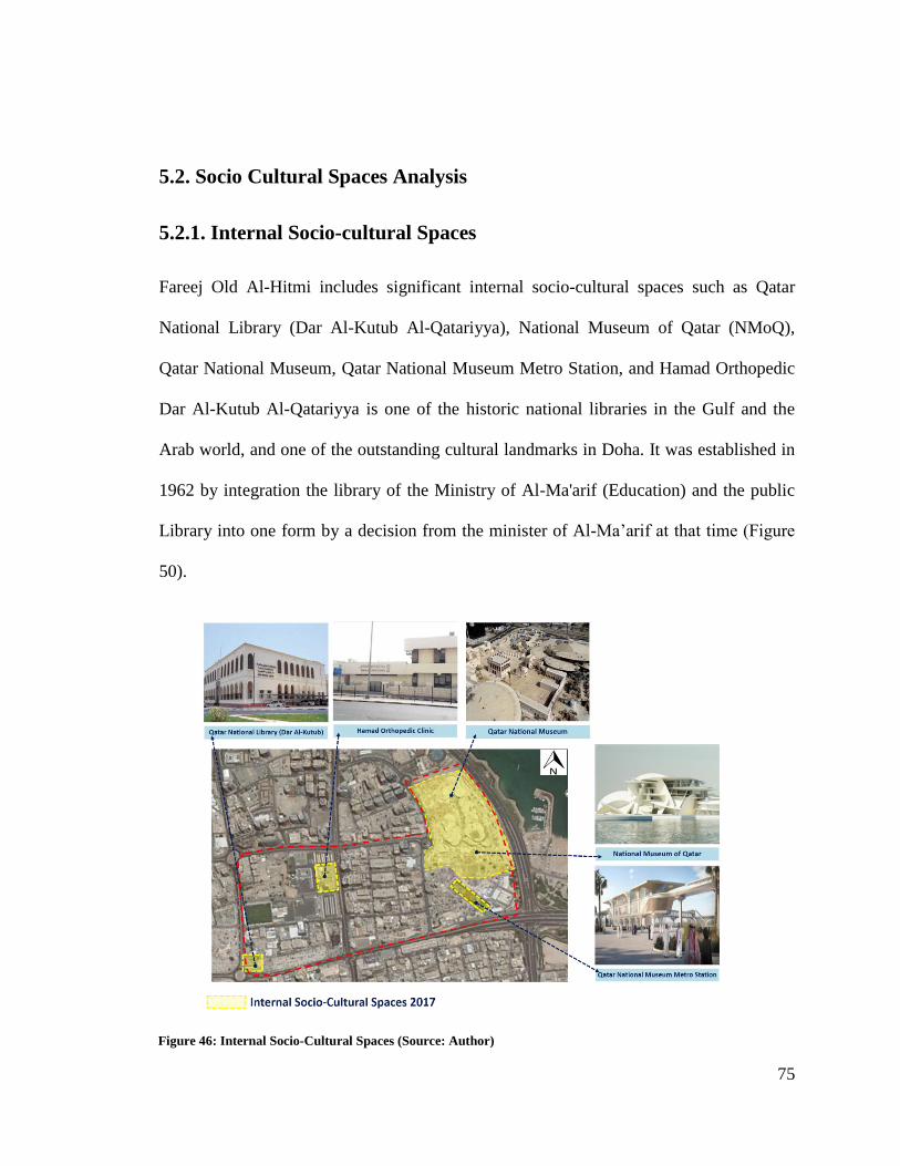
75
5.2. Socio Cultural Spaces Analysis
5.2.1. Internal Socio-cultural Spaces
Fareej Old Al-Hitmi includes significant internal socio-cultural spaces such as Qatar
National Library (Dar Al-Kutub Al-Qatariyya), National Museum of Qatar (NMoQ),
Qatar National Museum, Qatar National Museum Metro Station, and Hamad Orthopedic
Dar Al-Kutub Al-Qatariyya is one of the historic national libraries in the Gulf and the
Arab world, and one of the outstanding cultural landmarks in Doha. It was established in
1962 by integration the library of the Ministry of Al-Ma'arif (Education) and the public
Library into one form by a decision from the minister of Al-Ma‟arif at that time (Figure
50).
Figure 46: Internal Socio-Cultural Spaces (Source: Author)
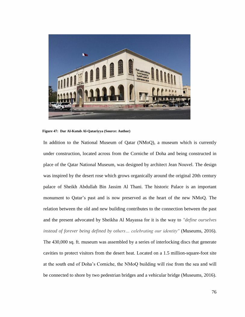
76
In addition to the National Museum of Qatar (NMoQ), a museum which is currently
under construction, located across from the Corniche of Doha and being constructed in
place of the Qatar National Museum, was designed by architect Jean Nouvel. The design
was inspired by the desert rose which grows organically around the original 20th century
palace of Sheikh Abdullah Bin Jassim Al Thani. The historic Palace is an important
monument to Qatar‟s past and is now preserved as the heart of the new NMoQ. The
relation between the old and new building contributes to the connection between the past
and the present advocated by Sheikha Al Mayassa for it is the way to "define ourselves
instead of forever being defined by others… celebrating our identity" (Museums, 2016).
The 430,000 sq. ft. museum was assembled by a series of interlocking discs that generate
cavities to protect visitors from the desert heat. Located on a 1.5 million-square-foot site
at the south end of Doha‟s Corniche, the NMoQ building will rise from the sea and will
be connected to shore by two pedestrian bridges and a vehicular bridge (Museums, 2016).
Figure 47: Dar Al-Kutub Al-Qatariyya (Source: Author)

77
The goal of National Museum Metro Station design is to add cultural elements to the
station which make it a cultural landmark where architectural features add a cultural
touch to the stations. The concept is to have a theme inspired by culture and history in the
station surrounding. The station network should be an opportunity to exhibit the unique
cultural heritage of Qatar through its rich reservoir of art and artifacts (Qatar Rail, 2016)
(Figure 52).
Figure 48: Qatar National Museum (Source: Author)
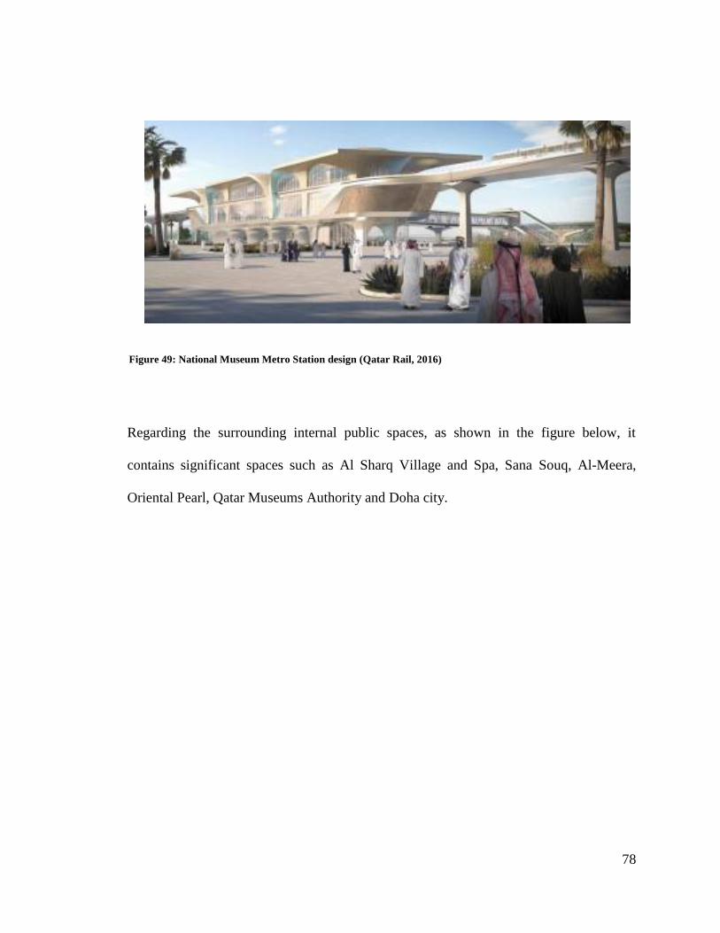
78
Regarding the surrounding internal public spaces, as shown in the figure below, it
contains significant spaces such as Al Sharq Village and Spa, Sana Souq, Al-Meera,
Oriental Pearl, Qatar Museums Authority and Doha city.
Figure 49: National Museum Metro Station design (Qatar Rail, 2016)
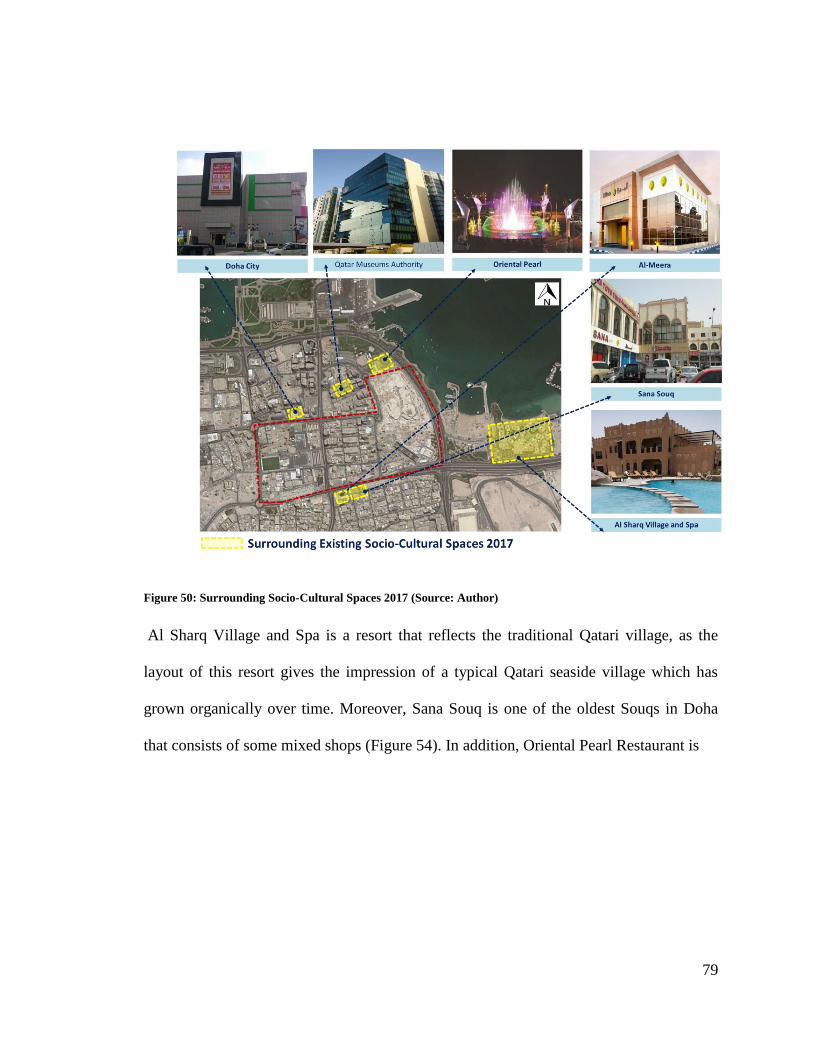
79
Figure 50: Surrounding Socio-Cultural Spaces 2017 (Source: Author)
Al Sharq Village and Spa is a resort that reflects the traditional Qatari village, as the
layout of this resort gives the impression of a typical Qatari seaside village which has
grown organically over time. Moreover, Sana Souq is one of the oldest Souqs in Doha
that consists of some mixed shops (Figure 54). In addition, Oriental Pearl Restaurant is
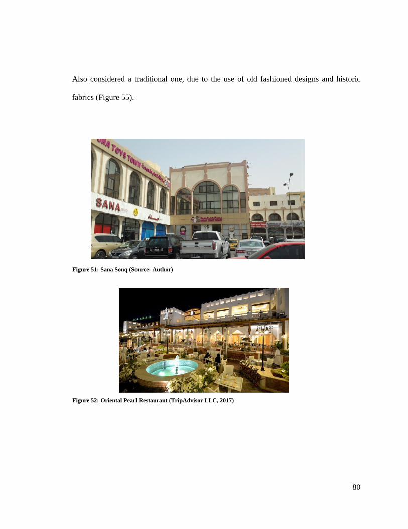
80
Also considered a traditional one, due to the use of old fashioned designs and historic
fabrics (Figure 55).
Figure 51: Sana Souq (Source: Author)
Figure 52: Oriental Pearl Restaurant (TripAdvisor LLC, 2017)
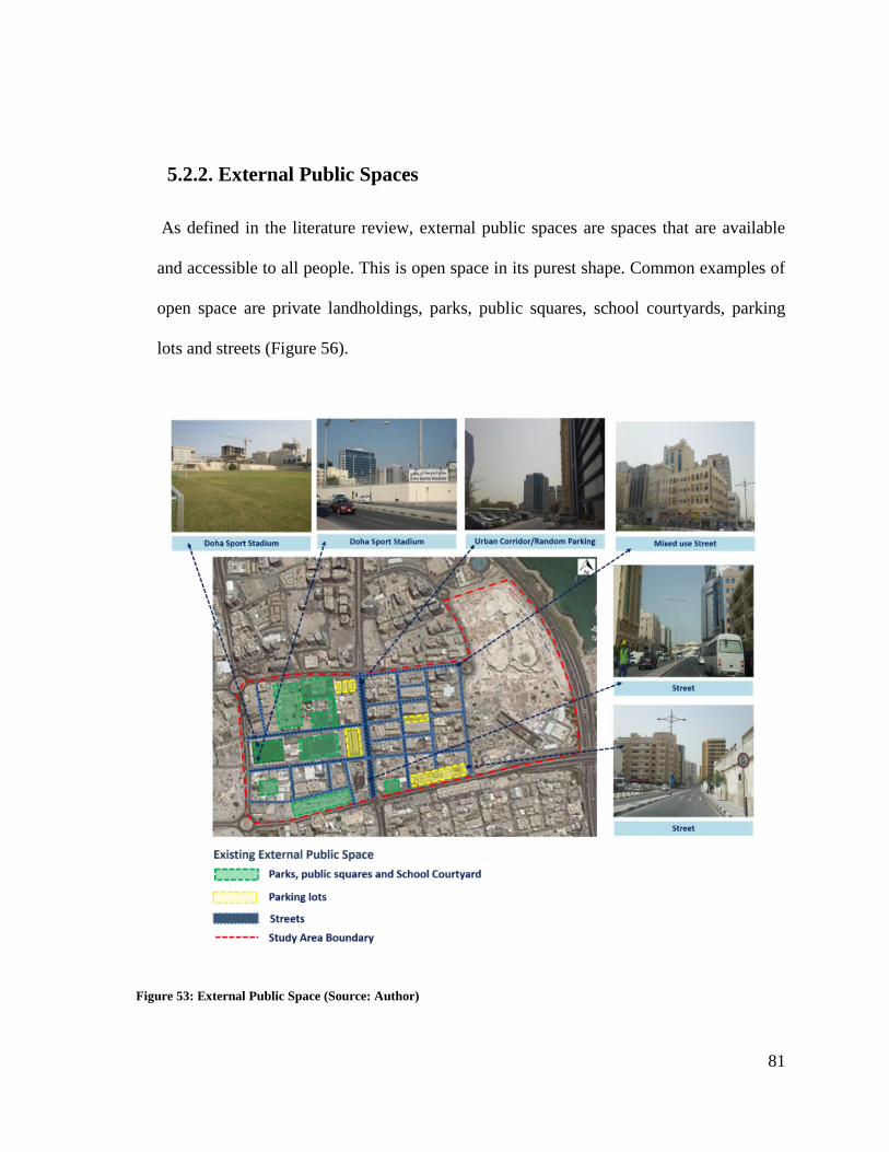
81
5.2.2. External Public Spaces
As defined in the literature review, external public spaces are spaces that are available
and accessible to all people. This is open space in its purest shape. Common examples of
open space are private landholdings, parks, public squares, school courtyards, parking
lots and streets (Figure 56).
Figure 53: External Public Space (Source: Author)
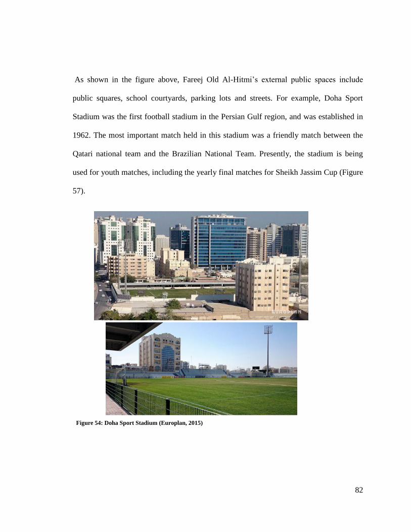
82
As shown in the figure above, Fareej Old Al-Hitmi‟s external public spaces include
public squares, school courtyards, parking lots and streets. For example, Doha Sport
Stadium was the first football stadium in the Persian Gulf region, and was established in
1962. The most important match held in this stadium was a friendly match between the
Qatari national team and the Brazilian National Team. Presently, the stadium is being
used for youth matches, including the yearly final matches for Sheikh Jassim Cup (Figure
57).
Figure 54: Doha Sport Stadium (Europlan, 2015)
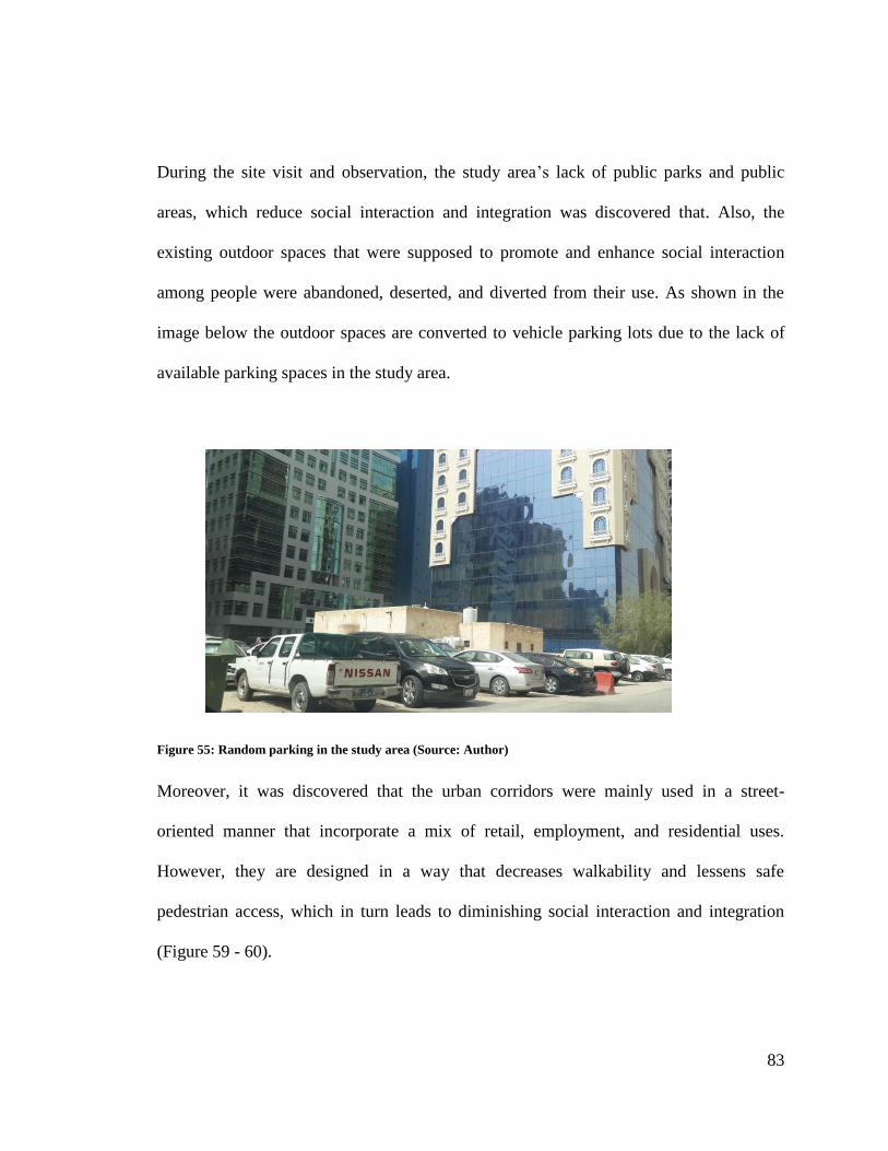
83
During the site visit and observation, the study area‟s lack of public parks and public
areas, which reduce social interaction and integration was discovered that. Also, the
existing outdoor spaces that were supposed to promote and enhance social interaction
among people were abandoned, deserted, and diverted from their use. As shown in the
image below the outdoor spaces are converted to vehicle parking lots due to the lack of
available parking spaces in the study area.
Moreover, it was discovered that the urban corridors were mainly used in a street-
oriented manner that incorporate a mix of retail, employment, and residential uses.
However, they are designed in a way that decreases walkability and lessens safe
pedestrian access, which in turn leads to diminishing social interaction and integration
(Figure 59 - 60).
Figure 55: Random parking in the study area (Source: Author)
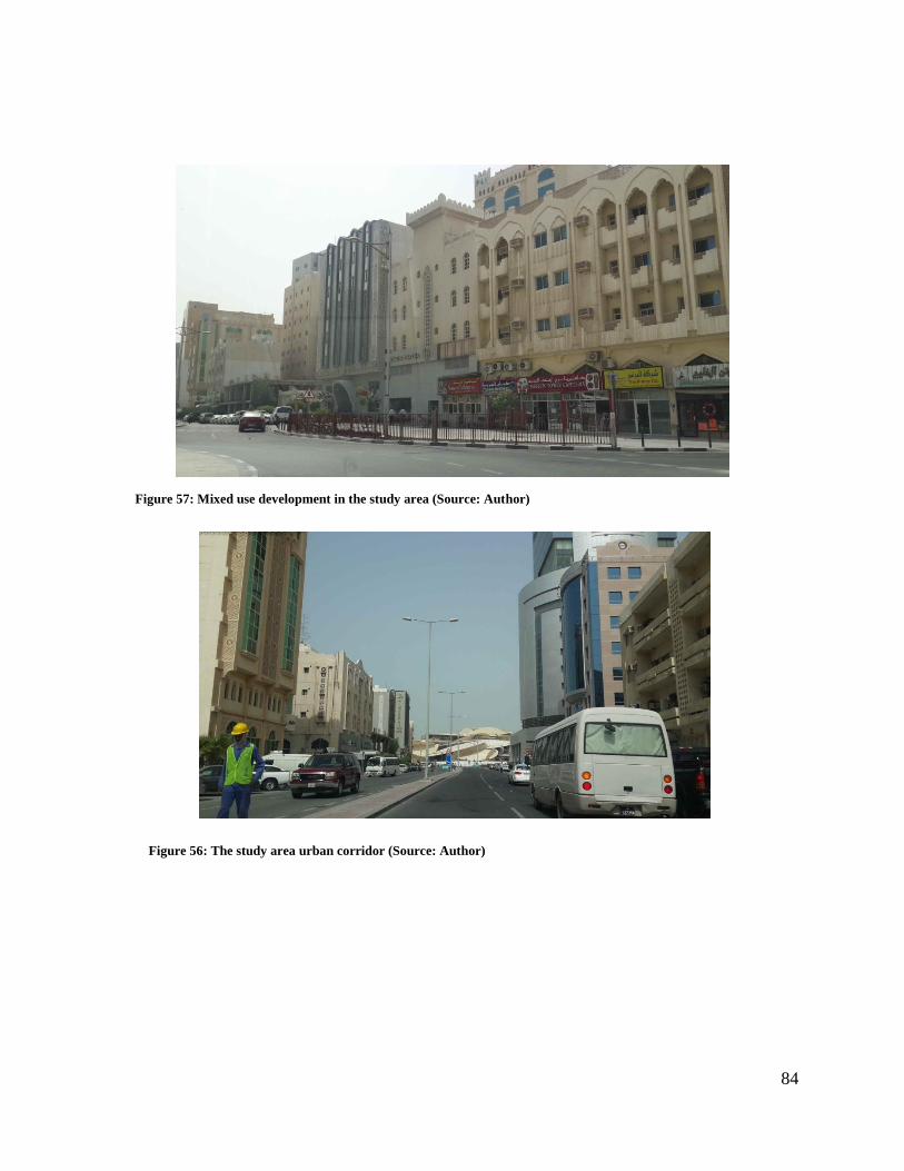
84
Figure 57: Mixed use development in the study area (Source: Author)
Figure 56: The study area urban corridor (Source: Author)
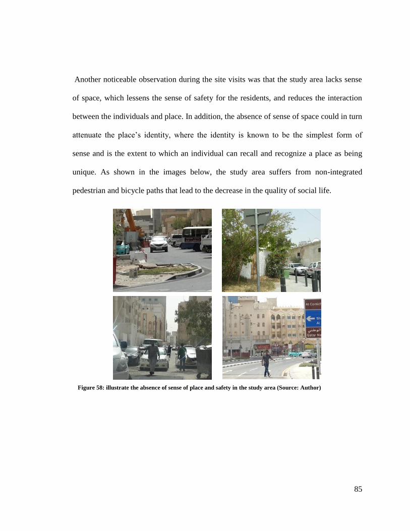
85
Another noticeable observation during the site visits was that the study area lacks sense
of space, which lessens the sense of safety for the residents, and reduces the interaction
between the individuals and place. In addition, the absence of sense of space could in turn
attenuate the place‟s identity, where the identity is known to be the simplest form of
sense and is the extent to which an individual can recall and recognize a place as being
unique. As shown in the images below, the study area suffers from non-integrated
pedestrian and bicycle paths that lead to the decrease in the quality of social life.
Figure 58: illustrate the absence of sense of place and safety in the study area (Source: Author)
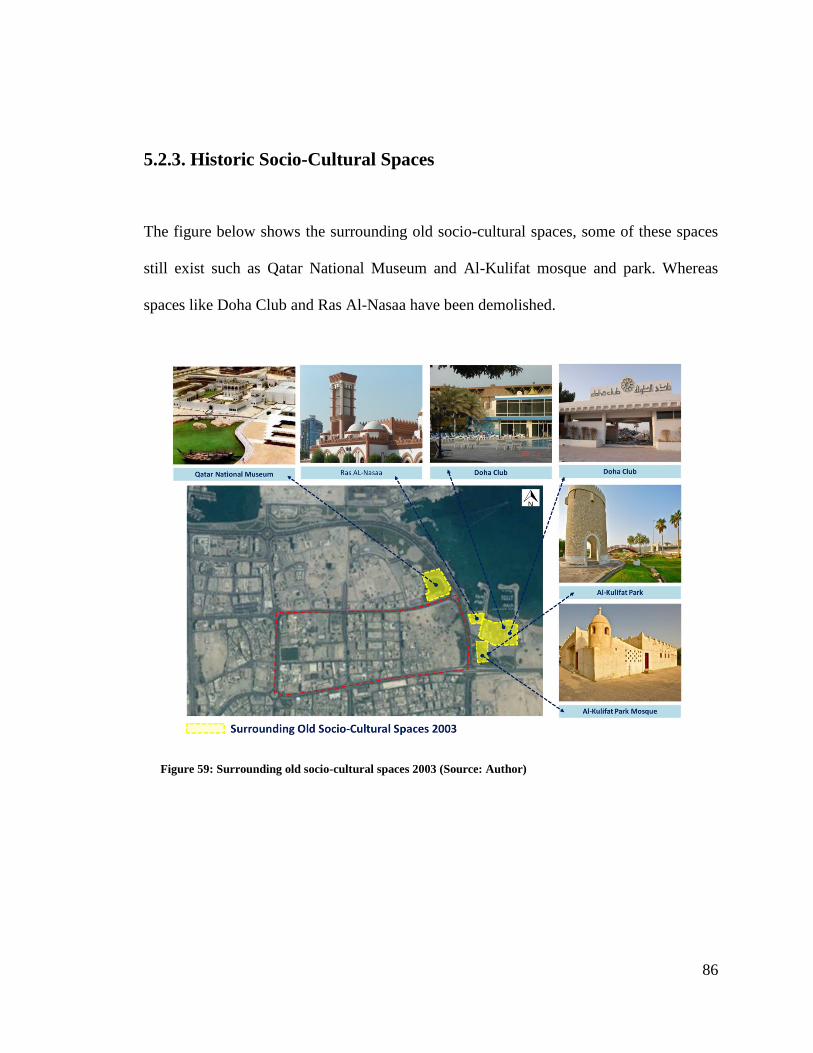
86
5.2.3. Historic Socio-Cultural Spaces
The figure below shows the surrounding old socio-cultural spaces, some of these spaces
still exist such as Qatar National Museum and Al-Kulifat mosque and park. Whereas
spaces like Doha Club and Ras Al-Nasaa have been demolished.
Figure 59: Surrounding old socio-cultural spaces 2003 (Source: Author)
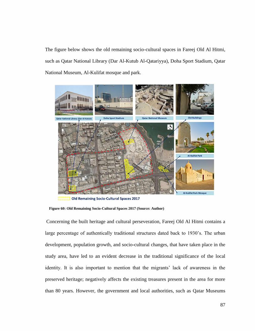
87
The figure below shows the old remaining socio-cultural spaces in Fareej Old Al Hitmi,
such as Qatar National Library (Dar Al-Kutub Al-Qatariyya), Doha Sport Stadium, Qatar
National Museum, Al-Kulifat mosque and park.
Concerning the built heritage and cultural perseveration, Fareej Old Al Hitmi contains a
large percentage of authentically traditional structures dated back to 1930‟s. The urban
development, population growth, and socio-cultural changes, that have taken place in the
study area, have led to an evident decrease in the traditional significance of the local
identity. It is also important to mention that the migrants‟ lack of awareness in the
preserved heritage; negatively affects the existing treasures present in the area for more
than 80 years. However, the government and local authorities, such as Qatar Museums
Figure 60: Old Remaining Socio-Cultural Spaces 2017 (Source: Author)
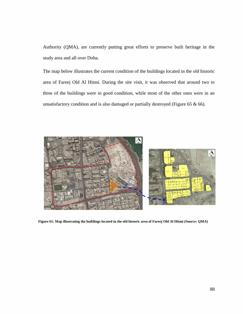
88
Authority (QMA), are currently putting great efforts to preserve built heritage in the
study area and all over Doha.
The map below illustrates the current condition of the buildings located in the old historic
area of Fareej Old Al Hitmi. During the site visit, it was observed that around two to
three of the buildings were in good condition, while most of the other ones were in an
unsatisfactory condition and is also damaged or partially destroyed (Figure 65 & 66).
Figure 61: Map illustrating the buildings located in the old historic area of Fareej Old Al Hitmi (Source: QMA)
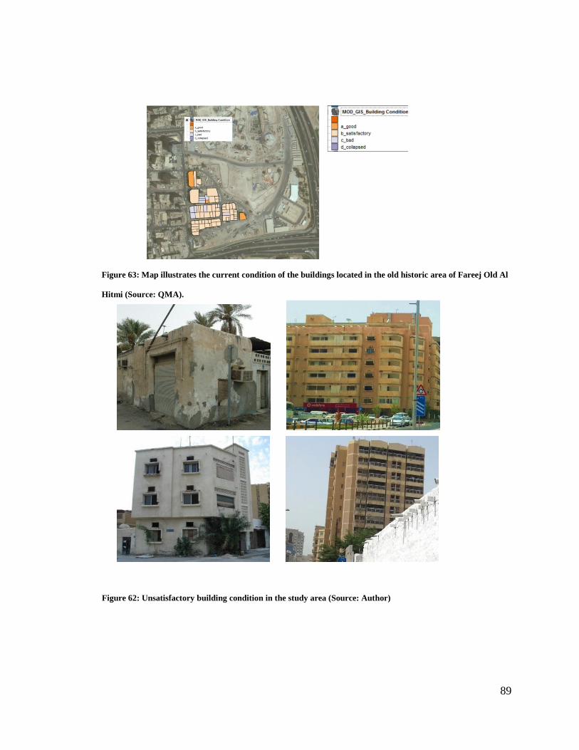
89
Figure 63: Map illustrates the current condition of the buildings located in the old historic area of Fareej Old Al
Hitmi (Source: QMA).
Figure 62: Unsatisfactory building condition in the study area (Source: Author)
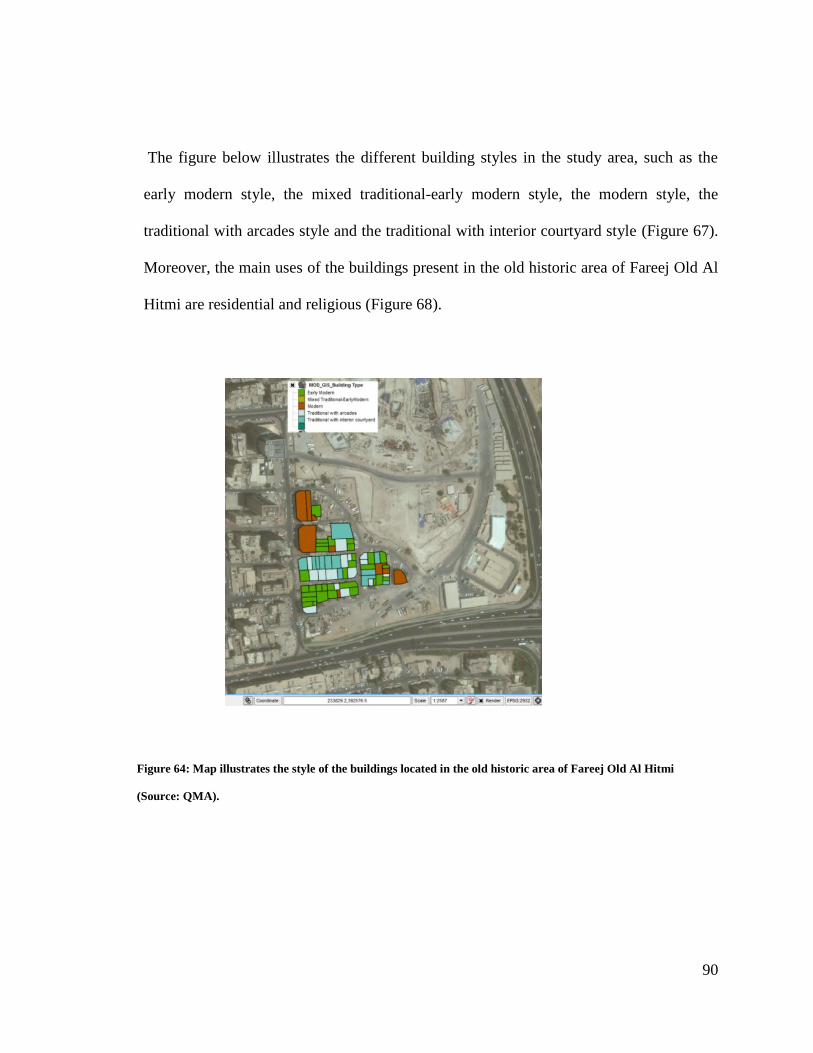
90
The figure below illustrates the different building styles in the study area, such as the
early modern style, the mixed traditional-early modern style, the modern style, the
traditional with arcades style and the traditional with interior courtyard style (Figure 67).
Moreover, the main uses of the buildings present in the old historic area of Fareej Old Al
Hitmi are residential and religious (Figure 68).
Figure 64: Map illustrates the style of the buildings located in the old historic area of Fareej Old Al Hitmi
(Source: QMA).
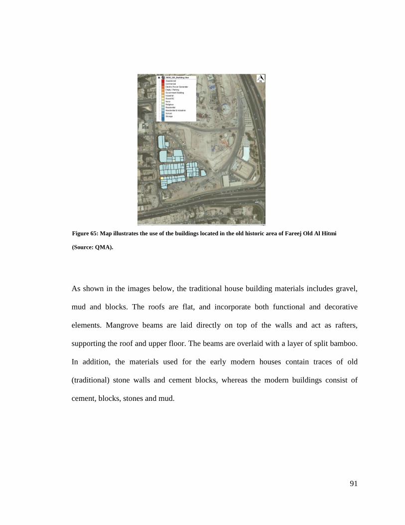
91
As shown in the images below, the traditional house building materials includes gravel,
mud and blocks. The roofs are flat, and incorporate both functional and decorative
elements. Mangrove beams are laid directly on top of the walls and act as rafters,
supporting the roof and upper floor. The beams are overlaid with a layer of split bamboo.
In addition, the materials used for the early modern houses contain traces of old
(traditional) stone walls and cement blocks, whereas the modern buildings consist of
cement, blocks, stones and mud.
Figure 65: Map illustrates the use of the buildings located in the old historic area of Fareej Old Al Hitmi
(Source: QMA).
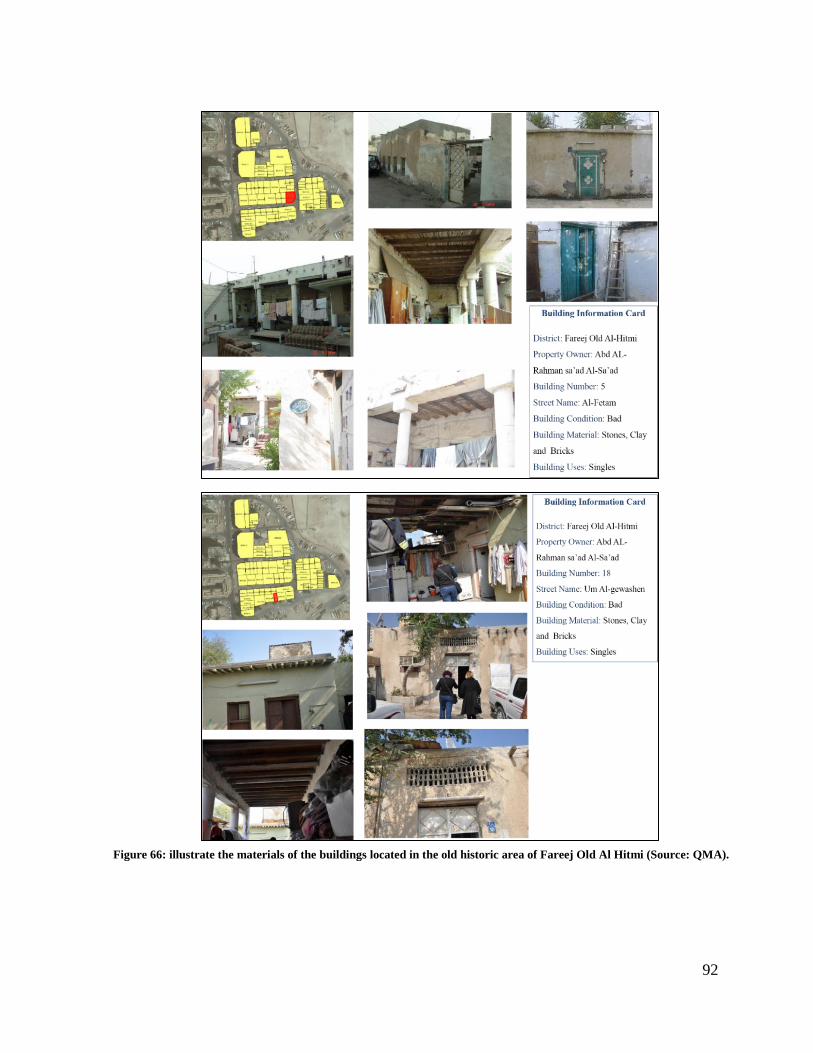
92
Figure 66: illustrate the materials of the buildings located in the old historic area of Fareej Old Al Hitmi (Source: QMA).

93
5.3. Site Observation
The table below shows the results of the observation conducted in the study area.
Table 8: Observation Checklist Results
Principle Indicator Status Comments
Social
Interaction
Sense of place and character + The old and new Qatar National
Museums are well integrated
Choice of social activities \ Limited to isolated social activities
Human-scaled public square - Does not exist
Accessible parks and green \ Rarely exist
Public playgrounds \ Rarely exist
Visual access to public spaces „eyes on the streets‟ - Not considered
Pedestrian-friendly - Not considered
Walkability Car-free streets where possible - Not considered
Human-scaled public realm \ Rarely exist
Public amenities located within 5 to 10 minutes walking
distance - Not considered
Well-connected public spaces - Not considered
Connectivity
and
Accessibility
Hierarchy of boulevards, streets, and alleys - Not considered
Integrated pedestrian network - Not considered
Integrated bicycle lanes - Not considered
Integrated and accessible public transportation \ Karwa bus network
The future metro station
Integrated street network to distribute traffic - Not considered
Density of land uses within close proximity \ Rarely exist
Density and
Diversity of
Land Uses
Mixed uses within neighborhood development + Exist
Mixed uses within buildings \ Rarely exist
Mixed housing types \ Rarely exist
94
5.4. Survey Analysis
A total of 103 residents have participated in the questionnaire survey. The survey was
distributed to residents living in different neighborhoods around Doha. The decision to
target different districts was taken in order to gain a wider knowledge of the society‟s
perception in regards to the activities that encourage social interaction. The main focus of
the questionnaire was on the resident‟s perception of their neighborhoods, their level of
satisfaction, the neighborhood‟s requirements to have integrated socio-cultural spaces,
and their perception of the social activities that will encourage the community to gather
together and interact. The questionnaire is divided into two distinctive sections, the first
section includes the personal information, while, the second section includes the
necessary information regarding the socio-cultural spaces and interaction in the
neighborhood.
In total, the participants were 54 % Female and 46 % Male. About 40 % of respondents
were single, while 55 % were married and 5 % were divorced. The majority of
participants were adults, as 45 % of them age between 26-35 years old, 25 % were
between the ages of 18-25 years old, 17% between 36-45 years old, 10% were between
46-55 years old, and the remaining 3 % were more than 55 years old. Regarding the
participants‟ nationalities, Arabs made up 52 % of the sample, Qataris constituted 19 %,
Asians amounted to 14 %, whereas, Americans, Europeans, and Australian took up the
remaining 15 % of the sample (Figure 70 & 71 ).
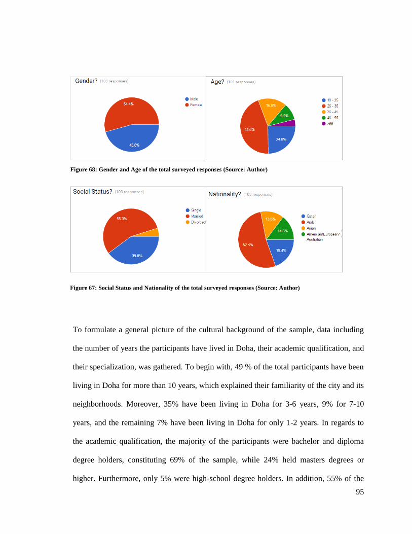
95
To formulate a general picture of the cultural background of the sample, data including
the number of years the participants have lived in Doha, their academic qualification, and
their specialization, was gathered. To begin with, 49 % of the total participants have been
living in Doha for more than 10 years, which explained their familiarity of the city and its
neighborhoods. Moreover, 35% have been living in Doha for 3-6 years, 9% for 7-10
years, and the remaining 7% have been living in Doha for only 1-2 years. In regards to
the academic qualification, the majority of the participants were bachelor and diploma
degree holders, constituting 69% of the sample, while 24% held masters degrees or
higher. Furthermore, only 5% were high-school degree holders. In addition, 55% of the
Figure 68: Gender and Age of the total surveyed responses (Source: Author)
Figure 67: Social Status and Nationality of the total surveyed responses (Source: Author)
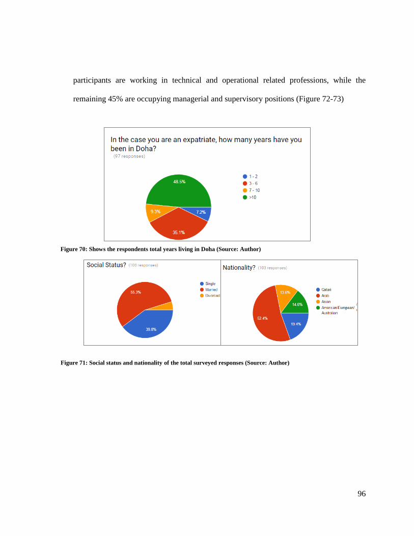
96
participants are working in technical and operational related professions, while the
remaining 45% are occupying managerial and supervisory positions (Figure 72-73)
Figure 70: Shows the respondents total years living in Doha (Source: Author)
Figure 69: The total years living in Doha of the survey respondent (Source: Author)
Figure 71: Social status and nationality of the total surveyed responses (Source: Author)
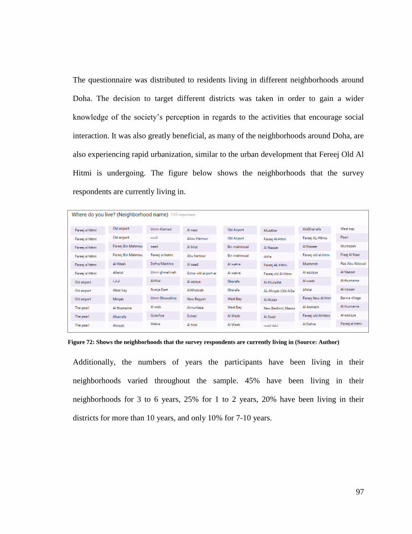
97
The questionnaire was distributed to residents living in different neighborhoods around
Doha. The decision to target different districts was taken in order to gain a wider
knowledge of the society‟s perception in regards to the activities that encourage social
interaction. It was also greatly beneficial, as many of the neighborhoods around Doha, are
also experiencing rapid urbanization, similar to the urban development that Fereej Old Al
Hitmi is undergoing. The figure below shows the neighborhoods that the survey
respondents are currently living in.
Additionally, the numbers of years the participants have been living in their
neighborhoods varied throughout the sample. 45% have been living in their
neighborhoods for 3 to 6 years, 25% for 1 to 2 years, 20% have been living in their
districts for more than 10 years, and only 10% for 7-10 years.
Figure 72: Shows the neighborhoods that the survey respondents are currently living in (Source: Author)
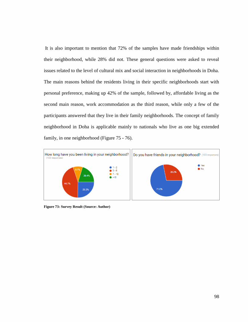
98
It is also important to mention that 72% of the samples have made friendships within
their neighborhood, while 28% did not. These general questions were asked to reveal
issues related to the level of cultural mix and social interaction in neighborhoods in Doha.
The main reasons behind the residents living in their specific neighborhoods start with
personal preference, making up 42% of the sample, followed by, affordable living as the
second main reason, work accommodation as the third reason, while only a few of the
participants answered that they live in their family neighborhoods. The concept of family
neighborhood in Doha is applicable mainly to nationals who live as one big extended
family, in one neighborhood (Figure 75 - 76).
Figure 73: Survey Result (Source: Author)
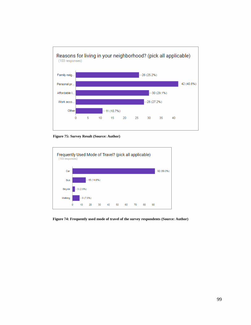
99
Figure 75: Survey Result (Source: Author)
Figure 74: Frequently used mode of travel of the survey respondents (Source: Author)
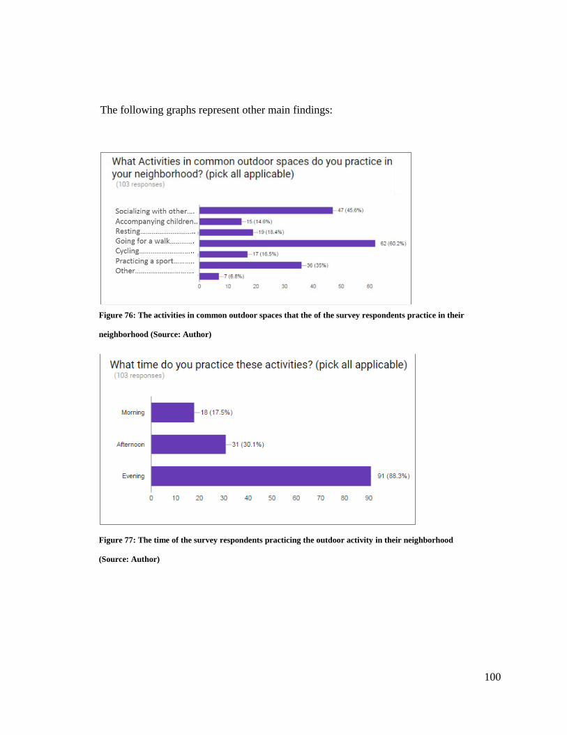
100
The following graphs represent other main findings:
Figure 76: The activities in common outdoor spaces that the of the survey respondents practice in their
neighborhood (Source: Author)
Figure 77: The time of the survey respondents practicing the outdoor activity in their neighborhood
(Source: Author)
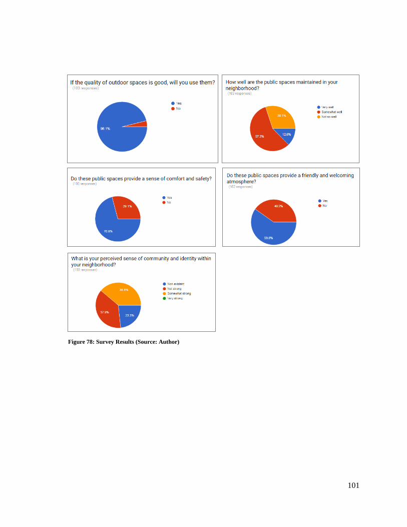
101
Figure 78: Survey Results (Source: Author)
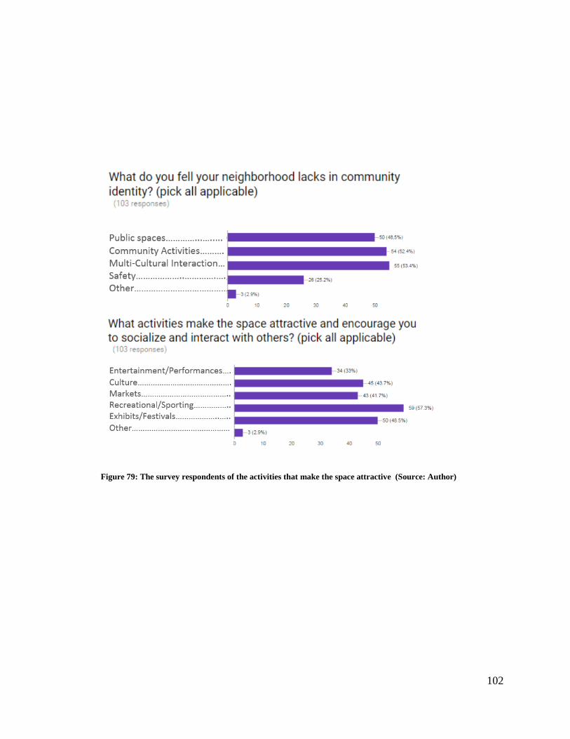
102
Figure 79: The survey respondents of the activities that make the space attractive (Source: Author)
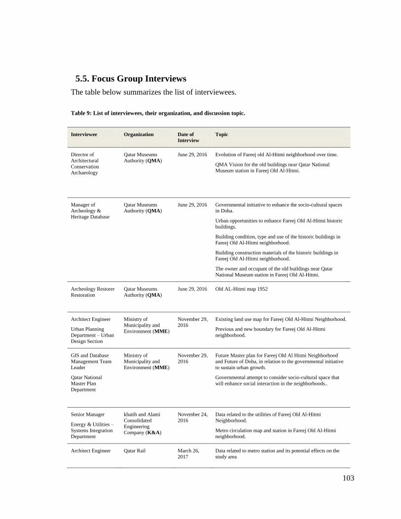
103
5.5. Focus Group Interviews
The table below summarizes the list of interviewees.
Table 9: List of interviewees, their organization, and discussion topic.
Interviewee Organization Date of
Interview
Topic
Director of
Architectural
Conservation Archaeology
Qatar Museums
Authority (QMA)
June 29, 2016 Evolution of Fareej old Al-Hitmi neighborhood over time.
QMA Vision for the old buildings near Qatar National
Museum station in Fareej Old Al-Hitmi.
Manager of Archeology &
Heritage Database
Qatar Museums Authority (QMA)
June 29, 2016 Governmental initiative to enhance the socio-cultural spaces in Doha.
Urban opportunities to enhance Fareej Old Al-Hitmi historic
buildings.
Building condition, type and use of the historic buildings in
Fareej Old Al-Hitmi neighborhood.
Building construction materials of the historic buildings in Fareej Old Al-Hitmi neighborhood.
The owner and occupant of the old buildings near Qatar
National Museum station in Fareej Old Al-Hitmi.
Archeology Restorer
Restoration
Qatar Museums
Authority (QMA)
June 29, 2016 Old AL-Hitmi map 1952
Architect Engineer
Urban Planning
Department – Urban
Design Section
Ministry of Municipality and
Environment (MME)
November 29, 2016
Existing land use map for Fareej Old Al-Hitmi Neighborhood.
Previous and new boundary for Fareej Old Al-Hitmi
neighborhood.
GIS and Database
Management Team
Leader
Qatar National
Master Plan
Department
Ministry of
Municipality and
Environment (MME)
November 29,
2016
Future Master plan for Fareej Old Al Hitmi Neighborhood
and Future of Doha, in relation to the governmental initiative
to sustain urban growth.
Governmental attempt to consider socio-cultural space that
will enhance social interaction in the neighborhoods..
Senior Manager
Energy & Utilities –
Systems Integration Department
khatib and Alami
Consolidated
Engineering Company (K&A)
November 24,
2016
Data related to the utilities of Fareej Old Al-Hitmi
Neighborhood.
Metro circulation map and station in Fareej Old Al-Hitmi neighborhood.
Architect Engineer
Qatar Rail March 26,
2017
Data related to metro station and its potential effects on the
study area
104
CHAPTER 6: CONCLUSION AND RECOMMENDATIONS
It has been concluded that the study area clearly lacks integrated socio-cultural spaces
and suffers from low levels of social interaction. This chapter presents a thorough
discussion of possible approaches and guidelines to achieve integrated socio-cultural
spaces, and to promote socio-cultural interaction and engagement in the study area.
6.1. Answers to Research Questions
The aim of this thesis was to investigate the impact of the rapid urban development on the
socio-cultural spaces in Fareej Old Al-Hitmi in Doha and evaluate the current socio-
cultural spaces within the study area. The objective is to develop an approach to enhance
the socio-cultural spaces, and to promote social interaction and engagement in urban life
over a set of design guidelines and recommendations.
The following table shows the research questions and how it was answered to respond to
the above mentioned aims and objectives of the thesis through a mixed methods approach
involving a combination of both quantitative and qualitative analyses through three steps:
(1) Theoretical study, by examining different topics and disciplines (2) Applied and
analytical study through site observation, field notes, and photographs (3) Structured
questionnaires and interviews with professionals from local planning authorities and
engineering companies.
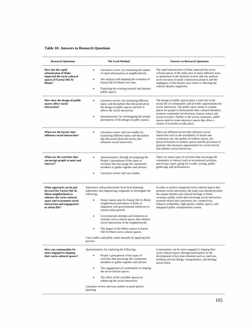
105
Table 10: Answers to Research Questions
Research Questions The Used Method Answers to Research Questions
How has the rapid
urbanization of Doha
impacted the socio-cultural
spaces of Fareej Old Al-
Hitmi?
Literature review, by examining the impact
of rapid urbanization on neighborhoods.
Site analysis and mapping the evolution of
Fareej Old Al-Hitmi over time.
Exploring the existing external and internal
public spaces.
The rapid urbanization of Doha impacted the socio-
cultural spaces of the study area in many different ways
as mentioned in the literature review and site analysis
such execution of multi construction projects and the
negligence of the historic area which is affecting the
cultural identity negatively.
How does the design of public
spaces affect social
interaction?
Literature review, by examining different
topics and disciplines that discussed about
the design of public spaces and how it
affects the social interaction.
Questionnaires, by investigating the people
perceptions of the design of public spaces.
The design of public spaces plays a vital role in the
social life of communities and provides opportunities for
social interaction. The public space needs to contain
places for people to demonstrate their cultural identities,
promote community involvement, human contact and
social activities. Further to the survey responses, public
spaces need to create attractive spaces that allow a
variety of activities to take place.
What are the factors that
influence social interaction?
Literature review and case studies by
examining different topics and disciplines
that discussed about the factors that
influence social interaction.
There are different factors that influence social
interaction such as the availability of mixed and
continuous use, the quality of outdoor spaces, the
physical features in outdoor spaces and the provision of
greenery that increases opportunities for social activity
and enhance social interaction.
What are the activities that
encourage people to meet and
interact?
Questionnaires, through investigating the
People‟s perceptions of the types of
activities that encourage the community
members to gather together and interact.
Literature review and case studies
There are many types of activities that encourage the
community to interact such as recreational activities,
practicing a sport, going for a walk, cycling, public
gatherings and performances.
What approach can be put
forward for Fareej Old Al-
Hitmi neighborhood to
enhance the socio-cultural
space and to promote social
interaction and engagement
in urban life?
Interviews with professionals from local planning
authorities and engineering companies to investigate the
following:
Future master plan for Fareej Old Al-Hitmi
neighborhood and future of Doha in
alignment with governmental initiatives to
sustain urban growth.
Governmental attempts and initiatives to
consider socio-cultural spaces that enhance
social interactions in the neighborhoods.
The impact of the Metro station in Fareej
Old Al-Hitmi socio-cultural spaces.
Case studies and public realm manuals by applying best
practice.
In order to achieve integrated socio-cultural spaces that
promote social interaction, the study area should promote
the unique identity and cultural heritage of Doha,
creating a public realm that encourage social interaction,
promote mixed and continuous use, connectivity,
enhance walkability, high quality outdoor spaces, and
integrated public transportation system.
How can communities be
more engaged in shaping
their socio-cultural spaces?
Questionnaires, by exploring the following:
People‟s perceptions of the types of
activities that encourage the community
members to gather together and interact.
The engagement of communities in shaping
the socio-cultural spaces.
The effect of the available spaces on
enhancing the social interaction.
Literature review and case studies on participative
planning.
Communities can be more engaged in shaping their
socio-cultural spaces through participation in the
development of key plan elements such as, land use,
building and site design, transportation, and heritage
preservation.
106
The answers to the research questions allow confirming the research hypotheses that the
availability of integrated urban design processes that adopt integrated socio-cultural
spaces will promote social interaction. Furthermore, social outdoor activities can increase
social interaction and co-existence of various groups of people and finally, there is a
relation between the neighborhood urban design and the sense of neighborhood identity
and place.
6.2. Recommendations towards Integrated Socio Cultural Space
A set of recommendations and discussion of possible approaches and guidelines were
developed to achieve integrated socio-cultural spaces, and to promote socio-cultural
interaction and engagement in Fareej Old Al-Hitmi in Doha.
6.2.1. Socio-Cultural Interaction and Identity
The study area should promote the unique identity and cultural heritage of Doha, by
encouraging innovative design while still preserving Qatar‟s architectural heritage;
incorporating public art installations that reflect the community‟s identity; and by
providing areas for public gatherings and performances. It is recommended that the
Fareej style is brought back to the study area but by also simultaneously taking into
consideration the new generation‟s needs. The arrangement of Mosques should also be
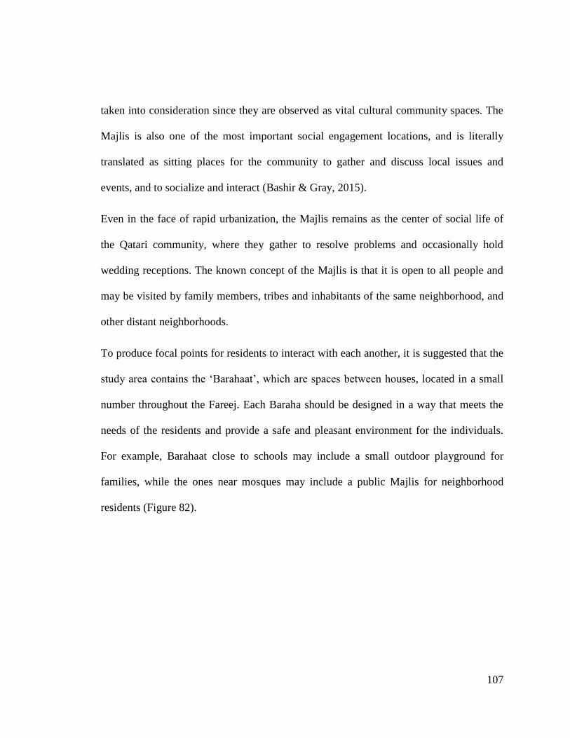
107
taken into consideration since they are observed as vital cultural community spaces. The
Majlis is also one of the most important social engagement locations, and is literally
translated as sitting places for the community to gather and discuss local issues and
events, and to socialize and interact (Bashir & Gray, 2015).
Even in the face of rapid urbanization, the Majlis remains as the center of social life of
the Qatari community, where they gather to resolve problems and occasionally hold
wedding receptions. The known concept of the Majlis is that it is open to all people and
may be visited by family members, tribes and inhabitants of the same neighborhood, and
other distant neighborhoods.
To produce focal points for residents to interact with each another, it is suggested that the
study area contains the „Barahaat‟, which are spaces between houses, located in a small
number throughout the Fareej. Each Baraha should be designed in a way that meets the
needs of the residents and provide a safe and pleasant environment for the individuals.
For example, Barahaat close to schools may include a small outdoor playground for
families, while the ones near mosques may include a public Majlis for neighborhood
residents (Figure 82).
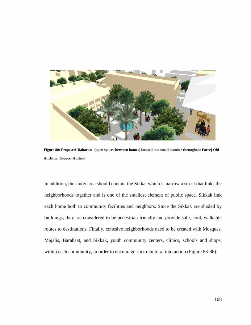
108
In addition, the study area should contain the Sikka, which is narrow a street that links the
neighborhoods together and is one of the smallest element of public space. Sikkak link
each home both to community facilities and neighbors. Since the Sikkak are shaded by
buildings, they are considered to be pedestrian friendly and provide safe, cool, walkable
routes to destinations. Finally, cohesive neighborhoods need to be created with Mosques,
Majalis, Barahaat, and Sikkak, youth community centers, clinics, schools and shops,
within each community, in order to encourage socio-cultural interaction (Figure 83-86).
Figure 80: Proposed 'Baharaat' (open spaces between homes) located in a small number throughout Fareej Old
Al Hitmi (Source: Author)
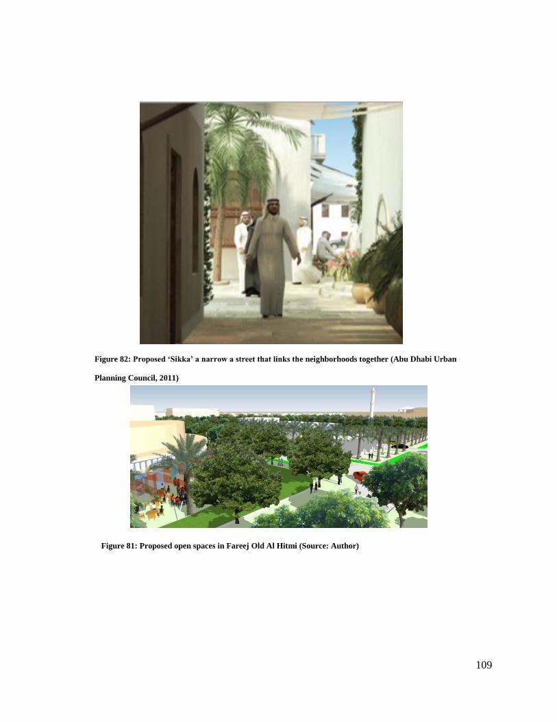
109
Figure 82: Proposed ‘Sikka’ a narrow a street that links the neighborhoods together (Abu Dhabi Urban
Planning Council, 2011)
Figure 81: Proposed open spaces in Fareej Old Al Hitmi (Source: Author)
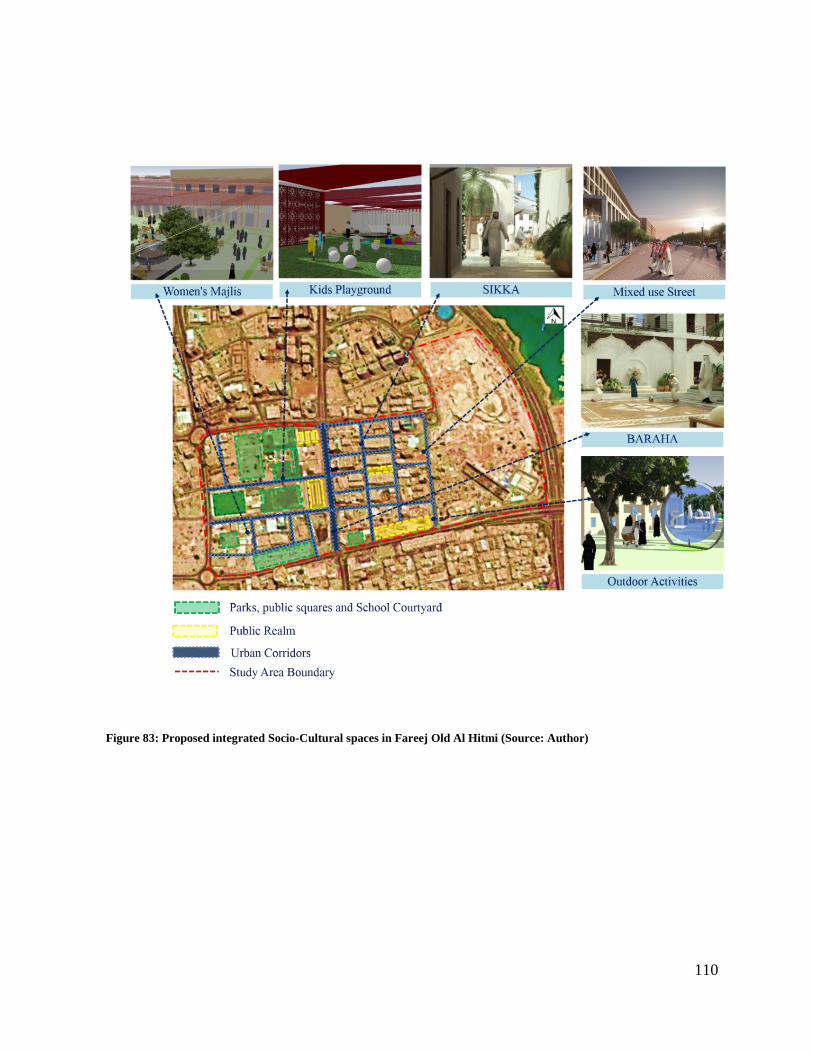
110
Figure 83: Proposed integrated Socio-Cultural spaces in Fareej Old Al Hitmi (Source: Author)
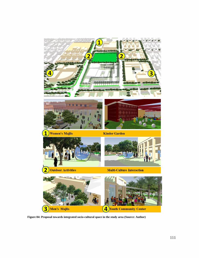
111
Figure 84: Proposal towards integrated socio-cultural space in the study area (Source: Author)
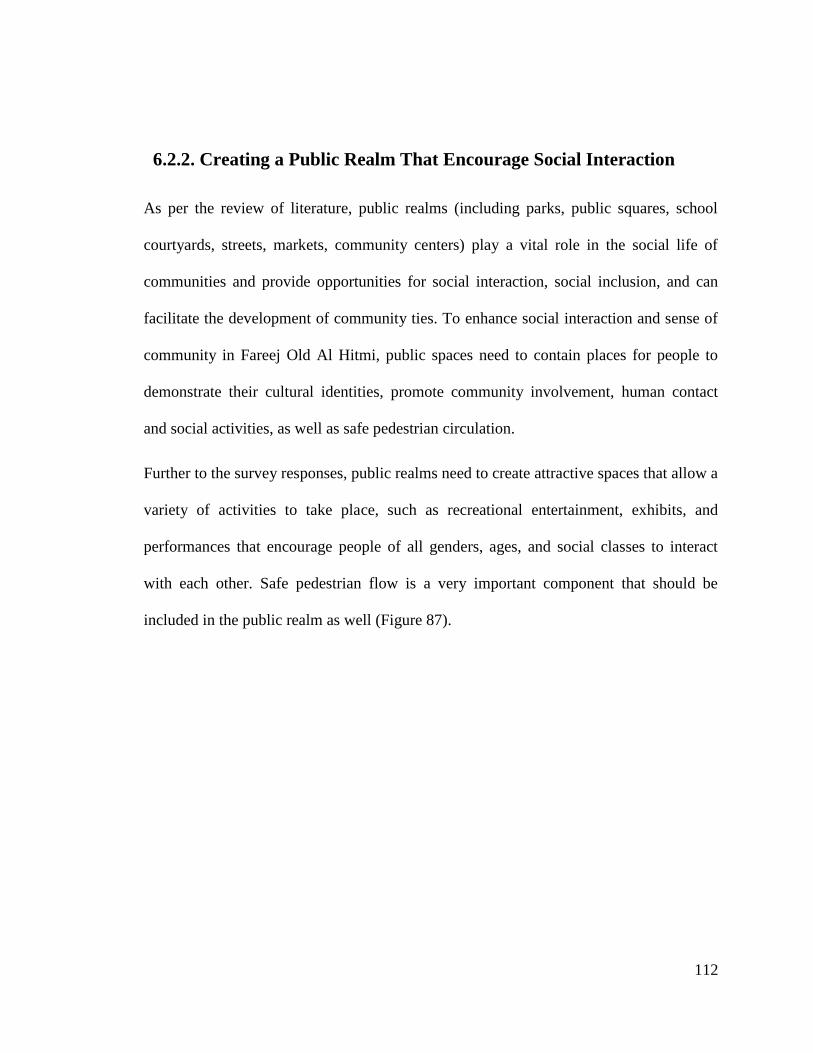
112
6.2.2. Creating a Public Realm That Encourage Social Interaction
As per the review of literature, public realms (including parks, public squares, school
courtyards, streets, markets, community centers) play a vital role in the social life of
communities and provide opportunities for social interaction, social inclusion, and can
facilitate the development of community ties. To enhance social interaction and sense of
community in Fareej Old Al Hitmi, public spaces need to contain places for people to
demonstrate their cultural identities, promote community involvement, human contact
and social activities, as well as safe pedestrian circulation.
Further to the survey responses, public realms need to create attractive spaces that allow a
variety of activities to take place, such as recreational entertainment, exhibits, and
performances that encourage people of all genders, ages, and social classes to interact
with each other. Safe pedestrian flow is a very important component that should be
included in the public realm as well (Figure 87).
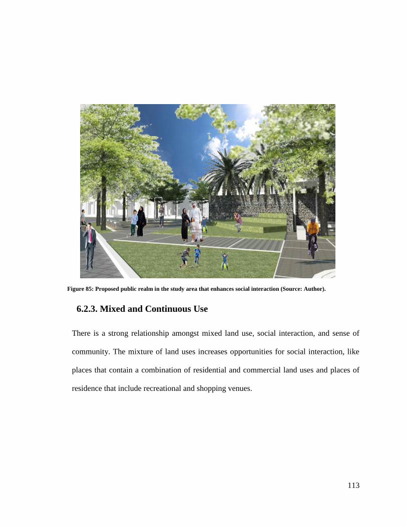
113
6.2.3. Mixed and Continuous Use
There is a strong relationship amongst mixed land use, social interaction, and sense of
community. The mixture of land uses increases opportunities for social interaction, like
places that contain a combination of residential and commercial land uses and places of
residence that include recreational and shopping venues.
Figure 85: Proposed public realm in the study area that enhances social interaction (Source: Author).
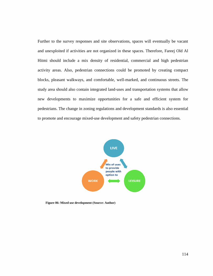
114
Further to the survey responses and site observations, spaces will eventually be vacant
and unexploited if activities are not organized in these spaces. Therefore, Fareej Old Al
Hitmi should include a mix density of residential, commercial and high pedestrian
activity areas. Also, pedestrian connections could be promoted by creating compact
blocks, pleasant walkways, and comfortable, well-marked, and continuous streets. The
study area should also contain integrated land-uses and transportation systems that allow
new developments to maximize opportunities for a safe and efficient system for
pedestrians. The change in zoning regulations and development standards is also essential
to promote and encourage mixed-use development and safety pedestrian connections.
Figure 86: Mixed use development (Source: Author)
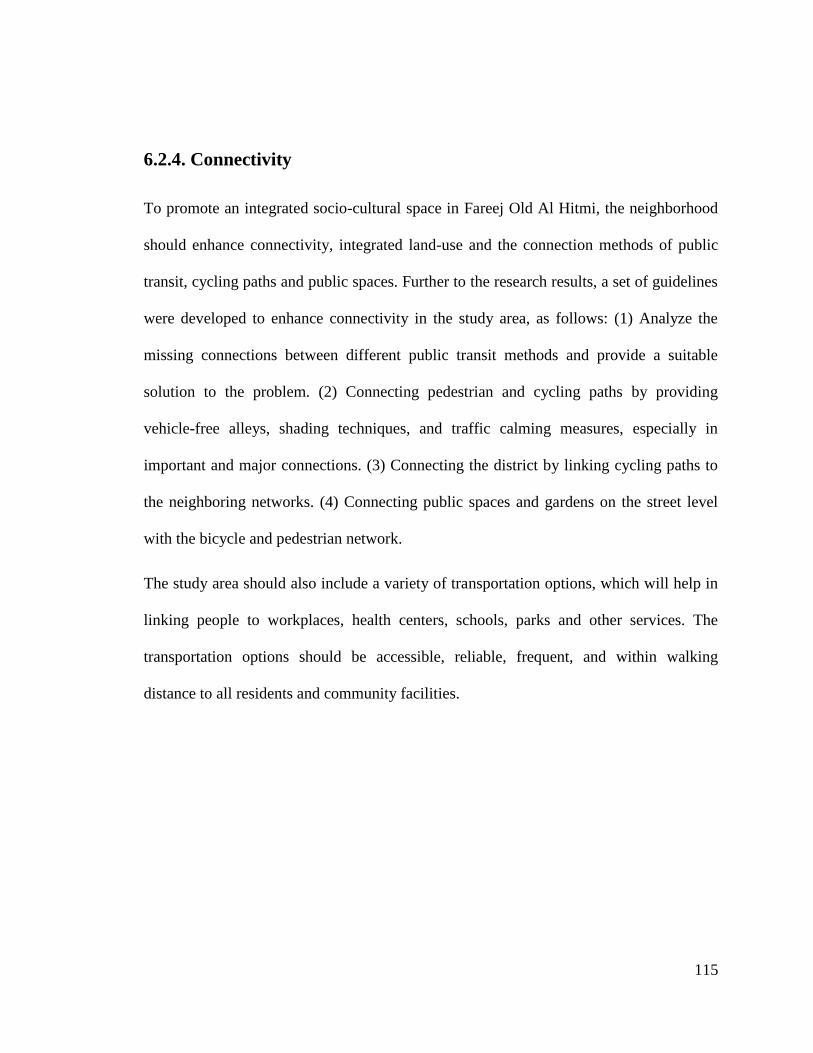
115
6.2.4. Connectivity
To promote an integrated socio-cultural space in Fareej Old Al Hitmi, the neighborhood
should enhance connectivity, integrated land-use and the connection methods of public
transit, cycling paths and public spaces. Further to the research results, a set of guidelines
were developed to enhance connectivity in the study area, as follows: (1) Analyze the
missing connections between different public transit methods and provide a suitable
solution to the problem. (2) Connecting pedestrian and cycling paths by providing
vehicle-free alleys, shading techniques, and traffic calming measures, especially in
important and major connections. (3) Connecting the district by linking cycling paths to
the neighboring networks. (4) Connecting public spaces and gardens on the street level
with the bicycle and pedestrian network.
The study area should also include a variety of transportation options, which will help in
linking people to workplaces, health centers, schools, parks and other services. The
transportation options should be accessible, reliable, frequent, and within walking
distance to all residents and community facilities.
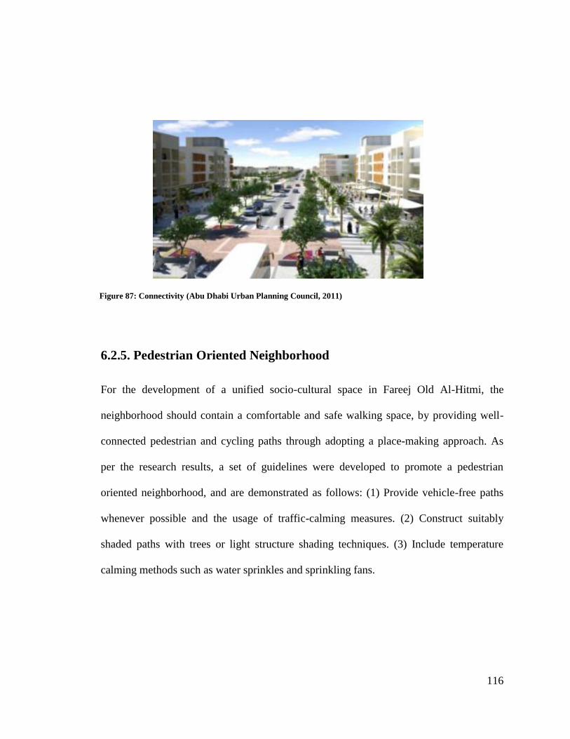
116
6.2.5. Pedestrian Oriented Neighborhood
For the development of a unified socio-cultural space in Fareej Old Al-Hitmi, the
neighborhood should contain a comfortable and safe walking space, by providing well-
connected pedestrian and cycling paths through adopting a place-making approach. As
per the research results, a set of guidelines were developed to promote a pedestrian
oriented neighborhood, and are demonstrated as follows: (1) Provide vehicle-free paths
whenever possible and the usage of traffic-calming measures. (2) Construct suitably
shaded paths with trees or light structure shading techniques. (3) Include temperature
calming methods such as water sprinkles and sprinkling fans.
Figure 87: Connectivity (Abu Dhabi Urban Planning Council, 2011)
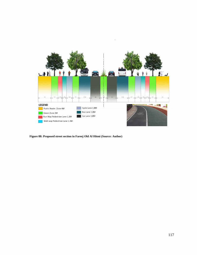
117
Figure 88: Proposed street section in Fareej Old Al Hitmi (Source: Author)
118
6.2.6. Physical Features
The study area should contain high-quality outdoor spaces that promote social interaction
by attracting people to spend time in the open air and motivate residents to interact with
one another. It was also observed that, the more time people spent outdoors, the more
likely they are to engage in activities. The visual appearance of common outdoor spaces
is vital to develop neighborhood relations. Physical features are recognized as efficient
design features in outdoor spaces that encourage human socialization. Appealing features
such as properly arranged seats and water feature also encourage the use of public space.
In addition, the provision of greenery in the neighborhood increases opportunities for
social activity and enhances social bonding among the residents.
Figure 89: High-quality outdoor spaces that promote social interaction (Source: Author)
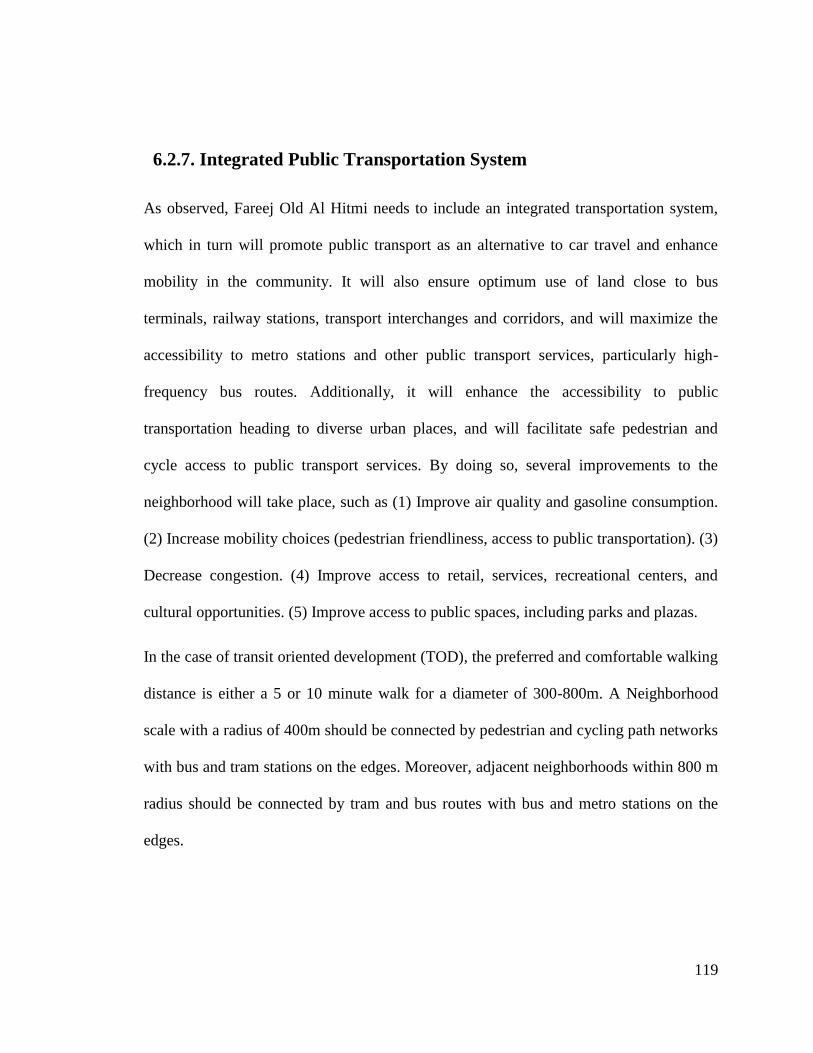
119
6.2.7. Integrated Public Transportation System
As observed, Fareej Old Al Hitmi needs to include an integrated transportation system,
which in turn will promote public transport as an alternative to car travel and enhance
mobility in the community. It will also ensure optimum use of land close to bus
terminals, railway stations, transport interchanges and corridors, and will maximize the
accessibility to metro stations and other public transport services, particularly high-
frequency bus routes. Additionally, it will enhance the accessibility to public
transportation heading to diverse urban places, and will facilitate safe pedestrian and
cycle access to public transport services. By doing so, several improvements to the
neighborhood will take place, such as (1) Improve air quality and gasoline consumption.
(2) Increase mobility choices (pedestrian friendliness, access to public transportation). (3)
Decrease congestion. (4) Improve access to retail, services, recreational centers, and
cultural opportunities. (5) Improve access to public spaces, including parks and plazas.
In the case of transit oriented development (TOD), the preferred and comfortable walking
distance is either a 5 or 10 minute walk for a diameter of 300-800m. A Neighborhood
scale with a radius of 400m should be connected by pedestrian and cycling path networks
with bus and tram stations on the edges. Moreover, adjacent neighborhoods within 800 m
radius should be connected by tram and bus routes with bus and metro stations on the
edges.
120
Figure 90: TOD design main principles (Source: Author)
121
6.3. Conclusion
Urban development strengthens countries in many different ways, starting with the
greater value it gives to certain areas, by transforming them into international attractions
rather than just local ones. Consequently, regions that are implementing mega projects
are gaining greater tourism popularity and in turn are becoming more recognized on the
world map.
Such urbanization greatly enhances the infrastructure and facilitates the establishment of
various socio-cultural spaces. In addition, the international attention that countries
acquire as a result of the rapid urban development, provide an immense economic boost.
Seeing as how globalization has turned the world into one big village, it is necessary to
provide suitable spaces for traditional cultures and communities to come together. Hence,
to ensure optimal benefits, integrated socio-cultural spaces need to me maintained
throughout the process, in order to enhance social engagement in the neighborhood‟s
urban life as well as promote the sense of neighborhood identity and place.
In recent years, Qatar has been monitoring the rapid development that the country is
undergoing and has incorporated the concept of integrated socio-cultural spaces in its
national 2030 vision. Even though the conservation of cultural traditions is a great
challenge, the government is on the path of establishing utter harmony among economic
expansion, communal development, and cultural individuality. Accordingly, this will lead
to better social interaction and engagement and will encourage a community that
122
embraces goodwill and equality for all. As a result, the ultimate goal is to successfully
implement the discussed and recommended guidelines in this thesis, to establish and
maintain integrated socio-cultural spaces in Fareej Old Al Hitmi, and in Qatar as a whole.
6.4. Limitation of the Research and Opportunity for Future Study
The hypothesis put forward in the this research concerning a historic neighborhood and
its rapid evolution, and the analysis and recommendations proposed towards enhancing
the socio-cultural spaces in Fareej Old Al Hitmi were limited by a number of factors.
There is a limitation on available data on the current situation, land ownership and future
project from local planning authorities or consultants, which are treated with high
confidentiality, especially with regard to the future development, therefore, the
mentioned recommendation and guidelines is a conceptual contribution to the ongoing
discussion to achieve an integrated socio-cultural space that enhances and promotes
social interaction and engagement in the study area.
Additionally, the study did not focus on the climatic conditions, which would have
necessitated site visits and questionnaires that differentiate the seasons and times of day
of the use of social-cultural spaces. It is given that while Qatar has extremely hot and arid
climate, it also has a number of months during the year when the climate is very
comfortable for outdoor activities.
This thesis can be further developed in a number of ways by further to investigating
different neighborhoods in Doha that suffer from the same situation as Fareej Old Al
123
Hitmi. A more critical point of view could also look at the erosion or disappearance of
socio-cultural spaces, while also identifying new social cultures and practices in an
evolving society.
The study of the morphologies of the built form and its consequences for the use of social
space, the climate and microclimate, as well as factors such as air and noise pollution and
urban lighting, would additionally inform on these outdoor socio-cultural spaces, and
how these factors influence the vitality of these spaces and the interaction of the
communities in them. In addition, investigating the use of social spaces during day and
night, different days of the week, and different seasons, and exploring further the
different communities and their social practices would further enhance the research and
the recommendations towards more integrated and participative socio-cultural spaces.
124
REFERENCES
Hodges, B., & Swanson, J. (2013). Small Area Plan, Linden Hills Neighborhood.
Minneapolis: Community Planning and.
Town and Country Planning Department. (2006). National Urbanization Policy. Ministry
of Housing and Local Government.
Abu Dhabi Urban Planning Council. (2011). Neighbourhood Planning. Retrieved from
Abu Dhabi Vision: https://www.upc.gov.ae/guidelines/neighbourhood-
planning.aspx?lang=en-US
Abu-Lugod, J. (1999). New york, Chicago, Los Angeles: America's Global Cities.
Adham, K. (2008). Rediscovering the Island: Doha's Urbanity from Pearls to Spectacle,"
in The Evolving Arab City. New York.
Al Buainain, F. (1999). Urbanisation in Qatar: A study of the residential and commercial
land development in Doha City. Salford : University of Salford.
ALkuwari, Y. (2015). Traffic congestion, causes and solutions. Gulf Times.
Almy, D. (2007). Center 14: On Landscape Urbanism. The Center for American
Architecture and Design.
Bashir, H., & Gray, P. W. (2015). Deconstructing Global Citizenship: Political, Cultural,
and Ethical Perspectives. United State of America: Lexington Books.
125
Blowers, A. (1973). The City as a Social System: Unit 7: The Neighbourhood:
Exploration of a Concept. Open University, Milton Keynes.
Boussaa, D. (2014). Al Asmakh historic district in Doha, Qatar: from an urban slum to
living heritage. Journal of Architectural Conservation, 1-14.
Brenner, N., & Elden, S. (2012). Henri Lefebvre, State, Space, World: Selected Essays.
International Journal of Urban and Regional Research.
Brinkhoff, T. (2016, May 3rd). Retrieved from City population:
http://www.citypopulation.de/Qatar.html
Carmona, M. T. (2010). Public Places- Uraban Spaces: The dimensions of Urabn
Design. New York: Architecture Press.
Carmona, M., Tiesdell, S., Heath, T., & Oc, T. (2010). Public Places - Urban Spaces.
The Dimensions of Urban Design. USA: Elsevier Ltd.
Carr, S. F. (2012). Needs in Public Space in M. Carmona and S. Tiesdell. Urban design
reader, PP.230-240.
City of Minneapolis, MN. (2017). Linden Hills Location and General Characteristics.
Retrieved from Minneapolismn:
http://www.ci.minneapolis.mn.us/neighborhoods/lindenhills/index.htm
Claessens, F. (2005). Mapping urban and social space: towards a socio-cultural.
Understanding of the built environment. International conference'Doing, thinking,
feeling home: the mental geography of residential environments. Netherlands:
126
Delft University of Technology, OTB Research Institute for the Built
Environment.
Corner, J. (2006). Landscape Urbanism Reader .
Duany, A. E.-Z. (2000). Suburban Nation: The Rise of Sprawl and the Decline of the
American Dream. San Francisco: North Point.
DubaiAlArab. (2017, April 7). Downtown Dubai. Retrieved from DubaiAlArab:
http://www.dubaialarab.com/2017/04/downtown-dubai.html
Dyer, H., & Ngui, M. (2010). Watch this Space: Designing, Defending, and Sharing
Public Space. Kids can press.
Europlan. (2015, January 20). Retrieved March 29, 2017, from Europlan Football
Magazine: http://www.europlan-online.de/doha-sports-stadium/verein/13464
Farida, N. (2013). Effects of outdoor shared spaces on social interaction in a housing
estate in Algeria.
Gans, H. (1962). The balanced community: Homogeneity or heterogeneity in residential
areas? . Journal of the American Institute of Planners, 176-84.
Gehl, J. (1987). Life between Buildings: Using public spaces.
Gehl, J. (1987). The Life between Buildings.
Goonewardena, K., Kipfer, S., Milgrom, R., & Schmid, C. (2008). Space, Difference,
Everyday Life. Reading Henri Lefebvre. New York and London: Routledge
Taylor and Franic Group.
127
Haas, T. (2008). New Urbanism and Beyond: Designing Cities for the Future. New York:
Rizzoli International.
Habermas, J. (1962). The Structure Transformation of the Public Sphere (translated by
Burger, T & Lawrence, F). Cambridge: MIT Press .
Jaidah, I., & Bourennane, M. (2009). The History of Qatari Architecture. Milan: Skira.
Jodidio, P. (2011). The Aga Khan Historic Cities Programme: Strategies for urban
regeneration.
Kashef, M. (2008). Architects and planners approaches to urban form and design in the
Toronto region: A comparative analysis. Geoforum.
Kelbaugh, D. (2001). Three Urbanisms and the Public Realm. 3rd International Space
Syntax Symposium. Atlanta.
Kuitert, W. (2013). Urban landscape systems understood by geo-history map overlay.
Journal of Landscape Architecture , 54–63.
Lefebvre, H. (2009). State, Space, World. London.
Lockerbie, J. (2005-2016 ). OLD QATAR 02. Retrieved September 13, 2016, from
Catnaps.org: http://www.catnaps.org/islamic/islaqatold2.html
Lockerbie, J. (2016, May 9th). Retrieved from catnaps.org:
http://www.catnaps.org/islamic/planning.html
Loukaitou-Sideris, A., & Banerjee, T. (1998). Urban Design Downtown: Poetics and
Politics of Form. University of California Press, Berkeley, CA.
128
Low, S., & Smith, N. (2006). The Politics of Public Space. New York: Routledge.
Lynch, K. (1972). What time is This Place? Cambridge: MIT Press.
Lynch, K. (1981). A Theory of Good City Form. Cambridge: MA: MIT Press.
Madanipour, A. (2003). Public and Private Spaces of the City. New York: Routledge.
Mcmillan, D., & Chavis, D. (1986). Sense of Community: A Definition and Theory.
Journal of Community Psychology, 6-23.
Mensch, J. (2007). Public Space. Continental Philosophy Review.
Molla, M. B. (2015). Urbanization process in developing countries: A review on urban
ecosystem degradation and public health effect. Apex Journal International .
Montgomery, J. (1998). Making a city: Urbanity, vitality and urban design. Journal of
Urban Design.
Museums, Q. (2016, March 25). National Museum of Qatar_Heritage Meets Innovation.
Retrieved from Qatar Museums: http://www.qm.org.qa/en/project/national-
museum-qatar
Naqy, S. (2000). Dressing up Downtown: Urban Development and Government public
image in Qatar . City and Society.
Nations, U. (1987). UN-Documents.
Nations, U. (2005). World Summit,
http://www.unmillenniumproject.org/press/worldsummit05.htm.
129
Newman, O. (1972). Defensible Space: People and design in the Violent City.
Nsiah-Gyabaah, K. (u.d.). Urbanization Processes – Environmental and Health effects in
Africa. Panel Contribution to the PERN Cyberseminar on Urban Spatial
Expansion.
Oxford Business Group. (2009). The Report- Qatar 2009. Oxford: OBG.
Planells C, G. I. (2014). Traffic congestion in Doha: Causes and solutions. Qatar
construction News.
Qatar Rail. (2016). Doha Metro. Retrieved from Qatar Rail:
http://www.qr.com.qa/English/Projects/Pages/Doha-Metro.aspx
QatarStatisticsAuthority. (2013). Qatar in Figures 2013. Retrieved from
http://www.qsa.gov.qa/eng/publication/qif/2013/qatar_in_figures_2013_English.p
df
Raffaello Furlan, L. F. (2015). The Development of Vital Precincts in Doha: Urban
Regeneration and Socio-Cultural Factors. American Journal of Environmental
Engineering.
Rinnawi, K. (2006). Instant Nationalisim. McArabism, Al Jazeera and transnational
Media in Aarab World. Lanham: University Press of America .
Rogers, G. O., & Sukolratanametee, S. (2009). Neighborhood design and sense of
community: Comparing suburban neighborhoods in Houston Texas. Landscape
and Urban Planning, 325-334.
130
Sakr, N. (2001). Satellite Realms. Transnational Television. Globlization and the Middle
East. London: I.B.Tauris.
Salama, A. M., & Wiedman, F. (2013). Demystifying Doha on architecture and urbanism
in an emerging city. Ashgate Publishing Limited, UK.
Salama, A. M., & Wiedmann, F. (2013). Demystifying Doha On Architecture and
Urbanism in an Emerging City. UK: Ashgate Publishing Limited.
Scholz, F. (1999). Die Kleinen Golfstaaten. Gotha: Justus Perthes Verlag Gotha GmbH.
Steine, F. (2011). Landscape Ecological Urbanism: Origins and Trajectories. Journal of
Landscape Architecture, 333-337.
Tiesdell, S., & Oc, T. (1998). Beyond fortress and panoptic cities - Towards a safer
urban public realm', Environment & Planning B: Planning & Design .
TripAdvisor LLC. (2017). Orient Pearl Restaurant. Retrieved 03 31, 2017, from
TripAdvisor: https://www.tripadvisor.co.uk/LocationPhotoDirectLink-g294009-
d4452397-i163338718-Orient_Pearl_Restaurant-Doha.html
Urban Design Group. (2017). Dubai Downtown & Business Bay. Retrieved from Urban
Design Directory: http://www.urbandesigndirectory.com/projects/dubai-
downtown-business-bay
Viva. (2015). Urban Regeneration. VirginiaTech Metropolitan institute.
Wiedmann, F., Salama, A. M., & Thierstein, A. (2012). Urban Evolution Of The City Of
Doha:an Investigation Into The Impact Of Economic. METU, 29 (2), 35-61.
131
Wolch, J., & Dear, M. (2014). The Power of Geography: How Territory Shapes Social
Life. Boston: Routledge Library editions: Social and cultural geography.
Zahlan , R. (1979). The Creation of Qatar. London: Croom Helm.
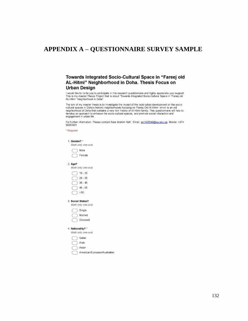
132
APPENDIX A – QUESTIONNAIRE SURVEY SAMPLE

133
134
135
136
APPENDIX B – QU – IRB APPROVAL FORM

137
APPENDIX C – LETTER TO THE MME

138
تم بحمد هللا