Punjab State Roads Project - World Bank Documents
236
DRAFT Punjab State Roads Project 1 ~~~~~~RP444 - ~~ s_ .a>5 Zs ~~VOL. 5 4'~~~~~~~~~ =g ,~~~~~~~~~.- Prpae by IC ReevdJ,e1,20 Public Disclosure Authorized Public Disclosure Authorized Public Disclosure Authorized Public Disclosure Authorized Public Disclosure Authorized Public Disclosure Authorized Public Disclosure Authorized Public Disclosure Authorized
-
Upload
khangminh22 -
Category
Documents
-
view
3 -
download
0
Transcript of Punjab State Roads Project - World Bank Documents

DRAFT
Punjab State Roads Project1 ~~~~~~RP444
- ~~ s_ .a>5 Zs ~~VOL. 5
4'~~~~~~~~~ =g
,~~~~~~~~~.-
Prpae by IC
ReevdJ,e1,20
Pub
lic D
iscl
osur
e A
utho
rized
Pub
lic D
iscl
osur
e A
utho
rized
Pub
lic D
iscl
osur
e A
utho
rized
Pub
lic D
iscl
osur
e A
utho
rized
Pub
lic D
iscl
osur
e A
utho
rized
Pub
lic D
iscl
osur
e A
utho
rized
Pub
lic D
iscl
osur
e A
utho
rized
Pub
lic D
iscl
osur
e A
utho
rized

I
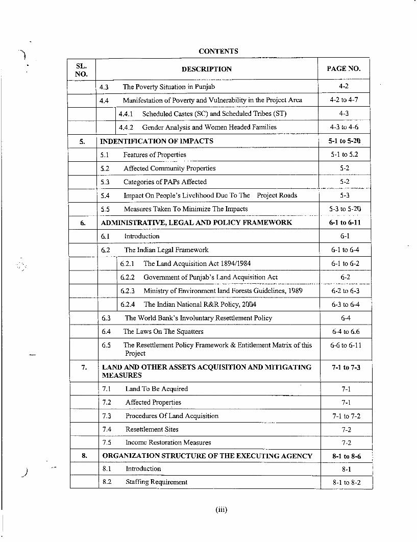
CONTENTS
SL. DESCRIPTION PAGE NO.NO.
4.3 The Poverty Situation in Punjab 4-2
4.4 Manifestation of Poverty and Vulnerability in the Project Area 4-2 to 4-7
4.4.1 Scheduled Castes (SC) and Scheduled Tribes (ST) 4-3
4.4.2 Gender Analysis and Women Headed Families 4-3 to 4-6
5. INDENTIFICATION OF IMPACTS 5-1 to 5-20
5.1 Features of Properties 5 -1 to 5.2
5.2 Affected Community Properties 5-2
5.3 Categories of PAPs Affected 5-2
5.4 Impact On People's Livelihood Due To The Project Roads 5-3
5.5 Measures Taken To Minimize The Impacts 5-3 to 5-20
6. ADMINISTRATIVE, LEGAL AND POLICY FRAMEWORK 6-1 to 6-11
6.1 Introduction 6-1
6.2 The Indian Legal Framework 6-1 to 6-4
6.2.1 The Land Acquisition Act 1894/1984 6-1 to 6-2
6.2.2 Government of Punjab's Land Acquisition Act 6-2
6.2.3 Ministry of Environment land Forests Guidelines, 1989 6-2 to 6-3
6.2.4 The Indian National R&R Policy, 2004 6-3 to 6-4
6.3 The World Bank's Involuntary Resettlement Policy 6-4
6.4 The Laws On The Squatters 6-4 to 6.6
6.5 The Resettlement Policy Framework & Entitlement Matrix of this 6-6 to 6-11Project
7. LAND AND OTHER ASSETS ACQUISITION AND MITIGATING 7-1 to 7-3MEASURES
7.1 Land To Be Acquired 7-1
7.2 Affected Properties 7-1
7.3 Procedures Of Land Acquisition 7-1 to 7-2
7.4 Resettlement Sites 7-2
7.5 Income Restoration Measures 7-2
8. ORGANIZATION STRUCTURE OF THE EXECUTING AGENCY 8-1 to 8-6
_) _______8.1 Introduction 8-1
8.2 Staffing Requirement 8-1 to 8-2
(iii)

CONTENTS
SL.NO. DESCRIPTION PAGE NO.
8.2.1 Central Level Arrangement 8-1
8.2.2 Contract Management Units Level 8-2 to 8-2
8.2.3 Contract Package Level Arrangement 8-2
8.3 Roles & Responsibilities for the R&R Activities 8-2 to 8-5
8.4 Training of PRBDB Officials and NGOs 8-5 to 8-6
9. R&R IMPLEMENTATION SCHEDULE 9-1 to 9-4
9.1 Introduction 9-1
9.2 The Implementation Procedure 9-1
9.3 General Activities 9-1
9.4 Land and Assets Acquisition 9-1 to 9-2
9.5 Resettlement 9-2
9.6 R&R Assistance 9-2
9.7 Implementation Schedule 9-2 to 9-4
10. R&R COST AND BUDGET 10-1 to 10-10 7210.1 Introduction 10-1
10.2 Methodology for the Valuation of Costs 10-1 to 10-3
= < ~~~~10.2.1 Valuation of Land Cost 10-1
10.2.2 Valuation of Replacement Cost of Structures 10i-1
10.2.3 Valuation of Replacement Cost of Others Assets 10-2
10.2.4 Valuation of Costs of Rehabilitation Assistance 10-2 to 10-3
10.3 Cost of Registration and Fees 10-3
10.4 The R&R Budget Estimates 10-3
10.5 Disbursement of Compensation and Assistance 10-3 to 10-10
11. GRIEVANCE REDRESS MECHANISM 11-1 to 11-2
11.1 Need for Grievance Redress 11-1
11.2 Grievance Redress Committee 11-1
11.3 Grievance Redress Mechanism 11-1
11.4 Response Time 11-1 to 11-2
11.5 Grievance Redress Monitoring 11-2
12. R&R MONITORING AND EVALUATION 12-1 to 12-6
(iv)

CONTENTS
SL. DESCRIPTION PAGE NO.NO.
12.1 Introduction 12-1
12.2 M&E Mechanism and Reporting 12-1 to 12-3
12.2.1 District Roads Committees (DRC) 12-1 to 12-2
12.2.2 Construction Supervision Consultants (only for Link 3, 12-2Malerkotla-Dhuri-Sangrur)
12.2.3 Quality Assurance team (for Rehabilitation Packages) 12-2
12.2.4 Extemal Evaluation 12-2 to 12-3
12.3 Monitoring Project Input and Output Indicators 12-3 to 12-5
12.4 Monitoring Project Outcome/Impact Indicators 12-5 to 12-6
ANNEXURE 1 to 76
1.1 Typical Cross Sections Drawings I to IX
1.2 Questionnaire for Census and Assets Inventory I to IV
1.3 Socio-Economic Questionnaires I to III
1.4 Questionnaires for Public Consultation and Focus Group I to IIDiscussion
1.5 Consultation Format I to II
1.6 Public Participation Poster I
1.7 Information document for Community participation I to II
3.1 Link-1: Chandigarh-Landran-Chuni-Sirhind I to VII
Link-2: Nagar-Aur-Rahon I to IV
Link-4: Tarn Taran-Chabal-Attari I to IV
Link-5: Kapurthala-Fatehbad-Tarn Taran I to IX
Link-6: Dharamkote-Kot Ise Khan-Zira-Firozpur I to VI
3.2 List of participants in public consultation
5.1 Details of affected Govemment properties/amenities within Col I to III
5.2 Cost and budgets foe Resettlement and Rehabilitation of PAPs for Iimprovement within Zira town
7.1 Land Schedule for all Road Links I to VII
7.2 Details of Govenmment Lands in Rural Areas-Available, I* - Encroachment, Under Construction
! J 8.1 Implementation of Resettlement Action Plan Terms of Reference I to VIIIfor the NGOs
(v)

CONTENTS
SL.NO. DESCRIPTION PAGE NO.
8.2 Entitlement Photo Identity Card I
11.1 Format 11.1 Record for Individual/Family Entitlements I to IV
Format 11.2 GRC Monthly and Cumulative Report V
Format 11.3 Road Link Level NGO (Project Manager's) VIReport for PAF
Format 11.4 Monthly Synthesis of RAP Implementation VII to VIII(Physical)
Format 11.5 Monthly Synthesis of RAP Implementation IX(Financial)
(vi)

Acronyms
AIDS - Acquired Immuno-Deficiency SyndromeARRO - Assistant Resettlement & Rehabilitation Officer
AWR - Average Wage Rate
BoQ - Bill of QuantitiesBPL - Below Poverty Line
CMUs - Contract Management Units
COI - Corridor of ImpactCPIAL - Consumer Price Indices for Agricultural Labour
CSC - Construction Supervision Consultant
CSR - Common Schedule of Rates
DLPFC - District Land Price Fixation Committee
DRC - District Roads Committees
CSW - Commercial Sex WorkerEP - Entitled Person
ERG - Economic Rehabilitation Grant
FGDs - Focuser Group Discussions
GoP - Government of Punjab
GSDP - Gross State Domestic Product
GRC - Grievance Redress Committee
Ha - Hectare
HIV - Human Immuno-Virus
ILO - Intemational Labour Organisation
IRDP - Integrated Rural Development Programme
Km - Kilometre
LA - Land Acquisition
LHS - Left Hand Side
LPG - Liquefied Petroleum Gas
MDGs - Millennium Development Goals
MDR - Major District Road
NACO - National AIDS Control Organization
NGO - Non-Govemment Organization
NH - National Highway
NITHE - National Institute for Training of Highway Engineers
NSSO - National Sample Survey Organization
NTH - Non Title HolderOBCs - Other Backward ClassesODR - Other District Road
PA - Project AreaPAF - Project Affected FamilyPAPs - Project Affected Persons
I

PDF - Project Displaced Family
PDPs - Project Displaced Persons
PGI - Post Graduate Institute
PHC - Primary Health Centre
PIA - Project Influence Area
PIC - Public Information Centre
PIO - People of Indian Origin
PPO - People of Punjabi Origin
PRBDB - Punjab Roads and Bridges Development Board
PSRSP - Punjab State Road Sector Project
PWD - Public Works Department
R&R - Resettlement and Rehabilitation
RP / RAP - Resettlement Plan / Resettlement Action Plan
RHS - Right Hand Side
ROW - Right of Way
RRO - Resettlement & Rehabilitation Officer
RTAs - Road Traffic Accidents
SA - Social Assessment
SC - Schedule Caste
SH - State Highway
SIA - Social Impact Assessment
ST - Schedule Tribes
TH - Title Holder
TOR - Terms of Reference
UN - United Nations
WB - World Bank
II

Consultancy Services for Project Preparatory Studies forPackage It (Phase I)for Punjab State Road Sector Project
EXECUTIVE SUMMARY
0.1 PROJECT BACKGROUND
The Punjab Roads and Bridges Development Board (PRBDB), Government of Punjab(GoP) is preparing the Punjab State Road Sector Project (PSRSP) with World Bank (WB)loan assistance. Under the PSRSP, 1698 km of roads have been identified by the PRBDBfor improvements and upgradation under various phases and packages. This projectinvolves rehabilitation of 5 corridors under Phase I programme of Package II. The detailsof corridors under the present package of PSRSP and their salient features aresummarised in Table ES.1. The project road corridors pass through 7 districts, namely,Rupanagar, Fathegarh Sahib, Firozpur, Amritsar, Kapurthala, Jalandhar andNawanshehar. The corridors are located across west-central, central and east-central partsof the state for a total length of about 219 km.
Social impact assessment of the project roads has been carried out on the basis ofinformation collected mainly from primary, but also secondary sources. The field studyincluded census and socio-economic survey of the project affected households and anassets inventory within the proposed formation width of the road, which varies between9-14 mtrs in different road section except at few locations within 21.8 mtrs where fourlaning is proposed along all Links of rehabilitation project. The table ES-1 shows therequired formation width of road in all links for ready reference:
Table ES-1: Link Wise Existing ROW and required Formation Width of the Road
Existing RequiredLink Corridor ROW Formation Remarks Reference/
(m) width (m) Chainage
14m carriageway,median of 1.2 - 2.8m1.5m paved shoulder, Drawing
25.2 14 lm earthen shoulder, 1.1 of1.7m unlined toe Annexuredrain, varying 1.1
Chandigarh- embankment slopesLandran- (on both sides)ChunniSirhind 7m carriageway
1 .5m paved shoulder, Drawinglm earthen shoulder, 1.2 of
15.4 12.0 1.7m unlined toe Annexuredrain, varying 1.1embankment slopes(on both sides)
7m carriageway Drawing2 RahoDun - 9.0 9.0 Im hard shoulder and A noefur
Volume- V Social Impact Assessment and Resettlement Action PlanEs-l

Executive Summary
Existing RequiredLink Corridor ROW Formation Remarks Reference/
(m) width (m)
7m carriageway1.5m hard shoulder, Drawinglm earthen shoulder, 1.4 of
15.4 12.0 1.7m unlined toe Annexuredrain, varying 1.1embankment slopes(on both sides)
7m carriageway
lm earthen shoulder, DrawingTarn Taran- 12.4 9.0 1.7m unlined toe 1.7 ofChabal-Attan drain, varying Annexure
embankment slopes 1.1(on both sides)
7m carriageway Drawing
14.0- 1.5m shoulder/ 1.8 of15.0 10.0 parking, 2.0 - 2.5m Annexure
footpath/ covered 1.1Tarn Taran- drain
4 Fatehbad- 7m carriagewayKapurthala 1.5m hard shoulder,Road Dr-awing
Im earthen shoulder, 1.9 of15.4 12.0 1.7m unlined toe Annexure
drain, varying 1.1embankment slopes(on both sides)
7m carriageway Drawing
14.0- 1.5m 1.10 of15.0 10.0 shoulder/parking, 2.0 Annexure
- 2.5m footpath/ 1.1Dharamkote- covered drain
5 Kot Isekhan- 7m carriagewayZira-Ferozepur 1.5m hard shoulder, Drawing
1 m earthen shoulder, 1.11 of15.4 12.0 1.7m unlined toe Annexure
drain, varying 1.1embankment slopes(on both sides)
This report also outlines discussions/consultations with relevant Government of Punjabofficials, and individual and group discussions/consultations with the potentially projectaffected persons and other stakeholders.
The objective of socio-economic survey was to identify the adverse impacts at the designstage, categorization of PAPs as per impacts and identification of measures to mitigate /
-. minimize negative impacts so that the project can be made peoples friendly with the bestpossible engineering solutions in respect of the road design.
Volume- V Social Impact Assessment and Resettlement Action PlanEs-2

Consultancy Services for Project Preparatory Studies forPackage II (Phase I)for Punjab State Road Sector Project
The main objective of the assignment is to verify that the project preparation complieswith the requirements of the World Bank (WB) with regard to its safeguard policies.
This report defines, identifies and addresses all the negative social impacts, due toimplementation of the project. The impact, however, is not significant as about 29families of non-titleholders, squatters in nature are to be affected. The present reportprovides an analysis of the impacts and type of losses and opted a suitable resettlementframework as a guide for payments of compensation and resettlement benefits.
The social survey has elicited the following existing features of the project area:
* There are 24 affected private properties representing 24 households (PAHs) and 29project-affected families (PAFs) in all road links put together.
* There are 24 households who will be pushed back at the same place little behind theproposed formation width of the road and if they require land for resettlement, thegovt will provide them land for price. All these are non-titleholder PDFs. There is notitle-holder PDFs.
* The total number of project-affected persons (PAPs) is estimated to be 112 in 29project affected families. These PAPs constitute 71 males (63.4%) and 41 females(36.6%). Of the total number of households affected. Approximately 11 families(45.8%) households fall under the vulnerable category, mostly BPL families.
* A total of 169 properties and assets of different types are likely to be affected by theproject. This number includes, 24 private properties, 6 Govemment properties, 58hand pumps, 65 bus shelters, 4 roadside shrines, 5 police check posts and 12platforms with trees used for various purpose
2) * The presence of 24 households are concentrated at 2 locations are forming criticalareas; however, all are squatters in nature. These critical areas are Rajatal (Link4:Tran Taran-Atari) and Attnawali and Mandbu-Mundichhena (Link 5: Tarn Taran-Fatehbad-Kapurthala).
0.2 MAIN OBSERVATIONS
* The field study includes assessment of the project-affected households and propertieswithin proposed formation width of the road for all road links. Out of 24 householdsall are non-titleholders and are Squatters.
* In Link-1 between km 13.600 to km 15.760 (within Landran village boundary) theavailable RoW is about 6m, which is not sufficient for improvement. This stretch,which require land / properties acquisition, has been excluded from rehabilitationproject and considered in Improvement/ upgradation project for which a separatereport has been prepared and submitted.
* In Tran Taran - Atari corridor 11 kiosks are affected. All these are squatterproperties. No titleholder property is affected along this corridor.
Major issues discussed in Consultations with the Stakeholders and its addressal:
The major concems related to provision of compensation amount, altemativeemployment, R & R assistance, livelihood support, wayside amenities, storm waterdrainage, parking facilities, , dust suppression, provision of footpath in town areas, etc hasbeen discussed with the affected people and communities. A total of 27 consultationswere carried out and are appended to this report as Annexure 3.1.
A consolidated summary of the 5 road links is presented in the following.
Volume-V Social Impact Assessment and Resettlement Action PlanEs-3

Executive Summary
Issues Discussed:
1 Provision of wayside amenities
2 Road side storm water drainage
3 Provision of Hand pump near school and settlement area
4 Roadside sign board for safety
5 Parking facilities
6 Compensation at market rate for land acquisition
7 Enhancement of Gurudwara at Chunni and other shrines
8 Provision of median in the road
9 Protection of water pipe line and other utilities
10 Junction improvement
11 Provision of service road
12 Road improvement within the RoW
13 Street light facilities in market area
14 Restoration of livelihood of affected people
15 Employment during construction
16 Provision of speed breakers
Issues Addressed
1. Bus shelters provided
2. Covered drain will be used as footpath
3. All the affected hand-pumps will be replaced
4. Road signboards are provided at appropriate locations
5. Parking could not be provided due to limited row
6. Compensation at local market rate has been given in R &R budget
7. Enhancement measures for affected Gurudwara has been incorporated in EMP
8. Centreline marking provided instead of median with adequate sign boards
9. Protection of water pipeline and other utilities will be taken care during roadconstruction, and addressed in EMP
10. Junction redesigned at km 14.700
11. Improvement of service road has been considered within the existing RoW
12. To avoid the land and properties acquisition, the road has been improved withinavailable ROW
13. Street light will be incorporated in the design
14. Measure for livelihood support for affected people has been incorporated in in RAP.
15. Preference in employment will be given to local people at the time of roadconstruction
16. Rumble strips provided where required
0.3 ANALYSIS OF ALTERNATIVES
Evaluations of altematives were examined at Zira town (Link 6). The project road at Ziratown is of four-lane configuration from km 24 to km 24.300. At the end of four-laning, asection of about 300m length long stretch (km 24.300 to km 24.600) has been identifiedas a bottleneck. The ROW in this part (300m stretch) is about 6-7m wide with acarriageway of about 4-5m-width space. There are about 200 shops along this stretch. The
Volume- V Social Impact Assessment and Resettlement Action PlanEs-4

Consultancy Services for Project Preparatory Studies forPackage II (Phase I) for Punjab State Road Sector Project
2 options for rehabilitation of this road have been analyzed. Option- I was not suitable asimprovement of the existing road will demolish built-up areas (shops and residential-cum-commercial structures), thereby making adverse social impacts on the people as well ason livelihoods, while Option- II alone was also not sufficient to accommodate therehabilitation proposal. The combination of Option -I and Option-TI with one-waytraffic provisionwas recommended as most suitable, as there would not be any adversesocial impact and, therefore, recommended as the preferred route.
However, for other link road only proper Planning and designing was made to avoidnegative impacts as mitigation measures as it is a rehabilitation project within availableROW.
0.4 COST OF THE R&R COMPONENT
The R&R costing has been made according to the R&R entitlement matrix. Table ES-3presents a summary of the R&R costs and budget for all the 5 project road corridors.
TABLE ES-3: SUMMARY OF R&R COSTS AND BUDGET
Support to Project (EthernaLinks Compensation Assistance Implementation CPRs EValUatiOn Total
(NGOs) ~~~Consultant)
I 0 0 1,599,000 250,000 0 1,849,000
2 159900 0 1,599,000 1020000 0 2,778,900
4 154576 329208 1774000 950000 27500 3,235,284
5 125756 339848 1799000 844396 32500 3,141,500
6 0 0 1649000 240720 0 1,889,720
Links 440232 669056 8,420,000 3,305,116 60000.00 12,894,404
0.5 INSTITUTIONAL ARRANGEMENT
Considering that a sizeable number of households/business establishments are to beaffected by the project, it is required to set up a regular unit within the PIU to deal withthe R&R activities. The following table outlines the staffing requirement for this purpose.
Table Es-4: Staffing Requirement for R&R
Level Job Title and/or Description Number
PRBDB Joint Secretary-cum-Project Director 1
(Central Level) Deputy Project Director 1R&R Officer (RRO) I
Executive Engineer IContract Management Units A(CMU) Assistant R&R Officer (ARRO) I
Secretarial Staff 1
Assistant R&R Officer (ARRO) 1Contract Package
NGO (RAP, HIV/AIDS/ Road Safety) 1-3
Volume-V Social Impact Assessment and Resettlement Action PlanEs-5
Executive Summary
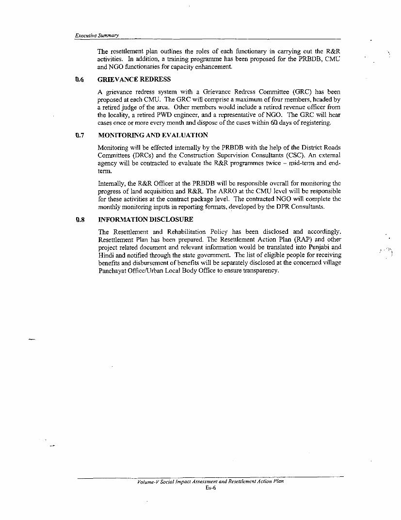
The resettlement plan outlines the roles of each functionary in carrying out the R&Ractivities. In addition, a training programme has been proposed for the PRBDB, CMUand NGO functionaries for capacity enhancement.
0.6 GRIEVANCE REDRESS
A grievance redress system with a Grievance Redress Committee (GRC) has beenproposed at each CMU. The GRC will comprise a maximum of four members, headed bya retired judge of the area. Other members would include a retired revenue officer fromthe locality, a retired PWD engineer, and a representative of NGO. The GRC will hearcases once or more every month and dispose of the cases within 60 days of registering.
0.7 MONITORING AND EVALUATION
Monitoring will be effected intemally by the PRBDB with the help of the District RoadsCommittees (DRCs) and the Construction Supervision Consultants (CSC). An extemalagency will be contracted to evaluate the R&R programmes twice - mid-term and end-term.
Intemally, the R&R Officer at the PRBDB will be responsible overall for monitoring theprogress of land acquisition and R&R. The ARRO at the CMU level will be responsiblefor these activities at the contract package level. The contracted NGO will complete themonthly monitoring inputs in reporting formats, developed by the DPR Consultants.
11.8 INFORMATION DISCLOSURE
The Resettlement and Rehabilitation Policy has been disclosed and accordingly,Resettlement Plan has been prepared. The Resettlement Action Plan (RAP) and otherproject related document and relevant information would be translated into Punjabi andHindi and notified through the state govemment. The list of eligible people for receivingbenefits and disbursement of benefits will be separately disclosed at the concerned villagePanchayat Office/Urban Local Body Office to ensure transparency.
Volume- V Social Impact Assessment and Resettlement Action PlanEs-6

Consultancy Services for Project Preparatory Studies forPackage 11 (Phase I)for Punjab State Road Sector Project
1. PROJECT DESCRIPTIONS AND STUDY METHODOLOGY
1.1 PROJECT BACKGROUND
The Punjab Roads and Bridges Development Board (PRBDB), Government of Punjab(GoP) is preparing the Punjab State Road Sector Project (PSRSP) with World Bank (WB)loan assistance. Under the PSRSP, 1698 km of roads have been identified by the PRBDBfor improvements and upgradation under different phases and packages. This projectinvolves rehabilitation of 5 corridors under the Phase-I programme of Package II. Thedetails of corridors for the present package of PSRSP are shown in Map 1.1 and salientfeatures are summarised in Table 1.1.
The rehabilitation works generally involves strengthening of the existing pavement,overlaying, improving the longitudinal sections and cross drainage structures along theexisting alignment within the existing RoW (subject to minor modifications in order toimprove road geometry, junction improvement and road safety).
The 12 mtrs proposed improvement includes 7m carriageway, 1.5m paved shoulder andIm earthen shoulders each on both sides. In case of unavailability of land or in criticalspots the earthen shoulder may be avoided. Between km 16.800 and km 18.600 and km21.400 and km 22.900 of Link 2, 9m road improvement is proposed. The Link 4 (TranTaran- Atari) corridor is proposed for 9m-carriageway configuration throughout itslength. The 9m proposed improvement includes a 7m carriageway and a lm unpavedshoulder on each side. Link wise a detailed corridor of impact and proposed improvementis shown in Table 1.2.
1.2 PROJECT DESCRIPTION AND THE PROPOSED IMPROVEMENT
The project road corridors traverse through 7 districts, namely, Rupanagar, FatehgarhSahib, Firozpur, Amritsar, Kapurthala, Jalandhar and Nawanshehar. The corridors arelocated across west-central, central and east-central parts of the state for a total length ofabout 254 km. All the roads traverse through plain terrain. As indicated above, the projectdevelopment envisages improvements along the project roads that will yield a 7-m wideundivided carriageway with provisions for a 1.5m hard shoulder and a Im earthenshoulder on both sides (total 12m width).
The project would improve the geometric deficiencies including the improvement of thevarious intersections. The proposed improvement aims at improving the riding quality,improving journey speed and reducing congestion of traffic on the highway. It isproposed to provide proper drainage, road furniture, utilities and amenities whereverrequired.
Volume- V Social Impact Assessment and Resettlement Action PlanI -I
Project Descriptions and Study Methodology
MAP 1.1
Volume-V Social Impact Assessment and Resettlement Action Plan1-2

INDEX MAPToJan,m,
- aiY tINDIA
' ~ To Mudi
7 - 1 3t$, -X3- PUNJAB
,.' ,GDdas ¢ ukrau
4tala~~~~~~~~~ ~HIMACHALBatel D PRADESH
L [ > f \,,,,rLegend
Jhkha* -i> - ; ~ (=t~ Other Roads
=X7 7 Moga sf-j- F 1-l-+a- XKrDaS "-. ~~~~~~~~~Project Roads
g Fandeko , Rait Kharnig Rehabilitation Corridor
Milttaor LI~~~~~~ ~~NK 3 alayLn
Jhokg TN h LIN 6 DharaliFot nLINK t:Machhiwk Crrdo
\ ~ ~ ~~~FazIca OtLI bNOJs Xw!1^ <i2 DETAILS OF PROJECT COhRRIORS |
| * + t -4 * + g :Kj ta t rn,, l k ,: . , ' | Link Project Road Corridors Lenst
KWVur ~ ~ ~ anrr SaaaNo kn
~)- /DabwaIt '> fBudhladrh 2 NNgr Aur-R ihon r
o . _ 30a 3 MalerkoUM-Dhukl-SRngrur 33
e \ * _~~~~~~~~ 4 Sern Tarmn-Chabel-Attarl 41
; Q > ~~~~~~~HARYANA _ ___________________
RAJASTFbW '. *r ¶snFbba-^ur^l 51
Faz_ka Jay Dher mko e-Kot lrkh n-21ra-Dte-59
PunJab Roads and Bridges N~2 ~ Psekage-i se-IFor DetailedU Nab ProJect SHOWING PROJECT CORRIDOR LOCATIONS aP DETAIL-S OF PROaT CORRIDORS
Development Board NO s Krn Road Length (REHO & UROUTES) I PRBDBI/MISC/F/mAP .1
S Pj Rd ro
-~~~~~~~~~~~~~~~~~~~~~~~~~~~~~~~~~~~~~~~~~~~~~~N.(m

I
II
II

Consultancy Services for Project Preparatory Studies forPackage II (Phase I) for Punjab State Road Sector Project
Table 1.1: Contract Packages along the Rehabilitation and Upgradation Routes
Existing Configuration
. E | E s~~~~~~ E>: Project Project Remarks
Road Road RemarksCorridors Districts
>
< IKlm.29607 to km~~~~~~~~~~ I Km 9.7 to km11.260Km 12.240l to km15 .522
120 Km 15.522 to km12.0 39.840
Chandigarh Km 39.935 to km
I -Landran - Rupnagar & Plain 38.88 20 - 22 5.5 - 10 41.660Chuni Fathegarh Km 42.250 to NHSirhind ahb-1I
Km 11.260 to km
21.8 12.2409.0 IKm 39.840 to km
(4.90
laning) TKm 41.660 to0km42.250
For full length ofcorridor except
Rd12.0 Km 16.800 to km120 18.600
2 Nagar-Aur- Jalandhar & Pan 2 8-2 . . Km 2 1.400 to km2 Rahon Nawanshahr Pan 2 18-0 37-5522.900
Km 16.800 to km9( 18.600
.~ ~ ~ ~~~~~~~~.
Km 21.400 to km22.900
Tam 3.5lTaran- (kmt1lan7l For full length of
Chabal- Arta Pli 41 18 - 38 5.5 9. corridor
Attari (Rest ofcorridor) _ _ _ _ _ _ _ _ _
Tam ~~~~~~~~~~~~~~~~~~~~For full length of
Taran- 12.0 corridor except5 Fatehbd Amritsar & Plain 5 1 20 - 30 7.0 Km26.0000 ok
Kapurtaa Kapurthala 29__ __________
Road 120 Km 26.000 to km120 29.000
Volume- V Social Impact Assessment and Resettlement Action Plan1-3
Project Descriptions and Study Methodology
Existing Configuration
w Project Project j Remarks.c Road Road r Xs Remarks
Corridors Districts . E.0~~E 0
For full length ofcorridor exceptKm 0.000 to km0.300Km 8.600 to km
Dharamkote I1.00-Kot Km 22.800 to km
6 Isekhan- Firozpur Plain 59 28 - 34 7.0 25.000Zira-Ferozepur Km 0.000 to km
0.300
10.0 Km 8.600 to kmn10. 11.000
Km 22.800 to km25.000
Except Link 1, the road improvement work will be limited to the existing RoW. Theavailable RoW in Link 1 between km 13.600 to km 15.750 (within Landran villageboundary) is approximately 6m. The proposed improvement involves acquisition ofminimum land (approximately 8 - 9m, except the existing 5.5m road width). The junctionwith NH-15 in Tarn Taran-Kapurthala corridor (Link 5) involves junction improvement,which envisages acquisition of private land. The junction improvement at Tarn Taran hasbeen dealt with in a separate volume.
The social assessment and documentation of assets/ properties has been conducted withinproposed formation width of the road, which varies between 9-14 mtrs for all the linkroads. (Figure 1.1).
Proposed ROW
Clear Zone Clear Zone---------- 1- Carriahe Way
Shoulder Shoulder
3CSm .1 3Sm\1Sm 5. 3.5 m
25m l25m
Formation width of the Road
Figure 1.1: A cross section showing a typical Formation width of the Road
Table 1.2 shows the required formation width of road in all links. The cross sections foreach type are appended to this report as Annexurel.1.
Volume-V Social Impact Assessment and Resettlement Action Plan1-4

Consultancy Services for Project Preparatory Studies forPackage II (Phase I) for Punjab State Road Sector Project
Table 1.2: Link Wise Existing ROW and required Formation Width of the Road
Existing Required). Link Corridor ROW Formation Remarks Reference/
(in) width (in) Chainage14m carriageway,median of 1.2 - 2.8m1.5m paved shoulder, Drawing
25.2 14 lm earthen shoulder, 1.1 of1.7m unlined toe Annexuredrain, varying 1.1
Chandigarh- embankment slopes1 Landran- (on both sides)
Chunni Sirhind 7m carriageway1 .5m paved shoulder, DrawingIm earthen shoulder, 1.2 of
15.4 12.0 1.7m unlined toe Annexuredrain, varying 11embankment slopes(on both sides)
7m carriageway Dr-awing9.0 9.0 lm hard shoulder and 1.3 of
drain Annexure_ _ _ _ _ _ _ _ _ _ _ _ _ _ _ _ _ 1 .1
2 Nagar-Aur- 7m carriageway2 NaRahon 1 .5m hard shoulder, Drawing
lm earthen shoulder, 1.4 of15.4 12.0 1.7m unlined toe Annexure
drain, varying 11embankment slopes(on both sides)7m carriagewaylm earthen shoulder, Drawing
Tarn Taran- .7m unlined toe 1.5 ofChabal-Attari drain, varying Annexure
embankment slopes 1.1(on both sides)7m carriageway Drawing
14.0- 1.5m shoulder/ 1.6 of15.0 10.0 parking, 2.0- 2.5m Annexure
footpath/ covered 1.1Tarn Taran- drain
5 Fatehbad- 7m carriagewayKapurthala 1.5m hard shoulder,Road Im earthen shoulder, 1.7of
15.4 12.0 1.7m unlined toe Annexuredrain, varying Anuembankment slopes(on both sides)
Volume-V Social Impact Assessment and Resettlement Action Plan1-5
Project Descriptions and Study Methodology
Existing Required Reference!Link Corridor ROW Formation Remarks Chainage
_____ ______ _____ (in) w idth (in)
7m carriageway Drawing14.0- 1.5m 1.8 of15.0 10.0 shoulder/parking, 2.0 Annexure
- 2.5m footpath/ 1.1covered drain
Dharamkote-6 Kot Isekhan- 7m carriageway
Zira-Ferozepur 1.5m hard shoulder, Drawinglm earthen shoulder, 1.9 of
15.4 12.0 1.7m unlined toe Annexuredrain, varying 1.1embankment slopes(on both sides)
All the structures within formation width were examined and poverty and socialassessment and public consultations have been carried out along all the project roads.Consequently, this report addresses the impacts and outlines the measures, includingresettlement of the affected persons, in accordance with the World Bank's Policy onInvoluntary Resettlement (OP 4.12).
However, the proposed project has hardly any resettlement impacts.
1.3 OBJECTIVES AND SCOPE OF THE STUDY
The objectives of the study are to:
1. Collect information regarding project impacts in order to facilitate the design ofvarious components of the Resettlement Action Plan (RAP);
2. Set up a cut-off date in order to monitor any influx of new people;
3. Differentiate the properties by type and identify possible categories of entitlement;
4. Attach actual value to the key indicators of social and economic status of the projectAffected Persons (PAPs), as well as their vulnerability to socio-economic change as aresult of the project; and
5. Provide a baseline for any further information needed to monitor and evaluateEntitled Persons (EPs) in the future.
1.4 SOCIAL AND ECONOMIC DEVELOPMENT OBJECTIVE OF THE PROJECT
This project, through the road infrastructure, seeks to:
* Ensure that the poorest sections of the people in the project area can obtain maximumbenefit by accessing the mainstream economy and social infrastructure; and
* Ensure that any aspect of the project does not disadvantage the poorest sections of thelocal communities.
Thus, the socio- economic development objective of the project comprises the following:
- Everybody concemed is a partner in the development process; and
* No one is adversely affected due to the implementation of the project; any adverseimpact is to be appropriately mitigated.
Volume- V Social Impact Assessment and Resettlement Action Plan1-6

Consultancy Services for Project Preparatory Studies forPackage II (Phase I) for Punjab State Road Sector Project
1.5 THE PROJECT INFLUENCE STATE: PUNJAB
Punjab is one of the most prosperous states of the Indian Union. It is located in the north-western part of the country in great alluvial plains, bounded on the west by Pakistan, onthe north by Jammu & Kashmir state, on the northeast by Himachal Pradesh state, and onthe south by Haryana and Rajasthan states. Physiographically Punjab can be divided into2 broad geographic divisions, as outlined below'.
The Siwalik Hills: This region covers the outer range of the Siwalik Hills and isapproximately 6-10km in width running along the eastern border of the state. Thelithology of the Siwaliks suggests the origin of the sediments as water bome debris of theHimalayas.
1.6 ROAD NETWORK IN PUNJAB
Punjab possesses a very good system of road network. A total of 54,836-kilometer longroads pass through state, with a .road density of 118 km per 100 km2. As indicated above,almost all villages of the state are linked with all-weather roads. Its modem bus fleet of3,511 buses covers a distance of 1.05 million Kilometers per day. The state governmentproposes to construct express highways and free ways for speedier vehicular traffic.Presently the upgrading of Chandigarh-Ludhiana, Zirakpur-Patiala, Ropar-Nawanshahar,Jagraon-Nakodar highway projects has been taken in a big way.
Information available from the Govemment of Punjab web site shows that the NationalHighways constitute 977 km in the State, State Highways 2,166 km, Major District Roads1799 km, Other District Roads 3340 km, and Link Roads constitute 31,657 km.
1.7 PROJECT AREA AND PROJECT INFLUENCE AREA
Generally, all the 7 districts through which the project road traverses constitute theProject Area for the project.
The project influence area (PIA) within project area of the project road is much biggerarea beyond COI. In the context of proposed project a clear-cut fringe for the PIA cannotbe delineated, however, the settlements/ habitats at a distance of 7.00 km in either side ofthe road are generally considered as the project influence area (PIA).
The corridor-of-impact (COI) of a road is the area where immediate negative impactsmight be expected. The COI for a roads project is usually defined as the width withinwhich the improvement, and or construction of a new road and the civil works includingthe new pavements, shoulders, support slopes, footpaths, drainage and necessary supportzones is intended. COI for roads project is generally 60.00 mtrs.
The right of way (ROW) is public land under the control of the PWD/or executing agencyand is usually defined as that area over which the public has open access. The corridor ofimpact (COI) may or may not be part of the right of way.
1.8 METHODS AND TOOLS USED IN THE STUDY
The social analysis for this project incorporates both qualitative and quantitative data.Besides, the information on the prevailing social issues from the project area, congregatedthrough community consultations and focus group discussions were also used foranalysis. The various activities that have been carried out as part of this project aresummarised in the following sub-sections:
Geography of Punjab, by Harpal Singb & D.S. Tiwana, National Book Trust India, New Delhi, second revised edition,1993, pp 20-22.
Volume- V Social Impact Assessment and Resettlement Action Plan1-7

Project Descriptions and Study Methodology
1.8.1 Household Survey, Census and Assets Inventory
The survey of the project-affected households (PAHs) for social impacts was carried outin two trenches. Originally, all the project roads were earmarked for rehabilitation only,affecting only a small number of households. Consequently, the household survey wascarried out in the 100% of the project-affected households. The household survey wascarried out by administering a comprehensive social survey questionnaire (see Annexure-1.2) to the users of all the structures falling within the proposed formation width of theroad, which varies between 9-14 mtrs in different road section except at few locationswhere four laning is proposed within available ROW of 21.8 mtrs.
After completing the asset inventory survey, the consultants carried out the socio-economic survey of around 14 households, i.e., about 60% of the total surveyed assets. Itis important to elucidate here that, however, as per guidelines the minimum requirementof the socio-economic survey is just 25 % of the total affected households, but povertyanalysis was also our target and more number/percentage of affected households can wellrepresent the universe and project influence area and can make the analysis moremethodical. A format of socio-economic questionnaire is attached as Annexurel.3.
1.8.2 Community Consultations
The community consultation was carried out taking into the consideration of differentmethods of consultation, which includes consultation with key informants of the area,concerned NGOs working in the field, Govt officials of concerned department,knowledgeable person of the village and off course Focussed group discussions (FGDs)with various social group. A total of 30 consultations and FGDs were carried out in theproject area villages with different ranges of population, and each consultation includedpeople from a cluster of nearby villages. A total of 16 villages and 14 towns of differentpopulation sizes were represented. The number of participants in the FGDs ranged fromfour to sixty-two persons including affected persons, village panchayat members, women,and elderly people. Moreover, female professionals carried out group discussion withfemale. Women were consulted in group (10-20), however, at some locations it wasdifficult to ensure the presence of women in group, where only 34 women shown theirpresence to participate in the group discussions.
The consultations were carried out on the basis of a set of guidelines prepared for theproject, Guidelines for Focus Group Discussions, appended as Annexure-1.4. A sampleformat for carrying out consultations and an attendance sheet is attached as Annexure1.5. A leaflet was designed in Punjabi covering brief notes on the Project, agenciesinvolved, need for public participation etc. Two-three days prior to the consultations, theaffected people and other stakeholders were invited to attend these specifying date, timeand venue of the meetings.
A sample of Punjabi and English version of the leaflet displayed before consultation isattached as Annexure 1.6. An information document circulated with maps showing theproject corridors is attached as Annexure 1.7. All the meetings were organised incollaboration with the PRBDB, Village Panchayat members and the anticipatedparticipants. The output of the consultations is appended as Annexure-3.1. A listcontaining the names and signatures of all the attendees are given in Annexure 3.2. Theconsultations are summarized in this report in Chapter 3, indicating the main issues thatemerged and how these have been resolved, and if not resolved, the technical reasons forthe non-compliance.
1.9 DISCLOSURE OF INFORMATION
The Resettlement and Rehabilitation Policy, Resettlement Plan and other project relateddocuments and relevant information would be translated into Punjabi and Hindi andnotified through the state government. The list of eligible people for receiving benefits
Volume-VSocial Impact Assessment and Resettlement Action Plan1-8

Consultancy Services for Project Preparatory Studies forPackage II (Phase I)for Punjab State Road Sector Project
and disbursement of benefits will be separately disclosed at the concerned villagePanchayat Office/Urban Local Body Office to ensure transparency.
The list of eligible people for receiving benefits and disbursement of benefits will also beput up at notice boards of the Punjab Legislative Assembly, affected District Collector'soffice, Block Development Offices, Jan Sampark Vibhag (at the state and district levels),Urban Local Bodies, Panchayat Offices, etc.
In addition, a Public Information Centre (PIC) will be established at PRBDB Head Officeas a part of the project. The Punjabi, Hindi and English versions of all the project relateddocuments will be made available in the PIC as well as on the web site of the PRBDB.
1.10 CUT OFF DATE
The census and assets inventory in the 5 road links were carried out between 13-20February 2006, which are the cut-off dates for entitlement of Non-titleholders.
Volume- VSocial Impact Assessment and Resettlement Action Plan1-9

!~~~~~~~~~~~~~~~~~~~~~~~~~~~~~

Consultancy Services for Project Preparatory Studies forPackage II (Phase I) for Punjab State Road Sector Project
2. SOCIO-ECONOMIC PROFILE OF THE PROJECT AREA
2.1 INTRODUCTION
Punjab is a relatively small state with an area of 50,362 km2, which is 1.56% of the totalarea of India. It comprises 4 administrative divisions, 17 districts, 73 tehsils, 81 sub-tehsils, 141 development blocks, 12,278 inhabited villages, 145 towns and 14 cities.Punjab is a leading state in agricultural production. During the mid-1960s, the GreenRevolution transformed its agricultural sector and contributed significantly in making thecountry self-reliant in food. The increase in production as well as productivity of wheatand rice in the state was a landmark in the country. However, industrial development inthe state has not been of the level of agricultural development. The major industrial townsin the state are Ludhiana, Jalandhar, Kapurthala, and Amritsar.Punjab has a remarkable development record. It is well on its way to achieving most ofthe Millennium Development Goals (MDGs). At the end of the 1990s (1999-2000), morethan 93 percent of Punjab's citizens were above the poverty line (population belowpoverty line 6.16 %)1, 70 percent were literate, 94 percent of all six year olds wereenrolled in primary schools, 63 percent of births were attended by skilled health staff, 72percent of children under twelve months were immunized, 52 percent of households hadaccess to improved sanitation, 99 percent of households had access to safe drinking water,and the average life expectancy was 68. According to India's National HumanDevelopment report2, Punjab is ranked second only to Kerala in terms of the overall levelof human development among the major Indian states.
2.2 DEMOGRAPHIC FEATURES OF PUNJAB2.2.1 Population by Age and Gender
Punjab has a population of 24,358,999 with 482-persons/ km2 as density of population(Table 2.1). There is a significant variation in the density of population among differentdistricts. The highest density of population is in Ludhiana district with 805 persons perkm2. The density of population in the project districts varies between 330-742. Thedistrict Jalandhar shows the highest density of population among project districts, whileFerozpur have just 330-persons/ km2. The district written and highlighted in Italic letterconstitutes the project districts.
Table 2.1: Punjab - Area, Population, and Density per Sq. Km. by Project Districts
Population Statistics
Si. Project District PopulatinTotal No. of No. of Sex PNo oal ND.o o f Sx ensityPopulation Males Females Ratio (Persons! kM 2)
I Gurdaspur 2,104,011 1,113,077 990,934 890 5882 Amritsar 3,096,077 1,650,589 1,445,488 876 6033 Kapurthala 754,521 399,623 354,898 888 4614 Jalandhar 1,962,700 1,040,177 922,523 887 7425 Hoshiarpur 1,480,736 765,132 715,604 935 4396 Nawanshahr 587,468 306,902 280,566 914 4637 Rupnagar 1,116,108 596,582 519,526 871 540
IPlanning Commission of India Report, 20012 National Human Development report, Punjab, 2004
Volume-VSocial Impact Assessment and Resettlement Acton Plan2-1


Socio-Economic Profile of The State, PIA and The Project Area
Population Statistics
No. Project District Total No. of No. of Sex DensityPopulation Males Females Ratio 2ens/t3r(Persons/ kmn2
8 Fatehgarh 538,041 290,137 247,904 854 457Sahib
9 Ludhiana 3,032,831 1,662,716 1,370,115 824 805
10 Moga 894,854 474,139 420,715 887 400
11 Firozpur 1,746,107 926,224 819,883 885 330
12 Muktsar 777,493 411,217 366,276 891 300
13 Faridkot 550,892 292,596 258,296 883 380
14 Bathinda 1,183,295 632,809 550,486 870 360
15 Mansa 688,758 366,446 322,312 880 315
16 Sangrur 2,000,173 1,069,289 930,884 871 400
17 Patiala 1,844,934 987,390 857,544 868 510
Punjab State 24,358,999 12,985,045 11,373,954 876 482
Source: Census of India 2001.
2.2.2 Sex ratio
The gender disaggregated project affected population information shows that in theimmediate project area the percentage of males in all age groups surpassed females,indicating lower sex ratio. Sex ratio is a sensitive indicator of the status of women insociety, at a given point of time. India's low sex ratio of 933 females per 1000 males inthe current census 2001 reveals a continuing imbalance in gender relations. Sex ratio inPunjab is even worse at 876 females per 1000 males (as shown in table 2.1). Among thePunjab districts, only Hoshiarpur has a sex ratio, which is at least comparable with thenational average, while two districts, viz. Hoshiarpur and Nawanshehar, have a sex ratioabove 900. All the other 15 districts have sex ratio lower than 900. The main reason forthe lower sex ratio is attributed to female infanticide and child neglect (Premi, M.K.,1994, Female infanticide and child neglect as possible reasons for low sex ratio in Punjab1881-1931, Population Geography). Besides, migration of labour (mostly man) fromBihar and Rajasthan also contributed for low sex ratio.
2.2.3 Birth rate, Death Rate and Infant Mortality Rate
The birth rate in Punjab decreased fromt 21.2 per thousand in 2001 to 20.8 per thousandduring the year 2002. In urban areas it decreased from 18.7 per thousand in 2001 to 18.1per thousand in 2002 and in rural areas decreased from 22.1 per thousand in 2001 to 21.7per thousand in 2002. The death rate increased from 7.0 per thousand in 2001 to 7.1 perthousand in 2002. In urban areas its decreased from 6.4 per thousand in 2001 to 6.2 perthousand in 2002 and in rural areas it increased from 7.2 per thousand in 2001 to 7.4 perthousand in 2002. The infant mortality rate per thousand live births in Punjab hasdecreased from 52.0 per thousand in 2001 to 51.0 per thousand in 2002. In the urbanareas it decreased from 37.0 per thousand of live birth in 2001 to 35.0 per thousand of livebirth in 2002. In rural area it remained same as it was in 2001.
Table 2.2: Birth, Death and Infant Mortality Rates in Punjab
Year Birth Rate Death Rate Infant Mortality Rate
Rural Urban Combined Rural IUrban |Combined Rural Urban ICombined
Volume- V Social Assessment Plan2-2


Consultancy Services for Project Preparatory Studies forPackage 11 (Phase I) for Punjab State Road Sector Project
2000 22.7 18.6 21.6 7.9 5.9 7.4 56 38 52
2001 22.1 18.7 21.2 7.2 6.4 7 55 37 52
2002 21.7 18.1 20.8 7.4 6.2 7.1 55 35 51
Source: Census of India, 20012.2.4 Social Composition
Sikhs constitute the largest religious community with 63% of the total population inPunjab, followed by Hindus (34%). Other groups are insignificant in number, i.e., Muslim(1%) and others (2%, including Christians, Jains and Buddhists). The Scheduled Castes(SC) population in the state comprises 28.9%, which is reported to be the highestpercentage of SC in the country. In the project area, the Sikhs constitute approximately80% and the remaining are Hindus. The social stratification in Punjab shows that 67% ofthe total population is general caste, followed by other Backward Caste (OBC) (31%),and SC (2%).
There is no ST population in Punjab as per the 2001 census.
2.2.5 Literacy level and Education Facilities
Literacy is an important indicator in showing the status of social development. Theliteracy rate in Punjab is 69.7% as compared to Indian average of 54.51 % in 2001 census.The project areas of the 5 road corridors have 46 educational facilities, as follows:
Table 2.3: Educational Facilities in the Project Area
No. ofLink Corridor Facflities
:j ) 1 Chandigarh-Landran-Chunni-Sirhind 3
2 Nagar-Aur-Rahon 9
4 Tam Taran-Chabal-Attari 8
5 Tam Taran-Fatehbad-Kapurthala 8
6 Dharamkot-Kot Ise Khan-Zira-Ferozepur 18
Total 46Source: Information from the Feasibility Consultants, Interim Report on SocialScreening, Jan 2006.
- 2.2.6 Health Care Facilities
As on 1 St April 2001 Punjab has 2242 Medical Institutions, out of which 205 are hospitals,14 are hospital-cum-community health centres, 60 are community health centres, 43 arecommunity health centres cum-primary health centres, 441 are primary health centres and1479 are subsidiary health centres/dispensaries/clinics. On an average each institutionserved the population within a radius of 2.7 kIn during 2003-04. The project areas of the 5road corridors have 8 health care facilities, as follows:
Table 2.4: Health Care Facilities in the Project Area
Link Corridor No. of Facilities
1 Chandigarh-Landran-Chunni-Sirhind 2
2 Nagar-Aur-Rahon 2
4 Tarn Taran-Chabal-Attari 0
5 Tarn Taran-Fatehbad-Kapurthala 3
Volume-VSocial Impact Assessment and Resettlement Action Plan2-3

Socio-Economic Profile of ATe State, PIA and The Project Area
6 Dharamkot-Kot Ise Khan-Zira-Ferozpur 1
Total 8
Source: Information from the Feasibility Consultants, Interim Report on SocialScreening, Jan 2006.
2.3 ECONOMIC FEATURES'
The overall economy of Punjab has exhibited substantial growth during 2003-04 over theyear 2002-03. The overall growth rate of the Gross State Domestic Product (GSDP) atConstant (1993-94) prices has increased to 5.30 percent in 2003-04 as compared to 1.38percent in 2002-03. The acceleration in the growth of the economy in the year 2003-04can be attributed to a sizeable increase in production of main agricultural crops.
The GSDP from the primary sector, which comprises agriculture and allied sectors viz.livestock, forestry and fishing has increased from Rs. 16,166 Crores in 2002-03 to Rs.17,333 Crores during 2003-04, showing a growth rate of 7.22 percent at constant priceswhich had a negative growth rate of (-) 3.5 percent in 2002-03. The agriculture (proper)has recorded an increased growth rate of 9.09 percent during 2003-04 as compared to (-)7.48 in 2002-03.
2.3.1 Land Use
In Punjab, generally, 85 percent of Land use is being used for agricultural purpose.Agriculture is the key to the overall development of the State economy which contributedas much as 25.3 percent of Gross State Domestic product at constant prices (1993-94)during 2003-2004.As per 2001 census around 39.0 percent of the working population ofthe State is employed in this sector. The scope of increase in the area under agriculturehas reached at a saturation level as 98.4 percent of cultivable land in the State is underplough
However, in urban and semi-urban areas, the land use pattern has significantly changesand is being used as commercial and residential purpose. The following table shows theland use pattern in the state.
Table 2.5: Land Use Pattern in Punjab
SI. No. Classification Area in hectare Percentage
1 Agriculture Land 42,66,000 85.0
Non-Agricultural land (Human2 settlement, roads, railway lines, canals, 4,02, 000 8.0
riverbeds and seasonal streams etc.)
3 Forest 2,61,000 5.2
4 Cultivable waste land 25000 0.5
5 Fallow land 62000 1.3
Total 51,16,000 100.0
2.3.2 Migration
Migration is a universal phenomenon and plays vital role in shaping the economy of thecountry. As an intrinsic part of life, trend of migration is considerably important for mostof the Punjabi families. The state ranks, perhaps, only behind Kerala and Gujarat in termsof migration as measured by the number of People of Indian Origin (PIO) living outside
National Human Development report, Punjab, 2004
Volume- V Social Assessment Plan2-4
Consultancy Services for Project Preparatory Studies forPackage II (Phase I) for Punjab State Road Sector Project
India. Among the 20 million strong Indian Diaspora, it is believed that 10-15 percentpeople are of Punjabi Origin (PPO). It is generally believed that Punjabi migrants have ahigher per capita income than an average Indian migrant (the latter in turn possessing ahigher level of income than the national average of their host countries). In the projectarea, however, no affected family was found to have a migratory member except some ofthe wage labourers, who come from other states.
2.3.3 Child Labour
Child labour is defined as 'participation in gainful activity by children below 14 years ofage'. India has the dubious distinction of being the largest possessor of a child labourforce. The International Labor Organization (ILO) has estimated that 250 millionchildren' between the ages of five and fourteen work in developing countries and one-fourth of the working children in the world are Indians.
The Indian Child Labour (Prohibition and Regulation) Act of 1986 designates a child as aperson who has not completed his fourteenth year of age. It purports to regulate the hoursand conditions of child workers and to prohibit the use of child labour in certainenumerated hazardous industries. However, the household survey for studying socialimpacts of the project did not come across instances of the practice of child labour in theproject area.
2.4 PROFILE OF THE PROJECT ROAD CORRIDORS
The project road comprises of 5 road corridors, which traverses through 7 districts,namely, Rupanagar, Fatehgarh Sahib, Firozpur, Amritsar, Kapurthala, Jalandhar andNawanshehar. The details of the related corridors are given below:
2.4.1 Link 1: Chandigarh-Landran-Chuni-Sirhind
This corridor (SH-12A) is about 41-km long. Itstarts from Sohana village at km 9.700. Shopsand residences along the road are located wellbeyond the RoW. However, at the starting pointof the Link shop owners have encroached uponthe RoW for their livelihoods (for example,cotton works, motor repairing shops, etc).Community consultations along this road havebeen carried out at 6 locations and the details areappended to this report as Annexure 3.1. There A view of the Project Road (Link 1)are about 20 mobile vendors2 at differentlocations. They use the road space during the day time, operate their business and go backat night (for example, roadside cloth vendors, ground nut trolleys, etc). All along thecorridor the RoW appears to be adequate and free from encumbrances except what isindicated above and the roadside is generally free from ribbon development. At presentthe road is in good riding condition, almost for its full length. The roadside land from km13.600 to km 15.760 belongs to Landran Grampanchayat, where the available RoW isabout 6m. At this place 1 one-boundary wall, 24 agricultural plots, 33 built-up propertiesand 44 non-agricultural plots are located on both sides of road at an average distance ofabout 8m from existing road centerline. The roadwidth here is about 5.5m. Keeping inmind minimising the social impact the widening will be confined within 14m width,which calls for land acquisition of about 8-9m width in total.
2.4.2 Link 2: Nagar-Aur-Rahon
1 http://www.hrw.org/about/projects/crd/child-labor.htm2 Indicates the number of mobile/ ambulatory units marked during the survey within Col limit
Volume-V Social Impact Assessment and Resettlement Action Plan2-5

Socio-Economic Profile of The State, PIA and The Project Area
The Nagar to Rahon route is an OtherDistrict Roads (ODR)-5, withintermediate lane configuration. The roadis generally in bad shape except in townareas. Particularly after km 26, the roadis completely devoid of blacktop surface.The road is generally free fromencroachments. However, at a fewlocations shops like motor/ cyclerepairing units and utensil shops use theavailable RoW. The boundary of the AurPrimary Health Center (on the left side)at existing km 23.300 (design chainage17.900) is very close to the carriageway Project Road passes through Aur Village(2.5m). Because of the proposedimprovemnet this will be affected. Allalong the corridor the Right of Way (ROW) is adequate and no other adverse socialimpacts are anticipated.
2.4.3 Link 4: Tarn Taran-Chabal-Attari
The Tam Taran to Attari route is- -/=. designated as Major District Road1 * . (MDR 61) with intermediate lane
configuration up to Chabal town,after which it becomes a single-laneroad, which is in bad condition. 13
> properties will be affected atdifferent places along the corridor.Aj Other than these, 10 mobile shops(ambulatory units) are located indifferent locations of Chabal town.
Project Road just before Chabal Town A small-realigned section isproposed from km 30.000 to km
30.150, for which there will be no private land acquisition. The land required for thispurpose is already with Public works Department (PWD). All along the corridor there areagricultural fields on both sides of the road and no adverse social impacts are anticipateddue to the road rehabilitation.
2.4.4 Link 5: Tarn Taran-Fatehbad-Kapurthala
The Tam Taran to Kapurthala route follows theMDR-49 up to Fatehbad, after which it follows i 1ODR-01. A total of 57 properties are potentially ,affected along this corridor. The affected houses 4 ;are mostly of pucca type, owned by squatters. Atkm 20.000 a group of squatters have beenstaying here for the past 18 years, after theirvillage was flooded in 1988 and they wereevacuated to this location. All of these peopleare labourers or agricultural labourers. Duringthe consultations these people asked thatappropriate mitigating measures may be taken tosave their houses. In this context, a retainingwall may be proposed at the end of the
Road Condition Near Narangabad
Volume- V Social Assessment Plan2-6
Consultancy Servicesfor Project Preparatory Studies forPackage II (Phase I)for Punjab State Road Sector Project
embankment at this location to save these properties. The road surface condition of this
road is generally bad in most parts.
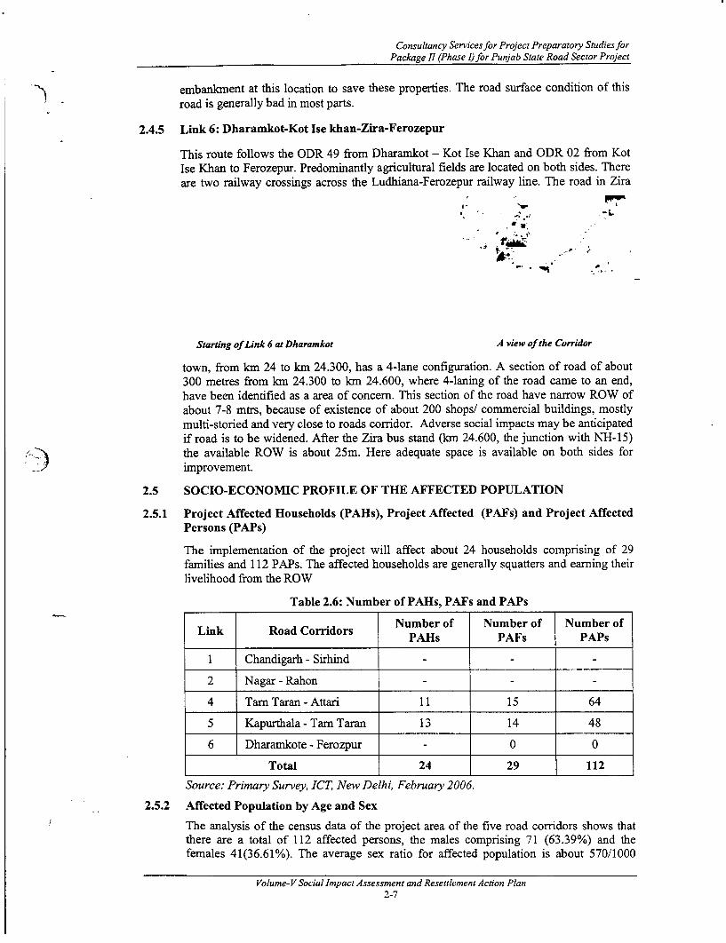
2.4.5 Link 6: Dharamkot-Kot Ise khan-Zira-Ferozepur
This route follows the ODR 49 from Dharamkot - Kot Ise Khan and ODR 02 from KotIse Khan to Ferozepur. Predominantly agricultural fields are located on both sides. Thereare two railway crossings across the Ludhiana-Ferozepur railway line. The road in Zira
,: ''U_
4u
Starting of Link 6 at Dharamkot A view of the Corridor
town, from km 24 to km 24.300, has a 4-lane configuration. A section of road of about300 metres from km 24.300 to km 24.600, where 4-laning of the road came to an end,have been identified as a area of concem. This section of the road have narrow ROW ofabout 7-8 mtrs, because of existence of about 200 shops/ commercial buildings, mostlymulti-storied and very close to roads corridor. Adverse social impacts may be anticipatedif road is to be widened. After the Zira bus stand (km 24.600, the junction with N1H-1-15)the available ROW is about 25m. Here adequate space is available on both sides forimprovement.
2.5 SOCIO-ECONOMIC PROFILE OF THE AFFECTED POPULATION
2.5.1 Project Affected Households (PAHs), Project Affected (PAFs) and Project AffectedPersons (PAPs)
The implementation of the project will affect about 24 households comprising of 29families and 112 PAPs. The affected households are generally squatters and earning theirlivelihood from the ROW
Table 2.6: Number of PAHs, PAFs and PAPs
Link Road Corridors Number of Number of Number ofPAHs PAFs PAPs
I Chandigarh - Sirhind
2 Nagar - Rahon
4 Tarn Taran - Attari 11 15 64
5 Kapurthala - Tarn Taran 13 14 48
6 Dharamkote - Ferozpur - 0 0
Total 24 29 112
Source: Primary Survey, ICT, New Delhi, February 2006.
2.5.2 Affected Population by Age and Sex
The analysis of the census data of the project area of the five road corridors shows thatthere are a total of 112 affected persons, the males comprising 71 (63.39%) and thefemales 41(36.61%). The average sex ratio for affected population is about 570/1000
Volume-VSocial ImpactAssessment and Resettlement Action Plan2-7

Socio-Economic Profile of The State, PIA and The Project Area
males. The following table shows the population in the project area of all corridors,disaggregated by age and gender.
Table 2.7: Distribution of Affected Population by Age and Sex
SL No. Age Group Total PAPs % Gender Disaggregated Population(Years) Male % Female %
1 <18 43 38.39 30 26.79 13 11.61
2 18-25 25 22.32 16 14.29 9 8.04
3 26-40 27 24.11 14 12.50 13 11.61
4 41-55 13 11.61 9 8.04 4 3.57
5 56 & Above 4 3.57 2 1.79 2 1.79
TOTAL 112 100.00 71 63.39 41 36.61Source: Primary Survey, ICT, New Delhi, February 2006
The analysis of above table delineates that majority of the PAPs belong to the age groupbelow 18 years of age, which constitute 38.39 %, followed by age group of 26-40(24.11 %), and 18-25 (22.32%). The PAPs in the age group of 41-55 and above 56 yearsconstitute 11.61% and 3.57%, respectively.
2.5.3 Social Categories of PAHs
The analysis of census data pertaining to the social categories of PAHs suggests that mostof the affected households belong to OBC category (75.00%) followed by SC category(12.50%). About 8.33% of the affected households have not disclosed their socialcategory and only 1 household (4.17%) of the affected household) belongs to generalcategory. None of the affected households belongs to category of schedule tribe (ST).The details of the social categories given in the Table: 2.8.
Table 2.8: Social category of the PAHs
Sl. No. Caste No. of households1 SC 3 12.502 OBC 18 75.003 General 1 4.174 ST 0 0.005 Not Available 2 8.33
TOTAL 24 100.00
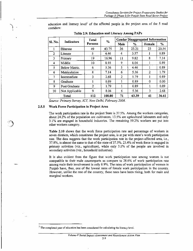
2.5.4 Education and Literacy
Education and literacy among project affected population reveals that illiteracy is highamong PAPs as 43.75% of them are illiterate. The just literate' population and primarylevel educated population constitute 4.46% and 16.96%, respectively. The middle schooleducated PAPs constitute 8.93%, matriculate 5.36%, intermediate level 2.68%, andgraduate and postgraduate 0.89% and 1.79% respectively. The gender-disaggregatedinformation in the above table shows that the proportion of literates among the females atall levels is less than their male counterpart. However, among illiterates the percentage ofmales is higher at 23.21% than the females at 20.54%. The following table shows the
Literate means just literate not functionally literate. If a person aged 6+ years and above without formal education, canread and write with some understanding in any language can be considered as just literate
Volume- V Social Assessment Plan2-8
Consultancy Services for Project Preparatory Studies forPackage II (Phase I) for Punjab State Road Sector Project
education and literacy level' of the affected people in the project area of the 5 roadcorridors:
Table 2.9: Education and Literacy Among PAPs
SI. No. Indicators Total % Gender Disaggregated InformationPersons Male % Female %
1 Illiterate 49 43.75 26 23.21 23 20.54
2 Literate 5 4.46 4 3.57 1 0.893 Primary 19 16.96 11 9.82 8 7.144 Middle 10 8.93 9 8.04 1 0.895 Below Matric. 6 5.36 5 4.46 1 0.89
6 Matriculation 8 7.14 6 5.36 2 1.797 Intermediate 3 2.68 2 1.79 1 0.89
8 Graduate 1 0.89 1 0.89 0 0.009 Post Graduate 2 1.79 1 0.89 1 0.89
10 Not Applicable 9 8.04 6 5.36 3 2.68
Total 112 100.00 71 63.39 41 36.61Source: Primary Survey, ICT, New Delhi, February 2006.
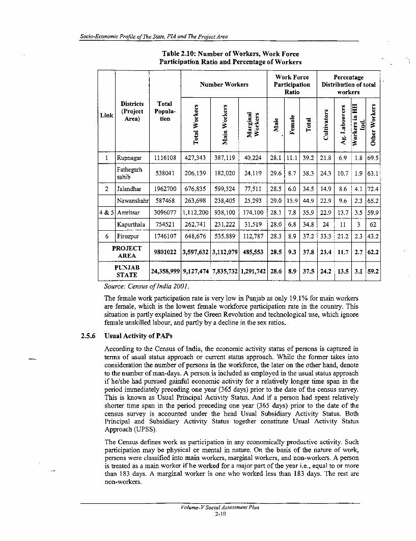
2.5.5 Work Force Participation in Project Area
The work participation rate in the project State is 37.5%. Among the workers categories,about 24.2% of the population are cultivators, 13.5% are agricultural labourers and only3.1% are engaged in household industries. The remaining 59.2% workers are put into
J other workers category.
Table 2.10 shows that the work force participation rate and percentage of workers inseven districts, which constitutes the project area, is at par with state's work participationrate. The data suggests that the work participation rate in the project-affected area, i.e.,37.8%, is almost the same to that of the state of 37.5%. 23.4% of work force is engaged inprimary activities (viz., agriculture), while only 3.1% of the people are involved insecondary activities (viz., household industries).
It is also evident from the figure that work participation rate among women is notcompatible to their male counterparts as compare to 28.6% of work participation rateamong male their involvement is only 8.9%. The rates of work participation of women inPunjab have, thus, one of the lowest rates of female work participation in the country.However, unlike the rest of the country, these rates have been rising, both for main andmarginal workers.
1 The completed year of education has been considered for calculating the literacy level.
Volume-VSocial Impact Assessment and Resettlement Action Plan2-9
Socio-Economic Profile of The State, PIA and The Project Area
Table 2.10: Number of Workers, Work ForceParticipation Ratio and Percentage of Workers
Work Force PercentageNumber Workers Participation Distribution of total
Ratio workers
Districts TotalLik (Project Popula- u-Link -E .lt$ 3 *i i S E
Area) tion -c
1 Rupnagar 1116108 427,343 387,119 40,224 28.1 11.1 39.2 21.8 6.9 1.8 69.5
Fathegarh 538041 206,139 182,020 24,119 29.6 8.7 38.3 24.3 10.7 1.9 63.1sahib
2 Jalandhar 1962700 676,835 599,324 77,511 28.5 6.0 34.5 14.9 8.6 4.1 72.4
Nawanshahr 587468 263,698 238,405 25,293 29.0 15.9 44.9 22.9 9.6 2.3 65.2
4 & 5 Amritsar 3096077 1,112,200 938,100 174,100 28.1 7.8 35.9 22.9 13.7 3.5 59.9
Kapurthala 754521 262,741 231,222 31,519 28.0 6.8 34.8 24 11 3 62
6 Firozpur 1746107 648,676 535,889 112,787 28.3 8.9 37.2 33.3 21.2 2.3 43.2
PROJECT 9801022 3,597,632 3,112,079 485,553 28.5 9.3 37.8 23.4 11.7 2.7 62.2AREA
PUNJAB 24,358,999 9,127,474 7,835,732 1,291,742 28.6 8.9 37.5 24.2 13.5 3.1 59.2STATE
Source: Census of India 2001.
The female work participation rate is very low in Punjab as only 19.1% for main workersare female, which is the lowest female workforce participation rate in the country. Thissituation is partly explained by the Green Revolution and technological use, which ignorefemale unskilled labour, and partly by a decline in the sex ratios.
2.5.6 Usual Activity of PAPs
According to the Census of India, the economic activity status of persons is captured interms of usual status approach or current status approach. While the former takes intoconsideration the number of persons in the workforce, the later on the other hand, denoteto the number of man-days. A person is included as employed in the usual status approachif he/she had pursued gainful economic activity for a relatively longer time span in theperiod immediately preceding one year (365 days) prior to the date of the census survey.This is known as Usual Principal Activity Status. And if a person had spent relativelyshorter time span in the period preceding one year (365 days) prior to the date of thecensus survey is accounted under the head Usual Subsidiary Activity Status. BothPrincipal and Subsidiary Activity Status together constitute Usual Activity StatusApproach (UPSS).
The Census defines work as participation in any economically productive activity. Suchparticipation may be physical or mental in nature. On the basis of the nature of work,persons were classified into main workers, marginal workers, and non-workers. A personis treated as a main worker if he worked for a major part of the year i.e., equal to or morethan 183 days. A marginal worker is one who worked less than 183 days. The rest arenon-workers.
Volume- V Social Assessment Plan2-10

Consultancy Servicesfor Project Preparatory Studies forPackage II (Phase I) for Punjab State Road Sector Project
The present study more or less followed the working days concepts for categorization ofworkers and non-workers in their usual activity in the project area.
Table 2.11: Usual Activity of PAPs
Si. No Usual Activity Number _
1 lWorkers 40 35.71
2 Non-workers 72 64.29
Total 1 112 100.00
2.5.7 Occupation Pattern of the Affected Persons
Although the economic base of Punjab is comprised of agriculture, the scenario in theimmediate project affected area is quite different. Out of total 112 PAPs, 72 were fromthe non-working population. Occupation-wise analysis of working group population isshown in Table 2.12.
As far as occupation of the affected population is concerned, majority of PAPs areengaged in business (62.50%), agricultural labour (25.0%) and agriculturefarmer/cultivator (2.50%). Very less proportion of population is engaged in service(2.5%). 3 PAPs (7.5%) are unemployed and none of them are professionals. Thepercentage of people engaged in agricultural labour in the project area resemblances neartrend at the state level. However, the percentages of cultivators in the project corridors aremuch less than that of the State level.
Table 2.12: Occupation Pattern of working population
-S. No. Occupations Total No. of % Project Affected Persons byNo. Ocuatos_oalN. f%Gender
Male % Female %
1 Service 1 2.50 1 2.50 0 0.00
2 Business 25 62.50 24 60.00 1 2.50
3 Agriculture 1 2.50 1 2.50 0 0.00Farmer/Cultivator
4 Business and Agricultural 10 25.00 10 25.00 0 0.00Labourer
5 Commercial Wage 0 0.00 0 0.00 0 0.00Labourer
6 Unemployed 3 7.50 3 7.50 0 0.00
7 Professional 0 0.00 0 0.00 0 0.00
Total 40 100.00 39 97.50 1 2.50
Table 2.13: Non-Working Population
Total No. Project Affected Persons by GenderSl. No. Occupations of .PsMl % Fmlof PAPs Male % Female %
1 NA 2 2.78 0 0.00 2 2.78
2 Housewife 24 33.33 0 0.00 24 33.33
3 Below 18 43 59.72 30 41.67 13 18.06
4 Above 60 3 4.17 2 2.78 1 1.39
Volume-VSocial Impact Assessment and Resettlement Action Plan2-11

Socio-Economic Profile of The State, PIA and The Project Area
TOTAL 72 100.00 | 32 | 44.44 40 55.56
Source: Primary Survey, ICT, New Delhi, February 2006.
The gender disaggregated occupational pattern shows that women participate in thebusiness (2.50%). In addition, none of the female folks are engaged in the service and anyprofessional activities. However, women are not found to participate in any otheroccupations and they are largely into household work.
The social survey gathered information on the main occupation and subsidiary occupation(if any) of the income-earning project affected population. It is noted that almost all theaffected households follow a single occupation type. However, 7 households are found topractice secondary occupation. The percentage calculation of income earning occupationshas been obtained on the basis of people's functional working age (18 to 60 years),earning an income along the corridor. The obtained data indicates that all earningmembers in a family are between the ages of 18-60 year.
The data reveals that no child labourer exists along the project road.
2.5.8 Income Pattern of the Affected Households
The census of the PAPs inquired into the annual income of the affected households. Theresult is shown in Table 2.14. The incomes have been grouped into several categories andthe number of households falling into a defined category has been shown against it. Thisinformation has provided groundwork for determining the number of household BelowPoverty Line (BPL) among the project-affected households. As indicated in the DraftResettlement & Rehabilitation (R&R) Policy Framework for the Punjab State RoadSector Project, the BPL figure in the Punjab State currently stands at Rs. 24,000/-annually a family of 6 members'. Taking annual income of Rs. 20,000/- with thethreshold income level of 20% higher than those specified therein has derived this incomelevel of Rs. 24000. The BPL issue is discussed in details in Chapter 4.
Table 2.14: Annual Income of the Affected households
SI. No. Annual Income Number Women Headed Percentageof PAH Households
1 0 to 24000 9 1 41.67
2 24001 to 30000 0 0 0.00
3 30001 to 40000 5 0 20.83
4 40001 to 60000 4 0 16.67
5 60001 to 100000 3 0 12.50
6 100001 to 200000 0 0 0.00
7 Above 200000 0 0 0.00
8 Undisclosed 2 0 8.33
Total 23 1 100.00
Total N= 24Source: Primary Survey, ICT, New Delhi, February 2006.
The above table shows that in the project area 41.67% households have annual income upto Rs. 24,000/. Which is the BPL level in the Punjab state. This table also details that 11
As per the national decennial of census of 2001, the average household size is 6. (The total population is 24,385,999and the numbers of households are 4,348,580.)
Volume- V Social Assessment Plan2-12
Consultancy Services for Project Preparatory Studies forPackage II (Phase I) for Punjab State Road Sector Project
families are living below BPL level in which 1 household is Women Headed Households(WHHs). The table further shows that 20.83% households fall in the category of annualincome group of Rs 24,001-30,000. 12.50% of the affected households have their annualincome between Rs.60, 000-1,00,000/-. About 8.33% of them have not disclosed theirannual income.
Table 2.15: Sources and Ranges of Income
Income Range (Rs.)
Si. Sources of Number o o oNo. Income of PAHs o . _
I Agriculture
2 Service
3 Business 15 5 5 3 2
Business and3 24 Agriculture 3 2 1
Business and 4 3 15 Ag. Labour
6 Labour - -
7 Undisclosed 2
Total 24 10 5 4 3 -
Source: Primary Survey, ICT, New Delhi, February 2006.
The analysis of income from different sectors shows that business activity is predominantamong the affected households. However, there are also some percentage of PAPs whoare engaged in varied occupation, comprise of Business- cum- agriculture or labour.
2.6 Findings of the Sample Baseline Socio-Economic SurveySocio-economic survey was carried out to assess the socio economic conditions and toestablish a baseline for future evaluation of project impacts. The unit of survey washousehold. Out to total 24 households (29 families), 14 households were surveyed andaccordingly analysis was made on household level. The findings of this survey arediscussed in the following sub-sections:
2.6.1 Women's Participation in Decision Making ActivitiesThe women's participation in various decision-making activities in day-to-day life is notonly confined to routine household chores, health care of children, social functions andmarriages but also in the financial matter and purchase of assets. Table 2.16 shows that inone hand women's role is cent percent in terms of domestic decision-making and healthcare of children, while on the other hand their role is limited in financial matter (35.7%).However, women plays important role (78.6%) when the decision on purchase of assetscome up. It is noted that the response for the number of households indicates a multiple-choice question; hence, the total does not tally with all the number of affected households.It is important to mention here that generally head of the households were respondents ofthe households' survey, not the women member. However, in group discussions withwomen, by and large they endorsed the views expressed by their male counterparts
Table 2.16: Women's Participation in Decision Making Activities
Volume-V Social Impact Assessment and Resettlement Action Plan2-13

Socio-Economic Profile of The State, PIA and The Project Area
Positive ResponseSI. No. Issues %age
(Multiple choice)
1 Financial Matters 5 35.702 Education of Children 6 42.903 Health Care of Children 14 100.004 Purchase of Assets 11 78.60
5 Day-to-day house management 14 100.006 On Social Function and Marriage 12 85.70
Total Number of Response=14Source: Primary Survey, ICT New Delhi, February 2006.
2.6.2 Expenditure Pattern
The expenditure pattern shows the standard of living and social status among the affectedhouseholds. The annual expenditure pattern among an average household are calculatedand presented in Table 2.17.
Table 2.17: Annual Expenditure Pattern of the Affected Households
Average Expenditure/SI. Items Particular No. of Total Monthly Family (Rs.) %age ofNo. Households Expenditure Monthly Annual Expenditure
1 Food Grains 14 19900 1421 17057 49.12 Cooking Fuel I 1 2500 227 2727 7.83 Clothing 9 2000 222 2667 7.74 Health 4 300 75 900 2.65 Education 7 2150 307 3686 10.66 Communication 12 3600 300 3600 10.47 Social Function 8 2750 344 4125 11.9
Total Expenditure % (N=14) 100Source: Primary Survey, ICT New Delhi, February 2006.
The above table shows that the average annual expenditure per families' on food grainsconstitutes a major share of the total expenditure, which is about 49.00%. Subsequently,the expenses on social function, education and communication comes the next, whichvaries between 12-10 %. The affected households have minimum expenses on health i.e.,2.6% in the order.
2.6.3 Possession of Durable Consumer Items
Possession of consumer durables/ assets generally reflects the social status of a person. Ifa person or family possess Car, Television, LPG Connection, Air-condition, Refrigerator,Motorbikes, washing machine etc, it is understood that he is economically affluentperson. Economically affluent person by and large also acquires high social status in thesocial order. The baseline data collected through the household survey shows that theliving standard of the project-affected households is just average. Most of the affectedhouseholds possess consumer durables like radio, bicycle, music system and television setetc. But they are not able to get LPG connection due to difficulties in getting connectionas well as refilling of the fuel cylinder, as the PIA is by and large rural areas. Motorbikeis the common personal vehicle of the people, as 21.4 % people own it. Not a singleproject affected households possess Car, air-condition and washing machine. The detailsare shown in Table 2.18. It is noted that the response for the number of householdsindicates a multiple-choice question; hence, the total does not tally with all the number ofaffected households.
Volume- V Social Assessment Plan2-14

Consultancy Services for Project Preparatory Studies forPackage II (Phase I) for Punjab State Road Sector Project
Table 2.18: Possession of Durable Consumer Items
Si. Items Number of HHs % ageNo.
1 Radio 14 100.00
2 Bicycle 14 100.00
3 Music system 12 85.7
4 L.P.G Connection 4 28.6
5 Television 6 42.9
6 Refrigerator 0 0.00
7 Washing Machine 0 0.00
8 Motor cycle/Scooter 3 21.4
9 Car 0 0.00
10 Air Condition 0 0.00
Total Number of Response =14Source: Primary Survey, ICT New Delhi, February 2006.
Volume-VSocial Impact Assessment and Resettlement Action Plan2-15

I-A

Consultancy Services for Project Preparatory Studies forPackage II (Phase I) for Punjab State Road Sector Project
3. CONSULTATIONS
3.1 INTRODUCTION
Keeping in mind the objective of minimizing adverse impacts and the need of thestakeholders' participation for the smooth implementation of the project, consultationswith the members of different sections of society, specifically the affected people,identified vulnerable groups including women headed families, local governmentofficials, of the project area were carried out. The consultations with vulnerable peoplewere made with the aim of building awareness among them so that the likely potentialadverse impacts of the project on the target vulnerable population may be minimized. Theoption of alternative design was also discussed with them in order to achieve speedyimplementation of the project with the active involvement of the local population. In thisregard several meetings were organized at various locations, as detailed in this Chapter.
3.2 APPROACH TO COMMUNITY PARTICIPATION
Involuntary resettlement creates a mixedfeeling of insecurity, curiosity andmisunderstanding amongst the PAPs. Socialassessment and public/communityparticipation helps to remove suchuncertainties and at the same time help theproject-proponent to incorporate valuablesuggestions and perceptions of development.Consultation with the community and theirinvolvement in different stages of project1) planning and implementation is often used Poster Displaying Date, Time and Places ofas a tool to inform and educate the Public Consultation along corridorstakeholders about the proposed action both,before and after the development decisions have been made. The consultations werecarried out on the basis of a set of guidelinesprepared for the project, Guidelines for Focus v
Group Discussions, appended as Annexure-1.4. A leaflet was designed in Punjabi ,
covering brief notes on the project, agencies - F . -involved, the need for public participation, etc.In the end, an invitation specifying date, time a -
and venue of the meeting was attached (seephoto). A sample of Punjabi and Englishversion of the leaflet used in the publicconsultation programme is attached to thisreport as Annexure 1.6 and an informationdocument circulated with maps showing theproject corridors is attached as Annexure 1.7. > ' *
All the meetings were organised incollaboration with the PRBDB, VillagePanchayat members and the anticipated Lparticipants.
In all meetings road drawings, cross sectionsand maps were shown to the people so that Gathering during Consultation
they can gather a better picture. Duringconsultation, an attempt was made to provide information about PSRSP in an appropriateform and timely manner.
Volume-VSocial Impact Assessment and Resettlement Action Plan3-1
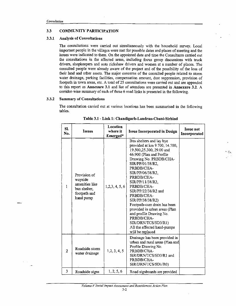
Consultation
3.3 COMMUNITY PARTICIPATION
3.3.1 Analysis of Consultations
The consultations were carried out simultaneously with the household survey. Localimportant people in the villages were met for possible dates and places of meeting and theissues were indicated to them. On the appointed date and time the Consultants carried outthe consultations in the affected areas, including focus group discussions with truckdrivers, shopkeepers and auto rickshaw drivers and women at a number of places. Theconsulted people were already aware of the project and of the possibility of the loss oftheir land and other assets. The major concerns of the consulted people related to stormwater drainage, parking facilities, compensation amount, dust suppression, provision offootpath in town areas, etc. A total of 25 consultations were carried out and are appendedto this report as Annexure 3.1 and list of attendees are presented in Annexure 3.2. Acorridor-wise summary of each of these 6 road links is presented in the following.
3.3.2 Summary of Consultations
The consultation carried out at various locations has been summarised in the followingtables.
Table 3.1 - Link 1: Chandigarh-Landran-Chuni-Sirhind
SL ~~~~Location Issue notNo. Issues where it Issue Incorporated in Design Incorporated
Emerged*Bus shelters and lay byeprovided at km 9.700, 14.700,19.500,25.300, 29.00 and46.900 (Plan and ProfileDrawing No. PRBDB/CHA-SIRIPP/01/38/R2,PRBDB/CHA-
Provision of SIR/PP/06/38/R2,Provision of PRBDB/CHA-wayside SIR/PP/11/38/R2,
1 amenities like 1,2,3,4, 5,6 PRBDB/CHA-bus sheler, SIR/PP/22/38/R2 andfootpath and PRBDB/CHA-hand pUmnp SIR/PP/38/38/R2)
Footpath-cum drain has beenprovided in urban areas (Planand profile Drawing No.PRBDB/CHA-SIR/DRN/TCS/SD3/Rl)All the affected hand-pumpswill be replaced
Drainage has been provided inurban and rural areas (Plan andProfile Drawing No.
2 Roadside storm 1,2, 3,4, 5 PRBDB/CHA-water drainage , SIR/DRN/TCS/SD3/Rl and
PRBDB/CHA-SIR/DRN/TCS/SD 1/R0)
3 Roadside signs 1,2,5,6 Road signboards are provided
Volume- V Social Impact Assessment and Resettlement Action Plan3-2
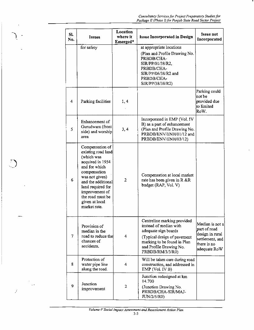
Consultancy Services for Project Preparatory Studies forPackage II (Phase I) for Punjab State Road Sector Project
Si Location Issue not
No. Issues where it Issue Incorporated in Design IncorporatedEmerged*______
for safety at appropriate locations(Plan and Profile Drawing No.PRBDB/CHA-SIR/PP/0 1/3 8/R2,PRBDB/CHA-SIR/PP/06/38/R2 andPRBDB/CHA-SIR/PP/38/3 8/R2)
Parking couldnot be
4 Parking facilities 1, 4 provided dueto limitedRoW.
Incorporated in EMP (Vol. IVEnhancement of B) as a part of enhancement
5 sGurudwara (front 3, 4 (Plan and Profile Drawing No.side) and worship PRBDB/ENV/ENH/01/12 andarea PRBDB/ENV/ENH/03/12)
Compensation ofexisting road land(which wasacquired in 1954and for whichcompensation
was not given) Compensation at local market6 and the additional 2 rate has been given in R &R
land required for budget (RAP, Vol. V)improvement ofthe road must begiven at localmarket rate.
Centreline marking providedProvision of instead of median with Median is not amedian in the adequate sign boards part of road
7 road to reduce the 4 (Typical design of pavement design in ruralchances of marking to be found in Plan there is noaccidents. and Profile Drawing No. adequae isRoW
PRBDB/RM/3/3/RO) adequate RoW
Protection of Will be taken care during road8 water pipe line 4 construction, and addressed in
along the road. EMP (Vol. IV B)
Junction redesigned at kmJunction 2 ~~~14.700
9 Junction 2 (Junction Drawing No.improvement PRBDB/CHA-SIR!MAJ-
JUN/2/5/RO)
Volume- V Social Impact Assessment and Resettlement Action Plan3-3

Consultation
SL Location Issue notNo. Issues where it Issue Incorporated in Design Incorporated
Emerged*Service road
Provision of could not be10 srvice oad1 provided due
to the limitedRoW
Road11 eimprovement to Improvement within the
I1 be restricted 2 existing ROWwithin theavailable Row
Street light Provision of Street light is12 facilities 4 being incorporated in the
12 facilities ~~~design
Restoration of Measure adopted in RAP (Vol.13 livelihood of 6 IV)
affected people
Employment to Preference will be given to
1 d4 local people 6 local people at the time of roadduring road construction (RAP, Vol. IV)construction
Provision of Rumble strips provided
15 speed breakers to 6 (Plan and Profile Drawing no.reduce chances o PRBDB/MISC/4/4/RO)accident
Dust suppression16 measures should None
be adopted
Change in
17 widening Noneoption/Realignment
18 Tree plantation None
* Location Code: 1= Sohana; 2= Landran; 3= Jhangeri; 4= Chunni; 5= Badali; 6= Sirhind
Volume- V Social Impact Assessment and Resettlement Action Plan3-4

Consultancy Services for Project Preparatory Studies forPackage II (Phase I)for Punjab State Road Sector Project
Table 3.2 - Link 2: Nagar-Aur-Rahon
LocationIsenoSN. Issues where it Issue Incorporated in Design icp norated
_No Emerged*
Bus shelters and lay byeprovided at km 11.200, 12.600,17.300, and 22.300 (Plan andProfile Drawing No.PRBDB/RAH-
Provision of NAG/PP/6/28/R2,Provwsion of PRBDB/RAH-wayside NAG/PP/7/28/R2, Provision ofamenities like PRBDB/RAH- toilets is not
1 bus shelter, 1, 2, 3, 4 NAG/PP/12/28/R2 and included infootpath, toilet, PRBDB/RAH- this projectstreet light and NAG/PP/i17/28/R2)provision of NGP/72/2proision of Footpath-cum drain has been
provided in urban areas (Planand Profile Drawing No.PRBDB/RAh-NAG/DRN/TCS/SD3/Rl)All the affected hand-pumps
_ _______________ ___________ will be replaced
Provision of Trafficadequate safety controlmeasures like Rumble strips and street light signal light
-. J speed breaker, have been incorporated in not provided2 Pedestrian 1, 2, 3,4 highway design because
crossings and (Plan and Profile Drawing No. traffic is nottraffic control PRBDB/MISC/5/5/RO) up to thesignal light at requiredjunction level
Drainage condition improvedand provided at new places
Improvement of (Plan and Profile Drawing No.3 existing storm 1, 2, 3 PRBDB/RAh-
water drainage NAG/DRN/TCS/SD3/Rl andPRBDB/RAh-NAG/DRN/TC S/SD 1 /RO)
Junction Intersection redesigned4 improvement at 3 (Junction Drawing No.
4 km 22.650 PRBDB/ NAG-RAh/MAJ-km 22.650 ~~~J-UN/2/3/RO)Restrict the roadimprovement Road improvement is restrictedbetween km 18.2 2 and typical design is shown into km 18.6 to and of dein is nminimise thesocial impact
Provision of a dustbin and the
6 Provision of 3 typical design is given in EMPdustbin in market (Vol. IV B) as a part of
____________________ enhancement
Volume-V Social Impact Assessment and Resettlement Action Plan3-5

Consultation
Si. LocationNo. Issues where it Issue Incorporated in Design incorporated
No. ~~~Ernerged* icroae
Construction of7 boundary wall 3 Existing boundary wall will be
and doctor's replaced (RAP Vol. V)house at PHC
8 Compensation at 3 No affected private propertiesreplacement cost
Existing height o Height of road is maintained at9 the road should 4 the existing level
be maintained
Strengthening ofexisting road to
10 Satluj river (3km 4 the projectlong and 22 feetwide)
Centreline marking providedinstead of median withadequate sign boards
Provision of a (Typical design of pavementmedian marking to be found in Plan
and Profile Drawing No.PRBDB/RM/3/3/RO)
Provision of Not a part of12 sewing training 4 the project
centre in village
Employment to
13 local people Noneduring roadconstruction
14 Parking facilities None
Enhancement of15 any public None
property
Dust suppression16 measures should None
be adopted
Change in
17 widening Noneoption/Realignm Nnt
18 Tree plantation None
* Location Code: 1= Rapariya; 2= Chakdana/ Urapar; 3= Aur; 4= Silkiana
Volume-V Social Impact Assessment and Resettlement Action Plan3-6

Consultancy Services for Project Preparatory Studies forPackage 11 (Phase I) for Punjab State Road Sector Project
Table 3.3 - Link 4: Tarn Taran-Chabal-Attari
Si. Location Issue notNo. Issues where it Issue Incorporated in Design corprated
No. ~~~Emerged* icroae
Bus shelters and lay byeprovided at km 4.720, 13.150,13.475 (Plan and ProfileDrawing No. PRBDB/TAR-ATT/PP/5/41 /R2,
Provision of PRBDB/TAR- Provision ofwayside ATT/PP/14/41/R2 and toilets is notamenities like ~ ,PRBDB/TAR- icue nti
1 bus shelter, 1,2 , ATT/PP/31/41/R2)Me udintsfootpath, toilet Footpath-cum drain has been projectand hand pump provided in urban areas (Plan
and Profile Drawing No.PRBDB/TAR-ATT/DRN/TCS/SD3/R1)All the affected hand-pumpswill be replaced
Sign boards and rumble stripsprovided at kIn: 4.800, 13.300,30.000, and 39.200 (Plan and
Provision of Profile Drawing No.roadside sign (PRBDB/TAR-boards, street ATT/PP/5/41/R2,2 1, 2, 3,4 PBBTRlighting and PRBDB/TAR-speed breakers ATT/PP/1 4/41 /R2 andfor road safety PRBDB/TAR-
ATT/PP/31/41 /R2)Street light will be incorporatein design
Restoration oflivelihood of
3 affected people 4,3 Measures adopted in RAPand of the (Vol.-V)vulnerablegroups
Drainage has been provided inurban and rural areas (Plan and
Provision of Profile Drawing No.4 storm water 2,4 PRBDB/TAR-
drainage ATT/DRN/TCS/SD3/Rl andPRBDB/TAR-ATT/DRN/TCS/SD 1 /RO)
Junction improved at ChabalPlan and Profile Drawing no.
5 Junction 2 3 (PRBDB/TAR-ATT/MAJ-improvement 2, JUN/3/4/RO) and at Rajatal
(PRBDB/Applicable-JUN/l/RO)
Volume-VSocial ImpactAssessment and Resettlement Action Plan3-7
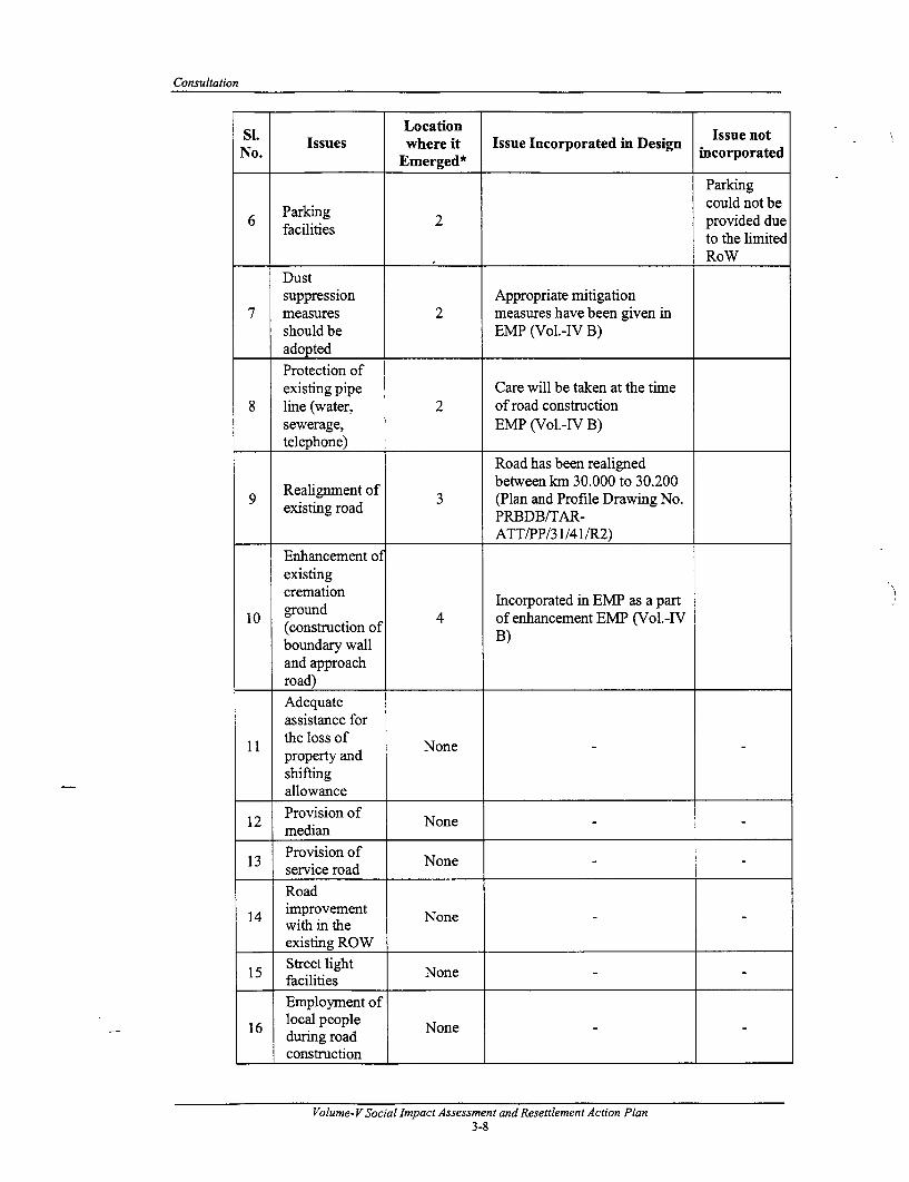
Consultation
Si. ~~~~LocationIsunoIssues where it Issue Incorporated in Design Issue n
No. Emnerged* incorporated
Parkingcould not be
6 facing 2 provided duefacilities 2 to the limited
RoWDustsuppression Appropriate mitigation
7 measures 2 measures have been given inshould be EMP (Vol.-IV B)adopted
Protection ofexisting pipe Care will be taken at the time
8 line (water, 2 of road constructionsewerage, EMP (Vol.-IV B)telephone)
Road has been realigned
Realig.nent of between kmn 30.000 to 30.2009 .exsig. of 3 (Plan and Profile Drawing No.
existing road PRBDB/TAR-
ATT/PP/3 1/41/R2)
Enhancement ofexistingcremation Incorporated in EMP as a part
10 ground 4 of enhancement EMP (Vol.-IV(construction of B)boundary wall X
and approachroad)
Adequateassistance for
11 the loss of Noneproperty andshiftingallowance
12 Provision of Nn 12 median None
13 Provision of None13 service road Nn
Road14 improvement None
14 with in theexisting ROW
15 Street light NonefacilitiesEmployment of
16 local people Noneduring roadconstruction
Volume-V Social Impact Assessment and Resettlement Action Plan3-8

Consultancy Services for Project Preparatory Studies forPackage II (Phase I)for Punjab State Road Sector Project
Si. ~~~Location Issue notSl. Issues where it Issue Incorporated in Design incorporated
No. ~~~Emerged*
17 Provision of Nonespeed breakers Nn
18 Tree plantation None
* Location Code: 1= Nurthai; 2= Chabal Town; 3= Rajatal; 4= Atari
Table 3.4 - Link 5: Kapurthala-Fatehbad-Tarn Taran
Si. IsusLocation . . Issue notNo. Issue where it Issue Incorporated in Design incorporated
Emerged* ______
Bus shelters and lay byeprovided at km 0.900, 6.700,14.700, 20.100, 30.300,42.400 and 46.900 (Plan andProfile Drawing No.PRBDB/TAR-KAP/PP/01/48/R2,PRBDB/TAR-
Provision of KAP/PP/7/48/R2,wayside PRBDB/TAR- Provision of
amenities like KAP/PP/1 5/48/R2, tiesi o7). %3 1 amentie like 1,2,3,4,5 PRBDB/TAR- included inbus shelter,KAPP248Raniclddnfootpath, toilet KAP/PP/20/48/R2 and this projectand hand-pump PRBDB/TAR-
KAP/PP/30/48/R2)Footpath-cum drain has beenprovided in urban areas (Planand Profile Drawing No.PRBDB/TAR-KAP/DRN/TCS/SD3/Rl)
All the affected hand-pumpswill be replaced
Adequatecompensationand assistancefor the property 2, 3 4 Adequate measure adopted in
2 for and RAP (Vol. V)loss andshifting cost
Employmentopportunities Preference will be given tofor local people 2,4,6 local people at the time ofduring the road , , road construction RAP (Vol.construction V)works
Volume-VSocial Impact Assessment and Resettlement Action Plan3-9
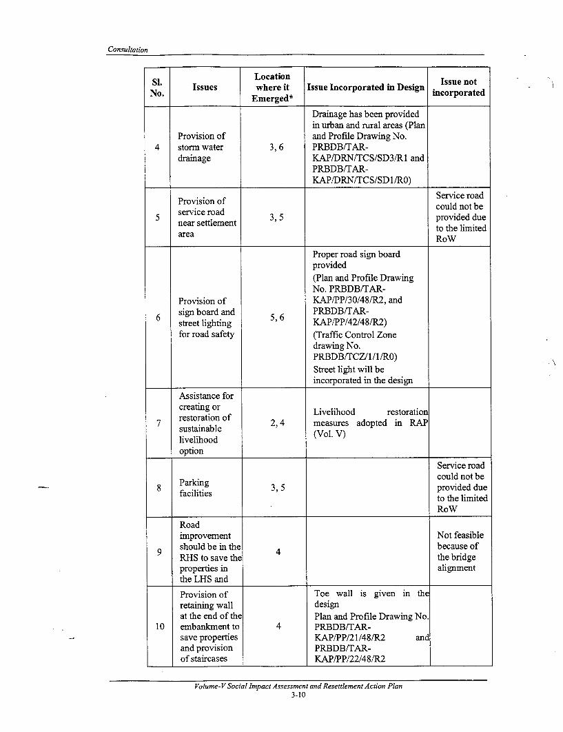
Consultation
Si. ~~~Location Issue notNo. Issues where it Issue Incorporated in Design IncorpotedNo . Emerged* incorporated
Drainage has been providedin urban and rural areas (Plan
Provision of and Profile Drawing No.4 storm water 3, 6 PRBDB/TAR-
drainage KAP/DRN/TCS/SD3/Rl andPRBDB/TAR-KAP/DRN/TCS/SD 1 /RO)
Provision of Service roadservice road could not be
5 settlement 3 5 provided duenear settlement ,' ~ to the limitedarea RoW
Proper road sign boardprovided(Plan and Profile DrawingNo. PRBDB/TAR-
Provision of KAP/PP/30/48/R2, and6 sign board and 5 6 PRBDB/TAR-
street lighting KAP/PP/42/48/R2)for road safety (Traffic Control Zone
drawing No.PRBDB/TCZ/l/l/RO)Street light will beincorporated in the design
Assistance forcreating or Livelihood restoration
7 restoration of 2,4 measures adopted in RAPsustainable (Vol. V)livelihoodoption
Service road
Parking could not be8 facilities 3, 5 provided due
to the limitedRoW
Roadimprovement Not feasible
9 should be in the 4 because ofRHS to save the the bridgeproperties in alignmentthe LHS and
Provision of Toe wall is given in theretaining wall designat the end of the Plan and Profile Drawing No.
10 embankment to 4 PRBDB/TAR-save properties KAP/PP/21/48/R2 andand provision PRBDB/TAR-of staircases KAP/PP/22/48/R2
Volume-V Social Impact Assessment and Resettlement Action Plan3-10
Consultancy Services for Project Preparatory Studies forPackage II (Phase I) for Punjab State Road Sector Project
* ~~~~~~~S. Location Issue not) No. Issues where it Issue Incorporated in Design incororatd
No. ~~~Exnerged* icroae
Provision ofspeed breakers Rumble strips providedto control the (Standard Pedestrian
11 speed of 4 Crossing, Speed Hump andvehicle within Rumble Strip Drawing No.the settlement PRBDB/MISC/4/4/R0)area.Dustsuppression Mitigation measures have
12 measures 5 been incorporated in EMPshould be (Vol. IV)adopted
Alternatehousing or Compensation at local marke
1 c3 at full 2 rate has been given in R & R13 platefell budget RAP (Vol. V)replacementcost
14 Provision of Nonemedian
1 5 Junction Noneimprovement
J 16 Street light Nonefacilities
17 Restoration of NoneI livelihood
18 Tree plantation None* Location Code: 1= Kapurthala; 2= Attnawali; 3= Fattu Dinga; 4= Mandbu-Mundichhena; 5= Fatehbad; 6= Narangabad;
Table 3.5 - Link 6: Dharamkot - Kot Ise khan-Zira-Firozpur
Si. ~~~Location Issue notNo. Issues where it Issue Incorporated in Design incorporated
Emnerged*Bus shelters and lay byeprovided atkm 0.100, 12.000,24.800,48.100, and 58.200 (Plan
Provision of and Profile Drawing No.wayside PRBDB/DHA-FIRIPP/l/60/R2, Provision ofamenities like PRBDBDHA-FIR/PP/2/60/R2, toilets is not
1 bus shelter, 1, 2, 3,4,5 PRBDB/DHA-FIR/PP/3/60/R2 included infootpath, PRBDB/DHA-FIRP5/60/R2 this projecttoilet and and PRBDB/DHA-hand pump FIR/PP/6/60/R2)
Footpath-cum drain has beenprovided in urban areas (Planand Profile Drawing No.PRBDB/FIR-
Volume- V Social Impact Assessment and Resettlement Action Plan3-11

Consultation
s~~~. ~LocationNo. Issues where it Issue Incorporated in Design Issue notedNo . Emer2ed* incorporated
DHA/DRN/TCS/SD7/R0)All the affected hand-pumps willbe replacedProper road sign board provided(Plan and Profile Drawing No.
Provision of PRBDB/TAR- Street lightsign boards KAP/PP/30/48/R2, and are not
2 and street 1, 2,3,4,5 PRBD/TAR- included inlighting for KAP/PP/42/48/R2) . the currentroad safety (Traffic Control Zone Drawing road design
No. PRBDB/TCZ/l/1/RO)Street light will be incorporated
_ ___________ in the design
Drainage has been provided inurban and rural areas (Plan and
Provision of Profile Drawing No.3 storm water 1, 2, 3,4 PRBDB/FIR-
drainage DHA/DRN/TCS/SD3/Rl andPRBDB/FIR-DHA/DRN/TC S/SD 1 /R0)
ParkingProvision of could not be
4 parking 2,4 provided duefacilities to limited
RoW
Junction Junction redesigned at kmimnprovement, 12.000 (design chainage 9.500)beatification (Plan and Profile Drawing No.
5 and 2 PRBDB/FER-maintaining DHA/MAJ1J-UN2/DRN/ l/RO)the height of Height of the road is maintainedthe road at at the existing levelsame levelTreeplantation Incorporated in EMP (Vol. IV
6 within the 2 B)market areaEnhancement
7 of Shivalya 3 Incorporated in EMP (Vol. IVtemple and B) as a part of enhancementPark
One way Bypass istraffic not feasiblebetween km Incorporated in the design due to the
8 24.600 and (Plan and Profile Drawing No. projectProvisiond of PRBDB/DHA- limitationsProvision of FIR/PP/25/60/R2) (As this is a
minimise rehabilitationmmimise corridor)social impact
Volume- V Social impact Assessment and Resettlement Action Plan3-12
Consultancy Services for Project Preparatory Studies forPackage II (Phase I) for Punjab State Road Sector Project
Si. LocationIssues where it Issue Incorporated in Design icorporated
No. Emerged* icroae
Roadimprovementshould berestrictedwithin the Road widening restricted withinexisting RoW existing RoW all along the
9 to minimise corridor and no privatethe impact on properties are affected.livelihood and Height of the road is maintainedthe Road at the existing level.height shouldbe maintainedat the samelevelAdequatecompensation
10 and assistance Nonefor the loss ofassets
11 Provision of Nonemedian
Protection ofwater
-~) ; 12 pipelinesalong the road
Provision of13 service roads None
14 Street light Nonefacilities
Restoration of
15 livelihood of Noneaffectedpeople
Employmentof local
16 people during NoneroadconstructionProvision of
17 speed NonebreakersDustsuppression
18 measures Noneshould be
.___ adopted
) * Location Code: 1= Dharnkote; 2= Kot Ise Khan; 3= Zira; 4= Sharkhan Wala; 5=,Ferozpur
Volume- V Social Impact Assessment and Resettlement Action Plan3-13

Consultation
3.3.3 Consultation with women along the project road
Consultation with women member of society in the project corridor was carried out withthe intention to document their views about the project and likely impact of the projectimnplementation on them. The separate consultation with the women was intended torecord the women specific problems/ issues, which may not be possible in the generalconsultation. As evident, by and large, male members dominate the whole proceedings ofthe consultation process in general consultation and where hardly any women specificissues were discussed. In this way, the consultation with the women group along theproject corridor was different from the general consultation, where mostly womenspecific issues were discussed and concern of the women, related to projectimplementation, were recorded by a women social scientist.
Consultation with Womenhinterviews and discussion with women were carried out in all the roads sub-project toincorporate their views, concerns, requiremnents and suggestions due to imnplementation ofthe project. Some of the issues raised during consultations are summarised in thefollowing table. Most of the issues were incorporated in project deign stage and has beendiscussed in Chapter 3. Some of the issues emerged during consultation with women issummarised in Table 3.6.
Table 3.6: Issues Raised by Women during Consultation
No. ofLink Place Chainage Issues Raised Women
Participants1 Landran 14.700 * Roadside drainage 9
* Road safety
* Arrangement of secondaryeducation facility in the existing
SiManan ~~~~school in village2 Villange 11.200 * Provision of sewing training 8
Village ~~~~centre in village* Provision of street light* Road sign _____
Volume- VSocial Impact Assessment and Resettlement Action Plan3-14

Consultancy Services for Project Preparatory StudiesforPackage 11 (Phase I) for Punjab State Road Sector Project
No. ofLink Place Chainage Issues Raised Women
ParticipantsRajatal 30.000 Roadside drainage
R Public convenience for ladies3 . Roadside drainage
Attari 39.200 . Public convenience for ladies 10a Provision of street light. Education facility for their
Attnawali 6.600 children 20. Road safety 2. Assistance to the PAPs
4 * Road traffic accidents. Road safety
Mandbu- 22.000 . Assistance to the PAPs 29Mundichhena . Provision of staircase from road
to house (located at toe ofembankment)
5 Kot - Ise - 12.000 . Roadside drainageKhan . Road safety
The main issue raised by the women were related to road safety and drainage facility.Apart from this, they were also concerned with the appropriate compensation payment.The measures for road safety have been incorporated in the design.
In brief, most of the issues discussed during the consultation, as summarised in tables 3.17) to 3.6, have been incorporated in the design.
3.3.4 Summary of Consultation with the Vulnerable Groups
The consultation with the vulnerable group is much more focussed than the generalconsultation, as it tries to visualise the impact of the project on that group, who alreadyhave a fragile social and economic base.
Although, there is 1 1 households belong to Vulnerable Groups but surprisingly, in agroup discussion, which was specially organized for vulnerable groups, no people fromvulnerable section turned up in the meeting except one Women headed household (WHH)at Rajataal on Link 4. Thus, the views expressed by the woman only depict the partialpicture of the concern of the vulnerable groups. The affected woman is a widow andmnning a tea stall owned by her. This shop is only source of her livelihood, with whichshe supports her family of two unmarried and school going daughters.
Thus, to restore her income and livelihood she only needs adequate compensation andassistance.
* Although 3 women can 'tform a group but it was better to record the perception of the women who turnedup for consultation, as at some locations it was difficult to ensure the participation of women in a group,where only 3-4 women came forward to participate in the group discussion.
Volume- V Social Impact Assessment and Resettlement Action Plan3-15

I
II
I

Consultancy Services for Project Preparatory Studies forPackage I1 (Phase I) for Punjab State Road Sector Project
4. POVERTY ANALYSIS AND VULNERABLE GROUPS
4.1 DEFINITION OF POVERTY AND POVERTY LINE
Poverty usually refers to inadequate income to carry out the minimum expenditure for themaintenance of a family. As such, poverty line is a fiscal line. People not having thecapacity to spend for maintaining themselves above that line are known as those belowthe poverty line.
The United Nation (UN) Human Development Report defines poverty as denial ofopportunities and choices most basic to human development, which include choice to leada long, healthy and creative life and enjoy a decent standard of living, freedom, dignityand self-respect.
However, poverty also refers to relative inaccessibility to the social services, such as,drinking water, education and health care facilities, lack of access to market for the sale ofa farmer's surplus produce as well as lack of accessibility to economic services, such as,agricultural loan, etc. In this respect, further away a village is from the centre of economicgravitation, poorer are the villagers there. This aspect of poverty - the non-incomedimension - is now at the centre of the multilateral agencies' attention, especially thoseof the ADB, the World Bank, and the United Nations (cf. the UN Human DevelopmentIndex). It is believed that tackling these aspects of poverty would function as thepreventive management of the poverty incidences.
4.2 CONCEPTUALISATION OF POVERTY IN INDIA
Poverty in India is officially linked to a nutritional baseline measured in calories. Thepoverty line corresponds to a total family per capita expenditure sufficient to provide, inaddition to basic non-food items such as clothing and transport, a daily intake of 2400K) calories in rural and 2100 in urban areas. Poverty is, thus, a concept closely related tosubsistence level of living'.
The poverty line in India is not measured in terms of income, but in terms of monthlyconsumption. The monthly consumption expenditure is more or less equivalent to income(including borrowing) of the poor, but it is not so for the non-poor, who may havesignificant savings. Since the poverty line is based on expenditure, it has no directrelation to income earnings by any individual of a household. The measurement is carriedout by taking total household expenditure and dividing by the number of householdmembers.
The actual identification of below poverty line (BPL) families is done by a survey, knownas the BPL survey, carried out by the District Rural Development Agency (DRDA) of allthe State Governments. Generally, the poverty line is multiplied by an assumed familysize (usually 5) and used as a cut-off for the family as a whole. In addition, this surveyalso uses certain exclusion criteria such as the type of the house, ownership of a minimumamount of land, ownership of certain consumer durables, etc.
It is noted that there is no "national poverty line" in India, simply because both prices andconsumption patterns are very different in the rural and urban areas. Clubbing thesetogether would do injustice to at least one group. Therefore, in India we have differentpoverty lines for rural and urban populations. Similarly, prices of the same commoditycan vary by as much as 40% in different parts of the country. Thus, the same consumptionbasket will have very different values in different states. That is why in India we use statespecific poverty lines for rural and urban areas separately.
Y.C. Nanda, Employment Creation and Poverty Alleviation. Mumbai, National Bank for Agriculture and RuralDevelopment (NABARD), 1998.
Volume- V Social Impact Assessment and Resettlement Action Plan4-1

Poverty Analysis and Vulnerable Groups
The BPL survey is carried out by the states once every few years; the last time it wasdone was in 1999-2000. Therefore, to update the figures to the current year, a simple andacceptable (although approximate) procedure would be to inflate them by using the statespecific Consumer Price Indices for Agricultural Labour (CPIAL) for rural areas andIndustrial Workers (CPIIW) for urban areas. On the other hand, the World Bank uses aUS$ 1.00 per person per day poverty line for intemational comparisons.
In a recent study on poverty in one of the Indian state Andhra Pradesh', poverty line hasbeen defined from the point of view of the poor people as one's ability to cross over theneed of the four stages of food, minor repairs, debt servicing, and finally, clothes (in thatorder). This kind of participatory approach to poverty analysis illustrates the nature of riskand vulnerability, how cultural factors and ethnicity interact and affect poverty, howsocial exclusion sets limits to people's participation in development, and how barriers tosuch participation can be removed.
4.3 THE POVERTY SITUATION IN PUNJAB
Poverty has fallen in Punjab during the 1990s and the regional disparities have narrowed.The most recent large-sample National Sample Survey Organization (NSSO) data from1999-00 indicate that only 1.5 million of the 25 million people who live in Punjab arebelow the official poverty line, compared to 260 million poor people in all of India. Thispoverty head-count ratio (6 percent) makes Punjab the state with the lowest poverty rateamong the major Indian states and places it well above the all-India average of 26percent.
There is also evidence of narrowing of regional disparities within the state during the1990s. Rural poverty levels are comparable to those in urban Punjab, and the differentestimates of poverty levels in 1998-99 all point to a narrowing of the gap between thenorthem (traditionally richer) and southem regions of the state. Not only has Punjabhistorically had the lowest poverty rate, it has also experienced one of the sharpest rate ofdeclines in poverty as compared to other states. Punjab performed particularly well duringthe 1970s following the green revolution. The rural headcount ratio declined by 12percentage points, from 28 percent in 1973-74 to 16 percent in 1977-78, at a rate that wasmuch more rapid than poverty reduction in other states during the same period.
4.4 MANIFESTATION OF POVERTY AND VULNERABILITY IN THE PROJECTAREA
The PSRSP R&R Principles and Policy Framework includes in the list of vulnerablegroup the following:
(a) Families below the poverty line;
(b) Small and Marginal farmers;
(c) Members of the Scheduled Castes (SC);
(d) Women headed families;
(e) Orphans or destitute persons (socially handicapped); and
(f) Disabled persons (physically or mentally handicapped).
Poverty is manifested in the project area in terms of below poverty line families and othervulnerabilities, such as Scheduled Caste families. Other issues of vulnerability include thewomen-headed families, although in term of number it is insignificant.
'Falling into Poverty in Villages ofAndhra Pradesh by Anirudh krishna, Mahesh Kapila, Sharad Pathak, MahendraPorwal, Kiranpal Singh, Virpal Singh. Economic and Political Weekly, 17 July 2004, pp. 3249-3256.
Volume- V Social Impact Assessment and Resettlement Action Plan4-2

Consultancy Services for Project Preparatory StudiesforPackage n1 (Phase I)for Punjab State Road Sector Project
The below poverty line (BPL) figure in the Punjab State currently stands atapproximately Rs. 24,000/- annually' per family of 6 members2. Taking annual income ofRs. 20,000/- with the threshold income level of 20% higher than those specified thereinhas derived this income level of Rs. 24,000/-.
The data presented in the table below shows that out of total affected population, 11Project Affected Households (PAHs), i.e., 45.8 % of total affected households arevulnerable, of which 7 PAHs are under the BPL category. 3 households belong to SCcategories, while 1 household is WHHs.
There are no ST, marginal farmers, handicapped orphans and destitute persons beingaffected due to project implementation.
Table 4.1: Vulnerable Households 3
Total % Distribution ofS1. No. Vulnerable Groups PAHs PAFs Vulnerable Households
1 BPL (Excluding SC People) 7 7 29.7
3 SC (BPL-2; APL-1) 3 4 12.5
4 ST - - -
Women Headed Households5 (BPL) 1I 4.2
6 Small Marginal Farmers - -
7 Handicapped -
8 Orphans -
9 Destitute - -
Total 11 12 45.8
Total (N) 24Source: Primary Survey, ICT, New Delhi, February 2006.
The census and social impact surveys did not record the existence of orphans or destitutepersons, as squatters or otherwise, within the existing road corridor. The issues of thevulnerable groups in respect of this project and their mitigation are discussed in thischapter.
4.4.1 Scheduled Castes (SC) and Scheduled Tribes (ST)
The members of the SC and the ST are the socially and economically deprived sections ofthe Indian population. The Scheduled Caste groups are at the bottom of the Hindu socialhierarchy. These communities lag behind other communities in several respects, such asliteracy, occupational status and income level. These differences point to their highervulnerability. As indicated, the social impact survey has identified only 4 project affectedSC families and no ST family.
4.4.2 Gender Analysis and Women Headed Households (WHHs)
Women in India generally, and in Punjab among others, have lagged behind on thepolitical, economic and social front, not because they are not capable but because they
Source: Draft Resettlement & Rehabilitation (R&R) Policy Frameworkfor the Punjab State Road Sector Project, May2006.
2As per census survey 2001, in Punjab the average household size is 6. (The total population is 24,385,999 and thenumbers of households are 4,348,580.)
Vulnerable groups were identified as per the guideline of PSRSP R & R Principles and Policy Framework (given inparagraph I of section 4.4 of this report).
Volume- V Social Impact Assessment and Resettlement Action Plan4-3

Poverty Analysis and Vulnerable Groups
have been denied opportunities. In the case of Punjab, the imbalance in the male-femalesex ratio, the educational attainment levels, the infant mortality rates, the skilledworkforce, access to common properties, and the right to inheritance are a few indicatorsthat highlight the differentials. In the following a brief review is made of the genderanalysis of a few relevant indicators in the context of Punjab.
Women's Place in Punjabi Society
As in other parts of India, Punjabi society consists of hierarchies based on caste, class andcommunity. Within these hierarchies there is yet another hierarchy-of gender-womenbeing at the lower rung. There were marked differentials in labour force participation forpoor women, both urban and rural. The state of rural women, who comprise the majorityof the women's labour force, is pitiable. Most of them belong to the informal sector, withlittle or no bargaining power, which contributes to their marginalisation.
The Custom of Son Preference
The Punjabi society continues to place a premium on the male child. The birth of a son isan occasion to rejoice while the birth of a girl is a time for disappointment. Folk songsand dances reflect people's values and beliefs. Thus, discrimination against girls andwomen seems to be woven into the very socio-cultural fabric of the Punjabi society. Awoman's status in society, among her own peers is measured not by what she is and whatshe does but if she has at least one male child. So strong is this need to 'belong' to thesociety and community that women themselves perpetuate the custom of son preference.
The preference for the male child is strongly rooted in economics, particularly scarcity ofagricultural resources, such as land. Since women have been largely left out of theagricultural process, land and its use has become a typically male domain. Any womantrying to get her share of the ancestral property was accused of being vile, base anddepraved.
A number of customs related to the son preference could be traced to efforts at keepingvalued assets within the family. Widows were married off to younger brothers-in-lawthrough a practice known as 'chadar pauna'. Sisters were discouraged from asking fortheir share in property and any actions in this direction invariably led to rift in family ties.Women were thus discouraged from claiming any rights to land or assets of value.
While there has been awareness among women of inheritance rights in the past quarter ofa century, families began to fear that their property would go into the hands of the son-in-law. Thus, there emerged a heightened preference for the male child and the custom ofdowry gained ground. Dowry was seen as assets given in lieu of a girl's share in herparental property. These developments reinforced the existing preference for a son,indirectly accelerating the rates of foeticide and infanticide in the state.
All this gender disaggregated information in the project area point to the lower socialstatus of women and their commensurate vulnerability. It is, however, noted that there areno legal, cultural or religious constraints to women's potential participation in the project.
Women at work
In Punjab as in India, women are relatively invisible in workforce statistics. Restrictivedefinitions of 'work', mostly based on economic concepts of productivity, have reducedwomen to economic non-entities. This is because women's labour, in most cases does notdirectly produce marketable goods or services. This notion of work has hugelyundermined women's contribution to the economy, resulting in the non-recognition ofwomen as important economic entities. Despite the high level of development andeducation, Punjab has the lowest female workforce participation rate in the country. Themajority of women are included in the category of non-workers, which is a conclusive
Volume- V Social Impact Assessment and Resettlement Action Plan4-4
Consultancy Services for Project Preparatory Studies forPackage II (Phase I) for Punjab State Road Sector Project
evidence of the invisibility of women work force. The overall female work participationrates have increased, but this is much more significant for rural Punjab compared to urbanPunjab. In spite of this increase, female WPRs remain very low in Punjab. There arediverse thoughts on why is women's work invisible in Punjab. While some people assertthat the causes be traced to migration of female labour to the Green Revolution andtechnological use, which ignores female unskilled labourers, others attribute it to adecline in sex ratios.
The women's work force matter described above finds support in the Consultants'household survey, which has been discussed in chapter-2 in details.
Education
Although significant progress has been made in education, vast gender gaps persist in thestate. Punjab ranks 16th in terms of literacy compared to other states and union territories.However, the state is better placed in terms of female literacy (14'") as compared to maleliteracy (25th). This could be indicative of the increased efforts to promote femaleeducation. In comparison, in a number of states female literacy rate is almost half of thatof male literacy rate, as in Jharkhand and Bihar.
Age at MarriageAge at marriage is relatively high in Punjab. The National Family Health Survey (NFHSII, Punjab) reports that a majority of women in Punjab get married only after attaining thelegal minimum age of marriage. The Singulate Mean Age at Marriage (SMAM) forfemales age 25-49 years estimated by the NFHS (1998-99 - Punjab) is 21 years in urbanareas, 20 in rural areas and 21 years overall. Marriage ages have been rising over time.The SMAM for females has risen by three and a half years during the two decades from17.5 years in 1961 to 21.1 years in 1981. Age at marriage had remained unchangedbetween 1981 and 1998.'
Gender Equity IndexThe National Human Development Report released by the Planning Commission hasmade a Gender Equity Index, similar to the Gender Development Index (GDI). TheUNDP's Human Development Index (HDI), using three indices-life expectancy,educational attainments and per capita GDP-measures a country's achievement inhuman capabilities. Of the 25 major States, Punjab ranks sixth in HDI but in GEIrankings it comes 16th. This gives the highest negative differential when HDI rank iscompared vis-a-vis the GEI ranks and indicates that Punjab's affluence does not translateinto better opportunities for women, and reinforces the fact that gender inequalities cannotbe linked to income levels alone.
Women's Status in project corridorEconomic prosperity isn't always a sign of social progress, but sometimes the status ofwomen in the society decides the nature and structure of the society. Uptil now, in Indiathe role of women in the decision-making in the family was practically ignored. But withthe increasing participation of women in the work force and the multiple roles of womenas mothers, homemakers and paid workers etc, therefore, demonstrated the importanceand usefulness of women. In this light, the present study analyses in depth the changingrole of women in occupational structure with the economic development of the society.
The concept "status of women" eludes precise definition and hence precise measurement.Status can be perceived in different ways: the extent of a woman's access to social andmaterial resources within the family, community and society or her authority or powerwithin the family/community, autonomy they have in decision-making and makingpersonal choices at crucial points in their life-cycle.
As reported in the Punjab Human Development Report 2004, UNDP.
Volume-V Social Impact Assessment and Resettlement Action Plan4-5

Poverty Analysis and Vulnerable Groups
The general consultation and survey conducted in the project area reveals that women ingeneral have their say in decision making of economic and family matter. As and whenrequired their male counterparts consult the women member in financial matters,education and health care of their children and other day-to-day activities.
Volume- V Social Impact Assessment and Resettlement Action Plan4-6
Consultancy Services for Project Preparatory Studies forPackage 11 (Phase I) for Punjab State Road Sector Project
5. IDENTIFICATION OF IMPACTS
5.1 FEATURES OF PROPERTIES
The result of the social survey shows that about 24 private properties; mainly shops arebeing affected due to the project. Besides private properties, 139 Community propertyResource (CPRs) excluding Govt properties are also affected (See Table 5.1). Busshelters, hand pumps and religious structures, which constitute community properties(CPRs), count together for 139 in number and it comprise of 58 hand pumps, 65 Bus-Shelters, 4 shrines and 2 trees with sitting platforms. Govt Structures such as 5 policecheck posts and 1 boundary wall are also being affected.
The social survey also enumerated 60 mobile vendors operating on the project roads.Observing their mobile nature, these mobile vendors have not been considered in affectedcategories by the project and no mitigating measures proposed for these.
The combined list of all properties, which are being affected by the project and link wisedetails of all the private properties, has been delineated in table 5.1 and table 5.2. Thedetail list of affected private properties is given in Annexure 5.1.
It is important to note here that no titleholders are being affected due to implementation ofthe project.
Perceptibly there is also no land acquisition in all the project roads under rehabilitationcorridors as the existing ROW is sufficient for the proposed road project.
Table 5.1 - Link-Wise details of Affected Properties
Private (Shops) Link 1 1 Link 2 4 5 Link 6 Total %
Private Structures l1 13 24 14.2
Private (Total) 24
Hand Pumps 5 19 18 14 2 58 34.3
Bus Shelters 12 8 13 18 14 65 38.5
Community Platform + 0 3 2 5 2 1 .Properties Tre 0 3 2 5 2 12 7.1
(CPRs) ~~Shrine - 1 1 - 2 4 2.4
Shrine under0.Shrie uder - - - - - 0 0.0
tree
CPRs (Total) 139
Police Check - - 3 2 5 3.0Govt. Post
Boundary Wall - 1 |- - 1 0.6
Govt. (Total) 6
Total 17 32 45 53 22 169 100
% 10.1 18.9 26.6 31.4 13.0 100.00
Volume- V Social Impact Assessment and Resettlement Action Plan5-1
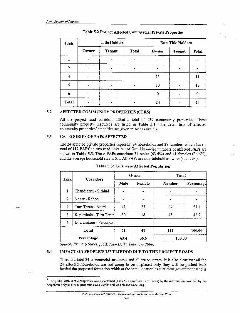
Identification of Impacts
Table 5.2 Project Affected Commercial Private Properties
Link Title Holders Non-Title Holders
Owner Tenant Total Owner Tenant Total
4 --- 11-1
5 13 -13
6 --- 0 -0
Total - - - 24 24
5.2 AFFECTED COMMUNITY PROPERTIES (CPRS)
All the project road corridors affect a total of 139 community properties. Thesecommunity property resources are listed in Table 5.1. The detail lists of affectedcommunity properties/ amenities are given in Annexure 5.2.
5.3 CATEGORIES OF PAPs AFFECTED
The 24 affected private properties represent 24 households and 29 families, which have atotal of 112 PAPs' in two road links out of five. Link-wise numbers of affected PAPs areshown in Table 5.3. These PAPs constitute 71 males (63.4%) and 41 females (36.6%),and the average household size is 5.1. All PAPs are non-titleholder owner (squatters).
Table 5.3: Link wise Affected Population
Owner TotalLink Corridors
Male Female Number Percentage
1 Chandigarh - Sirhind
2 Nagar - Rahon - - - -
4 Tar Taran - Attari 41 23 64 57.1
5 Kapurthala - Tarn Taran 30 18 48 42.9
6 Dharamkote - Ferozpur - -
Total 71 41 112 100.00
Percentage 63.4 36.6 100.00Source: Primary Survey, ICT, New Delhi, February 2006.
5.4 IMPACT ON PEOPLE'S LIVELIHOOD DUE TO THE PROJECT ROADS
There are total 24 commercial structures and all are squatters. It is also clear that all the24 affected households are not going to be displaced only they will be pushed backbehind the proposed formation width at the same location as sufficient govermnent land is
l The partial details of 2 properties was ascertained (Link 5- Kapurthala Tarn Taran) by the information provided by theneighbour only as closed properties was kiosks and was closed since long.
Volume-V Social Impact Assessment and Resettlement Action Plan5-2

Consultancy Services for Project Preparatory Studies forPackage II (Phase I)for Punjab State Road Sector Project
available in the backside of these structures. There will be temporary livelihood loss dueto the project.
The Entitlement Framework of the PSRSP provides for distinct entitlements andassistance for each category of the affected/displaced families/persons.
5.5 MEASURES TAKEN TO MINIMISE THE IMPACTS
The various avoidance measures for minimizing the extent of social impacts have beenworked out for all the five corridors where impacts are envisaged. A description of themeasures has been presented in the following sub-section.
5.5.1 Establishment of the Corridor of Impact (CoI)
The Corridor of Impact in the project corridors defines the extent on either side of theroadway that needs to be cleared for the construction purposes. Rehabilitation/wideningand raising of the road formation will require a wider clear zone than the existing one.This will involve removal of roadside trees and squatters from within the RoW. Theprimary objective of the social team has been to reduce the CoI without compromising theconstruction requirements and safety needs of the road design. The measures taken tomodify the CoI include:
* Optimisation of the CoI width by the provision of retaining walls;
* Incorporating the desired low-speed zones and hence reduced cross sections in thesettlement areas;
* Closed drains used (where applicable) in urban area to ensure proper drainage andfootpath above it. Attempt has been made to minimize the possibility of the drainsbecoming open sewers or clogged with garbage.
5.5.2 Minimisation of Displacement and Property Acquisition
By reducing the formation width of the road for rehabilitation work, the road boundaryhas been restricted within available ROW in Rural and Urban area. The proposedformation width comprise a 12m pavement in rural areas and a 9m one in urban areas tominimise the adverse social impacts in terms of acquisition of private properties and theresultant displacement of families. In link 4, where the RoW is narrow, a 9m pavement isproposed throughout. Various types of typical cross sections that were considered aregiven in Annexure 1.1 and are described below.
Cross Section in Link 1
* Pavement width of 21.8m (4-laning cross section): The 21.8m proposedimprovement includes 7m divided carriageway, 1.5m paved shoulder and lmearthen shoulders on both sides and 1.2-1.8m median (Drawing 1.1 of Annexure1.1). This is adopted in Link 1, km 11.260 to km 12.240, km 39.840 to km 39.935,km 41.660 to km 42.250. Pavement width of 12m (cross section in rural areas):
* Pavement width of 12m: The 12m proposed improvement includes 7m undividedcarriageway, 1.5m paved shoulder and lm earthen shoulders on both sides(Drawing 1.2 of Annexure 1.1).
Cross Section in Link 2
* Pavement width of 9m (cross section in urban/ settlement areas): The 9m proposed) improvement includes a 7m undivided carriageway and a 1 m hard shoulder on each
side (Drawing 1.3 of Annexure 1.1). This is adopted in link 2, km 16.800 to km
Volume-VSocial ImpactAssessment and Resettlement Action Plan5-3
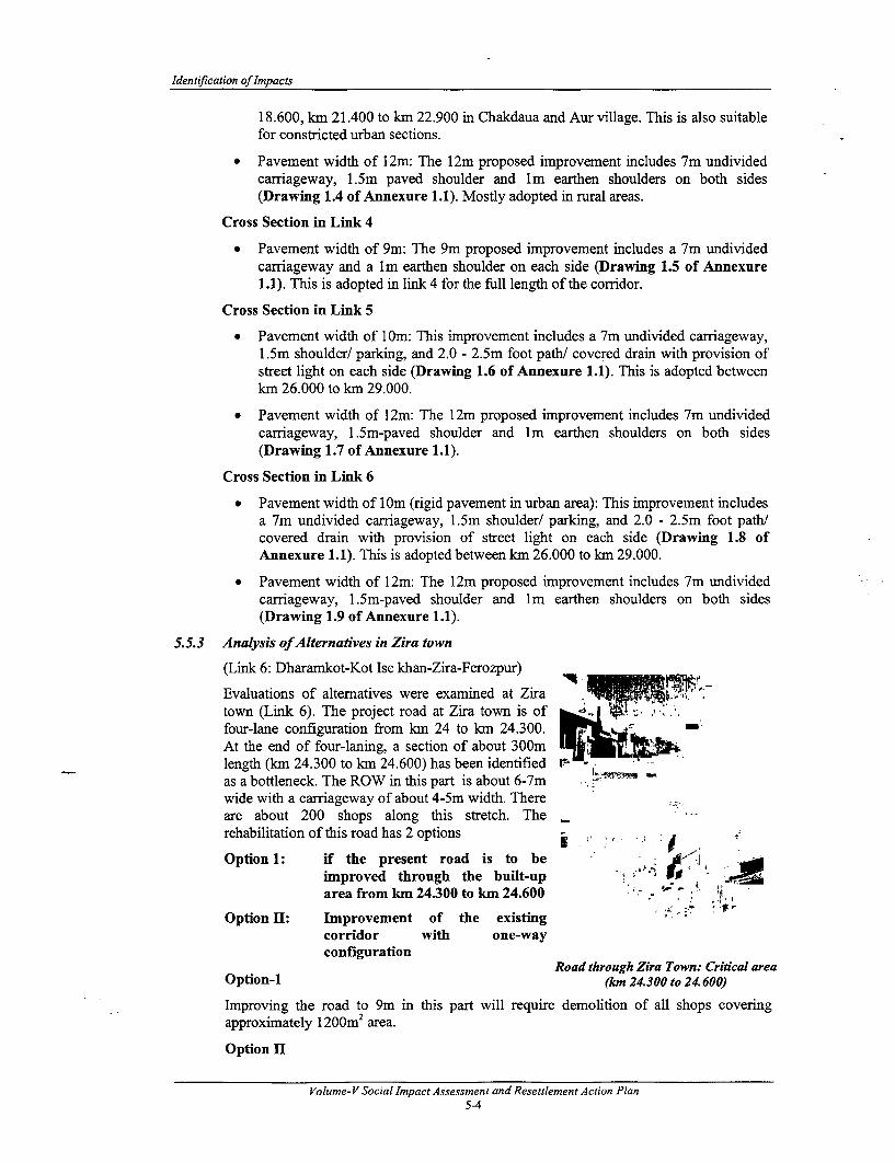
Identification of Impacts
18.600, kIn 21.400 to km 22.900 in Chakdaua and Aur village. This is also suitablefor constricted urban sections.
* Pavement width of 12m: The 12m proposed improvement includes 7m undividedcarriageway, 1.5m paved shoulder and Im earthen shoulders on both sides(Drawing 1.4 of Annexure 1.1). Mostly adopted in rural areas.
Cross Section in Link 4
* Pavement width of 9m: The 9m proposed improvement includes a 7m undividedcarriageway and a lm earthen shoulder on each side (Drawing 1.5 of Annexure1.1). This is adopted in link 4 for the full length of the corridor.
Cross Section in Link 5
* Pavement width of 1 Om: This improvement includes a 7m undivided carriageway,1.5m shoulder/ parking, and 2.0 - 2.5m foot path/ covered drain with provision ofstreet light on each side (Drawing 1.6 of Annexure 1.1). This is adopted betweenkm 26.000 to km 29.000.
* Pavement width of 12m: The 12m proposed improvement includes 7m undividedcarriageway, 1.5m-paved shoulder and Im earthen shoulders on both sides(Drawing 1.7 of Annexure 1.1).
Cross Section in Link 6
* Pavement width of 1 Om (rigid pavement in urban area): This improvement includesa 7m undivided carriageway, 1.5m shoulder/ parking, and 2.0 - 2.5m foot path/covered drain with provision of street light on each side (Drawing 1.8 ofAnnexure 1.1). This is adopted between km 26.000 to km 29.000.
* Pavement width of 12m: The 12m proposed improvement includes 7m undividedcarriageway, 1.5m-paved shoulder and lm earthen shoulders on both sides(Drawing 1.9 of Annexure 1.1).
5.5.3 Analysis ofAlternatives in Zira town
(Link 6: Dharamkot-Kot Ise khan-Zira-Ferozpur)
Evaluations of alternatives were examined at Ziratown (Link 6). The project road at Zira town is offour-lane configuration from km 24 to km 24.300.At the end of four-laning, a section of about 300mlength (km 24.300 to km 24.600) has been identified r as a bottleneck. The ROW in this part is about 6-7mwide with a carriageway of about 4-5m width. Thereare about 200 shops along this stretch. The _rehabilitation of this road has 2 options
Option 1: if the present road is to beimproved through the built-up - a UXarea from km 24.300 to km 24.600
Option II: Improvement of the existingcorridor with one-wayconfiguration
Road through Zira Town: Critical areaOption-I (km 24.300 to 24.600)
Improving the road to 9m in this part will require demolition of all shops coveringapproximately 1200m2 area.
Option II
Volume-V Social Impact Assessment and Resettlement Action Plan5-4

Consultancy Services for Project Preparatory Studies forPackage II (Phase I)for Punjab State Road Sector Project
From km 24.300 to km 24.600, the existing road may be improved and made one way fortraffic movement. This critical area (300m length) has about 6-7m available space as theROW, which is sufficient for accommodating a single lane. On the other hand to makeanother lane, there is an existing road, which runs almost parallel to the project road forabout 400m in length. This road (the new road) starts from NH 15 and joins the projectroad at km 24.300 (end of 4 laning road in Zira town).
However, a comparative analysis will give a clear picture of the improvement proposal bywhich we can select a peoples' friendly option for rehabilitation project, which will helpin avoiding involuntary resettlement as well as R & R cost:
Table 5.4: Comparative Analysis for Improvement of Corridor in Zira Town
Si. CombinationNo. Parameters Option I Option II of Option I
and Option _1
1 Length of Aligmnent (m) 300 400 400
2 Available Space (m) 6 6- 7 6 - 7
Affected People and Properties
3 No. of Affected People 1200 0 0
4 No. of Affected Wage Earners 60 0 0
5 No. of Affected Built-up 200 0 0properties
Affected Area
6 J Affected Built-up area (Ha) 1200 0 0
Utilities and Others
7 No. of Electric Poles to be 6 0 0Shifted
8 No. of Trees to be cut 0 0 0
9 Estimated Cost of Land & R&R 19,799,420 - -
Costs' (Rs.)
Remarks One way One way Recommendedconfiguration configuration Option
Source: Primary Survey, ICTI New Delhi, February 2006.
Recommended Option: Option I is not suitable as improvement of the existing road willdemolish built-up areas (shops and residential-cum-commercial structures), therebymaking adverse social impacts on the people as well as on livelihoods. However, acombination of Option -I and Option-H with one-way direction of traffic is mostsuitable, as there would not be any adverse social impact and, therefore, recommended asthe preferred route.
5.6 IMPACT OF THE PROJECT ON STD/HIV/AIDS
5.6.1 Introduction
Acquired immuno-deficiency syndrome (AIDS) caused by the human immuno-deficiencyvirus (HIV) is emerging as a major health problem and is profoundly affecting differentaspects of human life. It has emerged as a serious challenge to the public health system inIndia. According to the National AIDS Control Organisation, Government of India, after
I The detail cost is shown in Annexure 5.3.
Volume-VSocial Impact Assessment and Resettlement Action Plan5-5

Identification of Impacts
the first AIDS case was detected in India in 1986, over two million people are alreadyinfected with the HIV infection today'.
Various studies carried out worldwide by the World Health Organisation and nationalorganisations have established a direct link between the highways users (more specificallythe truck drivers) and the commercial sex workers, which is largely responsible for thetransmission of the HIV infection. It is this concern that is discussed in this chapter as anattempt in preventing of the spread of the HIV/AIDS on the improved highways.
5.6.2 HIVWAIDS in India
As the highways are improved, the transport system also improves. Throughout theworld, the growth of transport systems has been and continues to be a key element ineconomic development. In both developed and developing countries, increases in GrossNational Product (GNP) are accompanied by greater investment in both vehicles andtransport infrastructure. In the developing world, current trends in population,industrialisation and urbanisation put heavy pressures on the transport networks ingeneral. This trend, in fact, has resulted in a growth of many transport companies and,consequently, vehicles and crewmembers in many parts of India.
It is reported that HIV is rapidly spreading to rural areas in India through migrant workersand truck drivers. Surveys show that five to ten percent of the truck drivers in the countryare infected with HIV. The World Health Organisation estimates that currently there aretwo to five million crewmembers (drivers, assistants) of inter-city trucks in India.Besides being away from their homes for most of the year (almost eleven months), 75-90% of these drivers have a high rate of sexual promiscuity with female commercial sexworkers (CSW) and other sex friends enroute upon their travels or at places where theystop for rest.
The truck drivers are also reported to engage in homosexual relations with their assistants.The crew members, their spouses and the female commercial sex workers serving thesemen on the route and also in cities and towns constitute a sexually active population ofapproximately 5-12 million in India.
5.6.3 The Punjab Scene
The first AIDS patient in Punjab was reported in May 1987. Studies2 carried out at thePGI, Chandigarh show that the incidence in high-risk groups increased from 3 per 1000 in1987 to 59 per 1000 in 1997, 73% of the cases being in the third and fourth decades oflife, i.e. the most productive years. The male to female ratio was 3.1:1, and 29% of thepatients had the full-blown disease. A total of 80.5% acquired the infection heterosexuallyand only 2% of the patients were intravenous drug users. The percentage of patientsacquiring infection through blood, blood products, and haemodialysis dropped from 20%in 1987 to 5% in 1997, but the cumulative figure was still 12%. The interventionprogramme launched by the National AIDS Control Organization (NACO) appears tohave had little impact on the epidemic.
5.6.4 H[V / AIDS along the Project Road
The project road in question only serves the purpose of localized traffic and truckers andothers long route operators are hardly using it, who are generally considered as thepotential carrier of HIV/AIDs. However, in order to know about these fatal highwaydiseases along the project area, Consultant has conducted individual interviews, personalcontacts, and discussion with Dhaba owners, the potential HIV/AIDS carrier- truckers and
NACO Country Scenario, 1998-99. National AIDS Control Organisation, Ministry of Health & Family Welfare,Govermnent of India. New Delhi, (1999).For example, S. Sehgal, HIV epidemic in Punjab, India: time trends over a decade. Bulletin of World Health
Organisation, 1998;76 (5):509-13
Volume-V Social Impact Assessment and Resettlement Action Plan5-6

Consultancy Services for Project Preparatory Studies forPackage 11 (Phase I) for Punjab State Road Sector Project
their helpers and assistant, though not many in number, pedestrians and local communitypeople etc.
The consultant hardly identified any presence of Commercial Sex Workers (CSWs) in theproject area. The consultation with diverse group of people reveal the fact that generallylocal population of rural base use this road to access the basic amenities and market andthere is nothing worthwhile for CSWs that can encourage them to use the project corridoras center of sex trade. There is no movement of truckers of long route, even, who may betheir potential clients.
Not only this, the Project road is only up gradation of existing road and constructionlabour will be easily available from the local area. Further, project road is not nationalhighway thus risk of HIV/AIDs and human trafficking will be negligible. However,project Implementing Authority (PIA) will put a clause in the contract document fortaking safeguards by contractors and propagating awareness about HIV/AIDs and humantrafficking among the local people and labourers.
Thus, awareness campaign will be required at the time of construction of the road.
5.6.5 Action Plan for Awareness Campaign proposed
Thus, an action plan is proposed here for awareness campaign and prevention ofHIV/AIDS, as shown in Table 5.5 and a comprehensive budget appended to the R&Rbudget. The NGOs engaged at the project road level for the implementation of the projectwill do this job if qualified, or sub-contract specialised NGOs for the purpose.
During the construction period the prevention of the problem at the construction campwill be part of the contractor's responsibilities, which would include providing routinemedical check up, medical facilities, and condoms. The awareness campaign, to beundertaken by the NGOs, will continue throughout the implementation period. Theawareness campaign will include the following activities:
* Monthly meetings involving the potential carrier of HIV/AIDs including CSWs, ifidentified;
* Putting up signing/hoardings;
* Pictorial literature;
* Explaining the health risks through the use of flip charts;
* Referral services;
* Social marketing of condoms;
* Information on availability of pharmacies.
A couple of NGOs working on HIV/AIDS in Punjab, who are recognised by the NationalAIDS Control Society, include the following and can be engaged for specified purpose:
* Citizen Awareness Group, 2812, Sector-28-C, Chandigarh. (Contact Person- Mr.Surinder Verma)
* Servants of the People Society, Lajpat Rai Bhawan, Sector-15-B, Chandigarh.(Contact person-Shri Onkar Chand)
Volume-V Social Impact Assessment and Resettlement Action Plan5-7

Identification of Impacts
Table 5.5: Plan for Awareness Campaign and Prevention of HIV/AIDS
Action Action Implemen- Overseeing Source ofProject Stage Location Theme Components Responsibility Responsibiity Funding
Construction Awareness HI V/AIDSCamp Campain m Signing/hoardings NGO CMU Budget
Prevention Condom Contractor Contractor'sdispensing budget
Signing/hoarding
Project SiteAwareness Advertisements
Project Campaign, NGO CMU HIV/AIDSImplementation Prevention Referral services Budget
Social marketingof condoms
Signing/hoarding
Immediate Awareness Advertisements
of the Proect Ca gn, Referral services NGO CMU Budgetlocations Prevention
Social marketingof condoms
5.7 5.7 THE ROAD SAFETY ASPECTS
"If a single bread earner dies in an accident, the whole family destroy. Imagine howmany families are being destroyed every day. 7his is not only the loss of individualfamilybut the whole nation suffers due to the loss ofproductive human resources and assets. "
Road safety cannot be the responsibility of government alone. The commercial sector,service organizations and non-Governmental Organizations (NGOs) play an importantrole in increasing road safety awareness. NGOs have an imnportant input at grass rootslevel
5.7.1 Introduction
One million people are killed and 10-15 million people are injured or disabled in roadtraffic accidents (RTAs) every year worldwide. The developing countries suffer the mostand the annual loss is estimated to exceed a staggering amount of US$1000 billion, whichis equivalent to nearly twice the value of all development assistance. It is estimated that75% of road fatalities occur in developing countries and clearly the RTAs constitute amajor health problem'.
With approximately 50 fatalities per 10,000 vehicles, compared to less than five in NorthAmerica and Westem Europe, India has a high RTA rate2 . Within India, Punjab occupiesa leading position in the road related accidents with 2406 deaths in 2000, 2690 in 2001and 2638 in 2002. The mixture of buses, trucks, cars, motorized rickshaws, motorcycles,bicycles and pedestrians travelling at vastly different speeds create extremely unsafedriving conditions.
The Global Road Safety Partnership flier, The World Bank, undated (August?), 2000; Guidelines on Road SafetyAction Plans and Programmes, United Nations/ESCAP, New York, 1999.
2 Transport and Road Research Laboratory/Overseas Development Administration, Towards Safer Roads inDeveloping Countries. TRL, England, 1991.
Volume- V Social Impact Assessment and Resettlement Action Plan5-8
Consultancy Services for Project Preparatory Studies forPackage 11 (Phase I) for Punjab State Road Sector Project
5.7.2 The RTA Scene in Punjab
Research findings on RTAs in Punjab for the 2.5-year period from Jan 2003 to Jun 2005have shown that buses have been involved in 39 fatal accidents (that is 11% of the total).In the years 2003 and 2004, 61 fatal road accidents involved trucks. The victimscomprised two-wheeler riders (50%); cyclists/cycle-rickshaw pullers-passengers (25%);and pedestrians (25%). The rate of accidents has been gradually brought down from 18(13%) in 2003 to 15 in 2004 (10%) to 6 till Jun 2005 (9.5%). The rate of accidents hasbeen controlled by heavy challenging for route violations as well as for over-speeding. In2005 till July nearly 700 buses have been challanedl impounded for different violations.A problem faced by the traffic police is the unavoidable discomfort caused to passengerswhen buses have to be impounded on the failure of the errant driver to produce hisdriving license.
Road accidents in the state have registered a sharp increase recently following rapidgrowth in vehicle ownership, coupled with poor traffic culture (both road user and roadauthorities), non-maintenance of installed traffic signals, lack of road markings, poorgeometric at intersections, etc. Other reasons being encroachments lack of parking facilityand ill-equipped and untrained traffic police.
5.7.3 Social Problems Associated with Unsafe Roads
* Children go to school mostly unescorted by family elders. In the absence offootpaths they are often RTA victims.
* Most drivers are not aware that they are supposed to halt their vehicles if a schoolbus ahead of them stops.
* In the common RTAs, a family loses a dear member, perhaps the family earner,and is doomed to poverty. Society loses trained professionals, such as teachers,doctors and others.
* Drivers have inadequate knowledge of driving norms, regulations, and disciplinesand no observance of them.
* In the absence of proper drainage and poor road shape, there are always pools ofwater after rains and pedestrians get splashed with muddy water by fast drivenmotor vehicles.
* Use of the vehicle horns, most of the time unnecessary, causes immense social andhealth problems as well as acute discomfort.
* It is humiliating and dangerous for a pedestrian, waiting to cross a road, when afast approaching driver turns left or right, without any signals. The motoristssimply have no regard for pedestrian safety or well being.
* There is an almost total absence of safety refuges and footpaths and little regard byengineers for these essential facilities.
5.7.4 Address Behaviour Pattern Associated With Driving
In all countries the driving of a vehicle appears to stimulate an individual's aggressiveinstincts. In developing countries this appears to be accentuated not only by anindividual's powerlessness in his normal situation as compared to his feeling of powerwhen he is behind the wheel of a vehicle but also by ineffective policing. The sense ofaggression is particularly noticeable among bus drivers and as indicated before, theyappear to be involved in a higher number of accidents than could be justified by theirmileage. There appears to be a need for a focused and sustained program to encouragesafe driving rather than the offensive driving that is so much part of the local culture. Thismust involve training, education through the media, enforcement and sanctions againstoffenders.
Volume-VSocial Impact Assessment and Resettlement Action Plan5-9
Identification of Impacts
Another action to improve safety is improved road maintenance and the prevention of theuse of the right-of-way to store materials, dump wastes and for other uses which blockpedestrian pathways forcing pedestrians onto the roadway and sometimes forcing vehiclesto move to the right. Drains need to be covered and maintained in a smooth and regularpattern and must be kept clean to be effective. Footpaths must be created and maintainedin such a way as to encourage pedestrians to use them.
Progressively higher insurance costs for offending drivers should encourage road safetynorms, as will the imposition of compulsory eye testing as part of any driving licenseapplication/renewal and loss of license for serious offenders.
5.7.5 Suggested Design Parameters for the Road Safety Improvements
The design of the road improvements planned under the PSRSP includes engineeringfeatures that should minimize the accident rate as far as is possible. The types of measuresthat can be incorporated include:
* Introduction of 40 km/hr speed limit through the more heavily built up areas withspecial attention to traffic policing.
* The separation of pedestrians and bicycles from motorized traffic, especially theprovision of footpaths.
* Clearance of footpaths of obstructions such as trees, utility poles, rubbish tips andtransformer stations (Their clearance can also reduce the severity of accidents forvehicles leaving the roadway).
* Improved lines of sight.
* Provision of lay-bys, off-road bus stops and service roads.
* Improved junction designs with signing and priority lining.
* Provision of safety barriers.
* Provision of road signing.
* Installation of street lighting in urban areas, specifically designed to improve safetywhere there is a proven higher incidence of accidents during the hours of darkness.
* Provision and enforcement of safe pedestrian crossing facilities.
On the social side, it may be difficult to convince bus drivers to use bus lay bys becauseof the difficulties of re-entering the traffic stream and because in many locations people atbus stops overflow onto the pavement. Without the provision of "speed bumps", effectivepolicing, or some other measure to slow traffic it will be difficult to make drivers stop atpedestrian crossings.
5.7.6 Action Plan To Address The Problems of Road Safety
The respective roles of the State Govemment, the Punjab-PWD/PRBDB, DriverEducation, the Police, and the Transport Department are outlined here. Adequate budgethas been earmarked in the general Bill of Quantity (BOQ) of the project for this purpose,which includes such components as improvements of accident black spots and road safetyfumiture and markings.
The Government of Punjab
One of the most important assets of the State Govenmment is the State road system. Therole of the road corridors is to provide the facility for safe and speedy transport of peopleand goods, both by vehicles and for pedestrians. An improvement in the road fabric interms of alignment and pavements will not solve the main problem of road safety. In fact,with "improved" roads vehicle speeds will increase and the incidence and severity ofRTAs will also increase if positive action is not taken now.
Volume-VSocial Impact Assessment and Resettlement Action Plan5-10

Consultancy Services for Project Preparatory Studies forPackage 11 (Phase l) for Punjab State Road Sector Project
There must be State level reform in attitudes to the whole sphere of road usage. It isrecommended that a road safety policy unit meets with representatives from the principalplayers, representatives with authority to underwrite an agreed action plan.
The road system cannot be changed overnight. It will undergo a relatively slowmetamorphosis. It is, therefore, most important to accept that the existing standard ofroads may be here for some time and all roads should be reviewed by the PWD to ensurecompliance with modern traffic management techniques (safety audits).
The PWD/PRBDB
The role of the PWD/PRBDB must be to effect the following physical changes in the roadsystem compatible with a realistic funding level and target dates for implementation;hence the planning of the necessary budget provisions:
* New road signing - mandatory and advisory;
* New road lining - especially junction priorities but also centre and edge lines;
* Review junction layouts and potential for one-way systems (traffic management);and
Periodic maintenance (resurfacing) to be preceded by a formal road safety audit andprovision of footpaths and shoulder improvements made in all projects before formalapproval.
A senior PRBDB engineer of the rank of Executive Engineer in each project district willcoordinate with the Police Department, the Motor Vehicles Department, etc. in roadsafety related matters. One of the first priorities is to gain a baseline reference formonitoring the status of RTAs in each district and this can be done very quickly. It isnecessary to obtain the current accident reporting forms from the police, to review themand to make any changes needed, quickly sending out the revised forms for field use.
A copy of each of the newly completed police RTA forms should be sent to the PWDDistrict Engineer's office within two days of each accident.
There needs to be clear definitions of each RTA relative to its location, most likely causeassessed by the police and the seriousness. RTAs are usually classified as "damage" only(often not reported), "slight injury" where patients are discharged from hospital the sameday, "serious injury" where victims are hospitalised for more than three days and "fatal"where death is reported within 30 days of the RTA (this could require a follow up reportfrom the police following submission of the first RTA report).
The District Senior Engineer would be responsible for making up schematic road maps insimple strip maps for rural roads or based on town maps indicating upon them thelocation of all RTAs as they are reported using a colour coding for seriousness andseparation year by year. It will also be necessary for the Senior Engineer's office, havingcollected the reports, to prepare a monthly sunimary for release to the press (within 10days of the end of each month?). Only by accurate monitoring and reporting can there beany measure of possible success. The Committee and the public need to be aware of theaccident trends and the most common causes.
As records develop over months and years, accidents in which road conditions are acontributory factor need to be investigated. Engineers should carry out safety audits withsenior police officials and traffic engineering measures identified to reduce the source ofdanger.
With regard to the RTA records, there is a need to adapt the present accident recordingsystem to use the TRL (Transport Research Laboratory, UK) RTA Data System. TRLoffers two complementary softwares: SafeNET and Microcomputer Accident AnalysisPackage (MAAP). SafeNET is a software package for assessing the safety of a trafficmanagement scheme and it assists traffic engineers in the design of safer road networks.Its capabilities of modelling road networks include:
Volume-V Social Impact Assessment and Resettlement Action Plan5-11

Identification of Impacts
* Roundabouts;
* Mini-roundabouts;
* Traffic signal junctions;
* Urban and rural priority T-junctions;
* Urban crossroad and staggered junctions;
* Urban single carriageway roads;
* Urban roads including minor junctions; and
* Traffic calming measures.
The software package MAAP provides the accident investigator with the latest techniquesin accident data storage and analysis which facilitates accident, casualty and vehicle crosstabulations with graphical presentation and stick diagram analysis. The safety benefitsthat can be derived from identifying hazardous locations through careful analysis ofaccident data, studying sites and then designing appropriate remedial measures haveproven to be particularly high in developed and other developing countries'. The TRLMAAP software is expensive (in the range of Rs. 12-15 lakh); however, the PRBDBcould develop its own software for the purpose.
The effectiveness of this approach can be maximised by a planned programme ofremedial measures based on accident reduction targets for the highways authorities, viz.,the PWD/PRBDB in Punjab. The four main strategies are: single site or black spotprogramme, mass action plans, route action plans, and area wide schemes.
Driver Education
There are several advisory publications in the market, viz., Guidelines for Safe Drivingissued by earlier Ministry of Surface Transport (MOST). Unfortunately, this publicationis not totally true to the Motor Vehicle Rules 1989 and it refers only to drivers. What isrequired is a Punjab specific Highway Code defining the conduct of all road users. Thisshould be in accordance with the National Standards or where these are not adequate,revised using an international standard.
The Highway Code should possibly follow the UK (or other pattern) and include a fixedpenalty system for offences. It is important that good police training and court procedureenable rapid treatment of offenders and also that representatives of law enforcementcontribute to the drafting of any new code.
The adoption of the new code should have a target date of six months from inception andinvolve a small working party made up of Representatives from the:
* Transport Department;
* P.W.D/PRBDB;
* Police;
* Judiciary; and
* A Road User Association
The Police
Road Safety Guidelines, Global Road Safety Partnership Programme.
Volume- V Social Impact Assessment and Resettlement Action Plan5-12

Consultancy Services for Project Preparatory Studies forPackage II (Phase I) for Punjab State Road Sector Project
The police will require retraining. The role of the police should as far as possible beadvisory and educational but it is essential that the road user learns to respect theirauthority. This will only be achieved if police drivers are better trained and set anexample. In the developed countries police drivers and those of other emergency vehiclesare the best trained. Additional training is necessary for drivers at large if they need todrive High Grade Vehicles (HGV), and a higher standard again is required to drive PublicService Vehicles (PSV) (carrying in excess of six persons).
The Police should be in the forefront of road user education expanding their current goodwork in schools and also on the roads. Minor user misdemeanours should result inguidance and warnings, only blatant disregard for the rules or abuse upon the policeauthority should result in enforcement action.
All drivers must appreciate that disregard for the rules will result in fines, loss of thelicence, or in some instances imprisonment. The loss of a licence should be a sufficientthreat to most drivers, since it could result in the loss of their means of livelihood and aslong as the rules are enforced without favour drivers should react quickly.
The Transport Department
All vehicles operating on public highways must conform to certain standards in theirconstruction design and operational safety. At present, the designs of the public vehiclesare not sensitive to the needs of children, disabled persons or women (especially thoseclad in a sari). The basic requirement should be laid down in the proposed Highway Codeand enforced with the help of effective policing and court action.
Some basic requirements include.
* Rear view mirrors
* Front and rear lights + rear reflectors
* Reversing lights
* Indicator lights and horn
* Effective brakes and steering
* Functioning speedometer
* Mudguards
* Roadworthy tyres with tread depth greater than 2 mm
* Windscreen and effective windscreen wipers etc.
* Evidence of approved third party insurance as a minimum requirement.
Vehicles over three years old should be tested at licensed centres, which must beappropriately qualified. The annual registration of a vehicle must be dependent upon theproduction of a valid "test certificate" in addition to the insurance and other documents ifmore than three years old.
Traffic Courts
There needs to be participation of the road safety stakeholders in the drafting of any newhighway code and to ensure adherence to the laws of the country. There also needs to beguidance on police action and the means of presenting prosecutions to the courts. There isalso a responsibility for legal observance over the whole process to ensure unbiasedpolicing and prosecution from corruption or favour.
Volume- V Social Impact Assessment and Resettlement Action Plan5-13

Identification of Impacts
5.7.7 Role of NGOS in Road Safety Measures
Road safety cannot be the responsibility of government alone. The commercial sector,service organizations and non-Governmental Organizations (NGOs) play an importantrole in increasing road safety awareness. NGOs have an important input at grass rootslevel.
An NGO can do a lot in promoting safety by providing guidance, relief to accidentvictims and act as pressure group to incorporate safety aspects in all Governmentschemes. NGO, in fact, can provide a link between public and the Govermment agencies.No institution or organization on its own, can tackle the issue of road safety and othertypes of injuries. The combined effort and cooperation of all forms of organizations is theneed of hour to control the menace of road accidents. Some of the useful activities thatNGO can do in the field of road safety include:
* Help the authorities in formulating effective road safety programmes
* Provide feedback to the authorities about the usefulness and weaknesses of variousroad safety programmes
* Collect, compile and disseminate accident related data/information of their region
* Assist the authorities about legislation needs and changes required in existing laws
* Play an effective role in public education by way of producing and distributing roadsafety education material
* Synthesize the opinion of experts by way of conducting seminars, panel discussionsand workshops
* Bring people / experts of different discipline such as medical, insurance, police,education, mass media etc., on a single platform.
* Pool together the efforts of various departments such s Public Woks Department,Transport Department, Civil Authorities, Police, Legal Departmnent, AcademicInstitutes, Urban Development Authorities etc.
* Act as a pressure group to bring into the notice of the authorities short term andlong term measures that need to be implemented on priority basis. It is especiallyimportant, as the Govermment Departments are preoccupied with several otheractivities and programmes.
* Supplement the efforts of the traffic police by pooling the services of students,NCC, NSS and other voluntary bodies
* Play an important role in helping road accident victims by arranging needed help,legal assistance, accident compensation, and rehabilitation
* Run accident relief centers and can also operate ambulance services.
The role of NGO must be appreciated and understood by the authorities, society and roadusers. The menace of accidents can be best handled by the cooperation and involvementof all forms of organizations including NGO. The authorities should involve NGOs whiletaking policy decisions and implementing road safety programmes.
However, the involvement of NGOs, for road safety measures in a specific project for aspecific period have very limited role to play. Mainly involved in coordination andawareness campaigns, concerned NGOs should be equipped and assisted with printedmaterials (pamphlets, leaflets, calendars etc) of road safety with illustrations. NGOs candistribute this material during the awareness campaign. Apart from this handy printedmaterial, large hoarding related to road safety, should be displaced at various locationsalong the road corridors. The detailed action plan for role of NGO in road safety is shownin Table 5.6
Volume-V Social Impact Assessment and Resettlement Action Plan5-14

Consultancy Services for Project Preparatory Studies forPackage II (Phase I) for Punjab State Road Sector Project
-) Table- 5.6: Action Plan for NGO's Role in Road Safety
Si. No. Road Safety Issues Role of NGO
1 Awareness Campaign * Information dissemination about the road safety measuresfor Road Safety * Organizing workshops with drivers, Expert, district
administration, media and general public to makeeveryone aware about the road safety measures
* Understanding of the traffic laws
* Incorporate the views of every participants, if feasible
2 Coordination with * Sought help from traffic department in properTraffic and Transport enforcement of traffic Law.Department * Will suggest the way to competent authority of proper
implement the laws for better public acceptance
3 Coordination with * In case there is any Accident or mis-happening in labournearest Hospitals. camp at construction site make sure the availability ofPrivate Clinic etc ambulance in time
* Will assist PIU and contractors in ensuring the Doctor, ifrequired
* NGO will voluntary make and receive the calls foremergency ambulance for road accidents
* Will Check and Ensure the availability of doctors to treatcases of road accidents
* Will ensure the help line number to be displayed at publiclocations.
* Data collection of road accidents.
4 Monitoring of Safety * Ensure the Alternate route constructed by the contractorsmeasures on the for traffic movement during road constructionconstruction site * Ensuring Training of construction workers about road
safety measures the safety of temporary alternate route
* Provision of road safety signs on new road
* Training of construction workers about road safetymeasures
* Check and collect the data of road safety signs withlocation and discuss with the road safety Experts aboutthe adequacy of road signs
* Discussion with road users about the understanding ofroad sign
* Check and ensure the awareness level of constructionworkers regarding road safety.
* Check and ensure the safe movement of heavy machinery.
5 Coordination with * Check and ensure Proper and adequate safety measures invarious agencies case of emergencyinvolved in the road * Discuss the problem areas related to each agency relatedconstruction (PRBDB, to the road safetycontractor, Labour, Keyinformants, Local * Suggesting the ways to overcome problemspeople etc.) * Submit quarterly progress report on road safety
Volume-V Social Impact Assessment and Resettlement Action Plan5-15

Identification of Impacts
5.8 INDIRECT IMPACTS OF THE PROJECT5.8.1 Overall Development and Diversification of DevelopmentActivities
As a result of the improved road system, economic activities are expected to developmore evenly throughout the State in general, and in the project district in particular. Withefficient connections between the main areas, entrepreneurs may want to establish theirbusinesses or production in areas with lower prices of land and with access to workforce.At the micro level, the following categories of persons are beneficiaries of the project:
* Vehicle operators (trucks and buses) and drivers
* Car owners and drivers
* Passengers
* Communities through which the road passes
* All persons who use the highway or benefit from any form of transport on it.By way of benefits, all the five categories gain in terms of savings in fuel, maintenanceand time due to improved road surfaces, lessening of accidents, drainage, and betteraccess to health care and education facilities. The survey consultations with informedcommunity members along the project corridor confirm this.
5.8.2 Reduction in Vehicle Operation Costs
The main and immediate project benefit is an expected reduction of Vehicle OperatingCosts (VOC). Three major problems faced by a driver are the pedestrians, traffic and roadsurface. The initial social assessment of the project recommends constructing footpaths incongested areas and traffic islands and installing road lining and signing. All thesemeasures will bring down the VOC, as vehicles will be able to travel more efficientlybetween areas within the State and outside. A reduction in travel time is expected to resultin reduced transport costs. Improved highway will also reduce the wear and tear of thevehicles. Timely and effective delivery of both goods and passengers will increaseeffectiveness of agriculture, trade and road users. An improved transport system will yieldeconomic benefits to all types of income generating activities in the State and generaldevelopment will be boosted. Moreover, an improved road is also beneficial to theenvironment due to reduced energy consumption and pollution.
5.8.3 Increase in Transport FacilitiesThe increasing number of vehicles marks the road traffic scenario in India. All this pointsto the necessity to plan for the parking spaces and other amenities at different placesalong the project road, which will be needed in connection with road improvement. Theissue here is to plan and control development in an organised manner in order tomaximize harmonious multi-sectoral development.
5.8.4 Access to Livelihood Activities
As the project areas get better roads, the efficiency of the local livelihoods are expected togo up. It is anticipated that this chain effect will generate more employment, at least forthe wage labourers.
5.8.5 Better Civic AmenitiesIt has been mentioned already that the project recommends constructing footpaths andcovered drains in congested areas. As a result of improvements in transport facilities andfootpaths, access to health facilities and educational institutions is expected to be better.
5.8.6 Increase in Land PriceLast but not the least among the indirect impacts of a roads project like this, is theinadvertent increase in land prices in the project areas. As the roads in the area improve,the local economy takes a better shape and as demands for land increases, the land pricealso goes up. In this process, as experience shows, poor people are often forced to selltheir land to make way for the rich people, which start the further impoverishment processfor the poor.
Volume-V Social Impact Assessment and Resettlement Action Plan5-16
Consultancy Services for Project Preparatory Studies forPackage II (Phase I) for Punjab State Road Sector Project
6. ADMINISTRATIVE, LEGAL AND POLICY FRAMEWORK
6.1 INTRODUCTION
A road-upgrading project often involves the acquisition of land where the existing right ofway is not adequate to accommodate the improved road requirements. Alternatively,people encroach upon or squat on the public land, which needs to be cleared for theimprovement of the roads. Both these activities often lead to involuntary displacement ofthe affected people and loss of their livelihoods (both temporary and permanent),culminating in a process of impoverishment. Both the country and the State haveadministrative, policy and legal frameworks to counter this process, including the IndianLand Acquisition Act 1894/1984 and the amendments of this Act by the Government ofPunjab, the Indian Ministry of Enivironment and Forests Guidelines 1989, and the IndianNational Policy on Resettlement and Rehabilitation for Project Affected Families-2003'.In addition, the World Bank has its own policy on involuntary resettlement. An overviewof these laws and policies as well as that of the World Bank is attempted in this chapter inthe context of the social impact of the present project.
6.2 THE INDIAN LEGAL FRAMEWORK
6.2.1 The Land Acquisition Act 1894/1984
The Land Acquisition Act (LA Act), legislated in British India and amended as late as1984, guides the basis of the Indian land acquisition practices.
The LA Act facilitates the acquisition of the privately owned lands by the Government inIndia. The objective of the LA Act is to empower the Government to acquire lands onlyfor public purpose or for a company. If lands are needed for a public purpose they cannotbe acquired by an executive action without following the provisions of the LA Act. Theprovisions of the Act will apply only to the private lands. There are separate rules foralienation or transfer of Government land in favour of any other Government departmentfor public purposes.
For any land acquisition by the Government, the Land Acquisition Act under section 4(1)stipulates publication of a notification to that effect in the official Gazette and in two dailynewspapers circulated in the locality, of which at least one shall be in the regional("vernacular") language. After the notification, the Land Acquisition Officer (LAO) willmake a preliminary survey to ascertain the suitability of the land in question anddetermine the exact portion of the land to be required. The conclusions arrived at areannounced in the form of a public notice at a convenient place in the locality in which theland is to be acquired. Such a notification provides an opportunity to the affected partiesto file objections to the proposed acquisition under section 5A of the LA Act.
As the Government acquires private land for "public purposes" which are defined in theAct, a court of law is not empowered to entertain any litigation regarding theappropriateness of the "public purpose". The law is also silent if any person, other thanthe "interested person" can object to the Government order under Section 4(1) foracquisition of private land.
In order to proceed with the acquisition of the notified land or any portion of it, adeclaration under section 6 of the Act specifying the precise boundaries of the area of theland need to be made. Every declaration is to be published in the official gazette and intwo daily newspapers, which have circulation in the local areas. With the appearance ofthe notification under section 6 of the Act in the Gazette, the Revenue Department issuesa direction to the Collector under section 7 of the Act to issue the order for acquisition ofthe notified land and/or other immovable properties.
Published in the Gazette of India, Extraordinary Part-l, Section 1, No. 46, dated 1 7 I February, 2004
Volume- V Social Impact Assessment and Resettlement Action Plan6-1

Administrative, Legal and Policy Framework
Section 8 of the Act requires land to be marked out, measured and planned, while undersection 9 notices are served to the concerned person stating the intention of theGovernment to take possession of the land and that any claims for compensation shouldbe made to the Collector. Finally, the award of compensation is made by the Collectorunder section 11 of the Act after enquiring into objections (if any) in pursuant to thenotice given under section 9, to the measurements made under section 8 and into thevalue of the land on the date of publication of the notification under section 4(1). Theaward under section 11 is made within two years from the date of publication of thedeclaration and if no award is made within this period the entire proceedings of the landacquisition lapses and a fresh notification needs to be initiated. Once the award is made,the Collector takes possession of the land, which thereupon vests absolutely in theGovernment free from all encumbrances.
Land is in the Eminent Domain under the Indian laws and in case of an urgency, section17 of the Act empowers the Collector to take possession of the land after 15 days ofissuing notice under section 4(1). However, section 17 of the LA Act is invoked onlywhen it is considered to be absolutely necessary.
The above discussion makes it clear that the Indian LA Act has built in safeguardmeasures to protect the interests of the common man titleholder of land under normalcircumstances. If an "interested person" is not satisfied with the award or with themeasurement of his land to be acquired by the Government, he is free to approach a courtof law for redress of his grievances. Experience and precedents show, however, that thisis a lengthy exercise and takes a long time to resolve.
6.2.2 Government of Punjab's Land Acquisition Act
The Government of Punjab follows the national Land Acquisition Act 1894 for therequisition and acquisition of land, with appropriate amendments from time to time in itsapplication to the State of Punjab. Five such amendments have been carried out so far, asfollows:
The Land Acquisition (East Punjab Amendment) Act, 1948 (East Punjab Act 15 of 1948)
The Land Acquisition (Punjab Amendment) Act, 1953 (Punjab Act 2 of 1954)
The Land Acquisition Punjab Second Amendment Act, 1956 (Punjab Act 47 of 1956)
The Land Acquisition (Punjab Amendment) Act, 1962 (Punjab Act 7 of 1962)
The Land Acquisition (Punjab Amendment) Act, 1969 (Punjab Act No. 7 of 1969)
The above-mentioned amendments have simplified the process of land Acquisition andhave also safeguarded the interest of the affected people.
6.2.3 Ministry of Environment and Forests Guidelines, 1989
As this project will require acquisition of land, structures and other assets and causedisplacement of people as a consequence, the social impact requirement of theGovemment of India refers to the Relocation section in the Environmental Guidelines forRail/Road/Highway Projects2. The Guidelines recommend the following mitigationmeasures for social impacts, including a special programme for squatters:
Advance notification of enough (say, two years) time must be given to enable therelocatees to find a suitable place. At the same time, the Project Authorities could arrangefor public relations through television, radio, and advertisement on the need for theproject and how land acquisition and compensation will be effected.
2 The Environmental Guidelinesfor Rail/Road/Highway Projects, Ministry of Environment & Forests, Government ofIndia, New Delhi, 1989.
Volume- V Social Impact Assessment and Resettlement Action Plan6-2
Consultancy Services for Project Preparatory Studies forPackage 11 (Phase I) for Punjab State Road Sector Project
Advance realistic payment should be available in some form for the relocatees to secure anew unit.
The estimation of compensation for land and property should be based on the fair marketvalue. The term fair market value is defined as being the amount at which the propertywould exchange between a willing buyer and a willing seller and both parties should havereasonable knowledge of all relevant facts.
The choice of replacement of a living unit organized by the Project Authority may bemade available for the relocatees who are not satisfied with the compensation amount orwho cannot find a suitable house.
Re-establishment cost must be carefully considered to offset the loss in income, increasein expenditure resulting from disconnection of public utility services and moving cost.Special attention must be paid to the possible loss of jobs or business that cannot be re-established.
In case of any squatters, a special programme for construction of a low cost housing unit(the labour provided by relocatees) may be set up.
A social work subsection should be established in the PIU to follow up and monitor theproblems faced by the relocatees. This sub-section should also be entrusted with theresponsibility to ensure that individual households relocated receive sufficientcompensation with enough lead time to secure a living unit.
Discussion
While the land acquisition process according to the Land Acquisition Act spans aminimum of 2-3 years because of the lengthy procedures and possible litigation involved,the relocation parameters of the Environmental Guidelines makes a modest suggestion ofgiving at least two years notice to the affected persons whose land will be acquired by theGovernment. The provision of assistance to the encroachers and squatters is a goodconsideration of the Guidelines.
6.2.4 The Indian National R&R Policy, 2004
The Indian national R&R Policy ("National Policy on Resettlement and Rehabilitationfor Project Affected Families-2003") was published in the Gazette of India on 17February 2004. The Policy recognises the need to minimize large-scale displacement tothe extent possible and, where displacement is inevitable, the need to handle with utmostcare and forethought issues relating to resettlement and rehabilitation of project affectedfamilies. It specifically invokes such an approach in respect of tribal people, small andmarginal farmers and women.
As mentioned in the Preamble to the Policy, it essentially addresses the need to providesuccour to the asset less rural poor and supports the rehabilitation efforts of the resourcepoor sections (including the SCs/STs), which have been displaced. The Policy isapplicable to projects displacing 500 or more families in masses in plain areas and 250families en masse in hilly areas, Desert Development Programme Blocks, and areasmentioned in the Schedule V and Schedule VI of the Constitution of India.
The National R&R Policy proposes grants and other monetary benefits, which are theminimum amounts and would be applicable to all project affected families, irrespectiveof whether they are BPL families or not. As some States have their own R&R policies,the National R&R Policy gives them freedom to adopt their own packages if these arehigher then those proposed in the National Policy.
Volume- V Social Impact Assessment and Resettlement Action Plan6-3

Administrative, Legal and Policy Framework
The National Policy, however, has several self-imposed barriers for the affected people totake advantage of it. The first barrier of exclusion is the clause that says that only thoselosing 100% of their lands will be eligible for compensation. Another exclusion isderived from the clauses that only if 500 families (or more) in the plains villages and 250families (or more) in hilly or scheduled areas are affected en masse by the project, willthe area be declared an affected zone. Unless further clarified, these exclusions willadversely affect the project-affected people from getting justice.
6.3 THE WORLD BANK'S INVOLUNTARY RESETTLEMENT POLICY
The World Bank has set out certain mandatory requirements for its loan projects. TheOperational Procedure 4.123 describes the Bank policy and procedures for projects thatinvolve involuntary resettlement. This Directive aims to improve, or at a minimum,restore the welfare of the people who will be displaced because of a development project.It requires that projects minimize the need for involuntary resettlement. Wheredisplacement is unavoidable, resettlement plans should pay particular attention to thevulnerable groups. This Directive recommends land for land compensation as the firstpreference and requires that compensation be made at replacement value, which is similarin tone to the "market value" of the Indian Land Acquisition Act.
Displaced persons should be assisted in their efforts to improve their livelihoods andstandards of living or at least to restore them, in real terms, to pre-displacement levels orto levels prevailing prior to the beginning of project implementation, whichever is higher.
As discussed before, an important principle in the Indian Land Acquisition Act is that lostassets should be compensated at the price a willing seller may reasonably expect from awilling buyer. This is referred to as replacement cost in the World Bank guidelines.
6.4 THE LAWS ON THE SQUATTERS
6.4.1 Central Laws
The enactment of the Constitution of India is a significant landmark because it sought tointroduce the concept of fundamental rights, which serve as affirmative claims againstState action. The judiciary in India has played an active role in shaping and furthering theevolution of "obligation of the State not to violate the fundamental rights" to anobligation of the State to take positive measures to establish a society where each citizencan realise his or her fundamental rights.
In the post-Constitution India a number of legislative Acts have been passed which relateto the encroachers and squatters, such as The Slum Area (Improvement and Clearance)Act, 1956, The Urban Land (Ceiling and Regulation) Act, 1976, and The Public Premises(Eviction of Unauthorised Occupants) Act, 1971. As the names indicate, these laws rangefrom eviction of unauthorised dwellers from State-owned property to those, which seek toimprove the living conditions in slum areas. The interpretation and application of theselaws should be viewed as solving problems, thus furthering the progress of thecommunity as a whole, which is also in keeping with the World Bank's position onencroachers and squatters.
The most relevant of these laws, The Public Premises (Eviction of UnauthorisedOccupants) Act, 1971, defines public premises as premises belonging to the Government,or vested in any Local Authority by law. The Act provides for the issue of notice to thepersons in unauthorised occupation to show any cause against the Order of Eviction. Itfurther authorises the officer appointed by the Government to use force, as may benecessary, to evict an unauthorised occupant from the public premises if the latter does
3 Involuntary Resettlement, the World Bank OP-4.12, Dec 20U1.
Volume-V Social Impact Assessment and Resettlement Action Plan6-4

Consultancy Services for Project Preparatory Studies forPackage II (Phase I)for Punjab State Road Sector Project
not comply with an eviction order. The officer has power to order demolition ofunauthorised construction on public premises. He may also, after the prescribed period ofnotice, remove, cause to be removed or dispose of by auction, property remaining on suchpremises.
It is pointed out, however, that this Act cannot be implemented in isolation. It has to becarried out in the context of the guarantees under the Constitution of India. Power grantedto the State and its authority under this Act should be exercised keeping in view the limitsprescribed on the exercise of such power under the Constitution of India. For instance, theofficer appointed under the Act is required to ensure that any exercise of power under theAct will stand the Test of Constitutionality. All these also relate to the UniversalDeclaration of Human Rights, 1948, the International Covenant on Economic, Social andCultural Rights, 1966, and the Directive Principles of State Policy of the Constitution ofIndia.
The Supreme Court of India has made a distinction between slum and pavement dwellers,both squatters, which has a bearing on this project. The Court has stated that slums whichhave been in existence for 20 years or more, and which have been improved anddeveloped will not be removed unless the land on which they stand is required for publicpurpose, in which case altemative sites or accommodation will be provided for them4. Inthe case of pavement dwellers, however, the provision of altemate places is not acondition for the removal of the encroachments. Nevertheless, the Court has ruled thatalternate sites should be provided to those pavement dwellers that are in receipt of censuscards. A significant matter for this project is that in this particular case, the SupremeCourt has ruled that the cut off date for this purpose is the date of census conducted by theState Government prior to the order of eviction.
It is clear that in India, squatters and encroachers are not eligible for compensation.Compensation is a legal term, used in connection with land acquisition under EminentDomain. Therefore, the approach taken for squatters and encroachers is not based oncompensation and legal recognition, but on assistance and support for shelter and income,based on humanitarian grounds. As mentioned, the Indian Constitution recognises theright of its citizens to shelter and livelihood, and both the Government and privatedevelopment agencies such as NGOs, have a number of targeted programmes, aimed atsupporting poor and vulnerable groups.
It should be recognised that many of the squatters occupy the space illegally eitherbecause they are poor or have no other land for shelter, as the Supreme Court rulingdiscussed above emphasises, or because of the fact that the road corridor constitutes aneconomic corridor with customers for various types of businesses and services. Many ofthe squatters therefore also perform a useful economic and public service, and it may notbe in the public's best interest to remove them without assisting them in continuing tocarry out their business.
6.4.2 State Law
The Govemment of Punjab enacted The Punjab Public Premises and Land (Eviction andRent Recovery) Act, 1973 (a follow up on the national legislation, The Public PremisesEviction of Unauthorised Occupants Act, 1971) and The Punjab Religious Premises andLand (Eviction and Rent Recovery) Act, 1997.
The govemment lands are covered under the definition of Punjab Public Premises Act.Rule 2(e) of the Punjab Public Premises and Land (Eviction and Rent Recovery) Act,1973 empowers the govenmment to remove encroachments from such lands. For the
"Olga Telhs v. Bombay Municipal Corporation." The Supreme Court of India, 1985 [1 985(3)SCC545]
Volume-V Social Impact Assessment and Resettlement Action Plan6-5

Administrative, Legal and Policy Framework
properties belonging to religious institutions the Punjab Religious Premises and Land(Eviction and Rent Recovery) Act, 1997 was enacted in the year 1998. Theencroachments from the premises of religious institutions that are registered under theSociety Registration Act, 1807 or established under any statute can be removed under thisAct. The SGPC Gurudwaras are covered under this Act.
It is suggested that like The Public Premises (Eviction of Unauthorised Occupants) Act,1971 of the Government of India, the State laws too handle the question of squatters withregard to an individual's constitutional rights. The position of the Supreme Court of Indiais that eviction of the squatters will lead to deprivation of their livelihood andconsequently, to the deprivation of their life. The Court recognises that these people usepublic properties for an unauthorised purpose, but their intention in doing so is not tocommit an offence. Therefore, this does not amount to an offence of criminal trespassunder the Indian Penal Code.
6.5 THE RESETTLEMENT POLICY FRAMEWORK & ENTITLEMENT MATRIXFOR THIS PROJECT
The principal aim of a RAP is to address the social impacts and ensure the successfulrehabilitation of project-affected families/households. The policy framework forentitlement of the project affected families is based on the laws and practices of theGovernments of India and Punjab and the World Bank requirements. The resettlemententitlement matrix (Table 6.1) recognises different types of losses associated withdislocation and resettlement. These include the loss of squatter structures/ properties andthe spill over (encroachment) business space.
6.5.1 Unit of Entitlement
The "family" is the unit of entitlement for receiving compensation and assistance forsuffering losses due to the project. A family consists of a person, his or her spouse,unmarried sons, unmarried daughters, minor brothers, unmarried sisters, father, mother,and other members residing with him/her and dependent on him/her for their livelihood.The affected persons/families have been categorised as
* Titleholders
* Non-titleholders
However, for this project there are not a single Titleholders
6.5.2 Entitlement Matrix
The cut-off date for entitlement is the date (i) on which notification is issued U/s 4 of LAAct modified in 1984 for the titleholders, and (ii) the date on which census and socio-economic surveys of PAPs begin for the non-titleholders. The eligibility of differentcategories of PAFs will be as per the Entitlement Matrix, as presented below.
The titleholder PAFs would be eligible for compensation as well as assistance. The non-Titleholders PAFs will not be eligible for compensation of the land occupied by them.However, they will receive compensation for the investment made by them on the landsuch as structures, wells, etc. in addition to their assistance. As per the current practicescompensation is provided as per govemment rates, determined by a legally constitutedcommittee (District Land Price Fixation Committee). The PAFs will be allowed tosalvage whatever material is useful to them from the structures after demolition to rebuildtheir structures. The following mitigating measures are being proposed in keeping withthe R&R Policy framework prepared for this project by the Consultants.
Volume- V Social Impact Assessment and Resettlement Action Plan6-6

Consultancy Services for Project Preparatory Studies forPackage II (Phase I)for Punjab State Road Sector Project
Table 6.1: Resettlement Entitlement Matrix
Category of Unit of Entitlement as per the ProjectCode PAP Type of Impact Entitlement Etteeta e h rjc
1 A Titleholder Loss of Land Titleholder/ 1. Registration and stamp duty charges equivalent(N=0) (Agriculture, Owner to the area acquired for the project.
Non- 2. Entitled Persons belonging to vulnerable groupsAgriculture, will be eligible Compensation will be paid atHome stead, etc) "replacement cost".
i. Negotiated amount in case of landacquired through negotiation.
ii. Rate decided by the appropriate authorityin case land is acquired through the LAAct, 1894.
3. EP shall have the option of surrendering theResidual Plot to the project authority atreplacement cost.
4. Transitional allowanceS for 3 months (Average Wage rate (AWR) of Punjab will begiven to the EPs.
5. EPs shall be eligible for training.
6. Severance allowance of 25% of award valueshall be paid to EP.
7. for Economic Rehabilitation Grant6(ERG)equivalent to 9 months re-establishing theirlivelihood @Average Wage Rate (AWR) ofPunjab (calculated for 30 days in a month).
I B Titleholder Loss of Structure Titleholder/ 1. Compensation will be paid at replacement cost(1N=0) (Residential, Owner (calculated as per the latest CSR of Punjab with
Commercial out any depreciation).Residential cum 2. EPs whose structures are partially affected shallCommercial, etc) be eligible for assistance for repairing/
strengthening cost of remaining portion will be25 % of the replacement value of affected areaas estimated per latest CSR of PWD.
3. In case of Kutcha structure EPs will be eligiblefor a lump sum amount of Rs 6000/-.
4. Self-relocating displaced persons shall beeligible for additional support for theconstruction of structure ( 25% of thereplacement value or 30000/-whichever ismore.
5. In case of assisted resettlement, alternativehouse or shops will be offered.
6. Transitional allowance for 3 months @ AverageWage Rate (AWR) of Punjab (calculated for 30days in a month) will be given to EPs.
5Transitional allowance is the assistance paid to Entitled Persons Based on reasonable estimate of the time likely to betaken to restore their livelihood and standard of living.6 Economic Rehabilitation Grand (ERG) is the support provided to the Vulnerable Groups/Families so that they areable to restore their livelihood above the Poverty Line.
Volume- V Social Impact Assessment and Resettlement Action Plan6-7

Administrative, Legal and Policy Framework
Category of Unit ofCode PAP Type of Impact Entitlement Entitlement as per the Project
7. EPs will be eligible for shifting allowance @1000/-for Kutcha and Rs.2500/-for puccastructures respectively.
8. Entitled persons loosing livelihood belongingto vulnerable groups will be eligible for ERGequivalent to 9 months towards re-establishinglivelihood @ AWR of Punjab (calculated for30 days in a month)
9. EPs shall be eligible for training
10. EPs shall be eligible to salvage structuralmaterials from their demolished structures.
2 A Non- Loss of structure Family I . 2 months' notice for removal of structural shalltitleholder and loss of be given.(N=29) livelihood etc. 2. 4 months' notice for harvesting crop shall be
given.
3. Entitled Person shall be compensated for lossof structure. The compensation shall becalculated as per the latest CSR of Punjabwithout depreciation. For all other assets, EPshall be compensated as per prevalent marketrates.
4. Entitled persons will be eligible for transitionalallowance for 3 months ( Average Wage Rate(AWR) of Punjab (calculated for 30 days in amonth)
5. Shifting allowance @ 1000/- per family toDisplaced persons.
6. Entitled persons loosing livelihood belongingto vulnerable groups will be eligible for ERGequivalent to 9 months towards re-establishinglivelihood @ AWR of Punjab (calculated for30 days in a month).
7. EP who are losing livelihood will be eligiblefor training (one person per project affectedfamily).
8. Compensation on account of damage tostanding crop in case stipulated time period ofnotice is not given.
9. EPs shall be eligible to salvage structuralmaterials from their demolished structures.
10. Self-relocating displaced persons shall beeligible for additional support for theconstruction of structure @ 25 %of thereplacement value or 30000/-whichever ismore.
11. In case of assisted resettlement, alternativehouse or shops will be offered7 .
7 Details are given in section 7.4 of Chapter 7.
Volume- V Social Impact Assessment and Resettlement Action Plan6-8

Consultancy Servicesfor Project Preparatory Studies forPackage 11 (Phase I) for Punjab State Road Sector Project
Coe Category of Unit ofCode CPAP Type of Impact Entitlement Entitlement as per the Project
3 A Tenant Dislocation, Loss Family 1. 4 months notice for harvesting crops shall be(N=0) of livelihood, given.
etc. 2. 2 months notice for vacating the property shall
be given.
3. Transitional allowance for 3 months (Average Wage Rate (AWR) of Punjab will begiven to EP.
4. Tenants will be eligible for shifting allowanceof Rs. 1000/-
5. Tenant is eligible to salvage structural materialsfrom the structures constructed by him/her.
6. Entitled persons loosing livelihood belonging tovulnerable groups will be eligible for ERGequivalent to 9 months towards re-establishinglivelihood @ AWR of Punjab (calculated for 30days in a month)
7. Tenants losing source of livelihood shall beeligible for training (one person per family).
8. One person from sharecropper/contractcultivator/wage earner family shall be eligiblefor training.
9. Contract cultivator/farmer shall be eligible forentire assistance amount against crop loss.
10.Assistance for crop loss shall be paid in theratio of 1/3:2/3 between the landowner andtenant in case of sharecropping.
1I. Perennial crops/fruit, trees, wells, etc. shall becompensated in case adequate notice is notgiven.
4 A Community Loss of Community 1. Common resources such as religious structures,(N=139) Religious places, cremation grounds, graveyards, hand pumps,
(N=139) pellgloumplaces, passenger shelters at bus stops, village gateshand pump, and other such assets to be replaced or
reconstructed or rehabilitated at project cost in
consultation with local community and villagepanchayats.
2. Enhancement of village ponds, wells, footpaths,religious structures/ places, cremation place,graveyard, to be covered at project cost inconsultation with Panchayat Raj Institutions(PRIs) and local people
4 B Unforeseen impact 1. Any unforeseen impacts will be documentedand mitigated in accordance with the principleand objectives of the policy.
Volume- V Social Impact Assessment and Resettlement Action Plan6-9

Administrative, Legal and Policy Framework
6.5.3 Comparative analysis of NPRR, OP 4.12 and Project specific R&R framework
A comparative analysis has been made of the NPRR, OP 4.12 and Project specific R&Rframework and has been summarized in the Table 6.2.
Table 6.2: Comparative analysis of NPRR, OP 4.10 and Project Specific R&R framework
Si. ProjectNo. Policy Principal NPRR 2004 OP 4.12 specific R&R Comments
framework1. Involuntary Resettlement
must be avoidedwherever possible; 1 '1and if unavoidable itshould be minimized
2. Affected personsshould be fullyinvolved and Sconsulted in the Silent onint planning and this pomtimplementation ofresettlement
3. Compensation to No Titleholders in thisTitleholders for the stretch going to beloss of structures and affectedland
4. Assistance to NPRR speaks of anTitleholders for the assistance of Rs. 10,000/-loss of structures and '1 to the affected families,land however no title holders is
being affected
5. Transitional allowance x Not Applicable for thisto the Titleholders X project
6. Compensation to Non- Compensation is beingTitleholders paid to Squatters for loss(Encroachers and I of Structures but not forSquatters) for the loss landof structures andlivelihood
7. Assistance to Non- Assistance is paid toTitleholders Squatters(Encroachers andSquatters) for the lossof structures andlivelihood
8. Transitional allowance Provided to Squattersto Non-Titleholders
9. Financial assistance to Provided to SquattersBPL
10. Financial assistance to Provided to SquattersNon-BPL
11. Basic amenities and Providedinfrastructure facilities lV
at the replacement site
12. The resettlement plan '1
Volume-V Social Impact Assessment and Resettlement Action Plan6-10
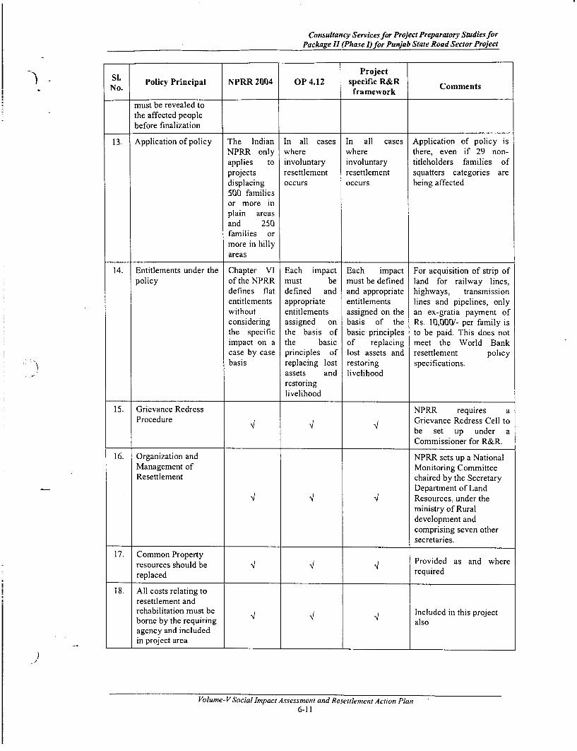
Consultancy Services for Project Preparatory Studies forPackage II (Phase I)for Punjab State Road Sector Project
Si. ProjectlNSl. Policy Principal NPRR 2004 OP 4.12 specific R&R Comments
framework
must be revealed tothe affected peoplebefore finalization
13. Application of policy The Indian In all cases In all cases Application of policy isNPRR only where where there, even if 29 non-applies to involuntary involuntary titleholders families ofprojects resettlement resettlement squatters categories aredisplacing occurs occurs being affected500 familiesor more inplain areasand 250families ormore in hillyareas
14. Entitlements under the Chapter VI Each impact Each impact For acquisition of strip ofpolicy of the NPRR must be must be defined land for railway lines,
defines flat defined and and appropriate highways, transmissionentitlements appropriate entitlements lines and pipelines, onlywithout entitlements assigned on the an ex-gratia payment ofconsidering assigned on basis of the Rs. 10,000/- per family isthe specific the basis of basic principles to be paid. This does notimpact on a the basic of replacing meet the World Bankcase by case principles of lost assets and resettlement policybasis replacing lost restoring specifications.
assets and livelihoodrestoringlivelihood
15. Grievance Redress NPRR requires aProcedure Grievance Redress Cell to
be set up under aCommissioner for R&R.
16. Organization and NPRR sets up a NationalManagement of Monitoring CommitteeResettlement chaired by the Secretary
Department of Land.4 i4 l4 Resources, under the
ministry of Ruraldevelopment andcomprising seven othersecretaries.
17. Common Property Provided as and whereresources should be '4 4 '4 requiredreplaced
18. All costs relating toresettlement andrehabilitation must be ' Included in this projectborne by the requiring alsoagency and includedin project area
Volume- V Social Impact Assessment and Resettlement Action Plan6-11

I
II

Consultancy Servicesfor Project Preparatory Studies forPackage II (Phase I)for Punjab State Road Sector Project
.. 7. LAND AND OTHER ASSETS ACQUISITION, RESETTLEMENT SITESAND INCOME RESTORATION MEASURES
7.1 LAND TO BE ACQUIRED
The width of the existing road is an indicator of land takes for the improvement of a road.According to the records available from the PRBDB, the right of way of the project roadsvaries between 12 to 34 metres. The width of the available ROW and proposed pavementwas shown in Table 1.1 (in Chapter 1). The existing roads will be rehabilitated in all the5 road corridors.
There is no land acquisition in the 5 project corridors (rehabilitation corridors) as theexisting ROW is sufficient for the proposed formation width of the roads. Therefore noadditional land beyond ROW is required.
7.2 AFFECTED PROPERTIES:
No titleholders are loosing their assets/ properties due to implementation of the projectOnly few commercial Squatters, 139 CPRs and 6 govt properties are being affected whoare located within existing ROW along the road corridors. The details of properties aregiven in chapter 5. All the private properties are commercial squatters and 24 innumbers, while other losses include tube wells/hand pumps (58), bus shelters (65), 5police check posts, 4 roadside shrines and 12 platforms with trees. All the losses havebeen properly budgeted in R & R cost as per their entitlement.
7.3 PROCUDURES OF LAND ACQUISITION
Although, the rehabilitation project has no provision of any land acquisition for all theroad corridors, nonetheless, the procedure for land acquisition as given below can be usedfor reference, if at any point of time, the design require any land acquisition:The Draft Resettlement and Rehabilitation Policy Framework for the project outlines,among others, the procedures and modalities to be followed for the acquisition of land.These are reproduced here:
* Land needed for the project shall be acquired by direct negotiation as perGovernment procedure for negotiations, vide Financial Commissioner's standingorder no. 28 and amended from time to time, which shall be followed as the firstpriority. If negotiation fails, then land would be acquired under provisions of theLA Act, 1894 (modified in 1984). However, record of all those cases wherenegotiations have failed and reasons for failure of negotiations shall bemaintained for future reference.
. The Emergency Clause of the Land Acquisition Act, 1894 shall not be invokedfor land acquisition.
* A time period of 45 days would be available for carrying out negotiations withthe landowners.
* The negotiations shall begin by offering a minimum of 1.5 times of the stampduty value/circle rate (whichever is higher) in order to make the propositionsfinancially lucrative to the landowners (sellers). If the registered value/stampduty or circle rates are more than year old at time of negotiations, 10% perannum will be added to bring the rates to currents levels. Those PAFs losing landshall be eligible for additional assistance equivalent to registration cost of landlost and expenditure incurred on paper work if PAF intends to buy land. Thecurrent cost is 9% (stamp duty 6% + development charge 3% upto a distance of-5km in municipal limits) plus 1% registration charges for males and 8% (stampduty 5% + development charge 3% upto a distance of 5km in municipal limits)plus 1% registration charges for females.
Volume-V Social Impact Assessment and Resettlement Action Plan7-1

Land and other Assets Acquisition, Resettlement Sites and Income Restoration Measures
* A maximum of 3 rounds of negotiations may be conducted with the landowners.
* After every round of negotiation, record would be sent to the Head Office forinformation.
* The negotiations shall be conducted village-wise involving groups in order tomaintain transparency.
* If land acquisition by negotiation is finalized, the entire negotiated amount willbe paid in a single instalment within three months of negotiation interest Z9%will be paid for any delays in the payment of compensation beyond three months.
* Entitled person has an option to surrender residual plot to project authority andbe compensated as per provisions of the policy.
* All land measurements shall be based on the latest revenue map of the concemedvillage.
7.4 RESETTLEMENT SITES
The squatter families, 29 in number, may observe temporary impact on their structures,however, they are illegal occupants of the Govt land and will be offered assistance as perthe Resettlement Policy Framework prepared for the project. Presently, they could bepushed back at the same location beyond the COI for their relocation on the availablegovernment land.
However, if required, the govt will help those families in allocation of government landfor a price, as available, outside of the road right of way. The Government of Punjabwebsite has information on the availability of such land in rural and urban areas as thecase may be in all the districts. This information is attached to this report as Annexure7.1.
The NGOs engaged for the R&R implementation will, accordingly, generate thenecessary information and plan for such resettlement activity.
7.5 INCOME RESTORATION MEASURES
The Draft Resettlement and Rehabilitation Policy Framework of the project enjoin thatthe local people in general and the PAFs in particular will be given preference forunskilled and other jobs created during the construction phase of the project. Moreover,Para 15 of the R&R Policy Framework indicates that
* If at least 20 displaced commercial establishments (small business enterprises)within a continuous stretch of 5kms opt for assisted resettlement for a vendormarket, the Project Authority will develop the vendor market on cost basispayable in monthly instalments spread over two years subject to a maximumamount equivalent to the compensation for the loss of structure received by theEPs. The cost of providing approach road, electricity connection, drinking waterfacility, etc shall be bome by the Project Authority.
* It was indicated before that the project envision impact on livelihood for 29PAFs, although all of them will be temporarily affected in carrying out theirlivelihood. This group of people will be benefited from the local jobopportunities, if they wish to, due to the road construction activities.
* If, however, PAFs lose their sources of livelihood, they would be eligible fortraining to upgrade their skills for which assistance in the form of economicrehabilitation Grant (ERG) would be given to the affected families for restorationof livelihood.
* All the shopkeepers will be pushed back on the available government land;therefore there is no permanent loss of livelihood of the affected people.
Volume- V Social Impact Assessment and Resettlement Action Plan7-2
Consultancy Services for Project Preparatory Studies forPackage 11 (Phase I)for Punjab State Road Sector Project
- * A provision for altemative employment for affected population should be ensured in) - Bid document who want to work in the construction of the road and ifjob require any
specific training for the purpose, it must be provided to the people concerned
)
Volume- V Social Impact Assessment and Resettlement Action Plan7-3

-
-
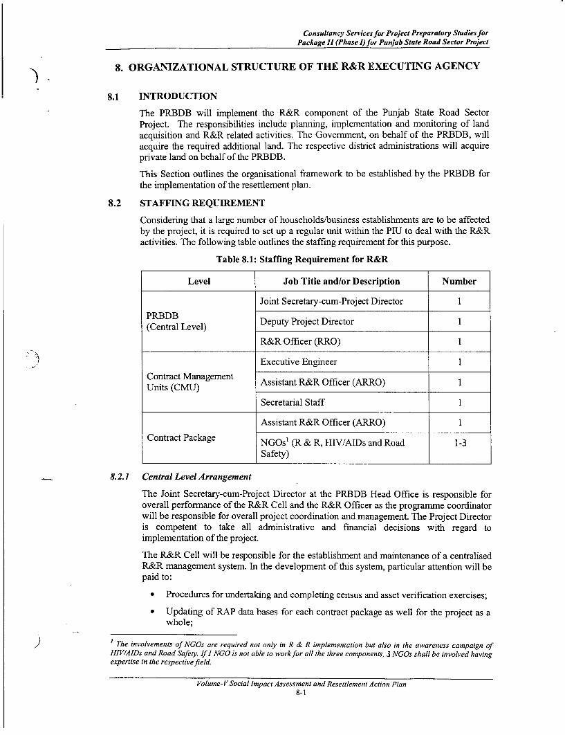
Consultancy Services for Project Preparatory Studies forPackage II (Phase I) for Punjab State Road Sector Project
8. ORGANIZATIONAL STRUCTURE OF THE R&R EXECUTING AGENCY
8.1 INTRODUCTION
The PRBDB will implement the R&R component of the Punjab State Road SectorProject. The responsibilities include planning, implementation and monitoring of landacquisition and R&R related activities. The Government, on behalf of the PRBDB, willacquire the required additional land. The respective district administrations will acquireprivate land on behalf of the PRBDB.
This Section outlines the organisational framework to be established by the PRBDB forthe implementation of the resettlement plan.
8.2 STAFFING REQUIREMENT
Considering that a large number of households/business establishments are to be affectedby the project, it is required to set up a regular unit within the PIU to deal with the R&Ractivities. The following table outlines the staffing requirement for this purpose.
Table 8.1: Staffing Requirement for R&R
Level Job Title and/or Description Number
Joint Secretary-cum-Project Director 1
PRBDB Deputy Project Director 1
R&R Officer (RRO) 1
Executive Engineer 1
Contract Management Assistant R&R Officer (ARRO) 1
Secretarial Staff 1
Assistant R&R Officer (ARRO) 1
Contract Package NGOs' (R & R, HIV/AIDs and Road 1-3
Safety)
8.2.1 Central Level Arrangement
The Joint Secretary-cum-Project Director at the PRBDB Head Office is responsible foroverall performance of the R&R Cell and the R&R Officer as the programme coordinatorwill be responsible for overall project coordination and management. The Project Directoris competent to take all administrative and financial decisions with regard toimplementation of the project.
The R&R Cell will be responsible for the establishment and maintenance of a centralisedR&R management system. In the development of this system, particular attention will bepaid to:
* Procedures for undertaking and completing census and asset verification exercises;
* Updating of RAP data bases for each contract package as well for the project as awhole;
The involvements of NGOs are required not only in R & R implementation but also in the awareness campaign ofHIV/AIDs and Road Safety. If I NGO is not able to workfor all the three components, 3 NGOs shall be involved havingexpertise in the respectivefield.
Volume- V Social Impact Assessment and Resettlement Action Plan8-1
Organizational Structure ofthe R&R Executing Agency
* Integration of land acquisition, compensation and construction activities;
* Establishment of procedures for internal monitoring and review of contract packageprogress reports; and
* Procedures for the prompt implementation of corrective actions and the resolutionof grievances.
8.2.2 Contract Management Units Level
Several Contract Management Units (CMUs) are proposed to be set up in the state. EachCMU will be headed by an officer of the rank of Executive Engineer and assisted byseveral other technical personnel, 1 Assistant R&R Officer (ARRO), and secretarial staff.The ARRO will assist the head of CMU in matters related to R&R and land acquisition.
8.2.3 User committee
A User Committee should be constituted, comprising road users especially from projectaffected families from that specific area, in which adequate representation of womenshould be ensured. This committee seems to be essential for effective and genuineparticipation of PAFs in implementation mechanism. This would entail for an easy andsustainable transfer of various responsibilities from implementing agencies in a futureperiod of time. An active and responsible User committee is expected to act as a mediumfor evolving 'community ownership' for project implementation. All the functions relatedto the project should be made transparent to the User committee also. The UserCommittee will also take part in the monitoring and evaluation process along with theIndependent Agency. This will ensure the participatory monitoring and evaluation
8.2.4 Grievance Redress Committee (GRC)
The PSRSP will constitute a Grievance Redress Commnittee (GRC) at each CMU withintwo months of commencement of the implementation of the project. The objective of theGRCs is to settle as many disputes as possible through consultations. The GRC willcomprise a maximum of four members, headed by a retired judge of the area. Othermembers would include a retired revenue officer from the locality, a retired PWDengineer, and a representative of NGO. (The details of this committee has been delineated inChapter- 1 of this report)
8.2.5 Contract Package Level Arrangement
As several contract packages will be working simultaneously, the PRBDB will appoint oncontract basis 1 Assistant R&R Officer (ARRO) for each contract package. The ARROwill report to the head of the CMU and will also take guidance and directions from theR&R Officer at the PRBDB central level.
While the PRBDB level and Contract Management Unit (CMU) level arrangements arenecessary for the coordination of the R&R activities, the contract package levelarrangements are most important for effective R&R implementation. The work ofidentifying and developing the resettlement sites for individuals or groups and other R&Rrelated development activities would be undertaken by the NGO appointed by thePRBDB. The PRBDB will hire services of NGOs for the implementation of not only theresettlement plan including Identity Card Distribution appended as Annexure 8.2 but alsothe implementation of HIV/AIDs and Road Safety Measures through the standard biddingprocess. A detailed TOR for hiring the services of the NGOs has been appended asAnnexure 8.1.
The NGO will appoint a Project Manager, supported by field assistants, as required, foreach contract package.
Volume- V Social Impact Assessment and Resettlement Action Plan8-2

Consultancy Services for Project Preparatory Studies forPackage II (Phase I) for Punjab State Road Sector Project
8.3 ROLES & RESPONSIBILITIES FOR THE R&R ACTIVITIES
The broad roles and responsibilities of the main functionaries for the implementation ofthe R&R activities are outlined in the following Table.
Table 8.2: Roles and Responsibilities
Level Implementation Roles and ResponsibilitiesStaff
* Oversee the progress of land acquisition andR&R activities
* Seek services of the DRC for monitoring theland acquisition process and R&R mitigatingmeasures.
* Contract NGOs for the implementation of the
PRBDB Project Director* Coordinate with other Government line
Departments and NGOs for ensuring effectivedelivery of mitigation and rehabilitationsupport.
* Approve of the expenses for RPimplementation.
* Assist the Dy. Project Director and ProjectDirector at Head Office in finalizing the RAPand Land Acquisition Plan,
* Assist and advise in matters related to R&R,
* Overseeing the implementation of RAP carriedout by the contracted NGO (means
R&R Officer Organisation registered under the Society Act,Educational Institution and Consulting Firm),
* Compile data related to R&R activitiesobtained from various contract packages andupdate reporting officer and suggest suitablemeasures to be taken,
Volume-VSocial Impact Assessment and Resettlement Action Plan8-3

Organizational Structure of the R&R Executing Agency
Level Implementation Roles and ResponsibilitiesLevel ~Staff
* Interact with NGO and Construction andSupervision Consultant (CSC) on a regularbasis,
* Attend meetings and participate in GrievanceRedress Committee meetings for redress ofgrievances of PAFs,
* Assist Contract Management Unit (CMU) inmatters related to R&R,
* Approval of micro-plan at the Head Office,
* Ensure budgetary provision for relocation,rehabilitation and reconstruction of CPRs inBOQ,
* Timely release of budget for implementation ofRAP,
* Any other work that may be assigned fromtime to time by the Head Office, etc.
Executive * Overall in-charge for RP implementationEngineer
Grievance * Meet once or more a month to hear and recordRedress grievances of the PAFs.Conunittees * Resolve grievances within 60 days
Contract * Vet the monitoring reports on land acquisitionManagement District Roads and R&R measures implementation, preparedUnits Committees by the ARRO and the CSC, consolidated by(CMUs) the R&R Officer
* Monitor the R&R implementation
Construction * Submit monthly monitoring reports in the firstSupervision year
Consultants * Submit quarterly monitoring reportssubsequently
Volume- V Social Impact Assessment and Resettlement Action Plan8-4

Consultancy Services for Project Preparatory Studies forPackage II (Phase I)for Punjab State Road Sector Project
Level Implementation Roles and Responsibilities) - Level ~~~~~~~Staff
* Responsible for successful implementation ofRAP,
* Co-ordinate with District Administration withregard to land acquisition, NGO for RAPimplementation and CSC for RAP monitoring,
* Ensure distribution of pamphlets of R&RPolicy to PAFs,
* Ensure preparation of identity cards andContract Assistant R&R distribution of the same to PAFs,
Level Officer (ARRO) * Ensuring inclusion of those PAFs who couldnot be enumerated but have documentary proofto be included in the list of PAFs,
* Ensure timely preparation of micro-plan fromNGO and endorsement from District RoadsCommittee,
* Ensure disbursement of R&R assistancethrough the NGOs concemed in a transparentmanner,
A. R & R Activities:* Participate in respective committee involving
R&R matters,* Facilitate in opening of joint account of PAF,
* Maintain record of physical and financialprogress of RAP,
* Ensure relocation, rehabilitation andreconstruction of CPRs before dismantlingthrough proper mechanism.
* Ensuring development of resettlement site, ifrequired.
* Ensuring availability of budget forimplementation of RAP,
* Liaison with various Govt. Departments forinclusion of PAFs in Govt. sponsoredprogrammes./schemes for employment andincome generation,
* Any other work related to R&R that may beentrusted from Head Office, etc.
* The NGO will be the main link between theProject Authority and affected person/family,
* Undertake public information campaignalong with ARRO at the commencement ofthe RAP,
* Responsible for verification of PAFs asprepared by the DPR consultant,
* Develop rapport with PAFs,
Volume-V Social Impact Assessment and Resettlement Action Plan8-5
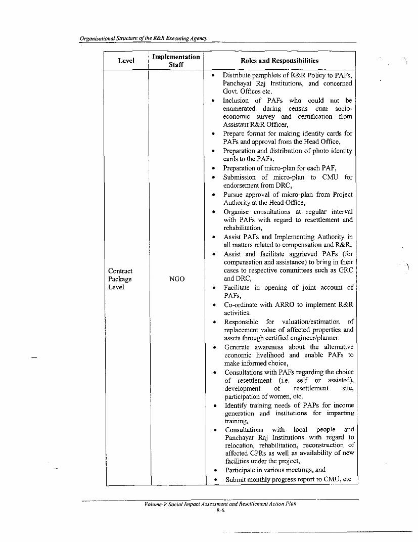
Organizational Structure of the R&R Executing Agency
Level Implementation Roles and ResponsibilitiesLevel ~Staff
* Distribute pamphlets of R&R Policy to PAFs,Panchayat Raj Institutions, and concernedGovt. Offices etc.
* Inclusion of PAFs who could not beenumerated during census cum socio-economic survey and certification fromAssistant R&R Officer,
* Prepare format for making identity cards forPAFs and approval from the Head Office,
* Preparation and distribution of photo identitycards to the PAFs,
* Preparation of micro-plan for each PAF,* Submission of micro-plan to CMU for
endorsement from DRC,* Pursue approval of micro-plan from Project
Authority at the Head Office,* Organise consultations at regular interval
with PAFs with regard to resettlement andrehabilitation,
* Assist PAFs and Implementing Authority inall matters related to compensation and R&R,
* Assist and facilitate aggrieved PAFs (forcompensation and assistance) to bring in their
Contract cases to respective committees such as GRCPackage NGO and DRC,Level * Facilitate in opening of joint account of
PAFs,* Co-ordinate with ARRO to implement R&R
activities.* Responsible for valuation/estimation of
replacement value of affected properties andassets through certified engineer/planner.
* Generate awareness about the alternativeeconomic livelihood and enable PAFs tomake informed choice,
* Consultations with PAFs regarding the choiceof resettlement (i.e. self or assisted),development of resettlement site,participation of women, etc.
* Identify training needs of PAPs for incomegeneration and institutions for impartingtraining,
* Consultations with local people andPanchayat Raj Institutions with regard torelocation, rehabilitation, reconstruction ofaffected CPRs as well as availability of newfacilities under the project,
* Participate in various meetings, and* Submit monthly progress report to CMU, etc
Volume- V Social Impact Assessment and Resettlement Action Plan8-6

Consultancy Services for Project Preparatory Studies forPackage 11 (Phase !) for Punjab State Road Sector Project
Level Staff Roles and Responsibilities
B. HIV/AIDs Awareness Campaign:
The awareness campaign, to be undertaken by theNGO will continue throughout theimplementation period. The awareness campaignwill include the following activities:
* Monthly meetings involving the Importantkey informants, potential carrier ofHIV/AIDs and other stakeholders includingCSWs, if identified;
* Putting up signing/hoardings at appropriateplace not only at construction site but also atsome important locations within projectinfluence area;
* Distribution of Pictorial literature amongpotential stakeholders;
* Explaining the health risks through the use offlip charts;
* Will provide Referral services;
* Social marketing of condoms at constructionsite in labour camp and other places;
-*- . Information on availability of pharmaciesand health centres.
C. Road Safety Measures
* Organizing workshops with drivers, Expert,district administration, media and generalpublic to make everyone aware about the roadsafety measures
* Incorporate the views of every participants, iffeasible
* Sought help from traffic department in properenforcement of traffic Law.
* Will suggest the way to competent authorityof proper implement the laws for better publicacceptance
* Will assist PIU and Take Action, if required
* NGO will voluntary make and receive thecalls for emergency ambulance for roadaccidents
. Will Check and Ensure the availability ofdoctors to treat cases of road accidents
. Will ensure the help line number to bedisplayed at public locations.
Vo ume- V Social Impact A MMsessmenak;.lt Sraccidcnts*8-7 Will assist PIU and Take Action, if required
* NCiO will voluntarv make and receive the

Organizational Structure ofthe R&R Executing Agency
Level Implementation Roles and ResponsibilitiesLevel ~Staff
* Will ensure the help line number to bedisplayed at public locations.
* Data collection of road accidents* Ensuring the safety of temporary altemate
route* Check and collect the data of road safety
signs with location and discuss with the roadsafety Experts about the adequacy of roadsigns
* Discussion with road users about theunderstanding of road sign
* Check and ensure the awareness level ofconstruction workers regarding road safety.
* Check and ensure the safe movement ofheavy machinery.
* Discuss the problem areas related to eachagency related to the road safety
* Suggesting the ways to overcome problems* Submit quarterly progress report on road
safety
It is noted that the role of the R&R Expert of the Construction Supervision Consultant(CSC) and that of the District Roads Committees (DRC) are limited to monitoring theR&R implementation. These are detailed in Chapter 12 on Monitoring and Evaluation.
8.4 TRAINING OF PRBDB OFFICUILS AND NGOs PRACTITIONERSTraining is necessary for the required capacity building. Besides, the World Banksafeguard measures are not limited to the project activities only; the main purpose of thesafeguard measures is to effect social transformation. In keeping with this idea, it isnecessary to identify and train officials at the PRBDB head office as well as at the CMUwho will be associated with the R&R activities. NGOs and supervision consultants tooneed to be included in this list. An in-house training exercise need to be organisedperiodically to train the responsible officers and the NGOs engaged for carrying out theR&R activities.
Trainers from the National Institute for Training of Highway Engineers (NITHE) couldbe engaged to train the identified PRBDB officers and NGOs in the R&R activities. Thefollowing Table 8.3 outlines the proposed 2-day training programme on the R&R issues.
Table 8.3: Training Programme on R&R and Environment
No. Who Attends? Training Programme on Instruction DurationPIJ Social Officer, Regulation and Policies RelatedDivision Executive to Land Acquisition/R&R: landEngineer, NGO, acquisition; LA Act; basic features
1 Supervision of the RAP; institutional Lecture 1/2 dayConsultant arrangement; monitoring,
evaluation and reporting; planningfor relocation; documentationrequirement of the project.
Volume- V Social Impact Assessment and Resettlement Action Plan8-8
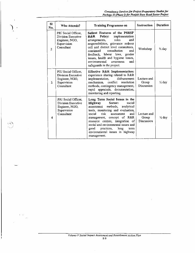
Consultancy Servicesfor Project Preparatory Studies forPackage II (Phase I)for Punjab State Road Sector Project
. ~~~~~~Si) - No. Who Attends? Training Programme on Instruction Duration
PIU Social Officer, Salient Features of the PSRSPDivision Executive R&R Policy: implementationEngineer, NGO, arrangements, roles andSupervision responsibilities, grievance redress
2 Consultant cell and district level committees,continued consultation and Workshop 12 dayfeedback, labour laws, genderissues, health and hygiene issues,environmental awareness andsafeguards in the project.
PIU Social Officer, Effective R&R Implementation:Division Executive experience sharing related to R&REngineer, NGO, implementation, disbursement Lecture and
3 Supervision mechanism, conflict resolution Group '/2 dayConsultant methods, contingency management, Discussion
rapid appraisals, documentation,monitoring and reporting.
PIU Social Officer, Long Term Social Issues in theDivision Executive Highway Sector: socialEngineer, NGO, assessment methods, analyticalSupervision tools, monitoring and evaluation,Consultant social risk assessment and Lecture and
4 mnanagement, concept of R&R Group 1/2 dayresource centres, integration of Discussionsocial and environmental issues andgood practices, long termenvironmental issues in highwaymanagement.
Volume- V Social Impact Assessment and Resettlement Action Plan8-9

l~~~~~~~~~~~~~~~~~~~~~~~~~

Consultancy Services for Project Preparatory Studies forPackage II (Phase I) for Punjab State Road Sector Project
9. R&R IMPLEMENTATION SCHEDULE
9.1 INTRODUCTION
Although, the implementation of the RAP doesn't involve land acquisition, the R & Ractivities is expected to continue up to 12 months as a significant number of Squatters arebeing affected due to implementation of the project. In addition, the association of NGOsin HIV/AIDs and Road Safety measures require their involvement for complete projecttenure of 24 months. The PRBDB/CMUs will further detail the implementation schedule.The programme schedule for the major tasks of the RAP is shown in Chart 9.1. Thisschedule will be updated as the project progresses.
Professional best practices and the World Bank norms require that the physical workscommence only after full compensation has been paid to the affected families and theyare rehabilitated. As such, the implementation schedule as presented in Chart 9.1 is to belinked with the estimated timing of the contractor's mobilisation. If, required, any time inproject implementation due to change in design, the land will be acquired according to theLA Act 1894/1984, which also has a provision of invoking an urgency clause (Clause No.17) for acquiring land urgently. However, the R&R Policy Framework of the project hasprohibited invoking the urgency clause.
9.2 THE IMPLEMENTATION PROCEDURE
The major activities related to the implementation of the resettlement plan include theacquisition of land and assets to facilitate the project implementation. Theimplementation of R&R would consist of five major stages:
A. Deployment of staff;
B. Issuing of legal notification for land acquisition and the cut-off date, however forthe present project it is not required;
C. Verification of entitled PAFs and estimation of their type and level of losses;
D. Preparation of list of PAFs for relocation;
E. Relocation and rehabilitation of PAFs.
9.3 GENERAL ACTIVITIES
Verification of the Entitled Persons (EP);
Distribution of Identity Cards;
Monitor physical and financial progress;
Prepare monthly progress reports.
9.4 LAND AND ASSETS ACQUISITION
The project doesn't have any provision for permanent acquisition of land, however,temporary land acquisition may take place to facilitate civil works on the project roads byproviding diversion routes for traffic and for earth works from borrow areas. Thetemporary acquisition of land will require the following action/ steps:
Volume-VSocial Impact Assessment and Resetilement Action Plan9-1

R&R Implementation Schedule
* Contractor negotiates with owners the area to be leased;
* The contract signed between the owner and the contractor will include the terms ofpayment and return of the land to the owner;
* Complete payments will be made to the Contractor after the PIU is satisfied thatthe terms and conditions of the contract have been met;
* Retuming the land after restoring to its original condition.
9.5 RESETTLEMENT
* Civil works will begin after PAFs have been paid compensation and R&Rassistance.
* Verification of the displaced PAFs - agricultural, residential and commercial;
* Identification and allotment of altemate plots (if need be) in consultation with thePAFs;
* Development of the resettlement zone, if required, with basic infrastructurefacilities;
* Disbursement of the R&R assistance to the PAFs;
* Construction of residence and shops at the resettlement zone (if need be).
9.6 R&R ASSISTANCE
Verification of the PAFs entitled to receive R&R assistance.
9.7 IMPLEMENTATION SCHEDULE
Implementation schedule for resettlement, which is linked to the civil works contract, ispresented in Chart 9.1, which shows the scheduled activities linked to civil workactivities to indicate clearly what steps and actions will be taken at different stages of theproject implementation cycle. It is anticipated that civil works will commence with effectfrom 1 November 2006. Therefore, it is expected that the implementation of RAP, whichinclude compensation and assistance to the affected people, will be completed by 15October 2007 as the project doesn't involve any land acquisition
It is anticipated that the land acquisition process generally take approximately 9 monthstime to complete and if matter is litigated, sometimes it take even 24 months. Theimplementation plan has been prepared accordingly. The dates are indicative, and linkedwith each activity
Volume-V Social Impact Assessment and Resettlement Action Plan9-2

Consuttancy Services for Project Preparatory Studies forPackage 11 (Phase I) for Punjab State Road Sector Project
Chart 9.1: Implementation Schedule
So. Activities Pre-Project Time Frame in Months - Project Implemenation Phase
No. AtvbsPhase _ 2 3 4 5 6 7 8 9 IQ10 _ 12 13 14 ]i5 16 17 18 19 20 21 22 23 24
A. StaffingPRBDB H.Q.
I Project Director In place -_
2 Deputy Project Director In place
3 R&R Officer In place
CMU (4-5 numbers)I Executive Engineers = _= = _= === =
2 Assistant R&R Officer (ARRO) .... .. ...... ...... ...._..... ............... ..... ... ........ .... .... .......... .......... ......... ....,
NGOs Recruitment (4-5 numbers) ____
I Bid opening for NGO recruitment(R & R, HIV/AIDS and Road Safety) _ __
2 Completion of NGO recruitment
Contract Package _ __
NGO (R & R)NGO (HIV/AIDS)
_ NGO (Road Safety)B. Training
Iltn-house training for PRBDB, CMU and NGOs staff -t
2 In-house training for PRBDB, CMU and NGOs staff -2
D. Details of R&RI Printing of the R&R Policy in Punjabi2 Consultations and awareness campaign
3 Verification of entitled personsDistribution of identity cards
4 Opening of joinit bank accounts == = = = ==_= =
5 Updating census and socio-economic data
Disbursement of AssistanceI Transitional assistance2 Replacement Cost3 Shifting _____
4 Economic Rehabilitation Grant
E. Relocation of Cultural PropertyI Identification of cultural property by NGOs
2 Consultation with people by NGOs
F. HIV AwarenessAwareness Caimpaign by NGO _ __
G. Road SafetyConsultation with people, contractors, hospitals & PIA by NGOs _ I - _ _ _ _ -…
4 F. Grievance RedressS Set up the committee for grievance redress6 Grievance redress ............... ......... ..... ................. . ................. . ............... ..... ..,...... r .....7 G. Monitoring and Evaluation8 Intemal monitoring9 Appointment of extemal agency
10 Evaluation by extemal agency =_ _ _ _ _____
It User CommitteeMidterm Evaluation Report End term Evaluation Report
Volume-V Social Assessment Plan9-3
n sE~~~~~~~~~~~~~~~~~-

l~~~~~~~~~~~~~~~~~~~~~
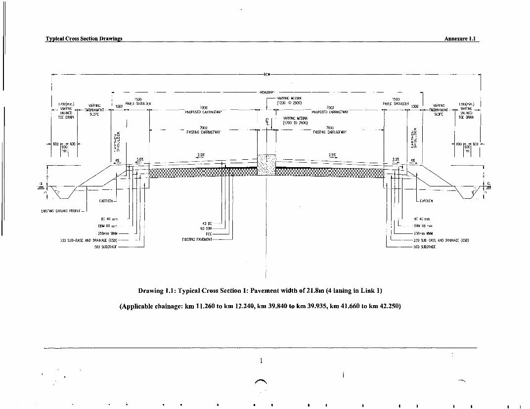
Typical Cross Section Drawings Annexure 1.1
ROW
ROADWAY
1500 VARING MEDIAN 1500
1700(min.) VARYING 1000 PAVED SHOULDER 7GOG(1200 TO 2800) PAVED SHOULDER 100 V VARYING 1700(min.)VARY(ING) VDIG woPVDSOLE 7000 _ ____________________ 7000 .EMBANKMENT---' VARYING
UNLYINED SLOP-EBAKEN PROPOSED CVARRIAGEWAY PROPOSED CARRIAGEWAY SLOPE UNLINED
TOE DRAN _ VARYING MEDIAN TOE DRAN
_ 700W tX(1200 TO 2800) 7
wo ~~~~~~~~~~~EXISTING CARRIAGEWAY _ _EXISTING CARRIAGEWAY z I
600 600 I2
2500m WMMG RE 2500m SUWGREXITIN GR UNDP8FL-8AEADDANG GB XSIGPVUN 3 U-AEADDANG G8
(Applicable chainage: km 11.260 to km 12.240, km 39.840 to km 39.935, km 41.660 to km 42.250)
1
60 DBM-~~~~~~~~~~~~~~~~~~~~~~~~~~
25.m WM --- C 5m M
23 U-AS N RING GB EXSTN PAEET 23 SU-BS AN DRING GB

Typical Cross Section Drawings Annexure 1.1
ROW
ROADWAY
1500 15001700(min.) VARYING 1000 PAVED SHOULDER PAVED SHOULDER 1000 VARYING 1700(min.)VARYING -.- EMBANKMENT 700POPSE CRIGWY- - -- EMBANKMENT --- VARYINGUNLINED SLOPE PROPOSED CARRIAGEWAY SLOPE UNLINED
TOE DRAIN TOE DRAIN0D 6500 TO 7000 6m
250m WM 20m M
2I EXISTING CARRIAGEWAY E N w
_ 600 t 600 < T <I5 SUBGRADE 600 UG600|TYP _TYP.#
v4.0% 3O .502.% 3 X_4.0%
EXISTING GROUND PROFILE- EATE ATE
BC 40 mm _40 BC =_ BC 40 mm
DBM 60 mm 60 DIBM _DBM 60 mm
250mm WMM PCC _250mm WMM
230 SUB-BASE AND DRAINAGE (GSB) _ EXISTING PAVEMENT _ 230 SUB-BASE AND DRAINAGE (GSB)
500 SUBGRADE 500 SUBGRADE
Drawing 1.2: Typical Cross Section 2: Pavement width of 12m (Link 1)
(Applicable chainage: For full length of corridor except the stretches as shown in Drawing 1.1 and Km 13.600 to 15.720 (Landran Village)
2

Typical Cross Section Drawings Annexure 1.1
-VARIES ROW VARIES -
1000 7000 1000HARD PROPOSED CARRIAGEWAY HARD
SHOULDER SHOULDER
5.300 to 5.600EXISTING CARRIAGEWAY
340 ~ ~ ~ ~ ~ ~ ~ ~ ~ ~ ~~4 GSBSB
180 SUB-BASE AND DRAINAGE (GSB)- - 40 BC 180 SUB-BASE AND DRAINAGE (GSB)
500 SUB GRADE 500 SUB GRADE
250 WMM
Drawing 1.3: Typical Cross Section 3: Pavement width of 9m (Link 2)
(Applicable Chainage: 1. Km 16.800 To Km 18.600 - Chakdaua Village, and Km 21.400 To Km 22.900 - Aur Village)
3

Typical Cross Section Drawings Annexure 1.1
-ROW
ROADWAY
1500 15001700(mi,,.) VARIES DO HARD SHOULDER HARD SHOULDER 17000 (miR.)
VAVSARIES V ARIES_ _ __ __ __7 DD__ _ __ __ __ _ __ __ __ _ __ l D VARIES VARIES VARIESVARIES _~EMBANKMNT70PPSE CARAEA - -EMBANKMENT-. (H NIE
UNLINED (2H) SLOPE E _ .TOE DRAIN
TOE DRAIN
ZO, ~~~~~~~~~~5.300 to 5.600 O
EXISTING CARRIAGEWAY0 bUD y X 00 | e I _ t V __ _0 01
600 600 IDN, IDENIN Lw) 600 I-~ 600
CL
EARTHEN 340 GSB
EXISTING GROUND PROFILE
250 WMM
180 SUB-BASE AND DRAINAGE (GSB) 50 DBM 340 GSB
500 SUBGRADE PCCEXISTING PAVEMENT-
500 SUBGRADE
250 WMM
180 SUB-BASE AND DRAINAGE (GSB)
Drawing 1.4: Typical Cross Section 3: Pavement width of 12m (Link 2)
(Applicable chainage: For full length of corridor except the stretches as shown in Drawing 1.3)
4 '

Typical Cross Section Drawings Annexure 1.1
n9ROW
9000
1700(min.) VARIES 1000 OO1 000 VARIES 1700(min.)VARIES - EMBANKMENT-00 --- -. EMBANKMENT -VARIESUNLINED SLOPE PROPOSED CARRIAGEWAY SLOPE UNLINEDTOE DRAIN
TOE DRAIN
z D EXISTING CARRIAGEWAY Dz
6000 600 I WIENING W < T 600 X 60015~001 Li1)5001
TYP. ~~~~~~~~~~~_TYP.~3.52 2. 5% 2.57 S 2. 5% 3.57 %
SB25 SDBC
EXISTING GROUND PROFI 0 BR50 DBM_250 WMM
180 SUB-BASE AND DRAINAGE (GSB) _ 25 SDBC500 SUBGRADE _ 50 DBM
250 WMMPCC 180 SUB-BASE AND DRAINAGE (GSB)EXISTING PAVEMENT 500 SUBGRADE
Drawing 1.5: Typical Cross, Pavement width of 9m (Link 4)
5
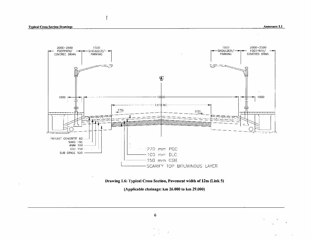
Typical Cross Section Drawings Annexure 1.1
2000-2500 1500 1500 2000-2500FOOTPATH/ SHOULDER/ SHOULDER/ FOOTPATH/
COVERED DRAIN PARKING PARKING COVERED DRAIN
WMM0 1000~
AOOD~~~~~~~0 mm OLCOD
X _SCAEXISY TNO B L
PRECAST CONCRETE 80SAND 1 90WMM 100 _GSB 150 _270 mm PQC
SUB GRADE 500 _1 00 mm DLC
_ ~150 mm GSBSCARIFY TOP BITUMINOUS LAYER
Drawing 1.6: Typical Cross Section, Pavement width of 12m (Link 5)
(Applicable chainage: km 26.000 to km 29.000)
6

Typical Cross Section Drawings Annexure 1.1
-ROW
ROADWAY
1500 1500
1700(min.) VARIES 1000 HARD SHOULDER HARD SHOULDER VARIES 1700(min.)
VARIES EMBANKMEN670 PRPOE CARIAGWA -EMBANKMENT--. VARIES
UNLINED SLOPE PROPOSED CARRIAGEWAY SLOPE UNLINED
TOE DRAIN TOE DRAIN
6700 TO 7000
EXISTING CARRIAGEWAY
_600 X600
<sI j 600C60
4.0% 3.0% 2.%25%_ 3.0% 4.0%
EARTHEN EARTHEN
EXISTING GROUND PROFILE
85 GSB 85 GSB
180 SUB-BASE AND DRAINAGE (GSB) _ SDBC 180 SUB-BASE AND DRAINAGE (GSB)
180 SUB-BASE AND (OSO) ~~~60 DBM
500 SUBGRADE PCC 500 SUBGRADE
EXISTING PAVEMENT
Drawing 1.7: Typical Cross Section, Pavement width of 12m (Link 5)
(Applicable chainage: For full length of Corridor)
7

Typical Cross Section Drawings Annexure 1.1
2000-2500 1500 1500 2000-2500FOOTPATH/ SHOULDER/ SHOULDER/ - FOOTPATH/
COVERED DRAIN PARKING PARKING COVERED DRAIN
100D M 100 lo1'
; | 2.5% ~~~~~~~~~~EXI'STING 25
PRECAST CONCRETE 80SAND 1 90WMM I100 .GSB 150 270 mm PQC
SUB GRADE 500 - 100 mm DLC
150 mm GSBSCARIFY TOP BITUMINOUS LAYER
Drawing 1.8: Typical Cross Section, Rigid Pavement in Urban Area (Link 6)
(Applicable chainage: km 0.000 to km 0.300, km 8.600 to km 11.000, km 22.800 to km 25.000)
8

Typical Cross Section Drawings Annexure 1.1
ROW
ROADWAY
1500 1500
170mi. VA RYI0 _ EMBANKMENTG 1000 HARD SHOULDER 650H TO 7H HARD SHOULDER 1000 VARYING 1700(min.)170mn)VARYING 100E600AON000MENT ___ 100 EMBANKMENT--VARYING
VARYINGD SLOANPEN PROPOSED CARRIAGEWAY SOEUNLINED
TOE DRAIN TOE DRAIN
_____________________ 6500 TO 7000 a:EXISTING CARRIAGEWAY I,
cr cfr600 I 600 < I < 600 - BO
15001Li( 507016
4.0% 3 2 _5% 3.0% 4.0% 0
CL /L
i < L EARTHEN | L EARTHEN
EXISTING GROUND PROFILE
110 GSB= 70 OM 110 GSB
180 SUB-BASE AND DRAINAGE (GSB) PCC 180 SUB-BASE AND DRAINAGE (GSB)
500 SUBGRADE EXISTING PAVEMENT 500 SUBGRADE
Drawing 1.9': Typical Cross Section, Pavement width of 12m (Link 6)
(Applicable chainage: For full length of corridor except the stretches as shown in Drawing 1.8)
9

I

An,exore 1.2
PUNJAB STATE ROAD SECTOR PROJECT
Questionnaire for Census and Assest Inventory
Questionnaire No.Dote: __ ' __' __
Strucrure No.
Name of Invesligdtor
Name of Supervisor
A. GENERAL INFORMATION
PROPERTY DETAILS Code
1.1 Road Side 1. Left 2. Right Li1.2 Chainage Kim. :
1.3 i. District :
fi. Block
fil. Village I Town :1.4 Location
I Rural 2 Semi- Urban 3 Urban Ei_2 TYPE OF LIKELY LOSS
A. Residential I loose 2 Hut 3 Catllehed 4 FPun House
B. Commercial 5 Shop 6 Hotel 7 DhM1. 0 Khokhs 9 T.o Sul _10 Pe-t] pomp II Clo-t 12 STDB-ool 13 Worsltop 14 Vnordo
ISC-sc eeiCpalConpte 16 bndrsry 17 Apoolti-eL;td IM Vucm/OltherL;md 19 Odlerust-es-(Gottoo)
IC. Res-cum-Com 20 Oesulestl-cunCotmeecot
ID. Community Properties 21 BU Step 22 Conutty Cetee 23 Weekly Msket 24 Witee Tap/ Hod Pop 25 Pb1l, Waleshed
E. Religious Properties 26 Temple 27 Chuech 28 Mosque 29Maoar 30 Shrme 31 Geveysd
IF. CovtlPublic Propertim 32 Govl oflSe, 33 Hoepiil 34 SchIol / Colelge 35 Ofte.s Govtlrfrt,e/ Cmsty
IG. Other Private Properties 36 Bo.-dry Wlt1 37 Abottdoto S-clure 38 Undee Cotoinolon 39 o0l-s
2.1 Type of Property I Moveable 2 Immovable 11]3 MEASUREMENT OF THE STRUCTURE / PROPERTY
3.1 Distance from the Centre of the Carriageway (In Metres)_
3.2 Area of the StnscturelProperties:
SI. No. Measurement in Mtrs. Area of the Affected Structure
I Length (Along the road)
2 Width (Perpendicular to the road)
3 Height
3.3 Age of the Structurc_
3.4 Type of Construction
1 Kutchha 2 Semi- Pucca 3 Pucca 4 Thatched S Wooden
3.5 Type of Roof
I Tln/ Asbestos 2 TUle 3 Thached 4 Concrete S Othres
3.6 Type of Wall
I Wood with Tin 2 Mud 3 Stone 4 Brick 5 Othres
3.7 Type of StructureI Temporary 2 Semi Permanent 3 Permanent D
3.8 Market value of the Structure I.PAPs Estimation 2.1nvestigator's Estimation
4 TYPE OF POSSESSION 1 Owner 2 Tenant D,

B. HOUSEHOLD DETAILS OF OWNER
5 STRUCTURE/HOUSEHOLD IDENTIFICATION
5.1 Name of the Head of the Household
5.2 Multi- Household Structure (I) Yes (2) No t5.3 Number of the Households in the Structure:
6 OWNERSHIP STATUS
6.1 1 Legal 2 ilitgal FIf legal then: Do you possess the following on the given address?
A Ration Card I.Yes 2. No
B Voter List l Yes 2. No
C Legal Documents of Property l.Yes 2. No
6.2 If Dilegal then;
1 Encroacher 2 Squatter 116.3 Number of tenants in the affected structure:
6.4 Period of possession (In years) _
6.5 Occupation: (5 Buint ... 2. L.b.ur l Agri-niO-r1 L.b..u 4W.g. E.r-er 55..r1- .d r.on 6. ASrte-1l- 7. Other-)
Pri-..ey Of-p.to S-eond-y O .o..p.io.
6.6 Number of employees:
Name: 1. (Salary 3. (Salary -------
3. (Salary_ _ 4_ Salary ....___7 SOCIAL GROUP PARTICULARS
7.1 Family Type:
I Joint 2 Nuclear 3 Extended I7.2 Religious Group:
1. Sikhism 2. Hinduism 3.Islam 4. Christianity S Other LI]7.3 Social Stratificatlon
I ST 2 SC 3 OBC 4 Higher Caste 5 Minority
7.4 Number of Family Members I Male 2 Female
7.5 Details of Family Members
SI. No Name of the Family Member Marital Status Education Occupation Age Sex
I U-ss.d 2.Lit..t. 2 B-i-. 2.t F-1k3. W.d.u 3 Pi-uuy 3 Agu-l (
4 Widower 4. Ulpto Anddtn 4 Study5 No. Applo-b: 5 Beow- oi. 5 Ho-uuife
6 M.s- 6 Lbo.7 utuoin,-W 7 U..Wltynd9 CGdude Preof-io-[t9 otGdi. 9.N. Appli-b:r
10 Not A=Ow.bl.
2
3
4
S
6
7
8
9
2
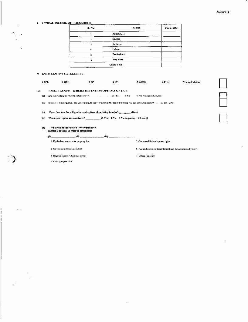
Anne.ure 1.2
8 ANNUAL INCOMEO F HOUSEHOLD
SI. No. Sour"e Income (Rs.)
I Agirculture
2 Service
3 Business
4 Labour
3 Professional
6 Any other
Grand Total
9 ENTITLEMENT CATEGORIES
1 BPL 2 OBC 3 SC 4 ST 5 WHIb 6 PHs 7 Unwed Mother C
10 RESETTLEMENT & REHABILITATION OPTIONS OF PAPs
(a) Are you willing to resettle voluntarily? _ _ (I Yes 2 No 3 No Response/Closed)
(b) In case, if It is required, are you willing to move out from the land building you are occupying now? _ (IYcs 2No)
(c) If yes, then how far will you be moving from the existing location? (Km.)
(d) Would you require any assistance? _ (I Yes, 2 No, 3 No Response, 4 Closed) II(e) What will be your option for compensation
(Record 3 options, in order of preference)
(e) ___ __ __ (ii) _ _ (iii)
I Equivalent property for property lost 5 Commercial development rights
2 Government housing scheme 6 Full and complete Resettlement and Rehabilitation by Govt
3 Regular license / Business permit 7 Others ( specify)
4. Cash compensation

Annexure 1.2
C. HOUSEHOLD DETAILS OF TENANT
I DETAILS OF TENANT
1,1 Structure No.
1.2 Serial No. _
1.3 Name of the Tenant:
1.4 Category and possession
SI No Category Period of Stay (years) Advanced paid
I 1Commercial
2 Residential
1.5 I Joint 2 Nuclear 3 Extended 4 Other 111.6 Religious Group:
1. Sikhism 2. Hinduism 3.1slam 4. Christianity 5 Other
1.7 Social Stratification : FliI SC 2 ST 3 OBC 4 Higher Caste 5 Minority
1.8 Number of Family Members 1. Male 2. Female_1.9 Annual Income of the Family:
1.ll Entitlement Category FI BPL 2 OBC 3 SC 4 ST 5 WHHs 6 PHs 7 Unwed Mother
1.11 Number of Employees:
Name: 1. (Salary ) 3.
3. (Salary ) 4. (Sahr )
1.12 Details of Family Members
SI. No Name of the Family Member Marital status Education Occupation Age Sex
1. M-d I Illile-t I S.r".oe (ma y.-) I M.l2 Unoo-id 2Lilen. 2 Btui.2F-1 23 W,dow 3 Psiouy 3. Aa,icollx4 Wido-er 4 Up o dd4le 4 Sttdys Cben 5 Belw r,oui 5 Hotuewife
6 M-i. 6 Lbtt.7 In-ened:a-o 7 U-Wo,ployedS Goodtt e 3 Fn~moSstir
9 P.. GndooIt 9 No: Appli-.bl.10 Not Appl-bl I=
2
3
4
5
6
7
9
1 2
1 3
1 4
Signature of Supervisor (Signature of Eaumerator)

Annexure 1.3
PUNJAB STATE ROAD SECTOR PROJECTSocio-Economic Questionnaire
Date
Q. No.
Census Q.No.
Name of Investigator
Field Supervisor
GENERAL IDENTIFICATION
1.1 Road Side I Left 2 Right Z1.2 Chainage Km.
1.3 i. District
ii. Block
iii. Village /Towr:
1.4 Location
I Rural 2 Semi- Urban 3 Urban l l
2 HOUSEHOLD IDENTIFICATION
2.1 Name of the head of Household :
3 LAND USE
Kindly give the following details:
Cultivable Non-Cultivable Total Land Area (Acres)
4 CROPPING PATTERN
Si No. Type of Crops Total Cultivated Land Total Yield (Quintal)________ ~~~~~(Acres,
2
Total
5 ANNUAL INCOME OF HOUSEHOLD
SI. No. Source Income (Rs)
I Agriculture
2 Service3 Business4 Labour
5 Professional
6 Any otherFGrand Total
6 INDEBTEDNESS
Please indicate, your borrowings during last one year:
SL. No Source Amount taken Amount Balance(in Rs.) returned
I Bank (specify which bank)
2 Private money lender
3 Others (Specify)
Total
7 POSSESSION OF DURABLE CONSUMER ITEMS:
Do you possess followigies
Si. No. Items Response_ Radio ~~~~~~~~~~~~~1. Yes 2. NoI Radio
2 Bicycle
3 Music system4 LPG Connection5 Television
6 Refrigerator7 Washing Machine8 Motor cycle/Scooter9 Car
) 0i Air ConditionerI. Any other (specify)

Anne.ure 1.3
8 CONSUMPTION PATTERN
Kindly indicate the consumption / expenditure on different items in last one year.
Own Production Market ProduceSL. No. Particulars / Source Expenditure (Rs.) Expenditure (Rs.)
Monthly Annual Monthly Annual
Food
I. Cereals
2. Pulses
3. Milk
4. Ghee/ Oil
A 5. Vegetables
6. Fruits
7. Edible Roots
8. Meat/ Fish
9. Eggs
Ill. Sugar/ Gur
Sub total (A)
B Cooking Fuel
C Clothing
D Health
E Education
F Commnunicati'on
G Social fuinctions
Agriculture (such as seeds, hiringof farm implements etc.)
I Others (Specify ) _
Grand total (A-1)
9 COVERAGE UNDER GOVERNMENT DEVELOPMENT SCHEMES
9.1 Have you availed any benefit under any govt. scheme?
I Yes 2 No |''
9.2 If 'Yes', kindly give us the following details
Name of the scheme Kind of helpI Loan, 2 Trainning, 3 Emplovment
JRY/ IJRY
DWACRA
IRDP
PMRY
Million Wells Programme
Others (Specify)
If'l', kindly indicate the amnount Rs.s
If '2', kindly indicate the type of training
9.3 After availing this scheme did your annual income increase?
I Yes 2 No l
9.4 If 'Yes', how much ? Rs.
9.5 IfNo', why?
10 HEALTH STATUS
11.1 Was any member of your family affected by any iliness in last one year?
I Yes 2 No
10.2 If 'Yes', please indicate the details
No. of CasHeo Type of dTrasedltitoness Treatment t.k..
1: Allopathic, 2 Homeopathic, 3 Ayurvedic, 4 Traditional, 5 No Treatment

Annexure 1.3
11 MIGRATION
11.1 Do you migrate for work ? C l
I Yes 2 No
11.2 If'Yes', for how many days/months in a year?
11.3 Where do you migrate? 1. Within the District 2. Outside the District 3. Outside the State
11.4 What kind ofjob do you undenake?
I Agricultural Labour 2 Non Agricultural Labour [I3 Trade & Business 4 Others (Specify)
11.5 How much do you earn?
11.6 Trend of Migration
1. Once in a year 2. Twice in a year 3. Every alternative year
4. Once in every three years 5. No regular interval/as and when required
t1.7 At what time of the year do you migrate?
I Summer 2 Winter 3 Rainy Season | ]12 WOMEN'S STATUS
12.1 Inheritence Line
I Male 2 Female12.2 Inheritence Through
I Primogeniture 2 Ultimogeniture
12.3 Kindly give the following details
SINo. Economie/Non-economic Activities Engagement in Activities1. Yes 2. No
I Cultivation
2 Allied Activities.
3 Sale of forest products
4 Trade & Business
5 Agricultural Labour
6 Non Agricultural Labour
7 HH Industries
8 Service
' i> 9 Households Work
1a Relaxation and Entertenment
I I Others (Specify)_
I Dairy, Poultry, Piggery, Sheep rearing, Goatry etc.
If, engaged in economic activities total income of the year, Rs.s
12.2 Do your women member have any say, in decision making of household matters ?
I Yes 2 No l12.3 If 'Yes, give the following details?
SI.No. Issues I Yes 2 No
I Financial masters
2 Education of child
3 Health care of child
4 Purchase of assets
5 Day to day activities
6 On social functions and marriages
7 Others
13 POVERTY ASSESSMENT
13.1 What according to you, are the characteristics of a BPL Household?
I Inability to buy adequate Food
2 Inability to buy clothes
3 Inability to repay loans
4 Inability to repair rood and other minor repairs
5 Others
Signature of Supervisor Signature of Investigator
3

I

Guidelines for Focus Group Discussion Annexure 1.4
PUNJAB STATE ROAD SECTOR ROAD
GUIDELINES FOR FOCUS GROUP DISCUSSION ANDPUBLIC CONSULTATION
(Focus groups: farmers, shopkeepers, housewives, women 's groups, labourers, etc.)
1. Beginning
Introduction of facilitator
* Introducing the Project - show maps & photographs, charts
2. Purposes/objective of the project
Example: The purpose of the project is to prepare a comprehensive programme forimproving access of the rural poor to the mainstream economy and to developmentopportunities and the major social services.
3. Purpose and scope of the meeting
The meeting is about making participants aware of the project, existing roads forimprovement, and to identify the participants' project related interests, the likely barriersto their participation in the project and the barriers to their benefiting from the projectresources.
4. Topics to be covered during the session
Benefits/losses perceived due to the road improvement programme
> Additional private/government land required for road upgrading and the impact ofpopulation dislocations and/or loss of agricultural land.
* Issues/concerns to be discussed
> Provision of wayside amenities like bus stop, shelter, footpaths toilets and drinkingwater
> Standards of living - enhanced or degraded due to the proposed project
> Drinking water supply - adequate or inadequate, improved roads helpful foraccessing water supply, etc.
> Employment generation capacity of the road project and impact on income levels> Gender issues - women labour acceptable in road construction? Any other issues.> Impact of the improved road on spread of AIDS and other diseases
)' Improved access to health, market and educational facilities
> Dust suppression measures should be adopted
> Adequate safety measures near settlement
> Protection of vulnerable groups
5. Questions/issues to be examined
* Which are the perceived benefits from the proposed project?
* Which are the perceived losses/concerns from the proposed project?
VWhat is likely to be affected by the project?
. If the road is improved, it is likely that you will have better access to agricultural inputssuch as fertilizers and seeds. Transporting products might also become less expensive andmore reliable. Would these factors encourage you to increase your agricultural yields? Ifyes, would you sell your surplus yields, and where, how far?

Guidelines for Focus Group Discussion Annexure 1.4
6. Benefits
The upgraded road will ensure road safety and all the road users including the projectaffected persons will benefit due to better roads - more accessibility and availability ofmotorized transport and possibility of reduction of fare and freight rates.
Society will benefit economically from the saving on vehicle operating cost, better accessto conmmunity facilities, such as school, health care.
Significant economic opportunities due to road construction and increased access tomarkets and urban centres.
Local petty business will benefit due to increased road traffic.
* Increased tourist traffic in some of the areas.
7. Listing development priorities
* Ask the participants to think about the most important development projects that wouldimprove their quality of life. Point out that improving the road will cost a large sum ofmoney. If the participants had a choice about how to spend that money to improve theircommunity, what projects in order of priority do they consider as the top three mostimportant projects?
(For example, a group may decide that the road improvement project is most important,that a new irrigation system is second most important, and that a new secondary school isthe third most important project.)
* List the priority projects in order of the group's assessment of their importance.
8. Ending the interview
* Explain to the participant, when the meeting is about to end, to think about what has beendiscussed and they have any other comment to add.
* Thank the participants for their contribution, cooperation and participation.
* Note down the additional comments when participants are in the process of leaving.
9. It is necessary to take detailed notes of the session proceedings and names of the participants.The individual session reports shall be finalized in the format suggested below.

Annexure 1.5
Format for Focus Group Session Report
Focus Group Discussion, No.: ...............
Road Section: Date:Meeting Location: Panchayat: District:Discussion led by:
Group description:
Number of people:
Positive impacts
Negative impacts
Priorities
Other comments
Highlights. Realignment. Underpasses. Accident reduction. Access controls. Bus stops locations. Lay byes. Off road facilities

Annexure 1.5
PUNJAB ROAD SECTOR PROJECT
ATTENDANCE SHEET FOR PUBLIC CONSULTATION AND FOCUS GROUP DISCUSSION
Name of the Village & Chainage: Signature & Date:
Si No Name & Address Phone/Fax Subjects Discussed Suggestions RemarksNumber
1
2
3
4
5
7
8
9
2
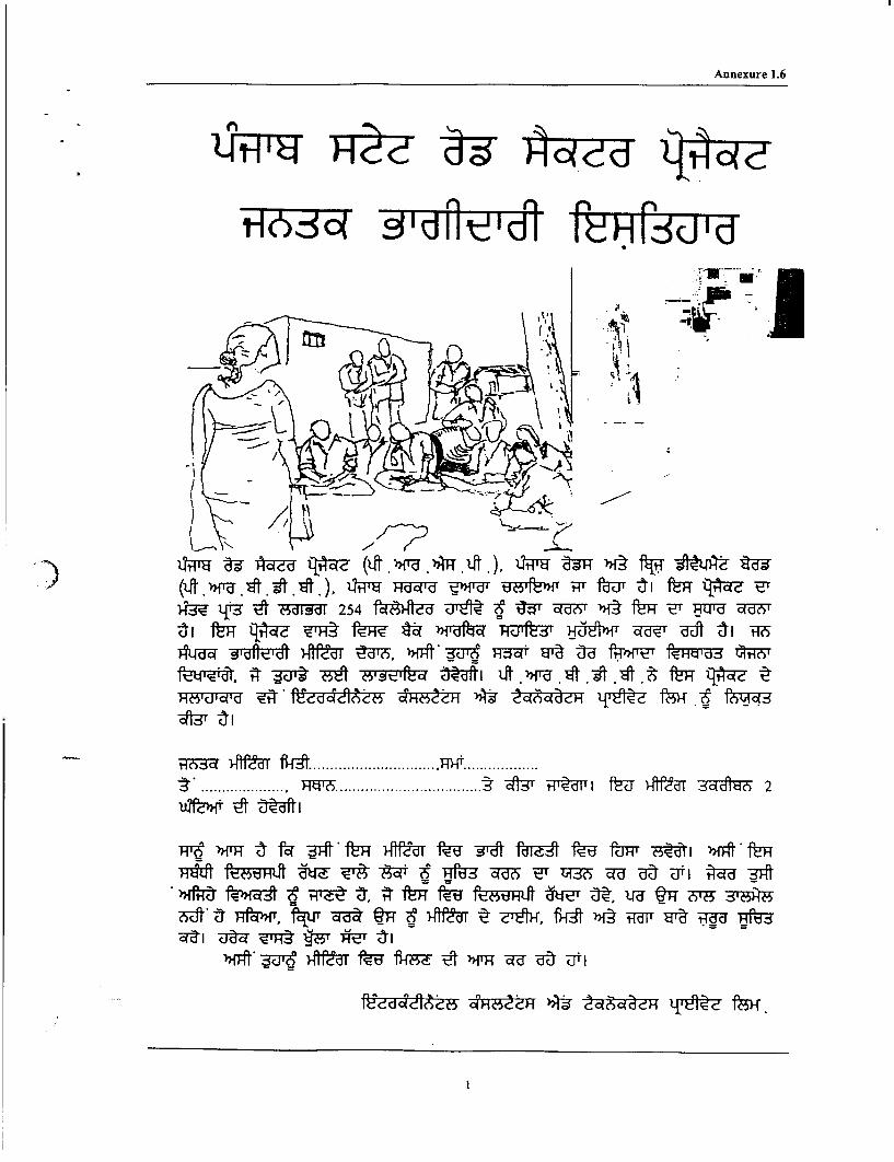
Annexure 1.6
~~~~e H
>~~~~~~-U 25 f|Wed wZTE q(4--a) )s mT tFg -E RTU -
§'dR~Wf'd ) td'6 waff Hotsi K w -cl0 HR'd 2 R?va~Tfloif qfiT -'5. -oft, 3u6 p5r i J- f4)~T f~Hvd rq?5T
~?#fitez F !8 HAt t6|3C *'emE y1 te ft e t f9 at
H 6 dd~~~~R- ................ P .................. .................. ................... 4A3 t T' d l fI7 Af T &5dd le 2
7j )fM t fc ft Af)>T tU 3At f6Tt t ffd 1T {F5 1 tIfIT
lEa U2F VFt Y'T *E tiH<Hd')1ft' - auI a
d~~~~~~ dV&f. ! -dH* C 2deodac
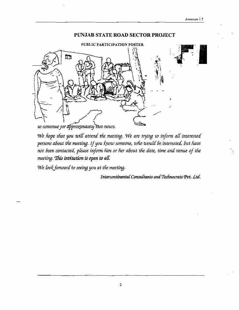
Annexure 1.7
PUNJAB STATE ROAD SECTOR PROJECT
PUBLIC PARTICIPATION POSTER -
w continuejor xoproxnmatexJT o tours.
We hope that you wiff attend the meeting. 'We are trying to inform aff interested
persons about the meeting. If you know someone, who woul be interested, but have
not been contacted, please inform him or her about the date, time and venue of the
meeting. 'This invitation is open to all
'We fookforvardto seeing you at the meeting.
IntercontinentalConsuftants andTechnocrats Pvt. Ltd.
2

Annexure 1.7
INFORMATION DOCUMENT FOR COMMUNITY PARTICIPATION
The Punjab Roads and Bridges Development Board (PRBDB), Government of Punjab (GoP) is
preparing the Punjab State Road Sector Project (PSRSP) with World Bank (WB) loan assistance.
Under the PSRSP, 1698 km of roads have been identified by the PRBDB for improvements and
upgradation under various phases and packages. This project involves rehabilitation of 5 corridors and
upgradation of Malerkotla - Sangrur road (Link 3) under the Phase I programme of Package II. The
PRBDB has appointed Intercontinental Consultants and Technocrats Pvt. Ltd. as Project Consultants.
The rehabilitation works generally involves strengthening of the existing pavement, overlaying,
improving longitudinal sections and cross drainage structures along the existing alignment within the
existing RoW (subject to minor modifications in order to improve road geometry, junction
improvement and road safety). The project road corridors pass through 8 districts, namely, Rupanagar,
Fathegarh Sahib, Sangrur, Firozpur, Amritsar, Kapurthala, Jalandhar and Nawanshehar (Refer Map).
The corridors are located across west-central, central and east-central parts of the state for a total
length of about 254 km.
Some social dislocations or negative impacts may still arise during the implementation of the Project.
However, the Project is being designed in a way so as to minimise its negative impacts on people and
the environment. In our opinion, implementation of the Project will not be totally successfully without
taking people into confidence. We strongly believe that public/community opinion is important for
successful implementation of any Project. Acceptance of the Project (by people/beneficiaries) is one
of indicators for showing the degree of success attained by a Project. If communities/people clearly
put forward their opinion, issues etc, then implementation of the Project would be both easier as well
as fruitful.
In order to discuss some of these matters, a consultation session is being organised in your
village/locality. In this meeting, the following points would be covered -
* Your view about the Project
* Data Collection, local issues/matters related to the Project
* Incorporating local issues into Project design and to reduce negative impact
* To resolve the problems of people who would be affected by the Project
A Public Participation Session is being organised on (date), at (time) at
(venue). The meeting is likely to continue for approximately two hours.
We hope that you will attend the meeting. We are trying to inform all interested persons about the
meeting. If you know someone, who would be interested, but have not been contacted, please
inform him or her about the date, time and venue of the meeting. This invitation is open to all.
We look forward to seeing you at the meeting.
Intercontienta[Consuftants ansTecdnocrats PVt Ltd
1

I
i
Ii
i
i
I
I
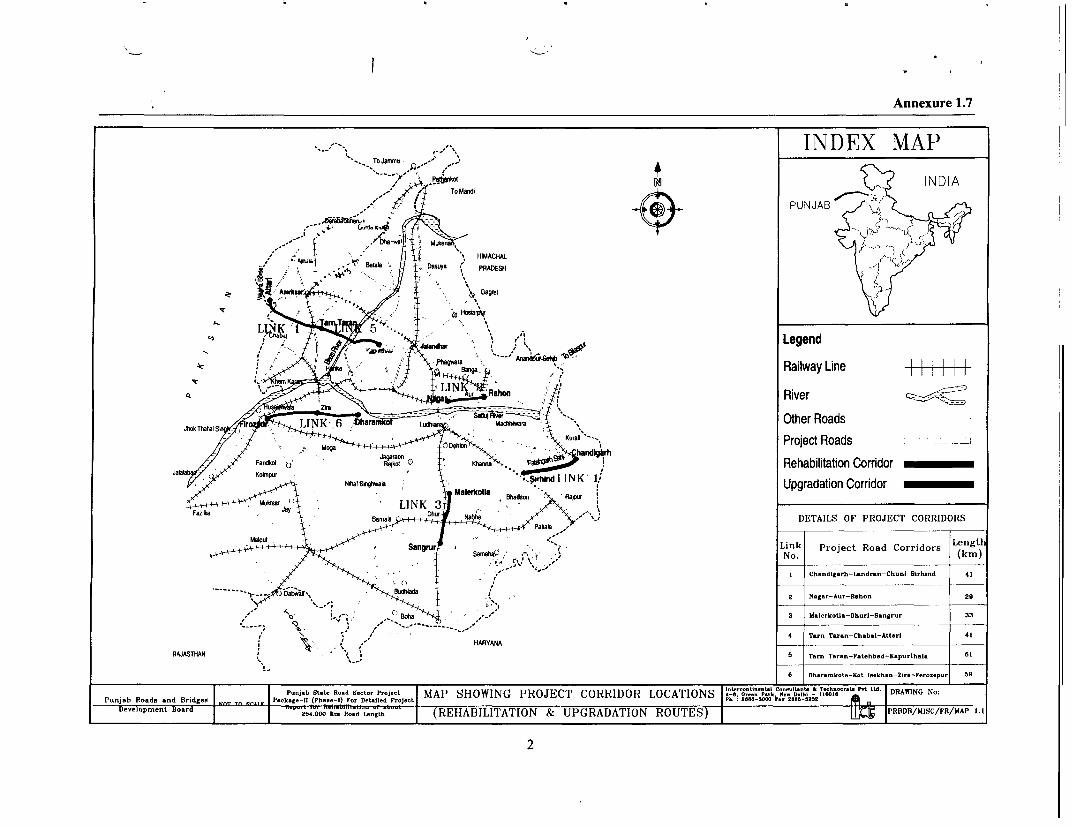
Annexure 1.7
.o -. mot, ...... IN D E X M A P
/7, ,. , + ) INDIA/ TO Maodi
PUNJAB
L00 ." MAe HIMACHALJhrakThahalS Da6 p _ Other RoaPRADESH
aT ~~~~~~~~~~~~~~ ~~~Legend
o a Barga Railway Line
River
Jhok Thahal S LINK-,6 LuM madtma ~~~~~~~~~~~Other RoadsDoMm ," - ~ ~~~~~~~~~~Project Roads
Faridkot Khanna ~~~~~~~~~~~~~~~~~~~~Rehabilitation CorridorNtal Spgtmale K ~~~~~~~~~~~~~Upgradation Corridor
MukWr MaL.1kotlaLINKBtrdsmr Rap,ur
' 0 s <hab ,> DETAILS OF PROJECT CORRIDORS
M_ _ ~~ >, * Sangrur Sarnalig - k # Link Project Road Corridors LengtNo. (kin)
I Ch..diZOrh-Land-.o-Ch.nl Blrhoid 41
2 Nag.r-A.r-R.hon 29
Al o' B,,;~; ,, ohaX , 3 UaI-rkoUa-Dh-rI-Sansor- 33
t th 0 ,'/ HARYANA 4 T-rn Taran-Chubl-Attari 41HARYANA__ _ _ _ _ _ _ _ _ _ _ _ _ _ _ _ _ _ _ _ _ _
RAJASTHAN -6 Then Taean--Ftehbad-K.purth.I. 61
06 Dharankot.-Xot I.ekh.-Zir--Fero..pur 69
I 0-8. Ge... POOh 0.. 0.161 - 1100~~~~~~~~~~~~T.h..,U P A
Poojb OtoLe Rood -tor P-oje-t MAP SHOWING PROJECT CORRIDOR LOCATIONSA6 0-.onton. P-onooih Toi o.l o W DRAWING No:
Punjab Roads and Bridgeo hk.e- - PPh o eF., Delled PrJecLt Ph 28L8-t0 k.. 0885-52N21"
Development Board 204000 TA .If'-l§P Reppr tu. eK Rood U.gt (REHABILITATION & UPGRADATION ROUTES) PRBDB/MISC/FR/MAP 1.1
2

; f)

Community Consultation Annexure 3.1
PC-1: PUBLIC CONSULTATION AT SOHANA
Sohana village is about one km long along the corridor at starting point (km 9.7). Mostly shopsand residences are well located beyond RoW. However, at beginning the shop owners haveencroached upon the RoW for temporary works (ex. Cotton works, motor repairing shops etc).During consultation people expressed that they are aware of the road widening project. Some ofthem knew that their properties are not affected and the widening will be restricted within theRoW. On an average about 8 - 9m clear space is available on either side from the existing roadcenterline. The list of people participated in consultation process and the issues discussed arepresented here.
PUBLIC CONSULTATION AT SOHANA - PC-1
Place: Sohana
Date: 13th December 2005 Chainage/km: 9.700
Number of Participants: 8 Time: 10.00-10.30 AM
Table 1: List of Persons During Consultation at Sohana
SI. No. Name & Address Occupation Gender Age Subjects Discussed
1 S.K. Yadav Agriculture Male 33
2 Kartar Singh Shop owner Male 41 1. Road side drainage
3 Zafar Singh Shop owner Male 52 2. Parking Facilities3. Provision of Service
4 Ram Nayan Sharma Shop owner Male 39 Road
5 Shardar Singh Grass Business Male 32 4. Bus stop and Safeaccess to it6 Madhur Khan Shop owner Male 40 5. Provision of footpath
7 Bimal Khan Shop owner Male 45 6. Roadside signage
8 Dhanveer Singh Shop owner Male 48
Issues Discussed at Sohana
i) This village does not have drainagefacility as a result during rainy season itbecomes difficult to drain the rainwater.People were concemed in particular toknow whether water from the roadswould flow into their fields. Insettlements, people were apprehensiveabout storm water drainage. Theyexpected the project to improve theexisting situation.
ii) As the upcoming road will be a high-speed corridor, the people demand for aservice road for their day-to-day activities. Consultation at Sohana Village
iii) Wayside amenities like bus stop, footpaths and hand pumps are required. They wantedto relocate the existing bus stop near the road and to provide a bus bay.
iv) Proper safety measures like road signing or signboards should be adopted.
I

Community Consultation Annexure 3.1
PC-2: PUBLIC CONSULTATION AT LANDRAN
Landran is a small junction, where few shops located at edge of RoW at an average distance ofabout 8-lOm from center of existing road. Big Eucalyptus trees are prominent on both sides of thecorridor. There will be land acquisition at this place (within Landran village boundary) as theavailable RoW is only about 6m. However, discussions with local people revealed thatcompensation of land at market place is the main issue. Among other issues provision of bus stopand other wayside amenities, speed breakers are important. Some of the issues recorded arediscussed here.
PUBLIC CONSULTATION AT LANDRAN - PC-2Place: LandranDate: 14h May 2006 Chainage/km: 14.600Number of Participants: 47 Time: 10.00 AM-1.00 PM
Table 2: List of Persons During Consultation at Landran
SI. No. Name & Address Occupation Gender Age Subjects Discussed
Prashan Singh Farner Male 822 Sudha Singh Pensioner Male 603 Pramjit Singh Shop Owner Male 374 Nirpal Singh Service Male 45 1. Compensation at market rate
Nirpal Singh (Sweeper) 2. Wayside amenitiesPresident Male 90 3. Roadside storm water
5 Palbir Singh Gurudwara drainage provision
6 Pravinder Singh Shop Keeper Male 33 4. Road sign for safety aspects(Tenant) 5. Junction improvementShop Keeper Male 30 6. Road imnprovement may be7 Harbhag Singh (Owner) restricted with RoW
8 Pal Singh Farmer Male 659 Jastar Singh Farmer Male 3610 Ganwant Singh Service Male 53
Note: Details of list of participants are given in Annexure 3.2
Issues Discussed at Landran
i) Compensation for land acquisition should be given atmarket rate.
iii) Proper storm water drainage facilityiv) Provision of safety measures like road signing and
signboards should be displayed at with proper visibility.v) Junction improvement.
vi) The widening should be restricted within the availableRoW, so that there will be no impact on the people and ,their livelihood.
C-onsultatfon at Lanndran
2
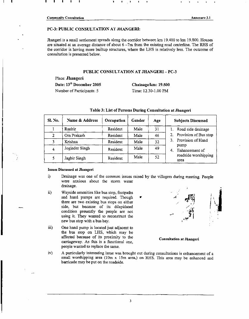
Community Consultation Annexure 3.1
PC-3: PUBLIC CONSULTATION AT JHANGERI:
Jhangeri is a small settlement spreads along the corridor between km 19.400 to km 19.800. Houses
are situated at an average distance of about 6 -7m from the existing road centerline. The RHS of
the corridor is having more builtup structures, where the LHS is relatively less. The outcome of
consultation is presented below.
PUBLIC CONSULTATION AT JHANGERI - PC-3
Place: JhangeriDate: 13th December 2005 Chainage/km: 19.500
Number of Participants: 5 Time: 12.30-1.00 PM
Table 3: List of Persons During Consultation at Jhangeri
SI. No. Name & Address Occupation Gender Age Subjects Discussed
1 Ranbir Resident Male 31 1. Road side drainage
2 Om Prakash Resident Male 46 2. Provision of Bus stop
3 Krishna Resident Male 32 3. Provision of Hand
4 Joginder Singh Resident Male 49 4. Enhancement of
5 Jagbir Singh Resident Male 52 roadside worshippingarea
Issues Discussed at Jhangeri
i) Drainage was one of the common issues raised by the villagers during meeting. People
were anxious about the storm waterdrainage.
ii) Wayside amenities like bus stop, footpathsand hand pumps are required. Though w HIthere are two existing bus stops on either .. i lI
side, but because of its dilapidatedcondition presently the people are notusing it. They wanted to reconstruct thenew bus stop with a bus bay.
iii) One hand pump is located just adjacent tothe bus stop on LHS, which may beaffected because of its proximity to the Consultation at Jhangericarriageway. As this is a functional one,people wanted to replace the same.
iv) A particularly interesting issue was brought out during consultations is enhancement of asmall worshipping area (lOm x 15m area,) on RHS. This area may be enhanced andbarricade may be put on the roadside.
3

Community Consultation Annexure 3.1
PC-4: PUBLIC CONSULTATION AT CHUNNI
Chunni is a major settlement in terms of quantum of business and its linear extent along thecorridor. At present the road passing through this settlement is is in good riding condition. All thestructutes are located beyond RoW. However, few mobile vendors come in day time, operate theirbusiness and go back at night (ex. roadside cloth vendors, ground nut trolleys etc). The settlemet isalready having a storm water drain on both sides. Some of the issues discussed here are as follows.
PUBLIC CONSULTATION AT CHUNNI - PC-4Place: ChunniDate: 1 4t' May 2006 Chainage/km: 25.300
Number of Participants: 44 Time: 5.00 - 7.00 PM
Table 4: List of Persons During Consultation at Chunni
SI. No. Name & Address Occupation Gender Age Subjects Discussed
1 Mahender Singh Farmer Male 75 1. Provision of wayside2 Amit Kapoor Shop Male 32 amenities
3 Dinesh Kumar Shop Male 21 2. Roadside storm waterdrainage
4 Baljit Singh Farmer Male 34 3. Provision of parkingNamberdar facilities
5 Rakesh Kumar Shop Male 42 4. Enhancement of6 Prithvi Singh Farmer Male 35 Gurdwara7 Sukhvinder Singh Farmer Male 22 5. Provision of median
6. Protection of water8 Satwant Singh Student Male 18 pipeline during9 Sulakhan Singh Farner Male 24 construction10 Gurpreet Singh Farmer Male 22 7. Street light facilities
Note: Details of list of participants are given in Annexure 3.2
Issues Discussed at Chunni + |
i) People were informed about the objective of kl I -PSRSP and came to know about the project abouta month before from the surveys done by ourvarious teams.
ii) The commnunities were requested that this projectwould be limited to standard two-laning sections X.(with parking bays, footpaths, etc., whereverapplicable).
iii) Though the market has already provided withstorm water drainage, but its capacity is notadequate. People strongly raised voice regardingoverflow from the drains. At present thepanchayat is doing maintenance works. However,people have suggested to make it covered drainwith the provision of footpath. Consultation at Chunni
4

Community Consultation Annexure 3.1
iv) Chunni is a major market place within 10km on either side and is spreading nearly 1kmalong the corridor. The local businessmen requested for parking space. Further the parkingof vehicles on the ROW shows there is a need to plan for parking areas in the road.
v) People requested to enhance the front side of Gurdwara
vi) Provision of median in settlement area
vii) Proper care must be taken during construction to save the water pipe line that runs alongthe road for about 300m.
viii) Street light facility with working condition would be an added advantage for the marketarea as well as for the local traffic.
PC-5: PUBLIC CONSULTATION AT BADALI:
Badali village spreads along corridor between km 29 to km30. All the shops are well locatedbeyond RoW at a distance of about 10m from road center. The road is regularly maintained byPWD and in a good riding condition. Already the settlement has a public drainage system.However, local people expressed their views for provision of wayside amenities and maintenanceof drainage system. Some of the issues recorded are discussed here.
PUBLIC CONSULTATION AT BADALI - PC-S
Place: Badali
Date: 13th December 2005 Chainage/km: 29.000
Number of Participants: 4 Time: 3.00-4.00 PM
:; Table 5: List of Persons During Consultation at Badali
S1. No. Name & Address Occupation Gender Age Subjects Discussed
1 Vikramjeet Singh Shop owner Male 45
2 Surjeet Singh (Reaide) Male 38 Wayside amenities2_S_jet_Sng (Rupaikeri)al 3 2. Improvement of existing(Rupalikeri) ~~~~~drain condition
3 Surendra Singh Shop owner Male 43 3. Safety measures
4 Bhuparajeet Singh Shop owner Male 37
Issues Discussed at Badali
i) The village has storm water drainagefacility. However, people have suggestedto make it covered drain with theprovision of footpath. , ,
ii) The community bring out issues, which ,. j f -;
are important in their perception; likewayside amenities like bus stop, drainagefacilities etc are required. 2 i
iii) People recounted a number of events inrecent past, when somebody or other inthe village was seriously / fatally injured.Provision of safety measures like road Consultation atBadali
signing and signboards should bedisplayed at with proper visibility. According to the people, better surface and junctiondesigns would only help vehicles zooming through the villages.
5

Community Consultation Annexure 3.1
PC-6: PUBLIC CONSULTATION AT SIRHIND
Sirhind is taluka head quarter and a major settlement in terms of its linear extent along the corridorand volume of business. An important religious institution in Sirhind is Baba Fatehgarh SahibGurdwara at km 41.500 on LHS. Many small stretches between km40 to km47 is made upto 4-lane configuration. The town is free of encroachment. At end point (junction of NH 1) fewtemporary shops (snacks/ tea stalls, vegetable trolleys and tyre repairing shops) are marked about8 to 9m from road. However, these shops are not affected. The issues discussed with thecommunities are as follows.
PUBLIC CONSULTATION AT SIRHIND - PC-6Place: SirhindDate: 13th December 2005 Chainage/km: 46.900Number of Participants: 6 Time: 4.30-5.00 PM
Table 6: List of Persons During Consultation at Sirhind
SI. No. Name & Address Occupation Gender Age Subjects Discussed
Hazarilal Shop owner Male 45 1. Wayside amenities2 Sahdev Singh Resident (Khanpr) Male 37 2. Safety measures3' Kewal Singh Resident (Chenawali) Male 41 3. Restoration of livelihood4 Avtar Singh Shop owner Male 39 4. Employment opportunity5 Paramjeet Singh Resident (Shamipura) Male 32 5. Provision of speed6 Dalvari Singh Resident Male 39 breakers
Issues Discussed at Sirhind
i) Provision of wayside amenities like bus _stop, drainage facilities etc are required.
ii) Proper safety measures like road signing andsignboards may be taken into account
iii) The temporary shops located near end ofcorridor (unction) are important for them, Uas this is the source of livelihood. Thecommunities wanted provision of somedesign elements to address this issue. As perthe present design these are not affected.
iv) Employment opportunities may be createdfor semi-skilled and skilled labourers during Consultation at Sirhindconstruction stage.
v) People were concemed that the widening or strengthening of road would induce manymore vehicles in the road through their settlement, thereby increasing accident rates. Mostof them recommended "speed breakers", or any other equivalent feature would reduce thechances of accident.
6
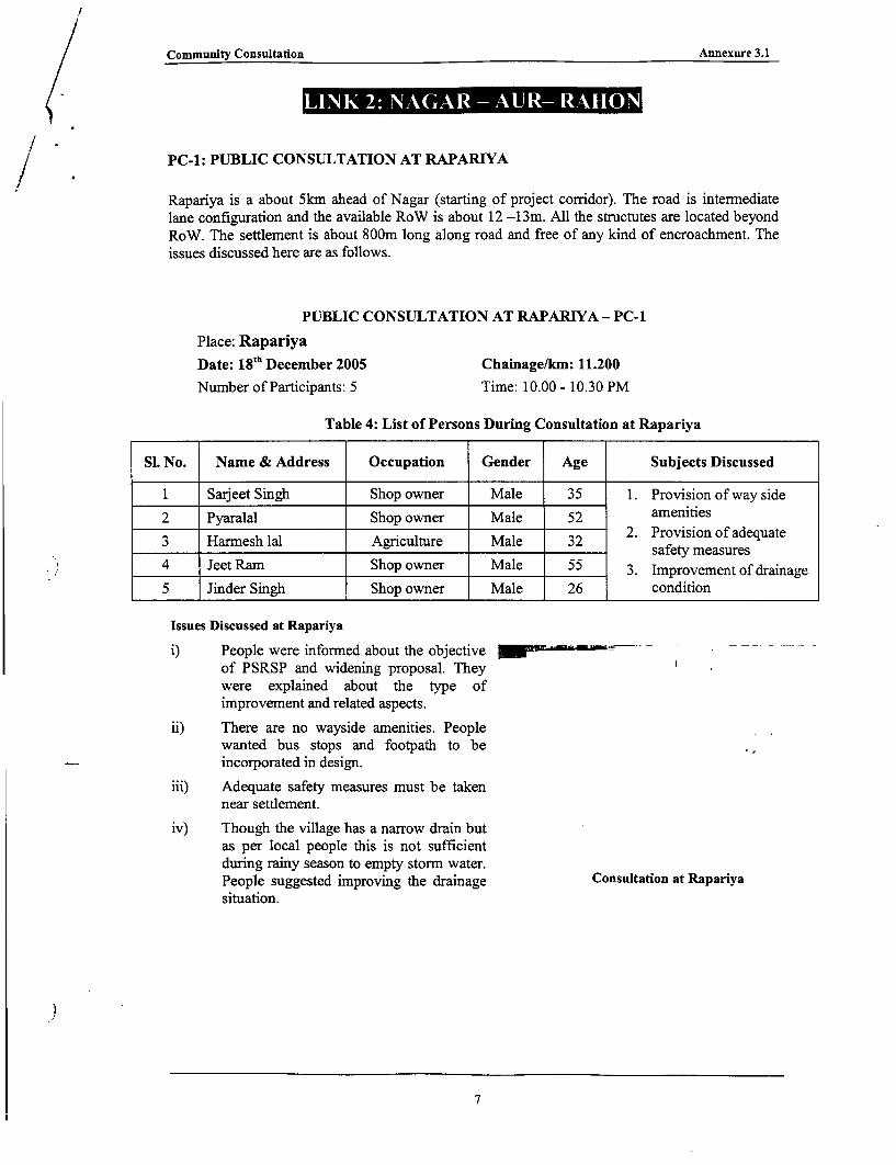
Community Consultation Annexure 3.1
l ~ ~ ~ ~ ~ ~ ~ ~ ~ l
PC-I: PUBLIC CONSULTATION AT RAPAR.IYA
Rapariya is a about 5km ahead of Nagar (starting of project corridor). The road is intermediatelane configuration and the available RoW is about 12 -13m. All the structutes are located beyondRoW. The settlement is about 800m long along road and free of any kind of encroachment. Theissues discussed here are as follows.
PUBLIC CONSULTATION AT RAPARIYA - PC-1
Place: RapariyaDate: 18 'h December 2005 Chainage/km: 11.200
Number of Participants: 5 Time: 10.00 - 10.30 PM
Table 4: List of Persons During Consultation at Rapariya
Sl. No. Name & Address Occupation Gender Age Subjects Discussed
1 Sarjeet Singh Shop owner Male 35 1. Provision of way side
2 Pyaralal Shop owner Male 52 amenities2. Provision of adequate
3 Harmesh lal Agriculture Male 32 safety measures
4 Jeet Ram Shop owner Male 55 3. Improvement of drainage
5 Jinder Singh Shop owner Male 26 condition
Issues Discussed at Rapariya
i) People were informed about the objective M -
of PSRSP and widening proposal. Theywere explained about the type ofimprovement and related aspects.
ii) There are no wayside amenities. Peoplewanted bus stops and footpath to beincorporated in design.
iii) Adequate safety measures must be takennear settlement.
iv) Though the village has a narrow drain butas per local people this is not sufficientduring rainy season to empty storm water.People suggested improving the drainage Consultation at Rapariyasituation.
7

Community Consultation Annexure 3.1
PC-2: PUBLIC CONSULTATION AT SILKIANA VILLAGE
Silkiana is a small village at km 11.200. The road is intermediate lane configuration and theavailable RoW is about 12 -13m. All the structutes are located beyond RoW. The settlement isfree of any kind of encroachment. The issues discussed here are as follows.
PUBLIC CONSULTATION AT SILKIANA - PC-2Place: Silkiana
DATE: 15T MAY 2006 CHAINAGE/KM: 11.200
Number of Participants: 28 Time: 10.00 - 12.30
Table 2: List of Persons During Consultation at Silkiana
SI. No. Name & Address Occupation Gender Age Issue Discussed
1 Hari Ram Agr. Labour Male 482 Ram Kishan Business Male 68 1. Provision of way side3 Ratna Farmer Male 70 amenities
2. Provision of adequate4 Harpal Singh Farmer Male 47 safety measures5 Pyara Singh Farner Male 60 3. Height of road should be6 Bhupender Singh Service Male 45 maintained at same level7 Pulla Singh Farmer Male 70 4. Strengthening theexisting connecting8 Paja Ram Farmer Male 51 village road to Satluj9 Ajit Singh Farmer Male 45 river
Male 60 5. Provision of median10 Trisem Singh Farmer 6. Provision of sewing
I______ ________I______________I______ I________ training centre in village
Note: Details of list of participants are given in Annexure3.2
Issues Discussed at Silkiana
i) Wayside amenities like bus stop, drainagefacilities etc are required.
ii) Provision of safety measures like road signingand signboards should be displayed at withproper visibility.
iii) Height of existing road should be maintainedat same level.
iv) The connecting road to Satlij River may beimproved. This road is about 3km long and 22feet wide.
v) Provision of media to segregate traffic comingfrom different directions.
vi) Consultation with the women shows that they .
want a sewing training centre in the village sothat the girls or ladies can practise and eam ata later date.
Consultation in progress at Silkiana
8

Community Consultation Annexure 3.1
PC-3: PUBLIC CONSULTATION AT CHAKDANA/ URAPAR
Chakdana and Urapar are two different settlements but is a continuous one. The linear extent isabout 2.5km and has been categoried as NAC. The length of town and quantum of business showsthe importance as a major market place. The road is about 5.5m wide along the settlement. Ingeneral the road is free of encroachment, however, at few locations shops like motor/ cyclereapiring units and utensil shops use the available RoW. Mostly the shops and houses are of puccastructures. About 7 -9m clear space is available on both sides, which is sifficient for the proposedwidening. Consultations carried out with the shop owners are discussed here.
PUBLIC CONSULTATION AT CHAKDANA/ URAPAR - PC-3
Place: Chakdana/ Urapar
Date: 1 8th December 2005 Chainage/km: 17.300
Number of Participants: 8 Time: 10.00 - 10.30 PM
Table 3: List of Persons During Consultation at Chakdana/ Urapar
SI. No. Name & Address Occupation Gender Age Subjects Discussed
1 Jasbir Singh Shop owner Male 35 1. Provision of bus stop and
2 Mandeep Singh Taxi Driver Male 33 wayside amenities
3 Kuldeep Singh Shop owner Malc 28 2. Provision of adequatesafety measures,
4 Baljeet Singh Shop owner Male 32 pedestrian crossings etc.
5 Khadak Singh Shop owner Male 33 3. Improvement of drainage
6 Gurdev Singh Shop owner Male 29 condition4. Constrict the widening in
7 Dalbagh ram Shop owner Male 38 between km 18.2 to km
8 Amarjeet Singh Shop owner Male 34 18.6
Issues Discussed at Chakdana/ Urapar
i) People were informed about the objective of PSRSP .and came to know about the project about a month . AIbefore from the surveys done by our various teams. , 4
ii) Wayside amenities like bus stop, footpaths, toiletsand drinking water facilities are required. Some ofthe bus stops are in very bad condition and needs tobe reconstructed.
iii) As the vehicles are running at a faster speed, everytime there is fear of accident. The project shouldaddress safety issues in settlement by providingstreet light facility, speed breakers and signboards.
iv) People were apprehensive about storm waterdrainage. This town does not have proper drainagefacility as a result during rainy season it becomesdifficult to drain the rainwater. They expected theproject to improve the existing situation.
v) During survey it is evident that between km 18.2 to Consultation at Chakdana/ Urapar
km 18.6 RoW is limited, as people have encroachedupon road. In this 400m stretch approximately 3 -3.5m space is available on both sides
9

Community Consultation Annexure 3.1
from edge of road. There are about 40 houses in this stretch and are of pucca construction.The total space available at this place is about 12m, which may be sufficient for two-laneformation. Keeping in mind the social and other related aspects it is advisable to reducethe width of formation in this critical stretch. So that the social impact would be minimum.
PC-4: PUBLIC CONSULTATION AT AUR:
Aur settlement shows all characteristics of Chakdana and Urapar. Aur is a Notified Area Council(NAC) with average RoW of about 12-13m. This settlement is nearly 2km long and at most placesRoW is free of encroachments. However, the boundary of Aur primary health center (on left side)at km 23.300 is very close to carriageway (2.5m). The junction at km 22.650 is a problematic areain Aur where accidents took place. Issues discussed with the local people are as follows.
PUBLIC CONSULTATION AT AUR - PC-4
Place: Aur
Date: 15th May 2006 Chainage/km: 22.300Number of Participants: 12 Time: 1.00-3.30 PM
Table 4: List of Persons During Consultation at Aur
SI. No. Name & Address Occupation Gender Age Issue Discussed
1 Ravinder Singh Business Male 55 1. Provision of wayside2 Shiv Kumar Business Male 52 amenities
2. Provision of adequate3 Tarsem Singh Business Male 50 safety measures,4 Pandit Ratan Lal Business Male 33 pedestrian crossings5 Amreek Singh Business Male 45 etc.
Kamaljit Rana Male 41 3. Provision!6 (Ex- Panchayat Business existing storm water
Member) exst. str waedrainage facility
7 Jagjot Singh Business Male 48 4. Junction improvement8 Jasbir Singh Farmer Male 55 5. Provision of dust bin9 Kulwant Singh Auto Driver Male 40 in market area
Vijay Kumar Male 50 6. Construction of10 Sharma Busimess boundary wall of AurPHC
11 Suresh Sahajpal Business Male 41 7. Compensation in case
12 Gurmeet Singh Business Male 27 properties are affected
10
Community Consultation Annexure 3.1
Issues Discussed at Aur
i) People were explained about theobjective of PSRSP and they wereinformed of the road upgradationproject. The proposed expansion/ J P1widening would be restricted within theavailable RoW.
ii) Bus shelters, parking facilities andpedestrian facilities should beincorporated in the road design.
iii) Widening of road will fasten the speedof vehicles, which may lead to accidentsof higher severity. People recommended"speed breakers" reduce the chances ofaccident.
iv) At present a small drain (0.5 ft wide and V0.5 ft deep) exists which is not sufficientin rainy season to drain the rainwater.
v) The junction at km 22.650 is a criticaljunction. The three-arm road needs todesign properly and safety measuresought to be taken.
vi) Provision of dustbin in the Aur market Consultation at Aurarea.
vii) The Aur PHC boundary wall is very close-to-close and because of widening this will beaffected. So people wanted to construct a new boundary wall.
viii) In case the project affects any properties, compensation should be given at market rate.
11

Community Consultation Annexure 3.1
_S.~~EM
PC-1: PUBLIC CONSULTATION AT NURTHAI
Nurthai is a small village of about 300m long along the road. The road is intermediate lane and theshops and houses are situated about 8m from ceter of road on both sides. As the widening is onlyconfined to RoW, no impact is anticipated. The list of people participated in consultation processand the issues discussed are given here.
PUBLIC CONSULTATION AT NURTHAI - PC-1Place: Nurthai
Date: 17th December 2005 Chainage/km: 4.800Number of Participants: 7 Time: 9.00-9.30 AM
Table 1: List of Persons During Consultation at Nurthai
SI. No. Name & Address Occupation Gender Age Subjects Discussed
1 Jannaire Singh Shop owner Male 352 Malki Singh Shop owner Male 383 Nirmal Singh Shop owner Male 40 1. Road widening
4 Jarnail Singh Shop owner Male 36 2. Wayside amenities3. Safety measures, speed
5 Shaab Singh Shop owner Male 41 breakers in village6 Jagdeep Singh Shop owner Male 217 Balwinder Singh Shop owner Male 28
Issues Discussed at Nurthai
i) People were informed about objective of ,__PSkSP. They were described about theprocess of widening and proposedexpansion would be confined within the [ 4.:existing RoW.
ii) As the width of carriageway is not even 2lane, people wanted to widen the road forfree flow of traffic.
iii) At present there are no wayside amenities.People wanted bus stops and public -conveniences on roadside.
iv) Proper safety measures like road signingand signboards should be adopted.Villagers emphasised on providing speed Consultation at Nurthaibreakers at both end of the village tocontrol the speed of vehicles.
12

Community Consultation Annexure 3.1
PC-2: PUBLIC CONSULTATION AT CHABAL TOWN
Chabal town is a Notified Area Council (NAC) about 2.5km long along the road. About 10m clearspace is available on bothsides. However, few ambulatory units and roadside parking is markedalong the town area. The road is in a very bad condition and dust generation is a commonphenomena. The issues discussed are as follows.
PUBLIC CONSULTATION AT CHABAL - PC-2
Place: ChabalDate: 180 May 2006 Chainage/km: 13.300
Number of Participants: 30 Time: 9.00 - 11.00 PM
Table 2: List of Persons During Consultation at Chabal
SI. No. Name & Address Occupation Gender Age Subjects Discussed
1 Vijay Kumar Business Male 56 1. Wayside amenities
2 Badaru Nalla Business Male 45 2. Junction improvement
3 Bil Malik Business Male 44 3. Covered drainage
4 Badrup Singh Business Male 59 4. Provision of bus shelter5. Provision of parking
5 Tarsem Singh Business Male 21 place
6 Om Prakash Business Male 35 6. Provision of street light
7 Shri Lal Business Male 61 7. Provision of speed
8 Sukhdev Singh Business Male 23 breakers, zebra crossingand footpath
9 Manish Sharma Business Male 44 8. Protection of existing
10 Bhupender Singh Business Male 51 pipe line (water,sewerage, telephone)
Note: Details of list of participants are given in Annexure 3.2
Issues Discussed at Chabal
i) People were informed about the objective of PSRSPand came to know about the project about a monthbefore from the surveys done by our various teams.
ii) The highway design may incorporate wayside ,amenities like, bust stop, pedestrian pathway etc.
iii) Junction improvement for better traffic flow
iv) Chabal is a major market place. The localbusinessmen requested that parking facilities shouldbe incorporated in the road design.
v) Dust generation is an important issue needs to beaddressed.
vi) Street light facility in the town area is required.
vii) Adequate safety measures with road sign should beadopted. 4V NV
viii) Protection of utility pipelines during construction. -
Consultation at Chabal
13
Community Consultation Annexure 3.1
PC-3: PUBLIC CONSULTATION AT RAJATAL
Rajatal is about 200m long on the corridor. Small shops located on both sides at beyond RoW andat about 10m from centerline of road. The consultation carried out with villagers are presentedhere.
PUBLIC CONSULTATION AT RAJATAL - PC-3Place: Rajatal
Date: 18* May 2006 Chainage/km: 30.000Number of Participants: 4 Time: 11.30 -2.00 PM
Table 3: List of Persons During Consultation at Rajatal
SI. No. Name & Address Occupation Gender Age Subjects Discussed
1 Sukhvinder Singh Business Male 502 Surender Singh Business Male 563 Pratap Singh Farner Male 41 1. Widening of road and
provision of wayside4 Kulwant Business Male 45 amenities5 Ball Singh Fanner Male 40 2. Safety provision and6 Surjeet Unemployed Male 23 accident issues7 Gur Sahib Farner Male 47 3. Junction improvement
4. Realignment of existing8 Baldev Singh Driver Male 36 ra9 Manjal Singh Business Male 3210 Gulab Singh Business Male 36
Note: Details of list of participants are given in Annexure 3.2
Issues Discussed at Rajatal
i) Discussions with the villagers shared theidea that the road needs to be expandedfor better and uninterrupted flow of ftraffic. . *r t
ii) All types of wayside amenities to beprovided for passengers. Another majorconcern among the villagers is provisionof off road bus stops and otheramenities.
iii) People informed that sometimesaccident takes place in this corridor.Proper road signs at clear visibledistance and good riding surface can Consultation at Rajataleliminate the chances to a greater extent.
iv) Junction improvement at km 32.200.v) The existing road in Rajatal is tortuous and people wanted for realignment of road for
traffic and passenger safety.
14
Community Consultation Annexure 3.1
PC-: 4 PUBLIC CONSULTATION AT ATTARI
Attari is a small village about 1 km before the end of corridor. Few shops and houses (about 40 -50numbers) are located beyond RoW at an average distance of about 8 - 9m from center of existingroad. As the widening is confined to existing RoW, no impact is anticipated. Infact discussionswith local people revealed that expansion of road with proper drainage facility is the only issuethat is required at present. The outcome of consultation is presented below.
PUBLIC CONSULTATION AT ATTARI - PC-4
Place: AttariDate: 18th May 2006 Chainage/km: 39.200
Number of Participants: 28 Time: 4.00-6.00 PM
Table 4: List of Persons During Consultation at Attari
SI. No. Name & Address Occupation Gender Age Subjects Discussed
1 Balvinder Singh Fanner Male 56
2 Vir Singh Farmer Male 32
3 Devender Singh Farmer Male 45 1. Expansion of road with roadside
4 Rajan Singh Fanner Male 34 amenities
5 Principal Singh Farmer Male 58 2. Road side drainage3. Safety and sign boards
6 Ram Chandra Farmer Male 59 4. Enhancement of cremation
3 7 Hardeep Singh Farmer Male 54 ground
8 Jagdas Singh Farner Male 61
9 Satnam Singh Farmer Male 49
10 Surjeet Singh Farmer Male 36
Note: Details of list of participants are given in Annexure3.2
Issues Discussed at Attari
i) People were explained about the objective ofPSRSP and they were informed of the roadupgradation project. The proposed expansion/widening would be restricted within theavailable RoW.
ii) Wayside amenities like bus stop, footpaths etcare required.
iii) Provision of roadside drains must beconsidered. o
iv) Safety measures like signboards, seed breakersetc. must be provided.
v) Enhancement of existing cremation ground.
Consultation at Attari
15

Community Consultation Annexure 3.1
PC-i: PUBLIC CONSULTATION AT KAPURTHALA
Though Kapurthala is well known for presence of rail coach factory, but the beginning of projectroad is a small junction and the road is free of encroachment. Presently the road is intermediatelane and the shops are about 15m on RHS and 10m on LHS. As the widening is only confined toRoW, no impact is anticipated. The list of people participated in consultation process and theissues discussed are presented here.
PUBLIC CONSULTATION AT KAPURTHALA - PC-1
Place: Kapurthala
Date: 16t' December 2005 Chainage/km: 0.900Number of Participants: 5 Time: 11.00-11 .30 AM
Table 1: List of Persons During Consultation at Kapurthala
SI. No. Name & Address Occupation Gender Age Subjects Discussed
1 Gumam Singh Shop owner Male 32
2 Charanjeet Singh Shop owner Male 41 1. Widening process3 Kamal Singh Mechanic Male 50 2. Increase in business
3. Footpath and wayside4 Baldev Singh Mechanic Male 39 amenities
5 Kripal Singh Mechanic Male 29 .
Issues Discussed at Kapurthala
i) People were informed about objective of w ' --
PSRSP. They were described about theprocess of widening and proposedexpansion would be confined within theexisting RoW.
ii) Widening of road will automaticallyincrease in volume of business and,therefore, they anticipate good return infuture.
iii) As the width of carriageway is not even2 lane, people wanted to widen the roadfor free flow of traffic. Consultation at Kapurthala
iv) At present there are no waysideamenities. People wanted bus stops andpublic conveniences on roadside.
16
Community Consultation Annexure 3.1
PC-2: PUBLIC CONSULTATION AT ATTNAWALI
Attnawali is about 7 km ahead of Kapurthala where about 9 roadside huts are located. The
residents are migrants from outside in search of employment opportunity. All of them are
labourers and satying there since last 2 years. These huts are located about 4m from edge of road
and are of thached construction. Consultation with the affected PAPs are recorded and the issues
discussed are given below.
PUBLIC CONSULTATION AT ATTNAWALI - PC-2
Place: Attnawali
Date: 12'b May 2006 Chainage/km: 6.700
Number of Participants: 37 Time: 8.30-11.00 AM
Table 2: List of Persons During Consultation at Attnawali
S1. No. Name & Address Occupation Gender Age Subjects Discussed
1 Manoj Kumar Agricultural Labourer Male 41
2 Sattan Mehto Agricultural Labourer Male 50 1. Wayside amenities
3 Pahalwan Singh Agricultural Labourer Male 61 2. Adequate assistance
4 Sikander Mehto Agricultural Labourer Male 35 for property loss3. Employment
5 Sunita Devi Housewife Female 25 opportunity
6 Rada Devi Housewife Female 32 4. Restoration and
7 Gangia Devi Housewife Female 50 alternate livelihood5. Altemate housing or
8 Budhiya Devi Housewife Female 32 full compensation at
9 Sakhiya Devi Housewife Female 35 replacement costs
10 Kiran Devi Housewife Female 14
Note: Details of list of participants are given in Annexure 3.2
Issues Discussed at Attnawali
i) They were made aware of the upcoming ' ,
project and the widening criteria. They were -
explained about the process of widening and * . . . .,
proposed expansion would be confined withinthe existing RoW. .
ii) The affected persons wanted to save theirproperties if the road design can be changed.In case this is not possible they wantedadequate assistance towards shifting their -
structures.
iii) Employment opportunities may be created for
semi-skilled and skilled labourers duringconstruction stage.
iv) They belong to SC community and aresquatters. As they are poor, requested for anykind of assistance towards their livelihood.
v) Income generation opportunities may be Consultation with Women and PAPs
created for them to support livelihood.
17

Community Consultation Annexure 3.1
vi) Consultations with women points out they want complete resettlement & rehabilitationdue to the project.
PC-3: PUBLIC CONSULTATION AT FATTU DINGA
Fattu Dinga is about 15 km ahead of Kapurthala. The RoW is almost free of encroachmnet andconsultation with the affected PAPs are recorded and the issues discussed are given below.
PUBLIC CONSULTATION AT FATTU DINGA- PC-3Place: Fattu DingaDate: 16th December 2005 Chainage/km: 14.700Number of Participants: 6 Time: 1.00-1.30 PM
Table 1: List of Persons During Consultation at Fattu Dinga
SI. No. Name & Address Occupation Gender Age Subjects Discussed
1 Joginder Singh Shop owner Male 40 1. Project objective2 Bagichha Singh Shop owner Male 45 2. Widening and3 Jimmy Shop owner Male 42 strengthening of road
3. Drainage provision4 Sukhdev Singh Shop owner Male 39 4. Bus stops and other5 Jeet Singh Shop owner Male 28 amenities
Male 22 5. Provision of service6 Pardeep Singh Shop owner road & parking
facilities
Issues Discussed at Fattu Dinga
i) People were explained about the objective ofPunjab Road Sector Project (PSRSP) and theywere inforned of the road upgradation project.
ii) They were explained about the process ofwidening and the proposed expansion wouldbe confined within the existing RoW.
iii) At present there is no drainage facility as aresult during rainy season it becomes difficult -. ,to drain the rainwater.
iv) Bus shelters, parking facilities and pedestrianfacilities should be incorporated in the roaddesign.
v) Provision of service road along settlementarea. Consultation at Fattu Dinga
18

Community Consultation Annexure 3.1
PC-4: PUBLIC CONSULTATION AT MANDBU-MUNDICHHENA
Between km 18 - 24 the road is passing on high embankmnent. At km 20.100 village Mandbu islocated on LHS, where a number of housed located at toe of embankment. These houses aremostly of pucca type and are squatters. These people are staying here for about last 25 years, afterthey were evacuated from 1988 flood from near by village. All of them are labourers oragricultural labourers. These houses are located on toe of the embankment about 12 -14m from theceter of existing road. Some of the issues raised are discussed here.
PUBLIC CONSULTATION AT MANDBU-MUNDICHHENA - PC-4
Place: Mandbu-Mundichhena
Date: 1 2di May 2006 Chainage/km: 20.100
Number of Participants: 53 Time: 11.30-2.00 PM
Table 4: List of Persons During Consultation at Mandbu-Mundichhena
SI. No. Name & Address Occupation Gender Age Subjects Discussed
1 Bahal Singh Agricultural Labourer Male 70 1. Wayside amenities
2 Tara Singh Agricultural Labourer Male 60 2. Mitigation measures to
3 Kulwant Singh Agricultural Labourer Male 55 save houses
4 Surjeet Kaur Housewife Female 35 3. Provision of footpath
5 Som Kaur Housewife Female 27 4. Provision of speed
6 Gurdev Kaur Housewife Female 36 breakers to control the
7 t Parmeet Kaur Housewife Female 39 speed of vehicle withinthe settlement area.
8 Bholy Housewife Female 24 5. Provision of stair-cases
9 Manjeet Kaur Housewife Female 28 from toe of
10 Jasveer Kaur Housewife Female 34 embankment6. Assistance for shifting
11 Natna Singh Agricultural Labourer Male 36 7. Employment
12 Jagtar Singh Agricultural Labourer Male 50 opportunity
Note: Details of list of participants are given in Annexure 3.2
Issues Discussed at Mandbu-Mundichhena
i) People were explained about the objective of Punjab State Road Sector Project (PSRSP)and widening would be confined to the existing RoW.
ii) Appropriate mitigation measures may be taken and the houses may be saved. A retainingw
i 'I
~~~~~~~- .
I. -
Consultation at Mandbu-Mundichhena19

Community Consultation Annexure 3.1
proposed at end of embankment to save these properties. The right side of the corridor isdevoid of any structures and has little space. If the design can be shifted to RHS, thesehouses may be saved as a part of good engineering measure.
iii) Villagers demanded footpath for school children as they travel for about 2 km longdistance.
iv) Provision of speed breakers, so that the high speed approaching vehicles will be sloweddown in settlement area.
v) As the embankment height is high, villagers want a stair case to their houses from top ofthe road.
vi) Assistance to all affected people.
vii) Employment opportunities may be generated for semi-skilled and skilled labourers duringroad construction.
PC-5: PUBLIC CONSULTATION AT FATEHBAD
Fatehbad is a Notified Area Council (NAC) with average RoW of about 12-16m. Most placesRoW is free of encroachments clear space is available for widening. Few (about 18) mobile shops(ambulatory units) and parking is market in the town area. The road is in a very bad conditionwithout blacktop and dust generates with every passing vehicle. The issues discussed are asfollows.
PUBLIC CONSULTATION AT FATEHBAD - PC-5Place: FatehbadDate: 16th December 2005 Chainage/km: 30.300Number of Participants: 7 Time: 3.30 - 4.00 PM
Table 5: List of Persons During Consultation at Fatehbad
SI. No. Name & Address Occupation Gender Age Subjects Discussed
1 Satpal Singh Service Male 55 W1 . Widening of road2 Sukhwinder Singh Shop owner Male 52 2. Provision of footpath,
3 Charanjeet Singh Shop owner Male 38 drain and bus stop4 Kawal Singh Shop owner Male 42 3. Dust suppression5 Jodh Singh Shop owner Male 38 4. Provision of street6 Jagjit Singh Shop owner Male 40 light
5. Safety provision7 Haijit Singh Shop owner Male 46
Issues Discussed at Fatebbad
i) People were informed about the objective ofPSRSP and came to know about the projectabout a month before from the surveys done byour various teams.
ii) Fatehbad is a major market place. The localbusinessmen requested that parking facilities,
Consultation at Fatehbad20

Community Consultation Annexure 3.1
and service roads should be incorporated in the road design.
iii) Further the highway design may incorporate wayside amenities like, bust stop, pedestrianpathway etc. for safety of passengers.
iv) Dust generation is an important issue needs to be addressed.
v) Street light facility in the town area is required.
vi) Adequate safety measures with road signage should be adopted.
PC-6: PUBLIC CONSULTATION AT NARANGABAD
Narangabad is a small settlement spreads along the corridor between km 42.000 to km 42.600.
Houses are situated at an average distance of about 6m from the existing road centerline. There are
about 70-100 houses along the road facing each other in a linear manner. The outcome of
consultation is presented below.
PUBLIC CONSULTATION AT NARANGABAD - PC-6
Place: Narangabad
Date: 16"' December 2005 Chainage/km: 42.400
Number of Participants: 7 Time: 4.30-5.45 PM
Table 6: List of Persons During Consultation at Narangabad
SI. No. Name & Address Occupation Gender Age Subjects Discussed
1 Harbajan Singh Shop owner Male 35
2 Kundan Singh Shop owner Male 30
3 Gurpreet Singh Student Male 15 1. Expansion of road2. Road side drainage
4 Sulhvinder Singh Shop owner Male 24 3. Employment provision
5 Kuldeep Singh Shop owner Male 29 4. Safety arrangement
6 Nishan Singh Shop owner Male 28
-7 Tarlok Sigh Shop owner Male 38
Issues Discussed at Narangabad
i) The villagers were informed of the roadupgradation project. They were explainedthat the widening would be restricted -
within the available RoW.
ii) Drainage was one of the common issues Fraised by the villagers during meeting. Though a narrow drain is exists on RHS, Ubut because of its bad condition it hasbecome non functional. People wereanxious about the storm water drainage.
iii) Generation of skilled or unskilledemployment during construction.
vii) Adequate safety measures with road Consultation at Narangabad
21

Community Consultation Annexure 3.1
signage should be adopted.
I S~-J F1 10' S ISl A 55M11on owpPC-1: PUBLIC CONSULTATION AT DHARMKOTE
The project road (SH - 20) originates from Dharmkote, an important intersection (junction of NH71). The settlement is spotted with few Eucalyptus trees on both sides and the shops are locatedbeyond RoW. About 8 -9m clear space is available, which is sifficient for the proposed widening.The existing carriageway is about 5.5m and the town extends about 1.5 kms along road. There areno encroachments but about 5 mobile units (ambulatory shops) are scattered near the junction withNH 71. Consultation carried with the shop owners revealed the following issues related to thelocality.
PUBLIC CONSULTATION AT DHARMKOTE - PC-1Place: DharmkoteDate: 1 5th December 2005 Chainage/km: 0.100
Number of Participants: 9 Time: 11.00-11.30 AM
Table 1: List of Persons During Consultation at Dharmkote
SI. No. Name & Address Occupation Gender Age Subjects Discussed
1 Gurdev Kumar Shop owner Male 432 Nishter Singh Shop owner Male 38 1. Road widening3 Avtar Singh Shop owner Male 47 process4 Harpreet Singh Shop owner Male 33 2. Bus stop and other
amenities in urban5 Sukhveer Singh Shop owner Male 39 areas6 Sukhwinder Singh Shop owner Male 41 3. Discharge of storm7 Kawarjeet Singh Shop owner Male 39 water8 Suchha Singh Shop owner Male 42 4. Safety provision9 Balwinder Singh Shop owner Male 32
Issues Discussed at Dharmkote
i) People were informed about the objectiveof PSRSP and came to know about theproject about a month before from thesurveys done by our various teams. Theyunderstood the process of widening andexpansion will be confined within theexisting RoW. No additional land wouldbe required for widening.
ii) People shared the issue of storm waterdischarge in the town. The town has adrainage system (the drain is about 3ftdeep and 2ft wide), which may not beadequate to drain the water during rainy Consultation at Dharamkoteseason. Presently the level of road and thedrain is not justified, because of which thewater accumulates on road.
22

Community Consultation Annexure 3.1
iii) Dharamkote market does not have a single bus stop and other amenities. People wait onthe road for getting a bus and thereby making congestion and obstruction to the traffic.Wayside amenities like bus stop, footpaths etc. are required.
iv) Proper safety measures like road signing or signboards should be adopted.
PC-2: PUBLIC CONSULTATION AT KOT ISE KHAN
Kot Ise Khan is an old town and the name bears historical background. Many shops and residentialstructures have developed on both sides of the corridor. Most of these are of pucca structures. FewEucalyptus trees are present on both sides and the road at an average distance of about 4m fromedge of carriageway. About 8 -9m clear space is available, which is sifficient for the proposedwidening. Discussions made with the shop owners and taxi union is discussed here.
PUBLIC CONSULTATION AT KOT ISE KHAN - PC-2
Place: Kot Ise Khan
Date: 13tb May 2006 Chainage/km: 12.000
Number of Participants: 20 Time: 1.00-3.30 PM
Table 2: List of Persons During Consultation at Kot Ise Khan
SL No. Name & Address Occupation Gender Age Subjects Discussed
1 Ashok Thakur Business Male 50 1. Bus stop and other
2 Yaspal Ghulati Business Male 45 amenities
3 Jaswinder Singh Business Male 55 2. Provision of signboard,street light for road safety
4 Raghubir Singh Business Male 55 3. Drainage provision
5 Kripal Singh Business Male 60 4. Parking facilities
6 Om Prakash Business Male 50 5. Junction improvement &
7 Vikas Goba Business Male 22 beautification6. Height of road at existing
8 Mohammad Isa Business Male 30 level should beAnsari maintained
9 Moninder Pal Business Male 37 7. Tree plantation in market
10 Bagacha Singh Business Male 45 area
Note: Details of list of participants are given in Annexure 3.2
Issues Discussed at Kot Ise Khan
i) People were informed about the objective of PSRSP and came to know about the projectabout a month before from the surveys done by our various teams. No land acquisition isinvolved in this project and the road expansion will be confined within the existing RoW.
ii) Wayside amenities like bus stop, footpaths, toilets and drinking water facilities arerequired. Though there is an existing bus stop on either side, but because of its dilapidatedcondition presently the people are not using it.
iii) This town does not have proper drainage facility as a result during rainy season it becomesdifficult to drain the rainwater. People were apprehensive about storm water drainage.They expected the project to improve the existing situation.
iv) Provision of parking space and safety measures like road signing and signboards should bedisplayed at with proper visibility.
23

Community Consultation Annexure 3.1
v) Kote Ise Khan is a five-armned junction connecting to important places. As the project willbring good connectivity, people wanted the project may improve the junction and bringvisual beauty. Anticipates increased business in future due to increase in road traffic.
4.
Consultation at Kot Ise Khan
vi) People were anxious to know about the height of road should be maintained at the existinglevel, otherwise the roadside shops and residences will have drainage problem.
vii) Provision of tree within market area.
PC-3: PUBLIC CONSULTATION AT ZIRA
Zira town is a taluka H.Q. comes under Firozpur district. There are approximately 500 shopslocated on both sides beyond RoW. However, the town is made four-lane configuration from krm24 to km24.300. At end of four-laning about 300m long stretch (km 24.300 to km 24.600) hasbeen identified as bottleneck. This part (300m stretch) has about 6 -7m available space forwidening and about 200 shops. In addition to this there are about 25 mobile vendors operate theirdaily business. All the structures are of pucca construction and are multistoried buildings. AfterZira bus stand (km 24.600, the junction with NH 15) the available RoW is about 25m. The roadhere is only single lane and adequate space is available on both sides for expansion. Some of theissues discussed here are as follows.
PUBLIC CONSULTATION AT ZIRA - PC-3
Place: ZiraDate: 13th May 2006 Chainage/km: 24.800Number of Participants: 23 Time: 9.00-12.30 PM
Table 3: List of Persons During Consultation at Zira
SI. No. Name & Address Occupation Gender Age Subjects Discussed
1 Pankaj Singh Business Male 56 1. Bus stop and other2 Bhan Singh Business Male 42 amenities
3 Amandeep Singh Business Male 43 2. Provision of signboard,street light for road safety
4 Rajender Kumar Business Male 59 3. Provision of storm waterSingh drainage
5 Ratan Singh Business Male 31 4. One way traffic between
24

Community Consultation Annexure 3.1
SI. No. Name & Address Occupation Gender Age Subjects Discussed
6 Babvinder Singh Business Male 44 km 24.300 to km 24.600
7 Balvinder Singh Business Male 29 5. Enhancement of Shivalayatemple and park
8 Pradeep Singh Business Male 56 6. Provision of bypass
9 Harish Business Male 39
10 Balwant Rai Business Male 63
Issues Discussed at Zira
i) People were informed about the objective ofPSRSP and came to know about the projectabout a month before from the surveys done by ;our various teams.
ii) The community bring out issues, which are V
important in their daily activities, for ex. e ,:
wayside amenities like bus stop, street light, r. ''
drainage facilities etc are required.
iii) People recounted a number of events in recentpast, when somebody or other in the village wasseriously / fatally injured. Provision of safety View of Zira town km 24.3 to km 24.6
measures like road signing and signboardsshould be displayed at with proper visibility.According to the people, better surface andjunction designs would only help vehicleszooming through the villages.
iv) This town does not have proper drainagefacility. At present the existing drain is indilapidated stage as a result during rainy ;. -
season water overflows on road. Theyexpected the project to improve the existingsituation.
v) One way traffic between km 24.300 to km24.600, as this is heavily built-up area 4
vi) Enhancement of Shivalaya temple and a parkin Dhuri town limit
vii) During the public consultation at Zira, peopleinsisted there is a need for bypass for thesettlement. This would ameliorate free flow oftraffic and the internal road can be used by thelocal traffic. However, as this is arehabilitation road bypass is avoided and one- Consultation at Zira Town
way traffic is proposed.
PC4: PUBLIC CONSULTATION AT SHARKHAN WALA
Sharkhan Wala is a small settlement, where few shops and houses are located beyond RoW at an
average distance of about 10m from center of existing road. As the widening is confined to
existing RoW, no impact is anticipated. Infact discussions with local people revealed that
expansion of road is the only issue that is required for the villagers. However, in addition to this
25
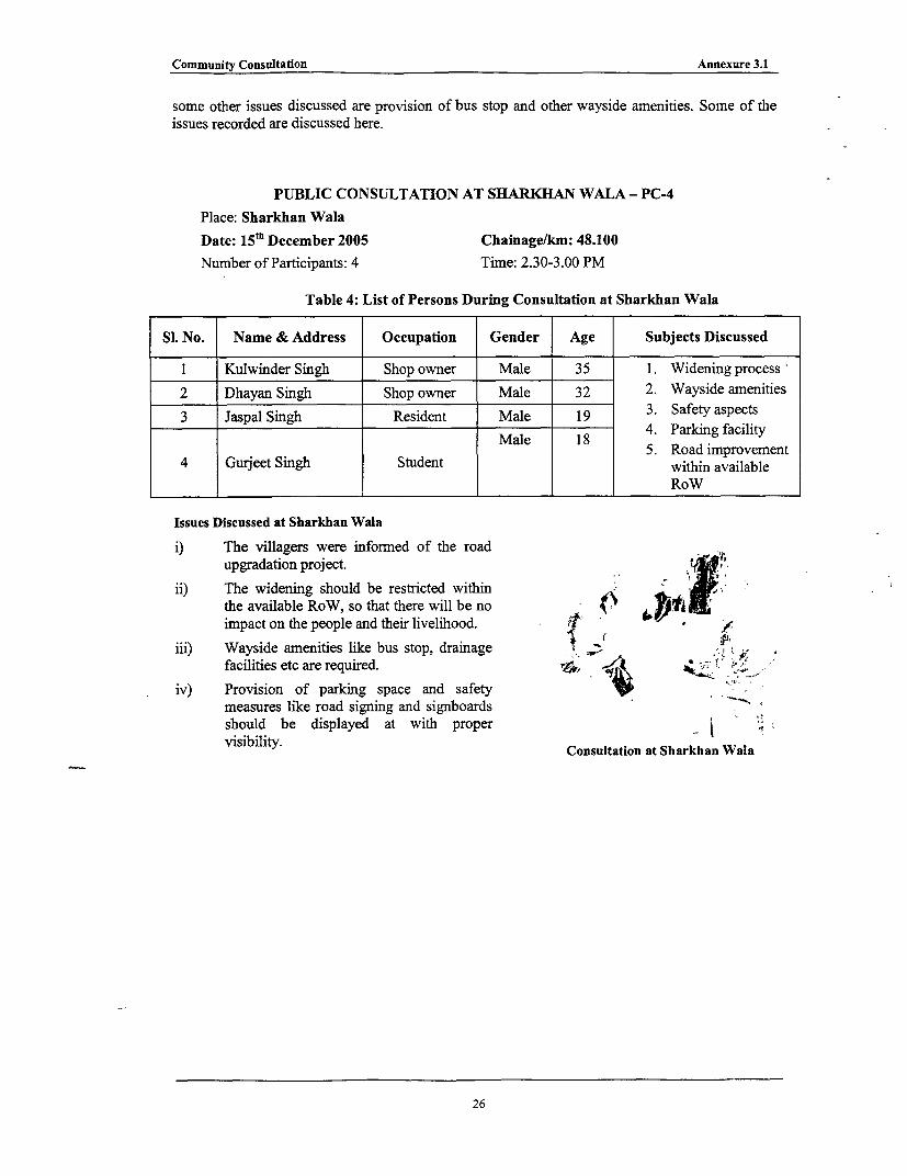
Community Consultation Annexure 3.1
some other issues discussed are provision of bus stop and other wayside amenities. Some of theissues recorded are discussed here.
PUBLIC CONSULTATION AT SHARKHAN WALA - PC-4Place: Sharkhan WalaDate: 15 th December 2005 Chainage/km: 48.100
Number of Participants: 4 Time: 2.30-3.00 PM
Table 4: List of Persons During Consultation at Sharkhan Wala
Sl. No. Name & Address Occupation Gender Age Subjects Discussed
1 Kulwinder Singh Shop owner Male 35 1. Widening process2 Dhayan Singh Shop owner Male 32 2. Wayside amenities
3 Jaspal Singhi Resident Male 19 3. Safety aspects3 Jaspal Singh Resident Male 18 4. Parking facility
Male 18 55. Road improvement4 Gurjeet Singh Student within available
I I I I ~~~RoW
Issues Discussed at Sharkhan Wala
i) The villagers were informed of the roadupgradation project.
ii) The widening should be restricted withinthe available RoW, so that there will be noimpact on the people and their livelihood. f
iii) Wayside amenities like bus stop, drainage ,,facilities etc are required.
iv) Provision of parking space and safety 'measures like road signing and signboardsshould be displayed at with proper ivisibility. Consultation at Sharkhan Wala
26
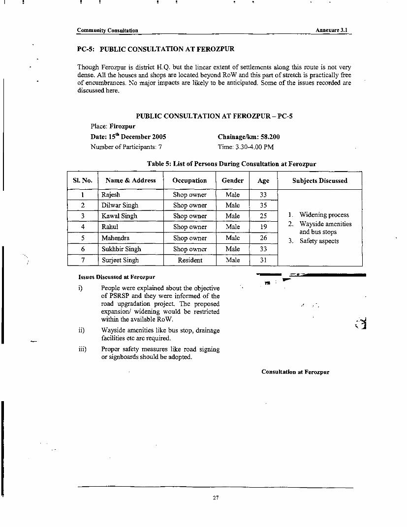
Community Consultation Annexure 3.1
PC-5: PUBLIC CONSULTATION AT FEROZPUR
Though Ferozpur is district H.Q. but the linear extent of settlements along this route is not very
dense. All the houses and shops are located beyond RoW and this part of stretch is practically free
of encumbrances. No major impacts are likely to be anticipated. Some of the issues recorded are
discussed here.
PUBLIC CONSULTATION AT FEROZPUR - PC-5
Place: Firozpur
Date: 15'h December 2005 Chainage/km: 58.200
Number of Participants: 7 Time: 3.30-4.00 PM
Table 5: List of Persons During Consultation at Ferozpur
SI. No. Name & Address Occupation Gender Age Subjects Discussed
1 Rajesh Shop owner Male 33
2 Dilwar Singh Shop owner Male 35
3 Kawal Singh Shop owner Male 25 1. Widening process2 . Wasd mnte
4 Rahul Shop owner Male 19 2. Wayside amenties
5 Mahendra Shop owner Male 26 3. Safety aspects
6 Sukhbir Singh Shop owner Male 33
7 Surjeet Singh Resident Male 31
Issues Discussed at Ferozpur
i) People were explained about the objectiveof PSRSP and they were informed of theroad upgradation project. The proposed A
expansion/ widening would be restrictedwithin the available RoW.
ii) Wayside amenities like bus stop, drainagefacilities etc are required.
iii) Proper safety measures like road signingor signboards should be adopted.
Consultation at Ferozpur
27

I
List of Attendees Annexure 3.2
LIST OF ATTENDEES DURING PUBLIC CONSULTATION
*bo I 3 1 1
PC-2: PUBLIC CONSULTATION AT LANDRAN
PUBLIC CONSULTATION AT LANDRAN - PC-2
Place: Landran
Date: 1 4th May 2006 Chainage/km: 14.600
Number of Participants: 57 Time: 10.00 AM-1.00 PM
Table 2: List of Persons During Consultation at LANDRAN
SI. No. Name & Address Occupation Gender Age Issue Discussed
1 Prashan Singh Farmer Male 82 Presented in
2 Sudha Singh Pensioner Male 60 Annexure 3.1
3 Pramjit Singh Shop Owner Male 37
4 Nirpal Singh Service Male 45(Sweeper)
President Male 905 Palbir Singh Gurudwara
6 .aSingh Shop Keeper Male 33Pravmder Smgh (Tenant)
7 Harbhag Singh.Shop Keeper Male 307 Harbhag Singh (Owner)
8 Pal Singh Farmer Male 65
9 Jastar Singh Farmer Male 36
10 Ganwant Singh Service Male 53
.1 Charanjit Singh Shop Keeper Male 30(Tenant)
12 Naresh Kumar Shop Keeper Male 40(Tenant)
13 Pravider Singh Farmer Male 25
Scooter Male 3314 Surmukh Khan Mechanic
(Tenant)
15 Rspinder Pal Hair Dresser Male 30(Baby) (Tenant)
16 Ajit Singh JE (PWD) Male 57
17 Hardayal Singh JE (PWD) Male 43
18 R K Gupta AE (PWD) Male 45
! X~~~~~~~~~~~~~~~~~~~~~~~~~~~~~~~~~~~~~~~~~~~~~~~
List of Attendees Annexure 3.2
Si. No. Name & Address Occupation Gender Age Issue Discussed
19 Naresh Sharrna AE (PWD) Male 39
20 Karamjit Singh (Tenant) Male 45
Kh. Environment Male 2621 . and Social
KhabIlongtshup Expert22 B S Chauhan AE (PWD) Male 53
23 Gurudev Singh Garanthi Male 42Garanthi
24 Gurudayal Singh Pensioner Male 80
25 Avtar Singh Motor Male 35Mechanic
26 Swam Singh Car Repair Male 3827 Rajender Singh Farner Male 5428 Barshdeep SDE (PWD) Male 3629 N C Ramola SDE (PWD) Male 5230 Balkar Singh JE (PWD) Male 5131 Gurudev Singh Owner (Shop) Male 6032 Balvinder Singh Driver Male 4533 Natua Singh Pensioner Male 7234 Bindhi Singh Driver Male 5035 Prithvi Singh Pensioner Male 5736 Sukhdev Singh Tailor (Owner) Male 35
37 Kashmi. LSweet Maker Male 4237 Kashmiri Lal (Tenant)
Auto Male 4038 Mohan Lal (Residence)39 Gurnit Singh Owner (Shop) Male 2940 Lakhvir Singh Service Male 46
4 Ba.vinder Singh Shop Keeper Male 4541 Balvinder Singh (Tenant)
42 Mohan Singh Shop Keeper Male 40(Tenant)
43 Jagtar Singh Khokha Male 22
Hamek Singh Shop Keeper Male 35(Tenant)
45 Bhupender Singh Shop Keeper Male 35Bhupendr Singh (Tenant)
46 Manjit Singh Shop Keeper Male 3546 IanJIt Smgh (Tenant)
47 Kavinder Singh Tailor (Tenant) Male 23
2

List of Attendees Annexure 3.2
PC-4: PUBLIC CONSULTATION AT CHUNNI
PUBLIC CONSULTATION AT CHUNNI - PC-4
Place: Chunni
Date: 14 'b May 2006 Chainage/km: 25.300
Number of Participants: 44 Time: 5.00 - 7.00 PM
Table 4: List of Persons During Consultation at Chunni
SI. No. Name & Address Occupation Gender Age Issue Discussed
1 Mahender Singh Farmer Male 75 Presented in
2 Amit Kapoor Shop Male 32 Annexure 3.1
3 Dinesh Kumar Shop Male 21
4 Baljit Singh Farmer Male 34Namberdar
5 Rakesh Kumar Shop Male 42
6 Prithvi Singh Farmer Male 35
7 Sukhvinder Singh Farmer Male 22
8 Satwant Singh Student Male 18
9 Sulakhan Singh Farmer Male 24
10 Gurpreet Singh Farmer Male 22
11 Naresh Sharma AE (PWD) Male 32
12 Suresh Kumar SDO (PWD) Male 39
13 Amrikh Singh (Ex- Farmer Male 48Panch)
14 Balbir Singh Politician Male 60(Sarpanch)
15 Arjun Singh Farmer Male 65
16 Dharam Singh Service Male 56Namberdar
17 Mahender Singh Farmer Male 76
18 Mahender Singh Farmer Male 64
19 Bhajan Singh Farmer Male 75
20 Kuldeep Singh Farmer Male 36
21 Gumam Singh Farmer Male 60
22 Balbir Singh Farmer Male 55
23 Ram Murthi Shop Male 58
24 Ram Singh Shop Male 50
25 Shamsher Singh Shop Male 46
26 Babu Singh Shop Male 80
3

List of Attendees Annexure 3.2
SI. No. Name & Address Occupation Gender Age Issue Discussed
27 Tasvinder Singh Shop Male 43
28 Lakhvinder Rickshaw Male 3228 Lakhvinder ~~Puller
29 Amar Singh Farmer Male 5530 Kala Singh Farmer Male 23
31 Gurmukh Singh Service (Pvt.) Male 65
32 Harchand Singh Service Male 57
33 Ranjit Singh Labour Male 60
34 Trilochan Singh Farmer Male 38
35 Pal Singh Farmer Male 60
36 Swam Singh Service Male 50
37 Sukhvinder Singh Shop Male 32
38 Harbans Singh Shop Male 38
39 Harvinder Singh Farmer Male 46
40 Gurbachan Singh Farmer Male 65Namberdar
41 Ajmer Singh Ex-Serviceman Male 55
42 Harjinder Singh Shop Male 48
43 Mewa Singh Farmer Male 70
Environment Male 2644 .and Social
Khabilongtshup Expert, PRBDB
4

List of Attendees Annexure 3.2
I A 1d q { tYM's | 'A T ' I C
PC-2: PUBLIC CONSULTATION AT SILKIANA VILLAGE
PUBLIC CONSULTATION AT SILKIANA - PC-2
Place: Silkiana
DATE: 15t" May 2006 CHAINAGE/KM: 11.200
Number of Participants: 28 Time: 10.00 - 12.30
Table 2: List of Persons During Consultation at Silkiana
SI. No. Name & Address Occupation Gender Age Issue Discussed
1 Hari Ram Agr. Labour Male 48
2 Ram Kishan Business Male 68
3 Ratna Farmer Male 70
4 Harpal Singh Farmer Male 47
5 Pyara Singh Farmer Male 60
6 Bhupender Singh Service Male 45
7 Pulla Singh Farmer Male 70
8 Paja Ram Farmer Male 51
9 Ajit Singh Farmer Male 45
10 Trisem Singh Farmer Male 60
11 Laxman Labour Male 45
12 Chanchal Farmer Male 70
13 Bachna Farmer Male 68
14 Sagar Sahib Farmer Male 30 Presented in Annexure
15 Chunderpal Labour Male 45 3.1
16 Somnath Labour Male 45
17 Bohadan Singh Agr. Labour Male 55
18 Tarsem Singh Unemployed Male 65
19 Chanchal Singh Farmer Male 70
20 Sarvan Singh Farmer Male 65
21 Surender Kaur Housewife Female 44
22 Harbans Kaur Housewife Female 55
23 Chindu Kaur Housewife Female 50
24 Pyari Housewife Female 52
25 Kashmir Kaur Housewife Female 40
26 Charan Kaur Housewife Female 70
27 Pragasu Housewife Female 60
28 Naseebo Housewife Female 68
5
List of Attendees Annexure 3.2
IR1s1iX S *2fu * .S *b *:M:
PC-2: PUBLIC CONSULTATION AT CHHABL TOWN
PUBLIC CONSULTATION AT CHABAL - PC-2Place: Chabal
Date: 1 8th May 2006 Chainage/km: 13.300Number of Participants: 30 Time: 9.00 - 11.00 PM
Table 2: List of Persons During Consultation at Chabal
SI. No. Name & Address Occupation Gender Age Issue Discussed
1 Vijay Kumar Business Male 56 Presented in2 Badaru Nalla Business Male 45 Annexure 3.13 Bil Malik Business Male 444 Badrup Singh Business Male 59
5 Tarsem Singh Business Male 216 Om Prakash Business Male 357 Shri Lal Business Male 61
8 Sukhdev Singh Business Male 239 Manish Sharma Business Male 44
10 Bhupender Singh Business Male 5111 Baljit Singh Business Male 47
12 Than Singh Business Male 5113 Barinder Singh Business Male 49
14 Ramesh Kumar Business Male 33
15 Harjeet Singh Business Male 31
16 Jogender Singh Business Male 6
17 Balwinder Singh Business Male 41
18 Surender Singh Business Male 29
19 Narinder Singh Business Male 21
20 Paramjeet Singh Business Male 3221 Amardeep Singh Business Male 39
22 Subhash Chand Business Male 2823 Ravinder Kumar Business Male 3724 Gurdeep Singh Business Male 4725 Abhay Singh Business Male 30
26 Trisem Lal Business Male 4427 Sandeep Kumar Business Male 38
28 Kulmant Singh Business Male 4129 Sarwan Singh Business Male 29
6
List of Attendees Annexure 3.2
| 30 K KSGhai | Business Male 42
PC-3: PUBLIC CONSULTATION AT RAJATAL
PUBLIC CONSULTATION AT RAJATAL - PC-3
Place: Rajatal
Date: 18th May 2006 Chainage/km: 30.0(0
Number of Participants: 26 Time: 11.30 -2.00 PM
Table 3: List of Persons During Consultation at Rajatal
SI. No. Name & Address Occupation Gender Age Issue Discussed
1 Sukhvinder Singh Business Male 50 Presented in
2 Surender Singh Business Male 56 Annexure 3.1
3 Pratap Singh Farmer Male 41
4 Kulwant Business Male 45
5 Ball Singh Farmer Male 40
6 Surjeet Unemployed Male 23
7 Gur Sahib Farmer Male 47
8 Baldev Singh Driver Male 36
9 Manjal Singh Business Male 32
10 Gulab Singh Business Male 36
11 Kabal Singh Business Male 35
12 Magender Singh Business Male 32
13 Gurmit Singh Business Male 38
14 Bimla Devi (WHH) Business Female 40
15 Bajar Singh Farmer Male 45
16 Amrat Singh Farmer Male 39
17 Dilbag Singh Business Male 25
18 Hardev Singh Farmer Male 44
19 Puramjit Singh Business Male 35
20 Charan Singh Labour Male 35
21 Jagdish Chand Farmer Male 39
22 Hardeep Singh Student Male 12
23 Harpeet Singh Student Male 10
24 Hardev Singh Farmer Male 33
25 Karan Singh Student Male 19
26 Dr. Lal Singh Service Male 41
7

List of Attendees Annexure 3.2
PC-: 4 PUBLIC CONSULTATION AT ATARI
PUBLIC CONSULTATION AT ATTARI - PC-4Place: Attari
Date: 18th May 2006 Chainage/km: 39.200Number of Participants: 28 Time: 4.00-6.00 PM
Table 4: List of Persons During Consultation at Attari
Si. No. Name & Address Occupation Gender Age Issue Discussed
1 Balvinder Singh Farmer Male 56 Presented in2 Vir Singh Farmer Male 32 Annexure3 Devender Singh Farmer Male 454 Rajan Singh Farmer Male 345 Principal Singh Farmer Male 586 Ram Chandra Farmer Male 597 Hardeep Singh Farmer Male 548 Jagdas Singh Farmer Male 619 Satnam Singh Farmer Male 4910 Surjeet Singh Farmer Male 3611 Savinder Singh Farmer Male 5112 Jageer Singh Farmer Male 6013 Balvinder Singh Farmer Male 6614 Arjun Singh Farmer Male 4215 Saabjeet Kaur Housewife Female 4516 Ashu Kaur Housewife Female 4217 Gyan Kaur Housewife Female 3518 Sanjit Kaur Housewife Female 6019 Kashmir Kaur Housewife Female 4420 Harjinder Kaur Housewife Female 3221 Balvinder Kaur Housewife Female 4122 Ninder Kaur Housewife Female 3923 Jaginder Kaur Housewife Female 4024 Charan Kaur Housewife Female 4325 Sham Singh Farmer Male 6026 Ashok Kumar Farmer Male 4427 Nandi Lal Farmer Male 5128 Manish Kumar Farmer Male 56
8

List of Attendees Annexure 3.2
IRII:SUME. S :i* . Ml I *:|wU2gM I
PC-2: PUBLIC CONSULTATION AT ATTNAWALI
PUBLIC CONSULTATION AT ATTNAWALI - PC-2
Place: Attnawali
Date: 12th May 2006 Chainage/km: 6.700
Number of Participants: 37 Time: 8.30-11.00 AM
Table 2: List of Persons During Consultation at Attnawali
SI. No. Name & Address Occupation Gender Age Issue Discussed
I Manoj Kumar Agricultural Labourer Male 41 Presented in
2 Sattan Mehto Agricultural Labourer Male 50 Annexure 3.1
3 Pahalwan Singh Agricultural Labourer Male 61
4 Sikander Mehto Agricultural Labourer Male 35
5 Kamal Das Mehto Agricultural Labourer Male 45
6 Sunita Devi Housewife Female 25
7 Rada Devi Housewife Female 32
8 Gangia Devi Housewife Female 50
9 Budhiya Devi Housewife Female 32
10 Sakhiya Devi Housewife Female 35
11 Kiran Devi Housewife Female 14
12 Suguiya Devi Housewife Female 43
13 Puinya Devi Housewife Female 24
14 Santi Devi Housewife Female 40
15 Radia Devi Housewife Female 28
16 Sarsatiya Devi Housewife Female 29
17 Dukhiya Devi Housewife Female 48
18 Kiran Devi Housewife Female 32
19 Phagudi Devi Housewife Female 40
20 Narujdo Nishan Housewife Female 60
21 Pamati Housewife Female 31
22 Sumitra Devi Housewife Female 38
23 Sanju Devi Housewife Female 40
24 Reema Devi Housewife Female 22
25 Phoolo Devi Housewife Female 30
26 Dukhiya Devi Housewife Female 48
27 Hari Chand Agricultural Labourer Male 65Paswan
9

List of Attendees Annexure 3.2
SI. No. Name & Address Occupation Gender Age Issue Discussed
28 Upender Das Agricultural Labourer Male 3029 Mohamad Kudus Agricultural Labourer Male 4530 Sheikh Salauddin Agricultural Labourer Male 403 1 Ashok Mehto Agricultural Labourer Male 2832 Kailash Mehto Agricultural Labourer Male 3533 Shanker Mehto Agricultural Labourer Male 4534 Sarthal Mehto Agricultural Labourer Male 5035 Vishnu Dev Mehto Agricultural Labourer Male 4436 Sahdev Mehto Agricultural Labourer Male 3637 Kuldev Mehto Agricultural Labourer Male 30

List of Attendees Annexure 3.2
PC-4: PUBLIC CONSULTATION AT MANDBU-MUNDICHHENA
PUBLIC CONSULTATION AT MANDBU-MUNDICHHENA - PC-4
Place: Mandbu-Mundichhena
Date: 1 2th May 2006 Chainage/km: 20.100
Number of Participants: 53 Time: 11.30-2.00 PM
Table 4: List of Persons During Consultation at Mandbu-Mundichhena
SI. No. Name & Address Occupation Gender Age Issue Discussed
1 Bahal Singh Agricultural Labourer Male 70 Presented in
2 Tara Singh Agricultural Labourer Male 60 Annexure 3.1
3 Kulwant Singh Agricultural Labourer Male 55
4 Mahender Singh Agricultural Labourer Male 35
5 Harsingh Agricultural Labourer Male 65
6 Puran Singh Agricultural Labourer Male 30
7 Jogender Singh Agricultural Labourer Male 65
8 Paramjit Singh Agricultural Labourer Male 20
9 Mahender Singh Agricultural Labourer Male 65
10 Jit Singh Agricultural Labourer Male 65
11 Kashmir Singh Agricultural Labourer Male 60
12 Natna Singh Agricultural Labourer Male 36
13 Jagtar Singh Agricultural Labourer Male 50
14 Chand Singh Agricultural Labourer Male 50
15 Bagicha Singh Agricultural Labourer Male 50
16 Teja Singh Agricultural Labourer Male 60
17 Gurmeet Singh Agricultural Labourer Male 40
18 Kamal Singh Agricultural Labourer Male 42
19 Jaswinder Singh Agricultural Labourer Male 36
20 Wazir Singh Agricultural Labourer Male 40
21 Balkar Singh Agricultural Labourer Male 25
22 Surjit Sihgh Agricultural Labourer Male 35
23 Mohan Singh Agricultural Labourer Male 40
24 Deshraj Agricultural Labourer Male 18
25 Surjeet Kaur Housewife Female 35
26 Som Kaur Housewife Female 27
27 Gurdev Kaur Housewife Female 36
28 Parmeet Kaur Housewife Female 39
29 Bholy Housewife Female 24
30 Manjeet Kaur Housewife Female 28
11
List of Attendees Annexure 3.2
SI. No. Name & Address Occupation Gender Age Issue Discussed
31 Jasveer Kaur Housewife Female 3432 Sinder Kaur Housewife Female 3333 Asha Housewife Female 3034 Jangir Kaur Housewife Female 3635 Jamal Kaur Housewife Female 3436 Mandir Kaur Housewife Female 2537 Kaur Bia Housewife Female 2838 Minder Kaur Housewife Female 3239 Manjit Kaur Housewife Female 2340 Mahinder Kaur Housewife Female 3841 Prakash Kaur Housewife Female 3342 Bahuminder Kaur Housewife Female 2743 Parmeet Kaur Housewife Female 2444 Simter Kaur Housewife Female 3145 Parkash Kaur Housewife Female 2346 Lashmo Bia Housewife Female 3347 Preetam Kaur Housewife Female 4148 Gurdev Kaur Housewife Female 3449 Kartar Kaur Housewife Female 4750 Paramjeet Kaur Housewife Female 3551 Minder Kaur Housewife Female 3752 Jaginder Kaur Housewife Female 4153 Gumam Kaur Housewife Female 33
12
List of Attendees Annexure 3.2
.,.I R , 1 F 1I '< s11 D :<Y 1 4:W X E'VI1 14 51 01115A170,
PC-2: PUBLIC CONSULTATION AT KOT ISE KHAN
PUBLIC CONSULTATION AT KOT ISE KHAN - PC-2
Place: Kot Ise Khan
Date: 1 3 th May 2016 Chainage/km: 12.000
Number of Participants: 20 Time: 1.00-3.30 PM
Table 2: List of Persons During Consultation at Kot Ise Khan
SI. No. Name & Address Occupation Gender Age Issue Discussed
1 Ashok Thakur Business Male 50 Presented in
2 Yaspal Ghulati Business Male 45 Annexure 3.1
3 Jaswinder Singh Business Male 55
4 Raghubir Singh Business Male 55
5 Kripal Singh Business Male 60
6 Om Prakash Business Male 50
7 Vikas Goba Business Male 22
8 Mohammad Isa Business Male 30
9 Moninder Pal Business Male 37
10 Bagacha Singh Business Male 45
11 Avtar Singh Business 23
12 Charamjit Pal Business 24
13 Jasminder Business 30
14 Surjit Singh Business Male 59
15 Krishan Singh Service Male 44
16 Inderjeet Singh Business Male 31
17 Parveen Kumar AEE, PRBDB Male 40
18 Jasbir Kaur Housewife Female 34
19 Amarpreet Kaur Housewife Female 32
20 Sarabjeet Housewife Female 39
13
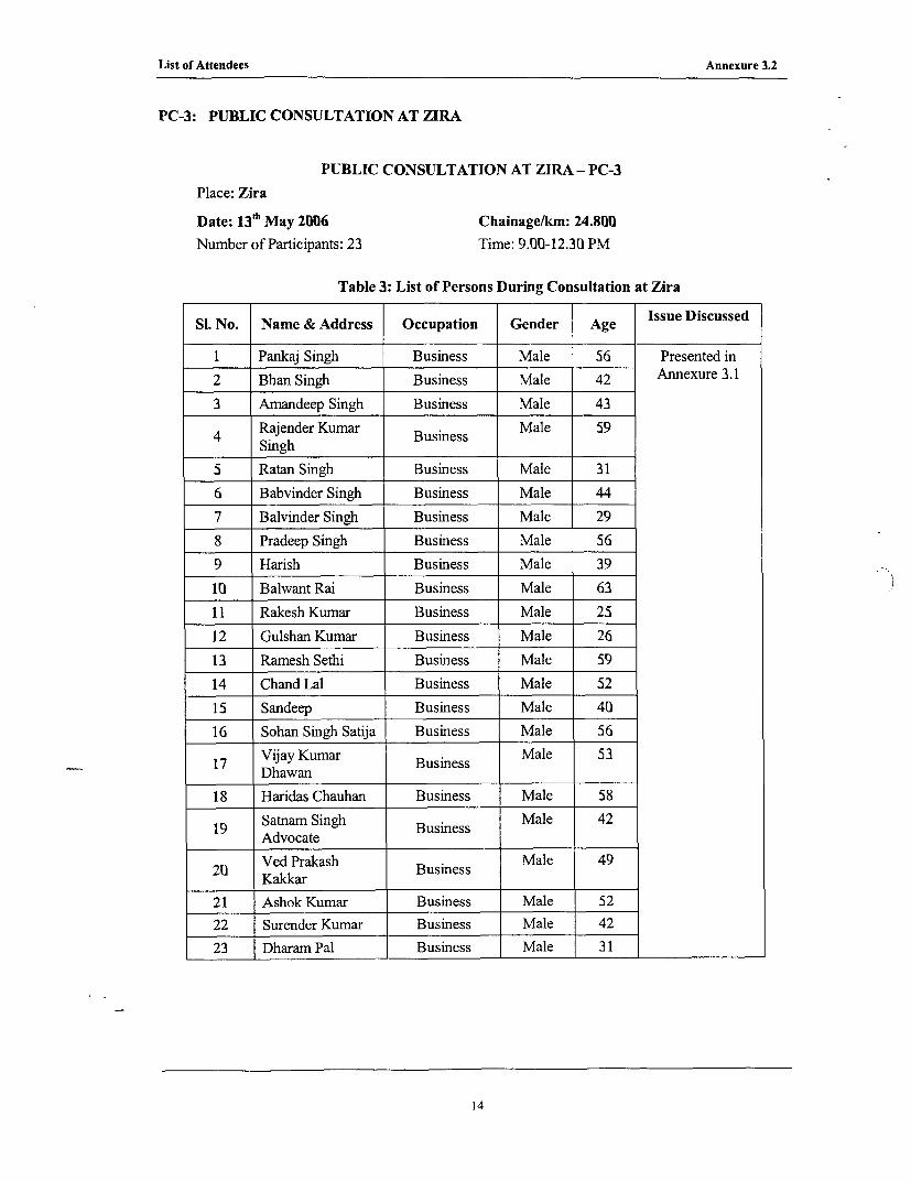
List of Attendees Annexure 3.2
PC-3: PUBLIC CONSULTATION AT ZIRA
PUBLIC CONSULTATION AT ZIRA - PC-3
Place: Zira
Date: 1 3th May 2006 Chainage/km: 24.800Number of Participants: 23 Time: 9.00-12.30 PM
Table 3: List of Persons During Consultation at Zira
Si. No. Name & Address Occupation Gender Age Issue Discussed
1 Pankaj Singh Business Male 56 Presented in2 Bhan Singh Business Male 42 Annexure 3.13 Amandeep Singh Business Male 43
4 Rajender Kumar Business Male 59Singh
5 Ratan Singh Business Male 316 Babvinder Singh Business Male 447 Balvinder Singh Business Male 298 Pradeep Singh Business Male 569 Harish Business Male 3910 Balwant Rai Business Male 6311 Rakesh Kumar Business Male 2512 Gulshan Kumar Business Male 2613 Ramesh Sethi Business Male 5914 Chand Lal Business Male 5215 Sandeep Business Male 4016 Sohan Singh Satija Business Male 56
17 Vijay Kumar Business Male 53Dhawan
18 Haridas Chauhan Business Male 58
19 Satnam Singh Business Male 42Advocate
20 Ved Prakash Business Male 49Kakkar
21 Ashok Kumar Business Male 5222 Surender Kumar Business Male 4223 Dharam Pal Business Male 31
14

Private Property Schedule(Non-Title Holders) for all Road Links (Punjab State Road Sector Project) Annexure 5.1
_ _~~ NameofCorridor TYieof ~~~~~~~~aName of Head *E. CZ ' Legal
120 4 Tar~a me Tara CoAriLAI L 187mritsar Shp Propet Kulan Sing Owe o _ Sq 0
121 PrnLope o o Household C Stus 9 9 9~~~~~ .~~~~~~~~~~ ~~>Affected
120 4 Taran Taran -Atari LTA/3 Left 1h.7 Amritsar Shapa Shop Kulwant Singh Owner No I Squatter 16 16 16 16 10
121 4 Taran Taran -Atari LTA/2 Left 30 Amritsar Rajatal Shop Bimla Devi Owner No I Squatter 9 9 9 9 100
122 4 Taran Taran -Atari LTA/3 Left 30.02 Amritsar Rajatal Shop Kabel Singh Owner No I Squatter 4 4 4 4 100
123 4 Taran Taran -Atabi LTA/4 Left 30.023 Amritsar Rajatal Shop iSukhwinder Sing Owner No I Squatter 24 24 24 24 10W
124 4 Taran Taran -Atari LTA/5 Left 30.03 Anmritsar Rajatal Shop Gulab Singh Owner No 1 Squatter 9 9 9 9 IOU1
125 4 Taran Taran -Atari LTA/6 Left 301.035 Amoritsar Rajatal Shop Nishan Singh Owner No 1 Squatter 4 4 4 4 IOU
127 4 Taran Taran -Atari RTA I Right 23.3 Amnritsar Sarai Aritkhan Shop Pramjit Singh Owner No I Squatter 9 9 9 9 I 0
128 4 Turan Taran -Atari RTA 2 Right 23.305 Amritsar Sarai Arikhan Shop Maggar Sigh Owner No I Squatter 9 9 9 9 100
129 4 Taran Taran -Atari RTA 3 Right 23.315 Amritsar Sarai Aritkhan Shop Mangal Singh Owner No I Squatter 9 9 9 9 100
130 4 Taran Taran -Atari RTA 4 Right 23.322 Amritsar Sarai Aritkhan Shop Mewa Singh Owner No I Squatter 9 9 9 9 100
131 4 Taran Taran -Atari RTA 5 Right 23.35 Amritsar Sarai Aritkhan Shop Gurmit Singh Owner No I Squatter 4 4 4 4 100
138 5 Kapurthala-Tarn Taran LKT 5 Left 3.730 Kapurthala Kapurthala Khakren More (Bha Kiosk Amanjeet Metho Owner No I Squatter I I I 100
139 5 Kaputthala-Tam Taran LKT 6 Left 3.735 Kapurthala Kapurthala Khakren More (Bha Kiosk No Survey Owner No I Squatter I I I I 100
140 5 Kapurthala-Tarn Taran LKT 7 Left 7.95 Kapurthala Kapurthala Khirawal Pind Kiosk Baunti Chodda Owner No I Squatter 9 9 9 9 100
141 5 Kapurthala-Tamn Taran LKT 8 Left 7.96 Kapurthala Kapurthala Khirawal Pind Kiosk Bagga Owner No I Squatter 8 8 8 8 100
156 5 Kapurthala-Tam Taran LKT 22 Left 20.2 Kapurthala Kapurthala Maudboo- Mund.-c Shop Avatar Singh Owner No I Squatter 12 12 12 12 l00
IS7 5 Kapurthala-Tam Taran LKT 23 Left 20.205 Kapurthala Kapurthala Maudboo- Mondi-c Kiosk Smnder Pal Singh Owner No I Squatter 4 4 4 4 100
163 5 Kapurthala-Tam Taran LKT 29 Left 21.6 Kapurthala Kapurthala Maudboo- Mundi-c Kiosk Sanjil Singh Owner No I Squatter 4 4 4 4 100
167 5 Kapurthala-Tam Taran LKT 33 Left 21.8 Kapurthala Kapurthala Maudboo- Mundi-c Kiosk Balwinder Sngh Owner No I Squatter I I I I 100
168 5 Kapurthala-Tarn Taran LKT 34 Left 21.805 Kapurthala Kapurthala Maudboo- Mundi-c Kiosk Fauja Singh Owner No I Squatter 4 4 4 4 100
169 5 Kapurthala-Tam Taran LKT 35 Left 21.795 Kapurthala Kapurthala Maudboo- Mundi-c Kiosk No Survey Owner No I Squatter I 1 I I 100
176 5 Kapurthala-Tam Taran RKT 7 Right 5.4 Kapurthala Kapurthala Parveesh Nagar Kiosk Tersemlal Owner No I Squatter 4 4 4 4 100
189 5 Kapurthala-Tarn Taran RKT 19 Right 6.67 Kapurthala Kapurthala Atnavali village Kiosk Fore man Owner No I Squatter 9 9 9 9 100
190 5 Kapurthala-Tam Taran RKT 20 Right 6.68 Kapurthala Kapurthala Atnavali village Kiosk Mohan Singh Owner No I Squatter 4 4 4 4 100
Total 24 168 168 168 168 -
I~~~~~~~~~~~~~~~~~~~~~~~~~~~~~~~~~~~~~~~~~~~~~~~~~~~~~~~~~~~~~~~~~~~~~~~~~~~~~~~~~~~~~~~~~~~~~~~~~~~~~~~~~~~~~

.-- - - I ---- - --- --- - -------
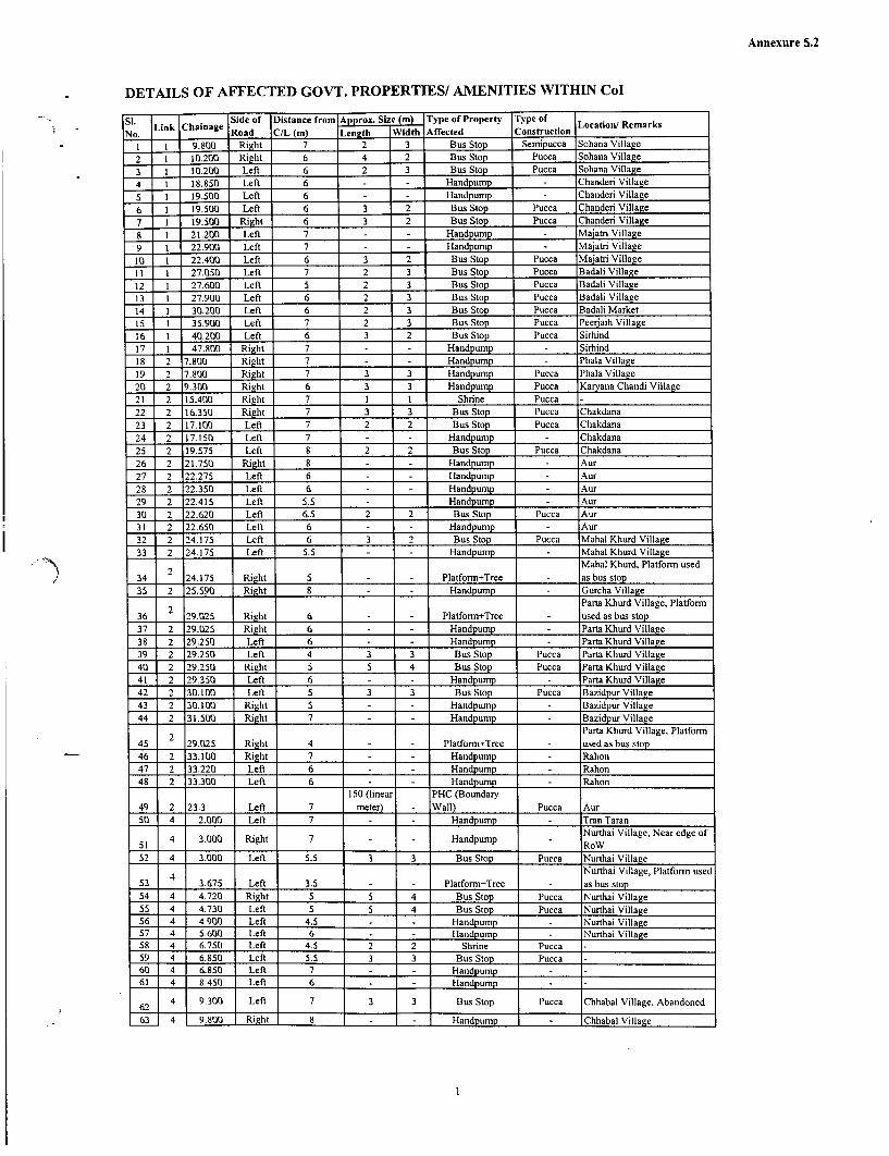
Annexure 5.2
DETAILS OF AFFECTED GOVT. PROPERTIES! AMENITIES WITHIN Col
Si. Side of Distance from Approx. Size (m) Type of Property Type ofLink Chainage Location/ Remarks
No. Road C/L (m) Leneth Width Affected ConstructionI I 9.800 Right 7 2 3 Bus Stop Semipucca Sohana Village
2 1 10.200 Right 6 4 2 Bus Stop Pucca Sohana Village
3 1 10.200 Left 6 2 3 Bus Stop Pucca Sohana Village
4 1 18.850 Left 6 - - Handpump Chanderi Village
5 1 19.500 Left 6 - - Handpump Chanderi Village
6 1 19.500 Left 6 3 2 Bus Stop Pucca Chanderi Village7 1 19.500 Right 6 3 2 Bus Stop Pucca Chanderi Village
8 I 21.200 Left 7 - - Handpump Majatri Village
9 1 22.900 Left 7 - - Handpump Majatri Village
10 I 22.400 Left 6 3 2 Bus Stop Pucca Majatri VillageII 1I 27.050 Left 7 2 3 Bus Stop Pucca Badali Village
12 1 27.600 Left 5 2 3 Bus Stop Pucca Badali Village13 1 27.900 Left 6 2 3 Bus Stop Pucca Badali Village14 1 30.200 Left 6 2 3 Bus Stop Pucca Badali Market15 1 35.900 Left 7 2 3 Bus Stop Pucca Peeraih Village
16 1 40.200 Left 6 3 2 Bus Stop Pucca Sirhind17 1 47.800 Right 7 - - Handpump Sirhind18 2 7.800 Right 7 - - Handpump Phala Village19 2 7.800 Right 7 3 3 Handpump Pucca Phala Village20 2 9.300 Right 6 3 3 Handpump Pucca Karyana Chandi Village21 2 15.400 Right 7 1 1 Shrine Pucca -
22 2 16.350 Right 7 3 3 Bus Stop Pucca Chakdana23 2 17.100 Left 7 2 2 Bus Stop Pucca Chakdana24 2 17.150 Left 7 - - Handpump - Chakdana
25 2 19.575 Left 8 2 2 Bus Stop Pucca Chakdana26 2 21.750 Right 8 - Handpump Aur
27 2 22.275 Left 6 Handpump Aur28 2 22.350 Left 6 Handpump Aur29 2 22.415 Left 5.5 Handpump Aur30 2 22.620 Left 6.5 2 2 Bus Stop Pucea Aur31 2 22.650 Left 6 - - Handpump - Aur32 2 24.175 Left 6 3 2 Bus Stop Pucca Mahal Khurd Village33 2 24.175 Left 5.5 - - Handpump Mahal Khurd Village
2 Mahal Khurd, Platform used34 24.175 Right 5 . Platform+Tree as bus stop
35 2 25.590 Right 8 Handpump Gurcha Village
2 Parta Khurd Village, Platform36 29.025 Right 6 Platform+Tree used as bus stop
37 2 29.025 Right 6 Handpump Parta Khurd Village38 2 29.250 Left 6 - - Handpump Parta Khurd Village
39 2 29.250 Left 4 3 3 Bus Stop Pucca Parta Khurd Village40 2 29.250 Right 5 5 4 Bus Stop Pucca Parta Khurd Village41 2 29.350 Left 6 - - Handpump - Parta Khurd Village42 2 30.100 Left 5 3 3 Bus Stop Pucca Bazidpur Village43 2 30.100 Right 5 - - Handpump Bazidpur Village44 2 31.500 Right 7 Handpump Bazidpur Village
2 Parta Khurd Village, Platform45 29.025 Right 4 Platform+Tree used as bus stop46 2 33.100 Right 7 Handpump Rahon
47 2 33.220 Left 6 Handpump Rahon48 2 33.300 Left 6 Handpump Rahon
150 (linear PHC (Boundary49 2 23.3 Left 7 meter) Wall) Pucca Aur50 4 2.000 Left 7 Handpump Tran Taran
51 4 3.000 Right 7 - Handpump Nurthai Village, Near edge of
52 4 3.000 Left 5.5 3 3 Bus Stop Pucca Nurthai Village
4 Nurthai Village, Platform used53 _ 3.675 Left 3.5 - - Platform+Tree - as bus stop
54 4 4.720 Right 5 5 4 Bus Stop Pucca Nurthai Village
55 4 4.730 Left 5 5 4 Bus Stop Pucca Nurthai Village56 4 4.900 Left 4.5 - - Handpump Nurthai Village57 4 5.600 Left 6 - - Handpump Nurthai Village
58 4 6.750 Left 4.5 2 2 Shrine Pucca .
59 4 6.850 Left 5.5 3 3 Bus Stop Pucca60 4 6.850 Left 7 - - Handpump-61 4 8.450 Left 6 - Handpump
t 62 4 9.300 Left 7 3 3 Bus Stop Pucca Chhabal Village, Abandoned
63 4 9.800 Right 8 Handpump IChhabal Village
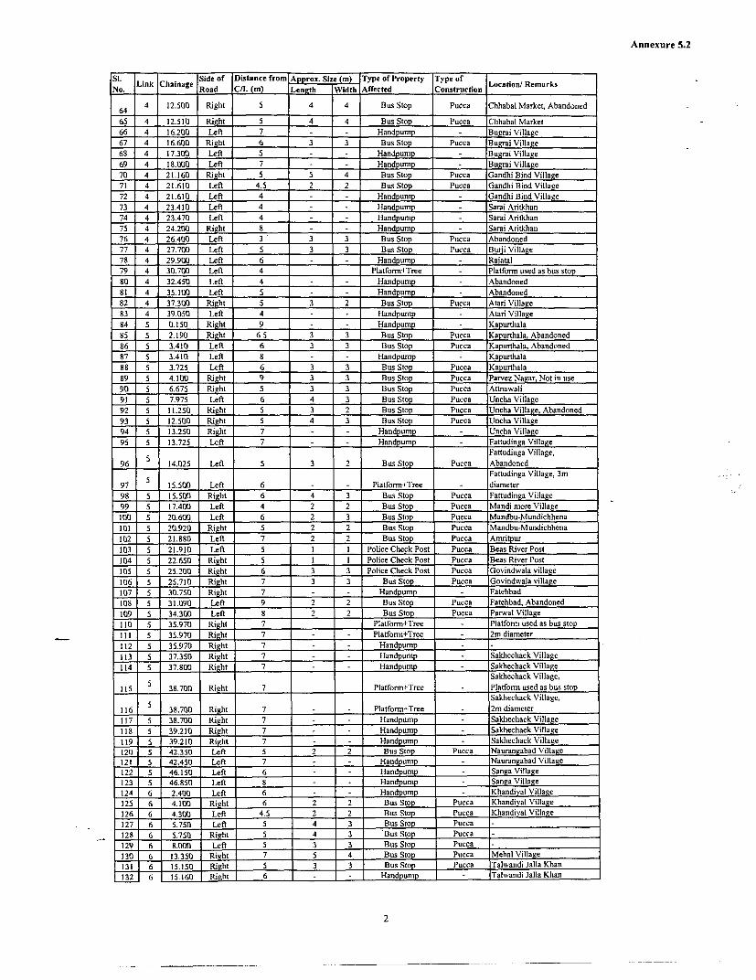
Annexure 5.2
Si. Link Cha Side of Distance from Approx. Size (m) Type of Property Type ofNo. n nage Road C/L (m) Length Width Affected Construction Location/ Remarks
4 12.500 Right 5 4 4 Bus Stop Pucca Chhabal Market, Abandoned
65 4 12.510 Right 5 4 4 Bus Stop Pucca Chhabal Market66 4 16.200 Left 7 - - Handpump - Bugrai Village67 4 16.600 Right 6 3 3 Bus Stop Pucca Bugrai Village68 4 17.300 Left 5 - - Handpump Bugrai Village69 4 18.000 Left 7 - Handpump Bugrai Village70 4 21.160 Right 5 5 4 Bus Stop Pucca Gandhi Bind Village71 4 21.610 Left 4.5 2 2 Bus Stop Pucca Gandhi Bind Village72 4 21.610 Left 4 Handpump Gandhi Bind Village73 4 23.410 Left 4 = Handpump Sarai Aritkhan74 4 23.470 Left 4 Handpump Sarai Aritkhan75 4 24.200 Right 8 Handpump Sarai Aritkhan76 4 26.400 Left 3 3 3 Bus Stop Pucca Abandoned77 4 27.700 Left 5 3 3 Bus Stop Pucca Burji Village78 4 29.900 Left 6 - - Handpump Raiatal79 4 30.700 Left 4 Platfortn+Tree Platform used as bus stop80 4 32.450 Lefl 4 = Handpump Abandoned81 4 35.100 Left 5 Handpump Abandoned82 4 37.300 Right 5 3 2 Bus Stop Pucca Atari Village83 4 39.050 Left 4 - Handpump Atari Village84 5 0.150 Right 9 - - Handpump Kapurthala85 5 2.190 Right 6.5 3 3 Bus Stop Pucca Kapurthala, Abandoned86 5 3.410 Left 6 3 3 Bus Stop Pucca Kapurthala, Abandoned87 5 3.410 Left 8 - - Handpump - Kapurthala88 5 3.725 Left 6 3 3 Bus Stop Pucca Kapurthala89 5 4.100 Right 9 3 3 Bus Stop Pucca Parvez Nagar, Not in use90 5 6.675 Right 5 3 3 Bus Stop Pucca Attnawali91 5 7.975 Left 6 4 3 Bus Stop Pucca Uncha Village92 5 11.250 Right 5 3 2 Bus Stop Pucca Uncha Village, Abandoned93 5 12.500 Right 5 4 3 Bus Stop Pucca Uncha Village94 5 13.250 Right 7 - - Handpump Uncha Village95 5 13.725 Left 7 H . Handpump Fattudinga Village
5 Fattudinga Village,96 14.025 Left 5 3 2 Bus Stop Pucca Abandoned
Fattudinga Village, 3m97 5 15.500 Left 6 - - Platform+Tree - diameter98 5 15.500 Right 6 4 3 Bus Stop Pucca Fattudinga Village99 5 17.400 Left 4 2 2 Bus Stop Pucca Mandi more Village
100 5 20.600 Left 6 2 3 Bus Stop Pucca Mandbu-Mundichhena101 5 20.920 Right 5 2 2 Bus Stop Pucca Mandbu-Mundichhena102 5 21.880 Left 7 2 2 Bus Stop Pucca Amritpur103 5 21.910 Left 5 I I Police Check Post Pucca Beas River Post104 5 22.650 Right 5 1 1 Police Check Post Pucca Beas River Post105 5 25.200 Right 6 3 3 Police Check Post Pucca Govindwala village106 5 25.710 Right 7 3 3 Bus Stop Pucca Govindwala village107 5 30.750 Right 7 - 1Handpump - Fatebbad108 5 31.090 Left 9 2 2 Bus Stop Pucca Fatehbad, Abandoned109 5 34.300 Left 8 2 2 Bus Stop Pucca Parwal Village110 5 35.970 Right 7 Platform+Tree Platform used as bus stopIII 5 35.970 Right 7 = Platform+Tree 2m diameter112 5 35.970 Right 7 Handpump .113 5 37.350 Right 7 Handpump Sakhechack Village114 5 37.800 Right 7 Handpump Sakhechack Village
Sakhechack Village,115 5 38.700 Right 7 Platform+Tree Platform used as bus stop
5 Sakhechack Village,116 38.700 Right 7 Platform+Tree 2m diameter117 5 38.700 Right 7 Handpump Sakhechack Village118 5 39.210 Right 7 Handpump Sakhechack Village119 5 39.2 10 Right 7 Handpump Sakhechack Village120 5 42.350 Left 5 2 2 Bus Stop Pucca Naurangabad Village121 5 42.450 Left 7 - Handpump Naurangabad Village122 5 46.150 Left 6 Handpump Sanga Village123 5 46.850 Left 8 Handpump Sanga Village124 6 2.400 Left 6 _ Handpump Khandiyal Village125 6 4.100 Right 6 2 2 Bus Stop Pucca Khandiyal Village126 6 4.300 Left 4.5 2 2 Bus Stop Pucca Khandiyal Village127 6 5.750 Left 5 4 3 Bus Stop Pucca128 6 5.750 Right 5 4 3 Bus Stop Pucca129 6 8.000 Left 5 3 3 Bus Stop Pucca130 6 13.350 Right 7 5 4 Bus Stop Pucca Mehal Village131 6 15.150 Right 5 3 3 Bus Stop Pucca Talwandi Jalla Khan132 6 15.160 Right 6 - - Handpump Talwandi Jalla Khan
2

Annexure 5.2
Si. Link Chainage Side of Distance from Approx. Sizmi Type of Property Type of Location/ RemarksSIN ino.ang Road CIL (m) Leneth Width Affected Construction ____________
133 6 17.550 Left 5 4 4 Bus Stop Pucca Talwandi Jalla Khan
134 6 20.300 Left 5 4 3 Bus Stop Pucca Sukhawala Village
135 6 20.950 Left 5 4 3 Bus Stop Pucca Sukhawala Village
136 6 21.200 Left 4 1 1 Shrine Shrine+Tree
137 6 22.900 Left 6 4 4 Police Check Post Pucca Zira
138 6 24.500 Left 4 2 2 Police Check Post Pucca Zira Town
139 6 27.800 Right 5 1 1 Shrine - Zira, Shrine+Tree140 6 35.550 Left 6 4 3 Bus Stop Pucca Markhai
Chuchak, Platform used as bus
141 6 37.750 Left 6 Platform+Tree stop
142 6 42.550 Right 4 Platform+Tree Lohgarh, Platform used as bus
142 6 42.550 Right 4 Plafform+Tree stop
143 6 45.350 Left 5 4 3 Bus Stop Pucca Lohgarh Village
144 6 49.850 Left 7 4 3 Bus Stop Pucca Balallar Village
145 6 54.050 Left 6 3 2 Bus Stop Pucca Sohini Village, Abandoned
3

i I z

Annexure 5.3
Costs and Budget for Resettlement and Rehabilitation of PAPs, for Improvement within Zira Town (km 24.300 to km 24.600 of Link 6) OPTION I
Total Amount ~ Total Amount in MillionSi. ItmUi uniyUnit Rate Toa mutRupees
No. Unit Quantity (Rs.) PRBDB World Bank Grand Total PRBDB World Total_________ ____ ______ _______ B ank
A COMPENSATIONI Cost of Built-up Land for Title holders (Res, Comm and Res+ Comm and Others) Sq.m. 1,201 4,485 5,382,00 5,382,001 5.38 5.38
2 Cost of registration for Built-up Land @,9% 484,38C 484,381 0.48 0.48
Sub Total - Land cost 5-866,380 0 5,866,381 5.87 5.87
3 Res/Com structure compensation: Pucca Sq.m. 1,200 4036 4,843,200 4,843,200 4.84 4.84
Total: Compensation 1__0_,70-9,580 0 10,709,581 10.71 0 10.71
B ASSISTANCE4 Shifting Allowance to the Titleholder PAPs for Pucca Structures PDF 200 2,500 500,000 500,000 0.50 0.50
5 Transitional Allowance to the affected PAPs for livelihood restoration O, AWR of Punjab for 3 m PDF 200 7,884 1,576,800 1,576,800 1.58 1.58
6 Economic Rehabilitation Grant to the affected Wage earners for livelihood restoration @ AWR of PAF 60 7,884 473,040 473,040 0.47 0.47
7 Support for construction of structures for Self Relocating Persons i,) 25% of Replacement Value c Total FamilieE 200 30,000 6,000,000 6,000,000 6.00 6.00
Total Assistance _0 8,549,840 8,549,840 0.00 8.55 8.55
C SUPPORT for Project Implementation8 Training to staff and NGOs* Estimated 0* 0* 0 0.00 0.00
9 Translation and printing of the Policy, I cards, etc. PAF 200 200 40,000 40,000 0.04 0.04
10 Studies and updating of survey data * Estimated 0* 0* 0 0.00 0.00
I INGO Recruitment for RAP Implementation*. Estimated 0* 0* 0 0.00 0.00
Total: Support 40,0001 40,00C 0.04 0.04
D OTHER ACTIVITIES _
12 H1V/AIDS awareness campaign* Estimated 0* 0* 0 0.00 0.00
13 M&E Consultants Household 200 2,500 500,000 500,00 0.50 0.50
Total: Other Activities 0 500,000 500,000 0.00 0.50 0.50
GRAND TOTAL (A+B+C-iD) 10,709,580 9,089,840l 19,799,4201 10.71 9.091 19.80
(in Terms of Million Rupees) __ _ _ _ _ __________ 10.711 9.091 19.801____ ____
*Note: As this is an indicative budget only for junction improvement, the star marked items are already taken care of in Annerure 10.6.
Acronyms: Sq.m. Square metre; PAF= Project Affected Family; PDF= Project Displaced Family

I
i~~~~~~~~~~~~~~~~~~~~~~~~~~~~~~~~~~~~~~~~~~~~~~~~~'

Annexure 7.1
DETAILS OF GOVERNMENT LANDS IN RURAL AREAS - AVAILABLE,ENCROACHMENT, UNDER CONSTRUCTION
Total land WithoutLeased Under Total UnderS1. No. District available encro- out litigation encroa- const-
achment ched land ruction
1 Amritsar 24928 1553 18256 55 20553 592 Gurdaspur 12358 788 7209 206 8289 403 Jalandhar 4484 0 415 190 4451 1204 Hoshiarpur 46597 17170 26368 21063 24902 05 Kapurthala 24410 4479 5432 4 13891 36 Nawanshahar 6715 3342 1433 243 2695 527 Ropar 969 281 66 0 688 08 Fatehgarh Sahib 325 141 32 50 182 339 Ludhiana 20754 5407 13700 1389 7419 289
10 Patiala 965 122 21 124 0
11 Mansa 273 22 85 47 52 0
12 Bhatinda 2505 289 95 434 2186 0
13 Faridkot 1307 746 745 124 562 438
14 Mukatsar 586 331 4 0 234 0
14 Sangrur 2401 449 35 92 1995 0
16 Moga 1223 11 740 25 1051 1417 Ferozepur 21626 996 7859 198 2287 2212
Total 172428 36127 82474 24142 91560 3261DETAILS OF GOVERNMENT LANDS IN URBAN AREAS - AVAILABLE, ENCROACHMENT,UNDER CONSTRUCTION
Total land Without Leased Under Total UnderSl. No. District available encro- out Under encroa- const-
(Acres) achment out litigation ched land ruction
1 Amritsar 3789 18 57 0 142 633
2 Gurdaspur 143 44 8 5 58 16
3 Jalandhar 1436 32 9 742 1395 1167
4 Hoshiarpur 722 134 51 0 489 0
5 Kapurthala 1363 5 0 0 1168 0
6 Nawanshahar 80 34 22 4 18 4
7 Ropar 31 0 0 0 31 0
8 Fatehgarh Sahib 436 220 64 19 27 0
9 Ludhiana 655 425 1 475 628 428
10 Patiala 1500 98 0 26 217 25
11 Mansa 166 15 5 0 3 1
12 Bhatinda 426 29 78 0 87 1
1

Annexure 7.1
Total land Without Leased Under Total UnderSl. No. District available encro- . . encroa- const-
(Acres) achment ched land ruction13 Faridkot 542 182 173 67 360 29014 Mukatsar 266 45 10 4 3 014 Sangrur 211 24 9 49 187 416 Moga 273 26 11 63 182 1617 Ferozepur 257 197 7 22 30 12
Total 12294 1528 505 1475 5025 2598
2

Annexure 8.1
IMPLEMENTATION OF RESETTLEMENT ACTION PLAN
TERMS OF REFERENCE FOR THE NGOs
1. Background of the project
1.1- The International Bank for Reconstruction and Development (The World Bank) isassisting the Government with loan funding for the Punjab State Road Sector Project(PSRSP).
1.2 The PSRSP consists of improvement and upgrading approximately 254 km of high priorityState Highways. The road works include widening of the existing carriageway fromintermediate/ two lane to two lane paved shoulder, widening of cross drainage structures,rehabilitation /reconstruction of existing distressed culverts and bridges and providingtraffic safety features etc. The project has adopted the COI approach for the improvementworks to minimise negative impacts. Therefore, most of the road improvements will beconfined to public land, i.e. the existing Right of Way (RoW). The project works will alsonecessitate the eviction of squatters within the RoW and demolition of private structures inLink 3, Link 4 and Link 5.
1.3 Detailed project reports, feasibility reports and detailed engineering design have beenprepared for the project including comprehensive environmental and social assessmentsand resettlement plan.
1.4 The Package II, Phase I works consists of rehabilitation and upgrading of approximately254 km of roads. The table containing the list of roads, districts, and number of affectedpersons and the area of land to be acquired are given below.
No. of Area of
Links Description District Affected private land to(kmn) persons be acquired
1 Chandigarh-Landran-Chuni 41 Rupnagar & 357 1.72Sirhind Fathegarh Sahib
2 Nagar-Aur-Rahon 29 Jalandhar & 0 0Nawanshahr
3 Malerkotla-Dhuri-Sangrur 33 Sangrur 71 0.23
4 Tam Taran-Chabal-Attari 41 Amritsar 73 05 Tam Taran-Fatehbad- 51 Amritsar & 287 0
Kapurthala Kapurthala
6 Dharamkote-Kot Isekhan- 59 Firozpur 0 0Zira-Ferozepur
Total 254 788 1.95
1.5 A detailed Resettlement Action Plan (RAP) has been prepared for compensating andassisting the Project Affected Persons (PAFs) including the project displaced persons torestore their livelihood and shelter. The RAP fully complies with the requirements of theState Government and the World Bank. Implementation of the RAP is an important part ofthe overall project.
1.6 To assist the PRBDB in the implementation of the RAP, the PRBDB now invites theservices of eligible NGOs to be procured under quality and cost based lump sum contracts.

Annexure 8.1
NGOs will be contracted to implement the RAP in individual packages as shown in thetable above, under the supervision of a Contract Management Unit (CNMU).
2. Objectives of the Assignments
2.1 The objectives of the NGO consultancy are to facilitate the resettlement and rehabilitationprocesses of the PSRSP by
* Educating the PAFs regarding their rights, entitlements and obligations under theRAP.
* Ensuring that PAFs obtain their full entitlements under the RAP. Where options areavailable, the NGO shall provide advice to PAFs on the relative benefits of eachoption.
* To provide support and information to PAFs for income restoration.
* Assist the PAFs in relocation and rehabilitation, including counselling andcoordination with the local authorities.
* Assisting PAFs in the redress of grievances through the system implemented as part ofthe RAP.
* Impart information to all the PAFs about the functional aspects of the various districtlevel committees set up by the project and assist them in benefiting from suchinstitutional mechanisms.
* To assist the PRBDB in ensuring social responsibilities of the project, such ascompliance with the labour laws, prohibition of child labour and gender issues.
* To collect data and submit progress reports on a monthly basis as well as quarterlybasis for the project authorities to monitor the progress of the RAP implementation
3. Scope of Work
3.1 The NGO shall play a role of secondary stakeholder in the implementation of the RAP andin mitigating the adverse impacts of the project. The NGO will function as a link betweenthe project authorities represented by the Project Director's representative, the DistrictAdministration and the affected community. The NGOs shall remain responsible for thedevelopment of a comprehensive livelihood system to facilitate the PAFs to take advantageof the option available (as per the RAP).
3.2 Administrative Responsibilities of the NGOs will include
* Developing rapport between the PAFs and the Project authority, particularly the AssistantR & R Officer (ARRO) who is the R & R Officer at Contact Management Unit (CMU)level. This will be achieved through regular meetings with both the ARRO and the PAFs.
* Undertaking a public information campaign at the commencement of the project to informthe affected communities of
i. The need for land acquisition
ii. The need for eviction of squatters and encroachers and
iii. The likely consequences of the project on the community's livelihood.
2

Annexure 8.1
* Assisting the Engineer (Supervision Consultant) to ensure that the contractors comply withthe applicable labour laws (including of prohibition of child labour) and gender issues.
* Assisting the PRBDB and /or the CMU in ensuring compliance with the safety, health andhygiene normns and the RAP action proposed for HIV/AIDS awareness/preventioncampaign.
* Reporting to CMU on a monthly basis and quarterly basis. The report should includephysical and financial progress both in terms of quantitative and qualitative reporting. Thereport should prominently feature the problems and issues addressed and tackled with thePAFs and the solutions found. The report should have a separate chapter covering thewomen's issues, their problems and what has been done (within the framework of theRAP) to ensure their participation in decision making as well as the options made availablefor them to access economic opportunities, marketing and credit. The report should clearlyinclude the number of field units made by the NGO's staff and the outcome of consultationwith the people.
4. Responsibility of implementation of the RAP will include:
4.1 Identification and verification
4.1.1 The NGO shall undertake a survey of the project affected area and shall update theinformation on the eligible PAFs and Project Affected Families (PAFs). The NGO shallverify the information already contained in the RAP and the individual losses of the PAFs.The NGOs shall establish rapport with the PAFs, consult them, provide them informationabout the respective entitlements as proposed under the RAP and distribute identity cardsto the eligible PAFs. An identity card should include a photograph of the PAF, the extentof loss suffered due to the project and the choice of the RAP with regard to the mode ofcompensation and assistance (if applies, as per the RAP).
4.1.2 The NGO shall prepare a list of a project displaced families (PDFs) for relocation, enlistingthe losses and entitlement as per the RAP after verification. It shall also prepare a list ofthe Project Affected Families (PAFs) enlisting the losses and the entitlements as per theRAP, after verification. Verification exercise shall include actual measurement of theextent of loss/damage and valuation of the loss / damage /affect along with the ARRO. TheNGO shall display the list of eligible PAFs in prominent public places like Panchayatoffice, Village office, Tehsil office and the District Headquarters.
4.1.3 During the identification and verification of the eligible PAFs, the NGO shall ensure thateach of the PAFs is contacted and consulted either in groups or individually. The NGOshall specially ensure consultation with the women headed families.
4.1.4 Participatory methods should be applied in assessing the needs of the PAFs, especially, withregard to the vulnerable group of PAFs. The methods of contact may include (i) villagelevel meetings (ii) gender participation through group interactions (iii) individual meetingsand interactions. While finalising the Entitled Persons (EPs) for compensation / assistance,the NGOs shall make a list of entitled PAFs, and distribute identity cards to each and everyverified eligible PAF. A format for the identity card is appended to the ToR asAnnexure 8.2.
4.2 Counselling the Entitled Persons.
4.2.1. The counselling shall include the following activities by the NGO
* The NGO shall explain to the PAFs, the need for land acquisition, the provisions of thepolicy and the entitlements under the RAP
3

Annexure 8.1
* Distribute the PSRSP Resettlement & Rehabilitation Policy and the translated version ofthe policy (into Punjabi) to each and every project affected family (PAF) for making themunderstand the entitlement packages in the correct perspectives.
* The NGO shall disseminate information to the PAFs on the possible consequences of theproject on the community's' livelihood systems and the option available, so that they donot remain ignorant.
* The NGO will monitor the involvement of child labour, if any, in the civil constructionworks in each package.
4.2.2 In all of these, the NGO shall consider women as a special focus group and deal with themwith care and sympathy.
4.3. Disbursing the assistance
* The NGO shall determine and document the entitlement of each of the PAFs on thebasis of the RAP and compare it with the ARRO's data. In case of discrepancies, theNGO shall try to resolve it in consultation with the ARRO on the basis of policyguidelines and if necessary, pursue the matter through the grievance redressmechanism.
* The NGO shall assist the project authorities in ensuring a smooth transition during thepart or full relocation of the PAFs. In close consultation with the PAFs, the NGO shallinforn the ARRO about the shifting dates agreed with the PAFs in writing and thearrangements desired by the PAFs with respect to their entitlements.
* The NGO shall assist the PAFs in opening bank accounts explaining the implications,the rules and the obligations of a joint account, and how she / he can access theresources she / he is entitled to.
* The NGO shall ensure proper utilization of the R&R budget available for each of thepackages. The NGO shall ensure that the PAFs have found economic investmentoptions and are able to restore against the loss of land and other productive assets. TheNGO shall identify means and advise the ARRO to disburse the entitlements to theeligible persons / families in a manner that is transparent and shall report to thePRBDB on the level of transparency achieved in the project.
4.4 Accompanying and representing the EPs at the Grievance Redress Committee meetings
* The NGO shall nominate a suitable person (from the staff of the NGO) to be amember of the Grievance Redress Committee (GRC) for the respective contractpackage.
* The NGO shall make the PAF aware of the GRC.
* The NGO shall train the PAFs on the procedure to file a grievance application and toconfirm that a statement of claim from the concemed PAF accompanies eachgrievance application. The NGO shall help the PAFs in filling up the grievanceapplication and also in clearing their doubts about the procedure as well as the contextof the GRC award.
* The NGO shall record the grievance and bring the same to the notice of the GRCwithin 15 (fifteen) days of receipt of the grievance from -the PAFs. It shall submit adraft resolution with respect to the particular grievance of the PAF, suggesting
4

Annexure 8.1
multiple solutions, if possible, and deliberate on the same in the GRC meeting throughthe NGO representation in the GRC.
* Shall accompany the PAFs to the GRC meeting on the decided date, help the PAF toexpress his / her grievance in a formal manner if requested by the GRC and again informthe PAFs of the decision taken by the GRC within 3 days of receiving a decision from theGRC (The time frame for the GRC to take a decision is 60 days).
4.5 Assisting the EPs and the ARRO identify and negotiate for the new land for resettlement.
4.5.1 Regarding this the NGO shall
* Obtain the PAFs choice in terms of (i) land identification (ii) site for relocation (iii)shifting plan and arrangements (iv) grant utilization plan (v) community asset buildingplan and institutional arrangements in maintaining the assets.
* Assist the PAF/ARRO in identifying suitable land for relocation and for agriculture.The identification of suitable Government land will be done in association with theRevenue Department. Assist in negotiating its transfer to the PAF. Where suitablegovernment land is not available, the NGO will assist the PAF to locate a landownerwilling to sell his land and will assist in the negotiation of the purchase price.
4.6 Assisting the eligible PAFs to take advantage of the existing govemment housing andemployment scheme,
4.6.1 With regard to the above, the NGO shall
* Coordinate (and impart wherever required) the training and capacity building of thePAFs for upgrading their skills for income restoration. This will include the training tobe given by the NGO to women self-help - group members in accounting, recordmaintenance, skill acquisition in the chosen enterprise and marketing etc.
* Help the PAFs in realizing and optimizing the indigenous technology knowledgethrough the use of local resources.
* Define, evolve and implore altemative methods of livelihood using the local skill andresources.
* Establish linkages with the district administration for ensuring that the PAFs arebenefited from the schemes available and those they are entitled to. The focus for thiscomponent of the NGO's work shall be the vulnerable PAFs for their incomerestoration. The NGO shall maintain a detailed record of such facilitation.
* Assist PAFs in receiving benefits from various government development programmesparticularly for house construction.
4.7 Representing the EPs in District Land Price Fixation Committee (DLPFC).
DLPFC will be established at the district level to evaluate the actual market price of theproperties in the areas where acquisition of land and / or structures are necessary. Theproject will assist the eligible PAFs towards the difference between the assessed marketprice and the compensation award. The NGO shall represent the Entitled Persons (EPs) inthe committee to ensure that a fair assessment takes place.
5

Annexure 8.1
4.8 Inter - agency linkages for Income Restoration and other R&R services
The NGO shall be responsible for establishing linkages with
* Financial institutions for facilitating the PAFs to access credit.
* Government departments, district administration etc to ensure that the PAFs areincluded in the development schemes, as applicable.
* Training institutes for imparting skill and management training for enterprise creationand development.
4.9 Assisting the Engineer in ensuring the social responsibilities.
4.9.1 The NGO shall assist the CMU to ensure that the contractors are abiding by the variousprovisions of the applicable laws, concerning the workers' safety, health and hygiene,women's issues and the child labour issues. The applicable laws include (a) The MaternityBenefit Act, 1951 (b) The Contract Labour (Registration and abolition) Act 1948 (c) TheMinimum Wages Act, 1948 (d) The Equal Remuneration Act 1979 (f) The Child Labour(Prohibition and Regulation) Act 1986 (g) The Building And Other Construction Workers(Regulation of Employment and Condition of Service) Act 1996 (h) The Cess Act of 1996and (i) The Factories Act 1948. Any divergence from (workers' welfare and remuneration,safety, health, hygiene, women's issues and child labour issues) the provisions of theselaws should be brought to the notice of the Engineer and the ARRO.
4.9.2 As per these laws, there are specifications regarding the facilities/requirements at theconstruction camp/site including basic health care facilities, mother and child welfare unitsand facilities for vaccination, day creche, etc. The NGO shall work in coordination withthe lady inspector of works or the resident engineers of the contractor, or any otherrepresentative of the contractors, to ensure these facilities are provided in a satisfactorymanner, and all social responsibilities of the contract is implemented satisfactorily.
4.10 Assisting the PRBDB/CMU in actions to HIV/Aids awareness/prevention campaign
4.10.1 Information campaign/advertisement in collaboration with line agencies (such as NACOand Punjab State AIDS Control Society) and international donor agencies active in theState, including provision of signing / hoardings at suitable locations, distribution ofvehicle stickers and provision of condom vending machines at suitable locations (restareas, truck parking lay-byes etc.) The NGO shall assist the PRBDB to implement thesemeasures, including collaborating with the line agencies.
4.10.2 As indicated in the HIV/ AIDS action plan in the resettlement plan, the contractors arerequired to provide condoms at the construction camps, provide for medical facilities andregular medical checkups especially meant for detecting/curing STD/AIDS. The NGOshall ensure, in collaboration with CMU that such facilities and medical check ups areprovided to workers at the construction camps.
5. Monitoring and Evaluation
5.1 The RAP includes provision for intemal monitoring and mid term and end term evaluationby an extemal consultant. The NGO involved in the implementation of the RAP will berequired to supply all information and documents to the extemal evaluation consultant. Tothis end, the NGOs shall keep proper documentation of their work and the R&R processinvolved in the project and shall be responsible for the upkeep and updating of suchdocuments periodically and regularly. The documents shall include photographs and
6

Annexure 8.1
videotapes of the pre-intervention and post intervention scenario. of all the properties,structures and assets affected by the project.
6. Recommending for the improvement of R&R services.
* Extend all services recommended by the additional studies to be undertaken by theproject in respect of the R&R services to be provided as part of the project.
. Recommend and suggest techniques and methods for improvement of servicesextended by the concerned government departments and other agencies andcommittees in disbursement / extension of R&R services in the project.
* Document implementation of the R&R process and services, including difficultiesfaced and corresponding solutions.
* Discuss with PRBDB on contingency management and other improvement of R&Rservices, within the project period.
7. Documenting of tasks carried out by the NGO and Evaluation of the achievements ofthe RAP.
7.1 The NGO selected for the assignments shall be responsible to
* Submit an inception report within four weeks on signing up of the contract, detailing theplan of action, manpower deployment, time schedule, detailed methodology and awithdrawal plan at the end of the period of contract. The withdrawal plan shall be detailedand shall reflect how the PAFs will maintain the assets created and transferred to the PAFs.
* Prepare monthly progress reports to be submitted to the CMU, with weekly progress andwork charges as against the scheduled time frame of RAP implementation.
* Data on PAFs for monitoring of impact indicators will be submitted to the ARRO on amonthly basis.
* Submit a completion report at the end of the contract period summarizing the actions takendiuring the project, the methods and personnel used to carry out the assignment and asummary of supports / assistance given to the PAFs.
* All other reports / documentation as described in the terms of reference.
7.2 All progress reports shall include data on input and output indicators as required by theCMU. Reporting in writing as well as photographs, videotapes etc. taken during theassignment shall be submitted in support of the reports. Account reports both onexpenditure and administration as well as training and other heads shall be submitted in theform of quarterly reports and along with the completion report.
7.3 The NGO shall document in full details the consultation / counselling processes, theprocess of identification of the resettlement sites and a full description of the trainingimparted (or facilitated) as part of the assignment. These documents shall be submitted tothe PRBDB as annual reports.
7

Annexure 8.1
8. Conditions of Services
8.1 The NGO shall ensure that the RAP is implemented on an effective and proper manner.The prime responsibility of the NGO shall be to ensure that each and every eligible PAFreceive appropriate and due entitlement (within the Entitlement Framework of PSRSP)and that at the project R&R service, eligible PAFs have improved (or at least restored)their previous standard of living. Additionally, the NGO shall help the PRBDB in all othermatters deemed to be required to implement the RAP in its spirit and entirety. Alldocuments created, generated or collected during the period of contract in carrying out theservices under this assignment will be the property of the PRBDB. No informationgathered or generated during and in carrying out this assignment shall be disclosed by theNGO without the explicit permission of the CMU/ PRBDB.
8.2 In order to carry out the above tasks, employees of the NGO are to be stationed in theproject area. Besides contacting PAFs on an individual basis to regularly update thebaseline information, group meetings and Gram Panchayat (village level) meetings will beconducted by the NGOs on a regular basis. The frequency of such meetings will depend onthe requirements of the PAFs but should occur at least once a month to allow the PAFs toremain up to date on project developments. NGOs will encourage participation ofindividual PAFs in such meetings by discussing their problems.
9 Time Frame for Services
9.1 The NGOs will be contracted for a period of about six to eight months from the date oftheir appointment, with a withdrawal methodology built into the proposal from the NGO.
10 Data, Services and Facilities to be provided by the Client
10.1 The PRBDB will provide the NGO the copies of the PAF's census, the RAP, the landacquisition plan and any other relevant reports/data prepared by the DPR Consultant. ThePRBDB will assist the NGO in collaborating with the Supervision Consultants.
10.2 All facilities required in the performance of the assignment including office space, officestationery, transportation and accommodation for staff of the NGO etc. shall be arrangedby the NGO.
8
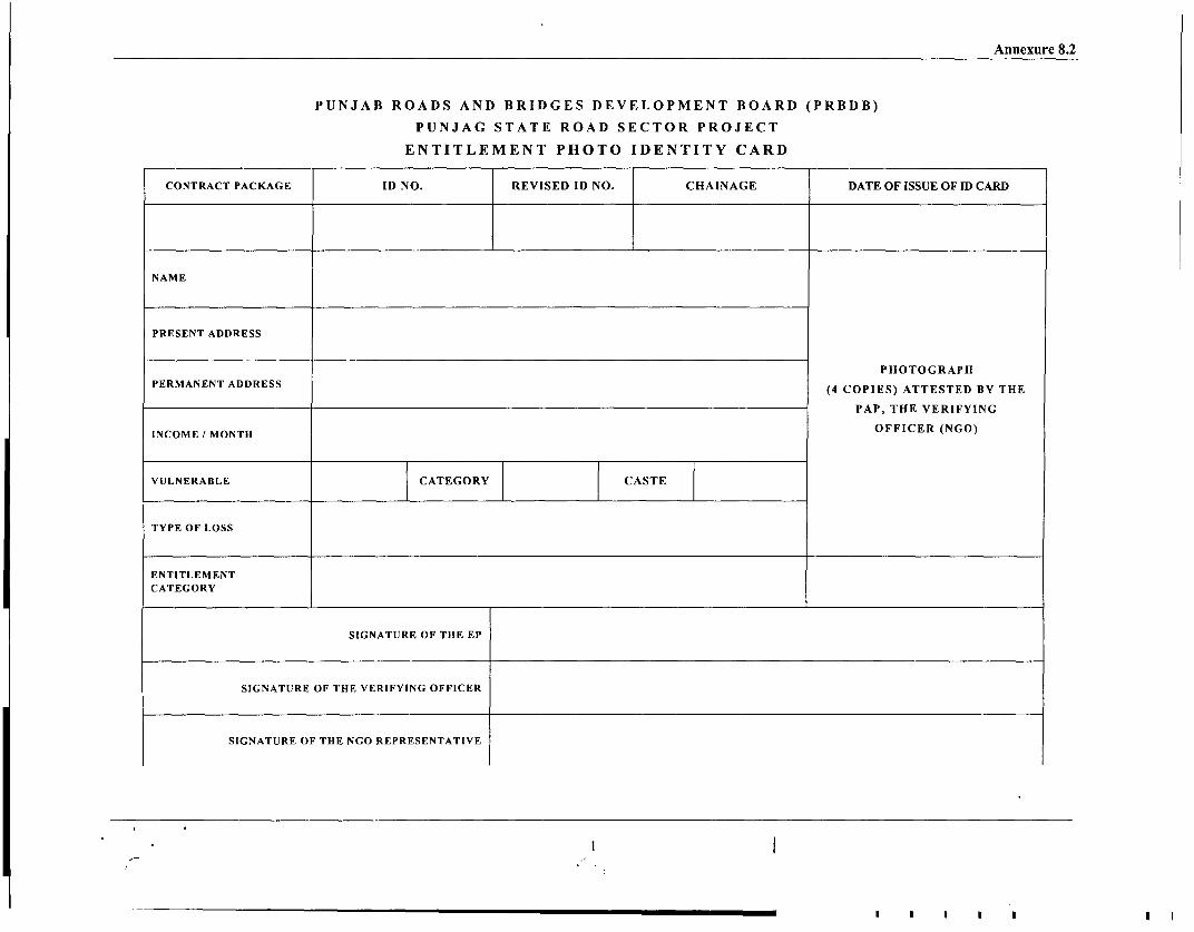
Annexure 8.2
PUNJAB ROADS AND BRIDGES DEVELOPMENT BOARD (PRBDB)
PUNJAG STATE ROAD SECTOR PROJECT
ENTITLEMENT PHOTO IDENTITY CARD
CONTRACTPACKAGE ID NO. REVISED ID NO. CHAINAGE DATE OF ISSUE OF ID CARD
NAME
PRESENT ADDRESS
PHOTOGRAPH
PERMANENT ADDRESS (4 COPIES) ATTESTED BY THE
PAP, THE VERIFYING
INCOME / MONTH OFFICER (NGO)
VULNERABLE CATEGORY CASTE
TYPE OF LOSS
ENTITLEMENTCATEGORY
SIGNATURE OF THE EP
SIGNATURE OF THE VERIFYING OFFICER
SIGNATURE OF THE NGO REPRESENTATIVE

6
I
Ii
I

Annexure 10.1
Detail budget of private properties affected in link 4 and link 5
Compensation (entitle persons) Assistance (Per Family)Aper PWD rate
Economic SelfRehabilitation Grant Relocating
inkurey Hon-lder Vulnerability No. of Affected Type of Transitional Shifting (E Training Displacing TotalNo. No (nme Statu 30m0iDers BPLr1rKucte ea of U Ta Allowance Allowance (1 Persons 5 R & RNo. No (n3.2 ame) Status Families Structure* Structu Affected Unit Sq 1 for 3 7 1000 Non- person 25% Of Cost
Structure Rate Compensation months 2 Per Vulnerable Vulnerable per replacementAWR8* Family (4 Months (6 Months family) value or Rs'
AWR9 4 T3AWR) 30000AWR) ~~~~whichever
____________ _________ ~~~~~~~is m ore)
1 4 LTA/4 18.700 Kulwant BPL (SC) 1 5 Pucca 16 Sq 4036 64576 7884 1000 15768 1500 Nil 90728Singh __ _ _ _ _ _ _ _ _M _ _
2 4 LTA/2 30.000 Bimla Devi BPL 1 5 Kucha 9 Sq 1000 9000 7884 1000 - 15768 1500 Nil 35152
3 4 LKTA 3 300 Kabel Non- 1 8 Kucha 4 Sq 1000 4000 7884 1000 10512 - 1500 Nil 2489613 5 K Singh Vulnerable M 8 Kh 10C 00i
0
4 4 LTA24 30.023 Sukhwinder Non- 2 5 Kucha 24 Sq 1000 24000 15768 2000 21024 - 3000 Nil 65792Singh Vulnerable __ _ _ __ _ _ _ _ _ _ _ _ _ _ _ _ _
1 4 L4TA G3u0.205 ab Non- 1 8 Kucha 4 Sq 1000 9000 7884 1000 10512 - 1500 Nil 29896S n h Vulnerable __ _ __ _ _ _ _ _ _ _ M _ _ _ _ _ _ _ ___ _ _ _
6 4 LTA16 30.035 Nishan Non- M uha 4 S ___ 40 136 40 24 60 i 78Singh Vulnerable 5 Kucha 4 Sq 1000 4000 313 4000 4 8 1600 Nil 8754
9 4 LKT 31 23.300 ramit Non- 51 Kucha 9 Sq 1000 9000 7884 1000 10512 - 1500 Nil 29896_____ Sing~~h Vulnerable I__ __M _ __ _ _
8 4 RTA 2 23.305 Maggar Non- 1 5 Kucha 9 Sq 10001 9000 78814 1000 10512 - 1500 Nil 29896Singh Vulnerable ________M
9 TA 3 3.1 Mangal Non- 1 5 Kucha 9 Sq10001 9000 78834 1000 10512 - 1500 Nil 29896_____ ~~~Singh Vulnerable _ _ _ _ _ _ ___ _ __ M _ _ _ _ _ _ _ _ _ _ _ _ _ _
10 4 RTA 4 23.322 Mewa SC 1 8 Kucha 9 Sq 10OOC 9000 7884 1000 15768 1500 Nil 35152____ ~~~Singh I_ _ _ _ _ _M 100
1 1 4 RTA 5 23.350 Gurmit Non- 1 5 Kucha 4 Sq 1000 4000 7884 1000 105112 - 1500 Nil 24896Singh Vulnerable _ _ _ _____ _ _ __M
1 2 5 LKT 5 3.730 Amanjeet BPL I 8 Kucha 1 Sq 1000 1000 7884 1000 - 15768 1500 Nil 27152_ _ _ ~ ~~~Metho _ _ _ _ _ _ _ _ _ _ _ _ _ _ _ M _ _ _ _ _ _ _ _ _ _ _ _ _ _ _ _ _ _ _ _ _
1 3 5 LKT 6 3.735 No Survey Vulnerale - 8 Kucha 1 Sq 1000 1000 - - - - 0 Nil 1000
Baunti S14 5 LKT 7 7.950 Chda BPL 1 8 Pucca 9 Sq 4036 36324 78834 1000 - 15768 1500 Nil 62476
1 5 5 LKT 8 7.960 Bga BPL (SC) 1 8 Kucha 8 Sq 1000 8000 7884 1000 - 15768 1500 Nil 34152__ _ _ ingh __ _ _M
,- ~ ~ vaa No-S
16 5 LKT 22 20.200 3 5 Pucca 12 4036 48432 23652 3000 31536 - 4500 Nil 111120________ Singh V ulnerable _ _ __M _ _ _ _ _ _ _ _ _ _ _ _ _ __ _ _ _
1 7 5 LKT 23 20.205 ine a o-1 8 Kucha 4 S 01 4007884 1000 10512 - 1500 Nil 24896____Singh Vulnerable M100 40
1 8 5 LKT 29 21.600 Sanjit BPL 1 8l Kucha 4 Sq 10001 4000 7884 1000 - 15768 1500 Nil 30152
1 95 KT33 1.00Balwinder BPL 1 8 Kucha 1 Sq 10 007a 00178 10 i 75
19 5 LKT33 21.800 1000 1000 7884 1000 - 15768 1500 Nil 27152~~~~~~~~~~~~~~~~~~~~~~~~~~~~~~~~~~~~~~~~~~~~~~~~~~~~~~~~~~~~~~~~~~~~~~~~~~~~~~~~~~~~~~~~~~~~~~~~~~~~~~~~~~~~~~~~~~~~~~~~~~~~~~~~~~~~~~~~~~~~~~~~~~~~~~~~~~~~~ t 78 10 57a150 i
20 15 ILKT 341 21.805 iFauja IBPL 1 8 IKucha 4 S100 4000 784 10 56 50 Nl 3 01 52

I I~~~~~~~~~~~~~~~~~~~~~~~~~~~~~~~~~~~~~~~~~~~~~~~~~~~~~~~~~~~~~~~~~~~~~~~~~~~~~~~~~~~~~~~~~~~~~~~~~~~~~~~~~~~~~~~~~~~~~~~~~~~~~~~~~~~~~~~
I~~~~~~~~~~~~~~~~~~~

Annexure 10.1Singh M
21 5 LKT 35 21.795 No Survey Vulnerable o Kucha 1 Sq 1000 1000 0 0 - - Nil 1000
22 5 RKT 7 5.400 Tersemlal BPL 1 a Kucha 4 Sq 1000 4000 7884 1000 - 15768 1500 Nil 30152
23 5 RKT 6.670 Fore man Non- 1 8 Kucha 9 Sq 1000 9000 7884 1000 10512 1500 Nil 29896
19 *Vulnerable M I
24 5 RKT 6.680 Mohan BPL 2 8 Kucha 4 Sq 1000 4000 15768 2000 31536 3000 Nil 56304
__ 2 0_ _ _ _ _ _ S in g h I _ _ _ _ _ _ _ I_ _ I__ _ _ _ _ _ _ _ _ _ _ I__ _ _ _ _ _ _ _ _ _ _ _ _ _ _ _ _ _ _ _ _ _ _ _ _ _ _ _ _ _
Total 29 280332 178704 173448 43500 1949388
*Affected Structure: 5- Shop & 6- Khokha (Kiosk)
**AWR (Average Wage Rate): AWR of Punjab State is Rs. 87.6 per day
1 ~~~~~~~~~~2

-...... --
I

Formats for Reporting Annexure 11.1
Annexure - 11.1
FORMATS FOR REPORTING
Format - 11.1: Record for Individual /Family Entitlements
Link No. & Name Location Chainage
EP Name: Address_
ID NO.:
Entitlement Category:
Titleholder: Loss of Land
Entitlement Due Entitlement ReceivedLand/ Cash: Cash | Land Cash I Land
Fees, Taxes, Other Charges: Amount Due | Amount Paid
Transitional Allowance' Amount Due T Amount Paid
Training | Organized - Attended | Not Attended
Severance allowance2 AmountDue Amount Paid
Economic Rehabilitation Grant3e Amount Due | Amount Paid
Additional Grants: | Amount Due | Amount Paid
Transitional allowance is the assistance paid to Entitled Persons Based on reasonable estimate of the time likely to be taken to restoretheir livelihood and standard of living.
2 Severance allowance of 25% of award value shall be paid to EP) 3 Economic Rehabilitation Grand (ERG) is the support provided to the Vulnerable Groups/Families so that they are able to restore their
livelihood above the Poverty Line.
Formats for Reporting Annexure 11. I
Titleholder: Loss of Structure
Entitlement Due Entitlement ReceivedStructure/Cash (Land/ Cash: Cash Structure Cash Structure
Land Land
Additional Support4 Entitlement Due Entitlement ReceivedAmount Due Amount Paid
Transitional Allowance 5 Entitlement Due Entitlement ReceivedAmount Due Amount Paid
Shifting Allowance6 : Paid Not Paid
ERG7Amount Due Amount Paid
Training Organized I Attended Not Attended
Structure Material Collected Or Salvaged Not Collected or NotSalvaged
Compensation for Structures: Amount Due Amount Paid
Non-Titleholder (Loss of Structure and loss of Livelihood)Allowance for Lost Income: Amount Due Amount Paid
Notice for removal of structure8 Issued Received Not Received
| Notice for harvesting crops9 Issued | Received Not Received
Compensation for Structure loss Entitlement Due Entitlement Received
Transitional Allowance | Entitlement Due Entitlement Received
4 Self-relocating displaced persons shall be eligible for additional support for the construction of structure @ 25% of the replacementvalue or 30000/-whichever is more
5 Transitional allowance for 3 months @ Average Wage Rate (AWR) of Punjab (calculated for 30 days in a month) will be given toEPs
6 EPs will be eligible for shifting allowance @ 1000/-for Kutcha and Rs.2500/-for pucca structures respectively.
7 Entitled persons loosing livelihood belonging to vulnerable groups will be eligible for ERG equivalent to 9 months towards re-establishing livelihood @ AWR of Punjab (calculated for 30 days in a month)
8 2 months' notice for removal of structural shall be given9 4 months' notice for harvesting crop shall given10 Transitional allowance for 3 months @ Average Wage Rate (AWR) of Punjab (calculated for 30 days in a month) will be given to
EPs
2
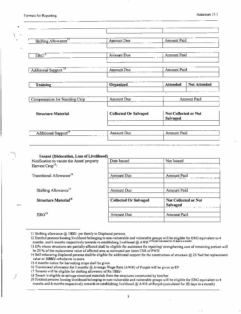
Formats for Reporting Annexure 11.1
Shifting Allowance Amount Due Amount Paid
ERG'2 Amount Due Amount Paid
-Additional Support | Amount Due Amount Paid
Training Organized Attended Not Attended
Compensation for Standing Crop Amount Due Amount Paid
Structure Material Collected Or Salvaged Not Collected or NotSalvaged
Additional Su ort14 Amount Due Amount Paid
Tenant (Dislocation, Loss of Livelihood)Notification to vacate the Asset! property Date Issued Not IssuedHarvest Crop'5 :
Transitional Allowance' 6 Amount Due Amount Paid
Shifting Allowance' 7 Amount Due Amount Paid
Structure Material'8 Collected Or Salvaged Not Collected or NotSalvaged
ERG'9 Amount Due Amount Paid
11 Shifting allowance ( 1000/- per family to Displaced persons.12 Entitled persons loosing livelihood belonging to non-vulnerable and vulnerable groups will be eligible for ERG equivalent to 4months and 6 months respectively towards re-establishing livelihood ( AWRof culated for 30 days in a month).
13 EPs whose structures are partially affected shall be eligible for assistance for repairing/ strengthening cost of remaining portion willbe 25 % of the replacement value of affected area as estimated per latest CSR of PWD
14 Self-relocating displaced persons shall be eligible for additional support for the construction of structure @ 25 %of the replacementvalue or 3000W/-whichever is more.
15 4 months notice for harvesting crops shall be given16 Transitional allowance for 3 months ( Average Wage Rate (AWR) of Punjab will be given to EP17 Tenants will be eligible for shifting allowance of Rs. 1000/-18 Tenant is eligible to salvage structural materials from the structures constructed by him/her19 Entitled persons loosing livelihood belonging to non-vulnerable and vulnerable groups will be eligible for ERG equivalent to 4
months and 6 months respectively towards re-establishing livelihood @ AWR of Punjab (calculated for 30 days in a month)
3

Formats for Reporting Annexure 11.1
Training Organized Attended Not Attended
Community Assets
Compensation for Community Asset20 | Entitlement Due | Entitlement Received
Unforeseen Impact
Other Assets Entitlement Due Entitlement Received
Date Signature of Entitled Person
Date Signature of Road Link Level Project Manager(NGO)
Remarks: Reason for Non - Payment/Non - Acceptance by PAP
Date Signature of ARRO (CMU)
20 Common resources such as religious structures, cremation grounds, graveyards, hand pumps, passenger shelters at bus stops, villagegates and other such assets to be replaced or reconstructed or rehabilitated at project cost in consultation with local community andvillage panchayat
4

Formats for Reporting Annexure 11. I
A~ Format - 11.2: GRC Monthly and Cumulative Report
Name of District: Date of Establishment:
Link No. &Name Location: Chainage:
Month: Year:
Task Current Month Previous Month TotalNumber of Grievances ReceivedNumber of Recommendations by GRCNumber of DecisionsNumber of Grievances ReferredNumber of Decisions Communicated toClaimantsNumber of Unresolved Grievances
Date Signature of GRC (Head)

Formats for Reporting Annexure 11.1
Format - 11.3: Road Link Level NGO (Project Manager's)
Report for PAF
District Link No. & Name
Location Month Year
EP Name ID No.
Address:
Forwarded for consideration of the District Level Committee on date
Details of Land/ Properties to be Land/ Area m2 Building m2 Crop Type Othersacquired
Compensation Received under each Land/ Area Building Crop Type TotalHead asPer LAA/ Replacement Costs
Recommendation on Value of Property Land/ Area Building Crop Type Totalby DLPFC .
Difference in Compensation and Land/ Area Building Crop Type TotalDLPFC Valuation
Total Assistance Amount Due Amount Paid
Date Signature of Road Link Level Project Manager(NGO)
6

Fornats for Reporting Annexure 11. I
Format - 11.4: Monthly Synthesis of RAP Implementation (Physical)
Month of: Link No. and Name:
Target Target for Task % of Task Cumulative
Resettlement Category already Total Current completed Remain Target for Remarkscompleted Task Month (% (% of Total Unachieved Nextl_________ _ _of Total) Task) Month*
1A (as per Entitlement Matrix)
Land
Cash
Fees, Taxes, Other Charges
Solatium 30% (LAA 23.2)
Additional Grant 12% (LAA 23.1)
Severance Allowance of 25%
Transitional Allowance
ERG
Training
1B (as per Entitlement Matrix)
Shifting Allowance
Transitional Allowance
ERG
Training
Salvage of Material
Additional Support
2A (as per Entitlement Matrix)
Notice for Removal of Structure
Notice for harvesting Crops
Shifting Allowance
Transitional Allowance
ERG _ _ _ _
Training||
Additional Support
3A (as per Entitlement Matrix)
Notice for vacating property _ _ l l_l_l_l
Notice for harvesting Crops l l l l_l_l_l
Shifting Allowance l_l__l__l_
Transitional Allowance
ERG ____
Training
Assistance for Crop Loss
4A (as per Entitlement Matrix)
Replacement of affected Common J
7

Formats for Reporting Annexure 11.1
Target Target for Task % of Task CumulativeResettlement Category already Total Current completed Remain Target for Remarks
completed Task Month (% (% of Total Unachieved Nextof Total) Task) Month*
Property Resources/ Otherproperties _ _
Enhancement of commonproperties
4B (as per Entitlement Matrix)Mitigation of any unforeseenimpacts
*Target of current month + task carryforwardfrom previous month/s
Date Signature of Road Link Level Project Manager(NGO)
8

Formats for Reporting Annexure 11.1
Format - 11.5: Monthly Synthesis of RAP Implementation (Financial)
Month of: Link No. and Name:
Total Monthly Actual % of TotalBudget Allocation And Spending Budget Expected Disbursement Allotment
Allotted Disbursement Disbursemen Allotment
Acquisition of private landAcquisition of private non-agriculturalland and assetsAssistance for restoration of livelihoodCompensation / Assistance for loss ofstanding cropCompensation / Assistance for loss ofperennial cropAssistance to squatters
Support to Vulnerable group for livelihoodAssistance for the businesses kiosksRestoration/ Enhancement of culturalproperties
Restoration of community resourcesMitigation Costs for any unforeseenimpacts
Date Signature of Road Link Level Project Manager(NGO)
9
9

f
II
I
i
I
i
I1 0

CONTENTS
-SL. l DESCRIPTION PAGE NO.
VOLUM E-V SOCIAL ASSESSMENT AND RESETTLEMENT PLAN
ACRONYMS (i) to (ii)
EXECUTIVE SUMMARY Es-1 to Es-6
1. PROJECT DESCRIPTIONS AND STUDY METHODOLOGY 1-1 to 1-9
1.1 Project Background 1-1
1.2 Project Description 1-1 to 1-6
1.3 Objectives And Scope Of The Study 1-6
1.4 Social Development Objective of the Project 1-6
1.5 The Influence State: 1-7
1.6 Road Network in Punjab 1-7
1.7 Project Area and Project Influence Area 1-7
1.8 Method and Tools Used in The Study 1-7 to 1-8
1.8.1 Household Survey, Census and Assets Inventory 1-8
1.8.2 Community Consultations and Focus Group Discussions 1-8
1.9 Disclosure of Information 1-8 to 1-9
1.10 Cut Off Date 1-9
2. SOCIO-ECONOMIC PROFILE OF THE PROJECT AREA 2-1 to 2-15
2.1 Introduction 2-1
2.2 Demographic Features of Punjab 2-1 to 2-4
2.2.1 Population by Age and Gender 2-1 to 2-2
2.2.2 Sex Ratio 2-2
2.2.3 Birth Rate, Death Rate and Infant Mortality Rate 2-3 to 2.3
2.2.4 Social Composition 2-3
2.2.5 Literacy Level and Education Facilities 2-3
2.2.6 Health Care Facilities 2-3 to 2-4
2.3 Economic Features 2-4 to 2-5
2.3.1 Land Use 2-4
2.3.2 Migration 2-4 to 2-5
2.3.3 Child Labour 2-5
2.4 Profile of the project Road Corridors 2-5 to 2-7
(i)
CONTENTS
SL.NO. DESCRIPTION PAGE NO.
2.4.1 Link 1: Chandigarh - Landran -Chunni- Sirhind 2-5 to 2-6
2.4.2 Link 2: Nagar-Aur-Rahon 2-6
2.4.3 Link 4: Tam Taran- Chabal-Attari 2-6
2.4.4 Link 5: Tarn Taran Fetehabad- Kapurthala 2-6
2.4.5 Link 6: Dharamkote-Kote-Ise Khan-Zira-Firozepur 2-6 to 2-7
.5 SOCIO-ECONOMIC PROFILE OF THE AFFECTED 2-7 to 2-13POPULATION
2.5.1 Project Affected Households (PAHs), Project Affected 2-7(PAFs) and Project Affected Persons (PAPs)
2.5.2 Affected Population by Age and Sex 2-7 to 2-8
2.5.3 Social Categories of PAHs 2-8
2.5.4 Education and Literacy 2-8
2.5.5 Work Force Participation in Project Area 2-9
2.5.6 Usual Activity of PAPs 2-10
2.5.7 Occupation Pattem of the Affected Persons 2-10 to 2-12
2.5.8 Income Pattem of the Affected Households 2-12 to 2.13
2.6 Expenditure Pattem 2.13 to 2-15
2.6.1Women's Participation in Decision Making Activities 2-13
2.6.2 Expenditure Pattem 2-14
2.6.3 Possession of Durable Consumer Items 2-14 to 2-15
3. CONSULTATIONS 3-1 to 3-15
3.1 Introduction 3-1
3.2 Approach to Community Participation 3-1
3.3 Commnunity Participation 3-2 to 3-11
3.2.1 Analysis of Consultations 3-2
3.2.2 Summary of Consultations 3-2 to 3-13
3.3.3 Consultation with women along the project road 3-14 to 3-15
3.3.4 Summary of Consultation with the Vulnerable Groups 3-15
4. POVERTY ANALYSIS AND VULNERABLE GROUPS 4-1 to 4-6
4.1 Definition of Poverty and Poverty Line 4-1
4.2 Conceptualization of Poverty in India 4-1 to 4-2
(ii)
Consultancy Services for Project Preparatory Studies forPackage II (Phase I) for Punjab State Road Sector Project
-- ,> 10. R&R COST AND BUDGET
10.1 INTRODUCTION
The budget is indicative with outlays for the different expenditure categories estimated atthe current price. The information on cost of land was collected by the socio-economicand census surveys of the PAFs together with field inquiries with local level revenueofficials. The structure replacement cost has been calculated on the basis of the PunjabPWD's Common Schedule of Rates (CSR).
10.2 METHODOLOGY FOR THE VALUATION OF COSTS
Following the World Bank guidelines and the R&R Policy Framework of the project,replacement cost has been considered for compensation. The following sub-sectionsprovide a concise methodology for the costing of compensation for the various losses dueto the project.
10.2.1 Valuation of Land Cost
There will be no land Acquisition for rehabilitation of the project. The engineering designfor the proposed road is to be rehabilitated within available ROW. If any point of timeduring implementation of the project, the design is changed due to some unavoidablereasons and require any acquisition the land will be acquired through the LA Act1894/1984 and through negotiation, and the negotiated amount will be the replacementcost. In addition 30% solatium (Clause 2312]), and 12% additional (Clause 23[1A])will also be paid. In the case of agricultural land, in addition, there is a 25% severanceallowance, as indicated in the R&R Policy Framework.
10.2.2 Valuation of Replacement Cost of Structures
The valuation of assets replacement has been calculated without depreciation. There is nodocumented/ official information for the cost of kutcha structures. However, discussionswith local elderly people established that construction of kutcha structures costs about Rs.1 000/M2 -, which has been considered for the R&R budget exercise. The following Tableshows the estimated unit cost of construction.
Table 10.1: Unit Rates for Cost of Construction along the Corridor
Si. Description Rate (Rs.)No.
1 Pucca Structure 4036/m2
2 Kutcha structure 1000/m2
4 Boundary wall (linear meter) 1066/linear metre
Source: Rates obtained from PWD, Govt. of Punjab. Note: a linear metre of wall isusually 1.5 metres high.
10.2.3 Valuation of Replacement Cost of Other Assets
Unit cost of a tube well/hand pump (India Mark II): Rs. 50,000/-
Unit cost of a platform + tree, used as a bus stop Rs. 20,000/-
10.2.4 Valuation of Costs of Rehabilitation Assistance
The project witnesses no impact on Titleholders. Only 29 families of Non-titleholders areloosing their assets and livelihood. They will be compensated and assisted as per theprovision of resettlement framework specially prepared for this project The rehabilitationassistance includes the following items, amount of money for each item and the durationof entitlement as detailed in the R&R Principles and Policy Framework.
Volume- V Social Assessment Plan10-1
R&R Cost and Budget
a. Squauters
* Assistance for structure replacement
* Transitional allowance for 3 months @ Average Wage Rate, i.e., Rs. 2628/month
* Shifting allowance @ Rs. 1000
* Training for skill upgradingl for altemative economic activities or one time grant ofRs.1500/ EPs.
* Self-relocating displaced persons shall be eligible for additional support for theconstruction of structure @ 25 % of the replacement value or Rs. 30000/- whicheveris more.
b. Vulnerable Groups
Economic Rehabilitation Grant for 6 months of Average Wage Rate, i.e., Rs.2628/month
One of the objectives of the R&R Policy is to provide support to the vulnerable familiesso that they are able to restore their livelihoods above the poverty level. Therefore, aneconomic rehabilitation grant of Rs. Rs.2, 628/-, calculated at 6 months' Average WageRate for vulnerable PAFs, which currently stand at approximately Rs. 15,768/-. In thevulnerable group the included PAFs are all identified BPL, women headed, and SCfamilies.
10.3 COST OF REGISTRATION AND FEES
As per the R&R Policy Framework of the project, the cost of registration, all fees, taxesand other charges due to transfer of land title for the project, will be bome by the project.The current cost of registration is 9% (stamp duty 6% + development charge 3% upto adistance of 5km in municipal limits) plus 1% registration charges for males and 8%(stamp duty 5%/o + development charge 3% upto a distance of 5km in municipal limits)plus 1% registration charges for females. However, it is not applicable for rehabilitationproject, as it has no land acquisition.
10.4 THE R&R BUDGET ESTIMATES
Table 10.2 presents a summary of the R&R costs and budget for all the 5 project roadcorridors. Table 10.3 shows the link-wise itemised, detailed indicative budget of theR&R component of the project corridor-wise. The detailed budget of private properties isappended in Annexure 10.1.
10.5 DISBURSEMENT OF COMPENSATION AND ASSISTANCE
The disbursements to the PAFs would be made against the purchase of assets/enhancement of assets and building/construction of structures.
A joint account will be opened at a local bank. The signatories will be the Entitled Person(EP), the ARRO at the CMU level and the NGO at the construction package level. Theamount under the R&R category would be paid from the joint bank account. Cheques willbe given for all assistance, which includes transitional allowance, shifting, and loss ofwage..
According to the current law the owner will receive cheques from the districtadministration for the entitled compensation. All payments of cheques will be made in thePanchayat office in the presence of the district administration representative and theconstruction package level NGO representatives.
The training amount is not specified in R&R Policy.
Volume- V Social Assessment Plan10-2
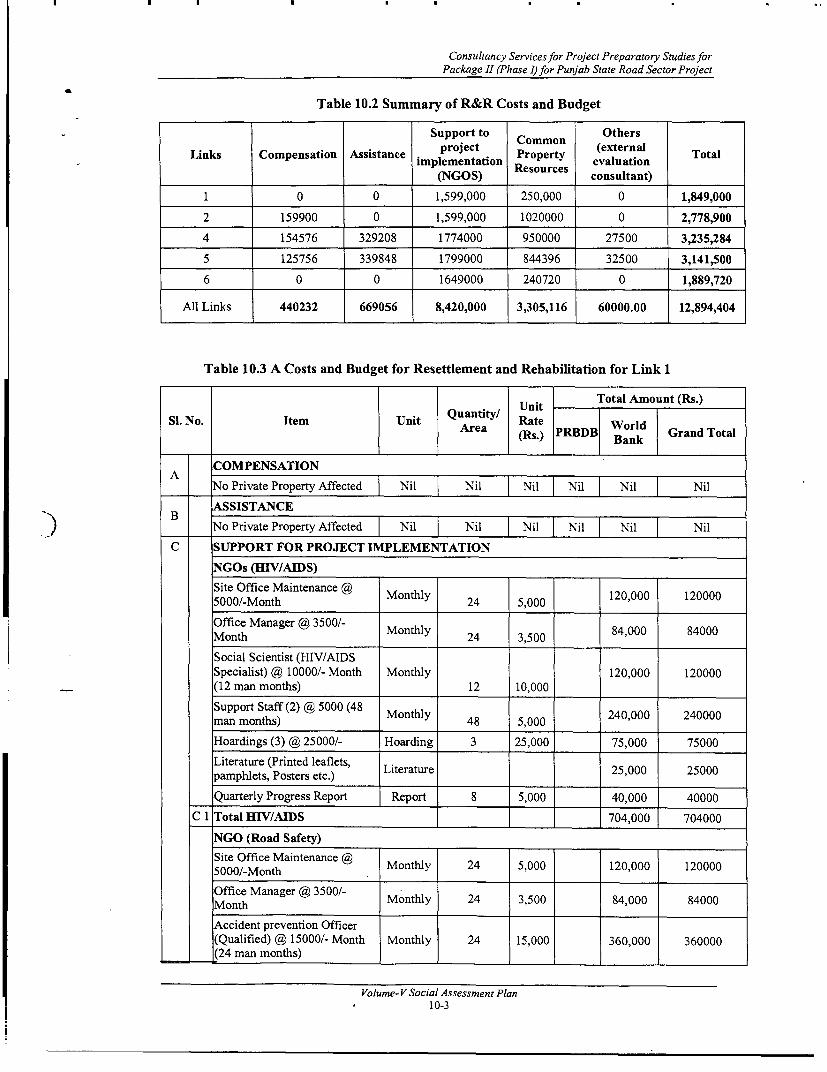
Consultancy Services for Project Preparatory Studies forPackage 11 (Phase I) for Punjab State Road Sector Project
Table 10.2 Summary of R&R Costs and Budget
Support to Common Others
Links Compensation Assistance precter (external Totalimplementation Peoropert evaluation
__________ (NGOS) Rsucs consultant)
1 0 0 1,599,000 250,000 0 1,849,000
2 159900 0 1,599,000 1020000 0 2,778,900
4 154576 329208 1774000 950000 27500 3,235,284
5 125756 339848 1799000 844396 32500 3,141,500
6 0 0 1649000 240720 0 1,889,720
All Links 440232 669056 8,420,000 3,305,116 60000.00 12,894,404
Table 10.3 A Costs and Budget for Resettlement and Rehabilitation for Link 1
UnIt Total Amount (Rs.)
SI. No. Item Unit Quantity/ RnteArea (Rs.) PRBDB Wrd Grand TotalBank
COMPENSATIONA
No Private Property Affected Nil Nil Nil Nil Nil Nil
ASSISTANCENo Private Property Affected Nil Nil Nil Nil Nil Nil
C SUPPORT FOR PROJECT IMPLEMENTATION
NGOs (HIV/AIDS)
Site Office Maintenance @ 24nthly000 00_120005000/-Month Monthly 24120,000 120000
Office Manager ( 3500/- Monthly 2484,000 84000Month Monhl 8,005800
Social Scientist (HIV/AIDSSpecialist) ( 10000/- Month Monthly 120,000 120000(12 man months) 12 10,000
Support Staff (2)@~5000 (48 Mnhy240,000 240000man months) Monthly 48 5,000
Hoardings (3) @ 25000/- Hoarding 3 25,000 75,000 75000
Literature (Printed leaflets, Literature 25,000 25000pamphlets, Posters etc.)
Quarterly Progress Report Report 8 5,000 40,000 40000
C 1 Total HIV/AIDS 704,000 704000
NGO (Road Safety)
Site Office Maintenance ( Monthly 24 5,000 120,000 1200005000/-Month
Office Manager @ 3500/- Monthly 24 3,500 84,000 84000
Accident prevention Officer(Qualified) @ 15000/- Month Monthly 24 15,000 360,000 360000(24 man months)
Volume- V Social Assessment Plan10-3

R&R Cost and Budget
Unit Total Amount (Rs.)SI. No. Item Unit Quarntaty/ Rate World
Ara (Rs.) PRBDB Bak Grand Total
Multilevel Sensitization Monthly 5 10,000 50,000 50000workshops (5)
Traffic Volunteers (2 @ 150/-) Monthly 48 4,500 216,000 216000
Literature (Printed leaflets, Literature 25,000 25000pamphlets etc.)
Quarterly Progress Report Quarterly 8 5,000 40,000 40000
C 2 Total Road Safety NGO 895,000 895000
Total: Support (C 1+ C 2) 1,599,000 1599000
No.Replacement of Hand Pumps Affected 5 50,000 250,000 250,000
Total: Shifting Cost 250,000 0 250,000
GRAND TOTAL (A+B+C+D) 250,000 1,599,000 1,849,000
(In Terms of Million Rupees) 0.25 1.60 1.85
In terms of Million Dollars (@ Rs. 0.01 0.03 0.0447.5=1 US$) I___ 0.03 0.04
Note: The cost of community properties have been calculated in general BoQ items.
Acronyms: Sq.m. = Square meter; PAF = Project Affected Family; PDF = Project Displaced Family Lin.m.= Linear Meter
TABLE 10.3 B: COSTS AND BUDGET FOR RESETrLEMENT AND REHABILITATION FOR LINK 2
Total Amount (in Rs.)
SI. No. Item Quantity Unit Rate Wor G/ Area (Rs-) PRBDB World Grand
COMPENSATION
A Replacement costs for Boundary Lin. M 150.00 1066 159,900 159900walls: PuccaLi.M 100 106 1900590
Total Compensation 150.00 1,066.00 159,900.00 0.00 0.00 159,900.00
B ASSISTANCE
No Private Affected Properties Nil Nil Nil Nil Nil Nil
C SUPPORT FOR PROJECT IMPLEMENTATION
NGOs (HIV/AIDS)
Site Office Maintenance @ 5000/- Monthly 24 5,000 120,000 120000Month
Office Manager @ 3500/- Month Monthly 24 3,500 84,000 84000
Social Scientist (HIV/AIDSSpecialist) @ 10000/- Month (12 Monthly 12 10,000 120,000 120000man months)
Support Staff (2) ( 5000 (48 man I I 5 2 2months) Monthly 48 5,000 240,000 240000
Hoardings (3) @ 25000/- Hoarding 3 25,000 | 75,000 75000
Volume-V Social Assessment Plan10-4

Consultancy Services for Project Preparatory Studies forPackage 11 (Phase I)for Punjab State Road Sector Project
Total Amount (in Rs.)
SI. No. Item Quantity Unit Rate World GrandS Area (Rs.) PRBDB Bank Total
Literature (Printed leaflets, Literature 25,000 25000pamphlets, Posters etc.)
_Quarterly Progress Report Report 8 5,000 40,000 40000
C 1 Total HEIV/AIDS 704,000 704000
NGO (Road Safety) 0
Site Office Maintenance @ 5000/- Monthly 24 5,000 120,000 120000Month
Office Manager @ 3500/- Month Monthly 24 3,500 84,000 84000
Accident prevention Officer (Qualified) @ 15000/- Month (24 Monthly 24 15,000 360,000 360000man months)
Multilevel Sensitization workshops Monthly 5 10,000 50,000 50000
(5)
Traffic Volunteers (2 @ 150/-) Monthly 48 4,500 216,000 216000
Literature (Printed leaflets, Literature Estimated 25,000 25000pamphlets etc.)
Quarterly Progress Report Quarterly 8 5,000 40,000 40000
C 2 Total Road Safety NGO 895,000 895000
Total: Support (C1+C2) 1,599,000 1599000
Shifting of Community Infrastructure
Shifting of Religious Properties No.Ac 10,000 10,000 10,000
(Shrine) Affected 1 1,0 0001,0
D Replacement of Platforms presently No. 3 2,0 0006,0used as Bus Stops Affected 3 20,000 60,000 60,000
Shifting of Hand Pumps Affected 19 50,000 950,000 950,000
Total: Shifting Cost 1,020,000 0 0 1,020,000
GRAND TOTAL (A+B+C+D) 1,020,000 1,179,900 1,599,000 2,778,900
(In Terms of Million Rupees) 1.18 1.60 0.00 2.78
In terms of Million Dollars (@ Rs. 47.5=1 0.02 0.03 0.00 0.06US$)
Note: The cost of community properties have been calculated in general BoQ items.
Acronyms: Sq.m. = Square meter; PAF = Project Affected Family; PDF = Project Displaced Family Lin. m.=Linear Meter
Volume-VSocial Assessment Plan10-5

R&R Cost and Budget
Table 10.3 C: Costs and Budget for Resettlement and Rehabilitation for Link 4
Unit Total AmountSi. No. Item Unit Quantity Rate World
/Area (Rs.) PRBDB Bank Grand Total
COMPENSATION
A Res/com structure compensation: Sq.m. 90 1000 90,000 90,000Kutch 9
Res/com structure compensation: Sq.m. 16 4036 64,576 64,576Pucca 1
Total: Compensation 154,576 0 154,576
ASSISTANCE
Shifting Allowance to the Non- PDF 15 000Titleholder PAFs 15 1,000 15,000
Transitional Allowance to the affectedPAFs for livelihood restoration ( PDF 118,260AWR of Punjab for 3 months 15 7,884 118,260
B Economic Rehabilitation Grant to theaffected Vulnerable Groups for PDF 47,304livelihood restoration @ AWR ofPunjab for 6 months 3 15,768 47,304
Economic Rehabilitation Grant to theaffected Non-Vulnerable Groups for 126,144livelihood restoration @ AWR ofPunjab for 4 months (Link 4) 12 10,512 126,144
Support for construction of structuresfor Self Relocating Persons @ 25% of PDFReplacement Value or maximum uptoRs. 30000
Training' @ 1 person from each PDF PDF 15 1500 22500 22500
Total: Assistance 329208 329208
C SUPPORT FOR PROJECT IMPLEMENTATION
NGO (RAP) Estimated | [ l | 150,000
C 1 NGO (RAP) Total l T | 150,000 150,000
NGOs (HIV/AIDS)
Site Office Maintenance @ 5000/- y 24120,000 120000Month Monhl 10,00 1200
Office Manager @ 3500/- Month Monthly 24 3,500 84,000 84000
Social Scientist (HIV/AIDSSpecialist) @ 10000/- Month (12 man Monthly 120,000 120000months) 12 10,000
Support Staff (2) @ 5000 (48 man Monthly 48 5,000 240,000 240000months) otl 8 5002000 200
Hoardings (3) @ 25000/- Hoarding 4 25,000 100,000 100000
'Training requirement is optional for PAFs in all the corridors and if by any reason EPs are not willing for training, thementioned training amount @ Rs. 1500.00/ PAFs in R & R Budget shall be paid to the people concerned in lieu thereof.
Volume-VSocial Assessment Plan10-6

Consultancy Services for Project Preparatory StudiesforPackage II (Phase 1) for Punjab State Road Sector Project
Unit Total AmountSI. No. Item Unit Quantity Rate World/Area (Rs.) PRBDB WrdGrand Total
Bank
Literature (Printed leaflets, pamphlets, Literature 25,000 25000Posters etc.) _
Quarterly Progress Report Report 8 5,000 40,000 40000
C 2 Total HIV/AIDS 729,000 729000
NGO (Road Safety) 0
Site Office Maintenance @ 5000/- Monthly 24 5,000 120,000 120000Month
Office Manager @ 3500/- Month Monthly 24 3,500 84,000 84000
Accident prevention Officer(Qualified) @ 15000/- Month (24 man Monthly 24 15,000 360,000 360000months)
Multilevel Sensitization workshops Monthly 5 10,000 50,000 50000(5) _ _ _ _ _ _ _ _ _ _ _
Traffic Volunteers (2 @ 150/-) Monthly 48 4,500 216,000 216000
Literature (Printed leaflets, pamphlets Literature 25,000 25000etc.) Litraur 25,000 25000
Quarterly Progress Report Quarterly 8 5,000 40,000 40000
C 3 Total Road Safety NGO 895,000 895000
Total: Support (Cl + C 2 + C 3) = 1,774,000 1774000
- - Shifting of Community Infrastructure
No.Shifting of Religious Properties Affected 1 10,000 10,000 10,000
D Replacement of Platforms presently No.used as Bus Stops Affected 2 20,000 40,000 40,000
No.Replacement of Hand Pumps Affected 18 50,000 900,000 900,000
Total: Shifting Cost 950,000 950,000
OTHER ACTIVITIES
E External Evaluation Consultants Household 11 2,500 27,500 27,500
Total: Other Activities 0 27,500 27,500
GRAND TOTAL (A+B+C+D+E) 1,104,576 2130708 3235284
(In Terms of Million Rupees) 1.10 2.13 3.22
In terms of Million Dollars (@ Rs. 47.5= 1 US$) 0.02 0.04 0.07
Note: The cost of community properties have been calculated in general BoQ items.
Acronyms: Sq.m. = Square meter; PAF = Project Affected Family; PDF = Project Displaced Family Lin.m.= Linear Meter
Volume-VSocial Assessment Plan10-7

R&R Cost and Budget
Table 10.3 D: Costs and Budget for Resettlement and Rehabilitation of PAPs for Link 5
Unit Total AmountSi. No. Item Unit Quantty! Rate WorldArea (Rs.) PRBDB Bank Grand Total
A COMPENSATIONRes/com structure Sq.m. 41 1000 41,000 41,000compensation: Kutcha
Res/Com structure Sq.m. 21 4036 84,756 84,756compensation: Pucca
Total: Compensation _ 1125,756 0 125,756ASSISTANCE
Shifting Allowance to the Non- PDF 14 1,000 14,000 14,000Titleholder PAFsTransitional Allowance to theaffected PAFs for livelihood PDF 14 7,884 110,376 110,376restoration @ AWR of Punjabfor 3 monthsEconomic Rehabilitation Grantto the affected Vulnerable
B Groups for livelihood PDF 9 15,768 141,912 141,912restoration @ AWR of Punjabfor 6 monthsEconomic Rehabilitation Grantto the affected Non-VulnerableGroups for livelihood PDF 5 10,512 52,560 52,560restoration ( AWR of Punjabfor 4 monthsSupport for construction ofstructures for Self RelocatingPersons @ 25% of PDF 0 0Replacement Value ormaximum up to Rs. 30000
Training @ 1 persons from PDF 14 1500 21000 21000each PDF
Total: Assistance 339,848 339,848C SUPPORT FOR PROJECT IMPLEMENTATION
NGO (RAP) | Estimated T l l [ 150,000 150,000Cl NGO (RAP) Total l l l l | 150,000 150,000
NGOs (HIV/AIDS)
Site Office Maintenance ( Monthly 24 5,000 120,000 1200005000/-MonthOffice Manager @ 3500/- Monthly 24 3,500 84,000 84000MonthSocial Scientist (HIV/AIDSSpecialist) @ 10000/- Month Monthly 12 10,000 120,000 120000(12 man months)Support Staff (2) @ 5000 (48 Monthly 48 5,000 240,000 240000man months)
_ Hoardings (3) @ 25000/- Hoarding 5 25,000 125,000 125000
Volume-VSocial Assessment Plan10-8
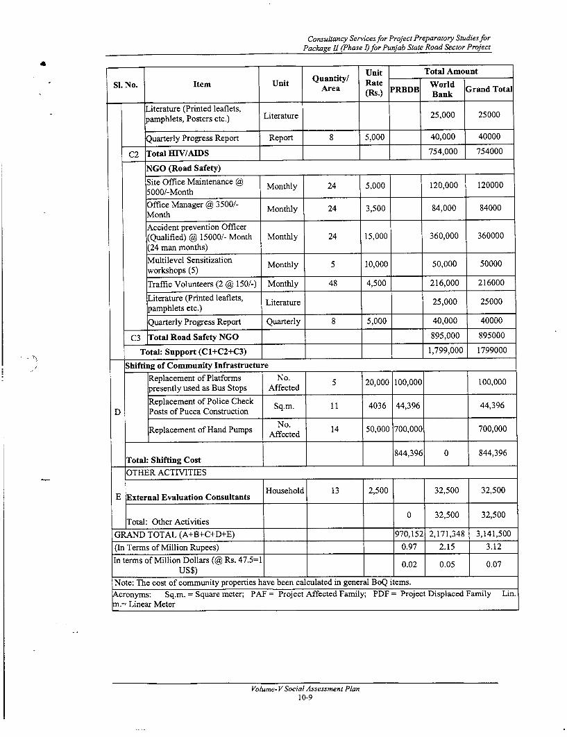
Consultancy Services for Project Preparatory Studies forPackage II (Phase D for Punjab State Road Sector Project
Unit Total AmountSI. No. Item Unit Quantity! Rate World
Area (Rs.) PRBDB Bank Grand Total
Literature (Printed leaflets,pamphlets, Posters etc.) Literature 25,000 25000
Quarterly Progress Report Report 8 5,000 40,000 40000
C2 Total BEiV/AIDS 754,000 754000
NGO (Road Safety)
Site Office Maintenance h Monthly 24 5,000 120,000 1200005000/-Month
Office Manager @ 3500/- Monthly 24 3,500 84,000 84000Month ___
Accident prevention Officer(Qualified) @ 15000/- Month Monthly 24 15,000 360,000 360000(24 man months) I
Multilevel Sensitization Monthly 5 10,000 50,000 50000workshops (5) _ _ _ _ _ _ _ _ _ _ _
Traffic Volunteers (2 ( 150/-) Monthly 48 4,500 216,000 216000
Literature (Printed leaflets, Literature 25,000 25000pamphlets etc.) _____
_ Quarterly Progress Report Quarterly 8 5,000 40,000 40000
C3 Total Road Safety NGO 895,000 895000
Total: Support (C1+C2+C3) 1,799,000 1799000
Shifting of Community Infrastructure
Replacement of Platforms No.A c 20,000 100,000 100,000presently used as Bus Stops Affected 5 2,0 0,0 0,0
Replacement of Police Check Sq.m. 11 4036 44,396 44,396D Posts of Pucca Construction S..I1 43 4364,9
Replacement of Hand Pumps Affected 14 50,000 700,000 700,000
_ Total: Shifting Cost 844,396 0 844,396
OTHER ACTIVITIES
E External Evaluation Consultants Household 13 2,500 32,500 32,500
Total: Other Activities 0 32,500 32,500
GRAND TOTAL (A+B+C+D+E) 970,152 2,171,348 3,141,500
(In Terms of Million Rupees) 0.97 2.15 3.12
In terms of Million Dollars (@ Rs. 47.5=1 0.02 0.05 0.07U S$) 0__ _ _ _ _ _ _02__ _ __ _ _ _ ____ ___ 0__ _07 _
Note: The cost of community properties have been calculated in general BoQ items.
Acronyms: Sq.m. = Square meter; PAF = Project Affected Family; PDF = Project Displaced Family Lin.m.= Linear Meter
Volume- V Social Assessment Plan10-9

R&R Cost and Budget
Table 10.3 E: Costs and Budget for Resettlement and Rehabilitation for link 6
n Quantity Unit Total AmountSI. No. Item Unit QuArea Rate World TGrand
______ ________________________ ______ _____ (Rs.) PRBDB 1 Bank Total-
A COMPENSATION NIL NIL NIL NIL NILB ASSISTANCE NIL NIL NIL NIL NIL NIL
SUPPORT FOR PROJECT IMPLEMENTATION
NGOs (HIV/AIDS)
Site Office Maintenance @ 5000/-Month Monthly 24 5,000 120,000 120000Office Manager @ 3500/- Month Monthly 24 3,500 84,000 84000Social Scientist (HIV/AIDS Specialist) @ Monthly 120,000 12000010000/- Month (12 man months)12 000Support Staff (2) @ 5000 (48 man Monthly 240,000 240000,months) Mnhy 48 5,00024001400Hoardings (3) @ 25000/- Hoarding 5 25,000 125,000 125000Literature (Printed leaflets, pamphlets, Literature 25,000 25000Posters etc.) Ltau250 20Quarterly Progress Report Report 8 5,000 40,000 40000
C Cl Total HIV/AIDS __754,000 754000
NGO (Road Safety)
Site Office Maintenance @ 5000/-Month Monthly 24 5,000 120,000 120000Office Manager @ 3500/- Month Monthly 24 3,500 84,000 84000Accident prevention Officer (Qualified) ( Monthly 24 15,000 360,000 36000015000/- Month (24 man months) ,
IMultilevel Sensitization workshops (5) Monthly 5 10,000 50,000 50000Traffic Volunteers (2 @ 150/-) Monthly 48 4,500 216,000 216000Literature (Printed leaflets, pamphlets etc.) Literature 25,000 25000Quarterly Progress Report Quarterly 8 5,000 40,000 40000
C2 Total Road Safety NGO 895,000 895000Total: Support (C1+C2) 11,649,000 1649000
Shifting of Community Infrastructure
No. 2,0Shifting of Religious Properties (Shrine) Affected 2 10,000 20,000 20,000Replacement of Platforms presently used No. 40,000
D as Bus Stops Affected 2 20,000 40,000Replacement of Police Check Posts of Sq.m 20 403 80,7280,72Pucca Construction 20 m8406 8,72
No. 000Replacement of Hand Pumps Affected 2 50,000 100,000 100,000
Total: Shifting Cost 240,720 0 240,720GRAND TOTAL (A+B+C+D) 240,720 1,649,000 1,889,720
(In Terms of Million Rupees) 0.24 1.65 1.89In terms of Million Dollars (@ Rs. 47.5= 1 US$) I _ I _ I _ 0.01 0.03 0.04
Note: The cost of community properties have been calculated in general BoQ items.Acronyms: Sq.m. = Square meter; PAT = Project Affected Family; PDF = Project Displaced Family Lin. m.=Linear Meter
Volume- V Social Assessment Plan10-10

Consultancy Services for Project Preparatory Studies forPackage II (Phase I) for Punjab State Road Sector Project
11. GRIEVANCE REDRESS MECHANISM
11.1 NEED FOR GRIEVANCE REDRESS
A grievance is indignation or resentment stemming from a feeling of having beenwronged. In case of projects involving land acquisition and involuntary resettlement, thegrievance procedure and appeal mechanism are an important aspect related to R & R ofthe PAFs. The Land Acquisition Act has provisions at different stages of the landacquisition process for the affected persons to object to the proposed acquisition of landand other properties, etc. It also allows the affected persons to receive compensationunder protest and to approach the court for settlement.
While an affected person cannot challenge the land acquisition by Government (whichinvolves a "public purpose") in court, an aggrieved person may go to a court of law inorder to challenge the amount of compensation. Experience shows that litigation causesunnecessary delays and cost overruns in many projects. Keeping in mind the legalprocedures involving such cases, each CMU will constitute a committee for grievanceredress, which will provide a forum for people to express their dissatisfaction overcompensation and R & R provisions. It does not imply that the affected people will bedebarred from approaching the court on the compensation issue.
11.2 GRIEVANCE REDRESS COMMITTEE
The PSRSP will constitute a Grievance Redress Committee (GRC) at each CMU withintwo months of commencement of the implementation of the project. The objective of theGRCs is to settle as many disputes as possible through consultations. The GRC willcomprise a maximum of four members, headed by a retired judge of the area. Othermembers would include a retired revenue officer from the locality, a retired PWDengineer, and a representative of NGO. The broad functions of the GRC are thefollowing:
* Record the grievances of PAFs, categorise and prioritise them and provide solutionto their grievances related to land and property acquisition.
* If required, the GRC would undertake site visit, ask for relevant information fromthe project authorities, other government and non-government agencies, etc.
* Fix a time frame within the stipulated time period of 60 days to resolve thegrievances.
* Inform the aggrieved parties through the NGO about the development of theirrespective cases and their decision to the project authorities and the aggrievedparties as well.
11.3 GRIEVANCE REDRESS MECHANISM
NGO representatives (NGOs contracted for the project implementation) will assist thePAFs bring their grievances before the GRC for redress. The main objective is to providea step-by-step process for registering and addressing the grievances. It is expected thatthis mechanism will ensure redress to the aggrieved party. The PAFs will have access tothe GRC that will function throughout the project period.
11.4 RESPONSE TIME
The GRC will hear grievances once in a month. However, as the entire resettlement andrehabilitation process has to be completed before road construction work starts, the GRCmay meet frequently and more than once every month, depending upon the number ofsuch cases. The GRC will inform the concerned Entitled Person/PAF of their decisionwithin 60 days of the hearing of the grievances. It is, however, noted that the decision ofthe GRC will not be binding on the PAF, who may approach the civil courts for redress ofhis grievances.
Volume-V Social Impact Assessment and Resettlement Action Plan11-1

Grievance Redress Mechanism
The following organogram illustrates the sequential steps for the grievance redressmechanism:
Organogram 11.1: Grievance Redress Mechanism
ENTITLED PERSONS/PAFS
1Grievance Related to
Award for Land Resettlement &Acquisition Rehabilitation
Provisions
Competent Authority ConstructionRedressed < (District Collector or Package Level
his designated R&R Officer Irepresentative) C
GrievanceRedress
Committee
r NotRcdressed
CivilCourt E ]
11.5 GRIEVANCE REDRESS MONITORING
The NGO engaged for the R&R implementation will develop a format for monthly andcumulative grievance redress monitoring. It should contain information on the number ofgrievances received, resolved, and the number of unresolved grievances. It is to be signedby the head of the Grievance Redress Committee (a retired judge). A sample-monitoringformat for grievance redress is included in Annexure 11.1.
Volume- V Social Impact Assessment and Resettlement Action Plan11-2

Consultancy Services for Project Preparatory Studies forPackage nI (Phase I)for Punjab State Road Sector Project
12. R&R MONITORING AND EVALUATION
12.1 INTRODUCTION
Monitoring and evaluation (M&E) of the RAP implementation are critical activities ininvoluntary resettlement. Monitoring involves periodic checking to ascertain whetheractivities are carried out according to the RAP. It provides the necessary feedback forproject management to keep the programme on schedule. By contrast, evaluation isessentially a summing up job, the end of the project's assessment of whether thoseactivities planned to be carried out actually achieved their intended objectives.
One of the objectives of the resettlement plan is to ensure that the affected individuals andfamilies regain, and preferably improve upon, their living standards. The measuresdetailed in this Report are designed to meet this objective. An M&E programme will,accordingly, be implemented to (a) record and assess project inputs and the number ofpersons/families affected and compensated, and (b) ensure that PAPs have at leastregained or improved their pre-project standard of living.
There are two broad activities to be monitored: first, the progress of land acquisition, ifany, and second, the R&R activities. The range of activities and issues that will have to berecorded and monitored include:
. Land acquisition and transfer procedures;
. Disbursement of compensation and assistance
. Construction of replacement structures by the displaced families;
. Re-establishment of the demolished houses and business enterprises;
. Rehabilitation of income levels.
Two broad categories of indicators, (a) input and output indicators and (b)outcome/impact indicators, will be used to monitor the project implementation. Input andoutput indicators relate to the physical progress of the works and include such items as theextent of land acquisition and compensation paid, the number of households displacedand resettled, the extent of govemment land identified and allotted to the project affectedhouseholds, other R&R assistance extended and the related financial aspects. Theoutcome/impact indicators relate to overall project objectives as stated in the R&R policy.
12.2 M&E MECHANISM AND REPORTING
Monitoring will be effected intemally by the PRBDB with the help of the District RoadsCommittees (DRCs) and the Construction Supervision Consultants (CSC). An extemalagency will be contracted to evaluate the R&R programmes. Periodic changes will bemade in the resettlement plan based on such evaluation.
Internally, the R&R Officer at the PRBDB will be responsible overall for monitoring theprogress of land acquisition and R&R. The ARRO at the CMU level will be responsiblefor these activities at the contract package level. The contracted NGO will complete themonthly monitoring inputs in reporting formats, developed by the DPR Consultants.
12.2.1 District Roads Committees (DRCs)
DRC is already in existence in Punjab, vide Department Memo No. 22/101/82-B&RII(1)/4152 dated 18.12.1986 and Memo No. 22/101/82-B&RII (1)/87/1505 dated 1 April1987 and their functions were indicated with Deputy Commissioners as Chairman, andDistrict Development and Panchayat Officer as Member Secretary. It was restructuredvide Memo No. 31/42/95-B&R1 (7)/2273 dated 16 May 1995, keeping in view the propermonitoring of the progress of repair works of link roads, constructed through the funds ofMarketing Committees/Marketing Boards. The present DRC comprises the following:
Volume-V Social Impact Assessment and Resettlement Action Plan12-1

R&R Monitoring and Evaluation
(i) Minister -in-charge of the District Chairman
(ii) Minister -in-charge of the District Vice-Chairman
(iii) Dy. Commissioner Member
(iv) Executive Engineer, P.W.D (B&R) in-charge of the MemberRural Works of the District
(v) Executive Engineer, P.W.D (B&R) in-charge of the MemberRural Works of the District
(vi) Additional Dy. Commissioner (Development) Member Secretary
(vii) Chairman of Zila Parishad Member
(viii) All M.L.A's/ M.P's/ Ministers belonging to the District Members(who may either attend personally or through theirpreviously nominated representatives)
The members at SI. No. (i) to (Vi) constitute the Core Group of the Committee.
The Project Authority (PRBDB) will take the services of the distinguished committee forthe implementation monitoring of the R&R activities. The Committee would perform itsoriginal responsibilities as stated in the Memo and some additional broad responsibilities,which would be as follows:
* Land acquisition process.
* Resettlement and rehabilitation measures.
The DRC will normally meet once in a month and may meet more frequently, if thesituation so demands.
12.2.2 Construction Supervision Consultants (onlyfor Link 3, Malerkotla-Dhuri-Sangrur)
The project authorities will hire the services of a Construction Supervision Consultant(CSC) for each road upgrading contract package. In addition to construction supervision,the CSC will monitor the implementation of the R&R activities. This will be done foreach activity and against the corresponding time frame. Not only this, the CSC will alsoensure and certify that a stretch is free from all encumbrances and can be handed over toContractors. In the event of delay of implementation of any activity the CSC would bringit to the notice of the Project Authority and suggest corrective measures. The CSC shallsubmit monthly monitoring report for one year and subsequently quarterly monitoringreports for the remaining period of the project to the Head Office. The CSC will have oneResettlement and Rehabilitation expert in its team for monitoring the implementation ofthe resettlement plan.
12.2.3 Quality Assurance Team (for Rehabilitation Packages)
As per ToR, for rehabilitation packages two posts have been proposed for all 5-road links.These posts are one senior quality assurance engineer and other quality control officer.Keeping in mind the requirement of rehabilitation monitoring and implementation, oneadditional post of rehabilitation officer is required. Altemately rehabilitation officer is notrecruited in case of rehabilitation contract package, monitoring of implementation ofR&R activities will be performed by the CMU itself. The Assistant R&R Officer in theCMU will be responsible for monitoring and submission of monthly and quarterly reportsto the Head Office.
Volume- V Social Impact Assessment and Resettlement Action Plan12-2

Consultancy Services for Project Preparatory Studies forPackage II (Phase I) for Punjab State Road Sector Project
12.2.4 External Evaluation
An external evaluation agency will be commissioned through the standard biddingprocess for carrying out a mid-term and end-term evaluation of the R&R activities foreach CMU. This agency will be independent of the project.
The external agency will carry out the evaluation exercise based on the filled outreporting formats as well as the output/impact of the project as outlined in Table 12.1. Itis recommended that the external evaluation be based on a recognised sampling method toselect the items of the performance indicators to be monitored and the PAFs within eachroad link to be monitored.
The parameters and indicators suggested for external evaluation are illustrative only. Asan independent and external agency, the evaluation agency may modify, add, eliminate orcombine these parameters and indicators, as necessary.
It is expected that the agency will present a comparative analysis with reference to thepre-project and post-project status in the socio-economic conditions of the PAFs. ThePRBDB will initiate corrective actions, if necessary, based on the recommendations ofthis agency.
12.3 MONITORING PROJECT INPUT AND OUTPUT INDICATORS
Project monitoring at the contract package level for the rehabilitation roads will be theresponsibility of the ARRO at the CMU who will prepare monthly and quarterly progressreports on the R&R activities. However, the R&R Expert of the CSC will undertake themonitoring of R&R activities of the upgrading roads. The CSC will prepare monthlymonitoring reports for one year and subsequently, quarterly reports would be submitted.
The monitoring reports will compare the progress of the project to targets set up at thecommencement of the project. The R&R Officer at the PRBDB will consolidate themonthly reports prepared as per the reporting formats, which will be vetted by the DRC.The progress of the project will be monitored with respect to these broad categories ofindicators: financial progress, physical progress, social development, and participation ofstakeholders. A suggested input and output monitoring indicators format is presented inTable 12.1.
Consultants specially procured for such purpose will do the external monitoring. Theextemal agency will be commissioned for annual, mid-term and end-of projectmonitoring and documentation of the results.
Components of monitoring will include performance monitoring, impact monitoring andexternal evaluation. Two broad categories of indicators will be monitored during theproject are:
> Input and output indicators and
> Outcome and impact indicators.
Input and output indicators related to physical progress of the work will include items as:
Table 12.1: Input and Output Indicators
SI. No. Monitoring IndicatorsInput Output
1 Completion of Training of PIU, ResettlementOfficers and other staff completed (no of Physical progresstraining, No of staff trained etc.)
2 Organization of Public meetings Physical progress
3 Completion of Census, assets inventories, Physical progress
Volume-V Social Impact Assessment and Resettlement Action Plan12-3

R&R Monitoring and Evaluation
Monitoring IndicatorsSi. No.
Input Outputassessments and socio-economic studies etc.
4 Recruitment and Training of NGO Physical progress
5 Meeting of District Level Committees (DLCs) Physical progress
6 Meeting of Grievances Redressal Committees Physical progress(GRCs)
7 Grievance redress procedures in-place & Physical progressfunctioning
8 Disbursement of Compensation payments Physical progress
9 Completion of Relocation of PAPs Physical progress
10 Employment provided to PAPs, if required Physical progress
11 Completion of Community development Physical progressactivities
12 Repair of Infrastructure, Bus stands, water & Physical progresssanitation facilities provided
13 Initiation of Training of PAPs Physical progress
14 Initiation Income restoration activities Physical progress
15 Number of families displaced and resettled Physical progress
16 Extent of government land identified and Physical progressallotted to the PAPs
17 Monitoring and evaluation reports submitted Physical progress
PIU will also monitor the following activities:
1 Verification exercise No. of PAPs/PAHs
2 LA Notification Date/s
3 Consultations on Entitlement No. Of consultation, no. of PAPs/PAHsattended
4 ID cards distribution No. Of consultation, no. Of PAPs/PAHsattended
5 Training of staff, NGO & PAPs No. Of staff trained
6 Establishment Staff recruited, equipment purchased,vehicles brought
7 Appointments ofI) NGOIi) M&E Agency
Volume- V Social Impact Assessment and Resettlement Action Plan12-4

Consultancy Services for Project Preparatory Studies forPackage II (Phase I)for Punjab State Road Sector Project
12.4 MONITORING PROJECT OUTCOME/IMPACT INDICATORS
The progress of the project should be monitored against the objectives of the project,through impact performance indicators. Table 12.2 contains a list of suggestedoutcome/impact performance indicators, which will be used to monitor project objectives.These indicators are important tools in understanding the progress targeted and planned inthe resettlement plan and will form the basis for monitoring and evaluation of the R&Rimplementation. The socio-economic survey undertaken during the project preparationwill provide benchmarks for comparison on the socio-economic status of the PAFs in thepost project period.
Table 12.2: Impact Monitoring Indicators
SI. No Impact on Indicators
. Employment status of economically activemembers;
. Landholding size, area cultivated and production1 Household Earning volume by crop;
. Changes to income earning activities - pre- andpost-project;
. Amount and balance in income and expenditure.
. Participation in training programmes;
2 Changes tn Status of . Use of credit facilities;2) Women . Participation in road construction;
. ____*. Participation in commercial enterprises.
3 Changes in Status of . School enrolment rates - males and females;Children . School attendance rates - males and females;
. Growth in number and size of settlements;lSettlement and
4 SePoleatn . Growth in market areas;Population
. Influx of squatters.
The outcome/impact indicators are, in effect, parameters for measuring the qualitativeimpact of the project and how the project has changed the lives of the peoplequalitatively. These indicators are expected to provide information about whether theproject objectives are being achieved or not. A key objective of the project is therestoration and improvement of affected people's income and quality of life.
Volume-VSocial Impact Assessment and Resettlement Action Plan12-5

7>A