Minority Rights, Culture, and Ethiopia's "Third Way" to Governance
Upload
khangminh22Category
view
4download
0
RightsofWayImprovementPlanforKirklees2010‐2020


RightsofWayImprovementPlanforKirklees2010‐2020
Foreword
Councillor David Sheard is Cabinet Member for Regeneration, Environment and Transportation with special responsibility for Highways.
The public rights of way network has always been an asset for recreation or for the purpose of everyday use such as getting to the local shop or to a bus stop for example. This valuable resource, often taken for granted, now plays an even more important role with regards to people’s health and well being and can significantly contribute towards reducing carbon emissions by encouraging travel on foot or by bicycle rather than by car.
Public Rights of Way help to boost tourism and thus contribute towards the local economy and without them it would be difficult for residents and visitors alike to access the wonderful countryside we have in and around Kirklees.
The purpose of this Rights of Way Improvement Plan is to identify what is required to allow people to get out and about in the surrounding countryside and to enjoy the many local attractions Kirklees has to offer. It also means making sure the network meets with the needs of local people who use it to get to school, work and to local facilities or other services and to ensure no one is excluded from using the network by making it accessible to everyone.
In finishing I would like to thank Roy Malkin, the main author of this plan who has laboured long and hard to produce this document, the first Rights of Way Improvement Plan (ROWIP) for Kirklees. Many thanks Roy !
Councillor David Sheard Chair of Highways and Transportation Service


RightsofWayImprovementPlanforKirklees2010‐2020
Contents ______________________________________________________ Page No Foreword Executive Summary Section 1 Introduction 1 1.1 Rights of Way Improvement plan 1 1.2 Rights of Way Assessment and Evaluation 3 1.3 Rights of Way and Other Access 4 Section 2 Background 7 2.1 Kirklees – A Place to Live, Work and Enjoy 7 2.2 Landscape Character 8 2.3 Parishes, Wards and Localities 8 2.4 Peak District National Park 8 2.5 Attractions 9 2.6 Promoted Routes 9 Section 3 Policies and Strategies relevant to the Rights of Way 11 Improvement Plan
3.1 Unitary Development Plan (UDP) 11 3.2 Local Development Framework (LDF) 11
3.3 Regeneration Areas 11 3.4 Cycling Strategy 12 3.5 Countryside Strategy 12
3.6 Tourism and Visitor Strategy 13 3.7 Health 14 3.8 Culture Strategy 14 3.9 White Rose forest 15 3.10 PROW Policies 15
3.11 West Yorkshire Local transport Plan (LTP) 16
Section 4 Use and Demand 17
4.1 Population 17 4.2 Disadvantaged Groups 17 4.3 Minority Ethnic groups 17 4.4 Healthy Living 17 4.5 Older People 17 4.6 Safer Routes to School 17 4.7 Children and Younger People 18 4.8 Neighbourhood Paths 18 4.9 Latent Demand 18
Section 5 Users Needs 20 5.1 Walking 20 5.2 Horse Riding 23 5.3 Cycling 25 5.4 Carriage Driving 26 5.5 Recreational Motoring 27

RightsofWayImprovementPlanforKirklees2010‐2020
Section 6 Issues and Actions 28 Issue 1 Definitive Map and Statement 29 Issue 2 Mobility and other Impairments 32 Issue 3 Non Users 35 Issue 4 Local Transport/Green Travel 37 Issue 5 Bridleway Network 39 Issue 6 Maintenance 41 Issue 7 Promotion and Publicity 44 Issue 8 Partners 46 Issue 9 Open Countryside 49 Issue 10 Enforcement 51 Issue 11 Volunteers 53 Issue 12 Funding 55 Issue 13 Conflicting Interests 57 Issue 14 Stakeholder Liaison 59 Section 7 Statement of Action 61 Section 8 Monitoring and Review 63
Summary Conclusion 64 Glossary of terms and definitions 65
References 68
Appendices: 1 Public Rights of Way Statistics – Path Number and Length 2 Public Rights of Way Statistics – Outstanding Issues 3 Outstanding Definitive Map Modification Order (DMMO) Claims 4 Public Path Order Priority Matrix 5 Enforcement Priority Matrix and Guidelines 6 Promoted Routes in Kirklees 7 Promoted Routes Publications 8 Main Attractions in Kirklees 9 Path Priority Assessment (example) 10 Unitary Development Plan (PROW) Policies 11 Greenways 12 West Yorkshire Pennine Local Access Forum Proposals 13 Public Rights of Way Overview Maps 14 Open Access Land Overview Map 15 Parishes, Wards and Town and Valleys Committee Areas Maps 16 Consultation

RightsofWayImprovementPlanforKirklees2010‐2020
Executive Summary The public rights of way network is a significant part of Kirklees’ heritage and a major recreational resource. It enables people to get outdoors and away from increasing motor traffic and to enjoy the countryside which they would not otherwise have access - or simply to use it for fresh air and exercise. These rights of way are also important in the daily lives of many people who use them for travelling, particularly on short journeys, to shops, schools and other facilities as well as being an important link between neighbourhoods and settlements. As part of Kirklees Vision, the Rights of Way Improvement Plan is to have a rights of way network; that is accessible for all, helps towards improving the health and well being of our residents, supports the economy through tourism and helps to reduce Kirklees’ “carbon footprint”. It aims towards improving sustainable transport with member authorities within West Yorkshire as well as working with other neighbouring authorities whose aims and objectives are the same or similar. The aims of the plan are to: 1. Protect, improve and develop the rights of way network as an important means of
access both within urban areas and the wider countryside to meet with the present and future needs of the public.
2. Ensure the condition of the rights of way network is maintained and enhanced in
keeping with the needs of local communities. 3. Afford opportunities for safe and sustainable travel and for access to work, schools,
shops and other facilities and amenities as well as providing further opportunities for outdoor recreation and enjoyment of the area.
4. Improve the accessibility of rights of way for all members of the community in particular
those from ethnic and deprived areas and especially for those with mobility problems or other impairments.
5. Identify opportunities to further improve public access in Kirklees by working with
partners and volunteer groups in providing well-connected, well maintained, traffic free routes that are safe, attractive and well used by residents and visitors.
6. Enable and encourage people to enjoy the benefits of regular exercise whilst going
about their daily business and to take advantage of the wide variety of countryside that exists within Kirklees.
7. Ensure the rights of way network contributes to the development of economic
opportunities in Kirklees through tourism. Each highway authority is required to prepare “A Statement of Action” for the management of its Rights of Way Network and for securing improvements to local rights of way, with particular regards to the matters dealt with in the criteria contained in the Countryside and Rights of way Act 2000.


1
RightsofWayImprovementPlanforKirklees2010‐2020
Section 1- Introduction The public rights of way network provides the public with opportunities to explore the countryside. It enables people to get away from urban areas for fresh air and tranquillity and to enjoy the countryside by way of recreational/leisure interests. Equally, the rights of way network still functions as its original use for travelling to work, school, church, local markets etc. Rights of way can also be seen as an important historical and cultural asset from both a local and national perspective. Kirklees has over 2000 recorded rights of way (sometimes called public paths) covering 1100 kilometres (700 miles). The network is made up of a wide range of routes from short tarmac urban “snicketts”, medium distance natural surfaced paths in rural areas to long and often rough surfaced paths in exposed upland areas. Sections of national trails with other footpaths, bridleways and byways also forms valuable links to communities’ in between. Kirklees is a good example of where rights of way perform both a utilitarian and recreational function having equal amounts of large conurbations and large areas of countryside. Kirklees public rights of way are recorded on the Definitive Map and Statement (see Issue 1 under Section 6) and historically by Parishes and the former Urban/Rural District Council areas - shown on maps at Appendix 15. The status and length of paths are shown by Parish/District and by Ward at Appendix 1. However, there are many other routes which are not legally recorded on the Definitive Map that are used regularly by the public. 1.1 Rights Of Way Improvement Plan The Countryside and Rights of Way Act 2000 placed a duty on all highway authorities to produce a Rights of Way Improvement Plan. Rights of Way Improvement Plans are intended to identify changes to highway authority’s public rights of way (PROW) network in line with the Governments aims for better provision for walkers, horse riders, cyclists and people with mobility and other problems. The Rights of Way Improvement Plan (ROWIP) considers:
• The extent to which local rights of way meet the present and future needs of the public. • The opportunities provided by local rights of way for exercise and other forms of open air
recreation and the enjoyment of the local authority’s area. • The accessibility of local rights of way to blind or partially sighted persons and others
with mobility problems. • Such other matters relating to local rights of way as the Secretary of State may direct.
Although there is a duty to produce a Rights of Way Improvement Plan, there is no such duty to implement it and consequently no Central Government funding is available. Therefore, funding for implementation will have to be raised through partnership working, external funding bids, sponsorships and existing local authority budgets. Whilst the Council’s statutory duties regarding public rights of way are not diminished, this new duty provides an opportunity for Kirklees to move forward and build on the day to day work already being carried out, plan strategically on how we manage and improve Kirklees’ rights of way and other access, promote and publicise the wider network in line with what the local people would like and at the same time meeting the Council’s overall ambitions for Kirklees.

2
RightsofWayImprovementPlanforKirklees2010‐2020
Kirklees Rights of Way Improvement Plan is also loosely based on the “Milestones”¹ principles that all rights of way should be legally defined, properly maintained and well publicised as this concept is of great value to people who live in and visit the countryside. A poorly maintained network can cause many problems not only for users, who may be deterred from visiting, but also for farmers and land owners who may suffer trespass and damage as a result. Rights of way improvement plans are intended to be the means by which highway authorities will identify changes to be made in respect of the management and improvements to the local rights of way network in order to meet with the government’s aims of providing better provision for walkers, equestrians, cyclists and people with mobility problems. The guidance from the government does not define what “improvement” is and for Kirklees it is therefore envisaged that the following is a basic assumption:
• A correct record of routes and trails • A reduction in the number of obstructions • An improvement in signposting, way marking and visual attraction • Review of path repair and maintenance regime • The creation or improvement of existing links to the strategic network • The removal of barriers and improved access for those with mobility and other
impairments • Improved information, promotion and publicity • Improving the network to take account of sustainable transport • Improve the network towards health benefits • Improvements to attract tourism in support of the local economy
Although Kirklees rights of way network has significant provision for walkers, it is poor and fragmented for horse riders and off-road cycling. The network is also very limited for those with mobility and sensory impairments. The Rights of Way Improvement Plan should take account of local and regional objectives/strategies which includes; Kirklees Countryside Strategy, Tourism Strategy, Green Space Strategy the West Yorkshire Local Transport Plan, Local Development Framework, , Leeds City Region Transport and Regeneration Framework. The “Statement of Action” within the plan, identifies the action the Council intends to take towards future management and improvement of the network based on the criteria mentioned above. Within ten years of the first publication of the ROWIP (and subsequently not more than ten years thereafter) highway authorities are required to review their plans and decide whether to amend them or not. ¹ The Milestones Statement was an initiative by the Countryside Agency (now Natural England) which was part of their Recreation 2000 Policy to have all rights of way legally defined, properly maintained and well publicised by the end of the century (year 2000). It was obvious that local authorities would not be able to achieve the target so the “Milestones” Initiative was launched. There was no duty to do this although many local authorities (including Kirklees) did produce a “Milestones Statement”. The ROWIP is a duty and a further attempt to get the rights of way network in order but refocused with present day and future needs.

3
RightsofWayImprovementPlanforKirklees2010‐2020
1.2 Rights of Way Assessment and Evaluation Rights of way survey - a condition survey of Kirklees’ entire rights of way network was undertaken in 2007 and much information was gathered about the legal alignment and physical condition. This information will be used as a baseline to measure the progress of general improvements and “Actions” identified in the Statement of Action - a summary of issues identified at the time of the survey and the present situation is given at Appendix 2. Rights of way improvement plan consultation - formal consultation was carried out by way of a questionnaire given to Kirklees “Talkback” Panel during 2005 and feedback from various Highways Customer Care questionnaires during 2009 and user group forums. Informal consultation was carried out during 2010 with various user groups, meetings with officers from other council services, outside organisations and agencies and certain individuals. Public consultation on the “Draft” ROWIP was between June and August 2010 and as well as paper copies and CD’s being available it was put onto the Council’s “Have Your Say” website and the availability of the draft was advertised in the local newspaper - mainly for the benefit of the general public. Each Ward Member was consulted. The response rate to the draft consultation was minimal (approximately 8%) and in most cases very positive which would indicate that Kirklees’ ROWIP is on the right track. The majority of the suggestions and comments received have been incorporated in this final document. A list of those consulted and a summary of responses is given at Appendix 16. Evaluation – the evaluation and assessment of the ROWIP identified “issues” (see Issues Section) which were then assessed and formulated a conclusion and, together with key points in broad terms, formed the basis for the recommended actions that should be taken to resolve the issues. The assessment and development of the ROWIP for Kirklees has been influenced by a number of factors:
• The Council’s (as highway authority) statutory duties • Government statutory guidance • Natural England’s (formerly the Countryside Agency) advice • Stakeholder consultations • Public consultation • Kirklees Public Rights of Way Forum • West Yorkshire Pennines Local Access Forum • Various other agencies and organisations • Other Kirklees Council Services • Relevant corporate strategies and plans • Kirklees’ Aims and Ambitions • Funding opportunities • Local Transport Plans • Local Development Framework
In evaluating the scope of the ROWIP, much consideration was given to user’s needs and demands, results of consultation, the Council’s objectives, analysis of the condition survey measured against the outstanding issues and the present state of the network. Key issues identified were:
• In many areas the Definitive Map does not accurately depict all the paths which are used on the ground,
• The network is fragmented with high concentrations in some areas and very little provision in others.

4
RightsofWayImprovementPlanforKirklees2010‐2020
• The network for horse riders (and consequently off-road cycling) is extremely poor.
• There is a need for short circular routes.
• Better integration of the rights of way network with the road network.
• The network of local rights of way is generally inaccessible to disabled/elderly users.
• There is a particular need to develop paths within regeneration areas.
• Provide better signposting with place names and distances.
• Better public information with regards to rights of way is required.
• Removal of obstructions should be a high priority.
• Ensure cyclists have equal opportunities to use the highway network and other available
access.
Rights of way hierarchy and priority - rights of way fall into two distinct uses; utilitarian and recreation and they are also categorised into urban, urban fringe and rural and as such have to be managed and maintained differently. In order to prioritise resources and to meet with the Council’s aims and ambitions, an assessment matrix showing each individual public path link has been devised and an extract from it is given at Appendix 9. Whilst the assessment determines the overall value of individual paths with regards influencing factors such as its value to the local community (by way of access to facilities and amenities) links to public transport, recreational value etc; other factors such as footpaths having the potential to become multi-use by way of upgrading them to bridleway status will also be included in the scoring – the overall aim being to prioritise routes into a strategic network following the “A, B, C” system of classification attributed to the road network. It is expected the results of the priority assessment will show the average volume of use to be: Urban routes – 50% Urban fringe – 25 % Promoted routes – 10% Rural – 13% Upland – 2% 1.3 Rights of Way and Other Access Kirklees district has over 2000 recorded public rights of way covering almost 1100 kilometres (700 miles). However, there are many other routes, both formal and informal which are not recorded on the definitive map that are used by the public. The public rights of way network in Kirklees is quite varied and ranges from well surfaced paths in urban areas, natural earth paths in rural pasture and woodland settings to peat or rough mineral paths on remote moorland. The rights of way network is used for both utilitarian and leisure purposes, providing key links for people to go about their daily business, whether this is a journey to a bus stop, school, work, shops, walking the dog etc. or undertaking a range of recreational activities such as walking in the countryside, a cycle ride, horse riding or simply being able to get to some other facility for

5
RightsofWayImprovementPlanforKirklees2010‐2020
leisure purposes for example; a rock face used by climbers or a place for anglers. Access opportunities available:
• Public Rights of Way – Footpaths, Bridleways, Restricted Byways and Byways Open to All Traffic (BOAT)
• Cycle tracks – specific paths mainly for cyclists • Greenways – multi user, easy access to off-road routes and trails • Permissive and other paths such as those provided by canal towpaths or through
woodlands and parks, paths provided by landowners within the Countryside Stewardship scheme
• Open Land – Open Access Land and Registered Common Land • Minor road network of unclassified highways (white roads)
There are many paths and access to land not recorded legally but are used by members of the public or used with some agreement of the landowner:
Unrecorded Paths – these are paths which were either missed off the original definitive map or have been established since then. They are often called “claimed” rights of way and generally have been used by members of the public without consent of the landowner or have nothing which prevented or impeded passage. There is a statutory process which enables such paths to be “claimed” and added to the definitive map - see list of outstanding claims at Appendix 3. Permissive Paths – these are paths (which also include “Greenways”) which landowners have agreed to give “permission” for members of the public to use. They often link to rights of way or to some attraction or place of interest. They can be of any “status” and be subject to conditions of use. They do not become rights of way and the landowner can withdraw permission at any time or subject to the terms of a formal agreement. The permissive path agreements within Kirklees (most of the Greenways in Kirklees are actually permissive paths) are as follows:
Footpath - Leak Hall Crescent, Upper Cumberworth Footpath - Holme Styes Wood, Hade Edge Footpath - Woodend Farm, Shepley Footpath - Jordan and Oliver Woods, Whitley Footpath - Deffer Woods, Clayton West Spen Valley Greenway Spen Ringway Meltham Greenway Calder Valley Greenway (part)
Countryside Stewardship – this scheme was set up by the Ministry of Food Agriculture and Fisheries (MAFF) now called DEFRA, which offered payments to land owners to improve the natural beauty and diversity of the countryside. It also allows for public access to land under the scheme or for permissive routes to be created - there is approximately 22 hectares of land and one permissive bridleway under countryside stewardship in Kirklees. Canal Towpaths – some canal towpaths are recorded on the definitive map as footpaths, however most are considered either as permissive paths, a public place or part of the navigable waterway. The value of these paths cannot be overestimated as generally they are level, usually well maintained, and on most sections, ideal for those with mobility problems. They also offer some interest from an historical or wildlife aspect. Woodland Trust – The Woodland Trust allows permissive access to approximately 60 hectares of woodland in its ownership within Kirklees district. Open Spaces - open areas/places where the public have access such as public parks and gardens, sports fields, village greens, children’s play areas, allotments etc. - see section 3.9 Strategy for Culture.

6
RightsofWayImprovementPlanforKirklees2010‐2020
Green Corridors - these are sites that offer opportunities for walking, cycling and horse riding whether for leisure purposes or travel and they can also provide for wildlife habitat and include rights of way, canal towpaths, river banks, permissive paths road and rail corridors and walking and cycling routes within towns. They provide connectivity links to other access and transport routes and can be used for a specific purpose or be part of multifunctional open space areas. The general ease of use can therefore offer access availability for those with mobility problems. Greenways are largely off-road routes connecting people to facilities and open spaces around towns and the countryside and are available to people of all abilities on foot, horseback or bicycle for commuting, recreation and leisure. They are identified either as part of a section of green corridors or as a stand alone provision usually within the urban fringe areas of Kirklees. There is approximately 26 km (16 miles) presently available with approximately 6.5 km (4 miles) in development and these include: Public rights of way and Greenways compliment one another with regards to Green Travel Plans as they provide links to or form part of the Green Corridor Strategy.

7
RightsofWayImprovementPlanforKirklees2010‐2020
Section 2 - Background information
2.1 Kirklees as a Place to Live, Work and Enjoy Life Kirklees is located in the South Pennines and is at the heart of the Pennine Corridor, covering an area of 408 square kilometres (157 square miles) and is a Metropolitan Borough of West Yorkshire. Neighbouring authorities are Barnsley and Derbyshire to the south, Oldham to the west Bradford, Calderdale and Leeds to the north and Wakefield to the east. The south western part of Kirklees falls within the Peak District National Park. Kirklees has the largest population (401,000) of the 36 metropolitan districts and the 8th largest population of the 376 local authorities. It includes the settlements of Batley, Birstall, Cleckheaton, Denby Dale, Dewsbury, Heckmondwike, Holmfirth, Huddersfield, Kirkburton, Marsden, Meltham, Mirfield and Slaithwaite. Huddersfield is the largest of the settlements and is the centre of local government administration. There is a wide range of industries across Kirklees, although much of the heavy industry that characterised the area in the 19th and 20th century such as textiles and engineering has disappeared, to be replaced by a broader range of innovative manufacturing and service industries. Having excellent communication road and rail links and in particular the M62 motorway in the North, the M1 to the east and a direct rail link from Huddersfield to Manchester Airport - Kirklees is easily accessible from Manchester, Leeds, and Sheffield offering a central location for touring and exploring.

8
RightsofWayImprovementPlanforKirklees2010‐2020
2.2. Countryside Landscape Character There are fairly large areas of varied countryside that is enjoyed by both residents and the many visitors which “encircle” urban conurbations, ranging from a rural patchwork of arable, grazing and woodland through to exposed moorland. Many of these areas are designated as Special Protection Areas (SPA) Sites of Special Scientific Interest (SSSI) or other form of conservation protection providing a wealth of diverse wildlife habitats. Much of the land outside the urban areas is designated “Green Belt” and therefore is offered some protection from development. 2.3 Parishes, Wards and Localities Historically, “Kirklees” is made up of eleven districts which consist of Parishes, the former Huddersfield Borough and former Urban and Rural District Councils and to which the rights of way network is legally identified and recorded on the Definitive Map. Kirklees district presently has 23 Wards and now has 6 Town and Valleys Committee areas and now that local people can have more of a say in the management of their area, it is intended that public rights of way will be managed more in partnership with these areas. Overview maps of Parishes, Wards and the Town and Valleys Committee areas are shown at Appendix 15. 2.4 Peak District National Park The Peak District National Park was the first National Park designated in 1951 and is renowned for its dark rough gritstone edges, beautiful heather moorlands and gentle limestone dales. It is managed by the Peak District National Park Authority as an independent body funded by central government. Whilst it is not the Highway Authority, it is nevertheless the Planning Authority for the area it covers within Kirklees and is responsible for:
• Conserving and enhancing the natural beauty, wildlife and cultural heritage of the area.
• Promoting opportunities for the understanding and enjoyment of the special qualities of the National Park by the public.
• Fostering the economic and social well-being of local communities.
With more than 22 million visitor days each year, The Peak District National Park is one of the most visited in Europe. It is estimated that 16 million people live within an hours drive, making the Peak district an easy place to reach. Most visits are by day trippers and approximately 90% arrive by private car thus inevitably leading to traffic congestion and parking pressures. Visitors are attracted by the area’s outstanding scenery, its peace and tranquillity and for taking outdoor recreational activities such as walking, horse riding, cycling, rock climbing and caving. The network of public rights of way, trails and access to open land, provides a valuable resource for both visitors and residents alike. The area of Kirklees within the Peak District National Park is over 55 square kilometres (17 square miles) and approximately 60 km (37 miles) of Kirklees public rights of way lies within the Park boundary. Both Kirklees Public Rights of Way and Countryside Units have fostered good working relationships with officers of the Peak District National Park and will continue to do so, along with officers from other Council services.

9
RightsofWayImprovementPlanforKirklees2010‐2020
2.5 Attractions Apart from the beautiful and varied countryside which surrounds the built up areas of Kirklees, there are many other attractions ranging from Country Parks, Museums and Historic Houses, council owned woodland together with a variety of sporting and recreational facilities. Access to many of these attractions is usually via public rights of way or has rights of way passing through them – some of the most popular attractions are listed at Appendix 8.
2.6 Promoted Routes Kirklees is well served by a variety of promoted routes from short circular walks for families to long distance or multi user routes for those who seek more of a challenge. Promoted routes have been devised not only by Kirklees Council but other organisations such as The Ramblers Association, National Trust, Yorkshire Water, Civic Societies and other private individuals or organisations. There are many people who are familiar with or happy and confident to visit the countryside. However, there are equally as many who find it daunting for a variety of reasons – for instance “getting lost”.

10
RightsofWayImprovementPlanforKirklees2010‐2020
Promoting specific routes is a way of encouraging people to “get out into the countryside” and to give them some guidance by way of providing relevant signing/waymarking, leaflets and books and other forms of publicity. There are many routes which are promoted by the Council’s Countryside Unit as well as those by private individuals or organisations and tailored to the various user, walker, horse rider, cyclist, family group etc. They vary in theme from “challenge” on remote uplands to a leisurely stroll in or around a Country Park or to take in some attraction, history or just the scenery. More recently the Countryside Unit has produced some short easy circular local walks with health aspects in mind to encourage people to take exercise within their own locality - as most promoted routes tend to be either over rough terrain or require a car/transport to get to the start. It is intended that the ROWIP will review and provide more “walking for health” routes and cater for those with disabilities. Brief details of some of the main promoted routes approved by the Council are given at Appendix 6.

11
RightsofWayImprovementPlanforKirklees2010‐2020
Section 3 - Policies and Strategies relevant to the Rights of Way Improvement Plan The Rights of Way Improvement Plan compliments many other council strategies, plans and initiatives which have reference to and are relevant to public rights of way and also with regards to access and recreation. The ROWIP has the potential to deliver on several of the aims and objectives expressed in the current council priorities and are integral to the Local Development Plan/Local Development Framework and Local Transport Plan. Government guidance recommends that Rights of Way Improvement Plans be developed within the context of other plans and strategies produced by the Council and with particular reference to healthy living, leisure and recreation, sport, tourism, transport, countryside and disability. This plan should therefore influence the above areas of responsibility especially where they are relevant to the economic, social and well-being of local communities. The fundamental purpose of the ROWIP is to ensure that the rights of way network meets with the present and future needs of all our communities and in particular those which are disadvantaged. It also encourages the development of partnerships within and outside the Council in delivering its aims and the aspirations of local people. The value of public rights of way for walking, horse riding and cycling as a means of low carbon, sustainable travel as an alternative to the car is well recognised. 3.1 Unitary Development Plan The Unitary Development Plan (UDP) sets out the Council’s policies and proposals for the use and development of land and buildings. It constitutes the statutory development plan for Kirklees, with the exception of the Peak District National Park (where the national park plans are in force). The Unitary Development Plan (UDP) was adopted on 1 March 1999. As a result of a Direction issued by the Secretary of State for Communities and Local Government in 2007, UDP policies were revised. Some policies were saved and remain in place. Key policy issues from the Unitary Development Plan relating to the Rights of Way Improvement Plan are shown at Appendix 10. 3.2 Local Development Framework The Planning and Compulsory Purchase Act 2004 states that each council must prepare a Local Development Framework (LDF) to replace its existing statutory development plan, currently the UDP. The LDF is a collection of local development plan documents (DPDs) which deliver the spatial planning strategy for its area. The Core Strategy is the key plan within the LDF and sets out the overall vision for the area together with a spatial approach setting out how development is intended to happen. Once adopted documents will be reviewed and updated individually as necessary. The Local Development Scheme (LDS) identifies the timetable of the Local Development Framework (LDF) and indicates when the new policies will be in place. The Council has consulted on the draft options for the Core Strategy. This included related aspects to this document such as strategy for open spaces etc. 3.3 Regeneration Areas It has been recognised that some areas of Kirklees for various reasons have fallen behind with regards to economic growth, prosperity and social issues. Dewsbury has been specifically identified by the Council as in need of priority regeneration. This will include attracting new businesses, creating better homes and infrastructure. Local rights of way can play a part in this

12
RightsofWayImprovementPlanforKirklees2010‐2020
regeneration from the concepts mentioned in this document - recreation, utilitarian, social exclusion and health.
3.4 Cycling Strategy Kirklees Council has a Strategic Cycling Network Plan which shows existing cycle routes, both on-highway and off-road together with proposed routes for future development. Over the past 12 years Kirklees Council has built/provided; 3.5 km bus/cycle lanes 40 km cycle lanes 6 km other cycle facilities The cycling network includes the Kirklees Greenway Network (see under 1.3 Green Corridors) which provides traffic-free routes linking urban areas and providing corridors to access green spaces and to the wider countryside and are recognised National Cycle Network (NCN) routes. There are other disused railway corridors recently completed or in development and which could become part of the “Greenway” routes and some are protected under land use in the Councils UDP. In addition to the above Kirklees promotes leisure cycling routes many of which are sign posted some having National Cycling Network recognition: West Yorkshire Cycle Route is a sign-posted long distance route 241 km (150 miles) around the boundary of West Yorkshire of which 47 km (29 miles) passes through Kirklees. The Pennine Cycleway (South Pennines) is a 199 km (124 miles) route promoted by SUSTRANS (NCN 68) and passes north-south through Kirklees via Scammonden, Slaithwaite, Meltham and Holmfirth. Kirklees Eastern Riding Route (KERR) is 48 km (30 miles) signed route using quite roads and bridleways linking Denby Dale, Kirkburton, Emley and Shepley. North Kirklees Riding Route is an unsigned route using quite roads and bridleways. Kirklees also provides free cycle parking stands for short-stay parking and cycle lockers for longer stay parking in town centres. 3.5 Kirklees' Countryside Strategy Kirklees Countryside Unit is currently producing a draft strategy for countryside recreation and this section of the ROWIP will be updated accordingly when the final document is available. The predominant land use in Kirklees is countryside, covering over 70% of the area. The diverse range of groups with an interest in the countryside include; the farming community, residents of rural towns and villages, rural businesses and the urban residents who use their local countryside for leisure. A Countryside Strategy is highlighted as a key action plan within "Vision 2012 - Our community strategy for Kirklees". The Department of Culture Media and Sport would also like local authorities to publish countryside recreation strategies as a sub-document of their cultural strategies. The Countryside Agency in 2000 produced guidance on the preparation of local authority countryside recreation strategies. This well researched guidance is used as the outline for this Kirklees Countryside Recreation Strategy.

13
RightsofWayImprovementPlanforKirklees2010‐2020
Kirklees Countryside - in Kirklees the countryside and urban environment of the district are so closely linked that it is a very subjective task separating the two geographically and economically. Fingers of land with a distinctly countryside character extend into the towns, providing potential countryside experiences for Kirklees residents at little or no cost. Many businesses in the countryside depend on spending by a combination of external and local visitors, plus people who have made their homes in attractive Kirklees villages and commute to the surrounding towns and cities. The vision of the Countryside Strategy is to provide a quality countryside experience which is accessible to everyone and with the following aims;
• To get more people actively involved in the local areas of countryside
• To contribute to the development of a diverse countryside heritage
• Remove barriers to active enjoyment of the countryside
• Promote the value of the countryside as a life long learning opportunity
Countryside Recreation - there is a wide range of countryside recreational activities, which people can do in the countryside. Walking is the most popular activity, but other pastimes and sports such as cycling; horse riding, hang gliding, fishing, canoeing, golf, nature study, visiting heritage attractions and picnicking attract vast numbers of participants. All these activities depend on the resources of the countryside and careful management of these resources and sensitive promotion is required if we are to pass on a countryside of value to future generations. The Benefits of the Countryside - the urban fringe and wider countryside of Kirklees benefits, or has the potential to benefit all sections of society: • The countryside is potentially very accessible. • The diverse countryside attracts visitors and enhances the profile of the district, which
benefits the wider economy of Kirklees. • People with low disposable incomes can enjoy the countryside. • There are proven physical and psychological health benefits from visiting the countryside
and living in a green environment. • Opportunities for physical recreation range from gentle "health walks" in rolling countryside
such as Kirkburton and Denby Dale to strenuous days out in the more upland parts of Kirklees.
• Trees in the countryside can trap particulate pollutants on their leaves, absorb carbon dioxide on a long-term basis and break up the movement of stale air.
• The diversity of wildlife in the countryside acts as an environmental barometer, for monitoring changes in land use and the impact of pollutants.
3.6 Tourism and Visitor Strategy There is a clear interface with tourism, the countryside and public rights of way. The Council’s Regeneration and Economic Development Service is in the process of rewriting their Tourism and Visitor Strategy. The Regional Development Agency has highlighted Tourism and the Visitor Economy as one of the priority areas for investment. Funding is accessible through the area tourism partnerships (for Kirklees this is the West Yorkshire Tourism Partnership), and for the first time activity across the region is focussed on common goals and marketing themes:
• Outdoors • Sport

14
RightsofWayImprovementPlanforKirklees2010‐2020
• Heritage • Family • Indulgence • Artistic • Delicious (food & drink) • City life
The visitor economy is a key part of Kirklees’ economic growth potential and important to many other aspects of life. Visitors and residents alike enjoy attractions; events, restaurants and markets Access to the countryside and waterways provides opportunities to learn; explore and take some exercise and vibrant towns have a greater potential to attract inward investment. Local residents as well as visitors from other areas benefit from facilities on offer in the district – local attractions, countryside walking, cycling routes and the culture, arts and events that are held throughout the year. These contribute also to the health agenda, aiding people to explore and exercise in the local area, as well as enabling local people to learn more about history, heritage and the diversity that Kirklees has to offer. 3.7 Health The government’s Chief Medical Officer’s report of 2004 highlighted the importance of taking regular exercise and stressed that increasing activity levels can improve physical and mental health and even small amounts of physical activity can reduce the risk of disease and disability. Further research has shown the positive effect nature and green spaces can have on people’s sense of well being. Encouraging more people to take more physical exercise is essential in reducing the cost of ill health to the economy. A lack of exercise is a key contributor to poor health and 70% of the population in England do not take enough exercise to benefit their health and well being. Walking and cycling are particularly good forms of exercise as they are relatively inexpensive; require little or no equipment and can be built into daily routines. Use of the public path network provides a free and accessible means of exercise available to everyone regardless of age, size or physical condition. There is therefore a very positive benefit to be gained from being in the natural environment whether engaging actively in walking and cycling or merely having a picnic or enjoying the views. Kirklees’ Community and Leisure Service has produced several “Walks to Health” leaflets in line with the national “Change for Life” initiative to encourage less active people to take up some form of exercise – leaflets and other publications currently available are given at Appendix 7. 3.8 Strategy for Culture Kirklees’ Culture and Leisure Services key objectives also contribute to the Council’s overall vision and aims and in particular to promote, develop and improve leisure, recreation and cultural opportunities for people who live, work or visit Kirklees. The rights of way and highway networks play an important role in accessing the many culture and leisure assets (in particular parks and open spaces) that the Council manages:
o 33 Parks o 260 Play area o 152 playing fields/sports pitches o 6 local nature reserves o 38 woodlands o 7 picnic areas o 100 allotment sites o 28 bowling greens

15
RightsofWayImprovementPlanforKirklees2010‐2020
o 73 tennis courts o 2 skateboard parks o Wilton Park Butterfly Conservation Centre o 1 cycle speedway circuit o Bradley Park Golf Club and Driving Range o 1 pitch and putt course o 3 all weather pitches o 15 floodlit multi-courts o 3 sports centres o 23 libraries o 3 museums o 2 historic houses o Town Halls o 8 mobile libraries o 3 home service libraries o Castle Hill Monument o Registration of births, deaths and marriages o Various other premises and public amenities
3.9 White Rose Forest The White Rose Forest was established on 1 August 2000 with the launch of a West Yorkshire wide strategy that aimed to realise the full economic, social and environmental value of a well-wooded landscape. Kirklees has signed up to a “Joint Venture Agreement” partnership within the Leeds City Region and aspires to: 1. Become a leader in sustainable economic development by working towards a low carbon economy in a high carbon landscape, where people want to live, businesses want to invest and environmental assets are utilised and valued. 2. Help local communities to be involved in the planning, management and recreational use of green space and greenways - encouraging more healthy lifestyles, community cohesion and quality of life. 3. Ensure that the region’s green infrastructure will be of such a scale and quality that it will protect and enhance biodiversity and reduce the impact of climate change on people and places. The White Rose Forest builds on the above and works closely with relevant organisations such as the Woodland Trust in providing greater access to woodlands in the region. The White Rose Operational Manager in Kirklees is presently engaged on several access initiatives, one notably working with Yorkshire Water and Kirklees’ Public Rights of Way Unit towards improvements to rights of way and access around Scammonden reservoir. 3.10 Rights of Way Policies Several policies are being produced or are in revision to effect better management of the rights of way network:
• Rights of Way Disabled Access Policy
• Rights of Way Enforcement Policy
• Definitive Map Procedures and Priorities

16
RightsofWayImprovementPlanforKirklees2010‐2020
• Working with Volunteers
• Open Access Land Management
3.11 West Yorkshire Local Transport Plan
The second West Yorkshire Local Transport Plan (LTP2) sets out a programme of wide ranging improvements to local transport from 2006 to 2011 and will also be an important step towards the longer term vision for transport. It is a statutory requirement to include the ROWIP within the Plan. LTP3 is currently in the proposals stage and will replace LTP2 in April 2011. Kirklees is bordered north and east by the M62 and M1 motorways and has other major trunk roads passing through such as the A58, A62, A629, A635. The public rights of way network is a key part of the local transportation infrastructure, providing connections, both for people without cars and those with cars who wish to reduce their carbon footprint – see Issue 4.
West Yorkshire Local Transport Plan core strategy approaches relevant to rights of way are:
A1 Improve physical accessibility by making public transport accessible, improving the continuity and signage of cycle/walk routes.
A2 Maintain and improve road, pavement and rights of way conditions for
pedestrians, cyclists, vehicle and freight users, C3 Encourage more cycling and walking by dealing with existing barriers, promoting
the benefits and integration with public transport. S2 Provide relevant skills for driving, riding, walking and cycling. M7 Maintenance of Rights of Way.

17
RightsofWayImprovementPlanforKirklees2010‐2020
Section 4 - Use and Demand Population – Kirklees has the eighth largest population of the 376 local authority districts not based on a major city. The population is generally centred in the larger urban areas of Huddersfield, Batley and Dewsbury. Large urban populations place a greater pressure on the countryside and the access network within it which is dwindling due to urban sprawl. However, it opens up opportunities for utilitarian use to work, schools and local amenities. Disadvantaged Groups – social exclusion can be the result of a number of factors which combine to prevent individuals from benefiting from the opportunities most people take for granted such as; good health, regular income, good education, reaching services and amenities. The traditional factors which are seen as barriers to enjoying the countryside are:
• Unemployment and poverty.
• Lack of private transport.
• Lack of information.
• Fear of the unknown. It is interesting that in areas which suffer from social exclusion; there is a low level of car ownership and the public transport service is lacking and as such there is a greater need to walk or cycle for local journeys. It is therefore very pertinent to improve local rights of way for both utilitarian and recreational use in these areas. Minority Ethnic Groups – ethnic groups account for 16% of the population of Kirklees the majority of these being Asian. They tend to fall into the “non users” category due mainly to their cultural background and in particular for Asian women. To encourage ethnic minorities to use the public rights of way network and access to the countryside it is necessary to provide more in the way of publicity not only as to where to go but also explaining what rights of way are and the opportunities and benefit of going into the countryside. Healthy Living – it is widely recognised that as part of a healthy lifestyle; moderate, regular exercise is necessary. The benefits of informal recreation, particularly walking and cycling are seen as a popular form of keeping fit. Access to the countryside is generally free and the rights of way network is available all day, every day. It has also been recognised that health benefits are gained by just walking 30 minutes a day. Therefore, as part of encouraging more people to take up physical activity, “Walking the Way to Health” leaflets have been produced by the Council’s Countryside Unit which also includes people recovering from ill health problems. Local rights of way can play an important role in this respect. Older People – the ageing population means that older people should be encouraged to take up some activities for their health and well being in particular those who have recently retired from work and have more leisure time. As mentioned previously, some of the rights of way network is not always available to certain groups of people such as the elderly for reasons not unlike those with disabilities. Nevertheless, routes can be devised to cater specifically for older people and structures such as stiles, steps, handrails on these routes should be reviewed to provide the “least restrictive” option. Safer Routes to School – there is a special need to provide easier and safer routes for children going to and from school and the Public Rights of Way Unit has a limited specific budget to improve paths which are used by schoolchildren - although this is soon to end. Nevertheless, improvements should be continued as far as possible and at the very least, paths which have been improved or identified should be subject to an annual maintenance regime to

18
RightsofWayImprovementPlanforKirklees2010‐2020
ensure the paths will remain useable for schoolchildren. The Rights of Way Unit works closely with Road Safety Officers with regards to “School Travel Plans” which involves trying to get more children to walk or cycle to and from school. It is hoped to work more closely with Schools to identify routes within the vicinity of their school. Children and Young People - most children want to play and explore and the rights of way network and other access provision gives them the opportunity to do so. However, parents fears of not knowing where their children are and the fear of crimes against children, whether real or perceived, is relevant. Therefore, routes which can accommodate “family walks and rides” should be devised to ensure that children have access to the countryside which not only benefits their health and well being but also can be an education or learning experience. Older children, teenagers in particular, should be encouraged more to take up walking and cycling activities and again the public rights of way network can provide for this. Because children appear to be fixated to computers these days, more by way of publicity and organised activities could help towards getting young people into the countryside for both health and interest reasons. Neighbourhood Paths - the Public rights of Way Unit has over the years improved many paths specifically for people to access shops and facilities in their local neighbourhood. This very successful project, whilst coming to an end, is, hopefully, to continue under “localities” working by way of improving local rights of way to the demand and wishes of local people. Latent Demand - this is potential demand which has not yet been developed and as far as the ROWIP is concerned, falls within the statutory guidance of assessment of the nature and scale of the present and future needs of the public in relation to the rights of way network, both in terms of local people and visitors alike. It is clear from consultation that current users would like the rights of way network to be further improved and developed and in particular with regards to maintenance and enforcement. Reasons which prevent increased use by current and potential users are primarily based upon the experiences whilst using the network and the availability and attractiveness for those who do not use the network. However it is clear that both groups desire the improvement of existing routes rather than just providing more routes. In 2000 the Countryside Agency (now Natural England) commissioned a “Use and Demand” survey and found that 70% of participants would increase countryside activities if more routes were made available. However, the survey concluded that such increase levels in activity would likely be higher for those already having and interest, although the level amongst non users would involve a significant increase. The survey also revealed that the provision of additional routes and facilities would increase activity for a variety of purposes:
• For health, leisure and recreation.
• Travel to shops and other local amenities.
• Travel to work.
• Children travelling to school.
It is also envisaged that the revised Tourism Strategy will promote more use of the public rights of way network and thus highlight the recreational need of the network - especially in areas such as the Holme and Colne Valleys whose economy is to some degree dependant upon tourist visitors.

19
RightsofWayImprovementPlanforKirklees2010‐2020
There also appears to be a latent demand for access to water for canoeists for example. This would involve possible creations or negotiating access through permissive agreement.

20
RightsofWayImprovementPlanforKirklees2010‐2020
Section 5 - Users Needs The needs of people using public rights of way vary greatly for many reasons and as mentioned previously, they are valued either for utilitarian or recreation purposes or both. Whilst the aim is to provide as many “multi-user” routes as possible, physical, financial and more importantly legal reasons are barriers which are often difficult to overcome. Factors that influence use are identified as follows: Location – routes can commence from outside the home or may require some form of travel to get to the start. There may be facilities available along or at the end of the route such as car parking, toilets, café or pub. The route may have some place of interest on, adjacent to or near it, for example; viewing point, historic monument, wildlife/nature interest or cultural significance. The route may also provide for other leisure interests such as getting to a place to fish or for jogging etc. Connectivity – routes that link rights of way with the road network should be available for all types of users - walkers, horse riders and cyclists and ideally for those with mobility problems. Terrain – routes may vary considerably from very flat to steep slopes. There may be natural obstacles such as streams and rivers to cross which may limit access to less-able people. Surface – routes may be even with smooth tarmac surface or rough and uneven with only an earth surface. They may also be subject to being wet and muddy and therefore the surface is a deciding factor on type of use - especially for those with mobility problems or people with pushchairs. Length – routes again may vary due to their length from very short “snicketts/ginnels” to long promoted routes and can be linear or circular. Width - the width of the route may also be a deciding factor (recorded rights of way have a defined width) as these vary considerably. Even on wide paths there may be “pinch points” such as narrow gaps, bridges or some natural feature. Access controls – stiles to prevent escape of stock and barriers to prevent illegal use can be a problem to some users. Safety – there is a whole raft of issues concerning public safety from the physical condition of the route, confrontation with animals, lack of lighting of urban routes, egress onto busy narrow roads to simply getting lost in isolated areas. Signposting – signposting and way marking gives confidence to users and the lack of such can deter people from using the network. Information – providing relevant and useful information about routes, raising awareness of the countryside, together with education and responsible use of the network. A brief description of the different types of user is given below which includes issues associated with each sub group: 5.1 Walking Walking is a very popular recreational pastime and a valuable alternative mode of transport especially in urban areas; providing access to local amenities. The needs of walkers must always be a priority as everyone is fundamentally a “pedestrian” (people who use mobility scooters are also classed as pedestrian). Walkers form a large and diverse group and have differing needs from the rights of way network. Pedestrians have the advantage of associated

21
RightsofWayImprovementPlanforKirklees2010‐2020
access such as to parks/ green space areas, reservoirs, common land, woodland and generally have access to almost anywhere in the district where allowed on foot. As well as a recreational or utilitarian purpose, walking also has an impact on reducing the carbon footprint – reducing the need of motor vehicles - health and well being and social and community benefits. Utilitarian Users – this category is for people who walk for a purpose other than for leisure; to get to work, to the shops, doctors’ surgery, bus stop, railway station, church or other facility. They may also visit friends and relatives using the path network – most people inevitably fall into this category and the paths they use are generally in urban areas and therefore require a higher standard of management - often being well surfaced, have street lighting and often an increased provision of safety aspects where appropriate. This sometimes is in contrast to utilitarian paths in rural areas, often these being poorly surfaced, unlit and usually connecting to unlit narrow roads with little or no safety aspects being taken into consideration. Schoolchildren – although schoolchildren use public rights of way from a utilitarian aspect, they deserve a special mention as it is important that schoolchildren be encouraged to walk (and cycle) to and from school for several reasons:
• For their personal health. Children tend to be less active today than in previous generations and therefore walking/cycling gives them the opportunity to get some physical exercise and fresh air.
• To help reduce pollution and congestion on the roads as a result of being taken to/picked up from school by car.
• It also allows children the opportunity to socialise by interacting with others on the
journey to school and encourages a feeling of independence.
• Makes them more aware of their local community and the countryside. Such paths need to be in very good condition with regards to width of the path, smooth surfacing - especially for infant and junior school children who may be accompanied with a parent or elderly grandparent (possibly with a pushchair) together with good lighting, signposting and safe crossing points. Therefore, these paths should as far as possible integrate with homes and the school and be away from busy roads. In previous years specific funding under the Safer Routes to School scheme has been made available and the Public Rights of Way Unit has over several years worked closely with Road Safety in trying to encourage schoolchildren to walk or cycle to school and ensure they do so in a safer and easier manner. Recreational Walkers – although these people walk mainly for pleasure, they can be categorised into differing needs; people who walk for specific health reasons or to keep fit, sightseeing, to get to some location in order to follow an hobby or activity such as, bird watching, fishing, rock climbing, kite flying, canoeing for example, or just for fresh air, peace and tranquillity. Recreational walking also varies; from short family walks to long and challenging walks and both can be either linear or circular. There should be accommodation facilities on routes which incorporate long or challenging routes such as National Trails. Recreational type paths tend to be in the countryside areas and these particular paths should be managed in character within the rural setting. Nevertheless, there is a requirement for better signage than in the urban areas and to ensure proper maintenance of gates, stiles etc. is carried out as tourists are attracted to the countryside in and around Kirklees. There is also a need to consider public transport availability to the rural network and in particular to the more remote areas of the district.

22
RightsofWayImprovementPlanforKirklees2010‐2020
Dog Walkers – dog walkers have particular needs and this activity is often seen in a social context - meeting with other dog walkers or as a family walk. Ideally, routes are circular and not particularly long, free from traffic and with minimum barriers such as stiles and ideally on routes where there is no conflict with livestock. There is a growing need for educating dog walkers as to their responsibilities - in particular to fouling footways, public footpaths and in particular control of dogs on farm land.
Walkers Needs: Sub Group Issues Utilitarian walkers
Hard surfaced well maintained paths free from encumbrances - dog fouling, dust bins, parked cars, overhanging vegetation, nettles, standing water. Free from litter and hazards e.g. broken glass. Wide enough for pushchairs/buggies. Well lit. Providing well maintained handrails on steps.
Recreational walkers Day Walkers Short circular or well connected routes.
Start from home or formal car park. Accommodate family groups. Accommodate organised groups. Route should have some historic, cultural and wildlife/nature aspect. Easy going /gentle terrain. Access to local transport. Well signposted and way marked. Well maintained surface. Well maintained stiles, gates, bridges. Routes free from obstructions.

23
RightsofWayImprovementPlanforKirklees2010‐2020
Hill Walkers Require longer often more challenging routes – can be circular or linear.
Remote/upland areas preferred. Parking facilities. Availability of public transport to/from remote areas.
Dog Walkers
Circular routes of varying lengths. Adapting stiles for dogs. A requirement for “dog bins”.
Family Walkers
Routes to accommodate differing ages of children. Flat well surfaced (not necessarily tarmac) routes. Access for pushchairs. Toilet facilities required on or near routes. Points of interest along route. Country Parks and Open Spaces.
Older Walkers
Gentle, gradients. No stiles and easy opening gates. Handrails on steps and/or long gradients. Well maintained surfaces. More information of relevant routes. Local public transport availability. Country Parks and Open Spaces.
Younger Walkers
Mix of safe easy to challenging routes. Leading to places of interest/facilities/activities. Country Parks and Open Spaces. Interesting / educational routes.
Wheelchair/Mobility Scooters (Can be both Utilitarian and Recreational)
Access to surfaced parking area. Accessible toilet facilities. Accessible gates on route. Requirement for more details of/and on routes. Seating for helpers. Suitable widths. Gradient consideration (wheelchairs) Routes connected to road network.
5.2 Horse Riding Bridleways can be considered “multi-user” being available to pedestrians, horse riders and cyclists. Kirklees bridleway network is very poor and fragmented and therefore horse riders have little choice with regards to riding along or across unsuitable roads especially for long journeys. The need to ride on the carriageway obviously brings them into conflict with motor vehicular traffic - there are over two million horse riders in the UK and approximately 3000 accidents annually involving horses on the road and therefore the safety of horse riders must be a consideration within the rights of way improvement plan. Added to this, is the poor state of

24
RightsofWayImprovementPlanforKirklees2010‐2020
the bridleways network, either the surface condition, overhanging tree branches or the infrastructure, for example poorly maintained or unsuitable opening of gates. Most of the bridleway network is signposted but there is need of further way marking. There is also a need to consider parking facilities for horse boxes near to bridleways start and end points. Bridleways in Kirklees amounts to only 8% of the network and this low figure is probably due to many bridleways being wrongly recorded as footpaths in the past. Most of the bridleway network is made up of short sections unconnected routes many which have now been tarmacked following development. Access for horse riders on byways is no better being just 1.6% of the entire public rights of way network and access on Greenways is limited. There is scope for using highway verges for horse riders either as a safe route or to link with existing bridleways. Unfortunately, horse riding is naturally viewed primarily as a leisure pursuit and therefore does not attract the designated funding which is made available for transportation. Maintenance of the existing bridleway network and efforts to create more bridleways is therefore considered a lower priority by the Council, although it must be remembered that bridleways also accommodate cycling - which is becoming an increasing activity both in terms of leisure and “green” travel. There is clearly a need for a “Bridleway Strategy” to be produced, not only from a maintenance perspective, but with regards to connectivity by way of upgrading exiting footpaths and creation of new bridleways and also incorporating “white” roads into the bridleway network.
Horse Riders Needs: Sub Group Issues Experienced Riders Medium to long distance rides.
Horse Box parking facilities. Livery facilities. Well signposted. Easy opening gates (from mounted position) Overhanging tree branches. Appropriate and well maintained surfaces. Traffic calming on “quiet” roads.
Young, Disabled or Less Experienced Riders Short safe routes. Country Parks. Routes close to riding stables.

25
RightsofWayImprovementPlanforKirklees2010‐2020
5.3 Cycling Cycling can either be utilitarian or for recreational purposes. There are over 3 million people who cycle every week and there is opportunity to make cycling safer and more enjoyable to encourage people to make more journeys by bicycle in order to reduce use of vehicles and hence reduce traffic congestion and in particular carbon emissions. Cycling is also healthier and a good form of physical exercise. Much improvement work has already been undertaken in providing routes specifically for cyclists by way of greenways and cycle-ways (see 1.3 above). As mentioned previously, the bridleway network is poor and fragmented for horse riding and improvement of the bridleway network will obviously benefit cyclists, especially for leisure use.
There can be conflict between cyclists, horse riders and walkers using the public rights of way network and with land owners where cyclists are trespassing over private land or cycling on footpaths without authority. However, this can be addressed by providing better information on their rights and responsibilities and with regards to their own and other users safety. Although much is being done in Kirklees with regards to cyclists by way of creating greenways and cycle ways, nevertheless, and as previously mentioned, the public rights of way network is poor for cyclists. This can be addressed by either the use of Cycle Track Orders in converting footpaths to Cycle Tracks or (and together with horse riders in mind) by creating new bridleways and, where appropriate, upgrading footpaths to bridleways. Utility cycling – mainly cycling to and from work but equally to the shops and visiting friends for example and most tend to use the road network and designated cycle ways. However, there is little in the way of connectivity for cyclists when leaving roads especially if not on a “mountain bike” as the bridleway network is poor and the surface of bridleways is usually unmade and normally earth or rough material. Nevertheless, work is ongoing to improve the provision and safety of cycling through the towns and urban areas of Kirklees. Recreational cycling – cycling for leisure purposes can be both on and off-road. Routes have been devised for “road” cycling and attempts to reduce motor vehicle speed on quiet roads (for horse riders and walkers also) is being considered. Off-road provision for cyclists is limited and reliant on the bridleway network and, as previously mentioned above, the bridleway network is poor and fragmented. However, the “Dark Peak Link” (section of Pennine bridleway feeder route) is an example of bridleway development. The use of Greenways for recreational cycling, especially for family groups, is very popular. However some are “permissive” paths and do not afford the legal protection as does public rights of way.

26
RightsofWayImprovementPlanforKirklees2010‐2020
Cyclists Needs: Sub Group Issues Utilitarian Cyclists Hard surface Direct routes to place of work/facilities/amenities Changing facilities at work Secure cycle storage Integrated cycle network Road crossing points Links from home to network Routes available to all age groups Good signage warning motorists
Links to Railway Stations and facilities to carry bikes on trains.
Road environment to encourage cycling (e.g. cycleways) Road Recreational/Sport Well maintained hard surface Varying challenging routes Various scenic routes Avoiding busy roads Well signed routes Off Road (Mountain Bikes) Wide range of terrain Varying length of routes Car parking facilities Links to trains Circular routes Accommodation facilities Signage to avoid conflicts/accidents Children or Family Groups Flat or gentle terrain Good surfacing Safer routes
Consideration of access control for various types of cycle such as “Tag-alongs”
Country Parks Away from water edges Free from vehicular traffic Mobility Impaired Cyclists Available range of cycle designs e.g. hand propelled,
tandem, trike Good level surfacing Consideration of barrier design Car parking facilities 5.4 Carriage Drivers The Countryside and Rights of Way Act 2000 conferred a new status of right of way being “Restricted Byway” which gives a right of way to walkers, horse riders, cyclists and includes horse carriage drivers – motor vehicles are excluded. Kirklees has no recorded restricted byways and no claims for such have been received to date. However, if such rights do become available in future in Kirklees, this aspect will be dealt with on individual merits and/or within the review of the rights of way improvement plan. Carriage drivers have no legal access to bridleways and in any event most would be unsuitable or impassable to them. In the absence of any Restricted Byways in Kirklees which would

27
RightsofWayImprovementPlanforKirklees2010‐2020
provide safer use, carriage drivers want at least to be able to use byways or quiet lanes. However, although more robust than a horse rider, they still nevertheless come into conflict with motor vehicles. 5.6 Recreational (off-road) Motorists Byways Open to All Traffic (BOAT) amount to 1.6% of Kirklees network – the level of lawful vehicular use amounts to 5% of the national network - These are available for all users but the surface may not be suitable for the average car or heavy vehicles. There is a general feeling that motor vehicles are inappropriate in the countryside and detrimental to walkers and horse riders’ enjoyment to quiet tranquillity and fresh air. Unlawful use by motor vehicles in particular motor cycles has increased the conflict with both users and landowners - not only on public rights of way but on open country and other land. Due to the lack of facilities for recreational vehicular users responsible drivers are concentrated to the few available byways and consequently, conflict with other users and maintenance is becoming more of a problem. Many of the BOATs in Kirklees now have a tarmac sealed surface and street lighting on them and therefore, these should be fully “adopted” and removed from the Definitive Map - as they are considered all purpose carriageways other than by name. It is unlikely that provision for recreational motor vehicles will increase in Kirklees the future and in fact is counter to the “green” issues which is incorporated in Kirklees’ policies and visions. Nevertheless, existing provision should be well maintained, signed (almost all the BOATs in Kirklees have been signed) and available for use.

28
RightsofWayImprovementPlanforKirklees2010‐2020
Section 6 – Key Issues and Actions In the process of producing the Rights of Way Improvement Plan for Kirklees, all the information gathered was evaluated which includes the following:
• All available access – rights of way, permissive paths, public open space etc. • Types of user – walkers, horse riders, cyclists, non users etc. • Users needs and demands – older people, disabled, safer routes to school etc. • Comments from consultation. • Condition of the network and infrastructure requirements. • Interface with external organisations – Police, Metro, NHS etc. • Working with partners. • Major landowners. • Stakeholders. • The Council’ statutory duties. • Local economy. • Promotion of the network. • Green travel initiatives. • Volunteers
From the evaluation, “issues” emerged and a brief explanation, together with a conclusion, was given for each issue. Key points were identified which formed the basis of the “actions” the Council proposes to take and which are identified in the “Statement of Action” at Section 7. Also mentioned within each “issue” are the following:
• The people who are involved in taking forward each item in the “Statement of Action”. • Partners. • Estimated costs. • Resources and funding. • A single priority item from each issue. • Policy and other relevant links. • Some additional information/reference.

29
RightsofWayImprovementPlanforKirklees2010‐2020
Issue 1: Definitive Map and Statement The National Parks and Access to the Countryside Act 1949 introduced a duty on local highway authorities to produce a “definitive map and statement” for their area. These two legal documents are conclusive evidence of the existence of a public right of way and are the reference points for rights of way issues. The map and statement (written description of the routes) was first produced in 1952 and excluded areas such as Huddersfield and Dewsbury - being large urban areas – which have now been mapped and recorded. As well as errors and anomalies there were many paths missed off the map for various reasons and many rights of way have been established over time since the first map (and subsequently the revised map of 1985) was produced. Although the intention was that the definitive map was to be reviewed every ten years this did not happen and as a result, the Wildlife and Countryside Act 1981 conferred a duty to “continuously” revise the definitive map and statement in order to provide an accurate and up-to-date record of all public paths. The continuous review of the Definitive Map for Kirklees involves the following:
• Identifying and correcting errors and omissions.
• Investigating and processing “claims” - paths established over 20 years of uninterrupted use by members of the public.
• Processing outstanding Definitive Map Modification Orders to show the changes
resulting from Legal Event Orders (diversions, extinguishments and creations etc.) since the definitive map was first published.
• Consolidation of various definitive maps into a single map and statement for Kirklees.
• Adding to the Definitive Map public rights of way recorded on the “Street Register” but
not on the Definitive Map and Statement. Under the Countryside and Rights of Way Act 2000 provision is made to extinguish all unrecorded rights of way, the cut off date being 2026. To try and record as many historic rights of way as possible before the cut-off date a project called “Discovering Lost Ways” has been initiated by Natural England and an Archive Research Unit has been set up to research historic rights of way not currently shown on the definitive map. This involves gathering evidence and submitting those with sufficient evidence to local highway authorities to process. This project does not create new rights of way; merely provides historical evidence to what already exists and for various reasons not recorded on the definitive map. If the highway authority is satisfied with evidence and merits of a particular path or way application it will then add the path or way to the definitive map through existing legal procedures. Assessment 1 - Definitive Map and Statement and network development Conclusion: The Definitive Map and Statement are the legal records of public rights of way and it is very important to keep these documents accurate and up to date. Kirklees’ Definitive Map and Statement do not accurately depict the nature of the public rights of way network on the ground as used by the public. Key points: 1. Kirklees has two separate Definitive Maps from the legacy of the former West Yorkshire
County Council and the previously excluded area of Dewsbury North.

30
RightsofWayImprovementPlanforKirklees2010‐2020
2. There is a need to review and prioritise all outstanding Definitive Map work with regards to public path orders (PPO) legal event orders (LEMO), definitive map modification orders (DMMO) review files and anomalies.
3. Improve the existing availability of digitised map of rights of way and other rights of way
information for the benefit of the general public.
4. A need to secure improvements from developers through the planning process to facilitate improvements to existing routes and to secure new routes.
5. There are several public rights of way that are now “fully adopted” carriage roads and
therefore which need to be removed from the Definitive Map and Statement.
6. There are many rural Unclassified County Roads & White Roads which would be of great benefit to the public rights of way network and should be added to the Definitive Map as a footpath, bridleway, restricted byway or Byway Open to All Traffic.
7. There is a duty to make available in electronic form, registers of applications and
declarations relevant to the Definitive Map and Statement.
8. There are many rights of way recorded on the “Street Register” that are not recorded on the Definitive Map.
9. There may be a requirement to Investigate and process any rights of way which are applied
for under “Discovering Lost Ways”. 10. There is a need to simplify and improve the internal procedures (notwithstanding any legal
requirements) with regards to definitive map work. 11. Develop programmes to identify and explore opportunities for path creation, dedication
(and diversion – where it is to benefit public) particularly those affecting the strategic network.
12 Working more closely with Highways Development Management can secure improvements
to existing paths and/or create new paths with developers at planning application stage.
Who is involved: Public Rights of Way staff, Legal Services, Colleagues in Strategic Investment Service.
Partners: Adjoining Local Authorities. Estimated costs: Difficult to ascertain as this will mainly be staff costs within
a revenue budget. Resources/funding: As most of definitive map work is a duty and guided by
statute, funding will come from existing revenue budget or as other budgets allow. However, funding improvements to existing and the creation of new paths can be secured through Planning/Highways Development Management.
Statement of Action Priority: DMS 2 - Work more closely with Highways
Development Management to identify and ensure that the Council maximises planning sustainability and maintenance with regards improvements to existing rights of way and the creation of new public paths as may be required.

31
RightsofWayImprovementPlanforKirklees2010‐2020
Policy and other links: National Parks and Access to the Countryside Act 1949, Wildlife and Countryside Act 1981, Countryside and Rights of way Act 2000, DOE Circulars 1/83, 2/93, 18/90, Corporate IT, Milestones Statement, Local Development Framework, Discovering Lost ways, Town and Country Planning Act 1990.
Additional information: Appendix 1 - PROW Number and Length by
Parish/District. Appendix 1 - PROW Number and Length by Ward. Appendix 3 - Outstanding Map Modification Orders
(DMMO). Appendix 4 - Priority Matrix for applications to change the
Definitive Map and Statement. Appendix 12 - The WYPLAF proposals with regards the
guiding principles for ROWIPs. Appendix 13 - Overview maps showing; Whole path
network, Footpaths, Bridleways and Byways. Appendix 15 – Overview maps showing Parish and Districts, Wards and Town and Valleys Committee Areas.

32
RightsofWayImprovementPlanforKirklees2010‐2020
Issue 2: Mobility and other Impairments The Countryside and Rights of Way Act 2000 places a duty on local highway authorities to have regard to the needs of blind or partially sighted people and those with mobility problems. The Disability Discrimination Act 1995/2005 classified public rights of way as a service and therefore local authorities must take responsible steps to provide “reasonable” access for disabled people. The nature of the countryside and in particular the topography of Kirklees together with the character of public rights of way means there are relatively few paths suitable for use by those with mobility or other impairment problems. It is difficult to accommodate people who are totally blind on the overall rights of way network other than providing “talking” information panels on specific routes. However, minor improvements can be carried out for partially sighted persons for example; painting handrails in an appropriate colour, painting steps, ensure signage is in appropriate font size and colours. Major limitations to disabled users is the number of stiles, narrow footbridges, uneven and poorly maintained surfacing other concerns such as heavy farm gates. However, a policy document is currently being produced to highlight the least restrictive options on the rights of way network and take account of the management, maintenance and improvement together with relevant promotion and publicity of local rights of way. Routes can be a single path or way, on roads and have defined start and end points such as a car park or viewing point for example. Therefore an audit of the network needs to be carried out to ascertain feasibility and to ensure improvements result in a complete and useable route. Nevertheless, Kirklees Council has already made attempts to meet with the legislation Culture and Leisure Services in partnership with Highways have made most of the paths on Castle Hill Monument (a very high profile attraction) accessible to those in wheelchairs. The Public Rights of Way Unit has also constructed a footpath and is in the process of construction a viewing area to allow wheelchair users and those with mobility scooters, to gain access to Open Access Land at Slaithwaite Moor. Other paths are being identified for wheelchair users and where possible brought up to standard. Such paths are then identified by adding the disabled logo to signposting.

33
RightsofWayImprovementPlanforKirklees2010‐2020
The issue with regards to blind or partially sighted people is difficult to address for example; trials for a “tapping rail” along a path was found to be a trip hazard for others. However, revision of colours for signage and more information in Braille is being investigated. Kirklees’ Highway Service has its own Disability Liaison Group and therefore has a good working relationship with its members and the Council’s Access Officer not only with regards to public paths but the whole highway network. Assessment 2 - Development and improvement of access for users with limited mobility Conclusion: The public rights of way network in Kirklees is generally inaccessible to those in wheelchairs. The presence of stiles and other structures limits accessibility to the network not only for wheelchair users but also to others with mobility problems. Improving paths for wheelchair users also improves them for the elderly, children and family and group outings. Key points: 1. There is a need to carry out an audit on the path network and other access sites to
assess access provision for those with mobility problems. 2. The Public Rights of Way Disability Access Policy should be completed as soon as possible. 3. Improve surfaces to wheelchair standard (where reasonable) on identified routes especially those on strategic routes. 4. Provide disabled access information for inclusion on the Public Rights of Way Web site. 5. Produce leaflets of promoted trails/routes specifically relevant to those with mobility problems. 6. Continue to work with disability groups and maintain input at the Disability Liaison Group meetings. 7. Many stiles are difficult to use by older/less agile people especially ladder stiles and consideration with regards this should be given to new or replacement stiles or ideally provide pedestrian gates instead. 8. Some bridleways are ideal for use with mobility scooters and wheelchairs. 9. It is recognised that people with disabilities should have equal opportunities to visit the countryside and use rights of way for leisure and not just utilitarian purposes. 10. There is very little consideration for blind or partially sighted persons and a few paths
could be identified for recreational use by this group of people. Who is involved: Public Rights of Way Staff, Colleagues in Streetscene,
Colleagues in Strategic Investment Service, Corporate IT, Community and Leisure Service, Kirklees’ Access Officer
Partners: Disability Groups, Volunteers, Major Landowners,
Fieldfare Trust, West Yorkshire Pennine Local Access Form.
Estimated costs: To be determined.

34
RightsofWayImprovementPlanforKirklees2010‐2020
Resources/funding: PROW revenue budget and as other budgets allow, Local Transport Plan, Local Enterprise Partnership. Fieldfare Trust.
Statement of Action Priority: MOB 1 - Carry out an audit on all routes to assess the
feasibility of improvements for those with mobility problems and in particular those in wheelchairs. This can be done either as a project to ensure connectivity or on an individual path basis.
Policy and other links: Disability Discrimination Act 1995/2005, Local Transport
Plan, PROW Disability Policy. Statement of Action 5 – Bridleway Strategy.
Additional information: Appendix 12 - The WYPLAF proposals with regards the
guiding principles for ROWIPs.

35
RightsofWayImprovementPlanforKirklees2010‐2020
Issue 3: Current Non Users
Whilst the use of rights of way is free, some sections of the population choose not to - simply because of the cost in getting to specific parts of the path network or wider countryside. Many people in poor health believe walking involves long or difficult routes and therefore consider is too strenuous an activity. There are many people who are not aware of rights of way network outside their community. Those of a different culture, particularly of Asian origin who are either not aware or do not understand the purpose of rights of way network, especially in the countryside, as a recreation asset. There are other factors why people choose not to use the rights of way network;
• Poor condition and lack of maintenance/signposting.
• Unsure of where they can go and their rights.
• Fears of being on a narrow enclosed or conversely, on open and isolated path.
• Cultural differences.
• Disadvantaged groups.
• Lack of awareness of the network.
• Intimidation by animals and other users/landowners.
• Health issues. Assessment 3 - Encourage non users to use the public rights of way network and other access facilities Conclusion : There are many people who do not use access facilities because of the nature of their culture, health issues, for fear of crime, due to poor maintenance, perceived cost in getting to the wider countryside or simply that they are not aware of what is available in and outside their locality. Key points: 1. There is a need to identify people who do not use the public rights of way network and the reasons why and to find ways in which to encourage them to do so. 2. Areas identified for regeneration should incorporate improvements to existing and possible creation of new access, especially for the benefit of ethnic minorities and disadvantaged groups. 3. Information specifically aimed at non-users could help both in terms of explanation of the path network and the benefits of using such. 4. There are many people who do not use rights of way because of health problems and who could be encouraged to take up exercise. 5. Leaflets of “walks to health” have already been produced but could be extended to ensure routes are devised in every locality. Who is involved: Public Rights of Way Staff, Colleagues in Strategic
Investment, Community and Leisure, Colleagues in Streetscene.

36
RightsofWayImprovementPlanforKirklees2010‐2020
Partners: Community groups, Volunteers, NHS (Hospital Trusts and Surgeries) Kirklees Housing Associations.
Estimated costs: To be determined. Resources/funding: - Statement of Action Priority: NON 3 - Work closely with the District Hospital and
doctors surgeries to encourage those with health issues and those residents who do not take part in any form of exercise, to use the public rights of way network positively towards improving their health generally and to assist those in poor health or recovering from a previous illness.
Policy and other links: Kirklees’ Vision, Local Transport Plan, Health Initiatives. Additional information:

37
RightsofWayImprovementPlanforKirklees2010‐2020
Issue 4: Local Transport /Green Travel The new Local Transport Plan (LTP3) guidance recognises the role of active travel solutions such as walking and cycling. There is now an opportunity for local authorities to take a broader, more holistic approach to transport and address the rights of way network as an integral part of urban and rural transport systems and in contributing to the achievement of all the national transport goals:
• reducing carbon emissions; • supporting economic growth; • promoting equality of opportunity; • contributing to better safety, security and health; and • improving quality of life and a healthy natural environment
The urban rights of way network is extremely valuable. Walking and cycling are important to everyone and especially to those without cars – elderly, children, disabled and those on low incomes. They provide important links between communities and workplaces. Improved routes which can be accessed by people with mobility problems will naturally improve access for and be more attractive to other users. The Rights of way Improvement Plan can contribute to the Local Transport Plan and links the main Government ‘s transport aims of reducing congestion, reducing pollution/poor air quality, reducing noise and reducing physical inactivity and the growing levels of obesity. Key issues are as follows:
• Deliver a more sustainable transport system, with growth in the use of alternatives to the private car including bus and the use of trains.
• Provide improved accessibility to jobs and key facilities such as hospitals.
• Improve road safety and reduce road casualties.
• Reduce vehicle emissions and improve air quality in those areas worst affected by
pollution.
• Improve journey safety and security.
• Deliver better travel information through the use of modern technology.
• Provide better facilities for pedestrians and cyclists.
• Improve the condition of the local highways and bridges.
Assessment 4 - Develop the Rights of Way Network to meet with the Government’s aims, the Council’s own aims and objectives and the Local Transport Plan 3 objectives to reduce the district’s “carbon footprint” and encourage “greener travel”. Conclusion: Rights of way can contribute significantly to Kirklees’ overall reduction of the district’s “carbon footprint”. Improving the condition and connectivity and integration with the road and rail network would encourage people to walk, cycle and use public transport as an alternative to travelling in cars.

38
RightsofWayImprovementPlanforKirklees2010‐2020
Key points: 1. Review the existing network and other access facilities with regards to connectivity. 2. Prioritize the network to provide strategic walking and cycling routes. 3. Prioritize those paths which link to the Core Transport Corridors. 4. Continue with the development of the Greenways programme for Kirklees. 5. Investigate and develop the integration of rights of way with the road / rail network. Who is involved: Public Rights of Way Staff, Colleagues in Strategic
Investment Service. Partners: West Yorkshire Local Transport Plan Partnership,
METRO, Sustrans, PROW Forum, West Yorkshire Pennines Local Access Forum.
Estimated costs: To be determined. Resources/funding: Local Transport Plan, as other budgets allow.
Statement of Action Priority: LTP 6 - Complete the rights of way priority assessment and categorise paths with an “A, B, C” route classification system.
Policy and other links: Local Transport Plan, Local Development
Framework, Health initiatives, Walking/Cycling, Carbon reduction, Public Transport.
Additional information: Appendix 9 - Path Priority Assessment. Appendix 10 - Unitary Development Plan (PROW)
Policies.

39
RightsofWayImprovementPlanforKirklees2010‐2020
Issue 5: Bridleway Network Due to the poor and fragmented bridleway network in Kirklees, it is felt that a specific strategy should be produced to address this issue - especially as bridleways also offer a facility for “off road” cycling. Horse riding is seen only as a recreational activity and is not recognised within transportation plans and therefore does not attract funding. Improving the existing network of bridleways and increasing the number through creation and dedication will also be of benefit to other users. As mentioned previously, there would be better provision for off-road cycling, better access for those with mobility problems and walkers would also benefit. Another benefit of bridleways is their width as they are usually quite wide and therefore gives a feeling of “openness” as opposed to most footpaths which are generally narrow and often enclosed so giving opportunities for family and group walking. There is an economic base with regards horse riding with requirements for stabling, livery businesses, riding schools, lease of grazing land, and events/shows etc. Providing more bridleways, especially as part of a well connected network, would take horse riders off the roads and reduce conflict with vehicles. In order to improve the bridleway network, the following items should be included in the strategy:
• Maintenance of the existing bridleway network in good condition and made easily accessible
• Increased promotion of the bridleway network
• Identify routes that should have been recorded as bridleways on the original Definitive
Map and effect a programme to deal with this issue
• Assess connectivity to existing bridleways
• Identify and improve links to and promoted more use of Greenways
• Identify routes which link to the Pennine Bridleway via the “Dark Peak Link”
• Identify and negotiate dedication/creation of routes which can accommodate bridleway use
• Identify stables and livery/blacksmith facilities
• Identify road verges that can be used for horse riders
Assessment 5 - Provide better provision for horse riders Conclusion : Horse riders in Kirklees are not very well provided for due to the lack of bridleway provision and the fragmented nature of the existing bridleway network. Support is unavailable from the LTP. Bridleways also accommodate cyclists and walkers and many are suitable for wheelchair users and therefore have a “multi-use” value.

40
RightsofWayImprovementPlanforKirklees2010‐2020
Key points: 1. There is a need to produce a specific strategy for bridleways with regards to missing
links and increase bridleway network through creation, upgrading, dedication or Section 106 agreements to ensure a well connected, well maintained bridleway network.
2. Because bridleways are considered multi user, priority should be given to “upgrading” claims for bridleways.
3. Produce leaflets of promoted trails/routes specifically relevant to horse riders. 4. Investigate traffic calming measures on quiet roads used by horse riders and the safety
aspects of road crossings at the junction with a bridleway. 5. Roadside verges could be used for horse riders and this should be Investigate feasibility of using more of the roadside verge for horse riders. 6. Stables and Liveries should be contacted with a view to partnership work on bridleways. 7. Many bridleways were recorded as footpaths on the original and subsequent definitive map and research should be undertaken to identify and redress this issue. Who is involved: Public Rights of Way Staff, Colleagues in Strategic
Investment Service, Colleagues in Streetscene, Community and Leisure Service, Legal Service.
Partners: Equestrian Organisations, Livery Outlets, Stables,
Riding Schools, Land Managers, Volunteers. Estimated costs: To be determined. Resources/funding: Natural England grant funding, available internal
funding, local sponsorships, Regional Development Agency.
Statement of Action Priority: BRI 2 - Prioritise claims for upgrading of
footpaths to bridleway status and also when processing any bridleway creation/ dedication.
Policy and other links: Section 71 Highways Act 1980, Statement of
Action 1(DMS 10). Additional information: Appendix 1 - PROW Number and Length. Appendix 12 - The WYPLAF proposals with
regards the guiding principles for ROWIPs. Appendix 13 - Overview map of bridleways,

41
RightsofWayImprovementPlanforKirklees2010‐2020
Issue 6: Maintenance
Condition of the Network Section 130 of the Highways Act places a duty on the highway authority to protect and assert the rights of the public to the use and enjoyment of a highway (public rights of way are by definition highways) and Section 41 of the Act places a duty to maintain all highways which are maintained at public expense. Many people are discouraged from using public paths due to issues such as; obstructions, overhanging and surface vegetation which prevent easy passage; drainage and poor path surfaces making passage difficult; litter, graffiti, enclosed and dog-leg routes which makes paths unattractive to use. People not familiar with the area may be deterred from using a path simply due to the lack of signposting. The PROW condition survey carried out during 2007 highlighted many defects ranging from lack of maintenance, obstructions and path alignment issues - current outstanding issues as at September 2010 by Parish/District are given at Appendix 2.
Maintenance Maintenance plays a vital role with regards to the use of the network as overgrown, poorly drained or badly eroded paths are unlikely to be used and may lead to people trespassing. A well maintained network is therefore a main component of the ROWIP. Maintenance also needs to be considered along with regards to the character of the route, environmental impact, conservation and the use of appropriate and sustainable/recycled materials and in particular those within a rural setting. Annual or regular maintenance regimes can reduce complaints and overall costs. There is a requirement to move from a “reactive” to a more “proactive role if it is to meet the demands of the ROWIP and also a need to reassess working practices and procedures in line with innovation, efficiency and best value working. The rights of way network plays an important part in the local economy through tourism and the promoted routes should be maintained to a high standard to encourage more visitors and to ensure they have a good experience.

42
RightsofWayImprovementPlanforKirklees2010‐2020
Assessment 6: Ensure that the existing public rights of way network is kept in good condition Conclusion: In order that people can use and be encouraged to use public rights of way, it is important that the network is well maintained relative to the character of individual routes. Key Points: 1. Surface Vegetation – the removal of nettles, brambles and other weeds has been a
constant concern over the years. The lack of resources and unclear procedures has resulted in delays in the clearance of surface vegetation. The low number of routes which can be cleared within the existing budget is also of concern especially during the summer months when path usage is at its highest. Therefore there is a need to review the procurement and procedures regarding this activity to meet with the aims of the ROWIP in line with current available resources.
2. Surfacing – this is the most costly aspect of path maintenance and the type of materials
used and standard of construction varies as to whether it is urban or rural. Urban paths require a higher standard because of the general utilitarian use and tend to have more associated structures such as steps and handrails. Many of these paths require “reconstruction” and funding such work has to rely heavily on external or other funding.
Rural paths mainly have a “natural” surface; earth, grass and tend to be subject to weather erosion and become muddy, waterlogged and severely rutted.
3. Drainage – the nature of the topography of Kirklees lends itself to many drainage
problems on public paths. Again this is quite costly exercise to address all the issues although the PROW Rangers carry out significant amounts of this type of work.
4. Structures - bridges, steps, revetments (supporting structures) on public paths in the
past were overlooked with regards to maintenance and replacement. However, the Public Rights of Way Unit now works closely with the Structures Section to jointly manage this aspect. Sponsorship from the Peak and Northern Footpaths Society, has enabled the construction of new or replacement footbridges in several locations in the district.
5. Signposting – signposting is extremely important as it shows the status of the path and
gives confidence to those who use public rights of way and also helps to prevent trespass. There are requests for signs to show destination and distance.
6. Waymarking – is equally important as this can prevent people getting lost on a route and
prevent accidental trespass onto private land and is especially useful to guide people through farmyards for example.
7. Volunteers – volunteers can assist the PROW Unit in maintaining the network and are a
valuable and useful asset. They fill the gap where the Council cannot resource works or have other priorities.
8. General – there needs to be consideration for general day to day maintenance issues
such as litter and rubbish and to effect an annual maintenance regime on paths which have been specifically improved such as routes to school paths and routes which are promoted by the council.
9. There is a large backlog of issues and problems (as identified at Appendix 2) on the
rights of way network and a method and /or programme should be devised in order to try and reduce this.

43
RightsofWayImprovementPlanforKirklees2010‐2020
Who is involved: Public Rights of Way Staff, Streetscene, Legal Services, Community and Leisure.
Partners: Land Managers, Volunteers, Community Groups,
Community Payback. Estimated costs: To be determined. Resources/funding: Maintaining rights of way is a duty of the Council
and relies on limited available internal budgets. However, this can be supplemented by external funding from; Natural England grant funding, local partnerships, Town and Valleys Committees, Regional Development Agency.
Priorities: MTN 8 - Produce regular inspection regimes
especially on paths used by the disabled, schoolchildren and other strategic routes with regards to routine maintenance.
Policy and other links: Section 130 and S41 Highways Act 1980, S27
Wildlife and Countryside Act 1981, Local Transport Plan.
Additional information: Appendix 2 - Outstanding issues. Appendix 12 - The WYPLAF proposals with
regards the guiding principles for ROWIPs.

44
RightsofWayImprovementPlanforKirklees2010‐2020
Issue 7: Promotion and Publicity There are many publications and points of information with regards to promotion of rights of way. However, these tend to be dispersed and produced on an individual basis. Whilst this is acceptable for specific routes, there is a need for better co-ordinated and targeted information to be made available to as many people as possible and to work more corporately or in closer partnership with those who produce such information. There are many paths and areas of land which have public access and which are not formally recorded, promoted or publicised. This wider available access is not generally promoted due to it being managed by other public or private bodies or organisations. Differing standards of signage and promotion often leads to a lack of awareness of the existence or extent of such access. The countryside is generally well served by public transport as many services pass through rural areas and towns. This gives opportunity for many people to access the countryside and other attractions. Joint working with METRO and other public transport providers needs to be encouraged further within the Local Transport Plans to promote sustainable alternatives to the private car. Kirklees is currently improving the rights of way information on its website which includes a digitised map showing all rights of way and this should extend to other types of access in the future. Other information should be provided which explains what rights of way are and how to use them together with information encouraging responsible use of rights of way or when in the countryside, for example dog fouling, polluting rivers, disturbance of wildlife, setting fires etc. Joint working with Tourism and the Countryside Unit with regards to promotion is very important to ensure the targeting of non-user, under represented, disadvantaged and ethnic groups together with promoting healthier lifestyles. Community and Leisure Services produce and hold various publications with regards to promoted walks and a list is given at Appendix 7. Assessment 7 - Increase information, promotion and publicity of the PROW network. Conclusion: There is a need to improve the level and quality of information about the public rights of way network and other available access and to provide information educating people on their rights and responsibilities. Key Points: 1. There is a need to provide more information at a local level about benefits to health, and
the social and environmental advantages of walking, and cycling. 2. There is a need to provide information which educates the public on their rights and
responsibilities when using rights of way or out in the countryside. 3. Improvements to the Council’s website to include more walks relative to key issues such
as the disabled, routes to schools, health etc. 4. Work more closely with other organisations such as the NHS and Education. 5. Provide a central point for information on local user groups and other organisations
involved in walking.

45
RightsofWayImprovementPlanforKirklees2010‐2020
Who is involved: Public Rights of Way Staff, Community and Leisure, Colleagues in Strategic Investment.
Partners: Natural England, West Yorkshire Pennines Local Access Forum.
Estimated costs: To be determined. Resources/funding: Natural England grant funding, available internal
funding, local sponsorships, partnerships, Regional Development Agency.
Statement of Action Priority: PRO 1 - Work closely with other agencies such
as the National Health Service and Education in providing more information of the benefits to health and well being and the social and environmental advantages of walking and cycling with emphasis on local routes.
Policy and other links: Additional information: Appendix 6 – Main Promoted Routes. Appendix 12 - The WYPLAF proposals with
regards the guiding principles for ROWIPs.

46
RightsofWayImprovementPlanforKirklees2010‐2020
Issue 8: Partners The value of partnership working is extremely important, not just from a joint funding point of view, but from a sense of sharing objectives, improving communication, understanding and valuing others perspective on issues and mutual support. Partnerships may be just between PROW and an individual landowner, with an adjoining local authority, a single large organisation such as Yorkshire Water or to multi- partners. Local Area Agreement (LAA)
The Kirklees LAA is a three year agreement between the organisations which make up the Kirklees Partnership and central government i.e. West Yorkshire Police, Health Trusts, Voluntary Action Kirklees and certain private sector representatives. It sets out our shared priority targets that need to be achieved to improve the quality of life in Kirklees.
The LAA will focus partnership working on the priorities that matter most to Kirklees. It is only through developing ways of working together and using resources in an effective, coordinated manner that we will begin to tackle some of the more difficult and cross cutting issues. The public rights of way network can contribute to the LAA themes:
• Children and young people • Safer stronger Communities • Healthier communities and older people • Economic development and the environment
Partnerships generate many advantages:
• A more strategic interface. • Effective joined-up working. • Collective range of skills and expertise. • Mutual support and trust. • Wider and better opportunities for successful funding bids. • Greater understanding of issues. • Developing better links with other Council Services • Share intrinsic aims and ambitions.
Partners can be within the Council or external bodies ranging from landowners to volunteer groups: Internal: Town and Valleys Area Committees Countryside Unit Community and Leisure Environment Unit Parish/Town Councils Ward Members Main External: British Waterways Community Safety Country Landowners Association Dartmouth Estates Farnley Estates Natural England

47
RightsofWayImprovementPlanforKirklees2010‐2020
National Farmers Union National Health Service Peak District National Park Authority Pennine Prospects National Trust Network Rail METRO Saville Estates SUSTRANS Thornhill Estates West Yorkshire Police Yorkshire Water Other Groups and Organisation: National user groups - Ramblers Association, British Horse Society, Cycling Touring Club, Byways and Bridleways Trust, Peak and Northern Footpath Society, Open Spaces Society, Auto-Cycle Union, British Driving Society, LARA, South Pennine Packhorse Trails Trust. Local user groups - Action for Rural Rights of Way (ARROW), North Kirklees Ramblers, Huddersfield Ramblers, Kirklees Cycling Tourist Club, Huddersfield Rucksack Club, Kirklees Bridleways Group, Denby Dale Parish Walking Group, Volunteer groups - Pathways Day Services, Kirklees Countryside Volunteers, Holme Valley Rotary Club, Local Scout Groups, SUSTRANS Volunteer Rangers, Conservation Kirklees. Community groups – Denby Parish Community Action Group, Newsome Horse, Slaithwaite Spa Bottom, Netherton and South Crosland Village Association, Colne Valley Riverside Project, Brockholes Village Trust, Honley Village Trust, Birkenshaw Village Association. Civic Societies: Batley and Birstall Civic Society Colne Valley Society Dewsbury Civic Society Honley Civic Society Holme Valley Civic Society Huddersfield Civic Society Kirkburton and District Civic Society Meltham and District Civic Society Mirfield and District Civic Society Spen Valley Civic Society Assessment 8 – Aim to increase partnership working on public rights of way Conclusion: Working with partners both within and outside of the Council can bring unique benefits towards the promotion and maintenance of the public rights of way network. Working with partners is extremely important with regards to rights of way management, not only from a funding aspect but also fostering goodwill and joint working. It also opens other avenues for resource issues and can be used as a mediating factor with conflicts or difficult situations. Key Points: 1. Engaging local communities in public rights of way can be of benefit to the Council, not
only by involving them on maintenance matters but by them taking ”ownership” may help towards reduce such issues as litter, fly tipping etc.

48
RightsofWayImprovementPlanforKirklees2010‐2020
2. User groups should be regarded as a valuable asset due to their wiliness to be involved
with specific project work such as way marking or carrying out surveys etc. 3. Working more closely with other Services not only from a funding point of view but also
strengthens joined-up thinking on the aims and ambitions of the Council. 4. Unlawful activities and anti-social behaviour is increasing on public rights of way and
therefore there is a need to work more closely with the Police and Community Safety. 5. There is a need to develop enhanced relationships with Council Members both in terms
of information with regards to rights of way and practical solutions to issues within their Wards.
6. Continue to work with Area Committees not only from a funding point of view but also to
the overall benefit of local people. 7. The benefit of working with Volunteers cannot be stressed enough. Engaging more
volunteers from User Groups, Community Groups etc. can contribute to the management of the PROW network.
8. Larger organisations such as Yorkshire Water and large landowners such as Dartmouth
and Farnley Estates do and others can contribute significantly towards the management of the network not just from a joint funding aspect but more importantly from mutual working relationships.
Who is involved: Public Rights of Way Staff, Colleagues in Strategic
Investment. Partners: As per above lists. Estimated costs: To be determined. Resources/funding: Natural England grant funding, available internal
funding, local sponsorships, Town and Valleys Committees, Regional Development Agency.
Statement of Action Priority: PAR 5 - Improve working relationships with
Council Ward Members to the betterment of local needs and improvements to the local network either on an individual basis or through Area Committees.
Policy and other links: Additional Information: Appendix 12 - The WYPLAF proposals with
regards the guiding principles for ROWIPs.

49
RightsofWayImprovementPlanforKirklees2010‐2020
Issue 9: Open Countryside Open Country - This is a term used to describe land which mainly consists of mountain, moorland, heath or down and is not registered common land and which has been made available either by statute or by agreement and usually contains some restrictions and/or limitations as to it’s by statute or specific local bylaws - depending upon the nature of the land concerned. An overview map showing open country (Open Access Land and Registered Common Land is given at Appendix 14. Open Access Land – The Countryside and Rights of Way Act 2000 designated land which conferred a right for people (on foot only) to access previously excluded land and termed “Open Access Land”. Maps have been produced by the Countryside Agency (now Natural England) and deposited with the appropriate highway authority and in Kirklees can be viewed in both electronic and paper format. There is approximately 24 square kilometres (9.2 sq miles) of Open Access Land within Kirklees of which approximately 15 square kilometres (5.8 sq miles) is situated in, the Peak District National Park. Open access land is administered overall by Natural England and managed by “Access Authorities” which is Kirklees as the highway authorities or where the land is in a National Park by the National Park authority. Although there is no duty on highway authorities to actively manage access land, they have powers to ensure access is made available and can carry out works as may be necessary. This is usually undertaken with cooperation of landowners and with partners and often grant funded by Natural England.
Common Land - land owned collectively or by one person, but over which other people have certain traditional rights, such as to allow their livestock to graze upon it, to collect firewood, or to cut turf for fuel. Historically, there was much legal confusion concerning common land which led to the Commons Registration Act 1965 which established a register of common land. However, the term "commons" has come to be applied to other resources which a community has rights or access to. Common Land is a term often used for any land where the public has access. Much of the common land in England is owned by the National Trust. Assessment 9 – Review value of Open Access Land as a recreational asset Conclusion: Designated Open Access land now gives people the opportunity to walk in the open countryside offering much in the way of relative peace and tranquillity, fresh air and exercise and therefore this resource should be managed in line with Common Land.

50
RightsofWayImprovementPlanforKirklees2010‐2020
Key Points: 1. Because most of Open Access Land in Kirklees was within the Peak District National
Park it was not properly recognised as a valuable resource and very little was done with regards to its management.
2. There are many very small “pockets” of land of no significance which should be removed
from the map and some areas missed which should be added. 3. Open Access Land abuts Common Land both of which have different limitations and
signing is required and publicity needs to be produced providing advice on this. 4. Much of the Open Access Land cannot be accessed easily either due to the lack of
“access points” from the roadside or is well away from any convenient access and therefore would require the creation of a route to it. Negotiations with landowners should be undertaken to establish access points or new routes to Open Access Land.
5. There has been no publicity or promotion of Open Access Land within “Kirklees’”
jurisdiction and reflects badly on Kirklees at the boundary with other adjoining local authorities especially with the Peak District National Park.
6. Volunteers can play an important role in the management of Open Access land. Who is involved: Public Rights of Way Staff, Colleagues in Strategic
Investment, Community and Leisure, Landowners. Partners: Natural England, Volunteers. Estimated costs: To be determined. Resources/funding: Natural England grant funding, available internal
funding, local sponsorships, Town and Valleys Committees, Pennine Prospects. Regional Development Agency (Yorkshire Forward).
Statement of Action Priority: OAL 2 - Complete wheelchair access path at
Cupwith Reservoir (Slaithwaite Moor). Policy and other links: Countryside and Rights of Way Act 2000 Additional Information: Appendix 12 - The WYPLAF proposals with
regards the guiding principles for ROWIPs. Appendix 14 – Open Access Land (overview map)

51
RightsofWayImprovementPlanforKirklees2010‐2020
Issue 10: Enforcement A major concern for path users is obstructions and nuisances which prevent or deter passage or are hazardous or dangerous. These cover many facets from electric fences to buildings on the path. The highway authority has a duty under section 130 of the Highways Act 1980 to “assert and protect the rights of the public to the use and enjoyment of any highway” and “to prevent so far as possible unauthorised stopping up or obstruction”. Where problems arise on rights of way initial attempts will be made to resolve them on an advisory basis. However, should discussions fail to resolve the matter, Kirklees Council, as the Highway Authority can take further action with the various powers available. Assessment 10 – Ensure the public path network is kept open and available for use Conclusion: Without proper enforcement of the public rights of way network, paths will increasingly become unavailable to the public. Many, especially those built on, are all but lost and requires an inordinate amount of effort to open up or resolve the issue. A robust enforcement policy must be produced and supported by the Council before the available network is gradually eroded away. Key Points: 1. The current PROW enforcement policy and internal procedures should be reviewed and
to include dealing with buildings unlawfully obstructing rights of way and other “nuisances” together with default action on confirmed public path and modification orders.
2. Working closely with Planning and Highways Development Management is crucial to
ensure developers/applicants are fully aware of the existence of rights of way and options available.
2. A more proactive role should be adopted to actively protect the network and prevent
obstructions - fully supported by management and Council Members. 3. Ideally, a specific post should be created to tackle enforcement on public paths as there
are too many distractions of officers who currently deal with this. Who is involved: Public Rights of Way Staff, Colleagues in Strategic
Investment, Legal Services. Partners: - Estimated costs: To be determined. Resources/funding: As this aspect of work is a duty, funding has to
come from available budgets. Statement of Action Priority: ENF 1 - Review the current PROW
enforcement policy and internal procedures and include major obstructions, other nuisances and default action with regards to confirmed public path and modification orders.
Policy and other links: Highways Act 1980,

52
RightsofWayImprovementPlanforKirklees2010‐2020
Additional Information: Appendix 2 – Outstanding issues (see under obstructions)
Appendix 5 – Priority Enforcement Matrix and Enforcement Policy Guidelines.
Appendix 12 - The WYPLAF proposals with regards the guiding principles for ROWIPs.

53
RightsofWayImprovementPlanforKirklees2010‐2020
Issue 11: Volunteers Volunteers assisting in maintaining (and management of) the public rights of way network are a valuable asset. They fill the gap where the Council cannot resource works or have other priorities. Volunteers have been involved in carrying out various surveys and also on specific tasks such as the Denby Dale Waymarking Project together with undertaking minor improvement and maintenance work.
Their flexible approach enables them to deal with a variety of tasks which range from urban “ginnels” to work on remote upland paths. Many paths have been “lost” for many years under dense vegetation etc. and have been opened up due only to the work undertaken by volunteers. Some paths have been improved for the single benefit of schoolchildren. Volunteers have many skills between them and have demonstrated their ability to carry out variable tasks asked of them to a high quality:
• Erecting and maintaining stiles • Erecting way marker posts • Drainage • Minor path surfacing • Revetments • Step building • Erecting and maintaining fencing • Dry stone walling • Surface and overhanging vegetation clearance • Constructing boardwalks • Ditch crossings
The partnership with some volunteer groups are of mutual benefit for example members of Pathways day Care Centre have gained skills and the ability to interact socially and become more confident in their daily lives. Scouts have used the opportunity to carry out tasks for the local community or towards their Duke of Edinburgh’ Award.

54
RightsofWayImprovementPlanforKirklees2010‐2020
Assessment 11 – Incorporate volunteers into the management of the PROW network. Conclusion: Volunteers play and important role in the management of the public rights of way network and although there is a cost to the Council this is minimal outlay/supervision for the amount of excellent work they do. They also connect very well with the community and path users and become ambassadors for the Council. Key Points: 1. Using volunteers is not totally cost free and would need someone to co-ordinate the
recruitment, training, programme of tasks and supervision etc. 2 There are many groups, organisations and individuals who are willing to volunteer their
time and these should be encouraged to come forward. 3. There is a requirement to provide tools and equipment and materials and a small budget
should be allocated. 4. Other than carrying out maintenance type tasks, they can be valuable in carrying out
surveys such monitoring the condition/improvements of the network - similar to the former Best Value Performance Indicator 178.
5. Continue to support the existing groups of volunteers who are engaged on public rights
of way maintenance. 6. Complete Volunteer Policy document. 7. Increasing the number of volunteers in the community is a priority for Kirklees Council
and is reflected by two key National Indicators and the Local Area Agreement. Who is involved: Public Rights of Way Staff, Colleagues in Strategic
Investment, Community and Leisure. Partners: User Groups, Community Groups, Local
Organisations and Individuals, Landowners. Estimated costs: Minimal outlay – tools and materials. Resources/funding: Requires an officer to manage/co-ordinate use of
volunteers. One-off cost for tools and equipment plus a minimal annual cost for materials and tool replacements.
Statement of Action Priority: VOL 1 - Identify an officer to take on role of co-
ordinating the Volunteers. Policy and other links: National Indicators -LAA-NI 06 Participation in
regular volunteering and LAA-NI 07 Creating a strong and vibrant voluntary sector.
Additional Information:

55
RightsofWayImprovementPlanforKirklees2010‐2020
Issue 12: Funding Funding rights of way has relied heavily upon available Council budgets. A small amount was previously allocated by central government through the Formula Grant Funding for Highways, but this is now only for the road network. Funding was also dependant upon grants from the former Countryside Commission/Countryside Agency (now natural England) and helped towards improving the public rights of way network. However, there is no longer such funding available for public rights of way and is once again reliant on the limited allocation from the Council’s budgets. Although the Council has a statutory duty to maintain right of way, no new funding is available to local authorities for the implementation of their Rights of Way Improvement Plans. It is expected that funding will come from the existing capital and revenue budgets but these are limited and uncertain in the future. Assessment 12 – Funding opportunities available for public rights of way. Conclusion: The budget for public rights of way maintenance and improvements is very limited and therefore it is imperative to seek additional external funding to support future works programmes. Key Points: 1. Future capital funding is more important than ever with regards to improving the rights of
way network. 2. There is a need to identify internal budget streams available which can support the
existing prow budget in delivery of improvements to the public rights of way network. 3. Working closely with Town and Valleys Committees ensures local rights of way are
improved to meet with local needs. 4. There is a need to attract further external funding from agencies and outside
organisations, through partnership working, sponsorship, grant schemes etc. especially for improvements to the rural network.
Who is involved: Public Rights of Way Staff, other Council Services. Partners: Natural England, Pennine Prospects, National
Trust, Yorkshire Water, Peak District National Park, Private Estates, Adjoining Local Authorities, Regional Development Agency.
Estimated costs: - Resources/funding: Requires an officer to seek and identify sources of
funding, liaise with partners and manage the processes.
Statement of Action Priority: FUN 3 - Continue to attract external funding
and increase partnership working with regards to improving public rights of way especially the rural network.

56
RightsofWayImprovementPlanforKirklees2010‐2020
Policy and other links: Additional Information: See under Issue 5 (Partnership working)

57
RightsofWayImprovementPlanforKirklees2010‐2020
Issue 13: Conflict of Interests Landowners and Farming Interests Land Managers (landowners, tenants, farmers, agents) face many challenges in managing livestock or crops where there is public access. They have an important role to play in looking after rights of way, being responsible for maintaining stiles, gates etc, across paths on their land, reinstating the line of paths after ploughing and keeping paths clear of crops. All land which is crossed by a right of way is owned by someone and, with regards to farming or forestry, this is a place of work. The involvement of landowners and the farming community is extremely important towards a successful public rights of way network. The willingness and attitude of the landowning and farming community is also crucial in obtaining public path dedications or agreements or at least reducing confrontation. Many landowners accept rights of way across their land and some even support and encourage their use. The general feeling of landowners however, is that they suffer many problems with; litter, dogs, damage to property, disturbance of livestock, people wandering (trespassing) about off the path route etc. and other problems which occur even without public access for example; fly tipping and unauthorised motor bikes. There is therefore, a perception that rights of way and countryside access is problematic and as such, the majority of landowners are now unwilling to dedicate additional access. Therefore, a much more co-operative attitude must be developed by working more closely with landowners and their agents, together with representatives of the National Farmers Union and Country Landowners Association which may help towards achieving the Council’s aim for more and better access. As well as farming and forestry considerations with regards to rights of way, there is also the need to consider conservation issues such as Special Protection Areas (SPA) and Sites of Special Scientific Interest (SSSI) local nature reserves and other wildlife/heritage sites. Users Due to the linear and somewhat restrictive nature of public rights of way there is always the potential for conflict between different users and this can occur in a number of situations:
• Competition between different classes of users.
• As a result of high volumes traffic on a particular route.
• Individual prior experiences.
• Individual bias.
• With landowners/managers.
• Walkers and disabled users on paths with vehicular rights.
• Inappropriate or reckless behaviour.
• Illegal use.
• Events (authorised or otherwise).
Where such conflicts arise, the Council will try to minimise this by providing signage, publicity and in severe cases, or where safety is an issue, the possible physical segregation of users.

58
RightsofWayImprovementPlanforKirklees2010‐2020
Assessment 13 – Reducing conflict on the public rights of way network. Conclusion: There is considerable conflict in the countryside and on public rights of way which distracts officers from carrying out their normal duties and which is costly in officer time. Key Points: 1. Increasing anti-social and irresponsible behaviour on the path network leads to
confrontation and unlawful actions. 2. Trespass and damage to property causes distress and alienates landowners and
communities. 3. Landowners are reluctant to dedicate or create new paths. 4. Conservation and protected areas are under increasing threat.
Who is involved: Public Rights of Way Staff, colleagues in Strategic Investment Service, Community and Leisure, Legal Service, Community Safety.
Partners: Natural England, Landowners, West Yorkshire
Police, National Trust, Yorkshire Water, Peak District National Park, Private Estates, Adjoining Local Authorities, Regional Development Agency, National Union of Farmworkers, Country Landowners Association.
Estimated costs: - Resources/funding: Requires an officer to seek and identify sources of
funding, liaise with partners and manage the processes.
Statement of Action Priority: CON 3 - Work with landowners and their agents to
secure better relationships and reduce the need for enforcement action.
Policy and other links: Additional Information: See under Issue 7 (Promotion and Publicity),
Issue 8 (Partnership working), Issue 10 (Enforcement).

59
RightsofWayImprovementPlanforKirklees2010‐2020
Issue 14: Stakeholder Liaison In order to improve working relationships with various user groups, landowners and other interested parties, Officers from the Rights of Way Unit of way attend various meetings whether they are a one-off or regular, local or regional. There are several Forum/Group meetings which have an interest in the use, management and promotion of the public rights of way network: Local Access Forum – the Countryside and Rights of Way Act 2000 required every council to set up a Local Access Forum to advise local authorities on issues relating to the provision and improvement of public access to the countryside in its area. Members of the Forum should represent a mix of interests including nature conservation, land managers and people with disabilities as well as different types of user; walking, horse riding and cycling. Kirklees, together with Bradford and Calderdale, formed a joint forum called the West Yorkshire Pennine Local Access Forum (WYPLAF) and includes a Council Member from each authority. The forum meets four times a year alternately in Bradford, Halifax or Huddersfield and is open to the public. Public Rights of Way Forum - this Forum was set up circa 1996 to create the opportunity to discuss policies and strategic issues relating to Kirklees’ public rights of way network. It mainly consists of representatives from the walking and horse riding groups, together with representatives from the National Farmers Union and Country Landowners Association - cycling group representatives now attend. The PROW Forum meets three times a year with a surgery once a year to allow members of user group to discuss individual or specific issues. Kirklees Cycling Forum – a group representing the interests of cyclists throughout Kirklees and liaises with the Highways Service on road safety and other traffic issues etc. Meetings are held four times a year and are open to the general public. Heavy Woollen Countryside Forum – the Heavy Woollen District Countryside Forum provides a dialogue between Kirklees Council and organisations with an interest in conserving and promoting access to the countryside in North Kirklees. In addition the Forum seeks to enable such voluntary sector organisations and the Council to work in partnership, to acquire external funding in support of appropriate countryside conservation and access projects. Highways Disability Liaison Group – a group specifically for people with disabilities to give them the opportunity to discuss with council officers, access issues both on the road and public rights of way networks. Assessment 14 – Improve consultation/liaison with stakeholders. Conclusion: Stakeholder groups play and important role in the management of access, not only in strategic planning but also to advise on the Council’s policies, procedures and priorities. They are also valuable as a point of consultation particularly on where specific matters require a “second opinion”. Key Points: 1. It is important that Rights of Way Officers have positive working relationships with Stakeholders who have an interest in public rights of way and other access and the countryside. 2. There are presently several forums which whilst having specific interests, nevertheless are linked with regards to access issues. Consideration should be given to merging these to maximise the overall consensus on access matters.

60
RightsofWayImprovementPlanforKirklees2010‐2020
3. There is a clear need to involve more of the general public at forum meetings. Who is involved: Public Rights of Way Staff, colleagues in Strategic
Investment Service, Community and Leisure, Legal Service, Community Safety.
Partners: Natural England Estimated costs: - Resources/funding: A small budget allocation is required to service the
forums e.g. venue refreshments and where appropriate expenses.
Statement of Action Priority: STA 1 - Encourage more of the general public
to attend Kirklees Public Rights of Way Forum. Policy and other links: - Additional Information: Appendix 12 - The WYPLAF proposals with
regards the guiding principles for ROWIPs.

61
RightsofWayImprovementPlanforKirklees2010‐2020
Section 7 – Statement of Action Each highway authority is required to prepare “A Statement of Action” for the management of its Rights of Way Network and for securing improvements to local rights of way, with particular regards to the matters dealt with in the assessment. It is intended that this should be a statement of how Kirklees proposes to take forward the management of public rights of way along with the assessment work upon which it is based. Many of the actions are relevant to more than one of the assessment outcomes and therefore will meet more than one of the aims and objectives. The assessment enables a number of conclusions to be reached and to identify where action is required.
For each conclusion the highway authority must set out:
• The proposed action.
• The estimated costs.
• The key organisations involved in the proposed action.
• The timescale required to complete the proposed action.
It should be remembered that there is no duty on the Council to implement the Rights of Way Improvement Plan and in any event, whatever proposals the Statement of Action may contain, will depend upon the current available resources during the life of the ROWIP. Therefore, because of this, only one action from each of the statements has been prioritised.

62
RightsofWayImprovementPlanforKirklees2010‐2020
THIS PAGE HAS BEEN INTENTIONALLY LEFT BLANK

RightsofW
ayIm
provem
entP
lanforKirklees201
0‐2
020
Kirk
lees
Rig
hts
of W
ay
Impr
ovem
ent P
lan
S
TATE
ME
NT
OF
AC
TIO
N
20
10 –
202
0

RightsofW
ayIm
provem
entP
lanforKirklees201
0‐2
020
Kirk
lees
Rig
hts
of W
ay Im
prov
emen
t Pla
n S
tate
men
t of A
ctio
n is
bas
ed
on th
e cr
iteria
con
tain
ed in
the
Cou
ntry
side
and
Rig
hts
of W
ay A
ct
2000
: Th
e ex
tent
the
loca
l rig
hts
of w
ay n
etw
ork
mee
ts w
ith th
e pr
esen
t and
futu
re n
eeds
of t
he p
ublic
. Th
e op
portu
nitie
s pr
ovid
ed b
y lo
cal r
ight
s of
way
for e
xerc
ise
and
othe
r for
ms
of o
pen
air
recr
eatio
n an
d en
joym
ent o
f the
are
a.
The
acce
ssib
ility
of l
ocal
righ
ts o
f way
to b
lind
or p
artia
lly s
ight
ed p
erso
ns a
nd o
ther
s w
ith m
obili
ty
prob
lem
s.
It is
als
o lo
osel
y ba
sed
on th
e M
ilest
ones
prin
cipl
e th
at a
ll P
ublic
Rig
hts
of W
ay s
houl
d be
lega
lly
defin
ed, p
rope
rly m
aint
aine
d an
d w
ell p
ublic
ised
.

RightsofW
ayIm
provem
entP
lanforKirklees201
0‐2
020
Stat
emen
t of A
ctio
n 1
- Def
initi
ve M
ap a
nd S
tate
men
t
Est
. cos
t key
: A
= £
0-£1
0k
B
= £
11-£
25k
C =
£26
-£49
k
D =
£50
k +
ID
No
Act
ion
By
Who
m
Star
t Es
t. C
ost
£ D
MS
1
Add
the
regi
ster
s of
app
licat
ions
for l
egal
eve
nt o
rder
s (d
iver
sion
s an
d ex
tingu
ishm
ents
) and
cla
ims
to a
men
d th
e de
finiti
ve m
ap a
nd s
tate
men
t (a
dditi
ons,
upg
radi
ng a
nd d
elet
ions
) to
the
Cou
ncil’
s w
ebsi
te to
com
ply
with
the
duty
to p
rovi
de s
uch
info
rmat
ion
in e
lect
roni
c fo
rm a
vaila
ble
to th
e pu
blic
.
PR
OW
, C
orpo
rate
IT
2011
A
DM
S 2
W
ork
mor
e cl
osel
y w
ith H
ighw
ays
Dev
elop
men
t Man
agem
ent t
o id
entif
y an
d en
sure
that
the
Cou
ncil
max
imis
es p
lann
ing
sust
aina
bilit
y an
d m
aint
enan
ce
with
rega
rds
impr
ovem
ents
to e
xist
ing
right
s of
way
and
the
crea
tion
of n
ew
publ
ic p
aths
as
may
be
requ
ired.
PR
OW
, Pla
nnin
g,
Hig
hway
s D
evel
opm
ent
Man
agem
ent
On-
goin
g A
DM
S 3
D
evel
op a
pro
gram
me
to id
entif
y an
d ex
plor
e op
portu
nitie
s fo
r pub
lic p
ath
crea
tion/
dedi
catio
n in
par
ticul
ar w
here
they
may
affe
ct th
e st
rate
gic
netw
ork.
PR
OW
, 20
11
A
DM
S 4
E
nsur
e th
at p
ublic
righ
ts o
f way
pla
y an
impo
rtant
par
t in
the
Loca
l D
evel
opm
ent F
ram
ewor
k
PR
OW
, Lo
cal D
evel
opm
ent
Fram
ewor
k
On-
goin
g A
DM
S 5
M
ake
impr
ovem
ents
to th
e di
gitis
ed m
ap o
f rig
hts
of w
ay a
nd o
ther
ele
ctro
nic
info
rmat
ion
by w
ay o
f sim
plify
ing,
upd
atin
g an
d m
aint
aini
ng in
form
atio
n an
d in
pa
rticu
lar t
he a
dditi
on o
f the
Def
initi
ve S
tate
men
t and
mak
e av
aila
ble
on th
e C
ounc
il’s
web
site
.
PR
OW
, C
orpo
rate
IT
On-
goin
g A
DM
S 6
R
evie
w a
nd s
impl
ify p
roce
dure
s (w
ithin
the
cons
train
ts o
f leg
al re
quire
men
ts)
with
rega
rds
to a
ll de
finiti
ve m
ap w
ork.
PR
OW
, Le
gal S
ervi
ce
On-
goin
g A
DM
S 7
C
arry
out
rese
arch
and
iden
tify
Unc
lass
ified
Cou
nty
Roa
ds a
nd “W
hite
Roa
ds”
whi
ch s
houl
d be
cla
ssed
as
a fo
otpa
th, b
ridle
way
, res
trict
ed b
yway
or b
yway
op
en to
all
traffi
c w
hich
sho
uld
be a
dded
to th
e D
efin
itive
Map
.
PR
OW
, H
ighw
ay R
egis
try,
Stre
etsc
ene
2012
B

RightsofW
ayIm
provem
entP
lanforKirklees201
0‐2
020
DM
S 8
Id
entif
y pu
blic
pat
hs w
hich
are
reco
rded
on
the
“Stre
et R
egis
ter”
and
tran
sfer
th
ese
onto
the
Def
initi
ve M
ap.
PR
OW
, H
ighw
ays
Reg
istry
2015
B
DM
S 9
Id
entif
y th
ose
right
s of
way
whi
ch h
ave
been
fully
ado
pted
as
all p
urpo
se
carr
iage
road
s an
d sh
ould
be
rem
oved
from
the
Def
initi
ve M
ap.
PR
OW
, H
ighw
ay R
egis
try
2020
A
DM
S
10
Iden
tify
and
adop
t a c
lear
prio
rity
prog
ram
me
and
set t
arge
ts fo
r dea
ling
with
; a.
Le
gal E
vent
Mod
ifica
tion
Ord
ers
(LE
MO
) b.
D
efin
itive
Map
Mod
ifica
tion
Ord
ers
(DM
MO
) c.
D
efin
itive
Map
ano
mal
ies
PR
OW
20
11
A

RightsofW
ayIm
provem
entP
lanforKirklees201
0‐2
020
Stat
emen
t of A
ctio
n 2
- Mob
ility
and
Oth
er Im
pairm
ents
Es
t. C
ost k
ey: A
= £
0-£1
0k
B =
£11
-£25
k
C
= £
26-£
49k
D =
£50
k +
ID
No
Act
ion
By
Who
m
Star
t Es
t. co
st
£
M
OB
1
Car
ry o
ut a
n au
dit o
n al
l rou
tes
to a
sses
s th
e fe
asib
ility
of i
mpr
ovem
ents
for
thos
e w
ith m
obili
ty p
robl
ems
and
parti
cula
rly th
ose
in w
heel
chai
rs.
This
can
be
don
e ei
ther
as
a pr
ojec
t to
ensu
re c
onne
ctiv
ity o
r by
indi
vidu
al p
ath.
.
PR
OW
, V
olun
teer
s 20
12
A
MO
B 2
Im
prov
e an
d pr
iorit
ise
iden
tifie
d ro
utes
that
can
acc
omm
odat
e w
heel
chai
rs
and
in p
artic
ular
thos
e w
hich
link
to th
e st
rate
gic
netw
ork
and
publ
ic o
pen
spac
e.
PR
OW
, S
treet
scen
e,
2015
D
MO
B 3
Id
entif
y an
d im
prov
e B
ridle
way
s w
hich
can
be
used
by
peop
le w
ith m
obili
ty
prob
lem
s.
PR
OW
, S
treet
scen
e 20
11
D
MO
B 4
Id
entif
y an
d re
plac
e or
mod
ify a
ny s
tiles
whi
ch a
re to
o hi
gh w
ith s
tiles
whi
ch
are
acce
ssib
le to
eld
erly
use
rs o
r (id
eally
) with
eas
y to
use
gat
es a
nd e
nsur
e an
y ne
w s
tiles
aut
horis
ed a
re w
ithin
reas
on u
seab
le fo
r tho
se w
ith m
obili
ty
prob
lem
s.
PR
OW
, S
treet
scen
e O
n-go
ing
C
MO
B 5
Id
entif
y ro
utes
whi
ch c
an b
e us
ed b
y pe
ople
in w
heel
chai
rs a
nd m
obili
ty
scoo
ters
spe
cific
ally
for l
eisu
re p
urpo
ses.
P
RO
W,
Vol
unte
ers
2011
A
MO
B 6
C
ompl
ete
the
Rig
hts
of W
ay p
olic
y do
cum
ent w
ith re
gard
s to
dis
abili
ty a
nd
acce
ss.
PR
OW
O
n-go
ing
A
MO
B 7
Id
entif
y pa
ths
whi
ch c
an b
e “a
dapt
ed” t
o ac
com
mod
ate
blin
d or
par
tially
si
ghte
d pe
rson
s.
PR
OW
, C
orpo
rate
IT
2015
A
MO
B 8
P
rodu
ce p
rom
otio
nal a
nd o
ther
info
rmat
ion
(and
whe
re a
ppro
pria
te d
etai
ls o
f th
e ty
pe o
f ter
rain
) on
rout
es a
nd tr
ails
that
are
acc
essi
ble
to p
eopl
e w
ith
mob
ility
pro
blem
s O
nce
iden
tifie
d, p
ublis
h ro
ute
acce
ssib
le to
whe
elch
airs
on
the
Cou
ncil’
s w
ebsi
te
PR
OW
, C
omm
unity
and
Le
isur
e,
2015
A
MO
B 9
C
ontin
ue to
eng
age
with
dis
abili
ty g
roup
s an
d m
aint
ain
inpu
t to
regu
lar
disa
bilit
y lia
ison
mee
tings
. P
RO
W,
Dis
abili
ty G
roup
s,
Acc
ess
Offi
cer
On-
goin
g
A
MO
B 1
0 W
ork
clos
ely
with
maj
or la
ndow
ners
to s
ecur
e ro
utes
acc
essi
ble
to th
ose
with
m
obili
ty p
robl
ems
for e
xam
ple
perm
issi
ve p
aths
. P
RO
W,
Cou
ntry
side
Uni
t, M
ajor
Lan
dow
ners
On-
goin
g
B

RightsofW
ayIm
provem
entP
lanforKirklees201
0‐2
020
Stat
emen
t of A
ctio
n 3
– N
on- u
sers
Est.
Cos
t key
: A
= £
0-£1
0k
B =
£11
-£25
k
C
= £
26-£
49k
D =
£50
k +
ID
No
Act
ion
By
Who
m
Star
t Es
t. co
st
£
NO
N 1
C
arry
out
rese
arch
to id
entif
y no
n-us
ers
and
find
way
s in
whi
ch to
info
rm
and
enco
urag
e th
em to
use
bot
h th
e ur
ban
and
rura
l net
wor
ks.
PR
OW
, C
omm
unity
and
Le
isur
e
2012
A
NO
N 2
Id
entif
y pr
iorit
y ar
eas
and
the
asse
ss fe
asib
ility
of i
mpr
ovem
ents
to p
ublic
pa
ths
in re
gene
ratio
n ar
eas.
P
RO
W,
Reg
ener
atio
n,
Kirk
lees
Hou
sing
2012
B
NO
N 3
W
ork
clos
ely
with
the
Dis
trict
Hos
pita
l and
doc
tors
sur
gerie
s to
enc
oura
ge
thos
e w
ith h
ealth
issu
es a
nd th
ose
resi
dent
s w
ho d
o no
t tak
e pa
rt in
any
fo
rm o
f exe
rcis
e, to
use
the
publ
ic ri
ghts
of w
ay n
etw
ork
posi
tivel
y to
war
ds
impr
ovin
g th
eir h
ealth
gen
eral
ly a
nd to
ass
ist t
hose
in p
oor h
ealth
or
reco
verin
g fro
m a
pre
viou
s ill
ness
.
PR
OW
, N
HS
, C
omm
unity
and
Le
isur
e S
ervi
ce
2012
A
NO
N 4
W
ork
clos
ely
with
eth
nic
and
min
ority
gro
ups
to e
ncou
rage
und
erst
andi
ng
and
use
of th
e P
RO
W n
etw
ork.
P
RO
W,
Loca
l Com
mun
ity
Gro
ups
2012
B

RightsofW
ayIm
provem
entP
lanforKirklees201
0‐2
020
Stat
emen
t of A
ctio
n 4
- Loc
al T
rans
port
Pla
n/G
reen
Tra
vel
Est
. C
ost k
ey: A
= £
0-£1
0k
B =
£11
-£25
k
C
= £
26-£
49k
D =
£50
k +
ID
No
Act
ion
By
Who
m
Sta
rt E
st. c
ost £
LT
P 1
R
evie
w th
e rig
hts
of w
ay n
etw
ork
and
othe
r acc
ess
faci
litie
s w
ith re
gard
s to
co
nnec
tivity
. P
RO
W
2012
B
LTP
2
Inve
stig
ate
and
deve
lop
a st
rate
gy w
ith re
gard
s to
the
inte
grat
ion
of ri
ghts
of
way
with
the
road
and
rail
netw
ork.
PR
OW
, Tr
ansp
orta
tion
2012
C
LTP
3
Iden
tify
and
prio
ritis
e st
rate
gic
wal
king
and
cyc
ling
rout
es a
nd d
evis
e a
prog
ram
me
of im
prov
emen
ts.
PR
OW
, Tr
ansp
orta
tion
2012
C
LTP
4
Prio
ritiz
e th
ose
path
s w
hich
link
with
the
Cor
e Tr
ansp
ort C
orrid
ors.
P
RO
W,
Tran
spor
tatio
n 20
11
A
LTP
5
Con
tinue
with
the
deve
lopm
ent o
f the
Gre
enw
ays
prog
ram
me.
P
RO
W,
Tran
spor
tatio
n,
SU
STR
AN
S
On-
goin
g B
LTP
6
Com
plet
e th
e rig
hts
of w
ay p
riorit
y as
sess
men
t and
cat
egor
ise
path
s w
ith
an “A
, B, C
” rou
te c
lass
ifica
tion
syst
em.
P
RO
W
2011
A

RightsofW
ayIm
provem
entP
lanforKirklees201
0‐2
020
Stat
emen
t of A
ctio
n 5
- Brid
lew
ay N
etw
ork
E
st .
Cos
t key
: A =
£0-
£10k
B
= £
11-£
25k
C =
£26
-£49
k D
= £
50k
+
ID N
o
Act
ion
By
who
m
Star
t E
st. c
ost
£ B
RI 1
P
rodu
ce a
spe
cific
stra
tegy
for b
ridle
way
s w
ith re
gard
s to
incr
easi
ng
brid
lew
ay p
rovi
sion
, im
prov
ing
acce
ss a
nd s
afet
y an
d to
ens
ure
the
deve
lopm
ent o
f a w
ell c
onne
cted
and
wel
l mai
ntai
ned
brid
lew
ay n
etw
ork
for K
irkle
es.
PR
OW
20
15
C
BR
I 2
Prio
ritis
e cl
aim
s fo
r upg
radi
ng o
f foo
tpat
hs to
brid
lew
ay s
tatu
s an
d al
so
whe
n pr
oces
sing
any
brid
lew
ay c
reat
ion/
ded
icat
ion.
PR
OW
O
n-go
ing
A
BN
3
Inve
stig
ate
traffi
c ca
lmin
g m
easu
res
on q
uite
road
s us
ed b
y ho
rse
rider
s an
d sa
fety
asp
ects
at r
oad
cros
sing
s.
PR
OW
, R
oad
Saf
ety
2015
A
BR
I 4
Iden
tify
road
side
ver
ges
whi
ch c
an b
e us
ed b
y ho
rse
rider
s an
d ad
opt a
pr
ogra
mm
e of
wor
ks.
PR
OW
, Hig
hway
R
egis
try,S
treet
scen
e
2015
A
BR
I 5
Con
tact
sta
bles
and
live
ries
etc.
to fo
ster
par
tner
ship
wor
king
on
brid
lew
ays.
PR
OW
20
11
A
BR
I 6
Iden
tify
rout
es w
hich
can
be
spec
ifica
lly p
rom
oted
for h
orse
ride
rs a
nd
prod
uce
info
rmat
ion/
leaf
lets
rele
vant
to h
orse
ridi
ng in
Kirk
lees
.
PR
OW
, Lei
sure
an
d C
omm
unity
2012
A
BR
I 7
Con
tact
maj
or la
ndow
ners
to n
egot
iate
ded
icat
ion
and/
or c
reat
ion
of n
ew
brid
lew
ays
or u
pgra
ding
exi
stin
g fo
otpa
ths
(if fe
asib
le) t
o br
idle
way
s.
PR
OW
Le
gal S
ervi
ces
On-
goin
g A
BR
I 8
Iden
tify,
whe
re fe
asib
le, b
ette
r pro
visi
on fo
r hor
se ri
ders
(brid
lew
ay
stat
us) w
hen
nego
tiatin
g S
ectio
n 10
6 A
gree
men
ts.
PR
OW
, Le
gal S
ervi
ces
On-
goin
g A
BR
I 9
Iden
tify
and
impr
ove
Brid
lew
ays
whi
ch c
an b
e us
ed b
y pe
ople
with
m
obili
ty p
robl
ems.
P
RO
W,
Stre
etsc
ene
2011
D

RightsofW
ayIm
provem
entP
lanforKirklees201
0‐2
020
Stat
emen
t of A
ctio
n 6
– M
aint
enan
ce
Es
t . C
ost k
ey:
A
= £
0-£1
0k
B =
£11
-£25
k
C
= £
26-£
49k
D =
£50
k +
ID
No
Act
ion
By
Who
m
Star
t
E
st. c
ost
£
M
TN 1
C
ompl
ete
road
side
sig
npos
ting
prog
ram
me
in li
ne w
ith s
tatu
tory
dut
y an
d ca
rry
out s
urve
y of
repl
acem
ent s
igns
and
revi
ew a
nd in
crea
se p
rogr
amm
e of
w
ay m
arki
ng.
PR
OW
S
treet
scen
e
2015
D
MTN
2
Pro
duce
an
annu
al p
riorit
ised
list
of p
aths
mos
t in
need
of r
epai
r whi
ch w
ill
bene
fit m
ost u
sers
.
PR
OW
S
treet
scen
e
2011
A
MTN
3
Iden
tify
the
path
s w
hich
are
in th
e ca
tchm
ents
of t
he s
trate
gic
trans
port
corr
idor
s an
d pr
oduc
e a
prog
ram
me
of im
prov
emen
ts.
PR
OW
S
treet
scen
e
2011
B
MTN
4
Rev
iew
the
list o
f ann
ual s
urfa
ce v
eget
atio
n cl
eara
nce
to in
clud
e tim
ing
and
frequ
ency
of c
ut a
nd id
entif
y m
etho
ds in
whi
ch to
impr
ove
this
are
a of
wor
k.
PR
OW
S
treet
scen
e
2011
A
MTN
5
Rev
iew
use
of m
ater
ials
with
rega
rds
to s
usta
inab
ility
, val
ue fo
r mon
ey a
nd
envi
ronm
enta
l im
pact
and
pro
duce
a c
ode
of w
ork.
PR
OW
S
treet
scen
e
2011
A
MTN
6
Rev
iew
mai
nten
ance
of p
rom
oted
rout
es w
ith re
leva
nt p
artn
ers/
orga
nisa
tions
ta
king
into
con
side
ratio
n av
aila
ble
exte
rnal
fund
ing.
PR
OW
S
treet
scen
e
On-
goin
g A
MTN
7
Rev
iew
and
mon
itor t
he s
yste
m o
f req
uest
s fo
r act
ion
and
impr
ove
cust
omer
ca
re.
PR
OW
S
treet
scen
e
On-
goin
g A

RightsofW
ayIm
provem
entP
lanforKirklees201
0‐2
020
MTN
8
Pro
duce
regu
lar i
nspe
ctio
n re
gim
es e
spec
ially
on
path
s us
ed b
y th
e di
sabl
ed,
scho
olch
ildre
n an
d ot
her s
trate
gic
rout
es w
ith re
gard
s to
rout
ine
mai
nten
ance
.
PR
OW
S
treet
scen
e
2011
A
MTN
9
Con
tinue
to w
ork
with
Stru
ctur
es S
ectio
n on
mai
nten
ance
of P
RO
W
stru
ctur
es.
PR
OW
S
treet
scen
e
On-
goin
g A
MTN
10
Con
tinue
to s
uppo
rt V
olun
teer
s en
gage
d on
PR
OW
sur
veys
and
mai
nten
ance
w
ork
and
enco
urag
e m
ore
com
mun
ities
to b
ecom
e in
volv
ed w
ith w
ork
on th
eir
loca
l net
wor
k.
PR
OW
S
treet
scen
e
On-
goin
g B
MTN
11
Mov
e to
war
ds a
mor
e pr
oact
ive
role
on
PR
OW
mai
nten
ance
by
way
of
regu
lar i
nspe
ctio
n of
dra
ins
and
ditc
h cl
eara
nce,
cul
verts
and
wat
er b
ars
and
surfa
ce e
rosi
on e
tc. a
nd p
rodu
ce a
n an
nual
pro
gram
me
of m
aint
enan
ce.
PR
OW
S
treet
scen
e
2011
C
MTN
12
Prio
ritis
e N
atio
nal T
rails
and
pro
mot
ed p
aths
and
oth
er s
trate
gic
rout
es in
to
“A” c
ateg
ory
and
ensu
re m
aint
enan
ce is
a p
riorit
y on
thes
e.
PR
OW
S
treet
scen
e
2011
B

RightsofW
ayIm
provem
entP
lanforKirklees201
0‐2
020
Stat
emen
t of A
ctio
n 7
- Pro
mot
ing
a B
ette
r Und
erst
andi
ng a
nd U
se o
f the
PR
OW
Net
wor
k.
Est .
Cos
t key
:
A =
£0-
£10k
B
= £
11-£
25k
C =
£26
-£49
k D
= £
50k
+
ID N
o A
ctio
n B
y W
hom
St
art
Est
. cos
t
£
PR
O 1
W
ork
clos
ely
with
oth
er a
genc
ies
such
as
the
natio
nal H
ealth
Ser
vice
and
E
duca
tion
in p
rovi
ding
mor
e in
form
atio
n of
the
bene
fits
to h
ealth
and
wel
l bei
ng
and
the
soci
al a
nd e
nviro
nmen
tal a
dvan
tage
s of
wal
king
and
cyc
ling
with
em
phas
is o
n lo
cal r
oute
s.
PR
OW
, C
omm
unity
and
Le
isur
e,
NH
S,
Edu
catio
n
2011
A
PR
O 2
P
rovi
de m
ore
info
rmat
ion
of th
e rig
hts
and
resp
onsi
bilit
ies
of p
eopl
e w
ho u
se th
e pu
blic
righ
ts o
f way
or g
o to
the
coun
trysi
de.
PR
OW
C
omm
unity
and
Le
isur
e
2011
A
PR
O 3
M
ake
impr
ovem
ents
to th
e C
ounc
il’s
web
site
by
incl
udin
g m
ore
info
rmat
ion
on
wal
ks s
peci
fical
ly a
imed
at r
oute
s to
sch
ool,
heal
thy
wal
king
rout
es a
nd ro
utes
fo
r the
dis
able
d.
PR
OW
, C
omm
unity
and
Le
isur
e,
Cor
pora
te IT
2012
A
PR
O 4
P
rovi
de a
cen
tral i
nfor
mat
ion
poin
t for
righ
ts o
f way
use
r gro
ups
and
othe
r gr
oups
and
org
anis
atio
ns in
volv
ed in
wal
king
.
PR
OW
, U
ser G
roup
s,
Cor
pora
te IT
2015
A
PR
O 5
P
rovi
de in
form
atio
n on
ava
ilabl
e ac
cess
spe
cific
ally
for b
lind
or p
artia
lly s
ight
ed
pers
ons
eith
er in
Bra
ille
or “t
alki
ng b
ook”
form
ats.
PR
OW
, C
omm
unity
and
Le
isur
e,
Cor
pora
te IT
.
2012
A

RightsofW
ayIm
provem
entP
lanforKirklees201
0‐2
020
Stat
emen
t of A
ctio
n 8
- Par
tner
ship
Wor
king
E
st .
Cos
t key
:
A =
£0-
£10k
B
= £
11-£
25k
C =
£26
-£49
k D
= £
50k
+
ID N
o A
ctio
n B
y W
hom
St
art
Est.
cost
£
P
AR
1
Con
tact
com
mun
ity a
nd v
olun
teer
gro
ups
with
a v
iew
to w
orki
ng to
geth
er o
n th
e m
anag
emen
t of t
heir
loca
l PR
OW
net
wor
k.
PR
OW
20
11
B
PA
R 2
C
ontin
ue to
enc
oura
ge u
ser g
roup
s in
ass
istin
g th
e C
ounc
il in
the
man
agem
ent o
f th
e pu
blic
righ
ts o
f way
net
wor
k an
d ot
her a
cces
s.
PR
OW
O
n-go
ing
A
PA
R 3
W
ork
mor
e cl
osel
y w
ith th
e P
olic
e an
d C
omm
unity
Saf
ety
with
rega
rds
to p
ublic
rig
hts
of w
ay a
ffect
ed b
y un
law
ful a
ctiv
ity o
r ant
i-soc
ial b
ehav
iour
.
PR
OW
20
11
A
PA
R 4
D
evel
op fu
rther
wor
king
rela
tions
hips
with
Par
ish
and
Tow
n C
ounc
ils, C
ivic
Soc
ietie
s w
ith re
gard
s to
futu
re in
volv
emen
t of w
ith p
ublic
righ
ts o
f way
.
PR
OW
20
11
A
PA
R 5
Im
prov
e w
orki
ng re
latio
nshi
ps w
ith C
ounc
il W
ard
Mem
bers
to th
e be
tterm
ent o
f loc
al
need
s an
d im
prov
emen
ts to
the
loca
l net
wor
k ei
ther
on
an in
divi
dual
bas
is o
r th
roug
h A
rea
Com
mitt
ees.
PR
OW
O
n-go
ing
A
PA
R 6
C
ontin
ue to
sup
port
Vol
unte
ers
enga
ged
on P
RO
W m
aint
enan
ce a
nd e
ncou
rage
m
ore
peop
le o
r gro
ups
to b
ecom
e in
volv
ed.
PR
OW
O
n-go
ing
A
PA
R 7
E
nsur
e cr
oss-
serv
ice
com
mun
icat
ion
and
clos
er w
orki
ng is
mai
ntai
ned
or im
prov
ed
with
rega
rds
to ri
ghts
of w
ay a
nd e
spec
ially
with
Stre
etsc
ene
and
Lega
l Ser
vice
s.
PR
OW
O
n-go
ing
A
PA
R 8
In
vest
igat
e be
tter w
orki
ng a
rran
gem
ents
with
par
tner
org
anis
atio
ns a
nd m
ajor
la
ndow
ners
with
rega
rds
to th
e pu
blic
righ
ts o
f way
net
wor
k an
d ot
her a
vaila
ble
acce
ss.
PR
OW
20
12
A

RightsofW
ayIm
provem
entP
lanforKirklees201
0‐2
020
Stat
emen
t of A
ctio
n 9
- Ope
n A
cces
s La
nd
Est .
Cos
t key
:
A =
£0-
£10k
B
= £
11-£
25k
C =
£26
-£49
k D
= £
50k
+
ID
No
Act
ion
By
Who
m
Star
t Es
t. co
st £
OA
L 1
Re-
asse
ss a
ll th
e O
pen
Acc
ess
Land
in K
irkle
es a
nd c
ompl
ete
the
man
agem
ent
plan
.
PR
OW
20
12
A
OA
L 2
Com
plet
e w
heel
chai
r acc
ess
path
at C
upw
ith R
eser
voir
(Sla
ithw
aite
Moo
r).
PR
OW
20
10
B
OA
L 3
Iden
tify
acce
ss ro
utes
to A
cces
s La
nd w
here
nee
ded
and
form
ulat
e a
prog
ram
me
to c
reat
e su
ch p
aths
.
PR
OW
20
12
A
OA
L 4
Ass
ess
the
inte
rface
bet
wee
n O
pen
Acc
ess
Land
and
the
right
s of
way
net
wor
k an
d pu
blic
tran
spor
t.
PR
OW
20
12
A
OA
L 5
Pro
vide
gen
eral
info
rmat
ion
and
prod
uce
leaf
lets
(to
incl
ude
map
s) s
peci
fic to
O
pen
Acc
ess
Land
,
PR
OW
, C
omm
unity
and
Le
isur
e
2012
A
OA
L 6
Iden
tify
and
deve
lop
a pr
ogra
mm
e of
wor
ks to
pro
vide
acc
ess
poin
ts, s
igna
ge,
furn
iture
and
fire
poi
nts.
PR
OW
, S
treet
scen
e,
Vol
unte
ers
2013
A

RightsofW
ayIm
provem
entP
lanforKirklees201
0‐2
020
Stat
emen
t of A
ctio
n 10
– E
nfor
cem
ent
Es
t. C
ost k
ey:
A
= £
0-£1
0k
B =
£11
-£25
k
C
= £
26-£
49k
D =
£50
k +
ID N
o A
ctio
n B
y W
hom
St
art
Est.
cost
£
E
NF
1 R
evie
w th
e cu
rren
t PR
OW
enf
orce
men
t pol
icy
and
inte
rnal
pro
cedu
res
and
incl
ude
maj
or o
bstru
ctio
ns, o
ther
nui
sanc
es a
nd d
efau
lt ac
tion
with
re
gard
s to
con
firm
ed p
ublic
pat
h an
d m
odifi
catio
n or
ders
.
PR
OW
, Le
gal S
ervi
ces.
2011
A
EN
F 2
Impr
ove
com
mun
icat
ions
with
Pla
nnin
g an
d H
ighw
ays
Dev
elop
men
t M
anag
emen
t to
ensu
re p
lann
ing
appl
icat
ions
whi
ch a
ffect
righ
ts o
f way
ar
e ta
ken
into
acc
ount
ear
ly o
n an
d th
at th
e ap
plic
ant i
s fu
lly a
war
e of
th
e ex
iste
nce
of ri
ghts
of w
ay a
nd o
ptio
ns w
hich
are
ava
ilabl
e in
de
alin
g w
ith th
em.
PR
OW
, P
lann
ing,
H
ighw
ays
Dev
elop
men
t M
anag
emen
t.
2010
A
EN
F 3
Eng
age
in a
mor
e pr
oact
ive
role
whe
n de
alin
g w
ith p
ublic
pat
h en
forc
emen
t by
way
of a
ctiv
ely
prot
ectin
g th
e rig
hts
of w
ay n
etw
ork
and
prev
entin
g ob
stru
ctio
ns a
nd o
ther
nui
sanc
es o
ccur
ring.
PR
OW
, Le
gal S
ervi
ces,
C
omm
unity
and
Lei
sure
.
On-
goin
g A

RightsofW
ayIm
provem
entP
lanforKirklees201
0‐2
020
Stat
emen
t of A
ctio
n 11
– V
olun
teer
s
Est
. C
ost k
ey:
A =
£0-
£10k
B
= £
11-£
25k
C =
£26
-£49
k D
= £
50k
+
ID
No
Act
ion
By
Who
m
Star
t Es
t. co
st £
VO
L 1
Iden
tify
an o
ffice
r to
take
on
role
of c
o-or
dina
ting
the
Vol
unte
ers.
P
RO
W
2010
B
VO
L 2
Enc
oura
ge v
olun
teer
s to
take
on
othe
r wor
k ot
her t
han
mai
nten
ance
task
s su
ch a
s su
rvey
s, w
aym
arki
ng,
Bes
t Val
ue P
erfo
rman
ce In
dica
tor m
onito
ring.
PR
OW
O
n-go
ing
A
VO
L 3
Act
ivel
y re
crui
t mor
e vo
lunt
eers
from
var
ious
gro
ups,
org
anis
atio
ns a
nd
indi
vidu
als.
PR
OW
, C
omm
unity
an
d Le
isur
e
2011
A
VO
L 4
Com
plet
e th
e P
RO
W V
olun
teer
pol
icy
docu
men
t. P
RO
W
On-
goin
g A
VO
L 5
Enc
oura
ge lo
cal c
omm
unity
gro
ups
to b
ecom
e in
volv
ed w
ith th
eir l
ocal
pub
lic
right
s of
way
net
wor
k.
PR
OW
20
11
A

RightsofW
ayIm
provem
entP
lanforKirklees201
0‐2
020
Stat
emen
t of A
ctio
n 12
– F
undi
ng
Est
. C
ost k
ey:
A =
£0-
£10k
B
= £
11-£
25k
C =
£26
-£49
k D
= £
50k
+
ID
No
Act
ion
By
Who
m
Star
t Es
t. co
st
£
FUN
1
Con
tinue
to u
se L
ocal
Tra
nspo
rt P
lan
fund
ing
to im
prov
e th
e rig
hts
of w
ay
netw
ork
PR
OW
, C
olle
ague
s in
S
trate
gic
Inve
stm
ent
On-
goin
g A
FUN
2
Iden
tify
and
max
imis
e in
tern
al b
udge
ts w
hich
can
hel
p to
sup
port
the
exis
ting
PR
OW
mai
nten
ance
bud
get.
PR
OW
O
n-go
ing
A
FUN
3
Con
tinue
to a
ttrac
t ext
erna
l fun
ding
and
incr
ease
par
tner
ship
wor
king
with
re
gard
s to
impr
ovin
g pu
blic
righ
ts o
f way
esp
ecia
lly th
e ru
ral n
etw
ork.
PR
OW
O
n-go
ing
A
FUN
4
Con
tinue
to w
ork
clos
ely
with
Are
a C
omm
ittee
s to
ens
ure
right
s of
way
are
im
prov
ed to
mee
t with
“loc
al” n
eeds
.
PR
OW
O
n-go
ing
A

RightsofW
ayIm
provem
entP
lanforKirklees201
0‐2
020
Stat
emen
t of A
ctio
n 13
- C
onfli
ctin
g In
tere
sts
E
st .
Cos
t key
:
A =
£0-
£10k
B
= £
11-£
25k
C =
£26
-£49
k D
= £
50k
+
ID
No
Act
ion
By
Who
m
Star
t Es
t. co
st £
CO
N 1
P
rodu
ce a
new
stra
tegy
to tr
y an
d re
duce
con
flict
on
the
right
s of
way
ne
twor
k an
d in
the
coun
trysi
de to
incl
ude
clos
er w
orki
ng w
ith re
leva
nt
orga
nisa
tions
and
Cou
ncil
Ser
vice
s.
PR
OW
, Pol
ice,
C
omm
unity
Saf
ety,
V
ario
us C
ounc
il S
ervi
ces.
2015
A
CO
N 2
P
rodu
ce p
ublic
ity to
hig
hlig
ht ri
ghts
and
resp
onsi
bilit
ies
of b
oth
land
owne
rs
and
path
use
rs -
espe
cial
ly w
hen
out i
n th
e co
untry
side
.
PR
OW
20
15
A
CO
N 3
W
ork
with
land
owne
rs a
nd th
eir a
gent
s to
sec
ure
bette
r rel
atio
nshi
ps a
nd
redu
ce th
e ne
ed fo
r enf
orce
men
t act
ion.
PR
OW
O
n-go
ing
A

RightsofW
ayIm
provem
entP
lanforKirklees201
0‐2
020
Stat
emen
t of A
ctio
n 14
- St
akeh
olde
r Lia
ison
E
st .
Cos
t key
:
A =
£0-
£10k
B
= £
11-£
25k
C =
£26
-£49
k D
= £
50k
+
ID
No
Act
ion
By
Who
m
Star
t Es
t. co
st £
STA
1
Enc
oura
ge m
ore
of th
e ge
nera
l pub
lic to
atte
nd F
orum
s th
at c
over
K
irkle
es’ r
ight
s of
way
issu
es.
PR
OW
, C
omm
unity
and
Lei
sure
.
2011
A
STA
2
Con
side
r mer
ging
the
vario
us fo
rum
s in
to o
ne g
ener
ic to
gai
n m
axim
um in
tere
st in
acc
ess
issu
es.
PR
OW
, C
olle
ague
s in
Stra
tegi
c In
vest
men
t
2011
A
STA
3
Rev
iew
the
wor
king
rela
tions
hip
with
the
Wes
t Yor
kshi
re P
enni
ne
Acc
ess
Foru
m.
PR
OW
, W
est Y
orks
hire
Pen
nine
s Lo
cal A
cces
s Fo
rum
.
2011
A

63
RightsofWayImprovementPlanforKirklees2010‐2020
Section 8 - Monitoring and Review The council must review the Rights of Way Improvement Plans every ten years and must make a new assessment of the criteria mentioned at 1.1 above and decide whether or not to amend the Plan. In consideration of this it is intended to introduce the following:
• Carry out (using volunteers) an annual sample condition survey based upon the former Best Value Performance Indicator (BVPI) 178 “The percentage of total length of footpaths and other rights of way which were easy to use by members of the public” to measure any physical improvements to the network throughout the time of this current plan and if felt necessary, carry out a full condition survey before the next review of the ROWIP.
• Produce an annual report detailing the progress of the actions over the ten year period of the ROWIP.
• Monitor the Statement of Action to see what progress is being made for each item
contained therein and review priorities which may be brought about by financial, political or regional changes during the lifetime of the Rights of way Improvement Plan.

64
RightsofWayImprovementPlanforKirklees2010‐2020
Summary Conclusion It is quite clear that rights of way play an important part in many people’s lives and is fundamental to many, if not most, of the Council’s strategies, aims and objectives. The inter-relationship of health and well being, green travel, leisure and recreation, disabled access, disadvantaged groups and utilitarian use of rights of way, has in the past been taken for granted or underestimated. There is a growing requirement for the carbon footprint to be reduced globally and encouraging green travel can go some way locally to address this problem. There is also the need to encourage people to lead a more healthy and active lifestyle which would indirectly help towards greener travel and may help reduce the costs to the National Health Service by way of benefit to the well being of the nation. It is also evident that there is an interface between public rights of way, the countryside, tourism and the economy. There is also a need to consider latent demand previously neglected in strategies - for example; access to water for canoeists. This is the first time a “rights of way strategy” for Kirklees has been written as previously, rights of way were only included, where appropriate, and in various forms in other strategies. Now that the Rights of Way Improvement Plan brings together all of the above aspects into one document, clearly, there needs to be closer working with other Services and Partners in consolidating the Council’s aims and objectives and it is hoped that in future, Council strategies will refer to and or include the ROWIP. There is also a need to produce or review existing relevant policy statements which will reinforce the ROWIP and in particular the action plans. Because resources are always insufficient, it is intended that an assessment is made of each path to ascertain its strategic value to the network and thus its priority for improvement by way of a classification into a hierarchy matrix based on that shown at Appendix 9.

65
RightsofWayImprovementPlanforKirklees2010‐2020
Glossary Key to terms and definitions: This glossary defines the “highways” and other paths or ways first and all other definitions and terms thereafter in alphabetical order. Bridleway (public) – a right of way on foot, riding or leading a horse or riding a pedal cycle. Byway Open to All Traffic (public) – often called a “BOAT” a right of way for all users. Mainly used as a footpath or bridleway but motor vehicles can use them. However the surface of BOATS may not all be suitable for a car. Claimed Path – a route which the public have used but not yet proven to be public. Such routes must have been used by the general public for 20 years or more and requires someone to submit a “claim” to the highway authority for it to be recorded onto the Definitive Map. Cycle Lane – that part of the carriageway set aside for pedal cyclists. Cycle Track – a right of way specifically for the use of pedal cycles which may or may not have pedestrian rights along it. Cycle Way - a route which can be used by cyclists. Carriageway/Carriage Road – all purpose highway available to all classes of users. It should be noted that people in wheelchairs or using powered mobility transport are classed as pedestrians and therefore can use (subject to the character/surface etc.) public footpaths. Footpath (public) – a right of way on foot only with normal pedestrian accompaniments such as a dog, pushchair etc. Green Lane – a generic term for an un-surfaced track usually between hedges, ditches or walls which may or may not have public rights. Greenways – vehicle free off road routes which connect people to facilities, places in and around towns and the countryside for shared use by pedestrians, horse riders and cyclists and mainly used for commuting but also for leisure. Highway – a strip of land over which the public have a right to pass and re-pass according to its status – this includes all categories of public rights of way. Occupation Road – such roads are primarily for the use of occupiers of land to gain access to it or for the local inhabitants and which may or may not have public rights. Permissive/Concessionary Path – a path which a landowner has given permission for the public to use – it can be any status and may have certain restrictions. It does not automatically become a public right after prolonged use. Private Road – a road having no rights of way and maintained by the landowner/occupier. Private Street – a road which may have public rights of way over it but is maintained by the landowner/residents. Quiet roads/lanes – these are minor rural roads with very little vehicular traffic. They can be made more attractive to walkers, horse riders and cyclists and which ideally link into other off-road routes.

66
RightsofWayImprovementPlanforKirklees2010‐2020
Restricted Byway (public) – a right of way on foot, with a horse, pedal cycle, horse drawn carriage but excludes motor vehicles. Road Used as a Public Path (RUPP) – These were ways mainly used for walking or horse riding but motor vehicles could use them. Under the Countryside Act 1981 these were to be reviewed and reclassified as a Footpath, Bridleway or Byways Open to All Traffic. Under the Countryside and rights of Way Act 2000 and Rupp’s not reclassified automatically became a “Restricted Byway”. Towpath – canals are classed as “navigable” highways, however, towpaths along canals are not rights of way unless they have been dedicated either expressly or by long use and any such grant of a right of way is subject to the needs of navigation. Unclassified County Road (UCR) – rural all purpose highway which is not classified as A, B or C road. Undefined paths – rights of way which are not recorded on the “Definitive Map”. White Road – a route, usually surfaced and often between boundaries which may or may not have public rights – shown uncoloured of Ordnance Survey maps. Other Terms: Access Land – specific area of land referred to as “Open Access Land” designated under the Countryside and Rights of Way Act 2000 giving access on foot only. Country Land Owners and Business Association (CLA) – representing the interests of landowners Countryside Stewardship – part of the government’s programme (administered by Natural England on behalf of DEFRA) of financial incentives to land managers for the protection and enhancement of the natural environment. Creation of “permissive paths” for conservation walks can be part of the stewardship agreement. Definitive Map and Statement – the legal records of public rights of way which shows their position, status and limitations of use. It is conclusive evidence in law of the existence of a public right of way. Department for Environment Food and Rural Affairs (DEFRA) – government department responsible for the environment, for food and farming and for rural matters. Discovering Lost Ways – a project to research historical rights of way which are not currently shown on the Definitive Map and to have them put on before closure of the map in 2026. Local Area Agreement – An agreement between the organisations which make up Kirklees Partnership and central government. Local Access Forum – a statutory body established under the Countryside and Rights of Way Act 2000 to provide advice on improvements with regards to rights of way, access to the countryside and outdoor recreation. Members are drawn from a variety of groups, landowners and individuals representing a diverse range of expertise and interest in access matters. Kirklees is in a joint forum with Bradford and Calderdale and it is called the West Yorkshire Pennine Local Access Forum (WYPLAF).

67
RightsofWayImprovementPlanforKirklees2010‐2020
Local Transport Plan (LTP) – This is a strategic document setting out the proposals for managing transport. The second phase document (LTP2) covers the period 2006…….. Local Development Framework (LDF) – the Local Development Framework (LDF) is the statutory development plan currently under preparation. The Local Development Framework (LDF) is made up of a number of documents covering particular topics or areas to better suit local circumstances and local distinctiveness. The Local Development Framework (LDF) will replace the Unitary Development Plan (UDP). Unitary Development Plan (UDP) –the Unitary Development Plan (UDP) sets out the council’s policies and proposals for the use and development of land and buildings. This will be replaced by the adoption of the Local Development Framework (LDF). National Union of Farmers (NFU) – represents farmers and growers in England and Wales. National Trails – are long distance routes for walkers, cyclists and horse riders through the finest landscapes of England and Wales. They are managed by Natural England. Natural England (NE) – the merger of the former Countryside Agency and Rural Development Agency and aims to conserve and enhance the natural environment for its intrinsic value, the well being and enjoyment of people and the economic prosperity it brings. Peak District National Park Authority (PDNPA) – works with local people, businesses and organisations to ensure the Peak District can be enjoyed today in ways that look after it for the benefit of future generations. Whist it is not the Highway Authority, it is the Planning Authority. Promoted Route – a specific route which has been usually endorsed by the Council and has accompanying information (leaflets, guide books etc.) or is promoted in other ways. Street Register – a register of all highways (this includes public rights of way) kept by the highway authority which it has a duty to maintain – often referred to as “adopted” highway. SUSTRANS – a leading charity organisation promoting “sustainable transport”. User Groups – national and local groups and organisations which represent the different types of users for example; Ramblers Association, British Horse Society, Cycling Touring Club, Trail Riders Fellowship, Peak and Northern Footpaths Society.

68
RightsofWayImprovementPlanforKirklees2010‐2020
References A Countryside for Health and Well Being – The Countryside Recreation Network www.countrysiderecreation.org.uk British Horse Society – Access and Rights of Way www.bhs.org.uk By All Reasonable Means – Natural England www.naturalengland.etraderstores.com/byallreasonablemeans.pdf Comprehensive Performance Assessment www.audit-commission.gov.uk/cpa Cycling and Health, What is the Evidence – DfT www.dft.gov.uk/cyclingengland/health-fitness/health-benefits-of-cycling/ Disability Discrimination Act 1995. www.direct.gov.uk/en/DisabledPeople/RightsAndObligations Encouraging Walking – DETR www.dft.gov.uk...Sustainable travel Fieldfare Trust. www.fieldfare.org.uk/ Kirklees Factsheets 2009 – Population and Statistics www.kirklees.gov.uk/community/statistics/factsheets/factsheets.shtml Kirklees Local Development Framework www.kirklees.gov.uk/business/planning/ldf/ldf.shtml Kirklees Milestones Statement. Kirklees Unitary Development Plan www.kirklees.gov.uk/business/planning/UDP/UDP.pdf Kirklees Tourism and Visitor Strategy www.kirklees.gov.uk/publications/visitorstrategy/TourismVisitorStrategy.pdf Local Area Agrreement (LAA) www.kirkleespartnership.org/communitystrategy/index.asp Making Ways for the Bicycle – SUSTRANS www.sustrans.org.uk/assets/files/policy/Sustrans_MoreHasteLessSpeed_100301.pdf Managing Public Access – A Guide for Farmers and Landowners www.naturalengland.org.uk/publications Making the Best of Byways www.defra.gov.uk/wildlife-countryside/cl/mpv/pdf/bestofbyways.pdf Report on “The Economic and Social Value of Walking in England” - Ramblers Association www.ramblers.org.uk/campaigns/EconVal.pdf Rights of Way Improvement Plans – Statutory Guidance to Local Authorities www.defra.gov.uk/rural/documents/countryside/prow/rowip.pdf

69
RightsofWayImprovementPlanforKirklees2010‐2020
Policy, Planning and Design for Walking and Cycling (LTN01/04) - DfT www.ukroads.org/.../LTN%201-04... Social Exclusion Unit – Report on Transport and Social Exclusion www.archive.cabinetoffice.gov.uk/seu/page3d04 Walking the Way to Health Initiative www.whi.org.uk Walking and Cycling – DfT Action Plan www.dft.gov.uk/pgr/sustainable/walking/actionplan West Yorkshire Local Transport Plan www.wyltp.com Wildlife and Countryside Act 1981 www.legislation.gov.uk/ukpga/2000/37/contents Yorkshire Tourist Board www.ytb.org.uk/


Rig
hts
of W
ay Im
prov
emen
t Pla
n fo
r Kirk
lees
201
0 - 2
020
APP
END
ICES
1 P
ublic
Rig
hts
of W
ay S
tatis
tics
– P
ath
Num
ber a
nd L
engt
h 2
Pub
lic R
ight
s of
Way
Sta
tistic
s –
Out
stan
ding
Issu
es
3 O
utst
andi
ng D
efin
itive
Map
Mod
ifica
tion
Ord
er (D
MM
O) C
laim
s 4
Pub
lic P
ath
Ord
er P
riorit
y M
atrix
5
Enf
orce
men
t Prio
rity
Mat
rix a
nd G
uide
lines
6
Pro
mot
ed R
oute
s in
Kirk
lees
7
Pro
mot
ed R
oute
s P
ublic
atio
ns
8 M
ain
Attr
actio
ns in
Kirk
lees
9
Pat
h P
riorit
y A
sses
smen
t (ex
ampl
e)
10
Uni
tary
Dev
elop
men
t Pla
n (P
RO
W) P
olic
ies
11
Gre
enw
ays
12
Wes
t Yor
kshi
re P
enni
ne L
ocal
Acc
ess
Foru
m P
ropo
sals
13
P
ublic
Rig
hts
of W
ay O
verv
iew
Map
s
14
Ope
n A
cces
s La
nd O
verv
iew
Map
15
P
aris
hes,
War
ds a
nd T
own
and
Val
leys
Com
mitt
ee A
reas
Map
s 16
C
onsu
ltatio
n


Rig
hts
of W
ay Im
prov
emen
t Pla
n fo
r Kirk
lees
201
0 - 2
020
APP
END
IX 1
-1
Pu
blic
Rig
hts
of W
ay N
umbe
r and
Len
gths
by
Paris
h/D
istr
ict
as a
t 30
S Se
ptem
ber 2
010
Se
ptem
ber
2010
FO
OTP
ATH
S B
RID
LEW
AYS
B
YWA
YS
TOTA
L
Paris
h / D
istr
ict
Num
ber
Leng
th (m
) N
umbe
r Le
ngth
(m)
Num
ber
Leng
th (m
) N
umbe
r Le
ngth
(m)
Bat
ley
56
30,4
42
4 4,
271
1 80
6 61
35
,519
Brig
hous
e 6
2,10
3 0
0 0
0 6
2,10
3
Col
ne V
alle
y 22
2 16
6,19
3 9
13,7
43
0 0
231
179,
936
Den
by D
ale
126
100,
111
12
10,8
83
1 1,
426
139
112,
420
Dew
sbur
y 12
2 39
,867
23
11
,411
1
216
146
51,4
94
Ella
nd
3 10
9 0
0 0
0 3
109
Gun
thw
aite
and
Ingb
irchw
orth
0
0 1
66
0 0
1 66
Hec
kmon
dwik
e 26
5,
532
0 0
0 0
26
5,53
2
Hol
mfir
th
199
170,
147
9 8,
119
4 4,
585
212
182,
851
Hud
ders
field
39
6 12
8,23
4 29
9,
873
30
14,0
34
455
152,
141
Kirk
burto
n 21
6 10
9,63
8 22
14
,952
1
1,23
3 23
9 12
5,82
3
Mel
tham
69
39
,672
12
14
,953
0
0 81
54
,625
Mirf
ield
81
28
,569
11
10
,384
0
0 92
38
,953
Mor
ley
3 18
3 1
698
0 0
4 88
1
Sad
dlew
orth
0
0 1
262
0 0
1 26
2
Spe
nbor
ough
16
0 94
,971
11
7,
501
0 0
171
102,
472
Tong
3
623
1 51
2 0
0 4
1,13
5 To
tals
1,
688
916,
394
146
107,
628
38
22,3
00
1,87
2 1,
046,
322
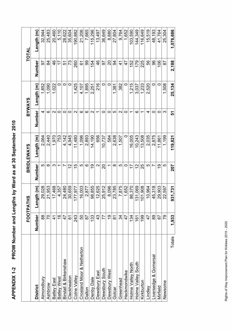
Rig
hts
of W
ay Im
prov
emen
t Pla
n fo
r Kirk
lees
201
0 - 2
020
APP
END
IX 1
-2
PR
OW
Num
ber a
nd L
engt
hs b
y W
ard
as a
t 30
Sept
embe
r 201
0 20
10
FO
OTP
ATH
S B
RID
LEW
AYS
B
YWA
YS
TOTA
L
Dis
tric
t N
umbe
r Le
ngth
(m)
Num
ber
Leng
th (m
) N
umbe
r Le
ngth
(m)
Num
ber
Leng
th (m
) A
lmon
dbur
y 88
29
,028
5
2,06
4 4
1,85
2 97
32
,944
A
shbr
ow
70
21,9
53
8 2,
440
6 1,
090
84
25,4
83
Bat
ley
Eas
t 41
17
,468
3
1,97
0 2
1,02
2 46
20
,460
B
atle
y W
est
16
4,35
7 1
753
0 0
17
5,11
0 B
irsta
ll &
Birk
ensh
aw
47
24,4
80
7 4,
142
0 0
51
28,6
22
Cle
ckhe
aton
61
30
,659
12
4,
945
0 0
73
35,6
04
Col
ne V
alle
y 24
3 17
7,97
7 15
11
,480
2
1,42
5 26
0 19
0,88
2 C
rosl
and
Moo
r & N
ethe
rton
50
16,0
03
5 1,
096
6 4,
107
61
21,2
06
Dal
ton
87
2,87
7 6
2,89
3 6
1,89
5 99
7,
665
Den
by D
ale
133
98,8
55
19
14,1
90
2 2,
251
154
115,
296
Dew
sbur
y E
ast
43
12,6
25
2 65
6 1
216
46
13,4
97
Dew
sbur
y S
outh
77
25
,912
20
10
,737
0
0 97
36
,649
D
ewsb
ury
Wes
t 19
8,
096
1 58
4 0
0 20
8,
680
Gol
car
81
23,7
85
8 2,
638
5 1,
381
94
27,8
04
Gre
enhe
ad
34
7,87
5 5
1,50
7 2
382
41
9,76
4 H
eckm
ondw
ike
47
1,65
2 0
0 0
0 47
1,
652
Hol
me
Val
ley
Nor
th
134
86,3
70
17
16,0
05
1 1,
215
152
103,
590
Hol
me
Val
ley
Sou
th
161
131,
069
12
10,2
43
6 3,
037
179
144,
349
Kirk
burto
n 19
9 10
1,90
8 25
13
,508
1
1,23
3 22
5 11
6,64
9 Li
ndle
y 47
10
,964
5
2,03
5 4
2,52
0 56
15
,519
Li
vers
edge
& G
omer
sal
89
45,3
18
7 2,
875
0 0
96
48,1
93
Mirf
ield
87
29
,903
19
11
,861
0
0 10
6 41
,764
N
ewso
me
79
22,5
97
5 1,
199
3 1,
508
87
25,3
04
Tota
ls
1,93
3 93
1,73
1 20
7 11
9,82
1 51
25
,134
2,
188
1,07
6,68
6

Rig
hts
of W
ay Im
prov
emen
t Pla
n fo
r Kirk
lees
201
0 - 2
020
APP
END
IX 2
-1
Issu
es b
y Ty
pe a
nd P
aris
h/D
istr
ict f
ound
at P
RO
W S
urve
y as
at 3
0 M
ay 2
007
B
at
Bri
Col
D
en
Dew
El
l G
ui
Hec
H
ol
Hud
K
ir M
el
Mir
Mor
Sa
d Sp
e To
n TO
TALS
Dep
osit/
Com
mer
cial
Dum
ping
1
1
Dep
osit/
Mac
hine
ry
1
4 3
1
1
10
Dep
osit/
Dom
estic
Dum
ping
1
1
11
13
Dep
osit/
Indu
stria
lDum
ping
1
3
4
Dep
osit/
Litte
r
1
1
Dep
osit/
Min
eral
s 1
7
1
1
2 4
3
19
Dep
osit/
Veh
icle
1
2 1
2 1
1
1
9
Dep
osit/
Oth
er
4 2
1
3
1 3
1
15
Intim
idat
ingO
rMis
lead
ing/
Bea
st
3 2
1
6
Intim
idat
ingO
rMis
lead
ing/
Sig
n
11
2
3
1
4 11
3
4 2
2
43
Land
Use
/Cro
ps
3
22
4
12
2
43
Land
Use
/For
estry
Pla
ntat
ion
1 1
1
1
1
5
Land
Use
/Oth
er
3
3
1
2 1
4
14
Land
Use
/Plo
ughe
d 2
2
1
6
1
12
Land
Use
/Qua
rry
1
1
Mai
ntai
n A
long
side
/Wal
l
0
Mai
ntai
n D
rain
/Cul
vert
0
Mai
ntai
n G
ate/
Brid
le/W
ood
1
1
Mai
ntai
n G
ate/
Kis
sing
/Gen
eral
1
1
Mai
ntai
n O
ther
/Bar
rier/O
ther
1
1
2
Mai
ntai
n O
ther
/Bar
rier/R
ail
1
1
Mai
ntai
n S
ignN
otR
oad/
Fpos
t/Woo
d
1
1
Mai
ntai
n S
ignN
otR
oad/
Fpos
t/Met
al
1
1
Mai
ntai
n S
ignN
otR
oad/
WM
D
isc/
Gen
eral
1
1
2
Mai
ntai
n S
ignR
oad/
Fpos
t/Lam
pPos
t
1
5
6
Mai
ntai
n S
ignR
oad/
Fpos
t/Met
al
1
3
1
2 1
10
18

Rig
hts
of W
ay Im
prov
emen
t Pla
n fo
r Kirk
lees
201
0 - 2
020
Mai
ntai
n S
ignR
oad/
Fpos
t/Oth
er
1
1
Mai
nain
Sig
nRoa
d/W
allF
inge
r
1
1
Mai
ntai
n S
ignR
oad/
WM
Pos
t/Gen
eral
1
1
1 1
1
5
Mai
ntai
n S
tile/
Oth
er
1
1
Mai
ntai
n S
tile/
Ste
p/S
tone
1
1
Mai
ntai
n S
tile/
Ste
p/W
ood
1
2 3
3
9
Mis
sing
/Brid
ge
1
1
1
3
Mis
sing
/Sig
n/N
otR
oad
0
Mis
sing
/Sig
n/R
oads
ide
21
14
6 27
20
17
51
48
6 38
36
11
45
898
Obs
truct
ion/
Bar
bed
wire
6
62
33
8
1 31
14
34
9
7
22
227
Obs
truct
ion/
Bou
ndar
y co
llaps
e 1
3
1 1
2
2
10
Obs
truct
ion/
Bui
ldin
g 3
20
8
4
5
12
9 8
4 6
14
93
Obs
truct
ion/
Ele
ctric
fenc
e
4
5 2
2
4
1
18
Obs
truct
ion/
Falle
n Tr
ee
1 5
1
3 12
4
1 1
1
29
Obs
truct
ion/
Fenc
e 25
70
18
14
14
36
45
26
10
10
47
31
5
Obs
truct
ion/
Hed
ge
2
6 9
4
1
5 3
11
4
10
55
Obs
truct
ion/
Oth
er
4
8 2
1
1
4 7
5 5
3
40
Obs
truct
ion/
Wal
l 3
64
24
7
5 57
30
38
27
5
17
27
7
Obs
truct
ion/
Wat
erco
urse
1
3
5 3
4
8 1
6 40
2
73
Pro
blem
foun
d on
sur
vey
25
20
8 12
3 60
3
98
115
118
57
2
11
0
919
Terr
ain/
Mud
dy
5
12
27
1
1
8 8
13
11
4
90
Terr
ain/
Oth
er
1
7
7 3
1 2
21
Terr
ain/
Rut
ted
1
1
Terr
ain/
Wat
erlo
gged
1
32
14
1 21
11
8
9
3
100
Veg
etat
ion/
Ove
rhan
ging
11
40
7 21
2
30
30
27
8 18
30
224
Veg
etat
ion/
Sur
face
16
65
18
19
4 41
87
28
23
10
37
348
TOTA
LS
140
1 79
2 36
7 17
9 0
0 56
42
9 90
4 40
1 22
1 11
4 0
0 38
4 0
3,98
8

Rig
hts
of W
ay Im
prov
emen
t Pla
n fo
r Kirk
lees
201
0 - 2
020
APP
END
IX 2
-2
Issu
es O
utst
andi
ng b
y Ty
pe a
nd P
aris
h/D
istr
ict a
s at
30
Sept
embe
r 201
0
Bat
B
ri C
ol
Den
D
ew
Ell
Gui
H
ec
Hol
H
ud
Kir
Mel
M
ir M
or
Sad
Spe
Ton
TOTA
LS
Dep
osit/
Com
mer
cial
Dum
ping
1
1
Dep
osit/
Mac
hine
ry
1
4 3
1
1
10
Dep
osit/
Dom
estic
Dum
ping
1
1
11
13
Dep
osit/
Indu
stria
lDum
ping
1
3
4
Dep
osit/
Litte
r
1
1
Dep
osit/
Min
eral
s 1
8
2
1
2 4
3
21
Dep
osit/
Veh
icle
1
2 1
2 1
1
1
9
Dep
osit/
Oth
er
4 2
1
3
1 3
1
15
Intim
idat
ingO
rMis
lead
ing/
Bea
st
3 2
1
6
Intim
idat
ingO
rMis
lead
ing/
Sig
n
12
2
3
1
5 11
3
4 2
2
45
Land
Use
/Cro
ps
3
22
4
12
2
43
Land
Use
/For
estry
Pla
ntat
ion
1 1
1
1
1
5
Land
Use
/Oth
er
3
3
1
2 1
4
14
Land
Use
/Plo
ughe
d 2
2
1
6
1
12
Land
Use
/Qua
rry
1
1
Mai
ntai
n A
long
side
/Wal
l
0
Mai
ntai
n D
rain
/Cul
vert
0
Mai
ntai
n G
ate/
Brid
le/W
ood
1
1
Mai
ntai
n G
ate/
Kis
sing
/Gen
eral
1
1
Mai
ntai
n O
ther
/Bar
rier/O
ther
1
1
2
Mai
ntai
n O
ther
/Bar
rier/R
ail
1
1
Mai
ntai
n S
ignN
otR
oad/
Fpos
t/Woo
d
1
1
Mai
ntai
n S
ignN
otR
oad/
Fpos
t/Met
al
1
1
Mai
ntai
n S
ignN
otR
oad/
WM
D
isc/
Gen
eral
1
1
2
Mai
ntai
n S
ignR
oad/
Fpos
t/Lam
pPos
t
1
5
6
Mai
ntai
n S
ignR
oad/
Fpos
t/Met
al
1
3 1
1
2 3
10
21

Rig
hts
of W
ay Im
prov
emen
t Pla
n fo
r Kirk
lees
201
0 - 2
020
Mai
ntai
n S
ignR
oad/
Fpos
t/Oth
er
1
1
Mai
nain
Sig
nRoa
d/W
allF
inge
r
1
1
Mai
ntai
n S
ignR
oad/
WM
Pos
t/Gen
eral
1
2
1 1
1
6
Mai
ntai
n S
tile/
Oth
er
1
1
Mai
ntai
n S
tile/
Ste
p/S
tone
1
1
Mai
ntai
n S
tile/
Ste
p/W
ood
1
2 3
3
9
Mis
sing
/Brid
ge
1
1
1
3
Mis
sing
/Sig
n/N
otR
oad
1
1
Mis
sing
/Sig
n/R
oads
ide
21
15
9 31
20
18
58
50
1 43
36
11
49
947
Obs
truct
ion/
Bar
bed
wire
6
63
33
8
1 41
15
34
9
7
22
239
Obs
truct
ion/
Bou
ndar
y co
llaps
e 1
4
1 1
2
2
11
Obs
truct
ion/
Bui
ldin
g 4
22
8
5
5
12
10
9 5
6
15
101
Obs
truct
ion/
Ele
ctric
fenc
e
4
5 2
2
4
1
18
Obs
truct
ion/
Falle
n Tr
ee
1 5
1
3 12
4
1 1
1
29
Obs
truct
ion/
Fenc
e 25
78
18
15
14
42
46
28
10
11
49
33
6
Obs
truct
ion/
Hed
ge
2
7 10
5
2 5
3 13
4
10
61
Obs
truct
ion/
Oth
er
4
9 2
1
1
4 7
6 5
3
42
Obs
truct
ion/
Wal
l 3
71
24
8
5 68
32
41
28
5
18
30
3
Obs
truct
ion/
Wat
erco
urse
1
6
5 3
8
9 1
6 43
2
84
Pro
blem
foun
d on
sur
vey
25
21
8 12
3 60
3
121
115
119
57
2
11
0
953
Terr
ain/
Mud
dy
5
16
27
1
1
11
8 13
11
4
97
Terr
ain/
Oth
er
1
7
9 3
1 2
23
Terr
ain/
Rut
ted
1
1
Terr
ain/
Wat
erlo
gged
1
34
14
1 33
11
8
9
3
114
Veg
etat
ion/
Ove
rhan
ging
11
41
8 21
2
31
32
27
8 19
30
230
Veg
etat
ion/
Sur
face
17
66
19
21
6 49
92
30
23
10
39
372
TOTA
LS
142
1 84
9 37
5 18
6 0
0 60
51
9 93
4 41
8 22
3 11
9 0
0 39
4 0
4,22
0

Rig
hts
of W
ay Im
prov
emen
t Pla
n fro
Kirk
lees
201
0-20
20
APP
END
IX 3
O
utst
andi
ng M
ap M
odifi
catio
n O
rder
s (D
MM
O) a
s at
30
Sept
embe
r 201
0
Par
ish
Inte
nded
E
ffect
C
laim
ed S
tatu
s Lo
catio
n of
app
licat
ion
Tow
nVill
age
Bat
ley
Add
Fo
otpa
th
Bro
wnh
ill E
nd, B
atle
y B
atle
y
Bat
ley
Add
Fo
otpa
th
Upp
er B
atle
y Lo
w L
ane,
Dis
used
Rai
lway
B
atle
y
Bat
ley
Add
Fo
otpa
th
Sol
way
Roa
d, S
ooth
ill
Bat
ley
Bat
ley
Add
Fo
otpa
th
Bro
mle
y R
oad,
Han
ging
Hea
ton
Han
ging
Hea
ton
Bat
ley
Add
Fo
otpa
th
Com
mon
side
, Bat
ley
Bat
ley
Bat
ley
Upg
rade
B
ridle
way
H
owle
y M
ill L
ane,
Bat
ley
Bat
ley
Bat
ley
Add
B
yway
G
rang
e R
oad
Han
ging
Hea
ton
Bat
ley
Add
/del
ete
Foot
path
Ja
il R
oad,
Whi
te L
ee
Bat
ley
Bat
ley
Add
Fo
otpa
th
Mon
k In
gs
Birs
tall
Col
ne V
aley
U
pgra
de
Brid
lew
ay
Pol
e M
oor B
ridle
way
P
ole
Moo
r
Col
ne V
alle
y A
dd
Brid
lew
ay
Dee
r Hill
M
arsd
en
Col
ne V
alle
y A
dd
Foot
path
B
anks
Roa
d, L
inth
wai
te
Lint
hwai
te
Col
ne V
alle
y A
dd
Foot
path
H
oyle
Ing
Lint
hwai
te
Col
ne V
alle
y A
dd
Foot
path
La
kesi
de, M
arsd
en
Mar
sden
Col
ne V
alle
y D
elet
e Fo
otpa
th
The
Hey
M
arsd
en
Col
ne V
alle
y D
elet
e Fo
otpa
th
Lydg
ate
Rifl
e C
lub
Mar
sden
Col
ne V
alle
y A
dd
Foot
path
/Brid
lew
ay
Moo
rval
e, O
ld W
ood
Yar
d M
arsd
en
Col
ne V
alle
y A
dd
Foot
path
C
ella
rs C
loug
h M
arsd
en
Den
by D
ale
Add
Fo
otpa
th/B
ridle
way
C
uttle
hurs
t S
ciss
ett
Den
by D
ale
Add
Fo
otpa
th
Lang
ley
Lane
, Sci
sset
S
ciss
ett
Den
by D
ale
Del
ete
Foot
path
D
enby
Dal
e 10
0 D
enby
Dal
e
Den
by D
ale
Add
Fo
otpa
th
Bag
den
Hal
l, S
ciss
ett
Sci
sset
t

Rig
hts
of W
ay Im
prov
emen
t Pla
n fro
Kirk
lees
201
0-20
20
Par
ish
Inte
nded
E
ffect
C
laim
ed S
tatu
s Lo
catio
n of
app
licat
ion
Tow
nVill
age
Den
by D
ale
Add
Fo
otpa
th
Kitc
henr
oyd
Den
by D
ale
Den
by D
ale
Add
Fo
otpa
th
Den
by L
ane,
Upp
er D
enby
U
pper
Den
by
Den
by D
ale
Add
Fo
otpa
th
Bac
k La
ne
Upp
er D
enby
Den
by D
ale
Add
fo
otpa
th
Woo
dbin
e Te
rrac
e C
layt
on W
est
Den
by D
ale
Add
Fo
otpa
th
Clif
fe W
ood
Cla
yton
Wes
t
Dew
sbur
y A
dd
Foot
path
S
avile
Pit
Lane
D
ewsb
ury
Dew
sbur
y A
dd
Brid
lew
ay
Rav
enst
horp
e R
oad,
Tho
rnhi
ll Th
ornh
ill L
ees
Dew
sbur
y A
dd
Foot
path
C
alde
r Nav
igat
ion
Dew
sbur
y
Dew
sbur
y A
dd
Foot
path
H
eath
Roa
d, C
hick
enle
y D
ewsb
ury
Dew
sbur
y A
dd
Foot
path
P
rince
ss L
ane,
Ear
lshe
aton
E
arls
heat
on
Hec
kmon
dwik
e D
elet
e Fo
otpa
th
Hill
Top
, Hec
kmon
dwik
e H
eckm
ondw
ike
Hec
kmon
dwik
e A
dd
Foot
path
K
ilpin
Hill
, (R
obyn
Lan
e)H
eckm
ondw
ike
Hec
kmon
dwik
e
Hol
mfir
th
Del
ete
Foot
path
D
ean
Lane
, Hep
wor
th
Hep
wor
th
Hol
mfir
th
Del
ete
Foot
path
S
tubb
in L
ane
Hol
mbr
idge
Hol
mfir
th
Add
Fo
otpa
th
Bro
ckho
les
Lane
B
rock
hole
s
Hol
mfir
th
Add
Fo
otpa
th
Nor
ridge
Bot
tom
, Hol
mfir
th
Hol
mfir
th
Hol
mfir
th
Add
Fo
otpa
th
Net
herle
a D
rive
Net
herth
ong
Hol
mfir
th
Add
Fo
otpa
th
Oak
es A
venu
e, B
rock
hole
s B
rock
hole
s
Hol
mfir
th
Add
Fo
otpa
th
Birc
h P
ark,
Bro
ckho
les
Bro
ckho
les
Hol
mfir
th
Del
ete
Foot
path
O
ld M
oll R
oad,
Hon
ley
Net
herto
n
Hol
mfir
th
Add
Fo
otpa
th
Hom
firth
Cat
tle M
arke
t H
olm
firth

Rig
hts
of W
ay Im
prov
emen
t Pla
n fro
Kirk
lees
201
0-20
20
Par
ish
Inte
nded
E
ffect
C
laim
ed S
tatu
s Lo
catio
n of
app
licat
ion
Tow
nVill
age
Hol
mfir
th
Add
Fo
otpa
th
But
t Lan
e H
epw
orth
Hol
mfir
th
Add
fo
otpa
th
Cro
wn
Stre
et
Hon
ley
Hol
mfir
th
Add
Fo
otpa
th
Woo
ldal
e C
liff
Hol
mfir
th
Hud
derfi
eld
Add
fo
otpa
th
Stri
ke L
ane
Ske
lman
thor
pe
Hud
ders
field
A
dd
Foot
path
S
umm
er S
treet
, Net
herto
n N
ethe
rton
Hud
ders
field
A
dd
Foot
path
Fe
nay
Bec
k H
udde
rsfie
ld
Hud
ders
field
A
dd
Foot
path
E
dger
ton
Roa
d H
udde
rsfie
ld
Hud
ders
field
A
dd
Foot
path
C
layt
on F
ield
s, E
dger
ton
Hud
ders
field
Hud
ders
field
A
dd
Foot
path
R
einw
ood
Roa
d H
udde
rsfie
ld
Hud
ders
field
A
dd
Foot
path
C
hurc
h S
treet
, Pad
dock
P
addo
ck
Hud
ders
field
A
dd
Foot
path
Y
MC
A, H
udde
rsfie
ld
Hud
ders
field
Hud
ders
field
A
dd
Foot
path
E
mm
anue
l Ter
race
H
udde
rsfie
ld
Hud
ders
field
A
dd
Foot
path
Lo
ngle
y La
ne
Hud
ders
field
Hud
ders
field
A
dd
Foot
path
Lo
ngw
ood
Gat
e Lo
ngw
ood
Hud
ders
field
A
dd
Foot
path
S
prin
g S
treet
, Hud
ders
field
H
udde
rsfie
ld
Hud
ders
field
U
pgra
de
Brid
lew
ay
Out
lane
Gol
f Cou
rse
Out
lane
Hud
ders
field
A
dd
Foot
path
S
tadi
um P
ath
Hud
ders
field
Hud
ders
field
A
dd
foot
path
B
ooth
royd
Driv
e C
ross
land
Hill
H
udde
rsfie
ld
Hud
ders
field
A
dd
Foot
path
D
ick
Woo
d Fi
xby
Hud
ders
field
A
dd
Foot
path
P
enis
tone
Roa
d, W
ater
loo
Wat
erlo
o
Hud
ders
field
A
dd
Foot
path
Ji
lley
Roy
d Fi
xby

Rig
hts
of W
ay Im
prov
emen
t Pla
n fro
Kirk
lees
201
0-20
20
Par
ish
Inte
nded
E
ffect
C
laim
ed S
tatu
s Lo
catio
n of
app
licat
ion
Tow
nVill
age
Hud
ders
field
D
owng
rade
Fo
otpa
th
Bry
an R
oad
Edg
erto
n
Hud
ders
field
A
dd
Foot
path
Fa
rnle
e Li
ndle
y
Hud
ders
field
U
pgra
de
Brid
lew
ay
Net
tleto
n H
ill
Sca
pego
at H
ill
Hud
ders
field
A
dd
/Upg
rade
B
ridle
way
Th
ewlis
Lan
e C
rosl
and
Hill
Hud
ders
field
A
dd
Foot
path
S
tock
s W
alk
Alm
ondb
ury
Hud
ders
field
A
dd
foot
path
S
prin
gdal
e S
treet
Th
ornt
on L
odge
Hud
ders
field
A
dd
Byw
ay
Spi
nney
field
Fi
xby
Hud
ders
field
A
dd/d
elet
e B
yway
/foot
path
R
ed D
oles
Lan
e Le
eds
Roa
d
Hud
ders
field
D
owng
rade
B
ridle
way
N
ethe
r Moo
r Far
m
Sou
th C
rosl
and
Hud
ders
field
A
dd
Foot
path
D
og K
enne
l Ban
k A
lmon
dbur
y
Hud
ders
field
A
dd
Foot
path
N
ew L
aith
e S
hrog
g A
lmon
dbur
y
Kirk
burto
n U
pgra
de
Brid
lew
ay
Kirk
burto
n 19
5 S
helle
y
Kirk
burto
n A
dd
Foot
path
Le
pton
Tho
rn
Lept
on
Kirk
burto
n A
dd
Foot
path
H
ouse
s H
ill
Kirk
heat
on
Kirk
burto
n A
dd
Foot
path
B
otan
y La
ne, L
epto
n Le
pton
Kirk
burto
n A
dd
Brid
lew
ay
Moo
r Lan
e Fa
rnle
y Ty
as
Kirk
burto
n A
dd
Foot
path
H
eale
y S
helle
y
Kirk
burto
n A
dd
Foot
path
C
loug
h G
ate
Farm
G
rang
e M
oor
Kirk
burto
n A
dd
Foot
path
G
rang
e M
oor,
Pla
ying
Fie
lds
Gra
nge
Moo
r
Kirk
burto
n A
dd
Foot
path
R
elia
nce
Pre
cisi
on
Fena
y B
ridge

Rig
hts
of W
ay Im
prov
emen
t Pla
n fro
Kirk
lees
201
0-20
20
Par
ish
Inte
nded
E
ffect
C
laim
ed S
tatu
s Lo
catio
n of
app
licat
ion
Tow
nVill
age
Kirk
burto
n A
dd
Foot
path
C
loug
h C
otta
ge, G
reen
side
Roa
d Th
urst
onla
nd
Kirk
burto
n A
dd
Foot
path
S
torth
es H
all
Thun
der B
ridge
Kirk
burto
n A
dd
Foot
path
M
ount
Ple
asan
t Lan
e Fe
nay
Brid
ge
Kirk
burto
n A
dd
Foot
path
Lo
w F
old
Kirk
heat
on
Krik
burto
n D
elet
e Fo
otpa
th
Folly
Hal
l, K
irkbu
rton
Kirk
burto
n
Mar
sden
D
elet
e/A
dd
Foot
path
W
esse
nden
Lod
ge
Wes
send
en
Mirf
ield
A
dd
Foot
path
Ta
ylor
Hal
l Lan
e M
irfie
ld
Mirf
ield
A
dd
Byw
ay
Fran
cis
Stre
et, M
irfie
ld
Mirf
ield
Mirf
ield
A
dd
Foot
path
H
and
Ban
k La
ne, H
opto
n H
opto
n
Mirf
ield
A
dd
Foot
path
Le
e G
reen
, Mirf
ield
M
irfie
ld
Mirf
ield
A
dd
Foot
path
B
alde
rsto
ne H
all L
ane,
Mirf
ield
M
irfie
ld
Mirf
ield
U
pgra
de
Brid
lew
ay
Woo
dbot
tom
Lo
wer
Hop
ton
Spe
nbor
ough
A
dd
Foot
path
R
ober
ttow
n R
ecre
atio
n G
roun
d R
ober
ttow
n
Spe
nbor
ough
A
dd
Foot
path
Fu
sden
Lan
e, G
omer
sal
Gom
ersa
l
Spe
nbor
ough
A
dd
Foot
path
Te
mpe
ranc
e Fi
elds
, Sch
oles
C
leck
heat
on
Spe
nbor
ough
A
dd
Foot
path
In
g Fi
eld,
Oak
ensh
aw
Oak
ensh
aw
Spe
nbor
ough
A
dd
Foot
path
In
gs R
oad
Live
rsed
ge
Spe
nbor
ough
A
dd
Foot
path
K
enm
ore
Driv
e C
leck
heat
on
Spe
nbor
ough
A
dd
Foot
path
C
roft
Stre
et
Birk
ensh
aw


Rig
hts
of W
ay Im
prov
emen
t Pla
n fo
r Kirk
lees
201
0 - 2
020
APP
END
IX 4
Pr
iorit
y M
atrix
for A
pplic
atio
ns A
ffect
ing
Publ
ic R
ight
s of
Way
mad
e un
der:
W
ildlif
e an
d C
ount
rysi
de A
ct 1
981,
Hig
hway
s A
ct 1
980,
Tow
n an
d C
ount
ry P
lann
ing
Act
199
0 an
d C
ount
rysi
de a
nd R
ight
s of
Way
Act
200
0 as
at 3
0 Se
ptem
ber 2
010
Sc
ore
0
1
2
3
Tota
l
A
Crit
eria
in le
gisl
atio
n sa
tisfie
d
-
Par
tially
Com
plet
ely
-
B
Ben
efit
to a
pplic
ant o
r lan
d ow
ner
-
P
ath
thro
ugh
gard
ens,
min
or
inco
nven
ienc
e
P
revi
ous
erro
r, bu
ildin
g ov
er
path
, etc
P
lann
ing
appl
icat
ion,
crim
e pr
oble
ms,
pro
perty
sa
le, e
tc
C
Ben
efit
to n
etw
ork
No
bene
fit
S
ome
bene
fit
G
ood
link
E
ssen
tial l
ink
D
Pre
viou
s co
mm
itmen
t
Non
e
-
No
cons
ulta
tion
but p
erm
issi
on
gran
ted
Fu
ll co
nsul
tatio
n w
ith P
RO
W o
r of
ficer
com
mitm
ent
E Th
reat
to ro
ute
No
thre
at
La
nd o
wne
rs
chal
leng
e
Way
fenc
ed o
r ou
tline
pl
anni
ng
B
uild
ing
wor
ks
pend
ing
/ co
mm
ence
d
F C
rimin
al a
ctiv
ity /
scho
ol
secu
rity
-
-
-
D
emon
stra
ble
prob
lem
/ ot
her
CR
OW
crit
eria
sa
tisfie
d
Tota
l sco
re
____


Rig
hts
of W
ay Im
prov
emen
t Pla
n fo
r Kirk
lees
201
0 -2
020
APP
END
IX 5
-1
Prio
rity
Enfo
rcem
ent M
atrix
as
at 3
0 Se
ptem
ber 2
010
Pa
rish
& P
ath
Link
P
RIO
RIT
Y 1
- D
ange
rous
/Haz
ardo
us -
Ser
ious
Inju
ry/L
ife T
hrea
teni
ng
PR
IOR
ITY
2 -
Act
ion
agai
nst d
evel
oper
s er
ectin
g pe
rman
ent o
bstru
ctio
ns
PR
IOR
ITY
3 -
Ope
ning
new
pat
hs fr
om M
odifi
catio
ns O
R fo
llow
ing
faile
d di
vers
ions
PR
IOR
ITY
4 -
Rep
eat O
ffend
er
PR
IOR
ITY
5 -
Maj
or O
bstru
ctio
n (B
uild
ings
, Wal
ls e
tc.)
SCO
RE
0
1
2
3 Sc
ore
Like
lihoo
d of
Inju
ry
NO
RIS
K T
O P
ER
SO
N
R
ISK
OF
DA
MA
GE
TO
RIS
K O
F M
INO
R IN
JUR
Y
R
ISK
OF
ME
DIU
M IN
JUR
Y
/Dam
age
OR
PR
OP
ER
TY
C
LOTH
ING
ETC
.
eg.C
uts,
Bru
ises
, Ele
c sh
ocks
, R
isk
eg
. Dam
age
to e
ye, S
prai
ns
to
hea
lth fr
om d
umpe
d sl
urry
/man
ure
IMPA
CT
ON
USE
RS
MIN
OR
PA
TH IM
PA
SS
AB
LE
IN
CO
NV
EN
IEN
CE
MA
JOR
INC
ON
VE
NIE
NC
E
eg
. Mis
lead
ing
Not
ice,
B
arbe
d
NO
T B
Y B
UIL
DIN
GS
but
by
eg
. Stil
e st
eps
mis
sing
, low
leve
l cr
op,
eg
. any
fenc
e/w
all o
r obj
ect
acro
ss
W
ire/E
lect
ric F
ence
al
ongs
ide
long
term
obs
truct
ions
OH
veg
on
stile
s, e
lect
ric/B
W
ro
ute
and
impo
ssib
le to
su
rmou
nt,
P
ath,
Min
imal
O
verh
angi
ng V
eg
al
ongs
ide;
enc
roac
hmen
t re
stric
ting
or g
o ro
und;
rout
e th
roug
h ra
pe
crop
;
P
loug
hed
out p
ath
but
usea
ble
us
e to
less
than
min
wid
th (1
m
Foot
plou
ghed
out
fiel
d ed
ge p
ath/
pa
th 2
m B
ridle
way
), pl
ough
ed
out o
r whe
re th
ere
is a
n
br
idle
way
al
tern
ativ
e av
aila
ble
N
UM
BER
OF
REQ
UES
TS
FIR
ST
RE
QU
ES
T
2 D
IFF
WIT
HIN
3 M
ON
THS
5 -1
0 D
IFF
IN 6
MO
NTH
S
1
0 +
DIF
F W
ITH
IN 6
MO
NTH
S
or v
ia U
ser G
roup
Rep
or R
ecie
pt o
f Pet
ition
PRO
MO
TED
RO
UTE
S
TAN
DA
RD
WA
YM
AR
KS
PR
OM
OTE
D L
OC
ALL
Y
C
OU
NC
IL D
ES
IGN
ED
&
N
ATI
ON
ALL
Y R
EC
OG
NIS
ED
On
any
part
of ro
ute
whe
re
inc.
rout
es in
pub
licat
ions
eg. v
illag
e w
alks
and
trai
ls
P
RO
MO
TED
e.g.
Pen
nine
Way
obst
ruct
ion
HV
, CV
, Bro
nte,
Spe
n V
e.g.
Kirk
lees
Way
VA
LUE
OF
PATH
TO
N
O O
BV
IOU
S P
UR
PO
SE
NO
RM
AL
LIN
K
C
ON
VE
NIE
NT
LIN
K
E
SS
EN
TIA
L LI
NK
NET
WO
RK
eg
. rou
tes
roun
d bu
ildin
gs
only
eg. N
eigh
bour
hood
pat
h, S
choo
l pa
th
le
isur
e &
com
mut
ing
Cul
-de-
Sac
pat
hs
P
aths
to a
men
ities
, Brid
lew
ays
-
as
thes
e ar
e fe
w &
mul
ti us
e
N
O O
F O
THER
PR
OB
LEM
S
2
PR
OB
LEM
S
1
PR
OB
LEM
NO
OTH
ER
PR
OB
LEM
S
N
o O
F O
THER
PR
OB
LEM
S O
N P
ATH
LIN
K –
cou
ld a
lso
refe
r to
a nu
mbe
r of
land
owne
rs if
kno
wn
in
stea
d of
pro
blem
s
TOTA
L SC
OR
E

Rig
hts
of W
ay Im
prov
emen
t Pla
n fo
r Kirk
lees
201
0 -2
020
A
PPEN
DIX
5-2
K
irkle
es P
ublic
Rig
hts
of W
ay E
nfor
cem
ent G
uide
lines
as
at 3
0 Se
ptem
ber 2
010
1.
B
AC
KG
RO
UN
D
1.
1 U
sers
of
Pub
lic R
ight
s of
Way
(P
RO
Ws)
can
enc
ount
er a
var
iety
of
prob
lem
s w
hen
mak
ing
use
of t
he n
etw
ork
in
Kirk
lees
. T
hese
inc
lude
the
una
utho
rised
rem
oval
of
sign
post
s or
way
mar
kers
, er
ectio
n of
bar
bed
wire
and
oth
er
unau
thor
ised
obs
truct
ions
, ov
erha
ngin
g ve
geta
tion
and
even
bui
ldin
gs e
rect
ed o
ver
the
alig
nmen
t of
the
PR
OW
. In
terfe
renc
e w
ith t
he p
ath
surfa
ce,
dang
erou
s or
int
imid
atin
g an
imal
s an
d m
isle
adin
g no
tices
may
als
o re
quire
en
forc
emen
t act
ion
to b
e ta
ken.
1.
2 K
irkle
es M
etro
polit
an C
ounc
il as
the
Loc
al H
ighw
ay A
utho
rity
has
the
duty
, un
der
sect
ion
130(
1) o
f th
e H
ighw
ays
Act
19
80, "
… to
ass
ert a
nd p
rote
ct th
e rig
hts
of th
e pu
blic
to th
e us
e an
d en
joym
ent o
f any
hig
hway
…".
2.
A
UTH
OR
ISA
TIO
N
2.
1 Th
e du
ty to
ass
ert a
nd p
rote
ct p
ublic
righ
ts o
f way
is n
orm
ally
per
form
ed b
y of
ficer
s w
orki
ng in
the
Pub
lic R
ight
s of
Way
U
nit.
The
Dire
ctor
of t
he E
nviro
nmen
t and
Tra
nspo
rtatio
n S
ervi
ce a
nd A
ssis
tant
Dire
ctor
Hig
hway
s an
d Tr
ansp
orta
tion
have
the
dele
gate
d po
wer
s to
aut
horis
e S
tatu
tory
Enf
orce
men
t Not
ices
for t
he p
rote
ctio
n of
Pub
lic R
ight
s of
Way
.
3.
PRO
CED
UR
ES
3.1
Enf
orce
men
t de
cisi
ons
shou
ld b
e co
nsis
tent
, ba
lanc
ed,
fair,
and
rel
ate
to c
omm
on s
tand
ards
tha
t en
sure
the
pub
lic's
rig
ht to
use
the
PR
OW
s.
In c
omin
g to
a d
ecis
ion
on th
e m
ost a
ppro
pria
te a
ctio
n to
be
take
n, o
ffice
rs w
ill c
onsi
der
the
serio
usne
ss o
f of
fenc
e, t
he lo
catio
n of
pat
h an
d th
e le
vel o
f p
ublic
use
, an
y hi
stor
y of
pre
viou
s of
fenc
es o
r of
non
-co
mpl
ianc
e.
3.2
Whe
neve
r Not
ices
and
sub
sequ
ent a
ctio
n ar
e in
volv
ed, l
iais
on is
nec
essa
ry w
ith c
ontra
ctor
s ca
rryi
ng o
ut a
ny w
ork,
and
th
e A
utho
rity'
s D
ebt R
ecov
ery
Uni
t to
ensu
re th
at a
ll re
ason
able
cos
ts in
curr
ed in
taki
ng a
ctio
n ar
e re
cove
red.

Rig
hts
of W
ay Im
prov
emen
t Pla
n fo
r Kirk
lees
201
0 -2
020
4.
IN
FOR
MA
L A
CTI
ON
4.1
Info
rmal
act
ion
to s
ecur
e co
mpl
ianc
e w
ith le
gisl
atio
n w
ill in
clud
e of
ferin
g ad
vice
, ver
bal a
nd w
ritte
n w
arni
ngs/
guid
ance
le
tters
, and
site
mee
tings
. 4.
2 U
nles
s th
e pr
oble
ms/
obst
ruct
ions
are
a r
isk
to p
ublic
saf
ety,
or
the
offe
nder
has
rep
eate
dly
and
delib
erat
ely
obst
ruct
ed
PR
OW
s (a
s ow
ner
or te
nant
) it
may
be
mor
e ap
prop
riate
to u
se in
form
al m
etho
ds p
rior
to a
ny e
nfor
cem
ent a
ctio
n o
r pr
osec
utio
n.
4.3
Info
rmal
Act
ion
will
con
sist
of :
• Id
entif
icat
ion
of th
e la
ndow
ner
and
a re
ques
t to
take
rem
edia
l act
ion.
The
CLA
and
/or
the
NFU
will
be
cont
acte
d if
nece
ssar
y.
The
issu
e is
con
firm
ed in
writ
ing
with
a p
olite
but
firm
lette
r det
ailin
g th
e fo
llow
ing
: •
The
exac
t nat
ure
of th
e of
fenc
e.
• Th
e re
leva
nt d
etai
ls o
f the
PR
OW
affe
cted
. •
The
legi
slat
ion
and
the
Aut
horit
y's
duty
. •
The
actio
ns th
at a
re re
quire
d.
• A
dea
dlin
e by
whi
ch th
e w
ork
mus
t be
carr
ied
out (
max
. of 1
4 da
ys).
• W
hat a
ctio
n m
ay b
e ta
ken
if w
orks
are
not
don
e w
ithin
the
requ
ired
time
limit.
4.4
The
dead
line
for w
orks
sho
uld
take
into
acc
ount
wea
ther
con
ditio
ns a
nd th
e am
ount
of w
ork
requ
ired.
4.
5 If
the
land
owne
r con
tact
s th
e P
RO
W U
nit w
ith v
alid
reas
ons
for
n
on-c
ompl
ianc
e w
ithin
the
times
cale
, the
n an
ext
ensi
on o
f tim
e m
ay b
e gi
ven
whi
ch s
houl
d be
con
firm
ed in
writ
ing.
4.
6 Th
ere
will
be
an in
terv
enin
g pe
riod
follo
win
g th
e de
adlin
e be
fore
form
al a
ctio
n is
initi
ated
. Th
is w
ill a
llow
tim
e fo
r th
e of
ficer
mak
e en
quiri
es a
nd to
car
ry o
ut a
site
insp
ectio
n.
4.7
If a
land
owne
r can
not b
e id
entif
ied
then
a c
opy
of th
e le
tter s
houl
d be
pos
ted
on th
e P
RO
W, i
deal
ly in
the
vici
nity
of t
he
offe
nce,
sta
ting
who
m to
con
tact
.

Rig
hts
of W
ay Im
prov
emen
t Pla
n fo
r Kirk
lees
201
0 -2
020
5.
FOR
MA
L A
CTI
ON
5.1
Form
al a
ctio
n co
nsis
ts o
f Sta
tuto
ry N
otic
es, w
ith a
cov
erin
g le
tter b
eing
issu
ed to
the
offe
nder
or o
n-si
te if
the
offe
nder
is
unkn
own.
5.
2 If
info
rmal
act
ion
fails
to a
chie
ve re
solv
ing
the
offe
nce,
War
d M
embe
rs w
ill b
e in
form
ed th
at fo
rmal
act
ion
is re
quire
d.
5.3
Form
al a
ctio
n w
ill b
e ta
ken
afte
r in
form
al a
ctio
n ha
s fa
iled,
or
whe
re t
he o
ffend
er h
as p
ersi
sten
tly a
nd/o
r re
peat
edly
of
fend
ed (e
.g. i
n th
e ca
se o
f cro
ps o
r plo
ughi
ng it
may
be
an a
nnua
l offe
nce)
. 5.
4 Fo
rmal
act
ion
cons
ists
of a
form
al n
otic
e si
gned
by
a S
enio
r Offi
cer (
with
the
dele
gate
d po
wer
s to
do
so) w
hich
det
ails
: -
• N
atur
e of
offe
nce
and
its lo
catio
n.
• D
etai
ls o
f the
legi
slat
ion
that
is b
eing
con
trave
ned.
•
Dea
dlin
e by
whi
ch th
e ob
stru
ctio
n/pr
oble
m m
ust b
e re
mov
ed/re
solv
ed (u
sual
ly a
sta
tuto
ry p
erio
d).
• W
hat f
urth
er a
ctio
n m
ay b
e ta
ken
shou
ld th
e re
quire
d w
orks
not
be
carr
ied
out.
A p
lan
will
acc
ompa
ny th
e no
tice
iden
tifyi
ng th
e pa
th n
ame
and
num
ber,
the
alig
nmen
t of t
he p
ath
and
the
loca
tion
of th
e ob
stru
ctio
n/pr
oble
m.
This
will
be
sent
with
a c
over
ing
lette
r (se
nt b
y re
cord
ed d
eliv
ery)
refe
rrin
g to
any
rele
vant
pre
viou
s co
rres
pond
ence
, and
de
tails
of t
he la
ck o
f act
ion
whi
ch h
as le
ad to
the
issu
e of
the
form
al n
otic
e.
5.
5 If
the
requ
irem
ents
of t
he n
otic
e ha
ve n
ot b
een
met
with
with
in th
e st
ipul
ated
tim
e, th
e A
utho
rity
shal
l tak
e th
e re
leva
nt
actio
n/w
orks
reco
verin
g al
l rea
sona
ble
cost
s an
d m
ake
a de
cisi
on o
n w
heth
er p
rose
cutio
n is
app
ropr
iate
.
6.
PRO
SEC
UTI
ON
6.1
Prio
r to
mak
ing
the
deci
sion
to p
rose
cute
adv
ice
mus
t be
soug
ht fr
om L
egal
Ser
vice
s. T
he p
roce
ss o
f mak
ing
a de
cisi
on
to p
rose
cute
, and
pur
suin
g le
gal a
ctio
n w
ill in
evita
bly
have
an
effe
ct o
n tim
esca
les
in re
solv
ing
som
e is
sues
. 6.
2 Th
e ci
rcum
stan
ces
that
are
like
ly to
war
rant
pro
secu
tion
may
be
char
acte
rised
by
one
or m
ore
of th
e fo
llow
ing:
• W
here
the
offe
nce
invo
lves
a fl
agra
nt b
reac
h of
the
law
, i.e
. del
iber
ate.
•
Whe
re th
e of
fenc
e in
volv
es a
failu
re to
com
ply
in fu
ll or
in p
art w
ith th
e re
quire
men
ts o
f a s
tatu
tory
not
ice.

Rig
hts
of W
ay Im
prov
emen
t Pla
n fo
r Kirk
lees
201
0 -2
020
•
Whe
re th
ere
is a
his
tory
of s
imila
r offe
nces
.
• W
here
ther
e is
a h
isto
ry o
f non
-com
plia
nce
with
sta
tuto
ry n
otic
es
• W
here
it is
con
side
red
that
a p
rose
cutio
n w
ould
be
mor
e ap
prop
riate
than
taki
ng e
nfor
cem
ent a
ctio
n, e
.g. w
hen
a pu
blic
righ
t of w
ay h
as b
een
built
ove
r.
6.3
Whe
n ci
rcum
stan
ces
have
bee
n id
entif
ied
whi
ch m
ay w
arra
nt a
pro
secu
tion,
all
rele
vant
evi
denc
e an
d in
form
atio
n m
ust
be c
onsi
dere
d, to
ena
ble
a co
nsis
tent
, fai
r and
obj
ectiv
e de
cisi
on to
be
mad
e.
6.4
Bef
ore
a pr
osec
utio
n pr
ocee
ds,
the
offic
er r
espo
nsib
le f
or d
ecid
ing
on e
nfor
cem
ent
actio
n, a
nd t
he S
olic
itor
to t
he
Cou
ncil,
mus
t be
satis
fied
that
ther
e is
rel
evan
t, ad
mis
sibl
e, s
ubst
antia
l and
rel
iabl
e ev
iden
ce th
at a
n of
fenc
e ha
s be
en
com
mitt
ed b
y an
iden
tifia
ble
pers
on o
r com
pany
. 6.
5 In
add
ition
ther
e m
ust b
e a
posi
tive
deci
sion
, bas
ed o
n th
e re
leva
nt c
riter
ia, t
hat i
t is
in th
e pu
blic
inte
rest
to p
rose
cute
. 6.
6 If
pros
ecut
ion
is to
be
purs
ued,
War
d M
embe
rs w
ill b
e in
form
ed th
at fo
rmal
act
ion
is re
quire
d.
7.
R
EVIE
W
7.
1 O
ffice
rs s
hall
mon
itor a
nd re
port
on th
e ef
fect
iven
ess
of th
is g
uida
nce
and
unde
rtake
a re
view
one
yea
r afte
r it i
s fo
rmal
ly
adop
ted.
TER
RY
BR
OW
N
Ass
ista
nt D
irect
or -
Hig
hway
s an
d Tr
ansp
orta
tion
June
200
5


Rig
hts
of W
ay Im
prov
emen
t Pla
n fo
r Kirk
lees
201
0 –
2020
(Dra
ft)
APP
END
IX 6
Pr
omot
ed R
oute
s in
Kirk
lees
as
at 3
0 Se
ptem
ber 2
010
Bel
ow a
re th
e m
ain
or p
opul
ar ro
utes
pro
mot
ed b
y K
irkle
es C
ounc
il or
by
othe
r org
anis
atio
ns a
nd in
divi
dual
s w
hich
are
in p
artn
ersh
ip w
ith o
r rec
ogni
sed
by
Kirk
lees
Cou
ncil.
Th
e lis
t the
refo
re d
oes
not i
nclu
de m
any
publ
icis
ed ro
utes
as
som
e ar
e in
dev
elop
men
t or n
ot a
ppro
ved
by K
irkle
es.
Ple
ase
note
that
m
any
rout
es m
erge
with
or c
ross
eac
h ot
her a
nd, i
n th
e ca
se o
f circ
ular
rout
es, c
an b
egin
at a
ny p
oint
oth
er th
an th
e ad
verti
sed
“sta
rt po
int”.
N
atio
nal T
rails
: Th
ese
are
devi
sed
by g
over
nmen
t age
ncy
(pre
sent
ly N
atur
al E
ngla
nd) t
hat p
rom
ote
and
part
fund
mai
nten
ance
. T
here
are
two
with
in K
irkle
es:
Pen
nine
Way
– th
e fir
st o
f a lo
ng-d
ista
nce
foot
path
rout
e w
hich
runs
from
Eda
le in
the
Pea
k D
istri
ct to
Kirk
Yet
holm
at t
he S
cotti
sh b
orde
rs.
It is
429
km
(2
68 m
iles)
and
13.
5 km
(8.3
mile
s) p
asse
s th
roug
h H
olm
e an
d C
olne
Val
leys
. D
ark
Pea
k Li
nk (P
enni
ne B
ridle
way
Fee
der R
oute
) – th
e P
enni
ne B
ridle
way
ski
rts K
irkle
es n
ear t
o th
e bo
unda
ry w
ith O
ldha
m.
Sev
eral
“fee
der r
oute
s”
have
bee
n sp
ecifi
cally
dev
ised
to e
nabl
e ho
rse
rider
s to
link
into
the
Pen
nine
Brid
lew
ay it
self.
Th
e se
ctio
n th
roug
h K
irkle
es is
stil
l in
deve
lopm
ent a
nd w
ill
be k
m lo
ng w
hen
com
plet
ed.
Oth
er R
oute
s:
Kirk
lees
Way
– a
116
km
(72
mile
) circ
ular
wal
k su
rrou
ndin
g ar
eas
of H
udde
rsfie
ld, H
olm
firh,
She
pley
, Den
by D
ale,
Hol
me,
Mar
sden
, Brig
hous
e,
Cle
ckhe
aton
, Bat
ley,
Dew
sbur
y, E
mle
y, C
layt
on W
est a
nd S
ciss
et.
Sta
nded
ge T
rail
– a
very
pop
ular
circ
ular
rout
e 17
km
(10.
5 m
iles)
whi
ch ta
kes
in b
oth
inte
rest
ing
hist
ory
and
coun
trysi
de.
Sta
rts a
nd fi
nish
es in
Tow
ngat
e M
arsd
en v
ia O
ld M
ount
Roa
d cr
ossi
ng R
oche
r Moo
r to
Dig
ley
then
Sta
nded
ge, P
ule
Hill
and
Tun
nel E
nd.
Col
ne V
alle
y C
ircul
ar –
a 2
1 km
(13
mile
s) c
ircul
ar w
alk
taki
ng in
the
hist
ory
of m
oor a
nd m
ills,
clo
ugh
and
cana
l as
wel
l as
the
Sou
th P
enni
ne c
ount
rysi
de.
S
tarts
at t
he M
useu
m a
t Gol
car t
hrou
gh L
inth
wai
te, M
arsd
en, B
utte
rley
rese
rvoi
r, U
pper
Sla
ithw
aite
, Mer
ryda
le a
nd W
ilber
lee.
M
elth
am W
ay –
a 1
4 km
(9 m
iles)
way
mar
ked
circ
ular
wal
k in
the
coun
trysi
de a
roun
d M
elth
am ta
king
in s
ome
hist
ory
and
flora
and
faun
a –
plea
se n
ote
that
se
ctio
ns a
re o
n pe
rmis
sive
pat
hs.
Hol
me
Val
ley
Circ
ular
– a
circ
ular
wal
k 39
km
(24
mile
s) s
tarti
ng fr
om C
astle
Hill
, tak
ing
in F
arnl
ey T
yas,
Thu
rsto
nlan
d, H
epw
orth
, Had
e E
dge,
Car
twor
th
Moo
r, H
olm
e, D
igle
y, U
pper
thon
g, N
ethe
rthon
g, H
onle
y an
d B
erry
Bro
w.
H
ills
and
Ham
lets
– a
16
km (1
0 m
ile) c
ircul
ar w
alk
arou
nd th
e H
olm
e V
alle
y to
the
sout
h of
Hud
ders
field
vis
iting
Hol
mfir
th, N
ethe
rthon
g, T
hong
sbrid
ge a
nd
New
Mill
. H
olm
e V
alle
y R
iver
side
Way
– a
10
km (6
mile
s) li
near
wal
k st
artin
g fro
m M
agda
le a
nd fi
nish
ing
at D
igle
y re
serv
oir g
oing
thro
ugh
villa
ges
incl
udin
g H
onle
y,
Hol
mfir
th a
nd H
olm
brid
ge,.

Rig
hts
of W
ay Im
prov
emen
t Pla
n fo
r Kirk
lees
201
0 –
2020
(Dra
ft)
Sta
tion
to S
tatio
n W
alk
– a
14 k
m (9
mile
s) li
near
wal
k fro
m M
arsd
en R
ailw
ay S
tatio
n (W
est Y
orks
hire
) to
New
hey
railw
ay S
tatio
n (L
anca
shire
) tak
ing
in
moo
rland
sce
nery
. B
ront
e W
ay –
a w
ell k
now
n lo
ng d
ista
nce
wal
king
rout
e so
me
69 k
m (4
3 m
iles)
from
Oak
wel
l Hal
l Cou
ntry
Par
k B
irsta
ll to
Gaw
thor
pe H
all P
adih
am
Lanc
ashi
re.
It li
nks
plac
es w
hich
pla
yed
a pa
rt in
the
lives
of t
he B
ront
e fa
mily
. Th
ere
are
vario
us c
ircul
ar w
alks
whi
ch le
ad fr
om th
e B
ront
e W
ay.
Spe
n V
alle
y H
erita
ge T
rail
– a
34 k
m (2
1 m
iles)
circ
uit a
nd v
alle
y pa
th e
xten
sion
of t
he fo
rmer
bor
ough
of S
penb
orou
gh a
nd th
e S
pen,
a tr
ibut
ary
of th
e R
iver
Cal
der,
the
Way
con
cent
rate
s on
the
hist
ory
of th
is o
ld te
xtile
man
ufac
turin
g ar
ea, v
isiti
ng S
chol
es, E
ast B
ierle
y an
d G
omer
sal t
hrou
gh a
var
ied
mix
ture
of u
rban
are
as, p
arkl
and
and
farm
land
. D
earn
e W
ay –
a lo
ng d
ista
nce
wal
king
rout
e 48
km
(30
mile
s) lo
ng fo
llow
ing
the
Riv
er D
earn
e fro
m it
s so
urce
at B
irds
Edg
e th
roug
h D
enby
Dal
e an
d C
layt
on W
est v
ia B
retto
n C
ount
ry P
ark
(Wak
efie
ld) t
hen
thro
ugh
Bar
nsle
y to
Mex
boro
ugh
in D
onca
ster
. S
helle
y W
elly
Wal
k –
orig
inat
ed a
s a
spon
sore
d w
alk
to ra
ise
mon
ey fo
r the
loca
l com
mun
ity n
ow a
pop
ular
wal
king
rout
e ab
out 1
3 km
(8 m
iles)
on
foot
path
s ro
ughl
y ar
ound
She
lley
villa
ge b
ound
ary.
S
kelm
anth
orpe
Vill
age
Trai
l – a
sho
rt ci
rcul
ar fa
mily
wal
k 5
km (3
mile
s) fa
mily
wal
k st
artin
g fro
m th
e C
ounc
il O
ffice
in S
kelm
anth
orpe
taki
ng in
som
e of
the
villa
ge a
nd c
ount
rysi
de n
orth
of t
he K
irkle
es L
ight
railw
ay li
ne.
Em
ley
Vill
age
Trai
l – A
sho
rt ci
rcul
ar ro
ute
5 km
(3 m
iles)
sta
rting
from
the
Sto
ne C
ross
in th
e vi
llage
cen
tre to
Upp
er C
raw
shaw
, Kirk
by G
rang
e, G
rang
e Fa
rm, t
hrou
gh th
e ol
d Iro
n W
orki
ngs.
E
mle
y B
ound
ary
Wal
k –
a 22
km
(14
mile
s) w
alk
arou
nd E
mle
y an
d its
sur
roun
ding
cou
ntry
side
ski
rting
Flo
ckto
n, C
layt
on W
est,
Ske
lman
thor
pe,
Roy
dhou
ses,
Tho
rncl
iff a
nd S
ix L
ane
End
s.
Kirk
lees
Eas
tern
Rid
ing
Rou
te –
a 4
8 km
(30
mile
s) ro
ute
mai
nly
for h
orse
ride
rs a
nd c
yclis
ts w
hich
form
s a
roug
h fig
ure
of 8
hav
ing
two
sepa
rate
loop
s, 2
1 km
(13
mile
s) a
nd 2
7 km
(17
mile
s) re
spec
tivel
y ta
king
in U
pper
Den
by, D
enby
Dal
e, S
hepl
ey, S
helle
y, K
irkbu
rton,
Lep
ton,
Hou
ses
Hill
, W
hitle
y Lo
wer
, Fl
ockt
on, E
mle
y an
d S
kelm
anth
orpe
. N
orth
Kirk
lees
Rid
ing
Rou
te –
a 2
9 km
(18
mile
s) c
ircul
ar ro
ute
for c
yclis
ts w
ith a
13
km (8
mile
s) o
ptio
n al
ong
the
Cal
der V
alle
y (R
aven
stho
rpe
to C
olne
B
ridge
) sta
rting
at O
akw
ell C
ount
ry P
ark
via
Nun
royd
, Dew
sbur
y M
oor,
Rav
enst
horp
e, N
orth
orpe
, Kits
on H
ill, M
riefie
ld M
oor,
Littl
e Th
orpe
, Hig
htow
n H
eigh
ts, H
arts
head
Moo
rtow
n, S
chol
es, M
oore
nd a
nd H
unsw
orth
. Th
ere
is a
furth
er o
ptio
n to
div
ert t
hrou
gh L
iver
sedg
e on
to th
e S
penV
alle
y G
reen
way
.

Rig
hts
of W
ay Im
prov
emen
t Pla
n fo
r Kirk
lees
201
0 –
2020
APP
END
IX 7
K
irkle
es P
rom
oted
Rou
tes
Cur
rent
Pub
licat
ion
List
as
at 3
0 Se
ptem
ber 2
010
Th
e pu
blic
atio
ns li
sted
bel
ow c
an b
e ob
tain
ed fr
om a
nd e
nqui
ries
mad
e to
: C
omm
unity
and
Lei
sure
Ser
vice
s, S
tadi
um B
usin
ess
& L
eisu
re C
ompl
ex, S
tadi
um W
ay, H
udde
rsfie
ld H
D2
2UW
Te
l: 01
484
2340
77.
Som
e ar
e al
so a
vaila
ble
at K
irkle
es T
ouris
t Inf
orm
atio
n C
entre
s.
Ple
ase
note
mos
t are
free
how
ever
ther
e is
a c
harg
e fo
r som
e of
the
item
s as
mar
ked.
3
Lunc
htim
e To
wn
Cen
tre W
alks
8
Pos
tcar
ds o
f Mar
sden
- (C
harg
e)
A C
ircul
ar W
alk
on W
hole
ston
e H
ill
A C
ircul
ar W
alk
roun
d B
utte
rley
Res
ervo
ir, M
arsd
en
A W
alk
fro A
lmon
dbur
y to
Cas
tle H
ill
Alm
ondb
ury
Pat
hway
s to
Hea
lth
B
atle
y H
erita
ge T
rail
Bat
ley
Pat
hway
s to
Hea
lth
B
irkby
Pat
hway
s to
Hea
lth
C
hick
enle
y P
athw
ays
to H
ealth
Cla
yton
Wes
t Vill
age
Trai
l
C
onse
rvat
ion
Kirk
lees
– v
olun
teer
s le
afle
t
Con
serv
atio
n K
irkle
es V
olun
teer
Lea
flet
Cow
lers
ley
Pat
hway
s to
Hea
lth
D
alto
n/R
awth
orpe
Pat
hway
s to
Hea
lth
Dal
ton
Ban
k Lo
cal N
atur
e R
eser
ve
Den
by D
ale
Pat
hway
s to
Hea
lth (J
an 2
007)
Den
by D
ale
Vill
age
Trai
l
D
ewsb
ury/
Sav
ille
Tow
n P
athw
ays
to H
ealth
Dry
Sto
ne W
allin
g: T
he E
ssen
tial G
uide
(DV
D) -
(Cha
rge)
E
ight
Circ
ular
Wal
ks in
Den
by D
ale
Par
ish
– (C
harg
e)
Em
ley
Vill
age
Trai
l
Farto
wn
Pat
hway
s to
Hea
lth
E
xplo
re th
e W
ildla
nds
of S
cam
mon
den
Wat
er
G
olca
r App
leya
rd p
icni
c si
te
G
olca
r Pat
hway
s to
Hea
lth
H
ills
and
Ham
lets
: A 1
6.9
km w
alk
in th
e H
olm
e V
alle
y
Hol
me
Val
ley:
Hol
mbr
idge
and
Hol
me
Wal
k

Rig
hts
of W
ay Im
prov
emen
t Pla
n fo
r Kirk
lees
201
0 –
2020
Hon
ley
Woo
ds C
ircul
ar W
alk
K
irkle
es E
aste
rn R
idin
g R
oute
(KE
RR
) 3rd
Edi
tion
Lans
cape
s by
Ste
phen
Bra
dnum
(D
VD
) – (C
harg
e)
Li
ndle
y P
athw
ays
to H
ealth
Map
of M
irfie
ld R
ight
s of
Way
Mar
sden
& S
laith
wai
te C
alen
dar –
(Cha
rge)
M
arsd
en C
entre
d O
S M
ap -
(Cha
rge)
Mer
ryda
le
Mirf
ield
Mea
nder
s
Mirf
ield
Pat
hway
s to
Hea
lth (J
an 2
007)
N
ewso
me
Pat
hway
s to
Hea
lth
N
orth
Kirk
lees
Rid
ing
Rou
te (C
ycle
/Hor
se)
O
xley
Tra
il –
Ske
lman
thor
pe
P
addo
ck P
athw
ays
to H
ealth
Pic
nic
Wal
ks in
the
Col
ne V
alle
y
Riv
er o
f Life
(Int
erac
tive
CD
)
Rot
cher
pic
nic
site
Sam
plin
g th
e hi
lls: A
3 k
m s
troll
to U
pper
thon
g
Sav
ille
Tow
n P
athw
ays
to H
ealth
S
kelm
anth
orpe
Vill
age
Trai
l
Spe
nbor
ough
/Cle
ck P
athw
ays
to H
ealth
The
Sta
nded
ge T
rail
– (C
harg
e)
The
Upp
er C
olne
Val
ley
Dry
Sto
ne W
allin
g Tr
ail –
(Cha
rge)
Th
ornh
ill P
athw
ays
to H
ealth
Tunn
el E
nd p
icni
c si
te
Vik
ing
villa
ges
and
Sum
mer
Win
e C
ount
ry: 8
km
W
alk
the
Kirk
lees
Way
– (C
harg
e)
Wel
com
e to
the
Spe
n V
alle
y G
reen
way
Wild
Abo
ut K
irkle
es (W
AK
) 2 e
ditio
ns p
er y
ear
W
indy
Ban
k P
athw
ays
to H
ealth
Life
on
the
Cut
: The
His
tory
and
Her
itage
of o
ur C
anal
s (D
VD
) – (C
harg
e)
Par
ks a
nd O
pen
Spa
ces
Stra
tegy
Exe
cutiv
e S
umm
ary
U
pper
Col
ne V
alle
y In
tegr
ated
Man
agem
ent P
lan
Exe
cutiv
e S
umm
ary
D
alto
n B
ank
Loca
l Nat
ure
Res
erve
Edu
catio
n P
ack
(for s
choo
ls, v
olun
tary
gro
ups
etc)
I’d ra
ther
be
cycl
ing:
14
cycl
e ro
utes
in a
nd a
roun
d th
e K
irkle
es c
ount
rysi
de (c
hequ
es to
Hud
ders
field
CTC
) – (C
harg
e)

Rig
hts
of W
ay Im
prov
emen
t Pla
n fo
r Kirk
lees
201
0 - 2
020
APP
END
IX 8
M
ain
attr
actio
ns in
Kirk
lees
as
at 3
0 Se
ptem
ber 2
010
Cas
tle H
ill –
thi
s is
a s
ched
uled
anc
ient
mon
umen
t si
tuat
ed o
n th
e hi
lltop
ove
rlook
ing
Hud
ders
field
and
is
rega
rded
as
one
of
Yor
kshi
res
mos
t im
porta
nt e
arly
Iro
n A
ge f
orts
. I
t ha
s be
en a
pla
ce o
f re
crea
tion
for
hund
reds
of
year
s an
d th
e Ju
bile
e To
wer
is
disc
erni
ble
from
alm
ost e
very
whe
re in
the
dist
rict.
K
irkle
es C
ultu
re a
nd L
eisu
re S
ervi
ce h
as r
ecen
tly re
furb
ishe
d al
l the
foot
path
s on
to
p of
the
hill
to w
heel
chai
r acc
essi
ble
stan
dard
and
, tog
ethe
r with
the
Pub
lic R
ight
s of
way
Uni
t, is
to c
arry
out
impr
ovem
ent w
orks
to
right
s of
way
lead
ing
to th
e m
onum
ent.
“Th
e H
ill” a
s it
is o
ften
calle
d, h
osts
man
y ev
ents
thro
ugho
ut th
e ye
ar.
Oak
wel
l Hal
l Cou
ntry
Par
k –
situ
ated
in th
e no
rth o
f the
dis
trict
, thi
s 11
0 ac
re p
ark
was
form
ed fr
om a
mix
of w
oodl
and,
farm
land
and
a
recl
aim
ed c
ollie
ry.
It
surr
ound
s th
e E
lizab
etha
n M
anor
Hou
se a
nd g
arde
ns a
nd h
osts
man
y va
ried
even
ts a
ll ye
ar r
ound
. I
t ha
s se
vera
l pub
lic fo
otpa
ths
and
brid
lew
ays
runn
ing
thro
ugh
it.
Res
ervo
irs –
The
re a
re s
ever
al r
eser
voirs
, m
ainl
y so
uth
wes
t of
the
dis
trict
, m
ost
owne
d by
Yor
kshi
re W
ater
whi
ch n
ot o
nly
have
pu
blic
rig
hts
of w
ay t
o or
aro
und
them
but
als
o ha
ve “
perm
issi
ve “
path
s w
hich
hav
e be
en c
reat
ed t
o al
low
gre
ater
acc
ess
visi
ts t
o th
ese
area
s.
Em
ley
Moo
r and
Hol
me
Mos
s Te
levi
sion
Mas
ts –
alth
ough
ther
e is
no
publ
ic a
cces
s to
the
actu
al s
ites,
they
attr
act m
any
visi
tors
bot
h ha
ving
spe
ctac
ular
vie
wpo
ints
. Lo
cal N
atur
e R
eser
ves
– th
ere
are
seve
ral n
atur
e re
serv
es in
Kirk
lees
whi
ch a
re v
isite
d no
t onl
y fo
r an
inte
rest
in n
atur
e, b
ut a
re a
lso
used
as
an e
duca
tiona
l res
ourc
e.
Tols
on M
useu
m –
A V
icto
rian
Man
sion
Hou
se c
olle
ctio
n w
hich
inc
lude
s; l
ocal
his
tory
, R
oman
, ar
chae
olog
ical
, na
ture
, sc
ient
ific,
tra
nspo
rt, t
oys
and
dolls
, m
ilita
ry h
isto
ry a
nd o
ther
arte
fact
s w
hich
tak
es y
ou t
hrou
gh t
he h
isto
ry o
f H
udde
rsfie
ld f
rom
the
ear
liest
se
ttler
s.
Cro
w N
est P
ark
(Dew
sbur
y M
useu
m)
– A
n at
tract
ive
and
exte
nsiv
e pa
rk s
urro
undi
ng a
Geo
rgia
n M
ansi
on n
ow u
sed
as a
mus
eum
de
dica
ted
to th
e th
eme
of h
isto
ry th
roug
h th
e ey
es o
f chi
ldre
n. T
he P
ark
host
s a
varie
ty o
f eve
nts.
R
ed H
ouse
Mus
eum
- T
his
delig
htfu
l, re
d-br
ick
hous
e, b
uilt
in 1
660,
was
hom
e to
the
Tayl
or fa
mily
who
wer
e cl
oth
mer
chan
ts a
nd
man
ufac
ture
rs w
ith fa
scin
atin
g B
ront
ë co
nnec
tions
. E
ach
of th
e ro
oms
brin
gs y
ou c
lose
r to
the
1830
s, fr
om th
e el
egan
t par
lour
to th
e st
one-
flagg
ed k
itche
n w
ith it
s Y
orks
hire
rang
e, je
lly m
ould
s an
d co
lour
ful c
rock
ery.

Rig
hts
of W
ay Im
prov
emen
t Pla
n fo
r Kirk
lees
201
0 - 2
020
Kirk
lees
Lig
ht R
ailw
ay –
a p
opul
ar f
amily
attr
actio
n lo
cate
d at
Cla
yton
Wes
t S
tatio
n be
ing
a 6
kilo
met
re (
3.75
mile
s) n
arro
w g
auge
ra
ilway
ride
to S
kelm
anth
orpe
toge
ther
with
oth
er a
ttrac
tions
and
a s
econ
d te
rmin
al a
t She
lly S
tatio
n.
Last
of
the
Sum
mer
Win
e C
ount
ry –
Hol
mfir
th a
nd t
he s
urro
undi
ng c
ount
rysi
de m
ade
fam
ous
by t
he l
ong-
runn
ing
tele
visi
on
prog
ram
me.
S
laith
wai
te –
His
toric
Mill
Tow
n m
ade
popu
lar b
y th
e te
levi
sion
pro
gram
me
Whe
re th
e H
eart
Is.
Can
als
– th
ere
are
seve
ral c
anal
s in
or p
assi
ng th
roug
h K
irkle
es d
istri
ct w
hich
not
onl
y gi
ve p
leas
ure
to th
ose
who
hav
e bo
ats
but t
o th
ose
who
fish
or u
se th
e to
wpa
ths
for r
ecre
atio
n or
eve
n ge
tting
to w
ork.

Rig
hts
of W
ay Im
prov
emen
t Pla
n fo
r Kirk
lees
201
0 - 2
020
APP
END
IX 9
P
riorit
y Pa
th A
sses
smen
t (Ex
ampl
e)
DISTRICT
PATH NO
LINK NO
STATUS
LENGTH (m)
WIDTH (m)
ISSUE
URBAN (3)
FRINGE (2)
RURAL (1)
BRIDLEWAY (2)
CAP (2)
BUS LINK (3)
RAIL LINK (2)
DDA
SRS
NHP
HEALTH CENTRES
COMMUNIAL
LEISURE AMMENITIES
SHOPS AND FACILITIES
CULTURE AND WORSHIP
LINKS SETTLEMENTS
LINK TO GREENWAY
LINK TO TOWPATH
POS
NAT TRAIL (3)
KIRKLESS WAY (2)
PROMOTED ROUTE
RECREATION ?
PEAK PARK
OPEN / COMMON LAND
ACCESS TO WATER
TO TAL
DEFINITIVE MAP
LOW VALUE TO NETWORK
POTENTIAL BW
PATH ORDER
BA
T 1
10
Brid
le
589
3.0
2
2
2 3
1 1
1
1
13
BA
T 1
20
Brid
le
15
3.0
1 2
1
1 1
1
1
1
9
BA
T 1
30
Foot
41
4 1.
2
2
2
1
1
1
7
BA
T 1
40
Brid
le
299
3.0
1 2
1
1 1
1
1
1
9
BA
T 1
50
Brid
le
133
3.0
1 2
1 1
1
1
1
8
BA
T 1
60
Brid
le
82
3.0
1 2
1 1
1
1
1
8
BA
T 1
70
Brid
le
606
3.0
*
1
2
1
1 1
1
2
1
10
*
BA
T 2
10
Foot
29
8
2
1
3
BA
T 2
20
Foot
46
2
2
1
2
1
6
BA
T 3
10
Foot
21
8
2
1
1
1
5
BA
T 3
20
Foot
40
8
2
1
1
2
1
7
BA
T 3
30
Foot
28
8
2
1
1
1
5
BA
T 3
40
Foot
20
1
2
1
1
1
5
BA
T 4
10
Foot
79
2
1
1
1
1
6
BA
T 4
20
Foot
10
7
2
1
1
1
5


RightsofW
ayIm
provem
entP
lanforKirklees201
0‐2
020
APP
END
IX 1
0
Uni
tary
Dev
elop
men
t Pla
n Po
licie
s as
at 3
0 Se
ptem
ber 2
010
Tran
spor
t – th
e tra
nspo
rt ne
twor
k ha
s a
vita
l rol
e in
the
qual
ity o
f life
of o
ur c
omm
uniti
es.
It d
eter
min
es th
e ea
se w
ith w
hich
peo
ple
can
mov
e ab
out
the
dist
rict a
nd th
eir
abili
ty to
gai
n ac
cess
to a
ran
ge o
f fac
ilitie
s.
It is
als
o im
porta
nt to
the
econ
omic
pro
sper
ity o
f the
are
a, p
rovi
ding
link
s to
the
maj
or to
wns
and
mar
kets
out
side
the
dist
rict.
T1
Prio
rity
will
be
give
n to
:
i sa
tisfy
ing
the
need
s of
all
sect
ions
of
the
com
mun
ity t
hrou
gh a
n ef
fect
ive
inte
grat
ed t
rans
port
syst
em w
ith e
mph
asis
on
impr
ovin
g pu
blic
tran
spor
t and
enc
oura
ging
a m
odal
shi
ft aw
ay fr
om tr
avel
ling
by p
rivat
e ca
r. ii
prom
otin
g a
trans
port
netw
ork
on w
hich
it
is s
afe
to t
rave
l an
d w
hich
cau
ses
min
imal
dis
turb
ance
thr
ough
dan
ger,
nois
e an
d ai
r po
llutio
n.
Iii
Co-
ordi
natin
g la
nd u
se c
hang
e w
ith tr
ansp
ort p
rovi
sion
so
as to
min
imis
e th
e ne
ed to
trav
el a
nd lo
catin
g ne
w d
evel
opm
ent w
here
it
can
be b
est s
erve
d by
pub
lic tr
ansp
ort a
nd w
here
it m
inim
ises
the
need
for e
xpan
sion
of t
he h
ighw
ay n
etw
ork.
T2
Hig
hway
impr
ovem
ents
will
be
dire
cted
tow
ards
:
i im
prov
ing
the
wor
st p
robl
ems
of p
erso
nal
acce
ssib
ility
with
spe
cial
em
phas
is o
n im
prov
emen
ts w
hich
ass
ist
publ
ic t
rans
port,
pe
dest
rians
and
cyc
lists
.
ii M
eetin
g th
e re
quire
men
ts o
f ind
ustry
and
bus
ines
s an
d im
prov
ing
the
qual
ity o
f the
stra
tegi
c ne
twor
k …
iii
im
prov
ing
road
saf
ety
for a
ll us
ers.
iv
im
prov
ing
envi
ronm
enta
l con
ditio
ns.
T14
The
safe
ty,
conv
enie
nce
and
attra
ctiv
enes
s of
ped
estri
an r
oute
s w
ill b
e im
prov
ed a
nd n
ew r
oute
s cr
eate
d.
Prio
rity
will
be
give
n to
link
ed
urba
n sc
hem
es w
hich
impr
ove
acce
ssib
ility
to c
omm
unity
faci
litie
s an
d pu
blic
tran
spor
t. T1
8 S
trate
gic
rout
es fo
r ped
estri
ans
and
cycl
ists
are
iden
tifie
d at
:
i H
udde
rsfie
ld T
own
cent
re to
Mirf
ield
via
Bra
dley
- kn
own
as B
irkby
/Bra
dley
/Cal
der V
alle
y G
reen
way
.
ii M
irfie
ld to
Cle
ckhe
aton
thro
ugh
the
Spe
n V
alle
y - k
now
n as
Cal
der V
alle
y/S
pen
Val
ley
Gre
enw
ay E
xten
sion
.
iii
Dew
sbur
y To
wn
Cen
tre to
Kirk
lees
bou
ndar
y (O
sset
, Wak
efie
ld) –
kno
wn
as D
ewsb
ury/
Ear
lshe
aton
/Oss
ett G
reen
way
.

RightsofW
ayIm
provem
entP
lanforKirklees201
0‐2
020
iv
D
ewsb
ury
to B
atle
y.
v
Bat
ley
to H
udde
rsfie
ld R
oad
Birs
tall
– kn
own
as W
ilton
Lin
ear T
rail.
vi
Sho
wca
se C
inem
a, G
elde
rd R
oad
to O
akw
ell C
ount
ry P
ark
– kn
own
as B
irsta
ll to
Oak
wel
l Gre
enw
ay.
vi
i K
irkbu
rton
to L
eeds
Roa
d, H
udde
rsfie
ld –
kno
wn
as F
enay
/Dal
ton/
Dei
ghto
n G
reen
way
. R
ecre
atio
n –
the
coun
trysi
de in
Kirk
lees
pro
vide
s a
vita
l rec
reat
iona
l res
ourc
e fo
r man
y re
side
nts.
H
owev
er, f
or th
ose
who
do
not l
ive
clos
e to
the
coun
trysi
de; d
o no
t hav
e a
car a
nd h
ave
rela
tivel
y lo
w d
ispo
sabl
e in
com
e, o
nly
thos
e pa
rts o
f the
cou
ntry
side
acc
essi
ble
by p
ublic
tran
spor
t are
like
ly
to h
ave
any
valu
e fo
r rec
reat
ion.
R
6 W
hen
deve
lopm
ent i
s pr
opos
ed w
hich
giv
es ri
se to
a n
eed
for p
ublic
ope
n sp
ace,
mea
sure
s sh
ould
be
incl
uded
to e
nsur
e th
at th
is n
eed
can
be s
atis
fied
by e
stab
lishi
ng n
ew a
reas
of p
ublic
ope
n sp
ace
eith
er o
n si
te o
r a re
adily
acc
essi
ble
loca
tion
or b
y up
grad
ing
exis
ting
publ
ic o
pen
spac
es.
R13
In
dev
elop
men
t pr
opos
als
acco
unt
will
be
take
n of
the
pot
entia
l for
new
link
s in
the
pub
lic r
ight
s of
way
net
wor
k an
d of
opp
ortu
nitie
s fo
r in
crea
sed
enjo
ymen
t of
the
cou
ntry
side
.
Dev
elop
men
t pr
opos
als
whi
ch w
ould
affe
ct a
pub
lic r
ight
of
way
or
publ
ic a
cces
s ar
ea o
r w
hich
in
volv
es th
e cr
eatio
n of
a p
ublic
righ
t of w
ay o
r pub
lic a
cces
s ar
ea s
houl
d al
so ta
ke a
ccou
nt o
f:
i th
e co
nven
ienc
e of
use
rs o
f the
righ
t of w
ay o
r acc
ess
area
.
ii th
e pr
ovis
ion
of fa
cilit
ies
for p
eopl
e w
ith d
isab
ilitie
s.
R18
P
ropo
sals
for d
evel
opm
ent a
djac
ent t
o ca
nals
and
rive
r sho
uld
take
acc
ount
of:
i
the
char
acte
r of t
he w
ater
side
env
ironm
ent.
ii
the
exis
ting
or p
ropo
sed
recr
eatio
nal u
se o
f the
can
al o
r riv
er.
iii
th
e ec
olog
ical
and
her
itage
val
ue o
f the
site
and
its
surr
ound
ings
.
iv
Opp
ortu
nitie
s to
impr
ove
publ
ic a
cces
s to
the
cana
l or r
iver
side
incl
udin
g ac
cess
by
disa
bled
peo
ple.
R
20
Dev
elop
men
t pr
opos
als
with
in t
he v
icin
ity o
f Tu
nnel
End
Mar
sden
will
be
cons
ider
ed h
avin
g re
gard
to
the
pote
ntia
l of
the
area
as
a m
ajor
vi
sito
r attr
actio
n.
R21
P
ropo
sals
for t
he d
evel
opm
ent w
ithin
the
boun
dary
of C
astle
Hill
sho
uld
have
rega
rd to
:

RightsofW
ayIm
provem
entP
lanforKirklees201
0‐2
020
i
the
stat
us o
f the
hill
as
an a
ncie
nt m
onum
ent.
ii
th
e si
gnifi
canc
e of
the
hill
as a
land
scap
e fe
atur
e.
iii
th
e ef
fect
on
the
loca
l roa
d ne
twor
k an
d pe
dest
rian
mov
emen
t on
the
hill.
iv
the
recr
eatio
nal a
nd e
duca
tiona
l pot
entia
l of t
he s
ite.


Rig
hts
of W
ay Im
prov
emen
t Pla
n fo
r Kirk
lees
201
0 - 2
020
APP
END
IX 1
1
Gre
enw
ays
as a
t 30
Sept
embe
r 201
0 S
pen
Val
ley
Gre
enw
ay (
11 K
m)
– a
rout
e al
ong
the
old
Spe
n V
alle
y ra
ilway
lin
e w
hich
lin
ks t
he c
omm
uniti
es o
f O
aken
shaw
, C
leck
heat
on, L
iver
sedg
e, H
eckm
ondw
ike
and
Dew
sbur
y.
Ope
ned
in 2
000
and
prov
ides
a s
afe
plea
sant
traf
fic-fr
ee r
oute
for
wal
king
, ho
rse
ridin
g an
d cy
clin
g.
Cal
der V
alle
y G
reen
way
(7.5
Km
) - a
mai
nly
off-r
oad
rout
e pr
ovid
es a
link
from
the
Birk
by/B
radl
ey G
reen
way
at B
radl
ey to
Rav
enst
horp
e an
d D
ewsb
ury.
A s
hort
sect
ion
(1.2
Km
) of t
he ro
ute
at M
irfie
ld ra
ilway
sta
tion
to S
hepl
ey B
ridge
. A
sho
rt se
ctio
n (2
Km
) fro
m B
radl
ey
to B
righo
use
boun
dary
has
yet
to b
e co
mpl
eted
. B
irkby
Bra
dley
Gre
enw
ay (
3.5
Km
) –
this
rou
te r
uns
from
the
nor
th e
dge
of H
udde
rsfie
ld t
own
cent
re t
hrou
gh r
esid
entia
l ar
eas
to
Bra
dley
. M
elth
am G
reen
way
(1.
2 K
m)
– a
form
er r
ailw
ay li
ne fr
om S
tatio
n S
treet
to H
udde
rsfie
ld R
oad
at M
elth
am M
ills,
par
t tar
mac
for
wal
king
an
d cy
clin
g an
d ad
jace
nt s
peci
al s
urfa
ce fo
r hor
ses.
A
4.2
5 K
m s
ectio
n fro
m M
elth
am M
ills
to L
ockw
ood
is p
ropo
sed.
W
ilton
Par
k C
ycle
Pat
h (1
Km
) – th
is ro
ute
runs
thro
ugh
Wilt
on P
ark
in B
atle
y.
Spa
Bot
tom
(500
m) –
com
plet
ed fi
rst s
ectio
n of
the
Fena
y G
reen
way
. S
pen
Rin
gway
(3 K
m) –
an
off-r
oad
rout
e w
hich
runs
from
Roy
ds P
ark
Littl
etow
n to
Hig
h S
treet
Hec
kmon
dwik
e an
d al
so p
rovi
des
a sa
fer
rout
e to
sch
ool.
Oth
ers
unde
r con
stru
ctio
n or
in d
evel
opm
ent:
Fena
y G
reen
way
C
olne
Val
ley
Gre
enw
ay
Dei
ghto
n/D
alto
n G
reen
way
E
arls
heat
on/O
sset
Gre
enw
ay


Rig
hts
of W
ay Im
prov
emen
t Pla
n fo
r Kirk
lees
201
0 –
2020
(Dra
ft)
APP
END
IX 1
2 G
uidi
ng P
rinci
ples
for R
OW
IPs:
Th
e W
est Y
orks
hire
Pen
nine
s Lo
cal A
cces
s Fo
rum
Pro
posa
ls to
Aut
horit
ies
This
doc
umen
t set
s ou
t the
vie
ws
of W
est Y
orks
hire
Pen
nine
s Lo
cal A
cces
s Fo
rum
(WY
PLA
F) a
s to
issu
es it
feel
s th
at th
e Lo
cal A
utho
ritie
s m
ight
us
eful
ly a
ddre
ss a
s pa
rt of
thei
r pla
n. I
n ge
nera
l, th
ese
are
stat
ed a
s br
oad
obje
ctiv
es a
nd w
e ho
pe th
at th
e re
leva
nt O
ffice
rs w
ithin
eac
h A
utho
rity
mig
ht
find
thes
e us
eful
whe
n de
visi
ng th
at a
rea'
s pl
an.
Whi
lst t
he li
sts
are
reas
onab
ly e
xten
sive
, the
y ar
e by
no
mea
ns e
xhau
stiv
e, a
nd o
ne m
ust n
ot ru
le o
ut
othe
r opt
ions
to im
prov
e R
oW a
nd a
cces
s. W
here
indi
vidu
al L
AF
mem
bers
hav
e pr
opos
als
for a
spe
cific
impr
ovem
ent b
ased
on
thei
r spe
cial
kno
wle
dge
of a
n ar
ea, t
hese
will
be
prov
ided
dire
ct to
the
appr
opria
te O
ffice
r for
that
are
a.
WY
PLA
F as
sum
es th
at a
ll de
finiti
ve R
oW a
re o
pen,
as
that
is a
lega
l req
uire
men
t pla
ced
on H
ighw
ay A
utho
ritie
s. H
owev
er, i
t is
note
d th
at th
e co
nditi
on
of s
ome
rout
es w
ould
ben
efit
from
impr
ovem
ent.
Atte
ntio
n is
als
o dr
awn
to th
e re
quire
men
t und
er 1
968
Cou
ntry
side
Act
S.2
7 (2
) tha
t a s
ign
shal
l no
rmal
ly b
e pr
ovid
ed w
here
a R
oW le
aves
a m
etal
led
road
, plu
s th
e pr
ovis
ion
for i
nsta
lling
sig
ns e
lsew
here
as
requ
ired.
G
ener
al Is
sues
Th
e fo
llow
ing
poin
t rep
rese
nt a
spec
t of R
oW im
prov
emen
t wor
k w
hich
the
Foru
m b
elie
ves
are
at th
e co
re o
f CR
oW A
ct's
inte
ntio
ns, w
hich
hav
e re
al
rele
vanc
e to
our
are
a, a
nd w
hich
are
com
mon
to v
irtua
lly a
ll R
oW.
Thes
e ar
e no
t sho
wn
in a
ny o
rder
of p
riorit
y as
all
are
cons
ider
ed im
porta
nt.
The
Foru
m a
lso
acce
pts
that
nee
ds a
nd p
riorit
ies
may
wel
l var
y ac
ross
diff
eren
t par
ts o
f the
thre
e A
utho
ritie
s.
1)
Aut
horit
ies
shou
ld c
onsu
lt w
idel
y w
ith re
leva
nt p
artie
s re
gard
ing
thei
r per
cept
ions
of p
robl
ems
and
need
s.
2)
Impr
ove
sign
ing
and
way
-mar
king
– e
.g. t
o sh
ow d
estin
atio
ns a
nd d
ista
nces
, pro
vide
sig
ns a
t mor
e pa
th ju
nctio
ns a
way
from
road
side
s, a
nd b
y pu
tting
in w
ay-m
arki
ng w
here
a R
oW is
diff
icul
t to
follo
w.
3)
See
k to
pro
vide
'mis
sing
link
s' in
the
RoW
net
wor
ks w
hich
, if m
ade
avai
labl
e, c
ould
sig
nific
antly
impr
ove
the
coun
trysi
de a
s a
recr
eatio
nal f
acili
ty
for a
ll po
tent
ial u
sers
. 4)
S
ee if
con
tinui
ty c
an b
e es
tabl
ishe
d on
cul
-de-
sac
RoW
, and
on
thos
e w
here
sta
tus
chan
ges
mid
rout
e.
5)
A
im to
get
de
fact
o an
d pe
rmis
sive
rout
es o
nto
the
defin
itive
map
s, a
s th
ese
have
alre
ady
show
n th
at th
ey a
re v
alua
ble
to th
e p
ublic
. 6)
E
xplo
re th
e si
tuat
ion
rega
rdin
g ro
utes
bel
ieve
d by
use
rs to
hav
e R
oW s
tatu
s of
a p
artic
ular
cat
egor
y, b
ut n
ot in
clud
ed a
s su
ch o
n de
finiti
ve m
aps.
7)
P
rodu
ce g
ood
gene
ral i
nfor
mat
ion
abou
t acc
ess
– pa
rticu
larly
faci
litie
s no
t now
on
OS
map
s, a
nd fa
cilit
ies
for s
ecto
rs o
f the
pub
lic w
here
pr
ovis
ion
for t
heir
parti
cula
r nee
ds is
cur
rent
ly a
t low
leve
l. 8)
W
ork
to o
btai
n sa
fer c
ross
ings
of b
usy
road
s fo
r all
cate
gorie
s of
use
r, an
d ad
d sa
fe li
nkin
g se
ctio
ns w
here
RoW
do
not t
erm
inat
e op
posi
te o
ne
anot
her.

Rig
hts
of W
ay Im
prov
emen
t Pla
n fo
r Kirk
lees
201
0 –
2020
(Dra
ft)
9)
Look
for o
ppor
tuni
ties
to e
nabl
e qu
iete
r, ru
ral r
oads
to b
e us
ed s
afel
y an
d pl
easu
rabl
y by
non
-veh
icul
ar u
sers
– p
ossi
bly
invo
lvin
g sp
eed
cont
rol/t
raffi
c co
ntro
l mea
sure
s, a
nd/o
r pro
visi
on o
f new
/bet
ter f
ootw
ays.
10
) E
ncou
rage
use
rs to
che
ck th
at th
ey a
re e
ntitl
ed to
use
the
rout
es th
ey p
lan
to tr
avel
, and
that
they
use
righ
t of w
ay re
spon
sibl
y.
11)
Con
side
r whe
ther
cer
tain
spe
cific
pat
h di
vers
ions
cou
ld p
rodu
ce b
enef
its fo
r bot
h us
ers
and
land
hold
ers.
12
) W
ork
with
oth
er b
odie
s re
gard
ing
faci
litie
s fo
r man
y sp
ecia
l cat
egor
ies
of u
ser i
nclu
ding
: fam
ilies
with
you
ng c
hild
ren,
dis
able
d pe
rson
s an
d th
ose
who
do
not n
ow ta
ke s
igni
fican
t exe
rcis
e.
13)
Exp
lore
opp
ortu
nitie
s fo
r im
prov
ing
the
path
env
ironm
ent.
incl
udin
g th
e pr
oble
ms
of: d
og fo
ulin
g, li
tter a
nd o
verg
row
th/u
nder
grow
th.
14)
Wor
k to
war
ds th
e cr
eatio
n of
impr
oved
use
r sta
tistic
s up
on w
hich
futu
re m
easu
res
can
be b
ased
. 15
) S
eek
to s
et u
p a
bette
r rep
ortin
g an
d pr
iorit
isat
ion
syst
em fo
r ach
ievi
ng a
ctio
n on
RoW
s w
ith p
robl
ems.
Fo
r Wal
kers
1)
E
nsur
e ne
w P
art 1
CR
oW A
ct a
cces
s la
nd li
nks
to e
xist
ing
path
net
wor
ks (n
ot S
.58
of C
RoW
Act
). 2)
Id
entif
y al
l unm
ade
coun
ty ro
ads,
plu
s st
ewar
dshi
p (a
nd s
imila
r) a
cces
s la
nd a
nd p
ublic
ise
them
. 3)
W
ork
tow
ards
bet
ter p
ublic
tran
spor
t fac
ilitie
s to
the
coun
trysi
de.
For E
ques
trian
s 1)
Id
entif
y an
d pu
blic
ise
all e
xist
ing
faci
litie
s in
clud
ing
unm
ade
coun
ty ro
ad a
nd u
rban
com
mon
(S.1
93) l
and
with
usa
ble
rout
es.
2)
Exp
lore
pos
sibi
litie
s fo
r the
pro
visi
on o
f hig
hway
ver
ge p
aths
for h
orse
s (1
980
HA
S.7
1 (1
)).
3)
See
k op
portu
nitie
s fo
r equ
estri
an a
cces
s in
CR
oW A
ct P
art 1
land
(S.7
of S
ched
ule
2 an
d S
.19
of th
e A
ct).
4)
See
k ot
her o
ppor
tuni
ties
to in
crea
se th
e ex
tent
of t
he b
ridle
way
net
wor
k in
the
coun
trysi
de –
esp
ecia
lly w
here
that
can
pro
vide
circ
ular
rout
es.

Rig
hts
of W
ay Im
prov
emen
t Pla
n fo
r Kirk
lees
201
0 –
2020
(Dra
ft)
For C
yclis
ts
1)
Iden
tify
and
publ
icis
e un
mad
e co
unty
road
s an
d cy
cle
track
s (c
urre
ntly
ofte
n no
t sho
wn
on m
aps)
. 2)
S
eek
oppo
rtuni
ties
for c
ycle
acc
ess
in C
RoW
Act
Par
t 1 la
nd (S
.7 o
f Sch
edul
e 2
and
S.1
6 of
the
Act
). 3)
S
eek
oppo
rtuni
ties
to in
crea
se th
e ex
tent
of t
he b
ridle
way
net
wor
k in
the
coun
trysi
de –
esp
ecia
lly w
here
that
can
pro
vide
circ
ular
rout
es.
4)
See
k to
impr
ove
bike
car
ryin
g fa
cilit
ies
on b
uses
and
trai
ns.
For t
he B
lind
and
Dis
able
d P
eopl
e 1)
Im
prov
e th
e ac
cess
ibili
ty o
f RoW
of b
lind
and
parti
ally
-sig
hted
per
sons
and
oth
ers
with
mob
ility
pro
blem
s.
2)
Wor
k w
ith o
ther
rele
vant
bod
ies
to e
ncou
rage
use
of R
oW b
y th
ose
who
do
not t
ake
sign
ifica
nt e
xerc
ise
at p
rese
nt, b
ut w
hose
ove
rall
heal
th m
ight
be
nefit
from
ple
asan
t phy
sica
l act
ivity
in th
e fo
rm o
f wal
king
. 3)
S
eek
oppo
rtuni
ties
to p
rovi
de im
prov
ed fa
cilit
ies
for w
heel
chai
r use
rs a
nd p
aren
ts w
ith p
ushc
hairs
. 4)
A
ppre
ciat
e th
at w
hils
t mob
ility
dis
abili
ty a
nd v
isua
l dis
abili
ty a
re h
ighl
ight
ed in
CR
oW A
ct S
.60,
mor
e ac
cess
opp
ortu
nitie
s co
uld
be c
reat
ed fo
r tho
se
with
man
y ot
her f
orm
s of
impa
irmen
t by
mod
est i
mpr
ovem
ents
to R
oW in
frast
ruct
ure.
La
ndow
ner/F
arm
er Is
sues
1)
Id
entif
y pr
oble
ms
resu
lting
from
acc
ess
and
seek
sol
utio
ns to
geth
er –
Hig
hway
Aut
horit
y, u
ser b
odie
s an
d la
ndho
lder
. 2)
W
ork
to o
verc
ome
user
pro
blem
s by
edu
catio
n an
d us
e of
info
rmal
vis
itor m
anag
emen
t met
hods
. 3)
La
ndow
ners
/farm
ers
shou
ld b
e en
cour
aged
to m
ake
RoW
rout
es e
asie
r to
follo
w.
4)
Incr
ease
aw
aren
ess
that
it is
in th
eir i
nter
ests
to e
nsur
e st
iles/
gate
s on
RoW
are
app
ropr
iate
to th
e si
tuat
ion
and
in s
ervi
ceab
le c
ondi
tion.

Rig
hts
of W
ay Im
prov
emen
t Pla
n fo
r Kirk
lees
201
0 –
2020
(Dra
ft)
Con
clus
ion
The
Acc
ess
Foru
m b
elie
ves
that
the
first
Rig
hts
of W
ay Im
prov
emen
t Pla
n in
any
Hig
hway
Aut
horit
y ar
ea is
par
ticul
arly
impo
rtant
as
it se
ts th
e to
ne fo
r fu
ture
wor
k in
acc
ess
impr
ovem
ents
for m
any
year
s to
com
e. I
t is
natu
ral t
hat C
ounc
ils w
ill b
e co
ncer
ned
as to
cos
t im
plic
atio
ns, b
ut th
e S
tatu
tory
Im
prov
emen
t Pla
n is
not
per
se
an u
nder
taki
ng th
at a
ll th
e pr
ojec
ts w
ill b
e ac
hiev
ed in
the
shor
t ter
m.
How
ever
, it i
s m
easu
re o
f the
nee
ds o
f the
are
a an
d,
as s
uch,
is a
use
ful t
ool i
n th
e co
nsta
nt s
trivi
ng to
get
impr
oved
out
side
fund
ing
for s
uch
wor
k.
The
Foru
m s
ugge
st th
at in
form
al re
crea
tion
in o
ur m
ore
rura
l are
as is
a m
ajor
recr
eatio
nal r
esou
rce
and
shou
ld ra
nk a
long
side
Sw
imm
ing
Pool
s,
Spor
ts A
rena
s an
d Le
isur
e C
entr
es w
hen
spen
ding
issu
es a
re b
eing
con
side
red.
Pub
lishe
d st
atis
tics
rela
ting
to c
ount
rysi
de a
reas
with
acc
ess
show
s th
at 1
21 m
illio
n da
y vi
sits
wer
e m
ade
to th
e co
untry
side
in Y
orks
hire
and
Hum
bers
ide
in 1
998.
Bet
wee
n 19
93 a
nd 2
000
such
vis
its h
ad in
crea
sed
by 5
0%,
thou
gh F
oot a
nd M
outh
cau
sed
a di
p la
ter.
Non
ethe
less
, it i
s su
gges
ted
that
thes
e ar
e im
pres
sive
figu
res
and
have
a b
earin
g of
pub
lic h
ealth
and
tour
ism
st
atis
tics
also
. A
s th
ese
Impr
ovem
ent P
lans
are
bei
ng e
volv
ed a
t bro
adly
the
sam
e tim
e as
the
new
Acc
ess
Land
und
er 1
of C
RoW
Act
com
es in
to b
eing
, the
impo
rtanc
e of
this
wor
k is
furth
er h
eigh
tene
d. T
he th
ree
Dis
trict
s co
mbi
ned
will
then
hav
e 19
.925
hec
tare
s of
land
ava
ilabl
e fo
r acc
ess
on fo
ot, o
r abo
ut 1
7½%
of t
heir
tota
l are
as.
Onl
y 7
larg
e C
ount
ies
and
8 N
atio
nal P
arks
(out
of o
ver 1
60 A
cces
s A
utho
ritie
s) w
ill h
ave
mor
e op
en a
cces
s la
nd th
an o
ur th
ree
Dis
trict
s. I
t is,
th
eref
ore,
mos
t im
porta
nt th
at th
is s
houl
d be
inte
grat
ed w
ith o
ther
form
s of
acc
ess.
Th
at fa
cilit
y un
der P
art 1
of t
he A
ct re
fers
onl
y to
Wal
kers
initi
ally
and
the
undo
ubte
d ne
eds
of o
ther
type
s of
acc
ess
user
s sh
ould
not
be
side
lined
bec
ause
of
this
not
able
incr
ease
in fa
cilit
ies
for W
alke
rs.
In m
any
parts
of o
ur D
istri
cts,
the
RoW
faci
litie
s fo
r equ
estri
ans,
cyc
lists
and
dis
able
d pe
ople
of v
ario
us
cate
gorie
s le
aves
muc
h to
be
desi
red.
Our
com
men
ts o
n th
e pr
eced
ing
page
s ha
ve s
ugge
sted
the
gene
ral a
reas
of a
ctiv
ities
whi
ch a
pply
to a
ll fo
rms
of
acce
ss, b
ut w
e ha
ve a
dditi
onal
ly fo
cuss
ed o
n th
e sp
ecia
l nee
ds o
f par
ticul
ar g
roup
s.
The
mem
bers
hip
of W
YP
LAF
cons
titut
es a
con
side
rabl
e bo
dy o
f exp
erie
nce
and
has
cont
acts
stre
tchi
ng e
ven
furth
er.
This
is a
t the
dis
posa
l of t
he D
istri
ct
Cou
ncils
and
thei
r sta
ff an
d it
is h
oped
that
ther
e w
ill b
e a
mut
ually
ben
efic
ial i
nter
chan
ge o
f ide
as a
nd p
ropo
sals
ove
r the
per
iod
whe
n th
e Im
prov
emen
t P
lans
are
bei
ng p
repa
red.
Th
e Fo
rum
look
s fo
rwar
d to
the
finis
hed
Pla
n be
ing
pres
ente
d an
d ha
ving
the
oppo
rtuni
ty to
com
men
t fur
ther
at t
hat s
tage
.


Rig
hts
of W
ay Im
prov
emen
t Pla
n fo
r Kirk
lees
201
0 - 2
020
APP
END
IX 1
4-1

Rig
hts
of W
ay Im
prov
emen
t Pla
n fo
r Kirk
lees
201
0 - 2
020
APP
END
IX 1
4-2


Rig
hts
of W
ay Im
prov
emen
t Pla
n fo
r Kirk
lees
201
0 - 2
020
APP
END
IX 1
6-1
Con
sulta
tion
as a
t 30
Sept
embe
r 201
0 M
embe
rs o
f the
pub
lic w
ere
cons
ulte
d vi
a “H
ave
You
r Say
” on
the
Cou
ncil’
s w
ebsi
te a
nd in
form
ed b
y ne
wsp
aper
adv
ertis
emen
t. Th
e fo
llow
ing
is a
list
of t
he m
ain
orga
nisa
tions
and
gro
ups
cons
ulte
d:
Inte
rnal
: A
ll K
irkle
es C
ounc
il M
embe
rs
Pla
nnin
g (U
DP
) C
ultu
re a
nd L
eisu
re (C
ount
rysi
de U
nit,
Par
ks)
Env
ironm
ent
Tran
spor
tatio
n (L
TP a
nd C
yclin
g)
Com
mun
ity S
afet
y K
irkle
es N
eigh
bour
hood
Hou
sing
Stat
utor
y/Pr
escr
ibed
:
Pea
k D
istri
ct N
atio
nal P
ark
Aut
horit
y P
eak
Dis
trict
Loc
al A
cces
s Fo
rum
W
est Y
orks
hire
Loc
al A
cces
s Fo
rum
N
atur
al E
ngla
nd
Ram
bler
s A
ssoc
iatio
n B
ritis
h H
orse
Soc
iety
C
yclin
g To
urin
g C
lub
Byw
ays
and
Brid
lew
ays
Trus
t O
pen
Spa
ces
Soc
iety
P
eak
and
Nor
ther
n Fo
otpa
ths
Soc
iety
B
ritis
h D
rivin
g S
ocie
ty
Aut
o-C
ycle
Uni
on
R
elev
ant O
ther
s:
A
ctio
n fo
r Rur
al R
ight
s of
Way
(AR
RO
W)
Spe
n V
alle
y C
ivic
Soc
iety
H
eavy
Woo
llen
Cou
ntry
side
For
um
PR
OW
For
um

Rig
hts
of W
ay Im
prov
emen
t Pla
n fo
r Kirk
lees
201
0 - 2
020
Cyc
ling
Foru
m
Col
ne V
alle
y C
ivic
Soc
iety
H
udde
rsfie
ld R
ucks
ack
Clu
b R
ambl
ers
Ass
ocia
tion
(Nor
th K
irkle
es G
roup
) R
ambl
ers
Ass
ocia
tion
(Hud
ders
field
and
Dis
trict
) B
ritis
h H
orse
Soc
iety
(Loc
al G
roup
) M
elth
am T
own
Cou
ncil
Mirf
ield
Tow
n C
ounc
il H
olm
e V
alle
y C
ivic
Soc
iety
H
olm
e V
alle
y P
aris
h C
ounc
il K
irkbu
rton
Par
ish
Cou
ncil
LAR
A/ P
enni
ne P
ackh
orse
Tru
st (R
ober
t Hal
stea
d)
Den
by D
ale
Par
ish
Cou
ncil
Den
by P
aris
h C
omm
unity
Act
ion
Gro
up
Cou
ntry
Lan
dow
ners
Ass
ocia
tion
Nat
iona
l Far
mer
s U
nion
N
atio
nal H
ealth
Ser
vice
W
est Y
orks
hire
Pol
ice
Nat
iona
l Tru
st
Dar
tmou
th E
stat
es
Sav
ille
Est
ates
Th
ornh
ill E
stat
es
Farn
ley
Est
ates
M
ETR
O
Brit
ish
Wat
erw
ays
Boa
rd

Rig
hts
of W
ay Im
prov
emen
t Pla
n fo
r Kirk
lees
201
0 - 2
020
APP
END
IX 1
6-2
Sum
mar
y of
Res
pons
es (b
oth
writ
ten
and
verb
al):
Indi
vidu
als
who
resp
onde
d ar
e no
t nam
ed b
ut o
rgan
isat
ions
whi
ch d
id a
re:
Hud
ders
field
Ram
bler
s A
ctio
n fo
r Rur
al R
ight
s of
Way
(AR
RO
W)
Ope
n S
pace
s S
ocie
ty
Hol
me
Val
ley
Par
ish
Cou
ncil
Cou
ncil
Offi
cers
C
onm
men
ts:
Ther
e is
a n
eed
for a
n up
-to-d
ate
Def
initi
ve M
ap
Prio
ritis
ing
path
s w
ould
lead
to m
any
path
s es
peci
ally
in ru
ral a
reas
bei
ng n
egle
cted
S
pen
Rin
gway
and
Mel
tham
Gre
enw
ay n
ot b
eing
in U
DP
In
bot
h th
e bo
dy o
f the
doc
umen
t and
the
appe
ndic
es, s
ome
wan
ted
mor
e in
form
atio
n ot
hers
less
C
reat
ion
of n
ew ro
utes
sho
uld
not b
e tra
ded
agai
nst e
xtin
guis
hmen
ts o
r div
ersi
ons
Req
uire
men
t to
pros
ecut
e m
ore
espe
cial
ly d
evel
oper
s Tr
ansf
er ro
utes
from
Stre
et R
egis
ter t
o D
efin
itive
Map
C
lear
all
obst
ruct
ions
not
sel
ecte
d on
es
Prio
ritis
e pr
oble
ms
not p
aths
P
riorit
ise
clai
ms
parti
cula
rly b
ridle
way
s P
riorit
ise
prom
oted
pat
hs a
nd N
atio
nal T
rails
R
ecog
nise
the
valu
e of
brid
lew
ays
to w
alke
rs
Add
ress
the
diffi
culti
es w
ith h
eigh
t of s
tiles
M
ake
mor
e us
e of
the
high
way
ver
ges
Nee
d to
pro
duce
a B
ridle
way
Stra
tegy
W
ork
mor
e cl
osel
y w
ith m
ajor
land
owne
rs/p
artn
ers
New
met
hods
for m
anag
ing
the
netw
ork
shou
ld b
e ad
opte
d Ta
rget
enf
orce
men
t E
nsur
e th
at S
106
agre
emen
ts a
re im
plem
ente
d P
ublic
Rig
hts
of W
ay s
houl
d ha
ve th
e ab
ility
to u
nder
take
brid
ge w
ork
Tran
sfer
rout
es fr
om S
treet
Reg
iste
r to
Def
initi
ve M
ap
Mak
e m
ore
use
of V
olun
teer
s W
alke
rs a
re W
elco
me
Incr
ease
wor
king
acr
oss
agen
cies
Th
e R
OW
IP la
cks
“teet
h”

Rig
hts
of W
ay Im
prov
emen
t Pla
n fo
r Kirk
lees
201
0 - 2
020
Forg
e m
ore
partn
ersh
ips
Map
s an
d le
afle
ts re
quire
d on
Acc
ess
Land
Th
e fin
anci
al s
ituat
ion
shou
ld n
ot d
eter
the
Cou
ncil
from
impl
emen
ting
the
RO
WIP
R
emov
ing
obst
ruct
ions
is a
prio
rity
and
a lo
w c
ost a
ctiv
ity a
nd e
nfor
cem
ent a
ctio
n sh
ould
be
used
mor
e fre
quen
tly
Ther
e is
a d
efin
ite n
eed
to c
ater
for h
orse
ride
rs -
as w
alke
rs a
nd c
yclis
ts a
lso
bene
fit
Gre
ater
use
of v
olun
teer
gro
ups
can
assi
st to
war
ds a
chie
ving
man
agem
ent g
oals
Im
prov
ing
sign
age
shou
ld b
e a
prio
rity
Sw
ifter
act
ion
shou
ld b
e ta
ken
with
mod
ifica
tion
orde
rs
The
back
log
of m
aint
enan
ce p
robl
ems
shou
ld b
e ta
ckle
d.
Prio
ritis
ing
the
easy
, low
cos
t iss
ues
can
be d
one
with
out t
oo m
uch
cons
ider
atio
n E
ngag
e m
ore
with
par
tner
s O
pen
Acc
ess
Land
sho
uld
be p
rope
rly m
anag
ed a
nd p
rom
oted
. P
rovi
de c
opy
of D
efin
itive
Map
and
oth
er P
RO
W in
form
atio
n on
-line
M
akin
g Li
st o
f Stre
ets
mor
e av
aila
ble
to p
ublic
(on-
line)
M
ore
sign
post
ing
and
way
mar
king
sho
uld
be c
arrie
d ou
t R
ecog
nise
the
cont
ribut
ion
of ri
ghts
of w
ay to
the
loca
l eco
nom
y
Mak
e m
ore
use
of L
TP fu
ndin
g D
efin
e ho
w is
the
coun
cil i
s to
car
ry o
ut it
s st
atut
ory
dutie
s C
once
rns
over
the
impl
emen
tatio
n of
the
RO
WIP
In
clud
e th
e po
tent
ial r
ole
of th
e P
RO
W F
orum
Copyright © 2022 FDOKUMEN