proposing streets for integrated, and universal mobility
519
STREETS FOR 2030: PROPOSING STREETS FOR INTEGRATED, AND UNIVERSAL MOBILITY UNIVERSITY OF LJUBLJANA, FACULTY OF ARCHITECTURE and URBAN PLANNING INSTITUTE OF THE REPUBLIC OF SLOVENIA in collaboration with NOTRE DAME UNIVERSITY-LOUAIZE, RAMEZ G. CHAGOURY FACULTY OF ARCHITECTURE, ART AND DESIGN and AESOP Thematic group Public spaces and urban cultures
-
Upload
khangminh22 -
Category
Documents
-
view
0 -
download
0
Transcript of proposing streets for integrated, and universal mobility

STREETS FOR 2030:PROPOSING STREETS FOR INTEGRATED,AND UNIVERSAL MOBILITYUNIVERSITY OF LJUBLJANA, FACULTY OF ARCHITECTURE andURBAN PLANNING INSTITUTE OF THE REPUBLIC OF SLOVENIA in collaboration withNOTRE DAME UNIVERSITY-LOUAIZE, RAMEZ G. CHAGOURY FACULTYOF ARCHITECTURE, ART AND DESIGN andAESOP Thematic group Public spaces and urban cultures
II

CITY STREETS 4 BOOK OF PROCEEDINGS
III
ORGANISERS
Notre Dame University-Louaize
Univerza v Ljubljani
Urbanistični Inštitut Republike Slovenije
COLLABORATING UNIVERSITIES & INSTITUTIONS
Chongqing University
De Montfort University
DUPPS - TSPAS
Edifici a Consumo Zero
Ljubljana Tourism
Vilnius Gediminas Technical University Faculty of Architecture

CITY STREETS 4 BOOK OF PROCEEDINGS
IV
Aristotle University of Thessaloniki
Slovenian Chamber for Architecture and Spatial Planning
ROUNDTABLES COLLABORATORS

CITY STREETS 4 BOOK OF PROCEEDINGS
V
ADVISORY BOARD, SCIENTIFIC AND ORGANIZING COMMITTEE
University of Ljubljana, Faculty of Architecture: assoc. prof. DR. MATEJ BLENKUŠ, dean assoc. prof. DR. ALENKA FIKFAK Urban Planning Institute of the Republic of Slovenia: DR. IGOR BIZJAK, director assist. prof. DR. MATEJ NIKŠIČ Notre Dame University-Louaize, Ramez G. Chagoury Faculty of Architecture, Art and Design: prof. DR. JEAN-PIERRE EL ASMAR assoc. prof. DR. CHRISTINE MADY
Dr. Jean-Pierre El Asmar, Notre Dame University-Louaize, Ramez G. Chagoury Faculty of Architecture, Arts and Design, Lebanon Dr. Laurie Abi Habib, University of Balamand, Faculty of Health Sciences, Lebanon Dr. Hebatallah Aboulfadel, Alexandria University, Egypt Dr. Alessandro Armando, Politechnico Di Torino, Department of Architecture and Design, Italy Ms. Dina Baroud, Notre Dame University-Louaize, Ramez G. Chagoury, Faculty of Architecture, Arts and Design, Lebanon Dr. Lola Beyrouthi, Notre Dame University-Louaize, Ramez G. Chagoury, Faculty of Architecture, Arts and Design, Lebanon Dr. Igor Bizjak, Urban Planning Institute of the Republic of Slovenia, Slovenia Dr. Maria Bou Zeid, Notre Dame University-Louaize, Faculty of Humanities, Lebanon Dr. Uģis Bratuškins, Riga Technical University, Faculty of Architecture, Latvia Dr. Charis Christodoulou, School of Architecture, Aristotle University of Thessaloniki, Greece Dr. Massimo Crotti, Politechnico Di Torino, Department of Architecture and Design, Italy Dr. Ilka Čerpes, University of Ljubljana, Faculty of Architecture, Slovenia Jernej Červek, Ministry of Environment and Spatial Planning of Republic of Slovenia, Slovenia Dr. Gregor Čok, University of Ljubljana, Faculty of Architecture, Slovenia Dr. Dalia Dijokienė, Vilnius Gediminas Technical University, Faculty of Architecture, Lithuania Dr. Vladan Đokić, University of Belgrade, Faculty of Architecture, Serbia Dr. Alenka Fikfak, University of Ljubljana, Faculty of Architecture, Slovenia Dr. Polona Filipič, University of Ljubljana, Faculty of Architecture, Slovenia Dr. Branislav Folić, University of Kosovska Mitrovica, Serbia Dr. Angeliki Fotiadou, Research Associate, Aristotle University of Thessaloniki, School of Architecture, Greece Dr. Damjana Gantar, Urban Planning Institute of the Republic of Slovenia, Slovenia Dr. Ilaria Garofolo, University of Trieste, Department of Engineering and Architecture, Italy Mr. Janez P. Grom, University of Ljubljana, Faculty of Architecture, Slovenia Dr. Guitta Hourani, Notre Dame University-Louaize, Faculty of Law and Political Science, Lebanon Dr. Liljana Jankovič Grobelšek, City Municipality of Ljubljana, Slovenia Dr. Dima Jawad, Notre Dame University-Louaize, Faculty of Engineering, Lebanon Dr. Matevž Juvančič, University of Ljubljana, Faculty of Architecture, Slovenia Dr. Ioannis Kiousopoulos, University of West Attica (UNIWA), Greece Dr. Miha Konjar, University of Ljubljana, Faculty of Architecture, Slovenia Dr. Saja Kosanović, University of Kosovska Mitrovica, Serbia

CITY STREETS 4 BOOK OF PROCEEDINGS
VI
Dr. Višnja Kukoč, University of Split, Faculty of Civil Engineering, Architecture and Geodesy, Split, Croatia Dr. Domen Kušar, University of Ljubljana, Faculty of Architecture, Slovenia Ph.D., P.E. Francesco Paolo Lamacchia, Zero Energy Building Network, Italy Dr. Peter Lipar, University of Ljubljana, Faculty of Civil and Geodetic Engineering, Slovenia Dr. Christine Mady, Notre Dame University-Louaize, Ramez G. Chagoury, Faculty of Architecture, Arts and Design, Department of Architecture, Lebanon Mr. Sebastiano Marconcini, Politecnico Di Milano, Department of Architecture, Built Environment and Construction Engineering, Italy Dr. Sabina Mujkič, Urban Planning Institute of the Republic of Slovenia, Slovenia Dr. Ognen Marina, Ss. Cyril and Methodius University in Skopje, Faculty of Architecture, Republic of North Macedonia Dr. Charbel Maskineh, Lebanese University (Iba2), Beirut, Lebanon Dr. John Mcmillan, Ulster University, Belfast School of Art, Faculty of Arts, Humanities and Social Sciences, Northern Ireland, Uk Dr. Habib Melki, Notre Dame University-Louaize, Ramez G. Chagoury, Faculty of Architecture, Arts and Design, Lebanon Dr. Luka Mladenovič, Urban Planning Institute of the Republic of Slovenia, Slovenia Dr. Ian Montgomery, Ulster University, Global Engagement, Northern Ireland, Uk Dr. Simon G. Moussalli, Advisor in Planning and Architecture, Lebanon Dr. Gašper Mrak, University of Ljubljana, Faculty of Civil and Geodetic Engineering, Slovenia Dr. Eglė Navickienė, Vilnius Gediminas Technical University, Faculty of Architecture, Lithuania Dr. Florian Nepravishta, Polytechnic University of Tirana, Faculty of Architecture and Urbanism, Albania Dr. Matej Nikšič, Urban Planning Institute of the Republic of Slovenia, Slovenia Dr. Nevena Novaković, University of Banja Luka, Faculty of Architecture, Civil Engineering and Geodesy, Bosnia and Hercegovina Dr. Tomaž Novljan, University of Ljubljana, Faculty of Architecture, Slovenia Dr. Svetlana Perović, University of Montenegro, Faculty of Architecture in Podgorica, Montenegro Dr. Lea Petrović Krajnik, University of Zagreb, Faculty of Architecture, Croatia Dr. Svetislav G. Popović, University of Montenegro, Faculty of Architecture in Podgorica, Montenegro Dr. Antoni Remesar, University of Barcelona, Polis Research Centre, Spain Ir. C., Ceren Sezer, Tu Delft, The Netherlands Dr. Paola Somma, Freelancer, Venice, Italy Dr. Luca Staricco, Politechnico Di Torino, Interuniversity Department of Regional and Urban Studies and Planning, Italy Dr. Mojca Šašek Divjak, Town and Spatial Planning Association of Slovenia, Slovenia Dr. Ahmad Taki, De Montfort University, Leicester School of Architecture, UK Dr. Ir. F.D., Franklin Van Der Hoven, Tu Delft, Faculty of Architecture and the Built Environment, the Netherlands Dr. Špela Verovšek, University of Ljubljana, Faculty of Architecture, Slovenia Dr. Tijana Vujićić, University of Banja Luka, Faculty of Architecture, Civil Engineering and Geodesy, Bosnia and Hercegovina Dr. Alma Zavodnik Lamovšek, University of Ljubljana, Faculty of Civil and Geodetic Engineering, Slovenia Dr. Martina Zbašnik Senegačnik, University of Ljubljana, Faculty of Architecture, Slovenia Dr. Tadeja Zupančič, University of Ljubljana, Faculty of Architecture, Slovenia Dr. Vita Žlender, Urban Planning Institute of The Republic of Slovenia, Slovenia Mr. Manfred Wacker, University of Stuttgart, Institute for Road and Transport Science, Germany

CITY STREETS 4 BOOK OF PROCEEDINGS
VII
Dr. Miao Xu, Chongqing University, Department of Architecture, China Mr. Donagh Horgan, University of Strathclyde, Institute for Future Cities, Scotland Dr. Tomaž Pipan, University of Ljubljana, Biotechnical faculty, Slovenia Mr. Donagh Horgan, University of Strathclyde, Institute for Future Cities, Scotland Dr. Manja Kitek Kuzman, University of Ljubljana, Biotechnical Faculty, Slovenia
DR. IGOR BIZJAK, UIRS assoc. prof. DR. ALENKA FIKFAK, UL FA NINA GORŠIČ, UIRS assist. JANEZ P. GROM, UL FA assoc. prof. DR. CHRISTINE MADY, NDU RC FAAD DR. LUKA MLADENOVIČ, UI RS assist. DR. GAŠPER MRAK, UL FGG assist. prof. DR. MATEJ NIKŠIČ, UIRS MARKO LAZIĆ, UL FA KRISTIJAN LAVTIŽAR, UL FA ALEŠ ŠVIGELJ, UL FA Msc. INA ŠUKLJE ERJAVEC, UIRS
assist. prof. DR. MATEJ NIKŠIČ Urban Planning Institute of the Republic of Slovenia Trnovski pristan 2, SI - 1000 Ljubljana, Slovenia [email protected]
assoc. prof. DR. ALENKA FIKFAK University of Ljubljana Faculty of Architecture Zoisova 12, SI - 1000 Ljubljana, Slovenia [email protected]

CITY STREETS 4 BOOK OF PROCEEDINGS
VIII
IMPRESSUM
STREETS FOR 2030: PROPOSING STREETS FOR INTEGRATED AND UNIVERSAL MOBILITY, Ljubljana, 23.-24. September 2020 BOOK OF PROCEEDINGS
EDITORS assoc. prof. DR. ALENKA FIKFAK, UL FA assist. prof. DR. MATEJ NIKŠIČ, UIRS assoc. prof. DR. CHRISTINE MADY, NDU RC FAAD DR. IGOR BIZJAK, UIRS assoc. prof. DR. MATEJ BLENKUŠ, UL FA
DESIGN assist. DR. GAŠPER MRAK, UL FGG
PUBLISHERS University of Ljubljana, Faculty of Architecture, Ljubljana, Slovenia; Urban Planning Institute of the Republic of Slovenia, Ljubljana, Slovenia; Ljubljana, September 2020
The book is available at: https://cs4.uirs.si/portals/cs4/posters/CS4_2020_BOP.pdf
ISBN 978-961-6390-58-3 (pdf)
Disclaimer: The papers and posters presented in these proceedings are the intellectual property of their respective authors, and the City Street 4 Conference cannot be held responsible for their content. The publisher is not responsible of the use which might be made of the following information. Copyright: No part of this publication of the proceedings can be copied, reproduced in any form of print, photo print microfilm or other means, stored or electronically transmitted without the consent of the publishers at Faculty of Architecture, University of Ljubljana, Slovenia, or Urban Planning Institute of the Republic of Slovenia, Ljubljana, Slovenia; All abstracts and as well as full papers were blind peer reviewed by two international scholars. Fikfak, A., Nikšič, M., Mady, C., Bizjak, I. & Blenkuš, M. (Eds.). (2020). Streets for 2030: Proposing Streets for Integrated, and Universal Mobility. Book of proceedings. Ljubljana, 23.-24. 9. 2020. University of Ljubljana, Faculty of Architecture, Urban Planning Institute of the Republic of Slovenia. Kataložni zapis o publikaciji (CIP) pripravili v Narodni in univerzitetni knjižnici v Ljubljani COBISS.SI-ID=32867843 ISBN 978-961-6390-58-3 (pdf)

CITY STREETS 4 BOOK OF PROCEEDINGS
IX
INTRODUCTION
Dear Participants,
Welcome to the City Street4 (CS4) Conference! In 2020 this conference
examines mobility in various aspects: the users, modes of mobility, and the
streets facilitating but also affecting it. A current and imminent need for
revisiting streets stems from the COVID-19 pandemic, which has imposed
new requirements for encounter, co-presence and mobility in public spaces,
among them streets. This conference is entitled:
STREETS FOR 2030: PROPOSING STREETS FOR INTEGRATED
AND UNVIERSAL MOBILITY
The conference theme outlines global mobility challenges in relation to
parameters of various transactions, communication modes and human
flows. The status of streets is put under the spotlight to address scholars with
multiple questions referring to society, climate change, the environment,
technical and technological aspects, safety, urban health and quality of life
implications. This international and interdisciplinary conference seeks to
engage participants in discussions of everyday living and explore it from
various backgrounds and considerations, with the purpose of forwarding
knowledge on addressing streets to respond to current needs.
Choosing Ljubljana as the location for CS4 was intentional, as this city
strives towards universal and integrated mobility. Mobility in Ljubljana is
underpinned by serious endeavours from urban planners and academicians
supporting professional practices and local authorities in providing a city for
all. Also, the strong collaboration between the institutions: Ramez G.
Chagoury Faculty of Architecture, Arts and Design at Notre Dame
University-Louaize, and the Faculty of Architecture at the University of
Ljubljana, along with the Urban Planning Institute of the Republic of
Slovenia, emphasises the attention given to the public realm, particularly
streets. This conference in Ljubljana provides a nexus across geographic
areas linking academicians, practitioners from various disciplines and all
those concerned with the future of streets. The richness of the contributions
from which participants will learn is included within the nine conference
tracks, the five keynote speakers from different backgrounds, the two
roundtables related to the Association of the European Schools of Planning
(AESOP) Thematic Group on Public Space and Urban Cultures, as well as
the other conference activities. The tracks have contributions from 43 papers

CITY STREETS 4 BOOK OF PROCEEDINGS
X
and two posters, which cover countries in Europe, Asia, and Latin America,
and explore global issues on streets and mobility. Each track focuses on
different aspects related to the year 2030 ranging from the users, to diverse
urban development, and implications for traffic congestion, transport
systems with a focus on public transport, the role of streets as dividers or
connectors, green mobility and resilience, pedestrians, walkability, culture
and activism.
Under Track 1: ‘Integrated and Universal Mobility: Whose Streets?’ the
contributions are concerned with street design for all amidst privatisation;
the integration of ecological concerns; health concerns, accessibility and
increased mobility in public spaces; the introduction of e-scooters and new
technologies with their anticipated impact on public spaces; supporting
social inclusion and different user groups including students through
mobility; the impact of temporary changes leading to inclusion in public
space. In Track 2: ‘Dense, Diverse and Designed Urban Development’
contributions address the emphasis of historic city parts through mobility;
accessibility and urban design; walkability in mega projects. These topics
are addressed through case studies from different cities. In Track 3:
‘Mitigating Traffic Congestion with Urban Development’ contributions
examine current case studies related to globalisation, and impact on streets;
street dynamics as manifested through programs; changing patterns in
building uses and impact on transport. In Track 4: ‘Travel Time and
Efficiency of Transport Systems’ the exploration of sustainable urban
mobility measures, digitalisation of traffic, autonomous vehicles, joint
development of transit corridors in various contexts provides lessons
learned for streets. Within Track 5: ‘Public-Transport-Oriented Cities for
All’ multimodal corridors, green spaces, alternative mobility and public
health, and transit-oriented development provide analyses of advantages and
disadvantages of public transport that could inform different urban contexts.
Track 6: ‘Borders in Street Life: Dividing or Protecting?’ comprises papers
exploring the role of material and immaterial divides including fences,
music, and art in streets. Track 7: ‘Green Mobility in a Way to Climate
Resilient Streets’ highlights directions for improving streets at various
scales and considerations for pollution, low carbon emissions, seismic
hazards. The papers provide examples at city scale and others at a university
campus scale. Track 8: ‘Pedestrian Friendly Cities to Support Climate
Change’ considers temporary strategies, integrated mobility, walkability as
explained through several case studies. Track 9: ‘Perspectives on
Sustainable Mobility: Culture of Everyday Activism’ presents the theme
from the eyes of the users and their cultural milieus: students, riders of
informal mobility psychological impact and human experience in public

CITY STREETS 4 BOOK OF PROCEEDINGS
XI
spaces; digitalisation to enhance the identity of historic public spaces;
streetscape transformations with the innovative interventions to street
design and social aspects, beyond engineering; and social innovation to
enhance urban mobility. And finally, Track 10: ‘Street Lighting –
Supporting Sustainable Urban Development’ addresses the questions of
nocturnal cityscapes and presents the role of light in managing the
architectonic, social and environmental dimensions of built environments.
We wish you a successful conference in which this platform triggers new
‘convivialities’ among participants, through the scholarly exchange of
thoughts, participatory debates, and inspirations for new and adaptive
approaches to further inhabit, manage, and sustain mobility in city streets
for 2030.
Assoc. Prof. DR. CHRISTINE MADY Notre Dame University-Louaize, Ramez G. Chagoury Faculty of Architecture, Art and Design:

CITY STREETS 4 BOOK OF PROCEEDINGS
XII
CONTENTS
ORGANISERS .................................................................................................................................. III
COLLABORATING UNIVERSITIES & INSTITUTIONS ................................................................... III
ROUNDTABLES COLLABORATORS ............................................................................................. IV
ADVISORY BOARD, SCIENTIFIC AND ORGANIZING COMMITTEE ............................................. V
INTRODUCTION ............................................................................................................................... IX
CONTENTS ..................................................................................................................................... XII
KEYNOTE SPEAKERS ................................................................................................................. XVI
CONFERENCE ROUNDTABLES ............................................................................................... XXIII
Roundtable 1: Public Spaces - Knowledge Transition Between Research, Policy And Practice ......... XXIII
Roundtable 2: Moving Around our Cities in the Times of Epidemics – the Changed Demand for Public Spaces ................................................................................................................................................XXIV
TRACK 1: INTEGRATED AND UNIVERSAL MOBILITY: WHOSE STREETS? .............................. 1 Track Chairs: Matej Nikšič, Paola Somma
From Everyone's to No-one's Streets – and Back?: Approaches to Public Space Design amid Privatisation Processes ..................................................................................................................................... 2
Matej Nikšič
Rethinking Public Spaces: Accessibility For All as a Driver to Integrate Mobility, Health and Ecological Issues .............................................................................................................................................. 15
Elena Marchigiani, Ilaria Garofolo, Barbara Chiarelli
E-Scooters in Urban Areas – A Viable Innovation or Source of New Conflict Potential? ......................... 25 Raphael David Saalmann, Wolfgang Fischer, Sabrina Reinbacher
City Transport and Social Inclusion, a Case Study of Student Dormitories’ Community in Ljubljana ............................................................................................................................................................ 33
Zala Bokal
The ”Pop-up Piazza”-project: How temporary changes in public space might help opening streets for everyone .......................................................................................................................................... 46
Sara Bafaro, Sabine Oberrauter
TRACK 2: DENSE, DIVERSE AND DESIGNED URBAN DEVELOPMENT .................................. 54 Track Chairs: Branislav Folić, Saja Kosanović
Sustainable Transformation of Historic Transport Corridor in the City of Belgrade, Serbia.................... 55 Branislav Folić, Milena Vukmirović, Saja Kosanović, Milena Ivanović
From Urban Porosity Decoding to Material Urbanity .................................................................................... 63 Sérgio Proenca
Roads In Introverted Megaprojects from Dubai to Lebanon, A walkability Analysis: Urban Design or Engineering Approach .................................................................................................................... 78
Oula Aoun
Role of Accessibility in a Sustainable Town as Applied to Murska Sobota ............................................... 88 Jernej Červek
Striated and Smooth Identities: Mapping Tripoli’s Varying Political Intensities ...................................... 101 Dina Nashar Baroud
The Evolution of the Shared Space .............................................................................................................. 109 Mia Crnič

CITY STREETS 4 BOOK OF PROCEEDINGS
XIII
TRACK 3: MITIGATING TRAFFIC CONGESTION WITH URBAN DEVELOPMENT .................. 124 Track Chairs: Ilka Čerpes, Mia Crnič
The Impact of Globalization on Ljubljana Streets ....................................................................................... 125 Ilka Čerpes
Dynamic Streets and City Programs ............................................................................................................. 136 Višnja Kukoč, Mirza Džananović, Marko Borota, Jelena Borota, Mariana Bucat
Decentralization of Workplaces as a Factor of the Reducing Urban Transport System ......................... 149 Gregor Čok, Samo Drobne, Gašper Mrak, Mojca Foški, Alma Zavodnik Lamovšek
Promoting accessibility in the urban planning system: FADP in Taranto Smart City Planning ............ 157 Alessandro Massaro, Francesco Rotondo
Urban Morphology and Mobility Patterns: Myths and Real-Life Transformations of a Large Housing Estate in Sofia .................................................................................................................................. 165
Milena Tasheva-Petrova, Elena Dimitrova, Angel Burov
TRACK 4: TRAVEL TIME AND EFFICIENCY OF TRANSPORT SYSTEMS ............................... 173 Track Chairs: Simon Koblar, Manfred Wacker
Assessing effects of sustainable urban mobility measures: case study in the City Municipality of Novo mesto ................................................................................................................................................. 174
Simon Koblar, Andrej Gulič, Sergeja Praper Gulič
Future Scenarios on New Mobility and the Digitalisation of Traffic & its Effects on Spatial Issues in Rural Areas ..................................................................................................................................... 181
Lola Meyer, Philipp Oswalt, Stefan Rettic
Future of Urban Mobility in Ljubljana ........................................................................................................... 189 Gregor Boltič, Miha Šetina
TRACK 5: PUBLIC-TRANSPORT-ORIENTED CITIES FOR ALL................................................ 200 Track Chairs: Luka Mladenovič, Peter Lipar
Public transport oriented cities ..................................................................................................................... 201 Luka Mladenovič
Formulating Multimodal Corridors Towards Sustainable Mobility in a Metropolitan City ...................... 209 Stefanos Tsigdinos, Thanos Vlastos
The role of green space and alternative transportation in improving public health ............................... 217 Jelena Marić, Aleksanda Djukić, Eva Vaništa Lazarević
Is Transit-Oriented Development in the Aftermath Feasible? .................................................................... 225 Dima Jawad, Pamela Mouawad, Peter El Khoury
Underground rail infrastructure as a multimodal passenger hub – the case of the Ljubljana Passenger Centre ........................................................................................................................................... 237
Jaka Veber
TRACK 6: BORDERS IN STREET LIFE: DIVIDING OR PROTECTING?.................................... 249 Track Chairs: Domen Kušar, Luca Staricco
Fences as a Means of Determination of Mobility......................................................................................... 250 Domen Kušar, Blaž Komac
Divided Neighbourhood ................................................................................................................................. 259 Katarina Konda
Music on the Streets: Positive Impressions ................................................................................................ 268 Lola Beyrouti
A-Place: Linking places through networked artistic practices .................................................................. 277 Leandro Madrazo, Maria Irene Aparicio, Burak Pak, Tadeja Zupančič

CITY STREETS 4 BOOK OF PROCEEDINGS
XIV
Digital Borders: Effect of Contemporary and Future Consumerism on Street Life ................................. 287 Oskar Cafuta
TRACK 7: GREEN MOBILITY IN A WAY TO CLIMATE RESILIENT STREETS......................... 297 Track Chairs: Kristijan Lavtižar, Jean-Pierre El Asmar
Adapting to the Urban Microclimate – Street Pollution .............................................................................. 298 Kristijan Lavtižar
Advancing low carbon mobility in Slovenia: The case of the City Municipality of Novo mesto ............ 307 Andrej Gulič, Sergeja Praper Gulič, Simon Koblar
Configuration of a city street network to support urban seismic resilience ............................................ 317 Katarina Rus, Vojko Kilar, David Koren
Sustainable Transport University Campus: Starting at the Grassroots ................................................... 329 Dima Jawad, Marie-Belle Boutros, Marc Abi Khalil, Ralph Khadra, Lilia Aboul Hosn
TRACK 8: PEDESTRIAN FRIENDLY CITIES TO SUPPORT CLIMATE CHANGE ..................... 341 Track Chairs: Matevž Juvančič, Ognen Marina
Walkability Themes and Principles Examined on Ljubljana City Centre and Južne Fužine Neighbourhood ............................................................................................................................................... 342
Matevž Juvančič, Kaja Žnidaršič
Another street is possible: Exploring future streetscapes through temporary redistribution strategies ......................................................................................................................................................... 362
Steffan Robel
New Centralities for Integrated and Universal Mobility in Latin America ................................................. 369 María Eugenia Martínez Mansilla, Marta Adriana Bustos Romero
Towards a Walkable City: A Case Study of Zouk Mosbeh ......................................................................... 383 Dima Jawad, Maya El Chakhtoura, Julien Semaan, Nasri Khneisser, Paul Boulos
Contribution of Public Space to Sustainable Development: Case study Varaždin ................................. 392 Lea Petrović Krajnik, Damir Krajnik, Tamara Lukić
TRACK 9: PEDESTRIAN FRIENDLY CITIES TO SUPPORT CLIMATE CHANGE ..................... 402 Track Chairs: Janez Grom, Christine Mady
A Road Or a Street? A Case of “Vodnikova” in Ljubljana .......................................................................... 403 Janez P. Grom, Matevž Frančič, Alenka Fikfak
Experiencing Mobility under Instability: A Perspective from Beirut’s Informal Bus Riders .................. 414 Christine Mady
Transition Streets: A View from Psychological Sustainability Perspective ............................................. 424 Natalia Olszewska, Nour Tawil
Space Digitization as a Tool to Enhance the Identity of Historic Public Space ....................................... 432 Milica Lazarević, Aleksandra Djukić, Branislav Antonić
Potentials and Experience of Streetscape Transformations - Recent Examples from Maribor ............. 442 Kaja Pogačar
Utopia or Dystopia in Mobility Cultures? Beirut’s Informal Bus System and Bus Map Project as Social Innovations .......................................................................................................................................... 452
Carine Assaf, Christine Mady, Pieter Van den Broeck
T10: STREET LIGHTING – SUPPORTING SUSTAINABLE URBAN DEVELOPMENT .............. 462 Track Chairs: Tomaž Novljan
Urban Lighting Ambiences ............................................................................................................................ 463 Tomaž Novljan
Outdoor Lighting Plan – Rethinking of Trg Osvobodilne Fronte In Ljubljana .......................................... 471 Lanlan Wei

CITY STREETS 4 BOOK OF PROCEEDINGS
XV
Lighting in Urban Space – Challenges in Zouk Mosbeh, Lebanon ............................................................ 480 Aleš Švigelj, Marko Lazić
TRACK 11: POSTER SECTION .................................................................................................... 488
Joint Development of Transit Corridors - Re-stiching the City .................................................................. 489 A. Savvides, S. Gregoriou
What Changes are Autonomous Vehicles Bringing to Urban Space ........................................................ 491 Urban Bračko, Peter Lipar
AUTHORS INDEX ......................................................................................................................... 493

CITY STREETS 4 BOOK OF PROCEEDINGS
XVI
KEYNOTE SPEAKERS
BERNARD KHOURY LUKA MLADENOVIČ
LUKA SKANSI DARKO RADOVIĆ DAVISI BOONTHARM

CITY STREETS 4 BOOK OF PROCEEDINGS
XVII
BERNARD KHOURY
Bernard Khoury studied architecture at the Rhode Island school of Design (BFA
1990 / B.Arch 1991). He received Masters in Architectural Studies from Harvard
University (M.Arch 1993). In 2001, he was awarded by the municipality of Rome
the honorable mention of the Borromini Prize given to architects under forty years
of age. In 2004, he was awarded the Architecture + Award. He was a visiting
professor at the Ecole Polytechnique Fédérale de Lausanne, L’Ecole Spéciale
d’Architecture in Paris and the American University of Beirut. He has lectured and
exhibited his work in over one-hundred-twenty prestigious academic institutions in
Europe and the U.S. including a solo show of his work given by the International
Forum for Contemporary Architecture at the Aedes gallery in Berlin (2003) and
numerous group shows including YOUprison at the Fondazione Sandretto Re
Rebaudengo in Turin (2008) and Spazio at the opening show of the MAXXI museum
in Rome (2010). He was the co-curator and architect of the Kingdom of Bahrain’s
national pavilion at the Venice Biennale’s 14th International Architecture
Exhibition in 2014. His work has been extensively published by the professional
press. Khoury started an independent practice in 1993. Over the past twenty years,
his office has developed an international reputation and a significant diverse
portfolio of projects both locally and in over fifteen countries abroad.
KEYNOTE SPEECH: TOXIC GROUNDS.
As a practitioner, I have been drawn to problematic territories. Most of the grounds
I have operated on were either highly sensitive zones, cities undergoing
convalescence or regions in which the state and its institutions have failed to
regulate or control the growth of the urban tissue. Beirut is a striking example that
I often call “a wonderful catastrophe”, a city that, over the last few decades,
witnessed a rapid and chaotic development. In the absence of federating and
consensual political projects, our neighborhoods are shaped by individualistic and
distinct gestures that do not compose with each other. These are often driven by
defensive postures that are the result of the inability to predict the future of the
surrounding context and the danger of what can be coming right around the corner.
In such conditions, you have to be extremely alert. Engaging in any kind of
speculation or assertive stance over the future settings of a project could be lethal.
We have taken that risk in many of our schemes that I would describe as voluntarily
masochistic and sometimes suicidal propositions. There is no comfort zone on the
unstable grounds where the most fundamental rules of urban planning don’t apply.
This is the result of the total bankruptcy, the incompetence and the corruption of
our state institutions. In such conditions, architecture has to be a political act. What
could be at the outset an ordinary program can take on a whole other dimension.
When the state does not build parks, memorials, museums, opera houses, social
housing… The most ordinary programs such as a residential development, a night
club, a corporate office tower or a commercial building have to be considered as

CITY STREETS 4 BOOK OF PROCEEDINGS
XVIII
projects that can hold a political charge. These private undertakings, which initially
do not bear any heavy social or political accountability, can be the grounds for
another kind of radicalism. This is where architecture should take on another kind
of political responsibility, in formulating a history that is nonconsensual and not
necessarily affirmative. I did not choose my battle fields. I chose to take action on
distressed grounds where meaningful and generous efforts are much more needed.
In a nation that failed to structure its grounds around consensual political symbols
that would inscribe its history on its territory.
DR. LUKA SKANSI
Luka Skansi is an architectural historian, associate professor at Politecnico di
Milano. He holds a Master of Science in Architecture from IUAV (Venice), and a
doctoral degree from the School for Advanced Studies in Venice. His research
interests include Italian Architecture and Engineering of the 20th century, Russian
and Soviet Architecture, the Architecture in Socialist Jugoslavija. Recently he
curated the exhibition Streets and Neighbourhoods, on Slovenian architect and
Harvard Scholar Vladimir Braco Mušič (MAO Ljubljana, 2016) and participated
to the 2014 Venice Biennale (section “MondoItalia”) with the installation The
Remnants of a Miracle. As a member of the curatorial staff of the
exhibition Toward a Concrete Utopia. Architecture in Yugoslavia, 1948-1980, held
at MoMA – the Museum of Modern Art in New York in 2018, he completed a
research on the structural architecture of the 1960s and 1970s in Yugoslavia. He
was a visiting scholar at the CCA (Canadian Centre for Architecture, Montreal)
and a visiting professor at Ca Foscari University in Venice and the Faculty of
Architecture in Belgrade and Ljubljana.
As a member of Datalab Rijeka, he participated in a collective research called
Fiume Fantastika: Phenomena of the City: a central exhibition of the Sweet&Salt
programme flagship, realized within the Rijeka 2020 – European Capital of
Culture project. Based on recent research by DeltaLab – Centre for Urban
Transition, Architecture and Urbanism at the University of Rijeka, the exhibition
follows the last hundred and fifty years of Rijeka’s urban history, during which the
city experienced radical growth and became a global transport and industrial
centre.
KEYNOTE SPEECH: FIUME FANTASTIKA. MONUMENTS OF A
CITY OF FIVE CAPITALS.
Fiume - Rijeka - Reka - Sankt Veit am Flukt: four toponyms that during the 19th
and 20th centuries signified the main seaport of the eastern Adriatic coast. In just
a few decades, Rijeka developed from a small and geopolitically insignificant
coastal town (1870) to the fifth largest port in the Mediterranean (1910), after

CITY STREETS 4 BOOK OF PROCEEDINGS
XIX
Marseilles, Genoa, Venice, and Trieste. She was a city that suffered a contested
and divided condition after WWI, between the Kingdom of Jugoslavia and Italy
(1919-41), and that experienced a second rapid process of growth after WWII as
the main commercial and shipyard port of Socialist Yugoslavia (1945-91).
Every political entity that ruled the city (the Habsburg Monarchy, the Austro-
Hungarian Empire, Fascist Italy, the Kingdom of Yugoslavia, Socialist Yugoslavia,
the Republic of Croatia) left indelible and incredible marks, both material and
immaterial, that today still characterize the image and spirit of Rijeka: dialects,
cuisine, infrastructure, urbanism, architecture, monuments.
The relationship between Rijeka and its monuments – monumental public
sculptures that commemorate important events and figures from the past – has
always been problematic and conflictual. In the affirmation and legitimation of the
various political entities that followed the collapse of the Austro-Hungarian
monarchy, monuments in Rijeka were subject to cyclical erasure, manipulation,
and exhumation due to their prominent symbolic significance. This fragmentary
and at times illegible legacy stands in contrast to the city's other material heritage,
primarily architecture (whether civil, industrial, or private), whose languages,
dimensions, and typologies in a much more evident and integral way reflect the
historical, political, and ethnic stratification that characterized this city, at least
from the mid-19th century onwards.
The lecture will explore – through specific case-studies – the memorialization
practices of different political entities, and the fate of memory in the city today, in
the period of the lowest rate of ethnic diversity in 150 years of Rijeka's history.
DR. DARKO RADOVIĆ
Professor of Architecture and Urban Design at Keio University, Tokyo, and co-
founder of co+re platform for strategic thinking making and living better cities
Darko has taught, researched and practised architecture and urbanism in Europe,
Australia and Asia. At Keio, he heads co+labo radović, research laboratory which
focuses at the concepts of urbanity and sustainable development across scales, in
contexts which expose difference and offer encounters with the Other. He has
published in English, Serbo-Croatian, Catalan, Japanese, Korean, Italian and
Thai languages.
KEYNOTE SPEECH: WHEN WE THINK ABOUT STREETS, WE ARE
ALWAYS THINKING ABOUT SOMETHING ELSE
The title of this presentation paraphrases an argument, most likely formulated by
Felix Guattari, that “when we think about cities, we are always thinking about

CITY STREETS 4 BOOK OF PROCEEDINGS
XX
something else.” I use it to point out how streets encapsulate many of the key
aspects of what the urban is all about, its ultimate complexity. Properly conceived,
(re)produced and (well) lived, the streets are indicators of healthy urbanity. Such
statement sounds agreeable, apart from that indeterminate qualifier – “properly” –
from which numerous legitimate questions arise. For instance, what do we think
when we say – street? When we gather at international conferences and utter that
word – to what degree does what we meant corresponds with Dutch expectations
from their straat; Bosnian, Croat, Serbian, Slovenian or Russian from ulica or
улица; Italian from strada; Spanish from calle, Catalan carrer; Vietnamese đường
phố, Thai ถนน, Japanese 通り, Chinese 街, Arabs شارع, Israeli גאס, or Turks from
an, again fairly internationalised – sokak? To what degree does what sociologists
assume when saying “street” resonates with what a traffic engineer, an
ethnographer, an urbanist, politician or a resident who has, perhaps, grown up in
that particular space may think – and feel?
The examples in this presentation are mainly from Tokyo, where I frame my
research to include subjectivity of lived space, my own vécu. Attempts at
conciliation of my personal, external and increasingly internalised views create
conflicting perspectives, hint at the variety of possibilities and degrees of entry. As
Jullien puts it, when exploring cultures and thought of the Other “only crossing
thresholds and ‘entering’” might be possible. Thus Japanese, along many other
non-Western languages, has no words for “public”. Neither the transcribed
paburiku, nor indigenous kōkyo encapsulate the true meaning. That indicates an
absence, or at least (to me) a very unusual situation with the concept of public –
the cornerstone of my cultural, professional and academic frameworks. How to
think streets without the idea of public?! How to admit that, as Jullien puts it
mercilessly again, “other cultures have shown hardly any interest” in many of our
key concepts?!
In this talk, my aim is to be polemological and to both, in de Certeau’s tradition,
help “force theory to recognise its own limits”, and demand humility from common
expert practices of solutionism. In that, I favour local criteria of excellence (as in
the old environmentalist adage, critically associated with global awareness), as
expressions of (also controversially untranslatable) – the right to the city.
DR. DAVISI BOONTHARM
Professor of Architecture and Urban Design at Meiji University, Tokyo. Davisi’s
international academic career stretches from France via Thailand, Singapore,
Australia to Japan. Her interest in urban research includes subjective method and
artistic approach in requalification, while her creative work expresses passion for
cities. She published a number of books and research papers; she also exhibits her
artwork internationally. Davisi is a member of the council board of City Space

CITY STREETS 4 BOOK OF PROCEEDINGS
XXI
Architecture, participating in research and action of public space. With Darko
Radović she co-founded co+re, platform for strategic thinking, making and living
better cities, organizing workshops, talks and exhibitions in Asia and Europe.
KEYNOTE SPEECH: CAPTURING THE CAPTIVATING STREETS
Street is an intricate subject at the core of urbanity. Street represents the character
of the city and plays an important role in determining the quality of urban
environment. I am interested in the notion of street as place, set within the context
of my own cultural background and other familiar cities of East and Southeast Asia,
which are in constant flux. The aim of this presentation is to explore creative
methods other than those conventional in urban investigation, in particular artistic
way to capturing, analysing, representing and interpreting the character and
meaning of streets, with an aim to reach beyond the tangible data, and recognize
their capacity to captivate. Three projects in three cities will be discussed.
1) Singapore: A tale of two streets, as an attempt to understand Singapore’s
urbanism through comparative mapping of Orchard Road and Haji Lane. Both
streets communicate image of the city state as global, with strong sense of locality.
By layering and delayering information that could relate to urban intensity, we
eventually establish a rich visual essay capable to communicate such qualities.
2) Tokyo: “A street with no name” tests an artistic approach which seeks ways to
communicate personal insights and sensibilities triggered by subtle qualities of
lived experience, aiming to complement traditional depictions of place in urban
research. Through my sketch&script method that engages bodily acts of drawing
and writing, drawings help detect and they depict personal attachment to a
particular street as a living place.
3) Bangkok: Mapping lived experiences of soi is the project that explores mapping
of spatial narratives of residents living in my neighbourhood soi (local appellation
of inner streets), located in a unique superblock of Bangkok. By referring to
Lefebvre's trialectics and exploring those spaces as conceived, perceived and lived,
I discuss the complexity of socio-spatial production of the neighbourhood and the
soi which transformed from water-based settlements to land-based city by mapping
the narratives of my family members and their attachment to the place.
The concluding part of presentation with focus at ultimate cultural quality of
Bangkok, is endangered system of khlongs, canals which over the centuries
functioned as liquid streets. This presentation will focus on current co+re efforts to
help Bangkok reclaim and revive this complex urban type.

CITY STREETS 4 BOOK OF PROCEEDINGS
XXII
DR. LUKA MLADENOVIČ
Researcher and project manager at Urban Planning Institute of the Republic of
Slovenia. Works in the fields of sustainable mobility and urban planning. He
graduated from the Faculty of Architecture in Ljubljana and then in Urban Design
at University College London, the Bartlett. Doctorate conducted at Faculty of
Architecture in Ljubljana on the topic of sustainable planning and development of
high-density urban areas. He has 15 years’ experience working with Slovenian
municipalities on their Cycling strategies, Sustainable Urban Mobility Plans and
in the National SUMP Platform. He is a certified BYPAD auditor and a member of
advisory board of European Cycle Friendly Employer Certification Scheme.
Keynote Speech: PUBLIC TRANSPORT AND OUR CITIES
Public transport is considered the cornerstone of mobility of a sustainable city. But
the contemporary public transport system goes beyond traditional forms such as
train or bus. It involves all sorts of new modes, some private and other shared, such
as bike sharing, scooters, skateboards, rollers, electric bikes, ride sharing and many
more.
Within the presentation we will take a closer look into important stages which
shaped the system into today’s state and influences public transport had on urban
planning and design, with a special focus on Central European cities, which are
mostly small and medium-sized, so changes might take some more time or develop
a bit different, than in metropolises which we usually observe.
We will be focusing on three important stages, in which public transport had a
direct influence on how urban environment is designed and built. First, the
relationship of public transport and urban development in the period before the fast
growth of motorization. Neighbourhoods of that period were originally planned as
self-sufficient towns, allocated along important public transport corridors, which
allowed daily commuting of its residents. This concept is today known as Transit
Oriented Development.
Second part of s speech will focus on the post 2000 development with rise of shared
and micromobility. We will look at what influence these new trends have on public
space and urban development, challenges related to that and what approaches cities
use to manage them.
Last part will discuss the effects of the COVID-19 crisis to public transport,
mobility in cities and effects it has on planning and managing urban environment.
As always, the crisis is a time of reflection, reconsideration of previous approaches
and a possibility for change.

CITY STREETS 4 BOOK OF PROCEEDINGS
XXIII
CONFERENCE ROUNDTABLES
ROUNDTABLE 1: PUBLIC SPACES - KNOWLEDGE TRANSITION
BETWEEN RESEARCH, POLICY AND PRACTICE
Date: 23 September 2020 Time: 3:30 PM – 5:00 PM CEST (Central European
Summer Time)
Moderators:
Matej Nikšič, Urban Planning Institute of the Republic of Slovenia, Ljubljana
Ceren Sezer, RWTH Aachen University, Aachen
Participants:
• dr. Patricia Aelbrecht, Geography and Planning School, Cardiff
University
• Cecilia Andersson, UN Habitat, Global Public Space Programme
• Enzhe Dusaeva, Tamga Institute of urban studies, Kazan
• Zeynep Gunay, ISOCARP Board, Director of Young Planning
Professionals Programme
• Alenka Korenjak, prostoRož, Ljubljana, Slovenia
• Tadej Žaucer, Ministry of infrastructure of the Republic of Slovenia,
Sustainable Mobility and Transport Policy Division
Public space has received an increasing attention in urban research, policy, and
practice. This is evident in the growing academic literature on the themes related
to public space, including accessibility, healthy living, inclusiveness, democracy,
urban justice, self-organization, social movements among others. The 2016 UN
Habitat Conference, Habitat III, adopted The New Urban Agenda, which focused
on public space as a promoter of ‘inclusive, connected, safe and accessible’ cities
(UN Habitat, 2016). NGOs worldwide have developed a placemaking approach to
improve public spaces, which has been adopted in many cities. Neighbourhood
organizations, local interest groups, cultural minorities, or politically oriented
pressure groups manifested their needs and interests and reclaimed public spaces
specifically in the context of profit-oriented urban developments. This complexity
requires transdisciplinary methods to analyse and conceptualise public spaces to be
able to engage knowledge, approaches and theories of public spaces from various
perspectives to inform and influence policy-making and practice in different
contexts.
CITY STREETS 4 BOOK OF PROCEEDINGS
XXIV
This roundtable aims to promote a vivid discussion between the speakers and
participants from academia, international institutions, practitioners and
governments on the challenges and opportunities of knowledge transition between
public space research, policy and practice.
The CS4 Roundtables are organized jointly with AESOP Thematic Group Public Spaces and Urban
Cultures within series of 2020-2022 events (https://www.aesop-planning.eu/blogs/en_GB/urban-
cultures-and-public-spaces).
ROUNDTABLE 2: MOVING AROUND OUR CITIES IN THE TIMES OF
EPIDEMICS – THE CHANGED DEMAND FOR PUBLIC SPACES
Date: 24 September 2020 Time: 3:30 PM – 5:00 PM CEST (Central European
Summer Time)
Moderators:
Alenka Fikfak, University of Ljubljana, Faculty of Architecture
Christine Mady, Notre Dame University-Louaize, Beirut
Participants:
• Jose Chong, UN Habitat, United Nations Human Settlements Programme
• Marko Peterlin, Institute for Spatial Policies, Ljubljana, Slovenia
• Janez Černe, Deputy Mayor of The City Municipality of Kranj, Slovenia
• Stefano Ragazzo, AMAT -Agency of the Mobility, Envrionment and
Territory of Milan Municipality, Italy
The recent Covid-19 pandemic crisis have affected mobility, social practices and
other forms of life that are part of public spaces in our cities. While the public
transport usage is decreasing, some other forms of mobility such as walking and
cycling are gaining popularity. At the same time new social distancing
measurements are challenging the design and management of the open public
spaces. On one hand public spaces must stay the places of the social exchanges and
democratic practices, on the other hand the epidemiologic measures demand the
changed behavioural patterns and practices in open public spaces. Can this be an
opportunity for re-conceptualising public spaces as we know them and turn them
into more democratic and sustainable places?
This roundtable focuses on the following questions: Which technical solutions can
contribute to a responsible usage of open public spaces during the epidemics so
that the transportation, socialisation and other normative functions of streets can be

CITY STREETS 4 BOOK OF PROCEEDINGS
XXV
kept while the public health standards not endangered? Which interdisciplinary
approaches are needed to address the issue in a holistic way at the crossroad of
health, IT, urban planning, social and other sciences and disciplines to allow streets
and other public spaces stay alive during the epidemics? How can individuals,
communities and local authorities equally engage in circumscribing epidemics and
mitigating their impact on the everyday lives of commuters, cyclists, pedestrians
and other users of city streets? How can data be shared in epidemics situations and
the transmittal of viruses controlled in streets and public transport?
The CS4 Roundtables are organized jointly with AESOP Thematic Group Public Spaces and Urban Cultures within series of 2020-2022 events (https://www.aesop-planning.eu/blogs/en_GB/urban-
cultures-and-public-spaces).

CITY STREETS 4 BOOK OF PROCEEDINGS
1
TRACK 1: INTEGRATED AND UNIVERSAL MOBILITY: WHOSE
STREETS?
Track Chairs:
Matej Nikšič, Urban Planning Institute of the Republic of Slovenia, Ljubljana, Slovenia and
Paola Somma, Freelancer, Venice, Italy
Around the world, “the street” is the object of design competitions, academic
courses, and concrete transformative operations. Most of these exercises propose
scenarios that focus on the needs and requests of specific categories and groups of
citizens and intentionally select the public for which the streets are intended. As a
result, integration and universality become synonymous of all modes of
transportation or, in the best case, of all ages and abilities.
The track focuses on how the dominant narrative is translated into concrete action
and addresses a series of questions: Who can use the street? For what purpose?
Under what conditions? With what entitlement and responsibility? In other words,
whom the street belongs? Are the owners the ones who own the properties that
front it? The ones who use the ground floor for a variety of economic activities?
The city council that regulates its modes of use and design standards? The citizens
in general? The international investors?
These questions are relevant both from a theoretical point of view and for their
arising operative implications as they prompt us to turn the attention from
unpopulated blueprints to the actual spatial practices that are changing our cities.
Different disciplinary approaches are contributing to the track, provided they
highlight the contradiction between the catchy slogans that advertise “streets for
all” and the extreme categorization of the citizens that are addressed to, and
engage with, proposing alternative and less unequal modes of using the public
space.
Keywords: The Street, Users, Public spaces, Whom the street belongs, “Streets for
all”
T1

CITY STREETS 4 BOOK OF PROCEEDINGS
2
T1
FROM EVERYONE'S TO NO-ONE'S STREETS – AND BACK?: APPROACHES TO PUBLIC SPACE DESIGN AMID PRIVATISATION
PROCESSES
Matej Nikšič, Assist. Prof., PhD, Urban Planning Institute of the Republic of Slovenia, Trnovski pristan 2, 1000 Ljubljana, Slovenia, [email protected]
ABSTRACT
The character of the residential streets of the (post)socialist comprehensively
planned neighbourhoods is changing under the shifting socio-economic paradigms
and lifestyles. The paper presents the case study of Litostroj complex in Ljubljana
to describe the changes in the life of residential streets in the last 70 years. It
highlights the constraints that hinder the ability of residential streets to serve
different needs of the users nowadays and sets an appeal for the decision makers
and stakeholders to act and bring residential streets back to local communities.
Keywords: Residential Streets, Users, Modernist urban planning, Post-socialist
city, Changing character of streets
INTRODUCTION
The impact of the quality of residential streets on the quality of urban life started
to increasingly trigger professionals’ minds in 1980s when the critique of the
modernist planning was is rise. Practitioners and researchers started to address the
issue of the characteristics of good residential streets. Jan Gehl, who has not yet
been considered as one of the gurus of urban design back then, claimed in 1980s
already that “Lively residential streets are those where the people meet easily and
enjoy leisure and chores outdoors” (1980, p. 51). It seemed that the residential
streets were rediscovered as the urban spaces that were always there but somehow
forgotten or not given proper attention during the decades of modernist urban
planning.
Different authors in 1980s and in 1990s started to address the potentials of
residential streets within the (sub)urban renaissance endeavours (Homburger et al,
1989, Appleyard 1981, Southworth and Ben-Joseph, 1995, Moudon, 1987, Brindle,
1991, Kjemtrup and Herrstedet, 1992). Those were the times of the fast
motorisation of the western society as well as the progressive decline of the
industrial city. The scholars and practitioners were thus addressing the worsened
safety situation on the residential streets filled with motorised traffic, the needs of

CITY STREETS 4 BOOK OF PROCEEDINGS
3
T1
the street users in the post-industrial context, the issues of disappearing children-
play in the streets, and the early ideas of the shared space instead of the segregation
of the pedestrians and vehicles were introduced.
Even if the general context was alike all across the cities of the (post-)industrialised
western world and some common solutions were proposed globally, different
cities also developed their very own approaches to redesign the residential streets
in accordance with their unique socio-economic and cultural contexts. Many
authors were pointing out that the street life is a direct reflection of social and
cultural assets of a community which must be considered when “redressing” the
streets (Hester, 1984, Holland et al, 2007, Crowhurst-Lennard and Lennard, 1987,
Cattell et al, 2008, Whyte, 1980, Mehta, 2007 and 2009, Polus, 1985).
This paper will put light on the changing character of residential streets which were
conceptualised in the distinctive times of fast industrialisation of Ljubljana after
WWII, when large housing estates were constructed to accommodate the new
working class. The historical review will reflect the evolving life of the residential
streets in one of the city’s distinctive residential areas - Litostroj. The paper is based
on the review of the historical documents related to the construction of the
industrial complex and accompanying housing estate, and the interviews with some
remaining residents that settled into the neighbourhood in their childhood. The
interviews were part of the study done for the preparation of the urban regeneration
strategy for the neighbourhood commissioned by the City of Ljubljana (Nikšič et
al, 2013). In the concluding part the paper discusses the factors that crucially affect
the quality of residential streets in the specific socio-economic circumstances of a
post-socialist and neo-liberal city.
LITOSTROJ NEIGHBOURHOOD AND ITS KOROTAN COLONY IN LJUBLJANA
The city of Ljubljana has historically been the functional, administrative, cultural
and political center of Slovenia (Korošec, 1991). In the period after the second
world war it was developed as one of the main industrial centres of then existing
federal state of Yugoslavia. The establishment of many working places attracted
large numbers of new residents to the city, coming from all over the country. The
city grew with new, comprehensively planned housing estates (Mihelič et al, 2014),
which can be interpreted as “goal towards which the social environment under the
self-management system was oriented” (Zbašnik-Senegačnik and Fikfak, 2006).
One of the new housing estates was constructed 3 kilometres north-western from
the historic city as a part of a newly developing heavy machinery industrial
complex Litostroj. The factory was one of the largest industrial estates of the ex-
Yugoslavia and was built in the middle of the agricultural lands (Nikšič et al, 2013)
where until 1940s only few family houses of so-called colony Korotan with few
individual houses existed. The construction of Litostroj complex changed the
character of a wider area of Korotan colony to a great extent – in a short period of

CITY STREETS 4 BOOK OF PROCEEDINGS
4
T1
few years the rural landscapes were turned into the industrial urban environments
with the accompanying housing areas.
At the peak of its production Litostroj employed more than 3.500 workers (Seme,
1977). The production halls were built north-eastern from Gorenjska railway, while
south-western to the railway the housing estate for Litostroj workers was formed.
Besides the industrial and housing zone, there was also the third part of the Litostroj
complex – so called educational and recreational zone which was positioned
western from the industrial zone and northern to the original Korotan colony.
The three zones of Litostroj complex were planned comprehensively as a new city
quarter and were inter-connected by the new main urban artery – Litostrojska cesta
avenue, which became the central and most representative linear public open space
of this part of the city (Nikšič et al, 2013) (see Figure 1). Its main characteristics
were the wide green stripes planted with trees, which were running along both sides
of the avenue, and the distinctive streetlamps made of reinforced concrete
(Figure 4).
The whole Litostroj complex was organized in accordance with the modernist
urban planning paradigm and notable architects and planners of the times took part
in its conception (Mihelič et al, 2013). Besides the clear zoning (industrial, living
and educational & recreational zone) the layout has been characterized by the big
amount of open green spaces in each zone - the industrial halls were separated by
green patches to provide space for workers’ recreation during work-breaks, while
the blocks of flats in the housing zone were positioned in rather large distances
from each other to form the abundance of green open spaces in-between (see
Figure 2). The largest green area was provided in the educational and recreational
zone where Litostroj technical school was built in a form of a modernist building
on pillars in the middle of a large park. Additional greenery was grown
spontaneously in the strip of land along the railways as well as western to the
complex, where the wooden barracks for the construction workers of the complex
were temporary constructed and then after (once the construction works were
finished), not demolished as initially planned.
The large development initiated by Litostroj influenced once isolated Korotan area
a lot – from eastern side Litostrojska cesta avenue formed its new border and
prominent access at the same time, while the land to the north was urbanized in
1947 by the construction of Litostroj school and surrounding park, and a decade
later by a number of terraced houses constructed by the housing cooperative
Proleter (besides the collective blocks of flats, Litostroj was encouraging the
construction of terraced houses too as part of it’s own housing policy to provide
more and diversified housing for its workers) (see Figure 3). A distinctive, however
not planned area of Korotan colony became also the construction-workers’
barracks area, which amid the unsuccessful demolitions spontaneously turned into
a shanty-town-like part of the neighborhood.

CITY STREETS 4 BOOK OF PROCEEDINGS
5
T1
Figure 1: Map of Litostroj complex: 6 – industrial zone,
4&5 – educational&recreational zone with Korotan
colony (3), housing zone to the south (1-2, 7-11).
Litostroj avenue is marked with yellow line,
Kovinarska street with green line (dashed continuation
into barracks area), Gorenjska railway with black line
(source: Mihelič et al, 2013)
Figure 2: The modernistic urban
planning layout of the housing
estate of Litostroj complex with
abundant open spaces between
the blocks of flats – marked with
1-2 & 7-11 on Figure 1 (source:
Arhitekt, 1951, No. 1).
Figure 3: Terraced houses of Proleter
housing cooperative at Andreaševa street
(source: Mihelič et al, 2013)
Figure 4: Litostroj avenue, the main
connection of the whole Litostroj complex
(source: Nikšič et al, 2013)

CITY STREETS 4 BOOK OF PROCEEDINGS
6
T1
NO-ONE’S AND EVERYONE’S PUBLIC SPACES OF SOCIALIST
NEIGHBOURHOOD
Based on the expropriation of the initial farmland-owners the whole area was
turned into the ownership of Litostroj from the very beginning of the existence of
the complex (Fonda, internet source). Litostroj was a state-owned socialist
enterprise, thus all the open spaces of the new urban area were freely accessible to
everyone with few exceptions (some plots next to the industrial halls were the
restricted zone due to the safety reasons, and the plots of the initial Korotan single
houses and of the Proleter housing cooperative terraced houses were in private
ownership). Besides Litostroj another public entity owned few open spaces, i.e. the
City of Ljubljana, which owned some of the local roads.
Such ownership structure in combination with the modernistic urban planning
layout (blocks of flats freely standing in the greenery) made the public spaces in
the whole Litostroj area easily and freely accessible to everyone, which offered lots
of recreational and socializing opportunities to the residents. In their childhood
memories the remaining initial residents of the neighbourhood (UIRS, 2012) recall
that they were playing all over the place, not only on the green patches around the
blocks of flats and in the school park, but also on the roads and streets which were
back then rarely used by the motorized traffic. Some interviewees also remember
that in the early years of the neighbourhood some open spaces were used as
allotment gardens, while the plots in-front of the residential buildings were
spontaneously arranged as flower beds.
Case Study: Kovinarska ulica (Kovinarska Street)
Kovinarska ulica is a residential street in the northern part of Litostroj area and is
nowadays part of the extended Korotan colony. The street is directly connected to
Litostroj avenue at its eastern end and runs westwards to it. The southern edge of
the street was aligned with 9 terraced houses while the northern edge was opened
into the park surrounding Litostroj school with the connection to the open
landscapes outside the city towards the north. It was constructed when the housing
cooperative Proleter developed row-houses for Litostroj workers in 1950s and was
designed as a residential street with two parallel tracks (northern and southern)
which were separated with a 14-meter wide green strip inbetween. The green strip
was originally not given any distinctive purpose but had a rather representative
role. It gave the street an outstanding character compared to other streets in the area
and through time started to serve as the unofficial front-garden of terraced houses
– the house owners were taking care of it. The street had also an unofficial
continuation towards the west into the shunty-town-like area of Litostroj-
construction workers' wooden barracks.

CITY STREETS 4 BOOK OF PROCEEDINGS
7
T1
Two other residential streets were constructed at the same time next to Kovinarska
and ran perpendicular to it - Andreaševa and Drabošnjakova streets. The initial
residents remember how the three residential streets were a spontaneous linear
playground of their childhood in early years of the neighbourhood (UIRS, 2012).
In their memories they recall that, similarly as in the whole Litostroj complex, there
were very few motorised vehicles on these streets and different activities took place
there: residents used the street space for walking to their daily errands such as work
in the nearby Litostroj and daily supply shops, and to school. They were also
regularly socialising on the street in the afternoons. Some residents even
occasionally used the street space as an extension of their little front-yards when
doing some out-door works. The initial local community was rather closely
connected in social terms as residents shared the feeling of belonging to the same
organisation (all families got the right to own the house in the area due to the fact
that at least someone in the household was Litostroj worker) (Fonda, internet
source), but also because many young families with children of similar ages moved
into the houses and had similar daily concerns and interests.
The initial residents also recall the times when the terraced houses' back garden
had not been fenced yet – these allowed children to played all around the houses,
using the back gardens as playing fields no matter of the ownership. However, this
has changed once the terraced houses owners decided to separate their own plots
from the rest of the open space in the neighbourhood to avoid unwelcomed visitors
to their vegetable gardens. Once the gardens were fenced, the socialising and
playing function of the residential streets became even more important - some
residents remember that especially the corners of the three residential streets gained
the importance and became spontaneous meeting spaces where youth spent a lot of
spare time together. Thus, fencing the gardens was the first bigger change in the
life of the area that had major consequences on the dynamics of street life in the
area as due to inaccessibility of back gardens they became the central open public
space.
Another big change happened in mid 1970s when a large block with 90 flats was
added at the intersection of Kovinarska and Andreaševa street (Nikšič et al, 2013).
The number of households suddenly tripled and new people who came to the
neighbourhood represented the majority of residents. 1970s were also the times
when the cars became more accessible to the average Slovenian family and more
street space got occupied by the parked cars in the neighbourhoods (Koblar, 2016).
Additionally, the first generation of children of initial residents grew up into late
adolescents and did not necessarily spend their spare time on the local streets
anymore. All these changes made Kovinarska street less occupied with social
activities while the parked vehicles were becoming more prevalent feature in the
street space.
The arrival of new residents in mid 1970s also caused some tensions between initial
and new residents who earlier established and abode some un-written rules of
conduct in the open spaces. Besides the bigger amount of traffic in the area caused

CITY STREETS 4 BOOK OF PROCEEDINGS
8
T1
by the newcomers, the initial residents were also not happy about the increased
amount of litter on the streets. Moreover, the new residents had some new demands
– as they did not have enough parking lots within their own plot, they wanted to
construct their garages in the green strip of Kovinarska street - the area was
“empty” and seemed not to be dedicated to any special purpose therefor the
newcomers, who did not have the strong feeling of belonging to Litostroj’s legacy,
found it suitable to fulfil their rising parking needs. The initial residents who were
(with a silent approval of Litostroy management) taking care of this green area in
front of their own terraced houses opposed this idea as they always perceived the
area as a part of the open space of their street. At the end they managed to convince
the management of Litostroj, which owned the plot, that the area is an indivisible
part of Kovinarska street and must stay an open green space. There is no written
evidence about the arguments that convinced the Litostroj management to keep the
green strip of Kovinarska street unbuilt - the initial residents guess (UIRS, 2012)
that the regular usage by initial Litostroj residence (mainly children for spare time
activities) convinced the decision makers to leave the street layout intact. Thus the
green strip of Kovinarska street remained a no-ones and everyone's open space
throughout the existence of Litostroj. It kept to be taken care of by terraced houses
owners and stayed unfenced, thus in theory accessible to anyone, even if the
terraced houses owners appropriated it through their maintenance activities.
OWNERSHIP CHANGES FROM 1990S ONWARDS AND THE
CONSEQUENCES FOR THE OPEN PUBLIC SPACES
In 1990s major socio-economic changes took place in Slovenia. They were
characterized by the end of socialist planned economy period and introduction of
the privatized market economy (Ferfila, 2010). These processes brought slow but
steady changes to the public open spaces in all Slovenian cities too, and Ljubljana
and its Litostroj neighbourhood were not any exceptions.
These changes were gradual and strongly related to the privatization tendencies
that started with the new housing law in 1990s that offered the purchasing of the
social housing units to the renters who were inhabiting them (Sendi, 1995). In the
same period also the privatization of some other properties that were previously in
the public ownership started. 1990s were also the times of the economic hardship
in Slovenia due to the re-orientation of the economy from the Yugoslav planned-
economy model to the market-oriented model integrated into the wider European
markets. In such circumstances many enterprises could not compete anymore and
got bankrupted which caused the rising unemployment (Kajzer, 1996).
Litostroj was not an exception – in early 1990s it went to administration (Pipan,
1998). In the bankruptcy proceedings all the properties of the company were made
part of the bankruptcy estate, including the properties and plots that the company
owned. To make the situation more complicated at the same time the de-
nationalisation processes started and the original owners of the lands that were

CITY STREETS 4 BOOK OF PROCEEDINGS
9
T1
nationalsed after WWII were eligible to claim their land ownership back (Sendi,
1995).
In these process parts of the open public spaces of Litostroj neighbourhood were
put on sale and were sold by the best bidder. This meant that parts of the street
network, green areas and other open public spaces were offered to literally anyone
who had the purchasing interest, even if only in speculative terms (not having real
interest in owning and managing the concrete plot but rather sell it further at a
higher price). The residents would usually not take part in such purchases, mainly
due to their unawareness that the “public” open spaces of their neighbourhood were
on sale (UIRS, 2012). Once they have got aware of the process the first buyers
would already increase the land prices and would only sell the plots at higher
prices, which many of the ex-workers of the bankrupted company could not afford.
The city authorities at that point did not attempt to protect the public interest by
buying the important parts of the public spaces network from Litostroj, among
other reasons also due to the fact that the big amount of public spaces would cause
more maintenance costs to the city (Litostroj was not a unique case, there are very
many similar cases all around the City). By doing so the City avoided the
maintenance costs and thus passed the responsibility and costs to the new owners.
It is important to note that the City however was investing into public spaces in the
same period, but primarily into the (re)development and upgrading of the city’s
most central open public spaces in the historic city centre which is a of great interest
to tourism sector (Nikšič, 2017).
The ownership changes took the residents of Litostroj neighbourhood by surprise
as they were unaware that open public spaces were made part of the bankruptcy
estate of Litostroj and on sale. They have got aware of the situation only once the
new private owners started to develop various ideas on rearranging or developing
the plots. The new plot owners saw the purchasing of the open spaces as an
investment with the clear goal to capitalize the land in different ways (e.g. by
selling it further for higher price, building it up with new properties, or fencing the
plots and turning them into the payable parking places).
Along with the privatization process and the decreased City’s interest for the
suburban open public spaces, another process accelerated in 1990s and continued
into the new millennium - the motorization. The average number of private cars
per household in Ljubljana rose rapidly and grew 1.5 times in a decade from 1990
to 2000 (SURS, web source). As the parking facilities in Litostroj neighbourhood
were not designed for such great amount of cars, the open public spaces started to
spontaneously turn into the open-air parking lots. The process firstly started along
the local streets which became filled-in with the side-parking. Similarly the open
spaces in-front of the entrances to the buildings were under the pressure. In the next
phase some green patches started to turn into the “provisional” parking spaces too.

CITY STREETS 4 BOOK OF PROCEEDINGS
10
T1
In some cases the new owners who bought the plots from Litostroj’s bankruptcy
estate even managed to turn them into the restricted-access payable parking spaces.
The accelerating privatization of open spaces and the absence of City’s urban
design, management and investment policies for suburban areas caused other
modifications of public spaces too. Some new owners for example decided to cut
all the trees on their plots - according to their explanations to avoid the autumnal
maintenance works when deciduous trees loose leaves, but in some cases with a
clear intention to prepare the plots to be turned into the parking surfaces. In some
places the privatised ground-floor flats were turned into the services (e.g. shops,
bars) and started to use the street space as the extended space for these business
(e.g. open-air beer gardens).
THE NOWADAYS REALITY OF KOVINARSKA STREET
These processes were reflected at Kovinarska street too. It turned out that only the
southern track of the street was in the ownership of the City, while the northern
track and the green stripe in-between were sold to a new owner who managed to
gain the right-to-build. Moreover the whole area of the nearby wooden barracks
was privatized too and the new owner fenced it, demolished the wooden barracks,
cut all extensive greenery and turned the area of 7.5 acres into a large parking lot
for the heavy trucks, as a transitory land use until the new housing estate with about
850 flats would be built there. As the area is part of the public-drinking-water
protected zone, the new parking facility attracted lots of wider public attention too,
including the press coverage and investigations (Rožman, 2019) which found out
that the new ownership of the lands is unclear at best as it is related to a post-box
in the UK.
Due to the fenced large parking lot the western extension of Kovinarska street
became inaccessible for general public. Additionally the motorization rate of the
nearby households grew even further meaning that all sidewalks were turned into
the informal parking spaces. That made the unoccupied space of the street limited
to a narrow passage-through. Some residents started to park their cars even within
the green strip in the middle of the street which was an unprecedented act not seen
ever before. The constant entering and exiting of heavy trucks made the northern
track of the street a completely motorised-traffic-serving surface with no space for
safe use by any other user even if it is the entrance area to Litostroj park (see
Figures 5-7). Moreover the new owner managed to get the City's approval to build
-up the green strip of Kovinarska street with new terraced houses.
All these changes largely influenced the overall social life of Kovinarska street.
The initial residents who put lots of effort to keep the open spaces intact (not built
up or turned into the parking lots), were unsuccessful in their endeavours and the
feeling of devotion to destiny started to develop (UIRS, 2012). Some residents even
gave up their decades long voluntary maintenance of the middle green strip which
started to be overgrown with bushes, as well as became the rat breeding place due

CITY STREETS 4 BOOK OF PROCEEDINGS
11
T1
to the City’s garbage disposal point that was placed there. The conviviality of the
street as it was known to the initial residents became a matter of a memory and the
far distant past.
Figures 5-7: Residential streets in socialist-constructed part of Korotan colony nowadays, on
an average mid-week day (source: the author)
CONCLUSIONS
The case of Litostroj neighbourhood in general and Kovinarska street in Korotan
colony in particular offers insights into the constraints that influence the ability of
residential streets to serve different needs of the street users through time:
• The ownership of open urban spaces has a profound impact on who will
(not) be able to use the open space and under which conditions. Therefor
the privatisation of historically publicly accessible open spaces can have
the devastating effects for the social life of streets if the planning system
does not provide and require compliance with the basic quality standards.
The privatisation-related fencing can have devastating consequences for
social capacity of streets if there are no alternative good spaces offered for
the residents to meet and spend time together (the case of shut down of
western extension of Kovinarska street for the needs of trucks parking lot).
The fencing policy must therefor be a well thought aspect of any
regeneration strategies.
• The modernist planning neighbourhood layouts of (post-)socialist cities
with relatively large amount of open spaces are being under big pressure
in contemporary neo-liberal paradigm amid privatisation and
monetarisation processes (new construction, parking lots etc). The local
communities need to be empowered to fight back such processes and show
that the true value of open spaces remains in their social and environmental
capacities.
• The dynamics of demographic structure of the local community is directly
reflected in street life of residential streets – the socialist neighbourhoods
that age at once will more likely see the drop of socialising and other user-
generated activities through time, therefore the regeneration plans must be
comprehensive and prepared in interdisciplinary teems with public space
strategies and participatory approaches in the core

CITY STREETS 4 BOOK OF PROCEEDINGS
12
T1
• The ever more present motorisation in suburban residential streets keeps
having the devastating influence on social life in street space. Due to the
weak policies it remains one of the main obstacles for the development of
the residential street concept, where the car-owner will not be the king
anymore but simply one of the users of street space. As the post-corona
revival of the car shows that the car will obviously not go anywhere for a
while without a daring public policy in the field, the communities and
practitioners must find new, might be “guerrilla tactics” to address the
problem.
In the context of the post-socialist suburbia, which dropped low on urban agendas
from once highly considered part of the city by socialist regime to the kind of the
forgotten urban territory under the post-socialist governance, the case of Litostroj
shows that the users that can in fact use the streets change through times in
accordance with the power they possess. The conditions and rules of street-usage
are dictated by the ones who manage to gain the most power in various forms:
either through historically acquired rights of usage, ownership or rule of the
performed fact, while the absence of any regulation excuses them of any
responsibility to share the space with other users on the bases of equality and
equity. These are fertile grounds for the external actors, such as profit-oriented
investors from elsewhere, to enter the local scene and use their financial powers to
set their own rules of play no matter how harmful they might be for life of local
public spaces.
As local communities most often get aware of these processes at a (too) late stage,
the quality of streets is decreasing and once every-one’s streets are turning into no-
one’s streets in social terms. Reversing the process will demand the full and sincere
investment of will, energy, and resources of cities’ decision makers too – they
finally must act in public interest in the suburban areas too and stop leaving them
to the grace and mercy of the all-mighty forces of the self-regulated market. Only
then may the Gehl’s bright vision (1980) of residential streets become the case of
post-socialist suburbia too - and the residential streets there lively places where the
people easily meet and enjoy their leisure time.
REFERENCES
Appleyard, D. (1981). Livable Streets. Berkeley: University of California.
Brindle, R. E. (1991). Traffic calming in Australia. Australian Road research 21(2), pp.
37-53.
Cattell, V., Dines, N., Gesler, W., Curtis, S. (2008). Mingling, observing, and lingering:
everyday public spaces and their implications for well-being and social relations. Health
& Place, 14, pp. 544–561.
Crowhurst-Lennard, S., Lennard, H. (1987). Livable cities —people and places: social
and design principals for the future of the city. New York: Center for Urban Well-being.

CITY STREETS 4 BOOK OF PROCEEDINGS
13
T1
Ferfila, B. (2010) Slovenia’s Transition: From Medieval Roots to the European Union.
Plymouth: Lexington Books.
Fonda, R. (internet source). Litostrojska leta mojega očeta – Litostroj years of my father.
Accessed on August 29th 2020 at http://rfondablog.blogspot.com/2017/01/litostrojska-
leta-mojega-oceta.html.
Gehl, J. (1980). The Residential Street Environment. Built Environment: Architects,
Space and People, 6(1), pp 51-61.
Hester, R. (1984). Planning neighborhood space with people, 2nd ed. New York: Van
Nostrand-Reinhold.
Holland, C., Clark, A., Katz, J., Peace, S. (2007). Social interactions in urban public
places. Bristol: Policy Press.
Homburger, W., Deakin, E., Bosselmann, P. (1989). Residential street design and traffic
control. Washington DC: Prentice Hall.
Kajzer, A. (1996). Trg dela in brezposelnost v Sloveniji = Labor market and unemployment
in Slovenia. PhD thesis. Maribor: Faculty of economics and business.
Kjemtrup, K., Herrstedt, Lene (1992). Speed management and traffic calming in Europe:
A historical view. Accident Analysis and Prevention, 24(1), pp. 57-66.
Koblar, S. (2016). Prometna obremenjenost cest v Ljubljani = Traffic loads of Ljubljana
roads. Urbani izziv, No. 6, pp. 140-144.
Korošec, B. (1991). Ljubljana skozi stoletja=Ljubljana through centuries. Ljubljana: MK.
Mehta, V. (2007). Lively streets: determining environmental characteristics to support
social behavior. Journal of Planning Education and Research, 27(2), pp. 165–187.
Mehta, V. (2009). Look closely and you will see, listen carefully and you will hear: urban
design and social interaction on streets. Journal of Urban Design, 14(1), pp. 29–64.
Mihelič, B., Nikšič, M., Goršič, N., Mujkić, S., Tominc B. (2013). Dragocena
urbanistična dediščina: Litostrojsko naselje = Valuable Urbanistic Heritage: Litostroj
Neighbourhood. Ljubljana: City of Ljubljana, Department of Urban Planning.
Mihelič, B., Koželj, J., Gajšek, M. (2014). Ljubljana: Portrait of a city. Ljubljana: City of
Ljubljana.
Moudon, V. A. (ed.) (1987). Public streets for public use. New York: Van Nostrand.
Nikšič, M., Goršič, N., Mihelič, B., Mujkić, S., Tominc, B. (2013). Litostrojsko naselje :
smernice za vzdrževanje in prenovo karakterističnih območji mesta Ljubljane / Litostroj
Neighbourhood: Maintainance and Renovation Guidelines of Distinctive Quarters of
Ljubljana. Lubljana: Urbanistični inštitut Republike Slovenije.

CITY STREETS 4 BOOK OF PROCEEDINGS
14
T1
Nikšič, M. (2017) Is a walkable place a just place? Urban justice issues of walkable
environments on the case of Ljubljana. Built Environment, Alexandrine Press,
42(4), pp. 214-235.
Pipan, G. (1998). Sodišče je preložilo narok za stečaj koncerna Litostroj = The court
adjourned the hearing for the bankruptcy of the Litostroj concern. Delo, 27.2.1998.
Polus, A. (1985). Evaluation of the characteristics of shared streets. Haifa:
Transportation Research Institute.
Rožman, A. (2019) Korotansko naselje: Dve družini izgubili streho nad glavo = Korotan
neighbourhood: Two familes lost their roof over their heads. Dnevnik, daily press,
25.9.2019.
Seme, M. (1977) Titovi zavodi Litostroj = Litostroj plant of Tito. Ljubljana: TZ Litostroj.
Sendi, R. (1995) Housing reform and housing conflict: The privatization and
denationalization of public housing in the Republic of Slovenia in practice. International
journal of urban and regional research, 19(3), pp. 435-446.
Southworth, M., Ben-Joseph, E. (1995). Street standards and suburbia. Journal of the
American Planning Association 61(1), pp. 65-81.
SURS, web source: Republic of Slovenia Statistical Office SiStat Portal: Accessed on
August 14th 2020 at https://pxweb.stat.si/SiStat/en
UIRS (2012). Litostrojsko naselje – pogovori s prvotnimi prebivalci: neobjavljena
gradiva zbrana za potrebe naloge Dragocena urbanistična dediščina = Litostroj
neighbourhood – conversations with the original inhabitants: unpublished materials
collected for the needs of the project Valuable urbanistic heritage. Ljubljana: Urban
Planning Institute of the Republic of Slovenia.
Zbašnik-Senegačnik, M., Fikfak, A. (2006). Urban, architectural, technological and
economic turning points in the construction of apartment buildings in Slovenia =
urbanističke, arhitektonske, tehnološke i ekonomske prekretnice u izgradnji
višestambenih zgrada u Sloveniji. Prostor, 14 - 1, pp. 77-86.
Whyte, W.H. (1980). The social life of small urban spaces. Washington, DC: The
Conservation Foundation.
CITY STREETS 4 BOOK OF PROCEEDINGS
15
T1
RETHINKING PUBLIC SPACES: ACCESSIBILITY FOR ALL AS A
DRIVER TO INTEGRATE MOBILITY, HEALTH AND ECOLOGICAL
ISSUES
Elena Marchigiani1 Assoc. Prof., University of Trieste, via Alfonso Valerio 6/1, [email protected]
Ilaria Garofolo Professor, University of Trieste, via Alfonso Valerio 6/1, [email protected]
Barbara Chiarelli PhD student, University of Trieste, Via Alfonso Valerio 6/1, [email protected]
ABSTRACT
The ageing of European urban population, the increase of social and economic
inequalities, and the demand for maintenance of public spaces and welfare
equipment foster deeper reflection on the material assets supporting citizens’
health and autonomous mobility. Recognising the largest number of people the
capability to actively contribute to their own well-being is also a matter of spatial
organisation of cities. In this view, taking accessibility for all as a right of
citizenship sets the reflection on sensorial/cognitive/motor (stable or temporary)
disabilities within a broader frame, covering many fields of EU and UN Urban
Agendas. Today, these issues become even more strategic in the light of post
COVID-19 quarantine measures, stressing the importance of re-equipping urban
spaces to make them usable to the largest extent of urban populations. The research
PROACTIVE CITY, in progress at the University of Trieste (IT), offers inputs to
this debate. In order to test and disseminate good practices, since 2019 its core
step has been the identification of pilot contexts in the Italian region Friuli Venezia
Giulia. Trieste and Grado were chosen as the locations of design workshops
organised with the local Municipalities and the main associations of people with
disabilities. Both workshops clearly showed the need to design without barriers
from the very beginning, and to adopt this as an ordinary approach in any urban
transformation. By taking the perspective of the most fragile people, the key issue
is turning the conflicts among different mobility modes/capabilities into an
opportunity to try out innovative design solutions and planning tools, addressed to
integrate slow mobility with a framework of green/health/sports equipment.
Keywords: Inclusion, Mobility, Proactive cities.
1 Corresponding author. As the result of shared research and intense discussion, the final version of
paragraphs is to be attributed as follows: to all three authors (first and fourth); to Barbara Chiarelli
(second); to Elena Marchigiani (third and fifth).
CITY STREETS 4 BOOK OF PROCEEDINGS
16
T1
INTRODUCTION
Since 2019, the interdisciplinary group Trieste Inclusion & Accessibility Lab
(TRIAL), led by the Department of Engineering and Architecture of the University
of Trieste (DIA), has been working at the research PROACTIVE CITY. The City as
a Gym for Active Design2. Going beyond the simple removal or mitigation of the
impacts of physical barriers, this action and by design research focuses on the
interpretation of cities as gyms: places where the configuration of public spaces,
the location of services, of green areas and sports equipment are part of strategies
aimed at reactivating people’s capabilities to move independently, mainly by
walking and cycling.
Focusing the attention on the enabling potential of urban space is taken as a key
move to overcome the sectorial nature of solutions that are often still designed for
specific categories of users and types of disabilities. The hypothesis is that the
physical configuration of places plays an important role in stimulating active
behaviours (Sen, 1987; Kaufmann, 2011). If the link between healthy places and
healthy people is recognised as inseparable (Commission on Social Determinants
of Health, 2008), disability should not be interpreted as the condition of single
individuals, but as the outcome of the daily interaction with a living environment
which is more or less able to enhance motor, sensory, cognitive capabilities, that –
in a stable or permanent way – change for everyone, in the different phases of their
existence.
In this frame, accessibility comes to the fore as a strategic and cross-cutting issue
of the 2030 Urban Agenda, and as a perspective from which many fields covered
by the Sustainable Development Goals and by the most recent addresses for a
European Green Deal are to be co-ordinately tackled: social justice and
mobility/motility; health and inclusion; universal, people-centred and inclusive
design; sustainable and nature-based solutions (United Nations, 2016a, b;
European Commission, 2019).
The paper is based on research developed on case studies in the Italian region Friuli
Venezia Giulia, through the organisation of workshops involving students and
professors from the courses of Architecture and Engineering at the University of
Trieste, and addressed to provide design criteria and suggestions for specific sites
and larger urban contexts. Starting from these results, the aim is to offer a broader
reflection on accessibility for all as the outcome of a proactive and inclusive design
approach (Bencini, Garofolo, Arenghi, 2018) to the refurbishment of public spaces
and equipment, based on strong integration of a variety of planning tools, strategies
and scales of urban regeneration. PROACTIVE CITY is still in progress. The paper
ends with open conclusions on further research steps, and on the relevance that the
design of urban spaces plays in fostering soft, inclusive and healthy mobility in the
view of post COVID-19 pandemic quarantine measures.
2 TRIAL is coordinated by Ilaria Garofolo, with Elena Marchigiani and Barbara Chiarelli.

CITY STREETS 4 BOOK OF PROCEEDINGS
17
T1
THE RENEWAL OF SANT'ANTONIO SQUARE IN TRIESTE
The first case study was offered by the re-design of Sant'Antonio Square, promoted
by the Municipality of Trieste as the latest step of a long-standing regeneration
process of the city historical centre that was started in the 90’s. A participatory
design experience was developed in spring 2019, by experts from TRIAL3, in
collaboration with members of Progettiamo Trieste (a local association of young
activists). The general aim was to raise – among a wider public – the awareness of
the issues of accessibility for all in public spaces, by defining and testing ways to
listen to vulnerable groups’ requests since the very first phases of the design
process.
In this perspective, a one-week workshop was organised; during the training,
students from the University of Trieste had the opportunity to discuss with the
administration technical staff, the architect Maurizio Bradaschia in charge of the
preliminary plan of the square, and different stakeholders4. The main objective was
to assess – in a shared way by students and expert designers, elderly persons and
persons with motor and visual disabilities – which of the four proposals defined by
the architect5 could best meet a series of requirements identified as fundamental.
The participatory process was supported by the use of decision-making tools, to
help match and evaluate different solutions, and improve the quality of the final
project. Specifically, a listening process was activated, starting from on-site
mapping and the filling in of qualitative questionnaires, that had already been tested
by TRIAL and the Municipality of Trieste to map urban itineraries according to
their degrees of usability by the most fragile city users6. Firstly, accessibility,
safety, environmental quality, usability and reachability were identified as the main
requirements. Then, in order to choose among the project proposals, a general grid
was defined, linking the types of stakeholders to more detailed design criteria
(Table 1). By adopting a multi-criteria assessment model, each participant was
asked which requirement weighed more, with the aim to recognise the design
alternative that could offer the highest level of accessibility, in relation to the
preferences of the majority of stakeholders. This approach helped understand that
the importance given to the issues related to spatial accessibility varies according
to the stakeholders’ needs and capabilities. For example, for the elderly, the most
important requirement was safety; for the visually impaired, accessibility, usability
and safety were equally fundamental; for physically disabled persons, not only the
accessibility of the space but also its reachability was defined as a priority. In the
end, a software elaborated all the answers by equally considering the different
points of view.
3 Barbara Chiarelli, Ghazaleh Afshary, Silvia Grion. 4 Representatives of the Regional Board of disabled people's associations, of the Italian Blind
Persons’ Union, and of Pro Senectute association. 5 The proposals were published by the Municipality on: http://piattaforma-
partecipativa.online.trieste.it/santantonio/progetto-di-fattibilita-tecnica-ed-economica. 6 The reference is to the Accessibility Laboratory (LaBAc), developed between 2011 and 2016 by
the Province of Trieste (Garofolo, Chiarelli, Grion, 2018; Garofolo, Marchigiani, 2019).
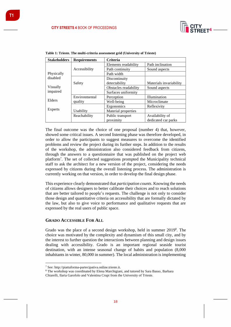
CITY STREETS 4 BOOK OF PROCEEDINGS
18
T1
Table 1: Trieste. The multi-criteria assessment grid (University of Trieste)
Stakeholders Requirements Criteria
Physically
disabled
Visually
impaired
Elders
Experts
Accessibility
Elements readability Path inclination
Path continuity Sound aspects
Path width
Safety
Discontinuity
detectability Materials invariability
Obstacles readability Sound aspects
Surfaces uniformity
Environmental
quality
Perception Illumination
Well-being Microclimate
Usability
Ergonomics Reflexivity
Material properties
Reachability Public transport
proximity
Availability of
dedicated car parks
The final outcome was the choice of one proposal (number 4) that, however,
showed some critical issues. A second listening phase was therefore developed, in
order to allow the participants to suggest measures to overcome the identified
problems and review the project during its further steps. In addition to the results
of the workshop, the administration also considered feedback from citizens,
through the answers to a questionnaire that was published on the project web
platform7. The set of collected suggestions prompted the Municipality technical
staff to ask the architect for a new version of the project, considering the needs
expressed by citizens during the overall listening process. The administration is
currently working on that version, in order to develop the final design phase.
This experience clearly demonstrated that participation counts. Knowing the needs
of citizens allows designers to better calibrate their choices and to reach solutions
that are better tailored to people’s requests. The challenge is not only to consider
those design and quantitative criteria on accessibility that are formally dictated by
the law, but also to give voice to performance and qualitative requests that are
expressed by the real users of public space.
GRADO ACCESSIBLE FOR ALL
Grado was the place of a second design workshop, held in summer 20198. The
choice was motivated by the complexity and dynamism of this small city, and by
the interest to further question the interactions between planning and design issues
dealing with accessibility. Grado is an important regional seaside tourist
destination, with an intense seasonal change of habits and population (8,000
inhabitants in winter, 80,000 in summer). The local administration is implementing
7 See: http://piattaforma-partecipativa.online.trieste.it. 8 The workshop was coordinated by Elena Marchigiani, and tutored by Sara Basso, Barbara
Chiarelli, Ilaria Garofolo and Valentina Crupi from the University of Trieste.

CITY STREETS 4 BOOK OF PROCEEDINGS
19
T1
innovative projects for public spaces, with a specific attention to green networks,
walkability and cycling. The two most relevant planning initiatives concern a plan
for the removal of architectural barriers (PEBA)9, and a plan for sustainable urban
mobility; however, further work is needed towards their integration into general
and extensive urban strategies.
The workshop approach was, again, based on direct practice of the city. For two
weeks professors and students walked across urban spaces, met technicians from
the Municipality and the Region, and took part into surveys with disabled people's
associations. A core activity was the organisation of training seminars on
accessible cities, given by experts engaged in national planning and design
experiences, and aimed at providing inputs both to the administration, and to
professionals and citizens. Meanwhile, design work focused on proposals for
healthy and green infrastructures: itineraries connecting the most residential parts
of the city to the parks and pedestrian areas at the back of the beach. The challenge
was to imagine Grado as a small capital of active life, where everyone can move
safely, all year long. As a city where collective spaces and equipment work in an
integrated manner, offering to the largest number of people the opportunity to
perform outdoor activities; where tourism can become a lever to develop
economies, but also to upgrade the quality of everyday life.
The selection of the streets and paths to refurbish was oriented by considerations
on a larger, urban scale. Projects took the public facilities already available in the
residential area – schools, parks, sports equipment, healthcare facilities for the
elderly – as keystones of the new urban route and of the whole system of soft
mobility. On a more detailed scale, the proposals focused on opening up the fences
of public buildings and plots and on redrawing their intermediate spaces with the
streets, in order to multiply and offer their services to a larger variety of users. The
solutions consisted in the design of flexible collective spaces, where casual
encounters and interactions can take place; where inclusive playgrounds and
equipment for outdoor activities are not conceived as intrusive furniture, but as an
integral part of multitasking, changing in time and inter-linked urban spaces,
inviting to freely act in the city. In all the projects, green materials and strategies
for making urban soil more permeable and resilient to climate change were among
the main ingredients, showing how accessibility, health and environmental issues
can be jointly addressed in ordinary interventions on public spaces. Wherever
possible, the students’ solutions converged on the increase of pedestrian areas and
of lanes specifically dedicated to bikes (separation of walking and cycling was
recognised as necessary and welcome by all the users), combined with the
reorganisation of parking facilities and public transport services. In line with the
9 In Italy PEBAs were established by the law no. 41/1986; they concern all existing public
buildings, and should have been adopted within one year of the enactment of the law. In 1992
another national law (no. 104) added the obligation to integrate them with provisions referring to
accessibility to open spaces. However, the compulsory nature of these instruments was nullified by
the lack of sanction measures, and the Municipalities that have approved a PEBA are still very few.

CITY STREETS 4 BOOK OF PROCEEDINGS
20
T1
EU Road Safety Policy Framework 2021-2030 and the advice provided by the
European Transport Safety Council (2020), when the co-presence of different
mobility modes in the same space could not be avoided, the proposal was to design
30 km/h streets: public spaces that are meant to protect the most vulnerable road
users, by hosting cars in reduced vehicular areas, adding chicanes and trees to
articulate the street section and force to reduce speed. A common ingredient to all
the interventions was, however, the creation of a continuous system of pedestrian
crossing platforms and pavements, where the choice of surface materials and the
location of street furniture could help orientation and avoid obstacles, not only to
persons with motor and sensory disabilities, but to anyone (let’s think about the
difficulties in carrying a baby stroller!) (Figures 1, 2).
Figures 1, 2: Grado. On the left, 30 km/h streets; on the right, spaces in-between sports
equipment and the street (University of Trieste)
The workshop strengthened the awareness that inclusive design is not synonymous
with special or sectorial. The challenge is to design without barriers from the very
beginning, taking the perspective of the most fragile persons to conceive spaces
that are walkable by everyone, and trying to negotiate in advance the conflicts
among different persons and ways/capabilities to move (pedestrians vs. cyclists,
motor vs. visual or cognitive abilities). Indeed, one of the workshop outcomes was
the awareness that the main obstacles to proactive cities are not to be found in the
lack of detailed technical solutions (that, in fact, urban planning, regulations and
design have already developed to a large extent), but in the difficulty in combining
them as average and interconnected components of a different (and multiscale) way
to transform our cities into people-centred and environmentally sustainable
habitats.

CITY STREETS 4 BOOK OF PROCEEDINGS
21
T1
INPUTS FROM DESIGN EXPERIENCE
The research activities and spatial solutions developed in Trieste and Grado
provided general methodological inputs on accessibility for all planning and
design. More than the mere application of building and planning standards and
regulations, a first group of inputs refers to the pivotal role recognised both to the
direct analysis of the spatial contexts (and of their constraints against soft and
autonomous mobility), and to the listening of the actual needs of those who
everyday practice them. The perceived usability of a place goes well beyond the
absence of single sensory and architectural barriers. It refers, instead, to an
articulated set of physical and behavioural variables, whose impacts differ
according to the types of disability, and that deeply influence the propensity to
freely move across urban space. When we design public spaces, we should design
for everyone, to guarantee the access to public services and equipment while
considering individuals’ different functioning. Talking about Universal Design
means providing high quality urban spaces, whereas the combination of the issues
of soft mobility and accessibility for all prompts to reconceive the material
configuration of a city as a welfare service itself. A service that both plays a
strategic prevention and therapeutic role in promoting healthier conditions (for the
urban environment and for its inhabitants), and helps fight against the exclusion of
growing numbers of at-risk urban populations (persons with disabilities, living in
institutionalised settings, with limited language proficiency, who are transportation
disadvantaged for social and economic reasons, as well as the children, the elderly,
etc.) (DIAUD/CBM, 2016).
In this view, participatory surveys and mapping help understand and negotiate the
often-conflicting effects of disenabling spaces, and search for more inclusive
solutions. In Italy as well as all over Europe, since many years, the adoption of
participatory approaches in design (and, specifically, in placemaking processes and
projects for inclusive public spaces10) has been recognised as fundamental and
highly recommended. However, when these approaches are not given as
compulsory by national and regional laws, they are often ignored. This in spite of
the evident value that the understanding of the end users’ needs can add to
designers’ creativity and to the effectiveness of their projects. In Italian legislation,
what comes closest to the concept of participation in design – that is the Public
Debate – is formally required only for the adoption of large-scale infrastructural
and architectural works of social relevance. In addition, public debate can also be
activated for other types and scales of interventions, but only if requested by a
sufficient number of citizens (Codice dei contratti pubblici, Legislative Decree no.
50, 18 April 2016). This situation highlights the importance of raising awareness
on the right to participate in decision-making processes. The activities carried out
by the University in the frame of the so-called public engagement third mission
10 An important role has been played by EU projects and initiatives. Among the others, URBACT;
see https://urbact.eu/how-participatory-placemaking-can-help-urbact-local-groups-develop-urban-
actions-public-spaces-our

CITY STREETS 4 BOOK OF PROCEEDINGS
22
T1
(establishment and strengthening of collaboration with local contexts and
stakeholders) precisely go in this direction. The dissemination and sharing of good
practices as well as the organisation of curricular and/or continuous training
programs – such as those accompanying the experiences that we have developed
so far – feed innovation processes, providing skills to all the involved actors: the
students (as future experts); the territorial administrations in charge of urban
policies; and the civil society, whose voice can be strengthened through a better
knowledge on possible solutions for urban accessibility.
Trying to match and co-ordinately address a variety of conflicting issues
(prioritisation of traffic flows and parking, safety and comfort of pedestrian and
cycling mobility, needs of persons with different disabilities) concretely shows to
be a wicked problem (Rittel, Webber, 1973). A problem that has many
reverberations on spatial justice (Sorkin, 1999) which, however, are still largely
underestimated by urban policies. A further group of inputs concerns the
importance of harmonising the variety of planning tools, building procedures and
regulations that more or less directly deal with soft mobility and accessibility, but
are often managed by local administrations in a sectorial way. Relying the
improvement of accessibility on the implementation of single thematic tools (i.e.
PEBAs) shows evident limits. In fact, the mapping of the physical obstacles to
people’s movement – although extensive, accurate and sided with the costs
necessary to their removal – tends to reduce the complex theme of accessibility to
a punctual and remedial approach. On the contrary, its assumption as a structural
component of ordinary and general town plans can more effectively build a
reference vision, able to coordinate the timing and contents of the many
programmes and public/private interventions that materially affect the usability of
collective spaces (i.e. traffic, mobility and parking plans, public works, permissions
for commercial occupation, etc.). When talking about healthy and active cities, no
less important is the need to overcome the persistent misalignments between
planning instruments on the one hand, housing, social and healthcare programs
meant to rule the territorialised organisation of welfare services on the other. This
further highlights the importance to foster a radical change in the routines that still
guide local administrations, in order to break the persistence of a silos thinking
approach, and to strengthen the coordination among urban policies, disciplines and
actors involved in urban transformations.
OPEN CONCLUSIONS
PROACTIVE CITY is still underway, and new operational fields have recently
opened up thanks to an agreement signed by the Universities of Trieste and Udine
with the Region Friuli Venezia Giulia. The request is to provide support to enacting
the regional law no. 1/2018, General Principles and Implementation Provisions on
Accessibility. By taking the perspective of Universal Design, the aim is to develop
a laboratory for the innovation of public policies, where the Region and the local
administrations work together to rethink the contents of planning tools (starting

CITY STREETS 4 BOOK OF PROCEEDINGS
23
T1
from PEBAs, but fostering their integration into general urban plans, public works
and private interventions). Planning guidelines, a georeferenced web portal
providing a regional database on accessibility to main public facilities, its further
implementation through the surveys made by the Municipalities on the basis of
methodological addresses and ICT tools, the organisation of participatory and
training activities: these are the main results of a process where administrative staff,
researches, professionals and civil society will be actively engaged. In more
general terms, starting from the results of previous research by design activities
developed by PROACTIVE CITY, the assumption of the lens of accessibility is
meant to help reformulate planning/building standards and spatial solutions, in
order to overcome a purely quantitative and functional conception, and to introduce
new performance and qualitative criteria to implement conditions of sustainable
and inclusive mobility connecting public spaces and equipment11.
Today, putting accessibility for all at the core of technical and political debate
becomes even more strategic and urgent in the view of post COVID-19 quarantine
measures, stressing the importance of re-furbishing urban spaces to make them
walkable and usable to the largest extent of urban populations. During the first
phase, lockdown and social/physical distancing have mainly affected the most
fragile persons (the disabled, the elderly, children), preventing or making even
more difficult the autonomous access to fundamental services and open spaces.
Now, the starting of a new phase prompts more careful reflection on how to
reorganise both welfare facilities (mainly healthcare and education), and the
accessibility to those public spaces that can offer the opportunity to safely
reactivate social and healthy practices (mainly parks and streets). If in many cities
all over the world the realisation of pop-up bike lanes and pedestrian areas are being
assumed as a solution to a limited use of public transport, adapting spaces and
material connections according to accessible for all criteria cannot be postponed.
The risk is – again – not to consider the importance that urban spatial setting plays
in the definition of health and equity conditions, and to miss the opportunity to take
pandemic as the driver of significant urban welfare and policies reforms. Our
choice can, therefore, place itself between two extreme scenarios: on the one hand,
the worsening of spatial/social/functional disparities by providing only sectorial,
targeted and temporary solutions; on the other, the opening up of a new phase for
sanitary and governance assets in the cities (as it has somehow already happened
after nineteenth epidemics) (Pineda, Corburn, 2020). Even stronger is, however,
the responsibility of university and research in providing technical and cultural
inputs, and in the promotion of actions aimed at raising awareness of the issues of
inclusion and the enhancement of diversity.
11 See the regional Planning guidelines on:
http://www.regione.fvg.it/rafvg/export/sites/default/RAFVG/infrastrutture-lavori-
pubblici/FOGLIA1/allegati/14072020_linee_guida_PEBA.pdf.

CITY STREETS 4 BOOK OF PROCEEDINGS
24
T1
REFERENCES
Bencini, M.L., Garofolo, I., Arenghi, A. (2018). Implementing Universal Design and the
ICF in Higher Education: Towards a Model That Achieves Quality Higher Education for
All. In: G. Craddock et al. (eds.), Transforming Our World Through Design, Diversity
and Education. 464-472. IOS Press.
Commission on Social Determinants of Health (2008). Closing the Gap in a Generation:
Health Equity Through Action on the Social Determinants of Health. Retrieved from
https://www.who.int/social_determinants/thecommission/finalreport/en
DIAUD/ CBM (2016). The Inclusion Imperative: Towards Disability-Inclusive and
Accessible Urban Development – Key Recommendations for an Inclusive Urban Agenda.
Retrieved from https://www.susana.org/en/knowledge-hub/resources-and-
publications/library/details/3080
European Commission (2019). The European Green Deal. Retrieved from
https://ec.europa.eu/info/strategy/priorities-2019-2024/european-green-deal_en
European Transport Safety Council (2020, January). How Safe is Walking and Cycling in
Europe? Retrieved from https://etsc.eu/how-safe-is-walking-and-cycling-in-europe-pin-
flash-38
Garofolo, I., Chiarelli, B., Grion, S. (2018). Percorsi inclusivi e partecipati per la
fruibilità degli spazi urbani: il caso studio LabAc. In: F. Angelucci (ed.), Smartness e
Healthiness per la transizione verso la resilienza. Orizzonti di ricerca interdisciplinare
sulla città e il territorio. 307-324. Franco Angeli.
Garofolo, I., Marchigiani, E. (2019). Accessibility and the City. A Trieste, dispositivi e
pratiche progettuali per attenuare le vulnerabilità sociali. In: Aa.Vv., Atti della XXI
Conferenza Nazionale SIU. Confini, movimenti, luoghi. Politiche e progetti per città e
territori in transizione. 91-98. Planum Publisher.
Kaufmann, V. (2011). Rethinking the City. EPFL Press.
Pineda, V.S., Corburn, J. (2020). Disability, Urban Health Equity, and the Coronavirus
Pandemic: Promoting Cities for All. Journal of Urban Health, 23 April. 1-6.
https://doi.org/10.1007/s11524-020-00437-7
Rittel, H.W., Webber, M.M. (1973). Dilemmas in a General Theory of Planning. Policy
Science, 4(2). 155-169.
Sen, A. (1987). Commodities and Capabilities. Oxford University Press.
Sorkin, M. (1999). Introduction: Traffic in Democracy. In: J. Copjec, M. Sorkin (eds.),
Giving Ground: the Politics of Propinquity. 1-18. Verso.
United Nations. (2016a). The Sustainable Development Agenda 2030. Retrieved from
https://sustainabledevelopment.un.org/post2015/transformingourworld
United Nations. (2016b). Good Practices of Accessible Urban Development. Retrieved
from
https://www.un.org/disabilities/documents/desa/good_practices_in_accessible_urban_dev
elopment_october2016.pdf

CITY STREETS 4 BOOK OF PROCEEDINGS
25
T1
E-SCOOTERS IN URBAN AREAS – A VIABLE INNOVATION OR
SOURCE OF NEW CONFLICT POTENTIAL?
Raphael David Saalmann1 MSc, BSc, University of Graz, A-8010 Graz, Heinrichstraße 36, [email protected]
Wolfgang Fischer Dr. Mag., University of Graz, A-8010 Graz, Heinrichstraße 36, [email protected]
Sabrina Reinbacher MSc, BSc, BSc, University of Graz, A-8010 Graz, Heinrichstraße 36, [email protected]
ABSTRACT
Electric scooters (e-scooters) have appeared in many cities since 2017. As a kind
of micro-mobility, they are used by nearly all segments of society, even though they
do not have clear use-cases or benefits. This paper shows the potential of the
current market, Austrian laws for electric scooter usage and the specific
characteristics of Vienna as the major competitive market for shared devices in
Austria. Present conflicts and processes are illustrated and analyzed with
structured and semi-structured interviews. The findings show that complex
processes of market maturation are still ongoing, which result in a great deal of
structural modifications and restrictions. These could turn dockless sharing into a
highly regulated system. An integration into existing urban mobility options has
not occurred yet, and proper concepts for its implementation are missing.
Keywords: e-scooter, e-mobility, micro-mobility, free-floating, sharing economy
INTRODUCTION
In the last few decades, human mobility behavior has changed fundamentally.
Urbanization and a rising number of people with demand for mobility caused not
only the private transport sector to increase in size dramatically, but also to reach
capacity of public (local) transport. For that reason, cities tend to develop forms of
sustainable transportation that defuse this situation. Confined urban spaces are cut
out to be used by forms of micro-mobility. Micro-mobility is based on easy to
handle means of transportation for people of all ages that appear to be cheap.
Furthermore, they adopt the concept of a sharing economy (sustainable use of
products by sharing instead of owning them).
1 Corresponding author

CITY STREETS 4 BOOK OF PROCEEDINGS
26
T1
A relatively new form is the use of e-scooters both privately and rented. This
market segment is growing substantially, but lacking experience. Therefore, it is to
question whether e-scooters will develop into being a useful form of urban mobility
in the future or a potential source of new conflicts.
This paper investigates the potential and value added by e-scooters in urban
mobility development, and outlines strengths and weaknesses of their use and
supply with a focus on Vienna. Vienna, being the capital, is the biggest city of
Austria with a population number of about 1.9 million and is continuously rising
(2019). The city is characterized by a high life quality and a great number of tourist
attractions which made it one of the most visited cities of Europe. At the same time
conflicts were identified and analyzed. As especially rental forms dominate the
urban image and seem to be an interesting extension of the sharing economy, e-
scooter rental companies are being focused on. During the investigations, a mixed-
method approach was used. Expert interviews based on guiding questions, semi-
structured interviews of e-scooter rental companies, users and other traffic
participants, as well as field tests, were performed.
CURRENT SITUATION AND DEVELOPMENT IN AUSTRIA
E-scooters reach a medium range of 25 km and can therefore be declared as short
distance vehicles. The devices reach a maximum speed of 25 km/h and a maximum
engine power of 600 Watts. Charging lengths vary between four and seven hours,
depending on brand and model. They are not to be confused with e-mopeds
(German: E-Scooters). Differences are listed in the following Table 1.
Table 1: Comparison of E-Roller and E-Scooters in Austria (own illustration, adopted from
BMDW 2019, Klima- und Energiefonds 2019 & ÖAMTC 2019)
(English term) E-Roller (e-scooter) E-Scooter (e-moped)
traffic legislation bicycle moped (motor vehicle)
authorized to be
operated on public
streets
only when there is no bike
lane
yes
driving license no yes
maximum speed 25 km/h 45 km/h
maximum engine power 600 W 600 W - 4 kW
requirement to wear a
helmet
no yes
compulsory registration
and insurance
no yes
age limit 12 years (younger children
need to be accompanied by
a person older than 16, or
have a bicycle license)
15 years
alcohol limit (permille) 0,8 0,5
federal grant no up to 350 Euros

CITY STREETS 4 BOOK OF PROCEEDINGS
27
T1
In Austria, there is no compulsory registration and insurance, which contributed to
an easy market entrance for e-scooters. Legally, since 2019 e-scooters are treated
like bicycles in Austria (30./31. StVO Novelle). First e-scooter rental companies
already established in 2018 in Vienna, being the only Austrian city at the time that
started to treat e-scooters like bicycles. In Austria, there were eleven rental
companies (December 2019), not all of them operating in Vienna. Current
implementations are characterized by using a free-floating system, i.e. e-scooters
can be parked/picked up anywhere within predefined areas (see Figure 1).
In contrast to private use, which is allowed from an age of 12 years on, the use of
rental e-scooters meets further requirements. First, users must be at least 18 years
old. Second, users need to have a smartphone with internet access and GPS
enabled, and they need to download an individual app provided by the rental
company. Lastly, payment is usually only possible by debit card or online payment
using services like PayPal.
As e-scooters are treated like bicycles, it is obligatory to use bike lanes. The use of
sidewalks and pedestrian areas (between 6 a.m. and 10 p.m.) is not allowed. Also,
driving “in public green spaces and other areas that are important for the urban
image” is prohibited (Magistrat der Stadt Wien, MA 65, 2019). Due to being
handled like bicycles, there is no statistical differentiation possible, and in further
consequence, there is no precise information about e-scooter usage. In 2019 there
was a limit of 1500 e-scooters per rental company in Vienna. That led to a
maximum number of 10500 devices. They are not equally distributed in all urban
districts (the focus lies on inner city areas), which leads, among other issues, to a
low acceptance by users (Pichler 2019). Other problems are recklessness, illegal
parking and conflicts with bicyclists and pedestrians. Further regulations were
planned for the beginning of 2020 (ORF 2019a).
RESULTS
Supply Side
Data from suppliers was collected using an online survey. It included open
questions especially concerning challenges, the latest findings about the current
business in Vienna and the evaluation of the future potential of e-scooters. Only
two out of seven suppliers in Vienna (LIME and TIER) responded, resulting in a
limited point of view and comparison.
Both emphasize that urban space is limited, and the number of people and vehicles
is increasing while emissions must be reduced. Protection of the environment and
life quality are important factors too. Therefore, sustainable and attractive new
forms of mobility become necessary. In general, they see a higher urban potential
and call for a higher number of e-scooters allowed.

CITY STREETS 4 BOOK OF PROCEEDINGS
28
T1
Profitability must go along with sustainability, also including a high life
expectancy of their devices. However, the current competitive market and
profitability in general are challenging. Different weather conditions are causing
problems as well.
Concerning costs, there is a basic charge of 1 or 2 Euros (depending on the number
of trips) and additional 20 Cents per minute. This is, relative to ticket prices of
public transport, quite high. Suppliers hence emphasize that e-scooters are not
alternatives to public transport, but an additional form of individual mobility. In
comparison, buying a low-price e-scooter for private use costs about 500 Euros.
By an average use of 10 km on five days a week a purchase pays of within three
months (based on a relatively high assumed constant driving speed of 20 km/h).
There is also potential in collecting and using the generated GPS data.
Consequently, the supply could be adapted to public interests, user behavior and
therefore organized more efficiently.
Figure 1: E-Scooters offered by rental companies in Vienna (photo: Raphael Saalmann 2019)
Demand Side
On the demand side, five random users (using rented and private devices) in the
first district of Vienna were individually and situationally questioned. They were
asked about their motivation to use e-scooters, their general opinion about e-
scooters and experiences in usage as well as upcoming challenges and possible
suggestions for improvements. They mentioned advantages concerning commute
time, ease of handling, and the ability to take them along in other means of (public)
transport. However, they also complained about the lack of comfort and
inconvenient locking. Besides, e-scooters do not have blinkers. Unlike riding a
bike, giving a hand signal while driving one-handed is dangerous and impractical.
Driving at night feels uncomfortable too. Users ask for expanded riding paths in
order to be safely separated from cars. Nevertheless, also misbehavior by users,
like two people driving on one scooter, can be observed.

CITY STREETS 4 BOOK OF PROCEEDINGS
29
T1
In a separate self-test, we experienced that a certain speed is necessary to activate
the e-motor. As other users already noted, driving on streets, or making a turn,
considering traffic and traffic rules turned out to be difficult. Another disadvantage
concerning the individual comfort is a missing basket or luggage rack.
Third Parties
Similar questions were used during interviews with several third parties, as for
instance Mobilitätsagentur Wien (Vienna Mobility Agency), working at the
interface between population, city administration, suppliers and policy and serving
as place to go for advice or criticism concerning mobility. Frequent complaints
about incorrect parking of e-scooters reach them. Also, there seems to be usage
insecurity. They further told about upcoming infrastructural challenges and limits,
as well as needing to gain more experience. Overall, they support active forms of
mobility and see e-scooters as a means of connection to public transport and rents,
and as part of a sharing-strategy. Dealings between all participants are described
as well-organized and in a good condition. However, they doubt whether e-scooters
effectively reduce car traffic.
Other traffic participants (N=9) like pedestrians, cyclists and car drivers have
differing opinions. Some react sympathetic, others complain about recklessness
and the violation of traffic rules by e-scooter users, vandalism and incorrect
parking, especially on footpaths. The national lobby of cyclists aims at boosting
non-motorized traffic and enhancing the traffic situation for cyclists. They
accentuate that the infrastructure for bikes must be extended urgently in Austrian
cities and that pedestrians should not have to share their space with vehicles like e-
scooters (Radlobby Österreich 2019). Another important interest group are blind
people who participate in traffic as pedestrians. In an e-mail interview with
Blinden- und Sehbehindertenverband Wien, Niederösterreich und Burgenland
(BSV-WNB) was stated that e-scooters, just as bicycles, are hard to notice by
(partially) blind people. The problem is that e-scooters, as already noticed by the
national lobby of cyclists, are frequently driven and parked on footpaths causing
higher potential risks, disregarding the needs of the blind.
Another interview partner was the Austrian Institute of Technology (AIT) who
works on a project called e-WALK, where potential impacts of daily use of e-
vehicles on pedestrians are investigated. They focus on how they can effectively
perform as a shuttle to other means of mobility and public transport. E-scooters
might be used by all age groups and different social classes. Surveys show that that
e-scooters are used predominantly for short distances, instead of using public
means of transportation. This, however, results in a rising pressure on the bicycle
infrastructure. AIT also calls on more public awareness and underlines the lack of
knowledge about proper behavior rules.
CITY STREETS 4 BOOK OF PROCEEDINGS
30
T1
Lastly, suppliers of public transport are included in the discussion around e-scooter
regulations, especially when it comes to transportation of e-scooters in public
vehicles. At the moment, Wiener Linien (Vienna’s public transport operator) count
e-scooters as hand luggage. Its transportation is free, but they must be folded. The
ÖBB (Austrian Federal Railways) specify a maximum size of 90 cm x 60 cm x 40
cm (ÖBB 2019). The lacking possibility to safely arrange them might be another
(critical) issue.
FURTHER ISSUES
Environment
There are a few different factors regarding e-scooters that cause concerns about
effects on the environment. One of them is the short life span and high attrition,
also due to vandalism, which demands the use of more resilient materials. Also,
they cause relatively high CO2-emissions per kilometer (regarding the whole value
chain: materials, production, transport, and disposal over two years of use)
(Hollingsworth et al. 2019).
Another problem deals with collecting rented e-scooters when they are parked
incorrectly or when it is necessary to charge them. This often happens with the use
of fossil-fueled powered vehicles, which does not fit the spirit of sustainability.
Instead, exchangeable batteries could be installed so that charging is not necessary
anymore. The new batteries could then be exchanged on site. However, frequent
charging must be reduced, and it is debatable how batteries should be disposed and
recycled (ORF 2019b).
Accidents
In Austrian statistics, there is no differentiation between accidents of (e-)bicycles
or e-scooters. There is a rising number of accidents, injured people and traffic
deaths in that category. Unfortunately, it is not possible to find out whether a rising
number of e-scooters contributes to that number. Hence, clear statements of
strengths and weaknesses of e-scooters cannot be discussed. Conflicts and
accidents might be ascribed to driving on pathways and the fact that only about 2
% (users of rental vehicles) to 10 % (private users) are wearing a helmet (KFV
2019).
INTERPRETATION OF THE RESULTS
Despite the limited respondence both on supply and demand side, in combination
with the opinions of several third parties some general insights of e-scooter usage
can be generated and interpreted.

CITY STREETS 4 BOOK OF PROCEEDINGS
31
T1
In Austria, the legal basis for e-scooter usage seems to be quite liberal. The e-
scooter market, especially in Vienna, shows a tendency to grow, and a
consolidation is to be expected (however, some have already given up or
withdrawn from the market due to pandemic reasons in early 2020). In general, it
is assumed that there is a high acceptancy of e-scooters given a high market
competition and a high density of rental devices in the inner-city parts of Vienna.
Further, it is said that renting an e-scooter may serve as an opportunity to test them
in order to decide on a private purchase. From a user´s point of view, the high
number of suppliers may at first seem beneficial, but requires an individual app,
account, payment service etc. for each as there is no cooperation between suppliers
yet. Advantageous is for sure a missing compulsory insurance, which leads to less
costs and sanctions, at least for users.
E-scooter rental systems have the character of a sharing economy based on free-
floating, where it is allowed to park the e-scooters within a defined area, without
determining explicit parking zones. However, first regulations concerning
restricted parking zones and speed limits have been discussed and implemented.
Fixed parking spaces would counteract the system of free-floating. Moreover, there
is a lack of theft-proof equipment for parking. Another point to mention is that
dangers and risks of the use of e-scooters are underestimated. For that reason, far
more public awareness must be generated.
CONCLUSIONS
E-scooters are a controversial topic. Are they a viable innovation or a source of
new conflict potential? The market for e-scooter rents developed since 2017, so it
is a very young and dynamical field, yet improvable. For now, legislation is
structured quite simply. Problematic is the lack of missing data concerning
accidents or traffic offence caused by e-scooters, as they are not classified
separately.
Criticism by users is mainly about technical features. There is also a call for better
infrastructure, since there is an expected overuse of bike lanes. This might lead to
their expansion or even the need for newly built constructions, as sharing existing
paths is not an optimal solution. Challenges are also about greater awareness and
sticking to traffic rules, also caused by a lack of sensitization about e-scooters and
their use in daily traffic. It is questionable whether e-scooters lead to a reduction
of motorized vehicles. They are rather an addition to the existing mobility supply.
Parking restrictions must be avoided to ensure the system of free-floating.
In conclusion, more adaptations must be made to enhance the use of e-scooters and
the situation for other traffic participants. Nevertheless, as part of being a trend, e-
scooters contribute to the ongoing debate about multimodal mobility and
distribution of certain traffic and living spaces not only in Vienna but also in other
cities of comparable size and setting.

CITY STREETS 4 BOOK OF PROCEEDINGS
32
T1
REFERENCES
BMDW (Bundesministerium für Digitalisierung und Wirtschaftsstandort). (2019, October
10). Elektro-Scooter, Quads & Co. Ministerien-übergreifende Informationswebsite.
Retrieved from https://www.oesterreich.gv.at/themen/freizeit_und_strassen-
verkehr/Elektro-Scooter,-Quads-und-Co.html
Hollingsworth, J., Copeland, B. & Johnson, J. X. (2019, November 11). Are e-scooters
polluters? The environmental impacts of shared dockless electric scooters. Retrieved
from https://iopscience.iop.org/article/10.1088/1748-9326/ab2da8/pdf
Klima- und Energiefonds (2019). Leitfaden Elektro-Zweiräder, Elektro-Fahrräder sowie
Transporträder. Jahresprogramm 2019.
KFV (Kuratorium für Verkehrssicherheit). (2019, December 16). E-Scooter: Neue KFV-
Analyse zeigt hohe Unfallzahlen und großen Aufklärungsbedarf. Retrieved from
https://www.kfv.at/escooter2019/
Magistrat der Stadt Wien, MA 65 (2019). Verordnung des Magistrats der Stadt Wien, mit
der die Verordnung des Magistrats der Stadt Wien betreffend stationslose Mietfahrräder,
Amtsblatt der Stadt Wien Nr. 26/2018, geändert wird. Amtsblatt der Stadt Wien Nr.
26/2019.
ORF (Österreichischer Rundfunk). (2019a, November 25). „Konstruktives“ Treffen zu E-
Scootern. Retrieved from https://wien.orf.at/stories/3018715/
ORF (Österreichischer Rundfunk). (2019b, December 08). E-Scooter-Entsorgung oft
problematisch. Beitrag. Retrieved from https://wien.orf.at/stories/3023412/
ÖAMTC (Österreichischer Automobil-, Motorrad und Touringclub). (2019, November
14). Kleinfahrzeuge & Trendsportgeräte im Straßenverkehr. Retrieved from
https://www.oeamtc.at/thema/kindersicherheit/kleinfahrzeuge-im-strassenverkehr/
ÖBB (ÖBB-Personenverkehr AG). (2019, December 16). Handbuch für Reisen mit den
ÖBB in Österreich. Tarifbestimmungen mit den Allgemeinen Geschäftsbedingungen. A.4.,
Mitführen von Gepäck, Gegenständen und Tieren. Retrieved from
https://www.oebb.at/static/tarife/de/handbuch_fuer_reisen_mit_der_oebb_in_oesterreich/i
ndex.html
Radlobby Österreich. (2019, November 14). E-Scooter: rechtlich wie Fahrräder
benutzbar. Retrieved from https://www.radlobby.at/e-scooter
Saalmann, R. D. (2020). E-Roller im urbanen Raum – eine praktikable Innovation oder
Quelle eines neuen Konfliktpotenzials? Masterarbeit, Institut für Geographie und
Raumforschung, Karl-Franzens-Universität Graz.

CITY STREETS 4 BOOK OF PROCEEDINGS
33
T1
CITY TRANSPORT AND SOCIAL INCLUSION, A CASE STUDY OF
STUDENT DORMITORIES’ COMMUNITY IN LJUBLJANA
Zala Bokal Msc student of Urban planning, Faculty of Architecture, University of Ljubljana, Zoisova ulica 12, 1000 Ljubljana, [email protected]
ABSTRACT
Transport related social exclusion the process by which people are prevented from
participating in the economic, political and social life due to insufficient mobility.
Substantial research is therefore important to understand the causes, factors and
outcomes regarding travel practices and social inclusion in local communities.
The following study is aiming to note, observe and disclose the use of transport
systems and services by the students, inhabiting specified six student dormitories
in Ljubljana and to investigate its relation and impacts on investigated students’
notion of being socially included in the city.
The three main questions that this research is seeking to answer are: 1) What city
public transport options are available to the students inhabiting selected student
dormitories in Ljubljana? 2) What are the characteristics of the transport services
use of surveyed groups of students? 3) What relations could be detected observing
the notion of personal social inclusion and their use of city transport among
investigated groups and what could be their explanations and interpretation?
Relations and impact on student’s notion of social inclusion is evaluated through
survey results comparison between different dorm sites resident’s groups.
Transport and other city policies, improving social inclusion and thus support the
social sustainability goal.
Keywords: Ljubljana, Social inclusion, Student community transport use, Student
dormitories, Transport-related social inclusion
INTRODUCTION
Transport-related social inclusion
Social Inclusion refers to people’s ability to participate adequately in society,
including education, employment, public services, social and recreational
activities. Social exclusion refers to constraints to adequate participation. Many

CITY STREETS 4 BOOK OF PROCEEDINGS
34
T1
factors can affect social inclusion. Ignorance, poverty, language barriers, racism
and classism can limit people’s ability to participate in some activities. (Litman,
T., 2003).
Although social exclusion involves many issues in which transport dimension is
peripheral (Kamruzzaman, et al., 2016), transport is crucial in enabling people to
reach essential opportunities and desired goods, services, activities, destinations as
well as social networks (Kenyon et al., 2002) and relationships (Stanley and
Stanley, 2017). Thus, the accessibility of transport is an important factor of social
inclusion. On the contrary, problems with transport provision, location of services
and therefore insufficient mobility in a society and environment built around the
assumption of high mobility (Kenyon et al., 2002), can reinforce social exclusion
(Social Exclusion Unit, 2003).
Assuming that a just society ensures participation in society to its entire members
and is therefore an inclusive society, mobility-related exclusion is the process by
which people are prevented from participating in the activities of economic,
political and social life of the community because of reduced accessibility to
opportunities (Kenyon et al., 2002). Of that importance, it is even highlighted by
various transport researchers to establish the “mobility rights” and “accessibility
rights” of citizen to combat social exclusion (Kamruzzaman et al, 2016).
Researching the transport-related social inclusion
When Kamruzzaman, et al. (2016) reviewed the effectiveness of investigating
social inclusion using various quantitative measures of transport disadvantage, four
groups of criteria were identified as related to the issues of 1) spatial (e.g., urban
accessibility, and public transport accessibility), 2) temporal (e.g., public transport
availability, and facility opening hours), 3) social attributes of travel and 4) activity
participation (e.g., personal mobility, and disability).
Broad research in European urban contexts is focused on transport issues and urban
accessibility as a key factor of transport-related social inclusion (e.g. Pérez-
DelHoyo, R., et al., 2017), its effectiveness and enhancement using Information
and Communication Technology – ICT, e.g. L. Martins et al. (2020), approaching
the design of a public transport route-planner in order to promote social inclusion
and Ricci et al. (2016) transport policies research, that is as well exposing that the
proliferation of ICTs requires the consideration of social inclusion as not limited
to physical participation only. Another pool of research is investigating how urban
design and traffic arrangements are affecting social relations in urban spheres thus
affecting social inclusion; e.g. Sauter & Huettenmoser (2008), connecting
liveability of streets and social inclusion.
Likewise, in a locational context of Slovenia’s capital city Ljubljana, Gabrovec &
Razpotnik Visković (2018) researched the accessibility of public passenger
transport as a condition for social inclusion of secondary-school students or in

CITY STREETS 4 BOOK OF PROCEEDINGS
35
T1
another study conducted by Tomšič & Rugelj (2016), the use of urban passenger
transport is disclosed as an important factor in the social inclusion of older people
was investigated.
Both mentioned works are researching the travel related social deprivation of a
specific focus group operating in a specified area. This is a prerequisite to a
meaningful research contribution that can support the development of
quantification and analysis of the social impacts. Those are to be considered in
transport policies planning as efforts to address transport-related social exclusion,
that are mostly implemented at the local level (Litman, T., 2003). The transport
related social-inclusion issue is indeed multidimensional, dynamic and highly
relational (Ricci M., et al. 2016). As Litman, T. (2003) argue that not everybody in
each category faces severe social exclusion under all circumstances, posing an
assumption that transport needs tend to be relative, depending on communities’
level of accessibility and social expectations. Furthermore, the impacts and benefits
of transportation systems are often unevenly distributed across regions and
population groups Pteg. (2010).
Hence, to identify the transport disadvantaged as well as their variation in needs,
in order to minimise transport-related social exclusion, an important requirement
is to use the analysis of disaggregated data (Kamruzzaman et al., 2016) of specified
sites and focus population groups.
Students and a risk of travel-deprivation social exclusion
Students are considered as a population group recognized to possibly be at risk of
facing travel deprivation. As Urban Institute Student Transportation Working
Group (2017) argues, student transportation may also affect a student’s health and
well-being and has an impact on attendance and overall academic performance.
Additionally, student transportation can have a substantial effect on the quality of
a student’s education and the composition of their peer group. Finally,
transportation options as well allow for participation in enriching before- and after-
school activities such as study clubs, sports and outdoor activities, that can make a
significant difference to pupils’ attainment, attitude to school and attendance.
Participation in social, cultural and leisure activities is very important to people’s
quality of life and can play a major part in building cohesive communities. (The
Social Exclusion Unit, 2003).
Since the opportunities to access the above mentioned is shown to be of special
large importance for students living in rural areas (Gabrovec & Razpotnik
Visković, 2018), where travel deprivation could be a critical factor of being at risk
of social exclusion, it certainly is applying to students living in urban areas as well.
One of the reasons could be that students are presumably the category with low
rate of private car access, that is according to Stanley & Stanley (2017) in
communities, that have become increasingly car-dependent, factor of risk for
transport related social exclusion.

CITY STREETS 4 BOOK OF PROCEEDINGS
36
T1
Transport-related social inclusion and student community in Ljubljana
As stated in Sustainable Urban Strategy of the city of Ljubljana, social inclusion is
on the list of priority work axes and it is important to understand how the city
transport practices can affect it and thus support the goals of the EU 2020 Strategy.
In the city government guidelines, promotion of social inclusion is found as a
multilateral goal represented by measures of different sectors - e.g. responding to
the needs of vulnerable social groups, strengthening youth work programs, setting
up an organizational environment for housing and other cooperatives for different
purposes (new housing construction, renovation of residential neighbourhoods
etc.), implementation of green public infrastructure, development of sustainable
and smart city-oriented electronic services, elimination of built barriers in the
living environment, response to the issue of temporary accommodation and refugee
issues etc. (LJ ZATE, 2018). Obvious and crucial factor for operability of such
programs is their accessibility, including potential participants ability of physical
engagement.
Sustainable urban strategy of Ljubljana synthesizes individual development
emphases, so that the implementation of a measure of individual strategy can mean
the implementation of a measure in another, e.g. the implementation of transport
policy could have a positive effect on measures related to the field of environmental
protection as well as on the social security strategy (e.g. enabling social inclusion
through universal accessibility and a diversified public passenger transport system,
including at regional level). In this regard of transport related social inclusion, the
implementation of the City's Transport Policy is recognized as crucial at the local
community level.
Ljubljana represents a national urban hub of concentrated University and other
higher education institutions’ life. Assumed the size of its’ academic community
(only University of Ljubljana is represented by 3 art academies, 23 faculties,
libraries, and an Innovation-Development Institute), the latest generates a high
percentage of trips within the city. Students living in dormitories are presumably
as well users of city transport services. Public Institute Residence Hall Ljubljana is
managing city dormitories with the capacity to accommodate 7500 beneficiaries
all together. They encompass 35 compound units on 10 different locations within
the city. In respect to the fact that each dormitory site is uniquely incorporated in
city transport schemes, there is a question that can be posed; how do the transport
access situations affect the transport use behaviour of selected student population
and furthermore, in what manner could that affect their social inclusion?
Considering above stated, the aim of the following study is to investigate student’s
perception of their own social inclusion as it is relating to their use of transport.
CITY STREETS 4 BOOK OF PROCEEDINGS
37
T1
Thus, the goal is to note, observe and disclose the use of transport systems and
services as the city government implementations, by the students, inhabiting
specified student dormitories in Ljubljana and to investigate its relation and
impacts on investigated students’ notion of being socially included in the city.
Therefore, the three main questions that this research is seeking the answers to are:
1) What city public transport options are available to the students inhabiting
selected student dormitories in Ljubljana? 2) What are the characteristics of the
transport services use of surveyed groups of students? 3) If and which connections
could be detected when observing the notion of personal social inclusion among
investigated groups of students in relation to their use of city transport and what
could be their possible explanations and interpretation?
The research is aiming to bring new cognitions supported by empirical results,
contributing to the understanding of transport impact on perception of social
inclusion in the City of Ljubljana. Considering transport as a factor supporting the
city social sustainability goal, research of this matter is useful to mind when
implementing new and adapting the existing range of city transport policies and
programs.
RESEARCH METHODOLOGY
Researching the transport-related impacts on social inclusion
Sauter & Huettenmoser, 2008 recognized three impact dimensions of measuring
the social inclusion in public life: 1) Structural dimension that deals with
accessibility and usability of the space and the corresponding perception of the
residents, 2) Interactive dimension that is considering neighbourhood relations,
activities in public space and the possibilities for participation in local decision
making and 3) Subjective dimension of social inclusion, where the personal
satisfaction and contentment with the living arrangements and the personal feeling
of being socially included are measured. The relations between the dimensions may
be complex and contradictory.
In the conducted research, measures of three listed dimensions are taking place;
structural is represented by defining the transport opportunities and through the
investigation of student’s traveling activities. Interactive dimension is considered
as the research survey is related to the student’s participation in public space
activities and the subjective dimension is an investigation of corresponding
perception of inclusion among students themselves.
CITY STREETS 4 BOOK OF PROCEEDINGS
38
T1
Study area, method and model of the analysis
The research is descriptive, comparative and explanatory. It compromises of four
steps as follows: 1) Basic analysing of selected student dormitories in Ljubljana
(capacity, location etc.), 2) Defining the range of city transport options, spatial
investigation and mapping of the public transport infrastructure and facilities
availability, 3) Providing quantitative data on selected groups of students regarding
their transport use and their notion of social inclusion via conducted survey and 4)
analysing obtained data, disclosing the survey results and interpreting the findings.
The qualitative and quantitative represented data needed to perform first research
step is obtained through academic literature, information provisions of City
Municipality of Ljubljana sources, platforms of city transport services providers
and personal observations on site visits.
All investigated dormitories are situated in urban environment in maximum 2 km
radius from the city centre - Prešeren Square that is recognized as a symbolic centre
of social city life and is for the purposes of this research considered as a reference
point to measure the distance of an individual dormitory to the city centre.
Next, maps of city public transport systems are analysed to define the range of
relevant city transport options and locate the public transport infrastructure and
facilities available for students. Radiuses from focal points of investigated
dormitories are defined, to measure proximity-based accessibility and frequencies
of the transport services (e.g. number of bus lines routes per specific bus stop).
The first measurement of public transport accessibility is defined as the proximity
of one dwelling - student dormitory unit to the nearest bus stop or public bicycle
station within a threshold travel time. The travel time was estimated as walking
minutes based on pedestrians’ distance.
As part of the next research step, student dormitory communities were asked to
take part in a survey to support the following analyses. For the survey purpose, the
study sample is population of residents inhabiting six dormitories: 1] Rožna dolina,
2] Rimska apartments, 3] Ilirska, 4] Akademski Kolegij, 5] Litostroj and 6]
Kardeljeva ploščad. *In following text, dormitories are referred to with consecutive
numbers n] of that order. This method is allowing to draw a representative sample
from an interconnected group and in such manner, surveyed groups are presumably
to an extent largely comparable in terms of some characteristics composition as
same age range group, temporarily or permanent residence in dormitory and
student status. Furthermore, considering particularities of investigated dormitories,
comparative analysis is enabled.
The questionnaire is structured out of four focus parts – the first sought some
personal characteristics (e.g. Gender, age) of the surveyed population, the second

CITY STREETS 4 BOOK OF PROCEEDINGS
39
T1
its transport use characteristics (choices of transport means detected issues), third
investigated personal assessment of social inclusion among students’ community
(using numeral indicators 0-5; the higher the rate, the higher the personal notion of
inclusion) and the last part of the questionnaire asked the respondents about their
perception on travel related social inclusion and related aspects affecting their
engagement in social and variant activities.
The online questionnaire was distributed by the means of social media (private
dorm groups on Facebook platform) in April and May 2020 in two separate periods
of altogether three weeks. Participation was voluntary and anonymous. The survey
covered a total of 369 respondents. Depending on each surveyed group - dormitory,
the response rate ranged from 10.05 the lowest to 65.21 the highest.
The average age of the respondents is 22.3, (19 the youngest, 28 the oldest). 31%
respondents identified as Male and 69% as female.
Table 1: Student dormitories characteristics, surveyed groups, their population, sample size
Student Dormitory Capacity [n] Respondents [n] Response rate [%]
1] Rožna dolina 808 75 10.05
2] Rimska apartments 23 15 65.21
3] Ilirska 294 73 28.23
4] Akademski kolegij 205 53 31.00
5] Litostroj 406 89 24.38
6] Kardeljeva ploščad 735 77 11.83 Data source: The Student Hall of Residence in Ljubljana website
In the last research step, a comprehensive set of obtained data on students’ use and
viewpoints on the city transport systems is taken into account to evaluate relations
and impact on their notion of social inclusion, through survey results analysis and
comparison between resident groups of individual dormitories.
RESULTS – FINDINGS AND DISCUSSION
1) What city public transport options are available for the surveyed groups?
Table 2: Identifying the availability transport systems per selected student dormitory
Dormitory n] 1 2 3 4 5 6
A. minimum walking distance
from the reference center [m]
1900 700 650 m 1500 4100 3400
Travel distance to closest city
public bus station [m/min]
210/2
.5
52/0,
6
50/0,5 250/
3
200
2.4
400/
5
Bus stations and lines numerus
[ns(nl)] in 200 m radius
2(3) 3(20)
1(2) 2(12) 1(4) 2 (4)

CITY STREETS 4 BOOK OF PROCEEDINGS
40
T1
Walking distance to the closest
BicikeLJ station [m]
210
120 30 250 210 350
Walking distance to the
referenced city centre point [m]
600 700 650 1500 4100 3000
Data source: Measurements on the data base retrieved from BicikeLJ website (Map of stations on the
platform), Ljubljanski potniški promet d.o.o. website (document: Map of the Bus Routes and P + R)
2) What are the characteristics of the transport services use of surveyed groups?
Identifying transport behaviour of surveyed student population is involving an
investigation of the transport means choice and use frequency.
Only 5% of students stated that they rarely walk to the city destinations, for all of
others, it is a regular practice. Asked about the choice of transport means, the most
used transport mode among all the respondents is a city bus, proceeded by a
personal bicycle, that is closely followed by public bike BicikeLJ. Generally, the
surveyed population very rarely use a personal car (31% of survey participants is
owning a personal vehicle ) - approximately half of students inhabiting each
individual student dormitory declared that they never use a personal car, but this
share is varying between dormitories; none of students living in dorms 2],3],4] is
reporting of its use as often or regularly, while the biggest share of daily car users
is among those inhabiting dorm 5] (18%). This difference could be to some extend
explained by the fact that dorms 2], 3] and 4] sites are in the central city part and
dorm 5] is in that respect the most distant dorm, with least frequent public
transportation links. When it comes to the use of personal bicycle, the customs of
students from separate dorms tend to vary a lot; circa half of students of dormitories
1] (52%), 2] (50%), and 4] (50%) is using their bikes often or on daily basis. Again,
a pattern emerges, that the use of personal bikes is higher among students living in
the central city parts. An exception is dorm 3, where the beforementioned share of
daily personal bike users is 15%. On the contrary, ¾ of students living in dorm 6]
stated that they never use a personal bicycle, making the dorm 6] community the
one of lowest personal bicycle use rate. Data shows that 14% of all asked students
use the city public bikes (BicikeLJ) often and 6% on daily basis. In this research,
BicikeLJ is found to be very popular among students of dorm 3] (that could be in
correspondence to the lower use of private bikes). Other dorms in central city
locations (1],2],4]), have significantly low percentages of use (up to maximum
10%) - in dorms 5] And 6], circa three times more respondents are choosing
BicikeLJ often/on daily basis. The use of city electric scooter, relatively new public
transport mode implementation, was reported by 1% of all asked students as
seldom (dorm 4]) and 1% stated that they choose it regularly (dorm 3]).

CITY STREETS 4 BOOK OF PROCEEDINGS
41
T1
3) Use of city transport services relating to students’ social inclusion?
Relating the concept of travel-related social inclusion, surveyed group of students
was asked to assess and disclose notions of their own social inclusion, how is the
city transport meeting their mobility needs and how is it affecting their inclusion.
Besides, subsection investigated how students perceive city transport availability
supporting their activities and participation in public space.
When asked to assess their own social inclusion (on the 0-5 scale), most students
(35%) opt for the medium rate (3), 33% rating it higher and percentage of 13%
choosing lower rates. 9% of the respondents feel totally social included and the
opposite, the same percentage (9%) do not feel included at all. The average social
inclusion assessment score on the proposed range is 3,89.
Results vary between individual student dorms. There is no significant correlation
detected between the proximity of a student dormitory to the referenced city centre
and the reported assessment rate of social inclusion notion, though the share of
students that feel absolutely socially included is higher among those dormitory
communities that are located closer to the centre. However, there is a significant
correlation (0.66) detected between the rate of social inclusion notion and the bus
station and lines numerus in 100 m distance from student dorm. The higher the
number of stations and bus lines, the higher the self-assessed inclusion rate.
Table 3: Self-assessment of social inclusion of selected dorms communities on 1 – 5 scale (1- I
do not feel socially included at all, 5 – I feel completely socially included)
Regarding the city transport meeting their mobility needs, 4% of all students are
describing their transport options as very poor, 12% as poor, more than half (56%)
finds them to be sufficient and for 28% the city transport is completely satisfactory.
Anticipated, disaggregated data investigation discloses significant correlation
(0.71) between the bus lines numerus and respondent’s satisfaction of the
availability of city transport options. In addition, when observing the respondents’
assessments of transport and their notion of social inclusion, significant correlation
(0.65) between those two is found; the lower assessment rate of city transport
generally means lower rate of personal self-assessed inclusion – none of the

CITY STREETS 4 BOOK OF PROCEEDINGS
42
T1
students that are reporting of themselves as not feeling socially included at all are
assessing the city transport as adequate to meet their needs and on the other side,
among students that feel absolutely socially included, no one is finding city
transport as poor or inadequate.
Researching students’ perception on the transport services in Ljubljana as
impacting their social inclusion in the city, 8% of asked students does not find
transport aspect important or see the correlation respectively and 27% thinks it has
a minor impact. However, viewpoint of 43% of the students is that transport related
matters have a strong impact and of 18% that they massively effect their inclusion.
Generally, students are recognizing the availability of transport options as a factor
that is affecting their academic goals achievements (learning success, attendance
at lectures, additional education). 35% of them strongly agree with stated, 45
partially and 16% do not agree with stated.
Moreover, more than half (shares varying from 56-70%/dormitory) are reporting
that transport-related problems have at least once in the past disabled them from
choosing or performing desired student part time work.
When asked if it is applicable to them that the optimized accessibility of city
transport means and services thus better mobility would enhance their social life
and possibly widen their social circle, the answers show that more than half of
respondents don’t think so or find it less likely to happen. Others think that it is
very likely (shares varying 15%-24%/dormitory) and minority (5-7%/dormitory)
is stating that better transport would certainly enhance their social life. Dorm 5] is
an exception at this point since 29% of its’ residents are of that opinion. The
possible explanation of that exception could be sought in the facts that student
dormitories 1], 2], 3], 4] and 6] are either located in central city areas of higher
transport connectivity and/or compromised of clustered blocks and in-habiting
students facilities. That does possibly provide more opportunities to engage in
social activities in terms of shorter travel distances.
In regard to the participation in public space activities, students were asked if they
think that the optimized city transport services thus better mobility would increase
their engagement and participation in several cultural events in activities or if it
would enable them to engage in more sports activities (trainings, fitness, etc.).
Results are comparable to the social life aspect; 13% (cultural activities),
respectively 15% (sports) do not think so, 33% respectively 32% find it is less
likely, around the same share – 34% very likely and for circa one-fifth better
transport would definitely have a positive impact of increasing their engagement
in cultural and sports activities.
The homogeny of results is again dissolving between the dorms and that could be
attributed to specific dormitory sites (e.g. offer of sports and cultural programmes
and facilities in individual student dormitory or compound, proximity of urban

CITY STREETS 4 BOOK OF PROCEEDINGS
43
T1
cultural and sports infrastructure, as only two of the two assumed factors. That said,
adequate transport access is indeed corelated with students’ participation in
academic and public life, but survey results shows that other factors, referring to a
specific dormitory site, have to be taken into consideration.
CONCLUSIONS AND RECOMMENDATIONS
The work is helping to identify some characteristics of the transport behaviour of
surveyed focus group of student communities in-habiting six selected student
dorms in Ljubljana.
Transport use habits are found to vary among residents of individual student
dormitories, which is anticipated since the analysis of student dormitories and city
transport infrastructure helps to understand different disparate characteristics of the
investigated sites.
City transport practices, especially availability of sufficient public transport
infrastructure (e.g. bus stops, routs), seems to play a role in how the students are
perceiving them as social included in the city of Ljubljana. Self-assessed social
inclusion of participants in the survey is not found to be in influenced by the
individual student dorm location and therefore proximity to referenced city centre,
but it is rather related to the transport services availability. The personal
contentment with city transport accessibility in as well related to their higher social
inclusion assessment, as it increases the potential for social integration.
A part of surveyed students is finding the city transport meeting their mobility
needs an important factor in enabling them to participate in public space activities
such as sports and cultural events and majority is recognizing it essential for
reaching their academic goals.
Disclosing the results, is important to have in mind the relativity moment of social
inclusion, its’ complex and contradictory dimensions and the various factors
affecting it. The scope of conducted research is limited (e.g. survey is not covering
disabled or of any form physical impaired students).
However, leading base findings are recognizing transport as one of the key factors
and therefore the study is confirming the results of previous work related to the
matter, but they also arising new questions. A need of site-specific research is
implied. As the research of (micro) urban environments, it would be meaningful to
conduct future research, tackling the transport related social inclusion on
municipality and regional levels. Orienting to comprehensive research could
support transport and other (e.g. land use) implementing policies, improving social
inclusion and finally, support the social sustainability goal.

CITY STREETS 4 BOOK OF PROCEEDINGS
44
T1
REFERENCES
A. L. Martins et al. (2020). Design of a Route-Planner for Urban Public Transport,
Promoting Social Inclusion. INTSYS 2019, LNICST 310, pp. 3–17, 2020.
Boisjoly, G., Yengoh, G. T. (2017). Opening the door to social equity: local and
participatory approaches to transportation planning in Montreal. Eur. Transp. Res. Rev.
(2017) 9: 432.
City Municipality of Ljubljana. (2018). LJUBLJANA ZATE. Publication.
Dejan, A. (2015). Predlog merjenja družbenih učinkov na primeru projekta Ljubljana –
pametno mesto. University of Ljubljana, School of Economics and Business. Master
thesis.
Gabrovec, M., Razpotnik Visković., N. (2018). Dostopnost do javnega potniškega
prometa kot pogoj za socialno vključenost dijakov. Geografski vestnik 90-2, 2018, 109–
120.
Ignaccolo, M., et al. (2016). PUBLIC TRANSPORT ACCESSIBILITY AND SOCIAL
EXCLUSION: MAKING THE CONNECTIONS. Conference paper for International
Conference on Traffc and Transport Engineering – Belgrade, November 24-25, 2016.
Kenyon, S., et al., (2002). J. Transport and social exclusion: Investigating the possibility
of promoting inclusion through virtual mobility. J. Transp. Geogr. 2002, 10, 207–219.
Kamruzzaman, Md., et al. (2016). Measures of Transport-Related Social Exclusion: A
Critical Review of the Literature. Sustainability (2016), 8, 696.
Litman, T. (2003). Social Inclusion as a transport planning issue in Canada. Contribution
to the FIA Foundation G7 Comparison Paper, presented at the European Transport
Conference held in Strassbourg in June, 2003.
Lukić A. et al. (2011). Planning a More Humane City: Student Expectations Concerning
Bicycle Use and Transportation in Zagreb. HRVATSKI GEOGRAFSKI GLASNIK 73/1,
111 – 132 (2011.).
Mazzulla, G. (2009). An activity-based system of models for student mobility simulation.
Eur. Transp. Res. Rev. (2009) 1: 163–174.
MOL Working group for preparation of TUS-StrMOL. (2015). Trajnostna urbana
strategija MOL 2014-2020.
Pérez-DelHoyo, R., et al. (2017). Improving urban accessibility: A methodology for
urban dynamics analysis in smart, sustainable and inclusive cities. International Journal
of Sustainable Development and Planning, Vol. 12, No. 3 (2017), 357–367.
Perko, M. (2014). Pametno mesto. Faculty of Computer and Information Science.
Bachelor thesis.

CITY STREETS 4 BOOK OF PROCEEDINGS
45
T1
Pteg. (2010). Transport & Social Inclusion: Have we made the connections in our cities?
Retrieved from http://www.pteg.net/Publications/Reports/Reports.htm
Ricci, M., et al. (2016). Transport policy and social inclusion. Social Inclusion, 2016,
Volume 4, Issue 3, Pages X-X.
Romanowska, A., et al. (2019). A Study of Transport Behaviour of Academic
Communities. Sustainability (2019), 11, 3519.
Sauter, D., Huettenmoser, M. (2008). Liveable streets and social inclusion. URBAN
DESIGN International (2008), 13, 67–79.
Stanley, J., Stanley, J. (2017). The Importance of Transport for Social Inclusion. Issue
“Regional and Urban Mobility: Contribution to Social Inclusion”. Social Inclusion, 2017,
Volume 5, Issue 4, Pages 108–115.
Sun et al. (2018). Gated university campus and its implications for socio-spatial
inequality: Evidence from students' accessibility to local public transport. Habitat
International, 80, 11–27.
The Social Exclusion Unit. (2003). Making the Connections: Final Report on Transport
and Social Exclusion. Report by the Social Exclusion, publication (2003).
Tomšič, M., Rugelj, D. (2016). Varna uporaba mestnega potniškega prometa kot
pomemben dejavnik socialne vključenosti starih ljudi. Družine s številnimi izzivi:
soustvarjanje pomoči v skupnosti. Monography. Ljubljana, 2016.
University of Ljubljana. (2020, March 25). University in numbers. Retrieved from
https://www.uni-lj.si/university/university_in_numbers/
Urban Institute Student Transportation Working Group. (2017). Student Transportation
and Educational Access. Publication of the Urban Institute.
CITY STREETS 4 BOOK OF PROCEEDINGS
46
T1
THE ”POP-UP PIAZZA”-PROJECT: HOW TEMPORARY CHANGES IN
PUBLIC SPACE MIGHT HELP OPENING STREETS FOR EVERYONE
Sara Bafaro1 BSc, University of Graz, Department of Geography and Regional Science, Heinrichstraße 36, A-8010 Graz, [email protected]
Sabine Oberrauter BSc, Austrian Mobility Research FGM-AMOR, Schönaugasse 8a, A-8010 Graz, [email protected]
ABSTRACT
Initiating a turnaround in the city planning process – especially in the transport
policy – towards sustainable mobility, there are several approaches. Some of them
stand out in terms of finding solutions, that are rapidly realizable, easily
accessible, and cost-efficient. The connection to awareness-raising aspects and the
better perception of the space will further contribute to a higher level of citizen
satisfaction with subsequent permanent implementation.
The project framework, therefore, includes temporary testing with the so-called
"StreetFormators” before cost-intensive reallocations or investments are made.
The conception of the “StreetFormators” is still going on and will be ready in late
spring 2020. The prototypes will be used in 2 situations. Within a context that
requiring permits (street festivals, play streets, etc.) and on their own. The big
advantage of using bikes is that they can legally be parked on parking lots and do
not have a size limit. The prototype has an integrated toy box and that triggers the
creative mindset of children and offers older people a place to sit and opportunities
for social participation. A key objective of the concept is to have the potential of
bringing together different age groups.
Furthermore, the “Digital Citizen Tool” supports the transformation by providing
citizens with the information they need. It allows people to have a look, where and
how in their neighbourhood a temporary transformation of public space (parklets,
play streets, street festival etc.) could take place. In a second step, there is the
possibility to apply directly for a permit for the temporary change. The platform
also provides a cartographic potential map and further information to create a link
between citizens and decision-makers.
All these details combined help to implement the concept of temporary try-outs,
especially from a bottom-up perspective.
1 Corresponding author

CITY STREETS 4 BOOK OF PROCEEDINGS
47
T1
Keywords: Tactical urbanism, pop-up techniques, sustainable transport policy,
streets for everyone, sustainable urban development
INTRODUCTION
Public streets originally had various functions: They were spaces that enabled the
connectivity of traffic but also formed part of the social interactions between
citizens in public space (Furchtlehner & Lička, 2019: 73). As the focus has
removed almost fully from the social aspect towards the transit usage, it has
become vital to reintroduce the balanced use of both functions again.
“Pop-Up Piazza” wants to change this circumstance and intends a suitable and
sustainable use of public space, making it accessible to people again. There is a
consensus that the most inefficient use of public space is private car parking.
Another issue is the fact, that changing the build environment is extremely cost-
intensive and takes a lot of time. Implementing flexible forms of transforming
public spaces might be a first step towards more active forms of mobility.
In this paper, possible effects of temporary changes of public streets will be
highlighted. The change in mobility habits, the engagement of citizens in bottom-
up participation processes and the opening of public space for active and creative
forms of social interaction provide opportunities to develop a higher social and
environmental impact on urban neighbourhoods.
THE PROJECT FRAMEWORK
The Pop-up Piazza is particularly interested in the temporary redesign of streets
and squares and create seasonal or one-day public spaces where people encounter
and interact. The project idea is based on an action-oriented planning approach.
This means that in case of a concrete requirement for modification, transformations
are no longer planned, permitted, and implemented traditionally, but a feedback
loop2 is interposed. That insert makes it possible to try out different options within
the frame of “Living Labs” in order to achieve the highest possible output for all
participants.
The aim is to develop tools that can make this approach feasible within the current
legal framework of the study area, make public spaces more human and child-
friendly but also lower the barriers that block a change in the mobility turnaround.
The focus is therefor on creating efficient tools for the planning and execution of
temporary transformations through the engagement of citizens in bottom-up
participation processes. For this purpose, the following Prototypes will be
developed:
2 Idea - prototype - test - evaluation and assess the modified situation - adaptation if needed - etc.

CITY STREETS 4 BOOK OF PROCEEDINGS
48
T1
• The physical prototypes, called “StreetFormators", will be used in two
situations: In a context requiring permissions (street festivals, play streets,
etc.) and on their own and without supervision. The great advantage of
bicycles, respectively cargo bikes, is that they can be parked legally on
parking spaces and have no other specific size restrictions. The prototypes
have, for example, an integrated toy box that promotes children's creativity,
or a place to sit, rest and for social participation.
• The “Digital Citizen Tool” supports citizens with the information and
prevailing conditions to participate in a temporary transformation or even to
become active themselves. It enables people to take a look at where and how
a temporary transformation of public space could take place in their
neighbourhood. Specifically, the subject areas of play streets, residential
streets and school streets are dealt with. All possible locations are shown on
a potential map where people can place their own ideas directly and interact
with one another and decision-makers. In this connection, the usability
aspect, regarding the simplicity of the app and the reachability of
stakeholders and other interested citizens, is an important thing to consider
(Stollnberger et al., 2018: 60f). All in all, this prototype supports the
digitalization of participation processes, also providing legal information.
Both prototypes are linked to each other and must be seen equally as the core part
of the project and its upcoming interventions in public space.
A special focus of the ongoing remarks will be on the city of Graz since the support
and possibilities for temporary interventions in public space are more limited than
in Vienna. While the Viennese administration is trying to strengthen
neighbourhoods with different digital services and supporting parklets even
financially (Furchtlehner & Lička, 2019: 80), there is no reference about any kind
of temporary public space interventions in the urban development concept of Graz.
So, the ongoing initiatives in Vienna can be seen as an inspiration for a bottom-up
movement by empowered citizens in Graz. At least, there must be a change in urban
development goals in Graz to guarantee a good quality of live to its citizens.
In total, around 30 interventions are planned with the support of both tools. The
project also focuses on the evaluation and validation of the implementations in the
real-world laboratory situation.
Mobility customs and spatial sharing in Graz (AT)
To gain space for sustainable forms of using the streets, there must be a change in
the mobility habits of the citizens. Modal splits visualize the mobility customs of
people in a certain area. In 2018, the individual motorized traffic represented
around 41,6 % (ZIS+P, 2019: 6). The other modes of transport have a roughly equal
share of 20% (see Table 1). One goal until 2030 is to change the mobility customs
significantly towards an active and sustainable form of movement.

CITY STREETS 4 BOOK OF PROCEEDINGS
49
T1
Table 1: Modal split of Graz 2018 (data: ZIS+P)
Modal Split (in %)
Pedestrian 19,3
Cyclist 19,3
Public transport 19,8
Motorized vehicle 41,6
The change of mobility customs is certainly one main aspect to consider. Another
issue is the spatial distribution of stationary traffic. To show, how different the use
of public space can turn out: One average car can be parked on 12 square meters –
or around seven bikes (Radlobby, 2020). So, the efficiency of public space usage
should lead to an intensified construction of bike infrastructure. But the figures in
Graz (Table 2) illustrate other realities.
Table 2: Spatial distribution of stationary traffic (data: FGM 2016 based on data from the
City of Graz (parking space department and street office and Holding Graz)
Land requirement (in %)
Bicycle parking facilities 2
Pedestrian areas 3
Areas for public transport 3
Car parking space 92
There is a significant mismatch between the different categories of land
requirement of stationary traffic. The largest part of the infrastructure is claimed
by parked motorized vehicles. Only around 8 % are left for other forms of mobility.
One objective is to gradually reclaim public space for more active forms of
mobility and social interactions.
The clue of “StreetFormators”
The prototype for the transformation of a car parking space allows a mobile
possibility to replace cars in public places. Unlike parklets3, parking a bike is
allowed without any form of application and permit. Provided to the public, it
offers additional space where people can meet, have a chat, have a break during
working hours, or just sit down and watch the proceedings going on in their
neighbourhood.
If one calculates the number of people who can make use of the newly gained area
of an average parking space, StreetFormators could provide space for approx. 16
people. These people could talk to each other without force, while the five people
in the car are “fixed” on their seats and could only talk to themselves. Moreover, a
car cannot expand and the communication to the outside is “naturally” limited since
it is a self-contained space.
3 A parklet can be described as a temporary structural extension of the sidewalk into the parking
lane. A parklet often provides benches, urban greenery, etc.
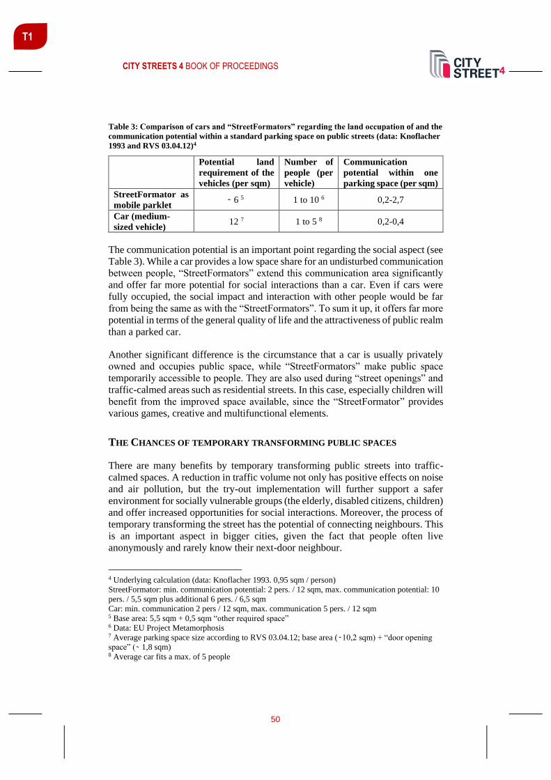
CITY STREETS 4 BOOK OF PROCEEDINGS
50
T1
Table 3: Comparison of cars and “StreetFormators” regarding the land occupation of and the
communication potential within a standard parking space on public streets (data: Knoflacher
1993 and RVS 03.04.12)4
Potential land
requirement of the
vehicles (per sqm)
Number of
people (per
vehicle)
Communication
potential within one
parking space (per sqm)
StreetFormator as
mobile parklet 6 5 1 to 10 6 0,2-2,7
Car (medium-
sized vehicle) 12 7 1 to 5 8 0,2-0,4
The communication potential is an important point regarding the social aspect (see
Table 3). While a car provides a low space share for an undisturbed communication
between people, “StreetFormators” extend this communication area significantly
and offer far more potential for social interactions than a car. Even if cars were
fully occupied, the social impact and interaction with other people would be far
from being the same as with the “StreetFormators”. To sum it up, it offers far more
potential in terms of the general quality of life and the attractiveness of public realm
than a parked car.
Another significant difference is the circumstance that a car is usually privately
owned and occupies public space, while “StreetFormators” make public space
temporarily accessible to people. They are also used during “street openings” and
traffic-calmed areas such as residential streets. In this case, especially children will
benefit from the improved space available, since the “StreetFormator” provides
various games, creative and multifunctional elements.
THE CHANCES OF TEMPORARY TRANSFORMING PUBLIC SPACES
There are many benefits by temporary transforming public streets into traffic-
calmed spaces. A reduction in traffic volume not only has positive effects on noise
and air pollution, but the try-out implementation will further support a safer
environment for socially vulnerable groups (the elderly, disabled citizens, children)
and offer increased opportunities for social interactions. Moreover, the process of
temporary transforming the street has the potential of connecting neighbours. This
is an important aspect in bigger cities, given the fact that people often live
anonymously and rarely know their next-door neighbour.
4 Underlying calculation (data: Knoflacher 1993. 0,95 sqm / person)
StreetFormator: min. communication potential: 2 pers. / 12 sqm, max. communication potential: 10
pers. / 5,5 sqm plus additional 6 pers. / 6,5 sqm
Car: min. communication 2 pers / 12 sqm, max. communication 5 pers. / 12 sqm 5 Base area: 5,5 sqm + 0,5 sqm “other required space” 6 Data: EU Project Metamorphosis 7 Average parking space size according to RVS 03.04.12; base area ( 10,2 sqm) + “door opening
space” ( 1,8 sqm) 8 Average car fits a max. of 5 people
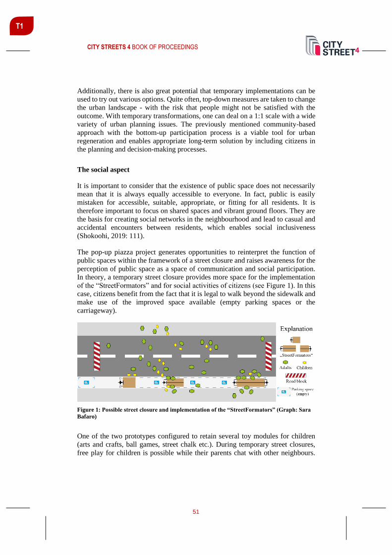
CITY STREETS 4 BOOK OF PROCEEDINGS
51
T1
Additionally, there is also great potential that temporary implementations can be
used to try out various options. Quite often, top-down measures are taken to change
the urban landscape - with the risk that people might not be satisfied with the
outcome. With temporary transformations, one can deal on a 1:1 scale with a wide
variety of urban planning issues. The previously mentioned community-based
approach with the bottom-up participation process is a viable tool for urban
regeneration and enables appropriate long-term solution by including citizens in
the planning and decision-making processes.
The social aspect
It is important to consider that the existence of public space does not necessarily
mean that it is always equally accessible to everyone. In fact, public is easily
mistaken for accessible, suitable, appropriate, or fitting for all residents. It is
therefore important to focus on shared spaces and vibrant ground floors. They are
the basis for creating social networks in the neighbourhood and lead to casual and
accidental encounters between residents, which enables social inclusiveness
(Shokoohi, 2019: 111).
The pop-up piazza project generates opportunities to reinterpret the function of
public spaces within the framework of a street closure and raises awareness for the
perception of public space as a space of communication and social participation.
In theory, a temporary street closure provides more space for the implementation
of the “StreetFormators” and for social activities of citizens (see Figure 1). In this
case, citizens benefit from the fact that it is legal to walk beyond the sidewalk and
make use of the improved space available (empty parking spaces or the
carriageway).
Figure 1: Possible street closure and implementation of the “StreetFormators” (Graph: Sara
Bafaro)
One of the two prototypes configured to retain several toy modules for children
(arts and crafts, ball games, street chalk etc.). During temporary street closures,
free play for children is possible while their parents chat with other neighbours.

CITY STREETS 4 BOOK OF PROCEEDINGS
52
T1
This type of intervention provides an opportunity to try out a car-free setting for
selected streets usually used by motorised traffic.
Reclaiming public space and increasing safety
Another possibility is to use one prototype as a “mobile parklet”. Parklets are
transformed former parking spaces, which typically are built with a platform as
extension of the sidewalk without the obligation to consume anything (San
Francisco Planning Department, 2013: 1). Since parklets require a permit, the
“StreetFormator” offers a simple alternative to temporary reclaim smaller parts of
streets. In addition to revitalising the neighbourhood and serving as a meeting
point, the “StreetFormator” offers a seating area that is especially helpful for the
elderly.
Figure 2: “StreetFormators” as mobile parklets in everyday life (Graph: Sara Bafaro)
The idea of attracting interested citizens, the local economy or other interest groups
as hosts for the StreetFormators (e. g. maintenance, reporting vandalism) also
promotes (institutional) neighbourly help and helps to lower the inhibition
threshold for active use. The intention of bringing together different stakeholders
is to show how easy little changes can be implemented in public space.
Focusing on temporary street closures, there is also an increased safety for children,
elderly or disabled people due to the increased “freedom of movement” for
everyone on the street. In addition, the presence of many people reinforces the
general feeling of security. This enhances the quality of public spaces and attracts
even more people (Pacheco, 2015).
CONCLUSION
To sum up the previous threads, there are some aspects to highlight. First: Making
the active forms of mobility more attractive to citizens leads to reduced traffic flow
and less “space consumption” due to private car parking in public space. The

CITY STREETS 4 BOOK OF PROCEEDINGS
53
T1
second facet is linked to the interactions between people. Mobile parklets provide
an equally good opportunity as stationary parklets for people to interact and get to
know each other (better). Besides, children enjoy the reclaimed freedom on the
streets, which fosters their creativity and (mental) health.
The third issue regards the engagement of people in the participation processes.
Integrating citizens in the transformation process can strengthen their confidence
in decision makers and encourage them to change their own environment too.
Decision makers have also the opportunity to test a car-free setting and to look at
the feedback given to the new situation. This can make a lasting contribution to
awareness raising and improved perception of space.
Disclaimer: The Pop-up Piazza project is a national research project within the
programme “Mobility of the future” that is funded by the Austrian Research
Promotion Agency (FFG) and the Federal Ministry of the Republic of Austria for
Climate Action, Environment, Energy, Mobility, Innovation and Technology
(BMK).
REFERENCES
Furchtlehner, J., Lička, L. (2019). Back on the Street: Vienna, Copenhagen, Munich, and
Rotterdam in focus. Journal of Landscape Architecture 2019, Vol. 14 (1), 72-83.
Pacheco, P. (2015). How “Eyes on the Street” Contribute to Public Safety. Retrieved from
https://thecityfix.com/blog/how-eyes-on-the-street-contribute-public-safety-nossa-cidade-
priscila-pacheco-kichler/
Radlobby (2020). Fahrradparken. Retrieved from https://www.radlobby.at/fahrradparken
San Francisco Planning Department (2013). San Francisco Parklet Manual. Retrieved
from
https://www.lgc.org/wordpress/docs/events/first_thursday_dinners/ftd_2013_Parklet_Ma
nual-may.pdf
Shokoohi, R. (2019). Our City. Countering exclusion in public space. Stipo.
Stollnberger, R., Gebetsroither-Geringer, E., Peters-Anders, J. (2018). “Interactive spatial
web-applications as new means of support for urban decision-making processes";
Presentation: 3rd International Conference on Smart Data and Smart Cities, Delft, The
Netherlands; 04.10.2018 - 05.10.2018; ISPRS Annals of the Photogrammetry, Remote
Sensing and Spatial Information Sciences, Vol. IV-4/W7, 59-66.
ZIS+P (2019). Mobilitätsverhalten der Grazer Wohnbevölkerung 2018. Retrieved from
https://www.graz.at/cms/dokumente/10192604_8032890/85f01d38/Mobilitätserhebung%
20Graz_Wohnbevölkerung%202018.pdf

CITY STREETS 4 BOOK OF PROCEEDINGS
54
TRACK 2: DENSE, DIVERSE AND DESIGNED URBAN
DEVELOPMENT
Track Chairs:
Branislav Folić University of Kosovska Mitrovica, Kosovska Mitrovica, Serbia and
Saja Kosanović University of Kosovska Mitrovica, Kosovska Mitrovica, Serbia
The physical component of a developed city system is changing more slowly than
the ecological and social ones. This is evidenced by the appearance of many cities
of the world at the end of the 20th century, namely busy city streets, large air
pollution due to the over-use of cars, high levels of traffic noise, usurpation of the
open parking spaces, etc. Initiated transformation of this negative picture is
considered a complex and long-lasting process as well as the integral segment of
sustainable urban development. Track 2 contributions identify concrete challenges
and present corresponding solutions regarding:
- Urban policy for mobility infrastructure (re)development;
- Sustainable mobility solutions for dense urban areas;
- (Re)design of the urban space along transport corridors;
- Spatial, social and ecological interrelations between pedestrian, singular
and group (public) mobility corridors in urban environment;
- Car-free cities;
- Alternative mobility viewed from the perspective of social and health
sciences;
- Design of slow-mobility streets;
- Open urban spaces as sustainable mobility nodes;
- Integration of sustainable mobility schemes into new urban development
projects.
Keywords: Sustainable mobility, Urban morphology, Urban planning and design,
Multidisciplinary approach
T2

CITY STREETS 4 BOOK OF PROCEEDINGS
55
T2
SUSTAINABLE TRANSFORMATION OF HISTORIC TRANSPORT
CORRIDOR IN THE CITY OF BELGRADE, SERBIA
Branislav Folić1 Assist. Prof., PhD, University of Priština, Faculty of Technical Sciences – Department of Architecture, 7 Kneza Miloša St., 38220 Kosovska Mitrovica, Serbia, [email protected]
Milena Vukmirović Assist. Prof., PhD, University of Belgrade – Faculty of Forestry Department of Landscape Architecture and Horticulture - Chair of Planning and Design, 1 Kneza Višeslava St., 11000 Belgrade, Serbia, [email protected]
Saja Kosanović Assoc. Prof., PhD, University of Priština, Faculty of Technical Sciences – Department of Architecture, 7 Kneza Miloša St., 38220 Kosovska Mitrovica, Serbia, [email protected]
Milena Ivanović PhD student, University of Belgrade - Faculty of Architecture, 73/II Bulevar kralja Aleksandra, 11000 Belgrade, Serbia, [email protected]
ABSTRACT
The relocation of Belgrade's main railway terminal and the mainline for freight
trains, which used to run parallel to the riverbank, opened an opportunity for the
development of sustainable urban mobility zone and its integration into specific
nature-based solution. Based on historical facts and the current status of the old
railway corridor positioned in the central zone of the City of Belgrade, the aim of
this paper is to elaborate suitability of a linear park concept for selected area and
to explain one proposal for its sustainable transformation into a multifunctional
contemporary urban space. In contrast to previous historical transport line, the
proposed green corridor is intended to connect the city and the riverbanks in
functional, ecological and visual terms. Furthermore, developed solution
represents a response to some of the city’s existing problems, and a contribution
to safeguarding the opulent heritage in historical urban core.
Keywords: sustainable urban mobility, green infrastructure, linear park,
multifunctionality, regeneration.
INTRODUCTION
The City of Belgrade was founded at the place that today is known as Kalemegdan.
Kalemegdan lies on the confluence of two rivers, the Sava and the Danube. Over
time, the city has been expanding from Kalemegdan towards inland, thus creating
1 Corresponding author

CITY STREETS 4 BOOK OF PROCEEDINGS
56
T2
new urban areas such as Gornji (Upper) Dorćol and Donji (Lower) Dorćol. At the
end of the 19th century, the transport corridor known as the Slaughterhouse Railway
was built around Kalemegdan and Dorćol (Figure 1). It aimed to connect industrial
area on the Danube bank with the main railway station i.e. the railway bridge across
the Sava river. Along this route, especially within the zone of today’s Concrete
Hall, many shops and storages were built. Later on, the station at the
Slaughterhouses (today known as Danube station) was enlarged with additional
tracks. Prior to construction of the Pančevo Bridge in 1935 and the extension of the
route across the Danube, the gorge had been a ‘dead end’. In the interwar period,
with the spontaneous development of the industrial zone along the rivers, the
railway grew into an industrial railway that served the Danube Industrial Zone
(Vukmirović & Nikolić, 2020). As a result, heavy rail traffic has occurred in the
area that, according to the General Plan from 1923, was planned to be the largest
sports and recreation zone (Figure 2).
Figure 1: Old railway line from the Concrete Hall to the Pančevo Bridge
Figure 2: A section of historical railway line in Lower Dorćol: Current state

CITY STREETS 4 BOOK OF PROCEEDINGS
57
T2
The railway route stopped operating in 2018, when Belgrade’s main railway
terminal and the mainline for freight trains were relocated. This has open up ways
for finding the new mobility solutions. Simultaneously, the redevelopment of the
old railway route has been seen as an opportunity to respond to some existing urban
problems in this part of the city, including the lack of greenery, high risk from river
flooding, occurrence of the urban heat island effect, bad air quality, lack of good-
quality leisure space, etc.
MULTIFUNCTIONAL LINEAR SPACES AS A RESPONSE TO LOCAL
CONDITIONS
In densely built urban areas, and especially in central zones, green infrastructure is
a common problematic issue. To increase the presence of greenery and improve
the quality of life, ultimately, voids needed to be found. In post-industrial cities,
these void spaces are likely a “by-product of a plethora of cultural processes and
needs”, e.g. disused railways, pipelines, post-industrial waterfronts, rivers, etc.
(Kullmann, 2011).
In recent theory and practice, adaptive reuse of linear infrastructural spaces is most
commonly referred to as the design of linear parks. According to Kullmann (2011),
thin parks located on infrastructural-type, linear sites need to be calibrated as
programmatic sequences of experience – whether variably visual, tactile, or event
based. Such is the case with the adaptive reuse of abandoned rail infrastructure and
its transformation into the High Line New York park that later inspired many
worldwide projects and proposals. Copying of the High Line New York concept to
other places, however, is not always successful due to numerous local specificities,
so when planning linear parks on the foundations of the old traffic infrastructure,
it is necessary to consider keeping, i.e. reintroducing suitable modes of transport
(Ascher & Uffer, 2015). In the Vauxall Missing Link Park in London, different
mobility routes were successfully brought together by forming a buffer between
pedestrian/cyclist/vehicular traffic.
Adaptive reuse of linear landscapes is of broad cross-disciplinary relevance
(Kullmann, 2011). By integrating new cultural, ecological, developmental,
agricultural, and recreational values (Faggi, at al., 2017) into existing urban
structure, some urban problems, and at least those found in physical proximity to a
line subjected to transformation, should be taken into consideration. For example,
linear parks could mitigate local urban heat island effect, improve health and well-
being, and strengthen the resilience to floods (Giannakis, et al., 2016). At the same
time, they should be designed to take advantage of local conditions (Santos, at al.,
2012). Tanghe River Park in Qinhuangdao, China, even introduces encompassed
natural habitats into educational use and allows its visitors to experience local
nature.

CITY STREETS 4 BOOK OF PROCEEDINGS
58
T2
TRANSFORMATION OF OLD BELGRADE RAILWAY: PLANS AND ACTIONS
Although the Belgrade Master Plan from 1972 intended to bring Belgrade back to
its rivers and thus foresaw the removal of railway line in the central urban zone and
the relocation of the central railway station, this topic has only recently begun to
be discussed more seriously. In late 2018, the Belgrade Land Development Public
Agency initiated a Detailed Regulation Plan for 4,600 m-long section of the old
railway line extending from the Concrete Hall to the Pančevo Bridge (Figure 1),
based on the Decision of the City of Belgrade Assembly from September 2018.
The Urban Planning Institute of Belgrade has been engaged in drafting the plan. In
April 2019, the media (Mučibabić, 2019) announced that the architectural studio
‘Diller Scofidio and Renfra’ was invited to submit a project proposal for the
transformation of the subject area into a park. Eventually, the fee for hiring the
world-renowned team turned out to be extremely high, which resulted in a need for
a different approach.
Standard planning procedure was subsequently amended and harmonized with the
international scientific project CLEVER Cities (Vukmirović & Nikolić, 2020),
whose main topic is the co-creation in city planning by utilizing live lab approaches
and nature-inspired solutions. In this manner, the team working on the project,
along with the group from the Urban Planning Institute, devised a plan
development methodology that was expected to involve all relevant stakeholders.
As a result, the Urban Innovation Partnership has been set up, uniting around 50
members from more than 35 local and national public and private sector
institutions, scholarly community, and common society.
The initial co-working phase on the project CLEVER Cities has resulted in defined
vision of the Linear Park 2025, an attractive, self-sustaining, multifunctional, eco-
technological, artistic, educational and research demonstration ground that
promotes healthy living, community, cosmopolitanism through national culture,
nature protection and youth empowerment (Belgrade Urban Living Lab, 2020).
The call for design solutions for the Linear Park in Belgrade was closed on
28/01/2020 and 28 proposals were submitted.
THE LINKPARK CONCEPT
The LinkPark design concept is among ten selected solutions for the transformation
of the area along historic railway into a linear park. The guiding idea of the
LinkPark 4-member team was to establish a direct spatial, socio-cultural and
natural-ecological connection between the Sava and the Danube rivers and their
banks, and the city. This implied a radical shift in notion of the subject spatial line
that in the past was treated as a firm spatial edge, i.e. a boundary. Therefore, the
concept of transformation is based on the need to generate a strong spatial identity,
establish continuity of space, connect river banks, integrate rivers with the city
core, and provide spatial contents to be used throughout the day, in all seasons and

CITY STREETS 4 BOOK OF PROCEEDINGS
59
T2
by all citizens. On the other hand, the key design elements were derived from the
main characteristics of the context: river– authentic natural habitats – old railway
line – city centre.
In spatial terms, special attention was paid to the issue of accessibility and the
integration of park into a public space network. Accordingly, the accessibility of
space has been achieved by introducing longitudinal and transverse linear strokes.
Longitudinal paths are aimed at establishing a connection between the Sava and
the Danube banks, while at the same time enabling the creation of five thematic
routes.
Predominantly pedestrian transverse connections represent an extension of existing
street routes, thus allowing for the direct access to the Danube quay. (Figure 3)
Figure 3: LINKPark thematic routes - MAIN, ACTIVE, TRAM, EcoCAR and SENSORY lines.
Authors: Vukmirović, at al., 2020
From the perspective of landscape architecture, the concept is based on mimicry of
wetlands of the alluvial plain of the Danube (Vukmirović, at al., 2020).
In terms of ecology, LinkPark offers significant strengthening of green
infrastructure with all its benefits, as well as the introduction of various modalities
of sustainable urban mobility (Figure 4). Defined longitudinal routes so include
walking as a primary modality (MAIN line); cycling and micro-mobility (ACTIVE
line); tram transport (circular TRAM line); and the use of environmentally-friendly
(zero-emission) vehicles exclusively (EcoCAR line consisted of two lanes with
green interspace). Finally, proposed water transport aims to establish a direct
connection with other parts of Belgrade (Figure 5).

CITY STREETS 4 BOOK OF PROCEEDINGS
60
T2
Figure 4: LINKPark image. Authors: Vukmirović, at al., 2020
Figure 5: LinkPark proposal for a new water taxi station. Authors: Vukmirović, at al., 2020
CONCLUSIONS
The City of Belgrade has recognized the location of abandoned rail traffic as a
creative opportunity to develop new green corridor. In that way, Belgrade has
finally begun to transform the abandoned zone into contemporary city centre
amenity, changing back this area to its original purpose, and using the inherited
advantages and weaknesses of the space.
LinkPark proposal fully opens the riverbanks of old Belgrade to the users. Next to
different modalities of sustainable mobility, the concept envisages nature-based
solution that has the potential to connect isolated remnant habitat patches and
provide ecosystem service in the city (Zhang, at al., 2019). The concept could also
be understood as an impetus for gradual green transformation of the whole central
urban zone, and the city in general, aimed at improving its sustainability- and
resilience-related capacities.

CITY STREETS 4 BOOK OF PROCEEDINGS
61
T2
Keeping in mind general developmental tendency of Belgrade central area that is
to decrease the intensity of motor vehicle traffic, and the necessity to apply new
ways of sustainable mobility, a more holistic approach could in future include the
consideration of time-related quality of space, e.g. the chrono-urbanism
(Gwiazdzinski, 2015; Moreno, 2019). In that case, the transformed infrastructural
corridor presented in this paper could also be considered an integral part of future
development of “interconnected network of pathways and relationships” (Mehaffy
& Salingaros, 2013).
ACKNOWLEDGEMENTS
The authors acknowledge the Erasmus+ Capacity building in Higher Education
project ‘Strengthening the Master Curricula in Water Resources Management for
the Western Balkans HEIs and Stakeholders – SWARM’ (597888-EPP-1-2018-1-
RS-EPPKA2-CBHE-JP).
REFERENCES
Ascher, K., Uffer, S. (2015). The High Line Effect. Global interchanges: Resurgence of
the Skyscraper City. Conference proceeding, CTBUH 2015: New York.
Belgrade Urban Living Lab (2020, January 6). Poziv za mlade arhitekte. Retrieved from:
http://bellab.rs/poziv/
Faggi, A., Vidal, C. Z., Gusteler, F. (2017, January 18). Linear parks: the importance of a
balanced, cross-disciplinary design. The Nature of Cities (online platform). Retrieved
from: https://www.thenatureofcities.com/2017/01/18/linear-parks-importance-balanced-
cross-disciplinary-design/
Giannakis, E., Bruggeman, A., Poulou, D., Zoumides, C., Eliades, M. (2016). Linear
parks along urban rivers: Perceptions of thermal comfort and climate change adaptation in
Cyprus. Sustainability, 8(10), 1023.
Gwiazdzinski, L. (2015). Introduction. The Urban Night: a Space Time for Innovation
and Sustainable Development. Articulo-Journal of Urban Research, (11).
Kullmann, K. (2011). Thin Parks / Thick Edges. Towards a linear park typology for
(post)infrastructural sites. Journal of Landscape Architecture, 6(2), 70-81.
Mehaffy, M., Salingaros N.A. (2013, March 22). What does Resilience have to do with
architecture? Retreived from: https://www.metropolismag.com/architecture/resilience-
architecture/
Moreno, C. (2019). The 15 minutes-city: for a new chrono-urbanism! Retrieved from: http://www.moreno-web.net/the-15-minutes-city-for-a-new-chrono-urbanism-pr-carlos-
moreno/

CITY STREETS 4 BOOK OF PROCEEDINGS
62
T2
Mučibabić, D. (2019, April 10). Novi park od Beton hale do Pančevačkog mosta.
Retrieved from:
http://www.politika.rs/sr/clanak/427093/Novi-park-od-Beton-hale-do-Pancevackog-mosta
Santos, P., Marques, G.F., Souza, V.B.F.S. (2012). Analysis of the Contribution of Linear
Parks in Urban Flood Control. In World Environmental and Water Resources Congress
2012: Crossing Boundaries, May 20-24, 2012 | Albuquerque, New Mexico, United States,
235-248.
Vukmirović, M., Nikolić, M. (2020). Findings on Industrial Heritage Preservation on
eleven sites placed along the Sava and Danube waterfront. Belgrade: Unpublished work.
Vukmirović, M., Vujović, I., Radić, B., Ćopić, A. (2020, January 28). LinkPark. Winning
proposal for the urban-architectural competitiotn for Linear park in Belgrade. Belgrade.
Zhang, Z., Meerow, S., Newell, J.P., Lindquist, M. (2019). Enhancing landscape
connectivity through multifunctional green infrastructure corridor modeling and design.
Urban Forestry & Urban Greening, 38, 305-317.

CITY STREETS 4 BOOK OF PROCEEDINGS
63
T2
FROM URBAN POROSITY DECODING TO MATERIAL URBANITY
Sérgio Proenca Assist. Prof., PhD, Universidade de Lisboa, Lisbon School of Architecture, CIAUD, formaurbis LAB, Rua Sá Nogueira - Pólo Universitário - Alto da Ajuda, 1349-063 Lisboa, [email protected]
ABSTRACT
The linear axis of Rua da Palma and Avenida Almirante Reis is the structuring
element of a complex urban territory characterized by a permanent urban dynamic,
compacity and overlapping of functions. This axis has a strong legibility in the city
of Lisbon, configuring the longest straight line of the urban layout, one of the main
radial axes of transportation of the city. Almirante Reis shows a wide diversity of
building periods and uses, standing out the commercial function, clearly derived
from the good accessibilities provided by the valley street, the avenue and the
subway system. Although this part of the city recently underwent processes of
abandonment and physical decadence of the built fabric, nowadays is going
through a period of transformation linked to the renovation and re-use of the city.
The relation between people movement and the private space permeability to
public and collective uses echoes the 1748 Giambattista Nolli plan of Rome that
uses the same representation for public spaces and singular buildings private
spaces of public use, revealing as streets and squares extend in the church ground
floors or in the palace’s atriums and courtyards. The same entanglement and
continuity between public and private spaces is part of Walter Benjamin and Asja
Lacis description of the city of Naples as a porous city (Benjamin and Lacis, 1925),
where public and private life overlap in space. Paradoxically, this impermanence
of uses is supported by the lasting and legible form of built spaces, referring to the
city as a the physical place of human exchanges.
Therefore, we may establish the hypothesis that it is the friction caused by human
movement in the edges of the urban space that originates sedimentation of urban
life in these porous spaces.
The paper addresses the morphological decoding of the longest avenue of Lisbon
by delayering and recombination of specific urban systems and strata. This
interpretative delayering of the avenue reveals formal relations between public and
private spaces and mobility systems that would otherwise remain veiled, revealing
urban porosity as essential to the “material urbanity” (Sòla-Morales, 2010) of
Avenida Almirante Reis.
Keywords: Urban morphology, Delayering, Urban Porosity, Lisbon.

CITY STREETS 4 BOOK OF PROCEEDINGS
64
T2
INTRODUCTION
The paper addresses the morphological characterization of the Almirante Reis
Avenue, based on the interpretation and design process developed in the context of
design studio classes (Laboratório de Projecto IV and Laboratório de Projecto V)
of the fourth year Integrated Master in Architecture with specialization in
Urbanism at the Lisbon School of Architecture, University of Lisbon.
The development of the design studio work in this academical year implies that the
project is developed in a complex urban area. Therefore, in the academical year
2019-2020, coordinated by Sérgio Proença and tutored by Ana Amado, the choice
fell on one of the most important valleys of the city of Lisbon that clearly stands
out by supporting the longest straight line of the city urban layout, which
corresponds to the axis Rua da Palma/Avenida Almirante Reis. (Figure 1)
Figure 1: Rua da Palma and Avenida Almirante Reis axis in the urban layout of Lisboa
(formaurbis LAB archive)
The valley that is structured by the axis Rua da Palma/Avenida Almirante Reis,
constitutes a complex urban territory of the consolidated and diverse urban fabric
of the city of Lisbon. Resulting of the sedimentation, overlapping and juxtaposition
of strata in the course of time, this urban territory is characterized by a constant

CITY STREETS 4 BOOK OF PROCEEDINGS
65
T2
dynamic, nonetheless keeping its identity in the context of the city. During the last
decades voted to processes of abandonment, it is nowadays a stage for the
renovation and reuse of its fabric, constituting a privileged context for the
development of the design studio assignments.
Pedagogically, the exercise considers urban form reading and interpretation as the
first act of project, acknowledging in the existing urban fabric a specific theme to
ground the conceptual approach that directs the definition of an urban strategy and
consequent development of a specific project that physically materializes the
program and aims previously defined.
Robert Bresson once said that “Créer n’est pas déformer ou inventer des personnes
et des choses. C’est nouer entre des personnes et des choses qui existent et telles
qu’elles existent, des rapports nouveaux” (Chateau, 2012, p.27). A possible
inference from this quote for the actions of the architect is that, whatever is the
reality we are addressing and transforming, there is the need to know it very well
– it is not possible to create lasting relations without a thorough knowledge of the
parts.
THE ANTECEDENT TERRITORY: THE VALLEY AND THE PATH
The interpretative reading of the valley bottom urban system, framed by the hills
of Santana, to west, and Penha, to the east, allowed to reveal, other than the straight
axis of Rua da Palma and Avenida Almirante Reis, other evidences. The clearest
of these is the matrix route that roughly follows the valley line and pre-exists the
opening of the avenue in a territory that has kept its rural character until late XIX
century.
The sinuous path that follows the valley stream and gradually sedimented in a
series of sequent streets – Rua do Benformoso / Rua dos Anjos / Rua de Arroios /
Estrada de Sacavém – with widenings in crossings and divergences to other routes
or near exceptional elements of the built fabric, such as churches and convents, was
the first structuring element of the valley bottom. This linear urban element
extended northwards from the São Vicente da Mouraria gate of the Fernandine
wall, one of the main gates of the medieval wall of Lisbon. It was on the outside of
the wall, following this linear path, the faubourg in the sequence of the Moorish
quarter developed, concentrating the built fabric that became less compact as it
spread north. (Fernandes, 2014).
This faubourg consisted in a ribbon of urban life, singular linear presence
structured by the valley path in a territory occupied by farms, vegetable gardens
and orchards, as it is acknowledged from the official cartography of mid-XIX
century and even after the opening of the avenue in early XX century.

CITY STREETS 4 BOOK OF PROCEEDINGS
66
T2
THE AVENUE: MORPHOLOGICAL INTERPRETATION
The interpretative reading of a complex urban element such as the urban axis
composed by Rua da Palma and Avenida Almirante Reis – the Avenue – requires
a decomposed approach that enables to simplify the formal complexity and allows
to decode composition rules (Gandelsonas, 1991) of this urban element. Moreover,
the recombination of specific layers allows to render evident existent relations
between layout and topography, public and private spaces or the mobility system
and the collective functions that inhabit the Avenue ground floors.
Layout and topography
Valley bottoms, when compared with the surrounding hillsides, are less steep,
therefore consisting in natural corridors suited for the establishment of paths
(Caniggia e Maffei, 2001 [1979]). The need to keep them free for the water flow
underline their vocation as mobility corridors. The continuous use in time of these
paths and the gradual consolidation their built margins led to the definition of
valley streets. These valley streets are usually sinuous linear urban elements that
structure the surrounding urban fabrics, which proceeded their settlement. In
Lisbon, a city built on a topography where hills and valleys alternate, is common
to find street layouts that mimic or double valley lines (Proença, 2014) (Figure 2).
The intrinsic good accessibility of valley streets stimulates the settlement of
commercial functions and the resulting intensification of urban life underlines the
structuring role of these linear elements. The expansion of the city or the need to
improve traffic conditions sometimes gave origin to the duplication, by
juxtaposition or overlapping, of the sinuous ancestral route by a new, wider and
more regular street layout (Proença, 2015). The urban system composed by the
sinuous sequence of Rua do Benformoso, Rua dos Anjos, Rua do Regueirão dos
Anjos, Rua de Arroios, Rua Alves Torgo e Rua Quirino da Fonseca and its
duplication by the regular layout of Rua da Palma and Avenida Almirante Reis is
a paradigmatic example of the valley bottom urban system in the city of Lisbon.
Although the straight layout of the Avenue, between Praça do Martim Moniz
(southern limit) and Praça Francisco Sá Carneiro (northern limit) has a continuous
width of 25 meters, this apparent uniformity may be questioned when observed in
the context of the urban layout of the valley of Arroios. The urban layout is the
result of the overlapping of morphologic strata with different organization
principles, although sharing the common matrix of the valley line. Thus, we can
acknowledge the sinuous linear urban element, adjusted to the topographic
conditions of the valley topographic configuration, and the overlapping operated
by an orthogonal matrix urban layout structured by Rua da Palma and Avenida
Almirante Reis and seven transversal streets, articulated with regularizations and
adjustments of pre-existent spaces (Figure 3).

CITY STREETS 4 BOOK OF PROCEEDINGS
67
T2
In addition to these linear elements, singular public spaces stand out – some of
them pre-existent and integrated in the new urban layout, other composed
regarding the Avenue, doting exceptions along the layout – from the south to the
north: Praça Martim Moniz; Anjos church churchyard; Praça do Chile; Alameda
Dom Afonso Henriques; Praceta João do Rio; and finally Praça Francisco Sá
Carneiro (Fernandes, 2014).
Figure 2: Structuring elements of the valley bottom urban system. Topography and valley line
vs. valley street and the Avenue urban layout (Proença, 2014)
Figure 3: Generative effect of the valley in the Almirante Reis layout (Fernandes, 2014)

CITY STREETS 4 BOOK OF PROCEEDINGS
68
T2
The public space [layout, partition and tree plantation]
The urban layout of the Avenue has a continuous width of 25 meters, only varying
in the exceptional urban moments described above. Nevertheless, in the course of
time and depending on its construction period and transformation, this regular
width had different partitions, which answered specific needs and wills.
Initially designed with sidewalks, carriageways and a central pedestrian platform
with a double alignment of trees, similarly to other Avenues that were built in
Lisbon during the same period and the Parisian boulevards that consisted in its
model. (Figure 4) Although, the Parisian boulevards and avenues were wider – 40
meters for the most important and structuring avenues; 36 or 30 meters for main
avenues; and 30 meters for avenues that were opened overlapping pre-existent
dense urban fabrics (Gourdon; Werquin; Demangeon, 2000). The proportion
between pedestrian and automobile space was more balanced than it is today.
Figure 4: Initial type section partition of the Avenue, already with the introduction of trams
(Eduardo Portugal, 1938). Arquivo Fotográfico Municipal: PT/AMLSB/POR/021056
In the 1930’s, the Avenue was equipped with public transportation that run on
tracks, which generated the non-exclusive appropriation of one of the lanes of the
carriageways in each direction, similarly to other Lisbon avenues in the same
period. Answering the same purpose, the expansion of the Avenue northwards of
the ancient ring road that defined the edge of the city, where today exists Praça do
Chile, contemplated the double circulation of trams in the central space. This
option compromised the extension of the central forested pedestrian platform in
benefit of the new mobility system in the northern part of the Avenue (Figure 5).
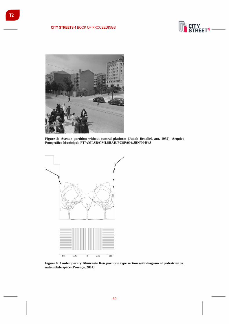
CITY STREETS 4 BOOK OF PROCEEDINGS
69
T2
Figure 5: Avenue partition without central platform (Judah Benoliel, ant. 1952). Arquivo
Fotográfico Municipal: PT/AMLSB/CMLSBAH/PCSP/004/JBN/004543
Figure 6: Contemporary Almirante Reis partition type section with diagram of pedestrian vs.
automobile space (Proença, 2014)

CITY STREETS 4 BOOK OF PROCEEDINGS
70
T2
The subway construction introduced six stations in the three kilometres long
Avenue and originated reformulations on the Avenue partition. Nowadays the
section partition is mostly constant (Figure 6) with central roadways divided by a
narrow separator, which nevertheless enables the existence of a rarefied tree
alignment, and lateral sidewalks, approximately six meters wide, with irregular tree
alignments between Martim Moniz and Alameda and without trees north of
Alameda. In the course of Lisbon recent transition to soft mobility and as a result
of a tactical urbanism action, the south-north central lane was converted in two
cycle lanes. Nevertheless, along the course of the Avenue, sidewalks remain
cropped by parking spaces, dotted with subway entrances and erratic urban
furniture that disturb pedestrian circulation.
The private space [plot structure and built fabric]
Regarding the private space, the plot structure is helpful to acknowledge
production processes and development phases. The irregular plot structure and the
diversity in the alignment of the plot division that exists between Martim Moniz
and Rua Maria Andrade reveals the land divisions that pre-exist the regularization
and opening of Rua da Palma and the southern part of Avenida Almirante Reis.
North of Rua Maria Andrade the alignment of the plot division is perpendicular to
the direction of the avenue and the width of the plots seems to be defined according
to a composition matrix multiple of 10, 12 or 15 meters (Figure 7).
The building replacement that occurred along the second half of the XX century
gave origin, in some cases, to plot joining, promoting longer façade buildings
which contributed to a transformation of the image of the Avenue.
Regarding the built fabric height, essential for the definition of the street cross
section, the diversity that exists in the Avenue seems to generate from the generic
legislation that framed each building construction period (Proença, 2014) (Figure
7).
Thus, for a street width of 25 meters, up to the approval of the Regulamento Geral
da Construcao Urbana (Urban Building General Regulation) – December 6th, 1930
– the maximum allowed height was 20 meters. On a common collective housing
building of the period, this height would correspond to six floors, adding up the use
of the space under the roof as long as the roof structure remain unchanged.
After the approval of the Regulamento Geral da Construcao Urbana, the
maximum allowed height for streets wider than 10 meters changed to 21 meters.
This height could reach 25 meters in corner buildings, underlining the role of the
corner in the urban image of the city. The same regulation allowed the existence of
overhangs with a certain presence in the façade composition, which would
characterize the Avenue buildings character along the decades of 1930 and 1940.
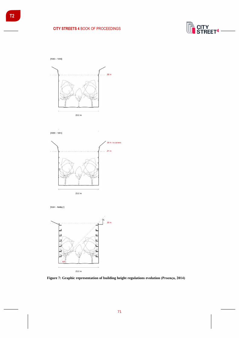
CITY STREETS 4 BOOK OF PROCEEDINGS
71
T2
Figure 7: Graphic representation of building height regulations evolution (Proença, 2014)

CITY STREETS 4 BOOK OF PROCEEDINGS
72
T2
From 1951 onwards, with the approval of the Regulamento Geral das Edificacoes
Urbanas (Urban Edifications General Regulation),the buildings maximum height
was defined by a 45º line drawn from the intersection of the facing building with
the ground. In the case of the Avenue, this implied that the maximum height of the
façade would correspond to 25 meters, admitting setbacks in the proportion of 1:1.
Nowadays, most Avenue buildings have six floors above ground, although
occurrences range from one to 13 floors, concentrating the lower buildings in the
southern part of the avenue, corresponding to non-residential buildings prior to
1919 (Santos; Soares; Ramalhete; Vicente, 2017).
Beyond the generic regulations that conditioned the height of the façade in each
period, traffic flow difficulties in the Avenue, acknowledged at least since the
1930’s, and the relative narrowness of the section for the service level demanded
in this axis, generated a specific regulation for Avenida Almirante Reis new
buildings. In November 18th, 1950, a municipal disposition obliged that the ground
floors of all new building receded 3,75 meters generating a continuous gallery at
street sidewalk level. When buildings on both sides of the avenue were demolished
and new buildings replaced them, the Avenue width at ground level would expand
from 25 to 32,5 meters, a considerable extension that would, in time, allow a
redesign in the partition of the section (Figure 8).
Figure 8: Receded ground floor bulding with gallery (Armando Serôdio, 1962). Arquivo
Fotográfico Municipal: PT/AMLSB/CMLSBAH/PCSP/004/SER/005244.

CITY STREETS 4 BOOK OF PROCEEDINGS
73
T2
This disposition is visible in 49 buildings with receded ground floor, mainly built
in the third quarter of the XX century (Ramalhete, 2019). Given the fact that almost
all buildings have commercial uses in the ground floor, the main purpose to design
galleries with the same depth as the recede would be the progressive construction
of a continuous shopping gallery that supports the pedestrian circulation, freeing
space in the Avenue for the expansion of the roadways and automobile parking.
The outcome isn’t as intense as it has been imagined. Nevertheless, between the
Anjos churchyard and Praça do Chile, it’s possible to find sequential buildings with
these galleries and in some points receded ground floors on both sides of the
Avenue.
Mobility and commercial vocation
According to the urban and functional survey that was made in 2015, in the scope
of the research project Atlas Almirante Reis, the 255 buildings that margin the Rua
da Palma and Avenida Almirante Reis axis are:
“mainly residential (90%), with an average of eight residential fractions and three
non-residential fractions per building. However, only 11 of the 255 buildings (...)
have exclusively residential use. (...) on the other hand, 26 buildings have no
residential units (...) hotels, commercial or office areas.” (Santos; Soares;
Ramalhete; Vicente, 2017)
Nowadays, Almirante Reis consists in a local linear centrality that glues both
hillsides of the valley social life and cumulatively is an important mobility radial
axis of Lisbon that connects to the traditional city centre. The importance of
mobility for the occurrence of commerce is relatively clear. Commercial uses in
ground floors are more intense near intersections with other main arteries and by
subway stations entrances – commerce even exists in some underground access
platforms. The existence of itinerant commerce next to subway entrances – as in
the case of Arroios station – confirms the importance of accessibility to generate
and sediment this urban function (Figure 9).
Traditionally dedicated to medium and low standard trade – consequence of the
extension of the western Baixa area commerce – despite the diversity, retail,
restaurants and cafes stand out. Currently, the specialization that existed in
previous decades in which most of the commercial establishments on the avenue
were dedicated to the sale of furniture and household appliances is less evident
(Santos; Soares; Ramalhete; Vicente, 2017).
In recent years, commerce diversification resultant from immigration contributed
to the cross-cultural enrichment and its coexistence with the neighbourhood spirit,
especially along Rua da Palma and the beginning of Avenida Almirante Reis,
extending from Martim Moniz and Rua do Benformoso.

CITY STREETS 4 BOOK OF PROCEEDINGS
74
T2
Figure 9: Almirante Reis Urban DeCODE, Anjos – Arroios extract (from the top): plots vs.
vacant spaces; transports vs. commerce; collective use; Nolli plan (4th year Master in
Architecture + Urbanism, Lisbon School of Architecture, Universidade de Lisboa, 2019/2020)

CITY STREETS 4 BOOK OF PROCEEDINGS
75
T2
A porous Avenue
A representation of the avenue that highlights the continuity between public and
private spaces of collective use, similarly to the 1748 Giambattista Nolli
representation of Rome, allows to acknowledge veiled continuities. (Figure 9) The
entanglement between public and private space as a value of urbanity is the key to
understand the description of Naples as a porous city: As porous as this stone is the
architecture. Building and action interpenetrate in the courtyards, arcades, and
stairways. (...) Porosity is the inexhaustible law of the life of this city, reappearing
everywhere. A grain of Sunday is hidden in each weekday, and how much weekday
in this Sunday! (...) Just as the living room reappears on the street, with chairs,
hearth, and altar, so, only much more loudly, the street migrates into the living
room. (Benjamin; Lacis, 1925)
The ground floors porosity that exists in commercial uses and public facilities
allow an expanded reading of the use of the avenue space (Figures 9, 10, 11). These
spaces where public and private uses overlap are the spaces where urban life fixates
and sediments.
However, despite the existence of this porosity between the public space and the
private space that takes place in a first strip of the built fronts, there is a relative
impermeability between the avenue and the streets that run parallel to it – mainly
to the north from the intersection with Rua de Angola, block fronts with more than
170 linear meters are common and the urban block front from Convento de Arroios
to Alameda reaches about 300 meters.
On the other hand, the subway line that accompanies the Avenue and surfaces at
the station’s accesses contribute to another type of porosity. A porosity that allows
transporting more or less distant realities directly to the avenue space and enhances
uses and appropriations with a metropolitan radius of influence.
Figure 10: Public space expansion through the ground floor galleries and commercial spaces.
(4th year Master in Architecture + Urbanism, Lisbon School of Architecture, Universidade de
Lisboa, 2019/2020)

CITY STREETS 4 BOOK OF PROCEEDINGS
76
T2
Figure 11: Public space expansion through the ground floor of singular buildings. (4th year
Master in Architecture + Urbanism, Lisbon School of Architecture, Universidade de Lisboa,
2019/2020)
CONCLUSION
The essential need to understand the territory of the city prior to transformation is
very well expressed in the words of Bernard Huet: “La Ville est donc à lire en
premier lieu comme une archive, non pas pour en retracer l’histoire, mais
simplement pour comprendre ce que l’on transforme et surtout pour ne pas faire
d’erreurs sur la manière dont on opère, afin de ne pas provoquer une rupture qui ne
serait pas inscrite dans les gènes que toute ville me semble posséder” (Huet, 1998).
In synthesis, the usefulness of reading the territory is to inscribe the transformation
and evolution of the city in continuity with its identity matrix. Therefore, we tried
to unveil the character of this anthropic landscape that was obtained by gradual
mimetic transformation in continuity with its supporting territory.
Morphological decoding of the Avenue allowed to reveal the formal nature of the
Avenue and the lead role of urban porosity in the definition of its character. The
territorial interpretation at the base of this morphological description consists in the
first step of a methodological approach to achieve the “material urbanity” that
Manuel de Sòla-Morales irreprehensible defined: “the ability of urban material to
express civic, aesthetic, functional and social meanings” (Sòla-Morales, 2010).
REFERENCES
Benjamin, W. and Lacis, A. (1925 [1978]). “Naples” in Reflections. Essays, Aphorisms,
Autobiographical Writings, Helen and Kurt Wolf Book, New York and London, Harcourt
Brace Jovanovich.
Caniggia, G., Maffei, G. L. (2001 [1979]). Architectural Composition and Building
Typology – Interpreting Basic Building, Firenze: Alinea Editrice.
Chateau, D. (2012). La subjectivité au cinéma: Représentations filmiques du subjectif,
Rennes, Presses universitaires de Rennes.

CITY STREETS 4 BOOK OF PROCEEDINGS
77
T2
Gandelsonas, M. (1991). The Urban Text, Cambridge, Chicago Institute for Architecture
and Urbanism Book / MIT Press.
Huet, B. (1998). “Une génétique urbaine” in Urbanisme, n.º 303, nov.-dec. pp. 56-59.
Fernandes, S. P. (2014). Génese e Forma dos Tracados das cidades portuguesas.
Morfologia, tipologia e sedimentacao, PhD Thesis in Urbanism (unpublished), Lisboa:
Faculdade de Arquitectura, Universidade de Lisboa.
Proença, S. B. (2014). A diversidade da Rua na cidade de Lisboa. Morfologia e
Morfogénese, PhD Thesis in Urbanism (unpublished), Lisboa: Faculdade de Arquitectura,
Universidade de Lisboa.
Proença, S. B. (2015). “Valley lines and mobility infrastructures in Lisbon. A timeless
morphological bond” in Urbanistica Informazioni, 263 s.i., IX 9° INU Study Day Green
and Blue Infrastructures, Virtual, Cultural and Social Networks. Roma: INU Edizioni,
2015. pp. 24-26.
Ramalhete, F. (2019). Atlas Almirante Reis. Leituras sobre uma avenida, lecture at the
Lisbon School of Architecture, Universidade de Lisboa, Lisboa, october 14th.
Santos, T., Soares, N., Ramalhete, F. & Vicente, R. (2017), “Avenida Almirante Reis:
diagnostico urbano” in Estudo Prévio. 11.
Sòla-Morales, M. (2010). “The Impossible Project of Public Space” in In Favour of Public
Space, Ten Years of the European Prize for Urban Public Space 2000-2010, exhibition
catalogue, Barcelona, CCCB / Editorial Actar.

CITY STREETS 4 BOOK OF PROCEEDINGS
78
T2
ROADS IN INTROVERTED MEGAPROJECTS FROM DUBAI TO
LEBANON, A WALKABILITY ANALYSIS: URBAN DESIGN OR
ENGINEERING APPROACH
Oula Aoun Assist. Prof., NDU, [email protected]
ABSTRACT
Roads are the core element of cities’ urban fabric. Innovative approaches of roads
design are critical to the liveability of neighbourhoods and cities. Interestingly,
roads design is differently approached by two distinct tracks: urban design and
highway engineering. While the first targets the quality of the built environment
and is pedestrian-centric, the second, more automobile-centric, deals with the
technical transportation needs (Southworth, 2005; Hebbert, 2005).
The design and characteristics of roads differ in relation to their scale and their
location within the city, and requires therefore different analysis and approaches.
One particular case is roads within urban megaprojects. Urban megaprojects are
becoming a key strategy in the context of cities’ competition, and are often designed
and perceived as self-sufficient introverted entities, or ‘cities within cities’ (Aoun,
2016).
Roads are often the raison d’être of megaprojects. Although megaprojects are
introverted, they are linked to the rest of the city through main arterials. Roads are
also a key element in the success or failure of megaprojects, as they constitute the
main determinant in the projects inner dynamics from one side, and their
connectivity to the city from the other side. However, despite many similarities not
all urban megaprojects have the same characteristics, and they differ in terms of
scale, landuse, density, topography and urban pattern, hence significantly
influencing the quality and role of roads.
This paper aims at analysing the status, role and characteristics of roads in two
different megaprojects: Dubai Marina in Dubai, and Beit Misk in Beirut. The two
projects vary in terms of context, scale and functions. We analyse to what extent
the roads are designed following an urban design or engineering approach. We do
so through a walkability analysis, basing our methodology on Southworth’s
attributes in evaluating walkability (Southworth, 2005). From these attributes, this
study will mobilize mainly urban pattern and connectivity.
Keywords: Roads, Walkability, Roads Engineering, Urban design, Dubai, Beirut

CITY STREETS 4 BOOK OF PROCEEDINGS
79
T2
INTRODUCTION
For several decades, the road was engineered to serve the automobile needs. In
parallel to that, pedestrian movement was considered as recreational activity rather
than legitimate transport (Wigan, 1994). In the last two decades a major change is
taking place; accommodating pedestrians and bicycle is becoming a growing
challenge that is seriously considered at all scales.
Roads are a key component in the urban fabric; they constitute the linkage and
connectivity layer of built environments. When well-designed, roads constitute the
setting for everyday activities and provide an image and a sense of community and
belonging (Jacobs, 1961; Pacione, 1990; Adkins et al., 2012). Walking is linked to
many health benefits; several studies have linked walking to longevity and quality
of life (Hakim et al., 1998; Strawbridge et al., 1996; Leveille et al., 1999). Before
the automobile era, all streets were mainly designed to fit to pedestrians and slow
moving vehicles of that time. As a result the urban fabric had to be dense and city
centers accommodated a variety of functions close to each other in a pattern that
makes them accessible to pedestrians in a relatively short time. Even the industrial
cities of the 19th century provided walkability since workers didn’t have cars
(Southworth, 2005). Cities lost their walkability progressively with Modernism
and with the emergent use of cars. Streets gave priority to cars and lost their
pedestrian scale, and progressively the pattern of the urban fabrics made it difficult
or even impossible to pedestrians to move freely.
Two approaches in roads design: the urban design and the highway
engineering
Urban design and transportation have often followed distinct tracks in
understanding the role of the road and designing it. Urban design focuses on the
experiential qualities of the built environment, mainly at a local scale, while
transportation planning focuses on the efficiency of roads, particularly
accommodating an abstract function of serving the motorist, at the city scale.
From the beginning of the twentieth century, the discipline of roads design had two
distinct branches: the professionals who are specialized in the technical
transportation matters, and the professionals who are specialized in the place-based
design. The first category consists of engineers who’s designing factors include
capacity, volume and flows, while the second category is mainly urban designers
and landscape architects who are interested in the form, the use, the dynamics, the
users perception of a place and the quality of the built environment at a local scale
(Southworth, 2005). In the engineers’ approach, roads are designed to
accommodate the flow of vehicles, while pedestrians are considered as a slowing
down factor mainly at street crossings (Ramsey, 1990).
A main difference between the two approaches is the availability of data related to
concrete variables in the engineering approach, while in urban design it has been

CITY STREETS 4 BOOK OF PROCEEDINGS
80
T2
difficult to map and measure the variables at stake, the way it can be done in
transportation research: the quality of an environment, the place character, the
pedestrian and bikers’ behaviors are not easily measurable.
Highway engineering is more automobile centric, and deals with the technical
transportation needs. It uses concrete metrics to measure effectiveness of roads;
these performance measures are crucial for decision-making.
What is walkability?
A walkable urban fabric provides access to a variety of everyday places to users of
varied ages, without interruption or unsafe modes of transportation. Literature on
walkability highlights the importance of walkability quality rather than walkability
duration (Ewing & Cervero, 2010; Adkins et al., 2012). Walkable roads must have
therefore an attractive and engaging character, offer a variety of visual experiences
and have a high recreational value.
Walkability is defined as the extent to which the built environment supports and
encourage walking by providing comfort and safety to pedestrians, connecting
people with varied destinations with a reasonable amount of time and effort, and
offering visual interest in journeys throughout the network.
WALKABILITY IN MEGAPROJECTS
Urban megaprojects are becoming a key strategy in the context of cities’
competition, and are often designed and perceived as self-sufficient introverted
entities, or ‘cities within cities’ (Aoun, 2016). Urban megaprojects are at the core
of cities’ re-imaging and marketing. Their large scale and functional complexity
provide them a significant cognitive power that puts them at the center of current
strategies of metropolization in many cities around the world. Clearly, exceptional
size is a major criterion in the definition, followed by the mixed-use and the
‘integrated’ aspects of such projects. Some authors focus on the complexity side of
the projects’ contents and contexts (Orueta & Fainstein, 2008; Premius et al.,
2008), others on their linkage to globalization where the projects transcend local
conditions and adhere to universal codes (Marshall, 2003), while yet others
highlight the inherent risk within these projects (Flyvbjerg et al., 2002). The
success of megaprojects depends on many factors; one of these factors is the urban
design and pattern. Attractiveness and liveable built environment are key
contributors to the image of a successful megaprojects.
Roads are often the raison d’être of megaprojects. Although megaprojects are
introverted, they are linked to the rest of the city through main arterials. Roads are
also a key element in the success or failure of megaprojects, as they constitute the
main determinant in the projects inner dynamics from one side, and their
connectivity to the city from the other side. A growing concern in designing roads
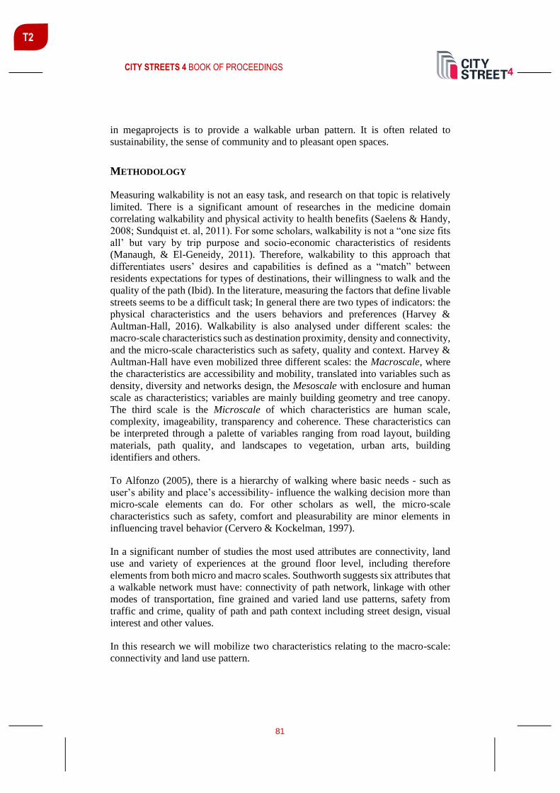
CITY STREETS 4 BOOK OF PROCEEDINGS
81
T2
in megaprojects is to provide a walkable urban pattern. It is often related to
sustainability, the sense of community and to pleasant open spaces.
METHODOLOGY
Measuring walkability is not an easy task, and research on that topic is relatively
limited. There is a significant amount of researches in the medicine domain
correlating walkability and physical activity to health benefits (Saelens & Handy,
2008; Sundquist et. al, 2011). For some scholars, walkability is not a “one size fits
all’ but vary by trip purpose and socio-economic characteristics of residents
(Manaugh, & El-Geneidy, 2011). Therefore, walkability to this approach that
differentiates users’ desires and capabilities is defined as a “match” between
residents expectations for types of destinations, their willingness to walk and the
quality of the path (Ibid). In the literature, measuring the factors that define livable
streets seems to be a difficult task; In general there are two types of indicators: the
physical characteristics and the users behaviors and preferences (Harvey &
Aultman-Hall, 2016). Walkability is also analysed under different scales: the
macro-scale characteristics such as destination proximity, density and connectivity,
and the micro-scale characteristics such as safety, quality and context. Harvey &
Aultman-Hall have even mobilized three different scales: the Macroscale, where
the characteristics are accessibility and mobility, translated into variables such as
density, diversity and networks design, the Mesoscale with enclosure and human
scale as characteristics; variables are mainly building geometry and tree canopy.
The third scale is the Microscale of which characteristics are human scale,
complexity, imageability, transparency and coherence. These characteristics can
be interpreted through a palette of variables ranging from road layout, building
materials, path quality, and landscapes to vegetation, urban arts, building
identifiers and others.
To Alfonzo (2005), there is a hierarchy of walking where basic needs - such as
user’s ability and place’s accessibility- influence the walking decision more than
micro-scale elements can do. For other scholars as well, the micro-scale
characteristics such as safety, comfort and pleasurability are minor elements in
influencing travel behavior (Cervero & Kockelman, 1997).
In a significant number of studies the most used attributes are connectivity, land
use and variety of experiences at the ground floor level, including therefore
elements from both micro and macro scales. Southworth suggests six attributes that
a walkable network must have: connectivity of path network, linkage with other
modes of transportation, fine grained and varied land use patterns, safety from
traffic and crime, quality of path and path context including street design, visual
interest and other values.
In this research we will mobilize two characteristics relating to the macro-scale:
connectivity and land use pattern.

CITY STREETS 4 BOOK OF PROCEEDINGS
82
T2
Connectivity is determined by the extent to which an urban fabric provides
continuous, safe and interconnected pedestrian paths. Measuring connectivity
could be done through the size of blocks, the amount of path choice and
intersections, and the absence of barriers.
Land use pattern has to provide accessible uses to serve daily needs. This
encompasses shops, grocery stores, day care centers, cafes and others, all in a
walkable distance of a maximum 20 minutes. A walkable neighborhood with a
varied and mixed land use has to have eventually a fine grained pattern.
The case studies are Dubai Marina in Dubai and Beit Misk in Lebanon. The two
projects were selected given their similar promoted image as attractive cities within
cities offering a luxury built environment. Another common aspect is the same
developer Emaar properties based in Dubai, mobilizing the same logic in real estate
development, the same knowhow and mobile exportable professional expertise. As
megaprojects both projects are considered as gated communities providing a
unique sense of place, high levels of safety and quality of urban realm. On the other
hand the two projects are different at many levels: Dubai Marina is one of the most
dense development of the world; it was planned to have a number of the highest
towers in the world. It is built on a flat empty area in the desert, in a zone with very
fast dynamics that transformed desert areas of Dubai into a new city center. The
project is connected to a complex transportation network encompassing buses,
metro, tram and marine transportation. Beit Misk is a low to medium density
project, built at the heart of pine forests with 250-meter difference in altitude from
the lowest to the highest point in the project. Density and topography are main
elements in shaping the urban pattern and the road network design.
WALKABILITY ANALYSIS
Dubai Marina
Dubai Marina is one of the first urban megaprojects in Dubai. It covers 3,000,000
m2 and includes more than 300 towers. The artificial 3.5 km canal with a 7 km
pedestrian promenade is at the core of the plan design. The project includes
residential towers, the Marina Mall, a Yacht Club, and ‘Jumeirah Beach
Residence’, a sub-project built in only one phase. ‘The Walk’ – a cornice
promenade within the project – is deemed to be one of the best public spaces in
Dubai. The project boasts several world records and spectacle elements such as the
highest residential tower, the largest man-made marina, and the ‘Tallest Block’,
consisting of a block of high towers reaching 350 meters.
Dubai Marina is considered to be ‘one of the first and largest waterfront
developments in the region’. It was planned to be the core and the catalyst for the
development of the Jumeirah region at the end of the 20th century, when the major
development of the city was occurring around the old center and along Sheikh
Zayed Road. With its towers, luxurious residences and retail facilities, mixed use
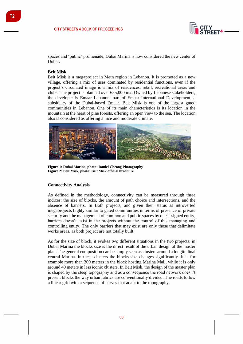
CITY STREETS 4 BOOK OF PROCEEDINGS
83
T2
spaces and ‘public’ promenade, Dubai Marina is now considered the new center of
Dubai.
Beit Misk
Beit Misk is a megaproject in Metn region in Lebanon. It is promoted as a new
village, offering a mix of uses dominated by residential functions, even if the
project’s circulated image is a mix of residences, retail, recreational areas and
clubs. The project is planned over 655,000 m2. Owned by Lebanese stakeholders,
the developer is Emaar Lebanon, part of Emaar International Development, a
subsidiary of the Dubai-based Emaar. Beit Misk is one of the largest gated
communities in Lebanon. One of its main characteristics is its location in the
mountain at the heart of pine forests, offering an open view to the sea. The location
also is considered as offering a nice and moderate climate.
Figure 1: Dubai Marina, photo: Daniel Cheong Photography
Figure 2: Beit Misk, photo: Beit Misk official brochure
Connectivity Analysis
As defined in the methodology, connectivity can be measured through three
indices: the size of blocks, the amount of path choice and intersections, and the
absence of barriers. In Both projects, and given their status as introverted
megaprojects highly similar to gated communities in terms of presence of private
security and the management of common and public spaces by one assigned entity,
barriers doesn’t exist in the projects without the control of this managing and
controlling entity. The only barriers that may exist are only those that delimitate
works areas, as both project are not totally built.
As for the size of block, it evokes two different situations in the two projects: in
Dubai Marina the blocks size is the direct result of the urban design of the master
plan. The general composition can be simply seen as clusters around a longitudinal
central Marina. In these clusters the blocks size changes significantly. It is for
example more than 300 meters in the block hosting Marina Mall, while it is only
around 40 meters in less iconic clusters. In Beit Misk, the design of the master plan
is shaped by the steep topography and as a consequence the road network doesn’t
present blocks the way urban fabrics are conventionally divided. The roads follow
a linear grid with a sequence of curves that adapt to the topography.

CITY STREETS 4 BOOK OF PROCEEDINGS
84
T2
Figure 3: Master plan of Dubai Marina (Source: www.Skyscrapercity.com)
Figure 4: Master plan of Beit Misk, photo: Beit Misk official brochure
Figure 5: Number of intersections in Dubai Marina; Author
Figure 6: Number of intersections in Beit Misk; Author
This can be seen in the intersections mapping (Figures 5 and 6) where the number
of intersections at Beit Misk is significantly low. At the eastern side of Beit Misk
a cluster is designed to be similar to a ‘traditional town’. In this cluster the number
of intersections is significantly high. In the case of Dubai Marina, the number of
intersection depends also on the general layout of the various clusters. In some the
number of intersection is high, as a result of small size blocks and in others where
the blocks accommodate large buildings, the number of intersections is small.

CITY STREETS 4 BOOK OF PROCEEDINGS
85
T2
Land Use Pattern Analysis
The correlation between the land use pattern and walkability can be understood as
the presence of everyday activities and the location of these activities within
walking distances from residences. In Dubai Marina the majority of ground floors
are for non-residential functions, mainly ranging from commercial, retail to
restaurants and cafes. However some blocks are more mixed than others, and some
ground floors are used for car parking. In the highly mixed blocks the walkability
is clearly more important. Interestingly the everyday walkability where users are
residents can be seen in less iconic clusters. On the other hand, the clusters where
the high iconic towers are built, the ground floor is mainly used for cafes and
restaurants, and therefore the users are mainly tourists. In Dubai Marina the
availability of everyday functions is not the factor affecting walkability; the
project’s layout being composed of large clusters, moving from one to the other
can take more than 20 minutes or what is almost equivalent to one kilometer and a
half, despite the presence of the central pedestrian promenade surrounding the
marina borders. Given the large scale of the project, the ‘largest Marina’s
promenade’ can’t be easily walkable by all categories of users.
In Beit Misk the residential function is dominant, hence groceries and everyday
functions are very rare. Residents do not have various destinations to go to. The
‘traditional town’ cluster is not central in the project’s composition and therefore
not easily accessible for the project’s residents. However it is worth to consider the
walkability of the roads for the purpose of walking per se, as physical activity that
doesn’t need a specific destination. The pleasant natural environment and low
traffic encourages walking in internal roads.
CONCLUSION
This paper has tried to analyse walkability in two different megaprojects, one in
Dubai and one in Lebanon. Megaprojects are specific developments that have
characteristics that make them different from city parts, such as the introverted
aspect, the particular urban morphology and design, and the private management
of common and public spaces. The analysis has mobilised two indices: connectivity
and land use pattern. It has shown that several factors influence walkability, mainly
the topography, the form of the road network and the Master Plan’s layout that
generates particularly lots with specific size, composition and connections. It has
shown also that the diversity and even distribution of everyday activities are key in
defining destinations for users and therefore in encouraging walkability.

CITY STREETS 4 BOOK OF PROCEEDINGS
86
T2
REFERENCES
Adkins, A., Dill, J., Luhr, G., Neal, M. (2012). Unpacking Walkability: Testing the
Influence of Urban Design Features on Perceptions of Walking Environment
Attractiveness. Journal of Urban Design, 17(4), 499-510.
https://doi.org/10.1080/13574809.2012.706365
Alfonzo, M. A. (2005). To walk or not to walk? The hierarchy of walking needs.
Environment and Behavior, 37(6), 808–836.
Aoun, O. (2016). Urban Megaprojects-based Approach in Urban Planning: From
Isolated Objects to Shaping the City. PHD Thesis. Université de Liège. Belgium.
Cervero, R. & Kockelman, K. (1997). Travel demand and the 3Ds: density, diversity, and
design. Transportation Research Part D: Transport and Environment, 2(3), 199–219.
Ewing, R., Cervero, R. (2010). Travel and the built environment: a meta-analysis. Journal
of the American Planning Association, 76(3), 265–294.
Flyvbjerg, B., Bruzelius, N., Rothengatter, W. (2002) Megaprojects and risk: making
decisions in an uncertain world. Cambridge: University Press.
Hakim, A. A., Petrovitch, H., Burchfiel, C. M., Ross, G. W., Rodriguez, B. L., White, L.
R., Yano, K., Curb, J. D. & Abbott, R. D. (1998). Effects of walking on mortality among
nonsmoking retired men. New England Journal of Medicine, 338(2), 94–99.
Hebbert, M. (2005). Engineering, Urbanism and the Struggle for Street Design. Journal of
Urban Design, 10(1), 39-59.
Jacobs, J. (1961). The death and life of great American cities. New York: Random House.
Leveille, S. G., Guralnik, J. M., Ferrucci, L., Langlois, J. A. (1999). Aging successfully
until death in old age: opportunities for increasing active life expectancy. American
Journal of Epidemiology, 149(7), 654.
Manaugh, K., El-Geneidy, A. (2011). Validating walkability indices: How do different
households respond to the walkability of their neighborhood? Transportation Research
Part D, 309-315.
Marshall, R. (2003) Emerging Urbanity, Global Urban Projects in the Asia Pacific Rim.
London and New York: Spon Press.
Orueta, F., Fainstein, S. (2008). The new mega-projects: Genesis and impact.
International Journal of Urban and Reginal Research, 32(4), 759-767.
Pacione, M. (1990). Urban liveability: A review. Urban Geography, 11, 1–30.

CITY STREETS 4 BOOK OF PROCEEDINGS
87
T2
Priemus, H., Flyvbjerg, B., Van Wee, B. (Eds.) (2008). Decision-Making on Mega-
Projects: Cost-benefit analysis planning and innovation, Transport economics,
management and policy. Cheltenham/Northampton Edward Elgar.
Saelens, B. E., Handy, S. L. (2008) Built environment correlates of walking: a review.
Medicine and Science in Sports and Exercise, 40(7 Suppl), S550–S566.
Sowthworth, M., (2005). Designing the Walkable City. Journal of Urban Planning And
Development, 131(4). 246-257.
Strawbridge, W. J., Cohen, R. D., Shema, S. J., Kaplan, G. A. (1996). Successful aging:
predictors and associated activities. American Journal of Epidemiology, 144(2), 135–141.
Sundquist, K., Eriksson, U., Kawakami, N., Skog, L., Ohlsson, H., Arvidsson, D. (2011).
Neighborhood walkability, physical activity, and walking behavior: The Swedish
Neighborhood and Physical Activity (SNAP) study. Social Science & Medicine, 72(8),
1266-1273. https://doi.org/10.1016/j.socscimed.2011.03.004

CITY STREETS 4 BOOK OF PROCEEDINGS
88
T2
ROLE OF ACCESSIBILITY IN A SUSTAINABLE TOWN AS APPLIED
TO MURSKA SOBOTA
Jernej Červek univ. dipl. ing. arh., Ministry of Environment and Spatial Planning of Republic of Slovenia, Dunajska cesta 48, Ljubljana, [email protected]
ABSTRACT
"Murska Sobota 2050 is a town through which we daily travel by bike or walk on
foot" (TUS, 2016: 9). This is a vision that will have a decisive impact on urban
planning, primarily through urban recycling, in order to achieve a good and safe
access to spheres of daily activities. The present paper analyses different areas,
ranging from scientific data and historical overview in the context of the town to
regulation promoting better urban accessibility. Numerous scientific contributions
on sustainability and urbanism deal with the subject of the compact city, urban
densification and mobility. In the context of sustainable urban forms, densification,
activity deployment and mobility are closely related. Their interconnection points
towards better accessibility and creation of quality open living spaces. Stronger
emphasis on more accessible public passenger transport – along with walking and
cycling in the urban streets – diminishes dependence on car use in urban areas.
Parallel historical overview indicates that the street as a space of urban traffic is
being restored to the people and is once more becoming an urban open public
space, suitable for socialising. Simulation of Vision Murska Sobota 2050 on the
location of one of town’s multi-apartment neighbourhoods points out to changes
already in place and to those still to be implemented.
Keywords: Mobility, Traffic, Transport, Walkability, Accessibility
INTRODUCTION
The present paper examines different aspects of the terms traffic, mobility and
transport in the case of the town of Murska Sobota. As pointed out by Čerpes (2013:
57), “in discussions on urban sustainable development and planning, the term
“traffic” is increasingly displaced by “mobility” and “transport”. She explains that
“traffic” should be understood as a synonym for “technical aspects of planning and
dimensioning of infrastructure”. Instead of traffic – in the sense of planning new
roads, parking spaces and other associated paved trafficked areas –, the emphasis
has moved to urban planning and activity deployment in areas accessible to people.
According to her, the goal of these activities is to enable “access to as wide a range
of services for as many as possible, under equal conditions and with the least

CITY STREETS 4 BOOK OF PROCEEDINGS
89
T2
possible consumption of fossil energy products and the lowest possible
environmental pollution”.
Urban mobility means re-directing transport towards cycling and walking in
combination with public passenger transport, all of which enable the population to
reach their desired destinations. Urban accessibility or, rather, daily travel habits
of residents, is defined by the five characteristics of built environment (the so-
called five Ds):
- Density (of population, dwelling units, employment),
- Diversity (of uses, building typologies, population),
- Design (walking and bicycle-friendly streets, dense and interconnected
street network),
- Destination Accessibility (e.g., a 30-min access to workplace reduces the
number of vehicle journeys by 20 %),
- Distance to Transit (up to 6-min of walking or 650 m walking radius)
(Čerpes 2013: 58).
One of the main documents for the provision of accessibility is Transport Oriented
Development (TOD): “The TOD Standard stands for the rights of all to access the
city: to walk and cycle safely, to easily and affordably reach the most distant
destination through rapid and frequent transit, and to live a good life free of
dependence on cars. It stands for access to opportunity, education, services, and all
the resources available via no- or low-cost mobility options” (TOD Standard, 2017:
4).
In the context of accessibility, there is an increased focus on walking or walkability.
Walkability means “attractiveness of a space for walking; a certain area
characterized by the ability to walk through easily, without unnecessary detours or
excessive effort. The concept of walkability consists of several components,
including presence of pedestrian areas, such as pavements and foot paths, spatial
permeability and connection density, low traffic velocity and crossing safety,
visual attractiveness of the space, feeling of safety, frequency of use of the path,
density of nearby activities, population density in the area, short distances between
travel sources and destinations” (IPOP, 2020).
In order to verify the scenario of the “Regional Green Capital”, a test case of the
densely populated Lendavska Street neighbourhood in Murska Sobota has been
made. We tested the density ratio of the neighbourhood vs. that of the town and the
accessibility of the neighbourhood to key activities in the town. Analysis of the test
case indicates that in order to achieve the goals from Vision 2050 an urban
recycling of a wider area is needed, with the emphasis on safer and more attractive
footpaths and cycling lanes and by incorporating green elements. Urban planning
for better accessibility for cyclists and pedestrians can reduce traffic load and
thereby transform streets from trafficked areas into quality open urban areas.

CITY STREETS 4 BOOK OF PROCEEDINGS
90
T2
MURSKA SOBOTA 2050: THE GREEN CAPITAL OF POMURJE
The Sustainable Urban Strategy of the City Municipality of Murska Sobota,
adopted by the municipality in 2016, includes a vision of development by the year
2050 (TUS MS, 2016: 9). This strategic vision provides for Murska Sobota as the
green capital, and administrative and economic centre of the region of Pomurje.
Vision 2050 emphasises environmentally friendly technology, sustainable food
supply from the town hinterland, and sustainable building and reurbanisation of the
town centre. The town is to become a healthy environment of active and lively
neighbourhoods, providing a meeting point for the needs of all generations (TUS
MS, 2016: 9).
TUS MS with its vision and goals will influence sustainable urban planning
development and therefore require necessary interventions into the urban fabric
with the emphasis on mobility, especially of pedestrians and cyclists, together with
associated infrastructure (cycling lanes and footpaths, benches, bicycle stops,
bicycle self-service stations), and the reduction of the share of road transport (cars
and transit traffic) through better public passenger transport, completion of the
town bypass and Park & Ride systems” (TUS MS, 2016: 88).
In order to achieve mobility goals, it is necessary to perform an analysis of the
existing town conditions that has to provide answers to three key questions:
- Are there any goals that have already been achieved in the town?
- Where are the locations of needed interventions?
- Which parts of the town cannot achieve required goals on their own and
therefore have to be considered comprehensively, in the context of the
town as a whole?
METHODOLOGY
The present article is based on a qualitative survey of relevant literature and
regulations on the subject of urban, density and traffic planning in recent years, as
applied to the town of Murska Sobota. The paper attempts to address the issue of
replacing traffic planning with mobility, a change which in connection with urban
density and deployment of activities can significantly alter the image of the street.
Such changes may lead to reduced dependence on cars and increase in walkability
and cycling, street greening, citizen cooperation, even to improved public health.
THE TOWN OF MURSKA SOBOTA
Murska Sobota has the status of a city municipality (more on the terminological
conundrum later) and is the administrative centre of the Mura Statistical Region
(Pomurje). Murska Sobota was only granted formal urban status in 1952 in the
former Yugoslavia (Hari, cited. in Merica, 2016), and then again in 2000 in the
newly established Republic of Slovenia (Uradni list RS, 2000). Territorial surface

CITY STREETS 4 BOOK OF PROCEEDINGS
91
T2
of the town is 14.5 km² and according to the latest data has 11,113 inhabitants
(SURS, 2019), ranking as only 16th in Slovenia. Geographically, the town is
situated in the northeastern part of Slovenia and is an “urban centre at the
intersection of four states – Slovenia, Austria, Hungary and Croatia” (TUS,
2016: 23).
Murska Sobota, a former village centre, gradually only acquired its urban image
by the end of the 19th c., influenced by the contemporary Vas County Regulations
on Buildings and Hygiene, adopted in 1879 in Budapest, since Murska Sobota was
then part of the Hungarian part of the Dual Monarchy, specifically Vas County
(slv. Železna županija). Regulations were applicable until the 1930s. One of the
outstanding parts of the Regulations concerns street planning, requiring that new
streets should only be laid out in straight lines and be at least 20 m wide, while both
sides of each street should be flanked by 1 m wide pavement for pedestrians
(trotoar) and lined with trees all along its length. Urban status was defined by article
28, prescribing the building of walls: “In municipalities with urban status, buildings
could only be constructed of stone or fired bricks.” Since “even in the 1920s houses
in Murska Sobota were still being built of compressed earth and with wooden
frameworks, this information allows us to assume that Murska Sobota during the
last era of Hungarian rule lacked urban status” (Brumen, 1995: 35).
According to Hari (as cited in Merica, 2016), proper urban development of Murska
Sobota began with architect France Novak in the 1930s. Novak, who became M.
Sobota’s first contractual architect, later, in 1938, for several months worked in
Le Corbusier’s studio in Paris, a fact that influenced urban planning development
of M. Sobota. Murska Sobota is, indeed, the only town that was completely
designed in the spirit of the CIAM methods and on the basis of the principles of
functionalist urbanism that were elsewhere broadly implemented only in the 1950s.
In his urban plan for Murska Sobota Novak resorted to zoning; he defined four
obligatory zones that cover east- and southward spread of the town, nowadays still
visible in spatial orientation. According to his plans, the town would cover c. 200
ha and have max. 6000 inhabitants, i.e. 33 inhabitants per ha. His calculations
thus envisioned 330 m² of town area per inhabitant. Future growth of the town
should reach a maximum of 12,000 inhabitants and thus 165 m² per inhabitant. At
the time of Novak’s death in 1959, Murska Sobota had c. 6000 inhabitants, while
nowadays the population has reached 12,000. In his plans for the transport
network, Novak took into account the existing street network, while the transit
connection was diverted to the south of the town (the southern bypass was only
built in 2019 and the western one is still under construction). The main streets were
designed with wide pavements, divided from the road surface by a broad green
caesura (as laid down by the Athens Charter).
Further development of the town in the 1960s followed Novak’s urban plan with
zoning. However, since the 1970s, the town has primarily been developing
piecemeal, through individual urban parts such as the densely populated residential
area in the north and the new industrial zone, or the urban planning competition for
CITY STREETS 4 BOOK OF PROCEEDINGS
92
T2
the town centre and similar unconnected spatial interventions, all of which paid no
regard to the broader urban context.
TUS MS and Vision 2050 thus represent an attempt to re-emphasize a
comprehensive urban design for the town of Murska Sobota.
TEST CASE: LENDAVSKA STREET NEIGHBOURHOOD
Lendavska Street 15 (Lendavska neighbourhood) is part of the densely populated
northeastern part of the town. The neighbourhood was built in the early 1980s and
is located next to one of the four approaches to the town, between the town centre
on the southwestern part and the industrial zone on the eastern and northern part of
the town.
The location of the Lendavska Street residential neighbourhood was dictated by
the broader renovation of the northern part of the town at the time (when the
roadside buildings, characteristic for the 19th c., were demolished). Furthermore,
the location provided for good accessibility (short distances) to the town centre
with social activities on the one hand and to the industrial zone with jobs on the
other. During the transition to capitalism, most of the industry collapsed, with the
result of still visible brownfield sites. The surrounding area consists of large
unfinished building sites, abandoned buildings and individual spatial interventions,
at odds with coordinated urban planning. Instead of considering a comprehensive
solution for the broader northern part of the town, the municipal administration
favoured further sprawl of building sites towards the north where a large
commercial zone was developed. After the service activities (shops, supermarkets,
schools) moved from the town centre to its outskirts, the planned accessibility
inside the town was partially destroyed. Lendavska neighbourhood with its wider
surrounding area is currently classified as a derelict brownfield site (Koželj, 2016).
The area lacks green elements, while most of the open built surfaces serve as
parking spaces, which are, nevertheless, too small in number (if prescribed
standards were taken into account).
The test case will attempt to verify Vision of Murska Sobota by 2050 as a green
town where one can walk or cycle and which is trying to re-establish the broad
green corridors, intended for the town inhabitants. Considering the interconnection
of density and mobility between the residential complex and the rest of the town,
we will apply the latest findings on the subject of urban density and accessibility.
The test case should answer the following questions: does this particular
neighbourhood correspond to the requirements listed in the scenario of Vision of
Murska Sobota by 2050 and are further urban planning measures needed, such as
“recycling urban planning”.

CITY STREETS 4 BOOK OF PROCEEDINGS
93
T2
URBAN TYPOLOGY AND DENSITY
Vision of Murska Sobota by 2050 predicts that the town will become the green
capital, and administrative and economic centre of the region of Pomurje. In order
to achieve this goal, we have comparatively used the European methodological
manual on territorial typologies, developed by Eurostat (Eurostat, 2018), in order
to determine the settlement typology of Murska Sobota with an estimated density,
which will be important for further work. The methodology in question provides
three main territorial typologies that can, on the most basic level, be divided into
three different groups, encompassing grid typologies, local typologies and regional
typologies. All of these are tightly interconnected, since they are all based on the
same basic building blocks, i.e. “classifying population grid cells to different
cluster types and then aggregating this information either by LAU or by region to
produce statistics for a wide variety of different typologies” (Eurostat, 2018: 4).
Table 1: Classification of Murska Sobota according to Eurostat methodology (Eurostat, 2018)
Territorial typologies
Local typologies
based on statistics for local administrative
units (LAUs)
Regional typologies
statistics that are grouped according to the
classification of territorial units for
statistics (NUTS)
Slovenia – municipality : City Municipality of Murska Sobota
Cluster types (based on 1 km2 grid cells)
Urban centre Urban clusters Rural grid cells
High-density clusters: Moderate-density clusters:
Grid cells of 1 km²
outside of urban centres
and urban clusters
a cluster of contiguous grid
cells of 1 km² with a
density of at least 1500
inhabitants per km² and a
minimum population of
50,000 after gap-filling
a cluster of contiguous grid
cells of 1 km² with a
density of at least 300
inhabitants per km² and a
minimum population of
5000
Murska Sobota

CITY STREETS 4 BOOK OF PROCEEDINGS
94
T2
Local typologies (LAU)
Urban areas Rural areas
Cities Towns and suburbs
Densely populated areas Intermediate density areas Thinly populated areas
where at least 50 % of the
population lives in one or
more urban centres
where less than 50 % of the
population lives in an
urban centre, but at least 50
% of the population lives in
an urban cluster
where more than 50 % of
the population lives in
rural grid cells
Murska Sobota
According to Eurostat methodology and publicly available data (Table 1), Murska
Sobota ranks among smaller settlements (Towns). Towns are defined as having a
density of at least 300 inhabitants per grid cell (1 km²) and an overall population
of at least 5000 inhabitants. According to the scenario of Vision 2050, the urban
settlement may grow into a larger settlement (City), characterised by at least 1500
inhabitants per grid cell and a population of at least 50,000.
At this point, a short explanation is necessary. We have just defined Murska Sobota
as a “town” and yet, due to several reasons, the official name of the municipality
in question is City Municipality of Murska Sobota. There are 11 such
municipalities in Slovenia, with Murska Sobota being the second smallest in terms
of population. If Eurostat criteria were applied to the urban centres of these
municipalities, only two of them (Ljubljana and Maribor) would qualify as “cities”.
URBAN MOBILITY
Transport & IKT communications is the one of the four main areas of TUS MS
that places special emphasis on accessibility (using different means of transport in
order to access different services) and sustainable mobility (footpaths, cycling
lanes, urban passenger transport, P&R, etc.). In order to meet the requirements of
TUS MS and Vision 2050, it will be necessary to preliminarily assess the traffic
categories, establish the newest trends and orientations for each of those categories,
and analyse their role in meeting the required objectives.
Five main categories may be identified in the context of urban transport: transit
transport, passenger car transport, public passenger transport, cycle transport and
pedestrians (walkability). In order to establish the quality of urban walkable
accessibility in connection with public passenger transport and cycling, we have
used the guidelines on length of journey and walking time from several documents
(TUS MS, TOD Standards, and Decree on Spatial order of Slovenia).

CITY STREETS 4 BOOK OF PROCEEDINGS
95
T2
TUS MS provides recommended lengths of accessibility for three selected
categories:
- walkability up to 1000 m
- cycling max. 3 to 5 km
- public passenger transport 0 to x km
Article 23 of the Decree on Spatial order of Slovenia among other rules on
settlement planning requires:
- development of a unified network of cycling lanes,
- development of a unified network of footpaths with the provision of a 5 min
walkable accessibility from residential areas, mixed areas, special areas and areas
of social infrastructure to public passenger transport stations,
- development of an efficient network of public passenger transport.
Table 2: Criteria for urban accessibility assessment (source: author)
Accessibility
Walkability Cycling
10 min (500
m)
20 min (1
km) 5 min (1.3 km)
Education (kindergarten,
primary school, high school) ✓ / X ✓ / X ✓ / X
Health (hospital, health centre,
health clinic, pharmacy) ✓ / X ✓ / X ✓ / X
Services (shop, market, bank,
post office, administrative
services) ✓ / X ✓ / X ✓ / X
Green and recreational spaces
(park, sports ground, children’s
playground, sports hall) ✓ / X ✓ / X ✓ / X
Public passenger transport
(urban passenger transport, bus
station, train station) ✓ / X ✓ / X ✓ / X
Walkability for pedestrians has been assessed on the basis of TOD standards stating
accessibility of 10- and 20-min walks at an average speed of 3 km/h. At such a
speed, it would take 10 min for a pedestrian to reach a linear distance of 500 m and
20 min to reach a linear distance of 1 km. For cyclists, we have used the guidelines
in “Bicycle-friendly infrastructure” (in: Ministrstvo za infrastrukturo, 2017: 10),
according to which the average speed of cyclists in urban area is 16 km/h. At such
a speed, a 5-min cycling would enable a cyclist to reach a linear distance of 1.3 km
(Table 2).

CITY STREETS 4 BOOK OF PROCEEDINGS
96
T2
ANALYSIS OF THE LENDAVSKA STREET NEIGHBOURHOOD
Lendavska Street neighbourhood is composed of 12 multi-apartment towers and a
ground floor supermarket, joined into two forms of construction: closed (grid
pattern) construction and open (linear pattern) construction (Figure 1).
Figure 1: Representation of Lendavska Street neighbourhood showing types of construction
and green spaces (figure: author)
The closed or grid pattern construction type building is defined as a block that
opens into the central courtyard with disjointed corners. The courtyard is
surrounded by 10- or 11-storey multi-apartment buildings on the eastern, northern
and western sides, while on the southern side there is a ground level building with
a supermarket. The central space is intended for open green and built spaces with
a small children’s playground. On the western side, there is an open or linear
pattern construction type building, defined as a lamellate block. The building has
11 storeys and three separate entrances.
The multi-apartment buildings are composed of 318 apartments and a public
ground floor with several different facilities (supermarket, catering establishment,
business offices, kindergarten and health clinic). The neighbourhood perimeter is
paved and serves as a parking area for c. 120 cars (c. 1 parking space per 3
apartments).
The entire neighbourhood area measures 12,149 m² (1.2 ha or 0.012 km²), with 45
% covered by built surfaces. Green spaces represent 14 % of the area, while the
rest of the paved surfaces (41 %) are intended for transport. A linear row of tries
divides the neighbourhood from the main thoroughfare.

CITY STREETS 4 BOOK OF PROCEEDINGS
97
T2
Official neighbourhood population data is lacking, therefore we have used a
formula for calculation of apartment density which “defines the number of
apartments per hectare (ap./ha)”. Mladenovič (2011: 6) writes that “based on the
number of apartments per hectare and by taking into account the average household
size we can simply reach an estimate of the number of inhabitants per hectare or
per square km”. Based on the SURS data for 2019, the average household in the
City Municipality of Murska Sobota numbers 2.2 members. Using available data,
we may estimate that Lendavska Street neighbourhood is very densely populated,
with c. 583 inhabitants (58,300 per km²) in a smaller town (767.1 inhabitants per
km²), since the population density of the neighbourhood is c. 76 times larger than
the average number for the town as a whole.
Mozas (as cited in Mladenovič, 2011: 22) writes that, according to the “building
density scale, areas with more than 300 apartments per hectare are considered to
be very densely populated urban areas, requiring new approaches to living in high
buildings”, and adds that it is necessary to verify the “organisation of mobility
inside the area and in connection with its surroundings” (in Mladenovič 2011: 9).
Such a high density requires provision of a certain quality of living, above all by
establishing sufficient green and recreational spaces in the narrower area of
accessibility.
In relation to Lendavska neighbourhood, we have verified the following criteria
from the table concerning accessibility to selected categories: education, health,
services, green and recreational spaces, and public passenger transport (Figure 1).
Figure 2: Representation of pedestrian (500 m and 1 km) and cyclist accessibility (1.3 km)
(source: author)
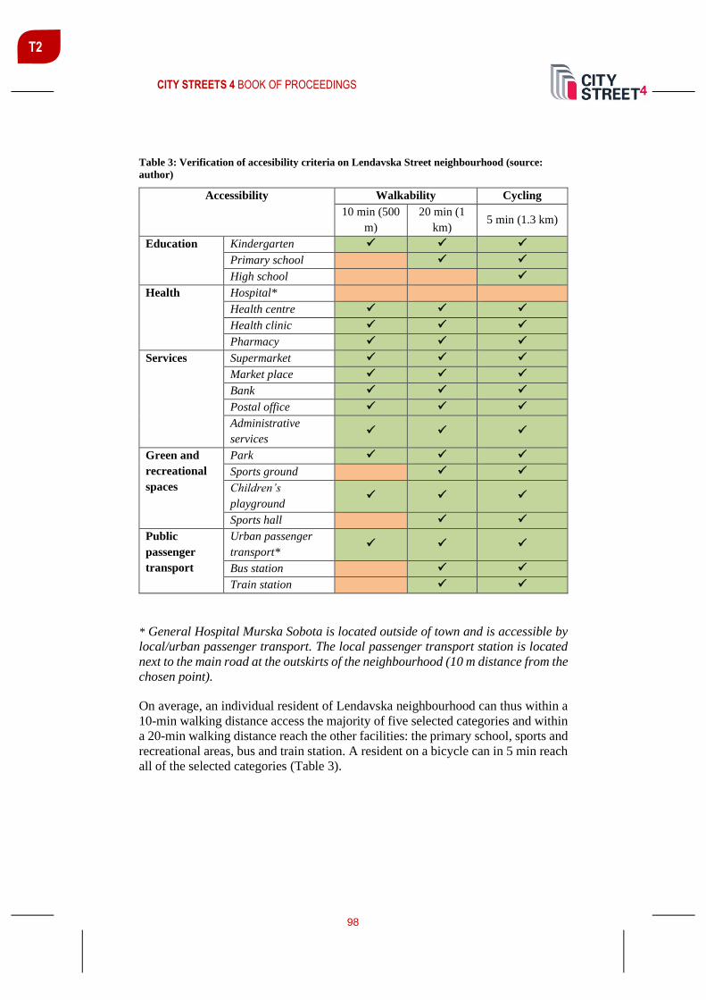
CITY STREETS 4 BOOK OF PROCEEDINGS
98
T2
Table 3: Verification of accesibility criteria on Lendavska Street neighbourhood (source:
author)
Accessibility Walkability Cycling
10 min (500
m)
20 min (1
km) 5 min (1.3 km)
Education Kindergarten ✓ ✓ ✓
Primary school ✓ ✓
High school ✓
Health Hospital*
Health centre ✓ ✓ ✓
Health clinic ✓ ✓ ✓
Pharmacy ✓ ✓ ✓
Services Supermarket ✓ ✓ ✓
Market place ✓ ✓ ✓
Bank ✓ ✓ ✓
Postal office ✓ ✓ ✓
Administrative
services ✓ ✓ ✓
Green and
recreational
spaces
Park ✓ ✓ ✓
Sports ground ✓ ✓
Children’s
playground ✓ ✓ ✓
Sports hall ✓ ✓
Public
passenger
transport
Urban passenger
transport* ✓ ✓ ✓
Bus station ✓ ✓
Train station ✓ ✓
* General Hospital Murska Sobota is located outside of town and is accessible by
local/urban passenger transport. The local passenger transport station is located
next to the main road at the outskirts of the neighbourhood (10 m distance from the
chosen point).
On average, an individual resident of Lendavska neighbourhood can thus within a
10-min walking distance access the majority of five selected categories and within
a 20-min walking distance reach the other facilities: the primary school, sports and
recreational areas, bus and train station. A resident on a bicycle can in 5 min reach
all of the selected categories (Table 3).

CITY STREETS 4 BOOK OF PROCEEDINGS
99
T2
CONCLUSIONS
The town of Murska Sobota is a smaller Slovenian urban settlement, with its design
still reflecting the original urban plan of architect Novak from the 1930s and with
a good accessibility to day-to-day facilities. Nevertheless, the town has been
subject to many unsuccessful interventions, such as the migration of social and
service activities to the town outskirts, leaving behind an empty town centre. All
of this is reflected in the travel behaviour of the town residents, mainly directed
towards the town outskirts and not the town itself.
The accessibility analysis of Lendavska neighbourhood demonstrates a need for
comprehensive treatment and town planning in order to achieve the goals of Vision
2050. The town administration has responded to the urban spread and associated
dispersal of different activities by setting up urban public passenger transport
system and cycling networks. The town’s cycling infrastructure is linked to the
existing pedestrian corridors (pavements), now shared by pedestrians and cyclists.
In order to improve urban accessibility, it would be profitable to glance back at the
history of the town, when it was in many ways planned on a more human scale,
and take visionary steps towards the urban future.
One question that remains is what is to be done with numerous personal vehicles
that are cluttering urban open spaces, such as streets, squares, large parking spaces
and other paved surfaces. Cars still play an important role as status symbols;
therefore a dialogue between decision makers, experts and residents is needed.
Higher and better accessibility levels to different facilities and activities could
diminish dependence on car use. Streets and squares should be turned into user-
friendly open built and green spaces, dedicated to public socialising. In that respect,
further dialogue between the town administration and residents on future
approaches to the implementation of Vision Murska Sobota by 2050 is needed.
REFERENCES
Brumen, B. (1995). Na robu zgodovine in spomina – urbana kultura Murske Sobote med
letoma 1919 in 1941. Murska Sobota: Pomurska založba.
Čerpes, I. (2013). Z javnim prevozom uravnan razvoj mest. Arhitektov bilten, 197–198,
56-60.
Eurostat. (2018). Methodological manual on territorial typologies – 2018 edition.
Luxembourg. Retrieved from: https://ec.europa.eu/eurostat/web/products-manuals-and-
guidelines/-/KS-GQ-18-008 (accessed 7 Jan 2020).
IPOP. (2020). Izrazje. Retrieved from: https://ipop.si/urejanje-prostora/izrazje/ (accessed
16. Dec 2019).

CITY STREETS 4 BOOK OF PROCEEDINGS
100
T2
Institute for Transportation & Development Policies (2017). New York: Institute for
Transportation and Development Policy. Retrieved from: www.itdp.org (accessed 20.
Apr 2020).
Koželj, J., Filipič, P., Hočevar, P., Strle, K., Kušar, K., Lavtižar, K., Gracar, M., Cafuta,
O. (2016). Merila in kriteriji za določitev degradiranih urbanih območij (DUO2).
Ljubljana: Ministrstvo za okolje in prostor.
Merica, T. (2016). Strukturiranost mestnega središča Murske Sobote v uporabnikovi
miselni sliki. Senior thesis. Ljubljana: Univerza v Ljubljani, Biotehniška fakulteta,
Oddelek za krajinsko arhitekturo.
Ministrstvo za infrastrukturo. (2017). Kolesarjem prijazna infrastruktura: Smernice za
umeščanje kolesarske infrastrukture v urbanih območjih. Ljubljana.
Mladenovič, L. (2011). Kriteriji za trajnostno načrtovanje in gradnjo območij z visoko
gostoto poselitve. PhD. thesis. Ljubljana: Univerza v Ljubljani, Fakulteta za arhitekturo.
Statistični urad Republike Slovenije. (2020, Februar, 21). Available at: https://www.stat.si/
Trajnostna urbana strategija Mestne občine Murska Sobota. (2020, Februar, 21).
Retrieved from: https://www.murska-
sobota.si/sites/default/files/datoteke/Trajnostna%20urbana%20strategija%20Mestne%20o
b%C4%8Dine%20Murska%20Sobota.pdf

CITY STREETS 4 BOOK OF PROCEEDINGS
101
T2
STRIATED AND SMOOTH IDENTITIES: MAPPING TRIPOLI’S
VARYING POLITICAL INTENSITIES
Dina Nashar Baroud Assist. Prof., Notre Dame University, Louaize, Lebanon, [email protected]
ABSTRACT
Karami Square is one of the significant central squares in Tripoli, Lebanon. In
recent decades, the square has manifested the city’s changing political identity,
where the spatial relationship that the square’s centre has with its surroundings
was diverse, resembling varying political statements. These variant spatial
relations are weaved and narrated between the area’s urban physical definition
and the imaginative places that people construct (through events and protests) as
they build political meanings around the place (according to De Certeau). This
work questions whether it is possible to more clearly formulate such a narration,
and, if so, then what the concepts could be for diagrammatically mapping (spiral
cyclic diagram) such spaces that are real, imaginative and meaningful (between
the centre and its surrounding). And how could such mapping help in
understanding the mobile political identity of a city? To approach such questions,
this work refers to Deleuze and Guattari’s notions of striated and smooth spaces,
and proposes that urban spaces that narrate the changing (political) identities are
partly defined, striated real, physical spaces and partly unstable, smooth,
imaginative spaces. Accordingly, to diagram such spaces is to resolve concepts
that can visualize and represent the striated and the smooth. In such an attempt,
the paper aims to formulate fields of intensities that are one form of visualizing the
urban space dynamics of the variant political identities: fields, intensities and
experiences (political identities). Methodologically, parameters are derived from
Deleuze and Guattari’s principles (points, lines, vectors, intervals and nomadism),
as well as allocating spatial interventions (tents,) and digital tools (AutoCAD or
similar) are deployed to map these narrations and formulate the fields of intensity
of the city’s vibrant political identities.
Keywords: striated and smooth spaces, spiral diagram, Tripoli, intensities
INTRODUCTION
One of the basic challenges in reading any urban dimensions is how to draw on the
complexity of the urban context that is being tackled. This complexity is inherent
in urban dynamics and reflects the spatio-temporal reality, or what can also be
termed “dynamic complexity” (Verraest and Keunen, 2012). Accordingly, this
reality is built on dynamics that oscillate between what is physical, imagined,
CITY STREETS 4 BOOK OF PROCEEDINGS
102
T2
appropriated, perceived and provisioned (Stockmans and Buscher, 2017). So how
does it become possible, then, to narrate and interpret such diverse aspects, as well
as their distinct spatial and temporal patterns, where what is physical has its own
spatial and temporal pattern and logic that is differently conceived and perceived
from what is imagined and provisioned in the city? How, for instance, can urban
identities, including political ones, be stated where these are the agglomeration of
spatial experiences, memories, places and spaces, as well as strategies and tactics?
How can these, as they change across time and history, be represented, mapped and
interpreted?
Narration can bring together all the elements of such complexity, as narration can
deploy and weave exuberant space-time scenarios that might reflect the diversity
of the reading of urban political identities (Dai et al., 2018). In this sense, the
political identities can be investigated within the interventions, experiences and
patterns of the political activities that take place in urban contexts (Gadinger et al.,
2019). But one questions how to deploy narration in understanding the spatiality
and temporality of such scenarios. To delve into this question, this paper aims to
conceptualize a diagrammatic mapping that might illustrate the “dynamic
complexity” of narrations that tell stories about changes in the political identities
of a particular urban context (Gadinger et al., 2019). This diagram aims to map the
space-time components of the narrations, or what will also be referred to as
territories. It proposes that what defines these political territories spatially and
temporally are the intrinsic characteristics of what Gilles Deleuze and Flèx Guattari
refer to as striated and smooth spaces (1987). The work further suggests a cycle–
specifically a spiralling cyclic form – can diagrammatically map the territories
across the variant space and time aspects of urban political identities and narrations.
The spiral, in this sense, can reflect the political narration’s space and time
qualities, such as fragmentation, continuity and rhythms. In such an attempt, the
paper traces the political identities by drawing territories as well as mobility and
intensities (Rossolatos, 2018) in spaces that are striated and smooth.
Taking the case study of Abdul Halim Karami Square in Tripoli, Lebanon, the
paper examines the political activities between the square’s centre and the
surrounding spaces and constructions. Methodologically, the work refers first to a
basic literature review in order to establish the theoretical frame and the main
propositions of the work (De Certeau, 1984; Deleuze and Guattari, 1987). Second,
it builds on interventions taken from Karami Square. However, due to limitations,
the work refers to only one level or element being studied, namely tents that have
been installed at various political activities and events. The paper attempts to map
the tents in the spiral diagram that is conceptually verified. AutoCAD is used as a
tool for drawing. The overall interpretation of the diagram aims to reveal the
potential indicators of the intensities and mobility of the political activities, hence
its changing identity.

CITY STREETS 4 BOOK OF PROCEEDINGS
103
T2
THE CYCLIC NARRATION: CIRCUMSTANCES AT KARAMI SQUARE
On 17 October 2019, Lebanon underwent an unprecedented national revolution,
which transformed and reshaped its main public spaces into spaces of protest. The
revolution was due to outrage against the country’s (political) corruption and
deteriorating economic, social and environmental conditions. Among the many
public spaces that witnessed ongoing gatherings, Abdul Halim Karami Square in
Tripoli was one of the most active in the country. For several consecutive weeks,
thousands of protestors met at the square on a daily basis (mainly in the evening),
expressing their protests through various activities and events. The site of Karami
Square changed, then, to become a public space of political manifestation, marking
not only a statement but also the city’s political identity.
Yet this was not the first time that the square had become a site of political activities
drawing the city’s identity. For decades, Karami Square has been a place for events,
protests and activities that keep on narrating, each time in different forms, the
changing political affiliation and identity of the city. The square, which marks one
of the main entrances to the city, is circular in form, with a roundabout. Originally
the square had at its centre a huge statue of Abdul Halim Karami (one of the
independence politicians). Yet in 1976, at the beginning of the civil war, the statue
was bombed and broken into pieces. Several years after this, a large “Allah” (God)
calligraphic sign was installed, beneath which, and on a separate board, the
following statement was written: Tripoli Castle of Muslims (author’s translation).
The square is surrounded by both low and high mixed-use buildings. Further, it
stands almost 100 metres away from the city’s Serail (the general security
government building) and court house. With the proximity of these buildings, and
having a vast space around the centre, cornered by an unfinished construction that
can be utilized for visual political statements, Karami Square resembles an urban
space that constantly houses political events, outrage, protests and even
celebrations. Examples include the bombing of the Karami statue (1976); the 14th
March uprising after the assassination of the prime minister, Rafic El Hariri (2005);
Islamist protests against the long government detention of Islamist radicalists
(ongoing for the last few years); and the latest 17th October revolution against the
country’s recession (2019).
Yet each of these instances have projected a distinct political identity and moments
of tension. Through this, Karami Square is an example by which “[t]he active
shaping and reshaping of the urban public landscape is an important political
mechanism in the … struggle for control and representation” (Stockmans and
Buscher, 2017). The (re)shaping of political spaces, as many would agree, is
articulated by experiences. These experiences are not definite, but follow “the
notion that we do not only see the world from a rational, logic-scientific viewpoint,
but also from a spontaneously narrative one” (Verraest and Keunen, 2012).
Accordingly, the reshaping is the subject of a sharp physical definition of the

CITY STREETS 4 BOOK OF PROCEEDINGS
104
T2
political public spaces and representations, as well as the narrations of these places
and moments.
Michel De Certeau suggests how this works: “narrated history creates a fictional
space. It moves away from the ‘real’ – or rather it pretends to escape present
circumstances: ‘once upon a time there was …’” (De Certeau, 1984), deviating
these circumstances from their actual time/space frames into the fictional
time/space of the narration. De Certeau continues that the narration’s
circumstances are restructured in a new logic and identity – that of the fictional
space – where time and space follow new interrelationships of compactness and
extension:
It recalls still more the mathematic theme of an identity correspondence
between a circle and its centre. But here extension means duration, and
concentration means an instant. By means of this substitution of time for
space, the correspondence moment of the unending experiences (the
circle) with the punctual moment of their recapitulation (the centre) could
be regarded as the theoretical model of the occasion. (De Certeau, 1984)
This mathematical restructuring is a formulation of the fictional circumstances.
This formulation is defined by the centre, which is the inevitable moment of the
narration (the place, the hit, the actual event) and the circle (the experience, the
imagined place, the individuals). Further, this formulation is constant and flexible,
relying on the one hand on the persisting actual spaces of the centre-circle, which
articulate the geometry of the narration, and, on the other hand, on the “unending
experiences” between both the centre and the circle’s unending limits – hence the
flexibility and tension between the centre and the circle.
The interpretation of any political identity (as in the case of Karami Square) can be
resolved, in one instance, by this mathematical spatial narration. Sepcifically, to
diagrammatically map the interrelations between the physical and the experienced
– the circle and its centre – might visually represent how political events at a
particular place manifest, through their location, perspectives, vision, and mobility
disseminations. However, to proceed with the mapping, the circle-centre is
reconsidered.
THE SPIRAL: MAPPING THE STRIATED AND SMOOTH SPACES
De Certeau’s circle-centre (1984) potentially lacks a detailed representation and
systematization of the full experience and temporal dimensions of any narration.
The compactness of any narration within the circle limits the expression of the
open, unending reshaping of the circumstances. An alternative form for
interpreting and mapping urban spatial narration could be cyclical and/or spiral.

CITY STREETS 4 BOOK OF PROCEEDINGS
105
T2
The cyclic model can be flexible. Unlike the linear model, it allows the mapping
of various spaces and temporalities or various rhythms and patterns of events: those
that resemble the complexity of any circumstances including the ongoing
experiences and the non-linear temporality of the events (Chirobocea, 2017).
Bruno Latour suggests what temporality (and space) can be if conceived in a
cyclic/spiral way, where “[e]lements that appear remote if we follow the spiral may
turn to be quite nearby if we compare loops” (Latour, 1993). Hence, the spiral
constructs a physical existing entity, with its looping line and its open, negative
space – that which stretches between its loops. Through this, the spiral is
susceptible to mapping along its line what is determined, and in its open space what
is vibrant and indefinite. Consequently, the spiral can map what Deleuze and
Guattari (1987) refer to as striated and smooth spaces. These spaces have intrinsic
characteristics that reflect the space-time circumstances of narration and the
reshaping process of any urban context, as people try to manifest their identity in
such spaces. But what are these spaces? And how can they be associated with the
spiral’s components?
To Deleuze and Guattari (1987), the striated space is a determined territory that is
defined by metric lines that join points. The smooth space, on the other hand, is
rather a territory that is constantly being defined by lines or vectors that are not
metric but directional (Deleuze and Guattari, 1987). Their directionality means that
these lines are in constant flight, de-territorizing the territory and constructing a
vibrant and indefinite territory (Fişek, 2018). Deleuze and Guattari write: “In
striated space, one closes off a surface and ‘allocates’ it according to determined
intervals, assigned breaks; in the smooth, one ‘distributes’ oneself in an open space,
accordingly to frequencies and in the source of one’s crossing.” (Deleuze and
Guattari, 1987)
In such spaces, the circumstances and experiences of narration are as follows: the
striated space – the spiral’s looping line – can represent the narration’s realistic
context; the smooth space – the spiral’s open, negative space in between the loops
– can represent the unending experiences and de-territorization/reshaping of the
story, specifically evidences (interventions during political activities). To test
whether this can be demonstrated, this paper proceeds as follows: 1) illustrate a
diagram showing the spiral with its striated and smooth space; 2) allocate certain
interventions realized during political events at Karami Square; and 3) suggest and
discuss what indicators can be derived from the diagram to establish grounds for
changing political spatial interventions.
Mapping the striated space
To construct the diagram, a spiral is drawn, mapping both space and time. To map
space, the centre of the spiral should be the centre of Karami Square. The buildings
and surrounding spaces are then allocated around the centre, as in the real situation

CITY STREETS 4 BOOK OF PROCEEDINGS
106
T2
and planning. The buildings are represented as dots of different scales, indicating
the distinct footprints of the represented buildings (small dots for small-footprint
buildings, medium for medium-footprint and large for large buildings). To project
the temporal aspect of the narration (the time of the political events to be mapped),
the buildings/spaces are diverted and arrayed along the loops; the past events are
indicated at the centre of the spiral and the latest events at the outermost loop of
the spiral (so that history is delineated from the centre outside, with the centre being
the oldest and the ending of the spiral the newest). Consequently, buildings and
spaces that were the locations of past events are diverted to the closest loop to the
centre, while those buildings and spaces that were the sites of recent events are
diverted to the outermost loops.
By allocating and directing the buildings/spaces in relation to the spiral’s centre
and its loops, the physical and temporal mapping of the events are represented as
striated spaces defined by both their actual physical and temporal dimensions and
by the spiral’s striated elements (centre and loops). The construction of this element
and the element that follows – the smooth space – refers to and relies initially on
Deleuze and Guattari’s (1987) striated and smooth spaces. Consequently, the
allocation and mapping of the context of Karami Square is, on the one hand, a
striated allocation following “determined intervals” defined by points and lines
between points (as Deleuze and Guattari would have put it).
Mapping the smooth space
The mapping indicates the intervention (as imagined) of the events’ smooth space
(narration of individual experiences). As discussed above, this is delineated within
the negative space between the loops. According to Deleuze and Guattari (1987),
the smooth space is rather a distribution of experiences. Consequently, to
concretize that spatial distribution, a grid is resolved around each building and
space. The purpose of defining the grid within these vectors is to establish the
territories of the smooth space. Further, the grid establishes a neutral ground, if not
a mesh that can inhabit diversity and flexibility within its premises (Morton, 2013);
the lines of the mesh and the negative space can be the ground on which the
mapping of the individual experiences and interventions can be projected.
Among the many alternatives that can be selected to map experiences, what is
suggested is to map the “placeness” of the experiences: the interventions. However,
due to word-count limitation and the exceptional outdoor measures due to the
COVID-19 lockdown, this work examines only tents as one possibility for
diagrammatically demonstrating the spatial and temporal interpretation of Karami
Square.
To reflect this in the diagram, tents are drawn as small squares in the grid of the
smooth space of the spiral. Tents are distributed, as in the real context, with respect
to the space/buildings around which the event is taking place. It is important to note

CITY STREETS 4 BOOK OF PROCEEDINGS
107
T2
at this point that this representation of the tents does not, however, show the actual
spatial mapping of the tents, but rather their variable intervals and directional
relations with the constructions and spaces on site, as well as the intensity and flow
of the events, as discussed below.
To exemplify, two events are considered: the first is the ongoing protests of the
Islamists, and the second is the 17th October protest. In this demonstration, curved
vectors are further added, which join the tents’ array and the spectrum of the
trajectories of each tent. Further, the curved vectors shape the fields of the
diagrammed events (Figure 1). Mapping these fields of intensities is an attempt to
suggest indicators of how to interpret changes of political identities in the square.
Figure 1: Spiral Diagrams
CONCLUSIONS
What is suggested at the moment is that the diagram could indicate political
intensities and their flow. By analysing and comparing the spatial distribution of
tents across the loops, what could be defined are indicators that can characterize
the political fields of intensities at the location. Essentially, these indicators and
characteristics can be subject to “rhythmanalysis” (Brighenti and Kärrhol, 2018),
or the question of continuity and discontinuity between the striated elements in the
diagram and the smooth distribution (of tents) in between the spiral loops. The
diagram can indicates the historic projection across the loops (to map the changing
political rate), the tension and proximity between the striated and the smooth
experiences and the distribution of events and imagination (to map the intensity of
struggle and protest between demonstrators and authorities), the changing pattern
and flow between both spaces and across time (to map the persistence and
strategies of the political activities), the scale of the presence of the
interventions/tents (to map the tactics of interventions and the imagination,
provision and prospects of the activists), and finally, the temporal flux that exists
between the centre and its surroundings. The task that lies ahead would be, then, to
formally develop a more elaborate spiral diagram that can encompass diverse and
more complex layers and levels of the spatial and temporal political situations and,
CITY STREETS 4 BOOK OF PROCEEDINGS
108
T2
materialistically, to develop what could provide evidence for the spatial
interrelation between the striated and the smooth spaces.
REFERENCES
Brighenti, A. M. and Kärrholm, M. (2018). Beyond rhythmanalysis: towards a
territoriology of rhythms and melodies in everyday spatial activities. City, Territory and
Architecture 5(4).
Chirobocea, O. (2017). Perspectives on the relation between history and fiction.
Philologica Jassyensia, 2(26), 191–202.
Dai, T., Zhuang, T., Yan, J. and Zhang, T. (2018). From landscape to mindscape: spatial
narration of touristic Amsterdam. Sustainability, 10 (2623).
De Certeau, M. (1984). The Practice of Everyday Life. University of California Press.
Deleuze, G. and Guattari F. (1987). A Thousand Plateaus: Capitalism and Schizophrenia.
Continuum.
Fişek, E. (2018). Palimpsests of violence: urban dispossession and political
theatre in Istanbul. Comparative Drama, 52(3), 349–371.
Gadinger, F., Ochoa, C. S. and Yildiz, T. (2019). Resistance or thuggery? Political
narratives of urban riots. Narrative Culture, 6(1), 88–111.
Latour, B. (1993). We Have Never Been Modern. Harvard University Press.
Morton, T. (2013). Hyperobjects: Philosophy and Ecology after the End of the World.
University of Minneapolis Press.
Rossolatos, G. (2018). Post-place branding as nomadic experiencing. Place Branding and
Public Diplomacy, 14, 285–304.
Stockmans, J. and Buscher, K. (2017). A spatial reading of urban political-religious
conflict: contested urban landscapes in Addis Ababa, Ethiopia. Journal of Modern
African Studies, 55(1), 79–104.
Verraest, S. and Keunen, B. (2012). Introduction to new work on landscape and its
narration. CLCWeb: Comparative Literature and Culture, 14(3).

CITY STREETS 4 BOOK OF PROCEEDINGS
109
T2
THE EVOLUTION OF THE SHARED SPACE
Mia Crnič univ. dipl. inž. arh., Faculty of Architecture, University of Ljubljana, [email protected]
ABSTRACT
This article will address the topic of shared space, which is an approach to
designing open space arrangements within urban centres. It is characterized by
blending pedestrian, cyclist, and motorized traffic. All users can move freely within
the Shared space, since the space can be moved arbitrarily and is not divided into
individual lanes. In addition to the indivisibility of space into individual lanes, the
main features of the Shared space are the arrangement of the space into one level
and its non-signalization. Shared space should be based on the equal use of space,
where the main mode of communication for all users is eye contact.
Shared space as a form of public open space regulation has experienced
tremendous growth over the last decade and is increasingly being introduced as a
way of regulating city centres. Yet, the concept of shared space is not new. This
article will summarize the historical overview of when and how shared space came
into use, what influenced its creation, who were its originators, etc.
This article shows that the way public space is regulated by shared space principles
has already been known and used even before the greatest developments that have
spurred the emergence of urbanism that we know today
Keywords: Shared space, public open spaces, historical evolution, traffic
INTRODUCTION
“Shared space” has been an increasingly more popular approach to designing city
centres and it deals with the problem of infrastructural connectedness of the city
on one hand, and the creation of an open public space on another. Shared space
conceptually blends the traffic and the street (shared space = traffic + street), where
it can be used as a spatial cluster by pedestrians, cyclists, and bikers.
The main characteristic of shared space is its non-segregation into lanes, creating
a space where all types of users are gathered on the same surface. This approach
aims to ensure the flexibility of the space, free crossing, and the attainment of its
primary goal: to create an equal space for everyone.

CITY STREETS 4 BOOK OF PROCEEDINGS
110
T2
Shared space extracts and clears the space. It designs a space where the emphasis
lies on the city and the pedestrians, not the traffic. Such an approach allows creation
of safe urban public and housing space (Grey and Sindall, 2012).
The removal of traffic signalling is the source of its alternative name: “naked
streets” (Gillies, 2009).
Besides technical characteristics of the street profile organization (non-segregation
into lanes, single level for walking or driving surfaces, no traffic signalling), the
shared space is characterized by its sociological and psychological influence. Its
“nakedness” conditions the necessity of “communication” based on eye contact
among the users. It is meant to enhance the attention between the users and visual
interaction among pedestrians, cyclists, and drivers, thereby affecting the provision
of safety in the space.
Besides the aforementioned social interaction, shared space could contribute to the
sustainability of urban centres, reduce traffic jams, and strengthen the content in
the space.
On one hand, shared space represents an element in the urban structure connecting
places and being often understood as a traffic-engineering system. However,
besides traffic supply, it is also a form and a type of a public open space, a space
for life in the streets as it generates activities happening in it or next to it.
In order to understand the actual role of the shared space in the development of
public and traffic spaces of modern cities, it is important to look back at a time
when the idea of a common traffic space first emerged and critically evaluate the
development of the phenomenon as well as its influence on the development of the
cities.
THEORETICAL BASIS FOR THE EMERGENCE OF THE SHARED SPACE
From the end of the 19th century, there were no special methods of traffic planning,
since there was no need for it due to the way in which cities were organized. Cities
were typically designed as compact central structures with a radial segregation. The
hierarchy of city districts would fall from the centre towards the outskirts and was
entirely connected by equivalent concentric traffic (linking) routes.
At the turn of the 20th century, the boost of scientific research and design has
projected and influenced the continuity of the development of science, technology,
energy, industry, traffic, trade, and society. The process of development continued
even after the two world wars, when the economic development strengthened even
further. Consequently, industrialization saw a steep rise (Tepina, 1996).

CITY STREETS 4 BOOK OF PROCEEDINGS
111
T2
This was an era that led to large shifts in the area of architecture and urban planning,
as well as planning of traffic spaces.
With industrialization and development, the turn of the century brought along the
transformation of the city. The emergence of the modern city was presented in the
fundamental works of the time, which simultaneously outlined the guidelines for
the planning of the city: Ebenezer Howard (Garden Cities of To-morrow, 1898),
Soria y Mara (Linear City, 1882), Tony Garnier (An Industrial City, 1904), and
Camilo Sitte (The Art of Building Cities, 1889). The compact design of a city with
a single consolidated centre began to fall apart. The centre either became
fragmented into several smaller units or began to stretch and expand within the
entire urban design. An image of a new urban structure emerged, comprising of a
large number of smaller centres - urban units - which had to be attached to the
infrastructural arteries. The system of connections, which enabled connectivity and
accessibility of individual units and thus facilitated the city to function as a whole,
gained a new important function; ultimately, it even began to help create the city.
The foundations of modern urban planning were built in the early 1920s (1914).
Urban planning became more scientific (Van Eastern-Fluck & Van Lohuizen
Fundation id, 2014).
In 1928, the first CIAM conference was held in Berlin. It pointed out principle
issues regarding the quality of living (social, educational, and cultural issues). The
congress advocated for building an industry, which was beginning to transform
from traditional to modern and highly-developed, organizing urban living
(residential and mass construction, work, recreation, and traffic), and adopting non-
intrusive monumental architecture (Van Eastern-Fluck & Van Lohuizen Fundation
id, 2014).
With these terms, they tried to teach people how to live again (Matysek-Imielińska,
2020).
One of the most important and key events affecting the development of urban
planning and architecture in Europe was the fourth CIAM congress held in Athens
in 1933. The architects of CIAM created images of a functional city which
responded, like “an organism”, to all changes brought upon by the industrial
revolution at the end of the 19th century (Van Eastern-Fluck & Van Lohuizen
Fundation id, 2014).
The congress set guidelines for planning: residential areas should always react to
natural conditions and circumstances and provide the planting of greenery in the
neighbourhoods. Choices for the location of the industry and its impact should be
made in an informed manner. Transport connectivity should be enhanced,
separation of traffic categories should and traffic bans in the residential areas
should be adopted. Assisted living areas with a collective consciousness should be
established. Among other things, many advocated to situate smaller and lighter

CITY STREETS 4 BOOK OF PROCEEDINGS
112
T2
industrial installations, which would not have a negative impact on health and
living environment, within the residential areas like shops and the craft industry.
This was the outline of the guidelines for a modern functional city, which has been
deeply rooted into urban planning even to this day. The fourth CIAM congress
introduced city zoning, where individual zones are segregated based on their
functions. With this approach, the city became clearer, more manageable, legible,
and segregated based on specific uses (Van Eastern-Fluck & Van Lohuizen
Fundation id, 2014).
The system of original solutions and projects for connectivity and city zoning faced
first criticism in the 1950s as the two world wars helped both define and destroy
European cities. The renovation of cities was necessary, leading to new spatial
approaches and projects. In 1953, the ninth CIAM congress was held. There, a
group of architects operating under the name of “Team 10” made an appearance
(Van Eastern-Fluck & Van Lohuizen Fundation id, 2014). While they still
advocated for the segregation of the city into four basic program zones, the
emphasis was put on the connectivity of the existing life of the people within the
existing houses, streets, areas, and the city itself. Team 10 reinforced their position
at the tenth CIAM congress in 1956. They advocated for community, spatial zones,
social interactions, and connections. Consequently, the development of the city
began to expand into the public sphere. The criticism reached international levels,
becoming impossible to ignore. The role of city segregation into individual
functions began to diminish. The idea of the importance of the city’s cultural
identity started to rise to the top of the agenda, as well as the role of open public
spaces which were lost during wartime (Van Eastern-Fluck & Van Lohuizen
Fundation id, 2014).
The policy of traffic segregation was most clearly and firmly supported by a
committee chaired by Colin Buchanan. His ideas on segregation were published in
a report called Traffic in Towns in 1963 (Hamilton-Baillie, 2008). He claimed that
in the areas of increasing traffic, traffic should be separated from public spaces,
exercise spaces, and spaces for social interactions. This policy was backed by the
United Kingdom’s then Ministry of Transport. “Segregation should be the keynote
of modern road design,” was Buchanan’s final report in 1966 (Roads in Urban
Areas). What emerged was an urban landscape of underpasses and overpasses,
obstacles (e.g. speed bumps, bends, etc.) and signalling systems, which served as
the main ingredients for a modern city (Hamilton-Baillie, 2008).
A few years later, it became clear that the division of space into individual lanes
was not an appropriate method to provide safety and lower the number of traffic
accidents, also in addition to not enabling the city to “live”. By prioritizing the
design of the space to accommodate cars, other aspects of city living began to
decline. Freund and Martin (van der Hoek, 2011) stated that the modern urban
landscape, which favours the car by segregating the space, consequently hinders
the development of the urban landscape and impedes the movement of people. The
criticism did not only touch upon the segregation of space for people and motor

CITY STREETS 4 BOOK OF PROCEEDINGS
113
T2
traffic, but also the segregation within neighbourhoods and their component parts
as well as the impact on social and economic environment. Individuality and
autonomy of vehicles proved to be problematic, as traffic transformed the open
public space (especially in cities). As stated by Urry (2006), the result of
segregation into individual traffic lanes lead to the individualization of the
community, making the interactions between people increasingly scarce (van der
Hoek, 2011).
The interest in the potential of integrating traffic in the public open space started
to emerge on local, national, and international levels with a concern to improve the
state of the streets and the “street landscape”. It has touched upon several
interconnected topics, e.g. environmental issues in regards to emissions, pollution,
noise, etc. It also touched upon the impact on economic activity, traffic flow of
pedestrians, cyclists, motor traffic, and, consequently, the emergence of traffic
jams. The interest even reached impact beyond economic activity, such as general
population health, mental health, obesity, public safety, quality of life, and
cohesive community (Hamilton-Baillie, 2008).
A step away from the modern design of cities would thus lead or promote a
sustainable development of cities, where topical spatial questions were put to the
forefront. This movement would go hand in hand with the approach of modern
urban planning, where sustainable goals are not only environmental but also stand
for the sustainable development of the social and economic environment. Jabareen
(2006) draws attention to parameters which affect the development of a sustainable
urban form, including compactness, sustainable transport, density, and diversity.
All these elements are related to the impact of cars on the city. A compact city
would thus have short connections for daily migrations within the city. This would
encourage more active models of transport. Short distances in the city structure
would enable the use of cycle transport and pedestrian traffic, thus making people
feel safer (van der Hoek, 2011).
The latter criticism of the modern city design led to the emergence of new concepts
of applicability and segregation of space between diverse users.
The application of traffic into the open public space began developing at the end
of the 1960s and the beginning of the 1970s based on Buchanan’s ecological zones.
German and Dutch architects saw Buchanan as a spatial pioneer because of his way
of traffic calming and urban development policies. De Boer applied those ideas in
the project called Delfta, whereit emerged with the so called “woonerf”
(Gharehbaglou, Khajeh-Saeed, 2018).
“Woonerf” realizes two important facts: first, it enables optimal opportunity for
space users while prioritizing pedestrians, cyclists, and public transport, and
second, it revives traditional urban spaces as well as residential areas. The latter
provides and meets the criteria of “woonerf” having to be safe and accessible to all

CITY STREETS 4 BOOK OF PROCEEDINGS
114
T2
users (including seniors, children, and the disabled). It suggests a sense of
belonging (Gharehbaglou, Khajeh-Saeed, 2018).
At the end of the 1970s, a Dutch traffic engineer Hans Monderman began
developing the “woonerf” concept and applying it in non-residential areas of urban
and rural settlements in the Netherlands, which marks the beginning of the “shared
space.”
TRAFFIC SPACE MANAGEMENT SINCE THE END OF THE 19. CENTURY
The turn from the 19th to the 20th century was marked by the development of science
and technology. It was also a time when two key developmental phenomena
emerged: concrete and automobiles. Both were the result of interactive components
of scientific research and industrial revolution. Thus, concrete revolutionized the
development of architecture, whereas the automobile revolutionized the
development of urban planning. Both emerged more or less simultaneously. The
beginning of the petrol engine development dates back to 1885, when Daimler
developed the first liquid petroleum vehicle. The mass use of concrete as building
material began in 1875 (concrete as building material was invented by John Aspin
in 1824). Reinforced concrete was invented between 1867 and 1870, when it was
patented by Joseph Monier, whereas the boost in the use of reinforced concrete
began in 1885 (Tepina, 1996).
Concrete enabled the construction of larger building volumes, overcoming wider
ranges, reaching greater heights, and the possibility of bearing greater loads. It
facilitated mass production of building materials and prefabricated construction
technology (among others the applicability for paving and road surfaces). All of
this affected the development of architecture, experimenting, the emergence of new
building types, etc. On the other hand, the rise of the automobile has made
remarkable shifts in urban planning or functioning and organization of the cities.
Travelling larger distances became easier, and the cities began to connect with the
outskirts, villages, and other cities, which affected regional connectedness and
development. The emergence of the automobile had a much larger impact on the
system of urban planning than that of the railway before it (Tepina, 1996).
The establishment of the road network and its hierarchic, yet adjustable structure
(reaching all from a distant highway to a definitive system of residential streets),
created a diffusion of urban structure beyond compare (Hauck, Kleinekort, 2010).
The development of the entire utility infrastructure (electricity network,
telecommunication systems, etc.), which is placed separately from the road system,
contributed to additional segregation of space (Hauck, Kleinekort, 2010).
The first signalised pedestrian crossing was placed in London in 1868, at George
and Bridge Street crossing next to the Parliament. In 1905, Eugene Henard

CITY STREETS 4 BOOK OF PROCEEDINGS
115
T2
published his proposal on the organization of the traffic roundabout in Paris (Place
de l’Opera), where the traffic system was organized by underpasses and lanes
segregated between pedestrians and (still used in the day) carriages (Hamilton-
Baillie, 2008).
In the beginning of the 20th century, first CIAM conferences were held as a
response to new situations and space requirements, since the city as it was before
the industrial revolution was no longer capable of meeting new needs. Architects
were searching for new spatial solutions, ways of complementing the old with the
new, ways of designing and placing new structures, and ultimately ways of
connecting all built structures.
This saw the rise of various exhibitions, catalogues, and competitions, which were
either looking for or exhibiting new spatial solutions for the cities.
One of the first and most important exhibitions of urban planning was held in
Dresden in 1903. The catalogue was edited by Robert Wuttke. The exhibition was
directed towards a technological modernisation of the cities and represented a
catalogue of characteristics of the modern city life – the infrastructural network
(electricity, plumbing, sewerage, garbage, etc.), the supervision of construction
works, housing, public arts, fire stations, educational institutions, public transport,
etc. (Van Eastern-Fluck & Van Lohuizen Fundation id, 2014)
In 1910, a big exhibition in connection with a design contest (1911) which
examined Dusseldorf was held in Berlin. Along with the exhibition, a catalogue
edited by Werner Hegermann was published. The first part of the catalogue showed
the development of Berlin, which was presented in various ways as an example of
chaotic growth of an industrial city. The development of the modern city within
the historical design was more or less a pioneering attempt. The result of the first
part of the catalogue shows that year 1910 saw the beginning of urban planning in
Berlin. An important part of the catalogue was its second part. There, Hegermann
dealt with the issues of traffic and city reconstruction. Modern railway transport
has already influenced the transformation of the traditional image of cities in the
1910s as compact and dense. London, as well as Berlin, were extremely
decentralized. The motor problems in city centres (Paris) presented additional
difficulties. An answer to the latter issue was toorganize public passenger transport
within cities (e.g. Eugene Henard, traffic solution in Paris, demonstrated by a series
of publications between 1903 and 1909) (Van Eastern-Fluck & Van Lohuizen
Fundation id, 2014).
In 1925, Van Eesteren won the international competition Unter den Linden in
Berlin. The proposed solution set high-rise office towers in the historical city.
Hermann took quite a critical view towards the suggested solution. He also
emphasized the problem of growth in traffic which could arise due to new
buildings, since the creation of the urban design did not tackle this problem (Van
Eastern-Fluck & Van Lohuizen Fundation id, 2014).

CITY STREETS 4 BOOK OF PROCEEDINGS
116
T2
In 1926, a new competition on traffic arrangement of cities was held in Paris. More
urban planners took part in the competition, including Van Eesteren and
colleagues. Pineau showed a new approach to solving issues caused by a sudden
growth in motor traffic. Pineau attempted to solve it by overlapping networks: the
existing historical network of Paris was overlapped with the traffic network. The
concept originated from attractive drawings by Van Eesteren that showed an image
of Paris in the future. Ultimately, the result of overlapping, or the merger, was not
the solution for this problem. After the competition, Van Eesteren kept working on
solving the issues with traffic. This time, he merged the theoretical model of
modern office towers with the traffic or traffic roads and adjusted everything to the
existing historical network. This showed that solving emerging issues does not lie
in pretty pictures (which show only the illustrative image of the city), but in an
integrated and well-thought-out spatial organization of the city and urban life (Van
Eastern-Fluck & Van Lohuizen Fundation id, 2014).
In 1930, Le Corbusier introduced a project called Villa Radieuse, which shows an
example of possibilities of combining modern technology with the house and
traffic. At the same time, the project reflected Le Corbusier’s belief that the existing
cities do not work properly (are chaotic) and do not respond to the change of the
times and development. In his opinion, cities were in dire need of restructuring in
terms of being able to respond to the mobilization and function along with it (Van
Eastern-Fluck & Van Lohuizen Fundation id, 2014).
The introduction of city zoning into individual zones began to expose issues in
regards to their interconnectivity and supply. Le Corbusier found the answer to the
mode of connectivity and city zoning in the way it was connected. He believed that
a city could live only if it was clearly marked in a plane or the axis and the majority
of traffic ran on this axis. He saw bends and curves as dangerous obstacles
paralyzing the city (Van Eastern-Fluck & Van Lohuizen Fundation id, 2014).
After the 1933 CIAM conference in Athens, several new approaches, where car
traffic is separated from pedestrians and cyclists, have emerged.
Examples of projects exploring the options of space segregation1 based on different
users:
● Frank Lloyd Wright, The Living City, 1958.
● Le Corbusier, Vertical garden city, 1945.
● Hans Schauroun, 1945 and 1948. (Hauck, Kleinekort, 2010)
● Luis Kahn, 1956-1957.
● Le Corbusier, hospital in Venice.
● Edvard Ravnikar, Ferantov vrt (the Ferant Garden), 1975.
1 The principle idea of space segregation is explained below.

CITY STREETS 4 BOOK OF PROCEEDINGS
117
T2
All projects share an even more radical segregation of space. In addition to the
horizontal segregation of space based on users, the space began to be segregated
vertically as well.
However, the period after World War II began revealing first signs of weaknesses
of segregating traffic into individual lanes and the emergence of car traffic in the
area of public surfaces: it cut up the space.
The pioneers of merging traffic lanes and implementing the approach of “the car
as a guest in a given space” were Joost Vahl and others, their beginnings set in the
Netherlands. First examples of new spatial solutions began emerging within
residential areas with an aim to lower the impact of traffic on the quality of the
social space and the creation of a safe space suitable for children. Vahl and
colleagues removed obstacles, curb stones, and road signs, or replaced them with
more attractively designed ones, etc. The maximum vehicle speed was adjusted to
the speed of the pedestrian (30 km/h), giving the pedestrian an absolute priority.
The road thus became a part of the public open space, furnished with urban
equipment, plantings, and playgrounds for children. In 1976, the Dutch
government recognized and formalized the “woonerf” concept approach, which
designed a road with slow traffic (Hamilton-Baillie, 2008).
If the basic thesis was that cities were losing life, “woonerf” became a public open
space acting as a “living courtyard”, enhancing safety, social interaction, and
improving the quality of living (Gharehbaglou, Khajeh-Saeed, 2018).
The “woonerf” concept caught on well in the Netherlands and other parts of
Europe. In the 1990s, the United Kingdom government began to promote test
projects of the “woonerf”, which developed into the “Home Zones” pilot project.
The image of streets should thus work as an external room of the cities through
which cars drive slowly, being mindful of the urban equipment and people (Gilles,
2009).
The beginning of the shared space is marked by Monderman’s project in the village
of Oudehaske in the Netherlands (mid-1980s) where he applied the characteristics
of the “woonerf” into a rural and programmically mixed space. The main road to
Oudehaske before the introduction of the shared space was represented by fast
driving cars, rendering the pedestrian helpless when crossing a space. Monderman
avoided the approach of installing elements or signalling systems, which would
slow down the traffic. He experimented with a simple urban and landscape design,
which emphasized the history and context of the village. He removed all common
street elements (road signs, traffic lights, speed bumps, etc.). With this approach,
he managed to reduce the speed of the traffic by 40% (Gilles, 2009).

CITY STREETS 4 BOOK OF PROCEEDINGS
118
T2
DISCUSSION AND CONCLUSION
A survey of the development of the city traffic space shows its gradual
transformation. From the history of the already existing, merged, uniform public
space that was typical for cities before the industrial revolution, to its opposite in
the time of modernism, when car traffic forced all other users out of the public
space, back to a mutual, uniform public space, where there is no hierarchy of users
based on their means of transport. The modern shared space becomes a space
without rules and labels thoroughly determining mandatory behaviour of the users.
Shared space strips the space completely: it excludes segregation to individual
lanes and signalling, and merges the space into a unified gesture. It erases
everything, even whatever was produced by development. It can be understood as
a return to a time before the industrial revolution. In a way, shared space shows
what public spaces looked like in the times of first civilizations.
As mentioned in the introduction, the industrial revolution had an overall impact
on the development of various fields, which meant an overall transformation of city
structures (cities and population density, linking the existing city structures with
new ones, linking the city with the outskirts, etc.), reflected also in the changes to
the traffic space. It became characterised by cars and other types of motor traffic
that was caused by the technological development. An increasing number of
vehicles (as well as higher speed) dictated several considerations on the new
organization of road profiles, which would enable connectivity (transport of goods
and people) on one side while providing safety and hierarchy between different
types of users on the other.
In late 19th and early 20th century, the organization of the traffic space began to
clearly define segregation into lanes and regulation of crossing intersections or road
profiles. The segregation into lanes enabled the establishment of rules, such as who
can use individual lanes and under what conditions and ways can individual lanes
be used (direction of movement, speed of movement, crossing points, etc.). The
pedestrian, the most vulnerable user, was assigned space at the edge of the street,
which enabled safety and contact with the buildings’ ground floors, while the inner
lanes became an area of faster flows intended for motorised traffic.
Connectivity and safety of users increased by segregating the lanes. Yet, the
motorised traffic flows have created a considerable border inside the space. A
reciprocal cross-linking (as well as crossing), especially by the pedestrians, was
enabled only at specific crossings. It was difficult to develop activities in and
alongside the street space.
An answer to the problem of how to successfully merge cross-linking/crossing (of
pedestrians and cyclists) and the longitudinal connectivity of the lanes (especially
faster flows) was found in the emergence of new spatial concepts, which began to
segregate the space even further based on the type of users and their main

CITY STREETS 4 BOOK OF PROCEEDINGS
119
T2
characteristics (first half of the 20th century). This saw the development of
concepts, which, in addition to segregating into lanes horizontally, segregated
space vertically as well.
With vertical segregation, the space began to segregate in detail. Most projects of
this type segregated the space in two levels. Generally, the lower level was intended
for flows reaching higher speed whose main goal was exclusively to pass through
the city (from point A to point B) – connectivity. The flows were still segregated
into individual lanes, because it was the only way to establish a system of rules and
other criteria based on the use of space. The second (higher) level was intended for
pedestrians and cyclists, who reach lower speed when crossing a space, and for
whom, besides connectivity, an important element is also settling in the space.
Thus, this level was designed uniformly, without segregation into individual lanes,
which enabled a wide variety of use of the open space, the flexibility of crossing
and settling, the development of activities in the outdoors, and finally, it was a
space that was safe to use.
The second half of the 20th century saw a shift. New concepts of “reunification”
of all users into a uniform space were beginning to appear; a space, which was not
segregated could enable the crossing of space in all directions (including laterally),
and was supposed to offer flexibility of use. First such concepts were used only in
residential neighbourhoods (“woonerf”). On the other hand, the shared space began
to be applied in all city districts regardless of its programming design – with an
aim to have the car traffic become permitted in the space of pedestrians and
cyclists. Cars would be a guest in the space, its speed of movement would be
harmonised with the speed of the pedestrians.
The survey of the development of the shared space as a type of a public and, at the
same time, traffic, space through the evolution of cities confirms the fact that the
type of the city and the type of the traffic space are inseparably connected. They
developed side by side and interdependently. There are parallels showing that one
type of the city structure is connected with the corresponding type of the traffic
space. The compact city with one single centre, which was well-established before
the industrial revolution, designs simple and generally equal traffic spaces whose
only function is that of connectivity. The more the city structure begins to break,
the more the traffic space breaks and segregates (e.g. vertical segregation of traffic
flows at the time of the emergence of the vertical city). Increasingly more exposed
sustainability goals have always called for a change in the organization of the
traffic space. The city begins to become more compact, enabling shorter inner
connections, spaces inside facilities begin to merge and enable flexibility in the
use. The set objectives of a sustainable city have begun to reflect in the traffic space
as well. Merging and flexibility of spaces within facilities has translated to exterior
spaces. With an objective to make the space equal, easily passable, and solving
problems related to the increase of traffic in cities, the traffic space became uniform
and not segregated into lanes. What emerged was the “shared space”, a space with
no rules, or the naked street.

CITY STREETS 4 BOOK OF PROCEEDINGS
120
T2
Although the shared space is more or less a spatial solution which should, besides
solving cross-connectivity of the space and its flexibility, also solve the problem
of traffic congestion in the city centres, reduce traffic jams, and enable the spread
of activities from the ground floors of buildings outside, it is also a social
phenomenon. If the public space reflects society, then the shared space shows just
that. It aims to establish and organize an equal space fair to all. This makes us
question whether the shared space is a public space which really provides safety
and equality for everyone moving within it, or is there perhaps an unwritten
hierarchy where the rules of behaviour are dictated by the most powerful and the
strongest ones.
By excluding rules, it works contradictory to its aims. The space becomes merely
seemingly equal. The individuality of an individual takes precedence over the
entire society. The stripping away of the rules creates a feeling of danger. Constant
mutual surveillance, behaviour, and reactions among the users prevent or hinder
various interactions. When using a space, the leading thought is who dominates the
space and how the weakest link (in this case the pedestrian) uses the space. One of
the biggest issues of the shared space is the usability of the space by vulnerable
groups (physically handicapped people, blind and partially sighted people, seniors,
children, etc.), who use/cross it with more difficulty, or are even exempt from being
able to use the space entirely. The latter proves that the space is neither equal nor
equally accessible to everyone under the same conditions.
If the introduction determined that the emergence of the shared space is the result
of technological development, it is also shows that it is a reflection of all changes
that began to emerge in the social context.
Finally, “shared space” can be understood as an urban experiment which combines
two completely different activities into one space: connectivity and settling. As an
experiment, it is based on various spatial, social, psychological, economic,
economical, and other areas, and it needs to be addressed in an interdisciplinary
way in order to provide quality guidelines for the development of a type of a space
that could enable the achievement of the primary goals – development of an equal
space, where two extremes successfully come together: connectivity and settling.
The latter certainly raises a question on what should “shared space” should mean
or look like. Should it mean an equal space for different users while adhering to
all technological and social shifts? Does such a space even exist? Is that still a
“shared space”?
REFERENCES
Alexander, C., Ishikawa, S., Silverstein, M. et al. (1982). A pattern language: towns,
buildings, construction. New York: Oxford University Press.

CITY STREETS 4 BOOK OF PROCEEDINGS
121
T2
Collarte, N. (2012). The Woonerf Concept: “Rethinking a Residential Street in
Somerville”. Retrieved from https://nacto.org/docs/usdg/woonerf_concept_collarte.pdf
(accessed on 5 April 2020).
Costa, P. B., Morais Neto, G. C., Bertolde, A. I. (2016). Urban mobility indexes: a brief
review of the literature. Retrieved from
https://www.researchgate.net/publication/317420405_Urban_Mobility_Indexes_A_Brief_
Review_of_the_Literature (accessed on 3 April 2020).
Edquist, J, Corben, B. (2012). Potential application of Shared Space principles in urban
road design: effects on safety and amenity. Retrieved from
http://citeseerx.ist.psu.edu/viewdoc/download?doi=10.1.1.681.7211&rep=rep1&type=pdf
(accessed on 1 April 2020).
Es, E. van, et al. (2014). Atlas of the functional city: CIAM 4 and comparative urban
analysis. Zürich: Bussum, Thoth.
Farini de Orleans-Borbon, E. (2011). Time and cities. Pozuelo de Alarcon: Universidad
Francisco de Vitoria, Facultad de Arquitectura.
Fikfak, A., Zavodnik, A. (1997). Mesto Cyberspace: Nove dimenzije urbanosti nasprotje
ali nadaljevanje informacijske avtoceste? Urbani izziv, št. 30/31, str. 19-26+110-114.
URN:NBN:SI:doc-F6GJHYUE. Retrieved from
https://www.dlib.si/details/URN:NBN:SI:doc-F6GJHYUE (accessed on 5 April 2020).
Gausa, M, et al. (2003). The Metapolis dictionary of advanced architecture: city,
technology and society in the information age. Barcelona: Actar.
Gharehbaglou, M., Khajeh-Saeed, F. (2018). Woonerf; A Study of Urban Landscape
Components on Living Streets. Journal of MANZAR, 10 (43): 40-49. Retrieved from
http://www.manzar-sj.com/article_68625_en.html (accessed on 5 April 2020)
Grey, T., Siddall, E. (2012). Shared Space, Shared Surfaces and Home Zones from a
Universal Design Approach for the Urban Environment in Ireland. Retrieved from
http://universaldesign.ie/Built-Environment/Shared-Space/ (accessed on 5 April 2020).
Hamilton-Baillie, B. (2008). Shared Space: Reconciling People, Places and Traffic.
Retrieved from https://www.jstor.org/stable/23289804?seq=1 (accessed on 5 April 2020)
Hamilton-Baillie, B. (2010). Shared Space and Street Design: Emerging best practice for
reconciling people, places and traffic. Retrieved from
https://www.jstor.org/stable/23289804?seq=1 (accessed on 5 April 2020).
Hauck, T., Keller, R., Kleinekort, V. (2011). Infrastructural urbanism: addressing the in-
between. Berlin: DOM.
Hoek, H.R. van der (2011). Why Shared Space? An Exploration of the Motivations for
Shared Space Development in Nine European Cities. Retrieved from
https://dspace.library.uu.nl/handle/1874/206210 (accessed on 5 April 2020).

CITY STREETS 4 BOOK OF PROCEEDINGS
122
T2
Holmes, L. (2015). Accidents by Design:TheHolmes Report on “shared space” in the
United Kingdom. Retrieved from http://chrisholmes.co.uk/wp-
content/uploads/2015/07/Holmes-Report-on-Shared-Space-.pdf (accessed on 5 April
2020).
Jayakody, R. R., Keraminiyage, K., Alston, M., & Dias, N. (2018). Design factors for a
successful Shared Space Street (SSS) design. International Journal of Strategic Property
Management, 22(4), 278-289. https://doi.org/10.3846/ijspm.2018.3685
Joyce, M. (2012). Shared Space in Urban Environments. Retrieved from
https://www.transportationgroup.nz/wp-content/uploads/Shared-Space-Guidance-
Note.pdf (accessed on 5 April 2020).
Kaparias, I., G.H. Bell, M., Miri, A., Mount, B. (2012). Analysing the perceptions of
pedestrians and drivers to shared space. Retrieved from
https://www.sciencedirect.com/science/article/abs/pii/S1369847812000149 (accessed on
3 April 2020).
Karndacharuk, A., Wilson, D., Tse, M. (2011). Shared Space Performance Evaluation:
Quantitative Analysis of Pre-Implementation Data. Retrieved from
https://www.researchgate.net/publication/278675209_Shared_space_performance_evalua
tion_Quantitative_analysis_of_pre-implementation_data (accessed on 1 April 2020)
Krier, R. (1979). Urban space. London: Academy Editions.
Lotfata, A. (2019). Shared Space Creation from Intersubjective Temporality. Retrieved
from
https://www.researchgate.net/publication/330542001_Shared_Space_Creation_from_Inte
rsubjective_Temporality (accessed on 5 April 2020).
Methorst, R., Gerlach, J., Boenke, D., Leven, L., (2007). Shared Space: Safe or
Dangerous? A contribution to objectification of a popular design philosophy. Retrieved
from http://www.pedbikeinfo.org/cms/downloads/Shared%20Space%20-%20eng.pdf
(accessed on 5 April 2020).
Nalmpantisa, D., Lampoua, S., Naniopoulos, A. (2017). The concept of woonerf zone
applied in university campuses: the case of the campus of the Aristotle University of
Thessaloniki. Retrieved from
https://www.sciencedirect.com/science/article/pii/S2352146517303526 (accessed on 1
April 2020).
Nello-Deakin, S. (2019). Is there such a thing as a ‘fair’ distribution of road space?
Retrieved from
https://www.tandfonline.com/doi/full/10.1080/13574809.2019.1592664?src=recsys
(accessed on 18 May 2020).

CITY STREETS 4 BOOK OF PROCEEDINGS
123
T2
Nikolaeva, A., Nello-Deakin, S. (2019). Exploring velotopian urban imaginaries: where
Le Corbusier meets Constant. Retrieved from
https://www.tandfonline.com/doi/full/10.1080/17450101.2019.1694300?scroll=top&need
Access=true (accessed on 18 May 2020).
Rinke, N., Schiermeyer, C., Pascucci, F., Berkhahn, V., Friedrich, B. (2017). A multi-
layer social force approach to model interactions in shared spaces using collision
prediction. Retrieved from
https://www.sciencedirect.com/science/article/pii/S2352146517304350 (accessed on 3
April 2020).
Siláči, I., Vitková, L. (2017). Public Spaces as the Reflection of Society and its Culture.
Retrieved from
https://www.researchgate.net/publication/320846655_Public_Spaces_as_the_Reflection_
of_Society_and_its_Culture (accessed on 12 November 2019).
Van Audenhove, F., Korniichuk, O., Dauby, L., Pourbaix, J. (2014). The Future of Urban
Mobility 2.0: Imperatives to shape extended mobility ecosystems of tomorrow. Retrieved
from
https://www.uitp.org/sites/default/files/members/140124%20Arthur%20D.%20Little%20
%26%20UITP_Future%20of%20Urban%20Mobility%202%200_Full%20study.pdf
(accessed on 3 April 2020).

CITY STREETS 4 BOOK OF PROCEEDINGS
124
TRACK 3: MITIGATING TRAFFIC CONGESTION WITH URBAN
DEVELOPMENT
Track Chairs:
Ilka Čerpes, University of Ljubljana, Faculty of Architecture, Ljubljana, Slovenia and
Mia Crnič, University of Ljubljana, Faculty of Architecture, Ljubljana, Slovenia
The fact that the sustainable mobility policy is the right way to reduce the harmful
effects of motorized traffic on the environment has become a widely accepted fact.
Less explored and considered are more detailed meaningful measures to achieve
the goals and the consequences of their implementation for the development of
urban environments. In the light of the experience of many European cities, the
well-known measures for implementing a sustainable mobility policy are measures
to reduce daily migration to urban centres and measures to introduce economically
efficient public transport in the areas of highly dispersed settlements, which stay
rather vague. The creative contributions on this topic with an emphasized
interdisciplinary approach are presented within track 3. At the level of discussion
on the consequences of sustainable mobility policies for the development of urban
forms they open up new issues and examples of innovative solutions in both urban
centres and the wider space. The particularly interest is in: the effects of
digitization on planning and design of transport infrastructure (How will it be re-
formed in the new circumstances?); the impact of the deployment of built structures
along transport corridors to reduce the differences between urban and rural living
environments (How and where to create new centralities? Where and what is the
limit of the urban centres?); the impact of densification of built structures on the
quality of life (What are the characteristics of the compact city? How dense is too
dense? Are the new typologies of dwellings being developed and what are they?).
Keywords: Mobility & Urbanization Policies, Urban patterns, Mobility modes,
Centrality, Densities
T3

CITY STREETS 4 BOOK OF PROCEEDINGS
125
T3
THE IMPACT OF GLOBALIZATION ON LJUBLJANA STREETS
Ilka Čerpes Assist. Prof., PhD, University of Ljubljana, Faculty of Architecture, Zoisova cesta 12, Ljubljana, [email protected]
ABSTRACT
Streets are basic building blocks of the city and a carrier of urbanity. Throughout
history, streets have borne various functions and forms but have always retained
their essential attribute as a linear space for communication between people,
between people and things, and between things themselves. In the 20th century,
street space was occupied by motor vehicles, significantly reducing their multi-
functionality. This phenomenon was accompanied by a significant deterioration of
the living conditions, leaving the streets abandoned and no longer a carrier of
public life. Presently, they are subject to physical decay, with traditional activities
– such as trading – moving elsewhere.
While the described processes take place in the same way in all types of streets, the
question remains, whether they are more common in certain types than in others,
and how is the quality of the street space connected to economic and political
changes in the age of globalization. In the case of the city of Ljubljana, we
conducted a photo-analysis of different types of streets and compared the activities
taking place in them and their physical state. We found that the intensity and
variety of activities, as well as the physical condition of each street, primarily
depends on its location – the distance from the city centre and its importance in the
hierarchy of connections between the city and the region. The closer a street
section is to the city centre, and the more important the role of the street is in the
network of transnational transport connections, the more active and physically
preserved the public space is. We also found a very clear connection between the
quality of a street and the economic system which drives the development in a
certain time period – the more liberal and market-oriented the system, the less
human oriented and vibrant the street space.
Keywords: globalization, street, Ljubljana
INTRODUCTION
The current period is characterized by the development of the world market, with
profound consequences for culture, identity, and lifestyles. Globalization of
economic operations is accompanied by waves of cultural transformation, a process
which significantly affects the very urban fabric.

CITY STREETS 4 BOOK OF PROCEEDINGS
126
T3
Architecture is a thought carved in stone, wrote Victor Hugo in his famous novel
Notre-Dame de Paris, published in Paris in 1831: “‘There exists in this era, for
thoughts written in stone, a privilege absolutely comparable to our current freedom
of the press. It is the freedom of architecture’, he wrote in praise of its construction”
(Cuttle, 2018).
Current debates on the role of streets and urban roads in the development of a
sustainable city raise an interesting question, namely how the turbulent events of
half-past history were embedded in the image of streets and arterial roads in cities
that experienced a radical break with the past due to the globalization processes
(Schneider-Sliwa, 2006). Specifically, some of them jumped literally overnight
from a totally static model of a socialist planned economy directly into a model of
a global liberal market economy.
Case study background
With the disintegration of socialist Yugoslavia in 1990, Ljubljana became the
capital of the independent Republic of Slovenia. Its formation as the capital of the
young state coincided with the collapse of the bloc world order and accelerated
processes of globalization, thus, in a relatively short time, experiencing dramatic
political, social and economic changes: transition to a market economy and
introduction of the multi-party system (1990) as well as integration into the
European common market (accession to the European Union in 2004 and to
Schengen in 2007). We are specifically interested whether the described processes
are written into the physical structure of Ljubljana’s streets and which factors
significantly affect the density of activity and the quality of public space.
METHOD
Ljubljana has an important geostrategic position of European significance. Its
location at the intersection of the Alpine and Mediterranean worlds has since
antiquity led to its development as an important transport hub. The city grew along
major arterial roads that spread in a star-like shape from its centre in all directions.
The characteristic star-like shape and leading role of the main arterial roads in the
development of urban form have been preserved to the present day.
We performed a photo-analysis of different types of major arterial roads and high
streets in two sections each: the first section was performed at the intersection of
the high street and the inner city ring bounding the compact historic city centre
(radius 500–700 m, measured from the geometric centre of the city). The second
section was made at the intersection of the arterial roads with the outer city highway
ring, which has since 2006 been defined as the boundary of a compact city (radius
3,000–4,000 m, measured from the geometric centre of the city). The 1986 city
plan envisioned these points of intersection as a new type of vibrant high street
space.
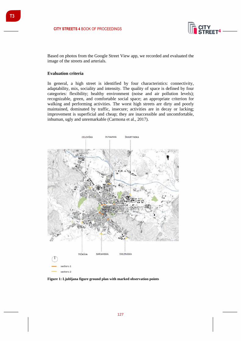
CITY STREETS 4 BOOK OF PROCEEDINGS
127
T3
Based on photos from the Google Street View app, we recorded and evaluated the
image of the streets and arterials.
Evaluation criteria
In general, a high street is identified by four characteristics: connectivity,
adaptability, mix, sociality and intensity. The quality of space is defined by four
categories: flexibility; healthy environment (noise and air pollution levels);
recognizable, green, and comfortable social space; an appropriate criterion for
walking and performing activities. The worst high streets are dirty and poorly
maintained, dominated by traffic, insecure; activities are in decay or lacking;
improvement is superficial and cheap; they are inaccessible and uncomfortable,
inhuman, ugly and unremarkable (Carmona et al., 2017).
Figure 1: Ljubljana figure ground plan with marked observation points

CITY STREETS 4 BOOK OF PROCEEDINGS
128
T3
RESEARCH
A common characteristic of all main arterials and high streets is the division into
northern entrances (Dunajska, Celovška, Šmartinska), which lie on a very suitable
solid geological base for construction, and southern entrances (Barjanska, Tržaška,
Dolenjska), which run along the edge of low bearing marshy soils of the former
tectonic lake (Ljubljansko barje). Due to the natural conditions, the northern
entrances are more intensively built up. The interest rate for investments there is
high. The high streets and arterials in the southern, marshier-ground part of the city
are less developed in terms of built structure and placement of private or public
investments.
To the north – Dunajska cesta
Dunajska cesta (“Vienna Road”) runs along the axis and in the direction of the
former Roman road between the Pannonian Plain and the Adriatic Sea. It connects
Ljubljana with the economically developed hinterland – Maribor, the second
largest Slovenian city, and further with Vienna. Towards the south, it ends in the
narrowest city centre, where its name changes to Slovenska cesta (“Slovenian
Road”) on the Roman Cardo Maximus axis. After the removal of the walls around
the medieval core, Slovenska cesta (respectively, Dunajska cesta) became the
carrier of urban development. Along it, the most important public and business
buildings from all periods of the city's history are located.
Section 1 – intersection with the inner city ring
This is a designed high street space with limited access for cars. Car speed is limited
to 30 km/h, and public transport predominates. The width of the street space allows
adjustments to accommodate different activities. The ground floors of the buildings
are filled with a variety of service programmes, which are safe and well accessible
to pedestrians. The recognizability of the space is distinct. It is surrounded by
quality modernist architecture with regionally rooted details of inventive Slovenian
architecture from the post-WW2 socialist era. A significant change since 1990 was
the restoration of pavement and diminishing of car traffic. Environmental pollution
with noise and gas emissions is moderate.
Section 2 – intersection with the outer city ring
The modernistic concept of dense and high building pattern along the main arterial
has been preserved, but most of the public space is occupied by cars with a speed
limit of 60 km/h. As a result, environmental pollution with noise and gas emissions
is high. The space is dangerous, unattractive, and uncomfortable for pedestrians.
On the left side is the building of the World Trade Centre, built in the socialist era
in postmodern style. This is the only building with a ground floor designed as a
space for socializing and mixed programmes, accessible to people. The remaining

CITY STREETS 4 BOOK OF PROCEEDINGS
129
T3
buildings were built after 1990. The visibility of the building volumes is rather
good, but they are designed without additional effort to create a specific
architecture. We are dealing with an uncritical transfer of “international” style of
serial office buildings from abroad. The programme on the ground floor is mostly
business with limited access to the public (banks, representative offices, insurance
companies, hotels, etc.).
To the northwest – Celovška cesta
Celovška cesta (“Klagenfurt road”) connects the city centre with Alpine regions
and further with Salzburg and Munich. Along it, all the way to the Austrian border,
well-developed urban centres in the form of conurbations are located. This part of
Slovenia is an important tourist destination. Celovška cesta is also the main
connection to the central state airport. The area along the arterial is mainly
composed of large residential neighbourhoods and an abandoned extensive turbine
factory complex, dating to the post-war socialist construction of the city.
Section 1 – intersection with the inner city ring
Here the high street is converting to arterial. Compact building line along the street
is blurring and no longer readable. Car areas with narrow sidewalks predominate.
The speed limit is 50 km/h. Security and readability of the space is poor.
Postmodern renovations have contributed to the loss of the elegant silhouette of the
glass modernist high-rise dominant volume of the hotel. The only highlighted
public entrance of the former public library from the socialist era is closed. The
building has been refurbished for business purposes. Street-accessible service on
the ground floors is lacking, as well. The buildings are dominated by an introverted
programme (hotel, casino, meeting room), without entrances from the street. Noise
and air pollution are high. Post-1990 changes have worsened the quality of public
space.
Section 2 – intersection with the outer city ring
The arterial is a wide road with a car speed limit of 60 km/h. The ground floors of
the buildings are below the road level and are not connected to it. Negotiating a
six-lane crossing poses a serious risk to pedestrians and cyclists. The area is
recognizable only by dense traffic signalization. Noise and air pollution are very
high. The only change since 1990 has been the widening of the crossing due to
connection to the outer highway ring (European transport corridor Nos. 5 and 10).
To the northeast – Šmartinska cesta
Šmartinska cesta (“Šmartno Road”) runs through a former logistics and industrial
area, since 1990 transformed into the biggest shopping centre in Slovenia. It runs
to the outer city ring and has no function in the regional road network. It is lined
CITY STREETS 4 BOOK OF PROCEEDINGS
130
T3
with abandoned pre- and post-WW2 industrial complexes. Since 1990, a large
shopping centre has been developing at the crossroads of Šmartinska and the outer
city ring. Development is based exclusively on the interest of private investors.
Section 1 – intersection with the inner city ring
Northeastern arterial is connected to the inner city ring through an underpass under
the railway line, part of the European Mediterranean corridor Madrid–Budapest.
Due to the narrowness, car traffic is congested and occupies the entire space
between the buildings. There is no pedestrian space, so people avoid the place. As
a result, both diverse service programmes on the ground floors and the physical
building structure of former high street are disappearing. The public space is
unsafe, recognizable only by the decaying pre-WW2 battery factory. Noise and air
pollution are very intense.
Section 2 – intersection with the outer city ring
This arterial performs the function of quick access to the regional commercial
centre BTC for cars and transport vehicles. Pedestrian walkways are narrow and
uncomfortable. The space is recognizable by high business and commercial
buildings with low-quality architecture and good car accessibility. It is a typical
example of a globalized consumer model of urban development. It is based on the
depletion of existing public infrastructure. Noise and air pollution are high,
whereas the safety of cyclists and pedestrians is very poor.
To the southwest – Tržaška cesta
Tržaška cesta (“Trieste Road”) runs along the route of the ancient Roman road in
the direction of the Adriatic Sea. To this day, it has retained the character of an
important transport connection with the northern Adriatic ports (Koper and
Trieste). Since it runs beside the edge of the wetland of Ljubljansko barje, there are
no tall buildings along it, and the interest of investors is lower due to more
expensive construction in comparison to the northern arterials and high streets. Due
to the parallel highway built before 1990, it lost the importance for transport, which
further accelerated the deterioration of buildings and services. No major city
programmes are located next to it, so the public space is either undeveloped or non-
existent.
Section 1 – intersection with the inner city ring
The historically built fabric forms a closed building line along the route of the
ancient Roman southern entrance in the direction of the narrowest centre of the
city. The inner city ring, built after WW2, does not follow the historical pattern.
The former high street human scale has replaced the car scale. The space is
recognizable for its preserved historical structures and partly preserved high street

CITY STREETS 4 BOOK OF PROCEEDINGS
131
T3
character. The ground floors of the buildings are lively, busy with services for the
local population, and well accessible from the street. Vehicle speed is limited to 40
km/h. Greenery improves air quality and reduces noise pollution. In part, a
comfortable and safe pedestrian area is provided.
Section 2 – intersection with the outer road ring
The four-lane arterial space is designed as a distinctly car-friendly space that is
uncomfortable, unattractive, and unsafe for pedestrians. The speed limit is 60 km/h.
The street fringe is occupied by extensive parking lots, the buildings are set into
the interior remote from the street and are not perceptible as part of the arterial.
The space is unrecognizable; people find it difficult to navigate. The space is
dangerous because there are no buildings with programmes close to the street.
Noise and air pollution are high.
To the south – Barjanska cesta
Barjanska cesta (“Marshes Road”) is the most recent arterial, which connects the
city centre with the southern outer highway ring. Built after 1990, it follows the
axis of the Roman Cardo Maximus. Barjanska was only partially implemented in
the socialist-era planned four-lane profile and doesn’t follow in full the prevailing
paradigm of the automobile city of the time. Closer to the city centre, the historical
profile of the two-lane street accompanied by early modernist villas and palaces,
which were originally planned for demolition, has been preserved. Like Šmartinska
cesta, this arterial lacks a direct connection to the regional road network but ends
at the outer ring of the city. It runs along the marshy terrain of Ljubljansko barje,
location of only relatively recent city expansion. Therefore, the plots along the
arterial are mostly left undeveloped. Closer to the city centre, several important
public buildings, university buildings, schools, and residential neighbourhoods
from the socialist – as well as post-1990 globalization – period are located next to
it.
Section 1 – intersection with the inner city ring
The place is recognizable by aligned buildings from the beginning of the 20th
century. It is one of the few intersections of the arterial with the inner city ring
where the width of the road has been adapted to the historic built structure. Vehicle
speed is limited to 40 km/h. Pedestrian corridors are well designed, safe, and
surrounded by greenery. Access to the buildings is connected to the street space
through front gardens, which provide privacy and noise protection for the
residential villas on the one side and the school on the other side of the street.

CITY STREETS 4 BOOK OF PROCEEDINGS
132
T3
Section 2 – intersection with the outer road ring
The southern end of Barjanska cesta is only a functional connection between the
city centre and the highway. Pedestrian movement has been not planned, so there
are no service or residential programmes. The place is recognizable by large
billboards and beautiful views towards Ljubljansko barje.
To the southeast – Dolenjska cesta
The southeastern arterial is directed towards the historic entrance of the medieval
core. During socialism, it was reconstructed into a wider two-lane road connecting
Ljubljana with the main Yugoslav cities in the Balkans (Zagreb, Belgrade). Very
heavy traffic flowed through it. In the 1970s it was widened into a four-lane arterial
with multi-level crossing after the American model of automotive city. With the
disintegration of Yugoslavia, the arterial lost its significance. In addition, it runs
between the marshy terrain of Ljubljansko barje and the steep slope along its
northern edge. The built structure and programmes on the ground floor are
deteriorating due to unfavourable location conditions and the loss of the function
of an important regional connection.
Section 1 – intersection with the inner city ring
The place is recognizable by the multi-level crossing above the historic level of the
urban ground floor with no access from the street. The main function of the arterial
here is the efficient delivery of car traffic. Cars are moving at a speed of 50 km/h.
The sidewalks are narrow and uncomfortable. The place is dangerous, polluted
with traffic signalization, noise, and gas emissions. Despite its walking distance to
the old city centre (550 m), it is not used by pedestrians and cyclists. They avoid
the place and, unless absolutely necessary, do not use it.
Section 2 – intersection with the outer city ring
A two-lane road with narrow pedestrian corridors ends at the outer city ring in the
form of a typical motor road surrounded by meadows. Billboards and car-care
services line the edge. The space is unrecognizable, unsafe for pedestrians, and
overloaded with excessive noise and air pollution. With the exception of minor
roadway reconstructions, the condition of the arterial area has remained unchanged
since the time of its post-WW2 construction.
CONCLUSION
The analysis of Ljubljana arterials and high streets has shown them to be well-
designed as multifunctional and active public space only in the narrowest city
centre, bounded by the inner city ring (radius 500–700 meters from geometric
centre on the city). It is organized to human scale. Cars are subject to speed limits

CITY STREETS 4 BOOK OF PROCEEDINGS
133
T3
and other regulations which ensure pedestrian priority. Already at the intersections
of high streets with the inner city ring, the high streets are transformed into
degraded mono-functional traffic corridors for motor vehicles moving at a speed
of at least 60 km/h. These areas are recognizable by aggressive traffic signalization
and poor local identity. The living conditions (polluted air, risk of accidents, noise)
are significantly deteriorated. The arterial corridors have been abandoned and are
no longer a carrier of public life. They are physically decaying, and traditional
activities, such as trade, have moved elsewhere (to the city outskirts, online, etc.).
Generally, we can conclude that the intensity and variety of activities of each street,
as well as its physical condition, mostly depend on its location – the distance from
the city centre and its importance in the hierarchy of connections between the city
and the region. The more economically developed the part of the city around the
street is, the more active and physically preserved is the street. The development
level of the region toward which the street is heading has significant impact on the
street quality. We also found a very clear connection between the quality of street
space and the economic system which drives the development in certain time
periods. The more liberal and market oriented the system is, the less human scale
oriented and vibrant is the street space.
As expected, the results showed that the street sequences closer to the historic city
centre are better preserved and livelier than more distant sequences at intersections
with the outer city ring. The latter were built after 1990 and support the goals of a
liberal market economy. Following first the model of the German concept from the
1960s (i.e. autogerechte Stadt) and later the model of the American car city, the
implemented solutions mostly, or even exclusively, enable fast and efficient
transport of goods and passengers. After joining the European Union in 2004,
Ljubljana arterials became part of the network of European transport corridors,
which further emphasized their transport function. As a result of Slovenia's
integration into the European and global space, intensive strengthening of road
transport connections is detrimental to the image of their adjoining public space.
Local programmes and social life have been replaced by parking lots. Once
carefully designed socialist-era city skyline along the Dunajska and Celovška cesta
has been blurred by the addition of an anonymous low-quality designed
architecture of smaller foreign investors with introverted programmes and with
very limited connections to the public space. Dolenjska and Tržaška cesta, due to
difficult construction conditions less attractive to investors, have remained
unchanged since pre-urbanization period. They maintain the rural appearance of
the built structure which is deteriorating physically and programmatically, owing
to the lack of interest in investing in renovation due to the adverse effects of
intensive traffic. The city ground floor along arterials outside the centre is largely
unattractive and useless for walking or socializing. Ljubljana arterial area outside
the city centre is a traffic area for vehicles, preventing any development of a quality
urban way of life.

CITY STREETS 4 BOOK OF PROCEEDINGS
134
T3
In order to develop a comprehensive strategy for the renovation of arterial and high
street network as a whole, it is entirely necessary to create a set of specific tools
for their renovation and revitalization. Such tools should be based on a typology of
streets as defined by the distance from the city centre and their importance in the
hierarchy of connections between the city and the region.
Figure 2: Intersection of the arterials with the inner city ring (left) and outer city ring (right)
CITY STREETS 4 BOOK OF PROCEEDINGS
135
T3
REFERENCES
Carmona, M., Gabrieli, T., Hickman R., Laopoulou, T., Livingstone, N. (2017). Street
appeal: The value of street. Progress in Planning, Vol. 126, Nov. 2018, pp. 1–51.
Retrieved from https://www.sciencedirect.com/science/article/pii/S0305900617300636 (12 Feb. 2020).
Cuttle, J. (2018). How the French Author Victor Hugo Saved Notre Dame. Retrieved from
https://theculturetrip.com/europe/france/paris/articles/how-the-french-author-victor-hugo-
saved-notre-dame/ (19 Apr. 2020).
Figure 1: SCHWARZPLAN.EU. Retrieved from https://schwarzplan.eu/ (3 Mar. 2020).
Figure 2: Google Maps. Retrieved from
https://www.google.com/maps/place/Ljubljana/@46.0660318,14.3920158,11z/data=!3m1
!4b1!4m5!3m4!1s0x476531f5969886d1:0x400f81c823fec20!8m2!3d46.0569465!4d14.5
057515 (20.4. 2020).
Schneider-Sliwa, R. (2006). Cities in Transition Globalization, Political Change and
Urban Development, GeoJournal Library 83. Springer, Netherland. Retrieved from
https://link.springer.com/book/10.1007/1-4020-3867-4 (15 Jun. 2020).
CITY STREETS 4 BOOK OF PROCEEDINGS
136
T3
DYNAMIC STREETS AND CITY PROGRAMS
Višnja Kukoč1 Assist. Prof., PhD, University of Split, Faculty of Civil Engineering, Architecture and Geodesy [email protected]
Mirza Džananović Assist. Prof., PhD, University of Zenica, Faculty of Philosophy [email protected]
Marko Borota MA, Independent designer [email protected]
Jelena Borota M. Arch, GISplan [email protected]
Mariana Bucat M. Arch, Arhitektonski Kolektiv [email protected]
ABSTRACT
Streets are the primary urban element and the primary public good. The word
street has a broad meaning. Regarding programs we differ a primary street with
city programs, a business street with a variety of businesses, a housing street with
housing programs and a combination of all three. Regarding purposes we differ
streets to pedestrians and streets to automobiles.
In this paper we present the research of the two primary business/housing
pedestrian streets in two different cities.
The first street is Maršala Tita Street in Zenica, in BiH, formed gradually and
largely in a spontaneous manner, located in the city centre. The second street is
Ruđera Boškovića Street in Split/Split 3, in Croatia, carefully planned and built at
once, located in the centre of the third city rayon.
Maršala Tita Street encompasses city and housing programs, businesses, the
University of Zenica Campus, the market, the old centre and the Jalijasꞌ Bridge.
Ruđera Boškovića Street encompasses city and housing programs, businesses, the
University of Split Campus, a bus hub and a department store. In the vicinity of
both streets there are primary and secondary schools.
1 Corresponding author

CITY STREETS 4 BOOK OF PROCEEDINGS
137
T3
The two streets have been created at different times, in different cultures, but within
the same social system – Yugoslav self-governing socialism. They are comparable
regarding their almost identical purposes and similar programs. Additionally, both
streets haven't been refurbished or exposed to tourism and yet they are dynamic
and active.
We planned to simultaneously count of passers-by at different times of the day and
of the month, listing street programs, and compare the outcome. Restriction of
movement that occurred due to the pandemic caused by COVID -19 prevented us
to carry out the research to the end. Results, of only a third of the planned survey
suggest to be indicative and we present them as preliminary.
Keywords: City program, pedestrian street, public good, residents, pedestrians
INTRODUCTION
Streets are the primary urban element and the primary public good. The word street
has a broad meaning. In regard to programs we differ a primary street with city
programs, a business street with a variety of businesses, a housing street with
housing programs and a combination of all three. In regard to purposes we differ
streets to pedestrians and streets to automobiles.
“Think of a city and what comes to mind? Its streets. If a city's streets look
interesting, the city looks interesting; if they look dull, the city looks dull”, Jacobs
(1992).
Until recently the streets in the city centres in Europe and elsewhere were full of
people, but mostly tourists. To meet the growing tourism needs programs and
purposes of those streets have been changing. Coffee bars, restaurants and souvenir
shops were all over while programs that serve residents have been disappearing,
and residents as well. City centres have become monotonous. Outside the tourist
season they are deserted.
Having in mind that city programs are meant for residents we consider how those
programs influence dynamism of streets, not exposed to tourism. Our research
reviews the two streets that serve residents on different schedules and in the place
for different purposes.
“The diversity, of whatever kind, that is generated by cities rests on the fact that in
cites so many people are so close together, and among them contain so my different
tastes, skills, needs, supplies and bees in their bonnets” Jacobs (1992).
We planned to simultaneously count of passers-by at different times of the day and
of the month, listing programs of the streets, and compare the outcome obtained in
the two listed streets. Restriction of movement that occurred due to the pandemic
caused by COVID -19 prevented us to carry out the research to the end. Results,

CITY STREETS 4 BOOK OF PROCEEDINGS
138
T3
of only a third of the planned survey suggest to be indicative and we present them
as preliminary.
The intensive literature review did not result in finding relevant research, criteria
or norms that could be used in our survey for the comparison. Researchers today
are preoccupied with reclaiming city streets for people, shared space and
pedestrian safety, pedestrianisation as a great necessity and alike, although already
in 1960s it was obvious: “The onslaught of cars and the pressure of that industry,
that is, the lobbies for cars have made the crumb the main object, the parking lot
an obsession, the traffic the primary goal, the destroyers of every social and urban
life. The day is approaching when the rights and powers of the car will have to be
limited, not without difficulties and damage” Lefebvre (1974).
Relevant insight of the topic similar to ours we find in the book of Jan Gehl and
Lars Gemzøe Public spaces Public Life Copenhagen first published in 1996.
Chapters Residents in the city centre, and Students in the city centre especially
justify our research. “Residents contribute to the vitality of the city at all times of
the day and night, going about their daily tasks (...) No single factor has more
influence on the vitality of city centres than the presence of universities and
students in the area” Gehl, Gamzøe (2004).
In this paper we deal with Maršala Tita Street in Zenica, in BiH and Ruđera
Boškovića Street in Split/Split 3, in Croatia. The two streets have been created at
different times, in different cultures, but within the same social system – Yugoslav
self-governing socialism2. City of Zenica has a population of 110,000 inhabitants.
City of Split has 180,000 inhabitants, while the rayon of Split 3 has 40, 000.
MARŠALA TITA STREET
Maršala Tita Street in Zenica, in BiH, is formed gradually and largely in a
spontaneous manner. It stretches through the historic centre of the city, in the area
of the old Ottoman Bazaar. Buildings built in different periods, from the Ottoman
to the Modern as well as the city programs have a long history on this street. They
appear to have happened by accident or in the development of a city over time.
Master plans created from 1955 to 1983 have directed the development of modern
Zenica (1955 by Juraj Neidhart, 1966 by Ivan Taubman and Jelena Civrić, 1983 by
Mugdim Čukle). “MaršalaTita Street was reconstructed in 1968. For further
activities, it was necessary to create a new urban solution for the city centre,
2 Socialism in the Socialist Federal Republic of Yugoslavia (SFRY) was characterized by a one-
party system, social ownership (instead of state ownership proclaimed in the USSR and other
countries of the Eastern bloc) and social or "socialist" self-government. This system was
decentralized (six federal units called Socialist Republic) and respected some elements of a market
economy.

CITY STREETS 4 BOOK OF PROCEEDINGS
139
T3
namely, its southern part around the Ottoman Bazaar. Famous Slovenian architect
Edvard Ravnikar performed this work “Džananović (2017).
Figure 1: Maršala Tita Street with all programs and services (Orto-photo: GISplan archive)
CITY STREETS 4 BOOK OF PROCEEDINGS
140
T3
Maršala Tita Street, primary business/housing3 pedestrian street, connects the
University of Zenica Campus with 5,500 students, the main city market, the old
centre and the Jalijasꞌ Bridge leading across the Bosna River to parks and
recreational areas. In its vicinity there are administrative centre of Zenica and
Zenica – Doboj Canton, elementary and secondary school, kindergarten and other
city programs.
During the day but also in the evening, especially in the summer period, when it
becomes a promenade, Maršala Tita Street plays important role in the social life of
city of Zenica.
Due to general conditions in the state of B&H and in Zenica – Doboj Canton not
so many tourist arrive to Zenica. “Tourism and catering in Zenica-Doboj Canton
have so far been at a very low level, although significant resources exist” Official
pages of the Assembly and the Government of Zenica - Doboj Canton, B&H
(2020).
RUĐERA BOŠKOVIĆA STREET
Ruđera Boškovića Street in Split/Split 3, in Croatia, is carefully planned and built
at once. It is located in the centre of the third city rayon4. Programs of Ruđera
Boškovića Street were systematically designated through the program for the urban
tender, with participation of the then wider public, and performed through a series
of strategic and implementation plans. The buildings built on this street belong to
the Modern period. The overall activities took place from 1970 to 1979.
“The street was conceived as one of the two main mixed use, commercial and
residential pedestrian streets of the third city rayon of 50,000 inhabitants. It is
placed in line of the cardo of Diocletian’s Palace and runs north – south. The street
was to serve inhabitants for their daily and occasional needs. Under the entire street
there is a garage with 1,050 parking places”, Kukoč (2013). Although at a very
attractive location, several large commercial state-owned spaces have not been in
use for decades.
Ruđera Boškovića Street connects the University of Split Campus with 20,000
students, a bus hub and a commercial centre. Several city and county agencies have
their premises on this street. A primary school, two secondary schools and a
hospital are nearby, and a little further is the sea and beaches.
3 Old čaršija houses with commercial space on the ground floor and residential on the first floor. 4 Rayon is a term used in urban planning from the 1950s to the beginning of the 21st century in
Yugoslavia, in SSSR and Eastern Bloc countries. Each rayon is divided into local communities that
make up the smallest organizational city units. In addition to housing, each local community has
appropriate facilities and about 6,000 to 10,000 inhabitants. Each rayon has a rayon centre with
appropriate facilities and 30,000 to 40,000 inhabitants.

CITY STREETS 4 BOOK OF PROCEEDINGS
141
T3
Figure 2: Ruđera Boškovića Street with all programs and services (Orto-photo: GISplan
archive)

CITY STREETS 4 BOOK OF PROCEEDINGS
142
T3
The architects first and foremost respected the tenant and the pedestrian, by
allowing him to move along the real street, which in the modern settlements was
forgotten.
“With new values, in the new context of ideas about the place of our time, the street
returns to us without losing any of its good traditional properties, and therefore
brings new ones”, Mušič (1970).
Given the old town with Diocletian's Palace, tourists do not come to Split 3 or
Ruđera Boškovića Street, as yet.
THESES
Dynamic streets are those streets that by diversity and mixture of uses, with more
than one city program, serve people living or working in the immediate vicinity or
within a walking distance. In other words, diversity and mixture of uses are
exemplified in a street that attracts people of different tastes, skills, needs and ideas.
METHOD
1. The method used is the systematic counting of pedestrians, at the strategic point
on Maršala Tita Street in Zenica, and on Ruđera Boškovića Street in Split/Split 3,
on 5 March, 2020, from 12:30 to 1:30 AM and from 3:30 to 4:30 PM, at a
temperature of 20° degrees in Zenica and 14° degrees in Split. The counting was
performed on a week day, on Thursday.
2. By touring the terrain, along each street individually, all spaces and programs
were listed.
3. The collected data are presented graphically using Orto-photo of Maršala Tita
Street and Ruđera Boškovića Street.
4. Brief analysis of preliminary results is conducted.
PEDESTRIAN TRAFFIC ON THE STREETS
“People come where people are, is a common saying in Scandinavia. People are
spontaneously inspired and attracted by activity and the presence of other people”
Gehl, Gemzøe (2004).
Counting of passers-by was conducted on 5 March 2020, in two terms on both
streets: between 12:30 and 1: 30 AM and between 3:30 and 4:30 PM. The first
term was chosen in regard to the time when children are coming back or going to
schools. The second term was chosen in regard to when residents are leaving
offices or coming back from work.
On Maršala Tita Street in Zenica, on sunny day, at 20°, first count gave total of
2,685 pedestrians. They were mostly of student age and retirees.

CITY STREETS 4 BOOK OF PROCEEDINGS
143
T3
The second count, under the same conditions, gave total of 1,955, mostly middle
and old age people in the direction of the market, while in the direction of the
University campus were mostly young people.
Figure 3: The first count of pedestrians on Maršala Tita Street (Orto-photo: GISplan archive)

CITY STREETS 4 BOOK OF PROCEEDINGS
144
T3
Figure 4: The first count of pedestrians on Maršala Tita Street (Orto-photo: GISplan archive)
On Ruđera Boškovića Street in Split, on partly cloudy and somewhat windy day,
at 14°, the first count gave total of 816 pedestrians. They were mostly of student
and school age and retirees.

CITY STREETS 4 BOOK OF PROCEEDINGS
145
T3
Figure 5: The first count of pedestrians on Ruđera Boškovića Street (Orto-photo: GISplan
archive)
The second count, under the same conditions, gave total of 754 pedestrians. One
third of them were elementary school children and the rest residents of all ages.
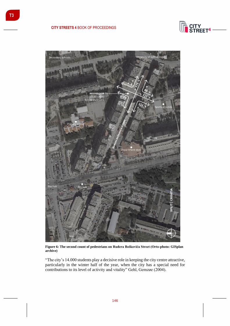
CITY STREETS 4 BOOK OF PROCEEDINGS
146
T3
Figure 6: The second count of pedestrians on Ruđera Boškovića Street (Orto-photo: GISplan
archive)
“The city’s 14.000 students play a decisive role in keeping the city centre attractive,
particularly in the winter half of the year, when the city has a special need for
contributions to its level of activity and vitality” Gehl, Gemzøe (2004).

CITY STREETS 4 BOOK OF PROCEEDINGS
147
T3
CONCLUSIONS
Diversity and mixture of uses are preconditions of dynamic streets. This includes
both, the dense concentration in the case of people who are there because of
residence and those who are there because of city programs, on the very street or
in the vicinity.
Restriction of movement that occurred due to the pandemic caused by COVID -
19 prevented us to carry out the research to the end. Results, of only a third of the
planned survey, suggest to be indicative and we presented them as preliminary.
City programs and dynamic streets are interrelated. In the past the big survey of
Jan Gehl and Lars Gemzøe presented in the book Public spaces Public Life
Copenhagen confirm our opinion. Additionally, now, that tourism has largely
waned and globalization is coming to an end city programs are even more
important. “As economies reopen, activity will recover, but don’t expect a quick
return to a carefree world of unfettered movement and free trade (...) Wave
goodbye to the greatest era of globalisation—and worry about what is going to take
its place”. No matter what changes are ahead of us children will always attend
school, just as students will attend college, people will take a bus on a city or
intercity lines, buy fresh food at a market, attend city agencies. Their presence on
Maršala Tita Street in Zenica and Ruđera Boškovića Street in Split provide
liveliness and thus a basis for economic activity.
“Whereas other city centres might feature specific user groups (…) public life in
Copenhagen city centre is highly diverse. There are people from all age groups,
income groups and educational backgrounds (...) There are residents, students,
customers and visitors. People live, work, shop and enjoy themselves in the city”
Gehl, Gemzøe (2004).
REFLECTIONS AND RECOMMENDATIONS
The actual contribution to the set thesis would be fully realized through the
continuation of research in the following months. Maršala Tita Street in Zenica, in
BiH and Ruđera Boškovića Street in Split/Split 3, in Croatia, are both vital to city
life. To describe their qualities and special features will give an overview of their
strengths and uniqueness to everyone concerned with urban development – users,
owners, merchants and politicians.
REFERENCES
Džananović, M. (2017). Grad u dimnjacima – urbanizacija Zenice od 1945. do 1990.
godine (City in chimneys - urbanization of Zenica from 1945 to 1990). Udruženje za
zaštitu intelektualnih i kulturnih vrijednosti Zjenica.
CITY STREETS 4 BOOK OF PROCEEDINGS
148
T3
Gehl, J., Gemzøe, L. (2004). (First published in 1996) Public Spaces Public Life –
Copenhagen. The Danish Architectural Press & The Royal Danish Academy of Fine Arts.
School of Architecture Publishers.
Jacobs, J. (1992). (First published in 1961) The Death and Life of Great American Cities.
Vintage Books.
Kukoč, V. (2013). Metoda za načrtovanje javnih mestnih prostorov v obdobju tranzicije
na primeru Split III (Method of Planning of Urban Public Places in Times of Transition
as Exemplified by Split III). Theses, University of Ljubljana.
Lefebvre, H. (1974). (First published in 1970) Urbana revolucija (The original title: La
révolution urbaine). Nolit.
Mušič, V. B. (1970). Urban Design and Development of the Split 3 Project. SINTEZA –
journal of art culture. Double issue 18 & 19.
Official pages of the Assembly and the Government of Zenica - Doboj Canton, B&H.
(2020, June 9). Trade, tourism and catering. Retrieved from
https://zdk.ba/press/item/2965-trgovina-turizam-i-ugostiteljstvo
The Economist (2020, May 14). Has covid – 19 killed globalisation? Retrieved from
https://www.economist.com/leaders/2020/05/14/has-covid-19-killed-globalisation
CITY STREETS 4 BOOK OF PROCEEDINGS
149
T3
DECENTRALIZATION OF WORKPLACES AS A FACTOR OF THE
REDUCING URBAN TRANSPORT SYSTEM
Gregor Čok1 Assist. Prof., PhD, University of Ljubljana, Faculty of Civil and Geodetic Engineering, [email protected]
Samo Drobne Assist. Prof., PhD, University of Ljubljana, Faculty of Civil and Geodetic Engineering, [email protected]
Gašper Mrak Assist., PhD, University of Ljubljana, Faculty of Civil and Geodetic Engineering, [email protected]
Mojca Foški Sen. Lect., PhD, University of Ljubljana, Faculty of Civil and Geodetic Engineering, [email protected]
Alma Zavodnik Lamovšek Assist. Prof., PhD, University of Ljubljana, Faculty of Civil and Geodetic Engineering, [email protected]
Abstract
The urban transport system today faces the challenges of the negative impact of
transport on health and the environment and its spatial limitations in terms of
sharing with other actors. Traffic regulation can be achieved through partial
measures or through strategic planning of activities in space. In recent decades,
Slovenia has experienced an intensive centralisation of workplaces, especially in
the large urban centers, which promotes daily commuting on a large scale and the
resulting strain on both the wider transport network and the urban street network.
The article presents an analysis of the current situation in the field of spatial
distribution of workplaces and business entities in Slovenia, with a focus on the
Osrednjeslovenska statistical region. Using a comparative research method, we
have defined their scope and distribution in space on the basis of publicly available
data. We found a significant concentration in the area of the Ljubljana Urban
Municipality, which is consequently confronted with traffic congestion and the
search for solutions to cope with the situation. The impact of transport on the urban
environment would be easier to manage at the level of a coordinated location of
activities in the area and towards the objectives of sustainable development.
Key words: urban transport system, jobs, commuting, business entities,
decentralization
1 Corresponding author

CITY STREETS 4 BOOK OF PROCEEDINGS
150
T3
INTRODUCTION
The urban transport system is one of the basic structural elements of urban space.
In addition to bypasses, access roads and other city streets, the system also forms
intersections and contiguous street spaces which, together with the content and
architectural scenery of the surrounding buildings, contribute to the identity of the
structural morphology of each city and its quality of living (Jacobs, 1961;
Rudofsky, 1969; Loafland, 1998; Gehl, 2010). In its chronological development, it
has undergone various transformations of its programmatic and shape
physiognomy over the decades.
The most important transformations of the conventional urban transport system
were experienced by the motorisation of transport at the beginning of the 20th
century (Clark, 1958). In addition to road surfaces, new uses such as parking lots,
bus stops, charging stations, signaling systems and other elements of transport
infrastructure were created, further restricting pedestrian traffic and causing
various negative impacts on health and the environment. Less than a century later,
the urban transport system faces the challenge of regulating the existing situation
(Furchtlehner and Lička, 2019). On the one hand, it is a complete overload of the
system and the search for effective solutions; on the other hand, we are witnessing
the phenomenon of empty streets, which is a consequence of general social
mobility or modern living and working culture. As an alternative to the traditional
city streets with a public program, modern commercial and shopping streets are
being developed, located in the newly emerging urban centers of cities and other
settlements (Mehta, 2009). At the same time, the process of reducing and
eliminating car traffic is being carried out in individual areas, especially in urban
centers, in order to bring this area closer to a wider range of users.
In Slovenia, too, we are confronted with two opposing processes in the current
planning of the urban transport system. In the field of renovation of historic streets
we follow the trends of sustainable design (Pignar, 2015) and give priority to “street
life and events on the street", tourism and trade. At the same time, we want to meet
the growing demand for urban bypasses, access roads and other streets in the city,
which are increasingly congested with increasing (mainly personal) traffic. The
biggest congestion on the roads usually occurs in the morning and afternoon rush
hours when people drive to and from work, and in the afternoons in larger shopping
centers, due to the concentration of workplaces and various services in the cities.
Especially in the area of Ljubljana, the capital of Slovenia and also one of the three
national centers of international importance (SPRS, 2004), there are many
business, administrative, educational and other functions that promote extensive
daily commuting from the hinterland. 80,600 employed persons come to the
Osrednjeslovenska statistical region every day, and only 19,700 leave it (Regions
in figures, 2018).
Thus, despite the construction of the motorway network and the continuous
improvement of urban transport systems, we are still confronted with congestion

CITY STREETS 4 BOOK OF PROCEEDINGS
151
T3
in transport infrastructure, particularly at the level of regional centers (MzI, 2018),
which is reflected in increased traffic flows and the resulting negative
environmental impact on the structural, symbolic and quality of life of cities. In
this context, the question arises whether the current centralisation (Miklavčič (ed.),
2016, Nared et al., 2016), which represents a deviation from the strategic
orientations of spatial (SPRS, 2004) and sustainable development (ESDP, 1999),
is also or primarily due to the lack of control of individual spatial processes?
Although the direct effects of the described situation are usually first seen on the
transport infrastructure, the problem is much more complex and needs to be
addressed on a broader scale. The article therefore draws attention to the situation
that, according to statistical and other publicly available data (SORS, 2019, AJPES,
2020), shows the increasing centralisation of jobs in the major employment centers,
which consequently leads to an increase in daily commuting. We will therefore show
the spatial distribution of jobs and business units in Slovenia, focusing on Ljubljana
and the Osrednjeslovenska statistical region.
METHODS AND DATA
The survey was carried out on the basis of publicly accessible (SORS, 2019) and
other public databases (AJPES 2019) processed with the corresponding software
tool (ArcGIS). In a first step, an analysis of the number of workplaces in Slovenian
municipalities in the period 2005-2018 (SORS, 2019) was carried out. The trend
of increase and decrease of the number of workplaces was divided into six (6)
classes according to the Jenks method (the method finds the places with the highest
concentration of the examined elements). In a second step, the size and distribution
of business entities in the space were checked using a database of all registered
business entities in Slovenia (AJPES, 2019). We then compared the results
obtained descriptively.
In a third step, an even more detailed analysis of business entities in the
Osrednjeslovenska statistical region was carried out and distributed according to
the sector of activity (Čok et al., 2020) and according to distribution in the
Ljubljana Urban Municipality (hereinafter referred to as MOL), suburban
municipalities (all municipalities directly bordering the city of Ljubljana) and in
the other municipalities in the Osrednjeslovenska statistical region. The scope and
distribution of business entities with regard to the detailed land use in MOL (OPN
MOL ID, 2010) was also reviewed.
RESULTS
Data on the change in the number of workplaces between 2005 and 2018 show that
the picture has changed significantly over this period (Figure 1). There is no doubt
that there is a strong trend of workplaces growth in some large urban centers along
the motorway junction and especially in MOL, which shows strong workplaces

CITY STREETS 4 BOOK OF PROCEEDINGS
152
T3
growth (up to 26% of all workplaces in the country) and in most municipalities of
the Osrednjeslovenska statistical region. The results undoubtedly show a high
concentration of business entities and the centralisation of many activities,
including in the public sector (Nared et al., 2016) and the resulting increase in daily
commuting to Ljubljana.
Figure 1: Number of workplaces by municipality in 2018 and the trend of change in the
number of workplaces in the period 2005-2018 by municipality in Slovenia
Figure 2: Spatial distribution of business entities in Slovenia, situation in 2019 according to
their number in the municipality (the number of municipalities in each class is given in
brackets)

CITY STREETS 4 BOOK OF PROCEEDINGS
153
T3
Regardless of the trend of increasing or decreasing of workplaces, in 2019 the
highest concentration of business entities (Figure 2) was also recorded in the urban
municipalities of Ljubljana and Maribor, followed by the municipalities of Koper,
Kranj and Celje.
The Osrednjeslovenska statistical region also stands out the most among the
statistical regions. It is home to 85,359 or 33.2% of all business entities in the
country, which together provide 293,647 workplaces and employ 53.5% of the
working population (SORS, 2019). In terms of activities, the tertiary and
quaternary sectors dominate in the Osrednjeslovenska statistical region, accounting
for up to 91.8% of all business entities (Table 1).
Table 1: Number and share of business entities by sectors of activity in the Osrednjeslovenska
statistical region
Sector of Slovenia Osrednjeslovenska statistical region
activity No. of business
entities
Share
(%) No. of business entities Share (%)
A - primary 2732 1,1 363 0,4
B - secondary 26.611 10,4 6671 7,8
C - tertiary 180.465 70,2 63.374 74,2
D - quaternary 47.224 18,4 14.951 17,6
Total 257.032 100,0 85.359 100,0
Compared with the data for the whole of Slovenia, in the Osrednjeslovenska
statistical region 25% of all business entities are located in the secondary sector,
even 35% in the tertiary sector and 31% in the quaternary sector. These data also
indicate a strong concentration of business entities and workplaces in the
Osrednjeslovenska statistical region, so we were also interested in a more detailed
distribution of business entities within the region. It shows a significant
concentration within the MOL (Table 2), where 65.8% of all business entities in
the region are present, in the suburban municipalities (municipalities directly
bordering to the MOL) this proportion is already much lower (21%), and in all
other municipalities in the Osrednjeslovenska statistical region there are only
12.9% of business entities.
Table 2: Distribution of business entities by municipalities in the Osrednjeslovenska statistical
region
Osrednjeslovenska statistical region No. of business entities Share (%)
MOL 55.920 65,5
Suburban municipalities 18.441 21,6
Other municipalities in region 10.998 12,9
Total 85.359 100,0

CITY STREETS 4 BOOK OF PROCEEDINGS
154
T3
Surprisingly, the majority of business entities are located in residential areas
(55.3% in the Osrednjeslovenska statistical region and 31.6% in the MOL). This is
followed by the areas of central (community, commerce and business activities)
and industrial activities. It is interesting that business entities in these areas also
belong to all four sectors of activity. The tertiary sector is strongly dominant (at the
level of the whole of Slovenia there are up to 70.2% of tertiary activities in
residential areas (Čok et al., 2020). As it can be assumed that a large part of these
activities is also carried out in the form of work at home, their influence on traffic
flows is reflected in the overall urban transport system (Figure 3).
Figure 3: Example of the location of business entities in residential areas and in areas of
central activities ( commnity, commerc and business activities) in the case of Tržaška ulica
(left figure) and Celovška ulica (right figure) in the city of Ljubljana
The consequences are naturally reflected in the general congestion of the main
access roads (e.g. Celovška and Tržaška Streets) as well as the network of junctions
and other city streets (access for business customers, supply of raw materials, waste
disposal, etc.). This phenomenon has not yet been systematically studied in
Slovenia (Čok and Furman, 2019), but we can say with great certainty that work at
home on such a large scale continues to put a strain on the urban transport system
and the associated street space.
CONCLUSIONS
The analysis of the distribution of workplaces and business entities in Slovenia,
particularly in the Osrednjeslovenska statistical region, confirmed that we have
long been confronted with the problem of concentration and, above all,
centralisation in MOL. We have also shown that the business entities are belong to
different categories of detailed land use at the city level. In this sense we are also
dealing with a loosely controlled phenomenon of work at home, which causes
additional traffic congestion and other negative impact on the urban environment.

CITY STREETS 4 BOOK OF PROCEEDINGS
155
T3
We also note that the spatial situation certainly shows a deviation from the strategic
orientations of a polycentric and balanced spatial development (SPRS, 2004), but
also an insufficient implementation of the current spatial legislation (ZPNačrt,
2007 and ZUreP-2, 2017) and control of spatial processes.
All this has a direct impact on the dominance of car traffic in the urban transport
system, including the interconnected junction and street system, often to be
regulated by intervention measures and ad hoc projects. These are curative
measures with the aim of rehabilitating existing problems that could be solved
more successfully and rationally. In fact, for all the above-mentioned issues, the
appropriate measures exist within the framework of existing strategic development
documents (SPRS, 2004; PRS, 2004; SRS 2030, 2016, etc.) and spatial legislation
(ZPNačrt, 2007 and ZUreP-2, 2017) with their implementation instruments. We
can therefore conclude that despite the principles of sustainable development and
the accepted direction of polycentric spatial development, Slovenia still has a clear
centralisation of business entities and workplaces in MOL (and the
Osrednjeslovenska statistical region), which raises two fundamental questions: Are
we able to regulate current trends in spatial development and do we want
harmonious spatial development?
ACKNOWLEDGEMENT The authors acknowledge the financial support from the Slovenian Research
Agency for co-financing of the research programme Geoinformation Infrastructure
and Sustainable Spatial Development of Slovenia (P2-0227).
REFERENCES
AJPES (2019). Baza poslovnih subjektov. Ljubljana, Agencija Republike Slovenije za
javnopravne evidence in storitve. Retrieved from //www.ajpes.si/fipo/default.asp
Clark, C. (1958). Transport: Maker and Breaker of Cities, The Town Planning Review.
28(4), 237-250.
Černič Mali, B., Marot, N. (2019). Izzivi zagotavljanja storitev splošnega pomena za
starejše v težje dostopnih podeželskih območjih: primer Idrijsko-Cerkljanskega. Bovec,
Slovenski regionalni dnevi 2019.
Čok, G., Furman Oman, M. (2019). Delo na domu kot prostorski pojav : arhitekturni in
urbanistični vidik regulacije dela na domu. Igra ustvarjalnosti (IU)/Creativity Game
(CG)–Theory and Practice of Spatial Planning, 7, 38-45.
Čok, G., Mrak, G., Zavodnik Lamovšek, A. (2020). Analiza prostorne distribucije
poslovnih subjekata u Sloveniji. Prostor : znanstveni časopis za arhitekturu i urbanizam.
28, 1 (59), 76-87.
ESDP (1999). European Spatial Development Perspective: Towards Balanced and
Sustainable Development of the Territory of the European Union. Luxembourg,
Committee on Spatial Development. European Commission.
CITY STREETS 4 BOOK OF PROCEEDINGS
156
T3
Furchtlehner, J., Lička, L. (2019). Back on the Street: Vienna, Copenhagen, Munich, and
Rotterdam in focus. Journal of Landscape Architecture, 14(1), 72-83.
Gehl, J. (2010). Cities for people. Washington, Covelo, London. Island press.
Jacobs, J. (1961). The Death and Life of Great American Cities. New York, Vintage
Books.
Mehta, V. (2009). Look Closely and You Will See, Listen Carefully and You Will Hear:
Urban Design and Social Interaction on Streets. Journal of Urban Design, 14(1), 29-64.
Miklavčič, T. (ed). (2016). Poročilo o prostorskem razvoju. Ljubljana, MOP.
MzI (2018): Pobuda za državno prostorsko načrtovanje za ureditev ljubljanskega
avtocestnega obroča in vpadnih cest ter predlog dopolnjujočih ukrepov reševanja
prometne problematike. Ministrstvo za infrastrukturo. Ljubljana, PNZ svetovanje
projektiranje d.o.o., LUZ d.d.
Nared, J., Bole, D., Breg Valjavec, M., Ciglič, R., Černič Istenič, M., Goluža, M., Kozina,
J., Lapuh, L., Razpotnik Visković, N., Repolusk, P., Rus, P., Tiran, J. (2016).
Policentrično omrežje središč in dostopnost prebivalstva do storitev splošnega in
splošnega gospodarskega pomena. Končno poročilo. Ljubljana. ZRC SAZU.
OPN MOL ID (2010). Odlok o občinskem prostorskem načrtu Mestne občine Ljubljana –
izvedbeni del, Ur. L. RS, št. 78/10, 10/11 - DPN, 22/11 - popr., 43/11 - ZKZ-C, 53/12 -
obv. razl., 9/13, 23/13 - popr., 72/13 - DPN, 71/14 - popr., 92/14 - DPN, 17/15 - DPN,
50/15 - DPN, 88/15 - DPN, 95/15, 38/16 - avtentična razlaga, 63/16, 12/17 - popr., 12/18 -
DPN in 42/18.
Pignar, U. (2015). Kreativno preoblikovanje uličnih prostorov. Primer začasne ureditve
Koroške ceste v Mariboru. Projektna naloga univerzitetnega študijskega programa
arhitektura 1. stopnja. Maribor, Univerza v Mariboru, Fakulteta za gradbeništvo,
prometno inženirstvo in arhitekturo.
PRS (2004). Uredba o prostorskem redu Slovenije. Ljubljana, Ur. l. RS 122/04.
Regions in figures (2018). Statistical portrait of slovenianm regions. Ljubljana, Statistical
Office of RS. Retrieved from: Retrieved from: https://pxweb.stat.si/
Rudofsky, B. (1969). Streets for People. New York, Doubleday.
SPRS (2004). Odlok o strategiji prostorskega razvoja Slovenije, Ur. L. RS 76/04.
Ljubljana. MOP.
SRS 2030 (2017). Strategija razvoja Slovenije. Ljubljana., Vlada RS
SIRS (2019): Si-stat: demografsko in delovno področje. Ljubljana, Statistical Office of
RS. Retrieved from: https://pxweb.stat.si/SiStat
ZPNačrt (2007). Zakon o prostorskem načrtovanju. Ljubljana, Ur. L. RS, št. 33/07.
ZUreP-2 (2017). Zakon o urejanju prostora. Ljubljana Ur. l. RS št. 61/2017.

CITY STREETS 4 BOOK OF PROCEEDINGS
157
T3
PROMOTING ACCESSIBILITY IN THE URBAN PLANNING SYSTEM: FADP IN TARANTO SMART CITY PLANNING
Alessandro Massaro1 MSc in Urban Regeneration, University of Parma, [email protected]
Francesco Rotondo Università Politecnica delle Marche, [email protected]
ABSTRACT
This paper aims to investigate the role of sustainable urban mobility in the strategy
of the new urban design development of the city of Taranto. Following Agenda
2030, the municipal urban planning system is finding a definitive shape, under the
regular exercise of the new Masterplan. Therefore, we investigate the role of
sustainable urban mobility in the process that brings to the Masterplan. In this
urban planning process, we analyze the FADP (Free-Accessibility Design Plan),
its genealogy process, and its development. The FADP is one of the first applied
tools of the Urban Sustainable Mobility Plan (SUMP), and regards the entire
downtown, which is made by three different parts, due to the particular
geographical context and to the different shapes of the urban neighborhoods. The
present search explains the methodology used to study this area, based on GIS
analysis supporting the decision system. So, the different moments of acquiring
data, collecting measures, and involving residents become the topics of the speech,
in their innovative methodology GIS-based. Finally, the search epitomizes the role
of FADP to enhance urban open space quality and attractivity of places.
Keywords: Planning, Mobility, Accessibility
INTRODUCTION
The articulation of Objective 11 of the 2030 UN Agenda, highlights the need to
enhance and adapt urban transport and public spaces to allow weaker users
accessibility and security, with a view to a progressive decrease in vulnerability,
greater inclusiveness, in a wider sense of sustainability. Reaching the targets of
Objective 11 of the Agenda has become even more urgent in the pandemic phase
in which the inability to use the entire capacity of local public transport to ensure
adequate health safety measures, could lead to an increase in the use of cars by
raising the level of pollution. The city of Taranto (the 16th most populous in Italy)
1 Corresponding author. The paper is a shared work between the two authors even if it has to
attributed the first three paragraphs and the last one to Francesco Rotondo and all the others to
Alessandro Massaro.
CITY STREETS 4 BOOK OF PROCEEDINGS
158
T3
has integrated the policies for sustainable mobility within the broader training path
of the new Masterplan. So, this paper discuss the free accessibility design plan,
starting from relationships with the general urban planning system, made by the
Masterplan and the SUMP which have preceded it.
BUILDING THE MASTERPLAN AS A FRAMEWORK FOR URBAN MOBILITY
The city has to make a huge effort to get out of the planning impasse it has been in
since 1978 (approval date of the current masterplan). The greatest difficulty of the
process, precisely in terms of participation, is the mistrust accrued by the
population with respect to the institutions and their plans and programs.
Furthermore, there are evidently strong discrepancies between the urban planning
tools in force and the real conformation of the settlements. This difficulty in
planning that has characterized the city is probably also due to the presence of the
large steelworks, accommodating and capable of ensuring easy employment and a
safe model of economic development that does not require planning alternatives.
All of this in a city covering an area of about 250 sq km with a population that
since 1971 has decreased from 244,000 to 198,000 inhabitants (it is a shrinking
city as revealed by Camarda, Rotondo, Selicato, 2015), of which today, even more
worryingly, 30% are unemployed, well beyond the more diffused data (2-7%). In
addition, the city, at present, has no relevance in the tourism market, neither
regional nor national despite the enormous historical and cultural value of the
Magna Graecia city (and not only) or of the Ionian tourist axis. For these reasons,
the new municipal urban plan is mobilizing the plan resources on areas of urban
regeneration in which to accompany and direct the private investors in the
transformation processes, avoiding defining new property income (as traditionally
the regulatory plans have always done in Italy) but focusing the scarce resources
available on the areas to be redeveloped, generating new transformation rents for
those operators who will undertake to implement the plan in these problem areas.
No longer new soils with a land rent, but new areas of urban regeneration with a
transformation income. This is how the new project areas of the municipal plan
were identified. These become the territories of the experimentation of
regeneration to be implemented. The new SUMP described in the next paragraph,
has given sustainable transport solutions to support those regeneration processes.
SUSTAINABLE MOBILITY PLAN (SUMP) AND APPLIED TOOLS
In 2018 the municipality approved the Urban Plan for Sustainable Mobility. As a
strategic tool, it does not introduce prescriptions, but addresses for the Masterplan,
determining its urban planning choices. Among the proposed mobility policies,
some outline new settlement arrangements for this complex city, such as the reuse
of an abandoned Station (Nasisi near the Paolo VI district) or the identification and
commissioning of the rapid transit bus, fast public transport lines (BRTs in
coherence with a transit oriented development. Calthorpe, 1993; Wright, 2010;
Wright, Hook, 2007) which will impose significant changes in the urban layout.

CITY STREETS 4 BOOK OF PROCEEDINGS
159
T3
The Plan, built with the idea of an implementation in stages, aims to reduce the
traffic crossing the old island and the historical quarters, making it expensive, up
to arriving to make it completely pedestrian the aforementioned areas, today
subject to severe congestion and degradation. Pedestrian and bicycle accessibility
is the key concept of the plan.
FREE ACCESSIBILITY DESIGN PLAN (FADP)
Starting from the SUMP’s addresses, the FADP weaves the concept of
“accessibility” to the meaning of disability, enhancing it (Carra, Caselli, Ventura,
& Zazzi, 2017), attempting to start the slow process of transforming discrimination
into social resources. It wish began a process of changing public policies and design
practices. Physical barriers in the environment are recognized as a discriminatory
and powerful influence on people with reduced mobility. The progressive increase
in the number of individuals with different abilities leads the consequent growth in
life expectancy. In Italy, accessibility has become a fundamental design criterion
for public buildings, with the Law 41/1986, which obliges public buildings to adopt
plans for the removal of architectural barriers. It does not explicitly concern urban
spaces, until 1992, with Law 104, which related the accessibility of buildings to
urban spaces. So, now the design plan promote interventions to enlarge pedestrian
flows, to allow the accessibility to the public spaces.
Roots of the idea
According to the European Agenda (Urban Agenda for the EU, 2016), the FADP
focuses on accessibility (for disabled, elderly, young children, etc.) in the planning
system (Massaro, Rotondo, 2019). Belonging the already described flows of the
new Taranto's planning system, the FADP has thought on promoting “the equal
rights of all persons with disabilities to live in the community, with choices equal
to others” (Article 19 of the CRPD). In this way, the FADP develops its phases,
trying to investigate the issues regarding the physical characteristics of the
pedestrian network. The choice's management options refer more to three different
zones of the city, belonging its downtown. The FADP, regarding the Old City an
island linked by two bridges (the Rounding Bridge, and the Stone Bridge) to the
other two parts of the Plan: Modern Downtown (Borgo) on the south, and Naple's
Door (Porta Napoli) on the north. Entirely, the Plan will give solutions about an
area of 2,11 sq km (28.341 inh., 2019), after an intense phase of participation,
involving population, and disability in the mainstream of the Plan.
Methodology
This methodological approach explores the metric relief of the infrastructures and
the construction of a GIS Network System, describing some proprieties about the
analysis of pedestrian flows in an arc-node system on pedestrian paths. Directly
connected with the relief, the multiplicity of constraints that affects the pathways

CITY STREETS 4 BOOK OF PROCEEDINGS
160
T3
is put in evidence, most of all, for the Structural paths. In this way, it is possible to
subdivide the planning zone in different micro zones by different indicators. The
following steps build each micro zone. The network bases its analytic performance
on the Municipality dataset, mapping the civic location of every inhabitant.
Therefore, the network gives them a topographic settlement, the resident
population has been subdivided and localized to the specific civic number, which
involves different coordinates, as well as various reasons concerning the shape of
the residential use of the urban space in the last years. The system represents the
number of inhabitants (2018 Municipality census data) for each civic number,
subdivided by sex, family components, and their evolution along the last ten years.
Even more, the value GDP p.i. (Gross Domestic Product per Inhabitants, Regional
data, 2006-2016) for the entire city in the last year has been subdivided by the
addressed inhabitants at each civic number. The correlation between the evolution
of the GDP p.i. for the entire city and the growth of the GDP p.i./Civic-Density,
gives some different answers related to the shape of the balanced distribution of
the residential value in the analyzed area. For first, it explains the difference
between the economic evolution shape for the so different three (from north to
south: Porta Napoli, Old City, Borgo) areas of the Plan, so close in the compact
city. The union of residents and facilities in the area describes the set of all arcs of
the analysis. Thus, when every link has an associated speed-max, derived from
manuals (Sciences, 2000) of 5.5 km/h, it gives back a specific time of the journey.
The study connects the different civic numbers with the various facilities,
evaluating the weight of residential pedestrians on each arc beside the GIS network
analysis, determining the most utilized paths of the analyzed area. Moreover, the
FADP locates, describes, and analyzes the accessibility for the main public
buildings of the area, collecting functions, and access indicators. One essential
system of facilities regards to healthcare's buildings. The whole network of the
healthcare centers (Hospitals, Pharmacies, Associations, etc.), acquires a critical
role in the study of pedestrian flows, and the time-path just becomes a part of the
safety equation. Another important system of facilities regards to education’s
buildings. The various schools in the area enlarge the functioning of the plan to the
children, and their security on the paths to reach their education.
The other crucial facilities added to the network to understand the main routes of
the pedestrian flows are the Railway Station in the Porta Napoli district; the
Cathedral, the University, and the City Hall in the Old City; the Museum
(https://museotaranto.beniculturali.it/it/), the Province's Building, and the Fruit and
Vegetable Market (Mercato Fadini) in the Borgo. The complex system of public
spaces, gardens, and squares complete the evaluation of the pedestrian
attractiveness. The functioning of the safety equation determines the danger along
the paths, locating that, for evaluating different solutions, connecting the entrances
of the various scheduled facilities, to the whole system of civic residential numbers.
The danger is related to the elements that indicate protection of pedestrians: the
height of the sidewalk on the roadway; the roads' speed max; protective elements
as railings, or similar features; the presence of electronic bollards at intersections;
the overall state of maintenance, measured on the different relief's evaluations.

CITY STREETS 4 BOOK OF PROCEEDINGS
161
T3
Applying a different weight to the various indicators, it is possible to classify the
location of the danger, obtained summarizing each value, and relating the result to
the total amount of the pedestrian flows. Particular attention regards the crossroads,
where the pedestrian paths intersect the vehicular flows. In fact, despite the
dimension of the area, and the diversification of the three mentioned zones, there
are few traffic lights. The safety in the intersections is often guaranteed just by old
zebra crosswalks, notwithstanding the speed limit of 50 km/h on the whole area,
standing the current Municipality’s rules. The system adds an amount of time at
every traffic light, regarding the time of the journey, measured by the proportional
reduction of the pedestrian speed-max: the length of the crosswalk, its schedule of
conditions, the dimension of the pedestrian flow, the shape of the relative
sidewalks, and the typology of the vehicular circulation, determine the weight for
that reduction for every intersection. Summarizing the data from the relief of the
pedestrian paths, with the data deriving from the GIS network Analysis, it has been
possible to evaluate the state of safety for the entire area. The network analysis
matches the considerations about the pedestrian paths with the pedestrian’s attitude
in following convenience, economy, and comfort during their trips. Therefore, the
state of safety depicts the localization of the danger for the whole area, underlining
the main issues due to the most utilized paths. The network also gives a first
evaluation of the level of service, directly linked to the convenience of the existing
walkway system. The network analysis improves the comfort of the paths, using
the Origin-Destination matrix to find the shortest one for each facility. The primary
evidence at this stage follows the comparison with the maps of the UMPD,
underpinning the similitude between the found paths, and the two lines of Bus
Rapid Transport (BRT), a "supporting" network created by the UMPD for the
urban transport. Naturally, the FADP focuses the analysis on the Structural Paths,
a group of walkways distributed on the three parts of the investigation, underlining
its proper functions. At this step, the calculations focus on accessibility, improve
the perceived level of services underlining safety and security, comfort, and
convenience. The feature of the sidewalks is skilled by the grade of separation from
vehicular traffic, analyzing traffic control devices, and the functioning of the free-
vehicular traffic areas. Moreover, in this part of the analysis, the location-allocation
methodology of the GIS built network spots the actual bus-stop system and its
relations with the neighborhood. It retains the previous accounts on the whole area,
refining the pedestrian utilization along the structural paths. From literature about
the topic, accessibility can be defined here as “the ability of people reaching
possible benefits or locations within a system.” (XU, 2014). The analysis of the
pedestrian paths undergoes a wide range of measurements. So the sheets of the
survey change, going deeply in the discovering of the physical features of the
walkways, improving the amount of the indicators for the evaluation of their
functioning. The calculations of the density, the frequency, and the rate of the
pedestrian flows are useful to classify the level of service related to the bus-stops,
so to the diverse functions. The shortest path to reach every key-point in the area
shows another crucial feature of the city, over the UMPD, over the structural
walkways, adequately related to the special meaning of the FADP. It is the case of
what we can define as the “lifeline” of the city downtown.
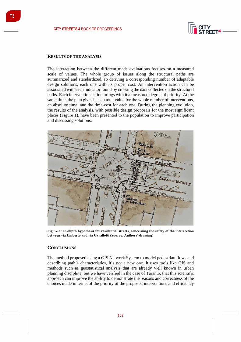
CITY STREETS 4 BOOK OF PROCEEDINGS
162
T3
RESULTS OF THE ANALYSIS
The interaction between the different made evaluations focuses on a measured
scale of values. The whole group of issues along the structural paths are
summarized and standardized, so deriving a corresponding number of adaptable
design solutions, each one with its proper cost. An intervention action can be
associated with each indicator found by crossing the data collected on the structural
paths. Each intervention action brings with it a measured degree of priority. At the
same time, the plan gives back a total value for the whole number of interventions,
an absolute time, and the time-cost for each one. During the planning evolution,
the results of the analysis, with possible design proposals for the most significant
places (Figure 1), have been presented to the population to improve participation
and discussing solutions.
Figure 1: In-depth hypothesis for residential streets, concerning the safety of the intersection
between via Umberto and via Cavallotti (Source: Authors’ drawing)
CONCLUSIONS
The method proposed using a GIS Network System to model pedestrian flows and
describing path’s characteristics, it’s not a new one. It uses tools like GIS and
methods such as geostatistical analysis that are already well known in urban
planning discipline, but we have verified in the case of Taranto, that this scientific
approach can improve the ability to demonstrate the reasons and correctness of the
choices made in terms of the priority of the proposed interventions and efficiency
CITY STREETS 4 BOOK OF PROCEEDINGS
163
T3
of the overall accessibility system designed. The plan actions and the expected
results are directly conveyable in the participation process to be continuously
updated and monitored (City of Helsinky, 2005; Mitman, Ridgway, Chira-
Chiavala, 2008). The plan acts as a tool for broader accessibility, reachable only
through extensive sharing and constant monitoring. Moreover, the statistical
evaluation through the analysis should be improved in the other parts of the cities.
The plan focuses on the inhabitants, so it is useful to repair and give an impulse to
the regeneration process. In this experience, sustainable urban mobility is a process
where the FADP is a relevant tool to improve it together with urban planning
development and transit oriented development, as we tried to describe in the case
of Taranto.
REFERENCES
Calthorpe, P. (1993). The Next American Metropolis: Ecology, Community, and the
American Dream. Princeton Architectural Press.
Camarda, D., Rotondo, F., & Selicato, F. (2015). Causes and processes of shrinkage in the
old industrialized city of Taranto. European Planning Studies, 23, Issue 1, 126-146.
Carra, M., Caselli, B., Ventura, P., & Zazzi, M. (2017). Gis-Based Monitoring and
Evaluation System as an Urban Planning Tool to Enhance the Quality of Pedestrian
Mobility in Pezzagno, M., Tira, M. Town and Infrastructure Planning for Safety and Urban
Quality, Taylor & Francis.
City of Helsinky. (2005, November 14). Accessibility Plan. Public Work Department.
Retrieved from https://www.hel.fi/helsinkikaikille/en/
Massaro, A., Rotondo, F. (2020). L’accessibilità urbana come forma di rigenerazione:
un’esperienza a Taranto. XXII Conferenza Nazionale Società Italiana degli Urbanisti -
L’urbanistica Italiana di Fronte all’Agenda 2030 per lo Sviluppo Sostenibile. Bari:
Società Italiana degli urbanisti (SIU). Retrieved from: http://www.planum.bedita.net/xxii-
conferenza-siu-2019-pubblicazione-atti
Mitman, M., Ridgway, M., Chira-Chiavala, T. (2008, May). A Technical Guide for
Conducting pedestrian Safety Assessments for California Cities. Retrieved from:
https://safetrec.berkeley.edu/sites/default/files/psa_guidebook_2013.pdf
Sciences, National Institute of Buildings (2019, 07 18). History Of Accessible Facility
Design. Retrieved from: https://www.wbdg.org/design-objectives/accessible/history-
accessible-facility-design
Wright, L., & Hook, W. (2007). Bus Rapid Transit Planning Guide. Institute for
Transportation & Development Policy.
Wright, L. (2010). Bus rapid Transit: a public transport renaissance. Built Environment,
35(3), 307-316.

CITY STREETS 4 BOOK OF PROCEEDINGS
164
T3
Xu, M. (2014), A GIS-based pedestrian network model for assessment of spatial
accessibility equity and improvement prioritization and its application to the Spokane
public transit benefit area, Washington State University Press.
CITY STREETS 4 BOOK OF PROCEEDINGS
165
T3
URBAN MORPHOLOGY AND MOBILITY PATTERNS: MYTHS AND
REAL-LIFE TRANSFORMATIONS OF A LARGE HOUSING ESTATE IN
SOFIA
Milena Tasheva-Petrova 1 Assoc. Prof., University of Architecture, Civil Engineering and Geodesy, Address: 1 Hr. Smirnenski Blvd., Sofia, Bulgaria, e-mail: [email protected]
Elena Dimitrova Assoc. Prof., University of Architecture, Civil Engineering and Geodesy, Address: 1 Hr. Smirnenski Blvd., Sofia, Bulgaria, e-mail: [email protected]
Angel Burov Assist. Prof., University of Architecture, Civil Engineering and Geodesy, Address: 1 Hr. Smirnenski Blvd., Sofia, Bulgaria, e-mail: [email protected]
ABSTRACT
The paper discusses the long-term urban planning impacts on the urban
morphology and mobility patterns in the large housing estates designed and built
at the periphery of Sofia in the period 1960-1990 and undergoing continuous
transformations under the changing political, demographic, sociocultural and
economic conditions in the country since 1990s. Based on a casestudy-based
approach developed within ongoing URBiNAT research project (HORIZON 2020),
and applying a set of qualitative as well as quantitative methods, spatial analyses
(territorial mapping, behavioural mapping, quality of life survey), and
participatory activities (cultural mapping, photovoice and walkthrough), the
research undertaken in Nadezhda district, Sofia, outlines major urban challenges
of the present day and claims needed changes in the planning approaches for
building a healthy and socially inclusive urban environment.
Keywords: urban morphology, mobility, large housing estates, post-socialist
transformations, Sofia
INTRODUCTION
The large prefabricated housing estates (HEs) designed and built at the urban
periphery of Sofia in the period 1960-1990 were aimed to support the national
industrialization policy by following the then influential Modernist planning
principles and providing good quality urban environment for large social groups.
Under profoundly changing societal conditions in the next three decades the HEs
1 Corresponding author

CITY STREETS 4 BOOK OF PROCEEDINGS
166
T3
underwent numerous physical transformations. The present study was motivated
by the interest to understand how and how far the urban model once chosen is
capable to accommodate societal change. The findings of an ongoing international
research project are discussed and needed changes in current planning approaches
claimed necessary to adequately respond to the ongoing urban process.
THE LARGE HOUSING ESTATES OF SOFIA AS AN URBAN CHALLENGE AND
OPPORTUNITY
Based on the social meta-narrative about directing social progress through planned
urban change, the Modernist concept largely influenced urban planning in Europe
and worldwide (Mumford, 2019). Modernist urban plans structured city life into
functional zones linked by effective public transport. The promoted collective
housing resulted in large housing estates (HEs) with standardized high-rise
multifamily building units and highly permeable open public space with abundant
greenery; motorized traffic was to be calmed down and walking prioritized in the
estates.
The rapid industrialization of Bulgaria in early 1960s brought about an urgent
demand for new urban housing. Large housing estates of prefabricated panel
buildings were considered an optimal economic and social solution. The first
prefab housing estates in Sofia for 15,000-20,000 inhabitants, with schools and
kindergartens centrally located at a walking distance, were planned in 1960s. In
mid-1970s, larger housing districts for up to 50,000 residents with planned
healthcare and cultural facilities in the district centres were already under
construction (Anastasov et al, 1968; Tashev, 1972); next large housing estates built
in mid 1980s, sheltered up to 200,000 inhabitants each (Kiradzhiev, 2006). In 2011
nearly half of the housing stock in Sofia had been built between 1970 - 1990. Prefab
housing estates sheltered about 575 000 inhabitants (47% of the city population)
(NSI, 2011). The post-1990 transformations of the large housing estates, the result
of a complex societal change, were motivated by market demand, enabled by the
restitution and privatization of urban land, and facilitated by the lack of effective
planning instruments. The social diversification of the inhabitants went alongside
the establishment of privately owned services - from small groceries to big
commercial chains. Housing densification due to infill private mid-rise
developments and the post-restitution fragmentation of the inter-block public
greenery was accompanied by a huge increase of privately owned cars, stimulated
by changing lifestyles and the low reliability of public transport.
International research interest in the impact of Modernist urban planning on
European cities in 20th century’s second half outlined a number of general
tendencies concerning the large housing estates in Europe and their peculiarities in
the CEE region (Anderson et al, 2013; Brade et al, 2009; Tsenkova & Nedović-
Budić, 2006). The urban dimensions of the transition period in Bulgaria were also
discussed alongside emerging societal conflicts and challenges (Alexandrov,

CITY STREETS 4 BOOK OF PROCEEDINGS
167
T3
2006). A deeper understanding for the long-term effects of the initial planning
concept would be today useful to fully estimate the existing potential of inherited
large housing estates to adequately address the needs and challenges of the present
day, and the changes needed in urban planning and governance.
RESEARCH AIM AND METHODOLOGY
The current research stemmed from an on-going international research (URBiNAT
project) with partner-cities from all over Europe, with a study area in Sofia
covering a location with two neighbouring prefab housing estates, among others
inherited from socialism (Figure 1). The construction of Momkova mahala HE
started in 1962; most of the buildings were inhabited by 1970, and some - by mid-
1980s. The spatial composition was built around a commercial centre, a
kindergarten, and a school, linking two residential groups (Figure 2a). The original
master plan of Svoboda HE envisaged 47 prefab panel blocks (Figure 2b). At
present, Momkova mahala is part of Nadezhda 4 urban unit (with 22 900
inhabitants; Svoboda is with 16 500 inhabitants (NSI, 2011).
Figure 1: The location of the study area (in red) among other prefabricated housing estates
in the city of Sofia (in black). Base: OpenStreetMap contributors
The study traced the changes in the urban morphology and the mobility patterns in
the HEs from embracing the Modernist concept in the initial urban design, through
their practical realization and functioning during the next 30 years, and the
transformations resulting from the profound and continuing societal changes since
1990. Three research questions were addressed: (1)What was the long-term effect

CITY STREETS 4 BOOK OF PROCEEDINGS
168
T3
of implementing the Modernist concept on today’s urban form and process? (2)
What was the capacity of the urban structure to accommodate changes resulting
from new societal demands and inhabitants’ lifestyles? (3) What planning
approaches would today contribute to efficiently utilizing the adaptivity of the
urban structures when facing new challenges in developing a socially inclusive and
healthy urban environment?
Figure 2: Urban design projects, 1960s: (a) Momkova mahala HE (today’s Nadezhda 4); (b)
Svoboda HE (source: adapted from Tashev, 1972)
The study of the functional and land-use dynamics and the related mobility patterns
in the HEs started by a general socio-economic and functional analysis, followed
by a comparative analysis of the planning tools developed and implemented – the
urban plans from 1960 and post-2012. Based on desk research, territorial mapping
and a comparative spatial study, diachronic analysis was conducted to identify
spatial transformations of the major structural elements related to housing, open
space, street pattern, and social services, retail, and leisure. The changes in land
ownership were then related to accessibility, connectivity, and walkability. The
state of the built environment was estimated through direct expert observations,
further complemented by a “walk through” and a “photovoice” exercise, and 20
motivational interviews with local pupils. Behavioural mapping was conducted in
9 observation sites. The diversity of lifestyles and mobility patterns, as well as
citizens’ perceptions and attitude, were addressed through 10 in-depth semi-
structured interviews, 3 focus groups with overall 20 participants, and a survey
among 150 citizens on the quality of life in URBiNAT study area, all carried out
in the period January - October 2019. The identified morphological transformations
were related to mobility pattern changes and inhabitants’ route preferences.
RESULTS AND DISCUSSION
The summarized research findings were related to four characteristics of the HES
– the initial conceptual framework of the urban design, the practical realization of
the projects up to 1990, the driving factors for change after 1990 and the resulting
urban features currently observed (Table 1). The diachronic analysis covered plot
ownership, buildings localization, and walking routes (Figure 3). The study results
were then referred to the research questions.

CITY STREETS 4 BOOK OF PROCEEDINGS
169
T3
Table 1: Urban dynamics in the housing estates, 1960s – 2020s
Urban
aspects
Modernist
concept
Realization
before 1990
Drivers for change
post-1990
Resulting
urban features
Morphology
Housing
units
Meeting large-
scale social
needs;
collective, free
standing,
Prefabricated,
standardized,
State-built and
later sold out to
inhabitants
private investment
pressure; delayed
plan update;
ineffective legal
framework
Densification,
changing scale;
private
initiatives in
services
Open
space
Abundant
greenery, free
access, contact
with nature
Low maintenance
budget, basic
equipment, local
initiatives
Land restitution,
economic
restructuring, high
unemployment
Fragmented
green system,
insecurity, poor
maintenance.
Social
services
Walking
distance to
daily services
Schools &
kindergartens
Insufficiency of
public funding,
privatization
Poor
maintenance
and decay.
Retail,
leisure
The daily used
at a walking
distance
Scarce shops,
basic goods
provision
Privatization,
market economy
Profit-oriented,
contrasts in
scale
Street
pattern
Hierarchical
network,
calming down
traffic inside
Narrow
sidewalks, not
well maintained,
street greenery
Low municipal
maintenance
budget, increased
parking pressure
Insufficient
parking space,
poor sidewalks,
no lighting
Mobility
Within
the HEs
Walking relied
upon and
encouraged
Walkways never
fully adapted to
real-life flows
Increased
diversity of paths
and flows
Fragmentation
of open space,
barriers
Between
the HEs
Walking, large
green axes
Compromised
green axes, few
formal crossings
Increased car
dependency
Few formal
crossings,
jaywalking
Between
the HEs
and the
city
Mainly public
transport
Difficult access
mainly by bus
and tram; few
private cars
Low budget for
public transport,
fast growing car
ownership
The city metro
system in
operation since
2012
(1) What was the long-term effect of implementing the Modernist concept on the
continuing urban form and process? In both cases the initial urban design
following the meta-narrative of Modernism set the long-term frame of collective
housing. Svoboda plan was developed on greenfield; its rather rigid physical
structure accomplished by 1970 was generally preserved after 1989 with only
minor changes in the ground floors of the housing units to shelter small local
businesses and provide needed everyday services. Momkova mahala plan
envisaged 6-story blocks within a wide open green public space to the east, and a
mix of existing and new low-rise houses to the west. The initial street design in
both cases followed the concept of walking distances, ‘calming down’ car traffic

CITY STREETS 4 BOOK OF PROCEEDINGS
170
T3
and small parking areas close to the buildings. The diachronic analysis outlined
elements with major effect on further development: the street network, the
residential buildings delineating the public open spaces, and the schools and
kindergartens, located within the urban units. The green axes linking the HEs with
the Northern park were the main elements not realized until 1990; that later
compromised the main pedestrian access to the park and the sports area to the east
and enabled future restitution and privatization. Most of the interviewed inhabitants
highly appreciated the inter-block public open spaces with their abundant greenery;
pupils, however, strongly disliked the poor maintenance of public space and the
lack of free sports facilities in the neighbourhoods.
Figure 3: Diachronic spatial analysis, 1960-2020. Base: OpenStreetMap contributors;
Pedestrian network: upgraded on Vision Sofia 2050 (2019)
(2) What is the capacity of the initial urban structure to accommodate changes
brought by emerging new demands and lifestyles? Change was not envisaged in
the initial urban concept, but after 1990 the urban structures were able to
accommodate minor transformations within the existing buildings and some
densification through the construction on the non-built plots initially designated for
kindergartens and linear public greenery along the pedestrian paths. The fast-
growing demand for parking places proved to be a major challenge difficult to cope
with. New residential buildings, shops on the ground level, but also playgrounds
and sports facilities appeared on restituted plots to meet new societal needs and
market demand. A planned, yet not realized, local park in Svoboda was replaced
by a large club football playground with paid access. New points of interest and

CITY STREETS 4 BOOK OF PROCEEDINGS
171
T3
new barriers shaped the new daily routes of the inhabitants. Alternative informal
paths - usually over municipal land, were trodden by and actively used in the large
inter-block spaces, mainly connecting the entrances of the buildings to the public
transport stops and the playgrounds located in the inter-block spaces. A much
denser pedestrian network than the initially planned one responded to residents’
diversified needs and search for walking convenience. An increase of pedestrian
flows between the neighbouring housing estates was motivated by the diversity of
services and personal motivations. Interviewed residents pointed out the poor
condition of the natural and built environment as a major shortcoming. On-site
observations outlined growing jaywalking and conflict points in crossing the streets
with intensive traffic bordering the estates.
(3) What planning approaches would today contribute to efficiently utilizing the
adaptivity of the urban structures when facing new challenges in developing a
socially inclusive and healthy urban environment? The abundant public greenery,
the network of schools and kindergartens within a walking distance in the quarters,
and the ‘porosity’ and ‘elasticity’ of public urban space, enabling a continuous
informal adaptation to emerging new needs and new mobility patterns, are today
estimated by citizens and local authorities as the greatest potential chance for
adaptability in future urban development. There is, however, a general perception
that, if not properly managed, they also turn into a major shortcoming– a threat to
safety and a prerequisite for crime, and face the risk of being privatized and built
up, thus compromising the potential of the initial morphology. The confirmed self-
identification of the young inhabitants with the place and the still existing culture
of collective action previously encouraged, could be a good basis for encouraging
proactive attitude to creatively changing public open space. The difficulties already
faced in reaching community consensus had also made people appreciate the
importance of a shared understanding on public space, and on the responsibilities
for its use and management. The active urban planning system already made a
serious effort to protect public space and public land ownership through the
updated urban plans. Building a new planning culture based on mutual trust and
embracing public participation would still need a long-term effort by all the actors
involved. There were indicative messages coming from the on-site meetings –
while the citizens claimed they were missing a clear guidance for action by the
district administration, local authorities considered their communication with the
inhabitants on public space a major challenge.
CONCLUSION
The Modernist planning concept was developed once with the promise to cure the
evils of the capitalist city by setting a radically new urban system based on
environmental and social justice. It largely failed in the long run, as its practical
implementation promoted an approach hardly sensitive to urban complexity and
dynamics, to the variety of inhabitants’ needs and preferences, and to existing
financial frames. The prefab housing estates in Bulgaria inherited from the period

CITY STREETS 4 BOOK OF PROCEEDINGS
172
T3
of socialism responded to large-scale and urgent development needs with modest
economic capacity; they, however, utilized considerable land and material resource
and are still home to thousands of people in Sofia. The physical assets still
preserved and highly valued by the inhabitants are the public open space and the
abundant greenery. There is also an important cultural value outlined by the
research – the inhabitants’ self-identification with the place and their proactive
attitude in the search for a better future there. If properly organized, that could be
supportive to an urban policy aimed at a healthy and socially inclusive urban
environment. Planning would need, however, to acknowledge the rights and values
of all the inhabitants, to carefully study the diversity of life patterns and conflicts,
and to build upon synergies.
REFERENCES
Alexandrov, A. (2006). The transition period in urban planning. Sofia Institute for
Modernity, Sofia (in Bulgarian)
Andersen, H.T., E. Dimitrova, K. Schmeidler (2013). Urban Knowledge and Large
Housing Estates in Europe. In Andersen, H. T., R. Atkinson (eds) Production and use of
Urban Knowledge. European experiences. Springer, pp. 103-132.
Brade, I., G. Herfert, K. Wiest (2009). Recent trends and future prospects of socio-spatial
differentiation in urban regions of Central and Eastern Europe: A lull before the storm? In
Cities, Volume 26, Issue 5, pp. 233-244. https://doi.org/10.1016/j.cities.2009.05.001
Kiradzhiev, S. (2006). Sofia 125 Years Capital 1879-2004 Chronicle (in Bulgarian). Sofia:
IK Gutenberg.
Anastasov, H. et al, (1968), The Architectural Image of the Panel Residential Buildings.
Bulgarian Academy of Science (in Bulgarian).
Mumford, E. (2019). CIAM and Its Outcomes. Commentary. In Urban Planning, vol. 4,
Issue 3, pp. 291–298. http://dx.doi.org/10.17645/up.v4i3.2383
NSI (National Statistical Institute, Republic of Bulgaria). Census 2011. Retrieved from:
http://www.nsi.bg/census2011/pageen2.php?p2=179
Tashev, P. (1972). Architecture and urban development of Sofia: Stages, achievements,
problems”. Technika State Publishing House, Sofia (in Bulgarian).
Tsenkova S., Nedović-Budić Z. (eds) (2006) The Urban Mosaic of Post-Socialist Europe.
Contributions to Economics. Physica -Verlag HD
Horizon 2020. URBiNAT Project. Retrieved from: https://urbinat.eu/
Vision Sofia 2050. (2019). Research on pedestrian connectivity on the territory of Sofia.
Retrieved from: https://vizia.sofia.bg/2019/02/21/pedestrian_network/"

CITY STREETS 4 BOOK OF PROCEEDINGS
173
TRACK 4: TRAVEL TIME AND EFFICIENCY OF TRANSPORT
SYSTEMS
Track Chairs:
Simon Koblar, Urban Planning Institute of the Republic of Slovenia, Ljubljana, Slovenia and
Manfred Wacker, University of Stuttgart, Institute for Road and Transport Science, Germany
This track focuses on one of the main functions of roads - to provide transport. To
ensure transport while disturbing adjacent land uses not more than really
necessary is one of the most fostering tasks in urban road planning and design. Not
only motorized vehicles in private transport, public transport, bicycles and
pedestrians compete for the given road space, but also adjacent land uses ask for
public space along the roads. Nowadays even new means of transport like e-
scooters or mono wheels show up. The track highlights the quality of the physical
throughput of a road by the perspective of the traveller (travel time) and the
planning authority (efficiency of transport), finally leading to the question which
capacity a road offers for the different means of transport. These items reflect the
connection and feeder function of a road and are very often in conflict with the
habitation function. Having this in mind the track addresses also the question of
both urban network hierarchies as well as urban road classifications.
Keywords: Travel time, Efficiency, Capacity, Urban Network Hierarchy, Urban
Road Classification
T4

CITY STREETS 4 BOOK OF PROCEEDINGS
174
T4
ASSESSING EFFECTS OF SUSTAINABLE URBAN MOBILITY
MEASURES: CASE STUDY IN THE CITY MUNICIPALITY OF NOVO
MESTO
Simon Koblar1 mag. geog., Urban Planning Institute of the Republic of Slovenia, Trnovski pristan 2, Ljubljana, Slovenia, [email protected]
Andrej Gulič mag. urb. in prost. načrt., Urban Planning Institute of the Republic of Slovenia, Trnovski pristan 2, Ljubljana, Slovenia, [email protected]
Sergeja Praper Gulič univ. dipl. ing. agr., Urban Planning Institute of the Republic of Slovenia, Trnovski pristan 2, Ljubljana, Slovenia, [email protected]
ABSTRACT
Mobility is one of the key areas where cities can improve quality of life for
residents. Sustainable urban mobility plans (SUMP) have proven as an effective
measure in achieving more sustainable urban mobility. In Slovenia 81
municipalities have already adopted SUMP. Most of them also implemented or are
planning new infrastructure measures. However, effects of these measures are
difficult to evaluate. In the paper we propose a new methodology for assessing
effects of measures by calculating accessibility to key traffic generators. The key
element is travel time calculation with OpenTripPlanner software and
OpenStreetMap and public transport schedules as input data. This approach has
been tested on a case study for the City Municipality of Novo mesto (Slovenia) that
adopted SUMP in 2017 and implemented several measures since then.
Accessibility for three situations is compared: before SUMP adoption (2017), in
the beginning of the year 2020 and for a scenario with some additional sustainable
mobility measures. Accessibility of the city centre by the residents with public
transport, walking, cycling, rented bicycle and car is calculated and displayed on
a map. The results show how different measures affect travel speed and number of
residents that can access the city centre in a specified amount of time.
Keywords: SUMP, transport accessibility, Novo mesto, Slovenia, simulations
1 Corresponding author

CITY STREETS 4 BOOK OF PROCEEDINGS
175
T4
INTRODUCTION
Mobility is one of the key areas where cities can improve quality of life for
residents (Schiller et al., 2010). Sustainable urban mobility plans (SUMP) are at
the core of a holistic approach to traffic planning that is gaining more and more
momentum also in Slovenia (Balant et al., 2018), where 81 municipalities have
already adopted SUMP. There is a common consensus about the positive effects of
SUMP, however quantitative measurements of implemented and planned
infrastructure projects remain difficult. Common practice is to count pedestrians,
cyclists and passengers in cars once a year at a specific location. Yet, this is a highly
labour-intensive activity. Moreover, there are other factors affecting traffic flows
which SUMP-s don’t have a direct control, e.g. economic activity or employment
rate.
Good infrastructure often plays a key part in attracting users of sustainable mobility
modes. This can be explained with the sentence: “Build it and they will come”, that
has proven to be correct (Dale Bracewell, 2016). Therefore, we propose an
alternative way of measuring the effects of new infrastructure, that can be used for
implemented or planned infrastructure. We suggest measuring travel times to key
locations in the city by sustainable mobility modes. This is done using open data
for street network (OpenStreetMap, 2019) and an open source software for travel
time calculation (OpenTripPlanner, 2019). Such choice allows easy scalability and
usage in other case studies without the need to purchase expensive traffic
modelling software and proprietary data sources.
The proposed approach has been tested on a case study for the City Municipality
of Novo mesto (Slovenia) that adopted SUMP in 2017 and implemented several
measures since then. Accessibility for three situations is compared: before SUMP
adoption (2017), in the beginning of the year 2020 and for a scenario with some
additional sustainable mobility measures.
METHODOLOGY
The assessment process includes four steps as shown in Figure 1. First, the study
area, locations for which to assess accessibility, travel modes that we want to
include and all variations that we want to consider need to be defined. Secondly,
input data is prepared. OpenStreetMap (2019) has been used to build the road
network in the next step. Data for Slovenia is generally detailed enough and can
also exceed other publicly available sources (Koblar and Pajk Koblar, 2020), but
for detailed modelling it is necessary to include all information about the road
network (all bike paths, sidewalks, restrictions, speed limits, crosswalks etc.).
OpenStreetMap is a community project, therefore improvements can be added
directly into the database. In case of building scenario networks, all further
modifications need to be done on a local copy of a database. A raw database can
be downloaded (Geofabrik, 2019) and clipped on the study area with Osmosis

CITY STREETS 4 BOOK OF PROCEEDINGS
176
T4
software (GitHub, 2020). Modifications of the local copy of OpenStreetMap can
be done in JOSM software (JOSM, 2019). Public transport data need to be in a
GTFS format (GTFS Static Overview, 2019). In Slovenia, data in this format is
available for the train and intercity bus networks and for some city bus networks.
If the data is not available in the right format, GTFS files can be generated from
timetable data. There are also some free tools available for GTFS manipulation that
would be needed if changes in public transport need to be modelled (Awesome
transit, 2020).
Travel times are calculated in OpenTripPlanner software (2019) with
OpenStreetMap as a data layer. Calls to the OpenTripPlaner can be performed with
R studio as proposed by Young (2019). Generated isochrones are then imported in
GIS software and joined with population data. The final step is to statistically
analyse the result and assess the differences between scenarios.
Figure 1: Assessment process
Case study for Novo mesto
The study area comprised the City Municipality of Novo mesto – population data
(SURS STAGE, 2019) and all the statistics were performed for the municipality.
OpenStreetMap, on the other hand, covered a slightly larger area, so that 30-minute
isochrones for car and cycling would not be limited by the municipal border.
Accessibility to Glavni trg in the city centre by walking, cycling and rented bicycle
was analysed. Scenarios included the years 2017 and 2020 and the future network
with a complete cycling network and new bridges over the Krka river. The analysis
for public transport and car was done only for the current situation.

CITY STREETS 4 BOOK OF PROCEEDINGS
177
T4
Before downloading data, the quality of OpenStreetMap data for Novo mesto was
checked and missing information regarding the transport network added. The
database now includes all relevant information for travel time modelling. The
downloaded and clipped data for the year 2020 was further edited in JOSM
software (JOSM, 2019) in the offline mode – therefore not affecting the official
OpenStreetMap database. The network for the year 2017 was constructed by
deleting the bike tracks that were built after 2017 and removing the bike sharing
facilities and road closure for motorised traffic on the main square in the city centre.
For the planned network, we predicted new bridges that are planned and a complete
cycling network on all streets.
Travel time isochrones were generated with the OpenTripPlanner software
(OpenTripPlanner, 2019) using default settings for generating isochrones, apart
from the detail level that was set to 20 m from default 200 m. Calls to the
OpenTripPlaner were done in R studio. Further analyses were performed in
ArcGIS, where population grid data with 100 m resolution were spatially joined
with isochrones. This part could have been done in open source QGIS software as
well. The statistical analysis was performed in Excel.
RESULTS AND DISCUSSION
Figure 2 shows the area reachable by different sustainable mobility modes in 30
minutes from Glavni trg in Novo mesto for the year 2020. The results are not
surprising, as the biggest area is reachable by bicycle followed by public transport,
rented bicycle and walking.

CITY STREETS 4 BOOK OF PROCEEDINGS
178
T4
Figure 2: Accessibility to the city centre by sustainable mobility modes for the year 2020.
Detailed results can be seen in Table 1, that shows the percentage of residents of
the City Municipality Novo mesto that can be reached from the city centre in 30
minutes and average travel times. Somewhat surprisingly, the percentage of
residents accessed by walking and cycling has not changed between scenarios
despite the new bridges included in the scenario. However, only one of the
proposed bridges is near the city centre, that is close to the existing Kandija bridge,
and has only minor effect on travel time to the city centre. Other bridges have
bigger effect on accessibility to other locations (Koblar et al., 2019).
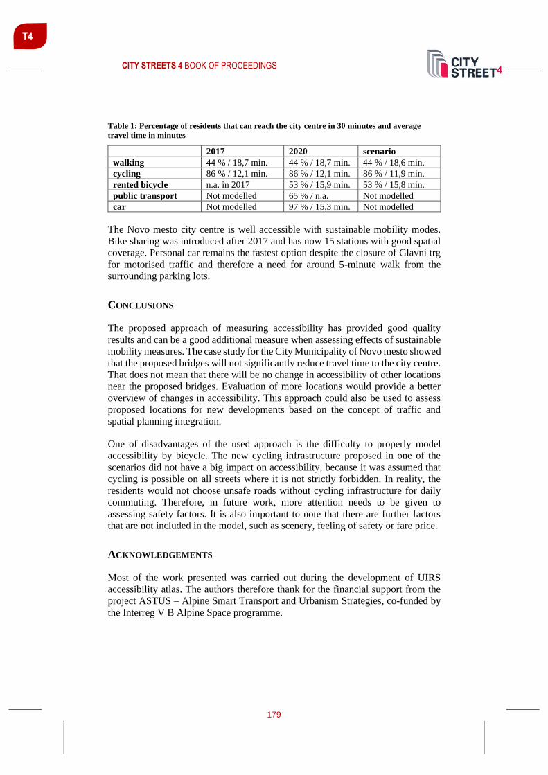
CITY STREETS 4 BOOK OF PROCEEDINGS
179
T4
Table 1: Percentage of residents that can reach the city centre in 30 minutes and average
travel time in minutes
2017 2020 scenario
walking 44 % / 18,7 min. 44 % / 18,7 min. 44 % / 18,6 min.
cycling 86 % / 12,1 min. 86 % / 12,1 min. 86 % / 11,9 min.
rented bicycle n.a. in 2017 53 % / 15,9 min. 53 % / 15,8 min.
public transport Not modelled 65 % / n.a. Not modelled
car Not modelled 97 % / 15,3 min. Not modelled
The Novo mesto city centre is well accessible with sustainable mobility modes.
Bike sharing was introduced after 2017 and has now 15 stations with good spatial
coverage. Personal car remains the fastest option despite the closure of Glavni trg
for motorised traffic and therefore a need for around 5-minute walk from the
surrounding parking lots.
CONCLUSIONS
The proposed approach of measuring accessibility has provided good quality
results and can be a good additional measure when assessing effects of sustainable
mobility measures. The case study for the City Municipality of Novo mesto showed
that the proposed bridges will not significantly reduce travel time to the city centre.
That does not mean that there will be no change in accessibility of other locations
near the proposed bridges. Evaluation of more locations would provide a better
overview of changes in accessibility. This approach could also be used to assess
proposed locations for new developments based on the concept of traffic and
spatial planning integration.
One of disadvantages of the used approach is the difficulty to properly model
accessibility by bicycle. The new cycling infrastructure proposed in one of the
scenarios did not have a big impact on accessibility, because it was assumed that
cycling is possible on all streets where it is not strictly forbidden. In reality, the
residents would not choose unsafe roads without cycling infrastructure for daily
commuting. Therefore, in future work, more attention needs to be given to
assessing safety factors. It is also important to note that there are further factors
that are not included in the model, such as scenery, feeling of safety or fare price.
ACKNOWLEDGEMENTS
Most of the work presented was carried out during the development of UIRS
accessibility atlas. The authors therefore thank for the financial support from the
project ASTUS – Alpine Smart Transport and Urbanism Strategies, co-funded by
the Interreg V B Alpine Space programme.

CITY STREETS 4 BOOK OF PROCEEDINGS
180
T4
REFERENCES
Awesome transit (2020). Retrieved from https://github.com/CUTR-at-USF/awesome-
transit (accessed 18. 5. 2020).
Balant, M., Plevnik, A., and Mladenovič, L. (2018). Razvoj nacionalnega programa za
celostne prometne strategije v Sloveniji = Development of National SUMP Programme in
Slovenia. In: Žnidarič, A., and Šemrov, D. (eds.): Kongres o Cestah in Prometu, pp. 1–7.
Ljubljana, DRC - Družba za raziskave v cestni in prometni stroki Slovenije.
Bracewell, D. (2016). “BUILD IT AND THEY WILL COME”: Convenient Routes
Encourage More People to Cycle. Institute of Transportation Engineers. ITE Journal,
86(9), p. 12.
Geofabrik. (2019). OpenStreetMap, Karlsruhe.
GitHub. (2020). Retrieved from https://github.com/openstreetmap/osmosis (accessed 14.
5. 2020).
GTFS Static Overview. (2019). Retrieved from https://developers.google.com/transit/gtfs
(accessed 26. 2. 2020).
JOSM. (2019). Retrieved from https://josm.openstreetmap.de/ (accessed 5. 8. 2019).
Koblar, S., Gulič, A., and Praper, S. (2019). UIRS atlas dostopnosti. Urbani izziv,
Posebna izdaja, (9), p. 126–131.
Koblar, S., and Pajk Koblar, V. (2020). Analiza prometne dostopnosti s podatki
OpenStreetMap (in print). In: GIS v Sloveniji 2020.
OpenStreetMap. (2019). Retrieved from https://www.openstreetmap.org/about (accessed
5. 8. 2019).
OpenTripPlanner. (2019). Retrieved from https://www.opentripplanner.org/ (accessed 5.
8. 2019).
Schiller, P.L., Bruun, E.C., and Kenworthy, J.R. (2010). An introduction to sustainable
transportation: policy, planning and implementation. London; Washington, Earthscan.
SURS STAGE. (2019). Retrieved from https://gis.stat.si/ (accessed 26. 8. 2019).
Young, M. (2019). OpenTripPlanner - creating and querying your own multi-modal route
planner.
CITY STREETS 4 BOOK OF PROCEEDINGS
181
T4
FUTURE SCENARIOS ON NEW MOBILITY AND THE DIGITALISATION
OF TRAFFIC & ITS EFFECTS ON SPATIAL ISSUES IN RURAL AREAS
Lola Meyer 1 Dipl.-Ing, Universität Kassel, Fachgebiet Architekturtheorie und Entwerfen, Universitätsplatz 9, 34127 Kassel, [email protected]
Philipp Oswalt Professor, Universität Kassel, Fachgebiet Architekturtheorie und Entwerfen, Universitätsplatz 9, 34127 Kassel, [email protected]
Stefan Rettich Professor, Universität Kassel, Fachgebiet Städtebau, Gottschalkstraße 22, 34127 Kassel, [email protected]
ABSTRACT
The interdisciplinary project uses different future scenarios with a timeframe of
2050 to investigate which possible changes in mobility infrastructure and public
spaces could occur due to the digitalisation of mobility, especially through
autonomous driving. We focused on questions of accessibility and public services
and possible impacts of residential and business development in rural areas. The
project developed two divergent scenarios: one in which mobilized individual
traffic increases significantly and dominates the traffic of the future and one where
local public transport is strengthened and developed. In this scenario, an on-
demand fleet of small, autonomous buses takes on a large part of the traffic load
and combines with public rail transport to form the backbone of future mobility,
which is supplemented by a well-developed and safe network of cycle paths.
Furthermore, we identified the entry and exit points as well as the transfer points
as crucial elements of a multimodal transport system. These mobility hubs have
been defined and systematized in the research project.
The study area is northern Hesse, beginning above the city of Kassel, an area of
about 700 square kilometres and approx. 100,000 inhabitants. We consider the
project to be applied research and have therefore presented the work-in-progress
not only to national experts in two workshops in May 2020, but have also discussed
and developed it further in a March 2020 workshop with key local stakeholders.
This special process design offers the possibility of first implementation steps at an
early stage – even though the time horizon of 2050 is still far away. However, to
influence the future development of our mobility system and its associated urban
developments, we must start early and proceed step by step.
1 Corresponding author

CITY STREETS 4 BOOK OF PROCEEDINGS
182
T4
Keywords: Future Scenarios, Mobility Change, Rural Areas, Digitalisation of
Traffic
INTRODUCTION
The research project is funded by the state innovation program “Future Building”
(Innovationsprogramm Zukunft Bau) by the “Federal Institute for Research on
Building, Urban Affairs and Spatial Development”. The interdisciplinary research
team from the University of Kassel comprises the departments of Architectural
Theory and Design, Prof. P. Oswalt and Dipl.-Ing L. Meyer, the department of
Regional Planning, Prof. F. Roost and M.Sc.E. Jeckel, and the department of Urban
Development, Prof. S. Rettich and M.Sc.F. Böker.
RESEARCH QUESTIONS AND WORKING THESES
Basic assumption
If state and local governments do not resist, the digitisation process will have a
significant impact on mobility development not only in cities, but also in rural
areas. Regardless of the expansion and availability of 5G technologies, a growing
number of autonomous private cars will begin spreading to rural areas around 2035.
The digitalisation of transport will have a dynamic impact on the development of
commercial and housing areas in rural regions (especially around bigger cites), and
commuter linkages will increase. Therefore, we need the mobility change now –
not only in big cities, but in the countryside as well. If we fail to strengthen public
transport as soon as possible, we should expect- with the successive expansion of
autonomous private cars – and an increase in motorized private transport and, as a
result, a “cannibalization” of public transport.
Key questions
What effects will digitalisation have on traffic and development in the housing and
business sector in the rural area of northern Hesse? Which measures must be
initiated by the public sector in order to strengthen public transport and thus to
provide public services of general interest in rural areas? Which stakeholders are
particularly important? What effects can be expected on traffic and public spaces
and which structural-spatial interventions must be enacted?
SCENARIOS 2050
From the above research questions and work theses, we developed two diverging
scenarios:
CITY STREETS 4 BOOK OF PROCEEDINGS
183
T4
Scenario A – Strong individualisation of traffic – growth of autonomous
private cars (Figure 3)
Federal and state governments are leaving the digital turnaround to private market
players – not unlike the issuance of 5G licenses. Control instruments are not being
introduced and demands on market players are not being made. As a result, private
cars are expected to increase at the expense of public transport. In this scenario, the
public RegioTram (a special tram line that connects the countryside of northern
Hesse to the city of Kassel used especially by commuters) would still be in use, but
would be reduced to a minimum and would need to be subsidized even more than
it is now. Public transport by bus in the area would have to be stopped completely
due to the slump in demand and would be replaced by autonomous private cars.
Complementary on-demand offers are conceivable and would be mediated on
specific, private mobility platforms while replacing existing bus and taxi offers.
The tariffs would be graded according to accessibility and route efficiency.
Graduated tariffs would also prevail in the delivery service. This scenario would
lead to a growth of urban sprawl and the urbanization of the rural landscapes – as
well as more remote areas.
Expected effects from this scenario
(1) The modal split shifts significantly to the disadvantage of public transport.
Public mobility offers come under considerable cost pressure, have higher deficits
than before and are partially discontinued. (2) Transport performance, number of
routes and travel distances increase significantly in the private car sector, with
negative effects on climate change and CO2 emissions. (3) The public space
remains dominated by the car. (4) With the increase in the number of private cars,
parking space requirements also rise. (5) The attractiveness and use of bicycle
mobility decreases. (6) Rail-bound public transport and its structural infrastructure
(stops / train stations) must be maintained in spite of declining profitability. (7)
Investments in the road network for the private cars increase.
Scenario B - Strong public transport (Figure 3)
Federal and state governments see the digitalisation of the traffic system as a great
opportunity to initiate the sustainable growth of public services and as an important
step towards mobility change. Looking ahead, public transport will be strengthened
and expanded on its main axes, the RegioTram Line. In the area in and around
Kassel, a public all-in-one mobility platform is gradually being developed, which
includes both existing public transport as well as an on-demand public fleet of
autonomous cars with ride pooling and private ride-sharing offers. It bundles the
activities of all services under one public roof and thus supports intermodal
mobility.

CITY STREETS 4 BOOK OF PROCEEDINGS
184
T4
The digital infrastructure is accompanied by the analogue infrastructure of new
“mobility hubs”. These are transformed and expanded transfer stations with
multifunctional purpose: mobility and social functions as well as site-specific
secondary functions. The various modes of transport assemble here in one place.
The hubs offer maximum service, transfer and residence comfort and become
social hubs via affiliated secondary functions. To strengthen local transport and
make the mobility hubs more accessible, the network of cycle routes would be
improved and expanded. Additional push factors favouring the modal shift are used
to contain the use of private cars.
Public measures are required for Scenario B
(1) Public all-in-one mobility platform
(2) Investments in the public transport sector (with the merging of public and
private transport) and the cycling network
(3) Development of spatially differentiated hubs
Expansion of the range of mobility – fusion of public transport and individual
mobility. The plan is to support the idea of carpooling by digitalising the idea of
“Mitfahrerbänke”, or carpooling benches. This is a system of special benches that
have been in use in Germany since 2015. The bench, positioned by the side of the
road, offers people without a car to “hitchhike” via the more formal system of the
carpooling bench. They vary from region to region, but the basic concept is the
same everywhere: if you sit on this bench, you are waiting for someone to stop and
pick you up. Sometimes the bench has a sign that shows where you would like to
go – so only cars willing to take you there will stop. Even though the concept is
quite new, initial studies have shown that there are 76% more people willing to
take someone with them than there are people using the bench – above all because
they fear no one would be willing to stop (Blees, Becker, 2019). Our solution to
the problem is to introduce the idea into the mobility platform. This way, bench
users know when someone will use the route and can even (if it is a personalized
system) see the person’s name, ratings, feedback etc.
- The main module of Scenario B is the acquisition of an on-demand fleet of
autonomous cars as feeder traffic and service of the area (further development of
the public citizens' buses, which may continue to exist in parallel).
- As push factors: Parking management in Kassel and a toll system for the private
cars on the main connecting roads.

CITY STREETS 4 BOOK OF PROCEEDINGS
185
T4
The following effects are expected
(1) The expansion of fast, public mobility offers significantly increases the
attractiveness of public transport. Supplemented by the offer of diversified hubs
and improved cycle paths, intermodality can be experienced more effectively – the
modal shift becomes possible. (2) Traffic performance, number of routes and
passenger distances are falling in the private segment, despite the growing fleet of
autonomous cars. (3) Housing and commercial development will dynamize and
bundle itself in accordance with the principle of decentralized concentration in the
vicinity of public transport routes. Placing the hubs at strategically important points
can strengthen public services and public life (Figure 3). (4) By reducing the
transport performance of private cars, the current cross-sections of streets and
parking space requirements can be re-designed and re-regulated in favour of public
transport and the public space. The spatial dominance of the car is pushed back.
Since car sharing and carpooling reduce the number of cars and parking lots, the
existing parking spaces can be added to the public space. Even though the amount
of space in question is not currently known, an Austrian study assumes that with
the maximum use of sharing offers (autonomous car sharing), the number of
vehicles could decline by around 80% (even 90% for car sharing with ride pooling).
Accordingly, enormous areas that were previously used for private cars, especially
parking space areas, could free up.2
FURTHER RESEARCH
In order to achieve Scenario B – Strong public transport – with its positive effects
on sustainable mobility as well as improved mobility for people in rural areas
(especially elder people as well as students and the disabled), different steps must
be taken and additional research must be done: (1) The hub idea must be specified
and tested in the field; (2) We need more testing areas for the use of public fleets
of autonomous on-demand cars;3 (3) The idea of the “carpooling bench” must be
further developed; (4) And, last but not least, the all-in-one mobility app must be a
public service.4 Furthermore, we need more push-measures to make private cars
less attractive and to support the idea of mobility change.
CONCLUSION
If we fail to react, more cars will be on the streets and people will be on the road
more often. Autonomous cars will revolutionize driving and make it even more
popular and convenient to be in your own private car – reading emails, watching
2 The research area is a small town in the Austrian country side with 15,000 inhabitants.
Klementschitz, R., Angerer, M., Bauernfeind, A Potenziale für den Einsatz gemeinschaftlich
genutzter autonomer Fahrzeuge im ländlichen Raum, 580. 3 There are already several studies and research projects underway, for instance the project
https://www.autonv.de in Eastern Germany. 4 Cities like Helsinki are quite far along in this regard. See https://whimapp.com

CITY STREETS 4 BOOK OF PROCEEDINGS
186
T4
films or sleeping while driving. This will lead to more urban sprawl and higher
CO2-emissions. The alternative is that we start doing something. One option is the
proposal to revolutionise public transport by the following measures: The existing
concept of carpooling benches could undergo a significant increase through
digitalisation; via an all-in-one mobility platform, a network of registered drivers
and users could expand the mobility offers and successfully hybridize public and
private transport, especially in rural areas. On the other hand, a public fleet of
autonomous cars will fuse the benefits of public transport and private transport,
offering more individualized and on-demand public transport.
Figure 1: Self-driving shuttle from the research project “autonomous driving public mobility
in rural areas”, at the TU Berlin. Photo: Arne Holst
Figure 2: Carpooling bench. Photo: Lola Meyer

CITY STREETS 4 BOOK OF PROCEEDINGS
187
T4
Figure 3: Research area Nothern Hesse. Concept Scenario B – Strong public transport – with
its backbone of rail transport (red), autonomous driving shuttles (everywhere on the street
system) and the plus-bus concept of fast buses that connect bigger distances (green). University
of Kassel, BauMobil

CITY STREETS 4 BOOK OF PROCEEDINGS
188
T4
REFERENCES
Blees, V., Becker, J. (2019). Erfolgsfaktor Mitfahrbank?! Wissenschaftliche
Untersuchung der Akzeptanz und des Nutzens von Mitfahrbänken. Hochschule
RheinMain Wiesbaden, Frankfurt University of Applied Sciences, 38.
Klementschitz, R., Angerer, M., Bauernfeind, A. (2019). Potenziale für den Einsatz
gemeinschaftlich genutzter autonomer Fahrzeuge im ländlichen. RauUniversität für
Bodenkultur Wien.
MaaS Global (2020). Retrieved from https://whimapp.com
Stern (2020). Retrieved from https://www.stern.de/neon/heimat/stadt‐land/baden‐
wuerttemberg‐‐sind‐diese‐mitfahrbaenke‐das‐neue‐trampen‐‐8002512.html
TU Berlin (2020). Retrieved from https://www.autonv.de in Eastern Germany

CITY STREETS 4 BOOK OF PROCEEDINGS
189
T4
FUTURE OF URBAN MOBILITY IN LJUBLJANA
Gregor Boltič MSc in Urban and Regional Planning, Heriot-Watt University, [email protected]
Miha Šetina1 BSc of Architecture and Urban Design, Fakulteta za Arhitekturo Ljubljana, [email protected]
ABSTRACT
Cars have been the main personal transportation mode for almost the past
100 years. A lot has changed in this field with the introduction of safety
measures, fuel consumption standards, electricity to power the cars and in
recent years automation. We could say that almost everything inside and
outside the cars had changed since its beginning, only the driver
remained. But this will change soon. With the introduction of digitalization
and more and more systems which allow the computers to take over the
control from humans, we will see the rise of autonomous vehicles in the
near future. Especially public transport can benefit from the introduction
of autonomy in driving, making it safer and more reliable as before.
Keywords: automation, autonomy, AV, mobility, digitalisation, urban strategy,
transport mode, shared mobility
INTRODUCTION
Although there are numerous directions in which we could see autonomous
vehicles (AVs in further reading) develop, this paper will focus on AVs that are
not a direct substitution for personal cars. As such, AVs that are not in direct
ownership by a household could also develop in several ways- as traditional public
transport means, on demand mini buses, shuttle buses and driverless taxis being
some of them.
It is arguable that the concept of autonomous vehicles is not even close to be fully
utilised and researchers predict that AV's usage might mature in the mid-21st
century, drawing on the experiences of introduction of electric vehicles and similar
transitional trends in the past (Schoettle and Sivak, 2014). It seems that ensuring
people's safety and technological challenges of AVs accompanied by public's
perception of safety and trust in the technology have been the main topic of
research in the past decade (Koopman and Wagner, 2017; Bagloee et al, 2016).
1 Corresonding author

CITY STREETS 4 BOOK OF PROCEEDINGS
190
T4
Because of this, and the fact that the scope of the conference is year 2030, we feel
that this paper should focus on understanding what AVs can bring and pointing out
what the city of Ljubljana can do to successfully undertake challenges and prepare
for its future transport plans for the decades to come.
Since the capital city of Slovenia, Ljubljana has been emerging in the last decade
as a green and modern central European city with focus on the development of
greener personal transports, we would like to show in this report our vision for the
future of the urban mobility in the city. We propose a plan based on the current
traffic situation but introducing new proven ideas from abroad to make the
transportation system safer, more modern, digital and most of all autonomous.
WHAT KIND OF FUTURE WILL AVS BRING?
Research by MIT (New York), ITF (Lisbon) and the VDV (Stuttgart) show that it
would be possible to reduce the number of cars by 80% and still cater for people
reaching their desired destinations. But it is of crucial importance to note that this
could only happen if AVs are utilised as shared vehicles of different sizes,
reinforcing a highly efficient public transport network, along with walking and
cycling still being chosen as a means of transport by many (Policy Brief, 2016).
The same paper reinforces this statement further by outlining that public transport
remains the only reasonable solution, able to accommodate a maximum amount of
trips by using as minimum space as possible and still be able to be time-efficient.
If the adoption of AVs is done correctly, we could see a drastic increase of shared
mobility modes, eventually displacing private ownership. The concept of “using,
not owning” might develop as a norm among urban populations, which will relieve
pressure on roads and road space allocation. But if AVs become a mainstream
mode of transport, what happens to walking and cycling? This issue is something
that still needs to be properly researched and according to Madeer et al, 2017 there
might be two possible future scenarios. One where active travel is done in almost
perfect conditions- reduced exhaust emissions with much less traffic noise and car
parking allocation alongside streets; and a second scenario, where walking and
cycling are rather redundant since people can be picked-up within seconds and
dropped-off at their exact desired location (Madeer, et al, 2017).
The other, less optimistic, but not unrealistic perspective of AVs changing the way
people move and vehicles influencing urban mobility is presented by Yigitcanlar,
2017. He argues, that with the introduction of mainstreamed AVs, commutes will
become easier, since driving won’t be seen as a specific task, so time might be
utilised differently by people driving in AVs. This might lead in complete
reappraisal of the time factor, since commuting wouldn’t be considered a big
burden and a waste of time (Silberg et al, 2012). Easier commutes will
consequently have “an impact on residential property prices, and might shift
preferences from properties in urban centres to those in suburban areas”. This

CITY STREETS 4 BOOK OF PROCEEDINGS
191
T4
might also have an impact on city centres being more densely populated, meaning
that urban and suburban lifestyle might increasingly differentiate and become more
distinct than they are at the moment (Yigitcanlar et al, 2017). People might favour
living further out from the city centre, since land prices and rent in suburban areas
tend to be cheaper than those in more central locations. Furthermore, families and
anyone wanting to live in a greener environment would utilise this change and
decide to move out, meaning that convenience of AVs could be a decisive factor
when comparing trade-offs between location and daily mobility (Heinrichs, 2016).
This scenario might be further supported with the prediction that fully automated
transport operations might not be achieved in the foreseeable future, resulting in
AVs not being able to form a new means of mobility and enhance existing public
transport. This is also one of the reasons why authorities need to actively start
preparing policy on AVs so that we don’t miss the opportunity for fundamental
change in urban mobility and end up with even more privately owned cars and all
the associated negative effects on our cities and streets (Policy Brief, 2016). Some
argue that the development of AVs will further increase VMT (vehicles miles
travelled). That might be seen in a case of long distance overnight drives, where
vehicles have sleeping compartments and are replacing similarly distanced train or
airplane journeys. Another application of AVs is providing mobility services for
elderly, people with disabilities or other mobility impaired members of society.
This might lead to further increase VMT. This might happen due to unoccupied
vehicles moving around the city, or driving on the outskirts to find cheaper and/or
available parking places (Miller and Heard, 2016).
These changes will definitely have an impact on town planning and relationships
between urban mobility and land use, yet this issue mostly remains untouched in
contemporary research. Heinrichs, 2016 predicts three different scenarios on types
of cities that might evolve with the introduction of AVs:
The regenerative and intelligent city: densely populated areas; resources are used
in an effective, efficient and environmentally friendly way; buildings are energy
neutral while power is gathered from renewable sources; intelligent management
and technologies are integrated across all sectors; population cherishes quality of
life and well-being, which is defined differently than economic well-being.
Integrated multimodal mobility is the key, with public transport being a backbone
of regenerative city, enhanced by walking, cycling and demand-oriented provision.
The hypermobile city: in this scenario, uninterrupted information, consumption and
competition are the norm. Similarly to a regenerative city, the assumption is that
society will no longer extensively use individual modes of transport, but the
pressure on resources and environment will stay high. People will widely accept
digitalisation, which will become an essential part of their everyday lives.
Differences between urban centres and suburban areas will continue to increase,
mobility demand will rise, mass and highly optimised taxi systems will replace
standard public transport.
CITY STREETS 4 BOOK OF PROCEEDINGS
192
T4
The endless city: new technology is not adopted to great extent, technological
development is limited to specific areas/sectors, no major behavioral change, state
does not have much power to steer development. Cities are sprawling, settlements
are fragmented, mobility is still dominated by cars.
Drawing on the described models above, it would seem reasonable that Ljubljana
pursues the model of regenerative city. As the city is already trying to be green,
energy efficient and overall liveable it would be a logical aspiration for the future.
Its current urban structure resembles the concept of transport oriented development
model where high population densities are mostly concentrated around main
transport corridors, while in between green wedges penetrate deep towards the
town centre. In the future, public transport along with walking and cycling
provision on these corridors must be reinforced, while the AVs must supplement
the public transport, providing a good connection between main transport
nodes/corridors and lower density areas.
WHAT CITIES SHOULD DO TO PREPARE FOR THE FUTURE
It is argued that despite all the planning and projecting the future, the planning
profession has struggled through history to predict and prepare for new
transportation technologies (Couclelis, 2005). Although private cars have been on
the roads since the beginning of 20th century it is only in the past few decades that
society realised that cars dominating city streets is not sustainable, nor convenient
when it comes to urban mobility. That being said it is recognised that due to city
planners' inability to predict the impact of a car, we left the urban environments to
become transport engineering dominated spaces, where the main purpose of streets
and roads is their vehicle throughput. With that in mind, planners might fail yet
again to steer the emerging development of AVs, their regulation and desired
impact they should have on cities. It might happen either in the form of
misunderstanding this new technology or to see it as a solution to road congestion
and climate change. Despite recent increase of research being done on AVs, it is
still predominantly tied to the area of the technology itself, their regulation, safety
and how they will affect road capacity (Guerra, 2015). One of the studies surveying
how state and local officials are preparing on driverless vehicles showed that none
of them were preparing for the impact of AVs on city planning in more than a
cursory way (Brown et al, 2009).
Although it is becoming clear that the AVs will be a part of our daily lives, there is
little known on how they will be utilised, which is mainly dependent on how their
regulation will be set-up. As discussed before, they might be rolled out as part of
the public transport fleet, or be a direct replacement of a personal car and if the
current traffic rules and regulations will not fundamentally change, the latter
scenario is much more likely to occur. If that is the case, it seems inevitable that
public transport and active travel will lose their modal share, thus doing nothing
and hoping for the best is not a smart game to play (Policy Brief, 2016). In the
CITY STREETS 4 BOOK OF PROCEEDINGS
193
T4
scenario where AVs are rolled out as private vehicles or on-demand driverless
taxis, it is believed that buildings and corresponding developments will need to
adapt to this new pattern of traffic flow, meaning they will need to accommodate
each site for door-to-door pick-ups and drop-offs (Yigitcanar et al, 2017).
But what if that is not the case? No doubt that planning authorities will be
challenged to adopt this new door-to-door services, but with that in mind, they
should build strong cases for continuing restrictions on private car traffic entering
core city, only this time the simple environmental case won't be enough- assuming
autonomous vehicles are powered by electricity or generally considered carbon
neutral.
As AVs are expected to reduce the need for parking, especially in the urban cores,
cities will be presented with an opportunity to rethink the allocation of freed-up
space. City planners and decision makers must recognise this opportunity to turn
former parking lots into social use, converting them to new parks, affordable
housing or more high-value activities. This might be challenging, especially
considering the high-value land prices in city cores, thus inviting more pressure
from private developers who might be willing to invest in these locations. Other
specific sites that will need to be transformed to different use are petrol stations-
assuming AVs run on electricity and are charged overnight at their designated
parking spaces (Yigitcanar et al, 2017). Petrol stations are usually positioned on
quite good strategic locations, so once again the potential to redevelop these sites
will be massive, as well as pressure on local authority by private investors trying
to capitalise on the freed-up space on primer location.
Planning regulations and land supply are seen as the key instrument for assuring
good balance between green field and brown field developments that will occur
due to the changes AVs will bring. Cities need to consider how to apply these
measures to maximise social and economic potential of this emerging new
environment. As planners are mostly unprepared for the emergence of AVs, it is
fundamental that cities become aware of the challenges and potential AVs bring
and start to act immediately. They need to be smart and proactive with their
decision-making if we all want to benefit from technological advancements that
are about to come (Fraedrichs et al, 2019).
HOW OTHER CITIES ARE TESTING AVS
Sion, Switzerland
In the town of Sion, Switzerland, a shuttle bus with the capacity for 11 people is
operating on a 1,5km circuit. Vehicles are fully automated without a steering wheel
or brakes, although there is always a trained member of staff on board who can
stop the vehicle in the case of emergency. Shuttle bus is travelling at the maximum
speed of 20 km/h. It has been in operation since June 2016 and is transporting

CITY STREETS 4 BOOK OF PROCEEDINGS
194
T4
people through pedestrianized and shared space areas in town. If the pilot project
is to be successful, these shuttles will be introduced on other routes in the town. At
the same time ETH Lausanne is working on a system to create demand-based
service. This service will take into account flexible timetables, on-demand routes,
door-to-door service and will be rolled out as an integral part of the public transport
fleet (PostAuto, 2019).
Lyon, France
In Lyon, Keolis is operating a fleet of completely automated shuttle buses as well.
Shuttle bus connects several businesses, entertainment and shopping areas. It has
run along river Saone since September 2016 and transports around 18,300
passengers a year. It is predicted that by 2021, these and few new shuttles will be
fully integrated in the public transport fleet of Lyon and will provide regular service
throughout the day from Monday to Saturday. The average speed of these shuttles
is 13-15km/h, while the general objective being to increase it to 20-25km/h in the
near future. Service was designed with intermodality in mind, with shuttles
stopping at the tram station that connects other districts of Lyon (Unlimited
Mobility, Kelios, 2019).
Singapore
As of 2019, the whole western part of Singapore was designated as a trial site for
AVs, covering more than 1,000km of roads as a response to calls for a more varied
testing environment. AVs in Singapore are supposed to provide last-mile
connectivity from and to the transport nodes, as well as serve as demand-based
services. In January 2019, Singapore released national standards that will guide the
development of vehicles. As of March 2019, Nanyang Technological University
cooperating with Volvo Buses, started trailing 12 metre long autonomous bus, able
to transport up to 80 passengers (Zdnet, 2019).
FUTURE VISION FOR THE TRANSPORT IN LJUBLJANA
Ljubljana is the capital city of Slovenia, a central European country. Ljubljana is
situated in the middle of the country and is also the biggest city with around
250.000 inhabitants. Ljubljana’s metropolitan region presents the biggest
opportunity for employment since most of the people work inside the region. The
city is surrounded by a highway ring which presents a border between the city and
its suburbs. Currently there is a system of P+R(Park and ride) implemented, where
people who commute to Ljubljana can leave their cars and continue the journey
towards the city centre with a bus or on a bike.
Our vision follows the current trends in smart mobility and plays on the
morphological characteristics of Slovenia’s capital city. Ljubljana has two main

CITY STREETS 4 BOOK OF PROCEEDINGS
195
T4
transport networks symbolized in two rings of streets that run around the city. The
bigger one is the highway ring that stretches around the whole city and assures
connections from one side of the city to the other. It connects travellers from all
sides of Slovenia and also serves international passengers passing by the city. The
inner city ring runs around the old city centre and connects the inner city while at
the same time serves as the border between the city centre and the surrounding
tissue. In the past decade the city's governance put a lot of effort into modernisation
of the public transport with new, greener buses, Park + Ride centres and implication
of bike share platform BicikeLJ, while at the same time closing the city centre for
car traffic. Historically Ljubljana was the biggest city in Slovenia and at the same
time the biggest employment market, which forces the daily migration of people
from other cities and suburban outskirts of Ljubljana towards the city and its centre.
Currently the most used mode of transport is still private cars, followed by public
transport, mainly busses and trains to a smaller extent. The public transport
network does not include the whole of Ljubljana and since it still relies on traffic
in the streets also unreliable when it comes to travel times and punctuality. The
current system works, but needs improvement and lacks the ability to adapt to the
changes.
The switch to AV transport is also a big problem of the culture, especially in a
country, a society where a car is seen as a status symbol. It's important to gain trust
of the people and make them embrace the changes and new ways of travel. It's
crucial to show them the benefits and let them try and experience the AV, since
research shows that almost 40% of people don't trust the AV. The commercial
centre BTC, one of the biggest shopping centres in Europe is progressively
implementing the use of AV inside their zone. They already installed the 5G
network, needed for the communication and real-time information with and
between the vehicles. They plan to introduce AVs to cater the transport connections
between the shopping malls. This eliminates the need to use the car, is much safer
and includes children and youth without driver’s license, as well as older and
disabled people in the transport. It is also very time efficient since it eliminates the
time searching for the parking and delivers you in front of the desired destination.
This exciting new addition to the transport network inside the centre, will not only
show first steps into autonomous means of travel in Ljubljana, but also provide the
people with a direct way to try and experience autonomous driving, giving them
more trust in self-driving technologies. The main priority and at the same time
benefit of autonomous driving is safety. The computer system operates the driving
functions of the car and thus eliminates the human errors. The autonomous car can
drop off kids at school and you in your office then go pick up groceries at the store,
deliver them to your house and park in the charging station. It gives you more time
to spend on other obligations rather than driving.

CITY STREETS 4 BOOK OF PROCEEDINGS
196
T4
Figure 1: Interconnected grid of cars, traffic lights, parking lots and other vehicles and
devices within the network
We propose a plan for digitalization and automation of the transport system in
Ljubljana. The concept of two rings includes 3 different zones, which differ with
use of transportation vehicles and the type of connections. First is the outside ring,
the suburbs around Ljubljana where the long-haul AV buses are operational. They
connect satellite cities and outskirts with the capital city and provide a better
alternative to traditional bus routes. Since the autonomous buses are connected to
the network, they allow for more punctual arrivals and departures and allow the
passengers to check the availability and book the ticket online in advance. The
smaller urbanised areas are served with autonomous mini buses which pick up the
passengers on demand and can deviate a small margin of the main route. They
operate more regularly and connect the smaller neighbourhoods to bus stations in
cities. These smaller buses can if needed connect as a train and also serve the same
route as bigger buses. The surrounding cities are connected with the Park + Ride
terminals situated on the highway ring. There the passengers can either change to
the city bus or select other means of public transport such as an electric scooter or
a bicycle, which are all shared and rented. If there is a need for personal travel with
a car, a system of car share is in place at the terminal.
Figure 2: Different types of vehicles included in the strategy

CITY STREETS 4 BOOK OF PROCEEDINGS
197
T4
Upon making a reservation online you can rent a personal autonomous vehicle,
which can take you to your destination inside the highway ring. This vehicle can
serve as a passenger car for up to 4 persons, or be suitable as a cargo vehicle to also
transport goods. Since most of the passengers are travelling inwards towards the
city, the autonomous city buses operate in the network similar to the already
established one. The main addition is a circle route that connects the P+R
Terminals. The Terminals still serve as a parking space for personal vehicles,
providing them with power chargers, which get electricity from solar energy. As
part of the transportation grid we also call for separate bus lanes on all major roads
which would distress the traffic and make the service more efficient. The old city
centre should be completely closed for all cars and other fossil fuel vehicles. The
main mode of transport are bicycles, scooters and other electric or passenger
propelled vehicles. Most of them should be provided as a shared experience on the
same principle as BicikeLJ. The user buys a yearly, monthly or daily pass for a
fixed price which should allow him to rent the vehicle and be able to drive with it
around the city. The project BicikeLJ is a very good example on how a shared
bicycle service can make more people use the bike instead of a car.
Figure 3: Vision for a network of stations and P+R Terminals

CITY STREETS 4 BOOK OF PROCEEDINGS
198
T4
CONCLUSIONS
In addition to all the potentials and challenges, there might be another opportunity
for the city of Ljubljana. That is to revitalise high density residential areas,
struggling with ever increasing private car ownership and related challenges of car
parking space. If city embraces the change in the right way and Ljubljana aspires
to become a regenerative city as discussed before, there might be a big opportunity
for high density residential areas such as Šiška or Bežigrad to use public space as
envisioned in the first place- for parks and places where people can gather and
socialize. Some of the petrol stations and P+R Terminals might be used as new
community centers, parks or multimodal transport nodes.
REFERENCES
Bagloee, S.A., Tavana, M., Asadi, M. and Oliver, T. (2016). Autonomous vehicles:
challenges, opportunities, and future implications for transportation policies. Journal of
modern transportation, 24(4), pp.284-303.
Brown, J.R., Morris, E.A. and Taylor, B.D. (2009). Planning for cars in cities: Planners,
engineers, and freeways in the 20th century. Journal of the American Planning
Association, 75(2), pp.161-177.
Couclelis, H. (2005). “Where has the future gone?” Rethinking the role of integrated
land-use models in spatial planning. Environment and planning A, 37(8), pp.1353-1371.
Fraedrich, E., Heinrichs, D., Bahamonde-Birke, F.J. and Cyganski, R., 2019. Autonomous
driving, the built environment and policy implications. Transportation research part A:
policy and practice, 122, pp.162-172.
Guerra, E. (2016). Planning for cars that drive themselves: Metropolitan planning
organizations, regional transportation plans, and autonomous vehicles. Journal of
Planning Education and Research, 36(2), pp.210-224.
Koopman, P. and Wagner, M. (2017). Autonomous vehicle safety: An interdisciplinary
challenge. IEEE Intelligent Transportation Systems Magazine, 9(1), pp.90-96.
Meeder, M., Bosina, E., Weidmann, U. (2017, May). Autonomous vehicles: Pedestrian
heaven or pedestrian hell. In 17th Swiss Transport Research Conference (STRC 2017).
IVT, ETH Zurich.
Miller, S.A., Heard, B.R. (2016). The environmental impact of autonomous vehicles
depends on adoption patterns.
Schoettle, B., Sivak, M. (2014). A survey of public opinion about autonomous and self-
driving vehicles in the US, the UK, and Australia. University of Michigan, Ann Arbor,
Transportation Research Institute.
Silberg, G., Wallace, R., Matuszak, G. (2012). Self-Driving Cars: The Next Revolution,
KPMG and the Centre for Automotive Research.

CITY STREETS 4 BOOK OF PROCEEDINGS
199
T4
Yigitcanlar, T., Currie, G., Kamruzzaman, M. (2017). Driverless vehicles could bring out
the best–or worst–in our cities by transforming land use. The Conversation.
Retrieved on 18.2.2020, from: https://www.zdnet.com/article/singapore-expands-test-site-
for-autonomous-vehicles.
Retrieved on 17.2.2020, from: https://www.postauto.ch/en/smartshuttle-projekt
Retrieved on 5.4.2020, from: https://www.keolis.com/en/our-services/transport-
solutions/autonomous-shuttles
Retrieved on 4.4.2020, from: https://www.delo.si/mobilnost/avtonomna-vozila-v-javnem-
potniskem-prometu-171714.html
Retrieved on 23.2.2020, from: https://varna-pot.si/2019/12/14/eden-kljucnih-deleznikov-
vizije-nic-so-avtonomna-vozila/
Retrieved on 26.2.2020, from: https://www.delo.si/novice/slovenija/o-parkiriscih-p-r-
parkiraj-in-se-odpelji-posebna-delovna-skupina.html
Retrieved on 15.3.2020, from: https://civitas.eu/measure/demand-responsive-services

CITY STREETS 4 BOOK OF PROCEEDINGS
200
TRACK 5: PUBLIC-TRANSPORT-ORIENTED CITIES FOR ALL
Track Chairs:
Luka Mladenovič, Urban Planning Institute of the Republic of Slovenia, Ljubljana, Slovenia and
Peter Lipar, University of Ljubljana, Faculty of Civil and Geodetic Engineering, Ljubljana, Slovenia
Public transport is the cornerstone of mobility of a sustainable city. The
contemporary public transport in cities goes beyond traditional forms such as train
or bus. It involves ride sharing, car sharing, bike and scooter sharing etc.
Applications help us plan the routes in real time. Some cities are also merging all
public transport services in user packages within the MAAS services.
How will the extended understanding of public transport affect the built
environment and the development of cities. How do cities adapt to these services?
Are new typologies of public space needed to host the exchange between different
transport modes? What elements of public transport should city administration add
to planning? Are concepts like TOD a thing of a past or just gaining their real
momentum? Are the new services accessible to everyone or exclusive to individual
age or economic groups?
The approaches and experiences in this field vary among cities. Some cities have
a clear vision of their future development and manage their mobility systems very
strictly. Other ceased to plan and manage this area and leave the offer to the laws
of the market. The track confronts different approaches, experiences and
considerations on how to plan cities in future so that they work more efficiently
with the support of public transport.
Keywords: Public Transport, Sharing Practices, Supportive E-applications,
Comprehensive Planning, New Planning Categories
T5

CITY STREETS 4 BOOK OF PROCEEDINGS
201
T5
PUBLIC TRANSPORT ORIENTED CITIES
Luka Mladenovič, Researcher, Urban Planning Institute of the Republic of Slovenia, e-mail [email protected]
ABSTRACT
Public transport is considered the cornerstone of mobility of a sustainable city. But
the contemporary public transport system goes beyond traditional forms such as
train or bus. It involves ride sharing, bike sharing, personal micromobility and
many more. Within the paper we are taking a closer look into important stages
which shaped the system into today’s state and influences it had on urban planning
and design. We are focusing on three important stages. First, the relationship of
public transport and urban development in the period before the fast growth of
motorization, which lasted up to 80s. Second, the post 2000 development with rise
of shared and micromobility. And third, the effects of the COVID-19 crisis. We
observe all three stages trough changes in public transport system and effects they
have on planning and managing urban environment.
Keywords: public transport, urban planning, shared mobility, micromobility,
INTRODUCTION
Transport is an important shaping element of city design and structure. Transport
technology, available modes and residents’ attitude towards them are influencing
how people and services organize in space, but also how urban environment is
designed and managed. Besides the parallels between the urban fabric complexity
and the urban mobility systems, we can also find several parallels between
approach and development of public transport system and general development of
society, cohesion and accessibility to services, education and jobs.
Within this paper we are focusing on processes which are relevant for central
European cities, witnessing changes in the way people live and behave we haven’t
seen for almost a century. What’s specific for the observed cities is that they are
mostly small and medium-sized, so changes might take some more time or develop
a bit different, than in metropolises which we usually observe.
The central European cities followed the development steps which are similar to
most historic European cities but were delayed in development in the last 70-100
years comparing to western European cities. In the last decade or two the gap
started to narrow as a result of EU cohesion and research programs, which provided

CITY STREETS 4 BOOK OF PROCEEDINGS
202
T5
resources for some cities to stimulate development of sustainable urban mobility
elements, comparable to more developed countries. But the lack of available
infrastructure, and specific attitude of residents towards different transport modes
remain specific and similar between the cities in question.
Traditional public transport modes
Post war redevelopment of European cities introduced a new approach in planning,
a residential neighbourhood. The concept was first described and applied on large
scale as a part of Stockholm’s development plan, but quickly transferred all around
Europe, including Slovenia. Neighbourhoods were originally planned as mostly
self-sufficient towns, sometimes also called by planners a 15-minute
neighbourhood (Littman, 2020), allocated along important public transport
corridors, which allowed daily commuting of its residents. Where rail was not
considered as a viable option, tram or bus was an alternative. Such development
patterns created communities that offered a high level of access for residents.
Looking into design of neighbourhoods of the period, we can clearly recognize the
focus around one or two closest public transport stops, with direct pedestrian
connections towards other parts of the development. And since car was not widely
accessible up to early 80s in most central European countries, the main transport
mode of residents of such areas was in fact public transport, in combination with
cycling and walking.
Figure 1: Residential neighbourhood layout from Ljubljan and TOD illustration by Peter
Calthrope from 1993. Source: Novak, 1958 and Calthorpe, 1993
What we know now as a clear and defined concept of Transit Oriented
Development is already included in layouts of those neighbourhoods (Figure 1).
They are well connected, not only by public transport, but also walking and cycling,
compact, dense and with well-planned mix uses (ITDP, 2017).

CITY STREETS 4 BOOK OF PROCEEDINGS
203
T5
But all this changed with growth of motorization, which up to now never really
ended. And with the increased availability of cars, interest in other transport modes
decreased.
Neighbourhood started to reshape, adapting to the new spatial needs of its
residents, changing parks to parking and leaving less and less of space for living
and conditions for pedestrians and cyclists steadily deteriorated.
Since citizens were not attached to public transport lines, the urbanization also
started to disperse, moving further and further into surrounding of cities, which still
provide workplaces and often all other basic functions. Car-oriented planning
caused that car accessibility increased significantly, while accessibility with other
modes declined due to degraded walking conditions, reduced public transportation
services, reduced transport network connectivity and sprawled development
patterns (Littman, 2020). This created large disparities between motorists and non-
drivers.
And for some time, it seemed that that the car won. Finally, after all these years,
almost everyone who was able to drive, owned a car. All other modes in modal
split represented less than a third of all trips made by car. Public transport was
losing passengers and was because of that less and less viable to maintain, let alone
further develop. Only passengers that remained were (are) those without a choice:
students and elderly.
But the love story of man and his car is not so pure when carefully observed. Since
costs of owning and maintaining a car are high, hybrid forms of ownership and
public transport started to develop within the society. Ride sharing to work was a
popular option between employees daily commuting on longer distances. First
organized only between co-workers and friends, it took a dramatic increase with
development of online tools for ridesharing, developed primarily for student
population. Soon spatial needs for this phenomenon took shape in a form of large
parking areas near motorway exits, where several commuters meet, leave their cars
and continue the trip in one car.
Raise of alternative services
This informal and not-for-profit phenomenon was only a first step in further
development of several alternative services which are available now. An important
concept related to development of alternative services is so called shared mobility.
Whether it is cars, bikes, scooters or any other mobility mode, the idea behind
shared mobility is that any privately owned transport mode is not in use most of
the day, so other users could benefit from making it available. By not owning a
transport vehicle and user could avoid costs related to ownership and maintenance.
Besides personal benefits of users, there are wider, space related benefits to
consider as well. With shared mobility, demands related to space needed for

CITY STREETS 4 BOOK OF PROCEEDINGS
204
T5
parking or storing the vehicles could be drastically reduces. According to data, a
local car sharing facility can drastically reduce the need for second car ownership
(Rodier, 2003), consequentially also influencing wider travel habits of residents.
First bike sharing schemes started appearing in early 2000s but were only short
lived. Only with the 3rd generation bike sharing schemes became widely
operational and financially viable. But since this generation of bike sharing
requires physical (static) hiring stations and therefore larger investments in
infrastructure, starting investment is only viable in larger cities with a certain
density of users, which is present only in a few of the central European cities. But
with further development of technology and arrival of 4th generation of bike
sharing, the dock less schemes these services started to appear also in smaller cities.
The second concept shaping the city landscape is micromobility. Originally
micromobility was walking and cycling, the two transport modes we use for the
short trips or, in combination with public transport, sometimes event car, the last
mile trips. But in recent years several other modes started to develop, such as
folding bikes, scooters, rollers, skateboards, and most recently the electric scooters.
Development of small electric motors gave a boost to these modes. Things started
changing fast what we call now Micromobility is becoming a key piece for
sustainable urban mobility policies and planning.
But spatially the quick development is posing several challenges. The new
micromobility modes are moving faster and less predictable than pedestrians. They
are not motorized vehicles, so they are not allowed to use the road space. In most
cases, where not regulated otherwise, the new modes share the existing public
space with pedestrians and cyclist. This often results in conflicts between the users
and quite often serious accidents. With shares of citizen which use micromobility
modes, but also with growing shares of walking and cycling, a need for reallocation
of available space and reorganization of traffic regimes is quite often needed to
match the demand.
Several cities are considering ambitious traffic calming measures. For instance,
Vienna made a decision to reduce all traffic limits to 30km/h with the only
exception of buses and trams, which are allowed to travel 40 km/h. This has an
important effect to other users, since reduced speeds of motorized traffic allows
better mix with other users. The change is supported with wider reorganization of
public space to support modal shift and improve quality of life in the city
(Figure 2).
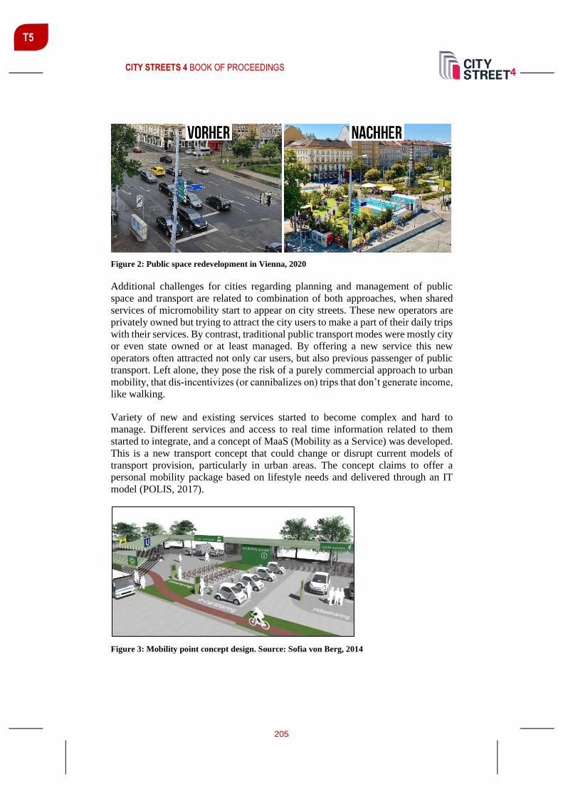
CITY STREETS 4 BOOK OF PROCEEDINGS
205
T5
Figure 2: Public space redevelopment in Vienna, 2020
Additional challenges for cities regarding planning and management of public
space and transport are related to combination of both approaches, when shared
services of micromobility start to appear on city streets. These new operators are
privately owned but trying to attract the city users to make a part of their daily trips
with their services. By contrast, traditional public transport modes were mostly city
or even state owned or at least managed. By offering a new service this new
operators often attracted not only car users, but also previous passenger of public
transport. Left alone, they pose the risk of a purely commercial approach to urban
mobility, that dis-incentivizes (or cannibalizes on) trips that don’t generate income,
like walking.
Variety of new and existing services started to become complex and hard to
manage. Different services and access to real time information related to them
started to integrate, and a concept of MaaS (Mobility as a Service) was developed.
This is a new transport concept that could change or disrupt current models of
transport provision, particularly in urban areas. The concept claims to offer a
personal mobility package based on lifestyle needs and delivered through an IT
model (POLIS, 2017).
Figure 3: Mobility point concept design. Source: Sofia von Berg, 2014

CITY STREETS 4 BOOK OF PROCEEDINGS
206
T5
The integration of services is physically realized in a form of mobility points,
interchanges between different services available in the city. Placed in residential
neighbourhoods, business or shopping centres, these points combine various
mobility facilities such as bus stop, bike sharing, charging stations, but also drop-
off places for taxis or personal delivery. What is interesting in this approach is that
the city is trying to combine various service providers, private in public, under
recognizable and united graphic image and in some cases also designed public
space (Figure 3).
Designing the mobility points should become a part of creating high quality urban
environment in line with city character, but also support development of the local
identity.
Post COVID shutdown development
Recent changes in society, related to COVID-19 spread limitations and lockdowns
made an important impact on public transport use as well. The lockdown sent
several dangerous messages to general population, which could further decrease
the use of public transport and shared mobility and give another boost to
irresponsible car use.
Already before the crisis caused by COVID-19, we observed difficulties in public
transport systems to secure resources of funding that would allow for the
investments needed for the expansion and improvements of systems. The lack of
financial inputs resulted in stagnation or decline of service quality contributing to
a loss in users. During lockdown all public transport services were completely
stopped, leaving the personal car as the only means of mid to long distance travel.
Furthermore, when lockdown ended, health guidelines recommended people
avoiding public transport if possible, even if no scientific support was available
that existing measures to reduce risk failed to provide safe service.
With less traffic on the streets, personal car became even faster and competitively
better than any other mode. Further on with social distancing, ride sharing became
undesired. Several initiatives, which in the past made car use in city more
acceptable, need a reconsideration in light of new situation.
Never has transport been so fragile and yet so vital, to maintain equal access to all
essential services. With limited or no public transport service available vulnerable
groups of residents often loose accessibility to even basic services.

CITY STREETS 4 BOOK OF PROCEEDINGS
207
T5
Figure 4: Pandemic safety and affordability by mode. Source: Littman, 2020
Again, some cities are taking initiatives to adapt to the new reality. As Littman
(2020) shows, cycling and walking are still the two modes we should focus the
most (Figure 4). Besides their high affordability and pandemic safety, both modes
also positively influence personal immune system. Cities like Paris and Bogota
started massive rearrangements of traffic to cycling lanes. By doing so, they hope
to influence the able residents to access destinations actively, without a car but also
without overloading the public transport system in order to keep it safe.
CONCLUSION
Considering the fast-changing society and current COVIS-19 crisis, cities are
constantly looking for ways to adapt to the new situations. The recent buzz word
is the 15-minute city, proposed by Paris Mayor Anne Hidalgo (Sisson, 2020). In
her ambitious program, she seeks to ensure that Parisians will be able to meet all
basic needs for work, shopping, health or culture within a 15-minute walk or bike
ride. This has once again become important after the quarantine experience, which
has sharpened our attention to our immediate surroundings and the services
available close to where we live.
All the principles needed for this, all the tools and all the solutions for planning
such cities, have been known for decades. Jane Jacobs, Jan Gel, authors of New
Urbanism and others wrote about the importance of the local. To be fair, most of
these principles are already included in our development documents and even
layout of some urban developments. They were just forgotten in the last 30 years.
REFERENCES
Boulange, C., Gunn, L., Giles-Corti, B., Mavoa, S., Pettit, C., & Badland, H. (2017).
Examining associations between urban design attributes and transport mode
choice for walking, cycling, public transport and private motor vehicle trips.
Journal of Transport & Health, 6, 155–166. doi:10.1016/j.jth.2017.07.007

CITY STREETS 4 BOOK OF PROCEEDINGS
208
T5
Calthorpe, P. (1993). The next American metropolis: Ecology, community, and the
American dream. New York: Princeton Architectural Press.
ITDP (2017) TOD Standard, 3rd ed. Institute for Transportation and Development Policy.
New York.
Koohsari, M. J., Owen, N., Cole, R., Mavoa, S., Oka, K., Hanibuchi, T., & Sugiyama, T.
(2017). Built environmental factors and adults’ travel behaviors: Role of street
layout and local destinations. Preventive Medicine, 96, 124–128.
doi:10.1016/j.ypmed.2016.12.021
Littman, T. (2020). Our World Accelerated: How 120 Years of Transportation Progress
Affects Our Lives and Communities. Victoria Transport Policy Institute.
Novak, V. (1958) Stanbena zajednica. Ilustrovana revija za ekonomska I društvena
pitanja. Ljubljana: Gospodarsko razstavišče.
POLIS (2017) Mobility as a Service: Implications for Urban and Regional Transport.
POLIS, Cities and Regions for Transport Innovation.
POLIS (2020) Macro managing Micro mobility: Taking the long view on short trips.
Discussion Paper. POLIS, Cities and Regions for Transport Innovation.
Rodier, C. J., Shaheen, S. A. (2003). Carsharing and carfree housing: Predicted travel,
emission, and economic benefits : a case study of the Sacramento, California
region. Davis, Calif: Institute of Transportation Studies, University of California,
Davis.
Sisson, P. (2020). How the ‘15-Minute City’ Could Help Post-Pandemic Recovery.
Bloomberg CityLab. Retrieved from:
https://www.bloomberg.com/news/articles/2020-07-15/mayors-tout-the-15-
minute-city-as-covid-recovery

CITY STREETS 4 BOOK OF PROCEEDINGS
209
T5
FORMULATING MULTIMODAL CORRIDORS TOWARDS
SUSTAINABLE MOBILITY IN A METROPOLITAN CITY
Stefanos Tsigdinos1 PhD Candidate, National Technical University of Athens, Iroon Politechneiou 9, Zographos, Greece, 15780, [email protected]
Thanos Vlastos Professor, National Technical University of Athens, Iroon Politechneiou 9, Zographos, Greece, 15780, [email protected]
ABSTRACT
The aim of this paper is to formulate multimodal corridors in a metropolitan city,
pointing towards inclusive and sustainable mobility. The proposed method defines
the corridors based on their network position, their connectivity, their urban
characteristics, the existence of trunk bus lines or metropolitan cycling routes as
well as their current classification. Moreover, the paper suggests general design
methods referring to each of the corridors’ category under the principles of
sustainable mobility. The study area is the metropolitan region of Athens in
Greece. The proposed method would bring about several benefits such as
promotion of active modes and collective transportation, unification of the urban
fabric, accessibility improvement, enhancement of urban vitality, etc. The
aforementioned method constitutes a decision support planning tool which could
be applied to other study areas with similar characteristics as well.
Keywords: Multimodal corridors, sustainable mobility, integrated urban and
transport planning, urban arterials
INTRODUCTION
Cities dependent on vehicular movement and especially on private motor vehicles
resulted in unattractive street environment, inaccessible public spaces, intense
traffic congestion levels, road accidents, and severances to the urban fabric, as well
as health hazards etc. (Nieuwenhuijsen and Khreis, 2016). These given
circumstances undoubtedly demand a resilient planning perspective. Such a
perspective is Sustainable Mobility (Banister, 2008) which focuses on the
improvement of urban environment and particularly of the urban transport
conditions. A fundamental step towards sustainable mobility is street functional
classification (Huang et al., 2016), which organizes movement potentials for each
1 Corresponding author

CITY STREETS 4 BOOK OF PROCEEDINGS
210
T5
transport mode, thus developing a discrete road network management system
(Stamatiadis et al., 2017). Classification systems that promote sustainable mobility
should be multimodal and therefore limit the existing car dominance (McAndrews
et al., 2017).
A crucial part of these alternative classification systems is urban corridors (mainly
on arterial roads) which promote multimodal mobility, accommodating primarily
the movement of sustainable modes (Curtis and Tiwari, 2008). Multimodal
corridors are a key strategy in spatial policy in cities (Ruming, 2014) meaning a
notable component for improving livability, as they integrate land use and
transportation (Moore et al., 2007) and accessibility for all users (Williams and
Seggerman, 2014), thus reducing social and spatial inequalities. Notable research
has been carried out towards this direction (e.g. Jones et al., 2008), highlighting the
necessity of reconceptualizing large urban streets (i.e. arterials) as places for
walking, shopping, and socializing along with their car-movement function (Hess,
2009). The implementation of multimodal corridors is a difficult and complex task
that demands flexible, robust and innovative solutions (McAndrews and Marshall,
2018). Although there are no fixed solutions, there are indeed some considerable
projects that deal with the design of these corridors, composing valuable tools (e.g.
FHWA, 2016; AC Transit, 2018). In this context, we strongly consider multimodal
corridors as a notable solution for transforming the road system towards a
sustainable future.
The current research is aimed at formulating multimodal corridors in a
metropolitan city, for ensuring an inclusive mobility level and enhancing spatial
and social equity. These corridors which have metropolitan or citywide range occur
from a new integrated street classification. This classification system takes into
consideration both urban and traffic dimensions and at the same time prioritizes
sustainable transport modes. The proposed method is applied to the metropolitan
area of Athens (AMA) and is line with the existing formal planning documents that
prioritize the shift to sustainable mobility (Ministry of Environment and ORSA,
2011).
METHODOLOGICAL FRAMEWORK AND PROPOSED METHOD
The paper used a mixed approach in order to develop the proposed method. The
part was the thorough examination of literature review regarding street
classification and multimodal corridors planning (e.g. Cherry et al., 2006; Institute
of Transportation Engineers, 2010), and the second was on-site observations in
order to identify the existing situation and understand the needs of a metropolitan
city. After taking into account the aforementioned parts in a combinatorial
perspective, we developed a method, which consists of three main steps; a) the first
step concerns the analysis of the existing situation (urban and transport features)
aiming at the identification of potentials in the study area, b) the second step refers
to the formulation of the multimodal corridors (utilizing the existing routes in order
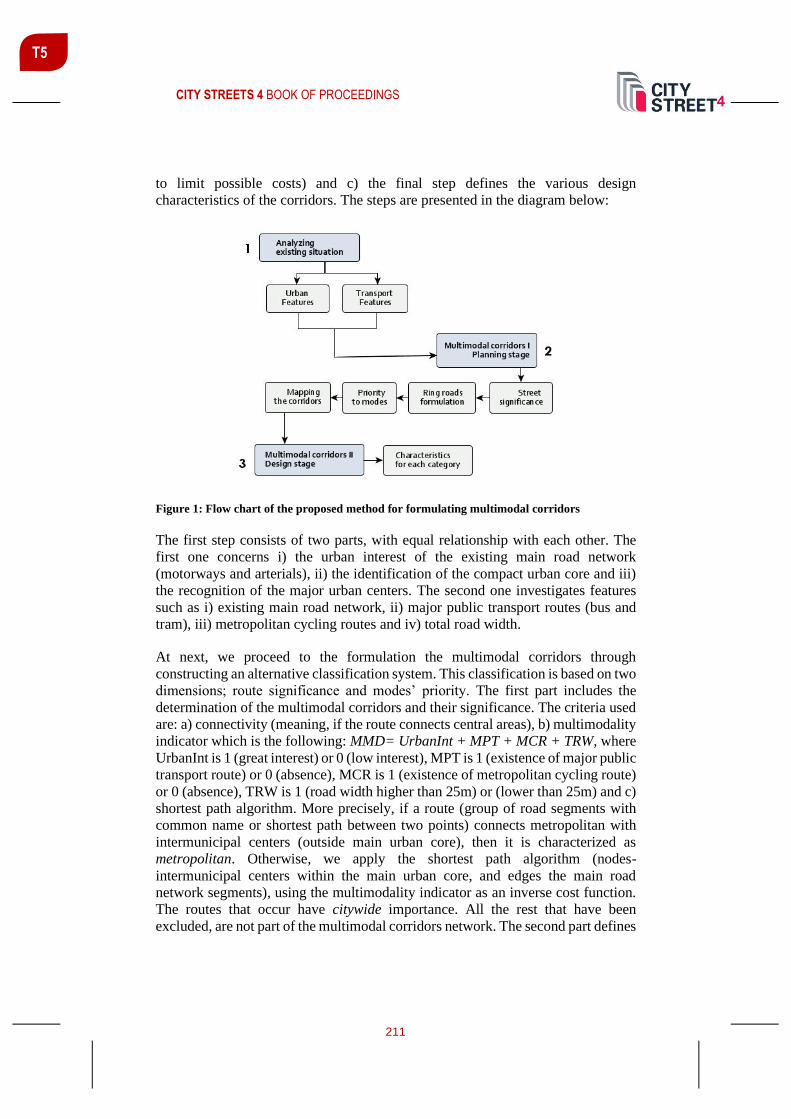
CITY STREETS 4 BOOK OF PROCEEDINGS
211
T5
to limit possible costs) and c) the final step defines the various design
characteristics of the corridors. The steps are presented in the diagram below:
Figure 1: Flow chart of the proposed method for formulating multimodal corridors
The first step consists of two parts, with equal relationship with each other. The
first one concerns i) the urban interest of the existing main road network
(motorways and arterials), ii) the identification of the compact urban core and iii)
the recognition of the major urban centers. The second one investigates features
such as i) existing main road network, ii) major public transport routes (bus and
tram), iii) metropolitan cycling routes and iv) total road width.
At next, we proceed to the formulation the multimodal corridors through
constructing an alternative classification system. This classification is based on two
dimensions; route significance and modes’ priority. The first part includes the
determination of the multimodal corridors and their significance. The criteria used
are: a) connectivity (meaning, if the route connects central areas), b) multimodality
indicator which is the following: MMD= UrbanInt + MPT + MCR + TRW, where
UrbanInt is 1 (great interest) or 0 (low interest), MPT is 1 (existence of major public
transport route) or 0 (absence), MCR is 1 (existence of metropolitan cycling route)
or 0 (absence), TRW is 1 (road width higher than 25m) or (lower than 25m) and c)
shortest path algorithm. More precisely, if a route (group of road segments with
common name or shortest path between two points) connects metropolitan with
intermunicipal centers (outside main urban core), then it is characterized as
metropolitan. Otherwise, we apply the shortest path algorithm (nodes-
intermunicipal centers within the main urban core, and edges the main road
network segments), using the multimodality indicator as an inverse cost function.
The routes that occur have citywide importance. All the rest that have been
excluded, are not part of the multimodal corridors network. The second part defines

CITY STREETS 4 BOOK OF PROCEEDINGS
212
T5
the ring roads of the city (outer and inner) by taking into account: a) significance
and b) geometry. Specifically, the outer ring road protects the main urban core of
the city, and is formulated by roads with metropolitan significance that do not
belong to the multimodal corridors network. The inner ring road protects the
historical and commercial metropolitan center and is composed by circumferential
routes with metropolitan importance. The third part divides the road segments into
two individual categories according to the mode they prioritize (mixed i.e. car and
public transport and sustainable modes i.e. public transport, active modes,
micromobility). The basic criterion used is the location. Precisely, if a route is
encountered within the inner ring road zone, then it prioritizes sustainable modes,
otherwise the route is characterized by a mixed priority condition. The final
multimodal categories are: a) metropolitan routes with mixed priority, b)
metropolitan routes with sustainable modes priority, c) citywide routes with mixed
priority, and d) citywide routes with sustainable modes priority. At last, the fourth
part includes the mapping and the illustration of the corridors, in order to reveal
their spatial dimension.
The final step refers to the specification of corridors’ characteristics, in order to
bridge the gap between planning and implementation stage, and therefore
completes the process of making multimodal corridors. Specifically, this step
presents several indicative design features (e.g. suggested land uses, modes’
infrastructure, etc.) for each corridor category. It should be mentioned that the
selection of the appropriate design features was based on various sources (e.g.
FHWA, 2016; AC Transit, 2018; Ministry of Environment, Regional Planning and
Public Works, 2001), in order to achieve efficient and comprehensive results.
FORMULATION OF THE MULTIMODAL CORRIDORS: METHOD APPLIED
The method is applied to the main urban core of Metropolitan Athens (AMA),
which constitutes the most significant component in Attica Region (population in
2011, approx. 3 million residents). The existing strategic network is car-oriented
with car use reaching an average percentage of 53%, which in certain
municipalities rises even up to 60-70% (Bakogiannis and Siti, 2014). As a result,
this classification system permits the penetration of the main urban core by major
arterials and undermines the vital role of sustainable modes. In addition, the current
conditions lead to exclusion of pedestrians and vulnerable social groups.
Furthermore, the main road network (10% of the entire) creates major movement
barriers to the urban fabric. Consequently, the strategic network is incapable of
encouraging sustainable multimodal corridors, thus requiring radical changes.
Multimodal corridors I: Planning stage
Taking into consideration the proposed method, we suggest several multimodal
corridors via establishing a new strategic network hierarchy (Figure 2). This new

CITY STREETS 4 BOOK OF PROCEEDINGS
213
T5
classification re-addresses the priority of transport modes, composing an entirely
different strategic road network system.
Figure 2: Proposed functional classification of road network
Each road segment was evaluated one by one according to our criteria, in order to
identify its role in the multimodal network. The results are the following: 63%
metropolitan and 37 % citywide. Focusing on each category separately, we should
note the subsequent: a) concerning the metropolitan network, 96% combines
private vehicles and sustainable modes, and the rest 4% prioritizes exclusively
sustainable modes, and b) regarding the citywide network, 9,3% turns into
sustainable modes and 90,7% is characterized by mixed-priority conditions. The
overall length of the proposed multimodal corridors equals to 237,5 km (28,81%
of the new strategic network), and its designation signifies that the existing car
dominance has been reduced by 35,9%.This fact leads also to a radical reduction
of central areas where mobility and access functions confront, decreasing these
friction areas by 86%.
Multimodal corridors II: Design stage
In an attempt to bridge the gap between planning and implementation, we have
developed a table including some desirable characteristics for each category. These
characteristics refer to speed limit, car movement regulations (conventional, EVs
or AVs), public transport, cycling and pedestrian infrastructure, land uses,
streetscape features and parking management.
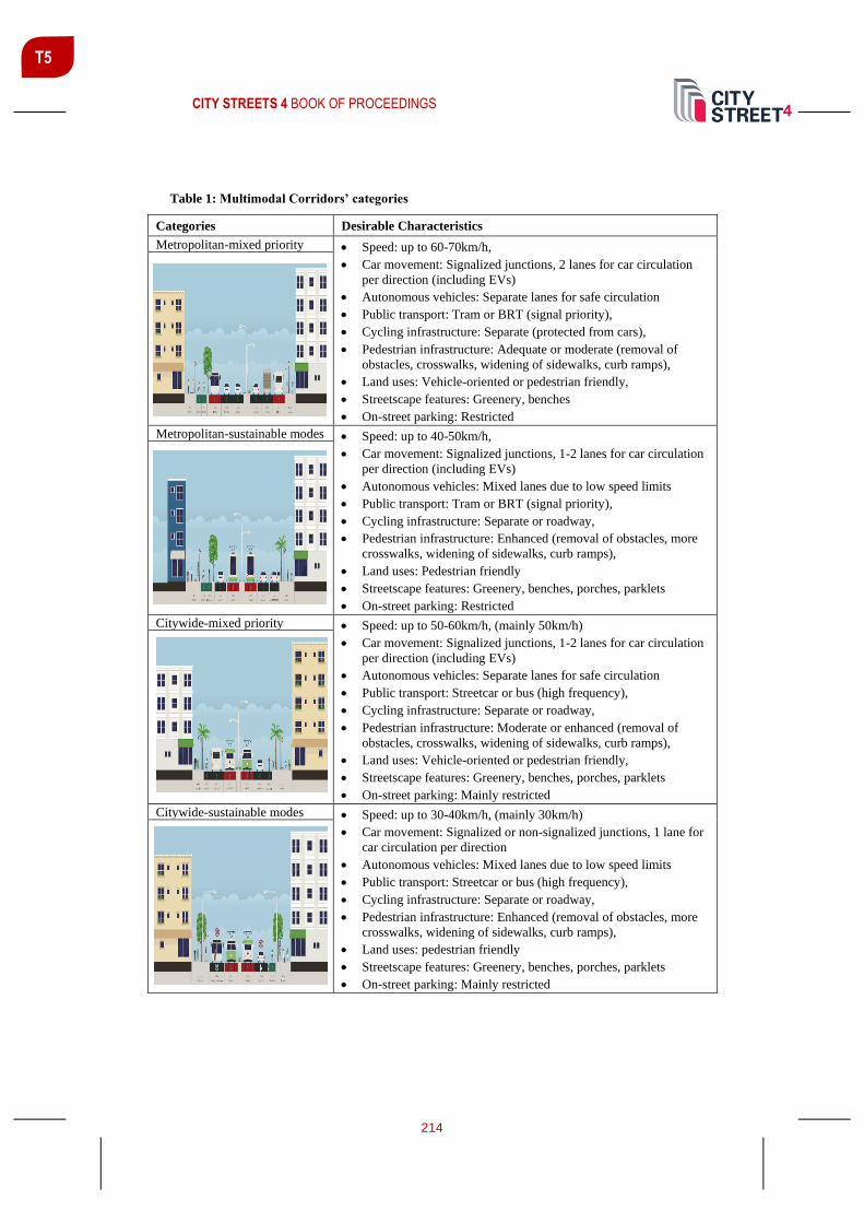
CITY STREETS 4 BOOK OF PROCEEDINGS
214
T5
Table 1: Multimodal Corridors’ categories
Categories Desirable Characteristics
Metropolitan-mixed priority • Speed: up to 60-70km/h,
• Car movement: Signalized junctions, 2 lanes for car circulation
per direction (including EVs)
• Autonomous vehicles: Separate lanes for safe circulation
• Public transport: Tram or BRT (signal priority),
• Cycling infrastructure: Separate (protected from cars),
• Pedestrian infrastructure: Adequate or moderate (removal of
obstacles, crosswalks, widening of sidewalks, curb ramps),
• Land uses: Vehicle-oriented or pedestrian friendly,
• Streetscape features: Greenery, benches
• On-street parking: Restricted
Metropolitan-sustainable modes • Speed: up to 40-50km/h,
• Car movement: Signalized junctions, 1-2 lanes for car circulation
per direction (including EVs)
• Autonomous vehicles: Mixed lanes due to low speed limits
• Public transport: Tram or BRT (signal priority),
• Cycling infrastructure: Separate or roadway,
• Pedestrian infrastructure: Enhanced (removal of obstacles, more
crosswalks, widening of sidewalks, curb ramps),
• Land uses: Pedestrian friendly
• Streetscape features: Greenery, benches, porches, parklets
• On-street parking: Restricted
Citywide-mixed priority • Speed: up to 50-60km/h, (mainly 50km/h)
• Car movement: Signalized junctions, 1-2 lanes for car circulation
per direction (including EVs)
• Autonomous vehicles: Separate lanes for safe circulation
• Public transport: Streetcar or bus (high frequency),
• Cycling infrastructure: Separate or roadway,
• Pedestrian infrastructure: Moderate or enhanced (removal of
obstacles, crosswalks, widening of sidewalks, curb ramps),
• Land uses: Vehicle-oriented or pedestrian friendly,
• Streetscape features: Greenery, benches, porches, parklets
• On-street parking: Mainly restricted
Citywide-sustainable modes • Speed: up to 30-40km/h, (mainly 30km/h)
• Car movement: Signalized or non-signalized junctions, 1 lane for
car circulation per direction
• Autonomous vehicles: Mixed lanes due to low speed limits
• Public transport: Streetcar or bus (high frequency),
• Cycling infrastructure: Separate or roadway,
• Pedestrian infrastructure: Enhanced (removal of obstacles, more
crosswalks, widening of sidewalks, curb ramps),
• Land uses: pedestrian friendly
• Streetscape features: Greenery, benches, porches, parklets
• On-street parking: Mainly restricted

CITY STREETS 4 BOOK OF PROCEEDINGS
215
T5
It is rather obvious that when shifting from mixed to sustainable, and from
metropolitan to citywide, the proposed features are getting more human-oriented.
CONCLUSIONS
This paper introduces a methodological tool for formulating multimodal corridors
in a metropolitan city. The suggested method as applied in Athens’ Metropolitan
Area will achieve a readable network of strategic corridors, will unify the urban
fabric and is expected to reduce car dominance in arterial streets. Moreover, it will
contribute to an acceptable accessibility level for all (vulnerable groups,
households without a private vehicle, etc.). In addition, the method includes some
desirable characteristics regarding the corridors, which somehow bridge the gap
between planning and implementation.
The research has notable value, since it deals with the integration of multimodality
in a car-oriented urban environment, thus enriching the existing literature which
proposes the shift towards sustainable modes. The method that we address, could
be used as a decision support tool, and could also be replicated to other cities with
comparable characteristics; especially with radial-centric road network.
Multimodal corridors constitute a complex issue which cannot be fully analyzed in
one single research. Another attempt could be the creation of a complete evaluation
framework, in order to identify the quality of the suggested multimodal corridors
and their dynamics. Also, it would be quite interesting to adopt a participatory
planning approach, engaging residents and stakeholders, for enhancing the
feasibility of the proposed strategy. Moreover, new criteria and tools could be
integrated into the methodological process augmenting smartness and innovation.
Undoubtedly, the elaboration of more scientific studies and projects about
multimodality (planning or design level) can contribute greatly to the making of
more sustainable and inclusive cities.
REFERENCES
AC Transit. (2018). Multimodal Corridor Guidelines. Alameda-Contra Costa Transit
District (AC Transit).
Bakogiannis, E. & Siti, M. (2014). Athens in crisis, sustainable mobility and climate
change. Journal of Earth Science and Engineering, 4, 352-360.
Banister, D. (2008). The sustainable mobility paradigm. Transport Policy, 15(2), 73-80.
Cherry, C., Deakin, E., Higgins, N., & Huey, S. (2006). Systems-level approach to
sustainable urban arterial revitalization: Case study of San Pablo Avenue, San Francisco
Bay Area, California. Transportation Research Record, 1997, 206-213.

CITY STREETS 4 BOOK OF PROCEEDINGS
216
T5
Curtis, C., & Tiwari, R. (2008). Transitioning urban arterial roads to activity corridors.
Urban Design International, 13, 105-120.
FHWA. (2016). Achieving Multimodal Networks: Applying Design Flexibility and
Reducing Conflicts. Washington, DC: U.S Department of Transportation Federal
Highway Administration.
Hess, P. (2009). Avenues or Arterials: The Struggle to Change Street Building Practices
in Toronto, Canada. Journal of Urban Design, 14(1), 1-28.
Huang, L., Zhu, X., Ye, X., Guo, W., & Wang, J. (2016). Characterizing street hierarchies
through network analysis and large-scale taxi traffic flow: a case study of Wuhan, China.
Environment and Planning B: Planning and Design, 43(2), 276-296.
Institute of Transportation Engineers. (2010). Designing Walkable Urban Thoroughfares:
A Context Sensitive Analysis. Washington, D.C.
Jones, P., Marshall, S., & Boujenko, N. (2008). Creating more people-friendly urban
streets through 'link and place' street planning and design. IATSS Research, 32(1), 14-25.
McAndrews, C., & Marshall, W. (2018). Livable Streets, Livable Arterials?
Characteristics of Commercial Arterial Roads Associated With Neighborhood Livability.
Journal of the American Planning Association, 84(1), 33-44.
McAndrews, C., Pollack, K., Berrigan, D., Dannenberg, A., & Christopher, E. (2017).
Understanding and Improving Arterial Roads to Support Public Health and
Transportation Goals. American Journal of Public Health, 107(8), 1278-1282.
Ministry of Environment & ORSA, 2011. Athens Mediterranean Capital: Strategies and
Priorities of the Attica Regional Plan 2021. Athens.
Ministry of Environment, Regional Planning and Public Works. (2001). Functional
Classification of Road Network. Athens: NAMA Consulting Engineers & Planners S.A.
Moore, T., Thorsnes, P., & Appleyard, B. (2007). The Transportation/Land Use
Connection . Chicago: American Planning Association.
Nieuwenhuijsen, M., & Khreis, H. (2016). Car free cities: Pathway to healthy urban
living. Environment International, 94, 251-262.
Ruming, K. (2014). Urban consolidation, strategic planning and community opposition in
Sydney, Australia: Unpacking policy knowledge and public perceptions. Land use policy,
39, 254-265.
Stamatiadis, N., Kirk, A., Jasper, J., & Wright, S. (2017 ). Functional Classification
System to Aid Contextual Design. Transportation Research Record, 2638 , 18-25 .
Williams, K., & Seggerman, K. (2014). Multimodal Transportation Best Practices and
Model Element. Tallahassee, FL : Florida Department of Transportation.

CITY STREETS 4 BOOK OF PROCEEDINGS
217
T5
THE ROLE OF GREEN SPACE AND ALTERNATIVE TRANSPORTATION
IN IMPROVING PUBLIC HEALTH
Jelena Marić1 Teach. Assist., Faculty of Architecture, University of Belgrade, e-mail [email protected]
Aleksanda Djukić Assoc. Prof., Faculty of Architecture, University of Belgrade, e-mail: [email protected]
Eva Vaništa Lazarević Professor, Faculty of Architecture, University of Belgrade, e-mail: [email protected]
ABSTRACT
The shift of paradigms regarding public health from pathogenesis to salutogenesis
(Antonovsky, 1979) is reflected in the famous definition of health given by the
World Health Organization. Health is not simply identified through the absence of
disease, but as a state of complete physical and mental well-being. The main issues
that affect public health in the modern era are stress and a sedentary lifestyle.
There is a growing body of research suggesting that exposure to natural
characteristics of open green space can improve both physical and mental well-
being (Ulrich et al., 1991). Additionally, environmental psychologists argue that
green space design can influence public health and positive behaviour of people,
such as social interaction, physical activity and the use of alternative
transportation, pedestrian and biking.
The aim of this research is to identify how specific characteristics and urban design
of green space can be beneficial to public health, as well as how the use of
alternative transpiration solutions can increase positive health outcomes. In
addition we will try to identify which areas in the urban city areas have the most
healing potential for improving public health. The methodology is based on
theoretical research and extensive literature review regarding the aforementioned
topics, followed by expert observation of green space and people's behaviour in
the riverfront area of New Belgrade.
Keywords: Green space, Alternative transportation, Public health and well-being,
healing space, riverfront.
1 Corresponding author
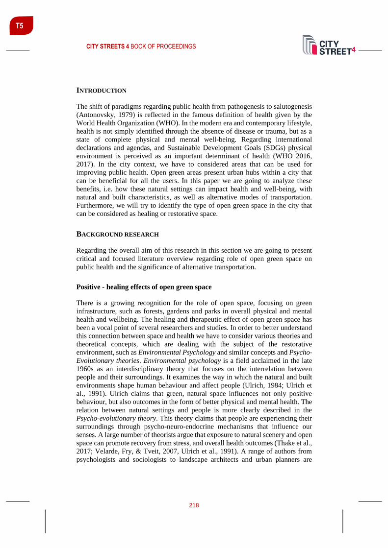
CITY STREETS 4 BOOK OF PROCEEDINGS
218
T5
INTRODUCTION
The shift of paradigms regarding public health from pathogenesis to salutogenesis
(Antonovsky, 1979) is reflected in the famous definition of health given by the
World Health Organization (WHO). In the modern era and contemporary lifestyle,
health is not simply identified through the absence of disease or trauma, but as a
state of complete physical and mental well-being. Regarding international
declarations and agendas, and Sustainable Development Goals (SDGs) physical
environment is perceived as an important determinant of health (WHO 2016,
2017). In the city context, we have to considered areas that can be used for
improving public health. Open green areas present urban hubs within a city that
can be beneficial for all the users. In this paper we are going to analyze these
benefits, i.e. how these natural settings can impact health and well-being, with
natural and built characteristics, as well as alternative modes of transportation.
Furthermore, we will try to identify the type of open green space in the city that
can be considered as healing or restorative space.
BACKGROUND RESEARCH
Regarding the overall aim of this research in this section we are going to present
critical and focused literature overview regarding role of open green space on
public health and the significance of alternative transportation.
Positive - healing effects of open green space
There is a growing recognition for the role of open space, focusing on green
infrastructure, such as forests, gardens and parks in overall physical and mental
health and wellbeing. The healing and therapeutic effect of open green space has
been a vocal point of several researchers and studies. In order to better understand
this connection between space and health we have to consider various theories and
theoretical concepts, which are dealing with the subject of the restorative
environment, such as Environmental Psychology and similar concepts and Psycho-
Evolutionary theories. Environmental psychology is a field acclaimed in the late
1960s as an interdisciplinary theory that focuses on the interrelation between
people and their surroundings. It examines the way in which the natural and built
environments shape human behaviour and affect people (Ulrich, 1984; Ulrich et
al., 1991). Ulrich claims that green, natural space influences not only positive
behaviour, but also outcomes in the form of better physical and mental health. The
relation between natural settings and people is more clearly described in the
Psycho-evolutionary theory. This theory claims that people are experiencing their
surroundings through psycho-neuro-endocrine mechanisms that influence our
senses. A large number of theorists argue that exposure to natural scenery and open
space can promote recovery from stress, and overall health outcomes (Thake et al.,
2017; Velarde, Fry, & Tveit, 2007, Ulrich et al., 1991). A range of authors from
psychologists and sociologists to landscape architects and urban planners are

CITY STREETS 4 BOOK OF PROCEEDINGS
219
T5
contemplating the role of nature and open space in public health and well-being. In
the overall context, combining different theoretical and practical approaches, we
can state that green open public spaces can influence well-being on different levels.
Firstly, natural characteristics can contribute to physical and mental health.
Restorative environments, natural views, ambient, colours and sounds can have a
soothing and calming effect and influence stress reduction, which directly affects
the heart rate and blood pressure (De Vries, 2010; Ulrich, 1984). Exposure to direct
sunlight is believed to increase the vitamin D levels and regulate the sleeping
hygiene and overall circadian rhythm (Farhud et al., 2018). Apart from natural
qualities, built characteristics of open space can engage people in physical activity,
sport and recreation as well as socialization and communication (Thake et al., 2017;
Tyrväinen et al., 2014). These activities are strongly connected with positive
behaviours that have restorative outcomes on people. Urban green spaces
particularly offer health benefits for citizens in urban dense areas. WHO has
released important publications in 2016 and 2017 (WHO, 2016; WHO, 2017)
where they list and explain in detail all of the positive effects that open green space
can have regarding human health, such as: Improved social capital; Enhanced
physical activity; Optimized production of natural sounds exposure to sunlight and
improved sleep; Reduced exposure to air pollution and reduction of the urban heat
island effect; Enhanced pro-environmental behaviour; Reduction of pain and
stress; Reduced cardiovascular disease and mortality; Alleviation of depression and
anxiety and Reduction of aggressive behaviour.
Open green space offers a range of physical activities that directly influences
peoples’ health outcomes and overall level of public health. In that context, we are
going to analyze the role of alternative transportation as means for physical
activities in open green space.
ROLE OF ALTERNATIVE TRANSPORTATION IN IMPROVING PUBLIC HEALTH
Alternative transportation, or active transportation, as it is often referred to in
literature present non-motorized transport modes including pedestrian walking,
cycling, and different other variations. Regarding available literature on the subject
we can summarise that alternative, or active modes of transportation can benefit
public health directly and indirectly, by: (1) indirectly - reduced air pollution and
better air quality and (2) directly - increased physical activity (WHO, 2008; Litman,
2013; Rissel et al., 2012). Tod Litman in the Annual Review of Public Health
discusses major categories of public health impacts that tend to be significantly
affected by transport policies and planning decisions. “Transportation policy and
planning decisions can affect health in various ways. How people travel affects
physical and mental health, including cancer, cardiovascular disease, vehicle
crashes, and diabetes, four major causes of death” (Tod Litman, 2013). Important
category of health outcomes that involves transportation is pollution emissions that
comes from motor vehicle and can cause serious ecological damage, therefore
influencing several health conditions as well as climate change (Mundorf et al.,
2018). According to a recent WHO report, approximately 1.3 million premature

CITY STREETS 4 BOOK OF PROCEEDINGS
220
T5
deaths worldwide are attributed to outdoor air pollution in 2009 (WHO, 2008).
Another major topic of health and well-being impacts is related to the effects that
transport-planning decisions have on physical activity, which is on the top of the
“public health risk factors” list (Rissel et al., 2012). Alternative or active
transportations modes provide an opportunity to increase frequent physical activity
on the daily basis, which could help people stay more active and fit, thus improving
the physical health and well-being (Rissel et al., 2012; WHO, 2000). In addition,
active transportation modes can affect mental health by improving physical activity
and supporting community cohesion and positive interactions among people in
public space (Oja et al., 2011).
In this chapter we have gathered and presented data regarding health outcomes of
open green space and alternative modes of transportation. In the city context we
have areas that combine open green space characteristics and possibilities for active
transportation. These areas are usually located in the riverfront, as it is the case
with Belgrade, and in the next chapters we are going to briefly present one of the
riverfronts in New Belgrade, from the aspects of public health benefits.
METHODOLOGY
The methodology is based on theoretical research and focused literature review
regarding topics of public health and health determinants. In particular, we analyze
the impact of open green space and alternative transportation on the health and
well-being outcomes. The research includes primary and secondary resources, such
as: theoretical research, studies, statements, publications and regulations. Next
phase of this research is focused on the case study Area of New Belgrade. More
precisely, the area of Sava riverfront in New Belgrade was selected, in order to
analyze the elements of design and usage. Regarding methodology, firstly, the
expert observation of natural and built characteristics was applied. In this regard,
we tried to determine the elements of riverfront areas that could be connected with
the healing characteristics of open green space that have been previously identified
through the theoretical background research. Secondly, we analyzed people
behaviour, regarding usage and means of transportation in the open green space –
riverfront. This form of methodology is based on the concept of environmental
design research, in specific environment (Markus, Cooper & Barns 1995,1999).
This particular methodology is especially popular and applied in urbanism,
architecture and design professions.
RESULTS - FINDINGS
With the presented theoretical background research we were able to identify how
natural and urban design characteristics of open green space can be beneficial to
public health, as well as how the use of alternative transportation solutions can
increase positive health outcomes, including both physical and mental health. In
the context of urban city areas most potential for improving public health can be

CITY STREETS 4 BOOK OF PROCEEDINGS
221
T5
assigned to the waterfront areas. These areas represent part of city green
infrastructure, with all the positive natural characteristics, as well as urban furniture
for socialization and communication. In addition, these areas are very often used
for alternative transportation such as pedestrian walking or cycling. In the next
chapter we are going to briefly present expert observation of open green space and
people's behaviour in the riverfront area of New Belgrade.
New Belgrade – Sava riverfront
In pre-industrial cities, waterfront areas were intensely used and thriving with
people and activities. Also, during this period, a close relationship was between
waterfront and cities. With industrial era, this relationship was interrupted due to
some uses, such as huge ports, commercial, industry, warehouses and
transportation. Through the evolution of technology, port activities moved to
outside of the city, leaving areas of riverfront for sport and recreation - as a public
open spaces with natural elements, pedestrian and bike lines and vistas towards
water. With the increasing environmental awareness and as a consequence of the
pressure for upgrade in a urban areas, waterfronts were rediscovered in the city. In
this paper we are going to present the formal and functional characteristics of Sava
riverfront in New Belgrade. Sava riverfront represents a public green landscape
along the banks of the Sava River, in the coastal land. This area of “preserved”
natural greenery, in addition to a significant role in improving the quality of the
environment, due to the pronounced strip shape, represent the “green connections”
of the system of green areas of Belgrade, thus achieving a significant ecological
function. The Sava riverfront in New Belgrade is located alongside the river bay
area as a part of New Belgrade mega blocks 70, 44 and 45. This area is developed
as a linear park, divided into several segments, with greenery in form of regulated
park areas and densely planted trees, providing shaded surfaces and spaces with
direct sunlight. This type of landscape with natural settings and vistas of water has
positive image for users and provides a restorative and calming effect. Another
component of a healing environment is fresh air. Air quality is relatively high in
this area due to tall trees and dense vegetation as well as distance from the main
roads and traffic.

CITY STREETS 4 BOOK OF PROCEEDINGS
222
T5
Figure 1-3: Natural greenery of the Sava riverfront; source: author
Built characteristics of Sava riverfront are in correlation with the aforementioned
urban design of a healing or restorative environment. Although often neglected and
outdated, selection of a garden-furniture and architectural elements of the square
are adapted to the type of use. The complete area is equipped with urban furniture
for communal use, as well as small shops, famous coffee places and restaurants on
the river, popularly known as “splavovi”, variety of benches for small and large
groups of people, communication and socialization. In addition, the area is
adequately equipped for different types of physical activity, such as courts for
different sports and open gym, as well as pedestrian and bike lines for active modes
of transportation, throughout the whole area. The riverfront area offers variety of
places that are proved to be beneficial for mental and physical health. Besides
positive natural characteristics, there are places for peace and quiet as well as places
for socialization, sport and recreation. People behaviour patterns are subjected to
the aforementioned types of places in riverfront area. During months with warmer
weather, users are sitting in a park, relaxing or walking the dog, playing with
children, sitting in restaurants and coffees or doing sports. People are active and
engaged in alternative transportation, of exercise in open gym areas.
Figure 4-6: People behaviour in Sava riverfront / active transportation; source: author

CITY STREETS 4 BOOK OF PROCEEDINGS
223
T5
As seen in the figures, majority of users are engaged in active types of
transportation, such as pedestrian walking or cycling. In that regard, the riverfront
area is playing an important role in increased physical activity in the city and
directly contributing to better outcomes regarding public health.
CONCLUSIONS
The aim of this paper was two-folded. In the first part of the paper – the background
theoretical research, we defined characteristics of open public space that can be
beneficial for physical and mental health and well-being. Based on presented
research we can conclude that green open space can have healing and restorative
components, that makes these areas crucial for public life and public health.
Promoting sustainable and alternative transportation is an important objective not
only for transportation planners, but also for public health researchers and policy-
makers. Population health includes preventing disease, prolonging life, promoting
health equity, as well as physical, mental, and social well-being. Sustainable
transportation can improve population health, through individual transportation
choices, activity patterns, walk ability, and increased exposure to green spaces
(Munford et al., 2018). Secondary aim of the research referred to the case study
research, we identified areas of open public space in a city that can combine all the
aforementioned healing characteristics. Riverfront areas presented in this paper
showed great potential for improving public health, due to their natural
characteristics in combination with urban design that can support activities
beneficial for mental and physical health. In order to improve the impact on public
health in our cities we should promote and enhance overall usage of riverfront
areas.
REFERENCES
Antonovsky, A. (1979). Health, stress, and coping. San Francisco: Jossey-Bass.Cooper
Ulrich, R. (1984). View through a window may influence recovery from surgery. Science
224(4647), 420. https://doi.org/10.1126/science.6143402
De Vries, S. (2010). Nearby nature and human health: Looking at the mechanisms and their
implications. In: W. Thompson, P. Aspinall and S. Bell. (Eds.) Innovative Approaches to
Researching Landscape and Health. Abingdon: Routledge.
Cooper Marcus, C. and Barnes, M. (1995). Gardens in healthcare facilities: Uses,
therapeutic benefits, and design recommendations. Retrieved from
https://www.healthdesign.org
Farhud D. ... [et. al.]. (2018). Circadian Rhythm, Lifestyle And Health: A Narrative
Review. Iranian Journal of Public Health, 47(8): 1068–1076.
Grahn, P., & Stigsdotter, U. K. (2010). The relation between perceived sensory dimensions
of urban green space and stress restoration. Landscape and Urban Planning, 95(3–4), 264–
275.
Hanzl, M. & Ledwon, S. (2017). Analyses of human behaviour in public spaces.

CITY STREETS 4 BOOK OF PROCEEDINGS
224
T5
Hartig, T., & Staats, H. 2006. The need for psychological restoration as a determinant of
environmental preferences. Journal of Environmental Psychology, 26, 215–226.
Kaplan, S. 1995. The restorative benefits of nature: Towards an integrative framework?
Journal of Environmental Psychology, 15(3), 169–182.
Litman, T. (2013). Transportation and Public Health. Annual review of public health. 34.
https://doi.org/10.1146/annurev-publhealth-031912-114502
Mundorf, N., Redding, C. A., & Bao, S. (2018). Sustainable Transportation and Health.
International journal of environmental research and public health, 15(3), 542.
https://doi.org/10.3390/ijerph15030542
Oja, P., Titze, S., Bauman A., et al. (2011). Health benefits of cycling: a systematic review,
Scandinavian Journal of Medicine and Science in Sports, 21(4), pp. 496–509, 2011.
Rissel, C, Curac, N., Greenaway M., and Bauman A. (2012). Physical activity associated
with public transport use—a review and modelling of potential benefits. International
Journal of Environmental Research and Public Health, 9(7).
Stigsdotter, U. and Grahn, P. 2002. What Makes a Garden a Healing Garden? Journal of
Therapeutic Horticulture, 13, 60-69.
Thake, C., Bambling, M., Edirippulige, S., & Marx, E. (2017). A psychoevolutionary
approach to identifying preferred nature scenes with potential to provide restoration from
stress. HERD: Health Environments Research & Design Journal, 10(5).
https://doi.org/10.1177/1937586717705085
Tyrväinen, L., Ojala, A., Korpela, K., Lanki, T., Tsunetsugu, Y., & Kagawa, T. (2014).The
influence of urban green environments on stress relief measures: A feldexperiment. Journal
of Environmental Psychology, 38, 1–9.
Ulrich, R. S., Simons, R. F., Losito, B. D., Fiorito, E., Miles, M., & Zelson, M. (1991).
Stress recovery during exposure to natural and urban environment. Journal of
Environmental Psychology, 11, 201-230.
Van den Berg, A.E., Maas, J., Verheij, R.A. (2010). Green space as a buffer between
stressful life events and health., Groenewegen PP, Soc Sci Med, 70(8):1203-10
Velarde, M. D., Fry, G., & Tveit, M. (2007). Health effects of viewing landscapes-
Landscape types in environmental psychology. Urban Forestry & Urban Greening, 199–
212. https://doi.org/10.1016/j.ufug.2007.07.001
WHO (2000). Urban Planning, Environment and Health: From Evidence to Policy Action.
Meeting Report. Copenhagen, Denmark: WHO Regional Office for Europe.
WHO (2016). Urban green spaces and health. Copenhagen: WHO Regional Office for
Europe.
WHO (2017). Urban green space interventions and health. Copenhagen: WHO Regional
Office for Europe.

CITY STREETS 4 BOOK OF PROCEEDINGS
225
T5
IS TRANSIT-ORIENTED DEVELOPMENT IN THE AFTERMATH
FEASIBLE?
Dima Jawad1 Assoc. Prof., Department of Civil and Environmental Engineering, Notre Dame University - Louaize, Lebanon, [email protected]
Pamela Mouawad Graduate Student, Department of Civil and Environmental Engineering, Notre Dame University - Louaize, Lebanon, [email protected]
Peter El Khoury Civil Engineer, Department of Civil and Environmental Engineering, Notre Dame University - Louaize, Lebanon, [email protected]
ABSTRACT
The concept of transit-oriented development (TOD) has been gaining noticeable
appreciation in cities that pursue urban and transport sustainability. This term was
coined in the late 1980s when the alarming outcomes of vehicle-dependent
planning started to materialize. TOD is characterized basically by mixed land use
that fosters the use of transit services by minimalizing the walking distance to its
service point. Thus, a transit station must be centred based on the neighbourhood
typologies in order to encourage the largest number of people who live or work
near the station to use transit as a transport mode. Setting this objective at the
onset of planning a development can result in a TOD with varying successes. But
when introducing transit into an already developed and car-based city, realizing a
TOD can be quite challenging. The objective of this research is to investigate the
feasibility of such an endeavour. The research is done while taking the city of Zouk-
Mosbeh in Lebanon as a case study. Lebanon is planning to introduce its new mass
transit system, the Bus Rapid Transit (BRT), where several alignments are
proposed. The city of Zouk-Mosbeh is planned to house one of the 28 BRT stations
along the northern corridor. Hence, this paper aims to study the adequacy of Zouk-
Mosbeh city to be transformed into a transit-oriented city. In this research, the
general TOD characteristics and objectives are first discussed as well as the
neighbourhood typologies. Then, a method of how TOD concepts can be applied
to an existing city is elaborated. TOD characteristics are compared with the city’s
existing characteristics; as a result, certain features are identified for necessary
modifications, and new components are proposed. Finally, recommendations of
priority-ranked interventions are developed that best satisfy the TOD required
criteria along with general reflection on the process.
Keywords: Transit-Oriented Development, Alternative transport modes, city
improvement
1 Corresponding author

CITY STREETS 4 BOOK OF PROCEEDINGS
226
T5
INTRODUCTION
With population growth in cities projected to rise to five billion people by 2030,
efficient urban planning and management must become manifest to face
urbanization challenges. Yet, most cities in developing countries lack basic urban
infrastructure and it is predicted that, by 2030, 95% of the urban sprawl will occur
in these developing countries. Also, it was estimated that, by the end of this year
2020, vehicle ownership would have increased by 32% and motor vehicle-
kilometres by 40% (United Nations, SDGs, 2015). These numbers are alarming if
we were achieve the targets of several indicators of the United Nations' sustainable
development goals. Supporting the economic development and well-being must
start through providing quality, sustainable and resilient infrastructure that
provides affordable access for everyone to sustainable transport systems while
improving road safety, specifically by broadening public transport systems that
consider different people’s needs particularly those with disabilities. (United
Nations, 2015).
A concept that integrates efficient urban planning with transit is the concept of
transit-oriented development (TOD). This concept has been gaining noticeable
appreciation in cities that pursue urban and transport sustainability. The TOD term
was coined in the late 1980s when the threatening outcomes of vehicle-dependent
planning started to materialize. TOD is characterized basically by mixed landuse
that fosters the use of transit services by minimalizing the walking distance to its
service point. Thus, a transit station must be centred based on the neighbourhood
typologies to encourage the largest number of people who live or work near the
station to use transit as a transport mode. Setting this objective at the onset of
planning a development can result in a TOD with varying successes. But when
introducing a novel transit system into an already developed car-based city,
realizing a TOD can be quite challenging. The objective of this research is to
investigate the feasibility of such an endeavour. The research is done while taking
the city of Zouk-Mosbeh in Lebanon as a case study. The paper aims to study the
adequacy of Zouk-Mosbeh city to be transformed into a transit-oriented city. In
this research, the general TOD characteristics and objectives are first discussed as
well as the neighbourhood typologies. Then, a method of how TOD concepts can
be evaluated in an existing city is elaborated. TOD characteristics are compared
with the city’s existing characteristics; as a result, improvement strategy is
proposed. Finally, recommendations of interventions are established that best
satisfy the TOD required criteria along with general reflection on the process.
LITERATURE REVIEW
Transit-Oriented Development Task Force at Maryland Department of
Transportation defines TOD as “a place of relatively higher density that includes a
mixture of residential, employment, shopping and civic uses and types located
within an easy walk of a bus or rail transit centre”. This concept has lately been

CITY STREETS 4 BOOK OF PROCEEDINGS
227
T5
used in different places to solve transportation issues, to minimize travel distances,
to reduce air pollution and congestion, to enhance transit ridership, walking and
cycling, and to ensure a better quality of life (Kumar, Sekhar, & Parida, 2020).
Nasri and Zhang characterize TODs by a reduced walking distance from residents’
houses to a major station or to any other facility which aims to promote transit
ridership by allowing access to more job centres, educational opportunities, and
cultural facilities and to encourage pedestrian activities (Nasri & Zhang, 2014). To
add up, TOD has lately been used to encourage Smart Growth strategies such as
energizing areas, improving the economy, and enhancing the quality of life. They
also introduce quantitative methodology taking into consideration three essential
factors which are walkability and high density, walking distance to a transit station,
and collaboration of mixed uses and transit.
Identifying TOD typologies is one main task to be able to characterize whether a
certain city is transit-oriented or not or if it can be modified to become one. Two
main approaches for differentiating TOD typologies exist in the literature (Higgins
& Kanaroglou, 2016). The first approach is qualitative, and it consists of labelling
typologies based on the geographic and functional characteristics of
neighbourhoods. According to this approach, Calthrope (1993) defined two TOD
types: urban TODs characterized by high density and small walking distance to
transit, and neighbourhood TODs characterized by a lower density and a small
distance to local or feeder bus lines. Other researchers went further and divided
TOD into six types (Dittmar, Belzer, & Autler, 2004). The second approach, called
the node-place approach is quantitative. It was first developed by Bertolini (1999).
This approach converts data into an XY-diagram where the Y-axis is the node-
index which describes the variety and frequency of transit supply and the X-axis is
the place-index which describes the functional mix of the area near the station
(Ibraeva, Silva, Antunes, & de Almeida Correia, 2020). Each station must be
located on the diagram depending on the two indexes’ performance and their
location will show whether they are sustained or un-sustained. Another alternative
approach for realizing TOD is the network governance approach proposed by Mu
& de Jong (Mu & de Jong, 2016). Network governance means the mechanisms that
aim to enhance the voluntary or forced alignment of goals and tasks of networked
actors. In TOD planning, network governance positively influences planning and
policy integration between urban transport and land use through progressive and
cumulative stages.
Evaluating TOD started using the 3Ds: density, diversity, and design (Cervero &
Kockelman, 1997), later researchers added new Ds to the list which are the distance
to transit, destination accessibility, and demand management (Translink, 2012). So,
the main typologies a city must have to be transit-oriented are walkable blocks and
streets, the proximity of housing and shopping centres, accessible public spaces,
and successful development around transit stations. Thus, residences, offices, open
spaces, commercial buildings, and public uses must be all mixed in a walkable
environment near stations (Ibraeva, Silva, Antunes, & de Almeida Correia, 2020).
Two main areas can be distinguished in TOD. The primary area includes major
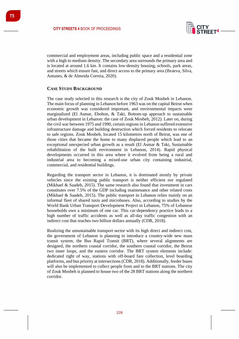
CITY STREETS 4 BOOK OF PROCEEDINGS
228
T5
commercial and employment areas, including public space and a residential zone
with a high to medium density. The secondary area surrounds the primary area and
is located at around 1.6 km. It contains low-density housing, schools, park areas,
and streets which ensure fast, and direct access to the primary area (Ibraeva, Silva,
Antunes, & de Almeida Correia, 2020).
CASE STUDY BACKGROUND
The case study selected in this research is the city of Zouk Mosbeh in Lebanon.
The main focus of planning in Lebanon before 1963 was on the capital Beirut when
economic growth was considered important, and environmental impacts were
marginalized (El Asmar, Ebohon, & Taki, Bottom-up approach to sustainable
urban development in Lebanon: the case of Zouk Mosbeh, 2012). Later on, during
the civil war between 1975 and 1990, certain regions in Lebanon suffered extensive
infrastructure damage and building destruction which forced residents to relocate
to safe regions. Zouk Mosbeh, located 15 kilometres north of Beirut, was one of
those cities that became the home to many displaced people which lead to an
exceptional unexpected urban growth as a result (El Asmar & Taki, Sustainable
rehabilitation of the built environment in Lebanon, 2014). Rapid physical
developments occurred in this area where it evolved from being a rural and
industrial area to becoming a mixed-use urban city containing industrial,
commercial, and residential buildings.
Regarding the transport sector in Lebanon, it is dominated mostly by private
vehicles since the existing public transport is neither efficient nor regulated
(Mikhael & Saadeh, 2015). The same research also found that investment in cars
constitutes over 7.5% of the GDP including maintenance and other related costs
(Mikhael & Saadeh, 2015). The public transport in Lebanon relies mainly on an
informal fleet of shared taxis and microbuses. Also, according to studies by the
World Bank Urban Transport Development Project in Lebanon, 75% of Lebanese
households own a minimum of one car. This car-dependency practice leads to a
high number of traffic accidents as well as all-day traffic congestion with an
indirect cost that reaches two billion dollars annually (CDR, 2018).
Realizing the unsustainable transport sector with its high direct and indirect cost,
the government of Lebanon is planning to introduce a country-wide new mass
transit system, the Bus Rapid Transit (BRT), where several alignments are
designed, the northern coastal corridor, the southern coastal corridor, the Beirut
two inner loops, and the eastern corridor. The BRT system elements include:
dedicated right of way, stations with off-board fare collection, level boarding
platforms, and bus priority at intersections (CDR, 2018). Additionally, feeder buses
will also be implemented to collect people from and to the BRT stations. The city
of Zouk Mosbeh is planned to house two of the 28 BRT stations along the northern
corridor.

CITY STREETS 4 BOOK OF PROCEEDINGS
229
T5
EVALUATION METHODOLOGY
As discussed in the literature, different methods exist to evaluate whether cities are
transit-oriented or not. Considering the current conditions and the scarcity of
available data, the method used to evaluate the city of Zouk Mosbeh in terms of
TOD potential is based on the 3Ds: density, diversity, and design.
Regarding the density, a city with low-density developments and poor integration
of land uses is considered to be more automobile-dependent. Thus, a high-density
area with mixed land-use and investments promotes the use of public transport
because it is assumed that the existence of residential buildings near transport
nodes and workplaces will motivate citizens to use transit (Ogra and Ndebele n.d.).
Also, presumably, high-density cities are characterized by a low average trip
distance to nodes that encourages more walking and cycling than private car usage.
As for diversity, what is referred to is the land-use diversity. It is agreed that a high
mix of land-use indicates that a city is more suitable for TOD. The land use
Diversity Index (LD) will be calculated using Simpson’s diversity index which
measures the distribution and the evenness of the individual land uses within the
mix of land uses where the larger value of LD indicates a greater land-use mix in
the area and 1 is the maximum possible diversity (Mohamad Zulkifli, et al. 2017).
The formula used to calculate this index is:
𝐿𝑎𝑛𝑑 𝑢𝑠𝑒 𝑑𝑖𝑣𝑒𝑟𝑠𝑖𝑡𝑦 (𝐿𝐷) = 1 − [∑ 𝐼𝐴𝑖𝑛𝑖=1 ] where 0 ≤ LD ≤ 1
𝐼𝑛𝑑𝑖𝑣𝑖𝑑𝑢𝑎𝑙 𝐴𝑟𝑒𝑎𝑠 = 𝐼𝐴1, … 𝐼𝐴𝑛 =𝐴1
2
𝐴2,𝐴2
2
𝐴2, …
𝐴𝑛2
𝐴2
Where Ai is the individual landuse area and A is the total area.
As for the design, a well-designed city is known for its land-use mix and its safe
and easy accessibility. It also contains well-designed streets and intersections with
continuous sidewalks and streetlights as well as amenities such as benches, parks,
libraries. Also, bicycle lanes and pedestrian crossings must exist. All these
elements are essential to assuring a good built environment, enable sustainable
mobility for cities, and encourage transit ridership (Ogra & Ndebele).
In order to conduct the 3D evaluation, a detailed analysis of the area is needed. The
analysis entails collecting information on cadastral maps, landuse, building
density, zoning, and streets network. Moreover, the existing status of public
transport is detailed and criticized. Then, the BRT project to be implemented in
Lebanon is studied specifically in Zouk Mosbeh. The location of the BRT stations
in this area is studied regarding the typologies of the surrounding buildings and the
pedestrian travel time needed to arrive at the station either from work, home, or
CITY STREETS 4 BOOK OF PROCEEDINGS
230
T5
any commercial centre. Also, these characteristics are further examined with
respect to the feeder bus loops that must be implemented.
After evaluating in detail, the 3Ds for Zouk Mosbeh, conclusions are made whether
this area is transit-oriented or not and how can different criteria be modified in
order to make it transit-oriented.
RESULTS AND DISCUSSION
Analysis of Current Status
Zouk Mosbeh area is a condensed city with an area of 4.48 km2 where around
45,000 people live in a mixed land-use. Figure 1 illustrates the map of Zouk
Mosbeh where zoning designation is characterized as residential commercial,
industrial, and future expansion.
Figure 1: Zonning and Zouk Mosbeh area
The current landuse includes also educational, religious, and recreational zones.
Under the educational landuse, is a major university in the region attracting more
than 6,000 people between students, faculty, and staff. The existence of a university

CITY STREETS 4 BOOK OF PROCEEDINGS
231
T5
is particularly important to the TOD context because of its high trip generation
coupled with the growing likelihood of university students to rely on transit.
The transport sector in Zouk Mosbeh is no different from other areas in Lebanon
with its high dependency on vehicular traffic and a large percentage of single-
occupant vehicles using its streets. The street network is for the most parts well
distributed with two main arterial roads crossing the city: the northern coastal
highway and the Ajaltoun highway (west-east), other streets are either collectors
or local roads. The public transport sector does not accommodate more than 5% of
travellers with unreliable service and low levels of service. Currently, public
transport relies mostly on shared minibuses or cars, mostly privately-owned. Only
one route of government-operated public buses crosses Zouk Mosbeh along the
northern coastal highway. Four main bus stops exist, two of them along the
northern coastal highway (in each direction) and two of them along Ajaltoun
highway. No public buses that may transport the traveller to other areas exist
internally in this city, so people who wish to take the bus in this area have to either
walk, cycle, carpool, or take a taxi to arrive at any nearby bus stop before reaching
their destination. In this area, there are more than 15 taxi operators.
BRT project in Zouk Mosbeh
As mentioned earlier, the planned BRT project in Lebanon has one of its main
alignment along the northern coastal corridor with Zouk Mosbeh housing two of
its stations. In Figure 2 below, it can be seen that the proposed BRT stations in
Zouk Mosbeh are located where two of the existing bus stops are located. In
addition to the main BRT stations, minor bus stops are planned inside the city
where feeder buses can pick people up and drop them off at the BRT stations.
The feeder bus system is proposed as a main component of the BRT project but
detailed designs are yet to be finalized. To conduct a comprehensive evaluation of
Zouk Mosbeh in terms of TOD potential, a preliminary feeder bus system is
proposed. Several different factors were considered in bus stop placements along
the feeder bus routes. The ridership potential is one important factor in determining
an adequate location for stops and therefore, several bus stops were placed near the
two most prominent trip generators in Zouk Mosbeh which are the highly active
commercial areas along the main arterial road (Zouk Mosbeh – Aajaltoun Road)
where retail shops, activity centres, banks, offices, restaurants, and supermarkets
are located, in addition to the major trip generator Notre Dame University. Another
considerable trip generator zone taken into consideration is the heavily populated
residential zone in Zouk Mosbeh where an exclusive feeder bus loop was designed
to provide transit service for that zone.

CITY STREETS 4 BOOK OF PROCEEDINGS
232
T5
Figure 2: BRT stations from Beirut to Tabarja (CDR 2018)
The Transit Capacity and Quality of Service Manual (National Academies of
Sciences, Engineering, & Medicine, 2013) suggest that 50% to 95% of transit
passengers walk no further than 0.25 miles (400 meters) to reach a bus stop
(equivalent to a 5-min walk). According to the manual, this walking distance is
affected by the street connectivity, the grade of the street, the pedestrian crossing
environment and a population factor that takes into account the number of elderly
people among the population. Those factors directly affect the reliability and the
willingness of the residents to use the transit system.
Figure 3: Proposed inner and outer feeder bus loop and bus stations

CITY STREETS 4 BOOK OF PROCEEDINGS
233
T5
The bus stop placement was chosen in a manner to maximize coverage area while
carefully taking into consideration the effects of the high number of stops on the
speed of the bus facility and on the implementation costs. The layout of each bus
stop was designed to conform to the on-site situation, including sidewalk presence
and traffic flow. Traffic counts were made at peak hours on the main arterial road
and on the inner roads where the bus stops were to be located, specifically the curb-
side lane volume. Figure 3 illustrates the alignment of the two proposed feeder bus
loops with 18 bus stops.
Analysis Results
Once all data are obtained, the 3D evaluation is done accordingly. The results
shown in Table 1 indicate the density and land-use diversity at the two BRT stations
and the 16 inner and outer feeder bus stations. For the density, it was calculated by
adding both the population and the employment density in the area. It can be seen
that two stations exist in a high-density area, twelve in a medium-density area, and
the rest in a low-density area. This proves that Zouk Mosbeh satisfies the first
criteria of the 3Ds.
Table 1: Density and diversity results for all stations in Zouk Mosbeh
Stations Density
(pers/km2) Scale
Diversity
(LD)
OBS 3 45000 High density
(above 30,000
pers/km2)
0.47
OBS 8 30000 0.75
OBS 6 26211
Medium density
(between 10,000
and 30,000
pers/km2)
0.74
BRT 1 (St Charbel) 23184 0.95
IBS 4 22615 0.88
OBS 7 22000 0.76
OBS 2 18000 0.72
OBS 5 17857 0.73
OBS 1 15000 0.77
OBS 4 13435 0.89
IBS 5 12828 0.93
IBS 8 12000 0.64
IBS 7 11040 0.83
BRT 2 (Yasouh Malak) 10979 0.99
IBS 2 8432 Low density (less
than 10,000
pers/km2)
0.90
IBS 1 6474 0.95
IBS 3 6000 0.86
IBS 6 4500 0.89

CITY STREETS 4 BOOK OF PROCEEDINGS
234
T5
For the diversity, as mentioned previously, the higher the LD, the more the land-
use is mixed. In Shanghai, Mohamad Zulkifli et al. classified LD values in the
Shanghai case study as follows: a value between 0.2 and 0.36 is classified as a low
diversity area, between 0.37 and 0.53, medium diversity area, and higher than 0.53,
a high diversity area (Mohamad Zulkifli, Kadar Hamsa, Noor, & Ibrahim, 2017).
The LD was calculated for the areas around the bus stops in the city of Zouk
Mosbeh. Almost all values are above 0.64 except for one value which is 0.47. At
some locations, LD has a value above 0.9 getting closer to 1 which indicates that
the Zouk Mosbeh area can be considered a mixed land-use area.
Regarding the design dimension, site investigation of Zouk Mosbeh streets was
done to assess the existing situation with regards to the walkability dimension. The
results found were worrisome. As the topography of the area varies between level
and mountainous and elevation that varies between 37 m and 200 m above sea
level, some roads have steep slopes which is a major factor when considering
pedestrians’ ease in walkability. However, as the area is subdivided to service area
each containing a feeder bus station, the time for pedestrians to arrive at these
stations is around 5 minutes where slopes encountered are for short distances.
Another impediment to walkability is adequate sidewalks. Sidewalks are seldom
found on local roads. When found, most of the sidewalks present are in poor
condition and disrupt safe pedestrian movement. As for the streetlights, none can
be found on the roads except on the main Zouk Mosbeh-Ajaltoun highway. There
are no pedestrian crossings on any road and no signalized intersections. However,
two streets underwent reconstruction recently and one was newly constructed.
These are the only roads that have continuous sidewalks with almost level slopes
and equipped with streetlights and trees ensuring a good environment for
pedestrians. Hence, regarding the design, almost all the streets in this area need to
be rehabilitated or reconstructed to be considered pedestrian-friendly, and these
modifications include, as a minimum, constructing sidewalks, adding streetlights,
pedestrian crossings, and greenery along the sidewalks. In certain streets, one
limitation to sidewalks construction is the limited right-of-way due to proximity or
encroachment of buildings on public space. When these conditions exist, further
modifications can be implemented such as reducing allocated space for vehicular
movement by converting streets to one direction if feasible and dedicating the
gained space to sidewalks.
CONCLUSIONS
With the prospect of implementing the BRT project in Lebanon, cities housing the
BRT stations must evaluate its current condition and prepare its transport
infrastructure where needed if they seek to benefit from economic and social
benefits that the BRT project will bring. This research studied the adequacy of the
city of Zouk Mosbeh to maximize its benefits from the BRT project by preparing
it to be a TOD. The study looked at three TOD aspects: density, diversity, and
design. It was found out that Zouk Mosbeh can satisfy the density and the diversity

CITY STREETS 4 BOOK OF PROCEEDINGS
235
T5
aspects taking into consideration introducing two feeder bus loops. Conversely, the
study concluded that the design aspect needs major improvements. In specific,
Zouk Mosbeh must rehabilitate its street in terms of walkability. Once the third
aspect is dealt with, it will put Zouk Mosbeh on track towards becoming a
successful TOD. The significance of this research is two dimensional: for existing
cities in terms of how they can prepare to better capture the potential benefits of
converting into a TOD, and for transit planners where locating stations can take
into consideration an additional factor that is the potential of the area to be a TOD.
This factor can bring about increased ridership and better system efficiency.
REFERENCES
CDR. (2018). Environmental and social impact assessment (ESIA) for the bus rapid
transit (BRT) system between Tabarja and Beirut and feeders buses services. Beirut:
ELARD.
Cervero, R., & Kockelman, K. (1997). Travel demand and the 3Ds: Density, diversity,
and design. Transportation Research part D: Transport and Environment, 2(3), 199-219.
Cohen, S. (2018). The Sustainable City. EBSCO.
Dittmar, H., Belzer, D., & Autler, G. (2004). The New Transit Town. Best Practices in
Transit-Oriented Development. In D. O. Hank, An introduction to transit-oriented
development (pp. 1-17). Washington D.C.: Island Press.
Duncan, M. (2019). Would the replacement of park-and-ride facilities with transit-
oriented development reduce vehicle kilometers traveled in an auto-oriented US region?
Transport policy, 293-301.
El Asmar, J.-P., & Taki, A. H. (2014). Sustainable rehabilitation of the built environment
in Lebanon. Sustainable cities and society, 22-38.
El Asmar, J.-P., Ebohon, J. O., & Taki, A. (2012). Bottom-up approach to sustainable
urban development in Lebanon: the case of Zouk Mosbeh. Sustainable Cities and Society,
37-44.
Higgins, C. D., & Kanaroglou, P. S. (2016). A latent class method for classifying and
evaluating the performance of station area transit-oriented development in the Toronto
region. Journal of transport geography, 61-72.
Ibraeva, A., Silva, C., Antunes, A. P., & de Almeida Correia, G. H. (2020). Transit-
oriented development: A review of research achievements and challenges. Transportation
Research Part A, 110-130.
Kumar, P. P., Sekhar, C. R., & Parida, M. (2020). Identification of neighborhood
typology for potential transitoriented development . Transportation research part D.
Mikhael, M., & Saadeh, L. (2015, June 13). Transportation sector: Problems and
solutions. Retrieved from Blom invest bank: https://blog.blominvestbank.com/wp-
content/uploads/2015/06/Transport-Sector-Problems-and-Solutions.pdf
Mohamad Zulkifli, S. N., Kadar Hamsa, A. A., Noor, N. M., & Ibrahim, M. (2017).
Evaluation of land use density, diversity and ridership of Rail Based. Transportation
Research Procedia 25, 5266-5281.

CITY STREETS 4 BOOK OF PROCEEDINGS
236
T5
Mu, R., & de Jong, M. (2016). A network governance approach to transit-oriented
development: Integrating urban transport and land-use policies in Urumqi, China.
Transport policy, 55-63.
Nasri, A., & Zhang, L. (2014). The analysis of transit-oriented development (TOD) in
Washington, D.C. and Baltimore metropolitan areas. Transport policy, 172-179.
National Academies of Sciences, Engineering, & Medicine. (2013). Transit Capacity and
Quality of Service Manual, Third Edition. Washington D.C.: The National Academies
Press.
Ogra, A., & Ndebele, R. (n.d.). The Role of 6Ds: Density, Diversity, Design, Destination,
Distance and Demand Management in Transit-Oriented Development. Neo-International
Conference on Habitable Environments (pp. 539-546). Johannesburg, South Africa:
University of Johannesburg.
Salameh, T. (2020, March 9). Zouk Mosbeh municipality's engineer. (P. Mouawad,
Interviewer).
Texas Transportation Institute, Texas A&M Research Foundation, Texas A&M
University, & College Station, TX. (1996). Guidelines for the Location and Design of Bus
Stops. Washington, D.C.: National Academy Press.
Translink. (2012, July). Transit-Oriented Communities Design Guidelines. Retrieved
2020, from Translink:
https://www.translink.ca/~/media/documents/plans_and_projects/transit_oriented_commu
nities/transit_oriented_communities_design_guidelines.ashx
United Nations. (2015). Goal 11: Make cities inclusive, safe, resilient and sustainable.
Retrieved from Sustainable development goals:
https://www.un.org/sustainabledevelopment/cities/
United Nations. (2015). Goal 9: Build resilient infrastructure, promote sustainable
industrialization and foster innovation. Retrieved from Sustainable development goals:
https://www.un.org/sustainabledevelopment/infrastructure-industrialization/
United Nations. (2015). Sutainable Development Goals. Retrieved from Sustainable
development goals: https://www.un.org/sustainabledevelopment/

CITY STREETS 4 BOOK OF PROCEEDINGS
237
T5
UNDERGROUND RAIL INFRASTRUCTURE AS A MULTIMODAL
PASSENGER HUB – THE CASE OF THE LJUBLJANA PASSENGER
CENTRE
Jaka Veber Student, University of Ljubljana – Faculty of Architecture, [email protected]
ABSTRACT
Potential benefits of underground rail infrastructure (currently at grade level) for
the functioning of the future Ljubljana Passenger Centre (PCL) as a multimodal
passenger hub are going to be examined through a review of literature on the topics
of transit oriented design, community severance and transit interchanges.
Ideas of moving rail infrastructure passing through Ljubljana below grade
appeared in the first half of the 20th century and persist to this day. The motivation
for such plans lies in the perception that ground level railways present an obstacle
for the development of the city and block the communication between urban areas
adjacent to them. Such proposals however, could also help improve the public
transport system of the city and its region. Of particular interest is the main train
station, along with its surroundings, which is waiting to be redeveloped into a
functioning passenger hub – the PCL, along with commercial, business and
residential programs.
In an attempt to re-evaluate proposals for underground railways in Ljubljana,
while focusing on the options these plans would create for shaping the built
structure, the aim of this paper is to obtain guidelines for urban design which could
facilitate the role of the PCL area as a public transportation hub.
Keywords: community severance, transit oriented design, mixed use, street system,
transit interchange
INTRODUCTION
The area of the future Passenger Centre of Ljubljana (PCL), in Slovenia’s capital,
Ljubljana, consists of the city’s main train station, along with large stretches of
empty degraded land – some of which has been converted to temporary parking
lots. Also, on the southern stretch of the area is the main bus station, which lacks
basic facilities such as covered platforms, with buses stopping on an improvised
parking strip. The redevelopment of the area is hoped to provide better conditions
for passengers, and create an urban whole that will incorporate both stations, along

CITY STREETS 4 BOOK OF PROCEEDINGS
238
T5
with commercial, business and residential programs. The exact definition of the
area has varied through time. It also was not always refered to as “PCL”. In this
paper however, we will think of the PCL as the area encircled by the following
streets: Trg OF, Masarykova cesta, Šmartinska cesta, Vilharjeva cesta and
Dunajska cesta. This roughly corresponds to the currently valid extent of the
current urban development plan by Klanjšček et al. (2002; see also Klanjšček et
al., 2007).
The PCL area also lies in the heart of a strategically important region. The main
train station of Ljubljana is the only one in the country placed in the highest
category of a classification based on ridership (Slovenske Železnice, 2020) by the
Slovenian Railway Company “Slovenske Železnice” (SŽ), while Ljubljana itself is
following the path of development as the country’s most important transport node
(Pravno informacijski system, 2019). As stated by Gregorc and Krivec (2012),
Ljubljana Urban Region (LUR) lies in central Slovenia, and in addition to a central
role in the country, it also represents a strategic transport hub, due to its positioning
at the intersection of V. and X. TEN (Trans-European Transport Network)
corridors. Therefore, LUR is subject to international passenger traffic, freight and
tourist flows, which are intertwined with cross-regional, regional and local traffic
flows (ibid.).
The focus of this paper is a topic commonly appearing in discussions about the
future PCL and development of the city in general. Namely, long persisting calls
for the redevelopment of rail corridors within Ljubljana by moving them below
grade – including the platforms of the new main train station. The history of such
plans is presented in the special issue of the journal AB (Dešman, 2007). The
primary motivation for such proposals is the perception that rail infrastructure in
Ljubljana creates a major obstacle for the city’s development. In the case of the
PCL area, railways disrupt the continuity of the urban form between the city centre
south of the PCL, and the Bežigrad neighbourhood to its north.
Ideas of moving railways in Ljubljana below the current elevation appeared before
the Second World War, initially as proposals for the railways to be put in an open
trench, with only the building of the main train station being placed above the
tracks. Since then, these ideas developed into visions for partially or fully covered
tracks, with buildings – particularly in the PCL area – being built above them. In
this paper, such plans are therefore referred to as “underground railways” since, in
the more recent proposals of this kind, the PCL is featured with buildings largely
covering the tracks – with examples by Vrhovec M. et al. (1994) and Kranjc et al.
(2001; see also Rožič, 2007) – and the freeing of space above the tracks for urban
development is often described as a major benefit of lowering the railways,
particularly by Rožič (2007).
As evident from Dešman (2007) proposals for underground tracks have enjoyed
support from the public and from professional circles, particularly among architects
and urbanists, who also heavily promoted the idea. Despite this, such plans have

CITY STREETS 4 BOOK OF PROCEEDINGS
239
T5
been often dismissed as unrealistic and other solutions chosen instead – such as the
existing road underpasses under the railways, or the current urban development
plan for the PCL with grade level railways by Klanjšček et al. (2002; see also
Klanjšček et al., 2007). This was mainly due to high costs, but also due to a lack of
support and cooperation from different stakeholders. Ambitions for the eventual
realisation of the project have not disappeared however, with the current plan for
the PCL technically permitting the eventual implementation of underground
railways even after its completion, where buildings would be shaped according to
ground level railways.
With the redevelopment of the PCL area according to current plans still awaiting
realisation at the time of writing (June 2020), the prospect of an entirely new
proposal for the PCL – possibly one that would consider underground railways as
an integral part of its design, forming a built environment above the underground
tracks – is a scenario still being given consideration, with a recent example in
Kosec (2015).
The main intention of this paper however, is to understand how underground
railways could open up additional options for designing the built environment of
the PCL area in a way that could facilitate public transport (PT) use and help
minimise transfer times between different modes. This kind of insight could help
evaluate potential future proposals and add new arguments in favour of
underground railways in Ljubljana. Along with acknowledging the importance of
designing the PCL itself, the characteristics of the built environment in the broader
region are important as well.
With the review of literature on the subjects of community severance, transit
oriented design and transit interchanges, these topics are going to be linked to the
aim of improving the functioning of the PCL as an efficient transit hub.
COMMUNITY SEVERANCE
The first topic that is going to be discussed is community severance, also known
as the barrier effect, which is the effect of linear transport infrastructure (such as
roads or railways) or road traffic levels or speeds as a physical or psychological
barrier separating local communities (Anciaes et.al., 2014b). In the case of
Ljubljana, the proposal of moving railways underground has been seen as a way to
solve this issue – that is to connect parts of the city separated by railway based
community severance.
Regarding potential negative effects of barriers on the PT system, only a few
studies mention accessibility to workplaces (UK DOT, 1983; in: Anciaes et al.,
2014a) and to public transport nodes such as rail stations or bus stops (Braddock,
1979; in: Anciaes et al., 2014a). Certain mentions of the issue are also made in the
literature review on the topic of severance in Anciaes et al. (2014a), where it is

CITY STREETS 4 BOOK OF PROCEEDINGS
240
T5
stated that “severance can also be an issue for road public or private transport, when
local traffic is affected by bottlenecks at junctions with main roads”, and that “the
need to cross busy roads also reduces the efficiency of services that need to use the
minor roads inside neighbourhoods, such as postal distribution, couriers, rubbish
collection, public transport, police and emergency vehicles” (Héran, 2011 in:
Anciaes et al. 2014a).
Regardless of whether plans for moving rail infrastructure below the surface are
ever implemented or not, connecting the city should remain a goal when designing
the PCL, since railway lines and stations have traditionally divided towns (Brian,
1997), in response to which many modern railway architects have designed the
station as an urban link; the station as “bridge” is a common modern interpretation
of the type (ibid.).
By implementing this design principle, the problem of severance could be solved
to a certain degree in the PCL case as well (the currently planned redevelopment
of the PCL uses this design principle) as in the case in many train stations globally,
or by constructing additional underpasses and overpasses. However, as stated by
Anciaes (2013); “it is assumed that infrastructure is a barrier to the movement of
pedestrians even when these facilities are present, due to the intimidation effect of
the infrastructure and traffic at high speeds”. Although large rail stations are a
special example due to having enclosed overpasses and underpasses, and often
contain commercial activities (all of which may reduce the intimidation effect), this
still would not diminish severance completely, due to factors such as changes in
level.
By moving rail infrastructure underground however, a step beyond merely
reducing severance (with bridges and underpasses) would be made, and planners
could have the freedom to create a built city structure on the surface, potentially in
a way which could help facilitate the use of PT options available in the PCL area.
PUBLIC TRANSPORT HUBS AND URBAN DESIGN
Hernandez and Monzon (2016) tried to identify key factors both from a functional
and psychological perspective for defining an efficient transport interchange in the
eyes of users. For this, they carried out a survey in three European transport
interchanges – Ilford Railway Station (London, UK), Moncloa (Madrid, Spain) and
Kamppi (Helsinki, Finland). The research considered interchanges not only “as
nodes”, but also “as places”, concluding that “current urban transport interchanges
can host other type of activities and act not only as transport nodes, but also as
meeting places within cities” (ibid.). This already suggests a mixed use urban
environment around transit interchanges, capable of attracting a large number of
users, many of whom might arrive to the area by PT.

CITY STREETS 4 BOOK OF PROCEEDINGS
241
T5
Also, transfers in a unimodal or multimodal trip are seen as inconvenient and, in
order to improve the attractiveness of public transportation, they should be made
simpler and shorter. Since a transfer implies extra travel time and/or travel costs
while no distance is covered, the transfer itself has serious consequences for the
transport services included in a multimodal trip (van Nes, 2002). Hernandez and
Monzon (2016) even say that “the total effectiveness of the transportation network
is determined by intermodal transfer facilities” and quote Iseki et al. (2009) who
noted that; “the attractiveness of Public Transport can be substantially increased
by reducing the burden of walking, waiting and transferring.”
In the following chapters, characteristics of the built environment which have an
effect on the usage of the PT system and the efficiency of transit interchanges, are
going to be addressed.
Street layout, density and land use mix
A description of the relations between PT and land use is given by Chatman (2006
in: Renne, 2008); “sufficiently high amounts of shops and services increase both
walking and transit use by making the walk to and from work, and the walk to and
from the transit stop, both more visually interesting and a way to carry out
occasional commercial trips during the middle of the day, after work or before
work”. Land-use mix (diversity) produces a more balanced demand for public
transport over time (reducing differences between peak and off-peak periods) and
in space (in terms of direction of flow) (Cervero, 2004 in: Guiterrez et. al., 2011).
Regarding urban design in the broader sense, the principle of Transit Oriented
Design (TOD), aiming to facilitate PT use, describes desirable characteristics of
the built environment in this regard with the so called 3D’s – density, diversity and
design. Cervero (2001) gives an explanation how the 3D’s promote walk-and-ride
access to PT stations; “Density does this mainly by bringing larger shares of
residents within walking distances of rail stops. Diversity, reflecting the degree of
land-use mixture, promotes walking by allowing pedestrians to efficiently
consolidate trip ends – such as between a station, retail shop, and a residence, and
without the need of a car – by bringing mixed activities closer together”.
Renne (2008) compared three stations of the BART mass transit system in San
Francisco, USA. He found that the station with the most passengers also had the
most street intersections in the surrounding area, indicating that smaller block sizes
with more linkages and intersections create greater pedestrian accessibility at the
neighbourhood level (ibid.). Apart from the small urban blocks, the area around the
station was also described as “Highly mixed – both vertical and horizontal” and as
“the most TOD-like” (ibid.). Furthermore, this particular station also happens to be
underground, which means no severance effects from rail infrastructure are present
– the same condition that the redevelopment of railways in Ljubljana would create.

CITY STREETS 4 BOOK OF PROCEEDINGS
242
T5
Regarding specific values for densities, Frank and Pivo (1994) showed – in a
research addressing relations between mix use and density – that the relation
between employment density and mode choice for single occupant vehicle (SOV)
use, PT/transit use, and walking for work trips is nonlinear, as well as the relation
between population density and mode choice for SOV use, transit use, and walking
for shopping trips. This means that increasing densities in order to encourage PT
use might not be cost effective unless certain thresholds are reached. For example,
in the case of work trips, as stated by the authors (ibid.), significant modal shifts
from SOV use to transit use and walking occur with between 20 and 75 employees
per acre (4942 and 18533 per square kilometre respectively) and again with more
than 125 employees per acre (30888 per square kilometre). This analysis suggests
that policies that encourage employment densities to increase from 75 to 125
employees per acre will have little effect on mode choice (ibid.). In the case of
shopping trips and population densities, the threshold of 13 people per acre (3212
per square kilometre) was determined.
Urban form beyond the transport hub area
Schlossberg and Brown (2004), use street intersection density as one of the
measures determining pedestrian accessibility in TOD areas around PT stations in
Portland, Oregon, USA. With this, they demonstrate the need for small city blocks,
similarly to Renne (2008) above. They also use the measure of pedestrian
catchment area (PCA), which means that distances are calculated not as aerial
distance, but instead through the street network. Furthermore, an important
contribution of this research is that it also distinguishes between non-impedance
and impedance based PCA. Impedance based measures are those where major
roads with heavy traffic are treated not as streets along which people can walk, but
instead as barriers that need to be crossed (in the context of this paper, referring to
the chapter “Community severance”, these measures could also be defined as
“severance based”). This makes a transit stop surrounded by busy streets less
accessible.
This is important in the context of the PCL, firstly because it shows negative effects
of severance on the accessibility of PT, and secondly – with addressing the
severance of the street network – it is important since railways are not the only
barrier in the PCL case. Currently, particularly the streets to the south of the PCL
area present a strong barrier which divides it from the remaining part of the city
centre (Figure 1). This implies that, even if we do choose to bury the railways, the
PCL itself must not remain isolated from the rest of the city by surrounding roads,
at least not to the same degree as today, primarily from the south. Furthermore, this
research looks at measures within a quarter mile (402.34 metres) and a half mile
radius (804.67 metres), suggesting a broader look is needed and a dense street
layout with many intersections needs to be promoted in the surrounding areas as
well. It should be noted, that Schlossberg and Brown (2004) were attempting to
only define factors of pedestrian accessibility, and did not compare these results

CITY STREETS 4 BOOK OF PROCEEDINGS
243
T5
with the actual number of users of each station. However, walking distance to
transit facilities is an important factor contributing to transit ridership, because the
farther away people are from transit facilities, the less likely it is they will use
transit (Cervero, 2004 in: Guiterrez et. al., 2011).
Figure 1: Surrounding street layout
The PCL area is divided from the city centre (towards the south) with major roads, making it less
accessible. Source: Google Satellite Image
Another justification for looking beyond the limits of the PCL area comes from the
research already mentioned in the previous section by Frank and Pivo, (1994). This
time, characteristics of urban form at trip endings and origins were correlated with
mode choice for different trip purposes (shop trips and work trips); “Transit usage
and walking increase as density and land-use mix increase, whereas single
occupant vehicle (SOV) usage declines. These findings suggest that observing the
urban form at both trip ends provides a greater ability to predict travel choices than
looking at trip ends separately. The findings also suggest that increasing the level
of land-use mix at the trip origins and destinations is also related to a reduction in
SOV travel and an increase in transit and walking” (ibid.).
The suggestion is that, in order to increase the number of total users of the PCL, it
is not enough to encourage density and land use mix only inside the PCL area and
its neighbouring areas. It should instead be done so also in other parts of the city
and region, around PT stations with connections to the PCL. This essentially
implies that a TOD – like environment should be promoted in the wider region as
well in order to increase the number of passengers using the PCL and the PT system
in general.
In practice, this can be imagined materialising in the form of corridors with higher
densities along PT lines, similarly to the so called “Finger Plan” strategy of
Copenhagen, Denmark, or the “Planetary Cluster Plan” of Stockholm, Sweden,
both mentioned by Cervero (2009), who describes the benefits of the later;

CITY STREETS 4 BOOK OF PROCEEDINGS
244
T5
“Stockholm planners have created jobs-housing balance along rail-served axial
corridors. This in turn has produced directional-flow balances. During peak hours,
55 percent of commuters are typically traveling in one direction on trains and 45
percent are heading in the other direction”. Regarding this, as Ljubljana has spread
outwards from its historical core along the radial road system, it has a characteristic
starlike shape (Š. Divjak, 2008). Furthermore, the radial roads run mostly parallel
to the railroads. Hence, there already exists a foundation on which urban
development supportive of PT use can be further encouraged.
Reducing transfer times
A model to determine ridership at Madrid metro stations through the characteristics
of the station (type, number of lines, accessibility within the network, etc.) and of
the areas they serve (population and employment characteristics, land-use mix,
street density, presence of feeder modes, etc.) was developed by Guiterrez et al.
(2011). Certain specifics were found in the case of intermodal stations, ie. those
that overlap with other PT modes. Namely that “most of the riders at this type of
station come from transport modes other than pedestrian. In fact, their demand
varies widely depending mostly on the amount of passengers provided by the
feeder modes” (ibid.).
At first, this seems to reduce the importance of underground railways by
prioritising the integration of PT modes over the characteristics of the built
structure (such as intersection density or land use mix). However, we can consider
the benefits of subsurface railways for improving transfer times as well in the PCL
example, by looking at the distance between the main train and bus stations and the
bus stop “Bavarski Dvor”, where most lines of the urban bus network meet.
According to Koblar (2017), the distance from Bavarski Dvor to the main train
station is more than 500 metres – resulting in a little more than 5-minute walk –
while the distance to the majority of platforms of the rail station is about 850m
(they are, except for two platforms, only accessible through an underpass under the
railway, located away from the main building), which results in about a 10-minute
walk. This makes transfers between the urban bus network and other modes long
and impractical.
A better spatial integration of urban buses with other modes is therefore important,
and in the PCL case, underground railways may present an opportunity to achieve
this. With rails gone from the surface, we would be able to reorganise the street
network and adapt it to the needs of connecting city bus lines with the PCL.
To demonstrate this, a simple hypothetical example of bringing PT modes closer
to one another can be given (Figure 2); where currently there is an underpass of the
major road Dunajska cesta under railways – in the case of the tracks being moved
underground –transfers could be made much easier by placing a bus stop there,

CITY STREETS 4 BOOK OF PROCEEDINGS
245
T5
thus reducing transfer times by bringing more urban bus lines closer to the main
bus and train stations.
Figure 2: Locations of facilities
Locations by number: 1: Bavarski Dvor, 2: Building of the main bus station, 3: building of the main
train station, 4: platforms of the main train station along with accessing underpass marked by a
white dashed line, 5: Dunajska cesta railway underpass. Source: Google Satellite Image
CONCLUSIONS
Based on the analysed literature, it can be concluded that moving rail infrastructure
underground would present advantages for establishing a dense, mixed use built
environment with a dense street network, the benefits of which are evident in regard
to the aim of facilitating PT use. This also fits well with calls for transit
interchanges to act as meeting places within cities.
Yet, reviewed literature also shows the greater complexity of such passenger hubs,
and the need to look beyond shaping the built environment of the PCL. Minimising
transfer times is probably as important as creating an urban environment of high
densities around transit interchanges. However, underground railways could make
integrating PT modes in the PCL area much easier, while also opening more space
for a densely populated environment with a mixed use and a dense street pattern.
Along with the presence of many PT options, this would make it an attractive place
to live and work.
Another benefit of sub surface railways from the perspective of public transit could
also be in creating an opportunity, as well as a necessity, to answer long term
strategic questions. This primarily concerns guiding urban development in areas
outside the PCL as well, towards a dense mix use environment in order to
encourage PT use.

CITY STREETS 4 BOOK OF PROCEEDINGS
246
T5
To conclude, this paper attempted to provide a collection of views that could serve
as a guide in the development of the PCL. This was done mainly from the
perspective of public transportation while taking the plans for underground rail
infrastructure into account. Questions and perspectives mentioned here should be
further researched and debated in order to provide orientation for planners and
decision makers.
ACKNOWLEDGEMENTS
I would like to thank Prof. Alenka Fikfak for her assistance and support. Her help
in clearing up dilemmas whenever they arose, and her guidance regarding technical
aspects were instrumental for finishing this paper. I would also like to thank
anonymous reviewers for their helpful comments.
REFERENCES
Anciaes, P. R. (2013). Measuring community severance for transport policy and project
appraisal. Urban Transport XIX.
Anciaes, P. R., Jones, P., & Mindell, J. S. (2014a). Quantifying community severance – A
literature review. Street Mobility and Network Accessibility Series, Working Paper 02.
November 2014. University College London. Retrieved from
https://discovery.ucl.ac.uk/id/eprint/1461385/1/Mindell_ucl_streetmobility_paper02.pdf
Anciaes, P. R., Jones, P., & Mindell, J. S. (2014b). The value of the barrier effect of roads
and railways – A literature review. Street Mobility and Network Accessibility Series,
Working Paper 03. November 2014. University College London. Retrieved from
https://discovery.ucl.ac.uk/id/eprint/1461386/1/Mindell_ucl_streetmobility_paper03.pdf
Braddock, M. (1979). Evaluation of the severance effects of a proposed rapid transit
corridor. Paper presented at the 1979 Australian Transport Research Forum, Sydney, 18-
20 April 1979. Retrieved from http://www.atrf.info/papers/1979/1979_Braddock.pdf
Cervero, R. (2001). Walk-and-ride: factors influencing pedestrian access to
transit. Journal of Public Transportation, 3(4), 1. https://doi.org/10.5038/2375-0901.3.4.1
Cervero, R. (2004). Transit Oriented Development in America: Contemporary Practices,
Impacts, and Policy Directions. International Planning Symposium on Incentives,
Regulations, and Plans – the Role of States and Nation-States in Smart Growth Planning.
University of Maryland.
Cervero, R. (2009) Public transport and sustainable urbanism: global lessons, in: Curtis,
C., Renne, J. and Bertolini, L. (eds.). Transit-Oriented Development: Making It Happen.
Farnham, Surrey, England; Burlington, VT., USA: Ashgate. 23–35.
Chatman, D.G. (2006). Transit-oriented development and household travel: a study of
California cities (DRAFT). Los Angeles, CA: Institute of the Environment, Institute of
Transportation Studies, Department of Urban Planning, School of Public Affairs.
Dešman, M. (2007). Arhitektov Bilten (AB), 37(173/174). Retrieved from http://www.ab-
magazine.com/volumes/ab-173-174.pdf

CITY STREETS 4 BOOK OF PROCEEDINGS
247
T5
Divjak, M. Š. (2008). Urban planning for the strategic spatial development of
Ljubljana. Urbani izziv, 19(1), 133-145. Retrieved from http://www.urbani-
izziv.si/Portals/urbaniizziv/Clanki/2008/urbani-izziv-en-2008-19-01-002.pdf
Edwards, Brian. The Modern Station. E. & F.N. Spon, 1997.
Frank, L. D., & Pivo, G. (1994). Impacts of mixed use and density on utilization of three
modes of travel: single-occupant vehicle, transit, and walking. Transportation research
record, 1466, 44-52.
Gregorc, C., & Krivec, D. (2012). Networking of Public Passenger Transport Modes, a
Step Towards Sustainable Mobility in Ljubljana Urban Region. Procedia - Social and
Behavioral Sciences, 48, 3009–3017. https://doi.org/10.1016/j.sbspro.2012.06.1268
Gutiérrez, J., Cardozo, O. D., & García-Palomares, J. C. (2011). Transit ridership
forecasting at station level: an approach based on distance-decay weighted regression.
Journal of Transport Geography, 19(6), 1081-1092.
https://doi.org/10.1016/j.jtrangeo.2011.05.004
Héran, F. (2011). La Ville Morcelée. Effets de Coupure en Milieu Urbain [The
fragmented city: Barrier effects in urban contexts]. Collection Méthodes et Approches.
Economica, Paris. [in French]
Hernandez, S., & Monzon, A. (2016). Key factors for defining an efficient urban transport
interchange: Users’ perceptions. Cities, 50, 158–167.
https://doi.org/10.1016/j.cities.2015.09.009
Iseki, H., & Taylor, B.D. (2009). Not all transfers are created equal: Towards a
framework relating transfer connectivity to travel behaviour. Transport Reviews, 29(6),
777–800. https://doi.org/10.1080/01441640902811304
Klanjšček, R., Vrhovec, A., Pavlin, K., & Lavrič, A. (2002). PCL [Urban development
plan]. Retrieved September 11, 2020, from http://www.real-eng.si/
Klanjšček, R., Vrhovec, A., Pavlin, K., & Lavrič, A. (2007). Zazidalni načrt potniški
center Ljubljana, 2002-2006. REAL Engineering d.o.o. In: Dešman, M., (2007). Novo
tisočletje. Arhitektov Bilten (AB), 37(173/174), 39-41. Retrieved from http://www.ab-
magazine.com/volumes/ab-173-174.pdf
Koblar, S. (2017). Predlog alternativnega omrežja javnega potniškega prometa v
Ljubljanski urbani regiji. Master Thesis. Ljubljana, Filozofska fakulteta, Oddelek za
geografijo.
Kosec, M. (2015, October 6). Emonika pod zemljo. Outsider. Retrieved June 26, 2020,
from https://outsider.si/emonika-pod-zemljo/
Kranjc, M., Rožič, J., Glažar, T., Omerza, J., Ostan, A. S., Drašler, G., Zorko, I., Lukas,
M., Lenarčič, L., Pavlin, N., Jovanovič, S., Vračko, S., Jaklič, T., & Rupar, B. (2001).
Mednarodni natečaj za območje Potniškega centra. Odprti krog. In: Dešman, M., (2007).
Novo tisočletje. Arhitektov Bilten (AB), 37(173/174), 39-41. Retrieved from
http://www.ab-magazine.com/volumes/ab-173-174.pdf
Mackie, P. J., Jara-Dıaz, S., & Fowkes, A. S. (2001). The value of travel time savings in
evaluation. Transportation Research Part E: Logistics and Transportation Review, 37(2-
3), 91-106. https://doi.org/10.1016/S1366-5545(00)00013-2

CITY STREETS 4 BOOK OF PROCEEDINGS
248
T5
Nes, R. van. (2002). Design of multimodal transport networks: a hierarchical approach.
Delft, Netherlands: DUP Science.
Pravno informacijski sistem. (2019, December 30). Odlok o strategiji prostorskega
razvoja Slovenije (OdSPRS). Retrieved from
http://www.pisrs.si/Pis.web/pregledPredpisa?id=STRA12#
Renne, J. L. (2008). From transit-adjacent to transit-oriented development. Local
Environment, 14(1), 1–15. https://doi.org/10.1080/13549830802522376
Rožič, J. (2007) Poglobitev. In: Dešman, M. (2007). Arhitektov Bilten (AB), 37(173/174),
54-59. Retrieved from http://www.ab-magazine.com/volumes/ab-173-174.pdf
Schlossberg, M., & Brown, N. (2004). Comparing transit-oriented development sites by
walkability indicators. Transportation research record, 1887(1), 34-42.
https://doi.org/10.3141/1887-05
Slovenske Železnice. (2020, May 13). Buildings. Retrieved from https://www.slo-
zeleznice.si/en/infrastructure/public-rail-infrastructure/facilities
UK DoT (UK Department of Transport) (1983) Manual of Environmental Appraisal.
Department of Transport; Assessments, Policy and Methods Division, London.
Vrhovec, M., Vrhovec, A., Zorko, I., Glažar, T., Fišer, E., & Gregorc, V. (1994). Proučitev
variantnih zasnov železniškega vozlišča in potniške postaje. LUZ-Ljubljanski Urbanistični
Zavod, Projektna skupina za proučitev variantnih zasnov železniškega vozlišča in potniške
postaje Ljubljana. In: Vrhovec, A., (2007). Devetdeseta leta. Arhitektov Bilten (AB),
37(173/174), 37-38. Retrieved from http://www.ab-magazine.com/volumes/ab-173-
174.pdf
CITY STREETS 4 BOOK OF PROCEEDINGS
249
TRACK 6: BORDERS IN STREET LIFE: DIVIDING OR
PROTECTING?
Track Chairs:
Domen Kušar, University of Ljubljana, Faculty of Architecture, Ljubljana, Slovenia and
Luca Staricco, Politechnico di Torino, Interuniversity Department of Regional and Urban Studies and Planning, Italy
As Jane Jacobs preached, large-scale highways, parks, and big buildings can all
divide communities, discouraging street life and sucking the life out of cities. Can
street life connect people when trying to follow protecting regulations and rules,
and ensuring safety in the living environment? Security is among the most valued
values of modern man. Measures, in particular the construction of walls and
fences, are accompanied by a man since the ancient times. Nowadays the walls are
being erected all over the world to satisfy partial economic interests, prevent
migration flows, and maintain religious, social and ethnic dominance in individual
societies. The questions are arising on a balance between safety, symbolism,
semiotics and creation of borders with the urban furniture on one hand and the
open urban public spaces as places of socio-economic interactions in the widest
sense. In the conditions where due to the safety & security regulations the urban
communities are losing the public space for the meaningful social contacts, human
interactions, exchanges and free mobility, the contributions to this track are
addressing the issue of borders in open public space in theoretical and practical
terms.
Keywords: Dividing communities, Security, Walls and Fences, Connecting, Public
space
T6
CITY STREETS 4 BOOK OF PROCEEDINGS
250
T6
FENCES AS A MEANS OF DETERMINATION OF MOBILITY
Domen Kušar 1 Assist. Prof., PhD, University of Ljubljana, Faculty of Architecture. Zoisova 12, Ljubljana [email protected]
Blaž Komac Research Advisor, PhD, ZRC SAZU Anton Melik Geographical Institute, Novi trg 2, Ljubljana [email protected]
ABSTRACT
Safety ranks among the most appreciated values nowadays. Safety in a residential
environment is ensured by controlling the passage and by preventing visual access.
Passage control arrangements, in particular the building of walls and fences, have
been part of our lives ever since prehistoric times. Their design and layout reflect
the societal, economic and social aspects, as well as the subjective perception of
threats. Not long ago, in urban settings, in particular in the western world, fences
were looked at as more or less symbolic elements of demarcation. Recently,
however, perceived insafety results in building higher, less passable fences. In
urban communities, this phenomenon leads to dwindling public spaces of social
contact, mobility, interaction among people. However, along with interactions in
society, people also need the opportunity to withdraw into privacy.
In the article we invent three new expressions which caracterised mobilities in
relation to fences: physical, visual and audio mobility. In the following, we have
defined these terms and presented them on examples of randomly selected cities
around the world. By defining these three categories, the properties of mobility can
also be used in the analysis of society. We have shown this in a small scale analyse.
We anticipated that more open societies have higher mobility in all categories. The
results demonstrate that, in the settings where people feel more threatened (e.g. in
the environments more exposed to crime), the fences are higher and more efficient.
This also depends on cultural basis. On the other hand, the environments less
exposed to such problems feature fewer and lower fences. The article aims to
present the role of fences in human mobility.
Keywords: fences, mobility, urban environment
1 Corresponding author

CITY STREETS 4 BOOK OF PROCEEDINGS
251
T6
INTRODUCTION
The Berlin Wall, a symbol of a divided world which cleaved Berlin for many years,
fell on 9 November 1989. The eventual expansion of the EU broke down the
barriers among member states, with Schengen seemingly a harbinger of a new
chapter in history and an enhanced quality of human progress. However, the
ongoing migrant crisis, its resulting safety issues and decreased trust in European
institutions have renewed regionalisation and reintroduced the border controls.
Elsewhere in the world, fences and border controls between the countries are, in
fact, a permanent feature. Despite some negative connotations, they do ensure
relative peace. It is therefore not surprising that the length of fenced and controlled
borders has been steadily increasing (Vallet, David 2012).
Borders arise as a consequence of various factors. Natural and geographic borders
(rivers, mountain ranges) impede passage due to their natural characteristics.
Political borders are far more changeable since they arise as a result of social,
economic and historical processes. Social conditions make these borders
impermeable or even impassable. Historically, the safety of cities was ensured by
appropriately high and defended walls. Once these walls were no longer needed
and began to hinder the development of cities, they were demolished. The
provision of safety was now pursued at a different, higher level—the level of state,
and at a lower level—the level of neighbourhood or a particular plot of land.
The lower level is represented by the so-called gated communities. According to
Altman (Polič, 1996: 26), there are various types of spaces, such as primary spaces
(home, spaces that are inaccessible to others), secondary spaces (clubs,
restaurants), and public spaces (parks, streets). By enclosing neighbourhoods,
residents wish to have control over who enters their area while simultaneously
ensuring that they live with people who are similar in terms of age, wealth, religion
or language, or make sure that they are living in what they perceive to be a suitable
environment (Low, 2003).
An even lower level of this type is represented by fences between plots. The
positioning of these fences is in part historically determined (Komac, Kušar, 2017;
Kušar, Komac, 2019). Nowadays plots are fenced in virtually all over the globe.
Various studies (Habeck, Belolyubskaya, 2016) have shown that a bigger and more
impassable fence does not necessarily mean fewer break-ins.
All space contains natural or artificial (political, structural) elements which direct
and regulate mobility. They include features such as rivers, mountain ranges
borders, long buildings, and fences... Mobility is enabled by allowing passage over,
through or across these barriers.
Despite the similarities between various types of barriers, the present paper focuses
on fences. These are a seemingly banal architectural, urbanistic element, which,
however, exert a significant impact on mobility and environment. There are many

CITY STREETS 4 BOOK OF PROCEEDINGS
252
T6
types of fences. Some of them, such as railings, are set up to prevent injuries caused
by falls or impact. Other fences ensure people’s comfort. These include acoustic
fences, wind fences and also fences that provide privacy. Even though fences can
belong to several categories at the same time, our attention will be given to urban
fences intended to guarantee the privacy and direct mobility. As shown by Komac
and Kušar (2017, 2019), there are different types of fences, depending on the
material, height, transparency, appearance etc. The choice of type affects the image
of the urban environment and may contribute to a balanced and orderly appearance.
This is primarily the case in environments with a high degree of social awareness
and individual responsibility, or in environments where fencing is regulated by law.
However, large urban environments in less developed countries often exhibit
disparate types of fencing, the appearance of which depends primarily on the
investor.
The appearance of fences also depends on feelings of the perceived threat and the
desire for privacy. The more threatened people feel, the more they invest in their
safety. The most extreme example of such (threatened) society is the totalitarian
system. In a totalitarian system, the government controls people, prescribes and
proscribes what is allowed and sanctions any irregularities. On the other hand, this
type of state provides a great degree of control and safety. Even though its citizens
live in fear, they know what type of behaviour is allowed or enforced and what
they are permitted to do in order to ensure their privacy. Totalitarian states are
increasingly substituting conventional or physical fences with electrical systems of
surveillance and restriction of movement (Ma, 2018). According to Graham
(2011), capital and centres of power also want to control people in democratic
societies. Urban areas are battlefields, where people want to fight against fences
and control. However, in places with different safety provisions, where people feel
safe, there is little need to separate between private and public spaces, since people
rely on others to respect the imagined, “mental” barriers. Ensuring privacy is thus
a dynamic process, in which individuals or groups control the possibility of contact
among each other or with people from the outside, the ability to transfer material
or information from one direction to the other and the freedom to choose who to
associate with or where (Altman, 1977; Ittelson et al., 1974; Polič, 1996). The
management of threats and protection of privacy thus entails a paradox: the more
privacy space provides, the more it separates from the rest of the environment
(Polič, 1996, 32).
The permeability of fences includes visual and technical permeability that
influences mobility, is related to the societal attitudes and the culture of privacy. In
cultures with high regard for privacy, fences tend to be taller, less permeable
(especially visually) and less regulated. In open, liberal societies, we expect them
to be fewer and lower, or at least visually permeable. In the article, we present a
survey of the differences between fences depending on their location. It is to be
expected that social and cultural differences will result in different types of fencing,
which may act as a mental (subconscious) barrier as well as a physical barrier
influencing mobility. We have included randomly selected locations from across

CITY STREETS 4 BOOK OF PROCEEDINGS
253
T6
the world and highlighted the role of fences as regulators of mobility in relation to
social and economic conditions.
METHODS
The study of influences exerted of fences has two parts. The first part defines
mobility. Kušar and Komac (2019) proposed a new typology of fences. This
typology which includes different properties like material, height, width, structure
and colour is now upgraded with three different types of mobility.
One of the key features of living in an urban environment is mobility in the broadest
sense of the term. It includes physical, as well as visual and acoustic mobility. As
one of the most significant types of mobility, physical mobility can be defined as
the capacity to physically move from point A to point B, either on foot or by various
means of transport and by taking the shortest possible route without encountering
obstacles. Visual mobility—in short, an “unobstructed view”—can be defined as
the ability of a random passer-by who is walking, travelling by car or public
transport, to have an unobstructed view of the surroundings. The third type of
mobility comprises the ability to perceive ambient sound and to interact vocally
with the environment. Restriction of mobility may be understood as being contrary
to the idea of freedom. In Europe, freedom was first won by cities. This freedom
represented a step towards the mobility of every individual, first the city dweller
and eventually, the citizen. City streets and squares became public spaces freely
accessible to everyone.
The second part – a comparison of fences was carried out with the aid of Google
Street View (2009), which enabled a virtual inspection of fences in different parts
of the world. Places of inspection were selected randomly and included Latin
America (Cordoba in Argentina), Asia (Nakhon Sawan in Thailand), Africa
(Kampala in Uganda), and Europe (Uppsala in Sweden). The selected cities are
from countries that are diverse in terms of geography, culture, religion, wealth, and
(in)equality. The study compared an area of one hectare in all the above-mentioned
cities and categorised fences according to different types of mobility. The areas
were randomly selected, the only precondition being that they are located in the
urban part of the city, but not in its centre. City centres are on display as the most
public parts of town, with less ostensible limitations of mobility. We used the
predominant type of fences in each area in the study. The results were compared to
some characteristics of the society which include social inequality, crime, wealth,
and life satisfaction. The relevant data were collected online (Crime index by
country 2019, Quality of life index by country, 2019, List of countries by income
equality, 2019, World happiness report, 2020).

CITY STREETS 4 BOOK OF PROCEEDINGS
254
T6
RESULTS
Fences and physical mobility
Physical mobility is defined as a person’s capacity to physically pass a fence. The
lowest level of a fence with a high degree of physical permeability is a “mental”
barrier, which indicates separation but can be easily overcome by a pedestrian.
These are usually low fences, low hedges, etc. This category also includes different
land uses and land development. The next level includes barriers whose passing
requires a greater effort. This is the category of medium physical mobility (Figure
1). It includes most fences which can be simply climbed over by a pedestrian. The
final category includes fences resulting in low physical mobility, i.e. it is difficult
or impossible to pass them. These fences are generally tall and may have additional
in-built features to prevent passage, such as barbed wire, electric wires, and video
and other types of surveillance.
Figure 1: Fences with medium physical and visual mobility and high acoustic mobility (Stara
Gora, eastern Slovenia)
Fences and visual mobility
Visual mobility is defined in terms of the ability to look through or across a fence.
Despite the availability of technical equipment which enables people to see across
fences (telescopes, periscopes, drones), it is usually the person’s height which
determines which fences they can see over. The human visual field depends on the
height of the viewer and the position of the head. The height of a person’s eyes
depends on their size. Low visual mobility is defined as the inability to look
through or across the fence. This is especially pronounced with acoustic fences,
which transform a thoroughfare into a forward-directed visual channel (Figure 2).
Low or transparent fences provide a high degree of visual mobility, despite the
barrier. The whole area thus visually becomes part of public space. Fences can
direct visual mobility by channelling sight into a particular direction or towards a
particular target.

CITY STREETS 4 BOOK OF PROCEEDINGS
255
T6
Figure 2: A double-sided masonry fence obstructs the view of the gardens, while at the same
time channelling sight forward (Kopačeva Street in Ljubljana, Central Slovenia)
Fences and acoustic mobility
The specifics of sound travel make fences less suitable for the acoustic obstruction
of mobility. The reason for this is the difficulty of preventing sound travel in open
spaces and even very tall or massive fence cannot fully prevent sound from
travelling. Even though the acoustic fences, commonly found alongside roads,
reduce the level of noise, they have to be very tall to do so. Generally speaking,
fences cannot prevent or channel sound mobility; partial sound mobility can be
achieved with tall and massive fences or walls and with fences made from special
acoustic panels. High sound mobility means that people can engage in a normal
conversation with each other. Because human communication contains a
prominent non-verbal element, high acoustic mobility is characterised also by the
ability of people to see each other. Medium acoustic mobility can be defined as the
ability to communicate without being able to observe non-verbal communication.
The channelling of mobility in four cities
The analysis of four individual areas of urban development in the cities of Cordoba,
Kampala, Nakhom Sawah, and Uppsala has shown the ubiquitous presence of
fences. Fences in Sweden are generally low, usually made of metal or consisting
of hedges. In the chosen example, buildings were mostly positioned in the middle
of the plot. There are very few outbuildings (sheds) complementing the fence next
to the property line. Physical mobility is managed on the mental level, people are
aware of the existence of borders and respect them. Because the fences are low,
there is a high degree of visual as well as acoustic mobility. In the case of
Argentinian Cordoba, plots were mostly enclosed by fences which are mostly made
of metal or masonry. The height of the fences usually exceeds 2 metres; the fences
partly consist of buildings that stand on the property line. Fences thus limit physical
mobility to a high degree or direct it to specific points. The choice of fence material
also results in visual mobility being impeded or even made impossible. There is a
medium degree of acoustic mobility since masonry walls are tall enough to obstruct
non-verbal communication. Nakhon Sawah in Thailand demonstrates a high
concentration of buildings in the selected area. Plots of land are enclosed by fences.
The choice of building material varies, with people tending to use locally-sourced

CITY STREETS 4 BOOK OF PROCEEDINGS
256
T6
materials. Fences vary in height; however, they are partially transparent and thus
do not impede visual or acoustic mobility. Kampala in Uganda is an exception
among the selected examples. In Kampala, fences are related to social status and
wealth. Simple fences built by poorer residents are made of locally sourced
materials, such as wood or dry-stacked bricks, and mainly demonstrate the desire
to establish at least some sort of a “mental” barrier. On the other hand, the same
neighbourhood also includes examples of high masonry walls, fortified by barbed
wire or broken glass. Their owners discourage any type of communication across
the fence, either physical or visual. Physical and visual mobility are therefore
highly obstructed or even impossible.
The above examples of city fences show that mobility is the least obstructed in
Sweden and Thailand, followed by Argentina and Uganda. The comparison of
chosen social indexes (Table 1) shows that the happiness index is highest in
Sweden, Argentina and Thailand are ranked in the middle, while Uganda has the
lowest happiness index. The income inequality index demonstrates a large
discrepancy between Sweden, on the one hand, and the other three countries on the
other, since they are quite close in terms of inequality. Interestingly, Argentina has
the highest rate of crime and Thailand the lowest rate. According to the quality of
life index, Sweden has the highest quality of life, followed by Argentina and
Thailand. Unfortunately, the quality of life data was unobtainable for Uganda.
Table 1: Socioeconomic conditions in selected countries, related to fence characteristics
City Happiness
index
(world
ranking)
Income
inequality
index
(world
ranking)
Crime
index
(world
ranking)
Quality of
life index
(world
ranking)
Fences and mobility
Physical Visual Acoustic
Cordoba
(AR)
6.086 (47) 41.7 (52) 62.55 (17) 122.49 (48) Medium Medium Medium
Kampala
(UG)
4.189 (136) 39.5 (64) 53.27 (29) No data Low Low Medium
Nakhon
Sawan (TH)
6.008 (52) 39.4 (66) 46.66 (49) 103.26 (61) Medium High High
Uppsala
(SE)
7.343 (7) 24.9 (140) 49.35 (38) 187.67 (14) High High High
Because our research was limited to a single area of each selected city, which is
too little to provide a comprehensive overview, we complemented our analysis by
using Google Street View to examine more locations in selected countries. This
has shown that other parts of the country exhibited similar characteristics in terms
of fenced enclosures. Results have demonstrated an interesting interrelation
between different types of mobility and social indexes. This confirms that the use
of fences is more closely related to perceived feelings of safety rather than
objective facts. Our findings furthermore indicate that in stable countries (with
greater happiness scores), fences pose less barrier to all types of mobility.

CITY STREETS 4 BOOK OF PROCEEDINGS
257
T6
CONCLUSION
In the Western world, mobility is considered an essential part of personal freedom.
However, an individual’s freedom is curtailed by the freedom of others. This is
relatively unproblematic if people keep it in mind. Fences help this by directing
different types of mobility.
They predominantly channel physical and visual mobility. Physical mobility
directs the movement of people or prevents mobility to undesired directions. This
can be achieved with tall impenetrable fences (such as, for instance, in Kampala).
However, there are other ways of generating feelings of safety. The most
significant contribution to safety is made by the state and society as a whole. Well-
regulated countries with societies of responsible individuals achieve equivalent
effects with low hedges or wooden fences (for instance, in Uppsala). In the absence
of this, or due to other cultural and social reasons, the provision of safety and
privacy appears to a lower level (neighbourhood, group of buildings or plot) where
efficient fences are necessary.
Similar factors apply in case of visual mobility. In situations where privacy is
highly valued as a societal norm, low fences—which do not obstruct visual
mobility—serve their purpose just as efficiently as taller fences. Liberal and
tolerant societies seem to be more successful at achieving this.
REFERENCES
Crime index by country 2019 (2020, February 10). Retrieved from
https://www.numbeo.com/crime/rankings_by_country.jsp?title=2019
List of countries by income equality, 2019 (2020, February 10). Retrieved from:
https://en.wikipedia.org/wiki/List_of_countries_by_income_equality
World happiness report, 2020 (2020, February 10). Retrieved from:
https://en.wikipedia.org/wiki/World_Happiness_Report
Quality of Life Index by Country 2019 (2020, February 11). Retrieved from
https://www.numbeo.com/quality-of-life/rankings_by_country.jsp?title=2019
Altman, I., Wohlwill, J.F. (1977). Human Behavior and Environment. Springer.
Google Earth Street View (2009). US Department of State Geographer.
Graham, S. (2011). The new military urbanism. Nonkilling Geography. Retreived from:
http://nonkilling.org/pdf/NKgeo.pdf
Habeck, J. O., Belolyubskaya, G. (2016). Fences, private and public spaces, and
traversability in a Siberian city 2016. Cities, 119-129.

CITY STREETS 4 BOOK OF PROCEEDINGS
258
T6
Ittelson, W. H., Proshansky, H. M., Rivlin, L. G., Winkel G. H. (1974). An introduction to
environmental psychology. Holt, Rinehart & Winston.
Komac, B., Kušar, D. (2017). Sledi ruralne dediščine v urbani pokrajini: obzidani vrtovi
na primeru Bovškega. Geografski vestnik 89-1.
Kušar, D., Komac, B. (2019). Ograje v urbani podobi Slovenije. Geografski vestnik. 91.
Low, S. (2003). Behind the gates: life, security and pursuit of happiness in fortress
America. Routledge.
Ma, A. (2018, October 29) China has started ranking citizens with a creepy 'social credit'
system. Retreived from https://www.businessinsider.com/china-social-credit-system-
punishments-and-rewards-explained-2018-4
Polič, M. (1996). Ekološka psihologija. Univerza v Ljubljani, Oddelek za psihologijo.
Vallet, E., David, C.-P. (2012). Introduction: The (re)building of the wall in international
relations. Journal of Borderland Studies 27(2).

CITY STREETS 4 BOOK OF PROCEEDINGS
259
T6
DIVIDED NEIGHBOURHOOD
Katarina Konda Mag., Mestna občina Ljubljana, Poljanska cesta 28, [email protected]
ABSTRACT
Large housing estates in Slovenia have been lately involved in land title
registration procedures. The aim of this procedure is solving land ownership
situation which has occurred, after the privatisation of a high proportion of the
former public housing stock in the early 1990s. Former tenants became owners of
their previous rental dwellings while the land was still owned by municipality or
building companies which built neigbourhoods. This is lately being solved with
land title registration procedures but for each residential building separately.
When this procedure is finished the occupants get the right to perform actions on
the land around their building. Very often their first action is setting up electric
locks around their parking lots. Lately we also witness (more problematic) trend,
which is closing the passages, which run through buildings and serve as part of a
bigger communication network for the whole neighbourhood. Due to that strollers
are forced to use longer detours, which are sometimes on streets, without
pedestrian surfaces.
This paper deals with effects this actions have on quality of public space in the
neighbourhoods, urban structure and social life. It also investigates the legal tools
to prevent this sort of situation.
Keywords: neighbourhood, public space, permeability
INTRODUCTION
The large housing estates are important parts of cities all over Europe. A
considerable part of the urban population live in these areas and they have often
lived there for many years. Many of them do not have much choice in the urban
housing market, because other parts of the market are too expensive or too
unattractive (for example for families with children). This means that the large
housing estates have an important function in the urban and even regional housing
markets of most cities in Europe (Kempen et al., 2007).
The neighbourhood can be defined as a planned, functionally organised unit in the
city or wider city area, designed for 2500 to 5000 residents, which includes all
necessary infrastructure, daily care, schools and kindergartens, green spaces, public
CITY STREETS 4 BOOK OF PROCEEDINGS
260
T6
space and public passenger network. Neighbourhood is also an area where people
live and interact with one another and tend to have their own identity. Residents
may have similar types of families, incomes, and education level. Neighbourhoods
are usually planned by the state or with state support.
NEIGHBOURHOODS IN SLOVENIA
Neighbourhoods in Slovenia were mostly built after Second World War with the
aim of providing housing to as many people as possible (Kepmen et al. 2007). The
intensive construction of residential neighbourhoods in Slovenia is typical for the
1960s, 1970s and the first half of the 1980s, reaching its peak between 1975 and
1985. After 1985, the volume of residential construction in Slovenia began to
decline (Rebernik, 2002).
Most of the neighbourhoods in Slovenia were carefully planned and provided
technically sound and well-designed housing. Nevertheless, many of the estates
now experience a multitude of problems as they were originally built for a society
that has subsequently changed. As life-styles have changed the neighbourhoods
now face new sorts of problems, which have not been present originally.
Construction was carried out on the basis of the detailed spatial plans adopted on
the basis of municipal spatial planning documents. After being built the
neighbourhoods remained largely unregulated (in the means of ownership,
management and regulation). Land is recorded partly as property of a former
municipality, partly as property of a residential construction investor and
sometimes as property of the original landowners. The causes of the disorderly
situation are mainly in the then relation to social property and in the then legislation
in the field of spatial planning and construction of buildings (Frelih, 2007, Bandelj
2016) and property law. Following the amendment of the Building Construction
Act in 1984 (Uradni list SRS No. 34/1984), the construction investor only
submitted a certificate of registration of the newly constructed building with the
then municipal geodetic authority, and in most cases did not ex officio regulate the
land registry. The land parcels of multi-dwelling buildings thus remained
unregulated by land, and public areas in residential neighbourhoods, such as roads,
paths, parking lots, greens and playgrounds, invested by municipalities or
municipal funds also remained unregulated (Frelih, 2006, Bandelj 2016). After the
abolition of the system of social property, the process of privatization and
privatization of social housing and associated land in social property began.
Already at the beginning of the process, due to unregulated real estate records, there
were many difficulties in registering condominium property in the land register.
Procedures for entering condominium ownership in the land registry have not yet
been completed, and the procedures1 for determining the pertaining land have
1 Act on the Acquisition of the Strata Title of a Part of a Building on the Proposal of the Owner and
on Determining the Land Belonging Thereto was (Zakon o vzpostavitvi etažne lastnine na predlog

CITY STREETS 4 BOOK OF PROCEEDINGS
261
T6
begun after 2008. Determination of the land belonging to the building may simply
be suggested by the building owners. The court in non-litigious proceeding
assesses which land belongs to apartment block. The problem is, that this decisions
are not coordinated on the level of the whole neighbourhood. Each building is
regarded as individual object and not so much as part of a master plan. Given the
decisions made so far, it appears that a large portion of the land in residential
neighbourhoods will eventually be allocated to condominium owners. According
to current practice, it is also possible to predict what happens in most cases (or is
it already happening) condominium owners restrict access to newly acquired land
with a barrier, and often come up with ideas on how to increase parking lots, of
course to the detriment of greens and trees.
ŠIŠENSKA NEIGHBOURHOOD - ŠS 6
Figure 1: Šišenska neighbourhood - ŠS-6 (photo: www. urbinfo.com)
Šišenska neighbourhood ŠS 6 (Figure 1) was built between 1966 and 1970 and is
one of the first completed residential neighbourhoods in Ljubljana that was created
in accordance with the 1965 General Urban Plan of Ljubljana (GUP). It was built
for 10,000 people and carefully designed as a set of several smaller
neighbourhoods. The urban planners (Janez Vovk, Aleš Šarec) planned a higher
density along the city road where public transport was taking place, and a smaller
density towards the interior of the neighbourhood. For this reason, the center of the
pridobitelja posameznega dela stavbe in o določanju pripadajočega zemljišča k stavbi (Uradni list
RS, št. 45/08, 59/11 in 34/17 – ZVEtL-1)),

CITY STREETS 4 BOOK OF PROCEEDINGS
262
T6
neighbourhood, surrounded by high blocks and high-rises, was envisaged along
Celovška Road, and lower residential buildings towards the interior. The apartment
blocks are set in vibrant lines, bays and horseshoes, with rich park greenery,
playgrounds and gardens (Figure 2). Road traffic is limited to just a few side streets.
In the green heart of the neighbourhood, there is a school, a kindergarten and a
gym. Pedestrian trails were carefully planned so that the distance from the station
to the school would not exceed 600 meters anywhere. Traffic was placed on the
edge of the settlement and was strictly separated from pedestrians. Inside the
neighbourhood, urban planners have introduced a pedestrianized street element in
the greenery to connect major points in the settlement (Figure 3).
Figure 2: Bays with rich greenery (photo: Katarina Konda)
Figure 3: Pedestrianized street element in the greenery (photo: Katarina Konda)

CITY STREETS 4 BOOK OF PROCEEDINGS
263
T6
Figure 4: ŠS6 neighbourhood (roads and streets as communal devices) (photo: Katarina
Konda)
Horseshoe-shaped building blocks were designed with two-sided entrances tied to
the driveway and parking spaces on one side (Figure 4), and on footpaths, greens,
playgrounds, on the other side. Along with the parking lots, there were also planned
greenery with trees that shade parking spaces (Figure 5), mitigate noise and have a
beneficial effect on the microclimate of the environment. (Modernist
Neighbourhoods of Ljubljana, 2015).
Figure 5: ŠS6 neighbourhood (two-sided entrances) (photo: Katarina Konda)
Unfortunately, the idea of a neighbourhood as a completed urban unit was not
realized to the last detail, but nevertheless represents one of the best Slovenian
examples, for which in 1969 the authors received the Prešeren Fund Award.
ŠIŠENSKA NEIGHBOURHOOD - ŠS 6 – RECENT CHALLENGES
In addition to the lack of parking spaces2, uncoordinated3 energy renovations and
tendencies to build on green areas, one of the challenges ŠS 6 neighbourhood is
2 The building plan is based on the standard "two parking spaces for three apartments or one garage
for two apartments", the urban standard was 0.9 parking spaces per dwelling unit (Bandelj, 2016). 3 Due to the fact that neighbourhoods were built in the 1960s, 1970s and 1980s, most of them require
energy rehabilitation. Due to the fragmented ownership and poor economic position of the population,
the opportunities for quality renovation are limited. Renovation of the blocks is therefore limited to
only necessary structural and technical updates and energy rehabilitation (thermal insulation, window
replacement and façade). The work is led by residential managers and artisans, mostly without

CITY STREETS 4 BOOK OF PROCEEDINGS
264
T6
facing today is determination of the land belonging to the apartment buildings.
Although ŠS6 was planned as a functionally and design complete unit, most of the
interventions today take place without top-level coordination. The renovation of
the buildings is carried out individually (facility by facility), as well as the
determination of the associated land to the facilities. The area, which was designed
as a whole, is now breaking into fragments. This can potentially have severe impact
on the character of the neighbourhood and consequently quality of life.
The neighbourhood in which pedestrian paths were carefully planned so that the
distance from the apartments to the school would nowhere exceed 600 meters, with
footpaths planned separately from traffic areas, is today facing a change, which
exceeds the problem of the rainbow coloured facades. The pedestrian paths, which
were planned in greenery inside the courtyards of apartment blocks, are today
already interrupted in the north part of the neighbourhood, where tall buildings
predominate. These buildings have passages that were originally designed as open
passages for all visitors (Figure 7), but are now almost everywhere closed with
doors (from 23 passages only 3 remained open to this day). Because the passages
are no longer open, pedestrians have to make long detours around blocks, walk on
grass and through traffic area without sidewalks. Besides closed passages another
obstacle (Figure 8) was added just recently. On the major path connecting ŠS 6
neighbourhood with new neighbourhood Celovški dvori, several iron fences were
erected (Figure 9).
A neighborhood that was originally designed to be transient in all directions is
today losing this quality.
Looking at ŠS 6 neighbourhood we can easily find four generators of diversity (by
Jane Jacobs) that determine and contribute to the character of ŠS 6 neighbourhood.
Mixed uses, variety in the built environment, high density and last but not the least
permeability. One the stroll through the neighbourhood one can notice, that these
conditions have positive effect on the social and economic vitality of ŠS 6
neighbourhood. Paths and streets are continuously connected in a network spread
over the whole quarter. Parks and public buildings (school, kindergarten, grocery
shop…) are included in the street network. Their presence increases the complexity
of the network and the diversity of uses. So preserving this quality should be one
of the major goals for this neighbourhood in the future.
architects, urban planners, sociologists and economists, who with their knowledge could contribute
to better results. Dwellings are thus transformed into (energy-less wasteful) rainbow complexes with
plastic windows with no added value (Trajekt, 2012).

CITY STREETS 4 BOOK OF PROCEEDINGS
265
T6
Figure 7: ŠS6 neighbourhood – red dotted lines show pedestrian lines, blue arrows show the
area where passages are still open, red signs show the area where passages are closed.
Figure 8: Closed passage ŠS6 neighbourhood (photo: Katarina Konda)
Figure 9: Iron fences on the sidewalk (photo: Katarina Konda)

CITY STREETS 4 BOOK OF PROCEEDINGS
266
T6
CONCLUSION
Considering neighbourhoods of Slovenia (and ŠS 6), it seems as if we still live in
the illusion that open space is an automatic good and that everybody is willing to
share it. The old spatial plans (detailed building plans, development plans…) did
not unambiguously define public areas and built public goods. They were made
during the time of social property, when the separation between public and private
was not clearly defined.
But sooner as we know, we could be facing fenced islands where there used to be
common open areas. Neighbourhoods that were built as organised construction, are
today facing a threat to disintegrate into separate unconnected fragments. If the
unsuccessful maintenance of buildings was usually highlighted, recently
determining the land belonging to the individual buildings has come to the fore.
What connects all of the actions mentioned above is, that most of interventions are
not spatially coordinated, neither at the neighbourhood level nor at the city level.
Knowing that good functioning can never be fully prescribed by provisions and
acts and that reality will always give birth to coincidences that will imply
unforeseen solutions, we should start thinking of organising joint management at
the neighbourhood level as the situation cannot be regulated only through spatial
plans. More attention should be paid to a comprehensive treatment of spatial issues.
Law of Property Code obligations should also be implemented so that the passages
are assigned with maintenance of rights of way4 as they were already foreseen as
public by the design of the detailed building plan.
Municipalities should be encouraged to actively participate aswell in land registry
issues and also in spatial planning of this areas (for instance project offices).
REFERENCES
Frelih, J. (2006). Problematika funkcionalnih zemljišč in vpisa stanovanj v zemljiško knjigo.
V: Zbornik referatov 17. posveta Poslovanje z nepremičninami. Ljubljana, Gospodarska
zbornica Slovenije.
Frelih, J. (2007). Problematika določanja gradbenih parcel k obstoječim večstanovanjskim
stavbam. V: Zbornik referatov 18. posveta Poslovanje z nepremičninami. Ljubljana,
Gospodarska zbornica Slovenije.
Bandelj, S. (2016). Določanje pripadajočih zemljišč v večstanovanjskih soseskah.
Diplomska naloga. Ljubljana, Univerza v Ljubljani, Fakulteta za gradbeništvo in
geodezijo. (mentorica Lisec, A., somentorica Simoneti, M.):
4 Already proposed in Background document Evidence of real estate record Municipality of
Ljubljana, (LUZ d.d., 2011-2017)

CITY STREETS 4 BOOK OF PROCEEDINGS
267
T6
Jacobs, J. (2009). Umiranje in življenje velikih ameriških mest. Ljubljana: Studia
Humanitatis.
Kempen, R., Murie, A., Knorr-Siedow T. & Tosics, I. (2007). Regeneracija velikih
stanovanjskih sosesk v Evropi: Priročnik za boljšo prakso. Ljubljana, Urbanistični inštitut
Slovenije.
Rebernik, D. Ljubljana. (2002). Urbano-geografsko proučevanje blokovskih
stanovanjskih sosesk kot element urbanističnega planiranja. Dela, 18.
Retrieved from: http://trajekt.org/2012/10/02/regeneracija-sosesk-stanje/
Retrieved from:
http://www.mao.si/Upload/file/Modernisticne%20soseske%20v%20Ljubljani.pdf
(Modernist Neighbourhoods of Ljubljana, 2015)

CITY STREETS 4 BOOK OF PROCEEDINGS
268
T6
MUSIC ON THE STREETS: POSITIVE IMPRESSIONS
Lola Beyrouti Assist. Prof., Notre Dame University – Louaize, [email protected]
ABSTRACT
The idea of writing about music on the streets was triggered by the conviction that
music can bring people together despite differences and conflicts. Efforts aiming
at resolving issues and disagreements through music are practiced throughout the
world, namely with the West-Eastern Divan Orchestra founded in 1999 by Daniel
Barenboim and Edward Said as a workshop for Israeli, Palestinian and other Arab
musicians; similarly, LeBAM, the Lebanese Band Association for the promotion of
Music founded in 2008, at the initiative of MP Ghassan Moukheiber in partnership
with the late Ghassan Tueini and Walid Gholmieh, as a community-based nation-
wide band music program, to promote culture, diversity, development and
citizenship.
The aim of this study is to find the type of music adapted to the prevailing culture
to be adopted by most Lebanese, both musicians and non-musicians, to achieve a
peaceful dialogue and understanding among the people. The title “Music on the
streets: Positive impressions” is holding many considerations: the impact of the
music in general, the issue of street and designing spaces for the music bands, the
popular and the folkloric music with the Rahbanis, and the analysis of one of the
songs that lead us to find the positive impressions.
Keywords: Streets, folkloric music, Rahbani.
GENERAL CONTEXT
Eighteen different religions, confessions, and sects are officially recognized in the
Lebanese society according to a survey done in 2011 (Harris, 2012: 14). It is
therefore very hard to have one style of music that is appealing to all citizens. This
style, if it exits, must be meaningful without being challenging or defying. The
liturgical music used for the rituals is diverse. Each of these repertoires is following
a system of scales or modes that is particular to the location, the liturgy and the
traditions. Therefore, this genre of music is not fit to unite the public. Furthermore,
the language used for worship is not the same, which makes it even more difficult
to consider using these songs as music to unify people. Moreover, their political
views are contradictory as well as their national music that represents, each, one of
the political parties. This multiplicity of sound identity makes it a problem as to
have only one nation identity. A universal and Gestalt ISO, Identity Sound
CITY STREETS 4 BOOK OF PROCEEDINGS
269
T6
(MacDonald, Kreutz, Mitchell, 2012: 48, 49) helps attributing one identity to the
citizens. In this context, music should hold a message of understanding. Already
the message conveyed through music is comparable to the rhetoric of a language
as Elaine Sisman presents it in the music of rhetoric (Greer, 2000:169). A common
space for all citizens is to be found as well, and the common understanding of a
public location is the downtown streets of a city.
MUSIC AND THE ISSUE OF STREETS
“Street music unquestionably influences the city and vice-versa” (Bennett and
Rogers, 2014) (Clua, 2020). Positive and negative musical expressions have been
heard in Beirut city centre. The “Fête de la musique”, music day, that the Lebanese
celebrate in all parts of Lebanon including downtown Beirut is one of these positive
expressions that is acclaimed by some of the citizens (Daily Star, June 23, 2018,
p.16). Similarly, political groups have chosen the downtown Beirut area to play
their revolutionary songs , despite suggesting negative impressions to other groups
of people.
The Journal of Public Space (Nazzal, Chinder, 2018) certifies that in Lebanon,
meeting places are not public; although we can consider the Beirut downtown as a
public space gathering people from all parts of Lebanon. The Place de l’Etoile of
Beirut with the buildings surrounding it, and the place outdoor by the movie
theatres, are some spots usually chosen for concerts and musical activities
(LeBAM, 2011, 2019). The acoustics there, are rather satisfactory providing the
use of microphones. However, no acoustical studies and no permanent musical
settings were conceived for this public space, thus the musicians, bands and
orchestras are managing their sceneries alone. Moreover, the genres of music
displayed in these places were attracting some but not all Lebanese each time.
According to Philip V. Bohlman, music expresses “the culture’s past, traits of a
language, and articulate religious belief… Music functioning in these ways is, of
course, what we call folk music” (Nettl, Capwell, Wong, Turino, 1997, 202). The
folk music made of souvenirs may find a common interest among Lebanese
citizens.
RAHBANI’S SONGS AND OPERETTAS
In the second half of the 20th century the Rahbani brothers who were driven by “the
struggle to define shape, and claim Lebanese identity” (Stone, 2008:1) started
composing popular songs and operettas, that were innovative and that the Lebanese
people adopted as folkloric music due to their symbols and aesthetics.
The Rahbani brothers, Assi (1923-1986), and Mansour (1925), then the Rahbani
family, Assi’s wife the Lebanese diva Fairuz (1933) and their son Ziad Rahbani
(1956) monopolized the fame of Lebanese composers and singers during the whole

CITY STREETS 4 BOOK OF PROCEEDINGS
270
T6
half of the century up till now. In 1957, an agreement with President Camille
Chamoun showed them the way to Baalbeck Festival where they quickly became
a foundation of the Festival called International, with their national operettas,
creating some controversy (Stone, 2008: 3, 4).
The Rahbani brothers studied music and theatre and were composing music and
lyrics. The first to compose operettas in Arabic, the Rahbanis are considered
pioneers of this structure from the 1960. These works were elaborated musically,
despite concentrating on daily life subjects socially and politically: a form that
combines many of the Arabic forms in one work. (Mansour, 2009:18, 20,26,28,34).
Their operetta “Sahret el Hub” Love Evening, is based on the mixture of these
following forms: The scores were not published therefore a site is mentionned.
https://www.youtube.com/watch?v=L01RivAmuhk&list=RDL01RivAmuhk&ind
ex=1 Fairuz, Wadih ElSafi, Nasri Chamseddine, Sahret el hub.
Zajal: Classical form. Lebanese dialect poetry, originally in Syriac (Aramaic
language), semi-improvised, semi-sung. The Zajal includes (the Errede: Repetition
of the refrains by a chanting chorus; the maanna made of 12 syllables, …).
Mawwal: Another Classical form of singing on a love subject with one singer and
one instrument. The melodic line is not measured and is characterized by the poetic
meter and rhythm.
Mouhawara: Dialogue explaining the story in singing.
Qasida: A form of singing poetry comprising 10, 25 or more versus, with an Arabic
Classical meter and a uniform final rhyme.
Mixing different forms apply equally to their songs. Their hundreds of songs and
more than 20 operetta production are counted folkloric works. Most of their works
were composed for the famous singer, Fairuz.
FAIRUZ
Fairuz a prominent figure of folkloric, national and actuality music, has many
songs in her repertory. Her voice holds a national message to Lebanese people in
Lebanon and abroad. The rich harmonics abide by an expression conveyed by the
Rahabni brothers’ music. The symbol triggered by the tunes and her voice is not
only a source of memories but a predilection of all parties of different ages
composing the Lebanese society and relying on the folklore to show their
belonging (Stone, 2008:3). Fairuz spent five years at the Conservatoire, voice
training, and studying with different private instructors.
In the next paragraph a nearly canto metrics analysis will be performed on one of
her songs.

CITY STREETS 4 BOOK OF PROCEEDINGS
271
T6
THEORETICAL FRAMEWORK
“Cantometrics is a system for rating a song performance in a series of qualitative
judgments; one day it may be a way of using song as an indicator of social and
psychological pattern in a culture.” “Cantometrics takes into account the
phenomena described by European music notation– melody, rhythm, harmony,
interval size, etc.– however it also looks beyond these European basics at many
other factors… the type and the degree of melodic, rhythmic, and vocal
embellishment in a song performance; and the quality of the singing voice normally
effected by the chosen singers in a culture” (Lomax, Averill, Cohen, 2003: ix, 250).
One of the songs will be selected from the Rahbani's repertoire. This song shows a
sightseeing of a region in Lebanon. It is called Layali El-Chimal.
Through the process it is useful to display the musical language used in the song
referring to Habib Hassan Touma’s work (Touma, 2003: 29,30,31,53, 54, 55).
TEMPLATES OF RHYTHMS AND MODES
1. The mode or maqam:
Maqam Kurd
2. The rhythm or ouasn
Maqsoum
Figure 1: Templates of rhythms and modes
Touma explains that each maqam has a proper feeling, and he specifically relates
to the maqam Saba which provokes sadness, pain and nostalgia. Regarding the
rhythm, the maqsoum is said to create a romantic atmosphere

CITY STREETS 4 BOOK OF PROCEEDINGS
272
T6
Case study
The song will be written in English letters, and then translated in English for the
meaning. The actual analysis will consider the text of origin in Lebanese dialect
and the metrics involved. This analysis will be better understood with a table that
will illustrate exactly the parameters, their frequency and their meaning, finding a
means of communication between these lyrics put in music and the Lebanese
society.
The song “Layali l chimal” is an extract from the operetta Al Mahatta which means
the station (Rahbani, 1973). Al Mahatta's main message is the solid faith of
Warde(a girl) who is waiting at a train station, to see the train showing up wanting
to materialize a dream or a desire to travel and adventure.
The title “Layali El-Chimal el hazini” evokes the sad nights of northern Lebanon.
The melody confirms the title of the song. Whoever is living there, can identify the
community surrounding him by hearing these sounds echoing exactly the blue
words of the farewell and the darkness of the night. Aesthetically the “kurd” was
used all along to suggest passion, dignity and nostalgia. The rhythm in use gives a
romantic atmosphere and the daff (tambourine) without suggesting a dance rhythm,
is adding a feeling of darkness and peace to these sad northern nights.
Lyrics:
Layali ilchimal elhazini
Dalli izkirini izkrini
O yis’al alaye habibi
Blayali elshmal elhazena
Ya habibi
Ana asforat elsahat
Ahli nadarouni
Lil shams o liltorkat
Ya habibi
Lasafar eltorkat
Lsawtak yindahli ma’a elmasafat
O ydal yhakini elreeh elhazene
Layali elshmal elhazena
‘Dili izkrini izkrini
O yisaal alaye habibi
Blayali elshmal elhazena
Ya habibi
o bhibak aa Tareek ‘ghyab
Bmada la bait ykhabena wala bab
Khofi lil bab
Yitsakar shi mara bain elahbab
English Translation:
The sad nights of the north
Stay remembering me, remembering me
And my love asks about me
In the sad nights of the north
My love
I am the bird of the square
My family promised me
To the sun and the streets
My love
To traveling
To your voice calling me with the distance
And it stays talking to me, the sad winds
The sad nights of the north
Stay remembering me, remembering me
And my love asks about me
In the sad nights of the north
My love
and I love you on the road of absence
With distance, a house can’t hide us,
nor can a door do so
I fear that the door

CITY STREETS 4 BOOK OF PROCEEDINGS
273
T6
O toll tbkini layali elshmal elhazene
Would close one day between the loved
one
And it would keep making me cry,
the sad nights of north
Figure 2: “Layali El-Chimal el hazini”
Table 1 description: The lowest key is A2 “oshairan” and the highest is C4 which
confirms that Fairuz’s voice vary between Alto and Mezzo-Soprano. The maqam
kurd is situated on the 5th degree of the minor mode “D”.

CITY STREETS 4 BOOK OF PROCEEDINGS
274
T6
The minor “D” will be: D Eb F G A Bb C D
Its 5th degree is A: A Bb C D E F G A
The use of a minor mode is frequent with Rahbani’s songs to avoid as much as
possible the 3/4 tone interval of the Arabic music and to be able to perform
orchestration on stable intervals. Maqsoum is translated by this formula: 4/4 1 &
2 & 3 & 4 &
D-T-----T-D-----T—
(Dum Tek ... Tek Dum ... Tek ...)
A free introduction or chorus is repeated till measure 11 then the rhythm starts at
the 12th measure. An interlude is repeated an octave higher then back to the chorus
before ending on measures 41 and 42 without rhythmic accompaniment.
Aesthetically the “kurd” was used all along to suggest passion, dignity and
nostalgia.
Table 1: The particularities of this song
Poetic analysis A BA/C/DA +
coda
C instrumental
Origin Al-Mahatta
Melody Melodic
progression
Narration type
of music where
a tetratonic scale
formula is
repeated a
semitone higher
An interlude kind
of bridge
Interval size A2 –C4
Rhythm Maqsoum
Form
ABACD
1-12 25-32
chorus A
1 versus: 12-24
Repeated after
the chorus B
2nd versus D
Free melody
between the 2
versus: 33-42 C
Ethnical content The proclamation
and echo of the
northern
mountains at night
(Mawwal)
The village
places and
the vow
Social structure Waiting for the train and farewell on the roads
Modality Maqam Kurd D transposed in A

CITY STREETS 4 BOOK OF PROCEEDINGS
275
T6
RESULTS
After a detailed exposition of the methodological approach of songs analysis, some
philological considerations clarified the results. The songs hold semiotics in the
gestures of the music: ascending and descending, sad and strong, ethnicity and
social structure, prelude, repetition and conclusion. With almost all their songs the
language of harmony and orchestration is light. The mixture of genres in one song
is frequent. Their use of sad modes on dance rhythms is their originality. They
often recur to the Octoechos of the Syriac liturgical modes. They mix the dabke
with other Lebanese folkloric genres. Based on this, one can clarify where would
reside the understanding of linking Rahbani’s music to the Lebanese society.
Already the Lebanese dialect used in the songs is a particularity of the Lebanese
society. This dialect is their mother tongue and it sends directly the messages.
Mostly all the Rahbani’s songs are in a spoken language.
The aesthetics of the melody ascending, descending, repeated, in progression or in
scales suggest the feelings, encouraged and hopeful or discouraged and sad. They
avoid using the Daraboukka.
CONCLUSION
An outline on how music is active on the streets of Lebanon guided the statement
of the hypothesis and determined a relationship between folk music and the society.
Christopher Stone, throughout his work saw in the Rahbanis operettas and songs
the advent of an elaborated folklore that was considered among the International
manifestations in Baalbeck festivals (Stone, 2008). A relation was deliberately
created between these musicians and the public due to their proficient use of music
elements in a simple structure as an interpretation of their feelings and
surroundings. A range of disciplines related to music helped figuring out the
characteristics that a social and unifying music should have, namely the popular
and folkloric music studies. Songs with words target groups of people with strong
messaging. Like any musical instrument, the voice of Fairuz with its rich
harmonics, works as impersonal means of communication in order to convey
messages of peace.
REFERENCES
Bunt, L. (1994). Music Therapy, An art beyond words. N.Y.: Brunner Routledge.
De Benenzon, R.O. (2004). La musicothérapie : La part oubliée de la personnalité.
Bruxelles : De Boeck & Larcier s.a.

CITY STREETS 4 BOOK OF PROCEEDINGS
276
T6
Clua, A, Llorca-Bofí, J. & Psarra, S. (2020). Urban opportunities and conflicts around
street musicians: the relationship between the configuration of public space and outdoor
acoustics in Ciutat Vella, Journal of Urban Design. Barcelona.
https://doi.org/10.1080/13574809.2019.1699398
Dudley, S. (2008). Carnival Music in Trinidad. Experiencing music, Expressing culture.
NY: Oxford University Press.
Feder, G., MacIntyre, B. (2011). Music Philology (monographs in Musicology). Hillsdale,
New York, USA: Pendragon Press.
Greer, D. (2000). Musicology and Sister Disciplines. NY: Oxford University Press.
Harris, W. (2012). Lebanon: A History, 600 – 201. N.Y.: Oxford University Press, Inc.
Lomax, A., Gage, A., Cohen, R. (2003). Selected Writings, 1934-1997. NY: Routledge.
Machin, D.A. (2010). Analyzing popular music: Image, sound and text. London: Sage
publications Ltd.
MacDonald, R., Kreutz, G., Mitchell, L. (2012). Music, health, and well-being. NY:
Oxford University Press Inc.
Mans, M. (2006). Centering on African Practice in Musical Arts Education. ZA: Pan-
African Society of Musical Arts Education by African Minds.
Mansour, M. (2009). The poetic map in Rahbani’s song. Damascus: Mamdouh Idwan
Press.
Miller, K.H. (2010). Segregating sound. Inventing folk and pop music in the age of Jim
Crow. NC: Duke University Press.
Sachs, O. (2007). Musicophilia: Tales of music and the brain. NY:Random House Inc.
Stone, C. (2008). Popular culture and nationalism in Lebanon: The Fairouz and Rahbani
nation. NY: Routledge.
Shepherd, J., Devine, K. (2015). The routledge reader on the sociology of music. New
York: Routledge, Taylor & Francis group.
Shepherd, J. & Wicke, P. (1997). Music and cultural theory. MA, USA: Blackwell
Publishers Inc.
Touma, H.H. (2003). The music of the Arabs. New expanded edition. Oregon: Amadeus
Press.
CITY STREETS 4 BOOK OF PROCEEDINGS
277
T6
A-PLACE: LINKING PLACES THROUGH NETWORKED ARTISTIC
PRACTICES
Leandro Madrazo1 Prof. Dr., School of Architecture La Salle, Ramon Llull University, Spain, [email protected]
Maria Irene Aparicio Assist. Prof., Faculty of Human and Social Sciences, Universidade Nova de Lisboa, Portugal, [email protected]
Burak Pak Prof. Dr., Department of Architecture, KU Leuven, Belgium, [email protected]
Tadeja Zupančič Prof. Dr., University of Ljubljana, Faculty of Architecture, Slovenia, [email protected]
ABSTRACT
The purpose of A-Place “Linking places through networked artistic practices”, a
project co-funded by the Creative Europe programme (2019-2023) is to design and
implement art-centred placemaking activities in six European cities –Barcelona,
Bologna, Brussels, Lisbon, Ljubljana, and Nicosia– to connect meanings and
experiences associated to places across cultural and geographic boundaries.
Placemaking activities will be carried out with the participation of both local
residents (from multiple cultural backgrounds) and transient population (refugees,
tourists, business travellers, temporary workers), in collaboration with artists and
educational staff participating in the project. In this paper, we outline the scope of
the project, describe the first-year programme of activities, and discuss the
methodology to be applied in their evaluation.
Keywords: placemaking, creative placemaking
INTRODUCTION
The re-appropriation of public spaces by their users, which defies the regulations
set by professional planners and policy-makers, has been gaining ground in the last
decades, to the extent that it has become part of newly “institutionalized” form of
planning. A diversity of practices, including placemaking, creative placemaking,
tactical urbanism, pop-up urbanism, performative urbanism and community art-
based interventions, among others, coincide in the need to foster bonds between
people and the spaces they live in, and to find ways to increase their sense of
1 Corresponding author

CITY STREETS 4 BOOK OF PROCEEDINGS
278
T6
belonging and advocate their right to the city: collaboration between professionals
(artists, planners, sociologists) and non-professionals; promotion of
interdisciplinary creative practices embedded in the social and built environments;
and creation of exchanges between social groups from multiple origins and
cultures.
PLACE AND PLACEMAKING
The idea of place conveys the existence of bonds between people and the
environment they inhabit. For Sime (1986), “The term 'place', as opposed to space,
implies a strong emotional tie, temporary or more longlasting, between a person
and a particular physical location”. A “sense of place” is inherent to human beings,
as they are able to create bonds with the spaces they live in to make them the places
of their existence. As Relph (1976) argued, places are “centres of meaning, or
focuses of intention and purpose”; meanings and functions which are not the same
for all cultural groups.
Place and placemaking are hardly distinguishable if we think of a place as a social
construction process which involves multiple actors and audiences in diverse ways.
The term “placemaking” has been used since the 1990s by the non-profit
organization Project for Public Spaces based in New York. They define
placemaking as “an overarching idea and a hands-on approach for improving a
neighbourhood, city, or region, which inspires people to collectively reimagine and
reinvent public spaces as the heart of every community” (Project for Public Spaces,
2007). Placemaking helps to unveil the potential embedded in the social fabric
through the empowerment of community members. As such, it is part of a
collaborative process to reinvent and reimagine everyday urban spaces, while
promoting social and cultural identities and values.
Placemaking, as an action-oriented approach for community empowerment, can
encompass a wide range of activities, from short-term interventions to long-term
cooperative projects embracing multiple experts and disciplines. The purpose of
placemaking is to create places “that benefit everyone - places that connect existing
residents, instead of dividing, alienating, or displacing them, and places that
enhance the existing character of a neighborhood, instead of erasing it” (Kahne,
2015). Place-based practices carried out with the participation of facilitators
(artists, sociologists, architects) can help individuals to unveil the memories
embedded in the living environment (Till, 2008).
In our global, multicultural societies, placemaking can become instrumental to
reinforce the coexistence of diverse ethnic groups in neighbourhoods and cities
thus giving rise to a superdiversity by which “individuals of diverse backgrounds
may come together and form bonds based on a variety of identities or interests”
(Foner et al., 2017). Superdiversity is a new condition of permanently increased,
varied and fragmented pattern that can be detected in our cities. This term, coined

CITY STREETS 4 BOOK OF PROCEEDINGS
279
T6
by Vertovec (2007), refers to a diversification of diversity which surpasses the
conventional interpretations of interculturality (Meissner and Vertovec, 2014).
The most evident challenge is a diversification of interests in society which gives
rise to intercultural conflicts and makes it difficult for the urban design and
planning practices to find a common ground to build upon. On the other hand,
superdiversity creates distinct and novel forms of everyday life, which can also be
creatively addressed.
CREATIVE PLACEMAKING
The term “creative placemaking” arose as a result of a programme of the National
Endowment for the Arts in the United States “to integrate art and design in
community planning and development, build shared spaces for arts engagement
and creative expression, and increase local economic activity through arts and
cultural activities” (Landesman, 2013). The aim was to help “public, private, non-
profit, and community sectors” to develop strategies to “shape the physical and
social character of a neighbourhood, town, city, or region around arts and cultural
activities” (Markusen and Gadwa, 2010). Creative placemaking was part of a
“creative economy” in which the “creative industries” would play a key role,
together with the “creative citizens”, in the making of “creative cities”.
The addition of the adjective “creative” to placemaking gave rise to a new
discursive practice, devised by government agencies, funders and other institutions
(Zitcer, 2018). Within this “mode of production of the objects of knowledge”, the
artist becomes one more member of a partnership whose aim is “to develop projects
that have a public impact”, together with other placemakers (e.g. developers,
citizens, local authorities). However, if “creatively planned”, placemaking can
bring about lively public spaces, preventing emptiness and isolation by enhancing
the capacity to experience humanized and meaningful places.
Creative placemaking and urban planning can be related to each other in so far as
the first provides solutions to the problems created (or not solved) by the second.
Thus, Walker contends that “Placemaking really happens when people utilize
recreational, social play and lingering spaces – and artists doing art – in ways that
actually help solve a design problem” (Walker and Marsh, 2019). For Marsh, the
function of creative placemaking is to repair or fix designs that people’s use has
proven them to be wrong: “Creative placemaking is an effort by artists to be part
of this work of place fixing, and also part of undoing the social damage that these
choices have caused for communities” (Walker and Marsh, 2019). Courage (2014)
opposes the top-down “creative placemaking” with what she refers to as “social
practice placemaking” which comprises “a cluster of co-produced, polylogic and
relational creative practices” which are “temporary; low cost; quick to install and
dismantle; informal; spontaneous; driven by community issues” and represent a
“process with a focus on the relation between subject, object, and space”. These
tenets are also shared by the planning “tactics” that De Certeau (1998) opposed to
CITY STREETS 4 BOOK OF PROCEEDINGS
280
T6
“strategies”, both terms now embraced by “tactical urbanism” (Lydon et al., 2012).
As Hou concluded, “Under the banners of tactical urbanism, creative placemaking,
pop-up, and so on, improvised uses of urban spaces have become a method of urban
design interventions and even development strategies”, which are becoming
increasingly accepted by institutional actors and adopted by companies as part of
their marketing strategies (Harris and Nowicki, 2015).
Today, planning practitioners are challenging conventional practices developing
new approaches which are more critical and process-driven (McKeown and
Courage, 2019). Along this line, performative urbanism (Wolfrum and Brandis,
2015) aims at shifting the focus on perception and interpretation to “action, politics,
design”, in order to move urban planning and architecture beyond the limits of
“objects and images”. These alternative practices question existing power relations
and offer alternative ways to bring together time, place and communities. In this
sense, the concept of spatial practice can be extended to integrate social and
political realms, which lead us to think of placemaking as a diverse form of civic-
situated knowledge creation .in-and-through design which, as Miessen (2017)
contended, lead us “to go beyond conventional physical construction and venture
into the construction of realities—to not follow existing protocols, but to
proactively generate them.”
A COMPREHENSIVE PROGRAMME OF PLACEMAKING INTERVENTIONS
The purpose of A-Place (2020), a project co-financed by the Creative Europe
programme (2019-2023), is to strengthen the bonds between people and places
through creative placemaking practices. A number of interventions are planned for
the first year of the project, in the cities where the partner organizations operate
physically, as well as in digital spaces. The activities to carry out, actors involved
and the objectives they pursue are next summarized.
- A Calm Place in Schaerbeek (Brussels) aims at enabling exchanges between
students and residents in this superdiverse neighbourhood, with mixed cultures and
ethnicities, and creatively exploring the potential of the strong presence of the
student community. Integrating temporary interventions with the North Brabant
Saint Lazare Renovation Contract, the placemaking activities –on-site events
around a mobile installation (Mobile Hub) and learning activities involving
students, artists, passers-by and residents (Learning Bubble)– will re-discover a
green space next to Maison des Arts and transform it into a space for reflection and
encounter. The interventions will help to visualize daily practices and activities and
to facilitate socialisation between people of different origins and backgrounds, thus
contributing to the rethinking and transformation of the urban space.
- A Confined Place is a programme of activities, open to those willing to express
and share the experience of living in the period of confinement through the digital
networks, using a variety of mixed techniques including texts and storytelling,
drawings and photographs, audio-visual works and performances. The goal is to

CITY STREETS 4 BOOK OF PROCEEDINGS
281
T6
create a sense of place derived from sharing a confinement across the globe,
connecting people’s experiences and contributing to community building in this
exceptional period.
- A Hidden Place in Ljubljana focuses on the revitalization of an empty plot in
the Bežigrajski Dvor district, a place without a collective memory or use. The
placemaking intervention is carried out together with Trajna, a non-governmental
organisation dedicated to promote community economies, creative research,
workshops and eco-infrastructure design. We are inviting youth and adults
(teachers from nearby schools, parents and child and young relatives, as well as
other interested residents and passers-by) to approach the site, to inhabit it and to
transform it into a place. This way, it will be possible to reveal the diversity of the
ways through which a place can be “sensed” (perceived and felt) by different age
groups within various learning environments (formal and informal).
- A Joint Place in Kaimakli (Nicosia) will be organized in conjunction with the
“Pame Kaimakli” neighbourhood festival, whose aim is to use artistic and spatial
practices to facilitate the interaction between the community, the artists and the
public. Over the period of one week, representatives of partner organisations
(architects, artists, students) will collaborate in the design and implementation of
actions which address the current problems of the neighbourhood, using a variety
of media (installations, performances, video and photography). This way,
academics, artists and students will participate in a joint construction of a sense of
place, together with the community.
- A Sound Place in Lisbon will involve the collaborative creation of a cultural
soundscape of the Martim Moniz surroundings –one of the most multicultural
neighbourhoods of Lisbon– by collecting residents’ and non-residents’ sonic
perceptions and using them as materials for the creation of music pieces to be
played in a live concert. The placemaking activities will include an installation of
videos and photos representing the sounds of the neighbourhood. They will
contribute to fostering social inclusion and dialogue between social groups, and
will provide new insights for the ongoing rehabilitation plans in the area.
- A Visionary Place in Bologna will comprise workshops, talks and small events,
which will be part of the Urban Visions festival. The programme will include a
section to discuss the living conditions of migrants, refugees and displaced
communities. The placemaking activities will concentrate on the Porto-Saragozza
neighbourhood, in the south part of the city, near the well-known Arco del
Meloncello. The goal is to increase the awareness of the need to integrate marginal
groups in a joint construction of a sense of place and belonging.
- A Weaved Place in L’Hospitalet (Barcelona). The multiplicity of social groups
with different origins, the marked differences between neighbourhoods, and the
transport infrastructures (railways, highways) have given rise to a fragmented
social and physical territory in this municipality, which is part of the metropolitan
area of Barcelona. The purpose of the activities –workshops, public space
interventions, photography exhibitions, video screening– is to involve students,

CITY STREETS 4 BOOK OF PROCEEDINGS
282
T6
citizens, artists and architects in the search for a shared identity, by connecting
these social and physical fragments.
The interventions, planned with the participation of local authorities, will bring
new insights which will inform on-going rehabilitation plans. They will engage
members of the various social groups to share the multiple meanings associated to
places.
Altogether, the ultimate purpose of the interventions planned in the different cities
and contexts is to create a network of multidisciplinary practices which help to
overcome the idea of place understood as a limited space meaningful to a group or
community.
EVALUATING THE IMPACT OF PLACEMAKING INTERVENTIONS
The evaluation of the impact of placemaking in public space remains an open
challenge. Assessment tools –such as the one prepared by the Michigan State
University Land Policy Institute (MSU, 2015)– can be used to analyse the kind of
placemaking –strategic, tactical or creative– that better suits the needs of a
community. The Project for Public Spaces (2017) suggests to carry out a
continuous process of re-evaluation by comparing the answers obtained after the
implementation of the actions with those collected in earlier phases. In the specific
case of creative placemaking, it has been argued that the vagueness of the term
does not help to assess the expected impacts. Thus, Zitcer (2018) claimed that
“With the range of projects classified as creative placemaking, it can be hard to
know what fits under the category—or what would fail to fit under its capacious
umbrella”. In addition, in creative placemaking is “almost certainly that results will
diverge from initial intentions” (Markusen and Gadwa, 2019). To overcome these
uncertainties, the various stakeholders involved in a creative placemaking action
tend to pay attention to the objectives that suit their own agendas. But even so, it is
difficult to define indicators to monitor impacts and to have access to the data to
assess them (Markusen and Gadwa, 2019).
Moreover, intertwining artistic practices with community life can help to develop
new forms of conviviality. But the assessment of a socio-physical transformation
process is neither straightforward nor easy. The evaluation needs to be specifically
“designed” for each placemaking action, taking into account each context. This
also implies the consideration of the expectations of the various actors involved
(e.g. artists, planners, citizens) and their shared goals and values. Placemaking
impact assessment, therefore, is inextricably linked to the placemaking activity.
The impact assessment methodology we have outlined for the A-Place project will
combine socio-ethnographic, phenomenologic and aesthetics theoretical
frameworks to critically explain how placemaking enhances social participation
and inclusiveness, and help to improve relations between community groups, by
strengthening social cohesion. We will use specific impact indicators to describe

CITY STREETS 4 BOOK OF PROCEEDINGS
283
T6
the dynamic process of transformation of indifferent spaces into engaging places,
such as the enhancement of social interactions, the emergence of intercommunity
discourses, and the increase in experiences of perceptions of places.
In order to acquire the data required for this assessment, we will use diverse
methods and tools (e.g. interviews; sound capture; photography; video; notes, and
sketches; press narratives; oral and written testimonies and the inhabitants’ oral
narratives). These data –collected, compared and collated in accordance with the
specific methodology adopted for each placemaking activity– will help to evaluate
issues such as:
a) The capacity to artistically express the sense of place with a particular media.
The strength of expression can be taken as an evidence of the potential impact on
different scales, targeted at actors with higher artistic sensitivity.
b) The potential of the performed action to transform physical and social space.
Here we can identify, for example, rituals in particular places, potentially
developed or disturbed by the actions, and changes in the understanding of
multicultural realities in the local, regional and/or global socio-physical context.
c) The social impact of the placemaking actions, and its capacity to strengthen
community ties. This capacity can be evidenced by the integration of the actions
into everyday routines.
d) The communicative value of social media. Sometimes the impact of
placemaking needs to be found far from where it took place, in the various social
media platforms.
e) The originality of the action. A fresh inventive reinterpretation could be more
influential than an alleged original work, which entails a potential fear of novelty.
On the other hand, a total novelty may offer potential for greater long-term impact.
f) The capacity to integrate the dimension of time. Creative placemaking is an
incremental process that is not limited to static spatial interventions or outcomes.
g) The capacity to transcend the disciplinary boundaries by bridging artistic
practices and organisations with citizens and other actors such as academia, civic
and governmental organizations.

CITY STREETS 4 BOOK OF PROCEEDINGS
284
T6
CONCLUSIONS
Nowadays, there is a myriad of approaches aimed at encouraging the participation
of people in the construction of a sense of place, by engaging multiple and diverse
actors in a joint creative effort: placemaking, creative placemaking, community-
based art, tactical urbanism, performative urbanism, do-it-yourself urbanism, etc.
The activities planned in A-Place share the basic principles underlying these
practices –enabling social cohesion, supporting inclusion and civic engagement–
and they can adhere to a larger or greater extent to any of them depending on each
particular intervention. Precisely, the creation of a network of overlapping and
interrelated practices across disciplines, territories and cultures –rather than the
adoption of an overarching theoretical framework– is what the project aims to
achieve.
While the mere engagement of a diversity of actors –local authorities and policy-
makers, residents and artists, students and faculty– in a joint placemaking
intervention can be considered valuable in itself, it is necessary to design and
deploy methods and tools to identify to which extent the shared objectives have
been achieved. This evaluation process needs to be designed ad hoc for each
placemaking activity, with the resources at hand, and their findings need to retrofit
the next cycle of placemaking interventions, thus helping to feed a long-term
process which goes beyond a concrete performative action.
ACKNOWLEDGEMENTS
The programme of placemaking activities has been elaborated by the A-Place
partnership: School of Architecture La Salle, Spain (project coordinator), KU
Leuven, Belgium; Alive Architecture, Belgium; Urban Gorillas, Cyprus; City
Space Architecture, Italy; and Universidade Nova de Lisboa, Portugal; University
of Ljubljana, Slovenia; prostoRož, Slovenia; and Screen Projects, Spain. A-Place
is co-funded by the Creative Europe programme 2019-23, Project Agreement
number 607457-CREA-1-2019-1-ES-CULT-COOP2.
REFERENCES
A-Place (2020). Linking places through networked artistic practices. Retrieved from
http://www.a-place.eu/
Courage, C. (2014). Placemaking as performative art. Retrieved from
https://www.academia.edu/8099324/placemaking_as_performative_art
De Certeau, M., Mayol, P. (1998). The practice of everyday life: living and cooking.
(Volume 2). University of Minnesota Press.

CITY STREETS 4 BOOK OF PROCEEDINGS
285
T6
Foner, N., Duyvendak, J. W., Kasinitz, P. (2017). Introduction: Super-diversity in
everyday life. Ethnic and Racial Studies, 42:1, 1-16.
Harris, E., Nowicki, M. (2015). Cult of the temporary: is the pop-up phenomenon good
for cities?. Retrieved from https://www.theguardian.com/cities/2015/jul/20/cult-
temporary-pop-up-phenomenon-cities
Hou, J. (2020). Guerrilla urbanism: urban design and the practices of resistance. Urban
Design International, 1-9.
Kahne, J. (2015). Does Placemaking Cause Gentrification? It's Complicated. Retrieved
from https://www.pps.org/article/gentrification
Landesman, R. (2013). Foreword. In Michael Rushton (ed.), Creative Communities: Art
Works in Economic Development, Brookings Institution Press.
Lydon, M., Bartman, D., Garcia, T., Preston, R., Woudstra, R. (2012). Tactical urbanism
short-term action long-term change (Volume 2). The Street Plans Collaborative.
McKeown, A., Courage, C. (2019). Conclusion: Moving into the beyond–What’s next for
creative placemaking?. In Cara Courage and Anita McKeown (eds.), Creative
Placemaking. Research, Theory and Practice. Routledge.
Markusen, A., Gadwa, A. (2010). Creative Placemaking. Retrieved from:
https://www.arts.gov/sites/default/files/CreativePlacemaking-Paper.pdf
Markusen, A., Gadwa, A. (2019). Creative Placemaking. Reflections on a 21st-century
American arts policy initiative. In Cara Courage and Anita McKeown (eds.), Creative
Placemaking Research, Theory and Practice. Routledge.
Meissner, F., Vertovec, S. (2014). Comparing Super-Diversity. Ethnic and Racial Studies
38(4):541-555.
Miessen, M., (2017). Crossbenching: towards a proactive mode of participation as a
Critical Spatial Practice. Doctoral thesis, Goldsmiths, University of London.
MSU (2015). Land Policy Institute. Placemaking Assessment Tool. Retrieved from:
https://www.canr.msu.edu/landpolicy/uploads/files/Resources/Tools/MIplace_Partnership
Initiative/PlacemakingAssessmentTool_LPI_WCAG2.0_updated_041515.pdf
Project for Public Spaces (2007). What Is Placemaking?. Retrieved from
https://www.pps.org/article/what-is-placemaking
Project for Public Spaces (2017). The Placemaking Process. Retrieved from:
https://www.pps.org/article/5-steps-to-making-places
Relph, E. (1976). Place and placelessness. Pion.
CITY STREETS 4 BOOK OF PROCEEDINGS
286
T6
Sime, J. D. (1986). Creating places or designing spaces? Journal of Environmental
Psychology, 6(1), 49-63.
Till, K. E. (2008). Artistic and activist memory-work: Approaching place-based practice.
Memory Studies, 1(1), 99-113.
Vertovec, S. (2007). Super-diversity and its implications. Journal Ethnic and Racial
Studies, 30, n. 6.
Walker, J., Marsh, S. (2019). A conversation between a collaborating artist and curator
Placemaking, socially engaged art, and deep investment in people. In Cara Courage and
Anita McKeown (eds.). Creative Placemaking Research, Theory and Practice.
Routledge.
Wolfrum, S., Brandis, N. (2015). Performative Urbanism Generating and Designing
Urban Space. Jovis Publishers.
Zitcer, A. (2018). Making Up Creative Placemaking. Journal of Planning Education and
Research, 1–11.
CITY STREETS 4 BOOK OF PROCEEDINGS
287
T6
DIGITAL BORDERS: EFFECT OF CONTEMPORARY AND FUTURE
CONSUMERISM ON STREET LIFE
Oskar Cafuta Master of Science, Prežihova ulica 12, 3000 Celje, [email protected]
ABSTRACT
As the world speeds towards a future that is perceived as desirable, this paper
looks into the future of street life as it is affected by consumer trends. In today’s
society, consuming has become an everyday preoccupation and expectation for
most. Achieving a socially desirable image through consumption has become a
driving force in modern society. However, consumer trends have experienced –
and continue to experience – large shifts over the past decade. This, in turn, has
also influenced the immense changes to the shape and use of our street space.
For decades, streets have been a place of gathering and transit, often revolving
around consumerism. Looking into the decline of high street life on account of
suburban shopping centres in past years, the latest culprit for extinction can be
identified as ecommerce consumerism and social media. Technology and the
digital era are transferring consumerism, as well as social interactions online. This
is furthering public life eradication and replacing it with new types of
consumerism. It is creating a digital border, one that we cannot see or
acknowledge, yet it has vast effects on our society.
With a research through design method base, this paper looks into ecommerce and
online consumer trends in Stockholm, Sweden and tries to understand the spatial
and societal changes, limitations or borders this trend could bring to street life. I
use the word ‘border’ in a very abstract sense. I am not referring to a border that
physically prevents people from using the street (at least, not yet), but rather a
border that limits the need to go out and thus prevents the use of city street space.
The aim of the paper is not to find a solution for the future development of street
life, but rather it seeks to expose and critique our mentality and planning principles
in order to raise awareness of the issue.
Keywords: street life, e-commerce, consumerism, sustainable consumerism
INTRODUCTION
Cities have always been a place of culture, knowledge and exchange. In ancient
Rome, exchange took place in forums, and in the 15th century the Grand Bazaar in
Istanbul became one of the first covered places for exchange (National Geographic,

CITY STREETS 4 BOOK OF PROCEEDINGS
288
T6
2018). Both of these examples show the beginnings of shopping centres in the
cities. Later, until the mid 20th century, city streets represented a place where
various functions came together as an integrated system of movement, of social
and economic life (van der Werf et al., 2016). Shopping streets did not exist in the
cities until the 19th century. They were places where living, working and trading
took place in the same building for craftsmen who displayed their merchandise on
the street in front of their homes. However, with the new transportation modes
rising, cities started developing functions and modernising. For example, new,
wide boulevards arose with separated traffic flows, pedestrian sidewalks were
built, trees were planted, and shops and offices were built which transformed
façades into attractive storefronts to display products. New shopping gallerias
started to emerge which created enclosed spaces to walk through as well as
providing a place to shop in luxury stores (van der Werf et al., 2016).
With the rise of the automotive industry, the urban fabric underwent major changes
and cities began to be planned for traffic. The dynamic of city streets was altered
on a fundamental level. Exchange places reached new dimensions and left the inner
city. The mid 20th century meant the beginning of shopping centres as we know
them today. The first ever enclosed shopping centre in Europe was opened in the
north of Sweden – in a city called Luleå in 1955 (Nordic Council of Shopping
Centers, 2017). The main reason for this shopping centre was not convenience in
the sense of accessibility, since the shopping centre was central, but rather it was
built in order to make shopping pleasant in the dark, cold Swedish winter months.
Shopping centres started rising in the suburbs of all major cities and along
highways for easier accessibility soon after. The design guide for them was a large
complex with multiple retailers, good accessibility and lots of parking spaces. In
the late 20th century entertainment programs infiltrated shopping centres via
cinemas, arcades and bowling alleys. In the 1990s, shopping centres were the
ultimate place for gathering and socialising in people’s spare time. Food courts,
restaurants, bowling alleys, movie theatres and more were enabling people to stay
for a long time inside shopping malls, and transformed this strictly consumeristic
space into space for leisure (Glennen, 2017).
In the late 1960s and early 1970s, French sociologist and philosopher Jean
Baudrillard described shopping centres and malls as homogenized and enticingly
organized, as something that constitutes a consuming community and is “the
sublimate of all real life”. According to Barry Smart, the difference between these
landscapes of consumption then and today is firstly the sheer size and scale of
physical objects as well as their global proliferation, secondly the rapid
digitalization of their virtual equivalents, and thirdly the proliferation of digital
communications media images and seductive signs of consumption in and through
which social life is increasingly lived, experienced, and s(t)imulated (Smart, 2017).

CITY STREETS 4 BOOK OF PROCEEDINGS
289
T6
CAR IS THE KING, CONVENIENCE IS THE QUEEN
Today, shopping centres are already marking a big decline in the US. While in
Europe this shift is not so obvious yet, a slow decrease in newly built shopping
centres is noted. In the past 15-20 years shopping centres have been increasingly
replaced by an even more convenient alternative – clusters of shopping centres on
the edges of major cities known as “shopping zones”. Shopping zones differ from
shopping centres in that they are usually much bigger and constructed with multiple
shopping centres in one area. While shopping centres can still be in the city centre
or its close proximity and can therefore be reached relatively quickly with public
transportation, shopping zones are strictly directed to car-based shopping. Since
they are more convenient than shopping centres, they have grown in recent years,
whereas shopping centres’ growth has slowed down and shops on city streets have
marked a big decline in consumption and the liveliness of streets. Despite 90% of
all retail sales in Sweden still taking place in physical stores, between 2005 and
2016 a 14% decline of stores in the city centre was marked. There was also a 1%
decline of shopping centres but there was an 8% increase of shopping zones and a
7% increase of e-commerce sales. (Svensk Handel, 2018)
Currently, as a big convenience successor of shopping centres and shopping zones,
e-commerce online shopping (Amazon, ebay, etc.) is rapidly rising. In the past few
years, online shopping has become a very popular way of consuming. In the UK,
where the e-commerce user base has become one of the largest in Europe (92% e-
commerce user base compared to 45% Europe average), e-commerce users can
now order clothes, appliances, books, services and meals online. Sweden on the
other hand has the same 92% e-commerce user base, however unlike in the UK,
Swedes cannot yet order everyday groceries. Additionally, big delivery services
such as Amazon have not yet infiltrated the Swedish market which is resulting in
a much lower e-commerce retail turnover. The UK had the third largest e-
commerce market in 2015 (behind the US and China) and it produced 678 billion
EUR of retail turnover whereas Sweden’s turnover comes to only 7,6 billion EUR
(Statista, 2017). While Svensk Handels’ predictions for Sweden in 2025 are
concerning, they are still relatively modest compared to the UK or the US. Online
shopping is estimated to account for 22% - 33% of all retail in Sweden and the city
centres would lose between 6.000 - 11.000 stores (Svensk Handel, 2018).
E-commerce is creating a variety of new issues ranging from killing shopping
zones, centres and city street shops and leaving vast, empty buildings on the edges
of the city, to losing connections to any kind of social life. Internet shopping is
emptying shopping centres and shopping zones in the same way these spaces were
emptying city centres. The cycle is running its course once again (Rushe, 2017).
Which begs the question: why are there still so many shopping centres and zones
being planned and built?

CITY STREETS 4 BOOK OF PROCEEDINGS
290
T6
CONSEQUENCES
As the environmental crisis is progressively exposed and discussed, consumerism
and its material-dependant society is increasingly criticised. However, the efforts
to make a great change towards sustainability are being buried under the strong
economic benefits of consumerism. In The Consumer Society: Myths and
Structures, Baudrillard points out the irony of urban space “producing new
examples of shortage: shortages of space and time, fresh air, greenery, water,
silence. Certain goods, which were once free and abundantly available, are
becoming luxuries accessible only to the privileged, while manufactured goods or
services are offered on a mass scale” (Baudrillard 1998). There is a war between
our planetary system and our economic system. As Naomi Klein neatly puts it,
“What the climate needs to avoid collapse is a contraction in humanity’s use of
resources; what our economic model demands to avoid collapse is unfettered
expansion. Only one of these sets of rules can be changed, and it’s not the laws of
nature” (Klein, 2014).
This new consumer society has created the need to express our social status through
consumption and materialism. We dedicate our time and energy to earning money
with which we will be able to consume. Ever since we were children, we have been
told that when we grow up we will become lawyers, doctors, astronauts… we will
become accepted in society as someone who is able to spend money – our worth is
measured by how much we can consume. We are being bombarded with
advertisements for things we do not even know we want and more often than not,
do not even need. “Each monitor has become a substitute for a window, real life is
inside, cyberspace has become the great outdoors” (Koolhaas, 2002).
Having eliminated “free time”, a time when people can enjoy and relax without
paying for it, the economy has tailored its offerings to make compensations for
overworked. The leisure and tourism industry have flourished with their offers
which compensate for our lack of free time with holiday breaks that promise to
make up for time we spent working. Tons of dating apps help us find the love of
our lives quickly since we now have no time to spend on dating. Walking, running
and cycling in the city no longer feels safe or pleasant, so we drive to gyms where
we run on treadmills or cycle. There is no longer time for cooking, so we order
food from fast food restaurants, because we have to save time for work.
Consumerist society has brought us to the stage where we spend the money that we
earned by working too hard and too long on goods and services we can no longer
provide for ourselves (Soper, 2013). “Shopping is branded as “retail therapy”, but
paradoxically, shopping mall culture is supposed to be a therapy for the very thing
it is causing” (Soper, 2017).
Shopping is becoming more and more convenient with the goal of allowing people
to consume as much as possible. Convenience has become one of the main factors
when planning for consumerism. The effects of consumerism have therefore started
not only affecting social and economic changes but also spatial changes. City

CITY STREETS 4 BOOK OF PROCEEDINGS
291
T6
planning has become subordinate to consumerism. Large department stores are
planned in order to accumulate several products with different quality and
competing prices, so different consumers can find everything they need in one
place. As a consequence, cities are losing public life in city centres as smaller stores
cannot compete with big department stores, shopping zones and online shopping.
The environment is suffering as well. Sustainability, in consumerism has, up to
now, mostly been portrayed in the form of sustainable products that are being sold
in shopping centres and online. However, these products, despite being made with
sustainable materials, have in reality often been shipped long distances from Asia
or Africa to shopping centres where consumers, who over-shop and arrive with
cars, buy them. Sustainability is trying to be met with measures that are nowhere
near sufficient to make a difference. Sustainable planning and design is thus
subordinate to sustainability in a very vague sense, a sustainability that is publicly
accepted, encouraged and sells well. It is tailored for consumption. Much like a
band aid will not heal a fracture, today’s sustainability efforts will not fix the planet.
Recently we have been seeing a new trend, so called “experience” stores,
suggesting a less material based future which will create more public life in the
cities. Between 2013 and 2017, the UK marked a strong decrease of different
“goods” stores such as clothing stores, sport and hobby equipment stores, phone
stores, gift and cards stores, bookstores, footwear stores and charity shops. In total
more than 3,800 stores closed across the UK (751 of which were clothing stores).
However, a new trend was noticed which we could call “experience” stores
(bakeries, tattoo shops, bookmakers, pubs and bars, cafes, takeaway stores,
convenience stores and hair and beauty salons) that experienced growth of more
than 2,800 stores across the UK in the same time period. Interestingly, the biggest
increase was marked in hair and beauty services (more than 1,000 stores), as well
as an 800% increase in tobacco and vaping stores (Holder, 2019). One such
“novelty” is concept stores – showroom stores, a place where people could go and
see the products but not buy them as they can only be ordered online.
This would seem to be a very desirable outcome as it encourages more cautious,
sustainable consumption whilst creating lively city streets and other public spaces.
The time spent “consuming” is time spent interacting, socializing and creating a
vibrant public life. However, even if stores like that develop or replace the stores
we know and have today, it does not necessarily mean it will be better for a
sustainable future. It may increase public life, but these “experiences” have a dark,
unsustainable background. Cafés like Starbucks or fast food chains like McDonalds
are importing a lot of their goods from other countries as well as producing a lot of
waste (Greenpeace Canada, Fiset, 2019). The majority of bars and restaurants also
import their drinks and food from abroad. Furthermore, travelling is a big part of
the “experience” industry and it is probably one of the biggest threats to a
sustainable future (Holder, 2019). Finally, thinking that we are moving towards a
less material-based society could be naïve. As we saw earlier, consumerism as we

CITY STREETS 4 BOOK OF PROCEEDINGS
292
T6
know it is moving to the internet and our cities are faced with an unprecedented
future.
DIGITALISED CONVENIENCE
“Our consuming interest is continually cultivated, our appetites stimulated, by the
relentless generation of newly designed consumer objects whose signs now litter
the multiple screens on and through which we live our smart-phoned, i-padded,
internetted and digitalised lives.” (Smart, 2017).
In order to better understand what future might hold, I have created an extreme,
dystopian scenario based on statistics, news, current trends, case studies and
theories, which are showing a possible outcome of a distant future and allows us to
analyse it and critique it.
One such outcome is a scenario where e-commerce takes over and technology and
convenience become the main pillars of consumerism. With the development of
online shopping, production robots, delivery robots, delivery drones, holograms,
AI, autonomous vehicles and other technological advances, we can imagine a
world in which public space will become infrastructure for delivering goods.
Products will get imported and distributed with drones or delivery robots and
people will work and socialise from home via holograms. There will be occasional
visits to shopping zones accessed only by cars (see Figure 1). Vibrant shopping
zones will be the main socializing hotspot with shops, restaurants, bars, cinemas
and bowling alleys, as well as indoors amusement parks and hotels. It would
contain everything a modern person requires. It could even become a prime holiday
destination where everything is interconnected and readily available – the perfect
all-inclusive vacation.
Figure 1: Imaginary future scenario for shopping zones on the left and city streets on the
right
CITY STREETS 4 BOOK OF PROCEEDINGS
293
T6
I imagine a regular day-in-the-life of an average 30year old in such scenario
consists of being woken up by your virtual assistant (Alexa or Siri, for example),
followed by toast with avocado for breakfast prepared by a kitchen robot. After
breakfast, you dress for work and move to your home desk where you sit and work
until late afternoon. Your meetings and interactions with co-workers are strictly
through online platforms and holograms. As you do not have time to cook, you
order bio-organic meals from restaurants for lunch and dinner, and you order
groceries for breakfast from delivery markets. You do not take longer than 30-
minute breaks for lunch as you need to earn more to be able to afford a vacation in
a shopping zone. After work you go to the in-building gym for a quick workout.
After the gym you have a quick video call with your friends that you met in your
online school. Before going to sleep, you surf through an online store and order
new designer clothes so your friends can see you are doing well in your video calls.
Finally, you check your dating app and make a couple of additional swipes in an
attempt to find your true love. You work on Saturdays and on your free Sundays
you take your car and leave the city to go to a park in the suburbs where you take
a couple of photos for social media. On your way home you stop in the shopping
centre to pick up some new shoes and meet with your match from the dating app.
All this effort, of course, is not in vain, as you get to take time off twice a year and
you can spend your vacations in shopping zones where you can see and buy
anything you could possibly imagine.
Strong technological innovations are promising ultimate convenience at the cost of
losing all the social interactions of city streets and not to even mention the social
inequalities it would cause, which is too large a topic to unpack here and would
deserve its own research project. Shopping zones will become horribly re-enacted
cities, cities constructed with the sole purpose of creating a space for unlimited
consumerism, a place where you forget about your real life and live in fantasy land
with plenty of social media praise. Public space will become oversaturated with
delivery infrastructure, our social life will become more dependent on materialism
than ever before, and social media will determine our social status based on what
we own.
CONCLUSION
"When you invent the ship, you also invent the shipwreck; when you invent the
plane, you also invent the plane crash; and when you invent electricity, you invent
electrocution…Every technology carries its own negativity, which is invited at the
same time as technical progress” (Virilio, 1999).
Right now, it seems as though the only way we know how to achieve lively city
streets is with increasing consumerism and offering inhabitants more central spaces
to spend their money. Despite the recent increase in “experience” stores - stores
which, for the most part seek to provide a social experience as well as a
consumeristic one - the fact remains, that consuming is not declining but rather

CITY STREETS 4 BOOK OF PROCEEDINGS
294
T6
steadily increasing. It is increasing in different forms and locations with different
technologies which could obstruct street life and eventually eradicate it all together.
As we have learned from Jane Jacobs, “the sidewalk must have users on it fairly
continuously, both to add to the number of effective eyes on the street and to induce
the people in buildings along the street to watch the sidewalks in sufficient
numbers” (Jacobs, 1992), and failing to do so could result in a very unsafe and
unpleasant environment (see Figure 2).
Figure 2: Consumerism effects on public spaces
Cities are developing in a relatively unpredictable way. They are largely affected
by economic and societal trends; therefore, it is very hard to know what will happen
next. City streets are, and have long been, strongly dependent on consumerism in
one way or another. With new technology arising and the climate crisis worsening,
it is time, to reconsider what the future street represents. It is not only the invention
of technology that carries its own negativity. Future plans for the cities and our
planet, no matter how suitable and beneficial they look, will always carry negative
factors within them. It is up to us to find which will be the best compromise for the
future of our cities and our planet.

CITY STREETS 4 BOOK OF PROCEEDINGS
295
T6
REFERENCES
Baudrillard, J. (1998). The Consumer Society: myths and structures. London: Sage
Publications Ltd.
Ecommerce Europe – infographics. (2015). Retrieved from: https://www.ecommerce-
europe.eu/research/infographics/ [Accessed 2. 5. 2019].
Fiest, M. (2019). Nestlé, Tim Hortons top Greenpeace Canada’s Plastic Polluter List for
Second Year. Greenpeace Canada. Retrieved from:
https://www.greenpeace.org/canada/en/press-release/26011/nestle-tim-hortons-top-
greenpeace-canadas-plastic-polluter-list-for-second-year/ [Accessed 10. 4. 2020].
Glennen, C. (2017). The rise and fall of the US mall. World Finance. Retrieved from:
https://www.worldfinance.com/markets/the-rise-and-fall-of-the-us-mall [Accessed 10. 4.
2020].
Holder, J. (2019). High street crisis deepens: 1 in 12 shops closed in five years. The
Guardian. Retrieved from: https://www.theguardian.com/cities/ng-
interactive/2019/jan/30/high-street-crisis-town-centres-lose-8-of-shops-in-five-years
[Accessed 2. 5. 2019].
Jacobs, J. (1992). The Death and Life of Great American Cities. New York: Vintage Books.
Klein, N. (2014). This Changes Everything: Capitalism vs. The Climate. London: Allen
Lane.
Koolhaas, R. (2002). Junkspace. Ltd. and Massachusetts Institute of Technology. October
Magazine (No. 100), p.175-190.
National Geographic (2018). Istanbul: Heritage and History. Retrieved from:
https://www.nationalgeographic.com/travel/destinations/asia/turkey/sponsor-content-
istanbul-heritage-and-history/ [Accessed 2. 5. 2019].
Nordic Council of Shopping Centres. Basic facts. (2012/2013 facts). Retrieved from:
https://web.archive.org/web/20170804053900/http://ncscnordic.org/basic-facts/
[Accessed 10. 4. 2020].
Report: European retail in 2018. (2018). GfK study on key retail indicators: 2017 review
and 2018 forecast. Retrieved from: http://www.gfk-
geomarketing.de/fileadmin/gfkgeomarketing/en/EN_European_Retail_Study_2018.pdf
[Accessed 2. 5. 2019].
Report: European retail in 2019. (2019). GfK study on key retail indicators: 2018 review
and 2019 forecast. Retrieved from: http://www.gfk-
geomarketing.com/fileadmin/gfkgeomarketing/en/EN_European_Retail_Study_2019.pdf
[Accessed 10. 4. 2020].

CITY STREETS 4 BOOK OF PROCEEDINGS
296
T6
Retail Guide Sweden 2017/2018. (2017). Invest Stockholm. Retrieved from:
https://www.investstockholm.com/globalassets/invest/reports/retail_guide_2017_stockhol
m2.pdf [Accessed 2. 5. 2019].
Richter, F. (2017). How Much Retail Space Is Too Much? Statista. Retrieved from:
https://www.statista.com/chart/9454/retail-space-per-1000-people/ [Accessed 2. 5. 2019].
Rushe, D. (2017). Big, bold … and broken: is the US shopping mall in a fatal decline? The
Guardian. Retrieved from: https://www.theguardian.com/us-news/2017/jul/22/mall-of-
america-minnesota-retail-anniversary [Accessed 2. 5. 2019].
Smart, B. (2017). Consuming Baudrillard: Introduction to the Revised Edition of the
Consumer Society. London: Sage Publications Ltd.
Soper, K. (2013). Beyond Consumerism: Reflections on Gender Politics, Pleasure and
Sustainable Consumption. Relational architectural ecologies: architecture, nature and
subjectivity. London; New York: Routledge, 2013. p. 127-138.
Soper, K. (2017). A New Hedonism: A Post-Consumerism Vision. The Next System Project
publication. Retrieved from: https://thenextsystem.org/learn/stories/new-hedonism-post-
consumerism-vision [Accessed 2. 5. 2019].
Statista. (2017). Per capita retail sales area provision in Europe in 2017, by country (in
square meters). Retrieved from: https://www.statista.com/statistics/451485/sales-area-
per-capita-in-europe-by-country/ [Accessed 2. 5. 2019].
Svensk Handel (2018). Det stora detaljhandelsskiftet 2018. Report. Available at:
https://www.svenskhandel.se/globalassets/dokument/aktuellt-och-opinion/rapporter-och-
foldrar/e-handelsrapporter/det-stora-detaljhandelsskiftet_2018-digital-version-
08052018.pdf [Accessed 2. 5. 2019].
Van der Warf, J., Zweerink, K., Teeffelen, J. (2016). History of the City Street and Plinth.
Retrieved from: https://thecityateyelevel.com/stories/history-of-the-city-street-and-plinth/
[Accessed 10. 4. 2020].
Virilio, P. (1999). Politics of the Very Worst. New York: Semiotext(e), p.89.

CITY STREETS 4 BOOK OF PROCEEDINGS
297
TRACK 7: GREEN MOBILITY IN A WAY TO CLIMATE RESILIENT
STREETS
Track Chairs:
Kristijan Lavtižar, University of Ljubljana, Faculty of Architecture, Ljubljana, Slovenia and
Jean-Pierre El Asmar, Notre Dame University-Louaize, Ramez G. Chagoury Faculty of Architecture, Arts and Design, Lebanon
The track encompasses papers, presentations and discussions addressing green
mobility on a way to climate resilient streets. Namely, climate change has become
a relevant topic within various disciplines over the last decade. The manifestations
of climate change are identified as a realistic threat to sustainable development in
the built environment. In the context of climate resilience, common spaces in the
built environment, including the streets, are gaining a new role and significance
that need to be explored. Some of the main research issues addressed within the
track are:
- Climate-resilient streets, strategies and policies;
- Climate-resilient streets and urban sustainability;
- Structure, metabolism and functionality of climate-resilient streets;
- Addressing climate change-related risks in street (re)design;
- Streets and extreme weather events;
- Design and materialization of climate-resilient and sustainable streets.
Keywords: Streets, Climate-change related risks, Uncertainty and Variability,
Robustness, Adaptation, Sustainability-resilience nexus
T7

CITY STREETS 4 BOOK OF PROCEEDINGS
298
T7
ADAPTING TO THE URBAN MICROCLIMATE – STREET POLLUTION
Kristijan Lavtižar mag. inž. arh. urb., University of Ljubljana Faculty of Architecture, Ljubljana, [email protected]
ABSTRACT
The purpose of this article is to evaluate the issues surrounding the urban
microclimate concerning the wind and street pollution. Urban climate remains one
of the most important environmental criteria in urban planning, since it
significantly affects an urban development and its placement in the space. As such,
microclimate conditions on the street level are discussed in a literature review as
to expose modern solutions in combating high levels of pollution in streets, to allow
for better health of the city’s residents and to improve comfort in using public
space. Computational fluid dynamic simulation techniques are used to provide an
insight into the complexities surrounding the wind modelling of the urban
environment. The main idea is to address, how do different conditions of the street
canyon affect the urban microclimate conditions in the street space. To conclude,
the end goal of this article is to address the importance of understanding the
microclimate for the purpose of sustainable development in the built environment.
Keywords: Urban climate, Wind Theory, Streets, Morphology, Robustness
INTRODUCTION
When planning a healthy urban intervention the planners are assessing a variety of
spatial conditions. For example, one of the necessary assessments to make for the
planner is the suitability of the specific location within the context of the city, its
landscape, the connective possibilities with the existing urban tissue, the economic
opportunities and so forth. Some of the lesser known criteria include the impact of
the intervention on public health, which is especially present when dealing with
new infrastructure project consisting of large paved patches of land which are
capable of bringing in to the area a larger traffic load and with it a worsening of
ecological and public health conditions. These might include higher noise levels,
deteriorated surface drainage capabilities as well as worse microclimate conditions
-correspondingly a greater heat island index and worse air pollution, matching a
larger presence of motor vehicles. The following standards on public are usually
not defined within the city legislation, but are more likely to be included in the
national legislative guidelines and documents from various health agencies,
including multinational organisations, such as the World health organisation. The
CITY STREETS 4 BOOK OF PROCEEDINGS
299
T7
following chapter presents these guidelines of our current understanding of healthy
urban conditions in a synthesized and clear arrangement.
NATURAL AND SOCIETAL ENVIRONMENTAL HEALTH FACTORS
The World Health Organization (WHO) has developed a set of 53 urban health
indicators (HCI) to help evaluate the health of urban residents. This is the first
systematic search for the collection of accurate data from European cities. The
analysis offered an important insight into the availability of data and the feasibility
of collecting such health indicator data, from which a set of 32 indicators with
appropriate definitions were compiled. The analysis showed which data was the
most useful in practical for a large-scale assessment. Healthy Cities interpretation
by the WHO:
• A clean and safe physical environment.
• An ecosystem that is stable to sustainable in the long term.
• High level of participation in the control of the city's residents, with regard
to decisions that affect life, health and well-being.
• Meeting basic needs (food, water, shelter, income, safety and work) for all
people in the city.
• Access to a wide range of experiences and resources, with a wide range of
contacts, interaction in communication
• Diversified, vital in an innovative economy
• Promoting connection with the past, cultural and biological heritage of
urban dwellers and other groups in individuals
• Optimum level of adequate public health services in healthcare accessible
to all.
• High health status (high level of positive treatment and low level of
disease).
A set of indicators was used to leverage information that contributed to the
definition of health, to formulate guidelines for the provision of health norms, and
to help identify health problems. The cities have been encouraged in such a way,
so that they begin a structured process of gathering information on the health of
their population on which they can build upon collecting relevant data points for
the development of the city's health profile, which can determine the municipal
public health strategy. The WHO has raised questions about the importance of
collecting quantitative in qualitative data, the number of indicators and the
suitability of using indicators for fundamentally different cities. WHO has also
identified four key characteristics, namely: outdoor and indoor air pollution,
respiratory diseases and the air quality (Briggs & World Health Organization,
1999).

CITY STREETS 4 BOOK OF PROCEEDINGS
300
T7
MICROCLIMATE OF STREET CANYONS
We perceive a multitude of microclimatic factors in the environment that can affect
the human health and well-being. These can be, for example: air temperature, air
quality, local winds and radiant temperature. Air quality is one of the determinants
of the physical environment that accompanies us both externally and indoors. On
average, a healthy adult, depending on constitution and physical activity, inhales
10 to 20 m3 of air per day, which is relatively high compared to the amount of daily
fluid and food intake, which is why air quality is one of the important determinants
of health (Levy, et al.., 1998). The atmosphere consists of a mixture of nitrogen
(78%), oxygen (21%), carbon dioxide (0.03%), noble gases, water vapour (which
is variable depending on the current amount of moisture in the air) and particulate
matter (McKinley, et al.., 2011). Some of the particles and gases in the atmosphere
are considered pollutants because their levels can have a detrimental effect on
human health or the environment, called pollutants. The WHO lists the following
as air pollutants: carbon monoxide (CO), particulate matter (PM10, PM2.5 and
UFD), sulphur dioxide (SO2), sulphur dioxide (NO2), ozone (O3), and lead (Pb)
(Briggs & World Health Organization, 1999).
Air pollutants are dominated by nitrogen and sulphur oxides, ozone, coarse, fine
and ultrafine particles, carbon monoxide, metals and non-metals, and volatile
organic compounds (Kukec, et al.., 2014). In addition to their effects on the
respiratory and cardiovascular systems, they also affect the reproductive systems
and nerves. They also have a negative effect on the flora and fauna and accelerate
the degradation of materials in the environment and on buildings (Kukec, et al..,
2014). Air pollution poses the greatest environmental risk to human health in the
European Union, according to the World Health Organization (WHO, 2016).
Residents of urban areas, dominated by the street canyons, are particularly exposed
to airborne pollutants. Particles, nitrogen dioxide and ground-level ozone are air
pollutants with the greatest impact on health. Both aerosol particles and noise have
been reported to adversely affect human health, for example, causing
cardiovascular disease. This raised the question of the relationship between
particulate matter and noise due to urban traffic (Franck, et al.., 2003). Another
major contributor to urban pollution in urban environments is the combustion of
biomass fuels, including wood, agricultural residues, animal manure, coal and
charcoal in open fires or traditional furnaces. Such inefficient cooking and heating
practices are still widely used in developing countries and release many air
pollutants such as carbon monoxide, organic matter particles, free radicals and PM
particles, especially PM2.5, which may be associated with health complications,
including low birth weight infants, cardiovascular disease, tuberculosis, and other
respiratory complications (Cincinelli & Martellini, 2017). The sources of pollution
are far from localized considering the scale of the city, since the combustion of
biomass fuels is popular among single households and those are spread throughout
the city, wherever there are residential areas.

CITY STREETS 4 BOOK OF PROCEEDINGS
301
T7
There are about 200 different pollutants in the atmosphere of the urban
environment. We classify them in different ways and according to their molecular
nature and their effect on the human body; we distinguish chemical, physical and
biological pollutants. According to physio-chemical reactions, we divide them into
primary and secondary pollutants. The former are released into the atmosphere
directly from a specific source of pollution, while the latter are formed directly in
the physio-chemical reactions of primary pollutants. Both short-term and long-term
exposures to high concentrations of pollutants in the atmosphere are associated
with a high risk of lung disease, blood circulation and some other organs.”(Zaletel,
et al.., 2016). Bioaerosol-borne organisms in the air also significantly affect air
quality. These include viruses, bacteria, moulds and spores. Many of them cause
infections, and their concentration affects the risk of diseases such as asthma, eye
and respiratory irritations, skin inflammation, headaches, allergic reactions,
bronchitis, etc. (Rejc, et al.., 2019).
Urban transport is the main source of pollutants in the air. It emits aerosol particles,
gases, and presents the source of about 50% of the noise to which urban people are
exposed. Transport is a growing problem, especially in the big cities and
neighbourhoods of the world. It occurs as a localized phenomenon bound by the
city streets and as such, the levels of the traffic-emitting pollution are localized as
well. The traffic-related sources of pollution can be grouped in two categories. The
first being ground traffic, consisting of bus, private car, taxi, a/o combi and
motorcycle traffic. These are primarily occurring on the street level and in densely
populated urban areas, they can saturate in street canyons. The second mode of
transport is underground traffic, usually meaning public transport in from of a
metro or subway. Ground-level traffic vehicles in urban areas are typically natural
gas-fuelled, gasoline fuelled or diesel-fuelled. Combined, they produce emissions
that contain aforementioned PM particles, CO, NO2 and SO2 (Han & Naeher,
2005).
Air pollution modelling
It is important to measure and evaluate the pollutant levels in urban streets in
established and standardized monitoring programmes. A popular way of doing
research in street pollution is by using street level dispersion models that allow for
the study of traffic pollution, performing analyses of field campaign measurements,
studying the efficiency of pollution abatement strategies, carrying out exposure
assessments and also serve as reference in comparison to other models
(Kakosimos, et al., 2010). One of the commonly applied models in air pollution
research is the Operational Street Pollution Model (OSPM), is capable to include
essential parameters and dependencies observed in field data including the
influence of the traffic-produced turbulence. Kakosimos et al.. presented an
overview of the applied models and gave a review to the OSPM, proving its
usefulness in air pollution modelling.

CITY STREETS 4 BOOK OF PROCEEDINGS
302
T7
Dispersion of pollutants originating from traffic is limited in its range and it is
obvious that the actual geometry of the adjacent area plays an important role. The
canopy layer is strongly affected by buildings and other obstacles, which may
influence the local pollutant concentrations (see Figure 1). In such situations, it is
essential to establish the influence of principal phenomena on the pollutants
distribution and to assess their relative contributions (Jicha, et al., 2000).
Figure 1: Distributions of the daily average concentrations of pollutants (Kim, et al., 2019)
Meteorological conditions play very significant role. It is mainly the speed and
direction of the wind, solar irradiation of sidewalls and bottom of the canyon and
thermal stratification of the atmosphere (Jicha, et al., 2000). Zhou and Levy studied
the influence of urban street canyons on population exposure per unit emissions
from motor vehicles. They considered the relative influence of street configuration,
such as street canyons versus other line sources in open terrain, and its effect on
personal exposure. Their points to the importance of controlling emissions in urban
street canyons, and the need to study high-resolution near-source exposures for
primary pollutants in urban settings (Zhou, et al., 2008). Research proves that with
a variety of measures such as changing geometric properties of the street canyon
a/o green areas, we also reduce the ambient air temperature by 3°C. Trees otherwise
improve air quality by absorbing pollutants, but in narrow street canyons they also
affect the flow conditions with their aerodynamic properties (Fink, 2013).

CITY STREETS 4 BOOK OF PROCEEDINGS
303
T7
IMPROVING THE STREET AIR QUALITY
The effect of buildings and landscape arrangements on cross-ventilation
The airflow in street canyons and its effect on cross-ventilation is evaluated with
computational fluid dynamic (CFD) models. Unfortunately, street canyon airflow
is a difficult mathematical and computational task, since it depends on a number of
factors. Nazarian and Kleissl found that the flow patterns in the canyon are
significantly affected by the heating conditions (Nazarian and Kleissl, 2016).
Thermal stratification in street canyon ventilation is one of those, as the street
canyon experiences differential heating actuated by the heating of windward and
leeward façade walls. Heating the windward wall was found to accelerate pollutant
removals in square cavities, while it contributes to worsening of air quality in
narrow cavities (Fellini, 2020). Yang, et al., conducted, that there is a significant
effect of the window-opening percentage (WOP) in buildings on the amount of
fresh air that enters the street canyon, because the airflow through windows
disturbs the primary street vortex. The effect decreases with the increasing of the
street width, which allows more air to enter from above the canyon (Yang, et al.,
2016). The most important factor remains within the dimensioning of the street
profile, or rather the height and width ratio of the street canyon. In addition, the
larger the value of width/height ratio corresponds to smaller effect and air-filtration
capabilities of street vegetation (Buccolieri, 2009).
Landscape mitigation in the urban environment
Fink (2013) measured CO2 content in a street canyon. The CO2 concentration
decreased with the increase of ventilation and the distance between buildings. In
contrast, the study found higher CO2 concentrations for strip tree lines. Due to the
aerodynamic properties of the trees in the street canyon, they acted as a barrier,
reducing the natural street ventilation. The research also showed higher CO2
concentrations at the windward façade than at the windward one, which was due to
the advection of pollutants from the swirling air (Fink, 2013). Because of the
aerodynamic properties, trees affect the spread of pollutants; however, this applies
to narrow canyons with sources of pollutants. In these cases, an obvious
aerodynamic effect predominates over the absorption effect and therefore trees
have a negative impact on air quality. The same is true for city parks, green zones
free of pollutant sources, where trees improve air quality.
Beckett, et al., discovered that trees of various ages and sizes removed significant
quantities of air particles from the atmosphere at different locations in throughout
the UK. The show showed to vary between tree species, by the fact that tree crowns
with a rougher and greater surface performed the best at removing particulate
matter from the atmosphere. Younger trees were also highly effective due to their
greater relative foliage density (Beckett, 2000). Although some studies show, that
the quantity of particle matter accumulation depends considerably between sites

CITY STREETS 4 BOOK OF PROCEEDINGS
304
T7
and plant species (Przybysz, et al., 2014), and other show, that the net-improvement
of air quality in some cities during the daytime of the vegetation in-leaf season is
less than 1 percent. The percent of air quality improvement was measured at highest
for particulate matter, ozone, and sulphur dioxide. Air quality improvement
increased with increased percent tree cover and decreased with mixing-layer
height. Conversely, cities with greater tree cover showed air quality improvements
as high as 10 percent for some pollutants, specifically in reducing ozone (Nowak,
et al., 2006). Paradoxically, some studies even show an increase in pollutant
concentrations that overwhelms air-pollutant filtration of vegetation by reducing
the street ventilation and trapping the air in roadside vegetation (Vos, et al., 2013).
Tallis, et al.. (2011) recommend a strategies to combat this paradox. Moving
planting trees as close as possible to the source of pollutants (the traffic) i.e. to the
edge of the street or planting vegetation in the centreline of the street. This is
because the pollutant removal by trees increases with pollutant concentration
(Tallis, 2011).
CONCLUSIONS
Among all the listed environmental factors that affect public health, microclimate
factors are crucial and a variable on which the design of the built environment has
a significant impact. In addition, quantifiable and measurable are the easiest of all.
Architecture and urbanism can thus become an important factor in improving
health in new spatial arrangements, but only if spatial criteria are developed to meet
indoor and outdoor air quality standards based on current research into the impact
of microclimatic conditions on public health. The research findings offer the
opportunity to upgrade existing street-space design criteria and guidelines.
Contribution to the development of the profession is aimed at advancing the
understanding of the impact of the environment on human health through
interdisciplinary research and linking different professions.
The findings of the article suggest however, that improving guidance for spatial
development and planning guidance through stricter quality of living criteria might
be more difficult to implement in practice. The CFD modelling show just how
complex the subject of air pollution modelling really is. The aforementioned
research shows that simply densifying the street with greenery in every scenario of
remodelling or planning a street profile might not be the correct approach in
improving the air quality in streets and meeting environmental standards and
reducing the negative effects of polluted street canyons on human health. The
proper content of planning acts should be designed to provide the necessary
guidance in planning healthy cities and in keeping with the latest scientific research
and best practices. In accordance with the guidelines, the maximum values ought
to be considered as an absolute ceiling data value when assessing existing building
stock and creating new spatial regulations.

CITY STREETS 4 BOOK OF PROCEEDINGS
305
T7
REFERENCES
Beckett P.K., Freer-Smith P., Taylor G. (2000). The capture of particulate pollution by
treesat five contrasting urban sites. Arboricultural Journal, 24.
Briggs, D. J. & World Health Organization. (1999). Environmental health indicators:
framework and methodologies. Geneva: World Health Organization.
Buccolieri, R., Gromke, C., Di Sabatino, S., & Ruck, B. (2009). Aerodynamic effects of
trees on pollutant concentration in street canyons. Science of the Total Environment,
407(19).
Cincinelli A., Martellini T. (2017). "Indoor air quality and health.” International Journal
of Environmental Research and Public Health. 1286.
Fellini, S., Ridolfi, L., & Salizzoni, P. (2020). Street canyon ventilation: combined effect
of cross‐section geometry and wall heating. Quarterly Journal of the Royal
Meteorological Society.
Franck, U. et al. (2003). Indoor and Outdoor Fine Particles: Exposure and Possible Health
Impact. Journal of Aerosol Science. 34.
Fink, R., (2013). Vpliv mikroklimatskih razmer in kakovosti. Ljubljana: Fakulteta za
strojništvo, Univerza v Ljubljani.
Han, X., Naeher, L. P. (2006). A review of traffic-related air pollution exposure assessment
studies in the developing world. Environment international, 32(1).
Jicha, M., Pospisil, J., & Katolicky, J. (2000). Dispersion of pollutants in street canyon
under traffic induced flow and turbulence. Environmental monitoring and assessment,
65(1-2).
Kakosimos, K. E., Hertel, O., Ketzel, M., & Berkowicz, R. (2010). Operational Street
Pollution Model (OSPM)–a review of performed application and validation studies, and
future prospects. Environmental Chemistry, 7(6).
Kukec, A. at el. (2014). Kakovost zunanjega zraka. International Journal of Sanitary 4
Engineering Research, 15.
Kim, M. J., Park, R. J., Kim, J. J., Park, S. H., Chang, L. S., Lee, D. G. & Choi, J. Y.
(2019). Computational fluid dynamics simulation of reactive fine particulate matter in a
street canyon. Atmospheric environment, 209.
Levy, M., Koeppen, B. & Stanton, B. (1998). Berne and Levy Principles of Physiology.
4th edition. St. Louis: Mosby Publishers.
Nazarian, N., Kleissi, J., 2016. Realistic solar heating in urban areas: air exchange and
street-canyon ventilation. Build. Environment. 95.

CITY STREETS 4 BOOK OF PROCEEDINGS
306
T7
Nowak, D.J., Crane, D.E., Stevens, J.C. (2006). Air pollution removal by urban trees
andshrubs in the United States. Urban Forestry & Urban Greening, 4:115-123.
Przybysz, A., Sæbø, A., Hanslin, H. M., & Gawroński, S. W. (2014). Accumulation of
particulate matter and trace elements on vegetation as affected by pollution level, rainfall
and the passage of time. Science of the Total Environment, 481.
Tallis, M., Taylor, G., Sinnett, D. & Freer-Smith, P. (2011). Estimating the removal of
atmospheric particulate pollution by the urban tree canopy of London, under current and
future environments. Landscape and Urban Planning, 103(2).
Vos, P.E.J., Maiheu, B., Vankerkom, J. & Janssen, S. (2013). Improving local air quality
in cities:To tree on not to tree? Environemntal Pollution.
Zaletel, K. L., Eržen, I. & Kukec, A. (2016). Zdravje in okolje – študijsko gradivo za EMŠ
medicina. Ljubljana (Mestna občina Ljubljana): Katedra za javno zdravje Medicinske
fakultete.
Zhou, Y., & Levy, J. I. (2008). The impact of urban street canyons on population
exposure to traffic-related primary pollutants. Atmospheric Environment, 42(13).
World Health Organisation. (2006, December 10). The Constitution of the World Health
Organisation. Retrieved from:
https://www.who.int/governance/eb/who_constitution_en.pdf
World Health Organization. (2016). Ambient air pollution: A global assessment of
exposure and burden of disease. Geneva: World Health Organization.
World Health Organization. (2017). Evolution of WHO air quality guidelines:past,
present and future. Copenhagen: WHO Regional Office for Europe.
Yang, F., Gao, Y., Zhong, K., & Kang, Y. (2016). Impacts of cross-ventilation on the air
quality in street canyons with different building arrangements. Building and Environment,
104.

CITY STREETS 4 BOOK OF PROCEEDINGS
307
T7
ADVANCING LOW CARBON MOBILITY IN SLOVENIA: THE CASE OF
THE CITY MUNICIPALITY OF NOVO MESTO
Andrej Gulič1 mag. urb. in prost. načrt., Urban Planning Institute of the Republic of Slovenia, Trnovski pristan 2, Ljubljana, Slovenia, [email protected]
Sergeja Praper Gulič univ. dipl. ing. agr., Urban Planning Institute of the Republic of Slovenia, Trnovski pristan 2, Ljubljana, Slovenia, [email protected]
Simon Koblar mag. geog., Urban Planning Institute of the Republic of Slovenia, Trnovski pristan 2, Ljubljana, Slovenia, [email protected]
ABSTRACT
In the paper, the trends, scenarios, strategy and actions for low carbon mobility
and transport for the City Municipality of Novo mesto (Slovenia) are presented. In
the introductory section, demographic and spatial trends and trends in transport
and mobility comprised in the strategic documents and related resources of the
municipality are introduced. These trends served as a basis for definition of key
scenario elements and for preparing four low carbon scenarios. With an active
involvement of local stakeholders, the most appropriate scenario was chosen and
used as a starting point for elaboration of a low carbon mobility and transport
strategy for the municipality. The content of the paper is based on activities carried
out within the ASTUS project which ran in the Alpine Space Programme in the
period 2017–2019. The project assisted local authorities in identifying and
adopting local low CO2 strategies and action plans to foster long term low CO2
options.
Keywords: Low carbon mobility, spatial planning, Novo mesto, Slovenia
INTRODUCTION
The project ASTUS – Alpine Smart Transport and Urbanism Strategies aimed to
help local authorities to identify and implement long term solutions in both
mobility and spatial planning and to reduce the CO2 impacts linked to daily trips in
the Alps. The Alpine territories are very attractive for tourism, economic activities
and housing. An increase in traffic volume and higher levels of CO2 emissions are
challenges of the future. The spreading of housing and car-dependent structures
1 Corresponding author

CITY STREETS 4 BOOK OF PROCEEDINGS
308
T7
often compels inhabitants to use their own car for daily trips. This has negative
consequences from the environmental, economic, spatial and social perspective
and contradicts the sustainable development of the Alpine Space (hereafter AS). A
transnational approach, cross-sectoral competencies, skills and experiences are
needed to improve the current situation and meet the objectives for the whole AS.
Local low CO2 strategies and action plans to foster long term low CO2 options were
elaborated and adopted by local authorities in the project’s pilot areas. The main
results of the ASTUS project were:
- a comparative, transnational typology of Alpine territories;
- transferable instruments and decision-making tools assessing the impacts
of potential alternative mobility solutions for any Alpine region willing to
improve its CO2 footprint in the field of mobility;
- a transnational methodology for producing low CO2 scenarios and local
action plans;
- low CO2 scenarios, strategies and action plans elaborated for territories
acting as ASTUS project pilot areas;
- transnational conclusions report and recommendations for successful
reduction of CO2 emissions in the Alps.
In the paper, some of the results of pilot activities carried out in the City
Municipality of Novo mesto (CMNM), one of the two pilot areas in Slovenia, are
presented, more precisely the trends, scenarios, strategy and actions for low carbon
mobility and transport.
TRENDS AND DRIVERS OF CHANGE
State of the art
The city of Novo mesto is the largest settlement and employment centre in the
Southeast Slovenia Statistical Region. It is a functional centre that integrates
administrative, health, educational, cultural and economic services of regional
importance. According to the data of the Statistical Office of the Republic of
Slovenia (SURS) the CMNM had 37,587 inhabitants (SiStat, 2020a) and 25,482
workplaces (SiStat, 2020b) in the year 2020. The number of people commuting
into the municipality was 12.074 (SiStat, 2020b).
The city of Novo mesto is the only large compact settlement in the municipality.
Between the city and the surrounding area there is no clear border. The suburbs are
characterized by a scattered settlement pattern with marked rural elements.
Decades of agricultural land conservation policy left their mark on the urban
development pattern. Since the city of Novo mesto was surrounded by a belt of
high-quality agricultural land no urban development allowing for organic growth

CITY STREETS 4 BOOK OF PROCEEDINGS
309
T7
of the settlement area was possible. The current dispersed urban development
pattern results in mobility problems related to the use of individual cars.
The characteristics of spatial development and recent land-use policies also
influenced the modes of transport mobility. There is an ever-increasing trend in the
level of motorization (583 in 2018) (SiStat, 2019), which affects that more and
more journeys to work, to different supply, service and leisure destinations are
carried out by individual motorized transport – 87 % and thus only 13 % by public
transport in 2014 (Ministry of infrastructure, 2014). These trends result in reduced
use of available public transport means, lowering efficiency of the public transport
system and consequently increasing pressures for further unsustainable use of
space.
The CMNM is actively responding and has already prepared various documents,
which form the basis for the efforts to counteract unwanted developments. With
reference to preparing scenarios within the ASTUS pilot activity the most
important documents are: Development strategy 2030 (Bratkovič et al., 2018),
Sustainable urban mobility plan (Balant et al., 2017) and Sustainable Urban
Strategy (Grobler et al., 2015). Implementation of these development documents
is an important driving force for changing inconvenient situations and trends.
Trends and driving forces
As mentioned in the introductory part of the paper, one of the main goals of the
ASTUS project was to prepare low CO2 scenarios, strategies and action plans for
the pilot areas. The aim was to support the Alpine local authorities in defining and
implementing relevant long-term solutions for a low CO2 approach of mobility,
combining transport and spatial planning solutions. The scenario-based approach
is an open approach that considers multiple strategy options and takes multiple
perspectives into account. It allows to develop mid- and long-term visions of what
the future could look like. It helps to consider the range of plausible futures, to
articulate preferred visions of the future, to develop strategies to attain the desired
future and to find solutions to prevent the unwanted developments. In the ASTUS
project, one purpose of the local low CO2 scenario – strategy – action plan building
process was also to produce transnational conclusions and recommendations that
would capitalize on the decision-making processes of pilot sites while producing
the scenarios, strategies and action plans.
As an introduction to the description of trends and driving forces definitions of the
terms are explained:
- Trend – a general tendency or direction of development/change over time.
- Driving forces in the broader sense - factors that cause changes that affect
the future.

CITY STREETS 4 BOOK OF PROCEEDINGS
310
T7
- Driving forces in the narrow sense - factors that promote and stimulate
certain aspects of demand for transport services such as driving
frequencies, distance travelled and the total volume of passenger traffic.
In the following, the trends described in the strategic documents and related
resources of the CMNM are described (the consulted documents and related
resources are listed in the literature).
Demographic trends
- Population growth, especially in settlements located near the city of Novo
mesto, and especially in the northern part of the municipality near the
connections to the motorway.
- Without a strong increase in fertility, the decline in births will get stronger
(558 inhabitants were born in 1995 and only 429 in 2018) (SiStat, 2020c).
- Decline of internal immigration into the municipality.
- Reduction in the number and share of the population with a lower level of
education belonging to the elderly population and an increase in the
number and share of the population with a higher and high level of
education belonging to the younger population (361 inhabitants had 3rd
cycle of higher education in 2011 and 589 in 2018) (SiStat, 2020d)
- Increase in the number and share of one-member and partly two-member
families and a rapid reduction of the share of three- and more-member
households (2,381 household with 4 household members in 2011 and 2,262
in 2018) (SiStat, 2020e).
Spatial trends
- Dispersal of settlements.
- The traditional settlement patterns are being dissolved with the suburban,
especially atomized construction on the edges of the settlements and in the
open space between settlements.
- Continued interweaving of rural and suburban features within settlements
(OPN MONM, 2009).
- The trend of accelerated motorization continues.
- Changing habits of young people (in the year 2001 about 45 % of primary
school pupils came to school actively (on foot or by bicycle) and only 31 %
in the year 2016) (Plevnik et al., 2017).
Trends in transport and mobility
- Worsening conditions for long distance passenger public transport.
- Strengthening pressures on the environment from human activities.
- Downward trend in bus service supply.

CITY STREETS 4 BOOK OF PROCEEDINGS
311
T7
- Increases in the number of alternative-fuel vehicles.
The following main drivers of change affecting spatial development and mobility
have been identified:
- Decline in the competitiveness of the public transport services.
- Decrease in the number of public transport passengers (in 2012, the
number of passengers in the urban passenger transport was 285,000, the
estimate for 2015 is that their number decreased by 13 % (Balant et al.,
2017).
- Continuing pressures for dispersed settlement development in the
suburban areas.
- Increasing motorization rate (there were 520 passenger cars per 1.000
inhabitants in 2001 and 597 in 2018) (SiStat, 2019; SiStat, 2020a).
- Growing automobility.
- Increasing greenhouse gas emissions from transport.
By analysing the trends, a background was created that enabled Urban Planning
Institute of the Republic of Slovenia (UIRS) and CMNM to identify the most
important drivers of change affecting the pilot area. During preparation of the set
of scenarios, the identified trends were considered and combined in different
scenario versions.
SCENARIO BUILDING PROCESS
Elements of the low carbon scenarios
Considering the set of identified trends and drivers of change, key elements of the
low carbon scenarios were identified (Gulič et al., 2019). There are four low carbon
scenario elements: the current situation in the transport system, the motorway belt,
the railway and bus networks. Possible variations are presented in Figure 1 below.
Figure 1: Elements of low carbon scenarios

CITY STREETS 4 BOOK OF PROCEEDINGS
312
T7
Scenario elements have the following variations:
- Motorway belt:
o Complete motorway belt: 3rd development axis – southern and
western bypass.
o Partial motorway belt: 3rd development axis – southern bypass.
- Railway:
o Modernized network of (sub)urban transport by train, including
new stations.
o Existing network of (sub)urban transport by train, without new
stations.
- Bus:
o Modernized network of urban and suburban bus transport.
o Existing network of urban and suburban bus transport.
Elements of the low carbon scenarios were identified for the territory encompassed
by the CMNM urban plan with adjacent areas which are attractive for different
types of land use (commercial, institutional, residential, recreational, industrial,
mixed, transport). The time frame of the low carbon scenarios is the year 2030.
Low carbon scenarios
Four scenarios were produced in the scenario building process. In the following,
their most important characteristics are briefly presented:
- Low carbon scenario 1. The scenario is based on construction of a complete
motorway belt around the urban area of Novo mesto, modernization of the
(sub)urban railway network which includes new railway stations and
modernization of the urban and suburban bus networks.
- Low carbon scenario 2. The scenario is based on construction of a partial
motorway belt around the urban area of Novo mesto, modernization of the
(sub)urban railway network which includes new railway stations and
modernization of the urban and suburban bus network.
- Low carbon scenario 3. The scenario is based on construction of a complete
motorway belt around the urban area of Novo mesto, the existing
(sub)urban railway network without construction of new railway stations
and modernization of the urban and suburban bus network.
- Low carbon scenario 4. The scenario is based on construction of a partial
motorway belt around the urban area of Novo mesto, the existing
(sub)urban railway network without construction of new railway stations
and modernization of the urban and suburban bus network.
Local stakeholders (representatives of the CMNM) chose Low carbon scenario 1
as the most appropriate one because it is to the highest possible degree aligned with
the valid development documents of the municipality and, at the same time, best
CITY STREETS 4 BOOK OF PROCEEDINGS
313
T7
reflects the long-term development interests in sustainable mobility and spatial
development (Figure 2).
Based on a proposal from the local stakeholders, attributes were defined for the
selected scenario, highlighting the substantive issues that are of importance for
promoting sustainable mobility and spatial development in the municipality. These
attributes are the rolling stock, a city well provisioned with economic public
infrastructure, inhabitants in the well-provisioned city, extra-urban settlements,
public passenger transport, the railway and public roads. Each attribute of the
scenario was then described by the following features: components of the attribute,
the current situation, the planned target situation in the valid development
documents of the municipality and the desired target state.
Figure 2: Low carbon scenario 1
STRATEGY FOR LOW CARBON MOBILITY AND TRANSPORT
The proposal for a strategy for low carbon mobility and transport in the CMNM
was based on the selected low-carbon scenario 1. The representatives of the
municipality actively participated in preparation of both the scenarios and the
strategy. The proposed strategic objectives, activities, sub-activities and measures
are closely related to the elements of the selected scenario and are - in terms of
content - focused on attaining the desired target state. The measures are to the
greatest extent possible related to the measures of the valid Integrated Transport
Strategy of the City of Novo mesto (Balant et al., 2017).
The strategy document includes a general description of the strategy, presentation
of strategic goals, actions and sub-actions, risk factors for their implementation and
a detailed action plan until the year 2030. In the following, the general description
of the strategy, strategic objectives and actions until the year 2030 are presented.
General strategy description
In the year 2030, green and healthy sustainable mobility is implemented in the City
Municipality of Novo mesto. Passenger car and public transport vehicle fleets have
been modernized, the equipping of the city with the current and new generation of
CITY STREETS 4 BOOK OF PROCEEDINGS
314
T7
public economic infrastructure - especially within the area delimited by the city
bypass - has been improved. The conditions for high quality living of the
inhabitants in the well-provisioned city have been established, and at the same time
important extra-urban settlements are attractive for the residence too. Public
passenger transport is well developed and compliant with applicable social and
technical standards. The city railway performs an important function as one of the
backbones of public transport. Road infrastructure is up-to-date and upgraded,
enabling quick and more environmentally friendly mobility. When designing and
implementing spatial development and mobility, choices that contribute to
reducing greenhouse gas emissions are preferred.
Strategic objectives
The strategy defines the following strategic objectives:
- Updated fleets of passenger cars and public transport vehicles.
- A well-provisioned city (with public economic infrastructure).
- High-quality living conditions have been established in the well-
provisioned city.
- Important extra-urban settlements have been revived.
- Highly developed public passenger transport.
- Well-functioning urban rail passenger services.
- The existing road infrastructure has been updated and new infrastructure
built.
- Monitoring of greenhouse gas emissions related to mobility and spatial
development decisions has been set up.
- Urban public passenger transport has been digitalised.
Actions until the year 2030
For each strategic objective the actions were identified and assessed. This was done
in close cooperation with the representatives of the CMNM and considering the
valid municipal strategic documents. The actions are as follows:
- Passenger cars and public transport vehicles fleet modernization. In the
year 2030 the degree of motorization will not exceed 600 passenger cars
per 1,000 inhabitants and the average passenger cars age will be 7 years.
- Improving the public infrastructure by investing in public passenger
transport and in public and private housing stock by equipping the areas
intended for construction of multi-apartment buildings with infrastructure.
- Creating conditions for a high-quality life of inhabitants in the well-
provisioned city. Increasing the number of new housing units in the city
from the current average of 100 to 150 per year until the year 2030.

CITY STREETS 4 BOOK OF PROCEEDINGS
315
T7
- Reviving the major extra-urban centres and encouraging moderate
immigration to them.
- Promoting the development of public passenger transport.
- Development of urban rail passenger transport.
- Modernizing the existing and building new road infrastructure with a new
outer bypass city ring.
- Development of sustainable mobility and spatial development aimed at
reducing greenhouse gas emissions.
- Development of digitized urban public passenger transport.
Indicative time frames were set for gradual implementation of each action for the
following time periods: 2020-2023, 2024-2026 and 2027-2030. For each action
concrete measures were also prepared.
CONCLUSIONS
Taking part in the ASTUS project brought new insights and knowledge in the field
of joint resolving of spatial development and transport mobility problems at the
local level to the Slovenian pilot site City Municipality of Novo mesto.
Furthermore, it contributed to an integration and upgrading of the existing
development documents and to elaboration of a long-term low-carbon strategy and
action plan. Local strategies and action plans were prepared also for the other pilot
areas of the ASTUS project in Austria, France, Germany and Italy and served as a
basis for transnational conclusions and recommendations developed for the level
of the Alpine Space Programme area. The approach can be readily implemented in
other areas facing similar transport mobility and spatial development problems.
ACKNOWLEDGEMENTS
The presented work was carried out within the project ASTUS - Alpine Smart
Transport and Urbanism Strategies. The project was co-financed by the Interreg V
B Alpine Space programme. The authors thank for the financial support.
REFERENCES
Balant, M., Mladenovič, L., and Plevnik, A. (2017). Celostna prometna strategija Mestne
občine Novo mesto: enostavne poti do živahnih središč. Novo mesto, Mestna občina
Novo mesto.
Bratkovič, F., Kovačič, S., Murn Kump, T., Jeraj, S., Pavlič, A., and Povše, J. (2018).
Strategija razvoja Mestne občine Novo mesto do leta 2030. Mestna občina Novo mesto.

CITY STREETS 4 BOOK OF PROCEEDINGS
316
T7
Grobler, B., Kump Murn, T., and Jerala, I. (eds.) (2015). Trajnostna urbana strategija
Novo mesto 2030. Mestna občina Novo mesto.
Gulič, A., Praper Gulič, S., and Koblar, S. (2019). Opis izbranega nizkoogljičnega
scenarija trajnostne mobilnosti in prostorskega razvoja v Mestni občini Novo mesto.
Ljubljana, Urbanistični inštitut Republike Slovenije.
Odlok o občinskem prostorskem načrtu Mestne občine Novo mesto. Uradni list RS, No.
101/2009 from 10. 12. 2009.
Plevnik, A., Balant, M., and Mladenovič, L. (2017). Alarming changes in youth mobility:
Primary school pupils in Novo Mesto. Urbani izziv, 28(2), pp. 149–158.
SiStat (2020a). Population by sex, municipalities. Statistical Office of the Republic of
Slovenia. Retrieved from
https://pxweb.stat.si/SiStatDb/pxweb/en/10_Dem_soc/10_Dem_soc__05_prebivalstvo__1
0_stevilo_preb__20_05C40_prebivalstvo_obcine/05C4002S.px/ (accessed 17. Jun. 2020).
SiStat (2020b). Persons in employment (excluding farmers) by municipalities of
residence, sex, year and municipality of workplace. Retrieved from
https://pxweb.stat.si/SiStatDb/pxweb/en/10_Dem_soc/10_Dem_soc__07_trg_dela__05_a
kt_preb_po_regis_virih__10_07234_delovne_migracije/0723405S.px/ (accessed 18. Jun.
2020).
SiStat (2020c). Natural change of population, municipalities, Slovenia, annually.
Retrieved from
https://pxweb.stat.si/SiStatDb/pxweb/en/10_Dem_soc/10_Dem_soc__05_prebivalstvo__2
5_selitveno_gibanje__05_05I10_naravno_gibanje/05I1002S.px/ (accessed 18. Jun. 2020).
SiStat (2020d). Population aged 15 years or more by education and sex, municipalities,
annually. Retrieved from
https://pxweb.stat.si/SiStatDb/pxweb/en/10_Dem_soc/10_Dem_soc__05_prebivalstvo__2
0_soc_ekon_preb__01_05G20_izobrazba/05G2014S.px/ (accessed 18. Jun. 2020).
SiStat (2020e). Households by number of members, municipalities, Slovenia,
multiannually. Retrieved from
https://pxweb.stat.si/SiStatDb/pxweb/en/10_Dem_soc/10_Dem_soc__05_prebivalstvo__1
7_Gospodinjstva__15_05F30_Gospodinjsva_OBC/05F3015S.px/ (accessed 18. Jun.
2020).
SiStat (2019). Road vehicle at the end of the year (31.12.) by type of vehicle and
municipality, Slovenia, annually. Retrieved from
https://pxweb.stat.si/SiStatDb/pxweb/en/20_Ekonomsko/20_Ekonomsko__22_transport_
_08_22221_reg_cestna_vozila/2222105S.px/ (accessed 18. Jun. 2020).

CITY STREETS 4 BOOK OF PROCEEDINGS
317
T7
CONFIGURATION OF A CITY STREET NETWORK TO SUPPORT
URBAN SEISMIC RESILIENCE
Katarina Rus1 University of Ljubljana, Ljubljana SI-1000, Slovenia, [email protected]
Vojko Kilar Professor, University of Ljubljana, Ljubljana SI-1000, Slovenia, [email protected]
David Koren Assist. Prof., University of Ljubljana, Ljubljana SI-1000, Slovenia, [email protected]
ABSTRACT
Street space has a significant impact on the resilience of an urban system to
earthquakes. Along with a city’s open spaces it provides space for emergency
evacuation and the long-term recovery of the affected urban system. This paper
presents the results of our preliminary study on assessing the seismic resilience of
the urban system with an emphasis on the city street network. The street network
topology has been modelled as a mathematical graph with vertices (intersections
and bridges) and edges (street segments). As test models, six topological variants
of a simplified fictitious grid (five by five vertices) urban system have been selected.
Their performance in terms of connectivity, accessibility and centrality has been
evaluated applying measures and algorithms of the graph theory. Moreover,
critical points in the system have been identified through centrality measures. The
performance of the analysed urban systems and basic guidelines to improve their
seismic resilience have been discussed. It has been shown that the graph theory
measures used present a promising tool for the seismic resilience assessment of an
urban system.
Keywords: Urban seismic resilience, Street network topology, Graph theory
INTRODUCTION
Cities are constantly exposed to many natural and human-made stressors
depending on their geographical location and specific circumstances. Although
generally the occurrence of earthquakes is much lower than extreme weather
events, the consequences of an earthquake can be more catastrophic in terms of the
death toll, as well as other victims and economic losses. In order to avoid the worst-
case scenarios and limit the extent of the damage, more attention must be paid to
increasing the resilience of urban systems. Urban resilience as a fundamental
1 Corresponding author

CITY STREETS 4 BOOK OF PROCEEDINGS
318
T7
property of sustainable cities is the capacity of a system to absorb disturbance and
reorganize while undergoing change so as to still retain essentially the same
identity (Folke et al., 2010). Therefore, a resilient urban system is a sustainable
network of physical systems (buildings, infrastructure and open spaces) and a
social community capable of managing extreme events. It is able to maintain its
basic operation during a disaster and following it the original functionality is
restored, while relationships and interactions between individual components
(buildings, the street network, open spaces and the social community) (Rus et al.,
2018; Koren et al., 2018; Koren and Rus, 2019) and their elements may also have
changed. Four characteristics of resilient systems (4Rs) were recognized by
Bruneau et al. (2003), namely robustness, redundancy, rapidity and resourcefulness
which reflects in cities’ flexibility and responsiveness to unexpected
circumstances. Smart cities’ intelligent technologies including decision support
systems can also enhance flexibility and responsiveness, as cities can use real-time
information to monitor urban functions and detect patterns and anomalies that will
eventually allow them to become more sustainable and resilient (Angelidou et al.,
2017). Thus, all three concepts of smart, sustainable and resilient cities are
interdependent and important for citizens’ well-being and cities’ long-term
functionality.
The street network as the backbone of an urban system has an important role in
urban system resilience with an impact on the overall system functionality and
development. It enables physical connections between individual elements as well
as social interactions and information transfer within the system. Together with
other technical infrastructures (water supply, sewage system, electricity network
and telecommunications), it supports urban functions and their successful
operation. When an earthquake strikes, streets serve as the location of immediate
evacuation and should enable the smooth withdrawal of population from deprived
areas as well as quick access of emergency services. Therefore, the focus of this
study is on street network properties for seismic resilience enhancement in terms
of street design and network topology. The emphasis is on the quantitative
resilience assessment of a street network by applying different measures from
graph theory.
STREET NETWORK PROPERTIES OF A SEISMICALLY RESILIENT CITY
Street design
Street space consists of various elements (streets, roads, cycling and walking paths,
etc.) which form a common transportation infrastructure network. The design of
these basic elements in terms of width, edge design, layout and orientation
influences the system functionality both in normal and in crisis situations. The
appropriate width of roads, streets or paths depends on the height of the adjacent
buildings ('aspect ratio'), as well as the type and purpose of transportation
infrastructure. The width of streets in a moderate density area is probably not

CITY STREETS 4 BOOK OF PROCEEDINGS
319
T7
optimal in denser urban systems where the aspect ratio should be higher (Sharifi,
2019). If a building is damaged or even collapses in a catastrophic earthquake
event, the adjacent streets would be disturbed or completely interrupted. To
determine the degree of disturbance, the impact radius for each building adjacent
to its street connection can be calculated, which depends on the building height and
quantity of debris (Argyroudis et al., 2015; So et al., 2018; Domaneschi et al.,
2018). Generally, wider streets provide safer and more successful evacuation after
an earthquake. Together with open space, they can also serve as a place for
temporary shelters in the proximity of the affected population’s homes (Asadzadeh
et al., 2017). Furthermore, wider streets can be easily transformed when needed
and provide more space to integrate green infrastructure. On the other hand, wider
streets require higher maintenance costs and do not provide the positive effects of
the mutual shading of buildings. Narrow streets designed in human scale calm
traffic and create intimate, semi-public spaces between private and public life.
The primary tasks of a street system to improve urban resilience are enabling
smooth movement and accessibility to various urban functions. The latter is made
possible by properly designed street edges which connect buildings and their
programmes to streets by creating permeability and connectivity between indoor
and outdoor spaces. Permeability of the edges can be achieved by traffic calming,
shared street spaces, mixed use and adequate built density, pavements and active
facades with large, open and transparent surfaces. However, building structures
must be designed to be earthquake resistant. In addition to buildings, overpasses,
underpasses and especially bridges with high occupancy levels may also be critical
points in the event of an earthquake. Their failure would result in the greater loss
of connectivity and accessibility for the entire urban system.
Street network topology
At the network level, the topology of transport infrastructure is important for urban
resilience, which can be evaluated using graph theory. The road network can be
translated into a mathematical graph constructed of points representing intersections
and links between them representing individual road and street sections. The graph
illustrates network topology in terms of relationships between individual elements,
while real distances and capacities (width, travel time, speed limit, etc.) of streets and
roads are captured by their attributes presented as weights. Measures and algorithms
of graph theory allow us to evaluate the centrality, connectivity and accessibility of
individual elements or the street network as a whole.
Centrality indicates the degree of importance of a particular point (vertex) or
connection (edge) in a system which is measured by different indicators such as
'betweenness centrality' (how many shortest paths pass through a selected vertex
or edge), 'closeness centrality' (the distance of selected vertex to every other
vertices) and 'degree centrality' (how many edges are connected to a given vertex)
(Sharifi, 2019; Barthélemy, 2011). In efficient systems, more important urban

CITY STREETS 4 BOOK OF PROCEEDINGS
320
T7
functions (health care, schools, cultural, sports, commercial and service activities)
are located in points with greater centrality, as these points are more accessible and
well connected with other points in the system. However, vertices with high
centrality are more vulnerable and require more attention to maintain their
functioning, as their loss has a greater impact on the functionality of the whole
urban system. A resilient system should be designed in such a way that potential
interruptions in any nodes or connections do not cause significant system-wide
accessibility losses (Sharifi, 2019). Therefore, an even distribution of centralities
across the network that follows the power of law (i.e. a small number of vertices
and edges with high centrality and a larger number with lower centrality value)
seems to be the most sustainable and resilient for the system functionality in terms
of efficiency and liveability.
Good system connectivity means redundant connections that provide alternative
options in the event of the failure of individual elements. It can be measured using
different indicators and algorithms of graph theory (Barthélemy, 2011; Koren and
Rus, 2019; Zhang et al., 2015; Derrible and Kennedy, 2011). Measures for
increasing connectivity include additional vertices and edges. When adding new
nodes, it is important to consider increased maintenance costs and maintain the
transparency and hierarchy of the street network. Accessibility indicates the
distance of individual elements of the system to each other, which is also known
as system performance. It can be measured as the shortest path between two points
or as the average of all the shortest paths in the system. The global efficiency of
the system (Latora and Marchiori, 2001) is defined on the basis of a characteristic
path and assumes values of between 0 and 1. In a theoretically fully efficient
system, where all paths between two points pass directly along the shortest possible
line, global efficiency is assumed to be 1, while in real systems these values are
much lower.
Some studies use the measure of global efficiency as the main criterion for system
resilience (Cavallaro et al., 2014; Bozza et al., 2017a; Bozza et al., 2017b). They
model the city as hybrid social-physical networks (HSPNs) which are a
mathematical graph composed of vertices (objects and their inhabitants) and the
(street) edges between them. Although these studies are a rare attempt of a network
approach to the seismic resilience assessment of an urban system, they have some
shortcomings and limitations. The measure of global efficiency evaluates the
functionality of the system based on the relationships between the individual
elements, but it does not take into account the overall health of the system in terms
of the quantity and quality of these elements. Apart from global efficiency, some
other measures and indicators for system connectivity, accessibility and centrality
should be applied when assessing the overall resilience of the urban system.

CITY STREETS 4 BOOK OF PROCEEDINGS
321
T7
A PRELIMINARY ANALYSIS OF THE STREET SYSTEM TOPOLOGY AND ITS
IMPACT ON URBAN RESILIENCE
The purpose of this study was to test different measures and algorithms of graph
theory in order to supplement the global efficiency measure for the seismic
resilience assessment of an urban system. The impact of different network
configurations and different earthquake scenarios was analysed using the Wolfram
Mathematica program. The experimental study was conducted on six fictitious
characteristic systems represented as non-weighted mathematical graphs (Figure
1) in order to identify a favourable street network configuration. All six selected
systems are composed of 25 vertices with the same grid distribution and the same
number of 32 bi-directional edges with different configurations. They reflect the
characteristics of the perimetral, transversal and mesh network, combined with an
orthogonal or diagonal configuration. For the purpose of this study, the
assumptions have been made that all edges have the same capacity (same width
and travel time) and a distance of l (for orthogonal links) or √2 (for diagonal links).
It should be noted that in the case of a real street system, the analysis would require
accurate measurements of the attributes based on the actual state of the street
system and their consideration as weights in a mathematical graph.
Figure 1: Six fictitious characteristic systems selected for analysis
Centrality measures
First, the importance of vertices and edges of the original graphs in terms of
betweenness centrality was analysed in order to recognise critical points of the
systems under investigation (Figure 2). The transversal-diagonal (T-D) graph
proved to be the most centralised, with one high centrality vertex (172) and four
associated edges with high betweenness centrality (106). Attention must be paid to
strengthen and protect them in order to prevent greater damage to the whole
network in the case of a catastrophic event. The mesh-diagonal (M-D)
configuration also proved to have a central vertex with greater centrality (144), but
in this case centrality is more evenly distributed following the power of law, while
centralities of edges are low and uniformly distributed across the network (48-72).
Therefore, in the case of an affected central vertex, other vertices and edges can
effectively take over the load.

CITY STREETS 4 BOOK OF PROCEEDINGS
322
T7
Figure 2: Analysis of betweenness centrality of vertices - VBC (above) and edges - EBC (below)
Connectivity and accessibility measures
Each of the above presented systems has been analysed using six different seismic
scenarios with three different intensities (reflecting seismic intensity levels) (Table
1). At low intensity (I1) only one vertex (in the bottom left quadrant of symmetric
graphs) appeared to be affected, while at medium intensity (I2) three vertices were
removed. High intensity scenarios (I3) are I2 scenarios mirrored to the opposite
quadrant so that five or six vertices are affected. In each scenario, different vertices
and their adjacent edges were assumed to be seriously affected and therefore
removed from the original graph. Scenarios were classified from the affected
peripheral (p-o, p-d), through transversal (t-o, t-d) to central vertices (c-o, c-d) and
divided on the orthogonal and diagonal position of these vertices (example of graph
M-D in Table 1).
Table 1: Identities of affected vertices for each analysed seismic intensity (I1, I2 and I3) and
scenario (S1 to S6)
S1 (p-o) S2 (p-d) S3 (t-o) S4 (t-d) S5 (c-o) S6 (c-d)
I1 1 2 3 7 8 13
I2 2, 3, 4 1, 2, 6 3, 8, 13 1, 7, 13 12, 13, 14 7, 13, 19
I3 2, 3, 4, 22,
23, 24
1, 2, 6, 20,
24, 25
3, 8, 13, 18,
22
1, 7, 13, 19,
25
8, 12, 13, 14,
18
7, 9, 13, 17,
19
Different indicators based on the graph theory were tested on the selected graphs
for each scenario to examine their relevance for the seismic resilience assessment
of the street network (Figure 3). Pre-disaster performance is also shown (S0) for
comparison of the values of each indicator under observation and their changes.
The higher the value on the y axis, the greater the performance of the analysed
system. On the other hand, a significant drop between the initial state (S0) and each
scenario indicates poor system resilience.

CITY STREETS 4 BOOK OF PROCEEDINGS
323
T7
Table 2: Suggested supplementary measures and indicators for system resilience assessment
Symbol Description
Cyclomatic
number
𝜇 Number of fundamental circuits in the network, where p is the number
of sub-graphs (𝜇 = 𝑒 − 𝑣 + 𝑝).
Edges 𝑒 The number of edges in a graph.
Vertices of main
component
𝑣 The largest number of vertices in one connected component of a graph.
Edge connectivity 𝜆 The size of the smallest edge cut, a set of edges whose removal renders
graph disconnected.
Separate
components
𝑝 The number of separate components (sub-graphs) in a graph.
Vertices with
degree 0
𝑑0 The number of vertices with vertex degree 0 (no edge adjacent).
Vertices with
degree 1
𝑑1 The number of vertices with vertex degree 1 (one edge adjacent).
In the analysis, betweenness centrality for removed vertices (VBC) and edges
(EBC) were evaluated and presented as a cumulative value (different colours
represent values of different vertices or edges) on the graph. Moreover, global
efficiency (GE) for different scenarios was calculated and supplemented by
additional measures (Table 2) for a more comprehensive resilience assessment
which requires multiple figures of merit (Koren et al., 2019). In order to get more
comprehensive evaluation of system functionality, global efficiency measure
should be combined with other indicators. It can be observed that generally all
indicators follow a similar trend of rising or falling for different scenarios but with
some exceptions. Usually, the greater the betweenness centrality of affected
vertices and edges, the deeper the decrease in indicator values. It was observed that
the measure of centrality might be related to system robustness as one of four
resilience characteristics. Graphs with even distribution of centralities across the
network (e.g. P-D) proved to be less vulnerable to disturbance of individual
element while high-centrality arrangement (e.g. T-D) poses a risk for substantial
losses of system efficiency in the case of affected high centrality element.
However, the correlation is not always straightforward. As the global efficiency
does not consider the overall health of the system (the quantity and quality of
elements), in some cases it can even increase despite the affected network. The
quantity and quality of elements (edges and vertices) present essential resources
for successful system response and recovery after a disaster. Therefore, they are
related to resilience characteristic of resourcefulness. The greatest drop in global
efficiency was detected when the network decomposes on different separate
components. Another important fact is the size of these components (number of
vertices). Global efficiency was less affected if the remaining edges form a
connected cycle around the deleted vertex. It reflects in the reduced number of
vertices with degree 1 or 0 and the unchanged value of the cyclomatic number. It
can be concluded that measures of connectivity including separate components,
edge connectivity and cyclomatic number are related to redundancy of the system

CITY STREETS 4 BOOK OF PROCEEDINGS
324
T7
as they reflect the availability of alternative connections. The fourth resilience
characteristic of rapidity can be reflected in a speed of recovery of the affected
system which should be studied in our further research.
Figure 3: Graphs representing changes of measures and indicators for different seismic
scenarios of M-D graph at medium intensity (I2) with a comparison of the initial pre-disaster
value (S0).
Among all street network configurations, T-D proved to be the least resilient,
which coincides with the highest centrality arrangement (see Figure 2). In the case
of the affected peripheral vertices (S1 and S2), the M-D graph suffers a minimum
loss of functionality. On the other hand, networks with an outer circumference (P-
O, P-D, T-O) proved to be most resilient in the case of affected transversal
connections (S3 and S4) or a system central part (S5 and S6).
Analysis of different seismic intensities
An analysis of the presented measures and indicators was performed on each
selected characteristic graph. The greatest changes of functionality were
recognised on the mesh-diagonal (M-D) graph. In the case of affected peripheral
vertices (S1 and S2 scenarios), the M-D graph proved to be most successful in
maintaining functionality among the selected systems. On the other hand, in the
case of affected central vertices (S5 and S6 scenarios), it was the most affected one.

CITY STREETS 4 BOOK OF PROCEEDINGS
325
T7
Therefore, a M-D street system was chosen for the further analysis of different
seismic intensity (Figure 4).
Figure 4: A graphically presented M-D street network affected at different seismic intensities
and scenarios.
As can be seen from the obtained results shown in Figure 5, minor changes of
global efficiency were observed at low seismic intensity (I1) and the worst
scenarios was S4 with 4 separated components. Even though the central graph
vertex and adjacent edges with the highest betweenness centrality were deleted in
scenario S6, the global efficiency was higher than in scenarios S4 and S5. It is
assumed that this is due to the maintained graph as a whole (one component) and
fewer vertices with degree 1 or 0. As expected, there were more significant changes
of efficiency at medium (I2) and high intensity (I3). A significant difference was
noticeable between the graphs composed of separated components and those which
remained connected as a whole. It should be noted that in some cases (S1 and S2),
due to its computational definition, global efficiency increased in comparison with
the initial graph, as the remaining vertices are better connected to each other.
Therefore, in addition to global efficiency, supplemental measures are necessary
for the proper and comprehensive evaluation of system functionality and thus
resilience.

CITY STREETS 4 BOOK OF PROCEEDINGS
326
T7
Figure 5: Changes in global efficiency for the M-D network at I1, I2 and I3 seismic intensity for
different scenarios including pre-disaster performance (S0).
CONCLUSIONS
Street network topology influences the emergency response in the event of a
seismic disaster. By applying graph theory tools on testing models (simplified
fictitious 5x5 grid networks) we were able to compare different street
configurations to select the most appropriate system topologies as well as
determine the most harmful seismic scenarios. At this preliminary stage, only
comparisons between different systems and different scenarios have be conducted.
For proper resilience quantification, the capacity (width, travel time, speed
limitation, etc.) of each individual street segment should be considered as weights
in a graph model, which will be the next step in our future research. In this study,
fictitious systems which try to illustrate real urban systems were selected for the
analysis. However, for the practical purpose of the study, they were simplified with
clear topologies and limited to only 25 vertices and 32 edges. There are no
attributes considered in the study except the length of an individual link (limited to
only 1 or √2 units). When assessing the system performance, measures of graph
theory were selected according to the authors’ choice. Some other algorithms and
indicators for assessing system performance can be used, too. In further research,
other urban components (buildings, open space and social community) with their
attributes represented as weights will also be included in the analysis. Moreover,
the presented tools should be tested on a real case study with a complex topology
of multiple vertices and edges.
Despite before mentioned limitations, the study offers some important new
findings about network approach to resilience assessment of a street system. In
order to enable the efficient evacuation and enhance the system resilience, it is
necessary to know the critical points in a street network. By applying a quantitative
approach and graph theory, they can be measured by betweenness centrality which
might be interpreted as a system’s robustness. Loss of vertices with high
betweenness centrality severely affects the performance of the whole network.
Therefore, they are recognised as critical points in the system which need special
attention.
A slight correlation between centralities of affected vertices or edges and loss of
global efficiency was observed. Even though the measure of global efficiency

CITY STREETS 4 BOOK OF PROCEEDINGS
327
T7
evaluates the relationship between individual system elements, it does not take into
account their quantity and quality, which can reflect the system resourcefulness.
Therefore, in some cases it can even increase despite the affected system. To
perform a more comprehensive evaluation of urban performance, global efficiency
should be supplemented by other measures and indicators. Beside the number of
edges and vertices in the system, we recommend the assessment of cyclomatic
number, number of separated components and vertices with one or zero
connections to the others. The last three measures can be related to redundancy of
the system, while the speed of system recovery reflects the rapidity, which should
be studied in our further research.
As a monocentric urban configuration proved to be highly vulnerable, it is
recommended to organise the system with more equally distributed centralities
following a power of law distribution. Among different topologies of street
networks, a mesh configuration with diagonal street connections (in the study
marked as a M-D graph) and outer circumference (e.g. city bypass ring) was
recognised as most resilient. Nevertheless, the resilience of individual urban
systems depends on different seismic scenarios and the location of affected
elements. Therefore, every city should be treated individually and assessed
depending on its specific situation.
Moreover, it is also important to be aware of the possibility of other disasters and
secondary hazards. In light of the current health crisis, which requires a
consideration of physical distancing in street design the future research can be
extended on the transformation of streets and user behaviours. However, individual
system of specific urban component cannot be treated completely separately as it
is deeply interdependent with other urban components. The new knowledge about
transportation infrastructure offered by this study should be integrated into a
holistic research on the resilience of urban system as a whole.
REFERENCES
Angelidou, M., Psaltoglou, A., Komninos, N., Kakderi, C., Tsarchopoulos, P. & Panori, A.
(2017). Enhancing sustainable urban development through smart city applications. Journal
of Science and Technology Policy Management, (9)2, 144-169.
Argyroudis, S., Selva, J., Gehl, P. & Pitilakis, K. (2015). Systemic seismic risk assessment
of road networks considering interactions with the built environment. Computer-Aided
Civil and Infrastructure Engineering, 30(7), 524-540.
Asadzadeh, A., Kötter, T., Salehi, P. & Birkmann, J. (2017). Operationalizing a concept:
The systematic review of composite indicator building for measuring community disaster
resilience. International Journal of Disaster Risk Reduction, 25, 147-162.
Barthélemy, M. (2011). Spatial networks. Physics Reports, 499, 1-101.
CITY STREETS 4 BOOK OF PROCEEDINGS
328
T7
Bozza, A., Asprone, D. & Manfredi, G. (2017a). A methodological framework assessing
disaster resilience of city ecosystems to enhance resource use efficiency. International
Journal of Urban Sustainable Development, 9(2), 136-150.
Bozza, A., Asprone, D., Parisi, F. & Manfredi, G. (2017b). Alternative resilience indices
for city ecosystems subjected to natural hazards. Computer-Aided Civil and Infrastructure
Engineering, 32(7), 527-545.
Bruneau, M.; Chang, S.E.; Eguchi, R.T.; Lee, G.C.; O’Rourke, T.D.; Reinhorn, A.M.;
Shinozuka, M.; Tierney, K.; Wallace, W.A.; von Winterfeldt, D. (2003). A Framework to
Quantitatively Assess and Enhance the Seismic Resilience of Communities. Earthquake
Spectra, 19, 733-752.
Cavallaro, M., Asprone, D., Latora, V., Manfredi, G. & Nicosia, V. (2014). Assessment of
urban ecosystem resilience through hybrid social–physical complex networks. Computer-
Aided Civil and Infrastructure Engineering, 29(8), 608-625.
Derrible, S. & Kennedy, C. (2011). Applications of graph theory and network science to
transit network design. Transport Reviews, 31(4), 495-519.
Domaneschi, M., Scutiero, G., Marasco, Sebastiano., Cimellaro, G. P., Khalil, A. A.,
Pellecchia, C. & De Iuliis, E. (2018). A methodology to quantify debris generation after a
seismic event. In Proceedings of 16th European Conference on Earthquake Engineering.
Thessaloniki, Greece, 18-21 June 2018.
Folke, C., Carpenter, S.R., Walker, B., Scheffer, M., Chapin, T. and Rockström, J. (2010).
Resilience thinking: integrating resilience, adaptability and transformability. Ecology and
Society, 15(4), 20.
Koren, D., Kilar, V. & Rus, K. (2018). A conceptual framework for the seismic resilience
assessment of complex urban systems. In Proceedings of 16th European Conference on
Earthquake Engineering. Thessaloniki, Greece, 18-21 June 2018.
Koren, D. & Rus, K. (2019). The potential of open space for enhancing urban seismic
resilience: A literature review. Sustainability, 11(21), 5942.
Latora, V. & Marchiori, M. (2001). Efficient behavior of small-world networks. Physical
Review Letters, 87(19), 198701.
Rus, K., Kilar, V. & Koren, D. (2018). Resilience assessment of complex urban systems to
natural disasters: A new literature review. International Journal of Disaster Risk Reduction,
31, 311-330.
Sharifi, A. (2019). Resilient urban forms: A review of literature on streets and street
networks. Building and Environment, 147, 171-187.
So, E., Baker, H. & Spence, R. (2018). Casualty estimation through assessment of volume
loss and external debris spread in building collapse. In Proceedings of 16th European
Conference on Earthquake Engineering. Thessaloniki, Greece, 18-21 June 2018.
Zhang, X., Miller-Hooks, E. & Denny, K. 2015. Assessing the role of network topology in
transportation network. Journal of Transport Geography, 46, 35-45.

CITY STREETS 4 BOOK OF PROCEEDINGS
329
T7
SUSTAINABLE TRANSPORT UNIVERSITY CAMPUS: STARTING AT
THE GRASSROOTS
Dima Jawad1 Assoc. Prof., PhD, Department of Civil and Environmental Engineering, Notre Dame University - Louaize, Lebanon, [email protected]
Marie-Belle Boutros Graduate Student, Department of Civil and Environmental Engineering, Notre Dame University - Louaize, Lebanon, [email protected]
Marc Abi Khalil B.E., Department of Civil and Environmental Engineering, Notre Dame University - Louaize, Lebanon, [email protected]
Ralph Khadra B.E., Department of Civil and Environmental Engineering, Notre Dame University - Louaize, Lebanon, [email protected]
Lilia Aboul Hosn B.E., Department of Civil and Environmental Engineering, Notre Dame University - Louaize, Lebanon, [email protected]
ABSTRACT
The link between climate change and transportation sector can no longer be
overlooked. According to the Environmental Protection Agency, a typical
passenger car emits about 4.6 metric tons of carbon dioxide per year (EPA, 2018).
This result can be aggregated exponentially when society is a car-dependent one.
Cities around the world are struggling to introduce innovative solutions that can
combat this problem. More specifically, universities could play an important role
on this behalf by converting their campuses into a sustainable transport campus.
Universities have major governance within their institutions; they can implement
changes in their policies and control them. This action will influence not only the
internal community of each university, but it will be spread out to bigger
communities. Furthermore, tackling this goal will also minimize the negative
impacts of transport activities considering that universities are themselves
generators of high levels of traffic. This paper presents the study done to convert a
car-dependent university campus into a sustainable transport campus taking Notre
Dame University in Lebanon as a case study. The approach followed in this study
includes a literature review of best practices in sustainable transport, site physical
assessment, investigation of exiting mobility options, survey, and evaluation of
potential alternatives within the local (Lebanese) context. The study of the current
1 Corresponding author

CITY STREETS 4 BOOK OF PROCEEDINGS
330
T7
mobility situation at NDU is developed by taking into consideration three major
dimensions: zero-emission mobility (pedestrian and bicycle circulation), vehicles
and parking, and public transport. The assessment resulted in deriving a
comprehensive strategy for the next seven years that includes a combination of
physical improvements, installing new facilities, introducing new mobility
programs, and developing targeted policies that lessen the car-dependency and
promote sustainable transport practices.
Keywords: Sustainable Transport, university campuses, alternative mobility
INTRODUCTION
In the last three decades, sustainability has become a crucial objective in every
sector. Researchers, planners, and policymakers are addressing this matter
worldwide, particularly, sustainable transportation. The transport sector puts
momentous pressures on the environment through the emissions of air pollutants,
greenhouse gases, and noise pollution. Moreover, traffic congestion, inefficient
land-use, and reduced physical activities also result from an unsustainable transport
system (WHO Regional Office for Europe, 2017). Thus, any designated means of
transportation that are safe and have low impacts on the environment can be
assigned to be within the category of sustainable transportation (HORN &
JANSSON, 2000). Since universities can be looked at as a minimization of the city,
where students, staff, and faculty members from different backgrounds and beliefs
work and cooperate (Azzali & Sabour, 2018,) campus planners are urged to
promote sustainable mobility on campus. These planners face major challenges in
designing good access and mobility within the university territory, without
affecting the accessibility on the campus. Different solutions have been raised to
release several constraints taking into consideration all campus users. These
solutions tackle different concerns that affect not only the internal community of
the university but also the surrounding neighborhoods (Poinsatte & Toor, 1999).
The literature on this matter agrees that the elaboration of transport demand
management (TDM) is among the least expensive and sustainable implementations
in the long term. Additionally, evidence shows that better public transport (PT)
facilities are associated with a reduced amount of carbon dioxide released in several
countries around the globe (Buehler & Pucher, 2011). However, when university
campuses are located in a country where PT services are inferior, single-occupant
car-dependency is the norm, and urban planning is anchored to vehicular
movement, planning a sustainable campus becomes a challenge. This study aims
at finding the best strategies to transform such campus into a sustainable transport
campus. The study takes Notre Dame University (NDU) main campus in Lebanon
as a case study. This paper discerns the best practices of sustainable transport
campuses. Then, the assessment of the current mobility at NDU is carried out
through physical assessment and investigations with respect to best practices.
Based on the results, the required modifications are suggested first and then
weighed via a survey to a group of experts to elaborate on the final

CITY STREETS 4 BOOK OF PROCEEDINGS
331
T7
recommendations. At the end, an optimization model is developed to identify the
best strategy of implementation.
LITERATURE REVIEW
The academic literature on developing sustainable transport practices at university
campuses started to surface in the last two decades. The majority of the available
research presents the experience of a certain university towards this objective. The
literature shows that assessments of the existing situation at campuses are typically
achieved through a data collection using direct observations, walk-ins, couple with
a survey. Earlier research in the year 2003 Balsas (2003) presented the results of
the surveys done on eight bicycle and pedestrian-friendly campuses. In his study,
the author highlighted the major role of colleges in encouraging and promoting
sustainable ways of transportation through elaborating TDM strategies, organizing,
planning facilities, promoting education, and adding enforcement. Yet, he
emphasized that the opposition to the implementation of these findings cannot be
underestimated. The adaptability of users to the new system will take time and it
must be guided with the required awareness (Balsas, 2003). Later, several studies
of campuses all over the world were done to elaborate more and more on this topic.
Fund et al. conducted a study at the University of Kansas (KU) to understand the
reason behind the preferences of KU students to take their vehicles to reach the
campus instead of using sustainable forms as cycling, walking, or taking the bus.
The findings revealed that distance, ease of use, time, and weather are the major
incentives for the car-dependent campus. Additionally, the locations of the bus stop
highly affect the ridership. His recommendation included improving the
infrastructure, rewarding the participants, motivating the users were the effective
paths to follow towards a sustainable campus. The authors mentioned the
importance of launching awareness campaigns in their recommendations which is
in line with Balsas’s proposition (Fund et al., 2012). In a study in Spain (University
of Cantabria) the authors suggested different scenarios and analyzed the responses
to these scenarios. To get accurate results, maps and models were designed to allow
the surveyors to understand the suggestions proposed. The study also considered
the financial feasibility of the suggested plan (Dell' Olio et al., 2014). In 2015, a
new component of sustainable transport was investigated by Rastogi et. al. The
suitability of an electric vehicle strategy was carried at a university in India. Even
though the components are different from the previously mentioned studies, but
the methodology followed had a lot of similarities. Then, the results showed that
the tendency of students to use the electric vehicle was 70% and this number
depends on the benefits and rewards received while using electric vehicles. Again,
rewards were also good incentives for the new suggestion (Rastogi & Doley, 2015).
In the same year, Kaplan studied the challenges of walking and bicycling at Kent
State University. The researcher started by identifying the current situation,
collecting data by circulating a survey, and then analyzing the results. Therefore,
the author identified the barriers and motivators to increase non-motorized
transportation (Kaplan, 2015). Following the same interests of turning the

CITY STREETS 4 BOOK OF PROCEEDINGS
332
T7
campuses into sustainable transport campuses, in 2018, a study elaborated on these
challenges at the Eastern Mediterranean University. The results were tackling not
only the physical infrastructure but also the management of the policies required
(Dehghanmongabadi & Hoşkara, 2018). Another research study concluded that
informing students regarding the environmental problems raising nowadays
increases their tendency to adopt sustainable mobility and thus decreasing the car-
dependency factor (Cattaneo et al., 2018). Moreover, the research at the University
of Sao Carlos (Brazil) discerned the barriers, motivators, and strategies to
encourage sustainable transportation on the campus. While the purpose is the same
but a slight difference in the data collection is adopted. A special adaptive
application was developed to collect data from all the students, staff, and faculty
members. According to their study, owning a car was a major barrier to walking,
cycling, and riding a bus; also, weather conditions and the need for additional stops
on the road. Whereas the main reasons to prevent cycling depended on the risks of
accidents and the absence of cycle paths on the campus. Finally, the main reasons
to be a car-dependent member were the excessive travel time, the need for
additional stops, and the weather conditions. Regarding the motivators, the benefits
for health and the limited parking spots changes the behavior of members in the
choice of a sustainable mode of transportation. Mainly, riding a bus had a major
rating for the benefits of saving money and reducing air pollution (Stein &
Rodrigues da Silva, 2018). At Qatar University, the barriers on the campus were
identified to transform into a sustainable campus. The main constraints were the
danger when crossing the roads, the absence of shadings, long trips distances, and
the deficiency in the number of busses. Several recommendations were proposed;
first, establish monitoring and reporting of the mobility inside the university.
Second, the improvement of the road connectivity between buildings and the
construction of effective pedestrians and bicycle pathways. Third, an improvement
in the level of bus services is highly needed. Lastly, educating the members on the
importance of the behavior change through awareness campaigns, specific
programs, along with launching the incentives and rewards (Azzali & Sabour,
2018). In 2019, a study was performed at the University of Cantabria in Spain. In
this study, the parking stalls availability were taken into consideration. Based on
user preferences, an optimization model was developed to minimize the number of
empty spaces in the parking and maximize the income per parking space. And
finally, this work lead to the development of parking policies to promote
sustainable mobility (Dell' Olio et al., 2019).
METHODOLOGY
The methodology followed in this research utilized multiple approaches. Based on
the literature review, sustainable transport aspects that can be applied on campus
are established as shown in Table 1. These aspects are developed such that it can
contribute to achieving the objectives of sustainable transport of limiting the
negative impacts of this sector on the environment, the society, and the economy.
To achieve these objectives, one main heading surfaces that are to reduce the

CITY STREETS 4 BOOK OF PROCEEDINGS
333
T7
number of fossil fuel vehicles on the streets. Three directions are discerned to do
so: promote zero-emission mobility, improve PT services and shared transport, and
manage your vehicular fleet. These aspects are further divided as either
infrastructural provisions or policies. Once sustainable transport aspects are
determined, the campus is assessed accordingly. Assessment of these aspects is
done through the revision of existing maps, extensive site investigation, verifying
codes, and standards compliance in addition to reviewing existing campus policies.
Table 1: Sustainable Transport Aspects
Components Infrastructure Provisions
Policies
Zero-Emission Mobility
Pedestrian Facilities
• Design Compliance • Continuity • Connectivity • Equipment (benches,
shaded, lighting, handrails)
• Special needs facilities
• Policies that protect the rights of special needs
Cycling Facilities
• Cycling Lanes Design Compliance
• Cycles Dedicated Parking
Public & Shared
Transport
Public Transport Service
• Availability • Frequency • Facilities (bus stops) • Comfort
University Shared Transport Service
• Availability • Frequency • Facilities (bus stops)
Car Pooling • Applications that manage carpooling
• Policies that provide incentives to encourage carpooling
Private Vehicles &
Parking
General Parking Facilities
• Design Compliance • Limit travel time
(signage, operation design)
• Safety of Pedestrians Safety and vehicles
• Smart management
• Fees schemes/ incentives that decrease private vehicular usage
Special Needs Parking Facilities
• Availability • Design Compliance
• Parking priority • Fees breaks
Electric Vehicles
• Charging Stations • Parking priority • Fees breaks that
encourage usage
Alternative Fuel Vehicles
• Parking priority • Fees breaks that
encourage usage

CITY STREETS 4 BOOK OF PROCEEDINGS
334
T7
The codes and standards include the International Building Code (IBC), AASHTO
standards, Urban Land Institute (ULI), and the Lebanese Building Law. After the
assessment is done, deficiencies are highlighted and several improvement
recommendations are suggested. These recommendations were weighed using a
Likert scale by a group of NDU experts through a survey that was circulated to
them. These experts are chosen because of their good expertise in sustainability
and familiarity with the local conditions and prevailing travel behavior.
CASE STUDY BACKGROUND
NDU is Lebanon's well-known non-profit Catholic institution of higher education.
NDU has three campuses, North, Shouf, and the main campus in the small city of
Zouk Mosbeh. During the fall semester of 2017, NDU had 652 faculty members
and a total of 6255 students enrolled. On average, 30 students suffering from
physical disabilities were registered (Office of Institutional Research and
Assessment, 2017). The scope of this study covers the main campus which
encompasses the buildings that house seven faculties, auditoriums, libraries,
cafeterias, gym, sports courts, dormitories, laboratories, observatory, and nine
different parking areas. Figure 1 shows the master plan of the university.
Figure 1: NDU main campus master plan
The total built-up area of the campus is 85,753 m2. This divided into three parts:
36% of roads, pathways, and landscaped areas, 35% built-up areas, and 29%
parking areas. The campus is located along the Zouk Mosbeh - Ajaltoun highway
where the campus has a mountainous topography with a difference in elevation on
campus reaching 65 meters.

CITY STREETS 4 BOOK OF PROCEEDINGS
335
T7
NDU CAMPUS ASSESSMENT RESULTS
Zero-emission mobility
Zero-emission mobility covered pedestrian and cycling facilities. In terms of
pedestrian facilities, the coexistence of pedestrian movement and vehicle
movements is studied by taking into consideration pedestrian safety and comfort.
The campus should provide means of egress which are continuous and
unobstructed from any occupied portion of a building or structure to a public way.
The critical components assessed were the pedestrians’ main pathways at campus
including stairways, ramps, hallways, and sidewalks. The following results were
found. The stairways all over campus seem 100% compliable with the International
Building Code (IBC) since they have the required egress width, riser heights, and
tread depths. As for the ramps, 70% of them appear to comply with the code in
terms of their width, slope, and handrail existence. Main hallways are the ones that
are used frequently, and they are the main mean of circulation provided on the
floor. Secondary hallways are less frequented paths that do not connect major
components of the campus and they are not the only means of access to the floor.
33% (5 out of 15) of the main hallways and 39% (11 out of 28) of secondary
hallways fulfill the IBC criteria. For example, two corridors 4 and 6 have the same
design. Corridor 4 (C-4) is classified as a main corridor since it is the only means
of access to the engineering department from the ground floor, while corridor 6 (C-
6) links the business faculty and the main area in front of the bookshop and it is
classified as secondary since it's not the only route of access for both areas from
the ground floor. C-4 is a critical corridor since it serves a high pedestrian traffic
flow with a low width of 120 cm and thus it leads to an all-day congested section
of the corridor.
Comparing the sidewalks to AASHTO standards shows that 60% (3 out of 5) of
them do not conform to the requirements. These results are shown in Table 2.
120
Figure 2: Maps of corridors 4 and 6

CITY STREETS 4 BOOK OF PROCEEDINGS
336
T7
Table 2: NDU sidewalks width with respect to AASHTO specifications
Width(cm) Minimum
Width(cm)
Best Practice
Width(cm)
Sidewalk-1 295 120 240
Sidewalk -2 100 120 240
Sidewalk -3 100 120 240
Sidewalk -4 110 120 240
Sidewalk -5 174 120 240
Additionally, a major impediment to pedestrians at the NDU campus is sidewalk
discontinuity. This discourages students and staff members from attempting to use
walking as a main means of transportation to and from the campus as it creates a
safety issue. Besides, the campus includes a lot of planted green areas that are
aesthetically pleasing and create a nice environment for walking; however, the
plantation is not well pruned which reduces pathway width. As regards the cycling
facilities, none were existing on campus in any form.
Public transport
PT is a fundamental component of both the larger campus sustainability ideology
and the efforts to minimize the negative impacts transportation has on our
university and the surrounding environment. Since mass transit is a major player
in reducing the number of vehicles entering the campus, PT was assessed in the
context of the campus surroundings. The assessment looked at the following
elements: the availability of PT, its frequency and travel time, the facilities, and the
comfort level it provides. The results showed that PT services are inferior.
Commuters come to campus from different directions where in most cases they
need to make several connections using different forms of PT from buses to
minivans, to shared taxis. Using PT can cause them an additional 30% up to 300%
of travel time. The frequency varies depending on the time of the day and it is not
reliable. All students using PT complained about the lack of comfort. On the other
hand, using PT can be cheaper in terms of cost, depending on your destination.
Currently, around 12% of NDU members use PT in some form. PT for special
needs is nonexistent. As regards campus shared transport, the assessment indicated
that such a system only exists between NDU campuses, however, its operation is
limited to certain days and makes one trip per day only.
Vehicles & Parking
Several parking lots are scattered around the entire campus offering 2850 stalls.
This number includes both free and paid parking lots and it is equivalent to 71,250
m2 of area devoted to automobile movement and storage. The stalls number
exceeds the requirement of the Lebanese building code or the Land Transport
Authority standard which requires 1150 and 327 respectively. Parking geometric
design was checked with respect to the Urban Land Institute (ULI) and the

CITY STREETS 4 BOOK OF PROCEEDINGS
337
T7
Lebanese Building Code. The provided parking complies with the requirements in
terms of design, however, the safety of pedestrians was not considered in the old
parking lots. The available number of paid parking stalls is 1600 stalls. This supply
is greater than the peak student demand of 1400 which encourages students to reach
NDU by their vehicles. Also, this parking holds a large in-vehicle search time
which tends to decrease the level of service of the parking. No smart parking
management system was found to exist. Finally, the required parking fees are
considered low which by their turn encourages their own-car usage. Thus,
modifying the parking fee structure may discourage students from using their
private cars.
Proposed Improvements
Based on the assessment and its analysis, fourteen improvement actions are
suggested that took into consideration the existing conditions in the country
regarding PT. These improvements are categorized as infrastructure provision or
policy. At the infrastructure provisions 1) Rehabilitating NDU's parking spaces to
provide safety for pedestrians, 2) Restructuring the roads, sidewalks and some
hallways to provide efficient pedestrian movement, 3) Providing sidewalks
furniture such as benches and lights, 4) Dedicating bike lanes at NDU roads and
bike parking’s spots. 5) Converting part of the free parking for recreational spaces:
food trucks and landscaped areas. 6) Developing pedestrian and bikers’ directional
maps that extend to NDU's surrounding community. 7) Providing private NDU bus
transport from the main bus station on the highway to NDU. 8) Using carpooling
App and providing priority parking stalls to car-poolers along with reduced parking
fees. 9) Installing electric vehicles charging stations to encourage the use of electric
vehicles. 10) Ensuring 100% accessibility for special needs. At the policy level:
11) Providing the option of online courses or work-from-home especially during
traffic peak hours. 12) Changing and increasing the on-campus parking fees. 13)
Dedicating priority parking spaces for hybrid and electric vehicles. 14) Reducing
parking fees for the owners of electrical and hybrid vehicles.
Once the list of improvement is established, planning its implementation for the
next seven years was done using the optimization model. Out of the 14
recommendations stated, nine were identified by the model considering the yearly
budget of $20,000. Increasing this budget can allow the implementation of
additional recommendations such as restructuring the roads and sidewalks,
assigning private NDU bus transport from the highway to NDU, and providing
charging stations for electrical vehicles. Table 3 summarizes the actions and the
best year to implement them.

CITY STREETS 4 BOOK OF PROCEEDINGS
338
T7
Table 3: Suggested recommendations, their objective and the year to implement them
Action Objective
Year 2 1)Dedicating bike lanes at NDU roads
and bike parking spots.
Encouraging the usage of bikes
(especially by dorm's students).
Year 3
2) Redesigning NDU's parking spaces
to provide safety for pedestrians.
Having safety and comfortable
walks from parking.
3) Developing pedestrian and bikers'
directional maps that extend to NDU's
surrounding community.
Encouraging people to walk and
bike instead of using their cars.
4) Encouraging the use of electric
vehicles.
Reducing fuel consumption and
pollution.
Year 4
5) Using carpooling App and
providing priority parking stalls to
carpoolers along with reduced parking
fees.
Decreasing the number of cars
reaching NDU's main campus.
6) Reducing parking fees for the
owners of electric vehicles.
Encouraging people to opt for an
electric vehicle.
Year 5
7) Applying for online courses
especially during traffic peak hours.
Decreasing the number of cars
reaching NDU's main campus.
8) Dedicating priority parking spaces
for the owners of electric and hybrid
vehicles.
Encouraging people to opt for an
electric and hybrid vehicle.
Year 7 9) Providing sidewalks furniture such
as benches.
Encouraging people to walk
instead of using their cars.
CONCLUSIONS AND RECOMMENDATIONS
To conclude, the purpose of this study was the development of an optimum strategy
that will be submitted to NDU's administration to implement to convert the campus
into a sustainable transport campus. The study utilized different approaches to
come up with its recommendation including site investigation of existing facilities
and its operation, related codes and standard compliance checks, a limited survey,
as well as an optimization model to find the optimum plan of action. It is concluded
that improvement actions must not emphasize the PT for the near term considering
the inferior level of PT in the country. On the other hand, focusing on walking,
cycling, and carpooling can bring about noticeable positive impacts. Encouraging
the usage of electric and hybrid cars is also recommended. Policies and TDM can
be effective tools, especially when the direct budget is constrained. Fourteen
improvement actions were proposed out of which nine can be implemented in the
next seven years when the limited budget is available. These suggestions could be
used by practitioners when designing campuses that pursue sustainable mobility on
campus.
CITY STREETS 4 BOOK OF PROCEEDINGS
339
T7
REFERENCES
Azzali, S., & Sabour, E. A. (2018). A framework for improving sustainable mobility in
higher education campuses: The case study of Qatar University. Case Studies on
Transport Policy, 6(4), 603–612. https://doi.org/10.1016/j.cstp.2018.07.010
Balsas, C. J. L. (2003). Sustainable transportation planning on college campuses.
Transport Policy, 10(1), 35–49. https://doi.org/10.1016/S0967-070X(02)00028-8
Buehler, R., & Pucher, J. (2011). Sustainable transport in freiburg: Lessons from
germany’s environmental capital. International Journal of Sustainable Transportation,
5(1), 43–70. https://doi.org/10.1080/15568311003650531
Cattaneo, M., Malighetti, P., Morlotti, C., & Paleari, S. (2018). Students’ mobility
attitudes and sustainable transport mode choice. International Journal of Sustainability in
Higher Education, 19(5), 942–962. https://doi.org/10.1108/IJSHE-08-2017-0134
Dehghanmongabadi, A., & Hoşkara, S. (2018). Challenges of promoting sustainable
mobility on university campuses: The case of Eastern Mediterranean University.
Sustainability (Switzerland), 10(12), 1–22. https://doi.org/10.3390/su10124842
Dell’Olio, L., Bordagaray, M., Barreda, R., & Ibeas, A. (2014). A methodology to
promote sustainable mobility in college campuses. Transportation Research Procedia, 3,
838–847. https://doi.org/10.1016/j.trpro.2014.10.061
Dell’Olio, L., Cordera, R., Ibeas, A., Barreda, R., Alonso, B., & Moura, J. L. (2019). A
methodology based on parking policy to promote sustainable mobility in college
campuses. Transport Policy, 80 (April 2018), 148–156.
https://doi.org/10.1016/j.tranpol.2018.03.012
Fund, A., Hall, A., Gorby, C., Siegel, D., Wolf, E., Burdett, J., Gathunguri, M., & Project,
C. S. (2012). Sustainable Transportation at the University of Kansas. 1–20.
Horn, B. E., & Jansson, A. H. (2000). Traffic Safety and Environment. IATSS Research,
24(1), 21–29. https://doi.org/10.1016/s0386-1112(14)60014-5
John, A., Jakle, K. A. (2005). Lots of parking.
Kaplan, D. H. (2015). Transportation sustainability on a university campus. International
Journal of Sustainability in Higher Education, 16(2), 173–186.
https://doi.org/10.1108/IJSHE-03-2013-0023
CDR. Environmental and social impact assessment (ESIA) for the bus rapid transit (BRT)
system between Tabarja and Beirut and feeders buses services. Beirut: ELARD, 2018.
Mohamad Zulkifli, Siti Nur Awanis, Abdul Azeez Kadar Hamsa, Norzailawati Mohd
Noor, and Mansour Ibrahim. “Evaluation of land use density, diversity and ridership of
Rail Based.” Transportation Research Procedia 25, 2017: 5266-5281.
Ogra, A., and Robert N. “The Role of 6Ds: Density, Diversity, Design, Destination,
Distance and Demand Management in Transit-Oriented Development.” Neo-
International Conference on Habitable Environments. Johannesburg, South Africa:
University of Johannesburg, n.d. 539-546.

CITY STREETS 4 BOOK OF PROCEEDINGS
340
T7
Poinsatte, F., & Toor, W. (1999). Finding a New Way: Campus Transportation for the
21st Century. Retrieved December, 83.
http://scholar.google.com/scholar?hl=en&btnG=Search&q=intitle:FINDING+A+NEW+
WAY+:+CAMPUS+TRANSPORTATION+FOR+THE+21ST+CENTURY#0
Rastogi, R., & Doley, G. (2015). Sub Theme II – Policies and countermeasures for
motorised and non-motorised transport. April.
Stein, P. P., & Rodrigues da Silva, A. N. (2018). Barriers, motivators and strategies for
sustainable mobility at the USP campus in São Carlos, Brazil. Case Studies on Transport
Policy, 6(3), 329–335. https://doi.org/10.1016/j.cstp.2017.11.007
WHO Regional Office for Europe. (2017). Cities. Transport, health and environment. In
European Environment and Health Process.
http://www.euro.who.int/__data/assets/pdf_file/0019/341128/Fact-Sheet-1-City-
Transport-health-and-environment.pdf?ua=1
CITY STREETS 4 BOOK OF PROCEEDINGS
341
TRACK 8: PEDESTRIAN FRIENDLY CITIES TO SUPPORT CLIMATE
CHANGE
Track Chairs:
Matevž Juvančič, University of Ljubljana, Faculty of Architecture, Ljubljana, Slovenia and
Ognen Marina, Ss. Cyril and Methodius University in Skopje, Faculty of Architecture, Skopje, Republic of North Macedonia
Walkability and pedestrianization have come to dominate our visions of ideal
cities. We can agree on the main benefits of pedestrian friendly urban
environments: lively streets, safe and less stressful places, exercise without
exercising, providing livelihood for dense and mixed-use programme at eye level,
vicinity of functions, more opportunities for social interactions, etc. These create
the cities in which we would all like to live in. Based on predominantly individual
perception, we sometimes forget the larger benefits and influences on sustainable
way of life. Does being able to walk really reduce the need to use the car and
commute? Every last inch of the city cannot be a pedestrian zone: what ‘pedestrian
friendly’ really means and what appropriate levels do we envision? Is it about the
access, enjoying walking or cycling, preferring the ‘on foot’ mode over the others
or excluding the others? Does pedestrian friendly also mean carless society and
car free streets? To which of the main pillars of sustainability do pedestrian
friendly cities bring the most and which ones get usually overlooked?
Keywords: Walkability and Pedestrianization, Sustainable Way of Life, Meaning
of ‘Pedestrian Friendly’, Encouraging Active Lifestyles by Urban Design
T8
CITY STREETS 4 BOOK OF PROCEEDINGS
342
T8
WALKABILITY THEMES AND PRINCIPLES EXAMINED ON
LJUBLJANA CITY CENTRE AND JUŽNE FUŽINE NEIGHBOURHOOD
Matevž Juvančič1 Assist. Prof., PhD, University of Ljubljana, Faculty of architecture, Zoisova c. 12, 1000 Ljubljana, [email protected]
Kaja Žnidaršič architect-urbanist, recent graduate of University of Ljubljana, Faculty of architecture, [email protected]
ABSTRACT
The contribution examines different approaches to- and definitions of- walkability,
attempts to unify, link and translate them from abstract themes to more practical
and implementable walkability principles. It continues with the assessment of two,
very different districts of Ljubljana, city centre and newly planned, unbuilt, Južne
Fužine residential neighbourhood. In both cases we analyse walkability themes
through infrastructure provision and built context, pedestrian network, supported
activities and establish key differences between them. The goal of comparison is
not to declare which district is more walkable, but to identify the differences
between them and compare walkability principles implementation and integration
methods considering their spatial and socio-historical differences.
Keywords: walkability, Ljubljana, holistic approach, integration, urban design
INTRODUCTION
In the debates on the walkability and pedestrianization we often encounter
principles and illustrative examples from retrofitted environments that
predominantly show segments or partial implementations of those principles. Only
rarely we come across an integrated, deliberate and explicit application of
guidelines and principles in newly planned neighbourhoods. This is not trying to
diminish the efforts of contemporary planners that intuitively incorporate (and had
done so also in the past) aforementioned walkability and pedestrianization
principles into the design of cities and neighbourhoods, but rather an example of
how we can, not only deliberately design and facilitate the principles through the
design of urban spaces, but also demonstrate, visualize and explain the benefits to
different target groups. Rather than looking at individual places and designing them
as independent interchangeable pieces we are arguing that the experience of
1 Corresponding author

CITY STREETS 4 BOOK OF PROCEEDINGS
343
T8
walking creates a continuous and unique spatial narrative which needs to be
understood and designed as such. As users we are perceiving the environment on
the experiential basis, through sequences, by moving through them. (This kind of
experience is also a unifying and shared across the widest variety and number of
users, regardless of their backgrounds and cultural affiliations.) Looking at
individual places rather than an interlinked network of them, hinders incorporation
of many decisive factors that accompany moving along a certain path, especially
the experience of variety, intensity and density of activities, moments of saturation
and moments of quieting down and contemplation, the much-needed rhythm and
interchanging of characters by which we also remember places and the path itself.
Whereas individual places can be well designed it is their interlinking and the
design of the spaces between that define or at least majorly contribute to the
wholesome user experience at the end. Rather than address the most interesting or
(for the design and designer) most attractive places in a neighbourhood, we
exemplified the approach by looking at the path, a walkable experience, through
the whole neighbourhood or district and address all spaces that the path transits.
Although we realize there is almost an infinite number of variation of paths the
users will take and experience, we can, by careful selection of certain scenarios and
envisioned paths better define, pace and integrate the principles of walkability and
liveable open spaces into the design of future neighbourhoods.
While trying to observe and asses the two diametrically different places in
Ljubljana (Slovenia), we came across different approaches and definitions of
walkability, which we felt, needed to be unified, linked and translated from more
abstract to more practical and implementable ones. Thus we first establish the
walkability as a notion, look at it in more detail through key themes (Forsyth,
2015), expand on them and connect them with walkability principles of other
researchers and publications. We also add our perspective and insight into the
broad, popular and widely accepted notion of walkability.
CONCEPT OF WALKABILITY AND WALKABILITY PRINCIPLES
The term walkable has been present for a long time, probably in use since at least
18th century (Oxford English Dictionary), but the term walkability is more recent.
It is a noun derived from adjective walkable. Walkability is a concept, more of an
abstract notion, for which there is no official definition, but variety of
understandings and explanations adapted to the context in which we are attempting
to define this term. We start with the definition of Slovenian Institute for spatial
policies ("Hodljivost - IPoP - Inštitut za politike prostora", 2020) where they
defined walkability as a spatial attribute, the appeal of the space trough which
pedestrians can move easily and uninterrupted. With this further more explained
concept of walkability, urban planners are creating environment for pedestrians
that is safe, functional, comfortable and interesting at the same time.

CITY STREETS 4 BOOK OF PROCEEDINGS
344
T8
While the European cities, built long before cars, are inherently walk-friendly
("Why cities are bringing walking into focus", 2019), modernity and fast pace of
cities’ growth, population health issues, combined with sustainability efforts,
forced a rethink of how we live and move in our towns and neighbourhoods. The
concept thus emerged from the most car-reliant societies and started to permeate
our way of thinking about urban environments even in more pedestrian attuned
localities. It is increasingly becoming the measure of liveability and synonymous
with good and successful design.
The concept of walkability covers a broad range and variety of different urban
design concepts. Jeff Speck in his book Walkable City (2012) divides them into
four main categories titled “The Useful Walk”, “The Safe Walk”, “The
Comfortable Walk” and “The Interesting Walk”. Every aforementioned component
of walkability includes many subcategories, from which we would like to point out
the most important, common and intelligible ones: traffic safety, security, mixed-
use, space legibility, suitable distances, green system, diversity, spatial sequences
and soft-edges. Even though Iderlina Mateo-Babiano (2015) managed to divide all
of the six main pedestrian needs into a hierarchy (based on Maslow pyramid) and
according to that ranked principles by their importance, we do not think that there
is only one exact approach and only one correct sequence of principles and their
application. We wold like to point out the fact that every space has its own needs
and characteristics, so walkability principles and the way of their incorporation into
specific environment have to be modified and adjusted to serve the needs of a
chosen space. It is also important to understand that walkability principles are not
isolated urban planning ideas, but with variety of other planning and designing
principles intertwined methods for enhancing quality of public space and therefore
public life. Walkability principles and the general concept of walkable cities and
neighbourhoods are beneficial in many ways, on many different levels and have
positive impact on environment, society and economy. Walkability plays a key role
in providing vital, lively, healthy, and sustainable city. It promotes physical activity
and thus has a positive impact on health and wellbeing of city’s residents. Therefore
walkability principles are not beneficial only in the discussed field of walkability,
but are also very important for the whole concept of a city life, which is illustrated
nicely by Speck’s quote: “Get walkability right and much of the rest will follow.”
Walkability is deemed essential by Sim (2019) as it is present in every single, built
relationship, building where people live, work and move and can significantly
contribute to sociability.
According to Gehl (2010), we consider walking as a prerequisite for lively city and
majority of social interactions. Walkable city offers people an opportunity to walk
and motivates them to choose walking over some of the less sustainable means of
transport. Furthermore, walkability plays a huge role encouraging people to walk
regardless of the walks purpose and motivates them to walk not only because they
have to (goal-oriented walks), but also because they want to (walks for the sake of
enjoyment and pleasure).

CITY STREETS 4 BOOK OF PROCEEDINGS
345
T8
Accessibility and Walkability
Closely tied to the idea of walkability is the concept of accessibility. Even so, they
are somewhat similar and in a way interdependent, they are not the same. The term
accessibility relates to the idea of ability to access a particular service or activity
and is measured with distance or time. While walkability focuses more on the
sensorial experience of space. We can understand walkability as one of many
components of the whole idea of accessibility and vice versa. There is also an
overlap between walkability and pedestrian-oriented planning and places (Lo,
2009) that have been in use before the term walkable became the norm.
ACHIEVING HOLISTIC WALKABILITY
In todays’ urban design and planning field, application of walkability principles
differs not only by the selection of principles and ways of their implementation,
but also whether they are implemented into individual, isolated environments or
deliberately incorporated into the whole picture, a series of interconnected
ambiences.
Holistic approach in planning and designing of walkable cities and neighbourhoods
is becoming essential, as this is the only way urban designers can design open
public space that are well connected and offer pedestrians unique, continuous and
narrative spatial experience. The integrative approach is extensive and more
demanding in nature, but also more effective in comparison to individual small-
scale projects, which are often designed in isolation or with limited possibilities of
linking to already established and built surrounding places.
While Forsythe (2015) takes holistic solution as one of the proxy definitions for
defining better environments that generate investment, are more sustainable and
are in generally better places to be in, we would like to take the integrative and
holistic design approach further, arguing that it is not only a proxy indicator of
walkability, an outcome, but rather a means to an end and a planning instrument
towards better walkability outcomes. By planning of the walkability experiences
in integrative fashion, as a series of interconnected and continuous places and
flows, we can achieve better and more holistic results.
Our experience of urban environments as pedestrians is predominantly
experiential. This is significant, because such an experience is common to all of us
regardless of age, status and interests. It is based on our sensory apparatus and
perception (also limited by it, e.g. vision: field of view), on our exploration by
moving, relative scales and estimations rather than factual measurements, first
person perspective and intuition. Cullen (1961) has summed it up with his notion
of serial vision and also continued to establish the users relative positioning in
regards to the places she moves through (outside, entering, being in the middle,
leaving them, etc.). The design of such places has to adapt to these findings and is

CITY STREETS 4 BOOK OF PROCEEDINGS
346
T8
by following them, in essence democratizing the experience to all users and user
groups.
IDENTIFYING WALKABILITY PRINCIPLES
As introduced above, concept of walkability consists of many interconnected
principles, which when implemented deliberately and consistently provide safe,
useful, comfortable, interesting and therefore walkable network of open spaces.
We can also understand and use those principles as criteria for measuring and
comparing walkability of different places. It is predominantly qualitative rather
than quantitative assessment. Based on those criteria, we can evaluate, as we did
below, and compare different spaces to establish which ones are more walk-
friendly.
Forsyth (2015) divided key themes and dimensions of walkability (from here on
referred to as walkability themes or key themes) in three clusters: means
(traversable, compact, safe, physically enchanting), outcomes (lively and sociable,
sustainable transportation options, exercise including) and proxies (measureable,
holistic solution). All of above-mentioned are interconnected; they all define
walkability and walkable places, but not all of them are always present at the same
time, at the same level and they also differ depending on the specific environment.
For the purpose of our case studies, we derived our walkability principles and their
definitions from Forsyth’s (2015) themes and dimension, modified them and
combined them with already mentioned Speck’s (2012) categories of walkability.
By doing that, we broadened the scope and systematics of notions in order to cover
as much aspects of walkability as possible. Some of the Forsyth’s (2015) themes
include more principles then others, while some of them are principles themselves.
We will discuss her themes along with their definitions later on in the paper and
compare them with our walkability principles. These were picked and formed out
of Speck’s Walkable city (2012) – safe, useful, comfortable and interesting and
combined with other authors’ contributions in the field.
Before we go into the comparison we would like to review and establish which
principles fall into particular category:
- Safe environment for walking, according to walkability debates, Gehl
(2010) and Speck (2012) is the one who provides both, traffic safety for
pedestrians and feeling of security. This category includes principles for
achieving traffic safety and principles for achieving sense of security. The
first one is more of a technical principle, closely tied to traffic engineering,
while the second one is more of a sociological theme, very well presented
with Jacobs’s (1961) “eyes on the street” concept of people presence.

CITY STREETS 4 BOOK OF PROCEEDINGS
347
T8
- Useful environment considering pedestrians is compact and expresses the
idea of destinations being close to each other in a range of a so-called
walkable distance, which we can describe and measured both, with time
and distance. In order to reduce distances and provide compactness of the
city or neighbourhood we implement mixed-use principle. Proximity of
everyday destinations plays a very important role in making city space
functional and therefore useful. Furthermore, essential for usefulness of
the space is legibility of the space, which we can understand as one of the
walkability principles.
- Interesting environment for walking is diverse and enticing; it consists of
many different architectural and open space design practices, is intriguing
and offers many different activities. Principles that fall into a category
titled interesting are diversity of both, physical space and activities, soft-
edge principle of merging inner and outer space and space sequencing
concept of multiple views.
- Comfortable environment for pedestrians is the one where pedestrians can
walk about without meaningless interruptions. Where there are direct lines
of walking, when perceived distance is shorter than the actual physical
distance, where there is enough space for comfortable walk and the
environment is overall traversable. Considering this category of
walkability principles urban greenery is also very important, because it
provides shade for pedestrians, which is especially important during
summer time.
Key Themes and Dimensions interpreted and compared with walkability
principles
In this chapter, we will look at each key theme of walkability (Forsyth, 2015),
interpret it and offer suggestion for widening of some notions as well as renaming
the others for clarity purposes or to introduce new, extended meaning.
We will look at the means first. According to Forsythe (2015) “traversable
environments have the basic physical conditions to allow people to get from one
place to another without major impediments, for example, relatively smooth
paths.” Traversable is walkability aspect, which falls into a category of comfort,
amongst with urban greenery and many other design principles that make space
appealing and comfortable to walk through. We suggest the term “comfortable”,
because it covers both, traversability as introduced by Forsyth and widens its
meaning by adding assessment beyond mere utilitarian, including different groups
and levels of comfortability of traversing.
For Forsyth (2015) compact places provide short distances to destinations for those
who are walking for utility. The term compact covers the already introduced
principle of proximity and short distances between everyday destinations. This

CITY STREETS 4 BOOK OF PROCEEDINGS
348
T8
Forsyth’s theme therefore falls in to the aforementioned category of usefulness of
the space, but is concrete and suitable for the purpose of our case study. In
comparison to our term useful, it does not cover the principle of legibility of the
space, but covers the principle of mixed use. We kept the term “compact”, which
will in our case include both, proximity and mixed-use, but exclude legibility of
the space, which we will discuss later on.
Forsyth (2015) states that safe spaces should be understood as: “[…] places being
safe for walking – perceived and actual crime and perceived and actual traffic
safety.” The denoted meaning of “safe” is aligned with above definitions, which
include walkability principles for achieving traffic safety and general feeling of
security.
For Forsyth (2015) physically-enticing environments: “[…] have full pedestrian
facilities such as sidewalks or paths, marked pedestrian crossings, appropriate
lighting and street furniture, useful signage, and street trees. They may also include
interesting architecture, pleasant views, and abundant services attractive to those
who have other choices for getting around and getting exercise.” Forsyth’s
definition of the term is very broad, it covers many different aspects of physical
qualities of the space. It includes some themes, which could also fall into some of
the above-mentioned themes. For example, sufficient lightning and pedestrian
facilities are more suitable for category safe, trees on streets were already
mentioned in category comfortable and service attractiveness and diversity is
already considered in the compact category.
Many of those principles overlap, are interconnected and interdependent, so
therefore we will not leave the mentioned ones out. Instead, we are substituting
physically-enticing with “interesting and functional”, which cater to Forsyth’s
definition and at the same time add some of the abovementioned principles –
legibility of the space, variety of built and open space morphology, concept of
space sequences and soft-edge principles.
One of the outcomes themes are lively and sociable places are pleasant, clean, and
full of interesting people, according to Forsyth (2015). Also, Gehl (2010)
emphasizes the importance of walking and describes it as one of the prerequisites
for lively and sociable city. We agree with poetic definition, which denotes these
characteristics well and is aligned with ours and common understanding of these
notions in their broader socio-economic meaning.
When it comes to sustainable transportation options we suggest broader term
sustainable (in general), that goes beyond Forsyth’s (2015) transport focused
understanding: “[…] to achieve both the environmental preservation and social
equity components of sustainable urban form providing sustainable transportation
options.” Sustainable in general, additionally to sustainable transportation options,
covers some additional outcomes, such as sustainable aspects of microclimate
design and control, energy efficiency, sustainable design and maintenance
practices, etc.
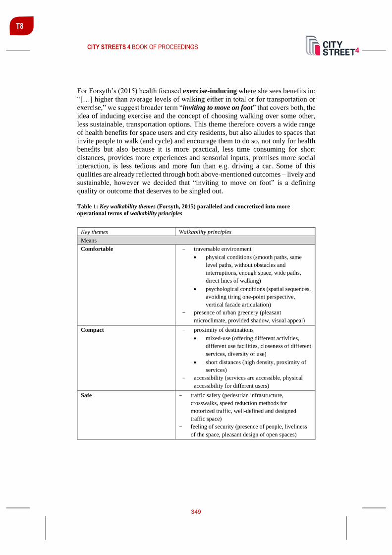
CITY STREETS 4 BOOK OF PROCEEDINGS
349
T8
For Forsyth’s (2015) health focused exercise-inducing where she sees benefits in:
“[…] higher than average levels of walking either in total or for transportation or
exercise,” we suggest broader term “inviting to move on foot” that covers both, the
idea of inducing exercise and the concept of choosing walking over some other,
less sustainable, transportation options. This theme therefore covers a wide range
of health benefits for space users and city residents, but also alludes to spaces that
invite people to walk (and cycle) and encourage them to do so, not only for health
benefits but also because it is more practical, less time consuming for short
distances, provides more experiences and sensorial inputs, promises more social
interaction, is less tedious and more fun than e.g. driving a car. Some of this
qualities are already reflected through both above-mentioned outcomes – lively and
sustainable, however we decided that “inviting to move on foot” is a defining
quality or outcome that deserves to be singled out.
Table 1: Key walkability themes (Forsyth, 2015) paralleled and concretized into more
operational terms of walkability principles
Key themes Walkability principles
Means
Comfortable - traversable environment
• physical conditions (smooth paths, same
level paths, without obstacles and
interruptions, enough space, wide paths,
direct lines of walking)
• psychological conditions (spatial sequences,
avoiding tiring one-point perspective,
vertical facade articulation)
- presence of urban greenery (pleasant
microclimate, provided shadow, visual appeal)
Compact - proximity of destinations
• mixed-use (offering different activities,
different use facilities, closeness of different
services, diversity of use)
• short distances (high density, proximity of
services)
- accessibility (services are accessible, physical
accessibility for different users)
Safe - traffic safety (pedestrian infrastructure,
crosswalks, speed reduction methods for
motorized traffic, well-defined and designed
traffic space)
- feeling of security (presence of people, liveliness
of the space, pleasant design of open spaces)

CITY STREETS 4 BOOK OF PROCEEDINGS
350
T8
Interesting and Functional - pedestrian facilities (paths are well connected,
presence of pedestrian infrastructure, accessible
services on foot)
- overall physically enticing (presence of street
furniture, sufficient lightning, pedestrian
infrastructure mentioned above)
- service attractiveness and diversity (similar to
mixed-use concept)
- legibility of the space (hierarchy of paths,
intersections, nodes, landmarks)
- diversity (of visual design and activities present)
- space sequences (avoiding one-point perspective,
serial vision concept)
- soft-edge concept
Forsyth’s (2015) proxy definitions are complex and as she states, draw together
elements of prior themes. We agree with the complexity that multidimensionality
and holistic solutions bring in the equation of walkability and are thus taking over
the proposed definitions. However, due to their broadness and derivative nature of
previous themes (notions), we abstain from measuring them in our case studies and
rather use them for summary of before mentioned topics and principles. However,
we also single out holistic solutions as a mean in an integrative approach, especially
in the design of new districts and neighbourhoods, where the holistic integration
into the initial design brings many benefits over later retrofits.
To conclude the interpretation, we agree with Forsyth’s definitions to a wide
extent, however we felt the need to broaden some of them, include additional
aspects, which we deemed important and at some instances rename them in a more
obvious fashion. To make the themes more operational for design and evaluation
purposes, we also systematically translated and concretized them in Table 1 into
more graspable walkability principles, especially in the means category, which we
see as an urban designer’s intervention and tools palette.
COMPARISON OF TWO CITY DISTRICTS
Methodology
We tested the proposed unified and modified walkability themes and principles on
two case studies in Ljubljana (Slovenia). Slovenska cesta – Čopova ulica –
Trubarjeva ulica sequence of spaces are located in the core city centre district and
Južne Fužine neighbourhood, on the periphery of the city. We intentionally
selected one that has already been built, is established and involves many layers
from different time periods, and the other that is a proposal, the difference being
that in the first case all walkability interventions are in a sense a retrofit, while in
the planned one, the principles can be an integrative part of the holistic planning.

CITY STREETS 4 BOOK OF PROCEEDINGS
351
T8
What we lose by potential speculation about the use and success of the one that has
been in planning stage, we gain by its different predominant space use and built-in
walkability principles for comparison purposes between two very different city
districts.
We analysed walkability themes and principles in both cases and tried to identify
whether they are present and in what way they are contributing to the walkability
themes of the space. The goal was not to decide which district is more walkable,
but to identify the differences between them and compare walkability principles
implementation methods considering spatial differences.
As discussed in previous subchapter, we adjusted and expanded Forsyth’s themes
for the needs of the case study and we are still following Forsyth’s methodology,
adjusted accordingly (Figure 1). Forsyth’s evaluation is based on identifying of the
themes and their presence in the specific environments, with additional analysis of
which principles for each theme are represented.
Figure 1: Linking modified key themes of walkability into an existing scheme (initially
proposed by Forsyth, 2015 and modified by the authors of the paper)

CITY STREETS 4 BOOK OF PROCEEDINGS
352
T8
Ljubljana City Centre
Slovenska cesta – Čopova ulica – Trubarjeva ulica sequence of streets
This is an example of existing built environment adaptation with walkability
principles, which were implemented in numerous ways and result in many different
aspects of city life, not just walkability. After the initial renewal projects, which
were based on the concept of pedestrianization, streets became more attractive,
traffic safety increased and the spaces became livelier. Even though
pedestrianization was the initial and predominant walkability principle, municipal
urban designers introduced and encouraged some other solutions, such as
Slovenska cesta shared space (Figure 2).
Ljubljana city centre is a great example of how, with a long term vision, a
combination of small-scale individual projects stretched through a longer period of
time merge and become one whole. Even though initially many of those projects
were isolated from each other, they linked up and came out well connected. All
together resulting in a walkable, pedestrian-friendly environment. Many of those
were planned all along, some of them resulted in on the spot adjustments. However,
it is amazing how these individual projects achieve pleasant and continuous spatial
narrative in existing environment (Figure 3).
Figure 2: Slovenska cesta – shared space
concept, car free, public transportation
zone only
Figure 3: Čopova ulica – pedestrian zone,
mixed use, public ground floors

CITY STREETS 4 BOOK OF PROCEEDINGS
353
T8
Južne Fužine Neighbourhood
Future residential neighbourhood layout and design
The main idea was to present a way of implementing walkability principles in the
not yet built environment. In the diploma thesis from where the project is borrowed
(Žnidaršič, 2020), we tried to set an example of how we can incorporate walkability
principles in early phases of projects and how this approach affects the result in
comparison to more common retrofitted urban renewals. The main objective or
general goal is to outline the idea of deliberate implementation of walkability
principles as guidelines for designing continuous walkable open space in
neighbourhoods. In order to emphasize the importance of aforementioned holistic
approach, continuity of walkability principles and open space network, we
designed a sequence of open public space throughout the neighbourhood, that are
all connected into one representative route – a continuous walkable open space
consisting of several different spatial sequences.
We implemented principles of walkability after the morphological design of the
neighbourhood was finished, which made it more difficult because of its
orthogonal layout, which in consequence limited the possibilities of designing even
more interesting spatial sequences. Regardless of that, we managed to design a
walkable neighborhood through partial implementation of walkability principles.
Every segment of the chosen path, which leads through the neighborhood was
approached and designed in a different way (akin to the example in Figure 4); we
applied many of the walkability principles in different order and form, depending
on a specific segments’ character, anticipated users and their needs, which at the
end all connected into one whole.
Figure 4: Visualization of a representative ambient from Južne Fužine neighbourhood

CITY STREETS 4 BOOK OF PROCEEDINGS
354
T8
COMPARISON AND RESULTS
The following table (Table 2) compares both areas, Ljubljana city centre and Južne
Fužine neighbourhood. It strives to identify the differences and similarities in order
to show the disparities in the design according to the context of the environment.
The comparison is assessed and described in qualitative rather than quantitative
fashion. Short descriptors help understand the reasoning behind the valorisation.
Table 2: Ljubljana city centre and Južne Fužine comparison - walkability themes according
to interventions and design decisions in infrastructure, pedestrian network and supported
activities
Interventions &
design decisions
(across)
Walkability
principles (down)
Infrastructure
provision & built
context
Pedestrian network Activities supported
Means
Comfortable
Ljubljana city
centre
Paths on the same
level, enough space to
move about, without
meaningless
interruptions, paths at
crossings are lowered
to the level of roads
Complete and well
connected
(pedestrianization)
interesting change of
sequences
Being able to move
around on foot, activities
accessible on foot
Comfortable
Južne Fužine
Provided, paths on the
same level, wide
enough to move
uninterrupted, road at
crossings with the path
is raised to the path
level
Less interesting due to
the predominant one-
point perspective
sequences, otherwise
well connected
Activities centralised in
the middle of the
neighbourhood, longer
walking distances
Compact
Ljubljana city
centre
Good accessibility,
close distances,
densely built part
medieval, part building
block urban tissue
from interwar period
Well connected,
provided intermodality
to other destinations,
resulting in proximity
of activities of
everyday use
Mixed-use resulting in
compactness, being able
to reach services and
desired destinations on
foot
Compact
Južne Fužine
Bigger open spaces,
higher buildings, high
density but medium
compactness, longer
distances
Connected, multiple
interwoven pedestrian
networks (along the
road network, within
building block
network, river path
network)
Activities very
centralised in the middle
of the neighbourhood,
longer distances

CITY STREETS 4 BOOK OF PROCEEDINGS
355
T8
Infrastructure
provision & built
context
Pedestrian network Activities supported
Safe
Ljubljana city centre
Pedestrian zones (very
safe), physical
separation of car and
pedestrian traffic; shared
space (less safe, less
separation), human scale
Safe (continuous,
pedestrian friendly)
Moving around on foot
without fear of crime,
presence of people, public
ground floors, good
lighting
Safe
Južne Fužine
Very safe (sidewalks,
pedestrians crossings
raised, physical
separation) shared space
(less safe), pedestrians
only zones (very safe)
Safe, continuous,
partially car free
Able to move around
safely, residential
neighbourhood, plenty of
public ground floors, well
lit
Interesting and
functional
Ljubljana city centre
Functional (pedestrian
infrastructure is
provided, space is
legible, non-repetitive,
street furniture provided,
signage, well
maintained)
Interesting (diverse
paving), functional
(connected
infrastructure)
Interesting and enticing
(diversity, presence of soft-
edge principle, service
attractiveness, many
different space sequences)
for walking, lingering,
strolling
Interesting and
functional
Južne Fužine
Street furnishing,
pedestrian friendly
crossings, multiuse
paving, furniture for
resting and relaxing,
recreating, playing,
gardening, etc.
Legible network,
hierarchy of paths,
various character of
paths
Longer distances to reach
shops, but many different
interesting outdoor
activities; walking to
services, leisure and school
activities, recreation
Outcomes
Lively and sociable
Ljubljana city centre
Provided
(stated already above)
Complete
(stated already above)
Offers many different
activities (shopping,
cultural activities, touristic
activities, bars,
restaurants), lively all day,
also tourist focused
Lively and sociable
Južne Fužine
Relatively provided,
depend on the specific
segment of the
neighbourhood
(stated already above)
Complete, activities
intensify at nodes
scattered across the
neighbourhood, constant
and everywhere
The amount of liveliness
depends on the activities
supported (livelier in the
central space), very
sociable where spaces are
more intimate (small
blocks), also depend on
what time of the day,
leisure activities, sports
activities, spare time
activities (e.g. urban
gardening)

CITY STREETS 4 BOOK OF PROCEEDINGS
356
T8
Infrastructure
provision & built
context
Pedestrian network Activities supported
Sustainable
Ljubljana city centre
Could be better, lack of
urban greenery,
overcrowding; majority
of users are visitors and
do not reside in the area
Relatively complete
(supports sustainable
transportation, waste
disposal and recycling,
lacks sustainable spatial
interventions),
consuming oriented, heat
island during summer
Human scale and
proximity reduce car use
(cars prohibited on
surveyed streets),
destinations can be reached
on foot
Sustainable
Južne Fužine
Provided, integrated into
a design of a new
neighbourhood; majority
of users reside in the
neighbourhood and
commute to work
Urban greenery
provided, sustainable
paving materials, heat
islands mostly avoided
Mixed use supports local
shops, different
recreational activities
(gardening, sports), river
space integrated;
Inviting to move on
foot
Ljubljana city centre
Provided
(stated already above)
Complete, well
connected
Present both, walking with
a goal of reaching a
specific destination and
walking for relaxation,
enjoyment, walks; spaces
prioritize pedestrian and
cyclist
Inviting to move on
foot
Južne Fužine
Provided
(stated already above)
Complete, connected
network of pedestrian
paths
More recreational and
relaxation walking, also
some walking to
destinations and reaching
services; most spaces
prioritize pedestrian and
cyclist
Infrastructure
provision & built
context
Pedestrian network Activities supported
Proxies
Multidimensional
Ljubljana city
centre
Provided safe,
comfortable and
functional pedestrian
infrastructure
Network completed
with additional
dimensions, for
example legibility and
diversity of use
Inviting environment,
mixed use, diversity, but
could be more
sustainable than it is
Multidimensional
Južne Fužine
Provided safe and
functional
infrastructure for
pedestrians
Network completed,
offers many outdoor
activities
Functional and inviting
environment, recreational
activities, sustainable

CITY STREETS 4 BOOK OF PROCEEDINGS
357
T8
Infrastructure
provision & built
context
Pedestrian network Activities supported
Holistic solution
Ljubljana city
centre
Provided, positive
effect on liveliness,
mostly retrofitted and
upgraded throughout
numerous renewals
during the years
Retrofitted to be such Supports many different
activities, promotes
tourism, socializing,
reduces negative effect of
motorised traffic
Holistic solution
Južne Fužine
Provided in
combination with
cycling infrastructure
and speed management
strategies; integrated
into the initial design
Designed to be as such Supports different
activities, outdoor and
recreational activities
stand out; reduces the
need of motorised traffic
and encourages
neighbourhood
community building and
socializing
Key differences
After the comparison we would like to highlight main differences between both
districts. Our goal is once again, not to decide which environment is more walkable,
because each of them has inherently different characteristics and different users,
with different predominant space use. Instead, we would like to present and
emphasize the contrasting points between them.
The major one has to be put aside first: Južne Fužine has been designed anew and
has not yet been realized, thus having an advantage of optimistic assumptions about
space use and user behaviour. Streets in centre of Ljubljana, have been recently
refurbished, but have established a proven record of pedestrian friendly and good
walkability solutions.
One of the key differences between them is comfort and its psychological aspect,
where human-scale design and spatial sequences play a big role. It is obvious that
city centre ‘wins’ in this comparison, because of the complex morphology and
layered historical sediments (Figure 5) – it has grown in more organic way, is more
diverse, supports the idea of serial vision and with that makes it more comfortable
to walk through (portrayed in Figure 6). While Južne Fužine neighbourhood is less
pleasant, because of its orthogonal design and sometimes less interesting one point
perspective.

CITY STREETS 4 BOOK OF PROCEEDINGS
358
T8
Figure 5: morphology comparison (Južne Fužine on the left, city centre on the right)
Figure 6: Trubarjeva ulica view (spatial sequences)
In addition, activities in the city centre and most of the important daily destinations
users want to visit are closer to each other, while in Južne Fužine neighbourhood
they are more centralised and require longer walking distances. “Dispersed
compactness” of the city centre is better and more effective than the “centralised
compactness” of the Južne Fužine neighbourhood. Which, once again, is reflected
in the character and predisposition of the environment – prevailing use in the city
centre is commercial, while in Južne Fužine neighbourhood it is residential.
The concept of interesting and therefore inviting is a little less dependent on the
environments morphology and character – we can influence it through urban and
architectural design. The key difference is, that city centre has many historical
layers and can be in this aspect more interesting, but at the same time less flexible,
while Južne Fužine neighbourhood is more flexible to change, in a way more open
for some innovative interventions and therefore has more potential for growth in
the interesting aspect. In conclusion both environment can be interesting and
inviting, but in a different way.
Regarding the outcomes, we can say that city centre is livelier, to some extent even
weather conditions independent, but Južne Fužine neighbourhood is more sociable,
once again considering specific environments character and majority of users (in

CITY STREETS 4 BOOK OF PROCEEDINGS
359
T8
the case of Fužine, we are also predicting behaviour rather than surveying it). In
Južne Fužine, there is a big potential for people to meet, get to know each other
and socialize, which builds a community and strengthens the feeling of belonging.
While in city centre, the aspect of community building is less present, however
sociability benefits still rank high. In contrast to Južne Fužine, city centre is lively
throughout the whole day, on the other hand, we predict Južne Fužine residents
will start to inhabit open spaces mostly in the afternoon, especially in good weather.
Sustainability in general can be better integrated in Južne Fužine, because it can be
done deliberately and is integrated into the design of a proposed neighbourhood
(e.g. solar energy, greenery and shading, avoidance of heat islands, sustainable
energy management and low consumption, waste water and rain water
management, etc.), while in the already built environment in the city centre it is
more difficult to implement those principles, which can be only retrofitted in less
ideal manner. The users of each districts also greatly differ. Majority of Ljubljana
city centre users are visitors and do not reside in the area. The place has
overcrowding tendencies, especially on summer days and numerous events, which
bring negative consequences (litter, noise, reduced movement speed, etc.). In Južne
Fužine, the majority of users will reside in the neighbourhood, however most of
them will need to commute to work in other city districts. The positive aspects of
belonging will result in better upkeep and sustainable practices of the users.
DISCUSSION AND CONCLUSION
The main goal of this contribution was to translate main walkability themes into
more concrete and implementable walkability principles. They can be also
understood as a palette of tools and interventions available to urban designers to
achieve walkable, lively environments. With this idea of themes broadened into
specific principles, we wanted to address the topic of walkability in general and
deepen the understanding of its complexity, as well as Europeanise it. We estimate
that we were successful in this endeavour.
As we already stated above, walkability principles are all connected,
interdependent and in many different ways affect each other. Therefore, it was very
challenging to divide them into groups because of the overlaps. Some of the
principles fit into more than one theme, but for the sake of chosen methodology the
grouping as done, was unavoidable. The challenges due this division and separation
of principles became clearer later on (in Table 2 – comparison). When we started
to describe each theme separately for a specific environment, some repetition
occurred and we were not able to describe some of the principles without the
support of others. Following the given methodology, the comparison lost some
clarity and simplicity. The major character differences between both environments
also added to the challenges. Some of the compared themes varied in their essence,
because of the spatial context, and were therefore not the most comparable. For
example, liveliness of the space in this case study does not solely reflect presence

CITY STREETS 4 BOOK OF PROCEEDINGS
360
T8
of walkability principles, but is mainly derived from the spatial properties and
character of the spaces themselves.
Therefore, we can conclude that the methodology in this case was not as effective
as we initially anticipated it to be. If we had chosen different, contextually more
similar and smaller locations to compare, it would be easier to make clearer
comparison. Whit this methodology of qualitative comparison we could easily and
effectively compare, for example, two different streets from the city centre or two
different ambiences from the same neighbourhood. In those cases, we would be
able to avoid stark contrasts which originate from very different environments
observed. In addition, we would also be able to score walkability with rating scale
(e.g. Likert scale), for example from 1 (not present) to 3 (present) and by that decide
which of the localities are more walkable. For the reason of aforementioned
baseline differences and the fact that one of the locations is a hypothetical one (not
yet built), which would make it difficult to score objectively, we abstained from
ascribing specific values to them.
With holistic and broadened approach we demonstrated that principles of
walkability cannot be divided into categories and observed in isolation. As
discussed above, the intertwinement even hinders unambiguous evaluation and
leads us away from isolationist approach. The holistic aspects of the walkability –
dealing with all of them at once – and its multidimensionality – intertwinement and
co-dependency – are its integral parts, in design, implementation and evaluation.
REFERENCES
Cullen, G. (1961). The Concise Townscape.
Forsyth, Ann. (2015). What is a walkable place? The walkability debate in urban design.
Urban Design International 20, no.4: 274-292.
Gehl, J. (1971). Life Between buldings. Washington D.C.: Island Press.
Gehl, J. (2010). Cities for People. Washington D.C.: Island Press.
Hodljivost - IPoP - Inštitut za politike prostora. (2020). Retrieved from
https://ipop.si/urejanje-prostora/izrazje/hodljivost/ (25. July 2020).
Jacobs, J. (1961). The uses of sidewalks: safety. The Death and Life of Great American
Cities (p. 29-55). New York: Random House.
Lo, R. H. (2009). Walkability: what is it?.
Mateo-Babiano, I. (2016). Pedestrian's needs matter: Examining Manila's walking
environment. Transport Policy, 45, 107-115. Retrieved from
https://www.sciencedirect.com/science/article/abs/pii/S0967070X15300561 (13. March
2020).

CITY STREETS 4 BOOK OF PROCEEDINGS
361
T8
Paris Mayor Pledges a Greener '15-Minute City' - CityLab. (2020). Retrieved form
https://www.citylab.com/environment/2020/02/paris-election-anne-hidalgo-city-planning-
walks-stores-parks/606325/ (11. July 2020).
Sim, D. (2019). Soft City.
Speck, J. (2012). Walkable City. New York: North Point Press.
Why cities are bringing walking into focus. (2019). Retrieved from
https://www.jll.pe/en/trends-and-insights/cities/why-cities-are-bringing-walking-into-
focus (9. August 2020).
Žnidaršič, K. (2020). Principi hodljivosti v urbanih soseskah: študija na primeru soseske
Južne Fužine (unpublished diploma thesis), University of Ljubljana, Faculty of
architecture.

CITY STREETS 4 BOOK OF PROCEEDINGS
362
T8
ANOTHER STREET IS POSSIBLE: EXPLORING FUTURE
STREETSCAPES THROUGH TEMPORARY REDISTRIBUTION
STRATEGIES
Steffan Robel Dipl.-Ing., A24 Landschaft, Köpenicker Straße 154, 10997 Berlin, Germany, [email protected]
ABSTRACT
Streets prevail public space. However, presently cars dominate our streets. A
reimagining of the street’s function is necessary to meet the needs, not just of
motorists, but of everyone else as well. Future requirements of the street as a place
for public life will ultimately reshape the spatial structure of our cities, which at
present adhere a post-war paradigm of the car-friendly city. Today, various
approaches to the reconfiguration of urban streetscapes are being tested through
the reclamation of social space along our streets. Progressive cities demonstrate
how the transformation of streets to squares and multimodal transit corridors can
be successful. In Oslo and Berlin, urban pilot projects which are temporarily
reorganising the use of streets have proven to be successful in illustrating possible
scenarios and ultimately changing the mind-sets of urbanites before the street is
permanently redesigned.
Keywords: Car-free city, mobility, participation, urban design, public space and
life
INTRODUCTION
Streets – or more precisely the use of them – in most global cities are changing. As
urban centres continue to demand increasingly more of their public and shared
spaces, the conventional mono-functionality of thoroughfares and carparks is being
questioned; the result of which is evident in streets being reclaimed for other uses
than cars. Our mobility has shifted and become multi-modular. Societal trends
such as urbanisation, densification and digitalisation have led to the increased use
of public space, as well as a significance of physical, local areas. The concept of
an urban street’s function being centred primarily around the personal vehicle is
being contested, and the paradigm of the car-friendly city is shifting. This is evident
by the myriad modes of transport visible throughout the city – from ride sharing,
to public transportation, cycling lanes and pedestrian zones – the potential of the
city street as a space for everyday life continues to be rediscovered. How do we
take up this current shift in mobility to formulate new narratives for urban space

CITY STREETS 4 BOOK OF PROCEEDINGS
363
T8
which correspond to the contemporary urban mode of living? Where can we
integrate public life into streets, creating an improved quality of living? Which
strategies and urban design typologies can support pedestrian-friendly cities?
Changes to mobility and climate adaptation of cities must go hand in hand. Urban
streets are dynamic spaces – as such, both their character and qualities can, and
should, be reinvented for a wider range of uses, types, and functions. Though the
consensus surrounding the necessity to reduce car dominance continues to grow,
what to do with the street space is a matter of debate between many stakeholder
groups. In Oslo and Berlin, the installation of temporary parklets has sparked a
dialogue about what we may choose to prioritise in the configuration of our urban
streets, by showcasing another kind of public space. This article explores the
potential of temporary interventions to pick up on the current moment of change in
mobility and reclaim the street as a hybrid living space of the city.
THE CAR-FRIENDLY CITY
How did the pre-motorised world look? What brought us to organising car-friendly
cities? Street scenes of past ages depicted in art and photography show a much
more varied and lively use of the streetscape before the car made its entry. This,
however, was also accompanied by the lack of sanitary means of transportation. In
Children’s Games (1560), a painting by the Dutch Renaissance artist Pieter
Bruegel, we see an interpretation of the streetscape in a very different light
compared to that of today – that of a crucial open space of a city where all of urban
life took place. Showcased in this image we see the inhabitants playing, eating,
trading. However, it was not always romantic. A photograph of a street scene in
New York in 1903 with children playing next to a decomposing horse
(photographer anonymous) display the fact that streets were also unhygienic
sources of infection. Cars were seen a rational and sanitary alternative to some
100,000 of horses occupying the streets at that time. This in-turn lead to the
paradigm of the car-friendly city which has continued to persist for upwards of half
a century.
The result is that today cars dominate the urban space of our cities. The present
distribution of the street gives dramatic priority to cars: Berlin consists of 48%
built-up areas, in contrast to a total of 18% green and open areas, but also of 11%
streets, taking up ¼ of the unbuilt areas (excluding water). Furthermore, Berlin’s
streetscapes are mostly reserved for cars, whereas pedestrian and cycle lanes take
up only 1/3 of the area, especially cycle lanes with only 3% of the entire street area
having little physical space.
This urban configuration corresponds neither to current mobility behaviour nor to
the renewed focus on health, wellbeing and quality of life in cities. Today, the
urban dweller tends to value a pedestrian-oriented and bike-friendly city. New
mobility technology like smart modal split apps, as well as car-sharing can help to

CITY STREETS 4 BOOK OF PROCEEDINGS
364
T8
accelerate the process of regaining the streets for other purposes than driving a car.
Although technology may not reduce traffic directly, it can address one crucial
component of our cities’ spatial composition, a component at the core discussions
surrounding issues of urban space: the parking lot. 95% of all cars are stationary
for the most part, only 5% are moving. What’s more, each car requires 12.5 square
metres of space (that of an average children’s room) at any given time. In the future,
automated driving could decrease the overall necessity of parking lots throughout
the city. This phenomenon would provide the opportunity to reclaim vast amounts
of otherwise unavailable space in our cities. For now, the question remains; what
is to be done with the new spaces that will emerge out of the abolished parking
lots?
OSLO: CAR-FREE CITY
The parklet is a pocket-sized temporary installation. They extend sidewalks and
replace parking space with more space and amenities for people using the street –
in-turn activating city life. Parklets are an important contribution to Oslo's car-free
city life project, "Bilfritt Byliv", which phases out cars from the city centre and sets
the framework for more city life. With a clear reduction of both the moving and
the stationary traffic, the project has been generating new social and cultural
activities in the streets since 2016 that could not have otherwise taken place in a
city laden with cars. Acting as a test bed in the transition between today's Oslo and
the future car-free city, parklets are facilitating a dialogue between the community
and the municipality, before permanent changes are made to the streetscape.
Developed by Studio Oslo Landscape Architects and Vestre, Parklets 2.0’s
modular system allows for easy implementation, relocation and reuse (see Figure
1). It is an innovative concept which allows people to experience the qualities of a
street with less cars, and how it may impact their daily life. Easy to customize,
order and implement, Parklets 2.0 is being adopted by cities around the world as
part of their transition to more people-friendly cities, including Trondheim, Berlin,
Paris, Vancouver and New York.

CITY STREETS 4 BOOK OF PROCEEDINGS
365
T8
Figure 1: Parklets in Nedre Slottgate in Oslo. Studio Oslo Landscape Architects (photo:
Vestre and Nicolas Tourrenc)
BERLIN: PEDESTRIAN CITY
Berlin, as the first German city, has developed a Pedestrian Traffic Strategy to
redesign street profiles and enhance pedestrian usage. The strategy aims to
demonstrate the possible quality of a public space with less motor traffic along with
raising public awareness of the fairness of an alternative street distribution. Pilot
projects called “Begegnungszonen” (“meeting zones”), which is a concept
originally coming from Switzerland, introduced urban spaces of high recreational
quality, where user groups interact, pay attention to one another, and are able to
walk safely and free of barriers. Two such pilot projects, in Maaßenstraße and
Bergmannstraße, both lively streets with central neighbourhood functions, served
as temporary test sites for the concept of “meeting zones”.
On Maaßenstraße bollards were used to test space allocation. The road was
drastically narrowed and deviated, while seating options were installed. After
negative reactions to the test phase possibilities and shortcomings were discussed
with the public. The result was a concept to restructure the street from one centered
around motor traffic to one that emphasized the pedestrian experience and
consisted of new uses for public life.
On Bergmannstraße an alternative approach was taken: parklets were introduced
as a temporary method to reconfigure the street, transferring the concept from Oslo
to Berlin. In order to showcase the positive effect of slowing traffic and increasing

CITY STREETS 4 BOOK OF PROCEEDINGS
366
T8
accessibility of the street, the parklets replaced car parking to create small but
multifunctional public spaces along the sidewalk (see Figure 2). The 15 modules
extended the purpose of the street with various seating options for sitting higher,
lower, in solitude, in groups, on benches, chairs or tribunes, with or without back
rests or tables, turned to or away from the traffic lane. Inviting pedestrians to rest
and enjoy the street life the parklets fundamentally changed the character of the
street and created a new urban atmosphere. The interventions work to illustrate
how less traffic could lead to more free space, and invite passers-by to re-
appropriate the street, opening up the potential for co-production and shared use.
Figure 2: Parklet in Bergmannstraße in Berlin. A24 Landschaft (photo: Vestre and Nicolas
Tourrenc)
The reception of the parklets was dubious: even if the use of the parklets could be
observed, soon after the installation of the first modules neighbourhood pushback
was evident through local media outlets such as the press, some installations even
fell subject to acts of vandalism. As a response to the scepticism, and as an attempt
to foster a face to face dialogue, a demographic cross-section of the local residents
and neighbourhood representatives were invited to a series of workshops together
with the senate, the district and the landscape architects to visualize the various
possibilities for the Bergmannstraße streetscape. Subsequently, the discussion was
brought back to the site, which saw the invitation of the broader public as well. The
result was a series of radical co-produced concepts, all of them car-free or nearly
car-free, leaving space for pedestrians, cyclists and greenery.

CITY STREETS 4 BOOK OF PROCEEDINGS
367
T8
It was learned that, the problem was not to take away some of the parking lots as
seen in other planning processes, but rather not taking all parking lots and cars
away. This shows how the attitude towards motoring has changed within the last
years.
CONCLUSIONS
Both in Oslo and Berlin, the test phases of the projects were integral to their
success. Temporary, reversible interventions are useful to present alternative
models of design and provoke debate. Contrary to the rigidness and formality of
large-scale, permanent projects, temporary, small-scale architecture allows for
experimental uses and scenarios, which are versatile and low-risk. These make
ideal testing scenarios for unconventional solutions to urban challenges. The small-
scale parklet interventions have produced extensive place-making changes. Their
temporary use of space helped form the basis for a fruitful community involvement,
ultimately making possible lasting large-scale projects more inclusive. The
approach to develop new streetscapes though temporary designs in order to start a
broad discussion with the public seems to be a promising way for the future
transformation of our cities to green, sustainable and liveable places. In an ever-
urbanising world, subject to the challenge of climate change and its associated
issues, temporary designs offer an interactive test ground on how to inhabit cities
in more sustainable ways. Interventions like the parklets have the potential to
encourage new uses of public spaces, alter a site’s identity, and reanimate the city.
Additionally, the reduction of parking spaces can transform mono-functional
spaces into dynamic components of multi-functional cities. Adaptive and flexible
urban design may inform the beginning of new urban structures with an array of
typologies equipped for complex streetscapes for varible forms of movement and
use. Hybrid streets provide an open urban stage, where different functions of
mobility, meetings, consumption, physical exercise, political manifestation and
ecology overlap. Another street is possible.
REFERENCES
Agentur für clevere Städte (ed.). (2020, May 4). Wem gehört die Stadt? Der Flächen-
Gerechtigkeits-Report. Mobilität und Flächengerechtigkeit. Eine Vermessung Berliner
Straßen. 2014. Retrieved from: https://www.clevere-staedte.de/files/tao/img/blog-
news/dokumente/2014-08-05_Flaechen-Gerechtigkeits-Report.pdf
Huber-Erler, R., Topp, H. (2014). Ein ungeliebtes Erbe. Stadt und Auto. Bauwelt 24.
Rode, P., Hoffmann, C., Kandt, J., Smith, D. and Graff, A. (2015). Toward New Urban
Mobility: The case of London and Berlin. Griffiths, P. (ed). LSE Cities/InnoZ. London
School of Economics and Political Science: London

CITY STREETS 4 BOOK OF PROCEEDINGS
368
T8
Senatsverwaltung für Umwelt, Verkehr und Klimaschutz. (2020, May 4).
Fußverkehrsstrategie. Retrieved from
https://www.berlin.de/senuvk/verkehr/politik_planung/fussgaenger/strategie/index.shtml
Senatsverwaltung für Stadtentwicklung und Wohnen. (2020, May 4). Umweltatlas Berlin.
Retrieved from:
http://www.stadtentwicklung.berlin.de/umwelt/umweltatlas/de601_06.htm
Sweco. (2020, May 4). Bilfritt byliv. Mellomundersökelse 2017 – opsummering av
observasjonsstudier. 2017. Retrieved from
https://www.oslo.kommune.no/getfile.php/13261937-
1513590196/Tjenester%20og%20tilbud/Politikk%20og%20administrasjon/Slik%20bygg
er%20vi%20Oslo/Bilfritt%20byliv/Bilfritt%20byliv_mellomundersøkelse%202017_obse
rvasjoner_16.11.2017.pdf

CITY STREETS 4 BOOK OF PROCEEDINGS
369
T8
NEW CENTRALITIES FOR INTEGRATED AND UNIVERSAL MOBILITY
IN LATIN AMERICA
María Eugenia Martínez Mansilla1 PhD student in Architecture and Urbanism, UNB. DF-Brazil. [email protected]
Marta Adriana Bustos Romero Full Professor, Coordinator of LASUS (Sustainability Laboratory) of UNB. DF-Brazil. [email protected]
ABSTRACT
The informality of urban consolidation processes in the Latin American context
tends to be more progressive in transitional areas of the city and constitutes an
obstacle to the accessibility and quality of open public space. However,
innumerable efforts in several countries, demonstrate institutional, civil, or
academic actions to face this problem, the fact is that occasionally they are
approached in an isolated way. This paper aims to present a case study in the city
of Tarija, Bolivia, which implemented the project of “widening sidewalks in the
historical centre of the city", which promotes two fundamental changes in the
urban context: a policy of sustainable urban mobility that prioritizes pedestrians
and cyclists, and a plan to revalue the urban heart of the city where the cultural
and heritage is preserved. The method consists in analysing that the contributions
of the implemented project can be limited only to an infrastructure fact and not as
part of a whole. The project can enhance and multiply its benefits from an integral
mobility approach, a baseline to consolidate “new centralities” in which more
than one hundred actions and/or complementary attributes are identified to justify
the creation of new urban centres to improve the quality of life based on mobility
and urban sustainability policies, considering that air quality and citizen
perception are indicators of main reference. The result aims to define these urban
cells in the city as model units, which will be constituted in the scenario to improve
urban health, image and formality where local governments can make visible the
multiple benefits of revaluing public space through micro-mobility, as part of a
process of urban transformation in phases, continued and supported with research
and which allows reconnecting the spaces to a true common sense and within a
synergy between technique, governance and culture.
Keywords: Sustainable mobility, Open Public space, Urban Centralities,
Sidewalks, Tarija.
1 Corresponding author; Architect Urbanist from UAJMS of Tarija, Bolivia.

CITY STREETS 4 BOOK OF PROCEEDINGS
370
T8
INTRODUCTION
It is clear that the concentration of urban population in cities, the expansion of
geographically wider areas and the rapid growth of metropolises are among the
most important transformations of human settlements (Martinez, 2020). Faced with
this reality, cities must reinvent themselves and adapt to the indispensable
requirements of urban health in order to face the end of the global health crisis, as
well as to mitigate the negative effects of climate change, two great challenges. It
is common that the problems and threats of the city, such as territorial dispersion,
segmentation of uses, primacy of the private vehicle, destruction of
neighbourhoods for the modernization of the city as a model of urban growth that
is inefficient on a socio-environmental, economic and even symbolic level (Jacobs,
2001), predominant in the American and English context, evidence a claim to the
right of the city, to an urban life of its own, to encounter and share. In other
European cases, the strategy of transformation in the City Lounge programme and
the treatment of the plinths as the most crucial part of the building at eye level,
connecting the pedestrian flows to the urban area (Karssenberg, Laven, 2015) from
the site, the road and the context according to Stipo2 in Rotterdam or Amsterdam
or the wonderful streets of Allan Jacobs (1995) or The walkable city in Stockholm
(2010). In this reflection arises this question: how is the criticism of this problem
in Latin America? The present work is oriented to make visible the urgent need to
rethink a paradigm of urbanism that allows to revalue the urban centrality to
reconnect with the city through sustainable mobility, where socioeconomic, spatial,
formal, and even labour factors can highlight the multiple benefits that a process
of transformation from the first urban cell, the centre, entails.
Although the object of this study focuses on highlighting how urban, functional
and social problems are addressed mainly in the urban centres of Latin American
cities from the street (as a punctual fact), it is also evident that it should not remain
only there but should go towards an integrated mobility (as part of a process). The
objective is to put in relevance the integrity of the solution proposals from the
continuous reflection of real indicators sensitive to the citizen perception and
emphasizing as focal point, the integral mobility. The qualitative methodology
consists of evaluating how the project acts on a suggested frame of reference of
thirteen criteria for new urban centres, articulated to three basic notions of
management: technique, governance and culture. The case study was chosen
because of the unique characteristics of an environment commonly adapted to the
Latin American context, and the results suggest that the project should be
approached in a comprehensive manner to achieve quality in urban space.
2 www.stipo.nl

CITY STREETS 4 BOOK OF PROCEEDINGS
371
T8
CONTEXT IN LATIN AMERICA
In a predominantly urban setting, there are processes of depopulation in almost all
the centralities of Latin American cities. While the housing rate amounts to more
than 10%, the depopulation of the centralities is around 3% (Carrion, 2011). The
new city is moving from spaces of encounter to spaces of flow, mobility,
interconnection, speed and a new approach to the networked city. However, three
aspects have caused these structural changes, such as the demographic transition,
the reform of the State and globalisation. In order to have an overview of the
specific actions in terms of centralities, mobility and public space, studies of the
countries of Brazil, Colombia, Mexico and Bolivia have been considered as case
studies.
In Brazil, Barbosa (2016), referring specifically to the quality of walking or
walkability and highlights three essential conditions: safety, attractiveness and
comfort, in addition to valuing public transport and the physical quality of the roads
to stimulate circulation in the city, considering that building and maintaining a
roadway is not expensive, according to Mobilize Brazil3, so that planning will be
done on a human scale and for people. In other work in Sao Paolo, Oliveira (2005),
presents the impact of the application of the Urban Centralities Program
(Neighbourhood Centres), executed by the Municipal Urbanization Company,
focused on the importance of the landscape project that highlights its
environmental relevance. Although the region shows inequalities in the supply of
public equipment, sanitation, infrastructure and areas for collective use that even
affect the local climate, with degraded areas that give a sense of neglect and
violence, urban neighbourhood environments are created in more deprived public
areas. To build reference spaces for social coexistence, negotiating with the
inhabitants the definition of use, schedules and activities, having as a priority the
pedestrian. The author says that the projects bring an innate appropriation and
highlights that these actions are of vital need for the future of the cities, those
democratized spaces, that place of citizenship (in Brazil there is an important
connotation due to the legacy of colonization and slavery). The urban landscape
acquires an important symbolic value articulated to the city. The experimentation
and appropriation of spaces and the care of trees was the tactic for public
landscaping, promoted by a team of architects and agronomists. Due to the
alternation of power, the program ceased to exist in 2005 and currently the
municipality of Sao Paolo, as an urban management strategy, established 'centrality
zones'4 for those areas or subcentres of the neighbourhood that promote non-
residential uses and landscape quality of public spaces.
For the Colombian case, Beuf (2016), analyses the figure of the centralities in the
territorial models of the LUP5, in which it passes from an urban vision of territorial
3 Brazilian Portal for Sustainable Urban Mobility. http://www.mobilize.org.br/ 4 https://gestaourbana.prefeitura.sp.gov.br/zona-de-centralidade-zc/ 5 Land Use Plan
CITY STREETS 4 BOOK OF PROCEEDINGS
372
T8
equity to the predominance of the principle of urban competitiveness. In the first
POT (2000), the centralities had to present an equidistance in the different sectors,
allowing the planning of a balanced and functional urban zone to facilitate access
to urban services, it was necessary to improve mobility and adapt to the model of
“cities within cities”, creating new areas or urban pieces on a zonal scale with the
execution of Structuring Operations (integral project in strategically delimited
zones) that organize daily mobilities, reach connectivity with the city, construction
of public spaces, recovery of wetlands and canalization of rivers, it was sought to
promote accessibility and to root the sense of territorial equity. It was proposed to
create 22 urban centralities located in the peripheries, for urban decentralization
and to diminish the dependence on the metropolitan centre, complex spaces and
places of interaction and identity that satisfy the needs of symbolic order of the
citizens. With the change of mayor and the revision of the LUP, already by 2014,
this network of urban centralities will become a network of cities, on a regional
scale. The concept of 'integration centres' is adopted at international, national,
regional and urban level, acquiring a sense of competitiveness, mainly to boost the
economy and private investment. Throughout this urban construction, the
centralities make sense in the framework of a global territorial model due to their
social and economic character, where it is emphasized that citizen participation
should not only act at a local level but also at a metropolitan level and in structuring
terms.
In the Mexican case, Alvarado et al. (2017), evaluated the habitability conditions
of public spaces in the historical centre of Toluca as a foundational and historical
centrality due to its identity and vitality, with the elderly and people with motor
disabilities through a methodological scheme that evidences that pedestrian
accessibility, connectivity, safety and environmental noise are the main factors to
be taken into account based on citizen perception and user surveys in these spaces,
assuming that sustainability is fulfilled by ensuring basic habitability elements in
public spaces, neighbourhoods and cities based on equity, cohesion and social
inclusion. The study shows that only 82% of the streets are walkable, and that
90.3% of adults over 60 years of age perceive insecurity, in addition to noisy
spaces, as inequity in access and free movement in a large part of the centre,
making evident the need to evaluate the performance of the constitutive elements
of public space. Likewise, Aguilar (2020), develops a study in the centre of Mexico
City, from the sensory experience of a blind person in different journeys,
emphasizing the sensitive aspects of the journey as the orientation, textures, smells
and sounds. The author argues how the narratives of those pleasant places, the idea
of secret places, are grouped into dimensions based on emotions and affects,
sensory data, cognitive resources, travel strategies and environmental preferences.
The relationship of the context with its stimuli, whether of a material or social
order, justifies the importance of design in space, which must be inclusive even in
saturated scenarios such as the city centre.
In Bolivia, the Country Report Habitat III, points out that the floating population
is in transition, between urban and rural areas, since it maintains a mixed residence,

CITY STREETS 4 BOOK OF PROCEEDINGS
373
T8
called “multilocality” (Antequera, 2011). In the city of Tarija, located in the south
of the country, the project to widen sidewalks in the historic centre, which was
initially misunderstood and is now required to promote active mobility, is
presented later as a case study. In this review of the Latin American context through
different scenarios and problems, it is common to note the concern and interest in
establishing criteria for urban development and focusing on the central areas as
favourable scenarios and great challenges to promote habitability in the
environmental, symbolic, economic, social, formal and accessibility aspects.
WHY CENTRALITIES?
In any sense of centrality, the interaction between people and their activities is
always present, and may be necessary, optional and social according to Gehl
(2006), providing flows of relationships and accentuating the value of closeness.
They are those spaces of socialization and encounter that help to create links
between people and a feeling of social responsibility (Jacobs, 2001). Romero
(2011), considers that the structure of a place is defined by its character and by the
space, the character of a certain space contributes to the creation of an atmosphere
of the place, a qualitative phenomenon that is not summarized only in the sum of
its constitutive elements and the space organizes three-dimensionally the elements
that guide the individual. It is in the urban centrality where the renovation project
becomes more relevant in the context of a city (Beuf, 2011) and it is that conceived
space that guides the action that forms a global project to understand its landscape
dimension and lived dimension. As part of a process of transformation and living
renewal that is shown in public space. As a result of conditions of good life,
interventions that revolve around identity, coexistence and social practices even in
the deep social inequalities that will be an individual and common search for small
groups, while accessible to ensure the right to the city with greater recognition of
the inhabitants as a reference point in the city, Garcia (2011), proposes to move
from the right to the city to the right to happiness. According to Montejano (2015),
urban centrality encompasses three dimensions: location of space (geographic);
functions of social groups (social); goods and services produced or consumed
(economic), closely associated with the concept of exchange between production
and consumption processes. In itself it is considered a cluster in the city. The
attributes of urban centralities are density as opposed to social segregation,
dynamics due to land use and mixed occupation of services and commerce. Even
Salat (2011), indicates that in the composition of natural spaces in the heart of the
city and in the incursions of the natural environment in the urban context, the
exterior becomes visible in the interior. The diversity of the urban landscape
reflects the diversity of the landscapes in its surroundings.
CASE STUDY TARIJA – REAL SCENE
The municipality of Tarija is facing a serious environmental problem with air
pollution due to the increase in the number of vehicles, a situation that is

CITY STREETS 4 BOOK OF PROCEEDINGS
374
T8
suffocating the arteries of the city centre, which concentrates commercial,
institutional and service activities and where associations and unions of urban
transport currently operate and other vehicles circulate (taxis, individuals). Land
use is also affected by the occupation of sidewalks with street commerce and
parking lots in the streets that hinder the free movement of pedestrians (Figure 1,
problems). Thanks to the promotion of international cooperation, Tarija became a
node in the MoniCA Network (air quality monitoring) and obtained the first
Municipal Air Quality Report for Tarija - Year 20146, the result of active sampling
establishes concentration levels of PM10 (24-hour average), measured between
January and December in two sites, Bolívar Park of 69.4 µg/m³ and Sucre Square
of 65.2 µg/m³, which in both cases exceeds the annual limit value of 50 µg/m³
according to Law No. 1333 on the Environment. This implies that in both areas
there is a moderate risk of chronic poisoning for the population. Similarly, the
concentration level of NO2 exceeds the annual limit value. In the same year, a
phase of sensitization begins to mitigate these environmental effects and a gradual
modification of the road infrastructure. One year earlier, the first sidewalk
widening was established around the Luis de Fuentes y Vargas Main Square and
the following year a semi-pedestrian circuit was planned in the centre of the city of
Tarija. The centre has an urban layout in the form of a checkerboard, typical
colonial legacy and has track profiles between 8 to 12 mt. for a population of
268,400 inhabitants7 that extends from north to south from the axis of the
Guadalquivir River.
Sidewalk Widening Project
The widening of sidewalks, follows a policy of sustainable urban mobility and a
plan to revalue the historic centre of the city, forms a circuit that articulates public
spaces (Figure 2, semi-pedestrian circuit on monumental area), sites of collective
interest, cultural, religious, tourist, squares (Palace of Justice) and consists of
recovering the space of the vehicle parked on the road to redistribute it on the
sidewalks, leaving 3mt. of road shared with the bicycle in the zone 30Km/h, area
of controlled and restricted vehicular traffic to ensure road safety (Figure 2, shared
road 3m). The project contemplates, the use of local materials, “laja” stone, worked
in quarries of the city, very characteristic and traditional element in its use. It
incorporates ramps for accessibility with lowered handkerchiefs and tactile tile at
pedestrian crossings or zebras (Figure 1, work execution). It seeks to eliminate
fixed obstacles, leaving the entire strip of traffic free for pedestrians, incorporates
brackets on facades to free up the electric lighting poles, is complemented by the
placement of aligned lights that are highlighted in perspective and medium sized
flower trees (Figure 1, widening of sidewalks and lights). Considering that
sidewalks are a fundamental form of urban infrastructure that facilitates walking,
socializing, interacting and doing business, they should be provided on all urban
6 http://snia.mmaya.gob.bo/web/modulos/PNGCA/# 7 Projection 2020. Statistics National Institute - INE

CITY STREETS 4 BOOK OF PROCEEDINGS
375
T8
streets and be accessible to all users (Global Street Design Guide), “ears” are left
on the bicycle parking spaces, trying to get the private sector to invest in cycle-
structures as part of their social responsibility to the city and as a result of citizen
participation in the “Move by Bicycle” design competition. With neighbourhood
presidents8, the work of incorporating art and sculpture into green areas,
exhibitions of objects (tangible) and stories (intangible) that keep the collective
memory, is coordinated; a circuit has been designed for weekend bike rides
accompanied by music with the traditional orchestra, a way of “living the city” and
as a strategy of urban animation.
Figure 1: Problems. Work execution. Widening of sidewalks and lights. Photo: Own file
Socially this project was very criticized at the beginning, mainly by users of
motorized which evidences the fact of strengthening the institutional role in local
governments to socialize the scope of urban project planning to the population and
institutions (water, electricity, hotel services, etc.), and to participate, discuss, plan
with them. The most reluctant sector was that of urban transport and merchants of
different items such as some owners, however, the collaboration of many others
was highlighted. A strong threat to this type of urban intervention, is expressed in
the malnourished culture of citizens and architecture to understand the spaces and
their meanings, the psychology of habitat manifests in the built environment the
way of life of people, so it is undeniable immediately resolve and curb the
aggressive air pollution by the saturated vehicle traffic, visual pollution, occupation
of the sidewalks by itinerant and informal trade that hinders free pedestrian traffic,
the exposure of fruits and foodstuffs to the polluting gases of the vehicle fleet,
generating an impact on people's health, to stop the deterioration of the
architectural heritage, the hostile architecture thrown onto the public highway, the
failure to comply with traffic regulations for loading and circulation in general, to
rethink the working conditions available to people with different abilities in the
collection of parking fees, the carelessness and indifferent sense of belonging to
the city, the citizens must be empowered in the problems as well as in the solutions.
The pending works to complete this first phase and of immediate realization
consists of the road-tourist signalling and in the medium term, the pedestrianization
of streets, migrating the system of aerial to underground wiring, adequacy of the
8 It is a representative of the neighbors (participatory and local democracy) to manage the provision
of services, infrastructure, security to public entities.

CITY STREETS 4 BOOK OF PROCEEDINGS
376
T8
system of pluvial drainage. The improvement of facades and the offer of new
premises imprints a formal dynamic of the economy during the day and night. The
actions set out in Table 1, are in themselves items of immediate application in the
central areas, so that the area is valued, the urban landscape is improved and the
conventional approach of seeing the sidewalks as spaces destined only for the
passage of passers-by and access to buildings is changed, but as organs of public
life.
Centrality Network
Although the project is planned within the framework of a municipal policy, it must
act in a network and constitute centralities in all the residential areas of Tarija
(Figure 2, urban centralities network), because the action of “widening” alone
represents nothing more than an infrastructure work, the urban sidewalk itself is
nothing, as an urban planner and reporter would say. For this reason, the approach
proposed here of “new centralities” must be understood in a holistic way,
integrating a whole and must be replicated in other areas of the city and articulated
to a network of urban centralities for the access of all people, that is the city we
want.
Figure 2: Shared road 3mt. Monumental heritage area. Semi-pedestrian circuit. Urban
Centralities Network. Source: PMOT file, self-made
Citizen perception
Another relevant aspect is related to the citizen's perception and to evaluate that
reality. Measuring the population's perception of different issues reflects the
intention or the problem they are facing. It also serves as a basic indicator for
planning new policies. Medeiros (2019), highlights the importance and need to
include consultation with individuals in the different studies, since interventions in
public spaces need to address their demands, desires and needs. In this case, three
studies conducted in Tarija were considered.
The Citizen Perception Survey (CIEPLANE, 2019) reports that citizen insecurity
(26.12%), after unemployment (47.16%), is the greatest problem facing the city.

CITY STREETS 4 BOOK OF PROCEEDINGS
377
T8
In another study, on Environment and Pollution in the city of Tarija (CIE-UPDS,
2019), 48% of respondents believe that there is a high level of environmental
pollution and perceive that the central area is one of the most polluted along the
Guadalquivir River. The type of pollution that is of most concern is atmospheric
pollution (77%) after the pollution of water sources. This study also shows that the
most demanded institutional actions are the reforestation of trees, promoting the
use of bicycles and fines to the most polluting vehicles. Finally, the study on
Citizen Problems (CIE-UPDS, 2018), identifies that the main problem of the
“neighbourhood” is the absence of parks and green areas (22.2%), followed by
poor service of public transport (20.8%), and thirdly the lack of police presence
(19.9%). With respect to the problems of the “city", it is identified that the main
problem is the contamination of rivers and streams (35.6%), the second is
unemployment (29.8%) and the third problem is insecurity/abuse (29.6%).
These results show that in the natural attributes, social and cultural aspects are
superimposed because in the problems of the “neighbourhood", it is clearly
identified that the first problem is linked to public space, the second to mobility
and finally the third problem is related to the safety of people. The results of these
studies justify the need to rethink spaces, places and their relationships with people.
Gordon (2006), indicates that social interactions in space are linked to the city and
are represented by its culture, architecture and design; this force of interaction
between economy-demography-development, awakens interest. The main
reflection is in deciphering the varied implications that predominate in the cities
and that print this character, as the case of Mexico that considers the perception,
the sensory of a vulnerable group with respect to the central space in the city.
NEW CENTRALITIES - IDEAL SETTINGS
In view of this context and according to the review of Management Practices and
Urban Sustainability with emphasis on Sustainable Mobility and Transport in
Curitiba (2013), Sustainable Cities: Social Urbanism and Public Management in
Medellín (2013), Leadership for Urban Mobility Planning in Medellín – LUTP
(2018) and other experiences gathered over several years in the municipal
administration (2016), the following approach is proposed for urban centres that
will be treated as an inseparable binomial between the historical centre and
sustainable mobility, or expressed in another way in the following formula: centre
+ mobility = new centrality. Although there are different methods for measuring
urban centres (spatial syntax), this paper relates the attributes of a municipal
“policy” for sustainable mobility to a “plan” for the revaluation of the city's
historical centre, grouped together in technical, governance and cultural criteria in
order to address the public's perception. The elements of this formula suggest more
than one hundred actions that promote this new centrality and can be articulated in
other urban nuclei and work in networks for different uses and relations (Table 1,
attributes of the new urban centrality).

CITY STREETS 4 BOOK OF PROCEEDINGS
378
T8
Table 1: Attributes of the new urban centrality. Source: Self made
NEW CENTRALITY
CENTRE + MOBILITY
PL
AN
IFIC
AT
ION
Centralities network Pedestrian /Bicycle Priority
PL
AN
IFIC
AT
ION
Apple hearts Phases to pedestrianize
Land use and occupation Shared and complete streets
Articulate squares or green areas Public bike and micro mobility/VMP
Hydrant networks Integration of cycle path networks
(transport, recreational, shared)
WIFI public space Transportation Oriented Development –
DOT
Information points Integrated Public Transportation System
CIV
IC C
UL
TU
RE
Tree/ Monument/ Bird Identification Driver training
VIA
L
ED
UC
AT
ION
Architectural culture Urban educators
Urban animation EcoBici (bicycle school)
Citizen security/Social trust Close traffic in downtown on Sundays
Cleaning Traffic control
INF
RA
ES
TR
UC
TU
RE
Improve lighting Public transport stops
INF
RA
ES
TR
UC
TU
RE
Public decoration/Street furniture (benches, posts)
Bike parking (public – private)
Improve facades Vehicle parking
Underground telephone network Traffic lights (intelligent monitoring)
Maintenance Attractors (museums, churches) Illumination
Storm drainage networks Stable, unobstructed surfaces
Newspaper kiosks Horizontal marking of bike boxes
DE
SIG
N Public space Pompeiians
Urban image/Urban imaginary Physical dividers / Area demarcation
Landscape architecture Bollards / Use of local materials
HE
RIT
AG
E Workshops schools Wayfinding
Preserve heritage houses Accessibility to attractors (market, library)
DE
SIG
N
SO
CIA
L
Quality of life index Tactical urbanism
Identity Parklets / Terraces
Collective memory Animated sidewalks
Coexistence Urban art
Music on the streets Universal accessibility (for all people)
AC
CE
SIB
ILI
TY
Traditions/crafts cultural Touch tile
EC
ON
OM
IC
Capital gain Street visibility
RO
AD
SA
FE
TY
Night dynamics 30km/h zone
Fairs and promotional activities Vehicle restriction
Shops, book club, cultural centre Safe intersections
TO
UR
ISM
Circuits (historical, gastronomic, religious) Vertical / Horizontal signage
Cataloguing urban landscape units Regular vehicle ramps / Slopes
Freelance local tourism Recreational bicycles
EC
ON
OM
IC
Guided walks Delivery / Services
Creative advertising Tourist circuits
Illuminated night art Bike maintenance (bicycle shops, stores)
EN
VIR
ON
ME
NT
AL
Green infrastructure Urban trees / Landscape
EN
VIR
ON
ME
NT
AL
Recover green areas Less visual contamination
Thermal comfort Less air pollution
Native woodland, rain gardens, flower pots Less noise pollution
Collective orchards Less direct insolation
Carbon footprint calculator Less wind speed
Clean air Improves physical and mental health –
Sensory experience
GO
BE
RN
AN
CE
Incentives Financing and execution of Mobility plan
GO
BE
RN
AN
CE
New offer of micro-companies Transportation to work plans

CITY STREETS 4 BOOK OF PROCEEDINGS
379
T8
Soil created/High-rise buildings Access to bicycles (More bike for everyone)
Compensation certificates Incentive to pedal and walk
Adequate burden sharing and benefits Regulate informal service trade,
transportation and Laws
In Tarija, more emphasis was given to those highlighted in the Table 1 (remark in
blue), making evident a greater articulation of the set of attributes for a new
centrality. Planning, governance and citizen culture, together with road education,
constitute the basic platform for consolidating the guidelines of this urban model
in a transparent, democratic and fair manner that guarantees active participation.
In the aspect of design, a specialized technical criterion is vital, but, above all,
sensitive in order to give a creative and coherent response to the urban space. The
social, economic and environmental aspects guarantee the sustainability of this
urban project. The infrastructure requires a serious and continuous commitment to
ensure the equipment and elements constituting the public space. Heritage and
tourism represent the opportunity to preserve what the past has coined in history as
a cultural legacy and to innovate for the future. Finally, the aspect of accessibility
and road safety are the key to always focus the priority on the urban space, the
citizen. The influence of the urban environment on pedestrian mobility is evident,
both the elements and the physical characteristics themselves will encourage or
discourage pedestrian movement Valenzuela (2015), three key aspects of access to
public transport, different centres and public space, ensuring social interaction. The
relationship between man and space underlies the value and identity of the place
(Romero, 2011). This approach also goes beyond public health by improving the
conditions in which people can access public space. This set of actions is grouped
into the following dimensions of sustainable urban management:
Figure 3: Sustainable Urban Management. Source: Self-made
Urban management has the challenge of guaranteeing the habitability of people,
accessibility to services and spaces with equity and security. A synergy between
technique, governance and culture. Here the importance of following the
Colombian model, with a vision of integrity and corresponding to a global scale.

CITY STREETS 4 BOOK OF PROCEEDINGS
380
T8
CONCLUSIONS
The creation of new urban centres to reconnect the city and guarantee its
accessibility, ensures two key aspects in the city: integrating all people in a
common scenario (in their relationships) and innovating new ways of working and
living as citizens (in their transactions). All the attributes identified for a new
centrality implemented in the city constitute the first action of social equity,
because each place has its own centre. Revaluing space in the Latin American
context should be the greatest effort that governments should make to guarantee
the positive impacts on human development and social production of the habitat,
as well as for the planning of public policies in the most sensitive areas of the city.
In both Sao Paolo and Bogotá, the studies carried out are linked to the revision of
urban management strategies in the conception of urban centres, in both cases with
actions in the periphery, highlighting more the environmental and landscape
guidelines in Brazil and the competitive and economic in Colombia. The
perception and sensory adoption of the problems, as in the case of Mexico and
Toluca, reveal the importance of considering the person as the main object of study,
in attention to their demands and needs. The ways of socializing the projects in
previous consultation differ so much between the context of European or American
countries with Latin America mainly to the informality of the processes of
management and administration of the public thing, in that aspect we have much
to learn.
In the Tarija case study, air quality indicators play a deterrent role in getting a
transformation process off to a good start, but even the problem seems to be
stagnating as a late event that could mitigate negative externalities. Throughout the
city, new centralities will be established, which must be adapted to the
characteristics of the place, although a single concept of centre is proposed, it is
articulated in a network, but each centrality is different from the other because it
acquires its own identity.
In the cases presented from the four Latin American countries, there are positive
aspects that seek mechanisms to address the processes of urban development,
however there are two common factors that must be carefully addressed, the
“continuity and maintenance” of the projects is key to ensuring the impact and
scope with which they were projected, as in the case of Sao Paolo worked on
concepts of urban landscape throughout the city, especially in peripheral areas, a
good experience that brought the population closer to the use of spaces, was only
for memory. And the “integrity” of the proposals of intervention in the urban space
since they are multiple factors and dimensions that must be addressed, nothing in
urban management is unilateral, that is why it is proposed to adopt this construct
of new centrality presented in this work, as a set of actions included in thirteen
criteria that aims to empower citizens of their development, to the government
capable of guaranteeing access and financing and the multidisciplinary technique
to democratize information, this synergy will make us capable of facing with
CITY STREETS 4 BOOK OF PROCEEDINGS
381
T8
resilience the great challenges to which we cities are now called mainly after the
global health crisis, to guarantee the quality of the built environment (overview)
and to integrate the pedestrian as the objective of urban quality.
Finally, developing new centralities in the city helps to organize the informality of
urban consolidation, promotes and improves accessibility, interconnection is not a
likely issue, it is an imperative need to collaborate with the health and welfare of
citizens, so required and fundamental today for the post Covid-19 time and
tomorrow for climate change.
REFERENCES
Alvarado, A. C., Adame M.S., Sánchez, N.R. (2017). Urban Habitability in public space,
the case of the historic center of Toluca, State of Mexico. Society and Environment, (13),
129-169.
Antequera, N., Cielo, C. (2011). Cities without bordesr. Multilocalidad in Bolivia. CIDES.
Barbosa, V. (2016). Avaliacao da caminhabilidade no entorno de estacoes da linha 1 do
metrô de Salvador. Dissertação. Universidade Federal da Bahia.
Beuf, A. (2011). New centralities and access to the city on the outskirts of Bogotá. Bulletin
de l'Institut francais d'études andines. 40 (1), 147-178.
Beuf, A. (2016). The urban centres as conceived spaces: technical and ideological
references of the territorial models of the land use plan (POT) of Bogota (Colombia)".
Notebooks of Geography: Revista Colombiana de Geografía. 25 (2): 199-219.
CIEPLANE. Business Information and Strategic Planning Center (2020, May 10).
Barometer of citizen perception 2019. Retrieved from http://cieplane.uajms.edu.bo/
CIE-UPDS. Statistical Research Center. (2019, March 25). Study on citizen problems in the
city of Tarija 2018. Retrieved from https://www.elpaisonline.com/
CIE-UPDS. Statistical Research Center. (2019, November 11). Study on environmental and
pollution in the city of Tarija 2019. Retrieved from https://www.elpaisonline.com/
Garcia, T., U. (2011). The right to happiness. II Iberoamerican meeting of best urban
practices. 62-63. Un Habitat.
Gelh, J. (2006). A humanizacao do espaco. A vida social entre os edifícios. Reverté.
Gordon, D. L.A. (2006). Planning Twentieth Century Capital Cities. Routledge.
Jacobs, J. (2001). Morte e Vida nas Grandes Cidades. São Paulo: Martins Fontes. 4 Ed.
Karssenberg, H., Laven, J. (2015). A Cidade ao Nível dos Olhos. Licoes para os plinths.
EdiPucrs. Porto Alegre.

CITY STREETS 4 BOOK OF PROCEEDINGS
382
T8
Martínez, M.M.E. (2020). Evaluación de la alteración del paisaje natural por los
asentamientos humanos en la comunidad de Lazareto, Departamento de Tarija.
Universidad Tecnologica Boliviana – UTB.
Medeiros, G.E. (2019). Avaliacao da importância da perspectiva do pedestre na análise
da caminhabilidade: Aplicacao de um modelo multicriterio. Universidade Federal da
Paraíba – UFPB.
Montejano-Escamilla, J. A. (2015). Is Mexico City Polycentric? New data and algorithms
for the detection of urban centralities. Economy, Society and Territory, Vol. XV. 333-361.
Oliveira, S. M. (2005). Landscaping and urban centralities. Landscape Environment. N.20.
61-83.
Romero, M. (2011). Architecture of the place: A bioclimatic vision of sustainability in
Brasília. Nova Técnica Editorial.
Salat, S. (2011). Cities and forms: on sustainable urbanism. CSTB Urban Morphology
Laboratory: Hermann.
Valenzuela, L.M., Talavera, G.R. (2015). Pedestrian mobility environments: a review of
approaches, factors and conditioning factors. Institute of Urban and Territorial Studies.
EURE, 41(123), 5-27.
CITY STREETS 4 BOOK OF PROCEEDINGS
383
T8
TOWARDS A WALKABLE CITY: A CASE STUDY OF ZOUK MOSBEH
Dima Jawad1 Associate Professor, PhD, Department of Civil and Environmental Engineering, Notre Dame University - Louaize, Lebanon, [email protected]
Maya El Chakhtoura B.E., Department of Civil and Environmental Engineering, Notre Dame University - Louaize, Lebanon, [email protected]
Julien Semaan B.E., Department of Civil and Environmental Engineering, Notre Dame University - Louaize, Lebanon, [email protected]
Nasri Khneisser B.E., Department of Civil and Environmental Engineering, Notre Dame University - Louaize, Lebanon, [email protected]
Paul Boulos B.E., Department of Civil and Environmental Engineering, Notre Dame University - Louaize, Lebanon, [email protected]
ABSTRACT
Cities all over the world are realizing the urgency to change their approaches for
planning their streets. We can no more afford to design for car-based mobility
solely; a practice that has proven to fail as a result of the traffic induction cycle
resulting in more congested streets and less mobility. Not only it failed to secure
mobility but also led to many disastrous outcomes from transport-induced air and
noise pollution to increasing traffic accidents, equity issues, loss of urban space,
and economic efficiency. The main challenge today is how to reverse this trend and
redefine our objective to provide the necessary mobility using an integrated mode
of transport that fosters low-emission alternative modes such as walking, cycling,
or transit. This research presents an investigation if whether this trend can be
reversed in the aftermath. The study takes the car-dependent city of Zouk Mosbeh
in Lebanon as a case study. A small size town in Lebanon that has grown
exponentially in the last two decades from a rural community to an agglomeration
housing industrial, educational, commercial, and residential land uses in a chaotic
manner while relying exclusively on vehicles for mobility. This growth is leading
gradually to loss of economic efficiency as a city as well as deterioration of quality
of life for its citizens. The study focuses on reintroducing walking as one of the
alternative modes. This approach starts by identifying best practices for creating
pedestrian-friendly environments, and then it moves into assessing the existing
land use and infrastructure in Zouk Mosbeh with respect to these best practices.
1 Corresponding author

CITY STREETS 4 BOOK OF PROCEEDINGS
384
T8
After the assessment and analysis are done, a set of recommendations and
guidelines are developed to guide the future planning and management of this city
based on quantifiable impacts that take into account mobility measures.
Keywords: pedestrian-friendly, city assessment, alternative transport mode.
INTRODUCTION
As the automotive industry grew in size, the space allocated to cars grew with it
whereas the pedestrian facilities shrunk. Cities all over the world are realizing the
urgency to change their approaches for planning their streets. We can no more
afford to design for car-based mobility solely; a practice that has proven to fail as
a result of the traffic induction cycle resulting in more congested streets and less
mobility. Not only it failed to secure mobility but also led to many disastrous
outcomes from transport-induced air and noise pollution to increasing traffic
accidents, equity issues, loss of urban space, and economic efficiency. The main
challenge today is how to reverse this trend and redefine our objective to provide
the necessary mobility using an integrated mode of transport that fosters low-
emission alternative modes such as walking, cycling, or transit. This research
presents an investigation if whether this trend can be reversed in the aftermath. The
study is done by taking the city of Zouk Mosbeh in Lebanon as a case study. This
city has become a hostile environment for pedestrians with severe vehicular
congestion throughout the city’s fast development. It currently lacks any initiatives
for planning and designing a pedestrian-friendly city. The main objectives of this
paper are to investigate if Zouk Mosbeh can become a pedestrian-friendly city by
conducting a detailed investigation of the existing street condition and developing
a set of appropriate recommendations and strategies towards transforming the city
into a pedestrian-friendly one. The paper starts with the literature review section
identifying best practices in planning for pedestrian-friendly cities, then outlines
the methodology. After that, a discussion of the results and analyses are presented
followed by the recommendation and conclusions.
LITERATURE REVIEW
Academic literature on the topic of walkability and pedestrian-friendly cities has
focused mainly on three directions: defining these concepts, illustrating different
approaches to assess their efficiency and impacts, and detecting peoples’
perceptions under opposite conditions. Moudon, et al. (2006) presented theoretical
and empirical insights on how to define walkable neighborhood from an
operational point of view. They concluded that residential density, block size,
presence of proximate grocery stores, restaurants, and retail facilities were strongly
associated with higher pedestrian traffic; on the other hand, the presence of large
office complexes and many educational facilities in a neighborhood had a deterrent
impact on walking. Moreover, they found that the presence of parks was not
associated with walking in the neighborhood. Most importantly the results showed

CITY STREETS 4 BOOK OF PROCEEDINGS
385
T8
that food environments had a dominant role in defining walkable neighborhoods.
(Moudon, et al., 2006)
Dannenberg (2017) presented an account of tools and practices for understanding
and promoting walking and walkability. His objective was to identify methods for
collecting and analyzing walking-related data. Although technology can play an
important role in gathering data, the credibility of some data cannot always be taken
for granted. For this reason, the research made use of five other research projects
that contributed additionally to the data he analyzed (Dannenberg, 2017). Bödeker
(2018) investigated the perception of walking and walkability in pre-set and self-
defined neighborhoods in older adults using mental mapping. The researcher asked
citizens to answer written surveys and participate in mental mapping interviews.
The habitual durations of neighborhood walking and the total walking are the
survey outcomes resulted from a self-reported physical activity, self-rated health,
and sociodemographic characteristics. Interestingly, neighborhood delineations in
this research are the mental mapping interview outcomes resulted from asking
participants to sketch them on paper maps (Bödeker, 2018).
Among the literature that assessed cities in terms of walkability, Panagopoulos et
al (2018) studied the usage and perception of pedestrian and cycling streets on
resident’s well-being in Kalamaria, Greece through 20 minutes of structured face-
to-face interviews that were conducted with all the households of Kalamaria by
using teams instead of sample units. Another study assessed pedestrian city-station
routes for edge stations in Spanish small cities by analyzing and comparing
pedestrian routes using the global impedance value of each route
(Amparo Moyano, 2018). Another study assessed the conditions provided to
pedestrians in two different cities with different urban morphologies: Qazvin
located in Iran and Porto in Portugal. The assessment was performed through a
multi-criteria model analysis to evaluate the pedestrian conditions. They concluded
that their model can be a useful tool for planning more walkable and sustainable
cities in urban areas (Jabbari, Pereira da fonseca, & Rodriguez Ramos, 2020).
Alternatively, the concept of complete streets was used to assess the conditions of
various streets’ in Riyadh – Saudi Arabia to examine the applicability of this
concept. One of its main objectives is to reclaim streets to all users, especially in
cities that have been characterized as auto-dependent for decades (Al- Mosaind,
2018).
METHODOLOGY
The existence of walkable streets has become one of the main goals for local
authorities in various cities around the world. This aspect can be evaluated by the
presence of elements that account for pedestrians and cyclists in a certain city. In
this research, different criteria (elements) were identified based on the Complete
Street guidelines (Al- Mosaind, 2018). The elements were divided into three

CITY STREETS 4 BOOK OF PROCEEDINGS
386
T8
categories. The first covers the sidewalks, the second covers the pedestrian
crossings on the vehicular right of way, and the third one the public surrounding
environment. Table 1 lists the 19 elements identified to be on the checklist for
evaluation in the case study. Following what was used in evaluating Winnipeg-
Manitoba, a five-point rating system was established to study the current
pedestrian-friendly conditions of Zouk Mosbeh and the physical quality of the
surrounding environment (Galston, 2017). This technique is widely used by
researchers and planners to determine a detailed score that enables engineers to
identify which street design interventions are applicable in the area. Accompanying
the checklist, is a rating system with a scale from 1 to 5, where a street would get
a score of 1 if the element (under evaluation) was not observed in any section of
the street, a score of 2 if the element was rarely observed, a score of 3 if the is
element sometimes observed, a score of 4 if the element is observed most of the
times, and finally a score of 5 if the element is always observed. The streets are
assessed by using this scoring system that weighs the presence of the 19 design
elements in each street. The optimum score that could have been obtained is 95.
Table 1: Evaluation Criteria
Sidewalks Pedestrian Crossings Public Surroundings
Presence of sidewalk Presence of crosswalks Active storefronts
Presence of sidewalk on
both sides of the street Refugee islands or median
Active doors &
windows
Protected driveways Crossing signage Outdoor restaurants
seating
Ramps Pavement striping Shared parking space
Landscape Curb extensions On-street parking
spaces
Street lighting Public spaces and
squares
Protective bollards
Sidewalk furniture
CASE STUDY OF ZOUK MOSBEH
Background
Zouk Mosbeh is a city in Keserwan district, part of Mount Lebanon Governorate.
It is located 12 km north of the capital Beirut with an altitude varying between sea-
level and 170 m and a total surface area of 4,480,000 m2. The topography of the
city varies between level and rolling topography. The city was first established as
an industrial region in 1950, and then it evolved into a city housing different land
use from industrial to residential, commercial, and educational institutions. The
topography of Zouk Mosbeh, the absence of public transportation systems, and the

CITY STREETS 4 BOOK OF PROCEEDINGS
387
T8
infrastructural congestion in the city act as deterring factors against developing the
city as a pedestrian-friendly city.
Lebanon’s climate has a Mediterranean climate that is characterized by hot,
dry summers and cool, moist winters. Temperatures in Zouk Mosbeh varies
between 5C in winter and 30C in summer. Precipitation is irregular and varies
considerably from the narrow and relatively moist coastal plain where Zouk
Mosbeh is located to the dry conditions in the Anti-Lebanon mountain chain.
(Verner, et al.).
Site Investigation Findings
In order to evaluate the streets of Zouk Mosbeh according to the established criteria
in table 1, streets were divided into several sections based on their connectivity, the
existing cross-sectional elements, the right-of-way width, and surrounding land
use. As a result, 22 sections were identified. Each section was assessed through a
detailed site investigation. The length of the sections ranges between 856 ft and
8,036 ft with a total length of 66,300 ft whereas the width ranges between 23 ft –
79 ft. The majority of these sections have some form of sidewalk with a width of
around 3 ft. The slopes of the 22 sections were determined. These slopes varied
between 0.9% (section 16) and 10.9% (section 6). It is recommended that
pedestrian walkways have a maximum of 8%. Pedestrians can walk comfortably
on a slope of up to 5%. Six out of the 22 sections exceed the maximum
recommended slope. Even though the slope is an important factor for pedestrian
comfort, this criterion is not included in the assessment per se as the slope is not a
factor that can be improved.
As a result of field investigation, street characteristics concerning the road right-
of-way, sidewalk width range, number of lanes, and presence of median are
recorded. In addition to that, the continuity of the sidewalks and their presence on
both sides of the streets were rarely spotted. It was also identified that some
sidewalks were built at the level of the roadway and thus occupied by vehicles as
parking spaces. Landscaping was mainly done by planting trees inconsistently and
not following standards in terms of the sidewalk zones and the required surface
area for the roots. Consequently, the continuity of pedestrian pathways was
interrupted and the surfacing material of the sidewalks was damaged. Basic traffic
calming circles and roundabouts were marked at almost every intersection of the
streets. However, some refugee islands were completely occupied by plants and
thus making those impossible to serve the pedestrians while crossing the streets. It
should also be noted that some Zouk Mosbeh streets have a combination of
industrial and residential land uses.
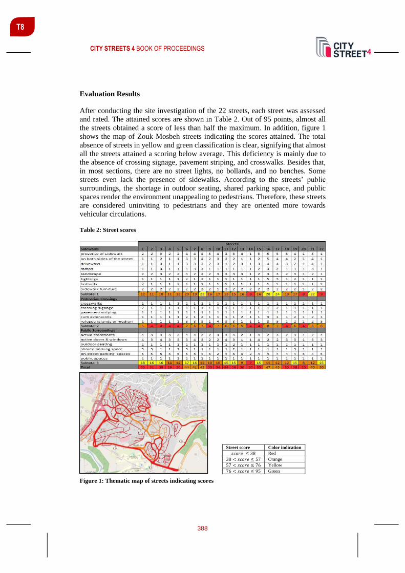
CITY STREETS 4 BOOK OF PROCEEDINGS
388
T8
Evaluation Results
After conducting the site investigation of the 22 streets, each street was assessed
and rated. The attained scores are shown in Table 2. Out of 95 points, almost all
the streets obtained a score of less than half the maximum. In addition, figure 1
shows the map of Zouk Mosbeh streets indicating the scores attained. The total
absence of streets in yellow and green classification is clear, signifying that almost
all the streets attained a scoring below average. This deficiency is mainly due to
the absence of crossing signage, pavement striping, and crosswalks. Besides that,
in most sections, there are no street lights, no bollards, and no benches. Some
streets even lack the presence of sidewalks. According to the streets’ public
surroundings, the shortage in outdoor seating, shared parking space, and public
spaces render the environment unappealing to pedestrians. Therefore, these streets
are considered uninviting to pedestrians and they are oriented more towards
vehicular circulations.
Table 2: Street scores
Figure 1: Thematic map of streets indicating scores
Street score Color indication
𝑠𝑐𝑜𝑟𝑒 ≤ 38 Red
38 < 𝑠𝑐𝑜𝑟𝑒 ≤ 57 Orange
57 < 𝑠𝑐𝑜𝑟𝑒 ≤ 76 Yellow
76 < 𝑠𝑐𝑜𝑟𝑒 ≤ 95 Green

CITY STREETS 4 BOOK OF PROCEEDINGS
389
T8
Recommendations
Since all the streets attained a score of less than half the maximum of 95, suggested
improvements are developed to enhance the score so that this city can be
considered pedestrian-friendly. The recommendations presented here are based on
design guidelines that accounted in tandem for the land use of each street and its
existing amenities.
Building complete streets and providing continuous pedestrian access were
considered as main priorities towards changing Zouk Mosbeh into pedestrian-
friendly. This is because the assessed streets either lack the existence of a functional
sidewalk from the first place or contain gaps within their existing sidewalks. The
scoring system, existing conditions for the right-of-way, and the prevailing land
uses were taken into account while deciding upon which design interventions to be
used based on ADA requirements (Planning and Designing for Pedestrians, 2002).
Accordingly, as general recommendations, streets should not be designed from
centerline out. Sidewalks should be elevated to prevent vehicles from using them
as parking spaces, free spaces should be allocated to design a shared parking place,
appropriate refuge islands should be provided, and regions that have a slope
exceeding 5% should have handrails on the sidewalk edges for safety. Also, streets
should include street lights on the sidewalks, bollards for safety, crosswalks and
pavement striping, and sidewalk amenities. In addition to that, each street is
assigned a specific sidewalk width according to its landuse which is shown in Table
3.
Table 3: Sidewalk width distribution
Land use Sidewalk
width
Edge
zone
Furnishing
zone
Throughway
zone
Frontage
zone
Residential 11’6’’ 6’’ 6’ 5’ 0
Commercial/educational 13’ 1’6’’ 5’ 5’ 1’6'’
Industrial 6’ 0 0 0 0
Some streets of Zouk Mosbeh are of a small restricted right of way which does aid
in adding efficient sidewalks widths as required by the code guidelines. Thus,
turning two-way streets into one-way could be the optimal solution. This
implementation is recommended to be used for two different complete circulations
ensuring proper continuity and accessibility. The delay in time resulting from this
change in vehicular pathways is calculated and it ranges between 0 to 2 minutes.
Appropriate recommendations were developed for each of the 22 streets along with
illustrative cross-sections. Figure 2 represents an example of the cross-sections
provided comparing the current conditions and the recommended provisions for
street 15. Due to the restricted right-of-way at certain streets like street 15, the
recommended sidewalk width was decreased to 10’ and a vehicle-prohibited cyclic
lane was added. In addition to that, vehicular circulation in certain areas in the city

CITY STREETS 4 BOOK OF PROCEEDINGS
390
T8
was modified into a one-way direction. It is recommended to add an off-street
shared parking space near that area since due to the narrow right-of-way, side-street
parallel parking spaces were not implemented.
Figure 2: Recommendations for street 15
CONCLUSIONS
This paper presented the research done on how to tackle the following two
objectives: investigating how to make Zouk Mosbeh a pedestrian-friendly city, and
identifying an applicable set of recommendations and strategies. The first one was
undertaken by accomplishing detailed site observations of the 22 streets according
to a scoring system that considers the essential aspects of pedestrian-friendly cities.
The second one was carried out by identifying appropriate recommendations for
each street that took into account the existing right-of-way, land use, and the
scoring system for each street.
As the Lebanese society is a highly car-dependent society in terms of mobility,
rendering Zouk Mosbeh pedestrian-friendly is expected to face opposition from its
residents in the short term. However, once they adapt to the city’s modification,
the opposing citizens will eventually enjoy the safer, environmental-friendly, and
sustainable streets of Zouk Mosbeh. Pedestrian-friendly streets are proven to foster
economic development locally more than vehicular streets, a much-needed aspect
for Zouk Mosbeh, especially with looming economic recession in Lebanon.
REFERENCES
Planning and Designing for Pedestrians. (2002, June). Retrieved January 17, 2020, from
https://www.sandag.org/uploads/publicationid/publicationid_713_3269.pdf
Al- Mosaind, M. (2018). Applying complete streets concept in Riyadh, Saudi Arabia:
opportunities and challenges. Urban, Planning and Transport Research.

CITY STREETS 4 BOOK OF PROCEEDINGS
391
T8
Amparo Moyano, J. R. (2018). Station avenue: high-speed rail’s missing link. Assessing
pedestrian city-station routes for edge stations in Spanish small cities. Journal of Housing
and the Built Environment.
Bödeker, M. (2018). Walking and Walkability in Pre-Set and Self-Defined Neighborhoods:
A Mental Mapping Study in Older Adults. International Journal of Environmental
Research and Public Health, 1-12.
Bushell, M. A., Poole, B. W., Zegeer, C. V., & Rodriguez, D. A. (2013, October). Costs
for pedestrian and bicyclist infrastructure improvement. Retrieved April 2020, from
http://www.pedbikeinfo.org/cms/downloads/Countermeasure%20Costs_Report_Nov2013
Dannenberg, A. L. (2017). Special Issue Editorial: Tools and practices for understanding
and promoting walking and walkability. Journal of transport & health, 1-4.
Edwards, K. (2016). Step It up! Action Institute for Increasing Walking and Walkability.
Journal of transport & health, S12-S13.
Galston, R. (2017). Places for People. Retrieved January 29, 2020, from
https://mspace.lib.umanitoba.ca/xmlui/bitstream/handle/1993/32572/Galston%20CP%20P
racticum%20REVISED%2009122017.pdf?sequence=1&isAllowed=y
Jabbari, M., Pereira da Fonseca, F., & Rodriguez Ramos, R. A. (2020). Assessing the
pedestrian network conditions in two cities: the cases of Qazvin and Porto. Urban heritage
along the silk roads, The Urban Book Series.
Moudon, A., Lee, C., Cheadle, A., Garvin, C., Johnson, D., Schmid, T., et al. (2006).
Operational Definitions of Walkable Neighborhood: Theoretical and Empirical Insights.
Journal of physical activity & health.
Panagopoulos, T., Tampakis, S., Karanikola, P., Karipidou-Kanari, A., & Kantartzis, A.
(2018). The Usage and Perception of Pedestrian and Cycling Streets on Residents’ Well-
being in Kalamaria, Greece.
Verner, D., Ashwill, M., Jens, C., Mcdonnell, M., Redwood, J., Jomaa, I., . . . Treguer, D.
(n.d.). DROUGHTS AND AGRICULTURE IN LEBANON CAUSES, CONSEQUENCES,
AND RISK MANAGEMENT. Retrieved from WorldBank.org:
http://documents.worldbank.org/curated/en/892381538415122088/pdf/130405-WP-
P160212-Lebanon-WEB.pdf
A Policy on Geometric Design of Highways and Streets. (2011). Washington, DC 20001:
American Association of State Highway and Transportation Officials.

CITY STREETS 4 BOOK OF PROCEEDINGS
392
T8
CONTRIBUTION OF PUBLIC SPACE TO SUSTAINABLE
DEVELOPMENT: CASE STUDY VARAŽDIN
Lea Petrović Krajnik1 Ph.D., Architect, Associate professor, Department of Urban Planning, Spatial Planning and Landscape Architecture, University of Zagreb, Faculty of Architecture, Kačićeva 26, HR – 10000 Zagreb, [email protected]
Damir Krajnik Ph.D., Architect, Full professor, Department of Urban Planning, Spatial Planning and Landscape Architecture, University of Zagreb, Faculty of Architecture, Kačićeva 26, HR – 10000 Zagreb, [email protected]
Tamara Lukić mag.ing.arh., [email protected]
ABSTRACT
Public spaces are one of the main constituent elements of the built environment,
which functionally and visually contribute to the integration of urban tissue. They
are significant places for social interaction that manifoldly improve the culture and
quality of life and, if properly planned and designed, represent an important
element of sustainable development.
In this work, public spaces are considered on two levels, as part of urban tissue
and as specific microlocations. On the first level, the importance of public space is
considered in the wider context of sustainable urban development investigating all
its aspects. The emphasis is placed on the key role of the public space both for the
city and for sustainability. The second level considers the public space planning
and design of the specific microlocations in the centre of the city of Varaždin. The
emphasis is placed on the consideration of the system of public places, their re-
thinking and enhancing through soft measures.
Consideration of public spaces during city development shows their importance in
case of different development dynamics, either expansion or transformation.
Through research of urban public spaces in the context of sustainability, topics of
mobility, vehichle, pedestrian and bicycle relations on certain microlocations
which make a system of public areas in the centre of the city of Varaždin (streets,
public squares, parks, common areas, etc.) are analysed.
The aim of this paper is to highlight the significance and importance of the public
space in the built environment, considered from various aspects of sustainability,
1 Corresponding author

CITY STREETS 4 BOOK OF PROCEEDINGS
393
T8
with a special emphasis placed on the public spaces in the centre of the city of
Varaždin.
Keywords: quality of life, system of public spaces, soft measures, sustainability,
Varaždin
INTRODUCTION
Public spaces are one of the main constituent elements of the built environment,
which functionally and visually contribute to the integration of urban tissue. They
are significant places for social interaction that manifoldly improve the culture and
quality of life.
Considered throughout history, public open spaces (streets, squares, parks and
parks) have been of great importance for the city, and their functions have gradually
changed. Until present time, these spaces have retained their basic functions, but
due to the dynamics of the relations, their functions are gaining new hybrid
dimensions. In a constantly changing world, where we are witnesses of constant
change and we can say that these spaces are places of various events, from random
to carefully planned cultural, social or political events.
Figure 1: Public spaces of the city centre of Varaždin as different event venues (source: Lukić,
T., 2019)

CITY STREETS 4 BOOK OF PROCEEDINGS
394
T8
Horvat (2002) studies and explains the development and role of public space, the
square in society throughout history and its importance in nowadays cities. The
square, with its traffic, stylistic, sociological and cultural elements, behaves like an
organism. The slightest change in one of the elements causes a change in others.
He points out that an important feature of public space in the city is that it must
contain elements of complexity, strangeness, surprise and uncertainty.
In the 1980s, the negative effects of accelerated development prompted more
intense reflections on sustainability and sustainable development on the global
level, as evidenced by numerous documents on sustainability. The need for
concrete action has prompted reflection at the local level, where actions conceived
on sustainability principles result in small shifts and positive effects in spe. Public
places, if properly planned and designed, represent an important element of
sustainable development. Whether it is “hard” or “soft” measures applied in the
design and / or improvement of public spaces, the effects have significant
repercussions on all aspects of sustainability.
The use of landscape architecture in the planned transformation and / or expansion
of urban areas plays an important role in establishing balanced and environmentally
friendly relationships between built and unbuilt areas. The share of park-shaped
space in a particular area indicates its importance for environmentally conscious
planning and design. The spaces arranged in this way shape the image of the city
and its recognizability and also contribute to the quality of life of the citizens. In
addition to all the other roles that public spaces, with the emphasis on green spaces,
play in urban areas, we would like to highlight their role in creating a healthy and
sustainable living environment for citizens. This role is particularly important for
European initiatives and documents that promote the sustainable development of
cities and towns. (Petrović Krajnik, Obad Šćitaroci & Dundović, 2013; Petrović
Krajnik, Križanić & Krajnik, 2019)
Architect Dora Francese (2016) points out that even though vegetation plays a
fundamental role in urban regeneration, there is a habit of assigning green spaces
only to those spaces of the city that have remained free from other uses, and often
only as the answer to the mandatory planning standards. A more sensitive approach
would be to consider green spaces as a design element that enhances the overall
quality of urban life.
The creation of public spaces of urban sociability throughout history, especially on
the site of former bastion fortifications, primarily meant providing new
opportunities for "citizens” for a richer and more meaningful social life, but also
contributed to the "transformation” of residents into "citizens". These new public
spaces have become areas of social contacts concentration. The dismantling and
transformation of bastion fortifications in European and Croatian cities resulted in
some of the most important urban achievements of the 19th century, which
regularly had the creation of public urban spaces and public buildings as urban
social spaces as one of the primary roles. (Krajnik, Obad Šćitaroci & Šmit, 2008)

CITY STREETS 4 BOOK OF PROCEEDINGS
395
T8
Consideration of public spaces during city development shows their great
importance in case of different development dynamics, either expansion or
transformation. The aim of this paper is to highlight the significance and
importance of the public space in the built environment, considered from various
aspects of sustainability, with a special emphasis placed on the public spaces in the
centre of the city of Varaždin.
CITY OF VARAŽDIN IN THE CONTEXT OF SUSTAINABILITY
Throughout history, the city of Varaždin has been a significant political, cultural,
economic and commercial centre of the northwestern part of continental Croatia.
Particular importance in the urban structure of the city represents the fort, today's
city historic urban centre, whose history dates to the 12th century when a manor
house was founded on the site of today's Old Town. During the 12th and 13th
centuries, a civic settlement developed as a suburb south of the aristocratic town,
which received its first fortifications in the middle of the 15th century, and at the
beginning of the 16th century the walls began to be erected. In the middle of the
16th century, Varaždin gained a significant geostrategic role, so the fortifications
of the aristocratic and civic city were transformed in the spirit of Italian
Renaissance fortification construction. The subsequent modernization of
fortifications in Varaždin is the first example of the emergence of a bastion-type
fortification in Croatia, which occurs simultaneously with the bastion fortification
of Austrian cities such as Vienna, Graz and Klagenfurt. The modernized Varaždin
fortress retained its shape and size until its demolition after 1807. The dismantling
of Varaždin's fortifications at the beginning of the 19th century enabled the creation
of public urban spaces on the site of former fortifications and buildings of
predominantly public purpose, similar to examples of urban transformation in
European cities such as Vienna, Riga, Wroclaw or Würzburg. (Krajnik, 2007;
Krajnik & Šćitaroci, 2007; Žmegač, 2000)
The importance of the city centre of Varaždin in the context of sustainable
development is evident in the plans and projects developed in the beginning of the
21st century. In 2008, the Institute of Tourism prepared the Basis for the Strategy
of Development and Sustainable Management of the Historic Core of the City of
Varaždin. The document is designed to propose, after the adoption of key spatial
plans, in the Urban Development Plan of the historic core in particular, the next
logical step in leading the process of revitalization of the historic core. The project
is the basis for the venture of urban renewal and a key element in building the
regional competitive position of Varaždin as a modern city with high quality of
life. On the conceptual level, the possibilities and preconditions for turning the core
into an attractive space for work, life and tourist visits are considered, ie: a)
directing space development and restoration (of a part) of the historical core
construction fund, and b) directing social and economic revitalization of the core.
The document was drafted following the basic rules of strategic planning. It is
divided into three main segments: a) Assessment, b) Sustainable Development

CITY STREETS 4 BOOK OF PROCEEDINGS
396
T8
Strategy and c) Implementation, and critically examines the success factors of
revitalization of the historic core, sets the vision of development, strategic
determinants and implications for the use of space and considers key determinants
of its implementation through organization of process management to the action
plan of foreseeable necessary activities. The “Varaždin House” program was
finally presented as a pilot project that illustrates the premises of the revitalization
of the historic core on a micro level. (Institute for tourism, 2008)
Urban Development Plan of the historic core of the city of Varaždin (2006) covers
an area of 56.6 hectares, which is characterized by 37 urban blocks with most of
the buildings as immovable cultural heritage. The area is one of the most important
Baroque-Rococo-Classicist historical architectural and urban units in Croatia,
which is characterized by a wealth of various stylistic expressions. Significant
urban elements of the historic core are green areas (public parks, gardens next to
palaces or sacral complexes, protective greenery along major city roads and green
islands along pedestrian streets and squares) and communication matrix formed by
streets and squares that represents a recognizable urban identity. In addition to the
streets that have retained their historical routes, the peculiarity of urban identity
can be found in Varaždin squares, which are characterized by irregular shapes,
peculiarities and spatial specifics. The goal of the urban arrangement of the centre
is further development that meets the needs and functions of the modern city as an
urban organism, whose most vital organ is the historical core. (City of Varaždin,
2019)
During the whole year the public spaces of the centre of Varaždin are places of
social interaction where numerous events take place in various locations depending
on the spatial specifics and the needs of the organizers. In that context, the
Capuchin Square, which hosts the largest number of events especially stands out.
Although some squares and parks have potential, they are not places of planned
events, but are used on a daily basis and are places of "accidental” events that also
play a significant role in the quality of life and the dynamics of city relations. (See
Figure 1)
PUBLIC SPACE AS A PART OF URBAN TISSUE OF VARAŽDIN
The representation of the importance of public spaces in the urban tissue of the city
of Varaždin is based on the part of the research for the doctoral dissertation "Urban
transformation of bastion fortifications” (Krajnik, 2007) and further scientific
researches as well as the master thesis "Urban planning and architectural proposal
for public spaces in Varaždin city centre” (student: Tamara Lukić, mentor: Assoc.
Prof. Lea Petrović Krajnik, PhD, 2019).
The historical transformation of the former fortifications in the beginning of the
19th century opened the possibility of design and arrangement of new public
spaces. These newly designed places were located on the site of former bastion

CITY STREETS 4 BOOK OF PROCEEDINGS
397
T8
fortifications and have a representative character and special significance in the
urban fabric of the city. Morphological recognition of the space on the site of the
former fortifications in the urban matrix at the beginning of the 21st century is
mostly possible due to the existence of a circular street on the site of the former
road around the fortress moat. The fact that four newly designed urban cassettes,
on the site of the moat, have been preserved from construction, speaks of the
recognition of the needs and possibilities of creating a quality public urban space
on the junction of the city core and the suburbs. Banski and Capuchin Square were
designed as extensions of Via fossata ambiens on its northeast and southwest
corners, and the public city park Prater-Graberje on the west and the public city
park Šetalište (today's Jagićevo šetalište) on the southern moat. (Krajnik, 2007;
Krajnik & Obad Šćitaorici, 2007)
Figure 2: Conceptual proposal of the public space system (source: Lukić, 2019)
The analysis of the present situation of public spaces, construction and facilities
surrounding them, traffic infrastructure, existing urban equipment and events that
take place indicate the current state of public spaces in the city of Varaždin and
their level of activity. From the existing spatial planning documentation, it is
evident that the city centre is planned as a cultural, social and business centre of
the city of Varaždin. Public spaces represent the potential for further development
based on the principles of sustainability.

CITY STREETS 4 BOOK OF PROCEEDINGS
398
T8
RE-THINKING AND ENHANCING OF THE SYSTEM OF PUBLIC SPACES IN THE
VARAŽDIN CITY CENTRE
The analysis of the present situation of the centre of Varaždin pointed to the need
of public spaces redefinition and planning interventions to create a better, more
complete and diverse system of public spaces, in order to provide an environment
for creating a quality atmosphere suitable for residents and visitors.
The proposal for a new system of public spaces of the urban centre respects the
historical identity of the city and is designed to meet the needs of its residents. The
proposal is based on 4 basic elements: 1) Creation of a bicycle traffic route around
the centre and widening of bicycle paths and lanes; 2) The city core is designed as
a pedestrian zone with occasional traffic. Streets and squares need additional urban
equipment to allow additional activities throughout the year not only for visitors
but also for city residents; 3) Creating a northern and southern green stretch by
completing and expanding existing green public areas; 4) Integration of public
facilities courtyards into the system of public areas. (see Figure 2)
Figure 3: Interventions in public spaces of the centre of Varaždin (source: Lukić, 2019)
Different interventions on 12 locations (3 squares, 6 streets and 3 courtyards) which
are an integral part of the public space system had been proposed. Each of the
locations has its own specifics, and by applying primarily “soft” measures,
proposals seek to improve the public spaces in the city centre. Interventions include
the following activities: creation of “new” squares in the urban fabric and the
redistribution of square functions, design of a new pedestrian street, and equipment

CITY STREETS 4 BOOK OF PROCEEDINGS
399
T8
of existing streets with urban furniture; introduction of “new” courtyards opened
for public use into the system of existing courtyards; redefinition of the existing
park on the north-east edge of the historic urban core; arrangement of a new
children's playground in one of the public courtyards; arrangement of new bicycle
paths and building new bicycle pavilions; the construction of a new underground
public garage and the removal of parking lots is planned on the northern perimeter
of the city centre; new traffic regulation of the in order to improve the quality of
life of the inhabitants.
Figure 4: Microlocation – newly arranged public space on the northeast perimeter of the
historical core (source: Lukić, 2019)
Special attention was given to the north-eastern edge of the former historical
fortifications, which was recognized as a strong potential in the urban matrix and
an area where the implementation of the largest number of interventions is
required. The square and the park of Ban Josip Jelačić were designed as a space of
dual character. In the context of traffic, the proposal envisages the relocation of the
existing parking lot on the ground level of the square to the underground, where
the construction of an underground garage on two floors is planned. It is planned
to expand the vehicle-pedestrian zone and to create new pedestrian
communications, respecting the historic routes. Along the north and south of the
square, different facilities (florists, terraces and pavilions for rent) are planned to
complement the existing facilities. The existing greenery has been preserved, effort
was made to horticulturally enrich the existing park, and the square perimeter has
been additionally greened with tree lines. In the north-western part of the park,
arrangement of a children's playground, and the additional urban equipment

CITY STREETS 4 BOOK OF PROCEEDINGS
400
T8
designed for the needs of the public space system of the centre of Varaždin was
proposed.
Pavilions set up around the perimeter of the square use PV panels to produce
electricity. Cooling of the space during the summer months is enabled by natural
ventilation, while the canopy, the existing construction and the peripheral high
vegetation serve as protection from the sun. During the winter, the glass wall of the
pavilion allows the sunlight transfer and additional heating of the space.
CONCLUSIONS
Public spaces represent especially important elements in the development of urban
fabric, whether it is about its expansion or transformation. They are one of the main
constituent elements of the built environment, which functionally and visually
contributes to the integration of urban tissue. In addition, they are places for social
interactions that can significantly contribute to the culture and quality of life of
residents.
Varaždin is one of the examples of Croatian cities in which historical
transformation of the former bastion fortifications opened the possibility of design
and arrangement of new public spaces. Newly designed public spaces are
becoming part of the urban fabric and have multiple implications for the quality of
life of residents. To this day, these spaces have retained their basic functions, but
thanks to the dynamics of the relationship, their functions are gaining new hybrid
dimensions.
In the spatial planning documentation from the beginning of the 21st century, the
historical core of Varaždin is planned as the cultural, social and business centre of
Varaždin, and public spaces represent the potential for further development based
on the principles of sustainability.
Based on the comprehensive research and analysis of the elements that affect the
public spaces of the city centre, a system of public spaces which represents a
potential contribution to the aspects of sustainability at the local level has been
planned. With the application of predominantly “soft” measures in the planning of
public spaces and the design of elements of urban equipment based on the
principles of sustainability, the newly renovated spaces acquire new features, and
the entire system contributes to the quality of life not only for the inhabitants of the
historic core but of the city of Varaždin as a whole.

CITY STREETS 4 BOOK OF PROCEEDINGS
401
T8
REFERENCES
City of Varaždin. (2019). Urbanistički plan uređenja povijesne jezgre / Urban
development plan for the historic core. Retrieved from https://varazdin.hr/urbanisticki-
plan-uredenja-povijesne-jezgre/
Francese, D. (2016). Technologies for Sustainable Urban Design and Bioregionalist
Regeneration. London and New York: Routledge.
Horvat, J. (2002). Urbanistički parametri u projektiranju javnih gradskih prostora / Urban
Designing Parameters in Organizing Public City Space. (doctoral dissertation, mentor
prof.dr.sc. Srečko Pegan). Zagreb: Faculty of Architecture, University of Zagreb.
Institute for tourism. (2008). Podloga za strategiju razvoja i održivog upravljanja
povijesnom jezgrom grada Varaždina / The basis for the strategy of development and
sustainable management of the historic core of the city of Varaždin. Retrieved from
http://www.iztzg.hr/hr/institut/projekti/strucni/?projekt_id=69&tip=3&podrucje=5
Krajnik, D. (2007). Urbanistička preobrazba bastionskih utvrđenja / Urban
transformation of bastion fortifications (doctoral dissertation, mentor: prof.dr.sc. Mladen
Obad Šćitaroci). Zagreb: Faculty of Architecture, University of Zagreb.
Krajnik, D. & Obad Šćitaroci, M. (2007). Preobrazba bastionskih utvrđenja grada
Varaždina / Conversion Process of Bastion Fortifications in Varaždin. Prostor, Vol. 15
No. 2(34), 180-193.
Krajnik, D., Obad Šćitaroci, M. & Šmit, K. (2008). Preobrazba gradskih utvrda u javne
prostore urbane društvenosti / The Transformation of City Fortifications into Urban
Public Spaces. Društvena istraživanja, Vol.17, No. 3 (95), 463-482.
Lukić, T. (2019). Urbanističko arhitektonsko rješenje javnih prostora središta grada
Varaždina / Urban planning and architectural proposal for public spaces in the Varaždin
city centre (master thesis, mentor doc.dr.sc. Lea Petrović Krajnik). Zagreb: Faculty of
Architecture, University of Zagreb.
Petrović Krajnik, L., Obad Šćitaroci, M. & Dundović, B. (2013). Perivojna arhitektura
projekta EXPO’98: Čimbenik preobrazbe istočnog obalnog područja Lisabona /
Landscape Architecture of the EXPO’98 Project: Transformation Factor of the Eastern
Coastal Zone of Lisbon. Prostor, Vol. 21, No. 1(45), 128-139.
Petrović Krajnik, L., Križanić, V. & Krajnik, D. (2019). Importance of green spaces in
planning sustainable urban areas. SMC - Sustainable Mediterranean Construction, No 10,
40-46.
Žmegač, A. (2000). Bastioni kontinentalne Hrvatske / Bastions of continental Croatia.
Zagreb: Golden marketing, Institut za povijest umjetnosti.

CITY STREETS 4 BOOK OF PROCEEDINGS
402
TRACK 9: PERSPECTIVES ON SUSTAINABLE MOBILITY: CULTURE OF EVERYDAY ACTIVISM
Track Chairs:
Janez Grom, University of Ljubljana, Faculty of Architecture, Ljubljana, Slovenia and
Christine Mady, Notre Dame University-Louaize, Ramez G. Chagoury, Faculty of Architecture, Arts and Design, Department of Architecture, Lebanon
Mobility in this track is investigated through a relational perspective, considering
the historical, social, economic, political and environmental characteristics of the
context, and how they shape and are shaped by social practices. In particular, the
role of mobility in contexts of instability is central in either mitigating or increasing
discrepancies among the population. Also, social practices including everyday
activism could contribute towards facilitating the mobility of various groups such
as the disadvantaged, the impaired, the very young or the aging. Activists are
essential in promoting different modes, specifically the non-motorized.
Contributions to this track are from various disciplines and engage with the
following questions: how is mobility justice sustained in the absence of public
investment? How can activists guide investors in transportation away from the
modification of basic mobility and towards a sustainable approach? What happens
to everyday mobility in contexts of instability such as sudden population changes,
natural or man-made disasters? How can actors engage in increasing accessibility
and everyday mobility for different user groups? How can activists inform urban
planners and policymakers in decisions related to mobility to and within urban
contexts? What modalities by mobility activists contribute to sustaining
spontaneous encounters and social interaction through mobility, enhancing the
urban experience?
Keywords: Everyday Activism, Mobility, Mobility Studies, Relational Perspective
T9

CITY STREETS 4 BOOK OF PROCEEDINGS
403
T9
A ROAD OR A STREET? A CASE OF “VODNIKOVA” IN LJUBLJANA
Janez P. Grom1 Assist., University of Ljubljana, Faculty of Architecture, [email protected]
Matevž Frančič Arch., ID:doma, [email protected]
Alenka Fikfak Assoc. Prof., PhD, University of Ljubljana, Faculty of Architecture, [email protected]
ABSTRACT
Urban spaces should reflect the quality of life, by continuing a dialogue with
history, identity of places, including the built environment. Open public spaces are
primarily catering to the various needs of people. The transformation from a traffic
street to a street with outdoor activities can support the identity of the city and
create or reinforce the local community. This paper presents the model of
cooperation between students, inhabitants and experts to establish Vodnikova
‘road back to a street’ (RBS) through a learning process based on practical work
and learning through experience. The project “Re-inventing the Vodnikova street”
brought up an intense collaboration between the local people, who were not happy
with a situation that was a result of the unplanned processes, a well-organized
public initiative and students from the Faculty of Architecture in Ljubljana.
Keywords: local community, learning by doing, students, Vodnikova street
INTRODUCTION
Today’s streets are an opportunity for a multifaceted vitality for the local
communities and they must offer and create liveable places. Street-space represents
more than 80 percent of all public space in cities and has the potential to foster
business activity, serve as a front yard for residents, and provide a safe place for
people to get around, whether on foot, by bicycle, car or transit (NACTO, 2013).
Already in 1968 Sallman (in Madanipour, 2010) has defined that the “tension
between the public and the private can be seen in the European medieval city,
where the streets and open spaces of the city are gradually being threatened by the
expanding houses and private spaces, to the extent that a minimum amount of space
is left for passing through and for conducting trade and other essential functions”.
An appreciation of urban morphology is also important in relation to the
preservation of the human scale within urban areas (Jacobs, 1961). In addition,
1 Corresponding author

CITY STREETS 4 BOOK OF PROCEEDINGS
404
T9
detailed attention to the local scale of urban form demonstrates the significance of
interaction of street spaces, the street system and traffic and pedestrian accessibility
and flows (Oliveira, 2016). Streets spaces are a mirror of the quality of life, by
continuing a dialogue with history, identity of places, including the built
environment, land and property questions, they are public spaces reflecting the
needs of people. But, when asked about the built environment, the ‘person in the
street’ would probably begin and end with comments on the visual manifestation
of the architecture of specific buildings (Oliveira, 2016). “Reducing traffic with
motor vehicles, care for the environment and economical use of resources” are
well-known development goals. But we are still dealing mostly with discussions
‘road vs. street’ as we know that the motorized traffic represents a lifeblood to the
functioning of a society, but actually prevents life to evolve where it flows.
On the other hand, “urban public open spaces are highly contested areas where
different interests and desires meet, which is why they are an ideal arena for
considering such questions” (Nikšič, Ragozino, Fikfak, 2018). The question of the
democratization in the urban planning system was interpreted as setting new
standards for an equal input of citizens in urban (re)development processes (Smith,
1999; Akkerman et al., 2004), where most transit and road systems were developed
to facilitate suburb-to-city. But what does the ‘street’ stand for? Do we consider it
as a space for people’s interaction or is this just another example of ‘shared
spaces’? Does the social interaction happen as a result of shops, stores or houses
along both sides of a road and are these the promotors of social interaction? The
importance of “shared values of community members in relation to public urban
spaces, including empathy, wellbeing, intimacy, sustainability, conviviality,
mobility, accessibility, imagination, leisure, aesthetics, sensoriality, solidarity, and
respect” were defined in the project Human city (2014; in: Nikšič, Ragozino,
Fikfak, 2018). How can we help giving voice to the residents of a certain street in
decision making processes in order to create inclusive social spaces?
CASE STUDY: VODNIKOVA STREET
The morphological structure, in relation to social space, can be pointed out as an
essential element of human life-space functioning. According to the morphological
studies (Lynch, 1960; Alexander, 1977; Carr et al., 1992; Mogutin, 2003; Carmona
et al., 2010; Hinse, 2014; Makeover, 2014; Oliveira, 2016; Conzen, 2018; Maretto,
2018; Kropf, 2018) it is the built structure that creates the anchoring points of the
stage ‘of life’ presented as spaces ‘in-between’. As part of the morphological
structure in urban systems the streets are reflecting the ‘white’, a ‘no-place’
structure in urbanity, a line or way to move from one point to the other. And
certainly not an open space to stay in for a long term, to sit and observe the
surrounding, to read a book, to talk with a friend etc. But as a part of the open space
system they create a backbone to ‘share values of community members’, the stage
for the life of the users. Whenever the balance between circulation and community
CITY STREETS 4 BOOK OF PROCEEDINGS
405
T9
life or one or the other prevail, the whole system cannot offer a stable platform for
user’s quality of life. In the case of Vodnikova street this is more than apparent.
Vodnikova is a peasant street which was swallowed by the city. In the historical
sense, Vodnik’s path goes from the city center of Ljubljana to Kranj, along which
the villages lined up: Lower and Upper Šiška, Dravlje, etc. (cadastral plan 1825
Unter and Oben Schisckha). In the first half of 20th century the city began do devour
villages that were gaining an increasing number of suburban characteristics. After
the WWII, Vodnikova became one of the backbones of the modernist typology of
block buildings. On the street, different building typologies are intertwined and
arranged in an organic way: the historical peasant homes in the core of the village
of Upper Šiška, one-dwelling buildings of inter- and post-war period, as well as
completely modern blocks of flats as part of the large residential neighbourhoods.
Because the street grew organically, various spatial and functional accents were
lined up along it: important cultural and historical sights (‘Old’ church, Gale
Castle, Vodnik Homestead2), public buildings (schools, Petra Držaja hospital
located in the castle garden of the former Jama Castle), market, bars, cultural and
sports institutions and landscaping – architectural accents such as a two-row
treeline next to the modernist neighbourhood of Šiška. At Koseška marketplace,
the street is crossed by the PATH3. Amongst other things, there is also a side street
with still functioning farms. In the proximity of Vodnikova street there are also the
‘new’ administrative centre and the former cinema building transformed into the
centre of urban culture ‘Kino Šiška’. In the immediate vicinity there are also health
centre and the green hinterland of Šiška hill and Koseški pond, which have
important leisure and recreational functions. A variety that is hardly paralleled in
Ljubljana.
Until recently (2018), the Vodnikova Street was a typical suburban road, which
was arranged according to the principles of road arrangement from the 70’s and
80’s of the 20th century, as the city axe’s (term in contrast to the repertoire of urban
morphology) where all the functionality was subject to car traffic requirements: at
the expense of a too wide roadway in several spots there were neither cycle paths
nor sidewalks for pedestrians. The speed that car drivers could develop was often
significantly higher than allowed in settlements, and the street greenery was
completely absent. The road was dangerous, noisy and uncomfortable; a feeling of
a dangerous place was attached to it; therefore, the parents would very likely drive
their children to a nearby schools, located less than 1km away).
2 The Vodnik Homestead is the birthplace of the poet, priest, and publicist Valentin Vodnik
(1758−1819). Nowadays Vodnik Homestead serves as a cultural centre - a house of reading, writing,
and storytelling. It is managed by the Divja Misel Institute, which is also well-known for organizing
the Library under Trees. The Homestead hosts regular book-themed events for adults and children
and houses a gallery hosting thematic exhibitions. The programme of events is created in
collaboration with partners in the fields of literature and music. (www.visitljulbjana.com) 3 The Path of Remembrance and Comradeship (PATH) is a circular recreation ground in the city of
Ljubljana, Slovenia. It is almost 33 km long and passes through the urbanised areas and the natural
landscapes (Fikfak et al., 2019).

CITY STREETS 4 BOOK OF PROCEEDINGS
406
T9
CREATIVITY AND EXPERIENCE: LEARNING IN/ FOR LOCAL COMMUNITY
“The formation of meaningful urban public space at a city level also has an
important role in achieving a more socially cohesive city. The advantages of the
city locations that are already present in users’ mental images in a positive way can
serve as starting points to extend the well-known and well-used public spaces into
new city territories, thus not only contributing to a more recognized and better
connected network of public space at a city level, but could also lead to new social
interactions and economic activities in yet undiscovered city territories.” (Nikšič
and Butina, 2018, p. 881) The case of establishing the Vodnikova ‘road back to a
street’ (RBS) type of communication is an example of innovative approach in
connecting learning process with local community. The method used in RBS
transformation process were: active inclusion of locals, students work,
implementation of theory in practice, fieldwork, and several parallel community
initiative activities. The conversion from a generic space characterised by the
traffic dominance to a place for inhabitants, projecting their historic identity, was
a situation where different experts and the public met in a constructive dialogue.
In the process of exploring the unknown problems we learn to think actively, by
trial, and to solve various situations with creativity. In society, not just in school,
this is a ‘sensible risk’ (Novak, 2004, p. 23), but many authors are convinced that
only creative thinking guarantees our development within the ‘society of
knowledge’. Creativity is tightly connected to empirical methods of learning,
where the involvement of an individual in the experience is the most important.
The basic ingredient of empirical learning is without a doubt participants’
communication, which includes conversation, thinking and acting; empirical
learning is social learning, because it erases the boundaries between the performers
and participants, they both search for the common solution of the problem
(Marentič – Požarnik, 1987). For Maretič Požarnik (2002), spontaneous learning
enables acquiring different types of knowledge. Central methods are: simulation,
practice, group interaction, role-playing and movement of body. The form of
spontaneous learning is closely connected with practical work, as a process of
education, learning through ‘experience’. But while it is clear within the academic
circles that different tools and approaches are supporting the ‘learning process’,
what does this mean for the local community?
The project “Re-inventing the Vodnikova street” brought up an intense
collaboration between the public, i.e. the local people suffering a de facto situation
(that was a result of unplanned solutions,) a well-organized public initiative and
students of the Faculty of architecture of the University of Ljubljana, working
together with different experts. Much more than a physical redesign of an urban
road, the important goal was the transformation to a user-friendly street with
adjacent spaces (the solution solving approach). The additional value of this
specific project was the long-term learning effects that activities had onto the
participants. The activities brought together the community members who felt
being active players in the process and thus now form the part of the local
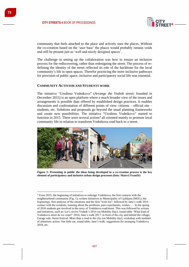
CITY STREETS 4 BOOK OF PROCEEDINGS
407
T9
community that feels attached to the place and actively uses the places. Without
the co-creation based on the ‘user base’ the places would probably remain voids
and still be present just as ‘well and nicely designed spaces’.
The challenge in setting up the collaboration was how to ensure an inclusive
process for the rediscovering, rather than redesigning the street. The process of re-
defining the identity of the street reflected its role of the backbone for the local
community’s life in open spaces. Therefor practicing the more inclusive pathways
for provision of public space, inclusive and participatory social life was essential.
COMMUNITY ACTIVISM AND STUDENTS WORK
The initiative “Uredimo Vodnikovo” (Arrange the Vodnik street; founded in
December 2015) is an open platform where a much broader view of the issues and
arrangements is possible than offered by established design practices. It enables
discussion and confrontation of different points of view: citizens – official site –
students, etc. Solutions and proposals go beyond the usual planning frameworks
and create new possibilities. The initiative “Uredimo Vodnikovo” started to
function in 2015. There were several actions4 all oriented mainly to promote local
community life in relation to transform Vodnikova road back to a street.
Figure 1: Presenting to public the ideas being developed in a co-creation process is the key
element of participatory and inclusive urban design processes (foto: Matevž Frančič)
4 From 2015: the beginning of initiatives to redesign Vodnikova; the first contacts with the
neighbourhood community (Fig. 1); written initiatives to Municipality of Ljubljana (MOL); the
beginnings: first analyses of the situations and the first “wish list”; followed by Jane’s walk 2016 –
contact with the residents, learning about the problems, past experiments, wishes, … In the spring
of 2016 students got involved in the story of Vodnikova road/street. This was followed by actions
and initiatives, such as: Let’s revive Vodnik’s 2016 (on Mobility Day); round table ‘What kind of
Vodnikova street do we want?’ 2016; Jane’s walk 2017: in front of the city and behind the village;
Garage sale; Street festival: More than a road to the city (on Mobility day); workshop with students
of urbanism; action: Our little car, round table; Jane’s walk: suggestions for arranging Vodnikova
2018, etc.

CITY STREETS 4 BOOK OF PROCEEDINGS
408
T9
Vodnikova Street – Learning and Resolving Problems Together
In the annual semester of 2015/2016, urban planning students of the Faculty of
Architecture, University of Ljubljana joined the “Re-inventing the Vodnikova
street” activities. One of the issues was to address the problems of the street (Figure
2) and its open spaces through the format of the student workshop rather than
through a common and generic client/designer contractual process. This format
better responded to the needs and dynamics of the work already carried out by
“Uredimo Vodnikovo” community initiative, as it offered an open platform for
discussions.
Figure 2: Vodnikova street with main location of students work (Grudina et al., 2017)
The process of inclusive urban design and problem solving is beneficial to all
included. This statement is further confirmed when students of urban design studies
come in contact with real life issues. Their energy, but mostly uncontaminated
enthusiasm that has no boundaries in real life or pragmatically limited design
approaches serves as a wonderful catalyst of fresh, inventive and innovative ideas.
The process itself is an example of good and positivistic dialogues since the
students have no political or economic agenda. With their fresh and not limited
ideas they have offered well intentioned and sincere solutions. By entering this type
of process anyone included feels the benefits of a workshop. It can be affirmed
from Vodnikova experience that ex-cathedra teaching processes produce only a
certain level of knowledge while the practical experience for the implementation
of the gained knowledge is what is missing in the so-called classical teaching
methods at the universities. The methods of teaching/learning through practice
require much more energies from the teacher, but the positive benefits of this
learning by doing processes more than justifies the invested energies. These
processes prepare the student to real life situation and improve their
communication skills with other participants of design processes.

CITY STREETS 4 BOOK OF PROCEEDINGS
409
T9
The activities of the workshop were initiated by a series of presentation and lectures
held by the Initiative representatives. The lectures were combined with ‘on situ’
activities such as location visit and by taking part of organized activities such as
the Janes walk. All these ensured that the students were able to come in a direct
contact with concerned experts already working on the issues of Vodnikova street
and most importantly with inhabitants of the area, i.e. the end users. The ‘getting
to know each other’ facilitated all the other steps taken towards a final design
solution. Students were divided into working groups and produced a series of
different conceptual ideas based on the previously carried out analytical work. All
the stages of their design work went through a series of consultations with mentors
from the faculty as well as external experts from the Initiative setting the
guidelines. Each group was tasked to point out critical locations alongside the
Vodnikova street. Each of these locations went through the same process of
problem identification, analytical work, idea conceptualization and design drafting
(Figure 3). After the work on a single micro location (3 of them) was completed,
the groups had presentations at the faculty where mentors, both from the faculty
and from the Initiative, were present to offer comments. When three selected micro
locations were completed (Figure 4) in such manner, the final task of each
individual group was to bring their ideas together in an integral proposal for the
whole Vodnikova street. This resulted in as many final solutions as there were
groups. The process of project division within each group meant that the solutions
were well detailed, layered and they addressed specific issues along the street.
Figure 3: A conceptual draft by one of the student groups showing approaches to a re-design of
the street – more space for bicycle line and more activities near the street to offer vitality and
interactions (Lavtižar, Banovec, 2017)

CITY STREETS 4 BOOK OF PROCEEDINGS
410
T9
Figure 4: Students work example - location Vodnikova homestead. Introduction of new walking
path “gallery” (Todorovič, Krišto, 2017)

CITY STREETS 4 BOOK OF PROCEEDINGS
411
T9
The organized final public exhibition of student work offered a platform for
discussion between all interested parties. This ensured a consensual decision for
the final product that served as a basis for the factual design decisions later on that
were finally implemented in the space. Students gained experiences otherwise
impossible to be gained in a standard academic environment.
During the process of work, we have used system of participation approaches,
from: New Economics Foundation's Participation Works! 21 Techniques of
Community Participation for the 21st Century (1998) and the Urban Design
Group's Involving Local Communities in Urban Design (Billingham, Loew, 1998).
These reports identified seventy-eight separate techniques, which were very useful
in discussions between all participants in the process of thinking and learning;
some most important that we want to point out are “involve all those affected,
encourage local ownership of the process, plan your own process carefully, agree
rules and boundaries, quality not quantity, involve all sections of the community,
spend money, get value for money, accept different agendas, accept varied
commitment, be honest, be transparent, have fun…”
CONCLUSIONS
Today, Vodnikova has been renovated, bicycle paths and pedestrian paths have
been arranged, new pedestrian crossings have been provided, the area in front of
Koseška marketplace and Vodnik’s homestead has been redesigned in favour of
pedestrians, and tree clusters have been planted along the street where space and
other factors allow.
Figure 5: Today we are
socialising on the street.
You are welcome!
(foto: Matevž Frančič)
After few years one may be thinking who has proposed the design ideas which
were used for RBS transformation of Vodnikova street? Does it matter? The
process on itself has had the benefits for all who took part. The result is a street, its
life and its users.

CITY STREETS 4 BOOK OF PROCEEDINGS
412
T9
REFERENCES
Alexander, C. (1977). A pattern language: towns, buildings, construction. New York:
Oxford university Press.
Akkerman, T., Hajer, M. & Grin, J. (2004). The interactive state: Democratisation from
above? Political Studies, 52(1), pp. 82-95. https://doi.org/10.1111/j.1467-
9248.2004.00465.x
Billingham, J., Loew (eds.) (1998). Involving Local Communities in Urban Design,
promoting a good practice. Urban Design Quarterly.
Carr, S., Francis, M., Rivlin, L.G., Stone, A.M., (1992). Public Space. Cambridge:
Cambridge University Press.
Carmona, M., Heath, T., Oc, T., Tiesdell, S. (2010). Public Places Urban Spaces. Oxford,
Burlington: Architectural Press, sec. Edition.
Conzen, M. R. G. (2018). Notes on Urban Morphology: Its Nature and Development
(1992–1999). Teaching Urban Morphology, 51–64. Springer, Cham.
Hinse, T. (2014). The Morphology of the Times: European Cities and their Historical
Growth. Berlin: DOM Publishers.
Fikfak, A., Konjar, M., Grom, J.P., Kosanović, S., Zbašnik-Senegačnik, M. (2019).
Temperature Comfort, Recreation and Historical Features in Open Spaces; the Path of
Remembrance and Comradeship (PATH) in Ljubljana, Slovenia. Journal of Architectural
Environment & Structural Engineering Research, 2(3), 7-14.
https://doi.org/10.30564/jaeser.v2i3.1291
Grudina, P., Mijić, I. (2016). Development of Vodnikova street. Students work. Ljubljana:
University of Ljubljana, Faculty of Architecture.
Jacobs, J. (1961). The death and life of great American cities. New York: Random House.
Kropf, K. (2018a). The handbook of urban morphology. Hoboken: John Wiley & Sons.
Lavtižar, K., Banovec, K. (2017). Mobility on Vodnikova street. Students work.
Ljubljana: University of Ljubljana, Faculty of Architecture.
Lynch, K. (1960). The image of the city. (Vol. 11). Cambridge, Massachusetts, and
London, England: M.I.T. Press.
Makeover, T. (2014). Touching the city. Thoughts on urban scale. West Sussex: Wiley.
Marentič - Požarnik, B. (1987). Nova pota izobraževanja učiteljev. Ljubljana: DZS.

CITY STREETS 4 BOOK OF PROCEEDINGS
413
T9
Marentič - Požarnik, B., Peklaj, C. (2002). Preverjanje in ocenjevanje za uspešnejši študij
(Prispevki k visokošolski didaktiki, 4). Ljubljana: Center za pedagoško izobraževanje
Filozofske fakultete.
Maretto M. (2018). Teaching Urban Morphology in a Sustainable Perspective. In:
Oliveira V. (eds). Teaching Urban Morphology, pp 243-264. The Urban Book Series.
Springer, Cham. https://doi.org/10.1007/978-3-319-76126-8_14
Moughtin, C. (2003). Urban Design: Street and Square. Oxford, Burlington:
Architectural Press.
National Association of City Transportation Officials (NACTO) (2013). Urban street
design guide. Washington, Covelo, London: Island Press.
New Economics Foundation's Participation Works! 21 Techniques of Community
Participation for the 21st Century (1998). London: New Economics Foundation.
Nikšič, M., Ragozino, S., Fikfak, A. (2018). Public spaces and local life : questioning the
participatory approaches. Urbani izziv, 29, 3-8. https://doi.org/10.5379/urbani-izziv-en-
2018-29-supplement-000
Nikšič, M., Butina Watson, G. (2018). Urban public open space in the mental image of
users: The elements connecting urban public open spaces in a spatial network. Journal of
Urban Design, 23, pp. 859-882.
Novak, B. (2004). Stili poučevanja učiteljev v funkciji učnih in mišljenjskih stilov
učencev. Ljubljana: Pedagoški inštitut.
Saalman, H. (1968). Medieval Cities. London: Studio Vista.
Smith, N. (2002). New globalism, New urbanism: Gentrification as global urban strategy.
Antipode – A radical journal of geography, 34(3), pp. 427-450.
Oliveira, V. (2016). Urban Morphology. An Introduction to the Study of the Physical
Form of Cities. The Urban Book Series. Springer International Publishing AG
Switzerland. https://doi.org/10.1007/978-3-319-32083-0
Todorović, A., Krišto, T. (2016). Interventions on Vodnikova street. Students work.
Ljubljana: University of Ljubljana, Faculty of Architecture.

CITY STREETS 4 BOOK OF PROCEEDINGS
414
T9
EXPERIENCING MOBILITY UNDER INSTABILITY: A PERSPECTIVE
FROM BEIRUT’S INFORMAL BUS RIDERS
Christine Mady Assoc. Prof., PhD, Notre Dame University-Louaize, P.O. Box 72 Zouk Mikael, Zouk Mosbeh, Lebanon, [email protected]
ABSTRACT
The geopolitical location of Lebanon allowed it over time to play a significant role
regionally, with Beirut as its nexus. The Lebanese civil war between 1975 and
1989, with ongoing implications to present, rendered this country a potential
laboratory for exploring various aspects of instability’s effects on spatial practices,
especially everyday mobility. The perspective of riders is considered. This article
builds on Lefebvre’s triad of space to investigate relationally the planned road
network, the everyday experience of mobility by bus or car, and contextual
specificities in Beirut. Building on participant observations by using the available
informal bus system, and conducting interviews with the NGO Riders Rights (RR)
who work on raising awareness on the current informal transport system, this
research explores the riders’ experience and its dissonance from the planned
transport infrastructure in Beirut, with the disruptions it incurred due to instability.
The interest in this exploration lies in identifying differentiated spatial experiences
of Beirut by the private automobile or the shared transport system as well as
various perceptions of the latter, and its operation under instability. This research
could contribute towards alerting public transport policymakers to have a more
nuanced understanding of the riders and awareness of the current experiences and
their underpinnings in order to contribute to an integrated public transport system.
Keywords: Beirut, informal bus system, mobility, riders, spatial practices
INTRODUCTION
Observing streets in Beirut, one notices heavy traffic congestion with the
dominance of private vehicles, the scarcity of pedestrians and public transport
vehicles, amidst the presence of security measures such as checkpoints, concrete
blocks and barbed wires. When spotted, public transport vehicles with red
matriculation plates seem to move about haphazardly, struggling to escape heavy
traffic congestion, even if by breaking rules. This vignette is the fruit of a history
of intermittent instability and contextual traits. To explain this situation, I start by
defining mobility as a practice and experience in reference to the mobility turn
(Urry and Sheller, 2006), and further, informal mobility as broadly referred to in
the literature (Cervero, 2000) and its riders are examined within unstable contexts.

CITY STREETS 4 BOOK OF PROCEEDINGS
415
T9
Under instability, Lefebvre’s (1991) triad of space serves to frame the relation
between the planned spaces for mobility, spatial practices and embedded
contextual meanings affecting mobility, to check whether it leads to riders’
differentiated experiences. This is illustrated through participant observations that
were conducted in August 2019 by riding along five bus lines: 6, 15, 24, 2 and 22
(Figure 1, see http://busmap.me/#downloads). The observation comprised taking
photographs of locations where allowed, taking notes on the bus to depict actions
as they emerged among driver, riders and understand how stops are signalled and
changes announced. These lines were chosen due to their spatial distribution across
Beirut, to experience their navigation and negotiation at terminals and across city
boundaries, and learn about the generated encounters, norms and meanings for
riders. In addition, interviews with Chadi Faraj (Faraj, 2018; 2019a; 2019b; Mady,
2018b), one of the Riders Rights NGO founders were conducted on 14 June 2018,
20 May and 8 August 2019 and served to gain insight on the informal mobility
system and its riders.
Figure 1: The Bus Map (http://busmap.me/bmp-en-pocket.pdf)

CITY STREETS 4 BOOK OF PROCEEDINGS
416
T9
INSTABILITY, INFORMAL MOBILITY AND CAR USERS
Mobility, whether by car or public transport, is a reflection of everyday urban life.
It helps in generating context-specific experiences of ‘socialities, affinities,
knowledge’, which one learns by practice and according to circumstances (Buhr,
and McGarrigle, 2017, pp. 227-228). Mobility for riders of informal public
transport differs from that of insular spatial practices of being in a car, dissociating
themselves from the public (Farjalla et al., 2017) and choosing which mode to use
and route to follow (Alaily-Matar, 2008; Blokland, 2017). Informal mobility’s
predominant traits include the absence of state endorsement, and response to
market demand (Cervero, 2000; Cervero and Golub, 2007), though contextual
considerations reveal further complexity. Automobile users perceive it as a
nuisance or undesired reality, a safety and pollution threat (Cervero, 2000). Not
participating in shared transport results in a ‘public space so imputed with
normative understandings of (in)appropriateness that they appear inaccessible to
some.’ (Blokland, 2017, p. 559) Informal mobility’s vital role in providing spatial
justice (Cervero, 2000: 9; Adams-Hutcheson et al., 2017; Sheller, 2018) is
overlooked. It is perceived as serving a homogeneous, stereotyped user group
rather than ‘multiple identities of users’ (Levy, 2013, p.49). There is a fuzziness in
referring to the riders according to gender, race and income, and reducing them to
those ‘captive riders’ (Chidiac, 2008, p. 45) who are forced to use informal mobility
on socio-economic, and gender-based assumptions (Levy, 2013, p. 49; Samaha and
Mohtar, 2016). Nevertheless, these ‘normalized mobile subject[s]’ (Sheller, 2014,
p. 50) have accumulated knowledge of the routes, the operators, other passengers
and their interrelations. The commuting experience generates a routine for the
regular riders who learn the practices and codes on the bus but also have
spontaneous encounters and interactions with others (Blokland and Schultze,
2017). Categorising and stereotyping riders, leads to marginalising their knowledge
and ridership experiences, values and norms, and disabling them from contributing
to the improvement of the informal system. Therefore, there is a need to understand
their perspective on differentiated socio-spatial mobility experiences in order to
address them. Mobility is a key factor in enabling social integration (Buhr, and
McGarrigle, 2017, p. 228) and the production of mutual recognition that could
increase tolerance, and support diversity within urban life (Blokland and Schultze,
2017). Though under instability, mobility cannot be taken for granted, as it is no
longer an everyday practice equally available to all. This article builds on
Lefebvre’s (1991) triad of space to investigate relationally Beirut’s planned road
network as representations of space, the everyday experience of mobility under
instability by bus or car as spatial practices, and contextual specificities in Beirut
as representational spaces.
READING BEIRUT THROUGH THE SPACE TRIAD
In 1890, under Ottoman rule, Beirut had its first motorised public transport, a
tramway with five lines covering the city north to south, and peripherally along the

CITY STREETS 4 BOOK OF PROCEEDINGS
417
T9
waterfront (Hanssen, 1998). During the French mandate period, the focus shifted
to the expansion of the road network serving trade, and forming suburban and peri-
urban residential areas accommodating different religious, sectarian, ethnic and
economic groups (Saliba, 1998). In 1943, the newly constituted Republic of
Lebanon was marked by its free-market economy and consociational democracy
(Salamey and Tabbar, 2008). This meant that state representation was divided
among the various politico-sectarian groups with the intention of sharing power
and ensuring equity among the multi-sectarian population (Camett, 2011). The
reality of the situation was that ‘authoritarian inner-state entities’ (Salamey and
Tabbar, 2008, p. 240) emerged with the patronage of politico-sectarian parties
supporting their communities with a strong sense of communal belonging, rather
than serving the public at large and having civic belonging (Roy, 2009; El Khazen,
2000). Nevertheless, various communities lived in cohesion until the war’s
outbreak. The new republic adopted ‘western’ trends in urban planning, and
proceeded with the implementation of the inherited French schemes (Salam, 1998),
prioritising road infrastructure and the automobile (Perry, 2000). In Beirut, this
meant dismantling the tramway lines to expand the road network and introducing
buses. Nevertheless, the favoured shared transport was by car, the ‘service’ or
jitney, a more individualised means of trasnport. The service used the existing road
infrastructure, had flexible itineraries and wide coverage, with routes radiating
from the city centre towards all residential districts (Jouzzy and Nakkash, 1973).
Since its inception, the service operation was linked to politico-sectarian groups
(Jouzzy and Nakkash, 1973), which meant that its management by the municipality
was difficult, a condition that was accepted and continues to present (Chidiac,
2008; Monroe, 2017).
The symbolic trigger for the war in 1975 was a shooting at a public bus crossing
between east and west Beirut (Chidiac, 2008), a recurrent incident that led to an
aversion towards the bus. Public transport stopped during the war, except for the
service (Perry, 2000). The war annihilated the city centre (Tabet, 1996) and
changed Beirut topologically: Damascus road became the demarcation line over 15
years, and segregated Beirut’s population into predominantly Christian east and
Muslim west (Khalaf, 2002). Urban spaces such as Martyrs Square north in the city
centre (Khalaf, 2006), transportation terminals (Khalaf, 2002, p. 248), and the pine
forest to the south (Mady, 2018a) became no-go areas. Beirut developed into a
polycentric city, with insular neighbourhoods servicing its severed east and west
parts with limited commute across them (Grenberg, 2002; CDR, 1995). Urban
mobility was physically and mentally restricted by the prevailing boundaries of
militia territories in a fragmented city (Nucho, 2016). The civil war ended in 1989
under the Taif Agreement, yet Lebanon and Beirut witnessed perpetual conflicts
and instabilities manifesting themselves in different episodes continuing to present.
Emerging from its devastation, a weak state and the reinforced role of politico-
sectarian communities, resulted in people’s mistrust in the neglected public sector,
a laissez-faire attitude, and the predominance of the neoliberal market trends
privileging private urban development interests over the public good.
Reconstruction focused on the city centre within a public-private partnership by

CITY STREETS 4 BOOK OF PROCEEDINGS
418
T9
the real estate company Solidere. This project disregarded the expanding and
densifying suburbs and the mobility needs of the economically disadvantaged
living in them or further outside Beirut (Bou Akar, 2018), despite the absence of
public transport (Perry, 2000). Priority was given to reconnecting war-time
disrupted streets, and the construction of tunnels and bridges, which both connect
and divide (Nucho, 2016). Mobility was shaped by place of residence vis-à-vis
everyday social practices and car ownership (Perry, 2000). The city is still
unequally accessible to everyone and at any time, for instance to residents in
suburban areas, which follow a ripple effect from the divide and consequent
instabilities generating new divisions (Borell, 2008; Deeb and Harb, 2013; Fawaz
et al., 2009; Bou Akar, 2012).
In 1996, the Office for Railway and Shared Transport (OCFTC) implemented a
plan for reinstating a limited number of state public buses, operating on 22 routes
without dedicated lanes amidst traffic congestion and with bus stops that were soon
after vandalised. OCFTC buses did not have terminals, with the disappearance of
the hub at Martyrs Square, and were served instead by city edge terminals (Chidiac,
2008), which were absorbed by the urban expansion in an already polarised
politico-sectarian east and west. Other providers including services and taxis were
competing to serve a limited post-war demand (Baaj, 2008). Also, families with
affiliations to politico-sectarian leaderships gained entry into the bus transport
system and dominated former OCFTC routes (Chidiac, 2008). This led to the
emergence of what is referred to as unregulated (Nakkash, 2017) or informal
transport serving different communities, with less network interchanges for riders
commuting across these communities within and around Beirut. Network
connections and disconnections change according to emerging instabilities, as was
experienced with the route deviation on bus number 6 during observations.
NAVIGATING SECURITISED BEIRUT
Intermittently after the war and particularly after 2005 with the assassination of the
former Prime Minister Rafic Hariri, people’s everyday mobility was negotiated and
often compromised to the benefit of some politico-sectarian figures, rather than the
public at large (Fawaz et al., 2009). Securitisation led to the territorialisation of
respective city parts, reducing possibilities for encounter and encouraging insular
behaviour. Instability and security measures manifested temporally at various
levels starting with complete curfews, to road closures, patrols, checkpoints, and
barriers, which could be fixed or emerge suddenly in the city, in all cases affecting
mobility (Monroe, 2011, p. 91). Being ‘mobile’ in a highly securitised context
meant that the path is guided by events leading to tactics and decisions, related to
the person’s perceptions of security and politico-sectarian affiliations. In Beirut
residential areas could be mixed from a socio-economic perspective (Alaily-Matar,
2008), yet rather homogeneous from a sectarian perspective. Hence even if car-
dependent, mobility varies not only by socio-economic classes (Samaha and
CITY STREETS 4 BOOK OF PROCEEDINGS
419
T9
Mohtar, 2016) but also along politico-sectarian differences, where new boundaries
were formed, accompanying demographic changes.
RIDING BEIRUT’S BUSES AND CONCLUSION
Based on observations, I demonstrate network connections and disconnections, the
fluidity of stops, routes and terminals. One clear distinction across routes is how
they connect suburbs to the capital’s centre. Coming from a northern or eastern
suburb, only few routes connect to the southern suburbs, and vice versa. Bus
number 6 for instance is operated separately on two different routes, serving two
separate areas without connecting them with stops, as evident on the map and
experienced during my ride. In the absence of a central terminal like Martyrs
Square, riders have to go through one of the two main nodes Cola in the west or
Dawra in the east, to interchange and commute to Beirut and its suburbs. So ‘being
mobile in Beirut is a civic practice, one in which different social and territorial
boundaries are fashioned’ (Monroe, 2011, p. 107). This produces differentiation
and inequalities (Monroe, 2011, p. 92) on the basis of current positionality and
inherited politico-sectarian affiliations. The various territories are supported by
spatial markers including slogans, dress codes, and images, which have become
integral to the city, yet dynamically change, affecting communities’ comfort zones,
as one moves across them. Using the Bus Map generated by Riders Rights (RR)
(http://busmap.me/#downloads), one realises that the marked stops are indicative
of road segments that have affordances to act as stops. Riders have the flexibility
of embarking and disembarking at any location and time. On some lines, routes
deviate from the map or even alter the terminal stop for various reasons. As
experienced during observations, these could include road repair works, bringing
a rider closer to their destination, or avoiding temporary checkpoints. This reflects
the system’s flexibility to adapt to congestion, instability, and riders’ needs while
simultaneously shaping their spatial experience in the city. A first-time rider has to
ask others to discover which line stops at which location or ‘terminal’ stop, as only
few stops are visually defined or clearly marked, and some could be shared by more
than one line such as 2 and 5.
Regarding riders, Monroe (2011) specifically refers to people’s perceptions of the
existing informal transport, whereby some consider the buses for foreign,
particularly Syrian workers, while others consider people with such perceptions as
snobbish. Another report on informal infrastructure in Beirut refers to this transport
as a means of social integration, since it provides ‘mobility for women and lower
income population as the informal transportation is usually cheaper.’ (Farjalla et
al., 2017, p. 31) During observations, the riders included passengers of all ages,
male and female, foreign and local, and different religions as reflected in dress
codes and religious ornaments. This corroborates with what RR reflect on their
webpage about riders’ diversity (www.busmap.me). To RR, ‘on the bus, everyone
is a rider’ (Chady Faraj, interview, June 2018). RR see the need to change insular
car users’ perceptions and stereotyping of riders. On the five bus lines observed,
CITY STREETS 4 BOOK OF PROCEEDINGS
420
T9
there was no indication that one type of riders prevailed whether in terms of age,
gender, religion or nationality. One could distinguish the regular riders from the
casual ones, as they greeted other riders or the driver, while some asked for other
lines, direction to a location, or what to do when disembarking. Despite perceptions
and claims, an informal bus in Beirut shares the qualities of any public transport
vehicle, and is one opportunity for social integration, at least through encounter
with other familiar strangers, the riders.
This article explored the impact of instability in generating various experiences in
urban mobility, especially when car dependency leads to the neglect of the public
transport, and stigmatisation of the latter’s riders. It highlighted the importance of
not homogenising riders, and the significance of paying attention to the practices
and culture generated by riders in an attempt to actively engage in improving the
shared transport system. One recommendation following this research would be
awareness raising and sensitization towards rendering this mobile public space an
opportunity for social integration, which is what Riders Rights are also seeking to
do (Faraj, 2018; 2019a). This would enable concrete interventions along the routes
as well as revisions across the network to facilitate transfer and more equitable
accessibility across the network.
REFERENCES
Adams-Hutcheson, G., et al. (2017). Introduction: Understanding Mobility in a Dangerous
World. Transfers, 7(3), pp. 1– 5.
Baaj, M. H., (2008). The Public Land Transport Sector in Lebanon. Journal of Public
Transportation, 3(3), pp. 87–108.
Blokland, T. (2017). The Public Life of Social Capital. In: Hall, S. and Burdett, R. (eds)
The SAGE Handbook of the 21st Century City. pp. 552–566. London: SAGE Publications.
Blokland, T. And Schultze, H. (2017). Belonging, Conviviality or Public Familiarity?
Making Sense of Urbanity in Rapidly Transforming Neighbourhoods through the Lens of
Berlin and Rotterdam. In Smagacz-Poziemska, M, Frysztacki, K. and Bukowski, A. (eds)
Reimagining the City: Municipality and Urbanity Today from a Sociological Perspective.
pp. 243–264. Krakow: Jagiellonian University Press.
Borell, K. (2008). Terrorism and Everyday Life in Beirut 2005: Mental Reconstructions,
Precautions and Normalization. Acta Sociologica, 51(1) March, pp. 55–70.
Bou Akar, H. (2012). Contesting Beirut’s Frontiers. City & Society, 24(2), pp. 150–172.
Bou Akar, H. (2018). For the War yet to Come: Planning Beirut’s Frontiers. Stanford,
California: Stanford University Press.
Buhr, F. and McGarrigle, J. (2017). Navigating Urban Life in Lisbon: A Study of Migrants’
Mobilities and Use of Space. Social Inclusion, 5(4), pp. 226–234.

CITY STREETS 4 BOOK OF PROCEEDINGS
421
T9
Camett, M. C. (2011). Partisan Activism and the Access to Welfare in Lebanon. Studies in
Comparative International Development, 46(1), pp. 70–97.
Cervero, R. (2000). Informal Transport in the Developing World. Nairobi: UN-Habitat.
Cervero, R. and Golub, A. (2007). Informal Transport: A Global Perspective. Transport
Policy, 14 (2007), pp. 445–457.
Chidiac, R. (2008). Le transport artisanal dans un contexte de crise politique, le ACS du
Liban. In Godard, X. Le transport artisanal dans les villes de la Méditerranée. Les collectes
de l’INRETS (Institut National de Recherche sur les Transports et leur Sécurité). Paris:
INRETS, N° 114, pp. 41–60.
Council for Development and Reconstruction (CDR) (1995). Greater Beirut
Transportation Plan. Republic of Lebanon: CDR.
Deeb, L. and Harb, M. (2013). Leisurely Islam: Negotiating Geography and Morality in
Shi’ite South Beirut. Princeton, NJ and Oxford: Princeton University Press.
Faraj, C. (2018). Personal interview on 14 June.
Faraj, C. (2019a). Personal interview on 8 August.
Faraj, C. (2019b). Personal interview on 20 May.
Farjalla, N., et al. (2017). The Role of Informal Systems in Urban Sustainability and
Resilience – a Review. Report by the Issam Fares Institute for Public Policy and
International Affairs, American University of Beirut: pp. 234.
Fawaz, M., Harb, M. and Gharbiyeh, A. (eds) (2009). Beirut: Mapping Security. Germany:
Diwan, IABR, Universität Stuttgart: Prince Klaus Fund for Culture and Development.
Grenberg, D. (2002). Borders and Boundaries in Post-War Beirut. In Erdentug, A. and
Colombijn F. (eds) Urban Ethnic Encounters: the Spatial Consequences. pp. 81–96.
London: Routledge.
Hanssen, J. (1998). “Your Beirut is on My Desk,” Ottomanizing Beirut under Sultan
Abdülhamid II (1876-1909) I in Rowe, P. and Sarkis, H. (eds). Projecting Beirut: Episodes
in the Construction and Reconstruction of a Modern City. pp. 41–67. Munich, London,
New York: Prestel-Verlag.
Jouzzy, N. and Nakkash, T. (1973). The Use of the Passenger Car for Public Transit.
Proceedings of the International Conference on Transportation Research Bruge 13 June,
pp. 321–328.
Khalaf, S. (2002). Civil and Uncivil Violence in Lebanon: a History of Internationalization
of Communal Conflict. New York: Columbia University Press.
Khalaf, S. (2006). Heart of Beirut: Reclaiming the Bourj. London: Saqi Books.

CITY STREETS 4 BOOK OF PROCEEDINGS
422
T9
Lefebvre, H. (1991). The Production of Space. Oxford: Blackwell Publishers
Levy, C. (2013). Travel Choice Reframed: “Deep Distribution” and Gender in Urban
Transport. Environment and Urbanization 25(1/April), pp. 47–63.
Mady, C. (2018a). Public Space Activism in Unstable Contexts: Emancipation from
Beirut’s Postmemory. In Knierbein, S. and Viderman, T. (eds) Public Space Unbound
Urban Emancipation and the Post-Political Condition. pp. 189–206. New York, Oxon:
Routledge.
Mady, C. (2018b). Everyday Mobility in Beirut: Reassessing Informal Transport. Master
of Infrastructure Planning 3rd Conference 25-28 September. Stuttgart: University of
Stuttgart, pp. 95–110.
Monroe, K. V. (2011). Being Mobile in Beirut. City and Society, 23(1), pp. 91–111.
Monroe, K. V. (2017). Circulation, Modernity, and Urban Space in 1960s Beirut. History
and Anthropology, 28(2), pp. 188–201.
Nakkash, T. (2017). Towards Regulated Public Transport for Lebanon: Overcoming
Obstacles and Rectifying Concepts [translated from Arabic] (public lecture) Order of
Engineers and Architects 25 October Beirut.
Nucho, J. R. (2016). Everyday Sectarianism in Urban Lebanon: Infrastructures, Public
Services and Power. Princeton, New Jersey: Princeton University Press.
Perry, M. (2000). Car Dependency and Culture in Beirut- Effects of an American Transport
Paradigm. Third World Planning Review, 22(4) November, pp. 395–409.
Roy, A. (2009). Civic Governmentality: The Politics of Inclusion in Beirut and Mumbai.
Antipode, 41(1), pp. 159–179.
Salam, A. (1998). The Role of Government in Shaping the Built Environment, in Rowe, P.
and Sarkis, H. (eds) (1998). Projecting Beirut: Episodes in the Construction and
Reconstruction of a Modern City. pp. 122–33. Munich, London, New York: Prestel.
Salamey, I., and Tabbar, P. (2008). Consociational Democracy and Urban Sustainability:
Transforming the Confessional Divides in Beirut. Ethnopolitics, 7(2-3), pp. 239–263.
Saliba, R. (1998). Beirut 1920-1940: Domestic Architecture between Tradition and
Modernity. Beirut: Order of Engineers and Architects.
Samaha, P., and Mohtar, A. (2016). Decoding an Urban Myth: An Inquiry into the Socio-
Economics of Van Number 4 in Beirut. https://doi.org/10.13140/RG.2.1.2536.3602
Sheller, M. (2014). Sociology after the Mobilities Turn. In Adey, P, Bissel, D., Hannam,
K., Merriman, P. and Sheller, M. (2014). The Routledge Handbook of Mobilities. London
and New York: Routledge, pp. 45–54.

CITY STREETS 4 BOOK OF PROCEEDINGS
423
T9
Sheller, M. (2018). Theorizing Mobility Justice. Tempo Social, revista de sociologia da
USP, 30(2), pp. 17–34.
Tabet, J. (1996). Al-I’maar Wal-Masslaha Al-A’amah [Reconstruction and the Public
Good]. Beirut: Dar Al-Jadid.
Urry, and Sheller, M. (2006). The New Mobilities Paradigm. Environment and Planning
A, 38(2), pp. 207–226.

CITY STREETS 4 BOOK OF PROCEEDINGS
424
T9
TRANSITION STREETS: A VIEW FROM PSYCHOLOGICAL
SUSTAINABILITY PERSPECTIVE
Natalia Olszewska1 MD, Dual MSc, MU2 NAAD - Scientific Consultant at Impronta (Bergamo, Italy). Fellow of The Centre of Conscious Design (London, UK), [email protected]
Nour Tawil Architect – MU2 NAAD - PhD fellow at the Max Planck Institute for Human Development and IMPRS on the Life Course (Berlin, Germany), [email protected]
ABSTRACT
McKinsey, the global consultancy firm, has expected that by 2030, 60 percent of
the world’s population will have lived in cities (50 percent today). The middle class
is expected to reach more than two billion people, with a majority living in cities
in emerging markets, leading to a continuous growth of megacities. The increasing
congestion, pollution and climate change call for the emergence of new business
and urban models to solve the faced challenges. The current urban sustainable
solutions include a direction towards physical and environmental aspects, with a
rather “passive” approach, neglecting dynamic interactions between humans and
their environment.
Transition Movement consists of initiatives exploring local strategies for cutting
energy use, reduction of carbon emissions, money savings and strengthening effect
on neighbourhoods. This urban behavioural model rooted in social contribution
and participation could indicate a direction for new urban models.
Drawing on the findings of studies on value-based decision-making and pro-
environmental behaviour, we will explore the concept of psychological
sustainability and its link with socio-ecological aspects. We argue that future
urban models would benefit from the integration of neuroscience and behavioural
sciences insights which provide a sound explanation of human behaviour and start
to build evidence on human/environment interactions".
Keywords: Urban Sustainability, Pro-environmental behaviour, Transition
Movement, Psychological Sustainability, Neuroscience-informed Design.
1 Corresponding author

CITY STREETS 4 BOOK OF PROCEEDINGS
425
T9
RAPID URBANIZATION - THE CALL FOR NEW URBAN MODELS
We are currently facing unprecedented rates of urban expansion almost everywhere
in the world. It was predicted that by 2030, 60 percent of the world’s population
will have lived in cities comparing to 50 percent today. Also, more than half of the
growth in global consumption is expected to come from cities’ middle class,
leading to a continuous growth of megacities (McKinsey, 2012).
This prognosis requires action targeted at transformation of human behaviour
towards pro-social and sustainable. We start by reviewing sustainability in the
urban context and we argue that the role of sustainable urbanism extends onto
psychological and socio-ecological sustainability. We believe there is a need for a
rather “enactive” approach which integrates neuroscience into urbanism. This view
shifting away from the “passive” towards active exploration emphasizes the
importance of situated cognition and agents’ interactions with the world (Jelič et
al., 2016). We explore Transition Movement as a model of social contribution and
behavioural change. And we highlight the need for new psycho-socio-ecological
urban models and frameworks informed by findings of neuroscience.
URBAN DESIGN AND SUSTAINABILITY MODELS
Defining Sustainability and Sustainable Development
Since the ‘Brundtland report’ (World Commission on Environment and
Development, 1987), Sustainable Development (SD) is a main goal for many
sectors in urban policy-making. The report has defined SD as a “development that
meets the needs of the present generation without compromising the ability of
future generations to meet their own needs”, underlining a long-term aspect.
Sustainability is mostly defined as a process of improvement and sustaining of
healthy economic, ecological and social systems for human development. One
definition stands out: “a possibility that life of various species on earth will flourish
forever” (John Ehrenfeld, 2008). According to Ehrenfeld, the pioneer in the field
of industrial ecology, this view requires a transformation in human behaviour, both
on the individual and collective levels, and an adoption of a mind-set focused on
“being” rather than “having”.
Sustainable Urbanism – A Passive Approach
Over the years, many concepts, planning principles and movements have been
created, and a considerable body of research was aimed at defining the
characteristics of sustainable urbanism (SU). Urban design by itself lacks a
theoretical framework of its own, though it is the most traditional field of planning
(Sternberg 2000). While the physical dimensions of the urban built environment

CITY STREETS 4 BOOK OF PROCEEDINGS
426
T9
focus on size, shape, land use, open/green spaces, transportation system and urban
features, its sustainability depends on more abstract matters: environmental, social
and economic. Most of the research on SU focuses on increasing density, ensuring
mix-use, containing the urban extensions and attaining social and economic
diversity and vitality (Jenks and Jones, 2010). Other popular core values of SU
include compactness and biophilia (Adhya et al., 2011).
Conversely, in order to become sustainable, cities need to adopt a new approach to
planning and operation. Planning and development decisions at local level play a
significant role in enhancing local sustainability (Thabrew et al., 2009). In response
to this concern, several thousand municipalities in different countries adopted the
28th chapter of Agenda 21, often known as “Local Agenda 21,” which triggered
the action at local scale. Since 2015, Sustainable Development Goals (SGDs) are
included in the newer Agenda 2030. However, the UN’s SDGs, although
integrating previously separate social, economic and environmental agendas, are
yet fragmented in their formulation and largely sectoral (Selomane et al., 2019).
New Urbanism – Community Building and Public Health
With the weakened sense of community in modern societies highlighted in social
studies, individualism and the loss of communal bonds bring negative effects in
reaching the goal of sustainable cities. New Urbanism (NU) is an urban
design movement that arose in the US in early 1980s promoting environmental
habits by creating walkable neighbourhoods that contain a wide range of housing
and job types (Boeing et al.). The movement advocates the establishment and
reinforcing of communities through planning activities and considers that
architectural and urban solutions directly influence people’s behaviour.
Interactions among inhabitants, as well as a sense of community, might be
strengthened by a proper organization of space. In their most recent definition of
NU, the Congress for the New Urbanism (CNU) have focused on ‘human-scaled
urban design’.
We cannot argue that this approach is beneficial for both humans and nature, but
we tend to consider it within the passive approaches, as it does not necessarily lead
to a behavioural transformation.
Transition Movement – Individual/Collective Behavioural Change
The Transition Movement (TM) is an initiative that supports and trains
communities to help them become more sustainable and more resilient to climate
change. Transition networks have emerged in many Europeans countries, after the
first initiative launched in Totnes (a small town in UK of some 8,000 population).
TM has become one of the fastest-growing community initiatives in the world, with
thousands of registered towns in more than 50 countries until today, however with
a noticed decline in growth in the recent years.

CITY STREETS 4 BOOK OF PROCEEDINGS
427
T9
The initiative consists of a 12 steps plan that emphasise group collaboration as a
driver of behavioural change, starting from individual level. Principles include
visioning for a less consumption-driven future, inclusion of all interested parties,
awareness raising about current environmental issues, resilience by building more
self-sufficient cities, and encouragement of individually and collectively formed
solutions. Such initiatives foster social sustainability and public engagement
through community-based activities and offer immediate benefits such as cost
savings, pleasure, sociability, sense of achievement, community, and self-
expression (Seyfang et al., 2012).
However, there are limitations to TM in terms of reach and scope. TM rather
addresses small sectors of society (Hamilton, 2010) and focuses on driving the
transition in rather small towns through the efforts of local people (Taylor, 2012).
Moreover, it faces internal and external challenges for surviving, replicating, and
spreading (Smith et al., 2013), and requires long-term resourcing and institutional
support (Seyfang et al., 2014). While championing local communities may be one
way to make communities more sustainable, there is a challenge in implementing
in the bigger city scale.
Our review concluded that TM, as an example of urban behaviour model rooted in
social contribution and participation, is based on a socio-ecological approach for
an individual and collective shift towards pro-environmental behaviour.
PSYCHOLOGICAL SUSTAINABILITY AND PRO-ENVIRONMENTAL
BEHAVIOUR AS KEY TO SUSTAINABLE DEVELOPMENT
Human Behavior and Psycho-social Sustainability
As proposed in the previous section, the current urban models, which are informed
by modernism, lack systematic understanding of human-environment interactions
(Marcus et al., 2016; Jelič et al., 2016). Furthermore, these models neglect
important cognitive and behavioural aspects and they reduce inhabitants to
“disembodied human observers” (Mallgrave, 2013; Pallasmaa, 2011).
We argue that this gap in understanding could be filled by neuroscience, which
constitutes an umbrella term for a number of disciplines applicable in architecture
and urban design. In this context, the philosophical notion of ‘enactivism’ could be
an important element of the framework guiding studies of dynamic relationship
between the organism and the urban world (Jelič et al., 2016).
From psychological point of view, sustainability is understood in terms of
promotion of human well-being and individual and collective growth (Di Fabio,
2016). The psychological sustainability model proposed by Di Fabio’s (2016)
implies existence of two axes. The vertical axis constitutes the idea of ‘where I
CITY STREETS 4 BOOK OF PROCEEDINGS
428
T9
come from’ and the horizontal axis symbolizes the transition from ‘I’ to ‘We’
mentality, bridging individual and social dimensions of sustainability.
Drivers of Pro-Environmental Behaviour
What do we know about the drivers of pro-environmental behaviour (PEB) based
on the social psychology research?
There are two major models of PEB that integrate values, attitudes and beliefs.
The first model is the Theory of Planned Behaviour (TPB; Ajzen and Fishbein,
1974), which suggests that PEB is more likely to occur when people have a positive
attitude towards such behaviour, believe significant others already do it or believe
it should be done and when they feel they can adopt the behaviour (perceived
behaviour control) (Gatersleber et al., 2012).
The second model, The Norm Activation Model (NAM; Schwartz, 1977), suggests
that altruistic behaviour underlying PEB is more likely when people feel a sense of
moral obligation (Gatersleber et al., 2012).
Values, beliefs and attitudes being elements of the above discussed models,
constitute the individual’s identity. In many cases identities can form barriers to
PEB (De Groot, 2008).
The environment constitutes many external influences on human decisions. Here
we mention the most important drivers of PEB according to our literature review:
1. Connectedness to nature (CN) as identified by Geng et al. (2015) promotes
PEB. Moreover, research conducted on children demonstrated a significant
relationship between CN and sustainable behaviors, which, in turn, impact
happiness (Barrera-Hernandez et al, 2020).
2. Sense of belonging (SOB), identified by psychologist Abraham Maslow (1943)
as the third basic need in hierarchy. The SOB concerns the symbolic dimension of
human and social relations and interactions, that is attachment, loyalty, solidarity
and a sense of affinity and we-feeling (Pollini, 2005).
3. Sense of place (SOP), which includes strong place attachment and ecological
place meaning contributes to PEBs (Field and Basso, 1999; Kudryavtsev et al.,
2012). It has been also proposed that SOP could be purposely influenced in order
to promote PEB and that it can be influenced by urban environmental education
(Kudryavtsev et al., 2012).
4. Place attachment (PA), a concept originating from environmental psychology,
stresses the existence of a bond between people and places. PA refers not only to
individual experience but also to the sentiment of entire groups towards an
environment. On a behavioural level, PA is expressed through actions, notably pro-
environmental and pro-social behaviour (Scannell and Gifford, 2010).

CITY STREETS 4 BOOK OF PROCEEDINGS
429
T9
Correlational studies showed that people with strong PA are likely to contribute to
solutions of local environmental problems (Kudryavtsev et al., 2012).
Finally, we note that cultural conditions shape individuals’ actions towards
environmental issues (Oreg and Katz-Gerro. 2006). As stressed by Oreg and Katz-
Gerro (2006), ‘culture is often defined as the integrated pattern of meanings,
beliefs, norms, symbols, and values that individuals hold within a society, with
values representing perhaps the most central cultural feature’.
The multicultural communities of megacities are characterized by non-converging
core values and pose a challenge (Cuthbert et al., 2018).
Cognitive Affordances in Urban Context and the Behavioural Shift
Urban contexts offer plenty of opportunities through both physical and mental
activities to learn, reinforce and shift human behavior towards PEB (Markus et al.,
2016). Marcus et al. (2016) proposed a concept of ‘cognitive affordance’ as an
element of a new sustainable urbanism framework. This notion is a refinement of
the Gibsonian ‘affordance’, which was originally defined as possibilities for action
provided by environmental features. However, cognitive affordance puts the stress
on abilities of humans, and suggests that “potential actions afforded by an
environment influence perception” (Djebbara et al., 2019).
Transition Movement, as an example of urban behavioural change confirms that
agents rooted in social contribution and participation are more likely to act in a
sustainable manner. We believe that the challenge for new urban models lies in
understanding how the above discussed values correlated with PEB could be
mediated in the urban contexts potentially by the use of cognitive affordances
and/or other concepts emerging from neuroscientific research and theories, in the
design process.
CONCLUSIONS
To conclude, shaping ecological perception of cities and education of pro-
environmental behaviours becomes an urgent matter. Predominantly, urban
interventions which reinforce sense of community are needed. New urban models
could integrate bottom-up strategies (i.e. TM’s citizen activism and initiatives
originating from local communities; new technologies analyzing social sentiment
like social media or responsibly used AI) with top-down policies and calls for
action (collaboration within municipal government structures).
Finally, we believe a science-informed approach to design has the potential to shift
the traditional efficiency metrics focused on form and mechanic performance that
we currently use to evaluate spaces to effectiveness metrics focused on human
experience.

CITY STREETS 4 BOOK OF PROCEEDINGS
430
T9
REFERENCES
Adhya, A., Plowright, P., Stevens, J. (2011). Defining sustainable urbanism: towards a
responsive urban design. In: Proceedings of the Conference on sustainability and the built
environment. King Saud University, Saudi Arabia. 3–6 January 2010.
Barrera-Hernandez, L.F., Sotelo-Castillo, M.A., Echeverria-Castro, S.B., Tapia-Fonllem,
C.O. (2020). Connectedness to Nature: Its Impact on Sustainable Behaviors and Happiness
in Children. Frontiers of Psychology, Volume 11, Article 276.
Boeing, G., Church, D., Hubbard, H., Mickens, J., Rudis, L. (2014). LEED-ND and
Livability Revisited. Berkeley Planning Journal, 27(1): 31–55.
Cuthbert, A., Suartika, G. A. M., Zerby, J., Alexander R. (2018). Doors of Perception to
Space–Time- Meaning: Ideology, Religion, and Aesthetics in Balinese Development.
Space and Culture, 21(4), 340–357.
Di Fabio, A. (2017). The Psychology of Sustainability and Sustainable Development for
Well-Being in Organizations. Frontiers in Psychology, 8, Article 1534.
Djebbaraa, Z., Ficha, L.B., Petrinib, L., Gramannc, K. (2019). Sensorimotor brain
dynamics reflect architectural affordances. PNAS, 116 (29).
Dobbs, R., Remes, J., Manyika, J., Roxburgh, C., Smit, S., Schaer, F. (2012). Urban world:
Cities and the rise of the consuming class. (2012). McKinsey Global Institute.
Ehrenfeld, J. (2009). Sustainability by Design. A Subversive Strategy for Transforming our
Consumer Culture. Yale University Press.
Field, S., Basso, H. (1999). Senses of Place. Geographical perception. Boydell&Brewer.
Gatersleber, B., Murtagh, N., Abrahamse, W. (2012). Values, identity and pro-
environmental behaviour. Contemporary Social Science: Journal of the Academy of Social
Sciences, 9:4, 374-392.
Geng, L., Xu, J., Ye, L., Zhou, W., Zhou, K. (2015). Connections with Nature and
Environmental Behaviors. PLoS ONE 10(5): e0127247.
Hamilton, K. (2010). Inspired Leadership. In G8-G20: The Canadian Summits, edited by
John Kirton and Madeleine Koch. London: Newsdesk Publications.
Hargreaves, T., Hielscher, S., Seyfang, G., Smith, A. (2013). Grassroots innovations in
community energy: The role of intermediaries in niche development. Global
Environmental Change 1084.
Jelić, A., Tieri, G., De Matteis, F., Babiloni, F., Vecchiato, G. (2016). The Enactive
Approach to Architectural Experience: A Neurophysiological Perspective on Embodiment,
Motivation, and Affordances. Front Psychol., 7: 481.

CITY STREETS 4 BOOK OF PROCEEDINGS
431
T9
Jenks, M., Jones, C. (2010). Dimensions of the Sustainable City. Springer, Netherlands.
Kudryavtsev, A., Krasny, M., Stedman, R. (2012). The impact of environmental education
on sense of place among urban youth. Ecosphere 3(4): art29.
Mallgrave, H.F. (2013). Architecture and Embodiment: The Implications of the New
Sciences and Humanities for Design. New York, NY: Routledge.
Marcus, L., Giusti, M., Barthel, S. (2016). Cognitive affordances in sustainable urbanism:
contributions of space syntax and spatial cognition. Journal of Urban Design.
Maslow, A. H. (1943). A theory of human motivation. Psychological Review, 50(4), 370–
396.
Pallasmaa, J. (2011). The Embodied Image: Imagination and Imagery in Architecture.
Chichester: John Wiley&Sons..
Taylor, P. (2012). Transition towns and world cities: towards green networks of cities,
Local Environment. The International Journal of Justice and Sustainability, 17(4), 495-
508.
Pollini, G. (2005). Elements of Theory of Place Attachment and Socio-Territorial
Belonging. International Review of Sociology 15(3):497-515.
Scannell, L., Gifford, R. (2010). Defining place attachment: A tripartite organizing
framework. Journal of Environmental Psychology, 30, 1-10.
Seyfang, G., Haxeltine, A. (2012). Growing grassroots innovations: exploring the role of
community-based initiatives in governing sustainable energy transitions. Environment and
Planning C: Government and Policy, 30, 381–400.
Oreg, S., Katz-Gerro, T. (2008). Predicting Pro-Environmental Behavior Cross-Nationally:
Values, the Theory of Planned Behavior, and Value-Belief-Norm Theory. Environment and
Behavior 38(4): 462-483.
Sternberg, E. (2000). An Integrative Theory of Urban Design. Journal of the American
Planning Association, 66(3), pp. 265–278.
Thabrew, L., Wiek, A., Ries, R. (2009). Environmental decision making in multi-
stakeholder contexts: Applicability of life cycle thinking in development planning and
implementation. J. Clean. Prod., 17, 67–76
United Nations Commission on Sustainable Development (UNCSD, 2002). Report of the
World Summit on Sustainable Development. United Nations Publication: Johannesburg,
South Africa, 26 August–4 September 2002.
World Commission on Environment and Development (Brundtland Commission, 1987).
Our Common Future. Oxford: Oxford University Press.

CITY STREETS 4 BOOK OF PROCEEDINGS
432
T9
SPACE DIGITIZATION AS A TOOL TO ENHANCE THE IDENTITY OF
HISTORIC PUBLIC SPACE
Milica Lazarević1 PhD Student, University of Belgrade – Faculty of Architecture, Serbia, Bulevar kralja Aleksandra 73/2, 11000 Belgrade, Serbia, [email protected]
Aleksandra Djukić Associate Professor, PhD, University of Belgrade – Faculty of Architecture, Serbia, Bulevar kralja Aleksandra 73/2, 11000 Belgrade, Serbia, [email protected]
Branislav Antonić Teaching assistant, PhD, University of Belgrade – Faculty of Architecture, Serbia, Bulevar kralja Aleksandra 73/2, 11000 Belgrade, Serbia, [email protected]
ABSTRACT
The 21st century is the era of new technologies, Internet, overall digitalization, and
the applications that represent a major advance in science and technology. On the
other hand, these innovative technologies have had a very challenging impact on
various social activities. People are spending more time in a virtual space, instead
going out, socialising or enjoining outdoor recreation. Despite this, digitalization
has also led to new ideas and directions for creativity, such as the creation of
various applications that can encourage human mobility and interaction in the
open space of a settlement. Accordingly, these applications can supplement and
upgrade the values of existing open spaces, adding them a new, ‘digitized’
dimension. This opportunity especially comes to light when these open spaces, such
as public squares, streets or quays, contain the elements of culture and heritage
that make up their identity.
The aim of this paper is to examine the level which the digitalization of heritage,
history, tradition, and culture is presented in open spaces in Serbia, including
public squares and promenades, as well as heritage sites outside settlements.
Based on this, a list of the nationally promoted digitized culture and heritage is
formed, while few best-practice examples are elaborated. The focus is on their
connection to real space and its identity. Therefore, all enlisted items are mapped.
In that sense, the final contribution of the research is to understand the role of
these innovative applications in the revitalisation and activation of open public
spaces based on this new dimension of their identity.
Keywords: Open public space, identity, digitalization, culture, heritage
1 Corresponding author

CITY STREETS 4 BOOK OF PROCEEDINGS
433
T9
INTRODUCTION
Open public spaces are key places within cities (Carmona, 2003; Gehl, 2006; Gehl,
2010; Djukic, Skarzauskiene & Mačiulienė, 2019; Vlastos &Joklova, 2019).This
is especially pronounced when it comes to the identity of a city or environment,
and also social life, as a basic indicator of the image and identity of a city. Open
urban spaces are now classified into different types and categories, such as parks,
squares, playgrounds, river banks, urban forests, and even streets and sidewalks
(Riether, 2016; Skarzauskiene & Mačiulienė, 2019). Each of these categories has
its significance in creating the identity of place through the type of content it offers.
Today, however, the development of information and information and
communication technologies (ICT) has a profound impact on many aspects of
everyday life, including the use of open public spaces. “Information technology
has shifted the relation of space and function… Thinking about public space in the
same way one might imagine people using the sidewalk as a new work environment
or a street as an environment that is not just designed for cars” (Riether, 2016, p.
261). According to this, there have been significant changes in outdoor content
creation requirements.
However, people are spending more time in a virtual space, instead of going out,
socializing or enjoying outdoor recreation. That is why many authors, including
one of the most famous urban designers and theorists of urban design, Jan Gehl,
are wondering if technology can replace the function of open spaces (Abdel-Salem
& El-Sayed, 2016). He claims that a physical encounter is irreplaceable and that
technology cannot in any way replace it, because true quality is a face-to-face
encounter (Gehl, 2010), while Keith Hampton (PPS 2014) believes that people
should have a freedom of choice and that users can use technology as a secondary
form of connection. Technology does not have to replace the first form of
connection, and can only be used to improve and add new features. Also, many
authors point out the double value of digitizing open public spaces. Smaniotto et al
(2017) point out that significance “lays in their ability to enhance communication
with (potential) users, transforming the production of public open spaces into an
interactive process, and enabling creative community participation and
empowerment” (Smaniotto et al, 2017, p. 1). Ruchinskaya, Ioannidis & Kimic
(2019) point out that the introduction of mobile devices offers users both new forms
of interaction with space, and opportunity to exchange information with potential
creators of public spaces. Skarzauskiene and Mačiulienė (2019) also state that the
importance of ICT lays in its ability to improve communication between users and
stakeholders, turning the creation of open public spaces into an interactive process.
All in all, the fact is that traditional social life is slowly disappearing. Activities
and entertainment in the physical environment are diminishing and, therefore, ICT
is becoming the factor that must be taken into account for creating successful open
public spaces. The relationship between ICT and public open spaces is becoming
an increasing challenge for the profession (Skarzauskiene & Mačiulienė, 2019).
All this indicates that urban design which includes the digitalization of open public
CITY STREETS 4 BOOK OF PROCEEDINGS
434
T9
spaces must be crucial for building the social life and identity of cities. It becomes
necessary to think about how to integrate ICT in open public spaces in such a way
that they become lively and attractive again. However, the introduction of digital
into the physical framework of open spaces is still in its infancy, with many
unexplored niches.
The main research of this paper is to analyse the introduction of interactive
applications as a form of ICT and the digitalization of open public spaces in order
to demonstrate their role and importance in strengthening the identity of open
public spaces. The polygons for this research are all open public spaces in Serbia
that contain digitized dimension. The paper is focused on the digitized elements of
heritage, history, tradition, and culture and how they are presented in open public
spaces in Serbia. The main focus is on their connection with real space and its
identity. Accordingly, this research spatially examines the interactive applications
of the digitized culture and heritage that encourage users in mobility and social
interaction. Therefore, all enlisted items are mapped. Considering this approach,
the final contribution of the research is to understand the role of these innovative
applications in the revitalization and activation of open public spaces based on this
new/digitized dimension of their identity.
METHODOLOGY
The proposed research combines the elements of data collecting and case study
presentation. The research is mainly focused on the analysis of open public spaces
in the territory of Serbia, where ICT technology was applied, in the form of analysis
of specially made applications. The first part of the paper presents a brief overview
of previous research on the application of digitization at the level of open spaces.
Given the reflection that open public spaces, especially those networked with
cultural heritage, have on the identity of the city, community or neighbourhood,
this part of paper also focuses on to the importance these tools have in terms of
identity strengthening. In accordance to this, the aspiration is to show the extent of
the implementation of these tools at the level of the territory of Serbia, so the central
part of the work is just based on collecting and enlisting of the all open public
spaces in Serbia that include and contain digitized elements, which present local
heritage, culture and tradition, i.e. their identity in innovative way. Based on this,
a list of the nationally promoted digitized culture and heritage is formed, while few
best practice examples are elaborated as case studies.
PLACE IDENTITY IN THE CONTEMPORARY TIMES
“Urban identity is defined as a ‘place-identity’, ‘placeness’, ‘character of a place’,
‘image of a place’, ‘sense of place ’and ‘spirituality of place’. These all pertain to
the urban identity as the concept of ‘distinctiveness’, denoting that places are
distinguishable from one another” (Cheshmehzangi, 2012, p. 309). Costa, Lazos
Ruíz & Oliveira (2016, p. 213) state that identity is something that is produced and
CITY STREETS 4 BOOK OF PROCEEDINGS
435
T9
created over time, and as such is the characteristic of every age. This is especially
important in the age of globalization in which we are living, where all cities become
very similar, and “identity becomes a socially necessary condition”. Therefore,
cities should have their uniqueness and characteristics and, given the similarities in
modern times, “they must be viewed from a historical standpoint” (Lotfabadi,
2013, p. 589), where heritage, culture, and tradition play a very important role. For
[Kevin] Lynch, “identity of a place is a response to identification and recognition
of objects in space, which is to distinguish one space from another”
(Cheshmehzangi, 2012, p. 309). Hence, embedded in the world of an uniformed
contemporary architecture, historic sites and monuments make the diversity and
uniqueness of a place and thus build its identity. It is also important what these
buildings matter to the viewer and what kind of ‘image’ some space creates in the
viewer’s eyes. “The interrelationship between space and man is, in fact, what we
can characterize as a sense of place or a spirituality of place” (Cheshmehzangi,
2012, pg. 310). Similarly, “person’s total identity involves identification with
places. “When a person wants to express who he or she is, a typical response would
be something like ‘I am a New Yorker’; This means that human identity
presupposes the identity of place” (Polat & Dostoglu, 2016, p. 1). It is clear that
people are a part of any urban living environment and that they are the main ones
in creating its identity. Moreover, when it comes to open public spaces, the
presence of people and the activities these users perform strongly influence the
identity of a particular place (Marušić & Niksic, 2012; Polat & Dostoglu, 2016).
The identity of open public spaces can also be influenced by many spatial
characteristics of the environment such as location, urban patterns, landscape,
shape, details or design (Polat & Dostoglu, 2016).
From all the above meanings of urban identity, it could be concluded that there are
many components that represent the identity of a place in public open spaces. What
has the greatest value, especially in the modern age, the age of globalization and
uniformity, are the historic contents as elements of uniqueness, and their
experience and meaning for the users of space. This image that users create about
a place is also a very important element in promoting the identity of a place (Djukić
& Vukmirović, 2012). That is why it is important to focus on highlighting historical
contents, such as monuments, protected buildings, and other elements that show
the uniqueness of a place. Moreover, since user activities play an important role in
creating the identity of the place and technology has a great impact on performing
these activities, it is very important to include various digital tools. Therefore,
further research will focus on analyzing educational and interactive applications
that encourage the user mobility within open public spaces throughout Serbia.

CITY STREETS 4 BOOK OF PROCEEDINGS
436
T9
DIGITIZED OPEN PUBLIC SPACES IN SERBIA
There are dozens of different interactive applications that have been identified in
the territory of Serbia, which are basically aimed at promoting the history, culture,
and tradition of Serbia, and, therefore, the identity of certain spaces. However, only
some of them stand out as applications that simultaneously activate urban public
spaces, encouraging users to explore and learn about heritage within a particular
network of public spaces. These applications are shown in the following map
(Figure 1) and table (Table 1), through their connection to identity and open public
spaces.
Figure 1: Spatial representation of applications in Serbia; Author: M. Lazarević
Table 1: List of spaces and applications
No Name Relation with Identity Relation with Open Public
Spaces
1 Time machine of Vrnjci
[Serb. Врњачки времеплов]
– Open public spaces
network in Vrnjci Spa
An interactive and
educational application that
uses virtual reality, i.e. the
AR scan tag. It promotes
history and learns about
historical buildings in the
central area of Vrnjci Spa.
The AR tag recognizes the facades
of buildings that are arranged along
a network of open public spaces
within the central area of the spa.
2 Iron Regiment
[Serb. Гвоздени пук] –Iron
Regiment Memorial Park
In Prokuplje
An interactive and
educational application that
uses the AR scan tag to
promote history and
maintain the memory of the
soldiers.
The application supports scanning
of monuments at the Iron Regiment
Memorial Park. This park is an
important element within the
network of open public spaces in
the central area of Prokuplje.
CITY STREETS 4 BOOK OF PROCEEDINGS
437
T9
3 Old Knjaževac
[Serb. Стари Књажевац] –
Open public spaces network
in Knjaževac
An interactive and
educational application that
uses the AR scan tag to
promote history and learn
about heritage within the
central area of Knjazevac.
The AR tag recognizes the facades
of buildings that are located within
the network of open public spaces
that includes the shores of Svrljiški
Timok, numerous parks and other
places in the central area of
Knjaževac.
4 Old Bač
[Serb. Стари Бач] –Bač
Fortress as a part of open
public spaces network in Bač
An interactive and
educational application that
uses the AR scantag to
promote the history of
Bačand teaches about
significant elements of
heritage.
The AR tag recognizes certain
elements within the fortress, which
is located near the centre of Bač
and the promenade along the
Danube-Tisa-Danube canal.
Considering the location and the
green space within the fort, it is the
important part of the network of
open public spaces.
5 Hidden Places – Savamala,
Belgrade
Educational and interactive
application that promotes
lesser-known Belgrade
history.
The application works by locating
users using Bluetooth technology
in the Savamala area. It is one of
the most significant spaces in
Belgrade's open public space
network.
6 Cultural monuments of
Vojvodina[Serb. Споменици
културе Војводине]
Educational and interactive
application that contains
maps, texts, 3D tours and
promotes history and
heritage.
It informs about monuments within
the parks in the territory of
Vojvodina, even in the entire
protected areas such as Lake Palic,
etc.
Author: M. Lazarević. A Djukić & B. Antonić
There are numerous similar applications for the other sites, such as Timacum
minus, Archaeological Site of Lepenski Vir, Museum of the Battle of Batina,
Flooded Archaeological Treasure of the Iron Gates, etc. All these and many other
applications are also interactive and directly related to space. However, they were
not chosen for this paper because these sites are not the part of the urban network
of open public spaces.
CASE STUDIES
Among the list of the nationally promoted interactive applications (Table 1) two
types of applications have been identified – first using the AR tag, and the second
using Bluetooth technology. Two best practice examples are elaborated as case
studies. The choice was influenced by the importance that the application has on a
given space.
CASE STUDY 1: Hidden Places is an interactive application that works by
locating users with the help of Bluetooth beacons. When the user is located in a
certain location, the story of some lesser-known building or hidden element that
marked the history of Savamala become unlocked. This is also an educational
application that promoting the lesser known history of Belgrade. The app teaches

CITY STREETS 4 BOOK OF PROCEEDINGS
438
T9
users about hidden places in the Savamala area. This area is the one of the most
significant spaces in Belgrade's open public space network. It is connected to the
promenade along the right bank of the Sava River, limited by the Kalemegdan
Fortress, Kosančić Wreath and the main bus station. The central street is
Karadjordjeva. This app is very important for this zone, because today this area is
primarily a place for entertainment and young people, while only few know its
historic significance.
Figure 2, 3, 4 & 5: App options, Places you should visit to unlock stories, Savamala position,
Map with places you should visit; Source: Hidden Places
CASE STUDY 2: Time machine of Vrnjci is an interactive application that
supports the AR tag that recognizes the facades of protected villas within the
central zone of Vrnjci Spa. The application also contains a voice guide through the
spa and stories not only about mentioned buildings, but also about the buildings
that used to be in this area. It contains songs, paintings, and a virtual catalogue of
fashion from the 1900s and 1970s. This is an educational application that promotes
the history of this age and learns about buildings that remained in the central area
of Vrnjci Spa.
Figure 6, 7, 8 & 9: App options, Vrnjci Spa Villas list, Old picture from 1927, Map of Vrnjci
Spa Villas to scan; Source: Vrnjci Spa

CITY STREETS 4 BOOK OF PROCEEDINGS
439
T9
The application is a time guide that connects the story of the buildings that are
arranged along the Promenade Park, near the pedestrian bridge “Bridge of Love”,
and other pedestrian zones within this area, which are interconnected. The AR tag
recognizes the facades of these buildings. The scanning unlocks new information
in the form of photos, stories and 3D tours. All this should encourage users to go
on a tour and interactive, educational walk through this area.
CONCLUSIONS
All these applications mentioned above have a dual role and value when it comes
to promoting identity in open public spaces. On one hand, it opens up a new form
of user interaction with space. That means that users, as the main factors of the
identity of a space, through applications actively influence the formation of the
identity of the public spaces. On the other hand, the applications, with their cultural
and historical content, promote the heritage that is also of great importance for the
identity of the place.
This is especially important for less-known and under-promoted content and
locations. Nevertheless, existing applications are mostly made for places that are
attractive, significant, or places that are famous tourist destinations. Such spaces
are already alive, active and full of different content, so this kind of interaction, at
least for the time being, is just an additional element to an already vibrant locality.
Limitations are also recognized in the passivity of the applications themselves. The
digitalization of cultural heritage within public spaces has been seen as a
complement to the main content and physical experience of the site. Additionally,
the mentioned applications are usually promoted only within the complex, and not
enough on the Internet. That is the reason why a small number of people know
about them. Some of these applications are not supported by all operating systems,
which is a limitation for certain users. All mentioned reasons are due to poor
organization in a general sense. Therefore, the final recommendation of this paper
is to dedicate to the promotion and advancement of different approaches to the
expansion of virtual reality. To conclude at the end, an analysis should be made
and a special typology of spaces should be formed where the need for digitalization
is recognized and in which way and to whom should be created.
REFERENCES
Abdel-Aziz, A. & Abdel-Salam, H. & El-Sayad, Z. (2016). The role of ICTs in creating the
new social public place of the digital era. Alexandria Engineering Journal. 55.
https://doi.org/10.1016/j.aej.2015.12.019.
Carmona, M., Heath, T., Oc, T., & Tiesdel, S. (2003). Public Places Urban Spaces. Oxford:
Elsevier Ltd.

CITY STREETS 4 BOOK OF PROCEEDINGS
440
T9
Cheshmehzangi, A. (2012). Identity and Public Realm. Procedia – Social and Behavioral
Sciences. 50. 307–317. https://doi.org/10.1016/j.sbspro.2012.08.036
Costa C. et al. (Eds.). CyberParks – The Interface Between People, Places and Technology.
Lecture Notes in Computer Science, vol 11380. Springer, Cham.
https://doi.org/10.1007/978-3-030-13417-4_15
Costa, M. & Lazos Ruíz, A. & Oliveira, R. (2016). The Role of Public Parks in the Creation
of an Urban Identity. 10.5176/2301-394X_ACE16.14
Djukic, A. & Vumirović, M. (2012). Creative cultural tourism as a function of
competitiveness of cities. Technics Technologies Education Management, 7(1), 404-410.
Djukic A., Vlastos T. & Joklova V. (2019). Liveable Open Public Space - From Flaneur to
Cyborg. In: Smaniotto Costa C. et al. (eds) CyberParks – The Interface Between People,
Places and Technology. Lecture Notes in Computer Science, vol 11380. Springer, Cham
Gehl, Ј. (2006). Life between buildings. (Sixth ed.) Arkitektens Forlag. The Danish
Architectural Press and Jan Gehl.
Gehl, J. (2010). Cities for People (first ed.), Island Press, Washington, DC.
Hidden Places Belgrade. Walk round Savamala and as soon as you reach a place included in
the app, short story about it would be shown followed by selected historical photos.
https://play.google.com/store/apps/details?id=com.danubecc.hiddenplacesbelgrade&hl=en_
US
Iron Regiment [Serb. Гвоздени пук]. AR-part recognises the names of the receivers of the
order of Karađorđe's Star, inscribed on a monument in a memory park.
https://play.google.com/store/apps/details?id=org.arhimedia.emg.gvozdenipuk
Lotfabadi, P. (2013). The Impact of City Spaces and Identity in the Residents' Behavior.
International Journal of Humanities and Social Sciences, 2.
Marušić, B. & Niksic, M. (2012). Multilayered identity of places: Linkage between physical
form, behaviour patterns and public perception. The Role of Place Identity in the
Perception, Understanding, and Design of Built Environments. 120-132.
https://doi.org/10.2174/978160805413811201010120
Old Bač [Serb. Стари Бач]. Guidance through historic Bač Town and nearby sightseeing
sites. https://play.google.com/store/apps/details?id=org.arhimedia.emg.bac
Old Knjaževac [Serb. Стари Књажевац]. AR-part recognises the facades of the existing
houses in Knjaževac historic core and projects old photos on them.
https://play.google.com/store/apps/details?id=org.arhimedia.emg.stariknjazevac
Polat, S. & Dostoglu, N. (2016). Measuring place identity in public open spaces.
Proceedings of the Institution of Civil Engineers – Urban Design and Planning. 170. 1-14.
https://doi.org/10.1680/jurdp.15.00031
Project for Public Space – PPS (2014). Technology Brings People Together in Public
Spaces After All. Retrieved from

CITY STREETS 4 BOOK OF PROCEEDINGS
441
T9
https://www.smartcitiesdive.com/ex/sustainablecitiescollective/technology-brings-people-
together-public-spaces-after-all/289076/
Riether, G. (2016). A Public Space for the Digital Age. 260-265.
https://doi.org/10.5151/despro-sigradi2016-766
Ruchinskaya T., Ioannidis K. & Kimic K. (2019). Revealing the Potential of Public Places:
Adding a New Digital Layer to the Existing Thematic Gardens in Thessaloniki Waterfront.
In: Smaniotto Costa C. et al. (eds) CyberParks – The Interface Between People, Places and
Technology. Lecture Notes in Computer Science, vol 11380. Springer, Cham
Skarzauskiene, A. & Mačiulienė, M. (2019). Assessment of Digital Co-Creation for Public
Open Spaces: Methodological Guidelines. Informatics. 6. 39.
https://doi.org/10.3390/informatics6030039
Smaniotto, C., Bahillo, A., Álvarez, F., Erjavec, I., Menezes, M. & Pallares-Barbera, M.
(2017). Digital Tools for Capturing User’s Needs on Urban OpenSpaces: Drawing Lessons
from Cyberparks Project. In: Smaniotto Costa C. et al - CyberParks – The Interface
between People, Places and Technology: New Approaches and Perspectives. Springer,
2019 M03 1
Time machine of Vrnjci [Serb. Врњачки времеплов], AR-part recognises the facades of 10
villas and gives information about them.
https://play.google.com/store/apps/details?id=org.arhimedia.emg.vrnjackabanja

CITY STREETS 4 BOOK OF PROCEEDINGS
442
T9
POTENTIALS AND EXPERIENCE OF STREETSCAPE
TRANSFORMATIONS - RECENT EXAMPLES FROM MARIBOR
Kaja Pogačar Assist. Prof., PhD, Faculty of Civil Engineering, Transportation Engineering and Architecture, University of Maribor, Smetanova ulica 17, 2000 Maribor, Slovenia, [email protected]
ABSTRACT
The paper is addressing the topic of contemporary urban streetscape
transformations. City streets, which have been subject to the motorized traffic over
the past 100 years and have mostly been treated as technical corridors, are
becoming places with new functionalities, encompassing different mobility options,
allowing coexistence with new forms of street use and the implementation of a new
design. More importantly, the processes leading to the transformation of city
streets have also changed. New approaches and tools, such as citizen participation,
temporary interventions, tactical urbanism, etc. focus on new issues, including
ecology and social cohesion, and open up space for many unused potentials.
The paper presents a case study of the spatial transformation of three streets from
Maribor - ‘Cesta zmage’, ‘Cafova ulica’ and ‘Koroška cesta’ - which incorporate
new impulses for urban development. The results show new design solutions, but
also different forms of citizen participation processes and related procedural
differences. Despite improvements in street design, as all three streets have become
friendlier spaces for pedestrians and cyclists and have also improved the quality
of the living environment in many ways, the participation process still has a long
way to go. For the residents in particular, the transformation process can be seen
as a sensitive issue, as it is associated with rights gained and habits maintained. It
is therefore necessary to impart more knowledge and ensure greater sensitivity in
the management of local authorities when it comes to such projects. In conclusion,
the current transformations of streetscapes open up many new potentials for the
urban fabric and are at the same time the key element on the way to a more
sustainable urban development.
Keywords: Streetscape transformations, Temporary interventions, Participation,
Maribor

CITY STREETS 4 BOOK OF PROCEEDINGS
443
T9
INTRODUCTION
City streets are part of infrastructural and social spaces that have undergone visible
changes since the beginning of the 21st century, primarily as a demand for
pedestrian and bicycle-friendly spaces and a better living environment (Mehta,
2013; NACTO, 2013). City streets, which have been subject to motorized traffic
over the last 100 years and have mostly been treated as technical corridors, are once
again becoming places with various functionalities, accommodating different
mobility options and enabling coexistence with new forms of street use (von
Schönfeld and Bertolini, 2017) while at the same time implementing a new design
(Furchtlehner and Lička, 2019). More importantly, the processes leading to the
transformation of city streets have also changed (Zavetoski and Agyeman, 2015).
New approaches and tools, such as citizen participation, temporary interventions,
tactical urbanism, etc. (Lydon and Garcia, 2015), which focus on issues such as
ecology and social cohesion, open up space for many unused potentials.
The paper addresses the issue of contemporary transformations of urban
streetscapes in the geographical context of Slovenia and attempts to answer the
question of what has changed in the process and outcomes over the past decade.
When talking about processes, the focus is set on the participation of citizens, how
they are informed, involved or even organised when dealing with the
transformation of streets. Beyond the theoretical model of the Arnstein's ladder of
participation, Baum defines citizen participation as citizen involvement in public
decision making. It includes different aspects, among them autonomous citizen
activities, such as social action but also communicating the information (Baum,
2001), which are both important for this research. With regard to new
functionalities, mobility options and design, it is analysed what has changed and
whether these changes support the goals of sustainability and create better
conditions for pedestrians, cyclists and residents overall, but also whether they
offer space for new uses.
METHODOLOGY
To understand the changes in street design and the characteristics of the processes,
the paper analyses the spatial transformation of three different streets in the centre
of Maribor (Slovenia), namely Cesta zmage, Cafova ulica and Koroška cesta
(Figure 1). All three have undergone a profound transformation in recent years, and
their common ground is also that they have received considerable media attention
due to the problems they have faced. Data was collected through research and
observation on the ground before, during and after the transformation, and
secondary sources were also used, mostly published studies and documents, but
also newspaper articles and web sources.

CITY STREETS 4 BOOK OF PROCEEDINGS
444
T9
RESEARCH
All three streets discussed are located in the centre of Maribor, the second largest
city in Slovenia (with about 110,000 inhabitants). Maribor was known as an
industrial city (with metal, textile, but also automobile industry), therefore the
dependence on cars was and is very high, also in terms of status symbols. This is
also important to understand in relation to the street design, because e.g. the streets
were designed for car traffic, they were mostly asphalted, parking places along the
street were important and bicycle lanes were the exception rather than the rule.
Although all three streets differ in their context and hierarchy, they have many
common problems and potentials.
Figure 1: Location of three streets in Maribor (source: Kaja Pogačar / OSM)
Case 1: Transformation process of Koroška cesta
Koroška cesta is situated in the centre of Maribor and is connected with the Main
Square on its eastern edge. The observed sequence of about 250 m in length has
been part of the mediaeval city of Maribor since 1250 and is considered the mother
of all streets in the city (Sapač, 2013). Despite its historical significance, it took
many decades from the first attempts at transformation (Pogačar, 2017) to its final
implementation in 2020 (still under construction at the time of writing this article).
An important milestone and the basis for the reconstruction was the 2010
architecture and urban planning competition, won by SL-MX Architects, two years
before Maribor was entitled the European Capital of Culture. Mainly due to the
unresolved traffic reorganisation in the centre of Maribor (the observed part of
Koroška cesta is one of the few east-west connections on the left bank of the Drava
River) the planned reconstruction was not carried out for a decade. In the period
Koroška cesta
Cafova ulica
Cesta zmage

CITY STREETS 4 BOOK OF PROCEEDINGS
445
T9
after 2014, however, numerous activities focused on initiating the transformation
process, which is documented in several scientific papers (Pogačar, 2017; Šenk and
Pogačar, 2019). These activities include about 40 meetings with street residents,
regular annual demonstration events with music, culinary, sports including
temporary interventions and closing the street to motorised traffic, three urban
hackathons were organised in support of urban change (Pogačar and Žižek, 2016).
In addition, the interim design of the street (Figure 2) at the time of European
Mobility Week 2015 with additional traffic monitoring, which would indicate the
redistribution of traffic flows in case the street is closed to traffic (Pogačar, 2017).
All the above activities have received a strong public response, both positive and
negative.
The changes related to the redesign of Koroška ulica listed in Table include granite
paving over the entire surface, a modern and separate rainwater drainage system,
underground waste containers, green islands, bicycle stands and bus stops, and new
LED streetlamps. The traffic regime changed from the one-way street proposed in
the competition to the shared space with the two-way traffic (street without curbs)
(Figure 3). It should be mentioned that Institute for the protection of Cultural
Heritage requested installation of local granite from Cezlak, not to repeat the bad
practice from the past as in the case of the renewal of the Trg Leona Štruklja, where
the entire stone for paving was imported.
Figure 2: Koroška cesta interim design (left), (photo: Kaja Pogačar); Figure 3: Koroška cesta
during final renewal works (right) (photo: Kaja Pogačar)
Case 2: Transformation process of Cesta zmage
Cesta zmage is located in the Tabor district, in a dense residential settlement
designed by the famous Slovenian architect Ivan Vurnik. The Vurnik’s Workers’
Colony (slo: Vurnikova delavska kolonija) was built in 1828 as a result of the
housing shortage and provided 147 small semi-detached houses with gardens. It is
still considered an important urban and architectural contribution to social housing,
not only in the national context as a first example, but also in the international
context. The colony planned as a garden city has been under the protection of
cultural heritage since 1992 (Ciglenečki, 2014). It also gained importance for its

CITY STREETS 4 BOOK OF PROCEEDINGS
446
T9
ally with 92 lime trees. Since the street was not paved until 1980, the conditions
for the growth of the trees were favourable and made the lime-tree ally a unique
ambient. After paving, many problems occurred, such as constantly appearing
cracks and the unevenness of the road (Figure 4). Since 2016, the municipality
announced the need to thoroughly renew the street including the old utility
infrastructure and paving, but also to rejuvenate the 90-year-old ally. As the ally
was not listed, the opinion was given that the majority of the trees needed to be
replaced because of the potential dangers associated with their condition (Figure
5). Unfortunately, the project was only presented to the local community the day
before the official start of construction. There is a divided opinion between the
local residents and the municipal officials as to whether the information about the
planned intervention was adequately and timely disseminated (according to the
municipality, the project was officially approved by Maribor City Council and by
Tabor City District; it was characterised as a maintenance work and did not require
a building permit, so the official opinion of the Institute for the protection of
Cultural Heritage was not obtained). Furthermore, two citizens’ initiatives were
founded, one for the preservation of the ally, the other for the replacement of old
trees. The latter highlighted the need to improve the quality of life on the street and
also pointed out the damage caused by the roots of some cellars and the asphalt,
fearing the danger of the old trees collapsing. The initiative for the preservation of
the trees underlined the strong identity of the ally and the importance of preserving
at least the healthy trees, which represent 60%, but it also exposed the ignorance,
lack of dialogue and information on the part of city officials (Ćatović, 2017). The
final decision was a compromise to replace the 72 trees. The felling of the trees
caused serious emotional distress to a certain group of the local population (Bradač,
2017).
The changes in street design listed in Table 1 show some improvements in the
streetscape compared to the past, especially for cyclists, pedestrians and
functionally disabled people (Figure 6). With good lighting during the night, the
street could become an important artery for cyclists, if only its continuation towards
the city centre was realised. On the other hand, the newly planted trees are well
maintained. However, the visual impression differs from that dominated by the
large trees - the new road layout has a rather clean technical character. As an
unplanned effect, many houses in the colony have improved their facades since the
street renovation.

CITY STREETS 4 BOOK OF PROCEEDINGS
447
T9
Figure 4: Cesta zmage before the renewal (left), (photo: Kaja Pogačar); Figure 5: Cesta zmage
while cutting trees (right) (photo: Andrej Petelinšek)
Figure 6: Cesta zmage after renewal (photo: Kaja Pogačar)
Case 3: Transformation process of Cafova ulica
Cafova ulica is a 150 m long street near the main railway and bus station in
Maribor. Its importance has increased since the District Court moved to the
location. There is also a business high school, a college of hospitality and tourism,
and several restaurants and bars. The eastern side of the street is mainly residential.
The scope of public services along Cafova ulica influenced the decision of the city
administration in 2018 to transform the street into shared space in order to improve
conditions for cyclists and pedestrians (Figure 7). However, the process leading to
the renewal was again paved with a lack of information as residents learned of the
municipality’s intention from newspapers, few days before the project was
confirmed by the City Council Maribor (Tošić Golob, 2018). Their dissatisfaction
and fears were linked to the loss of parking spaces (from 17 to 6) and a possible
escalation of nightlife. At the public presentation that followed, the residents were
confronted with the facts, along with an allegedly arrogant speech by the mayor.
The street was reopened in December 2019.
According to Table 1, the street has gained in ambient quality through new street
furniture, green elements and paving (Figure 8). In fact, it is the first street outside
the old city centre that has been completely paved and refurbished in the sense of
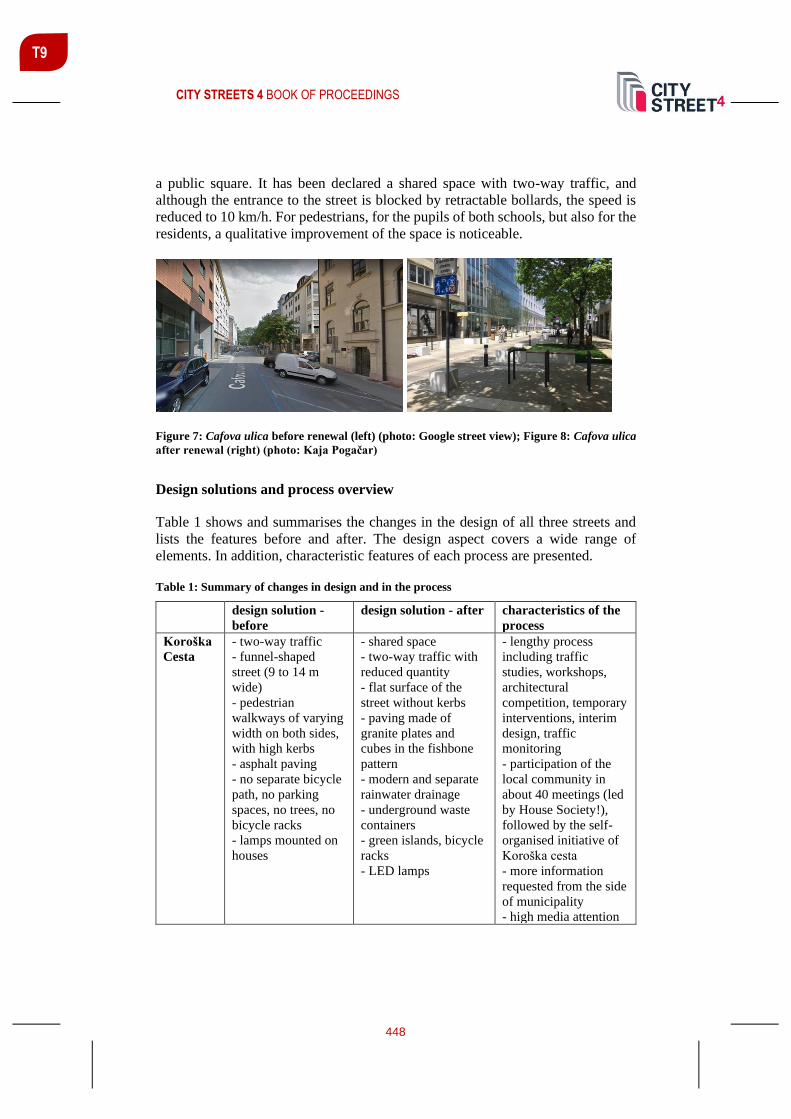
CITY STREETS 4 BOOK OF PROCEEDINGS
448
T9
a public square. It has been declared a shared space with two-way traffic, and
although the entrance to the street is blocked by retractable bollards, the speed is
reduced to 10 km/h. For pedestrians, for the pupils of both schools, but also for the
residents, a qualitative improvement of the space is noticeable.
Figure 7: Cafova ulica before renewal (left) (photo: Google street view); Figure 8: Cafova ulica
after renewal (right) (photo: Kaja Pogačar)
Design solutions and process overview
Table 1 shows and summarises the changes in the design of all three streets and
lists the features before and after. The design aspect covers a wide range of
elements. In addition, characteristic features of each process are presented.
Table 1: Summary of changes in design and in the process
design solution -
before
design solution - after characteristics of the
process
Koroška
Cesta
- two-way traffic
- funnel-shaped
street (9 to 14 m
wide)
- pedestrian
walkways of varying
width on both sides,
with high kerbs
- asphalt paving
- no separate bicycle
path, no parking
spaces, no trees, no
bicycle racks
- lamps mounted on
houses
- shared space
- two-way traffic with
reduced quantity
- flat surface of the
street without kerbs
- paving made of
granite plates and
cubes in the fishbone
pattern
- modern and separate
rainwater drainage
- underground waste
containers
- green islands, bicycle
racks
- LED lamps
- lengthy process
including traffic
studies, workshops,
architectural
competition, temporary
interventions, interim
design, traffic
monitoring
- participation of the
local community in
about 40 meetings (led
by House Society!),
followed by the self-
organised initiative of
Koroška cesta
- more information
requested from the side
of municipality
- high media attention

CITY STREETS 4 BOOK OF PROCEEDINGS
449
T9
Cesta
Zmage
- two-way traffic
- tree ally along the
entire street between
the parking spaces
on both sides
- pedestrian
walkways on both
sides of the street
- no separate bicycle
lane, no bicycle
racks
- asphalt paving
- two-way traffic with
the sharrow system for
cyclists
- newly planted trees
(smaller), between
parking spaces on both
sides
- pedestrian walks on
both sides of the street,
with lower kerbs
toward the street
- all intersections
entirely elevated
- new benches at the
intersections
- asphalt paving and
tactile paving for blind
and visually impaired
persons at the
pedestrian crossings
- new LED lamps
- classic trash bins and
rainwater drainage
- lack of information
and dialogue between
the local community
and the municipality
- sensitive topic with a
deep emotional
component
- different expert
opinions
- two citizens’
initiatives with
conflicting objectives
- confrontation
approach
- high media attention
Cafova
Ulica
- two-way traffic
- trees and parking
spaces on one side
only
- pedestrian walks on
both sides of the
street
- asphalt paving
- no separate bicycle
lane, no bicycle
racks
- shared space
- two-way traffic
(reduced motorised
traffic and reduced
speed, 20km/h)
- even surface of the
street paving made of
concrete plates
- new street furniture
- 5 parking spaces at
the entrance of the
street, 1 for delivery
- new LED lamps
- different motivation
for the renewal from
the side of residents
and bar/restaurant
owners
- insecurity because of
lack of information
(fear of losing parking
spaces, fear of potential
night life escalation)
- confrontation
approach
- high media attention
DISCUSSION / CONCLUSIONS
The paper examined three selected examples of streetscape transformations in the
city of Maribor. The results show that the transformation of the city’s streets can
be considered a sensitive issue, especially for the residents. For them, the street
represents an extension of their living space, which carries an emotional bond, as
was also researched by Appleyard in the 1970s and 1980s. It is therefore
understandable that they want to be involved in the decision-making process or at
least be adequately informed about what is planned in their immediate environment

CITY STREETS 4 BOOK OF PROCEEDINGS
450
T9
and what changes are pending. The research has shown that although all three
streets have become friendlier spaces for pedestrians and cyclists and have also
improved the quality of the living environment in many ways, the participation
process still has a long way to go. On the positive side, however, there are examples
of civic participation and self-activation, which were not observed in this form a
decade ago, but also new practices of temporary interventions and interim design
phases that can have a positive impact on personal experience in the changing
streetscape. The transformation of city streets is also associated with gained rights
and persistent habits; therefore, it is necessary to provide more knowledge and
ensure greater sensitivity in the management of local authorities when it comes to
such projects. It should be the duty of local government officials to avoid the
unnecessary accumulation of anger and fear among residents due to lack of
information and communication. For this reason, excuses and references to formal
procedures are simply not sufficient and justified. It is necessary to bring the culture
of information, communication and mediation to a higher level, to eliminate
ignorant behavior, but also to develop tools and skills for a more inclusive and
democratic society.
In conclusion, we find that the current changes in streetscapes open up many new
potentials for the urban fabric and are at the same time the key element on the way
to a more sustainable urban development. The cases presented show progress in
the redesign of city streets, although many potentials have not yet been fully
exploited and there is still much room for improvement if we want streets to
become environmentally, socially and economically sustainable spaces.
REFERENCES
Baum, H. S. (2001). ‘Citizen Participation’, in Smelser, N. J. and Baltes, P. B. (eds)
International Encyclopedia of the Social & Behavioral Sciences. 1st Editio. Elsevier, pp.
1840–1846. https://doi.org/10.1016/B0-08-043076-7/04439-9
Bradač, B. (2017). Cesta zmage: Protest ni obvaroval zdravih lip, Večer. Available at:
https://www.vecer.com/cesta-zmage-protest-ni-obvaroval-zdravih-lip-6299134
(Accessed: 2 February 2020).
Ćatović, A. (2017). Zgodba posekanih lip na Cesti zmage. Available at:
https://almiracatovic.wordpress.com/2017/11/14/lipe-na-cesti-zmage/ (Accessed: 2
February 2020).
Ciglenečki, M. (2014). Vurnikova kolonija v Mariboru. Ljubljana: Založba ZRC.
Furchtlehner, J. and Lička, L. (2019). ‘Back on the Street: Vienna, Copenhagen, Munich,
and Rotterdam in focus’, Journal of Landscape Architecture. Informa UK Limited, 14(1),
pp. 72–83. https://doi.org/10.1080/18626033.2019.1623551
Lydon, M. and Garcia, A. (2015). Tactical urbanism : short-term action for long-term
change. Washington: Island Press.
CITY STREETS 4 BOOK OF PROCEEDINGS
451
T9
Mehta, V. (2013). The Street: A Quintessential Social Public Space. New York:
Routledge.
NACTO (2013). Urban Street Design Guide. New York: Island Press.
Pogačar, K. (2017). ‘Struggle for Change-Process of Urban Transformation of Koroska
Street in Maribor’. In Schrenk, M. et al. (Eds) Real Corp 2017
Proceedings/Tagungsband. Vienna, pp. 549–560.
Pogačar, K. and Žižek, A. (2016). ‘Urban Hackathon - Alternative Information Based and
Participatory Approach to Urban Development’, in: Procedia Engineering.
https://doi.org/10.1016/j.proeng.2016.08.788
Sapač, I. (2013). ‘Mariborski srednjeveški obrambni sistem: znanstveno teoretični in
projektni elaborat’. Maribor: Mestna občina Maribor.
von Schönfeld, K. C. and Bertolini, L. (2017). ‘Urban streets: Epitomes of planning
challenges and opportunities at the interface of public space and mobility’, Cities.
Elsevier, 68(May), pp. 48–55. https://doi.org/10.1016/j.cities.2017.04.012
Šenk, P. and Pogačar, K. (2019). ‘Tracking Contemporary Streetscape Transformation
Processes – Two Case Studies from Slovenia Sledovanie aktuálneho procesu
transformácie ulíc – dve prípadové štúdie zo Slovinska’, Architektura a Urbanizmus, 1–2,
pp. 60–73.
Tošić Golob, T. (2018). Ožitev ulic Maribora: Tako bo po prenovi izgledala Cafova ulica,
Maribor 24. Available at: https://maribor24.si/lokalno/ozitev-ulic-maribora-tako-bo-po-
prenovi-izgledala-cafova-ulica (Accessed: 10 February 2020).
Zavetoski, S. and Agyeman, J. (2015). ‘Complete Streets. What’s missing?’. In Zavetoski,
S. and Agyeman, J. (Eds) Incomplete Streets: Processes, practices, and possibilities. 1.
Edition. New Yorl: Routlege, pp. 1–13.

CITY STREETS 4 BOOK OF PROCEEDINGS
452
T9
UTOPIA OR DYSTOPIA IN MOBILITY CULTURES? BEIRUT’S INFORMAL BUS SYSTEM AND BUS MAP PROJECT AS
SOCIAL INNOVATIONS
Carine Assaf1 PhD researcher, KU Leuven, Kasteelpark Arenberg 1 -3001 Leuven, Belgium, [email protected]
Christine Mady Assoc. Prof., PhD, Notre Dame Univeristy-Louaize, 72 Zouk Mikael, Zouk Mosbeh, Lebanon [email protected]
Pieter Van den Broeck Assist. Prof., KU Leuven, Kasteelpark Arenberg 1 -3001 Leuven, Belgium, [email protected]
ABSTRACT
Mobilising an institutionalist perspective, social innovation theory and the concept
of transportation (in)justice, the objective of this paper is to address whether and
how the grassroots initiative Bus Map Project (BMP), is responding to the politics
of everyday mobility in Beirut, which have trapped the informal transit system in
perceptions of being unsafe, irregular and even non-existent. However, this system
manifests the unmet needs of the dispossessed to navigate life without a car in
Beirut and its outskirts. Hence, the young activists devised bottom-up strategies to
bring to light the availability of the Beirut informal transit system, unknown to
many, by documenting it. In other words, the paper questions whether BMP and
the informal transit system are socially innovative. To do so, the dynamics of transit
activists are studied in relation to the predominantly car-oriented mobility
mechanisms in Beirut. In that manner, collective action may generate seeds for
socio-spatial justice and an equitable mobility for all.
Keywords: Social innovation, Beirut informal transit, Bus Map Project, mobility
injustice
INTRODUCTION
Riders’ Rights, which was only recognised by the state as an NGO in 2019, grew
out of a grassroots mapping initiative known as the Bus Map Project (BMP) that
began in summer 2015. BMP produced the first two maps of Beirut’s informal
transit network in 2016 and 2018 (Baaklini, 2020). The local grassroots initiative
1 Corresponding author
CITY STREETS 4 BOOK OF PROCEEDINGS
453
T9
encompasses a collective action, which seeks to achieve socio-spatial justice and
equitable movement for all, by recreating and reshaping the debate of Beirut’s
informal transit system. This system has emerged from Beirut’s perpetual
equilibrium of fragmented realities (Tfaily, 2020) and later became a mitigation
tool for the chaotic, fragmented politico-sectarian society as well as a reflection of
an ill-divided state. The latter originated in the Constitution of Lebanon in 1943,
and continued according to the power-sharing formula through the Charter of
Lebanese National Reconciliation (Tai’f agreement) created to end the civil war
(1975-1990). Failing to find a consensual democratic model and a common ground
that could embody the country’s political cleavages and social divergence, this
gave rise to authoritarian inner state entities and produced an oligarchic political
system, which caters for the needs of the various communities to everyday life
necessities, including mobility practices (Salamey, 2009). Ziad Nasr for example,
President and director general of the Railways and Public Transportation Authority
(RPTA), stated during a personal interview in 2018, that “the history of Beirut’s
everyday mobility had to face a completely corrupted, clientelist and chaotic
environment perceived as a form of informal arrangements, which are customised
to people’s needs and feed the political system” (freely paraphrased).
In other words, mobility in Beirut cannot be taken for granted, as it is not only an
everyday practice equally available to all, but varies according to socio-economic
classes and “spatial positionalities” (Buhr and McGarrigle, 2017; p.232), as it
depends on Beirut’s sectarian territoriality and political differences (Monroe, 2010;
2017). Hence, the reality of urban transport politics and the economy of a
dysfunctional elitist post-civil-war government produced injustices, such as major
gaps encountered at the level of public transport service provision. There was no
political will to (re)establish and (re)invest in public transportation, even though
Beirut was known for its glorious mobility past (Nakkash, 2016), which resulted
in the insurgence of informal practices. The latter emerged as “beyond-the-state”
(Swyngedouw, 2005; p.1) political arrangements, to be found in each corner of the
city, manifesting the unmet needs of the dispossessed (Monroe 2010; Baaklini,
2020) within a “laisser-faire” milieu to navigate life without a car in Beirut and its
outskirts, and supporting the legal politico-sectarian and economy framework of
the state. This informal system is characterised by its resilience (Bayat 1997; Scott,
1989), as a gap-filler, a self-managed practice to the apparent chaos (fawada in
Arabic) in transport and the absence of an adequate public transportation in Beirut.
However, the politics of daily mobility have trapped this network in perceptions of
being unsafe, irregular and even non-existent (Nakkash, 2018; 2020; Tfaily, 2020).
The streets of Beirut are taken by almost 80% of commuters relying on private cars,
leaving a small room for other modes of transport, including 18% for taxi-services,
1.7% for vans and buses, and 0.3% for unmotorized transport (Anas et al., 2017;
Mohieddine, 2018).
The main objective of this paper is to address and problematise the emergence of
the grassroots initiative BMP, and whether it is socially innovative or not, through

CITY STREETS 4 BOOK OF PROCEEDINGS
454
T9
understanding its dynamics in relation to mobility practices in Beirut. In the next
sections of this paper, literature will be mobilised on socio-spatial mobility and
transport (in)justices (Bayat, 1997; Scott, 1989; Cervero and Golub, 2007; Sheller,
2018; Pereira, Schwanen, Banister, 2017) and social innovation (SI) in territorial
development by Moulaert et al. The focus of SI lies within the context of local
development of communities and neighbourhoods and the inclusion of excluded
groups into different spheres of society (Moulaert and MacCallum, 2019). The
paper’s methodology builds on socio-spatial and ethnographic analysis for the
informal transit practices. It is based primarily on conducted interviews, between
2018 and 2019, with bus drivers and operators, riders and non-riders, and state
actors conducted by the first author. Moreover, secondary data was used including
maps and urban regulations on transportation and planning as well as online articles
and news reports. A triangulation of information was achieved through combining
these primary and secondary data sets to re-interpret the state of public
transportation mobility in Beirut. The first part of the paper examines how the
informal (self-managed) transit system is negotiating the city’s socio-spatial needs
within a quasi-absent state. Then, it reveals informal arrangements empowering
certain actors, while disempowering others. This part builds an argument that
informal transit is socially innovative only to a certain extent, since it is still a mere
reflection and product of a divided society. The next part examines the extent to
which BMP is reshaping the culture of mobility through mapping the informal
transit system. To note, part of the primary data collected for this part is based on
a participatory reflective action-research process with BMP since 2018. The paper
concludes that the radical ambitions of socially innovative arrangements are not
utopian, geopolitically marked (Moulaert and MacCallum, 2019), and possible in
unstable contexts as Beirut (Harb, 2018). However, they are limited by the forces
of an ill-functioning divided state and market forces that set the rules of the game.
TO WHAT EXTENT DO COMMUNITIES FIGHT BACK MOBILITY INJUSTICE IN
SOCIALLY INNOVATIVE WAYS?
In social innovation (SI) literature by Moulaert et al., the paradigm is often
presented with clear analytical, prescriptive and descriptive concepts. Going
beyond a materialistic understanding of development and growth, its three
dimensions focus on improving human conviviality in a broad sense, aiming at the
“transformation of institutions, overthrowing oppressive structures of power,
supporting collective agency to address non-satisfied needs, and building of
empowering social relations from bottom-up approaches” (Moulaert and Van
Dyck, 2013; p. 466). Nevertheless, the mechanisms of SI are not only an outcome
of collective action, but also of institutional processes. Much of the process, which
is inherently political, lies in making decisions on whose basic needs are to be
addressed. By which means and why? And who are the beneficiaries? (Van den
Broeck, 2011).

CITY STREETS 4 BOOK OF PROCEEDINGS
455
T9
SI research “has to be seen as a deeply institutional endeavour” (De Blust and Van
den Broeck, 2019; p. 100), addressing the interplay between individuals, collective
actors and different social groups to assess how socio-territorial innovation
capacities are differentially embedded in institutional frames, and how they can be
mobilised. All this highlights the importance of looking at the socio-political
content with regard to socio-territorial innovation (Van den Broeck, 2011). Hence,
the actors involved in dealing with unmet social needs through creative strategies
to reshape the way of thinking could be perceived as agents of innovative social
actions (Van den Broeck, 2011; Gracía and Pardel, 2019). According to Hillier, “it
is an in-between, a locus for socio-cultural transformation showing openness for
the future to overcome the traditional inertia and stasis” (2013; p.169). In other
words, to create structural change in the city, the current actors have to step out of
their comfort zone and break the box, and rethink their beliefs and look for new
innovative ideas that can reinstate socio-spatial justice in the city (Albrechts, 2005).
Viewed through the lens of Social Innovation (SI), social turns are hence necessary
to negotiate socio-spatial injustices in relation to mobility practices and
transportation instruments, to pave the way for profound socio-political transitions
in cities. In that sense, social innovation in transportation should not just be
understood within a spatial-technological context, as if it pertains merely to
technical artefacts (see the mobilities paradigm Cresswell 2006; Sheller and Urry
2006; Jensen, 2015), but it evolves around transforming and (re)creating social
relations (Moulaert et al., 2013; 2019). Transit systems are hence a complex bundle
of invisible politics that condense power dynamics, obscuring fundamental
questions on who has the right to the city, who is allowed to participate in urban
activities, who decides how space will be planned and produced (Sheller, 2018).
Accordingly, socio-spatial injustices occur in everyday life mobilities and
(re)create (in)justices for some passengers while excluding others (Pereira,
Schwanen, Banister, 2017).
The question then is whether and how socially innovative initiatives are mobilised
to negotiate socio-spatial mobility injustice to create an inclusive transit system?
Mobility justice seems indeed to be advocated by bottom-up (collective) initiatives,
as “informal or formal arrangements engaging in the act of governing outside and
beyond-the-state (often with the explicit inclusion of parts of the state apparatus)”
(Swyngedouw, 2005; p. 1-2), and foregrounded by citizens separate from ruling
technocrats and formal planning institutions, characterised to be self-managed,
activists or social entrepreneurs. Such initiatives appear to show in dramatic
fashion how the socio-spatial transit (in)justice tenet needs to be (re)thought in
more dynamic and creative manners (Sheller, 2018). From this multi-disciplinary
perspective, the following sections examine whether and how the Beirut informal
transit system and Bus Map Project can be seen as bottom-up strategies that aim to
recreate a solidarity-based transport community challenging existing narratives on
the real meaning of mobility in Beirut.

CITY STREETS 4 BOOK OF PROCEEDINGS
456
T9
FILTERING BEIRUT’S URBAN TRANSIT INFORMALITIES
Until 1980, a public transport network has been implemented in Beirut, but was
later weakened by the civil-war, and then undertaken by the private sector. Beirut’s
informal transit includes thirty-five state-owned buses, and more than 4000
(registered) privately-operated buses and minivans that often negotiate and
compromise to the benefits of some political figures, operating on approximately
fifty trajectories (Mohieddine, 2018; Nakkhah, 2018;2020; Nasr, 2018). Many
transport stakeholders and citizens actually refuse to acknowledge the informal
transit network and perceive it ubiquitous, but invisible. Indeed, for an outsider,
the informal transit practices might appear “quixotic” (Scott, 1989; p.37), however,
decoding its operational system can reveal how in fact a monopolised privately-
operated collective transport incrementally constructed defies, and re-defines
socio-economic variables, while reinforcing socio-political hierarchies to persist
(Bayat, 1997) and resist to the apparent chaos in transport.
Informality has hence created a situation in which the bus system empowers some
groups including bus owners, operators and passengers (Cervero and Golub, 2007),
challenges the predominant car system and fills in the gaps left by an ill-functioning
state with endless social, political and economic complications. For example, many
transport-related stakeholders, such as Ziad Nasr, Ali Mohieddine (Vice President
of the Union of Syndicates of Drivers of Public License Vehicles in Lebanon) and
Tammam Nakkash (Transport expert and founder of Managing Partner at TEAM
International), affirmed while they were interviewed in 2018 that “part of the
system is by the people and for the people” (freely paraphrased), expressing a
subtle balance between the power of the operators, the interests of the drivers and
the inputs from passengers. In addition, the operators consider the system as
“collective transit”, and feel they should be legitimised: today the reluctant state
provides permits to people who aim to be part of this practice (Monroe, 2010;
Nakkash, 2018; Nasr, 2018). In that sense, the system is a private-public-civil
hybrid.
However, in the interplay between the dynamics of social innovation and informal
sectors, the latter is not necessarily good per se for different reasons. First, based
on a socio-spatial and ethnographic analysis carried out between 2018 and 2019,
the whole operational system revealed that the lanes, as divided among operators,
serve their own communities. In that sense, each lane portrayed its political
party/clan, as if the system is a field of battle between various political parties and
sectarian groups. For example, when talking about the routes, some drivers,
expressing their particular party allegiance, choose to drive in their sectarian
territoriality to hunt for “their riders since the drivers’ duty is to serve their people,
and the system operates just like board-games” (freely paraphrased). Each bus lane
is hence a reflection of a consociational state structure. Second, lack of data makes
the system quasi-inaccessible for non-riders and non-transparent for riders and
operators. Social injustice is hence reproduced within the internal system.

CITY STREETS 4 BOOK OF PROCEEDINGS
457
T9
DOES MAPPING THE INFORMAL TRANSIT SYSTEM REINSTATE JUSTICE?
To palliate the lack of information and fill the gap in public knowledge, BMP, a
collective mapping initiative, emerged to reshape the culture of mobility through
recognising the real meaning of public transportation, which is contextually
dependent (see Figure 1). According to the BMP founders, mapping is a powerful
vector to tell realities about injustices, legitimise the informal transit system’s
existence, and above all, create a community engagement. The question however
is, to what extent the mapping initiative is responding to the politics of everyday
mobility?
Figure 2: Greater Beirut informal transit network map attached to a guide on how to use the
system (Bus Map Project, retrieved from http://busmap.me/#downloads)
El-Kayssi, (General Director of Land and Maritime Transport at the Ministry of
Public Works and Transport), one of the political figures in the transport sector,
interviewed in 2018, did not tire to point out that BMP is surpassing the state legal
authorities, considering that “the growing frustration of the state entities lead to
ignore the production of the map”. The production of the map is not a threat per se
according to Nakkash. The real gist lies rather in acknowledging the existence of
(informal) public transportation infrastructure “as a way to reproduce the social
infrastructure destroyed after the civil war”. And, “the state is benefiting from all
of this sectarian mobility scenario” (freely paraphrased). Therefore, BMP is a
collective force that can create advocacy because of its resilient character in the
face of state entities. For other transport stakeholders, the initiative is a medium-
term solution and the state should adapt strategies accordingly.

CITY STREETS 4 BOOK OF PROCEEDINGS
458
T9
From the view of BMP volunteers, to act on documenting means participating
collectively in teaching the society to reconsider alternatives for the existing
mobility patterns. Mapping hence unfolds the complexity of the existing milieu,
mirrors and uncovers different realities, as it reveals “the hidden potentials”
(Corner, 1999; p.20). The surveyors, while tracking the informal transit system, did
not only produce a map, but they also painted the landscape of inequalities lived
by the operators, riders and even non-riders, and identified dead areas and angles
that needed to be connected. In that manner, the map could be considered as a
manuscript for people to apprehend and accept Beirut mobility landscape. Further,
the documentation itself was for the drivers and riders a way to expose the
Lebanese urban mobility landscape, including the existence of the informal system.
Overall, the map emphasized the creativity of the operators in being able to provide
a public service while the ill-functioning and divided state failed. It allowed both
riders and non-riders to explore new ways to navigate the territories, regardless of
the sectarian territorial divisions in Beirut.
Viewing the work of BMP from the perspective of different transport stakeholders,
clarifies that BMP’s relation to social innovation dynamics are not utopian, as they
paved the way to reframe justice and generated seeds for collective action.
However, they are not fully socially innovative. De facto, BMP has a horizontal
character and contests the differential instabilities of the country, but lacks
financial resources, which limits their progress. The team, for instance, works on
low-cost solutions, such as using donated phones and free GPS applications to track
the buses. In that manner, BMP could bring to light the availability of the Beirut
informal transit system unknown to many by documenting it, but they did not
contribute in reversing the ratio between 80% of car users and 1.7% bus riders. To
have an impact on society as a whole, BMP should adopt strategies that can fill the
gaps that exist within the informal transit system, to trigger justice for the whole
society. But without financial resources, BMP has focused on building-up a
network of bus users and coalitions of local and international actors, such as Transit
Union Riders in Seattle, NGOs related to people with disabilities, or public
transportation as Train-Train, Chain Effect, and academics.
CONCLUSION: UTOPIA OR DYSTOPIA IN UNSTABLE CONTEXTS
Combining an institutionalist perspective, social innovation theory and the concept
of transportation (in)justice enabled the analysis of informal mobility practices and
mobility initiatives in Beirut. The project of mobility justice through collective
transit practices, is about an activity of struggles for different reasons. The paper
could expose the hurdles that the collective transit practices might face in attempt
to negotiate transportation instruments in societies. Transportation or physical
movements are not neutral technological artefacts or practices. Rather, they are a
complex bundle, often invisible, of socio-economic, sectarian territoriality political
and cultural differences, which (re)produce concomitant (in)justices. Moreover, the
social turns in this paper could shift the focus of transportation studies to
comprehend the relationships between actors and their interests, such as who

CITY STREETS 4 BOOK OF PROCEEDINGS
459
T9
belongs to the city, who is allowed to participate and in what urban activities, who
decides how spaces will be designed and produced, and who gains from urban
transformation in relation to transportation. Thus, transportation politics are always
pursued for the benefit of some to the detriment of others.
In that manner, mobility systems should not be isolated from socio-political and
physical relations, which materialise the condition of urban existence and the
essential capacity for participation in collective life. Rather, society should learn
how to create a heterogeneous mobility environment. Hence, the notion of
(in)justices enacted by the local initiative BMP and informal transit arrangements
is conceptually rich, as both practices are seeking redistributive remedies to historic
problems, and are not satisfied with being excluded. Socially innovative initiatives
hence appear to empower the dispossessed, but happen in an unstable context filled
with practices of differentiation. Therefore, movements such as these and their
adopted strategies could teach the government how to shift towards more just
practices, policies and discourses regarding the transport system, and confront
market forces, which could be the dystopian ending for collective practices.
REFERENCES
Albrechts, L. (2005). Creativity as drive for change. Planning theory, 4(3).
Anas, A. et al. (2017). Reducing traffic congestion in Beirut : an empirical analysis of
selected policy options (English). Policy Research working paper. WPS (8158).
Washington, D.C.: World Bank Group.
Baaklini, J. (2020). The road to mobility justice is not paved by technocrats. Retrieved from
https://thepublicsource.org/mobility-justice-technocrats
Bayat, A. (1997). Un-civil society: The politics of the 'informal people, THIRD WORLD
QUARTERLY, 18(I).
Buhr, F., McGarrigle, J. (2017). Navigating urban life in Lisbon: a study of migrants'
mobilities and use of space. Social Inclusion, 5(4).
Cervero, R., Golub, A. (2007). Informal public transport: a global perspective.
TRANSPORT POLICY, 14, 445-457.
Corner, J. (1999). The agency of mapping: speculation, critique and intervention” in
Mappings. 213-252. Reaktion Books, London.
Cresswell, T. (2006). Towards a politics of mobility. ENVIRONMENT AND PLANNING
A, 38, 207-226.
De Blust, S., Van den Broeck, P. (2019). From social innovation to spatial development
and planning in Social innovation as political transformation: thoughts for a better world.
100-105. Edward Elgar Publishing.
CITY STREETS 4 BOOK OF PROCEEDINGS
460
T9
El-Kayssi, A. (2018, May 4). Personal interview.
Jensen, O. (2015). More than A to B: cultures of mobilities and travel in handbook of
transport and development. Edward Elgar Publishing.
Harb, M. (2018). New forms of youth activism in contested cities: the case of Beirut, The
International Spectator, (53)2.
Hillier, J. (2013). Towards deleuzean-inspired methodology for social innovation and
practice in the international handbook on social innovation: collective action, social
learning and transdisciplinary research. 169-180. Edward Elgar Publishing.
Gracía, M., Pardel, A. (2019). Bottom-linked approach to social innovation governance in
in Social innovation as political transformation: thoughts for a better world. 97-98. Edward
Elgar Publishing.
Mohieddine, A. (2018, March 9). Personal interview.
Moulaert, F. et al. (2013). The international handbook on social innovation: collective
action, social learning and transdisciplinary research. Edward Elgar Publishing.
Moulaert, F., Van Dyck, B, (2013). Framing Social Innovation Research: a sociology of
knowledge perspective, chapter 3.5. in International handbook on social innovation:
collective action, social learning and transdisciplinary research. Edward Elgar Publishing.
Moulaert, F., MacCallum, D. (2019). Advanced social innovation. Edward Elgar
Publishing.
Monroe, K. (2010). The insecure city: space, power, and mobility in Beirut. Rutgers
university press New Brunswick, New Jersey, and London
Monroe, K. (2017). Circulation, modernity, and urban space in 1960s Beirut. History and
Anthropology, 28(2).
Nakkash, N. (2016). Assessing the failure of Beirut city in implementing a sustainable
transport system. Retrieved from https://www.linkedin.com/pulse/assessing-failure-beirut-
city-implementing-transport-system-nakkash/
Nakkash, T. (2018, March 1). Personal interview.
Nakkash, T. (2020, June 5). Right to Mobility Post COVID-19 talk delivered at Riders’
Rights Lebanon online session. Retrieved from
https://www.youtube.com/watch?v=BbXxu7VLkdM&t=496s
Nasr, Z. (2018, March 8). Personal interview.
Pereira, R., Schwanen, T., Banister, D. (2017). Distributive justice and equity in
transportation. Transport Reviews, 37 (2).
CITY STREETS 4 BOOK OF PROCEEDINGS
461
T9
Salamey, I. (2009). Failing consociationalism in Lebanon and integrative options.
International Journal of Peace Studies, 14(2).
Scott, J. (1989). Everyday forms of resistance. Copenhagen Papers, 4(89).
Sheller, M. (2018). Mobility Justice. Verso.
Sheller, M., Urry J. (2006). The new mobilities paradigm. ENVIRONMENT AND
PLANNING A, 38, 207-226.
Swyngedouw, E. (2005). Governance innovation and the citizen: the janus Face of
governance-beyond-the-state. URBAN STUDIES,42, 1991-2006.
Tfaily, M. (2020). Beirut’s Buses and the Filtering of Urban Informalities. Retrieved from
https://www.jadaliyya.com/Details/40377
Van den Broeck, P. (2011). Analysing Social Innovation through Planning Instruments: A
Strategic-Relational Approach in Strategic planning as a catalyst for transformative
practices. Routledge.

CITY STREETS 4 BOOK OF PROCEEDINGS
462
TRACK T10: STREET LIGHTING – SUPPORTING SUSTAINABLE
URBAN DEVELOPMENT
Track Chair:
Tomaž Novljan, University of Ljubljana, Faculty of Architecture, Ljubljana, Slovenia
Exterior lighting has always been an essential element of nocturnal cityscapes;
initially it was primarily based in function, providing night-time security and
orientation within the built environment. These functional needs were in turn
augmented by advertising and outdoor living ambiances that established multi-
scaled spatial hierarchies as well as creating multifarious views of the city during
the darkness of night. Nocturnal lighting within the urban landscape is one of the
many challenges that any contemporary city faces.
Track 12 welcomes the contributions on the proposed topics:
• Establishing orientation and hierarchy in cityscapes;
• Creating “another face” of the city;
• Nocturnal public spaces;
• Lighting art and advertising;
• Obtrusive light and light pollution.
Keywords: Exterior Lighting, Nocturnal Cityscapes, Urban Landscape
T10

CITY STREETS 4 BOOK OF PROCEEDINGS
463
T10
URBAN LIGHTING AMBIENCES
Tomaž Novljan Assoc. Prof., PhD, University of Ljubljana, Faculty of Architecture, Slovenia [email protected]
ABSTRACT
An ambience can be defined as a space with certain properties encompassing one
or more persons or things. An architectural ambience is a space containing a
number of special architectonic quantities. Light is one among them. Light is the
most powerful immaterial construction material. Light reflects from various
surfaces and enters into a human optical perceptive system. DEGRADED
LIGHTING AMBIENCE designates special spatial layers inside architecture
where otherwise qualitative segments of space are negatively affected by improper
lightning. The following text delivers a proposal of 12 typical lighting aspects that
should be considered prior to designing a quality ambience and furthermore, it
introduces light as an essential tool in the process of making new or refurbishing
degraded urban ambiences.
Keywords: ambience, architecture, lightning.
INTRODUCTION
One can define an ambience as a space with properties that encompass one or more
persons or things, in other-words: surroundings. It can be perceived through many
different scales – from micro to macro; it can be defined as a relative quantity.
Architectural ambience is a space where architectural quantities are accentuated,
e.g., the relationship between certain Euclidian geometrical elements (lines,
surfaces, bodies) and their surroundings. Different materials are used to support
diversity of architectural tasks. These materials reflect the specific language of the
ambience, artistic expression or simply the wealth of the investor. Various shapes,
colours, textures and patterns are created during the design and construction
process. All this is possible only through the presence of light. Light makes the
ambience visually perceptive, real and dynamic. Quality architectural ambience
fits within the spatial context; it has a “narrative”, where forms, light, shadows and
movement are involved. It also has material and immaterial hierarchy.
A human - he primary user of an architectural space perceives his/hers
surroundings through different sensory organs; mostly through vision (approx.
80%), hearing, and touch. Via these inherent senses the relationship between urban
space and its users becomes established. As previously mentioned, this paper
asserts that light is the most powerful among the “building materials” in the
CITY STREETS 4 BOOK OF PROCEEDINGS
464
T10
manmade environment. It reflects from various surfaces and enters into a human
recognition system. Lighting generates illuminations, where not only the
orientation is projected, but also functional and aesthetic enrichment of the space
becomes possible. At the Faculty of Architecture in Ljubljana a special system is
being developed that can serve as a tool for the analysis and evaluation of the light
ambiences. A 12-point criteria is based on the experience in dealing with the most
common areas of errors that were made in several different cases of lighting
concerning architectural ambiences: overdosed illumination, insufficient
illumination, glare, shadows, reflections, light “pollution” etc. A new term
LIGHT-DEGRADED AMBIENCE has been coined and designates a special
spatial level within the architecture where improper lighting deteriorates otherwise
quality segment of an architectural ambience.
EVALUATION CRITERIA
Relation to quality architectural elements and to overall composition
This kind of deficiency, if present, can lead to the overall degradation of
architecture. It is a well-known fact—in theory and in practice—that accented
illumination serves as visual amplifier of higher-value architectural elements.
However, too many accentuations at the same level can lead to the opposite effect
Even in the process of making accentuations it is necessary to take into account
both gradation and hierarchy. Within an architectural composition usually some
elements are more important than the others. Illumination intensity must follow
this order. With the proper amount of light a “lighting composition” is established
and as such complements and even upgrades the “original” artistic/geometrical
intention.
Insufficient illumination – generally and/or in detail
This lighting aspect must address two items: personal safety and orientation in
urban space, and the negligence and inconsideration of architectural elements. One
of people's basic necessities is that of personal safety; it is perhaps one of the most
important, and adequate illumination is a vital factor in the manifestation of “safe”
spaces. Architectonic space fundamentally consists of permanent components, i.e.
buildings and other, more or less static, exterior and interior elements and, of
variable components, mostly human users of exterior and interior environments. A
human, who lives and moves through an urban environment, typically seeks other
humans. This is particularly true at night when large amounts of people have left
urban places. Next is orientation in space. The human brain constantly seeks
balance. If it is very hot we want it to be colder, in the case of too bright an
environment we want it to be darker. Also, we want to be aware of our bearings –
on a physical level as well as on a more abstract level. We can find ourselves in a
certain place or space, which we know well from our experience, and as such can

CITY STREETS 4 BOOK OF PROCEEDINGS
465
T10
frame it within a wider spatial context. In the other instance we can find ourselves
in a space/room where we are able to locally recognize its physical properties: tall,
narrow, wide, clean, dirty etc. We cannot frame the space within a broader spatial
context directly, but we can call upon our other senses for help: our sense of smell
and hearing.
Consideration of the possibility of glare
Glare is an optical condition where the difference between a bright and dark object
which are put close together is so extreme that a simultaneous perception of both
objects is difficult or even impossible. It must be stressed that with glare, the degree
of impact depends highly on one's age. The higher one's age, the lower one's
threshold of tolerance. Because of glare certain architectural elements or
compositions or forms cannot be recognizable. Glare is also an important factor
when we speak about traffic safety.
Shape, design and size of the luminaries
In most cases a lamp plays a significant role in co-designing an overall appearance
of an architectural ambience. Until recently a luminous power was closely related
to the dimension of the lamp: the higher the power, the bigger the dimension. Of
course every shape and/or dimension of a lamp is not suitable for every
architectural ambience. Physically larger ambiences which are perceptible as a
whole from greater distance can stand larger and more robustly designed lamps.
Smaller, less articulated and minimalistic designed ambiences are much more
sensitive and require lamps which are designed in the same manner. The scale of
the space is, together with its articulation and function, an essential measure that
determines whether a certain lamp in the shape, dimension and even colour
corresponds and fits into the specific spatial instance.
Disposition of the luminaries regarding maintenance and vandalism
Maintenance, exposure to vandalism and investment-costs must be considered too
when planning the arrangement and position of lamps. Usually the disposition of
lamps in certain ambience obeys the need of evenly illuminated surfaces or the
need of providing special lighting effects. To achieve evenly illuminated
(horizontal) surfaces the lamps are usually positioned on relatively high poles (it is
always a trade-off between the height of the poles and their spacing) so vandalism
does not represent a potential risk. In this case the maintenance and exchange of
burned-out lamps have to be taken into consideration. But when considering lamps
for special ambient effects (spotlights, lamps on short poles, lamps encased in
pavement, grass etc.) one must also consider the possibility of vandalism. This
problem can be partly avoided by the proper selection of adequate, more robust or
built-in types of lamps.
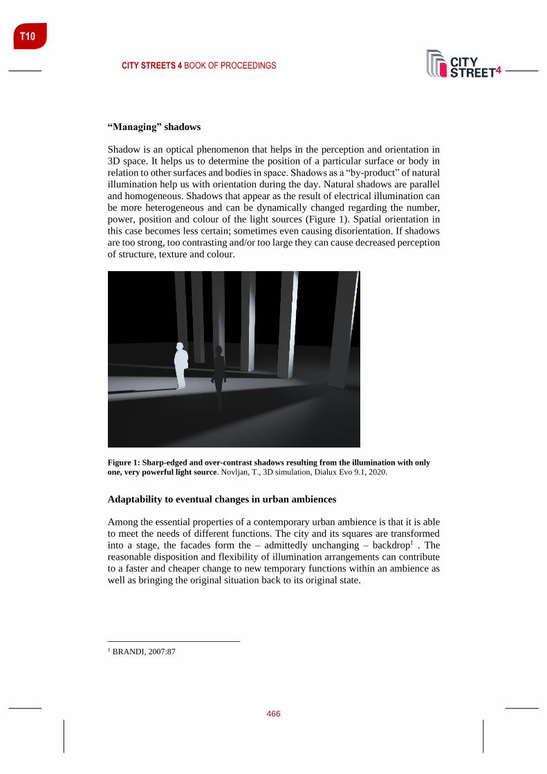
CITY STREETS 4 BOOK OF PROCEEDINGS
466
T10
“Managing” shadows
Shadow is an optical phenomenon that helps in the perception and orientation in
3D space. It helps us to determine the position of a particular surface or body in
relation to other surfaces and bodies in space. Shadows as a “by-product” of natural
illumination help us with orientation during the day. Natural shadows are parallel
and homogeneous. Shadows that appear as the result of electrical illumination can
be more heterogeneous and can be dynamically changed regarding the number,
power, position and colour of the light sources (Figure 1). Spatial orientation in
this case becomes less certain; sometimes even causing disorientation. If shadows
are too strong, too contrasting and/or too large they can cause decreased perception
of structure, texture and colour.
Figure 1: Sharp-edged and over-contrast shadows resulting from the illumination with only
one, very powerful light source. Novljan, T., 3D simulation, Dialux Evo 9.1, 2020.
Adaptability to eventual changes in urban ambiences
Among the essential properties of a contemporary urban ambience is that it is able
to meet the needs of different functions. The city and its squares are transformed
into a stage, the facades form the – admittedly unchanging – backdrop1 . The
reasonable disposition and flexibility of illumination arrangements can contribute
to a faster and cheaper change to new temporary functions within an ambience as
well as bringing the original situation back to its original state.
1 BRANDI, 2007:87

CITY STREETS 4 BOOK OF PROCEEDINGS
467
T10
“Managing” reflections
Reflected, indirect light is as important as direct light. Considering the reflecting
surface, indirect light can have even stronger architectural significance. It should
be pointed out that reflections from smooth, shiny and moving surfaces like water,
moving vehicles and glass façade elements are of special importance. The most
undesired result of the reflected light is glare. A work of art, a monument for
example, should be the brightest part of the field of view, with gently graded
brightness to the surrounding visual field, but there must be a total absence of glare,
both direct and reflected2.
Brightness of surfaces
Brightness is another photometric quantity that is directly perceivable with our eyes
(reflected light). Regardless of the level of illumination of a certain surface the
level of brightness of this surface can be too high or too low. In architectural design
and expression this difference between the perception and measurement is very
important. A “good” example are large advertising panels in urban areas and, in
certain natural ambiences, too. In spite of their triumphant advance in many
European cities, illuminated advertisements are subject to planning approval, and
rightly so. They are even prohibited in some districts.3 However, in such cases the
brightness of illuminated surfaces depends mostly on a displayed graphic
(Figure 2). As understood by experience, advertisements change very frequently
and so does the relation between brighter and darker surfaces; however, the level
of illumination remains constant. This results in under-dosed or overdosed
illumination, and further on in unwanted illumination of the surroundings and
produces glare etc.
Figure 2: The left advertising panel displays 30% higher luminosity than the right advertising
panel. Both panels receive equal illumination. Novljan, T., 3D simulation, Dialux Evo 9.1, 2020.
2 CUTTLE, 2007:8 3 BRANDI, 2007: 79

CITY STREETS 4 BOOK OF PROCEEDINGS
468
T10
Consideration of structure, texture and color
Structure, texture and colour are basic properties of any architectural object. We
distinguish more and less structured surfaces and compositions that need to be
nocturnally illuminated. A strongly articulated structure causes more shadows,
particularly if more light-sources are used to illuminate it. If the resulting shadows
are too contrasting the “visual denial” of the intended architectural expression can
occur and the architectural object gains a new, usually unwanted and unpredicted
image. Similarly, this applies to texture, which is a 2-dimensional visual property
in architecture, somewhat similar to the structure itself. An observer/occupant can
thus traverse from the structure to the texture and again to the structure and again
to the texture … It depends on the scale or the distance of observation. The third
basic property of all spatial elements is colour. The relation between absorption
and reflection of light from a surface generates colour impressions of this surface
and affects both structure and texture.
Light pollution / obtrusive light
The scattering of redundant light in the atmosphere causes so-called sky glow. This
phenomenon can disturb natural as well as human habitats. Light pollution greatly
depends on conditions in the atmosphere (humidity, clouds, presence of particles -
natural as well as industry-produced). These factors act as vast diffusers and
amplifiers of light. Such light can travel very long distances. One of the obtrusive
light by-products is also glare.
Special ambient conditions
Architectural ambiences of special historic values, or cultural importance require
additional attention regarding illumination. The importance of proper lighting –
both natural and artificial has played an important role through the history of
mankind. This can be particularly stressed in the field of sacred architecture, where
sunlight has consistently played an important role as an element of worship and
thus in its design. The Stonehenge, the temples of Egypt, public buildings of
antique Greece and Gothic cathedrals are just few among the most well-known
examples of the utilisation of light as a means of psychological influence on
humans. Currently these historical buildings generally perform a documentary and
educational role. It is important to stress here that lighting of historical buildings
must consider the context of time when these historical buildings were built and
used. Modern light sources are very powerful and cannot be compared to the
artificial and natural light sources of different technological eras. A desire for
bringing an old castle ruin into every tourist guidebook often results in overdosed
illumination that degrades both the historical and ambient value of a historic site.

CITY STREETS 4 BOOK OF PROCEEDINGS
469
T10
Figure 3: Bridge Theatre of Light: Student workshop Lighting Guerilla 2012. Photo: DK 2012.
CONCLUSIONS
The term Light Degraded Ambience, which evolved as a part of educational process
and research at the University of Ljubljana, Faculty of Architecture, designates a
special architectural level where improper lighting can damage the perception and
use of a certain urban architectural ambience or element. The set of 12 points
discussed above can be used as tools in analysing urban luminous environments
prior to the start of any lighting design project. Research in this field is an ongoing
process. Each year more experience is garnered, and if needed, these 12 “aspects”
will certainly be modified over time - primarily through various workshops in
urban spaces. The study and evaluation of different ambient quantities and qualities
will be used to propose solutions with the aim to improve degraded urban
ambiences through proper lighting methods. Properly illuminated spaces attract
people and public programmes culturally and commercially. In the past decade
via this project and in conjunction with The Lighting Guerilla annual international
lighting festival of Ljubljana these aspects have been investigated through
designing and setting ephemeral lighting installations in public urban space of
Ljubljana (Figure 3). Within these workshops future architects learned the whole
lighting design process from the start to the final implementation on the streets,
parks and squares. Proper lighting has to become one of the important tools for
qualitatively improving Ljubljana's or any other city’s “grey” urban areas.
REFERENCES
Brandi, U. (2007.). Light for cities, Birkhauser, Basel
Ching, F. D. K. (1996). Architecture – form, space and order, John Wiley&Sons Inc.,
New York.

CITY STREETS 4 BOOK OF PROCEEDINGS
470
T10
Cuttle, C. (2007). Light for art's sake. Elsevier, Oxford
Fotios, S., Utterly J., Fox, S. (2019). A whole -year approach showing that ambient light
level influences walking and cycling. Lighting Research & Technology 51, 55 – 64.
Lam, W. M. C. (1992). Perception & lighting, Van Nostrand Reinhold, New York
Scielke, T. (2019). The Language of Lighting: Applying Semiotics in the Evaluation of
Lighting Design LEUKOS, 15:2-3, 227 – 248. Retrieved from
https://www.tandfonline.com/doi/full/10.1080/15502724.2018.1518715
CITY STREETS 4 BOOK OF PROCEEDINGS
471
T10
OUTDOOR LIGHTING PLAN – RETHINKING OF TRG OSVOBODILNE
FRONTE IN LJUBLJANA
Lanlan Wei student, University of Ljubljana, Faculty of Architecture, [email protected]
ABSTRACT
City street lighting level and extent of illumination are affecting the safety and
comfort, as well as people's driving routes and activity areas. Redefining the
application of new lighting technologies, switches and dimming modes. And
planning night-time activities based on new lighting to promote the positive impact
of outdoor night-time lighting on life. Research methods used were: study of
lighting theories, standards, and legal regulations, relevant case studies, and field
trips and data measurement on site. Taking advantage of the outdoor lighting plan
of the central transport district and its surroundings, the lighting design was
considered to be one of the important factors for the quality design of the city of
Ljubljana.
Keywords: road, lighting, environment, adaptive plan
INTRODUCTION
From ancient times to the present, there have been many stories about light and
how it is beautiful, mysterious, sacred and a representation of power in different
cultures, beliefs or myths. Light in the night sky was considered in early
civilizations to be a powerful and sacred force, something that only the gods could
produce and release.
In ancient China, the image of the god of thunder was constantly evolving. Initially,
it was portrayed as a monster with a human head and a dragon body, and thunder
was emitted by striking its stomach. Later, it gradually changed into a monkey-
faced figure. In Taoist mythology, there are many numbers of thunder gods of
various levels, the lowest level being the “Thunder man”, the upper level being the
ordinary “Thunder God”, and the upper level being the “Thunder King”. The
Chinese folk set the birthday of the God of thunder (Leigong the God of thunder,
his wife is Dianmu, Chinese goddess of lightning) on the 24th day of the 6th lunar
month. The ceremony is held on this day, which conveys the good wishes of the
Chinese working people to expel evil spirits, avoid disasters and pray for good fortune.
Raijin is the Japanese god of storms, a chaotic being born of death who brings the world
vital rains as well as chaos and destruction. He flies across the sky on dark clouds and
throws lightning onto unsuspecting denizens below. A popular kami (a type of god

CITY STREETS 4 BOOK OF PROCEEDINGS
472
T10
or spirit in the Shinto religion) despite his connection to death and destruction,
Raijin is represented in Shinto and Buddhist imagery, as well as in folk belief and
popular art (Wright, 2020).
After centuries of using a different but less efficient solution for street lighting, in
1792 the inventor William Murdoch used gas distilled from coal to light his
house.1807, London. The first street lit by gas lanterns was opened. The gas
lanterns were placed on poles and then lit and extinguished by hand every evening
and morning. Later, other cities around the world followed. Until the arrival of
electricity (History of Lighting, 2020). After that, electric lighting spread the world
and is still here today.
Lighting of street and buildings accounts for up to 75% in electricity demand of
lighting (Kazarinov et al., 2011). The new methods of street lighting control based
on network technologies enable to configure street lighting in real time mode and
in a scientifically justifiable and dynamic manner (Filimonovaa et al., 2017). A
well-illuminated space in which faces and facial expressions are recognizable
creates a sense of increased comfort and users feel protected and not threatened by
the presence of others (Cariboni group, 2019). Changes which reduce lighting,
particularly ‘switch off’ and part-night lighting in urban areas, have attracted
considerable public and media concern, centring on crime, fear of crime, per-
captions of safety, and road safety. These are all important de-terminates of health
and wellbeing: directly in the case of road safety; and indirectly, in that fear of
crime, for instance, has multiple pathways that impact on mental health (Lorenc et
al., 2012).
CASE STUDY: TRG OSVOBODILNE FRONTE IN LJUBLJANA
Nearly 15% of global electricity consumption is used for lighting (International
Energy Agency, IEA/UNEP 2014), lighting is used every day, all the time, all over
the world. Lighting is a huge energy consumer and emitter of carbon dioxide.
As LED technology applications become more flexible and diversified, the role of
lighting has increasingly gone beyond the need to fulfil the lighting function, it has
given more social.
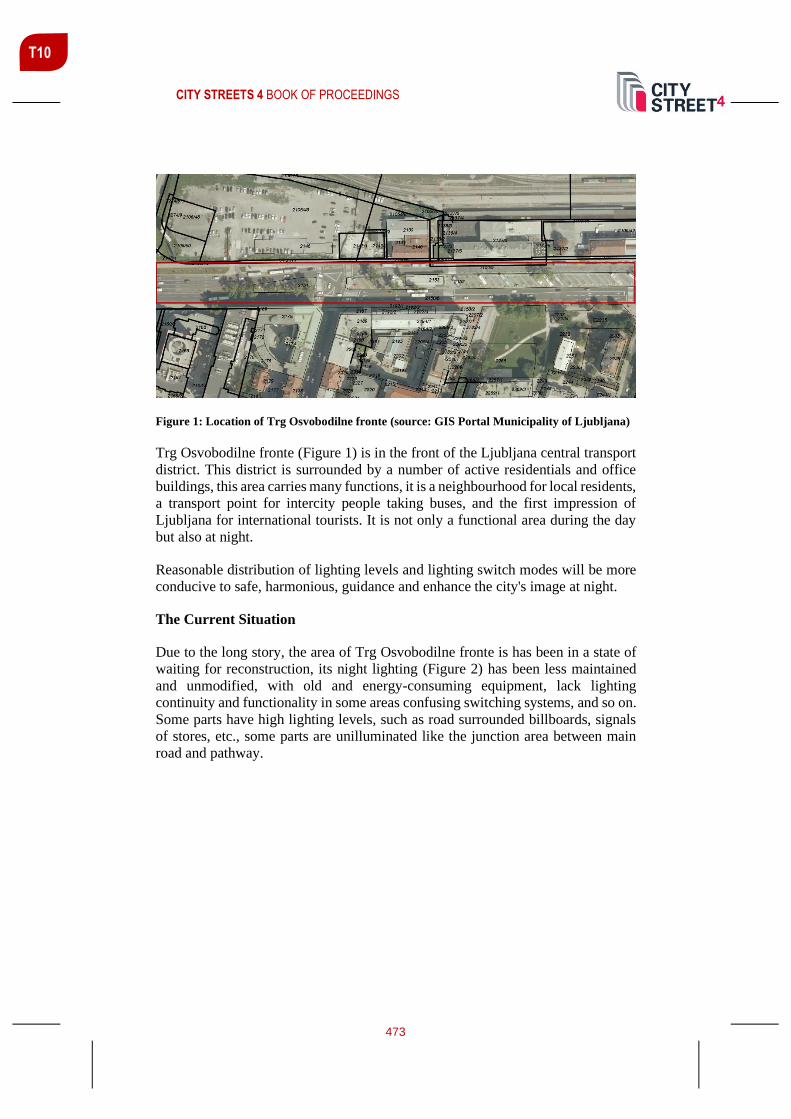
CITY STREETS 4 BOOK OF PROCEEDINGS
473
T10
Figure 1: Location of Trg Osvobodilne fronte (source: GIS Portal Municipality of Ljubljana)
Trg Osvobodilne fronte (Figure 1) is in the front of the Ljubljana central transport
district. This district is surrounded by a number of active residentials and office
buildings, this area carries many functions, it is a neighbourhood for local residents,
a transport point for intercity people taking buses, and the first impression of
Ljubljana for international tourists. It is not only a functional area during the day
but also at night.
Reasonable distribution of lighting levels and lighting switch modes will be more
conducive to safe, harmonious, guidance and enhance the city's image at night.
The Current Situation
Due to the long story, the area of Trg Osvobodilne fronte is has been in a state of
waiting for reconstruction, its night lighting (Figure 2) has been less maintained
and unmodified, with old and energy-consuming equipment, lack lighting
continuity and functionality in some areas confusing switching systems, and so on.
Some parts have high lighting levels, such as road surrounded billboards, signals
of stores, etc., some parts are unilluminated like the junction area between main
road and pathway.

CITY STREETS 4 BOOK OF PROCEEDINGS
474
T10
Figure 2: Luminance distribution around the district
POTENTIAL LIGHTING IMPROVEMENT AREAS AND PLAN
Certainly, the most obvious symbol of the station is Clock tower, and it is likely
perceived as a lighthouse whether the observer is looking at it from the surrounding
area or from inside the station area. Arriving from the northern side of the city, the
Clock tower can be easily seen as the prominent ornament of the area. However,
the Clock tower should not capture the full attention of those persons that are
looking for the North Entrance of the building. This should have a clear view of
the observer as well.
Walking toward the north entrance of the station, you will first find large steps that
one will need to walk down. Lighting uniformity is very important to safely walk
down the steps and to identify your connection to the platforms or to the underpass
situated behind the steps.
Areas that should have the priority for improvements are the zones from the
underpass to the platform and the connecting steps as indicated. The underpass
requires 24/7 light artificial light services. It is important to consider the strong
glaring effect created by the daylight when a person is approaching the entrance or
exit of the tunnel. It is recommended to equip the lighting in the underpass with
control sensors that can be located at the north and south end of the tunnel. The
control should work together with the luminaires to adjust the illuminance levels
to the daylight conditions at both ends of the tunnel. It is recommended a maximum
of 100 lx average illuminance at night and a maximum 300 lx average illuminance
during the daytime. Along with the previously recommended improvements, it is
necessary to reinforce the identification of the boundaries of the station, this is
aimed to avoid overlooking the edges of the platform areas at night, especially
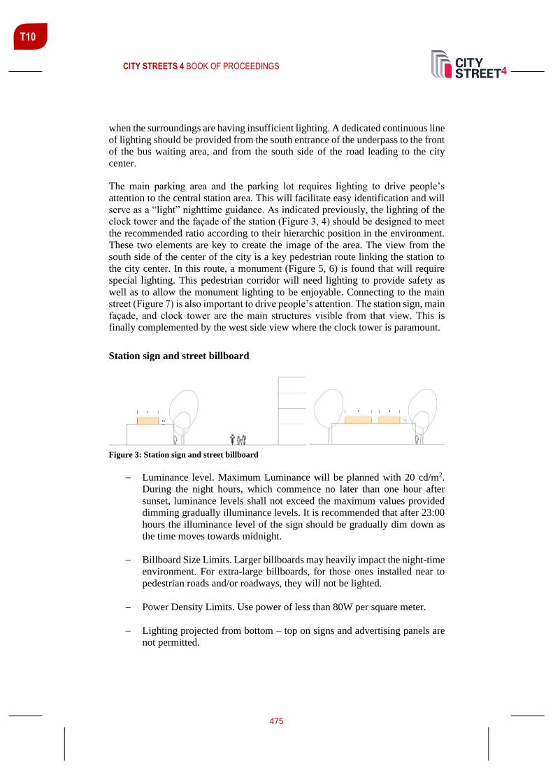
CITY STREETS 4 BOOK OF PROCEEDINGS
475
T10
when the surroundings are having insufficient lighting. A dedicated continuous line
of lighting should be provided from the south entrance of the underpass to the front
of the bus waiting area, and from the south side of the road leading to the city
center.
The main parking area and the parking lot requires lighting to drive people’s
attention to the central station area. This will facilitate easy identification and will
serve as a “light” nighttime guidance. As indicated previously, the lighting of the
clock tower and the façade of the station (Figure 3, 4) should be designed to meet
the recommended ratio according to their hierarchic position in the environment.
These two elements are key to create the image of the area. The view from the
south side of the center of the city is a key pedestrian route linking the station to
the city center. In this route, a monument (Figure 5, 6) is found that will require
special lighting. This pedestrian corridor will need lighting to provide safety as
well as to allow the monument lighting to be enjoyable. Connecting to the main
street (Figure 7) is also important to drive people’s attention. The station sign, main
façade, and clock tower are the main structures visible from that view. This is
finally complemented by the west side view where the clock tower is paramount.
Station sign and street billboard
Figure 3: Station sign and street billboard
− Luminance level. Maximum Luminance will be planned with 20 cd/m2.
During the night hours, which commence no later than one hour after
sunset, luminance levels shall not exceed the maximum values provided
dimming gradually illuminance levels. It is recommended that after 23:00
hours the illuminance level of the sign should be gradually dim down as
the time moves towards midnight.
− Billboard Size Limits. Larger billboards may heavily impact the night-time
environment. For extra-large billboards, for those ones installed near to
pedestrian roads and/or roadways, they will not be lighted.
− Power Density Limits. Use power of less than 80W per square meter.
− Lighting projected from bottom – top on signs and advertising panels are
not permitted.

CITY STREETS 4 BOOK OF PROCEEDINGS
476
T10
− Advertising lighting with rapid color changes is not permitted.
− LED interior light box lighting is recommended for signage and billboard
lighting. (Size less than 30 m2)
− Billboards shall be switched off completely after 00:30 (or 30 minutes after
the close of business for on-premises signs, whichever is later), and remain
off until one hour before sunrise or opening of business whichever is
sooner.
Façade and clock tower area
Figure 4: Façade and clock tower section
− The average luminance value of the clock tower should be Lave=5 cd/m2,
which is the highest luminance level in the area of facade lighting.
− The projection luminaires will be installed on the roof and will project light
onto the tower in two layers, the first layer mainly cover the central part of
the clock tower and the second layer on the upper part of the façade and
the top of the mast.
− For the facade, it will be better to use the wall washer lighting distribution
to well control the spill lighting; for the top of the mast, a adjustable narrow
beam lighting fixture will be used to minimize the spill lighting. The same
lighting levels and methods will be used on all four sides of the clock
tower.
− It will be important the uniformity of the lighting of the clock tower
combined with the precision of the lighting of the mast section.
− The luminance of the facade lighting section calculated from the average
value of the total area of the facade lighting section shall not exceed
1 cd /m2.
− Projected white light should be <3000K.

CITY STREETS 4 BOOK OF PROCEEDINGS
477
T10
Monument sculpture
Figure 5: Monument sculpture area section
− The illumination of cultural monuments should provide the required
luminance levels for visibility and modelling at the same time. The
renderings below show the light levels hitting the monument and the
surroundings, not ex-exceeding 1 cd / m2.
− The luminaires will be mounted on adjacent street and park using medium
size poles. The light will be projected from three different locations and
from top to bottom to create the modelling by contrast using a mix of
narrow and medium beam angles.
Figure 6: False colour rendering image of the monument to General Maister

CITY STREETS 4 BOOK OF PROCEEDINGS
478
T10
Active street frontage
Figure 7: Active street frontage section illumination diagram
The shopping street connecting the south of the station is dominated by fast-food
restaurants and cafes. This street is the busiest one and business hours are extended
up to 11pm at night.
The main forms of lighting are doorway advertising lightboxes, wall mounted
vertical advertising lightboxes, and outdoor shop lights. Upward advertising
lighting is not permitted.
Except for safety-related lighting, which shall remain ON overnight, all other
lighting must be switched OFF before 00:30 hours. Use fully shielded fixtures that
emit no light upward.
Connection areas with the park and Kolodvorska ulica
The pedestrian corridors from the station’s north underpass entrance to the north
surrounding area and from the south bus waiting area to the city centre are the most
used pedestrian corridors at night. These areas are also heavily used by bicycles
and people who like to walk.
Promote the continuity of night-time lighting in the commonly used corridors and
station neighbourhoods and surrounding commercial streets to enhance the night-
time image of public places.
Promote the use of adaptive control system
Adaptive lighting systems can be dynamically managed with all the functions for
maximum flexibility and use scenario mode management as needed to reduce
unnecessary energy consumption.

CITY STREETS 4 BOOK OF PROCEEDINGS
479
T10
CONCLUSIONS
There are many possibilities for lighting as a tool and material for night-time public
spaces, lighting use enhance the night-time public environment with a small
number of inputs, make more night-time activities possible, promote safety, beauty
and diverse lifestyles, and contribute to sustainable development.
This paper is a part of the master's thesis DEVELOPMENT OF ADAPTIVE PLAN FOR
OUTDOOR LIGHTING IN THE CENTRAL TRANSPORT DISTRICT OF LJUBLJANA
done at the Faculty of architecture, University of Ljubljana September 2020.
REFERENCES
Filimonovaa, A., Barbasovaa, T. A., Shnayder, D. A. (2017). Outdoor lighting system
upgrading based on Smart Grid concept. 8th International Conference on Sustainability in
Energy and Buildings, SEB-16, 11-13 September 2016, Turin, ITALY. Energy Procedia
111(2017), 678-688. https://doi.org/10.1016/j.egypro.2017.03.230
Historyoflighting.net. 2020. History of Lighting - Development Of Lighting Technology.
[online] Available at: <http://www.historyoflighting.net/> [Accessed 14 August 2020].
International Dark-Sky Association. 2020. Light Pollution | International Dark-Sky
Association. [online] Available at: <https://www.darksky.org/light-pollution/> [Accessed
14 August]
International Energy Agency, IEA/UNEP (2014).
Greena, J., Perkins, C., Steinbach, R., Edwards, P. (2015). Reduced street lighting at night
and health: A rapid appraisal of public views in England and Wales. Health & place, 34,
171-180. https://doi.org/10.1016/j.healthplace.2015.05.011
Kazarinov, L. S., Shnaider, D. A., Barbasova, T. A. (2011). Automatic control systems of
efficient lighting. Chelyabinsk: Publisher SUSU.
Lorenc, T., Clayton, S., Neary, D., Whitehead, M., Petticrew, M., Thomson, H.,
Cummins, S., Sowden, A. Renton, A. (2012). Crime, fear of crime, environment, and
mental health and wellbeing: mapping review of theories and causal pathways. Health
Place, 18(4), 757-765.
Wright, G. (2020). Raijin – Mythopedia. [online] Mythopedia. Available at:
<https://mythopedia.com/japanese-mythology/gods/raijin/> [Accessed 14 August 2020]

CITY STREETS 4 BOOK OF PROCEEDINGS
480
T10
LIGHTING IN URBAN SPACE – CHALLENGES IN ZOUK MOSBEH, LEBANON
Aleš Švigelj1 mag. inž. arh., University of Ljubljana Faculty of Architecture, Ljubljana, [email protected]
Marko Lazić mag. inž. arh., University of Ljubljana Faculty of Architecture, Ljubljana, [email protected]
ABSTRACT
Lighting is one of the strongest factors that can transform the perception of any
space, especially in urban environments where it importantly influences the quality
of life. One of the biggest issues in today’s urban space is the balance between the
lack of lighting and lighting pollution. How to establish the appropriate lighting in
the city is especially challenging in cases such as Zouk Mosbeh area in Lebanon.
Due to the domestic and neighbor's wars, the area grew from an agricultural
village into a densely populated area of tall buildings practically over the night.
Among other important urban assets, it suffers from a lack of sufficient and
appropriate lighting infrastructure, which would offer the newcomers and the
residents a quality space for interactions with each other and ensure different
activities in public spaces which are extremely important for such a densely
populated and heterogeneous area. The article offers a review of the importance
of lighting in urban space and provides an insight into the effectiveness of light on
people's moods and feelings. The article tries to establish new perspectives in
urban light design based on exploratory research in the Zouk Mosbeh area in
Lebanon as a case study. The end goal of this article is to help urban designers
and architects understand the importance of appropriate lighting in the urban
space especially in the fast-growing and heterogeneous cities such as Lebanon and
how this, beside other important factors such as safety, comfort, and the
attractiveness of the public space, has the social impact in the fast-growing and
densely populated spaces.
Keywords: Lighting, Zouk Mosbeh, Lebanon, Urban space
INTRODUCTION
Lighting is one of the most important factors in urban space and it is as critical for
the public as for the private spaces. Since the birth of public lighting (which, in
Europe, can be traced back to the Middle Ages), public spaces - the empty spaces
1 Corresponding author

CITY STREETS 4 BOOK OF PROCEEDINGS
481
T10
in the city - have always been lit (Narboni, 2017). City lighting plays important
role in the quality of people’s lives, their aesthetic perception of space, and feelings
of safety. It is only with the benefit of light after all that urban spaces become
accessible at night. (Geissmar-Brandi & Brandi, 2006). A quality lighting
environment was defined as the lit space that supports human behavioral needs,
with considerations for architectural and economical aspects of the installation
(Veitch, 2001). Whenever we are planning from the beginning or we are renovating
the existing public space we consider the impact of the design on a wider scale.
The same should be the case with lighting design for urban spaces. Good lighting
has the potential to transform the neglected city areas into attractive urban settings
as well as it can result in the extended hours for commercial and social activities
(Gokhale, 2013). Besides the costs of lighting (maintaining, light pollution, and
energy consumption) also esthetical and emotional impacts are important. Good
lighting design can display the culture and the characteristic of the city and
establish a charming world of light (Kutlu & Manav, 2013). It can transform urban
spaces far beyond their purpose so they don’t represent just the function but create
a unique experience for people. As the morphology of the city evolves, we can
imagine a new urban future, one in which there is a new relationship between
public and private spaces (Narboni, 2017). Public spaces play a vital role inside the
communities. They offer a space that regenerates the area and creates social
cohesion of the community which is vital in extremely heterogeneous areas where
a lot of nationalities come together but do not communicate due to historical or
ethnical arguments. If we upgrade these public spaces with appropriate lighting
people can easier and faster accept them. This leads to public spaces where citizens
can create a powerful sense of belonging or further joint actions.
IMPORTANCE OF LIGHT FOR URBAN SPACE AND LIFE
The lighting has always been an important element of urban space and life. For
millennia human beings have sought to transcend the limits of the cycle of day and
night by artificially lighting essential spaces (Narboni, 2004). Light emphasizes
specific aspects of the urban environment which change the daytime appearance,
while the absence of light can create a part of the luminous composition (Gokhale,
2013). The purpose of outdoor lighting is totally different compared to the lighting
in the interior space, especially at night - in 50% of the world’s time, it is a crucial
factor as the functionality of the space at that time totally depends on the lighting.
Appropriately designed night lighting influences the way people use and enjoy the
city, the way they move around its streets, and even how they feel. Because urban
spaces are essential for every city and its citizens, they must have appropriate
lighting so that they feel safe and welcoming to the users. Beyond that, lighting
transforms them into a unique experience for every visitor. On the other hand, it is
challenging because of specific conditions. The sky is naturally always dark by
night which means big contrasts to the enlightened areas. They can be seen from
great distances and can sometimes become distracting or disturbing.

CITY STREETS 4 BOOK OF PROCEEDINGS
482
T10
Feelings and experiences of people are sensitive and their perception of safety and
security changes very fast. Also, the requirements at night time are very specific
because of performing different occasions. Illuminating public spaces also create a
night-time environment in which pedestrians can quickly and accurately identify
objects and maintain orientation (Azari, Khakzand, 2014). Effective lighting of
public open spaces combines engineering solutions with urban strategies: the two
should go together if there is to be a successful transformation of public open
spaces (Altitude Services, 2020). Establishing an effective lighting design requires
expert knowledge in lighting, urban planning, and sociology. Properly considered
lighting positively impacts the ‘total architecture’ of our cities; reinforcing urban
design principles, enhancing cultural experiences, and encouraging social
interaction (Lam, 2020). It can contribute the strengthening experience of the
image at night, thus encouraging people to remain and to interact with each other,
as well as promoting socialization within the urban community (Cariboni group,
2019). The unsuccessful design immediately causes lighting pollution - that is why
lighting shall be well-thought during the process of the design, not to disturb the
well-being of the animals, insects, or nature within or over the skies of the cities
(Rich and Longcore, 2006). Overall urban lighting isn’t just about meeting safety
needs through code compliance or achieving an aesthetic effect. It represents a
significant opportunity to fundamentally improve the quality of urban life and
citizens’ experiences (Lam, 2020)
LIGHTING AND EMOTIONS
Light, as the most important element of the universe, plays a significant role in the
quality of human life (Goudarzi, 2018). Almost all living beings have a 24-hour
biological cycle called the circadian cycle which represents the responsiveness to
natural light. These cycles are influenced by light reception among the temperature
and other stimulators which play an important role in the above-mentioned process.
Our so-called natural clock is linked to photoreceptors which are synchronizing our
internal clock with the light that we absorb during the day. The circadian cycle also
affects our rhythm, mood, digestion, sleep, temperature, etc. A human being needs
light as an indispensable environmental input that controls the basic functions of
the human body (Wurtman, 1975). Different researches show that enough light
improves our mood and energy while lack of light leads to depression and other
negative impacts on our bodies. The type of lighting and its amount directly affects
our concentration, appetite, mood, and other aspects. Also, the perceived attributes
of lighting and emotional reactions are interrelated. Janet Lennox Moyer studied
relations between perceived attributes of lighting based on the direction and
brightness of light and people’s emotional reactions to it. By her studies, the eye
admitting light and the brain interpreting visual information are providing direction
and cues for people at night for emotions such as interest, pleasure, comfort, etc.
This means that with controlling the brightness in the space, or on a wider scale
with the lighting design of the space we influence how people see and feel about
it. Strong light is not necessarily bad but also not necessarily useful. Many types of

CITY STREETS 4 BOOK OF PROCEEDINGS
483
T10
researches showed that people exposed to bright light feel more positive, find some
people more attractive, or even choose spicier food. Just like we feel more
optimistic on a sunny day. Also walking towards the light feels comfortable,
meanwhile, high contrast creates confusion. The illumination created by lights,
their color and warmth, affect a human being physiologically and psychologically
(Birren, 1988). A well-illuminated space in which faces and facial expressions are
recognizable creates a sense of increased comfort and users feel protected and not
threatened by the presence of others (Cariboni group, 2019). Just like the other
senses, appropriate lighting in public space creates positive feelings of the citizen
towards the city and other citizens. It changes people’s nightly image of the public
space into interesting experiences and encourages them to stay there and interact
with others. This furthermore leads to better socialization and the establishment of
a stronger urban community.
STUDY CASE – ZOUK MOSBEH AREA IN LEBANON
This chapter reports the findings of the exploratory research which was carried out
in the Zouk Mosbeh area in Lebanon. It included 25 people who were interviewed
about their perspective on public spaces and lighting of the area where they reside.
The age groups from 15 to 82 years were included in the research.
Brief history review of the Zouk Mosbeh area in Lebanon
The Zouk Mosbeh is an area in Lebanon, which has long been known for its green
environment and agriculture. Over the years its character has changed and
transformed rapidly. The Civil War, which lasted for 15 years, caused the
immigration of a huge number of people who saw shelter in the green area. In
addition to immigration during the war, the biggest change occurred in the post-
war period when the migration expanded from the national to the global level. This
included high population growth and rapidly growing construction activities which
neglected all the rules and regulations due to the increased needs. This resulted in
a completely unique image of the area. This partly explains why Zouk Mosbeh
nowadays is a place of refuge for many people from neighbouring countries who
came to the area because of war and problems in their countries. These processes
transformed Zouk Mosbeh from the agricultural village into a densely populated
area of tall buildings.
Spatial perceptions
Despite the extremely rapid construction and immigration of people, the region of
Zouk Mosbeh was not fully built over. There are very few public spaces and
buildings in the area where people gather, socialize, and where social encounters
and cultural exchanges take place (Figure 1). This is a serious problem in the area
as well as throughout the whole country of Lebanon. The area suffers from a lack

CITY STREETS 4 BOOK OF PROCEEDINGS
484
T10
of public spaces and sufficient infrastructure, which would offer residents space
for interactions with each other. It would also ensure different activities in public
spaces that are extremely important for such a densely populated and
heterogeneous area. All elements in the area form an impenetrable built fabric
where the pedestrian perspective and the importance of the public space are lost.
Very few existing public spaces are inappropriately positioned, unconnected, and
not user friendly especially at night as there is no light, or to the contrary – the
street space is light-polluted due to numerous shop signs. Just like the area also the
lighting has its own extreme. The first and main problem is, as mentioned before,
the bad infrastructure. The area was growing too fast so the infrastructure couldn't
hold such load. This is especially seen in the case of power shutdowns which
happens a few times during the day and more often at night. From the perspective
of the user, this is not very comfortable because you stay in the middle of the alley,
street, or public building in total darkness. There are also dark alleys and public
spaces which are dangerous and not very inviting for people to use. On the other
hand, due to the shops, that are located practically on every ground floor, the
apartment buildings area has extreme light pollution – the shop signs cause the
over-exposure of people and make the street not very pleasant for them to stop
there or even walk by. That is why Lebanese are usually traveling by car, taxi, bus,
or motorcycle and never go on foot. This means that even if you walk at night along
the road, all the vehicles with their lights constantly disrupt your vision on the path
which is disturbing. All these factors are causing that people which live in the area
do not interact, they are not communicating, and further on they are not establishing
the public interactions which are so important for the city.
In our case study research, we made interviews with 25 people living in the area.
We included age groups from 15 to 82 years and asked them about their perspective
on public spaces and lighting of the area they are living in.
Figure 3: The only designed public space in the area

CITY STREETS 4 BOOK OF PROCEEDINGS
485
T10
Figure 2: Common situation of the area – the dominance of the vehicles
Case study results
We found out that 85 percent of interviewees are afraid to walk by night because
there is insufficient lighting. Almost all of them are using motorized transport at
night because they feel safer. All the interviewees also said that they miss public
spaces. Especially young ones aged between 20 and 35 age pointed out that they
would love public spaces where they can meet at night because Lebanon has a
Mediterranean climate with only a 1-month rain period during the whole year
which means it is warm even at night and very pleasant to gather and enjoy the
public space. Despite all problems, the area has a few green surfaces that represent
a void space and big potential for the establishment of quality public space with
appropriate lighting to attract and offer people a more quality and safe space. These
spaces could be the main triggers to revitalize the area and offer its inhabitants a
unique experience of the public space. As explained earlier in this paper, urban
lighting affects human perception, and crucially influences their moods. These are
very important factors in the case of the heterogeneous urban spaces such as Zouk
Mosbeh area and could be one of the steps on the way to bring many different
people together and to create or strengthen the feeling of a more connected
community.
CONCLUSIONS
The case study of Zouk Mosbeh area in Lebanon shows that urban lighting has a
strong influence on the quality of the urban space. In addition to human behavior,
lighting represents an important factor in the functionality of the space. The light
has a crucial role because it can create attractive night spaces meant for many

CITY STREETS 4 BOOK OF PROCEEDINGS
486
T10
different social activities and occasions which dark spaces cannot offer. Architects,
urban designers, and engineers should give more attention to the process of light
design - by combining human, spatial, and time factors of urban environments a
complex phenomenon is addressed that should not be underestimated when
designing new urban spaces or just renovating the existing urban structures. One
of the important factors is also the technology which gives numerous options to
work with lighting and is a tool to be used to achieve the desired results. With the
help of technology, there are numerous opportunities to explore light further,
especially nowadays when the context of the Smart City is very actual. The role
that urban lighting in the cities will have is strongly connected to environmental,
economics, technology, political and social factors. Urban spaces will have to be
more adaptable for the rapid changes that are happening today in the world, but on
the other hand also safe and attracting space to live in.
REFERENCES
Altitude services (n.d). Why is lighting important for parks and public spaces. Retrieved
from https://www.altitudeservices.co.uk/news-and-articles/2019/february/why-is-lighting-
important-for-parks-and-public-spaces/
Arup (n.d). Cities Alive – Lighting the urban night-time. Retrieved from
https://www.arup.com/perspectives/cities-alive-lighting-the-urban-night-time
Birren, F. (1988). Light, Color and Environment. Schiffer Pub Ltd; Revised, Subsequent
Edition.
Cariboni group. (2019, March 4). The social impact of urban lighting. Retrieved from
https://www.caribonigroup.com/en/news/the-social-impact-of-urban-lighting/
Ebbensgaard, C.L. (2015). Urban Lighting, Light Pollution and Society. European
Planning Studies, 23, 7.
Geissmar-Brandi, C., Brandi, U. (2006). Light for Cities: Lighting Design for Urban
Spaces, a Handbook. Birkhäuser Architecture.
Gokhale, V. (2013). People’s Perception of Urban Lighting in Public Space. The Journal
of Architecture, 1, 24.
Goudarzi, A.R. (2018). Smart City by Smart Lighting: Utilizing Smart Lighting in Urban
Texture Based on Effective Using of Power to Save in Macro Economy and Create
Diversity in Cities. Trends in Civil Engineering and its Architecture, 2, 324-330.
Khakzand, M., Azari A. (2014). Context-oriented lighting strategy in urban spaces (using
space syntax method) case study: historical fabric of Isfahan. International Journal of
Architecture Engineering & Urban Planning, 24, 37-44
Kutlu, R., Manav B. (2013). Lighting scheme as a design tool in urban identity: A case
study at bosphorus region in Istanbul. World applied sciences Journal, 23, 81-87.

CITY STREETS 4 BOOK OF PROCEEDINGS
487
T10
Moyer, J.L. (2013). The Landscape Lighting Book. Wiley; 3rd Edition.
Narboni, R. (2017, February 15). Imagining The Future of the City At Night. Retrieved
from https://www.archlighting.com/projects/imagining-the-future-of-the-city-at-night_o
Rankel, S. (2014). Prihodnja osvetlitev in nočna podoba mest: študija primera. Urbani izziv,
25, 56-70.
Rich, C., Longcore, T. (2006). Ecological Consequences of Artificial Night Lighting. Island
press.
Veitch, J.A., Newsham, G.R. (2013). Determinants of Lighting Quality I: State of the
Science. Journal of the Illuminating Engineering Society, 92-106.
Wurtman, R.J. (1975). The effects of Light on Man and Other Mammals. Annual Review
of Pysiology, 37, 467-483.
Zielinska-Dabkowska, K.M. (2014). Urban city lights. Light pollution as one of the effects
of incorrectly designed external illumination. How can a successful lighting masterplan
diminish its impact?. SLLP 2014, 1st International Conference on Sustainable Lighting and
Light Pollution at: Seoul/KR, 1, 59-67.

CITY STREETS 4 BOOK OF PROCEEDINGS
488
TRACK 11: POSTER SECTION
T11
CITY STREETS 4 BOOK OF PROCEEDINGS
489
T11
JOINT DEVELOPMENT OF TRANSIT CORRIDORS - RE-STICHING
THE CITY
A. Savvides , A. Savvides S. Gregoriou, Dept. of Architecture, University of Cyprus
S. Gregoriou , Dept. of Architecture, University of Cyprus
ABSTRACT
Transit hubs have always been sites of intense activity and the buildings housing
their functions have oftentimes been expressed in innovative and multi-layered
systems. The central theme of the poster is to address the potential for urban
regeneration and improved mobility presented by transit oriented development
(TOD) especially as it pertains to the crossroads of multi modal transportation
corridors and key stations along them. This poster will also attempt to suggest
some important qualities of expanded mobility as a smart-growth principle in the
creation of more livable urban environments that would constitute healthier cities
for their inhabitants. Integrated mobility is a cornerstone of efforts to promote
smart growth and its synergistic relationship with Transit Oriented Development
(TOD) introduces building components and building typologies whose design
elements are coupled with the uses they house so as to complement this urban
typology and to allow for new ways of restitching urban fabric that has been
separated by urban transportation rights-of-way.
Key-words: Transit Oriented Development; Transportation Corridor; Urban
Design
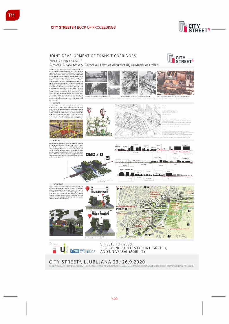
CITY STREETS 4 BOOK OF PROCEEDINGS
490
T11

CITY STREETS 4 BOOK OF PROCEEDINGS
491
T11
WHAT CHANGES ARE AUTONOMOUS VEHICLES BRINGING TO
URBAN SPACE
Urban Bračko, University of Ljubljana, Faculty of Civil and Geodetic Engineering
Peter Lipar , Assistant Professor, University of Ljubljana, Faculty of Civil and Geodetic Engineering
ABSTRACT
It is no longer a question in what kind of direction technology is developing. In a
not so distant future transport will become fully electric and autonomous. This will
largely improve road safety and lower the impact of traffic on the environment. It
will as well create new opportunities for architects and planners to make urban
space kinder for pedestrians and cyclists. But on the other hand it will also require
several changes in the infrastructure due to the needs for the operating of
intelligent transport systems. These are not only part of enhanced vehicle
equipment but are at the same time part of the infrastructure that needs to be
installed along the streets. The key importance is the orientation of a self-driving
car and its position on the road. They can both be already guaranteed by video
detection of lane markings, radar detection of other vehicles and improved real-
time GPS. However they soon might be replaced by new in-road technology which
will no longer be limited by weather conditions. With autonomous vehicles traffic
flow will function in a more controlled way and much higher level of mobility is
expected to be achieved. People will need to adjust their traveling habits where an
important role will be played by a service of car sharing and the new types of public
transport. All this will change the street environment and its usual cross section.
According to the urbanistic trends smart cities will continue to evolve rapidly. The
internet of things and a large connectivity of different platforms can lead to
significantly better efficiency of operations. Civil engineering could play a decisive
role in this process by paying more attention to the trends set by the informatics
and electronics.
Keywords: Civil engineering, future urbanism, autonomous driving, intelligent
transport systems

CITY STREETS 4 BOOK OF PROCEEDINGS
492
T11

CITY STREETS 4 BOOK OF PROCEEDINGS
493
AUTHORS INDEX
A
Abi Khalil, Marc ............................................... 329 Aboul Hosn, Lilia ............................................. 329 Antonić, Branislav ........................................... 432 Aoun, Oula .........................................................78 Aparicio, Maria Irene ....................................... 277 Assaf, Carine .................................................. 452
B
Bafaro, Sara .......................................................46 Beyrouti, Lola .................................................. 268 Bokal, Zala .........................................................33 Boltič, Gregor .................................................. 189 Borota, Jelena ................................................. 136 Borota, Marko ................................................. 136 Boulos, Paul .................................................... 383 Boutros, Marie-Belle ....................................... 329 Bračko, Urban ................................................. 491 Bucat, Mariana ................................................ 136 Burov, Angel ................................................... 165 Bustos Romero, Marta Adriana....................... 369
C
Cafuta, Oskar .................................................. 287 Chiarelli, Barbara ...............................................15 Crnič, Mia ........................................................ 109
Č
Čerpes, Ilka ..................................................... 125 Červek, Jernej ....................................................88 Čok, Gregor .................................................... 149
D
Dimitrova, Elena .............................................. 165 Djukić, Aleksandra .......................................... 432 Drobne, Samo ................................................. 149 Džananović, Mirza .......................................... 136
E
El Chakhtoura, Maya ....................................... 383 El Khoury, Peter ............................................... 225
F
Fikfak, Alenka .................................................. 403 Fischer, Wolfgang .............................................. 25 Folić, Branislav .................................................. 55 Foški, Mojca ..................................................... 149 Frančič, Matevž ............................................... 403
G
Garofolo, Ilaria ................................................... 15 Grom, Janez P. ................................................ 403 Gulič, Andrej ............................................ 174, 307
I
Ivanović, Milena ................................................. 55
J
Jawad, Dima .................................... 225, 329, 383 Juvančič, Matevž ............................................. 342
K
Khadra, Ralph .................................................. 329 Khneisser, Nasri .............................................. 383 Kilar, Vojko ....................................................... 317 Koblar, Simon .......................................... 174, 307 Komac, Blaž ..................................................... 250 Konda, Katarina ............................................... 259 Koren, David .................................................... 317 Kosanović, Saja ................................................. 55 Krajnik, Damir .................................................. 392 Kukoč, Višnja ................................................... 136 Kušar, Domen .................................................. 250

CITY STREETS 4 BOOK OF PROCEEDINGS
494
L
Lavtižar, Kristijan ............................................. 298 Lazarević, Milica ............................................. 432 Lazić, Marko .................................................... 480 Lipar, Peter ..................................................... 491 Lukić, Tamara ................................................. 392
M
Madrazo, Leandro ........................................... 277 Mady, Christine ....................................... 414, 452 Marchigiani, Elena .............................................15 Martínez Mansilla, María Eugenia .................. 369 Massaro, Alessandro ...................................... 157 Meyer, Lola ..................................................... 181 Mladenovič, Luka ............................................ 201 Mouawad, Pamela .......................................... 225 Mrak, Gašper .................................................. 149
N
Nashar Baroud, Dina ...................................... 101 Nikšič, Matej .........................................................2 Novljan, Tomaž ............................................... 463
O
Oberrauter, Sabine ............................................46 Olszewska, Natalia ......................................... 424 Oswalt, Philipp ................................................ 181
P
Pak, Burak ...................................................... 277 Petrović Krajnik, Lea ....................................... 392 Pogačar, Kaja ................................................. 442 Praper Gulič, Sergeja .............................. 174, 307 Proenca, Sérgio .................................................63
R
Reinbacher, Sabrina ..........................................25 Rettich, Stefan ................................................ 181 Robel, Steffan ................................................. 362
Rotondo, Francesco ........................................ 157 Rus, Katarina ................................................... 317
S
S. Gregoriou, S. ............................................... 489 Saalmann, Raphael David ................................. 25 Savvides, A. ..................................................... 489 Semaan, Julien ................................................ 383
Š
Šetina, Miha ..................................................... 189 Švigelj, Aleš ..................................................... 480
T
Tasheva-Petrova, Milena ................................. 165 Tawil, Nour ....................................................... 424 Tsigdinos, Stefanos ......................................... 209
V
Van den Broeck, Pieter .................................... 452 Vaništa Lazarević, Eva .................................... 217 Veber, Jaka ...................................................... 237 Vlastos, Thanos ............................................... 209 Vukmirović, Milena ............................................. 55
W
Wei, Lanlan ...................................................... 471
Z
Zavodnik Lamovšek, Alma............................... 149 Zupančič, Tadeja ............................................. 277
Ž
Žnidaršič, Kaja ................................................. 342