Preparing Village “Main Streets” for Planning May 2007
98
Preparing Village “Main Streets” for Planning Recommendations for the Village of Scottsville, NY May 2007
-
Upload
khangminh22 -
Category
Documents
-
view
1 -
download
0
Transcript of Preparing Village “Main Streets” for Planning May 2007

Preparing Village “Main Streets” for Planning
Recommendations for the Village of Scottsville, NY
May 2007

Acknowledgements
Staff Kevin Beers, Senior Planner*
Margaret DelPlato Economic Development Coordinator* Jason Haremza, AICP, Senior Planner*
Greta Goldberg, Economic Development Coordinator* Brian C. Slack, Senior Planner
Ellen Micoli-Soffa, Planner* Chris Tortora, Planner - Data, Technology & Resource Center
David S. Zorn, Executive Director
Interns Yenal Kucuker, SUNY Geneseo
Katharine Peters, SUNY Geneseo Julie Gotham, University at Buffalo
This report, along with other relevant project information, is available online at the following web address:
http://gflrpc.org/Publications/PVMSFP.htm
* Indicates staff no longer employed with G/FLRPC but who nonetheless provided important contributions during their tenure.

Preparing Village “Main Streets” for Planning
Recommendations for the Village of Scottsville, NY
May 2007
A report submitted to the Village of Scottsville, New York and Genesee Transportation Council in partial fulfillment of Stage I of the Preparing Village “Main Street” for Planning project, a
2004 – 2006 Unified Planning Work Program project.
Genesee/Finger Lakes Regional Planning Council 50 West Main Street • Suite 8107
Rochester, NY 14614 (585) 454-0190
http://[email protected]
Mission Statement
The Genesee/Finger Lakes Regional Planning Council (G/FLRPC) will identify, define, and inform its member counties of issues and opportunities critical to the physical, economic, and social health of the region. G/FLRPC provides forums
for discussion, debate, and consensus building, and develops and implements a focused action plan with clearly defined outcomes, which include programs,
personnel, and funding.

Preparing Village “Main Streets” for Planning Main Street Recommendations for the Village of Scottsville, NY
TTAABBLLEE OOFF CCOONNTTEENNTTSS FFOORRWWAARRDD .............................................................................................................................................................................................................. VV EEXXEECCUUTTIIVVEE SSUUMMMMAARRYY ............................................................................................................................................................................ VVII
II.. IINNTTRROODDUUCCTTIIOONN............................................................................................................................................................................................ 11 Objective of the Preparing Village “Main Streets” for Planning Project.............................................. 1
Project Structure and Components ......................................................................................................... 1 Reconstruction, Rehabilitation, and Revitalization: What’s the difference?.......................................... 2
IIII.. MMAAIINN SSTTRREEEETT IINN PPEERRSSPPEECCTTIIVVEE:: PPAASSTT,, PPRREESSEENNTT AANNDD FFUUTTUURREE ...................................................................... 55 An Evolving Landscape........................................................................................................................... 5
Centers of Influence: Main Street as Commercial District and Civic Center ........................................ 6 What Happened to America’s Main Streets? ......................................................................................... 7 Special Insert: Why are Main Streets Important Today? Excerpt from the National Trust for Historic Preservation ........................................................................................................................................... 8 Transportation and Main Streets: From Thoroughfare to Highway ....................................................... 9 Developing Lasting and Effective Solutions for Today’s Main Streets ................................................. 9
Preparing Your Main Street for Planning .............................................................................................. 11 IIIIII.. CCAASSEE SSTTUUDDYY CCOOMMMMUUNNIITTYY OOVVEERRVVIIEEWW...................................................................................................................... 1133 Case Study Community Application, Evaluation and Selection Process ......................................... 13
Local Main Street Steering Committee ................................................................................................ 13 Delineation of the Study Area .............................................................................................................. 15 Present Main St. Planning and Construction Status ............................................................................. 16
Inventory of Existing Conditions............................................................................................................ 16 General Historical Overview................................................................................................................ 16 Economic Development ....................................................................................................................... 17 Transportation History ........................................................................................................................ 17 Socio-Economic Profile ....................................................................................................................... 17 Transportation Profile........................................................................................................................... 21
1. New York State’s 2004 Highway Sufficiency Ratings ............................................................ 11 2. Road Safety ................................................................................................................................ 23
Land Use Profile................................................................................................................................... 24
IIVV.. PPUUBBLLIICC IINNPPUUTT........................................................................................................................................................................................ 2255 Public Meeting #1: Existing and Desired States................................................................................... 25
Meeting Overview................................................................................................................................ 25 Summary of Findings: Facilitated Public Comments........................................................................... 26
1. Issues to be Addressed.............................................................................................................. 26 2. Opportunities to be Seized ....................................................................................................... 26 3. Traffic Issues................................................................................................................................. 26
Genesee/Finger Lakes Regional Planning Council ii

Preparing Village “Main Streets” for Planning Main Street Recommendations for the Village of Scottsville, NY
4. Aesthetic Concerns ................................................................................................................... 27 Summary of Findings: Non-Facilitated Public Comments................................................................... 28
1. Signage and Aesthetics ............................................................................................................ 28 2. Parking, Traffic and Access ...................................................................................................... 28 3. Pedestrian Safety ....................................................................................................................... 29 4. Properties, Buildings and Facades .......................................................................................... 29 5. Parks and Trails............................................................................................................................ 29
Public Meeting #2: Presentation of Recommendations...................................................................... 33 Meeting Overview................................................................................................................................ 33 Public Reaction and Comments............................................................................................................ 33
VV.. MMAAIINN SSTT.. RREECCOOMMMMEENNDDAATTIIOONNSS ........................................................................................................................................ 3377 Structural/Physical Recommendations................................................................................................ 38
Roadway Area ..................................................................................................................................... 38 Sidewalk Area ..................................................................................................................................... 42 Building Area ....................................................................................................................................... 45
Regulatory Recommendations ............................................................................................................. 46 1. Minor Revisions to Current Zoning ................................................................................................. 46 2. Consideration of a Main St. Overlay District ................................................................................... 46 3. Comprehensive Planning and Future Strategic Planning ................................................................. 47
Programmatic/Organizational Recommendations ............................................................................ 50 1. Maintaining an Open, Active, and Effective Main Street Committee.............................................. 50 2. Evaluation/Consideration of Other Organizational Structures ......................................................... 51 3. Encouraging a Meaningful Citizen/Stakeholder Role in All Decision Making ............................... 52
AAPPPPEENNDDIICCEESS .................................................................................................................................................................................................... 5555
A. Technical Committees B. Application for Planning Services C. Explanation of Codes and Characteristics of NYS Highway Sufficiency Ratings D. TIP Eligible Project Types by Funding Program E. NYSDOT Region 9 Main Street Survey F. Main St. Overlay District – Wellfleet, MA G. Parking Management Best Practices H. Glossary/Acronyms
Genesee/Finger Lakes Regional Planning Council iii

Preparing Village “Main Streets” for Planning Main Street Recommendations for the Village of Scottsville, NY
MMAAPPSS AANNDD CCHHAARRTTSS Map: Regional Transportation Network ................................................................................................. 14 Map: Overview of Main Street Study Area ............................................................................................ 15 Chart: Demographic Profile..................................................................................................................... 19 Chart: Population Pyramid....................................................................................................................... 20 Chart: Population Change, 1990 – 2000 ................................................................................................ 20 Map: Focus Road Segments.................................................................................................................... 21 Chart: Sufficiency Ratings – General Characteristics ........................................................................... 22 Chart: Sufficiency Ratings – Traffic.......................................................................................................... 22 Chart: Sufficiency Ratings – Physical Condition .................................................................................... 23 Chart: Sufficiency Ratings – Adjusted Rate Capacity and Volume/Capacity Ratio....................... 23 Map: Zoning Districts within Village of Scottsville .................................................................................. 24 Map: Summary of Non-Facilitated Public Comments – Rochester St. Historic District ..................... 30 Map: Summary of Non-Facilitated Public Comments – Main St. Focus Area ................................... 31 Map: Summary of Non-Facilitated Public Comments – Parks and Trails............................................ 32 Map: Locations That Could Benefit from Enhanced Crossings ........................................................... 39 Chart: Savings Rates of United States Workers, Excluding Home Value ............................................ 49
Genesee/Finger Lakes Regional Planning Council iv

Preparing Village “Main Streets” for Planning Main Street Recommendations for the Village of Scottsville, NY
FFOORRWWAARRDD When guests visit the Village of Scottsville for the first time, their remarks are usually replete with adjectives such as “charming,” “quaint,” “picturesque,” and “friendly.” Often, visitors will comment on the beautiful architecture, residential landscaping, or efforts undertaken to maintain the Village’s historic identity. The Village of Scottsville and its residents are deservedly proud of their community and heritage. It was this ardent pride, coupled with a visionary attitude that motivated Village officials to apply for participation in the Preparing Village “Main Streets” for Planning study. Sponsored and prepared by the Genesee/Finger Lakes Regional Planning Council with funding from the Genesee Transportation Council, and designed to assist municipalities as they begin to plan for reconstruction or rehabilitation of “main streets” or business districts, the study represented a critical piece in the Village’s future landscape. Of the 192 municipalities eligible for the study, Scottsville was one of two chosen to participate. Why the focus on Main Street? American main streets, dating back to the 1800s, have served a variety of functions over the years, most notably as commercial districts and civic centers. And while economic and societal trends have necessitated some changes to the operation of main streets, the Village of Scottsville continues to recognize and support the belief that our Main Street remains a cornerstone in the community. Unyielding in this belief, the Main Street Steering Committee approached this intensive study with a clear desire to fortify Main Street as a sustainable, vital, and integral asset in our community. As you examine this study, its findings, and recommendations, we hope you will feel enlightened by discovery and energized with possibility. We trust that you will grow excited at the opportunities before us. We look forward to many of you joining us as we begin incorporating the study’s recommendations into the strategic planning process, thus striding towards the gratifying phases of implementation. Why now? Preparing Village “Main Streets” for Planning materialized at a perfect time for Scottsville. Many of the structural, physical, regulatory, programmatic and organizational recommendations proposed in the study are profoundly relevant to other current revitalization efforts and ideas pertaining to Main Street. “This project will help facilitate more productive revitalization efforts by establishing a framework for action and providing communities with a greater awareness and understanding of the issues and options…” (page 1). Equipped with enhanced knowledge and the study’s guidance, the Village of Scottsville stands poised and prepared to address the next steps of revitalization. ~~ SSUUBBMMIITTTTEEDD BBYY TTHHEE SSCCOOTTTTSSVVIILLLLEE MMAAIINN SSTTRREEEETT SSTTEEEERRIINNGG CCOOMMMMIITTTTEEEE
Genesee/Finger Lakes Regional Planning Council v

Preparing Village “Main Streets” for Planning Main Street Recommendations for the Village of Scottsville, NY
EEXXEECCUUTTIIVVEE SSUUMMMMAARRYY The Preparing Village “Main Streets” for Planning project is designed to address the body of issues that could potentially arise when reconstruction or rehabilitation of roadways that traverse a central business district or “main street” area is going to occur. This report – and its companion for the Village of Newark – presents the findings of the first phase of the project, providing recommendations to the Village of Scottsville based on a year-long evaluation of the community’s present attributes, future needs, and desired state. The report consists of five chapters and an appendix. Chapter I summarizes the objective, structure, and components of the Preparing Village “Main Streets” for Planning project. In an effort to provide clarity for the reader, three terms used frequently throughout the report – reconstruction, rehabilitation, and revitalization – are defined and their contextual background is explained. Chapter II provides the reader with a comprehensive review of the significance of main streets over time. The historical context of main streets is described in detail, illustrating the influence that these spaces have had on and within communities since the 1800’s. Main streets are described in terms of the functions that they served – as both a commercial district for the exchange of goods and services and as a civic center that facilitated the convivial interaction between residents for the purposes of finance, worship, governance, relaxation, or celebration. The variety of economic conditions, societal trends, and national policies that brought a decline to main street areas after the mid-20th Century is briefly described. During this period of decline, and partly as a result of it, many main streets were adapted to serve primarily as transportation corridors. Physical alterations that were made to promote the safe and efficient movement of traffic came, at times, at the expense of their historic attributes, detracting from their overall character and ambiance. The chapter concludes with a call for developing effective solutions that address the needs of today’s main street areas. The development of an adaptive, context-sensitive approach that strikes a balance between transportation, commerce, public interest, and community character is identified as an amenable framework. Chapter III provides an overview of the case study community. A summary of the selection policy and process used by the project Technical Committee is included, as well as a delineation of the project study area and the development and role of the local main street steering committee. An inventory of existing conditions follows, including descriptive sections which address the following six subject areas: general historical context; economic development history; transportation history; present socio-economic conditions; present transportation conditions; and a current land use profile. Chapter IV embodies the project’s overall emphasis on the importance of public involvement in the planning process. The chapter describes the process used to gather input from the public regarding the “existing” and “desired” states of the case study corridor and presents the data generated from that process. Public input was solicited through two primary mechanisms: directly at a public meeting and indirectly through a survey tool. A two-hour public meeting was held on December 3, 2006. Individuals in attendance were given a 45 minute presentation on the case study area. Issues pertaining to the strengths, weaknesses, opportunities and threats regarding transportation, pedestrian safety, community character and other relevant subject areas within the case study area were reviewed by G/FLRPC staff.
Genesee/Finger Lakes Regional Planning Council vi

Preparing Village “Main Streets” for Planning Main Street Recommendations for the Village of Scottsville, NY
Participants were then asked to visit one or more “stations” throughout the venue where their concerns could be submitted and recorded through a variety of mediums. These included both facilitated and non-facilitated comments which were recorded on charts and maps. All issues voiced by the public are summarized by subject area; in some instances, specific issue locations are illustrated with descriptive maps. Survey tools were distributed to residents and property owners within the case study area. Submitted survey data was integrated into the overall Summary of Findings. Chapter V presents G/FLRPC’s recommendations for the case study corridor. Recommendations were generated from a variety of sources, including the application of the latest information and research on context-sensitive solutions and urban design, numerous staff field visits, agency consultation (specifically, NYSDOT Region 4 and Genesee Transportation Council), local steering committee concerns, and information gained through the public input process. Recommendations were separated into three primary categories: Structural/Physical Recommendations, Regulatory Recommendations, and Programmatic/Organizational Recommendations. Structural/Physical Recommendations were further divided into three categories that together comprise the entire case study area: the roadway, the sidewalk and the building areas. Here, a variety of practical recommendations and design alternatives are put forth. Concepts pertaining to traffic calming, access, pedestrian safety, and streetscape appearance are explained; in some instances, alternatives are offered. Regulatory Recommendations address the two pieces of land use regulation and control: specifically, the comprehensive plan and zoning law. Local laws were reviewed and evaluated according to their overall effectiveness in promoting a desirable main street area. Recommendations were put forth in this regard, proposing several minor revisions to current zoning regulations. Future strategic planning initiatives were also recommended, emphasizing a community visioning process and incremental implementation in order to control costs and allow for a continual community evaluation process. Programmatic/Organizational Recommendations emphasized the importance of incorporating the public into the planning process well in advance of any serious planning and design activities. Recommendations for maintaining an open, active and effective main street steering committee were provided. A variety of organizational structures that can be used to guide the main street planning process were also presented and explained. Finally, the encouragement of a meaningful citizen/stakeholder role throughout the decision-making process was re-emphasized, described in part through the inclusion of the American Association of State Highway and Transportation Officials’ six components of an effective public involvement program. Appendices include: an explanation of the structure of the project Technical Committee, local main street steering committees and associated members therein; a copy of the Application for Planning Services used to solicit case study community participation; an explanation of the codes and characteristics of NYS Highway Sufficiency Ratings, as cited in Chapter III; a summary of Transportation Improvement Program eligible project types; a NYSDOT main street survey; and other tools and references associated with this project.
Genesee/Finger Lakes Regional Planning Council vii


Preparing Village “Main Streets” for Planning Main Street Recommendations for the Village of Scottsville, NY
II.. IINNTTRROODDUUCCTTIIOONN Objective of the Preparing Village “Main Streets” for Planning Project The primary objective of the Preparing Village “Main Streets” for Planning project is to engage communities that are considering strategic planning for their “main streets” or village centers and anticipating future infrastructure updates, rehabilitation or reconstruction of these areas. Such construction projects typically require significant demolition of the street and sidewalk right-of-way and the new facilities erected therein are typically designed to last several decades or more, affording communities few opportunities to affect their design after the planning and construction phases have been completed. This project was therefore conceived as a means of empowering communities with useful information on planning and design for main street renovations well in advance of significant construction projects. Significant alteration and investment in transportation and/or other street-side infrastructure creates a unique opportunity for a community to improve its overall function, vitality and character. Early intervention and public participation in the planning of new facilities is therefore recognized as a critical part of ensuring suitable and equitable outcomes. Many of the guidelines advanced through the Preparing Village “Main Streets” for Planning project are put forth as best management practices that are applicable to all main street communities in the Genesee/Finger Lakes region, independent of plans or schedules for actual construction activities. These are goals that all communities should strive for as they work toward improving the quality of life for residents and visitors alike.
Project Structure and Components Preparing Village “Main Streets” for Planning will build upon the work completed for Main Street Transportation Tools under the 2002-2003 UPWP and other “main street” projects.1 This project will help facilitate more productive revitalization efforts by establishing a framework for action and providing communities with a greater awareness and understanding of the issues and options associated with various types of capital improvement projects that occur along local, county or state highways. A central goal of the Preparing Village “Main Streets” for Planning project is to reinforce the need for main street planning efforts to be both continual and self-evaluative. Communities that find themselves attempting to address the long-term needs of their main streets on a short-term basis will rarely be able to enjoy sustainable, enduring, or economical results. Continual self-evaluation of community needs – be they infrastructural, economic, aesthetic or otherwise – can provide communities with a framework for proactive and effective community organization and planning. The project developed two primary products in separate stages. This main street recommendation report – and its companion for the Village of Newark – comprises the first stage. The process of main street revitalization efforts within the two communities was approached in a holistic sense in an effort to identify and explore relevant topics and assist in synthesizing community vision with policy,
1 Genesee/Finger Lakes Regional Planning Council. “Main Street Transportation Tools.”
http://gflrpc.org/Publications/MSTT.htm Last viewed 7/26/06.
Genesee/Finger Lakes Regional Planning Council 1

Preparing Village “Main Streets” for Planning Main Street Recommendations for the Village of Scottsville, NY
design, and other services and resources. Performing community inventories, summarizing data, identifying potential resources and partners, and preparing community recommendations for revitalization efforts are intended outcomes. Community input has been a key component in the development of the recommendations for revitalization. The second stage of this study includes the production of a guidebook detailing key main street revitalization components, intended to be utilized “off the shelf” for any community in the region. This guidebook incorporates lessons learned from other communities that have experienced notable main street construction projects in the recent past and also includes summaries of circumstances observed in Newark and Scottsville. The guidebook further explores the variety of issues and trends in main street and transportation infrastructure and design. Primary themes include the nexus between roadway, sidewalk and building area in a downtown space, as well as how the structure and scale of these spaces can help reinforce a unique “sense of place” for visitors.2 Key resources, partners and other pertinent data relevant to main street rehabilitation will also be included.
Reconstruction, Rehabilitation, and Revitalization: What’s the difference? Throughout this report, the terms rehabilitation, reconstruction and revitalization will be used frequently; it is important to note, however, that they are not interchangeable. The American Association of State Highway and Transportation Officials (AASHTO) was formed in 1914 in an effort to create a forum in which professionals from across the country could discuss and evaluate transportation efficiency and safety. Since then, AASHTO has continually been creating and refining uniform standards in highway maintenance, design and construction. According to AASHTO, a variety of facts are weighed when determining if a street’s surface should be physically rehabilitated or whether it should be entirely reconstructed.3 Reconstruction of existing highways implies substantial changes to the three-dimensional features of the highway. Many reconstruction projects in Upstate NY do not typically involve significant capacity expansion (such as widening from two lanes to four lanes). Most reconstruction projects tend to focus on ways of improving the overall function and safety of the roadway. The age and history of the road will ultimately determine what alterations are necessary and when and where compromises in design can be made. Historic functional trends of the highway, such as safety records and operational performance, as well as context-specific conditions (historic buildings, landmarks, local character, etc.) are among those that should be taken into account. In some cases, reconstruction will also include replacing a good deal of below-ground infrastructure, in particular water, stormwater, sewer and gas lines. The lifespan of reconstruction projects are generally intended to be long and the work performed will almost always involve serious disturbance of the road right of way. Replacement of below-ground facilities during this period is therefore likely to become warranted in order to avoid further disruption of highway in the near future.
2 For more information on the concept of “Sense of Place,” refer to the article “The Nature of Sense of Place” at:
http://www.eslarp.uiuc.edu/la/la437-f95/reports/yards/main.html Last viewed 7/26/06. 3 American Association of State Highway and Transportation Officials (AASHTO). A Guide for Achieving
Flexibility in Highway Design. May 2004.
Genesee/Finger Lakes Regional Planning Council 2

Preparing Village “Main Streets” for Planning Main Street Recommendations for the Village of Scottsville, NY
AASHTO groups resurfacing, restoration, and rehabilitation (3R) projects into the same general category. These projects typically leave the majority of below-ground infrastructure intact and focus on the street’s pavement, shoulders and possibly curbing, signage or sidewalks as necessary. Regarding 3R projects, the AASHTO publication A Guide for Achieving Flexibility in Highway Design states:
Such projects by definition do not include substantive changes in the geometric character of the road, but a very important consideration is that they enhance safety. Most [state DOT] agencies utilize special design criteria for 3R projects. Criteria generally reflect an acceptance of existing features regardless of whether they meet current agency criteria for a new highway. Of course, an important consideration in retaining an existing design dimension for 3R projects is the safety and operational performance of the existing road.4
In all cases, pavement and shoulder conditions are determined based on standardized, uniform field evaluation and compilation procedures, resulting in a determination of the road’s level of distress. This data is used in combination with other objective information to evaluate appropriate alternatives based on the life-cycles of said alternatives and other associated costs. A detailed explanation of the methodology and procedures used by the NYS DOT can be found in the Comprehensive Pavement Design Manual at the address referenced below.5 Further explanation of roadway evaluation criteria are provided in Chapter III and in the Appendices of this report. Finally, revitalization in the context of this report refers to a combination of factors which lead to an overall improvement of the vitality and character of a neighborhood or area. Factors typically include a mix of physical, aesthetic, commercial, political, regulatory and organizational initiatives which result in equitable and tangible improvements to the area’s social, physical and economic well-being.
4 AASHTO. Page 21. 5 NYS DOT Publications. Comprehensive Pavement Design Manual. Last viewed 7/28/06 at
http://www.dot.state.ny.us/cmb/consult/cpdmfiles/cpdm.html .
Genesee/Finger Lakes Regional Planning Council 3


Preparing Village “Main Streets” for Planning Main Street Recommendations for the Village of Scottsville, NY
I
III.. MMAAIINN SSTTRREEEETT IINN PPEERRSSPPEECCTTIIVVEE:: PPAASSTT,, PPRREESSEENNTT AANNDD FFUUTTUURREE An Evolving Landscape The Genesee/Finger Lakes region of Western New York is home to a wide variety of historic main streets and village centers, each of which has its own unique feel, ambiance and vitality. Many of these spaces are also in various states of repair and may be enjoying thriving commercial success or struggling to find or maintain viable businesses. Some regional main streets have experienced significant refurbishment in recent years with assistance from concerned citizens, dedicated local officials, private engineering and consulting firms and state agencies such as the New York State Department of Transportation (DOT) and the New York State Division of Housing and Community Development. Other regional main streets are struggling to various extents, presenting a host of challenges and opportunities for communities that are willing to put forth the attention, effort and investment. Main street and downtown revitalization efforts typically involve a complex blend of expertise, organization, resources and effort over a protracted period of time before successes can be realized. Capital improvements such as street and sewer reconstruction are no exception to this rule and can easily overwhelm a municipality’s organizational or financial capacity. These operations can also test the patience and mettle of the community at large – businesses can lose patronage, traffic is often slow and inconvenient, and an exposed roadway is typically unattractive, messy and hazardous to people and vehicles. All of these challenges underscore the need for a collaborative community-wide planning and outreach initiative in an attempt to manage the public’s expectations, build consensus and work toward long-term, sustainable project outcomes. Successful main streets and downtown centers do not simply “happen” – they are created through concerted participation and effort at a variety of levels, typically over the course of many years. The region’s main streets are evolving landscapes, molded and shaped by local inhabitants and outside
agencies in order to meet and adapt to the needs of their users – at times with unintended consequences. Indeed, since their inception, changes to these spaces have been occurring incrementally, with both positive and negative results. The shape that these spaces take and the functions that they serve in the future depends in large part on the decisions and efforts of their current inhabitants.
Row houses on South Main Street – Geneva, NY. Source: www.visitfingerlakes.com
Striking a balance between modern, adaptive uses for these spaces while recognizing and respecting their heritage and the “initial intentions that called for their creation” is a major challenge for those involved in planning for main streets.66 The communities that
6 Childs, Mark C. Squares: A Public Place Design Guide for Urbanists. University of New Mexico Press: 2004. 15.
5 Genesee/Finger Lakes Regional Planning Council

Preparing Village “Main Streets” for Planning Main Street Recommendations for the Village of Scottsville, NY
succeed in doing so, however, will find that they have not only contributed to the immediate surroundings of their downtown landscape, but to the health and well-being of the entire community and to the region as a whole. The following sections provide further perspective and context to the issue of planning for main streets by describing their geographic, cultural, historic and economic significance within the American landscape.
Centers of Influence: Main Street as Commercial District and Civic Center Human movement can be measured by two basic elements: time and distance. As our ability to travel greater distances in shorter periods of time has changed, so have the spaces upon which we travel. Main streets have evolved in both purpose and function in order to accommodate the various needs of the day. Many main streets originated as regional transportation corridors – trails and later roads along which movement was either convenient or otherwise beneficial to its users. As these corridors proved successful with greater use and interconnections, they became established as regional hubs – central spaces recognized as strategic locations to trade, conduct business and provide the public with a variety of services. Main street buildings were typically spaced close together and had occupants on all levels, including a mix of what were typically first floor retailers and second- and third- floors for offices and apartments. The presence of such institutions as the library, banks, and local and county level government offices provided a critical mass of users – both vehicular and non-vehicular along a central boulevard or thoroughfare. Complimentary services such as grocery stores, restaurants, haberdasheries, and repair shops reinforced these places as viable centers of social, economic and civic activity. “Conviviality…” writes Mark C. Childs, “is the vibrant sense of belonging to a settlement.”7 As regional economies and their comprising cities, towns and villages thrived, local residents expressed their financial successes, local prominence, civic pride, and cherished values in the design and construction of their buildings and the surrounding public and private spaces. This phenomenon was all too common on American main streets. In combination with adjoining local streets, walkways, squares and parks, these spaces comprised a public sphere which essentially became greater than the sum of its parts in many communities. Main streets provided local residents and visitors with what is commonly referred to today as a sense of place – spaces that were “…firmly woven Main St. – Oakfield, NY. Date unknown.
Source: http://www.oakfield.govoffice.com/
7 Childs, Mark C. 3.
Genesee/Finger Lakes Regional Planning Council 6

Preparing Village “Main Streets” for Planning Main Street Recommendations for the Village of Scottsville, NY
into the context in which they [were] located.”8 These common spaces typically made plentiful use of local resources. Building materials, such as local varieties of granite, sandstone or brick, and further, the various skills brought by local artisans and tradesman, coalesced to define the character of local main streets through their built forms. Moreover, the distinctions of local economies and regional markets had direct impact on the types of buildings that would be necessary to accommodate the various trades. Warehouses, mills, factories and merchants’ shops of various sorts stand as vestiges of a locale’s historic means of prosperity.
Many downtowns and main streets exhibit distinct pattern languages – repetitive symbols and design features in streetscape and architecture. While these pattern languages may have been repetitive across North America, each main street is as inextricably unique as the people who have lived and the stories that have transpired upon them through the decades. Many of these patterns have been well-preserved and can be observed throughout main street corridors today, to lesser or greater extents. Some of these spaces, on the other hand, have suffered significant distress and neglect due to a variety of causes, including economic decline, public policy, or from local disasters, such as fires or floods.
What Happened to America’s Main Streets? Historically, main streets served as both the commercial and civic core of communities. As American society evolved, so did its landscape. Due in part to the increased use of automobiles and the creation of the Interstate Highway System, there was a movement of people and services away from the central core of communities along main streets. Roads that once connected neighborhoods mixed with stores and apartments in downtown areas now carried residents to outlying regional malls, shopping strips and subdivisions. Second and third floor living spaces were also becoming less appealing to renters and owners, and many were vacated or adapted for other uses, such as storage. By the mid-1960’s, the prominence of many Upstate New York main streets was beginning to erode in the face of other competing centers of social, civic and commercial influence. The diversification and proximity of land uses has given people more options with regard to where they can live, work and play. The consequences of these changes in movement can be observed along main streets, some of which have struggled to maintain businesses and patrons as a result. These implications do not stop there, however. The popular modern spaces built for commerce and interaction – such as the strip mall or corporate campus – have been heavily criticized for their lack in overall character and quality of design. While these spaces may serve their purpose in an efficient and functional manner, many of them fall far short of providing the public with the sense of place that main streets and their surrounding neighborhoods did so well. While proponents and detractors of modern building and development practices will continue to debate the merits of these forms of construction, it is difficult to deny that some common trends in road and building design – particularly those which cater to automotive as opposed to human scales – detract from the convivial atmosphere that is typically provided by traditional main street spaces.
Cont. on page 9
8 Hannah, Gail Greet. “Creating the Built Environment: Issues and Trends in Design.” Landscapeforms. 18. Last
viewed online 6/27/06 at http://www.landscapeforms.com/insites/whitepapers/create_built.htm
Genesee/Finger Lakes Regional Planning Council 7

Preparing Village “Main Streets” for Planning Main Street Recommendations for the Village of Scottsville, NY
WWhhyy aarree MMaaiinn SSttrreeeettss IImmppoorrttaanntt TTooddaayy??99 Given the increase in competition and diversity of consumer choices offered by modern “big box” developments and malls, how can traditional commercial districts remain relevant as centers of influence, commerce and interaction? The National Trust for Historic Preservation’s Main St. Center provides twelve reasons: 1. Commercial districts are prominent employment centers. Even the smallest commercial district
employs hundreds of people, and often the district is collectively the community's largest employer. 2. The commercial district is a reflection of community image, pride, prosperity, and level of
investment – critical factors in business retention and recruitment efforts. 3. Main Street represents a significant portion of the community's tax base. If the district
declines, property values drop, placing more of a tax burden on other parts of town. 4. The traditional commercial district is an ideal location for independent businesses, which in
turn: • Keep profits in town. Chain businesses send profits out of town • Support other local businesses and services • Supports local families with family-owned businesses • Supports local community projects, like teams and schools • Provide an extremely stable economic foundation, as opposed to a few large businesses and chains with no ties to stay in the community
5. Main Street is the historic core of the community. Its buildings embody the community's past and its visual identity.
6. A historic commercial district is often a major tourist attraction. When people travel or shop, they want to see unique places – especially ones that offer a unique shopping "experience."
7. A vital Main Street area reduces sprawl by concentrating retail in one area and uses community resources wisely, such as infrastructure, tax dollars, and land.
8. A healthy Main Street core protects property values in surrounding residential neighborhoods. 9. The commercial district offers convenience. Main Streets are often within walking distance of
residential areas, providing easy accessibility for the community and reducing the reliance on auto-dependent shopping.
10. The district is usually a government center where city hall, municipal buildings, the courthouse, and/or post office are located. It often is an important service center as well for finding attorneys, physicians, insurance offices, and financial institutions.
11. Main Street provides an important civic forum, where members of the community can congregate. Parades, special events, and celebrations held there reinforce intangible sense of community. Private developments like malls and strip centers can and do restrict free speech and access.
12. The commercial district represents a huge public and private investment. Imagine how much it would cost to re-create all of the buildings and public infrastructure in your commercial district.
9 National Trust for Historic Preservation. “Why are Main Streets Important?”
http://mainstreet.org/content.aspx?page=1927 Last viewed 7/21/06.
Genesee/Finger Lakes Regional Planning Council 8

Preparing Village “Main Streets” for Planning Main Street Recommendations for the Village of Scottsville, NY
Automotive-centered design is of particular relevance when considering populations such as the poor, elderly and disabled. These populations – some of which comprise a rapidly- growing segment of our communities – generally do not enjoy the same degree of freedom and mobility that many Americans take for granted. When considering the overall growth, development and maintenance of our communities, local officials, planners and developers must carefully examine the needs of the entire population as opposed to certain segments. This will involve a delicate balance between meeting the needs of an efficient transportation network with preserving the qualities that make our main streets unique, safe and friendly places for people to enjoy. Transportation and Main Streets: From Thoroughfare to Highway Transportation networks (such as local streets, county roads and state and federal highways) and transportation modes (such as air, rail, boat, bus, automobile, bike and foot) tie a community together and link it to other neighboring communities. Streets provide safe and reliable access to work, schools, shopping and residences. The livelihood of a community depends on how goods and services are imported or exported, thus there is a strong connection between main street viability and the transportation network. Main streets, however, do not exist solely to meet the needs of the transportation system. As explored in the sections above, traditional main street design has come to serve a variety of benefits other than movement – in particular, providing convivial, meaningful spaces in which to meet, interact, relax or conduct business with one another. Because many main streets are typically along a state highway, these aspects can easily suffer at the expense of promoting an efficient, congestion-free transportation system. These two goals – transportation efficiency and the preservation of comfortable public spaces – can sometimes be in conflict with each other. Indeed, many of the typical approaches to more efficient highway design, such as lane additions, land and shoulder widening, unobstructed sight lines, etc., are incompatible with a traditional main street landscape. Trees, shade, pocket parks, convenient parking, pedestrian facilities, and other elements or amenities that promote an atmosphere conducive to what could be described as a “community-friendly environment” are typically sacrificed in an effort to increase traffic flow or to maintain or improve the level of service of these roadways. Furthermore, weak or contrived attempts to interject components of traditional main street design in the absence of a comprehensive consideration of the entire main street landscape are often met with displeasure and fall far short of their intended purpose. Developing Lasting and Effective Solutions for Today’s Main Streets Integrating context sensitive solutions (CSS) into the planning and design of main street centers presents highway officials and main street advocates with flexible approaches that can complement both transportation efficiency and the preservation of main street character. CSS provides a dynamic framework for addressing the range of issues that are likely to arise during a transportation project. Two organizations that have advocated this concept in the past include the Institute of Transportation Engineers (ITE) and the Congress for New Urbanism. While not a new concept for either group, this recent collaboration indicates a new era of cooperation between diverse schools of thought in an effort to establish best management practices in highway design, with a specific focus on walkable communities (i.e. main streets). The culmination of their work (a manual currently under final draft
Genesee/Finger Lakes Regional Planning Council 9

Preparing Village “Main Streets” for Planning Main Street Recommendations for the Village of Scottsville, NY
CCoommmmoonn IIssssuueess TThhaatt NNeeggaattiivveellyy AAffffeecctt TTrraannssppoorrttaattiioonn PPrroojjeeccttss:: ◦ Real or perceived incompatibility with surroundings; ◦ Community impacts; ◦ Emphasis on mobility without consideration of other community values; ◦ Disproportionate spread of benefits or impacts [to people or the environment]; ◦ Lack of stakeholder education and participation throughout the planning and design
processes PPrriimmaarryy PPrriinncciipplleess ooff CCoonntteexxtt SSeennssiittiivvee SSoolluuttiioonnss:: 1. The project satisfies the purpose and needs as agreed to by a full range of stakeholders. This
agreement is forged in the earliest phase of the project… 2. The project is a safe facility for both the user and the community. 3. The project is in harmony with the community, and it preserves environmental, scenic,
aesthetic, historic and natural resource values of the area [i.e. exhibits context sensitive design].
4. The project exceeds the expectations of both designers and stakeholders and achieves a level of excellence in people’s minds.
5. The project involves efficient and effective use of the resources (time, budget and community) of all involved parties.
6. The project is designed and built with minimal disruption to the community. 7. The project is seen as having added lasting value to the community. From the draft manual Context Sensitive Solutions in Designing Major Urban Thoroughfares for Walkable Communities. A publication of the Institute of Transportation Engineers. pp 6 – 9
review) suggests that unsuccessful transportation projects often result due to a lack of understanding of community values and an overall failure to address stakeholder issues and concerns early on in the planning stages of the project. Using a CSS approach to the planning and design process can help to “minimize problems and delays by ensuring stakeholder involvement, identification of issues and community values and evaluation of alternative solutions that meet the needs and purpose of the project.” 10 Perhaps more importantly, a CSS approach can also play a significant role in re-establishing Upstate village and town centers as important hubs for civic engagement, economic activity, and regional influence. As American consumers continue to be offered a dizzying array of choices within the marketplace, producers struggle to find innovative ways to give their products a competitive edge. Communities are no exception to this rule; concepts in urban design such as mixed-use and walkability are attributes that many consumers and producers are searching for in today’s real estate market. Those towns and villages that can set themselves apart in the marketplace will significantly further the chances of their economic success. By embracing the traditional mixed-use paradigm that many modern developers
10 Institute of Transportation Engineers. “Context Sensitive Solutions in Designing Major Urban Thoroughfares for Walkable Communities: An ITE Proposed Recommended Practice (Draft).” 2006. PP 6.
Genesee/Finger Lakes Regional Planning Council 10

Preparing Village “Main Streets” for Planning Main Street Recommendations for the Village of Scottsville, NY
are striving for in new developments, regional towns and villages can set themselves apart through the enhancement and promotion of their main street’s authentic elements and character.
Preparing Your Main Street for Planning The recommendations that follow in this report and its companion for the Village of Newark have been compiled with the intent of providing interested community members with a starting point for re-envisioning their main street areas. In effect, it is a course outline in the subject of main street renovation for both beginner and veteran citizen planners and local public managers alike. It will present readers with a way to approach and view the built environment of their downtown areas and consider a variety of options for the future. The report will also delve into important organizational and process-oriented considerations which often present local administrators with some of the most difficult challenges during major projects. Negotiating with important agencies and understanding key processes, rules and regulations are areas that will be explored. This report will target issues specific to the case study community, providing detailed insight when and where available and necessary. The Preparing Village “Main Streets” for Planning guidebook includes many of these same issues, and also expounds on other topics to greater or lesser degrees which very likely pertain to other communities within the Genesee/Finger Lakes region. Together, these resources should provide interested stakeholders with an excellent starting point for approaching a variety of main street revitalization projects.
Genesee/Finger Lakes Regional Planning Council 11


Preparing Village “Main Streets” for Planning Mai
Genesee/Finger
n Street Recommendations for the Village of Scottsville, NY
Lakes Regional Planning Council 13
IIIIII.. CCAASSEE SSTTUUDDYY CCOOMMMMUUNNIITTYY OOVVEERRVVIIEEWW Case Study Community Application, Evaluation and Selection Process The approved scope of tasks for the Preparing Village “Main Streets” for Planning project called for planning and outreach services to be provided to several municipalities anticipating significant infrastructure improvements in the near future (5 to 10 years, roughly). The purpose of this task was twofold: 1) to assist these communities in their efforts to improve their core main street areas and 2) to learn from this process and convey any applicable lessons to other municipalities that may be anticipating similar efforts through description within the project guidebook. Each of these tasks falls closely in line with G/FLRPC’s underlying mission, which is to “identify, define, and inform its member counties of issues and opportunities critical to the physical, economic, and social health of the region.”11
Draft criteria for case study community selection were prepared by G/FLRPC staff and evaluated and approved by the project technical committee in May of 2005. Applications for case study community participation in the project were distributed to the highest elected official for each of the 192 member municipalities of the Genesee/Finger Lakes region.12 Those applications had to be returned for evaluation by early July of that year for consideration; a total of eleven applications were received. Each application was reviewed by G/FLRPC staff and the technical committee and evaluated based on its individual merits. The Village of Scottsville’s application was selected by the project technical committee due to its combination of local enthusiasm, current and future planning needs, applicability, and various other geographic and organizational attributes.
11 Text is an excerpt of the Mission Statement of Genesee/Finger Lakes Regional Planning Council. http://gflrpc.org/ 12 A copy of the case study community selection criteria and blank application form can be found in Appendix A of
this report.
Local Main Street Steering Committee In the summer of 2005, municipalities selected for the project were asked to organize a local main street steering committee of at least 5 individuals. It was asked that the makeup of committee members consist of a mix of appropriate community representatives, including (but not limited to) business owners, elected officials, local administrators, parents, senior citizens, and other local citizens representative of various stakeholder groups. The purpose of the committee would be to initially guide project progress, identify and establish local goals and priorities, make key decisions regarding public meetings, provide necessary input regarding data acquisition, and review final recommendation reports before public release. A list of committee members has been provided in Appendix A of this report. An overarching purpose of forming a local main street steering committee hinges on the importance of having a cohesive group of dedicated individuals committed specifically to the main street planning process over an extended period of time. It is intended that these individuals continue to serve as liaisons to the community at large as progress toward implementing main street improvements moves forward. Further explanation of the importance of a responsive organizational structure to guiding main street revitalization efforts can be found in Chapter V of this report.

n Street Recommendations for the Village of Scottsville, NY
Lakes Regional Planning Council 14
Preparing Village “Main Streets” for Planning Mai
Genesee/Finger
Regional Transportation Network Relative to Scottsville, NY

Preparing Village “Main Streets” for Planning Main Street Recommendations for the Village of Scottsville, NY
Delineation of the Study Area The attributes associated with a main street corridor often overlap into other parts of the community. In many instances, a main street corridor gradually becomes defined as a commercial area as visitors transition in to and out of the central business district. One of the initial tasks of the main street steering committee was to consider the explicit boundaries of the study area for this project. Committee members and G/FLRPC staff agreed that the focus area should include the linear road segments along Scottsville’s primary corridor that are most likely to undergo construction within the coming years. Furthermore, it was agreed that particular focus should be given to the Central Business District (CBD) with respect to physical form and function. Along those road segments, focus will be given to the general road right of way, up to and including front walks and building façades. Other minor arterial corridors will also be considered as necessary (with particular emphasis on pedestrian/trail connections). Overview of Scottsville Main Street Study Area
As shown above, the main street study area begins at the village’s SW border on State Rt. 383, continuing through Main Street, veering northerly along Rochester St and ending on State Rt. 253 at the village’s NE border. The Main Street CBD is the primary area of concern (see red dotted ellipse).
Genesee/Finger Lakes Regional Planning Council 15

Preparing Village “Main Streets” for Planning Main Street Recommendations for the Village of Scottsville, NY
Present Main Street Planning and Construction Status The Village of Scottsville has experienced two significant capital improvement projects within the past three years. In July of 2003, NYSDOT Region 4 completed the reconstruction of the Route 251 (River Road) bridge over the Oatka Creek, replacing the existing 62 year-old structure. This new span incorporated wider travel lanes and featured replica historic railings built on simulated stone-faced concrete abutments, giving the appearance of quarried limestone similar to that of the adjacent feeder gates of the historic Genesee Valley Canal locks. The bridge has arched steel beams, period style antique lighting and brick sidewalk accents. A walkway was built underneath the bridge as well as on the south side of Oatka Creek in order to serve future trail expansion. Canal Street, an existing gravel driveway off Rochester Street, was reestablished as a paved pathway and included a simulated brick sidewalk, plantings, lighting, and a brick courtyard with a bench. The paved portion of the path leads to an elevated boardwalk connecting to the Genesee Valley Greenway, the design of which serves to protect sensitive archaeological assets beneath it that are associated with the former Genesee Valley Canal. In the spring of 2006, construction of two replacement bridges on Route 383 (Main St.) in Scottsville commenced. Largely similar in size and likeness to each other, the bridges feature a Texas-rail design and carry traffic over the mill race that arcs through the village. This project was completed by NYSDOT Region 4 in August of 2006. Village officials have identified the desire to initiate the construction of large-diameter sanitary sewers which would allow the Village to join the county-wide trend of consolidating with Monroe County Pure Waters, thereby eliminating the need for the Scottsville Sewage Treatment Plant. Consolidation is expected to occur around 2009. Overall, the condition of sanitary and storm sewer lines along the Main Street study area is variable; however, some have been identified to be in poor condition. While village officials have been exploring funding strategies regarding sewer and water replacement, right-of-way rehabilitation is contingent upon the Transportation Improvement Fund (TIP) schedule of projects. The Scottsville Main St/Route 383/251 corridor is not listed on the list of approved projects in the latest TIP (2005 – 2010), but it is eligible for future inclusion.13
Historic postcard of Main Street (facing east), Village of Scottsville, year unknown
Inventory of Existing Conditions
General Historical Overview14
The Town of Wheatland was settled in 1786 and was formed from Caledonia (Livingston Co) in 1921 as Inverness and was renamed Wheatland immediately afterward. The first important industry was distilling, to convert grain into a more shippable product. Gypsum mining and milling began in the
13 More information on the Transportation Improvement Program process can be found in Chapter V. 14 Adopted from Eisenstadt, Peter, Ed. The Encyclopedia of New York State. Syracuse: Syracuse University Press,
2005. Pages 1383 (Scottsville), 1695 (Wheatland) and 998 (Monroe County)
Genesee/Finger Lakes Regional Planning Council 16

Preparing Village “Main Streets” for Planning Main Street Recommendations for the Village of Scottsville, NY
mid-1830s. Wheat production declined after five bad harvests (1855-59), and general farming succeeded it. By the 1920s some residents commuted to Rochester, but Wheatland remains essentially rural to this day, experiencing a surge in suburban-type development in recent years. The Village of Scottsville was settled in 1790, a post office being established in 1820. Mills took advantage of the nearby Oatka Creek; a mill race connected to the creek is still present and crosses Main Street in two places. In 1836 residents incorporated the Scottsville and Genesee River Canal, which was completed in 1837, to facilitate shipping wheat on the Erie Canal. The Scottsville and Le Roy Railroad (incorporated 1836) was built to Mumford in 1837 and to Caledonia in 1838. An 1895 fire destroyed the mills. The Scottsville Agricultural Works operated from the 1870s to 1899. The village was incorporated in 1914. The library, formerly Windom Hall (1892), is on the National Register of Historic Places, along with many buildings of the Greek Revival style in the heart of the village.
Economic Development15
Scottsville’s prosperity has always been closely tied to that of the City of Rochester, approximately 10 miles to the north. By 1835 Rochester’s population had grown to 14,000, and 18 mills crowded around the falls with combined capacity to convert 20,000 bushels of wheat into 5,000 barrels of flour daily. The opening of markets energized local farmers to transform larger amounts of local forestland into wheat fields. The Erie Canal stimulated other manufacturing. In 1827 nine sawmills at Rochester produced approximately 100,000 board feet of lumber, most supplied from nearby forests. In following years those same mills depended upon rafts of sawlogs coming from further up the Genesee Valley. Wheat production in the county began to falter in the late 1830s because of the unrelenting planting of the crop and consequent mining of the region’s soil nutrients, weevil infestation, and effects of the panic of 1837. Millers covered the shortfall by purchasing great quantities of Midwestern wheat, which further encouraged local decline.
Transportation History16 The Genesee Valley Canal helped to move the lumber and saw the timber that fueled Rochester’s furniture, boatbuilding, and barrel-making industries. In addition, blue sandstone was loaded from quarries south of Portageville, and the flats of the Genesee north of Sonyea supplied wheat and grain for the city’s numerous flour and grist mills, helping make Rochester the Flour City. However, the canal never fully met its expectations, and after years of troublesome maintenance problems it was abandoned in 1878. Eventually the Pennsylvania Railroad occupied almost all of the canal’s right-of-way. As of 2003 the Genesee Valley Greenway, a rail/canal trail, covered the 90 mile route of the canal/ Pennsylvania Railroad right of way through five counties between Rochester and Cuba; 52 miles were open to the public. The Rochester and Southern Railroad line, once known as the Baltimore and Ohio Railroad through town, is still active, and continues to provide service to several regional manufacturers and other businesses. Socio-Economic Profile (refer to Demographic Profile chart, page 19)
15 Eisenstadt, Peter, Ed. Pages 1383 (Scottsville), 1695 (Wheatland) and 998 (Monroe County) 16 Eisenstadt, Peter, Ed. Pages 1383 (Scottsville), 1695 (Wheatland) and 998 (Monroe County)
Genesee/Finger Lakes Regional Planning Council 17

Preparing Village “Main Streets” for Planning Main Street Recommendations for the Village of Scottsville, NY
In 2000, the population of the Village of Scottsville was 2,128 persons. The Town of Wheatland, which houses this village, contained 5,149 persons (this figure includes those within Scottsville). Monroe County had an overall population of 735,343 in its entirety. The median household income in Monroe County was $44,891. Both the Town of Wheatland and the Village of Scottsville were above the county median at $55,239 and $52,472, respectively. In 2000, Monroe County had a poverty rate of 11.2 percent. Both the Town of Wheatland and the Village of Scottsville fell below the county rate at 3.5 percent and 2.3 percent. Unemployment in Monroe County was at 6.0 percent. The Town of Wheatland and the Village of Scottsville fell below this percentage at 4.9 percent and 4.0 percent, respectively. The Village of Scottsville had the lowest percentage of vacant housing units at 2.0 percent as compared to the Town of Wheatland and Monroe County at 3.9 percent and 5.9 percent vacant housing units, respectively. In Monroe County, the percentage of the population that moved into housing units since 1995 was 45.2 percent. In contrary, the percentages that moved into housing units since 1995 in the Town of Wheatland and the Village of Scottsville were lower at 40.1 percent and 35.0 percent, respectively. In 2000, 1.8 percent of housing units in Monroe County could be considered to be “overcrowded” with 1.01 or more occupants per room. In comparison to the county, the Town of Wheatland had fewer overcrowded housing units at 1.0 percent while the Village of Scottsville had more overcrowded housing units at 2.5 percent. In 2000, 27.2 percent of households in Monroe County earned less than $24,999 in annual income. As compared to the county, the Town of Wheatland and the Village of Scottsville had lower percentages of households earning less that $24,999 annually, at 17.9 percent and 18.2 percent, respectively. The estimated number of rental properties below $625 per month was 51.6 percent for Monroe County. The Town of Wheatland and the Village of Scottsville had lower percentages of rental properties below $625 per month, at 25.5 percent and 36.0 percent, respectively. In 2000, 21.1 percent of households had monthly owner costs that were 30 percent or more of household income in Monroe County. As compared to the county, the Town of Wheatland and the Village of Scottsville had fewer households that spent 30 percent or more of their income on monthly owner costs, at 11.7 percent and 12.7 percent, respectively. In 2000, 44.4 percent of gross rents were 30 percent or more of household income in Monroe County. As compared to the county, the Town of Wheatland had a significantly lower number of households that spent 30 percent or more of their income on gross rent at 27.0 percent while the Village of Scottsville had a slightly lower percentage than the county at 41.1.
Genesee/Finger Lakes Regional Planning Council 18

Preparing Village “Main Streets” for Planning Main Street Recommendations for the Village of Scottsville, NY
Demographic Profile for the Village of Scottsville, New York, 200017
*Estimated numbers of rental properties below $625 were established using Summary File 3 Table H64; the category $600 to $650 was divided in half to obtain the estimated number of rental units between $600 and $625
Monroe
County Town of
Wheatland Village of Scottsville
Population 735,343 5,149 2,128 Total housing units 304,388 2,093 852
Occupied housing units 286,512 2,011 835 Vacant Housing units 17,876 82 17
Pct Vacant housing units 5.9 3.9 2.0 Owner-occupied housing units 186,426 1,403 621
Pct Owner-occupied housing units 65.1 69.8 74.4 Renter-occupied housing units 100,086 608 214
Pct Renter-occupied housing units 34.9 30.2 25.6 Pct Unemployed 6.0 4.9 4.0 Median household income ($) 44,891 55,239 52,472 Individuals below poverty 79,311 182 48
Pct Individuals below poverty 11.2 3.5 2.3 Occupants per room
1.01 or more (overcrowded) 5,249 21 21 Pct 1.01 or more 1.8 1.0 2.5
Monthly Owner Costs as a Pct of HH Income 1999 30.0 or more 36,163 141 70
Pct 30.0 or more 21.1 11.7 12.7 Median Gross Rent ($) 612 731 659 Gross Rents as a Pct of Household Income
30.0 or more 44,232 164 85 Pct 30.0 or more 44.4 27.0 41.1
Number of Households below $24,999 in income 77,951 361 150
Pct House Holds below $24,999 Income 27.2 17.9 18.2 Est. Number of Rental Properties below $625 in rent* 51,382 155 75
Est. Pct Rentals below $625 in rent 51.6 25.5 36.0 Pct Households Moved into Unit since 1995 45.2 40.1 35.0
17 Table adopted from the New York Main Street Program “Main Street Demographic Profile” worksheet. Data
retrieved from US Census 2000, Summary File 1 Tables P1, H3, and H5; US Census 2000, Summary File 3 Tables P43, P53, P87, H20, H38, H62, H63, H69, H90, H97; retrieved from www.census.gov
Genesee/Finger Lakes Regional Planning Council 19

Preparing Village “Main Streets” for Planning Main Street Recommendations for the Village of Scottsville, NY
Population Pyramid for the Village of Scottsville, New York, 2000
7067
8966
4846
81959698
6860
5244
3036
3320
6784
11668
4547
6786
9180
7154
364143
2010
3
150 100 50 0 50 100 150
Under 5 years
5 to 9 years
10 to 14 years
15 to 19 years
20 to 24 years
25 to 29 years
30 to 34 years
35 to 39 years
40 to 44 years
45 to 49 years
50 to 54 years
55 to 59 years
60 to 64 years
65 to 69 years
70 to 74 years
75 to 79 years
80 to 84 years
85 years and over
Age
Ran
ge
Population Count
MaleFemale
The Village of Scottsville’s population distribution is similar to that of many small communities throughout the country. The bulge in the middle of the pyramid represents individuals between the ages of 30 to 60 years; this segment is composed of a large number of individuals from the baby-boomer generation. Many of these individuals will likely retire in the coming years, gradually increasing the demand for services and amenities targeted toward seniors. The pyramid also illustrates a large number of adolescents in the village, particularly the segment of 10 to 14 year olds. Many of these young people will likely migrate to other parts of the region or the country to pursue educational and employment opportunities as they enter their late-teens and 20s. If current trends hold true, a large proportion of these individuals are not likely to return to take up permanent residency in the village as they enter adulthood.
Population Change, 1990 – 2000, Village of Scottsville and Surrounding Communities (US Census)
1990 2000 % Change
Village of Scottsville 1,912 2,128 11.3% Town of Wheatland 5,093 5,149 1.1%
Village of Churchville 1,731 1,887 9.0% Town of Riga 5,114 5,437 6.3%
Village of Caledonia (Livingston Co.) 2,262 2,327 2.9% Town of Caledonia (Livingston Co.) 4,441 4,567 2.8%
Livingston County 62,372 64,328 3.1% Monroe County 713,968 735,343 3.0%
Genesee/Finger Lakes Regional Planning Council 20

Preparing Village “Main Streets” for Planning Main Street Recommendations for the Village of Scottsville, NY
As shown in the chart titled Population Change, 1990 – 2000, many towns and villages within Monroe County experienced small population gains between 1990 and 2000, primarily due to the steady suburbanization of towns near metropolitan areas, a trend that is in part due to continued outward migration from the urban core. The Village of Scottsville experienced a significant increase of 11.3% during this period of time, well above that of many of its neighbors. This is most likely due to recent construction of condominium-type structures within the village. Transportation Profile 1. New York State’s 2004 Highway Sufficiency Ratings18
Quoting the Introduction of the 2004 Highway Sufficiency Ratings for New York State: The New York State Department of Transportation (DOT) annually conducts a highway condition survey in cooperation with the US Department of Transportation. The purpose of this survey is to determine the surface condition for each section of highway on both the New York State Touring Route and the New York State Thruway, and the overall surface condition of these systems. This report presents updated pavement condition and physical characteristics data, developed from an inventory of the complete State Touring Route and the Thruway Authority Highway System conducted during the summer of 2004.19
As shown in the charts on the following pages, Highway Sufficiency Ratings provide highly detailed information relative to the use and condition of state routes. Each route is split into separate segments and rated accordingly; the seven major segments that compile the Rt. 383/253 case study area are
Focus Road Segments, Scottsville, NY
7 6
5
4 3 2 1
18 See Appendix B for a full explanation of the methodology, definitions and abbreviations used in the Highway
Sufficiency Ratings report.
Genesee/Finger Lakes Regional Planning Council 21

Preparing Village “Main Streets” for Planning Main Street Recommendations for the Village of Scottsville, NY
illustrated in the map below. Much of this information is requested by state and federal transportation agencies when evaluating the feasibility and merit of highway reconstruction and rehabilitation projects. Scottsville Highway Sufficiency Ratings for Rt’s 383 and 253: General Characteristics
Segment #
Segment Length No Lanes Roadways Shoulder
Width Pavement
Width Pavement
Type Sub-base Function Class
1 .11 2 1 06 22 A 5 06 2 .35 2 1 06 22 A 2 06 3 .30 2 1 08 22 A 2 06 4 .17 2 1 00 47 A 2 06 5 .53 2 1 04 24 A 5 06 6 .15 2 1 08 24 O 2 06 7 .29 2 1 04 22 O 2 06
In the General Characteristics chart, Segments 1 –5 are given a pavement type classification of “A” which is “asphalt (flexible);” Segments 6 and 7 have a pavement type classification of “O” which is “overlay (asphalt on Portland cement concrete).” The sub-base for Segments 1 and 5 is classified as “gravel, stone, etc. (12” or less)” while the sub-base for the remaining segments is classified as “natural soil, graded and drained with improved alignment.” The functional classification for each segment is considered to be “Rural – Minor Arterial.” Scottsville Highway Sufficiency Ratings for Rt’s 383 and 253: Traffic Segment # Segment Length AADT Act/Est % Trucks Class Year
1 .11 3050 E 07 98 2 .35 3050 E 07 98 3 .30 4380 A 08 -- 4 .17 4380 A 08 -- 5 .53 5800 A 07 98 6 .15 5800 A 07 98 7 .29 6540 A 06 98
The chart above lists traffic data provided in the Highway Sufficiency Ratings. The column titled “AADT” stands for “annual average daily traffic;” this data has been taken from the 2003 Traffic Volume Report. In the forth column (“Act/Est,” or Actual/Estimate) an “A” indicates the year traffic volume (AADT) was obtained from an actual traffic count and is the current year count for the section. An “E:” indicates that the traffic volume for the section was derived from a non-current year estimate, or a projection. The percentage of trucks using the section of highway is entered in the next column. This data is used in the adjusted rated capacity calculation. This is a truncated, not a rounded figure. The final column provides the year of vehicle classification. Counts with a classification year of 1988 – 03 have been entered. For segments without an actual count year, a percent based on the average percent for the appropriate Region and Function Classification category was used.
19 Region 4 NYS DOT. New York State’s 2004 Highway Sufficiency Ratings. 2004. page 1.
Genesee/Finger Lakes Regional Planning Council 22

Preparing Village “Main Streets” for Planning Mai
Genesee/Finger
n Street Recommendations for the Village of Scottsville, NY
Lakes Regional Planning Council 23
Scottsville Highway Sufficiency Ratings for Rt’s 383 and 253: Physical Condition Information
The physical condition of each highway section is determined by assessing the condition of the pavement surface. The data collection is performed using a windshield survey (i.e. by persons in the field). The survey team evaluates surface related distress (on a 1-10 scale where “1” is the worst and “K” or 10 is the best) using photographic and verbal scales developed to ensure consistency between regions and repeatability over time. This procedure has been in use since 1981. Dominant distress, (i.e. “Dom Distress”) is defined as a specific distress symptom which will trigger a treatment strategy different than the treatment recommended by the surface rating alone. The distresses collected relate directly to the type of pavement surveyed. The most frequently-cited distresses found on segments in the Scottsville corridor are various types of “alligator cracking.” Alligator cracking is defined as interconnected cracks forming a series of small polygons resembling an alligator’s hide. The dominant distress listed for Segment 1 – “Ai ” – indicates the presence of isolated alligator cracking; the dominant distress for Segments 2 – 6 – “Ag” – indicates general alligator cracking. Segment 7 has a dominant distress of “AgW” which indicates general alligator cracking with a widening drop-off, or a vertical displacement. Adjusted Rate Capacity and Volume/Capacity Ratio (Adopted from NYSDOT GIS dataset)
Segment # Segment Length Adjusted Rate Capacity Volume/Capacity Ratio 1 .11 860 00.25 2 .35 880 00.25 3 .30 880 00.31 4 .17 880 00.37 5 .53 730 00.37 6 .15 970 00.36 7 .29 1000 00.48
Work Performed Surface Score (by year) Segment #
Segment Length
2000 2001 2002 2003 2004
Dom Distress Yr Last
Work Work Type
1 .11 9 7 7 7 7 Ai 98 2 2 .35 8 7 7 7 7 Ag 98 2 3 .30 8 7 7 7 7 Ag 98 2 4 .17 8 7 7 7 7 Ag 98 2 5 .53 8 7 7 7 7 Ag 98 2 6 .15 6 8 8 7 7 Ag 00 1 7 .29 6 6 5 5 5 AgW 93 1
2. Road Safety NYSDOT did not report any outstanding traffic safety concerns along the Scottsville Route 383/251 corridor. G/FLRPC staff observations and public concerns regarding traffic speeds, crossings and overall pedestrian safety and comfort are included in Chapters IV and V of this report.
Example of significant alligator cracking with attempts of repair (unspecified location, outside of Scottsville)

n Street Recommendations for the Village of Scottsville, NY
Lakes Regional Planning Council 24
Preparing Village “Main Streets” for Planning Mai
Genesee/Finger
Land Use Profile Zoning Districts with the Village of Scottsville, NY

Preparing Village “Main Streets” for Planning Main Street Recommendations for the Village of Scottsville, NY
IIVV.. PPUUBBLLIICC IINNPPUUTT Public participation is widely recognized as a crucial component to the successful design of common spaces. A main street is a public venue that often represents the civic core of a community. Assessing the public’s values and concerns regarding the built environment of this area is therefore extremely important. The Preparing Village “Main Streets” for Planning project scope therefore called for two public meetings to be held within each case study community. The purpose of the first public meeting would be to assess the public’s perception of the existing state of the case study area and to gather the public’s ideas regarding the desired state of the area. The purpose of the second public meeting would be to deliver case study community recommendations to the public and begin to establish a framework for continued planning and visioning for the main street area. Public Meeting #1: Existing and Desired States
Meeting Overview The Scottsville steering committee agreed upon the date, time and general format whereby the first “main street workshop” would take place. The meeting was held on Saturday, December 3rd, 2005 from 11 to 1 o’clock in the joint Scottsville/Wheatland municipal building. Residents of the Village of Scottsville were informed about the event through the local press, flyers and a direct mailing to each village residence. Direct mailings were sent several weeks prior to the event and included a main street survey that residents were encouraged to return to Village officials or during the meeting. Attendee sign-in records indicate that 59 people were present at the meeting, although a modest number of individuals came and went throughout the event, evidently failing to sign in. The meeting began with a presentation by G/FLRPC staff providing the audience with a summary of the project, as well as an overview of common main street rehabilitation issues, including traffic calming, pedestrian safety, historic preservation, aesthetics, and other relevant subject areas. After the presentation, attendees were asked to visit one or more “stations” throughout the hall where residents’ concerns and ideas could be solicited and recorded through a variety of mediums. These included both facilitated and non-facilitated comments recorded on charts and maps, focusing on general areas of concern, including traffic, pedestrian safety, aesthetics, trail and park connections, and others. Participants were asked to visit several stations throughout the room in order to provide their comments on a variety of issues. Most attendees, however, concentrated the majority of time at the specific stations that interested them most.
Scottsville Main Street Workshop, Scottsville/Wheatland Town Hall -- 12/03/05
Genesee/Finger Lakes Regional Planning Council 25

Preparing Village “Main Streets” for Planning Main Street Recommendations for the Village of Scottsville, NY
Summary of Findings: Facilitated Public Comments Facilitated comments involved a planner seeking direct input on several distinct issues, encouraging participants to elaborate on their thoughts, communicate with each other and refine their concerns as best as possible. These comments were recorded on a large paper tablet so that participants could recall what had been said and continue to build on the discussion. Text included in brackets [--] have been added by project staff for clarification. 1. Issues to be Addressed • Safety
o Students walking to high school o Especially during any construction o Yield [“Yield for Pedestrians”] sign on Main St. is terrific, need one or two on Rochester St.
• Maintenance plan for Main St.- DPW make it a high priority • Foxy’s [area adult club south/west of village]- speeding alcohol, noise, motorcycles (as they leave
town) • Water drainage on West Main St. between bridges- big issue • Gateway on River Rd. • Safety- sidewalk on Main St. • Parking at night is a problem and signage needs to be addressed- covered walkway from
municipal lot to Main St.
2. Opportunities to be Seized • Look at history of parks
o Johnson Park- raft races, gardening, horseshoes • Improve linkages to Genesee Country Museum • Build on assets- not trying to be Pittsford/Fairport/Geneseo • Outdoor cafes on Main St.- to draw people • Review the Landmark Society video about Scottsville and talk to Cynthia Hawk to get good
understanding of village history • Include some of Main St. in the historic district- capitalize on historic district • Ice skating from Main St. to St. Mary’s Church
o Race would need to be improved o Reintroduce wildlife to the race
• Develop Oatka Creek- outdoor restaurants • Develop/build own identity- agrarian/rural character • Study of what businesses will be successful • Look at industries that are successful
o Farming o Industries to complement, not stereotypical industries
3. Traffic Issues • Biking Safety • 383 to Chili Ave.
o Terrible intersection o Dangerous for pedestrians, kids on bikes, and traffic
Genesee/Finger Lakes Regional Planning Council 26

Preparing Village “Main Streets” for Planning Main Street Recommendations for the Village of Scottsville, NY
• Rochester St. o Safety o Contact industrial facilities re: traffic speeds- truck traffic and speeds
• Sign for hearing-impaired child • Should not be increased access to greenway other than existing access points • Footbridge will remain
4. Aesthetic Concerns • Same look and feel along River Rd. as on Main St. • Bury utility wires- weigh costs and benefits
o Prepare conduit under both [Mill Race] bridges • Appropriate lighting up Rochester St.
o Consistent between Main St. and Rochester St. o Time period appropriate
• Façade of new municipal building- need input from community • Awnings • Eminent domain of front yards [if right of way expansion were to take place] is a concern • Maintain street trees • Race used for trash- needs to be maintained • Need public forums for comment • Don’t want to lose lawns along 383 • Lighting
o Current ones are stylish, but more aesthetic and appropriate o Current ones throw light all around o Too bright- light pollution o Are two posts necessary? o More subdued would be better o Not bright enough o Consistent theme for lighting
• Curb appeal- better curbs and sidewalks with sharp edge • Trees
o Tree strips o Plan for types of trees used o Rolling plan on how to replace trees- long-term o Stump removal- responsibility, timeliness o Trees along all of Main St.
• Signs on businesses o More historically appropriate o Stricter zoning? o Could be mandatory or encouraged o Grants could be available o Specific choices available o Sign ordinance is existing- fairly strict
Genesee/Finger Lakes Regional Planning Council 27

Preparing Village “Main Streets” for Planning Main Street Recommendations for the Village of Scottsville, NY
Summary of Findings: Non-facilitated Public Comments Non-facilitated comments were solicited from the public using large-scale maps of the area of concern. Each map had a distinct theme or location, such as “pedestrian and traffic issues,” “village gateways,” and “Rochester Street Historic District.” While a planner was on hand to discuss ideas with participants, listen to concerns and entertain possible solutions, participants were for the most part free to enter comments on the maps as they pleased. As a result, some comments tended to stray from the issues at hand; all comments that were provided, however, were included below regardless of relevance. Comments were then summarized under the following five categories. The majority of comments listed below are self explanatory. Others, however, are context-sensitive and require the aid of an illustration in order to fully understand the meaning and purpose of the statement. These comments have been delineated with a “ ” symbol and are accompanied by a location map below. 1. Signage and Aesthetics • Better signs to indicate parking, businesses and historic walks • The village could use historic welcome signs at each major gateway • Work with the town to improve the gateway into the village, driving south on Rt 383 • Plantings on the triangle • Historic lighting (within the hist. dist.) • Underground utilities within the historic dist. • Better greenway gateway/extend Main St. “look” onto Rt 251 • Better signage for Johnson Park on Main St. • (on Main -- Enclosed trees with wrought iron fence and ivy or other climbing plant – or surround
each by granite or raised brick • At intersection of 386 and RR overpass – similar to George Bridge idea – painted murals on both
sides of trestle…ideas submitted and voted on by residents – done by HS students • Redo the Town/Village Hall signboard with better lighting • Archway with lighting to let people know about canal street and the new boardwalk • Artwork, sculpture or central focus-piece should be placed in the triangle • Should be curbs along entire stretch of main st, and all of the village • Better signage directing visitors to municipal parking (hidden) • Triangle – grass, as opposed to dirt/concrete with improved signage and art or a clock (2
comments re: clock)
2. Parking, Traffic and Access • Failure to stop at the triangle • Traffic speed (within the hist. dist.) • Reconfigure the municipal lot in order to improve parking and signage • Two-way traffic entering into the village/town hall would be convenient
Genesee/Finger Lakes Regional Planning Council 28

Preparing Village “Main Streets” for Planning Mai
Genesee/Finger
n Street Recommendations for the Village of Scottsville, NY
Lakes Regional Planning Council 29
• Beautifully – designed municipal bldg.
• One big greenspace by reconstructing the triangle area and eliminating it • Can the triangle become a simple ‘T’ intersection with a traffic light? • Eliminate some parking near Race St. (sight line issues) • Eliminate poles (plus another in a specific location)
• Cross walks should be raised
3. Pedestrian Safety • Cross walks [this comment was repeated by several participants – locations are specified in maps
below]
4. Properties, Buildings and Facades • Imagine an historic façade on all of the businesses (east/south side of main) • Drainage issues – historic district near school • Ethany Bldg. – currently the façade is not keeping with the historic feel of the other bldg’s • Can we turn part of the (municipal bldg) into an indoor mini-mall? • eliminate 1st floor residences (near triangle) – should be commercial store fronts • Business owners could improve appearance of their property (gas station at corner of 383 and
253)
5. Parks and Trails • Access to the creek through main st. • Create a linear park/trail along the mill race • RE: proposed trails: liability to property owners/break ins – industry breakout pathway –
driveway access to my property divided…endangered species in area? Wetlands? Garbage – police coverage – trespassers
• Behind main street: north/west side would be good for a trail – it doesn’t flood. Historical informational signs would be good…it would be most ideal as a foot path…no atvs or snowmobiles, however
• Sign/better access to greenway near the school/a side street • George Bridge (greenway area) – could be “muraled” there is currently graffiti…see RR
suggestion above…student art could also go in Johnson Park • Re-water a portion of the Genesee Valley Canal • Extend the trail for better Oatka Creek access • Make better use of Oatka Creek – our Blue-Ribbon trout stream • Access to (this) side of creek (see map) and better use of the historic lock structures

Preparing Village “Main Streets” for Planning Main Street Recommendations for the Village of Scottsville, NY
Summary of Non-Facilitated Public Comments – Rochester Street Historic District
Historic welcome signs at major gateways Work with the Town to improve appearance of gateway through zoning, etc.
Historic lighting throughout the Historic Dist. Excessive traffic speed is a problem in the Historic Dist. Underground utilities would enhance the Historic Dist.
Archway with lighting on Canal Street to welcome people to the new boardwalk
There have been considerable drainage issues for property owners in this area since the school was constructed
Signage for the Greenway here Improve access to the Greenway here
Well-defined crosswalks would be a welcome addition [this comment was voiced by several citizens – See other specified locations at left]
Crosswalks
Business owners could improve appearance of their property
Genesee/Finger Lakes Regional Planning Council 30

Preparing Village “Main Streets” for Planning Main Street Recommendations for the Village of Scottsville, NY
Summary of Non-Facilitated Public Comments –Main Street Focus Area
Overall, better signage/uniform signage is necessary in downtown so that visitors can find parking and facilities with ease and interpret historic sites
Municipal parking requires improved signage Visitors have a difficult time finding mun. parking Mun. parking area could be better configured
4 comments: Grass and better curbs would improve the look of the triangle, as would better (less cluttered) signage and possibly a centerpiece (art, clock, etc.) or plantings
2 comments: This area could be expanded into a large green space by converting the triangle into a ‘T’ intersection
Two-way traffic entering the municipal bldg would be convenient The municipal sign should be redone in order to improve look and lighting
Visibility is poor turning out of Race St.; eliminating parking near corners might help
Traffic routinely fails to stop at this intersection as it moves north [from River Rd onto Rochester St.]
Utility pole should be eliminated
Genesee/Finger Lakes Regional Planning Council 31

Preparing Village “Main Streets” for Planning Mai
Genesee/Finger
n Street Recommendations for the Village of Scottsville, NY
Lakes Regional Planning Council 32
Johnson Park
Create a linear park/trail along the mill race Better signage for Johnson Park on Main Street
Access to Oatka Creek through Main Street Make better use of our Blue Ribbon trout stream
Behind Main St – north side of creek does not flood; would be good location for a trail if one is made Extend the trail for better Oatka Creek access Any trail in this area should be constructed to prohibit all recreational motorized vehicles
Access to this side of the creek and better use of the historic lock structures
Canawaugus Park
Better greenway gateway/connection between Main, River Rd and Canawaugus Park Extend the Main St. “look” [physical design] down river road to greenway
Summary of Non-Facilitated Public Comments – Parks and Trails

Preparing Village “Main Streets” for Planning Main Street Recommendations for the Village of Scottsville, NY
Public Meeting #2: Presentation of Recommendations
Meeting Overview Public Meeting #2 was held on Saturday, May 12, 2007 at the Scottsville Fire Company Pavilion from 11 to 1. Notices were placed in the local paper and a post-card notice (pictured) was sent to village residents informing them of the date and purpose of the meeting and the overall project. There were approximately 21 individuals in attendance. The purpose of Public Meeting #2 was to present the findings of the report and to provide the public with an opportunity to voice opinion therein. An hour-long presentation was delivered by G/FLRPC staff on the Preparing Village “Main Streets” for Planning project history and report findings, after which the floor was open for discussion. Considering that most of the individuals present at the meeting were seeing the report for the first time, the comment period was extended to May 28th, 2007. While the audience voiced a variety of reactions to the document and actively participated in discussion during the meeting, there were no public comments submitted after Public Meeting #2. Several members of the audience did, however, volunteer for future revitalization planning initiatives within Scottsville.
Copy of the postcard notice that was sent to local citizens informing them of Public Meeting #2. Created by the Scottsville Main St. Steering Committee.
Public Reaction and Comments The following list is a reflection of comments that were made by attendees as noted by G/FLRPC staff and confirmed by committee members. Comments have been paraphrased and elaborated as necessary. G/FLRPC reactions and/or recommendations to public comments are posted beneath in italics. • If you build it, will they come? Can physical improvements to the streetscape influence a
meaningful resurgence in activity in downtown Scottsville? There has been a gradual decline in businesses in Scottsville over the years. Physical improvements may not be enough to bring more people to the area. Commerce and businesses are what attracts people to a downtown/main street environment. Similar trends can be seen in Rochester – physical improvements made along Main Street Rochester years ago did not seem to have a positive effect on Midtown Mall or most other businesses in that area.
The gradual decline in activity within many main street areas in the US is touched upon in Chapter 2 of this report. Indeed, the physical aspects of Main Street Scottsville and the overall study area represent one component of an overall revitalization framework. Physical improvements alone cannot be expected to spur economic development. The premise of the “Preparing Village Main
Genesee/Finger Lakes Regional Planning Council 33

Preparing Village “Main Streets” for Planning Main Street Recommendations for the Village of Scottsville, NY
Streets for Planning” project, however, is to use main street rehabilitation/reconstruction as an impetus for overall community action, collective visioning, and better public involvement. The complex decision making and management process involved in rehabilitation/reconstruction projects requires communities to develop innovative approaches for working together and solving problems. It is out of this process that communities can continue to develop a successful framework for overall community development, which should include a proactive business improvement/economic development plan. • Oatka Creek Access: Canoe access to the Oatka Creek may be an important component to
downtown revitalization. At this point in time, the Creek cannot be navigated by canoe or kayak; in the past, water levels in the Creek did allow paddlers to navigate it. Improving access to the Creek for paddlers can bring people to the area.
While generally out of the scope of work of this project and any future roadway rehabilitation or reconstruction project, the issue of Oatka Creek access is an important one that is central to the issues of quality of life, central business district improvement, and tourism/recreation development within the Village of Scottsville. Issues pertaining to access generally fall to local private land owners with the exception of any publicly-owned lands or rights-of-way within the Oatka Creek corridor. Many of these issues can possibly be addressed through the Oatka Creek watershed management planning process, which is scheduled for initiation during the summer of 2007. Basic issues pertaining to access will also be addressed in the upcoming Regional Blueway Analysis.20 • Diagonal Parking: Would diagonal parking on Main Street be feasible? If not along the entire
length, what about along certain sections? Diagonal parking is not recommended for any sections of Route 383 within the Village of Scottsville. It is the conclusion of project staff that the narrow width of the corridor precludes the ability to safely incorporate diagonal parking within the study area. Furthermore, no historic evidence was found that showed diagonal parking has been used within the corridor in the recent past. • Walking: The entire Village of Scottsville is very conducive to walking. The scenery and overall
ambiance make for a very pleasant atmosphere during the evenings. Citizens in Sarasota, FLA meet regularly to have walking events in the evening; after strolling through parts of the city as a group or in separate groups, refreshments like wine and cheese are provided and participants use the opportunity to meet and talk about various topics of the day. This seems like a readily-transferable activity for Scottsville whereby citizens can meet, walk, and discuss topics of concern, such as local revitalization efforts and possible solutions.
This is an excellent idea that should be given further consideration by both the Main Street Steering Committee as well as local organizations such as the Chamber of Commerce. Through a collaborative approach, local groups can organize a series of events or “nights out” in an effort to raise awareness of Main Street issues. Whether it be in the form of a walking event as described above or some other type of gathering, bringing citizens together to meet and discuss issues in a
20 The Oatka Creek Watershed Management Plan and the Regional Blueway Analysis projects are funded by the
Dept. of State Division of Coastal Resources and are likely to be initiated by G/FLRPC in the summer of 2007.
Genesee/Finger Lakes Regional Planning Council 34

Preparing Village “Main Streets” for Planning Main Street Recommendations for the Village of Scottsville, NY
relaxed environment (outside of the typical confines of an official meeting) can be a productive and conducive means of engaging the public and generating support and ideas for Village improvement. • Rochester Street Trees: The DOT has considered road repairs along Rochester Street in the past;
it is understood that repairs would include widening this section of Route 383. Widening this section would require the removal of trees; these trees contribute a great deal to the character and ambiance of the Rochester Street Historic District. How can the Village prevent the destruction of these trees?
If the Village is serious about preserving its trees, it should take steps to do so through the local regulatory process. Considering the unique value of trees within the Rochester Street Historic District, an official statement within the Comprehensive Plan specifically citing how and why these particular trees contribute to the overall character of the community would be a prudent first step. A specific ordinance aimed at tree protection, retention and replacement should then be considered. The level of protection granted to trees can be determined or measured through specific criteria agreed upon by local officials, including tree variety, size, age, location, specific history or landmark significance, or a variety of other guidelines as established by the village. A tree survey should also take place in order to establish an objective inventory of the Village’s current tree stock, accounting for the location, relative age, health, condition and variety of individual trees.21 The manner in which trees contribute to the character of Scottsville is cited in several sections of the Comprehensive Plan; these generally pertain to trees as they relate to new development, however, and are not specific to the Rochester Street Historic District. Chapter 4 (Goals and Policies), page 9 of the Comprehensive Plan does, however, begin to address the preservation of existing trees. Under the section “Protect and Enhance the Natural Environment and Resources” the following policy statement is made: “Discourage the current utility company hack-and-slash practice of tree trimming that resolves conflicts with wiring yet destroys the beauty of tree-lined streets…”. Further clarification of how trees within or near the street right of way should be protrected and why these trees garner special consideration can be inserted as an addendum to the Comprehensive Plan in this section and/or other appropriate sections of the document. It is unknown if NYSDOT has plans to expand the width of Rochester Street in the future. Current volume and capacity information does not indicate a need to widen this section of Route 383 to improve traffic flow; however, slight widening may be necessary to accommodate the addition of curbing, shoulders and bike lanes, should they be installed. If this section of the corridor is indeed widened at a future date, the process may have a significant adverse impact on the health and appearance of trees in this area, if not require their removal altogether. Levels of protection should therefore be considered, including setback and retention guidelines for designated trees of significance (sometimes referred to as “heritage trees”) and contingencies in the event that a tree cannot be preserved or succumbs to root damage if preservation measures fail. Landscaping plans should also be required of the DOT by the Village of Scottsville detailing protective measures intended to be implemented.
21 Cornell Cooperative Extension of Monroe County did conduct a tree survey in 2005. Data was unavailable at the
time of last inquiry. CCE should be consulted for possible information in this regard.
Genesee/Finger Lakes Regional Planning Council 35

Preparing Village “Main Streets” for Planning Main Street Recommendations for the Village of Scottsville, NY
The above steps represent basic considerations for tree preservation within the Village. Professionals from the Cornell Cooperative Extension Service can provide valuable advice and recommendations regarding the care of trees and appropriate species selection for urban areas. Internet research can also yield variant approaches to tree preservation that can be considered by Village officials. Readers may also want to refer to the document entitled “Protecting Cultural Landscapes: Planning, Treatment and Management of Historic Landscapes,” an online publication which is part of the National Park Service’s Preservation Brief Series.22 Finally, refer to footnote # 25 on page 43 of this report for more information on urban tree selection. • Growing Green: In charting a course for future actions within the Village – be they capital
improvements like road construction or developing policies like amending the Comprehensive Plan – shouldn’t the Village make a commitment to certifying its actions as sustainable or at least low-impact with regard to the local and regional environment?
While perhaps only tangentially addressed within the body of this report, main street revitalization is clearly considered to be in alignment with the notion of sustainable, low-impact community development. By maintaining or enhancing traditional or historic commercial centers, communities can encourage infill development and generate greater demand for the “village lifestyle.” This trend is considered to be environmentally friendly in that it decreases the various costs that can be associated with building in green spaces or within agricultural areas. Such costs are both quantitative (costs associated with building new infrastructure, for example) and qualitative (costs associated with loss of sensitive habitat, longer commutes to work, greater traffic congestion, etc.). Many of the recommendations that follow are closely in line with the concepts of New Urbanism and Traditional Neighborhood Design, both of which embrace the importance of “green” or sustainable development.23
22 National Park Service Technical Preservation Series, Preservation Brief #36. Last viewed 5/30//07 online at
http://www.cr.nps.gov/hps/tps/briefs/brief36.htm23 For more information on the concepts of “growing green” and New Urbanism, visit the Congress for New
Urbanism’s website. Last viewed 5/30//07 online at http://www.cnu.org/.
Genesee/Finger Lakes Regional Planning Council 36

Preparing Village “Main Streets” for Planning Main Street Recommendations for the Village of Scottsville, NY
VV.. MMAAIINN SSTTRREEEETT RREECCOOMMMMEENNDDAATTIIOONNSS FFOORR TTHHEE VVIILLLLAAGGEE OOFF SSCCOOTTTTSSVVIILLLLEE,, NNEEWW YYOORRKK The following recommendations are intended to provide local citizens and officials with a clear starting point for planning the rehabilitation of their main street area. Before submission to the local main street steering committee, these recommendations were submitted for approval to the project’s technical committee, which includes officials from Region 4 NYSDOT, Genesee Transportation Council and other notable professionals. After technical committee approval was received, the local steering committee was provided an opportunity to review, comment and request revisions as needed. After approval was received by all relevant committees, the second of two public main street workshops took place on May 12th, 2007 in order to present findings to the public and solicit final input. Building upon information gathered from research, field visits, steering committee and the public comments summarized in Chapter IV, G/FLRPC staff formulated the following general recommendations for main street revitalization. Recommendations cover three areas of specialization: structural/physical, regulatory, and programmatic/organizational. Structural/physical recommendations address issues surrounding the built environment within the study area. Recommendations focus on changes that can be made to improve the character, function and safety of the immediate area for residents, visitors and both vehicular and pedestrian traffic. Regulatory recommendations address local land use laws that are currently in effect in the case study area and how the body of land use regulations in New York State can influence positive short- and long-term outcomes. Finally, programmatic/organizational recommendations address the importance of maintaining open channels of dialogue between various stakeholders within the community as well as fostering relationships with organizations outside of the community, such as state agencies, consultants and other applicable groups. Readers may find that these three areas are not entirely exclusive of each other. Indeed, many of the issues identified here tend to overlap into other categories. Issues have been categorized under the area of specialization thought to be most appropriate and/or applicable. SSuummmmaarryy ooff SSccoottttssvviillllee MMaaiinn SSttrreeeett RReeccoommmmeennddaattiioonnss:: • Begin to develop and refine a uniform design theme for the village that capitalizes on
Scottsville’s many unique strengths • Promote consistency in built form and design through planning and public consensus • Reinforce the local vision for Main St. Scottsville within the local regulatory framework • Improve and solidify linkages to the Genesee Valley Greenway and Oatka Creek • Target traffic speed and provide better accommodations for pedestrians and cyclists • Encourage changes in the streetscape that will reinforce the “outdoor room” concept along
the Main Street/CBD area
Genesee/Finger Lakes Regional Planning Council 37

Preparing Village “Main Streets” for Planning Main Street Recommendations for the Village of Scottsville, NY
Structural/Physical Recommendations
Recommendations pertaining to the structural/physical conditions of the study area are based on community input, multiple field visits over the course of 2005 and routine analysis and revision. They can be grouped into three main categories:
1. Roadway Area: this is the actual pavement surface for motor vehicles; it is located between the curbs and is a publicly owned and controlled area.
2. Sidewalk Area: this is the area between the curb and the edge of the public right-of-way on both
sides of the vehicular area; it is a publicly owned and controlled area.
3. Building Area: this is the part of the buildings visible from the public areas of Main Street; usually the front or façade of the buildings; except in the cases of public buildings (e.g. the library), it is privately owned and controlled but subject to public regulation.
Together, these three areas make up the complete streetscape of common village thoroughfares. If these spaces are to be attractive, effective, and vibrant places, all three components need to work together. The various needs of the users of the components (motorists, pedestrians, business owners, etc.) need to be understood, considered, and balanced.
Roadway Area Traffic calming refers to a variety of physical measures intended to reduce vehicular speeds, primarily in lower-speed environments such as residential areas, parks, school zones or any area with considerable pedestrian activity.24 These features can also have the added benefits of reducing vehicle intrusion (noise, pollution, etc.) into the human realm. This is of particular relevance when considering the function of a main street, which ideally should provide visitors with a comfortable, welcoming environment to spend time in. The entire Main Street/Rochester Street corridor would benefit from traffic calming features. As documented through staff site visits and submitted public comments, pedestrians on these streets can feel vulnerable at times, primarily due to traffic speeds and poor visibility. Furthermore, the Wheatland/Scottsville Comprehensive Plan sites citizen concerns regarding perceived and measured increases in traffic volumes along major arterials.25 Increased traffic volume and speed can be rather intimidating to pedestrians attempting to cross arterials like Main Street Scottsville, particularly with the absence of signalized intersections and clearly-defined crosswalks (several of which have gradually worn away over time). Furthermore, the geometry of the roadways (particularly the Route 383 curve at the intersection of Main and Rochester Streets) does little to discourage through-traffic from maintaining a high rate of speed when entering the village center. Traffic calming features can help slow traffic down to the posted 30 mile per hour limit. These physical changes are often more effective at changing driver behavior than police enforcement. As
24 AASHTO. May 2004. Page 19 25 Wheatland—Scottsville Comprehensive Plan 2004—2024. 2004. Ch 2, pp 23-28.
Genesee/Finger Lakes Regional Planning Council 38

Preparing Village “Main Streets” for Planning Main Street Recommendations for the Village of Scottsville, NY
important, traffic calming helps to encourage pedestrian comfort and presence and makes crossing Main Street safer, particularly for children, the disabled or the elderly. There are a variety of elements that can be incorporated along both the roadway and sidewalk area to induce traffic calming. Enhanced crosswalks are the most obvious of roadway area improvements that should be pursued within the Scottsville case study area. (Sidewalk area improvements can also impact traffic speeds and will be discussed in the following section.) Several other areas of improvement are described below with reference to specific locations.
Enhanced Crosswalks: Curb extensions were used in Medina, NY (left) in conjunction with a hashed crosswalk to improve the visibility of designated crossing areas on the Village’s historic Main St. (NYS Rt. 63). In Boston, MA (right), a neighborhood association worked with the State DOT to choose a unique decorative printed crosswalk.
1. Enhanced Crosswalks Enhanced crosswalks are those which go beyond two simple parallel painted lines. Enhanced crosswalks can employ a variety of methods in order to distinguish the zone of safety for pedestrians, including brick or cobblestone inlays, stamped and colored pavement (asphalt or concrete), or uniquely textured and colored line patterns (“printed” crosswalks). Not only does this create an attractive pedestrian crossing, but the texture of the crosswalk also creates an audible physical change for the motorist (i.e. operators can hear and feel it when passing over one), reminding them to slow down and be aware of possible pedestrians.
Locations that could benefit from enhanced crossings: • Main/Rochester/River
(The Triangle) • Main/Church Streets • Main/Caledonia/
Chili • Rochester/Genesee
Streets • Rochester/Winthrop
Streets • Rochester St/North
Rd/West Henrietta Rd
Genesee/Finger Lakes Regional Planning Council 39

Preparing Village “Main Streets” for Planning Main Street Recommendations for the Village of Scottsville, NY
It is important to note that while stamped, colored asphalt and concrete is attractive, its long-term performance is questionable when subjected to the harsh climactic variations typical in the Western New York region. Local officials and planners should therefore approach other communities that may have tried various methods in order to judge and compare their levels of performance.
2. Improving Side Street Gateways The lack of curbs and sidewalks along several local streets that feed onto Main Street can detract from the appearance of transitions to and from these neighborhoods. This is particularly evident on the intersections of Main Street and Church (a.k.a. Browns Ave) and Race Streets. These streets intersect with Main Street within the Central Business District and are very visible to anyone walking down Main Street. Providing physical queues for individuals traveling between different neighborhoods is an important feature of good urban design.
Gradual transitions between neighborhoods abutting Main Street can be accomplished through subtle variations in curbing, sidewalks and lighting leading to and from these areas. Ideal transitions will help to better define each area’s designated use (i.e. residential, commercial, mixed use, etc.) but will not sacrifice consistency in overall Village character or flow of vehicular movement. The Village should begin planning for physical improvements to these streets, whether through the village’s own capital improvement plan, outside funding, or a combination of the two.
Side Street Intersections: The intersection of Race Street (above) and Main lacks curbing and sidewalks, detracting from appearance, uniformity and flow of movement.
3. Intersection of Main and Rochester Streets (a.k.a. “The Triangle”) While accident report data does not reveal any evidence of accidents at the triangle, the intersection can be rather intimidating for pedestrians to traverse. There are no crosswalks of any kind. The intersection can also be confusing for motorists to negotiate, especially those entering the village from the south on Route 251. Furthermore, the entire intersection functions as a significant barrier for pedestrians and bicyclists entering the village center from the Genesee Valley Greenway. This is of particular significance considering that Scottsville is located at a central hub along the Greenway, providing great potential to attract visitors into the Main St. area. Finally, the area within the triangle is an under-utilized focal area containing a large expanse of unused asphalt paving, devoid of landscaping and hosting a clutter of signs and overhead wires. While the site has great potential, its present appearance detracts from the overall character in this part of the village center.
Genesee/Finger Lakes Regional Planning Council 40

Preparing Village “Main Streets” for Planning Main Street Recommendations for the Village of Scottsville, NY
The Triangle: The intersection of River Rd. with Main St. and Rochester St. – commonly referred to as “the triangle” – presents Scottsville with a significant challenge in terms of road geometry and urban design. The island has the potential to become a central focal point for visitors as they enter the Central Business District. At present, the space is underutilized, somewhat cluttered and presents motorists and pedestrians with some dwhen negotiating through the area.
ifficulty
Point and angle from which the photo at left was taken
There are three feasible alternatives for redesigning this intersection. All alternatives assume improvements in signage, new curbs, sidewalks where necessary, enhanced crosswalks, and a moderate expansion of current green space. Each of the following alternatives should be evaluated with the assistance of transportation and design professionals: 1. Keep existing roadway geometry but narrow travel lanes and eliminate unused paved shoulder
lane on the north side of the triangle. This could allow for a slight expansion of the area of the triangle, opening up the possibility for various landscaping options (centerpiece, plantings, signage, etc.).
2. Keep the alignment of Route 383 and reconfigure Route 251 into a “T” intersection with curb extensions and a full traffic signal. Utilize former road ROW as green space. A gazebo or other centerpiece (clock, water element, statue, etc.) located in the correct position would be an attractive focal point for Main Street looking east and/or Rochester Street looking south.
Possible Triangle Alternative #3
3. Keep the alignments of Route 251 the north/south leg of Route 383; reconfigure the east/west leg of Route 383 into a “T” intersection with curb extensions and a full traffic signal. A large triangular park area could be created on the northwest side of this new intersection, using the former Route 383 ROW. Forcing Route 383 through traffic to turn 90 degrees would slow traffic down through the village, which is currently a major concern. Small patches of green space would be created on the east and west sides of Rt 251. Space on the east side could provide for a promenade to or viewing area of nearby lock structures of the defunct Genesee Valley Canal (see sketch at right).
4. Consideration of a circular intersection (see next section).
Genesee/Finger Lakes Regional Planning Council 41

Preparing Village “Main Streets” for Planning Main Street Recommendations for the Village of Scottsville, NY
4. Circular Intersections or “Roundabouts”26
The possibility of circular intersections – commonly referred to as roundabouts – should be closely examined by citizens and local officials. Modern roundabouts provide a safe and attractive traffic control device that forces vehicles to slow down. The roundabout has the added benefit of signaling drivers that they are transitioning into a special area, such as a village downtown. While roundabouts are relatively rare in most parts of the United States, their use has steadily been increasing due to improvements in design and recognized safety benefits. Two areas in particular that may benefit from a roundabout would be the triangle and the intersection of Main Street, Caledonia Avenue, and Chili Avenue, at the western end of the village. This area has been identified as a difficult location for motorists entering Rt. 383 from Rt. 386. The addition of a roundabout here may mitigate this problem, while serving the added benefits of overall traffic calming and transitioning between village sections.
Along with the triangle, the road geometry at the intersection of Chili, Hanford, Main and Caledonia may also be adequate to allow for a circular intersection, although several other factors would have to be taken into consideration.
A variety of detailed site requirements must be considered when assessing the viability of a roundabout at a particular intersection. Site considerations include (but are not limited to) terrain, capacity limitation, traffic volume, street alignment, and pedestrian issues. NYS DOT Region 4 design officials would be the first and most appropriate party to consult with if local officials and residents appear to be receptive to the idea of adding a circular intersection to any part of Rt. 383 in
Scottsville.
This portion of Main St. Scottsville creates a significant gap in the overall continuity of the Main St area. As the old Scottsville Fire Station (pictured) is renovated, improved sidewalks, signage and roadside treatments should also be considered. Such improvements can transform this area from a spatial void into an anchor for activity.
Sidewalk Area 1. Improving Overall Streetscape Appearance and Continuity The Village of Scottsville is rich with history and local character, establishing a strong sense of place for visitors and residents (see description of sense of place in Chapter II). The Main St. area of the village does, however, appear to be missing some key elements that could help bind the downtown area and surrounding neighborhoods and parks into a more cohesive and convivial series of spaces. One basic, uniform concept that should be used to interpret what is needed in the area is continuity. While each building in Scottsville is unique, they work together with sidewalk and street
26 NYSDOT. Roundabout Information Homepage. “Roundabouts: Interim Requirements and Guidance.” 2000.
Website http://www.dot.state.ny.us/roundabouts/round.html last accessed 9/19/06.
Genesee/Finger Lakes Regional Planning Council 42

Preparing Village “Main Streets” for Planning Main Street Recommendations for the Village of Scottsville, NY
features to create the downtown area. By filling in gaps and providing uniform guidelines for signage, materials and styles, the Main St. area can be given a greater sense of continuity, much like an “outdoor room.” Furthermore, connections to other parts of the village, such as the Genesee Valley Greenway, can be enhanced in such a way that will facilitate movement and direct visitors toward key places of interest that might otherwise go overlooked. The Main St. area is currently lacking significant and uniform roadside treatments. Roadside treatments include elements such as trees, concrete or wooden planters, lighting, benches another accoutrements, and are a key consideratiofor main street revitalization projects. Whgenerally credited with improving the overall character and ambiance of a streetscape, urban designers note that streetscape features are beneficial and necessary elements that help motorists to properly gauge their speed as they interpret the road environment that they are traveling through.
d n
ile
27 Wide lane and shoulder widths, for example, improve the driver’s sight distance and overall field of vision, facilitating their ability to travel at higher speeds. When the roadway is restricted through a combination of streetscape features and other traffic calming methods, the driver is essentially coerced into driving at a slower, safer rate of speed.
Outdoor Room: The tree canopy along Main St. in Cooperstown, NY offers shade for visitors and helps to delineate between the pedestrian "comfort zone" and the roadway. Source: www.visitcooperstown.com
Types of streetscape features can and should vary in order to suit the character of the location, project budget constraints and the likes and needs of visitors and residents. One type of streetscape feature that is widely appreciated and generally affordable is trees. In combination with benches, stand-alone planters and other elements, trees can provide a calming effect on otherwise busy streets. While larger varieties of hardwoods can be difficult to site in paved areas due to their complex root structure (which can crack the sidewalk and interfere with below-ground pipes and utilities), there are a wide variety of trees that are specifically suited for such areas.28 When planted in well-constructed below-grade wells with tree grates, trees are much less likely to interfere with adjacent facilities. 2. Curb Extensions Curb extensions work in conjunction with crosswalks and can serve several important functions. Sometimes referred to as bump-outs, bulbs or bulb-outs, curb extensions can: a) increase a pedestrian’s visibility to motorists; b) increase a pedestrian’s field of vision and sight distance; c) shorten a pedestrian’s crossing distance; and d) have an “hourglass” effect on traffic, acting as a calming device.
27 Dumbaugh, Eric. “Safe Streets, Livable Streets.” Journal of the American Planning Association. Summer 2005. 28 For more information visit Urban Trees and Shrubs. A Guide to the Selection of Trees and Shrubs in Urban Areas.
Last viewed 9/18/06 at http://www.na.fs.fed.us/SPFO/pubs/uf/uts/index.htm
Genesee/Finger Lakes Regional Planning Council 43

Preparing Village “Main Streets” for Planning Main Street Recommendations for the Village of Scottsville, NY
Curb extensions do have some notable drawbacks, however. In some instances, design professionals have confronted conflicts with state historic preservation guidelines when attempting to incorporate these modern features into designated historic areas. Typically these conflicts can be mitigated when the relevant state agencies are contacted early enough in the planning and design stages.29 Bump-outs are often criticized due to their imposing appearance. The addition of large curbs in the road right of way creates a new hazard for utility and maintenance vehicles – snowplows and street sweepers in particular. The areas can also be effective at collecting debris and sediment brought in by wind or stormwater, which can become an unsightly nuisance if not addressed. Furthermore, street gutters and drainage will have to be
redesigned in order to accommodate these new features and prevent stormwater pooling.
Curb Extension added to Main St. Avon, NY, with inlaid pavers for the crosswalk.
3. Overhead Utility Lines Overhead utility lines along the sidewalks throughout the Main Street/Rochester Street corridor are unsightly and significantly detract from the character of the village. While burying lines would be the ideal solution, it is one that is typically cost-prohibitive. Village officials may, however, be able to seek some innovative solutions in certain parts of the village by consulting with officials from utility companies well in advance of any construction. Overhead utilities currently in place on the east side of Rochester St, for example, could possibly be moved to the back of residential lots, thereby providing more vertical space for lighting and a healthy tree canopy over.
4. Signs
Custom street signs on Center St. in Lewiston, NY help to establish a unique local character that leaves visitors with a distinct impression.
The signage along Main Street Scottsville is currently a variety of styles, many of which help reinforce the unique identity and historic character of Main Street, a few of which do not. The village has, as part of its Zoning Law, adopted a satisfactory sign code. One of the most important things the existing sign code does is prohibit plastic, internally-lit signs. These modern signs almost always detract from the look and feel of historic business districts, such as Main Street Scottsville. The village should therefore consider establishing technical assistance guidelines that will help merchants meet appropriate sign standards. To take this concept further, the village should establish some matching funds to assist building owners who install signs according to such standards.
29 New York State Historic Preservation Office. http://nysparks.state.ny.us/shpo/
Genesee/Finger Lakes Regional Planning Council 44

Preparing Village “Main Streets” for Planning Main Street Recommendations for the Village of Scottsville, NY
Building Area The building area of most streets generally falls outside of the public right-of-way, making zoning, comprehensive planning and other land use control mechanisms a critical aspect of planning for main street areas. In light of this, it is important that communities construct an amenable framework for building or maintaining an attractive downtown or main street, providing property owners with clear direction and adequate resources.
Pedestrian friendly, village-scaled communities depend on what are called “continuous street walls.” People like to walk next to stores with display windows and houses with front lawns. People do not like to walk next to blank walls and parking lots. Furthermore, people are more likely to walk further distances if their routes include interesting scenery. Scottsville has a number of “holes” in the street wall along Main Street. In general, however, Main Street has a very attractive streetscape – a mixture of traditional “main street” buildings (multi-story, usually brick, flat roofed) interspersed with what appear to be older, wooden and occasionally cobblestone, gable topped buildings. This mixture of building styles is very reminiscent of places such as Sackets Harbor and Lewiston in New York State or Niagara-on-the-Lake, Ontario, Canada. In the instance that new development may occur, Scottsville should thoroughly examine and possibly revise its zoning law to preserve and enhance this pattern. Too often, villages have outdated zoning codes that force new development to conform
to a suburban style, auto-oriented, anti-pedestrian form. To this end, recommendations for improving the building area of Scottsville can be found under the Regulatory Recommendations section.
The Terry Fyke Studio of Dance at 30 Main St. is one of several architectural gems in the Main St. CBD.
This newly-constructed building on Main St in East Aurora, NY conforms to the existing Main St. pattern: the building abuts the sidewalk with windows that provide an interesting element for pedestrians. Adjacent and rear space is utilized for parking and a bank drive through.
1. Façade Improvements Scottsville is fortunate in that many of its Main Street buildings retain their historic look and feel. The corridor generally is well-maintained. Unfortunately, there are a few buildings that have suffered from poor design or inappropriate renovations over the years. The village should establish a façade renovation program to encourage business and property owners to renovate their building fronts in a well designed and historically appropriate manner.
Genesee/Finger Lakes Regional Planning Council 45

Preparing Village “Main Streets” for Planning Main Street Recommendations for the Village of Scottsville, NY
Regulatory Recommendations Regulatory approaches are an important consideration when evaluating options for improving any neighborhood within a municipality. It is important, however, that local officials fully consider the ramifications of land use regulations and other types of regulatory controls before they are implemented. Equity, enforcement, and effectiveness are three factors to consider when evaluating whether a proposed or existing law legitimately advances the public’s interests. The two primary pieces of land use regulation and control that will be considered here are the comprehensive plan and zoning. The comprehensive plan and local land use controls can be an effective means of guiding the future development of specific neighborhoods or corridors, such as the Rt. 383 corridor in Scottsville, by addressing factors such as physical form, preservation and other quality of life issues and goals.
1. Minor Revision to Current Zoning A brief review of Scottsville’s Zoning Law revealed language and components conducive to maintaining the integrity of the main street area. Most of the Scottsville Main Street corridor is zoned CBD – Village Business District. Positive elements of this code include allowing residential units above first floor retail and having very generous lot dimensional requirements.
Below are two considerations that could improve the current zoning code: No maximum setback: The code should be structured so that new buildings conform to the existing building pattern on Main Street, i.e. buildings fronting directly on the sidewalk. While there is a low minimum setback (10 feet), there is nothing in the code to prevent a developer from building a new structure far back from the street, negatively impacting the established pattern and “Main Street” character of the area. A 5 foot minimum/10 foot maximum setback is recommended. No minimum permeability: Buildings along Main Streets need to have entrances and windows along the sidewalk to encourage walking and contribute to an attractive streetscape. Right now, the code does not require this. It is recommended that the code require that 70% of the wall area between 2 feet above the ground and 8 feet above the ground be clear glass and that a person be able to see through the window and into the structure for at least 5 feet. Also, it should be required that buildings have their primary entrance on the public sidewalk. 2. Consideration of a Main Street Overlay District
One of the many markers that adorn buildings of historic significance in Scottsville.
The Village of Scottsville has an impressive stock of historic buildings, the majority of which are very well-preserved and maintained by their owners. A large concentration of these buildings has been given specific protection through the establishment of a Historic District under Article V, § 170-26 of the zoning code (see also Scottsville zoning map on page 24). Local officials have considered expanding the Scottsville Historic District to include buildings located within the Main Street CBD. It is thought that by expanding the Historic District, the village could effectively promote continued revitalization of the
Genesee/Finger Lakes Regional Planning Council 46

Preparing Village “Main Streets” for Planning Main Street Recommendations for the Village of Scottsville, NY
Main Street/CBD area while simultaneously protect the historic integrity and aesthetic conditions of the buildings and area. The obvious problem that arises when considering the expansion of the Historic District is that Main Street and Rochester Street comprise two distinctly different neighborhoods – Main St. includes the CBD and many commercial uses while Rochester St. primarily consists of residential/single family homes. Current zoning rules reflect these distinctions and should remain in place. A possible remedy would be to introduce a Main Street Overlay District to the area in and around Main Street Scottsville. The purpose of an overlay district is to identify a special resource or development area and adopt new provisions that apply in that area in addition to the provisions of the current zoning ordinance.30 The general purpose of a Main Street Overlay would be to achieve or maintain a unique, unified and pleasing aesthetic/visual quality in landscaping, architecture, and/or signage, and to promote pedestrian activity. An example of a Main Street Overlay District from the Town of Wellfleet, Massachusetts has been included in Appendix G of this report. While any changes to local regulations should undergo strict and careful scrutiny from officials and the public, an overlay law may provide Scottville with the flexibility and options that it needs to improve the Main St. area. 3. Comprehensive Planing and Future Strategic Planning The Town of Wheatland—Village of Scottsville Comprehensive Plan 2004 – 2024 is a well-written document and an excellent example of a collaborative planning process. The plan includes a comprehensive inventory of existing conditions within the two communities and sets specific community goals and policies for future development and conservation of shared resources. One particular improvement that could be made, however, is setting clear strategic formulas for meeting these goals, which is the next logical step. The authors of the plan outline in detail many similar issues identified by G/FLRPC staff regarding the case study area (pedestrian issues, traffic, historic preservation, etc.). In order for these goals to be implemented, specific standards and guidelines need to be developed and applied to the case study area. In the absence of such standards, achieving the physical form and uniformity outlined in the sections above will be an extremely difficult task. This type of planning can be done through the comprehensive planning process as part of routine document revision; however, this approach is not recommended in this particular instance. Given that the Wheatland—Scottsville Comprehensive Plan is a joint plan between two municipalities, it may not be beneficial to the comprehensive planning process or conducive to Scottsville’s local interests to attempt to incorporate specific Rt. 383 corridor strategies into the comprehensive plan during the next scheduled revision. Given that the plan was completed in 2004, a revision might still be several years away; strategic planning for the 383 corridor should begin promptly and continue in an incremental manner as necessary. Furthermore, if incorporated into the
30 Nolon, John. Well Grounded: Shaping the Destiny of the Empire State. White Plains: Pace University Press. 1998.
pp 184
Genesee/Finger Lakes Regional Planning Council 47

Preparing Village “Main Streets” for Planning Main Street Recommendations for the Village of Scottsville, NY
comprehensive planning process, issues relevant to the Rt. 383 corridor could either overshadow or be overshadowed by other important town/village considerations.
“The communities that are best positioned to take advantage of funding and other opportunities are those that have done their homework. This means creating a dynamic and very public vision of what the community wants the main street to be – and committing to that vision.” From Main Street…when a highway runs through it: A Handbook for Oregon Communities. pp 7
It is therefore recommended that the Village of Scottsville develop a strategic plan for the Rt. 383 corridor in order to establish a clear vision and strategy for area revitalization. It is recommended that the process be separate from the joint village/town comprehensive planning process in order for the Village to retain local autonomy (although Town of Wheatland residents outside of the Village of Scottsville should not be discouraged from participating if they are interested in doing so). In the event that a strategic plan is pursued, it should be added as an amendment to the Village Comprehensive Plan upon completion so that it acts in accordance with local laws and reflects the community’s collective vision for future action.31
Strategic planning efforts for Main Street Scottsville should be directed by a specific task group (very likely an outgrowth of the current main street committee in place to guide this report). Public participation and resource identification and allocation should be key priority areas of the strategic planning process. Other primary strategic planning goals should include the following: • Specific physical and spatial design guidelines, stressing incremental implementation
scenarios and flexibility for business owners Design guidelines mentioned in the Town of Wheatland—Village of Scottsville Comprehensive Plan 2004 – 2024 should be seriously pursued and decided upon with specific assistance from professionals with background in historic preservation planning, historic architecture and landscape architecture. Design guidelines as used here refer to a wide variety of physical and spatial attributes that help to define a location and reinforce a collective theme. Guidelines can be applied to buildings – their color, architecture, functionality, etc. In Scottsville’s case, however, it may be more beneficial and feasible to first focus on design guidelines that exist primarily within the public domain. Street signage (interpretive, directional and informational), civic art and accoutrements (suitable locations, themes and varieties), sidewalks, and other permanent roadside structures should be deliberate in their conception and complementary to the historic context of the area. As these themes become established and publicly-accepted, guidelines for private property in the Central Business District can also be explored and pursued as necessary. For obvious reasons, Main Street business and property owners should be intimately involved in this process. A well-conceived and authentic set of design guidelines can help to better-define the Main St./CBD of Scottsville and help to link it to the neighboring attributes that are currently isolated (such as the Oatka Creek, Genesee Valley Greenway, and other adjacent neighborhoods). Any chosen design standards must recognize the importance of the concept of the civic room or outdoor room. In
31 For more information on the comprehensive plan and its relation to local law, see “Guide to Planning and Zoning
Laws in NYS,” part of the James A. Coon Local Government Technical Series. Available for download at http://www.dos.state.ny.us/lgss/list9.html
Genesee/Finger Lakes Regional Planning Council 48

Preparing Village “Main Streets” for Planning Main Street Recommendations for the Village of Scottsville, NY
essence, this concept refers to the functionality of a place (in Scottsville’s case, the Central Business District) and how it relates and connects to its surroundings. While the buildings along Main Street Scottsville offer an array of styles, the district overall should have some recognizable coherence, which can be accomplished through the design of streets, walkways and other elements. It is also important to recognize that the implementation of design guidelines can – and perhaps should – occur incrementally. This provides the public and local leaders with an opportunity to observe and measure the benefits and utility of imposed guidelines while also spreading out the financial burden over a period of time. • Acknowledgement of the Age Boom: Preparing for the Baby Boomers As stated by the US Census Bureau: “Today’s older Americans are very different from their predecessors, living longer, having lower rates of disability, achieving higher levels of education and less often living in poverty. And the baby boomers, the first of whom celebrated their 60th birthdays in 2006, promise to redefine further what it means to grow older in America.”32 It has been estimated that by 2030, approximately 1 in every 5 Americans (71.5 million) will be over the age of 65. This is a critical local planning issue indicating that communities should not only be thinking about how to accommodate resident retirees so that they can age in place, but also how to attract or promote new commercial markets that they will be demanding to serve their needs. The US population age 65 and older is expected to double in size within the next 25 years. As seen in the chart below, the financial circumstances of this very large age cohort is mixed. Regardless of the specific financial standing of individuals within this cohort, it is clear that the baby boomers will undoubtedly influence markets – housing and services in particular – as well as new and unforeseen markets that have not yet emerged. Savings Rates of United States Workers, Excluding Home Value33
All Workers Ages 25 – 34 Ages 34 – 44 Ages 45 – 54 Ages 55+
Less than $25,000 53% 73% 49% 44% 42% $25,000 – $49,000 12% 11% 14% 14% 8% $50,000 – $99,999 12% 7% 16% 12% 12%
$100,000 – $249,000
11% 4% 12% 15% 12%
$250,000 – or more
12% 5% 9% 16% 26%
Communities that are able to effectively cater to the baby-boomer generation will capture a relatively large, stable and – in some cases – an affluent segment of the population. Concepts such as mixed-use development, walkability, accessibility, pedestrian safety, diversity in housing choices and convenience in the location and type of facilities presents communities with an effective means of
32 US Department of Commerce, Bureau of the Census. Dramatic Changes in U.S. Aging Highlighted in New
Census, NIH Report. Last viewed online 9/18/06 at http://www.census.gov. 33 Source: Employee Benefit Research Institute and Mathew Greenwalk & Associates, 2006 Retirement Confidence
Survey. Presented at the Federal Reserve Bank of New York Annual Conference, 11/1/06 by Sandra Timmermann, Ed.D, Dir. MetLife Mature Market Institute.
Genesee/Finger Lakes Regional Planning Council 49

Preparing Village “Main Streets” for Planning Main Street Recommendations for the Village of Scottsville, NY
attracting and retaining the baby boomer demographic. Each of these concepts is inherently tied to traditional main street design patterns.
Programmatic/Organizational Recommendations A dedicated and well-informed group of staff and volunteer committee members is a critical component of any successful capital improvement project. Successful rehabilitation or reconstruction projects – those which meet the public’s expectations, are managed well, are completed on time and reasonably within budgetary constraints – can often be attributed to an organizational structure that communicated effectively both vertically and horizontally between internal departments, outside agencies, and with the public. The following recommendations briefly cover the importance of establishing or maintaining successful partnerships when embarking on main street revitalization projects.
1. Maintaining an Open, Active, and Effective Main Street Committee A key component of the case-study community stage of the Preparing Village “Main Streets” for Planning project was the establishment of a local main street steering committee. A successful main street project depends on a collaborative decision-making process with active dialogue between local governmental officials (mayor/supervisor, department of public works supervisor, clerk/treasurer, etc.), business owners, residents, consulting engineers, the state DOT, and – depending on the particulars of the project – a host of other relevant agencies (including but not limited to: local schools, businesses and business associations, the State Historic Preservation Office, state economic development agencies, the US Postal Service, the Federal Highway Administration, utility companies, etc.). This glut of players, combined with the complex logistics involved in a redevelopment project, can quickly and easily overwhelm the organizational capacity of a municipality. Having one visible “main street committee” (or “steering committee,” “task force,” etc.) in place to help make decisions, engage in dialogue between stakeholders, identify local priorities, and evaluate options is therefore a critical managerial component. While many of the issues associated with road construction and community planning are indeed complex, an active main street committee can become familiar enough with the issues to act as an effective liaison between transportation officials, elected board members and the community at large. This main street committee or “task force” should consist of an array of stakeholders that are representative of various sectors of the community, thereby offering different perspectives and knowledge from which to draw from. Some good examples include: business owners, who can offer perspectives on meeting customer and business owner needs; student leaders, who can add the opinions that area youths have regarding main street; and selected local officials (department of public works employees, town board members, etc.), who can offer professional expertise and also relay important information and concerns between parties. An active and effective project steering committee can help to alleviate the burden imposed upon local officials, who are likely to be restrained by routine job duties. The committee can inject fresh insight and ideas into the planning process and provide a level of oversight and assurance on behalf of local residents that the process is being managed in an open manner with the municipality’s best interests in mind. This committee can also continue to be active long after planning and construction,
Genesee/Finger Lakes Regional Planning Council 50

Preparing Village “Main Streets” for Planning Main Street Recommendations for the Village of Scottsville, NY
measuring and evaluating success and progress in the areas of beautification and economic development throughout the municipality over time. 2. Evaluation/Consideration of Other Organizational Structures There are a variety of stakeholder and organizational structures employed to propel and implement main street revitalization. In many respects, the best lesson to keep in mind when developing a main street program is that, although there may be core fundamentals, each community is different and different approaches to organization, stakeholders and concentration areas is appropriate. Main streets that are filled with small retail businesses may think it best to use a merchant’s association while others may find a business improvement district (also known as a B.I.D.) to fit their needs. The stakeholders and concentration areas of a main street revitalization effort will also vary. In some cases, bringing in a residential component, especially for mixed-use main streets, may be appropriate while other towns and villages may find that parking is the issue on which they should focus. For every main street that exists, there is a different mix of organizational structure, stakeholders and concentration areas. Some of the more standard organizational structures include business improvement districts (BIDs), chambers of commerce, merchant’s associations, types of free-standing non-profits, and private/independent organizations. Considering that there is currently an active Chamber of Commerce in the Wheatland/Scottsville area, it would seem unnecessary to reinvent a new organizational structure. Rather, current members of the Chamber should evaluate the structure of their organization in comparison to aspects of the Rt. 383 corridor that could use improvement. By doing so, sub-committees of specialization can be initiated as interest or need dictates (i.e. “design committee,” “business development committee,” “façade committee” etc.).
3. Encouraging a Meaningful Citizen/Stakeholder Role in All Decision Making
“…[P]roducing a true context-sensitive solution is possible only through early and effective public involvement integrated with all phases of the planning, design, and environmental process.” From A Guide for Achieving Flexibility in Highway Design. A publication of the American Association of State Highway and Transportation Officials. pp 26
Early and effective stakeholder identification and outreach must be fully-integrated with other engineering and environmental project development tasks. Involving the public in the planning process can and should not include any semblance of happenstance or afterthought. The public needs to be engaged in a meaningful and equitable manner if the end results of the project are going to be received with any sense of legitimacy and success. The American Association of State Highway and Transportation Officials have identified public participation as an integral component to project development. As such, the Association has
Genesee/Finger Lakes Regional Planning Council 51

Preparing Village “Main Streets” for Planning Main Street Recommendations for the Village of Scottsville, NY
identified several key components of an effective public involvement program, summarized as follows:34
1. Develop a Public Involvement Plan A public involvement plan is a blueprint of all project activities related to the project. The public involvement plan should clearly specify individual responsibilities, planned staff and other resources, and the roles of agency and any consultant staff. The plan should be tailored to meet specific project and public needs and should be geared to understanding community values. Not every project requires extensive public involvement campaigns; the plan should therefore be geared toward the scale of the project. 2. Tailor the Public Involvement Program to Meet Specific Project and Public Needs Many proposed transportation projects will have long-lasting effects on the project area residents and their neighborhoods. Meaningful public involvement puts people first in all stages of planning project development, leading to an enhanced transportation project. The public will inform the consultant or transportation agency by pointing out local values, desires and concerns. Conversely, the consultant/transportation agency will educate the public, potentially causing them to reassess their responses as professionals develop plans to accommodate local and regional needs. Community involvement is most effective when there are multiple opportunities to share information and work out solutions. 3. Build Community Consent through Open Communication The consultant and/or transportation agency must be responsive to local desires, as well as to the issues of safety and the efficient operation of the highway. The agency must determine the desired objective of any pubic involvement process. Properly defining the problem is 90% of the solution. The team must:
• Obtain the right participants • Agree on the problem(s) • Agree to openly discuss the process • Accommodate the views of others
Throughout project development, the project development team has the responsibility to build community consent on major issues such as project purpose and need, the development of alternatives, and resource mitigation measures. A demonstrated commitment to openness creates one team comprised of all project stakeholders working as partners, rather than fostering a divisive “we” and “they” atmosphere. 4. Strive for Inclusiveness Seeking out and including activist or marginalized groups and individuals that may otherwise be considered “adversaries” is key to the development of an effective public involvement program.
34 American Association of State Highway and Transportation Officials. A Guide for Achieving Flexibility in Highway Design. May 2004. pp. 30 – 35.
Genesee/Finger Lakes Regional Planning Council 52

Preparing Village “Main Streets” for Planning Main Street Recommendations for the Village of Scottsville, NY
Agencies that seek out and include disparate groups demonstrate a clear, defensible position at the conclusion of the project. 5. Maintain Continuity in the Public Involvement Program Effective public involvement occurs not just during alternatives development, but throughout the project development process to construction. Public involvement continues during preliminary design, during which traditional engineering activities are integrated with community and agency involvement to develop solutions consistent with the project’s purpose and need. Public involvement even continues during construction, when the adverse impacts (noise, dust, detours, driveway closures, etc.) are most evident, yet the benefits of the project are not yet apparent. 6. Provide and Communicate Clear, Structured Decision-Making Processes It is essential that the public and all stakeholders understand and consent to their roles on the project. An effective public involvement process explicitly addresses who will make the decisions on alternatives, what mechanisms or procedures will be followed, what data will be used, and how the decisions will be reached, documented, and communicated. The role of the advisory committee members (i.e. the main street planning committee), representatives of local units of government should be clearly spelled out.
Genesee/Finger Lakes Regional Planning Council 53


Preparing Village “Main Streets” for Planning Main Street Recommendations for the Village of Scottsville, NY
Genesee/Finger Lakes Regional Planning Council 55
AAPPPPEENNDDIICCEESS

Preparing Village “Main Streets” for Planning Main Street Recommendations for the Village of Scottsville, NY AAPPPPEENNDDIIXX AA:: TTEECCHHNNIICCAALL CCOOMMMMIITTTTEEEESS Preparing Village “Main Streets” for Planning project Technical Committee: Jeffrey Adair Monroe County Legislature, 12th District Richard Perrin Executive Director, Genesee Transportation Council Joan DuPont NYS Dept. of Transportation, Region 4 Joseph Rizzo Economic Development Manager, Rochester Gas and Electric Don Scalia Village of Mt. Morris Clerk/Treasurer (retired) Peter Siegrist, AIA Landmark Society of Western New York (as of December 2005) Robert Traver, P.E. NYS Dept. of Transportation, Region 4 Kal Wysokowski Fairport Village Partnership (formerly Fairport Industrial Development
Agency) David S. Zorn Executive Director, Genesee/Finger Lakes Regional Planning Council Village of Scottsville Main Street Steering Committee: Edie Cornish Community Member/Rep. for the American Legion Smith-Warren Post
#367 Mike Dakin Planning Board/Main Street Business Owner Tom Foster Main Street Business Owner Jim Luke DPW Superintendent Elizabeth Murray Chamber of Commerce Michael Souers Mayor/Village Board Liaison
Genesee/Finger Lakes Regional Planning Council A – 1

Preparing Village “Main Streets” for Planning Main Street Recommendations for the Village of Scottsville, NY AAPPPPEENNDDIIXX BB:: AAPPPPLLIICCAATTIIOONN FFOORR PPLLAANNNNIINNGG SSEERRVVIICCEESS [[UUSSEEDD FFOORR CCAASSEE SSTTUUDDYY SSEELLEECCTTIIOONN]] Overview: Case Study Community Selection As part of the Preparing Village “Main Streets” for Planning project, Genesee/Finger Lakes Regional Planning Council (G/FLRPC) requests applications to be submitted from municipalities within the nine-county G/FLRPC region. G/FLRPC staff will provide planning assistance to 2-3 municipalities as part of the case study component of this project. Communities that are anticipating or planning for significant reconstruction or redevelopment projects within their downtown, main street or primary activity center are encouraged to apply. A full description of this project, including a project scope and timeline, may be viewed online at the following web address: http://gflrpc.org/Publications/PVMSFP.htm.
The G/FLRPC region consists of 192 municipalities across nine counties. All cities, towns and villages within this area are eligible to apply for case study consideration. Communities will be notified via direct mail and given the opportunity to complete and submit a short application form in order to be eligible for consideration. Notifications will be mailed in early June 2005 and must be postmarked or faxed to G/FLRPC no later than July 6, 2005. Upon receiving applications, G/FLRPC will notify all municipalities of application status by mail. G/FLRPC staff, in conjunction with the project technical committee, will be responsible for final case study community selection, which will take place in July of 2005. Communities selected for participation will be notified by phone and posted online when available. Selection Criteria Case study community selection will be based upon a set of evaluation criteria that will be applied to each municipality that submits an application. Criteria will be derived from information submitted by the applicant in order to evaluate its “goodness of fit,” taking project goals and outcomes into consideration. Given that the project is constrained by limited resources, however, it is imperative that the selection of communities is limited to those which best satisfy the established criteria. To this end, the project will seek to maintain balance in terms of community character, richness of potential outcomes, as well as local interest, ability and enthusiasm. In conjunction with the project technical committee members and advisors, G/FLRPC staff will evaluate each project applicant relative to the following three areas:
1. Community character and location 2. Organizational capacity 3. Planning for improvement and revitalization 4. Current condition of infrastructure and history of physical or civic
improvements
Genesee/Finger Lakes Regional Planning Council B – 1

Preparing Village “Main Streets” for Planning Main Street Recommendations for the Village of Scottsville, NY Resulting evaluations based on submitted applications will provide a preliminary basis for ranking interested communities and will act as a benchmark for final community selection. G/FLRPC staff will be readily available to provide interested communities with application assistance. Applicants are strongly encouraged to request clarification from project staff regarding related information or criteria. Follow-up inquiries will be made by G/FLRPC staff as necessary in order to arrive at an accurate and comprehensive assessment of community criteria. Summary of Selection Criteria 1. Community Character and Location As described in the project scope, the basic, uniform selection criterion for this project is the central artery, “main street” or activity center. Communities must have a distinct transportation corridor around which growth, development, and civic activities have historically taken place or are currently evolving. Even though the term “village” is included in the title, the project is in no way confined to traditional villages. One of the underlying project goals is to explore and present a diverse array of issues and solutions that can be applied to any number of communities within the Genesee/Finger Lakes region. Furthermore, while each community within the region is unique in its own way, many of the towns, villages and hamlets tend to share common geo-political and economic traits that have shaped their development history. To this end, it is important that the community selection process attempts to meet the overall goal of providing a rich and diverse array of issues. In doing so, the final project outcomes and conclusions can be appreciated by a wide variety of communities in the Genesee/Finger Lakes region. Community character considerations will be made relative to the following points: • Does the area of concern constitute a well-defined activity center? • Does the area of concern offer an array of challenges, opportunities and attributes (social,
physical, economic, etc.) that can be applied to communities outside of the case study area? • Will the locale’s selection provide geographic balance to the project? (Ideally, selected
communities should not be located too close to each other, nor should they possess traits or attributes that are remarkably similar to each other. For example, it would be less than ideal to select more than one community that is located on the Erie Barge Canal, which could propagate repetitive issues and conclusions.)
2. Organizational Capacity This project requires case study communities to put forth a concerted effort toward the planning process. A central premise of the project is the belief that communities are best planned from within. A “bottom-up” planning approach to main street redevelopment is essential to guarantee
Genesee/Finger Lakes Regional Planning Council B – 2

Preparing Village “Main Streets” for Planning Main Street Recommendations for the Village of Scottsville, NY community satisfaction and overall goodness of fit. To this end, local leadership and vision is critical. Selected communities will be expected to organize or have organized a subcommittee of interested persons to help frame project goals and outcomes and to guide overall progress. Considerations will be made relative to organizational capacity, such as: • Is there currently a support structure in place intended to deal with main street revitalization,
downtown preservation, or general planning and/or economic development issues? (Examples may include one or more of the following: business improvement district, chamber of commerce, community beatification committee, architectural review panel, planning board, etc.)
• What is the local track record? Cite some recent accomplishments or goals of listed organizations. (Examples may include: revised land use laws, such as zoning, the comprehensive plan or design standards; grant acquisitions for downtown improvements; or establishment of a downtown revitalization strategy or sub-committee).
• If no such organization is in place, what is the potential for formation of an ad hoc committee, particularly given the likelihood of future downtown redevelopment and investment?
3. Planning for Improvement and Revitalization A goal that is central to this project is to help communities fully realize their potential. To this end, it is important to recognize the efforts that a community has been making toward improving the condition of their activity center. The redevelopment of a locale is a process that involves many components, including land use, organization, and the investment of time and other limited resources. This often occurs in phases over a prolonged period of time. This project seeks to work with communities that have been focusing effort and interest toward the goal of long-term community improvement. It is important to note that, while evidence of planning activity is important, the project team does not wish to discourage communities that have just begun to initiate a community revitalization effort from participating. Considerations regarding recent planning activities: • What current plans are in place? What goals are specific to community center preservation,
revitalization or improvement? • Are there any plans or initiatives that exist that directly cite the importance of or need for
downtown revitalization, preservation or enhancement? (Examples may include a comprehensive plan, zoning ordinance or organizational mission statement).
• Have any specific goals of a plan been implemented or initiated? • Does the community appear to be poised for redevelopment efforts? 4. Current Condition of Infrastructure and History of Physical or Civic
Improvements
Genesee/Finger Lakes Regional Planning Council B – 3

Preparing Village “Main Streets” for Planning Main Street Recommendations for the Village of Scottsville, NY This set of selection criteria speaks to the project team’s desire to work with communities that have a clear need for improvements to take place as well as an opportunity for those needs to be met. To this end, communities that are in the early stages of planning and improvement are preferable to those that may have begun initiating improvements. In an effort to manage public expectations, actual construction activities should be scheduled to occur within an acceptable period of time after planning activities have taken place. Furthermore, there should be an adequate period of time for such activities to take place so that the planning process is not placed under unusual duress. Ideally implementation would occur within a three to six year time period after planning activities have been initiated. A significant aspect for consideration in this project is pending reconstruction of main street facilities. To this end, the regional Transportation Improvement Program (TIP) can provide useful guidance for community selection. Communities scheduled for significant reconstruction on the TIP will receive consideration; however, selection will not be limited to TIP communities. Considerations regarding recent physical or civic improvement activities include: • What is the current condition of infrastructure in the center? (roads, gas, sewer, etc.) • Is there a need for reconstruction? Is that need intended to be met within the next 3-6 years? • What projects, if any, has the community undertaken recently to improve the overall
physical, social or economic well-being of the area of interest? What was the intended purpose of the project? What was the ultimate result or outcome?
Application for Planning Services In order to notify member municipalities of the Preparing Village “Main Streets” project, an explanatory bulletin on the project will be sent out to each municipality along with an application for planning services. Municipalities interested in participating in the project must complete and submit an application form within the designated time period. The application is designed to give municipalities the opportunity to bring their credentials to the attention of G/FLRPC staff and the technical committee. Received applications will be reviewed by G/FLRPC staff and evaluated as to their thoroughness and accuracy before being submitted to the committee for final review and deliberation. Follow-up inquiries will be made by staff as necessary in order to arrive at an accurate and comprehensive assessment of community criteria among interested applicants.
Genesee/Finger Lakes Regional Planning Council B – 4

Preparing Village “Main Streets” for Planning Main Street Recommendations for the Village of Scottsville, NY
APPLICATION FOR PLANNING SERVICES ~Applications are available in digital form at the project website, http://www.gflrpc.org/Publications/PVMSFP.htm~
1. Municipality
2. Briefly describe or explain main street redevelopment, transportation and economic development issues that are of concern in your municipality. Given your understanding of the Preparing Village “Main Streets” for Planning project, how do you think G/FLRPC could assist your municipality? • 150 words max., attach additional
sheets if necessary • Refer to cover letter for a list of
common main street issues and concerns in our region.
3. What actions have members of your community made to try to improve your downtown area (committees, beautification, planning, local laws, etc.) • 100 words max., attach additional
sheets if necessary
4. Municipal Staff and/or Board that would be the primary contact and working group • This requires a commitment of time
from the municipal staff and/or boards
Telephone: 5. Primary Contact Information name position
Address: Email:
To be considered for this project, the application must be postmarked or faxed by July 6, 2005. Criteria for community selection can be viewed at the project website, http://www.gflrpc.org/Publications/PVMSFP.htm. G/FLRPC, in conjunction with the project technical committee, will evaluate applicants in mid-July. Selected case study communities will be notified shortly thereafter and will be posted on the project website.
Genesee/Finger Lakes Regional Planning Council B – 5

Preparing Village “Main Streets” for Planning Main Street Recommendations for the Village of Scottsville, NY AAPPPPEENNDDIIXX CC:: EEXXPPLLAANNAATTIIOONN OOFF CCOODDEESS AANNDD CCHHAARRAACCTTEERRIISSTTIICCSS OOFF NNYYSS HHIIGGHHWWAAYY SSUUFFFFIICCIIEENNCCYY RRAATTIINNGGSS LOCATION/IDENTIFICATION 1. Route Number The touring route number contains from one to three numerals and, where required, one alphabetic suffix. For example, Route 5A is designated as SA and Interstate 787 is designated 7871. Please see the Glossary for a description of this field. 2. County Name The abbreviated county name in which the highway section is contained appears in this column. Please refer to the Glossary for the definitions of the abbreviations. 3. Region & County Identification The region/county numbers are the one-digit DOT region number with the specific one-digit county number which has been assigned to each county, in alphabetic order, within that region. For example, Essex County is Identified as 12 (second county in Region 1). 4. County Order Number The county order identification is a two-digit number. It is 01 at the beginning of a route in the county in which the route originates and increases by one each time the route crosses a county line, whether it is entering the county for the first time or has previously traversed that county. 5. Control Segment Number The control segment number is a single digit which helps to locate the specific portion of a touring route within a county. Upon entering a county, the control segment starts at 1 and increases by one each time it crosses a city line, whether entering or leaving a city. The County Order Control Segment is shown in the first record every time the COC changes. 6. End Milepoint A control segment is divided into shorter lengths called sections. The last four digits of the milepoint number denote the end mileage of a particular section from the beginning of the route or from the previous control segment. Mileage is cumulative through the control segment, starting with 00.00 at the beginning of the segment. Therefore, the end milepoint for the last section in a control segment is also the length of the entire control segment. 7. End Reference Marker Reference markers are small roadside signs used to mark a particular location along a highway. These markers consist of a green shield about eight inches square with three rows containing up to four characters each. The first row contains the route number. The second row contains the region/county numbers and the county order number. The third row contains the control segment number and the first three digits of the end milepoint, expressed in tenths of a mile, for that control segment. The reference marker legends listed in this column represent the last reference marker on their respective sections. 8. State Highway Number The state highway number is the contract number under which a section of highway was originally built, or the number assigned to a section of highway upon takeover by the Department from another political subdivision. If the route is on a city or village street, county or town road, parkway or toll bridge, the following abbreviations are used:
Genesee/Finger Lakes Regional Planning Council C – 1
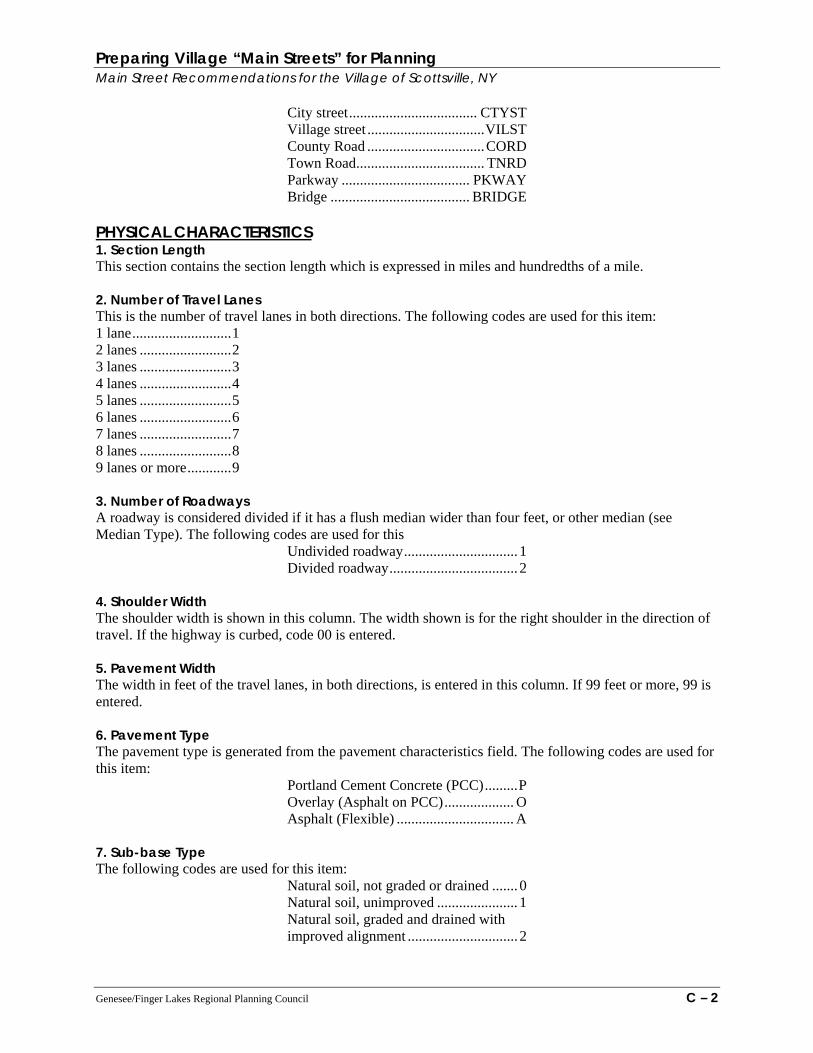
Preparing Village “Main Streets” for Planning Main Street Recommendations for the Village of Scottsville, NY
City street................................... CTYST Village street ................................VILST County Road ................................CORD Town Road................................... TNRD Parkway ................................... PKWAY Bridge ...................................... BRIDGE
PHYSICAL CHARACTERISTICS 1. Section Length This section contains the section length which is expressed in miles and hundredths of a mile. 2. Number of Travel Lanes This is the number of travel lanes in both directions. The following codes are used for this item: 1 lane...........................1 2 lanes .........................2 3 lanes .........................3 4 lanes .........................4 5 lanes .........................5 6 lanes .........................6 7 lanes .........................7 8 lanes .........................8 9 lanes or more............9 3. Number of Roadways A roadway is considered divided if it has a flush median wider than four feet, or other median (see Median Type). The following codes are used for this
Undivided roadway............................... 1 Divided roadway................................... 2
4. Shoulder Width The shoulder width is shown in this column. The width shown is for the right shoulder in the direction of travel. If the highway is curbed, code 00 is entered. 5. Pavement Width The width in feet of the travel lanes, in both directions, is entered in this column. If 99 feet or more, 99 is entered. 6. Pavement Type The pavement type is generated from the pavement characteristics field. The following codes are used for this item:
Portland Cement Concrete (PCC).........P Overlay (Asphalt on PCC)................... O Asphalt (Flexible) ................................ A
7. Sub-base Type The following codes are used for this item:
Natural soil, not graded or drained ....... 0 Natural soil, unimproved ...................... 1 Natural soil, graded and drained with improved alignment .............................. 2
Genesee/Finger Lakes Regional Planning Council C – 2

Preparing Village “Main Streets” for Planning Main Street Recommendations for the Village of Scottsville, NY
Selected soils (not gravel or rock) 12” or less .................................................... 3 Selected soils (not gravel or rock) over 12’................................................. 4 Gravel, stone, etc. (12’ or less) ............. 5 Gravel, stone, etc. (over 12’) ................ 6 Other (bridges, culverts, etc.)................ 7
8. Functional Classification The following codes are used for this item:
Urban Principal Arterial Interstate 11 Principal Arterial Expressway 12 Principal Arterial Other 14 Minor Arterial 16 Collector 17 Local 19 Rural Principal Arterial Interstate 01 Principal Arterial Other 02 Minor Arterial 06 Major Collector 07 Minor Collector 08 Local 09
TRAFFIC 1. Annual Average Daily Traffic Volumes – Two Way (AADT) The latest AADT for each section is shown in this section. For this publication, the volumes made available in the 2003 Traffic Volume Report have been provided. Questions concerning the most recent volume data available should be addressed to the Highway Data Services Bureau at (518) 457-1965 2. Actual/Estimate (ACT/EST) An “A’ in this section indicates the year traffic volume (AADT) was obtained from an actual traffic count and is the current year count for the section. An “E” indicates the traffic volume for the section was derived from a non-current year estimate, or a projection. 3. Percentage of Trucks The percentage of trucks using the section of highway is entered in this field. This entry is used in the adjusted rated capacity calculation. This is a truncated, not a rounded figure. 4. Year of Vehicle Classification Counts with a classification year of 1988-03 have been entered. For segments without an actual count year, a percent based on the average percent for the appropriate Region and Functional Classification category was used. CONDITION INFORMATION The physical condition of each highway section is determined by assessing the condition of the pavement surface. The data collection is performed using a windshield survey. The survey team evaluates surface related distress (on a 1-10 scale where “1 ‘is the worst and “K” or 10 is the best) using photographic and
Genesee/Finger Lakes Regional Planning Council C – 3

Preparing Village “Main Streets” for Planning Main Street Recommendations for the Village of Scottsville, NY verbal scales developed to ensure consistency between regions and repeatability over time. This procedure has been in use since 1981. In 1990 a new photographic manual was developed with more clearly defined scale points. In general, surface ratings may be categorized as follows:
Rating Condition Description 9-10 Excellent - No pavement distress. 7-8 Good - Distress symptoms are beginning to show. 6 Fair - Distress is clearly visible. 1-5 Poor - Distress is frequent and may be severe. These sections are flagged by the Department computers for further investigation and possible action. U Under Construction - Not rated due to on-going work.
Technical documentation of the scoring process as well as detailed descriptions of each scale value are available upon request. 1-4. Surface Condition 2000-2004 Surface condition scores for 2000-2004. If the scoring section identification or length for any year is different than in 2000-2004, this field is left blank. 5. Surface Condition 2004 Surface condition scores from the 2004 survey. 6. Roughness Data (IRI) - Not Included in 2004 Report Beginning in 2001, pavement roughness (ride quality) data was collected on the NYS Touring Route, Thruway and Major Reference Routes. Measures are collected in the right hand travel lane in one direction. The measure of roughness is the International Roughness Index (IRI) and is measured by automated equipment in units of inches per mile.
IRI Scale (in/mi) Description <60 Very Smooth 61 -120 Smooth 121 -170 Fair 171 -220 Rough > 220 Very Rough
Roughness data is provided in this document for the purpose of allowing those involved with managing pavements the opportunity to become familiar with IRI as a ride quality measure. Having roughness measures by roadway segments will allow users to develop a “seat of the pants” feel for IRI values. Department policy for the use of IRI in decision making has not been established nor implied by the collection and reporting of IRI. When considering IRI values, the user should be aware that IRI measures for short segments (less than 0.10 mile) are sensitive to large surface anomalies and may display a very high IRI value. Conversely, IRI values for segments longer than one mile may average out localized rough sections and mask their presence. IRI data is available electronically in 0.10 mile Increments for the entire highway network should the user wish to break down longer segments into 0.10 mile components for more detailed observation. IRI values plotted in GIS on 0.10 mile increments also produces a more refined view of the ride quality
Genesee/Finger Lakes Regional Planning Council C – 4

Preparing Village “Main Streets” for Planning Main Street Recommendations for the Village of Scottsville, NY characteristics of the highway network. Please contact Pavement Management Services for assistance with other data formats or for more information on the International Roughness Index and its uses. 7. Dominant Distress A dominant distress is defined as a specific distress symptom which will trigger a treatment strategy different than the treatment recommended by the surface rating alone. The distresses collected relate directly to the type of pavement surveyed. The following distresses were collected for the 2004 survey: Faulting (F) - Faulting may only be identified on Portland Cement Concrete (PCC) pavements. Faulting is the vertical displacement of abutting slabs at transverse joints creating a “step” formation in the pavement surface. Faulted pavements cause a sequenced jarring ride when traversed. Spalling, Isolated (Si) or General (Sg)- Spalling may only be identified on Portland Cement Concrete (PCC) pavements. Spalling may occur at PCC joints or at mid-slab. Isolated cracking, breaking, or chipping of slab edges usually results in feathered edges. The value 20% is used as a cut-off to distinguish between spalling isolated (Si) and general distress spalling frequency (Sg). Alligator Cracking, Isolated (Al) or General (Ag)- Alligator cracking may be Identified only in the wheelpaths on Overlaid or Flexible pavement types. Alligator cracking is defined as interconnected cracks forming a series of small polygons resembling an alligator’s hide. The value 20% is used as a cut-off to distinguish between alligator isolated (Al) and alligator general (Ag) distress frequency. Widening Drop-off (W) - Widening drop-off may only be identified on Overlaid pavements. Widening drop-off occurs when PCC slabs are overlaid with asphalt which extends a few feet past the slab edges to create width. The asphalt may crack at the underlying slab and create a vertical displacement. The widening drop-off is the difference in elevation across the longitudinal joint between the original pavement and the displacement. This displacement usually results in secondary or multiple cracking along the underlying slab edge. 8. Year of Last Work This is the year in which the latest pavement work (reconstruction or resurfacing, for example) was performed on the highway section by contract or by state forces. 9. Work Type Work type codes consistent with treatment types being utilized in the Department’s pavement management work are encoded in this field. Use the following codes to enter type of work: Code 1 Single course overlay, 1” - 1 ½” Typical VPP or State forces paving. This will include Micro-
Surfacing and thin coat paving applications. 2 Two course overlay, 2 ½” -3”. Typically R&P type paving, 3 Three course overlay, 4” - - 6” of asphalt. 4 In-place recycling, surface course only. Treatments where the top course is removed and
rejuvenated fall into this category. 5 In-place recycling, full depth. Treatments such as crack and seat or rubblizing fall into this
category. 6 Reconstruction. This treatment is defined as total pavement replacement. 7 Other. This code applies to special situations such as rehabilitation of bridge deck, repair of small
sections only and other treatments not specified by other work types.
Genesee/Finger Lakes Regional Planning Council C – 5

Preparing Village “Main Streets” for Planning Main Street Recommendations for the Village of Scottsville, NY OTHER DATA This section contains descriptions of selected items contained on the 2004 Sufficiency computer file but not published in this report. 1. Shoulder Type The following codes are used for this item: Curbed, mowing............................. 0 Curbed, no mowing........................ 1 Gutter, mowing .............................. 2 Gutter, no mowing ......................... 3 Stabilized, mowing ........................ 4 Stabilized, no mowing ................... 5 Unstabilized, mowing .................... 6 Unstabilized, no mowing ............... 7 2. Median Width (feet) The following codes are used for this item: 0-4’..............................1 5-8’..............................2 9-12’............................3 13-16’..........................4 17-20’..........................5 2 1-24’.........................6 25-28’..........................7 29-32’..........................8 33-36’..........................9 37’ +............................0 3. Median Type The following codes are used for this item: No Median ........................blank Flush Median (Turf).................1 Raised Median .........................2 Depressed Median....................3 Barrier ......................................4 Flush Median (Paved) ..............5 4. Terrain The following codes are used for this item:
Flat (pavement profile 0-3% approx.).............1 Rolling (pavement profile 4-8% approx.) .......2 Hilly (pavement profile 7-9% approx.)...........3
5. Area Type The following codes are used for this item:
Rural................................................................1 Unincorporated community ............................2 Village less than 5000 population ...................3 Suburban .........................................................4
Genesee/Finger Lakes Regional Planning Council C – 6
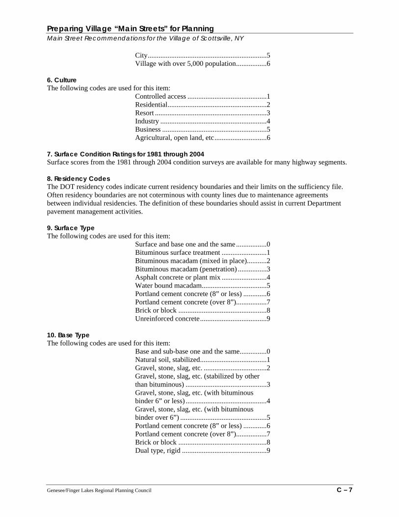
Preparing Village “Main Streets” for Planning Main Street Recommendations for the Village of Scottsville, NY
City..................................................................5 Village with over 5,000 population.................6
6. Culture The following codes are used for this item:
Controlled access ............................................1 Residential.......................................................2 Resort ..............................................................3 Industry ...........................................................4 Business ..........................................................5 Agricultural, open land, etc.............................6
7. Surface Condition Ratings for 1981 through 2004 Surface scores from the 1981 through 2004 condition surveys are available for many highway segments. 8. Residency Codes The DOT residency codes indicate current residency boundaries and their limits on the sufficiency file. Often residency boundaries are not coterminous with county lines due to maintenance agreements between individual residencies. The definition of these boundaries should assist in current Department pavement management activities. 9. Surface Type The following codes are used for this item:
Surface and base one and the same.................0 Bituminous surface treatment .........................1 Bituminous macadam (mixed in place)...........2 Bituminous macadam (penetration) ................3 Asphalt concrete or plant mix .........................4 Water bound macadam....................................5 Portland cement concrete (8” or less) .............6 Portland cement concrete (over 8”).................7 Brick or block .................................................8 Unreinforced concrete.....................................9
10. Base Type The following codes are used for this item:
Base and sub-base one and the same...............0 Natural soil, stabilized.....................................1 Gravel, stone, slag, etc. ...................................2 Gravel, stone, slag, etc. (stabilized by other than bituminous) .............................................3 Gravel, stone, slag, etc. (with bituminous binder 6” or less) .............................................4 Gravel, stone, slag, etc. (with bituminous binder over 6”) ................................................5 Portland cement concrete (8” or less) .............6 Portland cement concrete (over 8”).................7 Brick or block .................................................8 Dual type, rigid ...............................................9
Genesee/Finger Lakes Regional Planning Council C – 7

Preparing Village “Main Streets” for Planning Main Street Recommendations for the Village of Scottsville, NY 11. Access Control The following codes are used for this item:
No control of access.......................................N Partial control of access ................................. P Full control of access ..................................... F
12. Highway Control Code This Item contains the following information: a. Overlap status b. The level of government having jurisdictional the highway section. The following codes are used for this Item:
Type Code State Highway.................................................0 Parkway-State-DOT........................................1 Parkway-State-Non-DOT................................2 Parkway-Non-State .........................................3 Authority and Commission – Toll ..................4 Authority and Commission – Free ..................5 City or Village Street Gap...............................6 Town or County Road Gap .............................7 Indian Reservation or Institution Roads..........8 All Duplicate Mileage.....................................9 Service Road - State Maintained....................X Service Road - Non-State Maintained............Y
13. Design Hour Volume - One Way (DHV) DHV for each section for the count year as reported in item 2 above is entered in this column. A 2/3 - 1/3 direction distribution is assumed for two lane rural highways. 14. Adjusted Rated Capacity- One Way The capacity of a highway section is the maximum traffic volume which may reasonably be expected to pass a given point in a given time, at speeds consistent with current design standards and roadside development. Adjusted rated capacity as used in this publication is an estimate of the traffic volume which meets the above stated conditions for Level of Service E. Level of Service E represents operating conditions at or near the capacity level. All speeds are reduced to a low, but relatively uniform value. Freedom to maneuver within the traffic stream is extremely difficult, and it is generally accomplished by forcing a vehicle or pedestrian to “give way” to accommodate such maneuvers. Comfort and convenience levels are extremely poor, and driver or pedestrian frustration is generally high. Operations at this level are usually unstable, because small increases in flow or minor disturbances within the traffic stream will cause breakdowns. Please note that although the service volumes used in the adjusted rated capacity calculation are consistent with the 1985 Highway Capacity Manual, the algorithm itself only provides a rough estimate due to the lack of required data. If site specific capacities are desired, the user should use the procedures detailed In the 1994 Highway Capacity Manual. 15. Volume/Capacity Ratio (VIC) The ability to serve present traffic volume is stated as the volume/capacity ratio. The V/C ratio presented in this publication is the highway section’s one-way design hour volume divided by its one-way adjusted rated capacity, truncated not rounded.
Genesee/Finger Lakes Regional Planning Council C – 8
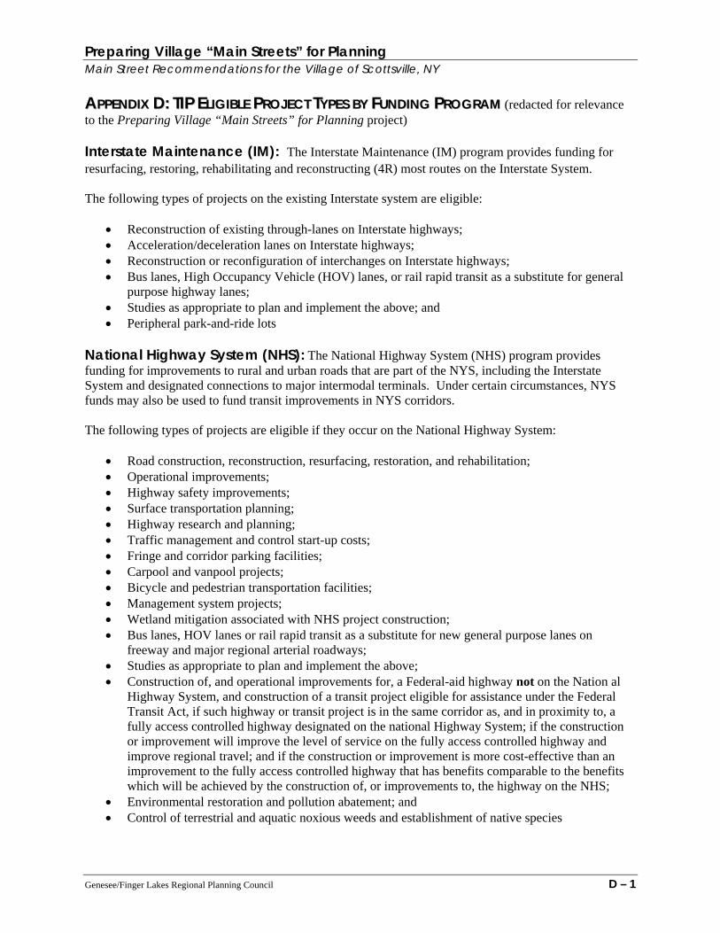
Preparing Village “Main Streets” for Planning Main Street Recommendations for the Village of Scottsville, NY AAPPPPEENNDDIIXX DD:: TTIIPP EELLIIGGIIBBLLEE PPRROOJJEECCTT TTYYPPEESS BBYY FFUUNNDDIINNGG PPRROOGGRRAAMM (redacted for relevance to the Preparing Village “Main Streets” for Planning project) Interstate Maintenance (IM): The Interstate Maintenance (IM) program provides funding for resurfacing, restoring, rehabilitating and reconstructing (4R) most routes on the Interstate System. The following types of projects on the existing Interstate system are eligible:
• Reconstruction of existing through-lanes on Interstate highways; • Acceleration/deceleration lanes on Interstate highways; • Reconstruction or reconfiguration of interchanges on Interstate highways; • Bus lanes, High Occupancy Vehicle (HOV) lanes, or rail rapid transit as a substitute for general
purpose highway lanes; • Studies as appropriate to plan and implement the above; and • Peripheral park-and-ride lots
National Highway System (NHS): The National Highway System (NHS) program provides funding for improvements to rural and urban roads that are part of the NYS, including the Interstate System and designated connections to major intermodal terminals. Under certain circumstances, NYS funds may also be used to fund transit improvements in NYS corridors. The following types of projects are eligible if they occur on the National Highway System:
• Road construction, reconstruction, resurfacing, restoration, and rehabilitation; • Operational improvements; • Highway safety improvements; • Surface transportation planning; • Highway research and planning; • Traffic management and control start-up costs; • Fringe and corridor parking facilities; • Carpool and vanpool projects; • Bicycle and pedestrian transportation facilities; • Management system projects; • Wetland mitigation associated with NHS project construction; • Bus lanes, HOV lanes or rail rapid transit as a substitute for new general purpose lanes on
freeway and major regional arterial roadways; • Studies as appropriate to plan and implement the above; • Construction of, and operational improvements for, a Federal-aid highway not on the Nation al
Highway System, and construction of a transit project eligible for assistance under the Federal Transit Act, if such highway or transit project is in the same corridor as, and in proximity to, a fully access controlled highway designated on the national Highway System; if the construction or improvement will improve the level of service on the fully access controlled highway and improve regional travel; and if the construction or improvement is more cost-effective than an improvement to the fully access controlled highway that has benefits comparable to the benefits which will be achieved by the construction of, or improvements to, the highway on the NHS;
• Environmental restoration and pollution abatement; and • Control of terrestrial and aquatic noxious weeds and establishment of native species
Genesee/Finger Lakes Regional Planning Council D – 1
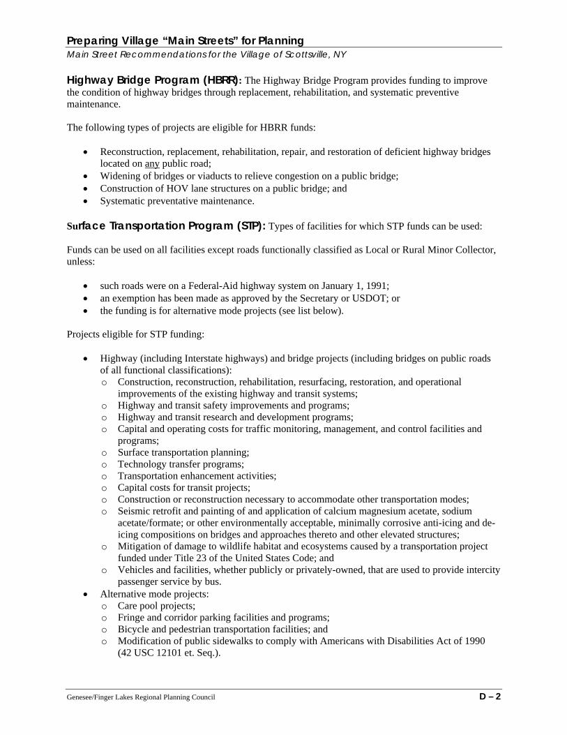
Preparing Village “Main Streets” for Planning Main Street Recommendations for the Village of Scottsville, NY Highway Bridge Program (HBRR): The Highway Bridge Program provides funding to improve the condition of highway bridges through replacement, rehabilitation, and systematic preventive maintenance. The following types of projects are eligible for HBRR funds:
• Reconstruction, replacement, rehabilitation, repair, and restoration of deficient highway bridges located on any public road;
• Widening of bridges or viaducts to relieve congestion on a public bridge; • Construction of HOV lane structures on a public bridge; and • Systematic preventative maintenance.
Surface Transportation Program (STP): Types of facilities for which STP funds can be used: Funds can be used on all facilities except roads functionally classified as Local or Rural Minor Collector, unless:
• such roads were on a Federal-Aid highway system on January 1, 1991; • an exemption has been made as approved by the Secretary or USDOT; or • the funding is for alternative mode projects (see list below).
Projects eligible for STP funding:
• Highway (including Interstate highways) and bridge projects (including bridges on public roads of all functional classifications): o Construction, reconstruction, rehabilitation, resurfacing, restoration, and operational
improvements of the existing highway and transit systems; o Highway and transit safety improvements and programs; o Highway and transit research and development programs; o Capital and operating costs for traffic monitoring, management, and control facilities and
programs; o Surface transportation planning; o Technology transfer programs; o Transportation enhancement activities; o Capital costs for transit projects; o Construction or reconstruction necessary to accommodate other transportation modes; o Seismic retrofit and painting of and application of calcium magnesium acetate, sodium
acetate/formate; or other environmentally acceptable, minimally corrosive anti-icing and de-icing compositions on bridges and approaches thereto and other elevated structures;
o Mitigation of damage to wildlife habitat and ecosystems caused by a transportation project funded under Title 23 of the United States Code; and
o Vehicles and facilities, whether publicly or privately-owned, that are used to provide intercity passenger service by bus.
• Alternative mode projects: o Care pool projects; o Fringe and corridor parking facilities and programs; o Bicycle and pedestrian transportation facilities; and o Modification of public sidewalks to comply with Americans with Disabilities Act of 1990
(42 USC 12101 et. Seq.).
Genesee/Finger Lakes Regional Planning Council D – 2

Preparing Village “Main Streets” for Planning Main Street Recommendations for the Village of Scottsville, NY
• Transportation Control Measures; • Natural habitat and wetlands mitigation efforts (related to STP-funded projects):
o Participation in natural habitat and wetlands mitigation banks; o Contributions to statewide and regional efforts to conserve, restore, enhance, and create
wetlands; and o Development of statewide and regional wetlands conservation and mitigation plans,
including banks, efforts, and plans. • Infrastructure-based Intelligent Transportation Systems capital improvements; • Environmental restoration and pollution abatement projects; • Advanced truck stop electrification systems; • Projects relating to intersections that have disproportionately high accident rates, high congestion,
and are located on a Federal-aid highway; • Environmental restoration and pollution abatement; • Control of terrestrial and aquatic noxious weeds and establishment of native species;
STP funding is allocated into four areas: Urban, Small Urban, Rural, and FLEX
• STP-Urban funds can be used for the transportation project types mentioned above within a
designated Urbanized Area. An Urbanized Area is an area with 50,000 or more persons living within a central city (or cities) and the surrounding densely settled area.
• STP-Small Urban funds can be used for the project types mentioned above within a densely settled area with more than 5,000 but less than 50,000 persons.
• STP-Rural funds can be used for the project types mentioned above in areas outside the defined Urbanized Area (see definition above).
• STP-Flex funds can be used for the project types mentioned above in any area – urban, small urban, or rural.
Highway Safety Improvement Program (HSIP): The program authorizes a new core Federal-aid funding program beginning in federal fiscal year 2006 to achieve a significant reduction in traffic fatalities and serious injuries on all public roads. Projects are derived from a statewide Strategic Highway Safety Plan (SHSP) that identifies and analyzes safety problems and opportunities. Railway-Highway Crossings: The purpose of the Railway-Highway Crossings program is to reduce the number of fatalities and injuries at public highway-rail grade crossings through the elimination of hazards and/or the installation/upgrade of protective devices at crossings. Congestion Mitigation and Air Quality Improvement Program (CMAQ): The Congestion Mitigation and Air Quality Improvement Program (CMAQ) provides funding for projects and programs in air quality non-attainment and maintenance areas for ozone, carbon monoxide, and particulate matter which reduce transportation related emissions. In this region, emphasis will be placed on those projects that provide the greatest improvement in ground-level ozone precursors in a cost effective manner. Projects must have an air quality benefit to be funded through CMAQ. The following types of projects are eligible for these funds:
• Diesel retrofit; • Transportation Control Measures; • The incremental cost of purchasing publicly-owned, alternative fuel vehicles; • Traffic flow improvements:
Genesee/Finger Lakes Regional Planning Council D – 3

Preparing Village “Main Streets” for Planning Main Street Recommendations for the Village of Scottsville, NY
o Projects that remove existing bottlenecks to traffic flow; o Projects that ease the flow of traffic through existing intersections without adding capacity; o Signal interconnects; and o Traffic control.
• Public Transportation Improvements: o Transit system start-up (for not longer than the first three years of service); o Transit transfer facilities; o Transit facility improvements; and o Transit service and equipment.
• Bicycle and Pedestrian Programs: o Bicycle and pedestrian facilities that reduce automobile travel; and o Bicycle parking and bicycle encouragement projects that create or increase the availability of
parking facilities for bicycles and promote the use of bicycles; • Travel Demand Management; • Outreach and rideshare activities; • Programs intended to reduce emissions from extreme cold-starts conditions; • Fare/fee subsidy programs; • Intermodal freight; • Projects that are cooperatively implemented under agreements between the public and private
sectors and/or non-profit entities; • Telecommuting; • Planning and project development activities that lead to construction of facilities or new services
and programs with air quality benefits, such as preliminary engineering or project planning studies;
• Experimental pilot programs provided the project or program can reasonably be defined as a “transportation” project and that emission reductions can reasonably be expected through reductions in vehicle miles traveled (VMT) or fuel consumption, or through other factors;
• Advanced truck stop electrification; • Interoperable emergency communications equipment; and • Retrofit of non-road construction equipment used for road and transit projects.
The following types of projects are NOT eligible for these funds:
• Transit operations (other than the first three years); • Routine maintenance of roads or transit vehicles, facilities, or equipment; • Mandated private sector demand management activities; • Programs to encourage removal of pre-1980 vehicles; and • Phases of existing projects that have been obligated.
Section 5310 (Federal Transit Administration Capital Assistance to Elderly Persons and Persons with Disabilities): The following types of projects are eligible for these funds:
• Capital assistance projects, not to exceed 80 percent of cost, to provide service for elderly persons and persons with disabilities
Section 5311 (for general transit assistance to rural and small urban areas only): The following types of projects are eligible for these funds:
Genesee/Finger Lakes Regional Planning Council D – 4

Preparing Village “Main Streets” for Planning Main Street Recommendations for the Village of Scottsville, NY
• Both operating and capital assistance is available for up to 80 percent of the total cost for rural and small urban area projects.
Section 5316 (Job Access and Reverse Commute): The purpose of the Job Access and Reverse Commute (JARC) program is to provide funding for local programs that offer job access and reverse commute services to provide transportation for low income individuals who may live in the city core and work in suburban locations. Project must be included in a locally-developed human service transportation coordinated plan. Section 5317 (New Freedom Program): The purpose of the New Freedom Program is to encourage services and facility improvements to address the transportation needs of persons with disabilities that go beyond those required by the Americans with Disabilities Act. Projects must be included in a locally-developed human service transportation coordinated plan. The following types of projects are eligible for these funds:
• Both operating and capital assistance is available.
Genesee/Finger Lakes Regional Planning Council D – 5

Preparing Village “Main Streets” for Planning Main Street Recommendations for the Village of Scottsville, NY AAPPPPEENNDDIIXX EE:: NNYYSSDDOOTT RREEGGIIOONN 99 MMAAIINN SSTTRREEEETT SSUURRVVEEYY The following survey and introductory narrative explanation were provided by NYSDOT officials Mark Bowers (Reg. 9 – Associate Capital Program Analyst ) and Dave Legeikis, P. E. (Eastern Zone – Resource Manager). The survey includes and excellent compilation of baseline information that should be clearly identified and agreed upon by local village stakeholders, transportation officials and hired consultants. Available from G/FLRPC in digital format upon request.
NYSDOT Region 9 Village Survey Project Spurred by the Regional Capital Program Committee’s (RCPC) desire to understand the unique nature of the Region’s villages, and their impact on planning proposed infrastructure improvements, the Village Committee was created. This Committee was tasked with coming up with a means of prioritizing work within the Region’s 46 villages. These villages have, as their “Main Street”, a State highway. The first report presented to the RCPC looked at the villages from three traditional perspectives, i.e. population, Average Annual Daily Traffic (AADT), and pavement surface score. The Committee also developed a “weighting” factor to take into account the impact of higher traffic volumes on the various routes. This information was presented to the RCPC at their monthly meeting, and generated a valuable dialog. The focus of this dialog centered on what could be categorized as “Context Sensitive Issues”, such as “cultural / historical context”, “green space”, “landscaping”. “bicycle / pedestrian issues”, “streetscaping” etc. The preceding elements create the context, which characterize these villages as unique places to live, work and visit. To that end, the committee developed the “Village Survey”. This “Village Survey” was developed in a collaborative manner with input from both committee members, and the village officials. One of the desired outcomes of the survey was to provide a context for meaningful dialog between Department Staff and local officials. A second desired outcome of this work was to make this information available to the Department’s Project Developers, Designers and Resident Engineers as we develop our multi-year transportation program. This web page will accomplish that end. Lastly, this information will be used to aide in project prioritization. What you see on this page is a result of those dialogs. These surveys were conducted in the villages, with locally elected officials and their staff. Also present were the Resident Engineer and his assistant for the subject village’s county. The Resident Engineers provided invaluable insight regarding the “day-to-day” operation of our maintenance forces, while at the same time strengthening the link between the Department and its stakeholders. Finally, when all of the surveys have been completed, the Village Committee will again report to the RCPC with its findings, identifying those “themes/issues” common to all the villages. At the time of this posting, villages within Broome and Chenango counties, and the Delaware South Residency area have been surveyed. The “Village People” will soon be performing surveys in
Genesee/Finger Lakes Regional Planning Council E – 1

Preparing Village “Main Streets” for Planning Main Street Recommendations for the Village of Scottsville, NY
Otsego, Schoharie / Delaware North and Sullivan counties. When these are completed they will be added to this web page.
REGION 9 VILLAGE SURVEY
New York State Department of Transportation Date __________
Village: _______________ County: _______________ State Route: _______________ (provide separate form for each state highway in Village) AADT: _______________ Year: _____ Population: _______________ Year: _____ Surface Score: _______________ Year: _____ Attach photos, narrative descriptions, and extra sheets where appropriate.
■ Lighting
Is Highway lighting present? □ Y □ N
Is it adequate? □ Y □ N
Is Pedestrian lighting present? □ Y □ N
Is it adequate? □ Y □ N
Is it decorative? □ Y □ N Notes:
■ Parking
Is it present? □ Y □ N
Is it adequate? □ Y □ N
□ Off street □ On street
Is park & ride present? □ Y □ N
Is it needed? □ Y □ N Notes:
■ Landscape Elements & Plantings
Genesee/Finger Lakes Regional Planning Council E – 2
Preparing Village “Main Streets” for Planning Main Street Recommendations for the Village of Scottsville, NY
Are they present?(i.e. signs, benches, planters) □ Y □ N If yes, describe what exists and location.
Are they adequate? □ Y □ N Notes:
■ Special Use Areas
Is it present? (i.e. park, kiosk, monument) □ Y □ N If yes, describe what exists and location.
Notes:
■ Utilities
Water Age _____ □ Y □ N
Is it adequate? □ Y □ N
Sanitary Sewer Age _____ □ Y □ N
Is it adequate? □ Y □ N
Gas Age _____ □ Y □ N
Is it adequate? □ Y □ N
Electric □ Y □ N
Is it adequate? □ Y □ N
Is it underground? □ Y □ N □ Partial
Telephone □ Y □ N
Is it adequate? □ Y □ N
Is it underground? □ Y □ N
Fiber Optics □ Y □ N
Is it adequate? □ Y □ N
Genesee/Finger Lakes Regional Planning Council E – 3
Preparing Village “Main Streets” for Planning Main Street Recommendations for the Village of Scottsville, NY
Cable TV/Internet □ Y □ N
Is it adequate? □ Y □ N
Is it underground? □ Y □ N Other_____________________ Notes:
■ Snow Storage □ Y □ N
If yes, is it paved or grassed?
Is it adequate? (3’ minimum) □ Y □ N Notes:
■ Drainage
Open (i.e. swales, ditches, curbs, gutters) □ Y □ N
Is it adequate? □ Y □ N
Closed (i.e. culvert, catch basin, drain inlet) □ Y □ N
Is it adequate? □ Y □ N Notes:
■ Traffic Signals/Control Devices
Are they adequate? □ Y □ N Notes:
■ Geometry/Traffic Channelization
Is it adequate? □ Y □ N
Genesee/Finger Lakes Regional Planning Council E – 4

Preparing Village “Main Streets” for Planning Main Street Recommendations for the Village of Scottsville, NY Notes:
■ Perceived/Real Congestion /Delay Issues
Delay □ Low □ Medium □ High Notes:
■ Perceived/Real Accident Problems □ Y □ N Number of PIL’s ________
Accidents □ Low □ Medium □ High Notes:
■ Roadside Commercial Development Provide inventory of existing commercial establishments.
Is it present? □ Y □ N
Level of Development □ Low □ Medium □ High Notes:
■ Walkability (Pedestrian Access & Mobility)
Sidewalks □ Y □ N If yes, describe connectivity, width, condition.
Are they adequate? □ Y □ N
Ped Crossings - signalized □ Y □ N
Are they adequate? □ Y □ N
Count-down timers □ Y □ N
Genesee/Finger Lakes Regional Planning Council E – 5

Preparing Village “Main Streets” for Planning Main Street Recommendations for the Village of Scottsville, NY
Are they adequate? □ Y □ N
Curbs & Curb extensions □ Y □ N
Are they adequate? □ Y □ N
Crosswalks □ Y □ N
Are they adequate? □ Y □ N Type (i.e. color, texture, mid-block) ________________________
Notes:
■ Designated Scenic Byways □ Y □ N Notes:
■ Bicycle Facilities
Bike Lanes □ Y □ N
Are they adequate? □ Y □ N
Bike Parking facilities (i.e. lockers, racks) □ Y □ N
Are they adequate? □ Y □ N
Designated Bike Routes □ Y □ N Notes:
■ Other Multi-Modal
Bus □ Y □ N □ Local □ Intercity
Air □ Y □ N
Rail □ Y □ N □ Freight □ Passenger Notes:
Genesee/Finger Lakes Regional Planning Council E – 6
Preparing Village “Main Streets” for Planning Main Street Recommendations for the Village of Scottsville, NY
■ Is there a Master Plan ? □ Y □ N Last Updated ________________
Are there any currently planned projects? □ Y □ N
Is the Village seeking other funding? □ Y □ N (i.e. grants, enhancements, multi-modal) Notes:
■ Infrastructure Projects done recently □ Y □ N Notes:
■ Historic & Cultural Context □ Y □ N (i.e. historic buildings, sites, landmarks, monuments, cultural themes, wall murals, sculptures, art) If yes, describe what exists and location.
Notes:
■ Economic Sustainability (Describe as appropriate) Economic Opportunities Economic Condition
Tax Base Info Tourism Zoning List Industrial Sites
Notes:
■ Miscellaneous (Describe as appropriate)
Special Events Open Spaces Gateways
Genesee/Finger Lakes Regional Planning Council E – 7

Preparing Village “Main Streets” for Planning Main Street Recommendations for the Village of Scottsville, NY
Institutional (i.e. school, hospital) Bridges (i.e. historic, signature)
Notes:
■ Comments
How can DOT assist in achieving your transportation vision in your Village? Notes:
■ Contributors Name/Title: __________________________ Name/Title: __________________________ Organization: __________________________ Organization: __________________________ E-mail/phone:________________________ E-mail/phone: _______________________ Name/Title: ___________________________ Name/Title: __________________________ Organization: __________________________ Organization: __________________________ E-mail/phone:________________________ E-mail/phone:________________________ Name/Title: ___________________________ Name/Title: __________________________ Organization: ___________________________ Organization: __________________________ E-mail/phone:_________________________ E-mail/phone:________________________
Genesee/Finger Lakes Regional Planning Council E – 8

Preparing Village “Main Streets” for Planning Main Street Recommendations for the Village of Scottsville, NY AAPPPPEENNDDIIXX FF:: MMAAIINN SSTTRREEEETT OOVVEERRLLAAYY DDIISSTTRRIICCTT EEXXAAMMPPLLEE –– WWEELLLLFFLLEEEETT,, MMAASSSSAACCHHUUSSEETTTTSS11 9.2 MAIN STREET OVERLAY DISTRICT 9.2.1 Purpose and Intent This by-law enables the development and redevelopment of Wellfleet’s village center (a portion of Main Street) in keeping with its historic development patterns, including the size and spacing of structures and open spaces. 9.2.2 Overlay District Defined The Main Street Overlay District shall extend along the south side of Main Street, one lot in depth, from Bank Street to Holbrook Avenue. The Main Street Overlay District established by this section is shown on a map entitled "Main Street Overlay District In the Town of Wellfleet", dated April 2006, which is on file in the office of the Town Clerk. Within the Main Street Overlay District, special permits are required under this by-law for all uses and structures required to obtain a special permit by the underlying Central District zoning district. 9.2.3 Special Permit Granting Authority
The special permit granting authority for this bylaw shall be the Zoning Board of Appeals.
9.2.4 Special Permit Criteria In addition to the Special Permit criteria listed in Section 8.4.2 of this Zoning By-law, applicants for Special Permits in the Main Street Overlay District must meet the following requirements: 9.2.4.1 Pedestrian Access. Provision for safe and convenient pedestrian access shall be incorporated into plans for new construction of buildings and parking areas and must be designed in concert with landscaping plans noted below. New construction should be consider of pedestrian access to buildings, sidewalks and parking areas and should be completed with considerations of pedestrian safety, handicapped access and visual quality. 9.2.4.2 Landscaping and Appearance. Landscape design plans should ordinarily be prepared by a landscape architect, although the Zoning Board of Appeals may accept a plan prepared by one other than a landscape architect if it believes the plan meets the design guidelines noted below and is in concert with the intent of this regulation. (a) A landscaped buffer strip or some other type of screening may be required adjacent to adjoining properties. This buffer strip shall be planted with a combination of grass, appropriate height shrubs, shade trees or other type of screening. (b) Exposed storage areas, machinery, garbage "dumpsters," service areas, truck loading areas, utility buildings and structures shall be screened from the view of abutting properties and streets using plantings, fences and other methods compatible with the goals of this regulation. (c) To ensure that landscaped areas are maintained, the Zoning Board of Appeals shall include as a provision of any special permit granted that a condition of said special permit is the maintenance of the landscaping as approved by the Zoning Board of Appeals. 9.3 Height, Setback and Building Coverage within the Main Street Overlay District: 9.3.1 Height The maximum height of any new or expanded existing structure shall be 28 feet. 9.3.2 Minimum Yard Requirements 1 Available online at http://www.wellfleetma.org/Public_Documents/WellfleetMA_Zoning/section9.pdf
Genesee/Finger Lakes Regional Planning Council F – 1

Preparing Village “Main Streets” for Planning Main Street Recommendations for the Village of Scottsville, NY The front yard setback of any new or expanded existing structure may be reduced to a zero line setback to continue the existing development pattern. The sideline setback shall be 6 feet, and the rear line setback shall be 15 feet. 9.3.3 Building Coverage Maximum building coverage within the Main Street Overlay District shall be 33%. Building Coverage shall be calculated using the entire area of the lot (upland and lowland) exclusive of any areas on a street or way open to the public. 9.4 Parking Requirements Recognizing that parking requirements in the underlying zoning district may hamper development of village-style land use and development, the Zoning Board of Appeals is authorized to reduce or waive the parking requirements specified for the use or structure proposed. In determining the appropriate reduction, if any, the Zoning Board of Appeals may give consideration to the hours of usage of the proposed use or structure, hours of usage of other uses or structures within the Main Street Overlay District, amount of "shared" parking with other uses, the opinions of merchants, residents and municipal officials as to the adequacy or inadequacy of parking spaces within the specific area of the proposed use or structure, as well as other relevant information to assist the Zoning Board of Appeals in determining the need for additional parking for motor vehicles. 9.5 Allowable Uses Recognizing that village-style development entails a mixture of uses, the Zoning Board of Appeals is authorized to allow a mix of residential and non-residential land uses within the Main Street Overlay District. Allowable uses shall be those listed in the underlying Central District within Section 5.3 of this Zoning By-law and the following:
Conversion of Dwelling Unit Guesthouse, Private Arcade Guesthouse, Public Inn Nursing Home Restaurant, Indoor
9.6 Severability The invalidity of any section or sections or parts of any section or sections of this by-law shall not affect the validity of the remainder of Wellfleet's zoning bylaw.
Genesee/Finger Lakes Regional Planning Council F – 2

Preparing Village “Main Streets” for Planning Main Street Recommendations for the Village of Scottsville, NY AAPPPPEENNDDIIXX GG:: PPAARRKKIINNGG MMAANNAAGGEEMMEENNTT BBEESSTT PPRRAACCTTIICCEESS
Comparison of Old and New Parking Paradigms Old Parking System New Parking System “Parking problem” means inadequate parking supply.
“Parking problem” can mean inadequate supply, inefficient management, inadequate user
information, or other types of problems associated with parking facilities and activities.
More parking is better. Too much parking is as harmful as too little.Parking costs are incorporated into building costs. As much as possible, users pay directly for parking
facilities.Parking is available on a first-come basis. Parking is managed to favor higher-priority uses
and encourage efficiency.Parking requirements are applied inflexibly, without exception or variation.
Parking requirements reflect each situation and are applied flexibly.
Traditional solutions are favored. New approaches are discouraged.
Innovations are encouraged, since even unsuccessful experiments often provide useful
information.Parking management is used only as a last resort when it is too costly to increase supply.
Parking management programs are widely applied to increase efficiency and prevent problems.
Transportation means driving. Dispersion of destinations (urban sprawl) is considered acceptable or even desirable.
Driving is one of many transport modes. Dispersed, automobile-dependent land-use patterns
are considered undesirable.Litman, Todd. “Parking Management Best Practices.” Planning October 2006: 40-45.
Genesee/Finger Lakes Regional Planning Council G – 1

Preparing Village “Main Streets” for Planning Main Street Recommendations for the Village of Scottsville, NY AAPPPPEENNDDIIXX HH:: GGLLOOSSSSAARRYY AANNDD AACCRROONNYYMMSS Glossary Best Management Practices: Methods that have been determined to be the most effective, practical means of meeting their intended goal or outcome. Context Sensitive Solutions (CSS): Collaborative, interdisciplinary process that involves all stakeholders to design a transportation facility that fits its applicable setting and preserves scenic, aesthetic, historic and environmental resources while maintaining safety and mobility. CSS respects design objectives for safety, efficiency, capacity and maintenance while integrating community objectives and values relating to compatibility, livability, sense of place, urban design, cost and environmental impacts. (from Context Sensitive Solutions in Designing Major Urban Thoroughfares for Walkable Communities. Institute of Transportation
Engineers.)
Critical Mass: The scale or volume at which processes become self-perpetuating. In this context, the number of visitors necessary that allows a place to become self-sustaining in terms of commerce, civil activity and interpersonal engagement. Geometric Design: The highway, vehicle, and individual users are the three integral parts of transportation safety and efficiency. The "Geometric Design" program area investigates, incorporates and promotes tools to improve safety performance and cost-effectiveness into the conventional transportation planning and design process. (Federal Highway Administration). Human Scale: How humans perceive the size of their surroundings and their comfort with the elements of the natural and built environment relative to their own size. In urban areas, human scale represents features and characteristics of buildings that can be observed within a short distance and at the speed of a pedestrian, and sites and districts that are walkable. In contrast, auto scale represents a built environment where buildings, sites, signs, etc. are designed to be observed and reached at the speed of an automobile. (from Context Sensitive Solutions in Designing Major Urban Thoroughfares for Walkable Communities. Institute of Transportation Engineers.)
Level of Distress: A qualitative measure describing the physical condition of a road surface. Conditions such as cracking and fault formation are taken into account in order to arrive at an overall level of distress for pavement segments. Level of Service: A qualitative measure describing the operational conditions within a traffic stream and their perception by motorists and/or passengers and other transportation users. Conditions such as speed, travel time, freedom to maneuver, traffic interruptions, and comfort and convenience are used to describe levels of service. Levels of service are characterized as ‘A’ (free flow, little delay) through ‘F’ (breakdown, forced flow), with ‘E’ representative of operation at capacity. Mixed-Use: The combining of, or zoning for, retail/commercial and/or service uses with residential or office use in the same building or on the same site either vertically (with different uses stacked upon each other in a building) or horizontally (with different uses adjacent to each other or within close proximity). (from Context Sensitive Solutions in Designing Major Urban Thoroughfares for Walkable Communities. Institute of Transportation Engineers.)
Genesee/Finger Lakes Regional Planning Council H – 1

Preparing Village “Main Streets” for Planning Main Street Recommendations for the Village of Scottsville, NY Outdoor Room Concept: This concept stresses the creation of an outdoor environment using built and natural forms (buildings, trees, benches, landscaping, etc.) to provide individuals with a sense of comfort and safety in the outdoor environment as well as focal points of interest that captivate or encourage interpersonal contact. Pattern Language: A structured method of describing good design practices within a particular domain. Styles in architectural and urban design that display similar characteristics reflect a distinct pattern language. North American main streets are an example of a distinct pattern language; several distinct patterns in building materials and design can be found within such spaces. Pocket Parks: Small green spaces accessible to the general public that are often of primarily environmental or aesthetic importance rather than recreational Sense of Place: While there are many intricacies to this concept, sense of place may best be defined within the present context as “defining oneself in terms of a given piece of land…Landscape acts as teacher in shaping our perceptions of place. Analysis suggests that four major components contribute to a sense of place…[including] (1) toponymic – related to naming places; (2) narrative – involving personal or group stories or legends; (3) experiential – associated particularly with dependence and survival; and (4) numinous – spiritual. Definition adapted from Yan Xu’s essay “Sense of Place and Identity.” (citation provided on page 3. Traffic Calming: The combination of mainly physical measures that reduce the negative effects of motor vehicle use, alter driver behavior and improve conditions for non-motorized street users. (ITE State of the Practice, 1999) Walkable/Walkability: Streets and places designed or reconstructed to provide safe and comfortable facilities for pedestrians, and are safe and easy to cross for people of all ages and abilities. (from Context
Sensitive Solutions in Designing Major Urban Thoroughfares for Walkable Communities. Institute of Transportation Engineers.)
Walkable Communities: Desirable places to live, work, learn and play, and therefore a key component of smart growth. Their desirability comes from two factors. First, locating, within an easy and safe walk, goods (such as housing, offices and retail) and services (such as transportation, schools, libraries) that a community resident or employee needs on a regular basis. Second, by definition, walkable communities make pedestrian activity possible, thus expanding transportation options and creating a streetscape that better serves a range of users – pedestrians, bicyclists, transit riders and drivers. To foster walkability, communities must mix land uses and build compactly, and ensure safe and inviting pedestrian corridors. (from Context Sensitive Solutions in Designing Major Urban Thoroughfares for Walkable Communities. Institute of Transportation Engineers.)
Acronyms AASHTO: American Association of State Highway and Transportation Officials ITE: Institute of Transportation Engineers CBD: Central Business District G/FLRPC: Genesee/Finger Lakes Regional Planning Council GTC: Genesee Transportation Council
Genesee/Finger Lakes Regional Planning Council H – 2

Preparing Village “Main Streets” for Planning Main Street Recommendations for the Village of Scottsville, NY DOT: [New York State] Department of Transportation UPWP: Unified Planning Work Program TIP: Transportation Improvement Project LRTP: Long Range Transportation Plan
Genesee/Finger Lakes Regional Planning Council H – 3