Proceedings Regional Knowledge Forum on Drought Earth ...
57
Proceedings Regional Knowledge Forum on Drought Earth Observation and Climate Services for Food Security and Agricultural Decision Making in South Asia and Southeast Asia 8–10 October 2018 | ICIMOD, Kathmandu, Nepal
-
Upload
khangminh22 -
Category
Documents
-
view
1 -
download
0
Transcript of Proceedings Regional Knowledge Forum on Drought Earth ...

Proceedings
Regional Knowledge Forum on Drought
Earth Observation and Climate Services for Food Security and
Agricultural Decision Making in South Asia and Southeast Asia
8–10 October 2018 | ICIMOD, Kathmandu, Nepal

1
About SERVIR
SERVIR connects space to village by helping developing countries use satellite data to address
challenges in food security, water resources, weather and climate, land use, and natural disasters.
A partnership of NASA, USAID, and leading technical organizations, SERVIR develops innovative
solutions to improve livelihoods and foster self-reliance in Asia, Africa, and the Americas.
SERVIR-HKH is implemented by ICIMOD in its regional member countries, prioritizing activities in
Afghanistan, Bangladesh, Myanmar, Nepal, and Pakistan.
SERVIR-Mekong is a joint initiative by USAID and NASA, implemented by a consortium led by
ADPC that includes Spatial Informatics Group (SIG), Deltares, and Stockholm Environment Institute
(SEI). The SERVIR programme is designed to address this need by using publicly available satellite
imagery and technologies to address challenges related to water resources, disasters, climate
resilience, agriculture, and ecosystem in the Lower Mekong.
About CSRD
Climate Services for Resilient Development (CSRD) is a global partnership that connects climate
and environmental science with data streams to generate decision support tools and training for
decision-makers in developing countries. Translating complex climate information into easy to
understand actionable formats to spread awareness in the form of climate services is core to CSRD’s
mission. The CSRD consortium in South Asia is supported by USAID and led by the CIMMYT in
partnership with the Bangladesh Meteorological Department (BMD), Bangladesh Department of
Agricultural Extension (DAE), Bangladesh Agricultural Research Council (BARC), Bangladesh
Agricultural Research Institute (BARI), ICIMOD, International Institute for Climate and Society (IRI),
University de Passo Fundo (UPF), and the University of Rhode Island (URI). This consortium
provides strength and technical expertise to develop relevant climate products that can assist
farmers and other stakeholders with relevant information to improve decision making, with the
ultimate goal of increasing resilience to climate-related risks.
Rapporteurs: Bashudev Neupane, Binod Parajuli, Ishaan Kochar, Kribina Pathak, Kripa Shrestha,
Sijal Pokhrel

2
Contents
About SERVIR ............................................................................................................................ 1
About CSRD ............................................................................................................................... 1
List of Acronyms ............................................................................................................................. 4
Introduction .................................................................................................................................... 3
Day 1, 8 October 2018 ................................................................................................................... 5
Opening Session ........................................................................................................................ 5
Drought Monitoring and Early Warning Systems ......................................................................... 9
Drought Impacts and Climate Risk Financing ............................................................................16
Day 2, 9 October 2018 ..................................................................................................................20
Agricultural Land Use Planning and Policies ..............................................................................20
Group Work - Agricultural Land Use Practices and Policies .......................................................21
Advances in Remote Sensing for Crop Area Assessments ........................................................23
Group Work - Advances in Remote Sensing for Crop Area Assessments ..................................25
In-season Crop Assessment and Yield Forecast........................................................................26
Group Work – In-season Crop Assessment and Yield Forecast .................................................29
Day 3 – 10 October 2018 ..............................................................................................................31
Panel Discussion: Emerging Earth Observation Technologies and its Adoption in the South and
Southeast Asia Region ..............................................................................................................31
Panel Discussion: Policy Actions for Operationalizing Climate and Agriculture Services ............33
Establishment of expert working groups to foster regional cooperation ......................................35

3
Annex I – List of participants .......................................................................................................... A
Annex II – Agenda .......................................................................................................................... E
Annex III – List of Talks at the Drought Forum ................................................................................ G
Annex IV - Media Coverage from the Event.................................................................................... K
Annex V – Photographs.................................................................................................................. L
Annex VI – Presentations from the session ....................................................................................M
Annex VII – Book of Abstracts ........................................................................................................ N

4
List of Acronyms
ADPC Asian Disaster Preparedness Center1, 3, 4,
7, 13, 15 ASIS
Agriculture Stress Index System ............. 13 CAS
Chinese Academy of Sciences ............... 27 CHIRPS
Climate Hazards Group InfraRed Precipitation Station ............................ 14
Climate Hazards Group InfraRed Precipitation with Station data ............. 11
CHIRPS-GEFS Climate Hazards Group InfraRed
Precipitation Station corrected Global Ensemble Forecast System ................. 14
CHT Chittagong Hill Tracts.............................. 20
CIMMYT International Maize and Wheat
Improvement Center ............................ 14 CKRB
Chitral-Kabul River Basin ........................ 15 CNN
convolutional neural network................... 23 CRAFT
Regional Agriculture Crop Forecasting Toolkit ................................................. 28
CSRD limate Services for Resilient Development 3
DMEWS Disaster Management Early Warning
System ................................................ 11 DMT
Drought Management Team ................... 13 EWEA
Early Warning Early Action ..................... 12 FAO
Food and Agriculture Organization.......... 12 GEE
Google Earth Engine .............................. 24 GEFS
Global Ensemble Forecast System ......... 14 HKH
Hindu Kush Himalayas ............................11 HydroSOS
Hydrological Status and Outlook System 17 ICIMOD
International Centre for Integrated Mountain Development ............... 3, 4, 5, 31, 33, 36
IMD India Meteorological Department ............15
IMERG Integrated Multi-satellitE Retrievals for GPM
............................................................14 IPCC
Intergovernmental Panel on Climate Change Intergovernmental Panel on Climate Change.................................... 3
JPL Jet Propulsion Laboratory .......................13
LDAS Land Data Assimilation System ..............11
MAIL Ministry of Agriculture Irrigation and
Livestock .............................................24 MRCS
Mekong River Commission Secretariat ...13 NASS
National Agricultural Statistical Services .28 NeKSAP
Nepal Food Security Monitoring System .28 PRISM
Platforms for Real-time Information Systems ..............................................18
RADI Institute of Remote Sensing and Digital
Earth ...................................................27 RDCYIS
Regional Drought and Crop Yield Information System .............................14
RHEAS Regional Hydrological Extreme Assessment
System ................................................13 RLCMS
Regional Land Cover Monitoring System 25 RWH
Rain Water Harvesting ............................20

1
S2S Sub-seasonal to Seasonal Forecast System
............................................................ 11 SAR
Synthetic Aperture Radar ........................ 24 SM
Soil Moisture ........................................... 27 SPEI
Standardised Precipitation-Evapotranspiration Index ..................... 15
SPI Standardized Precipitation Index ............ 15
UC
Union Council .........................................20 UNESCO
United Nations Educational, Scientific and Cultural Organization ............................ 8
VAWR Vietnam Academy for Water Resources .14
VCI Vegetation Condition Index .....................28
WFP World Food Programme ..........................28
WMO World Meteorological Organization .........17

1
List of Figures
Figure 1 David Molden, Director General of ICIMOD, addressed participants to the drought forum.
Also present on the dais are Birendra Bajracharya, Shahbaz Khan, Hans Guttman, Yubak Dhoj GC,
and Faisal M. Qamer ...................................................................................................................... 5
Figure 2 Yubak Dhoj GC, Secretary, Ministry of Agriculture and Livestock Development, Government
of Nepal shared that provisioning of climate services and their use for disaster preparedness and
management could negate damages from such events. ................................................................. 6
Figure 3 Hans Guttman, Executive Director, Asian Disaster Preparedness Center (ADPC) addresses
the plenary ..................................................................................................................................... 7
Figure 4 director of the United Nations Educational, Scientific and Cultural Organization (UNESCO)
Regional Science Bureau for Asia and the Pacific, Shahbaz Khan, called for the need to extend
beyond boundaries ......................................................................................................................... 8
Figure 5 Speakers at the session on drought monitoring and early warning systems: (L-R) Pranita
Bhushan Udas, Faisal M. Qamer, Tsegaye Tadesse, Mir Matin, Wu Bingfang, Susantha Jayasinghe,
Benjamin F. Zaitchik ....................................................................................................................... 9
Figure 8 Benjamin F. Zaitchik presents on Drought Monitoring and Forecast with the NASA Hindu
Kush Himalaya Sub-Seasonal to Seasonal Forecast System (HKH-S2S) .....................................10
Figure 9 Hideki Kanamaru, Food and Agriculture Organization (FAO), highlighted the importance of
early warning and early action .......................................................................................................12
Figure 10 Ashutosh S. Limaye, NASA-SERVIR, shared results from a joint SERVIR-CIMMYT effort
that assessed the accuracy of CHIRPS-GEFS performance in Bangladesh ..................................13
Figure 11 Speakers, Chair, session hosts and rapporteurs from the session on drought impacts and
climate risk financing (L-R) Sijal Pokhrel, Sarbeswara Sahoo, Gwyn Rees, Indira Bose, Aneel
Salman, Salar Saeed, Amanda Markert, (Back L-R) Bashudev Neupane, Abid Hussain, Peter
Richards ........................................................................................................................................16
Figure 12 Indira Bose speaks about risk mitigation and coordination building in Cambodia ...........18

2
Figure 13 A Panel Discussion on emerging Earth observation technologies and its adoption in the
South and Southeast Asia Region. (L-R) Ashutosh S. Limeye, Amit Wadhwa, D.R. Pattanaik,
Archana Shrestha, Tsegaye Tadesse, Eklabya Sharma ................................................................31
Figure 14 David Molden, DG, ICIMOD moderated a panel discussion on policy actions for
operationalizing climate and agriculture services ...........................................................................33

3
Introduction
The majority of Asia’s rural population livelihoods depend on rain-fed agriculture. However,
exacerbated by climate change, agricultural production faces increasing pressure from more
frequent and extreme climatic events such as droughts and floods. The Fifth Assessment Report of
the Intergovernmental Panel on Climate Change (IPCC) 2014 identifies heat-related mortality and
malnutrition due to increased drought-related water and food shortages among the top five climate-
related risks. The assessment suggests that extreme climate events linked to precipitation and high
temperatures will trigger slow-onset events and have adverse impacts on human health, food and
water security, livelihoods, and create new vulnerabilities. South and Southeast Asian countries are
among those most prone to natural resource degradation due to intensive human activities and
environmental changes. Moreover, producing additional food on limited land and providing economic
access to food at the household level to ensure food security will likely continue to be major
challenges. There is considerable research being undertaken on agro-climatic monitoring and
modelling. Lessons from such work can inform sustainable crop management decisions and provide
farmers and decision-makers with alternative farming system options. Similarly, a large amount of
information on climate variability is available, although use of such data by decision-makers remains
low. User-oriented, easily accessible, timely, and actionable scientific information in the form of
advisory services can assist adaptation to environmental change. Such information can also be used
to make wise decisions to limit the economic damage and social disruption caused by environmental
disasters.
The International Centre for Integrated Mountain Development (ICIMOD) is collaborating with
meteorological and agricultural institutions in the Hindu Kush Himalaya through its SERVIR Hindu
Kush Himalaya (SERVIR-HKH) and the Climate Services for Resilient Development (CSRD)
initiatives to establish agricultural drought monitoring and early warning systems. The aim is to
improve the capacity of national agro-meteorology and agricultural agencies to develop data
products related to crop monitoring and enhance the knowledge of national scientists about the
interpretation of agro-climatic data in their country contexts. Similarly, the SERVIR-Mekong initiative,
hosted by the Asian Disaster Preparedness Center (ADPC), is establishing a regional drought and
crop yield information system for the Mekong region in Southeast Asia. The system will assist local
governments and the agricultural sector with drought forecasting and implementing short- and long-
term mitigation measures during and before droughts.

4
In this context, ICIMOD and ADPC, under the framework of the SERVIR initiative, with support from
USAID and CIMMYT, organized a three-day Regional Knowledge Forum on Drought: Climate
Services for Food Security and Agricultural Decision Making in South and Southeast Asia. The forum
reviewed and assessed existing national practices and policies related to drought monitoring and
forecasting, crop monitoring and agriculture advisory services, and cross learning relevant to
countries in the HKH and the lower Mekong regions. The regional knowledge forum aimed to
deliberate on and address four key areas related to agriculture and climate services:
Agricultural and hydrological drought monitoring and early warning systems
Drought impacts and climate risk financing
Land use practice and policies
Crop mapping and yield estimation
In the three days deliberations, the forum reviewed current status and needs for sustained
information services at regional and national levels in the aforementioned areas. The participants at
the forum also discussed ways to establish a regional partnership with participation of national and
regional institutions, private sector, local and international organizations to improve climate services
using Earth Observation and facilitate agricultural decision making to help with food security in the
region.

5
Day 1, 8 October 2018
Opening Session
Figure 1 David Molden, Director General of ICIMOD, addressed participants to the drought forum. Also present on the dais are Birendra Bajracharya, Shahbaz Khan, Hans Guttman, Yubak Dhoj GC, and Faisal M. Qamer
The Regional Knowledge Forum on Drought was held at the International Centre for Integrated
Mountain Development Centre (ICIMOD) from 8–10 October 2018. The opening session included
speeches by ICIMOD’s Director General David Molden, Yubak Dhoj GC, Secretary, Ministry of
Agriculture and Livestock Development, Government of Nepal, Hans Guttman, Executive Director,
Asian Disaster Preparedness Center, and Shahbaz Khan, Director, UNESCO Regional Science
Bureau for Asia and the Pacific.
Speaking at the event, the Director General of ICIMOD, David Molden said that drought
preparedness measures, coupled with climate-resilient adaptation practices, could play a vital role
in improving food security across the Hindu Kush Himalaya (HKH). Molden shared that drought
monitoring and early warning systems can underpin national- and local-level planning and agro-
advisories to help local populations and governments prepare for drought and cope with its impacts
on agriculture.

6
In the HKH, food insecurity is more severe in the mountains than in the plains. Despite the region’s
wealth of natural resources, a significant percentage of the population experiences food insecurity
and malnutrition – 31% of the population is food insecure, while 50% faces malnutrition.
Molden stressed on the importance of a south-south dialogue. He shared that the regional
knowledge forum on drought provided cross-learning opportunities between people working with the
science and people working with communities in South and Southeast Asia.
Figure 2 Yubak Dhoj GC, Secretary, Ministry of Agriculture and Livestock Development, Government of Nepal shared that provisioning of climate services and their use for disaster preparedness and management could negate damages from such events.
Yubak Dhoj GC, Secretary, Ministry of Agriculture and Livestock Development, Government of Nepal
shared that the Ministry was keen on developing early warning systems and agro-advisories on
drought to provide timely information to line institutions, local bodies, and farmers on climate-induced
vulnerabilities. He noted that limited research and studies on drought had been carried out in Nepal.
He added that weak monsoons in 2014 and 2015 affected Nepal’s national gross domestic product
negatively and that the floods in 2017 damaged large swaths of agricultural lands. He said that the

7
timely provisioning of climate services and their use for disaster preparedness and management
could negate damages from such events.
Figure 3 Hans Guttman, Executive Director, Asian Disaster Preparedness Center (ADPC) addresses the plenary
Hans Guttman, Executive Director, Asian Disaster Preparedness Center (ADPC) emphasised the
need to make drought forecasts reliable and trusted to enable actions which save lives and
livelihoods. He added that we want to see significant improvement in tools and services for the
betterment of the livelihoods of people.
8
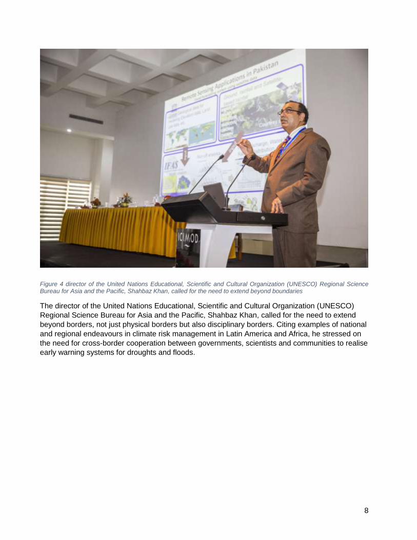
Figure 4 director of the United Nations Educational, Scientific and Cultural Organization (UNESCO) Regional Science Bureau for Asia and the Pacific, Shahbaz Khan, called for the need to extend beyond boundaries
The director of the United Nations Educational, Scientific and Cultural Organization (UNESCO)
Regional Science Bureau for Asia and the Pacific, Shahbaz Khan, called for the need to extend
beyond borders, not just physical borders but also disciplinary borders. Citing examples of national
and regional endeavours in climate risk management in Latin America and Africa, he stressed on
the need for cross-border cooperation between governments, scientists and communities to realise
early warning systems for droughts and floods.

9
Drought Monitoring and Early Warning Systems
Figure 5 Speakers at the session on drought monitoring and early warning systems: (L-R) Pranita Bhushan Udas, Faisal M. Qamer, Tsegaye Tadesse, Mir Matin, Wu Bingfang, Susantha Jayasinghe, Benjamin F. Zaitchik
In this session, speakers highlighted that remote sensing-based estimation of key environmental
variables such as rainfall, temperature, soil moisture and evapotranspiration have been increasingly
used to develop drought-monitoring tools. However, further improvement (including evaluation and
bias correction) is needed using ground observation to generate more accurate datasets. In the
South and Southeast Asia region, several efforts have been made to evaluate satellite-derived
rainfall datasets, with encouraging results. For example, the evaluation of the satellite-derived rainfall
data i.e., Climate Hazards Group InfraRed Precipitation with Station data (CHIRPS) in South Asia
presented at the forum showed encouraging results for rainfall estimates in the region. Forum
participants suggested building up regional and local cooperative mechanisms that could help in
operationalizing Disaster Management Early Warning System (DMEWS) in the region.

10
Figure 6 Benjamin F. Zaitchik presents on Drought Monitoring and Forecast with the NASA Hindu Kush Himalaya Sub-Seasonal to Seasonal Forecast System (HKH-S2S)
Progress has been made in improving hydro-meteorological modelling for drought monitoring. For
example, NASA’s Hindu Kush Himalaya Sub-seasonal to Seasonal Forecast System (S2S) has
been designed for optimal monitoring and probabilistic seasonal forecast of hydrological conditions
distributed across the Hindu Kush Himalayas (HKH) and South Asia. The HKH-S2S merges models
and satellite observations to get spatially complete monitoring and forecasts in data-limited regions.
However, challenges remain, such as uncertainty in seasonal forecasts of the South Asian monsoon
and evaluation of Land Data Assimilation System (LDAS) simulations. Using Earth Observation and
merging different ground observations with model outputs through an innovative approach (including
data mining/Artificial Intelligence) were recommended to help reduce uncertainties and improve
DMEWS.
In addition, there is a strong interest in developing regionally and locally calibrated drought indices
as well as integrating/combining several types of data and information on climate and water supply,
including satellite-derived products and seasonal forecasts, to provide decision makers with a
comprehensive representation of current conditions and outlooks. The participants emphasized that
effective and reliable modelling of drought monitoring/prediction tools will need to be directly
connected to end users, with stakeholders engaged at all stages of model development and
application. The engagement and access to actionable information for DMEWS should also include

11
the most vulnerable, such as women, the elderly, and poor communities. This could help experts
and decision makers to better monitor, predict, plan for and cope with the impacts of drought,
including food security.
1. Retrospective Drought Study and Developing Satellite-Derived Combined Drought Index for
Crop Assessment: A Case Study from Balochistan, Pakistan – Tsegaye Tadesse, Faisal M.
Qamer, Walter Lee Ellenburg, Sarva T. Pulla, Vikalp Mishra.
2. Operationalizing Agriculture Drought Monitoring and Early Warning System in South Asia –
Mir Matin, Faisal M. Qamer, Kiran Shakya, Nishanta Khanal, Birendra Bajracharya, Benjamin
F Zaitchik, Bhoj Raj Ghimire.
3. Water Scarcity, Drought and Gendered Vulnerabilities in Hindu Kush Himalaya
(HKH) – Pranita Bhushan Udas, Chanda G Goodrich
4. Drought Monitoring and Forecast with the NASA Hindu Kush Himalaya Sub-Seasonal to
Seasonal Forecast System (HKH-S2S) – Benjamin F. Zaitchik
5. Application of Regional Drought and Crop Yield Information System to Enhance Drought
Monitoring and Forecasting in Lower Mekong Region – Susantha Jayasinghe, Farrukh
Chishtie, Kostas Andreadis, Narendra Das, Kel Markert
6. Regional Cooperative Mechanism on Drought Monitoring and Early Warning for Mongolia-
Experiences and Lessons – Wu Bingfang
7. Evaluation of Gridded Rainfall Data Products for Drought Monitoring in South Asia – Faisal
M. Qamer, Walter Lee Ellenburg, Mir Matin, Ashutosh S. Limaye, Carlo Montes, HM. Hamidur
Rahman, Timothy J. Krupink, Kushal K.C.

12
Figure 7 Hideki Kanamaru, Food and Agriculture Organization (FAO), highlighted the importance of early warning and early action
Hideki Kanamaru, Food and Agriculture Organization (FAO), highlighted the importance of early
warning and early action. He shared that FAO opted for Early Warning Early Action (EWEA) which
translates warnings into anticipatory action by putting plans into action and acting early; it is more
effective as it is taken before the disaster happens. Citing examples from the implementation of the
EWEA System in Mongolia and Vietnam, he discussed different phases, achievements and
learnings from the project. He shared that the project was able to reduce animal mortality by 10%
and animal birth mortality by 18%. Kanamaru also showcased the Agriculture Stress Index System
(ASIS) and presented a case study from ASIS in Nicaragua. He identified multi-sectoral impact,
enhanced evidence, consideration of short-term and long-term perspectives while planning as major
learnings from the project.
Ix Hour, Mekong River Commission Secretariat (MRCS), outlined how a common basin-wide
development and procedural framework for managing the Mekong was developed. He talked about
the regional drought monitoring and forecasting system, which adopted a Regional Hydrological
Extreme Assessment System (RHEAS) to calculate daily drought monitoring and forecasting on

13
meteorological, hydrological, and agricultural indicators for the Lower Mekong Basin (LMB). He
added that the system was developed under MRCS’s Drought Management Team (DMT) through
technical support from NASA Jet Propulsion Laboratory (JPL) established under cooperation through
SERVIR Mekong. He shared that the system provided monitoring and 90 day forecasts for the region
and added that the team was working on building capacity of MRC member counties in drought
analysis at the country level. He outlined how pre-processed drought monitoring and forecasting
data from the RHEAS was further processed at Asian Disaster Preparedness Center (ADPC), and
MRCS for generation and visualization of drought monitoring and forecasting indices before being
shared with end users through the websites.
Figure 8 Ashutosh S. Limaye, NASA-SERVIR, shared results from a joint SERVIR-CIMMYT effort that assessed the accuracy of CHIRPS-GEFS performance in Bangladesh
Ashutosh S. Limaye, NASA-SERVIR, shared results from a joint SERVIR-CIMMYT effort that
assessed the accuracy of Climate Hazards Group InfraRed Precipitation Station (CHIRPS) corrected
Global Ensemble Forecast System (GEFS)/(CHIRPS-GEFS) performance in Bangladesh in terms
of seasonal precipitation at various lead times, as compared to ground observations and for derived
variables such as monsoon onset and dry spells during the rainy season. He shared that both

14
CHIRPS and CHIRPS-GEFS were useful in detecting the onset of monsoon, and added that GEFS
has higher false alarm ratio as compared to CHIRPS. Limaye also introduced the ClimateSERV data
portal developed under SERVIR, which provides CHIRPS, CHIRPS-GEFS and Integrated Multi-
satellitE Retrievals for GPM (IMERG) data to the public.
Ha Hai Duong, Vietnam Academy for Water Resources (VAWR), shared experiences from a pilot
application of the Regional Drought and Crop Yield Information System (RDCYIS) for drought
monitoring and forecasting in Ninh Thuan province in Vietnam. From 2015–2016, the province
experienced the longest recorded drought in over 15 years in Vietnam, leading local government to
declare some drought affected districts a national disaster. He shared that the RDCYIS was built on
the locally calibrated RHEAS framework, in cooperation with ADPC. Duong spoke about the
system’s capabilities of capturing salient features of drought through a variety of indices. He briefed
about the detailed model performance including model calibration and validation, and the application
of model outputs for drought bulletins, drought management plans and strategies in the province5+.
These would in turn help local authorities prepare and respond to droughts through short and long-
term risk mitigation measures. Duong shared that the future plans are to improve the resolution of
the products i.e. from 25*25 km2 to 5*5 km2.
Nilesh Wagh, India Meteorological Department (IMD), presented on the use of Standardized
Precipitation Index (SPI) to identify all three types of drought – meteorological, agricultural and
hydrological – at different temporal scales in various districts of India. Wagh shared IMD’s
experiences in using SPI to monitor drought in the real-time and in developing droughts outlooks
and agricultural advisories. He shared different standard tools that could be used to calculate SPI.
He concluded that SPI provides magnitude and severity of drought at a given time scale, and is
useful in detecting multi-seasonal or multi-year droughts.
Muhammad Abid, COMSATS University, introduced the transboundary Chitral-Kabul River Basin
(CKRB) project that aims to develop satellite enhanced snowmelt flood and drought predictions for
the Kabul River Basin (KRB) with surface and groundwater modeling. He shared that there are
inherent complexities of water resource management in the Kabul River Basin (KRB) shared by
Afghanistan and Pakistan. Abid recommended on carrying out studies on cropping patterns and
resulting demand for agriculture and energy production to determine the magnitude of impact and
its time of occurrence for the basin. He also briefed about the increasing water demand over the
years, the area under cultivation, crop water demand per acre and total water demand of Agriculture.

15
The session chair, Tsegaye Tadesse, University of Nebraska–Lincoln, summarised the discussion,
highlighting achievements of the EWEA system, and MRC’s drought monitoring and forecasting
system, which provides 90 day early warning information using five variable indices. He emphasised
on the need for higher resolution results and improvement in drought forecasting capabilities. The
session chair intimated that Standardised Precipitation-Evapotranspiration Index (SPEI)s provided
better results in dry regions as compared to SPIs.

16
Drought Impacts and Climate Risk Financing
Figure 9 Speakers, Chair, session hosts and rapporteurs from the session on drought impacts and climate risk financing (L-R) Sijal Pokhrel, Sarbeswara Sahoo, Gwyn Rees, Indira Bose, Aneel Salman, Salar Saeed, Amanda Markert, (Back L-R) Bashudev Neupane, Abid Hussain, Peter Richards
Speakers at this session emphasized that understanding the impacts of drought events and their
associated vulnerabilities is critical for efforts towards mitigating drought impacts and developing an
understanding on building resilience in the future. Risk financing (e.g., credit and insurance) is an
effective tool to minimize losses from hazards such as drought. It can enable early intervention within
communities at risk and ultimately help build their capacity to respond and recover faster and more
efficiently. Even though there is general progress in climate services in the region, the panel noted
that disaster risk management (including drought preparedness and mitigation) suffers from three
main weaknesses that have led to preventable damage to lives and livelihoods and greatly increased
the cost of responding to disasters: (i) decision-making processes are too slow, (ii) preparedness
planning is inadequate and often done too late, and (iii) the current response models are outdated,
costly and underfunded.
Discussants suggested that there should be long-term policy interventions, together with capacity
building activities for farmers on efficient water use technologies and climate resilient farming. In
addition, operationalizing vulnerability assessments by utilizing remote sensing-based analysis in

17
combination with socio-economic, demographic and infrastructural data is critical for identifying the
most vulnerable communities. Remote sensing and modelling offer a means to understand changing
drought conditions caused by climate variability, their impacts, and approaches to plan effective risk
management strategies. Organizations should also work on social protection, so that the most
vulnerable can get assistance. Coping strategies work well if they are connected with money
generation through micro-financing and building local institutional partnerships.
The participants noted a strong need for improvement on three levels of science-based climate risk
financing and how it is used to mitigate drought impacts: (i) local (e.g., resource pooling and
parametric insurance), (ii) national (e.g., risk financing policy), and (iii) regional (e.g., country
consortium and cross learning). One forum participant noted, “Risk management through risk
financing by means of Index-based insurance is very important as finance should be ready before
the hazard impacts people.”
Sarbeswara Sahoo presented on the case of out-migration of tribal communities from tribal-
concentrated areas in Gujarat, India. He reasoned that topography, climate and more specifically
drought and its impacts –land scarcity, labor surplus, land division, limitations in crop diversity due
to water limitations were the main cause for this mobility. Sahoo shared that migrant tribal were
migrating to urban centres searching for livelihood options, abandoning arable land due to water
scarcity. He recommended improvement of agricultural support services and reclamation of common
property resources, especially water bodies, and effective implementation of government
programmes to check migration.
Gwyn Rees, Centre for Ecology & Hydrology, introduced the global Hydrological Status and Outlook
System (HydroSOS), an initiative by the World Meteorological Organization (WMO) that aims to
provide a global operational system for assessing the status of surface- and ground-water systems
and predicting how they will change in coming weeks and months. . He added that the proposed
approach would integrate local ground-based observation, satellite data, weather forecast and
hydrological models into the system. He apprised the floor of WMO’s plans to establish a pilot
HydroSOS in South Asia, which had been initiated in 2016 and extended till 2020. He urged
members to support the initiative by contributing expertise, current capabilities, information on their
requirements and validation of the System products based on observed data brought HydroSOS as
a material

18
Figure 10 Indira Bose speaks about risk mitigation and coordination building in Cambodia
Indira Bose, World Food Programme (WFP) – Cambodia, shared that the World Food Programme
(WFP), in partnership with the National Committee for Disaster Management (NCDM), and SERVIR
Mekong, were working on developing impact based forecasting for Cambodia to reduce the impacts
of disasters. She introduced the Platforms for Real-time Information Systems (PRISM) initiative that
leverages technology solutions to strengthen the government’s capacity to collect information and
improve coordination and response. Bose shared that PRISM serves as the national disaster
management information system, and allows different ministries to share data that is useful for
NCDM and humanitarian coordination bodies (i.e., national poverty registry), enabling more effective
decision-making.
Salar Saeed Dogar, Pakistan Agriculture Research Council (PARC), spoke about a drought risk
assessment study carried out in five districts in Pakistan to understand droughts over space and
time. He shared that Pakistan had witnessed the worst drought in 2002, with some union councils in
drought affected districts categorized as “extreme” and others as “severe” drought intensities. He
recommended that getting clear results from the grass root levels is necessary to apply defined
indices and tools at union council scale. He recommended on adoption of a Drought Mitigation

19
Strategy (DMS), designation of agencies for drought management and training of farmers in the
adoption of efficient water use technologies.
Amanda Markert, NASA SERVIR Science Coordination Office (SCO), spoke about risk financing
and how it can be leveraged for applications in drought and other extremes to mitigate impact. She
shared that parametric (index-based) insurance used an indicator or proxy of natural hazard (e.g.
wind speed, rainfall intensity), to trigger a pay-out as compared to traditional insurance packages
that pay for complete replacement of damaged assets. She shared an example of Kenya’s
Agricultural Insurance System (AIS) that guides payouts made to farmers during incidences of crop
failure. She added that SERVIR-Eastern and Southern Africa developed the crop mask and was
working towards strengthening the capacity of Kenya’s State Department of Agriculture (SDA) to
update crop masks on an annual basis to ensure the sustainability of the insurance system. Markert
recommended that drought indices derived from Earth observations and models could be used to
identify potential drought events to guide funding mitigation measurements.
Aneel Salman, COMSATS Institute of Information Technology, presented a case study from the
Tharparkar district of Pakistan which has experienced more frequent consecutive droughts in the
current decade. The study analysed linkages between different coping strategies of households and
their socio-economic factors during the drought period. Salman recommended opting for climate risk
financing models, water management strategies, microfinance programmes, building local
institutional partnerships and supporting local self-organization to address drought conditions.

20
Day 2, 9 October 2018
The second day of the forum witnessed panel discussions on agricultural land use policies and
practices, advances in remote sensing for crop area assessments, in-season crop assessment and
yield forecast. Through group discussions, participants addressed key questions formulated in the
session background notes.
Agricultural Land Use Planning and Policies
The session comprised of presentations on studies on implications of land use practices and policies
from Bangladesh, Nepal, and Pakistan. The session highlighted the significance of agricultural land
use planning and policies for long-term sustainability of resources and socio-economic progress in
the region.
Tariq Ali, Peking University, presented a study focused on virtual trade of land resources in Pakistan.
Ali’s study used information on Pakistan’s trade in fifteen key agricultural commodities over the
period 1990–2016, to provide quantitative analysis for policies to ensure sustainable production for
trade. He stated that Pakistan’s total virtual land trade has been increasing, accompanied by large
and increasing net exports of land to other nations. Ali suggested that aligning the agricultural
structure towards high land use value commodities, combined with active promotion of trade in these
commodities, could optimize agricultural land use for the country’s long-term food security.
Md. Anowar Hussain Bhuiyan, National University, presented on the importance of water resources
for agricultural production in the Chittagong Hill Tracts (CHT), Bangladesh. He shared that though
95% of the CHT area is unsuitable for intensive agriculture primarily due to remoteness and
inaccessibility, deforestation and land degradation is increasing in the region. Bhuiyan
recommended reducing degradation of natural resources, improving access to water, disseminate
knowledge for optimum utilization of water, and introducing effective technology usage to promote
sustainable agricultural practices in this region.
Raza Shah, UNESCO Islamabad, presented about a Rain Water Harvesting (RWH) project in
Musazai Sharif Union Council (UC), Dera Ismail Khan District, Pakistan which set up 16
demonstration sites for RWH along wth water filtration units and indigenous technologies like rooftop
rainwater systems in local schools. The project revived centuries-old ponds which were in a critical

21
condition and provided trainings to the communities to maintain the ponds for sustained water
availability. The project also introduced olive plantations coupled with drip irrigation systems in two
model sites, as olives are hardy plants requiring less water with lifespans of 100 years. Shah shared
that policies based on scientific evidence, efficient use of water resources and right crop selection
could lead to sustainable land use in drought-stricken areas.
Amina Maharjan, ICIMOD, presented on a study on agricultural land use change in Chitwan,
Nuwakot and Lamjung districts in the Gandaki River basin, Nepal from 1990 to 2010 vis-à-vis rural
outmigration. The study used an innovative interdisciplinary approach integrating macro scale and
longitudinal geospatial analysis with quantitative econometric causal analysis and participatory
qualitative methods. Maharjan’s results show that agriculture land abandonment is higher in
mountain areas than in the Tarai. The effect of outmigration on agricultural land abandonment also
has an important gender dimension: internal outmigration of women has a significant positive effect
on agriculture land abandonment, confirming the increasing feminization of the agriculture sector.
Quotes from the session
“The per capita land availability and per capita water availability is decreasing continuously from
1992 to 2016 in Pakistan, as the population is growing” - Tariq Ali
“Main challenge for water resources management in Bangladesh is the lack of knowledge to use
water resources efficiently” - Anowar Hossain Bhuiyan
“The main target of current initiatives is water security to all people”- Raza Shah
“Rainwater Harvesting (RWH) works best when all other options are not viable and in the areas
where much water goes wasted.”- Raza Shah
“There is need of common effort of interdisciplinary scientists, working together to brings
compressive results and more to be done together” - Amina Maharjan
“Migration is neither the major nor only one factor for the changes observed in the land use of
HKH region” - Amina Maharjan
Group Work - Agricultural Land Use Practices and
Policies
The session addressed the following key questions:
1. What are the key challenges related to current agricultural land use practices?

22
The group discussion summarised some of the key challenges in agricultural land use practices.
Some of the key challenges listed out are soil erosion, land fragmentation, land conversion,
drought, salinity, flood and degree of OM.
2. What is the state of affairs of agricultural land use policies terms of technical,
procedural and social and gender dimensions in South and Southeast Asia?
The group identified the state of affairs of the existing land use policies. For instance, local
regulations overwrite national policies; top-down policies do not fit local needs, poor integrated
& sustainable plans for land use planning and slow reaction to regional/global trends.
3. How can earth observation tools and technologies support sustainable agriculture
practices?
The group recommended the use of earth observation tools to support land use practices for
crop monitoring, early forecast, crop yield forecast, land use planning, disaster monitoring and
management and provide direct support for farmers & managers using decision support systems
(DSS).
4. How to link earth observation and modelling tools on land use pattern with data on
demographic changes?
The group discussion also came up with recommendations on how to link EO & modelling tools
on land use pattern with demographic changes. Some of the recommendations are the 1) land
use change detection using satellite data for driving forces such as population pressure, job
opportunity, economic development, social welfare, and market orientation. 2) Land use planning
using geospatial data and modelling techniques for the use of existing land use considering
socio-economic parameters, soil, topography, weather/climate, market orientation, and national
strategies. 3) Forecast land use change using models and EO data for prediction of cropland,
land use change forecast, competition, type allocation, land degradation prediction, and land use
change with socio-economic scenarios.

23
Advances in Remote Sensing for Crop Area
Assessments
Studies and best practices in the South and Southeast Asia presented at the forum show efforts of
assimilating remote-sensing data into crop models to recalibrate model parameters based on
remotely sensed crop status on the ground, and reducing uncertainties in seasonal weather
conditions by incorporating ground observations in the models. These presentations discussed in-
season crop assessment and yield forecasts using satellite-derived data and field observations to
determine key crop production indicators such as crop area, yield, crop condition, cropping intensity
and crop-planting proportion. In addition, experts shared their research outputs and experience from
other parts of the world.
The forum’s panels discussed innovative approaches for regional crop mapping using cloud-based
remote sensing and machine learning in the region. The presentations included lessons learned
from new and advanced techniques in remote sensing application for crop area assessments and
advanced deep learning algorithm (e.g., convolutional neural network) to predict vegetation levels
across large and heterogeneous geographic regions. In addition, open-access cloud-based
solutions for crop area mapping for food security planning and policies were discussed.
The panels deliberated on how remote sensing technologies are being integrated with conventional
systems for improving efficiency and accuracy of crop models and the challenges of adoption of new
technologies. The participants found that the major technical challenges to crop assessments
include (i) lack of ground observation (e.g., crop calendar/types), differentiating inter-cropping
patterns, soil profile, quality and resolution of remote sensing data and (ii) understanding of methods
and uncertainties of the crop models, tools, and products. The panel suggested that institutional
collaboration is needed to integrate satellite, climate, and crop data and models by engaging users
and decision makers and tailoring communication to local levels as well as defining a process to
make information available, thus reducing barriers.
Peter Richards, USAID, introduced a project that tried to identify drought resilience and project
impact using synthetic outcomes generated through a convolutional neural network (CNN). He
described the workflow in using an advanced deep learning algorithm – CNN to predict vegetation
levels using historical vegetation patterns, daily weather conditions, and observations of the local
relationships between vegetation and weather conditions. The generated synthetic outcomes were
used as a counterfactual to identify and estimate drought resilience, and the impact of new

24
agricultural policies and programmes on agricultural productivity. Richards showcased several
examples including ones from Nepal. He concluded by stating that CNN models, combined with
remote sensing and estimations, can offer low cost, generalizable method for identifying and
assessing causal change.
Muhammad Fahad, University of Agriculture, Pakistan presented on the methodology using multi-
temporal Landsat time-series imageries for wheat area estimation in Faisalabad district, Pakistan.
Fahad explained the importance of the Normalized Difference Vegetation Index (NDVI) variable for
the classification of wheat from from other cultivated and non-cultivated areas. Accuracy assessment
results showed the overall accuracy, commission error and omission error as 77% with ±5% as
standard error, 23% and 28% respectively. He also highlighted mixed pixels originating from linear
tree plantations, and small land holdings used for agriculture as some of the bottlenecks in such an
approach. He recommended that the accuracy of similar exercises could be improved by minimising
mixed pixels located at field borders and using Sentinel imagery that have a higher ground resolution.
Sawaid Abbas, Hong Kong Polytechnic University, shared his experiences of using the Google Earth
Engine (GEE) platform and Sentinel imagery for crop area mapping in Punjab Province, Pakistan.
Abbas processed multi-temporal data from Sentinel-2 and Sentinel-1 satellites in the GEE platform
to characterize phenology of major crops, viz., wheat and potato in Rabi (winter) crops and
sugarcane, cotton and rice for Kharif (summer) crops. Comparing results from the study with results
from semi-automated supervised classification showed consistent results for wheat and sugarcane
while over-estimating statistics for rice and cotton. Abbas stated that by incorporating recent data on
crop development stage, the framework could generate near-real-time scenarios for crop area. He
further aadded that cloud-based solution is transparent, repeatable and replicable in areas with
similar cropping systems, and presented a strong potential to replace existing enterprise-based
solutions.
Varun Tiwari, ICIMOD, shared his experiences of using Sentinel 1 Synthetic Aperture Radar (SAR)
data and Sentinel 2 (10m spatial resolution) optical data in a GEE platform for mapping wheat sown
area in Afghanistan. He spoke about the importance of crop area estimation; crop yield estimation
for crop yield forecasting; pricing; distribution-export and import; formulation of policy. Tiwari
suggested that integrating optical and SAR data helped improve the accuracy of crop classification,
while GEE enabled processes of high volume of data. He apprised the floor of ICIMOD’s interest to
continue the wheat crop classification using the same approach, improved field data collection in
coordination with Ministry of Agriculture Irrigation and Livestock (MAIL), Afghanistan, and capacity
building of MAIL staff for the sustainability of the project and regular update in crop maps.

25
Farrukh Chishtie, ADPC, provided a brief overview of the Regional Land Cover Monitoring System
(RLCMS) that had twenty collaborating agencies. The RLCMS uses an innovative cloud based
remote sensing and machine learning approach utilizing the GEE platform. Chishtie presented
ADPC’s approach for the Mekong regional crop mapping products, where they combined regional
database of reference training data on crop type, crop seasons, and irrigation conditions with remote
sensing data and used via machine learning algorithms to create probability maps. Chishtie also
showcased how harmonic trends of crop seasons were derived to calculate seasonality, and a time-
series of annual crop and rice maps from 1990 to date. Finally, he concluded that using open tools
increased involvement and partnership of multiple stakeholders in the development process.
Group Work - Advances in Remote Sensing for Crop
Area Assessments
The session came up recommendations on how remote sensing technologies can be integrated with
the conventional system for improving efficiency and accuracy of crop area statistics and the
challenges in adoption of new technologies.
The session addressed the following key questions:
1. What are the opportunities and bottlenecks in the adoption of geospatial technologies
for crop area estimation in South and Southeast Asia?
Freely available data, improved spatial and temporal resolutions, and availability of free and
open source software and cloud-based platforms such as the Google Earth Engine, improved
storage capacity and data processing to store and manage large geospatial datasets, access
to advanced algorithms such as machine learning present themselves as a whole gamut of
opportunities.
However there are bottlenecks – weather conditions (cloud/aerosol contamination),
differences in field vs pixel scale, and diversity of agricultural practices and different inter-
cropping patterns are some of the hurdles. A general lack of ground observation data,
financial resources, technical capacity (trained staff) and lack of local context often affect the
adoption of geospatial technologies for crop area estimation in South and Southeast Asia.

26
2. How to optimize field data collection mechanisms from ICT technologies and field-
based institutional setups?
The key recommendations to optimize field data collection mechanisms received were to use
crowdsourcing technologies (e.g. Collect Earth Online) and mobile applications.
Standardization of data collection and data sharing at different levels (policy concerns),
developing and maintaining open channels of communications (inter-ministry and inter-
agency), involving students for data collection, and defining and teaching/training best
practices and using new techniques – drones and the internet– were other recommendations
received.
3. What are the next steps needed to integrate remote sensing methods in the
institutional crop area estimation process?
Active learning approaches for improved field data collection, methodologies to assimilate
remote sensing and ground data collection, data mining, exploring the use of high-resolution
base maps for high frequency and promoting the use of remote sensing/GIS within the
institutional structure for proper operations.
In-season Crop Assessment and Yield Forecast
Agriculture and food security issues continue to be major challenges in South and Southeast Asia.
Drought is a major challenge that can result in severe food shortages and depleted pastures,
threatening the livelihoods and lives of millions of people. These impacts are especially pronounced
in South and Southeast Asia as many people depend on rain-fed agriculture in a highly variable
climate. Early information like in-season yield assessments and forecasts about potential end-of-
season production could help national ministries and NGOs better plan and respond to possible food
security crises. Additionally, crop assessments and modelling techniques can provide insight and
guidance on optimal planning strategies and agricultural practices that can help to mitigate future
drought impacts, providing valuable information to policymakers, agriculture extensions and farmers
alike. The session explored novel techniques for cropland assessments and yield estimations, such
as remote sensing and modelling techniques, and discussed knowledge gaps and solutions needed
to integrate these methods into decisions support systems.

27
Wu Bingfang, Institute of Remote Sensing and Digital Earth (RADI), Chinese Academy of Sciences
(CAS) provided the keynote presentation for the session. He emphasized that an integrated
approach, sustainable and resilient agriculture practices are needed to attain Goal 2: Zero Hunger,
one of the sustainable development goals. He singled out information gap in food security as the
biggest challenge, and added that cloud computing can be an effective technique to utilise free
satellite data for in-season crop monitoring and yield forecasts. He introduced CropWatch – China’s
leading crop monitoring system, part of RADI, CAS. Wu shared that the system aims to improve food
information availability, quality and transparency globally. He shared CropWatch’s hierarchical
approach for crop production monitoring which uses specific environmental and agricultural
indicators on different scales to assess global, regional, and national (as well as sub-national) crop
conditions, production, and agricultural trends. Wu also provided an overview of the different
components within the CropWatch Cloud system – CropWatch-Pro (web service for people to
produce crop monitoring products), CropWatch-Explore (web service for users to explore and
visualize data), CropWatch-Analysis (open tool available for public for analyses of data), and
CropWatch-Bulletin (web space for people to read/download the CropWatch Bulletin). Wu shared
CropWatch’s plan on rolling out to different nations by customizing and localizing, and Integrating
with local technical systems and utilization of local knowledge. He showcased an example of how
CropWatch was customized for Mozambique, which led to information being incorporated into
Mozambique National Agro-Meteorological Bulletin in June 2018
Wei Xiong, CIMMYT-China, presented on an assessment of the potential impacts of past drought
anomaly (1961–2010) on summer maize yield, using a process based crop model, CERES-Maize,
in China. The CERES-Maize used gridded geographical data, with yield difference between irrigated
and rain fed conditions defined as the potential yield loss caused by drought. Wei’s team used the
anomaly percentage of potential yield loss to reflect the inter-annual and inter-decadal variation of
estimated impact of drought on Maize in China. Wei shared that there was a decreased drought risk
for summer maize production in China, and also indicated that the drought had moved to
northeastern China during the past fifty years. He further added linkages between national maize
yield loss and atmospheric circulation index realized through the assessment were used to establish
a simple conceptual forecasting model.
Walter Lee Ellenburg, NASA SERVIR SCO, shared results from a study that assimilated satellite-
derived microwave and thermal-infrared coupled soil moisture (SM) profiles into a crop model for
yield estimates. The study was conducted over parts of the southeastern United States from 2006–
2010. He shared that while agricultural simulation models played a key component in testing new

28
technologies, seeds, and cultivars, inaccurate input information and model related errors added to
model uncertainties. He recommended assimilating satellite observations of soil moisture (SM),
vegetation index, etc. into crop models to reduce input and model related uncertainties. Irrigated
regions observed highest improvements. The rain-fed model simulation failed to register additional
water supply but remotely sensed profiles were able to detect such supplements. Ellenberg stated
that by assimilating remotely sensed SM profiles into crop model the errors were reduced nearly by
a factor of 5 compared to open-loop yield errors against National Agricultural Statistical Services
(NASS) reported yields.
Ved Prakash Singh, India Meteorological Department, shared his experiences from a modeling
exercise in estimating rice and wheat yields for Madhya Pradesh and Maharashtra in central India,
incorporating weather variables and Vegetation Condition Index (VCI) derived from remote sensing
methods. Singh suggested that yield forecasts generated by the proposed model were validated
against actual production data. Positively coupled comparison results implied that it can be applied
in practice for both crops (rice and wheat) to generate more accurate and region based real time
yield forecast in developing countries. He recommended the incorporation of other remote sensing
parameters, along with VCI, in weather based crop yield forecasting models to improve model
performance and accuracy.
Saurav Suman, United Nations World Food Programme (WFP), shared his experiences in using the
CCAFS Regional Agriculture Crop Forecasting Toolkit (CRAFT) for yield estimation of rice and wheat
in Nepal. CRAFT includes a crop simulation module, a weather and seasonal forecast simulation
module, and a geographic information system module and is primarily used for in-season forecasting
of crop production. Suman shared that there is limited data on crop management and variety, and
that the model performed well for wheat but had more room for improvement on rice estimates. More
research required for satellite-derived datasets. He stated that the model was producing regular
updates for the nation, which were disseminated through the Nepal Food Security Monitoring System
(NeKSAP) website. He added there was more demand for subnational predictions as well. Suman
proposed using CHIRPS data for short term, long term yield estimates and blending DHM data with
CHIRPS.
The session chair, Ashutosh S. Limaye, summarised the session on how a combination of weather
and remote sensing derived indices – Vegetation Condition Index (VCI) can improve results in yield
estimation. He suggested that in-season crop yield estimates requires strong collaboration within
ministries.

29
Group Work – In-season Crop Assessment and Yield
Forecast
The session addressed the following key questions:
1. What are the major technical challenges to crop assessments and yield prediction in
South and Southeast Asia?
The group divided major technical challenges to crop assessments and yield prediction in
two categories – data and methods used for crop assessment, and yield estimation.
The challenges with respect to data are integration of weather information – current and
forecasted, lack of data on crop type and soil profiles, disaggregated data with differing
formats, problems with resolution (spatial, temporal) of remote sensing data, constraints
based on scale and temporal need for information, lack of interdisciplinary collaboration. Most
importantly, validation and accuracy assessment of models.
Statistical/empirical and simulation are two types of models used for crop assessment and
yield estimation. Lack of knowledge on how to use (set-up, process, parameterise and run)
these models is a major challenge.
2. What kinds of innovative solutions are needed to address the dearth of data on
cropping practices and production?
The group suggested the following solutions:
Use of remote sensing and image analysis as it provides information for data sparse
regions. The use of drones or Unmanned Air Vehicles (UAV) as it provides detailed
information for targeted regions.
Location and crop-specific models: some of the regions can have many climatic and
agricultural zones. Integration of weather forecasts – emphasis on long-term and
seasonal forecasts
Improve capacity building to build knowledge and expertise.
Consolidate information and ensure knowledge continuity by transfer and documentation
of information.

30
Inclusion of information on other drought effects such as disease and pests.
3. What are the next steps needed to integrate these methods in decision making and to
allow end users to use them?
Understand and contribute in decision make process. It would help to build trust in
produced science, data, and models. It will also bridge gaps between interdisciplinary
fields
Have a review process in place to assess success and failures. Proper monitoring and
evaluation process - what worked, what did not, and how it can be improved?
Understand methods to communicate and disseminate information and advisories.
Tailoring communication to local levels and defining a process to make information
available which would help reduce barriers
31
Day 3 – 10 October 2018
Panel Discussion: Emerging Earth Observation
Technologies and its Adoption in the South and
Southeast Asia Region
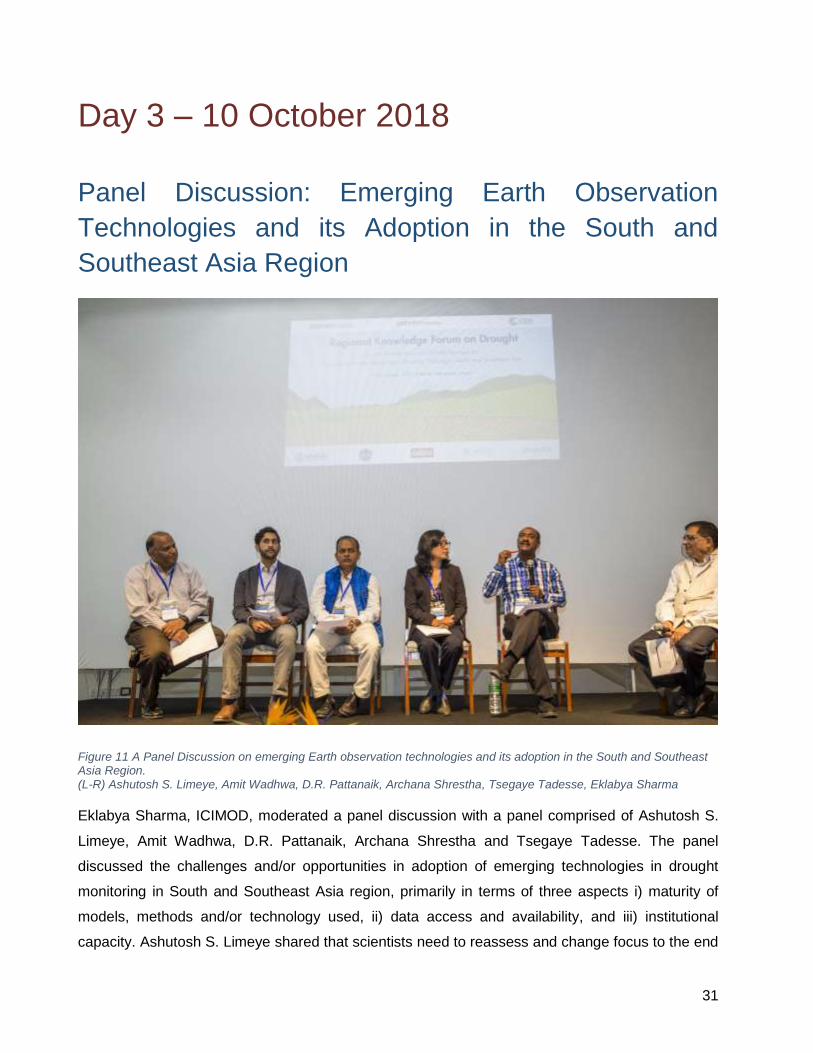
Figure 11 A Panel Discussion on emerging Earth observation technologies and its adoption in the South and Southeast Asia Region. (L-R) Ashutosh S. Limeye, Amit Wadhwa, D.R. Pattanaik, Archana Shrestha, Tsegaye Tadesse, Eklabya Sharma
Eklabya Sharma, ICIMOD, moderated a panel discussion with a panel comprised of Ashutosh S.
Limeye, Amit Wadhwa, D.R. Pattanaik, Archana Shrestha and Tsegaye Tadesse. The panel
discussed the challenges and/or opportunities in adoption of emerging technologies in drought
monitoring in South and Southeast Asia region, primarily in terms of three aspects i) maturity of
models, methods and/or technology used, ii) data access and availability, and iii) institutional
capacity. Ashutosh S. Limeye shared that scientists need to reassess and change focus to the end

32
user so that the science is usable. He recommended that new products be designed based on mutual
learning and understanding with end users, and data portals increase data accessibility to end users.
Limaye emphasised institutional capacity building as an important aspect, and suggested on looking
for examples that worked, and replicating them for local audiences. Limeye recommended that
institutions should include people who understand the models, outputs and also build awareness of
how to use the data to fit the different contexts.
Tsegaye Tadesse shared that models used for monitoring and forecasting drought should be based
on ground observations, and be accurate as far as possible for better forecasting, mitigation and
planning. He added that several models and predictions at regional, global, national and local level
were available, but more must to be done to ensure data availability, and capacity building must be
carried out to increase efficiency of the models. He stressed that validation of models is equally
important.
D.R. Pattanaik said that technological advances have led to improved model accuracy in the last
twenty years. He added the development process should be further improved so that users are able
to utilize model outputs. He shared that the evolution of models and technology helped in reducing
gaps.
Archana Shrestha outlined lack of data as one of the main challenges in monitoring of climate
induced hazards in Nepal. She mentioned that Nepal’s Department of Hydrology and Meteorology
(DHM) was working on establishing more automated weather stations and making data available on
SPI and SPEI. She added that once the department had enough stations, the data could be used
for validation of models. She mentioned that Nepal had yet to start forecasts on drought. Shrestha
also suggested that operationalization of services and continuation of the same are important once
they have been identified as fit for certain group of users. She stressed that reviewing existing
products and improving them were equally important for institutional capacity building
Amit Wadhwa advocated the benefits of involving the private sector in data management. He stated
that there were challenges in bringing in the private sector and in providing them access to data.
Wadhwa recommended on opting for a private / public partnership models, examining how
organizations utilize available information and developing helpful and practical interventions for end
users as important aspects for consideration.

33
Panel Discussion: Policy Actions for Operationalizing
Climate and Agriculture Services
Figure 12 David Molden, DG, ICIMOD moderated a panel discussion on policy actions for operationalizing climate and agriculture services
David Molden, ICIMOD’s Director General, moderated a panel discussion focused on three
questions:
- The status of drought in countries and their preparedness strategy
- Bottlenecks in drought monitoring, evaluation, assessment and mitigation of droughts
- Financial resources planning for droughts
Peter Richards highlighted climate resilience as an important issue, and identified preparation at
the household level, provisioning of index-based insurance and keeping markets moving for best
products. Efficient products have to be considered and be open to disrupt ideas in partnership.
American companies pay climate service startup. The data scientists need to search for innovation
and move out of comfort zones for finance.

34
Abid Hussain reflected upon the present status of Bangladesh under drought together with other
challenges such as population increase, shrinking land, conversion of arable land for off-farm
business. However, the preparedness for drought is in highest priority in Bangladesh by adopting
heat tolerant crop varieties, crop tuning, and shallow-rooted crops in drought-affected areas. He
emphasised on the unavoidable alternatives for regional collaboration by sharing knowledge and
experiences, sharing data in term of application development, capacity building of the institution,
sharing of resources and utilisation, exchange of tools and technologies. There have been many
initiatives and have failed because of policy support system and way of development. There has to
be policy support, institutional support and belongingness in the regional level. Awareness building
among beneficiaries regarding service is important, and it should create impact. The process should
involve the users for field validation and demonstration, and it also has to include piloting. Target
specific products should be given importance considering local contexts such as language — the
products reliable, timely, free delivery (or low cost) and location-specific considering the
socioeconomic condition of that area. He also pointed out the difficulties in the execution of projects
in the form of non-availability of appropriate data such as desired resolution map, data reliability, and
lack of skilled workforce in the institution and information hole of the end users.
Divya Gurung emphasized the status of policy to make it more gender responsive. The things that
have gone in parallel are somehow directed in the different sector by different working institutions
and stakeholders. She questioned how much privilege, does drought and resilience is getting in a
national and international context, by saying privilege, it is about space and financial investment.
She raised the issues like how we make a woman as a primary stakeholder as a foremost question
and how to translate the findings of larger technical fields such as GIS, modelling into the interest of
primary stakeholders, while formulating key policies. The local bodies need to consider by scientists
and practitioners, and the findings have to make sense to at least local representative authority.
Basanta Shrestha stressed on the importance of a regional data policy and harmonisation.
Investment in human resource and policies to make it conducive for the private sector to come and
invest for the sustainable running of projects. There are dedicated institutions of government, there
are multiple stakeholders, and all sectors have a role, so the open data services have much
importance in this region. The key challenge to the scientific community is can we make business
sense out of it and can we serve the need of local authorities who are hungry for ideas to implement
in the ground.
Aneel Salman emphasised to bring food security and policy from a national perspective. The
problem is in un-synced process of policy formulation because it works in isolation. He also talked

35
about policy paralysis when it came in the implementation phase and tried to draw the learning from
developed country mechanism such as minimum support price (MSP). The assessment of the entire
policy cycle has to be done before going for implementation and see how it work, and this flexibility
allows stakeholders in regular intervention.
Quotes from the session:
The primary concern is, what could be achieved in local level by having regional collaboration -
David Molden
Focus has to be on getting out to best products as per user need and wider collaboration with
partners and with the government for mitigation of drought impacts - Peter Richards
There is no other alternatives in regional collaboration than sharing knowledge, data and
examples along with capacity building by exchange of human resources, tools and technologies
- Abid Hussain
Woman in Asia and Nepal, by default, are the primary users of natural resources, but woman
are not considered in planning and policy-making as primary stakeholders - Divya Gurung
Who is synthesising information matters a lot for policy formulation? - Divya Gurung
Supply vs demand theory also applies in drought management policies as technology offers a
solution and give methods and technologies in need of locals (end users) and there is a gap in
supply and demand in HKH - Basanta Shrestha
Young people serve as “tech force”, contribute to knowledge generation, communication of the
gathered information - Basanta Shrestha
Do we have policies, yes and are these solving problem, No - Aneel Salman
Policies should be synced in different level because the single institution cannot solve the
problem – Aneel Salman
Issue of policy sinking is important in regional and national scale because one stakeholder
cannot solve the problem and second generation multi-stakeholder partnership (MSP) have to
be used for Knowledge sharing - Aneel Salman
Like data analysis using Artificial Intelligence (AI), there needs policy analysis to see the trend
and correlation - Aneel Salman
Establishment of expert working groups to foster
regional cooperation
The multi-faceted nature and interconnectedness of drought, food security, and socio-economic
issues related to race, class and gender demand a strategic partnership to develop engaged and
drought-resilient communities. In breakout groups, the participants at the forum discussed ways to
establish a regional partnership –an innovation platforms– with participation of national and regional
institutions, private sectors, local and international organizations to improve climate services using

36
Earth observation and facilitate agricultural decision-making to help with food security in the region.
Thus, three working groups (WGs) were proposed at the forum:
Drought monitoring and early warning,
Crop area and yield estimation, and
Management and policy.
The value and benefit of Earth observation for drought risk management and food security, which
were discussed at the forum, are also highlighted in Figure 1. These WGs will have regional
coordinators (e.g., experts from ICIMOD, CSRD, and SERVIR) and representatives from each
country’s key institutes in the region. The WGs are expected to help in knowledge sharing and
exchange of data resources as well as in building institutional capacity needed to address drought
monitoring and food security issues. Volunteering members of these WGs will meet periodically to
share their experiences and lessons learned. In addition to fostering collaboration at the regional
scale, the forum participants strongly recommended training local experts in capacity building.

37
ICIMOD SERVIR
CSRD

Annex I – List of participants
S. No Country Full Name Institution
1 Afghanistan Sayed Burhan Atal ICIMOD
2 Afghanistan Waheedullah Yousafi ICIMOD
3 Afghanistan Asadullah Rahmatzai Kabul University
4 Afghanistan Fawad Auobi Kabul University
5 Afghanistan Md. Kazem Yosufi Kabul University
6 Afghanistan Nasrin Faqiri Kabul University
7 Afghanistan Sediqullah Reshteen Kabul University
8 Bangladesh Hasan Md. Hamidur Rahman Bangladesh Agricultural Research Council
9 Bangladesh Kabir Uddin Ahmed Bangladesh Agricultural Research Council
10 Bangladesh Md. Abeed Hossain Chowdhury Bangladesh Agricultural Research Council
11 Bangladesh Mostafa Ali Center for Environmental and Geographic Information Services
12 Bangladesh Iftekhar Mahmud N/A
13 Bangladesh Pravez Babul N/A
14 Bangladesh Md. Anowar Hussain Bhuiyan National University
15 Cambodia Hideki Kanamaru World Food Programme
16 China Wu Bingfang Chinese Academy of Sciences
17 China Urs Christoph Schulthess CIMMYT
18 China Wei Xiong CIMMYT
19 China Tariq Ali Peking University
20 China Sawaid Abbas The Hong Kong Polytechnic University
21 India Sarbeswara Sahoo Global Informal Labour Institute
22 India D.R. Pattanaik India Meteorological Department
23 India Nilesh Wagh India Meteorological Department
24 India Shirish Khedikar India Meteorological Department
25 India Ved Prakash Singh India Meteorological Department
26 India Padma TV PRESS
27 Indonesia Shahbaz Khan United Nations Educational, Scientific and Cultural Organization
28 Nepal Arjun Kumar Shrestha Agriculture and Forestry University, Chitwan
29 Nepal Kishor K.C. Central Bureau of Statistics
30 Nepal Bashudev Neupane Central Department of Environmental Sciences, Tribhuvan University

B
S. No Country Full Name Institution
31 Nepal Binod Parajuli Central Department of Environmental Sciences, Tribhuvan University
32 Nepal Kribina Pathak Central Department of Environmental Sciences, Tribhuvan University
33 Nepal Kripa Shrestha Central Department of Environmental Sciences, Tribhuvan University
34 Nepal Sijal Pokhrel Central Department of Environmental Sciences, Tribhuvan University
35 Nepal Arun Kafle Department of Agriculture
36 Nepal Priyambada Joshi Department of Agriculture
37 Nepal Kishor Aryal Department of Forest and Soil Conservation
38 Nepal Prakash Singh Thapa Department of Forest and Soil Conservation
39 Nepal Archana Shrestha Department of Hydrology and Meteorology,MoPE
40 Nepal Prakash Acharya District Agriculture Development Office
41 Nepal Angeli Shrestha ICIMOD
42 Nepal Bhoj Raj Ghimire ICIMOD
43 Nepal Bikram Shakya ICIMOD
44 Nepal Birendra Bajracharya ICIMOD
45 Nepal Deepak Kumar Shah ICIMOD
46 Nepal Ganesh Bhattarai ICIMOD
47 Nepal Gauri Shankar Dangol ICIMOD
48 Nepal Ishaan Kochar ICIMOD
49 Nepal Kabir Uddin ICIMOD
50 Nepal Kushal K.C ICIMOD
51 Nepal Maxim Shrestha ICIMOD
52 Nepal Mir Matin ICIMOD
53 Nepal Nishanta Khanal ICIMOD
54 Nepal Prashanti Sharma ICIMOD
55 Nepal Rajesh Bahadur Thapa ICIMOD
56 Nepal Rajesh Shrestha ICIMOD
57 Nepal Ramesh Silwal ICIMOD
58 Nepal Shova Bhandari ICIMOD
59 Nepal Sudip Pradhan ICIMOD
60 Nepal Trilochana Basnet ICIMOD
61 Nepal Utsav Maden ICIMOD

C
S. No Country Full Name Institution
62 Nepal Smohit Shrestha International Rice Research Institute
63 Nepal Vishnu Prasad Pandey International Water Management Institute
64 Nepal Bhoj Raj Sapkota Ministry of Agricultural, Land Management and Cooperatives
65 Nepal Shib Nandan Prasad Shah Ministry of Agriculture and Livestock Department
66 Nepal Sudip Devkota Ministry of Agriculture and Livestock Department
67 Nepal Yubak Dhoj G.C Ministry of Agriculture and Livestock Department
68 Nepal Madhusudhan Guragain Nagarik News
69 Nepal Ram Chandra Adhikari National Agriculture Research Center
70 Nepal Ghanashyam Malla Nepal Agricultural Research Council
77 Nepal Robert Banick World Bank
71 Nepal Amit Wadhwa World Food Programme
72 Nepal Man Bahadur Kshetri World Food Programme
73 Nepal Moctar Aboubacar World Food Programme
74 Nepal Nicola Bidento World Food Programme
75 Nepal Pushpa Shrestha World Food Programme
76 Nepal Saurav Suman World Food Programme
78 Nepal Sridhar Thapa World Food Programme
79 Pakistan Aneel Salman COMSATS Institute of Information Technology
80 Pakistan Muhammad Abid COMSATS Institute of Information Technology
81 Pakistan Salar Saeed Doggar Pakistan Agricultural Research Council
82 Pakistan Syed Muhammad Raza Shah United Nations Educational, Scientific and Cultural Organization
83 Pakistan Muhammad Fahad University of Agriculture
84 Sri Lanka Laksiri Nanayakkara World Food Programme
85 Thailand Farrukh Chishtie Asian Disaster Preparedness Center/SERVIR-Mekong
86 Thailand Peeranan Towashiraporn Asian Disaster Preparedness Center/SERVIR-Mekong
87 Thailand Senaka Basnayake Asian Disaster Preparedness Center/SERVIR-Mekong
88 Thailand Susantha Jaysingha Asian Disaster Preparedness Center/SERVIR-Mekong

D
S. No Country Full Name Institution
89 Thailand Wadee Deeprawat Asian Disaster Preparedness Center/SERVIR-Mekong
90 United Kingdom Gwyn Rees Center for Ecology and Hydrology
91 United States of America Benjamin Zaitchik John Hopkins University
92 United States of America Amanda M. Weigel
National Aeronautics and Space Administration
93 United States of America Kel Markert
National Aeronautics and Space Administration-SCO
94 United States of America Walter Lee Ellenburg
National Aeronautics and Space Administration-SCO
95 United States of America Tsegaye Tadesse National Drought Mitigation Center-NASA
96 United States of America Pete Richardson
United States Agency for International Development
97 Vietnam Tri Deri Setiyono International Rice Research Institute

E
Annex II – Agenda
Day 1 (8 October 2018)
09:00 11:00 Session 1: Opening Session
Forum background and objectives: Birendra Bajracharya, ICIMOD
Welcome from host and co-host: David Molden, ICIMOD
and Hans Guttman, ADPC
Opening remarks: Pete Epanchin, USAID
Keynote speech: Shahbaz Khan, UNESCO
Remarks by chief guest: Yubak Dhoj G.C., Ministry of Agriculture and Livestock Development, Nepal
Vote of thanks: Faisal M. Qamer, ICIMOD
11:00 11:30 Tea break and Group Photo
11:30 13:15 Session 2: Drought Monitoring and Early Warning Systems Chair: Hans Guttman, ADPC
13:15 14:00 Lunch Break
14:00 15:45 Session 3: Parallel Session
(3a) Drought monitoring and early
warning systems
Chair: Tsegaye Tadesse, University of
Nebraska Lincoln
(3b) Drought impacts and climate risk
financing Chair: Peter Richards, USAID
15:45 16:00 Tea Break
16:00 17:15 Session 4: Climate Services and Climate Risk Financing Challenges
and Opportunities (Group work)
Moderator will elaborate on broader issues on the topic. Followed by the break-out group work.
Breakout structure: The group work will be structured around the Key Questions formulated in the Session background notes. Moderators: Benjamin Zaitchik, John Hopkins University, and Farrukh Chishtie, ADPC
18:30 20:00 Forum Dinner
Day 2 (9 October 2018)
09:00 10:00 Recap day 1
10:00 11:15 Session 4: Agricultural Land Use Practices and Policies Chair: Prak Thaveak Amida, Ministry of Agriculture, Forestry and Fisheries of Cambodia
11:15 11:35 Tea Break

F
Day 2 (9 October 2018)
11:35 13:15 Session 5: Advances in Remote Sensing for Crop Area Assessments Keynote speech by Peter Richards, USAID Chair: Peeranan Towashiraporn, ADPC
13:15 14:00 Lunch Break
14:00 15:45 Session 6: In-season Crop Assessment and Yield Forecast Keynote speech by Wu Bingfang, RADI Chair: Ashutosh S. Limaye, NASA-SERVIR MFC
15:45 16:00 Tea Break
16:00 17:15 Session 7: Earth Observation for Agricultural Land Use Planning and
Food Security Policies (Group work)
Moderator will elaborate on broader issues on the topic. Followed by the break-out group work.
Breakout structure: The group work will be structured around the key questions formulated in the session background notes Moderators: Mir Matin, ICIMOD, and Walter Lee Ellenburg, NASA-SERVIR SCO
Day 3 (10 October 2018)
09:00 10:00 Recap day 2
10:00 12:30 Policy-level Deliberation
10:00 10:30 Key Messages and Lessons from Day 1 and Day 2 Faisal M. Qamer, ICIMOD, and Senaka Basnayake, ADPC
10:30 11:30 Panel Discussion
Emerging Earth Observation Technologies and its adoption in the South and East Asia Region Moderated by Eklabya Sharma, ICIMOD
11:30 12:30 Panel Discussion
Policy Actions for Operationalizing Climate and Agriculture Services Moderated by David Molden, ICIMOD
Short Briefing on Establishing Thematic Working Group or Expert Groups Faisal M. Qamer, ICIMOD
12:30 13:30 Lunch Break
13:30 15:00 Session on Formalizing Knowledge Forum and Expert Groups Moderators: Mir Matin, ICIMOD, and Farrukh Chishtie, ADPC
15:00 15:30 Closing Session

G
Annex III – List of Talks at the Drought
Forum
Drought Monitoring and Early Warning Systems
Session Chair: Hans Guttman
Session hosts: Senaka Basnayake, Sudip Pradhan
Rapporteurs: Binod Parajuli, Kripa Shrestha
1. Drought Monitoring and Forecast with the NASA Hindu Kush Himalaya Sub-Seasonal to
Seasonal Forecast System (HKH-S2S) – Benjamin F. Zaitchik
2. Application of Regional Drought and Crop Yield Information System to Enhance Drought
Monitoring and Forecasting in Lower Mekong Region – Susantha Jayasinghe, Farrukh
Chishtie, Kostas Andreadis, Narendra Das, Kel Markert
3. Regional Cooperative Mechanism on Drought Monitoring and Early Warning for Mongolia-
Experiences and Lessons – Wu Bingfang
4. Evaluation of Gridded Rainfall Data Products for Drought Monitoring in South Asia –
Faisal M. Qamer, Walter Lee Ellenburg, Mir Matin, Ashutosh S. Limaye, Carlo Montes,
HM. Hamidur Rahman, Timothy J. Krupink, Kushal K.C.
5. Retrospective Drought Study and Developing Satellite-Derived Combined Drought Index
for Crop Assessment: A Case Study from Balochistan, Pakistan – Tsegaye Tadesse,
Faisal M. Qamer, Walter Lee Ellenburg, Sarva T. Pulla, Vikalp Mishra.
6. Operationalizing Agriculture Drought Monitoring and Early Warning System in South Asia
– Mir Matin, Faisal M. Qamer, Kiran Shakya, Nishanta Khanal, Birendra Bajracharya,
Benjamin F Zaitchik, Bhoj Raj Ghimire.
7. Water Scarcity, Drought and Gendered Vulnerabilities in Hindu Kush Himalaya
(HKH) – Pranita Bhushan Udas, Chanda G Goodrich

H
Drought Monitoring and Early Warning Systems
Chair: Tsegaye Tadesse
Session hosts: Susantha Jayasinghe and Bhoj Raj Ghimire
Rapporteurs: Kribina Pathak, Ishaan Kochhar
8. Agriculture Stress Index System and Early Warning Early Action in Asia – Hideki
Kanamaru
9. Drought Monitoring and Forecasting System of the Lower Mekong Basin – Ix Hour,
Andres Felipe Marin Munoz, Anthony Kiem
10. Assessing CHIRPS-GEFS Medium-Range Precipitation Forecasts in
Bangladesh – Ashutosh Limaye, Walter Lee Ellenburg, Carlo Montes, Begum Rushi,
Vikalp Mishra, Emily Adams, Eric Anderson, Emil Cherrington, Africa Flores, Kel Markert,
Dan Irwin
11. Application of Regional Drought and Crop Yield Information System to Enhance Drought
Monitoring and Forecasting in Ninh Thuan Province in Vietnam – Ha Hai Duong, Farrukh
Chishtie, Susantha Jayasinghe
12. Drought Monitoring and Prediction Over India from Weekly to Monthly Scale Using
Standardized Precipitation Index – Pulak Guhathakurta, Nilesh Wagh, A K Sahai
13. Flood and Drought Predictions for the Kabul River Basin (KRB) – Muhammad Abid, Jay
Sagin, Zaineb Abid
Drought Impacts and Climate Risk Financing
Chair: Peter Richards
Session hosts: Abid Hussain and Amanda M. Weigel
Rapporteurs: Bashudev Neupane, Sijal Pokhrel
14. Drought and Migration of Tribal Communities from Central Gujarat – Sarbeswara Sahoo
15. HydroSOS: A New Hydroclimate Service to Support Food, Energy and Water Sectors in
South Asia – Gwyn Rees, Guna N Paudyal, Alan Jenkins, Harry Dixon, Katie Smith
16. Innovations for Risk Informed Emergency Preparedness and Response – Indira Bose,
Chanvibol Choeur
17. Drought Hazard Vulnerability and Risk Assessment at the Union Council Scale in Punjab,
Pakistan – Bashir Ahmad, Bilal Iqbal, Naveed Mustafa, Salar S. Doggar

I
18. “Risky Business”: Risk Financing for Drought Resilience Applications – Amanda Markert,
Eric Anderson
19. Climate Resilience and Risk Financing – Evidence from Tharparkar, Sindh – Aneel
Salman
Agricultural Land Use Planning and Policies
Chair: Prak Thaveak Amida
Session hosts: Rajesh Thapa and Urs Schulthess
Rapporteurs: Bashudev Neupane and Kribina Pathak
20. Sustainable land use for international agricultural trade: The case of Pakistan – Tariq Ali,
Wei Xie
21. The Importance of Water Resource for Agriculture Production in Chittagong Hill Tracts
(CHT), Bangladesh – Md. Anowar Hossain Bhuiyan, Md. Abud Darda
22. Rainwater Harvesting to Combat Water Scarcity – A Case Study from Dera Ismail Khan
District, Pakistan – Raza Shah
23. Understanding Rural Outmigration and Agricultural Land Use Change in the Gandaki
Basin, Nepal: 1990 to 2010 – Amina Maharjan, Ishaan Kochhar, Vishwas Chitale,
Giovanna Gioli, Abid Hussain
Advances in Remote Sensing for Crop Area Assessments
Chair: Peeranan Towashiraporn
Session hosts: Kabir Uddin and Kel Markert
Rapporteurs: Binod Parajuli and Kripa Shrestha
24. Identifying Drought Resilience and Project Impact through Convolutional Neural Network-
Generated Synthetic Outcomes – Louis Reymondin, Peter Richards, Andres Cubides
25. Wheat Area Estimation Using Landsat-Based Time Series Imagery – Muhammad Fahad,
Matthew C. Hansen, Ahmad Khan, Peter Potapov, Ashfaq Ahmad
26. Open-Access Cloud-Based Solution of Crop Area Mapping for Food Security Planning
and Policies: A Case Study from Punjab Province, Pakistan – Sawaid Abbas, Muhammad
Kamran Lodhi
27. Synergistic Use of High Resolution Optical and Synthetic Aperture RADAR for Wheat
Sown Area Mapping in Afghanistan – Varun Tiwari, Mir A Matin, Faisal M Qamer, Walter

J
Lee Ellenburg, Birendra Bajracharya, Krishna Vadrevu, Rushi Begum, Waheedullah
Yusafi
28. An Innovative approach for regional crop mapping using cloud based remote sensing and
machine learning – Ate Poortinga, Nguyen Hanh Quyen, Farrukh Chishtie
In-season Crop Assessment and Yield Forecast
Chair: Ashutosh S. Limaye
Session hosts: Walter Lee Ellenburg and Kiran Shakya
Rapporteurs: Sijal Pokhrel and Ishaan Kochhar
29. Global Crop Watch – Wu Bingfang
30. Simulation of Summer Maize Yield Influenced by Drought in China During
1961–2010 – Wei Xiong, Cao Yang, Wu Yongfeng, Feng Liangzhi, Yang Jie
31. Crop Modelling Using Remotely Sensed Soil Moisture – Vikalp Mishra, Lee W. Ellenburg,
James F. Cruise, John R. Mecikalski
32. Yield Estimate of Rice and Wheat Crops Considering Weather and Remote Sensing
Together for Central India – Ved Prakash Singh, Shirish Khedikar

K
Annex IV - Media Coverage from the Event
Regional Drought Forum Calls for Cooperation in Sharing Information on Natural Hazards
[WWW Document], 2018. . Nepal Today. URL
http://nepaltoday.com.np/home/diplomacy_detail?id=3766 (accessed 15 Oct 18).
Regional Drought Forum Calls for Cooperation in Sharing Information on Natural Hazards
[WWW Document], 2018. . Morning Post. URL http://morningpost.pk/eng/?p=1614 (accessed
15 Oct 18).
Babul, P., 2018. Drought, climate services and earth observation in South Asia [WWW
Document]. Dly. Obs. URL https://www.observerbd.com/details.php?id=163645 (accessed 15
Oct 18).
Babul, P., 2018. Food security, agriculture and gender issues in Asia [WWW Document]. Dly.
Obs. URL https://www.observerbd.com/details.php?id=165892 (accessed 15 Oct 18).
खडेरीको सामना गनन कृषि बालीको षिषिषिकरणमा जोड [WWW Document], 2018. . ashakakiran.com.
URL http://www.ashakakiran.com/archives/70517 (accessed 15 Oct 18).
खडेरीको सामना गनन कृषि बालीको षिषिषिकरणमा जोड [WWW Document], 2018. . Baahrakhari. URL
https://baahrakhari.com/news-details/164406/2018-10-09 (accessed 15 Oct 18).
खडेरीको सामना गनन कृषि बालीको षिषिषिकरणमा जोड [WWW Document], 2018. . Gokarneswor
Online News. URL http://gokarneshworonline.com/archives/42878 (accessed 15 Oct 18).
खडेरीको सामना गनन कृषि बालीको षिषिषिकरणमा जोड [WWW Document], 2018. . OS Nepal. URL
https://www.osnepal.com/694216 (accessed 15 Oct 18).
Qamer, F.M., Tadesse, T., Matin, M., Ellenburg, W.L. and Zaitchik, B., 2019. Earth
Observation and Climate Services for Food Security and Agricultural Decision Making in
South and Southeast Asia. Bulletin of the American Meteorological Society, (2019).
https://doi.org/10.1175/BAMS-D-18-0342.1

L
Annex V – Photographs
Photos from the event are available for download from ICIMOD’s account on Flickr from the
following URL https://www.flickr.com/photos/icimodgallery/albums/72157702092287304

M
Annex VI – Presentations from the session
Pdf copies of the presentations made at the regional knowledge forum on drought are available
as a downloadable pdf http://bit.ly/2LBJ2cj

N
Annex VII – Book of Abstracts
The Book of Abstracts comprising of summaries of papers proposed for presentation at the forum
is available from the following URL http://servir.icimod.org/regional-knowledge-forum-drought