Proceedings of the fire history workshop; October 20-24, 1980
149
Proceedings of the FIRE HISTORY WORKSHOP October 20·24, 1980 Tucson, Arizona General Technical Report RM - 81 Rocky Mountain Forest and Range Experiment Station Forest Service U.S. Department of Agriculture , ,
-
Upload
khangminh22 -
Category
Documents
-
view
1 -
download
0
Transcript of Proceedings of the fire history workshop; October 20-24, 1980

Proceedings of the
FIRE HISTORY WORKSHOP
October 20·24, 1980
Tucson, Arizona
General Technical Report RM-81 Rocky Mountain Forest and Range Experiment Station Forest Service U.S. Department of Agriculture
,
,

Dedication The a ttendees of The Fire History \~orkshop
wish to dedicate these proceedings t o Hr . Harold \~eaver in recognition of his early wor~in ____ __ applying t he science of dendrochronology i n t he determination of fores t fir e histories ; for his pioneering leadership in the use of prescribed fire in ponderosa pine management; and for his cont inued interest in the effects of fire on various ecos ystems .
Stokes , Marvin A., and John H. Dieterich, tech. coord . 1980 . Proceedings of the fire history workshop. October 20-24, 1980, Tucson, Arizona. USDA Forest Service General 7echnical Report RM-81, 142 p . Rocky 1-lountain Forest and Range Experiment Sta tion, Fort Co ll ins, Colo .
The purpose of the 1vorkshop was to exchange information on sampling procedures , research methodo logies, preparation Pnd interpretation of specimen material, terminology, and the application and signifi cance of findings, emphasizing the relationship of de ndrochronology procedures to fire hi story interpretations .

Proceedings of the FIRE HISTORY WORKSHOP
October 20·24, 1980 Tucson, Arizona
Marvin A. Stokes and John H. Dieterich Technical Coordinators
Sponsored By:
Rocky Mountain Forest and Range Experiment Station Forest Service, U.S. Department of Agriculture
General Technical Report RM·81 Rocky Mountain Forest and Range
Experiment Station
and
Laboratory of Tree-Ring Research University of Arizona
Forest Service U.S. Department of Agriculture Fort Collins, Colorado

Foreword Fire has played a role in shaping many of the
plant communities found in the world today. Just how important this role has been can only be determined after we know more about the frequency, extent, and intensity of these historical fires. The Fire History Workshop, first of its kind held anywhere in the world, held as its primary objective the exchange of information on techniques and methodologies for determining fire histories based on tree-ring evidence. In addition, the workshop provided a forum for reporting on current, or recently completed fire history studies; made facilities and expertise available through the Laboratory of Tree-Ring Research for inspecting fire-scarred specimens and answering specific questions concerning dating and interpretation of the fire-scarred material; and helped resolve problems in terminologies which so frequently accompany developing sciences.
The study of fire scars as reflected in the radial growth patterns of both softwoods and hardwood tree species provides an important means of securing information on the precise years in which fires occurred during centuries past. The fire-scarred material collected and studied represents a form of "natural resource artifact"much as the pot-sherd or spear point represent cultural artifacts of past civilization. These natural resource artifacts are disappearing and one day will be totally absent from forested areas due to the influence of logging, fire, natural mortality and deterioration. ~en the material holding historical fire evidence currently being protected in Nationai Parks, Natural Areas, and other reserves will eventually be returned to the soil through natural processes. For this reason, it seems imperative that those collecting fire-scarred material for study insure that representative specimens are properly described, cataloged, preserved, and protected so that they will be available for future studies if needed.
Since the early 1970's there has been a renewed interest in the use of tree.rings and fire scars as a means of describing historical fires. Both living and dead material have been represented. This renewed interest has been generated in part by the general recognition that fire effects are not always destructive, and that in fact there are many beneficial aspects of fire when it burns under prescribed conditions of fuel, weather, and topography. The increased awareness of the need to return fire to its natural role in various ecosystems has also prompted this renewed interest for without knowing What the natural fire cycles have been in the past, it will be impossible to realistically reintroduce fire into these same ecosystems.
The Laboratory of Tree-Ring Research played an extremely important role in this workshop. If the science of dendrochronology is to be used in
the process of identifying and describing the incidence of historical fires, the established guidelines and procedures for analyzing the material and expressing the results should be carefully adhered to! Personnel at the Laboratory of Tree-Ring Research willingly provided this assistance and those attending the workshop benefited directly from this store of knowledge and experience.
There was a consensus that a similar forum be held in the future to provide an opportunity to report on completed studies and propose new work relating to dendrochronology and fire history. Our workshop provided only limited opportunity for reporting on fire effects and plant succession and on paleoecological studies. We anticipate that this will not change much in the immediate future because of the need to continue to resolve problems in utilizing dendrochronological techniques in determining fire histories; and the fact that ample opportunities will be available through other outlets to report on immediate and long-term effects of single and multiple burns. Additional subjects that might be covered in a future workshop include the mechanics of fire-scarring and physiology of the recovery process, statistical sampling problems related to fire history studies, and application of fire history studies in management situations.
Workshop proceedings are notoriously late in reaching the hands of workshop attendees and ultimate users of the information. To speed up publication of these proceedings Robert Hamre, Editor, Rocky Mountain Forest and Range Experiment Station, contacted each author asking them to assume full responsibility for submitting manuscripts in cameraready format by the time the workshop convened. Bob was largely successful in this effort and we appreciate his efforts in getting the proceedings processed and published.
Many individuals assisted in making the workshop a success. Dr. Bryant Bannister, Director, and members of his staff at the Laboratory of Tree-Ring Research were most cooperative in providing support for the workshop. Marna Thompson, Terry Mazany, and Tom Harlan handled many of the arrangement and organizing details for the workshop.
Special thanks to Phyllis West, Rocky Mountain Forest and Range Experiment Station, Tempe, AZ. for her clerical and manuscript assistance during the workshop, and to John McKelvy, Fire Management Officer, Santa Catalina District, Coronado National Forest for his efforts in hosting the field trip to Mount Lemmon.
Marvin Stokes J. H. Dieterich

Contents Page
Foreword •••••••••••••••••••••••••••••••••••••••••••••••••••••••••••••••••••••••••••••••• • • • • i
The Dendrochronology of Fire History M.A. S:l:.oku • • • • • • • • • • • • • • • • • • • • • • • • • • • • • • • • • • • • • • • • • • • • • • • • • • • • • • • • • • • • • • • • • • • • • • • • • • • 1
Fire History of a Mixed Conifer Forest in Guadalupe Mountains National Park GaiLy M. Ahl...6.tltan.d. • • • • • • • • • • • • • • • • • • • • • • • • • • • • • • • • • • • • • • • • • • • • • • • • • • • • • • • • • • • • • • • • • • • • • 4
The Composite Fire Interval -- A Tool for More Accurate Interpretation of Fire History J. H. Vie;t;elr.kh • •••••••••••••••••••••••••••••••••••••••••••••••••••••••••• ~ ••••• ~ • • • • • • 8
Sonoran Desert Fire Ecology GaJtJUj f. Rogelt6 and Je.66 S:l:.e.eL.e. ••••••••••••••••••••••••••••••••••••• o o o. o o ••••••• o. o. 15
Some Questions about Fire Ecology in Southwestern Canyon Woodlands W~ H. Mo.a. • • • • • • • • • • • • • • • • • • • • • • • • • • • • • • • • • • • • • • • • • • • • • • • • • • • • • • • • • • • • • • • • • • • • • • 20
Fire History of Western Redcedar/Hemlock Forests in Northern Idaho S:l:.e.phe.n f. Alr.ntJ and Van H. Va.v.L6 • • o • o o o o ••• o • o •• o ••• o o o o o o o •• o •• o o o ••• o o •• o o ••••• • • • • • 21
Fire Frequency in Subalpine Forests of Yellowstone National Park W~ H. Ror711'1e.. o •••••• o ••••• o o •••• o •• o o o o o •• o o • o o o ••• o o o •• o o o o o o • o •• o ••• o o •• o ••• o • • • 27
Interpreting Fire History in Jasper National Park, Alberta GeJr.ai.cl f • T and e. • • o • • • • • • • • • • • • • • • • • • • • • • • • o • • • • • • • • o • • • • • • • o • • • • • • • o o • • • • • • o • • • • • • • • o • 31
Indian Fires in the Pre-Settlement Forests of Western Montana S:l:.e.phe.n W. BaJrJr.e.tt ••••••••••••••••••• o •••• o o o o •••••••• o ••• o • o o •• o ••••••• o o •••••••• o • • • 35
Fire History of Kananaskis Provincial Park -- Mean Fire Return Intervals 8Jr.atl C • H awke.-6 • • • • • • • • • • • • • o • • • • • • • • • • o • • • • • • • • o • • • • • • • o • • • • • • • • • o • • • • • • • • • • • • • • • • • o • • 4 2
Interpretation of Fire Scar Data from a Ponderosa Pine Ecosystem in the Central Rocky Mountains, Colorado .
R.V. La.ve.n, P.N. Omi, J.G. Wyant, a.nd A.S. P.i.nk.eltton ••••••••• ~ ••• o o................... 46
Fire History of Two Montane Forest Areas of Zion National Park M.i.c.ha.el. H. Madany and Nell. E. We.6t • •••••••••••••••••• o • o • o •••• o • o •••••••••••••• o • • • • • • 50
The Use of Land Survey Records in Estimating Presettlement Fire Frequency CJr..a.Lg G. LoiLi.meJL • ••••••••• o • o •• o •••• o • o • o •••••••••••••••• o •••••••••••••••••••• o •• o ~ • • • 57
Fire History and Man-Induced Fire Problems in Subtropical South Florida Va.f.e. L. T a.yl.ollo o o • o ••••••••••• o •• o ••••••• o •• o •••••• o ••••••••• o o •••••• • ••• o • o • • • • • • • • • • • 63
Fire History of a Western Larch/Douglas-Fir Forest Type in Northwestern Montana Ka.thi.e.e.n M. Va.v..i..& o •••• o o o •••••• o o • o • o •••••••••••••• o •••• o •••••••• o o •••• ~ • o •••••••• o • • • 6 9
Fire History -- Blue Mountains, Oregon F Jte.deJr.i..c.k C • Hall.. • • • • • • • • • • • • • • • • • • • • • • • • • • • • • • • • • • • • • • • • • • • • • • • • • • • • • • • • • • • • • • • • • • • • 7 5
Fire History, Junipero Sierra Peak, Central Coastal California 1 ame.-6 R o G}[i.6 6-i.n and S.te.ve.n N •. T all.e.y o •••••••••••••• o • o o ••• o • o ••••••••• o ••••••• o •••• o • 82
Land Use and Fire History in the Mountains of Southern California Joe. Ro Mc.BILi.de. and V.iana. F. Jacob.& •• o o o ••••••••••••••••••••••• o o. o •• o ••• o ••••••• 0..... 85
Fire History in the Yellow Pine Forest of Kings Canyon National Park Thoma.6 E. WaJLneJL. o •••••••••••••••••••••••••••••••••••••••••••••••••••••••••• 0 • 0 • • • • • • • 89
The Influence of Fire in Coast Redwood Forests Ste.phe.n V. V i..eJL6 , ]Jr. • ••••••••••••••••••••• 0 •••••••••••••••••••••••••••••••••••••••• 0 • • 9 3

Forest Fire History Research in Ontario: A Problem Analysis Mall.t.ln. E. Al.e.x.an.delt. • • • • • • • • • • • • • • • • • • • • • • • • • • • • • • • • • • • • • • • • • • • • • • • • • • • • • • • • • • • • • • • • • • 96
Fire Recurrence and Vegetation in the Lichen Woodlands of the Northwest Territories, Canada
E.A. John.6on •••••••••••••••••••••••••••••••••••••••••••••••••••••••••••••••••••••••••• 110
Hunter-Gatherers and Problems for Fire History He.nJty T. Le~Ali,6 • • • • • • • • • • • • • • • • • • • • • • • • • • • • • • • • • • • • • • • • • • • • • • • • • • • • • • • • • • • • • • • • • • • • • • • 115
Forest Fire History: Ecological Significance and Dating Problems in the North Swedish Boreal Forest
OUe ZaekJr.i.A.6on. • • • • • • • • • • • • • • • • • • • • • • • • • • • • • • • • • • • • • • • • • • • • • • • • • • • • • • • • • • • • • • • • • • • • • • 120
Fire History at the Treeline in Northern Quebec: A Paleoclimatic Tool Se,~tge. Payefte.... • • • • • • • • • • • • • • • • • • • • • • • • • • • • • • • • • • • • • • • • . • • • • • • • • • • • • • • • • • . • • • • • • • • • • 126
Bibliography on Fire History: A Supplement MaJr..t,in. E • Ate.x.an.delt. • • • • • • • • • • • • • • • • • • • • • • • • • • • • • • • • • • • • • • • • • • • • • • • • • • • • • • • • • • • • • • • • • • 13 2
Fire History Terminology: Report of the Ad Hoc Committee W~ Ron~ne.. • • • • • • • • • • • • • • • • • • • • • • • • • • • • • • • • • • • • • • • • • • • • • • • • • • • • • • • • • • • • • • • • • • • • • • • 135
Workshop Summary: Who Cares about Fire History? Ro be.ILt: W. Mtlteh. • • • • • • • • • • • • • • • • • • • • • • • • • • • • • • • • • • • • • • • • • • • • • • • • • • • • • • • • • • • • • • • • • • • • • • 138
Workshop Participants • • • • • • • . • • • • • • • • . • • • • . • • • • • • . • . • • • . • . • • . • • • • • • . • • • • . . . • • • . • • • • • • . • • • • • 141

The Dendrochronology of Fire History1
M. A. STOKES 2
Abstract.--DendroChronology, the study of annual rings in woody plants, bas developed into a useful tool for a number of different fields of study. Based on the interaction of trees and the climate, it is possible to use treerings as proxy data in reconstruction of past climates and river runoff. It has been a dating tool of archeologists. The value of dendrochronology in fire history research has the potential of providing important data over and beyond the dating of fire scars.
The principles and practices of dendrochronology were developed in the American southwest by Dr. A. E. Douglass, an astronomer. When he first began his study of tree-rings, he was looking for a tool to be used in the study of sunspot cycles and their relationship to the earth's climate. From the late 1890's to his death in 1962, this remarkable scientist developed the science of dendrochronology and applied his keen mind to the various applications of tree-ring studies. The first application was to the climatic record contained in tree-ring series. In the 1920's, the use of tree-rings as an archeological dating tool began, culminating in 1929 in the establishment of a precisely dated archeological tree-ring chronology. This is a continuing viable aspect of dendrochronological research. During the 1930's and 1940's, Douglass continued to expand the time series boundaries in his search for old age trees. This work, carried on by Dr. E. Schulman, resulted in the establishment, on a sound basis, of tree-rings as a valid estimate of past climates (Douglass, 1919), leading to the application now called dendroclimatology (Schulman, 1956). This period in the history of tree-ring research also saw the application of tree-ring time series to the study of fluctuations of river runoff (Schulman, 1945), another very active line of continuing research (Stockton, 1975).
The interaction of tree growth and the climatic environment in which the tree grows is the basis of all tree-ring research, the unifying element of all applications. The basic principles governing dendrochronology are summarized below (Fritts, 1976):
1 Paper presented at the Fire History Workshop, Laboratory of Tree-Ring Research, University of Arizo2a, Tucson, October 2G-24, 1980.
M. A. Stokes is Professor of Dendrochronology, Laboratory of Tree-Ring Research, University of Arizona, Tucson, Ariz.
1. Limiting factor: The biological process of ring growth cannot occur at a faster rate than allowed by the most limiting factor affecting that process. In the southwest, the most limiting factor.is that of precipitation (available soil moistur~acting in combination with temperature In other areas, different agents may be more limiting.
2. Well defined growth layer: The expression of growth in the tree must be well defined (a treering) and the duration of growth must be known, such as the annual ring.
3. Site selection: While all trees are affected by the climatic environment, as well as the biotic, certain trees will reflect the limiting factor more than others. Thus trees growing at the lower forest borders, in semiarid environments, will show the greatest effects of the limiting factor to the maximum extent.
4. Sensitivity: Because the limiting factor varies through time, the widths of the annual rings will reflect such a variation. Trees that have a highly variable ring width series are considered to be sensitive; those that show little variation in ring width from year to year are considered to be complacent.
5. Cross dateability: Cross dating is the matching of a ring pattern of wide and narrow rings from one specimen to another, such matching establishing the synchronaeity of the rings. Since trees in a given area are influenced by a common fluctuating limiting factor, similar ring patterns will be produced in the trees. This cross dating is what makes the precision of tree-ring dating a reality, and is an absolute essential in order to "date" a tree-ring or a series of tree-rings. Starting with the known date of the most recently formed growth layer, the previously formed rings, in sequence, can be correlated with the calendar year of formation. Several problems can be present, however. Absent rings in a given specimen must be

identified by comparing with ring patterns of other specimens. "False rings", anomalous growth bands which do not represent total growth for any one season, must also be identified in the cross dating procedure.
6. Verification: So that complete confidence may be placed upon the cross dating procedure, a sufficient number of specimens must be studied to insure that all prob~ems have been eliminated from the dated tree-ring series. For those trees with a greater frequency of absent rings, a larger sample size is required. In our research in the Laboratory of Tree-Ring Research, a minimum number of two cores per tree from at least·ten trees which are dateable and sensitive has been established as basic for developing our tree-ring chronologies. Hundreds of chronologies have been develo'ped in the past two decades, and are published in a series of Laboratory p,ublications (Stokes, et al, 1973r D~ew, 1976). These chronologies cover the western United States, ·some ·parts of the midwest, parts of Canada and northern Mexico. ·They constitute a very valuable library of basic data available for many different types of research; including the study of fire history in forest com-munities. · '
The techniques of the actual process of treering dating will not be covered here. The preparation of specimens for dating, skeleton plotting, cross dating, and verifying cross dating are techniques best learned by actual practice (Stokes and Smiley, 1968).
As was stated previously, the interaction of tree growth and the climatic environment and its expression of that interaction in the varying ring widths is the basis for dendrochronology, Other factors, however, .are superimposed upon that interaction. One of the factors, the one we are interested in here, is that of fire. The most obvious evidence, of course, is that of the scar resulting from fire. Our immediate interest is to date the fire scars in order to determine some frequency of the fire events, prior to the application of management practices in our forests. Such information is of the utmost importance if we are to incorporate fire as a management tool, and if we wish to determine whether fire is an important part of the total picture of forest ecology. I will cover, briefly, some aspects of dating fire scars and then discuss some further implications.
Dating a fire scar would seem to be relatively simple: it "dates" according to the ring it is in. The dating of the ring(s) is not done along the two radii of a fire scar, however. To insure the precision of dating, a radius must be selected that is far enough removed from the distortion of ring widths caused by either the fire itself or the subsequent healing process. Therefore, I feel a cross section of the tree stem is necessary for fire scar dating, and the radius selected should be approximately at right angles to the face of the
2
scar. Any discontinuity of the ring series due to "absent rings" can best be worked out along that relatively undistorted radius. Even though the sample may represent a compacent ring series, absent rings along the fire scar face may result in the loss of the precision you seek (see illustration in Fritts, 1976). If working with species of trees that has not been extensively studied by dendrochronological techniques, the absent ring problem is again a real risk (Jordan, 1966).
I think we all recognize the importance of sampling both sides of a fire scar. The discrepancy of dates between two sides of a scar can be very great and any frequency estimate based on only one scar radius can be very misleading.
The definition of a fire caused scar is something that bothers us here in the TreeRing Laboratory. The criteria we have been using are somewhat uncertain. The presence of charcoal in the wound is the first criterion. The observation of subsequent healing over the area of wounding is the second criterion, and the presence of vertical lines representing the healing from the sides of the scar is the third criterion. But a succession of fires may very well eliminate or obscure evidence of earlier fires and make it difficult to determine whether a "scar" is actual evidence of an earlier and separate fire event. Any of a combination of two of the above criteria is probably accurate, but an element of doubt remains. 4 fourth criterion may be used but we have not quantified this, as yet. In some cases we have observed a band of what appears to be disrupted cells, within the growth ring, at right angles to the scar face. When the origin of the scar is uncertain, this condition may indicate the presence of heat causing either a disruption of cellular tissue or some change in cellular consttuents.
A discrepancy in dates between the two sides of a fire scar has been observ~d. Where the discrepancy between two opposite scars is a difference of one year, the error may very well be in determining in which ring the scars occur. However, do differences of two, three or even four years represent specific fire occurrences? The elminiation of theseslight differences may mean quite a change in the frequency interval obtained. Some caution must be used, until this question is resolved. In summary, all scars which show the curved growth of lateral healing are the most positive indicators of fire events. All others, while they may have certain characteristics which seem to indicate a fire origin, have an element of doubt.
To establish fire frequency, based on dating of fire scars, is a first step in a potentially rewarding line of tree-ring research. If we might, let us speculate a bit. Assuming that fire

was part of th~ forest ecosystem in the past, and occurred at some frequency, what more ~nformation may be contained in the tree-rings that would allow you to refine the results now obtained through fire scar dates? Arno and Sneck (1977) pose a question, among others, of what are the effects of past fires on the forests. In growth response studies done in the Laboratory by Fritts and his workers, the climatic parameters of rainfall and temperature are used as independent variables in studying the relationship of tree growth and seasonal changes of the climate. The tree response to fire occurrences may very well be revealed-by using fire history data as another "independent" set of nonclimatic variables to plug into growth response studies_. Using response functi,on analysis, reconstruction of past fire histories, in terms of increased growth or decreased growth, may be possible. Fire, of course, is not independent of climate, and the characteristics of fire are not independent from the characteristics of the forest community it occurs in. Further research will allow us to better define the relationships involved in the tripart system of
Climate
Tree growth Fire
LITERATURE CITED
Arno, S. F., and K. M. Sneck. 1977. A method of determin ing fire history in coniferous forests of the mountain west. U. S. Department of Agriculture Forest Service General Technical Report IVT-42.
3
Douglass, Jt, & 1919. Climatic Cycles and Tree Growth, Vol. 1. carnegie Institute Publication 289. Washington, D. c.
Drew, Linda G., Editor. 1976. Tree-Ring Chronologies for Dendroclimatic Analysis. An Expanded Western North American Grid. Chronology Series II, Laboratory of TreeRing Research, University of Arizona, Tucson, Ariz.
Fritts, H. c. 1976. Tree-Rings and Climate. Academic: Press, London •
Jordan, Carl F. 1966. Fire produced discontinuous growth rings in oak. Bulletin of the Torrey Botanic~~~. Vol._93, No~ 2, pp. _114~116.
Schulman, E. 1956. Dendroclimatic Change in Semi-arid America. University of Arizona Press, Tucson, Ariz.
--~~~~~ 1945. Tree-Ring Hydrology of the Colorado River Basin. University of Arizona Bulletin, Vol. 16, No. 4. Tucson, Ariz.
Stockton, c. w. 1975. Long term streamflow records reconstructed from tree-rings. Papers of the Labor~tory of Tree-Ring Research, No. S, University of Arizona Press, Tucson, Ariz.
Stokes, M. A., Linda G. Drew and c. W. Stockton, Editors. 1973. Tree-Ring Chronologies of Western America. Vol. 1. Selected Tree-Ring Stations. Chronology Series 1, Laboratory of Tree-Ring Research, University of Arizona, Tucson, Ariz.
Stokes, M. A. and T. L. Smiley. 1968. Introduction to Tree-Ring Dating. University of Chicago Press, Chicago, Ill.

Fire History of a Mixed Conifer Forest in Guadalupe Mountains National Park1
2 Gary M. Ahlstrand
Abstract.--Fire scarred southwestern white pine (P~ \... 4.tJwbi6o.JUrl.i.6) cross sections from a 1700 ha study site in
the Guadalupe MOuntains were examined to determine the historic role of fire in the forest. At least 71 fires have occurred on the site since 1554. The mean interval between major fires was 17.4 years for the period 1696-1922. No samples were scarred after 1922. Reduced incidence of fire during the past century coincides with changes in occupancy and use patterns in the mountains.
INTRODUCTION
Tree stems with multiple fire scars are evidence that fire has been a significant ecological factor operating in the past on a relict mixed conifer forest in the high country of Guadalupe Mountains National Park, Texas. The historic role of fire in this ecosystem was little understood, however. The abeence of fire in the recent past has permitted thickets of conifers to become established in the understory throughout the high country. It was not known if this represents a natural phase in the life cycle of ~he forest, or if it resulted from European man's activities in the area during the past century.
Little information concerning fires in the forest was readily available. Robinson (1969) reported that fires occurred in the forest in approximately 1858 and again in 1908 or 1909. A native that has resided west of the park since 1906 recalled having seen flaming trees fall from high cliffs in the mountains in about 1909 and smoke from another fire in the high country in about 1922 (E. Hammock, personal communication). No fires of any consequence have been reported for the forest since 1922.
This study was conducted to determine the fire history for a portion of the relict mixed conifer forest. Cross sections from fire scarred tree stems were studied in an attempt to identify specific fire years, the incidence of fire in the study area, the fire free interval for specific small areas within the study area, and a general indication of past fire intensities. Changes in the role of fire resulting from shifting patterns of use in the forest are also addressed.
1Paper presented at the Fire History Workshop,. Laboratory of Tree-Ring Research, University of Arizona, Tucson, October 20-24, 1980.
2Ecologist, Carlsbad Caverns and Guadalupe Mountains National Parks, Carlsbad, New Mexico
4
STUDY AREA
The study area consists of approximately 1700 ha in the upper portion of the South McKittrick Canyon watershed in Guadalupe Mountains National Park (fig. 1). The area sampled ranged in elevation from 2150 to 2550 m and included the most heavily visited portion of the park's high country.
The semiarid, continental climate of the area is characterized by mild winters, warm summers and summer showers. Lightning ignited fires occur mainly during spring or early summer before the onset of showers that accompany summer monsoons.
Associates in the mixed conifer forest include Douglas-fir (P4eudo~uga menz-i.~-i.-i.), southwestern white pine (P~ 4.tJwbi6o.JUrl.i.6), and ponderosa pine (PbuL& pondeJL04a). Dry, south-facing slopes support an open woodland of ponderosa pine, alli-
-- Intermittent stream
-----Ridge :((J~ ,, I~ I o
' \
\ ,. --\I
·. \ --
'--- • • \ • ·, / 0 - -o ...... -'~.1
t N
.5 2 Kilometers
Figure 1.--Map of the Guadalupe Mountains high country study area showing locations of sampled live cut (e) and dead (o) fire scarred stems.

gator juniper (Junip~ deppeana) and pinyon pine (P.l.rt.u.-6 e.c:iLLU.6). Where soil moisture is more available, as on slopes with some northerly aspect, Douglas-fir and southwestern white pine dominate, with ponderosa pine and pinyon pine included in the association.
Indians are known to have occupied the area, at least seasonally, until about 1870. By the middle of the 19th century, parties of soldiers, surveyors, settlers and gold seekers were passing through the area on a trail just south of the Guadalupe Mountains. European settlers were in the area by the 1870's. By the turn of the century, cattle, horses, sheep and goats were being run on rangeland surrounding the mountains, and even in the high country (E. Hammock, personal communication). Use of the high forested country for summer range continued into the 1960's, but was phased out between 1966 and 1970 after Congress authorized the area to become a national park. The area was officially dedicated and established as a national park in September 1972.
METHODS
Knowledge of the fire history for the relict forest was considered important enough to justify cutting cross sections from a number of fire scarred stems. Transects were laid out in the study area as described by Arno and Sneck (1977). Forty-eight stems, all southwestern white pine, have been sampled to date (fig. 1). The cross sections came from 3 living stems, 36 standing dead stems, 3 fallen dead stems, and 6 stumps left when a trail was widened through a portion of the study area. The location of each sample was noted on a 7.5 minute topographic map.
A master tree ring chronology was constructed from indices calculated from measurements of annual rings in two increment cores from each of 19 Douglasfir trees (Fritts 1974). The master chronology was used to cross date the fire scarred sections. When a sample section predated 1668, the earliest date of the master chronology, a ponderosa pine chronology from Cloudcroft, New Mexico dating to 1515 was used (Drew 1972).
Annual rings in the samples were measured under 30-90X magnification on a sliding stage micrometer to the nearest 0.01 mm. Widths of annual rings were plotted chronologically with fire scarred rings noted. The sample plot was then cross dated with a plot of the master chronoiogy.
Some fire scars were so distinct that it was possible to identify the fire as having occurred during the early, middle or late portion of the growing season for a particular year from the number and size of xylem cells formed prior to injury of cambium. When scars appeared to have formed between growing seasons, it was assumed that the fire occurred during the dry, winter-spring season unless a scar on a sample from a more sheltered site indicated that the fire burned late in the previous year's growing season. Occasionally a fire scarred ring was obscured by partial loss of the ring in a subsequent fire, or decay. Such rings were included only when they could be cross dated
5
with reasonable certainty within one year of another scarred stem from the vicinity.
When feasible, two or more fire scarred ~ms were sampled in a small area as in similar studies (Houston 1973, Arno and Sneck 1977, Kilgore and Taylor 1979). The occurrence of fire was determined for two approximately one hectare sites. Seven stems located within 100 m of each other were sampled on a west-facing slope near the crest of a ridge, and three cross sections from stems that had grown within 100 m of one another were taken from a north-facing slope near the bottom of a small ravine.
A fire year was defined as any year in which at least one sample was scarred by fire. Major fires were defined as those in which 20 percent or more of the samples alive at the time of the fire were scarred, and at least two of the scarred samples must have been separated by a minimum of 2 km.
All trees in fifteen 25 X 15 m plots were recorded by species and to the nearest diameter at breast height (dbh) size class. Size class 1 included all stems less than 1 m tall; size class 2 included stems less than 5 em dbh; size class 3 consisted of stems 5-10 em dbh; and successive size classes increased in 10 em dbh increments. Increment cores were taken from representative stems of Douglas-fir and southwestern white pine so that each size class could be correlated with tree age.
RESULTS AND DISCUSSION
Data from 305 fire scarred annual rings contained in 48 southwestern white pine cross sections indicate that fires of various sizes have occurred in the study area in at least 71 of the years between 1554 and 1980 (fig. 2). Sixty-three of the fires occurred before 1850 and none of the cross sections were scarred by fire after 1922. The number of fires per cross section ranged from 2-14 and the mean
70
60
10
1800 YEAR
1900 2000
Figure 2.--Incidence of fire in the study area as determined from fire scarred sample stems. Parameters for the regression line are: 1554-1842 segment, y = 0.251x - 399.8, r = 0.986; 1842-1922 segment, 7 = 0.0995x - 120.2, r = 0.993.

interval between scars for individual cross sections varied from 11.5-68.3 years.
Because no stems were scarred by every fite, the occurrence of fire is undoubtedly more frequent than indicated by the data. For example, 19 fires were represented by 35 scars that occurred in seven cross sections taken from one of the hectare sampling sites. Eleven of the fires were represented by only a single scar in the sample. Two fires each scarred four stems and the maximum number of stems scarred by any fire was four. The 19 fires occurred between 1673 and 1922. During this period the interval between fires ranged from 3-45 years and the mean fire free interval was 13.8 years. Fires scarred the three sample stems from the other hectare site in 21 of the years between 1643-1879. The fire free period ranged from 2-37 years during this period and the mean interval between fires was 11.8 years.
The mean interval for the incidence of all fires detected in the study area for the period 1554-1842 was 4.7 years (fig. 2). Between 1842 and 1922 the fire free interval more than doubled. None of the· sample stems ·were scarred· by fire during the last 58 years.
Between 1696 and 1922, 14 major fires occurred in the study area (fig. 3). The interval between major fires ranged from 6-30 years, and the mean interval was 17.4 years.
The reduced incidence of fire apparent after 1842 coincides with the ever increasing impact of European man and the decreasing presence of Mescalero Apache Indians in the area. By 1880 most of the Indians had been driven from the Guadalupe Mountains. This suggests that many ignitions in the forest prior to the mid-1800's were associated with the use of fire by Indians. 'lbe high ·country most likely received limited use between 1880 and the early 1900's as European man settled in the area.
Until this century, 30 years appear to have been the maximuiD interval between major fires in the study area. Thirty years elapsed between major fires that occurred in 1879 and 1909. The last major fire to occur in the study area was in 1922. Increased use of the high country after 1930 as summer range for livestock probably prevented cured grasses from accumulating in quantities sufficient to carry a fire any great distance. Longtime resi;.. dents recall that although the forest understory
~10 ;: c _, :::)
! 5 u
2000 YEAR
Figure 3.--occurrence of major fires in the study area, 1696-1922. Parameters for the regression line are: y • 0.0566x - 94.55, r e 0.996.
6
was open and park-like as recently as the early 1950's, large numbers of conifer seedlings were becoming apparent about this time, nearly 30 years after the last major fire.
A fire suppression policy has been in effect for the area since coming under the stewardship of the National Park Service. One ignition bumed undetected in 1974 on an open, southwest-facing slope in the study area. Less than two hectares were burned before the fire died, and no trees were found to have been scarred as a result of the fire. Other fires originating outside the study area might have spread into the area had they not been contained by fire suppression crews while still small.
MOst of the fires in the relict forest appear to have been relatively low intensity ground fires. Scarred stems in the forest are predominately those of southwestern white pine. Fire scarred stems of the more heavily barked Douglas-fir and ponderosa pine were seldom encountered. Fire damaged stems of young southwestem white pine usually die, and older trees remain susceptible to scarring for many years. Olily three of the· samples -were ·s·carred when less than 15 years old. Nearly half the sample stems were more than 50 years old when first scarred by fire.
Pooled size class density data for southwestern white pine showed fewer trees present in size class 3 than would normally be expected (fig. 4). Southwestern white pines of this size class in the study area are ordinarily 50-100 years old. A similar pattern was noted with Douglas-fir, except that both size classes 3 and 4 contained fewer trees tban would be expected in a regular distribution (fig. 5). Comparison of age data from
STEMS/HA
400
200
6
25
Pinus strobiformls
1 2 3 4 5 6
SIZE ~L·'~5
Figure 4.--Density of southwestern white pine by size class in the mixed conifer forest, Guadalupe Mountains National Park, Texas. Size classes are: 1 o stems < 1 m tall; 2 ~ stems to 5 em dbh; 3= stems 5-10 em dbh; and successive classes increase in 10 em dbh increments.

increment cores with diameter data for both species indicate that growth rates for Douglas-fir·in these size classes slightly exceed those for southwestern white pine in the study area. Many of the trees expected in these size classes in a normal distribution were apparently destroyed by the 1909 fire. During the 30 year interval since the last major fire in 1879, fuels probably accumulated tc levels that supported a more intense than usual fire. Most of the trees in size classes 1 and 2 became established after the last major fire to
·occur on the study site in 1922. Dense ~bickets of Douglas-fir have become apparent in the last 25-30 years (fig. 5).
STEMS/HA
6000
3000
Pseudotsuga menzlesii
1 2 3 4 5 6 7 8 9 10
SIZE CLASS
Figure 5.--Density of Douglas-fir by size class in the mixed conifer forest, Guadalupe Mountains National Park, Texas. Size classes are the same as for figure 4.
7
Data from this study indicate that the mixed conifer forest was overdue for anotber·major fire by the mid-1950's •. Many of the stems that now contribute to the dense understory thickets would have been destroyed bad a fire occurred. A critical situation exists in the forest·today. Ignition under certain weather conditions with the present dead and living fuel accumulation could result in a devastating fire. Perpetuation of mixed conifer forest is dependent upon finding an effective means to reduce fuel loads while saVing most of the trees in the canopy.
LITERATURE CITED
Arno, Stephen F., and Kathy M, Sneck. 1977. A method for determining fire history in coniferous forests of the mountain west. USDA Forest Service General Technical Report INT-42, 28 p. Intermountain Forest and Range Experiment Station, Ogden, Utah.
Drew, Linda G. 1972. Tree-ring chronologies of western America. II. Arizona, New Mexico, Texas. Chronology Series I, 46 p. Laboratory
(,of Tree-Ring Research, University of Arizona, Tucson.
Fritts, H. c. 1976. Tree rings and climate. ~67 p. Academic Press, London.
Houston, Douglas B. 1973~ Wildfires in northern Yellowstone National Park. Ecology 54:1111-1117.
Kilgore," Bruce M., and Dan Taylor. 1979. Fire bist~ry of a sequoia-mixed conifer forest. Ecology 60:129-142.
Robinson, James L. 1969. Forest survey of Guadalupe Mountains, Texas. M. S. 'Thesis 71 p. • University of New Mexico, Albuquerque.

The Composite Fire Interval -A Tool for More Accurate Interpretation of Fire Hlstory1
J. B. Dieterich2
Abstract.--Use of the Composite Fire Interval (CFI) as a means of expressing historical fire frequency for a particular area is discussed. Four examples are presented that summarize historical fire intervals on areas ranging in size from 100 to several thousand acres.
INTRODUCTION
A wide range of methodologies is available for documenting fire histories in various timber types using fire scars and dendrochronology techniques (pyro-dendrochronology). Early work by Clements (1910) described a method of determining fire history in the lodgepole pine (Pinus contorts) forest of Colorado. Weaver (1951) studied fire history in the White MOuntains of Arizona and identified individual tree average fire intervals ranging from 4.8 to 6.9 years. Be was perhaps the first student of fire history to establish contact with the Laboratory of Tree-Ring Research, University of Arizona, for the purpose of crossdating and verifying the dates of fire-scarred material from ponderosa pine (Pinus ponderosa).
More recent pyro-dendrochronology studies by Beinselman (1973), McBride and Laven (1976), Arno and Sneck (1977), Alexander (1977), Weinand MOore (1979), Zackrisson (1977), Rowdabaugh (1978), Kilgore and Taylor (1979), Tande (1979), and Dieterich (1980) have utilized a variety of approaches to analyzing fire history in specific forest types. Most of these studies further described the ecological changes that have resulted from the elimination of natural fires through improved fire suppression organization.
In 1975 we were preparing plans for a longterm prescribed burning study designed to evaluate the. effects of using fire at various intervals on fuel accumulation and consumption. We knew that fire had been an integral part of the southwestern
1 Paper presented at the Fire History Workshop, Tucson, Arizona, October 20-24, 1980.
2 J. B. Dieterich is Research Forester at the Rocky Mountain Forest and Range Experiment Station, USDA Forest Service, Forestry Sciences LaboratoryASU Campus, Tempe, Arizona 85281.
8
ponderosa pine ecosystem for centuries but we were searching for scientific information that would suggest what burning intervals would be reasonable for us to incorporate into the studies. The work by Weaver (1951) was the only information available on fire history in southwestern ponderosa pine. To expand Weaver's findings, and establish a basis for interval burning, we collected fire-scarred material from the site we had selected for our long-term prescribed burning study, and, started a regional collection of fire-scarred material £3om the national forests of Arizona and New Mexico. The Forest Service, Region 3, Division of Timber Management sent out instructions for severing cross sections from fire-scarred trees taken from current or recently active timber sales. The cross sections were sent to the Laboratory of Tree-Ring Research for dating and verification.
Site cards were prepared for each sample, and the location of each specimen was plotted on a map. In an effort to detect a pattern in the data, fire dates from each specimen wer~ plotted on a common chart. This "composite" as it came to be called wasn't as useful as we had hoped because it covered· such a large area. However, it did reveal some periods of years when fires appeared to be more common, and more importantly, it suggested a methodology that could be used to look at fire history on smaller land units.
The collection for the Chimney Spring study site and the preparation of the Composite Fire Interval (CFI) for the site is described in a recent research paper (Dieterich 1980).
Before proceeding further, the Composite Fire Interval concept and some of the criteria involved in its development should be discussed. A CFI is a means of more accurately expressing historical
3 Fire histories in southwestern ponderosa pine. 1975. Study plan on file, Rocky Mountain Forest and Range Experiment Station, Tempe, RM-2108.

fire frequency for a particular area. It involves collecting at least two {preferably more) firescarred cross sections, and determining dates of fire scars by cross-dating and verification of the tree-ring material using an established treering chronology.
Size of the area represented by a CFI is important but difficult to specify. The concept seems more appropriate for describing fire history on relatively small areas (such as historical sites, research plots, experimental watersheds), and seems more useful when there is a uniformly high level of fire occurrence. We have used the procedure to develop fire histories in southwestern ponderosa pine and mixed conifer types.
To determine a CFI, dates are plotted on a chart that spans the total number of years represented by the collection of fire-scarred specimens. This visual display of "fire years," along with center-ring dates and dates of outermost rings, makes it possible to identify dates from the various specimens that are common to one another, inspect for gaps in the fire sequence data, and identify periods of years having maximum fire frequencies.
Use of the CFI for describing fire histories on four different areas in northern Arizona and southern Colorado is discussed in this paper. In addition to preserving valuable historical information the CFI provides a scientific basis for speculating on the types and extent of plant and animal communities that existed in centuries past, and an opportunity to evaluate present day fuel and vegetative conditions in terms of past fire history.
EXAMPLES OF COMPOSITE FIRE INTERVALS
Chimney Spring
In reviewing the Chimney Spring fire history, it is appropriate to restate some basic assumptions regarding fire behavior and fire spread (Dieterich 1980).
1. A fire starting within the general area where the samples were taken would have had a good chance of spreading over the entire area.
2. A fire spreading into the area from outside would also have spread over the entire area.
3. These fires would not necessarily have burned every square foot of surface area because of fuel discontinuity, thus leaving some trees unscarred with each passing fire.
These assumptions also appear valid for the Limestone Flats study area but probably do not apply to the Thomas Creek fire history study area to be discussed later in this paper.
9
Significant results from the Chimney Spring fire history study are:
1. The most recent fire on the area, confirmed by scars on five of the seven specimens, was in 1876.
2.
3.
4.
5.
6.
The oldest fire scar was recorded in 1540 (Tree 7).
Fires occurring at 2-year intervals were recorded five times on Tree 6 and once on Tree 7. There were no instances where fires were recorded in successive years.
The CFI for the 122-year period, 1754-1876, was 2.4 years. All seven specimens were represented in this CFI.
The most intense CFI (1.25 years) was recorded for the 15-year period (1850-1865).
Adjacent trees (6 m) revealed a number of common fire scars (11) and nearly an equal number of fire scars (12) that were not in common.
Results from the Chimney Spring fire history study assure us that the prescribed burning intervals we chose (1, 2, 4, 6, 8, and 10 years) are appropriate and represent a realistic range of intervals for using prescribed fire. This fall we will be applying fire for the fifth consecutive year on the Chimney Spring annual-bum plots; we will be burning the 2-year interval plots for the second time; and we will be burning the 4-year plots for the first time since the initial fuel reduction burn in 1976.
Limestone Flats
This is a companion study to the Chimney Spring prescribed interval study. Objectives of the study, plot design, timber type, and burning intervals for the two areas are the same. The primary difference between the two areas is the soil type, although there is also a small difference in elevation (500 feet~· Chimney Spring parent material is basaltic; Limestone study site is limestonesandstone. The Limestone plots are located 50 miles south of Flagstaff, 8 miles from the southern edge of the Mogollon plateau. Lightning fires are common in the area, there have already been two lightning fires on the 100-acre study site in the past 3 years.
Figure 1 shows the approximate location of fire-scarred material being used to construct the CFI for the Limestone Flats study site. Trees with fire scars are reasonably well distributed on the area. Specimens 4 and 12 have been collected but as yet have not been dated. Fire dates from these specimens will be added to the CFI when they become available.

PRESCRIBED IUININO INTilYAL STUDY UMUTONE FLATS UNIT
LONG YALLIY EXPIIIMINTAL FOIUT
Scale: I"=S chain•
Figure i.--Limestone Flats prescribed burning interval study plots showing approximate location of fire-scarred·trees used for reconstructing fire history for the area. A narrow access road divides the plots but physiographic conditions are similar on both sides.
Figure 2 is the CFI for the 110-year period (1790-1900) on the Limestone study site. The total time-span represented by all the fire scar material covers more than 300 years but only the central portion bas been ilsed. Prior to 1790, 21 fire-years were identified.on available fire-scarred material dating back to 1722. Only five fire-years have been recorded on the area since 1900. Further interpretation of the fire history from the CFI for the 110~year period indicates the following:
Nine out of the 10 specimens were available to contribute to the CFI for the area beginning in 1790. Specimen 7 was· available in 1851. The CFI for the 110-year period 1790-1900 is 1.8 years (61 fires; 110 years). For the 50-year period 1810-1860, the CFI was 1.3 years. There were 25 fire-years on the area between 1810 and 1841 for a CFI of 1.2 years.
If it had been possible through some prior knowledge to select the "best" trees for fire. history analysis purposes a relatively few samples would have been needed. For example, if only specimen 2 had been used the average fi~e interval would have been identified as 4.1 years. If only trees 2, 3, and. 5 had been used to prepare the CFI for the 110-year period 1790-1900 the interval would
10
be 2.4 years--only slightly longer than the CFI based on all 10 specimens for the same period.
In an effort to gain a somewhat different perspective of the fire history on the Limestone Flats study area, a short movie has been assembled to show the area as it looked both before and after the initial fuel reduction burn in 1977, and provide a visual display of fire activity on the area during the 110-year period from 1790-1900.
Located at an elevation of about 6,900 feet the stand is typical of old-growth undisturbed ponderosa pine--essentially uneven-aged with small even-aged groups. There are patches of stagnated saplings, small and large pole stands, and groups of old-growth yellow pine scattered throughout the area. A light sanitation cut was made on the area about 15 years ago. One or two large trees per acre were removed and scattered snags were dropped. Bas~l area averages 121 square feet per acre with individual plots ranging from 91 to 169 square feet. Site index averages about 72.
Before burning, fuel loading of material under l-inch diameter (needles, twigs, litter, etc.) averaged 16 tons per acre; woody material over 1 inch in diameter averaged 16.5 tons per acre for a total fuel loading of 32 tons per acre (Sackett 1980). The last fire to burn over the area was in 1898; fire scars from 1928 and 1930 were found on two specimens.
The first fire occurrence display (1790) shows the location of nine of the specimens used to compute the CFI. During that year, two of the trees (5 and 10) were scarred by fire.
The succeeding years show the number of trees that were scarred and their location. I have arbitrarily (but conservatively) estimated that if two or more of the trees sustained scars, there was a good chance that the entire area burned over, although not necessarily every square foot within the area. If this estimate appears reasonable, it is likely that the area burned over at least 32 times during the 110-year period. However, if we accept the basic assumption as stated for the Chimney Spring site, the entire area would have burned over 61 times or each time one of the specimen trees was scarred.
To summarize for the Limestone Flats study area, inspection of the CFI data leads to the following conclusions:
- The prescribed burning intervals selected for the study appear to be realistic in terms of past fire occurrence;
- The fuel loading on the area in 1900 was vastly different from what was present when the plots were burned in 1977.
- Fine fuels (grass and needles) would have been the medium through which these historical fires spread because most large fuels would have been consumed by the frequent fires;

YEARS
FIRST ANNUAL 1790 1800 10 20 30 RING~
40 1850 60 70 80 90 1900
1. 1788 X X X X X X X X X
2. 1739 X X XX XX X X X X X X XX X X X X X XXX X X X X
3. 1655 X X X X XX X X X X X XX XXX XX X X X X X X
a: 4. - COLLECTED, NOT DATED w m 5. 1719 X X ::E X X X X XX XXX X X X X X
~ z 6. 1764 X X X X XX X X X X X X X z w 7. 1851 :e X X X X X
0 8. 1774 X X X X X X X X X X X X w Q.
9. 1760 (/) X X X X X X X X X
10. 1724 X X X X X X X X X X X X X
11. 1775 X X X X X X X X X X
12.- COLLECTED, NOT DATED
COMPOSITEt, I I I I I I IIIII Ill I ,,,,,,,,, ,,,,,,, I I I 1111111 I I II ,,, .. ,
FIRE I
INTERVAL 1800 1850 1900
Figure 2.--Composite Fire Interval for Limestone Flats prescribed burning study plots. Time span: 110 years; "Fire-Years": 61; Composite Fire Interval: 1.8 years.
- The dense thickets of stagnated pine saplings would not have been present prior to 1900 due to the frequent occurrence of surface fires;
- And, while many seedlings and young trees would have been destroyed by these frequent low-intensity fires, enough would have remained to maintain stocking within the stand.
Thomas Creek
In contrast to the ponderosa pine histories for Chimney Spring and Limestone Flats, fire history findings on the Thomas Creek experimental watershed reflect differences in elevation, stand type, and species composition.
Thomas Creek is part of a water yield improvement study located on the Aplche-Sitgreaves National Forest near Alpine, Arizona. Elevations range from 8,300 to 9,200 feet; the stand is typical of undisturbed southwest mixed conifer. Precipitation
4 Core Study Plan, Thomas Creek Resource
Evaluation Project. April 25, 1975. Rocky Mountain Forest and Range Experiment Station, Tempe, RM-2108.
11
averages 28 inches per year. Tree species include ponderosa pine, Douglas-fir (Pseudotsuga menziesii), white fir (Abies concolor), southwestern white pine (Pinus strobiformis), corkbark fir (Abies lasiocarpa var. arizonica), Engelmann spruce (~ engelmannii), and aspen (Populus tremuloides). Douglas-fir and white fir are the main understory species and make up about 50% of the trees and 55% of the basal area, which averages about 190 square feet.
The watershed was scheduled for a treatment in 1976 and a cut was prescribed designed to increase water yield while protecting wildlife and recreational values. Marking guides limited volume removal to about 30% of the basal area~stly in individual trees or small groups.
Fire scars were present on a large number of old-growth trees of nearly all species. Arrangements were made prior to cutting to have specific trees designated as "fire history" trees. The loggers were asked to ''high-stump" these trees so that a slab could be removed later for study. Fire history trees were selected on the basis of location with respect to other fire-scarred trees to insure a good sampling distribution over the area. Trees with numerous scars evident on the "catface" were also favored in the selection process. Fire-scarred specimens taken,9n Thomas

Creek were principally ponderosa pine, but a number of white pine cross sections were also removed for study. These two species scar readily and resisted decay better than other species scarred by fire. Six "pairs" of specimens were chosen (ponderosa pine-white pine), for comparing the incidence of scarring in the two species to determine if one species scarred more readily than the other. This analysis is as yet incomplete.
A total of 34 specimens were collected from this area of approximately 420 acres (170 ha). Cross-dating and verification is being done by the Laboratory of Tree-Ring Research. Results of the study are incomplete and will be published at a later date, but preliminary findings indicate the following:
1. The most recent fire scar recorded was in 1911. There have been few fires since 1900.
2. The preliminary CFI chart revealed widespread scarring on the watershed in 1748, 1819, 1847, 1873, and 1893. Further analysis of data should confirm these years and may reveal additional years when fires apparently covered the entire watershed.
3. The CFI is longer on Thomas Creek than on the Chimney Spring or Limestone areas. During normal years in the mixed conifer type fire weather is not as extreme and, although lightning may cause frequent fires, they spread slowly in the damp fuels and frequently go out. This type of fire created scars on some of the trees, as indicated in the CFI, but probably did not spread over a large area.
4. Perhaps the most significant finding is that, in spite of frequent fires, some extensive enough to cover the entire watershed, the area remains as a mixed conifer type. This is an important concept because to date silviculturists have maintained that fire and the mixed conifer type are not compatible.
San Juan National Forest
In 1975, 10 fire-scarred cross sections were collected from scattered stands of ponderosa pine on the San Juan National Forest in southern Colorado. Forest personnel were starting on a prescribed burning program to reduce natural fuel buildup, stimulate natural regeneration, and hold back invasion by Gambel oak (quercus gambelii), a competing understory species. They therefore needed to know about the frequency of historical fires.
12
The 10 specimens used for this CFI came from three different Ranger Districts on the Forest. They were forwarded to the Tree-Ring Lab in Tucson for cross-dating and verification. Results are as follows:
1. Individual tree average fire intervals ranged from 7 to 35 years.
2. The most useful fire history data came from the 150-year period 1750-1900. There were 38 fire-years during this period for a CFI of 3.9 years.
3. Within the above period the 85-year span 1815-1900 yielded 25 fires for a CFI of 3.4 years; and for the 50-year period 1840-1890, 22 fire-years were recorded for a CFI of 2.3 years.
Because of the widespread location of the sample trees, the CFI was not necessarily representative of any particular site. However the range of CFI's (2.3, 3.4, 3.9 years) computed for 22, 50, and 150 years respectively provided the Forest with useful information for expanding their
1prescribed burning program.
DISCUSSION
An important limitation of the CFI is the lack of statistical control resulting from an indeterminate number of samples taken from an area of unspecified size. On undisturbed areas of old growth trees there is usually ample material available for developing good composite fire histories. On·cutover areas where fire damaged trees have been removed, available material may be limited to old stumps or fire-scarred material scattered over the area.
The CFI provides an indirect measure of fire intensity. Knowing fuel type, loading, and arrangement, and knowing the natural fire frequency as indicated by the CFI, a reasonable estimate can be made of fire intensity--at least in relative terms. Low intensity fires must have been common, and high intensity fires unlikely, because frequent fires maintained fuel volumes at low levels.
While not necessarily a limitation of the CFI system, it is difficult, if not impossible, to reconstruct fire size and perimeter for historical fires in southwestern ponderosa pine because of the uneven-age character of the stand, and the fact that fires occurred so frequently. For example, the fact that two trees located '~" miles apart show fire scars for the same year does not mean that the entire area between the sites burned. In fact, the character of the fuels present at that time (mostly grass and fresh litter) would have precluded extended spread over a several day period. Light fuels would respond to slight increases in fuel moisture, thereby limiting spread over large areas.

Exclusion of fire in the stands where ponderosa pine is considered climax does not appear to have resulted in any significant changes in the overstory species composition. Although understory vegetation and age-class distribution of ponderosa pine stands have probably changed. An optimum combination of seed source and weather around 1919 resulted in the establishment of dense stands of reproduction over large areas (Schubert 1974). Around the turn of the century the natural fire interval had been interrupted, largely as a result of extensive grazing by livestock (Dieterich 1980). Without the influence of periodic natural fires, and in the absence of prescribed burning, these areas of reproduction developed into stagnated stands that today occupy in the neighborhood of some 3.5-4 million acres. These stands pose a significant problem for the land manager in that they are a serious fire hazard, are occupying productive sites, and are expensive to thin or otherwise convert using conventional methods.
The CFI for the Thomas Creek mixed conifer watershed provides some insight into the natural processes of fuel accumulation and the effects of fire on species composition. Fuel accumulates naturally in these stands in the absence of'fire. When fires do occur they alter this natural process by consuming some of the fuel that has accumulated, and by creating fuel that then becomes available to burn in future fires. The Thomas Creek CFI helps verify that there have been changes in species composition on Thomas Creek since the last major fire in 1893. Aspen has decreased because of the increase in the size and number of shade tolerant mixed conifer species. These shade tolerant species, many of which are easily damaged or killed by fire when they are young, are reproducing under ponderosa pine stands growing on the south slopes. Fire would favor the ponderosa pine component of the stand, and would maintain these small patches of ponderosa pine as a pure type.
Fire history on Thomas Creek seems to indicate that, even with 25-30 years of natural fuel buildup, the few fires that apparently burned over the entire watershed were not of the type that totally destroyed the stand. The presence of old growth trees, present species composition, and range in age classes within the stand bears out this assumption.
SUMMARY
The CFI is a research tool. It is expensive to develop and is probably not a feasible method for the land manager to use in describing fire history for an area. However, if an adequate number of properly distributed specimens can be located, sampled, and accurately dated it is a direct way of reconstructing fire history on relatively small areas. The accuracy and utility of a CFI in ponderosa pine is largely dependent upon precise dating and verification of the firescarred material. This means that-it is essential
13
to employ established dendrochronological techniques, (e.g., screening for false rings or locally absent rings) in determining dates of fires and fire free intervals. This can be an expensive and time-consuming process, but necessary if the results are to be considered reliable.
A CFI provides an improved understanding of the general climatic factors affecting ignition and spread of historical fires. In ponderosa pine, for example, the closer the fire interval, the more assurance we have that the ignition sources and conditions favoring fire spread occurred simultaneously. In mixed conifer, on the other hand, less frequent fires, and fewer fires covering the area indicate that, although ignition sources were present, critical burning conditions and ignitions occurred simultaneously at less frequent intervals.
The CFI technique may not have application in other forest types. For example, it may not be needed in forested communities having a history of infrequent but destructive fires.
A CFI for a particular area need not be developed all at once. In fact, it may be desirable to locate and collect fire-scarred material from an area over an extended period of time to improve the probability that the best specimens have been collected representing as much of the area as possible. A preliminary CFI can be refined as additional material is located and processed.
LITERATURE CITED
Alexander, Martin E. 1977. Reconstructing the fire history of Pukaskwa National Park. 4 p. Canadian Forestry Service, Northern Forest Research Centre, Edmonton, Alberta. [Fire Ecology in Resource Management Workshop, Edmonton, Alberta, December 6-7, 1977].
Arno, Stephen F., and Kathy M. Sneck. 1977. A method for determining fire history in coniferous forests in the Mountain West. USDA Forest Service General Technical Report INT-42. 28 p. Intermountain Forest and Range Experiment Station, Ogden, Utah.
Clements, F. E. 1910. The life history of lodgepole burn forests. U.S. Department of Agriculture, Forest Service, Bulletin 79. 56 p. Washington, D.C.
Dieterich, John H. 1980. Chimney Spring forest fire history. USDA Forest Service Research Paper RM-220. 8 p. Rocky Mountain Forest and Range Experiment Station, Fort Collins, Colo.
Heinselman, Miron L. 1973. Fire in the virgin forests of the Boundary Waters Canoe Area, Minnesota. Quaternary Research 3(3):329-382.
Kilgore, Bruce M., and Dan Taylor. 1979. Fire history of a sequoia-mixed conifer forest. Ecology 60(1):129-142.
McBride, Joe R., and Richard D. Laven. 1976. Scars as an indicator of fire frequency in the San Bernardino Mountains, California. Journal of Forestry 74(7):439-442.

Rowdabaugh, Kirk M. 1978. The role of fire in the ponderosa pine-mixed conifer ecosystems. M.S. Thesis. 121 p. Colorado State University, Fort Collins.
Schubert, Gilbert H. 1974. Silviculture of southwestern ponderosa pine: The status of our knowledge. USDA Forest Service Research Paper RM-123. 71 p. Rocky Mountain Forest and Range Experiment Station, Fort Collins, Colo.
Sackett, Stephen S. 1980. Reducing natural ponderosa pine fuels using prescribed fire: Two case studies. USDA Forest Service Research Note RM-392. 6 p. Rocky Mountain Forest and Range Experiment Station, Fort Collins, Colo.
14
Tande, Gerald F. 1979. Fire history and vegetation pattern of coniferous forests in Jasper National Park. Canadian Journal of Botany 57:1912-1931.
Weaver, Harold. 1951. Fire as an ecological factor in the southwestern ponderosa pine forests. Journal of Forestry 49(2):93-98.
Wein, Ross W., and Janice M. Moore. 1979. Fire history and recent fire rotation periods in the Nova Scotia Acadian Forest. Canadian Journal of Forestry Research 9:166-178.
Zackrisson, 0. 1977. Influence of forest fires on the North Swedish boreal forest. Oikos 29(1):22-32.

Sonoran Desert Fire Ecology 1
Garry F. Rogers2 and Jeff Steele3
Abstract.--Repeated observations of permanent plots and transects are used to evaluate adaptive responses of individual species and communities of perennial plants following fires that occurred in 1974. Positive adaptations are common, but are weakly developed. Recovery is taking place, but at a very slow rate. Several decades, at least, will be required for full recovery.
INTRODUCTION
An important objective of fire-ecology research is determination of natural fire frequencies (Vogl 1977). In most vegetation, fires leave dateable eviaence such as scars on tree rings (Ahlgren and Ahlgren 1960). In the Sonoran Desert, however, growth is not restricted to a single period, and growth rings are not reliable indicators of age (e.g., Judd et al. 1971). An alternative approach to fire history determination using fire-related adaptations is explored in this report. Separate analyses of the interrelationship of climate, fine fuels, and survival, as well as individual species responses, are being prepared.
Plant species of some vegetation have been shown to have evolved characteristics that favor survival of fire (Gill 1977). In this paper we evaluate post-fire responses of perennial plants, measured for three to five years, to determine whether or not positive adaptations to fire are sufficiently commor. to suggest an evolutionary history of repeated burning.
Little is known of the ecological role of fire in the deserts of western North America. }lost studies of desert fire have actually delt with the semiarid fringe of the desert--the foothill shrubland and woodland of the Great Basin Desert (Wright et al. 1979), the desert grassland of the Southwest (Humphrey 195 8) , and upper altitude sites in the Chihuahuan Desert (Ahlstrand 1979). One reviewer (Humphrey 1974) regards desert fire to be uncommon, except in areas
lpaper presented at the Fire History Workshop Laboratory of Tree-Ring Research, University of Arizona, Tucson, October 20-24, 1980.
2Assistant Professor of Geography, Columbia University, New York, NY 10027.
3Natural Resource Specialist, Bureau of Land Management, U. S. Department of Interior, Washington, DC 20240.
15
dominated by native perennial grasses. Studies in the Mojave Desert (Beatley 1966) and the Great Basin Desert (Rogers 1980), however, indicate that sufficient fuel can be supplied by. introduced .. annuals. Similar species of annuals are abundant at times in the Sonoran Uesert (Franz 1977).
During recent years fires have occurred throughout the Desert. Arizona Bureau of Land Management (B~ records show that during the seven-year period 1973-1979, 210 fires burned 36,621 ha in the Arizona Upland and Lower Colorado subdivisions (Shreve 1951) of the Desert. Most fires occur in the Arizona Upland, and it is probable that local topographic and climatic conditions, as well as behavior patterns of prehistoric and modern peoples, could result in much higher frequencies at some locations than at others • The above figures suggest that fire could occur in cycles shorter than the life span of longer-lived Desert species (Shreve 1951), and could be a significant selective force in shaping the life-history traits of individual species.
METHODS
Following fires that occurred in 1974, permanent plots and transects were established in burned, and adjacent unburned, vegetation at two sites in south-central Arizona. One site (Dead Man Wash) is about 45 km north of Phoenix (S~ sec. 27, T. 6 N., R. 2 E., Gila and Salt River Meridian), and consists of a 65 ha burn that began at the side of Interstate Highway 17, and was probably man-caused. The other site (Saguaro) is about 50 km east of Phoenix (T. 3 N., R. 8 E., Gila and Salt River Meridian), 105 ha in size, and was also man-caused. Both fires occurred in June.
At each site, two to three chart quadrats (100 to 300 m2) were established on each of three exposures. Total plot area is 600 m2 at Dead Man Wash, and 900 m2 at Saguaro. To supplement plot information, six point-quarter transects (250 to 500 m) were located in predominantly burned vegetation at Dead Man Wash, and four burned

(500 m) and four unburned (250 m) transects were established at Saguaro. Transects were sampled at 10 m intervals.
Percent kill (proportion of photosynthetic surface scorched or consumed by fire), percent consumption (reduction of total biomass), and resprouting (shoot or leaf growth from roots or scorched stems) were estimated and recorded for all perennial plants during the initial survey. Position of all plants in plots was recorded on graph paper. Identities of mostly consumed plants were determined by comparing remaining stem or root tissues with that of living plants. Errors in identification are most likely for rarer species, and do not greatly influence most results of the study, except the values for species richness and diversity. Presence and resprouting of living plants was recorded during resurveys after four years (51-58 months) at Dead Man Wash, and after three years (34-40 months) at Saguaro.
Data from both surveys are used for mostly qualitative judgements of species and community adaptations to fire (Gill 1977, Mutch 1970). The analysis is limited to peremlial plant species, and to the following species traits: 1) bud protection and resprouting, 2) seedling establishment, 3) resistance to fire, and 4) flammability. Bud protection and resprouting are reviewed by Gill (1977). Seedling establishment may have been from seeds surviving fire in the soil, seeds remaining on burned plants, or seeds dispersed from resistant plants within the burn, or from unburned areas.
Resistance to fire, for the purposes of this study, is defined as survival without resprouting or seedling establishment. Survival might thus result from physical resistance to kill and consumption, might be a chance event due to occurrence of a skip (area of unburned vegetation within the larger area of the burn), or might be due to habitat characteristics that decrease fire probability through fuel reduction.
The last trait considered, flammability, is assumed to be closely related to consumption. Whether or not greater consumption is a consequence of greater flammability of one or another species in the way that Mutch (1970) found the litter of fire-prone vegetation to be more easily burned is uncertain. Other characteristics such as canopy height and shape, or interspecific relations with understory species, might also be important.
Community characteristics considered include plant density, species richness (number of species), species diversity (Brillouin index, Pielou 1975), and adaptive characteristics (Grime 1979) typical of early ecological succession.
SPECIES ADAPTATIONS
Resprouting, seedling establishment, and resistance were observed in 13 of 19 species
16
present in all burned plots (Tables 1 and 3). Resprouting was observed in 15 of the original species present in all plots and transects (Tables 1 and 3). Although frequent among the species present, resprouting replaced only seven percent of combined plot and transect numbers, and only two percent of the plants in all burned plots. Resprouting species were more common in Saguaro plots than in Dead Man Wash plots. Most resprouting was by woody shrubs, and least by cacti.
Seedling establishment was more abundant than resprouting, and resulted in replacement of 22% of the original plants in all burned plots • Most (82%) seedlings were AmbPosia dettoidea. Seedling establishment was greatest at Saguaro, partly because of colonization by two species not recorded during the original survey (Cassia covesii and an unidentified species of Castitteja), but also because of the greater success of A. de ttoidea seedlings. At the time of the original survey, seedlings were abundant in the north-facing plots at Dead Man Wash, but few survived until the resurvey. Seedling establishment accounted for 52% of all plants present in burned plots at the time of the resurvey.
Resistance to burning occurred in 9 of the original 19 species in all burned plots. These plants represent 9% of the original number. Most (75%) of the survivors were either A. dettoiaea or ~~a tPidentata. Unburned skips were common at both sites, and A. dettoiaea usually survived by being entirely skipped. In contrast, L. tPidentata usually survived because of incomplete kill of stems and leaves.
Flammability varied from 95% (A. dettoidea, Table 3) to 1% (8 species, Tables 1 and 3) • An attempt was made to identify correlation between flammability and survival, but scattergram plots of flammability and resprouting, and other forms of survival, showed no relationship. Most cactus species were only slightly consumed, but A. dettoidea was usually 100% consumed unless skipped.
COMMUNITY ADAPTATIONS
Total species densities declined in all burned plots, with greatest decline at Dead Man Wash (Table 2) • Transect densities also declined at Dead Man Wash, but no change occurred on Saguaro transects. Resurvey density at Dead Man Wash ranged from 21% to 36% of pre-fire density. At Saguaro, post-fire density ranged from 70% to 100% of pre-fire. This was due both to skips, and to the reproductive success of Encetia faPinosa~ A. dettoidea~ C. covesii~ Castetteja~ Acacia constPicta~ Acacia g~gii ~ and Lyciwn spp. A. dettoidea decreased in burned plots at both sites, but increased on transects. E. faP'lnosa made the greatest relative increase. Cactus species decreased at Saguaro, and on burned plots at Dead Man Wash. E. faP'lnosa appears to qualify, at least in a relative sense, as a ruderial. Its increase while cactus species declined tends to

Table 1.-Dead Man l.Jash. Data include numbers of plants on both surveys (Nl and N2), numbers of plants resprouting (RSl and RS2) on each survey, numbers of seedlings and resistant plants, and mean percent kill and consumption.
Burned Elots Burned Elots and transects lsEecies Nl N2 RSl RS2 Seedlings Resistant Nl N2 RSl RS2 Z%Kill Z%Cons~.
Ambrosia dettoidea 275 49 0 0 35 14 298 178 5 0 84 73 Cereus giganteus 2 1 0 0 0 1 5 1 0 0 65 1 Cercidiwn microphy t twn 12 5 0 0 0 5 28 29 3 5 78 1 Echinocepeus engeUnanii 0 1 0 0 1 0 14 2 0 0 97 1 Encetia farinosa 6 3 0 0 3 0 10 27 0 0 79 15 Ferrocactus acanthoides 1 0 0 0 0 0 21 3 1 0 S2 1 Krameria grayi 2 1 0 1 0 0 28 19 3 12 95 20 Larpea tridentata 44 18 2 1 2 15 173 64 9 15 99 23 Lyciwn spp. 2 1 0 0 1 0 9 10 0 2 50 10 MC111W1ataria microcarrpa 4 0 0 0 0 0 28 3 0 0 95 1 Opuntia acanthacarpa 56 3 0 2 0 1 126 69 5 5 89 1 Opuntia bigtovii 0 0 0 0 0 0 52 16 2 0 88 1 Otnea tesota 0 0 0 0 0 0 1 3 0 0 100 1 Opuntia teptocautis 1 0 0 0 0 0 5 2 0 2 100 15 Prosopis jutifl,ora 1 0 0 0 0 0 3 B 2 0 100 73
lsp~cies represented by ~nly one or two plants were omitted. They include Bl~ckettia ~out~ri~ Castil7;3ja~ and z.£siphua obtusifolia all of which were present only on the resurvey, and Opuntia phaecat;tha which ~as present only on the original aurvey.
2The mean values w£re often accompanied by large standard errors. R~liability increases with Nl, but even with large Nl and small stcndard error, multiple populations may be present. A. dettoidea for example, was almost always 100% consumed unless completely skipped. Rather than indicating that individual plants were usually only partially consumed, the value of 73% indicates that about 27% of the plants were skipped.
support Grime's hypothesis that succession in stressful environments will progress from ruderial to tolerant strategies among the species present in the community (Grime 1979). Species richness changed very little at e~ther site, and diversity decreases on transects were balanced by increases in plots (Table 2).
Changes in community composition were greatest at Saguaro where seven species disappeared and eight species appeared between surveys (Tables 1 and 3). Added species accounted for 9% of the total number
Table 2. Community values for the survey (A) and resurvey (B) for both Saguaro, and Dead Man Wash.
l'j)ensiti ~Richness 3Diversitx A B A B A B
Dead Man Wash Plots 68 14 16 17 .44 . 56 Transects 11 4 12 10 .78 .71
Saguaro Plots 33 23 14 13 .51 .64 Transects 25 25 24 25 .69 .56
Both Sites Plots 19 17 Combined 26 31
3Plants per 100 m2 2Number of species. 3Evenness, the ratio of the Brillouin index to
H(maximum). Natural logs were used.
17
of plants recorded on the Saguaro resurvey. Five added species accounted for 29% of the resurvey number of plants in Saguaro plots. Most of the added plants were of two species, C. covesii and CasteU,eja, both of which exhibit some ruderial characteristics, including rapid dispersal and growth, and presumably relatively short life spans. Three new species were recorded at Dead Man Wash during the resurvey, and two former species disappeared. Numbers of these plants were quite low, however, and most represented less than one percent of the total pre-fire density.
Recovery of the Dead Man Wash site is proceeding much more slowly than recovery at Saguaro. The reason for this is uncertain. Burning intensity might have been responsible, but this seems unlikely, because kill and consumption were generally higher at Saguaro, and resistance was higher at Dead Man Wash. It seems likely that non-fire factors such as pre- or post-fire drought are responsible for the differences •
CONCLUSIONS AND RESEARCH NEEDS
Although it appears that adaptations to fire are present, they are not strongly developed, and the time for return to pre-fire conditions will be long. At the rate of development observed so far, the Saguaro site would reach original total density after about 5 years, but Dead Man Wash would require 20 years. Original species composition of the sites, assuming this to be a realistic goal (see White 1979), would require many decades to

Table 3.--Saguaro observations of numbers of plants on both surveys (Nl and N2), numbers of plants resprouting (RSl and RS2) on each survey, numbers of seedlings and resistant plants, and mean kill and consumption percents.
Burned 2lots Burned 2lots and transects 1s2ecies Nl N2 RSl RS2, Seedlings Resistant Nl N2 RSl RS2 7%Kill 2%consu~.
Acacia constPicta 12 5 7 3 0 2 19 19 13 6 94 20 Acacia gregii 4 3 3 3 0 0 4 5 3 4 100 47 Ambrosia deltoidea 209 103 0 0 88 15 535 509 0. 1 90 90 Arg,ythamnia neamexicanna 0 0 0 0 0 0 0 3 0 0 BeZoperone caZifornica 0 4 0 0 4 0 0 4 0 0 Bricketlia coulter£ 0 0 0 0 0 0 4 1 0 0 50 39 Cassia covesii 0 39 0 0 39 0 0 63 0 0 CaZUcr.ntlm eriophytta 0 0 0 0 0 0 • 22 12 15 12 100 74 Canotia holocantha 0 0 0 0 0 0 4 1 0 0 0 0 Castilleja 0 10 0 0 10 0 0 16 0 0 Cercidium microphyllum 4 5 0 0 5 0 24 10 4 1 92 11 Echinocereus engetmanii 2 0 0 0 0 0 6 1 0 0 100 1 Encelia farinosa 0 11 0 0 11 0 18 133 0 1 61 8 Ephedra 11 1 0 0 1 0 52 19 1 5 98 53 Fouquema sp Zendens 1 0 0 0 0 0 5 1 0 0 100 1 . Krameria grayi 9 5 3 3 0 2 86 54 17 29 97 67 LazTea tridentata 9 7 5 0 1 6 76 58 9 6 93 45 Lycium 12 10 7 3 2 5 33 36 9 21 100 51 Mamma Z Zaria microcaPpa 0 0 0 0 0 0 3 0 0 0 67 1 Opuntia acanthacaPpa 23 0 0 0 0 0 65 9 0 0 97 3 Opuntia biglovii 3 0 0 0 0 0 56 18 0 0 98 1 Opuntia Zeptocautis 10 1 0 0 0 1 28 4 0 0 96 6 Prosopis juliftora 0 0 0 0 0 0 36 0 0 0 97 34 Sirrmondsia chinninsis 0 0 0 0 0 0 27 14 4 12 96 42
~o save space, species represented by only one or twp plants were omitted from this table. They include one unknown species present on the original survey, Cereus giganteus~ Celtis paZZida~ and Olnea tesota~ also present only on the original survey, Dyssodia porophyZZoides~ Ferrocactus acanthoides~ MuZZenbergia porter£~ Thamnosma montana~ present only on the resurvey, and GutieiTBzia sarothrae which was present on both surveys.
2see the second footnote to Table 1.
develop. Obviously, no community can be adapted to fires that occur more frequently than the period required for the community to replace the majority of its original species in their former proportions. In 1979 Dead Man Wash rebumed, again from an ignition point near the highway. The new burn is larger, and contains fewer skips than the 1974 bum. Depending on the relative importance of dispersal of seeds from surrounding, unburned sites, and upon the general success of reproduction, recovery may be slower than after the 1974 fire. Opportunity for soil loss and site degradation (Vogl 1977) is high.
We consider the data made available by this study to be too limited in scope and quantity to yield firm conclusions about natural fire frequency. Too much variability exists between sites to consider the data representative of much of the Desert, and observation time has been too brief for generalizations about recovery rates. Based on the slow recovery rate observed at Dead Man Wash, however, a recommendation for conservative attitudes toward Desert fire management may be appropriate.
18
In this exploratory analysis a qualitative judgement was made regarding the adaptive characteristics of individual species. Further
. analysis to define life history traits, including longevity, reproduction, seed sources, phenology, and others, would assist in predicting the progress of succession (Slatyer 1977, Catellino et al. 1979).
The relationship.between annual plants and fire requires analysis. At Dead Man Wash the postfire annual community was diverse, but'was generally dominated by introduced species, especially Erodium cicu.tarium. At Saguaro, another introduced annual, Bromus rubens, appeared dominant. Does fire lend a competitive advantage to some species, and, as in the Great Basin Desert, do these species support increased fire frequency (Young and Evans 1973)? Do native annuals alone reach densities great enough to carry fire, or must introduced species be present? Perhaps no fire in the Sonoran Desert has been natural since the introduction and spread of exotic annuals. Both frequency and intensity may have increased.

LITERATURE CITED
Ahlgren, I. F. and C. E. Ahlgren. 1960. Ecological effects of t'orest fires. Bot. Rev. 26: 483-535.
Ahlstrand, Gary M. 1979. Preliminary report on the ecology of fire study, Guadalupe Mountains and Carlsbad Cavems National Parks. National Park Service Proceedings and Transactions Series 4: 31-44.
Beatley, Janice C. 1966. Ecological status of introduced brome grasses (Bromus spp.) in desert vegetation of southem Nevada. Ecology 47: 548-554.
Cattelino, Peter J., Ian R. Noble, Ralph 0. Slatyer, and Stephen P. Kessell. 1979. Predicting the multiple pathways of plant succession. Environmental Management 3: 41-50.
Franz, Clark E. 1977. Seasonal dynamics of selected annuals of the Sonoran Desert. Ph. D. dissertation, Northam Arizona University. 100 pp.
Gill, A. Malcolm. 1977. Plant traits adaptive to fires in Mediterranean land ecosystems. U. S. Forest Service General Technical Report W0-3: 17-26.
Grime, J. P. 1979. Plant strategies and vegetation processes. Wiley, Somerset, New Jersey. 222 pp.
Humphrey, R. R. 1958. The desert grassland, a history of vegetational change and an analysis of causes. Bot. Rev. 24: 193-252.
Humphrey, R. R. 1974. Fire in the deserts and desert grassland of North America. Pages 365-
19
400 in T. T. Kozlowski and C. E. Ahlgren, eds. , Fire and ecosystems. Academic Press, New York.
Judd, B. I. et al. 1971. The lethal decline of mesquite on the Casa Grande National Monument. Great Basin Naturalist 31: 153-159.
Mutch, R. W. 1970. Wildland fires and ecosystems-a hypothesis. Ecology 51: 1046-1050.
Pielou, B. C. 1975. Ecological Diversity. WileyInterscience, New York.
Rogers, Garry F. 1980. Photographic documentation of vegetation change in the Great Basin Desert. Ph. D. dissertation, University of Utah. 160 pp.
Shreve, Forrest. 1951. Vegetation of the Sonoran Desert. Cam. Inst. Wash. Pub. 591. 192 pp.
Slatyer, R. 0., ed. 1977. Dynamic changes in terrestrial ecosystems: patterns of change, techniques for study and applications to management. MAB Technical Notes 4: 1-30.
Vogl, Richard J. 1977. Fire frequency and site degradation. U. S. Forest Service General Technical Report W0-3: 193-201.
White, Peter S. 1979. Pattern, process, and natural disturbance in vegetation. Bot. Rev. 45:" '229-299 •.
Wright, Henry A. et al. 1979. The role and use of fire in sagebrush-grass and pinyon-juniper plant communities: a state-of-the-art review. U. s. Forest Service General Technical Report INT-58. 48 pp.
Young, James A. and Raymond A. Evans. 1973. Downy brome--intruder in the plant succession of big sagebrush communities in the Great Basin. Journal of Range Management 26: 410-415.

S9me Questions about Fire Ecology
In Southwestern Canyon Woodlands1
William H. Moir2
Southwestern canyon woodlands, for purposes of this paper, are vegetation types along canyon bottoms for mostly third and fourth order drainages whose streams may be permanent or intermittent. These include habitat types within blue spruce, white fir, ponderosa pine, narrowleaf cottonwood, Arizona cypress, and evergreen oak series (Layser and Schubert 1979). Nearly everywhere the canyon woodlands are subject to fire suppression and intense utilization such as commodity harvests, recreation, or development.
Can studies in fire ecology from one canyon woodland at a certain location be extended or generalized to another location? At present I believe not. Fires in the ecological sense are part of the environment, and we have not yet been.able to sufficiently particularize these canyon woodland envi~onments in a classificatory sense. For example, my studies (Moir 1981) in Boot Canyon, Chisos Mountains cannot be very relevant to Rhyolite Canyon, Chiricahua Mountains although the vegetation of both areas is in the Arizona cypress series. A habitat type classification provides a tool for generalization, but is not yet available.
I have often seen dense conifer thickets develop in a wide variety of disturbed upland or slope forests in the Southwest, but these thickets are usually absent, despite fire suppression, along canyon streamside environments. How important, then, is fire in maintenance and succession of canyon vegetation? The Bandolier fire of June, 1977 is instructive. A holocaustic fire that ravaged forests of mesa tops scarcely had any important effect along forests of Frijoles Canyon extending through the burn area. Along mesic canyon bottoms fires may be very local, and perhaps
1 ' . Paper presented at the Fire History Workshop. (Laboratory of Tree-Ring Research, University of Arizona, Tucson, October 20-24, 1980).
2 Rodeo, N.M.
20
other factors of microsuccession are more critical· for determining vegetation composition. To understand the role of fire in canyon woodlands we need information on the autecology and fire tolerances of the many dominant species that comprise the vegetation.
Fire management plans for canyon environments may not require fire history knowledge. Such histories can be irrelevant if intense utilization during the last hundred years has markedly changed the vegetation or if management goals are not directed to any kind of natural maintenance process. However, if Southwestern canyon woodlands are envisioned as natural or scenic areas, refuges, preserves, or wilderness, then the historic role of fire in bringing about or maintaining biotic diversity should be known if possible. In the absence of such knowledge I see little reason why localized, prescribed fires cannot be substituted for naturally occurring fires. And fires may not be needed at all along third and fourth order drainages where flash floods or other natural channel and fluvial geomorphic processes set the stage for local succession and perpetuate the diversity of these canyon environments.
LITERATURE CITED
Layser, Earle F., and Gilbert H. Schubert. 1979. Preliminary classification for the coniferous forest and woodland series of Arizona and New Mexico. USDA Forest Service Research Paper RM-208, 27 p. Rocky Mountain Forest and Range Experiment Station, Fort Collins, Colo.
Moir, William H. 1981. Mountains, Texas. 27: in press.
Fire history of the Chisos The Southwestern Naturalist

Fire History of Western Redcedar/Hemlock Forests in Northern ldaho1
2 Stephen F. Arno
Dan H. Davis3
Abstract.--Evidence of fire his tory ove r the past few centuries was gathered in two areas (totaling 30,000 acres; 6000 ha) for fire management planning. Findings are some of the first detailed data for western redcedar-hemlock forests. On upland habitat types fires of variable intensities generally occurred at 50-to-150-year intervals, often having a major effect on forest succession. On wet and s ubalpine habitat types fir es were inf r equent and generally small.
INTRODUCTION
Prior to the development of modern fire suppression, forest fires, caused largely by lightning, had a major influence in the ecology
history study, the information gathered provides a preliminary overview of fire history in some of the redcedar-hemlock forests.
of Northern Rocky Mountain forests (Leiberg 1898, Larsen 1929, Wellner 1970, Habeck and Mutch 1973). Periodic fires killed varying amounts of trees and undergrowth and consumed duff and litter, allowing shade-intolerant species to perpetuate through seeding or sprouting in what would otherwise have become climax forests (Davis et al. 1980). The history of fires occurring prior to the advent of organized fire suppression in the early 1900's h~s been studied in many of the major forest types (Arno 1980), but not in. the western redcedar (]buja plicata)-western hemlock (Tsuga ~eterophylla) potential climax forest types, which are abundant in northern Idaho.
In 1979, L. A. White and D. H. Davis of the Priest Lake Ranger District, Idaho Panhandle National Forests, sought to obtain fire history information to be used as a basis for writing fire management plans for two planning units, Salmo/Priest and Goose Creek, in the redcedarhemlock forests. In consultation with the senior author, they set up the fire history sampling approach outlined here . Although the approach was not designed for a comprehensive fire
1 Paper presented at the Fire History Work-shop, University of Arizona, Tucson, October 20-24, 1980 .
2 Stephen F. Arno is plant ecologist at the Northern Forest Fire Laboratory, Intermountain Forest and Range Experiment Station, USDA Forest Service, Missoula, Montana
3 Dan H. Davis is forestry technician at the Priest Lake Ranger District, Idaho Panhandle National Forests, USDA Forest Service, Priest River, Idaho.
21
STUDY AREAS
The Salmo/Priest and Goose Creek planning units are each about 15,000 acres (6000 ha) and are located north and southwest of Priest Lake (fig. 1) . Both units are dominated by redcedar
PRIES T LA
IDAHO j N
Figure 1.--Location of study areas.

and hemlock habitat types (as described by Daubenmire and Daubenmire 1968) on all but the highest elevations. In addition to these shadetolerant, potential-climax species, however, burned sites support numerous seral trees (shadeintolerant) particularly western White pine (Pinus monticola) , western larch (Larix occidentalis), and Douglas-fir (Pseudotsusa menziesii). The composition of seral forests varies with site conditions and stand history •. Early accounts (Leiberg 1898), 1930's aerial photography, timber type maps, and modern fiel4 reconnaissance all suggest that most of the circa 1900 landscape in both planning units was covered with forest stands 100 to 500 years old. Both areas are mountainous and have a cool, inland• maritime climate,· with heavy annual precipi• tation (about 35 to 50 inches in the redcedarhemlock type) • Winters are long and snowy; tbts short summers have periods of warm, dry weather.
There are some marked differences between the planning units. The Salmo/Priest unit is remote, essentially without roads, development, or timber cutting, and is part of a proposed Wilderness. It has steep, rocky, and J:Uggad terrain with elevations ranging from about 27 50 feet (840 m) in the Upper Priest fliver Valley to well over 6000 feet (1830 m) on major ridges. The fire management plan for this area will be concerned with perpetuating unique wilderness values, including ancient redcedar groves and habitat for the woodland caribou, grizzly bear, and certain bird species considered to be threatened or endangered in the contiguous United States.
In contrast, the Goose Creek unit is lessrugged commercial forest land (mostly betw•en 2500 and 5000 feet (760 to 1520 m) in elevation that has been logged since the early 1920's. Human occupation of the Goose Creek area dates back into the late 1800's· and Leiberg (1898) reported that white men (mostly prospectors) set numerous forest fires during that period. The Goose Creek fire management plan will be concerned with protecting and enhancing timber values.
METHODS
In both study areas data on fire history, fuel inventory, timber inventory, habitat types, and soils were collected to provide basic inputs to the fire management plan. Bach study area was divided into topographic subunits, small dratDages of 150 to 300 acres (60 to 120 ha). In each area nine or ten subunits representative of the terrain and forest conditions were then selected for intensive field sampling. Active cutting units and previously clearcut/burned units in the Goose Creek area were avoided.
Two to three miles of transects were then laid out on a map across elevational gradients in each subunit. Thus, a total of about 25 mUea
22
(40 km) of transects were laid out in each of the two study areas.
Field crews gathered fire scar evidence continuously along each transect and good specimens of fire scarred trees were wedge-sectioned with a cbainsaw (Arno and Sneck 1977) • Inventory plots for dead and down fuel (Brown 1974) were taken at 20 chain (1/4 mile; 402 m) intervals along each transect. A 100-foot-long (30 m) sampling plane was used for inventory of large fuels to minimize error related to variability of the fuel bed. Habitat type (Daubenmire and Daubenmire 1968) and topographic data were recorded at each fuel inventory site.
Two sampling teams (three technicians each) did the sampling over a period of 15 weeks in 1979. Over 100 fuel inventory plots were taken in each study area.
RESULTS AND DISCUSSION Field Application
To simplify field work crews were directed to select and cross-section a few of the fire~carred trees as they were encountered along the transects, rather than making an initial reconnaissance and then revisiting and sampling the best specimens (as recommended by Arno and Sneck 1977). The extensive bole rot associated with most old fire-scarred trees (essentially all species) made it difficult for field crews to obtain good quality samples necessary for dating early fires. Many partial cross-section cuts collected were subsequently rejected because of extensive rot or because stems were not sectioned deeply enough to identify the year of the fire. We now recommend that in studies of redcedarhemlock forests many of the trees be felled so that full cross-sections can be taken at the best location along the lower trunk (unnecessary portions of cross sections could be cut off and discarded in the field). Studies might be made in conjunction with logging.
In retrospect, the field crews could have gathered more complete fire scar and stand ageclass data if they had been given more training, t:lme, and supervision in the field. Our initial aim of obtaining large numbers of increment borings to identify all age classes of intolerant trees in sample stands was only accomplished in a few revisited stands in the Goose Creek unit. These data were useful for identifying probable fire years based upon vigorous regeneration of shade-intolerant trees such as western larch, Douglas-fir, lodgepole pine (Pinus contorta var. latifolia) , and ponderosa pine(pinus ponderosa) • In most stands a thorough investigator could extend the fire history record back to the 1600's using full cross sections of scarred trees and age classes of veteran intolerant trees. A special increment borer at least 24 inches (61 em) long would be necessary for the latter work.

A confounding problem for field work in redcedar-hemlock forests is that root-rotting fungi, notably Armillaria mellea, scar the bases of trees, sometimes in association with fire scars. However, most root-rot scars are easily differentiated from fire scars. Root-rot scars are associated with root buttresses; whereas fire scars usually are . -found in hollows between roots on the uphill side of the trunk. Externally, fire scars are usually triangular, while root-rot scars have irregular shapes.
Cross-sections from sample trees were taken to Dr. Arthu~ Partridge, forest pathologist at the University of Idaho, Moscow, for determination· of which scars were caused by pathogens and which by fire. Partridge was able to identify the pathogenic scars by the marked slowdown in radial growth preceding the scar and the evidence of rot associated with the growth rings formed prior to the scar. In most cases, the growth-ring healing pattern associated with pathogen scars was obscure and indefinite in contrast with the relatively clear and simple patterns associated with mechanical scars, including fire scars. Presence of charcoal on the outer bark is often associated with a fire scar as much as 100 years old. Interestingly, we found that although fires had often burned through the bark and cambium of western redcedars and charred areas of the sapwood, the trees continued
SUBUNIT SPECIES
21 15 c I L L
SALMO/PRIEST
191101 32 1331 3 I 5 I 40 L LILICIC AFGF(WHJC CJC C CIC C C
I I I I I I I
SUBUNIT SPECIES
to live. Similar damage from wildfires usually kills other species of conifers in the Northern Rockies.
Fire History Interpretations
Figure 2 shows the fire scar dates found on individual trees in all subunits.
The i'R" symbols in some of the Goose Creek subunits identify age classes of intolerant tree species. evidently:regenerating within a decade of a given fire year in the stand. This evidence of fire can be. viewed as conservative, since field reconnaissance undoubtedly failed to detect and documen~ all evidences of fire. Fire evidence from 1880's and 1890's at Goose Creek probably included some burns caused by European man. But on mos.t subunits. the period 1750 to 1900 probably reflects the general lightning fire frequencies, prior to settlement by European man. The frequency of Indian-caused fires in these forests is unknown,.but evidently such fires were of minor importance.
As shown in figure 2, one to four fires were detected-between 1750 and 1900 in each of the redcedar-hemlock subunits. This suggests average frequencies of about 50 to 150 years for signifi-
GOOSE CREEK
31 . pq 28 1 24 1 23 1 s J 8 J 18 c c LICIC PPIC c CIC c ll CIC c c GFIC c
I I . I I
ESTIMATED FIRE YEAR
1950 ESTIMATED 1950 I ~ _;
-1948 '4)
'30
'20
'10
1900
'90
·so '70
•eo '50
•4)
'30
'20
'10
UIOO
1790
'Ill
'70
·eo
1750
• -eL
i ------o•
.. 0
i.
0
SUBUNIT v -1 LOCATIONS
N J -33 9\
~"I~ ·51
z•L v
FIRE
~ -1933
• -1924 ~- -1920
1899
-1885
-1874
~ 1881
-18:t5
-1784 . 0 1771
0 1780 0
117001-0 .l -(1700)
~
Figure 2.--Master chronology of fire-scar records. different tree. Each dot represents the year counts. "R" (regeneration) indicates that an year. "L" indicates a lightning-strike scar.
C = western redcedar L = western larch
AF = subalpine fir
'4)
'30
'20
'10
1900
'90 ~-~·-•-•R •• i •so • '70
OR • ~--;----•. 0 -•
·eo •• '50 O-•R
'4)
'30
'20
'10
ISOO
1790
·so '70
·eo
eR
~ .
~ g!9 30
23
• R 1750
.
eR
• o""'
R
1891 -1885
-1874
-1883
1851
1799
-1753
Each column represents fire scar records from a of the fire scar. Solid dots indicate clearest ring age class of intolerant trees was traced to that fire ~ Tree species are coded as follows:
23
GF = grand fir WH = western hemlock PP ponderosa pine

cant fires occurring in small stands.
Our reconna issance data suggest the following interpretations of pre- s ettlement fire history by habitat t ypes (Daubenmire and Daubenmir e 1968) . Figure 3 shows t he distribution of habita t types in the Salmo/Priest unit .
Upland Redcedar- Hemlock (Tsuga/Pachistima and Thuja/Pachistima h . t . s)
Areas having large expanses of unbroken for es t (pre-1900 condition) are represented by the Goose Creek Unit and to a lesser extent by the southern portion of the Salmo/Priest unit. Fir e scar s and age classes of shade-intolerant trees presumably r esulting after fire suggest that significant fires occurred in most subunits once or twice a century since the 1600 ' s . This fire frequency coincides with findings by Marshall (1928) for five s t ands in the Pries t Lake a rea.
Fires in upland redcedar-hemlock habitats burned under variable intensities, ranging from light ground fires that did little direct damage even to thin- barked overstory trees, to crown fires that covered hundreds of acr es in a major run. Overall, fires l ef t a patchy pat t ern of (1) complete s tand replacement , (2) part i all y killed
Montane D Tsuga/ Pachistima H. T. S.
Wet l'ill Thuja/ Oplopa nax H. T. and I Athyrium
Subalpine ~ Abies lasiocarpa H. T. S.
Avalanche Chutes • Alnus sinuata Communities
Figure 3.--Habitat type map of Salmo/Priest unit.
24
overstor y (resistant species surviving), (3) underburning with little overstory mortality , and (4) unburned for est .
Certain topogr aphic situa tions were evidently pre-disposed to hot, s tand-replacing fir es . In the Salmo/Priest unit, field sampling and inspection of aerial photos and an old fire map identified a mid-s lope "thermal belt" that burned hot in the l ate 1800's. Hayes (1941) documented and described a similar thermal belt on mountainsi des south of Priest Lake. These wind-exposed s lopes are inherently warmer and drier , and their steep topography would allow pre-heating of live fuels to occur from below. Subunits 5 and 6 at Goose Creek are dense forest habitats on southwes t-facing slopes exposed to prevailing winds . They were the only s ubunits on which stands were almost entirely burned and replaced in l a t e 1800 ' s , evidently from a double burn in about 1863 and 1885 (fig . 2) .
The field data suggest that stands on sheltered north-facing s lopes burned less severel y, probably because of moist site conditions and less wind exposure. Stands in more rugged terrain (Salmo/Priest unit) appar ently burned less often. Natural barriers i n these areas would t end to limit fire spread . The northernmost s tudy subunits (Salmo/Priest 3, 5, and 40) burned less often and apparently less intensely. The subunits are dominated by old- growth redcedarhemlock stand~: (older than 300 year s) divided about every half-mile by l arge a lder-filled snow-avalanche swaths . Wet bottomland forests occur be low, and rocky subalpine terrain lies above these redcedarhemlock s tands .
Wet Sit e Redcedar-Hemlock (Thuja/Oplopanax and Thuja/Athyrium h . t . s)
These poorly drained sites occur along the major streams and in seepage a r eas. They genera l ly support groves of l arge (> 500-year-old) wes tern redcedar, except in logged areas . Fires were inf requent other than lightning-strike spot fires and usually had little impact upon these stands . Only rarely a major fire would spread through por tions of these communities and cause overs tory mortality.
Subalpine Fir Habit at Types (Abies lasiocarpa series)
These sites occur above about 4700 feet (1430 m) elevation in the Salmo/Priest unit, where they are covered with patchy stands primar ily of subalpine fir along with Menziesi~ shrubs and low growing Xerophyllum. The terrain is very rocky and steep, and forest vegetation forms a mosaic with shrub or herb communities and rockland . The map of 1921 through 1978 fir es (fig. 4) s hows that lightning fires are frequent. However, field data and district experience suggest that even without suppress ion the vast majority of fires would remain small . In nearby a reas where high el evation forest i s more contiguous on wind-exposed r idges, fires have occasionally spread over s i zeable acreages as s tand

• • • • •
• . , • •
•
•
• • • •
• •
• • •• •
SALMO/PRIEST
LOCATION AND SIZE OF FIRE (1921-1978)
e 0- 0. 25 ACRES ClASS A • 0. 25 - 10 ACRES ClASS B + 10- 100 ACRES ClASS C
1 • 100 - 300 ACRES ClASS 0
1 MILE ____ L---...,J
N
GOOSE CREEK
• • •
• ' ...
• •• • • •• •
Figure 4.--Location and size of fires 1921 through 1978, from national forest records.
replacement burns.
In the Goose Creek unit subalpine forest is confined to a small area on the highest ridge (subunits 14, 15, and 16, figure 2). These windsheltered, east-facing slopes are not rocky and are covered with a dense, moist subalpine fir forest. The stands of oldgrowth, fire-sensitive subalpine fir show very little evidence of fire during the past 250 years.
Management Implications
Table 1 presents the general fire history and vegetative response for both planning units. The characteristically long intervals between fires suggest that half a century of fire suppression
25
in these areas has not yet markedly altered the fire cycles for most natural stands. Similarly, loadings of dead and down fuels have apparently not increased significantly. The inventoried subunits in both study areas had moderate fuel loadings (22 to 40 tons per acre) mostly consisting of large (> 3 inch diameter) fuels •
Logging in these redcedar-hemlock forests creates large amounts of slash or "activity fuels," often totaling 100 tons per acre on clearcut units • Logging also opens the forest canopy and allows the fine fuels to dry and become more hazardous than in uncut stands. (Western redcedar slash is especially flashy and combustible.) Recognizing the hazardous fuels and the need to expose mineral soil to enhance tree regeneration, foresters have developed sophisticated prescribed burning methods coupled with clearcutting 20-to-40 acre blocks of forest.
The fire history of the Goose Creek area suggests that on some sites fire-resistant tree species--western larch, Douglas-fir, and ponderosa pine-- could be managed (perpetuated) via shelterwood or possibly ~ven selection cutting coupled with prescribed underburns for slash disposal and site preparation. Even fire-sensitive white pine, redcedar, grand fir (Abies grandis) , and western hemlock have withstood light surface wild fires with little damage. This suggests opportunities for hazard reduction and wildlife habitat improvement (i.e.,· fire-caused resprouting of browse plants) in standing timber. The sensitive trees might, however, develop fungal infections as a result of fire scars •
Fire history has several implications for wilderness management in the ·salmo/Priest area • Table 1 suggests that, prior to rigid control, fire was a primary factor in maintaining-vegetative diversity. Periodic fires allowed regeneration of western larch, Douglas-fir, paper birch (Betula papyrifera) , and many shade-intolerant shrub species in what would otherwise have become a climax western hemlock and redcedar forest. The patchy patterns and varying intensities of fire coupled with microsite variability allowed a mosaic of forest communities to develop over the landscape. Elements of the mosaic differed from each other both in composition and in structure (related to time since burning and severity of past fires).
Some of the threatened and endangered wildlife species associated with the Salmo/Priest area are dependent upon specific vegetative communities or combinations of them. Since fire is a chief manipulator of habitat, it may affect the animal needs for better or worse. Habitat needs of each threatened species must be determined along with the means of maintaining those habitat conditions. Fire's future role cannot be taken for granted. For instance, a future wildfire might destroy most of the remaining oldgrowth forest habitat needed by the woodland caribou, whereas a different type of wildfire (or prescribed fire) might help safeguard or improve the same habitat. In the context of wilderness,fire

Table 1. Some fire chatacteristics and effects by habitat type in the Salmo/Priest and Goose Creek units.
Habitat Types Topography
Thuja/Athyrium streamside & Thuja/Oplopanax seepage area&
Tsuga/Pachistima lower and Thuja/Pachistima middle slopes
Abies lasiocarpa upper slopes
Tree species abbreviations:
General elevations, feet
2500-3500
2500-5000
4700-7000
AF a subalpine fir PP = ponderosa pine DF = Douglas-fir WBP = whitebark pine ES = Engelmann spruce WH = western hemlock GF a grand fir WL a western larch LP = lodgepole pine WP = western white pine PB = paper birch ~C = western redcedar
management provides opportunities for maintaining primeval conditions, and the fire ~agement plan is the vehicle for allowing the appropriate use of fire.
PUBLICATIONS CITED
Arno, s. F. 1980. Forest fire history in the Northern Rockies. Jour. For. 78(8):460-465.
Arno, s. F. and K. M. Sneck. 1977. A method for determining fire history in coniferous forests of the Mountain Westo USDA For. Serv. Gen. Tech. Repo INT-42, 28 P•
Brown, J. K. 1974. Handbook for inventorying downed woody material. USDA For. Serv. Gen. Tech. Rep. INT-16, 24 P•
Daubenmire, R., and J. B. Daubenmire. 1968. Forest vegetation of eastern Washington and northern Idahoo Washo Agric. Exp. Stn. Techo Bull. 60, 104 p.
Davis., Ko M., B. D. Clayton, and W. c. Fischer.
Dominant trees with fire In pre·exclusion 1900 & no ail- forests vicultural treatments
WRC, WH WRC, WH
WH, WRC WP, WL, DF,
Mean firefree intervals,
years
> 200
50-150 WRC, Wll, GF,
AF, ES
LP, PB, ES, pp
WL,LP AF, ES, WBP
> 150
Characteristic fire int-ensities
low
quite variable
low to medium
1980. Fire ecology of Lolo National Forest habitat types. USDA For. Serv. Gen. Tech. Rep. INT-79, 77 P•
26
Habeck, J. R. and R. W. Mutch. 1973. Firedependent forests in the northern Rocky mountains. Quat. Res. 3(3):408-424.
Hayes, G. L. 1941. Influence of altitude and aspect on daily variation in factors of forest-fire danger. USDA Circ. 591, 38 p.
Larson, J. A. 1929. Fires and forest succession in the Bitterroot Mountains of northe~ Idaho. Ecol. 10:67-76.
Leiberg, J. B. 1898. The Priest River Forest Reserve. U.S~ Geol. Surv. 19th Ann. Rep., Part 5:217-252.
Marshall, R. 1928. The life history of some western white pine stands on the Kaniksu National Forest. Northwest Sci. 2(2):48-53.
Wellner, CoAo 1970. Fire history in the northern Rocky !-fountains. P. 42-64. In: The role of fire in the Intermountain West., Proc. Sch. For., Univ Montana, ltlssoula, MT
Fire Frequency In Subalpine Forests of Yellowstone National Park1
William H. Romme2
Abstract.--Dead woody fuels were sampled in 16 upland forest stands representing a chronosequence of forest successional stages. Different fuel components show different temporal patterns, but adequate levels of all components necessary for an intense crown fire are not present simultaneously until stand age 300-400 yr. Therefore·, the average interval between successive fires is estimated to be ~300 yr.
INTRODUCTION
There are two different aspects of fire history that must be distinguished if fire regimes are to be compared in different ecosystems. The first can be called fire·incidence, or the number of fires occurring within a study area during a period of time. The second is fire frequency, or the average interval between successive fires on a single site. I determined the incidence of fire on ~ 73-km2 subalpine watershed in Yellowstone National Park using fire-scar analysis (Romrnc 1979). I found evidence of 15 fires since 1600, of which seven were major fires that covered~ 4 ha, destroyed the existing vegetation, and initiated secondary succession. The other eight fires apparently covered very small areas and caused little change in the vegetation. Two large fires in 1739 and 1795 each burned about 25% of the watershed, with the other fires together burning another 107.. These were destructive, stand-replacinr. burns. Less than 10% of the watershed appears to have burned more than once in the last 350 years, mainly along the boundaries between two burns where the second fire apparently burned a short distance into the area burned earlier before going out. This is indicated by the fact that most fire-scarred trees contain only one scar and arc found mainly in cl~ps that appear to represent the margins of burns. In addition, most forest stands either are
lpaper presented at the Fire History llorkshop (Laboratory of Tree-Ring Research, University of Arizona, Tucson, October 20-24, 1980).
2willi8!11 ll. Romme is Assistant Professor of Natural Science, Eastern Kentucky University, Richmond, Ky. This work was done as part of a doctoral dissertation at the University of ~yomin~, Laramie, and was supported by a grant from the University of l-lyominp.--National Park Service Research center.
27
dominated by a single age class, representing post-fire establishment, or have an all-aged structure representinr 350+ yr without fire.
Because so little of the watershed shows evidence of more than one fire, it was not possible to estimate fire freQuency using fire scar analysis alone. Despain and Sellers (1977) hypothesized thnt fire frequency in this area is controlled by chan~es in the fuel complex durin~ succession. To test this hypothesis, I sampled dead woody fuels in a chronosequence of stands ran~inr. from early to late successional stages. T then combineu these data with the fire incidence data to develop a model for fire frequency in the Yellowstone subalpine_eeo!zysten.
STUDY AREA AND METHODS IJ
The study was conducted(on the Little Firehole River watershecl located on the Madison Plateau, a lar~e rhyolite lava flow in west-central Yellowstone National Park. Most of the watershed has relatively little topo~raphic relief, with an average elevation of 2500 m. Forests cover 90% of the watershed, with early and reiddle successional star.es dominated by lodgepole pine (Pinus contorts var. latifolia Engelm.)~ Lodgepole pine also dominates late successional stages on drier sites, but shares d~inance with subalpine fir (Abies lasiocarpa (liook.) Nutt.), Englemann spruce (Picea engelmannii Parry), and whitebark pine (Pinus albicaulis Engelm.) on more mesic sites. Ground cover is generally low and often sparse, docinated by ~ geyer~ Boott on dry sites and by Vaccini~ scoparium Leiberr. on More mesic sites.
I sampled dead woody fuels with the planar intersect method (Brown 1974) in 16 upland stands ranr.in~ from age 29 to 550+ years. All stands were locaterl on similar soils and substrata, with most on flat or gently slopin~ terrain. I counted intersections alnnp, 20 transects in each stand,

resulting in percent errors (standard error divided by x times 100) of about 10-20 for duff and needle litter, 10-35 for small particles (up to 7.5 em diameter), and 15-60 for large material (~7.5 em). I plotted each fuel component against stand age and looked for apparent temporal patterns. For time periods where an apparent change in a fuel component coincided with events in the development of a forest stand that could be expected to produce such a change, I applied linear regression to determine whether the pattern was statistically significant.
RESULTS
Figures 1-3 show temporal patterns in three different fuel categories, each of which has an important influence on fire behavior. Fire ignition and initial spread occur in the needle litter (undecomposed needles, twigs, cone scales, and other small particles on the ground) and 1-hour tfmelag fuels (1-HR-TL; dead woody pieces ~0.635 em diameter) (Brown 1974, Deeming et al. 1977). These small fuels are low in very young stands, but increase to a maximum after 150-200 yr due to litterfall, self-pruning, and suppression mortality in the maturing, even-aged lodgepole pine forest (fig. 1). Small fuels remain constant or decrease slightly in older stands as production of small materials declines and is balanced by decomposition. Even maximum accumulations of fine fuels are relatively low, and probably are not adequate to carry a fast-moving surface fire. With the assistance of the u.s. Forest Service, Northern Forest Fire Laboratory, I applied my fuels data from representative 350-yr-old and 450-yr-old stands to Rothermel's (1972) fire simulation model. Even under high wind and low moisture conditions, the model predicted maximum fire spread rates of 3.0-3.6 m/min and maximum fire intensities of 60-87 kcal/sec/m of fireline, values that are in the same ranp.e as those reported for controlled, prescribed fires (Romme 1979).
Potential fire intensity (heat release) and flame height are functions of the total fuel mass (Byram 1959). This is hi~h immediately after a fire, consisting mainly of large, fire-killed stems (fig. 2). The developin~ even-aged pine forest subsequently contributes primarily small fuels, and decomposition of large fire-killed material results in a net decline in total fuels to a minimum between 70-200 yr. Extensive mortality usually begins to occur in the even-aged pine canopy after 250-300 yr, resulting in an increase in total dead fuels which reaches a peak at ca. 350 yr. In recent uncontrolled fires in Yellowstone Park, D. G. Despain (personal communication) has observed that usually only the partially decomposed ("rotten") wood and the sound material up to about 7.5 em diameter are actually combusted. However, the larr.er sound material (1000-HR TL sound fuels) constitutes a major portion of the total fuel mass in stands ~ 200 yr old. Therefore, I also examined changes
28
30
:1: 25 • .... a.. 1&.1 20 • o-
/ a::~ 1&.11&.1
15 • ........ • .... 1&.1 • • ~~ • • w-' 10 • ..Jd • 0~ w- 5 ~ • r=.81 *'!'=
0
700 • • 600
/ 500
en -' 400 1&.1 ::J-IJ..<l
J: 300 -'' .... ~
200 a::- • J: I
100 r=.85*'1= r= .79**
0 100 200 300 400 500 600
STAND AGE
Figure !.--Temporal changes in small fuels capable of supporting ignition and initial fire spread. The regression line and correlation coefficient are shown for intervals where the slope is significantly non-zero (** = 95% significance level).
in total fuels excluding the 1000-HR TL sound fuels (i.e., includinp all rotten material plus sound pieces J!7 .5 em diameter), observing the same general pattern except that maximum fuel
._accumulations occur later, around 450 yr (fig. 2).
An important factor controlling initiation of'a ~rown fire is the vertical continuity between a surface fire and the canopy (Van Wagner 1977). The patterns shown in figure 3 are based on qualitative observations. Vertical continuity is high in very young stands where the small trees have living branches close to the ground. Subsequent self-pruning by maturing lodgepole pine eventually creates a gap between the lowermost branches and the ground. In a 200-yr old pine forest this space may be 3 m or more, and filled only by relatively non-flammable large tree trunks. Around stand age 250-300 yr a well-developed understory usually bep,ins to appear and vertical continuity increases. However, at this time the even-aged pine canopy is usually breaking up, and horizontal continuity appears inadequate for a fire to move through the canopy (although individual crowns may ignite). With maturation of the understory (ca. 400 yr), both vertical and horizontal canopy continuity appear adequate to support a crown fire (fi~. 3).

DISCUSSION
The fuels data support Despain and Sellers' (1977) hypothesis that fire frequency in this area is controlled by the slow development during succession of a fuel complex capable of supporting an intense crown fire. Less intense surface fires do occur, but because even the maximwn accumulations of fine fuels are comparatively low and because the small needles tend to form a relatively compact litter layer, light surface fires general~ ly spread slowly and cover only small areas. Thus they have a minor impact on overall vegetation structure and dynamics.
The very small quantity of easily ignited fine fuels in early successional stages (fig. 1) makes a second fire unlikely during the first several decades following a destructive crown fire. By stand age 150-200 yr fine fuels have accumulated to maximum levels, but total fuel mass and canopy continuity are by this time very low (figs. 2 and 3). This means that a surface fire is unlikely to generate sufficient heat to ignite the tree
80,000 •
• en 60,000 • ..J 1&.1 • ::) ~
li 40,000
...... OCI
""~ w- • 0 20.000
..J
~ 0 • 1- •• r• .92** , ... 86*
0
• •
40,000
• en 30,000 ..JO I&.I:Z:
~~ •
8 ~- 20.000
~ ~~ ....... 0 OCI ""0~ ~ g- 10,000
...~u ~~ • •• 0 ... r=.99* r•.76***
0 100 200 300 400 500 600
STAND AGE
Figure 2.--Temporal changes in total dead woody fuels and in total fuels excludinr. 1000-HR TL sound fuels. The regression line and correlation coefficient are shown for intervals where the slope is significantly non-zero (*a90% significance level; **a95%; ***a99%).
29
HIGH >-.... 5
li:!!!:; 0 .... zz ~8
...1
~ LOW
0 100 200 300 400 500 600
STANO AGE
Fip,ure 3.--Qualitative temporal changes in canopy fuel continuity.
crowns, and will probably go out before it burns a large area. Observations of recent uncontrolled fires in Yellowstone Park support this prediction. An intense crown fire burning rapidly throur,h an old-growth spruce-fir forest (~ 350 yr old) stopped when it reached a 97-yr old lodgepole pine forest, despite the fact that wind, temperature, and humidity all remained favorable and the pine forest was showered with fire brands (Despain and Sellers 1977) •
Total fuel mass and canopy continuity reach high levels around stand age 250-300 yr and 350-400 yr, respectively (figs. 2 and 3) •. Fine fuels remain high (fig. 1), having by this time become more heterogeneously distributed with locally large accumulations (Romme 1979). Duff and partially decomposed wood in which a fire can persist during periods of humid or rainy-weather (Despain and Sellers 1977) also have reached near maximum levels by this time (Romme 1979). Thus all of the fuel conditions necessary for an intense crown fire are not present simultaneously until stand age 300-400 yr. Once the fuel complex has developed, the actual occurrence of fire is probabilistic, depending on when an ignition source and hot, dry, windy weather occur together (Despain and Sellers 1977). Therefore, I concluded that the usual fire frequency or interval between successive destructive fires on a single site in subalpine forests of Yellowstone Park nust be a minimum of 300-400 yr, and it ~y be much lon~er.
Fire history studies in subalpine forests of Hontana and Alberta have reported fire frequencies (mean fire-return intervals) ranging from 63-153 yr (Arno 1980). These are strikingly different fr~ my estimate of 300-400 yr for fire freauency in subalpine forests of Yellowstone Park. The difference probably results from two factors, the first bein~·the high elevation (2500 m) and comparatively poor growing conditions (average site index 50-60) of my study area. On more productive sites at lower elevations in the Northern Rockies, tree growth and fuel accumulation probably occur more rapidly between fires, making more frequent fires possible (Arno 1980). The mountain pine beetle, which hastens fuel

accumulation, is also generally more abundant at lower elevations. Bevins et al. (1977), using data from a large area in southwestern Montana, found patterns of fuel accumulation in relation to stand age that are very similar to the patterns in figures 1-3, except that major changes in fuel quantities generally occur 50-100 yr earlier in Montana. The second factor is related to the types of fires being considered. My estimate for Yellowstone applies only to the frequency of destructive, stand-replacing burns; whereas the estimates from the Northern Rockies include a range of fires from low intensity, non-standreplacing burns throu~h high intensity, standreplacing burns. Apparently the low intensity fires are more common and cover larger areas in the Northern Rockies, where they consume a portion of the accumulated fuel and delay the occurrence of high intensity, destructive fires (Amo 1980).
LITERATURE CITED
Arno, s. F. 1980. Forest fire history in the Northern Rockies. Journal of Forestry 78(8):460-465.
Bevins, c. D., B. l.Z. Jeske, L. Bradshaw, M. w. Potter, and D. B. Dwyer. 1977. Fire mana~ernent information integration system (GANDALF): final report to USDA Forest
30
Service. Systems for Enviromnental Management, P. o. Box 3776, Missoula, MT, 59806.
Brown, J. K. 1974. Handbook for inventorying downed woody material. USDA Forest Service General Technical Report INT-16.
Byram, G. M. 1959. Forest fire behavior. p. 90-123. In K. P. Davis, Forest fire control and U8e. McGraw-Rill, New York.
Deemin~, J. E., R. E. Burgan, and J.D. Cohen. 1977. The national fire-danger rating system--1978. USDA Forest Service General Technical Report INT-39.
Despain, D. G., and R. E. Sellers. 1977. natural fire in Yellowstone National Park. Western Pildlands 4:20-24.
Rornme, t.J. H. 1970. Fire and landscape diversity in subalpine forests of Yellowstone National Park. Ph.D. Dissertation, University of Wyoming, Laramie.
Rothermel, R. c. 1972. A math~atical model for predictin~ fire spread in wildland fuels. USDA Forest Service Research Paper INT-115.
Van Hagner, c. E. 1977. Conditions for the start and spread of crown fire. Canadian Journal of Forest Research 7:23-34.

Interpreting Fire History in Jasper National Park, ·Aiberta1
Gerald F. Tande2
Abstract.--Fire history in ~oniferous forests (1665-1975) was related to cultural history and past climate. Fire periodicity increased significantly after European man · arrived in the early 1800's. In contrast, extent of fires was not consistently correlated with cultural history periods, but was correlated with climate. The fire regime must be cautiously interpreted in relation to these factors.
INTRODUCTION
In the past decade, historic fire regimes for various coniferous forest ecosystems have been described using dendrochronological techniques. Such studies were lacking for the Canadian Rocky Mountains until 1977 when this study was completed.
The 43,200 ha study area occupies the Athabasca, Maligne, and Miette River valleys which converge near Jasper townsite, Jasper National Park, Alberta. Complex topographic relief varies from gentle sloping terraces and flat valley bottoms to cliffs and ridges of exposed bedrock.
The area represents the extreme northern limit of the eastern Rocky Mountain montane forest zone. Valley bottoms and slopes are predominantly covered by lodgepole pine (Pinus contorta). Douglas-fir (Pseudotsuga menziesii), white spruce (Picea glauca), trembling aspen (Populus tremuloides), and balsam poplar (P. balsamifera) also occur over a moisture and elevational gradient. Grassland-savanna areas are frequently found in valley bottoms. Higher elevations are dominated by englemann spruce and subalpine fir (Picea engelmannii-Abies lasiocarpa) forest. Lodgepole pine, however, occurs where portions of these forests have been burned by past fires.
The study area lies in a marked rain shadow of the continental divide. As a result, seasonal total precipitation is lower, and mean daily temperature for May-September warmer than any other part of west-central Alberta. Jasper lies in an area of low lightning frequency, experiencing less than two lightning fires per million hectares per year.
1Paper presented at the Fire History Workshop. [Laboratory of Tree-Ring Research, University of Arizona, Tucson, October 20-24, 1980].
2Gerald F. Tande is a fire ecologist with the Division of Resources, Bureau of Land Management Alaska State Office, Anchorage, Alaska.
31
METHODS
Airphoto interpretation was used to distinguish vegetation pattern across the study area. A total of 889 stands were visited and sampled. Vegetation was systematically studied enroute to and within each stand, and fire margins were located and characterized. Changes in species composition, size classes of trees, and remnant stands that had survived previous fires were recorded. Fire scars were collected to document fire dates and increment cores were taken from post-fire trees.
Age data were used to determine areal extent of past fires. 1'he scar dates -:·lere used. tc est:lblish a fire chronology and verify dates of origin for fares~ stands wherever possible. The fire chronology was based upon 664 fire scars from 435 trees. Airphoto interpretation, field notes, and stand origin dates from 3,388 lodgepole pine and 110 Douglas-fir were verified with the fire-scar record. All of this information was used to construct a stand origin map depicting different forest stands and the fire or fires from which elements of the stand originated. A series of fire year maps was prepared from the stand origin map and field evidence. Details of these techniques are discussed by Tande (1979).
Historical sources from regional museums and archives were reviewed to reconstruct historical geography, check for fire occurrences, and verify fire dates if possible. Incomplete fire statistics for the Park were examined but all fire records from 1907-1968 have been lost or destroyed. As a consequence, the periodicity and pattern of past fires must be based on the fire-scar record and stand origin data.
RESULTS AND DISCUSSION
Fire Regime
The fire history chronology for the 311-year period, 1665-1975, encompassed 72 fires (table 1). Lodgepole pine yielded scar dates back to 1758, and stand origin dates to 1714. Douglas-fir was used to extend the chronology back to 1665. No

variations in dates due to false or missing rings were encountered for lodgepole pine. However, Douglas-fir dates varied by ±2 years because of insect damage, resin deposits, and charring by subsequent fires.
The fire scars show that there was a fire in the area every year between 1894 and 1908 (table 1). Fires occurred at 1-9 year intervals from 1837-1971. Intervals were much wider from 1665-1834, varying from 1-36 years. There was a notable decline in t~e portion of area burned after 1908, corresponding with effective fire suppression in 1913.
There was a fire in the area on an average of once every 4.4 years from 1665-1975. Before effective fire suppression, 46 fires occurred with a mean fire return interval (MFRI) of 5.5 years. Those covering more than 500 ha had a MFRI of 13 ranging from 1-27 years. Fires covering more than 50 ?ercent of the valleys had a MFRI of 65.5 ranging froo 42-89 years. Thus, the area experienced recurring fires of widely differing size, with larger fires occurring at much longer intervals.
The stand origin map depicts the present vegetation of the area in terms of its past fire history. It and individual fire year maps have previously been published (Tande 1979). Interactions of fire periodicity, intensity, and areal extent were evident in the diverse pattern of stand age structures. These patterns and field evidence were used to infer the corresoondine fire intensities (Tande 1979).
The Jasper fire regime was characterized by frequent and extensive low- to medium-intensity fires and occasional, medium- to high-intensity fires for the period 1665-1913. This fire disturbance regime was responsible for a landscape in all stages of secondary succession. Four major types of vegetation pattern are described in Tande (1979).
Influence of Man on Fire Regime
Archaeological evidence indicates that man has been in the Jasper region for at least 10,000 years. The Athabasca and Miette River valleys have been major corridors through the mountains for all of recorded history.and were probably used earlier. European man used these valleys since ca. 1800. Because man has been an integral part of the Jasper environment, his role must be examined when interpreting fire history. One could assume that with greater numbers of people there would be a corresponding increase in fire periodicity. During the period of record, we must consider not only this possible increase in human activity, but also the type of human activity. This is because native use of the area overlapped with use by European man. These cultural distinctions may have resulted in different uses of fire.
The human history of the Jasper Park region has been divided into six major periods (Tande 1977) as follows: The Pre-European Period (ca. 10 2 000 B.P.-
32
Table 1. Fire scar dates, intervals between fires, and areal extent of individual fires in Jasper National Park, Alta.
Date of fire
1971 1965 1964 1959 1956 1954 1952 1951 1950 1946 1944 1943 1941 1940 1939 1936 1934 1933 1932 1929 1928 1925 1923 1918 1915 1914 1910 1908 1907 1906 1905 1904 1903 1902 1901 1900 1899 1898 1897 1896 1895 1894 1892 1889 1888 1884 1883 1880 1878 1876 1869 1863 1861 1858 1851 11147 1846 1837 1834 1821 1811 1810 1807 1797 1780 1771 .. 1758 1737 .. 1727c 17W 1678 .. 166SC
Interval since last fire, years
6 I s 3 2 2 I 1 4 2 1 4 1 1 3 2 I I 3 I 3 2 s 3 I 4 2 I 1 I 1 1 1 I I I 1 1 1 1 1 2 3 1 5 I 3 2 2 7 6 2 3 7 4 I 9 3
13 10 I 3
10 17 9
13 21 10 13 36 13
Major fires•
•• •• •• ••
.. .. .. •• ••
•• .. .. •• .. •• .. •• .. •• •• •• •• ••
Interval since last
major fire, years
2
I 1
IS
I 4 1 3
11
6 2 3
II
1 9 3
27
10 17 22
21 10 13
Portion of study area burned,%
0.03
0.02
0.2
1.4 0.8 8.1 4.8 1.2
0.4 0.3 0.2
0.1 0.1 0.3 0.1 0.1
78.5 2.7 1.8 2.0 1.2
1.9 5.5 1.8 8. 7 0.1
52.3 5.3
18.5 5.6 0.2
8.2 6.7 2.4 0.4
50.9 IS.S 12.8 2.8 0.8 0.9
Known area of bum,
km2
0.22
0.09
0.68
5.98 3.52
34.19 20.47 5.29
1.71 1.17 0.85
0.21 0.21 1.07 0.32 0.16
338.39 11.64 7.90 8.64 5.29
8.00 23.59 7.79
37.68 0.32
225.45 22.74 79.74 24.23 0.64
35.44 28.71 10.14 1.49
219.42 67.04 SS.08 11.96 2.92 4.05
No. of fire scars found
I 1 1 1 1 1 I 2 I I I I 4 I I s I 2 I I 2 1 1 1 9 2 8
17 7
34 36 4 2 3 4 2 I 4 2 3 3 I 1
287 16 7
13 s 2 1 7
12 2
13 3
34 18 14 13 2 1 I 3
10 2 I 6 2 2 I I 1
Tota1664
.~~:=~r d;~esc!:tf~::S~~~~Jl~; ~~:a:::e;oo~anr,t~ or the total area). •Tentative dates based on two Doualas fir fire sections. Fire dates of Doualas fir have been found to vary
by ± 2 yean when comp:~rcd to known dates of the area they were collected ln.

ca. 1800) was a period of low population density. Small nomadic groups of forest Indians passed through the area but were never permanent residents, owing to harsh mountain environments and sparse game populations.
The Fur Trade Period (ca. 1800-ca. 1830) was an exploration period of major mountain passes as early as 1770-1802. Trading posts north of the study area were sporadically occupied until 1884, and small populations of Indians resided in the valley near these posts. The entire Jasper region was probably penetrated by trappers by 1825.
Trappers, travellers, and explorers passed through the area especially during the first 35 years of the Presettlement Period (ca. 1830-1892). Accounts suggest that there were few, if any, area inhabitants. Continuous local activity was probably less pronounced than during the fur trade.
Approximately 100 natives and homesteaders lived in the area during the Settlement Period (1892-1910). All but one were evicted by 1910. The area was also visited by mountain climbers and scientists, but activity was generally low.
Jasper National Park was established in 1907, before the Railroad Period (1909-1912). Fire control followed rapidly when the railroad company recognized the tourism potential of the Park. The Park had its first three wardens in 1909 as railroad fire hazards and game poaching increased.
In 1913, the railroad began bringing people tQ Jasper for scenery and recreation, thus beginning the Park Period (1913 to present). The study area has had effective fire control since 1913 because the valley is a major transportation corridor as well as recreation center.
The total number of fires by historical periods increased from past to present, with the exception of the Railroad Period when number of fires was less (table 2). Fire periodicity shortened from 15.1 years in the Pre-European Period to 1.2 years during the Settlement Period. This increase in fire may be related to increased human
activity with time, however, it is partially a result of erasure of older fire sign by subsequent fires. With the establishment of active fire suppression in the Park Period, average fire frequency decreased to one fire every 2.4 years. Since 1908, there have been no major fires and only 0.004% of the area has been burned per year.
The only fire year recorded in the Railroad Period was 1910. Scattered locations of fire scars suggests a number of fires within the year but only a negligible area burned (table 2). Locations are in close proximity to the railroad (Tande 1979), and therefore may have been caused by man. The long MFRI for this period is attributed to wet weather during fire seasons, better patrols on railroad right-of-ways, and mandatory spark arrestors on locomotives (Tande 197:·). These results contrast with other major corridors through the Rockies where fire frequency and extent increased during railroad periods.
The Settlement Period had the shortest MFRI uith a fire occurring every 1.2 years. The total area burned per year, however, was only 0.99%, whereas 3.0% burned per year in the previous period. While most fires were small, three fires covered 15.5% of the total area. This increase in frequency could have been caused by increasing numbers of people. However, the increase is not necessarily related to an increase in extent of fires. In fact, periodicity appears negatively correlated with extent. This would happen if climate were not conducive to large fires during the period. It conld stlso re,:mJ.t pstrtly fl:'om f;1l!'!'rP~.si.on
efforts and prescribed use of fire by settlers.
Fires of the Presettlement Period account for most of the area burned from 1665-1975. Three percent burned per year, and 13 of the 16 fires were of major extent. The MFRI was 3.9 years, or three times that of the Settlement Period. This decrease in frequency is particularly interesting because there were more people through the area compared to the Settlement Period. In comparing these two periods, we again see that there may not be a causal relationship between fire frequency and extent. If there were, we would expect reduced frequency to have resulted in a reduction of total fire extent.
Table 2. Mean fire return intervals (MFRI) and burned areas for cultural history periods.
Length Number MFRI Number of MFRI for Area covered Forest of of (range) major major fires* by major burned per
Cultural Period record fires fires* (range) fires* (%) year (%)
Total Period (1665-1975) 311 72 4.3 (1-36) 24 13.0 (1-2) 300.5 0.98
Park Period (1913-1975) 63 26 2.4 (1-6) 0.004 Railroad Period (1909-1912) 4 1 4.0 Settlement Period (1892-1910) 19 16 1.2 (1-2) Presettlement Period (1830-
3 6.3 (1-2) 15.5 0.99
1892) 63 16 3.9 (1-9) 13 4.8 (1-11) 185.8 3.00 Fur Trade Period (1800-1830) 31 4 7.8 (1-10) 1 31.0 8.2 0.28 Pre-European Period (1665-
1800) 136 9 15.1 (9-36) 6 22.7 (10-22) 91.1 0.69
*Fires burning more than 500 ha are termed "major fires" in this study.
33

As expected, the decrease of activity in the Fur Trade Period resulted in a decrease in fire frequency. In fact, the MFRI was almost double that of the Presettlement Period. Only four fires are recorded, of which one major fire is responsible for most of the total area burned. The cooler, wetter climate of this period apparently inhibited fire ignition, or large extent of fires (Tande 1978). In addition, trappers may have been more careful with fire due in part to·a Hudson·Bay Company's edict on this subject.
The total area burned per year in the PreEuropean Period was more than double that in the Fur Trade Period, although MFRI also doubled. This strongly suggests that man's later influx may have influenced periodicity, but did not necessarily affect total area burned. In fact, the larger extent of fires before 1800 may indicate another factor which governs areal extent and periodicity.
In contrast with fire periodicity, the extent of area burned per year in Jasper fluctuated erratically and is not consistently correlated with humanuse patterns. This is especially true of the larger area burned per year before the arrival of the white man in the early 1800's. Other workers have obtained estimates of forest burned per year after 1830 for different regions in the Canadian Rockies. These figures indicate that frequency and areal extent of forest fires were similar throughout the region, even though the areas did not experience equivalent human-use patterns (Tande 1977). Based on these ob&ervations, climate may have been the principal factor which.controlled the extent of past fires.
Climate
To test the influence of climate, environmental indicators were sought for periods which might correpond to fire years. Since no precipitation records exist for Jasper before 1918, the below-average growth rates of trees in the area were used as indicators of major drought years (Tande 1978).
When all fires between 1700-1913 were plotted against below-mean precipitation periods, 76% of the fires and 92% of the total area burned were accounted for. The 1758, 1847, and 1889 fires occurred during pronounced droughts and accounted for 61% of the total area burned. Only 8% of the area was covered by fires during above-mean precipitation periods. Since the probability of fire is greater during such below-mean precipitation periods, climate was the major environmental factor controlling the extent of past forest fires.
CONCLUSION~
Man and lightning are only sources of ignition, and whether a forest burns or not is dependent on vegetation and climatic conditions at the time of ignition (Tande 1978). Regardless of ignition source, a climatic change can result in an increase or a decrease in fire extent which will be reflected in annual burn figures. The problem, however, is
34
that the number of fires and their extent may also be affected when man is present. In this study, it appears that European man has increased fire periodicity in certain time periods since 1800, while having variable effect on fire extent. Data from historical sources, fire history, and climate strongly suggest that native man's impact was negligible. These factors affect the fire history chronology and hence our interpretation of fire regime.
Although the tree-ring record shows that fire has been an important environmental factor shaping the vegetation of Jasper from 1665-1913, caution must be exerted in interpreting this fire history as a "natural fire regime." European man has been part of the Jasper environment for over half the tree-ring record of fire. This means that we must rely more on the portion of the record before 1800 to interpret a more "natural role of fire." Unfortunately, this portion of the fire history data has suffered the greatest loss of information over time due to erasure by subsequent fires.
For these Pre-European fires (1665-1800) there is insufficient evidence to characterize the fire severities. Thus we cannot compare a fire regime of this period with that which has been determined for the total period of record 1665-1913. Without a comparison we cannot determine how representative the fire regime is after the early 1800's.
Even though we may never know the actual sources of historic fires, we must attempt to refine our understanding of past fires in Jasper National Park. Management decisions depend on the best possible interpretation of such information. It will be important to determine the incidence and extent of fire before 1665 to test whether the treering record of historic fires is representative of the Jasper ecosystem.
I recommend that a paleoecologi~al investigation be carried out to document the frequency of fire over a longer time period and allow comparison with the more recent tree-ring record. Likewise, further anthropological and historical geography studies would clarify man's use of fire in the Jasper region. These data are needed before the tree-ring record can be accepted or rejected as the typical forest fire situation in the study area.
LITERATURE CITED
Tande, G. F., 1977. Forest fire history around Jasper townsite, Jasper National Park, Alberta. M.Sc. thesis. Dept. of Bot., Univ. of Alberta, Edmonton, Alta.
. 1978. Management implications of historic ----~f~i-re periodicity in relation to changing climate.
p. 17-19. In Fire ecology in resource management: workshop proceedings. [December 6-7, 1977]. Can. For. Serv. Inf. Rep. NOR-X-210. Northern Forest Research Centre, Edmonton.
1979. Fire history and vegetation pattern of coniferous forests in Jasper National Park, Alberta. Can. J. Bot. 57:1912-1931.

Indian Fires in the Pre-Settlement Forests of Western Montana1
Stephen W. Barrett2
Abstract.--Presents preliminary results of a two-year study examining the pattern of Indian fires in western Montana's lower elevation forests. Interviews and historic journals were used to reconstruct the characteristics of aboriginal burning. Fire scar data from paired stands indicate substantial differences in fire frequency between Indian habitation zones and remote areas before 1860. Fire frequency between the paired stands varied during the settlement period (1861-1910), and fire frequency has been markedly reduced in most stands since the advent of organized fire suppression after 1910.
INTRODUCTION
The influence of Indian-caused fires on the ecology of Northern Rocky Mountain forests has not been investigated, even though sudh fires are known to have occurred. Schaeffer (1940), Malouf (1969), and Arno (1976) all cite individuals who believed Indian fires occurred before the start of European settlement around 1860. Arno's (1976) fire history study in the Bitterroot Valley documented fires baCk to about the year 1500. He speculated that Indian fires may have been a factor in several stands having notably high fire frequencies. Mehringer et al. (1977) examined pollen cores from Lost Trail Pass Bog at the head of the Bitterroot Valley. A 12,000-year sample showed a marked increase in airborne charcoal deposits during the past 2,000 years, .suggesting a substantial increase in low-intensity fires. However, the mesic climate of that period was not conducive to increased lightning fire occurrence and the researchers considered Indian fires a plausible explanation for the phenomenon.
In 1979 I began a two-year study of Indian fire practices in western Montana. The objective was to determine the ecological effects of Indiancaused fires on Ponderosa pine (Pinus ponderosa)/
1 Paper presented at the Proceedings of the Fire History Workshop, University of Arizona, Tucson, October 20-24, 1980. Research discussed is supported by Cooperative Agreement between the University of Montana, School of Forestry, and the Intermountain Forest and Range Experiment Station, USDA Forest Service.
2 Stephen W. Barrett is a graduate student in the School of Forestry, University of Montana, Missoula, Mont. 59812.
35
Douglas-fir (Pseudotsuga menziesii). forests west of the Continental Divide. This report describes the pattern of Indian fires in the region; final results and conclusions are expected by June 1981.
INTERVIEWS AND JOURNALS
Human habitation of present-day western Montana began at least 6,000 years ago (Malouf 1969). The Flatheads and Pend d'Oreilles (collectively kndwn as Salish), and Kootenais were the principal tribes occupying the area when the Lewis and Clark Expedition entered the region in 1805.
The main objective of the 1979 field season was to determine whether Indians set purposeful or unplanned fires in western Montana before intensive settlement by Europeans .after about 1860. I also attempted to document details of Indian burning, such as reasons for fire use, seasons of burning, periodicities, and locations and vegetative types where fires occurred. I interviewed descendents of Indians and homesteaders and researched historic journals. Of 60 persons interviewed 24 said Indians purposely set fires, 7 denied this, and 29 did not know. For example, one informant said that in the 1880s his father saw Flatheads burning meadows every few years when they passed through the Ninemile Valley west of Missoula. Journals also.often identify Indian fire locations and, as figure 1 indicates, Indian-caused fires were both geographically and temporally widespread.
Most Indian fires occurred in valley grasslands and lower-elevation forests dominated by ponderosa pine, Douglas-fir, or western larch (Larix occidentalis). Ignitions such as signal fires also ~red in high-elevation forests but were relatively rare. According to informants, Salish and Kobtenais purposely set fires during fall ana spring when climate and fuel conditions are often conducive to low-intensity fires. Journals indicate

. CANADA ---.-- I ---,n-~-----
1 ~ ·. Locations:
• • "1J \. Q INFORMANTS i liB \ • ®:oo:··· ... ~ :.-=.:=-1 !ill ( PEND D' OREILLE
I IDAHO '\~ ...,w /···~ MONTANA '·~L!JMtsaCIIA.A : ~ .
•FLA~EAD;
• liD•. ... 1. Tobacco Plains
U880'S)
•. ~m•• .···. ·~
i-1_"~ ... 1:: ....... 2. Tenmile Creek
(1880's- 1900's) 3. Wolf Creek
(1880'S) 4. West Fisher Creek
(1900 - 1920'S) 5. Thompson River
(1880's- 190()) 6. Hog Heaven
(1900- 1920's)
7. Ninemile Valley (1880's)
8. Vicinity of Missoula (18601
9. Vicinity of Lolo Pass (1806)
10. Vicinity of Deer Lodge (1832)
11. Vicinity of Stevensville (date unknown)
~ ~ r:· ,,._,.- .J',.-1 WYO.
I I
12. Vicinity of Hamilton (1833)
13. West Fork, Bitterroot River (1880'S)
14. West Fork, Bitterroot River (1888)
15. Vicinity of Lemhi River (1805)
16. Vicinity of Bannock Pass (1832)
17. N. Fork., Sl Joe River (1860)
18. Lake Coeur d'Alene (1858)
Figure 1.--Known Salish or Kootenai ignitions in the region (ca. 1805-1920) and 1980 sample stand distribution. Solid lines indicate tribal distributions as of 1855 (after: Malouf 1974).
Indians also set fires during swmner months, usually by accident (Mullan 1861; Phillips 1940; Schaeffer 1940). Summer fires might well have burned hot enough to kill overstory trees.
Although some persons may have been aware of only one purpose· for burning, most intentional fires probably were set to achieve more than one objective simultaneously. For example, several informants said fires were commonly set to "burn out the old, dense underbrush" and stimulate new growth of big game browse. Some said Indians set these fires to enhance berry production or to aid food gathering and travel. Others claimed the Indians burned understories to protect the forest from crown fires by reducing fuel accumulations. These statements and certain journals (Jacquette 1888; Elrod 1906) suggest Indians knew such fires could produce many ecological benefits. It is possible, however, that some informants' perceptions of Indian fire practices were inaccurate. For example, several people said the Salish and Kootenais set fires in order to maintain open,
36
healthy timber stands. Although such stands may have resulted from frequent man-caused and ligntning fires, it does not seem likely Indians set fires to benefit the forest. Similarly, one Salish informant said her mother-in-law and others burned lichens ~hat hang from trees to reduce the threat of wildfires spreading to the forest canopy. If this actually happened, such burning probably was not widespread. Some persons portray the Salish and Kootenais as having been "wise ecologists" but this was not always the case. Journals show Indians also caused careless, destructive fires (Phillips 1940; Johnson 1969; Malouf 1969).
Six informants said the Salish and Kootenais burned to improve forage for horses. The tribes acquired large herds after about 1730 (Roe 1955). Twelve persons said Indians used fire in various ways to improve hunting. Fires were set to favor big game browse, in addition to being used for drives and surrounds. In the winter of 1858 Father Pierre DeSmet wrote about Salish Indians near Lake Coeur d'Alene in present-day northern Idaho:
On both ends of their line they light fires, some distance apart ••• The frightened deer rush to right and left to escape. As soon as they smell the smoke of fires, they turn and run back. Having the fires on both sides of them and the hunters in the rear, they dash toward the lake, ••• they jump into the water as the only refuge left for them ••• (the hunters) let the animals get away from the shore, then pursue them in their light bark canoes and kill them without trouble or danger. (Chittendon and Richardson 1969:1021-22)
Apparently most purposeful fires were set to improve horse grazing (after 1730) or hunting. These and careless fires probably affected the most acres and, thus, are of most interest to ecologists.
Six informants said Indians burned forest understories to encourage food plants, mostly berry-producing species. A Kootenai informant claimed fire also was used to protect medicine plants. His father was a shaman ("medicine man") and told him small ground fires were set to burn unwanted vegetation and to fireproof the area from wildfires. Similarly, six people said Indians often set small fires in and around campsites to clear the tall grasses, weeds, and brush that could conceal enemies. Campsites also were cleared for protection from natural fires or enemy-caused fires. Other studies (Stewart 1954; Lewis 1977) have found that Indians in other regions practiced such burning to create supplies of small firewood or to eliminate insects. Small strip fires may not have affected forest ecosystems to any considerable degree.
The Salish and Kootenais often set fires for communication. In August 1805, members of the Lewis and Clark Expedition saw large signal fires near the Lemhi River in north-central Idaho:
This day warm and Sultry, Prairies or open Valies on fire in Several Places. The

countrey is set on fire for the purpose of collecting the different bands (of Pend d'Oreille), and a band of Flat Heads to go to the Missouri (River) where they intend passing the winter near the Buffalow ••• (Thwaites 1969:49)
Salish and Kootenai signal fires were built large so as to be seen from afar. Small campfires with sophisticated blanket-signaling are a myth. Thus, communication fires had considerable potential to to influence forest ecosystems.
One Salish informant said Indians sometimes cleared overgrown trails with fire. Several historic sources corroborate this statement (Ayers 1899; Johnson 1969). Such fires could affect forest development because they apparently were set in dense vegetation at lower elevations.
Journals indicate Indians often caused accidental fires in the region, although informants did not verify it. For example, in 1832 a trapper named Ferris saw the following incident near present-day Deer Lodge, Montana:
••• I discovered the burrow of a species of beautiful small spotted fox, and ••• sent a (Flathead) Indian boy to camp for a brand of fire ••• The careless boy.scattered a few sparks in the prairie, which, the grass almost instantly igniting, was soon wrapped in a mantle of flame. A light breeze from the south carried it with great rapidity down the valley, sweeping everything before it, and filling the air with black clouds of smoke •••• It however occasioned us no inconsiderable degree of uneasiness as we were now on the borders of the Blackfoot country, and had frequently seen traces of small (war) parties, (which) might be collected by the smoke ••• Clouds of smoke were observed on the following day curling up from the summit of a mountain ••• probably raised by the Blackfeet to gather their scattered bands, though the truth was never more clearly ascertained (Phillips 1940:106-07)
In contrast to findings in other studies (Reynolds 1959; Lewis 1977), tribes in western Montana apparently did not set purposeful fires with much sophistication. Except when used to clear campsites, or during dry weather, fires probably were set arbitrarily and unsystematically. Historical references indicate haphazard ignitions were characteristic (Ayers 1899; Phillips 1940; Johnson 1969; Malouf 1969). Most informants said intentional fires were set and allowed to burn freely because the Indians often were passing through or leaving an area and did not intend to return for long periods. Informants could not give detailed information on fire periodicities, further indicating systematic burning did not occur. The Salish and Kootenais roamed a vast territory and
37
there apparently was little need to plan or manage fires.
FIRE HISTORY INVESTIGATIONS
Methods
I used several methods to determine Indian fire influence on lower-elevation forests dominated by ponderosa pine, Douglas-fir, or western larch. The major approach was to compare fire history in 10 pairs of old-growth stands, one of each pair located in an area of past Salish and Kootenai habitation (hereafter, "heavy-use" stands), the other in an area remote from concentrated use ("remote" stands). Heavy-use stands were usually located in forests bordering large intermountain valleys and remote stands were usually in secondary canyons stemming from valley tributary canyons. Stand size ranged from about 200 to 600 acres (81 to 243 ha.) and stands were paired on the basis of similar vegetation potential (habitat types as per Pfister et al. 1977), elevation, and aspect. Figure 1 shows sample stand distribution.
In each stand, five to seven of the oldest trees with the most basal fire scars were sectioned with a chain saw (Arno and Sneck 1977). This sample number was usually sufficient to document most fires of appreciable size, provided sample trees were well distributed in the stand. I determined fire years from each:· cross-section in a laboratory and correlated fire years among the sample trees in order to develop a master fire chronology for each stand. A fire chronology was considered to begin when at least two sample trees started to record fires.
I calculated mean fire-free intervals (MFFI) for each stand as follows. Three identical periods for comparing fire frequencies were assigned each pair-of stands. The beginning date of the first period was defined as the latest beginning date among the two stands' chronologies (for example, if stand A's chronology began in 1500 and stand B's began in 1600, then 1600 is the mutual beginning date). Two ending dates, 1860 and 1910, were assigned all stands in order to examine fire history for these important periods: 1) the pre-1860 (presettlement) era, 2) 1861-1910 (settlement period), and 3) 1911-1980 (fire suppression period).
A secondary study approach was to closely examine each fire scar with a microscope to see if the season of fire occurrence could be determined. Informants said Indians set most purposeful fires in spring and fall, whereas USDA Forest Service regional data show that nearly 80 percent of lightning fires occur in July and August (Barrows et al. 1977). It was hypothesized that the position of clearly-initiated scars relative to ring structure might show that fires occurred either during earlywood (approximately May 1 to July 1) or latewood (July 1 to September 15) formation, or during the dormant period (September 15 to May 1) in western Montana (E. Burke, Wood Technologist,

University of Montana, Missoula, personal communication). This investigation in progress and results will be reported at a later date.
I used a third method to characterize the extent to which Indian fires augmented lightning fires. This approach involves uncontrollable variables and may be the least promising of the methods used. Two sites were intensively sampled in the Bitterroot Valley, the ancestral territory of the Salish as early as 6,000 years ago (Malouf 1974). The objective was to compare MFFI during two time periods in the same stand to see if the MFFI are similar. I assumed lightning fire frequency to be relatively similar during both periods. The periods considered were: 1) the pre-settlement (pre-1860) era--when lightning and Indians were the only ignition sources; and 2) 1931-1980--when lightning is the major causal factor and detailed records of all caused fires are available. The two sites, Goat Mountain and Onehorse Ridge, are especially suited to this approach because: 1) informants and journals·indicate Indian fires often occurred in the Bitterroot Valley before 1860; 2) fire suppression records are complete back to 1931; this allows both estimation of mean lightning fire frequencies for 50 years and elimination of man-caused fires from the calculations; and 3) both sites are triangular faces of ridges that slape downward into the Bitterroot Valley and are topographically isolated by large, cliffy, glacial canyons; the possibility of lateral fire spread from other locations, wbicfl would tend to increase pre-1860 mean frequencies, is thus markedly reduced.
Twelve or more samples each were collected from Goat Mountain (about 300 acres [122 ha.}) and Onehorse Ridge (about 600 acres [243 ha.]). Pre-1860 MFFI were determined according to the methods described by Arno and Sneck (1977).3 Modern mean lightning frequencies were estimated by first examining Bitterroot National Forest maps and documenting total ignitions per stand since 1931. Both sites are fully visible from the valley and Forest Service ranger stations, making records very accurate. It was then necessary to subjectively determine which fire-starts might logically have developed into spreading fires if there had been no suppression. I did this by examining Forest Service Individual Fire Reports (Form 5100 series), using date of ignition, fuel types, slope, aspect, position on slope, fire weather data, and nature and duration of each "fire" as decision criteria. I also examined National Weather Service daily temperature and precipitation data for one week before and two weeks after each ignition (weather stations are within ten miles of each sample site). After estimating the total number of potential fires I calculated expected MFFI by dividing the number of fire intervals into 50 years.
3The Onehorse Ridge sample site and data for the pre-1860 period are from Arno (1976).
38
Results/Discussion
Nine hundred forty-six scars from 120 samples revealed 472 individual fires. Ponderosa pine was by far the superior species for high quality scar samples (95 of 120 cross-sections were from this species). I was often able to date unbroken fire sequences from about 1600--the earliest recorded fire was 1443. However, 1700 was the most common approximate beginning date for comparison of paired stand chronologies.
Paired Stand Comparisons
Pre-1860 Fire Freguencies.--Lightning or Indians were essentially the only ignition factors in western Montana before 1860. MFFI for the period were substantially shorter for nine of ten 4 heavy use stands than their remote mates (table 1). Six of the nine heavy-use stands had about twice the incidence of fire (fig. 2). Other studies (Buck 1973; Arno 1976; Dorey 1979; Gruel! et al 1980)5 document similarly short, usually single digit, MFFI for the same forest types in past Salish and Kootenai "heavy-use" areas. I have not found any studies that examine fire history in what can be considered "remote" areas.
I also calculated median fire-free intervals (not listed in table 1). In this case four of the nine heavy-use stands with higher frequencies had about twice as many fires.
In general, the maximum individual fire intervals for most stands did not exceed 35 years although three remote sites had intervals of 59, 62, and 64 years. I interpreted the shortest fire interval to be one year, but such short intervals are difficult to identify.
One possible reason heavy-use stands had shorter MFFI than remote sites is that stands in open valleys may have been prone to record both stand-specific fires and fires which spread in from other locations. Side canyon (remote) stands may have been more likely to only record fires ignited in the immediate vicinity because these sites are often bordered by fire barriers such as streams and inflammable vegetation. However, it seems doubtful that such large MFFI differences could be entirely attributable to this factor. The evidence suggests Indians were a major contributing factor in these differential frequencies. Later in the analysis, I will examine the feasibility of statistical testing to determine the probability
4The only·remote stand with a higher incidence of fire than its heavy-use mate may be a function of poor site selection. Hot springs in the vicinity of the remote stand are known to have been attractive to the Salish (cf. Two Bear and McCartney Creeks).
5Gruell, G.E., W. Schmidt, and S. Arno. 1980. Seventy years of vegetation change in a ponderosa pine forest ~n western Montana. (Review Draft). USDA For. Service INT.

Table 1.--Mean fire-free 1ntervals (MFFI) and fire interval ranges for 10 paired stands in western Montana, according to 3 time periods.
(x)-1860a 1861-1910b 1911-1980
Mutual Heavy Use Remote Heavy Use Remote Heavy Use Remote Paired Beginning Stands Date MFFI Range MFFI Range MFFI Range MFFI Range MFFI Range c MFFI Range FC/RAC 1776 8.4 2-13 42.0 5-59 8.3 3-15 10~0 4-11 35.0 7-35 17.5 9-33+ MC/CG 1697 8.6 2-19 23.3 6-38 25.0 3-21 12.5 2-16 *(1889) 69+ 11.9 2-1a+ SC/ROC 1704 7.4 3-12 17.3 6-64 8.3 1-9 16.6 10-20 23.3 6-26+ *(1890) 69+ GM/SLC 1737 6.8 3-11 15.3 3-22 5.5 1-6 25.0 9-30 17.5 5-36+ 35.0 1J+-51 F/DC 1797 7.0 3-11 15.7 4-20 8.3 4-12 10.0 4-21 35.0 7-32+ t(1939) 28-41+ HAC/TC 1700 8.4 3-15 16.0 4-62 16.6 2-35 16.6 4-25 23.3 15-33+ *(1901) 69+
4-31+ HC/HT HH/NB IT/RC McC[TB
Mean
1722 10.6 5-19 19.7 5-43 10.0 4-19 16.6 5-31 23.3 4-26 35.0 1710 8.3 2-32 13.6 5-23 6.2 3-14 16.6 7-16 17.5 7-27+ 35.0 4-49+ 1695 12.7 3-35 16.5 6-36 12.5 6-16 16.6 6-30 35.0 8-36+ t (1918) 7-62+ 1729 13.1 5-26 10.1 5-26 7.1 3-15 10.0 5-18 23.3 9-4a+ *(1896) 69+
(all stands) 9.1 ±2 18.9 ± 9 10.8 +6 15.0 ±5 25.9 + 7 26.9 +11 (9 stands) '(5 stands)
a bGeneral date of beginning of white settlement in western Montana cGenera1 date of beginning of modern fire suppression in western Montana "+" indicates interval length to 1980; number is either shortest or longest interval in period
*no fires occurred in the period; date in parentheses indicates last fire year tonly one fire occurred in the period; date in parentheses indicates fire year
Sample Stand Key:
FC - Fivemile Cr. RAC - Rainy Cr. MC - McCalla Cr. CG - Cutoff Gulch
SC - Sixmile Cr. ROC - Rock Cr. GM - Goat Mountain SLC - Sleeping Child Cr.
F - Fairview DC - Doak Cr. HAC - Hay Cr. TC - Thompson Cr.
HC - Hughes Cr. HT - Hog Trough Cr. HH - Hog Heaven NB - North Bassoo Cr.
IT - Indian Trees RC - Railroad Cr. McC - McCartney Cr. TB - Two Bear Cr.
Tn>e,...!!.!!,•nd C177el
!Rid.OIIIFFI
lJ MEAl FIRE-FR££ lmRVILS,lMFFJ),(X}-1860 IEIII FIRE FREE IIIHRVllS 1881 1910 - -
MElli FIRE-FREE IIITERYILS,(MfFI),1911-1980
1100 NOflii!S
OICZ FIR E I ~ ·- ~ "" ~ D D Tn>eot Sl-
~ 'it'"'
2~
zs~ ze 1-
24
20
18
IZ
1- I1SWl 24 ....
~ 117221
117041
Ill 117371 C17Wl CUOOI C1SHI
~ 111
cmo1 C1720) Tn>eol
~ IZ ~ u
H H Bl-
41-
0
~
I ~ I I I I I fC IIC SC Gil F HAC HC HH IT llcC FC IIC SC Gil F HAC HC HH IT llcC FC MC SC Gil F HAC HC HH IT llcC ---------------------------------------------· ----------------------------------------------- ---'R;c-i:o--AOC:--s-Lc--'DC--ic--ii:r--'Na---Rc--le--· RAC CG ROC SLC OC TC HT NB RC T8 RAC CG ROC ILC DC TC HT NB RC T8
MIRED STANDS MIRED STANDS
Figure 2.--Time period comparisons of Mean Fire-Free Intervals for 10 paired stands in western Montana (Heavy-use stands: I Remote stands: n )
39
MIRED STANDS

of any chance differences between heavy-use and remote stand MFFI.
The Period 1861-1910.--Informants and journals indicate Indian fires still occurred in western Montana until the beginning of the 20th Century but presumably to a much lesser degree. However, prospectors and others caused many fires in the region in the late 1800s (Ayers 1899; Lieherg 1899). This apparently occurred up until at least 1910, when organized fire suppression aimed at eliminating all fires in the region. MFFI were highly variable for this 50 year period (table 1}. Fire occurrence decreased in 40 percent of the heavy-use stands and increased in 50 percent of the remote stands. Eight of ten heavy-use stands had shorter MFFI than remote sites, however, differences are smaller compared with pre-1860 figures. Three of the eight heavy-use stands with shorter MFFI burned more than twice as often as remote stands, one stand pair had equal amounts of fire, and one remote stand received twice as much fire as its heavy-use mate (fig. 2). Median intervals do not differ markedly from means for this period.
Several explanations are possible for such high variability. First, the shortness of the 50 year period may be conducive to variable means-longer time periods usually allow better characterization of fire history. Second, stands in open valleys probably were still subjected to more mancaused and unobstructed lightning fires. However, man-caused fires came into disfavor by settlers toward the end of the period, so some f~equency reduction might be expected in heavy-use stands. Conversely, the increase in remote stand fires may have been due to prospectors frequenting backcountry areas where these stands are located. Apparently prospectors set fires with the goal of destroying vegetation to expose mineral outcrops (Lieberg 1899) •
Although the data indicate- a shift in MFFI between heavy-use stands and remote stands compared with the previous period, there was little change in overall fire occurrence in the region. These data do not support Wellner's (1970) hypothesis that high man-caused and lightning fire frequencies from 1860 to 1935 were unprecedented in Northern Rocky Mountain forests.
The Period 1911-1980.--The data show a substantial increase in MFFI for most stands following the advent of modern fire suppression (fig. 2). Suppression practices became well organized and quite effective throughout the region in the 1930s. Twelve of the 20 stands had MFFI of 35 years or more (table 1). Median calculations are not meaningful for this period due to infrequent fires. In general, heavy-use stands still received slightly more fire than remote sites, perhaps reflecting modern man-caused fires (shorter MFFI from unobstructed lightning fires is no longer a plausible explanation due to efficient suppression). Mean intervals in the 12 stands now equal or exceed the longest individual fire intervals before 1910 for most stands. These results are similar to those of other fire history analyses done in the region
40
(Wellner 1970; Buck 1973; Habeck and Mutch 1973; Loope and Gruel! 1973; Arno 1976; Gabriel 1976; Dorey 1979; Tande 1979; Arno 1980; Gruel! et al. 19805), however, several of my stands still show relatively short MFFI since 1911. The general reduction in fire frequency is illustrated most dramatically by the McCalla Creek heavy-use stand. Before 1860, fires occurred on an average of every 8.6 years but sample trees have not recorded a fire for the last 91 years.
Goat MOuntain/Onehorse Ridge Period Comparisons
Six lightning ignitions occurred on Goat Mountain from 1931 to 1980. After examining fire reports and weather data, I concluded that three or four firestarts had the potential to spread. This would result in an expected MFFI of 16.6 to 12.5 years. The MFFI from 1700 to 1860 for the same stand was 6. 7 years.
Seven lightning ignitions occurred on the Onehorse Ridge site during the modern period. The data suggest that as many as five of these might have become spreading fires, for an expected MFFI of 10.0 years. Arne's (1976) data show a MFFI of 5.1 years from 1700 to 1860.
One inherent weakness of this approach is that an "error" in judgement of just one or two potential fires can result in large discrepancies in expected MFFI because the 50-year period is relatively short. However, my estimates of potential fires are conservative, and, if anything, represent an over-estimation of the number of expected fires for both sites. Data from wilderness fire management areas in USDA Forest Service Region One indicate that fewer than 50 percent of lightning ignitions have potential to develop into spreading fires (Division of Aviation and Fire Management, Missoula). Thus, the differentials be~een pre-1860 MFFI and modern possible MFFI for the two sites may actually be larger than indicated.
CONCLUSION
The paired stand method appears to have the most potential for characterizing the Indian role in an area's fire history. Each approach has limitations. Nevertheless, the combination of informant, historical, and biological data may present the best current means of research into this difficult problem.
This study revealed substantial fire frequency differences in pre-settlement ponderosa pine/Douglasfir forests in western Montana. The data suggest that the Salish and Kootenai Indians were largely responsible for causing the high frequencies characteristic of stands in habitation zones. After further analysis, I will report on the ecological effects and possible management implications of such frequent fires in this forest type. Perhaps future studies will examine, in detail, what these different frequencies can mean in terms of such management concerns as forest productivity, composition, and protection.

LITERATURE CITED
Arno, S.F. 1976. The historical role of fire on the Bitterroot National Forest. USDA For. Ser. Res. Paper INT-187, Intermt. For. and Range Exper. Sta., Ogden, UT. 29 PP•
1980. Forest Fire History in the Northern Rockies. J. For. 78:460-465.
and K.M. Sneck. 1977. A method for -----d~e-t-e-rmining fire history in coniferous forests
of the mountain west. USDA For. Ser. Gen. Tech. Rep. INT-42, 28 pp.
Ayers, H.B. 1899. Lewis and Clarke Forest Reserve. pp. 35-80 in 21st Ann. Rep. U.S.G.S. 1899-1900 part V, Forest Reserves. 711 pp.
Barrows, J.S., D.V. Sandberg, and J.D. Hart. 1977. Lightning fires in Northern Rocky Mountain Forests. Co-op Agreement 16-440 CA between USDA For. Ser. Intermt. For. and Range Exper. Sta. and Dept. of For. and Wood Sciences, Colo. State Univ., Fort Collins, 181 pp.
Buck, D. 1973. Fire history of a small portion of Lubrecht Experimental Forest. B.S. Thesis, Univ. Montana, Missoula.
Chittendon, H.M. and A.T. Richardson (editors). 1969. Life, letters, and travels of Father Pierre-Jean DeSmet, 1801-1873. NY, Arno Press, Inc.
Dorey, R.J. 1979. A fi~e history investigation and the effects of fire exclusion on a ponderosa pine forest in southeastern British Columbia. B.S. Thesis. Univ. British Columbia, Vancouver.
Elrod, M.J. 1906. An attempt on Mount St. Nicholas. Unpub. Manu., Univ. of Montana Archives, Missoula.
Gabriel, H.W. III. 1976. Wilderness ecology: The Danaher Creek drainage, Bob Marshall Wilderness, Montana. Ph.D. diss., Univ. Montana, Missoula. 224 pp.
Habeck, J.R. and R.W. Mutch. 1973. Fire-dependent forests in the northern Rocky Mountains. Quat. Res. 3(3):408-424.
Jacquette, F. 1888. Murder of J. Rombo. Memoirs published in Ravalli Republic, Vol. LXXXIV, No. 138, 7/14/72.
Johnson, 0. 1969. Flathead and Kootenai. Arthur H. Clark Pub. Co., N.Y.
Lewis, H.T. 1977. Maskuta: 'rhe ecology of Indian fires in northern Alberta. W. Canadian Jour. of Anthropology VII (1):15-52.
41
Leiberg, J.B. 1899. Bitterroot Forest Reserve. In 19th Ann. Rep. U.S.G.S. For 1897-98. Part V, Forest Reserves: 253-282.
Loope, L.L. and G.E. Gruel!. 1973. The ecological role of fire in the Jackson Hole area, northwestern Wyoming. Quat. Res. 3(3):425-443.
Malouf, C. 1969. The coniferous forests and their use in the northern Rocky Mountains through 9000 years of prehistory. In Coniferous Forests of the Northern Rocky Mountains. pp. 271-290. Proc. Center for Nat. Res., Univ. Montana, Missoula.
• 1974. Economy and land use by the ____ I,_n_,d_,..i-ans of western Montana. Garland Pub.
Inc., NY.
Mehringer, P., s. Arno, and K. Peterson. 1977. Postglacial history of Lost Trail Pass Bog, Bitterroot Mountains, Montana. Arctic and Alpine Res. 9(4):345-368.
Pfister, R., B. Kovalchik, S. Arno, and R. Preeby. 1977. Forest habitat types of Montana. USDA For. Ser. Gen. Tech. Rep. INT-34, 174 p.
Phillips, P.C. (ed.) 1940. W.A. Ferris; Life in the Rocky Mountains (diary of the wanderings of a trapper in the years 1831-32). The Old West Pub. Co., Denver, Colo.
Reynolds, R.D. 1959. Effect of natural fires and aboriginal burning upon the forests of the central Sierra Nevada. M.A. Thesis, Univ. Calif., Berkeley.
Roe, F.G. 1955. The Indian and the horse. Norman, Univ. Okla. Press.
Schaeffer, C.D. 1940. The subsistence quest of the Kootenai. Ph.D. diss., Univ. Penn.
Stewart, o.c. 1954. Forest fires with a purpose. Southwestern Lore XX (4):59-64.
Tande, G.F. 1979. Fire history and vegetation pattern of coniferous forests in Jasper National Park, Alberta. Can. J. Bot. 57: 1912-1931.
Twaites, R.G. (ed.) Original journals of the Lewis and Clark expedition, 1804-06. NY, Arno Press, Inc.
Wellner, C.A. 1970. Fire history in the northern Rocky Mountains. pp. 42-64 In The Role of Fire in the Intermountain West, Proc. Sch. For., Univ. Montana, Missoula.

Fire History of Kananaskis Provincial Park Mean Fire Return lntervals1
Brad c. Hawkes2
Abstract.--Mean fire return intervals for different ecological subzones, aspects and elevations in Kananaskis Provincial Park were described. Comparison of the results from this study with others was not practical because of a number of constraints. A discussion of the mean fire return interval results and park resource management was presented.
INTRODUCTION THE RESEARCH AREA
Fire has played an important role in the ecology of northern Rocky Mountain forests (Habeck and Mutch 1973). Fire history studies. in Alberta have indicated that fire return intervals, sizes and intensities have varied in different forest ecosystems (Byrne 1968; MacKenzie 1973; Tande 1979). Fire history information is an essential element in describing forest ecosystems, development of resource management alternatives, and implementation of programs in fire management planning and operations (Arno 1976).
The research area is located approximately 120 kilometres southwest of Calgary, Alberta at the head of the Kananaskis Valley (Figure 1). KPP, in which this study was conducted, encompasses 508 square kilometres, of which 236 sq km is forested. Elevation of the forested land ranges from 1525 metres at the valley bottom to 2300 metres, the approximate treeline.
Kananaskis Provincial Park (KPP) was selected for this study because intervals, sizes and intensities of fires in high elevation (>1500 metres) forests of the Canadian Rocky Mountains have not been investigated in detail. In addition, the recent creation of KPP provided an opportunity to include the collection of fire history information as part of the overall resource inventory of the Park.
In this paper, I will present only part of the results of this study. The paper will focus on the mean fire return intervals (MFRI) of high elevation forests in KPP. A fire chronology, fire-year maps and a stand origin map are presented in an earlier paper (Hawkes 1979).
The purpose of this paper is to describe the MFRI for different ecological subzones, aspects and elevations in KPP. A discussion will also be included on how this information on MFRI might be utilized by park resource planners in KPP.
1 Paper presented at the Fire History Workshop, Laboratory of Tree-Ring Research, University of Arizona, Tucson, Ariz., October 20-24 ~ 1980.
Brad c. Hawkes, Fire Research Officer, Pacific Forest Research Centre, Victoria, B.C.
42
A&lll1&
e-e study area
c::j:l
~ KANANASKIS PROVINCIAL PARK
Figure I.--Location of study area.

Summer (June to September) temperature and precipitation records are available for Kananaskis Fire Lookout (elev 2072 m), operated by the Alberta Forest Service for the period 1966 to 1975. Figure 2 illustrates the monthly mean temperature and precipitation for the summer at Kananaskis Fire Lookout. Jaques (1977) indicated that the climate within the Park represents a fairly narrow range of the total Rocky Mountain east slopes climatic regime, being skewed toward the moist-cool end of the gradient.
190 Temp.
~----, .... , , ' 12
10
' ' ' ' 8 ~
! ::t
6 2 !. E
4 ~ c
2 i
June July Aug. Sept.
Month
Figure 2.--Monthly mean temperature and precipitation for the summer at Kananaskis Fire Lookout (based on data for the period 1966-1975).
f
The vegetation of KPP is classified in the subalpine ecological zone according to the ecosystem classification described in Walker et al. (1978). This zone is divided into upper andlower subalpine subzones based on the occurrence of certain vegetation types and differences in vegetation physiognomy which reflect macroclimate. The lower subalpine subzone occurs generally below 2000 metres' elevation. The upper subalpine subzone ranges from 2000 to 3000 metres.
Mature Engelmann-wbite spruce bybrid3 (Picea engelmannii Parry x !• glauca (Moench) Voss.) - subalpine fir (Abies lasiocarpa (Hook.) Nutt.) forests occur in the higher elevational areas of the lower subalpine subzone. Successional lodgepole pine (Pinus contorta Loudon var. latifolia Engelm.) forests dominate the rest of the lower subalpine subzone.
The upper subzone is transitional between the lower subalpine subzone and the treeless alpine zone. Engelmann spruce, subalpine fir and alpine larch(~ lyallii Parl.) are common in this subzone. Closed forests are common at the
3 Called Engelmann spruce in this paper.
43
lower elevational areas of the subzone. Tree islands are common, with heather (Pbyllodoce sp.) meadows occurring between them at the higher elevational areas of the subzone.
For at least 8,000 years man has occupied the Kananaskis Lakes area, with most early use concentrated between 5,000 B.C. and 200 A.D. (Aresco Ltd. 1977). The Stoney Indians moved to the Kootenay Plains and Morley area in the early 1800s. They travelled through the Kananaskis Valley on bunting trips to British Columbia.
The Kananaskis Lakes area had seen relatively light use by man and bad escaped eKtensive development until the recent construction of the facilities for KPP. Recreation use was limited until the improvement of the Kananaskis trail to facilitate the construction of dams in the 1940s at the lakes. Paved access to the Park (completed in 1978) resulted in a marked increase in the number of visitors to the lakes area.
METHODS
The fire history of KPP was documented, using a fire-scar analysis, a stand age-class inventory, examination of historical and Alberta Forest Service fire records, and interpretation of aerial photographs.
The approach used in the field to document the fire history of KPP varied from that suggested by Arno and Sneck (1977). A network of reconnaissance transects were not used. Sample points for the fire history study were established along the stand edge and within remnant stands which provided the best source of fire history information. Many stands which contained fire history information were a hectare or less in size, perhaps because of the high intensity of past fires.
Snags provided a secondary source of information which extended the fire chronology to earlier fires than could be dated from fire scars on living trees. Data were collected from standing snags and dead down logs on the forest floor. Four problems were encountered when snags were used to obtain fire history data.
These were:
1. Weathering of the tree's exterior caused fire dates to be incorrect up to 10 years.
2. Determining which fire killed the snag was sometimes difficult; cross-dating to other living and dead fire scar information was necessary.
3. Sometimes the snag died a number of years after a fire scorched its crown.
4. Trunk rot added to agi~ problems.
The large expanse of young, even-aged stands in KPP made it necessary to use snags if historic fire years were to be determined.

A "master fire chronology" of KPP was developed from fire-scarred tree wedges, age-class data and Alberta Forest Service records according to the procedure in Arno and Sneck (1977). A total of 142 fire scars and 705 increment cores were taken on 117 fire history plots to establish the fire chronology. This information was used to estimate the MFRI for each fire history sample site in KPP.
RESULTS AND DISCUSSION
Mean fire return interval (the average number of years between fires) has been expressed in the literature in two different ways. The first is based on the average number of years between fires for a given study area (e.g. KPP, Jasper National Park or a particular watershed). The second is based on the average number of years between fires for a given point or stand (usually less than 100 ha) within a study area. The first expression of MFRI is area-dependent, because it will shorten if the size of the study area is increased. The point expression of MFRI is more useful for comparing results from one study area to another.
MFRI was calculated on a point basis to determine the effect of elevation, aspect and ecological subzone on MFRI. A two-way analysis of variance was done for elevation and aspect (Table 1). Twelve plots were randomly picked for each cell for the analysis of variance. The elevational differences were significant at the 95% probability level. The MFRI for the north aspect was significantly different at the 95% probability level from the south, west and east aspect (Table 1). Fire history plots were stratified according to their location (lower (n=88) or upper subalpine (n=13) subzones). A "t'' test of the means indicated that the two ecological subzones had significantly different MFRI at the 95% probability level (Table 1). The results for elevation, aspect and ecological subzone were:
Elevation MFRI (years)
1525-1830 m 90 1830-treeline 153 (Approx. 2300 m)
Aspect MFRI (years)
North 187 South 104 l~est 101 East 93
Ecolosical Subzone MFRI (years)
Lower Subalpine 101 Upper Subalpine 304
Comparison of MFRI results from different studies is possible if the following conditions are met:
1. MFRI is calculated on a point or stand basis (usually 41-81 ha (100-200 ac) in size).
2. The study areas have the same vegetation communities (e.g. habitat types as described by Pfister et al. (1977) for MOntana) not just the same vegetation zone or subzone (e.g. forest series as described by Pfister et al. (1977)). --
3. Arno (1980) mentions the importance of the distribution of forest series on the landscape. Small isolated forest series Which are surrounded by a major forest series may have a MFRI similar to the major forest series.
4. The length of record of fires and the study approach are similar for the different studies (Arno 1980).
s. Each area had a similar man-caused fire history (e.g. Indian fires).
Table 1. --ANOVA table for two-way analysis of variance ( elevatiOD and aspect vs KFRI ) , Scheffe multiple comparison results for aspect means and "t" teat results ( ecological subzone vs HFRI ) ,
Source Sum of Squares Degrees of Freedom tlean Square Computed F Probability
£1ev;1tion 96610.50 96610.50 6.38 .025 * Aspect 140989.30 3 46996.43 3.10 .oso * Interaction 94147 .oo 3 31382.33 2.07 >,100
Error 1332866.75 88 15147.35
* significant according to the confidence level set in this study (95%) Scheffe multiple comparison (95% confidence laval) indicated that the difference between aspect moans had to bfl >83.9 to be shnlfisant.
~lean
rpper Subalpine Subzone 304
Lower Subalpine Subzone 101
Co111111on Varianc.e (S2p) • 12539.52
V:~lu.e of t • 6.101
"t" Test Results
~. of Observations
5768.8
13329.6
13
88
Critical T is >1.645 3t 951. confidence level, therefore t is significant.
44

Comparison of my MFRI results with other study areas will not be made because of these constraints.
Most fires in the lower elevation sections of KPP (<2000 m) seemed to havJ been large ()1000 ha), stand-destroying fires of medium to high fire intensities, with low to moderate fire intensities on the edge and backing sections. Development of recreation facilities in the Lower Kananaskis Valley of KPP has led to a policy of total suppression on all fires. To re-introduce the same type of fire to KPP would not be possible now. Prescribed burning on a small scale might be a possible alternative. If so, how large an area of forest and which areas should be burned each year? The reciprocal of the point estimate of MFRI will give the average proportion of the whole area burned annually (Van Wagner 1978). This proportion would give a long-range average to work toward if the MFRI is accepted as the optimum fire cycle. Van Wagner (1978) describes the optimum fire cycle as that which "maintains the forest in question in the best possible ecological state, from the various viewpoints of production, health, and competition with other vegetation types that would tend to supplant it in the absence of fire.''
To answer the question of where to burn is also difficult. The historic age-class mosaic would be difficult to maintain because of the constraint on large fires. From the theoretical viewpoint of the fire return interval, the actual ntlmber of fires and their individual sizes are unimportant; only the total burned area per year counts (Van Wagner 1978). Many small sized fires will still maintain the age-class distribution. Only after a detailed study of the ecosystems in question throughout their entire age range can we start to answer the question of where to burn and how much (Van Wagner 1978).
These questions on when, where and how much fire will be allowed or can be logistically handled by the resource staff will have to be answered. Only 20 lightning fires out of 126 were allowed to burn in the Selway Bitterroot Wilderness in 19794 because of the commitment of fire suppression forces and the prescription limits of fire weather outlined in the fire management plan. This does not allow for the natural fire regime to be totally re-introduced because the fire agency cannot handle the fire load. Perhaps the historic average burned area per year might be set as a long-range goal.
4 Mutch, Bob. 1979. Personal conversation. USDA Forest Service, Lolo National Forest, Missoula, Montana.
45
LITERATURE CITED
Aresco Ltd. 1977. Archeological and historical resources inventory. Resource Assessment and Management Section, Planning and Design Branch, Parks Division, Alberta Recreation, Parks and Wildlife, Volume 1., 172 p.
Arno, S.F. 1976. The historical role of fire in the Bitterroot National Forest. USDA For. Serv. Res. Pap·. INT-187, 29 p. Intermt. For. and Range Exp. Stn., Ogden, Utah.
Arno, S.F. 1980. Forest fire history in the Northern Rockies. J. For. 78{8):460-465.
Arno, S. F., and Kathy M. Sneck. 1977. A method for determining fire history in coniferous forests in the Mountain West. USDA For. Serv. Gen. Tech. Rep. INT-42, 28 P• Intermt. For. and Range Exp. Stn., Ogden Utah.
Byrne, A. R. 1968. Man and landscape change in the Banff National Park area before 1911. Studies in Land Use History and Landscape Change, 173 P• National Park Series No. 1. Univ. of Calgary, Calgary, Alberta.
Habeck, J.R., and R.W. Mutch. 1973. Fire dependent forests in the northern Rocky Mountains. J. Quaternary Research, 3:408-424.
Hawkes, B.C. 1979. Fire history and fuel appraisal study of Kananaskis Provincial Park, Alberta. M.Sc. Thesis, 172 P• Univ. of Alta., Edmonton, Alberta.
Jaques, Dennis. 1977. A preliminary checklist vascular plants in the Kananaskis Lakes Provincial Park with special reference to rare or disjunct species and plant associations. Environmental Sciences Centre, Univ. of Calgary, Calgary, Alberta, 59 P• Submitted to Parks Planning and Design Branch. Dept. of Recreation, Parks and Wildlife, Edmonton, Alberta.
MacKenzie, G.A. 1973. The fire ecology of the - forests of Waterton Lakes National Park.
M.Sc. Thesis, 199 p., Univ. of Calgary, Dept. of Geogr., Calgary, Alberta.
Pfister , R. D. , B. L. Kovalchik, s. F. Arno , and R. C Presby. 1977. Forest habitat types of Montana. USDA For. Serv. Gen. Tech. Rep. INT-34, 174 p. Intermt. For. and Range Exp. Stn., Ogden, Utah.
Tande, G.F. 1979. Fire history and vegetation patterns of coniferous forests in Jasper National Park, Alberta. Can. J. Bot. 57: 1912-1931.
Van Wagner, C.E. 1978. Age-class distribution and the forest fire cycle. Can. J. For. Res 8:220-227.
Walker, B.D., P.L. Achuff, w.s. Taylor, and J.R. Dyck. 1978. Biophysical land classification of Banff National Park. Progress Report No. 4. 1977-78, 112 P• Edited by G.M. Coen and W.D. Holland. Northern For. Res. Centre, Can. For. Serv., Edmonton, Alberta.

Interpretation of Fire Scar Data from a Ponderosa Pine Ecosystem
in the Central Rocky Mountains, Colorado1
R. D. Laven, P. N. Omi, J. G. Wyant and A. S. Pinkerton2
Abstract.--Fire scar data from twenty ponderosa pine . trees located in the Central Rocky MOuntains, Colorado, were used to determine fire frequencies by historical era, fire size, topographic position and slope aspect. The average mean interval between fires is somewhat larger than in other parts of ponderosa pine's range.
INTRODUCTION
Prior to the arrival of European man to North America, creeping surface fires were a common occurrence in ponderosa pine (Pinus ponderosa Laws.) forests (Kotok 1·934, Wagener 1961, Biswell 1972). These fires had a significant effect on stand structure and composition by eliminating understory reproduction and enhancing regenertion within forest openings. The result was an uneven-aged forest with trees growing in evenaged groups (Biswell 1972, Gartner and Thompson 1972, Wright 1978). Previous studies indicate that fire frequency varies in these forests depending on study area location. Weaver (1951) found the frequency in Arizona and New Mexico to be between 5 and 12 years. Show and Kotok (1924) and Wagener (1961) determined an average frequency of 8 to 10 years in California. Arno (1976) reported an average frequency of 6 to 11 years for mature ponderosa pine in western Montana and eastern Idaho.
Little is known, however, about natural fire frequencies in the ponderosa pine forests of the central Rocky Mountains. Daubenmire (1943) indicates that slow spreading surface fires were quite common but does not attempt to quantify their frequency. Wright (1978) speculates that fire may be less frequent in this region since
lpaper presented at the Fire History Workshop, University of Arizona, Tucson, October 20-24, 1980. The research reported here was approved and financially supported by the Eisenhower Consortium for Western Environmental Forestry Research.
2Assistant Professor, Associate Professor, Graduate Research Assistant and Forestry Technician, respectively, Dept. of Forest & Wood Sciences, Colorado State University, Fort Collins ,CO.
46
litter is usually meager, canopy coverage is generally no more than 25% (Daubenmire 1943), and fine fuels appear to be less than in other parts of its range. In the only quantitative study to date, Rowdabaugh (1978) indicates an average fire frequency of 84 years prior to the initiation of fire suppression, and 110 years for the entire fire chronology.
In this study we have determined the mean time interval between fires in several ways as our data tend to support Kilgore and Taylor's (1979) viewpoint that a single mean time interval is misleading. We calculated fire frequencies based on the historical time period, the size of the fire, the topographic position, and the slope aspect.
Study Area
The study area ig a 50 ha ponderosa pine forest located in Wintersteen Park in the Front Range of the Colorado Rocky MOuntains, approximately 2 km northeast of Rustic, Colorado in the Roosevelt National Forest. Lying in a level to steeply sloping tertiary drainage of the Cache la Poudre River, the study area ranges from 2500 m to 2800 m in elevation. Numerous outcroppings of Precambrian granite occur throughout the area. The soils are rocky loams of the Wetman-BoyleMOen complex. These are shallow, well-drained soils of steep to gentle mountain slopes (USDA Soil Conservation Service, unpublished).
METHODS
The primary objective was to determine sitespecific fire history for the study area. For this reason, all intact fire-scarred trees in the location were sampled. Lightning-scarred trees, and trees that showed evidence of previous scarring but were healed over, were not included in

the sample. As a result, we examined 20 trees that encircled the study area.
Wood sections were removed from the base of each scarred tree using the method described by McBride and Laven (1976). Each tree was aged and its location was recorded on a topographic map. Fire dates were determined for each tree by counting the number of annual growth rings from the sampling year (1980) to the last (most recent) scar, and between previous scars on each wood section.
Cross-dating techniques were used to reduce the possibility of dating errors and to account for potential complications such as missing rings, double or false rings or anomalous rings associated with fire scarring. Skeleton plots (Stokes and Smiley 1968) were constructed for each specimen and used to develop the master fire chronology. Since scars, however, are not caused by every fire and more recent fires can consume the evidence of earlier fires, the recorded scars represent a conservative estimate of the number of previous fires.
For each individual tree the mean interval between scars was determined. These values were used to calculate the average mean interval for all of the trees as a function of aspect, topographic position, historical era and fire size. Additionally, we compared the average mean intervals using our formulation with the results generated using Houston's (1973) formulation.
Ring widths for each individual for three years prior to each scar were compared to the mean ring width of the previous ten years to investigate the supposition that fires in this region are preceded by several years of drought. An optical micrometer mounted to the eyepiece of a dissecting microscope was used to measure the ring widths to .0005 mm.
Finally, a stand-age analysis was performed to determine if the age-class destribution found on our study site was a typical ponderosa pine mosaic of even-aged groups. Two increment cores taken at ground level were prepared in the lab and examined under a dissecting microscope to determine tree age; tree ages were compared to fire scar dates to assess the degree of correspondence.
RESULTS AND DISCUSSION
Fire Chronology
The range in fire scar dates covered a period from 1708 to 1973. Because the mean age of the sampled trees was 248 years and the mean age of the trees when initial scarring occurred was 81 years, relatively few scars (21.1%) occurred prior to the mid-1800's. Mortality, and consumption of scars by subsequent fires would also contribute to this low percentage. Between the beginning of the settlement in the mid-1800's until the
47
inception of fire suppression at the turn of the century, 65.4% of the scarring occurred. The remaining 13.5% of the scars were recorded during the suppression era.
Fire Frequencies
Table 1 presents a summary of our determinations of fire frequency. The average mean interval between fire scars for all sampled trees throughout the entire chronology is 45.8 years. This frequency compares to Rowdabaugh's {1978) figure of 110 years. The apparent disparity in results is considerably lessened if the data are uniformly analyzed. For example, if we use Houston's (1973) formula for fire frequency {used by Rowdabaugh) our frequency becomes 129.9 years. On the other hand, if we use Rowdabaugh's data and calculate the frequency as the mean interval between fire scars (our method), his frequency becomes 37.9 years. Rowdabaugh's pre-suppression figure of 84.0 years likewise becomes 38.9 years. Either way, the results are much closer. Houston (1973) incorporates the entire age of the tree in determining the frequency, whereas we consider only the intervals between fire scars. The difference, then, is that Houston's (1973) formula includes the time it takes for initial scarring and the time
Table 1. Average Interval Between Fire Scars in Years {Wintersteen Park, Colorado)
X (min-max)
Entire Chronology {n a 20) 45.8 { 3-161)
Slope Aspect South (n a 18) 34.9
{ 3-161) North (n a 2) 64.3
( 5-157)
Topographic Position Lower Third ~D 5) 37.5
( 5-157) Middle Third (n a 5) 35.7
( 3-105) Upper Third {n a 5) 37.9
( 5-114)
Historical Era Pre-1840 (n a 6) 66.0
( 5-157) 1840-1905 (n a 12) 17.8
( 3-161) Post-1905 (n a 3) 27.3
8-46
Fire Size Small (n a 9) 20.9
(11-145) Large (n a 12) 41.7
( 5-63 )

since last scarring (in our case an average of 81.3 and 91.6 years, respectively). Since unscarred trees are not as sensitive to scarring by low intensity fires as previously scarred trees (Kilgore and Taylor 1979, Gill 1974, Lachmund 1921), including this relatively insensitive period when calculating fire frequency may be misleading.
As previously suggested, we feel that a single mean interval is not an appropriate representation of fire frequency. We therefore calculated the mean interval for a variety of eire~ stances. We emphasize, however, that by so doing we reduce an already small sample size with considerable inherent variability. Consequently the results should be viewed as only indications of trends.
The mean fire frequency for trees occurring on south-facing slopes is 34.9 years which co~ pares to 64.3 years for north-facing slopes. The north-facing interval is based on a sample of only two trees; the dearth of sample trees in itself is indicative of the variation in frequency associated with slope orientation.
In spite of a 300 m elevational change, fire frequencies are essentially the same (less than 2 years difference) for the lower third, middle third, and upper third of the slope. Analysis of fire sizes (discussed subsequently) indicates that these similarities are not due to individual fires burning entire slopes.
Based on the history of land use in the general area (Swanson 1975), three eras were distinguished which provide a more realistic indication of past fire frequency. The pre-settlement era (pre-1840) revealed a mean interval of 66.0 years; the settlement era (184Q-1905) had a mean interval of 17.8 years; and the suppression era (post-1905) has a mean interval of 27.3 years. Since these eras encompass different spans of time, another approach is to compare the number of fire scars per 100 annual rings of growth (Kilgore and Taylor 1979). For these three historical eras, the respective figures are 8.3, 52.3, and 9.3. The large differences in frequencies associated with these historical eras only serve to underscore the need to interpret average fire frequencies with caution.
In order to compare frequencies by fire size, two general size categories were distinguished. The "small" fire size category represented fires that scarred single or small groups of trees in close proximity. Such fires were on the order of 1 ha in size. The nlarge" fire size category represented fires that scarred trees on at least two opposing slopes, and were approximately 25 ha in size. Approximately half of the fires fell into each category. There is no evidence to suggest that a single fire burned the entire study area. Using fire incidence as our measure of frequency in this case, the small fires occurred on the average of every 20.9 years and the large
48
fires every 41.7 years. It is noteworthy that during the settlement era, the mean incidence of large fire occurrence was 16.3 years.
Tree Ring Widths
Analysis of average tree ring widths three years prior to a fire scar did not reveal any significant narrowing. If a prolonged drought period is a precursor to fire occurrence in this region, the narrower ring widths would most likely precede large fires prior to the influence of settlement. However, regardless of historical era or fire size, ring width narrowing was not exhibited.
Stand-Age Analysis
Analysis of age-class distribution does not support the classic concept that ponderosa pine is found in small even-aged groups that are part of a larger uneven-aged·forest. Our study area is indeed uneven-aged, but the suspected corresponpence of stand age with time elapsed since fire is not found. Because of the open nature of this forest, successful seedling establishment may not be as strongly tied to the exposure of mineral soil (as a result of fire) as ponderosa pine forests with heavy litter loadings.
CONCLUSIONS
Fire history studies are often conducted to provide guidelines for fire management planning. We assume that the resultant fire frequencies reflect the 'natural role of fire' that helped shape the structure and composition of the area being studied. This assumption may not be valid and we are therefore compelled to interpret our results with caution.
Each historical era of our fire chronology is confounded to such an extent that interpretation is difficult. The pre-1840 portion of the chronology is not complete; the data become less reliable as you move back in time, and the role that Indians played cannot be adequately quantified. The settlement era is confounded by the impact of settlers, lumbermen, cattlemen, and others, and obviously the fire suppression era is impacted by our control technologies. Averaging over these time periods is not the solution; in fact averaging tends to further obscure the results.
Since most studies of this kind are fraught with similar difficulties, inter-study comparisons of results may be the most valuable aspect of this work. Our results indicate that the average mean interval between fires is somewhat longer in ponderosa pine forests of the central Rockies than in other geographical regions. Additionally, the fire regime is variable: longer interval "large" fires are superimposed on more frequent ''small"

fires. Finally, successful regeneration of ponderosa pine does not appear to be correlated with past fire occurrence.
LITERATURE CITED
Arno, S. F. 1976. The historical role of fire on the Bitterroot National Forest. USDA Forest Service Res. Pap. INT-187, 29 p. Intermt. For. and Range Exp. Stn., Ogden, Utah.
Biswell, H. H. 1972. Fire ecology in ponderosa pine-grassland. Proc. Tall Timbers Fire Ecol. Con£. 12:69-96.
Daubenmire, R. F. 1943. Vegetational zonation in the Rocky Mountains. Bot. Rev. 9:325-393.
Gartner, F. R. and W. W. Thompson. 1972. Fire in the Black Hills forest-grass ecotone. Proc. Tall Timbers Fire Ecol. Con£. 12: 37-68.
Gill, A. M. 1974. Toward an understanding of fire-scar formation: field observation and laboratory simulation. For. Sci. 20:198-207.
Houston, D. B. 1973. Wildfires in northern Yellowstone National Park. Ecol. 54:1111-1117.
Kilgore, B. M. and D. Taylor. 1979. Fire history of a Sequoia forest. Ecol. 60(1):129-142.
Kotok, E. I. 1934. Fire as a major ecological factor !n the pine region of California. Proc. Fifth Pacific Sci. Cong.:21-37.
Lachmund, H. G. 1921. Some phases in the formation of fire scars. J. of For. 19:638-640.
49
McBride, J. R. and R. D. Laven. 1976. Scars as an indicator of fire frequency in the San Bernardino Mountains, California. J. of For. 74(7):439-442.
Rowdabaugh, K. M. 1978. The role of fire in the ponderosa pine-mixed conifer ecosystems. Unpublished M.S. Thesis, Dept. of Forest and Wood Sciences, Colo. State. Univ., Fort Collins. 121 p.
Show, S. B. and E. I. Kotok. 1924. The role of fire in the California pine forests. USDA Bull. 1294.
Stokes, M.A. and T. L. Smiley. 1968. An Introduction to Tree-ring Dating. U. of Chicago Press. 73 p.
Swanson, E. B. 1975. Fort Collins Yesterdays. Evadene Burris Swanson, Publisher. Fort Collins, Colorado.
USDA Soil Conservation Service. 1975. Unpublished Soil Interpretations. Larimer County, Colorado.
Wagener, w. W. 1961. Past fire incidence in Sierra Nevada forests. J. of For. 59:739-748.
I I ,I !1\ Weaver, H. 1951. Fire as an ~cological factor
in south-western ponderosa pine forests. J. of For. 49:93-98.
Wright, H. A. 1978. The effect of fire on vegetation in ponderosa pine forests. A state-of-the-art review. Texas Tech. Univ. Range and Wildlife Info. Series. No. 2. College of Agr. Sci. Pub. No. T-9-199.
/

•
Fire History of Two Montane Forest Areas of Zion National Park 1
Michael H. Madany and Neil E. West2
Abstract. A fire chronology for the last 480 years was developed from 119 partial cross sections of fire scarred ponderosa pine on a large plateau and a small, isolated mesa. Large fires (burning more than 400 ha) occurred nearly every three years prior to 1881 on the plateau. A sharp decline in fire frequency began thereafter, some forty years before the area was obtained by the National Park Service. The fire frequency of the relict mesa near the plateau featured an interval of 69 years. Changes in land use triggered the decline in fires on the plat~au.
INTRODUCTION
Many researchers have documented a drastic decline in fire frequency in western coniferous forests in the last century. Ponderosa pine and mixed conifer forests have received considerable attention (Wright 1978). Reports of presettlement fire intervals range from almost yearly in northern Arizona (Dieterich 1980) to 17.8 years in certain situations in the Sierra Nevada (Kilgore and Taylor 1979).
Prior to this study, no detailed research had been conducted regarding the fire history of montane ecosystems in either Utah or the northern half of the Colorado Plateau. A survey by 1~est and Loope (1979) found that fire was significant only at upper elevations within Zion National Park. Our project was funded by the National Park Service (NPS) as an extension of that prior work. The specific aim was to investigate historical changes in the fire regime of the upper ~levation ecosystems in the park, and provide data to aid in the development of a fire management plan.
1 Paper presented at the Fire History Work-shop (Laboratory of Tree Ring Research, University of Arizona, Tucson, October 20-24, 1980).
2 Authors are, respectively, Graduate Research Assistant and Professor, Department of Range Science, Utah State University, Logan.
50
STUDY AREA
Research was focused on the 3640 ha (9000 ac) Horse Pasture Plateau (UPP). This rectangular 3 k~ (2 miles) by 13 krn (8 oiles) land mass is sharply demarcated on nearly all sides by sheer 150-300 m (500-1000') cliffs. The undulating surface of the plateau is dissected by 15 intermittent streams. Elevation ranges from 1980 m (6500') ·to 2380 m (7800'). A pristine, isolated mesa (Church Mesa) near the plateau was included in the study area to provide an analog that had not been logged or grazed by livestock. Church Mesa has soil , elevation, and topographical characteristics that are identical to the HPP which lies 2 km (1.5 miles) to the north. The intervening land is a barren expanse of sandstone cliffs and slickrock.
Most of the landscape of the two study areas is covered by either ponderosa pine forest or Gambel oak woodland. Mesic locales are occasionally dominated by mixed conifer forests or aspen groves. Dry ridge crests and south-facing slopes are covered by pinyon-oak-juniper woodlands or serviceberry-manzanita shrublands. Meadows are found in some of the major valley bottoms.
A range of past land use intensities was found on the HPP. The northernmost section was moderately logged in the 1950's. The northern half of the plateau was lightly logged from 1905 until 1922 in the vicinity of a road along the central ridge. The entire plateau was grazed by horses and cattle from 1863 until the 1920's. In the 1930's, the southern third of the plateau was fenced3 and escaped much of the heavy sheep grazing
----,---------------Beatty, Reid. 1979. Interview.
Toquerville, Utah.

that occurred throughout the rest of the region (Hinton 1961). It is unlikely that Church Mesa was scaled by humans before the last decade. However, this mesa does support populations of mule deer and cougar, thus providing the same ungulate-predator dynamics as the "mainland" plateau.
METHODS
Data Collection
Catfaces were chosen for sampling on the basis of information value (number of scars) and wood quality (absence of ant infestations or visible rot). Since research was carried out in a de ~ wilderness area within a national park, cutting was kept at a minimum. Therefore, when presented by a grove of pine, the tree with the most scars was chosen. Usually, the majority of trees were unscarred and only a few were multiscarred, indicating the insensitivity of most ponderosa pine to fire. Even though scarred trees are more prone to subsequent scarring, only a minority of catfaces had more than a couple scars. Thus, less than 35% of all catfaces observed were cut.
Usable partial cross sections were taken from 119 fire-scared ponderosa pine, two white firs, one Douglas-fir and one Rocky Mountain juniper. Several cross sections were cut from Gambel oak, but were not datable due to heart rot. Cross sections were cut using the methods described by Arno and Sneck (1977). Physical site factors and plant community type were recorded for each sample tree and their location plotted on an aerial photograph. Permanent vegetation sampling plots ~th 15 x 20 m dimensions were established at 95 locations in a regular .4 km (.25 mile} grid pattern. Vegetation cover, tree ·density, and fuel load were measured in addition to physical site factors. Increment cores were taken from representative trees in various size classes within the plot (Madany 1981). Access to Church Mesa was gained by helicopter. Partial cross sections were cut and vegetation sampling plots were located in sites analogous to those in the main study area.
Data Analysis
Each section was planed and carefully counted with the aid of a dissecting microscope on two separate occasions. The date of each fire and the pith (or oldest ring in cases where pith was not reached) were recorded, and then organized into a master chronology. Raw dates were not assumed to be immediately accurate due to the problem of missing rings. Sooeriaatmadja (1966) reported that in an area of ponderosa pine in Oregon known to be burned in 1938, 10 stumps showed a 1938 date, while 17 indicated 1939, and 8 indicated 1940. Sections from Church Mesa
51
showed a similar pattern of clusters of two to four "fire years" separated by wide intervals of fifty to seventy years with no scar dates. Therefore, cross dating had to be employed to minimize this inherent source of error. Cross-dating and subsequent adjustment of dates were done as conservatively as possible with an emphasis on backdating isolated fire years to be in accordance with neighboring trees.
The terminology of Kilgore and Taylor (1979) was used to express the occurrence of fire. "Frequency" refers to the interval between fires for small areas of land, while "incidence" denotes the interval between fires over larger geographic units. Frequency was determined from both individual trees and clusters of trees that were assumed to have had identical fire histories because they were adjacent to each other. Each of the 26 clusters covered an area of .5-2.0 ha (1-5 ac) and was homogeneous with respect to physical site factors. Two larger clusters, termed groves, were also used to compute composite frequencies. They were 12 ha (30 ac} and 40 ha (100 ac}, respectively, and provide the most accurate of all frequency values. The rationale behind the use of clusters is that a single tree rarely, if ever, records all the fires that burn around it. Thus, a composite frequency gives a more accurate and useful expression of frequency than values from lone trees (Kilgore and Taylor 1979).
Incidence was tabulated for 12 "watersheds" of 240 to 400 ha (600 to 1000 ac) in size, and four "plateau subdivisions" of 810 to 1220 ha (2000 to 3000 ~c). The latter were comprised of two to four watersheds (fig. 1). Thus, the occurrence of fires through tiQe was assessed at each of the six levels in this areal hierarchy (table 1). Sixty fires were extensive enough to scar at least five trees. The probable area of each of these burns was mapped using natural fire breaks (cliffs, sparsely vegetated ridgetops) as boundaries around each constellation of scarred trees.
Table !.--Geographic units used to compute fire incidence and frequency on the HPP.
Incidence
Frequency
Unit
Plateau (or mesa) Plateau subdivision Watershed
Grove Cluster Individual tree
RESULTS AND DISCUSSION
N
2 4
12
2 26
123
A precipitous decline in fires occurred on the HPP after 1881 (fig. 2}. Records from the 16th and early 17th centuries are scanty due to a scarcity of trees that were alive then. By the end of the 18th century, virtually all sample

HORSE PASTURE PLATEAU
PLATEAU SUBDIVISIONS:
® WATERSHEDS: 3
Figure 1. Map of the Horse Pasture Plateau and Church Mesa showing plateau subdivisions and watersheds.
trees bad been established. The graph of "fire susceptible" trees in figure 2 is the cumulative representation of the initial scar dates of the sample .population (~ Arno 1976).
The following time periods will be used to organize the results. The Pre-European Period began in 1751 and ends in 1863 with subunits of 50 and 63 years. The time between 1864 and 1882 was deemed the Transition Period, when settlers began to graze livestock on the plateau, and the Paiute Indians were forced onto their reservation. The Grazing Period lasted from 1883 until 1925 anc was the time when horse, cattle, and sheep numbers were at their highest. The National Park Service Period extended from 1926 until the present, and featured a phasing out of livestock grazing and the implementation of a total fire suppression policy (Madany 1981).
52
!T-----------------------------------,
1600 1700 1800
DECADE
Figure 2. Histogram of fire scars per decade on the HPP. The curve records the recruitment of susceptible trees (a tree is considered susceptible after its first scar) to the sample population.
Fire Incidence
Plateau incidence
Starting with the most general situation of the total plateau, the fire scar record reveals a steadily increasing incidence of fire until the beginning of the Grazing Period (table 2). The last unit of the Pre-European Period is most representative and shows that in nearly every year, a large enough fire occurred to have scarred one of the 123 sample trees. There was no essential change during the Transition Period. The seemingly high incidence of fire in the NPS Period is misleading. This figure incorporates
Table 2.-Fire incidence of the HPP.
Time Periods 1751- 1801- 1864- 1883- 1926-1800 1863 1882 1925 1980
Number of Fires 29 48 14 16 32
Incidence 1.7 1.3 1.4 2.7 1.7

' .. , '
Table 3.--Incidence of fires larger than 400 ha (1000 ac) on the HPP.
Number of Fires Incidence
1651-1700
4 12.0
1701-1750
6 8.3
28 recorded fires from the last 30 years, in additign to three fires that caused scarring on trees. Only one of these 31 fires burned more than 4 hectares (10 ac). in amount of area burned. The area of each of the 60 major fires was estimated and tabulated by year and historical period. Table 3 displays incidence of large (greater than 400 ha [1000 ac]) fires in the various periods. Overall, 26% of scar dates were from moderate to large sized burns. This estimate is quite conservative since many older dates from the 16th and 17th centuries probably represent larger conflagrations but natural mortality, and removal by logging, have reduced the data available. Table 4 presents the acreage of each of the 60 major fires. Figure 3 illustrates the estimates of total acreage burned per decade in the last 300 years.
Table 4.--Acreage of major fires on the HPP (scars from at least 5 trees).
Year Size Year ·Size Year Size
1907 640 1841 1840 1788 1390 1881 2580 1839 250 1784 3090 1881 840 1838 1300 1782 1310 1879 2220 1835 270 1776 1460 1875 2650 1834 320 1776 290 1872 3710 1832 1020 1772 1740 1868 570 1826 1960 1769 1680 1866 3930 1824 530 1769 1560 1864 5870 1824 1550 1764 1640 1861 240 1821 1970 1751 1410 1860 1140 1820 2520 1742 3000 1860 1540 1817 1550 1730 1290 1859 1620 1817 1330 1729 1670 1856 1720 1812 2530 1723 2150 1856 1300 1809 . 860 1718 3470 1853 590 1808 1770 1706 2130 1846 230 1805 790 1692 2700 1844 800 1805 510 1679 3270 1843 2710 1803 2770 1676 2320 1841 630 1798 1600 1669 2100
4 West, N. E. and w. L. Loope. 1977. Annual
progress report to Zion National Park and USU-NPS Coop. Studies Unit regarding studies of frequency and role of fire in ecosystems of Zion National Park. Zion National Park, Springdale, Utah.
Time Periods 1751-1800
1801-1863
1864-1882
188·3- 1926-1925 1980
10 5.0
53
18 6 0 0 3.4 3.0
Plateau subdivision incidence
Pre-settlement fire incidence values for plateau subdivisions parallel the sequence of values· for the entire plateau. The decline in fires during the Grazing and NPS Periods is visible, albeit muted due to the prevalence of small, scattered burns in the last 50 years. From table 5 one can see that, for the portion of the pre-European Period where all recording trees were present (1801-1863), a fire occurred somewhere in a plateau subdivision every second or third year. The seemingly higher incidence of fire in the NPS Period, when compared to the Grazing Period, is misleading. As previously noted, fire records from the last thirty years have been incorporated along with the existing scar dates. Small fires prior to 1950 that did not result in scarring one of the sample trees are not represented in the incidence calculations.
::
!:!
2
M o.,
>< (/) t..J ct: u a:"'
I ,-I
N
I . ·-
r·1 I .r-
1-
Q
1650 1700
l ..--
I I
-
I
1750
-
~
·-
-
I BOO
DECADE
1-
r-
-
,..-
1-
r-
n 1850 1900
Figure 3.--Estimated amount of land burned per decade on the HPP
1950
i .I
.I

Table 5.--Fire incidence of HPP subdivisions (intervals between fires in years).
Unit Time Periods 1751- 1801- 1864- 1883- 1926-1800 1863 1882 1925 1980
A 4.5 3.7 3.8 14.3 13.5 B 2.6 2.3 1.9 5.4 6.8 c 5.6 2.7 2.1 10.8 6.0 D 3.6 2.7 2.7 6.1 4.9
Mean 4.1 2.9 2.6 9.2 7.8
Table 6.--Fire incidence of HPP watersheds (intervals between fires in years).
Unit Time Periods 1751- 1801- 1864- 1883- 1926-1800 1863 1882 1925 1980
1 8.3 7.0 9.5 43.0 27.0 2 7.1 7.9 3.8 43.0 54.0 3 25.0 7.9 9.5 43.0 54.0 4 7.1 7.9 4.8 21.5 27.0 5 4.2 4.8 4.8 21.5 6 3.6 7.9 4.8 14.3 18.0 7 7.1 6.3 3.8 14.3 18.0 8 8.3 4.2 4.8 21.5 27.0 9 12.5 4.8 2.7 10.8 7. 7
10 7.1 7.0 4.8 21.5 13.5 11 10.0 4.2 6.3 43.0 54.0 12 5.0 4.2 3.8 10.8 27.0 Mean 8.8 6.2 5.3 25.7
Watershed incidence
Table 6 summarizes values for fire incidence organized by watershed. The small and scattered nature of modern fires is illustrated by the extremely variable range in the NPS Period; from none in Watershed 5 to every 7.7 years in Watershed 9. The latter watershed is the largest such unit and contains within it the spring and former cabin site at Potato Hollow. Heavy human usage by both ranchers and campers has probably contributed to the higher amount of fires there.
Fire Frequency
Grove frequency
Two groves were used to evaluate changes in fire frequency over the last 230 years. A striking similarity is visible between the Pre-European values for the two groves (table 7), despite separation by 9 km (5.5 miles). The 4 fires that •>ct:urrf!ci in &;rove 2 duri11g the Craz 1'1p, Pcrt.ocl ~·::r.~
all apparently local, consuming less than 40 ha (100 ac). The larger size of Grove 2 increases the risk that certain of the fires recorded withln its confines might not have extended throughout the entire grove. Thus, the values presented
54
Table 7.--Fire frequency of groves on the HPP (intervals between fires in years).
Unit Acreage N Time Periods 1751- 1801- 1864- 1883- 1926-1800 1863 1882 1925 1980
1 30 7 8.3 7.0 6.3 2 100 8 8.3 4.2 6.3 10.7 54.0
Table 8.--Fire frequency from clusters on the HPP (intervals between fires in years).
Unit N
1 4 2 2 3 2 4 3 5 3 6 4 7 2 8 2 9 3
10 4 11 2 12 2 13 5 He an
1751- 1801-1800 1863
25.0 21.0 25.0 15.8 25.0 12.6 25.0 31.5 12.5 12.6 12.5 12.6 16.7 15.8 16.7 15.8 12.5 6.3 25.0 15.8 50.0 9.0
9.0 10.0 5.3
12.0
Time Periods 1864- 1883- 1926-1882 1925 1980
9.5 9.5 6.3
19.0 6.3 9.5
19.0 9.5
19.0 4.8
19.0 19.0
6.3 12.1
43.0
43.0 43.0
21.5
43.0
43.0 54.0 14.3
might, in some cases, be closer to incidence than frequency, as defined by Kilgore and Taylor (1979). Nevertheless, the values presented in table 7 are fairly close to the more definite frequency calculations of Grove 1.
Cluster frequency
Data from small clusters of two to five trees are shown in table 8. Clusters of two are only included if they have at least 10 different scar dates. While this may appear to be prejudicing the results, the inclusion of all clusters of two adjacent sampled trees, regardless of total number of scars, would have mingled inaccurate and misleading·· data with more accurate figures. Standards for accuracy for based on the examination of the composite scores for Groves 1 and 2. Most clusters not included above are located in the northern part of the HPP. Here the scarcity of older trees in the logged areas necessitated the sampling of trees with only a few individual scars.
Cluster fire frequency values are higher, indicating longer intervals between fires. Some of this is because certain fires did not burn an
1 entire watershed or subdivision. Therefore, they are represented in incidence calculations but not in all possible cluster frequencies within a given unit. The small sample size of the clusters makes them err on the conservative side.
.. , .• j • j .p . ~
j
f:
l
! ! I' I
I f ! i.
I !. I I I

Individual frequencies
Frequencies amongst individual trees varied tremendously. There was a range from several single-scarred specimens (cut for practice or in areas with few potential samples) to one ponderosa pine with 20 scars. This exceptional tree provided frequency values comparable with those of the cluster data. In all, 22% of the sections cut had more than five scars. Had an average been calculated based on the sum of all individua! trees (even with only those with more than five scars), the results would have been extremely misleading, either on the plateau subdivision or the watershed scale.
Church Mesa Chronology
The data obtained from the nine sample trees on Church Mesa gave intervals that contrasted with those from the HPP. Four fires were recorded--1757, 1813, 1892, and 1964. In addition the NPS reached the mesa by helicopter in July, 1976 to put out a small fire on a steep, eastfacing slope covered by oak woodland. Whether this fire would have covered the entire mesa without human intervention is subject to conjecture. If it had, it would have departed dramatically from the pattern of the previous 200 years From the scar dates, an average interval of 69 years was obtained, with a range from 56 to 79 years. Incidence approximates frequency on the 150 ha (370 ac) mesa, since nearly all of the sample trees show the same dates. Human activity has had essentially no impact (until the recent NPS fire control effort), so the historical time periods used on the plateau are irrelevant. However, two of the four fires recorded from Church Mesa in the last 225 years occurred after the sharp decline in fires on the HPP in 1882. Anthropogenic phenomenon, rather than climatic shifts are thus implicated.
A marked difference in vegetation structure was observed on the mesa. In contrast to the dense shrub and sapling strata found throughout the forests of the plateau, a uniform groundlayer of grasses dominated under widely spaced ponderosa pine on Church Mesa. Oak woodlands were also different from the plateau, and often featured a patchier structure with grass-dominated interspaces (Madany 1981).
Age-Class Relationships
Age at first scar
Sixty-seven of the 123 sample sections contained the pith and could be used to calculate the age at which a tree was first scarred. Sixtyfour of the trees were ponderosa pine with the remainder including one each of white fir, Douglas fir, and Rocky Mountain juniper. Figure 4 illustrates the range in values for ponderosa pine. The period when a pine is most
en w w a:: f-
L.. a,.. a:: w m :c ~ z
0
....-
-
0
.....- ,.-
r--r--
f- r-
-
-
-
30 60 90
X':::76.8 5:::54.5 RANGE:: 13--259
.--~
r--
- - r- - -
. . . 120 ISO 180 210 2to 270
YEARS
Figure 4. Age at the first scar from 64 ponderosa pine.
susceptible to scarring seems to be between the ages of 10 and 80. Scars can still be initiated after the tree has reached great age and girth. Probably few pines survive fires when they are less than 10 years old unless the immediate fuel load is scanty and/or moist. Thus, at the preEuropean frequencies displayed above, regeneration density could have been largely controlled by fire. Trees that survived their first 10 years were either those in patches of land that escaped burning or places with little fuel accumulation. The three values for the non-pine sections are all 3t or below the mean age for ponderosa pine.
Age-size class distribution
Dates from increment cores taken from !34 trees at the 95 vegetation sampling plots on the HPP support the conclusions based on the fire scar record. All major tree species (ponderosa pine, Gambel oak, Rocky Mountain juniper) show a dramatic increase in the early years of this century following the cessation of burning. Ponderosa pine and juniper establishment was greatest in the 1920's, while Gambe1 oak numbers peak around 1900 (Madany !981).

-· CONCLUSION
The incidence of large wildfires on the HPP decreased markedly at a point in history when great ecological changes were taking place (Madany 1981). The introduction of large numbers of livestock resulted in overgrazed conditions at least as early as the 1890's. tge range was described as fully stocked by 1875. Between these two dates. fires declined sharply. This gives strong ctrcumstantial evidence that the reduction of grass from the pine and oak savannas eliminated a critical fuel component (Madany 1981). Subsequent shifts in vegetation structure (i.e., the formation of the dense understory of saplings and shrubs) solidified the initial change. A new fuel environment prevailed in which fires could not burn as readily. As grazing was phased out, the NPS began it~ fire suppression activity and successfully prevented any major conflagrations from occurring. However, in June of 1980, a camperignited blaze consumed 65 ha (160 ac). This was not only the largest fire since 1907, but was probably the most severe fire the 200 to 600 year old ponderosa pines it killed had experienced. Thus, land use changes, especially grazing, have drastically altered the fire regime from frequent, light surface fires to infrequent, severe crown fires. Without further human intervention, a return to either pristine vegetation or fire regime ls probably imp~ssibl~ on the HPP.
5 Mason, L. R. and V. Mortensen. 1977. Vegetation and soils of Zion National Park. Unpublisted report. Soil Conservation Service. Salt Lake City, Utah.
56
LITERATURE CITED
Arno, Stephen F. 1976. The historical role of fire on the Bitterroot National Forest. USDA For. Serv. Res. Pap. INT-187, 29 p. Intermountain Forest and Range Experiment Station, Ogden, Utah.
Arno, Stephen F. and Kathy M. Sneck. 1977. A method for determining fire history in coniferous forests in the Mountain West. USDA For. Serv. Gen. Tech. Rep. INT-42, 28 p. Intermountain Forest and Range Experiment Station, Ogden, Utah.
Dieterich, John H. 1980. Chimney Spring forest fire history. USDA For. Serv. Research Paper RM-220, 8 p. Rocky Mountain Forest and Range Experiment Station, Ft. Collins, t::olo.
Hinton, Wayne H. 1961. Soil and water conservation in Washington County. M.Sci. thesis. 105 p. University of Utah, Salt Lake City.
Kilgore, Bruce H. and D. Taylor. 1979. Fire history of a sequoia-mixed conifer forest. Ecology 60:129-142.
Madany, Michael H. 1981. Land use--fire regime interactions with vegetation structure of several montane forest areas of Zion National Park. M. Sci. thesis. 103 p. Utah State University, Logan.
Soeriaatmadja, Roehajat E. 1966. Fire history of the ponderosa pine forests of the Warm Springs Indian Reservation, Oregon. Ph.D. dissertation 132 p. Oregon State University, Corvallis.
West, i·leil E. and Walter L. Loope. Occurrence of wild fires in Zion National Park in relation t~ ecosystem and record-taking variables. Second conference on scientific research in the National Parks. 1979 November 26-30, San Francisco, Cal. NPS, Washington, D.C.
Wright, Henry A. 1978. The effect of fire on vegetation in ponderosa pine forests. Texas Tech. Univ. Range and Wildlife Information Series No. 2. 21 P• Lubbock, Texas.

The Use of Land Survey Records in Estimating Presettlement Fire Frequency1
2 Craig G. Lorimer
Abstract.--Records from early government land surveys can be used to estimate the proportion of stands killed by fire in a 15-25 yr period preceding the survey for vast areas of presettlement forest. Identification of postfire stands is possible in some regions. Assumptions and problems of interpretation are discussed.
The determination of natural fire frequency in many of the forest types of eastern North America is beset with difficult problems. Some of the standard techniques of fire history analysis that are so useful in the West have only limited application in the East. Virgin forest remnants are so rare in most areas that opportunities for on-site research are geographically very limited in scope1 These analyses generally must rely on a limited number of increment cores rather than stem cross-sections, and the record of disturbance seldom extends further back than 350 years, the usual maximum lifespan in most species. Moreover, trees of many species are easily killed by moderate or severe fires, or even smoldering ground fires in duff. Especially in hardwoods, any fire scars that do form are often obscured by decay, obliterating valuable information.
An alternative approach that is potentially useful for analysis of fire history over large areas in the East is the study of early government land survey records. This paper will focus on the methodology, with particular emphasis on the underlying requirements and assumptions for valid interpretation. Examples will be drawn largely from surveys in the hemlock-northern hardwood and spruce-northern hardwood region extending from Wisconsin to Maine, which seems to be particularly suited to the method. Possibly it will be found useful in some other parts of the country as well.
1Paper presented at the Fire History Workshop, Laboratory of Tree-Ring Research, University of Arizona, Tucson, October 20-24, 1980.
2craig G. Lorimer is Assistant Professor of Forestry, University of Wisconsin, Madison, Wise.
57
NATURE OF THE DATA
The primary purpose of the surveys was to establish boundaries for a grid of square townships. But the field books contain systematic descriptions of many natural features including forest species composition, recorded in order that the supervisors of the survey could judge the relative value of each township for farming and timber production (see Bourdo 1956 for full documentation). Surveyors were required to describe the species of trees along each mile of township line in order of their predominance, and in most surveys, the species and diameters of 4 "witness trees" facing each section corner were recorded. Of even greater interest to fire ecologists is that the surveyors recorded the extent of burned lands and windfalls that intercepted the township lines. It was not uncommon for surveyors to encounter burned land, or even forests actually on fire. There seems little doubt that this record of burned land was made consistently. Virtually every mile of survey has a forest description, and it is unlikely that a surveyor would pass through a mile of burned land and simply record the species as if the trees were alive. The notes, in fact, are sufficiently complete that it is possible to map the boundaries of the large burns solely from the field notes (fig. 1). The surveys thus provide a "snapshot" of the fire-mosaic over a vast area at a given point in time. From this information, the average recurrence interval of moderate and severe fires can be calculated for the region.
Light surface fires are ordinarily excluded from this type of analysis. We can probably assume that any fire that did not cause heavy mortality of overstory trees remained unrecorded unless it occurred within a year or two before the survey.
ANALYSIS OF RECENT BURNS
One approach in estimating fire frequency simply involves a tally of the total area of "-:-ecently" burned forest and an estimate of the

t 1: . t I
!lt I '
-~ I
I I ' I : I I I' ..
• it. ~
time span over which these fires occurred. For large burns , a r ea can be estimated by dot grid , but if small burns are numerous, area is bes t calcula t ed by formulas designed for line-transect samples (Canham 1978).
The question of how long an area would be recognized by the s urveyors as being burned land must be cons ide r ed . This could well vary among surveys; in Maine the area of the great fire of 1803 was repeated l y cal led "ol d burnt l and " by all 3 s urveyors who traversed the a rea in 1825 and 1827. The fire origin was recogni zed by the smal l paper birch (Betu l a papyrife ra) and aspen ~Populus tremuloides and ! · grandidentata), all of a second growth ... not exceeding 4 inches
in diameter, " and pr obably by standing snags as well. Most su r veyor s would probably call an area "burnt land" d uring the entire "brushy " period prior to canopy closure, which on mos t sites in the re gion would occur about 15 year s afte r fire (fig. 2) . I n the Wisconsin survey , statements such as "burnt pine grown up with aspen br ush" are common .
The analysis of recent burns is probably feasible in many closed - canopy forest t ypes , but its main limi t ation is that the time span i nvol ved , such as 15 year s , is a rathe r narrow time interval on which t o base fire f req uency es timates. I f the ~nterval includes an unusually severe fire yea r, ~t ma y cause overest imation of long-range fire frequency, and th e oppos ite s ituat i on may cause underestimation . The northern Maine survey (Lor i me r 1977) included the notorious yea r 1825, probably the worst fi re year in the region in recorded history . However, since the l and s urveys o f some sta tes t ook nearly 100 yea r s t o comp lete, this can lessen the problem somewhat by extending th e time base .
INTERPRETATION OF STANDING FORESTS
This time base for the fire freq ue ncy es tima te can be considerably extended if we can dependably r ecognize sera!, post-fire forests from the surveyo r s ' lists of principal species . The res tric t ions on the approach, however , a re i mpor t ant and should be caref ully examined. Successional patterns in the reg i on must be distinct i ve and consis t ent . The sera! t ypes must be so nea rly dependen t on fi r e that any s t and s of these s pecie s can safely be assumed to be of fire origin, an d the seed so urce must be so nea rly ubiquitous that burned areas would ra r ely go uncolonized by pionee r species . Likewise, the c limax species must be somewhat poorly adapt ed to invadin g burned land, and those seed lin gs tha t do become established wo uld not successfully compet e with pionee r spec ies for overstory dominance .
Are the re fo res t t ypes i n which these stringen t r eq uirements can be met? A preliminary evaluation for northern ~Iaine suggested t ha t the paper birch-aspen type, which i s common throughout the Northeas t, qua li fies as such a diagnos tic
58
'· .
Fi gure ! . - - Coolidge ' s (1963) map of major r ecorded forest fi r es in Maine , revised to incorpo r ate information f rom land survey records and other so urces . Informa tion on post- fi r e species composition , and fuel and weather conditions , was derived from the following so urces : Mo r se 1819 , Land s urvey records of 1797-182 7, Ca r y 1894 , 1896 , Spring 1904 , Dana 1909 , records of the St . Regis and Gr eat ~orthern Paper Compan ies, John Sinclair , 7 I slands Land Co . , foresters wi th the Maine Fores t Service, a nd personal reconnaissance . Bu r ned areas for which i nfor mat i on on postfi re regeneration is avaLlab l e a re indicated by s ti ppling . Prese ttlemcnt fire frequency est i mate is based on t he st ud y area enc l osed by dark lines .
element of fire in t he upl and f orests of red spruce (Picea rubens) and northe rn hardwoods . Although scat tered paper bir c h may become es t ab l ished on windfalls , stands heavily domina t ed by pape r bi r ch and aspen rarely occ ur except after fire . This dependabl e r elations h i p was not~d by Dana (1909) , who r emarked " So intimate i s this relation between paper birch and cleared or burned-over land that it is fairly safe to assume that areas containin g a good stand of birch have either been burned or

Figure 2. --Aspen, paper birch, and pin cherry 11 years after crown fire in a sprucenorthern hardwood forest, near St. Andrews, New Brunswick.
previously cultivated ." It thrives on nearly all sites except the wetter bogs and the drier sand plains . The seeds are very lightweight and may be borne by wind for l ong distances, and large numbers are produced almost every year (Fowells 1965). This accounts for its "sudden appearance in dense stands on burned or cut- over areas even when there is not a single seed tree in the immediate vicinity" (Dana 1909) .
It is not unusual for spruce and other tolerant species to appear within a few years after a fire, but they quickly lapse into the understory because of their slower growth (fig. 3). After 50-60 years the spruce may penetrate the overstory, forming a mixed stand. Decadence of the birch and aspen begins after about age 75-80, although a substantial number of individua l s will often persist to ages 95- 110 (Cary 1896, Weigle and Frothingham 1911).
The critical assumption that the "climax species" rarely dominate a burned area needs careful documentation. In Maine, all the major historic fires for which evidence was available (fig. 1) had regenerated almost entirely to birch-aspen despite a wide range of burning conditions and seed source availability. Soil conditions ranged f rom s t ony loams to coarse gravels and sands. Some fires were " flashy" spring fires (e.g. 1903, 1934a), and others were deep- burning fires in summer (1952, 1977b) or fall (1825a, c, 1947) . Some were principally crown fires in mature coniferous timber (1934a , 194 7c , d, e ), or in young conifers (1903e, 1952); others burned in areas with numerous windfalls (1803, 1825a, 1977b). The largest number of fires occurred in slash after logging or land clearing (1822, 1825a, 1884a, 1886, 1903a, b , 1911, 1923a, 1947a) . Som~ of the fires, notably those of 1785 and 1803, occurred a t a time when paper birch and aspen seed trees were found in very low densities,
59
Figure 3 .--Growth of aspen and birch 27 years after the fire of August 1952 in eastern Maine. The scattered spruce in the understory are nearly as old as the aspen, but have lagged behind because of slower growth. This fi r e burned largely in young immature spruce stands.
averaging less than 5% of the total tree density (1825 land survey data) . Fires in hardwood stands are relatively uncommon, but several areas of fire-killed northern hard1voods that regenerated to birch-aspen can be documented . Recent examples are portions of the 1934a, 1952, and 1977a burns . The most notable example is the fi r e of 1825c, for which surveyors made r eference to 25 km of "hardwood killed by fire" along township lines . The a r ea• i s shown as merchan table paper birch on Dana' s (1909) map . lvestveld (1939) likewise noted that fire-killed northern hardwoods generally revert to paper birch and aspen if mineral soil is exposed .
A few small parts of the 1803 burn did not regenerate to birch-aspen . One mile of township line was described as " formerly pine forest, burnt totally about 20 years ago . Thick growth of small spruces has succeeded . " Exceptions to the usua l pattern may occur occasionally if seed distribution is erratic or if a crown fire leaves the s urface of the ground largely unburned . Such exceptions must be vie1ved as a source of error in the method, al though in northern Maine it does no t appear to be a serious problem.
This successional pattern appears t o be common in much of the Northeast and Lake States . Of particular i nterest is the report of Hosmer and Bruce (1901), s howing birch- aspen colonization of several burns < 30 ha in size in the spruce region of the Adirondack Mountains , New York , even though seed trees were uncommon on the township. However , it is not known if exceptions to this successional pattern are common in these areas , and more de t ailed studies will be needed . The recognition of post-fire forests in the Northeast and Lake States may also be r estricted if some surveyors did not consistently distinguish between

paper birch and yellow birch (Betula lutea), since the latter is not a reliable indicator of previous fire. Much of the "green timber" reported in the Wisconsin survey cannot be analyzed for this reason.
SCALE OF FIRES REPORTED
An important methodological question con-. cerns the size of the burned areas reported. Would small burns intercepting only a fractional part of a surveyed mile go unreported, and might not the cumulative effect of this underrepresentation have a major effect on calculated fire frequency? In the survey notes, however, it is common for burned areas to be reported along distances as short as 0.4 km. A circular area of such dimensions covers only 13 ha, so it can be seen that fairly small burned areas were reported by surveyors.
Evidence on older burns of small to medium size (2Q-150 ha) can be obtained in some cases from a tabulation of species of witness trees. If small intense fires were common and had a major influence on forest composition, we might expect a reasonable proportion of witness trees of seral species in the green standing timber outside the areas formally recognized as burned land, provided that successional patterns are similar after fires of this size range. This could be a useful analysis in some parts of the country, especially where trees of seral species are long-lived. In the Northeast it may be less useful because paper birch and aspen in older stands may have been avoided for witness trees because of the poor risk. For post-fire stands less than about 50 years old, however, the surveyors in most cases would have had no other alternative but to use paper birch or aspen, as in the stand shown in figure 3. In Maine the proportion of witness trees of these species in the green standing timber was quite low (3.0% and 0.3%, respectively), and some of these may have germinated on windfalls rather than burned land. This line of evidence does not seem to support a major role for fires of this size range in northern Maine, but in regions where this is not the case, approximate correction factors for fire frequency estimates could perhaps be derived from the witness tree counts.
FIRE FREQUENCY IN THE NORTHEAST: PRELIMINARY FINDINGS
Analysis of the northeastern Maine land survey data indicated that 3.9% of the landscape had been recently burned (within about 15 years of the survey), mostly in 1825; 5.1% was young birchaspen forest, mostly from the fire of 1803; and only 0.6% of the area had older paper birch and aspen, either alone or mixed with other species. The lack of extensive areas of mature birchaspen implies that no fires of great size occurred between 1750 and 1800, an inference that is consistent with the low incidence of charcoal
60
in lake sediments prior to the 19th century. 3
It is possible, however, that smaller areas of mature birch-aspen were not recorded or occurred as mixed stands that might not always be apparent from the surveyors' descriptions.
The apparent fire frequency indicated by the mosaic of burns for this time period is rather low despite the three extensive fires. Even the shorter 15-yr interval that included the severe 1825 season yields a calculated recurrence interval of about 400 years for moderate or severe fire in a given stand of trees, while the entire 75-yr interval (1750-1825) yields an estimate of about BOO years. There may be considerable temporal variability among successive time intervals, although the inclusion of an unusually severe fire year makes it less likely that the fire frequency from 1750-1825 was abnormally low. In fact the proportion of total area burned by large fires during this interval actually exceeded the proportion burned during the subsequent logging era of 1835-1910, which also included a severe fire year (1903). By comparison, the calculated recurrence interval for the 20th century, based on fire reports for fires of all intensities, is 260 years for the period 1903-1912 and 710 years for the period 1913-1960 (Coolidge 1963).
Evidence from other areas is still fragmentary, but apparently few areas of fire-killed timber were present at the time of the land surveys in parts of New York (Mcintosh 1962), Vermont (Siccama 1971), and Pennsylvania (Lutz 1930). Hosmer and Bruce (1901}, in a detailed investigation of a township of virgin spruce in the Adirondacks, reported that only 1% of the township was occupied by burns up to 50 years old, suggesting a surprisingly low fire frequency.
A generally low fire frequency in sizable areas of the Northeast seems to be indicated by other evidence independent of the land surveys. Many of the early foresters who were aware of the fire situation before the advent of organized fire suppression stressed the low fire hazard in standing green timber, even for the spruce-fir type in severe fire weather. Ayres (1909) stated that for northern New Hampshire "fire seldom sweeps through virgin forest; the slash left by lumbering is a chief promoting cause of fire, and it is in the slash that nearly all fires originate. A map of the fires in the White Mountain region shows that they have closely followed the cut-over areas." Similar statements were made by Spring (1904) and Chittenden (1905), although some cases of slash fires sweeping into virgin timber were noted. Even in the extremely severe season of 1903, Spring (1904) noted that "in not a single case over the entire area in this region did the fire penetrate into a virgin stand for more than 10 rods." Some large fires would surely occur in the absence of man, but they do
3swain, Albert M. 1980. Unpublished data on file, Center for Climatic Research, University of Wisconsin-Madison.

not appear to have been-frequent except in windfalls and other concentrations of dead trees.
Even more important evidence deals with the age structures of virgin stands. If the recurrence interval of severe fire were less than 300 years, most virgin stands should have been even-aged or nearly so. Yet most remnants that have been studied, from Wisconsin to New Hampshire, were broadly uneven-aged or all-aged (e.g. Zon and Scholz 1929, Gates and Nichols 1930, Westveld 1933, Hough and Forbes 1943, Leak 1975). This concurs with the opinions of early foresters who were able to examine logging operations in vir-gin forests of the Northeast (Graves 1899, Hawley and Hawes 1912, Dana 1930). Hawley and Hawes (1912) noted that "exceptions to this [uneven-aged] character occur; for sometimes a part of the forest is found where the trees are all of one age over considerable areas • • • but such cases are in the minority." Even if fires causing heavy tree mortality recurred on most sites only once in 500 years on the average, at least 40% of the landscape should have had evenaged stands {up to 200 years old) of fire origin alone, without even taking into account those resulting from windthrow and insect infestations.
A broader perspective on fire frequency in the Northeast and Lake States will develop as additional evidence is obtained. Undoubtedly there is much variation within a region due to vegetafive, soil, topographic, and climatic differences. The pattern of burn~.in figure 1, for example, reveals at least two areas of relatively high fire hazard that have been burned repeatedly. Perhaps the land survey records will be of further use in analyzing regional variations. Approaches other than land survey analysis, such as the study of charcoal in lake sediments, will be needed to provide evidence on the frequency of lower intensity fires and smaller fires.
LITERATURE CITED
Ayres, Philip W. 1909. Commercial importance of the White Mountain forests. USDA Forest Service Circular 168, 32 p. Washington, D.C.
Bourdo, E. A. 1956. A review of the General Land Office Survey and of its use in quantitative studies of former forests. Ecology 37: 754-768.
Canham, Charles D. 1978. Catastrophic windthrow in the hemlock-hardwood forest of Wisconsin. M.S. Thesis, University of Wisconsin. 94 p. Madison, Wisconsin.
Cary, Austin. 1894. Early forest fires in Maine. p. 37-59. In Second Annual Report of the Forest Commissioner of the State of Maine. Augusta, Maine.
Cary, Austin. 1896. Report of Austin Cary. p. 15-203. In Third Annual Report of the Forest Commissioner of the State of Maine. Augusta, Maine.
Chittenden, Alfred K. 1905. Forest conditions of northern New Hampshire. USDA Bureau of
61
Forestry Bulletin 55, 100 p. Washington, D.C. Coolidge, Philip T. 1963. History of the Maine
woods. 805 p. Furbush-Roberts Co., Bangor, Maine.
Dana, Samuel T. 1909. Paper birch in the Northeast. USDA Forest Service Circular 163, 37 p. Washington, D.C.
Dana, Samuel T. 1930. Timber growing and logging practice in the Northeast. U.S. Department of Agriculture Technical Bulletin 166, 112 p. Washington, D.C.
Fowells, H. A., editor. 1965. Silvics of forest trees of the United States. USDA Forest Service Agriculture Handbook 271, 762 p. Washington, D.C.
Gates, F. C., and G. E. Nichols. 1930. Relation between age and diameter in trees of the primeval northern hardwood forest. Journal of Forestry 28: 395-398.
Graves, Henry S. 1899. Practical forestry in the Adirondacks. USDA Division of Forestry Bulletin 26, 85 p. Washington, D.C.
Hawley, Ralph C., and Austin F. Hawes. 1912. Forestry in New England. 479 p. John Wiley and Sons, New York, N.Y.
Hosmer, RalphS., and Eugene S. Bruce. 1901. A forest working plan for Township 40, Totten and Crossfield Purchase, Hamilton County, New York State Forest Preserve. USDA Division of Forestry Bulletin 30, 64 p. Washington, D.C.
Hough, A. F., and R. D. Forbes. 1943. The ecology and silvics of forests in the high plateaus of Pennsylvania. Ecological !·fonographs 13: 299-320.
Leak, William B. 1975. Age distribution in virgin red spruce and northern hardwoods. Ecology 56: 1451-1454.
Lorimer, Craig G. 1977. The presettlement forest and natural disturbance cycle of northeastern Maine. Ecology 58: 139-148.
Lutz, H. J. 1930. Original forest composition in northwestern Pennsylvania as indicated by early land survey notes. Journal of Forestry 28: 1098-1103.
Mcintosh, Robert P. 1962. The forest cover of the Catskill Mountain region, New York, as indicated by land survey records. American Midland Naturalist 68: 409-423.
Morse, Jedediah. 1819. The American universal geography. Volume 1. 898 p. Charlestown, Massachusetts.
Siccama, Thomas G. 1971. Presettlement and present forest vegetation in northern Vermont with special reference to Chittenden County. American Midland Naturalist 85: 153-172.
Spring, S. N. 1904. The control and prevention of forest fires in Maine. p. 58-130. In Fifth Report of the Forest Commissioner-of the State of Maine. Augusta, Maine.
Weigle, W. G., and E. H. Frothingham. 1911. The aspens: their growth and management. USDA Forest Service Bulletin 93, 35 p. Washington, D.C.
Westveld, R. H. 1933. The relation of certain soil characteristics to forest growth and composition in the northern hardwood forest

of northern Michigan. Michigan State College Agricultural Experiment Station, Technical Bulletin 135, 52 p. East Lansing, Michigan.
Westveld, R. H. 1939. Applied silviculture in
62
the United States. 567 p. John Wiley and Sons, New York, N.Y.
Zon, Raphael, and Harold F. Scholz. How fast do northern hardwoods grow? Wisconsin Agricultural Experiment Station Research Bulletin 88, 34p. Madison 1 Wisconsin.

Fire History and Man-Induced Fire Problems in Subtropical South Florida1
Dale L. Taylor2
Abstract.-Historic fires, indicated by charcoal deposits, endemic plants, and lightning-caused fires, probably occurred during drought cycles of about 8 years, were several thousand acres in extent, and probably burned most of the fire-adapted vegetation every two cycles.
Environmental perturbation has created a critical fire situation with extreme years occurring at .5.8 to 7 • .5 year intervals, and moderate years at 3.2 to 4.3 year intervals.
INTRODUCTION
South Florida is an area with a high number of fires, but also where fire intensity, fire frequency, and fire type may be changing. Benign wet season fires now rarely occur, being replaced by man-caused and maninduced dry season fires that may burn more frequently and burn larger areas. Newly established exotics, such as the cajaput (Melaleuca guinquenervia), may permit crown fire for the first time, whereas Schinus terebinthifolius, forms a low, but dense, fire retardant forest.
Two areas in south Florida which this paper is concerned with are the 1.4 million acre Everglades National Park, established in 1947, and the .570,000 acre Big Cypress National Preserve established in 1974 (fig. 1). These two areas may be the most fire prone units within the National Park Service system. The 1948-1979 Everglades National Park fire records contain 682 fire reports that cover 4.51,082 burned acres. The first 21 months of Big Cypress fire records show that 131 reported fires have burned 40,370 acres. Both parks have been disturbed by drainage, lumbering, farming, off-road vehicle use (Big Cypress), and invasion by exotic plant species. Other federal and state lands also have extensive fire problems (fig. 1).
The climate in south Florida is subtropical with alternating wet and dry seasons. Rainfall for 1979 totaled .51.7 inches in Big Cypress and .52.8 inches at Royal Palm in Everglades National Park, but wide annual fluctuations between 30 and 100 inches may occur (Leach et al. 1972). June to October is the wet season when water covers the soil of most community types, except hammocks and pinelands, and when most cloud-to-ground lightning occurs. November into May is the dry season, and the time. when most man-caused fires occur.
1 Paper presented at the Fire History Workshop. (Laboratory of Tree-Ring Research, Forestry Sciences Laboratory, University of Arizona, Tucson, Arizona, Octobir 20-24, 1980).
Dale L. Taylor is a Research Biologist, South Florida Research Center, Everglades National Park, Homestead, Florida 33030.
63
Wade et al. (1980) describe fire impact on the diverse mosaic of at least 10 major vegetation types: sawgrass; wet prairie and slough; marsh and marl prairie; saltmarsh; pine flatwoods; Miami rock ridge pineland; tree islands and hammocks; cypress; mixedhardwood swamps; and mangrove. Long (1974) has concluded that the south Florida flora is the youngest flora in North America, about 3,000 to .5,000 years old at most, and therefore one of the most modern floras known. Because of its youth many niches may not be filled, allowing exotic vegetation to become established (Wade in press). The pinelands may be much older than suggested by Long, as Robertson et al. 0974) feel the Miami Rock Ridge, the Florida Keys, and other high spots may have persisted as islands through interglacial periods. ·
The following evidence strongly suggests that natural fire has been a constant factor affecting the local distribution of vegetation types, and that arrangement of plant cover types probably has been similar to that seen today.
Pre-aboriginal Period
Charcoal deposits
Studies of peat soils indicate they could have accumulated only in a wet, boggy environment beginning about 5500 years ago (Parker 1974).
Peats from the Everglades and coastal swamps of southern Florida contain numerous charcoal-rich lenses which represent ancient fires (Cohen 1974, Parker 1974). Peat from sawgrass (Cladium jamaicensis), and Acrostrichum-Cladium peats tended to have consistently high charcoal contents compared to mangrove (Rhizophora, Rhizophora-Avicennia) peat, Conocarpus (buttonwood) peat, or bay hammoCks (Myrica-PerseaSalix) peat. Cohen (1974) felt that the inability to find charcoal layers at the same levels in any cores indicated fires, although common, were probably restricted to environments with the greatest fire potential. He concluded there was no evidence to support the contention that there ever have been prolonged dry

periods which resulted in widespread burning of peat (and resultant widespread, observable charcoal layers) in the Everglades. Parker (1974), on the other hand, stated that there were times of alternating drought and flood, with some droughts of several years duration when fires in the glades ravaged the vegetation and burned the organic soils to the water table, producing ash layers several inches thick.
SOUTH FLORIDA REGION
BIG CYPRESS NATIONAL PRESERVE
& EVERGLADES NATIONAL PARK
~ ·- .:_: BCN PRESERVE
ULLmLU ENP BOUNDARY ___ OTHER STATE AND
FEDERAL LANDS
* TAYLOR SLOUGH BRIDGE
Figure 1. The south Florida region is the area south of Lake Okeechobee. Two National Park Service units, the Big Cypress National Preserve and Everglades National Park make up a large part of the region. Note the location of canal L-31{W) and Taylor Slough Bridge.
Endemic plants
Avery and Loope (1980) list 6.5 plant taxa as being endemic to south Florida. Well over half are limited to pine forests and 70% are herbs or low shrub plants maintained by fire (Robertson 19.53 ). Robertson (19 .53) states that evolution of these low-growing plants required that their sub-climax habitats exist for a long period of time, and this in turn required recurring natural fire. Almost all endemic and other low shrub and herbaceous plants are shaded out by hardwoods invading pine forests that are fire free for as little as five years (Robertson 19.53). Robertson concluded that their existence as distinct species is inescapable proof of regularly recurring natural fire sufficient to maintain large areas of sub-climax vegetation. Pine islands may have persisted through interglacial periods (Robertson et al. 1 974) allowing plant evolution to continue for long periods. In contrast Long (1974)
64
states that the existence of the south Florida flora is striking proof of the relatively short time required for the evolution of highly complex ecosystems. He concludes the presence of numerous endemic species and subspecies, plants found nowhere else in the world, may also constitute circumstantial evidence that highly specialized organisms can evolve in far less time than has been postulated for the development of new forms.
Lightning
The assumption by early authorities that natural fires were too infrequent to be of consequence hindered understanding of the role of fire in south Florida (Robertson 19.53). Not until 19.51, when lightningcaused fires were observed from a fire tower, was the role of lightning understood. It is now reasonable to assume lightning fires have been a factor throughout the geological existence of the region and that firemaintained cover types have been a constant feature of the south Florida vegetation (Robertson 19.53).
Florida has 70 to 90 thunderstorm days per year, more than any other place in the nation (Maier 1977). Most cloud-to-ground lightning strikes occur from June through September (Taylor and Maier unpublished data). Tentative data show probable mean annual gr~nd flash density varies from 4 to 12 flashes per km (fig. 2). Fewer strikes occur in Everglades National Park compared to the Big Cypress National Preserve (fig. 2), but for unknown reasons more lightning fires occur in Everglades than. occur in Big .Cypress.
PROBABLE MEAN ANNUAL GROUND FLASH DENSITY
(per km2)
Bl Monitoring Stotion
Figure 2. Probable mean annual ground flash density for cloud-to-ground lightning in south Florida. The trapazoid represents the primary target area in the National Oceanic and Atmospheric Administration lightning monitoring experiment (Taylor and Maier, unpublished data).

The lightning fire season is May through August when 87% of all lightning-caused fires occur, but lightning fires have been recorded for all months except January and February (Taylor in press). June is when most acreage burns and when the largest lightningcaused fires occur. In Everglades National Park lightning fires account for 28% of all fires and 18% of the acreage burned. An average 2.540 acres will burn due to lightning ignition each year. An exceptional year was 19.51 when nine lightning-caused fires burned 43,1.5.5 acres which constitutes .53% of the acreage burned due to lightning, and 10% of all acreage burned. The 19.51 wet season was late in arriving and water levels were still low in June, creating an exceptional fire year in modern records. Such conditions may have been the rule in pre-man times when lightning was the major ignition source.
Aboriginal Period
Griffin (1974) states that the earliest dated archeological materials are from B.P. 3400 + 100 or 1400 B.C. This places Indians in south Florida a few hundred years after the flora became established. Robertson (19.54) did not see the need to invoke Indian fires as a major factor in the origin of fire maintained vegetation types. He felt natural fires must have been sufficiently frequent from earliest times to maintain large areas of sub-climax vegetation.
Indian use of fire may have been careless and the wildfires they caused probably were frequent. This addition of Indian fires to recurring natural fires must have caused fire incidence to increase sharply as Indians became established.
Post-settfement Fires
When white people first arrived in south Florida, they found Indians using fire for a variety of purposes, and they quickly adopted the practices themselves (Wade et at. 1980). Robertson (19.53) believed the frequency of fires increased sharply as whites replaced aborigines in the area. Fires set accidentally as a result of farming or lumbering operations, and from incendiary activities, create an imposing picture of fire occurrence for the period of European settlement in south Florida (Robertson 19.53). Incendiary fires were set to kill mosquitoes and rattlesnakes, clear brush, drive game, and to create fresh pasture for cattle or deer. Burning to locate gator holes in sawgrass was a common practice of commercial hide hunters.
As European whites became established, drainage of the everglades began. With the lowering of water levels the greater frequency of fires caused increasingly severe damage by consuming organic soils and destroying hardwood vegetation (Robertson 19.54). Water levels were lowered by local drainage at various points, and by cutting off north to south water flow from Lake Okeechobee. Drainage was partially effective by about 1918 (Robertson 19.54). Parker (1974) used the 1940-1946 hydrologic conditions as those most representative of the pre-drainage period. Data obtained since 1948 were felt to be unduly influenced by huge drainage projects, pumping and storage works, and by explosive urbanization.
65
Man-caused fires accounted for 36% of all fires and 62% of the acreage burned from 1948 through 1979 in Everglades National Park (Taylor in press), but in Big Cypress National Preserve, man-caused fires made up 89% of the total fires, 89% of the acreage burned and 99% of the suppression cost for 1979 (Taylor 1980). Man-caused fires may occur every month of the year but fires during July through September are of little consequence.
The man-caused fire season is from November through May, with January through May being months when most fires occur. The largest average fire size and the most acreage burned is by man-caused fires during May.
There is a low correlation between the number of park visitors and the number of man-caused fires (coefficient of -.273 on number of fires and -.034 on number of acres burned). The fire records suggest that those who set fires fit the pattern of woods burners described by Doolittle and Lightsey (1979). They found active woods burners in southern states to be young, whit~ males whose activities are supported by their peers. An older, less active group has probably retired from active participation but act as patriarchs of the burning community.
Fire Season
Two fire seasons have been documented for south Florida: (1) The summer wet season (May through August) when fires are caused by lightning; and, (2) the winter dry season (November into May) when mancaused fires occur. Winter dry season fires include 246 known prescribed management fires that have burned 89,167 acres in Everglades National Park (Taylor in press). Most prescribed fires (88%) have been set from October through Apr 11, burning 9.5% of the acreage burned by prescribed fire (fig. 3).
If Everglades National Park and Big Cypress National Preserve were in strict adherence to National Park Service policies (NPS-18), all man-caused fires would be aggressively attacked, a formidable task.
100 ----lightning fires
90 ---proscribed fires
A fa I\ z « ::;) ca
"' I w « I ~ M I
I 30 I
IC /•\
I 20
I '-,, \ I
10 IC \ I I ., I
M A
MONTH
Figure 3. Monthly distribution of acres burned by prescribed fire and lightning-caused fire (from Taylor in press).

Some man-caused fires are allowed to burn if they meet a previously defined prescription in the approved Everglades National Park Fire Management Plan (1979). Many fires in Big Cypress burn out before they are discovered, but all others are manned at high expense.
Service policies require prescribed management fires to simulate, to the fullest extent, the influence of natural fires on the ecosystem. Prescribed management fires and natural lightning fires are out of sequence in Everglades National Park - (fig. 3).-Attempts now being made to conduct prescribed burns during the summer wet season have been successful, and a research program to evaluate summer versus winter season fires has been instituted (Taylor 1980).
Fire Frequency.
Subtropical south Florida ecosystems do not permit fire frequency documentation as described by Arno and Sneck (1974). Graminoid communities recover quickly following fire, and they leave little evidence to show they were burned. Only three tree species that form annual rings, the south Florida slash pine (Pinus elliottii var. densa) and cypress (Taxodium distichum and T. ascendens) (Tomlinson and Craighead 1972), are suffiCiently widespread to be useful for fire history documentation. However, bald cypress (T. distichum) trees usually are killed when organic soils are burned out, and any fire record disappears with the trees. Dwarf pond cypress (T. ascendens), present in cypress prairies, show fire scars and they may reveal fire frequency for one community type. Their slow growth, however, will make interpretation of rings difficult.
Slash pines are not useful for documenting fire history in Everglades National Park because the forests were cut-over about 1940. Some virgin pines do remain in Big Cypress, and many are fire scarred, but contrary to Tomlinson and Craighead (1972), we question whether the rings represent annual growth increments. Our reasons are as follows: (l) Langdon (1963) reported diameter growth throughout the year in slash pine growing on sandy soils on the west coast of Florida. (2) Ongoing studies of trees growing on limestone rock on the east coast show growth can occur every month of the year, depending upon the year (Taylor unpublished data). (3) In addition, an attempt to correlate fire scars on a tree cut July 28, 1979 with known fires in 197 5, 1972, and 1968, proved erroneous for two of the three years.
Lacking biological documentation for fire frequency, fire records were used. Robertson (1953) pointed out south Florida is unique in that it has had more fires and kept less account of them than any other sector of the country, consequently, the study was limited to Everglades National Park fire records (Taylor in press).
Fire ·frequency was estimated by attempting to determine periods between extreme fire years and periods betw~en moderate fire years. An extreme fire year was defined as a year when, before fire records, fire conditions received considerable discussion in the popular press, or when fire records showed unusually large numbers of fires and/or acres burned.
Frequency between extreme fire years was estimated from several sources. (1) A list of extreme years from 1910 to 1953 was gleaned from newspaper
66
accounts (Robertson 1953); (2) The total number of acres burned each year in Everglades National Park from 1948 through 1979 (Taylor in press); (3) The number of fires that burned each year in Everglades National Park from 1948 through 1979 (Taylor in press); (4) A regression equation, based on the relationship of man-caused fires to water levels and precipitation, was used to estimate number of fires from 1933 through 1947 (Taylor in press); (5) By counting the number of years when the annual mean acreage burned by mancaused fires, and the annual mean . total acres burned exceeded the five-year mean that had exceeded the mean for the period of record (fig. 4). These methods resulted in an estimated 5.8 to 7.5 years between extreme fire years.
Moderate fire frequency was estimated by counting the number of years when total acres burned exceeded the mean for the period of record. A moderate fire season will occur every 3.2 years if total acres are used in the calculations, or 4.3 years if only number of man-caused fires is used. Moderate fire frequency estimated from total acres burned is higher due to the influence of prescribed management fires.
William B. Robertson, Jr. and this author contend that historic natural fires were lightning-caused, occurred during the summer months, and burned several thousand acres during drought intervals of about eight years. Some droughts would have been more severe than others, and not all areas would have burned every interval. Few areas would have escaped two cycles in succession, however. •
Today most lightning caused fires have little chance to spread because of roads, canals, and artificially high water levels maintained in Shark Slough during the dry season. The annual average of 2540 acres burned by lightning caused fire would result in a burning cycle of more than 200 years for the burnable parts of Everglades Na tiona! Park. This is too low a level for fire dependent plants to evolve under, consequently, large lightning-caused fires must have been the rule in historic times.
The Future
There is little question that fire frequency has increased with the advent of Indians and white man, but the era of the Indian is over. The impact since European settlement will continue, and with increased drainage, urbanization, and further spread of exotics, fire frequency and fire severity will increase.
Drainage and subsequent shortening of the hydroperiod probably have influenced fire even during normal years. Longer periods with reduced water levels would allow more fires to occur at the transition from dry to wet, or wet to dry seasons (Taylor in press). As an example of water level change, Rose et al. (in press) report the highest water level at Taylor Slough bridge was during October before construction of canal L-3l{W) (fig. 1). After canal construction highest water level was a month earlier, with October and November levels showing a decrease of 0.58 and 0.69 feet respectively. The greatest overall decrease occurred during June when mean surface water levels decreased by 1.03 feet, a decline of 28.696. Mean annual discharge through the bridge was reduced 4096. Reduced overland sheet flow (from 8096 of the time to 59% of the time), and lowered water levels would allow

• • • •
• •
10 . ...................... -··----···· --- - \-:-··-----• Mean- Period of Record Burned
• • •
'Annual Acreage
• • •
• z, c( • • • • ------ •--- Five Year Mean ::E > • m Q w z a: • 0 • m fJ) w • a: 0 c(
•
• • •
7 8
Figure 4. Semi-log graph of acres burned by man-caused fires.
more fires to burn more acres each month of the year. Urbanization, which is continuing at an explosive
Tate (Wade et al. 1980), will require land and water, end will continue to change natural ecosystems. Keeping smoke from urban areas will be more and more difficult. Man-caused winter and spring dry season fires burn large areas, consume organic soil, and can contri-
67
bute to the spread of exotics. These exotics are colonizing large areas at the expense of native vegetation, and crown fire is now possible for the first time in south Florida (Wade in press). According to Wade et al. (1980) the situation has become critical in south Florida, and the future will require decisions made upon realistic goals for resource protection.

Everglades National Park has an extensive prescribed fire program to control fuel, and a research program has been started which will document frequency and season for fire in the Big Cypress National Preserve. Prescribed fire is used on other state and federal lands (fig. 1). New legislation allows prescribed burning in hazardous accumulations of wildland fuel on private holdings, provided the owner does not object (Wade and Long 1979). Whether these activities will allow restoration of a natural fire regime in the face of extreme environmental perturbations remains to · be seen.
ACKNOWLEDGEMENTS
I thank Betty Curl for typing this manuscript and for her editorial assistance. William B. Robertson, Jr. is acknowledged for the many hours spent discussing fire in south Florida with me. He, James Snyder, Tony Caprio and Lewis Sharman made constructive criticisms on this manuscript.
LITERATURE CITED
Arno, Stephen and K. Sneck. 1977. A method for determining fire history in coniferous forests in the mountain west. Intermountain Forest and Range Experiment Station. USDA, Forest Service, Odgen, Utah. 28 p.
Avery, George and Lloyd Loope. 1980. Endemic taxa in the flora of south Florida. South Florida Research Center Report T -558. Everglades National Park, Fl. 39 p.
Cohen, Arthur D. 1974. Evidence of fires in the ancient everglades and coastal swamps of southern Florida. In Environments of south Florida: present and past. Patrick Gleason editor. Memoir 2, Miami Geological Society, Miami, Fla. p. 213-218.
Doolittle, M. L and M. L. Lightsey. 1979. Southern woods-burners: A descriptive analysis. USDA Southern Forest Experiment Station, Starksville, Miss. Forest Service Research Paper 50-151. 6 p.
Everglades National Park. 1979. Fire Management Plan for Everglades National Park.
Griffin, John W. 1974. Archeology and environments in south Florida. In Environments of south Florida: present and past. Patrick Gleason editor. Memoir 2, Miami Geological Society, Miami, Fla. p. 342-346.
Langdon, 0. G •. 1963. Growth patterns of Pinus elliottii var. densa. Ecology 44(4):825-827.
Leach, S. D., H. Klein, and E. Hampton. 1972. Hydrologic effects of water control and management of southeastern Florida. U.S. Geol. Surv. Rep.
68
Invest. 60, Tallahassee, Fla. 115 p. Long, Robert W. 1974. Origin of the vascular flora of
south Florida. In Environments of south Florida: present and past. Patrick Gleason editor. Memoir 2, Miami Geological Society, Miami, Fla. p. 28-34.
Maier, M. W. 1977. Distribution of mean annual thunderstorm days in Florida. National Oceanic and Atmospheric Administration, National Hurricane Center. Coral Gables, Fla. Mimeo. Report 10 p.
Parker, G. G. 1974. Hydrology of the pre-drainage system of the everglades in southern Florida. In Environments of south Florida: past and present. Patrick Gleason editor. Memoir 2, Miami Geological Society, Miami, Fla. p. 18-27.
Robertson, William B., Jr. 1953. A survey of the effects of fire in Everglades National Park. Mimeo. Report. USDI National Park Service. 169 p.
Robertson, William B., Jr. 1954. Everglades fires-past, present and future. Everglades Natural History (1):9-16.
Robertson, William B., Jr. and J. A. Kushlan. 1974. The southern Florida avifauna. In Environments of south Florida: present and past. Patrick Gleason editor. Memoir 2, Miami Geological Society, Miami, Fla. p. 414-452.
Rose, P., M. Flora, and P. R. Rosendahl. In press. Hydrologic impacts of L-31 W on Taylor Slough, Everglades National Park. South Florida Research Center, Everglades National Park.
Taylor, Dale L. In press. Fire history and fire records for Everglades National Park 1948-1979. South Florida Research Center, Everglades National Park, FL.
Taylor, Dale L. 1980. Summary of fires in Everglades National Park and Big Cypress National Preserve, 1979. South Florida Research Center Report T -595, Everglades National Park, FL. 23 pp.
Tomlinson, P. B. and F. C. Craighead. 1972. Growth ring studies on the native trees of sub-tropical Florida. In Research trends in plant anatomy A. K. M. Ghouse and Mohn Yumus editors. Teta McGraw-Hill, New Delhi, India. p. 39-51.
Wade, Dale. In press. Some Melaleuca-fire relationships including recommendations for homesite protection. In Proceedings of Melaleuca Symposium. Fort Myers, Fla. September 23 and 24, 1980.
Wade, Dale and M. C. Long. 1979. New legislation aids hazard-reduction burning in Florida. J. Forestry 77(11):725-726.
Wade, Dale, J. Ewel, and R. Hofstetter. 1980. Fire in south Florida ecosystems. USDA Forest Service General Technical Report SE-17. Southeastern Forest Experiment Station, Asheville, North Carolina. 125 p.

Fire History of a Western Larch/Douglas-Fir Forest Type in· Northwestern Montana1
Kathleen M. Davis2
Abstract.--Mean frequencies were about 120 years for valleys and montane slopes and 150 years for subalpine slopes in this western larch/Douglas-fir forest from 1735 to 1976. Fires were small and moderately intense with occasional high intensity runs. Single burns thinned the overstory favoring mixed conifer regeneration. Multiple burns created homogeneous stands or shrubfields.
INTRODUCTION
In coniferous forests of North America fire is recognized as an ecological agent of change that, in some cases, is essential for continuation of certain biotic communities (Muir 1901, Intermountain Fire Research Council 1970, Kilgore 1973, Wright and Heinselman 1973). Acknowledging this as an integral factor of some environments, Mutch (1970) hypothesized that floral species in a firedependent community have flammable characteristics that promote fire. Features such as volatile oils, high resin content, serotinous cones, and fibrous bark perpetuate fire as a major ecological influence. However, in a community.that is not fire dependent, species do not display flammable characteristics.
As an environmental factor, fire has direct and indirect effects on all resources; soil, water, air, animals, vegetation, etc. Provided with fire history information, land managers have an ecological basis on which to suppress fires, develop fire precriptions, and evaluate planning alternatives in order to maintain and restore natural resources. Knowledge of the pattern, behavior, and effects of historic fires gives facts to develop logical resource programs.
PURPOSE
This study was undertaken to refine sampling techniques and extend fire history investigations in western Montana into a more mesic forest type and climate than encountered by Arno (1976) in the Bitterroot Valley of the Bitterroot National
1Paper presented at the Fire History Workshop. (University of Arizona, Tucson, October 20-24, 1980).
2Kathleen M. Davis is Plant/Fire Ecologist, Western Region, National Park Service, San Francisco, California.
69
Forest. 3 Coram provided a contiguous study unit with documented history of logging operations and fires since the 1920's. A fire history investigation would be a continuation of research in this Bioshpere Reserve. Specific objectives of the study were:
1.--Field test the fire methodology that was being prepared by Arno and Sneck and develop techniques for sampling logged areas and mesic forest types.
2.--Determine and describe fire history through scar analysis and stand age class structure.
3.--Interpret the role of fire using the study results and historical information from surrounding areas.
GENERAL DESCRIPTION
Coram Experimental Forest was established by the US Forest Service on June 21, 1933, for the purpose of studying the ecology and silviculture of western larch (Larix occidentalis) forests. In recent years, research projects have included other forest resources and ecological influences such as watershed, soils, pathogens, insects, and fire. The forest is located on the Hungry Horse Ranger District of the Flathead National Forest in northwestern Montana about 11 km (7 mi) south of Glacier National Park and 34 km (21 mi) northeast of Kalispell, Montana.
Coram encompasses 2984 ha (7460 ft) of the western slopes of Desert Mountain drained by Abbott Creek. The landform was created by glacial activity. Elevations rise from 1006 m (3300 ft) on Abbott Flats
3Fire history of Coram Experimental Forest was studied as partial fulfillment of a Master of Science degree in 1977. The study was supported with a cooperative agreement between the Research, Development, and Application Project, Northern Forest Fire Laboratory, US Forest Service, and School of Forestry, University of Montana, Missoula.

to 1911 m {6370 ft) on the mountain top. Slopes vary up to 80%. Soils are loamy-skeletal, and much of the area has a thin layer of volcanic ash just below the soil surface.
Coram has a mean temperature of 16"C {6l"F) in summer and -7"C {19"F) in winter, and annual precipitation is about 760 mm {30 in). Seasons are distinct. Snow may fall in early October and last until May in the high eleyations. Summers are short and cool with the most favorable fire weather occurring during the driest months, July and August. Summer thunderstorms approach in the late afternoon from the southwest and are usually weakened by the time they reach the forest since they have travelled over several mountain ranges. It has been noted that fewer lightning fires occur in forests of northern Idaho and MOntana than in forests to the south {Barrows 1951).
This is a western larch/Douglas-fir forest type {SAF 212). Habitat types according to Pfister et al. {1977) are Abies lasiocarpa/Clintonia uniflora h.t. {subalpine fir/queen cup beadlily); Abies lasiocarpa/Menziesia ferruginea h.t. {subalpine fir/menziesia); Abies lasiocarpa/Linnaea borealis h.t. {subalpine fir/twinflower); Abies lasiocarpa/Xerophyllum tenax h.t. {subalpine fir/ beargrass); Pseudotsuga menziesii/Physocarpus malvaceus h.t. {Douglas-fir/ninebark); Tsuga heterophylla/Clintonia uniflora h.t. (western hemlock/queen cup beadlily); and Abies lasiocarpa/ Oplopanax horridum h.t. (subalpine fir/devil's club). ·
The forest canopy becomes open at high elevations and there are very few trees on the top of Desert MOuntain. Here where local climate is cold, soils are poorly developed, and snow lingers, vegetation cover is hardy perennial. herbs. 'On lower slopes 'the forest is dense and continuous. Mixed con-ifer stands are common but small pockets of larch, lodgepole pine (Pinus contorta), Douglas-fir, subalpine fir, and hemlock do occur. Spruce (Picea glauca x Picea engelmannii) is found in mixed stands mainly with Douglas-fir and subalpine fir. Ponderosa pine (Pinus ponderosa), western white pine (Pinus monticola), and whitebark pine {Pinus albicaulis) are scarce.
Light to medium fuel loadings prevail throughout. Undergrowth, litter, and debris less than 8 em (3 in) diameter constitite the bulk of the ground fuels. Heavy accumulations occur as downfall where intense fires have burned or Douglas-fir bark beetle have occurred. Fuel model H is appropriate and depicts a situation where fires are typically slow spreading becoming intense only in scattered areas where the downed woody material is concentrated (Deeming et al. 1978).
METHODS
The methodology used to investigate fire history in forested and logged areas is described by Arno and Sneck (1977). The techniques were a simple pro-
70
cess of aging and correlating dates of scars and identifying age classes of fire-initiated regeneration.
Transects were laid out in a network to cover all elevations and aspects. They were subjectively placed to maximize sampling obvious burns and other areas likely to have scarred trees and regeneration, such as ridges. Trees that were sampled were located on or adjacent to the route. When a transect crossed a logged unit, the area was intensively and systematically examined in a zigzag pattern that covered the cut.
The method suggested by Arno and Sneck is a reconnaissance walk of the network to identify and locate the best scarred trees then a second walk to collect samples. However, since trees with external scars were scarce and since most trees had only one scar, the plan was changed to sample from scarred trees and stumps on the first walk.
Sampling procedures entailed: !.--Describing habitat types and existing
vegetation. 2.--Cutting cross sections with a chainsaw from
scarred trees and stumps (or making field counts on stumps when unable to get a sound cut).
3.--Coring fire-initiated regeneration to age stands.
4.--Describing in detail all trees, stumps, and regeneration sampled.
Adjacent logged areas of the Flathead National Forest were selectively studied when it became obvious that Coram's history was different from the extensive, stand-replacing fires reported for surrounding forests. The purpose of examining outlying areas was to look for evidence of past fires in order to better under• stand the history of the region and draw a comparison for Coram.
Attempts were made to document each fire year with a combination of cross sections, stump ring counts, or stand age classes. For some years this was not possible because of limited evidence. Cross sections were cut from lower tree trunks at a position to obtain the best scar and pith record. Annual rings on unsound stumps were counted enough times to obtain a good estimate of fire scar and pith dates. Cores to age regeneration were mainly taken from seral trees, usually larch, lodgepole, and Douglas-fir. In a few cases the climax species were used to age stands when it was obvious they represented the immediate post fire sere. All sampling was done at approximately 0.3 m (1 ft) height to obtain more accurate dates and standardize the information.
Total age for each sample was determined by adding to the pith count the estimated number of years for each species to reach 0.3 m. Throughout the study area, several seedlings of all species about 0.3 m tall were aged. This resulted in a growth factor by species for the period between germination and attaining 0.3m in height. Factor for larch, lodgepole, ponderosa, and white pine was four years, for Douglas-fir five years, and subalpine fir,

whitebark pine, and spruce was six years. A ten year span was allowed as the maximum time for establishment after fire because of the many factors influencing seed germination and development.
In the laboratory, cross sections and increment cores were air dried, sanded or shaved, and examined with a binocular microscope. Ring counting proceeded from the cambium to the pith and was taken on at least three separate occasions to verify the dates. When the pith was not included, the number of additional rings to the pith was estimated by projecting the curvature and thickness of the innermost rings.
To aid analysis of fire frequencies, tree and stump data were arranged into stands based on habitat type, geographic locale, species, fire chronology, and regeneration information. Fire history was determined from individual chronologies of each stand member. The largest amount of evidence for a certain date, particularly from samples with clear ring formations, indicated the probable fire year. Dates were synchronized by moving scattered dates ahead in time (false rings) or back (missing rings) towards the fire year. Minor ring errors do not allow for precise detection of fire years so it was hypothesized that two separate scarring intensity fires did not occur within three to four years of each other in one stand. This span was selected since the scattering of dates around a year was usually within this range. Chronologies for all stands were compiled to develop a master chronology.
RESULTS AND DISCUSSION
Techniques to sample logged units and an area of infrequent fires were added to the methodology developed by Arno in a drier forest type. The successful application of the basic methodology with slight variations indicated it is generally applicable to inland coniferous forests of western North America in locations where ring counts furnish reliable data.
Vast areas of seral forest communities, mosaic vegetation patterns, fire-scarred trees, and charcoal verify the prevalence and ecological importance of fire in forests of the northern Rocky Mountains. Coram Experimental Forest is no exception. Historical evidence showed that fire has been a regular and widely occurring ecological factor.
A total of 136 scars were examined on 130 trees and stumps. Only one-fifth of the data was obtained from live trees because open scars (catfaces) were uncommon. They were generally found on thin-barked lodgepole pine, subalpine fir, spruce, and whitebark pine. Fire resistant, thick-barked western larch and Douglas-fir usually had healed scars ·(buried). These were undetectable on the trunk but readily could be identified on cut stumps. Consequently, information found in logged areas was essential to determining fire occurrence.
Thirty-five fire years were documented from
71
1602 to 1976. Fire years from 1602 to 1718 should be considered as approximate because sample sizes were small and accuracy diminishes with time. From 1718 to 1976 they are probably within a year of the actual date because more evidence was available. When dates are based solely on stand age classes they were felt to be within three to five years of the actual date. It is difficult to pinpoint fire years by age classes because of factors which can delay seedling establishment and development.
The master fire chronology undoubtly does not include all fires occurring during the record period since some small area burns would have been missed by the transect network. Moreover, it is extremely
.difficult if not impossible to record low intensity fires which do not leave long-termed·evidence, such as scars, regeneration, or vegetation moasics. This was confirmed by the difficulity of relocating suppressed lightning fires that had been mapped.
The term "fire frequency" as used here denotes the number of years between fires or the fire-free interval. To calculate frequency, logical time periods were established. Prior to 1735 the chronological information became too sparse and frequency could not be accurately determined. From 1735 to 1910 was designated the "historical fire" period when lightning was the principal cause. The period from 1911 to 1976 was the "fire suppression" period when concerted efforts were made to contain fires since extensive control forces were organized after the notorious fires of 1910.
Average frequency was calculated for the historical fire period (1735-1910) in order to determine the occurrence of lightning fires. This was done for topographic units by computing frequency for each stand then obtaining the average of the stands in each habitat type (table 1). Thus, mean firefree interval represents the average reoccurrence of fire on a particular site. Since fire may kill trees in a stand or, conversely, leave little evidence, frequency is referred to the site. Minimum and maximum fire-free intervals are the range of actual frequencies.
Mean fire-free intervals displayed in the table may seem long, but most stands had just one fire recorded for the historical fire period. The exceptions were three stands that had up to six fires. Long intervals are also substantiated by the fact that most trees had only one scar, because once a tree is scarred it is more susceptible to injury due to exposed, dry wood and resin accumulations around the wound. Although differences were not large, there was a trend of decreasing mean frequency with increasing elevation. On north aspects, fires were least frequent and most intense. As would be expected, multiple burns occurred primarily on south facing slopes.
Between 1602 and 1976, fire occurred somewhere in Coram on an average of every 11 years, and for the historical period it was every 12 years. During the suppression years (1910 to 1976) frequency averaged 7 years, but most burns occurred between 1910 and 1930. This may be due in part to extended

Table 1.-- Fire frequency between 1735 and 1910 by habitat type for Coram Experimental Forest, Flathead National Forest. Frequencies are based on all fire years identified within stands.
Dominant trees General with continued Dominant trees No. of Mean fire-free
1 elevation fire exclusion before 1910 stands interval Topographic Habitat type range (most abundant (most abundant (no. of (min-max descri2tion groues (meters} seecies first} seecies first} trees} interval2
Valleys ABLA/CLUN h. t., ARNU phase 1000-1140 Douglas-fir western larch 2 )117 years3 ABLA/CLUN h. t., VACA phase western larch Douglas-fir (15) (21-175)
Montane PSME/PHMA h. t. , CARU phase 1200-1650 Douglas-fir Douglas-fir 11 121 years slopes PSME/PHMA h.t., PHHA phase western larch western larch (88) (6-173)
ABLA/CLUN h. t., ARNU phase lodgepole pine ABLA/CLUN h. t., VACA phase ABLA/CLUN h. t., XETE phase ABLA/CLUN h. t., PHMA phase4 ABLA/CLUN h. t., CLUN phase ABLA/LIBO h. t. , VACA phase
Lower ABLA/CLUN h. t., XETE phase 1575-1800 subalpine fir subalpine fir 3 146 years subalpine ABLA/XETE h. t. Douglas-fir Douglas-fir (15) (47-132) slopes lodgepole pine
Upper ABLA/XETE h. t. 1800-1910 subalpine fir subalpine fir 3 )146 years subalpine Douglas-fir lodgepole pine (8) (47-175) slopes whitebark pine
1 2Habitat types according to Pfister et al. 1977. The maximum interval was the longest fire-free interval within the period 1735 to 1910. For example, 175 means no
fire between 1735 and 1910. The minimum interval was the shortest interval between fires during the period. The mean interval is the average frequency.
3Tbe "greater than" sign denotes some stands had no fires between 1735 and 1910, so frequency was stated as 175 years for computation.
4ABLA/CLUN h.t., PHMA phase was a locally occurring variation of ABLA/CLUN h.t. only found in a small area of Coram Experimental Forest dentified by Pfister (1976 personal communication).
drought conditions between 1916 and 1940 (Wellner 1970) and increased settlement. It is interesting to note that 20 lightning fires have oeen suppressed since 1920. Thirteen of these were extinguished between 1920 and 1940.
Fires were small and usually stopped along ridges, ravines, and creeks which suggested that fuel availability and local weather influences controlled spread and intensity. Cloudy, rainy days that typically follow thunderstorms would contribute to moderate behavior. The three largest fires that occurred in 1832. 1854, and 1892 each covered only 100 to 190 ha (250 to 475 ac). No evidence of extensive, stand-replacing fires anywhere indicated that such fires are not typical of Coram. Fragments of charcoal in the soil, however, showed that past fires occurred widely throughout the forest.
LOw to moderate intensity fires were common on montane slopes, but intensity increased at ridgetops or on steep slopes with heavy fuels. Fire functioned primarily as an agent of change that thinned stands, reduced fuels, rejuvenated undergrowth, and prepared seedbeds. Seral species, particularly western larch, Douglas-fir, and lodgepole pine, were promoted. In the high elevations, lodgepole pine and subalpine fir were the post fire sere under their own canopies. In the absence of fire, shade tolerant species became dominant.
The effects on vegetation varied with fire
72
frequency, behavior, and intensity. Infrequent, moderately intense burns were most prevalent. They resulted in regeneration of mixed conifer stands commonly with small pockets dominated by a seral species. Severe burning created a more definite even-aged structure. Intense, multiple burns within a short time (<50 years) reduced the original stand and modified the species composition, generally favoring lodgepole pine or shrubfields.
Most of the perennial undergrowth species are capable of sprouting as long as the regenerative tissue is not killed by high temperatures. Moderately intense fires rejuvenated plants by burning decadent parts and stimulating new growth. Multiple and intense fires that reduced the overstory and halted succession also created conditions which favored shrubs and grasses. Herbaceous plants preferring shaded, cool microclimates decreased in abundance at least immediately after fire.
In logged units around Hungry Horse Reservoir, 24 stumps provided information for 18 fire years. Sampling confirmed fire years, areal spread, and multiple burns that were mapped by the Forest Service. It also gave evidence of older and less obvious burns. Frequency was slightly greater than for Coram, which is in accordance with other fire history studies.
Other investigators documented the character and effects of past fires in the region (Ayres 1900a,

1900b, Gabriel 1976, Antos 1977). All emphasized the severe, extensive fires and cited changes in vegetation composition, especially replacement by dense stands of lodgepole pine. Shrubfields created by multiple burns were also common. Furthermore, each mentioned the occurrence of low to moderate burns that thinned stands, primarily changing the structure more than composition. These burns typically occurred in small drainages on the side of larger valleys or in mesic valley bottoms.
In 1929 the intense Half Moon Fire almost entered Coram when it burned just to the south on Lion Hill and the present-day site of Hungry Horse Dam. A few days after the headfire went up the drainage of the Flathead River, the eastern flank became active and burned towards Coram resulting in an explosive fire on the steep north facing slopes of Belton Point on Desert Mountain (Gisborne 1931). Strong, cold drafts pulled in by the convection of the blow up subdued the flames along the ridges running south and west from the point. If winds had not stopped the flaming front, the fire would have burned into Coram.
In summary, information obtained from the experimental forest was compiled with data from the extended study area, literature, and records to gain an understanding of fire regimes for and around Coram. Coram's fire history is not representative of most of the surrounding forested lands that experienced extensive, stand-replacing fires. However, it is not atypical of the region. Several accounts and vegetative evidence of moderately intense fires proved these are widespread occurrences, especially in moist valley bottoms, topographically isolated drainages, and high elevations. Coram is a small, mesic valley that has little lightning activity except on top of Desert Mountain. The valley is topographically isolated, being protected by high ridges of Desert MOuntain. Low to moderate fires are the history of Coram, but judging from the surrounding areas, it is conceiveable that intense fires could occur in the future.
MANAGEMENT IMPLICATIONS
In this western larch/Douglas-fir forest type, fire is the primary ecological agent of disturbance that creates mosaics of vegetation composition and structure and, in turn, affects interrelated biotic and abiotic components. Mean frequencies range from 120 to 150 years within different topographic locations in an area where suppression has been carried out for roughly 50 years. The effect control has had depends when exclusion started in the fire cycle. The fact that 20 lightning fires have been suppressed since 1920 is reason to believe changes that would has occurred were prevented.
The management implications are straightforward. An important ecological factor is being successfully excluded, at least until nol~. If variety and stability of heterogeneous forest communities are desired, then fire ought to be restored. This can be done by incorporating prescribed burning into existing programs for wildlife, silviculture, natural fuel re-
73
duction, insects, diseases, watershed, etc. It can also be accomplished by establishing fire management zones wherein fire (natural, prescribed, or accidental) is allowed to burn during predetermined conditions.
When suppression is necessay, managers would do well to examine areal spread, regeneration, frequency, and other signs of past fire behavior to tailor control tactics when possible. In a location like Coram, the best method may be indirect attack to catch fires at topographic or vegetative breaks where most historically stopped. In areas where large, extensive fires are obvious, it would be wise to have strong control forces available or to get out of the way of the headfire. By using knowledge gained from past fires, managers can evaluate effective suppression methods beforehand and be aware of safety hazards for firefighters.
Fire history studies are planning tools. They are essential information for developing logical fire management plans. Even if the plan is total suppression it is important to know potential fire behavior and fuel situations as well as ecological consequences of fire exclusion. In addition, historical studies provide pertinent data for a variety of planning; such as wildlife management, watershed management, forest-wide planning, resources management, recreation planning, and forest pest control. Where fire is an integral factor, it must be acknowledged and incorporated into planning efforts.
LITERATURE CITED
Antos, J. J. 1977. Grand fir (Abies grandis (Doug!.) Forbes) forests of the Swan Valley, Montana. M.S. thesis University of·Montana, Missoula. 220 p.
Arno, S. F. 1976. The historical role of fire on the Bitterroot National Forest. USDA Forest Service Research Paper INT-187, 29 p. Intermountain Forest and Range Experiment Station, Ogden, Utah.
Arno, S. F. and K. M. Sneck. 1977. A method for determining fire history in coniferous forests of the mountain west. USDA Forest Service General Technical Report INT-42, 28 p. Intermountain Forest and Range Experiment Station, Ogden, Utah.
Ayres, H. B. 1900a. Flathead Forest Reserve, Montana. In 20th Annual Report USGS, 1898-1899, Part V--Forest Reserves. p. 245-316.
Ayres, H. B. 1900b. Lewis and Clarke Forest Reserve, Montana. In 21st Annual Report USGS, 1899-1900, Part V--Forest Reserves. p. 27-80.
Barrows, J. S. 1951. Forest fires in the northern Rocky Mountains. USDA Forest Service, Northern Rocky Mountain Forest and Range Experiment Station, Paper 28. 251 p.
Deeming, J. E., R. E. Burgan, and J.D. Cohen. 1978. The National Fire Danger Rating System--1978. USDA Forest Service General Technical Report INT~39. Intermountain Forest and Range Experiment Station, Ogden; Utah.
Gabriel, H. W., III. 1976. Wilderness ecology: The Danaher Creek Drainage, Bob Marshall Wild-

erness, Montana. Ph. D. dissertation University of Montana, Missoula. 244 p.
Gisborne, H. T. 1931. A forest fire explosion. The Frontier 10(1):13-16.
Intermountain Fire Research Council. 1970. The Role of Fire in the Intermountain West. Symposium Proceedings, University of Montana School of Forestry, Missoula. 229 p.
Kilgore, B. 1973. The ecological role of fire in Sierran conifer forests: Its application to national park management. Quaternary Research 3(3):496-513.
Muir, J. 1901. Our National Parks. Houghton Mifflin. 382 p. --
Mutch, R. W. 1970. Wildland fires and ecosystems-a hypothesis. Ecology 51(6):1046-1051.
74
Pfister, R., B Kovalchik, S. Arno, and R. Presby. 1977. Forest habitat types of Montana. USDA Forest Service General Technical Report INT-34. Intermountain Forest and Range Experiment Station, Ogden, Utah.
Wellner, C. A. 1970. Fire history in the Northern Rocky Mountains. Symposium Proceedings, The Role of Fire in the Intermountain West. p. 42-64. Intermountain Fire Research 6ouncil.
Wright, H. E., Jr. and M. L. Heinselman. 1973. The ecological role of fire in natural conifer forests of western and northern North America-introduction. Quaternary Research 3(3):319-328.

Fire History - Blue Mountains, Oregon1
Frederick c. Hall2
Interpretation of underburning effects in mixed conifer/pinegrass plant communities (Blue Mountains, Oregon) suggest: underburns occurred at 10-year intervals; ponderosa pine is being replaced by white fir; pine stands did not develop according to "normal stand development"; pine stands require stocking level control to prevent stagnation; range condition must be rated on successional vegetation not climax; range grasses show "downward range trend" due to increasing tree cover complicating trend interpretation; herbaceous plants can sustain livestock use since they developed genetically under periodic 100 percent use by fire; livestock fill a major biotic niche not occupied by wildlife; some plants are dependent upon fire for regeneration; some wildlife depend upon stocking level control and successional trees (pine and larch) formerly provided by underburning; soils developed under fire and are brown forest rather than podzolic; fire hazard is changing from light, flashy fuel under open tree cover to heavy fuels under dense tree cover.
INTRODUCTION
Fire in Western forests has been common. Its influence on vegetation and soil was studied in conjunction with a comprehensive ecological evaluation of the five-million-acre (two-millionhectare) Blue lwuntain land mass in Eastern Oregon and Southeastern Washington. Both conflagration fire and natural underburning have left their mark. Plant communities dominated by lodgepole pine or western larch are the result of conflagration fire. In contrast, underburning effect on vegetation is often difficult to see. In this paper I will deal only with underburning. Evidence will be presented to document underburning frequency, the influence fire had on tree dominance, interaction effect between tree cover and ground vegetation, fire influence on genetic development of ground vegetation, influence underburning had on soil development, and implications these have for land management.
I will illustrate interactions of fire with vegetation in the ponderosa pine/pinegrass ecosystem one of 18 kinds of forest communities in the Blue MOuntains (Hall 1973). We name plant
1. Paper presented at the Fire History Workshop, University of Arizona, Tucson, Arizona, October 20-24, 1980.
2. Frederick C. Hall is Regional Ecologist, Pacific Northwest Region, u.s. Forest Service, Portland, Oregon.
75
communities by the dominant tree, shrub, and herbaceous species. In this case, shrubs are absent; therefore, we call it the ponderosa pine/pinegrass community. It occupies nearly one-fifth of the total acreage in the Blue Mountains.
EVIDENCE OF UNDERBURNING
Underburning has been common in the Blue Mountains as shown by numerous fire-scarred trees. A fire scar is a storybook, a history of fire. The easiest way to open the storybook is shown in Figure 1. When cut in cross-section, a number of ripples or wayes can be seen. Each one of these waves indicates the occurrence of a fire.
The waves or ripples are formed as follows (Fig. 1 ). \.Jhile the tree is young, lightning strikes the ground and starts a fire in the easy-to-ignite pinegrass. Fire burns over the ground to the base of the tree igniting an accumulation of pine needles. A hot fire will scorch part of the bark on the tree, resulting in death of the cambium. Eventually, the dead bark will fall away as the wound begins to heal. When this happens, the tree will usually produce pitch at the point where new bark begins to grow around the wound. Some years later lightning strikes again, burns through grass, into needles at the base of the tree, and ignites the pitch. The pitch burns up the side of the tree, killing bark at the edge of the wound. This bark falls away as the tree again grows around the wound. Later, lightning strikes again, burns through the grass and ignites the pitch, killing the bark.

Figure 1. Cross-section of a fi r e scar . Tick mark at l ef t indicat es t he tree cent er and the year 1763. Numbers between tick marks indicate years be t ween marks . Each tick mar k l ocates the annual r i ng of the yea r i n which fire damaged t he t r ee .
In Figur e 1, the date was 1763 when this ponderosa pine reached 18 inches t al l (stump height) . Fr om then, the t r ee grew fo r 26 years before underburning damaged the bark and cambium , forming a first fi r e scar. Each number on the tape between the tick mar ks ind icates the number of annual rings be t ween fi r e scars . Af t er the f i r st scar , the tree was damaged at yearly i nte r val s of : 9, 10 , 13, 8, 10, 10, S, 9 , 6 , 1S, 9, 38, and 36 years . The fi r e scar occurr i ng between 6 and 38 was 1893 . Ten years later, the United States Forest Service began fire pr evention in this a r ea. Therefore, the next fi re di rl no t occur for 38 years . Since then , the tree grew f or 36 years un t i l it was cut in 1967.
This s tump shows a fire scar being prod uced about once ever y 10 year s prior to the start of protecti on of fo rest lands fr om wildfi r e in 1904. The 10- year average is a maximum time between underburnings. Lightning coul d have ignited pinegrass and burned up to the tree without causing a fire scar i f pitch or needl es were not present . l~e have evi dence here t hat f ire burned at least once every 10 years . I feel t hat underburning has been a nor mal part of the envir onment in the Blue Hountains (Hanson 1942) . In 1973 , 220 fires were started by lightning i n the Blue Houn tains ; an average of one fire fo r each 23 , 000 acres each yea r ( Anon 1973 ) .
FORESTRY
Recur ren t underburning in the ponderosa pi ne coni fe r /pinegrass plant community maintained a very open s tocking of t rees by periodic thinning . Groups of young po nderosa pine under significant Competi t ion could not grow fas t enough i n diamete r or height to escape the fi r es . This means t hat ponderosa pine s t and s did not develop according to the classical concept of "normal stand development" (Heyer 1961) . No r mal stand devel opment suggests that t housands of seedlings become established, some seedlings grow faste r tha n other s , become
76
dominant , suppr ess th~ir neighbors , and final l y e l i minate the suppr essed trees from the s t and . Wi th f ire contr ol , hundr eds and sometimes thousands of young ponder osa have become est ablis hed per ac re.
These young t r ees have not grown accor ding to normal stand development t heor y ; i ns t ead t hey have almost univer sally become s t agnat ed. l~e have found l it tle evidence in the Blue Hountains to indicate tha t ponder osa pine can, within a so- to 100-yea r t imespan , br eak out of s t agna tion . Instead trees persist and gr ow in diame t e r a t SO t o 70 r ings per inch and in height at 4 to 6 inches pe r yea r to a t l east age 80. Dougl as- fi r, white fi r, lodgepo l e pine and western l a r ch behave s imilarl y.
Hei ght and diamet e r growth of trees wh i ch developed with r ecurrent unde r burning i s ent i r el y dif fe r en. Increment cor es show diame t e r gr owth (BH) of three to five rings pe r i nch at the center of a tree . Rate of diameter gr owth gr adual ly slowed as s t and densi t y i nc r eased. This sugges t s that init ial s t ocki ng density of mos t nautral pine s t ands was quite low. Low stocking dens ity i s fur the r s uppor ted by pr esence of l a r ge dead limbs close to the ground . Hany old-gr owt h ponderosa pine still r etain l imbs two to fo ur i nches in diameter in the lower third of the bol e which could only develop under open stocking .
The rel a t ionship be tween unde r burning and t ree stocking has impor tant l and · managemen t impl i cations . First , s tocking l evel control is mandato ry . Overly dense young s t and s mus t be pr e- commer cially t hinned so tees can gr ow to commer cial size . Once of commercial size , pe r iodic thinning is desirable to pr event stand s t agna t ion and reduced growth. A second concern deals with estimating al l owable cut volumes . Some methods acce pt " f ully stocked stands" as contributing a full share to harvestable volume . Smal l - di amet e r stagna t ed s t and s of pre- commer cial s i ze will not furni sh f uture scheduled harvestable volume .
The typi cal s t and is fo rty years ol d , e i gh t feet tall , t wo inches DBH a nd growing at SO rings per inch (0. 4 i nches diamete r gr owt h i n 10 year s). A land manager dealing with ponderosa pine , Dougl asfir or whi t e fi r in the Blue Hountains is not fa t and happy wi th "well-stocked s tands ." Instead , he has an economic liabili ty on his hands r equiring stand treatment prior to realizing an economically saleabl e produc t . The manage r s hould be mor e satisfied wi t h "unde r stocked stands " which wi l l gr ow r apidly to a sui t abl e diamete r.
Underbur ning has affec t ed trees in ano the r way. Fire has selectively killed wh ite fir and Douglasfi r while favoring ponderosa pine due to highly diff e rent bark conditions . Pi ne develops fi r e- resis t ant bark containi ng a one-eighth- t o one- fo ur th- i nchthick dead oute r l aye r a t about two i nches diame t e r . Fi r bark remains gr een and pho tosyn the tically al i ve up to four inches diameter. This ba r k is so sensi t ive to heat that fire burning qui ckly through pineg r ass i s able to kill the bark and destroy the tree . I n fact , white fi r bark is so sensitive to hea t that understory t r ees r eleased by overstory r emoval of t en

suffer sunscald due to temperatures created by direct sunlight. With the demonstrated success of wildfire suppression, ponderosa pine is being replaced by white and Douglas-fir. By eliminating underburning, we have changed the environment to such an extent that a new "primary'' succession is taking place. The ponderosa pine/pinegrass community is changing to a fir/pinegrass-heartleaf arnica plant community "mixed conifer/pinegrass" rather than ponderosa pine/pinegrass. Our data indicates that cubic volume productivity of wood is about 20 percent greater when the site is dominated by firs than when it is dominated by ponderosa pine. (Hall 1973 ).
Realizing that underburning has tended to favor ponderosa and discourage white fir is significant information for the land manager. He has the opportunity of growing at least three different tree species on this site instead of just ponderosa. He ~as an opportunity of increased fiber production by converting pine to fir. But he should note that fir only regenerates under a shelterwood often of ponderosa pine,· whereas ponderosa can regenerate in full sunlight. This means silviculture for maintaining ponderosa pine is different from Douglasfir or white fir.
Lack of underburning has apparently retarded growth of ponderosa pine trees. On several sites we compared height and diameter growth between ponderosa pine and white or Douglas-fir in full sunlight under low stocking conditions. On one site, ponderosa was 41 years old, 2 inches diameter, and 8 feet tall. Within 10 feet of this tree in equally full sunlight was a white fir 20 years old, 3 inches diameter, and 18 feet tall. Pine grew 6 inches in height last year and the fir grew 20 inches in height; Pine averaged 40 rings per inch diameter growth and fir averaged 13 rings per inch. Old-growth ponderosa on this site, which developed with periodic underburning, showed 3 to 5 rings per inch diameter growth at the tree center and 5 to 7 rings per inch at 3 inches DBH. Something seems to inhibit growth of ponderosa pine while not adversely affecting white fir or Douglas-fir.
I suspect a selective inhibitory substance in ponderosa pine litter that is destroyed with periodic underburning. Without fire, this substance is free to build up in the soil and reduce pine growth. Measurements on underburned stands have suggested increased diameter growth of pine compared to unburned controlled plots. A somewhat analogous situation has been found in France with Norway spruce. Under dry summers and buildup of tree litter, manganese reaches concentrations that prevent regeneration of spruce. It does not prevent regeneration of beech and maple. Consequently, the land manager in France must grow alternate rotations of spruce and hardwoods or destroy the toxic manganese in litter by scarification (Duchaufour and Rousseau 1959). In this country, pine litter has been shown to influence root growth of various grasses and forbs (Jameson 1968, McConnell and Smith 1971).
77
RANGE
Underburning has had both a direct and indirect effect on ground vegetation; directly by burning and indirectly by permitting tree cover to increase. Fire-dependent ponderosa pine/pinegrass produces 500 to 600 pounds of forage per acre in pinegrass and elk sedge under 50 percent tree crown cover. As pine is replaced by fir, tree crown cover increases significantly. This crown cover drastically reduces ground vegetation under 100 percent tree cover, grass production is only 50 to 100 pounds per acre and heartleaf arnica becomes apparent. Clearly, control of underburning has not only caused an increase in fir and a change in tree dominance but also has caused a dramatic shift in ground vegetation.
This shift in ground vegetation has significant livestock management tmpacts. In 1940, 64,000 antmal units grazed in the Blue Mountains for three months. By, 1970, 10,000 animal units were lost because of increasing fir cover, a 16 percent reduction. An animal unit is one cow and her calf or five to seven sheep. This reduction represents not only a significant financial impact on ranchers dependent upon National Forest land but it also significantly reduces red meat for the consumer. In 1940, the Blue Mountains supplied 64,000 people with their one-year supply of beef (114 pounds per person per year). By 1970, only 54,000 people were supplied. Even though population of the United States increased, the ability to produce red meat was eliminated for 10,000 people.
Changing ground vegetation due to tree cover poses a problem in evaluating condition of the rangeland and trend in dominance of forage plants (Dyksterhuis 1949, Ellison 1951 ). In "typical" rangeland evaluation, good condition is equated with climax vegetation dominance. If livestock are forced to overgraze the range, they kill the most palatable forage plants, causing a downward trend in their dominance. The range is then considered to be in fair or poor condition. This very same situation is occurring without livestock influence in the mixed conifer/pinegrass community. Pinegrass and elk sedge, the most palatable plants, decrease with increasing tree cover. Interpretation of range trend must separate changes in ground vegetation caused by tree cover from those caused by livestock impacts. Interpretation of trend is our best means of appraising current livestock management--we strive for no downward trend in good range condition or upward trend in fair or poor condition.
On forest areas, condition of the rangeland must be related to tree cover instead of climax ground vegetation dominance. The climax condition under 100 percent fir cover is not a suitable benchmark for estimating how much pinegrass and elk sedge should occur under a 50 percent crown cover of pine. Range condition guides must relate tree cover to composition, density and productivity of ground vegetation.

Big-game animals, deer and Rocky Mountain elk, suffer the same reduction in forage as livestock. In addition, variety of palatable plants is significantly reduced. In the ponderosa pine/pinegrass fire community, five to eight plants contribute significantly to deer and elk forage. In the dense fir/pinegrass-arnica community, only three plants significantly contribute forage.
Underburning has had a direct effect on ground vegetation. Fire had to be carried by ground vegetation. Thus, pinegrass, elk sedge, balsam woollyweed, vetch, arnica, strawberry, and all other ground vegetation plants in this community developed genetically under 100 percent utilization every few years. Those plants best able to compete and colonize the site became dominant. Nature selected these plants genetically in the same way we breed and select pasture or hay grasses. Various species and varieties are mowed at two- or three-inch stubble heights to evaluate their performance under use. Those Which perform best are selected to produce pasture or hay. Periodic burning has endowed pinegrass and elk sedge with the ability to withstand utilization by livestock. They can persist and increase under natural range conditions with 25 to 40 percent utilization every single year.
Some plants often found in this plant community, like the shrub ceanothus, need fire for continued survival. Ceanothus seeds require heat treatment by underburn or conflagration fire to trigger germination (Hickey and Leege 1970). With fire suppression, many stands of ceanothus have not regenerated. This shrub is desirable because it provldes cover and essential early spring, late fall and winter forage for game animals, and it adds nitrogen to the soil. The current means of maintaining ceanothus is logging and use of fire for residue reduction.
Use of prescribed fire in mixed conifer/pinegrass has produced other results. In no case has a species been eliminated by burning; instead from one to three new species appear, particularly legumes such as lupine and vetch. In all cases, herbage production has increased the year following burning ranging from 20 to 35 percent and persisting for another 1 to 3 years. And palatability of pinegrass is increased when fire is hot enough to burn at least half the duff layer. Cool fire, burning the leaf litter and no duff, does not effectively stimulate legumes, herbage production or palatability.
ECOLOGY
Effects of underburning on both trees and ground vegetation has raised some interesting ecological questions. For example, what is climax: pristine, fire maintained ponderosa pine/pinegrass or the newly developing white fir/pinegrass-arnica kind of plant community? Classification and study of plant communities often uses climax as a point of reference (Daubenmire and Daubenmire 1968, Odum 1971, Oosting 1958). But how can "climax" without fire be estimated if most stands have never been in
78
climax? Fire suppression was initiated about eighty years ago which hardly seems long enough for a climax to have developed.
Another tmplication of climax is that greatest species diversity occurs in this condition (Odum 1971). Vegetational succession in the mixed conifer/ pinegrass type clearly suggests decreasing species diversity as climax status is approached. For example, under pine canopies of 50 percent·, 15 ground vegetation species constantly occur and three tree species can regularly be found. Under climax conditions, white fir clearly dominates to the exclusion of ponderosa pine and generally Douglas-fir, and only 7 ground vegetation species constantly occur, none of which are legumes or shrubs. As a result, wildlife diversity is also reduced. As noted earlier, 5 to 8 species are palatable to deer and elk under open pine While only 3 contribute under dense fir.
Climax has also been described as a "stable state" (Daubenmire and Daubenmire 1968, Odum 1971, Oosting 1958)• This concept ·suggests that, barring some natural disturbance, the plant community is stable. The tussock moth epidemic, which occurred in the Blue Mountains in the early 1970's, indicates that climax is most unstable (Brooks, et.al. 1978). Total stand death only occurred where white fir was the sole tree species -- climax. Total stand death never occurred with a mixture of species -- successional pine-fir/pinegrass. A similar climax vs. successional relationship is occurring today with a western pine beetle epidemic. Apparently climax is a condition where plant succession is very slow but is it also a condition highly susceptable to disturbance. An interesting combination of successional "stable state'' with a disturbance "unstable state".
WILDLIFE
Underburning has affected wildlife in several ways: stocking level control of trees, encouragement of successional vegetation and high forage production. Previous discussions have pointed out the decrease in both herbage production and plant species diversity as mixed conifer/pinegrass changes form open pine to dense fir. This change decreases forage for wildlife and also changes wildlife habitat. Under fire, recently burned areas were foraging spots due to legumes and the sttmulation of palatability, tall trees produced thermal cover, and occasional patches of regeneration afforded hiding cover (Thomas 1979). Climax stands seem to have uneven-aged structure which provides cover but little forage.
Past fire has been particularly tmportant to the pileated woodpecker. This 14-inch~long bird prefers a ponderosa pine or western larch tree about 24 inches in diameter where it excavates its nest hole, usually over 40 feet above the ground which requires a tree about 30 inches DBH. Large, tall, successional trees suitable for pileated use were produced by underburning which encouraged pine and larch and also maintained stocking level control necessary for growing large diameters. But these circumstances were not optimum because underburning that produced large trees also burned up snags housing carpenter

ants used as a staple winter forage supply. And the burning also tended to prevent an understory of trees characteristic of most-used pileated woodpecker nesting habitat. Optimum habitat is large, overstory pine or larch with an understory of trees less than 50 feet tall and a suitable supply of heart-rotted snags housing carpenter ants (Thomas 1979). This condition is presently common due to 80 years of fire suppression and seems to represent a mid-successional optimum for pileated woodpeckers. Climax without pine or larch is sub-optiomal as is fire maintained ponderosa pine/pinegrass.
Livestock grazing has suggested another specter of traditional thought. Wildlife are considered to have developed concurrently with vegetation and climate. In so doing, they have generally filled most habitat niches by one or more species (Moen 1973). Livestock currently fill a niche apparently unoccupied prior to White settlement. Historical reports of elk and deer suggest current populations are greater than under pristine conditions. In addition, livestock produce as much red meac today as all the deer and elk harvested in the Blue Mountains. At 6.1 million pounds, one might consider this a significant niche.
SOIL
We have seen that underburning was common in mixed conifer/pinegrass. By deduction, it would seem that soils have developed under periodic underburns in this plant community. For years, these soils caused consternation to soil scientists trying to classify them by European or eastern United States nomenclature. The mixed conifer/pinegrass plant community occurs in a northern type of environment characterized by snow cover during the winter (Montane Forest Formation) (Lutz and Chandler 1946, Oosting 1958). In Europe and the eastern United States, montane forests invariably grew on a podzol or podzolic soil. A podzol has a very dark A-1 horizon one to three inches thick, a White A-2 horizon three to six inches thick, and below that a B horizon of brown to dark brown. Mixed conifer/pinegrass soils do not show this sequence. Instead they gradually grade from dark to light brown. These have been referred to by Canadians as gray wooded or brown forest soils (Spilsbury 1963). They occur in the West under forest/grass plant communities that have been periodically underburned. Underburns consumed litter contributing to podzol development. Abundant grass roots have carried a brown to moderately dark brown color well down into the soil profile. Brown forest soils developed under periodic burning and are capable of withstanding periodic burning. In fact, if our supposition is correct that ponderosa pine litter inhibits ponderosa pine growth, it would seem desirable to consider periodic burning.
FIRE HAZARD
Ftre hazard is directly correlated with changes in tree cover and ground vegetation. In open pine/pinegrass, about two tons of needle litter can develop in ten years between fires While herbaceous flashy fuel is only about a thirn of a ton. Heat
79
from burning two tons per acre is easily dissipated through the open crown cover of pine. With a change from pine to fir, pine trees die and fall to the ground greatly increasing fuel and crown cover closes.
A near climax stand appears to have both overstory and understory fir with crown closure exceeding 100 percent. Cover greater than 100 percent is possible When cover of overstory and understory are measured separately. Up to 30 tons of moderate to heavy fuel cover the ground. When lightning strikes in this stand, the fire does not move quickly through light, flashy fuel but tends to burn hotter and slower in tree needles, twigs and old trees. This heavier fuel produces more heat and the closed crown canopy does not permit heat to escape. The result, volatilization of flammable oils in tree needles which suddenly ignite in an explosion to create a catastrophic crown fire. This phemonenon was precisely the cause of conflagration fire in Mitchell Creek during those terrible Wenatchee, Washington, fires of 1970. Mitchell Creek is primarily mixed conifer/pinegrass. It was totally consumed by fire.
SUMMARY
Interpreatation of underburning effects in mixed conifer/pinegrass vegetation of the Blue Mountains in eastern Oregon suggest that: underburning occurred at about 10-year intervals; ponderosa pine is being replaced by Douglas-fir and White fir; ponderosa pine stands did not develop according to the "normal stand development" concept; stocking level control is required to avoid stagnation; range grasses decrease with increasing tree cover as pine is replaced by fir regardless of livestock use, thereby complicating interpretation of range trend; range condition guides can not be based on climax, instead they must be tied to tree crown cover in successional stands; pinegrass is capable of sustaining livestock use because it developed under periodic 100 percent use by fire; livestock are filling a large animal "niche" unoccupied by wildlife and account for as much animal production as all the deer and elk in the Blue Mountains: some plants seem dependent on fire for their survival, such as ceanothus and some legumes; species diversity, both plant and animal, is greater in successional pinfir/pinegrass that in climax; use of climax for ecological interpretation seems tenuous since most stands have never been in a non-fire climax; soils developed under periodic fire and should be considered "brown forest" rather than "podzolic"; burning apparently does not damage soils since total herbage production is always greater following fire; underburning has influenced wildlife, such as the pileated woodpecker, in which successional trees were encouraged and stocking level control was maintained to produce large diameter trees; and fire hazard is changing from light, flashy fuel under open tree canopy to heavy fuels under a nearly closed canopy.

Control of underburning in the mixed conifer/pinegrass community has created an increased fire hazard in a known fire environment. We have changed from a fire-resistant plant community to a fire-susceptable plant community. We may NOT be able to manage for fir in this environment due to fire hazard. We may not have a choice about burning -- only a choice of how to burn: prescribed fire or wildfire.
PLANTS
Arnica
Balsam woollyweed
Ceanothus
Douglas-fir
Elk sedge
Firs
Heartleaf arnica
Lodgepole pine
Lupines
Mixed conifer
Norway spruce
Pinegrass
Ponderosa pine
Strawberry
Vetch
Western larch
White fir
ANIMALS
Deer
Rock Mountain Elk
SPECIES LIST
Arnica cordifolia
Hleracium scouleri
Ceanothus species
Pseudotsuga menziesii
Carex geyeri
Abies grandis and Pseudotsuga menziesii
Arnica cordifolia
Pinus contorta
Lupinus spp.
Pinus ponderosa, Pseudotsuga menziesii, Abies grandis
Picea excelsa
Calamagrostis rubescens
Pinus ponderosa
Frageria species
Vicia americana
Larix occidentalis
Abies grandis
Odocoileus hemionus
Cervus canadensis
Pileated woodpecker Dryocopus pileatus
80
LITERATURE CITATION
Anon. 19(3. National Forests fire report. USDA, Forest Service.
Arno, Stephen F. 1980. Forest fire history in the northern Rockies. Jour. For. 78(8):460-465.
Brooks, Martha H., R. w. Stark, and Robert w. Campbell. 1978. The Douglas-fir tussock moth; a synthesis. USDA, Forest Service, Tech. Bull. 1578, Washington D.C. 331 pp. illustr.
Daubenmire, R. and Jean B. Daubenmire. 1968. Forest vegetation of eastern Washington and northern Idaho. Wash. Agr. Exp. Stat., Tech. Bull. 60, Wash. State Un., Pullman, WA 104 pp., illus.
Duchaufour, PR. and L.A. Rousseau. 1959. Phenomena of Poisoning of Conifer Seedlings by Manganese in Forest Humus. Revue Forstiere Francaise, December, 1959.
Dyksterhuis, E.J. 1949. Condition and Management of Range Lands Based on Quantitative Ecology. Jour. Range Mgmt. 2(3): 104-105.
Ellison, L. 1951. Indicators of Condition and Trend on High Range Watersheds of the Inter-mountain Region. USDA, Agricultural Handbook No. 19. 66 PP• illust.
Hall, Frederick c. 1973. P.lant Communities of the Blue Mountains in Eastern Oregon and Southeastern Washington. USDA Forest Service, Pacific Northwest Region, R6 Area Guide 3-1. 62 PP•; illust.
Hansen, Henry P. 1942. Ebst-Mount Mazama Forest Succession on the East Slope of the Central Cascades of Oregon. Amer. Midland Naturalist 27(2): 523-534.
Hickey, William o. and Thomas A. Leege. 1970. Ecology and l~nagement of Redstem Ceanothus. A Review. Idaho Dept. Fish and Game, Wildlife Bulletin No. 4. 18 pp. illustr.
Jameson, Donald A. 1968. Species Interactions of Growth Inhibitors in Native Plants of Northern Arizona. U.S.D.A., Forest Service, Rocky Mountain Forest and Range Experiment Stat. Res. Note RM-113.
Lutz, Harold J. and Robert F. Chandler, Jr. 1946. Forest Soils. John Wiley and Sons, New York, N.Y. 514 pp., illustr.
McConnell, Burt R. and. Justin G. Smith. 1971. Effect of Ponderosa Pine Needle Litter on Grass Seedling Survival. U.S.D.A., Forest Service Pacific N.W. Forest and Range Exp. Stat. Res. Note PNW-155.
Meyer, Walter H. 1961. Yield of Evenaged Stands of Ponderosa Pine. U.S.D.A., Technical Bulletin No. 630. 59 pp. illust.

LITERATURE CITED
Jtoen, Aaron N. 1973. Wildlife Ecology. \~.II. Freeman and Co., San Francisco, 458 pp., illust.
Odum, Eugene P. 1971. Fundamentals of ecology, W.B. Saunders Co., Philadelphia. 574 pp., illust.
Oosting, Henry J. 1958. The Study of Plant Communities. ll. n. Freeman Co., San Francisco. 440 pp., illustr.
Spilsbury, R.n. et. al. 1963. A Cooperative Study of the Classification of Forest Land in British Columbia. In: Forest-Soil Relationships in N. America, edited by C.T. Youngburg, Oregon State U. Press, Corvallis. PP• 503-527.
81
Thomas, Jack Uard. 1979. Wildlife Habitats in Managed Forests. The Blue Mountains of Oregon and Washington. U.S.D.A., Forest Service, Agr. llndbk. No. 553, 510pp. illustr.
lleaver, H. 195 7. Ef fee ts of Prescribed Burning in Second Growth Ponderosa Pine. Jour. For. 55 (1): 823-826.
~Ieaver, tt. 1961. Ecological Changes in the Ponderosa Pine Forest of Cedar Valley in Southern Washington. Ecology 42(2): 416-420.
\lest, Neil E. 1969. Successional Changes in the Montane Forest of the Central Oregon Cascades. The Amer. tfidland Naturalist 81(1): 265-271.

Fire History, Junipero Serra Park, Central Coastal California1
James R. Griffin and Steven N. Talley2
Abstract.--Fire scars were analyzed on 11 trees from six plots in a small disjunct Pinus lambertiana forest in the Santa Lucia Range. Between 1640 and 1907 the frequency of fires hot enough to produce basal scars on the pines averaged 21 years. Excepting two lightning fires that were quickly extinguished, no fires occurred after 1907 until a lightning fire burned the entire forest in 1977. This was the most intense burn recorded within the life of the present forest.
INTRODUCTION
The highest point (1,788 m) in the Santa Lucia Range and adjacent mountains of central coastal California is Junipero Serra Peak (Griffin 1975). A small sugar pine (Pinus lambertiana) forest covers about 150 ha on the peak's north slope. The Junipero Serra Peak forest and a larger sugar pine forest on nearby Cone Peak are separated from the next sugar pine stands by 220 km (Griffin and Critchfield 1972). A large area of scrubby mixed hardwood forest and chaparral surrounds these disjunct pine forests. The Junipero Serra Peak forest is within a small unit of the Ventana Wilderness, Los Padres National Forest.
As part of a general ecological survey, we started floristic, stand structure, and limited fire scar dating studies on Junipero Serra Peak in 1975. In 1977 a lightning fire burned through the forest, but the next year we relocated the plots and continued work in the burn. Early results and some management implications have been reported (Talley and Griffin 1980); here only the fire history aspects of the study are given. Although the study was not designed for detailed fire frequency analysis, it does offer some information in a region where very little is known of fire history in montane pine forests.
1paper presented at the Fire History Workshop. (Laboratory of Tree-Ring Research, University of Arizona, Tucson, October 2Q-24, 1980].
2James R. Griffin is Research Ecologist, Hastings Reservation, University of California, Berkeley, Calif.; Steven N. Talley is Post Graduate Researcher, University of California, Davis, Calif.
a2
METHODS
Thirteen 0.07 ha stand structure plots were located in 1975 throughout the entire range of pine forest diversity on the peak. Old sugar pines with large catfaces grew on or immediately adjacent to six of the plots. Fire scars on these trees were dated approximately in 1975. After the 1977 fire the same catfaces were studied in greater detail and several trees were added for a total of 11 catfaces.
Due to physical problems in using chain saws in rugged terrain with poor access and also administrative problems in using power tools within a wilderness, only minimum-sized fire scar sections were removed by hand saw from these trees.
A helicopter fire crew fell three 1977 firekilled sugar pines on the wilderness boundary for us. Study of diameter growth rates and details of fire scar patterns on these stumps helped us to interpret the plot materials. Steven Talley developed the final fire scar chronology.
RESULTS AND DISCUSSION
Poverty of Cultural Records
Fires scarring old pines on Junipero Serra Peak span the Indian (before 1800), SpanishMexican (1800-1847), American settlement (1848-1906), and U.S. Forest Service (since 1907) land management eras. Through all four periods both humans and lightning storms started fires on the peak or close enough to reach the pine forest during hazardous fire periods.
We know little about Indian burning practices in this region. Burcham (1959) doubted that the local Indians burned chaparral or forest vegetation in the interior of the Santa Lucia Range. But

burning in grassland and oak woodland has been documented (Gordon 1977). Even if forest burning were uncommon, Indian fires in grass or woodland could have traveled long distances to the peak. We do know that there was considerable historic and prehistoric Indian activity near the southern base of the peak.
We have few additional facts on local burning practices by either the Spanish, Mexican, or early American ranchers. Conflicting view on whether these settlers started more or less fires than the Indians exist. By the 1890's a few reliable reports of large fires in the Santa Lucia Range began to appear (Talley and Griffin 1980). During high danger periods, some uncontrolled fires burned for many weeks; an October, 1906 fire covered some 55,000 ba.
Minimal Lightning Records
Lightning frequency is far lower in the Santa Lucia Range than in the higher southern California ranges or the Sierra Nevada. For example, Mt. Pinos (260 km southeast, up to 900 m higher than Junipero Serra Peak) may receive 100 lightning strikes per storm, 600 strikes per season (Vogl and Miller 1968). About one-third of the pines which Vogl and Miller sampled on Mt. Pinos had lightning damage. That degree of damage is not apparent anywhere in the Santa Lucia Range. On Junipero Serra Peak lightning-damaged pines are uncommon; only three were noticed near the plots.
Even though the lightning frequency is relatively low in the Santa Lucia Range, late summer or fall sub-tropical storms can start large numbers of fires across the region. But reliable records are too short-term and too incomplete to suggest regional patterns or long-term trends in frequency of lightning strikes. Only partial fire records exist for the Monterey District, Los Padres National Forest before 1919. The 1919-1931 records are still rather incomplete, and even the 1931-1977 offical count of 39 lightning fires does not reflect all the lightning fires actually suppressed in the Monterey District.
Historic Fires on the Peak
The first historic report3 of a fire on the summit of Junipero Serra Peak was in 1901 when a blaze covered most of the mountain including the pine forest. No other fires started on the peak or traveled to the peak until September, 1939, when lightning started a fire in oak scrub on the northwest ridge. That fire was extinguished while still small. Lightning started a fire in pine
3Plummer, F. C., and M. G. Gowsell. 1905. Forest conditions in the Monterey Forest Reserve, California. Unpublished report. [On file Los Padres National Forest, Goleta, California~
83
forest on the north slope in September, 1959; it was also quickly suppressed. Two man-caused fires burned up the south slope but were controlled before reaching the pine forest: a 1,30Q-ba fire started by a vehicle in June, 1968; and a 2,50Q-ha fire started at a campground in May, 1976.
In August, 1977, following two seasons of serious drought, four lightning fires started in the Ventana Wilderness. They soon merged to form the "Marble-Cone" conflagration, which covered 72,000 ba. After burning for a week this fire reached Junipero Serra Peak and burned the pine forest. This severe surface fire (locally a crown fire) was probably the most intensive burn to occur within the life of the present forest. Numerous sugar pines that bad received no serious fire damage during the preceeding 300 years were killed or severely damaged. Some of the catfaces studied in 1975 were burned so deeply _that old fire scars were removed.
Fire Scar Frequency
The extreme intervals between fire scars on individual plots ranged from 4 to 108 years (table 1). Eleven of these fires were either spot fires
Table I.--Estimated dates of fires scarring sugar pines on or adjacent to the Junipero Serra Peak plots. Dates within a given row are believed to represent the same fire. Trees per plot shown under plot number.
Plot 3 Plot 5 Plot 6 Plot 8 Plot 10 Plot 12 (1) (2) (1) (3) (2) (2)
1977
1901
1793
1743
1977 1959 1901 1896 1872 1852 1840 1820
1791 1786 1758
1746 1740 1724
1688
1977
1901
1872 1853 1842 1826
1809 1801 1795
1757
1734 1717 1707 1700 1683 1668 1664 1651 1640
1977 1977 1977
1901 1901 1901 1896
1872 1872 1872 1852
1842 1845 1843 1826 1826 1825
1812
1795 1795
1759 1755
1739 1722
1671

or else not hot enough to scar trees on several plots. Over the entire time period the average interval between scars on a given plot ranged from 19 to 78 years. We emphasize that our sampling methods give us a conservative estimate of the total number of fires, particularly light fires early in the history of the forest.
Primitive fire control started in 1907. Before that time 13 fires scarred trees on two or more plots with an average interval between multiplot fires of 21 years (table 1). These fires probably lightly burned sizeable portions of this small forest.
Before fire control the study tree at plot 6 was scarred at least 18 times with an average interval of 15 years. Careful study of a complete catface section from this tree would probably reveal additional scars (but even with permission to use a chain saw, a prudent researcher would not saw very much on this hazardous snag).
A large proportion of the short fire intervals (10 years or less) occurred early in the record; eight before 1809, two after 1809. A decline in lightning frequency would help to explain such a trend. But if the Indians started more fires than the Spanish or Mexican settlers, a more likely cause of less frequent fires could be the complete destruction of the Indian culture near the peak soon after 1800.
The only other study which approaches ours in terms of vegetation type, topographic setting, climate, and cultural history was a brief survey on Big Pine Mountain, Los Padres National Forest (230 km southeast, up to 250 m higher than Junipero Serra Peak).4 Although sample sizes were small in both studies, the results suggest similarities in fire history. One tree in the Big Pine Mountain study (resembling the tree on plot 6, table 1) was very sensitive to fire and had burned 17 times since 1651. This Big Pine Mountain tree averaged 12 years between fire scars during the Indian era prior to 1806. The shortest fire scar interval on any Big Pine Mountain tree was six years. The Big Pine Mountain forest last burned in a lightning fire in 1921.
CONCLUSIONS
This study adds a central coast example to the growing body of evidence that pre-Spanish
4sandberg, Nancy. 1977. Ecological processes on Big Pine Mountain: a proposal for study by fire scar dating. Senior thesis, University of California, Santa Barbara. 71 p. 1979. Progress report, fire age class study on Big Pine Mountain. (On file Los Padres National Forest, Goleta, California.]
84
fires were relatively frequent in California and that fire control during this century has contributed to less frequent but more severe fires. Although prescribed burning is increasingly suggested as a solution to fuel accumulation problems, prescribed burning in this region will be controversial, hazardous, and expensive. Prescribed burns will be particularly difficult in the isolated pine forests within chaparral regions that have wilderness status. The pine forests on Junipero Serra Peak, Cone Peak, and Big Pine Mountain well illustrate the situation in which serious administrative and emotional problems will arise with any fuel management program -- in addition to the normal difficulties.
As more data on fire history become available, implementation of effective prescribed burning programs in such areas will become more likely. It is desirable that more definitive dating of pre-fire control and especially pre-Spanish fire scars be done on the Junipero Serra Peak sugar pines. It is even more desirable that the abundant fire scars be studied in the Cone Peak forest. Cone Peak has a greater number of sugar pines of similar sizes and ages in a more mesic habitat. Portions of the Cone Peak forest are scheduled to become a Research Natural area, making it a very appropriate site.
LITERATURE CITED
Burcham, L. T. 1959. Planned burning as a management practice for California wild lands. 21 p. Calif. Div. Forestry, Sacramento, Calif.
Gordon, Burton, L. 1977. Monterey Bay Area: natural history and cultural imprints. ed. 2. 321 p. Boxwood Press, Pacific Grove, Calif.
Griffin, James R. 1975. Plants of the highest Santa Lucia and Diablo Range Peaks, California. USDA Forest Service Research Paper PSW-110, 50 p. Pacific Southwest Forest and Range Experiment Station, Berkeley, Calif.
Griffin, James R., and William B. Critchfield. 1972. The distribution of forest trees in California. USDA Forest Service Research Paper PSW-82, 114 p. Pacific Southwest Forest and Range Experiment Station, Berkeley, Calif.
Talley, Steven N., and James R. Griffin. 1980. Fire ecology of a montane pine forest, Junipero Serra Peak, California. Madro~o 27:49-60.
Vogl, Richard J., and Brian C. Miller. 1968. The vegetational composition of the south slope of Mt. Pinos, California. Madro~o 19:225-234.

Land Use and Fire History
in the Mountains of Southern California 1
Joe R. McBride and Diana F. Jacobs2
Fire frequencies are related to periods of land use in the mountains of Southern California. Differences in fire frequencies were found for coastal sage scrub, chaparral, and yellow pine forest types between various sets of the Native American, Spanish-Mexican, American Pioneer, and Modern American land use periods. Analysis of fire maps was employed in the scrub; ring counts were used between fire scars in the forest types.
The mountains of southern California have experienced recurring wild fire for a very long time. The flora exhibits a variety adaptations indicating an evolutionary history in which fire was a major selective force. Man has been probably present in southern California for at least 11,000 years. His use of fire during this period has influenced the frequency of wild fires. Knowledge of fire frequency and its relation to land use history is prerequisite to understanding and properly managing vegetation. The objective of this paper is to investigate the relationship between land use and the frequencies of wild fires occurring in four major vegetation types in the mountains of southern California.
The Setting
The mountains of southern California occur in four landform provinces: the Transverse Ranges, Peninsular Ranges, Mojave Desert, and Colorado Desert. Only mountains in the Transverse and Peninsular Ranges support coniferous forests of commercial value or dense scrub-dominated vegetation which presents a significant fire hazard. This paper discusses studies made in the Transverse Ranges.
The Transverse Ranges are oriented along east-west axes from Santa Barbara to San Bernardino.
1
2
Paper presented at the Fire History Workshop. (Laboratory of Tree-Ring Research, University of Arizona, Tucson, Arizona. October 20-24, 1980).
Joe R. McBride is Associate Professor of Forestry and Landscape Architecture and Diana Jacobs is Research Assistant in Forestry, University of California, Berkeley, CA. The work upon which this publication is based was performed in part pursuant to Contract No. 68-03-0273 with the U.S. Environmental Protection Agency.
85
The vegetation varies along altitudinal gradients with the following sequence of types moving upon the seaward side: coastal sage scrub, chaparral, oak woodland, yellow pine forest, fir forest. On the desert side the vegetation shows the influence of lower precipitation with a pinyon-juniper woodland followed by a high desert scrub community occurring at lower elevations in place of the coastal sage scrub.
Fire history investigations were conducted in the coastal sage scrub, chaparral, and yellow pine forest types. These types were selected because they present major problems of fire control and management.
The coastal sage scrub occurs from sea level to about 1000 m. The type is common on sites that are climatically or edaphically dry. Rainfall is 40-80 ern annually. The dominants in this type are Artemisia californica (coast sagebrush), Salvia apiana (white sage), !· mellifera (black sage), !· leucophylla (purple sage), Eriogonum fasciculatum (California buckwheat), Rhus integrifolia (lemonade-berry), and Encelia californica (California encelia). These soft shrubs form a generally discontinuous cover .5 to 1.5 m tall.
Chaparral is found from 300 to 1500 m on the more rainy coastal sides of the mountains and from 1000 to 1600 m on interior sides. Average annual rainfall ranges from 55 to 100 ern. Species composition varies throughout the type. Adenostema fasciculatum (chamise), is common and often dominant. Co-dominants may be species of Arctostaphylos (manzanitas), Ceanothus (ceanothus), Heteromeles (toyon), Rhus (sumacs), and Quercus (oaks). These hard shrubs form a complete crown canopy 1 to 3 m in height.
The yellow pine forest dominates above the chaparral on the higher mountains between 2000 and 2700 m. On north-facing slopes it may be found in

favorable canyons below 1300 m; on south-facing slopes it is usually first encountered above 1600 m. It occupies a variety sites and may be locally replaced by chaparral on shallow soil on south-facing slopes or by riparian species in areas of saturated soil. Species composition varies with altitude. Pinus ponderosa (ponderosa pine) and Quercus kelloggii (California black oak) dominate at lower elevations while ~ Jeffreyi (Jeffrey pine) and Abies concolor (white fir) dominate higher up. The yellow pine forest type was divided in this study into a ponderosa pine type and a Jeffrey pine type.
History of Land Use
The history of land use in the Transverse Ranges can be divided into four periods: Native American, Spanish-Mexican, American Pioneer, and Modern American. Land use in the Native American period was characterized by hunting and gathering. Ethnographic information indicates that Native Americans used fire as a management tool to facilitate both hunting and gathering of certain plant materials (Lewis, 1973). Fires were set annually in lower elevation grasslands and some chaparral areas were periodically burned in the fall (Aschmann, 1959). The major concentrations of Native Americans were along the coast and in lower elevation valleys. They traveled into the mountains annually to collect acorns and pine seeds in the autumn, and occasionally to hunt.
• The Spanish-Mexican period can be characterized as a period of livestock grazing. It began in 1769 with the establishment of the first mission. Spanish and later Mexican land grants divided up the lower elevation into ranchos where large herds of cattle were raised for hides. Conflicts arose between the early Spanish settlers and the Native Americans over burning of grassland at lower elevations. The Spanish were dependent upon these grasslands for winter range; the Native Americans were dependent on these same grasslands for root and bu~b crops which they collected annually after burning the grass. The Spanish stopped the burning and the Native Americans were removed from the grasslands. The higher elevation coniferous forests were generally not utilized by Spaniards or Mexicans for grazing.
The Spanish-Mexican period ended in 1848 when the United States took possession of California from Mexico. In the same year gold was discovered in Cal~fornia. American prospectors explored not only the Sierra Nevada, but the mountains of southern California too. Significant lodes were discovered at higher elevations in the Transverse Ranges. Mining towns sprang up overnight. Fire was a constant threat to these crudely constructed towns and many were hurned to the ground more than once in their brief lfespans. Many of these fires spread into adjacent forests. When the gold was depleted these towns were abandoned and much of the mining population shifted to the lower elevation valleys to farm. A few stayed behind to develop
86
sawmills and a timber industry. Others had ranches at lower elevations and returned to the mountains for summer grazing of both sheep and cattle. Coniferous zones of the San Bernardino Mountains were often used for summer grazing. Sheep herders commonly set fires in mountain meadows at the end of each grazing season to improve forage the following year. It was common practice among the early lumbermen to burn slash which interfered with log extraction, and sawmill fires were another common source of wild fire (Johanneck, 1975).
The exploitation of resources through mining, logging, and livestock grazing was curtailed in the 1890's with the establishment of federal forest reserVes. The year 1905 was the beginning of a new period in which conservation practices controlled land use. In 1905 the Forest Reserves were transferred from the Department of the Interior to the newly formed U.S. Forest Service. In the same year, California enacted the Forest Protection Act which provided for fire control on private lands. These events resulted in the elimination of broadscale burning for range and initiated a regulation of forest harvesting. Since 1905 land use has shifted from logging and grazing to recreation and watershed protection.
Fire History in Coastal Sage Scrub and Chaparral
The Santa Monica Mountains, west of Los Angeles, were selected for studying fire history in the coastal sage scrub and chaparral. These mountains lie near the western end of the Transverse Ranges and rise from sea level to an elevation of 945. The vegetation is composed of (1) grassland occurring along coastal terraces and at lower elevations at the northern base of the mountains, (2) coastal sage scrub extending from sea level on mountain slopes, or at the base of slopes behind the coastal terraces to elevations of about 330 m on the seaward side (south) and from elevations of 150 to 350 m on the interior (north) side of the mountains, and (3) chaparral occurring at elevations above the coastal sage scrub. Minor areas of oak woodland occur along streams.
An analysis of historic fires was used to determine frequencies of fire in the coastal sage scrub and chaparral of the Santa Monica Mountains. Maps of areas burned in these mountains from 1909 to 1977, compiled by the Division of Forestry of the Los Angeles County Fire Department, were used to determine fire frequencies. These maps recorded all fires over 0.1 ha (Class Band larger).
Two hundred eighty-one sample plots, each with an area of 4 ha, were located at random within the areas dominated by coastal sage scrub and chaparral on U.S.G.S. topographic maps. The plots were divided between the two vegetation types to give a 3% sample of the area in each type. These plot maps were compared with the fire history maps and each fire which had burned at least one-half

of any plot was tallied as a fire event in th~t plot. This procedure was adopted to minimize the error associated with transferring fire boundaries from Los Angeles County Fire Department Maps (which had been drawn at various scales) to the U.S.G.S. maps. The number of fires on each plot was divided into the time period covered by the maps (68 years) to determine the intervals between fires. Average intervals were determined for the plots in each vegetation type.
The average interval between fires was 14 years for the coastal sage scrub and 16 years for the chaparral. These averages are significantly different at the .05% level. The difference in fire frequencies between the two types may be due to differences in access, temperature, and rate of recovery following fire of shrub species in the two types. Access to the coastal sage scrub is better than to the chaparral. There is a greater density of roads and houses in the coastal sage scrub than chaparral. Opportunities for accidental as well as arson fires are, therefore, considered greater. Temperature gradients result in higher summer and fall temperatures in the lower elevation coastal sage scrub than in the chaparral. This difference increases the number of days during the year when fires can readily be ignited ·in the coastal sage scrub. Recovery of crown canopies following burning is more rapid among the coastal sage scrub species than in the chaparral species. (Hanes, 1971). This more rapid rate of recovery on the part of the coastal sage scrub may result in an earlier reestablishment of the fuel continuity necessary to carry fire.
The fire intervals of 14 and 16 years represent the intervals occurring in the modern American period of land use. An interval of from 2 to 10 years has been suggested for coastal sage scrub in the San Gabriel and San Bernardino Mountains for the same period by Hanes (1971). Philpot (1973) proposed intervals of 15 to 17 years for chaparral in the San Bernardino Mountains. In this modern American period man has acted both as the principal agent of fire ignition and as the control. In earlier periods of land use man was also the primary cause of fires at lower elevations, but it is unlikely that man's influence was as important in the higher elevation stands of chaparral in the Santa Monica MOuntains. These chaparral stands were of little value for grazing during the American Pioneer and Spanish-Mexican periods. Sauer (1977) reports that unlike many Native American tribes in southern California, the Chumash living in the Santa Monica Mountains did not burn vegetation in their management of the land. Fire ignition may have resulted as a result of carelessness with campfires, but the major cause of fire during this period was from lightning. Lightning is infrequent in the Santa Monica MOuntains but is the cause of occasional fires. Vogl (1976) has suggested a fire frequency of 20 years for lightning caused fires in chaparral during pre-historic times. A similar interval has been proposed by Aschman (1976) for pre-historic chaparral fires in those regions where burning was not
87
practiced by Native Americans. This suggests that a reduction has occurred in the interval between fires in the Santa MOnica Mountains, when one contrasts the Native American period with the modern American period. Information on the fire history of both the Spanish-Mexican period and American Pioneer periods is unfortunately limited.
Fire History in Ponderosa and Jeffrey Pine Forests
The San Bernardino MOuntains, near the eastern end of the Transverse Ranges, were used as a location to study fire history in the ponderosa and Jeffrey pine forest types. The San Bernardino MOuntains range in elevation from about 400 m to 3,500 m. Coniferous forests found at elevations above 1500 m. Ponderosa pine dominates the somewhat lower elevations of southern and western portions in this zone, while Jeffrey pine dominates the higher elevations to the north and east. The ponderosa pine forest is contiguous with either chaparral or oak woodland types at its lower edge. The lower elevations at the northern and eastern boundaries of the Jeffrey pine forest are bordered by pinyon-juniper woodlands.
Fire frequency was determined by counting annual rings between fire scars on wood sections removed from the base of living trees. Twenty-nine ponderosa and 38 Jeffrey pines were sampled. Trees were selected over the entire range of each forest type. A minimum distance of 1.6 kilometers was maintained between any two trees selected for sampling. A tree was considered for selection only if one or more trees within 100 m had similar fire scars. Some inaccuracy in dating by this method can be expected because of the possible occurrence of missing rings. Cross dating of rings was not possible because of the distortion of ring widths in the healed over portions of the small wood samples. Removal of larger wood sections would have resulted tree mortality.
Average intervals between fires were determined for three periods in each forest type. These periods were (1) prior to 1860, (2) 1860 to 1904, and (3) 1905 to 1974. They correspond to the Native American, American Pioneer, and Modern American periods of land use. Those fires prior to 1860 can be used to characterize the Native Amercan period because neither the Spanish nor the Mexican settlers used the ponderosa or Jeffrey pine forests of the San Bernardino MOuntains. However, the population of the major tribe using the pine forest of the San Bernardino Mountains was reduced about 50% during the Spanish/Mexican period (Bean, 1978). Use of these mountains by Native Americans was further reduced in 1852 when American pioneers constructed a road into the mountains. By 1860 the American pioneers had essentially eliminated the Native Americans.
The fire intervals for each period are shown in Table 1. Analysis of these data shows significant differences at the .05% level between the period from 1905 to 1974 and the earlier periods within each species. No significant differences

were found between the period prior to 1860 and the period from 1860 to 1904 for either species. There was a significant difference between the two species for the modern period; 1905 to 1975. No significant difference occurred between the two types prior to 1905.
Table !.--Average interval between fires in ponderosa and Jeffrey pine forests of the San Bernardino Mountains.
Interval between fires (yrs) Forest Prior to 1860 to 1905 to ~ 1860 1904 1974
Ponderosa pine 10 14 32
Jeffrey pine 14 19 66
The fire frequencies determined in ponderosa and Jeffrey pine forests in the Native American period reflects ignitions by the Cahuillas and by lightning. The Cahuilla-caused fires were usually set in meadows within the forests or in the chaparral. Some of these fires burned into adjacent forest ~tands. Fires set in the chaparral may have played a significant role in igniting the lower elevation coniferous stands. The distribution of chaparral, oak woodland, and coniferous forest species at the interface between the chaparral and yellow pine forest in the San Bernardino Mountains has been interpreted by Minnich (1977) as a pattern controlled by fires moving up from the lower elevations of the chaparral. Lightning was the common cause of fire ignition in the higher elevations of the Jeffrey pine forest. The Native Americans made limited use of these higher elevation forest stands and a less frequent interface occurs between Jeffrey pine stands and chaparral.
The fire frequencies calculated for the American pioneer period in both the ponderosa pine and Jeffrey pine forest types do not differ significantly from frequencies in the Native American period. It is assumed that the pioneer miners, sheep herders, ranchers, and lumbermen replaced the Native American as causal agents for wildfires. The elimination of the Native Americans from the mountains did not result in a significant increase in the interval between fires as has been reported for the Sequoia-Kings Canyon region of the Sierra Nevada by Kilgore and Taylor (1979).
The activities of the American pioneers may have resulted in more fires actually having been set, purposefully or by accident, in the forests themselves. The use of fire by stockmen, which was considered a serious threat to the fot;est·s, was a major impetus for the establishment'of a
-~ federal forest reserve in the San Bernardino Mountains.
The significant increase in the length of interval between fires in the Modern American period is a result of fire control activities by the U.S. Forest Service and the California Division
88
of Forestry. These activities included the prevention of burning by stockmen and the enforcement of fire safety regulations at sawmills and lumber camps. Advancements in fire suppression technology have allowed for a more rapid control of fires, thus reducing the average extent of individual fires. As the area of forest burned has decreased since fire records have been maintained, the number of fires have increased (U.S.F.S., 1940-79). Lightning has accounted for about 33% of all fires during the last twenty years. Fires initiated in the chaparral continue to be a source of ignition for fires in the yellow pine forest. In the more recent part of the Modern American period, recreation has replaced grazing and lumbering as the principal land use in the conifer forests of the San Bernardino Mountains. The long term impact of this land use is yet to be determined.
Literature Cited
Aschmann, H. 1959. The evolution of a wild landscape and its persistence in southern California. Ann. Assoc. Amer. Geographers 49:34-57.
Aschmann, H. 1976. Man's impact on the southern California flora. Symposium Proceedings: Plant Communities of.Southern California. Special Publ. No. 2. Calif. Nat. Plant Soc. Berkeley, CA. pp. 40-48.
Bean. L. J., 1978~ Cahuilla. In R. F. Heizer (ed.) Handbook of North American Indians: California. Smithsonian Institution. Washington, DC. pp. 575-587.
Hanes, T. L. 1971. Succession after fire in the chaparral of southern California. Ecol. Monogr. 41:27-52.
Johann~ck, D. P. 1975. A history of lumbering in the San Bernardino Mountains. San Bernardino County Museum Assoc. 22:1-124.
Kilgore, B. M. and D. Taylor. 1979. Fire history of a Sequoia-mixed conifer forest. Ecology 60:129-142.
Lewis, H. T. 1973. Patterns of Indian burning in California: Ecology and Ethnohistory. Ballena Press Anthropological Papers 1:1-101. Ramona, CA.
Minnich, R. A. 1977. The geography of fire and big cone-Douglas fir, Coulter pine, and western conifer forests in the east Transverse Ranges, Southern California. In Proc. Symp. on the environmental consequences of fire and fuel management in Mediterranean ecosystems. August 1-5, 1977, Palo Alto, CA. USDA Forest Serv. Gen. Tech. Rep. W0-3. pp. 443-450.
Philpot, C. W. 1973. The changing role of fire on chaparral lands. In Proc. Symp. on living with the chaparral. Univ. Calif., Riverside, CA. March 30-31, 1973. pp. 131-150.
Sauer, J. D. 1977. Fire history, environmental patterns, and species patterns in Santa Monica Mountain chaparral. In Proc. Symp. on the environmental consequences of fire and fuel management in Mediterranean ecosystems. August 1-5, 1977, Palo Alto, CA. USDA Forest Serv. Gen. Tech. Rep. WO-#. pp. 383-386
U.S.F.S. 1940-79. National Fire Report, 1940-79. USDA. Washington DC.

Fire History in the Yellow Pine Forest of Kings Canyon National Park 1
Thomas E. Wamer2
Abstract.--Preliminary results of an on-going fire scar study in the yellow pine forest of Kings Canyon National Park indicate a mean fire frequency per individual tree of approximately 11 years for the period 1775 until 1909, the date of the last recorded fire scar on sampled trees. For the entire area sampled (approximately 400 acres) there was a fire on an average of once every 3.5 years.
INTRODUCTION
Cooper (1960), and Weaver (1951, 1959, 1961) have discussed fire in terms of its ecological role in the ponderosa pine type. Othe~ authors (Wagener, 1961; and McBride and Laven, 1976) have presented fire frequency data for yellow pine forests in the central and northern Sierra Nevada and San Bernardino mountains respectively. Kilgore and Taylor (1979) have reported on the results of extensive fire scar analyses in a sequoia-mixed conifer forest in the aouthem Sierra Nevada. Their work was at elevations of 5500-7000 feet (1675-2135 m) in mixed stands that included a relatively small proportion of sample trees in the ponderosa pine type. Other recent studies (Parsons and Hedlund 1979; and Pitcher 1980) have addressed the fire frequency question in the foothill and upper montane zones respectively in Sequoia National Park, but no work to date has been reported on fire frequency in the lower montane pine type in the southern Sierra Nevada.
The purpose of this paper is to present preliminary results of a study initiated in 1980 to determine fire frequency in the lower montane yellow pine forest of Kings Canyon National Park. The results of this study, will be utilized by Park Service resource managers in establishing the periodicity of prescribed burning in this vegetation type in the Parks.
lpaper presented at Fire History Workshop. (University of Arizona, Tucson Arizona, October 20-24 1980).
~Thomas E. Wamer is a Forestry Technician at Sequoia-Kings Canyon National Park, Three Rivers, CA.
89
STUDY AREA
The study area (fig. 1) is located at approximately 37° latitude in the U-shaped glacial valley of the South Fork of the Kings River in Kings Canyon National Park. This area is about 7-3/4 miles (12 km) long by 1/4 to 1/2 (0.4-0.8 km) mile wide and encompasses about 1600 acres (650 ha), extending from Lewis Creek on the west to Copper Creek on the east. Elevations range from 4500 feet (1370 m) in the west to 5000 feet (1525 m) in the east. The results reported in the paper are from approximately 400 acres (160 ha) in the west end of the valley.
The western portion of the study area was last glaciated during the Pleistocene epoch about 75,000 years ago. The eastern portion from about. 1000 feet (350 m) east of the Cedar Grove Ranger Station in Camp 3, was more recently glaciated about 45,000 years ago (Birman 1962).
Soil in the study area is generally a sand or sandy loam of granitic origin, of medium, 13-32 inches (33-81 em) depth, and with a low water holding capacity (Sellers 1970).
Climatic data for Cedar Grove is limited. Munz (1973) presents a general range of annual precipitation for the yellow pine community in California of 25-80 inches (64-203 em). Grant Grove, located at an elevation of 6600 feet (2010 m), 15 miles from the study site, receives an average of 42 inches (106 em) precipitation annually. Most of the precipitation in Cedar Grove is as rain from October through April.
The vegetation is predominantly a ponderosa pine forest comprised of ponderosa (Pinus ponderosa) and Jeffrey pine (!_. jeffrey!) (Hammon, Jensen and Wallen 1971). Two other important species in this type are incense cedar (Calocedrus decurrens), which is about co-equal with pine in abundance (Sellers 1970) and California black oak (2}ercus kelloggii). Sugar pine (Pinus lambertiana is a less common associate. Most stands are uneven-aged

6
I CALl
'(2 ..... AIIIA A AIIIA I
IAII'U Tllll
.Fig. 1.-- Cedar Grove fire history study area, showing location of sample trees.
wd.th total crown cover variable • from 10-100%. Sellers (1~70) reports basal areas ranging from 115-750 ft /acre (27-171 m2/ha), with a modal value of about 200 ft2/acre (46 m2/ha). Ages for 36-48 inch (91-122 em) diameter ponderosa pine are typically 250-300 years, while those for sugar pine greater than 48 inches (122 em) diameter are 350-400 years. Sellers (1970) found 24-36 inch (61-97 em) incense cedar to be 155-240 y.ears old and 16-25 inch (41-64 em) black oak to be 160-270 years.old.
The other main vegetation type is lower elevation pine-fir (Hammon, Jensen, and Wallen 1971). This is comprised of the same species as above except with the replacement of black oak by white fir (Abies concolor). This type is most commonly as~ted with more mesic sites adjacent to the river.
Another important species which occurs locally on xeric glacial morraines in the valley and comprises much of the hardwood type on the canyon walls is canyon live oak (quercus chrysolepis). Ass~ciated species in the latter type are Arctostaphylos mariposa and Cercocarpus betuloides.
METHOJ;>S
This study was patterned after the guidelines in Arno and Sneck (1977). Reconnaissance transects were systemtically laid out at approximately 1/4 mile (0.16 km) intervals beginning at the west en4 of the study area. These transects are oriented north-south and are confined to the pine type on
90
the valley floor. Where the pine type extends up the south wall of the canyon the transects were terminated at an arbitrary pre-determined distance . of 330 feet (100 m)"from the road. All fire-scarred trees encountered in a 66 foot (20 m) wide search strip each side of the transect were tagged for future reference, mapped· and rec;_orded. Upon completion of the transect the tree with the greatest number of scars was selected for sampling. Also included in the sample were three previously collected fire-scarred cross sections from bark beetle killed trees whose locations coincided with the sample area.
The sampling method followed that of McBride and Laven (1976). After drying for a week or two, the wood sections were sanded with a belt sander, first with coarse (40 grit) and then with a fine (100 grit) belt. The rings were counted and every tenth ring, starting from the cambium, and every fire scar were marked. Wetting the section facilitated counting. For counting very closely spaced annual rings a 7X to 301 variable power binocular microscope was used. The number of years back to the first scar and the interval between each previous fire was recorded. Then these dates were plotted on graph paper and some of the years were adjusted to correlate the chronology as described by Arno and Sneck (1977). Finally a mean fire frequency for the entire area was calculated. In addition, a combined mean fire frequency per individual tree was also calculated. The time period under consideration was from 1775, the date there was a minimum of 4 fire-scarred sample trees in the area, until 1909, the date of the last recorded fire scar on sample trees.

RESULTS
During the 134 year period from 1775 t o 1909 a fire burned somewhere within the approximately 400 acre (160 ha) portion of the study area sampled on an aver age of once every 3,5 years . Thi s is compared t o a mean frequency per individual tree of once every 11.4 years for pine after initial scarr ing. Incense cedar did not seem t o be as reliabl e an indicator of fire, even a fter it was ini t ially scarred , as was pine. For this r eason , cedars wer e not included in the individual frequency determinations. The last recorded fire scar on any tree in the sample area was in 1909. These figures are based on a ver y limited sample of only ten trees which recorded a total of sixty- five indivddual fires during this period, This corresponded to an estimated 38 separate fire-years after adjustment of the master chr onology . Several trees exhibited multiple scar ring (fig. 2), four contained nine or more scar s .
DISCUSSION
Two factors, soil moisture availability and f i re have been cited as being the most important in determining the composition and structure of t he ponderosa pine fores t (Rundel et al . 1977). Sellers (1970) noted a correl ation between height above the river and species distribution, Black oak and ponderosa pine tend to increase t owards the xeric end of the mois ture gradient while t he converse is true for incense cedar and white fir. Sugar pine is intermediat e in moisture s t ress tolerance, but tends to decrease wi th increas ing e l evation above the river.
Fire frequency affects s tand density which in turn influences species composition (Rundel et al . 1977). Ponder osa pine tends to increase with decreasing stand density. The same is true for black oak , which replaces pine on the more xer ic sites. Incense cedar shows t he reverse tendency while the distribution of sugar pine tends to be unrelated to stand density (Sellers 1970). Frequent light gr ound fires tend t o favor shade intolerant species such as ponderosa pine and black oak and disfavor shade tolerants such as incense cedar and white f ir. Fire exclusion then would tend to increase these latter species relative to the former. This is exactly what Sellers (1970) observed when he analyzed the size class distributions for these species. The ponderosa pine-incense cedarbl ack oak fire sub-climax is being replaced in the absence of fire by one in which white fir and sugar pine are assuming gr eater rela tive i mpor tance at the expense of black oak,
The results of this study, even though preliminary in nature, tend t o support the successional observations by Sellers. Fir e frequency apparently began to show a decrease about 1880 in the study area and came to an abrupt halt in 1909. Thi s drastic alteration in the r ole of fire has led t o changes involving species composition and s tand structure in the climax community,
91
Fig . 2. -- Cross section of fire- scar red tree killed by bark beetles . This particular tree had r ecorded a total of 12 separate fires from 1721, when it was first scarred, until 1895 . The tree was felled in 1977.
Exactly what influence aboriginal burning had on the fire frequency of Kings Canyon is uncertain • • What is known, however , is that intensive use of the Parks in general began about 1000 A.D. with the ancestors of the Honachi or Western Hono Indians , and continued until shortly after white intrusion around 1850 (Elsasser 1972). This use was seasonal in natune and t he total number of Indians in Kings Canyon during any one year was probably l ess than 100 (Sellers 1970) . One particular village site, located in the study ar ea , was apparently occupied from about 1350 to 1700 A.D. (Elsasser 1972)
Reynolds (1959) has documented t he use of fire by Indians in the central Sierra Nevada to aid in acorn collection . \fhile there is no positive evidence that the Wobonuch Monachi Indians in Kings Canyon burned periodically, the presence of bedrock ~ortars in the immediate vicinity indicates utilization of acorns as a food source and strongly suggests that they possibly did (Seller 1970).
Ki l gor e and Taylor (1979) compar ed contemporary lightning- caused fire f requency with that from fire scar records in their study area. They concluded that natural ignitions a l one wer e insufficient to account for the observed historic fire frequency. Thi s could only be explained by some other ignition .source, namely I ndians .
Apparently lightning caused fi r e igniti ons on t he valley floor of Kings Canyon are r elatively rare; only seven were recorded in a 40 year period. (1940- 79). This does not take into account, however , ignitions on the walls of the canyon , nor those either up or down canyon , whi ch , had

they not been suppressed, undoubtedly would have influenced the fire frequency in the valley. It is unlikely, though, that even taking into consideration the spread of some of these fires from outside into the area the resultant fire frequency would equal the historic fire frequency as determined from an analysis of fire scars. This then, would support the tentative conclusion that some other agent, most likely Indians, was at least partly responsible for the observed frequency.
Recognizing the effect of fire exclusion on vegetation and fuel conditions and realizing the need to reintroduce fire into the Parks' ecosystems has led to a program of prescribed burning in Sequoia and Kings Canyon. An intensification and extension of that program throughout the mixed conifer zone of the Parks since 1978 has resulted in approximately 300 acres being prescribe burned in Cedar Grove since that date.
Hopefully, the conclusion of this study will find us better able to describe present stand conditions in the yellow pine forest in terms of past fire frequecy and allow us to extrapolate that information to our present management programs.
LITERATURE CITED
Arno, Stephen F. and K.M. Sneck. 1977. A method for determining fire history in coniferous forests of the mountain west. USDA Forest Service General Technical Report INT-42, 28 p. Intermountain Forestry and Range Experiment: Station, ·Ogden, Utah.
Birman, J. H. 1962. Glaciation of parts of Sequoia and Kings Canyon National Parks, Sierra Nevada, California. Unpublished contract report for National Park Service. On file at Ash Mountain headquarters. 27 p.
Cooper, Charles F. 1960. Changes in vegetation, structure, and growth of southwestern pine forests since white settlement. Ecol. Monog. 30(2): 36-164 p.
Elsasser, A •. B. 1972. Indians of Sequoia and Kings Canyon National Parks, Sequoia National History Association, Three Rivers, California. 56 p.
Hammon, Jensen, and Wallen. 1971. Vegetation type classification of Kings Canyon National Park. Contract forest type mapping for National Park Service.
92
Kilgore 7 Bruce M. and D. Taylor. 1979. Fire history of a sequoia-mixed conifer forest. Ecology, 60(1): 129-142.
McBride, Joe R. and R. D. Laven. 1976. Scars as an indicator of fire frequency in the San Bernardino Mountains, California. J. For. 74: 439-442.
Munz, Phillip A. and D. D. Keck. 1959. A California flora, Univ. of Calif. Press, Berkeley. 1681 p.
Parsons, David J. and R. P. Hedlund. 1979. Fire history in the foothill zone of Sequoia National Park. Paper presented at Second Conference on Scientific Research in the National Parks, San Francisco, CA. 12 p.
Pitcher, Donald C. 1980. Preliminary report: fire ecology of red fir in Sequoia National Park. Contract report for National Park Service. 34 p.
Reynolds, Richard D. 1959. Effect of natural fi~es and aboriginal burning upon the forests of the central Sierra Nevada. M.A. thesis. University of California, Berkeley. 273 p.
Rundel, Philip W., D. J. Parsons, and D. T. Gordon. 1977. Montane and subalpine vegetation of the Sierra Nevada and Cascade Ranges. In Terrestrial Vegetation of California. M. Barbour and J. Major, eds. John Wiley and Sons, Inc. New York. 1002 p.
Sellers, James A. 1970. Mixed conifer forest ecology a quantitative study in Kings Canyon National Park, Fresno County California. M.A. thesis. Fresno State College. 65 p.
Wagener, Willis W, 1961, Past fire incidence in Sierra Nevada Forests. J. For. 59(10): 739-748 p.
Weaver, Harold. 1951. Fire as an ecological factor in the southwestern ponderosa pine forests. J. For. 49(2): 93-98 p.
1959. Ecological changes in the ponderosa pine forest of the Warm Springs Indian Reservation in Oregon. J. For. 57(1): 15-20 p.
1961. Ecological changes in the ponderosa pine forest of Cedar Valley in southern Washington. Ecology 42(2): 416-420 p.

The Influence of Fire in Coast Redwood Forests1
Stephen D. Veirs, Jr. 2
Abstract.--In its northern range redwood vegetation is influenced by fires of differing intensity. Relatively hot fires appear essential for the establishment of Douglas-fir (Psuedotenga menziesii) trees as discrete age classes. Coast redwood (SeJGoia sem ervirens) and several lesser associates are success 1 with or wit out fires. The effects of two fires are described.
INTRODUCTION
The influence of natural fire in old growth redwood forest is poorly understood. Redwood (Sequoia sempervirens) stands have been described as even-aged, (Cooper, 1965), and all-aged (Fritz, 1929), a climax species (Weaver and Clements, 1929) and as a subclimax, fire dependent species (Cooper, 1965, Stone et.al. 1969). Roy (1966) described fire as the worst enemy of redwood. A better understanding of the role of natural fire in redwood forest vegetation is necessary to guide long-term management of old grm'lth redl'lood forests now largely confined to parklands. Restoration or perpetuation of the natural processes which dominate this and related vegetation types, or artificial management to mimic these processes depends upon a better information base than is now available. Research has been carried out in and near Redwood National Park to gain needed information for management of this superlative natural ecosystem. The results of part of this work (Veirs, 1979) suggest that redwood maintains its dominant status in the northern portion of its range with or without the influence of fire. On the other hand, Douglas-fir (Psuedotsuga menziesii), the major canopy associate of redwood, appears to occur only as discrete age classes of trees (Table 1.) established following fires.
In moist low elevation sites the return interval for fires which open the redwood canopy enough to allow Douglas-fir seedling establishment and survival may be as long as 500-600 years, on intermediate sites from 150-200 years, and on high elevation interior sites 33-50 year intervals. Redwood stands are best developed where fire
1Paper presented at the Fire History Workshop, (Laboratory of Tree Ring Research, University of Arizona, Tucson, Arizona, October 20-24, 1980).
2stephen D. Veirs, Jr. is Research Scientist, National Park Service, Redwood National Park, Arcata, CA.
93
frequency and intensity is low. Greater fire frequency and intensity along with difficulties of seedling establishment appear to limit the inland development of redwood. Other lesser associates of redwood and Douglas-fir occurring in these forests; western hemlock (Tsuga heterokhylla), grand fir (Abies grandiSf, and tan oa (Lithocarpus densiflorus) all, like redwood, appear to be successfUl in the presence or absence of fire.
Here I examine the relative impact of two fires on old grol'lth redwood vegetation and subsequent tree establishment.
METHODS
Stand histories have been developed (Veirs, 1972, 1979) for several hectare plots by sampling before and after timber harvest. Tree species, density and ages were obtained directly and fire scars dated by growth ring counts. Data from one stand with a well-defined low intensity fire which occurred about 1880 is compared with data from stand burned in October, 1974. Mortality and establishment was determined by counting overstory trees and oy systematic sampling of seedlings. Tree ages on the latter site are inferred from data available from a logged area nearby and from sections removed from fallen trees.
DESCRIPTION OF THE STUDY SITES
The 1880 fire site was located east of Crescent City, California in the Mill Creek basin. The area sampled (2.47 acres) was a moist westfacing slope, elevation 250-350 feet. The overstory was largely redwood with a few Douglas-fir and there was a dense understory of western hemlock with few plants in the herb layer. This fire may have been intentionally set by a prospecting landowner to expose the soil surface, or it may have occurred naturally.

Table 1.~-Age classes of Douglas-fir occurring in coastal redwood vegetation, Humboldt and Del Norte counties, California.
Distance from Location Pacific Coast Elevation Aspect Age Classes
(miles) (feet)
800 300-500
(Drection slope faces)
Ridgetop N
Years
Near Klamath River Near Klamath River High Prairie Creek Mill Creek Redwood Creek Redwood Creek Redwood Creek
1.2 1.9 2.8 3.0 5,0 5.4 5,9
1300-1500 250-350 600-800 600-800 700-900
sw WSW ssw WNW w
250 250
50,75,100,190 575
200,275,350,450,575 400,550
300,400,500 150,300 Eel River (Fritz,l929)
At the time of sampling the overstory redwoods ranged in age from 400 to 1200 years, all the Douglas-fir were approximately 550 years old. The understory hemlocks comprised two distinct groups; a few older trees 180-220 years and many young trees all less than 93 years of age.
The 1974 fire site was located east of Orick, California in the Redwood Creek basin. The area burned was 6.0 acres on a moderately dry slope between 600-800 feet in elevation. The overstory was largely redwood with a few Douglas-fir; the redwoods ranging broadly in age from a few to 1450 years. The Douglas-fir are thought to be in two age classes between 200 and 400 years of age. The subcanopy and understory was largely hemlock with two probable age classes approximately 75 years and 200 years old. Tan oak and grand fir also occurred as associates. This fire was probably ignited accidently by forest workers falling nearby timber.
FIRE BEHAVIOR
While the time of year the 1880 fire burned is unknown, there is evidence to suggest that it occurred under conditions which yielded a low intensity fire. Hemlock, well-known for its sensitivity to fire, was not always killed. About five hemlock per acre survived (Table 2.). Several of these surviving hemlock displayed evidence of release following the fire; increased diameter growth rates were observed on survivors. The absence of deadfall, the presence of a largely intact canopy of old red\t~ood and Douglas-fir (cover approximately 90%) and the absence of a well-defined scar record of the fire also suggests low intensity.
The 1974 fire may have been ignited in the afternoon or evening during the first week of October and was controlled after its discovery the following day, burning six acres. I was able to observe spread rates of approximately 2-3 ft. per minute down hill and slightly faster up hill with flame lengths of 0.5 to 2 feet. Flames reached the canopies of two or three redwoods and
94
two Douglas-firs by burning up rifts and resin on the bark, but damage to living pDTtions appeared limited. No crowning occurred. In spite of an extremely dry summer, low wind conditions and a slight inversion combined to yield a fire of relatively low intensity. Rain a few days later put out any smoldering materials including the aerial fires in stems.
RESULTS AND DISCUSSION
Following the 1880 fire, hemlock seedlings (Table 2.) became abundantly established forming a dense subcanopy which has limited the reestablishment of herbs, shrubs and trees to the present time. A few redwood also became established but none of these occurred on the sample site. The fire caused no significant changes in the canopy composition and the understory of hemlock may also have been essentially unchanged. The stand bore approximately one-half fire scar per overstory tree with no well-defined pattern over an average life of about 800 years. Clearly this mesic stand has had relatively little impact from fires during the past several hundred years. What will happen as the understory hemlocks mature and senesce and when overstory redwood and Douglas-fir mortality occurs remains to be seen.
The 1974 fire, in spite of its apparent low intensity caused complete mortality among the small and large hemlock alike, with relatively little mortality among all other tree species (Table 2.). Similarly, the strong establishment of hemlock, redwood and Douglas-fir seedlings is remarkably different from the 1880 fire. It is possible that the very dry conditions permitted more complete burning of duff and woody materials in which the hemlock were rooted. Whether the hemlock-redwood-Douglas-fir seedling establishment was a fortuitous accident or was due to the conditions of the burn is unknown. No estimates of light intensity have been made on the 1974 burn, however, the relatively high light requirement for Douglas-fir appears to have been met. Basal sprouting by tan oak and young redwood is typical

Table 2.--Tree survival, mortality, and establishment following two fires in redwood forest vegetation.
Species Prefire trees/acre greater than 12" d.b.h.
Trees killed by fire/acre
1880 FIRE
Redwood Douglas-fir Western Hemlock
20 2 5 or more
probably none probably none possibly many
1974 FIRE
Redwood 17
Douglas-fir 2.6 Grand fir 1.6
Westem hemlock 5.16 Tan oak 1.6
for this site and may be of great importance in maintenance of these species in sites where regeneration from seed is strongly limited by climate conditions.
CONCLUSIONS
0.5
0.3 none
all none
It is clear that much additional information is needed in order to clarifY the role of fire in redwood vegetation. The infrequent establishment of the Douglas-fir component of moist site redwood stands is for now the most interesting aspect of the dynamics of old growth redwood vegetation. Additional observations of fires or experimental burning in this vegetation type, and extensive mapping of Douglas-fir age classes and old fire pattems is needed to clarify the natural role of fire in redwood vegetation. Once done, this information can be used to develop sensitive long-term management to ensure the perpetuation of dynamic old growth redwood forest ecosystems, in parks, if nowhere else.
LITERATURE CITED
Cooper, D. W. 1965. The Coast Redwood and its ecology. Agricultural Extension Service, University of California. 20 pp.
95
Surviving trees or seedlings estab'd following fire/acre
none none
607
446
250 present but did not occur in sample plots.
473 none
Trees sprouting per acre
1 does not sprout does not sprout
1.5(all free stand'g trees under 12" d.b.h.) (1.25 sprout groups/ acre associated with overstory trees also sprouted again.)
does not sprout does not sprout
does not sprout 7 (including trees less than 12" d.b.h.)
Fritz, Emanuel. 1929, Some popular fallacies concerning Cal if.ornia redwood. Mad rona 1 : 221 - 224.
Roy, Douglas F. 1966. Silvical characteristics of redwood (Sequoia sempervirens (D. Don) Endl.) U. s. Forest Service Res. Paper PSW-28. 20 pp.
Stone, Edward C. Rudolf F. Grah and Paul J. Zinke, 1969. An analysis of the buffers and the watershed management required to preserve the redwood forest and associated streams in Redwood National Park. Prepared for the U. S. National Park Service. 106 pp.
Veirs, Stephen D., Jr. 1972. Ecology of the coast redwood, a progress report. Redwood N. P. Crescent City, Cal. 6pp.
Veirs, Stephen D., Jr. 1979. The role of fire in northern coast redwood forests, (Second Conference on Scientific Research in the National Parks, Nov. 28, 1979, San Francisco, CA) unpublished, 20 pp.
Weaver, John E. and Frederick E. Clements. 1929. "Plant Ecology", McGraw Hill Book Company, Inc., New York. (p 443).

Forest Fire History Research in Ontario: A Problem Analysis1
Martin E. Alexander2
Abstract.--This paper surveys available information on fire regimes and methodology employed in elucidating these regimes during the suppression, presuppression and postglacial periods, principally in the boreal and Great LakesSt. Lawrence forest regions of Ontario. · The presettlement section reviews written accounts, tree-ring and fire scar dating, ·mapping of fire patterns, and stand age-class distribution. Research needs are suggested.
INTRODUCTION
Resource managers, recognizing that fire exclusion is often impractical and undesirable, and that total relaxation of fire protection cannot be tolerated, are faced with the formidable challenge of coming to terms with forest fires in land management. The first and most basic question that must be considered is: '~at was the natural fire regime prior to the initiation of fire suppression?" An analysis of available information and data sources and a review of fire history methodology are logical steps in formulating a research program.
Heinselman3 made the following statement about fire regimes which has served as a guiding principle in the preparation of this paper:
••• there are a limited number of variables that determined the natural fire regimes of most regions, and of specific physiographic sites within regions. Once these variables are understood, and we have enough good fire histories to relate them to, it will become possible to estimate the probable natural fire regimes of most areas without additional fieldwork. Some
1Paper presented at the Fire History Workshop, University of Arizona, Tucson, Arizona, October 2Q-24, 1980.
2Fire Research Officer, Canadian Forestry Service, Great Lakes Forest Research Centre, P.o. Box 490, Sault Ste. ~mrie, Ontario P6A 5M7.
3Heinselman, M.L. 1975. The history and natural role of forest fires in the lower Athabasca Valley, Jasper National Park, Alberta. Unpublished report. 63 p. [Contract Report NOR 5-980-1 on file with Canadian Forestry Service, Northern Forest Research Centre, Edmonton, Alta.].
96
of these variables include the climate of the area, the electrical storm occurrence rate, the known lightning-fire occurrence rate, the natural vegetation of the area, the productivity of the area, the natural balance between fuel accumulation and decay, the local soils and topographic situation, and any special information concerning possible unusual use of fire by man (in presettlement times).
Sharpe and Brodie (1931) remarked that "Throughout Ontario, with the exception of swampy areas, there are probably few timber stands without their fire history." The quiltwork pattern of stand age-classes in northern Ontario suggests that lethal, stand-replacing, high-intensity surface and/or crown fires are characteristic of the area. Further south the effects of sublethal, low-intensity surface fires are more pronounced. Hence, elucidation of the fire regime requires that the temporal pattern of burning be emphasized--area extent in the former area and return intervals at point locations in the latter.
The purpose of this paper is to explore the scope of our knowledge and ability to reconstruct fire history in Ontario and, finally, to identify the areas where future research efforts will be most fruitful. It is based on a review of published literature and unpublished reports, personal contacts with other workers, familiarization with available written historical sources and five seasons of direct and related field experiences in northern Ontario. This problem analysis is especially timely for someone who has taken on the task of "deciphering the historical nature of wildfire in the Boreal and northern Great Lakes-St. Lawrence Forest Regions of Onatrio." The paper is organized into three recognizable time periods from the standpoint of fire history--modern (since 1920), presettlement (1600-1920), and paleoecological (Holocene deglaciation). Furthermore, the presettlement

fire record has been subdivided to cover the following topics: written accounts, tree-ring and fire scar dating, mapping of fire patterns, and stand age-class distribution.
FOREST ECOSYSTEMS OF ONTARIO
Rowe's (1972) forest regions and sections of Canada have been utilized in this paper partially as a synthesizing framework of available information (fig. 1). Where appropriate, forest section designations have been included. In addition, the latitude and longitude of place names have been included for reader convenience and reference. A forest region is a major geographical belt or zone, characterized vegetationally by a broad uniformity both in physiognomy and in the composition of the dominant tree species. Regional subdivisions, or forest sections, are geographical areas possessing an individuality which is expressed relative to other sections in a distinctive patterning of vegetation and physiography. Rowe (1972) provides a brief description of each forest section.
Three of Canada's eight major forest regions occur in Ontario. The Deciduous Forest Region, restricted to the southwestern part of the province, occurs only in Ontario and is similar to the deciduous .forests of the eastern United States. The natural forest vegetation of this region has been largely eliminated by settlement and urbanization. The Great Lakes-St. Lawrence Forest Region of Canada is composed of 16 sections. Three entire forest sections and portions of eight others occur in Ontario. The most outstanding vegetational features of the region are the eastern white pines (~nus strobus L.) and red pines (P. resinosa Ait.) although the forests contain a number of other conifers and several deciduous species, resulting in many mixed stands. Much of the area has been influenced by settlement and logging has taken its toll; only portions of the original vegetation remain intact. The vast Boreal Forest Region of Canada is composed of 45 forest sections, of which four entire sections and portions of six others are found in Ontario. The major tree species are jack pine (P. banksiana Lamb.), black spruce (~aea mariana [Mill.]B.S.P.), white spruce (P. g~uaa [Moench] Voss), balsam fir (Abies baZsamea [L.] Mill.), trembling aspen (Populus tremuZoides Michx.), and white birch (Betu~ papyrifem Harsh.). Unexploited forests still exist in large blocks. In reality, there is a continuum of various broadleaf deciduous forests in southern Ontario to largely coniferous forests in the north.
There are three major physiographic regions in Ontario (Rowe 1972). The Hudson Bay Lowland (B.S and B.32) is a poorly drained region abounding in bogs and shallow lakes. The Canadian Shield, comprising the remainder of the boreal forest and most of the Great Lakes-St. Lawrence Forest Region, is characterized by Precambrian bedrock covered with a shallow layer of stony
97
sandy till with knob/ridge topography and an extensive network of streams, rivers, lakes and bogs. Southern Ontario, chiefly D.l, is principally a gently sloping plain.
Worth noting is that mean total annual precipitation, a principal determinant of fire climate, increases on a west to east gradient and decreases from south to north (Brown et al. 1968, Chapman and Thomas 1968). Lightning fire densities in Ontario have recently been mapped for the twelve-year period 1965-1976 (Stocks and Hartley 1979). Lightning fire incidence decreases significantly as one moves eastward. The boreal (excluding B.S and B.32) and Great Lakes-St. Lawrence forests experience between 0.5 and 3.0 lightning fires per 1,000 km2 per year (2-12 fires/1,000,000 acres/yr).
MODERN FIRE RECORD
Formal fire reporting by the provincial forestry service (now Ontario Ministry of Natural Resources) began in 1917 and by the 1920s most of Ontario north to approximately latitude 52° was being consistently covered. Data on B.32 and the northern portions of sections B.S and B.22a prior to 1970 are incomplete. The first attempt to summarize the areal extent of forest fires from these reports was the inclusion of Map No. 9 (Reported Burned Areas of over 500 Acres) in the report of the 1947 Ontario Royal Commission on Forestry (Anonymous 1947b). Fire areas were color coded by two time periods (1920-1935 and 1936-1946) on a single map sheet at a scale of 1 inch to 50 miles (1 em~ 31.7 km). Donnelly and Harrington (1978) have since produced an "atlas" comprising seven maps at a scale of 1:500,000 for all fires 200 hectares (500 acres) and larger covering the period 192Q-1976. Individual fires have been identified by year and Rowe's (1972) forest section boundaries have been included as well. It is thought that about 95 percent of the total area burned is represented by these fires. Harrington and Donnelly (1978) subsequently compiled area burned data and computed the percentage of area burned annually by decade for several sections in northern Ontario. Their work has been updated only slightly in this paper by including fire report information for the period 1977-1979. On the basis of the average annual rate of burning, over the relatively short period during which records have been kept (i.e., the past 60 years), the present fire cycle for northern Ontario is calculated to be approximately 500 years (table 1), and this presumably reflects increasing fire control effectiveness.
PRESETTLEMENT FIRE RECORD
Written Accounts
Two of the best known historic fires in Ontario prior to 1920 are unfortunately associated with human disaster. An estimated 73 persons lost

8 Quetico Provincial Park
8 Pukaskwa National Park
• Algonquin Provincial Park
100 0 100
MILES
200
100 0 100 200 300 400
I<ILOMETRES
BOREAL FOREST REGION
B.4 Northern Clay B.S Hudson Bay Lowlands B.7 Hlssinaibi-Cabonga B.8 Central Plateau B.9 Superior B. 10 Nipigon B.ll Upper English River B.l4 Lower English River B.22a Northern Coniferous B.32 Forest-Tundra
DECIDUOUS FOREST REGION
D.l Niagara
GREAT LAKES-ST. LAWRENCE FOREST REGIO
L. I Huron-Ontario L.2 Upper St. Lawrence L.4b Algonquin-Pontiac L.4c Hiddle Ottawa L.4d Georgian Bay L.4e Sudbury-North Bay L.8 Halleybury Clay L.9 Timagaml L. 10 Algoma L.ll Quetico L.l2 Rainy River
Figure 1.-- Map of forest regions and sections in Ontario according to Rowe (1972).
98

Table I.--Percentage of area burned annually {by decade) and calculated fire cycle for selected geographical regions in northern Ontario based on all fires greater than 200 ha (500 acres) in size that were reported oetween 1920 and 1979 (adapted from Harrington and Donnelly 1978; includes data for period 1977-79).
Forest Region and Section Size of Area % Mean Annual Burned Area2 Fire
~acres 1 ~ Cycle3
~after Rowe 1972~ 1920-29 1930-39 194Q-49 1950-59 196Q-69 197Q-79 192Q-79 ~;!r)
Boreal 82,319,220 0.30 0.28 0.14 0.07 0.15 0.20 0.19 526 Northern Clay (B.4) 13,327,909 .17 .03 .05 .08 .o .03 .06 1,667 Missinaibi-Cabonga (B.7) 10,763,952 .44 .16 .49 .19 .02 .02 • 22 455 Central Plateau (B.8)4 24,881,238 .42 :19 .03 .05 .03 .15 .15 667 Superior (B.19) 5,852,452 .08 .88 .25 .02 .o .01 .21 476 Nipigon (B.lO) 1,200,965 .17 .02 .27 .69 .o .o .19 526 Upper English River (B.ll) 10,189,529 .19 .46 .08 .o .12 .13 .16 625 Lower English River (B.l4) 3,555,317 .58 .16 .05 .05 .04 .02 .15 667 Northern Coniferous (B.22a) 4 12,547,857 .23 .46 .16 .03 .81 .86 .43 233
Great Lakes-St. Lawrence Quetico (L.ll) 10,757,111 .51 .60 .03 .01 .01 .14 .22 455
lAcres x 0.4047 hectares. 2The percentages were computed under the assumption that the portion of the surface covered by water within
the boundaries of the burned areas was equal to that in the region at large (Harrington and Donnelly 1978). 3Based on the· average rate of burning for the period 192Q-1979. The reciprocal of the calculated fire C;!cle
is the proportion of the whole region that burned annually (Van Wagner 1978). 4Includes that area south of latitude 52°N within the section.
their lives in a fire covering 864 mi2 (2,238 km2) in the newly opened mining country between Porcupine (48°30'N, 81°lO'W) and Cochrane (49°4'N, 81°0l'W) in 1911. In 1916, 224 people perished in a fire that covered more than 1,000 mi2 (2,590 km2) centered around the community of Matheson (48°32'N, 80°28'W). Numerous accounts of forest fires prior to the initiation of province-wide reporting can be found in several printed sources. The detail varies considerably, from general observations of causes and major fire years in certain locales to specific information on location and approximate areal extent of individual fires. Only a few examples can be given here to illustrate the wealth and value of fire history information available in published and unpublished forms.
Some of the earliest written accounts of forest fires were by Jesuit priests serving at various missions throughout eastern North America. Father Jean Pierre Aulneau remakred that the smoke from forest fires was so thick that it prevented him from "even once catching a glimpse of the sun" as he travelled from Lake Superior to Fort St. Charles (Minnesota) on Lake of the Woods (49°18'N, 94°52'W) in 1735 (Nute 1950). Many of the Jesuit writings are recorded in several published volumes (Thwaites 1901). However, as Leslie4 rightly notes, " ••• it is difficult to tie these records to an actual area. "
4Leslie, A.P. 1954. Large forest fires in Ontario. Unpublished report. Ontario Department of Lands and Forests, Toronto. 16 p. [copy on file with Aviation and Fire Management Centre, Ontario Ministry of Natural Resources, Sault Ste. Marie].
99
The chronicles of the first Europeans to traverse the country also served to document fire incidence. Alexander MacKenzie, a renowned explorer of northern Canada, mentioned that large fires occurred north of Lake Superior in 1788 and 1789 (Leslie4). Many diaries have been published and a considerable amount of unpublished material can be found in the Archives of Ontario in Toronto and the Public Archives of Canada in Ottawa.
Records associated with the fur trading companies contain entries of forest fires near established posts and in surrounding areas. An excellent map showing post locations and approximate length of operation is available (Anonymous 1973). The journals and reports of the Hudson's Bay Company (HBC) post traders are particularly useful and as Leslie4 suggests " ••• would repay further study." J.D. Cameron, the HBC trader at Rainy Lake (48°50'N, 93°05'W), wrote that 1803 and 1804 were major fire years along the Minnesota/ Ontario lakeland border country (Nute 1941, 1950). Charles McKenzie, the HBC trader at Osnaburgh House (51°08'N, 90°16't.f), noted that a large part of the country between the post and the Winnipeg River in southern Manitoba was burned over in 1825 (Bishop 1974). The original HBC records are located in the Company's archives in Winnipeg, Manitoba. Microfilm copies have been filed with the Public Archives of Canada.
The field notes and maps of the Ontario provincial land surveyors (PLS) constitute an invaluable record of forest fire history (Weaver 1968). An excellent example is the published account of an extensive exploratory survey of some 60 million acres (24 million ha) in northern Ontario during 1900 (Anonymous 1901). The area was divided into ten districts and one field party

was detailed to examine each district. Meridian and base line surveys which passed through miles of country afforded the opportunity to tie observations of forest fires to specific locations with a high degree of accuracy (Richardson 1929, Leslie4). For example, extensive portions of the country north and west of Lake Superior and as far west as Rainy Lake (48°42'N, 93°lO'W) are known to have been burned over in 1845. The eastern parts of Algonquin Provincial Park were swept by fire in 1851. fires in 1855 covered an estimated 2,000 mi2 (5,180 km2) between the west shore of Lake Timiskaming (46°52'N, 79°15'W) and Michipicotn (47°57'N, 84°54'W) on Lake Superior. In 1864, two separate fires joined, finally covering a distance of approximately 170 miles (275 km) from the Thessalon River (46°15'N, 83°34'W) on Lake Huron to Lake Nipissing (46°17'N, 80°00'W). Fires covered more than 2,000 mi2 (5,180 km2) north of Lake Huron in 1871 from Lake Nipissing to the Mississagi River (46°34'N, 83°22'W). Township surveys are a very specific source of data on past fire occurrence. For example, PLS Hugh Wilson laid out the 63,630 acre (25,751 ha) Pic Township (48°4l"N, 86°17'W) on Lake Superior in 1873 and determined that a large portion had been overrun by fire in 1869 (Kirkwood and Murphy 1878). Ontario is nearly covered by townships north to approximately latitude 50° and west to longitude 85° (Weaver 1968). In the remainder of the province, townships are clustered around existing population centers. The unpublished documents and maps associated with the various PLS surveys are on file with the Surveys and Mapping Branch of the Ontario Ministry of Natural Resources in Toro&to.
References to forest fires are also found in the published reports and maps of the Ontario Bureau of Mines and Geological Survey of Canada (e.g., Ferrier 1920, Nicolas 1921). For instance, during his travels in 1888 through the Hunter's Island area in what is now Quetico Provincial Park, Smith (1892) stated that there had been three recent periods of fire: in 1870, 1879 and 1885-1886. He gives a long list of lakes whose shores showed evidence of those fire episodes. Bell (1904) describes an area of over 3,000 mi2 (7,770 km2) that burned in 1901 south and west of Lake Kesagami (50°23'N, 80°15'W). Collins (1909) remarked that much of the country between the east and west branches of the Montreal River (47°08'N, 79°27'W) was swept by several fires in September, 1908.
The relative roles of lightning and man as ignition sources during the presettlement era are known only qualitatively. As Wright and Heinselman (1973) point out, though, "The key question is whether lightning alone is an adequate source of ignition to account for the observed extent of burning in given ecosystems." Lutz (1959), in his review of the various historical causes of fire in the boreal forest, was of the opinion that lightning was certainly responsible for starting fires but that man had been a more important cause. There is little doubt that man has been a factor in the proportion of area burned
100
(Richardson 1929, Sharpe and Brodie 1931, Leslie4), particularly through his carelessness with campfires. The white man's intentional use of fire in those activities associated with prospecting and the railroad in the late 1800s and early 1900s is a case in point. For example, there were two large fires in 1891 and 1896 along the Canadian Pacific Railroad line (Richardson 1929) between Pogamasing (46°55'N, 81°46'W) and Woman River (47°3l'N, 82°38'W), a distance of some 80 miles (129 km).
The extent to which natives used "prescribed" fire in their culture is difficult to assess. Harnden5 related an interesting account of the use of fire by Indians for wildlife habitat improvement. In 1948, during a canoe trip on Poshokagan Lake (49°22'N, 90°20'W), 80 miles northwest of Thunder Bay, he met a French immigrant who had lived most of his life with the native Indians of northwestern Ontario. At the time, the man was approximately 75 years of age, having arrived in northwestern Ontario when he was about 17. The Indians were apparently well aware that young vigorous forests were usually the most suitable habitat for a large variety of animal and plant species. In order to maintain sufficient areas suitable to their needs, Indian bands set fire to selected areas at appropriate times and thus manipulated the forests. Consequently, over the long term, perhaps a generation or more, most of northwestern Ontario was burned by the Indians.
Assessing the influence of man-caused fires on the regime may be immaterial, for man probably served merely as an alternative ignition source in most areas. Fuels and weather determined whether ecologically significant fires occurred (Heinselman 1973). Any detrimental effects associated with a short-interval fire regime were probably loc.alized and in most cases not of great significance on a regional scale except for those situations where repeated fires followed logging and land clearing (Howe 1915, Sharpe and Brodie 1931).
Tree-Ring And Fire Scar Dating
Some 50 years ago Richardson (1929) in his booklet on Ontario forestry wrote " ••• strange as it may seem, the magnificent pineries composed as they were of trees nearly all of th~ same age, were the result of forest fires which occurred some time in the distant past." Richardson was undoubtedly referring to red and white pine stands which are reasonably reliable as a source of fire dates, but there is a period between the time fire occurs and the time natural regeneration begins, and this period must be taken into
5Harnden, A.A. 1978. Personal correspondence. Canadian Forestry Service, Great Lakes Forest Research Centre, Sault Ste. Marie, Ont.

account when one tries to determine exact fi re dates . Jack pine, and to some extent black spruce are especially good colonizers following fire . ' Ring counts of aspen and birch a r e especially difficult. White spruce can be used to obtain "minimum" fire origin dates.
Red and white pine each have a maximum lifespan of 400 years, although the latter is more prone to decay. White and black spruce may live for up to 250-300 years, but for the latter such ages are encountered only in rather large lowland areas . Jack pine stands seldom exceed 200 years . The preceding es timates are based on values found in the literature for Ontario and on personal experience. For instance, one of the oldest known intact jack pine stands in Ontario (ca. 1772 fire origin) is found along the Aubinadong River (46°52 ' N, 82°24 ' W; L. 9). No standard correction factors for increment boring height (in order to arrive at total age) are avai lable although these could be developed from stem analysis data available for large trees , by progressive measurement of seedling heights on recent wildfire sites , and/ or by aging seedlings . Factors no doubt vary according to s ite conditions .
Jack and red pine constitute the most abundant source of live basal fire scar material i n the north and south, respectively. Double fire scars are reasonably common on jack pine (fig . 2). For example , we were able to document the origin, 1899, and pr evious fires, 1831 and r.a . 1780 (corrected pith year), for an experimental fire study area in a mature j ack pine stand near Kenshoe Lake (48°56'N, 85°16'W; B.8) . Triple scars are exceedingly uncommon . In only one case during a survey of over a hundred fire origin stands in northwestern Ontario was a triple encountered . Approximately 12 . 5 miles (20 km) northeast of the town of Pickle Lake (51°35'N, 90°00'; B. 22a) a triple fire scar cross-section collected in 1978 r evealed fi r es in 1929, 1863, 1835 and ca . 1799 (corrected pith year). Red pine has a great : esistance to decay resulting from fire scars , as ~s readily apparent in a cross-section taken in 1980 from a specimen (ca. 1671 origin) on Kwinkwaga Lake (48°49'N, 85°20'W; B. 8) exhibiting evidence of fires in 1829 and 1818.
Dead fire scar material has been found to be an invaluable means of extending fire chronologies back in time. As part of the survey referred to earlier, a double fire-scarred jack pine killed in a known fire (1932) area on Tackaberry Lake (51°23'N, 93°05'W; B. 22a) was collected in 1976 and showed evidence of fires in 1845, 1807 and ca. 1792 (corrected pith year). Fire scars on recent wildfire sites have proven useful in documenting stand history associated with permanent regeneration plots on these areas . Near the Allan \~ater train stop on the Canadian Pacific Railroad l ine (50°14 ' N, 90°12'W; B. ll) a 1976 fire-killed jack pine revealed previous fires on the s ite in 1910, 1843, and ca . 1797 (corrected pith year) .
101
Figure 2. --Cros~-section of a doubl e fi r e- scarred jack pine collected near Foch Lake (49°15 ' N, 85°20 ' 1~; B.8) in August , 1954 for stand aging purposes during a timber cruising operation . The second scar date was inadvertently mislabelled 1922 instead of 1923 . The spceimen measures 10 inches (25 em) in width. (Photo cou:tesy of The Ontario Paper Company Limited, Han~touwadge, Ont .).
Rondeau Provincial Par k, located on the north shore of Lake Erie (42°l7'N, 81°5l 'W; D.l), i s a 4,450 acre (1800 ha) remnant of the deciduous forest that once covered most of the southwestern peninsula of Ontario before the days of the early settlers . Bartlett (1956) obtained the ages of 610 trees from increment cores at DBH and freshly cut stumps during an extensive examination of ageclass composition in 1954. Sixty saplings were subjected to stem analys is and average corr ection factors were computed in order to arrive at tot al age (6 yr for DBH height and 2 yr for stump height) . Bartlett concluded that fires were "common " in the white pine-oak (Quercus sp . ) forest type between 1664 and 1839. The oldest , even-aged groups of white pine were r egarded as having originated following fire between ca . 1749 and 1758. The broad distribution of ages obtained in the hardwood fo r est type suggested tha t the community had been relatively undisturbed by fires s ince at l east 1664 . Heinselman6 was forced to rely almost soley on increment cores from white spruce in estimating fire origin dates for the Slate Islands located a l ong the north shore of Lake Superior (48°40'N, 87°00'W; B. 9) . During a brief 3-day field trip he was able to reconstruc t a major por t ionof the area ' s fire history which was r equired for an evaluation of woodland cari bou habi t at characteristics .
6Heinselman , ~I . L. 1978. Personal conver sation . Department of Ecology and Behavioral Biology , University of Ninnesota , Hinneapolis, ~linn .

The stand (fire) origin of a 367-acre (149 ha) silvicultural experimental study area (49°00'N, 85°49'W; B.8) southeast of Manitouwadge was determined as ca. 1761 (Hughes 1967). A careful search for fire scars in the upland mixedwood stand failed to reveal any fire scars except for a small segment that burned in 1850 and a 1922 fire that passed nearby.
Turner (1950) reconstructed the fire history for several of his spruce budwormrforest impact study areas using tee-ring counts and basal fire scars. For example, in the Mississagi River area (47°00'N, 83°00'W; L.9) he found in 1946 that the ages of most white, red and jack pine stands were all between 160 and 165 years. This corresponds to Sharpe and Brodie's (1931) observation that "In parts of the Mississagi Provincial Forest white pine was found to be in the neighbourhood of 350 years of age and carrying two fire scars, one about 150 years ago [1780] and the first one about 250 years ago [1680]." At his Manitowik Lake-Michipoten River location (48°00'N, 84°30'W; B.7) he found scar evidence for fires in 1790, 1828, 1845, 1875, 1878, 1891 and 1901.
Howe (1915) undertook a detailed survey of forest conditions in areas that had burned once, twice, three and several times within Methuen Town-
ship., and. a Pc:trtion of Burleigh Township (44°40'N~. 78°03'W; L.l). The total area involved amounted to 86,333 acres (34,939 ha). From tree-ring counts of aspen and fire scar dating of red and white pine he documented fires in 1880, 1890, 1895, 1897, 1899, 1905, 1907 and 1910. (I am assuming that "years" date from a reference year of 1915). A cross-section from a single firescarred red pine snag disclosed that it has been scarred when it was 25, 43, 55, 64, 82, 88, 96 and 100 years old. This corresponds to a return interval of 12.5 years. The photo of a ca. 1678 origin triple fire-scarred red pine cross-section showing fires in 1744, 1756, and 1766 from his report was reprinted in a short popularized article (Anonymous 1923).
Bickerstaff (1942) reported that much of the Petawawa Forest Experiment Station (now Petawawa National Forestry Institute) which shares Algonquin Park's northeast boundary (46°00'N, 72°26'W; L.4c) has been repeatedly swept by fire since at least 1647, with dated fires occurring in 1716, 1748, 1832, 1862 and 1875. Six major fires were reported to have occurred between 1860 and 1919 (Anonymous 1947a). Brace (1972) found fire scar evidence for fires prior to 1920 in 1854, 1871, and 1892. From written and forest records Burgess (1976) was able to document eight separate fire events during the last 300 years for a mixed jack-red-white pine area on the Station. The average fire interval over this time was approximately 37 years (Burgess and Methven 1977).
A red pine fire-scarred cross-section taken from a mixed pine stand in the Parke Township (46°30'N, 84°30'W; L.lO) near Sault Ste. Marie revealed an average return interval of 30 years
102
with a range of 14-46 years on the basis of five fire events for the period 1727-1877 (Alexander et al. 1979). The cross-section and entire "cat face" have been developed into a display located in the Great Lakes Forest Research Centre's (GLFRC) main entrance area. Approximately 900 people visit the Centre during the summer months. Further fire scar and tre-ring dating in the 5,300-acre (2,145 ha) township was completed in 1979 and 1980. This work is being done by Stephen W.J. Dominy, a forestry student at Lakehead University in Thunder Bay who is supported in part by GLFRC. The results form the basis of a Bachelor of Science thesis due to be completed in May 1981.
Cwynar (1975, 1977) developed a presettlement fire chronolgy, principally from wedges of red pine fire scars, for the 45,960-acre (18,600 ha) Barron Township which lies in the east half of Algonquin Provincial Park (45°53'N, 77°54'W; L.4b). Sampling was carried out by foot and canoe during the summer of 1974. Sixteen fire years were identified as having occurred between 1696 and 1920. Accuracy of the fire scar dating was judged to be ± 2 or 3 years. Increment cores were also taken from dominant trees at most fire scar sites.
Woods and Day (1976, 1977) reconstructed the presettlement fire history of a 230,000 acre (93, 080 ha) portion of Quetico Provincial Park, known as Hunter Island, by aging wedges of basal fire scars and increment cores of fireinitiated stand age-classes. Because of possible inaccuracies in age determinations, fire origin dates were placed in 10-year periods going back to 1770. The sampling was carried out during the 1975 and 1976 field seasons and was confined to areas along major waterways which afforded access by canoe.
A current study in the 460,000-acre (186,000 ha) Pukaskwa National Park involves the use of increment cores from fire-initiated stands and basal fire scar cross-sections of live residuals and snags to construct a chronology of major fire years (Alexander 1978). Access and the shear size of the area posed a formidable challenge. The shoreline area and adjacent islands in Lake Superior were intensively sampled by motorboat. Over 125 sample sites were selectively located in the interior of the park on the basis of a careful review of existing forest inventory maps. Most of these areas were reached with a Hughes 500D helicopter. Sampling was carried out during portions of the 1977-79 field seasons. The field data are being supplemented by stand aging information collected as part of a biophysical resource inventory of the park. Where possible, fire origin dates are bieng confirmed by written accounts. The climatic history of the park and its relation to fire occurrence are also being investigated in a cooperative study with dendroclimatologists M.L. Parker and L.A. Jozsa of the Forintek Canada Corp:'s Western Forest Products Laboratory

in Vancouver, British Columbia. Red pine (the eastern cousin of ponderosa pine) stands were sampled at four locations and the increment cores were subjected to X-ray densitometry techniques. Analysis and interpretation of the data are still in progress.
Mapping Fire Patterns
Fry 7 notes that " ••• an age-class distribution map for a management unit in northern Ontario is little more than a mosaic that visually tells us where fires burned, when they burned and what they looked like in terms of area covered." Recent burns were mapped (chiefly by aerial sketching) during province-wide forest surveys in the 19208 : (Sharpe and Brodie 1931). This represents the earliest mapping of fire patterns at such a large scale with reasonably accurate detail. Reconstructing historic fire patterns is no doubt more readily accomplished in northern Ontario than further south.
Howe (1915) was able to produce a "fire incidence" map for Methuen and Burleigh Townships at a scale of 1 inch to 2 miles (1 em = 1.27 km) from the fire scar and tree-ring data gathered along cruise lines. Recent burn areas comprised 51,334 acres (20,775 ha) of the total 84,333 acres (34,130 ha) of forested area under investigation. Areas burned once, twice, three and many times (since the present stand establishment) comprised 33.8, 34.6, 13.6, and 18.0 P.ercent of the study area, respectively. Cwynar (1975, 1977) was not able to develop true fire history or stand origin maps (Heinselman 1973). Instead he reproduced maps in which fire scar locations and fire-initiated forest stands, presented separately, were used to show the approximate areal extent of eight major fire years between 1763 and 1914, five of which covered more than half the township (1763, 1780, 1854, 1864, 1875).
Lynn and Zoltai (1965) developed a stand origin map at a scale of 0.75 inch to 1 mile (1 em = 1.18 km) for a 21.0 mi2 (54.4 km2) area (49°56'N, 87°07'W; B.8) northwest of Geraldton from forest inventory maps and stand aging data. An area of approximately 12 mi2 (31 km2) was delineated as having burned in 1880. An area of about 5 mi2 (13 km2) was swept by fire in 1920, 1922 and 1923 while the remaining area was burned in 1830, 1852, 1860, and 1870.
Woods and Day (1976) initially produced a ''burn period" map at a scale of 1 inch to 1 mile (1 em = 1.58 km) for approximately 100,000 acres (40,500 ha) of their Hunter Island study are from data collected in 1975, existing forest inventory maps, and interpretation of 1948 and 1965 aerial
7Fry, R.D. 1976. Prescribed fire in the forest. Paper presented at the Ontario Ministry of Natural Resources Prescribed Burning Seminars (November 23-25, Quetico Centre and November 30 -December 2, L.M. Frost Natural Resources Centre). 22 p.
103
photos. This was subsequently combined with further information collected in 1976 and with photo interpretation, and a final map was printed at a s~ale of 2 inches to 2.65 miles (1 em = 1.19 km) with areas delineated by decade intervals back to 1770 (Woods and Day 1977). Over 75 percent of the study area was burned over between 1860 and 1919.
Stand origin and fire history maps for Pukaskwa National Park are being produced from the tree-ring/fire scar data tied to forest inventory maps from stereoscopially interpreted aerial photographs taken in 1949, 1963, and 1973. The northern half of the park also has 1937 photo coverage. The 1949 maps constitute the most compelte and reliable inforamtion on forest stand mosaics. Stands were delineated by 20-year ageclass groups up to 140+ yr. The entire project was supervised by S.T.B. Losee, a pioneer of forest aerial photo interpretation in eastern Canada. Extrapolations of field data to adjacent areas are being made out of necessity.
Harrington 8 has illustrated the potential of satellite imagery in mapping fire patterns for a pilot study area near Trout Lake in northwestern Ontario (51°12'N, 93°07'; B.22a) that has a history of large fires between 1932 and 1976. Recent fire mosaics were readily identifiable and appeared as bright to progressively darker colors. Older age-classes (1915 and 1856) were very dark blue. Remote sensing is a rapidly advancing technology in northern Canada. It will very likely paly a major role in future fire history investigfLtions.
Stand Age-Class Distribution
Brodie and Sharpe (1931), in their publication on Ontario's forest resources stated that " ••• fires have occurred periodically up to the present time, giving rise to series of age-classes, thus providing an opportunity for seeing the development of stands from youth to maturity." Germane to this section of the paper are some additional statements and observations from various surveys conducted in northern Ontario during the 1950s and 1960s. MacLean and Bedell (1955) noted that most parts of the Northern Clay belt (B.4) had:
• •• burned at least once during the past 130 or 140 years, and even-aged stands predominate The age-class distribution indicates that widespread fires took place about 1820, between 1850 and 1865, about 1895, and in 1923. It appears that dry condi-
8Harrington, J.B. 1976. LANDSAT imagery applied to the ecology of the Canadian boreal forest. Paper presented at the Fourth National Conference on Fire and Forest Meteorology (St. Louis, Missouri, November 16-18). 4 P•

tiona accompanied by hi~h fire frequency, occur at .. about 3G-year intervals. This conclusion is substantiated by similar findings to the south and eas t:.·in Pores t Section B. 7. Owing to the flat nature of the topography, the fires burned over the whole landscape, from the driest sand plains to the wettest swamps. In this respect Forest Section B.4 differs from Forest Section B.9 where the topogrpahy is much rougher, fires are usually confined to the higher ground, and great difficulty is encountered in finding swamps which have been burned in the past 120 years ••• [Bedell and MacLean 1952 were not able to find any stands > 200 years in more than 600 examined in B.9].
MacLean (1960) stated that most mixedwood stands in sections B.4, B.8, and B.9 had:
••• originated from fires which took place since the year 1800. Stands from earlier fires are infrequent and rarely extensive. However, a few of these very old stands were found in each of three sections under consideration.
Zoltai (1965) made the following comment about northwestern Ontario (principally sections L.ll, B.ll and B.l4):
The fire disturbance is so widespread throughout the region that areas not burned within the last 100-150 years are exceedingly rare.
These statements indicate that the frequency or distribution of stand age-class is a major feature of northern Ontario's forest landscape strongly associated with the area's fire history and that differences in the geographical pattern of burning do exist.
Heinselman (1973) referred to the average time required for fire to burn over an area equivalent to the total area under consideration prior to fire suppression as the natural fire rotation. Van Wagner (1978) used the term fire cycle to mean the same thing. The definition is worded in this way to allow for the likelihood that some portions of the area will experience shorter return intervals while others will be missed by fire for fairly long periods. The fire rotation or cycle is the appropriate yardstick of forest renewal in natural fire-dependent ecosystems. Cwynar (1975, 1977) deduced a presettlement fire rotation of 70 years for Barron Township on the basis of the conservative assumption that fires during the five major fire years covered at least half of the area and tha small fires in 1844, 1889, and 1914 each burned a quarter of the township. Wodds and Day (1977) calculated a natural fire rotation, founded on the best period of record prior to 1920 (i.e., 1860-1919), of 78 years. An inherent problem in using a percent annual burn figure derived from reconstructed fire year maps in calculating fire rotations or
104
cycles is the loss of record of the exact area burned by past fires because of succeeding fire events.
Van Wagner (1978) has illustrated that the distribution of stand age-classes in natural fire-dependent forest ecosystems experiencing a stand renewing fire regime should, if we assume a random ignition pattern and uniform flammability regardless of age, match a negative exponential (NX) function. The assumptions used in the model require clarification. Lightning fire ignitions occur in a more or less random fashion and any non-uniformity in flammability throughout the fire cycle is not likely to affect the age-class distribution (ACD) adversely. The NX model of ACD predicts that about one-third of the forest is older and that two-thirds is younger than the fire cycle which is equal to the mean stand age. The average interval between fires at a given point is theoretically the same quantity as the fire cycle. Van Wagner (1978) has shown that Heinselman's (1973) stand origin map data for the remaining 415,000 acres (168,000 ha) of virgin forest in the Boundary Waters Canoe Area, which borders Quetico Provincial Park on the north, to fit a NX distribution approximating a presettlement fire cycle of 50 years. This differs considerably from the natural fire rotation of 100 years derived earlier by Heinselman (1973) for his entire 1,000,000 acre (404,700 ha) study area. Van Wagner's (1978) concept of fire cycle is also appropriate to a particular forest vetetation type that is intermingled on a regional scale with other types that have different cycles. 9 Upland forest types no doubt have variable fire cycles and are certainly shorter than those for lowland communities.
The NX model of ACD can be used to determine fire cycles for forests such as those found in northern Ontario. Its main advantage over other model forms is its simplicity. 9 The mathematics is easy, the resulting graphic model is easily visualized, and a less than perfect fit may be interpreted as mere roughness in the natural fire process. One might suspect that fire cycles could be estimated from stand data generated by Ontario's forest inventory program (Anonymous 1978) but it is doubtful that the classification of stand age groups delineated almost wholly from interpretation of aerial photographs is sufficiently precise to permit accurate determinations. Calculations must therefore depend on the distribution of stand ages obtained by random sampling. A large body of data is needed, both on the area sampled and on the age of stands, to obtain a good statistical fit.9 A forest section might be regarded as a sufficiently large area. An alternative to sampling would be stand origin
9van Wagner, C.E. 1980. Personal correspondence. Canadian Forestry Service, Petawawa National Forestry Institute, Chalk River, Ont.

map data such as Heinselman's (1973). The old age tail is an important aspect of the NX model and must be carefully accounted for in the study area. 9
Some mention should be made here of computer modelling of stand age-class distributions and related interactions. The simulations of ACD influenced by random fire and timber harvesting such as those presented by Van Wagner (1978) can provide considerable information that will be useful in planning fire and land management strategies. A further example of fire history-ecology modelling is offered by Suffling et al. (1980) who developed scenarios for projections in stand ACD, species composition and furbearer population changes over time, until the year 2017, as influenced by fire control, fire control and logging, and a completely natural regime of fire and no logging.
PALEOECOLOGICAL FIRE RECORD
The oldest positive evidence of fire in Ontario comes from charred wood remains, found 200-300 feet (60-90 m) below the surface at Scarborough Heights near Toronto (Penhallow 1904), which dated back to the Early Wisconsin glacial period (60,000-70,000 years ago). Terasmae (1967) attributed the consistently high percentages of jack p ~ne and t~hite birch pollen found. in core se~iments from Nungesser Lake in nt>rthuestern Ontario ()l 0 28't1, 93° 30'W; B.22a) to frequenL forest fires in the region throughout postglacial (Holocene) time--more than 9,000 years. Charcoal fravncnts/depsoits have ·also been casually noted ln core samples of lake and peat bog sediments taken for palynological studies. For example, "charcoal bookmarks" at varying depths, dating back to deglaciation (8,00Q--ll,OOO yec>.r3 ago) have been documented at Harrowsmith Bog (44°25'N, 76°l~2'W; :..1) in southern Ontario (Texasmae 1969) and in '!'r.ane Lake (48°20' N, 84 ° 59-'l-1; B. 8) in northern Ontario (Terasmae 1967).
The only charcoal stratigraphy studies n.f lake sediments (combined with pollen analysis) undertaken in Ontario are confined to Algonquin Provincial Park c.nd nearby areas. Cwynar (1975, 1978) analyzed a SOD-year section of land.nated scdieent for charcoal influx from Greenleaf Lake (46°63'N, 77°57'W; L.4c) on the east side of the ~ark. Six distinct peaks documented between 770 and 1270 A.D. resulted in a fire return interval of approximately SO years for the lake's drainage basin. Terasmae and Weeks (1979) examined the extent of charcoal abundance and frequency of occurrellce at Found Lake (45°3l'N, 78°3l't•!; L.4b) ir1 the sou thto~es terr.. portion of the park, and at Perch Lake (46°02'N, 72°2l'W; L.4c) and Boulter Lake (46°09'N, 79°02'W; L.4b) east and northwest of the park, respectively. An additional site, Lac Louis (47°15'N, 79°07'W), approximately 16 wiles (26 km) east of the Ontario/Quebec bor~er arld within section B. a, t·ras also sampled. The r~u~d Lake sediment revealed a spRrseness of
105
charcoal whereas the limited core sampl~ from Boulter Lake exhibited both a high frequency and an abundance of charcoal. For Perch Lake, the fire frequency was judged to be 140-150 years. The mean fire frequency in the Lac Louis area was calculated to be 95-100 years for the past 9,000 years but increased to 48-56 years approximately 4,000-7,000 years ago. In support of this work (1976) developed a slide preparation technique for determining the presence of charcoal particles that could be used for continuous sampling of lake sediment cores. All the data reported in Terasmae and Weeks (1979) can be found in Weeks' (1976) undergraduate thesis.
Site selection remains a major consideration in charcoal stratigraphy studies. Meromictic lakes (overturning does not extend to the bottom) are preferred sample locations, but they are exceedingly rare. The Experimental Lakes Area in northwestern Ontario (49°30'-45'N, 93~30'-94°00'W) is known to contain a number of meromictic lakes (Schindler 1971). SchindlerlO has indicated that probably less than one percent of the lakes on the Canadian Precambrian Shield are meromicitc in nature. The exact mechanisms of charcoal dispersal from source to deposition in lakes requires further investigation.
CONCLUSIONS AND RESEARCH NEEDS
Area burned maps on a provincewide scale have been prepared from fire report information for the period since approximately 1920. Fire cycles for the recent past, based on percent annual burn, have been calculated. Written accounts are a potentially useful data source on fire incidence between aa. 1700 and 1920. Treering and fire scar dating has been widely used. Reconstructing fire patterns for presettlement times is limited to a few study areas. The mosaic of even-aged forest stands in northern Ontario lends itself well to mathematical deduction and modelling of natural fire cycles. Extension of fire history back to the end of pleistocene glaciation has been at least partially successful but is confined to a small number of concentrated sites.
A question that must be addressed here is: "How much do we need to know about the historical role of fire?" Management concerns and contributions to·ecological knowledge must be considered jointly. Fire history information may also have site specific and area specific uses, e.g., for fuel complex assessment, ecological surveys and investigations, insect and disease susceptibility, wildlife habitat evaluation, research study area
lOschindler, D.W. 1980. Personal conversation. Department of Fisheries and Ocenas, Western Region, Freshwater Institute, Winnipeg, Man.

description, and natural history interpretation. Man has so greatly altered the natural fire regimes of southern Ontario that elucidation would be virtually impossible if not academic in many areas. From a fire and land management perspective, the needs in northern Ontario are great and the information currently available is limited. The complexity of the area coupled with its vastness dictates the neef for a comprehensive study of a single forest section initially. The following research needs represent a compromise between these two interest groups. They should be the focus of a forest fire history research program in Ontario over a 2-to-5-year period. In selecting these research needs I have considered the likelihood of problem solution, the applicability of research results, available resources, and financial limitations.
1. The written accounts of fire history should be systematically assembled and catalogued, carefully synthesized, and made readily available in the form of a single published compendium or a series of publications. Cooperation with historical geographers would be beneficial.
2. A handbook similar to Arno and Sneck's (1977) should be developed for forest situations found in the boreal ana Great Lakes-St. Lawrence regions of Ontario. It should be based on previous local experience and written to cover the perceived uses of fire history information.
3. The Northern Coniferous forest section (B.22a) is a likely candidate area for an integrated study of fire hisotry. It is largely unmodified by logging and fire protection although expansion of these activities is imminent. Fire periodicity is extraordinarily high and so it should serve as a reference by which to gauge the fire regimes of other forest sections. Such a study should involve an integrated team of scientists and consist of random age-class/fire scar sampling, stand origin mapping at representative locations, and charcoal/pollen analysis of selected lakes and bogs. Forest section B.22a is sufficiently large for the application and further testing of Van Wagner's (1978) NX model. Charcoal fragments are known to be rather abundant in postglacial lake and peat sediments in the area.ll
4. The relationship between past climatic characteristics and fire history utilizing dendroclimatological techniques needs further investigation but such work should await the results of the pilot effort in Pukaskwa National Park. If red pine tree rings are indeed a sufficiently sensitive barometer of
llTerasmae, J. 1978. Personal correspondence. Department of Geological Sciences, Brock University, St. Catharines, Ont.
106
climatic fluctuations then a network of sample sites would be necessary. A number of small red pine stands are found across northern Ontario (Haddow 1948); the northernmost stand is located at Nungesser Lake.
ACKllOWLEDGMENT
GLFRC fire research technician John A. Mason deserves special thanks for his continuing assistance in the field and office.
LITERATURE CITED
Alexander, Martin E. 1978. Reconstructing the fire history of Pukaskwa National Park. p. 4-11. In Proceedings Fire Ecology in Resource Management Workshop [Edmonton, Alta., December 6-7, 1977]. Canadian Forestry Service Information Report NOR-X-210, 111 p. Northern Forest Research Centre, Edmonton, Alta.
Alexander, Martin E., John A. Mason, and Brian J. Stocks. 1979. Two and a half centuries of recorded forest fire history. Canadian Forestry Service, Great Lakes Forest Research Centre Leaflet, 2 p. Sault Ste. Marie, Ont. [also available in French as: Deux siecles et demi de feux de for~ts enregistr~s].
Anonymous. 1901. Report of the survey and exploration of northern Ontario, 1900. 294 p. L.K. Cameron, Toronto, Ont.
Anonymous. 1923. forest fires.
How a tree tells the story of Scientific American 128: 183.
Anonymous. 1947a. The Petawawa Forest Experiment Station. 25 p. Canada Department of Mines and Resources, Lands, Parks and Forests Branch, Dominion Forest Service, Ottawa, Ont.
Anonymous. 1947b. Report of the Ontario Royal Commission on Forestry. 196 p. +maps. Baptist Johnston, Toronto, Ont.
Anonymous. 1973. Posts of the Canadian fur trade, 1600 to 1870. p. 79-80. In The National Atlas of Canada. 266 p. Canada Department of Energy, lfines and Resources, Surveys and Mapping Branch, Ottawa, Ont.
Anonymous. 1978. Forest inventory procedure for Ontario (third edition). 31 p. Ontario Ministry of Natural Resources, Toronto, Ont.
Arno, Stephen F., and Kathy M. Sneck. 1977. A method for determining fire history in coniferous forests of the Mountain West. USDA Forest Service General Technical Report INT-42, 28 p. Intermountain Forest and Range Experiment Station, Ogden, Utah.

Bartlett, Charles o. 1956. A study of some deer and forest relationships in Rondeau Provincial Park. M.s. thesis, University of Wisconsin, Madison. 172 p. [also available as: Ontario Department of Lands and Forests Technical Bulletin-Wildlife Series No. 7. 1958].
Bedell, G.H.D., and D.W. MacLean. 1952. Nipigon growth and yield survey. Canada Department of Resources and Development, Forestry Branch Silvicultural Research Note No. 101, 51 p. Ottawa, Ont.
Bell, James MacKintosh. 1904. Economic resources of Moose River Basin. Report of the [Ontario] Bureau of Mines XIII(I):135-197.
Bickerstaff, A. 1942. Comparison of costs and silvicultural results of various improvement cutting methods. Canada Department of Forestry Establishment Report Project 44, 18 p. Petawawa Forest Experiment Station, Chalk River, Ont.
Bishop, Charles A. 1974. The northern Ojibwa and the fur trade: An historical and ecological study. 379 p. Holt, Rinehart and Winston of Canada, Ltd., Toronto, Ont.
Brace, L.G. 1972. Assessing silvicultural stand improvement alternatives in pine uixedwoods. 1. Costs and effects of cutting treatments. Canadian Forestry Service Internal.Report PS-27, 31 p. Petawawa Forest Experiment Station, Chalk River, Ont.
Brown, D.M., G.A. McKay, and L.J. Chapman. 1968. The climate of southern Ontario. Canada Department of Transport, Meteorological Branch, Climatological Studies Number 5, 50 p. Toronto, Ont.
Burgess, Darwin.M. 1976. Fire as a factor in the succession of northeastern pines. B.S.F. thesis, University of Toronto, Ont. 56 p. + Appendices.
Burgess, Darwin M., and Ian R. Methven. 1977. The historical interaction of fire, logging, and pine: A case study at Chalk River, Ontario. Canadian Forestry Service Information Report PS-X-66, 18 p. Petawawa Forest Experiment Station, Chalk River, Ont.
Chapman, L.J., and M.K. Thomas. 1968. The climate of northern Ontario. Canada Department of Transport, Meteorological Branch, Climatological Studies Number 6, 58 p. Toronto, Ont.
Collins, W.H. 1909. Preliminary report on Gowganda Mining Division, District of Nipissing, Ontario. 47 p. Canada Department of Mines, Geological Survey Branch, Ottawa, Ont.
Cwynar, Les. 1975. The fire history of Barron Township, Algonquin Park. M.S. thesis, University of Toronto, Ont. 119 p.
107
Cwynar, Les C. 1977. The recent fire history of Barron Township, Algonquin Park. Canadian Journal of Botany 55: 1524-1538.
Cwynar, Les C. 1978. Recent history of fire and vegetation from laminated sediment of Greenleaf Lake, Algonquin Park, Ontario. Canadian Journal of Bot·any 56: lQ-21.
Donnelly, R.E., and J.B. Harrington. 1978. Forest fire history maps of Ontario. Canadian Forestry Service Miscellaneous Report FF-Y-6, 1 p. +maps. Forest Fire Research Institure, Ottawa, Ont.
Ferrier, W.F. 1920. Annotated catalogue of and guide to the publications of the Geological Survey Canada. Canada Department of Mines , Geological Survey Publication No. 1723, 544 p. Ottawa, Ont.
Haddow, W.R. 1948. Distribution and occurrence of white pine (Pinus strobus L.) and red pine (Pinus resinosa Ait.) at the northern limit of their range in Ontario. Journal of the Arnold Arboretum XXIX:226 + plates.
Harrington, James B., and Robert E. Donnelly. 1978. Fire probabilities in Ontario's boreal forest. p. 1-4. In Preprint Volume Fifth Joint American Meteorological Society of American Foresters Fire and Forest Meteorology Conference [Atlantic City, N.J., March 14-16, 1978]. 99 p. American Meteorological Society, Boston, Mass. [Abstract published in Bulletin of the American Meteorological Society 58: 1351].
Heinselman, Miron L. 1973. Fire in the virgin forests of the Boundary Waters CanoP Area, Minnesota. Quaternary Research 3: 329-382.
Howe, C.D. 1915. The effect of repeated forest fires upon the reproduction of commercial species in Peterborough County, Ontario. p. 166-211. In Forest Protection in Canada: 1913-1914. Canada Commission on Conservation. 317 p. w. Briggs, Toronto, Ont.
Hughes, E.L. 1967. Studies in stand and seedbed treatment to obtain spruce and fir reproduction on the mixedwood slope type of northwestern Ontario. Canada Department of Forestry and Rural Development, Forestry Branch Departmental Publication No. 1189, 138 p. Ottawa, Ont.
Kirkwood, A., and J.J. Murphy. 1878. The undeveloped lands in northern and western Ontario. 281 p. Hunter, Rose and Co., Toronto, Ont.
Lutz, Harold J. 1959. Aboriginal man and white man as historical causes of fire in the boreal forest, with particular reference to Alaska. Yale University, School of Forestry Bulletin No. 65, 49 p. New Haven, Conn.

Lynn, R.J., and S.C. Zoltai. 1965. The Greta Lake Road Reference Area, Geraldton Site District, Site Region 3W. Ontario Department of Lands and Forests Research Report No. 60, 72 p. Toronto, Ont.
MacLean, D.w. , and G.H.D. Bedell. 1955. Northern Clay Belt growth and yield survey. Canada Department of Northern Affairs and National Resources, Forestry Branch, Forest Research Division Technical Note No. 20, 31 p. Ottawa, Ont.
MacLean, D.W. 1960. Some aspects of the aspenbirch-spruce-fir type in Ontario. Canada Department of Forestry, Forest Research Division Technical Note No. 94, 24 p. Ottawa, Ont.
Nicolas, Frank J. 1921. General index of the reports of the Ontario Bureau of Mines Volumes I to XXV (1891-1916). 871 p. Clarkson w. James, Toronto, Ont.
Nute, Grace Lee. 1941. The voyageur's highway. 113 p. Minnesota Historical Society, St. Paul.
Nute, Grace Lee. 1950. Rainy River country. 143 p. Minnesota Historical Society, St. Paul.
Penhallow, D.P. 1904. Notes on tertiary plants from Canada and the United States. Proceedings and Transactions of the Royal Society of Canada 10(4):57-76.
Richardson, Arthur H. 1929. Forestry In Ontario. 73 p. Ontario Department of Forestry Booklet, Toronto, Ont.
Rowe, J.S. 1972. Forest regions of Canada. Canadian Forestry Service Publication No. 1300, 172 p. +map. Ottawa, Ont.
Sharpe, J.R., and J.A. Brodie. 1931. The forest resources of Ontario, 1930. 60 p. + charts & maps. Ontario Department of Lands and Forests, Forestry Branch, Toronto, Ont.
Schindler, D.W. 1971. Light, temperature, and oxygen regimes of selected lakes in the Experimental Lakes Area, northwestern Ontario. Jounal Fisheries Research Board of Canada 28: 157-169.
Smith, W.H.C. 1892. Report on the geology of Hunters Island and adjacent country. Geological Survey of Canada Annual Report 1890-1891 (Part G): 1-76.
Stocks, B.J., and G.R. Hartley. 1979. Forest fire occurrence in Ontario [map & report]. Canadian Forestry Service, Great Lakes Forest Research Centre, Sault Ste. Marie, Ont.
Suffling, Roger, Joseph D. Molin, and Brian Smith. 1980. Trappers and the forest industry: the case of northwestern Ontario. Final report prepared for the Ontario Royal Commission on
108
the Northern f.nvironment under University of Waterloo Research Institute Contract 903-03. 79 p. +Appendices.
Terasmae, J. 1967. Postglacial chronology and forest history in the northern Lake Huron and Lake Superior regions. p. 45-58. In Quaternary Paleoecology, Proceedings VII Congress of the International Association of Quaternary Research [Cushing, E.J., and H.E. Wright, Jr., eds.]. 433 p. Yale University Press, New Haven, Connecticut.
Terasmae, J. 1969. A discussion of deglaciation and the boreal forest history in the northern Great Lakes region. Proceedings of the Entomological Society of Ontario 99: 31-43.
Terasmae, J., and N.C. Weeks. 1979. Natural fires as an index of paleoclimate. Canadian Field-Naturalist 93: 116-125.
Thwaites, Reuben Gold, editor. 1901. The Jesuit Relations and Allied Documents: Travels and explorations of the Jesuit missionaries in New France, 1610-1791. Vols. I-LXXIII. The Burrows Brothers Co., Cleveland, Ohio.
Turner, K.B. 1950. The relation of forest co~ position to the mortality of balsam fir, Abies balsamea (L.) Mill. , caused by the spruce budworm, Choristoneura fumiferana (Clem.) in the Algoma Forest of Ontario. M.S.F. thesis, Universi~r of Toronto, Ont. 365 p. [condensed version available as: Canada Department of Agriculture Publication No. 895. 107 p. 1952].
Van Wagner, C.E. 1978. Age-class distribution and the forest fire cycle. Canadian Journal of Forest Research 8: 220-227.
Weaver, W.F. 1968. Crown surveys in Ontario. 25 p. Ontario Department of Lands and Forests, Toronto, Ont.
lveeks, Nancy C. 1976. Wildfire cycling in the natural environment: A key to paleoclimatic reconstruction. B.S. thesis, Brock University, St. Catharines, Ont. 97 p.
Woods, G.T., and R.J. Day 1976. The present and past role of fire in Quetico Provincial Park. Ontario Ministry of Natural Resources Quetico Provincial Park Fire Ecology Study Report No. 2, 9 p. + Appendices & map. North Central Region, Atikokan District, Atikokan, Ont.
Woods, G.T., and R.J. Day. 1977. A fire history study of Quetico Provicial Park. Ontario Ministry of Natural Resources Quetico Provincial Park Fire Ecology Study Report No. 4, 17 p. + map. North Central Region,. ,Ati'kokar.:. .. District, Atikokan, Ont.

Wright, H.E., Jr., and M.L. Heinselman. 1973. The ecological role of fire in natural conifer forests of western and northern North America~-introduction. Qu~ternary Research 3: 319-328. ·
109
Zoltai, S.C. 1965. Forest sites of Site Regions 5S and 4S, northwestern Ontario. Volume 1. Ontario Department of Lands and Forests Research Report No. 65, 121 p •. Toronto, Ont.

Fire Recurrence and Vegetation in the Lichen Woodlands of the Northwest Territories, Canada1
E. A. Johnson2
Abstract - -EIITidence from 10 years•of fire records and 300 years of tree ages and fire scars indicate that forest fires in a large area east of Great Slave Lake, N.W.T. are recurrent over a short time interval (<125 years) and related to large scale air mass climate patterns and terrain rough-ness.
Reconstruction of fire recurrence for 3700 years from paleoecological evidence of treeline position suggests ~o levels of environmental dynamics. The shorter term change is related to periods of stationary fire frequency and the longer term change is related primarily to climatic change and site conversion. These two levels of dynamics are also observed in the gradient analysis of the contemporary vegetation. The gradients are fire frequency-intensity and topographic-nutrientepergy budget.
INTRODUCTION
First I must warn you that I am not primarily interested in fire history, but instead in exploring the implications of disturbance frequency on the concepts of plant community assembly and dynamics. The arguments I will develop are two: First, fire is a cha1:aacte'Pistic, fPequent and PecurPent part of the subarctic lichen woodlands of western Canada. Second, incorporation of these three points requires significant changes in many existing ideas of plant community organization and dynamics.
FIRE RECURRENCE
In northwestern Canada (N.W.T., Saskatchewan and Manitoba) the northern boreal forest forms a transition zone to the tundra. This transition zone varies in width from 400 km in northern Manitoba to less than 100 km south of the Mackenzie delta. The studies herein summarized are located in a 105,000 sq km area (approximately the size of the state of Ohio) east of Great Slave Lake and between 60°N and treeline. The area has about 250 inhabitants mostly in one settlement. There are
1 Paper presented at the Fire History Workshop, Oct. 20-24, 1980, Tucson, Arizona.
2 E. A. Johnson is Assistant Profes~or of Biology, University of Calgary, Calgary, Alberta, Canada. Manuscript preparation was aided by granta from the National Sciences and Engineering Research Council of Canada and the Boreal Institute.
110
no roads; access is by float-plane, boat, dog team and snowmobile.
The bedrock is precambrian igneous and metamorphic. The glacial till is generally thin with much bedrock exposed. The region has a humid continental climate with short cool summers, long cold winters and with slightly more precipitation during summer than winter. A characteristic which separates this region from the comparable transition zone in the eastern boreal forest is its low precipitation. For example, Fort Reliance, N.W.T. receives 21 em precipitation while Knob Lake, Quebec receives 70 em. Permafrost is not common except in the few lacustrine soils and in peatlands.
The upland canopy vegetation is -an open, park-like mixture of jack pine (Pinus banksiana), black spruce (Picea maPiana), white spruce (P. gZauca) and paper birch (Betula papy'Pifem). The ground cover is predominantly lichens (StePeocauZon, CetraPia and Cladonia) and ericaceous shrubs (LedUm, Vaccinium, EmpetPium). The peatland vegetation is generally dominated by open forests of black spruce with infrequent tamarack (La!'ix lai'icina) • Treeless peat plateaus covered with Cetra'Pia ad Cladonia are common. For a flora of the region see Jasieniuk and Johnson (1979).
Our knowlege of forest fires for this area comes from three sources: actual records of forest fires since 1966, forest ages and fire scars for the last 300 years and paleoecological records in peat stratigraphy for the last 4000 years.
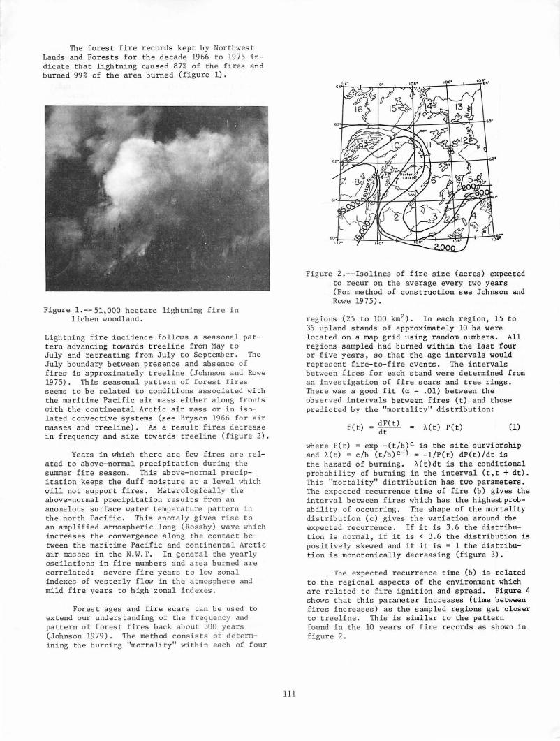
The forest fire records kept by Northwest Lands and Forests for the decade 1966 to 1975 indicate that lightning caused 87% of the fires and burned 99 % of the ar ea burned (J~gure 1) .
Figure 1 .--51,000 hectare lightning fire in lichen woodland .
Lightning fire i ncidence follows a seasonal pattern advancing towards treeline from May to July and retreating from July to September. The July boundary between presence and absence of fires is approximately t r eel ine (Johnson and Rowe 1975) . This seasonal pattern of forest fires seems to be related to conditions associated with the maritime Pacific air mass either along fronts with the continental Arctic air mass or in isolated convective systems (see Bryson 1966 for air masses and treeline) . As a r esult fires decrease i n fr equency and size towards treeline (figure 2) .
Years in which the r e are fe1v fires are related to above- normal p r ecipitation during the summer fir e season . This above-normal precipitation keeps the duff moistur e at a level which will not s upport fires. Meterologically the above-normal precipitation results from an anomalous sur face water temperature pattern in the north Pacific . This anomaly gives rise to an amplified a tmospheric long (Rossby) wave which i ncreases the convergence a l ong th e contact between the maritime Pacific and continental Arctic air masses in the N. W.T . In general the yearly oscilations in f ire numbers and area burned are correlated: severe fi r e year s to low zonal indexes of westerly f low in the atmosphere and mild fire years to high zonal indexes .
Forest ages and fire scars can be used to extend our understa nding of the frequency and pattern of for est fires back about 300 years (Johnson 1979) . The method consists of determining the burning "mortali ty" within each of four
111
Figure 2 .--Isolines of fire size (acres) expected to r ecur on the average every two years (For method of construction see Johnson and Rowe 19 75) .
regions (25 to 100 km2) . In each region, 15 t o 36 upland stands of approximately 10 ha were located on a map grid using random numbers. All regions sampled had burned within the last four or five year s , so that the age intervals would r epr esent fire-to-fire events . The interval s between fires for each stand were determined f rom an investi gation of fi r e scar s and tree rings . There was a good fi t (a = . 01) between the observed intervals between fires (t) and those predicted by the "mortality" distribution:
f(t) = dF(t) = A(t) P(t) dt
( 1)
where P(t) = exp -(t/b) C i s the site s urviors hip and A( t) = c/b (t /b)C- 1 = -1/ P(t) dP(t) / dt is the hazard of burning . A(t) dt is the conditional probability of burning in the inter val (t,t + dt). This "mortality" distribution has t wo parameter s . The expected recurrenc e time of fire (b) gives the interval be tween fires which has the highest pr obability o f occurring . The shape of the mortality distributi on (c) gives the variation around the expected r ecurrence . If it is 3 . 6 the distribution is normal , if it is < 3. 6 the distribution is pos i t i vely skewed and if it is = 1 the distribution is monotonically decreasing (figure 3) .
The expec t ed r ecurrence time (b) is related to the regional aspects of the environment which are r e l ated to fire ignition and s pread . Figure 4 shows t ha t this parameter increases (time between fires increases) as the sampled r egions get closer to treel ine . This is similar to t he pa ttern found i n the 10 years of fire r ecords as shown in figure 2 .

f(t)
Fire Intervals (t)
Figure 3.--The fire frequency "mortality" distribution of equation (1) with different values of the shape parameter c.
The burning of a population of sites is affected not only by their shared regional environment, such as the air mass climate, but also by individual differences between sites such as terrain, vegetation and topoclimate. The shape parameter (c) indicates this variation. In smooth terrain the variation in the fire environment between sites in the population is due largely to chance, and the variation around the expected recurrence time is symmetrical (c - 3) in the mortality distribution. In rough terrain the variation around the expected recurrence is positively skewed (c = 1 to 3). The tail of the skew indicates the existence of a few sites which survive fires much longer than most others.
Cl u c ~ 100 ... :I u Cl a:
~ iL 'tJ Cl u Cl a. )(
w
50
0
I tOO 200 300 4oo km Oiltance from tree-line
Figure 4.--The expected fire recurrence interval (in years) decreases as one moves away from treeline. Compare this to the similar pattern in figure 2. Bars represent 90% confidence intervals.
112
It is possible to speculate about the fire recurrence for nearly 4000 years by using paleoecological evidence. Sorenson et at. (1971) and Nichols (1976) present reconstructions of the forest/tundra boundary in this region from radiocarbon dates, paleosols and pollen analysis. These reconstructions give the age and distance of the present forest/tundra boundary from its positions in the past. By using this information and the relationship of fire recurrence to distance from treeline (figure 4), a reconstruction :(figure SA) can be made of the fire recurrence intervals for 3700 years in the Porter Lake region (see location in figure 2).
• t ~ ~ . I u ., • a:
~ ...
400
100
.10
f .11 II' I! ...
A
B
,.,. Recurrence 111ternl
Figure 5A.--Tentative reconstruction of fire recurrence at Porter Lake, N.W.T. for 3700 · years. Based on paleoecological evidence for position of forest/tundra boundary and the contemporary relationship of fire frequency and treeline. The step changes in the recurrence are due to the relative discreteness of the climatic changes; the curve would be smoothed if the lag response of vegetation and soil were considered.
Figure 5B.--Frequency of fire recurrence intervals for 3700 years at Porter Lake.
Two levels of environmental dynamics can be hypothesized from this reconstruction of fire recurrence at Porter Lake. First, a shorter term dynamic occurs during which the fire frequency is stationary. This period may include one to many fire-vegetation recovery couplets, with each stationary period lasting from 300-1000 years. Between these stationary periods are transitional intervals during Which the fire frequency and other environmental parameters change rapidly. These singularities are usually associated with change in the atmospheric circulation. This longer term dynamic seE!JIB to occur randomly because the density distribution (figure 5B) follows a negative exponential.

i.>emonstration that forest fires are characteristic, frequent and recurrent in this part of the subarctic has some immediate consequences for the understanding of vegetation dynamics in the subarctic.
The survivorship of sites indicate that 50% will have burned by the ages of 60 to 100 years. From the point of view of the major tree species (Picea mariana, P. glauca, Pinus banksiana) , which can live to be 300 or 400 years old, death will probably occur by fire well before this maximum age is reached.
The high fire recurrence creates real difficulty for traditional. arguments of succession and climax. Firstly, if 300 or more years are required to reach the postulated black sprucefeather moss climax (cf. Kershaw 1977) then there is simply not enough time between fires for the climax to develop except in very rare cases. Secondly, the evidence is convincing that the fire frequency is primarily determined by the air mass climate. Consequently it is difficult to argue that the fire frequency is for some reason artifically (e.g. man caused fires) or abnormally high and that this is preventing the "natural" succession.
VEGETATION ORGANIZATION & DYNAMICS
The two environmental dynamics of figure 5 are also reflected in a gradient analysis of the contemporary vegetation as shown in figure 6 (cf. Johnson 1980).
The habitat gradient in figure 6 is associated with topographic - nutrient - energy budget factors. These factors remain relatively constant in influence because of the stability of aspect, slope and substrate types. A stand's environmental factors Which locate it on the gradient, will change significantly only during the singular periods usually associated with changes in climatic regimes and sometimes with geomorphic changes, pedogenesis, species invasion or extinction and introduction of pathogens. The habitat gradient is the longer term dynamicof figure 5. It represents the major changes in species composition usually associated with changes in community type classifications.
The fire frequency and intensity gradient in figure 6 describes an environmental factor (fire) which is recurrent but acts quickly and then stops. It interacts slightly with the habitat factors (as is indica ted by the non-orthogonal relation of the communities) because the destruction of the vegetation canopy leads to a more negative ("cooler") energy budget for 30 or 40 years (Rouse 1976).
The fire frequency and intensity gradient is the shorter term dynamic of figure 5. Species can persist and/or recover from fires only when their life histories are in some manner correlated
113
\ \ \
' ' I i I .., - I
' a~ca , ... c ' I g l 1 § lA __
I I I 1!...!:::.. low Potential Radiation high lower- mid-slope upper-
concave convex
alii-loam sand mesic xeric
HABITAT GRADIENT
Figure 6.--Gradient Analysis of upland vegetation along the two major environmental gradients. Tile habitat gradient is related to topographic-nutrient-energy budget factors while the fire gradient is related to fire frequency and severity. Community types are characterized by the most abundant canopy and understory species. The small graphs on the right indicate the predominate fire recovery pattern depending on the location in the fire and habitat gradient.
to the recurrence interval and severity of the fires (Johnson 1980). Since plant communities consist: of a spectrum of species with varied life histories, community response in terms of structure and composition will reflect the selection of those species adapted to the fire interval and severity (see figure 6). Consequently as long as the recurrence is short relative to the life span of the species and stochasticly stable, most species present before the fire are present shortly afterwards. This is a result of vegetative reproduction from surviving parts and diaspores e.g. spruces (seed), jack pine (seed) and lichens (fragments and soredia).
Changes in vegetation composition implied in many fire recovery successions (e.g. Scotter 1964) are due to differences in conspicuousness resulting from different growth rates and sizedensity relationships (Harper and White 1974). The sequence often described of birch being replaced by spruce is primarily due to differences in growth rates,not age and establishment differences; similarly for jack pine to spruce and Cladonia gmcZis to C. mitis to C. rangiferina. Also recovery sequences often confuse the habitat gradient with the fire gradient.

CONCLUSION
The vegetation landscape of the western subarctic lichen woodland consists of two overlain and interactive mosaics, one related to habitat differences and one related to fire. The habitat mosaic is the major organizing force on vegetation composition and structure, accounting for changes in the kinds of species adapted to different sites. Overlying this mosaic is the change in vegetation abundance resulting from the selective influence of the interval between and severity of fires. Both mosaics interact. 'lbe habitat factors influence, for example, the amount of biomass accumulation (fuel) and fire climate of a site while fire influences the seed bed (fire intensity) and the site's energy budget (intensity and frequency).
The dynamics of these two sets of environmental factors does not lead to any developmental succession of communities. Developmental successio~as usually conceived by ecologists,would not lead to a reliable reconstruction of communities (with a maximum persistent biomass and relatively closed nutrient cycling) after disturbance by fire or habitat changes. This reliability can only be obtained by highly individualistic populations (varied life histories) which as units can be disintegrated and reconstituted in a variety of combinations without loss of the above mentioned stability.
LITERATURE CITED
Bryson, R.A. 1966. Airmass, streamlines and the boreal forest. . Geographical Bulletin (Canada) 8: 228-269.
Harper, J.L. and J. White. 1974. The demography of plants. Annual Review of Ecology and Systematics 6: 419-463.
114
Jasieniuk, M.A. and E.A. Johnson. 1979. A vascular flora of the Caribou Range, Northwest Territories. Rhodora 81: 249-274.
Johnson, E.A. 1979. Fire recurrence in the subarctic and its implications for vegetation composition. Canadian Journal of Botany 6?: 1374-1379.
Johnson, E.A. 1980. Vegetation organization and dynamics of lichen woodland communi ties in the N.W.T., Canada. Ecology in pPess.
Johnson, E.A. and J.S. Rowe. 1975. Fire in the -wintering grounds of the Beveraey Caribou herd. American Midland Naturalist 94: 1-14.
Kershaw, K.A. 1977. Studies on lichen dominated systems. XX. An examination of some aspects of northern boreal lichen woodlands in Canada. Canadian Journal of Botany 66: 393-410.
Nichols, H. 1975. Palynological and paleoclimatic study of the late Quaternary displacement of the boreal forest-tundra ecotone in Keewatin and Mackenzie, N.W.T., Canada. Institute of Arctic and Alpine Research Occasional Papers Number 15., University of Colorado.
Rouse, W.R. 1976. Microclimate change accompanying burning in subarctic lichen woodland. Arctic and Alpine Research 8: 357-376.
Scotter, G.W. 1964. Effects of forest fires on the wintering range of barren-ground caribou in northern Saskatchewan. Canadian Wildlife Service. Wildlife Management Bulleting Series 1, Number 18. Northern Affairs and Natural Resources, Ottawa.
Sorenson, C.L., J.C. Knox, J.A. Larsen and R.A. Bryson. 1971. Paleosols and the forest border in Keewatin, N.W.T. Quarternary Research 1: 468-473.

Hunter-Gatherers and Problems for Fire History1
Henry T. Lewis2
Abstract.--Reconstructing fire histories in regions where hunting-gathering peoples once used burning techniques appears to present special problems of interpretation. Studies over the past two decades involving the reconstruction of indigenous firing practices in western North America and observations of extant practices in northern Australia indicate some of the major difficulties involved.
The tropical savanna region of northern Australia is one of the few areas of the world where indigenous peoples still use fire to modify local habitats to manipulate the distribution and relative abundance of hunting and gathering resources. Recent studies in Arnhemland, Northern Territory, have shown the importance which these practices have for managing a rang~ of subtropical ecosystems.) Though these practices apply to a markedly different environmental zone than any of those which have been considered during recent years in western
1Paper presented at the Fire History Workshop. (Laboratory of Tree-Ring Research, University of Arizona, Tucson, October 2Q-24, 1980).
2uenry T. Lewis is Professor, Department of Anthropology, University of Alberta, Edmonton, Alber3a, Canada.
Reports on contemporary uses of fire by Aborigines in northern Australia are now beginning to appear in print and further studies are in progress. The first to deal with the subject was Jones (1975) who, in a subsequent work (1978), has incorporated the uses of fire into more general practices of hunting-gathering technology in northern Arnhemland. Three papers dealing specifically with fire uses can be found in the work of Haynes (1978a, 1978b, 1978c); these are especially significant papers regarding the practices and beliefs of Aborigines in central Arnhemland. The substantive materials described in this paper derive from Haynes' work plus, on a more personal level, information and assistance that he provided the author while in the Northern Territory from midJune to mid-August, 1980. A series of unedited discussion papers (Fox 1974) offer a range of comments by social scientists and biologists on Aboriginal uses of fire in the north. Still other writers on the Northern Territory have commented on the use and possible significance of Aboriginal practice (Davidson n.d., Peterson 1971, and Stocker 1966). Considering the dearth of materials on the contextual employment of fire by huntergatherers in other parts of the world, the materials on northern Australia are comparatively rich.
115
North America, the overall strategies employed by Aborigines and Indians are remarkably similar.4 Of special importance for understanding fire histories in the two regions, the argument is here made that the variable ways by which Aborigines and Indians employed fire resulted in difficult, in some instances insurmountable, problems of interpretation for studies of fire histories.
The problem essentially derives from the fact that hunters and gatherers employ patterns of burning which are significantly different from natural patterns of ignition and, with both manmade and natural fire regimes occurring throughout a given region and range of micro-habitats, information derived from fire scars may provide little real insight into the chronology and frequency of fires. The central problem can be seen with the major technological considerations that huntinggathering societies use in their respective fire technologies: the seasonality and frequency of burning, the intensity and size of fires, and the ways in which fires are applied (or alternately withheld) in different habitats. Paradoxically, it is the very ways in which prescribed burning has been used that accounts for its environmental importance and the paucity of fire scar evidence.
Indigenous fire practices in North America have been quite literally extinguished and our interpretations of the patterns once involved and the impacts made are based on historical records or, in a very few cases, recall data provided by older informants from isolated areas where burning technologies were employed until forty or more years ago (Lewis 1977, 1981b). Though oral histories are potentially far more useful than documented source materials--which most frequently do little more than confirm the fact that Indians did burn--neither provides the empirical detail that ongoing, contextual studies would reveal.
4studies on Indian uses of fire have included works by Arthur (1975), Barrett (n.d.), Boyd (n.d.), Bean and Lawton (1973), Day (1953, Lewis (1973 et al.), Reynolds (1959),and Steward (1951 et al.).

Fortunately, important comparable data concerning extant fire technologies can still be derived from areas like northern Australia and like situations in isolated parts of Africa and Asia. In this respect the Arnhemland studies are especially significant because for the first time we have field studies on the uses of fire by hunting-gathering peoples. These examples are further important fot what they suggest about f~nctionally similar conditions in North America.
The seasonality, frequency, intensity, scale, and type of Aboriginal fires in Arnhemland vary significantly between vegetational communities and from one micro-habitat to another. Within the four major vegetational types of the Northern Territory's savanna region--monsoon forest, open floodplains, tall-open forest, and eucalypt woodlands--firing activity begins in mid-April with the onset of the dry season, continues virtually on a day-to-day basis for approximately four months, and then sporadically in some areas until as late as mid-December and the return of monsoonal rains. Each area, however, is managed in distinct ways.
For the monsoon forest stands (deciduous vine thickets and semi-evergreen vine forest areas which are seldom more than 10 ha) particular care is taken to exclude fire, if at all possible. Because monsoon forest vegetation can sustain severe damage from late, dry season fires (Stocker and Mott 1978), the surrounding drier grass margins of floodplains and the grass and shrub understories of tall-open forests are burned early in the dry season to create firebreaks. Reasons for excluding fire from monsoon forests include a combination of practical considerations (especially to protect the vines of yams) and important totemic-religious beliefs.
In marked contrast, nearby floodplains are fired at virtually any time between mid-April and early August with as much as 90% of these grasslands burned in a given year. Mainly in growth to various species of Cyperaceae and Gramineae these coastal floodplains are inundated for the several months of rainy season. Burned for both the small animals killed in such fires and the secondary green-up that follows, more animals are
5Except for observations noted in a recent report to the Australian National Parks and Wildlife Service (Hoare et al. 1980:46), there are no published references on northern Australia concerning fire scarring. The interpretations made here derive from the author's own observations and, more significantly, the observations of individuals who have worked for a number of nears on related problems of fire effects in northern Australia. Among the people to whom the author is particularly indebted are Chris Haynes (Australian Parks and Wildlife Service, Darwin) and Dr. M. G. Ridpath (Division of Wildlife Research, Commonwealth Science and Industrial Research Organization, Darwin).
116
soon drawn from surrounding vegetation types to feed there.
Further removed from the coasts, in areas receiving 750 mm or more annual rainfall, the tall-open forests are dominated by evenly spaced eucalypts (esp. E. tetrodonta and E. miniata) of from 18 to 24 m high and an understory of grasses (particularly Sorghum intrans) and shrubs, the densities of which are largely determined by the frequency of burning. Though sporadic burning begins by mid-April, most burning within open forest areas takes place in the two-month period of mid-June to mid-August. Though individual fires are small (1-5 ha) and discontinuous, Haynes (1978b) estimates that between 25% and 50% of the tall-open forests are burned in a given year. An important feature of controlling these fires involves making use of the relatively high winds (25-35 k.p.h.) which occur during the two months. This condition is important to Aboriginal burning technology in that fires are more easily directed (e.g, burning into previously fired patches or natural firebreaks) and scorch height is consequently lower, thereby causing less damage to the flowers and buds of important fruiting trees. Related to this is the added controlling factor that winds drop off late in the day and fires go out at night during this cooler period.
The overall effect of this more-or-less annual frequency of burning is to create a mosaic of unevenly aged understory plants. Some areas are fired every year, others less frequently, with many burned portions overlapping from one season to another d~pending upon the particular clusters of plants and the actual extent and intensity of fires in a particular place. The trees of tall-open forest are seldom killed by fires at this time (unless already aged, diseased, or termite infested) nor are they frequently or consistently scarred because of the relative low intensity of the fires.
The fourth environmental zone is the eucalypt woodland, a savanna forest with a lower diversity of plant and animal species than that found in tallopen forest areas. Usually dominated by E. dichromoploia, and with large numbers of E. miniata and !· tetrodonta, these drier (less than-750 mm per annum) and more open regions (the trees more widely spaced and usually less than 12 m high) are characterized by understory fires that are larger and more intense. Though the overall floral and faunal diversity is less than that of tall-open forests, eucalypt woodlands are the preferred cattle grazing areas ~f the north, supporting two-to-three times the number of stock found in tall-open forest regions (Perry 1960).
However, partly related to the emphasis which hunting-gathering societies place upon a wide spectrum of plant and animal resources, the more uniform eucalypt woodlands are viewed by Aborigines in Arnhemland as "desert" or "rubbish country" (Haynes 1978b and personal communication), primarily

important for the animals taken when using fires as a direct hunting technique, and subsequently for the macropods attracted by the "green pick," or green-up that follows early season burning. As with the tall-open forests, the pattern of burning is patchy but both burnt and unburnt areas are larger. Also, fires are ignited in eucalypt woodlands over a longer period of time than in other areas: from the end of the wet season, through August, and into the weeks immediately prior to the onset of monsoon rains in mid-December. Thus, as a less important zone for Aboriginal economies, burning practices within eucalypt woodlands are carried out much more casually and with less concern for local plant and animal associations. As with other areas, the time of year, frequency, and related conditions influencing the intensity of burning have a considerable effect upon the extent and regularity of scarring.
For example, over the past hundred years the pastoral industry in the Northern Territory has used fire extensively as an aid in mustering cattle--for both clearing the 2-m high grasses and initiating new, palatable growth, the "green pick," to attract stock. Cattlemen, in contrast to Aborigines, attempt to burn eucalypt woodlands as early as possible (between mid-April and mid-June) to obtain the maximum amount of new growth so that stock will have at least a minimum amount of nutritious feed until the return of the wet season. Though stockmen burn larger areas, and do so on a more regular-annual basis, trees are scarred less frequently, it was suggested, because fire intensities are reduced at this time and, in burning areas more regularly than do Aborigines, fuel loads are kept down.
The natural fire regime of the Northern Territory's "Top End" derives from thunderstorms occurring in the months immediately preceeding monsoon rains. However, given the effects of man-made fires and the consequent reduction of fuels, lightning fires rarely occur (Stocker 1966). With monsoon forests that are fire protected, tallopen forests of which up to SO% are burned in small, discontinuous patches over a two-month period, grasslands which are almost completely fired each year, and eucalypt woodlands which are fired more or less indiscriminately throughout the dry season, the results of Aboriginal fire management are highly variegated. Northern researchers were unanimous in their agreement that the fire scar evidence from essentially man-made fire regimes was quite inadequate for reconstructing the complex of pyro-technical events--either Aboriginal or Euro-Australian in origin.
As Haynes' definitive studies show (1978a, 1978b, 1978c), the pattern of Aboriginal burning is quite clear when examined firsthand. However, it is a pattern that does not result in equivalent, discrete types of evidence. In fact, it is partly designed to avoid the kinds of perturbations that result from lightning fire regimes. The result is that in themselves fire scars provide no insights into the complex of man-made fire dynamics in northern Australia.
117
In the case of North America we unfortunately have no extant situations involving huntinggathering burning practices. Though there are still remote areas of Canada and Alaska within which burning was carried out until recent times, and where some aged informants are still available, most of our information is derived from incidental historical references. However, despite the lack of contextual studies, there are general patterns which emerge (Lewis 1981a), and these suggest similar difficulties for interpreting fire scar evidence in regions where Indians once employed prescribed burning.
Like Aboriginal hunters and gatherers of Australia, North American Indians used fires in ways that differed significantly from natural fire patterns, especially in terms of the major considerations involved: the seasonality and frequency of burning, the intensity and scale of fires, and the kinds of fires used. In the same ways that there are great variations in the regional uses of fire within Australia (Nicholson 1980), specific practices varied from one habitat and one zone to another given the importance of the resources involved.
In an area from which we have our most detailed information on North American Indian practice, northern Alberta, burning was mainly confined to grasslands and, according to informants, extended areas of boreal forest were left unburned (Lewis 1977, 1981b). Unlike those Indians of California who set autumn ground fires within the ponderosasequoia forests, Indians of this subarctic region did not (could not) employ understory burning within the boreal forest. Except for the early spring burning of deadfall and windfall areas (Lewis 1977:40), fires within the boreal forest were apparently the consequence of lightning storms and human carelessness throughout late spring and summer. Thus, unlike the savannas of northern Australia, lightning fires undoubtedly did play a significant role in northern Canada.
However, it appears that the combination of man-made and natural fires in the northern boreal forest would have resulted in a greater diversity of variously aged communities than is now the case. In the absence of light understory fires the evidence from fire scars probably presents a more reasonable record of natural fire frequencies within forested areas than is the case for other vegetational types. However, it can tell us little if anything about the effects and counter-effects which the Indian burning of intervening grasslands and shrub areas, resulting in a more pronounced forest mosaic, might have had for limiting larger, more destructive fires.
In California's regions of prairies, oakgrasslands, chaparral, and montane forests, prescribed fires were carried out in variable ways that related to the distribution and relative abundance of plants and animals in each zone. The overall result, I have argued elsewhere (Lewis 1973), was to create a more diversified environment and one

that was less susceptible to the major disruptions which are now more characteristic of natural fire regimes.
The central prairies of California and Oregon (Boyd n.d.) were burned in late summer of each year to initiate a second green-up of grasses, with the frequency of burning acting as the primary factor for controlling fires.6 Chaparral areas were burned so as to maintain grass openings, with older chaparral being periodically fired to maintain clearings and ecotones between grasses and shrubs. Depending upon specific resource goals and variations in habitat (e.g., south-facing chamise and north-facing mixed chaparral), fires were ignited in both fall and spring. Within the coniferous forests of the Sierra Nevadas, fires were set underneath trees whenever sufficient fuel buildups developed, a pattern very similar to that carried out by Aborigines in the tall-open forests of northern Australia. The problems which exist with correlating fire scars from such an area may, in part at least, be attributed to the high frequency with which Indians actually burned, a frequency higher than the "adjusted" fire scar evidence suggests.
The growing number of studies from Australia and North America are now beginning to demonstrate the considerable importance which indigenous burning practices had for environments in these two different parts of the world. And, even though so much information is now lost to us, the fact that we have technologically parallel examples from a number of environmental zones in two continents strengthens the overall argument for the importance of human interference in .affecting fire histories. A failure to consider the major factors, the human artifacts involved (the seasonality and frequency of burning, the scale and intensity of firing, plus the ways in which fires were set or excluded) make conclusions drawn only from fire scar data problematic at the very least.
Over the past two decades anthropologists have increasingly moved away from the isolation of considering only social and cultural questions to include a wide range of perspectives and information from environmental sciences in order to broaden their interpretations of human adaptations. On the basis of questions raised here, I think it not inappropriate to suggest that whenever possible studies of fire history must include all available information regarding known practices of hunters and gatherers as they influenced plant and animal communities with fire (e.g., Barrett (n.d.)). Though this will enormously complicate interpretations, the pictures to emerge will provide much more towards an understanding of the dynamics of environments as they have been influenced by humans for past millenia. It is not enough merely to note that Indians or Aborigines set fires. It is especially important that we begin to understand
6An exact parallel of this technique has been described for Western Australia by Hallem (1975).
118
the variable but locally specific impacts which these fire technologies have had in the human history of fire.
REFERENCES CITED
Arthur, G. W. 1975. An introduction to the ecology of early historic communal bison hunting among the Northern Plains Indians. National Museum of Man Mercury Series. No. 37. Ottawa.
Barrett, s. w. 1979. Ethnohistory of Indian fire practices in western Montana. (Manuscript) School of Forestry, University of Montana, Missoula.
Bean, L. J., and H. W. Lawton. 1973. Some explanations for the rise of cultural complexity in native California with comments on protoagriculture and agriculture. In Patterns of Indian Burning in California: Ecology and ethnohistory. H. T. Lewis. Ballena Press Anthropological Papers. No. 1. Ramona, California. pp. v-xlvii.
Boyd, R. n.d. Aboriginal burning practices in the Willamette Valley of Oregon. (Manuscript) Department of Anthropology, University of Washington, Seattle.
Davidson, G. R. n.d. The use of fires for hunting in southern Arnhem Land. Report No. 1 to the Australian Institute of Aboriginal Studies, Canberra, Australian Capital Territory.
Day, G. M. 1953. The Indian as an ecological factor in the northeastern forest. Ecology 34(2):329-346.
Fox, R. E. (ed.) 1974. Report on the use of fire in national parks and reserves. Department of the Northern Territory, Darwin.
Hallam, S. J. 1975. Fire and Hearth: A study of Aboriginal usage and European usurpation in south-western Australia. Australian Institute of Aboriginal Studies, Canberra, Australian Capital Territory.
Haynes, C. D. 1978a. Land, trees and man. Commonwealth Forestry Review 57(2):99-106.
Haynes, C. D. 1978b. Fire in the mind: Aboriginal cognizance of fire use in the north central Arnhemland. M.S. Thesis. Australian National Parks and Wildlife Service, Darwin, Northern Territory.
Haynes, C. D. 1978c. The pattern and ecology of munwag: Traditional Aboriginal fire regimes in north central Arnhemland. M.S. Thesis. Australian National Parks and Wildlife Service, Darwin, Northern Territory.
Hoare, J.R.L., R. J. Hooper, N. P. Cheney, and K.L.S. Jacobson. 1980. A report on the effects of fire in tall open forest and woodland with particular reference to fire management in Kakadu National Park in the Northern Territory. Australian National Parks and Wildlife Service. Darwin, Northern Territory.
Jones, R. 1975. The neolithic, palaeolithic and the hunting gardners: Man and land in the Antipodes. In Suggate, R. P. and Creswell, M. M. (eds.). Quaternary Studies. The Royal Society of New Zealand. Wellington, p. 21-34.

Jones, R. 1978. "Can't finish him up": hunters in the Australian tropical savanna. Paper presented at the Burg Wartenstein Symposium. No. 79 (Human Ecology in Savanna Environments). Wenner-Gren Foundation for Anthropological Research. New York, N.Y.
Lewis, H. T. 1973. Patterns of Indian Burning in California: Ecology and ethnohistory. Ballena Press Anthropological Papers. No. 1. Ramona, Calif.
Lewis, H. T. 1977. Maskuta: The ecology of Indian fires in northern Alberta. Western Canadian Journal of Anthropology 7(1):15-52.
Lewis, H. T. 1980. Indian fires of spring. Natural History 89(1):76-83.
Lewis, H. T. 1981a. Fire technology and resource management in aboriginal North America and Australia. In The Regulation of Environmental Resources in~ood Collecting Societies. E. Hunn and N. Williams (eds.). American Association for the Advancement of Science MOnographs (in press).
Lewis, H. T. 1981b. A Time for Burning. Boreal Institute for Northern Studies. University of Alberta. Edmonton, Alberta (in press).
Nicholson, P. H. 1980. Fire and the Australian Aborigine: An enigma. In A. M. Gill, R. A. Groves, and I. R. Noble (eds.). Fire and Australian Biota •. Australian Academy of Science. Canberra, Australian Capital Territory (in press).
Perry, R. A. 1960. Pasture lands of the Northern Territory, Australia. Land Research Series No. 5. Commonwealth Scientific and Industrial Research Organization. Melbourne, Victoria.
Peterson, N. 1971. The structure of two Australian Aboriginal ecosystems. Unpublished Ph.D. thesis. University of Sydney, Sydney, New South Wales.
Reynolds, R. D. 1959. Effects of natural fires and Aboriginal burning upon the forests of
119
the Central Sierra Nevada. Unpublished M.A. thesis. University of California, Berkeley.
Stewart, 0. C. 1951. Burning and natural vegetation in the United States. Geographical Review 41:317-320.
Stewart, 0. C. 1954. The forgotten side of ethnogeography. In R. F. Spencer (ed.). Method and Perspective in Anthropology. University of Minnesota Press, Minneapolis, Minn. p. 221-248.
Stewart, o. C. 1955a. Fire as the first great force employed by man. In w. L. Thomas (ed.). Man's Role in Changing the Face of the Earth. University of Chicago Press. Chicago, Ill. p. 115-133.
Stewart, 0. C. 1955b. Forest fires with a purpose. Southwestern Lore 20(3):42-46.
Stewart, 0. C. 1955c. Why were the prairies treeless? Southwestern Lore 20(4):59-64.
Stewart 0. C. 1955d. Forest and grass burning in the mountain west. Southwestern Lore 21(1): 5-9.
Stewart, 1963. Barriers to understanding the influence of use of fire by aborigines on vegetation. Annual Proceedings, Tall Timbers Fire Ecology Conference 2:117-126.
Stocker, G. C. 1966. Effects of fire on vegetation in the Northern Territory. Australia Forestry 30:223-230.
Stocker, G. C. 1968. The vegetation of Karslake Peninsula, Melville Island, Northern Territory. Unpublished M.S. Thesis. University of New England, Armidale, New South Wales.
Stocker, G. C., and J. J. MOtt. 1978. Fire in the tropical forests and woodlands of northern Australia. (ms.) CSIRO, Division of Forest Research, Atherton, Queensland; and CSIRO, Division of Tropical Crops and Pastures, Darwin, Northern Territory (respectively).

Forest Fire History: Ecological Significance and Dating Problems in the North Swedish Boreal Forest 1
Olle Zackrisson 2
Abstract.--The past and present fire regimes are described, and the significance for the flora of this region is discussed. Methods used to reconstruct forest fire history are presented. The dating problems with false and absent rings in Scots pine, Norway spruce and two birch species are also dealt with.
INTRODUCTION
Descriptions of fire impact on the Swedish forest landscape are often found in literature from the 18th and 19th century. Already at .that time fire was considered to have a purely negative effect, and fire prevention was considered desireable. This opinion found expression in the legislative measures taken to stop or prevent any use of fire to modify the forest ecosystem for agricultural practice.
At the end of the 19th century and the beginning of the 20th century, when the first more comprehensive forest biological research was carried out in North Sweden, the importance of fire for the origin and stability of the forest types was often discussed (Holmertz & Ortenblad 1886, Tamm 1920) • The destructive influence of forest fires was very much stressed and a special forest organization was founded with the aim or reducing the impact of fire on the forests in the north of Sweden. Later, when the influence of uncontrolled fires was reduced, scientists tended to underrate the importance of fire as a natural ecological factor throughout history. Forestry research appears to have stressed man's role in causing forest fires, and often neglected or even denied the fact that many were caused by lightning.
Interest in fire ecology was greatly increased by the extremely severe fire year of 1933, and some very interesting work was consequently done (Hogbom 1934, Wretlind 1934, Tiren 1937). Since the close of the 1930's very little research has been carried out on the natural importance of
1Paper presented at the fire history workshop
(Laboratory of Tree-Ring Research, University of Arizona, Tucson, October 20-24, 1980).
2011e Zackrisson is professor of forest vegetation ecology, Swedish University of Agricultural Sciences, Umea, Sweden.
120
forest fires. One exception is the study by U ggla (1958) of a burned forest area in the Muddus region, North Sweeden. Recently, a further series of papers on fire ecology of the whole circumpolar area has stimulated a fresh approach to, and renewed interest in, reconstructing fire influence on the boreal forest. The negative attitude toward the use of fire as a suitable management method for virgin-forest reserves has very slowly begun to change as knowledge of its actual function in ecosystems has increased. A more positive approach to the use of fire in modern forestry to improve regeneration by prescribed burning on soils with a thick, raw humus layer is also now detectable.
It is not until now that we have begun to realize how frequently the North Swedish boreal forests have been subjected to forest fires, and what effects they have had on the organisms found there.
CHANGES IN THE FIRE REGIME AND ITS SIGNIFICANCE FOR
FOREST VEGETATION
Investigation of the forest region in the Vindeliilven Valley, North Sweden has shown a forest fire rotation of about 100 years from the end of the medieval period up to the close of the 19th century ( Zackrisson 1977) • This figure includes different types of forest found within the whole river valley.
The Scots pine (Pinus sylvestris) dominated forest found on glad-fluvial sandy plains along the river, has burned most frequently with a mean fire interval of about 46 years (fig. 1). In local stands, mean fire intervals of approximately 30 years for the last 600 years are found in the most fire-prone areas . Fire in this type of forest often gave rise to very uneven-aged stands, where successful regeneration often occurred a short period after the last fire.

1702
l.sl .. l"' l 'I:·r7 'l:r73 r58 r63 t r50·nr 132
~~---r--~INVI I 1250 1300
I 1AOO
I 1500
I 160Q
I 1700
Figure 1. --Local forest fire chronology of a lichenpine forest stand in Harads, North Sweden. The fire years are marked with arrows and the intervals between fires are shown by figures between the arrows. The floating chronology to the left goes into the Viking age, but does not correspond exactly with the absolute chronology because of problems with absent rings in the oldest samples. The chronology is built up from 81 crosssections of pine. A mean fire interval of about 50 years is rather typical for most lichen -pine forests in the interior of North Sweden.
In mixed coniferous stands of the Vaccinium type found on morainic soils, intervals between fires are usually longer. Mean fire intervals are commonly 100 years. In this type of forest, Norway spruce (Picea abies) often forms the undergrowth regenerated after each fire. Scots pine often survives as overstory trees and can reach old ages (fig. 2). .
In all these forest types previously influenced by frequent forest fires, fire impact has decreased drastically during tne last 100 years ( Zackrisson 1977) • This is partly a consequence of severe restrictions in the rights of burn-beating and of burning for grazing improvement, as well as the introduction of an active fire-prevention policy. The latter received active support from the bulk of the population as soon as the value of forest for timber production was acknowledged.
Another very important factor in decreasing fire frequency was the passive fire elimination caused by extensive· cutting out of dead standing trees from the 19th century and onward. Dry snags are of particular importance with regard to forest fires caused by lightning, since they catch fire much more readily than living trees do (Kourtz 1967).
In spruce forests on wet sites, fire has usually been rare. Fire-free intervals of up to 500 years can be found in exceptional cases. Normally, this type of long-term fire-free refuge seems to be a rather rare phenomenon in most of the boreal landscape. The special environment found in this type of late successional stage seems to be favorable for some very rare arboreal lichen species (Essen et al in press). Some rare vascular species could also be expected in the very late successional stages. It is important that such natural refuges be found and protected from clear-cutting, because several threatened species may be adapted to them.
121
I 1800
18A71888
l••! I I
1900 1978
A.D
Figure 2. --Reconstruction of forest fires and successful regeneration in a mixed coniferous stand with overstory trees of Scots pine and undergrowth of Norway spruce. Spruce is sensitive to fire and all regeneration of spruce has come after the last fire. The regeneration during the last 70 years is also influenced by selective cutting of Scots pine. Sample plot SOx 20m, Arvidsjaur, North Sweden. Trees under breast height were not dated.
Unfortunately, we have the same lack of knowledge concerning species dependent on frequent fire disturbance. There is therefore a great need for investigations describing different fire adaptations found among organisms in the boreal forest. By studying the strategies and mechanisms developed by different species to survive the long-term influence of repeated fires , we probably also will improve our understanding of floristic and faunistic changes currently taking place.
Some of the dynamics found today could be a direct effect of the drastically reduced influence of forest fires in the landscape. Organisms adapted to the special environment created by repeated fires may not always have been able to find other suitable sites for their survival, and so decreased both in number and distribution. To reduce these effects, a reintroduction of boreal pyro adaptions, as well as knowledge of the previous long-term influence of fire on different parts of the boreal landscape, is however very fragmentary. More detailed information is needed before fire can be

Figure 3. --Overhealing wood close to a fire scar in Scots pine. A ring count made from a bore core in direction 1 would have given 24 rings less than a count made in direction 2, beca use of partial absent rings. Disappearing rings are a serious problem when bore cores are used for dating, but could in most cases be avoided when well-prepared cross sections are used from different levels of the scar .
reintroduced in full scale as a management tool in nature conservation .
METHODS OF RECONSTRUCTING FIRE INFLUENCE ON T HE FOREST
Historical sources s uch as land survey maps, court records, records of land inquiries, annual reports from district forest officers, and travel descriptions can be used to reconstruct the previous influence of fire on the forest landscape of North Sweden . T h ese historical sources can be used to reconstruct burned areas and to check if the dating of a particular fire made by tree-ring counts is correct. Forest fires from this century can be traced by fire registrations at each fire fighting district.
For a detailed reconstruction of the fire history on a particular forest s ite, fire scar-dating is the easiest method to employ . In the forests of North Sweden, Scots pine can reach ages close to 1, 000 years ( Zackrisson 1979) . Pine trees with multiple fire scars are common in areas less influenced by previous logging operations. Virgin forest types with Scots pine are also mostly quite
122
uneven-aged, which is favorable when dendroecological methods are used to study the previous fire regime. In the interior of North Sweden, dry standing trees, and stumps and logs on the ground are often well-pre.served from rot because of the more continental climat e found in t his region. Dead wood of this type can be u sed for fire dating purposes (Zackrisson 1976) .
Scots pine h as traditionally b een believed to produce annual rings even under very severe environmental conditions. This is probably t rue in most cases. The problem with partially absen t rings, however , seems to be overlooked (fig. 3) . When a cross section is taken, this problem can b e eliminated in most cases, but when only a bore core is available , the problem is more serious unless cross-datin g t echniques ar e u sed.
Part ial rings seem to be rather common in old , low-vigor trees . Cross sections taken at different levels of a pine stem could give different dates for the same fire scar. This phenomenon is described in fig . 4. Cross sections wer e taken close to the root neck and at b r east height (1. 3m). Dating by ring counts from the two samples in this case gave two different dates for the fires. The difference is no less than 13 to 19 years . The sample taken at the root neck le vel shows the accurate date of the last fire in 1758. This fire year has been verified by an extensive reconstruction of the for est fire his tory of t h e area . It is uncertai n if this is a mor e gener al phenomenon found in most tree species , but this s hould be studied more thoroughly.
Assymetrically developed rings , with sections of numerous rings missing, seem to b e rather common in cross sections of Norway spruce and birch from some types of forest sites. An investigation made in a spruce stand in Arvidsjaur, North Sweden, influenced by a well- documented fire in 1831 , will illustrat e some of the d ating problems caused by missing rings. The spruce stand was a ffected by a surface fire that killed some spruces b ut left others alive with fire scars at the base of the stem. Due to t h e fire, the spruce stand is composed of two differ ent age classes. The younger spruces, all b elonging to a lower tree layer, regenerated shortly after t he fire in 1831.
Spruces with fire scar s were sampled to study ring formation in the wood produced after the fire. As a consequence of the extensive f u ngal infection s found in the older spruces previously damaged by fire , great problems arose in getting enough material for t his pilot investigation . More than 200 trees with fire scars were cut, but only 24 could be used for ring counts. The cross sections accepted were taken out close t o the root neck of the trees . In each cross section the tree rings were counted fr om three directions (fig . 5) under a Wild M 8 s tereomicroscope.
Of the 72 counts made from d ifferent directions from t h e 24 cross sections, only 31 ( 43%) counts s howe d the accurate number of rings that should have been produced if one ring was formed annually from the damage in 1831 until

Figure 4.--Scots pine from Jokkmokk, North Sweden, scarred by well-documented fires in 1652 and 1758. The cross section taken at the base shows the accurate number of rings, while l3 to 19 rings are missing in the sample taken at breast height. These l3 to 19 rings are lost in the wood formation after the fire in 1758. A date made by ring counts at 1. 3m would in this case have given quite incorrect dates for the fires. This is indicated in the figure by the false fire years 1771, 1777, 1671, and 1665 .
1980 (fig. 6) . This pilot study also shows that 66% of the error found lies with ±l year. Four percent of the counts showed more than 10 absent rings. In one observation, 21 rings were absent. When considering the counts with the highest number of rings found in each cross section , only SO% of the sampled cross sections could give an accurate number of rings in all three directions. Only in these trees would it seem reasonable to assume that a core taken out with an increment borer at the base of the stem would provide an accurate date for the fire by counting the rings found in the core.
In some cases, a false ring was produced close to the scar margin (fig . 7). This is also the reason why one extra tree ring is found in some
Figure 5. ;-Norway spruce scarred by a fire in 1831. Ring counts were made at three directions as described in the text . Only one ring count (148 rings ) made in the cross section taken out at the base of the stem could verify the actual fire year . The figure shows the rings found at different counts .
counts in fig. 6 . In most cases , this type of ring could rather easily be recognized as false if studied more closely. If studied at a higher magnitude, it mostly g ives the impression of a frostring. How this type of false ring is formed is uncertain. One explanation is that heat from the fire could damage the xyle m mother cells without lethally d amagin g the cambium. There are indications that xylem mother cells and undifferentiated tracheid cells are more sensitive to extreme temperature than the cambial cells (Aronson 1980).
The false ring formed close to the margin of the scar could, however, h ave a varying structure and could in some cases closely mimic a real late wood formation with an abrupt transition to earlywood . It seems easy to recognize a false ring

Number of observations Norway spruce
30
20
10
0 I I I I I I I •1 0 ·1 -2 -3 -4 -5 -6 ·7 -8 -9 -10-11 ·12-13-14-15·16-17-18·19 -20-21
Number of rings 1 the accurate (0)
Figure 6.--The results of ring counts made in 24 . spruce trees (Picea abies ) scarred by fire in
1831 . One cross section was taken out at the base of each tree, and ring counts were made in three directions in the wood formed after the fire (compare fig . 5) . A total of 72 cou nts were made. The different numbers of rings found in t he 72 observations are p lotted in t h e figure .
(Fritts 1976), but in a specific case it could be very difficult to identify such a ring, especially if only a bore core is available . Taking into account all the problems involved in taking a core exact to the margin of the scar, it seems highly recommendable to use destructive sampling techniques when a more exact dating is needed . If cross sections are taken from a lot of spruces and at different levels of t h e stems, err or could prob ably be minimized.
More severe dating problems arose when bir ch (Betula pubescens and ~ verrucosa) from the same area described above was sectioned for dating purposes . Full grown trees of both the birch species often survive light surface fires and well-defined fire scars are formed. This was the case in the burned area from 1831. Because of a serious problem with decay , only 6 birches with fire scars could be used, and in one cross section, counts
124
Figure 7. --A false ring formed close to the fire scar mar gin to the r i ght. In a cross section of the scar red area it is r ather easy to identify t his type of false ring . If only a bore core is us ed , fa lse rings c an b e a problem.
could only be done in two direct ions. As shown in fig. 8, no dating by countin g r ings in the healedover wood gave the accurate dat e of the fire in 1831. In one c ase , no le s s t h an 36 ( 25%) rings were missing. Des pite t he lack of s ample material , the results at least indicate t hat t he problems of dating fires b y us ing birch could be more s ev er e than expected.
Rings i n t he birch species (~ pubescens and B. ver ucos a) have often been u sed for calculating tree ages an d reconst r uctin g pr odu ction cap a cities in b irch stands (Fries 1964) . However , the problem with ab sent rin gs has never b een s tudied closely, but is sometimes mention ed a s a possible error (Elkington & Jones 1974) . To use birch for exact dating of fires seems rather hazardous without using a cross-dating technique , a t least when v ery old t rees are used as in this case . Between 253 a nd 369 r in gs were found a t root neck level in the birch trees investigated , whi ch indicates rather hig h actu al ages for all of the stems . Some of t he t rees are probably around 400 y ears old .
Number of observations
5
Birch
o .....--. ..L....LI -L-..,1 ,__L_L...L.tl llc.l..--1 .J._I ....l...-.fl---'-____,, 0 -10 -20 -30 -40
Number of mi ssing rings
Figure 8 . --Th e results of ring coun ts made on birch (Betula pubescen s and ~ v errucosa) s carred by fire in 1831. Rin g counts were made in cr oss sections from 6 birche s . In each cr oss section , r ing counts were made in three dir ections in t h e wood formed after the fir e . T he number of miss ing r in g s in each ring count (obser vation ) is p lott ed.

It is plausible that the difficulty with absent rings is closely connected with high ages, and that the problem of getting accurate dates by ring counts increases with the age of the tree. As pointed out by Kullman (1979), the problem of dating young stems of Betula pubescens by ring counts is probably very small. The impression received through previous investigations made by the author is that younger trees are more useful for dating fires. However, an error of ±1 year seems to be hard to avoid because of the special difficulties found in birch in determining whether the scar was produced late one growing season or early the next. This is a less severe problem in Scots pine or Norway spruce, where other wood structures could be used to specify the fire season.
LITERATURE CITED
Arons son, A. 1980. Frost hardiness in Scots pine. Studia Forestalia Suecica 15.
Elkington, T. T. and B. M. G. Jones. 1974. Biomass and primary production of birth (Betula pubescens s. lat.) in South-West Greenland. J. Ecol. 62:821-830.
Essen, P. A. , L. Ericson, H. Lindstrom, and 0. Zackrisson. Occurrence and ecology of ~ longissima in central Sweden. The Lichenologist (in press).
Fries, J. 1964. Vartbjorkens production i Svealand och sodra Norrland. - Studia
. Forestalia Suec. 14.
Fritts, H. C. 1976. Tree rings tnd climate. Academic Press, New York. \
Holmerz, C. C • and Th. Ortenblad. 1886. Om Norrbottens skogar. Bidrag till domanstyrelsens underdaniga berattelse rorande skog-
125
svasendet ar 1885, Stockholm.
Hogbom, A. G. 1934. Om skogseldarna forr och nu och deras roll i skogarnas utvecklinghistoria. Norrlandskt Handbibliotek 8.
Kourtz, E. 1967. Lightning fires and lightning behavior in Canadian forests. Can • Dept. of Forestry Publ. No. 1179.
Kullman , L. 1979. Change and stability in the altitude of the birch tree-line in the southern Swedish Scandes 1915-1975. Acta Phytogeographica Suecica 65.
Tamm, · 0. 1920. Markstudier i det nordsvenska barrskogsomradet. Medd. fr. Statens Skogsforsoksanstalt 17.
Tiren, L. 1937. Skogshistoriska studier i trakten av Degerfors i Vasterbotten. Medd. fr. Statens Skogsforsoksanstalt 30.
Uggla, E. park.
1958. Skogsbrandfalt i Muddus nationalActa Phytogeographica Suecica 41.
Wretlind, J. E. 1934. Naturbetingelserna for de nordsvenska jarnpodsolerade moranmarkernas tallhedar och mossrika skogssamhallen. Sveriges Skogsvardsforbunds Tidskrift 32.
Zackrisson, 0. 1976. Vegetation dynamics and land use in the lower reaches of the river Umeatven. Early Norrland 9:7-74 •
Zackrisson, 0. 1977. Influence of forest fires on the North Swedish boreal forest. Oikos 29:22-32.
Zackrisson, 0. 1979. Dendroekologiska metoder att spara tidigare kulturinflytande i den norrlandska barrskogen. Fornvannen 74.

Fire History at the Treeline in Northern Quebec: A Paleoclimatic Tool 1
Serge Payette2
Abstract.--The long term fire history at the treeline in Northern Quebec can be evaluated by ecological surveys of the major ecosystems. Available data suggest that fires are presently climate-controlled, and therefore may be used as paleoclimatic indicators. During a cold climatic interval, postfire tree regeneration is hindered, and a shift from forest to barren conditions is recorded. Examples from specific environments are provided in order to reconstruct significant ecological periods of the fire history since 3,000 years B.P. (Before Present). A preliminary interpretation indicates that these periods of climatic cooling are centered around 2,800-2,500, 2,200-2,000, 1,600-1,400, 1,100-900, 700 ? , 500-100 years B.P. and Present.
INTRODUCTION
The northernmost part of the boreal forest, called the forest-tundra ecotone, is particularly influenced by natural perturbations such as fires. Although of lower occurrence than in the boreal forest proper, fire has always been reported in the forest-tundra of Northern Quebec (Hare 1969; Rousseau 1968; Low 1896; Hustich 1939, 1951; Payette 1976), and is far more frequent than in the shrub tundra, either in Arctic Quebec or elsewhere in the Arctic (Wein 1976). Fire occurrence seems to be related to the importance of shrub and forest covers, which are closely dependent on the cool subarctic or hemi-arctic climate. Fires are climate-controlled under certain conditions, i.e., when weather initiates lightning, and when fuel is especially available through biomass production. Additionally, postfire tree regeneration is strongly influenced by climatic conditions prevailing during fire periods. Thus, fires may serve as climatic indicators of present and past ecological conditions of the forest-tundra. Reconstitution of the fire history in an area of adverse climatic conditions might help to detect paleoclimatic fluctuations, major changes of the forest cover, and, ultimately, any relative displacement of the treeline. The purpose of the present paper is thus to stress the importance, on a space-time basis, of forest-tundra fires in
1Paper presented at the Fire History Workshop. (Laboratory of Tree-Ring Research, University of Arizo~a, Tucson, October 20-24, 1980).
Serge Payette is Director of the Centre d'etudes nordiques, Universit~ Laval, Quebec, Canada.
126
Northern Quebec, and to emphasize their paleoclimatic significance in ecological studies.
FIRES IN FLUCTUATING ENVIRONMENTS
A great diversity of habitats characterizes the forest-tundra landscape. The northernmost forests are selectively located in valleys and depressions protected from cold winds, and where water is available from snowmelt. In upland locations, but also in many lowland sites, the forests are replaced by shrubby and lichenic vegetation, including shrubby tree species stands called krummholz. Black spruce (Picea mariana (Mill.) BSP) is the most common krummholz-forming species. Krummholz are also found in the southern shrub tundra (or Low Arctic) in depressions, on gentle slopes, and on low summits. A more detailed account of the vegetation pattern in both plant zones has been published elsewhere (Payette 1976). It is generally assumed that the classical vegetation pattern of the forest-tundra, the so-called forest-and-barren landscape, can be viewed as a response to a set of ecological gradients related to wind and snow conditions, and also to soil properties. In fact, these ecological conditions are also expressing an underlying general climatic control, restricting tree populations to specific and favourable sites. During a warm climatic interval, it is presumed that forest transgression would occur, whereas under adverse conditions the reverse situation would prevail. This is a very simple and quite general model of the evolution of the forest cover and the migration of the treeline in relation to Holocene climatic fluctuations. The reality is more complex, since forest cover changes derive also from conditions of plant succession,

of plant reproduction strategies, and also of other environmental variables, where the time-lag in the vegetation response to climatic changes is poorly known. On the other hand, treeline displacements do not appear to be a mere expression of major forest cover changes observed in southern areas, because they are not always geographically and ecologically linked. The shift from one vegetation type to another is more frequently achieved by a major perturbation of the environment. Forest-tundra fires therefore appear to be important catalysts of ecological change operating through time, under the control of fluctuating climate. The forest-tundra of Northern Quebec might be defined as an assemblage of postfire plant communities where forest regeneration generally varied on a space-time basis. In other words, the forest-tundra appears to be a vegetation zone composed of a fire ecological mosaic, where the rotation period varies strongly between different ecosystems and geographic areas. It is worthwhile, in this context, to study the fire history in distinct parts and habitats of the forest-tundra, whose makeup is tightly associated with Holocene climatic fluctuations.
As pointed out by Wright and Heinselman (1973) and by Weinand Moore (1979), one can reconstruct the fire history of a particular region within the short term by historical document analyses, firescar and tree population age studies. Many published works concern this time perspective, for example, in mixed hardwood-coniferous forest regions (Heinselman 1973, Cwynar 1977), and in boreal forest and forest-tundra regions (Rowe et al. 1974, 1975; Johnson and Rowe 1975; Zackrisson 1977). A second perspective emphasized by Wright and Heinselman (1973) and by Wein and MOore (1979) is related to the long term environmental history, as revealed by pollen analysis (Swain 1973, Terasmae and Weeks 1979, Cwynar 1978) and where fire occurrence. is traced back to early Holocene forest bioclimates. In the forest-tundra and in the shrub tundra, the long term fire history can also be achieved by another approach related to ecological surveys based on soil-plant investigations of the major ecosystems.
Paleoecological studies were conducted north and south of the modern treeline in Keewatin (Northwest Territories) by Bryson et al. (1965), Nichols (1967, 1975) and Sorenson et al. (1971); Fossil charcoals were found in paleosols, radiocarbon dated, and assigned to previous displacements of the treeline. In Northern Quebec, studies on treeline dynamics related to paleoecological conditions have been undertaken recently (Payette and Gagnon 1979), and research is focused on the evolution of terrestrial and peatland systems, where fire is most influential.
One of the main hypotheses that underlies these studies is that major periods of fire are climate-controlled, and depending on their occurrence during warm or cold climatic intervals, act selectively on tree or forest regeneration. Therefore any charcoal layer found in presently nonwooded sites is thought to represent the onset of
127
a cold climatic period; as it was pointed out (Payette and Gagnon 1979), the paleoclimatic significance of the charcoal layer is strengthened if it belongs to a previous forest burn, but to a less extent if it is related to a black spruce krummholz burn. Identification of charcoal remains is necessary to prevent any misinterpretation, and, for example, the presence of charred cones of tamarack (Larix laricina (DuRoi) K. Koch) in the charcoal layer suggests more strongly that it is in fact a forest burn, since this species does not produce numerous and extensive eroded growth-forms like krummholz. We will briefly outline fire influence in the long term with examples from specific habitats whose development is thought to be primarily controlled by the present climate: the forest-and-barren system, the snowpatch system, the peatland system, and the sand dune system.
The Forest-and-Barren System
Virtually all forest and krummholz stands in Northern Quebec are of postfire origin. Forest fires in presently wooded stands are generally younger than 300 years old, and range between 50 and 250 years old. The oldest foi%st fires yet recorded in the forest-tundra by C dating and age structure studies are about 45Q-500 years old in the white spruce (Picea glauca (MOench) Voss) fog belt along the Hudson Bay coast, and it is highly probable that older white spruce stands might be eventually found. Very small tamarack groves 400-500 years old have also been located in continental Northern Quebec (Payette and Gagnon 1979) and some of them appear to be older (Godmaire in prep.)". As a general rule, charcoals found in forested soils of the forest-tundra are younger than 500-600 14c years B.P.
The fire history is quite different in krummholz stands of the forest-tundra and the shrub tundra. It is important to distinguish the Cladoniakrummholz sites of the southern forest-tundra from those of the northern forest-tundra and the southern shrub tundra. In the southern forest-tundra, fire frequency in Cladonia-krummholz stands seems to be related more or less closely to the fire frequency in forest stands found nearby. These krummholz are characterized by scattered eroded black spruces established from seeds. Their age may range from 10 to 250 years old. The wide occurrence of Cladonia-krummholz sites suggests that wildfires, since the onset of the Little Ice Age, are restricting forest regeneration to the most favourable habitats, and therefore causing a shift in the forest-barren cover ratio. The present landscape of the southern forest-tundra, with rather disjunct forests and widely distributed Cladonia-isolated black spruce trees, and Cladoniakrummholz stands, is a response to fire influence prevailing during a cold interval.
The extent of the Cladonia-krummholz habitat increases significantly in the northern foresttundra and in the southern shrub tundra. Those located around tree groves are more or less closely linked to their fire history. In areas of large
1.

krummholz cover, the forest cover is highly disjunct or absent. In many regions of the modern treeline in continental Northern Quebec, Cladoniakrummholz stands are characterized by scattered black spruces; this vegetation type seems to be r el a t ed to fires less than 500-600 14c years old. In Cladonia-dense krummholz sites, fire dates are generally older, up to 1,500-1, 600 years B.P. according to the available data, suggesting a rather long fire rotation period . This situation does not seem unique, since it was observed through a wide area around the treeline in continental Northern Quebec (fig. 1). The main conclusion is
Permafrost aggradallon in mineral sediments (modified after Payelte and Seguin 1979) Leaf River area
Permafroat aggradation In peat sediments (modified attar Couillard and Payette 1980} Leaf River area
Snowpatch development (modified after Payette and Lajeunesse 1980} Leaf River area
Regrenlon of tree populations near the treeline (modified aUer Gagnon otnd Payette 1980) Leaf Rlnr area
that fir e conditions are less frequently met in these sites because of adverse climate and, therefore, of low biomass production since the last fire period that occurred apparently during the second or later part of the Holocene climatic optimum (in the sense of Nichols 1976). In other words, since 1,600-1,500 years B.P. in some sites, and 1,100-1, 000 years B.P. in others , fire frequency decreased because of climatic cooling. Regression of tree populations near the treeline in Leaf River area (58°15'N, 72'W) occurred also after these periods (fig . 1).
+ +
~-dense krummholz : 1•c dates (charcoala ) of last fires registered in these tiles l eaf River and Buah Lake
3000
Activat ion of eolian processes after fires (Filion in prep. and Payette .!1......1.!· in prep. ) Hudson Bay coast
Development ot neoglacial moraines, Barnes Ice Cap (modified after Andrews and Barnell 1979)
2000
14 C years B.P.
1000 Present
FIGURE ' ' Preliminary correlation of lire chronology at the treeline in relation to Holocene climatic fluctuations in Northern Quebec (from 3000 years B. P. to Present l.
128

The Snowpatch System
This system is widely distributed in the forest-tundra and in the shrub tundra. In a recent study, Payette and Lajeunesse (1980) showed that snowpatches near the treeline in continental Northern Quebec were previously forested. Their location in depressions near forest stands favors snow accumulation, and the short growing season prevents tree establishment. The nivation processes in this environment are producing geliturbation and gelifluction of the solum, and buried soils are generally observed. The paleosols found in these sites contain charcoals (including black spruce and tamarack cones) and wood fragments. Radiocarbon-dated charcoals suggest that snowpatches were formed after forest fires, when tree regeneration was hindered by cold climatic conditions around 2,600, 2,200, 1,600-1,400, 1,000-900 and 500-300 years B.P. Fires were acting as catalysts in the deteriorating neoglacial climate (fig. 1).
The Peatland System
Charcoals are commonly found in northern peatlands, often in ombrotrophic peat formed during a climatic cooling. In minerotrophic or fen peatlands, charcoals are also observed, although the drainage conditions are poor and woody vegetation generally scarce. Under climatic cooling, permafrost aggrades in the form of palsas and peat plateaus. The peat upheaving under permafrost growth gives way to ombrotrophication and relative drying of the organic material. Forest and/or krummholz establishment follows this environmental change, and is observed in the peat profile by charcoal layers located above the fen peat. Couillard and Payette (1980) have provided a series of 14c dates from charcoal samples collected in peat plateaus of the Leaf River area. The registered fire periods match closely those obtained from the snowpatch system, and are correlated with permafrost aggradation since 2,600-2,700 years B.P., under climatic cooling (fig. 1).
The Dune System
Dune landforms are widely distributed along the Hudson Bay coast both in the forest-tundra and in the shrub tundra. They are more scattered inland, where sand deposits are less extensive. Filion (in prep.) has sampled buried soils in dune sediments and observed that most of the time eolian processes were initiated by fires. In the northernmost sites, she observed between 4 and 6 buried soils with charcoal layers containing small woody fragments; in southern sites, the number of charcoal layers may be up to 9, and even 16 in one particular site. The dune inception and further evolution are closely related to delay in forest and/or shrub regeneration after fire. Available data indicate that fires dated around 3,000-2,800, 2,000, 1,400, 1,000, 450-250 and present were characterized by active sand deflation and sand accumulation processes
129
across the forest-tundra of Northern Quebec (fig. 1). Present knowledge suggests that dune activity began at least 3,000 years ago; similar trends were observed in the Northwest Territories (west of Hudson Bay) since 3,500 years B.P. by Sorenson et al. (1971) and Sorenson (1977). Buried charcoal layers may yield a complete fire history of unstable xeric environments during cold intervals in different bioclimatic zones; thus specific fire frequency can be evaluated within the paleoclimatic framework.
DISCUSSION
Although palynology is providing an interesting format for the long term fire history reconstruction, ecological surveys may be also useful in seeking significant fire periods of the Holocene climates, which have caused important shifts in the vegetation landscape of both the forest-tundra and the shrub tundra. In order to evaluate the paleoclimatic significance of fires near the treeline in Northern Quebec, fire data gathered from different ecosystems are compared in figure 1; independent glacial events reported by Andrews and Barnett (1979) from the Barnes Ice Cap (Baffin Island), many hundreds of kilometers north of Northern Quebec, are compared to the fire chronology. The overall conclusion is that Holocene fire chronology is detectable in the ecological record, mainly during cold climatic intervals; the fire periods are synchronous between specific ecosystems, but also with neoglacial moraine development. At least for the past 3,000 years, important reduction of the forest cover occurred in the forest-tundra, due to direct influence of wildfires during cold intervals. At the present time, it is difficult to state whether the treeline regressed or not. For example, the 1,600-1,500 and 1,100-1,000 14c year-old burns found in Cladonia-dense krummholz sites of the shrub tundra cannot be assigned precisely to a forest or a krummholz fire. More data on plant macrofossil identification are needed to reach a firm conclusion. Nevertheless, it is possible that these fire periods correspond to different forest burns, and therefore to former forest or treeline positions north of the modern limits; the climatic cooling after these events did not provide opportunities for forest reconstruction; the Cladonia-dense krummholz appears to be a rather stable ecosystem, operating over many centuries. Clearly, these stands would become extinct if fires were ignited in the near future. On the other hand, charcoals found in non-forested habitats, as in the snowpatch environment, does not prove that the treeline has regressed; it points out that the forest cover retracted during the Neoglacial. The same interpretation must be held for fossil charcoals found in any periglacial landform of the forest-tundra, as in polygonal-patterned grounds south of the modern treeline. These events may not always be evidence of treeline displacements, as suggested by Sorenson et al. (1971) and Sorenson (1977); for instance, periglacial landforms are presently produced far south of the forest border in open sites and also under tree covers; but they indicate at least the incidence of a cold period,

and a subsequent regression of the forest cover. Evidence of treeline migrations based on macrofossil studies of timber has been demonstrated mainly in mountain ranges (LaMarche 1973, Denton and Karlen 1977, Kullmann 1979), and only at a few locations in high latitude regions (Ritchie and Hare 1971). Buried soils with charcoals (without confirmation of tree growth-forms) in tundra regions suggest the presence of former woody vegetation, but not necessarily forest vegetation. So, the ultimate evidence of northward treeline migrations in the Arctic is obtained from fossil tree stems and other plant remains that belong to tree growth-forms. Such a proof has been recently presented by Gagnon and Payette (1980) from Arctic Quebec; a buried tamarack forest made of several well-formed stems has been discovered in a fen peatland, about 10 kilometers north of the modyin forest line; this paleoforest is about 2,800 C years old and represents, at the present time, the unique evidence of Holocene forest line fluctuations in Northern Quebec.
Fire occurrence in tundra and in forest-tundra of northern North America has been more or less used to reconstruct Holocene paleoclimates (Bryson et al. 1965, Sorenson et al. 1971, Nichols 1975, Payette and Gagnon 1979, Gagnon and Payette 1980). Because of its critical position in northern lands, the forest-tundra ecotone is highly sensitive to climatic fluctuations. In this connection, wildfires of the present and the past provide a rather complete record of significant events that have affected the major ecosystems. Fire history in presently forested lands of the forest-tundra can be obtained by classical methods including fire scar and tree population age studies; this cannot be the case for non-forested lands, although geographically and ecologically linked to the forest dynamics. Ecological surveys based on soil-plant relationships of the major ecosystems of the foresttundra and the shrub tundra, supplemented by the space-time framework, appear to be a useful approach in the reconstruction of fire history, or more precisely, in the reconstruction of significant ecological periods of the fire history, revealing the overwhelming influence of Holocene climates. A preliminary interpretation of all available data suggests that cold intervals of the last 3,000 years appeared around 2,800-2,500, 2,200-2,000, 1,600-1,400, 1,10Q-900, 700 ?, 500-100 years B.P., and present.
ACKNOWLEDGEMENTS
I wish to express my gratitude to Dr. Harvey Nichols from the University of Colorado for reviewing the manuscript. This study has been financed by the National Research Council of Canada and the Ministere de !'education du Quebec (FCAC program).
LITERATURE CITED
Andrews, J. T., and D. M. Barnett. 1979. Holocene {Neoglacial) moraine and proglacial lake
130
chronology, Barnes Ice Cap, Canada. Boreas 8:341-358.
Bryson, R. A., W. N. Irving, and J. A. Larsen. 1965. Radiocarbon and soil evidence of former forest in the Southern Canadian Tundra. Science 147:46-48.
Couillard, L., and S. Payette. 1980. Chronostratigraphy of a palsa plateau peatland, Leaf River, Northern Quebec. 4th Symposium on the Quaternary of Quebec~ Universite Laval, Queb~c.
Cwynar, L. C. 1977. The recent fire history of Barron Township, Algonquin Park. Can. J. Bot. 55:1524-1538.
Cwynar, L. C. 1978. Recent history of fire and vegetation from laminated sediment of GreenLeaf Lake, Algonquin Park, Ontario. Can. J. Bot. 56: 1Q-21.
Denton, G. H., and W. Karlen. 1977. Holocene Glacial and Tree-Line Variations in the White River Valley and Skolai Pass, Alaska and Yukon Territory. Quat. Res. 7:63-111.
Gagnon, R., and S. Payette. 1980. Treeline holocene fluctuations in Northern Quebec. 4th Symposium on the Quaternary of Quebec. Universite Laval, Quebec.
Hare, F. K. 1959. A photo-reconnaissance survey of Labrador-Ungava, Canada. Geogr. Branch, Dep. Mines Tech. Res. Mem. 6:1-83.
Heinselman, M. L. 1973. Fire in the virgin forests of the Boundary Waters Canoe Area, Minnesota. QuaL Res. 3:329-382.
Hustich, I. 1939. Notes on the coniferous forest and tree limit on the east coast of Newfoundland-Labrador. Acta Geographies 7:1-77.
Hustfch, I. 1951. Forest-botanical notes from Knob Lake area in the interior of Labrador Peninsula. Nat. MUs. Can. Bull. 132:166-217.
Johnson, E. A., and J. S. Rowe. 1975. Fire in the subarctic wintering ground of the Beverly Caribou Herd. Am. Midl. Nat. 94:1-14.
Kullmann, L. 1979. Change and stability in the altitude of the birch tree-limit in the southern Swedish Scandes 1915-1975. Acta Phytogeogr. Suecica 65 (Uppsala):1-121.
LaMarche, V. C. 1973. Holocene Climatic Variations inferred from Treeline Fluctuations in the White Mountains, California. Quat. Res. 3:632-660.
Low, A. P. 1896. Reports on Explorations in the Labrador Peninsula along the East Main, Koksoak, Hamilton, Manicuagan and portions of other rivers in 1892-95. Geological Survey of Canada, Ottawa.
Nichols, H. 1967. The postglacial history of vegetation and climate at Ennadai Lake, Keewatin, and Lynn Lake, Manitoba. Eiszeitalter und Gegenwart, 18:176-197.
Nichols, H. 1975. Palynology and paleoclimatic study of the Late Quaternary displacement of the boreal forest-tundra ecotone in Keewatin and Mackenzie, N.W.T. Canada. Occas. Paper No. 15, INSTAAR, Univ. of Colorado. 1-87.
Nichols, H. 1976. Historical aspects of the Northern Canadian Treeline. Arctic 29:38-47.
Payette, S. 1976. Les limites ecologiques de la zone hemi-arctique entre lamer d'Hudson et la baie d'Ungava, Nouveau-Quebec. Cab. Geogr. Que. 20:347-364.

Payette, S., and R. Gagnon. 1979. Tree-line dynamics in Ungava Peninsula, Northern Quebec. Holarctic Ecol. 2:239-248.
Payette, s., and R. Lajeunesse. 1980. Les combes A neige de la Rivi~re aux Feuilles, NouveauQu~bec: indicateurs paleoclimatiques holoc~nes. G~ogr. Phys. Quat. 34 (at the Press).
Payette, S., and M.-K. Seguin. 1979. Les buttes min~rales cryog~nes dans les basses terres de la Rivi~res aux Feuilles, Nouveau-Qu~bec. G~ogr. phys. Quat. 33:339-358.
Ritchie, J. c., and F. K. Hare. 1971. Late Quaternary vegetation and climate near the Arctic Tree-line of northwestern North America. Quat. Res. 1:331-342.
Rousseau, J. 1968. The vegetation of the Qu~becLabrador Peninsula between 550 and 60° N. Naturaliste Can. 95:469-563.
Rowe, J. S., J. L. Bergsteinsson, G. A. Padbury, and R. Hermish. 1974. Fire studies in the Mackenzie Valley. ALUR Program. Dep. Indian North Aff., Ottawa, Canada.
Rowe, J. S., D. Spittlehouse, E. A. Johnson, and M. Jasieniuk. 1975. Fire studies in the Upper Mackenzie Valley and adjacent Precambrian Uplands. ALUR Program. Dep. Indian North Aff., Ottawa, Canada.
131
Sorenson, c. J. Bioclimates. 67:214-222.
1977. Reconstructed Holocene Ann. Ass. Amer. Geogr.
Sorenson, C. J., J. C. Knox, J. A. Larsen, and R. A. Bryson. 1971. Paleosols and the Forest Border in Keewatin, N.W.T. Quat. Res. 1:468-473.
Swain, A. M. 1973. A history of fire and vegetation in northeastern Minnesota as recorded in lake sediments. Quat. Res. 3:383-396.
Terasmae, J., and N. C. Weeks. 1979. Natural fires as an index of paleoclimate. can. Field Nat. 93:116-125.
Wein, R. W. 1976. Frequency and characteristics of Arctic Tundra Fires. Arctic 29:201-222.
Wein, R. W., and J. M. MOore. 1979. Fire history and recent fire rotation periods in the Nova Scotia Acadian Forest. Can. J. For. Res. 9:166-178.
Wright, H. E., Jr., and M. L. Heinselman. 1973. The ecological role of fire in natural conifer forests of Western and Northern America. Introduction. Quat. Res. 3:319-328.
Zackrisson, 0. 1977. Influence of forest fires on the North Swedish boreal. Oikos 29: 22-32.

Bibliography of Fire History: A Supplement 1
Martin E. Alexander2
INTRODUCTION
A bibliography on forest and rangeland fire history containing 307 references was completed during the winter of 1979 and released in the spring of 1980 (Alexander 1979). Nearly five hundred copies have been issued to date. I have casually kept track of new and overlooked literature since publication and included 26 additional references (numbered 308 to 333) here. The citation form and abbreviations used in the original document have been retained for continuity. Subject and area indexes consistent with those of the published bibliography, are provided for user convenience. Worth noting is the excellent review published recently (Maeglin 1979) on the methods, care, and use of increment borers. A number of minor errors in the original printing have been discovered and a list of the relevant corrections is provided here for compl~teness. This supplement has been prepared and included in these proceedings for the benefit of workshop participants and others interested in keeping abreast of available fire history information.
SUPPLEMENTARY REFERENCES
308. Agee, J.K., and Huff, M.H. 1980. First year ecological effects of the Hob Fire, Olympic Mountains, Washington. p. 175-181 in Proc. Sixth .Con£. Fire and For. Meteorol. (Apr. 22-24, Seattle, Wash.). Soc. Amer. For., Washington, D.C.
309. Ahlstrand, G.M. 1979. Fire history of a relict mixed conifer forest. Highl. Noxious Brush and Weed Contr. Range and Wildl. Manage. 10: 15-16.
310. Arno, S.F. 1980. Forest fire history in the Northern Rockies. J. For. 78: 460:...465.
311. Barrett, s.w. 1980. Indians & fire. West. Wildlands 6(3):17-21.
312. Coolidge, P.T. 1963. History of the Maine woods. Furbush-Roberts Print. Co., Inc., Bangor, Me. 806 p.
lprepared for the Fire History Workshop, University of Arizona, Tucson, Arizona, October 20-24, 1980.
2Fire Research Officer, Canadian Forestry Service, Great Lakes Forest Research Centre, P.O. Box 490, Sault Ste. Marie, Ontario P6A 5M7.
132
313. Driver, C.H., Winston, V.A., and Goehle, H.F. 1980. The fire ecology of , bitterbrush--a proposed hypQthesta. p. 204-207 in Proc. Sixth Con£. Fire and For. Meteorol. (Apr. 22-24, Seattle, Wash.). Soc. Amer. For., Washington, D.C.
314. Ferris, J.E. 1980. The fire and logging history of Voyageur's National Park: an ecological study. M.Sc. Thesis, Mich. Tech. Univ., Houghton. 75 p.
315. Geiszler, D.R., Gara, R.I., Driver, C.H., Gallucci, V.F., and Martin, R.E. 1980. Fire, fungi, and beetle influences on a lodgepole pine ecosystem of southcentral Oregon. Oecologia 46: 239-243.
316. Guyette, R., McGinnes, E.A., Jr., Probasco, G.E., and Evans, K.E. 1980. A climate history of Boone County, Missouri, from tree-ring analysis of eastern red cedar. Wood and Fiber 12: 17-28.
317. Hatcher, R.J. 1963. A study of black spruce forests in northern Quebec. Can. Dep. For., For. Res. Br., Ottawa, Ont. Dep. For. Publ. 1018. 37,p.
318. Hughes, E.L. 1967. Studies in stand and seedbed treatment to obtain spruce and fir reproduction in the mixedwood slope type of northwestern Ontario. Can. Dep. For. and Rural Devel., Ottawa, Ont. For. Dep. Publ. 1189. 138 p.
319. Johnson, E.A. 1979. A quantitative model of fire frequency in the subarctic and its implications for vegetation composition. Bull. Ecol. Soc. Amer. 60: 123.
320. Lamont, B.B., and Downes, S. 1979. The longevity, flowering and fire history of the grasstrees XanthorPhoea peisii and Kingia austmlis. J. Appl. Ecol. 16: 893-899.
321. Madany, M.H., and West, N.E. 1980. Fire regime and land use interactions in ponderosa pine forests of Zion National Park, Utah. Bull. Ecol. Soc. Amer. 61: 122.
322. Moir, W.H. 1981. Fire history of the Chisos Mountains, Texas. Southwes~
Nat. 26: [in press].

323. Olson, S.F. 1969. The hidden forest. Viking Press, N.Y. 127 p. [section entitled Fire Scar, p. 75-83].
324. Potzger, J.E. 1950. Bogs of the QueticoSuperior country tell its forest history. Quetico-Superior Comm., Chicago, Ill. Spec. Publ. 26 p.
325. Rowe, J.S. 1955. Factors influencing white spruce reproduction in Manitoba and Saskatchewan. Can. Dep. North. Aff. and Natl. Resour., For. Br., Ottawa, Ont. For. Res. Div. Tech. Note 3. 27 p.
326. Russell, E.W.B. 1980. Systematic burnings of the northeastern forests by Indians: a myth? Bull. Ecol. Soc. Amer. 61: 121.
327. Saari, E. 1923. Kuloista etupn!Bsa suomen valtionmetsia pitaen [Forest fires in Finland,- with-special reference to State Forests]. Acta. For. Renn. 26 (5):1-155. (English summary).
328. Stanek, w. 1968. Development of black spruce layers in Quebec and Ontario. For. Chron. 44(2):25-28.
329. Talley, S.N., and Griffin, J.R. 1980. Fire ecology of a montane pine forest, Junipero Serra Pemt, California. Madrono 27: 49-60.
330. Toole, E.R. 1961. Fire scar development. South. Lumberman 203: 111-112.
331. Underwood, R.J. 1978. Natural fire periodicity in the Karri (Eucalyptus diversicolor) F. Muell.) forest. For. Dep. West. Aust. Res. Pap. 41, 5 p. Perth, Australia.
332. Zackrisson, 0. 1980a. Norrlandsskogarnas kulturhistoriska naturvarden [Biological archives in the forest of N. Sweden]. Sveriges SkogsvardsfHrbunds Tidskrift 78(3):27-32.
333. Zackrisson, 0. 1980b. ~ojligheten att spara tidigare kulturinflytande i den norrlandska barrskogen med hjalp av dendroekologiska metoder [Possibilities to reconstruct the history of the North Swedish boreal forest]. p. 279-288 in Manniskan, Kulturlandskapet och Frarntiden. FHredrag och Diskussioner via Vitterhetsakademiens Konferens (Feb. 12-14, 1979, Stockholm, Sweden). Kungl. Vitterhets Historie och Antikvitets Akademien Konferenser 4. Almqvist & Wiksell International, Stockholm, Sweden.
133
Subject Index
Charcoal Analysis (lake sediments and peat boss).--324. Fire Scar Analysis.-- 309, 310, 313, 314, 315, 318, 321, 322, 325, 329, 332, 333. Fire Scar Formation.-- 330. General/Summa;y.-- 310, 323. Historical References (oral and written).-- 311, 312, 326. !!!P.i!l· -- 312. Models.-- 319. ~Fire Statistics.-- 327. Technisues.-- 320, 331. Tree-ring Analysis.-- 308, 314, 316, 317, 318, 325, 328.
Canada Manitoba.- 325.
Area Index
Northwest Territories.-- 319. Ontario .• -- 318. Quebec.-- 317, 328. .saskatchewan.-- 325.
United States of America California.-- 329. Idaho • -- 310 • Maine.-- 312. ~sota.-- 314, 323, 324. Missouri.-- 316. Uonta11a.-- 310. Oregon.-- 315. ~--- 309, 322 Utah.-- 321. Washington.-- 308, 313.
Other Australia.-- 320, 331. Finland.-- 327 ~--- 332, 333
CORRIGENDA
Acknowledgments page, line 4: insert Gerald F. Tande after Frederick J. Swanson.
Table of Contents page, Cover photographs, line 7: should read " ••• page 13G"
Page 13, Reference 09: add "[French version also available as: Deux siecles et denrl: de feux de forets enregistres]" at the end.
Page 15, Reference 034: should read "Historic fires in the ••• " and 130 p. instead of 128 p.
Page 17, Reference #47: should be 1975 rather than 1976.
Page 17, Reference 1156: should read "Chimney Spring forest fire history."
Page 23, Reference 0124: should read " ••• interpreted mainly using pollen ••• "
' I

Page 30, Reference (1200: should read "Plummer, F.G."
Page 31, Reference 0211: should be 152 p. instead of 179 p.
Page 33, Reference 0231: citation should read Singh, G., Kershaw, A.P., and Clark, R. 1980. Quaternary vegetational and fire history in Australia in Fire in the Australia Biota. Australian Acad. Sci., Canberra, A.C.T. [in press].
Page 34, Reference 246: citation should read Inter!. Palynological Conf. (June 29-July 6, Cambridge, England) Abstrs. 5: 381.
Page 35, Reference 0261: should be 1980 rather than 1979.
Page 39, Reference 0304: paper will not be published.
Page 39, Reference 0305: should be 1979b rather than 1980 and note volume 10.
Page 41, Table 2, 01: Expected completion date should read June 1980.
Page 42, Table 2, Olq: should be Stephen [instead of Steveu]. W. J. Dominy.
134
The following references noted as "in press" in the bibliography have since been publisheJ:
8. Alexander (1980) - Southwest. Nat. 25: 432-434.
56. Dieterich (1980) - Res. Pap. ~220. 8 p.
124. Huttunen (1980) - Acta Bot. Fenn. 113: 1-45.
211. Romme (1979) - (Diss. Abstr. Int. 41: 801-B).
261. Tolonen (1980) - Ann. Bot. Fenn. 17: 15-25.
LITERATURE CITED
Alexander, Martin E. 1979. Bibliography and a resume of current studies on fire history. Department of the Environment, Canadian Forestry Service Report o-X-304, 43 p. Great Lakes Forest Research Centre, Sault Ste. Marie, Ont.
Maeglin, Robert R. 1979. Increment cores--how to collect, handle, and use them. USDA Forest Service, General Technical Report FPL 25, 19 p. Forest Products Laboratory, Madison, Wise.

Fire History Terminology: Report of the Ad Hoc Committee2
William Romme, Committee Chairman
It is often quite difficult to compare fire history studies conducted by different investigators because different terms may be used to refer to the same concept and the same term may be used to refer to different concepts. To help resolve this difficulty, an ad hoc committee was formed early in the course of the workshop with the task of (1) listing the most confusing terms commonly used in fire history studies, (2) determining which terms are actually synonymous, (3) suggesting which of several synonyms is the best term to use in future fire history studies, and (4) providing a definition for each of the preferred terms. The ·committee was composed of Martin Alexander, Stephen Arno, Kathleen Davis, H. William Gabriel, Edward Johnson, Michael Madany, William Remme, Gerald Tande, and Dale Taylor. The committee presented its preliminary report to all of the workshop participants during the concluding session, and a concensus was reached on the meaning and preferred use of several terms. Copies of the preliminary report were also distributed to several other fire history researchers who could not attend the workshop. Following a 3-week period during which several people made additional comments, this final version of the committee's report was written by William Remme. This is not meant to be an exhaustive fire history glossary nor a complete documentation of definitions as used in the literature. Rather it focuses on those terms that caused the greatest confusion at this ·workshop and are in greatest need of clarification. The individual papers in these proceedings do not necessarily use the terminology recommended in this report, as they were prepared before the committee was formed. However, it is hoped that the recommendations below will help to improve communication in future papers dealing with fire history.
We must add that although terminology can be a serious source of confusion, another major problem in comparing fire histories is related to differences in the size of our study areas. Concepts like fire frequency and mean fire interval take on very different meanings when applied to a 0.1-ha stand as opposed to a 100,000-ha park. We emphasize the importance of clearly stating the size of the area referred to by these terms. But there are still problems in comparison even if the sizes of the study areas are specified, especially when two study areas differ markedly in size. It may not be appropriate to extrapolate findings based on a small study area to a larger area, or vice versa.
lA product of the Fire History Workshop, Laboratory of Tree-Ring Research, University of Arizona, Tucson, October 20-24, 1980.
135
Not only are there probably differences in sampling intensity in large and small study areas, but extrapolation by simple multiplication or division may be quite misleading. For example, if there were 10 fires in a particular area during some time period of interest, it does not necessarily follow that there were 100 fires in an area 10 times as large. Similarly, if 10% of a 100,000-ha park burns each year, it is not necessarily true that 10% of every 0.1-ha stand burns each year. At this time, we can offer no solutions to these problems of study area size; we simply remind investigators of the problems, and urge caution in making comparisons or extrapolating results. Hopefully some future fire history workshop can resolve this difficulty.
The following terms are those for which a concensus was reached by the participants at the workshop. The preferred terms·are given first, with other synonyms (if any) in parentheses:
1. FIRE OCCURRENCE (or FIRE INCIDENCE) = one fire event taking place within a designated area during~ designated time (no units; either yes, a fire occurs, or no, a fire does not occur).
2.
COMMENTS:
(1) These terms have sometimes been used to refer to fire frequency (as defined below) with specific reference to some large study area, as opposed to fire frequency at a single point. This use is semantically inaccurate, however, as "occurrence" or "incidence" implies one event. Therefore, we recommend the term fire frequency (see below) for this meaning.
(2) Neither synonym is clearly superior to the other, but only one term is needed. We recommend the term fire occurrence.
FIRE INTERVAL (or FIRE FREE INTERVAL or FIRE iETifRN INTERVAL) = the number of years between two successive fires documented in a designated area (i.e., the interval between two successive fire occurrences); the size of the area must be clearly specified (units--years).
COMMENTS:
(1) These terms have been used to indicate mean fire interval, etc. (see below), but we should distinguish between individual fire intervals and mean fire intervals.

3.
(2) None of these three synonyms is clearly superior to the others, but only one term is needed. For the sake of brevity, we recommend the term fire interval.
(3) Writers should indicate whether a reported fire interval has been corrected by crossdating the individual fire occurrences (see below).
MEAN FIRE INTERVAL (or MEAN FIRE FREE INTERVAL""or MEAN FIRE RETUiif!NTEiVAL) = arithmetic average of all fire intervals determined in a designated area during a designated time period; the size of the area and the time period must be specified (units --years).
COMMENTS:
(1) None of these three synonyms is clearly superior to the others, but only one is needed. To be consistent with the term fire interval, recommended above, we recommend the term~ fire interval.
(2) The frequency of distribution of fire intervals also should be examined. With highly skewed distributionS, for example, the median fire interval or some other statistic may be more meaningful ecologically than the mean.
(3) Hypothetical Example--"Fire occurrences in the years 1750, 1800, and 1900 were documented in a 10-ha study area, based on fire scar analysis corrected by cross-dating. Fire intervals of 50 and 100 years, respectively, were thus determined. Therefore, the mean fire interval in a 10-ha stand between 1750 and 1900 was 75 years."
Note that these fires may or may not have burned the entire 10-ha stand. All we know for certain is that 3 fires occurred somewhere within the stand during a 150-year period, and the average interval between successive fires in the stand was 75 years.
4. f!!! FREQUENCY = the number of fires per unit time in some designated area (which may be as small as a single point); the size of the area must be specified (units--number/ time/area).
COMMENTS:
(1) This term has been used in a more restrictive sense to indicate that the area referred to is a single point or a very small stand, while some other term (e.g., fire incidence or fire occurrence) is used in reference to a larger area. However, we recommend using only the term fire frequency for
5.
136
areas of all sizes (with the size of the area clearly specified) because (i) if two different terms are used, it may not be clear which is appropriate in study areas of borderline size, i.e., bigger than a point but smaller than a large area; (ii) there is no semantic reason why the term frequency must be restricted to an area of any particular size; and (iii) it is semantically inaccurate to use terms like occurrence and incidence to refer to multiple events, as noted above.
(2) HyPothetical example: "Intensive firescar sampling, corrected by cross-dating, produced evidence of .100 fire occurrences during the last 50 years in a 10,000-ha National Park. At one point within the Park (i.e., a single fire-scarred tree) there was evidence of 10 fires during the same 50-year period. Therefore, the fire frequency during the last 50 years in a 10,000-ha study area was 100 fires/50 years/ 10,000 ha, or an average of 2 fires/year/ 10,000 ha. The fire frequency at a single point during the same time period was 10 fires/50 years/point, or an average of 0.2 fire/year at a point, or 1 fire/5 years at a point."
(3) Fire frequency in a large area indicates only the number of ignitions in that area during some time period; it reveals nothing about the sizes of the fires or their ecological effects. When referring to a large area, therefore, the amount of area burned per unit time may be more meaningful than simply the number of ignitions per unit time. With very small areas or single points, however, the number of fires per unit time is useful information.
CROSS-~ = correcting the chronology determined from an individual tree-ring sample by comparison with a master tree-ring chronology developed for the area (no units).
COMMENTS:
(1) This term has been used to refer to the process of correcting fire dates in a master fire chronology by adjusting individual sample dates to correspond to dates obtained from nearby fire-scarred trees. However, the term should not be used except in reference to a master tree-ring chronology for the area.
(2) When reporting fire dates determined by dendrochronological methods, it is important to distinguish between fire dates that have been corrected by cross-dating and fire dates that have been estimated without cross-dating. /

6. MASTER FIRE CHRONOLOGY (or COMPOSITE FIRE iNTER:VAL) = a chronological listing of the dates of fires documented in a designated area, the dates being corrected by cross-dating (defined above); this master fire chronology is compiled from several individual fire chronology sources (e.g., individual trees, stumps, stands, or written fire records), and is then used to determine fire frequency, mean fire interval, and other fire history parameters; the size of the area must be clearly specified (no units).
COMMENTS:
(1) Neither synonym is clearly superior to the other, but only one is needed. We recommend the term master fire chronology.
(2) If a master fire chronology is constructed without correction of individual fire dates by cross-dating, this should be clearly indicated by calling it an "un-cross-dated master fire chronology" or some similar term.
(3) Many of the master fire chronologies previously reported in the literature have not been corrected by cross-dating.
7. FIRE SENSITIVE TREE= a species with thin bark or highly flammable foliage that has a relatively greater probability of being killed or scarred by a fire (no units). A FIRE RESISTANT TREE is a species with compact, resin-free, thick corky bark and less flammable foliage that has a relatively lower probability
.of being killed or scarred by a fire.
8. FIRE SCAR SUSCEPTIBLE TREE = a tree of any species that has already been scarred by fire at ~east once and has a relatively greater probability of being scarred by the next fire (no units).
9.
COMMENTS: The term fire susceptible tree has been used to express this meaning, but for clarity the tree should be referred to as fire .!£!!_ susceptible.
STAND-REPLACING FIRE (or STAND-RENEWING FIRE or STAND-DESTROYIN(f"" FIRE or STAND-REGENERATING FIRE) = a fire which kills all or most of the living overstory trees in a forest and initiates forest succession or regrowth (no units).
COMMENTS: None of these four synonyms is clearly superior to the others, but only one is needed. We recommend the more neutral term stand-replacing fire.
The following terms were also discussed at the workshop, but no concensus was reached regarding their precise meanings or the preferred synonyms. They are useful terms, but because they may
137 .
be used in different ways by different investigators, each writer should clearly specify his/her intended meaning.
A. FIRE CYCLE or FIRE ROTATION = the length of time necessary for an area equal to the entire area of interest to burn; the size of the area of interest must be clearly specified (units--years/area).
COMMENTS:
(1) These terms have sometimes been used with reference only to stand-replacing fires. However, there is no semantic reason
·why the terms could not be used with reference to non-stand-replacing fires as well.
(2) Note that the entire area of interest need not necessarily burn; some portions may burn more than once while other portions do not burn at all, as long as the sum of hectares burned by each individual fire equals the total number of hectares in th.e area of interest.
(3) This concept has sometimes been referred to as the natural fire rotation. In these cases the intended meaning of the word "natural" should also be defined.
(4) This is a useful concept, and one synonym or the other should be adopted for general use. However, participants at the workshop expressed strong preferences for both terms, and no concensus could be reached.
B. FIRE INTENSITY and FIRE SEVERITY. There was considerable disagreement about the meanings and uses of these terms, which probably are not synonymous. Some argued that fire intensity should be used only in a strict thermodynamic sense (i.e., units of energy released/ area or length of fireline/time), while fire severity should be used to indicate the effects of a fire on the ecosystem (e.g., changes in the forest floor, the canopy, the total photosynthetic area, etc.). Others argued that in fact we rarely can measure the actual energy release of a fire, but we can readily determine its relative intensity by examining its ecological effects. Thus, it is appropriate to call a stand-replacing fire a high intensity fire, and to call a fire that produces little mortality a low intensity fire, there being nothing to gain by introducing an additional term like fire severity. Writers should be careful to define these terms whenever using them.
C. FIRE PERIODICITY. This term is often used, but we could arrive at no concensus as to its meaning. It was difficult even to produce a tentative definition, so writers should be very explicit about what they mean by the term.

Workshop Summary: Who Cares About Fire History?1
2 Robert W. Mutch
INTRODUCTION
Threads of continuity ran through this excellent workshop. The workshop was characterized by an abiding interest in a common terminology, concern about scale (how large, or small, an area can be represented), the resolution of data required to make effective management decisions, recognition of the limitations of fire history information, the cultural, biological and environmental stratification of data, and animated discussions regarding differing methodologies. These threads wove a unifying strength into the workshop's fabric. But some of the participants harbored reservations about the utility of fire history information; thus, the question: Who cares about fire history? This questioning remark was overheard during one of the informal discussion periods, and it is an appropriate one to ask.
APPARENT LIMITING FACTORS
Certain factors limit the interpretation and application of fire history information and pose potential reasons for not caring:
1. Flammable exotic species tend to obscure "natural" fire frequencies (e.g., Bromus rubescens in Sonoran Desert, Bromus tectorum in Great Basin, Mela~in Everglades) •
2. Changing cultural activities over time confound the "natural" fire history record (e.g., burning by aboriginals, miners, trappers, settlers).
3. Climatic changes occur.
4. Grazing patterns change.
5. Fire scars represent a conservative history (fires must be intense enough to scar the cambium tissue).
1Prepared for the Fire History Workshop, Laboratory of Tree-Ring Research, University of Arizona, Tucson, Arizona, October 20-24, 1980.
2Fire Management Officer, Lolo National Forest, Missoula, Montana.
138
6. Stratification of data is sometimes difficult.
1. It is difficult to date events in certain ecosystems (for example, fires in the Sonoran Desert leave few direct signs).
8. Fire chronologies that are not cross-dated may impair the accuracy and amount of information collected.
9. The importance of fire history information to fire suppression, prescribed fire, and land management planning programs is not fully recognized.
For these reasons, and possibly others, it would be easy to discount the importance of fire history studies. Despite these limitations, workshop participants did care about fire history information and its application to management programs. Fire history results were reported from northern Quebec to the Northwest Territories, New England and Florida to Oregon and California, and from Sweden and Australia.
FIRE HISTORY METHODOLOGIES
Many methods were presented to determine the fire history of a point or area, including the direct dating of fire scars in the annual rings of trees and numerous indirect procedures. Direct dating techniques essentially followed the crossdating methods developed by the Laboratory of TreeRing Research, University of Arizona, or utilized an alternative method as described by Steve Arno and Kathy Davis. Lake sediment analyses for pollen and charcoal provided additional direct, but less precise, estimates of fire intervals. Indirect methods for determining fire history analysis included land survey records, informants, journals, and fire occurrence records, inferences derived from the adaptive strategy of species, and age class distributions of fire originated stands.
QUESTIONS AND CONCEPTUAL CHALLENGES
Bill Moir questioned our ability to stratify fire history information in meaningful ways, demonstrating that if you've seen one canyon woodland you haven't necessarily seen them all. The issue of stratification came up repeatedly during the workshop. Investigators subdivided time and space in

terms of prehistoric and historic periods, environmental gradients, and plant communities. Fire history information obviously will be more readily extended and applied to resource management programs, if it can be organized according to recognized classification systems. For example, the interpretation of fire history data in different environments (through habitat types) has facilitated management applications in the northern Rocky Mountains.
Fire history and fire ecology relationships in the east and northeast often have not been addressed with the detail devoted to our understanding of western ecosystems. It was encouraging to see Craig Lorimer and Serge Payette apply land survey records and paleoecological methods to further the understanding of fire in eastern ecosystems. Lorimer's results suggested a 400- to 800-year fire interval in his study area in the northeast. Because such an event is infrequent, does this imply that the effect of that event is insignificant? Fred Hall tended to contrast understory burning vs. crown fire regimes in a competitive sense, indicating that understory burning is more important than crown fires. Is it appropriate to consider one type of fire regime as being more significant than another type? Or should we recognize that different p~ant communities are regulated by different intervals, types, and intensities of fires? Thus, infrequent crown fires are as normal to lodgepole pine forests as frequent surface fires are to ponderosa pine forests.
Is it possible to discuss fire history results in an objective manner? Words like degradation, disastrous, and damage crept into some of the discussions during the week. Can our interpretations of fire history be unbiased if we employ such value judgments in our assessment of fire intervals and their effects on ecosystems? Shouldn't resource management objectives provide the criteria for determining whether a given fire is beneficial or harmful?
Several investigators appreciated that tree rings portrayed only a narrow slice out of the time sequence of a region's fire history. Examples of paleoecological research were presented that dramatically extended fire history information back to prehistoric periods. Gurdip Singh presented some tantalizing results regarding the pollen and charcoal record in southeastern Australia. Results such as these should provide us with new insights regarding the evolutionary adaptedness of plant communities to varying fire intervals. And although we should never expect to acquire fire chronologies that rival the time span encompassed in Wes Ferguson's bristlecone work, more attention to crossdating would permit us to push fire history informa'tion further back in time.
Fire interval information, when coupled with the knowledge of a site's productivity, can be instrumental in evaluating the effects of attempted fire exclusion actions. The effects of 50 years of fire suppression will be more readily discernible in the Arizona ponderosa pine stands where fire
139
intervals are around 2 years than in the cedarhemlock stands of northern Idaho where the return interval can exceed 200 years. On the other hand, low productive sites characterized by warm-dry and cold-dry environments should not be as adversely affected by fire exclusion as moderately productive sites with frequent fire intervals. Thus, information about fire intervals and productivity is important to the resolution and scheduling of prescribed fire activities.
An assumption that stands are uniformly fla~ mable over time does not fit all plant communities. Contrast the frequent, sometimes almost annual, fire intervals in ponderosa pine with the more infrequent intervals in lodgepole pine. And we must recognize, too, that there is considerable variation in fire intervals within each of these types with more frequent intervals in western Montana lodgepole pine as compared to the Yellowstone National Park lodgepole stands. We can use such fire history information to infer relationships about the presence or absence of fuel-free periods in these plant communities. Such fuel succession information is useful in defining opportunities for prescribed natural fire programs. If age class mosaics serve to regulate fire size, this knowledge provides a measure of confidence that Yellowstone National Park is large enough to contain fires freely burning under prescription. Conversely, if we are losing the expression of an age class mosaic as in the chaparral type of southern California, we can expect an increase in high intensity, large fires (as the 16-to 18-year fire interval is dampened by suppression efforts).
There may be a new opportunity for real-time fire history studies in the future, due to the natural laboratory provided by long duration (up to 5 months) prescribed fires in national parks and wildernesses. Tommorrow's fire historian has the chance to live with these fires on a day-to-day basis, observing which trees are scarred, when they're scarred, and how they're scarred; and also observing events that contribute to the nonscarring of trees. These observations, coupled with the distribution of fire intensity classes and stand mosaics associated with individual large fires, could improve our understanding of fire interactions with plant communities. Also, the seasonal collection and analysis of fire-scarred specimens on prescribed fires might permit us to determine the seasonality of historic fire occurrence, as well as the year of occurrence.
MANAGEMENT APPLICATIONS
The workshop described some land managers as not always being careful, unenlightened, victims of their own inadequate literature searches, and guilty of seemingly irrational suppression decisions in many instances. These perceptions of a manager need to be interpreted in terms of his environment:
1. Subject to endless deadlines.
2. Accountability for hard targets and planned accomplishments.

3.
4.
A daily schedule driven by phone calls and a steady stream of mail with due dates.
Often a crisis-oriented decisionmaking atmosphere.
5. Too little time to read and reflect.
6. A sincere desire to do better (which means applying our current knowledge base in the decision making process).
To the question, "Who cares about fire history?," many managers today would respond with an "I care!" Fire Management policies today are more closely aligned with the resource objectives of agencies like Parks Canada, National Park Service, Bureau of Land Management, and USDA Forest Service. As imprecise as fire history information may be, an increasing number of enlightened land managers consider it to be absolutely essential, not just "nice to know", data for land management planning purposes. Researchers and m anagers need to acquire the necessary patience and perseverance to work closely with each other. Just because a study is published and distributed to library and office shelves is no guarantee that the information will be applied. Effective application.will be realized only when the researcher and manager agree to meet each other more than half way. In other words, each must have the desire to live a little in the other's world.
Some of the practical applications of fire history information as stated by Kathy Davis and others are:
1. A basis for silvicultural prescriptions.
2. A basis for fire behavior predictions on wildfires.
3. A data base for land management planning.
4. A scheduling guide for prescribed burning activities to simulate natural intervals (some warning signals to observe when we exclude fire for too long, or return it too frequently).
5. An aid in prescribed burning and prescribed natural fire planning (effects of past fire exclusion related to different fire intervals, public understanding of prehistoric and historic role of fire, potential fire intervals and fire sizes, etc.). Steve Barrett provided evidence to consider aboriginal burning as a measurable element in natural ecosystems.
6. An example to gain homeowner's attention to the fact that fires are inevitable in most plant communities. The fire history record indicates that although we may postpone fires we will not eliminate them from the urban/wildland interface.
140
7. A backdrop to guide development of postfire rehabilitation programs. Fire history and fire effects information demonstrate that fire adapted plant communities have evolved mechanisms to rehabilitate themselves; and that massive re-seeding programs often can be avoided.
SUMMARY
The purpose of the workshop was to exchange information on sampling procedures, research methodology, preparation and interpretation of specimen material, terminology, and the application and significance of findings. That Marv Stokes and Jack Dieterich were right on target in providing a productive forum for such discussions is best exemplified in the remarks of the participants themselves. Many felt that it was one of the most informative workshops they had ever attended. Those in attendance also agreed that the pace was quick, and that energy levels remained high. Challenging discussion punctuated the delivery of diverse and stimulating papers as people freely shared ideas with each other. And the warm hospitality of the faculty and staff of the Laboratory of Tree-Ring Research provided a comfortable environment for communications.
One of the objectives of the workshop was to emphasize the relationship of dendrochronology procedures to fire history studies and interpretations. Although his outward demeanor was calm, Marv Stokes must have been inwardly wincing at the absence of cross-dating procedures in some of the tree-ring investigations. Lively debates ensued regarding the need for cross-dated chronologies in all cases. And Tom Harlan provided the group a moment's pause when he indicated that it could take up to a year for a person to develop competency in dendrochronology procedures. Yet the participants went away with a better appreciation for the increased accuracy and information content that results when standard dendrochronology methods are followed. More than one individual indicated an interest in developing cross-dated chronologies in future studies.
\ Most tree-ring investigators stated that they
were essentially forced to take material wherever they found it and were unable to follow a rigid sampling design. One saving point is that a few trees seem to capture most of a stand's fire history story. But there's probably a need to better involve biometricians to strengthen sampling procedures where possible.
A final footnote is in order--and that has to do with the warm kinship the workshop participants all felt towards Harold Weaver and his lovely wife, Billie. Having this grand gentleman of"ponderosa pine management with us all week added immeasurably to the workshop's atmosphere. Thanks to both of you for joining with us and for giving us the opportunity to get to know you better.

Gary M. Ahlstrand Carlsbad Caverns and Guadalupe
Mountains National Parks 3225 National Parks Highway Carlsbad, New Mexico 88220
Martin E. Alexander Canadian Forestry Service Great Lakes Forest Research Centre P. o. Box 490 Saulte Ste. Marie, Ontario P6A 5M7 CANADA
Stephen F. Arno Northern Forest Fire Lab USDA Forest Service Missoula, Montana 59806
Stephen W. Barrett School of Forestry University of Montana Missoula, Montana 59806
Trevor Bird Laboratory of Tree-Ring Research University of Arizona Tucson, Arizona 85721
Jane Bock Research Ranch Elgin, Arizona 85611 (University of Colorado) E.P.O. Biology, Box 334 Boulder, Colorado 80304
Laura Conkey Laboratory of Tree-Ring Research University of Arizona Tucson, Arizona 85721
Edward Cook Laboratory of Tree-Ring Research University of Arizona Tucson, Arizona 85721
Kathleen M. Davis National Park Service Western Region 450 Golden Gate Ave. Box 36063 San Francisco, California 94102
J. H. Dieterich Forestry Sciences Lab-ASU USDA Forest Service Tempe, Arizona 85281
Workshop Participants
C. W. Ferguson Laboratory of Tree-Ring Research University of Arizona Tucson, Arizona 85 7 21
Louise Filion Centre d'~tudes nordiques Universit~ Laval, Sainte-Foy Qu&ec G 1K 7P4, CANADA
Charles L. Foxx 412 Rover Los Alamos, New Mexico 87544
Teralene S. Foxx 412 Rover Los Alamos, New Mexico 87544
H. William Gabriel USDI-Bureau of Land Management 701 C Street, Box 13 Anchorage, Alaska 99513
James R. Griffin Hastings Reservation Star Route Box 80 Carmel Valley, California 93924
Richard Guyette University of Missouri 1-30 Agriculture Building Columbia, Missouri 65211
Frederick C. Hall USDA Forest Service P. 0. Box 40225 Portland, Oregon 97240
Robert Hamre, editor USDA Forest Service Rocky Mountain Station 240 W. Prospect Street Fort Collins, Colorado 80526
Thomas Harlan Laboratory of Tree-Ring Research University of Arizona Tucson, Arizona 85721
141
Brad C. Hawkes Pacific Forest Research Centre 506 West Burnside Rd. Victoria, British Columbia V8Z 1M5 CANADA
Richard Holmes Laboratory of Tree-Ring Research University of Arizona Tucson, Arizona 85721
Edward A. Johnson Department of Biology University of Calgary Calgary, Alberta T2N 1N4 CANADA
Elaine Kennedy Laboratory of ·Tree-Ring Research University of Arizona Tucson, Arizona 85721
George Leech Bureau of Indian Affairs P. 0. Box 7007 Phoenix, Arizona 85013
Henry T. Lewis Department of Anthropology University of Alberta Edmonton, Alberta T66 2G9 CANADA
G. Robert Lofgren Laboratory of Tree-Ring Research University of Arizona Tucson, Arizona 85721
Craig G. Lorimer Department of Forestry University of Wisconsin Madison, Wisconsin 53706
Michael H. Madany Department of Range Science UMC 52 Utah State University Logan, Utah 84322
Ron Mastrogiuseppe P. 0. Box SS Redwood National Park Arcata, California 95521
/
1/

Terry Mazany Laboratory of Tree-Ring Research University of Arizona Tucson, Arizona 85721
Joe R. McBride Department of Forestry University of California Berkeley, California 94 720
Alex McCord Laboratory of Tree-Ring Research University of Arizona Tucson, Arizona 85721
William H. Moir Thorne Ecological Institute 2336 Reare Street Boulder, Colorado 80302
'Bill Murray Chiricahua National Monument Dos Cabezas Star Route Willcox, Arizona 85643
Bob Mutch Lolo National Forest Missoula, Montana 59801
John Parminter Protection Branch Ministry of Forests 1450 Government Stree~ Victoria, British Columbia V8W 3E7 CANADA
Serge Payette Centre d'~tudes nordiques Universit~ Laval, Sainte-Foy Qu&ec G1K 7P4 CANADA
Carol Rice Wildlands Resource Management 134 Journeys End Walnut Creek, California 94595
Garry F. Rogers Department of Geography 1028 International Affairs Columbia University 420 W. 118th Street New York, New York 10027
William H. Romme Department of Natural Science Eastern Kentucky University Richmond, Kentucky 40475
Martin Rose Laboratory of Tree-Ring Research University of Arizona Tucson, Arizona 85721
Paula Sanchini E. P. 0. Biology, Box 334 University of Colorado Boulder, Colorado 80304
Gurdip Singh Paloenvironmental Laboratories University of ~izona Tucson, Arizona 85721
Marvin Stokes Laboratory of Tree-Ring Research University of Arizona Tucson, Arizona 85721
Thomas Swetnam Laboratory of Tree-Ring Research University of Arizona Tucson, Arizona 85721
Gerald F. Tande Bureau of Land Management 701 C Street, Box 13 Anchorage, Alaska 99513
Dale F. Taylor South Florida Research Center Everglades National Park Homestead, Florida 33030
Johnathan Taylor Renewable Natural Resources University of Arizona Tucson, Arizona 85721
Marna Ares Tho~pson Laboratory of Tree-Ring Research University of Arizona Tucson, Arizona 85721
~ U. S. GOVERNMENT PRINTING OFFICE 1980 - 778-282/183 Reg. 8 142
Ray Turner U.S. Geological Survey Tumamoc Hill Tucson, Arizona 85705
Nicholas Van Pelt University of Arizona Tucson, Arizona 85721
Stephen D. Viers, Jr. USDI National Park Service Redwood National Park P. 0. Box SS Arcata, california 95521
Thomas Warner Bo~ 22 Ash Mountain Th~ee Rivers, California 93271 (~tional Park Service S~guoia-Kings Canyon National Park)
Harold Weaver Jasper, Arkansas 72641
Phyllis West USDA Forest Service Forestry Sciences Lab-ASU Tempe, Arizona 85281
James Wyant Dept. of Forest and Wood Sciences Colorado State University Fort Collins, Colorado 80523
Olle Zackrisson The Swedish University of
Agricultural Sciences Department of Forest Site Research S-901 83 Umea, SWEDEN
Malcolm Zwolinski School of Natural Resources University of Arizona Tucson, Arizona 85~21

Rocky Mountains
Southwest
Great Plains
_-' .r .
U.S. Department of Agriculture Forest Service
.. ·
Rocky Mountain Forest and Range Experiment Station
The Rocky Mountain Station is one of eight regional experiment stations, plus the Forest Products Laboratory and the Washington Office Staff, that make up the Forest Service research organization.
RESEARCH FOCUS
Research programs at the Rocky Mountain Station are coordinated with area universities and with other institutions. Many studies are conducted on a cooperative basis to accelerate solutions to problems involving range, water, wildlife and fish habitat, human and community development, timber, recreation, protection, and m ultiresource evaluation.
RESEARCH LOCATIONS
Research Work Units of the Rocky Mountain Station are operated in cooperation with universities in the following cities:
Albuquerque, New Mexico Bottineau, North Dakota Flagstaff, Arizona Fort Collins, Colorado • Laramie, Wyoming Lincoln, Nebraska Lubbock, Texas Rapid City, South Dakota Tempe, Arizona
• Station Headquarters: 240 W. Prospect St., Fort Collins, CO 80526