Preliminary Research of Using Ocean Currents and Wind Energy to Support Lighthouse in Small Island,...
7
Energy Procedia 47 (2014) 204 – 210 Available online at www.sciencedirect.com 1876-6102 © 2014 The Authors. Published by Elsevier Ltd. Selection and peer-review under responsibility of the Scientific Committee of Indonesia EBTKE Conex 2013 doi:10.1016/j.egypro.2014.01.215 ScienceDirect Conference and Exhibition Indonesia Renewable Energy & Energy Conservation [Indonesia EBTKE CONEX 2013] Preliminary Research of Using Ocean Currents and Wind Energy to Support Lighthouse in Small Island, Indonesia Noir P. Purba a, *, Jaya Kelvin b , Muallimah Annisaa b , Dessy Teliandi b , Ghalib K. G. b , Resti Ayu I. P. b , Finri S. Damanik c a Hydro-Oceanography Laboratory, Fisheries and Marine Science Faculty (FPIK) - Padjadjaran University (UNPAD), Ged. Dekanat FPIK, Jalan Raya Bandung Sumedang Km. 21 Jatinangor, Sumedang 40600, Jawa Barat, Indonesia b Undergraduate Student of Marine Science Department and Member of KOMITMEN, FPIK-UNPAD, Ged. Dekanat FPIK, Jalan Raya Bandung Sumedang Km. 21 Jatinangor, Sumedang 40600, Jawa Barat, Indonesia c Undergraduate Student of Marine Science Department, FPIK-UR, Jl. HR Subrantas km 12,5 Pekanbaru, Riau-28293 Indonesia Abstract This study was aimed to get preliminary result, which review potential of utilizing ocean surface current and wind energy as energy source of lighthouse in Small Island. The data was acquired from field observation and from satellite. Ocean current speed in Berhala, Anambas, and Biawak island have their mean on 0.135 m/s, 0.055 m/s, and 0.272 m/s, meanwhile the ocean surface wind speed has its mean on 0.220 m/s and 3.032 m/s. Three years satellite data showed that Miangas island has the highest mean speed (0.835 m/s) of ocean current and Biawak island has the smallest one (0.154 m/s), whereas the highest mean speed (4.848 m/s) of ocean surface wind was in Rondo island and the smallest one (1.438 m/s) was in Berhala island. Keywords: wind; currents; energy conversion; lighthouse; pattern 1. Introduction Growing of energy demand, prompting the government to implement the blueprint in which the composition of renewable energy by 2025 is expected to reach 17%. One of energy source to substitute fossil fuel is to exploit the potential of the sea [1]. Early identification says that the important parameters are the wind, currents, waves, tides, and water column temperature differences. In some countries such as Britain and America have developed * Corresponding author. Tel.: +62-22-87701519; fax: +62-22-87701518. E-mail address: [email protected] © 2014 The Authors. Published by Elsevier Ltd. Selection and peer-review under responsibility of the Scientific Committee of Indonesia EBTKE Conex 2013
-
Upload
univesitaspadjadjaran -
Category
Documents
-
view
0 -
download
0
Transcript of Preliminary Research of Using Ocean Currents and Wind Energy to Support Lighthouse in Small Island,...
Energy Procedia 47 ( 2014 ) 204 – 210
Available online at www.sciencedirect.com
1876-6102 © 2014 The Authors. Published by Elsevier Ltd. Selection and peer-review under responsibility of the Scientifi c Committee of Indonesia EBTKE Conex 2013doi: 10.1016/j.egypro.2014.01.215
ScienceDirect
Conference and Exhibition Indonesia Renewable Energy & Energy Conservation [Indonesia EBTKE CONEX 2013]
Preliminary Research of Using Ocean Currents and Wind Energy to Support Lighthouse in Small Island, Indonesia
Noir P. Purbaa,*, Jaya Kelvinb, Muallimah Annisaab, Dessy Teliandib, Ghalib K. G.b, Resti Ayu I. P.b, Finri S. Damanikc
aHydro-Oceanography Laboratory, Fisheries and Marine Science Faculty (FPIK) - Padjadjaran University (UNPAD), Ged. Dekanat FPIK, Jalan Raya Bandung Sumedang Km. 21 Jatinangor, Sumedang 40600, Jawa Barat, Indonesia
bUndergraduate Student of Marine Science Department and Member of KOMITMEN, FPIK-UNPAD, Ged. Dekanat FPIK, Jalan Raya Bandung Sumedang Km. 21 Jatinangor, Sumedang 40600, Jawa Barat, Indonesia
cUndergraduate Student of Marine Science Department, FPIK-UR, Jl. HR Subrantas km 12,5 Pekanbaru, Riau-28293 Indonesia
Abstract
This study was aimed to get preliminary result, which review potential of utilizing ocean surface current and wind energy as energy source of lighthouse in Small Island. The data was acquired from field observation and from satellite. Ocean current speed in Berhala, Anambas, and Biawak island have their mean on 0.135 m/s, 0.055 m/s, and 0.272 m/s, meanwhile the ocean surface wind speed has its mean on 0.220 m/s and 3.032 m/s. Three years satellite data showed that Miangas island has the highest mean speed (0.835 m/s) of ocean current and Biawak island has the smallest one (0.154 m/s), whereas the highest mean speed (4.848 m/s) of ocean surface wind was in Rondo island and the smallest one (1.438 m/s) was in Berhala island. © 2014 The Authors. Published by Elsevier Ltd. Keywords: wind; currents; energy conversion; lighthouse; pattern
1. Introduction
Growing of energy demand, prompting the government to implement the blueprint in which the composition of renewable energy by 2025 is expected to reach 17%. One of energy source to substitute fossil fuel is to exploit the potential of the sea [1]. Early identification says that the important parameters are the wind, currents, waves, tides, and water column temperature differences. In some countries such as Britain and America have developed
* Corresponding author. Tel.: +62-22-87701519; fax: +62-22-87701518.
E-mail address: [email protected]
© 2014 The Authors. Published by Elsevier Ltd. Selection and peer-review under responsibility of the Scientific Committee of Indonesia EBTKE Conex 2013

Noir P. Purba et al. / Energy Procedia 47 ( 2014 ) 204 – 210 205
technologies to the study of its harvesting technology.This study focuses on two important aspects; those are ocean wind and currents. Wind [2]and currents energy are clean, non-polluting and renewable. Wind is caused by differences in atmospheric pressure phenomenon and global warming that took place at any time and any places on this earth. Kinetic energy has been used for thousands of years and in all places [3, 4]. Wind Speed in Indonesia have an average speed of 3-5 m/s [5], but in some places which is directly interact with the ocean can reach 6-9 m/s. Ocean current is horizontal motion due to gravity, wind, and density difference. The fluctuation can be daily, seasonally, or annually and always moving in different patterns. Motion on the surface is quicker and warmer while in the bottom layer of the water column is slower but nearly covered 90% of the circulation of seawater in the world.
The selection of the two parameters is due to the pattern, which can be predicted. Both of these parameters generate energy that can be used as a power plant. However, the development of ocean wind and current harvesting technology have a challenge where speed is not constant, pattern changing, the height/depth [6], turbulence, corrosion, equipment capabilities, and damage caused by the growth of biota [7], also the density of air [8].
There are two concepts in energy harvesting, which are 1) mapping the potential area and 2) the development of instrument technologies. A baseline characteristic to determine its potential is to determine the speed, direction, and strength of the wind [9] and currents. The greatest potential for wind can be indicated if there is a direct contact with the ocean and for currents to be in the straits [1]. Current technology can harvest the wind with speed of 1 m/s and ocean current on 1.5 m/s.
Small islands play an important role in shipping where in that region often built lighthouse construction for navigation. This building mounted lights that are currently supplied by diesel fuel around 18,000 litres per 3 months. In addition, in the small islands in the world, the main source of power is still dependent on fossil fuel energy [10]. Some areas also do not have spotlight, although the region often makes shipwreck. To that end, this study more emphasis on marine energy if it can be used as a lighthouse’s energy support and how the dominance of its energy.The objective of this paper is, therefore, to mapping available potential of wind energy and ocean currents resources in Small Islands to support lighthouse.
2. Location study and method
2.1 Location study
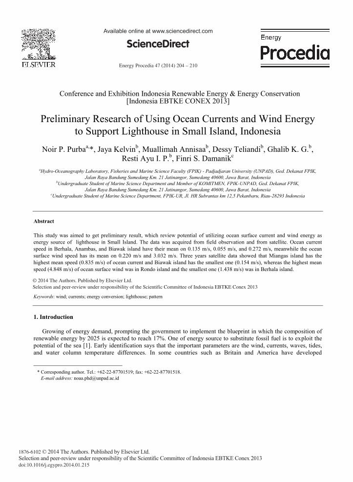
The selection of those islands as the study sites due to the difference of their water characteristics. Rondo Island represented the Indian Ocean region. Berhala Island represented the Malacca Strait, Biawak Island represented the Java Sea, Anambas Island represented the South China Sea waters, and Miangas Island represented the Pacific Ocean waters that passed by Indonesia Troughflow Water (ITW).Rondo Island is located at the northern tip of Weh Island, which borders with Hindiaocean. The position of the island is very strategic, which is located in the international shipping route, Administratively, the island is located in the area of Ujung Bau, Sukakarya District, City of Sabang, Aceh Province. The distance from the Town of Sabang Island as far as 15.6 km2, with an area of 3 km2 and need time about 40 minutes from the Ujung Bau along 4.8 km. Berhala Island is located at the eastern province of North Sumatra and borders with Malaysia. Area of the island is 2.5 km2 and located in the international shipping routes of Malacca Strait. Administratively, the island is located in the sub district of TanjungBintang, Serdang regency, North Sumatra. The distance of this uninhabited island to the district capital takes about 2.5 hours and requires a special permit because the region is the ammunition disposal area [11]. This region does not have a lighthouse, but much needed given because the region is the outer one. Anambas Island is located in Riau Archipelago, which has 255 islands, including the 5 outer islands directly adjacent to neighbour countries. This is because most of the territory consists of oceans and islands scattered in the waters of Natuna Sea and South China Sea. Biawak Island is located off the coast of Java Sea, ± 40 km on the north coast of Indramayu in position of 05o56'002" LS and 108o22'015" BT, or is located 26 miles (50 km) to the north of Indramayu. It has flat topography; some parts of the island were covered with mangroves, which flooded, by seawater, especially during high tides. The area of this island is ± 120 ha, consisting of ± 80 hectares of mangroves and 40 ha of forest ± beach/shore. The length of the island from east to west is ± 1 km and from north to south is ± 0.5 km [12]. Miangas Island, located in the northern part of North Sulawesi province, directly adjacent to the island of Mindanao in the Philippines. On this island, there is a basis point TD 056 [13].
206 Noir P. Purba et al. / Energy Procedia 47 ( 2014 ) 204 – 210
Fig. 1. The objective location.
2.2 Data sources and processing
Hydrographic data on every island are obtained in four directions of the island that represented the surrounding hydrographic characteristics of the island. Hydrographic parameters that measured in the field are ocean surface current and wind speed. Measurements of ocean surface current speed was using direct reading current meter (with depth five meters approximately) and wind speed (u4) is acquired by Envirometer. The direction of ocean surface current measured with Lagrangian method, but wind direction measured from a flag direction, which placed on the top of boat. The data then to be converted with pattern: 1) direction and 2) speed with the 3 years satellite data. The visual data then changed to (watt). The energy of the wind expressed with the formula:
P = 1/2 x ρ x v3 x A (1)
Where: P = the power of the wind in Watt ρ = the density of air, in kg/m3 v = speed (velocity), in m/s A = the area that is swept by the rotor blades, in m2
For a wind turbine with diameter D and operating at sea level and 15 degrees Celsius (an air density of 1,225 kg/m3) the power of the wind is: P (wind) = 0,48 x V3 x D2. Betz’s law says that a wind turbine can extract a maximum of 16/27 (in other words 60%) of the energy from the wind [14]:
P (Betz) = 16/27 * P (wind) (2)
To get an estimation of the annual energy output of a wind turbine in kWh the following formula is used:
E (kWh) = 0.48 * 8760/1000 x Cp x v3 x D2 (3)
Where: E (kWh) = annual energy output in kWh Cp = efficiency factor of the wind turbine v = wind speed in m/s D = rotor diameter of the wind turbine in meters
For this calculation an efficiency factor Cp of 0.6 is used. To get a result in kWh the number of hours in a year

Noir P. Purba et al. / Energy Procedia 47 ( 2014 ) 204 – 210 207
(8760) is divided by 1000. The annual energy output (kWh/year) was converted into power unit (watt) to make an easy analysis with 1 kWh is equal to 0.114079553 watts.
P = 1/2 x ρ x v3 x A x η (4)
Where: P = the power of the ocean current in Watt ρ = the density of water, in kg/m3 (1025 kg/m3) v = speed (velocity), in m/s A = plane broad of turbine = turbine height x turbine diameter = 1.2 m2
η = generator coefficient (%) = 79.07%
The comparison standar deviation between satellite and observation can see in Table 1. The blank data mean that we did not make insitu measurement. The data was acquired from satellite andhas been made some modification to reduce error.
Table 1. Observation and standar deviation.
Island Ocean Surface Current Speed (m/s)
Ocean Surface Wind Speed (m/s)
Observation Satellite Observation Satellite Rondo - 0.502 ± 0.21 - 4.848 ± 2.05 Berhala 0.135 ± 0.04 0.463 ± 0.33 - 1.438 ± 0.81 Anambas 0.055 ± 0.03 0.283 ± 0.14 0.220 ± 0.13 4.420 ± 1.65 Biawak 0.272 ± 0.14 0.154 ± 0.09 3.032 ± 1.22 3.981 ± 1.64 Miangas - 0.835 ± 0.26 - 4.441 ± 1.79
3. Result and discussion
3.1 Wind energy
Pattern of wind speed and direction is different on each island within 3 years (figure 2).
Fig. 2. Wind pattern among five islands.

208 Noir P. Purba et al. / Energy Procedia 47 ( 2014 ) 204 – 210
It shows on Figure 2 that Rondo Island had 53% of its three years wind direction headed to northeast (30o - 60o) with the speed dominantly higher than 5 m/s and 26% of it directed to southwest (180o - 210o) with the speed dominantly higher than 5 m/s as well. In Berhala Island, there was no wind speed even higher than 3 m/s and the pattern of its direction was changing all over the time to every course, but dominantly 31% of them was directed to southeast. Anambas Island’s wind direction was generally headed into two courses, 45% to north (340o - 20o) and 41% to southwest (200o - 250o) with 38% of its speed was 3-5 m/s and 36% was higher than 5 m/s. Biawak Island also had two main directions of wind which are 50% headed to northwest (270o - 315o) and 38% headed to east (80o
- 120o). The wind speed was varying, 7.5% was less than 1.5 m/s, 19% was 1.5-3 m/s, 60% was 3-5 m/s, and the rest of it was higher than 5 m/s. The last one is Miangas Island, which had 30% of its wind direction headed to northeast (20o - 50o) and 36% headed to southwest (210o - 250o) with speed was dominantly higher than 5 m/s.
3.2. Ocean currents
The geostrophic current speed and direction of those five islands within three years is showed on Fig. 3. Rondo Island geostrophic current was only headed to south and west with 44% of it had speed less than 0.5 m/s and 56% was 0.5-1.2 m/s. Rondo Island’s current direction was distributed to every course except to southwest. The dominant direction was headed to northwest and south which was 34% and 14%, The current speed was 45% of less than 0.5 m/s speed, 4% was 1.2-1.5 m/s and the remaining was 0.5-1.2 m/s. Anambas Island’s current direction is dominantly headed to southwest and northwest (230o - 300o) which about 18% left was headed to south, north, and west of island. The speed was dominantly less than 0.5 m/s with just about 8% of it was 0.5-1.2 m/s. Biawak Island had current direction generally to northeast until southeast. It was like the general current direction on Java Sea. The speed was less than 0.5 m/s. In Miangas Island, the current direction was nearly headed to southwest (210o - 255o) for all the time with just 2% of it was headed to south. The speed was dominantly 0.5-1.2 m/s (figure 3).
Fig. 3. Currents pattern among five islands.
3.3. Wind and currents speed
From the 5 Islands, maximum speeds are in the region of Anambas, Biawak, Miangas, and Rondo Island. However, the minimum speed qualified as a pilot project from wind energy for is Miangas and Anambas Island. It is considering current technology capable of converting wind energy is about 1 m/s. To the currents parameters, the
Noir P. Purba et al. / Energy Procedia 47 ( 2014 ) 204 – 210 209
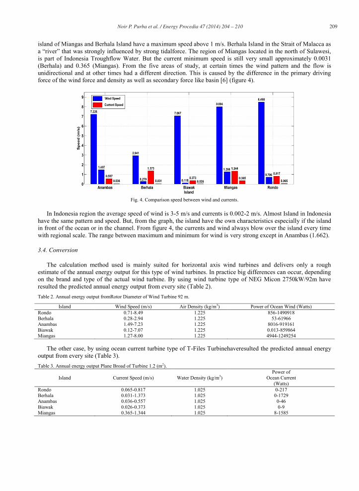
island of Miangas and Berhala Island have a maximum speed above 1 m/s. Berhala Island in the Strait of Malacca as a “river” that was strongly influenced by strong tidalforce. The region of Miangas located in the north of Sulawesi, is part of Indonesia Troughflow Water. But the current minimum speed is still very small approximately 0.0031 (Berhala) and 0.365 (Miangas). From the five areas of study, at certain times the wind pattern and the flow is unidirectional and at other times had a different direction. This is caused by the difference in the primary driving force of the wind force and density as well as secondary force like basin [6] (figure 4).
Fig. 4. Comparison speed between wind and currents.
In Indonesia region the average speed of wind is 3-5 m/s and currents is 0.002-2 m/s. Almost Island in Indonesia
have the same pattern and speed. But, from the graph, the island have the own characteristics especially if the island in front of the ocean or in the channel. From figure 4, the currents and wind always blow over the island every time with regional scale. The range between maximum and minimum for wind is very strong except in Anambas (1.662).
3.4. Conversion
The calculation method used is mainly suited for horizontal axis wind turbines and delivers only a rough estimate of the annual energy output for this type of wind turbines. In practice big differences can occur, depending on the brand and type of the actual wind turbine. By using wind turbine type of NEG Micon 2750kW/92m have resulted the predicted annual energy output from every site (Table 2). Table 2. Annual energy output fromRotor Diameter of Wind Turbine 92 m.
Island Wind Speed (m/s) Air Density (kg/m3) Power of Ocean Wind (Watts) Rondo 0.71-8.49 1.225 856-1490918 Berhala 0.28-2.94 1.225 53-61966 Anambas 1.49-7.23 1.225 8016-919161 Biawak 0.12-7.07 1.225 0.013-859864 Miangas 1.27-8.00 1.225 4944-1249254
The other case, by using ocean current turbine type of T-Files Turbinehaveresulted the predicted annual energy output from every site (Table 3). Table 3. Annual energy output Plane Broad of Turbine 1.2 (m2).
Island Current Speed (m/s) Water Density (kg/m3) Power of
Ocean Current (Watts)
Rondo 0.065-0.817 1.025 0-217 Berhala 0.031-1.373 1.025 0-1729 Anambas 0.036-0.557 1.025 0-46 Biawak 0.026-0.373 1.025 0-9 Miangas 0.365-1.344 1.025 8-1585
210 Noir P. Purba et al. / Energy Procedia 47 ( 2014 ) 204 – 210
A lighthouse needs power about 1000 watts. Therefore, by looking at Table 2 and 3, which showed the power resulted from one turbine, the possible islands to construct energy from ocean are Berhala and Miangas Island. For another island, such as Rondo Island, probably need a minimum 5 turbine constructions to get the power needed from ocean current.
3.5. Challenges
Energy harvesting from ocean current and wind can be done with existing technology. Calculations using 1-5 turbine constructions can be done by considering the following points: 1) most of small island locations are a conservation area, 2) ocean current-wind concept is suggested from this study to get more kinetic energy, and 3) almost throughout Indonesia regions have the same speed and pattern as resulted above. Ergo, the development of the technology should be developed.
4. Conclusion
Ocean wind has more significant potential than ocean current although nowadays the technology is not much better to farming. A high speed of ocean wind yet needed an advance technology to increase the energy output. Ergo, the development of energy harvesting technique is counted on. Beside that, the instrument must be eco-friendly, economist, and easy to maintenance. The range of maximum and minimum for wind speed are being a challenge for construction of instrument.
Acknowledgements
Thanks to surveyor and scientist in Biawak Exploration and Research (BIEXRE) I and II Projects, Marine Survey and Instrument Community (KOMITMEN), DIKTI-UNPAD by HibahKompetitif program and BOPTN in 2012. Thanks to Fisheries and Marine Science Padjadjaran University for collaborating material and discussion when doing this project.
References
[1] Yuningsih A, Sudjono EH, Rachmat B, Lubis S. Currents energy prospect. ESDM. Report; 2010. [2] Zhou Y, Wu WX, Liu GX. Assessment of onshore wind energy resource and wind- generated electricity potential in Jiangsu, China; 2011.
p. 418-422 [3] World Energy Council. Survey of energy resources. Excecutive summary. Report-survey; 2010. p. 28-30. [4] Van Zwieten JH, Smentek AE, Duerr, Alsenas GM, Hanson HP. Global ocean current energy assessment: An initial look. In: Proceedings
of the 1st marine energy technology symposium METS. Washington, D.C; 2013. [5] Minsitry of Energy and Mineral Resources. Renewable energy policy development and conservation of energy. Report; 2005.p. 5. [6] Purba NP, Awaluddin MY, Taofiqurohman A, Kelvin J, Irwan A. Marine energy to support isle in Indonesia, study case: Biawak Island.
Report; 2012. [7] Mineral Management Service. Technology white paper on ocean current energy potential on the U.S outer continental shelf. Renewable
energy and alternate use program U.S. Department of interior. Report; 2006. [8] Khaligh A, Omer C, Onar C. Energy harvesting, solar, wind, and ocean energy conversion system. CRC press; 2010. p. 101-165. [9] Nedaei M. Wind resource assessment in Abadan airport in Iran. International journal of renewable energy development 2012; p. 87-97. [10] Jensen T L. Renewable energy on small island. 2nd ed. Forum for Energy Development; 2000. [11] Direktorat Jendral Sumber Daya Kelautan dan Pesisir. Grand design development and infrastructure monitoring. Directorate General of the
monitoring and control of Marine Resources and fisheries, Ministry of Marine and Fisheries Affairs; 2010. [12] Department of Fisheries and Marine-Indramayu. Preparation manuscript of the academic management of regional marine conservation
area (KKLD) Biawak Island, Indramayu District. Report; 2006. [13] Tentara Nasional Indonesia Angkatan Laut. 12 Outer islands. DISPOTMAR AL; 2011. Available from www.info.tnial.mil.id [14] Sustainableenergyworld. Wind turbine energy output calculator. Year accesed June 2013.