Preliminary Report of the16th Season of Excavations at Tepe Hegmataneh; Hamedan
24
IRANIAN JOURNAL OF ARCHAEOLOGICAL STUDIES 2: 2 (2012) Preliminary Report of the16th Season of Excavations at Tepe Hegmataneh; Hamedan Yaghoub Mohammadifar 1, * , Assef Norouzi 2 and Ali Sharifi 3 1 Department of Archaeology, Bu-Ali Sina University, Hamedan, Iran 2 University of Tehran, Tehran, Iran 3 Department of Archaeology, Islamic Azad University, Abhar Branch, Iran (Received: 12/ 05/ 2012 ; Received in Revised form: 15/ 07/ 2012; Accepted: 21/ 07/ 2012 ) The archaeological campaign of the 16th season of excavations in Tepe Hegmataneh intended to explore the architectural structures belonging to the historical period. The excavated area consists of 4 squares including AJ45, AJ46, AK45, and AK46 with a total size of 400 m 2 . Excavations in these squares recorded 55, 54, 105, and 116 loci respectively. The architecture belonging to the historical period was uncovered at an average depth of 4.00 cm from BM1, and after clarifying the spaces, determining the condition of the floors and revealing the façades of the walls, the excavations in the squares was completed. A suite of architectural spaces appeared through excavations in these squares. Though there were slight differences, the plan was similar to the standard one suggested by Mohammad Rahim Sarraf. The revealed architecture includes one passage, three complete spaces, and parts of three other spaces. Based on the results of thermoluminescence experiment, it is rejected not only that this architecture belongs to the Medes, but also that its belonging to Parthians must be reconsidered. Keywords: Hamedan; Tepe Hegmataneh; Parthian; Sasanian * Corresponding author e-mail address: [email protected] did not possess any rampart, but its citadel was extremely firm and strong. He believed that its castle was built of wooden materials (Polybius 1889). Isidorus Characenus, a Greek geographer who lived in the 1st century B.C. points out the existence of a treasure house and a temple in Hegmataneh (Schoff 1914). Due to the linguistic conformity of the word “Hegmataneh” with “Ekbataneh”, “Ekbatan” the contemporary “Hamedan”, and some other geographical proofs and documents, most scholars believe Hamedan was the location of ancient Hegmataneh. The only different idea, which considered Takht-è Suleiman in Takab, located in the northwest of Iran, as matching with Hegmataneh, belongs to Sir Henry Rawlinson whose idea has been rejected by most archaeologists (DeMorgan 1896) and through the excavations in Takab, this was proven to be wrong. The English explorer, MacDonald Kinz was among the first who believed that Hegmataneh is located in Hamedan; an idea which was confirmed by his fellow countryman Buckingham (Malekzadeh 1995: 97). The location of Hegmataneh in Hamedan is an issue of much discussion (Jackson 1973: 177). Introduction D iscovering the legendary capital of the Medes has always been of great importance for all the researchers’. Seemingly, its name has been first mentioned in Babylonian texts entitled “Agamatanu” and was recorded during the fall of the Median kingdom by Cyrus the Great. The most famous narrative about this city belongs to Herodotus in which he ascribed the foundation of the city to Deioces and he considers seven ramparts for the city, each of them of different colors (Azkaei 1988: 61). Ctesias is another historian who mentioned Hegmataneh and ascribed it to Semiramis, the legendary queen of Assyria (Jackson 1973: 173). The Aramean equivalent of Hegmataneh, “Akhmetha”, is mentioned in the book named “Ezra”, 6th chapter, 2nd verse, and the two books of the Apocrypha set that is the third book of Tobit and the fourth one of Judith (Malekzadeh 1995: 96). One of the most authentic documents about Hegmataneh is associated with Polybius, who lived in the Parthian period. According to him, the city
Transcript of Preliminary Report of the16th Season of Excavations at Tepe Hegmataneh; Hamedan

IRANIAN JOURNAL OF ARCHAEOLOGICAL STUDIES 2: 2 (2012)
Preliminary Report of the16th Season of Excavations at
Tepe Hegmataneh; HamedanYaghoub Mohammadifar1, *, Assef Norouzi2 and Ali Sharifi3
1Department of Archaeology, Bu-Ali Sina University, Hamedan, Iran
2University of Tehran, Tehran, Iran
3Department of Archaeology, Islamic Azad University, Abhar Branch, Iran
(Received: 12/ 05/ 2012 ; Received in Revised form: 15/ 07/ 2012; Accepted: 21/ 07/ 2012 )
The archaeological campaign of the 16th season of excavations in Tepe Hegmataneh intended to explore the architectural structures belonging to the historical period. The excavated area consists of 4 squares including AJ45, AJ46, AK45, and AK46 with a total size of 400 m2 . Excavations in these squares recorded 55, 54, 105, and 116 loci respectively. The architecture belonging to the historical period was uncovered at an average depth of 4.00 cm from BM1, and after clarifying the spaces, determining the condition of the floors and revealing the façades of the walls, the excavations in the squares was completed. A suite of architectural spaces appeared through excavations in these squares. Though there were slight differences, the plan was similar to the standard one suggested by Mohammad Rahim Sarraf. The revealed architecture includes one passage, three complete spaces, and parts of three other spaces. Based on the results of thermoluminescence experiment, it is rejected not only that this architecture belongs to the Medes, but also that its belonging to Parthians must be reconsidered.
Keywords: Hamedan; Tepe Hegmataneh; Parthian; Sasanian
*Corresponding author e-mail address: [email protected]
did not possess any rampart, but its citadel was extremely firm and strong. He believed that its castle was built of wooden materials (Polybius 1889). Isidorus Characenus, a Greek geographer who lived in the 1st century B.C. points out the existence of a treasure house and a temple in Hegmataneh (Schoff 1914).
Due to the linguistic conformity of the word “Hegmataneh” with “Ekbataneh”, “Ekbatan” the contemporary “Hamedan”, and some other geographical proofs and documents, most scholars believe Hamedan was the location of ancient Hegmataneh. The only different idea, which considered Takht-è Suleiman in Takab, located in the northwest of Iran, as matching with Hegmataneh, belongs to Sir Henry Rawlinson whose idea has been rejected by most archaeologists (DeMorgan 1896) and through the excavations in Takab, this was proven to be wrong. The English explorer, MacDonald Kinz was among the first who believed that Hegmataneh is located in Hamedan; an idea which was confirmed by his fellow countryman Buckingham (Malekzadeh 1995: 97).
The location of Hegmataneh in Hamedan is an issue of much discussion (Jackson 1973: 177).
Introduction
Discovering the legendary capital of the Medes has always been of great importance
for all the researchers’. Seemingly, its name has been first mentioned in Babylonian texts entitled “Agamatanu” and was recorded during the fall of the Median kingdom by Cyrus the Great. The most famous narrative about this city belongs to Herodotus in which he ascribed the foundation of the city to Deioces and he considers seven ramparts for the city, each of them of different colors (Azkaei 1988: 61). Ctesias is another historian who mentioned Hegmataneh and ascribed it to Semiramis, the legendary queen of Assyria (Jackson 1973: 173).
The Aramean equivalent of Hegmataneh, “Akhmetha”, is mentioned in the book named “Ezra”, 6th chapter, 2nd verse, and the two books of the Apocrypha set that is the third book of Tobit and the fourth one of Judith (Malekzadeh 1995: 96). One of the most authentic documents about Hegmataneh is associated with Polybius, who lived in the Parthian period. According to him, the city

IRANIAN JOURNAL OF ARCHAEOLOGICAL STUDIES 2: 2 (2012)
Preliminary Report of the 16th ...
Jackson and Herzfeld considered Mosalla hill as the ancient citadel of Hegmataneh, but archaeological evidence discovered by Mohammad Rahim Sarraf and Ismael Yaghmaei show that Mosalla hill is a natural rock [shelf] where there had been a castle on top probably related to the Parthians (Malekzadeh 1995:98). According to Mohammad Mehriar, the Pisa hill to the northeast of Hamedan is actually Median Hegmataneh, but according to recent excavations in that hill, this has been rejected too (Mohammadifar et al 2009).It seems that Mostafavi was the first scholar who considered Sar Ghal-è hill as the ancient Hegmataneh (Malekzadeh 1995: 117, fin, 130) and since that time, many archaeologists believe the hill to be Hegmataneh.
The ancient site of Hegmataneh, about 40 hectares in extent, is located in the northeast of the city of Hamedan. It lies between Ekbatan and Shohada Streets and Hegmataneh Boulevard. It should be mentioned that Ekbatan Street crosses the hill and some parts of Hegmataneh area are located on its western side (fig. 1).The site includes adjacent mounds on the surface; it has undergun extreme damages due to contemporary constructions. The mounds are 10 meters height in average. Hegmataneh hill is oval in shape and its longitudinal direction is north-south. After being visited by archaeologists and equated with median Hegmataneh, the original name of Sar Ghal-è hill changed to Hegmataneh hill.
The first archaeological study of Hegmataneh arose from DeMorgan`s visit to the site (DeMorgan 1896). Thereafter in 1913, an expedition lead by Ch. Fossey started excavating in Hamedan (Chevalier N. 1989). The results of his digs in order to find antiquity in Sar Ghal-è, or so called Hegmataneh hill, was two big holes named Chal-è Shotor-khab and Goud-è Faransavi-ha [=The French pit] (Azkaei 1988:58-59). After the French expeditions, archaeological operations in Hegmataneh were halted for a long period of time. Since 1969 the Ministry of Culture and Art [of the time] started to buy the houses and other properties on top of the hill. Between 1975-76, Mohammad Mehriar was appointed to lead an Iranian group to prepare and organize the area for a long-term excavation (Azarnoosh 2007). Performing the above mentioned operations, Mehriar performed fruitful studies
regarding the size of area in different periods, recognizing its enclosure, the construction material, and the dimensions of mud bricks (Mehriar 1975:44-45; also 1976: 94-97). He eventually declared that the area could not be Median and that the start of its establishment probably began in the Achaemenian period (Mehriar 1982: 76-115). Also, it should be mentioned that Dyson and Luschay believed in the difference between mud-brick structures of Hegmataneh, hence different architectural periods in this site (Malekzadeh 1995:104-105).
However, it must be noticed that there has not been any actual excavations in Hegmataneh until 1983; and all the ideas presented are based on the data gathered from the surface of the hill. The first course of scientific excavation in Hegmataneh was directed by Sarraf since summer 1983 until 2000; twelve seasons of excavations were accomplished (Azarnoosh 2007) uncovering the pattern of the existing architecture in Hegmataneh. The most important results are as follows:
1. Uncovering the enclosure in the northern and eastern parts of the site.
2. Identifying the uniform structural rectangular units with a dimension of 17.5 × 17.5 meters.
3. Uncovering some passages heading NE - SW, and one NW - SE, and an intersection.
4. Identifying an irrigation system near the sides of the enclosure and in some passages.
Since Sarraf`s excavations were mostly focused on an extended and horizontal excavating system, after 12 seasons, the chronology of the site still remained obscure. Therefore, a second course of excavations was started by Azarnoosh, with the main purpose of determining the chronology. The results of his excavations during 4 seasons are as follows:
1. Excavating in order to establish stratigraphy with the dimensions of about 110 m2 during two seasons.
2. Investigating the results of the first two seasons, developing probe soundings at all points of the site.
3. Determining the oldest period of establishing
14

IRANIAN JOURNAL OF ARCHAEOLOGICAL STUDIES 2: 2 (2012)
Yaghoub Mohammadifar et. al
the site and ascribing the architectural structures to Parthians.
4. Identifying, leveling and the subtraction of the site in Parthian Period; revealing the existence of over two meters depth of deposits related to the
Fig.1: Location of Hegmataneh hill in Hamedan (After: The Archieve of Cultural Heritage, Handicrafts and Tourism Organization of Hamedan).
Parthian, and perhaps Seleucid periods under the excavated architectural structures.
5. Locating the place of “The Museum of The West” and sounding in order to determine the extent of the site.
15
IRANIAN JOURNAL OF ARCHAEOLOGICAL STUDIES 2: 2 (2012)
Preliminary Report of the 16th ...
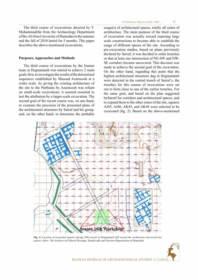
Purposes, Approaches and Methods
The third course of excavations by the Iranian team in Hegmataneh was started to achieve 2 main goals; first, to investigate the results of the determined sequences established by Masoud Azarnoosh at a wider scale. As giving the existing architecture of the site to the Parthians by Azarnoosh was reliant on small-scale excavations, it seemed essential to test the attribution by a larger-scale excavation. The second goal of the recent course was, on one hand, to examine the precision of the presented plans of the architectural structures by Sarraf and his group, and, on the other hand, to determine the probable
usage(s) of architectural spaces, totally all suites of architecture. The main purpose of the third course of excavation was actually toward exposing large scale constructions to become able to establish the usage of different spaces of the site. According to pre-excavation studies, based on plans previously declared by Sarraf, it was decided to order trenches so that at least one intersection of NE-SW and NW-SE corridors became uncovered. This decision was made to achieve the second goal of the excavation. On the other hand, regarding this point that the highest architectural structures dug in Hegmataneh were detected in the central trench of Sarraf`s, the trenches for this season of excavations were set out to form close to one of the earlier trenches. For the same goal, and based on the plan suggested bySarraf for corridors and architectural spaces, and to expand them to the other zones of the site, squares AJ45, AJ46, AK45, and AK46 were selected to be excavated (fig. 2). Based on the above-mentioned
Fig. 2: Location of excavated squares during 16th season in Hegmataneh hill toward the architecture uncovered last season. (After: The Archieve of Cultural Heritage, Handicrafts and Tourism Organization of Hamedan).
The third course of excavations directed by Y. Mohammadifar from the Archaeology Department of Bu-Ali Sina University of Hamedan in the summer and the fall of 2010 lasted for 5 months. This paper describes the above-mentioned excavations.
16

IRANIAN JOURNAL OF ARCHAEOLOGICAL STUDIES 2: 2 (2012)
Yaghoub Mohammadifar et. al
Fig. 3: Standard three-part plan offered by Mohammad Rahim Sarraf. (After: The Archieve of Cultural Heritage, Handicrafts and Tourism Organization of Hamedan).
Fig. 4: Selected squares to excavate, before the excavation (Photo: Authors).
expanded plan, the intersection of corridors was located in the SE side of AK46 and it was expected to appear a standard1 architectural unit (17.5 × 17.5 meters) in an approximate style (fig. 3).
In order to record the relationship between the layers and other elements methodically, the lot-locus system of recordkeeping was used in the excavation. In this method, each deposit and architectural structure is given a single locus label which is changed to a new one with any variation of material culture or physical properties of soil (type, texture, color, density, etc.). After setting out the four mentioned squares on the surface of the site, it became clear that the western part of two squares of AJ45 and AJ46 were 1.5 meters lower than the other parts; such a difference in level was due to a deep digging of the site in the modern period. The partition façade between these two levels is reverted during organizing operations of Hegmataneh project, therefore excavation started by removing this part of stiles. After clearing this part, the excavation area was divided into the previously-mentioned four squares (fig. 4) with the dimensions of 10 × 10 meters. Actually, the whole excavated area during the 16th season of excavations at Hegmataneh is 400 m2. It should be mentioned that 1 meter of
1The standard plan is a three-part.
the southern part of the squares AK45 and AK46 was selected as a balk for the ease of transferring debris out of the excavated area. This balk was fixed even till the level of the historical period. When the architecture of the historical period appeared, the balk was dug and the excavated soil was transferred out of the squares.
Regarding the destructions of architectural structures during Pahlavi era on the hill and not gathering the debris, the upper surface of the site is covered mainly with the debris and the wasters related to these structures. The destruction of contemporary buildings and then preparing the site for excavation was carried out by Mehriar between 1972 and 1976. The debris of such destruction was left untouched with the wasters on the surface and the debris of some later seasons of excavations for thirty years, and they have created a level which is not archaeologically significant and excavating it would just be a waste of time and energy. During the second course of archaeological excavations in Hegmataneh, Masoud Azarnoosh excavated, identified and recorded all the layers among the above-mentioned one in order to establish stratigraphy and determine the chronology of the site so that half of the excavation reports during four seasons is allocated to the layers belonging to the contemporary period. During the last season of excavation, deposits of the upper levels were dug very quickly in order to achieve the main purpose of excavations (i.e. to reach the architecture of the historical period) and recognize the upper deposits
17

IRANIAN JOURNAL OF ARCHAEOLOGICAL STUDIES 2: 2 (2012)
Preliminary Report of the 16th ...
of the site (debris, waster, and detrital). However, it should be mentioned that excavating, recognizing and recording all such deposits in this season were completely accurate and in spite of attempting to excavate these layers with the least number of loci, nearly 1/3 of the recorded ones belong to the deposits and the structures of the contemporary era. Superficial evidences suggested a great destruction and damage in the western parts of the site in the modern age. As a result, the expedition group decided to excavate in limited ranges and soundings in order to save costs and energy. The first sounding with the dimensions of 5.00 × 2.00 m was created in AJ45 workshop. Not having found any architectural features in this sounding, this operation continued in the dimensions of 2.00 × 2.00 m in AH40 and AI41 squares. All the depths of excavation are calculated from the datum point number 1 of Hegmataneh hill (BM1).
During the 16th season of excavations in Hegmataneh, the excavation continued up to about 4 meters in depth from the datum point. Such a depth reveals the floor of the architectural structures of the historical period. In total, the identified phenomena found this deep down can be classified top-down
in the three main categories as the contemporary phenomena, the phenomena produced between historical period architecture and the contemporary period, and the historical phenomena. With reaching the floor of the architectural structures belong to historical period, the excavation was completed. Of course in some points, clarifying all the ambiguity and completely elucidating the condition of some structures, the operation continued into lower depths.
Contemporary Architecture
Contemporary structures are mostly made of stone which, in case of destruction, do not have a specific status. Deposits of this period also contain several shafts and pits which damaged the related architecture greatly (see figs. 5a-5b). A canal in the direction of NW-SE could be considered as the most important structure of the contemporary period (fig. 6), which conforms to the one attributed to the historical period at a lower depth. Seemingly, the structure of this canal in this part of the site was preserved continuously, so that the other architectural structures during all eras were
Fig. 5a: Eastern section of square AK45.
18

IRANIAN JOURNAL OF ARCHAEOLOGICAL STUDIES 2: 2 (2012)
Yaghoub Mohammadifar et. al
Fig. 6: A part of identified structures relating to recent times. (Photo: Authors).
Fig. 5b: Eastern section of square AK46.
19
IRANIAN JOURNAL OF ARCHAEOLOGICAL STUDIES 2: 2 (2012)
Preliminary Report of the 16th ...
The Architecture in Range between Historical and Contemporary Periods
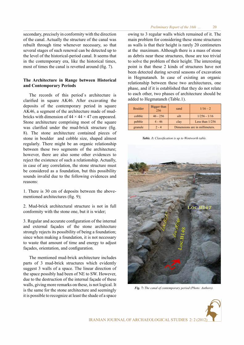
The records of this period`s architecture is clarified in square AK46. After excavating the deposits of the contemporary period in square AK46, a segment of the architecture made of mud-bricks with dimension of 44 × 44 × 47 cm appeared. Stone architecture comprising most of the square was clarified under the mud-brick structure (fig. 8). The stone architecture contained pieces of stone in boulder and cobble size, shaped almost regularly. There might be an organic relationship between these two segments of the architecture; however, there are also some other evidences to reject the existence of such a relationship. Actually, in case of any correlation, the stone structure must be considered as a foundation, but this possibility sounds invalid due to the following evidences and reasons:
1. There is 30 cm of deposits between the above-mentioned architectures (fig. 9);
2. Mud-brick architectural structure is not in full conformity with the stone one, but it is wider;
3. Regular and accurate configuration of the internal and external façades of the stone architecture strongly rejects its possibility of being a foundation; since when making a foundation, it is not necessary to waste that amount of time and energy to adjust façades, orientation, and configuration.
The mentioned mud-brick architecture includes parts of 3 mud-brick structures which evidently suggest 3 walls of a space. The linear direction of the space possibly had been of NE to SW. However, due to the destruction of the internal façade of these walls, giving more remarks on these, is not logical. It is the same for the stone architecture and seemingly it is possible to recognize at least the shade of a space
1/16 – 2sandBigger than 256Boulder
1/256 - 1/16silt46 - 256cobble
Less than 1/256clay4 - 46pebble
Dimensions are in millimeters.2 - 4granule
Table. 1: Classification is up to Wentworth table.
secondary, precisely in conformity with the direction of the canal. Actually the structure of the canal was rebuilt through time whenever necessary, so that several stages of such renewal can be detected up to the level of the historical-period canal. It seems that in the contemporary era, like the historical times, most of times the canal is revetted around (fig. 7).
owing to 3 regular walls which remained of it. The main problem for considering these stone structures as walls is that their height is rarely 20 centimeters at the maximum. Although there is a mass of stone as debris near these structures, those are too trivial to solve the problem of their height. The interesting point is that these 2 kinds of structures have not been detected during several seasons of excavation in Hegmataneh. In case of existing an organic relationship between these two architectures, one phase, and if it is established that they do not relate to each other, two phases of architecture should be added to Hegmataneh (Table.1).
Fig. 7: The canal of contemporary period (Photo: Authors).
20

IRANIAN JOURNAL OF ARCHAEOLOGICAL STUDIES 2: 2 (2012)
Yaghoub Mohammadifar et. al
Fig. 9: Stone structure identified from square AK46. (Photo: Authors).
Fig. 8: . Mud-brick structure with mud-bricks in dimension of 44×44×7cm, uncovered from square AK46 (Photo: Authors).
The Architecture of the Historical Period
After excavating about 2.50 meters of deposits and structures of various periods, the excavation team succeeded to reach the structures related to the historical period. It must be mentioned that more
than one-third of the structures belonging to this period, in the excavation area of the recent season are completely destroyed. These destructions are due to an extensive scooping in northern and western sides of the site during modern day. Besides the destructions in the western sides of the structures, in spite of previous assumptions, the remaining historical structures in the site are low in height. Despite all the damages, the team managed to detect and record the plan of some spaces and a corridor (fig. 10). The plan includes 3 perfect spaces in midpoint and parts of 3 other spaces in the north and west in general (fig. 11). The detected corridor is located on the eastern side of the site; its direction is NW-SE and its maximum excavated length is 17.50m (fig. 12). This corridor is a divider between the historical structures located on the eastern and western sides. From the structures on the eastern side of the corridor, only a small part - in the north eastern side of the site - was detected in square AK45 (fig. 13). It was built of mud-bricks with various dimensions of 48 ×48 ×14cm, 37 × 37 ×16cm, and 52 × 52 ×25cm along with mud mortar. The continuous erosion through time has destroyed the western façade. In the western side of the passage, there is a long wall with an obscure status (fig. 14); it forms the eastern sides of spaces number 1, 3, and 5. Its average width is 1.60 meters and the excavated length is 17.50 meters. On the clarified surface of this wall, 4.00 meters in south, there are some mud-bricks with dimensions of 48 × 48 × 13cm. There is no sign of mud-bricks from this part towards the north. Some almost regular-shaped lines have crossed the wall. The lines are repeated regularly at a distance of 80-85cm on wall`s surface. The existence of such lines could be a reason to show that most of this wall`s structure (at least at this depth) is made brick-laid. Not fully recognizing the kind of material used in the structure of the wall has made it more obscure; its façades, especially the eastern one, are extremely damaged and can scarcely be distinguished from the nearby deposits. One of the obscure points for this wall is a stone structure at the northern side, which seemingly extended into the wall; in this part, the wall`s façade is also penetrated by some sediments. The above mentioned ambiguities in totality - i.e. the kind of the material used, the stone structure and sediments, an uncertain façade, and some detrital mud-bricks - have raised a question on the structural
21

IRANIAN JOURNAL OF ARCHAEOLOGICAL STUDIES 2: 2 (2012)
Preliminary Report of the 16th ...
Fig. 10: A view of eastern section of square AK46 that indicates the existence of two layers of deposits between mud-brick and stone structures (Photo: Authors).
Fig. 11: Clarified plan at the end of the 16th season.
22

IRANIAN JOURNAL OF ARCHAEOLOGICAL STUDIES 2: 2 (2012)
Yaghoub Mohammadifar et. al
Fig. 14: The mud-brick structure (wall) in eastern side of NW-SE passage (Photo: Authors).
Fig. 12: Landscape of the zone of 16th season of excavations after ending of excavation (Photo: Authors).
Fig. 13: Identified passage of NW-SE direction (Photo: Authors).
matter/notion of this phenomenon. In spite of these ambiguities, two reasons can confirm this phenomenon as a structure. Firstly, it has formed the eastern side of spaces number 1, 3, and 5; the second is the existence of a brick structure which abuts the wall and runs parallel to it (fig. 15); a similar one was detected in the NW-SE passage of
the central trench in the excavations by Mohammad Rahim Sarraf. There is a similar brick structure parallel to it, this structure borders on the eastern wall of the passage (fig. 16). This brick structure was made in two lines and of seven rows. On the uppermost row between 2 lines of bricks, a duct is in sight that has 5 centimeters width (fig. 17) but the
23

IRANIAN JOURNAL OF ARCHAEOLOGICAL STUDIES 2: 2 (2012)
Preliminary Report of the 16th ...
Fig. 15: The outer wall of the eastern part of architectural structure in western side of the NW-SE passage (Photo: Authors).
Fig. 16: The brick structure abut on and parallel to the wall in fig. 15 (Photo: Authors).
Fig. 17: The brick structure parallel to the one in fig. 16 which is located in eastern side of the passage (Photo: Authors).
24

IRANIAN JOURNAL OF ARCHAEOLOGICAL STUDIES 2: 2 (2012)
Yaghoub Mohammadifar et. al
Fig. 18: The duct in the brick structure (Photo: Authors).
Fig. 19: Layers of stucco and metal oxide covering the duct (Photo: Authors).
reason of its development is unknown. The duct is filled with sedimentary debris of sand1 . Bricks used in the structures are of various dimensions of 34 ×34 × 7cm and 34 × 26× 7cm, and the mortar used between them was not recognized due to rigorous erosion through the time. There is a one-centimeter-depth layer of stucco on top of the uppermost row of bricks in the western structure. Between the stucco layer and the upper surface of the bricks, a layer of metal oxide (probably Iron Oxide) was detected that seemingly had been covering the above mentioned duct (figs. 18-19).
Nowadays, the lowest detected floor of the passage is at the same level as the highest row of the mentioned brick structures. The corridor between the two brick structures (second reasons) that are mentioned earlier is 3.20 meters in width and the one between mud-brick structures of west-east walls has 4.00 meters width. A canal passes through the corridor. Its walls are reverted with stones of boulder and cobble dimension. Also a covered inferior canal sticks out of the passage’s eastern wall, and ends in the main canal (fig. 20). It seems that during different phases and in upper levels of settlement on the site, the canal was used continuously to transfer water. Probably dredging has been performed after sedimentation of the canal, and in case of not being economical to dredge, they were creating a new canal on an upper surface.
To better understand the process of sedimentation in the canal, and also recognizing its basin, some specimens of the sediments were sampled to be examined. According to the reports of sedimentary petrology and sedimentology laboratory of Bu-Ali Sina University of Hamedan, the sources of the mentioned sediments are igneous and metamorphic stones of granite mass of Alvand and its surroundings.
The above mentioned evidence suggests that the Alvand Mountains are the source of the water streams of the canal. This canal and the others similar to this, may have been related to Nazar-Beig River which passes from the eastern part of the area, as the river originated from the Alvand sub mountain, its sediments has been transferred to the canals.
1 The standard plan is a three-part (fig.3).
To study the hypothesis, remote sensing analysis, satellite images and sampling the sediments of present streams of Alvand rivers basin can provide appreciable data on irrigation systems and methods of controlling the flowing waters. So it would not be impossible to locate and clarify the structures of
25

IRANIAN JOURNAL OF ARCHAEOLOGICAL STUDIES 2: 2 (2012)
Preliminary Report of the 16th ...
near the passage, forms the southern and eastern boundaries of the spaces. There is an eave similar to one of southern sides of the first space. Related to the second space, 2 floors with about 25cm variance
water controlling systems in their waterway to the ancient site in the past (figs. 20-21).
Spaces of the western side of the corridor formed in line to it and seemingly did not directly correlate to it (fig. 11). The nearby spaces are respectively named from south to north with numbers 1, 3, and 5 (figs.11-12)1 . Space no. 2 is rectangular with dimensions of 4.50 × 3.50m being separated from the space no. 3 by a wall of 2.80m wide. No entrance has been detected between these two spaces. This absence could be due to the low height of the walls; however, with the same height, there are some evidences that suggest the existence of an entrance between this space and the space no.2 in the west. Thus, there is no direct relationship between the first and the third space. The only detected floor relating to this space is a beaten surface with some signs of ash and coal. There is an eave being 50 centimeters wide in the same level with the floor next to the northern wall (fig. 22). This eave is considered as a technique that is performed next to some walls near the floor; in addition to the northern wall, the western and southern walls have also some eaves which appeared at a lower depth (fig. 23). It should be mentioned that the western wall is 20cm wide and the southern one 40cm wide. Despite the very low height of the remaining wall, there is some evidence showing the presence of an entrance with width of 1.10 meters. The distance from this entrance to the northern side of the first space is about 1 meter. This entrance opens toward the second space (fig. 21).
The space number 2 is in the shape of a rectangle with dimensions of 5.30 × 4.50m and its long direction is NW-SE. Its northern wall is the extension of the wide wall which is located between the first and the third spaces which extend to the north of the sixth space. The width of the wall which forms northern side of the second space has decreased to 1.40m. There is an entrance of 1.40m width placed in the midpoint of the wall in the northern side of the second space (fig. 24) which connects it to the fourth one. The southern sides of the first and the second spaces are formed by a wall in a NE-SW direction that seemingly, along with the western wall located
Fig. 20: The canal located in the passage given to historical period (Photo: Authors).
2To understand the whole style of spaces in architecture explanation of historical period refer to figs 11-12.
Fig. 21: The inferior canal stock out of architectural structures of eastern side of the passage (Photo: Authors).
26

IRANIAN JOURNAL OF ARCHAEOLOGICAL STUDIES 2: 2 (2012)
Yaghoub Mohammadifar et. al
in levels were cleared. As mentioned before, on the north-east side, the second space is related to the fourth one through an entrance.
Just a few sections of the northern and southern sides of the 4th space were recognized. Its western part and related structures are ruined throughout scooping in the contemporary period. Some evidence in the northern part of its eastern side suggests the presence of an entrance with 1.20m width opening to the third space. The fourth space in this surface is filled with a secondary mud-brick structure which was detected all over the floor of the space and even inside its southern entrance. This structure was built of mud-bricks with dimensions of 36 × 36 × 12cm and some fragments of mud-brick with various dimensions. Wide range of destructions has made it almost impossible to clarify its primary height and also its function, as it is not possible to recognize whether the mud-bricks have filled this structure or merely increased the height of its floor, which is a beaten one with signs of ash and coal like other detected floors. There are traces of a row of mud-bricks under this surface although it is not observed over the floor.
The third space is in the shape of a rectangle with dimensions of 4.50 × 3.50m and with a NW-SE direction. Its floor is a beaten one and it extended under the western wall of the space in the south west corner; it can be due to presence of an entrance which was blocked later. Like the fourth space, a mud-brick structure was detected under this space`s floor (fig. 25). This structure was detected all over the floor and even inside the southern entrance. It was made of mud-bricks with dimensions of 36 × 36 × 12 cm and some pieces of mud-bricks with various dimensions. The extensive range of destruction made it almost impossible to clarify its primary height and also its function, as it is not possible to recognize whether the mud-bricks filled this structure or merely increased the height of its floor. In the northern part, this structure contains 3 rows of mud-bricks as a platform beside the northern side, but towards the south, it can be observed as a mud-brick paved surface all over the space.
Fig. 22: Threshold between spaces number 1 and number 2 (Photo: Authors).
Fig. 23: The eaves in northern wall of space number 1 (Photo: Authors).
Fig. 24: The eaves in southern and western walls of space number 1 (Photo: Authors).
27

IRANIAN JOURNAL OF ARCHAEOLOGICAL STUDIES 2: 2 (2012)
Preliminary Report of the 16th ...
The southern side and some parts of the eastern side of a space, which is numbered 5, can be seen along the third space. Here, like the fourth space, the western and northern parts are destroyed as a result of scooping. It is probably 3.50 meters wide just like the first and the third spaces. Its length is not clear due to the destruction of the western and southern parts. The floor is beaten along with some signs of being burnt. Like the other spaces, some signs of ash and coal could be seen all over the surface.
In spite of extreme damages in the western part of the structures and architectural spaces of the squares in the west, some parts of another space numbered as space 6 were discovered in the southern part of the excavation area. It overlaps the second space in its eastern side, and its northern side forms the northern sides of the first and the second spaces. Here, the length and width are not clear and its floor, like other spaces, has burnt signs such as ash and coal. It is filled, like the fourth space, with a mud-brick structure.
One of the most ambiguous matters during this season of excavations is mud-brick fillings in some parts of the site (as mentioned earlier); this phenomenon can be observed in the 4th and 6th spaces, also in the southern parts of the first and the second spaces. According to Sarraf`s plans on central and northern trenches (fig. 2) and expanding it into the excavation area of this season, there was seen a corridor with a NE-SW direction to the south of the first and the second spaces; but with more
excavations, a mud-brick mass aligned with the south wall of the mentioned spaces emerged in the space considered to be the corridor. Due to unknown reasons, the corridor might have been filled, or it might be a case of not matching the current plan with reality. However, it can possibly be detected in the nearby excavated squares in further seasons of excavation. Another ambiguity about the detected spaces is that we were not able to understand their links with corridors. One of the goals of the expedition was to investigate whether there are repeated units similar to those presented by Sarraf or not. Such units are architectural structures with dimensions of 17.5 × 17.5 meters and contain 3 parts. Each of these units has a counter and a nave which ends in 3 rooms in each side.
These structures are located symmetrically in 2 parallel rows, at the back of each other (fig. 26). Between each row there is a corridor with a width of 3.50 meters and with NE-SW direction. In fact, in excavations in the northern trench by Sarraf, a corridor was detected perpendicular to these corridors; which seemingly could be the continue of the passage detected in north eastern part of the site.
In spite of the all the damages, there are similarities between the spaces having been revealed in the current season with the three-part plan given by Sarraf. This plan is clear in the eastern and southern parts of the excavation area, but the western and northern parts have been destroyed during the modern days. Nevertheless, the dimensions of the detected spaces are not in full conformity with the standard dimension. Seemingly, according to Sarraf`s, the second space conforms with the counter and the fourth one with the nave; especially the detected entrances end to this space and also other spaces are connected to each other only by these two spaces. As mentioned earlier, the entrance of the complex is not detected yet. According to Sarraf`s plan, it must have been located in the south side of the second space. Unsuccessful attempt to detect the entrance is probably because of the severe destruction of the structures - especially in this part - up to the floor. Despite the mentioned similarities, there also seem to be some obscure points around this complex. In addition to noticeable differences in dimensions and spaces, the positions of some structures are also
Fig. 25: Mud-brick filling in the floor of space number 4 (floor or changing the usage of space ) (Photo: Authors).
28

IRANIAN JOURNAL OF ARCHAEOLOGICAL STUDIES 2: 2 (2012)
Yaghoub Mohammadifar et. al
Fig. 26: Landscape of uniform architecture identified by Sarraf (After: The Archieve of Cultural Heritage, Handicrafts and Tourism Organization of Hamedan).
questionable. Of the most significant ones could be the dividing wall of the first and the third spaces. Its width varies between 2.60 to 2.80m and does not suggest any connections between the mentioned spaces; however, in the plan provided by Sarraf,
the massive structure is situated in front of this structure`s place. Also this massive structure always ends at a short corridor and an entrance, while the detected structure is a homogeneous mass ended at both western and eastern sides of the first and
29

IRANIAN JOURNAL OF ARCHAEOLOGICAL STUDIES 2: 2 (2012)
Preliminary Report of the 16th ...
the third spaces. It can be because of the fact that the remaining part of the structure is very low in height and the entrance and the connecting passage had been higher. However the ambiguities (absence of an entrance and the unusual situation of the massive mud-brick structure) are not solved yet. It should be noticed that the plan by Sarraf holds some exceptions too. One of the most significant exceptions is found in the northern trench, during
the 10th and 11th seasons of excavation. Also The NW-SE passage had been excavated during these seasons. This passage is named as number 20 in the article titled “Hegmataneh: an ancient mud-brick city” (Sarraf 2003). In the west part of the passage two units have been discovered which are different from the other passages. Their plans has two parts rather than three and their dimensions are 17.5 × 13.5m instead of 17.5 × 17.5m (fig. 27). These two
Fig. 27: The exception out of standard three-part architecture in Sarraf`s excavations; selected part is similar to the uncovered architecture in 16th season of excavations (After: The Archieve of Cultural Heritage, Handicrafts and Tourism Organization of Hamedan).
30

IRANIAN JOURNAL OF ARCHAEOLOGICAL STUDIES 2: 2 (2012)
Yaghoub Mohammadifar et. al
units are actually the standard units regardless of the three spaces in the west part of the nave. There are noticeable differences between these units and the main units regarding the dimensions. As previously mentioned, based on the standard plan, the massive mud-brick structure is usually situated in the western part, but it seems that it is placed in the eastern part in various units of the northern trench; but there is no entrance here. Considering the similarities between such a mud-brick mass with the mud-brick structure detected between the first and the third spaces in current season, this complex`s is almost definitely in conformity with the above-mentioned units.
As put by Sarraf, the dual units in the northern trench are made based on the priority of the corridors network. It seems that the uncovered corridor with the direction of NW-SE in the current season is along with the corridor number 10 of the northern trench of Sarraf`s; this fact can confirm the possibility of similarity between the uncovered architectural suite in the current season and the different uncovered model in the northern trench of Sarraf`s. Anyhow, considering the three-part plan the standard plan, conformity of the present complex with the standard plan of Sarraf`s would be sophisticated. Beside what was mentioned, the next problem is with the dimensions of the 5th space in the north of the suite. Although the measurements are not in full conformity, a relative proportion with the standard plan is observed in the other spaces. But the length of the eastern side is very unusual; so that besides enlarging the length of the 4th space, it has changed the general shape of the unit from square to rectangular. The northern and western parts of this space are so damaged that it is impossible to recognize the position of the northern side; so it should be noticed that the north-south border of this rectangular space is smaller. The other obscure matter is the location of the NE-SW corridor in the excavation site of the current season; nevertheless, the position of the revealed complex is in such way that the corridor must be detected in the south eastern corner of the site. This part is filled with a mass of mud-bricks. Although one should mention the possibility of being a secondary structure for this one, the presence of this corridor is not certain. Seemingly it can be possible to clear the ambiguities about the corridor by expanding the excavation
site to the south and east. The essential point to be mentioned is that most of the obscure points occur due to the low height of uncovered structures in this season. Also it is questionable that while there have remained high architectural structures within less than 30 meters away from the area, why this part undergoes such a destruction. The most significant reason for such a severe destruction seems to be the higher level of the architecture in this part of the site compared to the revealed architecture in the central and northern trenches of Sarraf. After investigating and comparing the depth of the floor of the corridor in 3 segments – the digs of the current season, central and northern trenches - it became clear that the floor of the uncovered corridor in this season is about 2.00 meters higher than the ones of the above-mentioned corridors. Regarding this variance in height, it seems that placing the architectural spaces of the central and northern trenches at a lower depth has preserved them from destruction in later periods. The difference in height itself raises other questions on the methods used in constructing the architectural complex in this site. Considering these methods, some matters have been presented so far such as predesigned architecture, similar units, and priority of the corridors and the water-draining structures which all would be confirmed by the results of excavations in different seasons.
During the excavations by Azarnoosh, another idea was provided about the method of construction, suggesting that there was an underlying foundation for leveling the area, in order to construct the architectural spaces. Azarnoosh believes that the builders first leveled the existing unevenness of earth with filling or probably scooping; then after leveling the area, the architectural structures were built. This idea has also been examined and confirmed in different parts of it. Although, the existence of such underlying foundations was confirmed but because of the low amount of excavations, there is not enough information about them; it means, it is not clear whether this foundation is made just on one level or performed as joined terraces. There are some possibilities about the intentional or accidental slope leveling. Also, it is not clear that in case of any slope, what the directions of slopes are.
The height of the detected floor of the corridor,
31

IRANIAN JOURNAL OF ARCHAEOLOGICAL STUDIES 2: 2 (2012)
Preliminary Report of the 16th ...
in the central workshop is almost equal to corridor number 10 (northern trench), while the floor of the corridor and consequently the revealed spaces in the current season is about 2.00 meters above the mentioned parts. Having considered the surface of the site, after leveling, as slope one, regarding the position and the distances between these three parts, one can estimate that the final slope in the north and east is respectively 2 percent and 4 percent. In contrast with this idea, if the surface is considered as a flat or an even one, the existence of some terraces at the site will be probable. Regarding the mentioned variance on height, it seems that the direction of the uncovered canal from the last season (northern trench) and the current season would be south east to northwest.
It should be noticed that it is only by extended excavations in the southern and eastern sides of the site excavated in the current season (16th season) that the presented possibilities about the constructing methods of the structures, type of units and irrigation can be tested.
Small findings
Due to their solid architectures, sites like Hegmataneh have been inhabited after the primary construction phase. Therefore, it is rare to discover unique small finds. Most of the findings from Hegmataneh include potsherds, which are mixed up because of continuous settlements, disturbance and damage in the modern period. Apart from the pieces of pottery, also bone, metal, and glass were found in the 16th season of excavations at Hegmataneh hill (fig. 27). However, owing to the small size of most of these findings, damaged and tangled as the result of human activities in the modern period, these objects including bone, metal, and glass do not contain any significant data. In this season of excavations, regarding the great amount of detected and registered potsherds during the excavations (more than 50000 pieces of potsherd), just some significant and noticeable potteries have been registered. From the viewpoint of chronology, these potsherds belong to an extended period from the Parthian to the modern era (see fig. 28). The most noticeable pieces belong to the Parthian period, which are detected from reliable contexts and
include Clinkey, alkaline-glazed and painted ones; some samples can be seen in fig. 29. Some coins, probably made of copper with obscure images, were discovered in the contexts belonging to the historical period. Although it was not possible to completely recognize the images on the coins, one can say that, based on recognizable parts, they had the characteristics of Parthian coins (see fig. 30).
Fig. 28: Some samples of found glass fragments.
Chronology
According to the data recovered from the 16th season of excavations at Hegmataneh hill, three periods could be identified in the site. The oldest period, particularly based on the ceramics which mostly ascribed to the Parthian period, dated back to Parthian period. According to survived structures, this period can be divided into two phases. The first phase is defined according to the structures which form the plan presented at the end of the first season. The second and newer phase is related to 3 mud-brick masses which have been built in spaces no.4 and no.6, and the corridor in NW-SE direction. The second period is introduced based on a two mud-brick and stone structure belonging to the historical and contemporary periods. Since the layers of Hegmataneh hill because of continuous settlements were commixed, the ceramics belonging to different periods were found in its various deposits, especially in layers and deposits of the Islamic period. Determining the accurate construction period of the mud-brick and stone structures is impossible, since ceramics of the medieval and late Islamic periods, both were found in detected deposits of the second period. The third and the last recognized period in the site (within the 16th season excavation border) belongs to the modern period and during the
32

IRANIAN JOURNAL OF ARCHAEOLOGICAL STUDIES 2: 2 (2012)
Yaghoub Mohammadifar et. al
Fig. 29: Some samples of found potsherds.
Fig. 30: Discovered coins.
Pahlavies (the ruling period of both the father and the son). This period layer is observed all over the hill with the thickness of 0.5 - 2 meters.
During the 16th season of excavations, four samples of brick and pottery were chosen from different loci for thermo luminescence experiment. The first sample is related to locus No. 148 from AK46 and obtained from depth of - 210cm. This locus belongs to and represents the stone architecture which itself fit in the period between the architecture structure supposed to be usual in the historical and modern periods. The dating of this sample, based on
the solar hegira Muslim calendar, is 1150±70 years ago. According to such a dating, the mentioned style of architecture dates back to the years 168-308 A.H. (790-930 AD). So this kind of architecture could be ascribed to the initial Islamic Period. However, the brick could be made in an older historical period and used later in building the stone architecture. Regarding the later hypotheses, it should be noticed that the mentioned brick, during this idle time was exposed to light; so its thermoluminescence timing is not definitely reliable. Consequently, based on the results obtained from this experiment, the only thing that can be stated without any doubt is that the stone architecture cannot be older than the initial Islamic period.
The second sample selected for Thermoluminescence experiment belongs to locus number O.142 from trench AJ46 which has been detected in depth of -404cm. It should be mentioned that this sample is a potsherd with a ceramic ware.The deposit layer, from which the sample is taken, is set on the floor of the space no.4, and based on the evidences gathered through excavations. , it is a settlement deposit. The dating for this sample goes back to 1010±60 years ago, and it is not something
33

IRANIAN JOURNAL OF ARCHAEOLOGICAL STUDIES 2: 2 (2012)
Preliminary Report of the 16th ...
that can be left unnoticed. Therefore this deposit should be dated between 318-438 A.H. (AD 940-1060) or the late initial Islamic period and early medieval Islamic period. As mentioned before, there is a mud-brick-filled space which has been introduced as the second phase of the architecture ascribed to the historical period. The mentioned deposit is located under this mud-brick part and its suggested date is therefore more recent than the historical period. On the other hand, it should be mentioned again that the existing architecture of Hegmataneh which is ascribed to historical period was highly solid, and it was settled during various periods and underwent numerous alterations. So it is possible to detect some deposits newer than the historical period on the floor of some settling spaces.
The other two samples selected for thermoluminescence experiment belong to square AK45 and were chosen from loci number B.197 and B.190. Both of these loci represent the brick structures that were built parallel to external walls of architectural spaces and in two sides of the passage with the direction of NW-SE. These structures which include a canal covered with metal and stucco were described and explained in the architecture part of this paper. These loci were built at the same level as the canal, and some parts of it are placed under the external walls of architectural spaces. Therefore, the dating of these samples is extremely surprising. The dating proposed for these bricks are as following:
The sample from locus number B.190: based on solar hegira calendar, refers to 1350±75 years ago.
The sample from locus number B.197: based on solar hegira calendar, refers to 1370±100 years ago.
Consequently, the brick structures should be dated to the period between 82 years before the Hegira (BH) and 118 years after it (AH) equal to 540-740 AD. Indeed, the oldest dating proposed to these samples equates to the last Sassanid kings. Accepting these datings requires ascribing the exposed architecture to the Sassanian-Islamic periods. Actually, based on Azarnoosh`s studies, it seems impossible to assign the main architecture to the Medes. The results of the experiments done in the new course of excavations, put under the question the assigning of the architecture to the
Parthians and to some extent, to the Sassaniand period. Because, as mentioned, some parts of the brick structures placed under the main walls of uniform architecture in size of 17.5 × 17.5m and naturally the date for these brick structures should be considered equal to or slightly older than the date of constructing the wall. On the other hand, the close relationship between the dating results presented for both samples to some extent show their accuracy. In fact, these two samples confirm each other and the proposed dating. The only subject that may cause doubting about these dates is the damages endured during the time and the subsequent repairs and maintenance activities (some evidences of these repairing and restoring are obvious all over the hill). Therefore, confirming or rejecting the mentioned results needs further studies. Based on the results of thermoluminescence experiment applied to the last two samples, any statement about the subject, without considering the results of experiments will lead to a wrong conclusion. It should be noticed that during the stratigraphic excavations of Azarnoosh in the architectural structures or surfaces, which are in the same grade, rarely a steady deposit related to the Parthians were found and most of this period`s layers have been detected under the underlying layer prepared for building the main architecture of the site. Maybe because of this reason, Azarnoosh believed that the further studies may turn out that the architecture of the area belongs to Sassanid period (personal discussion). Based on Azarnooshs’ hypotheses, the architecture could have been formed between the initial and medieval Sassanid period.
Anyhow, as mentioned before, any statement about the accurate dating of the site of Hegmataneh hill, even currently should be expressed with great precaution would be impossible. Finding the accurate date of the architectural complexes, the stratigraphic excavations should be performed at a larger scale (at least in four trenches of 10 × 10 m2) and the whole stratigraphy excavation, in this area, should focus on the excavations up to the virgin soil.
Future Works
All of the spaces assigned to the historical period (except the space no.6) are related to a
34

IRANIAN JOURNAL OF ARCHAEOLOGICAL STUDIES 2: 2 (2012)
Yaghoub Mohammadifar et. al
single architectural unit which is different from the presented standard pattern, but two similar units have been uncovered in the northern trench of Sarrafs’ excavations. The main difference between these units and the standard ones is the number of their spaces; i.e. three lateral spaces in west side of the units were omitted and reduced to two units. After measuring the height of the detected floors during the 16th excavation and comparing them with the floors of the passages detected during previous seasons (in central and northern trenches), it turned out that the height of this part is about 2.00 meters more than the central and northern parts.
This difference itself puts forward a question about the methods of building and performing the architecture in the site. Presently, there are two probabilities about the method of leveling the area; grading (exclusive of its necessity) and terracing. In addition, except the differences in the plan, a late phase in the architecture assigned to the historical period has been detected, the phase that featured secondary structures having filled two spaces and possibly a corridor. Based on the extended plan, this corridor was likely to be detected in the south east of square AK46; but according to the evidence it seems to be filled with brick during later periods. Seemingly, the accurate study of these cases needs extending the excavation area in this part and other parts of the site in order to answer all the questions and clearing all ambiguities. Also by extending the horizontal excavating method used around the architectural spaces ascribed to the historical period, perfect information could be obtained about the water draining system and transferring it to the main canal and application of the brick structures with covered canals on two sides of the surrounding walls.
On the other hand, as mentioned in the dating section, determining accurately the age of the layers and the existing architecture of the site, specially ones ascribed to the historical period is not currently possible and demands further studies, but based on the results of thermoluminescence experiment applied on some samples, until performing the later studies ascribing the main architecture of the site to the Parthian period and before, should be considered with doubt, and regarding the latest data
Acknowledgements
This project as a five-month field study was sponsored by the Iranian Cultural Heritage, Handicrafts, and Tourism Organization of Hamedan province (ICHHTOH). We should express our profound gratitude to Mr. Asadollah Bayat, director of the organization, Mr. Mohammad Rahim Ranjbaran and Mr. Habibollah Rashid-beigi for their support and cooperation. The Undersecretary of Technology and Research of Bu-Ali Sina University is appreciated for his support. We would like to thank Abbas Norouzi for his cooperation in preparing this paper and Professor Roger Matthews from University of Reading for edition of this article. Also our heartfelt thanks go to the other members of the 16th season of excavations team, Hamed Eghbal, Ahad Mo`menpour, Amir Bahrami, Ahmad Ali Arab, Farhad Amini, Parvin Ranjbari, and Parinaz Bahar-aghdam for their company and support.
(resulted from the 16th season of excavation) the mentioned architecture could be ascribed to last Sassanid period, although this ascribing itself is not definitive. Therefore, considering the low height of this architecture, a stratigraphic excavation in 4 excavated squares of the 16th season down to the virgin soil is suggested. Actually, it seems that determining the accurate chronology of the site at a large scale is more important than preserving structures of these 4 squares which have a low height and were damaged severely.
Thus, further studies should include both horizontal excavating methods in order to clarify the mentioned architecture complexes and their application; and also vertical excavating methods to clarify the obscure chronological status of the site.
35

IRANIAN JOURNAL OF ARCHAEOLOGICAL STUDIES 2: 2 (2012)
Preliminary Report of the 16th ...
References
Azkaei, Parviz 1988 An Introduction to the Archaeology of Hamedan. Iranian Journal of Archaeology and History (In Persian) 2 : 56- 67. Tehran: Iran University press.
Azarnoosh, Masoud. 2007 The Report of Stratigraphic Excavations in Hegmataneh, Hamedan. The Ninth Annual Congress of Archaeology (In Persian). Tehran: Iranian Center for Archaeological Research.
Chevalier, N. 1989 Hamadan 1913, une mission oublié. Iranica Antiqua 24: 245-53.
DeMorgan, J. 1896 Mission Scientifique en Perse vol. IV. Recherche archeologiques. Paris.
Jackson, V. V. 1973 Hamedan, The Ancient Ecbatana (Hegmataneh) (Jackson`s Diaries, Iran in Past and Present) (In Persian). Translated by Manouchehr Amiri and Fereidun Badrei. Tehran: Kharazmi publications.
Malekzadeh, Mehrdad. 1995 Median Capitals. In Mohammad Yosef Kiani (ed.) Capitals of Iran reading: 83-146. Tehran: Iranian Cultural Heritage, Handicrafts and Tourism Organization.
Mehriar, Mohammad. 1975 The Prelude of a Great Archaeological Program in Hegmataneh hill. In Firouz Bagherzadeh (ed.). Reports of the 3rd Annual Congress of Excavations and Archeological Researches in Iran ( In Persian): 41 - 50. Tehran: Iranian Center of Archaeology.
1976 The Prelude of a Great Archaeological Program in Hegmataneh hill. In Firouz Bagherzadeh (ed.) Reports of the 4th Annual Congress of Excavations and Archeological Researches in Iran ( In Persian): 92 - 98. Tehran: Iranian Center of Archaeology. 1982 Study of Architectural Elements in Ancient Site of Hegmataneh. Monument (Asar) ( In
Persian). Vols. 7-8-9 (linked series): 76 -1 15. Tehran: Former National Organization of Conservation of Ancient Monuments of Iran.
Mohammadifar, Y; A.Motarjem & H.Torabzadeh. 2009 Tepe Pissa: new investigations at a Kura- Araxes site in central western Iran. Antiquity 82 (320).
Polybius. 1889 The Histories of Polybius. Vol 1. Translated from the text of F. Hultsch by Evelyn S. Shuckburg. London and New York: Macmillan and Co.
Sarraf, M.R. 2003 Archaeological excavations in Tepe Ekbatana (Hamadan) by the Iranian Archaeological mission between 1993 and 1999. In Giovanni B. Lanfranchi; Michael Roaf & Robert Rollinger (eds.) Continuity of Empire (?) Assyria, Media, Persia: 269-280. Padova: Sargon srl.
Schoff, Wilfred H. 1914 Parthian Stations by Isidore of Charax: The Greek text, with a translation and commentary, Philadelphia: Commercial Museum.
36