PREHISTORIC TRAILS OF THE PICACHO BASIN IN THE COLORADO DESERT, IMPERIAL COUNTY, CALIFORNIA
11
SCA Proceedings, Volume 25 (2011) Bryne, p. 1 PREHISTORIC TRAILS OF THE PICACHO BASIN IN THE COLORADO DESERT, IMPERIAL COUNTY, CALIFORNIA STEPHEN BRYNE SCIENCE APPLICATIONS INTERNATIONAL CORPORATION Prehistoric trails are part of the cultural landscape of the Picacho Basin in the Colorado Desert of southeastern California. These trails provide a lasting testament to prehistoric lifeways. Since the early twentieth century, scores of trails have been documented in this region. The trails, which vary from short segments to over 200 mi. in length, were used to access resource collections areas, to conduct trade and warfare, and as ritual routes to sacred sites. A number of trails were recorded in 2010 during surveys for proposed military aircraft landing sites. Observations regarding these trails, and their significance, are discussed. The entire west was crisscrossed by prehistoric trails. In California, these trails linked all areas: north, south, east, and west (Campbell 1999:42). Not only were local trails utilized, but super-pathways traversed and bisected the region and reached trails far beyond, leading to what would become the adjoining states of Arizona and Nevada (Campbell 1999:42). The prehistoric trail systems in the Picacho Basin are some of the most numerous and complex in the Colorado Desert (Pendleton 1985:89; Townsend 1983:7; von Werlhof 1988). These trails consist of narrow, cleared lines, in some cases continuing for miles. Over the years, scores of trails have been recorded in this area (Pendleton 1985:89; Pigniolo et al. 1997; Townsend 1983:7; von Werlhof 1988). The trails of the Picacho Basin are part of the cultural landscape, and they provide a lasting testament to prehistoric and historic Native American lifeways. In an area that seems to lack habitation sites, trails and their associated features can provide insight into prehistoric people’s behavior, including subsistence and settlement. ETHNOHISTORY The Native American tribes who occupied western Arizona and southeastern California were speakers of related languages of the Yuman family. The lowland Yuman tribes included the Quechan, Mojave, Kamia, Cocopah, Halchidhoma, and Maricopa (Cleland 2004). Their economy was based on floodplain agriculture, fishing, and harvesting wild plant foods. These groups traveled widely across the desert for purposes of social visitation, religious pilgrimages, trade, alliance building, and warfare (Cleland 2004). The construction of a regional trail system was a key component of this cultural system (Cleland 2004; von Werlhof 1987). Among Yuman groups, pilgrimages to distant locations of ritual importance were common, and war parties traveled great distances to engage the enemy in pitched battles; these activities were facilitated by a network of trails (Cleland 2005:133). Perhaps the most notable trail system is the Xam Kwatcan trail network, an almost 200-mi.-long trail from Avikwalal (Pilot Knob) near Yuma to Avikwame (Spirit Mountain) near Laughlin, Nevada (Cleland 2004; Pigniolo et al. 1997). QUECHAN COSMOLOGY The cosmology and spirit life of the Quechan are dominated by the belief in a plural reality: one is the “normal” material existence, and the other is the spiritual-mystical existence (Cleland and Apple 2003:21; Pigniolo et al. 1997:60). The spiritual level of reality is accessed through dreams, and dreams are tied to the natural and cultural landscape (Cleland and Apple 2003:21). Thus, dream travel, trails, and
-
Upload
independent -
Category
Documents
-
view
1 -
download
0
Transcript of PREHISTORIC TRAILS OF THE PICACHO BASIN IN THE COLORADO DESERT, IMPERIAL COUNTY, CALIFORNIA

SCA Proceedings, Volume 25 (2011) Bryne, p. 1
PREHISTORIC TRAILS OF THE PICACHO BASIN IN THE COLORADO DESERT, IMPERIAL COUNTY, CALIFORNIA
STEPHEN BRYNE SCIENCE APPLICATIONS INTERNATIONAL CORPORATION
Prehistoric trails are part of the cultural landscape of the Picacho Basin in the Colorado Desert of southeastern California. These trails provide a lasting testament to prehistoric lifeways. Since the early twentieth century, scores of trails have been documented in this region. The trails, which vary from short segments to over 200 mi. in length, were used to access resource collections areas, to conduct trade and warfare, and as ritual routes to sacred sites. A number of trails were recorded in 2010 during surveys for proposed military aircraft landing sites. Observations regarding these trails, and their significance, are discussed.
The entire west was crisscrossed by prehistoric trails. In California, these trails linked all areas: north, south, east, and west (Campbell 1999:42). Not only were local trails utilized, but super-pathways traversed and bisected the region and reached trails far beyond, leading to what would become the adjoining states of Arizona and Nevada (Campbell 1999:42).
The prehistoric trail systems in the Picacho Basin are some of the most numerous and complex in the Colorado Desert (Pendleton 1985:89; Townsend 1983:7; von Werlhof 1988). These trails consist of narrow, cleared lines, in some cases continuing for miles. Over the years, scores of trails have been recorded in this area (Pendleton 1985:89; Pigniolo et al. 1997; Townsend 1983:7; von Werlhof 1988). The trails of the Picacho Basin are part of the cultural landscape, and they provide a lasting testament to prehistoric and historic Native American lifeways. In an area that seems to lack habitation sites, trails and their associated features can provide insight into prehistoric people’s behavior, including subsistence and settlement.
ETHNOHISTORY
The Native American tribes who occupied western Arizona and southeastern California were speakers of related languages of the Yuman family. The lowland Yuman tribes included the Quechan, Mojave, Kamia, Cocopah, Halchidhoma, and Maricopa (Cleland 2004). Their economy was based on floodplain agriculture, fishing, and harvesting wild plant foods.
These groups traveled widely across the desert for purposes of social visitation, religious pilgrimages, trade, alliance building, and warfare (Cleland 2004). The construction of a regional trail system was a key component of this cultural system (Cleland 2004; von Werlhof 1987).
Among Yuman groups, pilgrimages to distant locations of ritual importance were common, and war parties traveled great distances to engage the enemy in pitched battles; these activities were facilitated by a network of trails (Cleland 2005:133). Perhaps the most notable trail system is the Xam Kwatcan trail network, an almost 200-mi.-long trail from Avikwalal (Pilot Knob) near Yuma to Avikwame (Spirit Mountain) near Laughlin, Nevada (Cleland 2004; Pigniolo et al. 1997).
QUECHAN COSMOLOGY
The cosmology and spirit life of the Quechan are dominated by the belief in a plural reality: one is the “normal” material existence, and the other is the spiritual-mystical existence (Cleland and Apple 2003:21; Pigniolo et al. 1997:60). The spiritual level of reality is accessed through dreams, and dreams are tied to the natural and cultural landscape (Cleland and Apple 2003:21). Thus, dream travel, trails, and
SCA Proceedings, Volume 25 (2011) Bryne, p. 2
spirit mountains are significant parts of the spiritual life of contemporary Quechan people (Cleland and Apple 2003:21; Pigniolo et al. 1997:60).
The Keruk ceremony was held at irregular intervals to celebrate and perpetuate a ritual taught to the first men after the death of Kukumat, the creator of the world (Cleland and Apple 2003:22). The Keruk was an occasion for relatives and friends to travel considerable distances to get together to exchange food and goods, gossip, conduct courtship, arrange marriages, settle disputes, etc. (Cleland and Apple 2003:22). A great deal of travel was associated with this ceremony, and this travel took place over trails. Pilot Knob (Avikwalal) was the starting place for the traditional Keruk ceremony, and Picacho Peak (Avi milyket) was a major ceremonial stop on the pilgrimage to Avikwame (Cleland and Apple 2003:22-23; Pigniolo et el. 1997:62). The trails linking these sacred places with each other and with various villages are of particular spiritual significance to the Quechan people because the trails were used during the Keruk ceremony and for dream travel (Cleland and Apple 2003:23).
The Cargo Muchacho Mountains (Winsue) also figure prominently in the creation, mythology, healing, habitation, and subsistence practices of the Quechan (Cleland and Apple 2003:22). In addition, many trails have spiritually significant features associated with them, such as geoglyphs, spirit breaks, and shaman’s circles (Cleland and Apple 2003:23).
PREVIOUS RESEARCH
The nineteenth-century historian Hubert H. Bancroft perhaps first described the trail system of the Colorado Desert. Bancroft described the trails in the following passage:
…several long, path-like discolorations of the surface, extending for miles in nearly straight lines, which were Indian trails. The only change which was produced appeared to be the removal or dimming of the polish on the pebbles. There was no break in the hard surface, and no dust. That the distinctness of the trail was made by the removing of the polish only became evident from the fact that figures and Indian hieroglyphics were traced, or imprinted, on the surface or adjoining path, apparently by pounding or bruising the surface layer of pebbles. These trails seem very old, and may have endured for many generations [Bancroft 1890:690-691].
Pioneering archaeologist Malcolm Rogers studied these trails in the 1920s (Rogers 1966:42, 47-49). The trails, along with cleared circles and crude stone tools, formed the basis of Roger’s definition of San Dieguito culture (Rogers 1939). Rogers stated,
One impressive phenomenon left by the San Dieguito ancients is the great number of trails, and the fact that so many of them survived, even in a fragmented condition. They are best preserved on the extensive flat desert pavements of the American Desert in its southernmost parts. Any unnatural alteration of a pavement surface seems to become an imperishable record, no matter how much time has intervened; the record simply becomes more blurred with elapsed time. Regardless of how ancient the disturbance was, a discerning eye can detect some vestige [Rogers 1966:47].
More recently, archaeologists including Norman Whalen (1976), Jay von Werlhof (1983, 1984), Jerry Schaefer (1982, 1983), Jan Townsend (1983), Lorann Pendleton (1985), Andrew Pigniolo et al. (1997), Jerry Schaefer and Carol Shultze (1996), and James Cleland and Rebecca McCorkle Apple (2003) have documented numerous trails in this region.
Jay von Werlhof recorded several trails during this study of the Gold Fields Mining Company Mesquite District Project area (von Werlhof 1983, 1984). He observed that the trails, “average 35 cm wide, in at least the southeastern California deserts” (von Werlhof 1984:33). He suggested that the trails represented transient usage, “probably guiding people between the valley and the river, and between the west side of the Chocolate Mountains and the main east-west trail through the Mesquite District” (von
SCA Proceedings, Volume 25 (2011) Bryne, p. 3
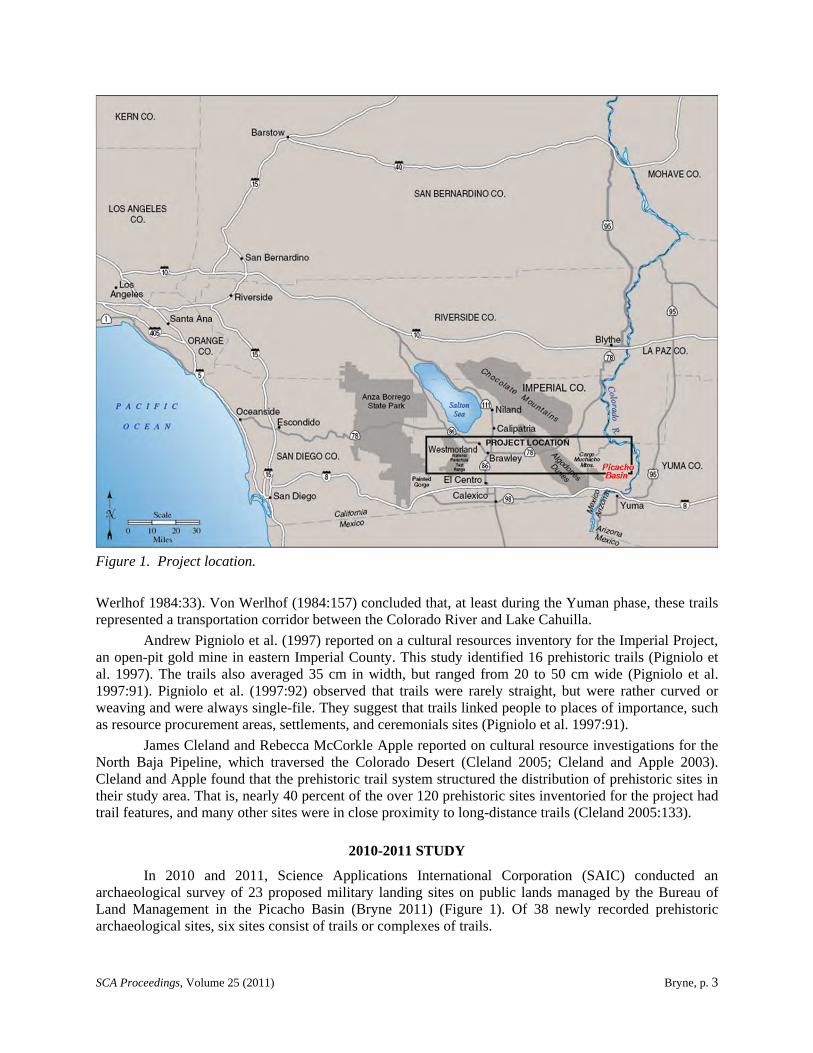
Figure 1. Project location.
Werlhof 1984:33). Von Werlhof (1984:157) concluded that, at least during the Yuman phase, these trails represented a transportation corridor between the Colorado River and Lake Cahuilla.
Andrew Pigniolo et al. (1997) reported on a cultural resources inventory for the Imperial Project, an open-pit gold mine in eastern Imperial County. This study identified 16 prehistoric trails (Pigniolo et al. 1997). The trails also averaged 35 cm in width, but ranged from 20 to 50 cm wide (Pigniolo et al. 1997:91). Pigniolo et al. (1997:92) observed that trails were rarely straight, but were rather curved or weaving and were always single-file. They suggest that trails linked people to places of importance, such as resource procurement areas, settlements, and ceremonials sites (Pigniolo et al. 1997:91).
James Cleland and Rebecca McCorkle Apple reported on cultural resource investigations for the North Baja Pipeline, which traversed the Colorado Desert (Cleland 2005; Cleland and Apple 2003). Cleland and Apple found that the prehistoric trail system structured the distribution of prehistoric sites in their study area. That is, nearly 40 percent of the over 120 prehistoric sites inventoried for the project had trail features, and many other sites were in close proximity to long-distance trails (Cleland 2005:133).
2010-2011 STUDY
In 2010 and 2011, Science Applications International Corporation (SAIC) conducted an archaeological survey of 23 proposed military landing sites on public lands managed by the Bureau of Land Management in the Picacho Basin (Bryne 2011) (Figure 1). Of 38 newly recorded prehistoric archaeological sites, six sites consist of trails or complexes of trails.
SCA Proceedings, Volume 25 (2011) Bryne, p. 4
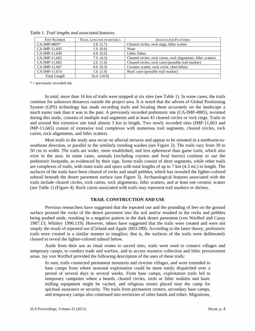
Table 1. Trail lengths and associated features.
SITE NUMBER TRAIL LENGTHS IN KM (MI.) ASSOCIATED FEATURES CA-IMP-4805* 2.8 (1.7) Cleared circles, rock rings, lithic scatter CA-IMP-11,643 1.0 (0.6) None CA-IMP-11,649 0.8 (0.5) Lithic flakes CA-IMP-11,663 7.0 (4.3) Cleared circles, rock cairns, rock alignments, lithic scatters CA-IMP-11,665 2.6 (1.6) Cleared circles, rock cairn (possible trail marker) CA-IMP-11,667 0.6 (0.3) Ceramic scatter, rock circle, chert biface CA-IMP-11,674 1.6 (1.0) Rock cairn (possible trail marker)
Total Length 16.4 (10.0)
* = previously recorded site
In total, more than 16 km of trails were mapped at six sites (see Table 1). In some cases, the trails continue for unknown distances outside the project area. It is noted that the advent of Global Positioning System (GPS) technology has made recording trails and locating them accurately on the landscape a much easier task than it was in the past. A previously recorded prehistoric site (CA-IMP-4805), revisited during this study, consists of multiple trail segments and at least 43 cleared circles or rock rings. Trails in and around this extensive site total almost 3 km in length. Two newly recorded sites (IMP-11,663 and IMP-11,665) consist of extensive trail complexes with numerous trail segments, cleared circles, rock cairns, rock alignments, and lithic scatters.
Most trails in the study area occur on alluvial terraces and appear to be oriented in a northwest-to-southeast direction, or parallel to the similarly trending washes (see Figure 2). The trails vary from 30 to 50 cm in width. The trails are wider, more established, and less ephemeral than game trails, which also exist in the area. In some cases, animals (including coyotes and feral burros) continue to use the prehistoric footpaths, as evidenced by their sign. Some trails consist of short segments, while other trails are complexes of trails, with main trails and spurs with total lengths of up to 7 km (4.3 mi.) in length. The surfaces of the trails have been cleared of rocks and small pebbles, which has revealed the lighter-colored subsoil beneath the desert pavement surface (see Figure 3). Archaeological features associated with the trails include cleared circles, rock cairns, rock alignments, lithic scatters, and at least one ceramic scatter (see Table 1) (Figure 4). Rock cairns associated with trails may represent trail markers or shrines.
TRAIL CONSTRUCTION AND USE
Previous researchers have suggested that the repeated use and the pounding of feet on the ground surface pressed the rocks of the desert pavement into the soil and/or resulted in the rocks and pebbles being pushed aside, resulting in a negative pattern in the dark desert pavement (von Werlhof and Casey 1987:13; Whitley 1996:119). However, others have suggested that the trails were created and were not simply the result of repeated use (Cleland and Apple 2003:289). According to the latter theory, prehistoric trails were created in a similar manner to intaglios; that is, the surfaces of the trails were deliberately cleared to reveal the lighter-colored subsoil below.
Aside from their use as ritual routes to sacred sites, trails were used to connect villages and temporary camps, to conduct trade and warfare, and to access resource collection and lithic procurement areas. Jay von Werlhof provided the following description of the uses of these trails:
In sum, trails connected permanent mountain and riverine villages, and were extended to base camps from where seasonal exploitation could be more easily dispatched over a period of several days to several weeks. From base camps, exploitation trails led to temporary campsites where a hearth, cleared circles, tools or lithic nodules and basic milling equipment might be cached, and religious stones placed near the camp for spiritual assurance or security. The trails from permanent centers, secondary base camps, and temporary camps also continued into territories of other bands and tribes. Migrations,

SCA Proceedings, Volume 25 (2011) Bryne, p. 5
Figure 2. Trail at CA-IMP-11,674.

SCA Proceedings, Volume 25 (2011) Bryne, p. 6
Figure 3. Trail crossing desert pavement surface at CA-IMP-4805.
visitations, war, quarrying and trade were the most widely used purposes for the extended trail system [von Werlhof 1988:64].
Lorann Pendleton (1985:184-185) concluded that some of the trails were used by people living near the Colorado River who exploited the lithic resources in the Picacho Basin within their daily foraging radius, while other trails resulted from long-distance travel by people traveling through the Picacho Basin to distant destinations. Pendleton (1985:186) concluded, “Perhaps the best evidence for the functioning of trails in long-distance travel networks is the mere presence of the trails themselves.”
ASSOCIATED FEATURES
Trails in the Picacho Basin are often associated with other archaeological features, including rock cairns, trailside shrines, cleared circles, ceramic scatters (or “pot drops”), lithic scatters and isolated lithic artifacts. It is the association with prehistoric artifacts and features that argues for the prehistoric origin of these trails. Rogers (1966:49) observed that, “along these trails and in their vicinities are found artifacts, sleeping circles, cobble trail shrines, and boulder-outlined ceremonial configurations.”
Rock cairns or shrines are sometimes found in conjunction with trails. Rogers (1966:49) indicates that the earliest trail shrines were composed of “simple offerings, generally rocks, presumably in the belief that they would prevent fatigue, sickness or injury while travelling.” Later (assumedly Yuman) shrines sometimes contain tobacco pipes, smashed whole ceramic vessels, shell ornaments, and food offerings (Rogers 1966:49). Begole (1974:59) describes trailside shrines as being constructed by travelers,
SCA Proceedings, Volume 25 (2011) Bryne, p. 7
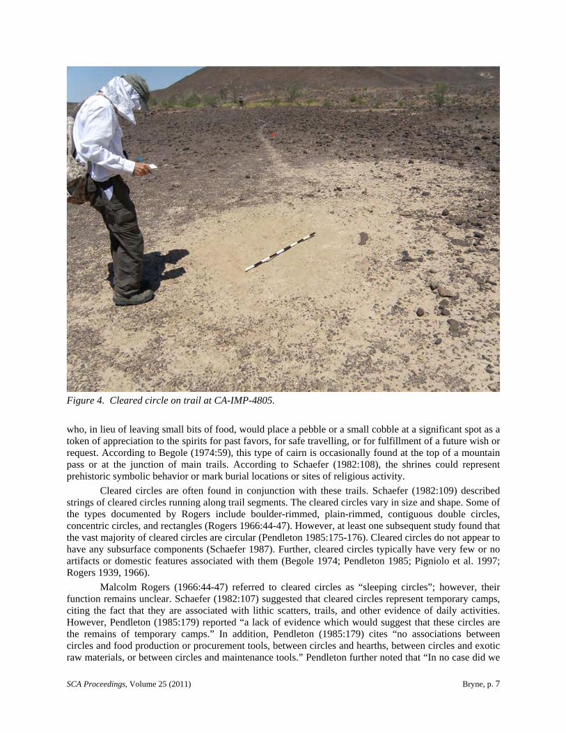
Figure 4. Cleared circle on trail at CA-IMP-4805.
who, in lieu of leaving small bits of food, would place a pebble or a small cobble at a significant spot as a token of appreciation to the spirits for past favors, for safe travelling, or for fulfillment of a future wish or request. According to Begole (1974:59), this type of cairn is occasionally found at the top of a mountain pass or at the junction of main trails. According to Schaefer (1982:108), the shrines could represent prehistoric symbolic behavior or mark burial locations or sites of religious activity.
Cleared circles are often found in conjunction with these trails. Schaefer (1982:109) described strings of cleared circles running along trail segments. The cleared circles vary in size and shape. Some of the types documented by Rogers include boulder-rimmed, plain-rimmed, contiguous double circles, concentric circles, and rectangles (Rogers 1966:44-47). However, at least one subsequent study found that the vast majority of cleared circles are circular (Pendleton 1985:175-176). Cleared circles do not appear to have any subsurface components (Schaefer 1987). Further, cleared circles typically have very few or no artifacts or domestic features associated with them (Begole 1974; Pendleton 1985; Pigniolo et al. 1997; Rogers 1939, 1966).
Malcolm Rogers (1966:44-47) referred to cleared circles as “sleeping circles”; however, their function remains unclear. Schaefer (1982:107) suggested that cleared circles represent temporary camps, citing the fact that they are associated with lithic scatters, trails, and other evidence of daily activities. However, Pendleton (1985:179) reported “a lack of evidence which would suggest that these circles are the remains of temporary camps.” In addition, Pendleton (1985:179) cites “no associations between circles and food production or procurement tools, between circles and hearths, between circles and exotic raw materials, or between circles and maintenance tools.” Pendleton further noted that “In no case did we
SCA Proceedings, Volume 25 (2011) Bryne, p. 8
find evidence which would suggest that the cleared circles were the remains of houses (e.g., a base camp)” (Pendleton 1985:179). Based on Pendleton’s analysis, the function of cleared circles could not be determined (Pendleton 1985:180). More recently, Cleland and Apple (2003:291) have suggested that the cleared circles may represent “dreaming circles,” which may explain the apparent lack of associated artifacts.
Rogers developed the first ceramic chronology for the area, still in use with minor modifications, by using the ceramics deposited along the trails and at trailside shrines. Most ceramic scatters are attributable to Yuman or Patayan (historic) cultures from approximately 1,200 to 100 years ago (Schaefer 1982:113). Five Patayan I period ceramic types have been defined: Colorado Beige, Colorado Red-on-beige, Colorado Red, Black Mesa Buff, and Black Mesa Red-on-buff (Waters 1982). Ceramics most frequently occur along trails as discrete ceramic scatters or so-called “pot drops.” According to Schaefer (1982:113), these may represent accidental breakage by people traveling through the area.
Lithic artifacts associated with trails included debitage, unfinished tools, hammer stones, and occasional flake tools (Pendleton 1985:185). Finished tools, tool caches, hearths, domestic goods, and remains of any habitations are conspicuously absent in this part of the Colorado Desert (Pendleton 1985:228).
CHRONOLOGICAL INDICATORS
Dating of trails is problematical, since they tend to lack dateable artifacts and features. Further, these are surface features and they appear to lack any subsurface components.
Trails used by pre-ceramic populations may lack any kind of temporal indicator, other than the degree of weathering and desert varnish that they possess (Cleland and Apple 2003:36). Efforts to establish age determinations for individual rocks or rock features based on microlaminations on desert varnish (i.e., Dorn 1994, 2004; Dorn and Whitley 1984; Dorn et al. 1992; von Werlhof et al. 1995) are still considered experimental. Nevertheless, the technique of cation ratio dating has obtained chronometric ages for rock varnishes, and this technique has been successfully used to date petroglyphs in the Coso Range (Dorn and Whitley 1984). This technique has recently been successfully used to date a number of petroglyph sites in Montana and Wyoming (Alice Tratebas, personal communication 2011).
Associated ceramics and cairns have, in some cases, allowed the trails to be dated and/or assigned a cultural affiliation. Rogers felt that some trails were established by the Malpais culture during San Dieguito I times, while he attributed other trails to later Yuman cultures (Rogers 1966:47). He believed that trails with potsherds on their margins could safely be assigned to Yumans because of the characteristic Yuman ceramic types present (Rogers 1966:47). However, Rogers acknowledged that, in some cases, Yuman people used the trails that had been established by more ancient cultures (Rogers 1966:47).
Schaefer (1982:109) suggests that some trails date to San Dieguito times, from 12,000 to 8,000 years ago, while other trails were constructed or used during the Yuman period. Von Werlhof (1988:52) suggests that abandoned San Dieguito-aged trails were later reestablished by Yuman people, rather than having been used continuously through time. Some trails continue to be used by contemporary Native Americans.
SIGNIFICANCE
Pigniolo et al. (1997:116) suggested that trails have sometimes been poorly understood, under-esteemed, and poorly protected in the past. According to Pigniolo et al. (1997:116), “The religious and spiritual significance of trails, added to the well-recognized importance of desert trails for trade and travel, provides a portrait of trail patterns as an extremely significant heritage resource.”
Among the contemporary Yuman people of the Lower Colorado, trails have religious and spiritual significance (Pigniolo et al. 1997:93). Especially important is the Native American dream travel that occurs over traditional trails (Pigniolo et al. 1997:96). In dream, Yuman people travel along trails
SCA Proceedings, Volume 25 (2011) Bryne, p. 9
leading to mountains of religious significance where important spirits reside (Pigniolo et al. 1997:115-116).
Because some trails lead to sacred sites, the trails themselves are considered sacred to contemporary Native Americans (Woods 1980). Quechan people have indicated that trails served to connect all major religious sites into a single complex through which they can trace their history as a people (Pigniolo et al. 1997:283). Quechan tribal member and elder Lorey Cachora described the importance of dreaming and sacred places to Quechan culture:
The Quechan were also instructed by the spiritual leaders on power and dreams. They were taught that dreaming enabled them to have direct contact with various supernatural beings in order to gain advice and teaching on how to solve the problems of the living. While dreaming their souls returned to the time of creation to learn. The Yuman people have the ability to learn through dreams, but a few people have special gifts….
So the mountains along the Colorado River region are highly significant in regional Native American culture and ethnic identity. Spiritual activities and events are deeply associated with numerous intaglios, petroglyphs, trails, lithic scatters, and cleared circles present along the Colorado River and surrounding hills [Cachora 1994:14].
Although the Colorado Desert and Picacho Basin may lack large habitation sites, the prehistoric people who inhabited this region, as well as contemporary Native Americans, have left a lasting legacy of their presence in this area in the form of numerous trails crisscrossing the desert. Future research, including additional mapping and documentation of these trails and their associated features, may shed light on questions such as who constructed the trails and when they were used. Dating of ceramics and perhaps of rock varnish has the potential to provide additional chronological data.
REFERENCES CITED
Bancroft, Hubert H. 1890 Antiquities of California. History Company, San Francisco.
Begole, Robert S. 1974 Archaeological Phenomena in the California Deserts. Pacific Coast Archaeological Society
Quarterly 10(2):51-70.
Bryne, Stephen 2011 Archaeological Survey Report of Twenty-Three Proposed Military Aircraft Landing Zones on
Bureau of Land Management Lands, Imperial County, California. Science Applications International Corporation, Carpinteria, California. Report prepared for U.S. Marine Corps, Marine Corps Installations West and U.S. Department of the Interior, Bureau of Land Management, El Centro Field Office.
Cachora, Lorey 1994 The Spirit Life of Yuman-Speaking Peoples: Lower Colorado River between Arizona and
California. In Recent Research along the Lower Colorado River, edited by Joseph A. Ezzo, pp. 13-14. Statistical Research Technical Series No. 51. Tucson, Arizona.
Campbell, Paul D. 1998 Survival Skills of Native California. Gibbs-Smith, Salt Lake City, Utah.
Cleland, James 2004 Ethnographic Trail Systems and Large-Scale Cultural Landscapes: Preservation and
Management Issues. In Exploring the Boundaries of Historic Landscape Preservation: Proceedings of the Twenty-ninth Annual Meeting of the Alliance for Historic Landscape Preservation 2007, Athens, edited by Cari Goetcheus and Eric MacDonald pp. 41-55. Clemson University Digital Press, Clemson, South Carolina.
SCA Proceedings, Volume 25 (2011) Bryne, p. 10
2005 The Sacred and the Mundane: Cultural Landscape Concepts and Archaeological Interpretation in the Colorado Desert. Proceedings of the Society for California Archaeology 18:130-135.
Cleland, James, and Rebecca McCorkle Apple 2003 A View across the Cultural Landscape of the Lower Colorado Desert: Cultural Resource
Investigations for the North Baja Pipeline Project. EDAW, San Diego.
Dorn, Ronald 1994 Dating Petroglyphs with a 3-Tier Rock Varnish Approach. In New Light on Old Art:
Advances in Hunter-Gatherer Rock Art Research, edited by D. S. Whitley and L. Loendorf, pp. 12-36. UCLA Institute of Archaeology Monograph Series No. 36. Los Angeles.
2004 Experimental Approaches to Dating Petroglyphs and Geoglyphs with Rock Varnish in the California Deserts: Current Status and Future Directions. In The Human Journey and Ancient Life in California’s Deserts, edited by Mark W. Allen and Judyth Reed, pp. 211-224. Maturango Museum Publication No. 15. Ridgecrest, California.
Dorn, R. I., P. B. Clarkson, M. F. Nobbs, L. L. Loendorf, and D. S. Whitley 1992 New Approach to the Radiocarbon Dating of Rock Varnish, with Examples from Drylands.
Annals of the Association of American Geographers 82:136-151.
Dorn, Ronald I., and David S. Whitley 1984 Chronometric and Relative Age Determination of Petroglyphs in the Western United States.
Annals of the Association of American Geographers 74(2):308-322.
Pendleton, Lorann 1985 Archaeological Investigations in the Picacho Basin: Southwest Powerlink Project—Sand
Hills to the Colorado River Segment. Wirth Environmental Services, San Diego. Report prepared for San Diego Gas & Electric, San Diego.
Pigniolo, Andrew R., Jackson Underwood, and James H. Cleland 1997 Where Trails Cross: Cultural Resources Inventory and Evaluation for the Imperial Project,
Imperial County, California. KEA Environmental, San Diego. Report prepared for Environmental Management Associates, Brea, California.
Rogers, Malcolm J. 1939 Early Lithic Industries of the Lower Basin of the Colorado River and Adjacent Desert Areas.
San Diego Museum Papers No. 3. 1966 Ancient Hunters of the Far West. Union-Tribune, San Diego.
Schaefer, Jerry 1982 Cultural Resource Survey of the APS/SDG&E 500kV Transmission Line Right-of-Way, Sand
Hills to the Colorado River, Imperial County, California, Volume I: Survey and Results. Report prepared for San Diego Gas & Electric, San Diego, California.
1983 Cultural Resource Survey of the APS/SDG&E 500kV Transmission Line Right-of-Way, Sand Hills to the Colorado River, Imperial County, California, Volume II: Confidential Technical Appendices. Report prepared for San Diego Gas & Electric, San Diego, California.
1987 Hunter-Gatherer Adaptations to a Marginal Desert Environment: Subsistence Practices and Lithic Production in the Chocolate Mountains, Imperial County, California. Mooney-LeVine and Associates, San Diego. Report prepared for Gold Fields Mining Corporation, Lakewood, Colorado.
Schaefer, Jerry, and Carol Schultze 1996 Cultural Resources of Indian Pass: An Inventory and Evaluation for the Imperial Project,
Imperial County, California. ASM Affiliates, Encinitas, California.
Townsend, Jan 1983 Southwest Powerlink Cultural Resources Management Plan. Wirth Associates, San Diego.
SCA Proceedings, Volume 25 (2011) Bryne, p. 11
von Werlhof, Jay 1983 Archaeological Examinations of the Gold Fields Project Area, Mesquite District, Imperial
County. Report prepared for St. Clair Research Systems, Anaheim, California. 1984 Archaeological Investigations of the Gold Fields Mesquite District. Imperial Valley College
Museum, El Centro, California. Report prepared for Gold Fields Mining Company. 1987 Spirits of the Earth: A Study of Earthen Art in the North American Deserts, Volume 1: The
North Desert. Imperial Valley College Museum Society, El Centro, California. 1988 Trails in Eastern San Diego County and Imperial County: An Interim Report. Pacific Coast
Archaeological Society Quarterly 24(1):51-75.
von Werlhof, Jay, and Harry Casey 1987 Spirits of the Earth: A Study of Earthen Art in the North American Deserts, Volume 1: The
North Desert. Imperial Valley College Museum Society, El Centro, California.
von Werlhof, Jay, Harry Casey, Ronald I. Dorn, and Glenn A. Jones 1995 AMS 14C Age Constraints on Geoglyphs in the Lower Colorado River Region, Arizona and
California. Geoarchaeology 10(4):257-273.
Waters, Michael R. 1982 The Lowland Patayan Ceramic Tradition. In Hohokam and Patayan: Prehistory of
Southwestern Arizona, edited by Randall H. McGuire and Michael B. Schiffer, pp. 275-297. Academic Press, New York.
Whalen, Norman M. 1976 An Archaeological Survey in Southeastern Imperial County, California. Manuscript on file,
South Coastal Information Center, San Diego State University, San Diego, under NADB # 1101274.
Whitley, David S. 1996 A Guide to Rock Art Sites: Southern California and Nevada. Mountain Press, Missoula,
Montana.
Woods, Clyde 1980 Native American Cultural Resources. In APS/SDG&E Interconnection Project,
Environmental Study, Phase II Corridor Studies, Volume II, Chapter 6. Wirth Associates, San Diego.