Welcome to Milford's Hiking Trails
19
Welcome to Milford’s Hiking Trails Brought to you by: Milford Conservation Commission www.milford.nh.gov/conservation 603.249.0628 Please Protect Your Environment
-
Upload
khangminh22 -
Category
Documents
-
view
5 -
download
0
Transcript of Welcome to Milford's Hiking Trails

Welcome to Milford’s Hiking Trails
Brought to you by:
Milford Conservation Commission www.milford.nh.gov/conservation
603.249.0628
Please Protect Your Environment
The Milford Trails Select your favorite trail - they are included alphabetically in this
booklet
Note: The Rotch Wildlife Preserve is the newest addition to the Milford Trail System. The trail system within the Preserve is in the early planning an development stages. When ready, maps and other information will be added to this booklet.

Welcome:
The Milford Conservation Commission would like to welcome
you to our trail system. The commission maintains trails in
five town forests: Hitchiner, Mayflower Hill, Mile Slip, Rotch
Wildlife Preserve, and Tucker Brook. In addition, the
commission maintains the Granite Town Rail Trail, an
abandoned rail bed beginning behind DPW on South Street as
well as the Souhegan River Trail on privately owned land
Please visit us at www.milford.nh.gov/conservation.
We mark our main trails with white blazes and loops or side
trails with blue. Yellow blazes denote a trail that leaves the
property by an alternate route. Confusing spots have colored
arrows signs; let us know if you have any problems.
The conservation commission would appreciate receiving
reports of any problems you may encounter using its lands or
repairs you think need to be done. Please call the
Conservation Commission at 603-249-0628 or send us an
email at [email protected]. If you would like to join
us for a work day on the trails please contact us.
Caution:
For your hiking safety and enjoyment and that of hikers who
come after you, we encourage responsible hiking, 'leave
nothing but footprints, take nothing but pictures.' Hunting is
allowed in Tucker Brook, Hitchiner and The Mile Slip. Please
check with NH Fish & Game at www.wildlife.state.nh.us for dates
and precautions to take when hiking during hunting season.
Although the woods are relatively safe, there are inherent
hazards which could cause injury. Slips, trips, falls, insect
bites, branch scraps, etc. are all very possible in the woods.
Pay attention to where you step and to what is in front of you
to avoid injury. Hike with a partner whenever possible.

�
��
������������� �����
�������������� ��������������� � ��� ������ ��������������� ����� ����� ��������������������� ��� ��� ������� ������������ ������������������� ��� ����� ��
!����� "�#���� $ ���������� "��%�&���"��'('�)�#*%&��������
��� ���������
��������������������
���������������������������������������������������
������+��������"
,����� ����-�.�� �����# /���� ����� ����-����� ������������ ��� � ������� ��� �������������� �-�������� ���������������� �-��0����1����,��������� � ���������)%#&���� ��������������� �������� 2��� ������� �� ����0���� � ����������3��� ��� ��� ������������ �������� ����0���
�������-���������������� �������0��������0�����������������0������-���� ��������-����������3���� 3��������� ������ �4�� ������� ���� ����
�������������� ���������
� �� ��! �����
���������,
���� ����
5���������
6
6
1��&�,���
117&�1����.���
������
�� �� �� ��
�� ��

Revised Fall 2014
Hitchiner Trails, Milford, New Hampshire
How to get there:
Take Union Street from downtown Milford for half a mile, turn right onto
Osgood Road. Stay on Osgood Road for approximately 2 miles, watch the road
signs, there are a few jogs. Mullen Road, a dirt road with a brown hiker’s sign,
is on the right and will bring you into the parking lot.
Trail information:
Hitchiner Town Forest is a 194 acre property that was donated to the town by
Hitchiner Manufacturing Company. The property was once farmland, as
evidenced by the many stone walls. The highlight of the walk is Burns Hill at an
elevation of 751'. The hilltop is a delight with exposed granite bedrock,
blueberry, ground juniper, red cedar, pitch pine and
stunted oaks.
The trail to Burn’s Hill starts directly ahead on the
now discontinued section of Mullen Road. You will
pass the pavilion on your right. Watch for signs, the
trail turns left and enters the forest. After a short
walk along a stone wall that serves as a retaining wall
for the field, the trail turns right, crosses a small
bridge and rises gently. You will soon come to an old
farm road, turn left. From here the trail forms a loop. You can turn right at
the first leg, marked by a white arrow and approach the summit from the east.
Continuing along the farm road and then turning right farther along will bring
you on a more gentle slope, approaching the summit from the south.
Crossing the field on the right or north side of Mullen Road will bring you to
Beaver Brook Association’s Burn’s Farm trails. This town land is available for
hiking, picnicking, cross country skiing, snow shoeing, bird watching and just
enjoying nature and the quiet of the forest. No drinking, no fires, and
camping is by permit only.
We mark our main trails with white blazes and loops or side trails with blue.
Yellow denotes a trail that leaves the property by an alternate route. Confusing
spots have colored arrows, let us know if you have any problems.
Please follow the blazes, stay on the trails and enjoy.

�
��
�
�����������
�� ��������
����������������������
�����������
����������
������������
���������
���������
�
� ��� ��� ����
�
�
�
������������ ������
���� ���������� ���� ��� ��!���"������#$�� ���
��%��� ����&�����'�(�����)��*��+��������&������'�)����)��*��,-���&������'������(�)��*��������.��������/��/����&�(��!�����
������������%
���!����"������ ����� �)����%���/��������������(����������������"�/������ ���������(�������� ����������&����������%�����/��/�����)������ ��!��������������������������"�$#0'12$3���������$110
&��+��+�4� �&+4�5 ��!��(��������&�(�������������������%���6�������!��������!�������� ��!����4�����&���������� ������� ���!�������(������7�������%��/�����������������!������8�����������!������������������������9�������9���������������%�����������������(�����!�����(��������(�����!�&��/��� �������)����������.��������� �� ������ ������������!������/��/����������������������� ����������������������"�������!�������������/������/��/�������&�������%�����%�������������/�����%"���������������������������&������(���������������)���!��������%"�/� �� ���%"� ����� ������������%����6������6����%��������
Revised Fall 2014
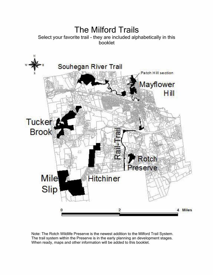
Mayflower Hill Trails, Milford, New Hampshire
How to get there:
Shady Lane Entrance
Milford Oval, head north, over the bridge and past the post office, bear left
and turn right onto Maple St. At the end of Myrtle St. turn left and then an
immediate right onto Shady Lane. The main parking area is about a thousand
feet up on the left.
Falconer Ave Entrance
Continuing to the end of Shady Lane and turning left brings you to the
Falconer Avenue parking and the start of an easy walk to Lookout Point. It may
look like you are entering a private driveway but this is a public entrance to
the trails. Please respect the landowner, pull up to the ‘Trailhead Parking’ sign
and please do not block the driveway.
Trail information:
Mayflower Hill is an easy, pleasant walk, close to
downtown, great for a lunch time stroll to calm the
mind during a busy work day. The main trail is a
loop from the parking area, to a scenic overlook and
back. There are two shortcut trails crossing the loop.
The property can also be accessed from Perkins St.
A steep trail brings a hiker up the hill through a pine
forest, past large boulders and joins the main loop.
In 2009 a new trail, leaving Mayflower Hill, heading north into Amherst, was
built. It can be accessed just below the lookout at Mayflower Hill following
signs to Patch Hill.
We mark our main trails with white blazes and loops or side trails with blue.
Yellow denotes a trail that leaves the property by an alternate route. Confusing
spots have colored arrows, let us know if you have any problems.
Please follow the blazes, stay on the trails and enjoy.
�
��
�
�������������� ���
���� ������
���� ���� ��������������������������� ������� ��������
���������� �
! �����"������������ �������������������
�������������������������� ������������������������������������������������������������ ���!���������� ���������������"���#$���������%�����������������������������������������������������������������������������������������������������������������������������������������������������������������%���������������������������������������������������������������������
�����&��'���������(���������������������������������������������������������� ����������������������'�������������������(��'����������������������������������)������������������)$�����)��������
*�����'���������������(������������������������������*������'����������������������������������������������������������������������"����(�����"�����'�+�,-��.-�+�/��!�(�����0�
� ��# ��$ �����
������'�*1��� ������
�
Revised Fall 2014
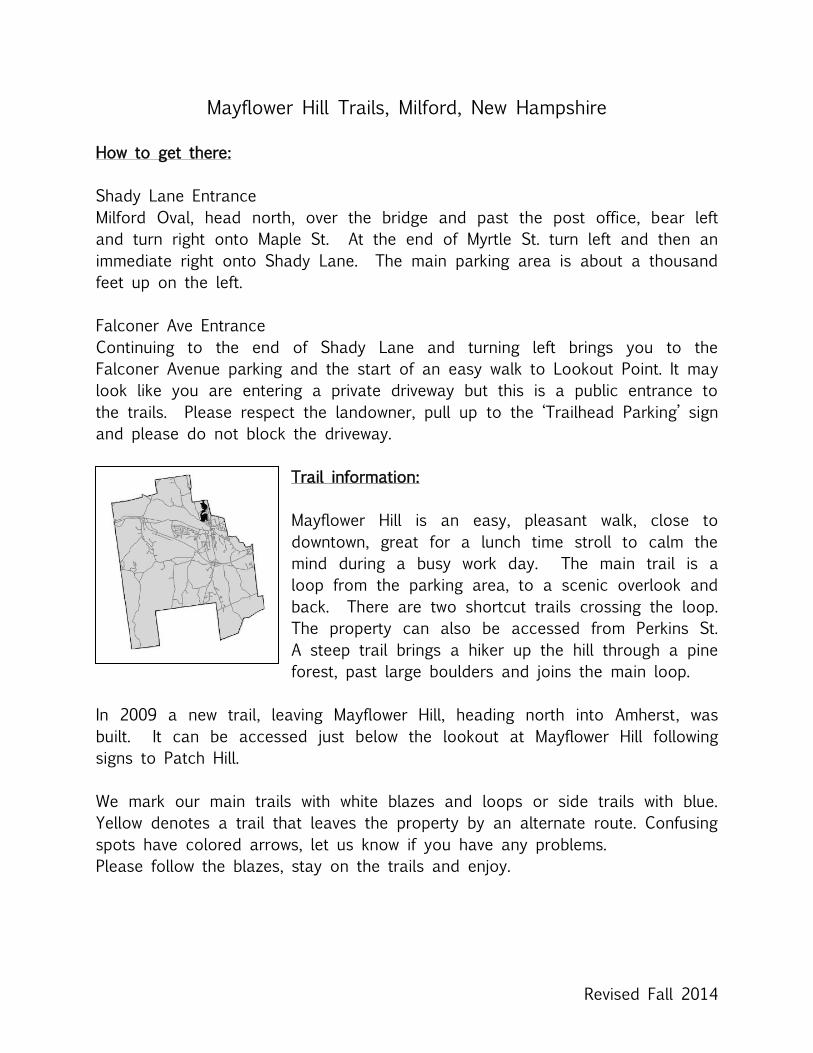
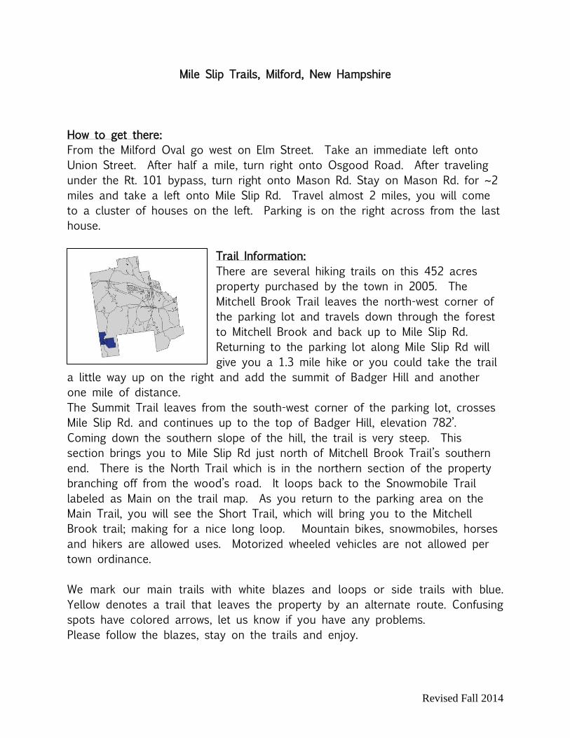
Mile Slip Trails, Milford, New Hampshire
How to get there:
From the Milford Oval go west on Elm Street. Take an immediate left onto
Union Street. After half a mile, turn right onto Osgood Road. After traveling
under the Rt. 101 bypass, turn right onto Mason Rd. Stay on Mason Rd. for ~2
miles and take a left onto Mile Slip Rd. Travel almost 2 miles, you will come
to a cluster of houses on the left. Parking is on the right across from the last
house.
Trail Information:
There are several hiking trails on this 452 acres
property purchased by the town in 2005. The
Mitchell Brook Trail leaves the north-west corner of
the parking lot and travels down through the forest
to Mitchell Brook and back up to Mile Slip Rd.
Returning to the parking lot along Mile Slip Rd will
give you a 1.3 mile hike or you could take the trail
a little way up on the right and add the summit of Badger Hill and another
one mile of distance.
The Summit Trail leaves from the south-west corner of the parking lot, crosses
Mile Slip Rd. and continues up to the top of Badger Hill, elevation 782’.
Coming down the southern slope of the hill, the trail is very steep. This
section brings you to Mile Slip Rd just north of Mitchell Brook Trail’s southern
end. There is the North Trail which is in the northern section of the property
branching off from the wood’s road. It loops back to the Snowmobile Trail
labeled as Main on the trail map. As you return to the parking area on the
Main Trail, you will see the Short Trail, which will bring you to the Mitchell
Brook trail; making for a nice long loop. Mountain bikes, snowmobiles, horses
and hikers are allowed uses. Motorized wheeled vehicles are not allowed per
town ordinance.
We mark our main trails with white blazes and loops or side trails with blue.
Yellow denotes a trail that leaves the property by an alternate route. Confusing
spots have colored arrows, let us know if you have any problems.
Please follow the blazes, stay on the trails and enjoy.
Revised Fall 2014
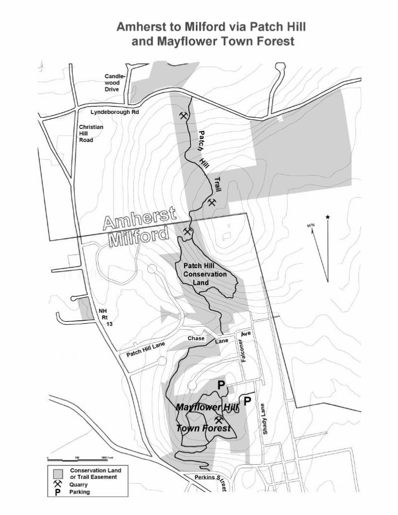
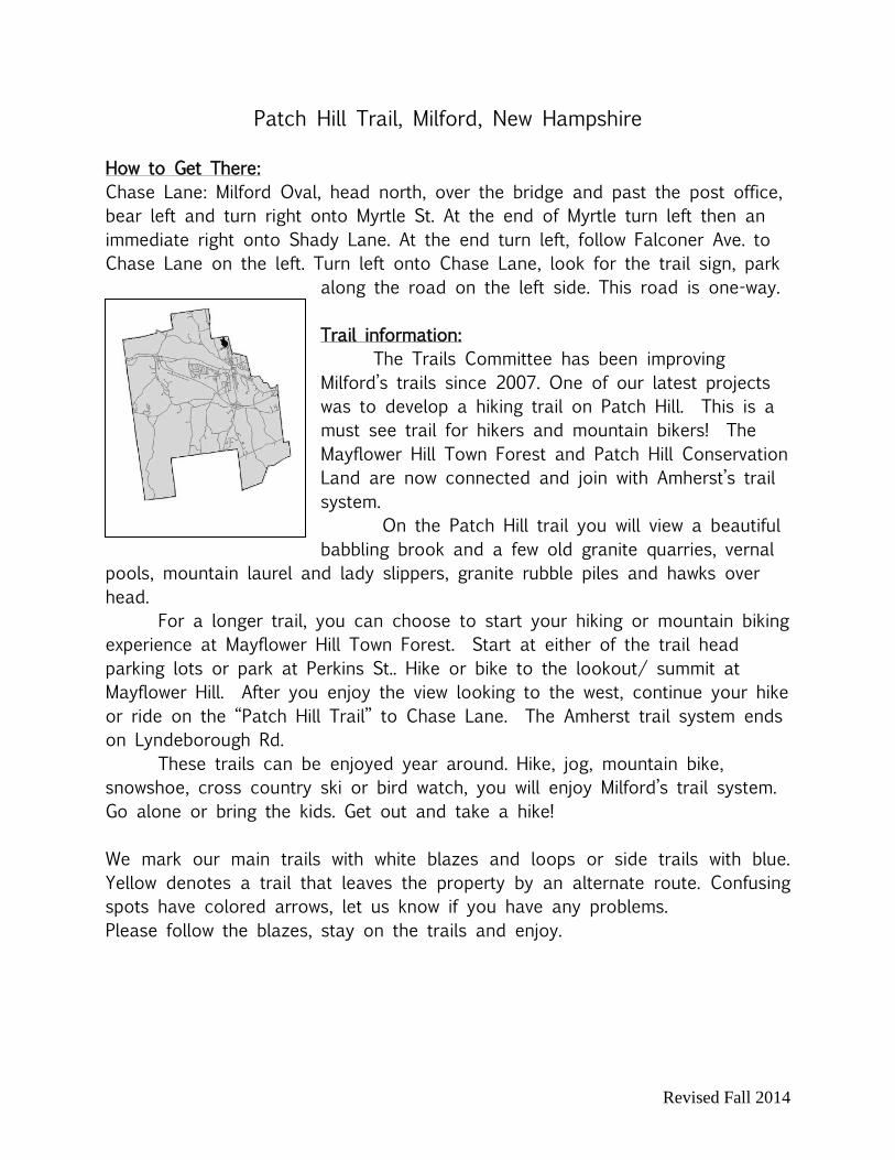
Patch Hill Trail, Milford, New Hampshire
How to Get There:
Chase Lane: Milford Oval, head north, over the bridge and past the post office,
bear left and turn right onto Myrtle St. At the end of Myrtle turn left then an
immediate right onto Shady Lane. At the end turn left, follow Falconer Ave. to
Chase Lane on the left. Turn left onto Chase Lane, look for the trail sign, park
along the road on the left side. This road is one-way.
Trail information:
The Trails Committee has been improving
Milford’s trails since 2007. One of our latest projects
was to develop a hiking trail on Patch Hill. This is a
must see trail for hikers and mountain bikers! The
Mayflower Hill Town Forest and Patch Hill Conservation
Land are now connected and join with Amherst’s trail
system.
On the Patch Hill trail you will view a beautiful
babbling brook and a few old granite quarries, vernal
pools, mountain laurel and lady slippers, granite rubble piles and hawks over
head.
For a longer trail, you can choose to start your hiking or mountain biking
experience at Mayflower Hill Town Forest. Start at either of the trail head
parking lots or park at Perkins St.. Hike or bike to the lookout/ summit at
Mayflower Hill. After you enjoy the view looking to the west, continue your hike
or ride on the “Patch Hill Trail” to Chase Lane. The Amherst trail system ends
on Lyndeborough Rd.
These trails can be enjoyed year around. Hike, jog, mountain bike,
snowshoe, cross country ski or bird watch, you will enjoy Milford’s trail system.
Go alone or bring the kids. Get out and take a hike!
We mark our main trails with white blazes and loops or side trails with blue.
Yellow denotes a trail that leaves the property by an alternate route. Confusing
spots have colored arrows, let us know if you have any problems.
Please follow the blazes, stay on the trails and enjoy.
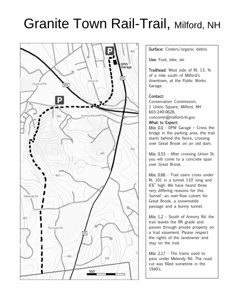
Granite Town Rail-Trail, Milford, NH
Surface: Cinders/organic debris
Use: Foot, bike, ski
Trailhead: West side of Rt. 13, ¾
of a mile south of Milford’s
downtown, at the Public Works
Garage.
Contact:
Conservation Commission,
1 Union Square, Milford, NH
603-249-0628,
What to Expect:
Mile 0.0 - DPW Garage – Cross the
bridge in the parking area, the trail
starts behind the fence, crossing
over Great Brook on an old dam.
Mile 0.53 - After crossing Union St.
you will come to a concrete span
over Great Brook.
Mile 0.66 - Trail users cross under
Rt. 101 in a tunnel 110’ long and
6’6” high. We have heard three
very differing reasons for this
‘tunnel’: an over-flow culvert for
Great Brook, a snowmobile
passage and a bunny tunnel.
Mile 1.2 – South of Armory Rd. the
trail leaves the RR grade and
passes through private property on
a trail easement. Please respect
the rights of the landowner and
stay on the trail.
Mile 2.17 - The trains used to
pass under Melendy Rd. The road
cut was filled sometime in the
1940’s.
Mile 2.95 – Town Line. The rail-
trail continues another 4 miles in
Brookline.
Last Updated 2014

RAILROAD HISTORY
Train traffic began coming to Milfordfrom Nashua in 1850, and by 1852,continued on to Wilton. The station waslocated on South Street. A new station onGarden Street replaced it in 1853.
Huge quantities of ice were being shippedto Massachusetts on the Brookline-Pepperel Railroad. The ice was cut duringthe winter months from Lake Potanipo andstored in mammoth houses near the lake.In January, 1893, gentlemen from Milfordpetitioned the state of New Hampshire forpermission to build a railroad line runningsouth to join with this rail line. The newline would give Milford businessesanother means to ship goods manufacturedhere to other markets.
The state agreed in February and workbegan later in the year. The formal
opening was celebrated November 15,1894. The town shut down all work so allcould enjoy the parade, complete withmusic by the local Cornet Band, a cannon,and a reception for 400 people at the townhouse. The new line was known as theBrookline & Milford Railroad or theFitchburg Line..
A new station was built that year on SouthStreet. It served passengers coming andgoing from local hotels and also freight.By 1900, 8 trains a day ran on theBrookline & Milford Line. There was botha roundhouse and a turntable just east ofthe station opposite Lincoln Street.
GRANITE INDUSTRY
Since the early 1800's, granite has beenquarried at many places in town. Hugeblocks, some as large as 10 tons, werecarried by multi-horse drawn wagons tothe finishing sheds and up to the Nashuarail line. Spur lines laid to some of thegranite quarries heading south along Great
Brook, enabled these companies totransport granite much more quickly,easily and cheaply.
Fine Milford granite from some of the 15commercial quarries, such as Lovejoy,Kittredge, and Tonella, came in shades ofgray, pink, and blue. The granite wasused mostly for paving and edging ofstreets and for building stones. Milfordgranite was used in at least one building atthe West Point Military Academy. Thirtypillars, weighing ninety tons each, werequarried in 1908 at the Lovejoy Quarry.The pillars were used in the U.S. Treasurybuilding in Washington, DC to replacedeteriorating sandstone pillars. Skilledstone carvers came here from Europe towork with stone, creating beautifulmonuments, large and small, to be placedin cemeteries and parks. "In the year of1900, fifty thousand tons of granite wereshipped from Milford."
Just as the railroads put the stagecoachlines out of business in the 1800's, soautos and trucks took most of the
railroad's passengers and freight. Trainson the Brookline & Milford Branch andthe main Fitchburg Line stopped runningpassenger trains in 1926, forcing people toride on mixed freight/passenger trains. InSeptember, 1931, the last train ran on theFitchburg line.The steel rails were taken up for scrap tohelp the war effort in 1941-42. As late as1978 the Barretto Granite Company wasstill using a small section of the line fromthe cutting shed on Oak Street north to theNashua Line.
THE TRAIL
The Milford Conservation Commissionwould like to thank the followingindividuals for their cooperation with ourefforts to bring this trail to reality.Without their generosity you would not beenjoying the Granite Town Rail-Trail.
Thank you,Steven DesmaraisTai-Deh HsuJohn F. BarrettoCelia Cerulli PasheFrank GavinStephen Talarico
The trail corridor averages only 66 feetwide. This land is surrounded by privateproperty. PLEASE STAY ON THE TRAIL.
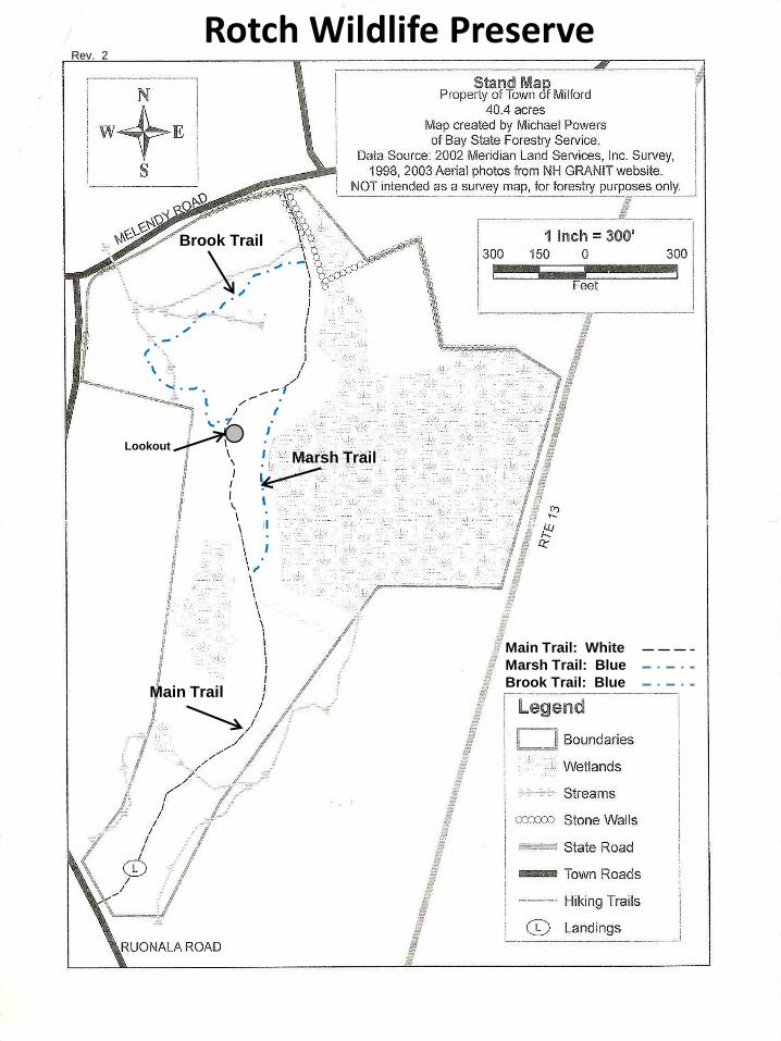
Rotch Wildlife Preserve
Brook Trail
Marsh Trail Lookout
Marsh Trail: Blue
Brook Trail: Blue
Main Trail: White
Main Trail
Rev. 2
Revised Fall 2014
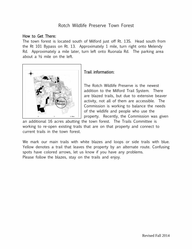
Rotch Wildlife Preserve Town Forest
How to Get There:
The town forest is located south of Milford just off Rt. 13S. Head south from
the Rt 101 Bypass on Rt. 13. Approximately 1 mile, turn right onto Melendy
Rd. Approximately a mile later, turn left onto Ruonala Rd. The parking area
about a ½ mile on the left.
Trail information:
The Rotch Wildlife Preserve is the newest
addition to the Milford Trail System. There
are blazed trails, but due to extensive beaver
activity, not all of them are accessible. The
Commission is working to balance the needs
of the wildlife and people who use the
property. Recently, the Commission was given
an additional 16 acres abutting the town forest. The Trails Committee is
working to re-open existing trails that are on that property and connect to
current trails in the town forest.
We mark our main trails with white blazes and loops or side trails with blue.
Yellow denotes a trail that leaves the property by an alternate route. Confusing
spots have colored arrows, let us know if you have any problems.
Please follow the blazes, stay on the trails and enjoy.

���
�����
�
� ��
���
� ��
� ��
���
����
�
� �
����
�
��
�
����
�����
��
���� ���������������� ����������������

Revised Fall 2014
Souhegan River Trail West, Milford, New Hampshire
How to get there:
From the Milford Oval take Elm Street west to the intersection with RT. 101. Turn
right, cross the bridge, continue approximately ½ mile. Turn right onto a small
gravel road. Park on the right.
Trail information:
The Souhegan River Trail meanders thru property
owned by the State of New Hampshire. This property is
managed by the NH Fish & Game Department as a fish
hatchery. Some of the property, the fields in particular, is
leased to local farmers or dairymen and should be
treated as private land.
The trail follows the river closely and may be
flooded during seasonally high water. There are several
bridges spanning small water courses before they enter the Souhegan River.
Follow the white blazes. There are many trails in this area made over the
years by children, fishermen and local people walking by the river. Some trails lead
to private land, please stay on the designated trail. You may notice red paint spots
and orange ribbons. These have been placed by mtn. bikers & snowmobilers and
are not part of the town’s trail system.
Souhegan River Trail East, Milford, New Hampshire
How to get there:
Start from Emerson Park which is located on the Oval side of the Post Office on
Mont Vernon Street. There is parking around the Oval.
Trail Information:
The east side of the Souhegan River Trail begins at Emerson Park. Hikers walk
along the river behind the Souhegan Valley Boys and Girls Club passing the bridge
to Keyes Field. The trail leaves the woods and river using a fenced dirt path to
connect to the sidewalk on Mont Vernon Street. Turn left on the sidewalk to
continue to the MCAA fields. On the far side of the fields follow the hiking signs
to the trail located near the river side of the fields. Follow the white blazes
through the cornfields of an active farm. Please stay on the trail or dirt roads.
The trail is not blazed well in this section as the commission continues to work
with the farmer to minimize the impact of hikers on his operation.
���������������� ����������� ������
�
��
�
��������
��������
�����������
����������
���!����
"��!������!
#$%
#$%
#$%# %
#&%
#'%
#(%
#�%
#�%#)%
�
�
� ��� ��� ����
�������������������������������� �
�����������
���
�������������������� ���������� ��������������
�*��!���
+�����
"����,����-�����.
#$%"������������/$�&-�0��������������������������������������������������������#�%"����1��+��� ������������������*��������������23-������������������2��#)%4�--35����*�������������2������������������������������!������-���2�!������!��#(%"��6����+��*/7�&-�0*������������"��!������!6����8���������������������2���������*������23��������������������$7�7773��������#�%"������1��������������-�������2�!�����������������239��:�#'%"��+�1������������������1���-���2�!����-��������������1���-���������������*�����#&%"��6�����"����/7�'-�0*�������������������1����-2������$; '������������������23�-���������������-�����# %"������!"����/7�&-�0-���������1�*������2���!���2��!�
��������������������������2���������<�����������������*��-��������������"��������������*��*����23���������� ����������� �--�������<*������77;
"��!������!"�1�6�����
���������� ������
Revised Fall 2014
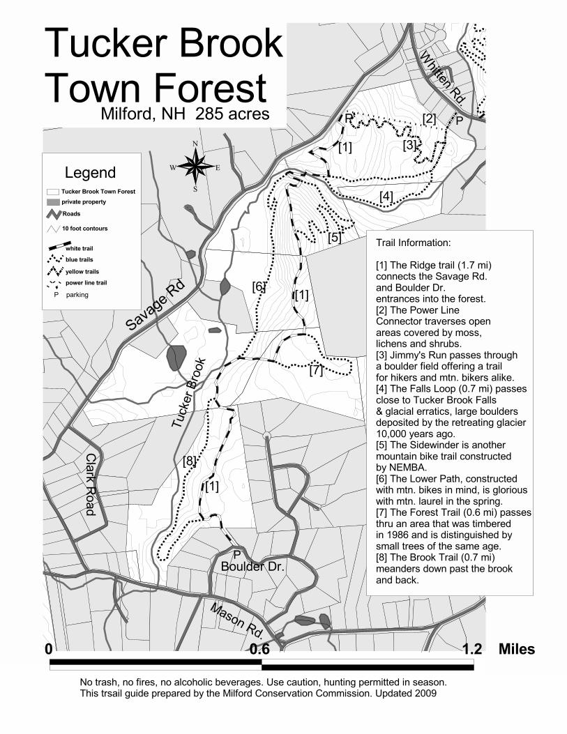
Tucker Brook Trails, Milford, New Hampshire
How to Get There:
Savage Rd. Entrance
Milford Oval, west on Elm St., right onto 101 bypass, turn right at light onto
Phelan Rd. Bear right up the hill as the road changes to Savage Rd. A
parking lot is on left under the power lines. The trail head leaves the parking
area on the right very near Savage Rd. Another trail leaves the parking lot,
directly ahead, under the power lines.
Boulder Dr Entrance
Milford Oval, west on Elm St immediate left onto Union Street, to Osgood
Road. Right onto Mason Rd just past Osgood Pond. Go 2.9 mi., turn right at
second entrance to Boulder Dr. Trail head is 0.1 mi
on the left.
Trail information:
Tucker Brook Town Forest is 285 acres of mostly
forested, rolling terrain, and provides excellent hikes in
all seasons.
The Ridge Trail (1.8 mi) connects the two entrances
into Tucker Brook Town Forest. Falls Loop (0.7 mi)
passes Tucker Brook Falls and the remains of a mill.
A local chapter of NEMBA, a mountain bike club, built Sidewinder, Jimmy’s Run
and the Lower Path which are beautiful in the spring when the mountain laurel
is in bloom. There is a permanent orienteering course on the property. For a
map and instructions see our Web site or pick one up in the town hall.
We mark our main trails with white blazes and loops or side trails with blue.
Yellow denotes a trail that leaves the property by an alternate route. Confusing
spots have colored arrows, let us know if you have any problems.
Please follow the blazes, stay on the trails and enjoy.