ANALYSIS OF COUNTY PARKS AND TRAILS
63
Chapter Three Overview of County and Non-County Parks and Recreation Suppliers Chisago County Park System Plan 7/19/17 3-1 CHAPTER THREE ANALYSIS OF COUNTY PARKS AND TRAILS INTRODUCTION This chapter provides an inventory and analysis of existing County Parks and Trails and non-county recreational resources. Analysis of the existing kinds of recreational resources available to county residents and their location helps provide the planning context for developing the this update to the Comprehensive Parks and Trail plan for Chisago County. A synthesis of this information along with the community input obtained from the public meetings in the summer of 2014 on issues and opportunities and background information on demographics and recreation trends provides the framework for the 2030 Chisago County Park and Trail Plan. Existing Conditions Chisago County is blessed with natural resources that are aesthetically attractive and diverse. It has high quality lakes, woodlands, agricultural areas, wetlands and a nationally significant river valley. Chisago County’s regional parks and open spaces have preserved some of the best land in the county, including high quality ecosystems and scenic vistas. The Chisago County Park and Open Space System now has five parks. Today, most of the land acquisition is complete for the five parks and facilities are open in all five of the county parks. The County also has the 150-acre North Sunrise Park Reserve in North Sunrise Township that is undeveloped.
-
Upload
khangminh22 -
Category
Documents
-
view
5 -
download
0
Transcript of ANALYSIS OF COUNTY PARKS AND TRAILS
Chapter Three Overview of County and Non-County Parks and Recreation Suppliers
Chisago County Park System Plan 7/19/17 3-1
CHAPTER THREE
ANALYSIS OF COUNTY PARKS AND TRAILS INTRODUCTION This chapter provides an inventory and analysis of existing County Parks and Trails and non-county recreational resources. Analysis of the existing kinds of recreational resources available to county residents and their location helps provide the planning context for developing the this update to the Comprehensive Parks and Trail plan for Chisago County. A synthesis of this information along with the community input obtained from the public meetings in the summer of 2014 on issues and opportunities and background information on demographics and recreation trends provides the framework for the 2030 Chisago County Park and Trail Plan.
Existing Conditions
Chisago County is blessed with natural resources that are aesthetically attractive and diverse. It has high quality lakes, woodlands, agricultural areas, wetlands and a nationally significant river valley. Chisago County’s regional parks and open spaces have preserved some of the best land in the county, including high quality ecosystems and scenic vistas. The Chisago County Park and Open Space System now has five parks. Today, most of the land acquisition is complete for the five parks and facilities are open in all five of the county parks. The County also has the 150-acre North Sunrise Park Reserve in North Sunrise Township that is undeveloped.
Chapter Three Overview of County and Non-County Parks and Recreation Suppliers
Chisago County Park System Plan 7/19/17 3-2
Park Functions
Chisago County parks preserve resources and provide limited, related recreational opportunities. Different kinds of needs require different types of parkland and facilities. Governments classify park functions in the following manner:
Protection Open Spaces (or Reserves) include ecologically
sensitive lands, groundwater recharge areas, forests and woodlands, lands containing unique or endangered species of plants or animals, educationally valuable features, sites with exceptional aesthetic value and scenic roadways.
Recreation Open Spaces provide outdoor activities such as fishing, swimming, boating and canoeing, hiking, biking, picnicking, camping, cross-country skiing and environmental education. These are often self-guided activities with little or no public staff involvement
Special Use Facilities provide specialized activity areas that require logistics, management or resources that are not compatible or available with other recreational activities. Examples of such facilities include a downhill skiing area, an arboretum or a zoo.
Trail Corridors provide safe paths for a variety of travel modes including hiking, biking, horseback riding and cross-country skiing.
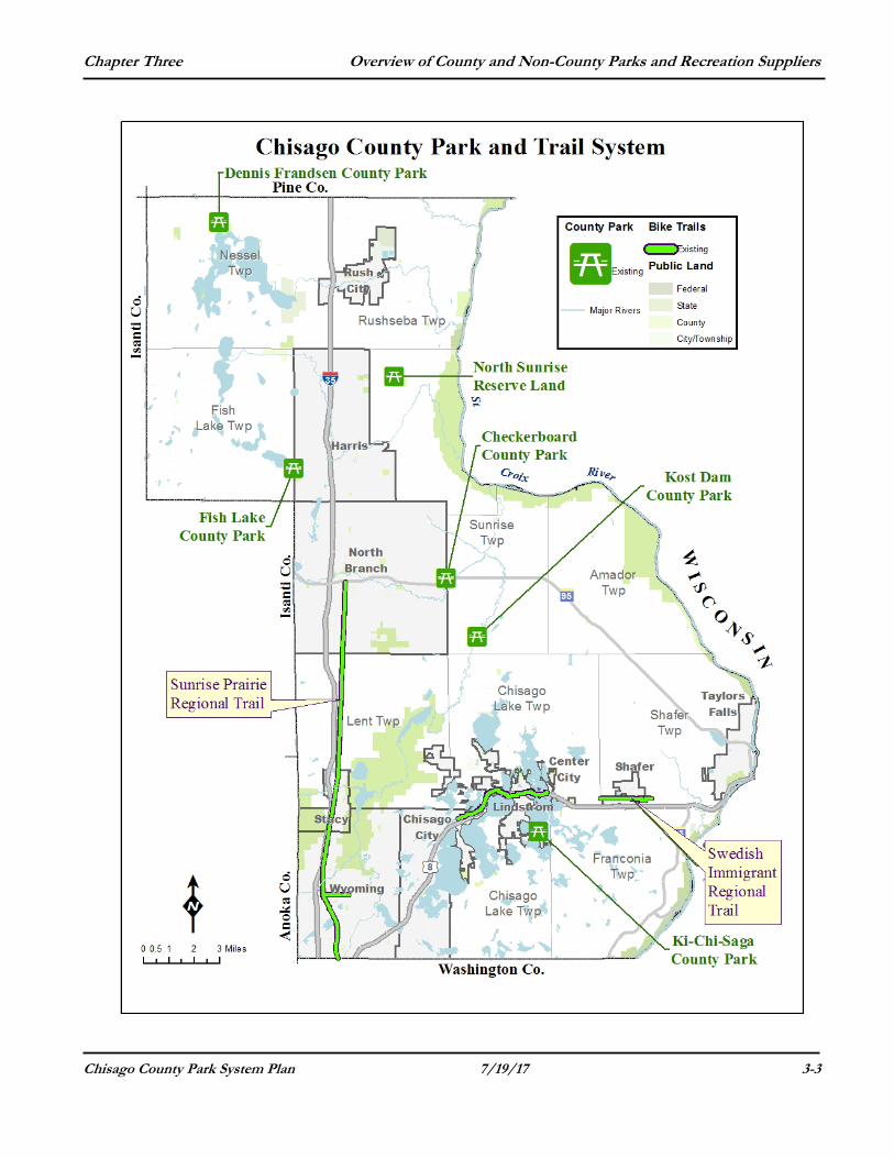
COUNTY PARKS Chisago County operates and maintains approximately 793 acres of parks and trails. All of the County Parks are adjacent to water resources, marshes, streams or lakes. In general, the parks in the northern section of the county are not extensively developed. Parks in the southern section tend to be more developed. The recreational opportunities offered in the northern parks is generally passive and consists of nature viewing and walking.
Chapter Three Overview of County and Non-County Parks and Recreation Suppliers
Chisago County Park System Plan 7/19/17 3-3
Chapter Three Overview of County and Non-County Parks and Recreation Suppliers
Chisago County Park System Plan 7/19/17 3-4
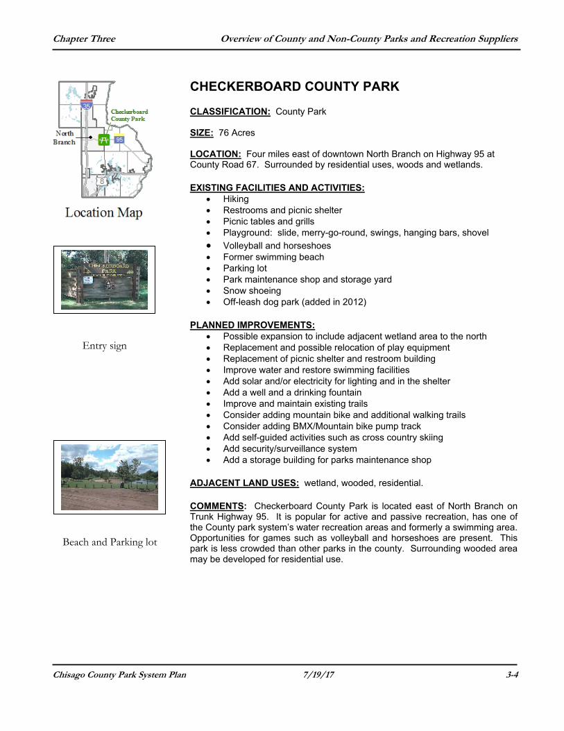
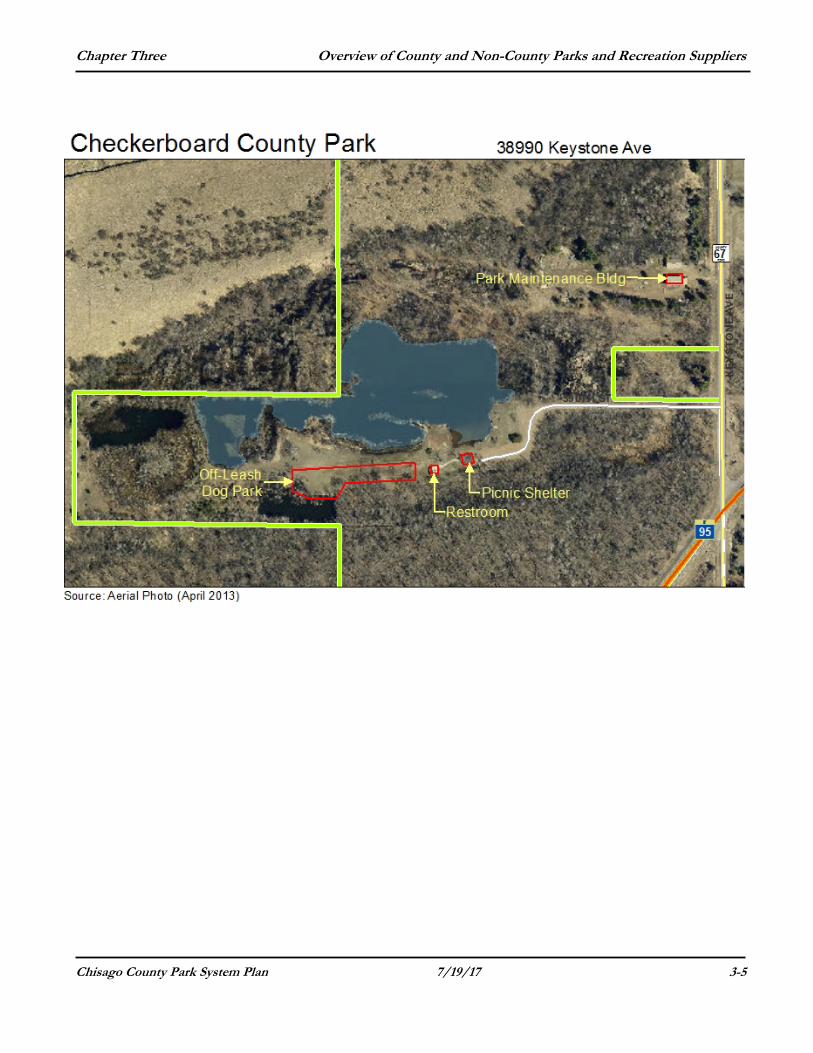
CHECKERBOARD COUNTY PARK CLASSIFICATION: County Park SIZE: 76 Acres LOCATION: Four miles east of downtown North Branch on Highway 95 at County Road 67. Surrounded by residential uses, woods and wetlands. EXISTING FACILITIES AND ACTIVITIES:
Hiking Restrooms and picnic shelter Picnic tables and grills Playground: slide, merry-go-round, swings, hanging bars, shovel
Volleyball and horseshoes Former swimming beach Parking lot Park maintenance shop and storage yard Snow shoeing Off-leash dog park (added in 2012)
PLANNED IMPROVEMENTS:
Possible expansion to include adjacent wetland area to the north Replacement and possible relocation of play equipment Replacement of picnic shelter and restroom building Improve water and restore swimming facilities Add solar and/or electricity for lighting and in the shelter Add a well and a drinking fountain Improve and maintain existing trails Consider adding mountain bike and additional walking trails Consider adding BMX/Mountain bike pump track Add self-guided activities such as cross country skiing Add security/surveillance system Add a storage building for parks maintenance shop
ADJACENT LAND USES: wetland, wooded, residential. COMMENTS: Checkerboard County Park is located east of North Branch on Trunk Highway 95. It is popular for active and passive recreation, has one of the County park system’s water recreation areas and formerly a swimming area. Opportunities for games such as volleyball and horseshoes are present. This park is less crowded than other parks in the county. Surrounding wooded area may be developed for residential use.
Entry sign
Beach and Parking lot
Chapter Three Overview of County and Non-County Parks and Recreation Suppliers
Chisago County Park System Plan 7/19/17 3-5
Chapter Three Overview of County and Non-County Parks and Recreation Suppliers
Chisago County Park System Plan 7/19/17 3-6
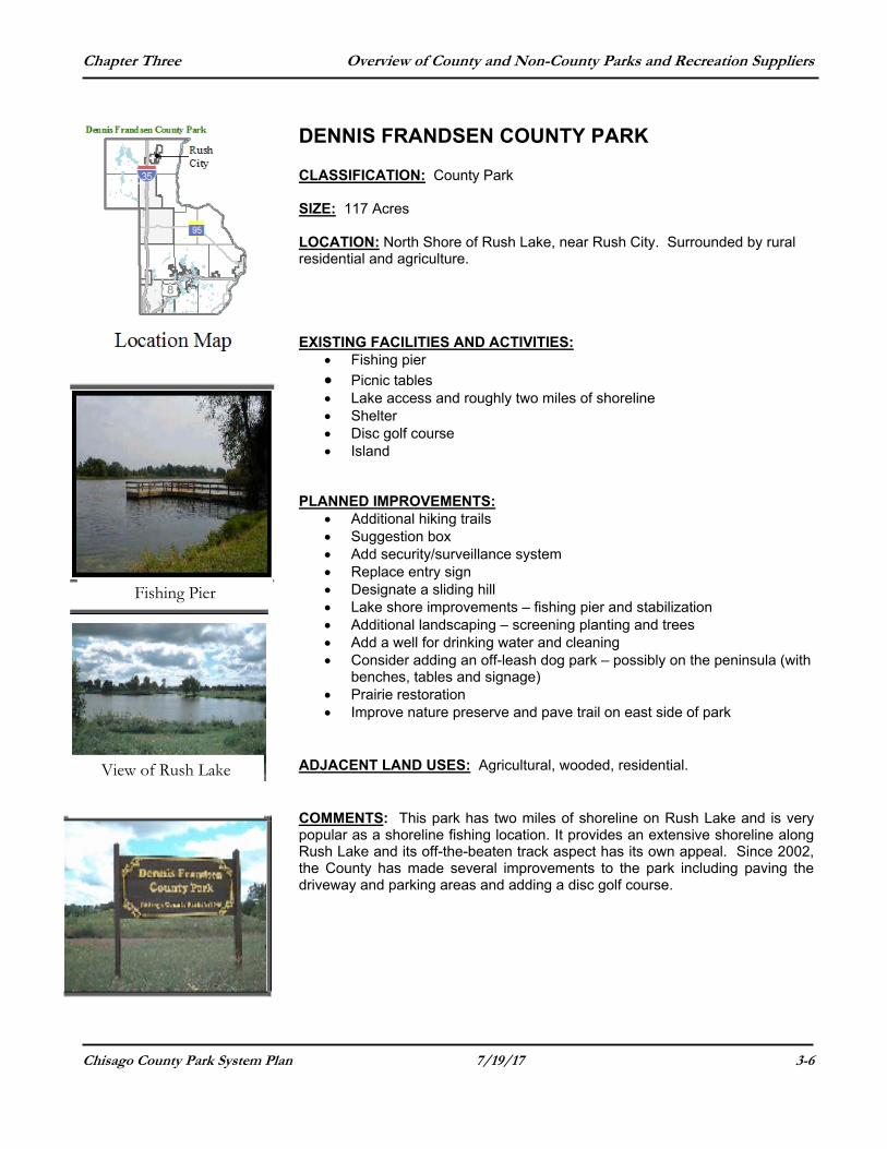
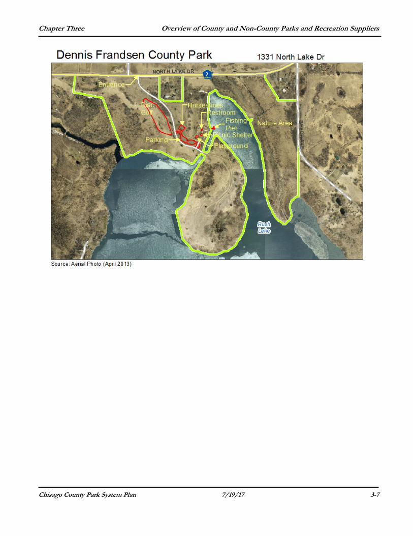
DENNIS FRANDSEN COUNTY PARK CLASSIFICATION: County Park SIZE: 117 Acres LOCATION: North Shore of Rush Lake, near Rush City. Surrounded by rural residential and agriculture. EXISTING FACILITIES AND ACTIVITIES:
Fishing pier
Picnic tables Lake access and roughly two miles of shoreline Shelter Disc golf course Island
PLANNED IMPROVEMENTS:
Additional hiking trails Suggestion box Add security/surveillance system Replace entry sign Designate a sliding hill Lake shore improvements – fishing pier and stabilization Additional landscaping – screening planting and trees Add a well for drinking water and cleaning Consider adding an off-leash dog park – possibly on the peninsula (with
benches, tables and signage) Prairie restoration Improve nature preserve and pave trail on east side of park
ADJACENT LAND USES: Agricultural, wooded, residential. COMMENTS: This park has two miles of shoreline on Rush Lake and is very popular as a shoreline fishing location. It provides an extensive shoreline along Rush Lake and its off-the-beaten track aspect has its own appeal. Since 2002, the County has made several improvements to the park including paving the driveway and parking areas and adding a disc golf course.
Fishing Pier
View of Rush Lake
Chapter Three Overview of County and Non-County Parks and Recreation Suppliers
Chisago County Park System Plan 7/19/17 3-7
Chapter Three Overview of County and Non-County Parks and Recreation Suppliers
Chisago County Park System Plan 7/19/17 3-8
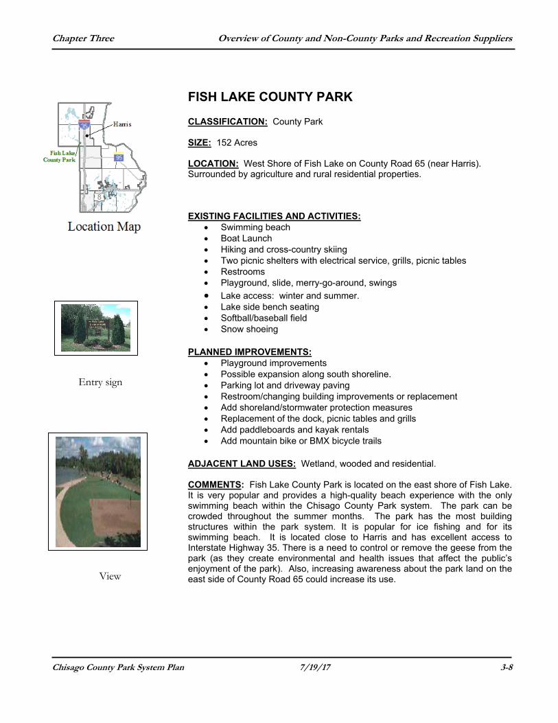
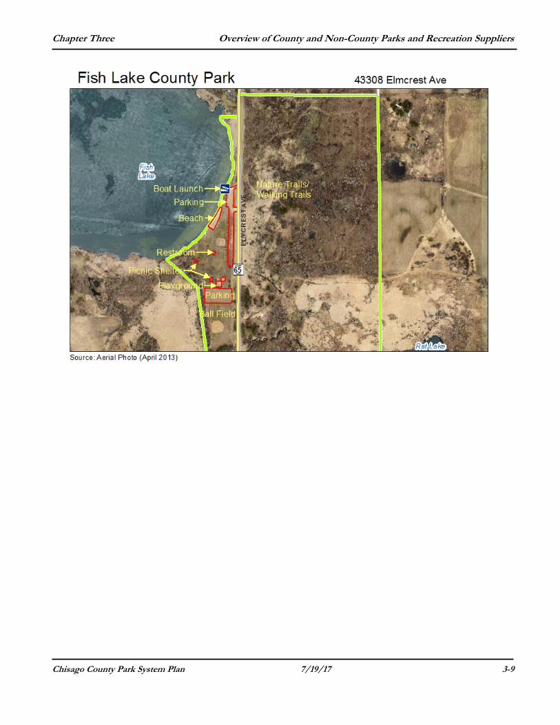
FISH LAKE COUNTY PARK CLASSIFICATION: County Park SIZE: 152 Acres LOCATION: West Shore of Fish Lake on County Road 65 (near Harris). Surrounded by agriculture and rural residential properties. EXISTING FACILITIES AND ACTIVITIES:
Swimming beach Boat Launch Hiking and cross-country skiing Two picnic shelters with electrical service, grills, picnic tables Restrooms Playground, slide, merry-go-around, swings
Lake access: winter and summer. Lake side bench seating Softball/baseball field Snow shoeing
PLANNED IMPROVEMENTS: Playground improvements Possible expansion along south shoreline. Parking lot and driveway paving Restroom/changing building improvements or replacement Add shoreland/stormwater protection measures Replacement of the dock, picnic tables and grills Add paddleboards and kayak rentals Add mountain bike or BMX bicycle trails
ADJACENT LAND USES: Wetland, wooded and residential. COMMENTS: Fish Lake County Park is located on the east shore of Fish Lake. It is very popular and provides a high-quality beach experience with the only swimming beach within the Chisago County Park system. The park can be crowded throughout the summer months. The park has the most building structures within the park system. It is popular for ice fishing and for its swimming beach. It is located close to Harris and has excellent access to Interstate Highway 35. There is a need to control or remove the geese from the park (as they create environmental and health issues that affect the public’s enjoyment of the park). Also, increasing awareness about the park land on the east side of County Road 65 could increase its use.
Entry sign
View
Chapter Three Overview of County and Non-County Parks and Recreation Suppliers
Chisago County Park System Plan 7/19/17 3-9
Chapter Three Overview of County and Non-County Parks and Recreation Suppliers
Chisago County Park System Plan 7/19/17 3-10
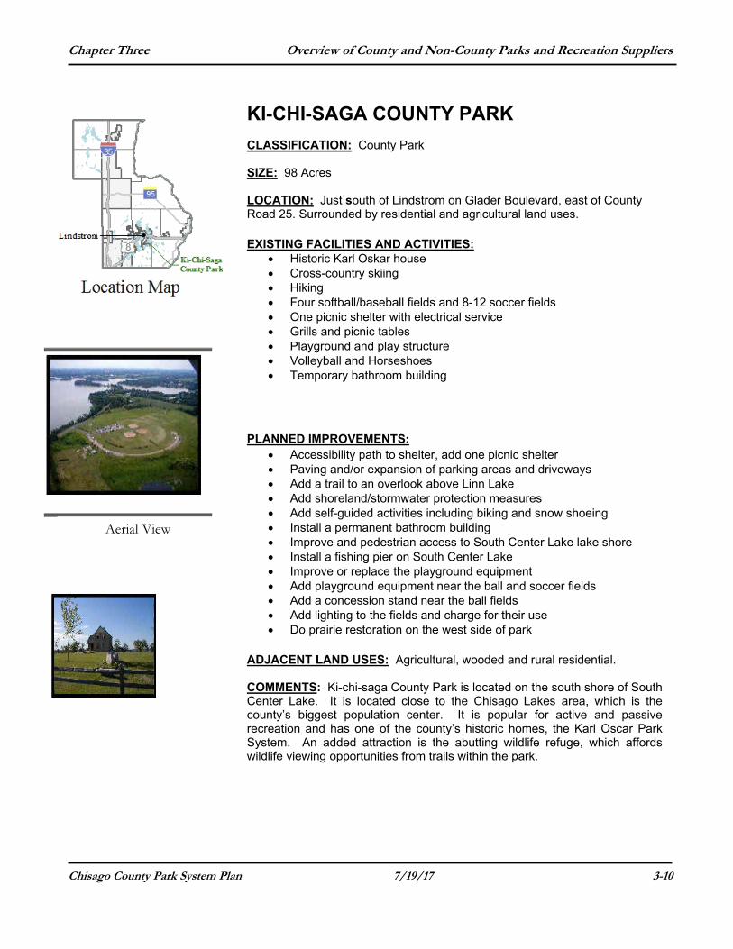
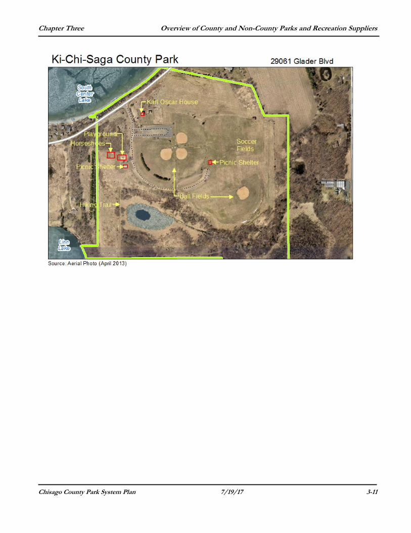
KI-CHI-SAGA COUNTY PARK CLASSIFICATION: County Park SIZE: 98 Acres LOCATION: Just south of Lindstrom on Glader Boulevard, east of County Road 25. Surrounded by residential and agricultural land uses. EXISTING FACILITIES AND ACTIVITIES:
Historic Karl Oskar house Cross-country skiing Hiking Four softball/baseball fields and 8-12 soccer fields One picnic shelter with electrical service Grills and picnic tables Playground and play structure Volleyball and Horseshoes Temporary bathroom building
PLANNED IMPROVEMENTS:
Accessibility path to shelter, add one picnic shelter Paving and/or expansion of parking areas and driveways Add a trail to an overlook above Linn Lake Add shoreland/stormwater protection measures Add self-guided activities including biking and snow shoeing Install a permanent bathroom building Improve and pedestrian access to South Center Lake lake shore Install a fishing pier on South Center Lake Improve or replace the playground equipment Add playground equipment near the ball and soccer fields Add a concession stand near the ball fields Add lighting to the fields and charge for their use Do prairie restoration on the west side of park
ADJACENT LAND USES: Agricultural, wooded and rural residential. COMMENTS: Ki-chi-saga County Park is located on the south shore of South Center Lake. It is located close to the Chisago Lakes area, which is the county’s biggest population center. It is popular for active and passive recreation and has one of the county’s historic homes, the Karl Oscar Park System. An added attraction is the abutting wildlife refuge, which affords wildlife viewing opportunities from trails within the park.
Aerial View
Karl Oskar House
Chapter Three Overview of County and Non-County Parks and Recreation Suppliers
Chisago County Park System Plan 7/19/17 3-11
Chapter Three Overview of County and Non-County Parks and Recreation Suppliers
Chisago County Park System Plan 7/19/17 3-12
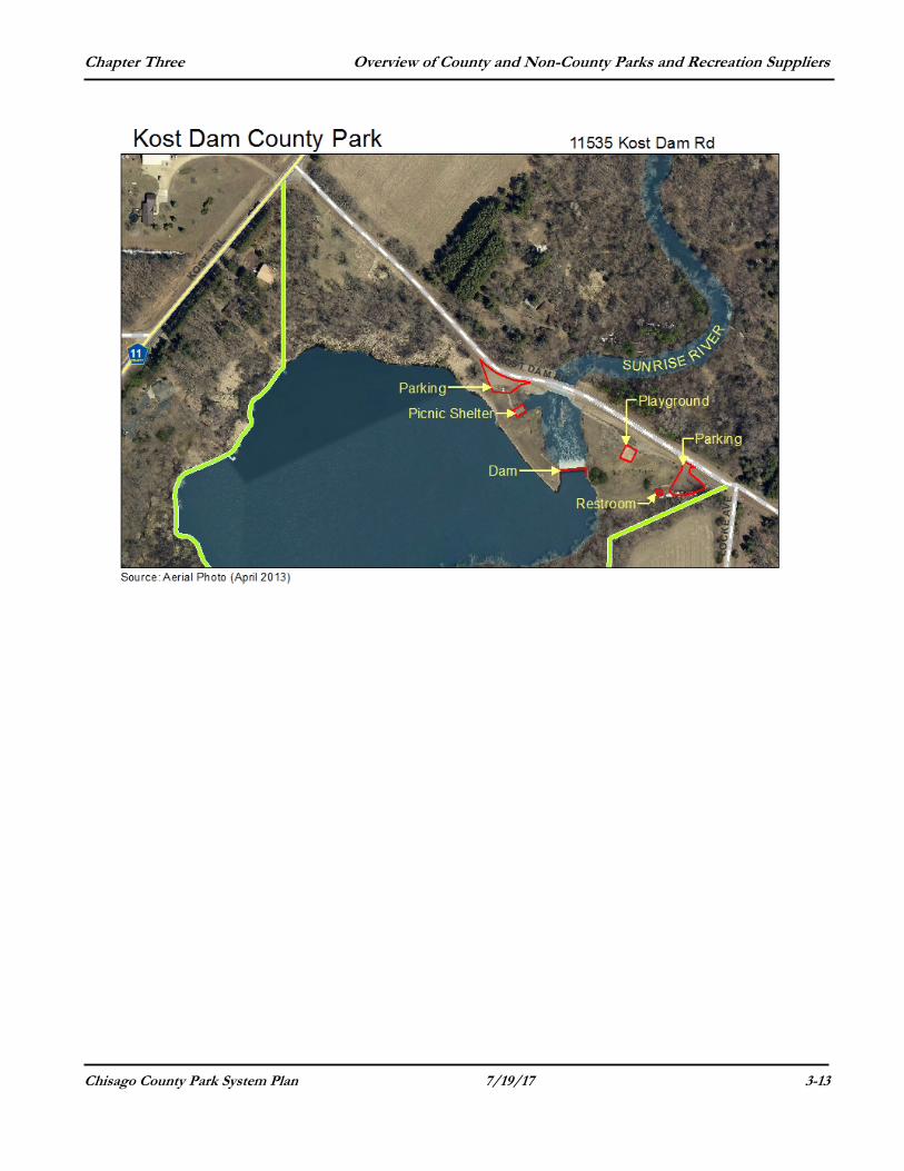
KOST DAM COUNTY PARK CLASSIFICATION: County Park SIZE: 27 Acres LOCATION: Between North Branch and Lindstrom off County Roads 14 and 11. Surrounded by agriculture and rural residential land uses. EXISTING FACILITIES AND ACTIVITIES:
One interpretive shelter over historic mill Grills Picnic Tables Play Area: slide, swings Restrooms Bank fishing Sunrise River Dam
PLANNED IMPROVEMENTS:
Playground equipment replacement Possible park expansion to the north and east along river Adding a fishing dock or pier Adding trees and landscaping along township road Regrade east side of park to make a flatter and more level sitting area
and to accommodate an ADA compliant trail Repair or mudjack sinking, existing handicap ramp Add interpretive signage (with QR code) with the history of dam and
former mill Add a small dock for carry-in boat launch on west side of park Designate a water trail on the Sunrise River – starting at Kost Dam and
going north and east to the St. Croix River Designate a water trail on the Sunrise River – starting at Pool #1 in
Carlos Avery and ending at Kost Dam ADJACENT LAND USES: Agricultural, wooded and residential. COMMENTS: Kost Dam County Park is located on the south branch of the Sunrise River. As a historic site, it is a picturesque spot that takes advantage of the sights and sounds provided by Kost Dam. The park is located between North Branch and the Chisago Lakes. It is popular for passive recreation as a picnic and shore fishing. The shelter over the historic mill was built in 2011 and a new, wider township road bridge over the Sunrise River was installed in 2012.
Kost Dam
Chapter Three Overview of County and Non-County Parks and Recreation Suppliers
Chisago County Park System Plan 7/19/17 3-13
Chapter Three Overview of County and Non-County Parks and Recreation Suppliers
Chisago County Park System Plan 7/19/17 3-14
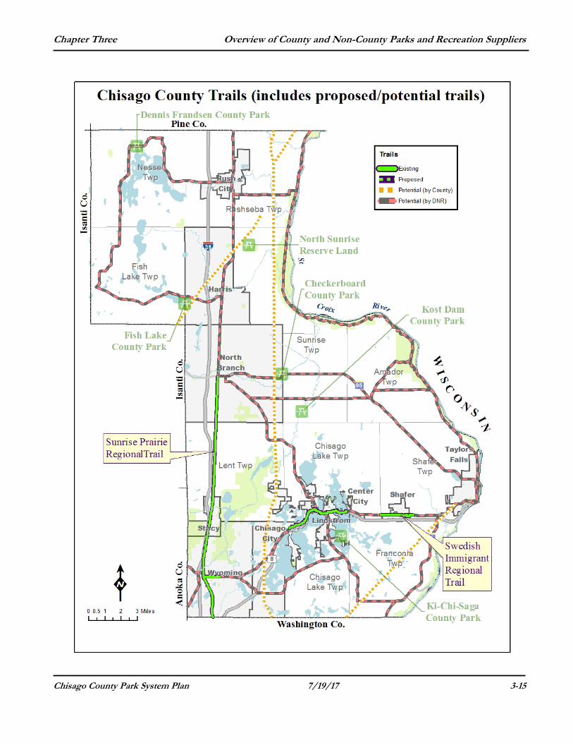
COUNTY TRAILS The Chisago County Parks department has a unique role in providing trails throughout the County to connect cities, parks and adjoining counties. The Sunrise Prairie and Swedish Immigrant trails are designated regional trails in the state system. Chisago County and the state intend regional trails to provide recreational travel along linear pathways and they provide long distance links between cities while also providing local trail experiences. The County has selected the trail routes to facilitate connections across the County and those that follow natural or linear features that traverse areas of scenic appeal and/or historic or architectural interest while assuring that the trail will not have an adverse effect on the natural resources. Trails are an area of focus for the County Parks department and for this plan update. Chisago County is placing more emphasis on the need for a comprehensive trail system throughout the County as part of this plan update. Creating a network of trails (both county and city) that are not only for recreational purposes but will serve as a transportation alternative is a long-term goal that has never been fully realized.
Walkability is a fundamental contributor to livability to connect and engage people to their neighborhood, their city and the County. Creating safe and enjoyable options for travel can encourage young adults, children and seniors to stay active. The presence of high-quality natural resources that create attractive settings contribute strongly to the quality of trail recreational experience. Natural features in the greenway or adjacent to a trail also serve ecological and environmental educational purposes. Restoration and management practices emphasizing native species can maintain and enhance the aesthetic, habitat and other resource values of these areas. The Swedish Immigrant Regional Trail (especially the east end), has the opportunity to showcase such aesthetic and ecological resources.
The cities along a county or a regional trail (including water trails) could work to create a welcoming environment for trail users which in turn will improve their local economy and the quality of life for residents. Business and civic leaders also could work to create a sense of place based on the cities’ history and character.
To encourage extended side trips, there should be a consistent system of marketing, mapping and way finding to make it easy for bicyclists and water trail users to stop and explore these cities. In addition, catering to customer needs by revitalizing town centers, retooling existing stores and when possible, growing new businesses are actions cities along the trail should consider. The process of creating a “trail town” can renew a cities sense of pride and identity while attracting tourists.
Bicycle trails longer than 10 miles promote economic development and healthy lifestyles, inexpensive transportation and pollution-free recreation. The longer the trail, the further people will travel to use it, the longer they will visit the area and the more they will spend. For example, studies have shown that someone who travels to a trail for a day’s ride will spend four times as much as a local user and trail users who stay overnight will spend twice as much as one-day visitors.
Chapter Three Overview of County and Non-County Parks and Recreation Suppliers
Chisago County Park System Plan 7/19/17 3-15
Chapter Three Overview of County and Non-County Parks and Recreation Suppliers
Chisago County Park System Plan 7/19/17 3-16
Regional trails serve pedestrians, inline skaters and casual bicyclists who prefer comfortable access to the trail. The casual bicyclists are most comfortable on designated bikeways, off-road facilities and independent trails or on streets with low vehicle speeds and volumes.
The trail system plan in this update is more comprehensive than previous versions and shows a significant amount of trail development throughout the County. This trail plan creates an emphasis on interconnected trails and waterways that provide essential linkages throughout the system. This will allow residents and visitors to move through the county safely regardless of their purpose in using the trails. The trail plan is based on the following principles:
1. Focus and priority is placed on primary north-south and east-west corridors that will provide the greatest access and accessibility to residents.
2. Connections between schools, community facilities, parks and the region are emphasized to help support alternative transportation options for all residents.
3. The proposed system is ambitious and is focused on creating the ideal plan for the future of Chisago County.
4. The development of a series of “water trails” or routes throughout the County in existing and future corridors will provide another recreational opportunity for residents and visitors.
A water trial is a designated stretch of navigable waterway (river, creek, lake or canal) or any combination of water routes for a recreation experience. Water trails help identify the appropriate routes along existing stretches of river and shorelines that connect and allow access to recreational, scenic, historic and cultural resources. Water trails are often designed for small water craft such as canoes, kayaks, rafts and drift boats. In Chisago County, the biggest users of the possible water trails on the lakes would likely be motorized boats – especially pontoons. River and stream water trails (St. Croix River, Sunrise River) may see an increase in non-motorized boat use. Water trails are an increasingly popular form of recreation that uses existing water resources with a relatively small amount of site improvements (such as designated water access sites, signs, parking, restrooms and other amenities) to enhance the user experience.
Water trails can serve as a tool for the recreational and educational benefit of paddlers, boaters and other water users. Water trails typically include points of interest, access locations, day-use sites and camping areas that are in a map-and-guide brochure or booklet. Trails may include both public and private lands with varying restrictions. The beauty of water trails is that the trailway already exists (as a public waterway of the State) and so the corridor acquisition struggles associated with land-based trails are minimized. A water trail provides an opportunity to connect people to water-related activities for a safe and enhanced experience. The water trail can identify what lands and amenities are public or private and where appropriate facilities are for disposing of trash and waste. The creation of a formalized
Chapter Three Overview of County and Non-County Parks and Recreation Suppliers
Chisago County Park System Plan 7/19/17 3-17
trail can help protect natural resources and private property, identify public access points, promote boater safety, and increase knowledge of water conditions and wayfinding along the waterways. The expanded awareness of the water trail as a recreational resource also can boost local economic activity through boat and equipment sales and rentals, food and support services and provide another physical activity that promotes personal health.
To better understand the opportunities and challenges that water trails may cause, the County should develop a water trail chapter to include in the County’s Comprehensive Trail Plan. The primary purpose of preparing a water trail plan would be to facilitate outdoor water-based recreation on existing waterways in Chisago County. The plan would formally designate the location of the trails, identify needs for additional amenities, access points and other improvements and address potential conflicts or safety concerns in order to facilitate a better recreational experience for the users. It also will allow the organization and agencies involved in the plan to apply for grants to help make the identified improvements and help public agencies budget for future water trail related projects. The County Parks Commission and County staff recognized the need to plan for these recreation resources as part of the 2013-2014 update to the Chisago County Comprehensive Parks and Trails Plan.
The planning report for water trails in Chisago County would provide a conceptual framework for building on the existing recreational water resources and acting as a catalyst to develop new amenities for recreation and economic development. The water trail plan also should acknowledge the need to balance recreational uses and improvements with preserving or restoring the health of local waterways and fostering the conservation of ecologically sensitive and environmentally valuable lands along the shorelines.
Chisago County has prioritized the development of a comprehensive and interconnected trail system as part of this plan update. With a priority toward improving the overall extent of the trail system within the County, providing bikeways was reviewed and the bikeability of the trail system was prioritized. The County (and cities) should consider on-street bike lanes in neighborhoods without trails and sidewalks and all agencies should consider adding these facilities along major corridors to help encourage and support biking as a means of transportation.
The success of the trail system will rely on the prioritization of creating and maintaining the system. On-going trail maintenance is necessary to help ensure the safety of the users and the success of the County trail system. The focus on trails does not eliminate the need for the County to maintain and manage the parks and trails to ensure a high quality system, but this shift in acquisition focus to help complete a comprehensive trail system.
County Park Board
As part of this update, the County Park Board discussed at length the future County trail plan. The focus of their discussions was on development of a more comprehensive approach to the trail system in Chisago County. That discussion included reference to specific trail types and on trail locations. The Park Board discussed the following items, trail needs and general recommendations and while not exhaustive, the County should consider these when moving toward creating a detailed implementation plan.
Chapter Three Overview of County and Non-County Parks and Recreation Suppliers
Chisago County Park System Plan 7/19/17 3-18
County Trails and Bikeways Needs: More scenic walking trails Designated bike lanes on streets and roads Improve parking and trailheads to increase trail access Mapping of bikeways and trails Having amenities suited for the aging population and/or those with
limited mobility such as having picnic areas or short, looped trails close to parking lots or points of access and providing benches along trails
Add park benches, water fountains and water features along trails Interconnectivity of trails, bikeways and parks is important – needs
more continuity and make more connections Create master plans addressing development, management and
operational plans for all County trails and include this information in County Capital Improvement Plans (CIP)
Consistent funding for ongoing maintenance Coordinated signage and more directional signage needed for trails Use consistent identification, logos and trail markings Provide more canoe/kayak and walk-in launches for public access Identify and map “water trails”, routes and access points Improve access to reserve lands Develop corridor standards throughout the County Trail changes and improvements must meet ADA requirements Raise public awareness that the bicycle is a viable travel mode – for
daily commuting needs, for health and exercise benefits and as a means of outdoor recreation.
General Trail Recommendations
The County Park Board reviewed the existing trails plan as a starting point for making their recommendations about future trail planning in Chisago County. They paid specific attention to the desire to enhance and create strong east-west and north-south connections that would provide an interconnected network of trails throughout the county and region. The Park Board discussed the following items as part of its review and update of the County trail plan:
1. It is desirable to have a comprehensive network of trails that serve both recreation and transportation needs. Trails should provide opportunities for biking as an alternative mode of transportation and major County roads should be considered for a dedicated bike lane for commuters. The system should provide a safe and comfortable user experience that allows bicyclists of varying skills to safely, efficiently and comfortably connect to and between destinations.
2. The County should develop the trail system that makes connections
between park land, open space, community facilities and schools. (These are examples of County/City partnerships at their best). The County should prioritize improvements to road ways or other facilities that may be easily retrofitted and that will provide key connections during the planning and development of the system.
Chapter Three Overview of County and Non-County Parks and Recreation Suppliers
Chisago County Park System Plan 7/19/17 3-19
3. Signage of the overall system, both existing and future, should be a priority to make navigating through the County easier and more accessible to residents and visitors.
4. There should be a consistent system of marketing, mapping and
way finding to make it easy for bicyclists to stop and explore the cities and attractions along and near the trails.
5. Since regional trails also can serve commuters, it is important for
the County to integrate the County bicycle and trail system with other transportation systems. At the time of any major road or bridge construction or reconstruction, the County should reference the trail plan and the County Park Board should be given the chance to review and suggest opportunities to complete or enhance the trail system.
6. The County should carefully plan nature trails, especially those in
nature or reserve areas, to ensure the development of a trail system that protects the environment but considers access to high-quality natural areas without being detriment to the area.
7. The County needs to consider various factors when determining
whether other activities, as described below, should be included in County trails and included in County trail master plans.
Inline skating: This activity requires a treadway wider than eight feet if pedestrian, bicycling and inline skaters are on the same trail and going in two directions. Inline skating also requires a smoother/harder surface than bicycling and pedestrian uses. Inline skating is more popular on flat-terrain trails, such as abandoned railroads, than on hilly terrain trails going cross country. Inline skating appears to be more popular on looped park trails than on long-distance regional trails. However, skaters will go out and back on linear trails at a distance that meets their physical conditioning. Inline skating can be added as a primary use on a regional trail if the County can make the treadway sufficiently wide, smooth and flat to safely accommodate skaters, pedestrian and bicyclists.
Mountain biking: Challenging, hilly terrain is attractive to mountain bicyclists, but the trail must be constructed to minimize soil erosion. In some cases, mountain biking on turf trails may be permitted only during dry times of the year if the underlying soil and slopes are not able to withstand mountain bike use when the trail is wet. The County would need to carefully evaluate mixing mountain biking and pedestrian users on the same trail during the trail design process. Trail user rules may be needed to provide a safe and enjoyable experience for both kinds of users. Mountain bike trail terrain is best provided in closed loop trails within parks or park preserves rather than in cross-country trails between parks.
Night trail use: Opening trails at night allows those who work during the weekdays to use them more frequently. Walking and cross-country skiing at night increases trail uses during the off-peak
Chapter Three Overview of County and Non-County Parks and Recreation Suppliers
Chisago County Park System Plan 7/19/17 3-20
spring, fall and winter seasons. When considering lighted trails, however, the County must assess the lighting’s impact on adjacent land uses.
The mixing of motorized and non-motorized trail uses, such as snowmobiling and hiking, requires appropriate trail design and signage and possibly speed controls to safely accommodate both uses. Snowmobiles with traction control devices or “studs” on their tracks can damage bituminous trails.
8. The County should help develop and promote a series of “water
trails” or routes throughout the County in existing and future corridors to promote and provide another type of recreational opportunity for residents and visitors. Water trails apply and promote the following principles:
Partnerships: Private property owners, land managing agencies
(County, State and Federal), regulatory agencies, user groups and local businesses form partnerships to create and maintain a water trail.
Stewardship: Depending on the type of trail, a water trail can
promote minimum-impact practices and the Leave No Trace Code of Outdoor Ethics for waterways and adjacent lands. They cultivate stewards of the water, land, vegetation, wildlife and other resources.
Education: Water trails can serve as outdoor classrooms that
promote an awareness of the natural and cultural attributes of the rivers and lakes through experiences involving all the senses.
Conservation: Water trail activities support the conservation of the
aquatic ecosystem and contiguous lands and build a constituency of resource protection and restoration advocates and watchdogs.
Connecting People and Places: Water trails connect individuals,
families and groups with a variety of hiking trails, bikeways, parks and preserves thus helping to cultivate a sense of place.
Diversity: Water trails benefit the able-bodied and the disabled, the
young and the old, the disadvantaged and the advantaged. Through shared work and play, they foster tolerance and understanding.
Wellness and well-being: Water trails provide fresh-air activities
that promote the physical fitness and health of participants.
The following are the main points that the County should consider
as first steps in planning water trails.
1. Identify the possible locations for water trails.
Chisago County, working with its partners and interested groups, will need to identify the locations of possible water trails in the County. The Chisago County Comprehensive Parks and Trails Plan identifies the
Chapter Three Overview of County and Non-County Parks and Recreation Suppliers
Chisago County Park System Plan 7/19/17 3-21
following water trails that future planning efforts may address to expand recreational access and amenity improvements for waterways in the County. They include: 1. The Sunrise River from Pool #1 (in Carlos Avery Wildlife
Management Area) to Kost Dam and a segment from Kost Dam to the St. Croix River.
2. The St. Croix River from Stevens Creek landing on the north to Osceola and Washington County on the south.
3. The Chisago chain-of-lakes (Chisago, South Lindstrom, North Lindstrom, Bull, South Center and North Center).
4. The north chain-of-lakes (Goose, Mandell and Rabour) and East and West Rush Lake.
2. What is the long-term vision for each trail?
The County must consider the big picture in planning a water trail. Can the trail connect to other cities, important conservation areas, other water trails, land trails, bike trails, businesses, cultural resources or other transportation networks? The County should develop a vision for each trail in partnership with users and supporters of the water trail.
3. What is the mission or specific role that the County and the County Park Board will play to establish and maintain each water trail?
4. What are the goals for each trail? Trails can provide recreation opportunities, allow users to enjoy nature, help with nature protection and wildlife conservation efforts, contribute to the health of County residents and help with economic growth.
5. Partnerships.
Water trails are most successful when they are supported and maintained by an organization or committee that backs the formation of the trail. The County should identify possible partners for each water trail in the County. These could include non-profit groups, other governments and agencies, local outfitters and local businesses. The interested groups should participate in the visioning and goal setting for each water trail. A trail is ideally sponsored, maintained and promoted by a local entity or partnership (similar to an Adopt-a Road program).
6. Access points.
The County must ensure that river and lake access sites are spaced apart correctly on the river and lakes to provide sections reasonably paddled in a few hours or a full day. How many access points will each trail have? Who owns the lands and do those sites have safe and accessible launch area? The County would need to identify existing public water access and launch sites on each stretch of river and on each trail route.
Chapter Three Overview of County and Non-County Parks and Recreation Suppliers
Chisago County Park System Plan 7/19/17 3-22
7. Parks and other points of interest. Those who plan each water trail will need to identify the public parks, public lands and other points of interest or destination on each water trail. For each of these locations, the plan will need to identify the existing facilities and features and the needed improvements for each site. This planning also needs to include trail heads or water access points for each water trail.
8. Improvements. At the access points, are there support facilities (bathrooms, garbage cans) in place? Is there parking? Are there areas where boaters and paddlers can unload boats and park vehicles? Will these locations be primitive (with little or no improvements) or are they improved (with paved parking lots, boat ramps and driveways and bathroom facilities)? Who would maintain facilities (trash cans, signage, bathrooms) if they are installed? How safe are these locations?
9. Safety. Has anyone paddled or traveled the proposed route (on the river or lakes) to provide information about its navigability, obstacles and level of difficulty? What is the need for providing safety measures (including patrols by police or sheriff department staff?)
10. Maps and Signage. What would be the interest or need for education kiosks, maps of the trails or a website with trail information? It is important that trail users can access this information and understand the area that they are going to paddle. Could someone who has used the water trail write a blog or post on-line information about it?
11. Funding. Trails range in costs based on whether the land is already owned, what facilities exist or are planned to be built, how complicated any launch site improvements may be and what in-kind services are available.
9. In order to accommodate trail users of all abilities, the County needs to plan and design trails wherever possible to accommodate trail uses such as motorized wheelchairs or three-wheeled bicycles and other persons with mobility impairments.
Chapter Three Overview of County and Non-County Parks and Recreation Suppliers
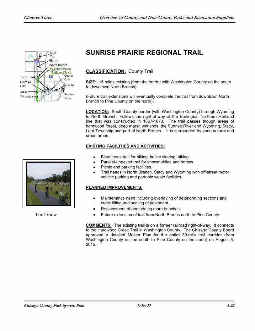
Chisago County Park System Plan 7/19/17 3-23
SUNRISE PRAIRIE REGIONAL TRAIL CLASSIFICATION: County Trail SIZE: 15 miles existing (from the border with Washington County on the south to downtown North Branch) (Future trail extensions will eventually complete the trail from downtown North Branch to Pine County on the north). LOCATION: South County border (with Washington County) through Wyoming to North Branch. Follows the right-of-way of the Burlington Northern Railroad line that was constructed in 1867-1870. The trail passes though areas of hardwood forest, deep marsh wetlands, the Sunrise River and Wyoming, Stacy, Lent Township and part of North Branch. It is surrounded by various rural and urban areas. EXISTING FACILITIES AND ACTIVITIES:
Bituminous trail for biking, in-line skating, hiking. Parallel-unpaved trail for snowmobiles and horses. Picnic and parking facilities. Trail heads in North Branch, Stacy and Wyoming with off-street motor
vehicle parking and portable waste facilities. PLANNED IMPROVEMENTS:
Maintenance need including overlaying of deteriorating sections and crack filling and sealing of pavement.
Replacement of and adding more benches. Future extension of trail from North Branch north to Pine County.
COMMENTS: The existing trail is on a former railroad right-of-way. It connects to the Hardwood Creek Trail in Washington County. The Chisago County Board approved a detailed Master Plan for the entire 30-mile trail corridor (from Washington County on the south to Pine County on the north) on August 5, 2015.
Trail View
Chapter Three Overview of County and Non-County Parks and Recreation Suppliers
Chisago County Park System Plan 7/19/17 3-24
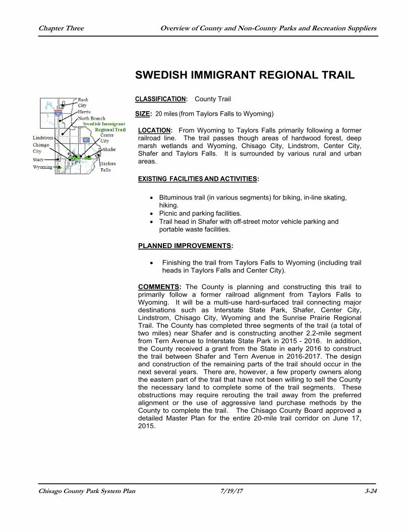
SWEDISH IMMIGRANT REGIONAL TRAIL
CLASSIFICATION: County Trail
SIZE: 20 miles (from Taylors Falls to Wyoming) LOCATION: From Wyoming to Taylors Falls primarily following a former railroad line. The trail passes though areas of hardwood forest, deep marsh wetlands and Wyoming, Chisago City, Lindstrom, Center City, Shafer and Taylors Falls. It is surrounded by various rural and urban areas.
EXISTING FACILITIES AND ACTIVITIES:
Bituminous trail (in various segments) for biking, in-line skating, hiking.
Picnic and parking facilities. Trail head in Shafer with off-street motor vehicle parking and
portable waste facilities. PLANNED IMPROVEMENTS:
Finishing the trail from Taylors Falls to Wyoming (including trail heads in Taylors Falls and Center City).
COMMENTS: The County is planning and constructing this trail to primarily follow a former railroad alignment from Taylors Falls to Wyoming. It will be a multi-use hard-surfaced trail connecting major destinations such as Interstate State Park, Shafer, Center City, Lindstrom, Chisago City, Wyoming and the Sunrise Prairie Regional Trail. The County has completed three segments of the trail (a total of two miles) near Shafer and is constructing another 2.2-mile segment from Tern Avenue to Interstate State Park in 2015 - 2016. In addition, the County received a grant from the State in early 2016 to construct the trail between Shafer and Tern Avenue in 2016-2017. The design and construction of the remaining parts of the trail should occur in the next several years. There are, however, a few property owners along the eastern part of the trail that have not been willing to sell the County the necessary land to complete some of the trail segments. These obstructions may require rerouting the trail away from the preferred alignment or the use of aggressive land purchase methods by the County to complete the trail. The Chisago County Board approved a detailed Master Plan for the entire 20-mile trail corridor on June 17, 2015.
Chapter Three Overview of County and Non-County Parks and Recreation Suppliers
Chisago County Park System Plan 7/19/17 3-25
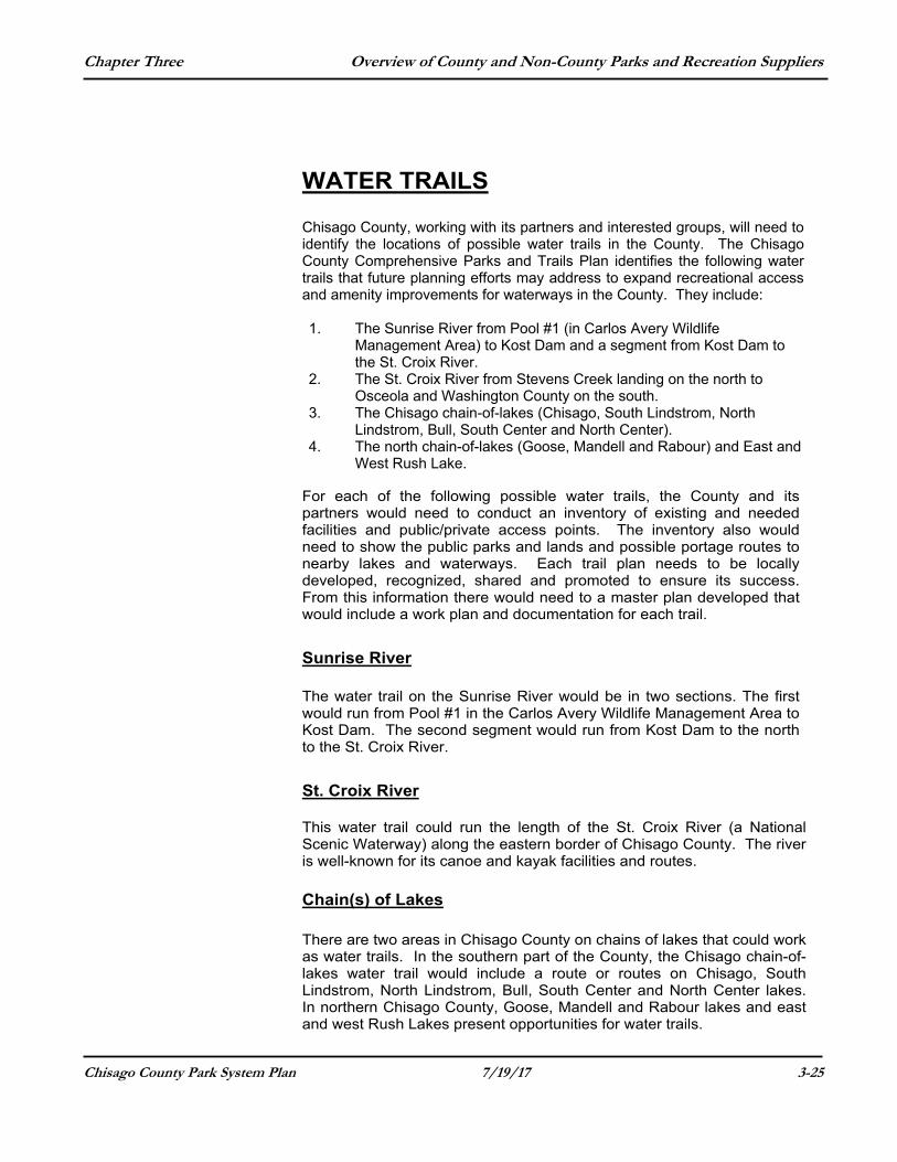
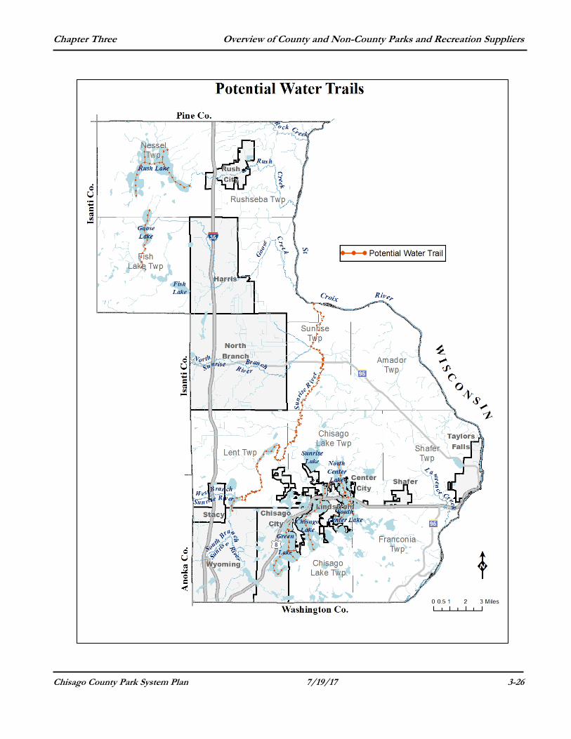
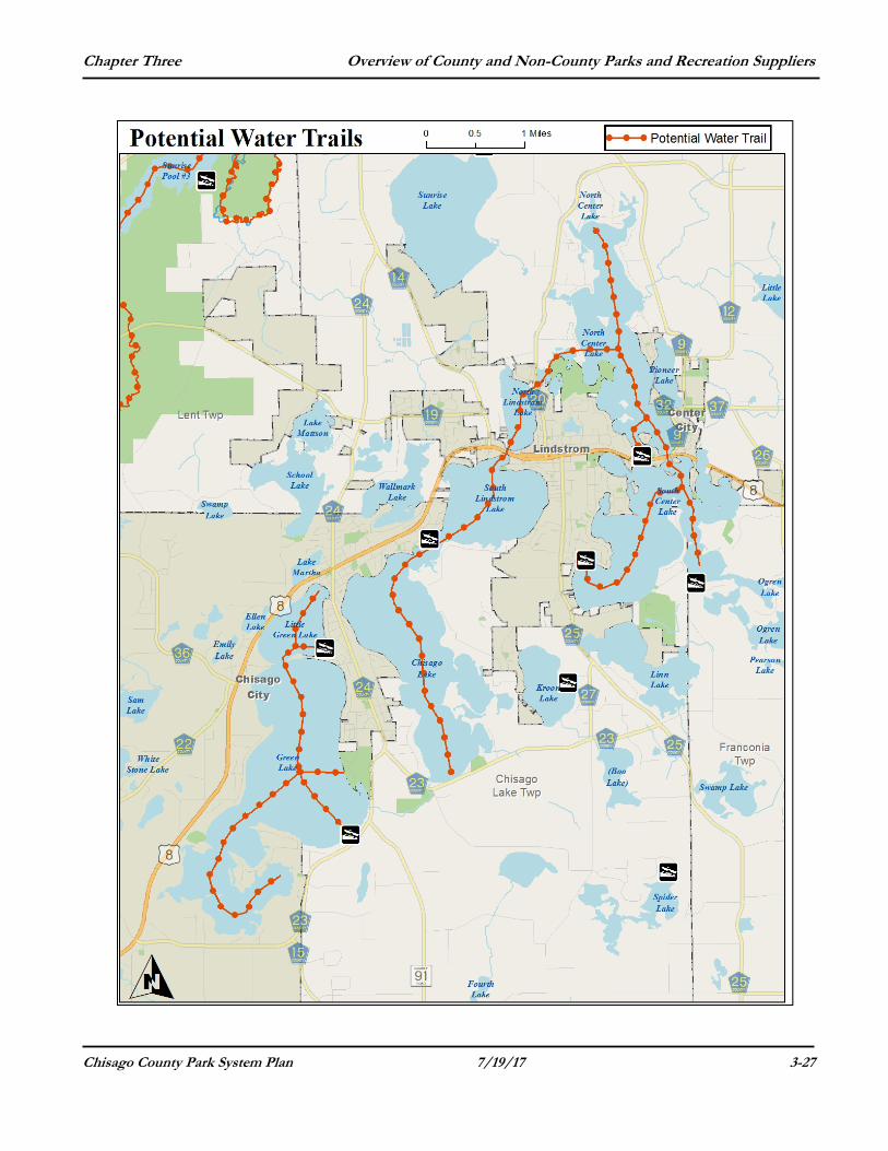
WATER TRAILS
Chisago County, working with its partners and interested groups, will need to identify the locations of possible water trails in the County. The Chisago County Comprehensive Parks and Trails Plan identifies the following water trails that future planning efforts may address to expand recreational access and amenity improvements for waterways in the County. They include:
1. The Sunrise River from Pool #1 (in Carlos Avery Wildlife
Management Area) to Kost Dam and a segment from Kost Dam to the St. Croix River.
2. The St. Croix River from Stevens Creek landing on the north to Osceola and Washington County on the south.
3. The Chisago chain-of-lakes (Chisago, South Lindstrom, North Lindstrom, Bull, South Center and North Center).
4. The north chain-of-lakes (Goose, Mandell and Rabour) and East and West Rush Lake.
For each of the following possible water trails, the County and its partners would need to conduct an inventory of existing and needed facilities and public/private access points. The inventory also would need to show the public parks and lands and possible portage routes to nearby lakes and waterways. Each trail plan needs to be locally developed, recognized, shared and promoted to ensure its success. From this information there would need to a master plan developed that would include a work plan and documentation for each trail.
Sunrise River
The water trail on the Sunrise River would be in two sections. The first would run from Pool #1 in the Carlos Avery Wildlife Management Area to Kost Dam. The second segment would run from Kost Dam to the north to the St. Croix River.
St. Croix River
This water trail could run the length of the St. Croix River (a National Scenic Waterway) along the eastern border of Chisago County. The river is well-known for its canoe and kayak facilities and routes.
Chain(s) of Lakes
There are two areas in Chisago County on chains of lakes that could work as water trails. In the southern part of the County, the Chisago chain-of-lakes water trail would include a route or routes on Chisago, South Lindstrom, North Lindstrom, Bull, South Center and North Center lakes. In northern Chisago County, Goose, Mandell and Rabour lakes and east and west Rush Lakes present opportunities for water trails.
Chapter Three Overview of County and Non-County Parks and Recreation Suppliers
Chisago County Park System Plan 7/19/17 3-26
Chapter Three Overview of County and Non-County Parks and Recreation Suppliers
Chisago County Park System Plan 7/19/17 3-27
Chapter Three Overview of County and Non-County Parks and Recreation Suppliers
Chisago County Park System Plan 7/19/17 3-28
PARK RESERVES/OPEN SPACES
There are four primary open space/reserves in Chisago County. They are:
Carlos Avery State Wildlife Management Area
This wildlife management area (WMA) is owned by the State of Minnesota and has 8740 acres in Chisago County. It also has several hundred acres west of Stacy in Anoka County. This WMA is in the southwestern part of County primarily in Lent Township. (See the next section for more information about this WMA).
Janet Johnson Wildlife Management Area
This WMA is 540 acres in size and is located a 36492 Hemingway Avenue (west of County Road 14) in the southern part of North Branch. This site is owned by the State of Minnesota. North Sunrise Park Reserve
This County-owned reserve is 154 acres and is located at 46984 Government Road (in North Sunrise Township). This site functions as a wildlife management area.
Sunrise Lake Aquatic Management Area
The Minnesota Department of Natural Resources (DNR) acquired 46.5 acres of land on the north shore of Sunrise Lake in 2014 for an aquatic management area.
Chapter Three Overview of County and Non-County Parks and Recreation Suppliers
Chisago County Park System Plan 7/19/17 3-29
NON-COUNTY RECREATIONAL PROVIDERS There are several "outside resources” influencing recreational opportunities offered to Chisago County residents. In addition to the Chisago County park system, there are many city parks, state and federal parks/lands and private recreational providers in the County. This section outlines these comparable recreational providers in Chisago County. These providers are private and publicly owned and offer facilities and amenities that may have an influence on future planning for the Chisago County Park and Trail system. In addition to the parks and trails under the jurisdiction of Chisago County, there are many parks, trails, historic sites and other recreation sites that other units of government and the private sector provide to residents and visitors. While this plan does not cover these facilities, they are important in meeting the needs of the county’s residents and are taken into consideration when planning the county’s parks and open spaces.
Other park facility providers are described below: The National Park Service manages scenic areas and some use areas
on the St. Croix River.
The Minnesota Department of Natural Resources (DNR) manages Wild River and Interstate state parks along the St. Croix River, the Janet Johnson Wildlife Management Area in North Branch, the Sunrise Lake Aquatic Management Area and the Carlos Avery Wildlife Management Area in the southwest part of the county. They also manage 13 boat or canoe access points on the St. Croix River and at least 17 public boat ramps on lakes throughout the County.
Cities and townships provide outdoor recreation facilities - most frequently local trails and community parks or athletic fields. These trails and parks provide facilities for active recreation such as playgrounds, athletic fields, courts and skating rinks in smaller spaces that meet local and neighborhood needs. Local recreational facilities provide locations for a large number and variety of recreational activities that occur in Chisago County. Local parks are often more intensely developed than County parks and provide facilities for active recreation. Cities design local parks to serve a neighborhood or a city, are frequently located in residential areas, are typically smaller than County parks and are typically constructed to serve the local population, rather than the larger County parks that are based on natural resource amenities. Local trails typically provide connections between neighborhood or city destinations, such as schools, libraries and city parks. Although local recreational areas are not covered by this plan, the County should take into consideration the facilities and services they offer when County prepares park and trail plans and updates.
Chapter Three Overview of County and Non-County Parks and Recreation Suppliers
Chisago County Park System Plan 7/19/17 3-30
Ki-Chi-Saga County Park in Lindstrom is used by local athletic associations for softball and soccer as it has eight soccer fields along with other recreational facilities. Two city parks that have a regional influence are Almendstrat Park in Lindstrom and Ojiketa Park in Chisago City.
Public recreational facilities do not meet all the needs or demands for recreation by the County’s residents. Private operations also make contributions to the development of facilities and the provision of services while complementing the activities and experiences offered by the public sector. The most prominent facilities that the private sector provides are golf courses, riding facilities, gun clubs, camp grounds, marinas and downhill ski areas. Examples of private recreation facilities in Chisago County include Wild Mountain Recreation Area and Wildwood Campground. Some private recreation facilities such as resorts, campgrounds and tubing centers are open to the general public for a fee. Private recreation facilities reduce the burden on the public sector, provide additional recreation opportunities and help preserve hundreds of acres of land in open space.
FEDERAL AND STATE MANAGED PARKS/AREAS Upper and Lower St. Croix National Scenic Riverway In 1968, the St. Croix River north of Taylors Falls was designated as a National Wild and Scenic River. Then the portion of the River south of Taylors Falls received the same designation in 1972. The National Park Service and the Minnesota Department of Natural Resources (DNR) developed management plans for the designated areas. This area offers many scenic opportunities. Minnesota Department of Natural Resources-Natural Areas
Carlos Avery Wildlife Management Area The DNR manages this 23,000-acre area of upland forests, grassland, fields and wetland marshes lying on the Anoka Sand Plain. The WMA was established for wildlife production, public hunting and trapping and "other uses compatible with wildlife management" in northeastern Anoka County and in southwestern Chisago County for wildlife purposes. The WMA includes 8740 acres in Chisago County and contains 57 miles of roads and more than 23 miles of trails and fire breaks. The forest and grassland areas are managed through selective cutting, controlled mowing and burning, planting of food plots, and tree planting. Wetland areas in the WMA are maintained using a system of dikes and control structures, prescribed burning and level ditching.
Chapter Three Overview of County and Non-County Parks and Recreation Suppliers
Chisago County Park System Plan 7/19/17 3-31
The area is a haven of rare animal species, including wolves, eagles and Sandhill Cranes. The primary public recreational use of the Carlos Avery WMA is the hunting and trapping of waterfowl, deer, squirrel, mink, muskrat, raccoon and beaver. Janet Johnson Wildlife Management Area
This WMA is 540 acres in size and is located a 36492 Hemingway Avenue (west of County Road 14) in the southern part of North Branch. This site is owned by the State of Minnesota and managed by the Department of Natural Resources (DNR) for wildlife production, public hunting and trapping and "other uses compatible with wildlife management.” Interstate State Park Interstate State Park is 293 acres in size and was established in Minnesota in 1895. Wisconsin followed suit and established its own state park across the St. Croix River in 1900. Visitors can see at least ten different lava flows, fossil remains of ancient creatures and tracks of various creatures and ripple marks left in stone by now vanished seas. The magnificent glacial formation of the park makes rock climbing a favorite recreational activity for many visitors to the park. The park also provides camping sites and facilities and canoeing opportunities. Wild River State Park The State of Minnesota established Wild River State Park in 1978. Nearly 5,000 acres of the Park's 7,008 acres were donated by Northern States Power Company. Approximately 10,000 years ago, the melting of the last glacier formed Glacial Lakes Duluth and Grantsburg; these lakes supplied the water power to create the present day St. Croix Valley. Like other parks in the county, this too was a popular logging area years ago. Among the variety of recreational activities available in the Park are more than 35 miles of hiking and skiing trails. Chengwatana State Forest The Chengwatana State Forest was established in 1953 and encompasses about 29,000 acres in Pine and Chisago counties. About 17,000 acres are publicly owned. It contains a variety of outdoor recreation facilities, including Snake River Campground (Pine County) hiking and skiing trails, and snowmobile trails. The Minnesota-Wisconsin Boundary Trail crosses the State Forest and will eventually connect the Twin Cities Metropolitan Area to Duluth. Primary uses of the trail are hiking and snowmobiling and some sections are used for horseback riding. During the winter, the trial connects Chengwatana, St. Croix State Park and St. Croix and Nemadji State Forests.

Chapter Three Overview of County and Non-County Parks and Recreation Suppliers
Chisago County Park System Plan 7/19/17 3-32
Chapter Three Overview of County and Non-County Parks and Recreation Suppliers
Chisago County Park System Plan 7/19/17 3-33
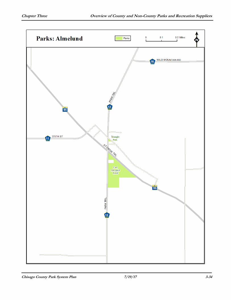
MUNICIPAL PROVIDERS Almelund-City Parks
Carl Almquist Field This 9 acre park features a softball and a baseball field with dug outs, bleachers and lighting, a concession stand/storage building, playground and picnic tables. It is located at 37245 Park Trail. Triangle Park Triangle Park is about ½ acre in size and consists of green space with a monument dedicated to Swedish Pioneers. It is located at the southeast corner of Park Trail and Maple Lane and has a picnic shelter and playground equipment.
Amador Heritage Center Museum and Park This 17-acre park-like setting is located at 15892 Maple Lane. It has a 1910 two-room brick school house used a museum, two pre-1890 log cabins, one pre-1900 log granary, picnic tables and a playground There also is a walking trail traveling through the site.
Chapter Three Overview of County and Non-County Parks and Recreation Suppliers
Chisago County Park System Plan 7/19/17 3-34
Chapter Three Overview of County and Non-County Parks and Recreation Suppliers
Chisago County Park System Plan 7/19/17 3-35
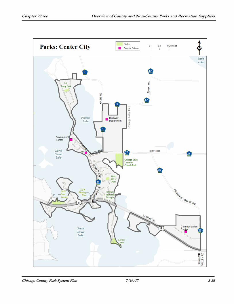
Center City – City Parks Water Tower Park Water Tower Park is located at 150 Busch Avenue. It provides a picnic area, a playground area that includes swings, slides, a merry-go-round, and a volleyball court. It is small and is only a half-acre in size. (The most popular park in Center City.) I.G. Long Park. This one-acre park is located at 595 Nelson Lane. It provides a playground area, with swings, a slide, jungle gym, picnic tables, ice hockey rink, canoe access and fishing. Loren’s Park This 3-acre park is located at 685 Grand Avenue on the shore of South Center Lake and has picnic tables, a walking path and lake access for fishing. This park used to be a popular swimming beach in the 1940's. Now it cannot be used as a swimming beach. Chisago Lake Lutheran Church Park/John Moody Field Located at 14495 310th Street (adjacent to the church), this facility is a two or three acre park with a softball and baseball field. South Park This 3-acre park is undeveloped and built on four peninsulas located at South Center Lake, North Lake and Pioneer Lake but does have picnic tables. This park used to be a popular swimming beach back in the 1940’s. Now it cannot be used as a swimming beach. Chisago City - City Parks Chuckie Lundquist Park This park is located at 10940 Stinson Avenue. Chuckie Lundquist Park was dedicated in the 1960's and is 3.3 acres in size. It provides an ice rink with a warming house, skateboard park, access to trails and facilities for tennis, baseball, softball and basketball activities. Dahl Park This park is located at 29186 Main Street. This tot lot was built in the 1960's and was furnished by the Chisago City Booster club. It has some minor playground equipment and is the site of well # 3. This park is one tenth of an acre in size.
Chapter Three Overview of County and Non-County Parks and Recreation Suppliers
Chisago County Park System Plan 7/19/17 3-36
Chapter Three Overview of County and Non-County Parks and Recreation Suppliers
Chisago County Park System Plan 7/19/17 3-37
Vi lhe lm Moberg Park Located at 10625 Railroad Avenue. This park was formerly known as Central Park and was dedicated as Vilhelm Moberg Park in 1997 by the King and Queen of Sweden. This park is mainly used as the Gateway to the Chisago Lakes Area and as a community-meeting park. It is two acres in size and provides facilities for picnics and special events, which includes playground equipment, a pavilion, benches and a drinking fountain.
Ojiketa Regional Park This park is located at 27500 Kirby Avenue. This park is 73 acres in size and has on-site parking, walking and biking trails, a beach area and a dock on Green Lake, tent camping, cabin facilities, lodges, a chapel and conference and banquet halls. Paradise Park Paradise Park is located 11031 Stinson Avenue Paradise Park is 7.3 acres in size and was built in 1992 with a grant from the Minnesota DNR. This is the largest of the City parks and is on the site of the former Paradise Resort. It has a swimming beach, sand volleyball court, a pavilion with picnic tables and children’s playground equipment.
Rotary Park This park is located at 10340 Liberty Lane. Rotary Park is 6.6-acres and has a picnic shelter, a natural wood chip trail that runs along the southern bay of School Lake to Karmel Avenue.
Surfland Park Surfland Park is located at 11305 Lakeview Road. This park is 1.1 acres in size and has a baseball field, playground equipment, picnic tables and rest rooms. Triangle Park This park is located at 29309 Old Towne Road. Triangle Park is the site of the Ernest Hawkinson memorial. It has a clock memorial for Bart Lindquist. Water Tower Park This park is located at 11066 North Avenue. Water tower Park was created in 1998. The Park consists of a few walking trails, parking lot, lighting, play structures and benches.
Chapter Three Overview of County and Non-County Parks and Recreation Suppliers
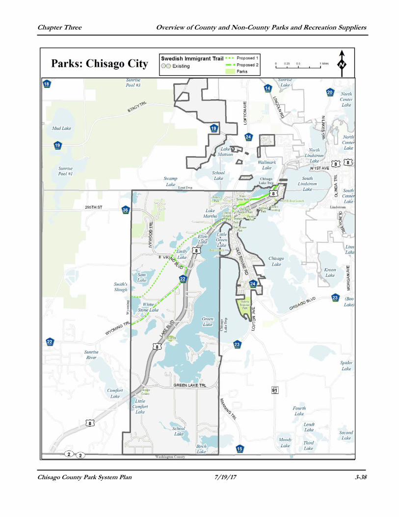
Chisago County Park System Plan 7/19/17 3-38
Chapter Three Overview of County and Non-County Parks and Recreation Suppliers
Chisago County Park System Plan 7/19/17 3-39
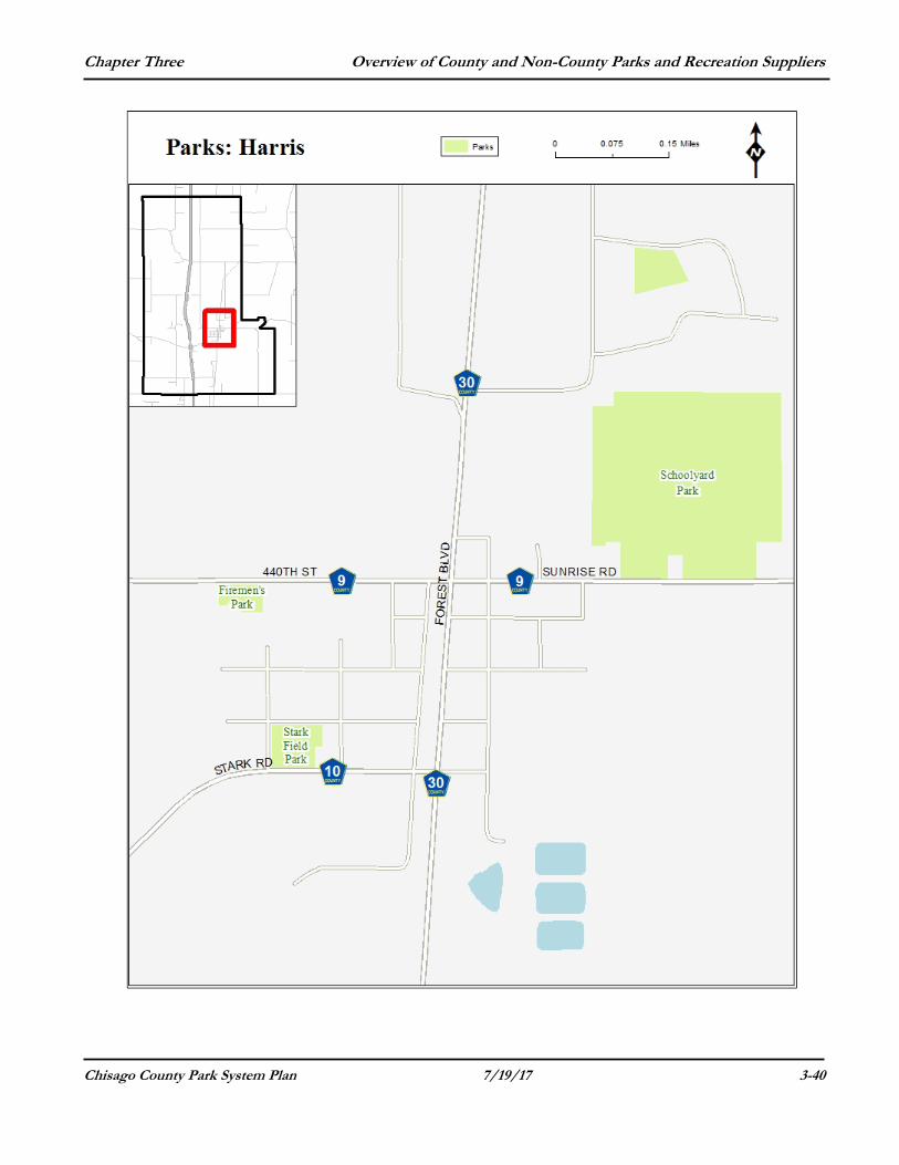
Harris City - City Parks Firemen's Park This park is located at 6345 440th Street (off of County Road 9) This one-acre park provides facilities for volleyball, a horseshoe pit, a picnic shelter, grills and swings. Schoolyard Park Schoolyard Park is located at 6834 Sunrise Road (off of County Road 9) This four-acre park is part of a 34 acre site and it has a picnic shelter, horseshoes, volleyball, basketball and a tennis court and playground area. Stark Field Park This park is located at 6379 437th Street (on County Road 10) Size: 2.2 acres Features: This large field offers softball and baseball activities and has bleachers and a concession stand.
Chapter Three Overview of County and Non-County Parks and Recreation Suppliers
Chisago County Park System Plan 7/19/17 3-40
Chapter Three Overview of County and Non-County Parks and Recreation Suppliers
Chisago County Park System Plan 7/19/17 3-41
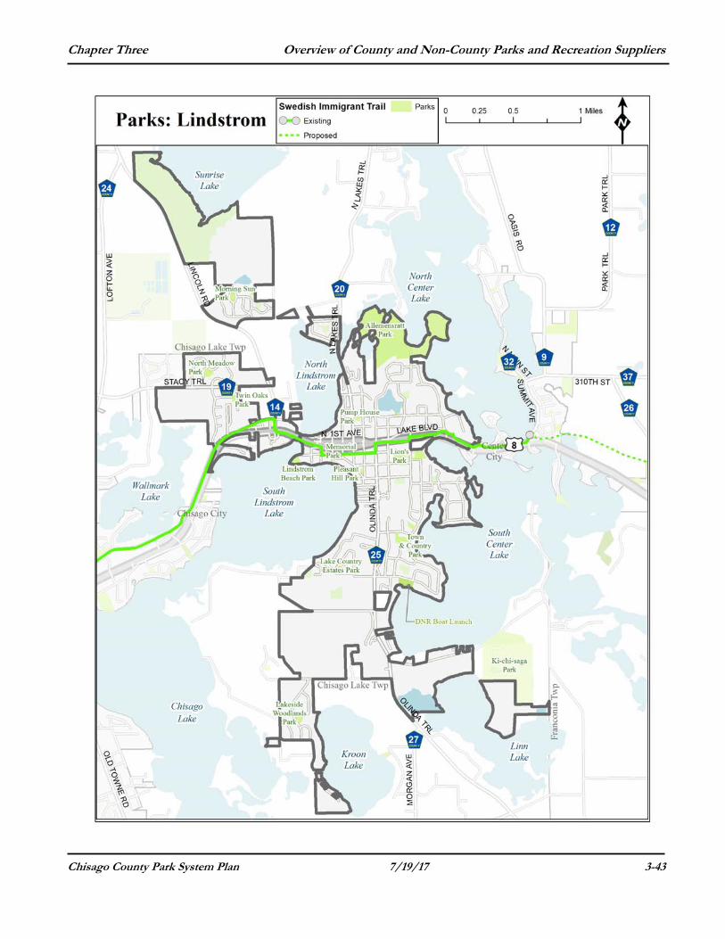
City of Lindstrom - City Parks Allemanstratt Park This park is located at 31316 Olinda Trail on the North Lindstrom Lake Channel, North Center Lake and on Bull Lake. Size: This city park is about 90 acres Features: With over 5,800 feet of shoreline, it is a wilderness park with unique ecological features and minimal improvements. It has several miles of trails and the city has designated it as a “Carry in, Carry out” park.
Kroon Lake Park This park is located at 28131 Lake Lawn Drive (on the corner of Lake Lawn Drive and Lakeside Trail). Size: 2.25 acres Features: This park has a play structure, a basketball half-court, baseball field and picnic tables. Lindstrom Beach Park Located at 12505 Newell Avenue (on South Lindstrom Lake). Size: 3 acres Features: Sand beach, swimming beach, boat dock, fishing pier, pavi l ion, sand volleyball, shelter, picnic tables, grills, swings, play structure, winter access for ice fishing, paved walking paths. This park and all of its amenities are all handicapped accessible. Lions Park Located at 13292 Sylvan Avenue (adjacent to Lindstrom City Hall) Size: 5.5 acres Features: a small island accessible by a covered foot bridge, playground equipment, pavilion with picnic tables, electricity, grills and a drinking fountain, much open green space, portable toilets for general use and restrooms for community hosted events. Specific play equipment: The play structures include a separate toddler’s play area, an elementary-aged play area with a handicapped swing and a tire swing. Memorial Park (formerly known as Library Park) Located at 30525 Linden Street (on the west end of Newell Ave - Behind the Lakes Area Chamber of Commerce) Size: 0.5 acre Features: A pre-school park with a play structure with slides, swings and a handicap swing.
Morning Sun Park Located at 31810 McGuire Trail (north of County Road 14). Size: 1.4 acres Features: This park has a half-court basketball area, play structures, benches and picnic tables.
Chapter Three Overview of County and Non-County Parks and Recreation Suppliers
Chisago County Park System Plan 7/19/17 3-42
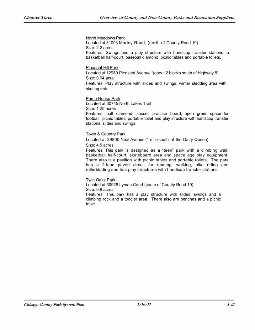
North Meadows Park Located at 31093 Morley Road, (north of County Road 19) Size: 2.2 acres Features: Swings and a play structure with handicap transfer stations, a basketball half-court, baseball diamond, picnic tables and portable toilets.
Pleasant Hill Park Located at 12980 Pleasant Avenue *(about 2 blocks south of Highway 8) Size: 0.64 acre Features: Play structure with slides and swings, winter sledding area with skating rink. Pump House Park Located at 30745 North Lakes Trail Size: 1.25 acres Features: ball diamond, soccer practice board, open green space for football, picnic tables, portable toilet and play structure with handicap transfer stations, slides and swings. Town & Country Park Located at 29800 Neal Avenue (1 mile south of the Dairy Queen) Size: 4.5 acres Features: This park is designed as a “teen” park with a climbing wall, basketball half-court, skateboard area and space age play equipment. There also is a pavilion with picnic tables and portable toilets. The park has a 2-lane paved circuit for running, walking, bike riding and rollerblading and has play structures with handicap transfer stations.
Twin Oaks Park Located at 30926 Lyman Court (south of County Road 19). Size: 0.8 acres Features: This park has a play structure with slides, swings and a climbing rock and a toddler area. There also are benches and a picnic table.
Chapter Three Overview of County and Non-County Parks and Recreation Suppliers
Chisago County Park System Plan 7/19/17 3-43

Chapter Three Overview of County and Non-County Parks and Recreation Suppliers
Chisago County Park System Plan 7/19/17 3-44
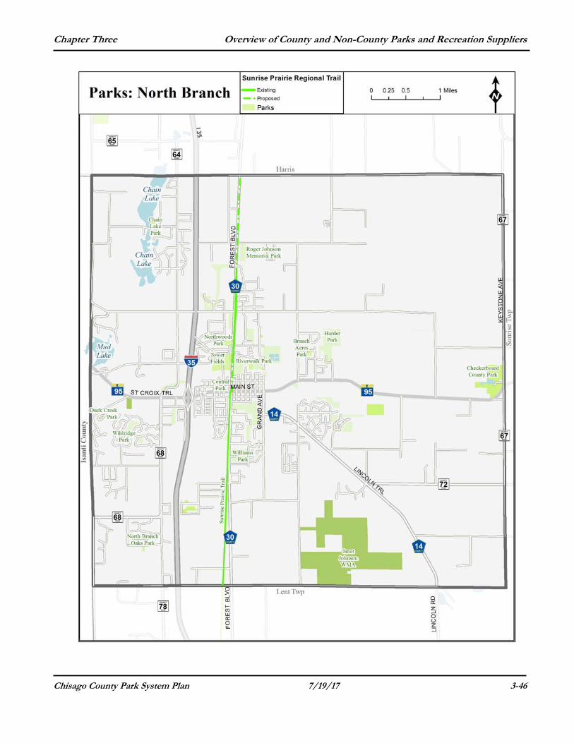
City of North Branch-City Parks & Natural Areas Branch Acres This open space is undeveloped and located in a neighborhood at 394th Street and Henna Avenue (7451 394th Street). The park also has a 3.4-acre native prairie. Central Park Central Park consists of 2.4 acres and has playground equipment, a hard court surface (basketball), permanent buildings, a pavilion/shelter, and a picnic area. It is located at the intersection of Hwy 95 and Branch Avenue (6250 Main Street). Chain Lake Park This 0.9-acre undeveloped open space features a lake access (no boat landing). The property is located at 5200 412th Street. Duck Creek Park This 1.6-acre park undeveloped open space with bird feeders. It is located off of Isanti Trail at 4552 392nd Street. Harder Park Harder Park is a 63-acre park and features 40 acres of wetlands and is located east of downtown on Harder Parkway north of Highway 95. The remaining 23 acres provides four (4) baseball fields, play equipment, a 9-hole disc golf course, horseshoes, pavilion/shelter and a picnic area. It is located at 39260 Harder Parkway. North Branch Oaks Park This 2 acre area is forested and has playground equipment. It is located at 5035 366th Street. Northwood Park Northwood is a 5.4-acre park located at Sioux Trail and Chippewa Avenue (39581 Cherokee Avenue). This park features playground equipment, tennis courts, a hard court surface (basketball) a pavilion/shelter, horse shoe pits, and picnic area. Riverwalk Park This park is located along the Sunrise River and features ½ mile to 1-mile gravel trail, a pavilion/shelter and a picnic area. It is located at 39181 Forest Boulevard. Tower Fields This 8.7-acre park is located under the east water tower (at 6211 Cougar Trail) and features two baseball fields, playground equipment and picnic area.
Chapter Three Overview of County and Non-County Parks and Recreation Suppliers
Chisago County Park System Plan 7/19/17 3-45
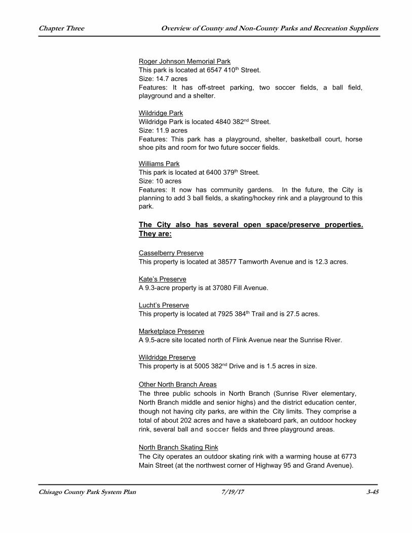
Roger Johnson Memorial Park This park is located at 6547 410th Street. Size: 14.7 acres Features: It has off-street parking, two soccer fields, a ball field, playground and a shelter.
Wildridge Park Wildridge Park is located 4840 382nd Street. Size: 11.9 acres Features: This park has a playground, shelter, basketball court, horse shoe pits and room for two future soccer fields. Williams Park This park is located at 6400 379th Street. Size: 10 acres Features: It now has community gardens. In the future, the City is planning to add 3 ball fields, a skating/hockey rink and a playground to this park. The City also has several open space/preserve properties. They are:
Casselberry Preserve This property is located at 38577 Tamworth Avenue and is 12.3 acres.
Kate’s Preserve A 9.3-acre property is at 37080 Fill Avenue.
Lucht’s Preserve This property is located at 7925 384th Trail and is 27.5 acres. Marketplace Preserve A 9.5-acre site located north of Flink Avenue near the Sunrise River. Wildridge Preserve This property is at 5005 382nd Drive and is 1.5 acres in size.
Other North Branch Areas The three public schools in North Branch (Sunrise River elementary, North Branch middle and senior highs) and the district education center, though not having city parks, are within the City limits. They comprise a total of about 202 acres and have a skateboard park, an outdoor hockey rink, several ball and soccer fields and three playground areas.
North Branch Skating Rink The City operates an outdoor skating rink with a warming house at 6773 Main Street (at the northwest corner of Highway 95 and Grand Avenue).
Chapter Three Overview of County and Non-County Parks and Recreation Suppliers
Chisago County Park System Plan 7/19/17 3-46
Chapter Three Overview of County and Non-County Parks and Recreation Suppliers
Chisago County Park System Plan 7/19/17 3-47
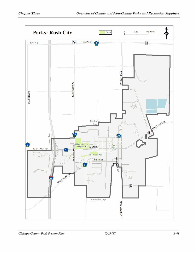
Rush City-City Parks and Other Recreational Facilities Aquatic Center This facility is located at 305 S. Eliot Avenue. It is owned by the school district and has outdoor pools that are open June – August.
Rush City Park This park is located at 250 South Dana Avenue (northwest corner of the intersection of Dana Avenue and Fourth Street) Size: 0.8 Acres (100 ft. by 350 f t . ) Features: A covered pavilion with a cement floor and picnic shelter, swings, playground equipment and a restroom. Rush Creek Park This open space/park is located at 600 Harte Avenue. Size: 7 acres Features: This park is a nature park with walking trails along the creek.
Chapter Three Overview of County and Non-County Parks and Recreation Suppliers
Chisago County Park System Plan 7/19/17 3-48
Chapter Three Overview of County and Non-County Parks and Recreation Suppliers
Chisago County Park System Plan 7/19/17 3-49
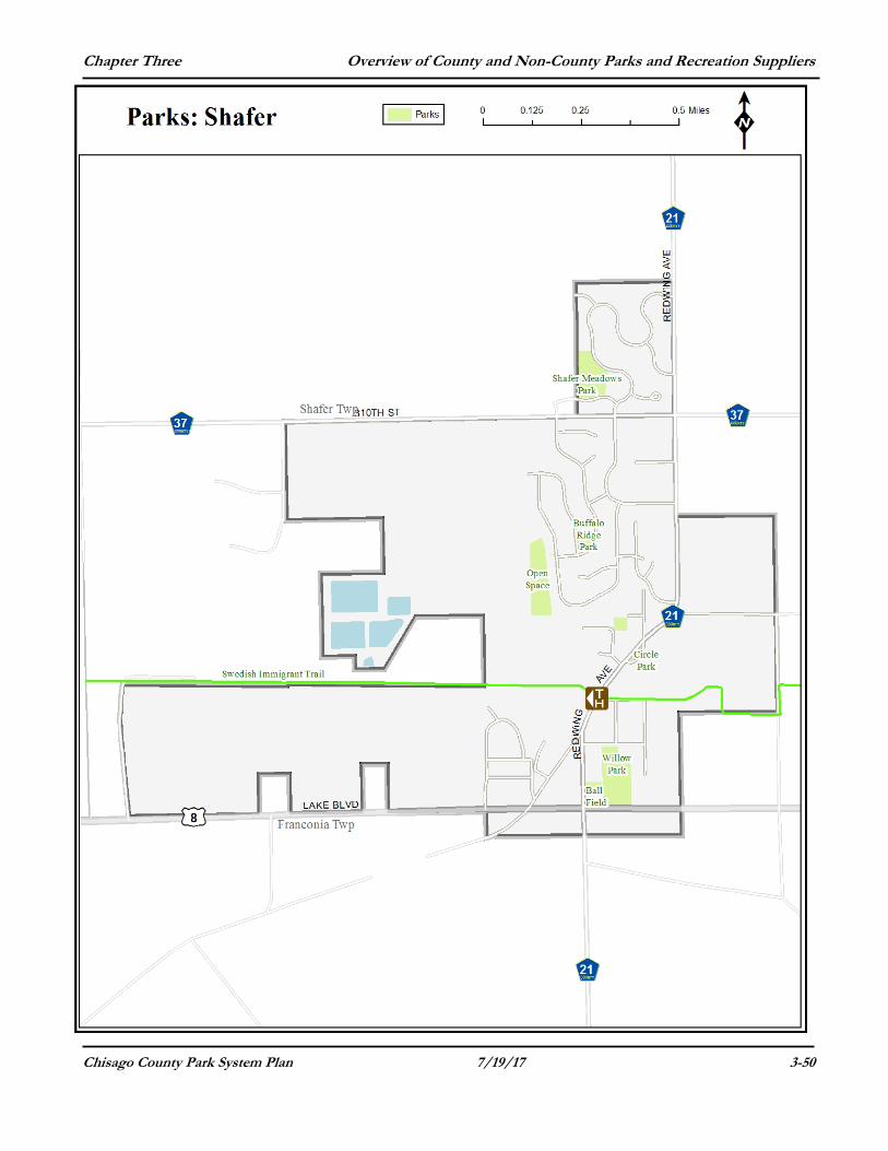
City of Shafer-City Parks & Natural Areas Buffalo Ridge Park This park is located at 30710 Reflection Avenue. Size: 0.94 acres Features: This park has swings, a port-a-potty, pavilion, picnic tables, basketball court and a drinking fountain.
Circle Park This green space is located along the east side of Red Wing Avenue (near 304th Street). Size: 0.15 acres Features: It is improved with flowers and provides benches. Shafer Meadows This park is located at 17610 311th Street. Size: 5.0 acres Features: This park has softball fields, an Olympic-sized outdoor hockey rink with lights, a warming house, port-a-potty, playground and 2 picnic shelters.
Willow Park This park is located at 17625 302nd Street. Size: 7.3 acres Features: This park has swings, a climber, one-half basketball court, picnic table and a grill. Ball field (not city-owned) This ball field site provides facilities for softball. It is located on Red Wing Avenue near Highway 8 and is owned by Schafer Contracting.
Trailhead (for Swedish Immigrant Trail) This facility is located at 30300 Red Wing Avenue. Size: 0.46 acres Features: This access for the trail has picnic tables, a paved parking lot and a port-a-potty. Open Space/Green Space This open space area is located west of Redding Avenue near 307th Street and is 5.5 acres in size.
Chapter Three Overview of County and Non-County Parks and Recreation Suppliers
Chisago County Park System Plan 7/19/17 3-50
Chapter Three Overview of County and Non-County Parks and Recreation Suppliers
Chisago County Park System Plan 7/19/17 3-51
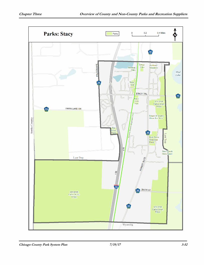
City of Stacy – City Parks Richland Meadows Park This park is located in northeast Stacy between County Road 30 and Gable Avenue. Size: 2 acres Features: Currently undeveloped. Rick Doyle Memorial Field Doyle Fields is located at 30309 Forest Boulevard (on the east side of County Road 30). Size: 12 acres Features: This park features two softball fields, a concession stand, parking lot and is the site of a proposed ice arena. Rieger Fields Park This park is located at 30707 Forest Boulevard (east of County Road 30 and south of County Road 19). (in Lent Township) Size: 16 acres Features: Softball field(s), a fenced-in play area and disc golf.
Sherman Oaks Park This park is located at the southwest corner of Foxhill Avenue and 314th Street. Size: 6 acres Features: Currently undeveloped.
Stacy Lion’s Park This park is located at 5859 Stacy Trail (on the south side of County Road 19 along the Sunrise Prairie Trail). Size: 11 acres Features: Playground, softball field, one-half court basketball court, picnic shelter and parking lot. Stacy Ponds This open space is east of Stacy Ponds Drive adjacent to Lent Township. Size: 12.3 acres Features: This site is undeveloped except for a trail that loops from this site toward Carlos Avery Wildlife Management Area. Twins Field (Sunrise Mobile Home Park) This park is located at 30493 Fir Trail (on the west side of I-35 on the south side of the manufactured home park). Size: 5.7 acres Features: Softball/baseball field.
Chapter Three Overview of County and Non-County Parks and Recreation Suppliers
Chisago County Park System Plan 7/19/17 3-52
Chapter Three Overview of County and Non-County Parks and Recreation Suppliers
Chisago County Park System Plan 7/19/17 3-53
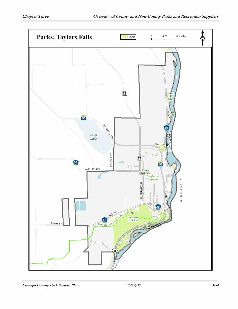
City of Taylors Falls Cherry Hill Park Location: This facility is located at 560 Maple Street. Size: 0.5 acres Features: Undeveloped.
Heritage Park Location: This park is located at 250 St Croix Trail (Highway 95) Size: 8 acres Features: This facility has a small pavilion, picnic tables, paved parking lot, trails and an overlook. North Lions Park Location: This park is located at 1950 Chisago Street. Size: 2 acres Features: This park has a bathroom, play equipment and volleyball.
Pumphouse Playground Location: Located on the southwest corner of West and Maple Streets. Size: 0.4 acres Features: This facility has children’s play equipment.
South Lions Park Location: This park is located at 1750 Chisago Street (along the St. Croix River) 1.5 miles north of downtown Taylors Falls. Size: 2 acres Features: This park has 1.25 miles of shoreline on the St. Croix River. It has a boat landing, canoe access, pavilions, picnic tables, new restrooms in 2014 and a trail along the river to North Lions Park. Riverwalk Trail (MN/DOT Park) Location: Under the Highway 8 Bridge This park provides benches, picnic areas and viewing platform.
Chapter Three Overview of County and Non-County Parks and Recreation Suppliers
Chisago County Park System Plan 7/19/17 3-54
Chapter Three Overview of County and Non-County Parks and Recreation Suppliers
Chisago County Park System Plan 7/19/17 3-55
City of Wyoming - City Parks & Natural Areas Ashton Park Ashton Park is located at 26110 Galen Drive. Size: 0.4 acre Features: The playground has three slides, one monkey bar, one climbing bar, one steering wheel, and one play “window”. Separate swing set includes three swings and one baby swing. Individual equipment includes a digger/scoop, a rocking horse, and a rocking turtle. Two picnic tables also are available.
Asian Acres Park This park is located east of E. Viking Boulevard, south of 272nd Court. Size: 3.3 acres Features: This park is currently undeveloped. Banta Park This park is located at 24684 Fondant Avenue (south of 250th Street). Size: 3.74 acres Features: It has a softball field, pavilion, playground set (plastic - slides, climbing), swing set, big slide, 1 grill, 2 benches, 3 tables, 2 bleachers, 1 digger, 2 bouncy horses, whirl-bug climbing structure. Blue Spruce Park Blue Spruce Park is located at 6546 262nd Street (south of Granada Avenue). Size: 1.95 acres Features: It has a playground and two picnic tables.
Bridgewater Park This park is located on West Comfort Drive at 256th Street. Size: 1.9 acres Features: This park is currently undeveloped. Centennial Park Centennial Park is located at 26947 Fenwick Avenue. Size: 0.77 acres Features: It provides picnic tables, grills, a small storage building and flagpole and memorial plaques. Centennial Park is located on the site of one of the first homes built in Wyoming, which was founded in 1855. Stanley and Helen Struble donated land for a community park in memory of her grandparents, Mr. and Mrs. F.W. Tepel, an early pioneer family who occupied the home. The American flag flies over Centennial Park and two small monuments are also located nearby. One in remembrance to the Stubles and the Tepels and one in memory of Tony Richner placed by the Wyoming Lions and Lioness.
Chapter Three Overview of County and Non-County Parks and Recreation Suppliers
Chisago County Park System Plan 7/19/17 3-56
Comfort Estates Park This park is located at 25578 Iris Avenue (south of Pioneer Road). Size: 3 acres Features: This park has a limestone walking trail, native plantings, bridges over water, large play structure, 4 swings (1 infant, 1 accessible), 2 benches and 1 picnic table. Fireside Park Fireside Park is located at 4354 251st Street. Size: 11 acres total (5.6 with an additional 6.4 acres to the north) Features: This park has a boat, swing set, slide, digger, 2 bouncy horses and a merry-go-round.
Goodview Park This park is located at 26000 Goodview Avenue. Size: 14.7 acres Features: Goodview Park is the newest park in Wyoming. It features a picnic shelter with grills; children's play equipment and trail system. There are 2 soccer fields, tennis courts and a paved parking area.
Other projects slated for Goodview Park are a lighted hockey rink with warming house.
Hawk Meadow Park and Open Space This open space is located near 255th Street and Granada Avenue at 25419 Grail Court. Size: 2.6 acres. Features: It has a wood chip hiking trail.
Kunshier Park/Open Space This park site is located at 5560 Flint Avenue. Size: 6.8 acres Features: This park is undeveloped/unused at this time. Part of the property is determined to have possibly unstable ground due to past back filling of tree stumps and other debris. Liberty Ponds Park This park is located at 24588 Heath Avenue. Size: 8 acres Features: Currently undeveloped. Lions Park of Wyoming Lions Park is located at 4803 263rd Street. Size: 2.8 acres Features: This park has a pavilion (that can be reserved), picnic tables and two grills, large parking lot, softball field with back stop, basketball half court, large open field, playground (swings, play set with slide, merry-go-round) and a porta-potty. The park is lighted and there is a skating rink in the winter.
Chapter Three Overview of County and Non-County Parks and Recreation Suppliers
Chisago County Park System Plan 7/19/17 3-57
Railroad Park Railroad Park is located at 5280 East Viking Boulevard. Size: Almost an acre in size. Features: This park has a City Welcome sign, picnic tables, and drinking water and is next to the Sunrise Prairie Trail, which is a 10-foot-wide paved multi-use trail extending from North Branch to Forest Lake. St. Paul's Lutheran Church Park This park is located at 5879 Wyoming Trail. Size: 7.6 acres Features: This park is owned by St. Paul's Lutheran Church and cooperatively developed with the City as a park. This park features a basketball court, a playground, picnic tables, a ball field and trail crosses through the park. Swenson Park This park is located at 26929 Flintwood Avenue. Size: 3.5 acres Features: This park provides tennis courts, a playground, picnic tables, baseball field and a trail crosses through the park. Tolzmann Park Tolzmann Park is located at 5530 274th Street (formerly known as Sunrise Park). Size: 7.6 acres Features: This park has a softball field, pavilion, picnic tables, sand volleyball court with benches on side, swing set, slide, 3 bouncy horses, 2 diggers, 1 table, bike rack, 1 grill, paved trail, climbing/exercise structure. Town Hall Park This park is located at 7571 Pioneer Trail (east of Highway 61). Size: 6.1 acres Features: Town Hall Park has a softball field, swing set, slide, 2 picnic tables, bleachers, 2 benches, 2 bouncy horses and 1 digger. Verges Memorial Park Vergas Memorial Park is located at 25915 Goodwin Road. Size: 1.24 acres Features: This park has a playground equipment, one-half court basketball courts and sand volleyball courts.
Verges Playground Park This park is located at 25580 Goodwin Road. Size: 0.2 acres Features: This park has a playground set (swings, slide), 2 bouncy horses, 1 bench, 1 table and a bike rack.
Chapter Three Overview of County and Non-County Parks and Recreation Suppliers
Chisago County Park System Plan 7/19/17 3-58
Water Tower Park This park is located at 26725 Felton Avenue. Size: 0.6 acre Features: This park provides a small playground area, picnic tables, and water tower well and pumps house/maintenance building. Whitetail Ridge Open Space This is a 22.9-acre private, undeveloped open space located east of Hillcrest Drive. Other Wyoming Areas Wyoming Elementary, though not a City Park, is within the City limits and has several ball fields and a large playground area. Other areas include several short trails/paths, various outlots, city properties and right-of-way throughout the city.
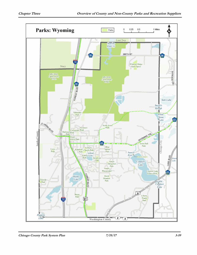
Chapter Three Overview of County and Non-County Parks and Recreation Suppliers
Chisago County Park System Plan 7/19/17 3-59
Chapter Three Overview of County and Non-County Parks and Recreation Suppliers
Chisago County Park System Plan 7/19/17 3-60
PRIVATE RECREATIONAL PROVIDERS Campgrounds
Kozy Oaks Kamp Located in North Branch Township (in Isanti County) at 8629 277th Avenue NE. This campground has group camping, seasonal sites, bathrooms and sites with electrical and water hook-ups available. Peterson’s Rush Lake Resort and Campground This facility and campground are located on Rush Lake at 51170 Rush Lake Trail. It has 26 seasonal and 15 rental camp sites available. Taylors Falls – Camp Waub-o-Jeeg This private campground provides rustic campsites and trails. It is located along the west side of County Road 16 at 2185 Chisago Street (north of Taylors Falls). Whispering Bay Resort Located in Franconia Township at 14430 291st Street on the south shore of South Center Lake It has a swimming beach, boat launch, restrooms with showers and 68 sites for year-round RV parking. Wildwood RV Park and Campgrounds Located on the north side of Highway 8 at 20078 Lake Boulevard in Shafer. It has a total of 201 campsites (daily and seasonal); some with electric and water hook-ups and showers and bathrooms are available.
Charter Boat Tours and Commercial Boat Landings Taylors Falls Scenic Boat Tours Located in Taylors Falls at 220 South Street. Provides a variety of boat excursions and tours seven days a week along the St. Croix River. Golf Courses
Adventure Falls’ Mini-golf and Drive-in. This facility is located at 572 Bench Street in Taylors Falls. It has an 18-hole mini golf course and a drive-in restaurant. Bulrush Golf Course This course is located at 605 Brookside Parkway in Rush City. It is has 18 holes and a lighted driving range. Chisago Lakes Golf Course This course is in Lindstrom at 12975 292nd Street. It has 18 holes, a club house and a pro shop.
Chapter Three Overview of County and Non-County Parks and Recreation Suppliers
Chisago County Park System Plan 7/19/17 3-61
Falcon Ridge Golf Course This golf course has an 18-hole, MGA sanctioned course, an executive 9-hole course and a driving range. It also has a pro-shop and lessons are available. This facility is located in Lent Township at 33942 Falcon Avenue (south of County Road 17 and west of Interstate 35). Highway 8 Driving Range This facility is located in Chisago City at 8640 Lake Boulevard (at the intersection of Highway 8 and County Road 23). It has a driving range and a mini golf course. North Branch Municipal Golf Course This facility is on land owned by City and is managed privately. It is a public, nine-hole, par thirty five golf course. It is located in North Branch at 38585 Forest Boulevard (off of County Road 30, south of Highway 95).
Hunting and Fishing Preserves
Deer Ridge Game Farm Located at 5050 470th Street in Harris. This facility is available for private pheasant hunting.
Ski Areas
Wild Mountain This year-round park offers summer and winter activities: skiing and snowboarding, winter tubing, alpine slides, Taylor's Falls Scenic tours, summer water park, canoe rental and campground facilities. It is located at 37200 Wild Mountain Road (north of Taylors Falls in Amador Township).
Snowmobile Clubs
Wild River Snowmobile Club Their club house is located at 17940 St. Croix Trail N. in Almelund.
North Branch Sno-Drifters Their headquarters is located at 7283 St. Croix Trail (Highway 95) in North Branch.
Rush City Sno-Bugs Located at 50574 Shorewood Circle in Rush City.
Sno-Barons Snowmobile Club They operate the annual Hay Days event on one weekend every September on a 120 acre site at 38740 Oriole Avenue in Sunrise Township (near Almelund).
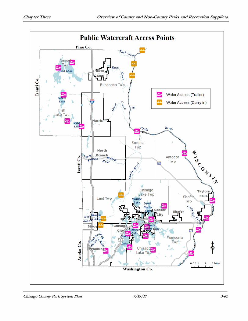
Chapter Three Overview of County and Non-County Parks and Recreation Suppliers
Chisago County Park System Plan 7/19/17 3-62
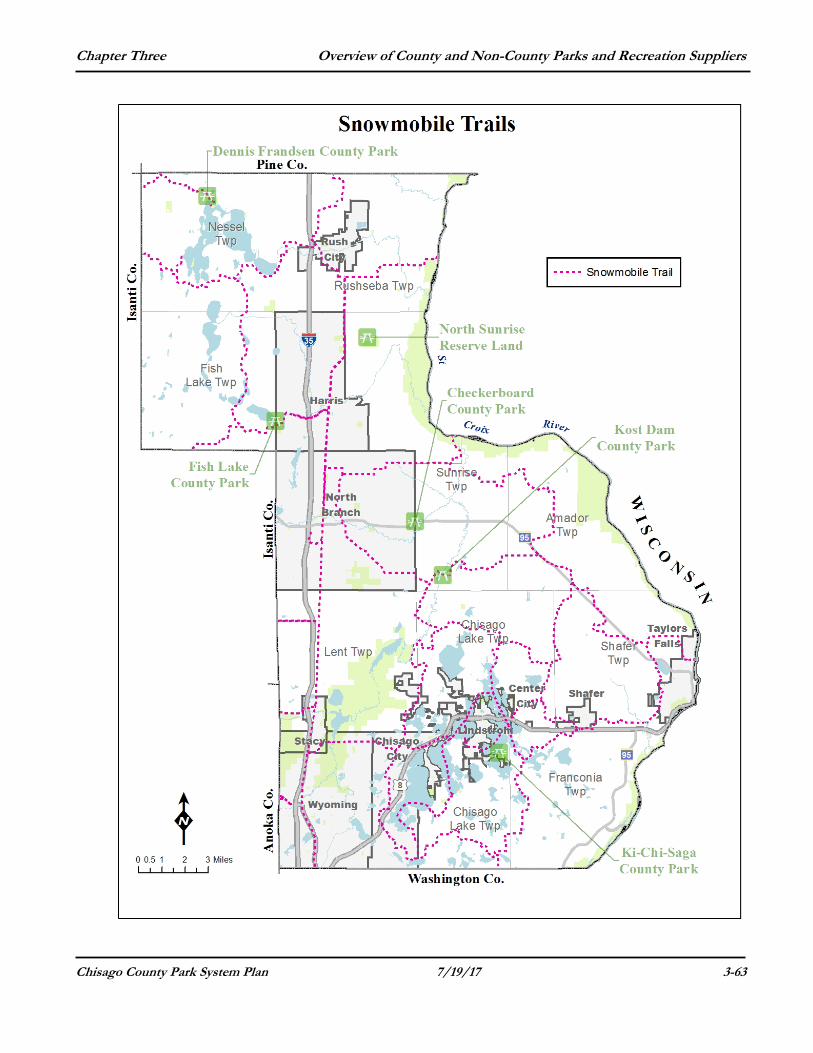
Chapter Three Overview of County and Non-County Parks and Recreation Suppliers
Chisago County Park System Plan 7/19/17 3-63