Precambrian geology of Nuussuaq and the area north-east of Disko Bugt, West Greenland
35
6 Contents: Precambrian geology of Nuussuaq and the area north-east of Disko Bugt, West Green- land ...................................................................... A.A. Garde and A. Steenfelt.................... 6 Geology of Greenland Survey Bulletin 181, 6–40 (1999) © GEUS 1999 Descriptions of lithological units on the 1:250 000 scale map ............................................... 10 Archaean gneisses north of Torsukattak .................................................................................. 10 Nuussuaq gneisses ................................................................................................................ 10 Gneisses on Nunataq ............................................................................................................ 12 Archaean supracrustal rocks along the coasts of Torsukattak and in the Ataa domain ........ 12 Saqqaq supracrustal rocks .................................................................................................... 13 Itilliarsuk supracrustal rocks ................................................................................................. 14 Western occurrence, around Itilliarsuk ............................................................................ 14 Eastern occurrence, Qeqertaarsuk and Inussuk ............................................................. 16 Nunataq ............................................................................................................................. 17 Correlation of the Archaean supracrustal rocks north of Torsukattak ............................... 17 Arveprinsen-Eqi supracrustal rocks, south of Torsukattak ................................................. 18 Oqaatsut ............................................................................................................................ 19 Arveprinsen Ejland ........................................................................................................... 19 Anap Nunaa ...................................................................................................................... 20 Qingaarsuaq ...................................................................................................................... 20 Eqi and Maniitsoq ............................................................................................................. 21 Correlation of the Archaean supracrustal rocks south of Torsukattak ............................... 22 Comparison between the Archaean supracrustal rocks north and south of Torsukattak . 22 Boye Sø anorthosite complex ................................................................................................... 22 Other occurrences of anorthosite and related rocks on Nuussuaq ................................... 24 Archaean rocks south of Torsukattak ...................................................................................... 24 Atâ tonalite ............................................................................................................................ 24 Gneisses and supracrustal rocks in the Rodebay domain .................................................. 25 Rodebay granodiorite ....................................................................................................... 25 Late granitoid rocks .......................................................................................................... 26 Nunatarsuaq domain ............................................................................................................ 26 Nunatarsuaq supracrustal rocks ....................................................................................... 26 Proterozoic platform sediments and intrusive rocks ............................................................... 29 Anap nunâ Group ................................................................................................................. 29 Proterozoic marble on northern Nuussuaq ......................................................................... 30 Basic dykes and sills ............................................................................................................. 31 Albitisation ............................................................................................................................ 32 Lamprophyres and lamproites ............................................................................................. 32 Structural and metamorphic evolution ..................................................................................... 33 Nuussuaq domain ................................................................................................................. 34 Evidence for Proterozoic deformation in Nuussuaq and on Nunataq ........................... 34 Shear zones in southern Nuussuaq and the boundary between the Nuussuaq and Ataa domains ..................................................................................... 35 Ataa domain .......................................................................................................................... 35 Proterozoic deformation in the Ataa domain .................................................................. 35 Rodebay domain ................................................................................................................... 36 Nunatarsuaq domain ............................................................................................................ 37 Concluding remarks .................................................................................................................. 37 Acknowledgements ................................................................................................................... 38 References ................................................................................................................................. 38
-
Upload
independent -
Category
Documents
-
view
2 -
download
0
Transcript of Precambrian geology of Nuussuaq and the area north-east of Disko Bugt, West Greenland

6
Contents:
Precambrian geology of Nuussuaq and the area north-east of Disko Bugt, West Green-land ...................................................................... A.A. Garde and A. Steenfelt.................... 6
Geology of Greenland Survey Bulletin 181, 6–40 (1999) © GEUS 1999
Descriptions of lithological units on the 1:250 000 scale map ............................................... 10Archaean gneisses north of Torsukattak .................................................................................. 10 Nuussuaq gneisses ................................................................................................................ 10 Gneisses on Nunataq ............................................................................................................ 12Archaean supracrustal rocks along the coasts of Torsukattak and in the Ataa domain ........ 12 Saqqaq supracrustal rocks .................................................................................................... 13 Itilliarsuk supracrustal rocks ................................................................................................. 14 Western occurrence, around Itilliarsuk ............................................................................ 14 Eastern occurrence, Qeqertaarsuk and Inussuk ............................................................. 16 Nunataq ............................................................................................................................. 17 Correlation of the Archaean supracrustal rocks north of Torsukattak ............................... 17 Arveprinsen-Eqi supracrustal rocks, south of Torsukattak ................................................. 18 Oqaatsut ............................................................................................................................ 19 Arveprinsen Ejland ........................................................................................................... 19 Anap Nunaa ...................................................................................................................... 20 Qingaarsuaq ...................................................................................................................... 20 Eqi and Maniitsoq ............................................................................................................. 21 Correlation of the Archaean supracrustal rocks south of Torsukattak ............................... 22 Comparison between the Archaean supracrustal rocks north and south of Torsukattak . 22Boye Sø anorthosite complex ................................................................................................... 22 Other occurrences of anorthosite and related rocks on Nuussuaq ................................... 24Archaean rocks south of Torsukattak ...................................................................................... 24 Atâ tonalite ............................................................................................................................ 24 Gneisses and supracrustal rocks in the Rodebay domain .................................................. 25 Rodebay granodiorite ....................................................................................................... 25 Late granitoid rocks .......................................................................................................... 26 Nunatarsuaq domain ............................................................................................................ 26 Nunatarsuaq supracrustal rocks ....................................................................................... 26Proterozoic platform sediments and intrusive rocks ............................................................... 29 Anap nunâ Group ................................................................................................................. 29 Proterozoic marble on northern Nuussuaq ......................................................................... 30 Basic dykes and sills ............................................................................................................. 31 Albitisation ............................................................................................................................ 32 Lamprophyres and lamproites ............................................................................................. 32Structural and metamorphic evolution ..................................................................................... 33 Nuussuaq domain ................................................................................................................. 34 Evidence for Proterozoic deformation in Nuussuaq and on Nunataq ........................... 34 Shear zones in southern Nuussuaq and the boundary between the Nuussuaq and Ataa domains ..................................................................................... 35 Ataa domain .......................................................................................................................... 35 Proterozoic deformation in the Ataa domain .................................................................. 35 Rodebay domain ................................................................................................................... 36 Nunatarsuaq domain ............................................................................................................ 37Concluding remarks .................................................................................................................. 37Acknowledgements ................................................................................................................... 38References ................................................................................................................................. 38

Precambrian geology of Nuussuaq and the area north-east of Disko Bugt, West Greenland
Adam A. Garde and Agnete Steenfelt
The Precambrian terrain of eastern Nuussuaq and north-east Disko Bugt largely consists of late Archaean (c. 2800 Ma) orthogneisses, intercalated with units of strongly deformed Archaean supracrustal rocks. The latter are up to several kilometres wide and comprise both metavol-canic and metasedimentary rocks within which local occurrences of gold have been found. In central Nuussuaq a layered complex of anorthosite, leucogabbro, gabbro and ultramafi c rocks is tectonically intercalated with Archaean orthogneisses, and an intrusive complex of Archaean tonalites and trondhjemites, largely unaffected by Archaean and Proterozoic deformation, occurs in the area north-east of Disko Bugt. Here an up to c. 3.5 km thick sequence of early Proterozoic shallow marine clastic sediments and minor marble unconformably overlies Archaean rocks. Several suites of basic dykes are present, and dykes and small plugs of ultramafi c lamprophyre and lamproite (age c. 1750 Ma) are common in the central part of the region.
Most of the region was overprinted by early Proterozoic deformation and metamorphism. Prominent Proterozoic fl at-lying ductile shear zones with north- or north-westward movement of the hanging wall are overprinted by open folds.
Geological Survey of Denmark and Greenland, Thoravej 8, DK-2400 Copenhagen NV, Denmark. E-mail: [email protected].
Keywords: anorthosite, Archaean rocks, Disko Bugt, Nuussuaq, Proterozoic deformation, Prot-erozoic rocks, West Greenland
This paper describes the Precambrian geological evolu-tion of the Disko Bugt – Nuussuaq region (Fig. 1). It is based on fi eld work by the former Geological Survey of Greenland (GGU) and the Geological Institute, University of Copenhagen, in 1988, 1989 and 1991 during the Disko Bugt Project (Kalsbeek 1989, 1990; Kalsbeek & Christiansen 1992). The account also serves as a description of the geological map at scale 1:250 000 (Garde 1994) enclosed in the present volume, and in the course of the geological description reference is made to the main lithological and structural units on this map.
Precambrian basement is exposed in the eastern part of Nuussuaq and on the mainland north-east of Disko Bugt (Fig. 1). There are both Archaean and Proterozoic rocks, and most of the region has been exposed to both Archaean and Proterozoic phases of deforma-tion. Several geotectonic settings are recognised in the region: an Archaean low-grade granite-greenstone
terrain, an active continental margin, and a high-grade gneiss-amphibolite terrain. In addition, a Proterozoic setting with platform sedimentation and basic and lamproitic magmatic activity is present in the central part of the region.
A small number of isotopic age determinations has been carried out (Kalsbeek et al. 1988; Kalsbeek & Taylor 1999, Nutman & Kalsbeek 1999 and Rasmus-sen & Holm 1999, all in this volume), but most of the tentative distinctions made in this account between Archaean and Proterozoic rocks and structures are inferred from fi eld observations. In particular it has been diffi cult to separate Archaean and Proterozoic deformation events.
The present account is primarily based on informa-tion gathered by the authors during reconnaissance mapping, but it also relies heavily on more detailed work in the central part of the region by the other participants in the Project, see the 1:100 000 geological
7

8
Fig. 1. Principal Archaean and Proterozoic rock units and four structural domains between Qarajaq Isfjord and Jakobshavn Isfjord. Inset map shows location in West Greenland.
��������yyyyyyyy
����yyyy����yyyy
���������
yyyyyyyyy
�y�y
����yyyy
������������������������������������������������������������������������������������
500 km
70° N
Torsukattak
AnapNunaa
IlluluarsuitNunataat
DrygalskiHalvø
Boye Sø
Puiattup Qaqqaa
Ilorleeraq
Itilli
arsu
k
Saqqaq
Qaqulluit
Sanningasoq
Kanaakip Aaffaa
Nunataq
Saqqap Tasersua
Uigorleq
Inussuk
50° W52° W
69°30' N
Qarajaq Isfjord
Nuussuaqdomain
Ataadomain
Rodebaydomain
Nunatarsuaqdomain
Rensdyrnunatak
QarassapNunataa
T
TT
T
T
T
N u u s s u a q
D i s k o
D i s k oB u g t
Itilli
Qeqertakassak
Oqaatsut
Ataa
Qapiarfiit
Arfiusaq
Eqi
Maniitsoq
Qeqertaa
Ataa
Sund
Kangerlu-arsuk
ArveprinsenEjland
PaakitsupNunaa
JakobshavnIlulissat
Nunatar-suaq
Laksebugt
Qingaarsuaq
Oqaatsuunguit
Ikerasak
Innarsuaq
Paakitsoq
Jakobshavn Isfjord
Saattut
Bredebugt
BerggrenHavn
Rodebay
Sik
uiui
tsoq
25 km
Saqqaqdalen
P
P
P
P
P
Archaean
Inland Ice
Cretaceous–TertiaryProvinceT
��yyProterozoicmetasedimentsP
Supracrustal rocks������������������������������������������Boye Søanorthosite complex
Dioritic gneiss
������������������������������������������������������������������������������������ Itilli diorite���������������������������������������������������������������Atâ tonalite
Orthogneiss

9
Nuussuaq domain Ataa domain Rodebay and Nunatarsuaq domains
ARCHAEAN
Nuussuaq gneisses Orthogneisses c. 2800 Ma Orthogneisses
Boye Sø anorthosite complex Anorthosite on Arveprinsen Ejland(tectonic contacts with other units)
Unconformity (?)
Saqqaq and Itilliarsuk Arveprinsen–Eqi supracrustal rocks Nunatarsuaq supracrustal rockssupracrustal rocks; c. 2800 Ma Supracrustal enclavessupracrustal rocks on Nunataq (intruded by Atâ tonalite) (relationships with orthogneisses unknown)(unconformably resting on orthogneiss?)
Itilli diorite Atâ tonalite 2800 Ma Rodebay granodiorite(intrudes homogeneous amphibolite) (intrudes Arveprinsen–Eqi supracrustal rocks)
Trondhjemite sill Late granitoids c. 2750 Ma Late granitoids c. 2750 Ma (?)(intrudes Saqqaq supracrustal rocks) (intrude Atâ tonalite)
EARLY PROTEROZOIC
Nuussuaq marble Anap nunâ GroupSedimentary rocks on Nunataq (partly Archaean provenance)(probably equivalent to Anap nunâ Group)
Ilorleeraq dykesMetabasic sills Basic sills Basic dykes and sillsBasic sill on Nunataq
Dolerite dykes Dolerite dykes Dolerite dykes
Albitised sandstone and siltstone Albitised rocks
map of the Ataa area compiled by Escher (1995), and contributions in this volume. The authors have mainly worked by helicopter from the Survey base camp at the former settlement Ataa 60 km north of Ilulissat, supplemented by short fi eld camps.
Prior to the Disko Bugt Project, the Precambrian geol-ogy of the Disko Bugt region was poorly known. The fi rst geological investigation by the Geological Survey of Greenland (GGU; Escher & Burri 1967; Escher & Pulvertaft 1976) consisted of reconnaissance mapping by boat in 1964 between latitudes 69° and 70° along the coasts east and south-east of Disko. The results were shown on a preliminary map at scale 1:250 000 (Escher & Burri 1967, map 1) and as part of the geological map sheet Søndre Strømfjord – Nûgssuaq at scale 1:500 000 (Escher 1971).
Escher & Burri (1967) divided the Precambrian rocks between Jakobshavn Isfjord and Nuussuaq (Fig. 1) into a lower, older gneiss group and an upper, younger
group, the ‘Anap nunâ Group’, in which they included all exposures of supracrustal rocks on both sides of Torsukattak. They also recognised the ‘Atâ granite’, which they considered was formed largely by granitisa-tion of earlier gneisses and supracrustal rocks. Escher & Burri (1967) thought that all the supracrustal rocks were younger than the gneisses, but it is now known that some of them are Archaean and furthermore older than some of the Archaean plutonic rocks, whereas others are Proterozoic (Kalsbeek et al. 1988). The term ‘Anap nunâ Group’ is now restricted to the Proterozoic part of the supracrustal rocks. Escher & Burri (1967) proposed a simplifi ed model for the structural evolu-tion of the region, according to which the supracrustal rocks form a rim syncline around a large diapiric dome of reactivated gneiss basement; however more recent fi eld work has not supported this interpretation.
The northern coast of Nuussuaq and areas north of Qarajaq Isfjord included in the present map (Garde
Approximate ages are summarised from Kalsbeek et al. (1988), Kalsbeek & Taylor (1999, this volume) and Nutman & Kalsbeek (1999, this volume).
Table 1. Archaean and lower Proterozoic lithological units between Jakobshavn Isfjord and Qarajaq Isfjord

10
1994, enclosed in pocket) were reconnoitred in 1965 and 1980 by T.C.R. Pulvertaft (personal communica-tion 1988, 1993) during fi eld work for geological map sheets at scale 1:100 000 in the Uummannaq region north of Nuussuaq.
The mining company Kryolitselskabet Øresund A/S carried out a mineral exploration programme north-east of Disko Bugt in the beginning of the 1980s (see Gothenborg 1982). The exploration comprised airborne and ground magnetic and electromagnetic surveys in search of base and precious metal deposits, supple-mented by local detailed geological mapping around various prospects. Other companies have later pros-pected in the same region, primarily for gold.
The area north-east of Disko Bugt was visited again several times in the mid-1980s by geologists from the Geological Survey of Greenland and the University of Copenhagen (Kalsbeek et al. 1988; Knudsen et al. 1988; Steenfelt 1988). The results obtained from these small expeditions provided the basis for the Disko Bugt Project in 1988–1991.
Descriptions of lithological units on the 1:250 000 scale map
In the following, the main lithological units that occur on the geological map (Garde 1994) are referred to in italics, and their labels on the map quoted in brackets. However, since the different rock units have not been formally defi ned in a stratigraphical sense, we use informal terms like ‘Atâ tonalite’ (with lower case t) instead of ‘Atâ Tonalite’ as employed on the map. A geological overview of the region is shown on Fig. 1, and the main lithological units and their age relation-ships are presented in Table 1.
Both the orthogneisses and supracrustal rocks of presumed Archaean age and the Proterozoic (meta)-sediments and intrusive rocks are described below ac-cording to their occurrence in four different structural domains (see Structural and metamorphic evolution, p. 33).
Archaean gneisses north of Torsukattak
Orthogneisses s.l. (including the essentially undeformed Atâ tonalite and local granitic rocks) form about 90 per cent of the Precambrian of Nuussuaq and the region north-east of Disko Bugt and comprise the Nuussuaq gneisses north of Torsukattak, the rocks belonging to
the Atâ tonalite centred around the northern part of Arveprinsen Ejland, the Rodebay granodiorite towards Jakobshavn Isfjord, and the gneisses on Nunatarsuaq in the south-east. The orthogneisses are all presumed to be late Archaean in age, broadly coeval with the Atâ tonalite dated at c. 2800 Ma (Kalsbeek et al. 1988; Nutman & Kalsbeek 1999, this volume).
Nuussuaq gneisses
The Nuussuaq gneisses, which form the greater part of Precambrian Nuussuaq, appear to form a basement to the Archaean supracrustal rocks along Torsukattak, because conglomerates which contain boulders of orthogneiss have been found at two localities within these supracrustal rocks (descriptions follow below, p. 14). The most common type of Nuussuaq gneiss is homogeneous orthogneiss (gn). This consists of pre-dominantly medium-grained, light grey, biotite-bearing rocks of tonalitic to trondhjemitic composition with weak migmatisation. The gneiss commonly shows a strong fl at-lying to subhorizontal foliation, and in the north-western part of the exposed basement towards the Cretaceous – lower Tertiary province in western Nu-ussuaq it is variably crushed and epidotised. Extensive supracrustal units occur in the southern part of Nuus-suaq, but elsewhere the homogeneous orthogneiss is mostly almost devoid of supracrustal enclaves; tectonic slices of an anorthosite-leucogabbro-gabbro suite (see p. 22) are the most prominent marker horizons.
On Nuussuaq, within the rather homogeneous or-thogneiss described above, areas with distinctive litholo-gies were identifi ed during helicopter reconnaissance; however, in most cases their mutual relationships could not be established. In the central and north-western part of the Nuussuaq basement there occurs an about 20 km long and up to 500 m thick, fl at-lying unit of dark grey hornblende-biotite gneiss (dgn). In the north-eastern part of Nuussuaq ash-grey, sugary plagioclase-rich varieties of orthogneiss (tonalitic gneiss, bgn) are spatially associated with layers of anorthosite, leuco- and gabbro; especially in the area south-east of the head of Qarajaq Isfjord and on Rensdyrnunatak this gneiss unit may be very heterogeneous (and commonly strongly deformed), consisting of several phases of orthogneiss mixed with anorthosite, leucogabbro and gabbro (Fig. 2) and possibly also mafi c supracrustal rocks (see also colour photograph in Kalsbeek 1990, p. 21). Dark, homogeneous, plagioclase-rich ortho-

11
gneiss also occurs north of Qarajaq Isfjord, e.g. on Drygalski Halvø and Qarassap Nunataa. In both of the two latter areas the dark gneiss appears to have tec-tonic contacts to the underlying biotite gneiss (T.C.R. Pulvertaft, personal communication 1993).
A c. 25 km long and up to 1 km thick layer of dark grey tonalitic to dioritic gneiss, banded hornblende-biotite gneiss (dgn) occurs in the area south-east of the lake Uigorleq. This gneiss commonly possesses a distinct compositional banding at a scale of centimetres to decimetres, formed by alternating hornblende- and biotite-rich layers (Fig. 3).
Around Saqqaq there is a large area of augen gneiss (agn), which lithologically resembles the augen gneiss
that forms characteristic marker horizons in the Uum-mannaq region (Pulvertaft 1986; Henderson & Pulvertaft 1987); however, intense deformation in the bound-ary area towards the Tertiary volcanic province west of Saqqaqdalen has modifi ed all gneissic textures so strongly that it was not possible to identify the northern boundary of the augen gneiss with certainty.
North and east of Boye Sø pale leucocratic gneisses with evenly distributed, fi ne-grained biotite predomi-nate. These gneisses are not well known due to the reconnaissance nature of the geological mapping and are not differentiated on the geological map.
The Itilli diorite (id) is a large composite NW-trending body south of Boye Sø. It consists of homogeneous,
Fig. 2. Grey plagioclase-rich orthoneiss with interleaved pale layers of anortho-site-leucogabbro and dark layers of gabbro at the c. 1000 m high cliff side In-narsuaq, north coast of Nuussuaq. Note the c. 100 m long subhorizontal dark body of irregular shape (lower right), which we interpret as a deformed Proterozoic metabasic sill. The pro-nounced fl at-lying structure is almost certainly of Proterozoic age.
Fig. 3. Dioritic gneiss with compositional banding of alternating centimetre-thick hornblende- and biotite-rich layers and a few millimetres thick streaks of leucosome. Locality 3 km west of the southern end of lake Uigorleq in central Nuussuaq.

12
medium to dark grey, biotite- and hornblende-bearing diorite and differs from other gneisses on Nuussuaq by its more mafi c composition. Besides, it is clearly intrusive into a fi ne-grained supracrustal amphibolite of presumed Archaean age (Fig. 4), which occurs south-west of Itilli (see p. 16). In places, especially along its north-eastern margin, the Itilli diorite is strongly foliated; it is locally cut by younger granitoid rocks. During the reconnaissance mapping it was often diffi cult to dis-tinguish between the Itilli diorite and gabbroic rocks belonging to the Boye Sø anorthosite complex (p. 22); the two groups of lithologies have been tectonically mixed in the area west of Boye Sø by tight to isoclinal folding and shearing, and their primary relationship is unknown.
Along the north coast of Saqqap Tasersua there is a distinct fl at-lying, few metres thick pyrite- and quartz-rich horizon (P), which can be followed intermittently for 15 km. It is of unknown origin, maybe deposited from fl uids along a Proterozoic shear zone.
Gneisses on Nunataq
Nunataq, an isolated area bounded by the head of Torsukattak and two glaciers (Fig. 1; Higgins & Soper 1999, this volume), breaches the gap of no exposure across Torsukattak between the deformed tonalitic or-thogneisses on southern Nuussuaq and the Atâ tonalite south of the fjord, which is more leucocratic and only little deformed. The northern part of Nunataq mainly
consists of polyphase banded gneiss reminiscent of that in the eastern part of Nuussuaq. Within the predominant banded gneiss in the central part of Nunataq there are small bodies of heterogeneous, pinkish, muscovite-, garnet- and fl uorite-bearing miarolitic granite. This granite is younger than the gneisses and was emplaced at a shallow crustal level.
In the southern part of Nunataq are two major folds: an isoclinal syncline of Archaean and Proterozoic su-pracrustal rocks, and to the south an anticline with a core of homogeneous granitoid rocks that strongly re-semble (and are probably related to) the Atâ tonalite.
Archaean supracrustal rocks along the coasts of Torsukattak and in the Ataa domain
The most important occurrences of Archaean supracrus-tal rocks in the Disko Bugt – Nuussuaq region are found on both sides of Torsukattak (Fig. 1). Those on the northern side of the fjord are likely to be continuous with similar rocks on Nunataq; their relationships to the supracrustal rocks south of the fjord are discussed in a later section (p. 22).
Along the north coast there are several, up to c. 25 km long occurrences of metasedimentary and meta-volcanic rocks, some or all of which were probably deposited on a basement of Nuussuaq gneiss along an unstable continental margin. The two largest occur-
Fig. 4. Two vertical sheets and second-order veins of Itilli diorite intruding fi ne-grained supracrustal amphibolite, c. 1 km west of Itilli, south-eastern Nuus-suaq.

13
rences are the Itilliarsuk and Saqqaq supracrustal rocks. Indirect evidence (p. 17) suggests that both are of Archaean age. The sequences are metamorphosed under low to intermediate amphibolite facies conditions and have probably been exposed to both Archaean and Proterozoic deformation.
South of Torsukattak, Archaean rocks of volcanic and sedimentary origin, the Arveprinsen–Eqi supracrus-tal rocks, occur on Oqaatsut, in the northern part of Arveprinsen Ejland, on southern Anap Nunaa, Qin-gaarsuaq, and from Eqi to Maniitsoq in the east (Fig.
1). The north-eastern part is overlain by Proterozoic platform sediments. The Archaean supracrustal rocks are intruded by the 2800 Ma Atâ tonalite and have been metamorphosed under upper greenschist to low amphibolite facies conditions; the metamorphic grade increases towards the margins of the Atâ tonalite. This part of the Disko Bugt - Nuussuaq region contains characteristic features of a classic granite-greenstone terrain (see p. 35).
Saqqaq supracrustal rocks
A c. 25 km long and at least 500 m thick sequence of metavolcanic and metasedimentary rocks, the Saqqaq supracrustal rocks (Sms, Sa and Sub), occurs north-east of the settlement Saqqaq on the south coast ofNuussuaq. These rocks and their chemistry are de-scribed in some detail by Garde et al. (1999, this vol-ume).
The south-eastern end of the sequence forms a large upright, south-east-plunging antiform which apparently refolds an earlier recumbent isocline. The rocks in the central part of the sequence are well exposed in a c. 7 km long, north-east facing steep cliff profi le opposite the mountain Qaqulluit (Fig. 5), and in this area an internal stratigraphy has been established by means of a few traverses across the lower, accessible part of the sequence, combined with a profi le constructed by means of the multi-model geological photogrammetry method (Garde et al. 1999, this volume; see Dueholm 1992 and Dueholm et al. 1993 for a description of the method). From the lowermost exposures upwards the sequence comprises a thin quartz-, amphibole- and pyrrhotite-rich rusty horizon, which is followed by about 150 m of ultrabasic and subordinate basic meta-volcanic rocks (ultrabasic metavolcanic rocks, Sub) heavily affected by carbonate alteration. Then follows a second, 3–4 m thick rusty horizon which consists of fi nely laminated exhalative silica- and iron-rich rocks (with quartz, pyrrhotite, fuchsite, garnet, tourmaline, hornblende, staurolite and kyanite). This horizon contains up to 3 ppm gold over a thickness of c. 3 m (Thomassen & Tukiainen 1992). The gold is associated with arsenopyrite and is interpreted as syngenetic. The metavolcanic and associated volcanogenic-exhalative rocks are overlain by minimum c. 100 m of muscovite-, biotite- and garnet-bearing quartzo-feldspathic rocks of metasedimentary or volcaniclastic origin, which form the middle part of the supracrustal sequence. A several kilometres long and up to c. 100 m thick trond-
Fig. 5. Saqqaq supracrustal rocks on NE-facing cliff face 9 km north-north-east of Saqqaq, opposite the mountain Qaqulluit. Ultramafi c metavolcanic rocks (partially unexposed) are followed up-wards by dark grey mafi c metavolcanic rocks and clastic metasedimentary rocks in grey shades. The white irregular layer in the middle part of the c. 450 m thick succession is a trondhjemitic sill.

14
hjemitic sill with second-order aplitic veins has intruded the metasediments and can be seen as an irregular light-coloured band along the cliffs. The thick upper part of the sequence is inaccessible but probably consists of alternating horizons of metavolcanic amphibolite and metasediment. By analogy with the supracrustal rocks exposed further east (see below) it is thought that the Saqqaq supracrustal rocks lie right way up in the 7 km long cliff where they are best known.
Itilliarsuk supracrustal rocks
Along the southern coast of Nuussuaq there are sev-eral continuous exposures of amphibolite facies su-pracrustal rocks, here referred to as the Itilliarsuk supracrustal rocks. The westernmost part has been mapped by Rasmussen & Pedersen (1999, this volume); the remainder has been investigated in variable detail by the present authors and by A.K. Higgins and N.J. Soper (personal communication 1994). Kryolitselska-bet Øresund A/S has explored several sulphide occur-rences.
Western occurrence, around ItilliarsukThe supracrustal rocks are thickest (about 2.5 km) and best preserved on both sides of Itilliarsuk (Fig. 1). The sequence strikes c. 80° with intermediate southerly dips, and appears to have retained substantial elements of
an original stratigraphy in spite of Archaean and Prot-erozoic deformation events that have produced internal isoclinal folds and thrusts.
The contact between the supracrustal sequence and the underlying gneiss is generally strongly tectonised, and an unequivocal basal unconformity has not been located. The orthogneiss immediately below the contact commonly contains small, strongly foliated slivers of supracrustal rocks, which could be interpreted either as relics of contemporary or older xenoliths, or as fragments of (younger) supracrustal rocks tectonically emplaced in the orthogneisses. The occurrence of con-glomerates with orthogneiss boulders and quartz-rich metasediments in the supracrustal sequence, which are described below, makes the second of these two possibilities more likely.
The lowermost rocks that have been recognised as belonging to the supracrustal sequence consist of sheared lenses and semi-continuous layers of ultrabasic rocks (Iub; Fig. 6) and associated mafi c metavolcanic amphibolites (Ia). The mineralogical composition of the ultrabasic rocks varies from olivine-rich to mixtures of olivine, diopside, tremolite and carbonate; locally the rocks are entirely retrograded with serpentine,
talc, tremolite and carbonate. Up to 1 m thick layers of impure carbonates are also present. It is possi-ble that carbonates and their metamorphic reaction products such as diopside and tremolite are signs of pre-metamorphic metasomatic processes involving car-bonic fl uids.
Discontinuous exposures of polymict conglomerate with felsic and mafi c clasts occur over a strike length
Fig. 6. Ultramafi c rocks near the base of the supracrustal succession at Itilliarsuk: light brown dunitic rocks intercalated with green diopside-rich rocks.

15
of about 1.5 km west of Itilliarsuk about 300 m south of the contact to the Nuussuaq orthogneisses (Ras-mussen & Pedersen 1999, this volume), and similar conglomerates occur east of Itilliarsuk c. 500 m south of the orthogneiss contact (Fig. 7). The former con-glomerates directly overlie serpentinitic ultrabasic rocks and contain up to about 1 m long, rounded boulders of weakly foliated orthogneiss set in a dark biotite-, gar-net- and staurolite-bearing matrix, which also contains up to c. 50 cm thick, broken-up bands of amphibolite and medium-grained hornblendite. The conglomerates
are deformed, and the dimensions of the gneiss clasts suggest moderate stretching in a SE-plunging direction. The orthogneiss boulders, which resem-ble little-deformed varieties of the gneisses north of the supracrustal rocks, suggest that the Itilliarsuk su-pracrustal rocks rest unconformably on the Nuussuaq gneisses.
The overlying rocks are amphibolites (± garnet), minor acid metavolcanic rocks (Ic; Fig. 8) and dark variegated biotite-rich rocks with variable proportions of garnet, staurolite and hornblende. The latter rocks
Fig. 7. Polymict conglomerate with clasts of medium-grained, grey orthogneiss, fi ne-grained pale grey rocks (probably of acid metavolcanic origin) and dark green calc-silicate-rich rocks. Itilliarsuup Qaqqaa (near Itilliarsuk), c. 500 m south of the contact between the orthogneiss and the supracrustal succession.
Fig. 8. Acid metavolcanic rock with fl at-tened, up to c. 5 cm long lithic fragments. East of Itilliarsuk, c. 500 m south of the contact between the orthogneiss and supracrustal rocks.

16
may represent sediments derived from a mafi c volcanic source. The amphibolites contain local iron sulphides and sporadic chalcopyrite mineralisation with malachite staining. Also muscovite-rich and muscovite-garnet(-kyanite) schists occur, and several centimetres long kyanite crystals have been found in quartz veins.
Close to the coast 8 km east of Itilliarsuk there are several layers of quartz-rich gritty metasediment (Is) with locally preserved pebbly bands, cross bedding and graded bedding (Fig. 9; A.K. Higgins, personal communication 1993) which show that the supracrus-tal sequence at this locality is orientated right way up. The presence of quartz-rich metasediments within the Itilliarsuk supracrustal rocks may furthermore support the suggestion that the sequence rests unconformably on a quartzo-feldspathic basement.
In the lower part of the supracrustal sequence around Itilliarsuk there are several metagabbros (Iai) which are easy to recognise by their porphyritic texture with scattered centimetre-sized plagioclase crystals. The metagabbros are deformed and form more or less conformable plate-like bodies up to c. 100 m thick and more than 1 km long.
The upper part of the Itilliarsuk supracrustal se-quence is dominated by biotite schists (Ims), which east of Itilliarsuk contain a spectacular rusty pyrrhotite-bear-ing horizon as well as impure iron formation discovered by Kryolitselskabet Øresund A/S during an aeromag-netic survey. The iron formation (Ibi) consists of fi nely banded siliceous rocks rich in magnetite, quartz, garnet and amphibole, which occur in a c. 200 m thick zone in the southern part of the biotite schists. Also impure calcareous rocks locally occur within the upper, meta-sedimentary part of the supracrustal sequence.
Several hundred metres of acid metavolcanic rocks terminate the supracrustal sequence towards the point south-east of Itilliarsuk. Both these rocks and the iron formation possess intense stretching lineation fabrics which severely hinder the recognition of pri-mary structures.
Eastern occurrence, Qeqertaarsuk and InussukThe relative proportions of volcanic and sedimentary lithologies west of Itilli differ from those at Itilliarsuk, and their structure is different. A c. 5 km long, locally very carbonate-rich ultrabasic layer occurs c. 2 km west of Itilli; it strikes NW and is up to c. 250 m thick. The ultrabasic layer separates a large segment of amphibolite intruded by Itilli diorite in the south-west (see below) from a north-eastern segment dominated by biotite schists with garnet, muscovite, staurolite ± kyanite and subordinate amphibolite. The ultrabasic layer contains several folded and metamorphosed, plagioclase-phyric mafi c dykes which are at most c. 10 m thick. Similar dykes have also been observed within biotite schists on the south-western side of the agmatitic amphibolite.
The amphibolite in the area west of Itilli is generally very homogeneous and fi ne grained. Its volume is much greater than found elsewhere among the supracrustal rocks in southern Nuussuaq, and the apparent stratig-raphy at Itilli as a whole cannot be matched to the supracrustal rocks in any of the adjacent sequences. The massive character of the amphibolite furthermore brings to mind the greenstones on Arveprinsen Ejland, see p. 19 and Garde & Steenfelt (1999, this volume).
The amphibolite has been intruded (at scales vary-ing from centimetres to tens of metres) by variable proportions of dioritic gneiss, the previously mentioned Itilli diorite, which is in places almost undeformed, with clear intrusive contacts to the amphibolite (Fig. 4).
Sporadic layers and enclaves of supracrustal amphibo-
Fig. 9. Cross-bedded sandstone in the lower part of the Itilliarsuk supracrustal rocks, indicating right way up of the supracrustal succession and provenance from felsic rocks (probably a base-ment of orthogneisses). Locality c. 8 km east of Itilliarsuk, close to Torsukattak. Photo: A.K. Higgins.

17
lite and ultrabasic rocks occur in the Itilli diorite as far as 15 km inland towards the north-west. In the Itilli area there are several tectonic enclaves of leucogab-broic and gabbroic rocks, which may belong to the Boye Sø anorthosite complex described in a later sec-tion (p. 22).
The amphibolite-diorite agmatite south-west of Itilli contains copper-gold (-cobalt) mineralisation, which has been drilled by Kryolitselskabet Øresund A/S; this company also mapped part of the agmatite (Gothen-borg & Morthorst 1981; Gothenborg 1982). The miner-alisation is located in epigenetic veins, and the metals may have been remobilised from the supracrustal rocks in the course of the intrusion of the Itilli diorite.
NunataqThe supracrustal rocks on Nunataq at the head of Tor-sukattak provide indirect evidence that the extensive amphibolite facies metavolcanic and metasedimentary rocks along the south coast of Nuussuaq (including the Saqqaq and Itilliarsuk supracrustal rocks) are Ar-chaean. In central Nunataq east–west-trending su-pracrustal rocks occur, repeated by isoclinal folding. The sequence is only a few hundred metres thick, but it
consists of two entirely different units: an amphibo-lite-facies unit of garnet amphibolite and mica-garnet schist with two sets of cleavage, and a pseudo-con-formable but less metamorphosed (greenschist facies) unit of cross-bedded and ripple-marked quartzite, tremolite-bearing marble and siltstone with only one cleavage set present (Higgins & Soper 1999, this vol-ume). The former unit is presumably Archaean and may be correlated along strike with the lithologically very similar, east–west-trending supracrustal rocks that are exposed at Itilli. The latter unit closely resembles the basal part of the Proterozoic Anap nunâ Group to the south, and is almost certainly Proterozoic in age.
At the northern tip of Nunataq a minimum c. 500 m thick, isoclinally folded sequence of amphibolite-facies mafi c metavolcanic rocks and biotite-garnet schists is exposed; these rocks are considered to be Archaean.
Correlation of the Archaean supracrustal rocks north of Torsukattak
The tracts of supracrustal rocks that occur in the south-ern part of Nuussuaq (Fig. 10) possess a number of similarities in their stratigraphy and structural setting
������
�����
����▲ ▲ ▲
������
����
����▲ ▲ ▲��
Chert
?
��
��
����������������������������������������������������������������������������������������������������������������������������������������������������������������������
Au
���▲ ▲ ▲
▲ ▲ ▲
▲ ▲ ▲▲ ▲ ▲
?
������
����
��
�Acid metavolcanic rocks
Amphibolite
��Itilli diorite (with enclaves of homogeneous amphibolite) Ultrabasic metavolcanic rocks
�����������������������������������������Biotite-garnet-staurolite schist
Saqqaq
Itilli
Itilliarsuk (east)
��Biotite-garnet schist
Muscovite schist
Horizons of banded iron formation
��Metagabbro
Unconformity
Conglomerate
Thrust contact▲ ▲
0
2 km
1 km
Itilliarsuk (west)
Nunataq
BIF
Rust zone
�Trondhjemite sill (Saqqaq)
a bc
d e
Fig. 10. Simplifi ed stratigraphic columns and correlation of the Archaean Saqqaq (a) and Itilliarsuk supracrustal (b–d) rocks in southern Nuussuaq, and supracrustal rocks on Nunataq (e).

18
which suggest that they were formerly part of a com-mon, continuous supracrustal group.
Conglomerates and quartz-rich metasediments ori-entated right way up suggest that the south-dipping supracrustal rocks along the south coast of Nuussuaq were deposited on a basement of Nuussuaq gneisses. Elsewhere the original relationships between the su-pracrustal rocks and gneisses have been destroyed by deformation. The area west of Itilli is exceptional in that the Itilli diorite has intruded supracrustal amphibolite of unknown setting (see below).
The Saqqaq and Itilliarsuk supracrustal sequences begin with thin units of ultrabasic metavolcanic rocks (which are sometimes tectonically disrupted) and mafi c metavolcanics, followed by more voluminous clastic and minor volcaniclastic metasediments. At Itilli the north-eastern part of the supracrustal rocks consists of banded amphibolites and associated ultrabasic rocks overlain by mica schists and aluminous metasedi-ments; these rocks form a continuation on strike of the supracrustal rock sequence at Inussuk and likewise resemble the lower part of the Itilliarsuk supracrustal sequence to the west.
The thick agmatised amphibolite unit in the cen-tral part of the Itilli area is bounded by a fault to the south-west and by ultramafi c rocks to the north-east. The amphibolite cannot be correlated with units in the neighbouring supracrustal sequences, and we sug-gest that it is part of a foreign supracrustal sequence dominated by massive amphibolite similar to the one on Arveprinsen Ejland (see next section and Garde & Steen-felt 1999, this volume). The amphibolite may have been emplaced into its present position by thrusting along
the ultrabasic layer at the north-eastern amphibolite boundary. The ultrabasic layer itself, on the other hand, is likely to have been locally derived, since similar ultrabasic rocks are known from the lowermost parts of the adjacent supracrustal sequences on southern Nuussuaq.
All the supracrustal rocks in southern Nuussuaq have been exposed to Proterozoic low or intermedi-ate amphibolite facies metamorphism (Rasmussen & Holm 1999, this volume); Archaean metamorphism is presumed to have been of lower grade. Hornblende and plagioclase ± garnet occur in mafi c rocks, diopside in impure calcareous rocks, and biotite, muscovite, garnet, kyanite ± staurolite in aluminous to iron-rich metasedi-ments (Rasmussen & Pedersen 1999, this volume).
Arveprinsen-Eqi supracrustal rocks, south of Torsukattak
Most of the Arveprinsen-Eqi supracrustal rocks within the Ataa structural domain show only weak Protero-zoic deformation and metamorphism and are the best preserved Archaean supracrustal rocks in the Disko Bugt – Nuussuaq region. They are predominantly mafi c metavolcanic rocks, but also acid metavolcan-ics, clastic metasediments and traces of iron formation and chert occur. Three samples of acid metavolcanic rocks have all yielded Sm-Nd model ages of c. 2800 Ma (Kalsbeek & Taylor 1999, this volume), suggesting that the Arveprinsen-Eqi supracrustal rocks have broadly the same age as the Atâ tonalite which intrudes them (see p. 24).
Fig. 11. Contact between Atâ tonalite and Archaean mafi c metavolcanic rocks on southern Oqaatsut (left). In the far distance (right) supracrustal rocks on Arveprinsen Ejland. View towards the east-north-east. The mountain in the centre of the photograph is c. 500 m high.

19
Oqaatsut The supracrustal rocks at Oqaatsut are dominated by metasediments sandwiched between metavolcanic amphibolites which are truncated by tectonic or tecton-ised intrusive contacts with Atâ plutonic rocks (Fig. 11; Rasmussen & Pedersen 1999, this volume). The meta-morphic grade at Oqaatsut is low to middle amphibolite facies with staurolite and kyanite in the metasediments, higher than on Arveprinsen Ejland.
Arveprinsen EjlandThe supracrustal rocks on Arveprinsen Ejland, which have been investigated by Knudsen et al. (1988), Nielsen (1992) and Marshall & Schønwandt (1999, this volume), form a c. 20 km long and up to c. 10 km
wide, north–south-trending synclinal keel of green-stones intruded by the Atâ tonalite. The supracrustal sequence is about 3 km thick (with no indications of tec-tonic repetition), and has been metamorphosed in up-per greenschist facies, increasing to lower amphibolite facies as the contact to the Atâ tonalite is approached. Graded bedding is locally preserved in metasediments in the central part of the syncline and shows that the supracrustal sequence is right way up.
The supracrustal sequence has tentatively been divided into a c. 3 km thick, predominantly volcanic lower succession and a much thinner, mainly volcani-clastic-sedimentary upper succession (Fig. 12). The most common supracrustal rocks in the lower succession are fi ne-grained mafi c metavolcanic rocks, greenstone and amphibolite (Aa). There are also gabbroic intrusive rocks and at least one ultrabasic lens up to c. 500 m long with secondary carbonates (ultrabasic rocks, Aub).
������������
������������������
������������
��������
����
������
�����▲ ▲ ▲
▲▲
▲
����
��
������
��
������
����������������
���
�� ��
▲ ▲ ▲
▲ ▲ ▲����
������
��
��
��������������������������������
▲ ▲ ▲
���
����
���������
��������
▲ ▲ ▲
������
▲▲
▲▲
▲ ▲ ▲▲ ▲ ▲
▲ ▲ ▲
Low
er g
reen
ston
e do
min
ated
suc
cess
ion
Upp
er s
ilici
clas
tic s
ucce
ssio
n
Upper unit
Middle unit
Lower unit
0
2 km
1
Anap Nunaa
QingaarsuaqEqi
ArveprinsenEjland
Oqaatsut
��� ����
Mixed metasedimentary andacid metavolcanic rocks
Metasediment
Metagabbro
Subvolcanic acid dome complex
Volcaniclastic and related rocks Pillow-structured greenstone
�Breccia
Thrust contact
br.
▲ ▲
br.
BIF
Au
Au
Au, Cu
▲ ▲ ▲
??
Fig. 12. Simplifi ed stratigraphic columns and correlation of the Archaean Arveprinsen–Eqi supracrustal rocks in the Ataa domain south of Torsukattak. Based on correlation and original hand drawing by M. Marker (personal communication 1992).

20
Subordinate, up to about 100 m thick layers of acid metavolcanic, volcaniclastic and clastic rocks (acid metavolcanic rocks, Ac; pelitic and psammitic metasedi-ments, Ams) occur towards the top. Local thin cherts and sulphide-rich horizons also occur (Nielsen 1992). In the southern part of the syncline the greenstones of the lower succession commonly possess calc-silicate and carbonate banding at a scale of centimetres, and in the northern part there are locally well-preserved pillowed lavas. The north-eastern part of the island is dominated by a voluminous hypabyssal gabbroic sill complex (Aai) within the metavolcanics (Marshall & Schønwandt 1999, this volume), in which there are also coarse-grained gabbroic to anorthositic rocks (Knudsen et al. 1988).
Several mining companies have carried out explo-ration within the greenstones on Arveprinsen Ejland. A small massive pyrrhotite-chalcopyrite body, the so-called ‘Anderson showing’, which occurs in the north-ern part of the greenstones, has been investigated by Kryolitselskabet Øresund A/S (Gothenborg 1983) and by Nielsen (1992) and was drilled by Vestgron Mines Ltd. Electromagnetic work by GGU suggests that the mineralisation does not continue at depth (L. Thorning, personal communication 1988).
Anap NunaaThe southern part of Anap Nunaa consists of sheared, east–west-trending Archaean rocks. The southernmost exposures consist of strongly foliated granitic rocks belonging to the Atâ tonalite. These have sheared (pos-sibly originally intrusive) contacts to a c. 1.7 km thick supracrustal sequence of N- and NW-dipping dacitic quartz- and plagioclase-phyric metavolcanic rocks, acid metavolcanic rocks (Ac), besides minor volcanogenic and epiclastic quartzo-feldspathic metasediments. A Sm-Nd model age of c. 2800 Ma has been obtained from the acid metavolcanic rocks (Kalsbeek & Taylor 1999, this volume). The sequence is intruded by me-tagabbroic rocks of presumed Archaean age (shown as amphibolite on the map). The central and northern parts of Anap Nunaa consist of Proterozoic sediments, deposited on the acid metavolcanics with a basal un-conformity (p. 29).
QingaarsuaqThe Archaean rocks at Qingaarsuaq are situated im-mediately south-west of the Proterozoic sediments at Qapiarfi it (Fig. 1; p. 29). Granitoid rocks belonging to the Atâ tonalite underlie the south-western part of Qingaarsuaq and are bounded by a thrust to a NE-dip-
Fig. 13. Only slightly deformed pillowed lavas c. 7 km east of Eqi. Cuspate pillow bases indicate that the sequence is invert-ed. Pillows about 40 cm in diameter.

21
ping, c. 2 km thick pile of Archaean supracrustal rocks. The supracrustal rocks mainly consist of low-grade metamorphic intrusive and extrusive basic greenstones including pillowed lavas, besides layers and wedges of metasediments, up to a few hundred metres thick. The succession at Qingaarsuaq contains several thrusts which appear to have repeated part of the stratigraphy. No signifi cant Archaean mineralisation is known from Anap Nunaa or Qingaarsuaq.
Eqi and ManiitsoqThe best preserved Archaean supracrustal rocks in the Disko Bugt region occur adjacent to the Inland Ice in the Eqi and Maniitsoq areas. At Eqi the supracrustal sequence is about 4 km thick and has a general north–south structural trend with easterly dips (see Stendal et al. 1999, this volume). There is no indication of tectonic repetition. Volcanic textures in well-preserved pillowed lavas in the eastern part of the area indicate that the whole sequence has been inverted.
Figure 12 shows a division into a lower and an upper succession. The base of the lower, eastern succession (now at the top of the sequence) is hidden under the Inland Ice; in the Eqi area it cannot be demonstrated whether the Atâ tonalite intruded the supracrustal rocks. The lower and upper parts of the lower suc-cession are dominated by pillowed greenstones, Aa (Fig. 13). An extensive network of felsic hypabyssal rocks (with a Sm-Nd model age of c. 2800 Ma, Kals-beek & Taylor 1999, this volume) in the lower green-
stones may have acted as feeders to a large volcanic dome complex of intermediate to acid rocks, which dominates the central part. These felsic metavolcanic rocks commonly contain horizons with deformed, fragmented lithologies (Fig. 14) which may represent submarine crumbled breccias from the margins of the dome complex. Parts of the felsic metavolcanics have been subject to pervasive metasomatic activity by CO
2-
rich fl uids, resulting in brownish to greenish carbonate-, quartz-, chlorite- and occasionally fuchsite-rich rocks with gold and copper mineralisation (see below). In the upper part of the lower succession there are several thick, metamorphosed mafi c sills, metadolerite (As), presumably of Archaean age.
Trace element geochemistry of mafi c and felsic metavolcanic rocks from the lower succession suggests that the pillowed lavas and other greenstones represent ocean fl oor or back arc basalts, whereas felsic metavol-canic rocks from the dome complex have geochemical characteristics of volcanic arc rocks (Garde et al. 1991; Stendal et al. 1999, this volume).
The upper succession consists of interfi ngering meta-volcanic greenstones (greenstone and amphibolite, Aa) including pillowed lavas, hyaloclastic breccias, mafi c and felsic tuffs, besides fi ne- to medium-grained clastic rocks, pelitic and psammitic metasediments (Ams). There are also several horizons of banded iron forma-tion, each only about a metre thick. Thin layers of chert are located in the transition zone between the lower and upper successions.
Epigenetic gold mineralisation has been encountered in two different settings. Gold occurs in quartz veins
Fig. 14. Acid metavolcanic rock inter-preted as representing a submarine brec-cia (Stendal et al. 1999, this vol-ume), c. 8 km east of Eqi. The deformed clasts contain euhedral, c. 5 mm large quartz and plagioclase crystals.

22
in zones of carbonate alteration within the felsic volcanic complex, and in a pyrite and pyrrhotite min-eralised breccia zone within the upper, sedimentary succession. The latter mineralisation has been drilled by Kryolitselskabet Øresund A/S (Stendal et al. 1999, this volume, and references cited therein).
Correlation of the Archaean supracrustal rocks south of Torsukattak
The semicircular tract of well-preserved Archaean su-pracrustal rocks intermittently exposed from Arveprin-sen Ejland to Eqi contains stratigraphic similarities from place to place which suggest the correlation shown on Fig. 12. The sequence at Oqaatsut differs from the former ones by its larger proportion of metasedimentary rocks and higher metamorphic grade, and its stratigraphy seems to have more in common with the Saqqaq and Itilliarsuk supracrustal rocks north of Torsukattak. The thrusts in the Qingaarsuaq area and the inversion of the succession at Eqi leave their original relationships uncertain.
The stratigraphy as preserved today is approximately as follows. Mafi c ocean fl oor basalts prevail in a c. 3.3 km thick, lower formation and are associated with a sill complex of leucogabbroic and gabbroic rocks on northern Arveprinsen Ejland. A felsic calc-alkaline dome complex at Eqi forms the middle part of the lower for-mation; smaller volumes of felsic lavas and pyroclastic rocks may represent eruption products from this or similar hidden dome complexes. A c. 2 km thick up-per formation is dominated by epiclastic rocks and a volcanic centre with felsic calc-alkaline rocks at Anap Nunaa. At the boundary between the lower and up-per formations where clastic sediments become more common than volcanic rocks, thin horizons of banded iron formation occur in Eqi, and cherty rocks (locally with iron sulphides) are found in the west.
Comparison between the Archaean supracrustal rocks north and south of Torsukattak
The supracrustal rocks north and south of Torsukattak have certain similarities but differ from each other in several respects. The lower parts of both sequences contain common mafi c volcanic rocks, and clastic sedi-ments and felsic volcanic rocks dominate in their upper parts; thin horizons of iron formation and chemical
or exhalative sediments occur in middle or upper zones both north and south of the fjord. Gabbroic intrusives of presumed Archaean age are known from both regions. Two important differences are; (a) the much more common presence of ultrabasic, probably mainly metavolcanic rocks in the lower part of the se-quence north of Torsukattak, and (b) the much thicker units of clastic metasediments in the upper part of the northern sequence, compared to the region south of the fjord.
Also the relationships between the supracrustal rocks and orthogneisses appear to be different north and south of the fjord. There is probably a gneiss base-ment with a depositional unconformity in the north whereas in the south the Atâ tonalite has intruded the supracrustal rocks, and also the orthogneisses them-selves are different (polyphase, variably migmatised tonalitic gneisses on Nuussuaq versus more leucocratic and more uniform Atâ rocks).
The metamorphic grade is higher north of the fjord, where deformation is also more intense and more complicated than in the south (Garde & Steenfelt 1999, this volume). Little is known about the structure in the region hidden by the fjord; this problem is discussed in a later section (p. 35).
Boye Sø anorthosite complex
The Boye Sø anorthosite complex (Fig. 15) is a large massif of spectacular (metamorphosed) snowball-type anorthosite, leucogabbro, gabbro and ultrabasic rocks (Fig. 16) that form a snow-capped mountain c. 7 km west of Boye Sø (shown as anorthosite and leucogab-bro, Ban, metagabbro, Bai and ultrabasic rocks, Bub). The complex is c. 25 km2 in outcrop size. It was found by the authors in 1988 during reconnaissance map-ping, and a brief account can be found in Garde & Steenfelt (1989). Its structure appears to be a series of thrust slices, with a large synform fold in the north-eastern part (Fig. 15); a protracted tail of anorthosite-gneiss agmatite extends about 4 km towards the north-west.
Analysis of sediment from small streams draining the Boye Sø anorthosite complex confi rmed the elevated contents of Cr and Ni known from a regional geochemi-cal study of eastern Nuussuaq (Steenfelt 1988) but did not reveal any PGE-metal anomalies. The fact that the Boye Sø anorthosite complex consists of several rela-tively thin thrust sheets probably means that a complete magmatic stratigraphy is not preserved.

23
³o
������������������������������������������������������������������������������������������������
������������������������������������������������������������������������������������������������
������������������������������������������������������������������������������������������������
������������������������������������������������������������������������������������������������
������������������������������������������������������������������������������������������������
����������������������������������������������������������������������������������������
����������������������������������������������������������������������������������������
����������������������������������������������������������������������������������������
����������������������������������������������������������������������������������������
����������������������������������������������������������������������������������������
70°10' N
Local ice caps and glaciers
Quaternary deposits
Ultramafic rocks
Leucogabbro and anorthosite
Gabbro
OrthogneissArchaean
Trace of axial surface(synformal fold)
Thrust (interpreted)
Strike and dip oflithological layering
1 km
Direction of fold axis
42
2787
85
85
23
42
4042
65
24
41
42
35
11
14
20
45
27
52
48
30
20
400
500
7001000
600
1100
500
600
700
gn
gn
gn
gn
51 30' W
Fig. 15. Outline geological map of the Boye Sø anorthosite complex based on helicopter reconnaissance and interpretation of colour slides, using multi-model photogrammetry at the Technical University of Denmark (the method is described by Dueholm 1992 and Dueholm et al. 1993). The photographs, which formed the basis for both the topographic map and geological interpretation, were taken with a hand-held 6 × 6 cm Hasselblad camera from a helicopter.

24
Other occurrences of anorthosite and related rocks on Nuussuaq
Garde & Steenfelt (1989) outlined other anorthosite-leucogabbro-gabbro occurrences in Nuussuaq (shown as an and ai on the 1:250 000 scale map), which are considered to represent disrupted parts of a common large layered intrusion akin to or originally part of the Boye Sø anorthosite complex. These occurrences are sometimes massive, reaching thicknesses well above 100 m, but commonly just appear as trains of more or less closely packed enclaves in the orthogneiss. They form important marker horizons in the otherwise mo-notonous basement in north-eastern Nuussuaq (Fig. 2; Garde 1992, fi gs 2–3; Garde & Steenfelt 1999, this vol-ume).
Archaean rocks south of Torsukattak
Atâ tonalite
The area around Ataa consists of the Atâ tonalite (at). This is not a tonalite sensu strictu but a plutonic com-plex of tonalitic, trondhjemitic and subordinate grano-dioritic rocks, which has largely escaped Proterozoic deformation (Kalsbeek & Skjernaa 1999, this volume). The complex was formerly called the ‘Atâ granite’ (Escher & Burri 1967); hence the old Greenlandic or-thography is retained in its name (Atâ instead of Ataa). On the 1:100 000 scale map of the Ataa area (Escher 1995) the Atâ tonalite is shown as ‘Atâ pluton’, and
Kalsbeek & Skjernaa (1999, this volume) employ the term ‘Atâ intrusive complex’.
The southern part of the rocks that have been mapped as Atâ tonalite contains local magmatic layer-ing and numerous undeformed aplite and pegmatite sheets and veins in various directions (Fig. 17). Orbi-cules and inclusions of volcanic breccias on the island Illuluarsuit Nunataat (Kalsbeek & Skjernaa 1999, this volume) suggest interaction of the Atâ magma with meteoric water and indicate that the top of the intru-sion is near the present level of erosion in many lo-calities.
Kalsbeek et al. (1988) and Nutman & Kalsbeek (1999, this volume) showed that the age of the Atâ tonalite is c. 2800 Ma, using several different methods of isotopic age determination. The tonalite is younger than the Arveprinsen-Eqi supracrustal rocks: on the steep east-facing slopes north of Ataa a granitic sheet belonging to the Atâ complex cuts into overlying su-pracrustal rocks, and it is likely that the Atâ tonalite has also intruded the supracrustal rocks further east. Deformation has to some extent obscured the original contact relationships to orthogneisses in the boundary areas of the complex. Field observations show that it is younger than the surrounding orthogneisses, and on Arveprinsen Ejland it is cut by c. 2740 Ma granitoid rocks.
The Atâ tonalite commonly has a steep internal fo-liation which is most pronounced towards its margins (Kalsbeek & Skjernaa 1999, this volume). The foliation is cut by the above mentioned undeformed dykes and is thus likely to have formed during emplacement and
Fig. 16. Igneous contact between layered gabbro and anorthosite in the upper part of the Boye Sø anorthosite complex, central Nuussuaq.

25
solidifi cation of the Atâ magma. Kalsbeek & Skjernaa (1999, this volume) were able to separate several suc-cessive intrusive phases of Atâ tonalite in areas adjacent to the inner part of Ataa Sund, but it has not been pos-sible to trace these phases throughout the intrusion.
The southern boundary of the Atâ tonalite towards other Archaean orthogneisses is diffi cult to defi ne. Escher & Burri (1967) placed it where deformation becomes obvious, but the situation is complicated by the presence of younger granitoids and fl at-lying shear zones in the border area. These shear zones have imposed rapid changes in lithology and intensity of deformation and are diffi cult to distinguish from the original marginal facies of the complex. On the ac-companying map (Garde 1994) a slice of Atâ tonalite has been tentatively shown between two shear zones south of the tonalite massif itself.
Gneisses and supracrustal rocks in the Rodebay domain
The tract of orthogneisses extending between the Atâ tonalite and Jakobshavn Isfjord was originally collec-tively named the ‘Jakobshavn gneiss’ by Escher & Burri (1967). During the Disko Bugt Project it has become apparent that the rocks in this area probably belong to two different tectonic domains, the Rodebay and Nunatarsuaq domains (Fig. 1).
The Rodebay domain comprises varieties of grey, migmatised biotite orthogneiss with mafi c tonalitic to trondhjemitic compositions (biotite-rich orthogneiss, dgn; orthogneiss, gn), and a granodioritic unit termed the Rodebay granodiorite (Rg) which is described in more detail below. Ion probe U-Pb analysis of zircons from an orthogneiss in the Eqi area predating the Atâ tonalite (fi eld observations by M. Marker, personal com-munication 1991) gave an age of 2815 Ma (Nutman & Kalsbeek 1999, this volume). The orthogneisses in the areas surrounding Kangerluarsuk and on southern Arve-prinsen Ejland commonly resemble the Atâ tonalite in general appearance but mostly lack cross-cutting veins. Ductile shearing is widespread (Escher et al. 1999; Gro-cott & Davies 1999, both in this volume). Supracrustal rocks are subordinate and mainly consist of intensely folded amphibolite bands, but locally there are also horizons of biotite-garnet schist, notably on the coast south of outer Kangerluarsuk. The age relationships between these supracrustal rocks and the surrounding orthogneisses are not known.
Rodebay granodioriteThe Rodebay granodiorite (Rg) comprises fairly homo-geneous, fi ne- to medium-grained grey biotite gneiss, typically with up to several centimetres large feldspar crystals. These big feldspars consist of antiperthite cores (presumably originally phenocrysts) with rims of K-feldspar, and may cut foliation surfaces. The fo-liation is mostly subhorizontal to south or south-east dipping. Pegmatitic segregations (weak migmatisation) at a scale of centimetres are common. Escher & Burri (1967) mapped part of the Rodebay granodiorite as leucocratic siliceous gneisses. The large extent of the Rodebay granodiorite was discovered as a consequence of a systematic rock sampling programme in 1991 (A. Steenfelt, unpublished data). It was recognised that the chemistry of the Rodebay granodiorite is clearly distinguishable from the gneisses to the north, west
Fig. 17. Magmatic layering in Atâ tonalite and cogenetic felsic dykes. Coastal outcrop 3.5 km east of Ataa.

26
(Arveprinsen Ejland) and south-east (Nunatarsuaq), and there is good agreement between our fi eld observations of feldspar-phyric granitoid gneisses and the areas with this geochemical signature. The most evolved samples are granitic in composition.
The two areas with Rodebay granodiorite are sepa-rated by a c. 5 km wide sector of mixed rock units which include banded polyphase tonalitic orthogneiss with basic enclaves (some partly digested), mafi c meta-volcanics, and granitic gneiss, but individual rock units within this sector have not been mapped in detail. The boundaries with the Rodebay granodiorite appear to be mainly tectonic, although a fairly distinct lithologi-cal boundary between the Rodebay granodiorite and neighbouring gneisses was established at one locality c. 1.5 km south of Bredebugt. The fl at-lying orientation of the Rodebay granodiorite may indicate that it intruded as subhorizontal sheets.
The central part of the Rodebay granodiorite con-tains two layers (tectonic slices?) of supracrustal rocks
dominated by mafi c metavolcanics. Their boundaries with the surrounding gneiss are sheared, and the nature of the original contact relationship is unclear. Metre-sized ultramafi c bodies occur in the structurally lower section of the sequence. These rocks have a strong S fabric dipping weakly towards SE, as well as south-east-plunging rodding and mineral lineation.
Also the gneisses east of Paakitsoq, shown on the 1:250 000 map with ‘orthogneiss’ signature, are locally feldspar-phyric. Their chemical composition is remi-niscent of the Rodebay granodiorite, and they may be related to it.
Late granitoid rocksGranitic magma, now in the form of clearly discord-ant pink microgranite and quartz-feldspar pegmatites (granitic gneiss, ggn, and pegmatite and granite), has intruded into the gneiss terrain between the Atâ tonalite and the Rodebay granodiorite. The largest occurrences of granite of this type were encountered in southern Arveprinsen Ejland (Fig. 18) and have given a Rb-Sr whole-rock isochron age of 2825 ± 50 Ma (Kalsbeek & Taylor 1999, this volume). Fairly voluminous granitic sheets have also intruded the supracrustal sequences in the mixed sector that separates the two areas of Rodebay granodiorite.
Nunatarsuaq domain
The orthogneiss (gn) at Nunatarsuaq comprises fi ne-grained, commonly banded, light to dark grey biotite-bearing rocks of tonalitic-trondhjemitic composition. Migmatitic appearance and pegmatitic schlieren are common. The gneisses have been folded together with large units of supracrustal rocks described in the fol-lowing. Although late granite-pegmatite phases of the gneisses can sometimes be seen to intrude supracrustal enclaves it is uncertain whether the bulk of the gneisses are younger than the supracrustal rocks.
Nunatarsuaq supracrustal rocksThe largest occurrences of supracrustal rocks outside the area around Torsukattak occur on the peninsula Nunatarsuaq north of Jakobshavn Isfjord, and are domi-nated by metasediment. These supracrustal rocks have amphibolite facies mineral parageneses, and outline a
Fig. 18. Sheets and irregular blebs of pink granite intruding granitoid gneisses, 9 km south of Laksebugt, west coast of Arve-prinsen Ejland. Width of outcrop in the foreground c. 5 m.
27
series of approximately east–west-trending refolded folds. The largest sequence in the northern part of Nunatarsuaq has an apparent present thickness of about 4 km and forms an asymmetric, north-vergent composite antiform fold with a c. 8 km wide northern fl ank (Fig. 1). This large fold refolds earlier folds, and the northern fl ank is probably structurally repeated by two other, earlier isoclinal folds. The true thickness of the supracrustal rocks in their deformed state is prob-ably no more than c. 1 km. The supracrustal rocks along the southern fl ank are only about 300 m thick, strongly sheared, and apparently strongly attenuated by deformation.
No primary structures which could show the direc-tion of younging have been found, and the boundaries to the surrounding gneisses are strongly deformed and do not provide defi nite clues to age relationships. The gneisses along the well-exposed southern amphibo-lite-gneiss contact of the northern fold fl ank contain frequent supracrustal inclusions which range in size from decimetres to metres; this might suggest that the orthogneisses intruded the supracrustal rocks.
Very dark, fi ne-grained amphibolite (Na), com-monly garnet-bearing and sometimes with scattered centimetre-sized hornblende crystals, is found mainly in the centre and along the margins of the northern fl ank; the dark amphibolites may be one and the same refolded unit. Locally the amphibolites are intruded by pre- or synkinematic pegmatite veins. Fine-grained variegated biotite-garnet schist, muscovite schist and semipelite (Nms) occur adjacent to the amphibolites; grey biotite (-garnet) schists predominate but are in-
tercalated with darker, biotite-rich and lighter, musco-vite-garnet-rich schists, which sometimes possess indistinct colour banding (Fig. 19). Coarse-grained quartzo-feldspathic schlieren in the metasediments locally contain garnets up to c. 3 cm in diameter. The mica schists commonly contain rusty pyrrhotite-bear-ing zones (see below), which are up to a few metres thick. In some areas layers of garnet amphibolite, commonly only a few centimetres thick and therefore probably of pyroclastic origin, alternate with the biotite schists.
Disseminated pyrite and pyrrhotite are common in the supracrustal rocks, and also small quartz-feldspar lenses and quartz veins. The regional stream sediment sampling programme by the Survey has indicated a couple of small gold anomalies within the supracrustal rocks at Nunatarsuaq (Steenfelt 1992), but no other exploration has been carried out in the area.
Two c. 30 m thick and about 5 km long horizons of impure marble, locally with tremolite and scapolite, are exposed on north-facing cliffs in the northernmost part of the large fold (Fig. 20). Loose blocks of similar marble have been found scattered all over Nunatarsuaq, indicating that in situ marble also exists to the east under the Inland Ice.
The central part of the supracrustal rocks contains several semi-concordant bodies of intrusive pinkish microgranite (no acronym on the 1:250 000 scale map) which are up to several kilometres long and 200 m thick. These granites are much fi ner grained than the orthogneisses outside the supracrustal rocks and ap-pear to be less deformed. Their location close to inter-
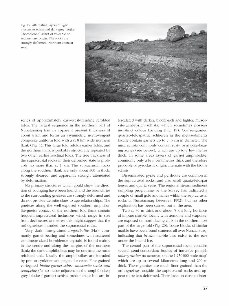
Fig. 19. Alternating layers of light muscovite schist and dark grey biotite (-hornblende) schist of volcanic or sedimentary origin. The rocks are strongly deformed. Northern Nunatar-suaq.

28
nal hinge zones may suggest that they were intruded during a phase of folding that predated the 8 km an-tiform structure.
In south-eastern Nunatarsuaq there are several, up to about 1 km wide, exposures of supracrustal rocks, mainly schist and garnet-bearing paragneiss but also agmatised amphibolite. The paragneiss exposures are associated with numerous small bodies and veins of white garnet-bearing granitoid rocks that appear to be partial melt products of the paragneiss.
In summary, the supracrustal rocks in the Nunatar-
suaq domain differ from those north and south of Tor-sukattak in several ways. The succession is dominated by intermediate biotite-rich quartzo-feldspathic rocks, and also contains two c. 30 m thick horizons of impure marble. Mafi c metavolcanic rocks are subordinate and ultrabasic rocks absent. The concentration of arsenic in stream sediment is low (Steenfelt 1992), and no signs of major volcanic exhalative activity have been observed. The general character of the Nunatarsuaq supracrustal rocks may suggest a platform or intracra-tonic basin type of setting.
Fig. 20. North-facing cliff face above the ice margin in northern Nunatarsuaq, showing a variegated series of supra-crustal rocks. The two white layers consist of tremolite-bearing marble. The cliff is about 200 m high.
Fig. 21. Basal unconformity and the Proterozoic Anap nunâ Group in south-eastern Anap Nunaa, looking east. Right, with person: Archaean acid metavolcanic rocks. Valley bottom: rubble of basal quartzite and pink marble of the Anap nunâ Group, obscuring the basal unconformity. Lower slope: impure marble succeeded by ultramafi c lamprophyric extrusive rocks (including the white bed). The white bed is 1–3 m thick. Upper slope: sandstones and siltstones. Far distance: pink albitised sediments.

29
Proterozoic platform sediments and intrusive rocks
Anap nunâ Group
Proterozoic tidal fl at and mostly shallow water, pre-sumably marine sediments form an arcuate belt south of Torsukattak on Qeqertakassak, Anap Nunaa and Qapiarfi it. Outcrops also occur on Nunataq and Ar-fi usaq east and south-east of the head of Torsukattak. At Qapiarfi it the sediments strike NW and dip 25–40° NE. On the island Qeqertakassak and at Anap Nunaa they have a general east–west trend and are folded into a series of upright, open to tight folds; the intensity of deformation increases towards the north and west. The sediments are collectively known as the Anap nunâ Group (Escher & Burri 1967). The Anap nunâ Group originally also comprised the Archaean supracrustal rocks around Torsukattak, since Escher & Burri (1967) were not able to distinguish the two age groups from each other. The sediments of the Anap nunâ Group are partially recrystallised, but unmetamorphosed or only weakly metamorphosed. The lower part has been subject to pervasive albitisation, which was studied on Qeqertakassak by Kalsbeek (1992; see p. 32).
The Anap nunâ Group was deposited on Archaean supracrustal rocks, and the basal unconformity is ex-posed on Anap Nunaa (Fig. 21), Qapiarfi it and Nunataq. In all three areas thick sequences of silt- and sandstones form the bulk of the sediments; the total thickness of the Anap nunâ Group is at least about 3600 m, but possibly considerably more if the deposits on Arfi usaq
form a direct continuation of those on Qapiarfi it. On Anap Nunaa a less than 30 m thick basal quartzite rests on sheared acid metavolcanic rocks and metabasic rocks; on Qapiarfi it a polymict conglomerate with mar-ble clasts rests on Archaean greenstones (Fig. 22).
At Anap Nunaa the Proterozoic sediments have a minimum thickness of 2500 m; they were described by Andersen (1991). The degree of deformation var-ies considerably, but exposure is generally good and the lower 530 m of the succession show a large lateral continuity of the sedimentary units. A basal shallow marine, clastic quartzitic unit is overlain by 50 m of cream to pink coloured marble (marble, m), interpreted as sub- to supratidal deposits in a normal to hypersa-line environment (Andersen 1991). The interpretation is based on the presence of oolites, teepee-structures and algal laminae as well as chicken-wire structures indicating the precipitation of nodular anhydrite. The marble is succeeded by c. 350 m of mainly clastic, het-erolithic sediments characterised by wave-ripples and desiccation cracks interpreted as tidal deposits (Fig. 23). These shallow water deposits are abruptly overlain by deeper water clastic sediments. According to Andersen (1991), siltstones and fi ne-grained sandstones (siltstone and sandstone, fs and ms) with a total thickness of c. 2000 m constitute an overall shallowing succession of turbidites, terminated by inner-shelf storm-depos-its characterised by hummocky cross-stratifi cation (sandstone, s).
The sediments at Arfi usaq, which may represent the uppermost preserved part of the Anap nunâ Group, consist of cross-bedded sandstone with local intrafor-
Fig. 22. Sheared unconformity (along the river) between Archaean greenstone (left) and Proterozoic marble conglomer-ate (centre right) overlain by dark sandstones and siltstones of the Anap nunâ Group on Qapiarfi it. Width of outcrop at middle distance c. 200 m.

30
mational conglomerate beds containing angular siltstone fragments of local origin (Fig. 24).
On Nunataq sedimentary rocks of presumed Protero-zoic age form a thin, isoclinally folded greenschist facies sequence of quartzite (q), marble (m) and metapelite (mp) (Fig. 25). They overlie Archaean supracrustal rocks (Higgins & Soper 1999, this volume) and are considered by these and the present authors to belong to the lowest part of the Anap nunâ Group.
Proterozoic marble on northern Nuussuaq
An up to c. 350 m thick, isoclinally folded marble body (marble, m) with two showings of sphalerite minerali-sation and a very complex internal structure occurs at Kanaakip Aaffaa in northern Nuussuaq within Archaean orthogneisses (Fig. 26). A couple of thinner marble horizons with local mineralisation lie in the gneisses between Kanaakip Aaffaa and the north coast of Nu-ussuaq. The marble at Kanaakip Aaffaa is shown on the geological map at scale 1:500 000 (Escher & Burri 1967; Escher 1971), but no descriptions from that time have been published. Economic and structural aspects of the marble have been discussed in unpublished company reports (King 1983; Della Valle & Denton 1991) and by Garde & Thomassen (1990). The marble has several characteristics which closely resemble the Proterozoic Mârmorilik Formation in the Uummannaq district (Garde 1978): it consists of both tremolite-bearing dolomite marble and calcite marble, contains
Fig. 23. Siltstone of the Anap nunâ Group with ripple marks and desicca-tion cracks, indicating intertidal or shallow water environment. Central Qeqertakassak west of Anap Nunaa.
Fig. 24. Sandstone and intraformational conglomerate with angu-lar clasts of siltstone. Anap nunâ Group, Arfi usaq nunatak.

31
quartzitic and semipelitic horizons, and hosts sphaler-ite mineralisation. Furthermore, its structural setting as an isoclinally folded body tectonically interleaved with Archaean gneisses is also similar (Pulvertaft 1986; Henderson & Pulvertaft 1987). It is therefore believed that the marble occurrences in northern Nuussuaq are Proterozoic and belong to the Mârmorilik Formation.
Basic dykes and sills
Basic dykes and sills (μ) occur around Paakitsoq (Escher et al. 1999, this volume), on Nunatarsuaq, and particu-
larly in the south-western and north-eastern parts of the Nuussuaq basement (dolerite dykes and sills, δ); fl at-lying to inclined sills are most common. The sills can be quite thick, up to 200 m, and the thicker ones are commonly differentiated with olivine-rich ultraba-sic bases. Sills on Nuussuaq locally have variable and steeper dips, but it is not always clear if this is a pri-mary feature or due to folding. At least some of them have been sheared and folded, and examples from the north coast of Nuussuaq can be seen on Fig. 2 and in Garde (1992, fi gs 2–3). Also the sills in the south-west-ern part of Nuussuaq are variably folded and sheared; a sill at Sanningasoq is affected by open folding and
Fig. 25. Steeply inclined overturned Proterozoic marble (light, middle distance) in contact with Archaean mica schist and amphibolite (far distance) on Nunataq. Width of outcrop at middle distance c. 100 m.
Fig. 26. Isoclinally folded marble (subhorizontal fold axis plunging SE) of presumed Proterozoic age, bounded by Archaean orthogneiss. Locality 15 km north-west of Saqqap Tasersua in northern Nuussuaq. View towards north-west from helicopter. Height of cliffs about 500 m.

32
has strongly sheared margins, but the centre is almost undeformed with its igneous texture preserved. An-other, c. 50 m thick sill in that area (see Garde & Steen-felt 1999, fi g. 9, this volume) appears from a distance to form a recumbent isoclinal fold, but the supposed hinge zone was not inspected at close hand. The dif-ferentiated sills and their geological setting resemble the descriptions by Schiøtte (1988) of deformed Archaean or early Proterozoic metabasites in the Uummannaq district which predate the main event of Rinkian re-cumbent folding.
North-east of the embayment Ilorleeraq at the south coast of Nuussuaq there is a group of NW-trending dol-erite dykes, for which we propose the name Ilorleeraq dykes. The dykes, which are not suffi ciently numerous to form a real swarm, are very thin, normally less than 10 m thick. Some of the dykes are variably deformed and metamorphosed (see below), but others are un-deformed, have sharp contacts to the orthogneisses that host them, and 10–20 cm thick chilled margins. The Ilorleeraq dykes have therefore intruded cold and stable crust, and are presumably Proterozoic in age. The Ilorleeraq dykes are described in more detail by Garde & Steenfelt (1999, this volume).
Medium- to coarse-grained gabbroic sills, which are undeformed and undifferentiated, have intruded the Anap nunâ Group on Anap Nunaa, Nunataq, Qapiarfi it and at the western end of Qeqertakassak. The sills are generally subparallel to bedding, dipping 20–40°.
Undeformed dolerite dykes (δ) of proven or pre-sumed Proterozoic age also occur in the region. The most prominent one is a 400 km long, NNW–SSE-trending, 1645 Ma old dolerite dyke described by Kalsbeek & Taylor (1986), which cuts the eastern part of Nuussuaq and the gneisses east of Disko Bugt. NW-trending dykes are common in the area north-east of Ilulissat.
Albitisation
Both on Qeqertakassak, Anap Nunaa and Qapiarfi it the clastic quartzo-feldspathic rocks in the lower part of the Anap nunâ Group have been partially or com-pletely altered to massive, very fi ne-grained, pinkish yellow albitites, which are locally cut by narrow verti-cal carbonate veins. They are shown on the map as albitised sandstone and siltstone (αs). Kalsbeek (1992) studied the chemistry of the albitised rocks on Qeqer-takassak in detail and showed that their composition has been substantially altered. All primary sedimen-
tary structures have been obliterated in the albitised rocks, which frequently contain scattered, few millime-tres large dolomite and pyrite crystals that leave char-acteristic vugs on weathered surfaces. The albitisation is transgressive with respect to the east–west-trending folds on Qeqertakassak and Anap Nunaa and has af-fected an undeformed mafi c dyke (Kalsbeek 1992; a colour photograph of the altered dyke was shown by Kalsbeek & Christiansen 1992). This shows that the albi-tisation postdates the regional Proterozoic deformation, which is also supported by isotopic age data reported by Kalsbeek & Taylor (1999, this volume). Nevertheless, the large lateral extent of the alteration and its confi ne-ment to the lower part of the sedimentary sequence indicate that the alteration process has exploited the physical properties of the sediments.
Albitisation has also affected Archaean orthogneisses north of Paakitsoq (Ryan & Escher 1999, this volume). In some cases the albitisation follows late north-west-trending faults.
Lamprophyres and lamproites
The area south of Torsukattak contains at least two age groups of Proterozoic lamprophyres and lamproites; fi eld evidence and age determinations by Larsen & Rex (1992) and Rasmussen & Holm (1999, this volume) indicate that the younger group is around 1750 Ma old. The known occurrences were all discovered during the Disko Bugt Project, and it seems likely that more could be found by a systematic effort.
The younger group, which essentially post-dates Prot-erozoic deformation, comprises a lamproite stock dated at 1743 ± 70 and 1764 ± 24 Ma (phlogopite K-Ar ages, Larsen & Rex 1992; Rasmussen & Holm 1999, this vol-ume) and several ultramafi c lamprophyric dykes (1782 ± 70 Ma, Larsen & Rex 1992). The 1750 Ma lamproite was described by Skjernaa (1992). It forms a c. 40 × 65 m large stock with ellipsoidal phlogopite nodules, and occurs at Oqaatsunnguit near Ataa Sund; a nearby satellite exposure measures 15 × 25 m. Marker & Knud-sen (1989) described an east–west-trending swarm of decimetre- to metre-thick ultramafi c lamprophyre dykes south and west of Eqi. Subsequent fi eld work in 1989 and 1991 revealed that such dykes are also common on the mainland further west and in the central part of Arveprinsen Ejland, mostly trending east–west but also with other directions; some are fl at-lying and exploit existing shear zones. In the southern part of Arveprin-sen Ejland Grocott & Davies (1999, this volume) lo-

33
cated a c. 1 km long, north-north-east-trending ultra-mafi c lamprophyre. On the small island Qeqertaa in Kangerluarsuk the authors found an up to 5 m thick dyke with jumbled olivine nodules and large corroded orthopyroxene crystals (Fig. 27) which are probably of mantle origin (L.M. Larsen, personal communica-tion 1989).
The older group occurs on southern Anap Nunaa. Thomsen (1991) described an occurrence of ultrama-fi c lamprophyre with olivine and magnetite nodules, which forms a more or less conformable band along the marble in the basal part of the Anap nunâ Group (Fig. 21). A possible discordance to the Proterozoic deposits occurs in a cliff c. 1.5 km north-west of the main, apparently conformable lamprophyre exposure, which might indicate that the lamprophyre in the north-western exposure is a sill. However, thrusting along the lamprophyre horizon has obscured the contact relationships, and the apparent discordance may not be real. The lamprophyre locally contains textures and stratifi cation reminiscent of pyroclastic rocks, and the interpretation is favoured that the ultramafi c lampro-phyre in both localities is a volcanic surface deposit. The stratifi ed lamprophyre has been cut by a c. 80 cm thick carbonate-rich lamprophyre dykelet.
Thomsen (1991) also found two lozenge-shaped plugs of ultramafi c lamprophyre with similar olivine and magnetite nodules which have intruded the Ar-chaean acid metavolcanic rocks south of the Anap nunâ Group.
Structural and metamorphic evolution
The following outline of the Precambrian structural and metamorphic history between Qarajaq Isfjord and Jakobshavn Isfjord is mainly based on: (1) geological reconnaissance on Nuussuaq and in the area south of Paakitsoq by the authors, and in the Ataa area by Knudsen et al. (1988), (2) studies of the Atâ tonalite complex and the Nunataq area (Higgins & Soper 1999; Kalsbeek & Skjernaa 1999, both in this volume), (3) geological mapping at scale 1:100 000 south of the Atâ tonalite (Escher et al. 1999, this volume), and (4) a detailed structural investigation of the southern part of Arveprinsen Ejland by Grocott & Davies (1999, this volume). In addition, hornblende K-Ar ages from sam-ples collected in the whole region (Rasmussen & Holm 1999, this volume) have provided information about the timing of thermal events.
The region between Qarajaq Isfjord and Jakobshavn Isfjord is located in the boundary zone between the previously established Rinkian and Nagssugtoqidian orogenic belts to the north and south (e.g. Grocott & Pulvertaft 1990; Kalsbeek et al. 1987). Substantial evi-dence is now available that at least the northern part of the region has been affected by strong Proterozoic structural and thermal reworking (Garde & Steenfelt 1999; Higgins & Soper 1999, both in this volume). However, fi eld criteria which might serve to separate Archaean and Proterozoic tectonic events are scarce, and apart from the above mentioned hornblende K-Ar study no isotopic ages have so far been obtained from Nuussuaq. At any rate it is diffi cult to establish the age of a tectonic event per se with currently available iso-
Fig. 27. Nodular ultramafi c lamprophyre with large corroded crystals of magne-sium-rich orthopyroxene. Central part of the island Qeqertaa in Kangerluarsuk.
34
topic methods. The conclusions presented in the follow-ing may therefore have to be revised in the future.
Based on variations in the structural and metamor-phic history in different parts of the region we have distinguished four tectono-metamorphic domains, the Nuussuaq, Ataa, Rodebay and Nunatarsuaq domains (Fig. 1; index map in Garde 1994), which are described below.
Nuussuaq domain
Garde & Steenfelt (1999, this volume) present evidence that the Nuussuaq domain has been subjected to sub-stantial Proterozoic reworking and discuss its boundary relationships along the fjord Torsukattak (Fig. 1) to the Ataa domain which was much less affected by Prot-erozoic deformation. In the following we highlight the evidence that a major part of the present structure of Nuussuaq was acquired during the early Proterozoic.
As described earlier in this paper, the Nuussuaq domain consists of Archaean amphibolite facies or-thogneisses, sequences of Archaean continental margin supracrustal rocks (probably deposited on a basement of Nuussuaq gneisses), inclusions of variable size of amphibolite and metasediments, and kilometre-scale tectonic slices and smaller enclaves of a layered anorthosite-gabbro complex. Repeated and intense deformation, which we presume is Proterozoic, resulted in general fl at-lying structures in northern Nuussuaq (Garde 1992), a series of kilometre-scale, NW–SE-trend-ing upright folds, and several shear zones. The upright NW–SE-trending folds and the likewise NW–SE-trending Puiattup Qaqqaa shear zone were formed during crustal shortening, and were succeeded by development of the ENE–WSW-trending Torsukattak shear zone during an episode of crustal extension. The fl at-lying structure and major thrusts in the northern part of the Nuussuaq domain have much in common with the structural style of the Uummannaq district to the north. Extensive reset-ting of hornblende K-Ar isotope systematics (Rasmussen & Holm 1999, this volume) shows that the Nuussuaq basement reached amphibolite facies metamorphism in the early Proterozoic.
Evidence for Proterozoic deformation in Nuussuaq and on NunataqCalcite and dolomite marble with zinc mineralisation, and adjacent semipelitic metasediments form a major recumbent fold embedded in orthogneisses north-west of Saqqap Tasersua in central Nuussuaq (Fig. 26). Sev-eral other tectonic slices of marble associated with clas-tic sediments occur farther north. These rocks are con-sidered to belong to the early Proterozoic Mârmorilik Formation (Garde & Thomassen 1990) and show that major thrusting and isoclinal folding of Proterozoic age took place in the north-western part of the Nu-ussuaq basement, involving both orthogneisses and cover rocks. Local development of calc-silicate minerals like tremolite and diopside in the marble support the evidence from hornblende K-Ar isotope systematics that lower amphibolite facies metamorphic conditions were reached in central Nuussuaq during the early Proterozoic.
Also Nunataq at the south-eastern end of the Nuus-suaq basement provides evidence of Proterozoic de-formation (see also Higgins & Soper 1999, this volume). Nunataq contains isoclinally folded Proterozoic meta-sedimentary rocks which are part of the Anap nunâ Group. Proterozoic marker horizons such as metasedi-ment similar to the Mârmorilik Formation or Anap nunâ Group have so far not been found in other parts of Nuussuaq. However, east or south-east-trending tight to isoclinal fold systems overprinting earlier fold struc-tures, as well as late fl at-lying shear zones and thrusts, can be recognised in most parts of Nuussuaq.
Both the Ilorleeraq dykes west of Boye Sø and a group of basic sills in central Nuussuaq were emplaced into stabilised Archaean crust and subsequently de-formed, and the Ilorleeraq dykes are also metamor-phosed with new growth of hornblende. The sills have generally preserved magmatic textures in their interior parts but have developed new cleavage at their mar-gins, and the orthogneiss hosts adjacent to the sills are commonly strongly sheared. Some of these sills ap-pear to have been folded. An isoclinally folded basic sill was observed at the north coast of Nuussuaq (Garde 1992), and similar, isoclinally folded metabasic sills were described by Schiøtte (1988) from the southern part of the Uummannaq district; the latter sills cut the Archaean orthogneiss but predate the main episode of Proterozoic isoclinal folding. We consider that the basic sills in Nuussuaq (and also those in the central part of the Rodebay domain, p. 36) are likely to be of early Proterozoic age.

35
Shear zones in southern Nuussuaq and the boundary between the Nuussuaq and Ataa domainsThe Puiattup Qaqqaa shear zone (Garde & Steenfelt 1999, this volume) is a prominent NW–SE-trending synformal zone of highly strained rocks in the south-eastern part of Nuussuaq, which comprises a tectonic mélange of Archaean supracrustal and infracrustal rocks. The shear zone is probably Proterozoic and contemporaneous with the system of NW–SE-trend-ing folds in Nuussuaq. In the south-eastern end of the shear zone its two margins diverge in opposite directions towards Torsukattak like an inverted Y until they have a common ENE–WSW trend along the fjord (Garde & Steenfelt 1999, fi g. 2, this volume), and an intense SE-plunging stretching lineation is developed. These structures are interpreted in terms of later deformation in a second ductile shear zone located along Torsukattak, in which the main sense of displace-ment was parallel to the extension lineation with oblique south-east downthrow of the southern side (see Garde & Steenfelt 1999, fi g. 10, this volume). This interpreta-tion is supported by structural evidence from Nunataq and the northernmost part of the Ataa domain, and also provides an explanation of the contrast in meta-morphic grade observed across Torsukattak.
Ataa domain
The Ataa domain in the central part of the Disko Bugt – Nuussuaq region (Fig. 1) consists of a little to moderately deformed Archaean granite-greenstone terrain, namely the Arveprinsen–Eqi supracrustal rocks (forming a large synclinal cusp in the west and an in-verted sequence in the east) and the Atâ tonalite that intrudes them. The Archaean rocks are overlain by an unconformable, about 10 km wide belt of Proterozoic epicontinental sedimentary rocks. Part of the Ataa do-main has been subject to weak Proterozoic structural and metamorphic reworking which increases towards the north, but the local retention of Archaean K-Ar and Ar-Ar hornblende ages (Rasmussen & Holm 1999, this volume) shows that the Ataa domain to a large extent has escaped the Proterozoic metamorphic (and structural) overprinting that affected the other parts of the region.
The Proterozoic sedimentary rocks contain open up-right folds, sometimes associated with internal thrusts.However, much of the Archaean basement south of
the Anap nunâ Group hardly appears to have been af-fected by Proterozoic metamorphism or deformation, or indeed Archaean deformation post-dating the intrusion of the Atâ tonalite (Kalsbeek et al. 1988).
This fact formed the basis for the original identifi ca-tion of the ‘Atâ granite’ by Escher & Burri (1967). It has already been mentioned that a distinct foliation can commonly be observed along the margins of the Atâ tonalite parallel to the greenstone contacts; the foliation is thought to have developed during late stages of the emplacement of the complex (Kalsbeek & Skjernaa 1999, this volume). We have tentatively placed the southern margin of the Ataa domain at the southern boundary of the Atâ tonalite, which occurs in the central part of Arveprinsen Ejland and north of Kangerluarsuk where the granitoid rocks begin to contain fl at-lying shear zones. The arbitrary nature of this domain boundary was discussed previously in the section describing the Atâ tonalite.
The supracrustal rocks on Qapiarfi it and Eqi contain several roughly north–south-trending, east-dipping thrusts. One of these appears to be truncated by the Proterozoic unconformity on Qapiarfi it (Fig. 22), and can be followed about 10 km southwards from Eqi into the orthogneisses. This thrust (and perhaps also others with similar orientations in the same area) is therefore most likely of Archaean age.
Proterozoic deformation in the Ataa domainBoth on Anap Nunaa and Qapiarfi it some shearing has occurred along the basal unconformity of the Anap nunâ Group, and the sedimentary sequences have been tilted c. 30° towards the NNE and NE respectively in the two areas. On Anap Nunaa and Qeqertakassak a series of approximately E–W-trending, open, non-cylindrical, upright to overturned folds with local thrusts along axial surfaces were formed (Andersen 1991; Kalsbeek 1992; Higgins & Soper 1999, this volume). The sediments on Qapiarfi it are not folded.
There is an apparent structural gap between the steep north-east-trending Archaean greenstones on Arveprinsen Ejland and the east–west-trending, variably dipping Proterozoic sediments on Qeqertakassak. This gap may constitute a Proterozoic shear zone, continu-ing eastwards along strongly sheared Archaean rocks along the peninsula Saattut on southern Anap Nunaa and perhaps even further south-east to the sheared unconformity on Qapiarfi it.

36
As already mentioned, Proterozoic deformation in the northern part of the Ataa domain generally increases towards Torsukattak. In northern Anap Nunaa delicate sedimentary structures (which are common elsewhere on the peninsula) have been destroyed, and close to the north coast a new north- to north-east-dipping axial plane cleavage was formed. Along the north coast of Oqaatsut and Arveprinsen Ejland a steep east–west cleavage and local small-folds with E–W-trending axes have been observed (Knudsen et al. 1988; H. Rasmus-sen, personal communication 1992) which could also be Proterozoic in age. These features are considered to provide supporting evidence for the proposed ductile shear zone along Torsukattak (Garde & Steenfelt 1999, this volume).
Rodebay domain
The Rodebay domain, which extends from south of the Atâ tonalite to Jakobshavn Isfjord, consists of Archaean orthogneisses with scattered layers and enclaves of supracrustal rocks (mainly banded amphibolite) that might be equivalents of the greenstones in the Ataa domain. Its northern part has been mapped by Escher et al. (1999, this volume). Contrary to the Ataa domain the Rodebay domain appears to have suffered moderate to strong deformation in the Archaean and presumably also in the early Proterozoic, when amphibolite facies metamorphic conditions were reached (Rasmussen & Holm 1999, this volume).
On Arveprinsen Ejland a series of low-angle ductile shear zones, which structurally underlie the Atâ tonalite, dip north and south in the central and southern parts
of the island, respectively, and have been folded by a large open WNW-trending antiform (Grocott & Davies 1999, this volume). Upright folding with NE-trending axial surfaces followed in the southern part of the is-land, and right-lateral ductile displacements occurred along narrow near-vertical zones. The latest recognised phase of folding has E–W axial surfaces, was contem-poraneous with injection of ultramafi c lamprophyres (Grocott & Davies 1999, this volume), and was perhaps restricted to their immediate surroundings.
On the mainland between 69°30′ and 69°45N′ layers and enclaves of amphibolite delineate early (apparently Archaean) tight to isoclinal folds at scales of one to two kilometres. A fold of similar aspect in south-eastern Arveprinsen Ejland may likewise be Archaean. These folds are superimposed by south-vergent folds with east-plunging axial surfaces. The relationship between the folds and the Archaean shear zone that extends southwards into the orthogneisses from the supracrustal rocks at Eqi is not known with certainty.
Like Arveprinsen Ejland, the mainland also contains a number of fl at-lying ductile shear zones with vari-able, generally easterly strike directions (Escher et al. 1999, this volume). Whereas there is at present no clear evidence regarding the age of fl at-lying shear zones on Arveprinsen Ejland, at least some of those on the mainland are likely to be Proterozoic because they affect the basaltic to picritic sills in the vicinity of Paakitsoq (described above). Both these sills and those in central Nuussuaq are thought to be of Proterozoic age, like similar sills in the Uummannaq district (Schiøtte 1988). Some of the contact zones between the sills and their host gneisses are strongly sheared and the sills themselves are sometimes boudinaged along the
Fig. 28. Low-angle Proterozoic ductile shear zones in Archaean orthogneisses in a 250 m high, south-facing cliff north of Paakitsoq.

37
shear zones as can be seen on a 250 m high cliff face about 2.5 km north-east of Berggren Havn (Fig. 28; see also Escher et al. 1999, this volume). At least one episode of ductile shearing thus took place after the intrusion of the basic sills, probably in the early Pro-terozoic. Also towards the south-eastern boundary of the Rodebay domain there are several fl at-lying shear zones, in which σ- and δ-shaped feldspar porphyro-clasts indicate transport of the hanging wall in northerly directions.
A prominent late, vertical, ESE–WNW-trending ductile shear zone with shallow easterly-plunging stretching lineation occurs along Paakitsoq (Fig. 29; see also Knudsen et al. 1988, and Escher et al. 1999, this volume). It is superimposed by brittle faulting. The Paakitsoq shear zone was previously designated by Escher & Pulvertaft (1976) as the boundary between the Rinkian and Nagssugtoqidian mobile belts. Several faults in the southern part of Paakitsup Nunaa follow approximately the same direction as the Paakitsoq shear zone, and a couple of NE-trending, SE-dipping shear zones occur along the south-eastern margin of the Rodebay domain.
Nunatarsuaq domain
The reason for the designation of the Nunatarsuaq peninsula to a separate domain is the fact that neither large structures nor supracrustal and orthogneiss litholo-gies on Nunatarsuaq can be correlated across the fjord
Sikuiuitsoq to the Rodebay domain. Nunatarsuaq with its common mica schists, orthogneisses of intermediate composition and large isoclinal folds (see below) seems to have more in common with the poorly known area south of Jakobshavn Isfjord than with the Rodebay domain. It is therefore likely that a signifi cant structural boundary occurs in the fjord Sikuiuitsoq, which contains a north-east-trending zone of strongly sheared rocks along its western coast.
The most prominent structure in Nunatarsuaq is the large, multiply folded isocline outlined by steeply dip-ping, ENE-trending mica-garnet schists and amphibo-lites in the northern part of the peninsula. Measured fold axes and mineral lineations plunge 15–60° in directions around c. 80°. Another, east–west-trending isoclinal fold of smaller dimensions with a north-dipping axial surface
occurs in the south-eastern part of the area.
The investigation of the region between Qarajaq Isfjord and Jakobshavn Isfjord during the Disko Bugt Project has produced several important geological results.
The existence of two different supracrustal groups in the central part of the region suggested by Kalsbeek et al. (1988) was fi rmly established: the Archaean Saqqaq, Itilliarsuk and Arveprinsen–Eqi supracrustal sequences (Garde et al. 1999; Rasmussen & Pedersen 1999; Marshall & Schønwandt 1999; Stendal et al. 1999, all in this volume), and the early Proterozoic Anap
Fig. 29. Stretched, cigar-shaped ultrama-fi c enclaves with south-easterly plunge in granitoid rocks with strong LS fabric. Locality east of Paakitsoq.

38
nunâ Group. Substantial knowledge was attained about the lithologies, depositional environments, structure and economic potential of both groups. Two new types of Archaean gold mineralisation were discovered, one associated with alteration processes in a felsic dome complex east of Eqi (Stendal et al. 1999, this volume), the other in a more than 3 km long volcanogenic-ex-halative horizon near Saqqaq (Garde et al. 1999, this volume).
Helicopter reconnaissance in the interior parts of eastern Nuussuaq, which were virtually unknown prior to the Project, led to the discovery of the large Boye Sø anorthosite complex and the establishment of two major units of orthogneiss in northern Nuussuaq. Besides, new information was gathered about major Proterozoic deformation in Nuussuaq and on Nunataq, and about a fl at-lying Proterozoic structure along Qarajaq Isfjord. Furthermore, the importance of Proterozoic ductile thrusting south of the Atâ tonalite was documented by Escher et al. (1999) and Grocott & Davies (1999, both in this volume).
New information about geochemistry, structure and isotopic ages was obtained from the Archaean orthog-neisses in the remainder of the region; in particular, the Atâ tonalite around Ataa Sund was investigated in detail (Kalsbeek & Skjernaa 1999, this volume).
Widespread but previously unknown Proterozoic albitisation was studied in the lower part of the Anap nunâ Group (Kalsbeek 1992) and around Paakitsoq (Ryan & Escher 1999, this volume), and a new province of lamprophyric and lamproitic rocks with an age of c. 1750 Ma was discovered (Marker & Knudsen 1989), including a spectacular ultramafi c fl ow with magnetite nodules (Thomsen 1991), the Oqaatsunnguit lamproite stock with rounded phlogopite aggregates (Skjernaa 1992), and lamproitic dykes with olivine-rich nodules of presumed mantle origin.
Acknowledgements
Many participants in the Disko Bugt Project have helped us during the fi eld work and contributed with knowl-edge and comments during preparation of this paper. In particular we wish to thank F. Kalsbeek (Geological Survey of Denmark and Greenland), for numerous dis-cussions, many of which took place on key localities in the region. We also thank N.J. Soper (Barnsley, UK) for a constructive review, and G.K. Pedersen (Geological Institute, University of Copenhagen), for help with the section on Proterozoic sediments.
ReferencesAndersen, J. 1991: Tidlig proterozoisk rift-relateret sedimentation
og post-sedimentær deformation. Anap Nunâ, Diskobugten, Vestgrønland, 73 pp. Unpublished cand. scient. thesis, Køben-havns Universitet, Danmark.
Della Valle, G. & Denton, P. 1991: Geological report on the 1990 zinc and lead exploration programme in central Nûgssuaq peninsula, Maarmorilik Formation, West Greenland, 17 pp. Unpublished report, Intergeo-Exploration (in archives of Geological Survey of Denmark and Greenland).
Dueholm, K.S. 1992: Geologic photogrammetry using standard small-frame cameras. In: Dueholm, K.S. & Pedersen, A.K. (eds): Geological analysis and mapping using multi-model photogrammetry. Rapport Grønlands Geologiske Under-søgelse 156, 7–17.
Dueholm, K.S., Garde, A.A. & Pedersen, A.K. 1993: Preparation of accurate geological and structural maps, cross-sections or block diagrams from colour slides, using multi-model photo-grammetry. Journal of Structural Geology 15, 933–937.
Escher, A. 1971: Geological map of Greenland, 1:500 000, Søn-dre Strømfjord – Nûgssuaq, sheet 3. Copenhagen: Geological Survey of Greenland.
Escher, A. & Burri, M. 1967: Stratigraphy and structural devel-opment of the Precambrian rocks in the area north-east of Disko Bugt, West Greenland. Rapport Grønlands Geologiske Undersøgelse 13, 28 pp.
Escher, A. & Pulvertaft, T.C.R. 1976: Rinkian mobile belt of West Greenland. In: Escher, A. & Watt, W.S. (eds): Geology of Greenland, 104–119. Copenhagen: Geological Survey of Greenland.
Escher, J.C. 1995: Geological map of Greenland, 1:100 000, Ataa 69 V.3 Nord. Copenhagen: Geological Survey of Greenland.
Escher, J.C., Ryan, M.J. & Marker, M. 1999: Early Proterozoic thrust tectonics east of Ataa Sund, north-east Disko Bugt, West Greenland. In: Kalsbeek, F. (ed.): Precambrian geology of the Disko Bugt region, West Greenland. Geology of Greenland Survey Bulletin 181, 171–179 (this volume).
Garde, A.A. 1978: The Lower Proterozoic Marmorilik Formation, east of Mârmorilik, West Greenland. Meddelelser om Grønland 200(3), 71 pp.
Garde, A.A. 1992: Interpretation of fl at-lying Precambrian struc-ture by geological photogrammetry along a 65 km coastal profi le in Nuussuaq, West Greenland. In: Dueholm, K.S. & Pedersen, A.K. (eds): Geological analysis and mapping using multi-model photogrammetry. Rapport Grønlands Geologiske Undersøgelse 156, 35–40.
Garde, A.A. 1994: Precambrian geology between Qarajaq Isfjord and Jakobshavn Isfjord, West Greenland,1:250 000. Copenha-gen: Geological Survey of Greenland.
Garde, A.A. & Steenfelt, A. 1989: A new anorthosite/gabbro com-plex at Nûgssuaq, central West Greenland. Rapport Grønlands Geologiske Undersøgelse 145, 16–20.
Garde A.A. & Steenfelt, A. 1999: Proterozoic tectonic overprint-ing of Archaean gneisses in Nuussuaq, West Greenland. In: Kalsbeek, F. (ed.): Precambrian geology of the Disko Bugt

39
region, West Greenland. Geology of Greenland Survey Bulletin 181, 141–154 (this volume).
Garde, A.A. & Thomassen, B. 1990: Structural and economic aspects of the Proterozoic marble on Nûgssuaq, West Green-land. Open File Series Grønlands Geologiske Undersøgelse 90/6, 14 pp.
Garde, A.A., Kalsbeek, F., Marker, M. & Schønwandt, H.K. 1991: Archaean supracrustal rocks at different crustal levels in West Greenland, and their metallogeny. Terra Abstracts 3, 194 only.
Garde, A.A., Thomassen, B., Tukiainen, T. & Steenfelt, A. 1999: A gold-bearing volcanogenic-exhalative horizon in the Ar-chaean(?) Saqqaq supracrustal rocks, Nuussuaq, West Green-land. In: Kalsbeek, F. (ed.): Precambrian geology of the Disko Bugt region, West Greenland. Geology of Greenland Survey Bulletin 181, 119–128 (this volume).
Gothenborg, J. 1983: Report on the ore exploration in the Ata area, Jakobshavn 1982, 49 pp. Unpublished report, Kryolit-selskabet Øresund A/S (in archives of Geological Survey of Denmark and Greenland).
Gothenborg, J. & Morthorst, J. 1981: Report on the ore exploration in the Ata area, Jakobshavn 1981, 88 pp. Unpublished report, Kryolitselskabet Øresund A/S (in archives of Geological Survey of Denmark and Greenland).
Grocott, J. & Davies, S.C. 1999: Deformation at the southern boundary of the late Archaean Atâ tonalite and the extent of Proterozoic reworking of the Disko terrane, West Greenland. In: Kalsbeek, F. (ed.): Precambrian geology of the Disko Bugt region, West Greenland. Geology of Greenland Survey Bulletin 181, 155–169 (this volume).
Grocott, J. & Pulvertaft, T.C.R. 1990: The Early Proterozoic Rinkian belt of central West Greenland. In: Lewry, J.F. & Stauffer, M.R. (eds): The Early Proterozoic Trans-Hudson Orogen of North America. Special Paper Geological Association of Canada 37, 443–463.
Henderson, G. & Pulvertaft, T.C.R. 1987: The lithostratigraphy and structure of a Lower Proterozoic dome and nappe com-plex. Geological map of Greenland, 1:100 000, Mârmorilik 71 V.2 Syd, Nûgâtsiaq 71 V.2 Nord and Pangnertôq 72 V.2 Syd. Descriptive text, 72 pp., 3 maps. Copenhagen: Geological Survey of Greenland.
Higgins, A.K. & Soper, N.J. 1999: The Precambrian supracrustal rocks of Nunataq, north-east Disko Bugt, West Greenland. In: Kalsbeek, F. (ed.): Precambrian geology of the Disko Bugt region, West Greenland. Geology of Greenland Survey Bulletin 181, 79–86 (this volume).
Kalsbeek, F. 1989: GGU’s expedition in the Disko Bugt area, 1988.
Rapport Grønlands Geologiske Undersøgelse 145, 14–16.Kalsbeek, F. 1990: Disko Bugt Project, central West Greenland.
Rapport Grønlands Geologiske Undersøgelse 148, 21–24.Kalsbeek, F. 1992: Large-scale albitisation of siltstones on Qeqer-
takavsak island, northeast Disko Bugt, West Greenland. Chemi-cal Geology 95, 213–233.
Kalsbeek, F. & Christiansen, F.G. 1992: Disko Bugt Project 1991, West Greenland. Rapport Grønlands Geologiske Undersøgelse 155, 36–41.
Kalsbeek, F. & Skjernaa, L. 1999: The Archaean Atâ intrusive complex (Atâ tonalite), north-east Disko Bugt, West Green-
land. In: Kalsbeek, F. (ed.): Precambrian geology of the Disko Bugt region, West Greenland. Geology of Greenland Survey Bulletin 181, 103–112 (this volume).
Kalsbeek, F. & Taylor, P.N. 1986: Chemical and isotopic homo-geneity of a 400 km long basic dyke in central West Green-land. Contributions to Mineralogy and Petrology 93, 439–
448.Kalsbeek, F. & Taylor, P.N. 1999: Review of isotope data for Pre-
cambrian rocks from the Disko Bugt region, West Greenland. In: Kalsbeek, F. (ed.): Precambrian geology of the Disko Bugt region, West Greenland. Geology of Greenland Survey Bulletin 181, 41–47 (this volume).
Kalsbeek, F., Pidgeon, R.T. & Taylor, P.N. 1987: Nagssugtoqid-ian mobile belt of West Greenland: a cryptic 1850 Ma suture between two Archaean continents – chemical and isotopic evidence. Earth and Planetary Science Letters 85, 365–385.
Kalsbeek, F., Taylor, P.N. & Pidgeon, R.T. 1988: Unreworked Archaean basement and Proterozoic supracrustal rocks from northeastern Disko Bugt, West Greenland: implications for the nature of Proterozoic mobile belts in Greenland. Canadian Journal of Earth Sciences 25, 773–782.
King, A.R. 1983: Report on prospecting and correlating pro-gramme in the Maarmorilik Formation, West Greenland 1982, 21 pp. Unpublished report, Greenex A/S (in archives of Geo-logical Survey of Denmark and Greenland).
Knudsen, K., Appel, P.W.U., Hageskov, B. & Skjernaa, L. 1988: Geological reconnaissance in the Precambrian basement of the Atâ area, central West Greenland. Rapport Grønlands Geologiske Undersøgelse 140, 9–17.
Larsen, L.M. & Rex, D.C. 1992: A review of the 2500 Ma span of alkaline-ultramafi c, potassic and carbonatitic magmatism in West Greenland. Lithos 28, 367–402.
Marker, M. & Knudsen, C. 1989: Middle Proterozoic ultramafi c lamprophyre dykes in the Archaean of the Atâ area, central West Greenland. Rapport Grønlands Geologiske Undersøgelse 145, 23–28.
Marshall, B. & Schønwandt, H.K. 1999: An Archaean sill com-plex and associated supracrustal rocks, Arveprinsen Ejland, north-east Disko Bugt, West Greenland. In: Kalsbeek, F. (ed.): Precambrian geology of the Disko Bugt region, West Greenland. Geology of Greenland Survey Bulletin 181, 87–102 (this volume).
Nielsen, A.T. 1992: Geologi, geokemi og tektonisk setting for Andersens mineraliseringen: En vulkansk massiv sulfi dfore-komst i det arkæiske supracrustalbelte, Arveprinsen Ejland, Vestgrønland, 98 pp. Unpublished cand. scient. thesis, Kø-benhavns Universitet, Danmark.
Nutman, A.P. & Kalsbeek, F. 1999: SHRIMP U-Pb zircon ages for Archaean granitoid rocks, Ataa area, north-east Disko Bugt, West Greenland. In: Kalsbeek, F. (ed.): Precambrian geology of the Disko Bugt region, West Greenland. Geology of Greenland Survey Bulletin 181, 49–54 (this volume).
Pulvertaft, T.C.R. 1986: The development of thin thrust sheets and basement-cover sandwiches in the southern part of the Rinkian belt, Umanak district, West Greenland. Rapport Grønlands Geologiske Undersøgelse 128, 75–87.
Rasmussen, H. & Holm, P.M. 1999: Proterozoic thermal activ-
40
ity in the Archaean basement of the Disko Bugt region and eastern Nuussuaq, West Greenland: evidence from K-Ar and 40Ar/39Ar mineral age investigations. In: Kalsbeek, F. (ed.): Precambrian geology of the Disko Bugt region, West Green-land. Geology of Greenland Survey Bulletin 181, 55–64 (this
volume).Rasmussen, H. & Pedersen, L.F. 1999: Stratigraphy, structure and
geochemistry of Archaean supracrustal rocks from Oqaatsut and Naajaat Qaqqaat, north-east Disko Bugt, West Greenland. In: Kalsbeek, F. (ed.): Precambrian geology of the Disko Bugt region, West Greenland. Geology of Greenland Survey Bulletin 181, 65–78 (this volume).
Ryan, M.J. & Escher, J.C. 1999: Albitised gneisses in the area be-tween Paakitsoq and Kangerluarsuk, north-east Disko Bugt, West Greenland. In: Kalsbeek, F. (ed.): Precambrian geology of the Disko Bugt region, West Greenland. Geology of Greenland Survey Bulletin 181, 113–117 (this volume).
Schiøtte, L. 1988: Field occurrence and petrology of deformed metabasite bodies in the Rinkian mobile belt, Umanak district, West Greenland. Rapport Grønlands Geologiske Undersøgelse 141, 36 pp.
Skjernaa, L. 1992: A lamproite stock with ellipsoidal phlogopite nodules at Oqaatsunnguit, Disko Bugt, central West Greenland. Rapport Grønlands Geologiske Undersøgelse 154, 33–47.
Steenfelt, A. 1988: Progress in geochemical mapping of West Greenland. Rapport Grønlands Geologiske Undersøgelse 140, 17–24.
Steenfelt, A. 1992: Gold, arsenic and antimony in stream sediment related to supracrustal units between Arfersiorfi k and Qarajaq Isfjord (68°N to 70°30′N), West Greenland. Open File Series Grønlands Geologiske Undersøgelse 92/4, 11 pp.
Stendal, H., Knudsen, C., Marker, M. & Thomassen, B. 1999: Gold mineralisation at Eqi, north-east Disko Bugt, West Greenland. In: Kalsbeek, F. (ed.): Precambrian geology of the Disko Bugt region, West Greenland. Geology of Greenland Survey Bulletin 181, 129–140 (this volume).
Thomassen, B. & Tukiainen, T. 1992: Gold mineralisation in Pre-cambrian supracrustal rocks on southern Nuussuaq, central West Greenland: 1991 results. Open File Series Grønlands Geologiske Undersøgelse 92/3, 31 pp.
Thomsen, H.S. 1991: Contrasting types of metasomatic alteration in the low-metamorphic Precambrian Anap Nunâ area, West Greenland, 99 pp. Unpublished cand. scient. thesis, University of Copenhagen, Denmark.