Analysis of the Gulf of Mexico's Veracruz-Havana Route of La Flota de la Nueva España
Upload
independentCategory
view
1download
0
Journal of Arid Environments (2001) 47: 47–75doi:10.1006/jare.2000.0691, available online at http://www.idealibrary.com on
Pre-columbian soil erosion, persistent ecologicalchanges, and collapse of a subsistence agricultural
economy in the semi-arid TehuacaH n Valley,Mexico’s ‘Cradle of Maize’
Joseph R. McAuliffe*, Peter C. Sundt-, Alfonso Valiente-Banuet?,Alejandro Casas? & Juan Luis ViverosA
*Desert Botanical Garden, 1201 N. Galvin Pkwy., Phoenix, Arizona 85008,U.S.A.
-Rangeland Consultant, HCO1 Box 5610, Pima, Arizona, 85543, U.S.A.?Instituto de EcolognHa, Universidad Nacional Autonoma de MeHxico (UNAM),
Ap. Postal 70-275, MeHxico 04510, D.F. MeHxicoAInstituto del BiolognHa, UNAM, Ap. Postal 70-614, MeHxico 04510,
D. F. MeHxico
(Received 24 February 1999, accepted 3 August 2000)
The cultivation of hillslopes in pre-Columbian times caused considerable soilerosion in the landscapes of the semi-arid TehuacaH n Valley, south-centralMexico. A very severe episode of erosion of cultivated uplands occurredapproximately 900 years ago in one drainage basin. The magnitude of soilerosion has left behind a degraded landscape with greatly decreased agricul-tural productivity and locally impoverished native flora. Hillslope soils in thebasins studied are highly susceptible to erosion and neither pre-Columbian normodern agricultural practices have proven to be sustainable in these uplandenvironments. Severe soil loss that precedes agricultural collapse and landabandonment may impair the recovery of diverse and productive ecosystemsfor many hundreds to thousands of years, as this is the time required for theformation of a new, substantial soil mantle.
( 2001 Academic Press
Keywords: desertification; maize; Mexico; Quaternary geomorphology; soilerosion; sustainable agriculture; TehuacaH n
Introduction
Severe soil erosion and its multiple environmental and social consequences (Pimentelet al., 1995) are not unique to modern times. Soil erosion caused by agriculturalpractices of ancient societies in both hemispheres has in some cases adversely affec-ted landscapes for millenia after the original damage was done (Fall, 1990; Kohler-Rollefson & Rollefson, 1990; Sandor & Eash, 1991). Syntheses of knowledge fromarchaeology, ecology, geology, and soil science provide a valuable means of understand-ing how past societies have affected their environments and how long these changes
0140}1963/01/010047#29 $35.00/0 ( 2001 Academic Press

48 J. R. MCAULIFFE ET AL.
can persist. Lessons from the past can potentially help prevent repeated episodes ofsimilar environmental damage.
Central Mexico provides an example of an area that supported dense human popula-tions before European colonization, then was severely depopulated; during this centurythe area has again been faced with burgeoning human populations that increasinglystrain the local environments’ capacities to support them. Mainland Mexico, from thedesert regions north of Mexico City to the Isthmus of Tehuantepec, contained anestimated 25)2 million people when HernaH n CorteH z began his overland quest in 1519A.D. (Hassig, 1994). Within decades of the conquest by the Spanish in 1521 A.D., theindigenous population of Mexico was drastically reduced, principally by the ravages ofOld World diseases to which indigenous peoples were immunologically defenseless(Black, 1992). It has been estimated that the indigenous population of Mexico wasreduced by as much as 95% (to just over 1 million persons) by 1600 A.D. (Hassig,1994). Only within the last half-century has Mexico’s population again reached andexceeded that of pre-Conquest times; population sizes for the entire Republic of Mexicoin 1940, 1960, and 1990 were 19)6, 34)9, and 81)1 million, respectively (Parkes, 1970;INEGI, 1991).
There is growing evidence that agricultural use of the landscape by pre-Columbiansocieties in Mexico caused considerable soil erosion. Cook (1949) originally attributedthe eroded appearance of many terrains in central to south-central Mexico to theresidual impacts of pre-Columbian agriculture. A correlation between the severity ofhillslope erosion in several areas that Cook observed in the 1940s and estimated humanpopulation densities in each of those areas before the Spanish Conquest suggesteda causal link between soil erosion and the presumed intensity of agricultural use of thoselandscapes by pre-Columbian populations. Cook (1949) recorded potsherds and otherpre-Columbian cultural artifacts buried beneath and within deep alluvial deposits onbasin floors and concluded that severe erosion of cultivated soils on surroundinghillslopes provided these great volumes of alluvial sediments. However, withoutradiocarbon dating techniques, Cook was unable to definitely ascertain the timing ofthese erosional and depositional events.
Studies of lake sediments (Watts & Bradbury, 1982; Byrne & Horne, 1989; Metcalfeet al., 1991; Goman, 1992; O’Hara et al., 1993) have verified Cook’s original conjecturesabout the magnitude of soil erosion caused by pre-Columbian agriculture in Mexico.Analyses of sediment cores from several lakes in central Mexico indicate that pre-Columbian agriculture apparently caused extensive deforestation and soil losses thatwere as great as the better-known examples of the ecological impacts of classic Mayancultures in lowland tropical forests in Guatemala (Byrne & Horn, 1989; Metcalfe et al.,1991; Goman, 1992; O’Hara et al., 1993). However, these palaeoecological investiga-tions in Mexico have been restricted to relatively few lake basins in sub-humid andhumid zones which supported some of the densest pre-Columbian populations. Little isknown about the environmental impacts of pre-Columbian peoples in the less denselypopulated semi-arid regions of Mexico.
In this paper, we assess some of the long-lasting impacts of pre-Columbian agriculturein two small drainage basins in the TehuacaH n Valley of south-central Mexico. Thisvalley, located 200 km south-east of Mexico City (Fig. 1), is one of the most biologicallyrich semi-arid regions of the western hemisphere. The valley has an area of approxim-ately 10,000 km2, yet, for its small size, has an extremely rich flora. The TehuacaH n Valleyhas a documented flora of 2703 species, 922 genera, and 189 families of vascular plants(DaH vila et al., 1993). Approximately 30% of the vascular plant species of the TehuacaH nValley are endemic to the valley, a level of endemism similar to that of near-shore islands(Smith, 1965). Geographic and climatic isolation of the valley contribute to this highlevel of endemism. Mountain ranges surrounding the valley impede the influx of tropicalmaritime moisture. To the immediate east of the valley, slopes of the southern SierraMadre Oriental facing the Gulf of Mexico receive an annual average precipitation of

Figure 1. Location of the two study site localities (Basins 1 and 2) in the western part of theTehuacaH n Valley. Each drainage basin is outlined with a dotted line. The shaded area withinBasin 1 depicts the approximate area of non-calcareous bedrock surrounding the town of Met-zontla. The site where charcoal samples collected for radiocarbon dating of alluvial deposits in thelowermost part of Basin 1 is depicted with an open triangle. Elevation contour interval"200 m.
THE SEMI-ARID TEHUACAD N VALLEY, MEXICO 49
more than 4000 mm and support tropical rainforest. In contrast, most of the TehuacaH nValley, only 100 km to the south-west, annually receives an average precipitation of400–600 mm principally in the summer season (May to September; Byers, 1967). Thenatural vegetation of the valley includes shrubby desertscrub to deciduous thorn scrub,depending on edaphic factors and precipitation (Zavala-Hurtado, 1982). Some of themore mesic areas in the south-eastern portion of the valley contain elements of tropicaldeciduous forest (Rzedowski, 1988).
In addition to the biotic diversity of this region, the TehuacaH n Valley also has a richcultural history. Maize was apparently domesticated in south-central Mexico (Iltis,1983) and the TehuacaH n Valley has yielded the oldest yet-discovered remains of maize

50 J. R. MCAULIFFE ET AL.
dated at 4700 years B.P. (Mangelsdorf et al., 1967; MacNeish et al., 1972; Long et al.,1989). Consequently, the TehuacaH n Valley is popularly referred to as the ‘Cuna delMaize’ (‘Cradle of Maize’). Pre-Columbian agricultural societies modified theTehuacaH n Valley landscape in many ways to provide the agricultural production thatwas both required by and fostered a steadily increasing population. At the time of theSpanish Conquest in 1521 A.D. the TehuacaH n Valley supported a population estimatedat 100,000 (MacNeish et al., 1972). Today, the TehuacaH n Valley has a populationestimated at 881,693 (INEGI, 1993). In addition to the city of TehuacaH n with a popula-tion of 155,563 (INEGI, 1993), the valley is a mosaic of towns, villages, and ruralcollectives (ejidos), intensively cultivated and irrigated valley floors, seasonally farmednon-irrigated lands, and areas occupied by natural vegetation. The nearly ubiquitouspresence of remnants of ancient canals, terraces, and other archaeological featuresindicates that many areas supporting ‘natural’ vegetation were in fact cultivated inpre-Conquest times (MacNeish et al., 1972; Woodbury & Neely, 1972).
Study sites and methods
Study site localities
Fieldwork was conducted from 4–21 November 1991 in two separate drainage basins:Basin 1, a 65 km2 basin of the Barranca Nacional above the confluence of this drainagewith the RmHo ZapotitlaH n, and Basin 2, the uppermost 10 km2 of the drainage basin of theBarranca Agua la Iglesia (Fig. 1). Studies in the two basins provided different typesof information. Basin 1 contained a set of alluvial deposits that provided specificinformation on the location and timing of soil erosion in pre-Columbian times. Thepersistent, deleterious impacts of soil erosion on the subsistence economy of one villagein this basin was also assessed. Basin 2 contains a much smaller community and has notexperienced such an extent of severe soil erosion and environmental degradation inpre-Columbian or modern times. In this basin, we identified several small, isolatederoded areas interpreted as pre-Columbian agricultural fields which have apparently notbeen cultivated since the Spanish conquest. Although the timing of use and abandon-ment of these areas could not be precisely determined, they nevertheless provide generalinformation on the persistent impacts of soil loss on vegetation. Detailed studies of soilfeatures and the alluvial deposits in this basin also enabled an interpretation of landscapedynamics since the latest Pleistocene, and of information on the time required forformation of the soils that presently support diverse natural vegetation.
Soil profiles were described in the field using standard methodology (Soil SurveyStaff, 1975; Birkeland, 1984) and included data on soil horizon depth, Munsellcolour, textural class, structure, wet and dry consistence, carbonate abundance (reactionto dilute HCl), pedogenic carbonate morphology (Gile et al., 1966, 1981), and visualestimates of percentage coarse ('2 mm diameter) particles.
The barrancas (incised stream channels) cut through alluvial deposits in the floors ofboth basins. These alluvial deposits provide records of episodes of alluviation that areassociated with sediment production from slopes within the drainage basins. Thestratigraphy of the alluvial deposits were described and the thickness, Munsell colour,texture, and calcium carbonate accumulation were recorded from individual strata.Charcoal fragments buried in these deposits were collected for radiocarbon dating. Allradiocarbon dates reported represent radiocarbon years before 1950 (14C years B.P.).
Patterns of present-day agricultural use and production were determined alonga representative 0)3 km transect located 1 km NW of the town of Metzontla in Basin 2.The transect extended east from the summit of a hill (18313)7@N; 97329)7@ W) to thenarrow floor of the Barranca Nacional valley. Four categories of land use were recorded:(1) fields planted in the current year (summer 1991); (2) fields in fallow containing
THE SEMI-ARID TEHUACAD N VALLEY, MEXICO 51
residues from crops planted in the previous year; (3) long-abandoned fields; and(4) areas lacking clear evidence of either recent or ancient cultivation. Distances alongthe transect were measured with an optical rangefinder and slope inclinations weremeasured with a clinometer. The proportion of land in a particular category wasestimated as the fraction of the transect length crossing that category. Within individualfields, soil depth (distance to either solid or fractured bedrock) was determined byexcavation and ranked into three depth categories: (A)(10 cm; (B) 10–20 cm; or(C)'20 cm. Dry grain yields of maize and beans were estimated along this transect inseven fields from total counts of plants and maturing fruits in four, 5-m-long representa-tive sections of crop rows in each field. Length of each maize ear was recorded in 5 cmlength classes (0–5 cm, 5)1–10 cm, etc.). Total production of maize grain was computedby multiplying the total dry weight of seeds per 5 cm length of an ear (determined fromactual weight of grain removed from ears of similar diameters) by the total number of5-cm-long ear length increments recorded from each sampled crop row. Production ofdry beans was computed as the product of total numbers of fruits counted in eachsampled row]average seed number per fruit]average individual dry seed weight(300 mg seed~1). Measurements of distance between adjacent crop rows were used tocalculate total plant density and crop yields on a per hectare basis.
Interviews with residents and elected representatives of villages in both drainagebasins provided information on cultural issues, land usage, and the means by whichsubsistence needs are currently met.
In Basin 2, the canopy cover of perennial and annual plants was measured in threeareas of intact soils and three areas identified as pre-Columbian agricultural fields fromwhich soils have been severely eroded. Plant canopy cover was estimated by thepoint-intercept method with 100 points distributed at 2 m intervals in each of the sixsampled areas. The number of different perennial plant species and their densitieswere also recorded from each of the six sample areas within three 100 m2 circular plotsper area. Surface infiltration capacities of soils in these sampled areas were quantified bymeasuring the time required for infiltration of the equivalent of 10 mm precipitationapplied within a 15 cm diameter metal retaining ring pressed into the soil surface.
Results and discussion
Basin 1
Geology and soils
Limestones and calcareous shales underlie most of Basin 1 except for a small areacentred around the village of Metzontla where the bedrock consists of non-calcareoussandstones and conglomerates (Fig. 1). Soils with strongly reddened (5YR Munsellhues), clay-enriched argillic horizons have developed in this limited zone of non-calcareous parent materials. In contrast, soils developed in calcareous parent materialsthroughout the remainder of the basin are typically greyish-brown in colour (10 YRMunsell hues), lack clay-enriched argillic horizons, and frequently contain massivelimestone at or near the surface or contain shallow, strongly developed, cemented calcichorizons. The strong contrasts in argillic horizon development and soil reddening incalcareous vs. non-calcareous parent materials are typical for warm arid and semi-aridclimates (Gile, 1975; Gile et al., 1981). The boundaries between these contrastinglithologies and associated soils are abrupt. The soils that have formed on non-calcareoussubstrates have been intensively cultivated, whereas those on calcareous substrates havenot generally been cultivated except in very limited areas (Fig. 2(a)). Within a1)5–2)5-km radius of Metzontla, virtually all of the hillslopes on non-calcareaous parent
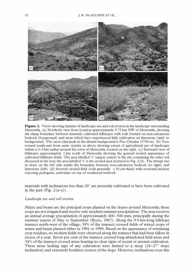
Figure 2. Views showing manner of landscape use and soil erosion in the landscape surroundingMetzontla. (a) Northerly view from location approximately 0)75 km NW of Metzontla, showingthe sharp boundary between intensely cultivated hillslopes with soils formed on non-calcareousbedrock (foreground) and areas which have experienced little cultivation on limestone (mid- tobackground). The snow-clad peak in the distant background is Pico Orizaba (5700 m). (b) Viewtoward south-east from same vicinity as above showing extent of agricultural use of landscapewithin a 2–3 km radius around the town of Metzontla, located on the right. (c) Eastward view ofhillslopes approximately 1 km north of Metzontla showing the general eroded appearance ofcultivated hillslope fields. The area labelled ‘r’ (upper center) is the site containing the relict soildiscussed in the text; the area labelled ‘e’ is the eroded area pictured in Fig. 2(d). The abrupt risein slope on the left side marks the boundary between non-calcareous bedrock (to right) andlimestone (left). (d) Severely eroded field (soils generally (10 cm thick) with erosional incisionexposing pedogenic carbonate on top of weathered bedrock.
52 J. R. MCAULIFFE ET AL.
materials with inclinations less than 203 are presently cultivated or have been cultivatedin the past (Fig. 2(a–c)).
Landscape use and soil erosion
Maize and beans are the principal crops planted on the slopes around Metzontla; thesecrops are not irrigated and receive only incident summer precipitation. The area receivesan annual average precipitation of approximately 400}500 mm, principally during thesummer season of May to September (Byers, 1967). Along the 0)3-km-long hillslopetransect north-west of the village, 59% of the transect crossed fields of mixed crops ofmaize and beans planted either in 1991 or 1990. Based on the appearance of remainingcrop residues, no modern fields were observed along the transect that had been fallow inexcess of a year. Seven per cent of the transect crossed long-abandoned field areas and34% of the transect crossed areas bearing no clear signs of recent or ancient cultivation.These areas lacking sign of any cultivation were limited to a steep (24–273 slopeinclination) and extremely bouldery section of the slope. However, inclinations even this
THE SEMI-ARID TEHUACAD N VALLEY, MEXICO 53
steep to the immediate east on the opposite side of the Barranca Nacional werecultivated when free of bouldery materials (Fig. 2(c)). Low terraces or rock borders ofapparent pre-conquest construction bounded some of the plots. Complete coverage oflarge stones within terraces by slow-growing, crustose lichens indicated that thesestructures were constructed long ago, possibly in pre-Columbian times. Although lowstone terraces were present in some fields, many slopes lack large stones for terraceconstruction and have been cultivated without the benefit of water- and soil-conservingsurface modifications (Fig. 2(c, d)).
These intensely cultivated hillslopes have suffered extreme soil erosion andpossess only very thin soils on top of weathered rocky parent materials. Within parts ofthe hillslope planted in 1990 or 1991, 59% of the transect length crossed cultivated plotswith soils less than 10 cm deep, 37% crossed plots with soils 10–20 cm deep, and only4% crossed plots with soils exceeding 20 cm depth. Extensive reconnaissance on footthroughout the area within a 4-km radius of Metzontla indicated similar eroded condi-tions throughout the area. The very shallow soils of hillslopes are highly dissected by rillsand gullies that expose the underlying weathered bedrock, and pedogenic carbonatefrequently coated these exposed bedrock surfaces (Fig. 2(d)). In some exposures, thinremnants of reddened argillic horizons were present on top of these carbonate horizons.In non-calcic parent materials in this semi-arid environment, calcic horizons formbeneath clay-enriched argillic horizons (calcium carbonate is transported in solution togreater depth than are clays which are moved downward in colloidal suspension).Consequently, the widespread appearance of pedogenic carbonate on exposed surfacesof non-calcic bedrock indicates that overlying argillic horizons that were originallypresent have been lost through erosion. Most frequently, the cultivated soils of hillslopefields consist of little more than a thin mantle of loose, coarse-textured material derivedfrom weathered bedrock.
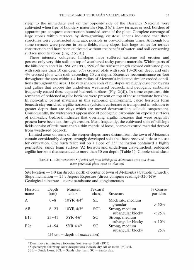
Limited areas on some of the steeper slopes more distant from the town of Metzontlacontain considerably deeper, strongly developed soils that have received little or no usefor cultivation. One such relict soil on a slope of 253 inclination contained a highlypermeable, sandy loam surface (A) horizon and underlying clay-enriched, reddenedargillic horizons that extended to more than 50 cm depth (Table 1). Cobble-sized clasts
Table 1. Characteristics* of relict soil from hillslope in Metzontla area and domi-nant perennial plant taxa on that soil
Site location — 1)0 km directly north of center of town of Metzontla (Catholic Church).Slope inclination — 253; Aspect Exposure (direct compass reading)}3203NWGeological substrate—coarse sandstone and conglomerates
Horizon Depth Munsell Textural % Coarsename (cm) color- class? Structure particles
A 0}8 10YR 4/4d SL Moderate, mediumgranular '50%
AB 8}23 10YR 4/3d SCL Strong, mediumsubangular blocky (25%
B1t 23}41 5YR 4)6d SC Strong, mediumsubangular blocky (10%
B2t 41}54 5YR 4)4m SC Strong, mediumsubangular blocky 25%
(54 cm"depth of excavation)
*Descriptive terminology following Soil Survey Staff (1975).-Superscripts following color designations indicate dry (d) or moist (m) soil.?SL"Sandy loam; SCL"Sandy clay loam; SC"Sandy clay.

54 J. R. MCAULIFFE ET AL.
covered the soil surface and coarse gravel and cobbles occupied approximately half ofthe volume of the A horizon. An abrupt transition in soil depth and texture at theboundary of the area mantled by this relict soil and a nearby cultivated area on the sameslope provided direct evidence for the magnitude of soil loss that has accompaniedcultivation. The nearest cultivated field was located approximately 100 m from thedescribed soil. Directly above the upslope margin of this field, a similar, well-developedsoil with a reddened (5YR hues) sandy clay B horizon was present on a slope with 203inclination. This clay-enriched horizon was completely absent in the immediatelyadjacent field where soils consisted of a thin gravelly to cobbly residuum and brownish(10YR 5/3) coarse sandy loams. These areas were cut through by numerous rills,exposing bedrock at depths of 15–25 cm. The abrupt transition in soil characteristicsand depth at the field margin suggests that more than 0)5 m of soil (i.e. on the order ofthe thickness of the relict soil; Table 1) had been eroded from the hillslope field.
In the limited areas mantled by relict, well-developed soils, perennial plants coverapproximately three-quarters of the soil surface with small trees (Lysiloma divaricata,Senna wislizenii, Prosopis laevigata, Neopringlia viscosa) and arborescent cacti (Stenocereusstellatus, Cephalocereus chrysacanthus, Myrtillocactus geometrizans) forming a brokencanopy, with a more extensive cover provided by a variety of shrubs and smaller cacti.On steep hillslopes of this area, both the relatively dense vegetation and a physicalarmour provided by cobbles on the surface protects underlying, fine-grained soilhorizons from erosion. Removal of natural vegetation and disturbance of this cobblysurface soil horizon by tillage exposes fine-textured underlying horizons to severeerosion.
Antiquity of severe soil erosion around Metzontla associated with agriculture
Alluvial deposits in the Barranca Nacional basin provided a record of an episode ofconsiderable soil erosion that occurred approximately 500 years before the Spanishconquest of Mexico. Downstream, 9–10 km distance from Metzontla, the BarrancaNacional has incised a channel to a depth of 5–7 m in the alluvial deposits of the valleyfloor. We examined a 40-m-long section of a west-facing exposure of these alluvialdeposits, located 1 km above the confluence with the RmHo ZapotitlaH n (Fig. 1). Fourdistinct alluvial fills were recognized in this section (Fig. 3(a)), three of which yieldedcharcoal for radiocarbon dating. The lowermost fill (Fill I) is a cobbly channel depositlacking dateable materials. Fill II is a pale brown (10YR 6/3) silty clay loam aproximately60 cm thick. Charcoal located at the interface of Fill II and overlying Fill III was obtainedfrom wood that was burned in place, apparently in a small hearth (indicated by thepronounced reddening of immediately underlying, baked sediments). Radiocarbondating of this charcoal constrains the age of Fill II to greater than 4630$70 years B.P.(Beta 55055). Fill III is a slightly reddened (10YR–7)5YR 4/3) silty clay loam, approx-imately 2 m thick, with higher clay content than any of the other fills. The only possiblesource within the drainage basin of reddish, clayey sediments contained in Fill III wouldhave been the soils containing reddened argillic horizons around Metzontla, becausereddened soils are completely absent from calcareous substrates that comprisethe remainder of the drainage basin (Fig. 1, 2(a)). Wood charcoal located 40 cm belowthe top of Fill III yielded a date of 940$60 years B. P. (Beta 54370). Fill III is extremelyhomogeneous throughout its entire vertical depth and lacks discontinuities in textureand colour. The homogeneous nature of the fill indicates it was probably deposited ina relatively short time. Fill III is thicker than any of the other fills (Fig. 3(a)); the volumeof sediment it contains indicates a period of significant soil erosion in the very limitedarea containing reddened, clayey soils around Metzontla. This episode of soil erosionmay well have occurred within several centuries of an expansion of agriculture fromirrigated valley floors to seasonally cultivated hillslopes in the TehuacaH n Valley and
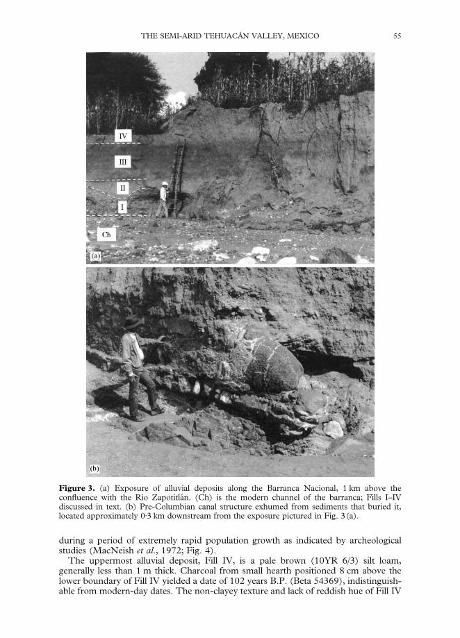
Figure 3. (a) Exposure of alluvial deposits along the Barranca Nacional, 1 km above theconfluence with the RmHo ZapotitlaH n. (Ch) is the modern channel of the barranca; Fills I–IVdiscussed in text. (b) Pre-Columbian canal structure exhumed from sediments that buried it,located approximately 0)3 km downstream from the exposure pictured in Fig. 3(a).
THE SEMI-ARID TEHUACAD N VALLEY, MEXICO 55
during a period of extremely rapid population growth as indicated by archeologicalstudies (MacNeish et al., 1972; Fig. 4).
The uppermost alluvial deposit, Fill IV, is a pale brown (10YR 6/3) silt loam,generally less than 1 m thick. Charcoal from small hearth positioned 8 cm above thelower boundary of Fill IV yielded a date of 102 years B.P. (Beta 54369), indistinguish-able from modern-day dates. The non-clayey texture and lack of reddish hue of Fill IV
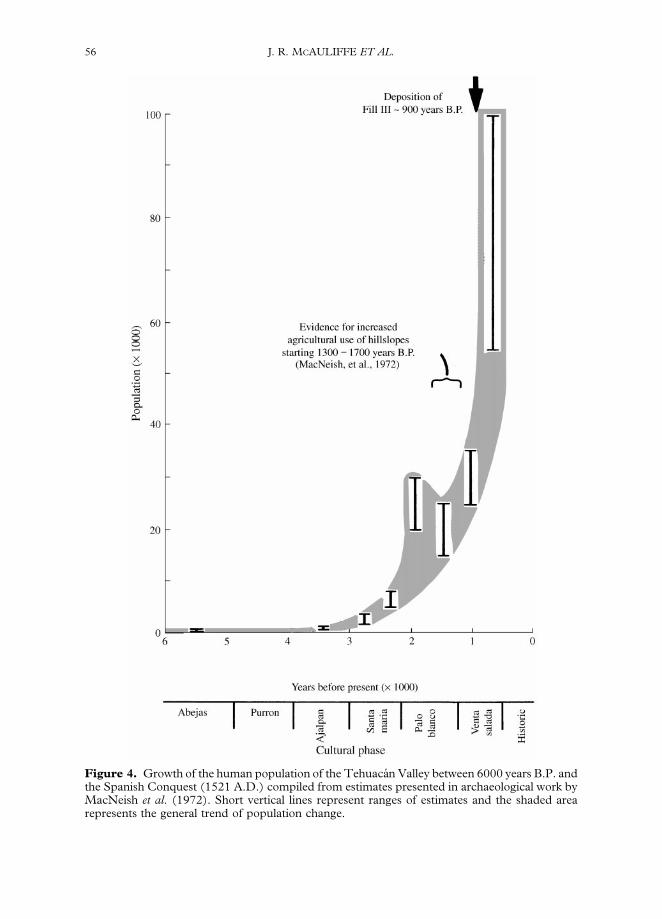
Figure 4. Growth of the human population of the TehuacaH n Valley between 6000 years B.P. andthe Spanish Conquest (1521 A.D.) compiled from estimates presented in archaeological work byMacNeish et al. (1972). Short vertical lines represent ranges of estimates and the shaded arearepresents the general trend of population change.
56 J. R. MCAULIFFE ET AL.
THE SEMI-ARID TEHUACAD N VALLEY, MEXICO 57
indicate that most of the reddened, clay-rich soils of hillslopes around Metzontla wereprobably stripped before the sediments of Fill IV were produced. The light colourof Fill IV (and also of the '4600-year-old Fill II) indicates that these sedimentswere derived from areas more generally distributed throughout the drainage basin thatinclude the extensive areas of calcareous lithologies. Cutting of the current channel ofthe Barranca Nacional post-dates the age of Fill IV. Within the confines of the modernincised channel, a small inset terrace with a surface 1)6 m above the channel floorcontains modern-day artifacts (e.g. buried plastic) and indicates a minor, recent episodeof sediment storage on the channel floor and subsequent incision of this deposit.
In pre-Columbian times, the deleterious impacts of soil erosion in the immediatevicinity of Metzontla must have adversely affected communities located furtherdownstream within the Barranca Nacional drainage basin. At the time of the depositionof Fill III (ca. 900 years. B.P.), irrigation structures on valley floors, including waterdiversion dams and canals were widespread in the TehuacaH n Valley (Woodbury & Nee-ly, 1972). The deposition of Fill III in the lower part of the basin apparently buried ordamaged pre-Columbian irrigation canals on the valley bottom. Approximately 0)3 kmdownstream from the location of the stratigraphic description and charcoal samplecollections, a pre-Columbian stone-and-mortar structure in the process of beingexhumed from sediments was observed on the north-eastern wall of the barranca(Fig. 3(b)). The structure was constructed on a bedrock surface that is locally exposedon the floor of the channel in this area. The low, wall-like structure was apparentlyconstructed in a setting to divert flood waters into an irrigation canal system. Althoughthe precise stratigraphic context of this buried structure was not determined, it is buriedby sediments similar to those of Fill III located a short distance upstream. Burial of thisand other irrigation canal structures on the valley floor by the large pulse of sediments ofFill III probably had catastrophic impacts on agricultural production in the lower part ofthe basin. The expansion of agriculture from irrigated valley floors to non-irrigatedhillslopes approximately 1300–1700 years B.P. (MacNeish et al., 1972) may have at firstprovided additional resources required by a rapidly expanding population. However,this expanded use of marginal environments may have eventually become counter-productive if it led to disruption and damage to agricultural enterprises on the far moreproductive valley floors.
Impacts of soil loss on modern-day subsistence
The extreme loss of soils near Metzontla has caused the virtual collapse of significantagricultural production on hillslopes, despite continued tilling and planting. Hillslopefarming is completely dependent on incident summer rainfall, and the effects ofdrought are compounded by lack of sufficient soil volume for storage of plant-available moisture. Even in years of favourable rainfall, insufficient supply ofmoisture in extremely thin soils contributes to very poor yields; interviews with residentsof Metzontla indicated that ‘bad years’ frequently occur in which there is virtually noproduction. One of the town’s elected officials, a man in his 60s, commented thatdue to soil erosion, the fields surrounding Metzontla had produced ‘essentially nothing’for the last 45 years. One young man from the village stated that the people of Metzontlasuffered much from hunger because of the failure of maize for the last several years.Our estimates of production from hillslope fields in 1991, a year of favourable summerrainfall, documented the negligible agricultural production of hillslope fields. Althoughmaize is frequently planted in fields where soil thickness is 10 cm or less, maize plants inthese shallow soils typically attained maximum heights of only 50 cm and failed toflower, reflecting the insufficient supply of soil water to enable growth and develop-ment. Two estimates of maize production in fields with such shallow soils were1)1 kg ha~1 and (1 kg ha~1. In fields with soils between 10–30 cm deep, only 25%of maize plants produced grain and estimated maize grain yields were 60–99 kg ha~1.
58 J. R. MCAULIFFE ET AL.
In these somewhat deeper soils, exhausted soil fertility also contributed to extremelypoor yields. Soils are nitrogen deficient, as indicated by the considerable enhancement ofyields in very limited areas immediately surrounding occasional nitrogen-fixing, leg-uminous trees (Prosopis laevigata) and in contrast, slight to severe chlorosis and pooryield of plants removed from this nitrogen source. A field with an estimated maize grainyield of 99 kg ha~1 in areas removed from Prosopis canopies had very localized estimatedyields of 1300 kg ha~1 in areas a few metres wide surrounding two trees. Relatively highproductivity of maize was also observe in two other limited areas: (1) a few hectares ofvery narrow alluvial terraces located along the margins of the Barranca Nacional(estimated grain yield 3960 kg ha~1); and (2) a few small plots on hillslopes further fromthe town that had only recently been cleared of vegetation dominated by woody legumes(indicated by cleared brush recently piled along margins of plots) that retained relativelydeep and fertile soils. However, the total area of the alluvial terraces is extremely smalland similarly, hillslope areas that yet possess deep soils are extremely rare (Fig. 2(a–c)).
Beans, despite their nitrogen-fixing ability, produced little in soils (10 cm deep(7)2 kg ha~1), but dry grain yields increased to 20 kg ha~1 in soils 10–20 cm deep and111 kg ha~1 in soils 20–30 cm deep.
Despite the considerable investment in labour in the planting of maize andbeans, residents cannot cultivate a sufficient area of these unproductive hillslopesto meet their subsistence requirements. The 800 ha of cultivated plots belonging to theMetzontla community are distributed among 639 families. The average family ofeight members annually consumes approximately 1920 kg of maize grain and 192 kg ofdry beans. Even given the production estimates of 300 kg ha~1 for maize and50}60 kg ha~1 for beans in good years as claimed by some of the local officials, thecultivated lands surrounding Metzontla can only supply about one-fifth and one-third ofthe community’s subsistence needs for maize and beans, respectively. Since observedaverage production, especially for maize, was considerably less than 300 kg ha~1 formost of the landscape, the actual contribution of dryland farming to subsistence is farless.
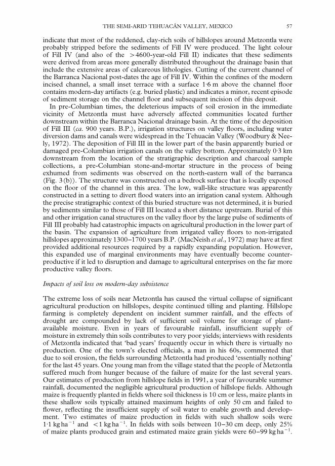
Residents have largely turned to external economic opportunities (wage labour atregional or distant locales, and production and export of handcrafted ceramics). Nearlyall the families in the town are involved in the production of handcrafted ceramics whichare transported and sold in markets of nearby towns (Fig. 5). (The clay for ceramicsmanufacture is obtained from nearby outcroppings of shale, not from the soils aroundMetzontla.) For one typical family that was interviewed, production of ceramicsgenerated an annual income of $2080 (1992 U.S. equivalent), which marginallycovered the annual purchase of basic food requirements of maize, beans, and eggs($1069) and costs of fuel wood for firing ceramics and transportation of ceramic waresto town markets ($784). Such marginal home economies contribute to the continuingattempts to cultivate the severely eroded soils as a hedge against uncertainty: a deliberateattempt by residents to augment subsistence needs in an area where the shortage ofarable land is acute, human population continues to grow, and poverty is extreme andincreasing.
Despite the severity of soil loss and collapsed agricultural potential of the area, theprincipal environmental and economic concern expressed by residents of Metzontla wasneither soil erosion nor insufficient agricultural production, but rather the supply offuelwood for domestic use and firing ceramics. The community of 639 families con-sumes an estimated 1)66]106 kg of fuelwood per year for domestic use (use per familyis approximately 50 kg week~1 or 2600 kg year~1). A nearly identical additionalquantity is used per family in firing of ceramics, although the kinds of fuels differ.Dense woods of leguminous trees, especially Acacia cochleacantha, Senna wislizenii,Prosopis laevigata and Lysiloma divaricata are preferred for domestic use in food prepara-tion. Fuel that burns more slowly and at lower temperatures are used in firing ceramics,including the soft wood from the small tree Ipomea arborescens, dried stems of various
Figure 5. Typical process of firing ceramic wares by a family in Metzontla. (a) Greenware isstacked on a 10–15-cm-deep bed of small-diameter fuelwood. This stack of greenware was theproduct of two weeks of work by two women in the family (the wife and mother of the man showntending the fire). Women exclusively construct the ceramic wares with coiled clay, paddle andanvil without the use of a potter’s wheel. The large, flat round pieces are known in Spanish ascomales, and are traditionally used as cooking pans. (b) Larger diameter fuelwood is stackedvertically at the downwind end of the stack and lit. Fuels that burn slowly and at relatively lowtemperatures are used in firing. (c) The fire is tended and two long tongs made from the wood ofcolumnar cacti (in this case Neobuxbaumia tetetzo) are used to move burning pieces of wood slowlyalong the stock to ignite additional wood that is stacked along the leading edge. The entire firingprocess involving movement of the fire along the stack required approximately 75 min.
THE SEMI-ARID TEHUACAD N VALLEY, MEXICO 59
60 J. R. MCAULIFFE ET AL.
columnar cactus species, fibrous trunks of Yucca, and flowering stalks of Agave (Fig. 5).In addition to fuelwood obtained for local use, cutting and sale of fuelwood to travel-ling vendors had until recently been another means by which residents augmentedsubsistence incomes. A recently imposed ban on cutting of live trees within thecommunal lands of the ejido is a reflection of the local people’s concern about thesevere, unsustainable depletion of this resource. Consequently, in 1991, mostfuelwood for domestic use and firing ceramics was obtained from travellingvendors. Although the local fuelwood scarcity may in part have been caused byoverharvest, a principal factor that has contributed to and will perpetuate thefuelwood shortage is the manner of land use in the area. Most of the hillslopesaround Metzontla consist of either active or abandoned fields that have experiencedextremely severe soil loss. In the same way that these shallow, eroded soils cannot storesufficient moisture to produce a seasonal crop of maize, such degraded soilenvironments are unlikely to foster growth of moderately large tree species favouredfor domestic fuelwood that are now restricted to limited areas containing relict soils.The time necessary for ecological recovery of these highly eroded slopes may be on thesame scale as that required for significant soil formation, i.e. many hundreds to thou-sands of years.
Basin 2
Studies in this basin provided information on the persistence of ecological changesaccompanying soil loss and the length of time required for soil formation on denudedterrains. The basin contains the small village of San Juan Raya (Figs 1 & 6). Thiscommunity contains fewer people than Metzontla (200 vs. 5300 inhabitants) butcontrols a significantly larger land area (San Juan Raya: 24,000 ha; Metzontla: 8000 ha).As a consequence, human use of the landscape surrounding San Juan Raya hasapparently not been nearly as intense as it has around Metzontla. In 1991, fields of maizeand beans planted by members of the San Juan Raya ejido were generally restricted todeep alluvial soils along the Barranca Agua la Iglesia or on very gentle slopes within 1 kmof the village. There is evidence of pre-Columbian cultivation of areas further removedfrom the present-day village, but unlike the landscape surrounding Metzontla, theseareas have apparently been long-abandoned rather than pressed into near-continual use,allowing assessment of some of the persistent ecological consequences of ancient soilerosion that apparently occurred in pre-Columbian times.
Soils
Our work was concentrated within the southern half of the drainage basin. This part ofthe basin consists of gentle hillslopes ((103 slope inclination) underlain by soft andeasily weathered Cretaceous marine shales interbedded with thin, widely separated strataof extremely hard, very fine-grained, weathering-resistant sandstone (the San Juan RayaFormation; CalderoH n-Garcia, 1956). Steep limestone slopes of Cerro Gordo form thenorthern third of the drainage basin (Figs 6 & 7).
Most of the natural vegetation in the southern part of the basin is intact and is visuallydominated by tall columnar cacti, and has a relatively dense understory of woody plants,other leaf and stem succulents, and herbaceous plants, including perennial grasses(Figs 7 & 8(a)). Slopes supporting this vegetation possess moderately well-developedsoils with brown to dark brown (10YR 4)3) loamy surface (A and AB) horizons andslightly reddened (7)5 YR 5/4) argillic (Bt) horizons (Table 2). The boundary betweenthe soil and underlying Cretaceous bedrock is sharp and distinct (Fig. 8(a)) and soilthicknesses generally range from 40 to 80 cm.
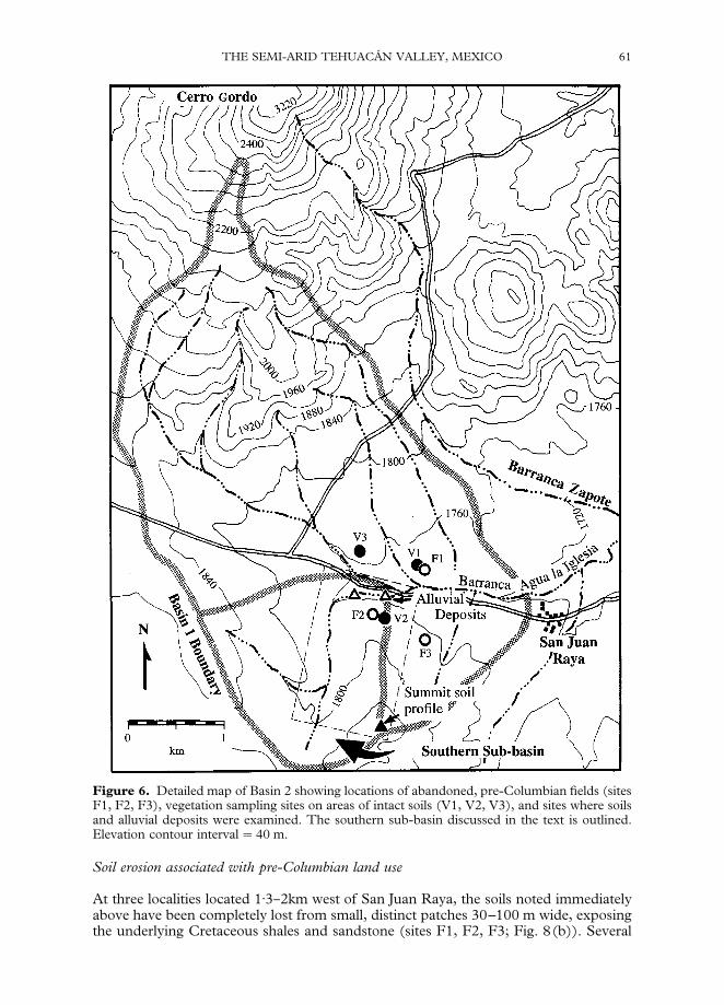
Figure 6. Detailed map of Basin 2 showing locations of abandoned, pre-Columbian fields (sitesF1, F2, F3), vegetation sampling sites on areas of intact soils (V1, V2, V3), and sites where soilsand alluvial deposits were examined. The southern sub-basin discussed in the text is outlined.Elevation contour interval"40 m.
THE SEMI-ARID TEHUACAD N VALLEY, MEXICO 61
Soil erosion associated with pre-Columbian land use
At three localities located 1)3}2km west of San Juan Raya, the soils noted immediatelyabove have been completely lost from small, distinct patches 30–100 m wide, exposingthe underlying Cretaceous shales and sandstone (sites F1, F2, F3; Fig. 8(b)). Several

Figure 7. Northerly view across Basin 2 from a location south of Barranca Agua la Iglesia. Thetall, rounded peak on the left is Cerro Gordo. The unbranched, tall columnar cacti are Neobux-baumia mezcalaensis; the branched columnar cactus on the left is N. macrocephala. The areaindicated by the arrows in the background has been extensively cleared for cultivation bya neighbouring ejido.
62 J. R. MCAULIFFE ET AL.
lines of evidence indicate that these erosional features are long-abandoned, pre-Colum-bian agricultural fields. A linear alignment of large stones was situated across the slope atthe upslope end of one of these eroded surfaces (area F2; Fig. 6); these stones wereprobably accumulated during the process of land clearing and may also have functionedas a low water-diversion terrace. Cultivated areas of pre-Columbian antiquity onhillslopes with similar associated stone alignments have been described for other nearbyareas in the TehuacaH n Valley (Woodbury & Neely, 1972, pp. 113}116). At least onemargin of each of the eroded areas was sharp and linear, suggesting intentional clearing(Fig. 8(b)). Two lines of evidence indicate the passage of considerable time sinceabandonment of these suspected pre-Columbian fields. Although the eroded areas aresparsely vegetated, they contain occasional large individuals of long-lived plants such asthe giant barrel cactus, Echinocactus platycanthus, which in some cases may exceeda century in age. In addition, each of the eroded areas contains channels up to 3-m deepcut into the underlying shale and sandstone bedrock, and at sites F1 and F2 the channelshave migrated upslope into areas of intact vegetation and soils. Such deep incision intothe underlying bedrock indicates that a considerable amount of time has passed since theareas were first cleared and marked soil erosion began. Given the history of Mexico’sdepopulation following the Spanish conquest and present-day limited use of the land-scape around the village of San Juan Raya, it is very unlikely that the original landscapeclearings were originally created after the Spanish conquest of Mexico.
Ecological consequences of soil loss
Surface horizons of intact soils on hillslopes included clay loam, loam, and sandy loamtextural classes, whereas clays and silty clays predominated on the weathered shale

Figure 8. (a) Hillslope soil profile exposed in headcut that has migrated upslope from aban-doned field F2. Soil depth ranges from 40 to 80 cm thick. A pronounced stone line (‘St’)containing angular sandstone cobbles separates the soil from underlying Cretaceous bedrock(‘R’). (b) View eastward across eroded pre-Columbian field F3 with view of dense naturalvegetation on intact soil in background. Note highly dipped strata of weathering-resistant sand-stone protruding 10–15 cm above the light-coloured, weathered shale surface. (c) Angular,relatively little-weathered sandstone clasts on surface of hillslope soils. (d) Highly weathered,lichen-covered appearance of sandstone clasts on surface of older soils in stable landscape position(summit of hill).
THE SEMI-ARID TEHUACAD N VALLEY, MEXICO 63
surfaces of eroded areas. The loamy surfaces of intact soils had infiltration capacities(2)52–3)36 mm min~1) that were approximately three times those of clayey surfaces ofweathered shale in eroded areas (0)94–1)26 mm min~1).
The loss of soil and greatly diminished infiltration capacity has produced marked, andprobably long-lasting vegetation changes. Densities of the tall, unbranched columnarcactus Neobuxbaumia mezclaensis exceed 900 individuals per ha in some locations onareas of intact soils, but ancient eroded fields are almost entirely devoid of this species(Figs. 7 & 8(a, b)). This particular cactus is more typically found in areas of tropicaldeciduous forest to the west in the Rio Balsas drainage which receive substantially morerainfall than most of the TehuacaH n basin. The eastern-most extension of the naturalrange of N. mezcalaensis into the more arid TehuacaH n Basin in the area of San Juan Rayaprobably depends on the relatively mesic edaphic environments provided by soils withpermeable surface horizons and large moisture-holding capacities of underlying argillicorizons.
Other marked ecological changes associated with soil loss are reduced perennial plantcover, reduced species richness, and a shift to dominance by more xeromorphic plantspecies. The eroded areas possess only about one-quarter the perennial plant canopycover of areas of intact soils (Fig. 8(b)). The number of perennial plant species recordedin 100 m2 plots ranged from 22 to 24 on intact soils compared to a range of 13}17 inthe eroded areas (Fig. 9). The predominant woody plants occupying areas of intactsoils includes a wide variety of species with simple, mesomorphic leaves, but in eroded
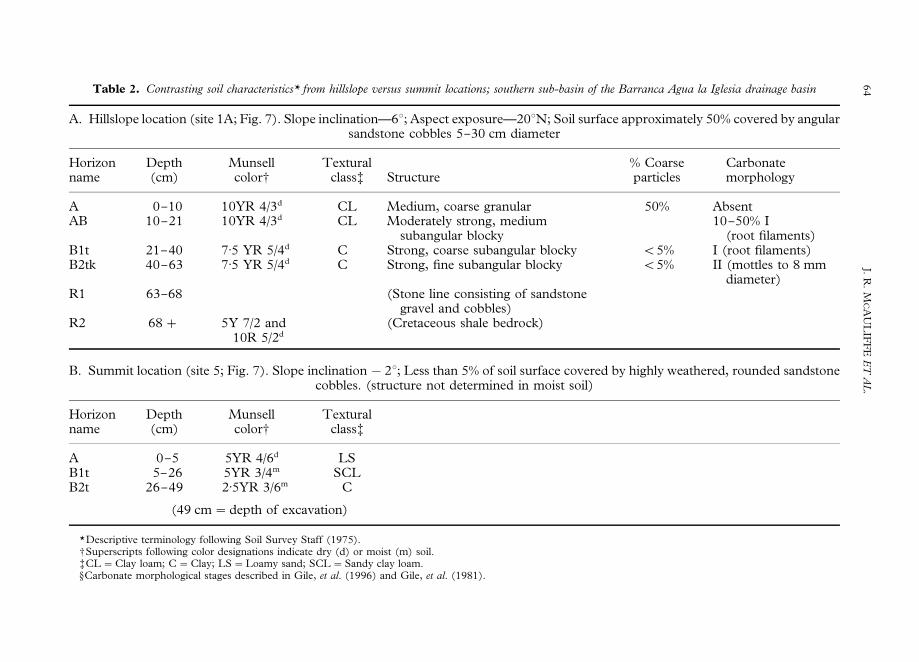
Table 2. Contrasting soil characteristics* from hillslope versus summit locations; southern sub-basin of the Barranca Agua la Iglesia drainage basin
A. Hillslope location (site 1A; Fig. 7). Slope inclination—63; Aspect exposure—203N; Soil surface approximately 50% covered by angularsandstone cobbles 5}30 cm diameter
Horizon Depth Munsell Textural % Coarse Carbonatename (cm) color- class? Structure particles morphology
A 0}10 10YR 4/3d CL Medium, coarse granular 50% AbsentAB 10}21 10YR 4/3d CL Moderately strong, medium
subangular blocky10}50% I
(root filaments)B1t 21}40 7)5 YR 5/4d C Strong, coarse subangular blocky (5% I (root filaments)B2tk 40}63 7)5 YR 5/4d C Strong, fine subangular blocky (5% II (mottles to 8 mm
diameter)R1 63}68 (Stone line consisting of sandstone
gravel and cobbles)R2 68# 5Y 7/2 and (Cretaceous shale bedrock)
10R 5/2d
B. Summit location (site 5; Fig. 7). Slope inclination!23; Less than 5% of soil surface covered by highly weathered, rounded sandstonecobbles. (structure not determined in moist soil)
Horizon Depth Munsell Texturalname (cm) color- class?
A 0}5 5YR 4/6d LSB1t 5}26 5YR 3/4m SCLB2t 26}49 2)5YR 3/6m C
(49 cm"depth of excavation)
*Descriptive terminology following Soil Survey Staff (1975).-Superscripts following color designations indicate dry (d) or moist (m) soil.?CL"Clay loam; C"Clay; LS"Loamy sand; SCL"Sandy clay loam.ACarbonate morphological stages described in Gile, et al. (1996) and Gile, et al. (1981).
64J.
R.
MCA
UL
IFF
EE
TA
L.
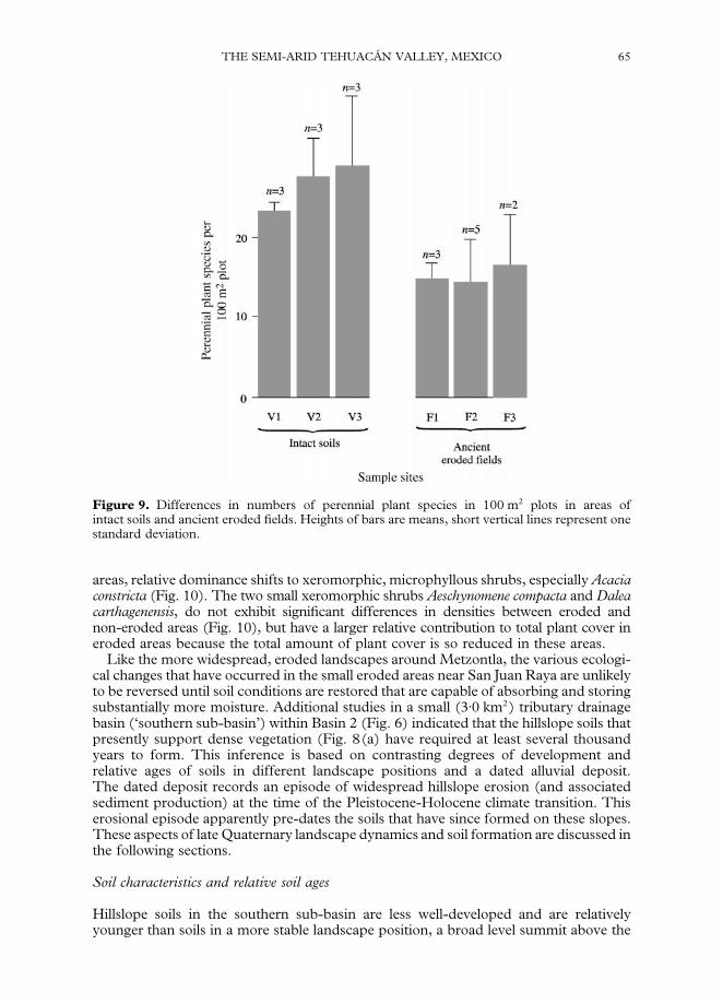
Figure 9. Differences in numbers of perennial plant species in 100 m2 plots in areas ofintact soils and ancient eroded fields. Heights of bars are means, short vertical lines represent onestandard deviation.
THE SEMI-ARID TEHUACAD N VALLEY, MEXICO 65
areas, relative dominance shifts to xeromorphic, microphyllous shrubs, especially Acaciaconstricta (Fig. 10). The two small xeromorphic shrubs Aeschynomene compacta and Daleacarthagenensis, do not exhibit significant differences in densities between eroded andnon-eroded areas (Fig. 10), but have a larger relative contribution to total plant cover ineroded areas because the total amount of plant cover is so reduced in these areas.
Like the more widespread, eroded landscapes around Metzontla, the various ecologi-cal changes that have occurred in the small eroded areas near San Juan Raya are unlikelyto be reversed until soil conditions are restored that are capable of absorbing and storingsubstantially more moisture. Additional studies in a small (3)0 km2) tributary drainagebasin (‘southern sub-basin’) within Basin 2 (Fig. 6) indicated that the hillslope soils thatpresently support dense vegetation (Fig. 8(a) have required at least several thousandyears to form. This inference is based on contrasting degrees of development andrelative ages of soils in different landscape positions and a dated alluvial deposit.The dated deposit records an episode of widespread hillslope erosion (and associatedsediment production) at the time of the Pleistocene-Holocene climate transition. Thiserosional episode apparently pre-dates the soils that have since formed on these slopes.These aspects of late Quaternary landscape dynamics and soil formation are discussed inthe following sections.
Soil characteristics and relative soil ages
Hillslope soils in the southern sub-basin are less well-developed and are relativelyyounger than soils in a more stable landscape position, a broad level summit above the
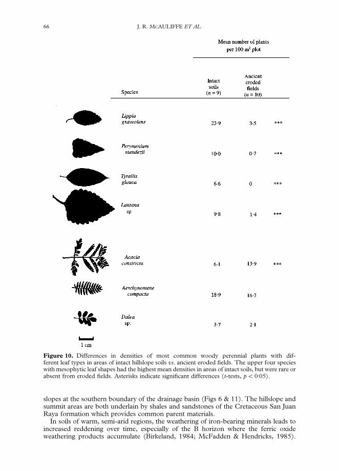
Figure 10. Differences in densities of most common woody perennial plants with dif-ferent leaf types in areas of intact hillslope soils vs. ancient eroded fields. The upper four specieswith mesophytic leaf shapes had the highest mean densities in areas of intact soils, but were rare orabsent from eroded fields. Asterisks indicate significant differences (t-tests, p(0)05).
66 J. R. MCAULIFFE ET AL.
slopes at the southern boundary of the drainage basin (Figs 6 & 11). The hillslope andsummit areas are both underlain by shales and sandstones of the Cretaceous San JuanRaya formation which provides common parent materials.
In soils of warm, semi-arid regions, the weathering of iron-bearing minerals leads toincreased reddening over time, especially of the B horizon where the ferric oxideweathering products accumulate (Birkeland, 1984; McFadden & Hendricks, 1985).

Figure 11. Landscape block diagram showing variation in soils in different locations and thestratigraphy of alluvial deposits examined in exposures along the south fork of the Barranca Aguala Iglesia.
THE SEMI-ARID TEHUACAD N VALLEY, MEXICO 67
Maximum reddening of B horizons was far less pronounced in hillslope soils (brown, 7)5YR 5/4) than the soil of the level summit (dark red, 2)5 YR 3/6; Table 2). Thedifference in soil reddening was also expressed in colours of the soil surface whichwere generally dark brown (7)5 YR hues) but changed to 5YR hues (reddish brown) asslope decreased approaching the level summit area. The reddening of these soils is dueto pedogenic change over time; the vast majority of the underlying Cretaceous rockparent materials are shales with light grey to yellow colours (5 Y 7/2 to 5 Y 7/3); thewidely separated sandstone strata are typically olive grey (5 Y 5/2).
Studies of soils in the south-western United States provide some indication of the timerequired for the development of various degrees of reddening of clay-enriched B hor-izons in soils of warm, semi-arid regions where the original parent materials lacked redcolouration. In southern California, alluvial deposits of 4000 }13,000 years of age haddeveloped B horizons with hues of 7)5 YR in parent materials that originally had 10YRhues (McFadden & Hendricks, 1985). However, only in alluvial deposits exceeding350,000 years old did B horizons possess 2)5 YR hues. Similarly, Birkeland (1984) citedseveral other studies from southern California and southern New Mexico where 7)5 YRhues of B horizons developed from 10 YR parent materials in the order of 104 years,whereas 2)5 YR hues required in the order of at least 105 years to develop.
The degree of weathering of surface and subsurface sandstone clasts also indicateda great difference in ages of the soils on hillslopes and summit in the southern

68 J. R. MCAULIFFE ET AL.
sub-basin. Surfaces of intact soils on hillslopes are covered by angular sandstone cobblesderived from the Cretaceous bedrock (Fig. 8(c)). Similar angular sandstone clasts arealso concentrated throughout the uppermost soil horizons and frequently within adistinct stone line at the interface of the soil and underlying Cretaceous bedrock(Figs 8(a) & 11). The angularity and hardness of surface and subsurface sandstoneclasts (they ring when struck with a hammer and resist breakage) indicate relatively littleweathering and a relatively young age of hillslope soils. In contrast, sandstone cobblesare less abundant on the soil surface on the summit and are very strongly weathered,lacking the sharp angularity of those found on the hillslopes, and are typically coveredwith crustose lichens (Fig. 8(d)). The uppermost 5 cm of the summit soil consists ofa strongly reddened (5 YR 4)6) loamy sand apparently derived from the weathering anddisintegration of sandstone clasts that at one time were more abundant on the soilsurface. Subsurface sandstone clasts were weathered to their interiors, soft in consist-ency, and were easily cut with a shovel or crushed in hand.
The process of landscape stabilization and soil formation on slopes
The contrast between the moderately developed hillslope soils and the highly weatheredsoil on the summit indicates that the hillslopes must have been denuded of a soil mantleduring some time in the relatively recent geological past, while soils on the summitremained intact. Hillslopes lacked any evidence of older soils buried beneath therelatively young soil, indicating an episode of complete removal of any pre-existinghillslope soils down to the Cretaceous bedrock surface. The following additional evid-ence supports this hypothesis of an episode of widespread hillslope erosion.
On the hillslope, the soil-bedrock interface and stone line typically found at thisboundary undulates (Fig. 8(a)), suggesting that a shallowly channelled landscapepreceded the formation of the existing soil on the hillslope. The stone line apparentlyrepresents a lag that accumulated over the shale-dominated surface during the erosionalepisode. The stone line does not represent thin Cretaceous sandstone strata that havebeen weathered in place because the stone line is present even where steeply dippedCretaceous strata are oblique to the land surface and in areas where the sandstone stratado not directly contact the soil-bedrock interface (Fig. 8(a)). The accumulation of thislag of weathering-and transport-resistant sandstone clasts was probably essential forstabilizing an erosional surface consisting principally of soft, easily weathered anderoded shales. Such stabilization was necessary before substantial soil developmentcould occur.
The process of accumulation of a lag of sandstone clasts on top of an erosional shalesurface can be seen in the previously described, eroded pre-Columbian fields. Theselective erosion of the easily weathered shales leaves thin, weathering-resistant strata ofsandstone protruding slightly above the surface (Fig. 8(b)). Sharply angular clastsderived from these protruding sandstone strata have begun to accumulate over the entirebedrock surface, including the exposed soft shales.
Timing of the erosional episode and age of the hillslope soil
A dated alluvial deposit on the sub-basin floor records a major episode of sediment yieldfrom hillslopes within the southern sub-basin slightly more than 9000 years ago. Twoexposures of this deposit were examined in the deeply incised walls of the tributarystream (South Fork) that drains the sub-basin, approximately 0)2 and 0)5 km upstreamfrom the confluence with the North Fork of the Barranca Agua la Iglesia (Figs 6 & 11).The basal deposit (Fill I) is coarse, cobbly to bouldery channel sediment up to 1)4 mthick, deposited on top of Cretaceous bedrock. Fill II is a 2)0–2)7-m-thick, slightlyreddish, fine-grained clayey deposit. At the upstream exposure, Fill II is fine-grained andtexturally homogeneous throughout its vertical depth (Fig. 12(a)), but at the down-
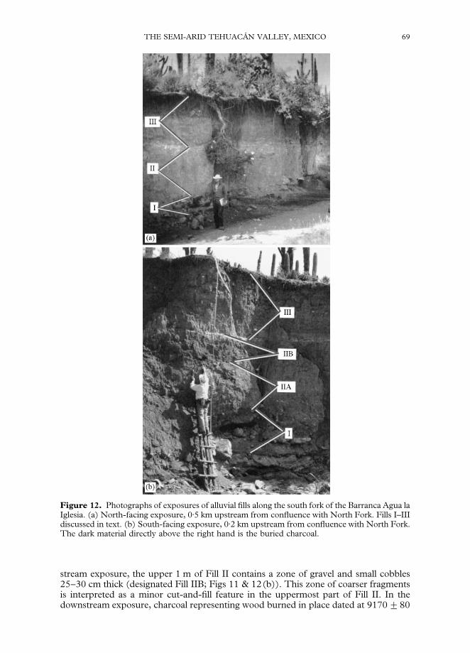
Figure 12. Photographs of exposures of alluvial fills along the south fork of the Barranca Agua laIglesia. (a) North-facing exposure, 0)5 km upstream from confluence with North Fork. Fills I–IIIdiscussed in text. (b) South-facing exposure, 0)2 km upstream from confluence with North Fork.The dark material directly above the right hand is the buried charcoal.
THE SEMI-ARID TEHUACAD N VALLEY, MEXICO 69
stream exposure, the upper 1 m of Fill II contains a zone of gravel and small cobbles25–30 cm thick (designated Fill IIB; Figs 11 & 12(b)). This zone of coarser fragmentsis interpreted as a minor cut-and-fill feature in the uppermost part of Fill II. In thedownstream exposure, charcoal representing wood burned in place dated at 9170$80
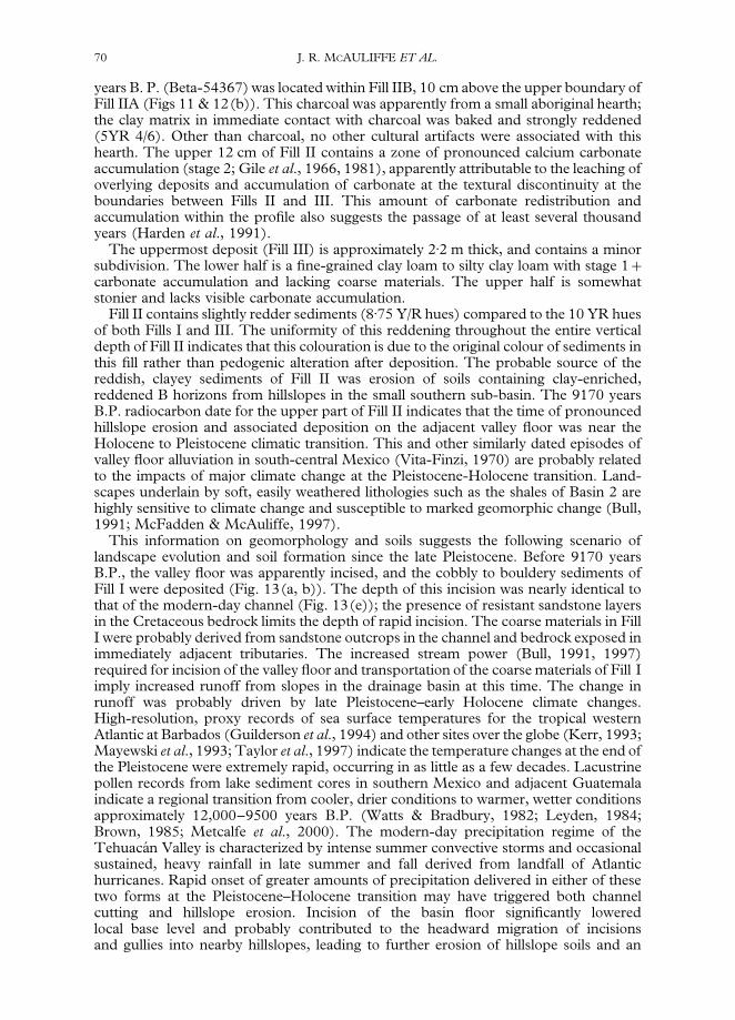
70 J. R. MCAULIFFE ET AL.
years B. P. (Beta-54367) was located within Fill IIB, 10 cm above the upper boundary ofFill IIA (Figs 11 & 12(b)). This charcoal was apparently from a small aboriginal hearth;the clay matrix in immediate contact with charcoal was baked and strongly reddened(5YR 4/6). Other than charcoal, no other cultural artifacts were associated with thishearth. The upper 12 cm of Fill II contains a zone of pronounced calcium carbonateaccumulation (stage 2; Gile et al., 1966, 1981), apparently attributable to the leaching ofoverlying deposits and accumulation of carbonate at the textural discontinuity at theboundaries between Fills II and III. This amount of carbonate redistribution andaccumulation within the profile also suggests the passage of at least several thousandyears (Harden et al., 1991).
The uppermost deposit (Fill III) is approximately 2)2 m thick, and contains a minorsubdivision. The lower half is a fine-grained clay loam to silty clay loam with stage 1#carbonate accumulation and lacking coarse materials. The upper half is somewhatstonier and lacks visible carbonate accumulation.
Fill II contains slightly redder sediments (8)75 Y/R hues) compared to the 10 YR huesof both Fills I and III. The uniformity of this reddening throughout the entire verticaldepth of Fill II indicates that this colouration is due to the original colour of sediments inthis fill rather than pedogenic alteration after deposition. The probable source of thereddish, clayey sediments of Fill II was erosion of soils containing clay-enriched,reddened B horizons from hillslopes in the small southern sub-basin. The 9170 yearsB.P. radiocarbon date for the upper part of Fill II indicates that the time of pronouncedhillslope erosion and associated deposition on the adjacent valley floor was near theHolocene to Pleistocene climatic transition. This and other similarly dated episodes ofvalley floor alluviation in south-central Mexico (Vita-Finzi, 1970) are probably relatedto the impacts of major climate change at the Pleistocene-Holocene transition. Land-scapes underlain by soft, easily weathered lithologies such as the shales of Basin 2 arehighly sensitive to climate change and susceptible to marked geomorphic change (Bull,1991; McFadden & McAuliffe, 1997).
This information on geomorphology and soils suggests the following scenario oflandscape evolution and soil formation since the late Pleistocene. Before 9170 yearsB.P., the valley floor was apparently incised, and the cobbly to bouldery sediments ofFill I were deposited (Fig. 13(a, b)). The depth of this incision was nearly identical tothat of the modern-day channel (Fig. 13(e)); the presence of resistant sandstone layersin the Cretaceous bedrock limits the depth of rapid incision. The coarse materials in FillI were probably derived from sandstone outcrops in the channel and bedrock exposed inimmediately adjacent tributaries. The increased stream power (Bull, 1991, 1997)required for incision of the valley floor and transportation of the coarse materials of Fill Iimply increased runoff from slopes in the drainage basin at this time. The change inrunoff was probably driven by late Pleistocene–early Holocene climate changes.High-resolution, proxy records of sea surface temperatures for the tropical westernAtlantic at Barbados (Guilderson et al., 1994) and other sites over the globe (Kerr, 1993;Mayewski et al., 1993; Taylor et al., 1997) indicate the temperature changes at the end ofthe Pleistocene were extremely rapid, occurring in as little as a few decades. Lacustrinepollen records from lake sediment cores in southern Mexico and adjacent Guatemalaindicate a regional transition from cooler, drier conditions to warmer, wetter conditionsapproximately 12,000–9500 years B.P. (Watts & Bradbury, 1982; Leyden, 1984;Brown, 1985; Metcalfe et al., 2000). The modern-day precipitation regime of theTehuacaH n Valley is characterized by intense summer convective storms and occasionalsustained, heavy rainfall in late summer and fall derived from landfall of Atlantichurricanes. Rapid onset of greater amounts of precipitation delivered in either of thesetwo forms at the Pleistocene–Holocene transition may have triggered both channelcutting and hillslope erosion. Incision of the basin floor significantly loweredlocal base level and probably contributed to the headward migration of incisionsand gullies into nearby hillslopes, leading to further erosion of hillslope soils and an
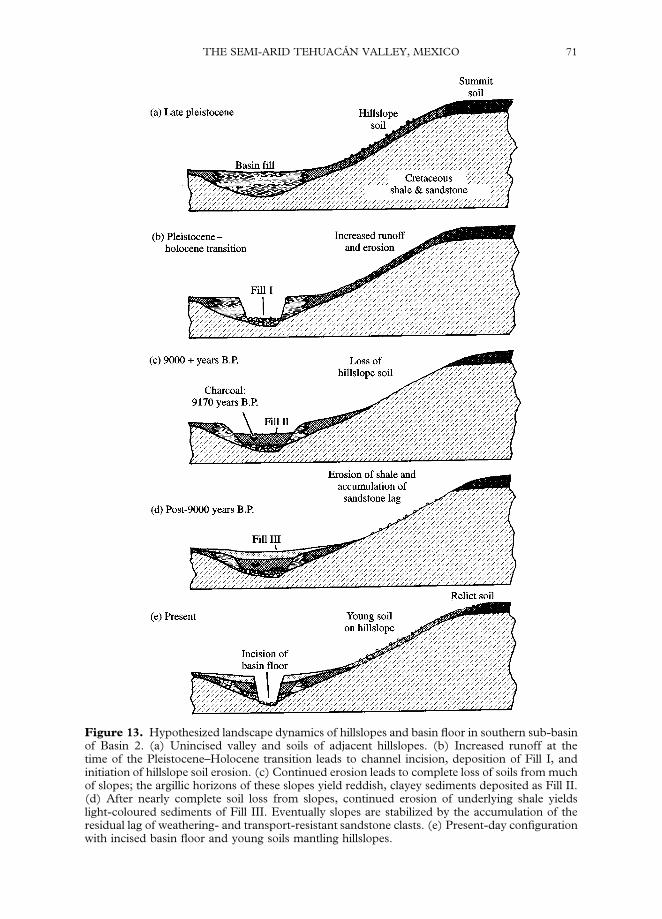
Figure 13. Hypothesized landscape dynamics of hillslopes and basin floor in southern sub-basinof Basin 2. (a) Unincised valley and soils of adjacent hillslopes. (b) Increased runoff at thetime of the Pleistocene–Holocene transition leads to channel incision, deposition of Fill I, andinitiation of hillslope soil erosion. (c) Continued erosion leads to complete loss of soils from muchof slopes; the argillic horizons of these slopes yield reddish, clayey sediments deposited as Fill II.(d) After nearly complete soil loss from slopes, continued erosion of underlying shale yieldslight-coloured sediments of Fill III. Eventually slopes are stabilized by the accumulation of theresidual lag of weathering- and transport-resistant sandstone clasts. (e) Present-day configurationwith incised basin floor and young soils mantling hillslopes.
THE SEMI-ARID TEHUACAD N VALLEY, MEXICO 71

72 J. R. MCAULIFFE ET AL.
increase in sediment volume delivered to the main channel system. This increasedsediment supply may have led to the aggradation of Fill II (Fig. 13(c)). The reddish hueof Fill II indicates that these sediments were not derived from the predominantlylight-coloured Cretaceous shales, but rather from the reddened argillic horizons of soilsthat mantled hillslopes at the time of the Plestocene–Holocene transition. Today, thepresence of extremely well-developed soils in a more stable landscape position (i.e. thelevel summit) indicates that the summit escaped the complete removal of soils such asthat which occurred on adjacent slopes. The lower, fine-grained half of Fill III probablyrepresents grey-coloured sediments derived from the erosion of exposed shales onhillslopes after removal of argillic horizons (Fig. 13(d)). Soil formation on the slopescould have occurred on the predominantly shale surface only after a sufficient lag ofsandstone clasts had accumulated and stabilized the erosional (Fig. 13(d, e)). Therelatively sparse cover of sandstone clasts present today on the small eroded pre-Columbian fields (Fig. 8(b)) indicates that a lag sufficient to stabilize the erosionalsurface and allow for significant pedogenic development takes well over 500 years toaccumulate.
The hillslopes of this basin and the soils that mantle them are inherently unstable andhave undergone denudation in the past, apparently in response to either a major climatechange or disturbance by cultivation. Under cultivation, the destruction of the naturalvegetation and disruption of the sandstone clasts that physically armour the surfaceexposes fine-textured soil horizons to erosion. Once the relatively thin hillslope soils areeroded down to Cretaceous bedrock, runoff and erosion may be further accelerated,producing a self-enhancing feedback that ultimately leads to more extensive slopedenudation (Bull, 1991).
Despite the apparent sensitivity of this landscape to erosion, in another ejido com-munity on the west boundary of the San Juan Raya ejido in the central part of thedrainage basin, areas on this Cretaceous shale and sandstone terrain have been clearedand used for agriculture in modern times (Fig. 7). These areas cannot be expected toremain in production for very long before soil erosion and exposure of the underlyingCretaceous bedrock forces abandonment and greatly diminishes the landscape’s capa-city for ecological recovery. The late Quarternary geological history of this landscapeemphasizes its extreme sensitivity to any kind of disturbance. The soils that presentlysupport a tremendously diverse, unique vegetation can be quickly lost, yet the soilconditions necessary for substantial ecological recovery are very slow to develop.
Summary and conclusions
The agricultural use of hillslopes in pre-Columbian times apparently caused consider-able soil erosion in the semi-arid environments we studied in the TehuacaH n Valley,especially the Barranca Nacional Basin (Basin 1) around the present-day village ofMetzontla. The magnitude of soil loss in that basin has greatly decreased agriculturalproductivity and has impoverished the natural vegetation. Neither pre-Columbian normodern agricultural practices in these semi-arid uplands have proven sustainable.Although hillslope soils in this region may temporarily support seasonal agriculture,disturbance of the natural vegetation cover and cultivation of the thin soils of thesesemi-arid environments lead to severe soil loss and abandonment of agricultural use.The vegetation that follows is greatly impoverished compared to that which wasoriginally present. Soil loss that precedes agricultural collapse and abandonment mayimpair recovery of diverse and productive ecosystems for many hundreds of years toa few thousand years, the time scale necessary to form a new, substantial soil mantle.Given the long duration of human occupancy and agriculture in the TehuacaH n Valley(MacNeish et al., 1972), these kinds of persistent impacts on soils, agricultural produc-tion, and ecosystems are probably widespread. Cook (1949) originally suggested that
THE SEMI-ARID TEHUACAD N VALLEY, MEXICO 73
widespread soil erosion due to pre-Columbian agriculture was responsible for suchlong-lasting changes in south-Central Mexico.
Some of the ecological consequences of soil erosion in the semi-arid TehuacaH n Valleymay be much more persistent than those experienced in more humid areas of Mexicoand Central America where agricultural areas abandoned at the time or before Europeansettlement have been more rapidly reforested. In contrast to humid tropical forestecosystems, the ecological changes associated with soil loss during pre-Columbian timeshave persisted to this day in the small areas in Basin 2 near San Juan Raya. The recoveryof adequate water-storage capacity of soils in water-limited, semi-arid ecosystems mayrequire a much longer time period than the regeneration of soil fertility in humidenvironments, where plant nutrients, not water, impose the main limitation on primaryproduction.
Most of the recent studies on palaeoecology, palaeoclimatology, and the impacts ofpre-Columbian agriculture in Mexico and Central America have been derived fromstudies of lake sediments (Metcalfe et al., 2000). Lake sediments (especially from closedlake basins) typically yield uninterrupted statigraphic sequences that record the transit ofmaterials from areas within the lake drainage basin to the lake, and therefore provideideal records for palaeoenvironmental reconstruction. Unfortunately, natural lakes arescarce throughout most of Mexico, and for this reason, palaeolimnological studies oflake sediments in Mexico have been relatively few and geographically restricted. Lakebasins containing late Quarternary sediments are completely absent in the TehuacaH nValley. However, alluvial deposits on the floors of stream valleys provide a virtuallyuntapped reservoir of information that can be used to reconstruct many significant butlittle-studied palaeoenvironmental changes. The TehuacaH n Valley contains thousands ofkilometers of deeply incised stream channels in first- to larger-order drainages that canprovide a geographically widespread reconstruction of past changes and their cause(s).In particular, palaeoenvironmental reconstructions based on studies of very smalldrainage basins (e.g. 1–10 km2) may be especially fruitful because direct linkagesbetween sediments contained in alluvial fills and nearby hillslope sources of the sedi-ments can be more readily established (e.g. McFadden & McAuliffe, 1997). Incontrast, alluvial deposits of extremely large drainage basins typically represent integ-rated responses of varied lithologies, soils, and different kinds of land use, making itdifficult to ascertain relationships between valley floor alluvial deposits and phe-nomena occurring on hillslopes.
The semi-arid landscapes we studied are inherently susceptible to severe soil erosion.Extreme soil erosion occurred when tillage was done either with a digging stick 900 yearsago or with the steel plow in modern times. Despite the susceptibility of these landscapesto soil loss and ecological degradation, extreme and growing poverty drives the con-tinued short-term exploitation of this and other semi-arid regions of Mexico. Thelong-term social consequences today may be analogous to what was experienced by theresidents of Metzontla 900 years ago when the growing population turned to non-irrigated hillslope agriculture for its subsistence. The recent geological record of human-caused changes in this landscape provides valuable information on which kinds of landuse are sustainable and which are not.
Everardo Castillo-Hernandez of ZapotitlaH n Salinas assisted us with many aspects of fieldwork andlogistics, including the construction of a ladder in the field from agave flowering stalks and ropes(see Fig. 12), used in studies of alluvial deposits and collection of radiocarbon samples. RosalindaMedina of the Instituto de BiologmH a, UNAM, identified plant specimens. Leopoldo Valiente-Banuet assisted with fieldwork in the Metzontla area. Robert Breunig, former Executive Directorof the Desert Botanical Garden, encouraged work on this project and shared his anthropologicalperspectives during a site visit in 1991. Les McFadden provided helpful suggestions on themanuscript. Fieldwork was supported by grant d7520 from the Biodiversity Support Program ofthe World Wildlife Fund.
74 J. R. MCAULIFFE ET AL.
References
Birkeland, P.W. (1984). Soils and Geomorphology. Oxford University Press. 372 pp.Black, F.L. (1992). Why did they die? Science, 258: 1739–1740.Brown, R.B. (1985). A summary of late-Quaternary pollen records from Mexico west of the
isthmus of Tehuantepec. In: Bryant, V.M. & Holloway, R.G. (Eds), Pollen Records of Late-Quaternary North American Sediments, pp. 71}93. Dallas, Texas: American Assoc. of Strati-graphic Palynologists.
Bull, W.B. (1991). Geomorphic Response to Climatic Change, Oxford: Oxford University Press326 pp.
Bull, W.B. (1997). Discontinuous ephemeral strems. Geomorphology, 19: 227–276.Byers, D.S. (1967). Climate and hydrology. In: Byers, D.S. (Ed.), The Prehistory of the TehuacaHn
Valley. Volume One: Environment and Subsistence. pp. 48–65. Austin, University of Texas Press.Byrne, R. & Horn, S.P. (1989). Prehistoric agriculture and forest clearance in the Sierra de los
Tuxtlas, Veracruz, Mexico. Palynology, 13: 181–193.CalderoH n-GarcmH a, A. (1956). Bosquejo geoloH gico de la regioH n de San Juan Raya, Pue. ExcursioHn
A-11: Congreso GeoloH gico Internacional, XXa Ses.Cook, S.F. (1949). Soil erosion and population in central Mexico. Ibero-Americana, 34: 1–86.
University of California Press.DaH vila, P., Villasen8 or, J.L., Medina, R., RammH rez, A., Salinas, A., SaH nchez-Ken, J. & Tenorio, P.
(1993). Listados flornHsticos de MeHxico. X. Flora del Valle de TehuacaH n-CuicatlaH n. Instituto deBiologmHa, Universidad Nacional AutoH noma de MeH xico, MeH xico.
Fall, P.L. (1990). Deforestation in southern Jordan: Evidence from fossil hyrax middens. In:Bottema, S., Entjes-Nieborg, G. & Van Zeist, W. (Eds), Man’s Role in Shaping the EasternMeditterranean Landscape. pp. 271–281. Balkema, Rotterdam.
Gile, L.H. (1975). Causes of soil boundaries in an arid region: I. Age and parent materials. SoilScience of America Proceedings, 39: 316–323.
Gile, L.H., Peterson, F.F. & Grossman, R.B. (1966). Morphological and genetic sequences ofcarbonate accumulation in desert soils. Soil Science, 101: 347–360.
Gile, L.H., Hawley, J.W. & Grossman, R.B. (1981). Soils and Geomorphology in the Basin andRange Area of Southern New Mexico-Guidebook to the Desert Project. Memoir 39. New MexicoBureau of Mines and Mineral Resources, Socorro, New Mexico. 222 pp.
Goman, M. (1992). Paleoecological Evidence for Prehistoric Agriculture and Tropical Forest Clearancein the Sierra de Los Tuxtlas, Veracruz, Mexico. M.A. Thesis, Department of Geography,University of California, Berkeley. 64 pp.
Guilderson, T.P., Fairbanks, R.G. & Ruberstone, J.L. (1994). Tropical temperature variat-ions since 20,000 years ago: modulating interhemispheric climate change. Science, 263:663–665.
Harden, J.W., Taylor, E.M., Reheis, M.C. & McFadden, L.D. (1991). Calcic, gypsic, andsiliceous soil chronosequences in arid and semiarid environments. In: W.D. Nettledon (Ed.),Occurrence, Characteristics, and Genesis of Carbonate, Gypsum and Silica Accumulations in Soils.pp. 1–16. Soil Science Society of America Special Publication No. 26.
Hassig, R. (1994). Mexico and the Spanish Conquest. Longman, London & New York. 179 pp.Iltis, H.H. (1983). From teosinte to maize: the catastrophic sexual transmutation. Science, 222:
886–894.INEGI (1991). Agenda Estadistica 1990. Instituto Nacional de Estadistica Geografia e Infor-
maH tica. MeH xico. 293 pp.INEGI (1993). Estados Unidos Mexicanos. Resumen General. Tabulados Complementarios Tomo I.
XI Censo General de PoblacioH n y Vivienda, 1990. Instituto Nacional de EstadmH stica Geografiae InformaH tica. MeH xico. 776 pp.
Kerr, R.A. (1993). How ice age climate got the shakes. Science, 260: 890}892.Kohler-Rollefson, I. & Rollefson, G.O. (1990). The impact of Neolithic subsistence strategies on
the environment: the case of ’Ain Ghazal, Jordan. In: Bottema, S., Entjes-Nieborg, G., & VanZeist, W. (Eds), Man’s Role in Shaping the Eastern Meditterranean Landscape. pp. 3–14.Rotterdam, Balkema.
Leyden, B.W. (1984). Guatemalan forest synthesis after Pleistocene aridity. Proceedings of theNational Academy of Sciences, USA, 81: 4856–4859.
Long, A., Benz, B.F., Donahue, D.J., Jull, A.J.T. & Toolin, L.J. (1989). First direct A.M.S. dateson early maize from TehuacaH n, Mexico. Radiocarbon, 31: 1030–1035.

THE SEMI-ARID TEHUACAD N VALLEY, MEXICO 75
McFadden, L.D. & Hendricks, D.M. (1985). Changes in the content and composition ofpedogenic iron oxyhydroxides in a chronosequence of soils in southern California. QuaternaryResearch, 23: 189}204.
McFadden, L.D. & McAuliffe, J.R. (1997). Lithologically influenced geomorphic responsesto Holocene climatic changes in the southern Colorado Plateau, Arizona: a soil-geomorphicand ecologic perspective. Geomorphology, 19: 303–332.
MacNeish, R.S., Peterson, F.A. & Neely, J.A. (1972). The archaeological reconnaissance. In:MacNeish, R.S., Folwer, M.L., Garcia-Cook, A., Peterson, F.A., Nelken-Terner, A. & Neeley,J.A. (Eds), The Prehistory of the TehuacaH n Valley. Volume 5: Excavations and Reconnaissance.pp. 341–495. Austin, University of Texas Press.
Mangelsdorf, P.C., MacNeish, R.S. & Galinat, W.C. (1967). Prehistoric wild and cultivatedmaize. In: Byers, D.S. (Ed), The Prehistory of the TehuacaH n Valley Volume One: Environment andSubsistence. pp. 178}200. Austin, University of Texas Press.
Mayewski, P.A., Meeker, L.D., Whitlow, S., Twickler, M.S., Morrison, M.C., Alley, R.B.,Bloomfield, P. & Taylor, K. (1993). The atmosphere during the younger Dryas. Science, 261:195–197.
Metcalfe, S.E., Street-Perrott, F.A., & Harkness, D.D. (1991). Palaeolimnology of the UpperLerma Basin, central Mexico: a record of climatic change and anthropogenic disturbance since11600 yr BP. Journal of Palaeolimnology, 5: 197–218.
Metcalfe, S.E., O’Hara, S.L., Caballero, M., & Davies, S.J. (2000). Records of late Pleistocene-Holocene climatic change in Mexico–a review. Quaternary Science Reviews, 19: 699–721.
O’Hara, S.L., Street-Perrott, F.A., & Burt, T.P. (1993). Accelerated soil erosion around a Mexi-can highland lake caused by prehispanic agriculture. Nature, 362: 48–51.
Parkes, H.B. (1970). A History of Mexico. Boston, Houghton Mifflin Co. 460 pp.Pimentel, D., Harvey, C., Resosundarmo, P., Sinclair, K., Kurz, D., McNair, M., Crist, S.,
Shpritz, L., Fitton, L., Saffouri, R., Blair, R. (1995). Environmental and economic costs ofsoil erosion and conservation benefits. Science, 267: 1117–1123.
Rzedowski, J. (1988). Vegetacion de Mexico. Editorial Limusa. Mexico, D.F.Sandor, J.A. & Eash, N.S. (1991). Significance of ancient agricultural soils for long-term ag-
ronomic studies and sustainable agriculture research. Agronomy Journal, 82: 29–37.Smith, C.E., Jr. (1965). Flora, TehuacaH n Valley. Fieldiana: Botany, 31: 107–143.Soil Survey Staff. (1975). Soil Taxonomy. A Basic System of Soil Classification for Making and
Interpreting Soil Surveys. Agriculture Handbook No. 436, U.S. Dept. of Agriculture, SoilConservation Service. U.S. Government Printing Office, Washington, D.C. 754 pp.
Taylor, K.C., Mayewski, P.A., Alley, R.B., Brook, E.J., Gow, A.J., Grootes, P.M., Meese, D.A.,Saltzman, E.S., Severinghaus, J.P. Twickler, M.S., White, J.W.C., Whitlow, S. & Zielinski,G.A. (1997). The Holocene-Younger Dryas transition recorded at Summit, Greenland. Science,278: 825–827.
Vita-Finzi, C. (1970). Alluvial history of central Mexico. Nature, 227: 596–597.Watts, W.A. & Bradbury, J.P. (1982). Paleoecological studies at Lake Patzcuaro on the west-
central Mexican Plateau and at Chalco in the Basin of Mexico. Quaternary Research, 17: 56–70.Woodbury, R.B. & Neely, J.A. (1972). Water control systems of the TehuacaH n Valley. In Johnson,
R. (Ed.). The Prehistory of the TehuacaH n Valley. Volume 4: Chronology and Irrigation. pp. 81–153.Austin, University of Texas Press.
Zavala-Hurtado, J.A. (1982). Estudios ecoloH gicos en el valle semiaH rido de ZapotitlaH n, Puebla. I.ClassificacioH n numeH rica de la vegetacioH n basada en atributos binarios de presencia o ausencia delas especies. Biotica, 7: 99–117. (Instituto Nacional de Investigaciones Sobre Recursos BioH ticos.Xalapa, Veracruz, MeH xico).
Copyright © 2022 FDOKUMEN