Analysis of the Gulf of Mexico's Veracruz-Havana Route of La Flota de la Nueva España
24
ORIGINAL PAPER Analysis of the Gulf of Mexico’s Veracruz-Havana Route of La Flota de la Nueva Espan˜a A. Lugo-Ferna ´ndez D. A. Ball M. Gravois C. Horrell J. B. Irion Ó Springer Science+Business Media, LLC 2007 Abstract During colonial times, an active maritime trade existed between Spain and the New World, with convoys sailing annually to and from Mexico and returning via Havana, Cuba, after wintering in America. A database constructed from secondary and open sources revealed that Spanish vessels were sailing over open waters along a northern path near Louisiana and a southern path across the central Gulf of Mexico. These routes were traversed in about one month and scheduling for the convoy was based on an under- standing of the Americas’ meteorological and oceanographic climate. However, other factors may also have been involved in the directional layout of the routes. Today these ancient routes crisscross planning areas for oil and gas lease sales in the US Exclusive Economic Zone and the information presented in this article may aid in identifying areas where historic shipwrecks may lie. Maps and documents found during this study helped piece together the evolution of our understanding of the Gulf of Mexico surface circulation and how this knowledge influenced sailing during colonial times. Keywords Routes Derrotas Gulf of Mexico Veracruz Havana New Spain Shipwrecks A. Lugo-Ferna ´ndez (&) Physical Sciences Unit (MS 5433), 1201 Elmwood Parkway Blvd., New Orleans, LA 70123-2394, USA e-mail: [email protected] D. A. Ball C. Horrell J. B. Irion Social Sciences Unit (MS 5411), 1201 Elmwood Parkway Blvd., New Orleans, LA 70123-2394, USA M. Gravois Mapping and Automation Unit (MS 5413), 1201 Elmwood Parkway Blvd., New Orleans, LA 70123-2394, USA 123 J Mari Arch DOI 10.1007/s11457-007-9015-5
Transcript of Analysis of the Gulf of Mexico's Veracruz-Havana Route of La Flota de la Nueva España

ORI GIN AL PA PER
Analysis of the Gulf of Mexico’s Veracruz-Havana Routeof La Flota de la Nueva Espana
A. Lugo-Fernandez Æ D. A. Ball Æ M. Gravois Æ C. Horrell Æ J. B. Irion
� Springer Science+Business Media, LLC 2007
Abstract During colonial times, an active maritime trade existed between Spain and the
New World, with convoys sailing annually to and from Mexico and returning via Havana,
Cuba, after wintering in America. A database constructed from secondary and open sources
revealed that Spanish vessels were sailing over open waters along a northern path near
Louisiana and a southern path across the central Gulf of Mexico. These routes were
traversed in about one month and scheduling for the convoy was based on an under-
standing of the Americas’ meteorological and oceanographic climate. However, other
factors may also have been involved in the directional layout of the routes. Today these
ancient routes crisscross planning areas for oil and gas lease sales in the US Exclusive
Economic Zone and the information presented in this article may aid in identifying areas
where historic shipwrecks may lie. Maps and documents found during this study helped
piece together the evolution of our understanding of the Gulf of Mexico surface circulation
and how this knowledge influenced sailing during colonial times.
Keywords Routes � Derrotas � Gulf of Mexico � Veracruz � Havana �New Spain � Shipwrecks
A. Lugo-Fernandez (&)Physical Sciences Unit (MS 5433), 1201 Elmwood Parkway Blvd., New Orleans, LA 70123-2394,USAe-mail: [email protected]
D. A. Ball � C. Horrell � J. B. IrionSocial Sciences Unit (MS 5411), 1201 Elmwood Parkway Blvd., New Orleans, LA 70123-2394, USA
M. GravoisMapping and Automation Unit (MS 5413), 1201 Elmwood Parkway Blvd., New Orleans, LA70123-2394, USA
123
J Mari ArchDOI 10.1007/s11457-007-9015-5

Introduction
On August 21, 1766, a Spanish convoy left Veracruz, Mexico, for Havana, Cuba, through
the Gulf of Mexico. This voyage was to be the first leg of a return trip to Spain of one of
the convoys of La Flota de la Nueva Espana. Between September 1 and 10, a powerful
storm caught the convoy at latitude 268 N and inflicted heavy losses of two vessels along
the coasts of present day Louisiana and Texas. Since Veracruz, the embarkation port of this
convoy, lies just south of latitude 208 N and Havana, the convoy’s destination, is located
just south of latitude 23.58 N, the authors wondered why a Spanish convoy was so far north
and whether this was common or not. A cursory examination of available information
suggested that wind and current patterns were instrumental in the design of the routes that
this and other convoys followed. However, as more information was uncovered, additional
questions arose and a complete pattern of the routes emerged.
Soon after the discovery of the New World and the realization of its economic potential,
Spain began to exploit these lands, documenting this immense undertaking in great detail.
Historic documents, especially ship logs, have been used to study many aspects of this
period, including past climatic conditions, e.g., Garcıa-Herrera et al. (2004, 2005) and
Garcıa et al. (2000, 2001). Because the authors did not have access to primary sources for
this study, they examined historical maps, books, and published materials to ascertain
Spanish shipping routes from Veracruz to Havana. Ships also travelled from Havana to
Veracruz by crossing the Yucatan Channel and sailing across the southern Gulf of Mexico,
but this route differs from the one examined here. The main objectives of this study are to
analyze and ascertain the Spanish sailing routes and to identify deepwater areas (depths
>350 m) crossed by these routes in the northern Gulf of Mexico. These routes cover areas
where present-day exploration for oil and gas occurs. The inference here is that areas
crossed by Spanish sailing routes are also areas where ship losses may have occurred
during the colonial period. By exploring these routes, it may also be possible to determine
the likelihood of archaeological sites occurring in these areas as well as prevent distur-
bance of these sites from oil and gas activities on the US Outer Continental Shelf (OCS).
As a Federal regulatory agency, the Minerals Management Service (MMS) is required by
the National Historic Preservation Act of 1966 (16 USC 470) and Executive Order 11593
to consider the effects of its actions on significant cultural resources of the United States. A
secondary objective was to examine historic reports of winds and surface currents that
affected sailing to explore any differences from present conditions that could have existed.
This latter objective addresses the fact that the study period (1575–1800’s) coincides with
the Little Ice Age (LIA), a widespread climatic event starting some time between 1200 and
1400’s and ending in the late 1800’s (Grove 2001; Soon et al. 2003).
Historical development of the Armadas de la Guardia de la Carrera de las Indias
The discovery of the New World in 1492 saw a wide array of administrative and economic
strategies that, above all else, focused on maximizing trade between these newly discov-
ered lands and the Kingdom of Spain. Continued discoveries in the latter part of the
fifteenth and early part of the sixteenth centuries fuelled further conquest of the circum-
Caribbean region, resulting in the continued growth of the empire and its wealth. In 1503,
as a means to address the ever-expanding trade between Spain and its new possessions, the
Crown formed the Casa de Contratacion, a maritime council located in Seville that li-
censed and administered all colonial trade, shipping, navigation, and ran a postal service
J Mari Arch
123

(Peterson 1975:58). The ordinances that gave life to the Casa de Contratacion were clear
in how trade was to be conducted. Essentially, the Casa de Contratacion chose captains
and assigned an escribano (clerk) to record all items brought aboard ships involved in trade
with the New World (Peterson 1975:57).
However, by 1510, the magnitude of trade between Spain and the New World, along
with the expanding geographical extent of the empire, overwhelmed the Spanish Crown
(Peterson 1975:57). To relieve this growing pressure, the Crown turned to private indi-
viduals and enterprises to help manage the trade. New ordinances redefined the Casa deContratacion’s function and mandated that only trade between Spain and her colonial
holdings be allowed. By 1511, the Casa de Contratacion was transformed into an official
office of the Spanish government charged with regulating the trade handled by private
individuals and companies (Peterson 1975:57).
While the Casa de Contratacion was primarily concerned with regulating trade and
preventing smuggling, this government entity focused equally on the protection of that
trade from privateers, pirates, corsairs, and other foreign interlopers. Once significant
amounts of gold and silver started to flow into Spanish coffers, European corsairs began to
lie off the coast of Spain to line their pockets with the spoils of prizes taken at sea (Smith
1988:85). Enemies of the Spanish crown also began to cruise throughout the islands of the
Caribbean with the same intent. Armed caravels and naos had already been making the run
across the Atlantic during the early part of the sixteenth century, protecting small fleets of
merchantmen carrying goods from the New World (Smith 1988:75). Even with these
protections in place, merchants in Seville were no less stunned when, in 1521, the French
captured two vessels laden with precious commodities and treasures from the New World
(Peterson 1975:60). This incident prompted the Crown to outfit a small fleet whose charge
was to patrol the waters off Cape St. Vincent, Portugal. To maintain this fleet, the Crown
initiated a tax on all trade with the West Indies. This tax, or averia, became the primary
means of maintaining ships, weapons, equipment, and men for the trade between the New
World and Spain (Peterson 1975:60).
The gradual development of the treasure fleet was predicated on the need for the Casade Contratacion to maintain control on trade and to provide protection to the fleet as it
plied the waters of the Atlantic, Caribbean, and the Gulf of Mexico. During the reign of
Charles V (1516–1556), the treasure fleet system started to take shape (Peterson 1975). The
increasing dangers associated with sailing throughout the West Indies forced government
officials to order armed escorts to accompany these vessels on each end of the trans-
Atlantic route. Merchantmen, as per a requirement of the Casa de Contratacion, were
already required to sail together as a group. The addition of armed vessels traveling with
the merchantmen during times of war would soon become a permanent feature of the
treasure fleets (Peterson 1975:61).
In 1543, government officials published regulations requiring that vessels of 100 tons or
more were to sail in groups of no less than ten and mandated that these vessels sail during
certain times of the year providing, for the first time, a regular schedule for the shipment of
commodities to and from the New World (Peterson 1975:61). However, it was soon
realized that this protection was inadequate and new regulations were implemented. These
safeguards became particularly important after extensive silver deposits were found in Peru
in 1545 (Parry 1966:106). This prosperity was compounded in 1555 when Bartholomew
Medina successfully worked out a procedure using mercury for the amalgamation of silver,
from the mines (Haring 1918:158). This not only facilitated a massive boost in the pro-
duction of silver but forced government officials to consider implementing additional
J Mari Arch
123

regulations ensuring that treasure and other cargo were protected as they made the long,
arduous journey across the Atlantic to Spain.
Simultaneously with the discovery of silver, changes in the manner in which cargo was
transported back to Spain were made. In 1552, the averia and the fleet system were
abolished. In place, the crown now required the owner of a vessel involved in the trans-
portation of cargo from the New World to be responsible for outfitting and protecting his
ships (Peterson 1975:62). During this time, only one private fleet with an armed escort of
four vessels was able to make the journey as war soon broke out between France and Spain
(Franco-Habsburg War, 1551–1559). This war saw the end of privatized fleets and a return
to a fleet system subsidized by the crown to protect the precious cargos leaving the New
World (Peterson 1975:62). From 1564 to 1566, a series of new laws helped reshape the
fleet system providing a structure for the continued trade between Spain and her colonial
holdings until the latter part of the eighteenth century. As the flota system continued to
evolve, the two squadrons responsible for the protection of the fleet between the Caribbean
and the Canary Islands continued to patrol the waters of the Atlantic. Eventually, these two
squadrons were renamed the Armadas de la Guardia de la Carrera de las Indias and were
charged with escorting the fleet and its valuable cargo from the New World to Spain. The
fleet traveling to and from Panama, termed Galeones, was named after the well armed and
constructed galleons. The fleet traveling to and from New Spain (Mexico) was named the
‘‘flota’’ and was protected by two heavily armed warships designated the Capitana and
Almiranta (Peterson 1975:64). Changes to the fleet would occur throughout the remainder
of the colonial period, but its overall structure remained relatively intact until the end of the
empire (Peterson 1975).
The development of the treasure fleet system was, in reality, an evolution of the mer-
cantilist economic polices of the Spanish Crown as well as an understanding of the
environmental constraints and conditions that existed while at sea. Most importantly, this
development was not haphazard in nature; rather, it was a result of trial and error where the
Spanish Crown and, later, private companies developed methods to mitigate smuggling,
piracy, and ultimately losses occurring at sea.
The fleet system
Essentially, the regulations mandated that two separate fleets were to leave for the New
World each year on a prescribed schedule. The fleet would leave Spain (first from Seville
and later Cadiz) from February through September with a peak in July (Chaunu 1977),
along with ships bound for Honduras, Cuba, and Hispaniola, sailing down the coast of
Africa until reaching the Cape Verde Islands. At the Cape Verde Islands, the fleet turned
west, using the prevailing trade winds until they entered the Caribbean. Here the ships
split into two separate fleets, the Nueva Espana fleet and the Tierra Firme fleet (after
1648 this fleet was termed Los Galeones). The first fleet sailed to New Spain’s (Mexico)
port of Veracruz, keeping south of the Greater Antilles, crossing the Yucatan Channel
and sailing along the southern Gulf of Mexico. Arrival at Veracruz occurred in the
summer (Perez-Maillania 1998); but again, Chaunu (1977) found that arrivals occurred
from May through November with a peak in September. The fleets were ordered to
winter in America (Chaunu 1977; Parry 1966; Peterson 1975; Haring 1918). The second
fleet hailed the South American mainland ports of Cartagena, Nombre de Dios, and Porto
Bello (Smith 1988).
J Mari Arch
123

At these ports, the ships offloaded manufactured goods produced in Spain, making
room for the precious and rare cargo of the Indies (Smith 1988). In addition,
commodities from another Spanish fleet called the Manila Galleons crossed the
Pacific, bringing exotic goods from the Orient to the port of Acapulco. Here the
goods were loaded on mule trains and hauled across Mexico to the Caribbean flotas(Smith 1988).
After the fleets were loaded with their cargos, they began the long trip back to Spain.
The Nueva Espana flota left Veracruz from February through August, with a peak in June,
and sailed along a northeasterly route into the northern Gulf of Mexico to the west coast of
Florida (Smith 1988; Chaunu 1977). Here the flota made its way down towards Cuba. The
two flotas would rendezvous at Havana for the voyage home to Spain after the ships were
refitted and made ready. The combined flota departed Cuba sailing north through the Straits
of Florida with the Gulf Stream propelling the ships past the Bahamas and eventually
setting a course for the Azores and Spain (Smith 1988:86). However, a joint convoy was
not always possible because of delays (Peterson 1975).
The flota system reached its height between 1590 and 1600. Over the next century, the
system slowly began to decline, primarily as a result of Spain’s weakened leadership,
enormous debts to foreign countries, continuous privateer attacks on shipping, colonization
of the Caribbean by other European countries, and a reduction in the extraction of precious
metals from colonial mines. By the end of the sixteenth century, the average number of
vessels used in the flota was approximately 100. However, by 1610, the number of vessels
used in the flota system dropped from 55 in 1610 to 25 by 1640. Back home, Spain suffered
economic and industrial decline. The shipbuilding industry began to decline as well and by
1650 more than two-thirds of ships used in the flota system were constructed in foreign
countries. This resulted in a weakened Spanish navy, forcing Spain to hire out foreign
warships to escort the flota home by the end of the seventeenth century. The last flotamaking the trans-Atlantic journey to Spain carrying cargos from the New World sailed in
1779 (Parry 1966).
Methodology
About one-third of the effort, energy, and time invested in preparing this study consisted of
searching and examining reprints of historic maps that depicted routes or derrotas that
colonial ships took between Veracruz and Havana. The literature search yielded maps from
books and online collections of maps by academic institutions or map collectors. Several of
the maps examined were not employed in this work because they are duplicates of other
maps and provided no new or additional information. In total, eighteen maps from late
1600’s to mid-1800 were examined and incorporated into our database of shipping routes.
Since our interest focused only on the shipping routes, the digital maps were stretched over
a modern projection and the routes were digitized. A description of how these maps were
manipulated is presented below. One map in particular was used, as it represents an
original captain’s chart depicting a ship’s route through the Gulf of Mexico. This route is
denoted as Madrid2 in Fig. 1.
Other sources of information pertaining to Spanish sailing routes included sailing
instruction books or derroteros and reports containing sufficient details to allow
reconstruction of the sailing routes. Some of the books and research employed in this
study includes Itinerario de Navegacion (Escalante de Mendoza 1575) and a report
J Mari Arch
123

Fig. 1 Derrotas or routes examined in this study: all routes (A); routes digitized from maps (B);reconstructed routes (C). The route Madrid2 is shown by the heavy dashed path in panels A and C
J Mari Arch
123

from an earlier MMS study entitled Cultural Resources Evaluation of the Northern Gulf ofMexico (Gagliano 1977). Derrotas or routes from sailing instructions were reconstructed
by plotting them over a 1905 Navigational Chart. The accuracy of the routes was checked
against details such as water depths, distances from known coastal areas, and sediment
distributions, all of which are described in the pilot books. The agreement between the
reconstructed routes and the details in the documents provided confidence that our plotted
shipping routes were accurate renditions of the actual routes.
Three sources widely consulted in this work were Chaunu and Chaunu (1955),
Chaunu (1977), and Garcıa-Baquero Gonzalez (1976). These works examined in detail
the shipping routes between Spain and the New World by examining the records of the
Casa de Contratacion (House of Trade) housed in the Archivo General de Indias (AGI)
in Seville. Chaunu and Chaunu (1955) and Chaunu (1977) examined the records from
1550 to 1650 and Garcıa-Baquero Gonzalez (1976) examined those between 1717 and
1778.
Source data
The data used in this study were derived from approximately eighteen non-georeferenced
images of maps with unknown projections obtained from publicly available sources. The
original maps date from approximately 1696 to the 1850’s and, while the latitude of the
original maps was fairly accurate, they contained large errors in longitude. Some maps also
exhibit large gaps of geographical knowledge, as demonstrated by misrepresented or
misplaced land forms.
Rectifying maps
The routes for this project were re-created from the original maps, which were dated before
the mid-1800’s. The original maps were not geographically accurate, had no known
coordinate system, and were not to scale. To re-create the map routes for this project, we
used the major steps outlined as follows:
Using ESRI’s ArcGIS software, each image was georeferenced using several control
points (points that are easily identified in both data sets that have known geographical
coordinates). The primary control points of Veracruz; Havana; and Tampa, Florida,
were selected because their locations were known at the time of the maps’ creation and
they were easily identified on each map. Other features that were identifiable on the
original maps, such as rivers, bays, and coastline segments, were used in the trans-
formation.
The newly georeferenced images were placed over layers of accurate geographical
themes, and the distortion in the routes of the original maps was easily identified. Using the
process known as ‘‘rubbersheeting,’’ (manipulating one set of map data to match another
known set of georeferenced data), the routes were interpolated by using the shapes of the
routes in relation to their location on the original maps to the control points and features.
The original errors in longitude were corrected during this process, allowing us to maintain
proportionate geometry with the known coordinates of Veracruz, Havana, and other control
points.
Finally, all routes were projected to Albers Equal-Area Conic and their distances were
measured.
J Mari Arch
123

Results
Figure 1 shows the routes followed by sailing ships from Veracruz to Havana across the
Gulf of Mexico from at least 1575 until the end of the organized flota system in the late
eighteenth century. All routes started at Veracruz, headed northeast until reaching between
latitudes 258 and 27.58 N, turned eastward until reaching west Florida, then turned
southeastward, crossed the Florida Straits, and reached Havana. These 23 routes are from
historic maps and sailing instructions from Spanish, English, French, American, and other
European mapmakers of the period. The route was first established by the pilot Anton de
Alaminos, who in 1519 returned to Spain from Veracruz by orders of Hernan Cortez during
the conquest of Mexico (Fernandez-Duro 1893; Marmer 1929; Cerezo-Martinez 1994). In
1513, while piloting for Juan Ponce de Leon, Alaminos discovered the route back to Spain
through the Florida or Bahamas Channel and this inspired him to seek the route from
Veracruz to Havana as shown in Fig. 1 (Cerezo-Martinez 1994). The classic Fishery
Bulletin 89 (1954) stated that Spanish ships from Mexico to Havana followed the Gulf of
Mexico’s northern coast, without further explanation.
The most notable aspect of Fig. 1 is the vast extent of the Gulf of Mexico affected
by the routes, which cover almost the entire north-south expanse (from latitude 198 N
to 288 N or *540 nautical miles (nm)) and the entire west-east span (latitude 978 N to
818 N or *961 nm) of the Gulf of Mexico. Figure 1 also reveals that all routes are
over deep waters (i.e., depths >200 m), a new realization for us, but not surprising,
since Spanish vessels were commonly crossing the Atlantic since l492 thanks in part to
the use of the magnetic compass (Cerezo-Martinez 1994). The routes show a large
scatter in the western Gulf of Mexico, which we ascribe to the fact that courses were
set either to the NE or NNE depending on the wind conditions at departure (see for
example Escalante de Mendoza 1575; Gonzales-Carranza 1740; Gagliano 1977). The
northern and eastern portions of the routes exhibit a smaller scatter, which we believe
is because of reduced variation of currents and winds that influenced these segments of
the routes. However, the scatter could also be attributed to the practice of copying and
transposing information between maps, a common occurrence among cartographers of
the period or errors resulted from ‘‘rubbersheeting.’’ Finally, the figure shows evidence
of two clusters of routes, those reaching north to latitude 27.58 N and a second group
around latitude 258 N. The latter cluster is mainly because of routes from sailing
instructions by English and French sources. This cluster could also reflect a seasonal
shift of routes. For example, Gonzales-Carranza (1740) states that in winter one needs
to reach latitude 268 N before turning east, but in summer only to latitude 258 N;
however, Kerhallet (1853), Lopez de Velasco (1894), and the Derrotero de las Antillas
(1849) indicate the opposite, that summer routes are the more northerly ones, and
winter routes the more southerly ones. Peterson (1975) and Haring (1918) indicate that
the route from Veracruz to Havana was along the latitude 258 N route without any
indications of seasonal changes. The important point here is that historic maps are
biased towards the northern route and that Spanish sailors were using both routes.
Table 1 shows distance covered and travel times employed to estimate the speed range
of colonial sailing ships in the western Atlantic waters. The speeds range from 1.5 knots to
a maximum of 8 knots. However, there are two cautionary points regarding vessel speed–
first, winds or currents could reduce speeds by 1–3 knots (Cerezo-Martinez 1988) and,
second, when heavily loaded, speeds could be reduced by up to 25 percent (Escalante de
Mendoza 1575). Recall that vessel speeds were anything but uniform along the routes. On
J Mari Arch
123

the basis of this information and the calculated speeds, the range of 2–6 knots was chosen
as representative of actual conditions to estimate travel time between Veracruz to Havana.
There could have been a trend towards higher speeds near the end of the study period, but
we do not have information to appraise such change. Furthermore, travel times are esti-
mated assuming no tacking, no problems, and uniform speeds; therefore, these values
represent minimum travel times. The other variable needed to estimate travel time is the
route length or distance. The Veracruz-Havana route length, from Fig. 1, varied from a low
of 985 nautical miles (nmi.) to a maximum of 1364 nmi. (range of 379 nmi.), with a mean
of 1170 nmi. and standard deviation of only 89 nmi. The range is about four times the
standard deviation. The distribution is skewed toward high values because our sample of
routes is biased toward the northern or longer routes. The bias arises because very few
maps depicting the southern routes were found. The longest distance represents a route
during wartime (Gagliano 1977). These lengths compare well to reported distances of 992
nmi. (310 leagues) (Escalante de Mendoza 1575) and 960 nmi. (300 leagues) (Peterson
1975) for routes close to latitude 258 N. Estimates of travel times varied from about
24 days at 2 knots to about eight days at 6 knots. In addition, their ranges are relatively
small: seven days at 2 knots, five days at 3 knots; three days at 4 knots, and two days at 6
knots. These travel time estimates agree with those reported in historical sources (Table 2),
which varied from 10 to 87 days. A plot of the travel time versus route length (not shown)
reveals two clusters: one at lengths �1,050 nmi. and the other at distances of 1,150–
1,300 nmi. The plot also reveals that the longest route is an outlier route. These clusters
reflect the obvious fact that northern routes near latitude 27.58 N are longer, while the
southern routes near latitude 258 N are shorter (Fig. 1). Of course, it could be that more
intermediate routes, while present, were not captured by our sampling; but this seems
unlikely, given the navigational practices of the era.
Winds, surface currents, and ship routes in the Gulf of Mexico
It has been established that vessels of the study period attained cruising speeds of 2–8
knots. These speeds are comparable to those commonly observed in oceanic currents and
Table 1 Reported distances and travel times in the western Atlantic employed to estimate the speed ofcolonial vessels
Distance (nm) Travel time (days) Vessel speed (knots) Source
1,190 11 4.5 Escalante de Mendoza (1575)
688 5 5.7 Escalante de Mendoza (1575)
992* 20 2 Escalante de Mendoza (1575)
2,560 28 3.8 Escalante de Mendoza (1575)
2,155 20 4.5 Cerezo-Martinez (1988)
2,155 30 3 Cerezo-Martinez (1988)
–a – 2.6 Chaunu (1977)
–a – 1.5 Chaunu (1977)
– – 2.5–3 Fernandez-Duro (1996)
– – 6–8 Fernandez-Duro (1996)
* Using the shortest route along latitude 258 Na Average speed on the inbound and outbound legs respectively to America
J Mari Arch
123

especially in areas of the Gulf of Mexico such as the Florida Straits, the Bahamas or
Florida Channel, or the Yucatan Channel, where surface currents of 2–3 knots are com-
mon. In fact, sailing instructions from Escalante de Mendoza (1575), Gonzales-Carranza
(1740), Romans (1775), and others warn sailors of the dangers of such currents in the
Florida or Bahamas Channel. Interestingly, no such warnings were found in the literature
for the Yucatan Channel, despite this being an area of strong currents and heavily transited
by colonial ships of the era (e.g., Fernandez-Duro 1893; Cerezo-Martinez 1994). These
current speeds represent up to 50 percent of the ship’s speed and, under light winds,
currents could dominate or dictate the movements of the vessels, as was the case during
Ponce de Leon’s expedition to Florida. Porter y Casanate (1634) states that ocean currents
are one of the main sources of error in colonial navigation; however, it appears that pilots
could account for these errors in their navigation. It seems that an understanding of ocean
currents is critical to comprehend how these routes from Veracruz to Havana came to be. It
must be recognized that sailors from the study period lacked the theoretical knowledge and
observations available to us, and that these routes must have been based on a different
paradigm of the Gulf of Mexico surface circulation. In this subsection, we examine these
routes in terms of our present knowledge of the winds and surface currents in the Gulf of
Mexico. Later, we examine the routes in terms of the knowledge of ocean currents during
the study period.
Sailing ships of the period usually carried both square and lateen sails, so they had some
capability of sailing close to the wind, although generally no closer than 70 degrees off the
wind. Figure 2 shows the mean wind stress field over the Gulf of Mexico during May
(Fig. 2A), June (Fig. 2B), and July (Fig. 2C) (Patchen et al. 1993). As was discussed
earlier, during these months departures for Havana peaked. Figure 2 allows us to examine
the trip in terms of winds for the entire route during the peak departure season. In all three
months, the average winds were favorable to sailing in a north–south direction because the
winds were blowing on a beam reach to the routes or ships at the beginning and conclusion
of the trip. In this regard, the work of Garcıa et al. (2001) is helpful since they examined
the speed of colonial vessels as a function of wind angle of attack and speed. On a beam
reach, or wind blowing at 908 to the ship, typical Spanish ships would have to travel at 0.25
of the wind speed. These are the conditions during the first (near Mexican waters) and third
(near the west Florida coast) legs of the trip; recall that the winds tend to be stronger in the
western Gulf of Mexico. In the west-east or northerly segment of the routes, the winds
were mostly diagonal to the ship (a broad reach) and their speed can be estimated as 0.32 of
Table 2 Reported travel time from Veracruz to Havana
Source Time* (days) Range (days)
Escalante de Mendoza (1575) 20 –
Perez-Mallaina (1997) – 14–21
Parry (1966) – 21–38
Haring (1918) – 18–20
Cerezo-Martinez (1988) 10 –
Garcia-Baquero Gonzalez (1976) 35 25–58
Chaunu (1977) 62 14–87
Hirzy (1992) 15 –
Garcıa et al. (2000) 55 –
* This column represents the average time for the trip
J Mari Arch
123

Fig. 2 Derrotas or routes superimposed on average wind field stress over the Gulf of Mexico in May (A),June (B), and July (C)
J Mari Arch
123

the wind speed. During this eastward leg, the winds became weaker but their angle of
attack allowed ships to reach their maximum speeds (0.32 of the wind speed). Once the
vessels reached latitude 258 N or near Dry Tortugas, the wind speed increased and re-
mained favorable for southward sailing to Havana as ships reached speeds close to 0.25 of
the wind speed. For ships sailing under typical trade wind speeds of about 8 m/s or 15.5
knots, their speed would have varied from 4 to 5 knots, which agrees very well with our
speed range of 2–6 knots used to estimate travel time. This is not the case in winter, e.g.,
October through January (Patchen et al. 1993), when the average winds near Veracruz are
from the north (northers), making departure not only very difficult but even dangerous.
Wind fields similar to those shown herein can be found in Rhodes et al. (1989).
During colonial times, sailors of the Gulf of Mexico avoided two seasons: summer
because of tropical storms and winter because of northers. The present tropical storm
season of the western Atlantic runs from June 1 through November 30; the Spanish
believed that the season ran from July through September, a 50-percent shorter season.
This could explain why some trips occurred during the present-day hurricane season. By
definition, tropical storms have wind speeds greater than 17 m/s (34 knots) and hurricanes
over 33 m/s (64 knots), with measured significant wave heights of 9–18 m. While the
number of tropical storms varies over time, in modern days the Gulf of Mexico experiences
about four tropical storms per year (*18 storm days per year) with the average storm
residing about 5 days in the Gulf of Mexico (Florida A&M University 1988). A pre-
liminary analysis of historic records suggests that the number of hurricanes was fewer than
15 hurricanes per 50 years from 1500 through 1749, then increased until 1898 and reached
a maximum of over 45 in the second half of the eighteen century (Garcıa-Herrera et al.
2004). Furthermore, the frequency of tropical storms is high in the southwestern and
central Gulf of Mexico, affecting the routes in the beginning of the trip. Northers are winds
from the north associated with extratropical cyclones and cold fronts in winter (December
through March). The extratropical cyclone classification starts at wind speeds of over 8 m/s
(16 knots) (Hsu 1993), and wave heights measured during such events reach over 4 m
(Nowlin et al. 1998). The number of extratropical cyclones varies regionally, but over the
northern Gulf of Mexico it reaches about seven events per winter on average, and near
Veracruz it decreases to about two events per winter (Florida A&M University 1988).
Nowlin et al. (1998) report the number of extratropical cyclones varying from 12 to 25
events per month with the maximum in January on the basis of just two winter seasons.
Cold fronts attain a frequency of about nine events per month down to latitude 288 N,
lasting 30–36 h (Florida A&M University 1988). The Derrotero de las Antillas (1849) cites
a frequency of 4–6 days between events of north winds. During such events, the winds are
strong enough to reverse currents (e.g., Gonzales-Carranza 1740) that, coupled with high
waves, would make sailing nearly impossible.
Figure 3 shows an overlay of routes compared to near-surface currents of the Gulf of
Mexico, derived from near-surface drifters deployed between 1989 and 1999 (Nowlin et al.
2001). The figure shows surface currents as annual averages (Fig. 3A), summer averages
(Fig. 3B), and winter averages (Fig. 3C). This gross partition is because of the limited
number of observations available. As can be seen, the routes avoid the counter-currents
present throughout the year near the southern Mexican coast. Further, the routes seem to go
around a large clockwise vortex centered near latitude 258 N and longitude 908 W.
Summer currents near Veracruz, while stronger, are mostly perpendicular to the routes,
meaning that they did not help or oppose the wind-induced forward motion of the vessel.
As the routes turn eastward, the currents become more favorable but weaker; however, the
winds are still favorable for sailing. When the routes turn southeastward, the currents
J Mari Arch
123

Fig. 3 Derrotas or routessuperimposed on average surfacecurrents derived from near-surface drifters in the Gulf ofMexico: annual field (A);summer (B), and winter (C)
J Mari Arch
123

increase in speed and become more favorable to the forward motion of the vessel, even if
the winds were at their minimum strength. This condition persists through the middle of
the Florida Straits, where the currents become easterly. In winter, the currents near Ve-
racruz are southward or against the ship’s forward motion until latitude 218 N, where the
currents become more northerly and more favorable to the ship’s northward motion. But as
the ships turn eastward, the currents decreased in speed and even opposed the progress of
the vessel for a short interval. Afterwards, the currents become southeasterly and favorable
to the ship’s progress until the Florida Straits are reached, where they become easterly.
From the standpoint of winds and currents, the routes followed by Spanish sailing
vessels are the most favorable to make the voyage from Veracruz to Havana in the shortest
time in summer. Further, the trips were timed to avoid the hurricane season, which they
regarded as starting in July, and the winter northers. While this discussion demonstrates
how well the Spanish routes were charted and the trips timed with respect to modern
understanding of winds, currents, and storms, their planning could only guarantee a certain
degree of success in navigation because winds and currents exhibit large variations around
the mean climatology.
Effects on the OCS
Figure 4 shows the sailing routes overlaid on oil and gas protraction areas in US Federal
waters of the northern Gulf of Mexico. The routes pass over 23 of these protraction areas,
but only 16 of these are of concern. The areas of interest are in water depths greater than
350 m with active leases and exploration and production activities. Those areas east of the
north–south line near longitude 868 W are of no concern since these have no active leases
or activities related to oil and gas. Regardless of this, from the archeological point of view
these still could be areas of high risk. However, the areas of Garden Banks, Keathley
Canyon, Green Canyon, Walker Ridge, Mississippi Canyon, Sigsbee Escarpment, Amery
Terrace, Atwater Valley, Lund, Lund South, De Soto Canyon, Lloyd Ridge, Henderson,
and Florida Plain are of interest and potentially high probability for having ship casualties
of this period within their submerged bottom lands. Although most routes lie far offshore,
one route does approach close to the coastline, but this occurs near Florida, where oil and
gas activities are not occurring.
The MMS has contracted three studies (Gagliano 1977; Garrison et al. 1989; Pearson
et al. 2003) aimed at modeling areas in the Gulf of Mexico where historic shipwrecks are
most likely to exist. The purpose of these models is to limit the requirement for detailed,
high-resolution acoustic and magnetic survey of the seabed (specified at present in Notice
to Lessees and Operators 2005-G07) to those areas most likely to yield positive results. The
first two studies concentrated almost exclusively on analyzing primary and secondary
historical sources to posit likely loss areas for historic shipwrecks. As a result, the greatest
concentrations of wrecks were thought to be either close to shore or within a 7.2-km radius
of their reported loss positions. Consequently, some lease areas in deepwater were des-
ignated erroneously as having a high probability for the location of shipwrecks on the basis
of faulty historical data, while most deepwater blocks had no archaeological survey
requirements whatsoever (Irion 2002). The Pearson et al. (2003) study benefited from the
experience of almost 15 years of high-resolution, shallow-hazard surveys in lease blocks
and along pipeline routes. Some of these surveys (almost exclusively for pipeline routes)
were conducted in deepwater. Several of these pipeline hazard surveys succeeded in
locating historic ships, ranging in age from an eighteenth-century armed sailing ship (Irion
J Mari Arch
123

2006) to a World War II German U-boat (Church et al. 2007). Historic shipwrecks have, to
date, been discovered through oil industry sonar surveys in water depths of up to 1,981 m.
Many of these wrecks were not previously known from the historic record to exist in these
areas. Taking these discoveries into account, the Pearson et al. (2003) study then recom-
mended including some deepwater areas, primarily on the approach to the Mississippi
River, among those lease areas requiring archaeological investigation.
With this investigation, new information has come to light, suggesting a higher potential
for early (sixteenth-eighteenth century) shipwrecks in the deepwater areas than previously
suspected. The MMS studies to date have largely discounted the presence of exploration or
colonial period shipwrecks in significant numbers in the Gulf of Mexico because of the
paucity of reported shipwrecks from those periods in the secondary literature. The few
early wrecks that have been discovered and reported in the central and western Gulf were
associated with hurricanes or storms that drove them into the shallow waters on the coasts
of Texas (viz., the 1554 Fleet) and Louisiana (viz., El Nuevo Constante). What has not
been explored thoroughly are losses associated with causes other than wrecking or
stranding (such as fire, structural failure of the hull, foundering, or armed attack) that
would have caused a ship to sink far from land. Since the likelihood of anyone surviving
such a catastrophe at sea also diminishes considerably, the likelihood of its loss site
being accurately reported is almost nil. Generally, such ships would be reported as simply
‘‘lost at sea.’’
Fig. 4 Derrotas or routes overlay on oil and gas lease protraction areas in US waters. Note that the southernroutes are outside American waters except in the southeastern Gulf of Mexico
J Mari Arch
123

Losses of ships on the Veracruz-Havana route are poorly understood. From the works of
Chaunu and Chaunu (1955), Garcıa-Baquero Gonazalez (1976) and other sources, we
assembled Table 3, which contains a partial listing of ships, drawn from those and other
sources, that were lost between Veracruz and Havana somewhere in the Gulf of Mexico.
Table 3 shows that 14 shipwrecks occurred over the deep Gulf of Mexico during the study
period. This list, however, should not be considered exhaustive. While the cause of loss of
each ship is not available, it would not be a stretch of the mind to assume that most were
related to hurricanes or storms. Recent findings on hurricane and storm activity in the
sixteenth to eighteenth centuries for the western Atlantic based on records at the AGI
(Garcıa-Herrera et al. 2004, 2005), reveal that this period experienced high hurricane/storm
activity, but the seventeenth century did not. The number of hurricanes/storms was highest
in 1576–1601, 1610–1626, 1726–1730, and 1760–1780 (Garcıa-Herrera et al. 2005). Also
interesting and informative is the monthly distribution of hurricanes and storms. As ex-
pected, hurricanes were most frequent during September, but hurricane activity was still
high in October and dropped fast in November through December (Garcıa-Herrera et al.
2005). The storm distribution shows two peaks, winter and summer, reflecting, as ex-
pected, the main types of storms in the Gulf of Mexico: extratropical in winter with a peak
in February instead of January, as reported earlier, and the tropical storm season in summer
with a peak again in September (Garcia-Herrera et al. 2005). Examination of Table 3
reveals that 8 out of 14 shipwrecks occurred during the 1576–1601 period, 3 of 14 occurred
in 1610–1630, and 2 of 14 in the 1726–1730. A corresponding peak is not evident for
1760–1780, but examination of the shipping data (Garcıa-Baquero Gonzalez 1976) reveals
that only five convoys sailed during 1717–1778; data is absent for the remaining two years.
Shipping data from Chaunu and Chaunu (1955) and Chaunu (1977) reveal that convoys
were sailing regularly from 1550 to 1650, but that was not the case between 1718 and 1778
(Garcıa-Baquero Gonzalez 1976). There is a data gap of 68 years between 1650 and 1718
when no information on sailing convoys was found in the published literature. The
available data suggest a correlation between shipwrecks and hurricane activity. We
examined the correlation between the number of hurricanes and duration of the trip from
Table 3 Ships lost between New Spain (Mexico) and Havana, provenance unknown
Year lost Name of ship Name of master Type of ship
1562 Unknown Pedro Menendez nao
1567 N.S. de los Remedios Lazaro de Rosas nao
1573 La Madalena Cristobal Sanchez nao
1586 Unknown barco con situado
1592 Nao de Diego Felipe Andino nao
1592 Nao grande de Granillo nao
1592 Nao de Miguel de Alzate nao
1595 El San Crucifixo de Burgos Pedro de Madariaga galleon
1600 Unknown Diego Rodriguez nao
1606 Unknown Pedro de Izaguirre frigate
1615 Candelaria Juan Estevan nao
1719 S. Juan Bautista frigate
1725 S. Bartolome ‘‘El Cambi’’ unknown
1730 Constante ship
J Mari Arch
123
Veracruz to Havana and found it to be very low (0.08). Coincidence of shipwrecks with
periods of high hurricane/storm activity might not be a cause-effect relationship, but it
suggests that shipwreck activity is related to hurricane/storm activity, while trip duration is
not. These correlations should be explored in more detail by using larger databases.
Knowledge of winds and currents in colonial times
It has been established how well modern climatological wind and current fields in the Gulf
of Mexico clarify and justify the path and timing of the Veracruz-Havana shipping routes.
But as stated previously, colonial sailors lacked the theoretical, technological, and
observational knowledge of winds and currents available today. So, what was their
understanding of the winds and currents then? Before this question is answered, a historical
context needs to be provided. The study period (1775–1800’s) was one during which the
Aristotelian view had to be abandoned for one that accounted for new knowledge and
understanding gained from travels, observations, experiences, and technological advances.
Therefore, this was a time of transition and evolution in almost every human endeavor.
Peterson et al. (1996) present an excellent review of these changes in oceanography and
navigation. To start answering the previous question, these navigators’ understanding of
the general patterns of winds and currents was fairly accurate, when one considers that
their knowledge consisted of *75 years of observations from ships by the time of Es-
calante de Mendoza’s (1575) book. Recall also that during this time the problem of
longitude made observation from ships very difficult and inaccurate. The Spanish sailors’
knowledge of the trade winds and westerly winds was fairly good; in fact, judging by the
map of Popple (1733) and others, they thought that the trade wind field had sharp
boundaries and did not cover the entire Gulf of Mexico. In this sea, the wind field covers its
center in the shape of a tear and excluded the coastlines. Notation over the route in
Popple’s (1733) map and others indicates that the routes were designed to avoid the
southwestward trade winds. A similar statement is related by Romans (1775). Several other
maps of the late 1700’s and early 1800’s provided a similar representation of the trade
wind field: a tear shape mainly over the center of the Gulf that excluded the coastlines.
While the pattern was empirically known, what the Spanish sailors lacked was theoretical
understanding of the trade winds, but this was not to come until the late 1800’s (see
Peterson et al. (1996) for discussion of this topic).
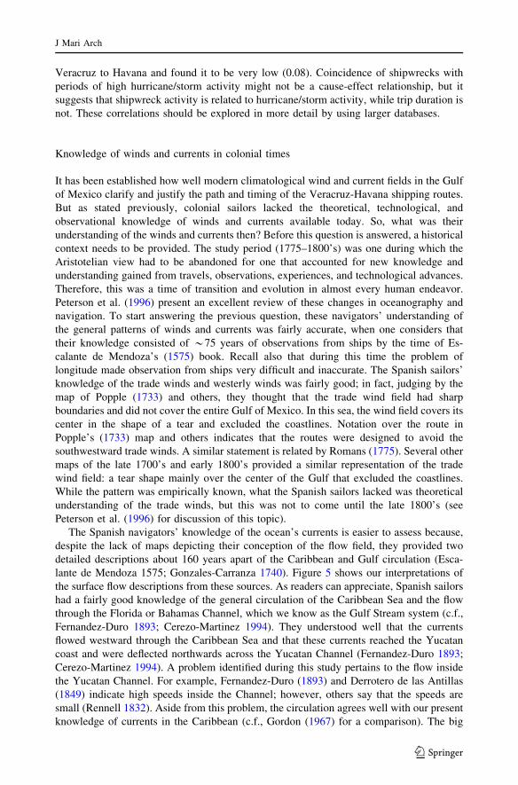
The Spanish navigators’ knowledge of the ocean’s currents is easier to assess because,
despite the lack of maps depicting their conception of the flow field, they provided two
detailed descriptions about 160 years apart of the Caribbean and Gulf circulation (Esca-
lante de Mendoza 1575; Gonzales-Carranza 1740). Figure 5 shows our interpretations of
the surface flow descriptions from these sources. As readers can appreciate, Spanish sailors
had a fairly good knowledge of the general circulation of the Caribbean Sea and the flow
through the Florida or Bahamas Channel, which we know as the Gulf Stream system (c.f.,
Fernandez-Duro 1893; Cerezo-Martinez 1994). They understood well that the currents
flowed westward through the Caribbean Sea and that these currents reached the Yucatan
coast and were deflected northwards across the Yucatan Channel (Fernandez-Duro 1893;
Cerezo-Martinez 1994). A problem identified during this study pertains to the flow inside
the Yucatan Channel. For example, Fernandez-Duro (1893) and Derrotero de las Antillas
(1849) indicate high speeds inside the Channel; however, others say that the speeds are
small (Rennell 1832). Aside from this problem, the circulation agrees well with our present
knowledge of currents in the Caribbean (c.f., Gordon (1967) for a comparison). The big
J Mari Arch
123

difference, however, occurs inside the Gulf of Mexico! The descriptions indicate that they
thought the currents turn westward upon entering the Gulf and flow along the coast all the
way around until becoming the outgoing current at the Florida Straits (Escalante de
Mendoza 1575; Gonzales-Carranza 1740; Lopez de Velasco 1894). This pattern is shown
in several maps found in sources such as Maury (1855), maps by de Fer (1702) and Dudley
(1661) both in Cerezo-Martinez (1994), a pilot chart by Kerhallet (1853), a chart by
Garcıa-Cubas (1885), and many other maps in Peterson et al. (1996). Pillsbury (1890)
states that the common view of the currents in the Gulf of Mexico is that a portion of the
Fig. 5 Surface circulation of the Caribbean and Gulf of Mexico, reconstructed from descriptions inEscalante de Mendoza (1575) and Gonzalez-Carranza (1740). Arrows represent direction of flow only sincespeeds were not reported or, more accurately, not observed
J Mari Arch
123

waters turn to the Florida Straits after entering the Gulf and that the remaining water turns
west and goes around the Gulf of Mexico until merging with the outflow at the Florida
Straits, a view shared by Rennell (1832). A 1914 chart by Soley (in Fishery Bulletin 89
1954) depicts three main currents inside the Gulf: a Gulf Stream gyrating around the Gulf
and exiting through the Florida Straits; an eastern branch that enters the Gulf and turns
immediately towards the Florida Straits; and a northwestern branch that intrudes the Gulf,
rotates anticyclonically, and exits through the Florida Straits. A chart in Chaunu (1977)
shows that some of the waters entering the Gulf of Mexico go north and turn east to exit via
the Florida Straits; another portion goes mainly west and becomes a vortex that is joined by
a third fraction that flows northwestward. The map does not show how the waters in the
western basin leave the Gulf of Mexico. The Chaunu (1977) map resembles two current
charts shown as Figures 34 and 35 in Fishery Bulletin 89 (1954) that suffer from the same
mass conservation problem. By the mid-1800’s it was no longer accepted, at least by some,
that waters entering the Gulf of Mexico flow westward along its perimeter, as descriptions
in Rennell (1823:150) and Derrotero de las Antillas (1949:401) indicate. Comparing old
depictions of the circulation in the Gulf of Mexico with that shown in Figure 3A reveals
that the colonial sailors were missing what is at present known as the Loop Current. This
high-speed current flows northward into the Gulf of Mexico through the western half of the
Yucatan Channel, turns clockwise, and exits through the Florida Straits, carrying most of
the influx of Caribbean water (Fig. 6). The Loop Current reaches speeds of 1.5–2.0 m/s,
carries 23–27 million cubic meters per second of water, and reaches up to latitude 288 N
inside the Gulf (Schmitz et al. 2005; Lugo-Fernandez in press). The Derrotero de las
Antillas (1849: pages 399–400) gives a description of the flow inside the Yucatan Channel
resembling our modern view of this current.
The early Spanish paradigm of currents in the Gulf of Mexico also makes the layout of
the routes logical. In fact, examination of the annual current map (Fig. 3A) reveals that
hypothesizing that the currents move around the Gulf of Mexico is a plausible interpre-
tation of the circulation. Only detailed observational studies, calculations of volume flux,
and modern numerical circulation models have revealed the circulation inside the Gulf.
Therefore, the Spanish paradigm of the Gulf’s circulation was probably justified on the
Fig. 6 Schematic representation of the Loop current in the Gulf of Mexico on the basis of modernunderstanding of this important current
J Mari Arch
123

basis of their oceanographic knowledge and observations of currents. But given the
experience gained during 300 hundred years of sailing in the Gulf of Mexico, the question
remains, how could these sailors miss the Loop Current? Two possible explanations are the
bias caused by the scheduling, which allows observation mainly during summer, and the
bias introduced by the routes themselves, which prevented observing the area of the Loop
Current. To the colonials’ defense, modern oceanography did not identify the Loop Current
until sometime between 1935 and the 1950’s; in his study of the Gulf of Mexico, Parr
(1935) did not mention this current but claims that water from the Caribbean takes the
shortest route to the Florida Straits with appreciable penetration inside the Gulf.
Discussion
This work examines the navigation route followed by Spanish vessels from Veracruz,
Mexico, to Havana, Cuba, across the Gulf of Mexico from 1575 to late 1800’s. Our route
database was assembled from historic maps and texts readily available; we did not have
access to the primary sources. While we do not know the basis for the mapmakers’ rendition
of the routes, it is apparent that these depictions are not just artistic renditions. We believe
that factual information was employed, and perhaps copied among them, in the routes’
portrayal to make their maps truthful and accurate within their limitations. Agreement
between the maps and reconstructed routes (Fig. 1) lends support to our claim against just
artistic renditions. Furthermore, Fig. 1 reveals a bias of the mapmakers for the northern
branch against the southern branch; only one of the maps showed the southern route. The
navigation texts revealed this branch of the route. Thus, we believe that we uncovered
sufficient and accurate information about the nature of the route employed by the Spanish in
their travels across the Gulf of Mexico. However, we could not assess the evolution and
refinements made to the route as new knowledge and experience were gained.
Spanish vessels navigated annually, as circumstances allowed, between Spain and
Mexico and returned to Spain via Havana. It is the first leg of the return trip, Veracruz to
Havana, that we examined in detail. The return leg consisted of two branches depending on
the wind direction at departure. The long or northern branch consisted of an arch that went
to latitude 27.58 N, then east, turned southeast near Florida until reaching Dry Tortugas,
and headed south to Havana through the Florida Straits. The second or southern branch
went only to latitude 258 N, proceeded east until the Dry Tortugas, and reached Havana,
similarly to the long route. The basic route pattern was established by Anton de Alaminos
in 1519 during his return trip to Spain to inform the King about the progress of the Mexican
conquest. No doubt that subsequently the route was refined but we could not evaluate this
aspect. The northern route had an average length of 1,170 nmi., while the southern route
had a length close to 985 nmi; both seemed equally important on the basis of the navigation
textbooks. The entire trip was over the deepwater (depths >200 m) of the Gulf, a fact not
surprising in light of the transoceanic travels of the era. The route length was covered in an
average time of 8–24 days, but reports suggest durations as high as 38–58 days with an
extreme of 87 days. Following the route was not a guarantee of a successful trip, but its use
over 350 years suggests that it was a highly advantageous route over which to conduct their
commerce, despite how widely known and predictable it was to Spain’s enemies.
The route, especially the northern branch, crosses over 16 OCS planning areas in which
oil and gas activities occur at present. Regulations governing the development and
exploration of petroleum resources require that the effects of these activities upon
archeological resources be considered during the permit processes. The results of this work
J Mari Arch
123

suggest that there is a significant probability that ships from the study period could be
found in areas depth’s of greater than 350 m under consideration by the oil and gas
industry. As Table 3 shows, 14 wrecks could be found in the deep waters of the Gulf of
Mexico. There is a good chance that more records of losses could be found in the Gulf if
the primary sources were consulted. Further study of primary sources is required to
determine if vessels were lost along this portion of the route, as opposed to waters closer to
Mexico, Florida, or Cuba.
Examination of historical events or conditions can always fall in the trap of basing the
analysis on current knowledge and not on the understanding of the time when the event
took place. In this study, we analyzed the Veracruz-Havana route under our present
knowledge of wind and current patterns and those during the study period. Under both sets
of knowledge, the pattern of the routes and timing of the trip were well designed. In fact,
the routes’ design was refined with considerations of the climatic conditions of the starting
and final destinations (Escalante de Mendoza, 1575). As such, the Spanish had a good
working knowledge of the hurricane season and the winter winds in the Gulf of Mexico;
however, that knowledge was still incomplete when compared with our modern knowl-
edge. Examination of their knowledge of the Caribbean and Gulf circulation reveals that it
resembles the large-scale aspect of our present understanding of the Caribbean, but departs
significantly in the Gulf of Mexico. In the Gulf, their paradigm of currents indicates a
strong flow entering through Yucatan, turning west and flowing along the entire perimeter
of the Gulf until exiting by the Florida Straits.
However, this pattern was evolving and approaching the modern view as observations
and knowledge increased over time. At present, we know that the flow across the Yucatan
Channel flows northward as a strong jet, turns clockwise near the Florida Peninsula without
extending farther west than about longitude 918 W, and exits across the Florida Straits. A
second branch seems to flow from Campeche around southern Mexico and north to the US,
where it flows eastward as a diffuse current. So the natural question is: Is the circulation
difference caused by interpretation and lack of data or was it real? The question is con-
founded by the fact that the study period coincided with the Little Ice Age.
We studied this difference and are proposing the following explanation: The interpre-
tation of the sailors’ observations of currents suggested the westward flow pattern could be
done from modern current fields (Fig. 3A), since their theoretical knowledge suggested that
flows continue until reaching a barrier and turning. This interpretation was reinforced by
the biases of the scheduling and routes of the trips, which prevented sampling the Loop
Current region. It was not until the advent of the chronometer, which allowed accurate
determination of longitude, that the accuracy of current observations increased to allow
distinguishing patterns better (Peterson et al. 1996). However, it took at least another
50 years before modern scientists identified the Loop Current. If there are any changes by
the Little Ice Age on the Gulf of Mexico circulation, it is hard to distinguish these effects in
the databases and literature available to us.
Conclusions
The main findings of this work are as follows:
1. Spanish vessels were crossing the Gulf of Mexico from Veracruz, Mexico, to Havana,
Cuba, at least annually for over 350 years; these trips took place over deep waters by
using a route that went north to latitude 27.58 N or to latitude 258 N and lasted from 8
to 24 days on average, but could last up to 87 days.
J Mari Arch
123

2. The route layout was optimal with respect to wind and ocean current fields, in terms
that it avoided areas that could delay the trip and used areas that helped with the
speedy crossing of the Gulf. The trips were scheduled around their knowledge of
winds and the hurricane season.
3. The routes crossed the portion of US waters where oil and gas activities are currently
taking place. This realization could potentially bring the oil and gas industry in contact
with a shipwreck of this period. Further study is needed to determine the likelihood of
such an occurrence.
4. Analysis of the current pattern in the Gulf as understood by the sailors of the study
period suggests that it differs from our present understanding of this circulation. We
hypothesized that such differences are caused by incomplete data and different
interpretations of the observations of currents because of their theoretical understand-
ing of oceanography.
Acknowledgments The authors appreciate the support of the US Department of the Interior, MineralsManagement Service, Gulf of Mexico OCS Region during the preparation of this manuscript. The opinionsexpressed by the authors are their own and do not reflect the opinion or policy of the US Government.
References
Cerezo-Martınez R (1988) Las rutas de las armadas de Castilla en los siglos XV y XVI. Instituto deInvestigacao Cientıfica Tropical, Lisboa, Serie Separatas 199, XXXIV:227–242
Cerezo-Martinez R (1994) La cartografıa nautica Espanola en los siglos XIV, XV, y XVI. Consejo Superiorde Investigaciones Cientıficas
Chaunu H (1977) Seville et l’Amerique aux XVI et XVII siecles. Flammarion, ParisChaunu H, Chaunu P (1955) Seville et l’Atlantique (1504–1650). 7 vols. Paris: S.E.V.P.E.NChurch R, Warren D, Cullimore R, Johnson L, Schroeder W, Patterson W, Shirley T, Kilgour M, Morris N,
Moore J (2007) Archaeological and biological analysis of World war II shipwrecks in the Gulf ofMexico: artificial reef effect in deep water. Report presented to the Minerals Management Service,U.S. Department of the Interior. OCS Study MMS 2007–015. New Orleans
de Fer N (1702) Le vieux Mexique ou la nouvelle Espagne avec les costes de la Florida. Reproduced as Fig.11 in: Cerezo-Martinez, R. 1994. La cartografıa nautica Espanola en los siglos XIV, XV, y XVI.Consejo Superior de Investigaciones Cientıficas
Derrotero de las Antillas (1849) Direccion de Hidrografıa de Espana. 5ta EdicionDudley R (1661) Carta particolare della baia de Messico con la costa. Reproduced as Fig. 9. In: Cerezo-
Martinez R (ed) 1994. La cartografıa nautica Espanola en los siglos XIV, XV, y XVI. Consejo Superiorde Investigaciones Cientıficas
Escalante de Mendoza J (1575) Itinerario de navegacion. Museo Naval de Madrid 1985Fernandez Duro C (1996) Disquisiciones nauticas, 6 vols. Madrid, 1876–81Fernandez-Duro DC (1893) Andres de Morales: observador de las corrientes oceanicas. Boletın Sociedad
Geografica de Madrid 34:362–373Fishery Bulletin 89 (1954) Gulf of Mexico its origin, waters, and marine life. Coordinated by P.S. Galtsoff,
Fishery Bulletin of the Fish and Wildlife Service, vol 55, US Government Printing Office, Washington,DC
Florida A&M University (1988) Meteorological database and synthesis for the Gulf of Mexico. Dept. of theInterior, Minerals Management Service, Gulf of Mexico OCS Region, New Orleans, La. OCS StudyMMS 88–0064
Gagliano SM (1977) Cultural resources evaluation of the northern Gulf of Mexico. Vols 1–3. Coastalenvironments, Inc. Prepared for Bureau of Land Management (now the MMS) and Office ofArchaeology and Historic Preservation, National Park Service
Garcıa-Cubas A (1885) Carta Hydrografica. National Atlas Map. David Rumsey Collection: http://www.davidrumsey.com. (23/04/07)
Garcıa RR, Dıaz HF, Garcıa-Herrera R, Eisched J, del Rosario Prieto M, Hernandez E, Gimeno L, Rubio DuranF, Bascary AM (2001) Atmospheric circulation changes in the tropical Pacific inferred from the voyagesof the Manila galleons in the sixteenth-eighteenth centuries. Bull Am Meteorol Soc 82:2435–2455
J Mari Arch
123

Garcıa R, Gimeno L, Hernandez E, Prieto R, Ribera P (2000) Reconstructing the North Atlantic atmosphericcirculation in the 16th, 17th, and 18th centuries from historical sources. Climate Res 14:147–151
Garcıa-Baquero Gonzalez A (1976) Cadiz y el Atlantico (1717–1778). 2 vols. Escuela de Estudios Hispano-Americanos de Sevilla, Seville
Garcıa-Herrera R, Rubio F, Wheeler D, Hernandez E, Prieto MR, Gimeno L (2004) The use of Spanish andBritish documentary sources in the investigation of Atlantic hurricanes in historical times. In: Mur-mane R, Liu K-B (eds) Hurricanes: present and past: 149–176. Columbia University Press, New York
Garcıa-Herrera RC, Gimeno L, Ribera P, Hernandez E (2005) New Records of Atlantic hurricanes fromSpanish documentary sources. J Geophys Res 110:D03109, doi:10.1029/2004JD005272
Garrison EG, Giammona CP, Kelly FJ, Tripp AR, Wolf GA (1989) Historic shipwrecks and magneticanomalies of the northern Gulf of Mexico: reevaluation of archaeological resources management zone1. OCS Study MMS 89-0023 to 0025, New Orleans. Report available at http://www.gomr.mms.gov/homepg/regulate/environ/studiesprogram.html
Gonzales-Carranza D (1740) A geographical description of the coasts, harbours, and sea ports of the SpanishWest-Indies. Trans Caleb Smith, London
Gordon AL (1967) Circulation of the Caribbean Sea. J Geophys Res 72:6207–6223Grove JM (2001) The initiation of the ‘‘Little Ice Age’’ in regions round the North Atlantic. Clim Change
48. 1:53–82Haring CH (1918) Trade and navigation between Spain and the Indies in the time of the Hapsburgs. Harvard
University Press, Cambridge MassachusettsHirzy J (1992) Fray Isidro de la Asuncion, itinerario a Indias (1673–1678). Centro de Estudios de Historia de
Mexico, Condumex MexicoHsu SA (1993) The Gulf of Mexico––a breeding ground for winter storms. Mar Log 37. 2:4–11Irion JB (2002) Cultural resource management of shipwrecks on the Gulf of Mexico outer continental slope.
Presented at the Second Annual MIT Conference on Technology, Archaeology, and the Deep Sea.Cambridge, Massachusetts, April 26–28, 2002 http://web.mit.edu/deeparch/www/events/2002confer-ence/papers/Irion.pdf
Irion JB (2006) A late-eighteenth or early-nineteenth century shipwreck in the deep Gulf of Mexico. Paperpresented at the 39th Conference on Historical and Underwater Archaeology, Sacramento, California,January 2006
Kerhallet CP De (1853) Manuel de la navigation dans la Mer des Antilles et dans le Golfe du Mexique. ParisLopez de Velasco J (1894) Geografia y descripcion universal de las indias. Establecimiento Tipografico de
Fortanet, MadridLugo-Fernandez A Is the loop current a chaotic oscillator? J Phys Oceanogr (in press)Marmer HA (1929) The Gulf stream and its problems. Geogr Rev 19:457–478Maury MF (1855) The physical geography of the sea, 3rd edn. Harper Brothers, New YorkNowlin WD Jr, Jochens AE, DiMarco SF, Reid RO, Howard MK (2001) Deepwater physical oceanography
reanalysis and synthesis of historical data: synthesis report. OCS Study MMS 2001-064, U.S. Dept. ofthe Interior, Minerals Management Service, Gulf of Mexico OCS Region, New Orleans, La. Reportavailable at http://www.gomr.mms.gov/homepg/regulate/environ/studiesprogram.html
Nowlin WD, Jochens AE, Reid RO, Dimarco SF (1998) Texas-Louisiana shelf circulation and transportprocess study: synthesis report LATEX A, vol I and II. OCS Study MMS 98-0035 and MMS 98-0036.U.S. Dept. of the Interior, Minerals Management Service, Gulf of Mexico OCS Regional Office, NewOrleans. Report available at http://www.gomr.mms.gov/homepg/regulate/environ/studiesprogram.html
Parr AE (1935) Report on the hydrographic observations in the Gulf of Mexico and the adjacent straits madeduring the Yale oceanographic expedition on the Mabel Taylor in 1932. Bull Bingham Oceanogr Coll5. 1:1–93
Parry JH (1966) The Spanish seaborne empire. Alfred A. Knopf, New YorkPatchen RC, Oey L-Y, Mellor GL (1993) Appendix G: Gulf of Mexico deterministic modeling results, in
coastal ocean modeling program for the Gulf of Mexico. Final report to the Minerals ManagementService, contract number 15-35-0001-30631, three volumes with separate appendices. Report No.115G: 82 pp
Pearson CE, James SR Jr, Krivor MC, Dean El Darragi S, Cunningham L (2003). Refining and revising theGulf of Mexico outer continental shelf region high-probability model for historic shipwrecks. OCSStudy MMS 2003: 60–62, New Orleans. Report available at http://www.gomr.mms.gov/homepg/reg-ulate/environ/studiesprogram.html
Perez-Mallaina PE (1997) El hombre frente al mar: naufragios en la carrera de Indias durante los siglos XVIy XVII. Universidad de Sevilla, Sevilla
Perez-Mallaina PE (1998) Spain’s men of the sea (Trans Carla R. Phillips). The John Hopkins UniversityPress, Baltimore
J Mari Arch
123

Peterson M (1975) The funnel of gold. Little, Brown, & Co, BostonPeterson RG, Stramma L, Kortum G (1996) Early concepts and charts of ocean circulation. Progr Oceanogr
37:1–115Pillsbury JE (1890) The Gulf stream––a description of the methods employed in the investigation, and the
results of the research. Report, Superintendent, U.S. Coast, Geodetic. Survey, Appendix 10:461–620Popple H (1733) Map of the British Empire in North America (London, 1733) http://www.usm.maine.edu/
maps/popple/reproduction.htmlPorter y Casanate P (1634) Reparo a errores de la navegacion Espanola. Zaragoza, EspanaRennell J (1832) An investigation of the currents of the Atlantic Ocean and of those which prevail between
the Indian Ocean and the Atlantic. J.G. & F. Rivington, LondonRhodes RC, Thompson JD, Wallcraft AJ (1989) Buoys-calibrated winds over the Gulf of Mexico. J Atmos
Ocean Technol 6. 4: 608–623Romans B (1775) A concise natural history of east and west Florida. Reprinted 1962. University Press of
Florida, GainesvilleSchmitz WJ, Biggs DC, Lugo-Fernandez A, Oey L-Y, Sturges W (2005) A synopsis of the circulation in the
Gulf of Mexico and on its continental margins. In: Sturges W, Lugo-Fernandez A (eds) Circulation inthe Gulf of Mexico: observations and models. Am Geophys Union Monogr No. 161:11–29
Smith RC (1988) Treasure ships of the Spanish main: the Iberian-American maritime empires. In: George F.Bass (ed) Ships and shipwrecks of the Americas. Thames and Hudson, New York, pp 85–106
Soon W, Baliunas S, Idso C, Idso S, Legates DR (2003). Reconstructing climatic and environmental changesof the past 1000 years: a reappraisal. Energ Environ 14:233–296
J Mari Arch
123