Post‐logging in remote rural forest areas of Gabon and its lon
391
Page 1 of 391 L’Okoumé, fils du manioc : Post‐logging in remote rural forest areas of Gabon and its long‐term impacts on development and the environment. Olivier Hymas Thesis submitted in fulfilment of the requirements for the degree of Doctor of Philosophy University College London 2015
-
Upload
khangminh22 -
Category
Documents
-
view
0 -
download
0
Transcript of Post‐logging in remote rural forest areas of Gabon and its lon
Page 1 of 391
L’Okoumé, fils du manioc : Post‐logging in remote rural forest areas of Gabon and its long‐term
impacts on development and the environment.
Olivier Hymas
Thesis submitted in fulfilment of the requirements for
the degree of Doctor of Philosophy
University College London
2015

Page 2 of 391
“We do need time to think. We do need time
to digest. We do need time to misunderstand
each other, especially when fostering lost
dialogue between humanities and natural
sciences. We cannot continuously tell you what
our science means; what it will be good for;
because we simply don’t know yet. Science
needs time. —Bear with us, while we think”
(The Slow Science Academy, 2010)
“Theory helps us to bear our ignorance of facts”
(Santayana, 1896, p.125)
“On the Shoulders of Giants”
(Merton, 1993)
“I, [Olivier Hymas,] confirm that the work presented in this thesis is my own. Where information
has been derived from other sources, I confirm that this has been indicated in the thesis” (UCL,
2015).
Signed:
Page 3 of 391
Abstract
Development and conservation theory use a chain of logic to suggest that timber industries bring
long‐term development to rural areas at the expense of the environment. This logic chain
assumes that the arrival of industry and their transport infrastructure in an un‐exploited area
creates employment opportunities that result in economic development which attracts migrants
and the commodification of agricultural and forest products.
However, this chain does not factor in historic natural resource exploitation before the arrival
of timber companies, nor what occurs after their departure. This thesis proposes an alternative
chain of logic which incorporates these two. By using historic literature, social and ecological
methods, this alternative is explored in Gabon, where 60% of roads are logging roads and 44%
of its forests are timber concessions.
The long history of exploitation of natural resources has resulted in the local extinction of species
which have then recovered, while any resulting development has been one of booms and busts.
Two sets of sites, where transport infrastructure had been created by timber companies,
demonstrate the repercussions of the departure of companies. Only in the less remote sites was
it found that commercial bushmeat hunting occurred. In the remote sites transport
infrastructure had collapsed, livelihoods had reverted to subsistence activities, migrants had left,
while education levels were worse. In one remote village animal signs were higher than in a
remote village that had never been logged. These findings correspond with Von Thünen’s classic
theory on land use and access.
By overlooking the drawbacks of the accepted chain of logic, misleading blanket assumptions
have been created. This can contribute to project failure. Assumption drag has been created not
only due to a lack of a multidisciplinary approach but also because research is usually only
carried out while timber operations are occurring.

Page 4 of 391
Acknowledgement
For all the “monomaniacs” (Wadham, 2013, p.132).
Thanks go to everyone, especially the doctors and nurses who kept patching me up so that I can
go back to the forest and the peoples of Africa. Many thanks to Katherine who somehow
managed to corral my thoughts and writing into something that I hope is intelligible. Thanks also
to Gretchen, who amazingly did not go crazy after reading each chapter a dozen times. Also
thanks to Marcus for looking over the statistics.
Kevin, Stevens, Repara, Wille first work colleagues and then research assistants who I dragged
into the middle of nowhere, just to see what was there. Hopefully one day we can get together
again and drink some Régabs. Also thanks to Kate and Anne‐Marie for helping me to get set up
in Gabon.
To Eric, Fiston, Malcolm and their families, their families who had to put up with both of them
disappearing to moan about the white car society in some bar deep in les quartier populaires of
Libreville.
To the village of Santa‐Clara, home for over seven years, especially Copain, Petit Paul, Claude,
Ndong, American, Maman Theresse, Boulingey, and all the chefs. Where each day our only
thoughts were on the state of the roads. Even though the lights of Libreville were reflected off
the roofs of the houses, they were a world away. I hope that one day I may again have the
privilege to fit as many of you into my car and give you a lift.
I would also like to thank John and Charles for their long conversations, et beaucoup de Bla Bla
Bla, over grilled fish in Yaoundé.
Thanks to Loz and Judy for allowing me to work in sites that they have been studying for a long
time.
Finally to all the people in Waka and Koulamoutou. Chimie, Canton, Slipe, Maman Jeanne and
the list continues. Many thanks to you all for putting up with me. One day I hope to find myself
with you again. I know that is probably just a fruitless wish. But one can but try.
Now pass me the palm wine and palm grubs.

Page 5 of 391
Tableofcontents
Abstract .......................................................................................................................................... 3
Acknowledgement ......................................................................................................................... 4
Table of contents ........................................................................................................................... 5
List of figures ................................................................................................................................ 10
List of tables ................................................................................................................................. 14
List of pictures .............................................................................................................................. 18
List of maps .................................................................................................................................. 19
Preamble ...................................................................................................................................... 23
1 Introduction: isolated states, timber companies and remote rural communities in
Gabon ........................................................................................................................................... 25
1.1 Overview of chapter ..................................................................................................... 29
1.2 Literature review .......................................................................................................... 30
1.2.1 Assumption drag ................................................................................................. 30
1.2.2 Von Thünen’s spatial analysis of tradable resources .......................................... 33
1.2.3 Transport infrastructure and development ........................................................ 39
1.2.4 Timber companies, transport infrastructure and development ......................... 42
1.2.5 Transport infrastructure and the environment .................................................. 49
1.2.6 Patch dynamics and logging ................................................................................ 55
1.2.7 Current research on the impacts of timber companies and their transport
infrastructure on development and the environment ....................................................... 59
1.3 Aim of thesis................................................................................................................. 61
2 Background to the study sites and methods ....................................................................... 64
2.1 An overview of Gabon .................................................................................................. 64
2.1.1 Geography and Climate ...................................................................................... 65
2.1.2 The Peoples of Gabon ......................................................................................... 66
2.1.3 Population ........................................................................................................... 67
2.1.4 Colonisation ........................................................................................................ 68
2.1.5 Economy .............................................................................................................. 69
2.1.6 Gabon and land use ............................................................................................ 69
2.1.7 The study sites .................................................................................................... 70
Page 6 of 391
2.2 Overview of methods ................................................................................................... 74
2.2.1 Historical approach ............................................................................................. 76
2.2.2 Geographic information system methods .......................................................... 77
2.2.3 Social methods .................................................................................................... 80
2.2.4 Ecological methods ............................................................................................. 83
2.2.5 Data analysis ....................................................................................................... 83
2.2.6 Critique of data collection ................................................................................... 85
3 Background resource use history. Exploitation of natural resource since the Atlantic Trade
and its short and long‐term impacts on the environment and economic development of
Gabon ........................................................................................................................................... 88
3.1 Summary ...................................................................................................................... 88
3.2 Introduction ................................................................................................................. 89
3.2.1 Trade and the spread of disease in Gabon (mid‐fifteenth century to present) . 91
3.2.2 Brief overview of the history of trade in natural resources in pre‐colonial Gabon
and its short and long term impacts on the environment (pre late nineteenth century) 103
3.2.3 Colonial trade – late nineteenth century to independence (1960) .................. 106
3.2.4 Short‐term environmental impacts of logging .................................................. 116
3.2.5 Long‐term environmental impacts of colonial logging ..................................... 118
3.3 Conclusion .................................................................................................................. 120
4 Migration, population and patch dynamics in the Ikoy Valley .......................................... 124
4.1 Summary .................................................................................................................... 124
4.2 Introduction ............................................................................................................... 125
4.2.1 Sedentary Pygmies in Gabon ............................................................................ 126
4.3 Methods ..................................................................................................................... 128
4.4 Results ........................................................................................................................ 130
4.4.1 The People in the area of the Ikobey study site ............................................... 130
4.4.2 Migrations ......................................................................................................... 136
4.5 Discussion and Conclusion ......................................................................................... 155
4.5.1 The impact of trade on logging and conservation ............................................ 155
4.5.2 The impact of trade on migration ..................................................................... 156
5 The timber industry and access ......................................................................................... 159
Page 7 of 391
5.1 Summary .................................................................................................................... 159
5.2 Theory ........................................................................................................................ 159
5.3 Research questions .................................................................................................... 161
5.4 Methods ..................................................................................................................... 161
5.5 Results ........................................................................................................................ 165
5.5.1 Creation of transport infrastructure to the sites .............................................. 165
5.5.2 Past and current maintenance of transport infrastructure in the sites ............ 166
5.5.3 Changes in access to public transport in the sites ............................................ 170
5.5.4 Factors that may impact access to transport in remote rural forest areas ...... 173
5.6 Discussion and Conclusion ......................................................................................... 177
6 Post‐logging and disintegration of direct development by timber companies ................. 181
6.1 Summary .................................................................................................................... 181
6.2 Theory ........................................................................................................................ 182
6.3 Research question ...................................................................................................... 183
6.4 Methods ..................................................................................................................... 184
6.5 Results ........................................................................................................................ 188
6.5.1 Education .......................................................................................................... 188
6.5.2 Employment ...................................................................................................... 193
6.5.3 The impacts of migration on education and employment ............................... 199
6.6 Discussion and Conclusion ......................................................................................... 201
6.6.1 Education .......................................................................................................... 202
6.6.2 Employment ...................................................................................................... 203
7 Post‐logging and livelihood activities ................................................................................. 206
7.1 Summary .................................................................................................................... 206
7.2 Theory ........................................................................................................................ 206
7.3 Research questions .................................................................................................... 208
7.4 Methods ..................................................................................................................... 208
7.5 Results ........................................................................................................................ 211
7.5.1 Overview of market sites .................................................................................. 211
7.5.2 Overview of livelihood activities based on the environment ........................... 214
7.6 Discussion and Conclusion ......................................................................................... 222
8 Logging and the long term impact on the environment .................................................... 225

Page 8 of 391
8.1 Summary .................................................................................................................... 225
8.2 Theory ........................................................................................................................ 226
8.3 Research question ...................................................................................................... 227
8.4 Methods ..................................................................................................................... 227
8.5 Results ........................................................................................................................ 232
8.5.1 Vegetation ......................................................................................................... 232
8.5.2 Impacts .............................................................................................................. 233
8.5.3 Animals .............................................................................................................. 235
8.6 Discussion and Conclusion ......................................................................................... 240
9 Conclusions and Discussion ............................................................................................... 244
9.1 Overview .................................................................................................................... 244
9.2 Summary of results .................................................................................................... 248
9.2.1 Past natural resource exploitation in Gabon .................................................... 248
9.2.2 Timber companies and access .......................................................................... 250
9.2.3 Timber companies and direct development ..................................................... 252
9.2.4 Timber companies and migration ..................................................................... 254
9.2.5 Timber companies and livelihoods ................................................................... 256
9.2.6 Timber companies and the environment ......................................................... 257
9.3 Limitations to the study and further research ........................................................... 259
9.4 Implications of this study on conservation practice .................................................. 260
9.5 Final words ................................................................................................................. 263
10 Bibliography ....................................................................................................................... 265
11 Appendices ......................................................................................................................... 318
11.1 Results from literature search on logging in Africa and its impacts .......................... 318
11.2 Heterotopian view of a landscape as seen from different disciplines ....................... 321
11.3 The lie of the road ...................................................................................................... 323
11.4 Referring to Pygmies .................................................................................................. 332
11.5 Forms used in demography questionnaires ............................................................... 335
11.6 Form used in activity questionnaires ......................................................................... 337
11.7 The use of statistics and modelling ............................................................................ 338
11.8 Pre‐ Atlantic trade – pre mid‐fifteenth century ......................................................... 341
Page 9 of 391
11.8.1 Metallurgical products traded during the pre‐Atlantic trade ‐ pre mid‐ fifteenth
century ........................................................................................................................... 341
11.8.2 The impact of the pre‐Atlantic trade on the environment – pre mid‐ fifteenth
century ........................................................................................................................... 342
11.9 Atlantic Trade – mid‐fifteenth century to mid‐ nineteenth century ......................... 344
11.9.1 Some products traded during the Atlantic trade ‐ mid‐fifteenth century onwards
........................................................................................................................... 344
11.9.2 The impact of the Atlantic trade on the environment – pre mid‐fifteenth century
onwards ........................................................................................................................... 348
11.10 Early transport of logs ................................................................................................ 360
11.11 The stacked deck: the demise of indigenous African logging .................................... 361
11.12 Annual exports of Okoumé from Gabon. ................................................................... 363
11.13 Comparison of the Waka site with two other sites close by ..................................... 367
11.14 The recent migration of the Mitsogho into the Ikobey study site ............................. 368
11.15 The recent migration of the Akele into the Ikobey study site ................................... 372
11.16 The recent migration of the Babongo Pygmies into the Ikobey study site ................ 375
11.17 A short history of the “discovery” of Pygmies and the role of Gabon ....................... 382
11.18 Some cases of assumption drag ................................................................................. 384
11.18.1 Assumption drag concerning Pygmies .......................................................... 385
11.18.2 Implications of assumption drag on funding and communication ............... 386
11.18.3 Implications of assumption drag for research .............................................. 387
11.18.4 Implications of assumption drag for sustainable development projects ..... 387
11.18.5 Implications of assumption drag for environmental science ........................ 388
11.19 Modeling including the role of ethnicity on animal frequency ................................. 390

Page 10 of 391
Listoffigures
Figure 1‐1: The typical chain of logic that conservation practitioners use to plan projects. A
conservation project can act at any one of the steps to reduce environmental degradation. .. 25
Figure 1‐2: The omissions (in red) in the chain of logic used by conservation practitioners to the
arrival of timber companies in remote rural forested areas. ..................................................... 26
Figure 1‐3: Proposed chain of logic (in red) added to the typical chain of logic (in black) to the
arrival of timber companies in remote rural forested areas, numbers correspond to events
described below. Note The migration of people out of the area can occur at any time after the
timber company departs. ........................................................................................................... 28
Figure 1‐4: Von Thünen’s rings under different conditions (from Peet, 1969, p.287; and Mäki,
2011, p.54) .................................................................................................................................. 36
Figure 1‐5: Idealised chain of events around a market “Town” when a timber company arrives in
an “Isolated State” showing how the land where marketable products are found changes, based
on von Thünen’s rings, resulting in the marketable products for villages, “farmsteads”, changing
as roads degrade. ........................................................................................................................ 38
Figure 1‐6: Proposed amendment to the chain of logic used by conservation practitioners. ... 61
Figure 2‐1: An example of one of the many particularities of Gabon, the amount of land area
that is forested (from Megevand and World Bank, 2013, p.2) ................................................... 65
Figure 2‐2: Demographic evolution and projections in the Congo basin (adapted from Ongolo et
al., 2013, p.177). ......................................................................................................................... 67
Figure 3‐1: Historic change of trader tiers and the area susceptible to the spread of disease due
to trade (red circle), created by combining the works of Chamberlin and Headrick. Trading tiers
are based on Chamberlin’s (1977) trade analysis while the spread of disease is based on
Headrick’s (1994) analysis. .......................................................................................................... 96
Figure 3‐2: Exports of Okoumé from Gabon. The 1896 to 1962 data was converted from metric
tons to cubic metres calculated using the Brunck et al. (1990, p.92) conversion factor. For the
raw data see Table 11‐4 in Appendix 11.12. The red boxes indicate busts and the black boxes the
booms that are mentioned in the text. .................................................................................... 114
Figure 4‐1: Summary of events and the impact that they had on both the people and the
environment of the villages of the Ikobey study site. .............................................................. 133
Figure 4‐2: Changes in population of study villages between 2003 and 2010. ........................ 153
Figure 4‐3: Proportion of each village that is made up of one of the principal ethnicities of the
area ........................................................................................................................................... 153

Page 11 of 391
Figure 5‐1: Pairplot of selected explanatory transport variables (diagonal). Each cell below the
variables represents an estimated pairwise Pearson correlations between the corresponding
variable at the top of the column with the variable to the right of the row. The font size of these
values is proportional to the absolute value of the estimated coefficient, so the bigger the font
the more correlated the pair of variables (see Ieno and Zuur, 2015, p.81 for Pairplots). ........ 173
Figure 5‐2: Number of taxis from the various villages to the nearest market from the
Koulamoutou and Ikobey study sites. NOTE: The villages of Makoko and Ngondet can only be
reached via footpaths and so have been removed. ................................................................. 174
Figure 5‐3: Relationship between the cost per distance of taxis and the average speed to each
village site from the various villages to the nearest market. NOTE: The villages of Makoko and
Ngondet can only be reached via footpaths and so have been removed. The linear regression of
the cost per distance travelled (r2=0.699) is significant (ANOVA, F=17.235, DF=7, p=0.006). . 174
Figure 5‐4: Pairplot of selected explanatory variables influencing years since road was last
maintained (diagonal). The lower panel contains estimated pairwise Pearson correlations and
the font size is proportional to the absolute value of the estimated coefficient (see Ieno and
Zuur, 2015, p.81 for Pairplots). ................................................................................................. 175
Figure 5‐5: The impact of distance between villages and market on the number of years since
the road was last repaired and how this affects speed of taxis. The red line shows the average
speed for all the sites. NOTE: Ngondet is not present as the village has no road. The linear
regression for years since road was last maintained against distance (r2=0.557) is significant
(ANOVA, F=8.806, DF =8, p=0.021) while the average speed linear regression (r2=0.825) is also
significant (ANOVA, F=112.260, DF =7, p=0.000), with a very high coefficient of determination.
.................................................................................................................................................. 175
Figure 5‐6: Best fitting model of the impact of different logging scenarios on minimum speed to
market against distance, with data points from study sites. .................................................... 177
Figure 6‐1: School Life Expectancy of children and teenagers of the Bantu‐speaking villages. The
linear regression of School Life Expectancy (r2=0.925) is significant (ANOVA, F=36.963, DF=4,
p=0.009). ................................................................................................................................... 189
Figure 6‐2: Model of impact of distance that a village is from a market on the number of years
of education of the Bantu‐speaking population. ...................................................................... 191
Figure 6‐3: Model of impact of distance that a village is from a market and past presence of a
timber company on the number of years of education of the Bantu‐speaking population. ... 192
Figure 6‐4: Plot of the number of years that Bantu‐speaking children and teenagers are educated
comparing villages where there has been a timber company present with ones where there has
not. ............................................................................................................................................ 192

Page 12 of 391
Figure 6‐5: Percent of people employed in each of the study village, excluding children and
infants. ...................................................................................................................................... 194
Figure 6‐6: Key employment sectors in all study villages, with total number of people employed
in all sectors N=321. .................................................................................................................. 194
Figure 6‐7: Effect of distance from the nearest market on the probability of employment. ... 195
Figure 6‐8: Percentage of jobs where some sort of training is needed. ................................... 197
Figure 6‐9: Distance people from each village have to migrate to find employment. The linear
regression of the distance people with no training have to migrate to find work (red line)
(r2=0.536) is significant (ANOVA, F=9.225, DF=9, p=0.016). The linear regression of the distance
people with training who had once migrated to find work in the past (r2=0.241) is not significant
(ANOVA, F=2.227, DF=8, p=0.179). ........................................................................................... 198
Figure 6‐10: Percentage of people who have migrated away from the village. ....................... 201
Figure 7‐1: Breakdown of the total number of items collected around the villages. ............... 211
Figure 7‐2: Value of items brought back to the village that are then to be used. Excluding any
item where a part of it was used and another part sold. ......................................................... 215
Figure 7‐3: Value of the items brought back to the village that are then to be sold. Excluding
ivory and any item where a part of it was used and another part sold. The sale of items, especially
of bushmeat, in the Ikobey village is very small. ...................................................................... 216
Figure 7‐4: Amount of different types of bushmeat and non‐bushmeat items that was brought
to the village, per person who participated in survey. ............................................................. 216
Figure 7‐5: Distribution of each of the environments from which items were transported back to
the village by the active population, each trip. The linear regression of the forest environments
visited by people (r2=0.399) is significant (ANOVA, F=5.302, DF=9, p=0.050). The linear regression
of the plantation environments visited by people (r2=0.299) is not significant (ANOVA, F=3.412,
DF=9, p=0.102). ......................................................................................................................... 217
Figure 7‐6: Percent of population who have collected items from the forest, plantation or rivers
during the study period. ........................................................................................................... 218
Figure 7‐7: Model of the variables that contribute to the value of all items with which people
have returned to the village, based on model from average AICs. .......................................... 220
Figure 7‐8: Model of the variables that contribute to the value of non‐bushmeat items with
which people have returned to the village and which are then used, based on model from
average AICs. ............................................................................................................................. 222
Figure 8‐1: Structure of IUCN Red List categories (from IUCN, 2012, p.5). .............................. 231
Figure 8‐2: Principal forest type of each 100 m sections of the transect in each of the study site
villages. The proportion of Plantations and Secondary forest decrease with distance from market

Page 13 of 391
town, while mature forests increase. In no case is the linear regression significant (ANOVA
Plantation F=1.847, DF=8, p=0.211; Secondary F=2.653, DF=8, p=1.420; Mature F=0.557, DF=8,
p=0.477). ................................................................................................................................... 233
Figure 8‐3: Overall long‐term human impacts on the forest found along the transect in each of
the study site villages. ............................................................................................................... 234
Figure 8‐4: Overall short‐term, “individual”, human impacts on the forest found along the
transect in each of the study site villages. ................................................................................ 235
Figure 8‐5: Number of all animal signs observed along the transect in each of the study site
villages. There seems to be an increase in the total number of animal signs with distance from
market with the linear regression (r2=0.404) being significant (ANOVA, F=5.419, DF=8, p=0.048).
.................................................................................................................................................. 236
Figure 8‐6: Number of all animal signs observed along the transect in each of the study site
villages. The linear regressions that are significant are shown: Elephants (r2=0.502, ANOVA,
F=8.051, DF=8, p=0.022), Great Apes and Primates (r2=0.785, ANOVA, F=29.285, DF=8, p=0.001),
Pangolins (r2=0.595, ANOVA, F=11.731, DF=8, p=0.009) and Other Animals (r2=0.596, ANOVA,
F=11.785, DF=8, p=0.009). ........................................................................................................ 237
Figure 8‐7: Animal signs grouped by principal IUCN Red list of Threatened Species categories
found along the transects of villages where logging has occurred. The linear regression that is
significant is the threatened grouping consisting of IUCN categories Critically Endangered,
Endangered, and Vulnerable (r2=0.522, ANOVA, F=6.549, DF=8, p=0.043). ............................ 237
Figure 8‐8: Number of all animal signs observed along the transect in each of the study site
villages by population size (teenage to elderly). Though there is no general trend, it does show
that the Babongo Pygmy villages (in black) have more animal signs that the Bantu‐speaking
villages (in red). The linear regression (r2=0.0004) is not significant (ANOVA, F=0.004, DF=8,
p=0.955). ................................................................................................................................... 238
Figure 8‐9: Model predictions from Generalised Linear Mixed Model where an area has either
never been logged or has been logged at different times in the past. Only areas that have never
been logged or logged within the last 5 years are significant in the model. Though the model can
also be fitted with data from areas where logging occurred more than 6 years ago, as done here,
it does not come out in the model as a significant predictor variable due to the number of sites
within this category. ................................................................................................................. 240
Figure 9‐1: Proposed amendment (in red) to the chain of logic used by conservation
practitioners. ............................................................................................................................. 245
Figure 11‐1: Recorded exports of ivory from Gabon over time. For the raw data see Table 11‐3.
Note * the first bar is with data that comes just from around Loango. ................................... 356

Page 14 of 391
Listoftables
Table 1‐1: Examples of assumed chain of logic for some theoretical papers which have been put
into question by research in Gabon. ........................................................................................... 32
Table 1‐2: Number of relevant articles found from a literature search using Metalib and Google
Scholar, with the key phrases “Logging Africa, “Bushmeat Logging Africa” and “Logging
Development Africa” and organised into five categories. For each of the key phrases the first 500
results from Google Scholar and 200 results from Metalib (total number of results = 21,000)
were looked at. ........................................................................................................................... 60
Table 2‐1: Summary of characteristics of each study site village. NOTE: the village of Makoko did
have road access ten years ago. ................................................................................................. 71
Table 2‐2: Summary of the number of open interviews and total number of people involved in
the collection of oral migration histories as used in Chapter 4. ................................................. 77
Table 2‐3: Summary of access data to each village site from the nearest market. .................... 79
Table 2‐4: Summary of semi‐structure interviews used as data for the various chapters. For
Chapter 6 all employed people were recorded. For Chapter 7 all people who returned to the
village with an item were recorded. Percentage of people who participated are not show here
as the total 2010 population size includes children and infants. ............................................... 79
Table 2‐5: Summary of the number of people participating during the twelve day collection
survey. ......................................................................................................................................... 82
Table 3‐1: Products traded during the Atlantic period. ............................................................ 104
Table 4‐1: Number of participants and dates when principal oral migration interviews were
carried out. ................................................................................................................................ 128
Table 4‐2: Local event calendar. ............................................................................................... 129
Table 4‐3: Summary of the number of households who participated in the demographic data
collection. .................................................................................................................................. 129
Table 4‐4: Population size of the villages above Ikobey, excluding the forestry camp, with the
total approximate distance that the people in the study villages migrated. The village of Dikouka,
no longer exists, with the population being integrated into other villages. ............................ 132
Table 4‐5: Summary of 2010 census data. ................................................................................ 152
Table 4‐6: Principal population ethnicity in villages. Highlighted villages are villages where the
timber industry had a base during this period. ........................................................................ 154
Page 15 of 391
Table 5‐1: Summary of data collection on the state of transport infrastructure and availability of
public transport......................................................................................................................... 161
Table 5‐2: Average top models from combining all the different variables of the full linear
regression, which resulted in 72 different possible models. .................................................... 164
Table 5‐3: Distance to the principal markets with time since loggers had last been in each village
and time since the maintenance of the roads to each village. Notes: ǂ in both these villages
loggers returned at the end of the study and repaired the road. †Neither Makoko nor Ngondet
have a viable road. .................................................................................................................... 168
Table 5‐4: Distance and travel time to the principal markets, with frequency and cost of taxis.
Notes: * Maximum time to market if based on getting a taxi after waiting for a taxi. ≠ Distance
travelled per average time is calculated by dividing the distance to market with the minimum
average me it takes to get there. † End of usable road. ǂ in both these villages the road was
maintained at the end of the study by a timber company, after the data was collected. ≡ Road
no longer usable. ≠ No road present. ....................................................................................... 172
Table 5‐5: Best fitting model of the variables that go into explain the speed of travel to the
nearest market from each village. Based on the important explanatory variables that was
highlighted in the four average models with a Delta of less than three (Table 5‐2). ............... 176
Table 5‐6 : Average speed predictions for these study sites chosen on AICc values (Table 5‐5 and
Figure 5‐6). ................................................................................................................................ 176
Table 6‐1: Levels of schooling used in the education survey. ................................................... 184
Table 6‐2: Distance to different types of educational establishments from each study village.
.................................................................................................................................................. 188
Table 6‐3: Number of children and teenagers who have been educated, separated in to number
of years of education. ............................................................................................................... 190
Table 6‐4: Number of adults and elderly who have been educated, separated in to number of
years of education. ................................................................................................................... 190
Table 6‐5: Results from a Negative Binomial model exploring the effect of distance and age on
the number of years that Bantu‐speaking villagers have been educated. ............................... 191
Table 6‐6: Results from a Negative Binomial model of number of years that Bantu‐speaking
villagers have been educated, distance from the nearest market and when there is the presence
of a timber company in the past. .............................................................................................. 192
Table 6‐7: Summary of number of people who have had paid employment in each village. .. 193
Table 6‐8: Results of a binomial model impacts of distance from the nearest market and past
presence of a timber company on whether people have been employed. ............................. 196

Page 16 of 391
Table 6‐9: Results of a binomial model impacts of distance from the nearest market on whether
people have been employed. ................................................................................................... 196
Table 6‐10: The number of people who have migrated away from the village. ...................... 200
Table 7‐1: Summary of results from twelve day period during which people returning with items
to the village were recorded. .................................................................................................... 209
Table 7‐2: Average model of the variables that contribute to the value of all items with which
people have returned to the village, based on AICc. ................................................................ 219
Table 7‐3: Average model of the variables that contribute to the value of non‐bushmeat items
with which people have returned to the village that are just used, based on AICc. ................ 221
Table 8‐1: AICs results from various Generalised Linear Mixed Model with a negative binomial
distribution investigating how the frequency of animals signs (Total_animals) is impacted by
variables that characterise each village site, namely distance from market (Distance), past
presence of a timber base (Camp) and time since the area around the village was last logged
(Last_Logged – grouped into never, less than 5 years and greater than 6 years). Highlighted are
the chosen model and the null model. ..................................................................................... 239
Table 8‐2: Results from Generalised Linear Mixed Model with a negative binomial distribution
of Total_animals. In this model villages characteristics that concern distance and time since the
area around the village was last logged are the predictor variables. ....................................... 239
Table 9‐1: Analysis of assumption drag based on the chain of logic events of the arrival of a
timber company in a remote rural forest area to environmental degradation. ...................... 247
Table 11‐1: Articles found during the literature search with Metalib and Google Scholar using
the key phrases “logging Africa, “bushmeat logging Africa” and “logging development Africa”.
NOTES *‐ studies where a control was used to compare with an area logged. £‐ these studies
were carried out a couple of years after timber companies left, compared to the vegetation,
mammal and other animal studies where some studies looked at impacts after 150 years.+‐
though Tsanga(2014) mentions in their methods that they interviewed people 3 years after
logging finished, they do not discuss this in their results ......................................................... 320
Table 11‐2: Examples of projects that have suffered or were stopped due to problems with
access to the projects study sites. * It should be noted that the access issue in Waka is reported
as a footnote of a table and that during this period access was possible throught the use of the
sub‐prefet’s vehicle (see Chapter 5.5.3). .................................................................................. 324
Table 11‐3: Exports of ivory from Gabon during the 19th and 20th century ........................... 356
Table 11‐4: Exports of Okoumé from Gabon, with references. The 1896 to 1962 data was
converted from metric tons to cubic metres calculated using Brunck et al. (1990, p.92)
conversion factor. ..................................................................................................................... 366

Page 17 of 391
Table 11‐5: Comparisons of three study sites that are within one hundred kilometres from each
other.......................................................................................................................................... 367
Table 11‐6: AICs results from various Generalised Linear Mixed Model with a negative binomial
distribution investigating how the frequency of animals signs (Total_animals) is impacted by
variables that characterise each village site, namely distance from market (Distance), past
presence of a timber base (Camp), ethnicity and time since the area around the village was last
logged (Last_Logged – grouped into never, less than 5 years and greater than 6 years).
Highlighted in orange are the model including ethnicity and the null model, while in green is the
chosen model that is simpler. ................................................................................................... 390
Table 11‐7: Results from Generalised Linear Mixed Model with a negative binomial distribution
of Total_animals. In this model villages characteristics that concern distance, ethnicity and time
since the area around the village was last logged are the predictor variables. ...................... 391

Page 18 of 391
Listofpictures
Picture 2‐1: Expectations from transport (illustration from Maranz, 2001, p.x) ........................ 86
Picture 3‐1: Men Rolling an Okoumé log. Photo from Cermak and Lloyd (1962) ..................... 109
Picture 3‐2: Pushing Okoumé logs on early railways. Picture from Cermak and Lloyd (1962) . 110
Picture 5‐1: Collapsed bridge on the road to the headquarters of Waka National Park in 2009
(Picture: Kevin Ndong, 2009). ................................................................................................... 180
Picture 11‐1 : Domestication of elephants in the Belgian Congo (Parc National de la Garamba,
2013) ......................................................................................................................................... 355
Picture 11‐2: Picture of logging raft used to transport wood on rivers. Picture from French
Delegation (1947). .................................................................................................................... 360
Picture 11‐3: Picture of logging raft still used today, to transport wood on the Ngounié River at
Sindara. ..................................................................................................................................... 360
Picture 11‐4: Tipoi being used during the colonial period in Gabon reproduced from (Meyo‐
Bibang, 1975, p.51), this mode of transport is said to have been very uncomfortable (de Hillerin,
2005). ........................................................................................................................................ 369

Page 19 of 391
Listofmaps
Map 1‐1: Logging concessions and roads in Central Africa (from Laporte et al., 2007, p.1451) 46
Map 2‐1: Map of Gabon, including area of study sites. Based on (Nations Online Project, 2012).
Area of study site in red oval. ..................................................................................................... 64
Map 2‐2: Location of the study site, with Babongo Pygmies and Bantu‐speaking study site
villages. Based on the following sources: Basemap ‐ (ESRI, 2012), Park boundaries ‐ (Institut
Geographique National, 2008). ................................................................................................... 72
Map 3‐1: The ports from which Influenza spread throughout Africa during the 1889‐90 influenza
pandemic (from Patterson, 1986, p.63; for more details see Patterson, 1981, pp.401–431 and
detailed map on p. 431). ............................................................................................................. 94
Map 3‐2: Population distribution of Gabon. The province of Haute‐Ogooué (Southeast) was
added to Gabon in 1964 (adapted from Pourtier, 1989; and Sautter, 1966). .......................... 103
Map 3‐3: Map of the current logging zones in Gabon (from Pourtier, 1989) .......................... 112
Map 3‐4: Different circuits used by forestry companies in the 1960s and 1970s, used to get
supplies for their concessions. Adapted from maps in Bouet (1974; 1977, p.99). ................... 117
Map 4‐1: Current villages above Ikobey. Basemap ‐ (ESRI, 2012), Park boundaries ‐ (Institut
Geographique National, 2008). ................................................................................................. 131
Map 4‐2: Maps showing the formation of dead zones (white area) between 1820 and 1864
(based on maps in Avelot, 1905, pp.62, 63) ............................................................................. 134
Map 4‐3: Maps showing the formation of dead zones (white area) between 1884 and 1904
(based on maps in Avelot, 1905, pp.64, 65) ............................................................................. 135
Map 4‐4: Old trade routes used by E. Quéru, and SHO agent, between 1907‐1909. Adapted from
(Coquery‐Vidrovitch, 2001, p.382). ........................................................................................... 138
Map 4‐5: Old trade routes, villages and SHO bases in 1928, with the addition of the current park
boundaries (in red), old SHO factories in blue. Adapted from (Mariol, 1928). ........................ 141
Map 4‐6: Old village sites and trade routes found along the Ikoy, Oumba and Ikobey River from
the 1960s. Based on the following sources: Basemap ‐ (ESRI, 2012), Park boundaries ‐ (Institut
Geographique National, 2008), old village sites, paths and roads from ‐ (Army Map Service,
1966a; Army Map Service, 1966b; Army Map Service, 1966c; Institut Geographique National,
2008; Institut Geographique National, 1994; L’Annexe en Afrique Equatoriale de Institut
Geographique National, 1986; L’Annexe en Afrique Equatoriale de Institut Geographique
National, 1980; L’Annexe en Afrique Equatoriale de Institut Geographique National, 1969;
L’Annexe en Afrique Equatoriale de Institut Geographique National, 1967a; L’Annexe en Afrique
Page 20 of 391
Equatoriale de Institut Geographique National, 1967b; L’Annexe en Afrique Equatoriale de
Institut Geographique National, 1962). .................................................................................... 142
Map 4‐7: Current and past Mitsogho villages around Ikobey, with their migration route. Based
on oral histories, the maps are from the following sources: Basemap ‐ (ESRI, 2012), Park
boundaries ‐ (Institut Geographique National, 2008), old village sites, paths and roads from ‐
(Army Map Service, 1966a; Army Map Service, 1966b; Army Map Service, 1966c; Institut
Geographique National, 2008; Institut Geographique National, 1994; L’Annexe en Afrique
Equatoriale de Institut Geographique National, 1986; L’Annexe en Afrique Equatoriale de Institut
Geographique National, 1980; L’Annexe en Afrique Equatoriale de Institut Geographique
National, 1969; L’Annexe en Afrique Equatoriale de Institut Geographique National, 1967a;
L’Annexe en Afrique Equatoriale de Institut Geographique National, 1967b; L’Annexe en Afrique
Equatoriale de Institut Geographique National, 1962)............................................................. 147
Map 4‐8: Current and past Akele villages above Ikobey, with their migration route (the last Akele
at Nyoe I passed away at the start of the field work). Based on oral histories, the maps are from
the following sources: Basemap ‐ (ESRI, 2012), Park boundaries ‐ (Institut Geographique
National, 2008), old village sites, paths and roads from ‐ (Army Map Service, 1966a; Army Map
Service, 1966b; Army Map Service, 1966c; Institut Geographique National, 2008; Institut
Geographique National, 1994; L’Annexe en Afrique Equatoriale de Institut Geographique
National, 1986; L’Annexe en Afrique Equatoriale de Institut Geographique National, 1980;
L’Annexe en Afrique Equatoriale de Institut Geographique National, 1969; L’Annexe en Afrique
Equatoriale de Institut Geographique National, 1967a; L’Annexe en Afrique Equatoriale de
Institut Geographique National, 1967b; L’Annexe en Afrique Equatoriale de Institut
Geographique National, 1962). ................................................................................................. 148
Map 4‐9: Current Babongo Pygmies villages above the town of Ikobey. Based on the following
sources: Basemap ‐ (ESRI, 2012), Park boundaries ‐ (Institut Geographique National, 2008), trails,
tracks, roads – track logs collected between 2008 to 2011. .................................................... 149
Map 4‐10: Migration of the Babongo from their old abandoned villages to the Babongo villages
above Ikobey. Based on oral histories, the maps are from the following sources: Basemap ‐ (ESRI,
2012), Park boundaries ‐ (Institut Geographique National, 2008), old village sites, paths and
roads from ‐ (Army Map Service, 1966a; Army Map Service, 1966b; Army Map Service, 1966c;
Institut Geographique National, 2008; Institut Geographique National, 1994; L’Annexe en
Afrique Equatoriale de Institut Geographique National, 1986; L’Annexe en Afrique Equatoriale
de Institut Geographique National, 1980; L’Annexe en Afrique Equatoriale de Institut
Geographique National, 1969; L’Annexe en Afrique Equatoriale de Institut Geographique
Page 21 of 391
National, 1967a; L’Annexe en Afrique Equatoriale de Institut Geographique National, 1967b;
L’Annexe en Afrique Equatoriale de Institut Geographique National, 1962). .......................... 150
Map 5‐1: Map of the logging road re‐opened by the Chinese logging company SUNNLY. Based
on the following sources: Basemap ‐ (ESRI, 2012), Park boundaries ‐ (Institut Geographique
National, 2008), trails, tracks, roads – track logs collected between 2008 to 2011. ................ 169
Map 7‐1: Location of the study sites. Based on the following sources: Basemap ‐ (ESRI, 2012),
Park boundaries ‐ (Institut Geographique National, 2008). ..................................................... 213
Map 8‐1: Summary of study villages showing distance to nearest market, when road was last
maintained, the last time the area around the village was logged and the villages where timber
companies had a base. .............................................................................................................. 228
Map 11‐1: Location of Dutch trade factories in Mayumba and Loango (Blue boxes) where Ivory
(“Teeth” on the map) and Slaves (“Negers” on the map) were exported, circa 1685 (based on
Thornton et al., 1707, p.142). ................................................................................................... 353
Map 11‐2: Current and past Mitsogho villages around Ikobey, with their migration route. Based
on the following sources: Basemap ‐ (ESRI, 2012), Park boundaries ‐ (Institut Geographique
National, 2008), old village sites, paths and roads from ‐ (Army Map Service, 1966a; Army Map
Service, 1966b; Army Map Service, 1966c; Institut Geographique National, 2008; Institut
Geographique National, 1994; L’Annexe en Afrique Equatoriale de Institut Geographique
National, 1986; L’Annexe en Afrique Equatoriale de Institut Geographique National, 1980;
L’Annexe en Afrique Equatoriale de Institut Geographique National, 1969; L’Annexe en Afrique
Equatoriale de Institut Geographique National, 1967a; L’Annexe en Afrique Equatoriale de
Institut Geographique National, 1967b; L’Annexe en Afrique Equatoriale de Institut
Geographique National, 1962). ................................................................................................. 370
Map 11‐3: Current and past Akele villages above Ikobey, with their migration route (the last
Akele at Nyoe I passed away at the start of the field work). Based on the following sources:
Basemap ‐ (ESRI, 2012), Park boundaries ‐ (Army Map Service, 1966a; Army Map Service, 1966b;
Army Map Service, 1966c; Institut Geographique National, 2008; Institut Geographique
National, 1994; L’Annexe en Afrique Equatoriale de Institut Geographique National, 1986;
L’Annexe en Afrique Equatoriale de Institut Geographique National, 1980; L’Annexe en Afrique
Equatoriale de Institut Geographique National, 1969; L’Annexe en Afrique Equatoriale de Institut
Geographique National, 1967a; L’Annexe en Afrique Equatoriale de Institut Geographique
National, 1967b; L’Annexe en Afrique Equatoriale de Institut Geographique National, 1962).
.................................................................................................................................................. 374
Page 22 of 391
Map 11‐4: Current Babongo Pygmies villages above the town of Ikobey. Based on the following
sources: Basemap ‐ (ESRI, 2012), Park boundaries ‐ (Institut Geographique National, 2008), trails,
tracks, roads – track logs collected between 2008 to 2011. .................................................... 377
Map 11‐5: Migration of the Babongo from their old abandoned villages to the Babongo villages
above Ikobey. Based on the following sources: Basemap ‐ (ESRI, 2012), Park boundaries ‐ (Institut
Geographique National, 2008), old village sites, paths and roads from ‐ (Army Map Service,
1966a; Army Map Service, 1966b; Army Map Service, 1966c; Institut Geographique National,
2008; Institut Geographique National, 1994; L’Annexe en Afrique Equatoriale de Institut
Geographique National, 1986; L’Annexe en Afrique Equatoriale de Institut Geographique
National, 1980; L’Annexe en Afrique Equatoriale de Institut Geographique National, 1969;
L’Annexe en Afrique Equatoriale de Institut Geographique National, 1967a; L’Annexe en Afrique
Equatoriale de Institut Geographique National, 1967b; L’Annexe en Afrique Equatoriale de
Institut Geographique National, 1962). .................................................................................... 378

Page 23 of 391
Preamble
As the father of economics, Adam Smith has had a large influence on our current understanding
of the world. This study is both social and ecological, and tries not only to use but to integrate
those two approaches. The backbone of the work has its origins in economics.
As neither I, nor the intended audience, are likely to be versed in the writings of Adam Smith, I
use brief extracts from his influential 1776 book “An Inquiry into the Nature and Causes of the
Wealth of Nations” as a preamble to this study.
For Adam Smith, and the economists that followed him, the livelihoods chosen by rational
people who rely on the environment are based on strategies that would best contribute to their
survival as well as that of those who are close to them:
[a]mong the savage nations of hunters and fishers, every individual who is able
to work, is more or less employed in useful labour, and endeavours to provide,
as well as he can, the necessaries and conveniences of life, for himself, or such
of his family or tribe as are either too old, or too young, or too infirm to go a
hunting and fishing (Smith, 1981, p.10)
They do so by using the environment in different ways to fulfil their current needs, for:
[i]n that rude state of society [...] in which every man provides everything for
himself [...] Every man endeavours to supply by his own industry his own
occasional wants as they occur. When he is hungry, he goes to the forest to
hunt; when his coat is worn out, he clothes himself with the skin of the first large
animal he kills: and when his hut begins to go to ruin, he repairs it, as well as he
can, with the trees and the turf that are nearest it (Smith, 1981, p.276).
In such precarious situations wealth can only be generated when an individual:
possesses stock sufficient to maintain him for months or years, he naturally
endeavours to derive a revenue from the greater part of it; reserving only so
much for his immediate consumption as may maintain him till this revenue
begins to come in (Smith, 1981, p.279).
Such a state of affairs can only occur if people have a market in which to sell the stocks that they
have, for:

Page 24 of 391
[w]hen the market is very small, no person can have any encouragement to
dedicate himself entirely to one employment, for want of the power to
exchange all that surplus part of the produce of his own labour, which is over
and above his own consumption, for such parts of the produce of other men's
labour as he has occasion for (Smith, 1981, p.31)
It is through supplying of access to markets that the transport infrastructure, created by
industries, can contribute to development and so help reduce “that rude state of society” that
is poverty.
Page 25 of 391
1 Introduction: isolated states, timber companies and remote
ruralcommunitiesinGabon
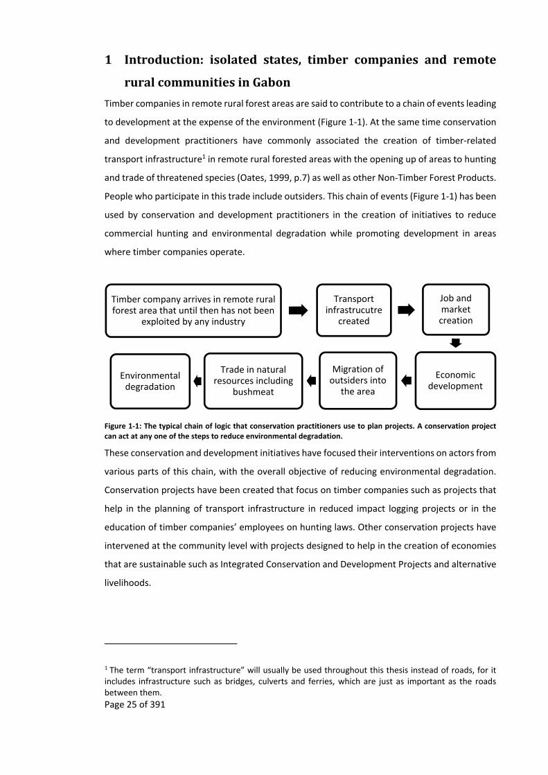
Timber companies in remote rural forest areas are said to contribute to a chain of events leading
to development at the expense of the environment (Figure 1‐1). At the same time conservation
and development practitioners have commonly associated the creation of timber‐related
transport infrastructure1 in remote rural forested areas with the opening up of areas to hunting
and trade of threatened species (Oates, 1999, p.7) as well as other Non‐Timber Forest Products.
People who participate in this trade include outsiders. This chain of events (Figure 1‐1) has been
used by conservation and development practitioners in the creation of initiatives to reduce
commercial hunting and environmental degradation while promoting development in areas
where timber companies operate.
Figure 1‐1: The typical chain of logic that conservation practitioners use to plan projects. A conservation project can act at any one of the steps to reduce environmental degradation.
These conservation and development initiatives have focused their interventions on actors from
various parts of this chain, with the overall objective of reducing environmental degradation.
Conservation projects have been created that focus on timber companies such as projects that
help in the planning of transport infrastructure in reduced impact logging projects or in the
education of timber companies’ employees on hunting laws. Other conservation projects have
intervened at the community level with projects designed to help in the creation of economies
that are sustainable such as Integrated Conservation and Development Projects and alternative
livelihoods.
1 The term “transport infrastructure” will usually be used throughout this thesis instead of roads, for it includes infrastructure such as bridges, culverts and ferries, which are just as important as the roads between them.
Timber company arrives in remote rural forest area that until then has not been
exploited by any industry
Transport infrastrucutre
created
Job and market creation
Economic development
Migration of outsiders into
the area
Trade in natural resources including
bushmeat
Environmental degradation

Page 26 of 391
However, this chain of logic assumes that without intervention the arrival of timber companies
in remote rural forest areas always results in the continued exploitation of natural resources and
development with resulting environmental degradation. When faced with such situations
conservation and development practitioners rarely explore alternative theories (Weiss, 1995,
p.67) or other possible outcomes to the arrival of a timber company in a remote rural forested
area. At a time when the success of alternative livelihood projects and their ilk is being
questioned (Roe et al., 2014) it is useful to re‐examine this chain of logic.
I propose that the chain of events suggested by conservation development practitioners (Figure
1‐1) is only part of the story, and that it is compromised by two omissions. Though the catalyst
of this chain of events may sometimes be the arrival of timber companies, this cannot always be
assumed to be the case, for the arrival of timber companies may in itself be the result of previous
land use which has led to the growth of tree species that are of interest to timber companies.
The inclusion of previous land use (Figure 1‐2) forms the basis of my first amendment to the
original chain of logic (Figure 1‐1). The second amendment to the original chain of logic is to
include the eventual departure of timber companies (Figure 1‐2), for though there has been
ecological research on ecosystems after timber companies depart, similar research has not been
undertaken on either development of communities or the trade in wildlife after the departure
of timber companies, with current knowledge mostly based on research carried out while timber
operations were taking place (see Chapter 1.2.7 and Appendix 11.1).
Figure 1‐2: The omissions (in red) in the chain of logic used by conservation practitioners to the arrival of timber companies in remote rural forested areas.
The first amendment has mostly been dealt by the likes of Leach and Mearns (1996b) and
Fairhead and Leach (1998) who have shown that most forested areas in Africa have been used
at one time or another by local people. Though this is sometimes acknowledged by conservation
practitioners this thesis shows that African landscapes have also been impacted by centuries of
Past local and international commercial trade of forest resources in remote rural forest
area
Timber company arrives in remote rural forest area that until then has not
been exploited by any industry
Transport infrastrucutre
created
Job and market creation
Economic development
Migration of outsiders into the
area
Trade in natural resources including bushmeat
Environmental degradation
Timber company leaves
?
Page 27 of 391
international commercial exploitation of natural resources, which started to influence the
African landscapes from at least the 1400s. The past human use, either by local people or by
industries, can lead, through succession, to a forest environment that is of commercial interest
to the timber industry as well as biodiversity interest to conservationists.
The second amendment, the departure of timber companies, is less understood by conservation
and development practitioners. Though there has been research on both the short‐term and
long‐term impacts of timber companies on tree and animal species, the research on the impact
of timber companies on livelihoods and the trade of natural resources, especially of the
bushmeat trade, is mostly based on studies carried out while timber operations are occurring
(Chapter 1.2.7 and Appendix 11.1). This makes it difficult to predict the long‐term post‐
departure impacts of timber companies on either the economies of rural communities or on the
trade in natural resources by these communities.
In this thesis it is proposed that the increase in development and market economy at the
expense of the environment that arises with the arrival of timber companies and their transport
infrastructure in remote rural communities is unlikely to continue when timber companies
depart remote rural forested areas. For, as observed by economists, geographers and
developers, transport infrastructure alone does not equate to long‐term development. The
assumption by conservation practitioners that it does has created “assumption drag”, whereby
scientific research is persistently compromised by outdated core assumptions. In this case, the
assumption that transport infrastructure equates to development invalidates the chain of logic
that they use (Figure 1‐1) and in turn undermines any conservation project based on it. This is
especially the case for remote rural forested areas of a rentier state (Yates, 1996) such as Gabon
displaying the following characteristics: no land shortage, the main economic activity is not
logging or agriculture, and clear felling is not carried out.
This thesis proposes an alternative chain of logic (Figure 1‐3) to the one used by conservation
practitioners (Figure 1‐1). This alternative takes on board and extends the findings of
economists, geographers and developers on transport infrastructure as well as historical use of
landscapes.
This proposed chain of logic (Figure 1‐3) is principally investigated through the implications of
departure of timber companies on various communities in remote rural forested areas of central
Gabon and how this impacts transport infrastructure, education, employment and livelihood
activities (particularly the commercial trade of wildlife in the form of bushmeat, rather than the
“wild meat” that is consumed locally (Mack and West, 2005, p.5)), as well as ecological impacts.
Page 28 of 391
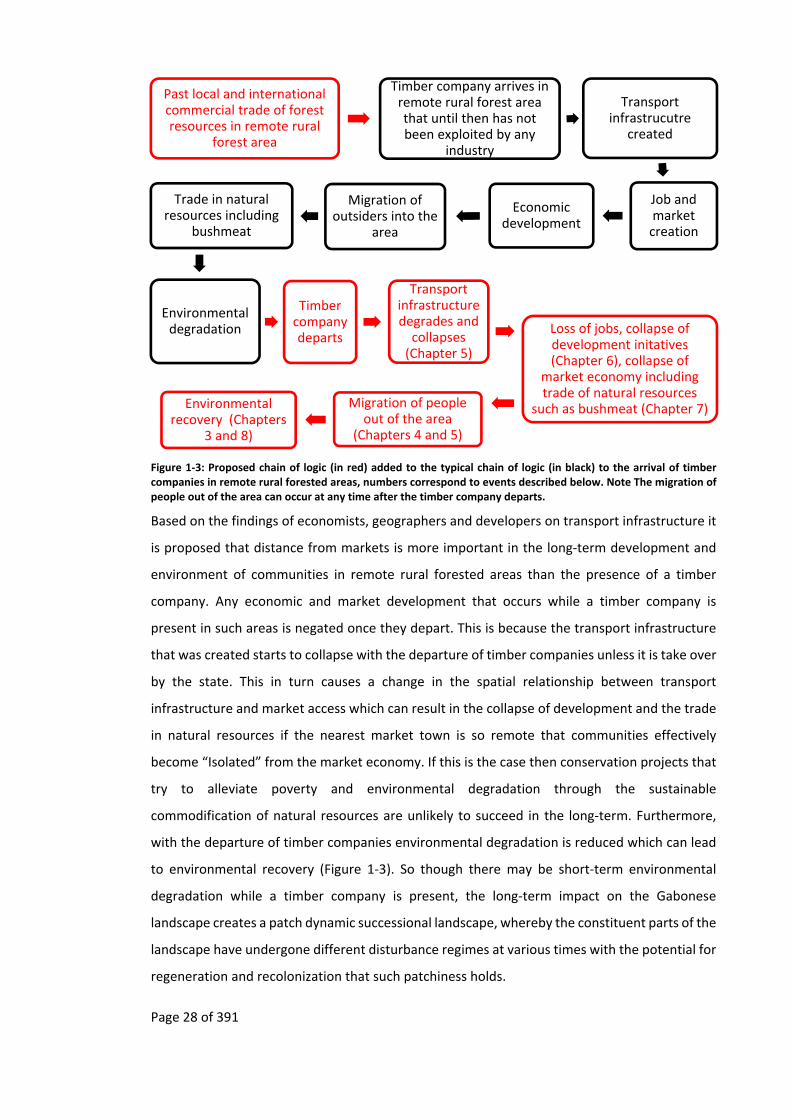
Figure 1‐3: Proposed chain of logic (in red) added to the typical chain of logic (in black) to the arrival of timber companies in remote rural forested areas, numbers correspond to events described below. Note The migration of people out of the area can occur at any time after the timber company departs.
Based on the findings of economists, geographers and developers on transport infrastructure it
is proposed that distance from markets is more important in the long‐term development and
environment of communities in remote rural forested areas than the presence of a timber
company. Any economic and market development that occurs while a timber company is
present in such areas is negated once they depart. This is because the transport infrastructure
that was created starts to collapse with the departure of timber companies unless it is take over
by the state. This in turn causes a change in the spatial relationship between transport
infrastructure and market access which can result in the collapse of development and the trade
in natural resources if the nearest market town is so remote that communities effectively
become “Isolated” from the market economy. If this is the case then conservation projects that
try to alleviate poverty and environmental degradation through the sustainable
commodification of natural resources are unlikely to succeed in the long‐term. Furthermore,
with the departure of timber companies environmental degradation is reduced which can lead
to environmental recovery (Figure 1‐3). So though there may be short‐term environmental
degradation while a timber company is present, the long‐term impact on the Gabonese
landscape creates a patch dynamic successional landscape, whereby the constituent parts of the
landscape have undergone different disturbance regimes at various times with the potential for
regeneration and recolonization that such patchiness holds.
Past local and international commercial trade of forest resources in remote rural
forest area
Timber company arrives in remote rural forest area that until then has not been exploited by any
industry
Transport infrastrucutre
created
Job and market creation
Economic development
Migration of outsiders into the
area
Trade in natural resources including
bushmeat
Environmental degradation
Timber company departs
Transport infrastructure degrades and collapses (Chapter 5)
Loss of jobs, collapse of development initatives (Chapter 6), collapse of
market economy including trade of natural resources
such as bushmeat (Chapter 7)Migration of people out of the area
(Chapters 4 and 5)
Environmental recovery (Chapters
3 and 8)

Page 29 of 391
In this thesis the proposed chain of events that occurs after the departure of timber companies
from a remote rural forest area (Figure 1‐3) is investigated on the basis that their departure
results in the degradation of transport infrastructure which in turn leads to:
1. the reversal of the migration of people, with departure of in‐migrants who were
attracted to the area by the timber company, while some of the original
population stays (investigated in Chapters 4 and 5),
2. increased transport costs (investigated in Chapter 5),
3. reduced access to education facilities and employment (investigated in Chapter
6), while the commodification of activities comes to a halt and becomes re‐
focused on subsistence activities (investigated in Chapter 7),
4. forest recovery, as logging and other economic activities have come to a stop,
and the forest landscape is released from disturbance, succession starts and
species populations recover even though subsistence hunting may continue
(investigated in Chapter 8).
1.1 Overviewofchapter
The remainder of this chapter is a literature review that forms the framework for the proposed
chain of events after a timber company leaves a remote rural forest area (Figure 1‐3). The
chapter starts off with a summary of assumption drag (Chapter 1.2.1) and then gives the
theoretical background to transport and markets (Chapter 1.2.2) which shows how the literature
on transport and markets has changed over time (Chapter 1.2.3). It continues with an outline of
how this theory and literature can be applied to the impacts that the arrival and subsequent
departure of timber companies can have on development and local economies (Chapter 1.2.4).
The framework continues with literature on the effects of the arrival of timber companies on
the environment (Chapter 1.2.5) and also of environmental changes that occur after timber
companies depart, through the theory of patch dynamics (Chapter 1.2.6). This literature review
finishes with the aims and structure of this thesis.

Page 30 of 391
1.2 Literaturereview
1.2.1 Assumptiondrag
“The specialist knows more and more about less and
less and finally knows everything about nothing”
attributed to Lorenz,
“avoid the corollary of Lorenz’s dictum: that generalists
… know nothing about everything” (Fisher, 2004,
p.363).
Assumptions based on generalisations from the rest of Africa, and elsewhere, may have led to
the chain of logic used by conservation practitioners (Figure 1‐1) when addressing the impacts
of the timber industry in Gabon, especially in the long‐term. This has led to environmental
policies that could be detrimental to the current and future management of the Gabonese
environment and its species (Engone Obiang et al., 2014; Leach and Mearns, 1996b).
“Assumption drag” (Ascher, 1979; Brysse et al., 2013; Keilman, 1998; Oppenheimer et al., 2008,
p.162) deals with how scientific research can be compromised by bad information, with
assumption drag occurring when outdated or inappropriately extrapolated core assumptions
are persistently used in theories, such as the use of assumed but incorrect historic baselines for
forest cover (Fairhead and Leach, 1998) and old, inaccurate population statistics (Ascher, 1979;
Ascher, 1978)2. The unreliability of assumptions is aggravated by time and space, for though
some assumptions may be correct at a certain time and place it cannot be assumed to be so at
another.
The way in which human activity in tropical forests is observed by outsiders is biased by
assumption drag. This should be no surprise given the amount of knowledge, spanning many
disciplines, an observer would need to understand fully any landscape being looked at. For
though an observer may be well versed in forest ecology they may not be as well versed in other
disciplines or other sources of knowledge, such as history, and so are dependent on information
from others, with limitations that the observer may not be aware of. These accumulated
assumptions can have consequences in the design of projects when integrating ideas from other
2 This thesis of course is not immune to such issues.
Page 31 of 391
disciplines, especially as advice from other disciplines is often sought late in the design process,
if at all (Campbell, 2005).
An outcome of this specialisation of different “bodies of information” has resulted in
heterotopian (Foucault, 1986; Foucault, 1984) (Appendices 11.2 and 11.3) landscapes, whereby
experts from different disciplines are able to talk about similar processes that have gone into
forming a particular landscape, without understanding each other (Grabbatin and Rossi, 2012)3.
In the social sciences assumption drag has been written about since the 1970s (Ascher, 1999a;
Ascher, 1979; Ascher, 1978), however it has recently found a new audience in the biological
sciences due to the debate over climate change where it has been used by the
Intergovernmental Panel on Climate Change (IPCC)4 in an effort to understand some of the
misunderstandings in the debate (Oppenheimer et al., 2008; Brysse et al., 2013). Similar
assumption drag has also occurred in Gabon, where certain theories based on a postulated chain
of events have been questioned (Table 1‐1), though this does not mean that these theories are
not applicable elsewhere.
Though some assumption drag can be rectified by getting the most up to date information, it is
not possible to remove all assumptions, either because no data exist for a specific geographical
area or time, or because of limited knowledge of ground‐breaking research in other disciplines.
This is especially difficult due to the ever‐increasing number of publications and reports in one’s
own discipline for
the balance of expertise continues to tilt in the direction of the experts – the
increasing specialization of the modernizing intellectual reduces the non‐
specialist’s capacity to judge the validity and implications of experts’ methods
(Ascher and Steelman, 2006, p.87).
3 As an example of the heterotopian view that a landscape can have is the way the same landscape can be seen differently by a biogeographer, cultural geographer or political ecologist see Appendix 11.2. 4 Throughout this thesis I have resisted the attempt to use acronyms, the exception to this is for names of companies and equipment, such as GPSs, that are more well known by their acronyms. In 200 Galen wrote “the chief merit of language is clearness, and we know that nothing detracts so much from this as do unfamiliar terms; accordingly we employ those terms which the bulk of people are accustomed to use …” (Galen and Brock, 1916, p.4). Though acronyms can make certain documents easier to read (Fred and Cheng, 2003) they can also “burden the reader” (Grange and Bloom, 2000, p.4), especially as their use is growing exponentially (Fred and Cheng, 2003). For people of other disciplines this makes documents harder to read. Furthermore, an acronym from one discipline may have a different meaning in another. In a text that is to be read by people from multiple disciplines it is important to reduce distractions and confusion that can be caused by acronyms. For example according to the acronym finder the abbreviation PA can have 258 meanings, none of which includes Protected Areas (Acronym Finder, 2015).

Page 32 of 391
Furthermore, to check all the assumptions behind an initiative would require significant
resources, both monetary and time, which are not available in crisis‐driven conservation or
development.
Author Assumed chain of logic as seen in the paper
But research in Gabon shows
Some confounding factors to assumption
Schmidt‐Soltau (2009)
Creation of National Park
Access to natural resources by local people is reduced
Poverty increases
Foerster, et al. (2012) found no wealth differences between remote villages next to a park and similar ones that are not.
Poverty can be due to a variety of reasons. Understanding these reasons is hindered by the movement of people.
Brown and Williams (2003)
Regulated bushmeat trade
Sustainable hunting and trade of bushmeat
Increased wealth of households with hunters
Coad, et al. (2010) found that half of the income that men gained was spent on alcohol and cigarettes, while women purchased food.
People in a community are impacted by and react differently to regulations and wealth.
Nasi, et al. (2008)
Reduced barriers to legal gun hunting
Increased bushmeat trade
Increased revenue for the state through taxes
Wilkie, et al. (2006) found that the costs of enforcing hunting regulations outweigh any income that the state could earn through the bushmeat trade.
Collection of taxes is dependent on ease of access to the tax payer.
(CARPE, 2006, p.173)
Frequent anthropo‐genic Savannah fire
Loss of trees
Loss of biodiversity
Walters (2012; 2010) found that in plateaux Batéké frequent burning of the savannah results in more trees and biodiversity.
Some biodiversity is dependent on anthropogenic disturbances.
(CARPE, 2006, p.145)
Frequent savannah fire
Degraded plant cover
Increased threat to forest
Jeffery, et al. (2014) found that there is forest expansion occurring in Lopé National Park, even though fire is used as a management tool to supress it.
Ecosystems react differently to anthropogenic disturbance.
Table 1‐1: Examples of assumed chain of logic for some theoretical papers which have been put into question by research in Gabon.
Page 33 of 391
This situation is further aggravated when assumptions are borrowed from a single parallel
discipline in isolation from others (Ascher, 1979, p.149; Balmford and Cowling, 2006). Though
using assumptions from one discipline may be quicker when designing conservation initiatives
it runs contrary to the multidisciplinary nature of conservation and conservation biology which
stipulates that interdisciplinary collaboration is needed (Clark et al., 2011a; Clark et al., 2011b;
Drury et al., 2011; Ehrenfeld, 1987; Fox et al., 2006; Lowe et al., 2013; Lowe et al., 2009; Mermet
et al., 2013; Newing, 2010; Phillipson et al., 2009; Pooley, 2013; Pooley et al., 2014; Schultz,
2011; Soulé, 1985; Szabó and Hédl, 2011; Szabó, 2010). However, even in an interdisciplinary
approach, reality has to be restricted, for it is not possible to cover everything (Gluckman, 2007).
Sooner or later it has to be accepted that we have to be naïve in certain aspects of an
interdisciplinary approach, which reduces how far generalisations can go (Devons and
Gluckman, 2007).
1.2.2 VonThünen’sspatialanalysisoftradableresources
Assumption drag is present in the way conservation and development practitioners think about
the impacts of timber companies on communities in remote rural forest areas, whereby “the
development of roads and road networks is strongly correlated with economic growth and
national wealth” (Wilkie et al., 2000, p.1615), even though economists and geographers have
been questioning this correlation since at least the 1970s (Barwell et al., 1985; Barwell, 1996;
Bryceson et al., 2008; Bryceson and Howe, 1993; Creightney, 1993; Edmonds, 1982).
From the debate among conservationists and developers on logging roads it is apparent that
some researchers in both fields find that spatial analysis, with its origins in the work of von
Thünen, is important. The following section gives a brief overview of the origins of spatial
analysis to highlight how the original model by von Thünen is still relevant to the communities
in remote rural forested areas of Africa and particularly when looking at the impacts of transport
infrastructure created by timber companies. However, it also needs to be recognised that the
spatial analysis of the impacts of logging roads on economies is not “static” (Lambin, 1994, p.76),
and thus von Thünen’s model may not always be relevant, especially in areas where transport
costs are minimal and do not have an impact on local economies (Lambin, 1994, pp.77–78).
Research on transport infrastructure, economies and land use by trade economists and
geographers was transformed in 1826 with von Thünen’s “seminal” (Angelsen, 2007, p.4; Mäki,
2004, p.1719) theory on market access and agricultural land use which laid out “the foundation
of land use theory” (Fujita and Krugman, 1995, p.506). Though von Thünen’s theory has been
much expanded upon, his basic approach can still be valid today, especially in some African
Page 34 of 391
countries, as the underlying assumptions about the economics of trade are still relevant. These
assumptions, summarised by von Thünen, are that:
near the Town will be grown those products which are heavy or bulky in relation
to their value and hence so expensive to transport that the remoter districts are
unable to supply them. Here too we shall find the highly perishable products,
which must be used very quickly. With increasing distance from the Town, the
land will progressively be given up to products cheap to transport in relation to
their value (von Thünen, 1966, p.8) (bottom right of Figure 1‐4)5.
Von Thünen applied Adam Smith’s ideas to agriculture. His approach was based on the “analyses
[of] economic rent and agriculture as a function of the distance to the market” (Lambin, 1994,
p.75). By having markets as one of the key components to land rent, he realised that certain
farm products would no longer be economical to trade at a certain distance from a market. At
such distances the rational farmer should not spend time and effort trying to trade such
products. It follows that this should also be true for commercialised products that are collected
from forest environments such as Non Timber Forest Products.
This land rent approach originated at a time when the majority of tradable items were
transported over land by horse power (Clark, 1967), or waterways. The transport of products to
a town could therefore take several days. This state of affairs stands in sharp contrast to today,
where, in the “western world”, people are used to the possibility of next day delivery to
“locations worldwide” (DHL, 2013). However in countries such as Gabon, these promised
delivery services frequently break down. In such countries transport infrastructure is in such a
poor state that it can sometimes take a day in a car to travel a few hundred kilometres, even
when roads are available (Foster and Briceño‐Garmendia, 2010; Megevand and World Bank,
2013, pp.90–92; Pourtier, 1984). It is in these circumstances that von Thünen’s land rent
approach becomes once more relevant.
The theory that von Thünen put forward demonstrated how land around a town would be used
rationally, so as to maximise its value. He concluded that:
5 This model continues to be used in standard textbooks and has produced a large literature, as well as variations that are still used by economic geographers and geographical economists (Mäki, 2011). It has also been used by ecologists to predict deforestation (Ahrends et al., 2010; Angelsen, 2007; Chomitz, 2007).

Page 35 of 391
fairly sharply differentiated concentric rings or belts will form around the Town,
each with its own particular staple product. From ring to ring the staple product,
and with it the entire farming system, will change; and in the various rings we
shall find completely different farming systems (von Thünen, 1966, p.4) (bottom
right of Figure 1‐4).
Today variations of this simplified model (Figure 1‐4) have been shown to be applicable in
numerous examples of how transport infrastructure is associated with market access and trade
in agricultural crops (Angelsen, 1997; Barwell, 1996; Howe and Richards, 1984; von Thünen,
1966). Recently this has been expanded to also cover the trade in bushmeat and other Non‐
Timber Forest Products (Auzel and Wilkie, 2000; Cowlishaw et al., 2005b; Solly, 2007; Wilkie and
Carpenter, 1999; Wilkie et al., 2001; Wilkie et al., 2000; Wilkie et al., 1992).
The traders of Non‐Timber Forest Products, such as smoked bushmeat (Auzel and Wilkie, 2000),
or sacred and medicinal plants, travel further than agricultural products. This is because Non‐
Timber Forest Products usually constitute an “easily traded resource as it is transportable, has a
high value/weight ratio and is easily preserved at low cost” (Nasi et al., 2008, p.13), as predicted
by von Thünen’s analysis for one of the outer rings (bottom right in Figure 1‐4). An exception to
this is for bushmeat in Gabon6 where fresh meat is both preferred and also harder to transport,
requiring traders to find bushmeat nearer to market towns so that it can arrive in the market
fresh. Spatial dynamic theory predicts that the bushmeat for trade in Gabon would therefore be
supplied from one of von Thünen’s inner rings where “highly perishable products, which must
be used very quickly” (von Thünen, 1966, p.8) can be found, with the radius of this ring being
influenced by transport conditions. If distance to market is of importance to a hunter’s decision
to participate in the trade of bushmeat, then changes to von Thünen’s rings should influence
this decision.
6 Why this preference should be the case in Gabon has yet to be explored. The common assumption, from bushmeat trade studies in dry environments (for example Brown and Marks, 2007), is that smoked meat lasts longer than fresh meat (Brown, 2007; Nasi et al., 2008). This may not apply to humid tropical areas where smoked meat needs to be kept above a kitchen fire, otherwise it quickly deteriorates.

Page 36 of 391
Figure 1‐4: Von Thünen’s rings under different conditions (from Peet, 1969, p.287; and Mäki, 2011, p.54)
However, the studies that have looked at the impact of transport infrastructure on the
commercialisation of forest products have usually been carried out when market access is
perceived to be relatively stable, either due to the short lengths of observer time in the field or
because the transport infrastructure is still being used and maintained by outside interests such
as timber companies, and so any resulting spatial analysis could be perceived to be static. Few
studies have looked at how changes in market access due to degradation of transport
infrastructure impacts the direct or indirect income from commercialisation of forest products
or the commodification of livelihood activities of people in remote rural forest communities. An
exception is the model proposed by Ling and Milner‐Gulland (2006)7 and work by Abbot on the
sale of natural resources around Lake Malawi National Park (Abbot, 1996, p.158).
7 They used a bioeconomic approach to look at the sustainability of bushmeat hunting, which incorporated variables such as demand and costs into their models.

Page 37 of 391
It should also be recognised that spatial patterns created by trade and transport routes may not
be static but be continually changing due to factors such as changes in technology. This was
recognised by von Thünen in his spatial analysis models when he relaxed the parameters8. Since
then others have also continued to add temporal dimensions to it (Lambin, 1994, p.76). That
economic and environmental spatial patterns resulting from the transport infrastructure
created by timber companies are not at equilibrium needs to be understood for the long‐term
success of projects that involve trade and transport, such as alternative livelihood projects,
Integrated Conservation and Development Projects, or in understanding the impacts of timber
companies on the trade of bushmeat.
The disequilibrium of the spatial patterns associated with transport infrastructure and market
access is exemplified by the arrival in a remote rural forested area of timber companies who
have an important impact on transport costs and so access to markets. Their arrival can result
in a temporary re‐configuration of von Thünen’s rings to incorporate village communities which
were previously unable to trade due to transport costs from the central market “Town” (von
Thünen, 1966, p.7). When the timber company departs, and if there are no other reasons for
the transport infrastructure to be maintained, the rings collapse back towards the original
market “Town”. Village communities that were once connected to the market town during the
presence of the timber company become once more “Isolated” from markets as transport costs
increase (Figure 1‐5).
This disequilibrium is of concern since it is the stability of access to markets that is supposed to
perpetuate the development and commodification of natural resources that is assumed to be
initiated by the construction of transport infrastructure in remote rural forested environments
(AFD, 2014), including the extraction of bushmeat for trade and other items of conservation
concern that are the basis for alternative livelihood projects and Integrated Conservation and
Development Projects. If the spatial pattern of transport infrastructure and access to markets
undergoes such a major change then projects that are based on helping people living in remote
tropical forested environments to increase their income through the commercialisation of forest
products are unlikely to work. Adam Smith’s and von Thünen’s economic rationality (top left of
Figure 1‐4) suggests that when transport infrastructure becomes degraded, local people’s use
8 The change in spatial structure to market access does not only have to be due to the degradation of transport infrastructure but can also be due to other factors such as increase in number of traffic jams. Such as “go slows” in Lagos, Nigeria.
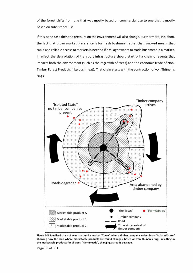
Page 38 of 391
of the forest shifts from one that was mostly based on commercial use to one that is mostly
based on subsistence use.
If this is the case then the pressure on the environment will also change. Furthermore, in Gabon,
the fact that urban market preference is for fresh bushmeat rather than smoked means that
rapid and reliable access to markets is needed if a villager wants to trade bushmeat in a market.
In effect the degradation of transport infrastructure should start off a chain of events that
impacts both the environment (such as the regrowth of trees) and the economic trade of Non‐
Timber Forest Products (like bushmeat). That chain starts with the contraction of von Thünen’s
rings.
Figure 1‐5: Idealised chain of events around a market “Town” when a timber company arrives in an “Isolated State” showing how the land where marketable products are found changes, based on von Thünen’s rings, resulting in the marketable products for villages, “farmsteads”, changing as roads degrade.
Page 39 of 391
1.2.3 Transportinfrastructureanddevelopment
Since von Thünen’s 1826 seminal work on transport and markets, the impacts of transport
infrastructure on the development of economies and land use have had two centuries of
academic interest. This research has been conducted by various disciplines, including engineers,
geographers, sociologists, economists and ecologists, each with their own voluminous
literatures. Roads have been “evaluated from physical, biological, and socioeconomic points of
view, often under only one perspective in isolation from the others” (Gucinski et al., 2001, p.1)
with different fields, mutual awareness of each other’s contributions remaining relatively
restricted (Bryceson et al., 2008, p.460). The general thrust of the literature on transport
infrastructure by economists and geographers has ranged from authors celebrating the
unquestionable benefit of transport infrastructure on economies through market demand
models, to those taking a more cautious approach in the 1970s (see Bryceson and Howe, 1993).
For the latter, benefits arise only under certain conditions (Barwell, 1996; Bryceson and Howe,
1993; Edmonds, 1998; Van de Walle, 2002) with transport infrastructure having a complex
relationship with the economy (Creightney, 1993).
The importance of transport infrastructure to development in colonial Africa was recognised by
the colonial powers when Lugard in 1922 remarked that “the material development of Africa
may be summed up in the one word ‘transport’” (Lugard, 1922, p.5). This theme continued for
half a century. Lewis, in 1955, wrote that “a cheap and extensive network of transport and
communications … is the greatest blessing that any country can have from the economic point
of view” (in Mwase, 1989, p.237). Taaffe et al., in 1963, observed that “in the economic growth
of underdeveloped countries a critical factor has been the improvement of internal accessibility
through the expansion of a transportation network.” (Taaffe et al., 1963, p.503). These views
resulted in, among others, the World Bank, colonial and post‐colonial governments and other
donors investing heavily in the construction of major roads in Africa during the 1950s and 1960s
and then rural roads in the 1970s (Bryceson et al., 2008; Edmonds, 1982).
By the end of the 1970s, there was mounting evidence that investment in transport
infrastructure was not having the economic and developmental returns that had been predicted,
suggesting that improvement in transport alone is “unlikely to result in significant benefits”
(Mwase, 1989, p.243; Bryceson et al., 2008). Moreover researchers were finding that there was
a “correlation between quality of route and the existence and reliability of public transport
services” (Barwell et al., 1985, p.128) with vehicle operating costs (Mwase, 1989) being
negatively correlated to quality of roads, so much so that taxi drivers and vehicle owners would
refuse to ply certain routes due to the cost of repairs to the vehicle (Porter, 1995; Porter, 2002).
Page 40 of 391
This refusal could be seasonal, i.e. during the rains, or all year round (personal observation).
When roads have to be taken, then poorly maintained ones could still make "almost any journey
… an 'expedition' where you arrived on time if you were lucky" (Nyerere (1973) in Mwase, 1989,
p.236), or you might not arrive at all.
One of the reasons for the failure of transport infrastructure to always contribute to
development is due to the prohibitive cost of its construction9 and maintenance, making it
impossible to create tarmac roads to service all the rural population (Barwell et al., 1985, p.135;
Edmonds, 1982). This includes rural populations that live in extremely remote areas of the
developed world. Though unimproved roads, even laterite roads, are relatively inexpensive to
create, without proper yearly maintenance their “surface may have totally disappeared” within
four years (Porter, 2002, p.287). This was already being observed in an 1886 interview when de
Brazza10 commented:
’What about the fertility of the country?’ ‘It is marvellously fertile; in fact, it is
over fertile. Things grow too quickly. We could not get our roads kept open.
When we cut a road, thirty kilometres wide [sic], through the trees, it was soon
made impassable’ (Anonymous, 1886, p.6).
In the 1990s development economists and the World Bank (Riverson et al., 1991) took “on board
spatial interests previously restricted to geographers, and rediscovering the links between
economics and population density pioneered … decades earlier” (Bryceson et al., 2008, p.461).
Though they noted how important transport infrastructure is to rural communities, as it may
broaden the economic opportunities available to rural people (Barwell, 1996, p.46) and can be
a prerequisite for modern agriculture allowing communities to be transformed from subsistence
to market economies (Riverson et al., 1991, p.17), there was also a growing consensus that the
effect of transport infrastructure is location specific. Following von Thünen, Chomitz and Gray
(1996) concluded that “[r]oads play an important role in determining rent‐and thus land use”
9 In South America road construction costs in 2002 were “US$750 [£378.38] per kilometre for unimproved roads, and US$2,000 [£1,009.02] per kilometre for all‐season roads” (Perz et al., 2007, p.548). While in 2003 the principal logging roads in Gabon cost between 9,400,000 cfa (£9,744.39) to 12,500,000 cfa (£12,958.00) per kilometre while secondary logging roads cost between 5,700,000 cfa (£5,908.83) to 7,200,000 cfa (£7,463.79) per kilometre (Jaffré, 2003a, p.260). 10 Nor is it limited to tropical forests, even routes going through the manicured forest of the English countryside have to be maintained, for “[i]n the nineteenth‐century Suffolk small sickles called ‘hooks’ were hung on stiles and posts at the start of certain well‐used paths: those running between villages, for instance, or byways to parish churches. A walker would pick up a hook and use it to lop off branches that were starting to impede passage. The hook would then be left at the other end of the path, for a walker coming in the opposite direction” (Macfarlane, 2012, p.17).

Page 41 of 391
(Chomitz & Gray, 1996, pp.487‐488), but they found that the impact of roads depends on many
factors including culture, history and ecology as well as improvement in agriculture technology
(Barrett et al., 2001, pp.325–326), so that if transport to and from a local market is blocked by
“physical barriers” (Riverson et al., 1991, p.vi), high transport costs, culture or a combination of
the three, then there is less incentive for farmers to become market orientated (Pourtier, 1984).
For these reasons donors in the 1990s became wary of supporting the construction of rural roads
and some introduced a policy to “not build what cannot be maintained' holding that
'rehabilitation is nothing more than a reward for lack of maintenance'” (Edmonds, 1998, p.29).
Von Thünen’s 1820s theory on land‐rents and distance from markets (von Thünen, 1966) and
the continuing research in the field, all point to the importance of well maintained transport
infrastructure on economic activities. It is not the presence of transport infrastructure alone that
is important in developing economic activity but rather the state of the transport infrastructure
(Barwell et al., 1985; Bryceson et al., 2008; Mwase, 1989; Porter, 2002; Porter, 1995) as well as
its location (Barrett et al., 2001) and cost of transport.
When transport infrastructure is created or improved the economic outcomes are not evenly
distributed within a community, with the poor benefiting the least (Bryceson et al., 2008, p.476).
The existing unequal redistribution of income is both reinforced and intensified while certain
types of productive activity become redundant (Edmonds, 1982, p.29). Furthermore these
economic benefits may also change with time, through yearly seasonal changes or social unrest
(Giles‐Vernick, 1996, p.250). Neither does transport infrastructure reduce time spent walking to
collect essential products, especially in “a walking world” (Porter, 2002, p.206) where women
carry water and fuelwood11 (Bryceson et al., 2004, p.54; Bryceson et al., 2008; Edmonds, 1998).
Men may gain most from improved access to markets “with, perhaps, a slow trickle‐down of
indirect benefits to women” (Bryceson and Howe, 1993, p.1722) if at all, though this is also
dependent on culture (Edmonds, 1998).
The economic return to local people from the creation of transport infrastructure may be further
reduced by the arrival of in‐migrants who are often better equipped in materials, skills, and
finance than local people, allowing them to capture more of the benefits, and by doing so
displace local people from the new economic opportunities that are created (Chomitz, 2007;
11 In certain cultures the “walking world” is actively sought for by women, as it is the only time that they can be free to talk between themselves. Projects that have tried to reduce this walking world by placing water pumps in villages have in some cases faced resentment by women because this freedom to talk is removed (personal communication Mohamed‐Katerere 2015)

Page 42 of 391
Hodgkinson, 2009; Mertens and Lambin, 1997; Poore and Sayer, 1991; Rich, 1985; Riddell, 2011;
Sinha et al., 1989).
As there is an inverse relationship between the distance a community is from a major market
and the number of bush taxis serving them, as well as a positive relationship between the
distance of a community and the cost of transport, then “only a minority” (Barwell, 1996, p.46)
of communities will be situated in the right place where long‐term benefits from the
construction of roads, including the ones built by the timber industry, can arise.
These more cautious approaches to the benefits of transport infrastructure can also be found in
the transport literature of developers from the 1990s and ecologists at the turn of the
millennium. However, the ecological and development literature on transport infrastructure
created by timber companies has yet to integrate these findings, resulting in assumption drag.
It is probable that assumption drag has been aggravated due the evaluation of transport
infrastructure by conservation practitioners in isolation from other disciplines (Ascher, 1979,
p.149; Balmford and Cowling, 2006).
1.2.4 Timbercompanies,transportinfrastructureanddevelopment
There have been long running debates concerning livelihoods and economic welfare of people
living in remote rural tropical forest village environments of developing countries. One of these
debates has explored the association between the location of conservation initiatives, their
remoteness and the ways they are associated with the poverty typically found in these areas
(Curran et al., 2009; Sunderlin et al., 2008; Redford et al., 2008; Riddell, 2011; Wilkie et al., 2006).
The result of these associations has been an increased interest in sustainable development
initiatives, especially in the way that forests and their natural resources can be used to alleviate
poverty. These initiatives can be through forestry, as defined in the Seventh World Forestry
Congress (Vernell, 1971)12, with the help of timber companies supporting development, through
the commodification of natural products including projects that promote the trade in Non‐
Timber Forest Products, other alternative livelihoods or Integrated Conservation and
Development Projects, including the captive rearing of non‐domesticated animals for trade,
12 During the Seventh and Eighth World Forestry Congress, foresters declared that “[f]oresters recognise that forestry is concerned not with trees, but with how trees can serve people” (Westoby, 1987, p.xii; from the Seventh World Forestry Declaration, paragraph 13 Vernell, 1971), or more explicitly “[f]orestry and a forest policy ... ‘should concern itself with all places where, and every conceivable way in which, forests, woodlands and trees can contribute to human welfare’” (Westoby, 1987, p.xii; from the Seventh World Forestry Declaration, paragraph 13 Vernell, 1971).

Page 43 of 391
livestock, agriculture and the honey trade (Arnold, 2001; Arnold and Townson, 1998; Angelsen
and Wunder, 2003; Chomitz, 2007; Hodgkinson, 2009; Huffmann, 1931; Sunderlin et al., 2003;
Vedeld et al., 2004) and through various Reducing Emissions from Deforestation and
Degradation (REDD+) and Payments for Ecosystem Services (PES) initiatives (Agrawal et al.,
2011).
A continuation of this debate is the impact that these same people have on the environment,
especially in the case of protected areas. This debate has left conservationists and social
scientists deadlocked, as highlighted in a recent special issue of Conservation and Society
(Agrawal and Redford, 2009a; Agrawal and Redford, 2009b; Bray and Velazquez, 2009; Chicchon,
2009; Curran et al., 2009; Krueger, 2009; Schmidt‐Soltau, 2009; Springer, 2009). In some cases
this debate has resulted in proposals for the re‐introduction of fortress conservation methods
(Oates, 1999) with some being concerned that Reducing Emissions from Deforestation and
Degradation initiatives may go down a similar path (Agrawal et al., 2011; and debate between
Beymer‐Farris and Bassett, 2013; Beymer‐Farris and Bassett, 2012; Burgess et al., 2013). Others
advocate ways in which local people can continue to use the natural resources in a sustainable
manner such as in the form of alternative livelihoods (García‐Amado et al., 2013; Roe, 2013;
Wicander and Coad, 2015) or legalised bushmeat trade (Brown and Williams, 2003; Nasi et al.,
2008).
In both debates the impact of access to local markets, via transport infrastructure in the form of
roads, has emerged as an important issue. The building and subsequent utilisation of transport
infrastructure has both short‐term and long‐term impacts that can either be direct or indirect,
with consequences that may either be positive or negative (Gucinski et al., 2001; Sinha et al.,
1989) depending on the viewpoint of the observer (Appendix 11.3). For conservationists, roads
are seen as a threat to the environment as they promote the commercialisation of natural
resources that are found in remote rural forested areas. For developers, the same roads allow
not only commerce and so poverty alleviation but also the delivery of services such as health
and education. This debate is not limited to forest environments; a similar debate has also
centred on roads in and around the Serengeti (Dobson et al., 2010; Fyumagwa et al., 2013;
Homewood et al., 2010). It is, however, the lack of transport infrastructure that is one of the
defining attributes of remote rural forest areas.
Though there are numerous forest resources that can be exploited, in most forests timber has
one of the highest values (Sunderlin et al., 2003, p.63) resulting in timber companies usually
being the only commercial industry in these remote rural forest areas (Sunderlin et al., 2005;

Page 44 of 391
Sunderlin et al., 2003). In Central Africa timber companies are the principal constructors of
transport infrastructure, especially in remote rural forested areas. Due to the impacts that this
transport infrastructure can have on both the environment and development, conservationists
and developers, through different types of initiatives, are now collaborating with timber
companies.
Even before the United Nations Millennium Development Goals were established (FAO and
DFID, 2001), collaboration in the forestry sector had received international interest by donor
agencies, governments (national and international), the World Bank (Geschiere, 2009, pp.70–
72), developers and conservationists as a way to “alleviate poverty” (Angelsen and Wunder,
2003, p.1). The timber industry became the “focal point for development interventions” in
remote rural forested areas (Angelsen and Wunder, 2003, p.1; Geschiere, 2009, p.72) with
development agencies “seeking to ‘bypass the state’” (Geschiere, 2009, p.71) so as to improve
economies, access to health care and access to education, at both local and national levels while
also limiting deforestation and allowing local populations to gain access to a cash economy in
ways that agriculture cannot provide (Bouet, 1974). Because of this interest there has been a
policy of promoting sustainable logging and its certification (Fisher, 2004; Whiteman, 2000) as a
way to achieve three objectives: 1) the sustainable harvesting of timber, 2) in a manner that is
ecologically sustainable, 3) but which still allows development.
The Congo Basin Forest Partnership (CBFP), a partnership of more than 70 conservation
organisations, government agencies and donors in Central Africa, has had a policy of promoting
collaboration with timber companies. In a 2005 report they stated:
[l]es filières bois emploient une main d'œuvre et créent de nombreux emplois qui
font vivre des familles entières, des villages, des petites villes. Souvent installées
dans des régions éloignées des infrastructures et des zones peuplées, les
exploitations et les unités industrielles créent des pôles d’activités et assurent
des missions de service public (désenclavement, routes, dispensaires, écoles)
(CBFP, 2005, p.33)13.
13 The timber industry employs a labour force and creates a number of jobs, underpinning the livelihoods of whole families, villages and small towns. Often established in areas that are far from infrastructure and populated zones, the timber industry and their industrial units, create centres of activity and ensure delivery of public services (roads, dispensaries, schools).
Page 45 of 391
While in a 2006 report, the USAID Central Africa Regional Program for the Environment (CARPE)
stated that:
until recently, industrial logging had a very negative image: it was the source of
the destruction of forests and the disappearance of fauna. It has certainly
always had a number of negative impacts on the environment, but more and
more of its potentially positive aspects are also being acknowledged. Not only
can it make a lasting contribution towards socioeconomic development, but it
can also become a powerful ally of conservation (CARPE, 2006, p.30).
As elsewhere in Central Africa (Zhang et al., 2006) the timber industry in Gabon has had an
important role to play in the construction of transport infrastructure (Map 1‐1) since they are
the principal builders of transport infrastructure in the region (Wilkie et al., 2000). While logging
roads account for 13% of the length of all roads in the Democratic Republic of Congo, in Gabon
they account for more than 60% (Laporte et al., 2007, p.1451; see also Blake et al., 2008; and
Wilkie et al., 2000). This transport infrastructure allows the transport of timber from the point
where a tree is logged to the point where it will be sold. For this to occur logging roads are
constructed in different manners, some of which have a long life, while others do not. These
roads range from small “temporary” tracks going from the felled tree to a road, to large
evacuation roads to take the logs to the nearest saw mill, railway or port. In all cases the quality
of these logging roads, and so how long they last, depends on the timber company creating
them. This transport infrastructure is also used by others including local people and outsiders
for commercial activity (Wilkie et al., 1992), by Non‐Government Organisations personnel as a
way to access project sites (personal observation) or by civil servant / government
administrations to get to remote communities, especially at election time (personal
observation).
This opening up of remote rural areas by timber companies can have similar “multiplier effects”
to those of opening up of other types of transport infrastructure that contributes to the
development of an area (Sunderlin et al., 2003). Like other types of transport infrastructure, the
timber industry brings opportunities either directly or indirectly (Auzel and Wilkie, 2000).
However, in Gabon there is no de facto system of royalties from logging to local communities
(Ondo Ntsame, 2007, pp.61–66) 14. For local people it can bring employment opportunities,
14 The Gabonese Forestry Code in article 251 says “Pour promouvoir l'aspect social de la politique de gestion durable, il est mis en place une contribution notamment financière, alimentée par les titulaires de ces concessions pour soutenir les actions de développement d'intérêt collectif initiées par lesdites

Page 46 of 391
either directly with the timber company itself or indirectly through services that the timber
company requires, and through access to other markets created by their arrival (Bouet, 1977;
Meye, 1969). One such market is the commercial trade of bushmeat which is sometimes
considered to be so important to local people “that without the revenue obtained from hunting,
they would be unable to obtain basic cooking utensils, clothing, medicine, and educational
materials for school‐age children” (Wilkie et al., 1992, p.59; see also Hodgkinson, 2009; Riddell,
2011).
Map 1‐1: Logging concessions and roads in Central Africa (from Laporte et al., 2007, p.1451)
communautés. La nature et le niveau de cette contribution sont définis par le cahier de charges contractuelles lié à chaque concession. La gestion de cette contribution est laissée l'appréciation des assemblées représentatives des communautés concernées” (République Gabonaise, 2001) – “To promote the social aspect of sustainable management policy, it is established a contribution, in particular financial, funded by the holders of such concessions to support the collective interest of development initiated by those communities. The type and level of this contribution are defined in the contractual document associated with each concession. The management of this contribution is left to the discretion of the representatives of the communities concerned”.

Page 47 of 391
Direct employment opportunities with timber companies are varied and can include jobs where
local knowledge is important, such as forest guides working with timber prospecting teams
(Whiteman, 2000) or manual, unskilled labour employed in building roads and assisting with the
cutting and transporting of the timber (Angelsen and Wunder, 2003; Arnold, 2001; Poschen,
1997; Scherr et al., 2003; Whiteman, 2000). Employment that involves manual labour, especially
unskilled labour, constitutes by far the majority of the opportunities created by the arrival of
timber companies (Balimunsi et al., 2011), yet these jobs are often of short duration with
relatively low pay, do not include social benefits or health care (Arnold, 2001; Colchester, 1999;
Moseley and Reyes, 2008; O’Connor, 2004; Poschen, 1997; Whiteman, 2000), and can be very
hazardous (Moseley and Reyes, 2008; Poschen, 1997) with poor working conditions (Balimunsi
et al., 2011). Such casual employment conditions can be illegal in countries such as Gabon, but
in practice they are all that is on offer to local people and are usually sought after, with timber
companies in remote rural forested areas serving as a “last‐resort employer” (Sunderlin et al.,
2003, p.62). Through recommendations local elites can have significant say on who gets
employed by the companies (Colchester, 1999; Lambin, 1994, p.4; Ribot, 2009; Rich, 2005;
Sunderlin et al., 2003, p.64).
More technical and better paid jobs, such as those operating machines, often go to outsiders,
some of whom are brought by the timber company from urban areas (Whiteman, 2000). These
people, who have the necessary training and skills to operate machinery (Poulsen et al., 2009),
receive not only better pay but also social benefits and health care15 (Angelsen and Wunder,
2003; Arnold, 2001; Poschen, 1997; Scherr et al., 2003; Whiteman, 2000).
This in‐migration of workers brings about major changes in the population size of local
communities. In northern Congo the population of one area increased by 70% over a six year
period (Poulsen et al., 2007, p.142). These increases are not only due to timber companies who
bring in their own employees but also because of in‐migrants attracted by both the access
created by timber companies and the markets created by their employees (Bryant et al., 1997;
Eves and Ruggiero, 2000; Geist and Lambin, 2001; Hodgkinson, 2009; Meijaard and Center for
International Forestry Research., 2005; Nasi et al., 2008; O’Connor, 2004; Riddell, 2011;
Robinson et al., 1999). The result of the change in population is an increased pressure on the
15 In Gabon labour (skilled and un‐skilled) from outside the country has long been (Lasserre, 1955), and continues to be (Christy et al., 2003), sought as they are not only cheaper to hire than local labour, but also readily available compared to the small Gabonese labour force. This was also a major issue in the past when many of the timber operations required a large manual workforce (Bouet, 1974).

Page 48 of 391
forest environment both to satisfy subsistence needs and also the commodification of natural
resources through the commercial extraction and sale of forest products. This increase is not
only for forest based natural resources such as Non‐Timber Forest Products including bushmeat,
but also for agricultural land which is created at the expense of the forest (Bryant et al., 1997;
Chomitz, 2007; Wunder, 2001).
Though a lot has been written on how timber companies are a major source of employment in
remote rural forest areas (Pinedo‐Vasquez et al., 2001), there is little data on the actual number
of people being employed by timber companies (Angelsen and Wunder, 2003; Poschen, 1997;
Whiteman, 2000). In Gabon available data indicate that 12,000 (FAO, 2009) to 14,121 (Bayol et
al., 2012) people are employed in the forestry sector, about 1.9% of the labour force (FAO, 2009)
though this only includes full time employment and does not indicate whether they are local
people, migrants or expatriates (Bayol et al., 2012; Poschen, 1997). Data on indirect job creation
rarely exist, such as hunters employed by the workers of timber companies (Auzel and Wilkie,
2000), cooking, supplying drinks and lodging, jobs that local rural people are more likely to
obtain (Poschen, 1997; Whiteman, 2000).
So far, this review has shown how the transport infrastructure created by timber companies acts
in a similar way to any other transport infrastructure, however there are major differences. The
transport infrastructure created either through government or donor funds is usually
maintained, even if not on a regular basis. For example, in Gabon the only non‐timber transport
infrastructure that is funded and built or maintained is that which forms part of the Trans‐African
Highway system, connecting Gabon to its neighbouring countries. These roads are usually
funded by international donors. Apart from these highways, some of the transport infrastructure
in and around major towns is usually funded and maintained by the Gabonese government.
Though there may be political reasons, such as during elections, for the Gabonese government
to invest in the construction of transport infrastructure in remote forested areas, its low rural
population means there is no sound economic reason to do so (Aicardi de Saint‐Paul, 1987;
Pourtier, 1989), since “logging roads are converted to public roads where population density is
high” (Laporte et al., 2007, p.1451). It is more likely that an existing road will be repaved than a
new road built, or even a feeder or secondary road upgraded (Zhang et al., 2006). This is one of
the reasons that the Gabonese administration does not maintain the 60% of logging roads that
have been constructed by tropical timber companies in remote rural forest areas.
Furthermore, unlike the transport infrastructure created by governments and donors to connect
countries and towns, the transport infrastructure created by timber companies is less durable
Page 49 of 391
as there are few long‐term incentives for the companies to either create lasting roads or
maintain the ones that they have created. Of the 60% of logging roads in Gabon it is not possible,
through current remote sensing, to say whether they are passable either by vehicle or by foot.
Logging roads have a “short life span” (Riverson et al., 1991, p.vi; Zhang et al., 2006). Without
constant maintenance these roads usually become covered in a high density of saplings that
span the former road (Lasserre, 1955; Pinard et al., 2000) which discourages passage even for
hunters (personal observation).
It would seem that the Gabonese State has, intentionally or not, taken into account von
Thünen’s question, when he asks “[i]n which districts and to what point of the Isolated State will
highways and railroads be constructed to advantage?” (von Thünen, 1966, p.240). This is a
question that the promoters of development and conservation initiatives, such as ones by the
Congo Basin Forest Partnership that rely on timber companies and the transport infrastructure
that they create, have failed to ask. This is especially relevant as timber companies usually have
several logging concessions, which are sometimes a great distance apart (Poschen, 1997) and so
are continuously moving. This movement can be in the form of rotations from one concession
to another, which occurs every three to eight years or so (Bouet, 1977, p.90), or the selling off
of exploited concessions. When a timber company does move they generally take along the
migrant workers they employed in the previous concession (Poschen, 1997), although there are
some who stay behind (personal observation). By contrast, rarely do the timber companies
continue to hire the local employees (Pinedo‐Vasquez et al., 2001). So whatever the multiplier‐
effects that open up with the arrival of a timber company, they are, by the nature of the timber
industry, unstable (Bouet, 1974).
It is therefore reasonable to question whether logging, sustainable or not, can improve local
economies in the long‐term, even if there is the collaboration with conservation initiatives,
especially when taking into account the findings of economists and geographers, for whom the
developmental effects of roads are location specific.
1.2.5 Transportinfrastructureandtheenvironment
Transport infrastructure has also been recognised as one of the factors that has an impact on
the environment (Ingles, 1965 in Gucinski et al., 2001). In the 1970s, researchers dealt with “road
ecology” (Coffin, 2007; Forman, 1998) and its effects on pollution, noise, erosion, road kill and
how roads formed barriers (for a number of references see Coffin, 2007; Gucinski et al., 2001;
Mertens and Lambin, 2000; Rich, 1985; Sinha et al., 1989; Spellerberg, 1998; Wisdom et al.,
2000).

Page 50 of 391
Lugo and Gucinski (2000) used the following metaphor to describe the area affected by roads: a
road is “a ‘cylinder’ with changing dimensions that meanders across the landscape” (Lugo and
Gucinski, 2000, p.252). In the Amazon forest, 90% of the deforestation occurs within a “cylinder”
of about 100 km wide (de Barros Ferraz et al., 2009)16. Lugo and Gucinski (2000) concluded that
roads should be considered as a man‐made ecosystem which interfaces with other ecosystems
that it crosses. These other ecosystems can either be more vulnerable or more resilient to the
changes that this new cylindrical road ecosystem brings. Road ecosystems are not static but, due
to patch dynamics, change over time reaching a “new ecological … state” (Lugo and Gucinski,
2000, p.253). The same would apply to the economic opportunities that the roads create: as the
road ecosystem changes, so will the economic opportunities that the road creates. If the
transport infrastructure is left with no maintenance, both the road ecosystem and the economic
opportunities could revert to conditions that may be similar, though not necessarily, to the ones
that existed before the transport infrastructure was built.
Transport infrastructure can therefore be thought of not only as a man‐made ecosystem (Lugo
and Gucinski, 2000) with ecological dynamics and succession, but also as being the “physical
manifestations of the social connections and the economic and political decisions that lead to
land use change” (Coffin, 2007, p.396). As the state of the transport infrastructure changes so
the economic dynamics, political decisions, social connections and the environment change
(Mongo, 2010).
For the last couple of decades researchers have been studying the effect of the timber industry
on forests and their recovery, including the effects of logging roads and skid trails. When
transport infrastructure, e.g. logging roads, go through forested areas (Lugo and Gucinski, 2000),
it causes deforestation (Chomitz and Gray, 1996; Coffin, 2007; Gucinski et al., 2001; Mertens
and Lambin, 2000) or other types of degradation such as defaunation (Wilkie et al., 1992; Zhang
et al., 2006). This research has shown how important it is “to remember von Thünen's lesson:
that road improvements near markets or ports are transmitted through the entire network,
affecting deforestation hundreds of miles away” (Chomitz, 2007, p.189; Ahrends et al., 2010).
Much has been written about deforestation (Lambin, 1994), as well as defaunation (Brashares
et al., 2011; Brashares et al., 2004; Brown, 2007; Brown, 2003; Wilkie et al., 2001). In both cases
the processes involved are complex, making them difficult to model, though there have been
16 This is probably not the case in Central Africa, as only 10% of the canopy is impacted by logging roads (Bryant et al., 1997; Zhang et al., 2006).
Page 51 of 391
attempts to do so for deforestation (Ahrends et al., 2010; Lambin, 1994). There are far fewer
models of defaunation. Though there are similarities between deforestation and defaunation,
there are also differences. A forested area may have a low deforestation rate but a high
defaunation rate (Auzel and Wilkie, 2000); for this reason defaunation may sometimes have to
be analysed separately from deforestation. The ultimate direct agents of both deforestation and
defaunation are well known (Agarwal et al., 2002; Chomitz, 2007; Lambin et al., 2003; Lambin
et al., 2001; Lambin, 1994; Wunder, 2001). For deforestation they include logging, slash‐and‐
burn cultivation, in‐migration and settlement, fuelwood gathering, cattle ranching, logging and
forest fires (Lambin, 1994; Megevand and World Bank, 2013), while for defaunation the ultimate
agents are subsistence or commercial hunting, including trophy hunting.
The proximate indirect forces of deforestation and defaunation seem to be similar but, due to
the complex interaction of indirect forces, are less well understood. These forces include, but
are not limited to, economic, cultural, political (including corruption at both national and
international scale17), demographic, environmental, geographical, agricultural and technological
factors (Geist and Lambin, 2001; Lambin, 1994; Davies, 2002b). For deforestation these
proximate forces interact with each other in different ways; some are present in certain
situations while absent in others. Rarely is only one of the forces solely responsible (Geist &
Lambin, 2001; Lambin, 1994). From the available observations of the bushmeat trade similar
(Bennett, 2002; Cowlishaw et al., 2005a; Poulsen et al., 2009; Rich, 2007a; Rowcliffe et al., 2005;
Rowcliffe et al., 2004; Wilkie et al., 1992) proximate forces seem to be at play.
Within the last couple of decades studies on the impact of transport infrastructure on hunting
have been carried out (Bennett, 2002; Bryant et al., 1997; Cowlishaw et al., 2007; Cowlishaw et
al., 2005b; Cowlishaw et al., 2004; Laurance et al., 2008; Laurance, Croes, et al., 2006;
Mendelson et al., 2003; Nasi et al., 2008; Wilkie et al., 2000; Wilkie et al., 1992; Wilkie et al.,
2001), while the interaction between logging roads and hunting has also been studied (Auzel
and Wilkie, 2000; Bennett, 2002; Elkan et al., 2006; Laurance et al., 2008; Laurance, Croes, et al.,
2006; Nasi et al., 2008; Wilkie et al., 2001; Wilkie et al., 2000; Wilkie et al., 1992) with local
hunters commenting “’It will be good when the Société opens up a new logging unit, because
then there will be more game; the forest around Pounga [village] is empty’” (Wilkie et al., 1992,
p.59). These studies all conclude that the indirect effects of logging roads, through market
17 “’It's not the... the oil and the filth and the poisonous chemicals that are the real cause of pollution, Brigadier. It's simply greed’” (Hulke, 1974).

Page 52 of 391
economies, include the opening up of “forests to hunting, fuelwood gathering, and clearing for
agriculture” (Bryant et al., 1997, p.16), for
[l]ogging infrastructure and industrial roads usher in a domino effect of factors
known to intensify hunting pressure, such as population growth from an
immigrant workforce, increased income and demand for wild meat, increased
forest access and increased extraction to international markets for specialist
products like ivory ... evidence across the [Central African] region indicates that
secondary impacts of logging activity are currently of far greater ecological
importance (Abernethy et al., 2013, p.6).
Research on the trade of bushmeat and the creation of transport infrastructure that opens up
previously inaccessible rural areas has shown that it can “intensify bushmeat hunting by
providing hunters greater access to relatively unexploited populations of forest wildlife and by
lowering hunters' costs to transport bushmeat to market” (Wilkie et al., 2000, p.1614). This
argument is similar to early theories of transport infrastructure and development whereby
transport infrastructure was seen as an economic blessing. The bushmeat markets can be either
local (for consumption at the logging site) or distant (to be sold in urban markets). In the case
where transport infrastructure is created by timber companies their employees have the means
to hire local or outside hunters to supply them with animals products that can then be either
directly consumed as “wild meat”, exported or sold as “bushmeat” (Auzel and Wilkie, 2000;
Bouet, 1974; Lasserre, 1955; Mack and West, 2005; Poulsen et al., 2009). In the past timber
companies directly contracted local hunters to supply bushmeat (Lasserre, 1955; Bouet, 1974).
The resulting conclusion has been that the threat by the timber industries, in the Congo Basin,
is not one of deforestation, but defaunation due to the bushmeat trade that develops around
logging areas (Bennett and Gumal, 2001; Eves and Ruggiero, 2000; Fimbel et al., 2001; Nasi et
al., 2008; Rieu and Binot, 2006; Robinson et al., 1999; Wilkie and Carpenter, 1999; Wilkie et al.,
1992). However, the drivers of the consumption of wild meat and trade of bushmeat are
complex (Brashares et al., 2011) and include economic, social and geographic factors, among
others.
One driver of the bushmeat trade, as well as trade in other agricultural products and Non‐Timber
Forest Products, is urban population centres (Chomitz, 2007; Chomitz and Gray, 1996; Wilkie et
al., 2000; Wilkie et al., 1992; Zhang et al., 2006). Starkey (2004; Wilkie et al., 2005) showed that
though the proportion of wild meat consumed in Gabon is roughly equally distributed between
rural and urban areas, its consumption was for different reasons. While wild meat was

Page 53 of 391
consumed in urban areas as a luxury good, in rural areas it was consumed as it was the cheapest
source of meat available. Similar results were found in a continent‐wide multi‐site survey
(Brashares et al., 2011), with the consumption of wild meat and trade of bushmeat in rural areas
being dependent on, among other factors, the proximity to wildlife and ease with which
bushmeat could be marketed, with the least accessible villages being more likely to consume
wild meat locally than trade it.
This demand has an impact on how far traders are willing to travel along the roads radiating out
of these urban centres. How far they go “is likely to be proportional to the population” (Zhang
et al., 2006, p.110). Though the link between hunting and biodiversity loss has been widely
written about (Brashares et al., 2011; Brashares et al., 2004; Laurance et al., 2008; Laurance,
Croes, et al., 2006; Nasi et al., 2008; van Vliet et al., 2012; Watson and Brashares, 2004; Wilkie
and Carpenter, 1999; Wilkie et al., 2001) few studies have looked into the factors that influence
decisions to participate in the bushmeat trade (for exceptions see Brashares et al., 2011; Coad,
2007; Coad et al., 2010; Kümpel et al., 2009). It is likely that a hunter’s decision to trade rather
than consume wild meat is dependent on access to markets (Brashares et al., 2011), since
markets, rather than the hunters themselves as is proposed by Kümpel et al. (2009, p.1), are the
critical link between supply and demand, with hunting being a “dynamic system in which
individual hunters respond to changes in system variables such as costs of hunting and prices
obtained for their catch” (Ling and Milner‐Gulland, 2006, p.1).
The role of the timber industry in the creation of bushmeat markets has resulted in conservation
organisations pushing timber companies and law makers to ban the hunting of bushmeat in
timber concessions and its transport in company vehicles, though in many cases commercial
hunting in timber concessions is already regulated either through national laws18 or through
guidelines demanded by the certification and timber organisations (for example International
Tropical Timber Organization, 2003) of which a timber company may be a member. There has
also been collaboration of development and conservation agencies with timber companies to
reduce hunting in timber concessions through the projects that include alternative livelihood
18 For instance the Gabonese Article 44 in the Decree number 689/PR/MEFEPEPN of the 24 August 2004, states that for the protection of soil and water and the conservation of flora and fauna a management plan must propose how access will be controlled – “Le plan d'aménagement doit préciser également les mesures générales visant la protection des sols et des eaux ainsi que la conservation de la flore et de la faune. Pour cela, les dispositions pour empêcher l'accès aux parcelles après la fermeture des assiettes [an area logged] annuelles de coupe et pour contrôler les pratiques de la chasse doivent être explicitées.” (République Gabonaise, 2004).
Page 54 of 391
projects and Integrated Conservation and Development Projects with the aim to reduce wildlife
offtake.
The “received wisdom” (Leach and Mearns, 1996a) or blanket assumption made by some
ecologists studying the impact of timber companies on local economies and trade of natural
resources such as bushmeat is that the transport infrastructure created by timber companies is
thought to be the primary factor behind environmental degradation and commercial hunting in
Africa. This blanket assumption is similar to those held by the early transport researchers who
thought that transport infrastructure and economies were closely correlated. While research
from other disciplines on transport infrastructure has been evolving away from blanket
assumptions, this has not yet happened in the ecological domain.
To have an impact on the environment, transport infrastructure in remote rural forested areas
(e.g. logging roads) would have to meet a minimum set of criteria. In the case of hunting, such
criteria would include, among others, cultural preference for wild meat, access to markets
where there is a human population density high enough for demand to outstrip supply, lack of
other areas from where bushmeat can be supplied at a lower cost, low transport cost to markets,
ways to preserve the meat which are culturally acceptable (Wilkie et al. 2005) and can preserve
the meat during its transport in a given climate (Brown and Marks, 2007, p.96). These criteria
do not cover other local cultural and social aspects, which could range from interdictions on
hunting specific species to the barring of certain people from trading due to their ethnicity, or
historical events between families (personal observation). When criteria such as transport costs
are factored in, then spatial models of land use that include land rent, such as von Thünen’s,
need to be taken into account.
Though there is little doubt that the creation of transport infrastructure by timber companies
operating in remote rural areas helps to supply bushmeat markets with wildlife, the question
remains as to its long‐term continuation after timber companies depart. The increased trade in
bushmeat and local animal population depletion may be true while a timber company is
operating in an area. However, there has been little research (Chapter 1.2.7 and Appendix 11.1)
to see if these trends continue once a timber company has left an area, especially when it comes
to remote rural forest areas of rentier economies.

Page 55 of 391
1.2.6 Patchdynamicsandlogging
“L’Okoumé, fils du manioc”19 (Aubréville, 1948)
Ecological succession from a disturbance has been discussed by biologists for over a century
(McCook, 1994) and has formed a body of work called “patch dynamics” that has been used,
among other things, to show the succession of events that occur after a natural tree fall (Arriaga,
1988; Bugmann, 2001; Levey, 1988) as well as to show how areas that had previously been under
a “slash and burn‐agricultural” management are today mature forests (Adams and McShane,
1996; Boulvert, 1990; Fairhead and Leach, 1998; Fairhead and Leach, 1996; Leach and Mearns,
1996b; Maley, 1990; Oslisly, 2001; Richards, 1999).
Any disturbance to tropical rainforests, or any ecosystem, “disrupts the physical or biological
structure of an ecosystem” (Pickett et al., 1999, p.707) resulting in a chain of successional events
that can take the ecosystem, and the people who live in it, down different paths (van der Maarel,
1993). The result of this is that different ecosystems, and their parts, are impacted in different
ways (del Moral and Grishin, 1999). A landscape is therefore heterogeneous, consisting of a
dynamic patchwork of areas that have experienced different disturbances at different times,
scale and magnitude (van der Maarel, 1993) and which are either recovering from the
disturbance or moving the landscape to another state (Pickett and Rogers, 1997).
The chain of successional events that follows any disturbance will depend on the type and
intensity of the original disturbance (Everham III and Brokaw, 1996) as well as the ecological and
anthropogenic conditions of the area at the time of the disturbance (Pickett et al., 1999). While
a large continuous disturbance may completely damage an ecosystem, disturbances that are of
“low intensity” may only lead to temporary shifts in the patchwork (Łaska, 2001).
Logging is a form of environmental disturbance that originates from outside an area and like
other types of disturbances creates a patch dynamic succession of regrowth. Like any other
disturbance, logging may not be uniform (Everham III and Brokaw, 1996) with different spatial
extents, length of time and magnitudes (van der Maarel, 1993) occurring at different, but
specific, spatial and temporal points (Łaska, 2001). While selective logging operations may only
directly impact a small part of the surrounding vegetation and less selective logging operation
may directly cause damage on a larger scale, both may have a larger indirect impact on the
environment such as the displacement of animals (Durrieu de Madron et al., 2000; Hall et al.,
19 Okoumé, the son of manioc.

Page 56 of 391
2003; Hawthorne et al., 2011; Hawthorne, 1993; Levey, 1988; Makana and Thomas, 2006;
Medjibe et al., 2011; Picard et al., 2012).
Findings on deforestation and afforestation, depending on various physical environmental
factors and logging intensity, show how resilient tropical forests can be to disturbance and how
quickly they can recover, though maybe not to the previous level of biodiversity (Chazdon, 2003;
Guariguata and Dupuy, 1997; Laporte et al., 2007; Nabe‐Nielsen et al., 2007; Pinard et al., 2000).
These dynamic patchworks of disturbance and succession can interact with each other (Hobbs
and Huenneke, 1992) and spread, through interacting species, at varying speeds throughout the
ecosystem and into adjacent ecosystems and landscapes forming a continuum of dynamic
patches which, especially in forest, are in three dimensions (Bugmann, 2001; Pickett and Rogers,
1997). Furthermore these successional paths can be impacted by other disturbances or
influences from outside an area, which can be natural or anthropogenic of origin and include
development and conservation initiatives (Hobbs and Huenneke, 1992; Pickett et al., 1999;
Pickett and Rogers, 1997).
In Gabon, gaps created during the selective felling of trees are usually too small to stimulate
growth of “light‐demanding species” that are also of economic value such as the timber tree
Okoumé (Aucoumea klaineana, Pierre) (Engone Obiang et al., 2014). By contrast, timber parks
where the wood is stocked before being transported, are “likely to be important for the
regeneration of many species due to the large‐scale, long‐lasting alterations of soils and light
environment” (Nabe‐Nielsen et al., 2007, p.32), in some cases this creates micro‐habitats that
reduce competition for other tree species allowing less resilient tree species to dominate (Nabe‐
Nielsen et al., 2007; Pinard et al., 2000). This can be seen in the forests of Gabon where past
features of logging concessions stand out from the rest of the forest. Features such as logging
roads that become “long and narrow corridors” (Guariguata and Dupuy, 1997, p.21) or the
Decauville rail20 routes of the 1920s that were observed as wide lighter green strips in aerial
surveys of Gabon carried out in 1950s, indicating Okoumé trees (Biraud, 1959). In this way the
long‐lasting impacts in structure and floristic characteristics may give selectively logged forest
(as is common in Gabon) a particular ecological role.
Though the chain of successional events that originate from a disturbance can easily be observed
in the short‐term, especially when the community being observed is “close to human time and
20 A system of track that allowed timber companies to go deep in the forest. The waggons were first pushed by people and later by small trains.
Page 57 of 391
spatial scales” (Pickett et al., 1999, p.708) of metres and years, the long‐term effects are more
difficult to observe, especially if the observer’s experiences are based only on “particular levels
of [ecological] organization” (Pickett et al., 1989, p.129). This is because the chain of successional
events can span large spatial and temporal scales (McCook, 1994), with species that occurred
before a disturbance only returning after hundreds of years later (Pickett and Rogers, 1997). In
this way an ecosystem that at first sight looks stable and at equilibrium can in fact be a mosaic
of dynamic patches at various successional points all resulting from a disturbance that occurred
many centuries ago, all of which are interacting with each other. Some patches act as
biodiversity sources from which others patches are recolonizing (Arriaga, 1988; Łaska, 2001).
For these reasons some management plans for protected areas are having to simulate
disturbance so as to maintain the landscape (Baker, 1992; Hobbs and Huenneke, 1992). Lopé
National Park in Gabon, is a case in point where, based on historic and archaeological research,
a fire management plan has been created to maintain the savannas (Jeffery et al., 2014) that
first appeared 2,500 BP and are now being encroached by forest (Maley, 2001a; Maley, 2001b;
Maley, 2001c; Oslisly, 2001; Oslisly and Dechamps, 1994).
If this disturbance regime is itself disturbed then these species could disappear. For example
Okoumé, a near‐endemic timber tree found in Gabon is dependent on heavy disturbance and is
the reason that this tree is sometimes referred to as the “fils du manioc”21 (Aubréville, 1948;
Engone Obiang et al., 2014), as it is one of the first timber species to reclaim old manioc fields.
It is due to the heterogeneous nature of disturbance and the chain of successional events,
including logging and post‐logging, that it is difficult to predict the long‐term outcome of a
timber operation on either the landscape or the people in that landscape.
It is now widely acknowledged that the perception that environments have been, until only
recently, scarcely touched by humanity is a myth. Natural landscapes have long been modified
by humans (Adams and McShane, 1996; Adams, 2004; Adams, 1996; Fairhead and Leach, 1996;
Leach and Mearns, 1996b; Pretty, 2011), either directly for example through setting fires (Kull,
2004), or indirectly such as via hunting (Terborgh and Estes, 2010). These landscapes have also
shaped human culture (Pretty, 2011). This is true for Gabon as well as the wider Central Africa
region (de Blas and Ruiz Pérez, 2008; Oslisly, 2001; White, 2001; Zhang et al., 2006).
21 “the son of manioc”.
Page 58 of 391
However, assumption drag is so pervasive in Central African conservation that the positive role
of anthropogenic influences has not always been systematically factored into either ecological
research or conservation projects. Gabon is a case in point. There is still a common
misconception that it is one of Africa’s last Edens (BBC Travel, 2013; National Geographic, 2007;
Odendaal and Day, 1999), with the result that research is often based on “received wisdom”
that has become “common knowledge” in the environmental literature of Africa (Leach and
Mearns, 1996b). This has led to Gabon’s forest being described as being “primary”, “virgin” or
“untouched” forests (Adams and McShane, 1996; Engone Obiang et al., 2014; Fairhead and
Leach, 1998; Fairhead and Leach, 1996; Leach and Mearns, 1996b).
The contradiction between the acknowledgement that environments have been touched by
humans and then describing forests as un‐touched by humans can partly be attributed to the
lack of true multidisciplinary collaboration, even though this is often said to be important in
conservation biology (Clark et al., 2011a; Clark et al., 2011b; Drury et al., 2011; Ehrenfeld, 1987;
Fox et al., 2006; Lowe et al., 2013; Lowe et al., 2009; Mermet et al., 2013; Newing, 2010;
Phillipson et al., 2009; Pooley, 2013; Pooley et al., 2014; Schultz, 2011; Soulé, 1985; Szabó and
Hédl, 2011; Szabó, 2010). Landscapes are always complex in nature from no matter what
disciplinary viewpoint (Appendix 11.2).
Though there is concern that timber companies will have dramatic consequences on the forest
landscapes of the Central Africa (which some see as ‘pristine’: Clark et al., 2009; Laurance et al.,
2008; Poulsen et al., 2009; Wilkie et al., 2001), as they have elsewhere (Laurance, 2001), there
are few long‐term datasets from this region to draw upon to predict the future of these
landscapes (Ernst et al., 2012; Hansen et al., 2008; Laporte et al., 2007; Mayaux et al., 1999).
One analysis warns that current data:
does not prove that tropical forest decline is not happening; it merely shows
that it is difficult to demonstrate it convincingly using available tropical forest
area data, despite the dedication of all who collected them (Grainger, 2008,
p.822).
The assumption by conservationists and developers that forests are untouched and that there
has been no commercial trade in natural resources prior to the arrival of timber companies in
remote rural forest areas (Figure 1‐2) is partly due to patch dynamics which, in tropical
rainforests, quickly erases any signs of past human disturbance. Understanding patch dynamics
in Gabon may give us an understanding of what may occur when timber companies depart from
a remote rural forest areas and so allow us to investigate the second amendment (Figure 1‐3) to

Page 59 of 391
the chain of logic that starts with the arrival of timber companies. Though logging is a relatively
new activity, the trade of natural resource extraction is not.
1.2.7 Current research on the impacts of timber companies and their transport
infrastructureondevelopmentandtheenvironment
This literature review on the impacts of timber companies on development and the environment
of remote rural forested areas has shown that when transport infrastructure is created by timber
companies, development of remote rural forested areas occurs at the expense of the
environment. In particular the growing literature on the bushmeat trade has often pointed a
finger at the timber companies as enabling the trade of endangered species (Fimbel et al., 2001;
Karesh and Noble, 2009; Laurance and Peres, 2006; Laurance and Useche, 2009; Malhi et al.,
2013; Robinson and Bennett, 2000; Wilkie et al., 2001). It is based on this that development
organisations, conservation agencies and donors have focused their attention on timber
companies with whom they collaborate on projects. This section looks at what evidence there
is to support these claims.
In May 2014 a literature search using Google Scholar (UK)22 and Metalib23 was carried out. Three
sets of words were searched in the complete texts (i.e. not tagged keywords) a) Logging Africa,
b) Bushmeat Logging Africa and c) Logging Development Africa. From each of these searches the
summaries and abstracts of the first 500 results from Google Scholar and 200 results from
Metalib (a total of 21,000 results) were considered. These abstracts and summaries were
examined and filtered for papers based on data from the field, of which 68 accessible papers
were found (see Appendix 11.1 for full details of the search and its results). Of these papers only
three studies have looked at the impact of timber companies on hunting and bushmeat after
timber companies have left a forested area in Africa. This is compared to fifteen studies that
looked at these impacts while logging operations were ongoing (Table 1‐2). Furthermore, these
three studies were undertaken a couple of years after the timber company had departed and
the impacts of the departure of the timber company was not the principal focus. Similar results
are achieved when using these search parameters for articles on the developmental impacts of
timber companies which returned five articles related to post‐logging studies (Table 1‐2).
22 Google scholar ranks documents by how relevant the full text is to the search words, who published and wrote the article and how often and recently has it been cited. 23 Metalib is a service provided by UCL Library’s as a search engine that includes GeoBase, Jstor, PubMed, Scopus, UCL library and Zetoc. Respectively the results of the search were as follows a) Google Scholar 112,000 and Metalib 13,469, b) Google Scholar 5,390 and Metalib 515 and c) Google Scholar 81,200 and Metalib 9,829.

Page 60 of 391
Though it has been thought that the poor states of roads may limit the trade of bushmeat (van
Vliet and Nasi, 2008a), which has also come out in models of the sustainability of commercial
bushmeat hunting where it was found that “assessing hunting sustainability is situation
dependent” (Ling and Milner‐Gulland, 2006, p.1), this literature search provides little field data
to confirm these suppositions.
By comparison, studies on the impacts of timber companies on vegetation and fauna are more
numerous and have been carried out before, during and after timber operations (Table 1‐2).
These studies indicate that in general both the vegetation and fauna can recover, in some cases
to levels higher than pre‐logging, but this recovery is spatially variable even for the same species.
Number of references that looked at impacts from logging
Pre‐logging exploitation
Logging exploitation
Post‐logging exploitation
Total
Vegetation / carbon 7 10 19 36
Mammals 2 6 24 32
Other animals 0 2 8 10
Bushmeat / trade / hunting 0 15 3 18
Social / development / health / migration / livelihoods
1 14 5 20
Table 1‐2: Number of relevant articles found from a literature search using Metalib and Google Scholar, with the key phrases “Logging Africa, “Bushmeat Logging Africa” and “Logging Development Africa” and organised into five categories. For each of the key phrases the first 500 results from Google Scholar and 200 results from Metalib (total number of results = 21,000) were looked at.
It would therefore seem that the current literature on the impacts of timber companies on either
hunting or development in Africa is based on a limited number of field studies which have mostly
focused on, and given a snapshot view of, the situation while timber companies are operating.
Such studies that have been done have been carried out while the spatial pattern between
transport infrastructure and market access is in a near stable state, due to maintenance of the
transport infrastructure by timber companies, and has overlooked the possibility of major
change when logging comes to an end. Furthermore the bushmeat trade studies found in this
literature search (Table 1‐2) are principally from authors that have a biological background,
while the social papers are more multidisciplinary (Appendix 11.1, Table 11‐1). The lack of cross‐
disciplinary perspective of these bushmeat trade studies has resulted in “negative learning”
where “scientific beliefs […] diverge over time from the a posteriori right answer” (Oppenheimer
et al., 2008, p.155; Brysse et al., 2013).
A further problem with many studies of bushmeat markets (Coad, 2007; Cowlishaw et al., 2007;
Kümpel, 2006; Starkey, 2004) and their impact on livelihoods (Brown and Williams, 2003; Brown,
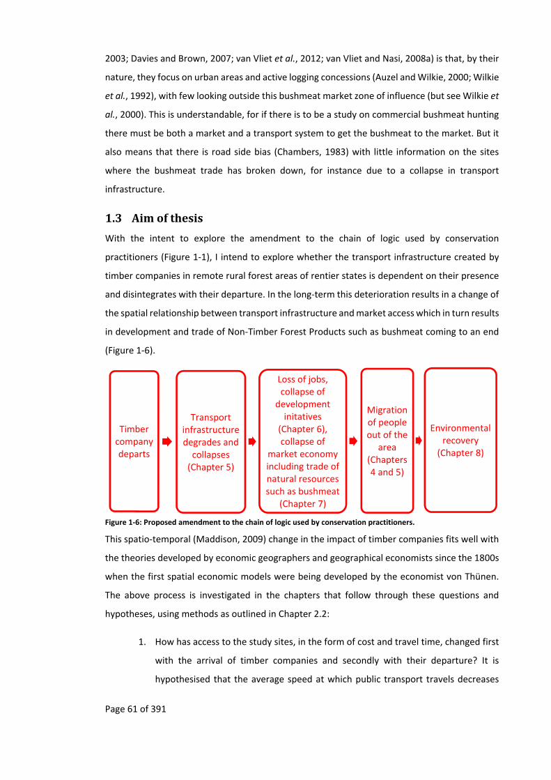
Page 61 of 391
2003; Davies and Brown, 2007; van Vliet et al., 2012; van Vliet and Nasi, 2008a) is that, by their
nature, they focus on urban areas and active logging concessions (Auzel and Wilkie, 2000; Wilkie
et al., 1992), with few looking outside this bushmeat market zone of influence (but see Wilkie et
al., 2000). This is understandable, for if there is to be a study on commercial bushmeat hunting
there must be both a market and a transport system to get the bushmeat to the market. But it
also means that there is road side bias (Chambers, 1983) with little information on the sites
where the bushmeat trade has broken down, for instance due to a collapse in transport
infrastructure.
1.3 Aimofthesis
With the intent to explore the amendment to the chain of logic used by conservation
practitioners (Figure 1‐1), I intend to explore whether the transport infrastructure created by
timber companies in remote rural forest areas of rentier states is dependent on their presence
and disintegrates with their departure. In the long‐term this deterioration results in a change of
the spatial relationship between transport infrastructure and market access which in turn results
in development and trade of Non‐Timber Forest Products such as bushmeat coming to an end
(Figure 1‐6).
Figure 1‐6: Proposed amendment to the chain of logic used by conservation practitioners.
This spatio‐temporal (Maddison, 2009) change in the impact of timber companies fits well with
the theories developed by economic geographers and geographical economists since the 1800s
when the first spatial economic models were being developed by the economist von Thünen.
The above process is investigated in the chapters that follow through these questions and
hypotheses, using methods as outlined in Chapter 2.2:
1. How has access to the study sites, in the form of cost and travel time, changed first
with the arrival of timber companies and secondly with their departure? It is
hypothesised that the average speed at which public transport travels decreases
Timber company departs
Transport infrastructure degrades and collapses (Chapter 5)
Loss of jobs, collapse of
development initatives
(Chapter 6), collapse of
market economy including trade of natural resources such as bushmeat
(Chapter 7)
Migration of people out of the
area (Chapters 4 and 5)
Environmental recovery
(Chapter 8)

Page 62 of 391
with increased distance from a market, whether or not there has been logging or
timber companies based in the village (Chapter 5).
2. What impacts have timber companies had on the migration of people, especially
after their departure? It is hypothesised that people are attracted to timber
companies, but once these depart people also leave (Chapters 4 and 5)
3. How has development in the form of education and employment been impacted by
the departure of timber companies? It is hypothesised that the distance a village is
from a market is more important than the past presence of a timber company in
shaping education and employment (Chapter 6).
4. How has the trade of Non‐Timber Forest Products in the form of bushmeat been
impacted by the departure of timber companies? It is hypothesised that the
bushmeat trade no longer occurs in the villages furthest from the market, with
people’s livelihoods largely being based on subsistence (Chapter 7).
5. How has the trade of Non‐Timber Forest Products impacted the environment,
especially with the departure of timber companies? It is hypothesised that in the
more remote areas there are more animal signs, signs of forest succession and fewer
signs of human disturbance in the forests around these villages (Chapter 8).
6. To put some of the findings in historic context, this thesis also looks at the ecological
impacts of various phases of natural resource exploitation in Gabon starting from
the Atlantic trade of natural resources to Europe in the 1400s (Chapter 3) and then
the nineteenth century trade in one of the study sites (Chapter 4). In doing so I
attempt to show how forest use, be it for logging or conservation, may be
dependent on past uses of the forest.
It is important to emphasise the context of this study (as outlined in Chapter 2.1) and to
continually bear it in mind throughout this dissertation. The study was undertaken in one of the
most remote areas of an African country, Gabon, whose main source of revenue is offshore oil.
It is a country in which there is a low population density, no land shortage, where there is little
incentive to transform landscapes from forest into agriculture24 and where timber operations
are selective due to the distribution of commercially exploitable tree species in the forests.
Under these conditions, and when there are no other factors that maintain access to remote
rural forested areas, then the outcome of the abandonment of a remote rural forested area by
24 Although in the last couple of years there has been a push to transform fallow “degraded” forest into oil palm plantations.

Page 63 of 391
timber companies may have results that are quite different from the increased environmental
degradation found in post‐logging situations in South American and other African countries
(Hodgkinson, 2009).

Page 64 of 391
2 Backgroundtothestudysitesandmethods
2.1 AnoverviewofGabon
Map 2‐1: Map of Gabon, including area of study sites. Based on (Nations Online Project, 2012). Area of study site in red oval.
This study was carried out in Gabon (Map 2‐1), an African country that is not only “little known”
to Anglophones (Aicardi de Saint‐Paul, 1989, p.vii; Darlington and Darlington, 1968, p.ix) but is
also an exception to many generalisations commonly applied to sub‐Saharan Africa. The
following section will give an overview of Gabon, highlighting some of the particularities that
puts it apart from much of the rest of sub‐Saharan Africa (Figure 2‐1).

Page 65 of 391
Figure 2‐1: An example of one of the many particularities of Gabon, the amount of land area that is forested (from Megevand and World Bank, 2013, p.2)
2.1.1 GeographyandClimate
Gabon sits astride the equator in Western / Central Equatorial Africa (Gardinier and Yates, 2006),
with an Atlantic coast line of 800 km and a land mass of 267,667 square km (Aicardi de Saint‐
Paul, 1987). The terrain consists of lowland plains that stretch 30 to 200 km inland and then rise
to a maximum of 300 metres in altitude. These plains continue along the principal rivers of
Gabon: the Ogooué, Nyanga and Ngounié. Outside these coastal and riverine plains the rest of
the country consists of plateaus from which two principal mountain chains rise: the Monts de
Cristal in the north and the Du Chaillu Massif in the centre and the south.
The climate is equatorial with a uniform temperature of around 26oC and high relative humidity
(Gardinier and Yates, 2006). Yearly the mean daily temperatures varies from a low of 21oC to a
high of 28oC (Wilks, 2003). There are two rainy seasons that generally run from mid‐February to
mid‐May and then from mid‐September to mid‐December (Gardinier and Yates, 2006). The small
dry season that runs between mid‐December to mid‐February is more pronounced in the north
than the south; in some years the small dry season in the south may just consist of a reduction
in rains rather than a complete halt to them (Wilks, 2003). The mean annual rainfall fluctuates
between 150 to 300 centimetres per year with the north‐west being the wettest while the
extreme north‐east and south‐west are the driest (Wilks, 2003).

Page 66 of 391
2.1.2 ThePeoplesofGabon
There is evidence of hunter‐gather Homo erectus inhabiting Gabon from 100,000 BP (Clist, 1999;
Clist, 1995; Vansina, 1990) with traces of Homo sapiens appearing 40,000 BP (Clist, 1999). Bantu‐
speaking peoples started to arrive along the coast of Gabon around 3,400 BP (Clist, 2005, p.788;
Ehret, 2002, p.113; Vansina, 1990, p.51). Later, around 2,500 BP, they migrated overland, using
the routes offered by rivers and ridges (Clist, 2005; Oslisly, 2001). This migration occurred at a
time when the climate became increasingly dry resulting in savannah corridors opening up in
the forest (Clist, 2005; Clist, 1995; Ehret, 2002, p.82; Maley, 2001a; Maley, 2001b; Oslisly, 2001;
Wilks, 2003, p.21). In the wake of Vansina’s (1990) work, researchers using similar methods have
identified three cultural systems that were simultaneously present in Gabon from around 2,500
BP, (1) nomadic Pygmies25, groups living on the edge of areas occupied by Bantu‐speaking
people, (2) Neolithic Bantu‐speaking peoples, and (3) Iron‐working Bantu‐speaking peoples
(Clist, 1995; Klieman, 2003, p.219; Klieman, 1997, p.146). It is on these cultures that today’s
ethnicities are based (Clist, 1995; Klieman, 1997).
Today linguists generally separate the peoples of Gabon into one of eight Bantu linguistic sub
groups (Myènè, Kèlè, Kota, Tsogo, Eshira, Mbédé, Nzabi and Fang) and one non‐Bantu‐speaking
group the Pygmies, (which include the Baka, Babongo and Bakoya (Gardinier and Yates, 2006,
p.529; Knight, 2003)). Some groups, such as the Fang (who represent one quarter of the
Gabonese population), are recent migrants, having, “within the memory of man” (Burton, 1863,
p.46), originally moved into the northern reaches of Gabon from Cameroon in the 1600s and
resulted in the displacement of other peoples from northern and central Gabon (Chamberlin,
1977; Cinnamon, 1998; Gardinier and Yates, 2006). In the 1840s the Fang started a major
migration south, in order to have direct access to trade with the Europeans who were appearing
on the coast at the time (Briault, 1943; Bruel, 1930; Chamberlin, 1977; Cinnamon, 1998; de
Brazza, 1887; de Compeigne, 1875; Deschamps, 1965; Deschamps, 1962; du Chaillu, 1861;
Gardinier and Yates, 2006, p.123; Gray, 2002; Klieman, 2003; Metegue N’Nah, 2006; Ngolet,
2003; Raponda‐Walker, 2002; Touchard, 1861; Trilles, 1912).
Though this early Fang migration and associated displacements may have been due, among
other things, to trade, conflict, and access to resources, more recent migrations, from the late
1800s and early 1900s, have also been due to the management practices of the colonial
administrators (Bruel, 1930, pp.161–162), which included the recruitment of soldiers, forced
25 See Appendix 11.4 on why the word Pygmy is used throughout this thesis, rather than one of the many alternatives.

Page 67 of 391
labour and tax collection, (Coquery‐Vidrovitch, 2001; Gray, 2002; Metegue N’Nah, 2006;
Metegue N’Nah, 1981; Rich, 2007a). These practices were amplified by a timber industry that
was attracting labour from all over Gabon as well as further afield (Gray, 2002; Rich, 2007a; Rich,
2005). In the early 1900s the displacement of large numbers of people resulted in outbreaks of
disease (Headrick, 1994) and famine (Chamberlin, 1977; Cinnamon, 1998; Coquery‐Vidrovitch,
2010; Rich, 2007a; Rich, 2005) that resulted in the creation of “dead zones” (Gray, 2002, p.160),
including in one of the study sites.
2.1.3 Population
With an official 2011 population of 1,534,000, a mean density of five people per square
kilometre (United Nations Statistics Division, 2009), a population that is only increasing slowly
(Figure 2‐2) and a rural population that makes up 13.8% of the entire population (United
Nations, Department of Economic and Social Affairs, Population Division, 2012), Gabon has a
rural population that is low compared to many other African countries and this rural population
is decreasing by 1.7% per annum (United Nations, 2012).
Year1950 1975 2000 2025 2050
Nu
mb
er
of in
hab
itan
ts/k
m2
0
10
20
30
40
50
60
70
80
90
World Cameroon RDC Congo Gabon
Figure 2‐2: Demographic evolution and projections in the Congo basin (adapted from Ongolo et al., 2013, p.177).
However, the censuses that have been carried out in Gabon have been poorly organised with
data being regularly manipulated upwards (Bruel, 1930, p.158) and being “systématiquement
cachées ou déformées par un gouvernement frappé du complexe d'infériorité de la taille … les

Page 68 of 391
résultats du recensement ont été, pour les besoins de la cause, passablement modifiés”26 (X...,
1977, p.155). Demographers believe that there are probably around 1,474,586 people in Gabon
(Gardinier and Yates, 2006, p.359; World Bank, 2012) others think there are fewer than
1,000,000. Projections from the French Ministère de la Coopération estimated that the
population of Gabon in 2000 would be 747,697 (Gaulme, 1988, p.35). Ever since the first
population censuses carried out by the colonial administration in Gabon, there has yet to be an
un‐biased population census. This is due both to methodological deficiencies and to problems
in logistics, where far flung villages make it impossible for censuses to be carried out (personal
observation, Gaulme, 1988). After regroupement27, which occurred at various times both before
and after Gabon’s independence, the population of Gabon has become concentrated around
the 565 km of “asphalt roads” and in urban centres (Sautter, 1966; Walker, 2010, p.72; World
Bank, 2012) and the railway (Map 3‐2).
It is among the urban population, which represents 86% of the Gabonese people, where many
of the in‐migrants from Central and Western Africa can be found. The urban in‐migrant
population is found mostly in Libreville and Port‐Gentil, where there are around 244,550 in‐
migrants from Africa, France and China (World Bank, 2012); the Chinese have recently overtaken
the French as the biggest resident in‐migrant population in Gabon.
2.1.4 Colonisation
Before and during the early part of European colonisation the name “Gabon” referred to the
area directly around Libreville and the Gabon Estuary. Different authors reveal that the French
colonisation of Gabon occurred at various times from 183928 the year when the French signed
the first treaty to be given “deux lieues de terre”29 (Gaulme, 1988, p.80; Merlet, 1990, p.61;
Pourtier, 1989, p.2; Spero, 1973, p.141). From 1910 to 1958 Gabon was part of the Afrique
Equatoriale Française30 and then in 1960 it gained independence.
26 “systematically hidden or distorted by a government feeling threatened by [its population’s] small size … the results of censuses were, for strategic purposes, significantly modified”. 27 French term used to define villagisation process. 28 Other dates that have been used are 1843 (Cuvillier‐Fleury, 1904, p.78; Gardinier and Yates, 2006, p.xlviii), 1878 (Denys, 1920, p.58) or 1886 (Merlet, 1990, p.20). These dates depend on different treaties signed with various chiefs along the coast, from Loango in the south to Rio Muni in the north (Gardinier and Yates, 2006, p.xlviii). 29 “two leagues of land” 30 French Equatorial Africa
Page 69 of 391
2.1.5 Economy
From the 1900s to the 1960s logging was the most important generator of revenue. Oil was
discovered by the French in 1929 and its exploitation started in 1957 (Gardinier and Yates, 2006,
p.260). It very quickly came to dominate Gabonese exports (Dowie, 2009; Laurance, Alonso, et
al., 2006; Wunder, 2003). Thirty years of oil exports made Gabon wealthy (United Nations
Statistics Division, 2009). With a GDP per capita of $8,729 in 2010 (World Bank, 2012), it was
one of the wealthiest countries of the region, being only recently overtaken by similarly oil‐rich
Equatorial Guinea.
Even though many rural Gabonese have ties, through the extended family, to elites in the
Gabonese administration, this recent wealth is not evenly distributed. Poverty is still prevalent,
especially in ethnic groups that have no political representation. As of 2005, the lowest 20% of
the population was estimated to share only 6.1% of the income (The World Bank Group, 2007),
with a Gini coefficient31 of 41.5 in 2005 (The World Bank Group, 2014).
Economists have raised concerns that Gabon is too dependent on oil, making it vulnerable to
worldwide fluctuations in oil price, events which have been behind several minor economic
crises in Gabon (Wunder, 2003; Yates, 1996). The production of oil and the rate of new
discoveries have been declining since the late 1990s (Gardinier and Yates, 2006; Leigh and
Olters, 2006; Pourtier, 2010, p.1; Wilks, 2003, p.74; Wunder, 2003). For this reason the World
Bank has encouraged Gabon to diversify its economy by promoting logging, mining and tourism
(Wunder, 2003).
2.1.6 Gabonandlanduse
Due to Gabon’s history (Rich, 2007) and the comparative wealth of the urban population, there
are few Gabonese who carry out commercial agriculture, be it large scale mechanised
agricultural industries or small scale individual farmers growing agricultural products to be sold
(Pourtier, 1984).
With just 1% of its land cultivated (U. S. Department of State, 2009) and an agricultural and food
production index that is so small as to be insignificant (United Nations Statistics Division, 2009),
Gabon imports a lot of the food from neighbouring countries and Europe, with France supplying
27.7% of its overall imports (U. S. Department of State, 2009). Rural villages and urban towns of
Gabon are not therefore surrounded by a sea of agriculture as predicted by von Thünen as would
31 An measure of inequality where 0% equates with perfect equality and 100% represent maximum inequality.
Page 70 of 391
be found in some other African countries (Nigeria ‐ Watts, 1987; Cameroon ‐ Guyer, 1987; e.g.
Tanzania ‐ Bryceson, 1987).
Commercial agricultural products such as tomatoes, onions, bananas and plantains mostly come
from Cameroon (Guyer, 1987, pp.136, 141), though some West Africans have set up their own
small plots around Libreville from where they grow crops to be sold, such as cassava and sweet
potatoes. When Gabonese do grow crops it is usually for subsistence. Commercial cultivation, in
Gabon, is seen as a job for in‐migrants, while many urban and some rural Gabonese aspire to a
job in an office as a civil servant (Rich, 2005; Rich, 2007a).
Even with logging occurring, this unique combination of factors has resulted in Gabon having a
low deforestation rate, less than 1%. The 84.5% of Gabon’s land that is covered in forest32 (Figure
2‐1) (United Nations Statistics Division, 2009) is being reduced by only 10,000 ha/year (FAO,
2009; FAO, 2006).
As commercial agriculture is unimportant and the rural population is low, there is no population
of landless migrant agricultural labourers. So unlike the situation in other places (Hodgkinson,
2009; Poulsen et al., 2009; Riddell, 2013; Riddell, 2011), newly built logging roads do not yet
attract a mass in‐migration of people looking for potential agricultural land.
In 2002 Gabon set aside 11% of its territory as protected areas in the form of thirteen national
parks and in the process cancelled 800,000 ha of timber concessions (WCS, 2007a). As well as
protecting the environment there was also the objective of creating high end tourism as a way
to diversify the economy (WCS, 2007a).
2.1.7 Thestudysites
The first set of study sites for the present thesis are in the middle reaches of the Ikoy River, in
Gabon’s Du Chaillu Massif (Map 2‐2 and Table 2‐1). This area was chosen as it is one of the most
remote areas in Gabon, where market access is difficult and, at certain periods of the year,
impossible. To the west of the site is the sous‐prefecture of Ikobey, which in 2003 had an
“unofficial” population of 22133. Beyond the rugged hills of Ikobey is the Ngounié River with, on
its banks, the towns of Sindara and Fougamou. To the north of the study site is the Lopé National
Park and then, on the other side of the Park on the banks of the Ogooué River, the towns of
Lopé and Ndjole. To the south of the study site is the Waka National Park followed by one of the
32 The rest being savannas. 33 This “unofficial” population is from the raw data of the 2003 census, before it was manipulated for official purposes as a state‐approved document.
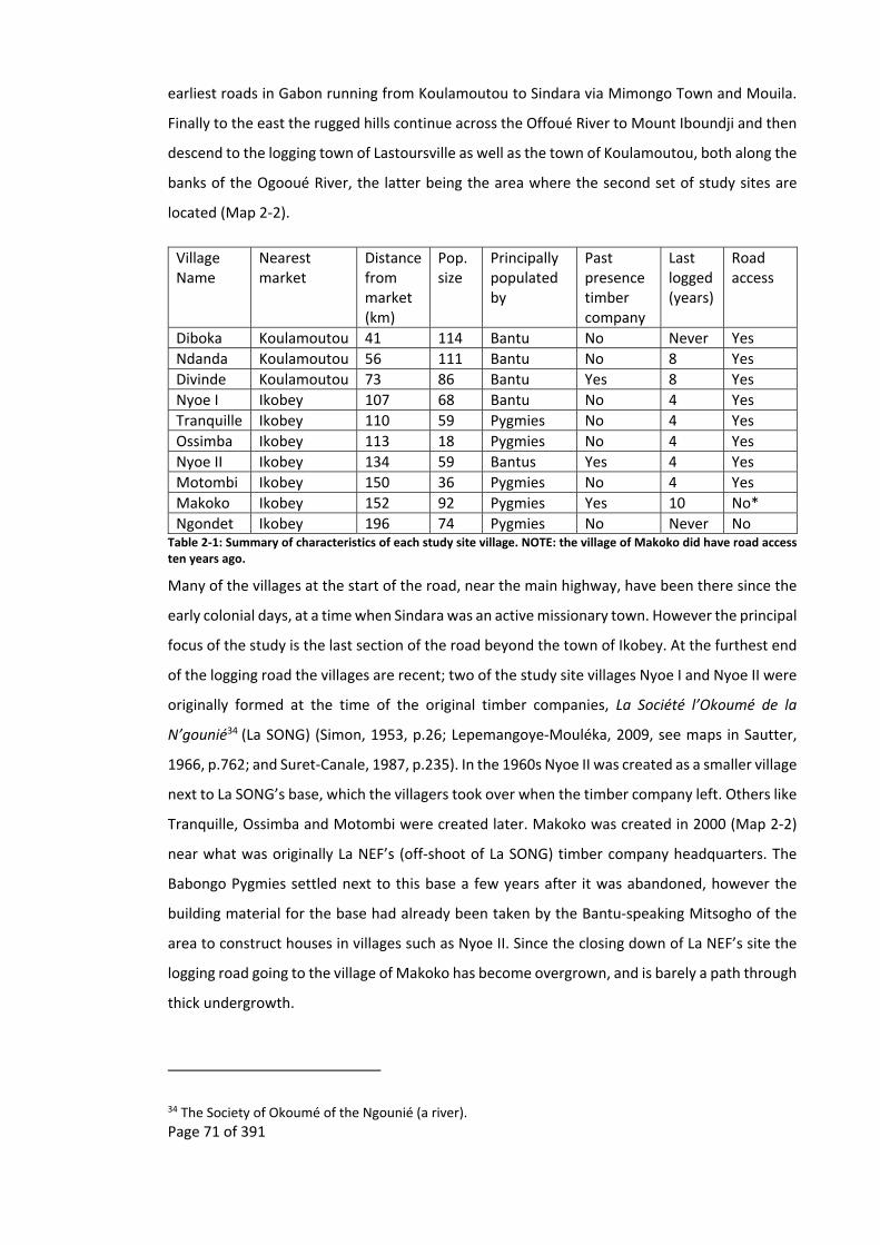
Page 71 of 391
earliest roads in Gabon running from Koulamoutou to Sindara via Mimongo Town and Mouila.
Finally to the east the rugged hills continue across the Offoué River to Mount Iboundji and then
descend to the logging town of Lastoursville as well as the town of Koulamoutou, both along the
banks of the Ogooué River, the latter being the area where the second set of study sites are
located (Map 2‐2).
Village Name
Nearest market
Distance from market (km)
Pop. size
Principally populated by
Past presence timber company
Last logged (years)
Road access
Diboka Koulamoutou 41 114 Bantu No Never Yes
Ndanda Koulamoutou 56 111 Bantu No 8 Yes
Divinde Koulamoutou 73 86 Bantu Yes 8 Yes
Nyoe I Ikobey 107 68 Bantu No 4 Yes
Tranquille Ikobey 110 59 Pygmies No 4 Yes
Ossimba Ikobey 113 18 Pygmies No 4 Yes
Nyoe II Ikobey 134 59 Bantus Yes 4 Yes
Motombi Ikobey 150 36 Pygmies No 4 Yes
Makoko Ikobey 152 92 Pygmies Yes 10 No*
Ngondet Ikobey 196 74 Pygmies No Never No Table 2‐1: Summary of characteristics of each study site village. NOTE: the village of Makoko did have road access ten years ago.
Many of the villages at the start of the road, near the main highway, have been there since the
early colonial days, at a time when Sindara was an active missionary town. However the principal
focus of the study is the last section of the road beyond the town of Ikobey. At the furthest end
of the logging road the villages are recent; two of the study site villages Nyoe I and Nyoe II were
originally formed at the time of the original timber companies, La Société l’Okoumé de la
N’gounié34 (La SONG) (Simon, 1953, p.26; Lepemangoye‐Mouléka, 2009, see maps in Sautter,
1966, p.762; and Suret‐Canale, 1987, p.235). In the 1960s Nyoe II was created as a smaller village
next to La SONG’s base, which the villagers took over when the timber company left. Others like
Tranquille, Ossimba and Motombi were created later. Makoko was created in 2000 (Map 2‐2)
near what was originally La NEF’s (off‐shoot of La SONG) timber company headquarters. The
Babongo Pygmies settled next to this base a few years after it was abandoned, however the
building material for the base had already been taken by the Bantu‐speaking Mitsogho of the
area to construct houses in villages such as Nyoe II. Since the closing down of La NEF’s site the
logging road going to the village of Makoko has become overgrown, and is barely a path through
thick undergrowth.
34 The Society of Okoumé of the Ngounié (a river).

Page 72 of 391
Map 2‐2: Location of the study site, with Babongo Pygmies and Bantu‐speaking study site villages. Based on the following sources: Basemap ‐ (ESRI, 2012), Park boundaries ‐ (Institut Geographique National, 2008).
N.P.
N.P.
Page 73 of 391
East of Makoko lies one other village, Ngondet. This is another Babongo Pygmy village that is off
the road, and a hard day’s walk for the Babongo Pygmies, from Makoko. There are several routes
through the forest that go to this village, one of which is to walk along an old logging road and
then, when this logging road comes to an end at a steep hill about half way to the village,
following a small path that continues through the forest (Map 2‐2). Around this village, during
colonial times, there had been many other villages containing several ethnicities (Ossimba,
Akele, Mitsogho, Apingi, and Babongo Pygmies). On some maps the old village of Mimongo,
labelled Ancien Mimongo (TerraMetrics, 2011), can still be seen, while on the ground there is
still evidence of these old village sites, including clearings, fruit trees and old pots (personal
observation).
To the west of the Ikobey study site lies the first road that was created in Gabon. Started in 1910
and finished in 1927, this road was first a path created to divert riverine traffic around the Samba
falls between the town of Fougamou and Sindara. The Samba falls was at the time a bottle neck
to the riverine transport on the Ngounié River (Gray, 2002, pp.151–153; Gouvernement Général
de L’Afrique Equatoriale Française, 1928, p.VI). Eventually this path became part of the first road
network that joined the middle and lower parts of the Ngounié (Lasserre, 1955) and later joined
Libreville to Franceville, before the Route Economique was built.
The second set of study sites is near the market town of Koulamoutou. This site was chosen as
a comparison to the Ikobey site due to their relatively easy market access, with the market being
closer to these village sites than the ones in the Ikobey site (Map 2‐2). Koulamoutou is the chef‐
lieu of l'Ogooué‐Lolo province. In 2003 this town had an “unofficial” population of 17,393; it is
about half an hour from the Route Economique that crosses Gabon. As the chef‐lieu, the local
administration is based there and there are numerous shops and daily markets, including a
bushmeat market (Starkey, 2004). There is also a national airport. To the west of Koulamoutou
lies the second set of sites. These villages are in the foothills of the Du Chaillu Massif, with one
village, Divinde, being not far from Mont Iboundji and so the most easterly study site village in
the Ikobey area, though access is only through the forest. To the south of Koulamoutou is
Franceville, while in the east is Lastoursville, a major logging town with a railway station.

Page 74 of 391
2.2 Overviewofmethods
There are many theoretical and methodological tools at the disposition of conservation
biologists that allow them to study different parts of an ecosystem, including historical, social
and ecological dimensions. All these tools have their strengths but also their weaknesses, for
every method has its weaknesses (Bernard, 2011; Maier and Imazeki, 2013). Both the past and
current bias towards a subset of tools that mostly originate from the natural sciences has biased
the outcomes of conservation efforts towards the limitations inherent in these tools35. By using
both the biological and social tools triangulation between datasets can be carried out (Drury et
al., 2011) to reduce biases, assumption drag and negative learning.
The push for a multidisciplinary approach to conservation has been practiced since at least the
1950s (Balmford and Cowling, 2006; Drury et al., 2011; Ehrenfeld, 1987; Mermet et al., 2013;
Newing, 2010, p.411; Pooley et al., 2014) with the rise of sub‐disciplines (see table in Cooke et
al., 2013; as well as table in Pretty, 2011; Balmford and Cowling, 2006; Clayton and Brook, 2005;
Grabbatin and Rossi, 2012; Mascia et al., 2003; Schultz, 2011) that have brought “significant new
bodies of information” (Healy and Ascher, 1995, p.1) including methodological techniques and
theoretical frameworks, though as yet these disciplines and even sub‐disciplines have not
managed to fully integrate with each other (Ascher, 1999b; Newing, 2010; Pretty, 2011).
However, such multidisciplinary collaboration is difficult, not only due to academic differences
such as language used, ethics, methodology, respect as well as lack of funding and time
constraints that advantage “quick and dirty” methods over more time consuming and in‐depth
methods (Balmford and Cowling, 2006; Drury et al., 2011; Fox et al., 2006; Harris and Lyon, 2013;
Martín‐López et al., 2009; Martín‐López et al., 2008; Phillipson et al., 2009; Sandbrook et al.,
2013; Sievanen et al., 2012). Collaboration is further hindered as career advancement is
increasingly being linked to impact factor of papers which are usually lower in inter‐disciplinary
journals, even though multidisciplinary work increases the likelihood of scientific articles being
published in high impact journals (Uzzi et al., 2013), while social science papers submitted to
conservation biology journals are reviewed by biologists (Adams, 2007; Campbell, 2005;
however see Hicks et al., 2010). Due to these difficulties multidisciplinary teams may not be the
best way forward, rather multidisciplinary people are needed (Adams, 2007, p.276; for an
example of the mishmash of disciplines, including: history, sociology, geography and linguistics
35 The use of only social science tools also creates biases.

Page 75 of 391
see Alexander, 2000). However, at a time where knowledge is expanding at a pace where
academics cannot keep up with the literature in their own field, it is even harder for a
multidisciplinary person to stay ahead of the literature from several different fields and so they
need to demarcate their research36. A multi‐disciplinary person cannot be expected to be an
expert is all the disciplines that they will need to help them elucidate problems, however they
should have the skills to understand colleagues from different disciplines who may use ideas,
language and ethics that are different to theirs. Furthermore they should be able to translate
these in such a fashion where it is not only understandable to themselves but also to their
colleagues in their own discipline and should be able to bring ideas from different disciplines
together.
The following outline of methods is my effort to try and incorporate a multidisciplinary approach
to this study, by using both biological and social science methodologies (Ascher, 2007, p.144) to
collect qualitative and quantitative data that is needed. Full methods are given in the relevant
chapters. I have used an adaptive methodology / research approach to the research questions
that I have posed. This allows the findings from the study sites to demarcate the investigation,
allowing one to refine the background research and methods needed. In this way it reduces the
risk of too narrowly circumscribing the interconnected data to one discipline, and so the risk of
ignoring relevant information from other disciplines that may be important to this investigation.
36 Devons and Gluckman (2007, pp.162–169) proposed a five step procedure for demarcating an anthropological investigation, which can also be useful for a multidisciplinary person or team to follow. The first step that they proposed was to carefully circumscribe (Devons and Gluckman, 2007, pp.185–212) the research to isolate a manageable “amount of interconnected data” (Devons and Gluckman, 2007, p.162) in both time and space. Once this is done then facts and events that can be taken for granted from other disciplines need to be incorporated (Devons and Gluckman, 2007, pp.169–173). Flowing from this is also the need to base an analysis on theories and hypotheses from other disciplines which, also often have to be taken for granted this step Devons and Gluckman called abridgement (Devons and Gluckman, 2007, pp.173–185). In the process of abridgement there will be times when the researcher has to make naïve (Devons and Gluckman, 2007, pp.212–253) assumptions about complex events that are studied by other disciplines, by doing so they have to carefully disregard the research of others and just taken their findings at face value. The limits of naïvety have to be respected by both the researcher and fellow colleagues from other disciplines (Devons and Gluckman, 2007, pp.166–169). The researcher should be wary of drawing conclusions from their studies that go beyond their expertise, while fellow colleagues should be wary of criticising this naïvety, especially if it is not central to the research being carried out. The final step is simplification (Devons and Gluckman, 2007, p.169), whereby facts and variables from the researchers own field have to be simplified, for example by using well known models and using a sampling structure that limits the data that needs to be collected to the bare essentials.

Page 76 of 391
The study was principally undertaken in two different environments, the first being the village
where social methods were used and the second the area around each village where ecological
methods were used.
The study was carried out in two periods. Pilot work from October 2008 to February 2009 was
used to get to know the area of each site, select appropriate villages and test methods. The
principal fieldwork was carried out during the second period running from February 2010 to
August 2010, with follow up questions carried out from September 2010 to January 2011. During
this time a total of approximately one month was spent in each village, spread out over the year.
The principal fieldwork was carried out in the dry season starting at the end of the short rainy
season and finished at the beginning of the long rainy season.
Research was conducted in two different sites that were formerly logged. The first set of sites
around Ikobey, chosen due to the difficulty of access to the communities there, had been
abandoned by timber companies four years before the start of the study (Table 2‐3). However
just at the end of the study in 2011 a Chinese timber company started operations in the area. It
is in this site that a more detailed study was undertaken. The site consisted of six villages, four
of which are next to a road and two far from a road (Table 2‐3). Some of these sites were
populated by Babongo Pygmies, others by Bantu‐speaking peoples (Table 2‐4). To get to these
sites public transport was used at first and then, later on in the study, personal transport was
used.
The second set of sites, around Koulamoutou, had been abandoned by timber companies eight
years previously. However access to the communities in this site is still relatively easy, with the
roads last being maintained within the last three years (Table 2‐4). This site consists of three
Bantu‐speaking villages, but only one has been directly influenced by timber companies,
Divinde; the other two villages, Diboka and Ndanda, are at various distances from the major
market town of Koulamoutou.
2.2.1 Historicalapproach
This thesis is primarily socio‐ecological, though it does bring in some historical elements, mainly
from authoritative secondary sources (such as Chamberlin, 1977; Coquery‐Vidrovitch, 2001;
Gray, 2002; Gray, 1998; Headrick, 1994; Klieman, 2003; Martin, 1972; Merlet, 1990; Patterson,
1975a; Rich, 2007a; Sautter, 1966; Vansina, 1990). Online archives were also used, particularly
those offered by the Internet Archive (www.archive.org), the British Library (www.bl.uk), the
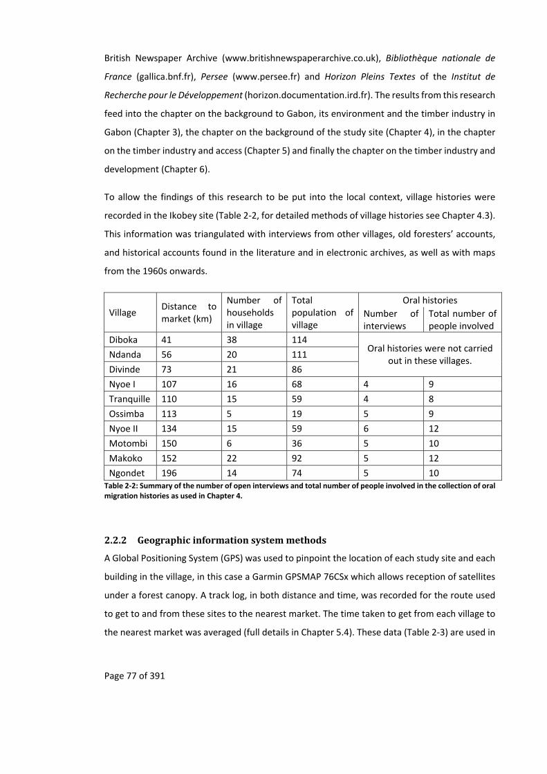
Page 77 of 391
British Newspaper Archive (www.britishnewspaperarchive.co.uk), Bibliothèque nationale de
France (gallica.bnf.fr), Persee (www.persee.fr) and Horizon Pleins Textes of the Institut de
Recherche pour le Développement (horizon.documentation.ird.fr). The results from this research
feed into the chapter on the background to Gabon, its environment and the timber industry in
Gabon (Chapter 3), the chapter on the background of the study site (Chapter 4), in the chapter
on the timber industry and access (Chapter 5) and finally the chapter on the timber industry and
development (Chapter 6).
To allow the findings of this research to be put into the local context, village histories were
recorded in the Ikobey site (Table 2‐2, for detailed methods of village histories see Chapter 4.3).
This information was triangulated with interviews from other villages, old foresters’ accounts,
and historical accounts found in the literature and in electronic archives, as well as with maps
from the 1960s onwards.
Village Distance to market (km)
Number of households in village
Total population of village
Oral histories
Number of interviews
Total number of people involved
Diboka 41 38 114 Oral histories were not carried
out in these villages. Ndanda 56 20 111
Divinde 73 21 86
Nyoe I 107 16 68 4 9
Tranquille 110 15 59 4 8
Ossimba 113 5 19 5 9
Nyoe II 134 15 59 6 12
Motombi 150 6 36 5 10
Makoko 152 22 92 5 12
Ngondet 196 14 74 5 10 Table 2‐2: Summary of the number of open interviews and total number of people involved in the collection of oral migration histories as used in Chapter 4.
2.2.2 Geographicinformationsystemmethods
A Global Positioning System (GPS) was used to pinpoint the location of each study site and each
building in the village, in this case a Garmin GPSMAP 76CSx which allows reception of satellites
under a forest canopy. A track log, in both distance and time, was recorded for the route used
to get to and from these sites to the nearest market. The time taken to get from each village to
the nearest market was averaged (full details in Chapter 5.4). These data (Table 2‐3) are used in
Page 78 of 391
the chapter on the timber industry and access (Chapter 5), the chapter on the timber industry
and development (Chapter 6) and the chapter on livelihood activities (Chapter 7).
A GPS was also used during the forest and animal surveys to create waypoints for the start and
end of the transects as well as for individual waypoints observations. This dataset was used in
the chapter concerning the human impact on wildlife and on the forest (Chapter 8).
GPS data were analysed using several different Geographic Information System software
packages including ExpertGPS (Foster, 2013), to quickly work out distances between waypoint
along the transects, and Global Mapper (Blue Marble Geographics, 2013) to map track logs and
place them on digitised maps (both old and recent).

Page 79 of 391
Village Nearest market
Distance to market (km)
Road last maintained prior to 2010
Last maintained by Number of cars observed in 12 day period
Cost of taxi to market
Average number of hours to market (N)
Diboka Koulamoutou 41 1 month State / Timber company 85 500 1.40 (5)
Ndanda Koulamoutou 56 3 years State / Timber company 4 1000 2.15 (3)
Divinde Koulamoutou 73 4 years State / Timber company 4 1500 3.25 (2)
Nyoe I Fougamou 107 4 years / 1 month Timber company 2 6000 5.30 (8)
Tranquille Fougamou 110 4 years / 1 month Timber company 2 6000 5.45 (8)
Ossimba Fougamou 113 4 years Timber company 2 6000 6.00 (8)
Nyoe II Fougamou 134 4 years Timber company 2 6500 7.20 (8)
Motombi Fougamou 150 4 years Timber company 1 7000 9.03 (4)
Makoko Fougamou 152 10 years Timber company road not passable 6500 14.20 (10)
Ngondet Fougamou 196 no road NA no road to village 6500 40.30 (4) Table 2‐3: Summary of access data to each village site from the nearest market.
Village Principal ethnicity
Demographic data used in Chapter 4 No. of employed people who were recorded for data in Chapter 6
Items collected data used in Chapter 7
Total no. of Households
No. of households who participated (% of households who participated)
Total Pop. size (2010)
No. of people who participated
No. of households who were recorded (% of households who participated)
No. of people who were recoded
Diboka Pove 38 35 (92%) 114 73 36 36 (95%) 75
Ndanda Pove 20 18 (90%) 111 42 18 18 (90%) 41
Divinde Pove 21 19 (90%) 86 42 14 19 (90%) 40
Nyoe I Mitsogho 16 11 (69%) 68 40 17 15 (94%) 49
Tranquille Babongo 15 11 (73%) 59 41 9 15 (100%) 41
Ossimba Babongo 5 5 (100%) 18 17 6 5 (100%) 15
Nyoe II Mitsogho 15 15 (100%) 59 49 18 15 (100%) 38
Motombi Babongo 6 6 (100%) 36 21 6 6 (100%) 22
Makoko Babongo 22 15 (68%) 92 51 17 20 (91%) 54
Ngondet Babongo 14 13 (93%) 74 39 3 14 (100%) 47 Table 2‐4: Summary of semi‐structure interviews used as data for the various chapters. For Chapter 6 all employed people were recorded. For Chapter 7 all people who returned to the village with an item were recorded. Percentage of people who participated are not show here as the total 2010 population size includes children and infants.
Page 80 of 391
2.2.3 Socialmethods
Questionnaires (Appendices 11.5 and 11.6) and village histories were carried out in each of the
study villages, usually by myself carried out in French with a Mitsogho translator at hand in case
further explanation is needed. In rare cases, usually with elders, interviews were carried out in
Mitsogho with a translator. In all cases the interviews were recorded electronically and, in the
case of the interviews carried out in Mitsogho, they were then translated into French by the
translator who was present at the interview.
In each of the questionnaires the principal representative of each household was asked to
participate in demographic questionnaires concerning themselves and their fellow members of
the household (full details in Chapter 4.3), including ones who were born in the household but
had migrated away. Where possible education levels and past employment of people in the
household were collected from each individual or, when unavailable, from the head of the
household (full details in Chapter 6.4). In the context of this research a household is considered
to be a group of people living in one house; this could include several buildings, such as kitchen,
main house and secondary house. To help in the identification of households, a map of the
village was created with the help of members of the village. For each house a number with a
GPS point and a head of household was attributed. Due to the small size of Gabonese villages37
no sampling strategy was used, with all the households asked to partake in the study (Table 2‐4
and Table 2‐4). For various reasons, some households preferred not to participate, however the
large majority did with the lowest percent of participating households being 68% in the village
of Makoko (Table 2‐4).
To encourage participation in the questionnaires and to compensate participants for their time,
in a locally meaningful but not excessive way, food items were given to participating households
(e.g. rice, salt, sardines, tomatoes, oil, coffee, sugar and powdered milk). To further help the
local economy these items were bought from the nearest shop (this also reduced carbon
emissions that would have resulted from these items being transported by ourselves from urban
37 In some cases villages have less than 10 people.

Page 81 of 391
areas). To encourage participation in open‐ended group interviews on village histories, soft
drinks were distributed during the interviews38.
The questionnaires (Appendices 11.5 and 11.6) were based on, but not limited to, those that
have been used by several other projects in Gabon, including Projet Gibier39 that ran in Gabon
between 2000 to 2007, and the Gabon Parks and People project that was carried out in 2005
(Wilkie et al., 2006). The first set of questionnaires (Appendix 11.5, Table 2‐4) covered simple
demographic data used in Chapter 5, and on transport infrastructure created by timber
companies. This questionnaire also covered education levels and past employment histories and
was used in Chapter 6 on analysing post‐logging development impacts.
Data on age or date of birth were collected. However, in some cases, especially for the elderly
and the Babongo Pygmy populations, no birth date or age could be ascertained. When this
occurred the age of a person was estimated either by asking other villagers or in the worst cases
visually. For this reason, data concerning the age of a person was split into one of the following
five subjective age categories:
infants – 0 to 12 months,
child – 2 year to 12 years,
teenager – 13 to 18 years,
adult – 19 to 59 years,
elderly – 60 + years.
A second set of questionnaires (Appendix 11.6, Table 2‐5) covered the activities that were
carried out by each participating household. This was repeated over a period of twelve days,
including the items that were brought into the household (full details in Chapter 7.4). These data
were used in Chapter 7 concerning post‐logging livelihood activities.
38 The drinks distributed during these interviews were non‐alcoholic. If alcoholic drinks were distributed, this was at the end of the interviews and consisted of local drinks such as palm wine, rather than spirits such as kai‐kai (distilled palm wine) and gin. 39 Managed partially by myself.

Page 82 of 391
Village Distance to market (km)
Dates of survey Number of households in village
Total population of village
Number of households who were recorded
Number of people who were recorded
Number of times people were recorded in collection survey
Number of items collected that were recorded
Diboka 41 02/06/2010 to 14/06/2010 38 114 36 75 344 977
Ndanda 56 16/06/2010 to 28/06/2010 20 111 18 41 163 406
Divinde 73 04/07/2010 to 26/07/2010 21 86 19 40 187 380
Nyoe I 107 22/05/2010 to 02/06/2010 16 68 15 49 189 318
Tranquille 110 08/05/2010 to 20/05/2010 15 59 15 41 173 339
Ossimba 113 26/04/2010 to 07/05/2010 5 19 5 15 98 160
Nyoe II 134 18/04/2010 to 30/04/2010 15 59 15 38 144 294
Motombi 150 03/04/2010 to 16/04/2010 6 36 6 22 92 163
Makoko 152 18/03/2010 to 30/03/2010 22 92 20 54 169 246
Ngondet 196 03/03/2010 to 15/03/2010 14 74 14 47 177 261 Table 2‐5: Summary of the number of people participating during the twelve day collection survey.

Page 83 of 391
2.2.4 Ecologicalmethods
Ecological data were collected along eight strip transects radiating out from each village site like
the spokes on a wheel (full details in Chapter 8.4). Over a distance of two kilometres animal
tracks seen one metre on either side of the transect line were noted. As best as possible these
tracks were identified to the species level, which in the case of elephants is a simple task,
otherwise to the order, as in the case of antelopes (Davies, 2002a; Sutherland, 2006; White and
Edwards, 2000a).
In addition to noting animal signs, human disturbance on the forest was also noted. This included
signs of hunting, agriculture and logging. The stage of forest succession was also noted as one
of three categories, plantation (old or new), secondary forest and mature forest. Both of these
datasets were used in the chapter concerning the human impact on animals and the forest
around the sites (Chapter 8).
2.2.5 Dataanalysis
Various statistical 40 analyses were used with different statistical packages. In the case of
univariate analysis QED was used (Seaby and Henderson, 2007), for various analyses R (R Core
Team, 2014; RStudio Inc., 2014) was used with the following packages: RExcel (Baier and
Neuwirth, 2009), Rcmdr (Fox, 2005), MASS (Venables and Ripley, 2002) for carrying out AIC
calculations, Linear Mixed Models and Generalised Linear Models, pscl for Zero‐Inflated Poisson
and Zero‐Inflated Negative binomial testing, (Jackman et al., 2014), lmtest for testing various
linear regression models (Hothorn et al., 2014).
Before any modelling was conducted data were tested for normality, outliers and collinerarity
as set out by Zuur et al. (2010) using R package lattice (Deepayan, 2008). The resulting final
models were tested for validity by looking at the normality of residuals, homogeneity and
independence (Zuur et al., 2009, pp.19–22). Overdispersion was assessed using Pearson
residuals (Zuur et al., 2015, p.146).
Models for Chapters 5 to 8 were chosen using an information‐theoretic approach following
Anderson and Burnham (2002). This uses Akaike’s Information Criteria (AIC) or Akaike’s
Information Criteria corrected for small sample bias (AICc), depending on sample size (Anderson
40 From the German Statistik “to describe efforts in the comprehensive description of political states” (Hilts, 1978, p.24).
Page 84 of 391
and Burnham, 2002; Zuur et al., 2009). All possible model combinations were tested using the
automated methods in the MuMln R package (Bartoń, 2004).
Generalised Linear Models (GLMs) were used in Chapters 6 and 7. Due to the excessive number
of zeros in the education response variable, representing people with no education, the
Generalised Linear Model of the education dataset, in Chapter 6, was investigated with Zero‐
Inflated Poisson (ZIP) and Zero‐Inflated Negative Binomial (ZINB) fitted to the data (Zuur et al.,
2009, pp.261–293). The employment data in Chapter 6 were investigated with a logistic mode
and resulting models were tested with an AIC approach.
As the animal sign observations in Chapter 8 consist of nested count data that is overdispersed,
a Generalised Linear Mixed Model (GLMM) fitted with a negative binomial distribution was used.
This was done using the glmmADMB package in the R environment (Bolker et al., 2012; Fournier
et al., 2012, p.245; Zuur et al., 2015, p.146).
In all cases the data analysis is only exploratory in nature and conclusions can only be
indicative41, with the results from these methods only indicating the best model from different
alternatives. They cannot distinguish if the proposed models, the computer42 used to created
them or the data that is put into them43, suffer from GIGO (Garbage In Garbage Out) (Askira
Gelman, 2011; Babbage, 1864; Hinde, 2004; Searle, 1993)44:
Every model is an abstraction from reality. It seeks to throw out the bath water
of irrelevancies while firmly holding on to the baby of significant relationships.
The problem is that when reality involves people it is not easy to discern which
relationships are significant. All too often the model‐builder, having constructed
his model, has the sensation that he has understood reality, and is therefore but
41 Only after repeats of this study (Ascher, 1979; Frieler et al., 2013; Goldfarb and King, 2013; Maier and Imazeki, 2013; The Economist, 2013a; The Economist, 2013b; The Economist, 2013c) with an eye on “negative learning” (Brysse et al., 2013; Oppenheimer et al., 2008) can the results drawn from this study be thought of as more definitive, assuming unbiased calculations without errors (Herndon et al., 2013; Jager and Leek, 2013; Keilman, 1998; Tyszkiewicz, 2013). 42 Such as computers with an Intel P5 Pentium processor, which suffered from incorrect decimal results, also called the Pentium FDIV bug (Nicely, 2011; Halfhill, 1995). 43 Into which errors can accumulate from several sources including methodological issues including faulty equipment (e.g. findings on faster than light neutrinos Reich, 2011; Reich, 2012), using baseline data that has been found to be incorrect errors (Keilman, 1998; Maier and Imazeki, 2013), or a simple typographical error in an excel sheet such as a bad cell or column reference (Tyszkiewicz, 2013). 44 GIGO has been “transmuted to Garbage In, Gospel Out” (Hinde, 2004, p.12).
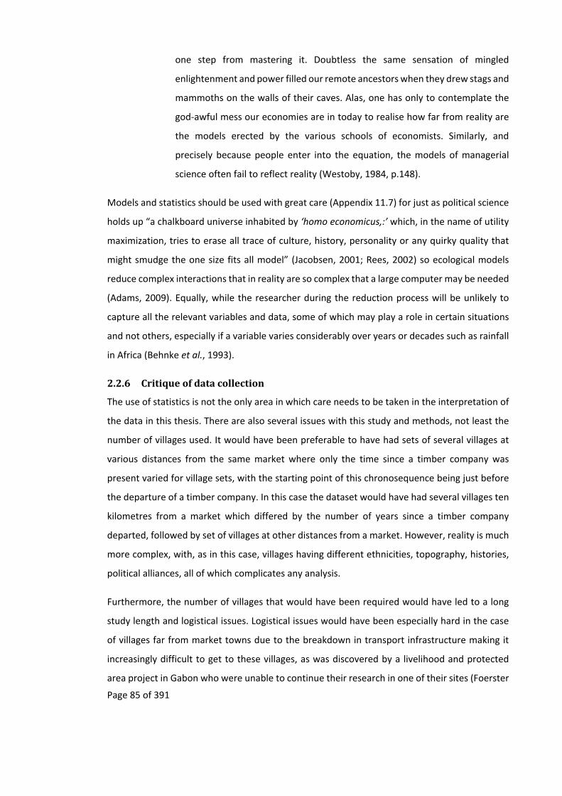
Page 85 of 391
one step from mastering it. Doubtless the same sensation of mingled
enlightenment and power filled our remote ancestors when they drew stags and
mammoths on the walls of their caves. Alas, one has only to contemplate the
god‐awful mess our economies are in today to realise how far from reality are
the models erected by the various schools of economists. Similarly, and
precisely because people enter into the equation, the models of managerial
science often fail to reflect reality (Westoby, 1984, p.148).
Models and statistics should be used with great care (Appendix 11.7) for just as political science
holds up “a chalkboard universe inhabited by ‘homo economicus,:’ which, in the name of utility
maximization, tries to erase all trace of culture, history, personality or any quirky quality that
might smudge the one size fits all model” (Jacobsen, 2001; Rees, 2002) so ecological models
reduce complex interactions that in reality are so complex that a large computer may be needed
(Adams, 2009). Equally, while the researcher during the reduction process will be unlikely to
capture all the relevant variables and data, some of which may play a role in certain situations
and not others, especially if a variable varies considerably over years or decades such as rainfall
in Africa (Behnke et al., 1993).
2.2.6 Critiqueofdatacollection
The use of statistics is not the only area in which care needs to be taken in the interpretation of
the data in this thesis. There are also several issues with this study and methods, not least the
number of villages used. It would have been preferable to have had sets of several villages at
various distances from the same market where only the time since a timber company was
present varied for village sets, with the starting point of this chronosequence being just before
the departure of a timber company. In this case the dataset would have had several villages ten
kilometres from a market which differed by the number of years since a timber company
departed, followed by set of villages at other distances from a market. However, reality is much
more complex, with, as in this case, villages having different ethnicities, topography, histories,
political alliances, all of which complicates any analysis.
Furthermore, the number of villages that would have been required would have led to a long
study length and logistical issues. Logistical issues would have been especially hard in the case
of villages far from market towns due to the breakdown in transport infrastructure making it
increasingly difficult to get to these villages, as was discovered by a livelihood and protected
area project in Gabon who were unable to continue their research in one of their sites (Foerster
Page 86 of 391
et al., 2011). Such logistical issues can be resolved but only at great expense, for example
through the use of 4 by 4s, which in turn biases any social research that is carried out, as this
results in raised expectations as well as perceptual biases from the communities involved
(Maranz, 2001; Woodhouse et al., 2015, p.9) (Picture 2‐1 and Appendix 11.3).
Picture 2‐1: Expectations from transport (illustration from Maranz, 2001, p.x)
Expectations are not the only issues with social methods; there are pitfalls and traps of which
the researcher needs to be aware (Bernard, 1994; Cooke and Kothari, 2001; Cornwall, 2011;
Kumar, 2002; Wolcott, 2005). Some of these are discussed below in relation to this study.
The use of oral histories has created much discussion, especially around history and memory
and how these histories can be used and abused (Thomson, 2007; Thomson, 1998). They can
also mark specific events that have marked the people recounting the oral history (Thomson,
2007; Thomson, 1998). Within this study it was found to be easier and quicker to understand
the broad brushstrokes of the migration of the people to the Ikobey site through one meeting
that involved as many members of the community as possible. Although this approach produced
the most confusion as different members of the community tried to integrate their histories into
a general one of the village, especially if the village consisted of several ethnicities. However, it
also allowed the memory of individual community members to be jogged. This helped when it
came to recording the finer details of the oral histories in follow up oral histories carried out
with small groups within the community. These oral histories also highlighted two important
events that had a major impact on the people who migrated into the Ikobey area, régroupement
and the arrival of the early timber companies (Chapter 4).
Page 87 of 391
The use of semi‐structured interviews in each of the village sites to get information on
demography, employment and education, rather than purely structured interviews, not only
allowed the basic collection of data but also to give further details about schools and
employment, especially in relation to migrations and timber companies. This did result in the
interviews being longer and increased the risk of prompting the respondent towards a certain
response at the risk of others (Bernard, 1994). However, this was un‐avoidable since the
objective of the research was known by all the community in each village. A village meeting
involving all the community was carried out before the start of the research to introduce myself,
the project, the assistants and the method of compensation that was being given to people who
participated in the study.
Though general data on education and employment was collected from the household head for
the people who were absent, in‐depth data is limited to the people who were currently in the
village at the time. This had the result that the observation discussed in Chapter 6 on the
disintegration of development after a timber company has left an area, may be biased towards
the less educated as well as the unemployed, as it could be that the educated and employed are
no longer in the village.
As data on transport to each village was only collected during the dry season (Chapter 5), this
data only represents the best case scenario not only for speed and time to each village but also
for taxi fares. During the wet season speed to each village would decrease while time and taxi
fare to each village would increase. This would have repercussions on any trade carried out by
the villagers, as in the wet season the transport infrastructure breaks down, resulting in the road
being closed for days and weeks at a time, so further increasing the difficulty in trading natural
resource products in towns.
Due to the break down in transport during the wet season, the data collected on the use of
natural resource items that people return with to the village (Chapter 7) also represents a best
case scenario, as these data were also collected during the dry season when transport to market
is easier. Other sources of bias in this data set, especially when the trade in bushmeat is involved,
is the unwillingness of people to display such products. However, through active participation
within the community, being clear with the community regarding the objectives of the study
and because of the small size of the villages involved whereby it was hard to come in and out of
the village without others knowing, this bias was reduced.

Page 88 of 391
3 Background resource use history. Exploitation of natural
resourcesincetheAtlanticTradeand itsshortand long‐term
impacts on the environment and economic development of
Gabon
“wherever humans have trodden, the natural environment is
somehow different, sometimes in barely perceptible ways,
sometimes in dramatic ways” (Balée and Erickson, 2006, p.ix).
3.1 Summary
This chapter explores the first part of the proposed amendment to the chain of logic, that timber
companies open up areas that have not previously been commercially exploited (Figure 1‐1 and
Figure 1‐3). In the process it discusses the short‐term impacts of the trade in natural resources
on the environment and then suggests the probable long‐term impacts that they have had on
the environment both in ecological terms of patch dynamics, and also in terms of the economic
development of Gabon. This chapter focuses on what Gabonese history can tell us as to the
likelihood of long‐term success of conservation and development initiatives in remote rural
forest areas that rely on transport infrastructure built by timber companies.
This chapter shows that the trade of natural resources from Gabon did not start within the last
hundred years with the penetration of timber companies into remote rural areas, as claimed by
some (e.g. Fay, 2004b), but can be tracked back to at least 6,000 years ago with the exploitation
of basalt rock (Clist, 1995) (Appendix 11.8). Human impact on Gabon’s forest builds and wanes
with changes in politics, trade, discoveries, technological advances, transport and disease. It
cannot be said that there is “primary” or “virgin” forest in Gabon, or that environmental
degradation of these forests is a recent phenomenon.
The spread of trade and then colonisation has resulted in increasingly industrialised natural
resource extraction, which accelerates with technological and political changes. However, the
same processes resulted in several disease epidemics and famine that had a role in reducing the
population of Gabon and in shaping its environment. This has resulted in a landscape that
contains areas which are highly valued by timber companies, due to the number of okoumé
trees, and by conservationists, due to their biodiversity.

Page 89 of 391
This chapter does not offer a historical analysis, but rather uses mostly secondary sources
relatively easily available to ecologists interested in Gabon45 to review the past and current trade
of natural resources from Gabon. This overview commences with the important, if indirect, role
that trade has had on the Gabonese landscape, that of facilitating the spread of disease (Chapter
3.2.1). The chapter then summarises the trade of natural resources before and during the
Atlantic Trade period and some of the environmental impacts that this may have had (Chapter
3.2.2). However, this chapter’s principal focuses is on the trade of natural resources during the
colonial and post‐colonial period, especially that of the trade in timber (Chapter 3.2.3). It shows
that the trade of timber in Gabon has not led to the development of local economies but rather
has been behind economic booms and busts that date back to at least 1815 (Chapter 3.2.3.3).
Furthermore, though the exploitation of timber has become more mechanised, it has not led to
an increase in environmental degradation but rather the opposite due to reductions in the size
of the workforce.
3.2 Introduction
Though conservationists usually acknowledge that there is a long history of local people using
the African landscapes, it is less recognised that the commercial exploitation of natural
resources from this landscape also has a long history. In Gabon the commercial exploitation of
resources predates the start of the Atlantic Trade. Later historical descriptions of this commerce
shows how they impacted both the environment and the economic development of Gabon.
The biophysical landscape can be read “like a text, but not one that is readily accessible to
historians’ and epigraphers’ methods because it is not written in a decipherable script, but
rather is inscribed in a subtle, physical sense by learned, patterned behaviour and action” (Balée
and Erickson, 2006, p.2). This “text” can be useful to conservationists when thinking about the
impacts that timber companies may have on remote rural forested areas and its succession once
they depart, as it allows a comparisons with other similar landscapes that have undergone
disturbance in the past (Reich et al., 2001). These landscapes, since their disturbance which can
be either natural or human, are at various stages of succession through patch dynamics.
Historical, archaeological, and linguistic references on the trade of natural resources from Gabon
abound. This history of natural resource trade in Gabon can be split into four periods, 1) pre‐
45 Surprisingly mostly in English.

Page 90 of 391
Atlantic trade (pre mid‐fifteenth century) (Appendix 11.8), 2) the Atlantic trade (mid‐fifteenth
century to mid‐nineteenth century) (Appendix 11.9), 3) the colonial trade based on logging (end
of the nineteenth century to 1960) (Appendices11.10, 11.11 and 11.12) and 4) the post‐colonial
trade (1960 onwards) which is dominated by oil and minerals. The process of transition from
one period to another does not occur abruptly but rather with a progressive change as economic
niches open and close over time. These economic niches are exploited by various players who
at different times adapted themselves to exploit the different economies and ecologies that
appear (Klieman, 2003; Klieman, 1999; Klieman, 1997; Vansina, 1990).
Understanding of the first period is limited by the archaeological data available and is widely
acknowledged by conservationists (Delègue et al., 2001; Maley, 2001a; Maley, 2001b; Maley,
2001c; Ngomanda et al., 2007; Oslisly et al., 2013; Oslisly, 2001; Palla et al., 2011; Schwartz,
1992; Schwartzman et al., 2000; White, 2001; White, 1992; Wilks, 2003). From the second
period, at the start of the Atlantic trade, available data increase with the trading accounts dating
from this time46. For instance, due to its value, the trade in ivory has been well documented
before, during and after the Atlantic trade (Barnes, 1996; Douglas‐Hamilton, 1979). The third
period is dominated by the exploitation of timber and has impacted the study sites. In the fourth
period revenue from logging has been overshadowed by off‐shore oil, though timber is still
Gabon’s biggest exploited natural resource by surface area. This chapter focuses on the colonial
and post‐colonial periods and is mostly viewed in relation to logging.
In describing some of the historical trade in natural resources that has shaped the Gabonese
landscape, not only do I try to address the first part of the proposed amendment to the logic
chain (Figure 1‐1 and Figure 1‐3), but I also put into historical context the study sites that are
used to investigate what may occur after a timber company leaves a remote rural forested area.
Migration and the spread of disease, due to increased trade and the breaking down of trade
barriers, that started during the Atlantic trade period and continues today, have had a profound
impact on the Gabonese landscape, partly explaining the presence in Gabon of areas that have
high Okoumé densities. As trade, migration and disease partially underpin the Gabonese
46 These being full of references on where and what to trade, where natural resources have been exhausted, prices and other information to help the then merchant trader.

Page 91 of 391
landscapes I first describe a framework to help understand the possible environmental
consequences that these continue to have.
3.2.1 TradeandthespreadofdiseaseinGabon(mid‐fifteenthcenturytopresent)
In Africa, the “cradle‐land” (Reader, 1998, p.234), humans and some of their parasites and
diseases have had millennia to co‐evolve (Hartwig and Patterson, 1978). Over this time they
have achieved “biological harmony”47 (Spinage, 2012, p.1194). However, people outside of
Africa have long viewed Africa as an “unhealthy tropical cesspool” (Zeleza, 1993, pp.40–41).
Though this view may be biased, stemming from a Europe that is no longer at the mercy of
diseases such as cholera and malaria (Zeleza, 1993, p.41), the recent West African Ebola
epidemic, where 11,299 people died (WHO, 2015), is a reminder of the devastation disease
outbreaks can cause48.
Diseases, both zoonotic and human, have played a significant role in determining the
demography (Cordell, 1983, p.49) and the ecology of Africa. Spinage (2012, pp.821–1364)
dedicated a third of his book on African Ecology to the description of the different impacts that
various diseases have had on Africa, adding that the “tsetse flies and trypanosomiases, [are] two
of the most important influences in African ecology” (Spinage, 2012, p.v). Disease, famine and
migration, have resulted in the depopulation of rural areas that has shaped, and continues to
shape, the environment of Africa49 including Gabon (Coquery‐Vidrovitch, 2010) and, in the early
twentieth century, one of the research sites. This depopulation has led to Gabon being named
one of the last “African Edens” (BBC Travel, 2013; National Geographic, 2007; Odendaal and
Day, 1999).
Diseases have hindered the exploration, trade and colonisation of Africa by European powers
(Birmingham and Martin, 1983; Curtin, 1968; Curtin, 1989; Curtin, 1998; Debusman, 1993;
Patterson and Hartwig, 1978; Webb, 2013). Before sanitation and quinine, the death rate for
Europeans arriving in Africa was 50 percent; it fell to 25 percent in the following years (Curtin,
1998, p.1). These deaths were not limited to Europeans. African soldiers were conscripted to
47 It can take as little as 150 years for zoonotic diseases to become established in humans (Spinage, 2012, p.1194). 48 “Emerging diseases” such as Ebola and HIV are likely to be ancient diseases (Spinage, 2012, p.1204). The oral histories that were recorded in this study from the Waka area, hint that the diseases that the elders say wiped out some of their villages when they were young seem to have had symptoms similar to Ebola. 49 As is being witnessed in the current Ebola outbreak in West Africa.

Page 92 of 391
European armies50, as they were thought to be more resistant to the African climate, but they
also succumbed to the diseases in the environments in which they operated51.
From the start of the Atlantic trade, the spread of disease in Gabon originated either from
outside Africa or from zoonotic diseases from within. Their spread was facilitated by trade routes
(Bruel, 1930, pp.170–171; Coquery‐Vidrovitch, 1985, p.49) with traders being at greater risk
from diseases (Patterson and Hartwig, 1978, p.12). However, as traders rarely diverted from
these routes diseases did not spread far (Patterson and Hartwig, 1978, p.6). This association
between trade, other colonial conditions that favoured movement of people and disease is not
unique to Gabon and is found in other African countries (Spinage, 2012, p.1034) as well as
around the world52.
For the British African colonies this effect has been termed Pax Britannica (Ford, 1971, p.390)
and resulted in an unintentional “outbreak of biological warfare on a vast scale” (Ford, 1971,
p.489) that assisted the “scramble for Africa” (Pakenham, 2010). For Richards and Spinage the
Pax Britannica theory is “a simple evolutionary stage model of ecological change” (Richards,
1983, pp.20–21; Spinage, 2012, pp.1034–1038; Zeleza, 1993, p.41) whereby the cultural and
biological adaptions to the local disease and epidemic environment has been disrupted
(Patterson and Hartwig, 1978, p.3). This disruption can be due to the introduction of new
diseases, changes in populations from war and famines, changes in population movements
(Patterson and Hartwig, 1978, p.3), the arrival of foreigners from outside of Africa (Patterson
and Hartwig, 1978, pp.7–8), and the adoption of new activities and technologies such as those
related to agriculture 53 (Patterson and Hartwig, 1978, p.6; Vansina, 1983, p.109) or
50 The annual military disease mortality of European soldiers in African garrisons varied widely, from 200 deaths per thousand to 600 deaths per thousand (Curtin, 1998, p.4). 51 Though the death rate was lower. For example, between 1816‐1873 African soldiers serving in the British army in West Africa had a mortality rate of 29 per thousand, they were susceptible to epidemics, such as smallpox that could result in the forced withdrawal from operations, such as during the 1824 siege of the Cape Coast in the Asante empire (Curtin, 1998, p.52). 52 Darwin observed that this has occurred around the world. He wrote “there appears to be some more mysterious agency generally at work. Wherever the European has trod, death seems to pursue the aboriginal. We may look to the wide extent of the Americas, Polynesia, the Cape of Good Hope, and Australia, and we find the same result” (Darwin, 1882, p.435). 53 “Once upon a time (but not too long ago) there lived a tribe deep within the Dark Continent. These people tilled the soil to raise crops of roots and grains, for they had little meat to lend them strength. Illness often befell them, but even so, in this dry land they were not overly troubled with the fever sickness brought by the mosquito, Now in the Northern World there was a powerful republic that had compassion on these people and sent their Wise Men to relieve the mean burden of their lives. The Wise Men said, "Let them farm fish," and taught the people to make ponds and to husband a fish called tilapia.
Page 93 of 391
transportation (Debusman, 1993, p.42; Patterson and Hartwig, 1978). All these disruptions can
occur at different frequencies while interaction with neighbouring communities varies,
epidemiological conditions will differ both in space and time (Patterson and Hartwig, 1978,
pp.5–6).
These disruptions can also occur for diseases to which Africans have acquired some resistance,
such as malaria and yellow fever, which can then become epidemic (Curtin, 1998, pp.5–11). In
the case of malaria this occurs when new strains are introduced, either through the movement
of people (Patterson and Hartwig, 1978, p.12; Zeleza, 1993, p.43) or when people lose their
resistance after having gone long periods without being infected, that can be related to the use
of insecticides to kill mosquitoes or the extensive use of anti‐malarial drugs (Webb, 2013, p.9).
The equilibrium between Africans and their disease environment has been disrupted several
times. The worst disruptions occurred between 1890 and 1930 (Coquery‐Vidrovitch, 1985, p.46;
Patterson and Hartwig, 1978, p.4) where various epidemics reduced the population of Africa,
making this period Africa’s equivalent to the European black death of the fourteenth century
(Zeleza, 1993, p.41). Though historical documents on demography and the number of deaths
that occurred since the start of the Atlantic trade are imprecise (Patterson, 1975b), especially at
the beginning of the period, there are innumerable reports from explorers, administrators,
doctors and missionaries of villages being empty of people due to epidemics (for example Bruel,
1935; de Brazza in Sautter, 1966, p.968; du Chaillu, 1867b; Kingsley, 1879; Marche, 1882; Nassu,
1914; Touchard, 1861).
Later demographic data were collected in a more systematic fashion. For instance it is probable
that between 1.5 to 2 million Africans died during the influenza pandemic of 1918‐191954
(Patterson, 1981, p.413; see also Coquery‐Vidrovitch, 1985, pp.60–61; Patterson and Hartwig,
1978, p.19; Patterson, 1986; Sautter, 1966, pp.859–860; and Spinage, 2012, pp.1201–1202)
The people learned well, and within a short time they had dug 10,000 pits and ponds. The fish flourished, but soon the people could not provide the constant labors required to feed the fish and keep the ponds free of weeds. The fish became smaller and fewer, and into these ponds and pits came the fever mosquitoes, which bred and multiplied prodigiously. The people then sickened and the children died from the fever that the medicine men from the cities called malaria, The Wise Men from the North departed, thinking how unfortunate it was that these people could not profit from their teachings. The people of the village thought it strange that Wise Men should be sent them to instruct in the ways of growing mosquitoes.” (Desowitz, 1978, p.36). 54 These dates seem to correspond to the time when the Waka study site became depopulated (see chapter 4).
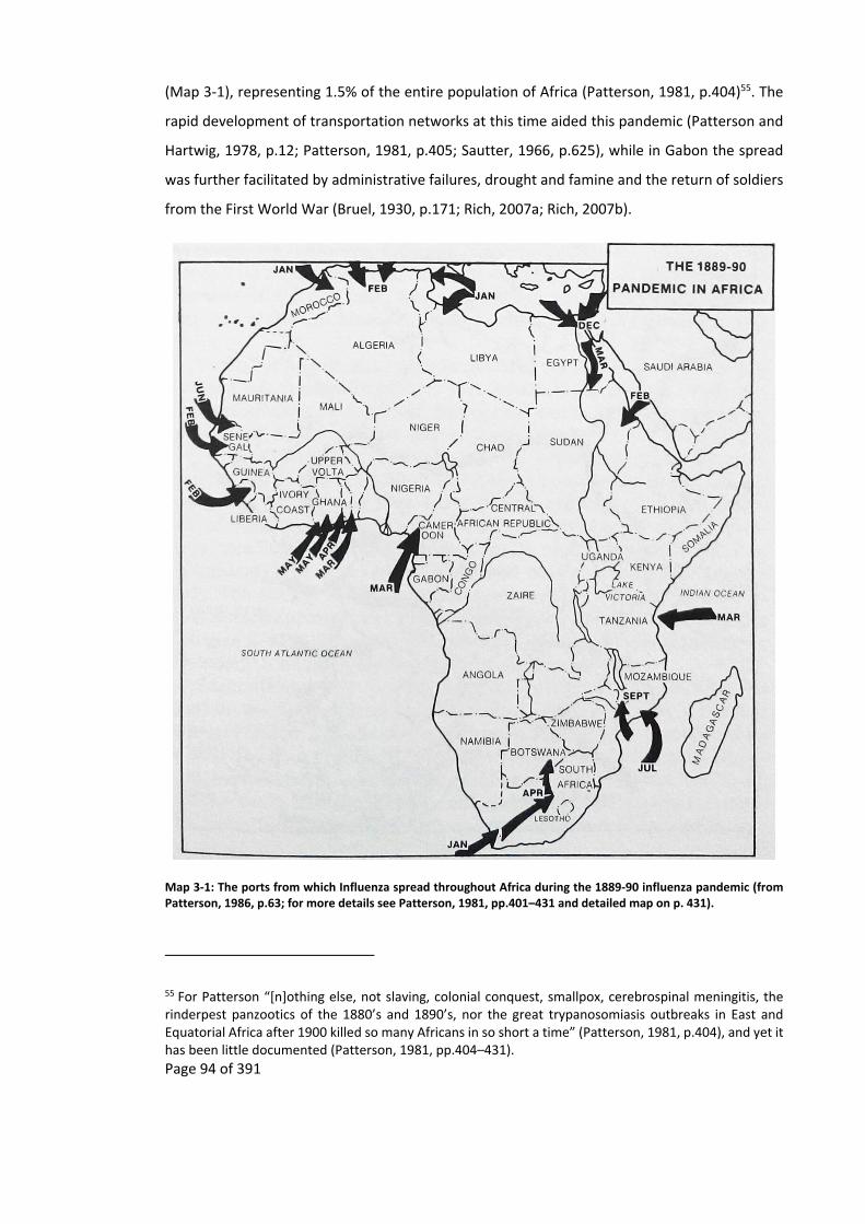
Page 94 of 391
(Map 3‐1), representing 1.5% of the entire population of Africa (Patterson, 1981, p.404)55. The
rapid development of transportation networks at this time aided this pandemic (Patterson and
Hartwig, 1978, p.12; Patterson, 1981, p.405; Sautter, 1966, p.625), while in Gabon the spread
was further facilitated by administrative failures, drought and famine and the return of soldiers
from the First World War (Bruel, 1930, p.171; Rich, 2007a; Rich, 2007b).
Map 3‐1: The ports from which Influenza spread throughout Africa during the 1889‐90 influenza pandemic (from Patterson, 1986, p.63; for more details see Patterson, 1981, pp.401–431 and detailed map on p. 431).
55 For Patterson “[n]othing else, not slaving, colonial conquest, smallpox, cerebrospinal meningitis, the rinderpest panzootics of the 1880’s and 1890’s, nor the great trypanosomiasis outbreaks in East and Equatorial Africa after 1900 killed so many Africans in so short a time” (Patterson, 1981, p.404), and yet it has been little documented (Patterson, 1981, pp.404–431).

Page 95 of 391
Disease‐related depopulation has a long history in Gabon. The disappearance of iron workers
between 1,400 and 800 BP from Lopé suggests that the area became devoid of humans for a
600 year period (Oslisly, 2001, pp.112–113; Spinage, 2012, p.1194). Oslisly (2001, pp.112–113)
hypothesises that this could have been due to a severe epidemic which struck rapidly as he
found “sites that seemed almost intact, with artefacts lying on the surface of the ground as if
suddenly abandoned” (Oslisly, 2001, p.113). Spinage hypothesises that this depopulation could
have occurred due to “malaria, trypanosomiasis, influenza, and a deadly arbovirus” (Spinage,
2012, p.1194), though he favours trypanosomiasis as it is known to have depopulated areas.
For Gabon, Headrick (1994) analysed the spread of disease from the start of the Atlantic trade
period (see also Debusman, 1993; and Coquery‐Vidrovitch, 1985 for the rest of equatorial
Africa). Over the same period Chamberlin (1977) described the way that Europeans took over
the trade of natural resources describing it as a series of phases that started on the coast. By
bringing together these two separate works I summarise how the three‐phased inland
penetration of European traders into Gabon has impacted the Gabonese landscape (Figure 3‐1).
Chamberlin’s original analysis splits traders into three tiers depending on their interaction with
the Atlantic shipping trade and the flow of goods to and from the interior (Figure 3‐1).
Chamberlin’s first tier consisted of traders who dealt directly with merchant ships, second tier
traders dealt with the first tier middlemen, and finally third tier traders operated the stages
between the producers and second tier middlemen (Chamberlin, 1977, pp.6–7). Middlemen in
the second and third trade tiers vied with each other to gain control of the prestigious first tier56
(Chamberlin, 1977; Gray, 2002, p.26; Patterson, 1975a; Vansina, 1990).
56 In Gabon the outcome of this rivalry was depicted by Du Chaillu who wrote that: “[n]one of these Shekiani fellows dare trade directly with the white men. They must all submit to the extortions of their neighbours who are so fortunate as to possess the seashore; and if Ogoula were to attempt direct trade‐though he has the finest chances‐his town would be burned down in a week” (du Chaillu, 1861, p.132).

Page 96 of 391
Figure 3‐1: Historic change of trader tiers and the area susceptible to the spread of disease due to trade (red circle), created by combining the works of Chamberlin and Headrick. Trading tiers are based on Chamberlin’s (1977) trade analysis while the spread of disease is based on Headrick’s (1994) analysis.
Major 1st tier
traders are also the producer, e.g. timber, oil and mineral sectors
European ship
Producer 3rd tier trader 2nd tier trader 1st tier trader
Ship Producer
Trade tiers during the Atlantic trade period
Trade tiers during the colonial trade period
Ship
Major trade tiers during the post-colonial trade period
1st tier trader

Page 97 of 391
Over time Europeans slowly took over each of the tiers and enhanced the extraction of natural
products along the trade routes. This was done by getting to understand local cultures and
landscapes and then integrating themselves into it them (Marche, 1882; Marche, 1878)57, but
also through the introduction of European technologies, logistics and policies that broke down
trade barriers. As they took over the different tiers, African participation in the trade of natural
resources reduced as did the revenue that they received, while the area under the influence of
diseases brought in or spread by Europeans grew.
Though the spread of disease has only been systematically recorded and described since the
mid‐twentieth century, there are plenty of accounts starting from the Atlantic trade that
describe the impacts of diseases in Gabon (Coquery‐Vidrovitch, 1985; Debusman, 1993; Marche,
1879; Newman, 1987; Patterson, 1975b; Rich, 2007b; Sautter, 1966). Accounts both by
Europeans and Gabonese indicate how the encounter between Europeans and Africans resulted
in epidemics. The coastal trade brought diseases such as smallpox, syphilis, cholera, measles and
chickenpox to Gabon (Patterson, 1975b, p.227; Patterson, 1974)58.
The first phase of the spread of diseases was unlikely to result in epidemics or spread far from
the coast as the relay system of the trade network, where goods are moved from trader to trader
to their final destination, would also have limited the transmission of disease (Headrick, 1994,
p.8). Competition by coastal African first tier traders restricted trading access between
Europeans seagoing traders and inland African second tier traders (Chamberlin, 1977; Gray,
2002; Headrick, 1994). This competition resulted in various Gabonese ethnicities migrating to
the coast to participate in this trade (Newman, 1987, p.p88; Touchard, 1861, p.9).
By migrating to the coast, different ethnicities came into contact with disease and strains of
diseases that were previously unknown to them (Sautter, 1966, p.798). This gave the Gabonese
coast a reputation as a place where both Europeans (de Compeigne, 1875, p.97) and Africans
came to die, it was described at the time as a “great gulf in which wave after wave of more dense
population of the vast interior has been swallowed up and lost” (Rollin Porter (1851) cited in
Patterson, 1975b, pp.218–220). The ethnic groups coming to the coast would “suffer the same
extinction that the previous migrants to the coast suffered” (Kingsley, 1879, p.409). After each
57 This is similar to the way that Bantu‐speaking people are thought to have migrated across Gabon (Klieman, 2003; Klieman, 1999; Klieman, 1997). 58 Smallpox and syphilis are two diseases that both Europeans and Africans recognised (Headrick, 1994).
Page 98 of 391
epidemic the surviving local population would have some immunity to the diseases being
brought in regularly by ships (Debusman, 1993, p.40; Patterson and Hartwig, 1978, pp.8–9;
Richards, 1983, pp.14–15; Spinage, 2012, p.1202) but as the reservoir of unexposed and more
susceptible people grew with each new generation, so epidemics could once more occur,
impacting the young more than the old (Curtin, 1998, p.51; Patterson, 1975b, pp.227–228).
The Mpongwe (Patterson, 1975b) of the Gabonese estuary are given as an example by various
historians, explorers and administrators of Gabon as a population who suffered from various
diseases. One of the first smallpox epidemics that was documented by the Europeans and
Americans occurred between 1864 to 1865 (Newman, 1987, p.88; Spinage, 2012, p.1248; Zeleza,
1993, p.66) where a French trading boat brought smallpox to Gabon from Senegal, it reduced
the Mpongwe population by two‐thirds (Patterson, 1975b, p.226), more would have probably
died if American missionaries had not been able to obtain some smallpox vaccine59 with which
they vaccinate the people on the northern bank of the estuary (Patterson, 1975b, pp.227–228).
This was not the first such epidemic. Mpongwe oral histories recorded at the time mention a
smallpox epidemic in 1847 that killed half of the population
The 1864 to 1865 smallpox epidemic impacted all of Gabon decimating local populations60 (Gray,
2002, p.95; Headrick, 1994, p.33; Walker, 1870, p.79)61. As riverine traders came increasingly in
contact with Europeans, so diseases spread along the major riverine trade routes and impacted
riverine peoples such as the “Galoa, Enenga and Okande” (Patterson, 1975b, pp.234–235).
However, the interior was largely spared as communities were relatively isolated from their
neighbours (Curtin, 1968, pp.199–200). These epidemics not only killed people directly but also
brought down retribution against people accused of witchcraft, for in Gabon there is the
“widespread idea … that one never dies of natural causes; one is always poisoned” (Rich, 2001,
p.627; see also Le Testu, 1918, pp.130–132).
59 The first ever smallpox vaccine, rather than variolation, was created in 1796 by Edward Jenner who used a cowpox lesion (in Latin vaccinia) to vaccinate a boy (Riedel, 2005, p.24). 60 Gabon was spared the smallpox epidemic that swept through Africa during the 1920s and 1930s (Schneider, 2009, p.207). 61 Until then the Gabonese had not heard of smallpox (Spinage, 2012, p.1284), and did not have a tradition of inoculation, unlike other parts of Africa (Vossen et al., 2014; Zeleza, 1993, pp.48–49). The people in the interior of Gabon claimed that smallpox was brought in packing‐cases from the coast (Spinage, 2012, p.1284).
Page 99 of 391
The introduction of quinine increased the sphere of European influence and allowed them to
settle along the coast. It also allowed early explorers and traders, such as Du Chaillu62 and de
Brazza (Marche, 1879, pp.327–328), to penetrate the interior of Gabon through waterways and
existing trade routes (Headrick, 1994, p.8).This led to the second phase in the spread of diseases
(Gray, 2002, p.95), which started around 1880 and lasted till the start of the First World War
(Debusman, 1993, p.40). During this period new parasites such as sand fleas causing jiggers63,
brought in from South America, spread throughout Africa by the 1890s (Nassu, 1914, pp.36–37;
Patterson and Hartwig, 1978, p.10; Spinage, 2012, p.1304; Zeleza, 1993, p.44).
The explorers, and especially their porters, brought with them venereal diseases and sleeping
sickness, both of which were well known in coastal parts of Gabon, into areas where it had not
previously occurred 64 (Spinage, 1973, p.966). These diseases and epidemics resulted in
population decline, either directly through mortality or indirectly through reduced fertility and
increased morbidity (Spinage, 1973, p.1191). Once again these epidemics were often limited to
the trade routes themselves (both land and riverine routes), with nearby villages not being
affected (Coquery‐Vidrovitch, 1985, pp.49–50; Patterson and Hartwig, 1978, pp.7–8; Sautter,
1966, pp.624–625; Spinage, 2012, p.982).
The final phase of the spread of disease occurred after the First World War with Europeans
consolidating their trade by taking over the second and third trading tiers and in some cases the
production of natural resources. They further penetrated inland away from water ways and set
up commercial concessions, which later became timber concessions. Europeans had up to the
end of the nineteenth century been living mainly along the coast and in a couple of riverine
62 Du Chaillu described how he saw the start of a smallpox epidemic inland where: “Elanga, one of Olenda's nephews, was taken ill with a disease which the natives had never before seen. It was described to me, and I thought I recognised in the description the symptoms of small‐pox. The next day the news came from a neighbouring village that Elanga had died. There was a great deal of mourning and wailing among the people; and all the inhabitants of Olenda, with the exception of the old king, went to join in the wild manifestations of grief. Now, Elanga was one of the Ashira men who had been to Obindji to fetch my baggage, and a suspicion of foul play or witchcraft, as usual, arose in the minds of the Ashira people, which, in addition to the other causes of unfriendliness, threatened to embarrass my movements” (du Chaillu, 1867a, pp.121–122). This epidemic started a year later in Ngosi district between the coast and the Du Chaillu Massif. 63 These sand fleas were brought from Rio de Janeiro to Angola in ship ballast in 1872. 64 Thirty years after Du Chaillu, the population of Loango had been decimated as were the people along the caravan routes that led to it (Headrick, 1994, p.33).

Page 100 of 391
trading posts such as Lambaréné where they had set up trade factories65 (Walker, 1870). Trading
was still limited to the riverine routes and principal trade routes, with the inland access
controlled by second tier African middlemen who now only managed access between the first
tier European coastal factories and the areas where resources were being harvested
(Chamberlin, 1977). The creation of commercial concessions by the French broke down the last
trade barriers and put an end to second tier African middlemen. This resulted in Europeans,
mainly the French, setting up factories deep in the forest where they traded directly with the
producers (Chamberlin, 1977; Coquery‐Vidrovitch, 2001; Gray, 2002).
Europeans such as Quéru, who traded in the area of the Ikobey study site in the early 1900s
(Coquery‐Vidrovitch, 2001), were penetrating the most remote parts of Gabon away from the
principal trade routes in search of resources. This included ivory, which was becoming rare on
the coast (Headrick, 1994, p.42) and wild rubber which people went deeper into the forest to
collect (Spinage, 2012, p.1033). In this way traders were expanding the zone directly influenced
by the Atlantic trade. Once again this speeded up the transmission of disease as it brought
people in remote areas into contact with coastal diseases (Headrick, 1994, p.42; Patterson and
Hartwig, 1978, pp.9–10).
This spread of disease was likely further facilitated by timber concessions and the development
of transport infrastructure. Both created a large demand for labour in a country that had already
been depopulated by disease. This created two major outbreaks of diseases and famine, firstly
between 1914 to 1916 and then between the 1920s and 1930s. A forester wrote for a 1918
conference:
[d]ans toute la partie exploitable de la forêt du Gabon il devient de plus en plus
rare de rencontrer des villages en plein forêt. La maladie du sommeil,
l’alcoolisme, les maladies vénériennes ont fait disparaitre une grande partie de
la population et le reste, décimé, s’est rapproché petit à petit des points d’où il
était facile d’aller aux factoreries européennes66 (Quilliard, 1920, p.645).
65 Factories is the original English term for a colonial trading post set up by Europeans in foreign territories. It is here where natural resources and other products were stocked before being either sent to the coast or to Europe (Diffie, 1977). 66 “in all the exploitable areas of the Gabonese forest, it is becoming more and more rare to find villages in the middle of the forest. Sleeping sickness, alcoholism, venereal diseases have resulted in the

Page 101 of 391
During the war years, 1914 to 1918, 60,000 people were recruited from southern Gabon as
porters to help the war effort in Cameroon (Gray, 2002, p.154). These displacements, and other
effects of colonisation, resulted in the disappearance of villages through labour migration, while
famine and disease, as witnessed by colonial administrators (Gray, 2002, p.158), resulted in
bodies and skeletons along trade routes (Coquery‐Vidrovitch, 1985, pp.54–56; Sautter, 1966,
p.860). Ultimately the forest reclaimed villages and trade routes and population density maps
began to show empty areas (Sautter, 1966, p.969). These processes of depopulation shaped
Africa’s disease environment today (Patterson and Hartwig, 1978, pp.11–12).
In the Afrique Equatoriale Française, of which Gabon was part during the colonial period, a third
of the population was lost between 1914 and 1921, with Gabon being the worst affected
(Coquery‐Vidrovitch, 1985, p.56; Debusman, 1993, p.42; Sautter, 1966, p.861)67. Vansina (in
Coquery‐Vidrovitch, 1985, p.56), estimated that in this period Gabon lost half its population.
These losses in Gabon after the First World War were due to droughts and then absence of a dry
season, which meant that fields could not be cur and burnt, resulting in food shortages (Rachel
Jean‐Baptiste, 2010, p.71; Sautter, 1966, p.859) that occurred at the same time as colonial
troops where regaining their barracks in Libreville after the defeat of the Germans in Cameroon.
At the same time head taxes were introduced channelling labour away from subsistence
agriculture towards mining, forest concessions (Patterson and Hartwig, 1978, p.13) and
commercial agriculture (Sautter, 1966, p.862). Furthermore, in 1918, the global influenza
pandemic swept through Gabon (Rich, 2007b, pp.241–242), an impact made possible by the
development of transport infrastructure to help trade and administrative control (Patterson and
Hartwig, 1978, pp.11–12).
During the inter‐war period, 1920s to 1930s, access to labour became increasingly important to
colonial administrators as labour shortages began to appear. Labour was needed by both the
disappearance of a large part of the population and the rest, decimated, have slowly come closer to places where they can get easy access to European factories” 67 The early twentieth century particularly impacted the Fang, just like the mid‐nineteenth century had impacted the Mpongwe. The Fang had continued to migrate to the coast or new trading centres to participate in trade and with this the mortality rate of the Fang increased (Patterson, 1975b, p.235; Sautter, 1966, pp.860–872). Missionaries estimated that in the influenza pandemic of 1918 10% of the population of Kango (east of Libreville) died (Rich, 2007b, p.249), while by 1930 the Fang population had reduced by a half (Coquery‐Vidrovitch, 1985, pp.54–56). In Sindara, near the Waka study site. There was a 16.6% mortality rate in 1917 (Bruel, 1935, p.338).
Page 102 of 391
colonial administration and commercial entrepreneurs. This labour was obtained from areas
inland because the coastal plains had a low population (Pourtier, 2010, p.3) who preferred
commercial work over manual labour (Headrick, 1994, p.127), though people from all over
Gabon and outside it were hired as labourers (Sautter, 1966, p.770). The introduction of a head
tax further helped in increasing the work force (Appendix 11.11). The colonial administration
was using manual labour to build Gabon’s first transport infrastructure, especially roads (Gray
& Ngolet, 1999), while the booming timber industry was soaking up all other available labour
(Coquery‐Vidrovitch, 2001, p.455), bringing the colonial administration and the timber industry
into conflict (Rich, 2005). The timber companies hired one‐fifth of the Gabonese population68
(Coquery‐Vidrovitch, 2001, p.457; Coquery‐Vidrovitch, 2010), and were referred to by the
colonial administration as being “de grands dévoreurs d’hommes”69 (Pourtier, 1989, p.173).
The resulting mixing of people from all over the country in places such as timber camps created
a national identity but also fostered the spread of diseases, such as malarial and venereal
diseases (Coquery‐Vidrovitch, 2001, p.456; Headrick, 1994, pp.125, 128), while the poor quality
food rations resulted in beriberi (Pourtier, 2010, p.4). This occurred not just in the timber camps
but also near administration posts. The imposition of head taxes also encouraged women to
take part in prostitution, with marriage being undermined as concubinage, and prostitution
became commercialised70, bringing in revenue both to the women involved and their families
(Headrick, 1994).
The reduction of a rural labour force, through migration, disease and low fertility, created
famines in Gabon (Gray and Ngolet, 1999; Meye, 1969, p.59; Rich, 2007a) and depopulation
throughout the 1910s and 1920s (Pourtier, 1989, p.173). From 1920 to 1931 the Gabonese
population rose slowly, though doctors reporting at the time “were ubiquitous [sic]” that there
was a decrease in population (Headrick, 1994, pp.109, 426). From 1931 to 1960 the population
68 This was occurring at a time where the concessions near waterways were being exhausted of Okoumé (Quilliard, 1920, p.650) resulting in an increase in man power needed to move, the now, distant Okoumé trees to waterways (Pourtier, 1989, pp.152–153). For example in 1929 logs had to be rolled for fifteen kilometres before reaching a waterway (Coquery‐Vidrovitch, 2001, p.455). 69 “big devourers of people” 70 “The workers, bachelors with or without their wives, were infected by prostitutes around the camps, and returned home with venereal disease and the money for a first or second wife. Many wives left behind considered themselves free because their bride price was not fully paid. During the two‐year separation they earned cloth or jewellery for themselves by granting favours to the men who stayed in the village” (Headrick, 1994, p.127).

Page 103 of 391
was stable. But during this period it was becoming less rural with people migrating to roads and
urban areas, partly due to “regroupement, the concentration and resettlement of subject
peoples in stable villages” (Burnham, 1975, p.594) (Map 3‐2).
Map 3‐2: Population distribution of Gabon. The province of Haute‐Ogooué (Southeast) was added to Gabon in 1964 (adapted from Pourtier, 1989; and Sautter, 1966).
The depopulation of Gabon and later the migration of people from rural to urban areas, resulted
in some Gabonese landscapes being released from anthropogenic disturbances. As signs of past
villages rapidly degrade in Gabon, the origins of these anthropogenic disturbances are usually
lost71. However, they live on as a patchwork of landscapes that are at different stages of
succession, some of which date back centuries. In some cases areas of “virgin” forest that are
about to be exploited by timber companies have been exploited in the past, with the only
evidence of this exploitation being in old maps or old trade accounts (Chapter 4).
3.2.2 Brief overview of the history of trade innatural resources inpre‐colonial
Gabon and its short and long term impacts on the environment (pre late
nineteenthcentury)
During the pre‐Atlantic period (Appendix 11.8) trade mostly formed around iron and copper
mineral resources (Clist, 2005; Dupre and Pinçon, 1997; Klieman, 2003; Klieman, 1997;
Ngomanda et al., 2007; Oslisly, 2001; Wilks, 2003). The consequences of the extraction and
71 The exception to this are charcoal deposits, indicating either old smelting areas or places where slash and burn cultivation had once taken place.

Page 104 of 391
transformation of these mineral resources in this period was the emergence of specialists such
as blacksmiths, a centralisation of the economy, increase in fuelwood collection, increased
plantation establishment and hunting to feed and trade with the specialists who did not carry
out agricultural activities (Clist, 1995; Ehret, 2002; Klieman, 1997). Its impact on the Gabonese
landscape can still be seen in savanna sites such as Lopé and coastal savannas (Biraud, 1959;
Gaulme, 1988; Maley, 2001c; Ngomanda et al., 2007; Oslisly, 2001; Oslisly and Dechamps, 1994;
Palla et al., 2011; Schwartz, 1992; White, 2001) that first appeared 2,500 BP (Maley, 2001a;
Maley, 2001b; Maley, 2001c; Oslisly, 2001; Oslisly and Dechamps, 1994) and slowly became
forest. To stop this succession conservation practitioners have put in management plans based
on fire (Jeffery et al., 2014).
The development of an international trade of African natural resources occurred during the
Atlantic period (Table 3‐1) (Appendix 11.9). Though it started slowly in the sixteenth century
(Merlet, 1990, p.20; Patterson, 1975a, p.8) it boomed in the eighteenth and early nineteenth
century with natural resources being traded in bulk quantities (Gardinier and Yates, 2006;
Sautter, 1966, p.729). This boom was partly the result of the European industrial revolution
where mass production led to cheap products (Ehret, 2002) for which there was a great demand
in Africa (Vansina, 1990).
Period (century) African products traded European products traded
Seventeenth Ivory, wax, honey, palm oil, dyewood / red wood / camwood (padouk), black wood (ebony), slaves (small scale).
Old iron and nails.
Eighteenth Ivory, elephant tails, hippopotamus teeth, parrot feather, wax, honey, palm oil, dyewood / red wood (padouk), black wood (ebony), slaves.
Various metals, guns, beads, textiles, alcohol.
Nineteenth Ivory, elephants tail, hippopotamus teeth, parrot feather, wax, honey, palm oil, dyewood / red wood (padouk), black wood (ebony), wild rubber.
Various metals, guns, beads, textiles, alcohol.
Table 3‐1: Products traded during the Atlantic period.
One of the principal natural resources that was traded was ivory. Due to this it has been well
documented and can be useful in analysing the outcomes of the current trade in Gabonese ivory.
Today there is a conservation interest in the decline of forest elephant populations which have
given rise to the fear that the “[l]oss of keystone species like elephants impacts the integrity of
ecosystems and their services … [including the] long‐term viability of the second most important
carbon capture forests in the world” (Wasser et al., 2010, p.1331), this being due to a “potential
Page 105 of 391
for a major wave of tree recruitment failure” (Blake et al., 2009, p.466). Predictions of forest
elephant population extinctions are not new, dating back to at least 1850 (Appendix 11.9). This
revival of conservation interests in elephants has, in Gabon, resulted in military intervention to
protect elephants for:
[i]f we lose our elephants we will enter the same spiral that has seen wildlife
and natural resources plundered elsewhere in Africa, with the inevitable
consequence of political instability and conflict in dysfunctional ecosystems
where man can no longer live sustainably in harmony with nature. Today I have
undertaken to create an elite military unit that will be signed into law this
month, which will support our National Parks Agency in their critical work to
manage Gabon’s natural treasures (Presidential press release: Parcs Gabon,
2011).
The Atlantic trade in ivory resulted in the local extinction of elephants from different areas in
Gabon. By the mid‐1600s the supply of ivory from around the coastal areas of Mayumba, Sette‐
Cama and Mayombe was poor with ivory traders having to go to Bukkameale, “also known as,
the Mountains of Ivory,” (Martin, 1982, p.208), probably in the southern part of the Du Chaillu
Massif (Martin, 1982, p.204; Martin, 1972, pp.17, 41), a walk of a month and a half, where ivory
was exchanged for salt from the coast (Martin, 1982).
By the early 1800s elephants also become locally rare in the Gabon Estuary72. Walker, in 1866,
observed that “les trappes à l’éléphant devinrent très‐nombreuse sans que nous vissions [sic]
cependant un seul animaux [sic]”73 (Walker, 1870, p.64), and this was after a week of walking
away from Libreville up one of the rivers entering the Gabon Estuary. At the same time the Fang
had to go far to find ivory to supply the Mpongwe traders (Chamberlin, 1977, p.104; Gaulme,
1991, p.84; Patterson, 1975a, p.59).
The disappearance of elephants from these areas would have changed the tree composition of
the forest due to the role that forest elephants play in the distribution of seeds (Blake et al.,
2009). It would also have changed the forest structure, with elephant trails becoming overgrown
and disappearing (Fairhead and Leach, 1994, p.501; Fay, 2004a).
72 With “[e]lephant herds visited the Estuary less and less” (Chamberlin, 1977, p.101). 73 “the elephant traps became numerous, even though we did not see one single animal”

Page 106 of 391
Elephants can today be found in areas where they were once locally extinct. In the 1950’s
elephants were “abondant” (Lasserre, 1955, p.121) in the coastal savannas of the Gabon Estuary
and the Mayumba coast. Even today elephants can be seen “strolling the beach” (Fay, 2004a),
with a population of “a few thousand elephants in and around Loango today” (Fay, 2004a). This
historic literature of Gabon indicates that though elephant populations in the past have
collapsed, they have also recovered as long as there is a viable source population (Okello et al.,
2008).
3.2.3 Colonialtrade–latenineteenthcenturytoindependence(1960)
The export of natural resources that started with the Atlantic trade has slowly evolved into a
trade that still underpins the Gabonese economy today. In the colonial era logging (Appendices
11.10, 11.11 and 11.12) became the focus of this trade and of colonial policies, and by surface
area is still the most important natural resource that is being exploited (Figure 2‐1). Until the
late 1890s first tier traders from Britain74, Germany and the United States of America were free
to set up factories and exploit the natural resources of Gabon with little hindrance by the
colonial administration, who even provided them with protection (Gardinier and Yates, 2006,
p.xlix)75. The ivory trade was dominated by British76 and German77 companies until its restriction
in 1904 (Chamberlin, 1977, p.123; de Compeigne, 1876, p.226; Neuville and Ch. Breard, 1884,
p.131). The Germans also dominated the timber industry until the First World War.
The dominance of trade by other Europeans infuriated the French (Coquery‐Vidrovitch, 2001;
Cuvillier‐Fleury, 1904, p.80; Gaulme, 1991, p.85) who, upon the recommendations of de Brazza
(Gardinier & Yates, 2006, p. 313), set about creating a concession system78 and trading routes
that favoured French companies. From these concessions the French exploited natural
resources such as ivory, rubber, raphia, oil palm and wood. This monopoly was already declining
74 Until the 1890s the trade in the Gabon Estuary was dominated by the British, with the presence of the Liverpool based companies of Hatton and Cookson, who had 39 trading counters, and John Holt who had 59 trade counters (Coquery‐Vidrovitch, 2001, p.234). 75 At this time the French were not interested in trade, but rather colonial expansion and administration, only becoming interested in trade when they saw other countries benefiting from their colony (Rich, 2007a). 76 British company Hatton and Cookson, a Liverpool based company who had a monopoly over ivory exported from the Gabon Estuary. 77 Francis Würmer and Company. 78 These commercial concession companies were able to limit those who could use their concessions, including through passage and sale of products to the Gabonese within them (Coquery‐Vidrovitch, 2001, pp.238–243).

Page 107 of 391
by the 1930s, when companies that held commercial concessions relinquished them in return
for forestry concessions 79 (Coquery‐Vidrovitch, 2001; Gardinier and Yates, 2006, p.314;
Headrick, 1994) that officially ended at independence80 (Spero, 1973).
In the first decades of the 1900s the French colonial administrators were exploring ways to
develop their colonies. They saw forestry81 as a way to bolster the colonial budget (Lasserre,
1955)82 and so helped the transformation of the timber trade (Coquery‐Vidrovitch, 2001, p.450).
This forestry policy was one of the catalysts for the modern timber industry. Enterprising
Europeans, some of whom had previously been only involved in the second and third trading
tiers, rushed to set up timber companies (Coquery‐Vidrovitch, 2001, p.452; Pourtier, 1989; Rich,
2005) that undertook the whole process from the production of logs by cutting trees to its export
(Bouet, 1974), circumventing the different Gabonese trading tiers and independent producers.
Timber exports soared from around 3,375 cubic metres in 1896, to an average of 654,098 cubic
metres per year by 193083 (Figure 3‐2) (Appendix 11.12) (Gaulme, 1988, p.119; Rich, 2005,
p.154).
3.2.3.1 Pre‐IndustrialOkoumélogging
The trade in wood for export began in Gabon at the same time as the Atlantic trade (Wilks, 2003,
p.72), though not on an industrial scale. This trade included dyewoods, ebony, and fuelwood for
ships that were returning to Europe or Brazil (Merlet, 1990; Patterson, 1975a; Quilliard, 1920;
Sautter, 1966, p.759). However, “le contact avec les Européens puis la colonisation française ont
conféré à la forêt d’autres valeurs, économiques, en la faisant entrer dans la mondialisation des
échanges”84 (Pourtier, 2010, p.1). In Gabon, the timber industry became focused on Okoumé85,
79 For example in return for its commercial concession the SHO (Société Commerciale Industrielle et Agricole du Haut‐Ogooué) received 35,000 ha forestry concession. 80 Unofficially the monopoly has continued until relatively recently through development aid linked to French industries operating in Gabon (Darlington and Darlington, 1968; Labrousse and Verschave, 2002; Yates, 1996). 81 During the 1918 French Colonial Agriculture Congress it was concluded that animal husbandry and agriculture were only suitable for the drier parts of the West African colonies, while forestry was only suitable for the humid Central African region, including Gabon (Denys, 1920). 82 As well as supply France with the timber it needed due to the heavy toll the war had taken on French forests, providing wood for the Allies and French troops (Chevalier, 1928; Puyo, 2001, pp.486–487). 83 Though there are large variations between authors on estimated rates of exploitation (Jaffré, 2003a, p.266; Pourtier, 2010, p.4). 84 “contact with the Europeans and then the French Colonisation conferred onto the forest other values, economic ones, by bringing it into the globalisation of exchange” 85 The wood itself, being easy to transform into plywood, has many uses including the making of furniture, veneer, boats, aeroplanes (such as The RAF’s Mosquito used in World War II), in the Eurostar trains, and

Page 108 of 391
a sub‐endemic tree whose distribution is centred on Gabon86. Okoumé an emergent can live for
150 to 300 years and become over 50 metres tall with a diameter of two metres (Mapaga et al.,
2002).
The first log of Okoumé arrived on the coast of the Gabon Estuary in July 1889, brought in by
Fang boatmen who were then the first tier traders. This log did not interest the French but it did
interest the German consul in Libreville who, after an analysis of the wood in Hamburg,
discovered how easy it was to manipulate and unroll the wood to make plywood (Coquery‐
Vidrovitch, 2001, p.442; Jaffré, 2003b; Pourtier, 2010, p.2; Quilliard, 1920). Within three months
the Germans began exporting Okoumé logs back to Germany87 (Gaulme, 1988, p.117; Hilling,
1963; Jaffré, 2003a, p.263; Pourtier, 2010, p.2). Soon afterwards they were followed by the
British and ten years later the French became interested88 (Coquery‐Vidrovitch, 2001, pp.441–
442; Cuvillier‐Fleury, 1904; Jaffré, 2003a, p.263; Lasserre, 1955).
Okoumé was most accessible in coastal and riverine areas, where logs could be floated out
(Lasserre, 1955). Places such as the Gabon Estuary (Jaffré, 2003a, p.263; Rich, 2005) and the
lakes along the Ogooué River (Meye, 1969; Pourtier, 2010, p.2; Sautter, 1966, p.757) became
important producers of Okoumé due to their small creeks and waterways as well as these areas
being designated as free trade zones outside the concession monopolies. It is likely that these
areas would also have had abundant Okoumé as its growth would have been aided by previous
anthropogenic use, such as occurred during the production of salt (Appendix 11.9).
These early timber operations were small scale manual affairs (Biraud, 1959, p.10; Jaffré, 2003b,
p.314; Quilliard, 1920) (Picture 3‐1), being carried out in a similar fashion to the extraction of
any other natural resources shipped to Europe at that time. The timber would have been
transported by second tier traders to the European first tier traders before being loaded onto
construction (which was especially important in the reconstruction of France post World War II) (Gaulme, 1988; Hillier, 1913, p.83; Labrousse and Verschave, 2002; Les Actualités Françaises, 1947; Puyo, 2001; Wilks, 2003; World Resource Institute, 2000). 86 Though it can also be found just over the borders in neighbouring Cameroon, Congo and Equatorial Guinea (Lasserre, 1955). Due to this distribution, Gabon has become the biggest producer of Okoumé in the world. 87 From the German Woermann Company based in Libreville. 88 When the first batch of logs finally arrived in France, merchant rivalry resulted in delays that further hindered the French trade of Okoumé for 25 years (Coquery‐Vidrovitch, 2001, pp.441–442).
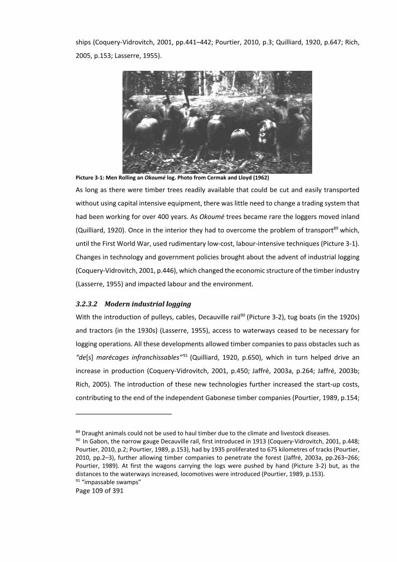
Page 109 of 391
ships (Coquery‐Vidrovitch, 2001, pp.441–442; Pourtier, 2010, p.3; Quilliard, 1920, p.647; Rich,
2005, p.153; Lasserre, 1955).
Picture 3‐1: Men Rolling an Okoumé log. Photo from Cermak and Lloyd (1962)
As long as there were timber trees readily available that could be cut and easily transported
without using capital intensive equipment, there was little need to change a trading system that
had been working for over 400 years. As Okoumé trees became rare the loggers moved inland
(Quilliard, 1920). Once in the interior they had to overcome the problem of transport89 which,
until the First World War, used rudimentary low‐cost, labour‐intensive techniques (Picture 3‐1).
Changes in technology and government policies brought about the advent of industrial logging
(Coquery‐Vidrovitch, 2001, p.446), which changed the economic structure of the timber industry
(Lasserre, 1955) and impacted labour and the environment.
3.2.3.2 Modernindustriallogging
With the introduction of pulleys, cables, Decauville rail90 (Picture 3‐2), tug boats (in the 1920s)
and tractors (in the 1930s) (Lasserre, 1955), access to waterways ceased to be necessary for
logging operations. All these developments allowed timber companies to pass obstacles such as
“de[s] marécages infranchissables”91 (Quilliard, 1920, p.650), which in turn helped drive an
increase in production (Coquery‐Vidrovitch, 2001, p.450; Jaffré, 2003a, p.264; Jaffré, 2003b;
Rich, 2005). The introduction of these new technologies further increased the start‐up costs,
contributing to the end of the independent Gabonese timber companies (Pourtier, 1989, p.154;
89 Draught animals could not be used to haul timber due to the climate and livestock diseases. 90 In Gabon, the narrow gauge Decauville rail, first introduced in 1913 (Coquery‐Vidrovitch, 2001, p.448; Pourtier, 2010, p.2; Pourtier, 1989, p.153), had by 1935 proliferated to 675 kilometres of tracks (Pourtier, 2010, pp.2–3), further allowing timber companies to penetrate the forest (Jaffré, 2003a, pp.263–266; Pourtier, 1989). At first the wagons carrying the logs were pushed by hand (Picture 3‐2) but, as the distances to the waterways increased, locomotives were introduced (Pourtier, 1989, p.153). 91 “impassable swamps”

Page 110 of 391
Rich, 2005) and of small independent European timber companies (Coquery‐Vidrovitch, 2001,
p.450)92.
Picture 3‐2: Pushing Okoumé logs on early railways. Picture from Cermak and Lloyd (1962)
Already, at this early stage of the timber industry, its elitist nature was apparent, needing both
monetary and political capital. The high initial capital outlay needed for industrial logging
(Lasserre, 1955), combined with profits that are only realised in the long term, resulted in an
industry which needed guarantees from political administrations and markets (Angelsen and
Wunder, 2003; Coquery‐Vidrovitch, 2001; Quilliard, 1920). Without these guarantees the timber
industry was, and still is, at the mercy of markets and policies93. With the addition of a biased
permit system and allocation of labour, African loggers were slowly pushed out of the industry
(Appendix 11.11).
After the Second World War, with the creation of the Office des Bois de l'Afrique Equatoriale94
and improved technology such as Caterpillars and logging trucks, industrial logging took off
(Jaffré, 2003a, pp.263–266; Lasserre, 1955; Pourtier, 2010, pp.3, 6). Between 1950 and 1970
production rose from 376,464 cubic metres to 1,500,000 cubic metres (Figure 3‐2) (Coquery‐
Vidrovitch, 2001; Gaulme, 1988, p.119; Jaffré, 2003b) helped by the introduction of chainsaws
(Pourtier, 1989, p.154). At this time, only 10% of the Gabonese forest was being exploited
(Forests Monitor Ltd, 2001).
92 In 1933 there were still some Gabonese and some European timber camps that were operating entirely by hand (Gaulme, 1988, p.31; Meye, 1969; Puyo, 2001, pp.488–489; Rich, 2005, p.158). However, they were a dying breed. 93 This created difficulties for the French during the early phase of European timber companies in Gabon (Coquery‐Vidrovitch, 2001; Quilliard, 1920) as well as in 1938 when exporting Okoumé was stopped due to late payments to the exporters by their clients (Sautter, 1966, p.768). 94 “Office of Equatorial Africa woods”

Page 111 of 391
The introduction of the first Caterpillars, bulldozers and logging trucks increased penetration
into the forest resulting in an increase in production, and allowed the opening of the second
forestry zone (Pourtier, 2010, p.3) (Map 3‐3). The introduction of the chainsaw allowed a tree
to be cut in “quelques minutes, contre un jour ou deux à la hache”95 (Pourtier, 2010, p.6), while
airplanes were used to identify forested areas where there were high densities of Okoumé
trees96. All these new technologies meant that the timber industry needed less manual labour.
By 1959 the industry needed only half the labour force than it required at the start of the century
(Biraud, 1959, p.10). However, it required more financial capital to carry out its work (Lasserre,
1955).
In 1987 completion of the railway running from Libreville to Franceville (Map 3‐3) further
opened up the forest. The railway was constructed to transport manganese from the mines in
Moanda and to allow the exploitation of wood around the zone d’attraction du chemin de fer97.
As with the introduction of lorries and the Decauville rails, the new railway allowed for the rapid
expansion of logging away from waterways (Jaffré, 2003a, p.265; Pourtier, 2010, p.6; Wunder,
2003).
95 “a couple of minutes, instead of a day or two by axe” 96 The aerial identification of okoumé is easiest during the small dry season (January to February), when the new leaves are still red (Clément and Guellec, 1974). The introduction of planes for the identification of areas with high densities of Okoumé resulted in Gabon having one of the highest number of airstrips per unit area in the world (Bouet, 1974). 97 “Zone of attraction due to the railway”

Page 112 of 391
Map 3‐3: Map of the current logging zones in Gabon (from Pourtier, 1989)
Although land based natural resources had been the principal focus of industries during the
colonial period, offshore oil became the focus of industries soon after Gabonese independence.
The period between 1960 to 1986 saw the decline of the importance of timber to the Gabonese
economy. In 1963 timber represented 75% of Gabonese exports but by 1970 timber only
represented 7% of exports (Jaffré, 2003b) and 10% in 1980 (Pourtier, 1989, p.191). Today oil
represents 80% of Gabonese exports (Pourtier, 2010, p.7)98.
Even though oil became the biggest earner for Gabon (Pourtier, 1989), today’s timber industry
is still important, with members of the Gabonese administration gaining from both forestry
(Pourtier, 2010) and oil rents (Yates, 1996). Today two‐thirds of Gabon’s forest have either been
logged at least once or allocated as a concession (World Resource Institute, 2000; Wunder,
2003).
However, though forestry became an important player in Gabon, the revenue raised by the
Gabonese colonial timber industry was not re‐invested in Gabon or its infrastructure, rather the
revenue went to the federal budget that was used to develop other parts of the colonial Afrique
Equatoriale Française, including the railway in the Republic of Congo which was largely financed
from the sales of Okoumé in Gabon (Pourtier, 2010, p.4).
98 Starting in 1966, it was rapidly swamped by the opening up of the oil industry (Gaulme, 1991, pp.85–86; Hilling, 1963; Marcus, 1960, p.67; Pourtier, 2010, pp.1, 6).
Railway
Zone 2 Zone 1

Page 113 of 391
3.2.3.3 Colonialloggingandeconomicdevelopment:aboomandbustindustry
The Gabonese and Gabon itself did not capture the full benefits from logging. The Gabonese,
through changes in colonial government policy, logging permits, labour distribution and lack of
capital (Appendix 11.11) were slowly pushed out of the lucrative first tier trade position and
then the secondary and tertiary trade tiers and even as independent producers, all to the benefit
of Europeans and their companies. By Independence the Gabonese were mostly relegated to
being employed by European companies, and today by timber companies from around the
world. Furthermore the number of employed Gabonese decreased as technological advances
reduced the need for manual labour. During the colonial era the revenue produced by logging
in Gabon went to other regions of the Afrique Equatoriale Française, while in the post‐
independence period the revenue went to urban areas at the expense or rural transport
infrastructure99 (Gaulme, 1991; Gaulme, 1988).
Development from the logging industry in Gabon has been hindered by a history of boom and
bust (Figure 3‐2). One of the first of these cycles occurred after the Napoleonic wars, in 1812,
when the British army stopped buying large quantities of Gabonese redwood to dye soldier’s
uniforms (Patterson, 1975a, p.38) leading to a slump in dyewood prices (Patterson, 1975a, p.64).
In the twentieth century there have been several episodes of boom and bust, culminating in the
decline of the timber industry with the rise in oil exploitation. The first bust was during the First
World War where shipping between Gabon and Europe was disrupted due to the dominance of
German and Dutch shipping companies (Quilliard, 1920, p.649)100. It occurred again in 1929,
during the Great Depression, when the stock market crash led to a collapse in demand for
Okoumé101 with the result that many small timber companies mostly Gabonese closed down
(Gaulme, 1988, p.119; Rich, 2005, p.165), though also some European (Pourtier, 2010, p.3; Puyo,
2001, p.491; Sautter, 1966, p.767; Meye, 1969). Companies that did not go bankrupt had to lay
off employees with people migrating to Libreville or returning to agriculture. This had wider
99 “’Starve the city dwellers and they riot; starve the peasants and they die. If you were a politician, which would you choose?’ Relief worker in the Sahel” (Timberlake, 1988, p.1). 100 The withdrawal of these companies and the 25% price increase by the remaining shipping companies (Coquery‐Vidrovitch, 2001, p.443) made it difficult to transport and market Okoumé logs to Europe (Quilliard, 1920, p.648). 101 During this time prices for Okoumé went from 30 to 60 francs a tonne in 1916, to 800 francs before the Great Depression and then collapsing to 250 francs in 1931 (Sautter, 1966, p.767; Lasserre, 1955).

Page 114 of 391
impacts on the local Gabonese economy as there was no longer a market selling food to timber
camps (Rich, 2007a, p.108).
These boom and bust fluctuations, like the “dents de scie”102 (Lasserre, 1955, p.163), were due
to factors outside the control of the timber industry but also due to factors that they could
control. For instance the 1938 crash occurred due to late payments for timber (Sautter, 1966,
p.768); the 1952 crash was due to the over production of Okoumé and reduced demand
(Lasserre, 1955). Between 1974 and 1975 exports of timber fell by 40% (Jaffré, 2003a, p.264)
due to a combination of the economic crisis, lack of competitiveness, bureaucratic burdens to
commerce, exhaustion of the coastal forests and insignificant investment in the infrastructure
of the interior (Gaulme, 1988, p.119; Pourtier, 2010, p.4; Wunder, 2005).
Year
1900 1910 1920 1930 1940 1950 1960 1970 1980 1990 2000Cub
ic m
etres
of O
koum
é e
xported fo
rm G
abon
ann
ually
0
500000
1000000
1500000
2000000
Figure 3‐2: Exports of Okoumé from Gabon. The 1896 to 1962 data was converted from metric tons to cubic metres calculated using the Brunck et al. (1990, p.92) conversion factor. For the raw data see Table 11‐4 in Appendix 11.12. The red boxes indicate busts and the black boxes the booms that are mentioned in the text.
102 “teeth of a saw”
Page 115 of 391
With the arrival of Asian timber companies103 in the 1990s, the timber industry started to
recover from the decline induced by oil. This recovery was short lived, as the Asiatic financial
crises of the late 1990s resulted in a fall in demand for Gabonese timber and once again resulted
in bankruptcy and layoffs104 (World Resource Institute, 2000).
The most recent timber industry bust occurred during the 2008 global economic crisis. Even
before the crash there had been a reduction in the exploitation of Okoumé because
overharvesting had resulted in large stock piles and a fall in price as companies tried to sell off
their stocks. At first the 2008 crash seemed to have mostly affected the French timber
companies, further strengthening the Asian companies who now dominated the Gabonese
timber industry (Karsenty et al., 2010, p.176; Pourtier, 2010, p.9). Eventually even the Asian
timber companies succumbed to the slowdown by reducing their production while also having
some layoffs (Sayer et al., 2012).
Redundancies due to the 2008 recession occurred in both the local and migrant worker forces,
including those who had found indirect work servicing the timber industry (Bayol et al., 2012;
Karsenty and Bayol, 2012; Sayer et al., 2012). Within Central Africa the timber industry had
already resumed operations by 2010 (Sayer et al., 2012), the exception being in Gabon where a
moratorium on the selling of unprocessed timber was put in place (Bayol et al., 2012; Karsenty
and Bayol, 2012). The decision in 2010 by the then newly elected Gabonese president to ban the
export of logs (Pourtier, 2010, pp.7–8) “triggered an unprecedented rush to export the logs
stored, whatever the price”105 (Karsenty et al., 2010). It is still too early to say what the long term
impacts of the 2008 financial crisis will have on logging management practices in Gabon or the
environment (Karsenty and Bayol, 2012), but large Forest Stewardship Council certified
concessions were being sold and “replaced by large but less environmentally responsible
companies” (Karsenty et al., 2010, p.172).
103 Asian timber companies started to arrive in Gabon because of the logging bans they faced in Asia. 104 This crisis also brought about a temporary reversal of competition, allowing French firms to once more dominate the Gabonese timber industry. 105 It also resulted in Asian companies shipping saw mills to Gabon, while French timber companies lobbied the French administration to help overturn the ban, so far without success.

Page 116 of 391
3.2.4 Short‐termenvironmentalimpactsoflogging
The short‐term direct impact of the early logging industry on the environment was the
exhaustion of Okoumé, with European timber companies being able to leave one area of
exhausted forest to exploit another area of forest (Lasserre, 1955; Meye, 1969, p.58; Rich, 2005,
p.155). Today only 3% of the first zone (Map 3‐3) is “forêt primaire”106 (Jaffré, 2003a, pp.204,
233). However, due to the timber industry’s preference for Okoumé and because of the cost of
living and transport, logging has become more and more selective (White, 1994b).
The short‐term indirect impacts of the early logging industry would have probably been greater
than of logging itself. Because of the larger labour forces involved and the unpredictability of
transport, timber companies relied on local food supplies (Biraud, 1959, p.10; Meye, 1969).
Large areas had to be converted from forest to agricultural land to feed this labour force107. To
do this timber companies employed people108, such as the wives of loggers (Bouet, 1974), to
create plantations; one company, in 1965, set up a 200 ha plantation for its 15,000 employees
(Coquery‐Vidrovitch, 2001, p.457). Other companies, such as the one operating at the Ikobey
study site, encouraged the creation of local markets where local producers could sell food either
directly to the timber companies or to the workers (Biraud, 1959, p.10; Bouet, 1974). These
plantations would have become more important after the numerous labour‐related famines
that occurred in Gabon in the first half of the twentieth century (Rich, 2007a). The creation of
plantations resulted in a ring of cultivation around the timber base (Bouet, 1974), similar to von
Thünen’s rings around Towns.
To supply protein the timber companies employed people to hunt and fish (Lasserre, 1955).
Hunters and fishermen were usually not salaried but rather independent operators, including
Europeans, who negotiated a fixed per kilogram price for the meat and fish that they caught.
The animals sold to the timber companies were “essentiellement d’éléphant, de phacochère, de
buffle, de porc‐épic ou de singe”109 (Bouet, 1974, p.6), elephants were especially targeted due to
106 “primary forest” 107 Early European timber operations in the 1900s did import some of their foodstuffs from Europe, urban centres and other parts of Africa (Coquery‐Vidrovitch, 2001, p.457) and even Asia (Lasserre, 1955). 108 People were employed to cultivate due to the unpredictable nature of the timber industry where an employee could not be sure that they would be in the same place for the whole cultivation cycle, and so were wary of creating plantations which they might not be able to harvest (Bouet, 1974). 109“essentially elephants, warthogs, buffalo, porcupines or monkeys”

Page 117 of 391
the amount of people the meat could feed relative to the cost of hunting them (Bouet, 1974).
So these early timber companies also had an impact on the wildlife.
With the mechanical advances in the timber industry the need for a large work force decreased
(Lasserre, 1955) as did the need to feed a large labour force. Though this may have reduced the
indirect local impact of logging, due to no longer needing plantations, the introduction of trucks
allowed the timber industry to buy food supplies from farmers outside the local area. These
trucks covered large distances, in some cases nearly crossing the whole of Gabon (Map 3‐4),
competing with each other to find the cheapest plantain, manioc or yams while driving an
increase in the price of food (Bouet, 1974). Along these routes subsistence agriculture was
transformed to commercial agriculture and so spread the indirect environmental impacts of
logging to the national scale.
The use of waterways to transport the logs would probably not have had much new impact on
the wildlife, as these waterways had long been used as a method to transport goods since before
the Atlantic trade. However, wildlife would probably have been impacted by the inland
penetration of the Decauville rails that allowed hunters to penetrate further into the forest. At
the start of the use of the Decauville rails, impacts may have been greater since the ivory trade
and extraction of other wildlife had yet to be regulated (de Hillerin, 2005). As a result animal
populations may have reduced.
Map 3‐4: Different circuits used by forestry companies in the 1960s and 1970s, used to get supplies for their concessions. Adapted from maps in Bouet (1974; 1977, p.99).

Page 118 of 391
3.2.5 Long‐termenvironmentalimpactsofcoloniallogging
Okoumé is of particular relevance for the timber industry as it was, and still is, the main exported
tree species in Gabon. There is a growing body of evidence that indicates that its distribution is
determined by past anthropogenic activity (Biraud, 1959; Delègue et al., 2001; Engone Obiang
et al., 2014; Gaulme, 1988). As a light loving tree species that grows quickly 110 in clearings larger
than a quarter of a hectare111 (Biraud, 1959, p.8), Okoumé seedlings do not survive well in the
shady environment of a mature forest (Biraud, 1959, p.4; Delègue et al., 2001).
Clumps of Okoumé trees in mature forest therefore indicate places where there has been forest
succession from past clearings due to various human activities or due to natural disturbances,
triggering a succession that is still occurring. However, though a cohort effect of disturbance on
Okoumé age structure can be seen (Engone Obiang et al., 2014) with “peuplements” of okoumé
(Biraud, 1959, pp.10–12; Lasserre, 1955, p.151) having been found in various places at different
times, care must be taken when trying to hypothesise what the original human disturbance was,
as there can be overlapping factors.
It is because of the light loving nature of Okoumé that the long‐term impact of depopulation on
Gabon’s landscape (Map 3‐2) could already be seen by the end of the 1950s. With a reduced
presence of villages in the forest due to epidemics in the 1920s and 1930s, old plantations
resulting in a forest succession where among others112 Okoumé trees came to dominate the
forest and which, 40 to 70 years later (Medzegue et al., 2007; Sautter, 1966, p.751) around the
late 1950s, would be ready for the timber industry to harvest. Biraud (1959) gives examples
where old village sites113 have been discovered in Gabon because of the presence of various
110 Okoumé can grow at a rate of one metre in height per year and one and a half centimetre in diameter per year (Fuhr et al., 1998, p.22), depending on light and humidity (Wilks, 2003, pp.86–90) 111 The legal exploitation diameter at breast height is of 0.7 metres (Biraud, 1959, p.11; Medzegue et al., 2007), allowing an Okoumé tree to be legally exploited in around 41 years, when grown in plantations, or 70 years in natural forest conditions. However, even though Okoumé quickly re‐establishes itself (Biraud, 1959, p.8; Pourtier, 2010, p.5,8; Wilks, 2003, p.85), the current rotation of exploitation in timber concessions, where some concessions have been exploited for the third or fourth time, has resulted in the removal of the “tallest and straightest” (Wunder, 2003, p.22) leaving behind trees that are not as suitable for commercial exploitation (Wunder, 2003). 112 Resulting in forest “riches en grandes arbres, comme ‘okoumé, l’ilomba et le movingui qui ont nécessité de la lumière pendant les premières années de leur croissance” (Wilks, 2003, p.2003) (“rich in tall trees, like Okoumé, l’imoba and movingui, which need light during the first years of their growth”). 113 One of the villages that Biraud mentions was in what was then the N’Golo forest reserve in the southeast of Gabon. Other villages found were in areas completely uninhabited by people, like the Lolo forest reserve (Biraud, 1959, p.6).

Page 119 of 391
trees including Okoumé and the fruit trees. An old civil servant is reported to have said that
people had fled this village due to an outbreak of disease that occurred after the First World
War (Biraud, 1959, p.6). The same patch successional processes once again started in the 1940s
and 1970s due to the rural to urban migration occurring in Gabon at the time (Sautter, 1966,
p.751) (Map 3‐2). The rural to urban migration in Gabon has resulted in a reduction in this sort
of anthropogenic disturbance to the forest and combined with the current selective logging
techniques that are being used, large forest gaps are no longer being created resulting in a
reduction of Okoumé regeneration (Engone Obiang et al., 2014; Wunder, 2003).
Colonial exploitation of the forest of Gabon has also had little long‐term impact on the forest
landscape. Though in 1930s it was no longer possible to log Okoumé in the Gabon Estuary
(Chamberlin, 1977; Cinnamon, 1998; Gaulme, 1991; Patterson, 1975a; Rich, 2005), today
Okoumé trees can be found throughout the Forêt Classée de la Mondah and the rest of the
Gabon Estuary, including areas outside the Okoumé plantation created in the 1950’s (Lasserre,
1955). The high densities of Okoumé in this area have even been called “peuplements
d’Okoumés”114 (Biraud, 1959, p.12) and can be found along the coast and in the Ogooué basin,
with both the Gabon Estuary and coastal forests having the oldest of these Okoumé areas
(Biraud, 1959, p.12).
The early routes used to transport Okoumé logs have not had a permanent long‐term impact on
the forest landscape. The abandonment of timber holding areas, villages built by the timber
companies and the first transport routes, including the ones where logs were rolled, and the
Decauville rail, all encouraged the growth of Okoumé, maybe to the detriment of other types of
trees that require no disturbance. Aerial surveys, carried out in the 1950s by foresters to find
“les jeunes peuplements d’okoumé”115 (Lasserre, 1955, p.151), showed wide green strips of
forest where Okoumé trees had overgrown old Decauville routes (Biraud, 1959, p.10). These
strips also show the impact of changes in technology with the oldest strips being larger due to
the early use of steam engines for the Decauville rails, with wood from the surrounding forest
collected for the furnaces to generate steam, while younger strips were narrower, reflecting the
114 “population of Okoumé” 115 “young stands of Okoumé”

Page 120 of 391
1939 introduction of diesel locomotives which resulted in less destruction along the rail tracks
(Biraud, 1959, p.11)116.
Though other species are logged, today’s timber industry still seek Okoumé which is found at an
average density of one to three exploitable trees per hectare, and current logging in Gabon is
very selective (Lasserre, 1955; White, 1994b). Owing to a low population that is not land hungry,
and with logging only representing a small fraction of the national budget, the current
deforestation rate of Gabon is less than 1% of the total forested area per annum (Coquery‐
Vidrovitch, 2001, p.446; Pourtier, 2010, p.5; Wilks, 2003, pp.28, 36; Wunder, 2003). So today’s
exploitation of Gabonese forest by timber companies has little direct impact on the forests
themselves, compared to previous logging operations where wide alleys had to be made to
extract the timber. However, it has had an impact on the structure and species composition,
with mature forest being rare along the coast.
3.3 Conclusion
The environment in Gabon has long been affected by people from both within and outside
Gabon, including Europe and the Americas. People have been living off, exploiting and trading
the natural resources of Gabon for at least 6,000 years. From the late 1800s until the 1950s
colonial practices resulted in a decrease in the human population with people also becoming
concentrated in certain areas. These factors have modified the pressures on the environment
and resulted in a patchy landscape that is a mosaic of various stages of succession, which has
fluctuated with historical events. The impression of recent observers, from outside Gabon and
Africa, that Gabon is a wild place or “Eden” is due to the history of settlements and resource use
in Gabon as well as more recent rural demographic decline because of the outbreaks of famine
and diseases and then the rural to urban migration that allowed the release of different parts of
the landscapes from anthropogenic disturbances.
The climate in Gabon favours not only rapid decomposition but also rapid recovery after
disturbance, leaving little physical evidence of past human presence (Clist, 2005). To the
untrained eye an agricultural plantation that has been abandoned for less than a decade looks
like an untouched forest (Guillard, 2010). Through patch dynamics it becomes a mature
secondary forest within 50 years (Wilks, 2003, p.24) and, in due course old growth or “mature
116 Current logging roads usually have a 50 metre strip where trees are cut to allow the sun to dry the roads (White, 1992), along which Okoumé trees later grow.
Page 121 of 391
forest” (Dauby, 2012), that only trained foresters and botanists can differentiate. There is a
traditional saying that indicates how resilient (Mumby et al., 2014) the Gabonese environment
is, “l’Okoumé, fils du manioc”117 (Aubréville, 1948) to indicate that Okoumé forest quickly takes
over manioc plantations. Just as forest elephants are said to be the “tree planters” of forest
(Blake et al., 2009) so are people (Pretty, 2011).
In Gabon the historic exploitation of natural resources has resulted in short‐term localised
species extinction, such as in the case of elephants. However, in the long‐term, these species
have recovered. In this way the fortunes of elephants “have risen and fallen with human activity”
(Fay, 2004a). This seems also to be the case for logging, where the first logging sites have
become repopulated by Okoumé and other species. Though it can be argued that these tree
species are early successional species, it can also be argued that the Gabonese forests have
always been influenced by past disturbance, be it natural or anthropogenic, and are therefore a
patch work of forest succession that is of different ages. Recent research (Engone Obiang et al.,
2014) has indicated that today’s selective nature of logging in Gabon does not introduce enough
disturbance in the forest to maintain these early successional species. A similar result has been
found in the management of savannas, where the fire regime has had to be put in place to keep
the Lopé savannas open, though this has not been enough to keep the forest back (Jeffery et al.,
2014; Walters, 2012).
How the early exploitation of natural resources contributed to the development of Gabon is
difficult to quantify; though it contributed to the development of some kingdoms it also resulted
in the destruction of others (Martin, 1982; Martin, 1972). With the arrival of Europeans during
the Atlantic Trade period the potential for economic development from the trade in natural
resources reduced as they slowly took over the different trading tiers and the control of revenue
from trade.
With technological advances, the production of natural resources, like timber, increased118.
However, this occurred at the expense of manual labour with fewer people being employed. The
long‐term development potential of the exploitation of remote rural forest areas by the timber
117 “Okoumé, the son of manioc”. 118 The introduction of guns, which were not controlled in Gabon (Martin, 1982, 1972), would have had a similar impact on the production of ivory.
Page 122 of 391
industry is further diminished by its dependence on outside factors that has resulted in a boom
and bust industry.
Though advances in technology have resulted in both higher production of timber and the
possibility to penetrate deeper in to the forest, they have also allowed the timber industry to be
more selective and less destructive, no longer having to cut alleys ten metres wide so that each
log can be rolled.
Historical trends in Gabon can therefore give an indication of what could occur under the right
environmental conditions and if the right land management practices are put in place. For
instance the current ivory demand from China adds further weight to the recent creation of the
National Park network in Gabon and the need for this to be managed correctly, with modern
law enforcement tools used to pinpoint poaching areas (e.g. Uno et al., 2013; WCS, 2013; Wasser
et al., 2010). If this is carried out elephant populations could once more expand in Gabon.
Understanding these past recoveries of elephant populations is both essential for the
conservation of elephants and other animals as well as the conservation of forest landscapes
due to the role that forest elephants play in the distribution of seeds (Blake et al., 2009) as well
as being the conservation “focal species for other large mammals” (Epps et al., 2011, p.603).
These historic examples of the trade in natural resources also indicate the problems of setting
up conservation or development projects that rely on the transport infrastructure of industries
such as timber companies. The boom and bust nature of the trade of natural resources, be it
due to local exhaustion of the resource being exploited or to outside factors, has resulted in the
coming and going of industries based on the exploitation of natural resource found in remote
rural forest areas. This does not bode well for the long‐term success of such conservation or
development projects that rely on the presence of the timber companies for the maintenance
of transport infrastructure.
This chapter has shown that the assumption by conservation practitioners that remote rural
forest areas have neither been disturbed by people or been industrially exploited in the past is
misguided. The base line upon which a conservation project bases its success is impaired
because the historical past in the chain of logic (Figure 1‐1) is misrepresenting, it being
impossible to tell if a conservation success is due to the project itself or just natural recover from
past disturbance. By taking into account the past the amended chain of logic (Figure 1‐3) allows

Page 123 of 391
conservation practitioners to better define the outcomes of their project and also decide
whether conservation intervention is indeed needed or if it is better to let nature take its course.
Page 124 of 391
4 Migration,populationandpatchdynamicsintheIkoyValley
4.1 Summary
As with the previous chapter, this chapter looks at the first part of the amended chain of logic
used by conservation practitioners (Figure 1‐1 and Figure 1‐3). This chapter dissects the
historical processes that have occurred more widely across Gabon and shows in detail how they
have also occurred to one of the study sites above Ikobey which is found in the upper reaches
of the Ikoy valley which covers approximately 4,000 square km. It does this with the aid of oral
histories of migration and the available literature. It shows that the recent environmental
degradation attributed to the recent arrival of timber companies into the Ikobey area is not new
and that the exploitation of natural resources from this area started over a century ago; since
then these natural resources have recovered. It also shows how the arrival and departure of
successive companies has impacted the local economy and local as well as national migration
into and out of the area.
Rivalry between different groups of people seeking access to the different trade tiers culminated
with the French setting up factories and taking over all trade in the Ikobey area. As with the rest
of Gabon the rivalry and then the opening up of trade routes by the French in the area resulted
in the spread of disease and the creation of a “dead zone” (Gray, 2002, p.160) empty of people.
There the forest was released from anthropogenic disturbances and through succession resulted
in the growth of large Okoumé stands in areas that were once plantations and the recovery of
animal populations, which would later attract timber companies and conservationists.
After a thirty year period people fleeing regroupement penetrated into the edge of this dead
zone, creating a complicated dynamic where parts of the forest were recovering from past
anthropogenic disturbances while other parts were once again being impacted by
anthropogenic disturbances.
This chapter also starts to investigate the second amendment to the chain of logic where it is
proposed that in‐migration comes to a stop and reverses when timber companies depart remote
rural forest areas of rentier states. The arrival of the first timber companies into the Ikobey area
resulted in the disappearance of the dead zone as local people migrated towards the timber
company in search of employment. The migration into the dead zone was heightened with
timber companies bringing in their own employees. However, with the departure of timber
companies the in‐migrants that arrived with them left, while local people continued their

Page 125 of 391
migration down the roads created by the timber companies. This once again created a dead
zone in the upper reaches of the Ikoy valley where anthropogenic disturbances have ceased.
This migration brings up the possibility that projects involving natural resource utilisation in
formerly logged areas may find that these sites become empty of people as they continue their
rural to urban migration towards markets.
4.2 Introduction
As with the impacts of the arrival of timber companies in a remote rural forest areas, this thesis,
with its results, conclusions and discussions that derive from it, can only be understood within
the context of the site in which the study was undertaken. Even within a limited area there can
be significant differences between case studies119 (Brashares et al., 2011, p.13932). For this
reason the context of a location needs to be understood (Ascher, 2007, p.142). In this chapter
only the background history of the Ikobey study site is explored. The background of the
Koulamoutou site has been recently outlined by Starkey (2004), Coad (2010; 2007) and Kialo
(2007).
Conservation and development practitioners often assume that timber companies are the first
industries to exploit the natural resources of a remote rural forest area. While this may be true
for some areas, the claim that timber companies are the first to commercially exploit the natural
resources of the Ikobey area (Brainforest, 2010; Kramkimel et al., 2005; Rambaldi et al., 2010;
WCS, 2007a) is not. In one case this assumption drag has led consultants to claim that the “access
road [into the Ikobey area] has been carved through the forest canopy by an Asian logging
company” (Rambaldi et al., 2010), even though logging operations, and their transport
infrastructure, were started in this area in the 1960s by French timber companies.
There is a consensus in the conservation literature that the arrival of timber companies leads
indirectly to environmental degradation due to increased population which, in some cases, can
be permanent (Abernethy et al., 2013; Auzel and Wilkie, 2000; Bryant et al., 1997; Hodgkinson,
2009; Poulsen et al., 2007; Riddell, 2011; Robinson et al., 1999). The impression that the arrival
119 For example the Gabonese study sites chosen by Starkey (2004), Coad (2007), Walters (2010) and the present thesis are each separated by only one hundred kilometres, but each has a different history, environments and access among other factors (Table 11‐5, Appendix 11.13).

Page 126 of 391
of timber companies results in in‐migration ignores the possibility that in and out migration, due
to multifaceted trade in natural resources, may pre‐date the arrival of timber companies.
In some areas in‐migrants to remote rural forest areas may stay once timber companies depart
(Bryant et al., 1997; Chomitz, 2007; Chomitz and Gray, 1996; Geist and Lambin, 2001;
Hodgkinson, 2009; Nasi et al., 2008; Wunder, 2001), especially where there is little available land
elsewhere or where poverty is high (Hodgkinson, 2009), the result of which is that
environmental degradation continues in the long‐term. However, this may not be the case when
timber companies depart from remote rural forested areas in rentier states like Gabon, where
land availability is not an issue.
Though the distances undertaken in the movement of Bantu‐speaking and Pygmy populations
discussed below are small, most being less than 100 km, I have here described them as
migrations since these movements have been occurring because of outside push and pull factors
(Jónsson, 2010; Molho, 1986; Rhoda, 1983) rather than local day to day needs, such as following
prey, in the way usually associated with the movement of Pygmy populations. Furthermore,
these small distances are similar to the movements undertaken by the various Bantu migrations
during their slow but cumulatively long‐distance migration from the Cameroonian/Nigerian
grasslands (Klieman, 2003; Klieman, 1999; Klieman, 1997; Vansina, 1995; Vansina, 1990;
Vansina, 1984).
This chapter uses some of the “landscape history” (Marcucci, 2000, p.70) framework, framing
the understanding of changes in a landscape by placing it in its spatial context with all its
constituent parts and identifying “keystone process” (Marcucci, 2000, p.72). This landscape
history starts off with a brief summary of the known recent history of the Ikobey site and former
migrations that once occurred in the area. This is then expanded with the use of oral migration
histories from local people, introducing their perspective. Oral migration histories for each of
the three ethnicities currently in the Ikobey area are then summarised (primary data and a full
discussion can be found in Appendices 11.14, 11.15 and 11.16).
4.2.1 SedentaryPygmiesinGabon
Although Bantu‐speaking farming populations are usually more sedentary than Pygmy
populations, who are often assumed to be mobile hunter gathers, in Gabon many of the Pygmy
populations are also relatively sedentary compared to Pygmy groups elsewhere. The Pygmies of
Gabon do not conform to the “primitive” and “romantic” views of anthropologists (Frankland,
Page 127 of 391
2001) (Appendix 11.17), being too much like their Bantu‐speaking neighbours. Frankland
observes that researchers interested in Pygmies have gone out to find groups in the “most
pristine environment” (Dupré, 1999, p.135), furthest from the roads, in the deepest, darkest
forest as far from outside influences as possible within a “forest cocoon” (Bahuchet and
Guillaume, 1982; Riddell, 2011; Rupp, 2011), and accessible Pygmies groups have “at best, been
ignored or, at worst, been categorized as culturally degraded” (Frankland, 2001, p.241)120.
As access to Pygmy groups of Gabon is relatively easy they have been largely overlooked by
explorers, anthropologists, ecologists and missionaries (Bahuchet, 1993b) since at least the
1940s. Until recently the only thing known about the Pygmies of Gabon was that they are more
or less found throughout the country (Bahuchet, 2007) and very little is known about them
(Bahuchet, 1993a; Mayer, 2007; Knight, 2003; Mayer, 1987). Before the 1980s “anthropological
and ethnographical research was, with a couple of exceptions, not encouraged in Gabon”
(Knight, 2003, p.82). Since 2000 this is being rectified by young anthropologists (Bonhomme et
al., 2012; Knight, 2006; Knight, 2003; Matsuura, 2009; Matsuura, 2006; Soengas, 2010; Soengas,
2009; Paulin, 2010; Ruyter, 2010; Ruyter, 2003; Weig, 2013).
These young anthropologists have found that in contrast to the Pygmy groups in the northern
Congo basin, the Babongo Pygmies of Gabon are much more sedentary (Matsuura, 2006;
Matsuura, 2009; Soengas, 2010), confirming the 1930’s accounts of Andersson on how the
Pygmies of southern Gabon lived in villages similar to their Bantu‐speaking neighbours
(Andersson, 1983; Le Roy, 1928; Trilles, 1933). It has been suggested that the past Pygmy
mobility in Gabon may have been an outcome of economic marginalisation during the Atlantic
trade (Klieman, 1999; Klieman, 1997; Klieman, 2003; Rupp, 2011). Genetics studies have also
highlighted this sedentarisation and the fact that Southern Gabonese Pygmies share more
genetic material with their Bantu‐speaking neighbours than do other Pygmy groups (Quintana‐
Murci et al., 2008). However, this is not to say there are no semi‐mobile Pygmy groups in Gabon.
The Baka Pygmies in northern Gabon, recently arrived within the last hundred years, are still
very mobile (Paulin, 2010; Weig, 2013). It is likely that mobility in different Pygmy groups
depends on how they have adapted to different environmental and social circumstances.
120 A view that continues in Gabon where a forester told me in 2007 “il n y a pas des Pygmées au Gabon” (“there are no Pygmies in Gabon”).

Page 128 of 391
4.3 Methods
The methods used here are as for the previous chapter, but complemented by old maps of the
areas and first‐hand data in the form of oral migration histories. The background material for
this chapter also includes the literature on Central Gabon and the Du Chaillu Massif, in which
the Ikobey site is located. In contrast to the writing on the coastal region, the literature on inland
Gabon before the mid‐1800s is patchy. Historians have tentatively identified Dapper’s 1600s
Bukkameale, from which ivory came, as being the southern edge of the Du Chaillu Massif
(Martin, 1972, p.17). More detail on central Gabon and the Du Chaillu Massif began to appear
in the 1800s. This came from explorers such as Du Chaillu, missionaries such as Le Roy and
Raponda Walker, commercial agents such as Walker (father of Raponda Walker) and Quéru and
administrators like Le Testu. The first description of the Ikoy River comes from Quéru and dates
between 1907 and 1909. As an employee of the Société Commerciale Industrielle et Agricole du
Haut‐Ogooué (SHO) based along the Ikoy River, he wrote about the commercial concession and
its trade factories as well as the natural resources that were harvested in the Ikobey area and
kept in the factories before being transported to the coast (Coquery‐Vidrovitch, 2001, p.382).
Village Date of principal interview Number of participants
Nyoe I 09/05/2010 6
Tranquille 27/04/2010 3
Ossimba 28/04/2010 3
Nyoe II 22/04/2010 to 23/04/2010 10
Motombi 12/04/2010 to 15/04/2010 7
Makoko 24/03/2010 12
Ngondet 05/03/2010 9 Table 4‐1: Number of participants and dates when principal oral migration interviews were carried out.
The oral migration histories were recorded first with a group of adults and elders from each of
the Ikobey study villages (Table 4‐1) so as to get an overview of the migration and then in
separate smaller groups, some of which were based on ethnicity. In each of the first group
interviews a map was drawn on the ground consisting of the villages that people had created
during their migration, starting with the current village. Once a map had been drawn, open‐
ended questions were asked on each of the villages mentioned, including why they had left the
previous village, why they have moved to the village in question and the path they used to get
to the village in question. This information was supplemented with the current known locations
of named places, a local event calendar constructed from dates of major local historically salient
events and the smaller group interviews (Table 4‐2). Data from each of the villages were
triangulated with each other and used in follow up questions.

Page 129 of 391
Approximate date Event
1950 Regroupement carried out by Ekoga
1960 Arrival of Madre / La Song timber company
1990 Departure of Madre / La Song, arrival of La NEF timber company
2000 Arrival of Malaysian logging company Table 4‐2: Local event calendar.
Current demographic data (Table 2‐4) was collected in each of the study site villages by
interviewing the head of each household in the village (Chapter 2.2.3 and Appendix 11.5) and
then from the individuals of the household. As Gabonese villages are small it was possible to
interview all the heads of households who were willing to participate and so obtain an accurate
population size of each village (Table 4‐3).
Village Principal ethnicity
Demographic data used in Chapter 4
Total no. of Households
No. of households who participated
Total Pop. size (2010)
No. of people who participated
Diboka Pove 38 35 114 73
Ndanda Pove 20 18 111 42
Divinde Pove 21 19 86 42
Nyoe I Mitsogho 16 11 68 40
Tranquille Babongo 15 11 59 41
Ossimba Babongo 5 5 18 17
Nyoe II Mitsogho 15 15 59 49
Motombi Babongo 6 6 36 21
Makoko Babongo 22 15 92 51
Ngondet Babongo 14 13 74 39 Table 4‐3: Summary of the number of households who participated in the demographic data collection.
The demographic data of the household included the members currently living in the household,
their age, their education level, whether they had been employed and the number of children
that they have had. For each child that was recorded additional demographic data was collected
on whether they still lived in the village or had migrated away, and if they had where they
currently lived.
Past demographic data was retrieved for most of the villages from an “unofficial” database of
the 2003 census; however this database did not include the two forest villages of Makoko and
Ngondet.

Page 130 of 391
4.4 Results
4.4.1 ThePeopleintheareaoftheIkobeystudysite
Fifteen villages are found along the final section of road beyond Ikobey (Map 4‐1). These villages
are principally inhabited by two populations, the Mitsogho, a Bantu‐speaking people and the
Babongo Pygmies. In addition to these populations there are the remains of a third population,
the Akele, also a Bantu‐speaking people, but of this group only three elders remain.
It is generally accepted by historians (Barnes, 1992, p.8; Gray, 2002; Vansina, 1984), consultants
(Kramkimel et al., 2005; Brainforest, 2010; Rambaldi et al., 2010), linguists (Klieman, 2003;
Klieman, 1997) and even the Gabonese that these two principal population groups of the Ikobey
study site, especially the Babongo Pygmies, have been living in the Du Chaillu Massif for a
considerable time. According to Klieman, a historical comparative linguist, the languages spoken
by today’s Mitsogho and Babongo Pygmies have a common root in proto‐Itsogho‐Himba that
has been spoken in the Du Chaillu Massif since 4,000 BP (Klieman, 1997).
Conservation and development Non‐Government Organisations (NGOs) have taken this
generalisation and applied it to the populations of Babongo Pygmies and Mitsogho who
currently live along the Ikoy River above Ikobey (Eisen, 2010; Maisels et al., 2008; Ndong et al.,
2008; Rambaldi et al., 2010; Rayden and Essame Essono, 2011; WCS, 2007b), portraying the
people along the middle reaches of the Ikoy River as having been there for a long time and using
this generalisation as a justification for work with these “indigenous” Babongo Pygmies (Mebia,
2009).

Page 131 of 391
Map 4‐1: Current villages above Ikobey. Basemap ‐ (ESRI, 2012), Park boundaries ‐ (Institut Geographique National, 2008).
Sindara andSamba Falls
Mimongo and Eteke
Mount Iboundji

Page 132 of 391
Village name Year of
census
Population size
Principal population
Migration route into the
area
Approximate overland
distance (km)
Nyoe I 2003 63 Mitsogho Oumba 70
Tranquille 2003 33 Babongo Pygmy Oumba 130
Ossimba 2003 22 Babongo Pygmy Oumba + Ikoy 130
Tchibanga 2003 39 Babongo Pygmy Oumba
Dikouka 2003 33 Babongo Pygmy Oumba
Gheghouba 2003 19 Babongo Pygmy Oumba
Divinde 2003 153 Mitsogho Ikoy
Nyoe II 2003 58 Mitsogho Oumba 90
Evouta I 2003 85 Mitsogho Oumba
Ebel 2003 55 Babongo Pygmy Oumba
Motombi 2003 34 Babongo Pygmy Ikoy 100
Mimongo II 2003 33 Babongo Pygmy Ikoy
Makoko 2010 92 Babongo Pygmy Ikoy 100
Ngondet 2010 74 Babongo Pygmy Ikoy 70 Table 4‐4: Population size of the villages above Ikobey, excluding the forestry camp, with the total approximate distance that the people in the study villages migrated. The village of Dikouka, no longer exists, with the population being integrated into other villages.
However, the oral histories I collected from the present day population of Mitsogho, Babongo
Pygmies and the remaining Akele currently living along the Ikoy River all tell of how they are all
recent arrivals, with the Bantu‐speaking Mitsogho arriving first. They all refer to their recent
migration from the surrounding areas into the Ikoy River area as occurring between the mid‐
1960s to 2000, with overall migration distances ranging from 70 to 130 km (Table 4‐4). According
to these people, when they first came into the area along the Ikoy River it was uninhabited.
However, history shows that the area has not always been empty, rather there is evidence for
“dead zones” appearing and disappearing in this area (Avelot, 1905) (Map 4‐2 and Map 4‐3) as
summarised in Figure 4‐1, and though the names of the rivers and hills of the area are Akele, the
Mitsogho and Babongo Pygmies are thought to have once occupied this area before the arrival
of the Akele.

Page 133 of 391
Figure 4‐1: Summary of events and the impact that they had on both the people and the environment of the villages of the Ikobey study site.
Fang migration south
Akele displaced taking over trade at Samba
falls
Increased exploitation of natural resources
Creation of “dead zone” between Akele and the
Mitsogho/Babongo Pygmies (ca. 10,000 km2)
Retreat of Mitsogho and Babongo Pygmies
Recovery of environment within “dead zone”
Increased exploitation of natural resources
Creation of new “dead zone” along upper reaches of Ikoy valley (ca. 5,000
km2)
Recovery of environment within enlarged “dead
zone”
Reduction of “dead zone”
Increased exploitation of natural resources on edges
of “dead zone
Further reduction of edge of “dead zone” with
renewed exploitation of natural resources
Impacts on environment
Impacts on people Event Period
Creation of a new “dead zone” in the upper Ikoy
valley
Creation of the SHO
Regroupement
Arrival of the timber company in the upper reaches of the Ikoy valley
Collapse of timber company
French take over trade from Akele
Spread of disease
Akele, Mitsogho and Babongo Pygmies
either migrate towards urban areas or into the
forest zone”
Akele, Mitsogho and Babongo Pygmies
migrate towards the logging roads
Degradation of roads
Akele, Mitsogho and Babongo Pygmies
migrate down the road
ca. 1860
ca. 1900
1920 to1930
1940 to 1970
ca. 1960
At various times from 1990
Disappearance of dead zone

Page 134 of 391
Map 4‐2: Maps showing the formation of dead zones (white area) between 1820 and 1864 (based on maps in Avelot, 1905, pp.62, 63)
Parks Area of Waka study site
Ethnicities according to Avelot
Parks Area of Waka study site
Ethnicities according to Avelot

Page 135 of 391
Map 4‐3: Maps showing the formation of dead zones (white area) between 1884 and 1904 (based on maps in Avelot, 1905, pp.64, 65)
Parks Area of Waka study site
Ethnicities according to Avelot
Parks Area of Waka study site
Ethnicities according to Avelot

Page 136 of 391
4.4.2 Migrations
The first three sections of this migration history, pre‐1930, are based on secondary sources while
post‐1930 the migration history is based on secondary sources and oral histories as detailed in
Appendices 11.14, 11.15 and 11.16.
4.4.2.1 TheAkelemigration(pre1890)
The Akele migration into the Ikobey area started in the 1840s due to competition with the
Fang121 who were trying to increase their position in the trading tiers (du Chaillu, 1861, p.121;
Chamberlin, 1977; Cinnamon, 1998; Gray, 2002; Sautter, 1966, p.745; Walker, 1870, p.142). The
result of this was the migration of the Fang southwards from southern Cameroon. In doing so
they triggered a series of events that led to the displacement of people throughout northern
and central Gabon (Avelot, 1905; Gray, 2002), including the Akele who also went southwards
(Sautter, 1966, p.743; Van der Veen, 1991).
By the 1870s, at Samba Falls (Map 4‐1, Map 4‐4), the Akele took over an important part of the
riverine trade from the Bantu‐speaking Villi and Eshira (Gray and Ngolet, 1999). At this point on
the Ngounié River, near Sindara, riverine trade is forced onto paths (Chamberlin, 1977; Gray,
2002), making it an important place to control the flow of forest resources to the European
factories that were further downstream. By controlling this key location, the Akele became the
second tier traders of the area (Chamberlin, 1977) and monopolised the trade in forest
resources coming down the Ikoy River, including ivory, beeswax and later, wild rubber and slaves
(Chamberlin, 1977; Gray, 2002), which put them in direct competition for access to trade with
the Mitsogho.
This event also meant that the inhabitants of the Ikoy valley, similar to the people described by
early explorers like du Chaillu (du Chaillu, 1867a; du Chaillu, 1867b) and shown on early maps
by Avelot (1905), Nassu (1914) and Neuville (1884), were now exposed to the Akele advance.
Presumably the Babongo Pygmies were also exposed, but there are no references to their
presence in the area at this time; Pygmies were only “re‐described” and “re‐discovered” by
Europeans in the 1860s (du Chaillu, 1872; Malte‐Brun, 1867; Schweinfurth, 1969, first published
in 1874).
121 Like the Fang, the Akele were traders, hunters, enslavers, warriors (Sautter, 1966, p.743) and semi‐nomadic (Bowdich, 1819; Sautter, 1966, p.744).
Page 137 of 391
By the 1890s the Akele had forced out the Mitsogho and other inhabitants of the Ikoy area (Gray,
2005, p.235; Gray, 2002, pp.57–58) and presumably also the Babongo Pygmies, since current
accounts of the Akele, by both themselves as well as the Mitsogho and the Babongo Pygmies,
all tell of how other peoples stayed away from the Akele. As an Akele explains:
nous sauvages avant, c’est‐à‐dire nous les Akele, c’est que on était trop
méchant, quand les autres [Mitsogho and Babongo Pygmies] voit dans la route,
qu’on a passé la route, ou on mangeait la casse à dent ‘ oh les Akele ont passés’
pour les histoires de bagarre étaient parce que nous était trop mauvais ... ils
évitent cette zone122.
The fleeing Mitsogho and Babongo Pygmies went east and southeast towards Mount Iboundji,
the town of Mimongo and the village of Eteke (Map 4‐1). Only a concentrated effort by the
Mitsogho in the late 1890s stopped this Akele advance (Gray, 2005, p.235; Gray, 2002, pp.57–
58). This resulted in the creation of a dead zone between the Akele and the other populations
in the upper reaches of the Ikoy valley (Avelot, 1905; Gray, 2002), where the forest environment
likely started to recover.
122 “before we were savage, that is us the Akele, we were too horrible, when the others [Mitsogho and Babongo] see in the road that we had passed, as we left behind traces of casse à dents [a type of food made from manioc tuber], ‘Oh the Akele have passed through here’, and, due to past fighting as we were so bad, … they avoided these zones”. Nyoe II, Akele 22/05/10 [recording DS400078; 31:42].

Page 138 of 391
Map 4‐4: Old trade routes used by E. Quéru, and SHO agent, between 1907‐1909. Adapted from (Coquery‐Vidrovitch, 2001, p.382).
Abandoned SHO Town
Samba Falls

Page 139 of 391
4.4.2.2 ThearrivaloftheFrench(1890–1930)
Trade became the downfall of the Akele, for it led to direct competition with the French, who in
the 1900s were reinforcing their commercial effort in Gabon by expelling the major foreign
traders of the time, namely the British and Germans (Barnes, 1992; Chamberlin, 1977; Coquery‐
Vidrovitch, 2001; Patterson, 1975b; Pourtier, 1989).
In 1893 the Minister of the Colonies un‐officially awarded Daumas, the then most important
French trader in the Gabon Estuary, the first commercial concession in Gabon part of which
included the Ikoy valley and Ikobey123. This consisted of eleven million hectares of forest and
700 km of river that Daumas could have for a thirty year period (Coquery‐Vidrovitch, 2001,
pp.14, 44; Cuvillier‐Fleury, 1904, pp.92–93; Rouget, 1906, pp.610–611). On the death of
Daumas, in 1897, his concession became the Société Commerciale Industrielle et Agricole du
Haut‐Ogooué, the SHO (Coquery‐Vidrovitch, 2001, p.44).
The SHO concession included the areas of Sindara as well as the Ikobey and Ikoy River valleys
(Coquery‐Vidrovitch, 2001, p.380). In 1907 one of the first commercial agents for the SHO,
Quéru, was sent to set up factories in the middle reaches of the Ikoy River (Map 4‐4) (Coquery‐
Vidrovitch, 2001, p.381; Gray, 2005). In the following years he made an inventory of the natural
resources that could be commercialised and found Akele villages throughout. This agent
organised the buying and transport of rubber, ivory, raphia (Barnes, 1992, p.25; Coquery‐
Vidrovitch, 2001, pp.381–383) and later palm nuts via a network of caravan routes resulting in
the disappearance of the dead zone. By 1928 the whole of the Ikobey area was criss‐crossed
with caravan routes, SHO trading posts and villages (Map 4‐5), some of which can still be seen
on current maps.
Though today’s population of Babongo Pygmies, Mitsogho and Akele, or their grandparents,
were not in the Ikobey areas during the 1900s, some elders do remember their grandparents
talking about the old trade routes running from the town of Mimongo to Sindara (Map 4‐6).
Along these trade routes their grandparents collected palm nuts, raffia and rubber that they
went to sell in Sindara:
123 Other commercial concessions were created in 1899 in the rest of the Afrique Equatoriale Française (Cuvillier‐Fleury, 1904, p.94).

Page 140 of 391
ah oui, imo. Il y avait ça, l’corde la, le caoutchouc là c’était le travail pour les
vieux. Avec le café la avec le palmier là. Il porte ça juste au Sindara là. Ça c’est le
travail pour les vieux d’avant, on avait compris ça, c’était le travail pour les vieux,
le raphia aussi124
4.4.2.3 Famineanddisease(1930)
The disappearance of the former dead zone was short lived, as elsewhere in Gabon the free
trade networks that the French brought in also enhanced the spread of disease. Between the
late 1920s and early 1930s disease125 and famines were also occurring in the Ikobey area and
resulted in the early SHO trade routes being abandoned. By the 1930s the upper reaches of the
Ikoy had once more become a dead zone (Gray, 2002, p.160) with the population of this area
being decimated before the First World War by a succession of famines (Choubert, 1954, p.37)
and the remaining Akele fleeing. For around thirty years the area lay empty as people feared
that it was cursed (Choubert, 1954, p.37; Gray, 2002).
During this thirty year period the forest of this area was released from anthropogenic
disturbance allowing the growth of Okoumé trees and recovery of animal populations that had
previously been hunted either for food or to be traded. The trees would later attract foresters,
while the wildlife would later attract conservationists.
124 “oh yes, imo. That did exist, cord, rubber, that was the work for our parents. With coffee and oil palm. They carried that all the way to Sindara. It was the work of our parents, we heard about that, it was the work of our parents, raphia as well”. Makoko, Babongo Ghebondgi 24/02/10 [recording DS400079;08:07]. 125 Even today unrecorded disease epidemics, of unknown origins, are a serious issue for the villages of the middle reaches of the Ikoy River. The elders of the village of Ngondet talk about how the nearby village of Komi was abandoned when most of the people died, with the two remaining elderly Akele of Nyoe II blaming the Mitsogho for using sorcery to kill off the Akele in the area.
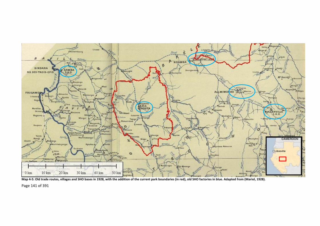
Page 141 of 391
Map 4‐5: Old trade routes, villages and SHO bases in 1928, with the addition of the current park boundaries (in red), old SHO factories in blue. Adapted from (Mariol, 1928).

Page 142 of 391
Map 4‐6: Old village sites and trade routes found along the Ikoy, Oumba and Ikobey River from the 1960s. Based on the following sources: Basemap ‐ (ESRI, 2012), Park boundaries ‐ (Institut Geographique National, 2008), old village sites, paths and roads from ‐ (Army Map Service, 1966a; Army Map Service, 1966b; Army Map Service, 1966c; Institut Geographique National, 2008; Institut Geographique National, 1994; L’Annexe en Afrique Equatoriale de Institut Geographique National, 1986; L’Annexe en Afrique Equatoriale de Institut Geographique National, 1980; L’Annexe en Afrique Equatoriale de Institut Geographique National, 1969; L’Annexe en Afrique Equatoriale de Institut Geographique National, 1967a; L’Annexe en Afrique Equatoriale de Institut Geographique National, 1967b; L’Annexe en Afrique Equatoriale de Institut Geographique National, 1962).
Flow of migration
Page 143 of 391
4.4.2.4 RegroupementandmigrationbacktotheIkoyRiver(1930–1960)
This thirty year period came to an end with Gabon’s Independence from France in 1960. Along
the road that was constructed between 1930 and 1960 linking the towns of Mimongo, Mouila
and Sindara to Koulamoutou, the Gabonese administration continued the policy of
regroupement. But, as during previous efforts, not everyone consented to move (Abitsi and
Lepemangoye‐Mouleka, 2009).
Today’s Mitsogho, Babongo Pygmies and Akele elders found in the middle reaches of the Ikoy
River, tell of how they fled regroupement by leaving the roads to the south of the headwaters
of the Oumba and Ikoy Rivers and entering the forest. For the most part these people used the
then rarely‐trodden Akele and SHO trade routes. In doing so they entered the headwaters of the
Ikoy and Oumba Rivers where they established a number of villages.
The local administration started to create paths in the headwaters of the Ikoy, Oumba and
Ikobey Rivers along which they continued to encouraged people to regroup (Map 4‐6). These
paths were maintained by the villagers along them “on faisait avec la pelle”126. The routes were
“bien débroussé, parce que quelqu’un qui était distant, tu le voyait venir”127. Traders who used
these routes were not just the Mitsogho, or even the Gabonese, but “il y avait des Maliens qui
arrivent jusque dans ces villages, qu’ils avaient appelés Ajoka, commerçants”128. Administrators
from Mimongo town also used the routes “pour que ils ne sont pas énervés par la forêt, pour
voir la population”129.
In this way the edge of the dead zone, created thirty years earlier, began to be once more filled,
reversing any forest succession that was going on at the time. Each time the administration
asked people to regroup near a town some refused and migrated deeper into the forest. As a
Mitsogho explained, “’Comme on nous a tapé donc obligatoire on doit descendre on ne part plus
126 “we made it with a spade”. Nyoe II, Mitsogho 09/05/10 [recording DS400079; 23:38]. 127 “the routes were cleared well, as when someone was far away you could see them coming”. Nyoe II, Mitsogho 23/04/10 [recording DS400080; 31:00]. 128 “there was the Malians who came all the way into those villages, they were called the Ajoka, traders”. Nyoe II, Mitsogho 23/04/10 [recording DS400080; 31:10]. 129 “so that they were not too annoyed by the forest when they went to see the population”. Nyoe II, Mitsogho 09/05/10 [recording DS400079; 23:38].

Page 144 of 391
à Mimongo, il n’a pas fallu que il nous tape’. Voilà comment ils sont descendus”130. As they
migrated into the forest each ethnicity created their own villages.
4.4.2.5 Recentmigrationandtimbercompanies
By the 1960s, the French commercial concessions had been or were being disbanded. The SHO
had already left the Ikobey area in the 1930s with the company being split up (Coquery‐
Vidrovitch, 2001, p.388; Gaulme, 1988, p.116; Suret‐Canale, 1987, p.130). Part of the former
SHO commercial concession was bought by M. Madre and then became, after his death, La
SONG, “Madre c’est La SONG, c’est Madre qui a commencé”131. While operational the five
companies that formed the “groupe Madre” exported 50,000 tonnes of wood per year
(Charbonnier, 1957).
La SONG exploited the forest around Sindara and Ikobey as well as other places in Gabon. In the
area around Ikobey they had a 100,000 ha concession used to supply logs to the Tarragona saw
mills in Spain (Gomez‐Jordana, 1971; Suret‐Canale, 1987, p.235). The coming of Madre at
Sindara encouraged people to cross the mountains to look for work. To do this they used “la
route caravane a sorti vers Ikobey pour aller à Trois Epis [the mission at Sindara]”132, this included
the Babongo Pygmies who left the village “Ebondji Mitone ils ont quitté là‐bas jusqu’ à Sindara
pour trouver le travail … à Sindara, avec La SONG. Avec les loco [train]”133
At the end of the 1960s La SONG timber company was entering the dead zone that had
developed in the Ikobey area thirty years earlier. In entering this area they would have found
many stands of light‐demanding Okoumé that had grown on the plantations that villagers had
previously cultivated before the dead zone was created thirty years earlier. Only when Madre
reached this point did people start to settle once more in the upper reaches of the Ikoy, above
Ikobey.
130 “‘as we were beaten, we are obliged to go down, we will no longer go to Mimongo, he should not have beaten us’. And that is why they went down.”. Nyoe I, Mitsogho 09/05/10 [recording DS400093; 1:19:03]. 131 “Madre is La SONG, it was Madre who started”. Nyoe 1, Mitsogho 14/07/10 [recording DS400098; time 01:58]. 132 “the caravan route emerged near Ikobey to then go to Trois Epis [the mission at Sindara]”. Nyoe I, Mitsogho 09/05/10 [recording DS400093; 2:01:06]. 133 “Ebondji Mitone, they left there to go all the way to Sindara to find work … at Sindara with La SONG. With the trains”. Makoko, Babongo Ghebondgi 12/07/10 [recording DS400095; 11:50].
Page 145 of 391
4.4.2.6 Oldtraderoutesandrecentmigrations(1960–2000)
The arrival of Madre and La SONG in Ikobey had an impact on migration into the Ikobey area
with people starting to migrate towards the timber companies (Abitsi and Lepemangoye‐
Mouleka, 2009) and by doing so filling in the previous dead zone. As they migrated all the people
found was forest. Before the timber companies came, in the 1960s, the area above Ikobey was
empty of villages “ici c’est la forêt tout ça c’était la forêt, Nyoe I et Nyoe II c’est la SONG qui a
ouvert ça”134, “il n’y avait pas des vieux villages”135. The number of people involved in these
migrations is unknown, however, today the current population of Mitsogho, Akele and Babongo
Pygmies is approximately 800, all of whom live in the villages that have resulted from these
migrations (Table 4‐4).
While the timber companies were coming up from Sindara, the Mitsogho, Akele and Babongo
Pygmies, who today live along the middle reaches of the Ikoy River, were migrating towards
Ikobey from the southeast, along two routes. A first group of Mitsogho followed the Oumba
River downstream (Map 4‐7). Latter, a second Mitsogho group (Map 4‐7) followed by the Akele
(Map 4‐8) and Babongo Pygmies (Map 4‐9 and Map 4‐10) followed the Ikoy River downstream.
The migration of people into the middle reaches of the Ikoy River culminated in 2000 when a
group of Babongo Pygmies, originating from around Mount Iboundji, also followed the Ikoy River
downstream. It was in this area that the different ethnicities started to live together in the same
village.
In all the cases the objective pulling them towards Ikobey was “d’aller vers les Blancs, on voyait
les layons [Madre] ils en profitaient déjà pour dire que quand les Blancs vont venir on va nous
retrouver là”136, because in the forest there was:
la souffrance, chercher le savon le pétrole les autres ont voulé approcher d’un
village plus proche... on ne voulait plus rester où il y avait les éléphants et les
134 “here everything was forest, all that was forest, Nyoe I and Nyoe II, it was La SONG that opened it up”. Makoko, Babongo Ghebondgi 24/02/10 [recording DS400043; 17:15]. 135 “there were no old villages”. Nyoe II, Akele 22/05/10 [recording DS400078; 16:25]. 136 “to go towards the Whites, we could see their transects [Madre’s], they took advantage of the situation and said that when the Whites come they will find us here”. Nyoe II, Mitsogho 23/04/10 [recording DS400093; 27:26].

Page 146 of 391
gorilles ... [papa] il était fatigué de la forêt [maman] par rapport à l’approche
pour certain nourriture, pour le savon et le sel137.
The use of the old trade routes as migration routes came to an end when they encountered the
timber company coming up from Ikobey, after which they used the logging roads to migrate
towards Sindara as well as back up the Ikoy River, moving in step with the timber companies and
in some cases taking over the old logging camps.
Madre and La SONG established the modern‐day town of Ikobey, where they set up their base,
and created all the present‐day roads that stopped short of a steep escarpment in the east. They
were in this area for over thirty years, from 1956 to the 1990s (Lepemangoye‐Mouléka, 2009),
but only exploited the forest along some of the roads that Madre had originally laid out,
including all the way up to Makoko where they went bankrupt. Though there have been other
timber companies none have lasted as long in this area, the maximum other timber companies
have spent in the area is six years “la NEF a fait même pas 2 ans”138 and they have all been
content to re‐open the old and now overgrown logging roads that Madre created, but none have
got to the end of the original roads that Madre had created.
137 “suffering, to go get soap, kerosene, the others wanted to go closer to a village … we did not want to stay where there were elephants and gorillas … [father] was tired of the forest [mother too] … due to the distance of certain foods, for soap and salt” Motombi, Babongo Ghebondgi 24/02/10 [recording DS400010; 02:41, 06:10]. 138 “NEF did not even do two years”. Nyoe 1, Mitsogho 12/07/10 [recording DS400098; time 01:46].

Page 147 of 391
Map 4‐7: Current and past Mitsogho villages around Ikobey, with their migration route. Based on oral histories, the maps are from the following sources: Basemap ‐ (ESRI, 2012), Park boundaries ‐ (Institut Geographique National, 2008), old village sites, paths and roads from ‐ (Army Map Service, 1966a; Army Map Service, 1966b; Army Map Service, 1966c; Institut Geographique National, 2008; Institut Geographique National, 1994; L’Annexe en Afrique Equatoriale de Institut Geographique National, 1986; L’Annexe en Afrique Equatoriale de Institut Geographique National, 1980; L’Annexe en Afrique Equatoriale de Institut Geographique National, 1969; L’Annexe en Afrique Equatoriale de Institut Geographique National, 1967a; L’Annexe en Afrique Equatoriale de Institut Geographique National, 1967b; L’Annexe en Afrique Equatoriale de Institut Geographique National, 1962).

Page 148 of 391
Map 4‐8: Current and past Akele villages above Ikobey, with their migration route (the last Akele at Nyoe I passed away at the start of the field work). Based on oral histories, the maps are from the following sources: Basemap ‐ (ESRI, 2012), Park boundaries ‐ (Institut Geographique National, 2008), old village sites, paths and roads from ‐ (Army Map Service, 1966a; Army Map Service, 1966b; Army Map Service, 1966c; Institut Geographique National, 2008; Institut Geographique National, 1994; L’Annexe en Afrique Equatoriale de Institut Geographique National, 1986; L’Annexe en Afrique Equatoriale de Institut Geographique National, 1980; L’Annexe en Afrique Equatoriale de Institut Geographique National, 1969; L’Annexe en Afrique Equatoriale de Institut Geographique National, 1967a; L’Annexe en Afrique Equatoriale de Institut Geographique National, 1967b; L’Annexe en Afrique Equatoriale de Institut Geographique National, 1962).
Eteke and Mimongo

Page 149 of 391
Map 4‐9: Current Babongo Pygmies villages above the town of Ikobey. Based on the following sources: Basemap ‐ (ESRI, 2012), Park boundaries ‐ (Institut Geographique National, 2008), trails, tracks, roads – track logs collected between 2008 to 2011.

Page 150 of 391
Map 4‐10: Migration of the Babongo from their old abandoned villages to the Babongo villages above Ikobey. Based on oral histories, the maps are from the following sources: Basemap ‐ (ESRI, 2012), Park boundaries ‐ (Institut Geographique National, 2008), old village sites, paths and roads from ‐ (Army Map Service, 1966a; Army Map Service, 1966b; Army Map Service, 1966c; Institut Geographique National, 2008; Institut Geographique National, 1994; L’Annexe en Afrique Equatoriale de Institut Geographique National, 1986; L’Annexe en Afrique Equatoriale de Institut Geographique National, 1980; L’Annexe en Afrique Equatoriale de Institut Geographique National, 1969; L’Annexe en Afrique Equatoriale de Institut Geographique National, 1967a; L’Annexe en Afrique Equatoriale de Institut Geographique National, 1967b; L’Annexe en Afrique Equatoriale de Institut Geographique National, 1962).

Page 151 of 391
4.4.2.7 Recenttimbercompanies,currentpopulationandmigration(2000topresent)
The last timber company to operate in the areas was Bordamure139, a Malaysian timber company
that worked in the area for six years and left in 2006. This timber company only operated as far
as Motombi and, like their most recent predecessors, brought in much of their own labour.
Between the census of 2003, when there were still ongoing timber operations, and the 2010
census (Table 4‐5) when timber companies had departed, the majority of villages140 in the Ikobey
site have shown a small increase in population size (Figure 4‐2, Table 4‐6), but this increase is
not significant (One Way ANOVA, F =1.438, DF=2, P=0.297). What increase there has been was
mostly due to births of children fathered by the departed employees of the timber companies,
as opposed to in‐migration, with one person observing “il reste plus rien des forestiers, sauf les
enfants”141.
This apparently stable population is not formed from in‐migrants who arrived from outside the
area due to the past presence of timber companies, since the ethnic composition of the village
sites in 2010 indicates that the majority of each village’s population is made up of people who
arrived from the surrounding area when Madre re‐opened the area in the 1960s (Figure 4‐3,
Table 4‐6). Therefore, unlike elsewhere, the employees brought in by the timber companies
have not stayed in the area; rather they have left when the timber companies departed, “quand
les forestiers partent, leurs travailleurs parte aussi”142.
139 At the end of the study period, at the end of 2010, a Chinese timber company started operations; these operations only lasted just over a year. 140 The exception being the village of Tranquille that was created by the slow splitting up of a neighbouring village. 141 “there is nothing left from the foresters, except for children”. Nyoe I, Mitsogho 12/07/10 [recording DS400098; 22:15]. 142 “when the foresters leave their workers leave as well.” Nyoe II, Mitsogho 23/04/10 [recording DS400093; 28:30].

Page 152 of 391
Village Principal ethnicity
No. of House‐holds
Pop. size 2010
No. people inter‐viewed
No. of Infants
No. of children
No. of
teen‐agers
No. of adults
No. of elderly
Diboka Pove 38 114 73 7 18 10 55 24
Ndanda Pove 20 111 42 11 41 16 39 4
Divinde Pove 21 86 42 11 28 8 34 5
Nyoe I Mitsogho 16 68 40 3 16 4 42 3
Tranquille Babongo 15 59 41 5 16 3 33 2
Ossimba Babongo 5 18 17 1 5 0 10 2
Nyoe II Mitsogho 15 59 49 2 16 7 29 5
Motombi Babongo 6 36 21 2 11 0 20 3
Makoko Babongo 22 92 51 6 20 11 48 7
Ngondet Babongo 14 74 39 5 32 3 33 1 Table 4‐5: Summary of 2010 census data.

Page 153 of 391
Villages
Nyoe 1 Tranquille Ossimba Nyoe 2 Motombi
Popul
atio
n si
ze
0
20
40
60
80
2003 2010
Year of population survey
Figure 4‐2: Changes in population of study villages between 2003 and 2010.
Villages
Nyoe I Tranquille Ossimba Nyoe II Motombi Makoko Ngondet
Perc
ent
of v
illage p
opul
atio
n co
mpose
dof t
he p
rinc
ipal e
thni
city
0
20
40
60
80
100
Figure 4‐3: Proportion of each village that is made up of one of the principal ethnicities of the area

Page 154 of 391
This lack of long‐term in‐migration of people from outside the area can also be seen in the 2003
and 2010 population data where the 2003 census shows an extra village called Bordamure,
situated between Ossimba and Nyoe II, with a population of 128. This village housed all the
timber companies workers who “quand Bordamure est parti, tous leurs personnel sont parti
aussi”143. In 2010, after it became the Waka National Park’s headquarters, it was only inhabited
by two people, both park guards, and in 2013 this logging village had been completely
abandoned144. Abandoned logging villages similar to this can be found throughout the Ikobey
area.
Village names
Year of census
Primary principal ethnicity in 2010
Secondary ethnicity in 2010
Total %
2003 2010 Ethnicity No. % of pop.
Ethnicity No. % of pop.
Nyoe I 63 68 Mitsogho 63 92.65 Babongo 4 5.88 99
Tranquille 33 59 Babongo 58 98.31 Mitsogho 1 1.69 100
Ossimba 22 18 Babongo 15 83.33 Babongo 3 16.66 100
Nyoe II 58 59 Mitsogho 57 96.61 Akele 2 3.38 100
Motombi 33 36 Babongo 34 94.44 Babongo 2 5.55 100
Makoko na 92 Babongo 88 95.65 Simbaka 4 4.34 100
Ngondet na 74 Babongo 72 97.30 Simbaka 1 1.35 99 Table 4‐6: Principal population ethnicity in villages. Highlighted villages are villages where the timber industry had a base during this period.
With the timber companies’ abandonment of the upper reaches of the Ikoy valley, people have
continued to migrate down the logging roads towards Ikobey, migrating as the transport
infrastructure collapses. For example each time that:
ponts qui étaient coupés on a préféré de venir ce côté‐ici. A l’époque La SONG
était retourné, et on ne pouvait pas travailler ce pont, et les voitures pouvaient
refuser de nous retrouver dans les villages145.
These migrations continue as they see that development in the area is coming to an end:
143 “when Bordamure left, all their personnel also left”. Nyoe I, Mitsogho 17/07/10 [recording DS400098; 32:51]. 144 The park headquarters being moved to Ikobey. 145 “bridges were broken, we preferred to come this side. At the time La SONG had gone and we could not repair the bridge, and cars would refuse to come to fetch us in our villages” Nyoe II, Akele 24/05/10 [recording DS400082; 1:17:02].
Page 155 of 391
en fait à ce moment on ne voit plus rien de beau donc ce qui est sûr ont va
continuer juste à Ikobey ... puisque la route est en train de se fermer on attend
encore un peu si il n’y a plus de sociétés qui arrivent on continue146.
As of 2014 the Babongo Pygmy village of Makoko had been moved further down the road
towards Nyoe II so as to get better access to transport (personal communication Kevin Ndong,
2014). In this way the dead zone in the upper reaches of the Ikoy valley is once more expanding
with the forest being once again released from human disturbance allowing recovery to take its
course.
4.5 DiscussionandConclusion
The trade of natural resources, regroupement and epidemics are the major keystone processes
that have not only influenced the people who live in the upper reaches of the Ikoy valley above
Ikobey, but have also resulted in a patchwork of forest succession including a forest rich in
Okoumé trees and wildlife.
4.5.1 Theimpactoftradeonloggingandconservation
The commercial exploitation of natural resources of the Ikobey area dates back to before the
last decades of the 1800s. Since this time people have competed for access to the natural
resources of the area. Today conservation organisations and timber companies are the current
players in a long history of local resource use, the impacts of which are still playing out on the
environment and the people of the area.
There is no reason to believe that the exploitation of natural resources by the SHO during the
first decades of the 20th century did not lead to temporary local exhaustion of resources,
especially of ivory and rubber, as it did elsewhere in Gabon, such as described in Chapter 3 for
the Gabon Estuary, the Ogooué River, the Ngounié River and Mayumba. An 1895 account from
near the area mentions that “même l'ivoire, très commun chez les Aouendjis et chez les N'Javis,
se fait rare à partir du pays des Massangos, pour disparaître complètement chez les Mitsos
[Mitsogho]”147 (Berton, 1895, p.214).
146 “in effect at this moment, we no longer see anything good, if this continues we will go to Ikobey … as the road is starting to close, we will wait a bit more, if there are no longer any companies that come them we will move”. Nyoe II, Mitsogho 23/04/10 [recording DS400093; 29:04]. 147 “even ivory, that is very common at the Aouendjis and at the N’Javis, becomes rare starting from the county of the Massangos, to disappear completely at the Mitsos”
Page 156 of 391
Following an epidemic, the Ikobey area was left empty of people for some thirty years, releasing
the environment from anthropogenic disturbance. This resulted in a succession from old
plantations to a forest with a high density of Okoumé trees, sometimes misread as “pristine”
forest. The high productivity of the forest and the presence of old fruit trees also probably
contributed to an increase in endangered species of animals such as gorillas and chimpanzees
and the recovery of elephants that had once gone locally extinct.
It is due to the history of the area with past exploitation and the subsequent dead zones that
the area became very attractive, firstly to timber companies that were drawn to the Okoumé
stands and later, in 2002, to conservationists due to the large populations of endangered species
found in the area today, leading to the creation of the Waka National Park. Today, with the
departure of timber companies from Ikobey, conservation practitioners are becoming a new
“keystone process” (Marcucci, 2000, p.72) in the history of this landscape.
4.5.2 Theimpactoftradeonmigration
The people living in the upper reaches of the Ikoy valley, including the Babongo Pygmies, have
been interacting with trade in various natural resources for hundreds of years. It has impacted
their migration in and out of the area. These findings contrast with research on Pygmy “hunter‐
gatherer” groups of the northern Congo Basin, from which a Pygmy stereotype, that is used for
all Pygmy groups, has been created (Rupp, 2011). The findings here indicate that the Babongo
Pygmies of Ikobey may be more interested in trading Non‐Timber Forest Products and buying
goods than in living only from the forest. The pull of trade has impacted the migration of both
the Bantu‐speaking populations and the Babongo Pygmies, which corroborates Klieman’s thesis
that the Babongo Pygmies participated in the Atlantic trade route autonomously as “specialist
procurers of forest products” (Klieman, 1999, p.95). They did, and do, this by choosing the
people with whom they traded, and by seeking trade routes, rather than by being dependent
clients of a specific Bantu‐speaking people as is described by Riddell (2011). This resulted in some
Pygmy groups having a more sedentary lifestyle than others (Klieman, 2003; Klieman, 1999,
pp.95–96; Klieman, 1997; Matsuura, 2009; Matsuura, 2006). Their independence is further
backed up by the following description by Battell in 1613 of what is now believed to be a Pygmy
group that was found eight days walk east from Mayumba (Battell, 1901, p.52; Klieman, 1999,
p.96; Martin, 1972, pp.16–17), near what is now Mouila:
Pygmy Elephant‐Hunters to the north‐east of Mani Kesock are a kind of little
people called Matimbas, which are no bigger than boys of twelve years old, but

Page 157 of 391
are very thick, and live only upon flesh, which they kill in the woods with their
bows and darts. They pay tribute to Mani Kesock, and bring all their elephants'
teeth and tails to him. They will not enter into any of the Marombos houses
[Mayumbas houses] , nor will suffer any to come where they dwell; and if by
chance any Maramba, or people of Longo [Loango], pass where they dwell, they
will forsake that place and go to another (Battell, 1901, p.59).
One important finding from these oral migration histories is the dispelling of the myth created
by assumption drag that the people around Waka National Park have continuously been there
for millennia (Brainforest, 2010; Eisen, 2010; Rambaldi et al., 2010; WCS, 2007b). Though the
Mitsogho and Babongo Pygmies are known to have been in the wider area for a considerable
amount of time (Klieman, 2003; Klieman, 1997) and in the past they may have periodically
resided there, there have been several stretches of time when this area was empty of people.
The complicated in and out migration raises the question of land‐rights in the Ikobey area.
Conservation and development organisations have been using the label of “indigenous peoples”
and “autochthones” (Geschiere, 2009) as the basis for their work with the Babongo Pygmies
living in the area of the study site, using traditional land‐rights as a justification of their work
(Eisen, 2010; Brainforest, 2010; Rambaldi et al., 2010). Some have even suggested that these
populations represent the first people to live in the area and that they, and the bio‐diverse
environment that surrounds them, need protecting (WCS, 2007b, p.246), especially from timber
and other industries. This approach has increased tension between the ethnicities in Ikobey,
with the Mitsogho, who are recognised by all the ethnicities in the area as the first to migrate
back into this “dead zone”, being side‐lined by researchers, developers and conservationists
from outside who claim that the Babongo Pygmies were there first148. Similar tension between
Bantu‐speaking peoples and Pygmies caused by outside intervention has been found by other
researchers (Geschiere, 2009, p.128; Rupp, 2011, pp.244–245).
The concern by conservationists that the timber companies operating in remote rural forest
areas result in the permanent migrations of people into such sites, as shown in the chain of logic
used by conservation practitioners (Figure 1‐1), is not an issue in forest areas of Gabon such as
in this Ikobey site. The migrants who did come to work for timber companies usually lived within
148 Even though there have been several outsiders who have conduct their own migration histories from talking to the people in the area.
Page 158 of 391
the area of the timber company’s base and left when the timber company did, resulting in
abandoned logging villages throughout the area; this corresponds to the alternative chain of
logic that has been proposed in Figure 1‐3. These findings contrast sharply with others, including
for neighbouring African countries, where industries (Auzel and Wilkie, 2000; Riddell, 2011;
Wilkie et al., 1992), including conservation projects (Hodgkinson, 2009), attract permanent in‐
migrants in search of employment. In such areas these in‐migrants stay when the industries
depart in the “belief that logging will resume soon” (Hodgkinson, 2009, p.283). In Gabon it would
seem that only local people such as the Mitsogho and Babongo Pygmies of Ikobey hold such
beliefs, while migrants from outside the area do not. Furthermore, the arrival of the timber
companies may have had a positive impact on the surrounding forest as it encouraged the
grouping of once dispersed village sites onto the logging road near the timber companies’ base
as occurred in Gabon with the road construction of the 1940s (Sautter, 1966).
Given the abandonment of these sites by in‐migrants attracted to remote rural forested areas
by timber companies, any environmental impact should only last as long as the timber company
is present, though this impact may be severe. If this is the case, then the recommendation by
Wilkie et al (2000) that conservation practitioners should “focus their environmental mitigation
efforts, at least in the short‐term, on logging companies” (Wilkie et al., 2000, p.1620) is
applicable. However, to focus long‐term development and conservation efforts on collaboration
with timber companies is unlikely to succeed, especially in the case of the upper reaches of the
Ikoy valley where people are moving towards the towns of Ikobey and Sindara. In such areas
conservation and development initiatives based on working with timber companies, such as a
resource management plan created for the area (Brainforest, 2010; Rambaldi et al., 2010), may
have limited long‐term success.

Page 159 of 391
5 Thetimberindustryandaccess
5.1 Summary
The principal supposition of this thesis is that von Thünen’s model of the link between land use
and market access is still applicable in certain situations such as remote rural forest areas of
rentier states, and as such needs to be taken into account by conservation and development
projects that collaborate with timber companies. By looking at the evolution of transport
infrastructure and its users after timber companies have left the study areas, this chapter
explores the degradation of transport infrastructure and the resulting implications for the
proposed chain of logic (Figure 1‐3 and Figure 1‐6). It shows that transport infrastructure
degrades once timber companies depart, which has a knock‐on effect on the frequency of
vehicles that use the roads and the price of transport. This result confirms that some of the
variables underpinning von Thünen’s land‐use theories are relevant to the study site. For
geographers and transport economists the results are perhaps unsurprising. However, for
development professionals and conservation practitioners these results do point to one of the
fundamental reasons, the degradation of transport infrastructure, as to why current initiatives
to help the sustainable development of remote rural forest areas commonly fail (Wicander and
Coad, 2015), even when such initiatives are carried out in collaboration with timber companies.
By relying on received wisdom (Leach and Mearns, 1996a) from their own disciplines and not
taking into account findings by geographers and transport economists, assumption drag is
occurring. As a result any sustainable development initiatives by development or by
conservation practitioners are likely to fall prey to the fluctuations in transport infrastructure,
whether seasonal, annual, or both, that can undermine the economic basis of projects. This
could only be remedied by incorporating and funding the maintenance of transport
infrastructure into sustainable development initiatives.
5.2 Theory
Geographers and transport economists have long concluded that transport infrastructure has
an influence on development, but the relationship between the two is complex, there being only
certain situations in which transport infrastructure leads to a positive development outcome.
Remote rural areas of Africa with high levels of poverty and transport issues seem not to fulfil
the necessary conditions for long‐term development (Sunderlin et al., 2005). Conservation and
development initiatives are commonly based on assumptions dating from early 1900’s when

Page 160 of 391
transport infrastructure was thought to always result in development and rarely take into
account current understanding of transport infrastructure, local transport systems, or how local
people use them (Leach and Mearns, 1996a).
Von Thünen’s spatial analysis was postulated nearly two centuries ago at a time where products
were transported by horse or waterways with the result that transport cost and time to markets
were a limiting factors to how land could be used. Though the world has drastically changed and
the current relevance of von Thünen’s spatial analysis has been questioned (Lambin, 1994; Mäki,
2004) and doubted (Jackson, 1972), there are still numerous versions of von Thünen’s model
(Fujita and Krugman, 1995). Transport infrastructure has improved since von Thünen postulated
his analysis, but where spatial distance may no longer be the main issue, transport cost and time
to markets are still limiting factors to how land can be used. This is especially the case in remote
rural forested areas of rentier states, where there is no economic incentive to maintain transport
infrastructure in areas far from the resource upon which the state is reliant.
Spatial analysis, such as von Thünen’s, would predict that long‐term development in remote
rural forest areas is dependent on the maintenance of transport infrastructure and its quality. If
this is the case then timber companies’ contribution to the development of remote rural forest
areas through the transport infrastructure that they create may not be economically sustainable
in the long‐term, unless such projects put in place some sort of maintenance of transport
infrastructure. However, the perception that timber companies are creating lasting
infrastructural development contributes to encourage policies by development professionals,
conservation practitioners and donors to collaborate with timber companies in the hope of a
win‐win situation (Wells et al., 2004) of promoting sustainable development with minimal
environmental degradations in these areas.
This chapter tests the application of von Thünen’s spatial analysis to the study sites by
investigating the evolution of transport infrastructure after timber companies depart remote
rural forest areas, thus evaluating the long‐term viability of these sustainable development
initiatives.
Page 161 of 391
5.3 Researchquestions
To explore the change in spatial dynamics in access to remote rural forest areas, and so the
potential for long‐term development, the evolution in transport infrastructure after timber
companies departed is investigated. This chapter asks the following questions:‐
1) How was the transport infrastructure into the sites created?
2) How was and is this transport infrastructure maintained?
3) How has access to transport changed with the departure of timber companies?
4) Is access more impacted by distance that a village is to a market town, or by the past
presence of a timber company?
5.4 Methods
The Ikobey site is used to explore the transport infrastructure of remote rural forested areas,
where study site villages are 100 to 200 km from the nearest market. The Koulamoutou site is
used to explore the transport infrastructure of less remote sites, where study site villages are 40
to 80 km from the nearest market.
To investigate what factors impact current public transport to the sites, the village sites that are
on roads used by taxis are used (n=8) (Table 5‐1). To investigate the impacts of the departure of
logging companies on the state of transport infrastructure, the village of Makoko, which has an
old overgrown logging road, is included (n=9) (Table 5‐1).
Village Nearest market
Distance to market (km)
State of Road
Taxis directly available in village
No. of journeys to the study sites where transport times and costs were recorded
Diboka Koulamoutou 41 Usable Yes 5
Ndanda Koulamoutou 56 Usable Yes 3
Divinde Koulamoutou 73 Usable Yes 2
Nyoe I Fougamou 107 Usable Yes 8
Tranquille Fougamou 110 Usable Yes 8
Ossimba Fougamou 113 Usable Yes 8
Nyoe II Fougamou 134 Usable Yes 8
Motombi Fougamou 150 Usable Yes 4
Makoko Fougamou 152 Unusable No 10
Ngondet Fougamou 196 None No 8 Table 5‐1: Summary of data collection on the state of transport infrastructure and availability of public transport.

Page 162 of 391
The creation of transport infrastructure in each of the sites is explored using the available
literature (such as Coad, 2007; Gray, 2002; Lepemangoye‐Mouléka, 2009; Pourtier, 1989; Rich,
2007a; Rossatanga‐Rignault et al., 2005; Starkey, 2004). Interviews were conducted with the
head of each study village about the road (creation and maintenance) and logging history.
Maintenance of the transport infrastructure is also explored with a year‐long participatory
observation.
Analysis of past access to each of the sites is investigated with the use of open ended interviews
with villagers as well as with people who previously worked in the areas. Analysis of current
access is investigated by looking at the distance to each study village and the amount of time it
took to travel from the village to the nearest market town. This was measured by taking GPS
track logs (2008 to 2011) to record the distance and time taken for public transport during the
dry season (representing the best case scenario) (Table 5‐1). The track log started from each
study village to the principal market, marking points every thirty seconds. This log included the
social stops that were taken along the route. These data were transferred to a computer, where
software (Mapsource, ArcView, Global Mapper, TopoGrafix, ExpertGPS) was used to calculate
the distance and time to each village site. These times were then used to calculate the averaged
speed (km/h) to each site.
It should be noted that the track log represents a best case scenario as it does not reflect the
true nature of access to the public transport systems. This can only be understood by adding the
additional time spent to walk to the nearest place where public transport is available and the
amount of time needed to wait for public transport to arrive and then to gather its passengers,
collect its load, ready its systems and leave the place149. Waiting time for public transport
depends on the frequency of bush taxis which was based on a twelve day survey in each village
site, carried out during the dry season, which noted the times a car arrived (and its type – taxi
or private) or passed each study site. This yielded the number of taxis per week and was used as
the frequency of transport variable.
The cost of transport from each study village to the nearest market was obtained from fares that
taxi drivers demanded while I was using public transport to get from each of the study site
villages to the nearest market place. These fares were noted and compared with those of fellow
149 Though these types of data were collected it was deemed as too variable to be used, as there are many influencing factors, even including elephants blocking the path leading to a taxi point.
Page 163 of 391
passengers as well as fellow Gabonese assistants. These taxi fares did not change during the
study period; once again the fares represent the best case scenario as they were collected during
the dry season when prices are usually the lowest.
The data on average speed, cost of transport per kilometre travelled and frequency of taxis were
examined using various linear models to look at whether distance or past presence of a timber
company are more important on access time to each of the villages. These variables were first
tested for normality, outliers, and collinerarity with data exploration following Zuur et al. (2010).
An information‐theoretic approach was taken to model selection following Anderson and
Burnham (2002). This uses Akaike’s Information Criteria (AIC) or Akaike’s Information Criteria
corrected for small sample bias (AICc), depending on sample size (Anderson and Burnham, 2002;
Zuur et al., 2009). Following data exploration a maximal model was chosen a priori as well as all
possible model combinations using the automated methods in the MuMln package (Bartoń,
2004) in the R statistical environment (R Core Team, 2014). The following maximal Gaussian
multiple regression model was used:
MinKMH ~ PresenceCompany * Distance + PostLog * Distance + MaxKMH *
PresenceCompany + MaxKMH * PostLog + Distance : MaxKMH + eps
Where:
MinKMH = Minimum speed to travel in km/h, taking into account time to get to a taxi
spot and waiting for a taxi (which can take several days),
PresenceCompany = Was there past presence of timber company around a village,
Distance = Distance to the nearest market from a village,
PostLog = Time since timber company left the area around the village,
MaxKMH = Maximum speed to travel in km/h, where there is no time needed to get to
or wait for a taxi,
eps = residual error or unexplained information
For exploratory purpose the “dredge” function in the MuMIn package of R was used to fit
different combinations of the model above, resulting in 72 different model combinations
available, from which an average model was defined where the AICc differences from the top

Page 164 of 391
models were less than three. The relative importance of parameters in these average models
was used to define the final model for fitting, whereby PostLog and PresenceCompany were
consistently the most important explanatory variables in the average models while MaxKMH
had a small relative importance and so was removed for model parsimony (Table 5‐2). The final
model from the important variables identified was:
MinKMH ~ PresenceCompany + Distance + PostLog
The resulting final model was then tested for validity by looking at the normality of residuals,
homogeneity and independence (Zuur et al., 2009, pp.19–22).
Models df logLik AICc Delta Weight
134 5 125.32 ‐239.32 0 0.52
1346 6 125.48 ‐237.06 2.26 0.17
1345 6 125.45 ‐236.99 2.33 0.16
1234 6 125.4 ‐236.89 2.43 0.15
Variable codes of models 1 2 3 4 5 6
Term Distance MaxKMH PostLog Presence Distance: PostLog
Distance: Presence
Model‐averaged coefficients
Estimate Std. Error Adjusted SE z value Pr(>|z|) Sig. at
(Intercept) 1.3599436 0.0260751 0.0267161 50.903 <2e‐16 0
Distance ‐0.0055185 0.0001984 0.0002032 27.152 <2e‐16 0
PostLog ‐0.3007013 0.0180194 0.0184444 16.303 <2e‐16 0
Presence 0.2964016 0.0184757 0.0189024 15.681 <2e‐16 0
Distance: Presence
‐0.0001607 0.0002995 0.0003076 0.522 0.601
Distance: PostLog
0.0001368 0.0002895 0.0002973 0.46 0.645
MaxKMH ‐0.0003429 0.0009293 0.0009544 0.359 0.719
Full model‐averaged coefficients (with shrinkage)
Term (Intercept) Distance PostLog Presence Distance: Presence
Distance: PostLog
MaxKMH
Average coefficients
1.36E+00 ‐5.52E‐03 ‐3.01E‐01 2.96E‐01 ‐2.69E‐05 2.21E‐05 ‐5.28E‐05
Relative variable importance
1 1 1 0.17 0.16 0.15
Table 5‐2: Average top models from combining all the different variables of the full linear regression, which resulted in 72 different possible models.

Page 165 of 391
5.5 Results
This following description of transport infrastructure in the different sites shows how much
timber companies have impacted transport infrastructure and its maintenance in the Ikobey
sites, while in the Koulamoutou sites transport infrastructure is more dependent on the state.
5.5.1 Creationoftransportinfrastructuretothesites
Access to the Ikobey area is via a road that starts at a ferry crossing on the eastern bank of the
Ngounié River (Map 5‐1), where there was originally a Decauville rail system. The ferry links the
villages and timber companies on the eastern side of the Ngounié to the rest of Gabon. It is a
key component to transport into the area and its management is dependent on timber
companies.
The eastern side of the Ngounié River was opened in the 1950s up by Madre and then La Société
l’Okoumé de la N’Ggounié (La SONG), with the construction of a Decauville rail system, after
which they carried on building the roads to Ikobey and onwards:
Il n’avait pas la route [Ikobey]… C’est M. Madre qui a fait tout, tout, jusqu'à là‐
bas. Mais les espagnols [La SONG], quand ils sont venus ils ont trouvé la route
bien tracé au fin fond. C’est M Madre, Madre… Jusqu'à Mimongo, c’est M Madre
qui a fait la route150.
This road penetrated 60 km into the Du Chaillu Mountains, as the crow flies, coming to a halt at
a steep escarpment in the east. It was built in various stages between 1960s and the 1990s by
Madre and La SONG (Lepemangoye‐Mouléka, 2009, p.8), and once more opened up the area 40
years after the SHO had left in 1910 (Chapter 4). It was along these roads that the migrations,
described in Chapter 4, took place.
In contrast to the Ikobey site, transport infrastructure to the Koulamoutou sites was originally
created by either the state for the part nearest to Koulamoutou, or by timber companies for the
part furthest from Koulamoutou. The national road that was started in 1910 at Sindara and
continued its way to Koulamoutou, was completed by the 1950s. It runs through Diboka, one of
150 “There was not a road [Ikobey] … It was Mister Madre who did everything, everything, right up to over there. But it was the Spanish [La SONG] when they came they found good roads going far. It was Mister Madre, Madre … All the way to Mimongo; it was Mister Madre who made the roads” Ikobey, Mitsogho 14/07/10 [recording DS4000102; time 19:36].
Page 166 of 391
the study villages (Coad, 2007; Pourtier, 1989; Starkey, 2004). As with Sindara (Gray, 2002; Rich,
2007a) the people of Diboka were required by the colonial government to participate in its
construction (Coad, 2007; Starkey, 2004). Some spent their whole lives constructing the section
of road that ran between Koulamoutou and Mouilla, as one person from Diboka recounts “I
started building this road when I was young and finished when I was old, where I retired”151.
Access to the village sites of Ndanda and Diboka is on a road that branches off the Route
Nationale at Mouila‐Pouve. Originally a loop created by the colonial and post‐colonial state to
get to the town of Iboundji, it was later extended by timber companies and eventually went all
the way to Lopé.
5.5.2 Pastandcurrentmaintenanceoftransportinfrastructureinthesites
In the Ikobey site the timber companies that followed La SONG included French timber
companies, small Gabonese companies and Malaysian companies. These have yet to exploit the
forest along all the logging roads that their predecessors created, neither have they been able
to maintain the transport infrastructure created by them. With few exceptions152, the latter
timber companies have mostly been content to re‐open a subset of the existing roads.
The transport infrastructure maintenance undertaken by many of these latter companies has
usually been done in haste, with bridges being quickly made from logs cut in the surrounding
area, typically soft woods. This maintenance has not stood the test of time, neither have the
short cuts that were later created. During the rains the roads become quickly blocked by mud
slides or deeply eroded ruts. The general consensus by local people was that Madre had made
good roads and bridges that other timber companies have not been able to replicate. One of the
villagers remarked on the construction of a new bridge in Ikobey by SUNNLY, a Chinese timber
company, “le pont là, au départ c’est fini, ça pas duré. Mais le pont de Madre, bien travaillé ça a
bien duré”153.
151 Interview with elderly man from Diboka on 19/11/2010, not recorded. 152 Where Bordamure, a Malaysian timber company, created some roads and short‐cuts, an informant noted “It was the Malaysians who worked over there, always over there, is where the Malaysians worked, not La NEF, not La SONG, it was the Malaysians who worked deep in the forest, right up to the limits of Eteke … it’s far”. Motombi, Babongo Pongue Pygmies 17/04/10 [recording DS400077; 58:55]. 153 “that bridge [new bridge at Ikobey] when they leave [of the Chinese loggers], it is finished, it will not last. But the bridge of Madre, was well built, it has lasted a long time”. Nyoe I, Mitsogho 12/07/10 [recording DS400098; 13:33]
Page 167 of 391
When the last of the timber companies left the Ikobey area in 2006 maintenance of the transport
infrastructure came to a halt (Table 5‐3). By the start of the field work, in 2008, the road to
Ikobey itself was practicably impassable with many of the bridges having to be temporarily
mended each time a vehicle wanted to pass. It was only at the end of 2010, when SUNNLY,
brought in heavy machinery, that maintenance of the roads restarted and access to Ikobey was
no longer an “adventure”. However, SUNNLY decided to only re‐open an old La SONG road to
Ikobey, by‐passing the road that had until then been used, and in doing so upsetting the villagers
who were along this road. The newly re‐opened road was twice as long as the original route. A
few weeks before the end of the study SUNNLY had repaired the road leading into the first study
villages of Nyoe I and Tranquille.
Although the ferry to cross the Ngounié River used to be run by the state, it has not worked for
many years, with parts now being scavenged from the ferry to repair similar ferries in less rural
parts of Gabon. It is thanks to a tug boat, brought in and run by a timber company, that the ferry
can still be used to transport vehicles across the river. However, the timber company that owned
the tug departed before negotiations on its use had been finalised with the timber company that
bought its timber concession (SUNNLY). Without maintenance from the previous owner the tug
boat broke down resulting in transport across the river being cut off for the last six months of
2010, until the new timber company repaired the tug in 2011. While the tug boat was no longer
operating SUNNLY had a small passenger boat which, to the dismay of local people, only allowed
its personnel and supplies across the river.
In the Koulamoutou site the situation is slightly different. The completion of the Route
Economique in 1967 resulted in the national road between Koulamoutou and Mouila becoming
redundant (Rossatanga‐Rignault et al., 2005, p.110); rarely do people now use it to go to Mouilla
or Libreville (Coad 2007). However, the Route Nationale is still open to Iboundji town with the
timber company (Société du Bois Lastoursville154) having maintained it, at the request of the local
administration, just before the study was undertaken in Diboka (Table 5‐3).
154 Timber Society of Lastoursville.
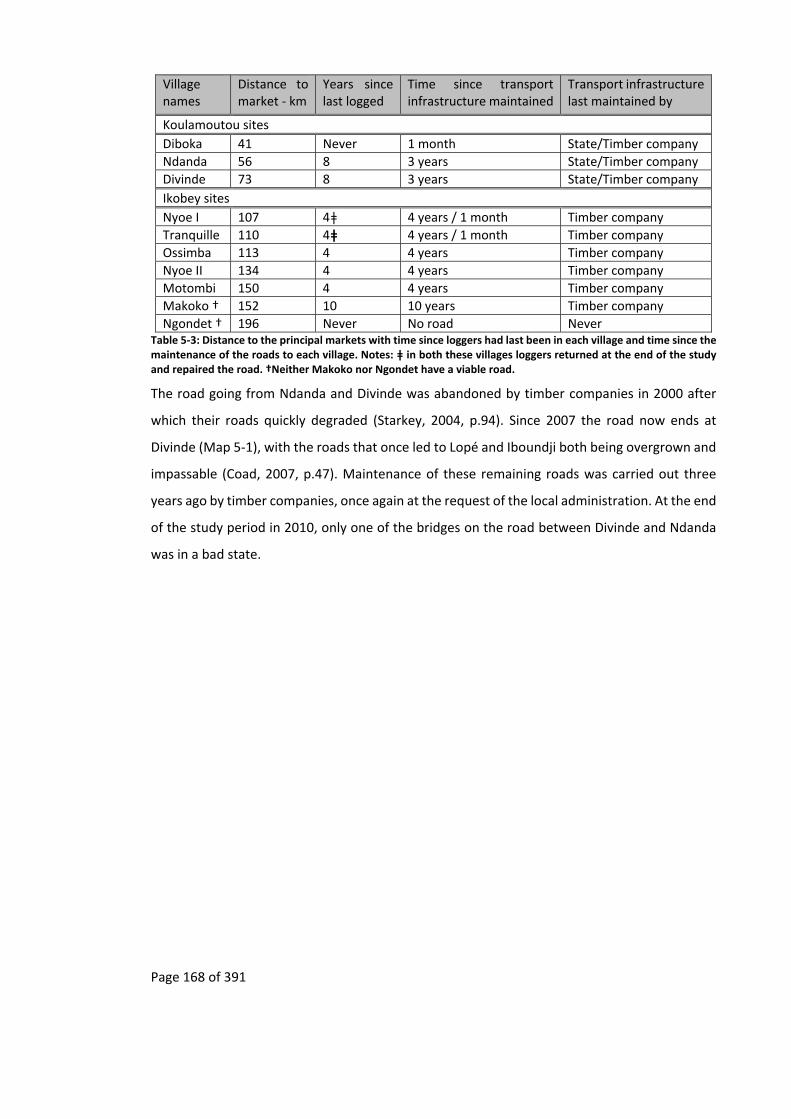
Page 168 of 391
Village names
Distance to market ‐ km
Years since last logged
Time since transport infrastructure maintained
Transport infrastructure last maintained by
Koulamoutou sites
Diboka 41 Never 1 month State/Timber company
Ndanda 56 8 3 years State/Timber company
Divinde 73 8 3 years State/Timber company
Ikobey sites
Nyoe I 107 4ǂ 4 years / 1 month Timber company
Tranquille 110 4ǂ 4 years / 1 month Timber company
Ossimba 113 4 4 years Timber company
Nyoe II 134 4 4 years Timber company
Motombi 150 4 4 years Timber company
Makoko † 152 10 10 years Timber company
Ngondet † 196 Never No road Never Table 5‐3: Distance to the principal markets with time since loggers had last been in each village and time since the maintenance of the roads to each village. Notes: ǂ in both these villages loggers returned at the end of the study and repaired the road. †Neither Makoko nor Ngondet have a viable road.
The road going from Ndanda and Divinde was abandoned by timber companies in 2000 after
which their roads quickly degraded (Starkey, 2004, p.94). Since 2007 the road now ends at
Divinde (Map 5‐1), with the roads that once led to Lopé and Iboundji both being overgrown and
impassable (Coad, 2007, p.47). Maintenance of these remaining roads was carried out three
years ago by timber companies, once again at the request of the local administration. At the end
of the study period in 2010, only one of the bridges on the road between Divinde and Ndanda
was in a bad state.

Page 169 of 391
Map 5‐1: Map of the logging road re‐opened by the Chinese logging company SUNNLY. Based on the following sources: Basemap ‐ (ESRI, 2012), Park boundaries ‐ (Institut Geographique National, 2008), trails, tracks, roads – track logs collected between 2008 to 2011.
Lopé National Park
Waka National Park
Page 170 of 391
5.5.3 Changesinaccesstopublictransportinthesites
Though longitudinal data on changes in public transport do not exist for the study sites, oral
histories and participatory observation indicate that there has been a change in public transport
of the Ikobey site, with a slow decline in the public transport which started when the last of the
timber companies left the area in 2006. This is compared to a slight increase in the Koulamoutou
site where the regular bush taxi service to Diboka now consists of approximately seven cars a
day rather than the “3–5 cars passing through the village each day” observed by Coad (2007,
p.43) (Table 5‐4), even though timber companies were no longer using this road as they had
been during Coad’s study (Coad, 2007, p.92).
When timber companies were present in the Ikobey site, private vehicles passed frequently,
including timber company vehicles but also other vehicles and a twice weekly bread truck and
beer trucks. These other vehicles also transported local people and were so frequent that there
was no need for a bush taxi service (personal communication Starkey, 2013). In 2006 the last
timber company departed from the Ikobey area, transport started to break down, private
vehicles no longer came and the sous‐préfet started to offer transport for people. This service
only lasted until the vehicle broke down, six months later. In 2008, the route to Ikobey was plied
by one of three taxis, depending on which was functioning at the time. This was further reduced
to two taxis after the owner of one gave up repairing his vehicle, and then in 2010 by one
temperamental bush taxi that had been stranded on the eastern bank of the Ngounié when the
tug broke down. These latter bush taxis were usually organised by people who were coming into
the area to buy “bois amer” 155 or looking for traditional medical treatments, visits which
principally occurred in the dry season. Local people would then use these taxis to obtain
transport out of the area.
The link between degraded transport infrastructure and cost of vehicle maintenance was
reflected with a villager remarking the “Jean Aime et Jérôme [taxi drivers] venaient ici tous le
temps, mais aujourd’hui ils ne viennent plus car la route est trop mauvaise. Ça casse la voiture
trop vite156 ”.
155 “bitter wood” used in the fermentation of alcohol. 156 “Jean Aime and Jérome [two taxi drivers], used to come here all the time, but, today, they no longer come as the road is too degraded. This breaks cars too quickly” Nyoe I, Mitsogho 17/07/10 [recording DS400098; 19:07].

Page 171 of 391
The public transport route to the study site itself, after Ikobey, was in a worse state. At the start
of the study only one taxi irregularly plied the route. Between 2009 and 2010 bush taxis had
completely abandoned the route, and only irregular vehicles belonging to the Gabonese
administration or environmental organisations reached beyond Ikobey. At the end of 2010
SUNNLY’s vehicles started to appear regularly, but these drivers were not allowed to take local
people, though they were often seen transporting their local girlfriends and associated family
members.
While people from Ngondet, Makoko (villages without road access) and even Motombi were
already walking to other villages to gain access to taxis, from 2009 everyone from the villages
after Ikobey had to walk to Ikobey and wait there to get a taxi. This wait could last a week or
longer.

Page 172 of 391
Village Distance to market town ‐ km
Number of taxis to markets over 12 day period
N of time taken to get to village
Average time to market –minutes, including waiting and walking (equivalent number of days)*
Distance travelled per average time including waiting and walking‐km/hour*
Average time to get to market, excluding waiting and walking – hours≠
Distance travelled per average time, excluding waiting and walking–km/hour≠
Cost of taxi to market – cfa
Cost taxi per distance to market ‐ cfa / km
Koulamoutou sites
Diboka 41 85 5 303 (0.21 days) 8.10 1.67 24.50 500 12.20
Ndanda 56 4 3 4,517 (3.14 days) 0.74 2.24 24.95 1,000 17.86
Divinde †. 73 4 2 4,588 (3.19 days) 0.96 3.42 21.42 1,500 20.55
Ikobey sites
Nyoe I ǂ 107 2 8 8,730 (6.06 days) 0.74 5.50 19.45 6,000 56.07
Tranquille ǂ 110 2 8 8,745 (6.07. days) 0.75 5.75 19.13 6,000 54.55
Ossimba 113 2 8 8,760 (6.08. days) 0.77 6.00 18.83 6,000 53.10
Nyoe II † 134 2 8 8,840 (6.14 days) 0.91 7.33 18.27 6,500 48.51
Motombi † 150 1 4 17,343 (12.04 days) 0.52 9.05 16.57 7,000 46.67
Makoko ≡ 152 0* 10 17,660 (12.26 days) 0.52 14.33 10.60 6,500 48.51
Ngondet ≠ 196 0* 4 19,820 (13.76 days) 0.59 50.33 3.89 6,500 48.51 Table 5‐4: Distance and travel time to the principal markets, with frequency and cost of taxis. Notes: * Maximum time to market if based on getting a taxi after waiting for a taxi. ≠ Distance travelled per average time is calculated by dividing the distance to market with the minimum average time it takes to get there. † End of usable road. ǂ in both these villages the road was maintained at the end of the study by a timber company, after the data was collected. ≡ Road no longer usable. ≠ No road present.
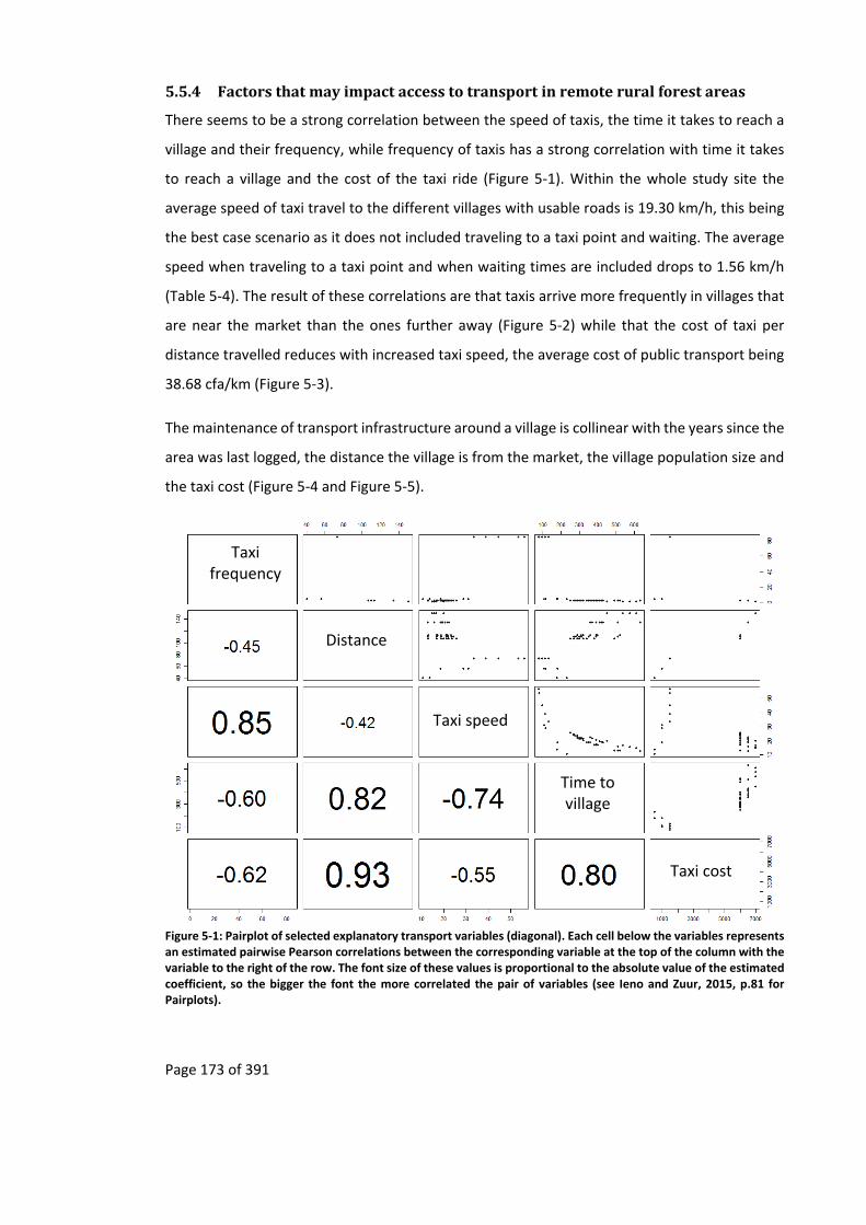
Page 173 of 391
5.5.4 Factorsthatmayimpactaccesstotransportinremoteruralforestareas
There seems to be a strong correlation between the speed of taxis, the time it takes to reach a
village and their frequency, while frequency of taxis has a strong correlation with time it takes
to reach a village and the cost of the taxi ride (Figure 5‐1). Within the whole study site the
average speed of taxi travel to the different villages with usable roads is 19.30 km/h, this being
the best case scenario as it does not included traveling to a taxi point and waiting. The average
speed when traveling to a taxi point and when waiting times are included drops to 1.56 km/h
(Table 5‐4). The result of these correlations are that taxis arrive more frequently in villages that
are near the market than the ones further away (Figure 5‐2) while that the cost of taxi per
distance travelled reduces with increased taxi speed, the average cost of public transport being
38.68 cfa/km (Figure 5‐3).
The maintenance of transport infrastructure around a village is collinear with the years since the
area was last logged, the distance the village is from the market, the village population size and
the taxi cost (Figure 5‐4 and Figure 5‐5).
Figure 5‐1: Pairplot of selected explanatory transport variables (diagonal). Each cell below the variables represents an estimated pairwise Pearson correlations between the corresponding variable at the top of the column with the variable to the right of the row. The font size of these values is proportional to the absolute value of the estimated coefficient, so the bigger the font the more correlated the pair of variables (see Ieno and Zuur, 2015, p.81 for Pairplots).
Taxi speed
Taxi frequency
Time to village
Distance
Taxi cost

Page 174 of 391
Villages along roadsKoulamoutou
Villages along roadsIkobey
Distance of village along road (km)
0 20 40 60 80 100 120 140 160
Num
ber of t
axis
per
week
0.0
0.5
1.0
1.5
2.0
2.5
48.0
50.0
52.0
Village Names (distance from nearest market town)
Diboka (41 km)Ndanda (56 km)Divinde (73 km)Nyoe I (107 km)
Tranquille (110 km)Ossimba (113 km)Nyoe II (134 km)Motombi (150 km)
Diboka
Ndanda
Divinde
Nyoe 1
Tranquille
Motom
bi
Ossim
ba
Nyoe 2
Figure 5‐2: Number of taxis from the various villages to the nearest market from the Koulamoutou and Ikobey study sites. NOTE: The villages of Makoko and Ngondet can only be reached via footpaths and so have been removed.
Average speed (km/h)
0 5 10 15 20 25 30
Cost
per dis
tanc
e tr
ave
led (cf
a/k
m)
0
10
20
30
40
50
60
70
Village Names (distance from nearest market town)
Diboka (41 km)Ndanda (56 km)Divinde (73 km)Nyoe I (107 km)
Tranquille (110 km)Ossimba (113 km)Nyoe II (134 km)Motombi (150 km)
Figure 5‐3: Relationship between the cost per distance of taxis and the average speed to each village site from the various villages to the nearest market. NOTE: The villages of Makoko and Ngondet can only be reached via footpaths and so have been removed. The linear regression of the cost per distance travelled (r2=0.699) is significant (ANOVA, F=17.235, DF=7, p=0.006).

Page 175 of 391
Figure 5‐4: Pairplot of selected explanatory variables influencing years since road was last maintained (diagonal). The lower panel contains estimated pairwise Pearson correlations and the font size is proportional to the absolute value of the estimated coefficient (see Ieno and Zuur, 2015, p.81 for Pairplots).
Villages along roadsKoulamoutou
Villages along roadsIkobey
Villages away from roads Ikobey
Distance of village along road (km)
0 20 40 60 80 100 120 140 160
Ave
rage ta
xi s
peed (km
/hour
)
0
5
10
15
20
25
Years
sin
ce road w
as
last
main
tane
d
0
2
4
6
8
10
12
Village Names (distance from nearest market town)
Diboka (41 km)Ndanda (56 km)Divinde (73 km)Nyoe I (107 km)
Tranquille (110 km)Ossimba (113 km)Nyoe II (134 km)Motombi (150 km)
Regression years since road last maintained r2=0.557
Average taxi speed for all sites - expected (19.30 km/h)
Regression average speed r2=0.825
Makoko (152 km)
Diboka
Ndanda
Divinde
Nyoe 1
Tranquille
Motom
biM
akoko
Ossim
ba
Nyoe 2
Years Speed Years Speed
Figure 5‐5: The impact of distance between villages and market on the number of years since the road was last repaired and how this affects speed of taxis. The red line shows the average speed for all the sites. NOTE: Ngondet is not present as the village has no road. The linear regression for years since road was last maintained against distance (r2=0.557) is significant (ANOVA, F=8.806, DF =8, p=0.021) while the average speed linear regression (r2=0.825) is also significant (ANOVA, F=112.260, DF =7, p=0.000), with a very high coefficient of determination.
Population
Distance
Years since area last logged
Taxi cost
Years since road
maintained
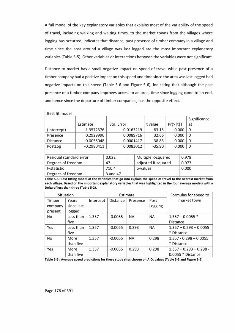
Page 176 of 391
A full model of the key explanatory variables that explains most of the variability of the speed
of travel, including walking and waiting times, to the market towns from the villages where
logging has occurred, indicates that distance, past presence of timber company in a village and
time since the area around a village was last logged are the most important explanatory
variables (Table 5‐5). Other variables or interactions between the variables were not significant.
Distance to market has a small negative impact on speed of travel while past presence of a
timber company had a positive impact on this speed and time since the area was last logged had
negative impacts on this speed (Table 5‐6 and Figure 5‐6), indicating that although the past
presence of a timber company improves access to an area, time since logging came to an end,
and hence since the departure of timber companies, has the opposite effect.
Best fit model
Estimate Std. Error t value Pr(>|t|) Significance at
(Intercept) 1.3572376 0.0163219 83.15 0.000 0
Presence 0.2929996 0.0089716 32.66 0.000 0
Distance ‐0.0055048 0.0001417 ‐38.83 0.000 0
PostLog ‐0.2980411 0.0083012 ‐35.90 0.000 0
Residual standard error 0.022 Multiple R‐squared 0.978
Degrees of freedom 47 adjusted R‐squared 0.977
F‐statistic 710.4 p‐values 0.000
Degrees of freedom 3 and 47 Table 5‐5: Best fitting model of the variables that go into explain the speed of travel to the nearest market from each village. Based on the important explanatory variables that was highlighted in the four average models with a Delta of less than three (Table 5‐2).
Situation Estimate Formulas for speed to market town Timber
company present
Years since last logged
Intercept Distance Presence Post Logging
No Less than five
1.357 ‐0.0055 NA NA 1.357 – 0.0055 * Distance
Yes Less than five
1.357 ‐0.0055 0.293 NA 1.357 + 0.293 – 0.0055 * Distance
No More than five
1.357 ‐0.0055 NA 0.298 1.357 ‐ 0.298 – 0.0055 * Distance
Yes More than five
1.357 ‐0.0055 0.293 0.298 1.357 + 0.293 – 0.298 ‐ 0.0055 * Distance
Table 5‐6 : Average speed predictions for these study sites chosen on AICc values (Table 5‐5 and Figure 5‐6).
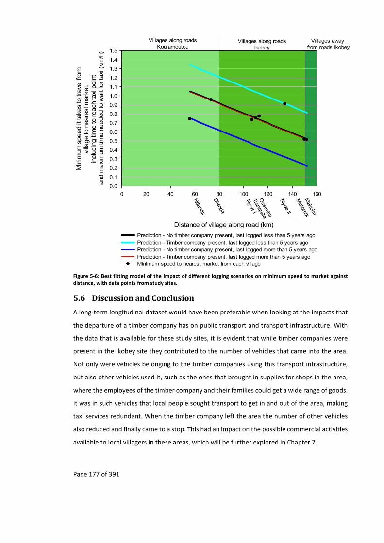
Page 177 of 391
Distance of village along road (km)
0 20 40 60 80 100 120 140 160
Min
imum
speed it
take
s to
trave
l fro
m
villa
ge to
neare
st m
ark
et,
incl
udin
g ti
me to
reach
taxi
poin
t and
maxi
mum
tim
e n
eeded to
wait
for ta
xi (km
/h)
0.0
0.1
0.2
0.3
0.4
0.5
0.6
0.7
0.8
0.9
1.0
1.1
1.2
1.3
1.4
1.5
Prediction - No timber company present, last logged less than 5 years agoPrediction - Timber company present, last logged less than 5 years agoPrediction - No timber company present, last logged more than 5 years agoPrediction - Timber company present, last logged more than 5 years agoMinimum speed to nearest market from each village
Villages along roadsKoulamoutou
Villages along roadsIkobey
Villages away from roads Ikobey
Ndanda
Divinde
Nyoe I
Tranquille
Motom
biM
akoko
Ossim
ba
Nyoe II
Figure 5‐6: Best fitting model of the impact of different logging scenarios on minimum speed to market against distance, with data points from study sites.
5.6 DiscussionandConclusion
A long‐term longitudinal dataset would have been preferable when looking at the impacts that
the departure of a timber company has on public transport and transport infrastructure. With
the data that is available for these study sites, it is evident that while timber companies were
present in the Ikobey site they contributed to the number of vehicles that came into the area.
Not only were vehicles belonging to the timber companies using this transport infrastructure,
but also other vehicles used it, such as the ones that brought in supplies for shops in the area,
where the employees of the timber company and their families could get a wide range of goods.
It was in such vehicles that local people sought transport to get in and out of the area, making
taxi services redundant. When the timber company left the area the number of other vehicles
also reduced and finally came to a stop. This had an impact on the possible commercial activities
available to local villagers in these areas, which will be further explored in Chapter 7.
Page 178 of 391
The dataset indicates that the departure of timber companies from remote rural forested area
results in a degradation of both public transport usage frequency and transport infrastructure.
As recounted by a villager “on ne pouvait pas travailler ce pont, et les voitures pouvaient refuser
de nous retrouver dans les villages [on the other side of the broken bridge] ”157.
In this study there is an inverse relationship between the distance a village is from the market
town and the taxi frequency as well as a positive relationship between the distance of a
community and transport cost (Barwell, 1996, p.46). Based on this analysis it would therefore
seem that von Thünen’s spatial rings hold true for the maintenance of transport infrastructure,
with transport infrastructure further from market town being less likely to be maintained than
ones near, as well as for frequency of taxis and cost.
The cost per distance travelled to the different study villages levels out at the furthest reaches
of the study site. This is probably due to local people at the furthest end of the road only being
able to afford transport up to a certain price. Due to this levelling out of prices and the increase
in maintenance costs of vehicle, taxi drivers become even more reluctant to ply certain routes.
The ones that do may do so because they have family relations in the area or because a client in
town has paid a premium fare, in which case it makes economic sense for the driver to go back
to an urban area with their car full158, even if this means that they have to go to the end of the
road, or along roads that are more degraded to find clients. However a taxi driver will usually
find all the clients that he needs before the end of the road and the vehicle will usually be full
before it reaches the end point (Barwell, 1996, p.3).
It therefore seems that von Thünen’s predictions also hold for transport cost and time to these
study sites. For some academic disciplines these finding are self‐evident. Development
economists and geographers would expect taxi drivers to be economically rational159, in that
they prefer to ply routes where some profit can be made rather than the routes that are no
longer profitable. If this is true then it is unlikely that long‐term economic development and
environmental degradation can continue when timber companies leave a remote rural forest
157“we could not mend the bridge, and cars refused to pick us up in the villages [on the other side of the broken bridge]” Nyoe II, Akele 24/05/10 [recording DS400082; 1:17:02]. 158 Especially if the car does not belong to them. 159 This assumption can break down when a taxi driver has family, friends or girlfriends along a route.

Page 179 of 391
area. These findings refute the chain of logic set out by development professionals and
conservation practitioners (Figure 1‐1).
The degradation of transport infrastructure in the Ikobey site has also impacted conservation.
With the creation of Waka National Park, negotiations were held with a timber company to
transform their timber base in the north of the park to become the headquarters of the park.
From 2006 this base was developed. However by 2009 the road to this base was barely passable
(Picture 5‐1) and in 2013 the park base was moved to Ikobey.
For the local people the transport situation in the Ikobey area has been accepted. Without these
timber companies:
les migrations ne sont pas encore finis, en fait à ce moment on ne voit plus rien
de beau donc ce qui est sûr on va continuer jusqu’à Ikobey ... puisque la route
est en train de se fermer on attend encore un peu s’il n’y a plus de sociétés qui
arrivent on continue160.
However, assumption drag based on the idea of the link between transport infrastructure and
development of the early 1900s has resulted in the recent knowledge on this infrastructure and
development not being taken into account by conservation agents when designing sustainable
development projects in remote rural forest areas where timber companies are operating. It is
unlikely that such projects can continue when timber companies depart, especially when
increased taxi cost and transport time to markets are taken into account unless transport
maintenance is integrated into these projects.
160 “the migrations are not yet finished, in fact at this moment we no longer see good things, so we will go to Ikobey … as the road is starting to close, we will wait a bit more, if no other company comes, we will move on” Nyoe II, Mitsogho 23/04/10 [recording DS400093; 29:04].
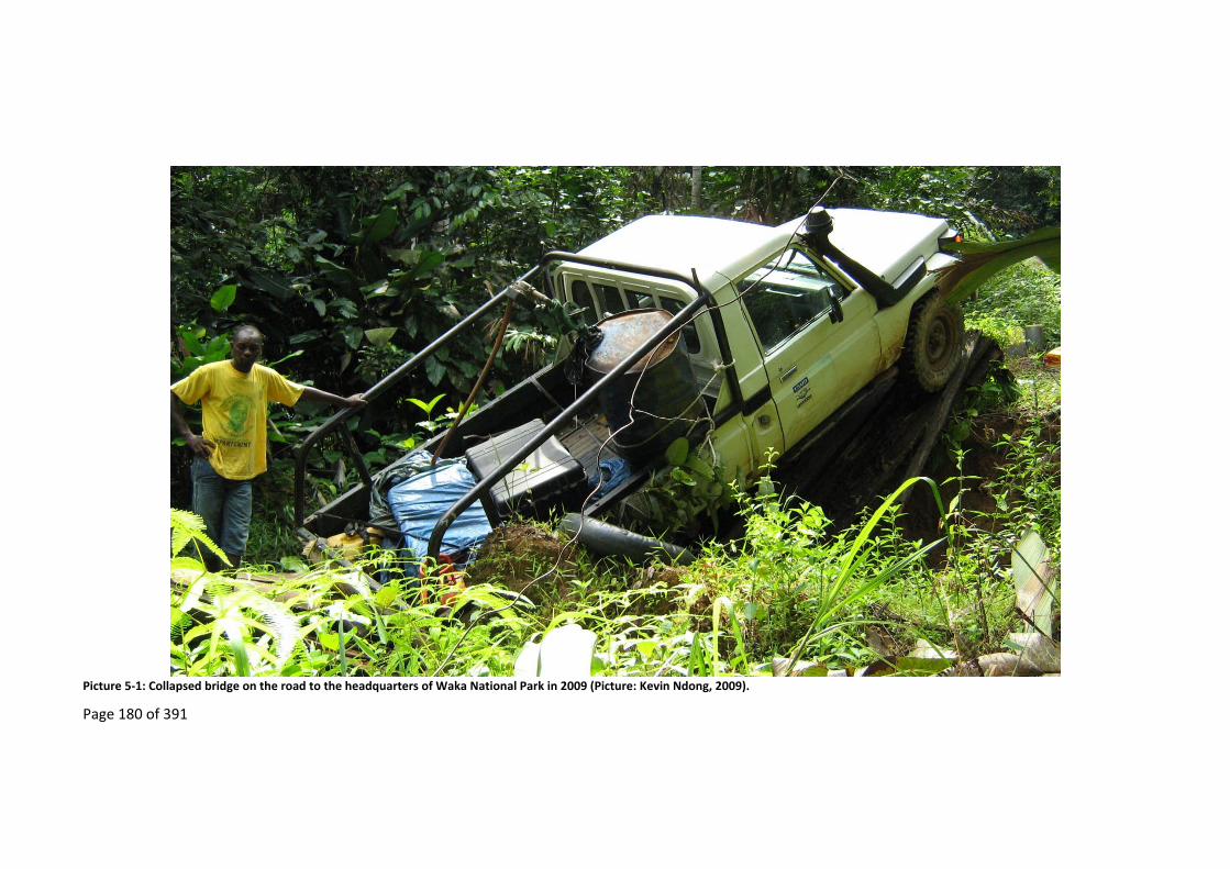
Page 180 of 391
Picture 5‐1: Collapsed bridge on the road to the headquarters of Waka National Park in 2009 (Picture: Kevin Ndong, 2009).

Page 181 of 391
6 Post‐logging and disintegration of direct development by
timbercompanies
6.1 Summary
Industries that operate in remote rural forested areas are often said to improve the economies
of such areas. This economic development is due to “multiplier effects” (Sunderlin et al., 2003)
that such industries bring, including improved access to education and employment
opportunities. This chapter looks at the proposed chain of events as set out in Chapter 1,
specifically direct development of education and employment, when a timber company leaves
a remote rural forest area (Figure 1‐3 and Figure 1‐6). Indirect impacts are looked at in Chapter
7.
Within the study sites education is impacted more by distance from markets than the past‐
presence of the timber industry. Though the education of children in villages far from markets
benefit from the presence of a timber company, it is found that that of teenagers does not. It
seems that teenagers may prefer to find work for timber companies that are in their village
rather than carry on secondary education in establishments that are further away.
There has also been a cohort effect in that teenagers also seem to have lost out on training.
While adults and the elderly recount how the early timber companies in Ikobey had a policy of
providing training such as driving and using chainsaws, this no longer applies to the more recent
timber companies. The number of people employed also seems to be impacted more by the
distance a village is from a market than whether or not a timber company was present in the
past. However, what employment opportunities are to be found in remote rural forest areas are
likely to be based on logging. Once again there seems to be a change in policy by timber
companies; while the early timber companies had a policy of recruiting local people, more recent
timber companies bring in workers from outside the area, especially in jobs that require more
skill.
This change in timber company policies is occurring at a time when policies such as Reducing
Emissions from Deforestation and forest Degradation (REDD+) and Forest Stewardship Council
(FSC) are encouraging timber companies to help development in remote rural forest areas.
Today in forested areas of West‐Central Africa development in education and employment

Page 182 of 391
seems to be linked to transport infrastructure, which, as predicted by von Thünen models, is
severely restricted and costly in remote rural forest sites such as Ikobey (Chapter 5).
6.2 Theory
The appearance of a timber company in remote rural forest areas can have a developmental
impact on local people through “multiplier effects” (Sunderlin et al., 2003). These multiplier
effects are attributed to the presence of the timber company either directly or indirectly. The
direct multiplier effects can include education and employment. There are, however, few data
to show how big an impact these multiplier effects have on local people (Angelsen and Wunder,
2003; Arnold, 2001; Poschen, 1997; Scherr et al., 2003; Sunderlin et al., 2003), especially in the
long‐term and after a timber company leaves an area.
Von Thünen’s model can be used to explore the impacts that the timber industry would have
had on education (von Thünen, 1966, pp.291–295). By comparing the “ring […] nearest to the
Town” (von Thünen, 1966, p.291) with the ring “at the edge of the cultivated plain” (von Thünen,
1966, p.291) von Thünen predicted that the addition of transport cost would increase the price
of schooling the further a school was from “the Town” (von Thünen, 1966, p.293), assuming
“schooling is equally good” (von Thünen, 1966, p.293). In addition to the transport costs, he
added that due to “the bad road and weather conditions of winter [, or the rainy season,] the
children will have to walk across the fields to go to school, which is liable to affect their health,
and certain to reduce attendance” (von Thünen, 1966, p.293). All of these issues would also
make the supervision of distant schools a “far more difficult task” (von Thünen, 1966, p.293) and
more expensive.
In some of the forests of South America these predictions have been confirmed by Godoy
(Godoy and Contreras, 2001). The further one goes into remote rural forested areas the lower
the likelihood of finding schools. When there are schools, the higher the likelihood of teacher
absenteeism, due to the difficulty for teachers to collect wages and also the difficulty of
supervising them (Godoy and Contreras, 2001). In such situations timber companies have
sometimes taken on the government’s role in providing schooling (CARPE, 2006; O’Connor,
2004).
Conversely the impacts of education on deforestation rates are inevitably complex. They include
the impact that education has on the ability of a person to negotiate the conditions under which
outsiders, such as government officials and the timber companies, have access to local land, and

Page 183 of 391
also the ability to have access to, and experiment with, new ideas and technologies. Education
also allows people to pursue alternative opportunities, such as employment or further education
(Godoy et al., 1998), some of which may result in the person migrating out of the area. All these
may result in reduced deforestation (Godoy et al., 1998) but may also increase it (Ribot, 2009).
The impact of the presence of timber companies on employment has received more attention
(Angelsen and Wunder, 2003; Arnold, 2001; Balimunsi et al., 2011; Colchester, 1999; Lambin,
1994; Poschen, 1997; Ribot, 2009; Rich, 2005; Scherr et al., 2003; Sunderlin et al., 2003;
Whiteman, 2000), regarding the upsurge they bring in local employment opportunities.
However, it is unlikely that this upsurge is sustainable, with local people losing the employment
once timber companies depart.
6.3 Researchquestion
In the amended chain of logic, it is proposed that any education and employment benefits that
occur with the presence of a timber company in a remote rural forest area, come to an end with
a collapse in both jobs and education when the company leaves.
If the presence of a timber company is comparable to a de‐facto “Town”, with similar spatial
associations, then does the long‐term departure of timber companies have an impact on the
direct development of a remote rural forest area? This is explored through the following
questions:‐
1) Is education, as measured by UN education index (see below), more closely related
to the distance a village is from a market town or to the past presence of a timber
company?
2) Is employment more closely dependent on the distance from a market town or the
past presence of a timber company?
Page 184 of 391
6.4 Methods
This chapter makes use of data from questionnaires on education and employment (Appendix
11.5), oral interviews (Chapter 2.2) and digitised 1:100,000 ING/INC maps of Gabon (Institut
Geographique National, 2008).
The education dataset (Appendix 11.5) was collected by asking the individuals in a household
(as established in the demographic dataset, Chapter 4) the level at which they had ended their
education (Table 6‐1); in the case where individuals were not available then the head of
household was asked.
Gabonese education levels Approximate equivalent UK education levels
Approximate number of years of schooling
CE1, CE2, CEP, CM1, CM2, CP1, CP2.
Primary school 1 to 6
Troisièmes, quatrièmes, cinquièmes, sixièmes, BEPC.
Secondary school / GCSE 7 to 10
Première, secondaire, terminale, BAC, BTS, BIT.
College / A levels 11 to 12
BAC +. University 13 + Table 6‐1: Levels of schooling used in the education survey.
From this education dataset an Education Index (Barro and Lee, 2010; Klugman et al., 2011;
United Nations Development Programme, 2013a) and School Life Expectancy (Barakat, 2012;
Ram, 1999; UNESCO, 2009) were calculated. The Education Index (He) was used to look at the
education of adults and the elderly using Klugman et al’s formulae (2011, p.263):
He = [((mys−mysmin) / (mysmax – mysmin)) ∗ eys – eysmin) / (eysmax – eysmin))]1/2
Whereby:
He = Education Index
mys = mean years of schooling
eys = expected years of schooling
while:
mys = average education of adults and elderly from the dataset
of each village site
mysmin and eysmin = 0 (United Nations Development
Programme, 2013a, p.2)
Page 185 of 391
mysmax = 13.3 – for the United States of America (United Nations
Development Programme, 2013a, p.2)
eys = 13 – for Gabon (United Nations Development Programme,
2013b, p.145)161
eysmax = 18 (United Nations Development Programme, 2013a,
p.2)
The School Life Expectancy Index was used to look at the education of children (aged from two
to twelve) and teenagers (aged from thirteen to eighteen), and was calculated using part of the
School Life Expectancy equation dealing with the known numbers of enrolled students (UNESCO,
2009, p.7):
∑
Whereby:
= School life expectancy at an age a in year t.
= Enrolment of the population of age i (for i = a, a+1,…, n) in
school year t; n denotes the theoretical upper age‐limit of
schooling.
= Population of age i in school year t. Age of level i denotes
the total school age population of that level.
As this dataset does not have specific ages, the population (P) used is the population of children
with the population of teenagers. The enrolled population (E) is the number of enrolled children
added to the number of enrolled teenagers. Because of this, the School Life Expectancy should
not be compared with other School Life Expectancy results of other studies.
Employment in each village was measured by asking the head of the household and members
of the household, the number of people living in the house who have been or who still are
employed. The members of the household that had been employed were then interviewed
161 Gabon has a high literacy rate, though this may only be reflecting the urban nature of Gabon’s population, and may not be applicable in remote rural forest areas.

Page 186 of 391
about their employment history (Appendix 11.5). For each of the jobs that they mentioned
information was collected on: who they had been employed with, job description and period of
employment. Each of the companies mentioned was classified into business type (e.g. logging,
mining, government, railway etc.) and each of the jobs carried out was also categorised (e.g.
driver, lumberjack, prospector, shop keeper etc.). The average salary level for these jobs was
taken from the databases created by Projet Gibier and Gabon Parks and People Project, the
latter having been partly collected in the Ikobey area (Chapter 2.2). If a person had been
employed in the local area then a discussion was also carried out with them on the perceived
benefits that the company had brought to the area.
The place names that people gave in reply to their place of education or place of employment
were located on a map of Gabon and the road distance between these and the study site village
in question was calculated using GIS software (such as ESRI’s ArcView and Blue Marble’s Global
Mapper).
The education dataset was first tested for normality, outliers, and collinearity. Due to collinearity
between the different variables it was only possible to explore how the number of years that a
person has been educated is related to distance from a market and past presence of a timber
company. To see if there has been a generational change in the number of years of education,
the education dataset was also explored with children and teenagers grouped together and
adults and elderly grouped together.
Generalised Linear Models (GLMs) were fitted to test for the effect of the presence or absence
of timber companies on the number of people that had been educated. Models assuming
Poisson then negative binomial distributions exhibited overdispersion (greater variation in the
data than assumed for the distributions used). Possible sources of overdispersion were
considered (Dobson 2002, Zuur et al 2013) and it was concluded that zero inflation was the main
cause. Due to the number of people who had not been educated, zero inflation was causing
overdispersion in Poisson and Negative Binomial models (Zuur et al., 2009, pp.261–293). For this
reason Zero‐Inflated Poisson (ZIP) and Zero‐Inflated Negative Binomial (ZINB) were fitted to the
data and then a likelihood ratio was compared to test these (Zuur et al., 2009, pp.261–293).
From this the ZINB model was chosen. The resulting final model was then tested for validity by
looking at normality of residuals, homogeneity and independence (Zuur et al., 2009, pp.19–22).
The final models being:
Page 187 of 391
YrsEd ~ Distance * Presence Company
Where:
YrsEd = Number of years of education of each person in the village,
Distance = Distance to nearest market from a village,
Presence Company = Past presence of a timber company around a village.
And:
YrsEd ~ Distance + Age Group
where:
YrsEd = Number of years of education of each person in the village,
Distance = Distance to nearest market from a village,
Age Group = Age categories.
The employment dataset was used to explore the impacts of distance and past presence of a
timber company on whether a person has been employed or not was analysed using a binomial
logistic model to give the probability of employment based on distance from the nearest market.
Once again this dataset was tested beforehand for normality, outliers, and collinearity. The
resulting final models were:
Employed ~ Distance * Presence Company
and
Employed ~ Distance
Where:
Employed = Whether the person has been, or still is, employed,
Distance = Distance to nearest market from a village,
Presence Company = Past presence of a timber company around a village.

Page 188 of 391
6.5 Results
6.5.1 Education
One of the multiplier effects attributed to timber companies in remote rural forested areas is
education. Within the Ikobey area the first timber company Madre/La SONG had originally set
up a school and dispensary at Ikobey and a school in Nyoe II, both of these were accessible to
everyone (personal communication, villagers from Tranquille, Ossimba and Motombi, 2010). All
these schools were taken over by the state when La SONG left in the 1990s. The timber
companies that have since followed, be they French, Gabonese, Malaysian or Chinese, have
given only token gestures of assistance to these schools.
The school at Nyoe I was created through lobbying by the communities. Though the schools at
Nyoe I and Nyoe II are now both state schools, the teachers officially appointed to them are not
present and so either the local population or the official teacher have appointed someone else
to take over. This is not the case for the schools in the Koulamoutou study sites where all the
official teachers are present. As all the schools in the sites are in Bantu‐speaking villages (Table
6‐2) these results mostly concentrate on the education of the Bantu‐speaking people rather than
the Babongo Pygmies.
Study area Village name
Principal population Distance from market
Distance from village to school (km)
Primary Secondary College
Koulamoutou Diboka Bantu‐speaking 41 0 0 41
Koulamoutou Ndanda Bantu‐speaking 56 0 15 56
Koulamoutou Divinde Bantu‐speaking 73 0 32 73
Ikobey Nyoe I Bantu‐speaking 107 0 9 107
Ikobey Tranquille Babongo Pygmies 110 3 12 110
Ikobey Ossimba Babongo Pygmies 113 6 15 113
Ikobey Nyoe II Bantu‐speaking 134 0 36 134
Ikobey Motombi Babongo Pygmies 150 16 52 150
Ikobey Makoko Babongo Pygmies 152 18 54 152
Ikobey Ngondet Babongo Pygmies 196 62 98 196
Table 6‐2: Distance to different types of educational establishments from each study village.
As for the South American finding of Godoy and Contreras (2001), the Bantu‐speaking villages
near market towns (Diboka, Ndanda and Divinde), and so with better transport infrastructure
and facilities, are not only nearer to higher education facilities but are also more likely to have a
functional primary school than the villages further from market towns (Table 6‐2). However,
even though a village near the market town may have a primary school, not all the pupils are
enrolled in these, some preferring to go to a primary school that is not in their village, usually in
the market town itself. This is not the case for the Bantu‐speaking pupils far from the market
town (Nyoe I and Nyoe II) where the roads are in worse condition (Chapter 5).

Page 189 of 391
In all the Bantu‐speaking villages except for Diboka, teenagers who want to attend secondary
schools have to go to a secondary school outside the village, and while Diboka does have a
secondary school the majority of secondary students prefer to go to the secondary school in the
nearest market town. This is reflected in both the number of children and teenagers (Table 6‐3)
as well as the number of adults and elderly (Table 6‐4) who have been to secondary school.
With distance from a market town there is a change in School Life Expectancy of the Bantu‐
speaking children and teenagers, which shows a high negative correlation with the distance from
a market town (Figure 6‐1).
Villages along roadsKoulamoutou
Villages along roadsIkobey
Distance from market town (km)
0 20 40 60 80 100 120 140
Sch
ool L
ife E
xpect
anc
y
1.40
1.45
1.50
1.55
1.60
1.65
1.70
Diboka
Ndanda
Divinde
Nyoe I
Nyoe II
Figure 6‐1: School Life Expectancy of children and teenagers of the Bantu‐speaking villages. The linear regression of School Life Expectancy (r2=0.925) is significant (ANOVA, F=36.963, DF=4, p=0.009).
Due to the collinearity between the continuous explanatory variables of distance, speed to a
village, frequency of taxis and cost of taxis (see Chapter 5.5.4), education is only looked at
through the distance to nearest market continuous explanatory variables. It is found that the
number of years that Bantu‐speaking villagers are educated is significantly impacted by distance
(Table 6‐5), with no evidence that children, teenagers and adults are affected differently. The
resulting model indicated that the number of years of education of the Bantu‐speaking
population reduces with distance from a market town to such an extent that on average two
years are lost in the furthest villages when compared to the nearest (Figure 6‐2).
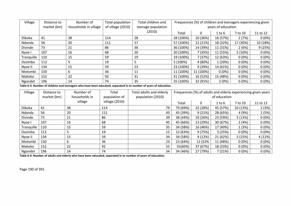
Page 190 of 391
Village Distance to market (km)
Number of households in village
Total population of village (2010)
Total children and teenage population
(2010)
Frequencies (%) of children and teenagers experiencing given years of education
Total 0 1 to 6 7 to 10 11 to 12
Diboka 41 38 114 28 28 (100%) 10 (36%) 16 (57%) 2 (7%) 0 (0%)
Ndanda 56 20 111 57 57 (100%) 12 (21%) 18 (32%) 17 (30%) 10 (18%)
Divinde 73 21 86 36 36 (100%) 14 (39%) 11 (31%) 2 (6%) 9 (25%)
Nyoe I 107 16 68 20 20 (100%) 7 (35%) 11 (55%) 2 (10%) 0 (0%)
Tranquille 110 15 59 19 19 (100%) 7 (37%) 12 (63%) 0 (0%) 0 (0%)
Ossimba 113 5 19 5 5 (100%) 4 (80%) 1 (20%) 0 (0%) 0 (0%)
Nyoe II 134 15 59 23 23 (100%) 9 (39%) 14 (61%) 0 (0%) 0 (0%)
Motombi 150 6 36 11 11 (100%) 11 (100%) 0 (0%) 0 (0%) 0 (0%)
Makoko 152 22 92 31 31 (100%) 16 (52%) 15 (48%) 0 (0%) 0 (0%)
Ngondet 196 14 74 35 35 (100%) 32 (91%) 3 (9%) 0 (0%) 0 (0%) Table 6‐3: Number of children and teenagers who have been educated, separated in to number of years of education.
Village Distance to market (km)
Number of households in
village
Total population of village (2010)
Total adults and elderly population (2010)
Frequencies (%) of adults and elderly experiencing given years of education
Total 0 1 to 6 7 to 10 11 to 12
Diboka 41 38 114 79 79 (69%) 22 (28%) 45 (57%) 10 (13%) 2 (3%)
Ndanda 56 20 111 43 43 (39%) 9 (21%) 28 (65%) 4 (9%) 2 (5%)
Divinde 73 21 86 39 38 (44%) 10 (26%) 23 (59%) 5 (13%) 0 (0%)
Nyoe I 107 16 68 45 45 (66%) 13 (29%) 30 (67%) 2 (4%) 0 (0%)
Tranquille 110 15 59 35 34 (58%) 16 (46%) 17 (49%) 1 (3%) 0 (0%)
Ossimba 113 5 19 12 12 (63%) 9 (75%) 3 (25%) 0 (0%) 0 (0%)
Nyoe II 134 15 59 34 34 (58%) 4 (12%) 21 (62%) 5 (15%) 4 (12%)
Motombi 150 6 36 23 23 (64%) 12 (52% 11 (48%) 0 (0%) 0 (0%)
Makoko 152 22 92 55 55(60%) 37 (67%) 18 (33%) 0 (0%) 0 (0%)
Ngondet 196 14 74 34 34 (46%) 27 (79%) 7 (21%) 0 (0%) 0 (0%) Table 6‐4: Number of adults and elderly who have been educated, separated in to number of years of education.

Page 191 of 391
Count model coefficients (negative binomial with log link)
Estimate Std. Error Z value Pr(>|z|) Significance
(Intercept) 2.065 0.065 31.905 <2e‐16 ***
Distance ‐0.004 0.001 ‐5.012 5.4e‐7 ***
Age Group 0.019 0.055 0.341 0.733
Log (theta) 1.635 0.142 11.505 <2e‐16 *** Table 6‐5: Results from a Negative Binomial model exploring the effect of distance and age on the number of years that Bantu‐speaking villagers have been educated.
Distance to market (km)0 20 40 60 80 100 120 140
Years
of e
duc
atio
n
0
2
4
6
8
Mean effect of distance on education of adults
Upper 95% CILower 95% CI
Mean effect of distance on education of children and teenagers
Upper 95% CILower 95% CI
Figure 6‐2: Model of impact of distance that a village is from a market on the number of years of education of the Bantu‐speaking population.
When adding the factor variable of the past presence of timber companies, it would seem that
there is no added benefit of the past presence of a timber company in village on the number of
years that a Bantu‐speaking villager is educated; rather in villages furthest from the market
people have fewer years of education (Table 6‐6 and Figure 6‐3). Furthermore, the past presence
of a timber company in villages far from market towns may hinder the education of Bantu‐
speaking teenagers as they may leave school to work in the timber company or to help service
the timber companies’ employees; however, children may benefit (Figure 6‐4). That the past
presence of timber companies hinders education in villages far from market towns could be due
to teenagers preferring to find employment which is available in their village rather than
continuing their education in a secondary school that is not in their village. This employment
may be with the timber company or for the workers of the timber company, such as cooking,
cleaning and hunting.
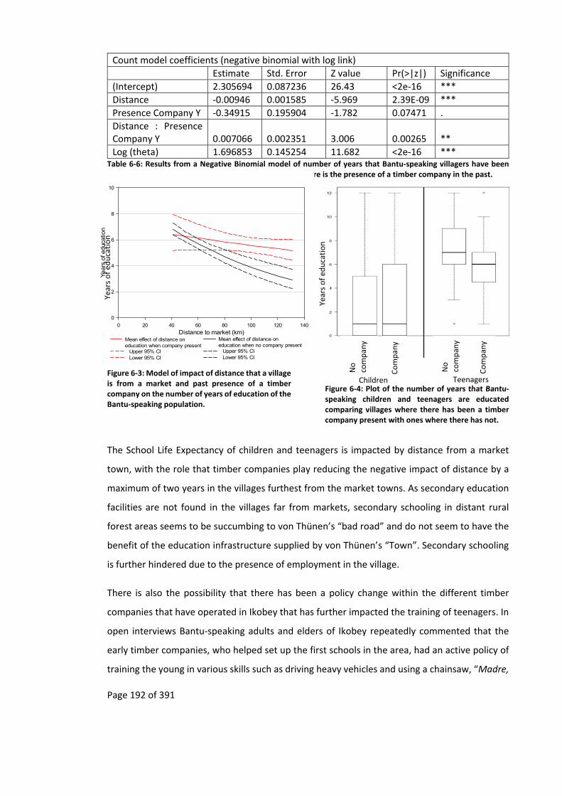
Page 192 of 391
Count model coefficients (negative binomial with log link)
Estimate Std. Error Z value Pr(>|z|) Significance
(Intercept) 2.305694 0.087236 26.43 <2e‐16 ***
Distance ‐0.00946 0.001585 ‐5.969 2.39E‐09 ***
Presence Company Y ‐0.34915 0.195904 ‐1.782 0.07471 .
Distance : Presence Company Y 0.007066 0.002351 3.006 0.00265 **
Log (theta) 1.696853 0.145254 11.682 <2e‐16 *** Table 6‐6: Results from a Negative Binomial model of number of years that Bantu‐speaking villagers have been educated, distance from the nearest market and when there is the presence of a timber company in the past.
Distance to market (km)0 20 40 60 80 100 120 140
Year
s of
educ
atio
n
0
2
4
6
8
10
Mean effect of distance on education when company present
Upper 95% CILower 95% CI
Mean effect of distance on education when no company present
Upper 95% CILower 95% CI
Figure 6‐3: Model of impact of distance that a village is from a market and past presence of a timber company on the number of years of education of the Bantu‐speaking population.
Figure 6‐4: Plot of the number of years that Bantu‐speaking children and teenagers are educated comparing villages where there has been a timber company present with ones where there has not.
The School Life Expectancy of children and teenagers is impacted by distance from a market
town, with the role that timber companies play reducing the negative impact of distance by a
maximum of two years in the villages furthest from the market towns. As secondary education
facilities are not found in the villages far from markets, secondary schooling in distant rural
forest areas seems to be succumbing to von Thünen’s “bad road” and do not seem to have the
benefit of the education infrastructure supplied by von Thünen’s “Town”. Secondary schooling
is further hindered due to the presence of employment in the village.
There is also the possibility that there has been a policy change within the different timber
companies that have operated in Ikobey that has further impacted the training of teenagers. In
open interviews Bantu‐speaking adults and elders of Ikobey repeatedly commented that the
early timber companies, who helped set up the first schools in the area, had an active policy of
training the young in various skills such as driving heavy vehicles and using a chainsaw, “Madre,
Years of ed
ucation
No
compan
y
Compan
y
No
compan
y
Compan
y
Children Teenagers
Years of ed
ucation

Page 193 of 391
nous a montré comment conduire et couper le bois”162 and “Sans La SONG, je n’aurais pas ce
travail avec SUNNLY, c’est eux qui m’ont appris tout. Aujourd’hui les jeunes n’ont pas la chance,
plus personne les apprends comment travailler le bois ”163.
The more recent timber companies no longer carry out such training, preferring to employ
people from outside the area who already have the required skill sets.
6.5.2 Employment
The other direct multiplier effect attributed to timber companies is job creation. Within both
study sites the majority of Bantu‐speaking adult men and some Bantu‐speaking adult women
have had paid employment. These adults form the biggest employed population in the villages,
with few teenagers having gained paid employment (Table 6‐7 and Figure 6‐5). This finding
seems to indicate that the teenagers who drop out of school do not do so to find work, but
rather to service the timber companies’ employees such as hunting and selling bushmeat for
them or preparing alcoholic drinks. The number of Babongo Pygmies who have had paid
employment is yet lower. Overall the largest employer is the timber sector, including saw mills
(Figure 6‐6). The importance of this sector changes with distance from a market town (Figure
6‐5), with logging becoming more important the further a village is from a market, while jobs in
other sectors generally decrease (Figure 6‐5).
Village Distance to market
(km)
Number of households in village
Total pop. of village (2010)
Number of people employed (% of total population)
Total Teen. Adult Elderly
Diboka 41 38 114 36 (32%) 1 (0.9%) 24 (21%) 11 (10%)
Ndanda 56 20 111 18 (16%) 0 (0%) 16 (14% 2 (2%)
Divinde 73 21 86 14 (16%) 0 (0%) 13 (15%) 1 (1%)
Nyoe I 107 16 68 17 (25%) 0 (0%) 16 (24%) 1 (1%)
Tranquille 110 15 59 9 (15%) 0 (0%) 8 (14%) 1 (2%)
Ossimba 113 5 19 6 (32%) 0 (0%) 5 (26%) 1 (5%)
Nyoe II 134 15 59 18 (31%) 0 (0%) 15 (25%) 3 (5%)
Motombi 150 6 36 6 (17%) 0 (0%) 4 (11%) 2 (6%)
Makoko 152 22 92 17 (18%) 1 (1%) 11 (12%) 5 (5%)
Ngondet 196 14 74 3 (4%) 0 (0%) 3 (4%) 0 (0%) Table 6‐7: Summary of number of people who have had paid employment in each village.
162 “Madre, showed us how to drive and cut wood”. Nyoe I, Mitsogho 10/05/10 [recording DS400098; 00:42]. 163 “Without La SONG, I would not have this work with SUNNLY, it is them who taught me everything. Today the young are not lucky, no one teaches them how to work the wood” Nyoe II, Mitsogho 22/04/10 [recording DS400079; 1:35:42].
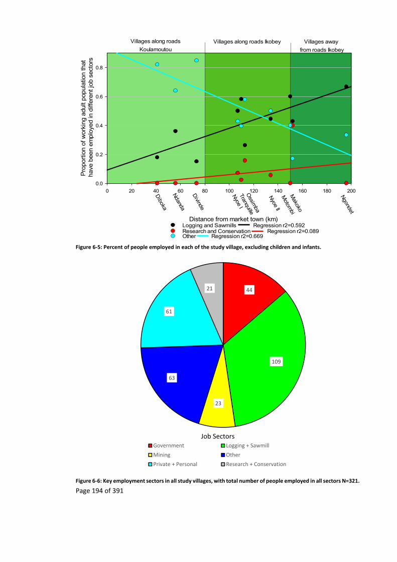
Page 194 of 391
Villages along roads
Koulamoutou
Villages along roads Ikobey Villages away
from roads Ikobey
Distance from market town (km)
0 20 40 60 80 100 120 140 160 180 200
Pro
port
ion
of w
orki
ng a
dult
popu
latio
n th
at h
ave
been
em
ploy
ed in
diff
eren
t job
sec
tors
0.0
0.2
0.4
0.6
0.8
Diboka
Ndanda
Divinde
Nyoe I
Tranquille
Motom
biM
akoko
Ngondet
Ossim
ba
Nyoe II
Logging and Sawmills Regression r2=0.592Research and Conservation Regression r2=0.089Other Regression r2=0.669
Figure 6‐5: Percent of people employed in each of the study village, excluding children and infants.
Figure 6‐6: Key employment sectors in all study villages, with total number of people employed in all sectors N=321.
44
109
23
63
61
21
Government Logging + Sawmill
Mining Other
Private + Personal Research + Conservation
Job Sectors
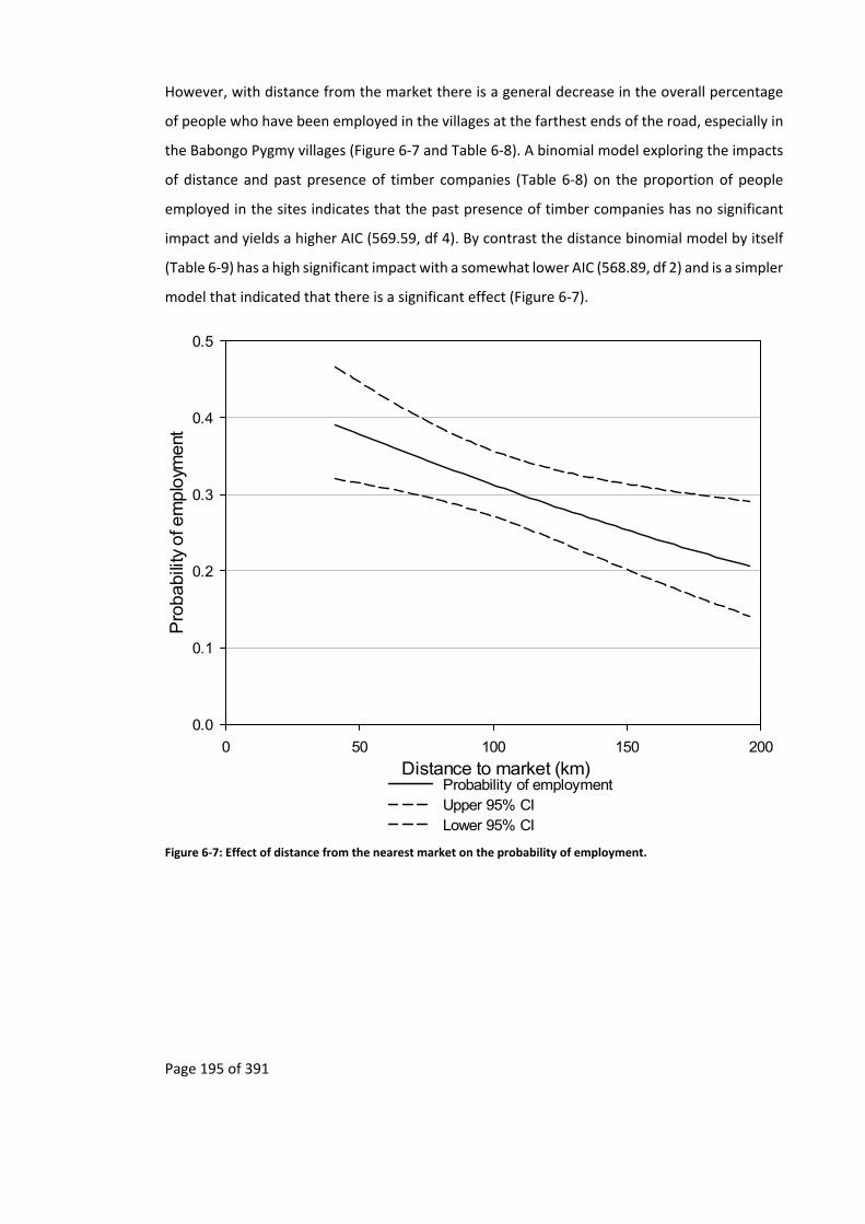
Page 195 of 391
However, with distance from the market there is a general decrease in the overall percentage
of people who have been employed in the villages at the farthest ends of the road, especially in
the Babongo Pygmy villages (Figure 6‐7 and Table 6‐8). A binomial model exploring the impacts
of distance and past presence of timber companies (Table 6‐8) on the proportion of people
employed in the sites indicates that the past presence of timber companies has no significant
impact and yields a higher AIC (569.59, df 4). By contrast the distance binomial model by itself
(Table 6‐9) has a high significant impact with a somewhat lower AIC (568.89, df 2) and is a simpler
model that indicated that there is a significant effect (Figure 6‐7).
Distance to market (km)0 50 100 150 200
Pro
babili
ty o
f em
plo
yment
0.0
0.1
0.2
0.3
0.4
0.5
Probability of employmentUpper 95% CI Lower 95% CI
Figure 6‐7: Effect of distance from the nearest market on the probability of employment.
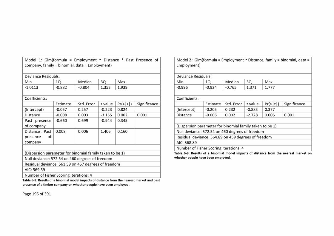
Page 196 of 391
Model 1: Glm(formula = Employment ~ Distance * Past Presence of company, family = binomial, data = Employment)
Deviance Residuals:
Min 1Q Median 3Q Max
‐1.0113 ‐0.882 ‐0.804 1.353 1.939
Coefficients:
Estimate Std. Error z value Pr(>|z|) Significance
(Intercept) ‐0.057 0.257 ‐0.223 0.824
Distance ‐0.008 0.003 ‐3.155 0.002 0.001
Past presence of company
‐0.660 0.699 ‐0.944 0.345
Distance : Past presence of company
0.008 0.006 1.406 0.160
(Dispersion parameter for binomial family taken to be 1)
Null deviance: 572.54 on 460 degrees of freedom
Residual deviance: 561.59 on 457 degrees of freedom
AIC: 569.59
Number of Fisher Scoring iterations: 4 Table 6‐8: Results of a binomial model impacts of distance from the nearest market and past presence of a timber company on whether people have been employed.
Model 2 : Glm(formula = Employment ~ Distance, family = binomial, data = Employment)
Deviance Residuals:
Min 1Q Median 3Q Max
‐0.996 ‐0.924 ‐0.765 1.371 1.777
Coefficients:
Estimate Std. Error z value Pr(>|z|) Significance
(Intercept) ‐0.205 0.232 ‐0.883 0.377
Distance ‐0.006 0.002 ‐2.728 0.006 0.001
(Dispersion parameter for binomial family taken to be 1)
Null deviance: 572.54 on 460 degrees of freedom
Residual deviance: 564.89 on 459 degrees of freedom
AIC: 568.89
Number of Fisher Scoring iterations: 4 Table 6‐9: Results of a binomial model impacts of distance from the nearest market on whether people have been employed.

Page 197 of 391
When local people are employed by timber companies it is only for the duration that the timber
companies stay in the area, with the departing timber companies taking along the personnel
that they came with (personal communication villagers from Tranquille, Ossimba, Motombi,
Nyoe I and Nyoe II, 2010).
Of the employment opportunities that the people in the study sites have had, most have been
in unskilled jobs where little training is needed (Figure 6‐8), with skilled jobs mostly going to
outsiders. One villager commented that:
Aujourd’hui, c’est les étrangers qui coupent le bois, même les malaysiens et
chinois, nous ont fait seulement le guide. Au temps de La SONG, je conduisais les
camions164.
What jobs are available to local people mostly involve manual labour, ranging from being forest
guides and security guards to grass cutting. In the villages near the market towns, where
transport infrastructure is good (Chapter 5), there is an increase in the number of people who
have had skilled jobs (jobs where formal education or job training is needed), ranging from
accounting and secretarial work to mechanics and chainsaw operators (Figure 6‐8).
Villages along roadsKoulamoutou
Villages along roadsIkobey
Villages away from roads Ikobey
Type of training categoriesDistance from market town (km)
0 20 40 60 80 100 120 140 160 180 200
Perc
ent
age o
f em
plo
yed
in jo
bs
whe
re tr
ain
ingis
needed
0
20
40
60
80
100
Diboka
Ndanda
Divinde
Nyoe 1
Tranquille
Motom
biM
akoko
Ngondet
Ossim
ba
Nyoe 2
No training needed Trainning needed
Figure 6‐8: Percentage of jobs where some sort of training is needed.
164 “Today, it is the foreigners who cut wood, including Malaysians and the Chinese, we are only guides. When La SONG was here, I drove the lorries” Nyoe II, Mitsogho 10/05/10 [recording DS400098; 05:22].
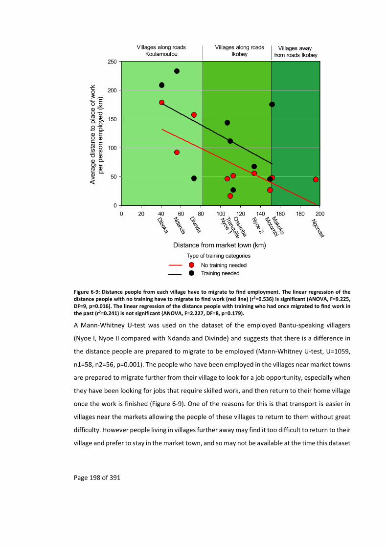
Page 198 of 391
Villages along roadsKoulamoutou
Villages along roadsIkobey
Villages away from roads Ikobey
Distance from market town (km)
0 20 40 60 80 100 120 140 160 180 200
Ave
rage d
ista
nce to
pla
ce o
f work
per pe
rson
em
plo
yed (km
).
0
50
100
150
200
250
Diboka
Ndanda
Divinde
Nyoe 1
Tranquille
Motom
biM
akoko
Ngondet
Ossim
ba
Nyoe 2
Type of training categories
No training needed
Training needed
Figure 6‐9: Distance people from each village have to migrate to find employment. The linear regression of the distance people with no training have to migrate to find work (red line) (r2=0.536) is significant (ANOVA, F=9.225, DF=9, p=0.016). The linear regression of the distance people with training who had once migrated to find work in the past (r2=0.241) is not significant (ANOVA, F=2.227, DF=8, p=0.179).
A Mann‐Whitney U‐test was used on the dataset of the employed Bantu‐speaking villagers
(Nyoe I, Nyoe II compared with Ndanda and Divinde) and suggests that there is a difference in
the distance people are prepared to migrate to be employed (Mann‐Whitney U‐test, U=1059,
n1=58, n2=56, p=0.001). The people who have been employed in the villages near market towns
are prepared to migrate further from their village to look for a job opportunity, especially when
they have been looking for jobs that require skilled work, and then return to their home village
once the work is finished (Figure 6‐9). One of the reasons for this is that transport is easier in
villages near the markets allowing the people of these villages to return to them without great
difficulty. However people living in villages further away may find it too difficult to return to their
village and prefer to stay in the market town, and so may not be available at the time this dataset

Page 199 of 391
was collected. However, this does not seem to be the case, as few people from the villages
further from the market have permanently migrated away (see below).
The state of the roads and so public transport may be contributing to this willingness to travel
further, as it facilitates the communication with the family members who remain in the village.
The people who have been employed in the villages further from the market towns have found
employment near their village, usually with timber companies. They do not seem to seek
employment opportunities further afield, probably hindered by the transport infrastructure
(Chapter 5), and so are reliant on the employment opportunities created by the presence of
timber companies near their villages.
6.5.3 Theimpactsofmigrationoneducationandemployment
The results above concern the impact of distance from markets and timber companies on
education and employment of the people who currently still live in the villages concerned. It
does not give much insight into how distance and timber companies have impacted people who
have already migrated out of the village.
People who have skill sets that employers require or who have better education may migrate
away from their villages to seek better employment opportunities (Stark, 1982). Sending
students or workers out of the village may be a household strategy to diversify their income
opportunities through remittances (Akokpari, 2006; Ellis, 1998), and may result in people
permanently migrating out of the village (Deshingkar, 2012), though this may not always be the
case, especially in times of recession (Oyono, 2004; Oyono, 1998; Oyono et al., 2005; Oyono et
al., 2003).
It is therefore of interest to see how many people have migrated out of the village. Though the
demographic dataset used in Chapter 4 does not give the reason for migrations, it does include
the people who were born in the household and who have left (Table 6‐10 and Figure 6‐10). It
indicates that people nearer to market towns are more likely to migrate away from the village
than the ones further from the market town. It is likely that the reason for the migration of
children, that only occurs in the villages near the Koulamoutou market, is for education.
That few adults have migrated out of the villages furthest from the markets, as compared to the
villages nearest the market, also suggests that it is people with better access to transport that
migrate further away to find jobs.
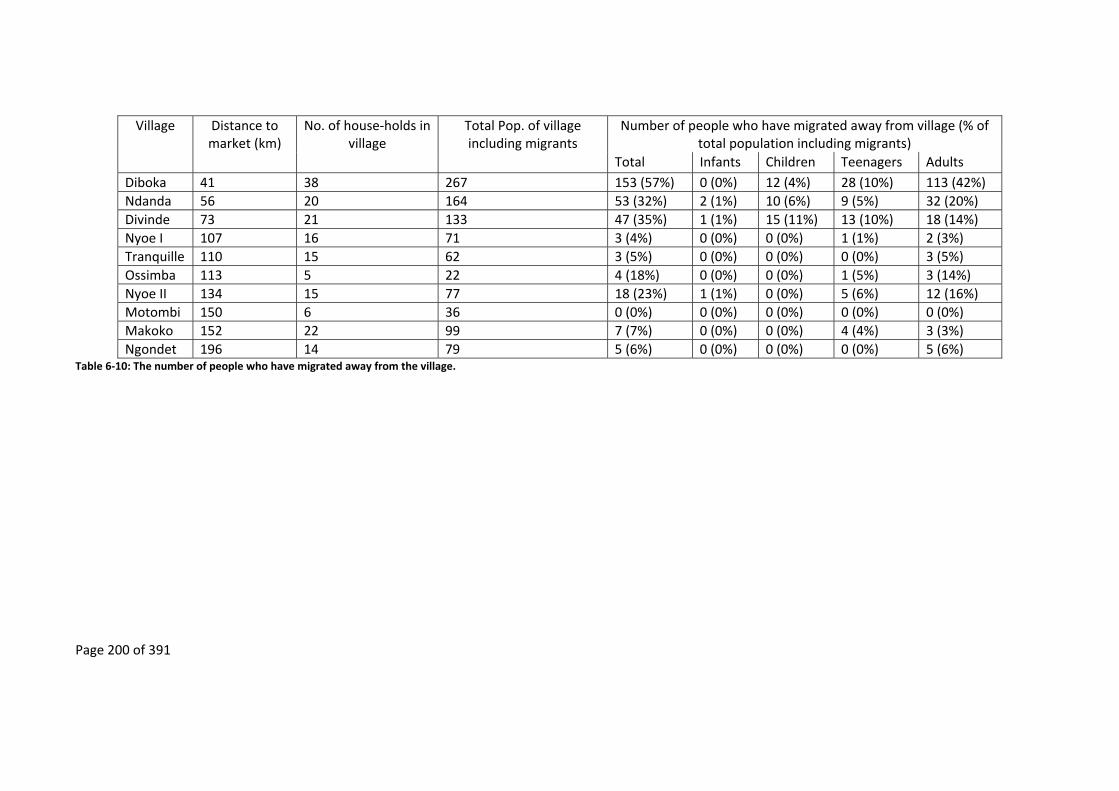
Page 200 of 391
Village Distance to market (km)
No. of house‐holds in village
Total Pop. of village including migrants
Number of people who have migrated away from village (% of total population including migrants)
Total Infants Children Teenagers Adults
Diboka 41 38 267 153 (57%) 0 (0%) 12 (4%) 28 (10%) 113 (42%)
Ndanda 56 20 164 53 (32%) 2 (1%) 10 (6%) 9 (5%) 32 (20%)
Divinde 73 21 133 47 (35%) 1 (1%) 15 (11%) 13 (10%) 18 (14%)
Nyoe I 107 16 71 3 (4%) 0 (0%) 0 (0%) 1 (1%) 2 (3%)
Tranquille 110 15 62 3 (5%) 0 (0%) 0 (0%) 0 (0%) 3 (5%)
Ossimba 113 5 22 4 (18%) 0 (0%) 0 (0%) 1 (5%) 3 (14%)
Nyoe II 134 15 77 18 (23%) 1 (1%) 0 (0%) 5 (6%) 12 (16%)
Motombi 150 6 36 0 (0%) 0 (0%) 0 (0%) 0 (0%) 0 (0%)
Makoko 152 22 99 7 (7%) 0 (0%) 0 (0%) 4 (4%) 3 (3%)
Ngondet 196 14 79 5 (6%) 0 (0%) 0 (0%) 0 (0%) 5 (6%) Table 6‐10: The number of people who have migrated away from the village.

Page 201 of 391
Villages along roadsKoulamoutou
Villages along roadsIkobey
Villages away from roads Ikobey
Diboka
Ndanda
Divinde
Nyoe 1
Tranquille
Motom
biM
akoko
Ngondet
Ossim
ba
Nyoe 2
Distance from market town (km)
0 20 40 60 80 100 120 140 160 180 200
Perc
ent
of p
eople
who
have
m
igra
ted a
way
from
the v
illage
0
10
20
30
40
50
60
Age categoriesInfants Children
Teenagers Adults
Figure 6‐10: Percentage of people who have migrated away from the village.
6.6 DiscussionandConclusion
M. Madre and La SONG both seemed to have had a policy that significantly advanced
development of the area, including the building of durable roads and bridges that lasted longer
than the period that they exploited the area (Chapter 5). They also helped build schools,
dispensaries, hired local people and taught them new skills. From discussion with several old
foresters this policy does not seem to have been restricted to M. Madre and La SONG.
These policies further encouraged the migration of the Mitsogho, Babongo Pygmies and Akele
into the study area (Knight, 2006). When La SONG left, the development of the area came to an
end resulting in the collapsing of infrastructure. This degradation of infrastructure has resulted
in the migrations of some of the Mitsogho and the Babongo Pygmies toward Ikobey, propelled
to move when bridges along the old logging roads collapse, so as to maintain access to trade
networks.

Page 202 of 391
The impact that the past presence of the timber industry in a remote rural area has in the
development of that area depends on their policies. If a timber company has appropriate policies
then the impacts of poor transport infrastructure can be overcome. Though the early timber
companies in the Ikobey site had such policies, these policies have changed with time and with
the turnover of different timber companies. The first timber companies had a policy of not only
recruiting people from the area but also helping in the education of their children and training
of teenagers. Recent timber company policies, such as SUNNLY, have shifted to recruiting
personnel from outside the area, especially for jobs that require skills, and are no longer
investing in the education of children. The result of this change in policy has been to reduce the
length of time that any direct development impact lasts after a timber company departs. After
they have departed, the state of transport infrastructure and other factors dictate how long the
post‐development impacts of timber companies will last in remote rural forested areas.
Once again the chain of logic that dominates conservation thinking (Figure 1‐1) is shown to be
simplistic when it comes to predicting the long‐term outcomes of the presence of timber
companies on education and the creation of employment. Without the inclusion of the
departure of timber companies, as has been done in the proposed alternative (Figure 1‐3), the
long‐term success of conservation projects that also try to have an impact on development is
not guaranteed. The lack of long‐term development in these study sites also corresponds to the
lack of long‐term development resulting from historic exploitation of natural resources in Gabon
(Chapter 3). The proposed alternative chain of logic (Figure 1‐3) is only one possible long‐term
outcome, with other possibilities depending on various factors that may be unique not just to
the local area but also to a country.
6.6.1 Education
Von Thünen’s prediction that schooling facilities far from market towns will not be the same as
facilities near market towns is borne out in this study, with distance to market being important
to the number of people getting education, especially secondary education. The presence of a
timber company may even reduce the number of years that teenagers stay in secondary
education as they may prefer to leave education to help service the employees of the timber
company, such as hunting for them. Either directly or indirectly, the timber company may hinder
a person from going to another village to continue their secondary education. Without the
support from the timber industry, both directly to the school and to transport infrastructure,

Page 203 of 391
the primary and any secondary schooling systems in these remote rural forested areas collapse,
especially when the timber company departs.
When timber companies invest directly in local education in remote rural forest areas, these
facilities, and the roads that provide access to them, break down after the timber company has
left, unless these roles are taken over by the state. Even when education facilities are taken over
by the state it is unlikely that the ones in remote rural areas will be run as they previously were,
as teachers abscond from their remote post or, as in the case here, designate someone who is
not qualified to take their place. From the interviews it is apparent that the early timber
companies may have had a larger role to play in the education and training of Bantu‐speaking
local people than is currently the case and that this effect lasted after they departed.
The fact that timber companies no longer support education or training may also be having a
longer‐term generational effect, with a long term decrease in out‐migration as cohorts of local
youth coming through do not have the skill set needed to compete for jobs outside the area.
6.6.2 Employment
One of the positive developmental impacts of the presence of a timber company in a remote
rural forested area is said to be the employment opportunities that open up for local people.
From this study it seems that distance from a town has a more important role in employment
than the presence of a timber company, with the role being to reduce the number of people
who are employed. Though timber companies are responsible for most of the employment in
remote rural forest areas while they are present, the long‐term employment opportunities
created by timber companies are not apparent in the study sites, with paid employment coming
to an end when timber companies depart.
Due to the lack of diversity in employment opportunities in these remote rural forested area
and with technical employment going to outsiders, people have the choice of either migrating
away from the area and their families or relying on livelihoods based on agriculture, gathering,
hunting and fishing (see Chapter 7).
For the people who migrate away from the village to find paid employment after a timber
company has departed, it would seem that this also depends on distance from the nearest
market. People living in villages near the market, where the transport infrastructure is in good
state, are more willing to travel further to gain paid employment and then come back to their
village when they are no longer employed. The people far from a market town do not seem to

Page 204 of 391
have migrated out of the area, or, if they did, have not returned to their villages once their
employment is over.
This difference may be due to transport infrastructure and the frequency of taxis, as villages
near market towns have better transport systems allowing the people who live in these areas to
access a wider range of other paid employment opportunities. Not only does easy transport
allow a market town to have a larger employment catchment area but there is also a higher
diversity of employment opportunities (Smith, 1981; von Thünen, 1966). Transport also helps in
the creation and the maintenance of networks between family and friends. It not only facilitates
finding a job and moving to the area where a job is located, it also allows workers to return to
their home village either after the job is over or for weekends. Furthermore, the lower education
of the people furthest from the market town may have resulted in these people staying in their
villages to find employment as they do not have the required education or skill set to be
competitive in the wider job market.
The employment opportunities that are created by timber companies have probably changed
over time. As logging technology becomes more sophisticated, the need for manual labour has
decreased and more technical labour is required. Manual labour would have once been needed
not only in the logging process, from the cutting of trees to its transport, but also in feeding the
workers in the timber camps. Today, in remote rural forested areas, food is transported from
towns and is no longer supplied by agricultural workers, while chainsaws and Caterpillars have
replaced the axe for cutting trees and the metal bar for moving the logs. Elders from the Ikobey
study sites still recall the time when logging was a manual process, having participated in the
use of pitsaws, axes and metal bars. This technological change has resulted in the employment
opportunities that open up with timber companies requiring more skills and education, which
makes them less accessible to the local populations who have to make do with poorly paid
unskilled employment.
In the past the timber industry may have helped the education of people as well as given them
employment, but today this is no longer true. As the duration of stay of timber companies within
the Ikobey and Koulamoutou study sites has decreased, from those staying decades such as La
SONG in an area like Ikobey, to those now only lasting a couple of years as in the case of
Bordamure and SUNNLY (Chapters 4 and 5), there is less of an incentive to invest in local
infrastructure or education. The need for timber companies to train local people has been
further eroded by their ability to easily bring in, and feed, workers from outside the area,

Page 205 of 391
including from outside Gabon. This is due to technological advances in transport that has made
vehicles more reliable and cheaper, bringing down transport costs. This has further reduced the
long‐term development potential of timber companies since they no longer need to employ
local people. The overall result is that where previously timber companies may have acted like
a “Town” in von Thünen’s “Isolated Stated”, they no longer do so, or only in the most ephemeral
way, with the result that access to market towns becomes critical in the education and
employment of population in remote rural forest areas, even when a timber company is present.
Page 206 of 391
7 Post‐loggingandlivelihoodactivities
7.1 Summary
In the previous chapters the proposed chain of logic (Figure 1‐3 and Figure 1‐6) was investigated
from the perspective of transport access (Chapter 5) and development (Chapter 6). In this
chapter the issue of change in the market economy and the trade of natural resources is
investigated.
This chapter demonstrates that when a timber company is present in an area a market economy
is created, with similar properties to von Thünen’s “Town”. However, when the timber company
departs, this defacto “Town” economy breaks down and with it the market‐based livelihoods
built around the commercial exploitation of the environment surrounding villages. The end
result is that local people resume the subsistence way of life that they had prior to the
company’s arrival.
Only in villages where transport infrastructure allows easy and economical access to markets do
local people’s livelihood strategies continue, post‐logging, to include the commercial
exploitation of the environment around them.
7.2 Theory
Due to the transport infrastructure that is created by timber industries operating in remote rural
forested areas, it has been assumed that this industry also has a long‐term indirect impact on
the forest environments that surround their concessions (Chapter 1.2.4). Among other reasons,
this assumption is based on the idea that access opens up the natural resources of remote rural
forests to the market economy through multiplier effects that are well documented, which
includes the arrival of employees of timber companies who have the means to either hunt
commercially themselves or hire others to do so (Colchester, 1999; Dove, 1993; Eves and
Ruggiero, 2000; Wilkie et al., 1992). The resources that can be exploited are either directly
sourced from the forest, such as through hunting and gathering, or indirectly sourced through
the conversion of forest into commercial agricultural land.
Timber industries also create a local market for natural resources (Angelsen and Wunder, 2003;
Auzel and Wilkie, 2000; Sunderlin et al., 2003) to supply food and alcoholic beverages to people
attracted to the area for employment. People come to work either directly with the timber
company (Nasi et al., 2008) or in services associated with the timber company such as in

Page 207 of 391
transportation, cleaning and maintenance (e.g. tailoring and mechanics) (CARPE, 2006),
construction, accommodation and prostitution (Angelsen and Wunder, 2003; Colchester, 1999;
Dupré, 1981; Gray, 2002). The timber industry also helps the commodification and trade of
agricultural and Non‐Timber Forest Products, such as bushmeat, to markets further afield, as
described by recent studies on the bushmeat trade and the timber industry (Auzel and Wilkie,
2000; Bird and Dickson, 2007; Eves and Ruggiero, 2000; Fimbel et al., 2001; Laurance, Alonso, et
al., 2006; Meijaard and Center for International Forestry Research., 2005; Poulsen et al., 2009;
Poulsen et al., 2007; Robinson et al., 1999; Wilkie and Carpenter, 1999; Wilkie et al., 1992). In
this way a timber company becomes a defacto “Town” with spatial impacts similar to von
Thünen’s “Town”.
These local markets can be supplied and operated either by the local community (O’Connor,
2004) or through stores that are run or are supported by the timber industry; in Gabon these
timber company stores are often called économats165 (Bouet, 1977). In the past locally produced
goods would have formed a larger part of this market economy in remote rural forest areas of
Gabon as the food supplies for timber companies were largely locally procured. In this way even
villagers who were not directly employed by timber companies would have benefited from the
presence of the companies, such as through the selling of agricultural products. However, local
food supply is seasonal and unreliable. With improvements to transport infrastructure and
modern vehicles, food can now be reliably imported in bulk quantities from towns and cities and
include foreign imports (Bouet, 1977). Today any local food production is more orientated
towards agriculture or the gathering and hunting of Non‐Timber Forest Products. Hunted
products can be consumed locally as “wild meat” or traded with either workers or in markets
further away as “bushmeat” (Mack and West, 2005, p.5).
165 These économats are generally stocked with items brought from outside the areas and have a credit system, “bons pour” (credit) (Bouet, 1974, p.6). In these stores employees can obtain food, beer, batteries, clothing and so on. In the past it would have been in these stores that the majority of an employee’s salary would be spent (Lasserre, 1955) resulting in the employee being indebted to the timber companies’ store (Bouet, 1974).

Page 208 of 391
7.3 Researchquestions
If the commodification of Non‐Timber Forest Products, such as bushmeat, that developers and
conservationists associate with timber companies, is to continue in the long‐term, then it would
be expected that the trade in these products should not be hindered by the collapse in transport
infrastructure after timber companies leave remote rural forest areas.
7.4 Methods
As well as participant observation of items that were being brought to the villages and how they
were used, a survey of items brought back to the village (Appendix 11.6) was carried out over a
single twelve day period in each village during the dry season. This survey was carried out from
six in the morning to seven in the evening, by which time the majority of people, including
hunters, had returned to the village. During this period all items brought into the village were
recorded as they entered the village. This included the name of the person with the item, the
household for which the items were destined, the type and number of items, the type of
environment the items were obtained (plantation, forest, river) and how the items were to be
used (consumed or sold).
Often collection trips consisted of exploiting multiple environments. Due to this, each individual
trip was divided by the number of different environments that were visited. So in the case of a
person visiting, in a single trip, both plantations and forest, this would count for half a trip in the
forest and half a trip in the plantation. In all cases people were always asked for permission to
record the items brought to the village. In no case did people openly refuse to participate and,
as most of the villages are small, people taking unusual routes back to their home would have
been noticed (this was not observed to have occurred).
As villages in Gabon are small, it was possible to observe the majority of the coming and goings
of the population and so to record most items that came into the village. People returning at
night were the exception. Not all households are represented in the data collected (Table 7‐1
and Table 2‐5). This was due to some households being in forest at the time (such as in the case
of Makoko) or having gone to town (such as in the case of Diboka). Not all the population of
each village collects items from the forest, especially non‐able bodied people such as the elderly
and children, so the percent of the total population of each village that collects items is reduced
(Table 7‐1).

Page 209 of 391
Village Number of households recorded during collection
survey (as % of all households in the village)
Number of people recorded during collection survey (as % of the total population of the village)
Number of trips recorded during collection survey
Diboka 36 (95%) 75 (66%) 344
Ndanda 18 (90%) 41 (37%) 163
Divinde 19 (90%) 40 (47%) 187
Nyoe I 15 (94%) 49 (72%) 189
Tranquille 15 (100%) 41 (69%) 173
Ossimba 5 (100%) 15 (79%) 98
Nyoe II 15 (100%) 38 (64%) 144
Motombi 6 (100%) 22 (61%) 92
Makoko 20 (91%) 54 (59%) 169
Ngondet 14 (100%) 47 (64%) 177 Table 7‐1: Summary of results from twelve day period during which people returning with items to the village were recorded.
In most cases the items were carried in baskets of similar sizes so there was no need to empty
out the whole basket each time. Instead an estimate of the number of items being carried was
made based on previous trials of filling up baskets with common items e.g. yams, manioc tubers,
sweet potatoes etc. As this survey was carried out during the same season, the type of products
and size should not vary.
Monetary equivalents of items brought to villages were derived from existing market datasets
collected by previous projects that had been carried out in Gabon. These datasets include data
from Projet Gibier (2000 to 2007)166, the Gabon Parks and People project (Wilkie et al., 2005),
and the Ph.D. theses of Malcolm Starkey (2004) and Lauren Coad (2007), all of which were also
carried out in Gabon; the latter three datasets included data from the study sites. These datasets
include the same items but were put together using different units. For example, in the case of
manioc tubers these datasets include the price of one kilogram of manioc tubers, one individual
manioc tuber, one basket of manioc tubers and one bag of manioc tubers. Using these different
datasets it was possible to calculate the estimated total market value of items that were brought
into the village, for both the items that were destined to be consumed and the items destined
to be sold (though not the items that were destined to be both consumed and sold). This
estimated total market value was used to compare the economic activity of the different village
sites.
166 Partially carried out by myself.

Page 210 of 391
The data on the value of items brought into the village were examined using various Generalised
Linear Models (GLMs). Variables were first tested for normality, outliers, and collinearity with
data exploration following Zuur et al. (2010). An information‐theoretic approach was taken to
model selection following Anderson and Burnham (2002). This uses Akaike’s Information Criteria
(AIC) or Akaike’s Information Criteria corrected for small sample bias (AICc), depending on
sample size (Anderson and Burnham, 2002; Zuur et al., 2009). Following data exploration a
model was chosen a priori as well as all possible model combinations using the automated
methods in the MuMln package (Bartoń, 2004) in the R statistical environment (R Core Team,
2014). The following normal distribution multiple regression model was used as the full model:
Value ~ Presence * Distance + Presence * Pop + eps
Where:
Value = Value of items brought,
Presence = Presence of timber company around a village,
Distance = Distance to the nearest market from a village,
Pop = Population size of village,
eps = residual error or unexplained information.
Modelling of the dataset is limited to all items brought to the village and non‐bushmeat items
brought that were destined to be used. This constraint was due to limitations in the dataset
where the selling of items, including bushmeat, were rarely observed (Figure 7‐1). The lack of
data in these categories was not because people were hiding these items as during the whole
research period people openly hunted protected species.
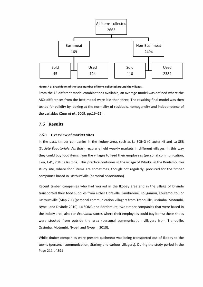
Page 211 of 391
Figure 7‐1: Breakdown of the total number of items collected around the villages.
From the 13 different model combinations available, an average model was defined where the
AICc differences from the best model were less than three. The resulting final model was then
tested for validity by looking at the normality of residuals, homogeneity and independence of
the variables (Zuur et al., 2009, pp.19–22).
7.5 Results
7.5.1 Overviewofmarketsites
In the past, timber companies in the Ikobey area, such as La SONG (Chapter 4) and La SEB
(Société Équatoriale des Bois), regularly held weekly markets in different villages. In this way
they could buy food items from the villages to feed their employees (personal communication,
Ekia, J.‐P., 2010, Ossimba). This practice continues in the village of Diboka, in the Koulamoutou
study site, where food items are sometimes, though not regularly, procured for the timber
companies based in Lastoursville (personal observation).
Recent timber companies who had worked in the Ikobey area and in the village of Divinde
transported their food supplies from either Libreville, Lambaréné, Fougamou, Koulamoutou or
Lastoursville (Map 2‐1) (personal communication villagers from Tranquille, Ossimba, Motombi,
Nyoe I and Divinde 2010). La SONG and Bordamure, two timber companies that were based in
the Ikobey area, also ran économat stores where their employees could buy items; these shops
were stocked from outside the area (personal communication villagers from Tranquille,
Ossimba, Motombi, Nyoe I and Nyoe II, 2010).
While timber companies were present bushmeat was being transported out of Ikobey to the
towns (personal communication, Starkey and various villagers). During the study period in the
All items collected
2663
Bushmeat
169
Sold
45
Used
124
Non‐Bushmeat
2494
Sold
110
Used
2384
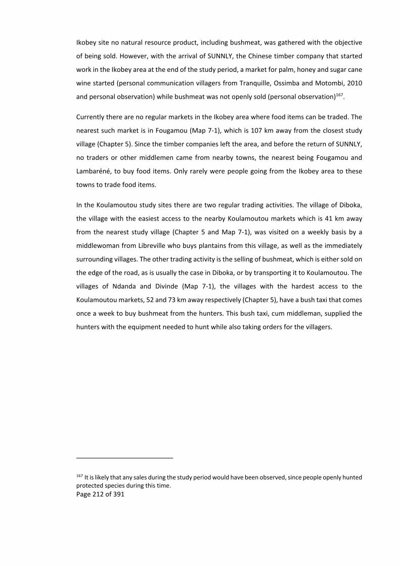
Page 212 of 391
Ikobey site no natural resource product, including bushmeat, was gathered with the objective
of being sold. However, with the arrival of SUNNLY, the Chinese timber company that started
work in the Ikobey area at the end of the study period, a market for palm, honey and sugar cane
wine started (personal communication villagers from Tranquille, Ossimba and Motombi, 2010
and personal observation) while bushmeat was not openly sold (personal observation)167.
Currently there are no regular markets in the Ikobey area where food items can be traded. The
nearest such market is in Fougamou (Map 7‐1), which is 107 km away from the closest study
village (Chapter 5). Since the timber companies left the area, and before the return of SUNNLY,
no traders or other middlemen came from nearby towns, the nearest being Fougamou and
Lambaréné, to buy food items. Only rarely were people going from the Ikobey area to these
towns to trade food items.
In the Koulamoutou study sites there are two regular trading activities. The village of Diboka,
the village with the easiest access to the nearby Koulamoutou markets which is 41 km away
from the nearest study village (Chapter 5 and Map 7‐1), was visited on a weekly basis by a
middlewoman from Libreville who buys plantains from this village, as well as the immediately
surrounding villages. The other trading activity is the selling of bushmeat, which is either sold on
the edge of the road, as is usually the case in Diboka, or by transporting it to Koulamoutou. The
villages of Ndanda and Divinde (Map 7‐1), the villages with the hardest access to the
Koulamoutou markets, 52 and 73 km away respectively (Chapter 5), have a bush taxi that comes
once a week to buy bushmeat from the hunters. This bush taxi, cum middleman, supplied the
hunters with the equipment needed to hunt while also taking orders for the villagers.
167 It is likely that any sales during the study period would have been observed, since people openly hunted protected species during this time.

Page 213 of 391
Map 7‐1: Location of the study sites. Based on the following sources: Basemap ‐ (ESRI, 2012), Park boundaries ‐ (Institut Geographique National, 2008).

Page 214 of 391
7.5.2 Overviewoflivelihoodactivitiesbasedontheenvironment
Singe aux arachides ou Foutou. — Ce singulier mets forme le plat
national dans le Baoula (Afrique équatoriale française)168 (De Noter,
1931, p.43; Fuligni and Aquindo, 2015, p.119).
In all the sites, items are gathered and harvested by the local population (Figure 7‐2). These
items are principally derived from the plantations and the forest. Even though few items are
traded, and none was traded within the community, all of the food items brought back to the
village sites have a market value (Figure 7‐2 and Figure 7‐3). Of all the items collected in the
forest environments, the highest values accrue to animal products in the form of bushmeat and
wild meat (Figure 7‐2 and Figure 7‐3). Yet little of this bushmeat was sold by the villagers in the
Ikobey site, most of it being consumed in the villages (Figure 7‐3). Furthermore, due to the
quantity of non‐bushmeat items that were collected and then consumed (Figure 7‐4) in the
Ikobey site, the value of these non‐bushmeat items (Figure 7‐2) is higher than of the bushmeat
that was sold (Figure 7‐3). This was not the case in the Koulamoutou study sites where food
items including bushmeat are traded. The people of Diboka traded more non‐bushmeat items
than the other villages due to the presence of a regular plantain trader while the other
Koulamoutou sites trade food products in the form of bushmeat (Figure 7‐3). Hunting is
therefore an important economic activity in the Koulamoutou villages, not only due to the
presence of a transport infrastructure, but also because of the regular presence of traders.
This analysis is consistent with the principle that in the communities where access is easier (in
this case the Koulamoutou communities), the forest is used less for subsistence activities and
more for commercial activities, with more bushmeat being sold. However, in communities
where access is harder (in this case the Ikobey communities), this principle no longer holds.
Though there is little trade by the villagers in the two villages that are off the main road (Makoko
and Ngondet), there is trade in valuable, non‐perishable, forest products such as bois amer
(Garcinia spp.)169 which is used throughout Gabon to ferment various types of wine including
palm and honey wine; the over use of this tree has resulted in its rapid disappearance from the
forests of Gabon (Walters, 2010).
168 Monkey in Peanut sauce or Foutou. ‐ This singular dish forms the national dish in the Baoula (French Equatorial Africa). 169 These villagers also trade ivory which was done to order, with the gun and ammunition supplied by outsiders who come into the area specifically for this commodity. It should be noted that neither of these villages have guns, with all hunting done either with cable traps or by poisons arrows. This only occurred twice throughout the three years spent in the study sites.
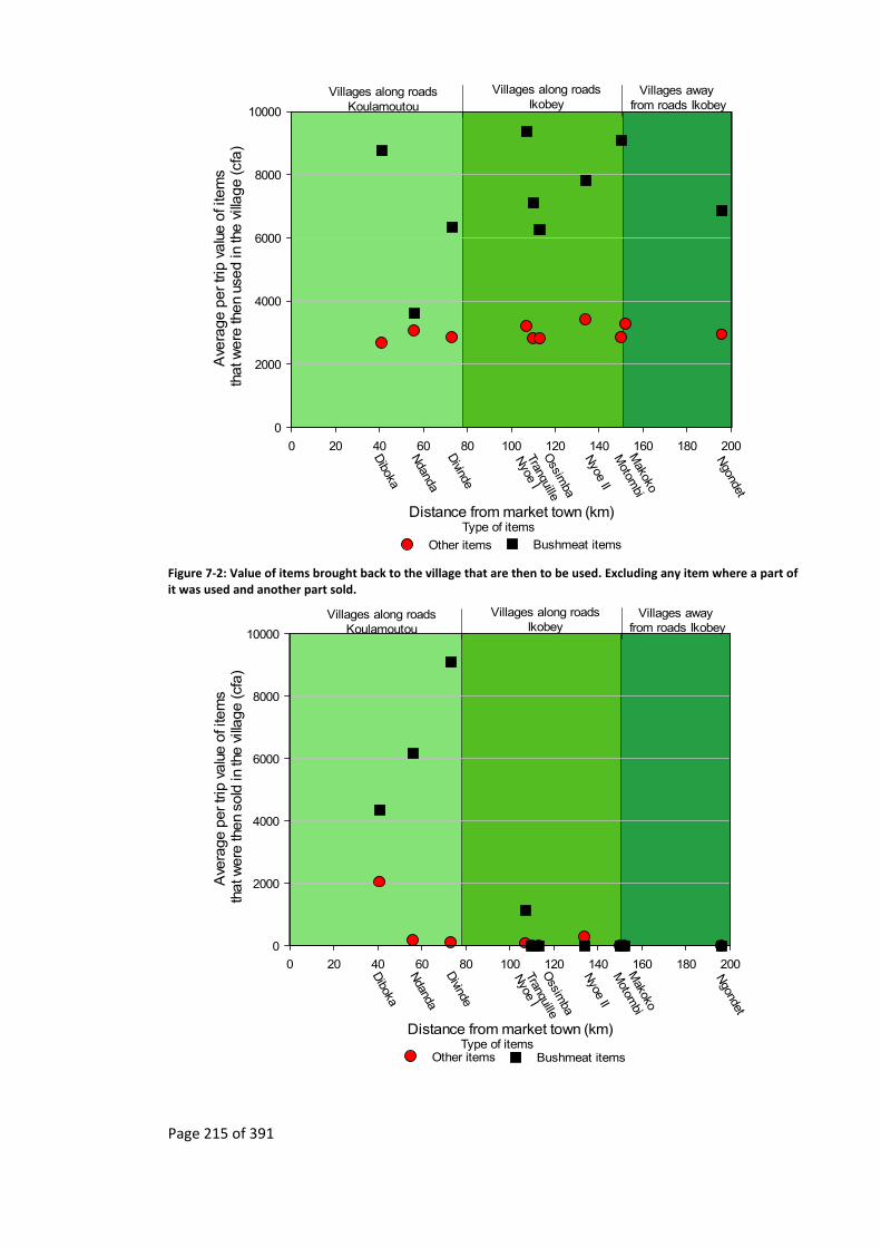
Page 215 of 391
Villages along roadsKoulamoutou
Villages along roadsIkobey
Villages away from roads Ikobey
Distance from market town (km)
0 20 40 60 80 100 120 140 160 180 200
Ave
rage p
er trip
valu
e o
f ite
ms
that w
ere
then
used in
the v
illage (cf
a)
0
2000
4000
6000
8000
10000
Ndanda
Divinde
Nyoe I
Tranquille
Motom
biM
akoko
Ngondet
Ossim
ba
Nyoe II
Diboka
Type of items
Other items Bushmeat items
Figure 7‐2: Value of items brought back to the village that are then to be used. Excluding any item where a part of it was used and another part sold.
Villages along roadsKoulamoutou
Villages along roadsIkobey
Villages away from roads Ikobey
Distance from market town (km)
0 20 40 60 80 100 120 140 160 180 200
Ave
rage p
er trip
valu
e o
f ite
ms
that w
ere
then
sold
in th
e v
illage (cf
a)
0
2000
4000
6000
8000
10000
Ndanda
Divinde
Nyoe I
Tranquille
Motom
biM
akoko
Ngondet
Ossim
ba
Nyoe II
Diboka
Type of itemsOther items Bushmeat items

Page 216 of 391
Figure 7‐3: Value of the items brought back to the village that are then to be sold. Excluding ivory and any item where a part of it was used and another part sold. The sale of items, especially of bushmeat, in the Ikobey village is very small.
Though bushmeat and wild meat (Mack and West, 2005, p.5) have the highest per item value,
the amount of non‐bushmeat items collected is higher (Figure 7‐4). The number of trips into the
forest to collect non‐bushmeat items increases with distance from market (Figure 7‐5). Within
the Ikobey sites the majority of the gathering activities occur in either the forest or plantations,
while in the Koulamoutou site the majority of gathering activities occur only in the plantations
(Figure 7‐5). However this could be a reflection of the fact that the forests around the
Koulamoutou villages are more distant, especially around Divinde and Diboka (Chapter 8), than
the forest around the Ikobey villages.
Villages along roadsKoulamoutou
Villages along roadsIkobey
Villages away from roads Ikobey
Distance from market town (km)
0 20 40 60 80 100 120 140 160 180 200
Am
oun
t of i
tem
s bro
ught
to v
illage p
er act
ive p
ers
on
0.0
0.2
0.4
0.6
0.8
1.0
1.2
1.4
1.6
1.8
2.0
Ndanda
Divinde
Nyoe I
Tranquille
Motom
biM
akoko
Ngondet
Ossim
ba
Nyoe II
Diboka
Type of itemsOther items Bushmeat items
Figure 7‐4: Amount of different types of bushmeat and non‐bushmeat items that was brought to the village, per person who participated in survey.
Page 217 of 391
Villages along roadsKoulamoutou
Villages along roadsIkobey
Villages away from roads Ikobey
Distance from market town (km)
0 20 40 60 80 100 120 140 160 180 200
Pe
rce
nta
ge
of e
nvir
om
ent
s vi
ste
d d
urin
g tr
ips
0
20
40
60
80
100
Ndanda
Divinde
Nyoe I
Tranquille
Motom
biM
akoko
Ngondet
Ossim
ba
Nyoe II
Diboka
Places returned from - with type of itemForest - non-bushmeatForest - bushmeat
Plantations - non-bushmeatPlantations - bushmeat
Regression Forest - non-bushmeat items
Figure 7‐5: Distribution of each of the environments from which items were transported back to the village by the active population, each trip. The linear regression of the forest environments visited by people (r2=0.399) is significant (ANOVA, F=5.302, DF=9, p=0.050). The linear regression of the plantation environments visited by people (r2=0.299) is not significant (ANOVA, F=3.412, DF=9, p=0.102).
In the Ikobey area people of all age groups participate in the collection of items from the
surrounding environment. This differs from the Koulamoutou site where children partake less in
these activities (Figure 7‐6), presumably as most are at school (Chapter 6).
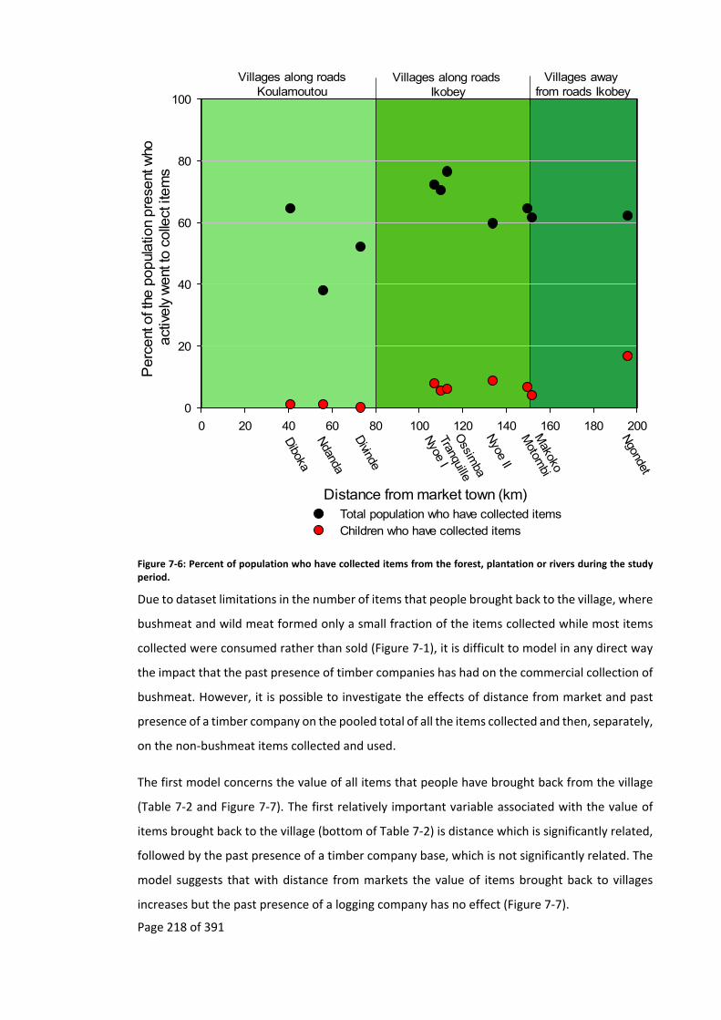
Page 218 of 391
Villages along roadsKoulamoutou
Villages along roads Ikobey
Villages away from roads Ikobey
Diboka
Ndanda
Divinde
Nyoe I
Tranquille
Motom
biM
akoko
Ngondet
Ossim
baN
yoe II
Distance from market town (km)
0 20 40 60 80 100 120 140 160 180 200
Perc
ent
of t
he p
opul
atio
n pre
sent
who
act
ively
went
to c
olle
ct it
em
s
0
20
40
60
80
100
Total population who have collected itemsChildren who have collected items
Figure 7‐6: Percent of population who have collected items from the forest, plantation or rivers during the study period.
Due to dataset limitations in the number of items that people brought back to the village, where
bushmeat and wild meat formed only a small fraction of the items collected while most items
collected were consumed rather than sold (Figure 7‐1), it is difficult to model in any direct way
the impact that the past presence of timber companies has had on the commercial collection of
bushmeat. However, it is possible to investigate the effects of distance from market and past
presence of a timber company on the pooled total of all the items collected and then, separately,
on the non‐bushmeat items collected and used.
The first model concerns the value of all items that people have brought back from the village
(Table 7‐2 and Figure 7‐7). The first relatively important variable associated with the value of
items brought back to the village (bottom of Table 7‐2) is distance which is significantly related,
followed by the past presence of a timber company base, which is not significantly related. The
model suggests that with distance from markets the value of items brought back to villages
increases but the past presence of a logging company has no effect (Figure 7‐7).

Page 219 of 391
model.avg.default(object = get.models(ms2, subset = delta < 3)) where ms2 = glm(Value~ Presence*Distance+Presence*Pop, family = poisson,data = Live4)
Component models:
df logLik AICc Delta Weight
1235 6.00 ‐23298.23 46608.48 0.00 0.38
12345 7.00 ‐23297.31 46608.67 0.18 0.35
13 4.00 ‐23301.04 46610.10 1.62 0.17
1 3.00 ‐23302.55 46611.11 2.63 0.10
Term codes:
Distance Population Past Presence
Distance: Past Present Population: Past Presence
1 2 3 4 5
Model‐averaged coefficients:
Estimate Std. Error Adjusted SE z values Pr(>|z|) Significance
(Intercept) 7.5608 0.1558 0.1559 48.5060 < 2e‐16 ***
Distance 0.0026 0.0008 0.0008 3.3510 0.0008 ***
Population ‐0.0005 0.0013 0.0013 0.3520 0.7250
Past Presence Yes ‐0.5716 0.4710 0.4711 1.2130 0.2250
Population: Past Presence Yes
0.0088 0.0037 0.0037 2.4100 0.0159 *
Distance: Past Presence Yes
0.0021 0.0016 0.0016 1.3510 0.1768
Full model‐averaged coefficients (with shrinkage):
Estimate Std. Error Adjusted SE z values Pr(>|z|) Significance
(Intercept) 7.5608 0.1558 0.1559 48.5060 < 2e‐16 ***
Distance 0.0026 0.0008 0.0008 3.3510 0.0008 ***
Population ‐0.0003 0.0012 0.0012 0.2950 0.7678
Past Presence Yes ‐0.5131 0.4787 0.4788 1.0720 0.2838
Population: Past Presence Yes
0.0064 0.0050 0.0050 1.2810 0.2003
Distance : Past Presence Yes
0.0007 0.0014 0.0014 0.5380 0.5907
Significance. codes: 0 ‘***’ 0.001 ‘**’ 0.01 ‘*’ 0.05 ‘.’ 0.1 ‘ ’ 1
Relative variable importance:
Distance Past Presence
Population Population: Past Presence
Distance: Past Presence
Importance : 1 0.9 0.73 0.73 0.35
N containing models: 4 3 2 2 1 Table 7‐2: Average model of the variables that contribute to the value of all items with which people have returned to the village, based on AICc.

Page 220 of 391
Distance to market (km)
0 50 100 150 200
Valu
e o
f all
item
s bro
ught
back
to v
illage (cf
a)
0
1000
2000
3000
4000
5000
6000
7000
Absence of past logging baseUpper 95% CILower 95% CI
Past presence of logging baseUpper 95% CILower 95% CI
Figure 7‐7: Model of the variables that contribute to the value of all items with which people have returned to the village, based on model from average AICs.
The second model considers just the value of the non‐bushmeat items that were then used
(Table 7‐3 and Figure 7‐8). Distance is again the highly significant variable. Neither the past
presence of a timber company nor population have any significant role to play (Table 7‐3 and
Figure 7‐8).
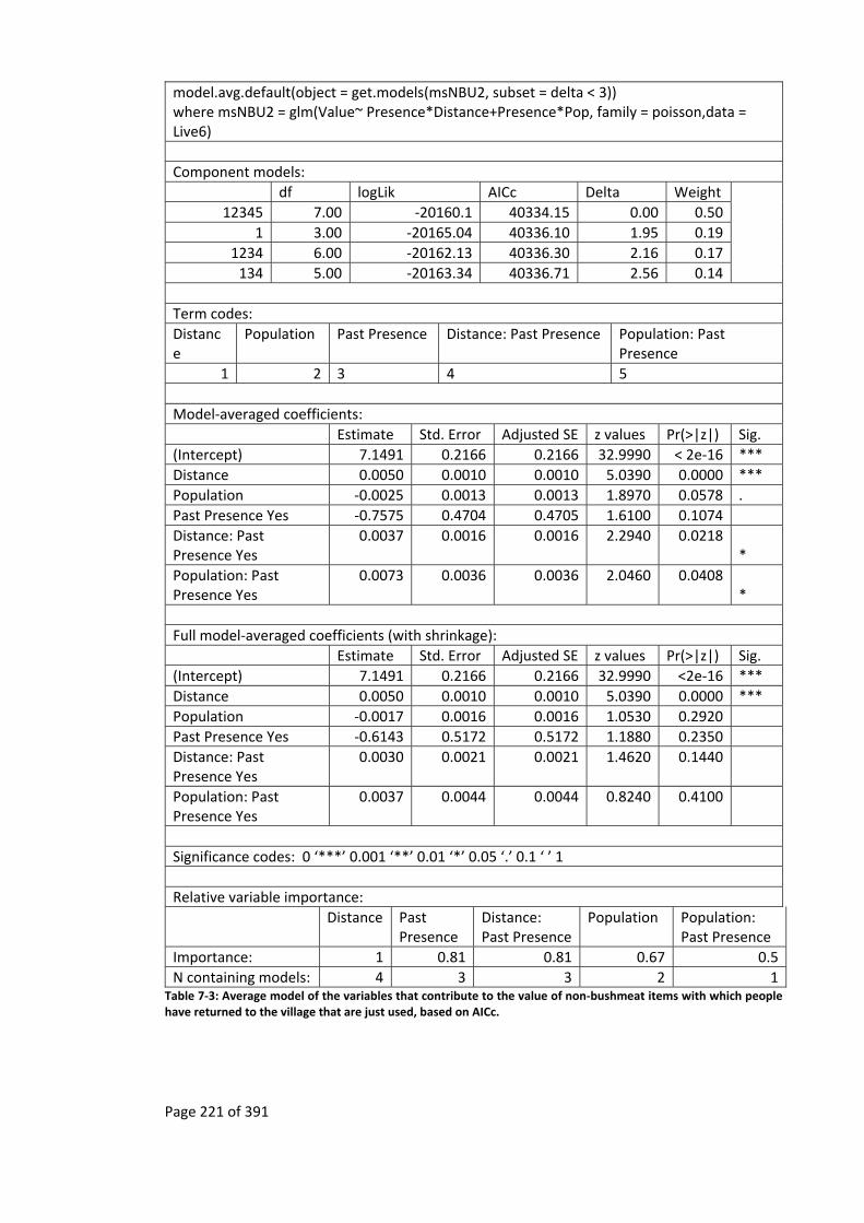
Page 221 of 391
model.avg.default(object = get.models(msNBU2, subset = delta < 3)) where msNBU2 = glm(Value~ Presence*Distance+Presence*Pop, family = poisson,data = Live6)
Component models:
df logLik AICc Delta Weight
12345 7.00 ‐20160.1 40334.15 0.00 0.50
1 3.00 ‐20165.04 40336.10 1.95 0.19
1234 6.00 ‐20162.13 40336.30 2.16 0.17
134 5.00 ‐20163.34 40336.71 2.56 0.14
Term codes:
Distance
Population Past Presence Distance: Past Presence Population: Past Presence
1 2 3 4 5
Model‐averaged coefficients:
Estimate Std. Error Adjusted SE z values Pr(>|z|) Sig.
(Intercept) 7.1491 0.2166 0.2166 32.9990 < 2e‐16 ***
Distance 0.0050 0.0010 0.0010 5.0390 0.0000 ***
Population ‐0.0025 0.0013 0.0013 1.8970 0.0578 .
Past Presence Yes ‐0.7575 0.4704 0.4705 1.6100 0.1074
Distance: Past Presence Yes
0.0037 0.0016 0.0016 2.2940 0.0218 *
Population: Past Presence Yes
0.0073 0.0036 0.0036 2.0460 0.0408 *
Full model‐averaged coefficients (with shrinkage):
Estimate Std. Error Adjusted SE z values Pr(>|z|) Sig.
(Intercept) 7.1491 0.2166 0.2166 32.9990 <2e‐16 ***
Distance 0.0050 0.0010 0.0010 5.0390 0.0000 ***
Population ‐0.0017 0.0016 0.0016 1.0530 0.2920
Past Presence Yes ‐0.6143 0.5172 0.5172 1.1880 0.2350
Distance: Past Presence Yes
0.0030 0.0021 0.0021 1.4620 0.1440
Population: Past Presence Yes
0.0037 0.0044 0.0044 0.8240 0.4100
Significance codes: 0 ‘***’ 0.001 ‘**’ 0.01 ‘*’ 0.05 ‘.’ 0.1 ‘ ’ 1
Relative variable importance:
Distance Past
Presence Distance: Past Presence
Population Population: Past Presence
Importance: 1 0.81 0.81 0.67 0.5
N containing models: 4 3 3 2 1 Table 7‐3: Average model of the variables that contribute to the value of non‐bushmeat items with which people have returned to the village that are just used, based on AICc.
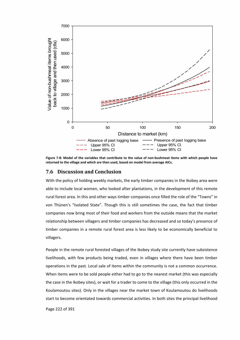
Page 222 of 391
Distance to market (km)
0 50 100 150 200
Valu
e o
f non-
bus
hmeat i
tem
s bro
ught
back
to v
illage a
nd th
en
used (cf
a)
0
1000
2000
3000
4000
5000
6000
7000
Absence of past logging baseUpper 95% CILower 95% CI
Presence of past logging baseUpper 95% CILower 95% CI
Figure 7‐8: Model of the variables that contribute to the value of non‐bushmeat items with which people have returned to the village and which are then used, based on model from average AICs.
7.6 DiscussionandConclusion
With the policy of holding weekly markets, the early timber companies in the Ikobey area were
able to include local women, who looked after plantations, in the development of this remote
rural forest area. In this and other ways timber companies once filled the role of the “Towns” in
von Thünen’s “Isolated State”. Though this is still sometimes the case, the fact that timber
companies now bring most of their food and workers from the outside means that the market
relationship between villagers and timber companies has decreased and so today’s presence of
timber companies in a remote rural forest area is less likely to be economically beneficial to
villagers.
People in the remote rural forested villages of the Ikobey study site currently have subsistence
livelihoods, with few products being traded, even in villages where there have been timber
operations in the past. Local sale of items within the community is not a common occurrence.
When items were to be sold people either had to go to the nearest market (this was especially
the case in the Ikobey sites), or wait for a trader to come to the village (this only occurred in the
Koulamoutou sites). Only in the villages near the market town of Koulamoutou do livelihoods
start to become orientated towards commercial activities. In both sites the principal livelihood

Page 223 of 391
activity of the community revolves around the collection of non‐bushmeat products that are
consumed. Even though bushmeat and wild meat have a higher monetary value per item, it only
becomes an important part of the communities’ livelihood in villages near markets where it can
be commercialised, such as the Koulamoutou communities, and not in communities further
from the markets such as the Ikobey communities.
The value of natural resources collected in this study is best explained by distance to the nearest
market, while the past presence of a timber company only has a marginal impact in areas further
from the market. While a timber company is operating in an area, livelihoods may become
orientated towards commercial activities, including the commercial trade of bushmeat, but
these multiplier effects do not seem to be sustained in the long‐term in remote rural forested
areas. Without some other organisation taking over the maintenance of transport
infrastructure, these commercial activities break down when the timber company departs.
Furthermore, in the remote rural forested areas non‐bushmeat items are being collected and
consumed more than wild meat items, while the value of the non‐bushmeat items that is
consumed is higher than that of the bushmeat items that are sold. If this is the case then the
legalisation of the commodification of bushmeat as a way to alleviate poverty (Brown, 2003;
Brown and Williams, 2003; Nasi et al., 2008; van Vliet and Nasi, 2008a) may in some cases have
the opposite effect if it results in the diversion of labour away from the collection of non‐
bushmeat items that are destined to be consumed.
The finding that the maintenance of transport infrastructure is important in the commercial
trade of bushmeat is in agreement with theories of transport and development, where certain
criteria have to be met before transport infrastructure can have an impact on economies. It also
corroborates von Thünen’s model for it is only in the areas where it is easy to transport bulky
perishable goods, such as plantains and bushmeat (usually sold fresh in Gabon), from the villages
to the markets that people will be involved in their trade. In remote rural forested areas such as
Ikobey, only non‐perishable high value Non‐Timber Forest Products, such as ivory and bois amer,
can be commercialised. It is likely that non‐perishable crops, such as manioc and yam tubers,
cannot be commercialised in these areas due to the high cost of transporting these items to the
market town, in relation to their low market value.
Therefore there are exceptions to development professionals’ and conservation practitioners’
chain of logic (Figure 1‐1) that assume transport infrastructure has a long‐term impact on rural
economies, leading to commercialisation and increasing extraction of natural resources
(Hodgkinson, 2009).

Page 224 of 391
This would suggest that conservation practitioners and development professionals also need to
take into account such models as von Thünen’s, or other distance based models (Lambin, 1994),
when it comes to working with timber companies in remote rural forest areas or in the
commodification of natural resources. In doing so the different outcomes of the long‐term
presence of a timber company in a remote rural forest area can be predicted and planned for,
such as the ones in the proposed chain of logic (Figure 1‐3), which may mean that in Gabon
conservation measures may only need to be prioritised while a timber company is operating in
a remote rural forest area. By contrast development projects may need to take into account the
change in the commercial environment once timber companies depart. David Ricardo’s 1820s
“Law of Rent”. From which von Thünen drew insight, needs to be considered when considering
the possible commercial livelihoods of remote communities for the:
most fertile, and most favorably situated, land will be first cultivated, and the
exchangeable value of its produce will be adjusted in the same manner as the
exchangeable value of all other commodities, by the total quantity of labour
necessary in various forms, from first to last, to produce it, and bring it to
market. When land of an inferior quality is taken into cultivation, the
exchangeable value of raw produce will rise, because more labour is required to
produce it (Ricardo, 1821, p.60).
It would however not be appropriate simply to generalise from this study and conclude that
commercial activities always break down with the departure of a timber company from a remote
rural forest area. This certainly does not seem to be the case in South America or in some other
parts of Africa, where other factors result in transport infrastructure being maintained and the
price of public transport being kept down after timber companies departs or when there are
resources that have a market price that more than compensates the break down in transport
(Chomitz, 2007; Chomitz and Gray, 1996; Hodgkinson, 2009; Riddell, 2013; Riddell, 2011;
Robinson and Bennett, 2000). No matter how “inferior” land quality and access to it is, as long
as the “exchangeable value of raw produce” is greater than the labour “required to produce it”
then it is likely that commercial activities will continue after the departure of timber companies.
Page 225 of 391
8 Loggingandthelongtermimpactontheenvironment
“Increased hunting activities following logging operations will definitely
have a negative long‐term impact on primate populations in the Campo‐
Ma'an area if no further, more effective conservation measures will
regulate wildlife use in the future” (Matthews and Matthews, 2002,
p.155).
8.1 Summary
Industries that open up remote rural forested areas in rentier states are thought to have impacts
on both the forest and its wildlife. Conservationist practitioners, as indicated by their chain of
logic (Figure 1‐1), are concerned that the opening up of remote rural forest areas by timber
companies results in the increased offtake of rare species that were previously out of reach of
commercial hunters. However, in the chain of logic as proposed here (Figure 1‐3 and Figure 1‐6),
the increased offtake is unlikely to continue in the long‐term after timber companies have left
remote rural forest areas. This is because of the break‐down in transport infrastructure (Chapter
5) which may result in the collapse of the trade in Non‐Timber Forest Products (Chapter 7) due
to an increase in transport prices that result in unfavourable terms of trade.
If this is the case, then the threat to the long‐term survival of rare species in remote rural forest
areas where timber companies operate, through their trade, could be overestimated in
conservationists’ concerns. This chapter explores the various environmental impacts that timber
companies have had around the study sites. The environmental impacts analysed included
vegetation succession, signs of human impacts and signs of animal occurrences around the study
site villages
The findings indicate that around villages that are near markets, whether or not there was a
timber company nearby, there is less mature forest, more plantations and fewer animal signs.
However, in villages further from markets where timber companies were once based but have
left, and where the market economy has subsequently broken down, signs of wildlife are highest
in the site where the timber industry had departed over ten years ago as opposed to sites where
there has been no logging or sites where timber companies have recently left.
Signs of rare threatened animals that are on IUCN’s Red List of Threatened Species are found
around the study sites where timber companies have been operating. These include signs of
elephants, chimpanzees and gorillas in areas where nearly half a century of logging came to an
end four years ago. In the Ikobey area, where elephants had become locally extinct over a

Page 226 of 391
century back, as recounted by Berton in 1895 (Chapter 4.5.1), there are now ample signs of their
renewed presence.
8.2 Theory
Even though it has been noted that forest animal species may recover after logging (Brugière
and Gautier, 1999; Clark et al., 2009; Plumptre and Reynolds, 1994; Struhsaker et al., 1996;
White, 1992), but not always (Chapman et al., 2010; Chapman et al., 2000; Matthews and
Matthews, 2002), conservationists are concerned that the opening up of previously inaccessible
forest areas by timber companies’ transport infrastructure facilitates the hunting of endangered
wildlife for the bushmeat trade. It is feared that the offtake for trade is high enough to threaten
the long‐term survival of wildlife (Auzel and Wilkie, 2000; Fimbel et al., 2001; Laurance, Alonso,
et al., 2006; Milius, 2005; Poulsen et al., 2009; Robinson and Bennett, 2000; Robinson et al.,
1999; Wilkie et al., 2000).
Timber companies account for 60% of the transport infrastructure in Gabon, a higher proportion
than for other countries in Central Africa (Blake et al., 2008; Laporte et al., 2007; Wilkie et al.,
2000). Work by Laurance et al (2006, 2008) in Gabon found that the impact of roads on animal
populations depended on the time of day, with little hunting impact on nocturnal arboreal
mammal species (Laurance et al., 2008). The impact that they did find on these species was
limited to road edges. In contrast, the impact on diurnal mammals extended hundreds of metres
into the forest (Laurance et al., 2008, p.728; Laurance, Croes, et al., 2006). However this
divergence between diurnal and nocturnal hunting in Gabon could be due to there still being a
large enough diurnal animal population to meet Gabonese hunter’s needs that they do not have
to undertake nocturnal hunting. There are some exceptions to this such as in northern Gabon
where hunting often only occurs at night (personal observation) as diurnal animals are rare170.
If transport infrastructure created by timber companies is linked to the decline of endangered
species due to commercialised hunting, and if this transport infrastructure persists when the
companies depart, then it would be expected that endangered species would be rare even after
timber companies depart. However, this thesis has shown that in remote rural forest areas of
Gabon, timber infrastructure degrades after timber companies depart (Chapter 5) resulting in
the collapse of the commerce of Non‐Timber Forest Products (Chapter 7).
170 Nocturnal hunting also occurs in other African countries such as in Cross River State in Nigeria (personal observation).

Page 227 of 391
8.3 Researchquestion
This chapter explores the impact that the departure of timber companies in remote rural forest
areas has on animal populations, as evidenced by their signs, in particular areas where timber
companies had been operating for decades.
While timber companies are operating in remote rural forest areas, transport to market towns
is relatively easy, but with their departure the market economies of villages in remote rural
forest areas which are based on the extraction of natural resources break down. In this case
there should be fewer signs of hunting in these remote rural forests, an increase in animal
populations, and signs of forest succession.
8.4 Methods
This chapter makes use of data from strip transects (Burnham and Anderson, 1984; Greenwood,
2006, pp.57, 105–106) in which all observable animals and human signs were counted one metre
on either side of the centreline; these were carried out around each village site (Map 8‐1). Four
strip transects were repeated twice (eight in total) for each village site. The repeated strip
transects were set approximately ten meters to the side of the previous one. This was done to
reduce the risk of counting the same animal or human signs twice and were all conducted during
the same season, the dry season, to reduce seasonal effects on signs (White and Edwards,
2000b, p.231). Due to the impacts of topography on animals (Vanleeuwe, 2008) and variations
between habitat type, season and observer’s ability to detect animals (Breuer and Breuer‐
Ndoundou Hockemba, 2012), care needs to be taken when using the data from these types of
method to compare vastly different sites.
Except where constrained by geological barriers such as rivers, strip transects were carried out
using cardinal directions (North, South, West and East) starting at eight in the morning from the
centre of the village, taken from the location of the chief’s flag. From this central point, and using
one of the four cardinal bearings on a compass, a GPS was switched on and a track log started.
For each bearing, a team of four people walked to the edge of the village, usually behind the last
house, from where a GPS waypoint was taken. The team carried on walking for a further fifty
metres and took another waypoint and started the strip transect. These strip transects were
carried out for two kilometres, using the fifty metre starting waypoint as a reference point to
calculate the distance. Each two kilometre strip transect would take four to six hours to
complete, depending on the terrain. Due to limitations of time, transects were not cut
beforehand, which added to disturbance (White and Edwards, 2000b, pp.230–231).

Page 228 of 391
Map 8‐1: Summary of study villages showing distance to nearest market, when road was last maintained, the last time the area around the village was logged and the villages where timber companies had a base.

Page 229 of 391
To minimise disturbance a small team of four went along the strip transect. This team consisted
of a note‐taker, a tracker, a person checking the bearing and a path‐cutter to make a minimalist
passage for the others to pass. In each village of the study, the same tracker and note‐taker were
used. The tracker, just behind the path‐cutter (White and Edwards, 2000b, pp.230–231), showed
the note‐taker any animal sign and sign of human impacts (roads, paths, traps, logging, etc.) that
were one metre to either side of the centreline, and, where possible, identified the animals to
which it belonged. For each sign the note‐taker created a waypoint, and recorded this point and
the associated signs observed at that point. The tracker used was a local Babongo hunter who
had knowledge of the area (Laurance, Croes, et al., 2006; Parnell, 2000, p.157).
It is recognised that there are many issues with strip transects, not least the assumption that
everything within the strip will be observed which is unlikely, especially at distances furthest
from the centreline; there are also boundary effects (Burnham and Anderson, 1984; Seber,
1986). It is due to this reason that a narrow strip (Buckland, 2001, p.3) that is one metre on
either side of the centre line is used, with observed signs being verified to fall within this strip
by the use of a metre long stick where the centreline is taken to be between the tracker’s feet.
Observations may also be missed due to thick vegetation cover, difficult terrain where
concentration is focused on moving along the transect, and fatigue. Fatigue is a rarely
mentioned issue of transect methods, but is especially relevant on long transects. It is highly
likely that observations along long transects will be negatively impacted by fatigue, resulting in
more observations at the start than the end of the transect. Though there have been studies to
look at different factors that may affect transects, such as the impacts of different observers and
the density of foliage which methods manuals seek to minimise (Davies, 2002a; White and
Edwards, 2000a), the impact of observer fatigue has yet to be explored171. As the same tracker
and note‐taker were used throughout the study, the fatigue factor should be roughly similar, so
any dip in the number of observations at the end of the two kilometre transects should be
similar. For these reasons animal abundance and animal density have not been calculated.
Rather the data has just been used to compare the number of animal signs observed around
each village site.
In addition to the noted animal and human impact signs, the note‐taker also recorded the stage
of forest succession of the waypoint, classifying it into one of three categories: plantation,
171 Though a similar method to measure the impact of foliage density on observations could be used, whereby objects are randomly placed along the transects that are to be measured before the observation team starts its work.

Page 230 of 391
secondary forest and mature forest. Plantations included newly cut plantations that had yet to
be burnt, burnt plantations that had yet to be planted, newly planted plantations, plantations
less than two years old (still being used) and abandoned plantations (usually more than two
years old). Secondary forest was noted when umbrella trees (Musanga cecropioides) were
visible; Umbrella trees are a fast‐growing light dependent species that colonises old plantations.
Mature forest was taken to be forest where no umbrella trees were visible. It should be noted
that the term “primary” forest has not been used here as in Africa it is highly likely that the
majority of the forests have been used by people at one time or another. Hence, in this study
“mature” forest is used.
Though using umbrella trees is a crude categorisation of the transition from plantation to mature
forest, it is used as it an easily identifiable, common tree in areas of Gabon (De Saint Aubin,
1963, p.166) that have been disturbed. Its canopy forms an important stage in the development
of mature forest trees which can, after fourteen years, be seen as a understory of four and a half
metres in height under the umbrella tree canopy of twenty‐three metres (Coombe and Hadfield,
1962, p.222). However, with a lifespan of approximately twenty years (Todou and Meikeu
Kamdem, 2011), the presence of umbrella trees can only indicate disturbance that occurred
within this period and not before.
The data from the GPS were downloaded into a computer and placed into a database, with the
observations recorded, the altitude, the distance from the start of the strip transect and the
waypoint number. The animal signs that were observed were then given a threat status by using
the categorises of the IUCN’s Red list of Threatened Species (Figure 8‐1) and grouped into
Threatened (Critically Endangered, Endangered, and Vulnerable), Lower Risk (Near Threatened
and Least Concern) and Other categories. This last category includes species for which there are
no data, which have not been evaluated or where the animal signs could not be identified to the
species level.
Each of the human impacts that were observed were placed into a database with the GPS
location, distance from start of transect and waypoint number noted. These impacts were also
placed into one of three categories: gathering (traps, shotgun shells, wine, gathering), logging
(felled trees, stumps and old logging camps) and transport (paths, tracks and roads).
From the recording of vegetation succession created at each animal and human sign waypoint,
the principal level of vegetation succession was calculated for each 100 m interval along the
transect and entered into a database. In cases where the types of vegetation succession were

Page 231 of 391
found to be equal in a 100 m interval then the principal vegetation succession category for both
the interval and previous 100 m interval was taken.
Figure 8‐1: Structure of IUCN Red List categories (from IUCN, 2012, p.5).
Due to zero‐inflation, where there are many sections of the strip transect with no observations,
modelling was not carried out with the IUCN threat categories or the number of hunting signs
observed. Instead modelling was just carried out on the number of animal signs. As the animal
sign dataset consists of nested count data that is overdispersed, Generalised Linear Mixed
Models (GLMM) fitted with a negative binomial distribution were used (Bolker et al., 2012;
Fournier et al., 2012, p.245; Zuur et al., 2015, p.146).
The set of predictor variables used to investigate the frequency of animal signs consists of the
characteristics of the villages. These were first tested for normality, outliers and collinearity
following Zuur et al. (2010). At the end of this process the village characteristics kept were as
follows: distance of the village from the market, principal ethnicity of the village, past presence
of a timber camp and time since timber companies left the area around the village (grouped into
never logged, logged more than six years ago and logged less than five years ago).
With the predictor variables various models were created and one was selected using an
information‐theoretic approach (Table 8‐1) following Anderson and Burnham (2002); in this case
Akaike’s Information Criteria (AIC) was used (Anderson and Burnham, 2002; Zuur et al., 2009).
Page 232 of 391
From these models the following Generalised Linear Mixed Model with a negative binomial
distribution was selected (Table 8‐1):
Total_animals ~ Distance + Last_Logged + (1|Village/Tran)
Where :
Total_animals = total number of animal signs per 100 m interval,
Distance = Distance to the nearest market from a village,
Last_Logged = Time since timber company left the area around the village (grouped into
never logged, logged more than six years ago and logged less than five years ago),
(1|Village/Transect) = Observations are nested in transect which in turn are nested in
village.
The chosen models were tested for validity by looking at the normality of residuals, homogeneity
and independence (Zuur et al., 2009, pp.19–22). Overdispersion was assessed using Pearson
residuals (Zuur et al., 2015, p.146).
8.5 Results
8.5.1 Vegetation
The vegetation transects show that there are a greater number of hundred metre transect
sections that are mature forest in the Ikobey sites than the Koulamoutou sites, with, in general,
an increase in the number of mature forest sections with distance from the nearest market
(Figure 8‐2). Although plantations and secondary forest cover decrease with distance from
markets, none of these produce significant linear regressions (Figure 8‐2)172.
Around all villages there are hundred metre transect sections that consist of plantations.
However, it is around the Koulamoutou village of Diboka, nearest to the Koulamoutou market
town (Map 8‐1), where there are the greatest number of sections that consist of plantations,
reflecting the importance there of commercial cultivation, especially of plantain (Chapter 7).
172 The rugged nature of the terrain around the Koulamoutou village of Ndanda may be the reason for the amount of mature forest around this village.

Page 233 of 391
Villages along roadsKoulamoutou
Villages along roadsIkobey
Villages away from roads Ikobey
Distance of village from market town (km)
0 20 40 60 80 100 120 140 160 180 200
Num
ber
of f
ore
st c
ate
go
rie
s fo
und a
long
ea
chse
gm
ent
of t
he tr
ans
ect
s (N
=8
0).
0
10
20
30
40
50
60
70
80
Forest categoriesPlantation Secondary Mature
Diboka
Ndanda
Divinde
Nyoe I
Tranquille
Motom
biM
akoko
Ngondet
Ossim
ba
Nyoe II
Figure 8‐2: Principal forest type of each 100 m sections of the transect in each of the study site villages. The proportion of Plantations and Secondary forest decrease with distance from market town, while mature forests increase. In no case is the linear regression significant (ANOVA Plantation F=1.847, DF=8, p=0.211; Secondary F=2.653, DF=8, p=1.420; Mature F=0.557, DF=8, p=0.477).
8.5.2 Impacts
The environment around the Ikobey sites had more signs of long‐term human disturbance in the
forest than the environment around the Koulamoutou sites (Figure 8‐3, Map 8‐1). This consists
mostly of logging activity including logging roads, reflecting the length of time that timber
companies have been operating in the Ikobey area (Chapter 4). These types of impacts reach a
peak just before the end of the regularly used road at Nyoe II, and are concentrated around the
villages where timber industries previously had a base. In some cases there was evidence of the
boom and bust nature of the timber industries (Chapter 3.2.3.3), with the presence of
abandoned logs especially in the Ikobey sites. Though the most remote village of Ngondet had
evidence of logging, this was in the form of artisanal logging and was minimal.

Page 234 of 391
Roads and paths were found throughout the village sites. The roads in the Koulamoutou sites
nearest to the market were mostly constructed by the state, colonial or post‐colonial
governments, while the roads in the Ikobey site and the furthest village in the Koulamoutou site
(Divinde) were mostly constructed by timber companies. No roads were found around the
village of Ngondet, but this site has the highest number of observed path signs, reflecting not
only that there are no roads that people can use, but also the historic human occupation in the
area with a number of abandoned villages (Chapter 4).
Villages along roadsKoulamoutou
Villages along roads Ikobey
Villages away fromroads Ikobey
Distance from market town (km)
0 20 40 60 80 100 120 140 160 180 200
Num
ber
of
imp
act
sig
ns
fou
nd
alo
ng
th
e tr
anse
cts
arou
nd
eac
h v
illag
e
0
100
200
300
400
500
Diboka
Ndanda
Divinde
Nyoe I
Tranquille
Motom
biM
akoko
Ngondet
Ossim
ba
Nyoe II
Impact categories
Logging Paths Roads
Figure 8‐3: Overall long‐term human impacts on the forest found along the transect in each of the study site villages.
When grouping together all the short‐term, individual, human impact signs there does not seem
to be a trend with distance from market (ANOVA, F=0.056, DF=8, p=0.819, Figure 8‐4). However,
hunting signs were found on all the transects undertaken, but were mostly concentrated around
the two Koulamoutou villages nearest the market, Diboka and Ndanda (Figure 8‐4). The reason
that there were fewer signs of hunting around the Koulamoutou village of Divinde is likely to be
due to the lack of mature forest (Figure 8‐2), as hunting does occur in this village (Chapter 7) and
maybe overhunting. In either case the hunters must go further afield to hunt and so outside the
area covered by the transects.
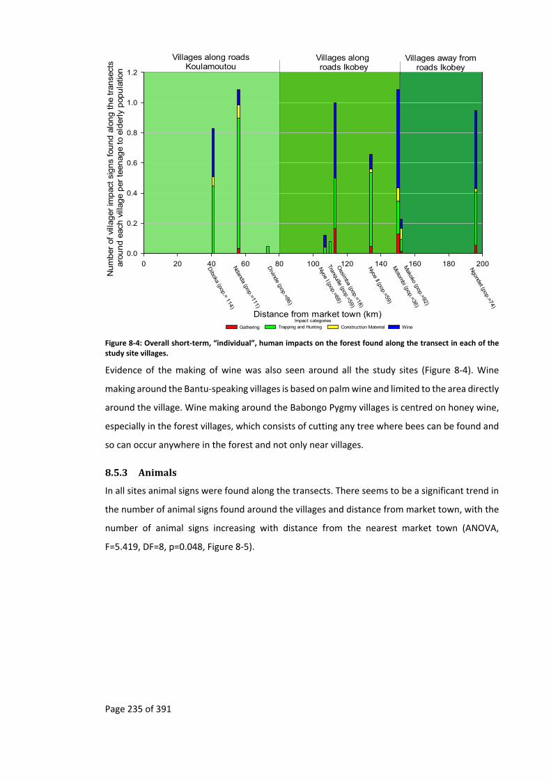
Page 235 of 391
Villages along roadsKoulamoutou
Villages along roads Ikobey
Villages away fromroads Ikobey
Distance from market town (km)
0 20 40 60 80 100 120 140 160 180 200
Nu
mb
er o
f vi
llag
er im
pac
t si
gn
s fo
un
d a
lon
g t
he
tran
sect
s ar
oun
d e
ach
vill
age
per
tee
nag
e to
eld
erly
pop
ula
tion
0.0
0.2
0.4
0.6
0.8
1.0
1.2
Diboka (pop.= 114)
Ndanda (pop.=111)
Divinde (pop.=86)
Nyoe I (pop.=68)
Tranquille (pop.=59)
Motom
bi (pop.=36)
Makoko (pop.=92)
Ngondet (pop.=74)
Ossim
ba (pop.=18)
Nyoe II (pop.=59)
Impact categories
Gathering Trapping and Hunting Construction Material Wine
Figure 8‐4: Overall short‐term, “individual”, human impacts on the forest found along the transect in each of the study site villages.
Evidence of the making of wine was also seen around all the study sites (Figure 8‐4). Wine
making around the Bantu‐speaking villages is based on palm wine and limited to the area directly
around the village. Wine making around the Babongo Pygmy villages is centred on honey wine,
especially in the forest villages, which consists of cutting any tree where bees can be found and
so can occur anywhere in the forest and not only near villages.
8.5.3 Animals
In all sites animal signs were found along the transects. There seems to be a significant trend in
the number of animal signs found around the villages and distance from market town, with the
number of animal signs increasing with distance from the nearest market town (ANOVA,
F=5.419, DF=8, p=0.048, Figure 8‐5).

Page 236 of 391
Villages along roadsKoulamoutou
Villages along roads Ikobey
Villages away from roads Ikobey
Distance from market town (km)
0 20 40 60 80 100 120 140 160 180 200
Nu
mb
er o
f an
imal
sig
ns
fou
nd
alo
ng
the
tran
sect
s ar
oun
d e
ach
vill
age
0
100
200
300
400
500
600
700
800
900
1000
1100
1200
1300
1400
1500
1600
Diboka
Ndanda
Divinde
Nyoe I
Tranquille
Motom
biM
akoko
Ngondet
Ossim
ba
Nyoe II
Figure 8‐5: Number of all animal signs observed along the transect in each of the study site villages. There seems to be an increase in the total number of animal signs with distance from market with the linear regression (r2=0.404) being significant (ANOVA, F=5.419, DF=8, p=0.048).
The different types of animals, represented by their signs, also increased with distance from the
nearest market town. Antelope and porcupine signs were dominant throughout the sites (Figure
8‐6), while rarer and more threatened species, such as great apes and elephants, were more
important in the sites that are furthest from the nearest market town (Figure 8‐6). That
antelopes and porcupine signs are dominant would be expected not only due to detectability of
the signs that they leave behind but also due to their life histories with rapid reproduction rates
(Kingdon, 2003) allowing them to recover quicker from being exploited. That great apes and
elephants are more important at sites further from market towns could again reflect their life
histories, with slower reproduction rates (Kingdon, 2003) resulting in increased time before
these populations can recover after being exploited.

Page 237 of 391
Villages along roadsKoulamoutou
Villages along roadsIkobey
Villages away from roads Ikobey
Animal groups Regression
Distance of village along road (km)
0 20 40 60 80 100 120 140 160 180 200
Num
ber o
f ani
mal s
igns
foun
d al
ong
the
trans
ect
s of e
ach
vill
age
0
200
400
600
800
1000
Antelopes Porcupines and Grasscutters Elephants Great Apes and Primates
Pangolins Red River Hogs Other Animals
Elephants Great Apes and PrimatesPangolins Other Animals
Diboka
Ndanda
Divinde
Nyoe 1
Tranquille
Motom
biM
akoko
Ngondet
Ossim
ba
Nyoe 2
Figure 8‐6: Number of all animal signs observed along the transect in each of the study site villages. The linear regressions that are significant are shown: Elephants (r2=0.502, ANOVA, F=8.051, DF=8, p=0.022), Great Apes and Primates (r2=0.785, ANOVA, F=29.285, DF=8, p=0.001), Pangolins (r2=0.595, ANOVA, F=11.731, DF=8, p=0.009) and Other Animals (r2=0.596, ANOVA, F=11.785, DF=8, p=0.009).
Villages along roadsKoulamoutou
Villages along roadsIkobey
Villages away from roads Ikobey
IUCN groupingsDistance of village along road (km)
40 60 80 100 120 140 160
Num
ber of a
nim
al s
igns
in e
ach
of I
UC
N g
roup
ing
foun
d a
long
the tr
ans
ect
s of e
ach
vill
age
0
200
400
600
800
1000
Ndanda
Divinde
Nyoe I
Tranquille
Motom
biM
akoko
Ossim
ba
Nyoe II
Threatened Lower Risk Other Regression of IUCN threat grouping
Figure 8‐7: Animal signs grouped by principal IUCN Red list of Threatened Species categories found along the transects of villages where logging has occurred. The linear regression that is significant is the threatened grouping consisting of IUCN categories Critically Endangered, Endangered, and Vulnerable (r2=0.522, ANOVA, F=6.549, DF=8, p=0.043).

Page 238 of 391
In the sites where logging has occurred in the past the abundance of species categorised as
threatened in IUCN’s Red list of Threatened Species (Critically Endangered, Endangered, and
Vulnerable) also increases significantly with distance of the site from a market town. There does
not seem to be a trend in sign frequency for animal signs categorised under Lower Risk (Near
Threatened and Least Concern) or Other (Figure 8‐7). If commercial hunting due to the timber
industry were affecting threatened species in a similar way, then this trend in the number of
animal signs categorised as threatened should not be seen.
Overall there does not seem to be a trend in the total number of animal signs with the
population size of a village (ANOVA, F=0.004, DF=8, p=0.955, Figure 8‐8), even though village
population size generally decreases with distance from market town (Figure 4‐2).
Population size of village - teenage to elderly (distance from nearest market town)
0 10 20 30 40 50 60 70 80 90
Num
ber of a
nim
al s
igns
foun
d a
long
the tr
ans
ect
s aro
und e
ach
vill
age
0
100
200
300
400
500
600
700
800
900
1000
1100
1200
1300
1400
1500
1600
Diboka (41 km
)
Ndanda (56 km
)
Divinde (73 km
)
Nyoe I (107 km
)
Tranquille (110 km)
Motom
bi (150 km)
Makoko (152 km
)
Ngondet (196 km
)
Ossim
ba (113 km)
Nyoe II (134 km
)
Principal ethnicity of village
Bantu-speaking Babong Pygmies
Figure 8‐8: Number of all animal signs observed along the transect in each of the study site villages by population size (teenage to elderly). Though there is no general trend, it does show that the Babongo Pygmy villages (in black) have more animal signs that the Bantu‐speaking villages (in red). The linear regression (r2=0.0004) is not significant (ANOVA, F=0.004, DF=8, p=0.955).
Of the various models tested using generalized linear mixed models (GLMM) with a negative
binomial distribution approach (Table 8‐1), the variables that have a significant impact on the
frequency of animals signs are distance from a market, areas around villages that have been
logged less than five years ago and those that have never been logged (Table 8‐2).
The overall village’s distance from market has a positive impact on the number of animal signs.
Time since logging also has an effect with sign frequency highest in areas that were last logged
more than six years ago, but lower and similar across areas that have either never been logged
or logged less than five years ago (Figure 8‐9).

Page 239 of 391
Model variables Df AIC AIC differences
Akaike weight
Total_animals ~ Distance + Last_Logged + (1|Village/Tran)
7 9219.4 0 0.621
Total_animals ~ Distance * Last_Logged + (1|Village/Tran)
9 9221.26 1.86 0.245
Total_animals ~ Last_Logged + (1|Village/Tran) 6 9225.32 5.92 0.032
Total_animals ~ 1 + (1|Village/Tran) 4 9225.62 6.22 0.028
Total_animals ~ Distance + (1|Village/Tran) 5 9225.76 6.36 0.026
Total_animals ~ Camp + (1|Village/Tran) 5 9226.98 7.58 0.014
Total_animals ~ Last_Logged + Camp + (1|Village/Tran)
7 9227.2 7.8 0.013
Total_animals ~ Distance + Camp + (1|Village/Tran 6 9227.22 7.82 0.012
Total_animals ~ Distance * Camp + (1|Village/Tran) 7 9229.1 9.7 0.005
Total_animals ~ Distance + Camp* Distance : Camp + (1|Village/Tran)
7 9229.1 9.7 0.005
Table 8‐1: AICs results from various Generalised Linear Mixed Model with a negative binomial distribution investigating how the frequency of animals signs (Total_animals) is impacted by variables that characterise each village site, namely distance from market (Distance), past presence of a timber base (Camp) and time since the area around the village was last logged (Last_Logged – grouped into never, less than 5 years and greater than 6 years). Highlighted are the chosen model and the null model.
glmmadmb(formula = Total_animals ~ Distance + Last_Logged + (1 | Village/Tran), data = Animals, family = "nbinom")
AIC: 9219.4
Coefficients:
Estimate Std. Error z value Pr(>|z|) Sig.
(Intercept) 1.819 0.139 13.11 < 2e‐16 ***
Distance 0.004 0.001 3.36 0.00078 ***
Last_Logged ‐Less_5 ‐0.431 0.118 ‐3.66 0.00025 ***
Last_Logged ‐Never ‐0.511 0.145 ‐3.54 0.00041 ***
Significance. codes: 0 ‘***’ 0.001 ‘**’ 0.01 ‘*’ 0.05 ‘.’ 0.1 ‘ ’ 1
Number of observations: total=1600, Village=10, Village:Transect=80
Random effect variance(s):
Group=Village Variance StdDev
(Intercept) 1.075e‐08 0.0001037
Group=Village:Transect Variance StdDev
(Intercept) 0.1721 0.4148
Negative binomial dispersion parameter: 4.14 (std. err.: 0.27104)
Log‐likelihood: ‐4602.7 Table 8‐2: Results from Generalised Linear Mixed Model with a negative binomial distribution of Total_animals. In this model villages characteristics that concern distance and time since the area around the village was last logged are the predictor variables.
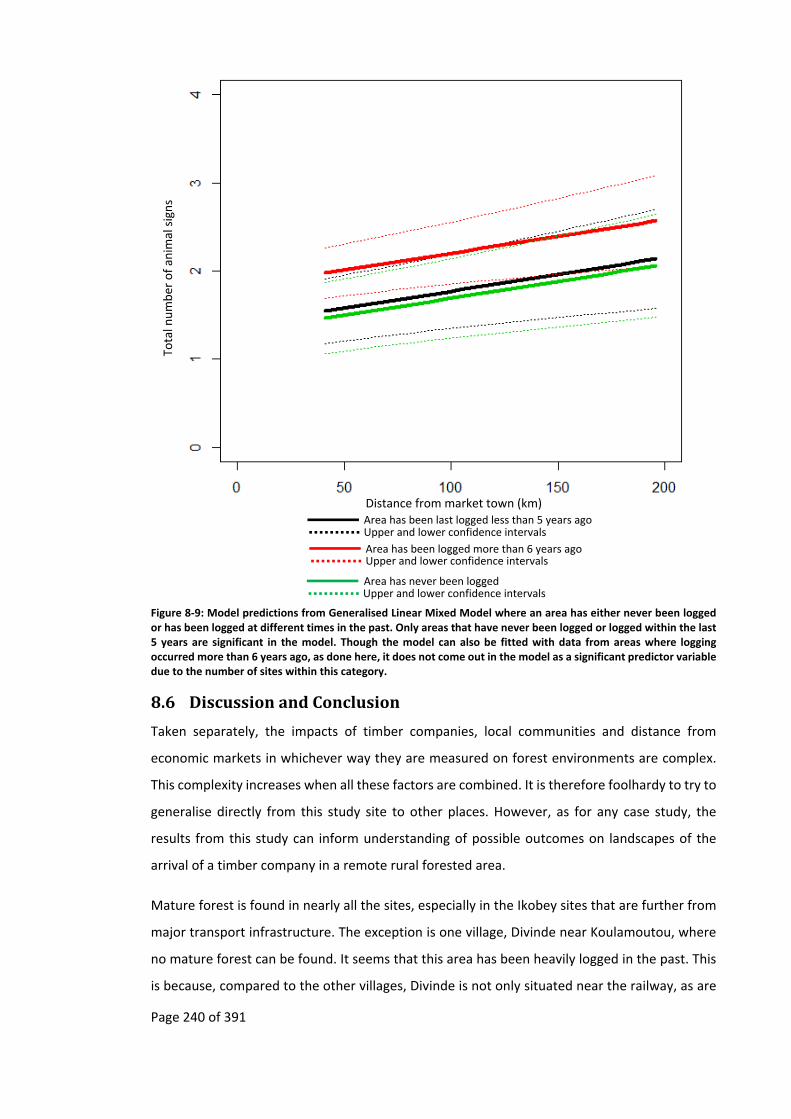
Page 240 of 391
Figure 8‐9: Model predictions from Generalised Linear Mixed Model where an area has either never been logged or has been logged at different times in the past. Only areas that have never been logged or logged within the last 5 years are significant in the model. Though the model can also be fitted with data from areas where logging occurred more than 6 years ago, as done here, it does not come out in the model as a significant predictor variable due to the number of sites within this category.
8.6 DiscussionandConclusion
Taken separately, the impacts of timber companies, local communities and distance from
economic markets in whichever way they are measured on forest environments are complex.
This complexity increases when all these factors are combined. It is therefore foolhardy to try to
generalise directly from this study site to other places. However, as for any case study, the
results from this study can inform understanding of possible outcomes on landscapes of the
arrival of a timber company in a remote rural forested area.
Mature forest is found in nearly all the sites, especially in the Ikobey sites that are further from
major transport infrastructure. The exception is one village, Divinde near Koulamoutou, where
no mature forest can be found. It seems that this area has been heavily logged in the past. This
is because, compared to the other villages, Divinde is not only situated near the railway, as are
Distance from market town (km)
Total n
umber of an
imal signs
Upper and lower confidence intervals Area has been last logged less than 5 years ago
Area has been logged more than 6 years ago Upper and lower confidence intervals
Area has never been loggedUpper and lower confidence intervals

Page 241 of 391
the neighbouring villages of Ndanda and Diboka (respectively seventeen and thirty‐two
kilometres away) allowing easy timber transport, but also it is situated in a relatively flat area,
where trees are accessible without difficulty. In comparison, the neighbouring village of Ndanda
has much more mature forest than the more remote villages in Ikobey because the terrain
around this village is rugged and so timber companies find it harder to harvest the trees.
The type of terrain that timber companies find in their concession has a large impact on the
amount of timber that they extract. While timber companies have been exploiting the area in
Ikobey since the 1960s, and even though the area had been heavily exploited for other resources
at the beginning of the 1900s (Chapter 4), mature forest is still widely found throughout the
area. In comparison, timber companies in the Divinde site have only operated for around twenty
years.
The lack of mature forest in the village that has been heavily logged, Divinde, has meant that
hunters from this village have to go further afield, further than the two kilometre transects that
were carried out. The commercialisation of bushmeat in the Koulamoutou sites, as seen in
Chapter 7, is visible in the number of trapping signs found around these villages.
The fact that there are fewer threatened species found around the villages near markets than
the villages further afield may be due to this commercialisation, but it may also be due to the
lack of mature forest around these villages. With distance from market there is an increase in
the number of threatened species that were found around villages where logging activity had
occurred in the past. Distance to market seems to be the likely cause of the amount of
plantations in the village nearest to the market (Diboka), where there is evidence of the
commerce of locally grown crops.
In the areas furthest from market sites there is some evidence that previous sites that have been
logged may have a positive long‐term impact on certain wildlife species but only under certain
conditions. Here it has been observed, through the use of animal signs, that animal populations
seemed to be the largest and with a higher diversity in the Makoko village site, where the time
since the area had last been logged was the longest, this finding adds evidence to what was
supposed by Adams and McShane (1996, p.217). The Makoko site had the following conditions:
a decade had passed since the last time the area had been logged, the road had not been used
for a similar period and the majority of the human population had migrated away from this area
with only the Babongo Pygmies remaining. This finding is not at odds with the ecological
knowledge of certain species, such as elephants, which are known to be attracted to areas that
were once occupied by people. As such sites, the secondary forests have more fruiting trees,
Page 242 of 391
which have been left behind by people, and more foliage than mature forests (Barnes et al.,
1991; Walker, 2010).
By allowing light into the forest, timber companies also encourage the growth of light
demanding tree species. Some species such as the umbrella trees Musanga cecropioides, are
common. But others such as the sub‐endemic timber tree, Okoumé, are potentially threatened
(Wunder, 2003, p.35) as sapling recruitment is being affected by the reduction in deforestation,
through the disappearance of villages, and their associated cultivation (Engone Obiang et al.,
2014) in rural Gabon (Map 3‐2). As Gabon becomes more urbanised (Chapter 1) and shifting‐
cultivation becomes less common, the opening up of the canopy by timber companies may be
the only way to protect threatened light demanding tree species.
This is not to say that all areas in which timber companies once operated will be as resilient and
see a recovery of animal populations (see Hodgkinson, 2009; and Riddell, 2011 as examples of a
different outcome due to the timber industry). In Gabon it is likely that timber concessions near
market towns will be less resilient, this being due to higher human population and so more land
competition between people and wildlife, both for food and subsistence (Ahrends et al., 2010;
DeFries et al., 2010; DeFries et al., 2006; Gordon et al., 2012; Smith et al., 2010; Smith et al.,
2001).
Though it is assumed by some that animal populations cannot recover around market towns,
the history of elephants in Gabon shows that it can happen (Chapter 3 and Appendix 11.9). In
the Loango area elephants had gone locally extinct in the 1600s (Martin, 1982); however today
there is a population of “a few thousand elephants”(Fay, 2004a). Around the capital, Libreville,
elephants went locally extinct in the 1800s (Walker, 1870) but today can be seen in the nearby
Pongara National Park (Blanc et al., 2007).
The results presented in this chapter show that the distance from a market and time since
logging has occurred have an impact on the frequency of animal signs. However, ethnicity may
also have a role to play on the frequency of animal signs (Appendix 11.19). The models
containing ethnicity were rejected due to their complexity, having higher degrees of freedom
and because the size of the dataset is problematic.
Further research which included many more ethnicities would be needed to see if the
relationship between ethnicity and number of animals is not just an artefact of the sites selected
in this study. However, the possibility that there is a link could further complicate the design of
conservation projects that wish to reduce hunting through projects tied to timber companies.
Page 243 of 391
As a “’one‐size‐fits‐all’ strategy” (Giles‐Vernick, 2002, p.201), certain conservation projects may
not be appropriate when numerous ethnicities are in and around a timber concession. For Giles‐
Vernick when conservation projects involve different ethnicities then:
it would be useful to conduct historical, economic, social and cultural studies
[…] to develop different conservation (and, when appropriate, development)
strategies […] such strategies would have to continue to be tailored to changing
populations, economic conditions, and environmental perceptions and
practices (Giles‐Vernick, 2002, pp.201–202).
Ethnicities may have an impact on the frequency of animal signs for any number of reasons
(Cohen, 1978; Kialo, 2007). This includes difference in gun ownership between Bantu‐speaking
villagers and the Babongo Pygmies (Riddell, 2011) or difference in hunting skills between Pygmy
populations and Bantu‐speaking population, whereby the former are known to be better
hunters (Mavah, 2011; Riddell, 2011, p.156). Other reasons that ethnicities impact wildlife, and
so the number of animal signs, include the way that different ethnicities react to markets, roads
and trade (Noss and Cuéllar, 2001), while different ethnicities migrate in different ways (as
shown in Chapter 4 and by Klieman (2003)) with new in‐migrant ethnicities unusually having
different attitudes to wildlife (Dzingirai, 1996). The religious orientations of different ethnicities
(Amador et al., 2015), due to taboos on types of animals that can be captured as well as
traditional beliefs against excessive hunting, can also have an impact on wildlife. Finally different
ethnicities perceive risks that originate from wildlife in different manners and react accordingly
(Dickman, 2010).

Page 244 of 391
9 ConclusionsandDiscussion
“Conservation Biology: a Dialog of the Deaf” (Agrawal and
Ostrom, 2006, p.681; Sandbrook et al., 2013, p.1487)
9.1 Overview
For many conservation practitioners and development professionals, timber companies are
thought to bring development to remote rural forest areas at the expense of the environment
through “multiplier effects” (Sunderlin et al., 2003) both directly because of the presence of
timber companies and indirectly due to the creation of transport infrastructure into a once
inaccessible area. These multiplier effects are said to include employment and the trade of
natural resources that result in the immigration of people into the area. While the use of natural
resources by local communities may have been sustainable before the arrival of timber
companies, the arrival of in‐migrants generates additional pressure on the environment that
may no longer be sustainable. This chain of logic (Figure 1‐1) has resulted in the unlikely
collaboration among conservation organisations, development organisations and timber
companies. However, it is filled with assumptions that may, or may not, be true in any one
location or at any one time (Ascher, 1999a, p.109; Marcucci, 2000; Rackham, 2003; Szabó and
Hédl, 2011).
While conservation and development projects that either collaborate with timber companies or
use their infrastructure may be successful in the short‐term, they may not be successful in the
long‐term, this being due to the accumulation effect of “assumption drag”, (Ascher, 1979; Brysse
et al., 2013; Keilman, 1998; Oppenheimer et al., 2008, p.162). Outdated core assumptions are
persistently used, having been created by, among other things, inappropriate generalisations.
One of these generalisations is that the transport infrastructure created by timber companies
leads to local development (Sunderlin et al., 2003) through commercial activity (Wilkie et al.,
1992; Auzel and Wilkie, 2000) at the expense of the environment through both deforestation
(Coffin, 2007; Lugo and Gucinski, 2000) and defaunation (Brashares et al., 2011; Wilkie et al.,
1992; Zhang et al., 2006), especially in remote areas that have never been commercially
exploited before (Abernethy et al., 2013; Bryant et al., 1997). Though not explicit, it is implied
that these impacts continue in the long‐term.
This thesis questions two of the assumptions in this chain of logic (Figure 1‐1). The first is that
remote rural forest areas have never been exploited commercially before the arrival of a timber
company and the second is that the impacts of timber companies, on both development and
the environment, are long‐term. By integrating these queries, an alternative chain of logic
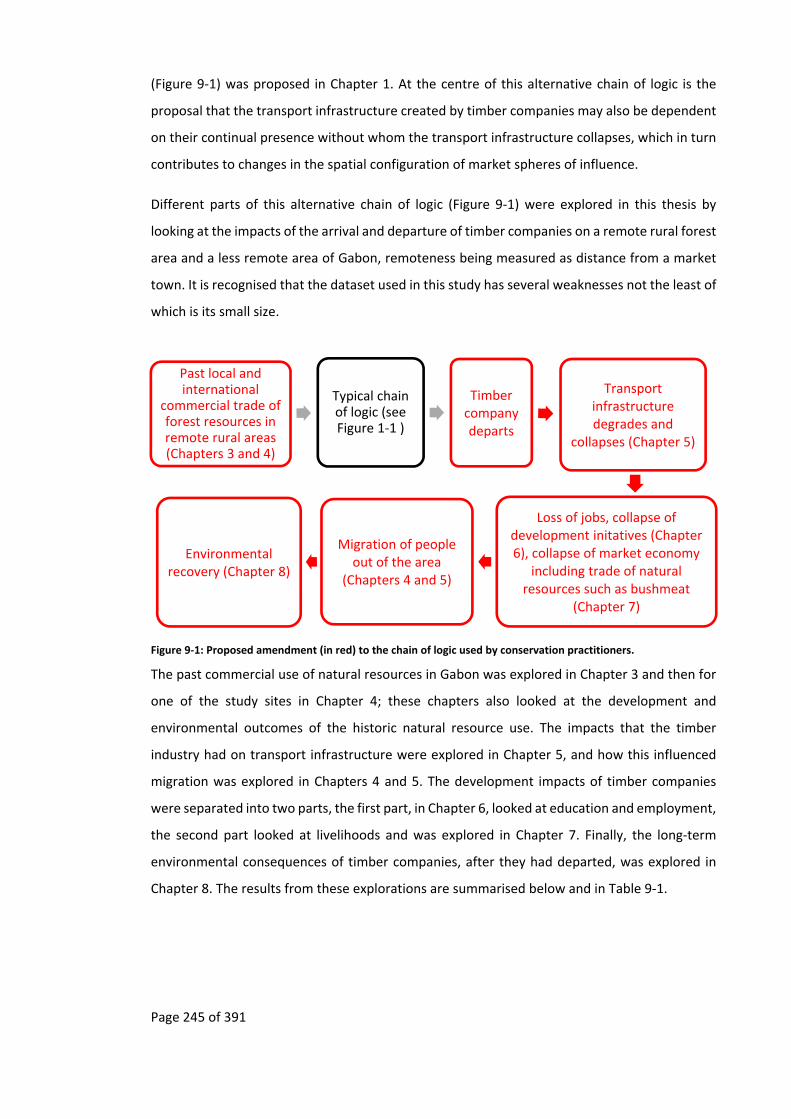
Page 245 of 391
(Figure 9‐1) was proposed in Chapter 1. At the centre of this alternative chain of logic is the
proposal that the transport infrastructure created by timber companies may also be dependent
on their continual presence without whom the transport infrastructure collapses, which in turn
contributes to changes in the spatial configuration of market spheres of influence.
Different parts of this alternative chain of logic (Figure 9‐1) were explored in this thesis by
looking at the impacts of the arrival and departure of timber companies on a remote rural forest
area and a less remote area of Gabon, remoteness being measured as distance from a market
town. It is recognised that the dataset used in this study has several weaknesses not the least of
which is its small size.
Figure 9‐1: Proposed amendment (in red) to the chain of logic used by conservation practitioners.
The past commercial use of natural resources in Gabon was explored in Chapter 3 and then for
one of the study sites in Chapter 4; these chapters also looked at the development and
environmental outcomes of the historic natural resource use. The impacts that the timber
industry had on transport infrastructure were explored in Chapter 5, and how this influenced
migration was explored in Chapters 4 and 5. The development impacts of timber companies
were separated into two parts, the first part, in Chapter 6, looked at education and employment,
the second part looked at livelihoods and was explored in Chapter 7. Finally, the long‐term
environmental consequences of timber companies, after they had departed, was explored in
Chapter 8. The results from these explorations are summarised below and in Table 9‐1.
Past local and international
commercial trade of forest resources in remote rural areas (Chapters 3 and 4)
Typical chain of logic (see Figure 1‐1 )
Timber company departs
Transport infrastructure degrades and
collapses (Chapter 5)
Loss of jobs, collapse of development initatives (Chapter 6), collapse of market economy
including trade of natural resources such as bushmeat
(Chapter 7)
Migration of people out of the area
(Chapters 4 and 5)
Environmental recovery (Chapter 8)

Page 246 of 391
Chain of logic
Timber company arrives in remote rural forest area that until then has not been exploited by any industry (Chapter 9.2)
Transport infrastructure created (Chapter 9.2.2)
Job and market creation (Chapter 9.2.3)
Migration of outsiders into the area (Chapter 9.2.4)
Trade in natural resources including bushmeat (Chapter 9.2.5)
Environmental degradation (Chapter 9.2.6)
Assumptions The area has never been exploited by industries.
Current timber industries are creating new transport infrastructure that have long‐term impacts.
Jobs and markets are created with the arrival of a timber company.
Migration of people from outside the area occurred when timber companies came.
Commercial trade in bushmeat is being carried out.
The environment is being degraded due to timber companies logging practices and commercialisation of .natural resources such as bushmeat.
Is there any data that shows that this assumption is true within the proposed project area?
No Conflicting data, some reports mention that the Malaysian timber companies are behind the creation of roads, while others report that roads have been around since the 1960s.
No No Conflicting data, past reports indicate that there was bushmeat trade occurring, but currently there are no data.
Conflicting data, past reports show that there are fewer animals in the area where timber companies were operating, but currently there are no data.
If not, or uncertain, how can it be show that this assumption is true within the proposed project area?
‐ Ask local people. ‐ Ask local administration. ‐ Look in archives and historical documents.
‐ Ask local people. ‐ Ask local administration. ‐ Ask past and present timber companies for the maps of the area, with the roads that they have built of propose to build.
‐ Long term economic data of the area. ‐ Ask people about current and past employment.
‐ Long‐term demography of the area. ‐ Local census. ‐ Ask local people and administrator.
‐ Market study on trade of natural resources out of the area. ‐ Study of use of natural resources.
‐ Previous reports. ‐ Animal survey. ‐ Vegetation survey.
Result ‐ Local people mention that elders used old paths to transport natural resources to Sindara, though no one was in the
‐ Local people mention how they migrated using the road built by the timber companies in the 1960s. ‐ Local administrators and
‐ People had been employed by timber companies but currently most
‐ Local census shows that there has been no long‐term migration into
‐ No natural resources were seen to be traded. ‐ The majority of natural resources that
‐ Surveys shown that the impact on the environment is dependent on many factors, including how long the area has

Page 247 of 391
Ikobey area at the time. ‐ Local administrators do not recall other industries having exploited the area before the first timber company in the 1960s. ‐ Old maps and historical documents from beginning of the 1900s, show that the area dotted with SHO factories where rubber, ivory and raphia were stored before being exported.
people explain how the early timber companies had created all the current roads in the area. ‐ Timber companies, local people and local administrators all mention how the most recent timber companies mostly re‐opened old roads that had been made by previous timber companies.
do not have jobs. ‐ The first timber companies bought food from local people, but latter on they stopped and transported the food supplies from the city.
the area, with outsiders having left when timber companies left.
were collected from the environment were used in subsistence.
been abandoned by the timber industry. It does not seem that animals have been put at long‐term risk due to the commercialisation of bushmeat.
Conclusion Assumption is false Timber companies in the past created roads, but the more recent companies limited themselves mostly to re‐opening up the old roads.
Long‐term job creation does not happen. No long‐term local markets created.
No long‐term in‐migration of people into the area.
Though trade in natural resources may have occurred in the past while the timber company was present, it no longer occurs.
Environment degradation is not only due to timber companies. It would seem that when timber companies depart the environment can recover.
Table 9‐1: Analysis of assumption drag based on the chain of logic events of the arrival of a timber company in a remote rural forest area to environmental degradation.

Page 248 of 391
9.2 Summaryofresults
9.2.1 PastnaturalresourceexploitationinGabon
One of the objectives of this study was to put into perspective the current ways in which Gabon’s
natural resources are being used today compared with how they were used in the past. In
Chapter 3, I addressed the assumption that the large scale commercial exploitation of natural
resources is relatively new (Figure 1‐1) and showed that by taking into account the proposed
chain of logic (Figure 9‐1), today’s remote landscapes should be seen in the context of previous
commercial exploitation of natural resources. In some cases this past exploitation may be
directly linked to creating a landscape that is currently of interest both to timber companies and
also to conservation organisations. Furthermore, insight into the long‐term impacts of timber
companies on the environment may be gained by considering past commercial extraction of
natural resources.
Gabon’s natural resources, landscapes, species, minerals, waters, etc. have been exploited and
traded in one way or another for over 6,000 years (Clist, 1995; Vansina, 1990). To say that Gabon
is one of Africa’s last Edens, which has been untouched by people until the last hundred years is
a gross misunderstanding of the impact that people have had, and continue to have, on shaping
Gabonese landscapes and, in general, of the “resilience” of some of these ecosystems (Mumby
et al., 2014). The importance of anthropogenic disturbance in Gabon was described by Jeffery
et al. (2014) and Palla et al. (2011) whereby the savannas of Lopé National Park would revert to
forest without anthropogenic fire; it was also used by Engone Obiang et al. (2014) to explain the
demography of tree species in Gabon. However, the Gabonese “Eden” hypothesis is prevalent,
with carbon plots being carried out without factoring in historic anthropogenic variables, such
as the carbon plots of Lewis et al. (2009) or, when anthropogenic variables are included, it is
only for recent disturbances such as in the botanical plots of Sassen and Wan (2006).
As an example of this resilience, the chapter on the environmental history of Gabon (Chapter 3)
showed how elephants had become locally extinct in different parts of Gabon since the 1600s
(Battell, 1901; Dapper, 1686) and yet each time their populations managed to recover. It also
showed that forested areas that were historically exploited, be it for firewood, timber, rubber,
etc. are only visible in historic documents, old maps and old aerial photos while, on the ground,
they are visible only to people trained in archaeology or botany.
The industrial exploitation of Gabon’s natural resources also has a long history. The SHO
concessions that were created at the end of the nineteenth century and covered a large part of
central Gabon, including one of the study sites, came and went. These industries depended on

Page 249 of 391
various outside factors, both national and global, that change over time; this includes financial
booms and busts, wars, and fashions. Once an extractive industry leaves a remote rural forest
area the resilient “wilderness” returns, devouring evidence that these industries or even people
were ever present (Clist, 1999).
It has also been assumed that the mechanisation of industries has increased environmental
impacts, whereby “modern forestry methods have a much higher impact” (Brown, 1998, p.52)
on the environment than manual techniques. In Gabon timber offtake steadily increased from
the 1900s (Coquery‐Vidrovitch, 2001; Gaulme, 1988, p.119; Jaffré, 2003b) due to mechanisation
(Jaffré, 2003a, pp.263–266; Lasserre, 1955; Pourtier, 2010, pp.3, 6). However, when analysing
how logging techniques have changed in Gabon (Chapter 3 and Appendix 11.10), it is apparent
that the environmental impacts of manual logging may have been greater than that of
mechanised logging (Chapter 3). For example, in the removal of timber after a tree is cut,
mechanised logging uses bulldozers that create tracks which are three and a half meters wide
(Brown, 1998, p.53). However, when removing timber in manual logging ten metre wide paths
are created so as to allow the timber to be rolled out (Picture 3‐1, Appendix 11.10). The largest
environmental impact of manual logging could have been the size of the workforce, a workforce
that needed feeding with products that were acquired locally. With the advent of mechanised
logging the labour force was cut by half and food could be acquired from towns that are further
afield, the result of which has been the transformation of the old work force plantations back to
a forest that is part of the Gabonese patch dynamic landscape. How much environmental
damage the mechanisation of the timber industry has on the forest is dependent on the density
of timber species that are of interest to the timber industry in any one particular forest. In Gabon
okoumé, the timber species that is of most interest to timber companies, is found in low
densities, meaning that clear felling is rarely carried out even though loggers can now cut several
trees a day with the use of a chain saw.
The factors behind the resilience of Gabon’s environment to anthropogenic disturbances are
many and include a low rural population (due to disease, famine, a mobile workforce and
colonial and post‐colonial policies) (Chamberlin, 1977; Gray, 2002; Rich, 2007a), a population
that is increasing only slowly (Figure 2‐2), a culture where being a trader, office worker and civil
servant are preferred livelihoods while working the land and other hands‐on activity is for non‐
nationals (Chamberlin, 1977; Gray, 2002; Rich, 2007a; Rich, 2005). Furthermore, an economy
based on off‐shore oil has allowed Gabon to import much of its food without having to invest in
agriculture (Pourtier, 1984; U. S. Department of State, 2009; United Nations Statistics Division,
2009).
Page 250 of 391
These somewhat unique factors all play a part in outsiders’ perceptions of the untouched
wildness of Gabon, especially when forest sites are adjacent to a landscape that has recently
been exploited by extractive industries such as timber, mining and now oil palm plantations173.
In the Ikobey study site the most recent sites of timber exploitation with their roads, clearings,
and remaining stumps, even though now abandoned, stand in stark contrast to the surrounding
mature forest, which has biased the outsider’s view of this landscape. This has resulted in the
timber industry being seen as a threat to this environment as well as to the people who live and
are reliant on the natural resources of the Ikobey area (Brainforest, 2010; Eisen, 2010; Rambaldi
et al., 2010). The same factors that have resulted in a “misreading” (Fairhead and Leach, 1998)
of the landscapes in the study sites also applies to Gabon more widely and many parts of Africa.
9.2.2 Timbercompaniesandaccess
Since von Thünen’s “Isolated State” in 1826 it has been understood that access to an area has
an influence on how natural resources and land are used (Lambin, 1994; Sinha et al., 1989; von
Thünen, 1966). The further a resource is located from a market town the more expensive it is to
transport it from where it was collected or harvested to a market; this distance then influences
the way land is used. This is in contrast to the current assumption by conservationists that
access, such as that created by timber companies, results in long‐term economic development
(Wilkie et al., 2000) of a remote rural forest area through “multiplier effects” (Sunderlin et al.,
2003) such as commercial hunting (Laurance et al., 2008; Robinson et al., 1999) and employment
in the timber industry or to service it (Angelsen and Wunder, 2003; Arnold, 2001), as outlined in
the chain of events in Figure 1‐1. This assumption does not take into account the eventual
departure of timber companies from these areas.
In the amendment (Figure 9‐1) to the chain of logic it was proposed that access to remote rural
forest areas in rentier states is dependent on timber companies, without whom transport
infrastructure would collapse. It was proposed that the average speed of public transport
increases with distance from a market town and that this is independent of the past presence
of timber companies. This question was explored in Chapter 5 as was how transport
infrastructure into the sites was created and maintained and how this changed with the
departure of timber companies. This exploration showed the following: distance from the
173 It is unlikely that the recent boom in palm oil production will be any different, especially due to the labour costs in Gabon which are significantly higher than neighbouring countries (African Development Bank Group, 2011), but also since the policy of major oil palm users is to move to synthetic alternatives (Disdier et al., 2013; Fry, 2011).
Page 251 of 391
nearest market had a constant impact on the speed of transport. When a timber company was
present in a village in the past, transport became faster while the greater the time since the
timber companies departed the slower transport speed became. It is likely that this is due to the
degradation of transport infrastructure.
It would therefore seem that the presence of a timber company improves access to remote rural
forest areas by reducing transport costs and transport time in such a way that von Thünen’s
rings expand out from the nearest market town. However, this thesis shows that once timber
companies depart, the rings collapse back to the nearest market town with communities in the
most remote rural forested areas finding themselves once more outside the rings. For these
communities the transport costs will outweigh any profits that could be made from trading with
the nearest market town (Figure 1‐5).
Within the Ikobey study site the collapse of transport infrastructure has been compounded by
the short‐term duration of the more recent timber companies operating in this area (Chapter
4). While the first timber company stayed for decades, today’s timber companies only stay a few
years, and as a consequence they spend less effort and resources on maintaining the transport
infrastructure, preferring to carry out quick‐fix maintenance.
In countries like Gabon, and maybe other areas, where the majority of the population is found
in urban areas, there is little economic or political reason for the state to invest in the
maintenance of roads in remote rural forest areas. In this case access to remote rural forest
areas is dependent on maintenance of the transport infrastructure by timber companies. For
this reason, when timber companies abandon such areas the transport infrastructure that they
helped to create starts to collapse (Chapter 5).
The collapse of transport to market towns may not always be the case, especially in non‐rentier
states (Yates, 1996) where “land hunger” (Park, 1992, p.50) has resulted in a “sea of rural poor
waiting to invade its forest” (Miller and Tangley, 1991, p.95). In these cases using von Thünen’s
theory to help model deforestations and other spatial modelling methods, as summarised by
Lambin (1994), may be suitable. However, in areas where von Thünen’s theory is still applicable,
such as rural Tanzania (Ahrends et al., 2010), this theory can have major implications on the
long‐term success of conservation projects including those forming a part of the requirements
for Forest Stewardship Council (FSC) certification or those which participate in Reducing
Emissions from Deforestation and forest Degradation (REDD+). These implications include the
choice of project sites or types of projects that are carried out, for if changes in transport costs

Page 252 of 391
due to the departure of a timber company are not factored in then the increased cost of
transport can become a liability to projects due to increased costs in logistics.
9.2.3 Timbercompaniesanddirectdevelopment
As long as timber companies are present in the study sites local communities have been able to
benefit from easy access to markets (Chapter 5). This is not the only benefit that communities
are assumed to receive with the arrival of a timber company. It is also assumed that communities
are able to gain access to education, health services and employment (Jaffré, 2003a; Sunderlin
et al., 2003) either indirectly due to improved transport or directly through policies that may be
implemented by timber companies (Figure 1‐1). However, if with the departure of timber
companies transport systems start to collapse then it is also possible that development
opportunities also break down (Figure 9‐1). The impact that the departure of timber companies
has on education and employment was explored in Chapter 6 where it was shown that the
distance a community is from a market town has a larger impact on education and employment
than the past presence of a timber company.
In this study distance from the nearest market town seems to have had a larger role to play in
the development of education with, on average, two years of education being lost in the
communities furthest from the market town. Furthermore, within the Ikobey study site the
timber companies of the past seem to have been more active in the development of the Ikobey
area than current timber companies, especially in the promotion of education (Chapter 6).
However, even if timber companies promote education, this may not result in better education.
In this study it was found that the presence of a timber company may reduce a teenager’s
education level, though children may benefit. This is because teenagers may prefer to work with
the timber company rather that continuing their studies. Even if teenagers did want to carry on
their studies, they may not have the access to facilities or teachers to do so, as these become
scarcer with distance from a market, as von Thünen predicted, probably due to teachers not
wanting to work in remote areas (Godoy et al., 1998; Godoy and Contreras, 2001).
The creation of employment opportunities directly with timber companies is often assumed to
benefit local communities (CBFP, 2005; Pinedo‐Vasquez et al., 2001). However, within the
Ikobey and Koulamoutou study sites it was found that many of the jobs that local people were
able to obtain from the timber companies present were low skilled with short‐term prospects174
174 This is not helped by Gabonese employment laws where it becomes difficult to dismiss long‐term employees, resulting in employers preferring to give short‐term contracts.

Page 253 of 391
(Chapter 6) and for which there is usually a need for local knowledge of the area (e.g. forest
guides). Indirect employment opportunities, such as servicing the employees of the timber
companies, are also low skilled with short‐term prospects, lasting only as long as the employees
of the timber companies are present. The more technical jobs went to outsiders that the timber
companies brought in. These findings are similar to the finding of others (Angelsen and Wunder,
2003; Arnold, 2001; Poschen, 1997; Scherr et al., 2003; Whiteman, 2000).
When the timber companies depart so do the different employment opportunities. Local people
then had to leave the area if they wanted to continue to be employed, whether with the timber
companies or elsewhere. In the case of the Koulamoutou sites this was less of a problem for the
village sites nearest to the market town, as reliable transport infrastructure has, among other
things, meant it is easier for people to have access to the job market in town while also being
able to keep in touch with their families (Chapter 5).
Advances in technologies has made the employment situation for local communities worse.
Improvement with logging technologies (Chapter 3) such as chain saws and more reliable
transport technologies has resulted in timber companies being less reliant on local communities.
Improvement in logging technologies has also resulted in timber companies recruiting skilled
personnel who are usually not found in local communities, creating a glass ceiling for local
employment opportunities based around low skilled labour. The decrease in cost to buy,
maintain and run vehicles for transport has allowed timber companies to access stable food
supplies from towns and cities rather than from the seasonal food that is produced by the local
community (Chapters 4, 5, 6 and 7) and so further reducing the dependency that timber
companies have on local communities.
As timber companies become less dependent on local communities for either their labour or
food supply then the previous development opportunities that opened up to local communities
decreased. Furthermore, as the time that timber companies operate in remote areas decreases,
from decades as seen in the early timber companies in Ikobey to a couple of years with the last
timber companies in this area, and the duration between the departure of one timber company
and the arrival of another increases, then the opportunities that timber companies have to
participate in the long‐term development of communities is reduced. For instance, in the Ikobey
site, the early timber companies actively participated, over decades, in education, training, and
the creation of a food market. By contrast any education participation by timber companies is
minimal and for a short‐period, there is no local food market, and little of the food needed to
supply the timber companies workforce is from the local area.

Page 254 of 391
These changes in the way timber companies help communities are occurring at a time when
there is an interest for timber companies to be better integrated with nearby communities. This
can be through development projects that are created with the collaboration of conservation
and development organisations or through requirements of various certification schemes that a
timber company is a member of, such as The International Tropical Timber Organization (ITTO).
It should be highlighted that none of the timber companies that have worked in the Ikobey area
have ever been certified. Not being certified did not hinder the developmental efforts of the
early timber companies. However, these early timber companies probably had no other choice
as it would have been too expensive for them to source all their supplies and man power from
outside the area.
9.2.4 Timbercompaniesandmigration
The permanent in‐migration of people who are not associated with the local people has often
been described in the conservation literature as one of the outcomes of the presence of timber
companies in remote rural forest areas (Bryant et al., 1997; Eves and Ruggiero, 2000; Geist and
Lambin, 2001; Hodgkinson, 2009; Meijaard and Center for International Forestry Research.,
2005; Nasi et al., 2008; O’Connor, 2004; Poulsen et al., 2007; Riddell, 2013; Riddell, 2011;
Robinson et al., 1999), even when the companies have departed (Hodgkinson, 2009). However,
the assumption that the arrival of a timber company into a remote rural forest area brings in
long‐term in‐migration (Figure 1‐1) may not always be accurate, there being situations where
in‐migrants depart with the departure of timber companies as is proposed in the amended chain
of logic (Figure 9‐1). This short‐term migration was explored in Chapter 4 where it was found
that the communities in the study sites consisted of people who are traditionally associated with
the areas, with others having migrated out at the time of the departure of the timber companies.
This has also been found in other countries such as Belize (Chomitz and Gray, 1996).
Though there has not been long‐term migration of people who are not traditionally associated
with the study areas, timber companies, and commercial activity in general, have had a major
impact on the migration of local people in the Ikobey site, especially in bringing out people from
forest villages to road side villages; a similar process also occurred in the 1940s when the first
roads were being constructed in Gabon (Sautter, 1966). The origin of some of these migrations
was the boom and bust trade of various natural resources. At least since the mid‐1800s there
have been several waves of migrants into the Ikobey area (Chapter 4) and, though the waves of
in‐migration have been directly triggered by the trade of natural resources, out‐migration has
been due to conflict, politics and disease (Chapter 3 and 4), with all three partly being indirect
Page 255 of 391
outcomes of the trade of natural resources found in the Ikobey area. Twice have these out‐
migrations resulted in the Ikobey area becoming a “dead‐zone” (Gray, 2002), empty of people.
The dead zone that was created in the 1920s started to be re‐populated from the 1960s with
the in‐migration of Bantu‐speaking people followed by Pygmies, both of whom were living
around the area.
“Land grab” in remote rural areas by migrants does not always have to be an outcome of the
arrival of timber companies. In the study sites the in‐migration of people who have no traditional
links to the study sites due to the arrival of timber companies has not been permanent, with
these in‐migrants leaving at the same time as timber companies departs. Only the children born
in the area from these people remain (Chapters 4 and 5). This migration pattern could be due to
the lack of a skilled labour force in Gabon (Gardinier and Yates, 2006, pp.103–112; Gray and
Ngolet, 1999; Rich, 2007a; Rich, 2005), with timber companies bringing in their own skilled
workforce to carry out the majority of logging operations and it being economically
advantageous for this workforce to move with the timber company to the next timber
concession. Furthermore, as the requirement for some of the low skilled jobs available to local
people is that they have knowledge of the area, e.g. as a guide, this knowledge is not transferable
to other timber concessions; this also put barriers to in‐migrants looking to take up such
employment. As the result of the departure of timber companies and the ensuing degradation
of the transport infrastructure, in particular bridges, there has also been an out‐migration of the
people who have traditionally lived in the Ikobey area (Chapter 4). Some areas, such as around
Makoko and Ngondet, are once more becoming “dead zones”.
One other finding from the Ikobey study site concerns the assumption by indigenous rights
activists that Pygmy communities found in the area are “indigenous” to it (Brainforest, 2010;
Eisen, 2010; Rambaldi et al., 2010), with the additional assumption that all Pygmy communities
live off the land and are very mobile. For this reason there are many conservation and
development projects whose principal focus are Pygmy communities, while disregarding other
communities (Rupp, 2011). In the Ikobey site these assumptions have created tension between
the Bantu‐population and the Pygmy population as, according to both Bantu and Pygmy oral
migration histories, it is the Bantu‐population that have lived in the Ikobey area the longest
(Chapter 4). Furthermore, as with other research on the Pygmies of Central and Southern Gabon
(Matsuura, 2009; Matsuura, 2006; Soengas, 2010; Soengas, 2009), it was found that the Pygmy
communities of Ikobey are relatively sedentary when compared to other groups in the northern
Congo Basin. In some cases the Pygmy communities of Central and Southern Gabon have been
Page 256 of 391
sedentary since at least the 1930s (Andersson, 1983; Fairley, n.d.; Le Roy, 1928; Trilles, 1933).
Others have found similar trends in the Congo Basin (Rupp, 2011).
9.2.5 Timbercompaniesandlivelihoods
“The material development of Africa may be summed up in one word
‘transport’” (Lugard, 1922, p.5).
Timber companies in remote rural forest areas are said to have long‐term developmental
impacts due to opening up areas to the commodification (Salzman and Ruhl, 2000) of natural
resources, including agricultural (Laurance, Alonso, et al., 2006) and wild products such as
bushmeat (Auzel and Wilkie, 2000; Bennett and Gumal, 2001; Elkan et al., 2006; Laurance et al.,
2008; Wilkie et al., 2001; Wilkie et al., 2000; Wilkie et al., 1992). This is because the timber
companies create a local market and through the improved transport infrastructure reduced the
transport costs to other markets (Auzel and Wilkie, 2000; Laporte et al., 2007). It also reduces
the cost of equipment and technologies needed in the extraction of natural resources or to carry
out agriculture (Laurance, Croes, et al., 2006; Robinson and Bennett, 2000).
It is assumed that this commodification of natural resources results in local communities
switching from subsistence livelihoods to ones that are more orientated towards commerce
(Figure 1‐1). However, this commodification of natural resources does not take into account
long‐term changes in transport infrastructure with the departure of timber companies and
hence changes in production and transport costs resulting in the “fungibility” (Salzman and Ruhl,
2000) of the value of natural resources in remote rural forest areas whereby natural resources
are given the same market value per unit no matter where they are extracted.
In the amended chain of logic (Figure 9‐1) it was proposed that there can be situations whereby
a local community may revert back to a subsistence livelihood with the departure of timber
companies. Furthermore, it was proposed that the commodification of animals to supply the
bushmeat trade also breaks down. This is explored in Chapter 7 where it was found that the
long‐term commodification of livelihoods based around the sale of natural products no longer
occurs in communities found in remote rural forest areas.
While the trade in bushmeat seems to have been important in the study sites when timber
operations were occurring (Chapter 7), it is not important in the communities furthest from the
market after timber companies leave. Only in the villages near to markets is there
commodification of natural resources, with hunters actively partaking in the bushmeat trade
and with more bulky agricultural products being traded in the villages nearest to the market.

Page 257 of 391
Within the remote rural Ikobey study site, at the time of the study, none of the local hunters
were selling bushmeat or were involved in its commercialisation. The lack of commodification
of livelihoods in the more remote Ikobey site resulted in dataset limitations where the majority
of natural resources that were collected by the communities were consumed rather than sold.
This consumption did increase with distance from the nearest market, probably reflecting the
subsistence nature of their livelihoods whereby the communities furthest from the nearest
market are more reliant on natural resources from their surrounding environment than on items
that were bought.
The assumption by conservation practitioners that commercial bushmeat trade continues to
have an environmental impact after timber companies depart has to be questioned in relation
to the degradation of transport infrastructure. This is borne out in the study sites, whereby how
far a village is from a market dictates whether bushmeat or other food products are
commercialised.
The importance of good transport infrastructure is even more applicable in the Gabonese
bushmeat trade due to the preference for fresh bushmeat. Because of the humidity which
means that the meat has to be continuously smoked in order for it not to spoil, it is hard to
transport the meat to markets. The trade in bushmeat is only possible in areas where there is
reliable and cheap transport. In remote rural forest areas cheap transport is a by‐product of the
presence of timber companies, with production costs being temporarily reduced or even
eliminated during the presence of a timber company or when conservation and development
projects are running, especially when help is being given for the transport of products to markets
(for an example see Wicander and Coad, 2015, p.30).
Livelihoods based on the trade of bulky or perishable food products, including bushmeat, are
unlikely to succeed after the departure of the timber company as the degradation of roads,
increased transport time and increased costs all make it uneconomical to trade these products.
The upshot of this inability to trade natural resources in the Ikobey area is that the livelihoods
of the people there have mostly gone back to a subsistence agriculture and hunting livelihood.
9.2.6 Timbercompaniesandtheenvironment
In general the direct long‐term impacts of selective logging on the environment, such as on trees
and animals species, are not thought to be high due to their ability to recover post disturbance
if there is no other perturbation (Brugière and Gautier, 1999; Clark et al., 2009; Park, 1992;
Plumptre and Reynolds, 1994; Struhsaker et al., 1996; White, 1992). However, the indirect
impacts of timber companies are thought to have long‐term impacts on forests (Figure 1‐1) due

Page 258 of 391
to the bushmeat trade (Auzel and Wilkie, 2000; Fimbel et al., 2001; Laurance, Alonso, et al.,
2006; Milius, 2005; Poulsen et al., 2009; Robinson and Bennett, 2000; Robinson et al., 1999;
Wilkie et al., 2000). It is likely that reality is much more complex than these generalisations, with
the characteristics of an area playing a differentiating role. Among others, these characteristics
can include ecological, geological, social, economic, political and historical ones, all interacting
in different ways with each other.
The collapse of transport infrastructure after the departure of a timber company from remote
rural forest areas may also play a role in the indirect long‐term impacts of timber companies on
forests and their wildlife. With the collapse of transport it becomes harder to trade in natural
resources so that natural resources are no longer exploited for commercial reasons, with the
result that patch dynamic recovery may occur as proposed in the amended chain of logic (Figure
9‐1). Chapter 8 explores the impact of the departure of timber companies from remote rural
forest areas on the forest by looking at signs of human disturbances and animal populations.
More signs of plantations are found around villages that are near market towns than villages in
remote rural areas where more mature forests are found. In these study sites, it therefore seems
that land use follows von Thünen spatial theory and is similar to the findings of Ahrends et al.
(2010). Though hunting signs were found around all the village sites, they were more
concentrated around the villages nearest to the market. Distance to the nearest market town
was the explanatory variable that most explained the number of animal signs counted along the
transects, though the past presence of a timber company and time since an area was logged also
had a lesser but negative role.
It would therefore seem that though timber companies may have a long‐term impact on animal
populations, distance from markets and, more importantly, ethnicity may also have a role to
play. The history of commercial natural resource exploitation in Gabon also puts into question
the long‐term environmental impacts that timber companies may have, whether they be direct
or indirect, as the boom and bust cycles of the timber industry in an area can create an
ecosystem with patch dynamic characteristics where different parts of the ecosystem are in
various stages of recovery from past exploitation. It is recognised that this outcome of logging
operations may not always be the case and may be an exception. An alternative outcome of
timber company operations in remote rural forest areas is the transformation of forest
ecosystems to agricultural or pastoral land. The outcome of the timber industry on a forest
ecosystem is dependent on the characteristics of the area as listed above, which need to be
Page 259 of 391
considered before concluding that timber companies generally cause long‐term damage to the
environment.
9.3 Limitationstothestudyandfurtherresearch
It is recognised that there are limitations to the methods used. Interviews are time consuming
to undertake, take time to transcribe and analyse, can be disruptive to the community and are
open to manipulation by either the interviewer, translator or interviewee (Bernard, 1994; Finana
and van Willigen, 2002; Wolcott, 2005). Questionnaires may be faster but are limited to the
questions posed, usually with binary or multiple response that may not reflect the answer that
the interviewee would like or worse, multiple responses reflecting the culture of the interviewer
rather than the culture of the interviewee175. The recording of natural resources that people
bring to the village is dependent on collaboration of the community, which in turn depends on
the relationship between the researcher and the community, as well as past research176, and on
whether the items are considered to be taboo either by the community or outsiders (such as
law enforcement and NGOs) especially in the case of bushmeat (Davies, 2002a; Deaton, 1997;
McKinney, 2000). Finally, animal transects are influenced by changes in climate which can be
both seasonal and multi‐year and are dependent on observation and correct identification, both
of which are prone to individual abilities, fatigue and topography with the results being biased
towards non‐cryptic animals (Davies, 2002a; White and Edwards, 2000a).
There are also other limitations to this study not least concerning the sites chosen. In an ideal
world a greater number of sites would have been used, which would include replicas and control
villages at similar distances, villages where there was no ethnic diversity and the topography of
the areas around each village was similar. A longitudinal study over a significant period of time
would have also been preferable. Further research on the impacts of distance from nearest
markets and past presence of timber companies should try to include all of these different
situations. However, as seen in Gabon’s Parks and Peoples project that sought to investigate the
long‐term impacts of parks on people’s livelihoods, longitudinal studies are unlikely to be funded
over several iterations of data collection.
175 For example multiple responses that reflect a scale between yes and no rather than just a simple yes and no (McKinney, 2000). 176 Research that I carried out in a remote area of Tanzania is a case in point. Sometime before my study medical students had been taking blood samples from people in the community without explaining their study. When I arrived to conduct an unrelated study shot guns were pointed at me as people feared I was another vampire.

Page 260 of 391
For conservation practitioners embarking on projects that in one way or another are dependent
on access to transport infrastructure, even if it is just for their own logistics, it is important for
them to understand the transport infrastructure that they are going to use, including its history
and its future. If conservation practitioners are interested in the commodification of community
livelihoods so as to reduce their impact on the environment then research is also needed on
changes in market prices, production costs and transport costs. For conservation practitioners
embarking on such projects this sort of data can be easily collected through surveys on market
prices, transport costs and production costs carried out at different times of the year, including
all seasons. Looking at current trade in a community will also give the conservation practitioner
an idea if the commodification of a specific livelihood is possible. How trade will be impacted by
various events outside the control of the community also need to be factored in, especially
possible changes in transport infrastructure and the arrival and departure of influential outsiders
such as timber companies, conservation and development organisation.
9.4 Implicationsofthisstudyonconservationpractice
“One of the anomalies of modern ecology is that it is the creation of two groups
each of which seems barely aware of the existence of the other. The one studies
the human community almost as if it were a separate entity, and calls its findings
sociology, economics, and history. The other studies the plant and animal
community, comfortably relegates the hodge‐podge of politics to 'the liberal
arts.' The inevitable fusion of these two lines of thought will, perhaps, constitute
the outstanding advance of the present century” (Leopold, 2013, p.375, written
in 1935).
“The challenges ahead for biodiversity conservation will require a better
understanding of one species: our own” (Saunders et al., 2006, p.702).
The ever increasing scientific knowledge of ecosystems and their species has allowed an
increased awareness of conservation issues (Balmford and Cowling, 2006; Lowe et al., 2009;
Mascia et al., 2003; Schultz, 2011). However, the conservation literature is biased away from the
practical aspects of conservation so that the outcome of conservation research does not lead to

Page 261 of 391
better conservation practice177 (Mascia et al., 2003; Schultz, 2011), resulting in conservationists
“winning a few battles” but “losing the war” (Balmford and Cowling, 2006, p.692). This
disconnect between conservation theory and conservation practice can lead to project failure,
as assumption drag at various levels (Appendix 11.18) is created by local realties.
When thinking about sustainability, sustainable development and conservation we should be
obliged to have a “long‐term vision of goals and outcomes” (Marcucci, 2000, p.69; Ascher, 2006).
Even if it is not practical, a five hundred year outlook may be needed if conservation is to succeed
(Marcucci, 2000, p.69; Tonn, 1986). However long‐term goals are complicated by assumption
drag that increases linearly over time (Ascher, 1981, p.258) while short‐term goals and projects
(approximately three to five years) are less likely to be hit by assumption drag and are
compatible with donor funding and time scales and short‐term government policies (Ascher,
2001). These are the goals that conservationists are currently fulfilling.
The bias towards short‐term studies has affected conservation research. In this study it has been
shown that the current knowledge on the impacts of timber companies on the environment and
development, including its impact on the bushmeat trade, has been affected by assumption drag
due to the lack of research on the impacts after timber companies depart. For though research
on the timber industry and the environment can be easily undertaken while logging operations
are occurring, the collapse of transport infrastructure makes it difficult for researchers to have
access to these areas once the logging operations come to a halt. This creates a research bias
whereby research has usually been carried out while timber operation are occurring and
transport infrastructure is in good condition (Chambers, 1983). This is exemplified by the
research of Foerster, et al. (2011), who could not carry on their study to the north of Waka
National Park in Gabon (the same study site used in this thesis) as the transport infrastructure
that had been created and maintained by timber companies had become “impassable at that
time” (Foerster et al., 2011, p.349).
The use of one‐size‐fits‐all theories that predominantly originate from conservation sciences as
the basis of conservation strategies ignores the heterogeneous world in which we live and
creates a heterotopia of understanding between different disciplines that results in
misunderstandings that do not help conservation (Appendix 11.2). Furthermore, these theories
predominantly originate in and then are applied to cultures with different philosophies, some of
177 “One might offer an ironic definition of conservation as follows: Conservation is a series of ecological predictions made by laymen because ecologists have failed to offer any” (Leopold, 2013, p.512 written in 1946).

Page 262 of 391
which may not be compatible (for example see the arguments on postcolonialism and Pan‐
Africanism as set out in Mbele, 2015). Without including history, philosophy, social sciences,
economic theories and business models, conservation initiatives are vulnerable to assumption
drag that are amplified by “homo economicus” (Jacobsen, 2001; Rees, 2002) resulting in
conservation project failure, especially in the long‐term (Giles‐Vernick, 2002). Multidisciplinary
conservation may not only lead to better conservation but also create new theories and ideas in
conservation science as has been show for inventions (The Economist, 2015; Youn et al., 2015)
and increase the likelihood of scientific articles being published in high impact journals (Uzzi et
al., 2013).
The ever increasing number of habitats and species threatened, even after the long and
concerted effort by conservationists to reverse this, points to a policy failure. Due to this “one
has to explore whether the institutions of policy making can be modified so that they will
generate better policy outcomes” (Ascher, 2007, p.143). Maybe a conservation revolution is
needed whereby the conservation baton is passed to people who principally have a background
in social sciences and so forming a conservation social science discipline that is no longer just
playing a supporting role in biological conservation (Adams, 2007; Lowe et al., 2013, p.207) but
rather taking the leading role (Mascia et al., 2003), with conservation biologists being relegated
to a secondary environmental monitoring role178.
This radical social science approach would need a shake‐up of the way conservation is taught
and implemented, with it being moved from the biological department at universities to the
social science department and with NGOs hiring more social scientists. There are already a
number of conservation orientated courses and research groups in social science departments
(Adams, 2007; Balmford and Cowling, 2006; Clark et al., 2011a; Clark et al., 2011b; Fisher et al.,
2009; Heberlein, 2012; Lowe et al., 2009; Mascia et al., 2003; Newing, 2010), such as the Human
Ecology Research Group (HERG) at the Anthropology Department of UCL, which has already
helped in the training of conservation practitioners (Homewood, 2014). In this way the new
conservationist would think “like a human” (Adams, 2007, p.276) and so better understand the
178 Well, at least until the circle loops back and hopefully ends up with conservation being represented
and served equally by both disciplines for “Révolution, c'est un mot mal choisi, parce que ça veut dire un tour complet. Par conséquent, ceux qui sont en haut descendent jusqu'en bas, mais ensuite ils remontent à leur place primitive… et tout recommence” (Pagnol, 1967, p.135). “Revolution, it is a badly chosen word, because it means a complete 360‐degree turn. Consequently those who are on top go down to the bottom, but afterwards they rise back to their original position… and everything restarts”.
Page 263 of 391
challenges. However, just as conservationists are getting to grips with the social aspects of
conservation and debating how far the social sciences should be integrated into conservation
biology (Newing, 2010), the role of business has appeared, so maybe future conservationists will
need to be primarily trained in business schools.
9.5 Finalwords
From a conservationist’s view point Gabon is in an enviable position as multiple factors have
resulted in a landscape that is biodiverse and resilient in the face of human exploitation. If
conservation cannot succeed here (Laurance, Alonso, et al., 2006) then it is unlikely that it would
succeed in other areas such as in neighbouring Cameroon which has a high population and more
pressure on natural resources. With the right policies it should be possible for the timber
industry to continue their work, while contributing to the development of local communities, in
a manner that has little impact on the environment in the long‐term. However, the short‐term
crisis driven view that some conservation organisations in Gabon have has led to assumptions
that may be hampering conservation there by diverting funds, activities and energies from areas
that are at little long‐term risk of environmental degradation. In framing the priorities for
conservation in Gabon practitioners need to look at the assumptions behind some of the threats
to the environment and be wary of blanket generalisations of environmental threat to the whole
country. Though the assumptions of environmental degradation caused by timber companies
on the environment may be true in certain parts of Gabon (e.g. coastal timber concessions or
areas where there is major transport infrastructure), it is not true for the whole of Gabon.
The overall conclusion of this study has been to show that the chain of logic used by conservation
practitioners when faced with timber companies (Figure 1‐1) does not always lead to either long‐
term poverty alleviation or environmental damage. That this is not the case shows how the
assumption that the environment is homogenous is incorrect and care needs to be undertaken
when using generalisations. Based on this chain of logic if care is not taken then the creation of
conservation projects to reduce poverty and protect the environment as measures undertaken
when timber companies operating in a remote rural forest area, whether initiated by
conservation organisations or timber companies, risk failure. The chain of logic proposed in this
thesis may be more appropriate (Figure 9‐1) in understanding the long‐term impacts of the
arrival of timber companies in remote rural forest areas and how conservation project can be
designed to mitigate them.
Following the spatial theory set out by von Thünen’s 1826 “Isolated State” (von Thünen, 1966)
on land use and distance from market, this thesis showed how it is still applicable in the remote
Page 264 of 391
rural forest areas of Gabon. Because of this, and other spatial theories, a one‐size‐fits‐all
approach to conservation initiatives may hamper conservation outcomes. Such blanket
approaches led to a process of “negative learning” whereby new technical information has “lead
to scientific beliefs that diverge over time from the a posteriori right answer” (Oppenheimer et
al., 2008, p.155). With assumption drag the risk of project failure from a one‐size‐fits‐all
approach increases with time. In Gabon this has led to the false idea that if there is transport
infrastructure into an area it means that there is long‐term access. This assumption has
hampered several conservation initiatives in Gabon as conservation project budgets did not take
into account the high cost of transport into project sites179.
The history of Gabon not only shows that “L’Okoumé, fils du manioc” (Aubréville, 1948) but also,
in certain cases, manioc is the grandfather of foresters and conservationists, for would the
forests of Gabon still be of interest to foresters and conservationists if it was not for its
disturbance? The chain of events that led to the disturbance of remote rural forests does not
start with the arrival of modern timber companies, and the transport infrastructure that they
create, but rather they are part of a chain of events that spans centuries. With the departure of
a timber company the chain continues with the forest eroding the traces of their past presence
through its vigorous growth. Due to the length of time involved, this succession of events is hard
to perceive, especially when it is persistently said that it is modern industries, such as timber
companies, that are the catalyst. Yet a historical understanding, both recent and in the distant
past, is vital to both the conservation and development of remote rural forest areas if one is to
understand the linkages between the past and the present species composition of the forest
and to the development of its people, industries and conservation, especially given the rapid
way in which current research is undertaken from which a pin point in time is extrapolated to
decades.
179 This was the case of the headquarters of Waka National Park that was based in an old timber company base but then had to be moved when the transport infrastructure degraded. Eco‐tourism projects, such as in Ivindo National Park have had to be abandoned due to the cost of road maintenance.
Page 265 of 391
10 Bibliography
Abbot, J.I.O. (1996). Rural Subsistence and Protected Areas: Community Use of the Miombo Woodlands of Lake Malawi National Park. University of London. Available at: http://discovery.ucl.ac.uk/1349603/ [Accessed: 20 July 2015].
Abernethy, K., Coad, L., Taylor, G., Lee, M.E. and Maisels, F. (2013). Extent and ecological consequences of hunting in Central African rainforests in the twenty‐first century. Philosophical Transactions of the Royal Society B 368:1–11.
Abitsi, G. and Lepemangoye‐Mouleka, F. (2009). Evaluation Des Zones de Hautes Priorités Pour La Conservation Dans Le Corridor Lopé‐Waka, Gabon. Libreville Gabon: WCS Gabon. Available at: http://wcs‐gabon.org/index.php?option=com_remository&func=fileinfo&id=4&lang=fr.
Acronym Finder (2015). PA ‐ Definition by AcronymFinder [Online]. Available at: http://www.acronymfinder.com/PA.html [Accessed: 26 May 2015].
Adams, D. (2009). The Hitch Hiker’s Guide to the Galaxy. London: MacMillan.
Adams, J. and McShane, T.O. (1996). The Myth of Wild Africa: Conservation without Illusion. Berkeley: University of California Press.
Adams, W.M. (1996). Future Nature: A Vision for Conservation. London: Earthscan.
Adams, W.M. (2004). Against Extinction. The Story of Conservation. London: Earthscan.
Adams, W.M. (2007). Editorial. Oryx 41.
Adie, H., Rushworth, I. and Lawes, M.J. (2013). Pervasive, long‐lasting impact of historical logging on composition, diversity and above ground carbon stocks in Afrotemperate forest. Forest Ecology and Management 310:887–895.
Adum, G.B., Eichhorn, M.P., Oduro, W., Ofori‐Boateng, C. and Rödel, M.‐O. (2013). Two‐Stage Recovery of Amphibian Assemblages Following Selective Logging of Tropical Forests: Recovery of Amphibians in Logged Forest. Conservation Biology 27:354–363.
AFD (2014). L’AFD Au Gabon [Online]. Available at: http://www.afd.fr/home/pays/afrique/geo‐afr/gabon/afd‐gabon [Accessed: 8 June 2009].
African Development Bank Group (2011). Republic of Gabon ‐ Country Strategy Paper 2011‐2015. [Online]. Available at: http://www.afdb.org/fileadmin/uploads/afdb/Documents/Project‐and‐Operations/Gabon%20‐%202011‐2015%20Country%20Strategy%20Paper.pdf.
Agarwal, C., Green, G.M., Grove, J.M., Evans, T.P. and Schweik, C.M. (2002). A Review and Assessment of Land‐Use Change Models: Dynamics of Space, Time, and Human Choice. Newtown Square, PA: Department of Agriculture, Forest Service, Northeastern Research Station.
Agence Nationale des Parcs Nationaux (2013). Wildlife and Poaching Assessment in Northeast Gabon. Preliminary Results. Available at: http://awsassets. panda.org/downloads/preliminary_results_of_minkebe_pilot_study.pdf.
Agrawal, A., Nepstad, D. and Chhatre, A. (2011). Reducing Emissions from Deforestation and Forest Degradation. Annual Review of Environment and Resources 36:373–396.

Page 266 of 391
Agrawal, A. and Ostrom, E. (2006). Political Science and Conservation Biology: a Dialog of the Deaf. Conservation Biology 20:681–682.
Agrawal, A. and Redford, K. (2009a). Conservation and displacement: An overview. Conservation and Society 7:1.
Agrawal, A. and Redford, K. (2009b). Place, Conservation, and Displacement. Conservation and Society 7:56.
Ahrends, A., Burgess, N.D., Milledge, S.A., Bulling, M.T., Fisher, B., Smart, J.C., Clarke, G.P., Mhoro, B.E. and Lewis, S.L. (2010). Predictable waves of sequential forest degradation and biodiversity loss spreading from an African city. Proceedings of the National Academy of Sciences 107:14556–14561.
Aicardi de Saint‐Paul, M. (1987). Le Gabon. Du Roi Denis a Omar Bongo. Paris VIe: Albatros.
Aicardi de Saint‐Paul, M. (1989). Gabon: The Development of a Nation. London ; New York: Routledge.
Akokpari, J. (2006). Globalization, migration, and the challenges of development in Africa. Perspectives on global development and technology 5:125–153.
Alemagi, D. and Nukpezah, D. (2012). Assessing the Performance of Large‐scale Logging Companies in Countries of the Congo Basin. Environment and Natural Resources Research 2.
Alexander, D. (2000). The Geography of Italian Pasta. The Professional Geographer 52:553–566.
Alonso, L.E., Lauginie, F., Rondeau, G. and Rapid Assessment Program (Conservation International) (2005). Une évaluation biologique de deux forêts classées du sud‐ouest de la Côte d’Ivoire = A rapid biological assessment of two classified forests in south‐western Côte d’Ivoire. Washington, DC: Conservation International.
Amador, R., Casanova, C. and Lee, P. (2015). Ethnicity and Perceptions of Bushmeat Hunting Inside Lagoas de Cufada Natural Park (LCNP), Guinea‐Bissau. Journal of Primatology [Online] 03. Available at: http://www.omicsgroup.org/journals/ethnicity‐and‐perceptions‐of‐bushmeat‐hunting‐inside‐lagoas‐de‐cufada‐natural‐park‐lcnp‐guineabissau%20‐2167‐6801.1000121.php?aid=33587 [Accessed: 20 April 2015].
Anderson, D.R. and Burnham, K.P. (2002). Avoiding pitfalls when using information‐theoretic methods. The Journal of Wildlife Management 66:915–918.
Andersson, E. (1983). Les Bongo‐Rimba. Uppsala: University Uppsala.
Angelsen, A. (1997). Deforestation: Population or Market Driven? Different Approaches in Modelling Agricultural Expansion. Bergen, Norway: Chr. Michelsen Institute, Development Studies and Human Rights.
Angelsen, A. (2007). Forest Cover Change in Space and Time: Combining the von Thünen and Forest Transition Theories. World Bank.
Angelsen, A. and Wunder, S. (2003). Exploring the Forest ‐ Poverty Link Key Concepts, Issues and Research Implications. CIFOR.
Page 267 of 391
Anonymous (1857). Situation du Commerce Français dans les Comptoirs de Grand‐Bassam, D’Assine et du Gabon. Revue Coloniale 2:269–275.
Anonymous (1884). The Pigmies in Africa. Dundee Courier:1.
Anonymous (1886). The French Congo and its New Governor‐General. An interview with M. Savorgnan de Brazza. The Pall Mall Gazette 44:6.
Army Map Service (1966a). Booué, Gabon‐ SA 32‐4.
Army Map Service (1966b). Koulamoutou, Gabon‐ SA 33‐5.
Army Map Service (1966c). Mouila, Gabon‐ SA 32‐8.
Arnold, J.E.M. (2001). Forestry, Poverty and Aid. CIFOR.
Arnold, J.E.M. and Townson, J. (1998). Assessing the potential of forest product activities to contribute to rural incomes in Africa. ODI ‐ Natural Resource Perspectives 37.
Arriaga, L. (1988). Gap Dynamics of a Tropical Cloud Forest in Northeastern Mexico. Biotropica 20:178.
Asase, A., Asiatokor, B.K. and Ofori‐Frimpong, K. (2014). Effects of selective logging on tree diversity and some soil characteristics in a tropical forest in southwest Ghana. Journal of Forestry Research 25:171–176.
Asase, A., Asitoakor, B.K. and Ekpe, P.K. (2012). Linkages between tree diversity and carbon stocks in unlogged and logged West African tropical forests. International Journal of Biodiversity Science, Ecosystem Services & Management 8:217–230.
Ascher, W. (1978). Forecasting: An Appraisal for Policy‐Makers and Planners. Baltimore: Johns Hopkins University Press.
Ascher, W. (1979). Problems of forecasting and technology assessment. Technological Forecasting and Social Change 13:149–156.
Ascher, W. (1981). The forecasting potential of complex models. Policy Sciences 13:247–267.
Ascher, W. (1994). Communities and Sustainable Forestry in Developing Countries. Duke University: The Center for Tropical Conservation.
Ascher, W. (1999a). Assumption drag in economic development. Technological Forecasting and Social Change 62:107–110.
Ascher, W. (1999b). Resolving the hidden differences among perspectives on sustainable development. Policy Sciences 32:351–377.
Ascher, W. (2001). Coping with Complexity and Organizational Interests in Natural Resource Management. Ecosystems 4:742–757.
Ascher, W. (2004). Scientific information and uncertainty: challenges for the use of science in policymaking. Science and engineering ethics 10:437–455.
Page 268 of 391
Ascher, W. (2006). Long‐term strategy for sustainable development: strategies to promote far‐sighted action. Sustainability Science 1:15–22.
Ascher, W. (2007). Policy sciences contributions to analysis to promote sustainability. Sustainability Science 2:141–149.
Ascher, W. and Steelman, T. (2006). Valuation in the environmental policy process. Policy Sciences 39:73–90.
Askira Gelman, I. (2011). GIGO or not GIGO: The Accuracy of Multi‐Criteria Satisficing Decisions. Journal of Data and Information Quality 2:1–27.
Aubréville, A. (1948). La Forêt d’Okoumé, richesse permanente du Gabon. Vers l’évolution dirigée de la forêt gabonaise. Bulletin Scientifique de la Direction de l’Agriculture, de l’Élevage et de la Forêt du Ministère de la France d’Outre‐Mer:64–80.
Auzel, P. and Hardin, R. (2000). Colonial history, concessionary politics, and collaborative management of Equatorial African rain forests. Hunting and bushmeat utilization in the African rain forest. Washington: Conservation International:21–38.
Auzel, P. and Wilkie, D.S. (2000). Wildlife Use in Northern Congo: Hunting in a Commercial Logging Concession. In: Robinson, J. G. and Bennett, E. L. (eds.) Hunting for Sustainability in Tropical Forests. New York: Columbia University Press, pp. 413–426.
Avelot, M.R. (1905). Recherches Sur L’histoire Des Migrations Dans Le Bassin de l’Ogooue et La Région Littorale Adjacente. Paris: Imprimerie Nationale.
Babbage, C. (1864). Passages from the Life of a Philosopher. London: Longman, Green, Longman, Roberts, and Green,.
Bahuchet, S. (1985). Les Pygmées Aka et La Forêt Centra Africaine. Ethnologie écologique. SELAF. Paris.
Bahuchet, S. (1993a). Histoire D’une Civilisation Forestière. La Rencontre Des Agriculteurs Les Pygmées Parmi Les Peuples d’Afrique Centrale. Paris: Peeters.
Bahuchet, S. (1993b). L’invention des Pygmées. Cahiers d’études africaines 33:153–181.
Bahuchet, S. (1996). Fragments pour une histoire de la forêt Africaine Et de son peuplement: les données linguistiques Et culturelles. In: Hladik, C. M., Hladik, A., Pagezy, H., Linares, O. F., Koppert, G. J. A. and Froment, A. (eds.) L’alimentation En Forêt Tropicale. Interactions Bioculturelles et Perspectives de Développement, Volume 1 Les Ressources Alimentaires: Production et Consommation. Paris: UNESCO, pp. 97–119.
Bahuchet, S. (2007). Les Pygmées du Gabon. In: Hombert, J.‐M. and Perrois, L. (eds.) Cœur d’Afrique: Gorilles, Cannibales et Pygmées Dans Le Gabon de Paul Du Chaillu. Paris: CNRS éditions.
Bahuchet, S. and Guillaume, H. (1982). Aka‐Farmer Relations in the Northwest Congo Basin. In: Leacock, E. B. and Lee, R. B. (eds.) Politics and History in Band Societies. Cambridge; New York; Paris: Cambridge University Press; Editions de la Maison des Sciences de l’Homme, pp. 189–211.

Page 269 of 391
Baier, T. and Neuwirth, E. (2009). Excel :: COM :: R (version 3.2.14). Computational Statistics 22:91–108.
Baker, W.L. (1992). The landscape ecology of large disturbances in the design and management of nature reserves. Landscape Ecology 7:181–194.
Balée, W. and Erickson, C.L. (2006). Time, Complexity, and Historical Ecology. In: Balée, W. and Erickson, C., L. (eds.) Time and Complexity in Historical Ecology. Studies in the Neotropical Lowlands. Columbia University Press, pp. 1–17.
Balimunsi, H.K., Kaboggoza, J.R.S., Abeli, S.W., Cavalli, R., Agea, J.G. and others (2011). Working conditions and productivity of logging companies in Mafuga forest plantation, western Uganda. JTFS‐Journal of Tropical Forest Science 23:232.
Ballard, C. (2006). Strange alliance: Pygmies in the colonial imaginary. World Archaeology 38:133 – 151.
Ballif, N. (1992). Les Pygmées de La Grande Forêt. Paris: L’Harmattan.
Balmford, A. and Cowling, R.M. (2006). Fusion or Failure? The Future of Conservation Biology. Conservation Biology 20:692–695.
Barakat, B.F. (2012). A second look at ‘school‐life expectancy’. International Journal of Educational Development 32:564–574.
Barnes, J.F. (1992). Gabon: Beyond the Colonial Legacy. Boulder, San Francisco, Oxford: Westview Press.
Barnes, R.F.W. (1996). The conflict between humans and elephants in the central African forests. Mammal Review 26:67–80.
Barnes, R.F.W., Barnes, K.L., Alers, M.P.T. and Blom, A. (1991). Man determines the distribution of elephants in the rain forests of northeastern Gabon. African Journal of Ecology 29:54–63.
Barnes, R.F.W., Blom, A. and Alers, M.P.T. (1995). A review of the status of forest elephants (Loxodonta africana) in Central Africa. Biological Conservation 71:125–132.
Barrett, C.B., Reardon, T. and Webb, P. (2001). Nonfarm income diversification and household livelihood strategies in rural Africa: concepts, dynamics, and policy implications. Food policy 26:315–331.
Barro, R.J. and Lee, J.‐W. (2010). A New Data Set of Educational Attainment in the World, 1950–2010. National Bureau of Economic Research. Available at: http://www.nber.org/papers/w15902.
de Barros Ferraz, S.F. de B., Vettorazzi, C.A. and Theobald, D.M. (2009). Using indicators of deforestation and land‐use dynamics to support conservation strategies: A case study of central Rondônia, Brazil. Forest Ecology and Management 257:1586–1595.
Bartoń, K. (2004). MuMIN: Multi‐Model Inference. Model Selection and Model Averaging Based on Information Criteria (AICc and Alike). Available at: http://cran.r‐project.org/web/packages/MuMIn/index.html.

Page 270 of 391
Barwell, I. (1996). Transport and the Village Findings from African Village‐Level Travel and Transport Surveys and Related Studies. Washington D.C. USA: World Bank.
Barwell, I., Edmonds, G.A., Howe, J.D.G. and De Veen, J. (1985). Rural Transport in Developing Countries. Intermediate Technology Development Group (ITDG).
Battell, A. (1901). The Strange Adventures of Andrew Battell of Leigh, In Angola and the Adjoining Regions. Reprinted from ‘Purchas His Pilgrimes’. Ravenstein, E. G. (ed.). London: Hakluyt Society.
Bayol, N., Demarquez, B., de Wasseige, C., Eba’a Atyi, R., Fisher, J.‐F., Nasi, R., Pasquier, A., Rossi, X., Steil, M. and Vivien, C. (2012). Forest management and the timber sector in Central Africa. In: de Wasseige, C., de Marcken, P., Bayol, N., Hiol Hiol, F., Mayaux, P., Desclée, B., Nasi, R., Billand, A., Defourny, P. and Eba’a Atyi, R. (eds.) The Forests of the Congo Basin ‐ State of the Forest 2010. Luxembourg: Publications Office of the European Union, pp. 43–61.
BBC News Magazine (2014). Did Hyman Minsky Find the Secret behind Financial Crashes? [Online]. Available at: http://www.bbc.com/news/magazine‐26680993 [Accessed: 24 March 2014].
BBC Travel (2013). Africa’s Last Eden [Online]. Available at: http://www.bbc.com/travel/slideshow/20130716‐africas‐last‐eden [Accessed: 18 July 2013].
Beaune, D., Fruth, B., Bollache, L., Hohmann, G. and Bretagnolle, F. (2013). Doom of the elephant‐dependent trees in a Congo tropical forest. Forest Ecology and Management 295:109–117.
Behnke, J.R.H., Scoones, I. and Kerven, C. (eds.) (1993). Range Ecology at Disequilibrium. New Models of Natural Variability and Pastoral Adaptation in African Savannas. Overseas Development Institute. London.
Bennett, E.L. (2002). Is there a link between wild meat and food security? Conservation Biology 16:590–592.
Bennett, E.L. and Gumal, M.T. (2001). The Interrelationships of Commercial Logging, Hunting, and Wildlife in Sarawak. Recommendations for Forest Management. In: Fimbel, R. A., Grajal, A. and Robinson, J. G. (eds.) The Cutting Edge: Conserving Wildlife in Logged Tropical Forest. New York: Columbia University Press, pp. 359–374.
Bernard, H.R. (1994). Research Methods in Anthropology: Qualitative and Quantitative Approaches. 2nd ed. Thousand Oaks, CA: Sage Publications.
Bernard, H.R. (2011). Research Methods in Anthropology: Qualitative and Quantitative Approaches. 5th ed. Lanham, Md: AltaMira Press.
Berton, J. (1895). De Lastourville sur L’Ogooué à Samba sur Le N’gounië (septembre et octobre 1890). Bulletin de la Société Géographie 7:211–218.
Beymer‐Farris, B.A. and Bassett, T.J. (2012). The REDD menace: Resurgent protectionism in Tanzania’s mangrove forests. Global Environmental Change 22:332–341.
Beymer‐Farris, B.A. and Bassett, T.J. (2013). Environmental narratives and politics in Tanzania’s Rufiji Delta: A reply to Burgess et al. Global Environmental Change 23:1355–1358.
Page 271 of 391
Biko, S. (1996). I Write What I like: A Selection of His Writings. London: Bowerdean Publishing.
Biraud, J. (1959). Reconstitution Naturelle et Amélioration des Peuplements D’okoumé du Gabon. Revue Bois et Forêts des Tropiques:3–28.
Bird, N. and Dickson, C. (2007). Bushmeat, Forestry and Livelihoods: Exploring the Coverage in Poverty Reduction Strategy Papers. In: Davies, G. and Brown, D. (eds.) Bushmeat and Livelihoods : Wildlife Management and Poverty Reduction. Oxford: Blackwell Pub., pp. 212–226.
Birmingham, D. and Martin, P. (eds.) (1983). History of Central Africa. London ; New York: Longman.
Bishop, P. (1996). Off road: four‐wheel drive and the sense of place. Environment and Planning D 14:257–272.
Blake, S., Deem, S.L., Mossimbo, E., Maisels, F. and Walsh, P. (2009). Forest elephants: tree planters of the Congo. Biotropica 41:459–468.
Blake, S., Deem, S.L., Strindberg, S., Maisels, F., Momont, L., Isia, I.‐B., Douglas‐Hamilton, I., Karesh, W.B., Kock, M.D. and McClain, C.R. (2008). Roadless Wilderness Area Determines Forest Elephant Movements in the Congo Basin. PLoS ONE 3:e3546.
Blanc, J.J., Barnes, R.F.W., Craig, G.C., Dublin, H., Thouless, C.R., Douglas‐Hamilton, I. and Hart, J.A. (2007). African Elephant Status Report 2007: An Update from the African Elephant Database. Gland Switzerland: IUCN.
de Blas, E.D. and Ruiz Pérez, M. (2008). Prospects for reduced impact logging in Central African logging concessions. Forest Ecology and Management 256:1509–1516.
Blue Marble Geographics (2013). Global Mapper. Maine 04347 U.S.A.: Blue Marble Geographics. Available at: http://www.bluemarblegeo.com.
Bolker, B., Skaug, H., Magnusson, A. and Nielsen, A. (2012). Getting Started with the glmmADMB Package [Online]. Available at: http://glmmadmb.r‐forge.r‐project.org/glmmADMB.html [Accessed: 4 February 2015].
Bonhomme, J., de Ruyter, M. and Moussavou, G.‐M. (2012). Blurring the Lines. Ritual and Relationships between Babongo Pygmies and their Neighbours (Gabon). Anthropos‐Freiburg‐ 107.
Bosman, W. (1907). A New and Accurate Description of the Coast of Guinea. Divided into The Gold, The Slave, and The Ivory Coasts. Frank Cass and Co. Ltd.
Bouet, C. (1974). Le Ravitaillement Des Chantiers Du Gabon. Libreville: Office de la Recherche Scientifique et Technique d’Outre‐Mer. Available at: http://horizon.documentation.ird.fr/exl‐doc/pleins_textes/divers13‐02/07097.pdf.
Bouet, C. (1977). Le ravitaillement des chantiers du Gabon. In: Girault, C., La Gra, J., Bouet, C. and Ejedepang‐Koge (eds.) Nouvelles recherches sur l’approvisionnement des villes. Talence: Centre d’études de géographie tropicale, pp. 87–104.

Page 272 of 391
Boulvert, Y. (1990). Avancée ou recul de la forêt centrafricaine. Changements climatiques, influence de l’homme et notamment des feux. In: Lanfranchi, R. and Schwartz, D. (eds.) Paysages Quaternaires de l’Afrique Centrale Atlantique. Paris: ORSTOM.
Bowdich, T.E. (1819). Mission from Cape Coast to Ashantee. London.
Box, G.E.P. (1987). Empirical Model‐Building and Response Surfaces. New York: Wiley.
Brainforest (2010). Mission de Cartographie 3D à Waka [Online]. Available at: http://www.brain‐forest.org/afficher_news.php?IdActu=300 [Accessed: 1 May 2012].
Brashares, J.S., Arcese, P., Sam, M.K., Coppolillo, P.B., Sinclair, A.R.E. and Balmford, A. (2004). Bushmeat hunting, wildlife declines, and fish supply in West Africa. Science 306:1180–1183.
Brashares, J.S., Golden, C.D., Weinbaum, K.Z., Barrett, C.B. and Okello, G.V. (2011). Economic and geographic drivers of wildlife consumption in rural Africa. PNAS 108:13931–13936.
Bray, D. and Velazquez, A. (2009). From displacement‐based conservation to place‐based conservation. Conservation and Society 7:11.
de Brazza, P.S. (1887). Conférences et Lettres De Pierre Savorgnan De Brazza. Paris: Maurice Drefous.
Breuer, T. and Breuer‐Ndoundou Hockemba, M. (2012). Intrasite variation in the ability to detect tropical forest mammals. African Journal of Ecology 50:335–342.
Brewer, G.D. (1983). Some costs and consequences of large‐scale social systems modeling. Behavioral Science 28:166–185.
Briault, M. (1943). Les Sauvages d’Afrique. Paris: Payot.
Briault, M. (1945). Sur Les Pistes de L’A.E.F. Paris: Alsatia.
Brown, D. (2003). Bushmeat & poverty alleviation: implications for development policy. Wildlife Policy Briefing, ODI 2.
Brown, D. (2007). Is the Best the Enemy of the Good? Institutional and Livelihoods Perspectives on Bushmeat Harvesting and Trade ‐ Some Issues and Challenges. In: Davies, G. and Brown, D. (eds.) Bushmeat and Livelihoods: Wildlife Management and Poverty Reduction. Oxford: Blackwell Pub., pp. 111–124.
Brown, D. and Williams, A. (2003). The case for bushmeat as a component of development policy: issues and challenges. International Forestry Review 5:148–155.
Brown, K.A. and Gurevitch, J. (2004). Long‐term impacts of logging on forest diversity in Madagascar. Proceedings of the National Academy of Sciences of the United States of America 101:6045–6049.
Brown, N. (1998). Degeneration versus regeneration ‐ logging in tropical rain forests. In: Goldsmith, F. B. (ed.) Tropical Rain Forest: A Wider Perspective. London; New York: Chapman & Hall, pp. 43–73.
Page 273 of 391
Brown, T. and Marks, S.A. (2007). Livelihoods, Hunting and the Game Meat Trade in Northern Zambia. In: Davies, G. and Brown, D. (eds.) Bushmeat and Livelihoods : Wildlife Management and Poverty Reduction. Oxford: Blackwell Pub., pp. 92–105.
Bruel, G. (1930). L’Afrique Equatoriale Française (A.E.F). 11, Rue Victor‐Cousin: Larose, Paris.
Bruel, G. (1935). La France Equatoriale Africaine: Le Pays, Les Habitants, La Colonisation, Les Pouvoirs Publics. Paris: Larose.
Brugière, D. (1998). Population size of the black colobus monkey Colobus satanas and the impact of logging in the Lopé Reserve, Central Gabon. Biological Conservation 86:15–20.
Brugière, D. and Gautier, J.‐P. (1999). Status and conservation of the sun‐tailed guenon Cercopithecus solatus, Gabon’s endemic monkey. Oryx 33:66–73.
Brunck, F., Grison, F. and Maitre, H.F. (1990). L’Okoumé: Aucoumea Klaineana Pierre. Nogent‐sur‐ Marne: Centre Technique Forestier Tropical.
Brunner, R.D. (1982). The policy sciences as science. Policy Sciences 15:115–135.
Bryant, D., Nielsen, D. and Tangley, L. (1997). The Last Frontier Forests: Ecosystems & Economies on the Edge: What Is the Status of the World’s Remaining Large, Natural Forest Ecosystems? Washington DC: World Resources Institute / Forest Frontiers Initiative.
Bryceson, D.F. (1987). A century of food supply in Dar es Salaam: from sumptuous suppers for the Sultan to maize meal for a million. In: Guyer, J. I. (ed.) Feeding African Cities. Studies in Regional Social History. International African Institute, pp. 154–202.
Bryceson, D.F., Bradbury, A. and Bradbury, T. (2008). Roads to poverty reduction? Exploring rural roads’ impact on mobility in Africa and Asia. Development policy review 26:459–482.
Bryceson, D.F., Davis, A.S.C., Ahmed, F. and Bradbury, T. (2004). Framework For The Inclusion Of Social Benefits In Transport Planning. Crowthorne: Transport Research Laboratory.
Bryceson, D.F. and Howe, J. (1993). Rural household transport in Africa: Reducing the burden on women? World Development 21:1715–1728.
Brysse, K., Oreskes, N., O’Reilly, J. and Oppenheimer, M. (2013). Climate change prediction: Erring on the side of least drama? Global Environmental Change 23:327–337.
Buckland, S.T. (ed.) (2001). Introduction to Distance Sampling: Estimating Abundance of Biological Populations. Oxford ; New York: Oxford University Press.
Bugmann, H. (2001). A review of forest gap models. Climatic Change 51:259–305.
Burgess, N.D., Mwakalila, S., Munishi, P., Pfeifer, M., Willcock, S., Shirima, D., Hamidu, S., Bulenga, G.B., Rubens, J., Machano, H. and Marchant, R. (2013). REDD herrings or REDD menace: Response to Beymer‐Farris and Bassett. Global Environmental Change 23:1349–1354.
Burnham, K.P. and Anderson, D.R. (1984). The Need for Distance Data in Transect Counts. The Journal of Wildlife Management 48:1248.
Burnham, P. (1975). ‘Regroupement’ and mobile societies: two Cameroon cases. The Journal of African History 16:577.
Page 274 of 391
Burnham, P.C. (1980). Opportunity and Constraint in a Savanna Society: The Gbaya of Meiganga, Cameroon. London ; New York: Academic Press.
Burton, R.F. (1863). A Day amongst the Fans. Anthropological Review 1:43–54.
Campbell, L.M. (2005). Overcoming obstacles to interdisciplinary research. Conservation Biology 19:574–577.
CARPE (2006). The Forest of the Congo Basin. State of the Forest 2006. Available at: http://carpe.umd.edu/Documents/2006/THE_FORESTS_OF_THE_CONGO_BASIN_State_of_the_Forest_2006.pdf.
CBFP (2005). PFBC ‐ Sommet Des Chefs d’Etat, 4 et 5 Février 2005 ‐ Brazzaville, Congo [Online]. Available at: http://www.cbfp.org/brazzaville2005.html [Accessed: 27 May 2009].
Cermak, F.I. and Lloyd, A.H. (1962). Supplement ‐ Timber transportation in the tropics. Unasylva [Online] 16. Available at: http://www.fao.org/docrep/c3200e/c3200e0a.htm [Accessed: 19 June 2012].
Chailley‐Bert, J. (ed.) (1902). Documents, Articles Spéciaux, Actes Officiels. Généralites. Le Marché du Caoutchouc et de l’Ivoire ‐ Anvers en 1901. La Quinzaine coloniale 11:7–8.
du Chaillu, P.B. (1861). Explorations and Adventures in Equatorial Africa; With Accounts of the Manners and Customs of the People, and of the Chase of the Gorilla, Crocodile, Leopard, Elephant, Hippopotamus, and Other Animals. London: John Murray.
du Chaillu, P.B. (1867a). A Journey to Ashango‐Land: And Further Penetration into Equatorial Africa. New York: D. Appleton and Company.
du Chaillu, P.B. (1867b). Le Pays D’Ashango. Fragment de la Relation du Second Voyage de M. Du Chaillu dans L’Afrique Equatoriale Occidentale. Nouvelles annales des voyages, de la géographie et de l’histoire ou Recueil des relations originales Tome 194:258–290.
du Chaillu, P.B. (1872). The Country of Dwarfs. New York: Harper and Brothers.
Chamberlin, C. (1977). Competition and Conflict: The Development of the Bulk Export Trade in Central Gabon during the Nineteenth Century. Ph.D., University of California, Los Angeles.
Chambers, R. (1983). Rural Development: Putting the Last First. London, Lagos, New York: Longman.
Chapman, C.A., Balcomb, S.R., Gillespie, T.R., Skorupa, J.P. and Struhsaker, T.T. (2000). Long‐Term Effects of Logging on African Primate Communities: a 28‐Year Comparison From Kibale National Park, Uganda. Conservation Biology 14:207–217.
Chapman, C.A., Struhsaker, T.T., Skorupa, J.P., Snaith, T.V. and Rothman, J.M. (2010). Understanding long‐term primate community dynamics: implications of forest change. Ecological Applications 20:179–191.
Charbonnier, F. (1957). Gabon, terre d’Avenir. Paris, France: Encyclopédie d’Outre‐Mer.
Chazdon, R.L. (2003). Tropical forest recovery: Legacies of human impact and natural disturbances. Perspectives in Plant Ecology, Evolution and Systematics 6:51–71.
Page 275 of 391
Chevalier, A. (1928). Une exploitation industrielle des Bois de la forêt équatoriale africaine d’après M. Léon Géraud. Revue de botanique appliquée et d’agriculture coloniale 8:322–333.
Chicchon, A. (2009). Working with indigenous peoples to conserve nature: Examples from Latin America. Conservation and Society 7:15.
Chomitz, K.M. (2007). At Loggerheads? Agricultural Expansion, Poverty Reduction, and Environment in the Tropical Forests. Washington DC: World Bank.
Chomitz, K.M. and Gray, D.A. (1996). Roads, Land Use, and Deforestation: A Spatial Model Applied to Belize. The World Bank Economic Review, 10:487–512.
Choubert, B. (1954). Recherches Géologiques au Gabon Central. Bulletin de la Direction des Mines et de la Géologie 6:5–81.
Christy, P., Jaffré, R., Ntougou, O. and Wilks, C. (2003). La Forêt et La Filière Bois Au Gabon. La Forêt Du Gabon Au Début Du Troisième Millénaire. Libreville, Gabon: Ministère des Affaires Etrangères (Français) et Ministère de l’Economie Forestière des Eaux.
Cinnamon, J.M. (1998). The Long March of the Fang: Anthropology and History in Equatorial Africa. Ph.D., Yale University.
Clark, C. (1967). Von Thünen’s Isolated State. Oxford Economic Papers, New Series 19:370–377.
Clark, C.J., Poulsen, J.R., Malonga, R. and Elkan, Jr., P.W. (2009). Logging Concessions Can Extend the Conservation Estate for Central African Tropical Forests. Conservation Biology 23:1281–1293.
Clark, S.G., Rutherford, M.B., Auer, M.R., Cherney, D.N., Wallace, R.L., Mattson, D.J., Clark, D.A., Foote, L., Krogman, N., Wilshusen, P. and Steelman, T. (2011a). College and University Environmental Programs as a Policy Problem (Part 1): Integrating Knowledge, Education, and Action for a Better World? Environmental Management 47:701–715.
Clark, S.G., Rutherford, M.B., Auer, M.R., Cherney, D.N., Wallace, R.L., Mattson, D.J., Clark, D.A., Foote, L., Krogman, N., Wilshusen, P. and Steelman, T. (2011b). College and University Environmental Programs as a Policy Problem (Part 2): Strategies for Improvement. Environmental Management 47:716–726.
Clayton, S. and Brook, A. (2005). Can psychology help save the world? A model for conservation psychology. Analyses of Social Issues and Public Policy 5:87–102.
Clément, J. and Guellec, J. (1974). Utilisation Des Photographies Aériennes Au 1 5.000 en Couleur Pour La Détection De L’Okoumé Dans La Forêt Dense Du Gabon. Bois et Forêts des Tropiques:3–22.
Clist, B. (1995). Gabon: 100 000 ans d’Histoire. Centre Culturel Français Saint‐Exupéry (Gabon) ‐ Sépia.
Clist, B. (1999). Traces de très anciennes occupations humaines de la forêt tropicale au Gabon. In: Biesbrouck, K., Elders, S. and Rossel, G. (eds.) Central African Hunter‐Gatherers in a Multidisciplinary Perspective: Challenging Elusiveness. pp. 75–87.

Page 276 of 391
Clist, B. (2005). Des Premiers Villages Aux Premiers Européens Autour de L’estuaire Du Gabon: Quatre Millénaires D’interactions Entre L’homme et Son Milieu. Ph.D., Université Libre de Bruxelles.
Coad, L.M. (2007). Bushmeat Hunting in Gabon: Socio Economics and Hunter Behaviour. Ph.D., University of Cambridge & Imperial College.
Coad, L.M., Abernethy, K., Balmford, A., Manica, A., Airey, L. and Milner‐Gulland, E.J. (2010). Distribution and Use of Income from Bushmeat in a Rural Village, Central Gabon. Conservation Biology 24:1510–1518.
Coad, L., Wicander, S., Walters, G., Angu Angu, K., Endamana, D. and Starkey, M. (2014). Moving Beyond Assumptions: Can Alternative Livelihoods Projects Reduce Hunting Pressure? Lessons from Central Africa for Practitioners and Donors. Oxford: Environmental Change Institute. Available at: http://www.eci.ox.ac.uk/publications/downloads/coad14‐brief‐short.pdf.
Coffin, A. (2007). From roadkill to road ecology: A review of the ecological effects of roads. Journal of Transport Geography 15:396–406.
Cohen, R. (1978). Ethnicity: Problem and focus in anthropology. Annual review of anthropology:379–403.
Colchester, M. (1999). Indigenous Peoples and the New ‘Global Vision’ on Forests: Implications and Prospects. Forest People’s Program: Moretonin‐ Marsh, U.K.
Colchester, M. (2000). Self‐Determination or Environmental Determinism for Indigenous Peoples in Tropical Forest. Conservation Biology [Online]. Available at: http://www.blackwell‐synergy.com/doi/abs/10.1046/j.1523‐1739.2000.00129.x.
de Compeigne, L.M. (1875). L’Afrique Equatoriale; Gabonais, Pahouins, Gallois. Paris.
de Compeigne, L.M. (1876). L’Afrique Equatoriale; Okanda Bangouens, Osyeba. Paris.
Cooke, B. and Kothari, U. (eds.) (2001). Participation: The New Tyranny? London; New York: Zed Books.
Cooke, S.J., Sack, L., Franklin, C.E., Farrell, A.P., Beardall, J., Wikelski, M. and Chown, S.L. (2013). What is conservation physiology? Perspectives on an increasingly integrated and essential science. Conservation Physiology 1:1–23.
Coombe, D.E. and Hadfield, W. (1962). An Analysis of the Growth of Musanga Cecropioides. The Journal of Ecology 50:221.
Coquery‐Vidrovitch, C. (1985). Afrique Noire: Permanences et Ruptures. Paris: Payot.
Coquery‐Vidrovitch, C. (2001). Le Congo Au Temps Des Grandes Compagnies Concessionnaires 1898‐1930. Paris: Edition de l’EHESS.
Coquery‐Vidrovitch, C. (2010). Petite histoire de l’Afrique: L’Afrique au sud du Sahara de la préhistoire à nos jours. Paris: La Découverte.
Cordell, D.D. (1983). The savanna belt of North‐Central Africa. In: Birmingham, D. and Martin, P. (eds.) History of Central Africa. London ; New York: Longman, pp. 30–74.
Page 277 of 391
Cornwall, A. (ed.) (2011). The Participation Reader. London; New York: Zed Books.
Cousin, A. (1901). Concessions Congolaises. Paris: Augustin Chalamel, Librairie Maritime et Coloniale.
Cowlishaw, G., Mendelson, S. and Rowcliffe, J.M. (2004). The Bushmeat Commodity Chain: patterns of trade and sustainability in a mature urban market in West Africa. ODI ‐ Wildlife Policy Briefing 7.
Cowlishaw, G., Mendelson, S. and Rowcliffe, J.M. (2005a). Evidence for post‐depletion sustainability in a mature bushmeat market. Journal of Applied Ecology 42:460–468.
Cowlishaw, G., Mendelson, S. and Rowcliffe, J.M. (2005b). Structure and Operation of a Bushmeat Commodity Chain in Southwestern Ghana. Conservation Biology 19:139–149.
Cowlishaw, G., Mendelson, S. and Rowcliffe, J.M. (2007). Livelihoods and Sustainability in a Bushmeat Commodity Chain in Ghana. In: Davies, G. and Brown, D. (eds.) Bushmeat and Livelihoods: Wildlife Management and Poverty Reduction. Oxford: Blackwell Pub., pp. 32–46.
Crampel, P. (1890). Au pays des M’Fans: voyage d’exploration de M. Paul Crampel dans le nord du Congo français rédigé par M. Harry Alis, sur les notes originales de M. Paul Crampel. Le Tour du Monde 1559:321–336.
Creightney, C. (1993). Transport and Economic Performance. A Survey of Developing Countries. Washington D.C.: World Bank.
Curran, B., Sunderland, T., Maisels, F., Oates, J., Asaha, S., Balinga, M., Defo, L., Dunn, A., Telfer, P., Usongo, L., Loebenstein, K. and Roth, P. (2009). Are central Africa′s protected areas displacing hundreds of thousands of rural poor? Conservation and Society 7:30.
Curtin, P.D. (1968). Epidemiology and the Slave Trade. Political Science Quarterly 83:190.
Curtin, P.D. (1989). Death by Migration: Europe’s Encounter with the Tropical World in the Nineteenth Century. Cambridge [England] ; New York: Cambridge University Press.
Curtin, P.D. (1998). Disease and Empire: The Health of European Troops in the Conquest of Africa. Cambridge, U.K. ; New York: Cambridge University Press.
Cuvillier‐Fleury, H. (1904). La Mise En Valeur Du Congo Français. Ph.D., Université de Paris.
Daïnou, K., Bauduin, A., Bourland, N., Gillet, J.‐F., Fétéké, F. and Doucet, J.‐L. (2011). Soil seed bank characteristics in Cameroonian rainforests and implications for post‐logging forest recovery. Ecological Engineering 37:1499–1506.
Dapper, O. (1686). Description de L’Afrique, Contenant Les Noms, La Situation & Les Confins de Toutes Fes Parties, Leurs Rivieres, Leurs Villes & Leurs Habitations, Leurs Plantes & Leurs Animaux ; Les Moeurs, Les Coûtumes, La Langue, Les Richeffes, La Religion & Le Gouvernement de Fes Peuples. Avec Des Cartes Des Etats, Des Provinces & Des Villes, & Des Figures En Taille‐Douce, Qui Reprefentent Les Habits & Les Principales Ceremonies Des Habitans, Les Plantes & Les Animaux Les Moins Connus. Amsterdam: Wolfgang, Waesberge, Boom and van Someren.
Darlington, C.F. and Darlington, A.B. (1968). African Betrayal. New York: David McKay Company.

Page 278 of 391
Darwin, C. (1882). A Naturalist’s Voyage. Journal of Researches into the Natural History and Geology of the Countries Visited during the Voyage of H.M.S. ‘Beagle’ Round the World : Under the Command of Capt. FitzRoy, R.N. London: John Murray.
Dauby, G. (2012). Structuration Spatiale De La Diversité Intra‐ Et Interspécifique En Afrique Centrale. Le Cas Des Forêts Gabonaises. Ph.D., Université Libre de Bruxelles.
Davies, G. (ed.) (2002a). African Forest Biodiversity: A Field Survey Manual for Vertebrates. Earthwatch.
Davies, G. (2002b). Bushmeat and International Development. Conservation Biology 16:587–589.
Davies, G. and Brown, D. (eds.) (2007). Bushmeat and Livelihoods : Wildlife Management and Poverty Reduction. Oxford: Blackwell Pub.
Deaton, A. (1997). The Analysis of Household Surveys: A Microeconometric Approach to Development Policy. Baltimore, MD: Published for the World Bank by Johns Hopkins University Press.
Debusman, R. (1993). Santé et population sous l’effet de la colonisation en Afrique équatoriale. Matériaux pour l’histoire de notre temps 32:40–46.
Deepayan, S. (2008). Lattice: Multivariate Data.
DeFries, R., Asner, G.P. and Foley, J. (2006). A glimpse out the window: Landscapes, livelihoods, and the environment. Environment 48:22–36.
DeFries, R.S., Rudel, T., Uriarte, M. and Hansen, M. (2010). Deforestation driven by urban population growth and agricultural trade in the twenty‐first century. Nature Geoscience 3:178–181.
Delègue, M.‐A., Fuhr, M., Schwartz, D., Mariotti, A. and Nasi, R. (2001). Recent origin of a large part of the forest cover in the Gabon coastal area based on stable carbon isotope data. Oecologia 129:106–113.
Demesse, L. (1957). A La Recherche Des Premiers âges : Les Babinga. Paris: Pierre Amiot.
Demesse, L. (1978). Changements Techno‐économiques et Sociaux Chez Les Pygmées Babinga (Nord Congo et Sud Centrafrique). Société d’études linguistiques et anthropologiques de France. SELAF.
Demesse, L. (1980). Techniques et Economie Des Pygmées Babinga. Paris: Institut d’ethnologie, Musée de l’Homme.
De Noter, R. (1931). La Bonne Cuisine Aux Colonies : Asie, Afrique, Amérique, 400 Recettes Exquises Ou Pittoresques. Paris: L’Art Culinaire.
Denys, O. (1920). L’Agriculture Indigène dans les Colonies Françaises. In: Chailley, M. J. and Zolla, D. (eds.) Congrès D’Agriculture Coloniale 21‐25 Mai 1918. Compte Rendu Des Travaux. Tome IV Agriculture Indigène Elevage, Hygiène, Forêt, Pêcheries. Paris: Augustin Challamel, pp. 3–115.
De Saint Aubin, G. (1963). La Forêt Du Gabon. Montpellier: CIRAD‐Forêt.

Page 279 of 391
Deschamps, H. (1962). Traditions Orales et Archives Au Gabon. Paris: Berger ‐ Levrault.
Deschamps, H. (1965). Quinze Ans de Gabon. Les Débuts de L’établissement Français 1839‐1853. Paris: Société Français D’Histoire D’Outre‐Mer.
Deshingkar, P. (2012). Environmental risk, resilience and migration: implications for natural resource management and agriculture. Environmental Research Letters 7:015603.
Desowitz, R.S. (1978). How the Wise Men Brought Malaria to Africa. Natural History 85:36–44.
Devons, E. and Gluckman, M. (2007). Conclusion : Modes and Consequences of Limiting a Field of Study. In: Gluckman, M. (ed.) Closed Systems and Open Minds: The Limits of Naïvety in Social Anthropology. 1st pbk. printing. New Brunswick, NJ: Aldine Transaction, pp. 158–261.
DHL (2013). DHL Express Worldwide [Online]. Available at: http://www.dhl.co.uk/en/express/export_services/export_time_definite.html#containerpar_productarticle_2 [Accessed: 21 March 2013].
Dickman, A.J. (2010). Complexities of conflict: the importance of considering social factors for effectively resolving human‐wildlife conflict: Social factors affecting human‐wildlife conflict resolution. Animal Conservation 13:458–466.
Diffie, B. (1977). Foundations of the Portuguese Empire, 1415–1580. University of Minnesota Press.
Dillard, D. (1984). Can It Happen Again. Essays on Instability and Finance by Human P. Minsky. Journal of Economic Issues 18:1260–1262.
Disdier, A.‐C., Marette, S. and Millet, G. (2013). Are Consumers Concerned about Palm Oil? [Online]. Available at: http://www3.lei.wur.nl/FoodSecurePublications/07_Disdier%20Marette%20Millet_Consumers%20Palm%20Oil.pdf [Accessed: 2 July 2013].
Dobson, A.P., Borner, M., Sinclair, A.R.E., Hudson, P.J., Anderson, T.M., Bigurube, G., Davenport, T.B.B., Deutsch, J., Durant, S.M., Estes, R.D., Estes, A.B., Fryxell, J., Foley, C., Gadd, M.E., Haydon, D., Holdo, R., Holt, R.D., Homewood, K., Hopcraft, J.G.C., Hilborn, R., Jambiya, G.L.K., Laurenson, M.K., Melamari, L., Morindat, A.O., Ogutu, J.O., Schaller, G. and Wolanski, E. (2010). Road will ruin Serengeti. Nature 467:272–273.
Douglas‐Hamilton, I. (1979). African Elephant Ivory Trade Study Final Report. U.S. Fish and Wildlife Service.
Dounias, E. and Bahuchet, S. (2002). Habitat semi‐permanent en forêt d’Afrique centrale. In: Brun B., Dufour A.‐H., Picon B., Ribéreau‐Gayon M.‐D. éds. Cabanes, Cabanons et Campements. Formes Sociales et Rapports à La Nature En Habitat Temporaire. Bergier. Châteauneuf de Grasse, pp. 161–181.
Dove, M.R. (1993). A Revisionist View of Tropical Deforestation and Development. Environmental Conservation 20:17–24, 56.
Dowie, M. (2009). Conservation Refugees : The Hundred‐Year Conflict between Global Conservation and Native Peoples. Cambridge Mass.: MIT Press.
Page 280 of 391
Dranzoa, C. (1998). The avifauna 23 years after logging in Kibale National Park, Uganda. Biodiversity & Conservation 7:777–797.
Drouineau, S. and Nasi, R. (1999). L’aménagement Forestier Au Gabon Historique, Bilan, Perspectives. CIRAD‐Forêt.
Drury, R., Homewood, K. and Randall, S. (2011). Less is more: the potential of qualitative approaches in conservation research: Qualitative approaches in conservation research. Animal Conservation 14:18–24.
Dupain, J., Bwebwe, F., Elliott, J., Sebunya, K., Williams, D. and Nackoney, J. (2010). Case Study 2 The Role of ‘Alternative Livelihoods’ in Achieving a People‐Centred Approach to Conservation. In: Yanggen, D., Angu Angu, K. and Tchamou, N. (eds.) Landscape‐Scale Conservation in the Congo Basin: Lessons Learned from the Central African Regional Program for the Environment (CARPE). Gland, Switzerland: IUCN, pp. 144–151.
Dupain, J., Degrande, A., De Marcken, P., Elliot, J. and Nackoney, J. (2010). Case Study 3 Lessons Learned from the Maringa/Lopori‐Wamba Landscape. In: Yanggen, D., Angu Angu, K. and Tchamou, N. (eds.) Landscape‐Scale Conservation in the Congo Basin: Lessons Learned from the Central African Regional Program for the Environment (CARPE). Gland, Switzerland: IUCN, pp. 30–39.
Dupré, G. (1981). Un Ordre et Sa Destruction. Paris: OSTROM.
Dupre, M.‐C. and Pinçon, B. (1997). Métallurgie et Politique En Afrique Centrale: Deux Mille Ans de Vestiges Sur Les Plateaux Batéké Gabon, Congo, Zaïre. Paris: Karthala.
Dupré, W. (1999). Paul J. Schebesta and the Study of Mbuti Culture. In: Biesbrouck, K., Elders, S. and Rossel, G. (eds.) Central African Hunter‐Gatherers in a Multidisciplinary Perspective : Challenging Elusiveness. Universiteit Leiden: Research School for Asian African and Amerindian Studies (CNWS) Universiteit Leiden, pp. 133–138.
Durrieu de Madron, L., Fontez, B. and Dipapoundji, B. (2000). Logging and skidding damage in relation to logging intensity in dense moist tropical forest in central Africa. Bois et Forêts des Tropiques:57–60.
Dzingirai, V. (1996). Every man must resettle where he wants: The politics of settlement in the context of community wildlife management programme in Binga, Zimbabwe. Zambezia 23:19–29.
Edmonds, G.A. (1982). Towards more rational rural road transport planning. International Labour Review 121:55–65.
Edmonds, G.A. (1998). Wasted Time The Price of Poor Access. Geneva: International Labour Office, Development Policies Department.
Ehrenfeld, D. (1987). Editorial. Conservation Biology, 1:6–7.
Ehret, C. (2002). The Civilizations of Africa: A History to 1800. Charlottesville: University Press of Virginia.
Eisen, J. (2010). The Road to Ikobé [Online]. Available at: http://www.rainforestfoundationuk.org/Joe_Eisen [Accessed: 1 May 2012].

Page 281 of 391
Elkan, P.W., Elkan, S.W., Moukassa, A., Malonga, R., Ngangoue, M. and Smith, J.L.D. (2006). Managing Threats from Bushmeat Hunting in a Timber Concession in the Republic of Congo. In: Laurance, W. F. and Peres, C. A. (eds.) Emerging Threats to Tropical Forests. Chicago and London: The University of Chicago Press, pp. 393–415.
Ellis, F. (1998). Household strategies and rural livelihood diversification. Journal of Development Studies 35:1–38.
Endamana, D. (2013). Rapport de Mission UICN – Programme Afrique Centrale et Occidentale (PACO). Libreville, Lope, Franceville (Gabon). Yaoundé: UICN – Programme Afrique Centrale et Occidentale (PACO).
Endamana, D. (2014). Impacts Des Projets Visant a Fournir Des Alternative a La Chasse Au Gabon. Yaoundé: UICN – Programme Afrique Centrale et Occidentale (PACO).
Engels, F. (1940). Dialectics of Nature. New York: International Publishers.
Engone Obiang, N.L., Ngomanda, A., Hymas, O., Chézeauxl, É. and Picard, N. (2014). Diagnosing the demographic balance of two light‐demanding tree species populations in central Africa from their diameter distribution. Forest Ecology and Management 313:55–62.
Epps, C.W., Mutayoba, B.M., Gwin, L. and Brashares, J.S. (2011). An empirical evaluation of the African elephant as a focal species for connectivity planning in East Africa. Diversity and Distributions 17:603–612.
Ernst, C., Verhegghen, A., Mayaux, P., Hansen, M. and Defourny, P. (2012). Central African Forest Cover and Cover Change Mapping. In: de Wasseige, C., de Marcken, P., Bayol, N., Hiol Hiol, F., Mayaux, P., Desclée, B., Nasi, R., Billand, A., Defourny, P. and Eba’a Atyi, R. (eds.) The Forests of the Congo Basin ‐ State of the Forest 2010. Luxembourg: Publications Office of the European Union, pp. 23–41.
ESRI (2012). World Topographic Map (MapServer) [Online]. Available at: http://server.arcgisonline.com/ArcGIS/rest/services/World_Topo_Map/MapServer [Accessed: 9 June 2012].
Evans‐Pritchard, E.E. (1969). The Nuer: A Description of the Modes of Livelihood and Political Institutions of a Nilotic People. New York; Oxford: Oxford University Press.
Everham III, E.M. and Brokaw, N. V. L. (1996). Forest Damage and Recovery from Catastrophic Wind. The Botanical Review 62:113–185.
Eves, H.E. and Ruggiero, R.G. (2000). Socioeconomics and the Sustainability of Hunting in the Forests of Northern Congo (Brazzaville). In: Robinson, J. G. and Bennett, E. L. (eds.) Hunting for Sustainability in Tropical Forests. New York: Columbia University Press, pp. 427–454.
Fabian, J. (2000). Out of Our Minds : Reason and Madness in the Exploration of Central Africa. Berkeley: University of California Press.
Fairhead, J. and Leach, M. (1994). Contested Forests: Modern Conservation and Historical Land Use in Guinea’s Ziama Reserve. African Affairs 93:481–512.
Fairhead, J. and Leach, M. (1996). Misreading the African Landscape: Society and Ecology in a Forest‐Savanna Mosaic. Cambridge; New York: Cambridge University Press.

Page 282 of 391
Fairhead, J. and Leach, M. (1998). Reframing Deforestation: Global Analyses and Local Realities: Studies in West Africa. London; New York: Routledge.
Fairley, D.A. Hunting Pygmy Hunters. Ohio: Fundamental Truth Publishers.
FAO (2006). Global Forest Resources Assessment 2005: Progress towards Sustainable Forest Management. Rome: Food and Agriculture Organization of the United Nations.
FAO (2009). State of the World’s Forest ‐ 2009. Food and Agriculture Organization of the United Nations.
FAO and DFID (2001). How Forests Can Reduce Poverty. Rome: Food and Agriculture Organization of the United Nations.
Fay, M. (2004a). Christmas Hippo [Online]. Available at: http://ngm.nationalgeographic.com/ngm/0408/feature6/fulltext.html [Accessed: 2 March 2011].
Fay, M. (2004b). Gabon’s Loango National Park. In the Land of surfing hippos. National Geographic:100–127.
Fay, M. (2012). The Global Poaching Crisis. ICCF. Available at: http://iccfoundation.us/downloads/Hearing_Testimony_Fay.pdf.
Fimbel, R.A., Grajal, A. and Robinson, J.G. (eds.) (2001). The Cutting Edge: Conserving Wildlife in Logged Tropical Forest. New York: Columbia University Press.
Finana, T.J. and van Willigen (2002). The Pursuit of Social Knowledge: Methodology and the Practice of Anthropology. In: McDonald, J. H. (ed.) The Applied Anthropology Reader. Boston: Allyn and Bacon, pp. 62–70.
Fisher, B., Balmford, A., Green, R.E. and Trevelyan, R. (2009). Conservation science training: the need for an extra dimension. Oryx 43:361.
Fisher, M. (2004). Household Welfare and Forest Dependence in Malawi. Environment and Development Economics 9:135–154.
Fleuriot, A. (1942). Les Babinga de Mékambo (Gabon). Etude anthropologique. Bulletins et Mémoires de la Société d’anthropologie de Paris 3:101–116.
Flower, W.H. (1889). The Pygmy Races of Men. The Journal of the Anthropological Institute of Great Britain and Ireland 18:73–91.
Foerster, S., Wilkie, D.S., Morelli, G.A., Demmer, J., Starkey, M., Telfer, P. and Steil, M. (2011). Human livelihoods and protected areas in Gabon: a cross‐sectional comparison of welfare and consumption patterns. Oryx 45:347–356.
Foerster, S., Wilkie, D.S., Morelli, G.A., Demmer, J., Starkey, M., Telfer, P., Steil, M. and Lewbel, A. (2012). Correlates of Bushmeat Hunting among Remote Rural Households in Gabon, Central Africa. Conservation Biology 26:335–344.
Ford, J. (1971). The Role of the Trypanosomiases in African Ecology; a Study of the Tsetse Fly Problem. Oxford [Eng.]: Clarendon Press.

Page 283 of 391
Forests Monitor Ltd (ed.) (2001). Sold down the River. The Need to Control Transnational Forestry Corporations a European Case Study. Forests Monitor Ltd 69A Lensfield Road Cambridge CB2 1EN UK.
Forman, R.T.T. (1998). Road ecology: A solution for the giant embracing us. Landscape Ecology 13:iii–v.
Foster, D. (2013). ExpertGPS. Stow, MA 01775: TopoGrafix. Available at: http://www.expertgps.com.
Foster, V. and Briceño‐Garmendia, C. (eds.) (2010). Africa’s Infrastructure: A Time for Transformation. Agence Française de Développement: World Bank. Available at: http://infrastructureafrica.org/library/doc/552/africa’s‐infrastructure‐time‐transformation [Accessed: 5 May 2013].
Foucault, M. (1984). Des espaces autres. Architecture, Mouvement, Continuité 5:46–49.
Foucault, M. (1986). Of other spaces. Diacritics 16:22–27.
Fournier, D.A., Skaug, H.J., Ancheta, J., Ianelli, J., Magnusson, A., Maunder, M.N., Nielsen, A. and Sibert, J. (2012). AD Model Builder: using automatic differentiation for statistical inference of highly parameterized complex nonlinear models. Optimization Methods and Software 27:233–249.
Fournols, J. (1958). Le Marché De L’Okoumé. Bois et Forêts des Tropiques:64–71.
Fox, H.E., Christian, C., Nordby, J.C., Pergams, O.R.W., Peterson, G.D. and Pyke, C.R. (2006). Perceived Barriers to Integrating Social Science and Conservation. Conservation Biology 20:1817–1820.
Fox, J. (2005). The {R} {C}ommander: A Basic Statistics Graphical User Interface. Journal of Statistical Software 14:1–14.
Frankland, S. (2001). Pygmic Tours. African Study Monographs Supplement 26:237–256.
Fred, H.L. and Cheng, T.O. (2003). Acronymesis: the exploding misuse of acronyms. Texas Heart Institute Journal 30:255.
Freire, P. (1996). Pedagogy of the Oppressed. London, New York: Penguin Books.
French Delegation (1947). Plans for the Development of Timber Production in Tropical French Territories. Unasylva [Online] 1. Available at: http://www.fao.org/docrep/x5340e/x5340e0b.htm#plans%20for%20the%20development%20of%20timber%20production%20in%20tropical%20french%20territories [Accessed: 19 June 2012].
French, J. (2009). Can Western Lowland Gorilla Tourism Become a Viable Tool for Conservation in Gabon. M.Sc., Imperial College London. Available at: http://www.iccs.org.uk/wp‐content/thesis/consci/2009/French.pdf.
Frieler, K., Mullensiefen, D., Fischinger, T., Schlemmer, K., Jakubowski, K. and Lothwesen, K. (2013). Replication in music psychology. Musicae Scientiae 17:265–276.

Page 284 of 391
Fry, C. (2011). Slipping away from palm‐oil. Engineering & Technology 6:68–71.
Fuhr, M., Delègue, M.‐A., Nasi, R. and Minkoué, J.‐M. (1998). Les Techniques D’exploitation à Faible Impact En Forêt Dense Humide Camerounaise. Montpellier: CIRAD‐Forêt.
Fujita, M. and Krugman, P. (1995). When is the economy monocentric?: von Thunen and Chamberlin unified. Regional Science and Urban Economics 25:505–528.
Fuligni, B. and Aquindo, S. (2015). Les gastronomes de l’extrême: du potage de hannetons au rôti de baleineau, les repas des grands voyageurs racontés par eux‐mêmes. Paris: Éditions du Trésor.
Fyumagwa, R., Gereta, E., Hassan, S., Kideghesho, J.R., Kohi, E.M., Keyyu, J., Magige, F., Mfunda, I.M., Mwakatobe, A., Ntalwila, J., Nyahongo, J.W., Runyoro, V. and Røskaft, E. (2013). Roads as a Threat to the Serengeti Ecosystem: Roads and the Serengeti. Conservation Biology:1122–1125.
Galen, C. and Brock, A.J. (1916). Galen On the Natural Faculties. With an English Translation by Arthur John Brock, MD. London: William Heinemann.
García‐Amado, L.R., Pérez, M.R. and García, S.B. (2013). Motivation for conservation: Assessing integrated conservation and development projects and payments for environmental services in La Sepultura Biosphere Reserve, Chiapas, Mexico. Ecological Economics 89:92–100.
Gardinier, D. and Yates, D.A. (2006). Historical Dictionary of Gabon. 3rd ed. Lanham Md.: Scarecrow Press.
Gaulme, F. (1988). Le Gabon et Son Ombre. Paris: Karthala.
Gaulme, F. (1991). From Timber to Petroleum. Review of African Political Economy, 51:84–87.
Geist, H., J. and Lambin, E.F. (2001). What Drives Tropical Deforestation? A Meta‐Analysis of Proximate and Underlying Causes of Deforestation Based on Subnational Case Study Evidence. University of Louvain Louvain‐la‐Neuve: LUCC International Project Office.
Geschiere, P. (2009). The Perils of Belonging: Autochthony, Citizenship, and Exclusion in Africa and Europe. Chicago: University of Chicago Press.
Giles‐Vernick, T. (1996). Na lege ti guiriri (On the Road of History): Mapping Out the Past and Present in M’Bres Region, Central African Republic. Ethnohistory:245–275.
Giles‐Vernick, T. (2002). Cutting the Vines of the Past: Environmental Histories of the Central African Rain Forest. Charlottesville: University Press of Virginia.
Gillespie, T.R., Chapman, C.A. and Greiner, E.C. (2005). Effects of logging on gastrointestinal parasite infections and infection risk in African primates: Primate parasite infections and selective logging. Journal of Applied Ecology 42:699–707.
Gillespie, T.R., Morgan, D., Deutsch, J.C., Kuhlenschmidt, M.S., Salzer, J.S., Cameron, K., Reed, T. and Sanz, C. (2009). A Legacy of Low‐Impact Logging does not Elevate Prevalence of Potentially Pathogenic Protozoa in Free‐Ranging Gorillas and Chimpanzees in the Republic of Congo: Logging and Parasitism in African Apes. EcoHealth 6:557–564.
Gluckman, M. (ed.) (2007). Closed Systems and Open Minds: The Limits of Naïvety in Social Anthropology. 1st pbk. printing. New Brunswick, NJ: Aldine Transaction.
Page 285 of 391
Godoy, R. and Contreras, M. (2001). A Comparative Study of Education and Tropical Deforestation among Lowland Bolivian Amerindians: Forest Values, Environmental Externality, and School Subsidies. Economic Development and Cultural Change 49:555–574.
Godoy, R., Groff, S. and O’Neill, K. (1998). The Role of Education in Neotropical Deforestation Household Evidence from Amerindians in Honduras. Human Ecology 26:649–675.
Goldfarb, B. and King, A. (2013). Scientific Apophenia in Strategic Management Research. Available at: http://papers.ssrn.com/sol3/papers.cfm?abstract_id=2337682.
Goldman, L. (1983). The Origins of British ‘Social Science’: Political Economy, Natural Science and Statistics, 1830–1835. The Historical Journal 26:587.
Gomez‐Jordana, R. (1971). El Okoume. ABC:12–13.
Goodall, J. (2010). Through a Window: My Thirty Years with the Chimpanzees of Gombe. 1st Mariner Books ed. Boston: Houghton Mifflin Harcourt.
Gordon, I.J., Acevedo‐Whitehouse, K., Altwegg, R., Garner, T.W.J., Gompper, M.E., Katzner, T.E., Pettorelli, N. and Redpath, S. (2012). What the ‘food security’ agenda means for animal conservation in terrestrial ecosystems. Animal Conservation 15:115–116.
Goucher, C.L. (1981). Iron Is Iron ’til It Is Rust: Trade and Ecology in the Decline of West African Iron‐Smelting. The Journal of African History 22:179–189.
Gourlet‐Fleury, S., Mortier, F., Fayolle, A., Baya, F., Ouedraogo, D., Benedet, F. and Picard, N. (2013). Tropical forest recovery from logging: a 24 year silvicultural experiment from Central Africa. Philosophical Transactions of the Royal Society B: Biological Sciences 368:20120302.
Gouvernement Général de L’Afrique Equatoriale Française (1928). Colonie Du Gabon. Comptes Définitifs Des Recettes et Des Dépenses Budget Local Du Gabon Exercice. 1926. 11, Rue Victor‐Cousin, Paris Ve: Librairie Larose.
Grabbatin, B. and Rossi, J. (2012). Political Ecology: Nonequilibrium Science and Nature‐Society Research. Geography Compass 6:275–289.
Grainger, A. (2008). Difficulties in tracking the long‐term global trend in tropical forest area. Proceedings of the National Academy of Sciences 105:818.
Grange, B. and Bloom, D.A. (2000). Acronyms, abbreviations and initialisms. BJU international 86:1–6.
Gray, C. (1998). Cultivating Citizenship through Xenophobia in Gabon, 1960‐1995. Africa Today 45:389–409.
Gray, C. (2002). Colonial Rule and Crisis in Equatorial Africa: Southern Gabon, C. 1850‐1940. Rochester N.Y.: University of Rochester Press.
Gray, C. (2005). The Disappearing District? Territorial Transformation in Southern Gabon 1850‐1950. In: Howard, A. M. and Shain, R. M. (eds.) The Spatial Factor in African History : The Relationship of the Social, Material, and Perceptual. Leiden; Boston: Brill, pp. 221–244.

Page 286 of 391
Gray, C. and Ngolet, F. (1999). Lambaréné, Okoumé and the Transformation of Labor along the Middle Ogooue (Gabon), 1870‐1945. The Journal of African History 40:87–107.
Greenpeace International (2013). Herakles’ Cameroon Palm Oil Project Halted [Online]. Available at: http://www.greenpeace.org/international/en/news/Blogs/makingwaves/herakles‐cameroon‐palm‐oil‐project‐starts‐to‐/blog/45259/ [Accessed: 2 July 2013].
Greenwood, J.J.D. (2006). Basic techniques. In: Sutherland, W. (ed.) Ecological Census Techniques: A Handbook. Cambridge UK; New York: Cambridge University Press.
Guariguata, M.R. and Dupuy, J.M. (1997). Forest Regeneration in Abandoned Logging Roads in Lowland Costa Rica. Biotropica 29:15–28.
Gucinski, H., Furniss, M.J., Ziemer, R.R. and Brookes, M.H. (2001). Forest Roads: A Synthesis of Scientific Information. Pacific Northwest Research Station Portland, Oregon: U.S. Department of Agriculture Forest Service.
Guillard, J. (2010). Au Service Des Forêts Tropicales ‐ Histoire Des Services Forestiers Français Outre‐Mer. [Online]. Available at: http://docpatrimoine.agroparistech.fr/spip.php?page=article&id_rubrique=122&id_article=430 [Accessed: 28 March 2011].
Gusinde, M. (1955). Pygmies and Pygmoids: Twides of Tropical Africa. Anthropological Quarterly 28:3–61.
Guyer, J.I. (1987). Feeding Yaoundé, capital of Cameroon. In: Guyer, J. I. (ed.) Feeding African Cities. Studies in Regional Social History. International African Institute, pp. 112–153.
Halfhill, T.R. (1995). The Truth Behind the Pentium Bug [Online]. Available at: http://users.minet.uni‐jena.de/~nez/rechnerarithmetik_5/fdiv_bug/byte_art1.htm [Accessed: 28 July 2015].
Hall, J.S., Harris, D.J., Medjibe, V. and Ashton, P.M.S. (2003). The effects of selective logging on forest structure and tree species composition in a Central African forest: implications for management of conservation areas. Forest Ecology and Management 183:249–264.
Hall‐Martin, A. (1980). Elephant survivors. Oryx 15:355–362.
Hansen, M.C., Potapov, P.V., Moore, R., Hancher, M., Turubanova, S.A., Tyukavina, A., Thau, D., Stehman, S.V., Goetz, S.J., Loveland, T.R., Kommareddy, A., Egorov, A., Chini, L., Justice, C.O. and Townshend, J.R.G. (2013). High‐Resolution Global Maps of 21st‐Century Forest Cover Change. Science 342:850–853.
Hansen, M.C., Roy, D.P., Lindquist, E., Adusei, B., Justice, C.O. and Altstatt, A. (2008). A method for integrating MODIS and Landsat data for systematic monitoring of forest cover and change in the Congo Basin. Remote Sensing of Environment 112:2495–2513.
Hansen, M., Potapov, P., Margono, B., Stehman, S., Turubanova, S. and Tyukavina, A. (2014). Response to Comment on ‘High‐resolution global maps of 21st‐century forest cover change’. Science 344:981–981.

Page 287 of 391
Harris, F. and Lyon, F. (2013). Transdisciplinary environmental research: Building trust across professional cultures. Environmental Science & Policy 31:109–119.
Hart, J.A. (1978). From Subsistence to Market: A Case Study of the Mbuti Net Hunters. Human Ecology 6:325–353.
Hartwig, G.W. and Patterson, K.D. (eds.) (1978). Disease in African History: An Introductory Survey and Case Studies. Durham, N.C: Duke University Press.
Hawthorne, W. (1993). Forest Regeneration after Logging: Findings of a Study in the Bia South Game Production Reserve Ghana. London: Overseas Development Administration.
Hawthorne, W., Marshall, C.A.M., Abu Juam, M. and Agyeman, V.K. (2011). The Impact of Logging Damage on Tropical Rainforests, Their Recovery and Regeneration an Annotated Bibliography. Department of Plant Sciences: Oxford Forestry Institute.
Hayashi, K. (2008). Hunting Activities in Forest Camps Among the Baka Hunter‐Gatherers of Southeastern Cameroon. African Study Monographs 29:73–92.
Headrick, R. (1994). Colonial Health and Illness in French Equatorial Africa, 1885‐1935. Headrick, D., R. (ed.). Atlanta Georgia: African Studies Association Press.
Healy, R.G. and Ascher, W. (1995). Knowledge in the policy process: incorporating new environmental information in natural resources policy making. Policy Sciences 28:1–19.
Heberlein, T.A. (2012). Navigating Environmental Attitudes. Conservation Biology 26:583–585.
Herndon, T., Ash, M. and Pollin, R. (2013). Does High Public Debt Consistently Stifle Economic Growth? A Critique of Reinhart and Rogoff. Political Economy Research Institute. Available at: http://www.handelszeitung.ch/sites/handelszeitung.ch/files/article/documents/wp322.pdf [Accessed: 13 January 2014].
Hicks, C.C., Fitzsimmons, C. and Polunin, N.V.C. (2010). Interdisciplinarity in the environmental sciences: barriers and frontiers. Environmental Conservation 37:464–477.
Hicks, T.C., Fouts, R.S. and Fouts, D.H. (2009). A Survey of Chimpanzees (Pan troglodytes troglodytes) and Gorillas (Gorilla gorilla gorilla) in the Selectively Logged Ngotto Forest, Central African Republic. Journal of Applied Animal Welfare Science 12:165–188.
de Hillerin, J. (2005). Souvenirs D’un Coupeur de Bois: Gabon‐Congo, 1946‐1960. Paris: L’Harmattan.
Hill, I.D. (1984). Statistical Society of London‐‐Royal Statistical Society: The First 100 Years: 1834‐1934. Journal of the Royal Statistical Society. Series A (General) 147:130.
Hillier, J.M. (1913). Economic Notes: Liverpool. Bulletin of Miscellaneous Information (Royal Gardens, Kew) 1913:81–86.
Hilling, D. (1963). The Changing Economy of Gabon. Developments in a New African Republic. Geography 48:155–165.
Hilts, V.L. (1978). Aliis exterendum, or, the Origins of the Statistical Society of London. Isis:21–43.

Page 288 of 391
Hinde, S. (2004). The transmutation of GIGO and the cult of assumption. Computer fraud & security 2004:12–13.
Hobbs, R.J. and Huenneke, L.F. (1992). Disturbance, diversity, and invasion: implications for conservation. Conservation biology 6:324–337.
Hodgkinson, C. (2009). Tourists, Gorillas and Guns: Integrating Conservation and Development in the Central African Republic. Ph.D., University College London.
Holl, A.F.C. (2009). Early West African Metallurgies: New Data and Old Orthodoxy. Journal of World Prehistory 22:415–438.
Hombert, J.‐M. and Perrois, L. (eds.) (2007). Cœur d’Afrique: Gorilles, Cannibales et Pygmées Dans Le Gabon de Paul Du Chaillu. Paris: CNRS éditions.
Homewood, K. (2014). HERG [Online]. Available at: http://www.ucl.ac.uk/anthropology/research/research_reading_groups/herg [Accessed: 3 March 2014].
Homewood, K., Brockington, D. and Sullivan, S. (2010). Alternative view of Serengeti road. Nature 467:788–789.
Hothorn, T., Zeileis, A., Farebrother, R.W., Cummins, C., Millo, G. and Mitchell, D. (2014). Testing Linear Regression Models.
Howe, J. and Richards, P. (eds.) (1984). Rural Roads and Poverty Alleviation: A Study Prepared for the International Labour Office Within the Framework of the World Employment Programme. London: Intermediate Technology Publications.
Hoyle, D. and Levang, P. (2012). Oil Palm Development in Cameroon. Bogor, Indonesia: CIFOR. Available at: http://assets.panda.org/downloads/palmoildevelopmentcameroon_english.pdf [Accessed: 2 July 2013].
Huffmann, C. (1931). La domestication de l’elephant au Congo Belge. Bulletin Agricole du Congo Belge 22:3–22.
Hulke, M. (1974). Invasion of the Dinosaurs [Online]. Available at: http://dwtpscripts.tripod.com/3rddoc/www/www6.html.
Ieno, E.N. and Zuur, A.F. (2015). A Beginner’s Guide to Data Exploration and Visualisation with R. Newburgh: Highland Statistics Ltd.
Institut Geographique National (1994). Gabon. Carte Touristique Routière.
Institut Geographique National (2008). Carte Touristique ‐ Gabon.
International Tropical Timber Organization (2003). ATO/ITTO Principles, Criteria and Indicators for the Sustainable Management of African Natural Tropical Forests. Yokohama, Japan: International Tropical Timber Organization.
inyathi (2014). Gabon’s Loango Lodge to Reopen, Fantastic! News ‐ Travel News ‐ Safaritalk [Online]. Available at: http://safaritalk.net/topic/7565‐gabons‐loango‐lodge‐to‐reopen‐fantastic‐news/ [Accessed: 22 May 2014].

Page 289 of 391
IUCN (2012). IUCN Red List Categories and Criteria Version 3.1. 2nd ed. Gland, Switzerland and Cambridge: IUCN.
Jackman, S., Tahk, A., Zeileis, A., Maimone, C. and Fearon, J. (2014). Political Science Computational Laboratory, Stanford University.
Jackson, R. (1972). A Vicious Circle? The Consequences of Von Thünen in Tropical Africa. Area 4:258–261.
Jacobsen, K. (2001). Revolt In Political Science. Post‐Autistic Economics Newsletter [Online]. Available at: http://www.paecon.net/PAEReview/wholeissues/issue6.htm.
Jaffré, R. (2003a). La Mise en Valeur de la Forêt. In: Christy, P., Jaffré, R., Ntougou, O. and Wilks, C. (eds.) La Forêt et La Filière Bois Au Gabon. Libreville Gabon: Multipress ‐ Gabon, pp. 203–274.
Jaffré, R. (2003b). L’Industrie du Bois au Gabon. In: Christy, P., Jaffré, R., Ntougou, O. and Wilks, C. (eds.) La Forêt et La Filière Bois Au Gabon. Libreville Gabon: Multipress ‐ Gabon, pp. 314–362.
Jager, L.R. and Leek, J.T. (2013). An estimate of the science‐wise false discovery rate and application to the top medical literature. Biostatistics 15:1–12.
Jeffery, K.J., Korte, L., Palla, F., Walters, G., White, L.J.T. and Abernethy, K.A. (2014). Fire Management In A Changing Landscape A Case Study From Lopé National Park, Gabon. Parks 20:35–48.
Jónsson, G. (2010). The environmental factor in migration dynamics: a review of African case studies. [Online]. Available at: http://www.imi.ox.ac.uk/pdfs/wp/wp21‐jonsson/at_download/file [Accessed: 19 June 2014].
Jost, C.A. (2012). Beyond Hunters and Hunted: An Integrative Anthropology of Human‐Wildlife Dynamics and Resource Use in a Central African Forest. Purdue University. Available at: http://gradworks.umi.com/35/44/3544212.html [Accessed: 13 May 2014].
Jost Robinson, C.A., Daspit, L.L. and Remis, M.J. (2011). Multi‐faceted approaches to understanding changes in wildlife and livelihoods in a protected area: a conservation case study from the Central African Republic. Environmental Conservation 38:247–255.
Karesh, W.B. and Noble, E. (2009). The Bushmeat Trade: Increased Opportunities for Transmission of Zoonotic Disease. Mount Sinai Journal of Medicine: A Journal of Translational and Personalized Medicine 76:429–434.
Karsenty, A. and Bayol, N. (2012). 2008‐2009 Economic crisis and its impact on the forestry sector in Central Africa. In: de Wasseige, C., de Marcken, P., Bayol, N., Hiol Hiol, F., Mayaux, P., Desclée, B., Nasi, R., Billand, A., Defourny, P. and Eba’a Atyi, R. (eds.) The Forests of the Congo Basin ‐ State of the Forest 2010. Luxembourg: Publications Office of the European Union, pp. 171–182.
Karsenty, A., Bayol, N., Cerutti, P., de Blas, D.E. and Forni, E. (2010). The 2008‐2009 timber sector crisis in Africa and some lessons for the forest taxation regime. International Forestry Review 12:172–176.
Keilman, N. (1998). How Accurate Are the United Nations World Population Projections. Population and Development Review 24:15–41.

Page 290 of 391
Kialo, P. (2007). Anthropologie de La Forêt: Populations Pové et Exploitants Forestiers Français Au Gabon. Paris: L’Harmattan.
Kingdon, J. (2003). The Kingdon Field Guide to African Mammals. London: Helm.
Kingsley, M. (1879). Travels in West Africa, Congo Français, Corisco and Cameroons. 2010 edition. Cambridge: Cambridge University Press. Available at: http://ezproxy.is.ed.ac.uk/login?url=http://dx.doi.org/10.1017/CBO9780511694738 [Accessed: 20 November 2015].
Kirch, P.V. (2005). Archaeology and global change: The Holocene record. Annual Review of Environment and Resources 30:409–440.
Klieman, K.A. (1997). Hunters and Farmers of the Western Equatorial Rainforest: Economy and Society, 3000 B.C. to A.D. 1880. Ph.D., University of California.
Klieman, K.A. (1999). Hunter‐Gatherer Participation in Rainforest Trade Systems: A Comparative History of Forest Vs. Ecotone Societies in Gabon and Congo, C. 1000‐1800 A. D. In: Biesbrouck, K., Elders, S. and Rossel, G. (eds.) Central African Hunter‐Gatherers in a Multidisciplinary Perspective : Challenging Elusiveness. Universiteit Leiden: Research School for Asian African and Amerindian Studies (CNWS) Universiteit Leiden, pp. 89–104.
Klieman, K.A. (2003). ‘The Pygmies Were Our Compass’: Bantu and Batwa in the History of West Central Africa, Early Times to C. 1900 C.E.. Portsmouth NH: Heinemann.
Klugman, J., Rodríguez, F. and Choi, H.‐J. (2011). The HDI 2010: new controversies, old critiques. The Journal of Economic Inequality 9:249–288.
Knight, J. (2003). Relocated to the Roadside: Preliminary Observations on the Forest Peoples of Gabon. African Study Monographs Supplement 28:81–121.
Knight, J. (2006). Indigenous Forest Peoples of Gabon Face Uncertain Future. Indigenous Affairs [Online] 4/06. Available at: http://www.iwgia.org/graphics/Synkron‐Library/Documents/publications/Downloadpublications/IndigenousAffairs/IA4‐2006%20articles/Gabon.pdf [Accessed: 31 March 2008].
Kramkimel, J.‐D., Schimidt‐Soltau, K. and Obame Ondo, P. (2005). Evaluation Environnementale et Sociale Sectorielle Du PSFE. Rapport Final. Juillet 2005. Libreville Gabon: Ministère de l’Economie Forestière, des Eaux, de la Pèche, de l’Environnement chargé de la Protection de la Nature.
Krueger, L. (2009). Protected areas and human displacement: Improving the interface between policy and practice. Conservation and Society 7:21.
Kull, C.A. (2004). Isle of Fire: The Political Ecology of Landscape Burning in Madagascar. Chicago: University of Chicago Press.
Kumar, S. (2002). Methods for Community Participation: A Complete Guide for Practitioners. London: ITDG.
Kümpel, N.F. (2006). Incentives for Sustainable Hunting of Bushmeat in Río Muni, Equatorial Guinea. Ph.D., Imperial College.
Page 291 of 391
Kümpel, N.F., Rowcliffe, J.M., Cowlishaw, G. and Milner‐Gulland, E.J. (2009). Trapper profiles and strategies: insights into sustainability from hunter behaviour. Animal Conservation:1–9.
Labrousse, A. and Verschave, F.‐X. (2002). Les Pillards de La Forêt : Exploitations Criminelles En Afrique. Marseille: Agone.
Lambin, E.F. (1994). Modelling Deforestation Processes. A Review. ECSC‐EC‐EAEC, Brussels. Luxembourg.: European Commission.
Lambin, E.F., Geist, H.J. and Lepers, E. (2003). Dynamics of Land‐Use and Land‐Cover Change in Tropical Regions. Annual Review of Environment and Resources 28:205–241.
Lambin, E.F., Turner, B.L., Geist, H.J., Agbola, S.B., Angelsen, A., Bruce, J.W., Coomes, O.T., Dirzo, R., Fischer, G., Folke, C., George, P.S., Homewood, K., Imbernon, J., Leemans, R., Li, X.B., Moran, E.F., Mortimore, M., Ramakrishnan, P.S., Richards, J.F., Skanes, H., Steffen, W., Stone, G.D., Svedin, U., Veldkamp, T.A., Vogel, C. and Xu, J.C. (2001). The causes of land‐use and land‐cover change: moving beyond the myths. Global Environmental Change‐Human and Policy Dimensions 11:261–269.
L’Annexe en Afrique Equatoriale de Institut Geographique National (1962). République Gabonaise ‐ Feuille SA‐32‐XI ‐ Fougamou.
L’Annexe en Afrique Equatoriale de Institut Geographique National (1967a). République Gabonaise ‐ Feuille SA‐32‐VI ‐ Booué.
L’Annexe en Afrique Equatoriale de Institut Geographique National (1967b). République Gabonaise ‐ Feuille SA‐32‐V ‐ Lambaréné.
L’Annexe en Afrique Equatoriale de Institut Geographique National (1969). République Gabonaise ‐ Feuille SA‐33‐VII ‐ Koulamoutou.
L’Annexe en Afrique Equatoriale de Institut Geographique National (1980). République Gabonaise ‐ Feuille SA‐32‐XII ‐ Mouila.
L’Annexe en Afrique Equatoriale de Institut Geographique National (1986). République Gabonaise ‐ Feuille SA‐33‐I ‐ Lastoursville.
Laporte, N.T., Stabach, J.A., Grosch, R., Lin, T.S. and Goetz, S.J. (2007). Expansion of Industrial Logging in Central Africa. Science 316:1451–1451.
Łaska, G. (2001). The disturbance and vegetation dynamics a review and an alternative framework. Plant Ecology 157:77–99.
Lasserre, G. (1955). Okoumé et chantiers forestiers du Gabon. Les Cahiers d’Outre‐Mer VIII:119–160.
Laufer, J., Michalski, F. and Peres, C.A. (2013). Assessing sampling biases in logging impact studies in tropical forests. Tropical Conservation Science 6:16–34.
Laurance, W.F. (2001). Tropical Logging and Human Invasions. Conservation Biology 15:4–5.
Laurance, W.F., Alonso, A., Lee, M.E. and Campbell, P. (2006). Challenges for forest conservation in Gabon, Central Africa. Futures 38:454–470.

Page 292 of 391
Laurance, W.F., Croes, B.M., Guissouegou, N., Buij, R., Dethier, M. and Alonso, A. (2008). Impacts of Roads, Hunting, and Habitat Alteration on Nocturnal Mammals in African Rainforests. Conservation Biology 22:721–732.
Laurance, W.F., Croes, B.M., Tchignoumba, L., Lahm, S.A., Alonso, A., Lee, M.E., Campbell, P. and Ondzeano, C. (2006). Impacts of Roads and Hunting on Central African Rainforest Mammals. Conservation Biology 20:1251–1261.
Laurance, W.F. and Peres, C.A. (eds.) (2006). Emerging Threats to Tropical Forests. Chicago: University of Chicago Press.
Laurance, W.F. and Useche, D.C. (2009). Environmental Synergisms and Extinctions of Tropical Species. Conservation Biology 23:1427–1437.
Laurent, C., Bourgeois, A., Mpoudi, M., Butel, C., Peeters, M., Mpoudi‐Ngolé, E. and Delaporte, E. (2004). Commercial logging and HIV epidemic, rural Equatorial Africa. Emerging infectious diseases 10.
Lawes, M.J., Griffiths, M.E. and Boudreau, S. (2007). Colonial logging and recent subsistence harvesting affect the composition and physiognomy of a podocarp dominated Afrotemperate forest. Forest Ecology and Management 247:48–60.
Leach, M. and Mearns, R. (1996a). Environmental Change and Policy. Challenging Received Wisdom in Africa. In: Leach, M. and Mearns, R. (eds.) The Lie of the Land: Challenging Received Wisdom on the African Environment. Oxford; Portsmouth New Hampshire: International African Institute in association with James Currey; Heinemann, pp. 1–33.
Leach, M. and Mearns, R. (eds.) (1996b). The Lie of the Land: Challenging Received Wisdom on the African Environment. Oxford; Portsmouth New Hampshire: International African Institute in association with James Currey; Heinemann.
Leigh, D. and Olters, J.‐P. (2006). Natural‐Resource Depletion, Habit Formation, and Sustainable Fiscal Policy: Lessons from Gabon. Fiscal Affairs and African Departments: International Monetary Fund.
Leithead, A. (2014). California Drought: Why Farmers Are ‘Exporting Water’ to China [Online]. Available at: http://www.bbc.co.uk/news/magazine‐26124989 [Accessed: 20 February 2014].
Leonhardt, A. (2006). Baka and the Magic of the State: Between Autochthony and Citizenship. African Studies Review 49:69–94.
Leopold, A. (2013). A Sand County Almanac & Other Writings on Ecology and Conservation. Meine, C. (ed.). New York: Library of America.
Lepemangoye‐Mouléka, F. (2009). Profil Socio‐économique de La Zone D’extraction de Ressources Naturelles à L’ouest Du Parc National Waka. Libreville Gabon: WCS Gabon. Available at: http://wcs‐gabon.org/index.php?option=com_remository&func=fileinfo&id=61&lang=fr.
Le Roy, A. (1928). Les Pygmées. Négrilles d’Afrique et Négritos d’Asie. Paris: L’Oeuvre D’Auteuil.
Les Actualités Françaises (1947). L’exploitation du bois d’okoumé en AEF. [Online]. Available at: http://fresques.ina.fr/jalons/fiche‐media/InaEdu04716/l‐exploitation‐du‐bois‐d‐okoume‐en‐aef.html [Accessed: 30 September 2013].
Page 293 of 391
Lescuyer, G., Assembe Mvondo, S., Essoungou, J.N., Toison, V., Trébuchon, J.‐F. and Fauvet, N. (2012). Logging Concessions and Local Livelihoods in Cameroon: from Indifference to Alliance? Ecology and Society [Online] 17. Available at: http://www.ecologyandsociety.org/vol17/iss1/art7/ [Accessed: 14 May 2014].
Le Testu, G. (1918). Notes Sur Les Coutumes Bapounou Dans La Circonscription de La Nyanga. Caen: J. Haulard la Briere.
Levey, D.J. (1988). Tropical Wet Forest Treefall Gaps and Distributions of Understory Birds and Plants. Ecology 69:1076.
Lewis, S.L., Lloyd, J., Sitch, S., Mitchard, E.T.A. and Laurance, W.F. (2009). Changing Ecology of Tropical Forests: Evidence and Drivers. Annual Review of Ecology, Evolution, and Systematics 40:529–549.
Lewis, S.L., Lopez‐Gonzalez, G., Sonké, B., Affum‐Baffoe, K., Baker, T.R., Ojo, L.O., Phillips, O.L., Reitsma, J.M., White, L.J.T., Comiskey, J.A., K, M.‐N.D., Ewango, C.E.N., Feldpausch, T.R., Hamilton, A.C., Gloor, M., Hart, T., Hladik, A., Lloyd, J., Lovett, J.C., Makana, J.‐R., Malhi, Y., Mbago, F.M., Ndangalasi, H.J., Peacock, J., Peh, K.S.‐H., Sheil, D., Sunderland, T., Swaine, M.D., Taplin, J., Taylor, D., Thomas, S.C., Votere, R. and Wöll, H. (2009). Increasing carbon storage in intact African tropical forests. Nature 457:1003–1006.
Ling, S. and Milner‐Gulland, E.J. (2006). Assessment of the Sustainability of Bushmeat Hunting Based on Dynamic Bioeconomic Models. Conservation Biology 20:1294–1299.
Lovejoy (1923). The Supposed Primitivism of Rousseau’s Discourse on Inequality. Modern Philology 21:165–186.
Lowe, P., Phillipson, J. and Wilkinson, K. (2013). Why social scientists should engage with natural scientists. Contemporary Social Science 8:207–222.
Lowe, P., Whitman, G. and Phillipson, J. (2009). Ecology and the social sciences. Journal of Applied Ecology 46:297–305.
Lugard, F.J.D. (1922). The Dual Mandate in British Tropical Africa. Edinburgh and London: William Blackwood and Sons.
Lugo, A., E. and Gucinski, H. (2000). Function, effects, and management of forest roads. Forest Ecology and Management 133:249–262.
van der Maarel, E. (1993). Some remarks on disturbance and its relations to diversity and stability. Journal of Vegetation Science 4:733–736.
Macfarlane, R. (2012). The Old Ways: A Journey on Foot. London: Hamish Hamilton.
Mack, A.L. and West, P. (2005). Ten Thousand Tonnes of Small Animals: Wildlife Consumption in Papua New Guinea, a. Canberra: Resource Management in Asia‐Pacific Program. Research School of Pacific and Asian Studies. The Australian National University.
Maddison, D. (2009). A Spatio‐temporal Model of Farmland Values. Journal of Agricultural Economics 60:171–189.

Page 294 of 391
Maier, M.H. and Imazeki, J. (2013). The Data Game: Controversies in Social Science Statistics. 4th ed. Armonk, NY: Sharpe.
Maisels, F., Abitsi, G. and Bezangoye, A. (2008). Suivi écologique Des Grands Singes et de L’impact Des Activités Humaines Dans L’aire de Priorité Exceptionnelle Lopé‐Waka, Gabon: Rapport Finale. Libreville Gabon: WCS Gabon. Available at: http://wcs‐gabon.org/index.php?option=com_remository&func=fileinfo&id=74&lang=fr.
Maisels, F., Strindberg, S., Blake, S., Wittemyer, G., Hart, J., Williamson, E.A., Aba’a, R., Abitsi, G., Ambahe, R.D., Amsini, F., Bakabana, P.C., Hicks, T.C., Bayogo, R.E., Bechem, M., Beyers, R.L., Bezangoye, A.N., Boundja, P., Bout, N., Akou, M.E., Bene, L.B., Fosso, B., Greengrass, E., Grossmann, F., Ikamba‐Nkulu, C., Ilambu, O., Inogwabini, B.‐I., Iyenguet, F., Kiminou, F., Kokangoye, M., Kujirakwinja, D., Latour, S., Liengola, I., Mackaya, Q., Madidi, J., Madzoke, B., Makoumbou, C., Malanda, G.‐A., Malonga, R., Mbani, O., Mbendzo, V.A., Ambassa, E., Ekinde, A., Mihindou, Y., Morgan, B.J., Motsaba, P., Moukala, G., Mounguengui, A., Mowawa, B.S., Ndzai, C., Nixon, S., Nkumu, P., Nzolani, F., Pintea, L., Plumptre, A., Rainey, H., de Semboli, B.B., Serckx, A., Stokes, E., Turkalo, A., Vanleeuwe, H., Vosper, A. and Warren, Y. (2013). Devastating Decline of Forest Elephants in Central Africa Kolokotronis, S.‐O. (ed.). PLoS ONE 8:e59469.
Makana, J.‐R. and Thomas, S.C. (2006). Impacts of Selective Logging and Agricultural Clearing on Forest Structure, Floristic Composition and Diversity, and Timber Tree Regeneration in the Ituri Forest, Democratic Republic of Congo. Biodiversity and Conservation 15:1375–1397.
Mäki, U. (2004). Realism and the nature of theory: a lesson from J H von Thünen for economists and geographers. Environment and Planning A 36:1719 – 1736.
Mäki, U. (2011). Models and the locus of their truth. Synthese 180:47–63.
Maley, J. (1990). L’histoire récente de la forêt dense humide africaine: essai sur le dynamisme de quelques formations forestières. In: Lanfranchi, R. and Schwartz, D. (eds.) Paysages Quaternaires de l’Afrique Centrale Atlantique. Paris: ORSTOM.
Maley, J. (2001a). La destruction catastrophique des forêts d’Afrique centrale survenue il y a environ 2500 ans exerce encore une influence majeure sur la répartition actuelle des formations végétales. Systematics and Geography of Plants 71:777–796.
Maley, J. (2001b). Si la forêt m’était contée. Canopée:6–9.
Maley, J. (2001c). The Impact of Arid Phases on the African Rain Forest Through Geological History. In: Weber, W., White, L. J. T. and Naughton‐Treves, L. (eds.) African Rain Forest Ecology and Conservation: An Interdisciplinary Perspective. New Haven: Yale University Press, pp. 68–87.
Malhi, Y., Adu‐Bredu, S., Asare, R.A., Lewis, S.L. and Mayaux, P. (2013). African rainforests: past, present and future. Philosophical Transactions of the Royal Society B: Biological Sciences 368:20120312.
Malte‐Brun, V.A. (1867). Foreword to: Le Pays D’Ashango. Fragment de la Relation du Second Voyage de M. Du Chaillu dans L’Afrique Equatoriale Occidentale. Nouvelles annales des voyages, de la géographie et de l’histoire ou Recueil des relations originales Tome 194:257.
Mannes, A. and Moore, D. (2013). I know I’m right! A behavioural view of overconfidence. Significance 10:10–14.
Page 295 of 391
Mapaga, D., Ingueza, D., Louppe, D. and Zaou, P.K. (2002). Okoumé. [Online]. Available at: https://agritrop‐prod.cirad.fr/508169/1/document_508169.pdf.
Maranz, D.E. (2001). African Friends and Money Matters: Observations from Africa. Dallas, Tex: SIL International and International Museum of Cultures.
Marche, A. (1878). Voyage au Gabon et sur le Fleuve Ogooue 1875‐1877. Le Tour du Monde XXXVI:369–416.
Marche, A. (1879). Trois Voyages En Afrique Occidentale Sénégal, Gambie, Casamance, Gabon, Ogowe. Paris: Hachette.
Marche, A. (1882). Trois Voyages Dans L’Afrique Occidentale. Sénégal ‐ Gambie ‐ Casamance ‐ Gabon ‐ Ogooue. Hachette.
Marcucci, D.J. (2000). Landscape history as a planning tool. Landscape and urban planning 49:67–81.
Marcus, E. (1960). Large‐Scale Investment and Development. The Dilemma of the Gabon Republic. Economic Development and Cultural Change 9:64–74.
Mariol, F. (1928). La Nyanga et la Ngounyé d’après les itinéraires de G. Le Testu, M.A. De Pompignan et H. Charbonnier. Administrateurs des Colonies. J. Lacombe et V.E. Eymard, Adjoints Principaux des Services Civils.
Marshall, A.R., Topp‐Jørgensen, J.E., Brink, H. and Fanning, E. (2005). Monkey Abundance and Social Structure in Two High‐Elevation Forest Reserves in the Udzungwa Mountains of Tanzania. International Journal of Primatology 26:127–145.
Martín‐López, B., Montes, C. and Benayas, J. (2008). Economic Valuation of Biodiversity Conservation: the Meaning of Numbers. Conservation Biology 22:624–635.
Martín‐López, B., Montes, C., Ramírez, L. and Benayas, J. (2009). What drives policy decision‐making related to species conservation? Biological Conservation 142:1370–1380.
Martin, P. (1972). The External Trade of the Loango Coast, 1576‐1870. Oxford: Clarendon Press.
Martin, P. (1982). The trade of Loango in the seventeenth and eighteenth centuries. In: Inikori, J. E. (ed.) Forced Migration: The Impact of the Export Slave Trade on African Societies. London: Hutchinson Publishing Group, pp. 202–220.
Mascia, M.B., Brosius, J.P., Dobson, T.A., Forbes, B.C., Horowitz, L., McKean, M.A. and Turner, N.J. (2003). Conservation and the social sciences. Conservation Biology 17:649–650.
Matsuura, N. (2006). Sedentary Lifestyle and Social Relationship Among Babongo in Southern Gabon. African Study Monographs Supplement 33:71–93.
Matsuura, N. (2009). Visiting Patterns of Two Sedentarized Central African Hunter‐Gatherers: Comparison of the Babongo in Gabon and the Baka in Cameroon. African Study Monographs 30:137–159.
Matthews, A. and Matthews, A. (2002). Distribution, population density, and status of sympatric cercopithecids in the Campo‐Ma’an area, Southwestern Cameroon. Primates 43:155–168.

Page 296 of 391
Mavah, G.A. (2011). Can Local Communities Participate Effectively? : Governance and Sustainability of Wildlife in Logging Concession Adjacent to National Park in Republic of the Congo. University of Florida. Available at: http://etd.fcla.edu/UF/UFE0043049/mavah_g.pdf [Accessed: 20 April 2015].
Mayaux, P., Richards, T. and Janodet, E. (1999). A Vegetation Map of Central Africa Derived from Satellite Imagery. Journal of Biogeography 26:353–366.
Mayer, R. (1987). Langues des Groupes Pygmées au Gabon: Un Etat des Lieux. Pholia ‐ Laboratoire de Phonétique et Linguistique Africaine ‐ CRLS ‐ Université Lumière ‐ Lyon 2 2:111–124.
Mayer, R. (2007). L’Etude des Pygmées Aujourd’hui. In: Hombert, J.‐M. and Perrois, L. (eds.) Cœur d’Afrique: Gorilles, Cannibales et Pygmées Dans Le Gabon de Paul Du Chaillu. Paris: CNRS éditions, p. 143.
Mbele, C.R. (2010). Essai sur le post colonialisme en tant que code de l’inégalité. Yaoundé: Éditions CLÉ.
Mbele, C.R. (2015). Panafricanisme Ou Postcolonialisme: La Lutte En Cours En Afrique. Paris: Harmattan.
McComb, K., Shannon, G., Sayialel, K.N. and Moss, C. (2014). Elephants can determine ethnicity, gender, and age from acoustic cues in human voices. Proceedings of the National Academy of Sciences‐Early Edition:1–6.
McCook, L.J. (1994). Understanding ecological community succession: causal models and theories, a review. Vegetatio 110:115–147.
McKinney, C.V. (2000). Globe Trotting in Sandals: A Field Guide to Cultural Research. Dallas, Tex: SIL International.
Mebia, E.M. (2009). Indigenous Peoples of Gabon and Sustainable Development Projects. In: Panel 102: Link Between Development and Indigenous Knowledge: An African Rebirth. Leipzig.
Medjibe, V.P., Putz, F.E. and Romero, C. (2013). Certified and Uncertified Logging Concessions Compared in Gabon: Changes in Stand Structure, Tree Species, and Biomass. Environmental Management 51:524–540.
Medjibe, V.P., Putz, F.E., Starkey, M.P., Ndouna, A.A. and Memiaghe, H.R. (2011). Impacts of selective logging on above‐ground forest biomass in the Monts de Cristal in Gabon. Forest Ecology and Management 262:1799–1806.
Medzegue, M.J., Grelier, S., M’Batchi, B., Nziengui, M. and Stokes, A. (2007). Radial growth and characterization of juvenile and adult wood in plantation grown okoumé ((Aucoumea klaineana) Pierre) from Gabon. Annals of Forest Science 64:815–824.
Megevand, C. and World Bank (2013). Deforestation Trends in the Congo Basin: Reconciling Economic Growth and Forest Protection. Washington, DC: World Bank.
Meijaard, E. and Center for International Forestry Research. (2005). Life after Logging : Reconciling Wildlife Conservation and Production Forestry in Indonesian Borneo. Sindang Barang Bogor Indonesia: Center for International Forestry Research.

Page 297 of 391
Mendelson, S., Cowlishaw, G. and Rowcliffe, J.M. (2003). Anatomy of a Bushmeat Commodity Chain in Takoradi, Ghana. The Journal of Peasant Studies 31:73–100.
Merlet, A. (1990). Le Pays Des Trois Estuaires: 1471‐1900: Quatre Siècles de Relations Extérieures Dans Les Estuaires Du Muni, de La Mondah et Du Gabon. Libreville Gabon: Centre culturel français Saint‐Exupéry.
Mermet, L., Homewood, K., Dobson, A. and Ballif, R. (2013). Five paradigms of collective action underlying the human dimension of conservation. In: Macdonald, D. W. and Willis, K. J. (eds.) Key Topics in Conservation Biology 2. Chichester, West Sussex, UK: John Wiley & Sons Inc, pp. 42–58.
Mertens, B. and Lambin, E.F. (1997). Spatial modelling of deforestation in southern Cameroon Spatial disaggregation of diverse deforestation processes. Applied Geography 17:143–162.
Mertens, B. and Lambin, E.F. (2000). Land‐Cover‐Change Trajectories in Southern Cameroon. Annals of the Association of American Geographers 90:467–494.
Merton, R.K. (1993). On the Shoulders of Giants: A Shandean Postscript. Chicago: University of Chicago Press.
Metegue N’Nah, N. (1981). Domination Coloniale Au Gabon: La Résistance D’un Peuple, 1839‐1960. Paris: L’Harmattan.
Metegue N’Nah, N. (2006). Histoire Du Gabon: Des Origines à L’aube Du XXIe Siècle. Paris: L’Harmattan.
Meye, F. (1969). Les Coupeurs de Bois. African Arts 2:57–59.
Meyo‐Bibang, F. (1975). Le Gabon, le monde: histoire 1er degré. Institut pédagogique national (ed.). Paris, France: Hatier.
Migeod, F.W.H. (1922). A Talk with Some Gaboon Pygmies. Man 22:17–19.
Milich, K.M., Stumpf, R.M., Chambers, J.M. and Chapman, C.A. (2013). Female red colobus monkeys maintain their densities through flexible feeding strategies in logged forests in Kibale National Park, Uganda: Ideal Distribution in Primates. American Journal of Physical Anthropology:52–60.
Milius, S. (2005). Bushmeat on the Menu. Untangling the influences of hunger, wealth, and international commerce. Science News 167:138–140.
Miller, K. and Tangley, L. (1991). Trees of Life. Saving Tropical Forests and Their Biological Wealth. Beacon Press.
Milner‐Gulland, E.J. and Beddington, J. (1993). The Exploitation of Elephants for the Ivory Trade: An Historical Perspective. Proceedings: Biological Sciences, 252:29–37.
Milner‐Gulland, E.J. and Mace, R. (1991). The impact of the ivory trade on the African elephant Loxodonta africana population as assessed by data from the trade. Biological Conservation 55:215–229.
Page 298 of 391
Milner‐Gulland, E.J. and Rowcliffe, J.M. (2007). Conservation and Sustainable Use. A Handbook of Techniques. Oxford University Press.
Minsky, H.P. (1982). Can ‘it’ happen again? A reprise. Challenge 25:5–13.
Molho, I. (1986). Theories of Migration A Review. Scottish Journal of Political Economy 33:396–419.
Mongo, A. (2010). The State of Rural Roads in Cameroon: How Conscious Neglect of Infrastructure Has Perpetuated Economic Stagnation. Denver, Colo: Outskirts Press.
del Moral, R. and Grishin, J. (1999). Volcanic Disturbances and Ecosystem Recovery. In: Walker, L. R. (ed.) Ecosystems of Disturbed Ground. 1st ed. Amsterdam ; New York: Elsevier, pp. 137–160.
Moseley, C. and Reyes, Y.E. (2008). Forest Restoration and Forest Communities: Have Local Communities Benefited from Forest Service Contracting of Ecosystem Management? Environmental Management 42:327–343.
Mumby, P.J., Chollett, I., Bozec, Y.‐M. and Wolff, N.H. (2014). Ecological resilience, robustness and vulnerability: how do these concepts benefit ecosystem management? Current Opinion in Environmental Sustainability 7:22–27.
Mwase, N.R.L. (1989). Role of transport in rural development in Africa. Transport Reviews 9:235–253.
Nabe‐Nielsen, J., Severiche, W., Fredericksen, T. and Nabe‐Nielsen, L.I. (2007). Timber tree regeneration along abandoned logging roads in a tropical Bolivian forest. New Forests 34:31–40.
Nasi, R. (2005). Potential Methodological Flaw in the Examination of the Effects of Logging. Ecology and Society 10.
Nasi, R., Brown, D., Wilkie, D.S., Bennett, E.L., Tutin, C., van Tol, G. and Christophersen, T. (2008). Conservation and Use of Wildlife‐Based Resources: The Bushmeat Crisis. Montreal Quebec: Secretariat of the Convention on Biological Diversity, Montreal, and Center for International Forestry Research (CIFOR), Bogor.
Nassu, R.H. (1914). My Ogowe. Being a Narrative of Daily Incidents During Sixteen Years in Equatorial West Africa. New York: The Neale Publishing Company.
National Geographic (2007). Gabon ‐ The Last Eden. National Geographic.
Nations Online Project (2012). Administrative Map of Gabon 1200 Pixel [Online]. Available at: http://www.nationsonline.org/oneworld/map/gabon‐administrative‐map.htm [Accessed: 15 June 2012].
Ndong, H., Tesse, L. and Nziengui, B. (2008). Rapport de Mission. Villages Evouta et Ossimba. Libreville, Gabon: Environnement Gabon, Brainforest, Rainforest Foundation.
Neuville, D. and Ch. Breard (1884). Les Voyages de Savorgnan De Brazza. Ogooue et Congo (1875‐1882). Paris: Berger‐Levrault & Cle.

Page 299 of 391
Newing, H. (2010). Interdisciplinary training in environmental conservation: definitions, progress and future directions. Environmental Conservation 37:410–418.
Newman, J.G. (1987). Gabon: A Demographic Anomaly. Yearbook of the Association of Pacific Coast Geographers 49:79–95.
Ngolet, F. (2003). Re‐examining Population Decline Along the Gabon Estuary: A Case Study of the Bakèlè. In: Reed, M. C. and Barnes, J. F. (eds.) Culture, Ecology, and Politics in Gabon’s Rainforest. Lewiston NY: The Edwin Mellen Press, pp. 137–163.
Ngomanda, A., Jolly, D., Bentaleb, I., Chepstow‐Lusty, A., Makaya, M., Maley, J., Fontugne, M., Oslisly, R. and Rabenkogo, N. (2007). Lowland rainforest response to hydrological changes during the last 1500 years in Gabon, Western Equatorial Africa. Quaternary research 67:411–425.
Nguimbi, L., Mapaga, D. and Oyono, C.N. (2006). La Gestion des Concessions Forestières au Gabon. L’Implication du Secteur Prive. In: Nasi, R., Nguinguiri, J. C. and de Blas, D. E. (eds.) Exploitation et Gestion Durable Des Forêts En Afrique Centrale. Paris: L’Harmattan, pp. 169–194.
Nicely, T.R. (2011). Pentium FDIV Flaw FAQ [Online]. Available at: http://www.trnicely.net/pentbug/pentbug.html [Accessed: 28 July 2015].
Noss, A.J. (1997). Challenges to nature conservation with community development in central African forests. Oryx 31:180–188.
Noss, A.J. and Cuéllar, R.L. (2001). Community attitudes towards wildlife management in the Bolivian Chaco. Oryx 35:292–300.
Nyafwono, M., Valtonen, A., Nyeko, P. and Roininen, H. (2014). Fruit‐feeding butterfly communities as indicators of forest restoration in an Afro‐tropical rainforest. Biological Conservation 174:75–83.
Oates, J. (1999). Myth and Reality in the Rain Forest: How Conservation Strategies Are Failing in West Africa. Berkeley California: University of California Press.
O’Brien, C. (2011). The origins and originators of early statistical societies: a comparison of Liverpool and Manchester. Journal of the Royal Statistical Society: Series A (Statistics in Society) 174:51–62.
O’Connor, C.M. (2004). Effects of Central Decisions on Local Livelihoods in Indonesia: Potential Synergies between the Programs of Transmigration and Industrial Forest Conversion. Population and Environment 25:319–333.
Odendaal, F. and Day, L. (1999). Africa’s Last Edens. Southern Book Publishers.
Ogbonnaya, S., Abu, J.E., Oni, P.I. and Popoola, L. (2002). Effects of logging operation on structure and composition of tree species in Bende Forest Reserve. In: Forestry and Challenges of Sustainable Livelihood. Proceedings of the 28th Annual Conference of the Forestry Association of Nigeria, Akure, Ondo State, Nigeria, 4‐8 November, 2002. Forestry Association of Nigeria, pp. 30–34.
Oishi, T. (2012). Cash Crop Cultivation and Interethnic Relations of the Baka Hunter‐Gatherers in Southeastern Cameroon. African study monographs. Supplementary issue. 43:115–136.
Page 300 of 391
Okello, J.B.A., Wittemyer, G., Rasmussen, H.B., Arctander, P., Nyakaana, S., Douglas‐Hamilton, I. and Siegismund, H.R. (2008). Effective population size dynamics reveal impacts of historic climatic events and recent anthropogenic pressure in African elephants. Molecular Ecology 17:3788–3799.
Ondo Ntsame, R. (2007). Les Enjeux Du Secteur Forestier Pour La Réduction De La Pauvreté Au Gabon. Annales de l’Université Omar Bongo:53–88.
Ongolo, S., Pavageau, C. and Madi, A. (2013). Redd+ et bois‐énergie: entre régulation et incitations, les enjeux de développement durable. In: Louppe, D. Larzilliere, Adelaıde and Larzilière, A. (eds.) Quand la ville mange la forêt les défis du bois‐énergie en Afrique centrale. Versailles: Quæ.
Oppenheimer, M., O’Neill, B.C. and Webster, M. (2008). Negative learning. Climatic Change 89:155–172.
Oslisly, R. (2001). The History of Human Settlement in the Middle Ogooue Valley (Gabon). Implications for the Environment. In: Weber, W., White, L. J. T., Vedder, A. and Naughton‐Treves, L. (eds.) African Rain Forest Ecology and Conservation. An Interdisciplinary Perspective. Yale University, pp. 101–118.
Oslisly, R. and Dechamps, R. (1994). Découverte d’une zone d’incendie dans la forêt ombrophile du Gabon ca 1500 BP: essai d’explication anthropique et implications paléoclimatiques. Comptes Rendus de l’Académie des Sciences 318:555–560.
Oslisly, R., White, L.J.T., Bentaleb, I., Favier, C., Fontugne, M., Gillet, J.‐F. and Sebag, D. (2013). Climatic and cultural changes in the west Congo Basin forests over the past 5000 years. Philosophical Transactions of the Royal Society B: Biological Sciences 368:20120304.
Ouédraogo, D.‐Y., Beina, D., Picard, N., Mortier, F., Baya, F. and Gourlet‐Fleury, S. (2011). Thinning after selective logging facilitates floristic composition recovery in a tropical rain forest of Central Africa. Forest Ecology and Management 262:2176–2186.
Overholt, W.H. (2000). Ascher, William, Forecasting: an Appraisal for Policymakers and Planners. Policy Sciences 33:101–106.
Owiunji, I. (2000). Changes in avian communities of Budongo Forest Reserve after 70 years of selective logging. Ostrich 71:216–219.
Oyono, P.R. (1998). Cameroon Rainforest: Economic Crisis, Rural Poverty, Biodiversity: Local Communities in the Lomié Region. Ambio 27:557–559.
Oyono, P.R. (2004). Institutional Deficit, Representation and Decentralized Forest Management in Cameroon. Elements of Natural Resource Sociology for Social Theory and Public Policy. World Resource Institute.
Oyono, P.R., Kouna, C. and Mala, W. (2005). Benefits of forests in Cameroon. Global structure, issues involving access and decision‐making hiccoughs. Forest Policy and Economics 7:357–368.
Oyono, P.R., Mala, W.A. and Tonyé, J. (2003). Rigidity Versus Adaptation: Contributions to the Debate on Agricultural Viability and Forest Sustainability in Southern Cameroon. Culture & Agriculture 25:32–40.

Page 301 of 391
Pagnol, M. (1967). La gloire de mon père: souvenir d’enfance. Paris: Livre de poche.
Pakenham, T. (2010). The Scramble for Africa. London: ABACUS.
Palla, F., Picard, N., Abernethy, K.A., Ukizintambara, T., White, E.C., Riéra, B., Rudant, J.‐P. and White, L.J.T. (2011). Structural and floristic typology of the forests in the forest‐savanna mosaic of the Lopé National Park, Gabon. Plant Ecology and Evolution 144:255–266.
Parc National de la Garamba (2013). Garamba et La Domestication Des élephants [Online]. Available at: http://iccngaramba.net/node/38 [Accessed: 13 April 2013].
Parcs Gabon (2011). Gabon Creates Military Unit to Combat Elephant Poaching [Online]. Available at: http://www.iccfoundation.us/index.php?option=com_content&view=article&id=342:gabon‐creates‐military‐unity‐to‐combat‐elephant‐poaching&catid=66:2011&Itemid=306%3E [Accessed: 18 June 2012].
Park, C. (1992). Tropical Rainforests. London: Routledge.
Parker, I.S.C. and Martin, E.B. (2009). Further insight into the international ivory trade. Oryx 17:194.
Parnell, R.J. (2000). Information from animal tracks and trail. In: White, L. J. T. and Edwards, A. (eds.) Conservation Research in the African Rain Forests a Technical Handbook. New York: The Wildlife Conservation Society, pp. 157–189.
Patterson, K.D. (1974). Paul B. Du Chaillu and the Exploration of Gabon, 1855‐1865. The International Journal of African Historical Studies 7:647–667.
Patterson, K.D. (1975a). The Northern Gabon Coast to 1875. Oxford: Clarendon Press.
Patterson, K.D. (1975b). The Vanishing Mpongwe: European Contact and Demographic Change in the Gabon River. The Journal of African History 16:217–238.
Patterson, K.D. (1981). The Dempographic Impact of the 1918‐19 Influenza Pandemic in Sub‐Saharan Africa : A Preliminary Assessement. In: Centre of African Studies. University of Edinburgh., pp. 403–431.
Patterson, K.D. (1986). Pandemic Influenza, 1700‐1900: A Study in Historical Epidemiology. Totowa, N.J: Rowan & Littlefield.
Patterson, K.D. and Hartwig, G.W. (1978). The Disease Factor: An Introductory Overview. In: Hartwig, G. W. and Patterson, K. D. (eds.) Disease in African History: An Introductory Survey and Case Studies. Durham, N.C: Duke University Press, pp. 3–24.
Paulin, P. (2010). Les Baka Du Gabon Dans Une Dynamique de Transformations Culturelles Perspectives Linguistiques et Anthropologiques. Ph.D., Université Lumière Lyon 2.
Paul, J.R., Randle, A.M., Chapman, C.A. and Chapman, L.J. (2004). Arrested succession in logging gaps: is tree seedling growth and survival limiting? African Journal of Ecology 42:245–251.
Peet, J.R. (1969). The spatial expansion of commercial agriculture in the nineteenth century: a von Thunen interpretation. Economic Geography 45:283–301.

Page 302 of 391
Périquet and Audoin (1913). Missions D’études Au Gabon. Chemin de Fer Du Nord et Mission Hydrographique. Paris: Publication du Comité de L’Afrique Française.
Perz, S.G., Caldas, M.M., Arima, E. and Walker, R.J. (2007). Unofficial road building in the Amazon: socioeconomic and biophysical explanations. Development and Change 38:529–551.
Peterson, R.O. (1977). Wolf Ecology and Prey Relationships on Isle Royale. Eashington D.C.
Peterson, R.O., Thomas, N.J., Thurber, J.M., Vucetich, J.A. and Waite, T.A. (1998). Population limitation and the wolves of Isle Royale. Journal of Mammalogy 79:828–841.
Peterson, S. (2005). Business Plans Kit for Dummies. 2nd ed. Indianapolis, IN: Wiley Pub.
Phillipson, J., Lowe, P. and Bullock, J.M. (2009). Navigating the social sciences: interdisciplinarity and ecology. Journal of Applied Ecology 46:261–264.
Picard, N., Gourlet‐Fleury, S. and Forni, É. (2012). Estimating damage from selective logging and implications for tropical forest management. Canadian Journal of Forest Research 42:605–613.
Pickett, S.T.A., Kolasa, J., Armesto, J.J. and Collins, S.L. (1989). The ecological concept of disturbance and its expression at various hierarchical levels. Oikos:129–136.
Pickett, S.T.A. and Rogers, K.H. (1997). Patch dynamics: the transformation of landscape structure and function. In: Wildlife and Landscape Ecology. Springer, pp. 101–127.
Pickett, S.T., Wu, J. and Cadenasso, M.L. (1999). Patch dynamics and the ecology of disturbed ground: a framework for synthesis. In: Walker, L. R. (ed.) Ecosystems of Disturbed Ground. 1st ed. Amsterdam; New York: Elsevier, pp. 707–722.
Picornell Gelabert, L., Asouti, E. and Martí, E.A. (2011). The ethnoarchaeology of firewood management in the Fang villages of Equatorial Guinea, central Africa: Implications for the interpretation of wood fuel remains from archaeological sites. Journal of Anthropological Archaeology 30:375–384.
Pinard, M.A., Barker, M.G. and Tay, J. (2000). Soil disturbance and post‐logging forest recovery on bulldozer paths in Sabah, Malaysia. Forest Ecology and Management 130:213–225.
Pinedo‐Vasquez, M., Zarin, D.J., Coffey, K., Padoch, C. and Rabelo, F. (2001). Post‐boom logging in Amazonia. Human Ecology 29:219–239.
Plumptre, A.J. and Reynolds, V. (1994). The Effect of Selective Logging on the Primate Populations in the Budongo Forest Reserve, Uganda. The Journal of Applied Ecology 31:631.
Pooley, S. (2013). Historians are from Venus, Ecologists are from Mars. Conservation Biology 27:1481–1483.
Pooley, S.P., Mendelsohn, J.A. and Milner‐Gulland, E.J. (2014). Hunting Down the Chimera of Multiple Disciplinarity in Conservation Science. Conservation Biology 28:22–32.
Poore, D. and Sayer, J. (1991). The Management of Tropical Moist Forest Lands: Ecological Guidelines. 2nd ed. Gland Switzerland; Cambridge UK: International Union for Conservation of Nature and Natural Resources.

Page 303 of 391
Poovey, M. (1993). Figures of Arithmetic, Figures of Speech The Discourse of Statistics in the 1830s. Critical Inquiry, 19:256–276.
Porter, G. (1995). The impact of road construction on women’s trade in rural Nigeria. Journal of Transport Geography 3:3–14.
Porter, G. (2002). Living in a Walking World Rural Mobility and Social Equity Issues in Sub‐Saharan Africa. World Development 30:285–300.
Poschen, P. (1997). Forests and employment – much more than meets the eye. In: World Forestry Congress. Antalya, Turkey: FAO, pp. 62–79.
Potts, K.B. (2011). The Long‐term Impact of Timber Harvesting on the Resource Base of Chimpanzees in Kibale National Park, Uganda: Impact of Logging on Chimpanzees. Biotropica 43:256–264.
Poulsen, J.R. (2009). Logging and Hunting Alter Patterns of Seed Dispersal and Seedling Recruitment in an Afrotropical Forest. University of Florida. Available at: http://purl.fcla.edu/fcla/etd/UFE0024893 [Accessed: 15 May 2014].
Poulsen, J.R., Clark, C. f. and Mavah, G.A. (2007). Wildlife Management in a Logging Concession in Northern Congo: Can Livelihoods be Maintained Through Sustainable Hunting? In: Davies, G. and Brown, D. (eds.) Bushmeat and Livelihoods: Wildlife Management and Poverty Reduction. Oxford: Blackwell Pub., pp. 140–157.
Poulsen, J.R., Clark, C.J. and Bolker, B.M. (2011). Decoupling the effects of logging and hunting on an Afrotropical animal community. Ecological Applications 21:1819–1836.
Poulsen, J.R., Clark, C.J., Mavah, G. and Elkan, P.W. (2009). Bushmeat Supply and Consumption in a Tropical Logging Concession in Northern Congo. Conservation Biology:1–12.
Poulsen, J.R., Clark, C.J. and Palmer, T.M. (2013). Ecological erosion of an Afrotropical forest and potential consequences for tree recruitment and forest biomass. Biological Conservation 163:122–130.
Pourtier, R. (1984). Agro‐industrie et développement rural au Gabon: une contradiction. In: Le Développement Rural En Questions: Paysages, Espaces Ruraux, Systèmes Agraires: Maghreb, Afrique Noire, Mélanésie. Paris: OSTROM, pp. 447–460. Available at: http://horizon.documentation.ird.fr/exl‐doc/pleins_textes/pleins_textes_2/memoires/15873.pdf.
Pourtier, R. (1989). Le Gabon Tome 2: Etat et Développement. Paris: L’Harmattan.
Pourtier, R. (2010). Un siècle d’exploitation forestière au Gabon: de l’okoumé‐roi à l’exploitation sous aménagement durable. In: Saint‐Dié‐Des‐Vosges.
Pretty, J. (2011). Interdisciplinary progress in approaches to address social‐ecological and ecocultural systems. Environmental Conservation 38:127–139.
Puyo, J.‐Y. (2001). Sur le mythe colonial de l’inépuisabilité des ressources forestières (Afrique occidentale française/Afrique équatoriale française, 1900‐1940). Cahiers de géographie du Québec 45:479–496.
Page 304 of 391
de Quatrefages, A. (1887). Les Pygmées. Paris: Librairie J.‐B. Bailliere et Fils.
Quilliard, M.C. (1920). Les Exploitations Forestières du Gabon. In: Chailley, M. J. and Zolla, D. (eds.) Congrès D’Agriculture Coloniale 21‐25 Mai 1918. Compte Rendu Des Travaux. Tome IV Agriculture Indigène Elevage, Hygiène, Forêt, Pêcheries. Paris: Augustin Challamel, pp. 642–667.
Quintana‐Murci, L., Quach, H., Harmant, C., Luca, F., Massonnet, B., Patin, E., Sica, L., Mouguiama‐Daouda, P., Comas, D., Tzur, S., Balanovsky, O., Kidd, K.K., Kidd, J.R., van der Veen, L., Hombert, J.‐M., Gessain, A., Verdu, P., Froment, A., Bahuchet, S., Heyer, E., Dausset, J., Salas, A. and Behar, D.M. (2008). Maternal traces of deep common ancestry and asymmetric gene flow between Pygmy hunter‐gatherers and Bantu‐speaking farmers. Proceedings of the National Academy of Sciences 105:1596–1601.
Rachel Jean‐Baptiste (2010). ‘A Black Girl Should Not be With a White Man’: Sex, Race, and African Women’s Social and Legal Status in Colonial Gabon, c. 1900–1946. Journal of Women’s History 22:56–82.
Rackham, O. (2003). Ancient Woodland: Its History, Vegetation and Uses in England. Dalbeattie, Kirkudbrightshire: Castlepoint.
Rambaldi, G., Crawhall, N. and Handja, G.T. (2010). Our Forest, Our Dignity. Forest‐Dependent Indigenous Peoples Voice Their Rights for Existence and Call for Recognition of Their Cultural Heritage and Indigenous Knowledge [Online]. Available at: http://participatorygis.blogspot.com/2010/10/our‐forest‐our‐dignity‐forest‐dependent.html [Accessed: 1 May 2012].
Ram, R. (1999). Tropics, income, and school life expectancy: an intercountry study. Economics of Education Review 18:253–258.
Raponda‐Walker, A. (2002). Notes D’histoire Du Gabon Suivi de Toponymie de l’Estuaire Libreville et Toponymie Du Fernan‐Vaz Port. Libreville: Editions Raponda Walker.
Raponda‐Walker, A. and Sillans, R. (2003). Les Plantes Utiles Du Gabon. Libreville Gabon: Sepia.
Ratoin, E. (1890). Nos Nouvelles Colonies. Le Congo. Tours: Alfred Mame et Fils.
Rayden, T. and Essame Essono, R. (2011). Evaluation of Wildlife Management Practices in Logging Concessions around Ivindo, Lope and Waka National Parks in Gabon. Libreville Gabon: WCS Gabon. Available at: http://wcs‐gabon.org/index.php?option=com_remository&func=fileinfo&id=26&lang=fr.
R Core Team (2014). R: A Language and Environment for Statistical Computing (version 2.‐4). Vienna, Austria: R Foundation for Statistical Computing. Available at: http://www.R‐project.org/.
Reader, J. (1998). Africa: A Biography of the Continent. London: Penguin Books.
Redford, K.H., Levy, M.A., Sanderson, E.W. and de Sherbinin, A. (2008). What is the role for conservation organizations in poverty alleviation in the world’s wild places? Oryx 42:516.
Rees, W.E. (2002). An ecological economics perspective on sustainability and prospects for ending poverty. Population and Environment 24:15–46.
Page 305 of 391
Reich, E.S. (2011). Speedy neutrinos challenge physicists. Nature 477:520–520.
Reich, E.S. (2012). Timing glitches dog neutrino claim. Nature 483:17.
Reich, P.B., Bakken, P., Carlson, D., Frelich, L.E., Friedman, S.K. and Grigal, D.F. (2001). Influence of logging, fire, and forest type on biodiversity and productivity in southern boreal forests. Ecology 82:2731–2748.
Remis, M.J. (2000). Preliminary assessment of the impacts of human activities on gorillas Gorilla gorilla gorilla and other wildlife at Dzanga‐Sangha Reserve, Central African Republic. Oryx 34:56–65.
Remis, M.J. and Jost Robinson, C.A. (2012). Reductions in Primate Abundance and Diversity in a Multiuse Protected Area: Synergistic Impacts of Hunting and Logging in a Congo Basin Forest: Primate Responses to Hunting and Logging. American Journal of Primatology 74:602–612.
Remis, M.J. and Kpanou, J.B. (2011). Primate and ungulate abundance in response to multi‐use zoning and human extractive activities in a Central African Reserve. African journal of ecology 49:70–80.
République Gabonaise (2001). Portant Code Forestier En République Gabonaise.
République Gabonaise (2004). Définissant Les Normes Techniques D’aménagement et de Gestion Durable Des Forêts Domaniales Productives Enregistrées.
Rhoda, R. (1983). Rural Development and Urban Migration: Can We Keep Them down on the Farm? International Migration Review 17:34.
Ribot, J.C. (2009). Authority over Forests: Empowerment and Subordination in Senegal’s Democratic Decentralization. Development and Change 40:105–129.
Ricardo, D. (1821). On the Principles of Political Economy and Taxation. 3rd ed. London: John Murray.
Richards, P. (1983). Ecological Change and the Politics of African Land Use. African Studies Review 26:1.
Richards, P. (1999). Youth War in Sierra Leone Pacifying a monster? In: Cortona Centro S. Agostino. Available at: repository.forcedmigration.org/pdf/?pid=fmo:1929.
Rich, B.M. (1985). The Multilateral Development Banks, Environmental Policy, and the United States. Ecology Law Quarterly 14:681 –745.
Rich, J. (2001). ‘Leopard Men,’ Slaves, and Social Conflict in Libreville (Gabon), c.1860‐1879. The International Journal of African Historical Studies 34:619.
Rich, J. (2005). Forging Permits and Failing Hopes: African Participation in the Gabonese Timber Industry, ca. 1920‐1940. African Economic History 33:149–173.
Rich, J. (2007a). A Workman Is Worthy of His Meat. Food and Colonialism in the Gabon Estuary. University of Nebraska Press.

Page 306 of 391
Rich, J. (2007b). Hunger and Consumer Protest in Colonial Africa During the First World War: The Case of the Gabon Estuary, 1914–1920. Food, Culture and Society: An International Journal of Multidisciplinary Research 10:239–259.
Riddell, M. (2011). Hunting and Rural Livelihoods In Northern Republic of Congo Local Outcomes of Integrated Conservation and Development. Ph.D., Jesus College, Oxford University.
Riddell, M. (2013). Assessing the Impacts of Conservation and Commercial Forestry on Livelihoods in Northern Republic of Congo. Conservation and Society 11:199.
Riedel, S. (2005). Edward Jenner and the history of smallpox and vaccination. Proceedings (Baylor University. Medical Center) 18:21.
Rieu, L. and Binot, A. (2006). « Des Agoutis Entre les Sapellis ... »: La Faune Sauvage dans L’Aménagement des Forets D’Afrique Centrale. In: Nasi, R., Nguinguiri, J. C. and de Blas, D. E. (eds.) Exploitation et Gestion Durable Des Forêts En Afrique Centrale. Paris: L’Harmattan, pp. 267–298.
Rist, L., Shanley, P., Sunderland, T., Sheil, D., Ndoye, O., Liswanti, N. and Tieguhong, J. (2012). The impacts of selective logging on non‐timber forest products of livelihood importance. Forest Ecology and Management 268:57–69.
Riverson, J., Gaviria, J. and Thriscutt, S. (1991). Rural Roads in Sub‐Saharan Africa Lessons from World Bank Experience. World Bank Technical Paper 141.
Robinson, J.G. and Bennett, E.L. (2000). Hunting for Sustainability in Tropical Forests. New York: Columbia University Press.
Robinson, J.G., Redford, K.H. and Bennett, E.L. (1999). Wildlife Harvest in Logged Tropical Forests. Science 284:595–596.
Roe, D. (2013). Has biodiversity fallen off the development agenda? A case study of the UK Department for International Development. Oryx 47:113–121.
Roe, D., Day, M., Booker, F., Zhou, W., Allebone‐Webb, S., Kümpel, N., Hill, N.A., Wright, J., Rust, N., Sunderland, T.C. and others (2014). Are alternative livelihood projects effective at reducing local threats to specified elements of biodiversity and/or improving or maintaining the conservation status of those elements?: a systematic review protocol. Environmental Evidence 3:6.
Rondet‐Saint, M. (1911). L’Afrique Equatoriale Française. Paris: Plon. Available at: http://www.archive.org/details/lafriquequator00ronduoft.
Rossatanga‐Rignault, G., N’Nah, N.M., Tonda, J. and Mary, A. (2005). Le Gabon Malgré Lui. Karthala.
Rouget, F. (1906). L’expannsion Coloniale Au Congo Français. Paris: Emile Larose.
Rowcliffe, J.M., de Merode, E. and Cowlishaw, G. (2004). Do wildlife laws work? Species protection and the application of a prey choice model to poaching decisions. Proceedings of the Royal Society B: Biological Sciences 271:2631–2636.
Page 307 of 391
Rowcliffe, J.M., Milner‐Gulland, E.J. and Cowlishaw, G. (2005). Do bushmeat consumers have other fish to fry? TRENDS in Ecology and Evolution 20:274–276.
Roy, S.B., Walsh, P.D. and Lichstein, J.W. (2005). Can logging in equatorial Africa affect adjacent parks. Ecology and Society 10:6.
RStudio Inc. (2014). RStudio. Boston: RStudio Inc. Available at: http://www.rstudio.com.
Rupp, S. (2011). Forests of Belonging: Identities, Ethnicities, and Stereotypes in the Congo River Basin. Seattle: University of Washington Press.
Ruyter, M. de (2003). La Musique Des Bongo Du Gabon. M.A., Université Paris Ouest Nanterre La Défense.
Ruyter, M. de (2010). Des Pygmées Insaisissables. Circulation Musicale et Relations Interethniques Entre Les Babongo et Leurs Voisins (Gabon). Université Paris Ouest Nanterre La Défense.
Salzman, J. and Ruhl, J.B. (2000). Currencies and the Commodification of Environmental Law. Stanford Law Review 53:607.
Samndong, R.A. and Vatn, A. (2012). Forest related conflicts in South‐East Cameroon: causes and policy options. International Forestry Review 14:213–226.
Sandbrook, C., Adams, W.M., BüScher, B. and Vira, B. (2013). Social Research and Biodiversity Conservation. Conservation Biology 27:1487–1490.
Sanders, D., Balagtas, J. and Gruere, G. (2012). Revisiting the Palm Oil Boom in Southeast Asia. International Food Policy Research Institute.: Environment and Production Technology Division.
Sand, H., Vucetich, J.A., Zimmermann, B., Wabakken, P., Wikenros, C., Pedersen, H.C., Peterson, R.O. and Liberg, O. (2012). Assessing the influence of prey‐predator ratio, prey age structure and packs size on wolf kill rates. Oikos 121:1454–1463.
Santayana, G. (1896). The Sense of Beauty Being the Outlines of Aesthetic Theory. Charles Scribner’s Sons.
Sassen, M. and Wan, M. (2006). Biodiversity and Local Priorities in a Community near the Ivindo National Park Makokou, Gabon. IRET/CENAREST and CIFOR. Available at: http://www.cifor.cgiar.org/mla/download/publication/MLA_Gabon_Report.
Saunders, C.D., Brook, A.T. and Eugene Myers, O. (2006). Using Psychology to Save Biodiversity and Human Well‐Being. Conservation Biology 20:702–705.
Sautter, G. (1966). De l’Atlantique Au Congo: Une Géographie Du Sous‐Peuplement République Du Congo; République Gabonaise. Paris: La Haye, Mouton.
Sayer, J., Endamana, D., Ruiz Pérez, M., Boedhihartono, A.K., Nzooh, Z., Eyebe, A., Awono, A. and Usongo, L. (2012). Global financial crisis impacts forest conservation in Cameroon. International Forestry Review 14:90–98.

Page 308 of 391
Scherr, S.J., White, A. and Kaimowitz, D. (2003). A New Agenda for Forest Conservation and Poverty Reduction: Making Forest Markets Work for Low‐Income Producers. Washington D.C.: Forest Trends.
Schmidt‐Soltau, K. (2009). Is the displacement of people from parks only ′purported′, or is it real? Conservation and Society 7:46.
Schneider, W.H. (2009). Smallpox in Africa during Colonial Rule. Medical History 53:193–227.
Schultz, P.W. (2011). Conservation Means Behavior. Conservation Biology 25:1080–1083.
Schwartz, D. (1992). Assèchement climatique vers 3000 B.P. et expansion Bantu en Afrique centrale atlantique quelques réflexions. Bulletin de la Société géologique de France 163:353–361.
Schwartzman, S., Nepstad, D. and Moreira, A. (2000). Arguing Tropical Forest Conservation: People versus Parks. Conservation Biology 14:1370–1374.
Schweinfurth, G. (1969). The Heart Of Africa. Three Years’ Travels And Adventures In The Unexplored Regions Of Central Africa. From 1868 To 1871. Chicago: AFRO‐AM PRESS.
Seaby, R.M.H. and Henderson, P.A. (2007). QED. Hampshire: Pisces Conservation Ltd. Available at: http://www.pisces‐conservation.com/.
Searle, S.R. (1993). Analysis of variance computing then and now, with reference to unbalanced data. In: Proceedings 18th SAS Users’ Group Conference. pp. 1077–1087. Available at: http://www.sascommunity.org/sugi/SUGI93/Sugi‐93‐181%20Searle.pdf [Accessed: 15 January 2015].
Seber, G.A.F. (1986). A Review of Estimating Animal Abundance. Biometrics 42:267.
Selleck, R.J.W. (1989). The Manchester Statistical Society and the foundation of social science research. The Australian Educational Researcher 16:1–15.
Sievanen, L., Campbell, L.M. and Leslie, H.M. (2012). Challenges to Interdisciplinary Research in Ecosystem‐Based Management. Conservation Biology 26:315–323.
Simon (1953). L’Exploitation de la Société du Haut Ogooué (Section Bois) a N’Djolé (Gabon). Bois Et Forêts Des Tropiques 31:15–26.
Sinha, K., Varma, A., Souba, J. and Faiz, A. (1989). Environmental and Ecological Considerations in Land Transport: A Resource Guide. The World Bank. Infrastructure and Urban Development Department.
Skorupa, J.P. (1986). Responses of Rainforest Primates to Selective Logging in Kibale Forest, Uganda: A Summary Report. In: Benirschke, K. (ed.) Primates. Springer New York, pp. 57–70.
Smith, A. (1981). An Inquiry into the Nature and Causes of the Wealth of Nations. In: Campbell, R. H., Skinner, A. S. and Todd, W. B. (eds.) The Glasgow Edition of the Works and Correspondence of Adam Smith. Repr. Indianapolis: Liberty Press.
Smith, D.R., Gordon, A., Meadows, K. and Zwick, K. (2001). Livelihood diversification in Uganda: Patterns and determinants of change across two rural districts. Food Policy 26:421–435.
Page 309 of 391
Smith, P., Gregory, P.J., van Vuuren, D., Obersteiner, M., Havlik, P., Rounsevell, M., Woods, J., Stehfest, E. and Bellarby, J. (2010). Competition for land. Philosophical Transactions of the Royal Society B: Biological Sciences 365:2941–2957.
Soengas, B. (2009). Preliminary ethnographic research on the Bakoya in Gabon. African Study Monographs 30:187–208.
Soengas, B. (2010). La Subsistance Des Pygmées Bakoya à L’épreuve de L’agriculture: Dynamique Des Savoirs Ethnobotaniques et Des Pratiques (Département de La Zadié, Ogooué‐Ivindo, Gabon). Museum national d’histoire naturelle‐MNHN PARIS. Available at: http://halshs.archives‐ouvertes.fr/tel‐00480270/ [Accessed: 5 May 2013].
Solly, H. (2007). Livelihoods and Sustainability in a Bushmeat Commodity Chain in Ghana. In: Davies, G. and Brown, D. (eds.) Bushmeat and Livelihoods: Wildlife Management and Poverty Reduction. Oxford: Blackwell Pub., pp. 61–72.
Soulé, M.E. (1985). What is conservation biology. BioScience 35:727–734.
Southworth, J., Marsik, M., Qiu, Y., Perz, S., Cumming, G., Stevens, F., Rocha, K., Duchelle, A. and Barnes, G. (2011). Roads as Drivers of Change: Trajectories across the Tri‐National Frontier in MAP, the Southwestern Amazon. Remote Sensing 3:1047–1066.
Spellerberg, I. (1998). Ecological effects of roads and traffic: a literature review. Global Ecology and Biogeography 7:317–333.
Spero, E. (1973). Dominance‐Dependence Relationships: The Case of France and Gabon. Ph.D., Columbia University.
Spinage, C.A. (1973). A review of ivory exploitation and elephant population trends in Africa. African Journal of Ecology 11:281–289.
Spinage, C.A. (2012). African Ecology. Berlin, Heidelberg: Springer Berlin Heidelberg. Available at: http://link.springer.com/10.1007/978‐3‐642‐22872‐8 [Accessed: 7 November 2015].
Springer, J. (2009). Addressing the social impacts of conservation: Lessons from experience and future directions. Conservation and Society 7:26.
Stanley, H., M. (1885). The Congo and the Founding of Its Free State; a Story of Work and Exploration. Franklin Square: Harper and Brothers.
Starkey, M. (2004). Commerce and Subsistence: The Hunting Sale and Consumption of Bushmeat in Gabon. Ph.D., University of Cambridge.
Stark, O. (1982). Research on rural‐to‐urban migration in LDCs: The confusion frontier and why we should pause to rethink afresh. World development 10:63–70.
Struhsaker, T.T., Lwanga, J.S. and Kasenene, J.M. (1996). Elephants, selective logging and forest regeneration in the Kibale Forest, Uganda. Journal of Tropical Ecology:45–64.
Sunderlin, W.D., Angelsen, A., Belcher, B., Burgers, P., Nasi, R., Santoso, L. and Wunder, S. (2005). Livelihoods, forests, and conservation in developing countries: An Overview. World Development 33:1383–1402.
Page 310 of 391
Sunderlin, W.D., Angelsen, A. and Wunder, S. (2003). Forests and poverty alleviation. In: FAO (ed.) State of the World’s Forests 2003. FAO, pp. 61–73.
Sunderlin, W.D., Dewi, S. and Puntodewo, A. (2008). Poverty and Forests Multi‐Country Analysis of Spatial Association and Proposed Policy Solutions. Bogor: Center for International Forestry Research (CIFOR).
Suret‐Canale, J. (1987). Afrique et Capitaux: Géographie Des Capitaux et Des Investissements En Afrique Tropicale D’expression Française. Montreuil‐sous‐Bois: L’Arbre verdoyant.
Sutherland, W. (ed.) (2006). Ecological Census Techniques: A Handbook. Cambridge UK; New York: Cambridge University Press.
Swaine, M.D. and Agyeman, V.K. (2008). Enhanced Tree Recruitment Following Logging in Two Forest Reserves in Ghana. Biotropica 40:370–374.
Szabó, P. (2010). Why history matters in ecology: an interdisciplinary perspective. Environmental Conservation 37:380–387.
Szabó, P. and Hédl, R. (2011). Advancing the Integration of History and Ecology for Conservation: History, Ecology, and Conservation. Conservation Biology 25:680–687.
Taaffe, E.J., Morrill, R.L. and Gould, P.R. (1963). Transport Expansion in Underdeveloped Countries A Comparative Analysis. Geographical Review 53:503–529.
Terborgh, J.J. and Estes, J.A. (eds.) (2010). Trophic Cascades: Predators, Prey, and the Changing Dynamics of Nature. Washington D.C.: Island Press.
TerraMetrics (2011). ‘Ancien Mimongo, Ogoulou, Ngounie, Gabon’ ‐ Google Maps [Online]. Available at: http://maps.google.com/maps?q=%22Ancien+Mimongo,+Ogoulou,+Ngouni%E9,+Gabon%22&oe=utf‐8&rls=org.mozilla:en‐GB:official&client=firefox‐a&hl=en&um=1&ie=UTF‐8&hq=&hnear=0x1a7e9df6b837f1cb:0x736fd7ad0983091f,Ancien+Mimongo,+Gabon&ei=cMLlTrDqNsWVswbemfGLCQ&sa=X&oi=geocode_result&ct=title&resnum=1&ved=0CB0Q8gEwAA [Accessed: 12 December 2011].
The Economist (2013a). Free exchange ‐ The 90% question. The Economist 407:74.
The Economist (2013b). Problems with scientific research. How science goes wrong. The Economist 409:11.
The Economist (2013c). Unreliable research. Trouble at the lab. The Economist 409:23–27.
The Economist (2015). The process of invention. Now and then. The Economist.
Théry‐Parisot, I., Chabal, L. and Chrzavzez, J. (2010). Anthracology and taphonomy, from wood gathering to charcoal analysis. A review of the taphonomic processes modifying charcoal assemblages, in archaeological contexts. Palaeogeography, Palaeoclimatology, Palaeoecology 291:142–153.
The Slow Science Academy (2010). The slow science manifesto. [Online]. Available at: http://slow‐science.org/.

Page 311 of 391
The World Bank Group (2007). Data Profile ‐ Gabon [Online]. Available at: http://ddp‐ext.worldbank.org/ext/ddpreports/ViewSharedReport?&CF=&REPORT_ID=9147&REQUEST_TYPE=VIEWADVANCED [Accessed: 26 July 2009].
The World Bank Group (2014). GINI Index [Online]. Available at: http://data.worldbank.org/indicator/SI.POV.GINI?page=1 [Accessed: 20 May 2014].
Thomas, J. and Bahuchet, S. (eds.) (1991). Encyclopédie Des Pygmées Aka: Techniques, Langage et Société Des Chasseurs‐Cueilleurs de La Forêt Centrafricaine (Sud‐Centrafrique et Nord‐Congo). Louvain; Paris: Peeters.
Thomson, A. (1998). Fifty Years On: An International Perspective on Oral History. The Journal of American History 85:581.
Thomson, A. (2007). Four Paradigm Transformations in Oral History. Oral History Review 34:49–70.
Thornton, S., Thornton, J. and Ashley Baynton‐Williams (1707). A chart of coasts of GABON, LOANGO and CONGO from C. St. John to the River Ambris. In: The Sea‐Atlas: Containing an Hydrographical Description of Most of the Sea‐Coasts of the Known Parts of the World. p. 142. Available at: http://digitalgallery.nypl.org/nypldigital/dgkeysearchresult.cfm?parent_id=293057.
von Thünen, J.H. (1966). Von Thünen’s Isolated State. An English Edition of Der Isolierte Staat by Johann Heinrich Von Thünen. Hall, P. (ed.). Pergamon Press Ltd.
Timberlake, L. (1988). Africa in Crisis: The Causes, the Cures of Environmental Bankruptcy. New. London: Earthscan Publications.
Todou, G. and Meikeu Kamdem, M.G. (2011). Musanga cecropioides R.Br. ex Tedlie. In: Lemmens, R. H. M. J., Louppe, D. and Oteng‐Amoako, A. A. (eds.) Timbers/Bois D’œuvre. Available at: http://database.prota.org/PROTAhtml/Musanga%20cecropioides_En.htm.
Tonn, B.E. (1986). 500‐Year Planning: A Speculative Provocation. Journal of the American Planning Association 52:185–193.
Touchard, F. (1861). Notice Sur Le Gabon. Ministère de la marine et des colonies. Revue maritime et coloniale Tome. 3.
Trilles, R.P. (1912). Chez Les Fang Ou Quinze Années de Séjour Au Congo Français. Lille.
Trilles, R.P. (1933). Les Pygmées de la forêt Equatoriale. Paris: Libraire Bloud and Gay.
Trilles, R.P. (1935). Contes et Légende Pygmées. Belgique: Librairie de L’Oeuvre Saint‐Charles.
Trilles, R.P. (1945). Au Cœur de La Forêt Equatoriale. L’Ame Du Pygmée d’Afrique. Paris: Les Editions du CERF.
Tropek, R., Sedla ek, O., Beck, J., Keil, P., Musilova, Z., imova, I. and Storch, D. (2014). Comment on ‘High‐resolution global maps of 21st‐century forest cover change’. Science 344:981–981.

Page 312 of 391
Tsanga, R., Lescuyer, G. and Cerutti, P.O. (2014). What is the Role for Forest Certification in Improving Relationships between Logging Companies and Communities? Lessons from FSC in Cameroon. International Forestry Review 16:14–22.
Turnbull, C. (1976). The Forest People. London: Picador.
Tyszkiewicz, J. (2013). The Power of Spreadsheet Computations. CoRR arXiv:1307.7261 [cs.PL].
UCL (2015). Title Page [Online]. Available at: http://www.ucl.ac.uk/current‐students/research_degrees/thesis_formatting_accordian/title_page [Accessed: 10 July 2015].
UNESCO (2009). Education Indicators Technical Guidelines. UNESCO. Available at: http://www.uis.unesco.org/Library/Documents/eiguide09‐en.pdf [Accessed: 18 September 2013].
United Nations (2012). World Urbanization Prospects. The 2011 Revision. Highlights. New York: United Nations. Available at: www.unpopulation.org.
United Nations, Department of Economic and Social Affairs, Population Division (2012). World Urbanization Prospects: The 2011 Revision, CD‐ROM Edition. Available at: http://esa.un.org/unup/.
United Nations Development Programme (2013a). Human Development Report 2013. Technical Notes. New York; London: United Nations. Available at: http://hdr.undp.org/en/media/HDR%202013%20technical%20notes%20EN.pdf.
United Nations Development Programme (2013b). Human Development Report 2013: The Rise of the South ‐ Human Progress in a Diverse World. New York; London: United Nations; Eurospan.
United Nations Statistics Division (2009). UNdata | Country Profile | Gabon [Online]. Available at: http://data.un.org/CountryProfile.aspx?crName=Gabon [Accessed: 26 July 2009].
Uno, K.T., Quade, J., Fisher, D.C., Wittemyer, G., Douglas‐Hamilton, I., Andanje, S., Omondi, P., Litoroh, M. and Cerling, T.E. (2013). Bomb‐curve radiocarbon measurement of recent biologic tissues and applications to wildlife forensics and stable isotope (paleo)ecology. Proceedings of the National Academy of Sciences.
U. S. Department of State (2009). Background Note: Gabon (07/09) [Online]. Available at: http://www.state.gov/r/pa/ei/bgn/2826.htm [Accessed: 26 July 2009].
Uzzi, B., Mukherjee, S., Stringer, M. and Jones, B. (2013). Atypical Combinations and Scientific Impact. Science 342:468–472.
Van der Veen, L.J. (1991). Etude Comparée Des Parlers Du Groupe Okani B30 (Gabon). Université Lumière‐Lyon 2.
Van de Walle, D. (2002). Choosing rural road investments to help reduce poverty. World Development 30:575–589.
Van Gemerden, B.S., Shu, G.N. and Olff, H. (2003). Recovery of conservation values in Central African rain forest after logging and shifting cultivation. Biodiversity & Conservation 12:1553–1570.

Page 313 of 391
Vanleeuwe, H. (2008). Counting elephants in Montane forests: some sources of error. African Journal of Ecology 47:164–174.
Vansina, J. (1983). The people of the forest. In: Birmingham, D. and Martin, P. (eds.) History of Central Africa. London ; New York: Longman, pp. 75–117.
Vansina, J. (1984). Western Bantu expansion. The Journal of African History 25:129–145.
Vansina, J. (1990). Paths in the Rainforest. Towards a History of Political Tradition in Equatorial Africa. Wisconsin Press.
Vansina, J. (1995). New linguistic evidence and ‘the Bantu expansion’. The Journal of African History 36:173–195.
Vasconcellos, E.A. (1997). Rural transport and access to education in developing countries: policy issues. Journal of Transport Geography 5:127–136.
Vedeld, P., Angelsen, A., Sjaastad, E. and Berg, G.K. (2004). Counting on the Environment Forest Incomes and the Rural Poor. Washington D.C.: The World Bank Environment Department.
Venables, W.N. and Ripley, B.D. (2002). Modern Applied Statistics with S. 4th ed. New York: Springer.
Vernell, L.J. (ed.) (1971). An international review of forestry and forest industries. Unasylva 25.
van Vliet, N. and Nasi, R. (2008a). Hunting for livelihood in northeast Gabon: patterns, evolution, and sustainability. Ecology & Society 13.
van Vliet, N. and Nasi, R. (2008b). Mammal distribution in a Central African logging concession area. Biodiversity and Conservation 17:1241–1249.
van Vliet, N., Nasi, R., Abernethy, K., Fargeot, C., Kümpel, N.F., Obiang, A.‐M.N. and Ringuet, S. (2012). The role of wildlife for food security in Central Africa: a threat to biodiversity? In: de Wasseige, C., de Marcken, P., Bayol, N., Hiol Hiol, F., Mayaux, P., Desclée, B., Nasi, R., Billand, A., Defourny, P. and Eba’a Atyi, R. (eds.) The Forests of the Congo Basin ‐ State of the Forest 2010. Luxembourg: Publications Office of the European Union, pp. 122–135.
Vossen, T., Towns, A., Ruysschaert, S., Quiroz, D. and van Andel, T. (2014). Consequences of the Trans‐Atlantic Slave Trade on Medicinal Plant Selection: Plant Use for Cultural Bound Syndromes Affecting Children in Suriname and Western Africa. [Online]. Available at: http://dx.plos.org/10.1371/journal.pone.0112345 [Accessed: 7 November 2015].
Wadham, L. (2013). The Secret Life of France. 2nd ed.
Walker, K.L. (2010). Moving Away From Prescriptive Pachyderm Palliatives: Toward an Integrated Assessment of Farmer Elephant Conflict in Gabon. Ph.D., University of Michigan.
Walker, K.L. (2012). Labor costs and crop protection from wildlife predation: the case of elephants in Gabon. Agricultural Economics 43:61–73.
Walker, R.B.N. (1870). Relation D’une Tentative D’Exploration en 1866 de La Rivière de L’Ogové et de la Recherche d’un Grand Lac Devant se Trouver Dans l’Afrique Centrale. Annales des voyages, de la géographie. L’Histoire et de l’Archéologie 205:59–80, 120–144.
Page 314 of 391
Walsh, P.D., Henschel, P., Abernethy, K.A., Tutin, C.E., Telfer, P. and Lahm, S.A. (2004). Logging speeds little red fire ant invasion of Africa. Biotropica 36:637–641.
Walters, G. (2010). The Land Chief’s Embers: Ethnobotany of Batéké Fire Regimes, Savanna Vegetation and Resource Use in Gabon. Ph.D., UCL.
Walters, G. (2012). Customary Fire Regimes and Vegetation Structure in Gabon’s Bateke Plateaux. Human Ecology 40:943–955.
Wasser, S., Joseph Clark, W., Drori, O., Stephen Kisamo, E., Mailand, C., Mutayoba, B. and Stephens, M. (2008). Combating the Illegal Trade in African Elephant Ivory with DNA Forensics. Conservation Biology 22:1065–1071.
Wasser, S., Poole, J., Lee, P., Lindsay, K., Dobson, A., Hart, J., Douglas‐Hamilton, I., Wittemyer, G., Granli, P., Morgan, B. and others (2010). Elephants, ivory, and trade. Science 327:1331–1332.
Watson, I. and Brashares, J.S. (2004). The bushmeat trade and fishing licence agreements in West Africa. Wildlife Policy Briefing, ODI 4.
Watts, M. (1987). Brittle trade: a political economy of food supply in Kano. In: Guyer, J. I. (ed.) Feeding African Cities. Studies in Regional Social History. International African Institute, pp. 55–111.
WCS (2007a). A Vision for Gabon. Tourism, Parks and Sustainable Development in the 21st Century.
WCS (2007b). Vision Pour Le Gabon. Le Tourisme, Les Parcs, et Le Développement Durable Au 21ème Siècle.
WCS (2013). Battle for the Elephants [Online]. Available at: http://www.wcs.org/elephants/ [Accessed: 2 July 2013].
Webb, J.L.A. (2013). Historical Epidemiology and Infectious Disease Processes in Africa. The Journal of African History 54:3–10.
Weig, D. (2013). Motility and Relational Mobility of the Baka in North‐Eastern Gabon. Ph.D., Universität zu Köln.
Weiss, C.H. (1995). Nothing As Practical As Good Theory: Exploring Theory‐Based Evaluation for Comprehensive Community Initiatives for Children and Families. In: Connell, J. P., Kubisch, A. C., Schorr, L. B. and Weiss, C. H. (eds.) New Approaches to Evaluating Community Initiatives: Concepts, Methods, and Contexts. Washington, D.C.: Aspen Institute, pp. 65–92.
Wells, M.P., McShane, T.O., Dublin, H., O’Connor, S. and Redford, K.H. (2004). The future of integrated Conservation and Development Projects: Building on what works. In: McShane, T. O. and Wells, M. P. (eds.) Getting Biodiversity Projects to Work: Towards More Effective Conservation and Development. Columbia University Press, pp. 397–422.
Westoby, J. (1984). Yet More on Forest Policy. The Commonwealth Forestry Review 63:148–152.
Westoby, J. (1987). The Purpose of Forests. Follies of Development. Basil Blackwell Ltd.
White, A.S. (1890). The Development of Africa. 32 Fleet Street, London: George Philp and Son.

Page 315 of 391
White, L.J.T. (1992). Vegetation History And Logging Disturbance Effects On Rain Forest Mammals In The Lope Reserve, Gabon (with Special Emphasis on Elephants and Apes). Ph.D., University of Edinburgh.
White, L.J.T. (1994a). Biomass of rain forest mammals in the Lopé Reserve, Gabon. Journal of Animal Ecology:499–512.
White, L.J.T. (1994b). The Effects of Commercial Mechanised Selective Logging on a Transect in Lowland Rainforest in the Lope Reserve, Gabon. Journal of Tropical Ecology 10:313–322.
White, L.J.T. (2001). Forest‐Savanna Dynamics and the Origins of Marantacea Forest in Central Gabon. In: Weber, W., White, L. J. T., Vedder, A. and Naughton‐Treves, L. (eds.) African Rain Forest Ecology and Conservation. An Interdisciplinary Perspective. Yale University, pp. 165–182.
White, L.J.T. and Edwards, A. (eds.) (2000a). Conservation Research in the African Rain Forests a Technical Handbook. New York: The Wildlife Conservation Society.
White, L.J.T. and Edwards, A. (2000b). Methods for assessing the status of animal populations. In: White, L. J. T. and Edwards, A. (eds.) Conservation Research in the African Rain Forests a Technical Handbook. New York: The Wildlife Conservation Society, pp. 225–275.
Whiteman, A. (2000). Promoting rural development through forestry policy: some experiences from developing countries. In: Vienna.
WHO (2015). Ebola Data and Statistics. Latest Available Situation Summary, 12 November 2015 [Online]. Available at: http://apps.who.int/gho/data/view.ebola‐sitrep.ebola‐summary‐latest?lang=en [Accessed: 15 November 2015].
Wicander, S. and Coad, L. (2015). Learning Our Lessons: A Review of Alternative Livelihood Projects in Central Africa. Oxford, UK; Gland, Switzerland: IUCN. Available at: http://cmsdata.iucn.org/downloads/wicander_and_coad_report_en_feb2015.pdf.
Wildlife Extra News (2014). Gabon’s Flagship Loango National Park Closed to Tourists Indefinitely [Online]. Available at: http://www.wildlifeextra.com/go/news/loango‐park.html#cr [Accessed: 22 May 2014].
Wilkie, D.S. and Carpenter, J.F. (1999). Bushmeat hunting in the Congo Basin: an assessment of impacts and options for mitigation. Biodiversity and Conservation 8:927–955.
Wilkie, D.S., Morelli, G.A., Demmer, J., Starkey, M., Telfer, P. and Steil, M. (2006). Parks and people: Assessing the human welfare effects of establishing protected areas for biodiversity conservation. Conservation Biology 20:247–249.
Wilkie, D.S., Shaw, E., Rotberg, F., Morelli, G. and Auzel, P. (2000). Roads, development, and conservation in the Congo Basin. Conservation Biology 14:1614–1622.
Wilkie, D.S., Sidle, J., G. and Boundzanga, G., C. (1992). Mechanized Logging, Market Hunting, and a Bank Loan in Congo. Conservation Biology 6:570–580.
Wilkie, D.S., Sidle, J., G., Boundzanga, G., C., Auzel, P. and Blake, S. (2001). Defaunation, Not Deforestation Commercial Logging and Market Hunting in Northern Congo. In: Fimbel, R. A., Grajal, A. and Robinson, J. G. (eds.) The Cutting Edge: Conserving Wildlife in Logged Tropical Forest. New York: Columbia University Press, pp. 375–400.

Page 316 of 391
Wilkie, D.S., Starkey, M., Abernethy, K., Effa, E.N., Telfer, P. and Godoy, R. (2005). Role of prices and wealth in consumer demand for bushmeat in Gabon, central Africa. Conservation Biology 19:268–274.
Wilks, C. (2003). La Forêt Gabonaise. In: Christy, P., Jaffré, R., Ntougou, O. and Wilks, C. (eds.) La Forêt et La Filière Bois Au Gabon. Libreville Gabon: Multipress ‐ Gabon, pp. 12–61.
Willcox, W.F. (1934). Note on the Chronology of Statistical Societies. Journal of the American Statistical Association 29:418.
Windle, J. and Cramb, R.A. (1997). Remoteness and rural development: economic impacts of rural roads on upland farmers in Sarawak, Malaysia. Asia Pacific Viewpoint 38:37–53.
Wisdom, M.J., Holthausen, R.S., Wales, B.C., Hargis, C.D., Saab, V.A., Lee, D.C., Hann, W.J., Rich, T.D., Rowland, M.M., Murphy, W.J. and Eames, M.R. (2000). Source Habitats for Terrestrial Vertebrates of Focus in the Interior Columbia Basin: Broad‐Scale Trends and Management Implications. Pacific Northwest Research Station Portland, Oregon: U.S. Department of Agriculture Forest Service.
Wolcott, H.F. (2005). The Art of Fieldwork. 2nd ed. Walnut Creek, CA: Altamira Press.
Woodhouse, E., Homewood, K.M., Beauchamp, E., Clements, T., McCabe, J.T., Wilkie, D. and Milner‐Gulland, E.J. (2015). Guiding principles for evaluating the impacts of conservation interventions on human well‐being. Philosophical Transactions of the Royal Society B: Biological Sciences 370:20150103.
World Bank (2012). Gabon | Data [Online]. Available at: http://databank.worldbank.org [Accessed: 6 March 2011].
World Resource Institute (2000). A First Look at Logging in Gabon: A Global Forest Watch Report. Washington DC: World Resources Institute.
Wunder, S. (2001). Poverty Alleviation and Tropical Forests—What Scope for Synergies? World Development 29:1817–1833.
Wunder, S. (2003). When the Dutch Disease Met the French Connection: Oil, Macroeconomics and Forests in Gabon. Indonesia: Center for International Forestry Research.
Wunder, S. (2005). Macroeconomic Change, Competitiveness and Timber Production: A Five‐Country Comparison. World Development 33:65–86.
X... (1977). Le rush sur le Gabon. Tiers‐Monde 18:155–157.
Yates, D.A. (1996). The Rentier State in Africa: Oil Rent Dependency and Neocolonialism in the Republic of Gabon. Trenton NJ: Africa World Press.
Youn, H., Strumsky, D., Bettencourt, L.M.A. and Lobo, J. (2015). Invention as a combinatorial process: evidence from US patents. Journal of The Royal Society Interface 12:20150272–20150272.
Zeleza, P.T. (1993). A Modern Economic History of Africa. Dakar, Senegal : Oxford, UK: Codesria ; Distributed by African Books Collective.

Page 317 of 391
Zhang, Q., Justice, C., O., Jiang, M., Brunner, J. and Wilkie, D.S. (2006). A GIS‐based Assessment On The Vulnerability And Future Extent Of The Tropical Forests Of The Congo Basin. Environmental Monitoring and Assessment 114:107–121.
Zuur, A.F., Hilbe, J.M. and Ieno, E.N. (2015). A Beginner’s Guide to GLM and GLMM with R. A Frequentist and Bayesian Perspective for Ecologists. Newburgh: Highland Statistics Ltd.
Zuur, A.F., Ieno, E.N. and Elphick, C.S. (2010). A protocol for data exploration to avoid common statistical problems: Data exploration. Methods in Ecology and Evolution 1:3–14.
Zuur, A.F., Ieno, E.N., Walker, N.J., Saveliev, A.A. and Smith, G.M. (2009). Mixed Effects Models and Extensions in Ecology with R. Springer.

Page 318 of 391
11 Appendices
11.1 ResultsfromliteraturesearchonlogginginAfricaanditsimpacts
For the non‐exhaustive literature search (Laufer et al., 2013) the following key phrases were
used in Google Scholar and Metalib “Logging Africa” (resulting in 112,000 matches in Google
Scholar and 13,469 matches in Metalib), “Bushmeat Logging Africa” (resulting in 5,390 matches
in Google Scholar and 515 matches in Metalib) and “Logging Development Africa” (resulting in
81,200 matches in Google Scholar and 9,829 matches in Metalib). These searches were carried
out between 12 and 13 of May 2014. From each of these searches the abstracts from the first
500 references from Google Scholar and the first 200 references from Metalib were looked at
and if found relevant downloaded. Due to the current debate on remote sensing (Hansen et al.,
2014; Hansen et al., 2013; Hansen et al., 2008; Nasi, 2005; Roy et al., 2005; Tropek et al., 2014),
articles that did not include ground‐truthing were removed. The references retained were
studies that looked at logging and its impacts on: 1) vegetation and carbon, 2) mammals, 3)
other animals, 4) bushmeat and hunting and 5) social, development, health, migration and
livelihoods. By looking at the abstract and methodology of these studies they were further
grouped into studies that had looked at the impacts of logging: 1) before logging had started, 2)
while logging was being carried out and 3) after logging had finished (Table 11‐1).

Page 319 of 391
Research on the impacts of timber companies
Pre‐logging exploitation Logging exploitation Post‐logging exploitation
Vegetation / carbon (Gourlet‐Fleury et al., 2013; Hawthorne, 1993; Medjibe et al., 2013; Medjibe et al., 2011; Ouédraogo et al., 2011; White, 1994b; White, 1992)
(Alonso et al., 2005; Gourlet‐Fleury et al., 2013; Hall et al., 2003*; Hawthorne, 1993; Medjibe et al., 2013; Medjibe et al., 2011; Ouédraogo et al., 2011; Swaine and Agyeman, 2008*; White, 1994b; White, 1992)
(Adie et al., 2013; Asase et al., 2014*; Asase et al., 2012*; Brown and Gurevitch, 2004*; Chapman et al., 2010*; Daïnou et al., 2011*; Engone Obiang et al., 2014; Gourlet‐Fleury et al., 2013; Hall et al., 2003*; Lawes et al., 2007; Makana and Thomas, 2006*; Ogbonnaya et al., 2002; Ouédraogo et al., 2011; Paul et al., 2004*; Poulsen et al., 2013*; Swaine and Agyeman, 2008*; Van Gemerden et al., 2003*; White, 1994b; White, 1992)
Mammals (Hicks et al., 2009; White, 1992)
(Alonso et al., 2005; Auzel and Wilkie, 2000; Clark et al., 2009*; Hicks et al., 2009; White, 1992; Wilkie et al., 1992)
(Brugière and Gautier, 1999*; Brugière, 1998*; Chapman et al., 2010*; Chapman et al., 2000*; Clark et al., 2009*; Gillespie et al., 2005*; Hicks et al., 2009; Jost, 2012; Marshall et al., 2005*; Matthews and Matthews, 2002*; Milich et al., 2013*; Plumptre and Reynolds, 1994*; Potts, 2011*; Poulsen, 2009*; Poulsen et al., 2013*; Poulsen et al., 2011*; Remis and Jost Robinson, 2012; Remis and Kpanou, 2011; Remis, 2000; Skorupa, 1986*; Struhsaker et al., 1996*; van Vliet and Nasi, 2008b; White, 1994a*; White, 1992)
Other animals (Adum et al., 2013*; Alonso et al., 2005) (Adum et al., 2013*; Dranzoa, 1998*; Gillespie et al., 2009*; Gillespie et al., 2005*; Nyafwono et al., 2014*; Owiunji, 2000*; Walsh et al., 2004)

Page 320 of 391
Bushmeat / trade / hunting
(Auzel and Hardin, 2000; Auzel and Wilkie, 2000; Brugière and Gautier, 1999; Clark et al., 2009; Eves and Ruggiero, 2000; Jost, 2012; Jost Robinson et al., 2011; Poulsen, 2009; Poulsen et al., 2009; Rayden and Essame Essono, 2011; Skorupa, 1986; Wilkie et al., 2000; Wilkie et al., 1992)
(Jost, 2012 £; Jost Robinson et al., 2011 £; Sayer et al., 2012 £)
Social / development / health / migration / livelihoods
(Tsanga et al., 2014+) (Alemagi and Nukpezah, 2012; Arnold, 2001; Auzel and Hardin, 2000; Jost, 2012; Jost Robinson et al., 2011; Laporte et al., 2007; Laurent et al., 2004; Lescuyer et al., 2012; Noss, 1997; Poulsen et al., 2009; Riddell, 2013; Samndong and Vatn, 2012; Tsanga et al., 2014+; Wilkie et al., 2000)
(Jost, 2012 £; Jost Robinson et al., 2011 £; Noss, 1997 £; Rist et al., 2012 £; Sayer et al., 2012 £)
Table 11‐1: Articles found during the literature search with Metalib and Google Scholar using the key phrases “logging Africa, “bushmeat logging Africa” and “logging development Africa”. NOTES *‐ studies where a control was used to compare with an area logged. £‐ these studies were carried out a couple of years after timber companies left, compared to the vegetation, mammal and other animal studies where some studies looked at impacts after 150 years.+‐ though Tsanga(2014) mentions in their methods that they interviewed people 3 years after logging finished, they do not discuss this in their results
Page 321 of 391
11.2 Heterotopianviewofalandscapeasseenfromdifferentdisciplines
“A biogeographer and a cultural geographer overlook a prairie. Each explains what they see. The
biogeographer begins with the soil, describing it as ‘an extended composite phenotype’, the
combined material expression of numerous metabolic relationships between, and among, living
organisms and abiotic conditions. Examining the vegetation mosaic, this physical geographer
describes how enormous underground root structures interact with microbes and invertebrates
to sequester and make available water and different nutrients. Further, this scientist points out
that the abundance and diversity of grasses and wildflowers is not the result of a predetermined
step‐wise succession pattern. On the contrary, it is just one of many possible assemblages
resulting from contingent relationships between living organisms, the soil’s seed bank, and
abiotic conditions including pyrogenic factors and hydrologic fluctuation. For this geographer,
the prairie is a resilient ecosystem whose current state is a site‐dependent result of frequent
disturbance and the current manifestation of changes and perturbations over a long history of
flux.
The cultural geographer considers this explanation, then offers another perspective. Focusing
on the social relationships embedded in the prairie, this human geographer sees a cultural
landscape where discourses are materialized. Beginning with a historical view, this scholar
comments on how the pre‐colonial prairie was the result of Native American burning practices.
This land use was displaced by colonial property regimes that facilitated grazing, ranching, and
intensive agriculture, which maintained the prairie for the benefit of Europeans. To the human
geographer, this landscape also embodies local social relationships. With the decline of the
ranching industry, a government agency began managing the prairie with prescribed burns, but
resident concerns over prescribed fires led to the formation of a new management regime. This
regime allowed a Native American craft guild to harvest grasses in the conservation area, which
reduced the necessary frequency of burns. This endeavour forged local social ties, challenged
established forms of ecological knowledge production and expert management regimes,
confronted normative assumptions of pristine nature, and created place‐based environmental
subjectivities. To our culturally oriented friend, this prairie embodies local discourses on
ecological restoration and best‐management practices, uncovers power dynamics within and
between communities, and illustrates the value of the prairie landscape to livelihoods, regional
identities, and people’s environmental imaginaries.
Page 322 of 391
Each geographer tries to make sense of the jargon infused descriptions of their counterpart, but
eventually, with eyes glazed over, they just nod their heads in an unconvincing agreement and
move on. A political ecologist, who is hiding in a resplendent patch of prairie blazing star,
eavesdrops on their conversation. After writing their jargon down on a waterproof notepad, this
scholar returns to the office to critique, borrow, and combine these seemingly disparate ideas
into a narrative that simultaneously considers the grassland’s ecology in its natural and political
dimensions. A political ecology of the prairie shows that the biogeomorphologist and cultural
landscape scholar had more in common than they may have realized. They used different units
of observation, spatial‐temporal scales, and theoretical frameworks to describe the landscape,
but they both interpreted it as a non‐equilibrium landscape” (Grabbatin and Rossi, 2012,
pp.275–276).
Page 323 of 391
11.3 Thelieoftheroad180
Road access and the quality of roads not only have an impact on villagers and the environment
but also on the assumptions and type of work outside researchers carry out, for example a
researcher who is studying the impacts of the timber industry on the commercialisation of
bushmeat would not choose a study site where no bushmeat is being traded, even though the
site may once have had a timber company operating in it and bushmeat was being traded.
Though this is well documented by, among others, Chambers (1983) it is still an issue in remote
rural forested areas of places such as Gabon.
In Gabon remote rural areas abandoned by industries quickly become a logistical nightmare for
researchers and projects as rapid access becomes difficult, if not impossible with the
degradation of the transport infrastructure. This is unless they have the material and finances
to repair the transport infrastructure, provide transport, or the time to walk. This is exemplified
by the research of Foerster, et al. (2011), who, as part of the debate on the association between
location, conservation initiatives and poverty, undertook research to look at the impacts of
national parks on local people livelihoods. In one of their study sites, to the north of Waka
National Park in Gabon (the same study site used in this thesis) road bias became an issue, as
they noted, in a footnote to a table, “[s]tudy villages at Waka National Park could not be included
in the intensive survey because roads to this part of the country became impassable at that
time” (Foerster et al., 2011, p.349), even though, at this time, unreliable transport into the area
was still a possibility (see Chapter 5). A few years later another study, at the same time as the
research for this thesis was being carried out and also in the same area north of Waka National
Park, decided that local participants of a Participatory Mapping Project should be transported
to the nearest town with easy access because transporting the equipment to the study site was
deemed too difficult (Brainforest, 2010; personal observation).
180 I would like to thank Professor Charles Romain Mbele of the Département de Philosophie in the Ecole normale supérieure de Yaoundé (Mbele, 2010) for his comments on this section. Additionally, my observations come from eight plus years of ferrying local villagers around in three different hard‐to‐reach localities in Gabon, Santa Clara –just thirty kilometres from Libreville, Ekouyi on the Batéké Plateau, and the villages around Ikobey, one of the places in Gabon most off the beaten track. In some cases this was done at the middle of the night during emergencies.

Page 324 of 391
Project Type of project
Area Reasons for the abandonment of the
project
Reference
Parks and People (Waka)
Research to look at the impacts of parks on peoples wealth
North of Waka national park (Gabon)
Difficulty in access (Foerster et al., 2011, p.349)*
Langoue Bai Tourism Ivindo national park (Gabon)
Too expensive to maintain access
(personal communication Nigel Orbell, 2008)
Operation Loango
Tourism Loango national park (Gabon)
Access cut off as plane service could no longer run
(French, 2009; inyathi, 2014; Wildlife Extra News, 2014)
Mikongo Conservation Centre
Tourism and research
Lopé national park (Gabon)
Expense of logistics and transport making tourism financially unfeasible
(French, 2009; personal communication Sandra Ratiarison, 2010)
Great ape and forest elephant programme
Great ape and forest elephant conservation
North east Gabon
Expense of logistics and transport
(personal communication Sandra Ratiarison, 2010)
Waka Ethnobotany training program
Botanical inventory and training
North of Waka national park (Gabon)
Difficulty in access. (personal communication Walters, 2014)
Landscape Land Use Planning
Research on land use
Maringa/Lopori‐Wamba (Democratic Republic of Congo)
Difficulties of communication due to isolation of programme sites
(Dupain, Degrande, et al., 2010, p.37; Wicander and Coad, 2015)
The boat project
Supplied boat for alternative livelihood away from bushmeat
Maringa/Lopori‐Wamba (Democratic Republic of Congo)
Access to market for commercial crops broke down when the government impounded the boat
(Dupain, Bwebwe, et al., 2010)
Appui aux initiatives du village d’Ayem
Help villagers to grow commercial crops as alternative from hunting
Ayem (Gabon) Access to market too expensive for products to be sold
(Coad et al., 2014; Endamana, 2014; Endamana, 2013)
Table 11‐2: Examples of projects that have suffered or were stopped due to problems with access to the projects study sites. * It should be noted that the access issue in Waka is reported as a footnote of a table and that during this period access was possible throught the use of the sub‐prefet’s vehicle (see Chapter 5.5.3).
These two examples from the study site, as well as others (Table 11‐2) demonstrates that in
countries such as Gabon “learning about rural conditions is mediated by vehicles” (Chambers,
Page 325 of 391
1983, p.13), with the interaction between researcher and local people in remote rural forested
areas being dependent on the researcher arriving in their own 4 by 4 vehicle (Eisen, 2010) and
so never get to know the reality of normal transport to the project site. The 4 by 4 forms an
umbilical cord to the outside world that can be quickly used in case of an emergency or if
supplies need to be procured. In this way the researcher may not realise the issues of day to day
transport that occurs in the “walking world” that the rural populations inhabit (Cleaver in
Barwell, 1996, p.vii; Bryceson et al., 2008; Porter, 2002).
For many researchers, conservation practitioners and development professionals the journey to
their project sites starts with vehicles in urban centres, it then continues on a network of roads
that are usually in good condition and end where the tarmac or laterite ends. Further hindering
the learning process on rural condition is the need to find “places for spending the night, and
shortages of both time and fuel dictate a preference for tarmac roads and for travel close to
urban centres” (Chambers, 1983, p.13). At the same time local staff may wish to impose comfort
on their “distinguished visitors” by finding living conditions in hotels, or research camps
(Brainforest, 2010) far from the site being visited with living facilities that preferably have
electricity, water, air‐conditioning, western food and drink. Furthermore, local staff may have
difficulty in accepting that a researcher may want to stay overnight at a village site, “[t]he result
is overlapping urban, tarmac and roadside biases” (Chambers, 1983, p.13).
The rural populations inhabit “a walking world” (Cleaver in Barwell, 1996, p.vii; Bryceson et al.,
2008; Porter, 2002), where they are “frequently marginalized and invisible, even to local
administrations” (Porter, 2002, p.285), timber companies and NGOs. If they are recognised it is
usually in token gestures (food and drink) during the meetings that are held by politicians,
companies and NGOs for various reasons; to get elected, to show donors that they have sought
local participation (personal communication Walters, 2012), or to show that they have complied
with national or international regulations for the exploitation of natural resources.
Many outsiders, be they researchers, NGO workers and their consultants, employees of the
timber industry, government officials, are dependent on 4 by 4 vehicles (Eisen, 2010), that are
not readily available to local people. Furthermore these 4 by 4’s have, nearly, prompt scheduling
departures while rural people may have to wait several days, if not weeks, before they can get
into a vehicle, usually over loaded, to the destination they want to go to (Porter, 1995; Porter,
2002). To initiate movement in these rural spaces may be as simple as getting up and going into

Page 326 of 391
the “walking world” (assuming there is little luggage), while in the world of the 4 by 4
preparation becomes an expedition.
This “white car syndrome” (since many of these 4 by 4s are white Land Cruisers, though the
people inside may not be) takes outsiders into a Foucauldian discourse on heterotopia where
there is a “juxtaposing in a single real place several spaces, several sites that are in themselves
incompatible” (Foucault, 1986, p.25; Bishop, 1996). Unlike utopia, where an idea represents a
place that is not real, heterotopia is when a real space has more than one meaning depending
on a person, or persons, view point (Foucault, 1984). Roads and 4 by 4s are one such
heterotopia, whereby the physical presence of a road or a 4 by 4 represents different things to
different people. For example villagers in a remote rural forested area could see a new road as
a potential development opportunity through which they can keep up social relations (Perz et
al., 2007; Porter, 1995; Van de Walle, 2002; Windle and Cramb, 1997) as well as bringing access
to the wider world. A conservationists may see the potential damage that a new road may cause
to the surrounding environment which may be partly based on a romantic view of nature (Adams
and McShane, 1996; Adams, 2004).
The following tries to tease out some of the heterotopian meanings of both the road and the 4
by 4s to two groups of people, the outside researcher / NGO worker and the local person. There
are of course other meanings for outsiders such as a forester or a government official, as well as
for other local people subgroups such as women and men, elderly and young which I will not go
into. Over time the heterotopia or roads can also change (Giles‐Vernick, 1996), for instance in
the Diboka village of the Koulamoutou site the elderly mention how roads were originally
unwanted due to the forced labour required to create them, but today people are thankful for
them due to the link that roads provide to towns, the wider world, jobs, education and family.
For the outside researcher / NGO worker, judgments are shaped, consciously or unconsciously,
willingly or unwillingly, by a romantic view of nature (Adams and McShane, 1996; Adams, 2004)
as emphasised in numerous, films, reality programs, nature programs, tourist safari brochures
and adverts where a trip in a 4 by 4 creates, among other, “dreams drawn directly from the
tradition of Empire and overseas exploration, with long range adventures and safaris in distant
parts” (Bishop, 1996, p.259). In some cases the outsider can be blinkered by the mission, just as
in 1881 when Thomson wrote:
Page 327 of 391
further marked by his profound ignorance, both of the work and the country
before him. But that was nothing! As he said, his king had need of him in his
philanthropic and enlightened designs for the opening of Africa. His Majesty had
said, “Go to Zanzibar, and organise a caravan to travel in the interior.” That was
sufficient for him, and without considering such trivialities as whether he was
fit for duty or not, he had at once set off (Thomson, 1881, in Fabian, 2000, p.24)
181.
As for the rural population, living along remote rural degraded forested roads, white car
syndrome manifests itself in various sentiments depending on the history of interaction with the
outsiders arriving in the 4 by 4’s. This could range from hope that the outsiders may change their
lives in one way or another “on était en forêt, on pensait que l’autre côté de la forêt il peut avoir
une certain bonheur donc on peut pas souffrir... mieux que vivre en forêt”182, to the fear that the
outsiders may come to take something away from them.
This heterotopia is not just represented by the physical 4 by 4 space, but also along the whole
journey that is carried out by the 4 by 4 on remote rural degraded roads. On the journey itself
the white car syndrome may get reinforced if the 4 by 4 gets stuck, either on a broken bridge,
by a fallen tree or a mud pool. For the outsiders this event could have two outcomes, both of
which reinforces the adventure aspect of the white car syndrome (Eisen, 2010). If they are by
themselves then these outsiders will have to get dirty and dig the vehicle out, while if these
outsiders are accompanied by a local person then the sense of adventure continues, in a more
colonial style, as the locals push and shove the laden 4 by 4 out of its predicament.
For the local people the trapped 4 by 4 represents one more problem to overcome, while
hampered by being dressed in their “Sunday best” on their way to the city. Not only to keep the
tenuous link open to the wider world but also as it could result in “the total failure to get to
market, [that] can also result in major losses through spoilage” (Porter, 2002, p.290), or a late
arrival to the market where trade has already finished and people are leaving.
181 To give a modern day relevance replacing references to royalty and country with one of the following conservation, development, and company, while replacing caravan with 4 by 4. 182 “we were in the forest, we thought that at the other side of the forest there could be a certain happiness, so we would not suffer … better than living in the forest” Nyoe II 22/04/10 [recording DS4000079; time 1:27:00].
Page 328 of 391
During the trip, usually on the more remote extremes of roads running into and through forests,
the outsider in the 4 by 4 will, from time to time, be surrounded by a wilderness (Rambaldi et
al., 2010). An impenetrable curtain of greenery plays on the white car syndrome. To the casual
outside observer, this impenetrable curtain of greenery represents a “primary forest”, full of
beasts and creatures “As seen on TV”, even when this greenery is only a couple of kilometres
from an urban area and made up of secondary trees such as the common, colonising species of
Umbrella tree, Musanga cecropioides, (personal observation, Santa Clara, Gabon). Yet to local
people that same “primary forest” may represent an old village site, an old plantation, a
cemetery where their ancestors are buried, or places where they may have once been employed
in an old colonial commercial concession where natural resources were once, in a bygone era
forgotten by the outside, exploited, or areas that was once forbidden by past administrations
for them to enter, be it a park, water catchment area, military base, etc. (personal observation,
Tanzania; Santa Clara, Ikobey in Gabon). In some cases a village site may represent a specific
event in their history:
C’est la [Mandji old village site] ou les hommes, ils ont commencés pour boire le
vin [palm wine and honey wine] déjà un peu un peu. ‐ Oui c’est à ce moment imo
… ‐ avant le Madre ont ne buvais pas le vin heuh, avant il y a rien, c’est là que
les gens ont commencé, ou ils ont commencé à faire mettre le bois amer
[Garcinia spp. to help ferment the wine] chacun a pour lui son madokou [wine],
il boit en cachet il prend seulement un verre183.
The arrival in the village by the outsiders in the 4 by 4 continues the white car syndrome,
whereby the outsiders imagination are filled with a “fantasy construction of wilderness
experience” (Porter, 2002, p.285). This fantasy will include rhetoric from their own disciplines,
even when they themselves know it to be wrong; the anthropologists with Rousseau's supposed
“Noble Savage” (Lovejoy, 1923), the ecologists with images of the environmental destruction
that these villages can create (Foerster et al., 2012), the developer aghast by the signs of poverty
183 “It was there [at Mandji an old village site] where men started to drink wine [palm and honey wine], to drink it a bit. – Yes it was there imo … ‐ before Madre we did not drink wine, before there was nothing, it was there that people started, where they started to put bitter wood [to help ferment the wine] everyone had their own madokou [wine], they drank in hiding, they only took with them a cup” Tchibanga 27/04/10 [recording DS4000084; time 1:02:55].

Page 329 of 391
and development measures that could remedy it (Sayer et al., 2012; personal observation,
Ikobey)184.
To local people the arrival of outsiders could represents potential possibilities not just for alcohol
(Coad et al., 2010; Oishi, 2012), but also for employment, development, gifts and even a means
to migrate to a less rural area (personal observation, Ikobey). Or the arrival of the outsider in a
4 by 4, may represent inequality, where‐by these rich outsiders have the power to take what
little they have be it by taxes, the taking of natural resources, dominating and taking over
ceremonial events, the hindering of their free access to land or even the ease of access that they
have, while covering the local people in dust or mud, depending on the season (personal
observation, Santa Clara, Ikobey, Ekouyi, all in Gabon). Interestingly the arrival of an outsider,
especially a white one, into a village using local transport, brings different connotations for local
people, such as the person is mad (personal observation, Ikobey), the person may marry one of
them (personal observation, Ikobey, Ekouyi), or that they are from Peace Corps and their ilk and
so do not have much money, but there will be plenty of partying (personal observation, Nigeria).
While in the village the 4 by 4 is a constant reminder of this white car syndrome. To the outsiders
it reminds them of the outside world, the urban technological world dependent on transport
infrastructure. The 4 by 4, and the road, is an umbilical cord to this world, one that can be quickly
used in case of an emergency or if supplies need to be got.
To local people the 4 by 4 and the road, is also seen as an umbilical cord to the outside world,
but not for the same reasons. Because local people are not as reliant on supplies from the
outside world, but rather from the environment that surrounds them, the 4 by 4 and the road is
more a link to potential opportunities such as keeping up social relations (Perz et al., 2007;
Porter, 1995; Van de Walle, 2002; Windle and Cramb, 1997) as well as obtaining access to
education, employment, trade and in emergencies, health care, though there are many cures in
the surrounding environment (Southworth et al., 2011; Vasconcellos, 1997). For an elder in Nyoe
II the forest is a hard place to move around in when trying to trade:
En forêt les gens se déplaçaient difficilement pour le vendre pour le acheter
quelque chose donc l’idée de sortir c’est parce que près de la route il y a assez
184 For example a comment from an international aid agency personnel on the lack of food in Pygmy villages, when in fact the food was stored in the forest and not in a Western cupboard or fridge / freezer.
Page 330 of 391
d’activités donc ils peuvent demande à leurs femme de creuse les timba [manioc
root] ou bien coupe une certain banane pour vendre185.
When the 4 by 4 goes the local people are once again left to their own devices (Bishop, 1996). If
a 4 by 4 stays in a village for a long period of time, and the owner regularly helps local people’s
access to the wider world with it, the ownership of the 4 by 4 gets blurred, with local people
claiming it as their own (personal observation, Ikobey, Santa Clara, Ekouyi all in Gabon; personal
communication Walters (2010)). This blurring of ownership can also be seen during periods of
elections where candidates or party members may each claim the arrival of a road and a 4 by 4
as being their doing, and “hijack” them to ferry people to political rallies (personal observation,
2010).
Finally while deteriorating roads may offer an opportunity for the outsider to see a wild
wilderness away from the tame and manicured one that normally surrounds them, for the local
person the thin meandering line running through the forest is a constant reminder of their daily
struggle to make their mark on the environment that surrounds them. As for the 4 by 4, the
heterotopia reinforces the difference between the haves and have not, the ability for a group of
people to have easy access to both social and spatial ability, both of which are important to
society.
In 1945 Briault gave a description of the forest which highlights how a heterotopia can form, in
this case he compares walking through the forest of Europe and Africa, and how different the
experience is:‐
En France et en Europe occidentale, la forêt est aujourd’hui fort réduite par la
culture et les champs. De plus, elle est, comme le reste du pays, percée de routes,
de voies charretières, de layons, qui permettent au voyageur de circuler sous son
couvert et de traverser en tous sens sans avoir à lutter contre elle. Même allant
à pied, il a devant lui un large ruban de voie aplanie: à gauche et à droite, la
végétation lui fait place nette et ne jette aucun obstacle devant ses pas. Si
185 “In the forest people moved to sell, to by something, with difficulty. So the idea of moving out of the forest was because near the road there is enough activity so that they could ask their wives to up root a manioc tuber or cut a hand of bananas to sell” Nyoe II 22/04/10 [recording DS4000079; time 1:29:09].
Page 331 of 391
d’aventure un arbre y tombe, renversé par l’orage, c’est un accident que les
forestiers réparent vite.
[…]
Pour ceux dont la vie se passe obligatoirement en marches à pied sous le bois
[africains], le point de vue change. C’est une chose fort dure à subir que la pesée
de ce couvert continuel, dense, noir à force d’être vert, lorsque vous portez cela
pendant huit ou neuf heures de suite, tandis que se poursuit le monotone défilé
des troncs d’arbres finalement tous pareils.
[...]
Renoncez à toute distraction, autrement voici des branches basses qui vont vous
éborgner et voici des rameaux qui portent des épines, des lianes qui ont des
hameçons, des herbes‐rasoirs qui coupent la peau en font perler le sang. Gare
aux nids de frelons ou de guêpés ! Gare aux tiques que laissent sur le chemin les
éléphants et autre sauvagines ! 186 (Briault, 1945, pp.11–12,15–16).
186 In France and Western Europe, today’s forest has greatly reduced in size by agriculture. Furthermore, it is, like the rest of the country, covered by roads, tracks, transects, that allows the traveller to go where ever they want in all directions without having to fight against the forest. Even walking, there is in front of the traveller a large ribbon of a path: to the left and to the right, the vegetation makes place so as to not become an obstacle. Even if a tree adventured to fall, knocked over by a thunder storm, it’s an accident that the foresters repair quickly. …
For those whose lives have to pass by foot under the [African] forest, the perspective changes. It is something very hard to live with, the weight of a continuous canopy, dense, so green its dark, when one carries it continually for eight or nine hours, while passing by is a monotone parade of tree trunks, that at the end all look the same. …
Do not be distracted, otherwise low branches will spear you, and there is a branch that has spines, lianas that have hooks, razor grass that cuts the skin and makes it cry blood. Be careful of the nests of bees and wasps! Be careful of ticks left on the path by elephants and other wildlife”.

Page 332 of 391
11.4 ReferringtoPygmies
“Judge Boshoff: But now why do you refer to you people as blacks? Why not
brown people? I mean you people are more brown than black.
Biko: In the same way as I think white people are more pink and yellow and pale
than white.
Judge Boshoff: Quite... but now why do you not use the word brown then?
Biko: No, I think really, historically, we have been defined as black people, and
when we reject the term non‐white and take upon ourselves the right to call
ourselves what we think we are, we have got available in front of us a whole
number of alternatives, starting from natives to Africans to kaffirs to Bantus to
non‐white and so on, and we choose this one precisely because we feel it is
most accommodating
Judge Boshoff: Yes but then you put your foot into it, you use black which really
connotates dark forces over the centuries?
Biko: This is correct, precisely because it has been used in that context our aim
is to choose it for reference to us and elevate it to a position where we can look
upon ourselves positively; because no matter whether we choose to be called
brown, you are still going to get reference to blacks in an inferior sense in
literature and in speeches by white racists or white persons in our society” (Biko,
1996, p.104).
Throughout history, especially recent history, various names have been used when referring to
these “little people” as Battell called them in 1625 (Battell, 1901). Some, such as “Negrillos” used
by Hamy (Flower, 1889), “Négrilles” (de Quatrefages, 1887) were used in colonial and taxonomy
texts. For Leonhardt (2006) these names are “more definitely human [...] that moves it into
association with the Negro” (Leonhardt, 2006, p.72), rather than with animals. However, these
names are alien to the average person.
Earlier scholars referred to Pygmies as dwarfs and elves (Leonhardt, 2006). These were used in
a fantastical manner, as if the authors could not believe their eyes such as the cries that Du
Chaillu gave when he first met the Babongo, who he referred to as the Obango.

Page 333 of 391
Some scholars have taken to referring to the Pygmies as the “first inhabitants of the land”
(Knight, 2003, p.83). Others have argued the case for and against the use of the words
indigenous peoples or autochthonous, for Leonhardt the difference between the two is that the
latter “presupposes a state” (Leonhardt, 2006, p.73) while the former does not.
“Indigenous” has also become part of the human rights discourse, used when trying to win
resource use rights for Pygmy groups from the state. Yet, certainly in the Gabon case, this has
its own problems, for strictly speaking, neither Indigenous or Autochthonous can be used for
the Baka in Gabon, since the Baka are recent arrivals to the country, coming from neighbouring
Cameroon and Congo in the 1880s (Bahuchet, 1993a; Hombert and Perrois, 2007; Knight, 2003).
Even the word “Pygmy” has its problems. The first written use of the word Pygmy was by Homer
in the Iliad. He used the Greek work Pugmaios, in turn this became Pygmaeus in Latin, meaning
“haute d’une coudée” (Ballif, 1992, p.12). Today, the word Pygmy has, in some circles, acquired
a derogatory connotation (Knight, 2003). As Bahuchet (1993) explains, at the end of his article
on the invention of the word Pygmy:
[e]n vérité, les Pygmées n'existent pas. Les hommes qui existent ont noms Baka,
BaBongo, BaKola, BaAka, BaSua, Èfè, Asua, BaTwa... Qui saura jamais ce qu'ils
ont en commun, autrement que d'exciter l'imagination des Occidentaux?
(Bahuchet, 1993b, p.175).
But, then again, many of the names we give to populations are an invention of someone or other
at various periods in time. Some classic example would be the use of English when referring to
the population of Britain, rather than British; much to the disgruntlement of the Scottish, the
Welsh and the Irish. And it is not just people outside Britain who use this nomenclature, but also
people within Britain. Or calling the people of the United States of America, American, when,
according to both their passports and the official administration, they are called U. S. Citizens or
Citizen of the United State of America.
To get around this “Pygmy Problem” (Ballard, 2006), scholars have taken to creating even more
names to describe the different populations of forest people with supposedly unique
characteristics. Such as the name that Gusinde (1955) uses “Twides”, or “hunter gather”,
(Gusinde, 1955), for Leonhardt (2006) this has “an economic concept with political implications”
(Leonhardt, 2006, p.73). Some other scholars have started to use longer and a more descriptive

Page 334 of 391
name such as “Forest People” (Knight, 2003, p.81) or “African rainforest hunter gatherers”
(Leonhardt, 2006, p.72).
Where will it stop! By going down the road of using descriptive names, we may end up with a
word or phrase that becomes longer and longer, while becoming more and more explicit such
as the Maori name
Tetaumatawhakatangihangakoauaotamateaurehaeaturipukapihimaungahoronukupokaiwhen
uaakitanarahu used as a name for a hill in New Zealand; translated into English it means “The
summit where Tamatea, the man with the big knees, the climber of mountains, the land‐
swallower who travelled about, played his nose flute to his loved one.”
When generalising about Pygmy populations this thesis uses the word “Pygmy”, with the
capitalisation to emphasise that I am using it as a name for a group of people. However, when
dealing with a specific Pygmy population then I will be using the most recent and up to date,
names available, such as the Babongo Pygmies.
There are several reasons to use “Pygmy” as a generalised term. Firstly it is the oldest known
word used by scholars to describe these populations, “elbow height”. While this may not be a
completely accurate definition, but, as Biko (1997) points out above, neither is Black or White.
Historically this is the name that these populations have been given by Europeans, and it is up
to these populations to give their own new names, if they desire so, rather than western
scholars.
Secondly, Pygmy is a word known by a lot of people, not just within Africa but also around the
world. Admittedly the word “Pygmy” has become a heterotopian word (Foucault, 1984), for it
conjures up different images and reactions from different people, but the word itself has no
original derogatory connotation, it has acquired this overtime (Knight, 2003) and if anything one
should try to change these connotations by elevating the word “Pygmy”, “to a position where
we can look upon” (Biko, 1996, p.105; see also Freire, 1996) the word in a positive fashion.
Rather than using other names that allows “the liberals [to] make themselves forget about the
problem or take their eyes off the eyesore” (Biko, 1996, p.22).
The final reason for using the word Pygmy in this thesis, is that it is the word that the Babongo
Pygmies in the study sites prefer. They even prefer the word Pygmy over the use of Babongo.
However, a similar quick survey in a Babongo Pygmy village several hundred kilometres away
near Franceville found the opposite.

Page 335 of 391
11.5 Formsusedindemographyquestionnaires

Page 336 of 391

Page 337 of 391
11.6 Formusedinactivityquestionnaires

Page 338 of 391
11.7 Theuseofstatisticsandmodelling
“The fact that the polynomial is an approximation does
not necessarily detract from its usefulness because all
models are approximations. Essentially, all models are
wrong, but some are useful. However, the approximate
nature of the model must always be borne in mind”
(Box, 1987, p.424).
Overconfident statistics (Mannes and Moore, 2013) have been used to convey bad news that
has led to the public being turned off by conservation doom and gloom (Balmford and Cowling,
2006). The use of statistics in this political way was why, on its creation in 1831, the British
Association for the Advancement of Science, which later became the British Science Association,
agreed that statistics was not a “science” (Poovey, 1993). In the early 1800s statistics, from the
German Statistik “to describe efforts in the comprehensive description of political states” (Hilts,
1978, p.24), had been created by social scientists to address the rapid social changes that were
occurring due to the industrial revolution (Goldman, 1983; Hill, 1984; Hilts, 1978; O’Brien, 2011;
Poovey, 1993; Selleck, 1989; Willcox, 1934) using social methods that have not generally
changed much (Selleck, 1989)187. When the Association did accept statisticians in their midst it
was with the warning that “if they [the statisticians] went into provinces not belonging to them,
and opened a door of communication with the dreary world of politics, that instant would the
foul demon of discord find his way into their Eden of philosophy” (Adam Sedgwick in Poovey,
1993, pp.256–257).
Currently there is a growing trend to use modelling to base or partly compose analysis and the
conclusions of environmental sciences. Through its “unique properties” (Ascher, 1981, p.81)
187 An example is this description of one of the first door to door surveys carried out in Manchester in 1834 “the Manchester Statistical Society, over one hundred and fifty years ago, had hit upon a durable research strategy: choose a trendy topic which involves working with people of low socioeconomic status, design a questionnaire, hire a research assistant, use him (now, it would probably be her) to do the fieldwork, appropriate the results with the minimum of acknowledgement, turn them into statistical tables, and deliver the findings as a paper to a learned society ‐ like the AARE. The Manchester Statistical Society got all this right, first time, in 1834, with the help of an intelligent Irishman. Even the manner of reporting has a familiar ring. The agent, 'research assistant', had trouble getting answers ‐ some people refused him admittance to their homes and others were absent when he called. Heywood was undaunted ‐ though 'the return was not as complete as we would wish' there was "no reason to dispute its correctness". It was a "fair and impartial" account of 4,102 families from 'the poorest class of the labouring population of Manchester'” (Selleck, 1989, p.6).

Page 339 of 391
modelling has the potential to give great insight to environmental sciences and conservation,
allowing the simplification of a complex system with the use of core assumptions. It is this
potential that allows models to have an important role in understanding ecological systems that
are being examined, for they allow the revelation of a “set of interactive relationships” that are
often “not apparent to an analyst who examines these relationships one at a time” (Ascher,
1981, p.255). Relationships that may be counter intuitive or surprising, especially in cases when
not much is known about a system being examined. Von Thünen’s model on land use (Mäki,
2011; Mäki, 2004; von Thünen, 1966) is an example of this, however, as von Thünen cautioned,
the crude assumptions he made in the modelling process may not reflect reality and, for this
reason, his theory is sometimes dismissed. However, even in a global economy where items can
be shipped cheaply from one side of the globe to another so that costs are no longer an issue,
this does not mean that von Thünen theory is no longer applicable. In certain areas transport
cost still matter. For example in California it is cheaper to ship hay to China than shipping hay to
the next valley (Leithead, 2014). Modelling therefore should not be seen as a miraculous
conservation tool that can supply all the answers wherever in the world there are environmental
threats, especially in the long‐term. A parallel comparison can be seen in the field of economics
where the predicting of the latest financial crisis has been compared to the “narrative approach”
of the fathers of economics such as Adam Smith, John Maynard Keynes and Friedrich Hayek, an
approach that was successfully used in the prediction of financial crises, such as by Hyman
Minsky in the 1980s (BBC News Magazine, 2014; Dillard, 1984; Minsky, 1982).
The weakness of modelling is not due to the models themselves but rather due to the people
behind such models, as well as the users who may not know all the assumptions behind a model.
As in the early days of “forecasting” in the social sciences (Ascher, 1981; a similar debate
occurred in the political sciences during a similar revolution in methodology in the 1980s see
Brunner, 1982) the use of complex models is very reliant on the modellers themselves, a fact
also noted by the British Association for the Advancement of Science in 1831 with their
argument against the inclusion of statistics as a “science” (Poovey, 1993, p.256). Modellers can
be “completely ignorant of the performance record, or are attracted solely by the promotional
advantages of the scientific aura of modelling [sic]” (Ascher, 1981, p.247), or may be attracted
to modelling due to the potential explanations that they may offer, though these are rarely
verified, especially in the long‐term (Ascher, 1981; Ascher, 1979; Brewer, 1983; Brysse et al.,
2013; Oppenheimer et al., 2008). The explicit nature of modelling results in the rejection of
factors where relevance may not be consistently clear‐cut (Ascher, 1981, p.254; Westoby, 1984)

Page 340 of 391
while being dependent on the quantitative data, sometimes from second hand sources, for
which the quality may not be up to scientific standards (Drury et al., 2011, personal observation).
These weaknesses are comparable to the ones highlighted during the critique of the
transformation of social sciences to a “true” science (Overholt, 2000), which was occurring in
the 1970s (Overholt, 2000). This transformation was done through the creation and
improvement of methodological techniques and tools (Overholt, 2000), much like current
conservation biology, a relatively young discipline (Ehrenfeld, 1987; Mermet et al., 2013; Soulé,
1985). However, Ascher (1979; 1978) showed that this narrow obsession in the social sciences
lead to “unfortunate consequences” such as “assumption drag”. As an example of these
consequences, Ascher (1981; 1978) compared the previous judgmental approach to
“forecasting” Gross National Product with, the then new econometric modelling techniques. He
found that when it came to short‐term Gross National Product forecasting judgment was more
successful than econometric models, however when it came to long‐term predictions, there was
little difference. He highlighted one of the problem with predictions based on judgments from
past experience and knowledge is that there is no guarantee that past experience and
knowledge would hold in the future, or in another place (Ascher, 1981), with the result that
forecasts are likely to diverge from reality creating “assumption drag” (Ascher, 1979; Ascher,
1978; Brysse et al., 2013; Oppenheimer et al., 2008).
Page 341 of 391
11.8 Pre‐Atlantictrade–premid‐fifteenthcentury
11.8.1 Metallurgical products traded during the pre‐Atlantic trade ‐ pre mid‐
fifteenthcentury
Unlike the historic and archival literature on trade and land use after the start of the Atlantic
trade in Gabon, which has generally been ignored by conservation practitioners and ecologists,
the archaeological literature is widely acknowledged by conservation practitioners and
ecologists (Delègue et al., 2001; Maley, 2001a; Maley, 2001b; Maley, 2001c; Ngomanda et al.,
2007; Oslisly et al., 2013; Oslisly, 2001; Palla et al., 2011; Schwartz, 1992; Schwartzman et al.,
2000; White, 1992; White, 2001; Wilks, 2003), for this reason this archaeological literature is not
dealt with as thoroughly as the literature for later periods of Gabon’s environmental history.
Small scale trade, such as iron and copper, is known to have existed on the coast and in the
interior of Gabon well before the appearance of the Portuguese along the coast of Gabon in the
mid‐fifteenth century (Gardinier and Yates, 2006). Along the coast there may have been
economic trade routes in the vicinity of the Gabon Estuary dating back to 6,000 BP where
hunter‐gatherers collected basalt, to use in tool making (Clist, 2005), either from neighbouring
areas or from further afield (Clist, 1995; 1999, p. 131; 2005, pp. 426, 473, 707).
Iron production started in a couple of centres such as Moanda (in the south of Gabon, Map 2‐1)
around 2,400 BP (Clist, 1995, p.202; Clist, 2005, p.791). At first only the products from metallurgy
were traded (Clist, 2005; Klieman, 1997, p.190), leaving artefacts which can still be found along
these old trade routes. Only later did secondary smelting centres develop (Clist, 2005; Vansina,
1990), after a period of perfecting the techniques by trial and error (Holl, 2009), such as in the
middle reaches of the Ogooué River (Map 2‐1) between 2,200 to 2,100 BP (Clist, 2005, pp.623,
780; Dupre and Pinçon, 1997; Klieman, 2003; Klieman, 1997; Ngomanda et al., 2007; Oslisly,
2001; Wilks, 2003, p.71). Linguistic studies suggest that these secondary trade centres sprang
up through transfer of skills along trade routes as well as being passed through family (Clist,
2005; Klieman, 1997, p.147; Holl, 2009), it also suggest that the inland trade of 2,200 BP was
occurring between communities hundreds of kilometres apart, including trading with Pygmy
groups (Clist, 2005, p.788; Dupre and Pinçon, 1997).
The trade in metal products, that occurred at this time, would have had a major, but gradual
(Ehret, 2002, p.200), impact on the culture of both agriculturalist and hunter‐gatherer
communities, the likely ancestors of today’s Pygmy groups (Clist, 1999). The introduction of iron

Page 342 of 391
into the economy would have “increased [the] centralization of economic spheres” (Klieman,
1997, p.151), with people coming towards these smelting centres (Klieman, 2003; Klieman,
1997; Vansina, 1990) to participate in the emerging economy. The start of an iron based
economy is likely to have promoted increased economic specialisation in resource use (Clist,
1995, p.198; Klieman, 1997, p.154), with people developing and exploiting new economic and
ecological niches. All of this would have reinforced the links between agriculturalist and Pygmy
groups (Klieman, 1997, p.180), with trade links being reinforced (Ehret, 2002, p.195), though the
Pygmies, in 2,500 BP, would have still kept “economic and social autonomy” (Klieman, 1997,
p.196).
11.8.2 Theimpactofthepre‐Atlantictradeontheenvironment–premid‐fifteenth
century
The savannah landscapes of Lopé were last forest‐free during a interglacial period that occurred
between 2,500 BP and 2,000 BP, corresponding to the Bantu‐speaking people’s migration and
to the introduction of iron (Maley, 2001c, p.79; Oslisly, 2001, p.102; Ngomanda et al., 2007;
Schwartz, 1992). Although "[u]ne question que l’on peut cependant se poser est de savoir si le
recul de la forêt observé … est purement climatique, où si l’homme y a également sa part"188
(Schwartz, 1992, p.359), what is certain is that the introduction of iron works would have had
both direct and indirect environmental impacts on the landscape. Direct impacts on the
environment would include clearance due to the demand for fuel for the furnaces whether as
wood or transformed into charcoal (Wilks, 2003, pp.71–72). The trees used for fuelwood may
have been selected for “slow‐burning, dense, hard” species of trees which are usually slow
growing, and may not have been sustainably harvested locally (Goucher, 1981, p.181; Dupre and
Pinçon, 1997, p.172), though whether this fuelwood selection occurs is questioned (Picornell
Gelabert et al., 2011; Théry‐Parisot et al., 2010), and may not have had as big impact as swidden
agriculture (Schwartz, 1992), as “no fuel collection occurs in vegetation catchments (i.e., the
rainforest) that lay outside the socio‐economic and cultural milieu of the villages” (Picornell
Gelabert et al., 2011, p.382). Whether this fuelwood demand would have resulted in an increase
in savannah area (as is known to have happened elsewhere in the world (Kirch, 2005)) or just a
188 “a question that we can however ask is to know if the observed retreat of the forest … is wholly climatic, or if humans also had a part to play”

Page 343 of 391
slowing down of the natural re‐colonisation of the savannas by trees, as is happening today, has
not yet been investigated (Maley, 2001a; Schwartz, 1992).
Starting from 2,000 BP the climate became more humid and in some places the forest recovered
(Maley, 2001c, p.79). In Lopé, evidence of fires deemed probably anthropogenic, can be found
“20 km south of the current savannah‐forest interface” dating to 1,400 to 1,500 BP (White, 2001,
p.179; Oslisly and Dechamps, 1994). Trees used for fuelwood would have encouraged the
growth of pioneer trees such as Okoumé when people abandoned areas (Biraud, 1959, p.4;
Gaulme, 1988, p.117; Palla et al., 2011).
The iron trade would also have had several indirect effects such as increased plantation size
around settlements to feed the people who did not participate in agricultural activities, such as
blacksmiths and traders. A trade would have sprung up for bushmeat and other forest products,
not only for food but also as a sign of prestige, wealth and for ceremonial purposes, including
items such as ivory and elephants tails. This trade in natural resources was not only focused on
the smelting hubs themselves but would have also benefited from the trade routes used to
transport the iron products (Klieman, 2003; Klieman, 1997, pp.186, 200), as well as supply the
traders using these routes.

Page 344 of 391
11.9 AtlanticTrade–mid‐fifteenthcenturytomid‐nineteenthcentury
11.9.1 Some products traded during the Atlantic trade ‐ mid‐fifteenth century
onwards
The Portuguese, coming from their base in São Tomé, were the first Europeans to enter into
contact with the Gabonese. They arrived along the Gabonese coast during the 1470s where they
met the Mpongwe in an estuary that the Portuguese called “Rio do Gabâo” (Aicardi de Saint‐
Paul, 1987, p.6; Gardinier and Yates, 2006; Knight, 2003; Patterson, 1975a; Merlet, 1990, p.19;
Gaulme, 1988, p.63). Up until 1886, the name “Gabon” referred to this estuary and the
surrounding area, upon which Libreville would later be built (Merlet, 1990, p.20).
Trade between Europe and the Gabon Estuary started in mid‐sixteenth century (Merlet, 1990,
p.20; Patterson, 1975a, p.8) where it developed slowly (Gaulme, 1988, p.84). When Portugal
came under Spanish sovereignty, the French, Dutch, English and Brazilians took over trading in
the Gabon Estuary (Merlet, 1990, p.21; Pourtier, 2010, p.2), but still it was only at a small scale.
By the time the first Europeans started to settle, in the late sixteenth century, the products
traded had greatly increased (Table 3‐1). In 1613 Battell described on the coast of southern
Gabon where:
… a great market every day, and it doth begin at twelve of the clock. Here there
is a great store of palm‐cloth of sundry sorts, which is their merchandizes; and
a great store of victuals, flesh, hens, wine, oil and corn. Here is also very fine
logwood, which they use to dye withal … and molangos [bracelets] of copper.
Here is likewise a great store of elephants’ teeth, but they sell none in the
market place. (Battell, 1901, pp.43–44, edited by Ravenstein, E. G. in 1901, first
printed in 1613; Martin, 1982, p.205).
Copper was also an important metallurgical product that was being traded. The first Europeans
observed “fine copper jewellery” (Martin, 1982, p.206) worn by the local population. By the
seventeenth century there was an extensive trade of copper from the Teke kingdom, where it
was mined, to Loango and the Gabon Estuary (Martin, 1982; Martin, 1972). The Atlantic trade
started to boom in the eighteenth and early nineteenth century (Gardinier and Yates, 2006;
Sautter, 1966, p.729).
At the beginning of the Atlantic trade period, European traders were interested in acquiring
natural resources rather than slaves (Merlet, 1990) (Table 3‐1). At first old iron and old nails
Page 345 of 391
were being exchanged for the natural resources which the Gabonese esteemed to be worth
“more than monies of gold” (Patterson, 1975a, p.8). In 1578 Portuguese traders were buying
ivory, wax, honey, palm oil, dyewood / red wood (padouk), black wood (ebony) and, on a small
scale, slaves for their plantations in São Tomé (Lasserre, 1955, p.126; Merlet, 1990, p.20;
Patterson, 1975a, p.8; Pourtier, 2010, p.2; Wilks, 2003, p.72). The Gabonese traders were also
buying slaves from the Portuguese for their own plantations. In 1611 Brun found that:
the people of the Rio de Gabon ‘desire no other goods than black slaves’. At
Cape Lopéz, he was offered ivory, ‘for which they desired no other goods than
men and iron.’... At mid‐century, the Dutch were selling Camerounian slaves in
Gabon at a rate of one adult for 150‐200 pounds of ivory in tusks of 30‐40
pounds each. (Patterson, 1975a, p.14).
These slaves were brought from other parts of the African coast (Gaulme, 1988, p.84), and, in
the seventeenth century, were being exchanged for ivory that Europeans cherished. This also
occurred in the 1870s where ivory, per pound, was “five times more valuable than … an adult
slave … A large tusk … was worth a near fortune in Central Gabon” (Chamberlin, 1977, p.160).
Before the mid‐1700s several Portuguese companies and later French companies tried to deal
in slaves, but all ended in bankruptcy, with two‐week slaving parties, in 1770, coming back with
only “five to six prisoners” (Patterson, 1975a, p.34). Certain ethnicities such as the Orungu
refused to “deal in people” (Patterson, 1975a, p.33) with Europeans having to resort to the
kidnapping of the people boarding their boats to trade, though this would usually result in
retaliation by local rulers (Patterson, 1975a).
After the mid‐1700s, and until the 1840s, slavery flourished in Gabon (du Chaillu, 1861; Gaulme,
1988; Patterson, 1975a, p.64; Sautter, 1966, p.726) and with it societies and kingdoms broke
down (Ehret, 2002). After the 1840s slavery carried on clandestinely until the 1870s (du Chaillu,
1861; Pourtier, 2010, p.2; Sautter, 1966, p.726; Vansina, 1990, p.209). The slave trade in Gabon
was not as big as that further up or down the coast (Gaulme, 1991; Vansina, 1990): only in
southern Gabon and along the Loango coast did it have a major impact on the structure of
societies of the time (Ehret, 2002; Martin, 1982; Martin, 1972).
In 1770 Europeans were buying other forest products from the Gabonese coast (Table 3‐1)
including wax, ivory, hippopotamus teeth, honey, parrots feathers, elephant’s tail (Gray, 2002;
Martin, 1972; Patterson, 1975a) and later, after the 1850s, wild rubber, ebony and dyewood in
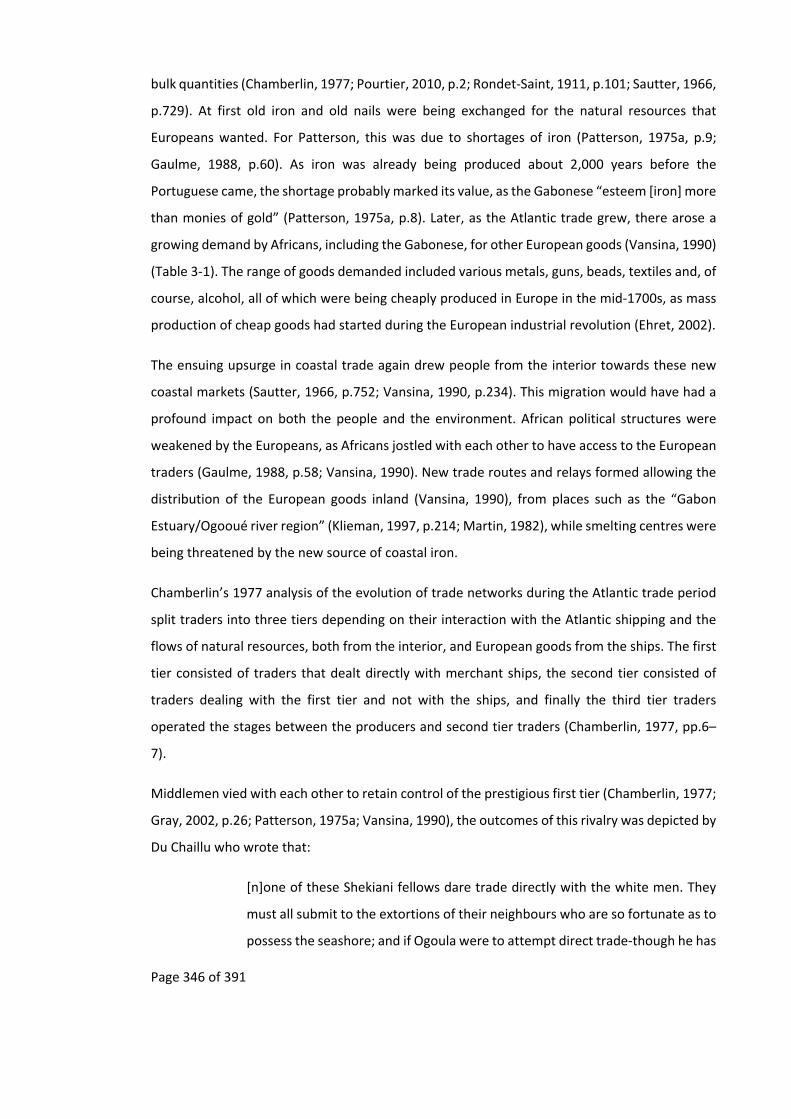
Page 346 of 391
bulk quantities (Chamberlin, 1977; Pourtier, 2010, p.2; Rondet‐Saint, 1911, p.101; Sautter, 1966,
p.729). At first old iron and old nails were being exchanged for the natural resources that
Europeans wanted. For Patterson, this was due to shortages of iron (Patterson, 1975a, p.9;
Gaulme, 1988, p.60). As iron was already being produced about 2,000 years before the
Portuguese came, the shortage probably marked its value, as the Gabonese “esteem [iron] more
than monies of gold” (Patterson, 1975a, p.8). Later, as the Atlantic trade grew, there arose a
growing demand by Africans, including the Gabonese, for other European goods (Vansina, 1990)
(Table 3‐1). The range of goods demanded included various metals, guns, beads, textiles and, of
course, alcohol, all of which were being cheaply produced in Europe in the mid‐1700s, as mass
production of cheap goods had started during the European industrial revolution (Ehret, 2002).
The ensuing upsurge in coastal trade again drew people from the interior towards these new
coastal markets (Sautter, 1966, p.752; Vansina, 1990, p.234). This migration would have had a
profound impact on both the people and the environment. African political structures were
weakened by the Europeans, as Africans jostled with each other to have access to the European
traders (Gaulme, 1988, p.58; Vansina, 1990). New trade routes and relays formed allowing the
distribution of the European goods inland (Vansina, 1990), from places such as the “Gabon
Estuary/Ogooué river region” (Klieman, 1997, p.214; Martin, 1982), while smelting centres were
being threatened by the new source of coastal iron.
Chamberlin’s 1977 analysis of the evolution of trade networks during the Atlantic trade period
split traders into three tiers depending on their interaction with the Atlantic shipping and the
flows of natural resources, both from the interior, and European goods from the ships. The first
tier consisted of traders that dealt directly with merchant ships, the second tier consisted of
traders dealing with the first tier and not with the ships, and finally the third tier traders
operated the stages between the producers and second tier traders (Chamberlin, 1977, pp.6–
7).
Middlemen vied with each other to retain control of the prestigious first tier (Chamberlin, 1977;
Gray, 2002, p.26; Patterson, 1975a; Vansina, 1990), the outcomes of this rivalry was depicted by
Du Chaillu who wrote that:
[n]one of these Shekiani fellows dare trade directly with the white men. They
must all submit to the extortions of their neighbours who are so fortunate as to
possess the seashore; and if Ogoula were to attempt direct trade‐though he has

Page 347 of 391
the finest chances‐his town would be burned down in a week. (du Chaillu, 1861,
p.132).
A living could be made not only by being a middleman, but also by servicing the trade route.
Fishermen were in direct contact with the commerce due to the then riverine nature of the trade
routes. They gave up their fishing day jobs to become porters. Others turned to commercial
fishing, hunting and agriculture to feed the traders and the porters, as well as to supply the
European ships for their journey back (Martin, 1972; Merlet, 1990; Patterson, 1975a; Vansina,
1990, p.211). This trade in foodstuffs included bushmeat (Merlet, 1990, p.21). In some cases
people inland were sending “their children to the coast to learn … boat building and iron
working” (Patterson, 1975a, p.27).
The competition between traders was not only among the Gabonese but also between the
Gabonese and the Europeans. The Gabonese living on the coast were “très‐jaloux des Européens
visitant l’intérieur"189 (Walker, 1870, p.61) and in certain case were doing “tout ce qu’il pouvait
[sic] pour empêcher les Blancs d’y arriver"190 (Walker, 1870, p.62) up the Remboué River that led
from the Gabon Estuary to the interior.
Not only were people moving to participate in the trade of natural resources but the competition
between ethnicities resulted in the modification of routes used to move goods. Trade was
sometimes halted at key points along the routes, such as riverine rapids, with onward passage
contingent on payment (Sautter, 1966, p.727; Walker, 1870, pp.71–72). To get around these
difficulties some traders would divert off the waterways onto land routes (Gray, 1998; Klieman,
1999; Vansina, 1990; Walker, 1870).
Over time Europeans gradually took over the different tiers from the Gabonese, until, during
colonisation, Europeans were setting up trade factories in remote areas to which producers
would directly bring goods that would then be shipped to Europe (Chamberlin, 1977). The
people who were excluded from the first tier and could not trade directly with Europeans on the
coast, suddenly found the Europeans in their villages with whom they could trade directly
(Sautter, 1966, p.731). In certain places in Gabon this still occurs, for example the Babongo
189 “very jealous of the Europeans visiting the interior” 190 “doing all that they could to hinder the Whites from getting there”

Page 348 of 391
Pygmies prefer to trade directly with white people, or other Bantu‐speaking populations, rather
than with their Bantu‐speaking neighbours (personal observation, Geschiere, 2009)
11.9.2 The impact of the Atlantic trade on the environment – premid‐fifteenth
centuryonwards
11.9.2.1 EnvironmentalimpactsoftheAtlantictradeandtraderoutes
Some of the direct effects on the environment of trade routes and their relays can still be seen
in the forests of Gabon as discernible lines or patches of trees. Much like elephants (Blake et al.,
2009), people also distribute seeds in the forest, either directly by planting seeds such as
breadfruit used to supply the slave trade and other traders with food (Vansina, 1990, p.211), or
indirectly through other human activity such as in the case of Moabi (Baillonella toxisperma,
Pierre) and Okoumé (Aucoumea klaineana Pierre).
An example of the indirect distribution of seeds is found with Moabi oil from the fruits of the
tree, which is used for cooking or as a cosmetic (Bowdich, 1819). There is generally a high
mortality and so low recruitment of these seedlings, as these fruits are much prized by both
people and animals (Forests Monitor Ltd, 2001, p.6). In areas where there is a lot of hunting,
such as along trade routes and around villages, animal populations are reduced allowing the
Moabi seedlings to survive (personal communication M. Starkey, Wilks, 2003, p. 26).
A second example relates to the distribution of Okoumé in the Gabonese forest. There is a
growing body of evidence that indicates that this distribution is determined by past
anthropogenic activity (Biraud, 1959; Delègue et al., 2001; Gaulme, 1988). As a light loving trees
that grow quickly in clearings larger than a quarter of a hectare (Biraud, 1959, p.8), Okoumé
seedlings do not survive well in the shady environment of a mature forest (Biraud, 1959, p.4;
Delègue et al., 2001). Clumps of Okoumé trees in mature forest therefore indicate places where
there have been past clearings due to human activity. The rural to urban migration in Gabon, as
described in Chapter 1, has resulted in a reduction in anthropogenic disturbance to the forest
and a reduction of Okoumé regeneration (Engone Obiang et al., 2014; Wunder, 2003).
The environmental disturbance resulting from trade routes was explored by Chamberlin (1977).
Using archival data, Chamberlin explored the consequences of natural resources exhaustion
along the trade routes, as well as conflict that resulted from the traders who vied to improve
“their low or falling profits” (Chamberlin, 1977, p.viii). After the 1850s this became increasingly

Page 349 of 391
important with the first factories set up to store natural resources that could then be shipped to
Europe, resulting in the rise of bulk exports (Chamberlin, 1977, pp.81, 86).
As with logging, the exploitation of these forest natural resources started off near waterways
with exploiters slowly moving further inland as areas nearby waterways became exhausted
(Chamberlin, 1977, pp.93, 101; Sautter, 1966, p.731). In the 1870s the “lower reaches of the
Como, Bokoué, and Remboué were reported to be near exhaustion” (Chamberlin, 1977, p.101)
with “dyewood, ebony and rubber” (Chamberlin, 1977, p.104) coming from areas far from
waterways and then outside the Gabon Estuary (Chamberlin, 1977, p.110). The collapse of
natural resources in the Gabon Estuary, in the mid‐1890s, resulted in an exodus of traders to the
Ogooué River and Ngounié River (Chamberlin, 1977, p.112), where the same process resulted in
natural resources exhaustion along the Ogooué River starting in 1880s (Chamberlin, 1977,
p.190) and for the Ngounié River in the 1870s (Chamberlin, 1977, p.239).
Rather than going into the details of the environmental impact of each of these traded products,
two components which would have profoundly marked the landscape will be briefly examined.
These are: the salt trade and the trade in ivory.
11.9.2.2 EnvironmentalimpactsoftheSaltTrade
The early trade in salt would have had a major environmental impact on the coastal forest. Salt
was extremely important for the people in the interior of Gabon. Nassu (1914) used salt to
purchase food from local people, for whom salt was “worth almost its weight in gold” (Nassu,
1914, p.72; Bowdich, 1819, p.427; Sautter, 1966, p.726).
In the interior, potash was used as a substitute for salt, made by reducing the ashes of the sun‐
dried “skins of ripe plantains and bananas” (Nassu, 1914, p.71), this technique is still sometimes
used as an alternative to salt (Raponda‐Walker and Sillans, 2003, personal observation, Batéké
plateaux). However the majority of salt was produced along the coast from ocean water (Nassu,
1914), this occurred in places such as Cap Santa Clara (Patterson, 1975a, p.59) and Loango
(Martin, 1972, p.14). It was produced in “imported large brass pans called ‘neptunes’” (Nassu,
1914, p.72) as depicted in this 1600s description of salt production along the Loango coast,
where the:
traditional process involved the evaporation of sea‐water over a fire. The
beaches were dotted with rough sheds where the salt‐making took place.
Inside, stoves made of clay or the stuff of termite mounds were set up with the

Page 350 of 391
fire kindled inside. Fuel was pushed through the holes in the sides of the stoves.
On top of each was a hole, on which was placed a brass or copper pot containing
sea‐water. This was boiled until only the salt remained. Sometimes the
operation was a family affair; the children helped to collect the sea‐water and
firewood. … These worked at the salt preparation for two or three weeks, until
enough had been collected to fill the baskets which they themselves carried to
inland markets. Others then took their place at the salt‐works. (Martin, 1972, p.
14, my emphasis).
Though the above description does not mention the impact of salt making on the environment,
it does mention the natural resources needed in the process (the bold emphasis in the above
quote), and it corresponds to impacts on the coastal forest area that Delègue et al. found to be
“not only linked to palaeoclimatic history but also results from recent disturbances of
anthropogenic origin” (Delègue et al., 2001, p.112)191. Though it should be highlighted that how
far inland people went to collect fuel wood is unknown, while the impacts of coastal erosion and
deposition, which are different for different parts of Gabon, also needs to be taken into account.
This production of salt may have slowed down the advance of the forest into savannah areas
such as in Mayumba, and promoted the growth of the economically valuable Okoumé trees
(Delègue et al., 2001), such as in the Mondah forest around Cap Santa Clara (Lasserre, 1955).
Coastal Okoumé trees that would later be exploited by the first wave of loggers (Delègue et al.,
2001; Gaulme, 1988, p.117), in what is called today the “first zone” (Christy et al., 2003; Nguimbi
et al., 2006).
11.9.2.3 Environmentalimpactsofthetradeinivory
Recent research on forest elephants decline has given rise to the fear that the “[l]oss of keystone
species like elephants impacts the integrity of ecosystems and their services … [including the]
long‐term viability of the second most important carbon capture forests in the world ” (Wasser
et al., 2010, p.1331) due to a “potential for a major wave of tree recruitment failure” (Blake et
al., 2009, p.466). In Gabon this has resulted in military intervention to protect elephants for:
191 This history may have important implications for the various forest plots that are being used today to understand forest dynamics, regeneration and carbon sequestration (Dauby, 2012; Lewis, Lloyd, et al., 2009; Lewis, Lopez‐Gonzalez, et al., 2009).

Page 351 of 391
[i]f we lose our elephants we will enter the same spiral that has seen wildlife
and natural resources plundered elsewhere in Africa, with the inevitable
consequence of political instability and conflict in dysfunctional ecosystems
where man can no longer live sustainably in harmony with nature. Today I have
undertaken to create an elite military unit that will be signed into law this
month, which will support our National Parks Agency in their critical work to
manage Gabon’s natural treasures (Presidential press release: Parcs Gabon,
2011).
With this growing concern for elephant populations in Gabon it is useful to put the current ivory
offtake into historical perspective. Historical documents on the ivory trade can give an indication
of what could occur if the demand for ivory reduces, especially in a country such as Gabon where
the rural population is low. The trade of ivory has been well documented before, after, and
throughout the Atlantic trade (Barnes, 1996; Douglas‐Hamilton, 1979).
European traders found that Gabon’s ivory was of the highest quality (due to the density of
forest elephant ivory, which takes longer to grow), and “un des plus beaux de la côte"192 (Bouët‐
Willaumez 1850 in Sautter, 1966, p.729; Stanley, 1885, p.369; White, 1890). As this ivory was
highly prized there are several accounts that mention where ivory could be found (Battell, 1901;
Bosman, 1907; de Brazza, 1887; Dapper, 1686). Due to ivory being transported by slaves the
historical literature concerning the slave trade also contains information on the ivory trade
(Martin, 1972; Merlet, 1990; Patterson, 1975a; Vansina, 1990; White, 1890).
Ivory was used by the Europeans to make furniture, games, weapons, teeth and musical
instruments. Historical studies such as Martin’s 1972 “The External Trade of the Loango Coast
1576‐1870”, Patterson’s 1975 “The Northern Gabon Coast to 1875” and Merlet’s 1990 “Le pays
des trois estuaires"193 are full of references to the ivory trade, including the amounts being
traded and guesstimates of the number of elephants this represented.
In the Gabon Estuary Bosman saw large herds of elephants in 1698 where “feveral Elephants
being daily killed in the faid Place; and the wilder and lefs inhabited the Lands are, the larger
Quantity of Elephants and wild Beafts are found” (sic Bosman, 1907, p.243, first printed in 1705).
192 “one of the finest of the coast” 193 “The county of the three estuaries”

Page 352 of 391
Other writings in the 1600s also mention that there were large herds inhabiting “the south shore
of the Gabon [estuary]” with good supply of ivory also at Cap Lopéz (Patterson, 1975a, p.13).
Along the Gabonese coast “Elephant’s Teeth, of which this Country produces a great Quantity”
(Bosman, 1907, p.399), were soon to disappear. While the trade for ivory may have been
sustainable when it was only supplying local demand, the arrival of the Portuguese and the
Dutch who supplied ivory to the European market, resulted in elephants becoming locally extinct
(Martin, 1982, p.207). Mayumba, on the southern coast of Gabon, is an example of the local
extinction of elephants. Ivory was readily available in this area during the early 1600s. In 1611,
after two years of trading, a ship came back from the Mayumba, Loango and Kongo coast (Map
11‐1) with 33 tonnes of ivory (Merlet, 1990, p.23). Yet by the mid‐1600s the supply of ivory from
around Mayumba, Sette‐Cama and Mayombe was poor with ivory caravans having to go to the
markets at Stanley Pool as well as the Bukkameale, “also known as, the Mountains of Ivory,”
(Martin, 1982, p.208), probably in the southern part of the Du Chaillu Massif (Martin, 1982,
p.204; Martin, 1972, pp.17, 41), a walk of a month and a half, where ivory was exchanged for
salt from the coast (Martin, 1982).
By the early 1800s elephants also become locally extinct in the Gabon Estuary with “[e]lephant
herds visited the Estuary less and less” (Chamberlin, 1977, p.101). Walker, in 1866, went up the
Remboué River, one of the rivers entering the Gabon Estuary, and observed that after a week
walking away from Libreville, “les trappes à l’éléphant devinrent très‐nombreuse sans que nous
vissions [sic] cependant un seul animaux [sic]”194 (Walker, 1870, p.64). At the same time the Fang
had to go far to find ivory to supply the Mpongwe (Chamberlin, 1977, p.104; Gaulme, 1991, p.84;
Patterson, 1975a, p.59) who then sold it to the Europeans.
194 “the elephant traps became numerous, even though we did not see one single animal”

Page 353 of 391
Map 11‐1: Location of Dutch trade factories in Mayumba and Loango (Blue boxes) where Ivory (“Teeth” on the map) and Slaves (“Negers” on the map) were exported, circa 1685 (based on Thornton et al., 1707, p.142).
N

Page 354 of 391
In the late nineteenth century and early twentieth century Gabonese ivory was being sold in
various European markets by a number of companies. By the twentieth century the French, by
then the colonial power in Gabon had not started “a century of exploiting timber, ivory,
crocodiles, and other wildlife” (Fay, 2004b, p.108), for they were not interested in trade, but
rather colonial expansion and administration, only becoming interested in trade when they saw
other countries benefiting from their colony (Rich, 2007a). Ivory trade was dominated by others
including the British company Hatton and Cookson, a Liverpool based company who had a
monopoly over ivory exports from the Gabon Estuary (Chamberlin, 1977, p.123; de Compeigne,
1876, p.226; Neuville and Ch. Breard, 1884, p.131), and the German company Francis Würmer
and Company (de Compeigne, 1876, p.226), the Germans also dominated the timber industry
until the First World War.
These current predictions of forest elephant population extinction are not new. In 1850 Bouët‐
Willaumez remarked that ivory was becoming “de jour en jour plus rare”195 (Bouët‐Willaumez in
Sautter, 1966, p. 729), while Stanley in 1885 calculated that “[i]f 200 tusks arrived per week at
Stanley Pool, or say £260,000 per annum, it would still require twenty‐five years to destroy the
elephant in the Congo basin” (Stanley, 1885, p.356). By 1890 “L'ivoire a presque disparu des
régions de l'Afrique actuellement accessibles”196 (Ratoin, 1890, p.176), much as it had during the
seventeenth century. In 1904 the least pessimistic estimation on the disappearance of elephants
in the Congo Basin was thirty to forty years. In 1903, 1,054 elephants were killed in the French
Congo197 (Rouget, 1906, p.862) while market data from London, Anvers and Liverpool, showed
that there was an annual sale of 650 tonnes of ivory representing a destruction of 20,000 to
30,000 elephants a year (Cuvillier‐Fleury, 1904, p.42; Rondet‐Saint, 1911, pp.89, 93; Rouget,
1906, p.804), to supply a worldwide demand of 700 tonnes, with 600 tonnes coming from Africa
(Rouget, 1906, p.792). This was not considered to be sustainable (Cousin, 1901; Périquet and
Audoin, 1913; Rouget, 1906, p.792). For these reasons a 1900 international meeting, in London,
on the protection of animals had elephants on its list of animals to be protected (Rouget, 1906,
p.809) and in of 1904, it became illegal to trade or exploit ivory in the French Congo that was
less than two kilograms (Rouget, 1906, p.794). This unsustainability encouraged the
administration to help in the domestication of elephants that had started in the 1890s, primarily
195 “becoming rarer day by day” 196 “ivory has nearly disappeared from the regions of Africa that are currently accessible” 197 On the basis that it takes 60 elephants for one tonne of ivory (Rouget, 1906, p.862).

Page 355 of 391
to be used to replace human labour but also for their ivory (Cuvillier‐Fleury, 1904, pp.41–44;
Huffmann, 1931; Parc National de la Garamba, 2013).
Picture 11‐1 : Domestication of elephants in the Belgian Congo (Parc National de la Garamba, 2013)
The accuracy of the offtake data for ivory from Gabon can be debated (Douglas‐Hamilton, 1979;
Milner‐Gulland and Beddington, 1993; Rondet‐Saint, 1911, p.100), as well as the geographical
area which is represented by “Gabon” at the time, as this changed substantially during the
nineteenth and twentieth century (Aicardi de Saint‐Paul, 1987, pp.28–29). However, these
figures, do confirm that large quantities of ivory were being exported from Gabon during the
mid to late nineteenth century, and that these started to drop off during the early twentieth
century (Figure 11‐1). The disappearance of elephants, in these areas, would have changed the
tree composition of the forest due to the role that forest elephants play in the distribution of
seeds (Blake et al., 2009). It would also have changed the forest structure, with elephant trails
becoming overgrown and disappearing (Fay, 2004a).
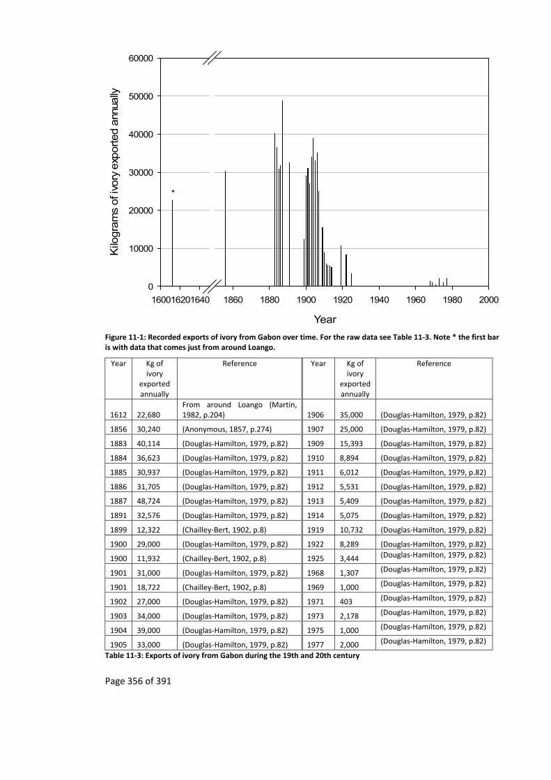
Page 356 of 391
Year
160016201640 1860 1880 1900 1920 1940 1960 1980 2000
Kilo
gra
ms
of i
vory
exp
orted a
nnua
lly
0
10000
20000
30000
40000
50000
60000
*
Figure 11‐1: Recorded exports of ivory from Gabon over time. For the raw data see Table 11‐3. Note * the first bar is with data that comes just from around Loango.
Year Kg of ivory
exported annually
Reference Year Kg of ivory
exported annually
Reference
1612 22,680 From around Loango (Martin, 1982, p.204) 1906 35,000 (Douglas‐Hamilton, 1979, p.82)
1856 30,240 (Anonymous, 1857, p.274) 1907 25,000 (Douglas‐Hamilton, 1979, p.82)
1883 40,114 (Douglas‐Hamilton, 1979, p.82) 1909 15,393 (Douglas‐Hamilton, 1979, p.82)
1884 36,623 (Douglas‐Hamilton, 1979, p.82) 1910 8,894 (Douglas‐Hamilton, 1979, p.82)
1885 30,937 (Douglas‐Hamilton, 1979, p.82) 1911 6,012 (Douglas‐Hamilton, 1979, p.82)
1886 31,705 (Douglas‐Hamilton, 1979, p.82) 1912 5,531 (Douglas‐Hamilton, 1979, p.82)
1887 48,724 (Douglas‐Hamilton, 1979, p.82) 1913 5,409 (Douglas‐Hamilton, 1979, p.82)
1891 32,576 (Douglas‐Hamilton, 1979, p.82) 1914 5,075 (Douglas‐Hamilton, 1979, p.82)
1899 12,322 (Chailley‐Bert, 1902, p.8) 1919 10,732 (Douglas‐Hamilton, 1979, p.82)
1900 29,000 (Douglas‐Hamilton, 1979, p.82) 1922 8,289 (Douglas‐Hamilton, 1979, p.82)
1900 11,932 (Chailley‐Bert, 1902, p.8) 1925 3,444 (Douglas‐Hamilton, 1979, p.82)
1901 31,000 (Douglas‐Hamilton, 1979, p.82) 1968 1,307 (Douglas‐Hamilton, 1979, p.82)
1901 18,722 (Chailley‐Bert, 1902, p.8) 1969 1,000 (Douglas‐Hamilton, 1979, p.82)
1902 27,000 (Douglas‐Hamilton, 1979, p.82) 1971 403 (Douglas‐Hamilton, 1979, p.82)
1903 34,000 (Douglas‐Hamilton, 1979, p.82) 1973 2,178 (Douglas‐Hamilton, 1979, p.82)
1904 39,000 (Douglas‐Hamilton, 1979, p.82) 1975 1,000 (Douglas‐Hamilton, 1979, p.82)
1905 33,000 (Douglas‐Hamilton, 1979, p.82) 1977 2,000 (Douglas‐Hamilton, 1979, p.82)
Table 11‐3: Exports of ivory from Gabon during the 19th and 20th century

Page 357 of 391
Milner‐Gulland and Beddington suggest that “[t]wo major factors are likely to have caused
recent elephant population declines: carrying capacity reductions and hunting for ivory” (Milner‐
Gulland and Beddington, 1993, p.29), with “carrying capacity” 198 changing due to habitat
change. In Gabon, the hunting of elephants has decreased compared to historic highs (Figure
11‐1), though in the last decade or so it may once again be on the increase. During this period
of time, as discussed in Chapter 3, there has also been an increase in elephant habitat, and this
“carrying capacity”, as a result of human rural depopulation caused by the famines and diseases
of the early twentieth century (Rich, 2007a) as well as the latter migration of people from the
forest interior both towards roads and urban centres (Sautter, 1966).
The abandonment of rural forest villages would have left behind old plantations and fruit crops
which are much loved by elephants (Barnes et al., 1991) “attracted to habitats that have been
used by people in the recent past” (Walker, 2010, p.71). In some parts of Gabon this would have
been occurring at a time before logging roads and the associated hunting were spreading and
before their related impact on elephant populations (Blake et al., 2008).
Though crop plantations would have been quickly overrun by the forest, the fruit trees would
have lasted for decades. These old plantations may still have been attractive to elephants and,
as elephants prefer to stay away from occupied villages, the existence of these old plantations
could have resulted in fewer crop raids by elephants in the occupied road side villages, so
reducing human‐wildlife conflict.
Over 50 to 80 years these old village sites and their fruit trees would be consumed by the forest
(Lasserre, 1955). When this occurred roadside villages could have once more become attractive
to elephants and so human‐elephant conflict could have increased (Walker, 2012; Walker,
2010). Unfortunately no study has yet looked at changes in perceived elephant populations and
human‐wildlife conflict by villagers. With all the methodological problems that it entails, the
elders, in the study sites used in this thesis, recount that they do remember fewer elephants
around their villages when they were young; a similar finding was reported by Walters (personal
communication 2010, Batéké plateaux).
198 Whether the theory of “carrying capacity” can be applied to the whole of Africa is debatable, see (Behnke et al., 1993)

Page 358 of 391
This is not to say that elephant populations in Gabon are not currently declining or threatened,
rather, in Gabon, this may not be solely due to hunting for ivory, since ivory export have not
reached the proportions of the late 1800s and early 1900s. It could be that the elephant
population were hit so badly during this time that they have never recovered, and now cannot
do so, however genetic studies in East Africa have shown that elephant populations have
“rebounded” several times in the last century, even after they had been hunted for over two
centuries, for example in Tanzania in 1933 (Bryceson, 1987, p.164) and then once again after
the elephant hunting peak that occurred in between the 1970‐1980s (Okello et al., 2008,
p.3788), while the largest loss of elephants occurred 2500 BP during the mid‐Holocene (Okello
et al., 2008), the same has occurred in South Africa where elephants were nearly wiped out by
the early 1900s (Hall‐Martin, 1980).
The historic literature of Gabon also indicate a recovery of elephant populations as long as there
is a viable source population (Okello et al., 2008). Elephants can today be found in areas where
they became locally extinct in the seventeenth century, in the 1950’s elephants were
“abondant” (Lasserre, 1955, p.121) in the coastal savannas of the Gabon Estuary and the
Mayumba coast, even today elephants can be seen “strolling the beach” (Fay, 2004a), with a
population of “a few thousand elephants in and around Loango today” (Fay, 2004a).
It must be emphasised that the above has to be taken and understood within the current context
of Gabon, with its unique situation in Africa of having a low human population that is mostly
urban as well as a high GDP. It cannot and must not be taken out of this context and applied to
other African countries, where the situation is very different (Beaune et al., 2013; Maisels et al.,
2013), though elephant recovery has been recorded in other parts of Africa (Okello et al., 2008).
The above should also only be used as an indicator of the future survival of elephants in Gabon
if current poaching levels do not increase and land intensive commercial agriculture, including
palm oil does not occur. Though intensive commercial agriculture is not occurring in Gabon
(Megevand and World Bank, 2013, pp.68–72) there has been a move to create oil palm
plantations in areas that have already been degraded. Palm oil is used in many products such as
cosmetics and food, in the last decade there has been a growing demand for palm oil, especially
as an alternative to oil from soybean in the food industry (Sanders et al., 2012). Oil palm
plantations could threaten elephant populations, especially as forest elephants prefer
secondary forests (Barnes, 1996; Barnes et al., 1991). However, it is too early to say if this
industry is going to grow in Gabon, especially in light of the growing international attention to
Page 359 of 391
the link between deforestation and palm oil plantations that has resulted in some plantations in
Africa closing down (Greenpeace International, 2013; Hoyle and Levang, 2012) while major
industrial players that utilise palm oil (e.g. Nestle, Unilever, Shell) are looking into ways to reduce
and stop the use of oil palm oil in their products (Fry, 2011) due to consumer concerns (Disdier
et al., 2013).
Currently there is little data on elephants in Gabon, whether on the current population of
elephants (Barnes et al., 1995; Maisels et al., 2013; Milner‐Gulland and Mace, 1991), the amount
of illegal ivory exported or the current number of elephants being killed through poaching.
However, one estimate of elephant decline in a national park in Gabon has been of over 1,000
elephants being killed per year, though there were special circumstances and this may not be
representative of other parks in Gabon (Agence Nationale des Parcs Nationaux, 2013; Fay, 2012;
Maisels et al., 2013). In comparison the offtake seen in the late 1880s and early 1900s peaked
at around 2,305 to 6,620 elephants killed per year199. Currently elephant poaching is in the boom
part of the cycle (Spinage, 1973) with demand currently being driven from China while in the
1970s and 1980s it was driven by Japan (Parker and Martin, 2009).
Historical trends in Gabon can give an indication of what could occur under the right conditions
and if the right land management put in place. The current ivory demand from China adds
further weight to the recent creation of the National Park network in Gabon and the need for
this to be managed correctly, with modern law enforcement tools used to pinpoint poaching
areas (e.g. Uno et al., 2013; Wasser et al., 2010; WCS, 2013). If this is carried out elephant
population could once more expand in Gabon. Understanding these past recoveries of elephant
populations is both essential for the conservation of elephants and other animals as well as the
conservation of forest landscapes due to the role that forest elephants play in the distribution
of seeds (Blake et al., 2009) as well as being the conservation “focal species for other large
mammals” (Epps et al., 2011, p.603).
199 This depends on the weight of elephant tusks. On the basis of 48,724 kg of legally recorded ivory exported at the peak of the trade in 1887 (Douglas‐Hamilton, 1979, p.82). The lower number comes from an average tusk weight of 11.74kg (Milner‐Gulland and Mace, 1991, p.217), with 1.8 tusks per individual and the second using the CITES estimation “of 6.6 kg ivory/elephant, 1.8 tusks per individual, and tusk weight of 3.68 kg” (Wasser et al., 2008, p.1070).
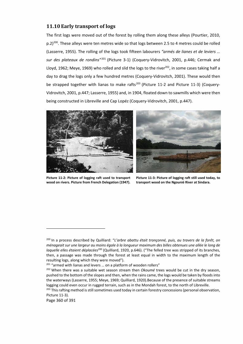
Page 360 of 391
11.10 Earlytransportoflogs
The first logs were moved out of the forest by rolling them along these alleys (Pourtier, 2010,
p.2)200. These alleys were ten metres wide so that logs between 2.5 to 4 metres could be rolled
(Lasserre, 1955). The rolling of the logs took fifteen labourers “armés de lianes et de leviers …
sur des plateaux de rondins”201 (Picture 3‐1) (Coquery‐Vidrovitch, 2001, p.446; Cermak and
Lloyd, 1962; Meye, 1969) who rolled and slid the logs to the river202, in some cases taking half a
day to drag the logs only a few hundred metres (Coquery‐Vidrovitch, 2001). These would then
be strapped together with lianas to make rafts203 (Picture 11‐2 and Picture 11‐3) (Coquery‐
Vidrovitch, 2001, p.447; Lasserre, 1955) and, in 1904, floated down to sawmills which were then
being constructed in Libreville and Cap Lopéz (Coquery‐Vidrovitch, 2001, p.447).
Picture 11‐2: Picture of logging raft used to transport wood on rivers. Picture from French Delegation (1947).
200 In a process described by Quilliard: “L’arbre abattu était tronçonné, puis, au travers de la forêt, on ménageait sur une largeur au moins égale à la longueur maximum des billes obtenues une allée le long de laquelle elles étaient déplacées200 (Quilliard, 1920, p.646). (“The felled tree was stripped of its branches, then, a passage was made through the forest at least equal in width to the maximum length of the resulting logs, along which they were moved”). 201 “armed with lianas and levers … on a platform of wooden rollers” 202 When there was a suitable wet season stream then Okoumé trees would be cut in the dry season, pushed to the bottom of the slopes and then, when the rains came, the logs would be taken by floods into the waterways (Lasserre, 1955; Meye, 1969; Quilliard, 1920).Because of the presence of suitable streams logging could even occur in rugged terrain, such as in the Mondah forest, to the north of Libreville. 203 This rafting method is still sometimes used today in certain forestry concessions (personal observation, Picture 11‐3).
Picture 11‐3: Picture of logging raft still used today, to transport wood on the Ngounié River at Sindara.

Page 361 of 391
11.11 Thestackeddeck:thedemiseofindigenousAfricanlogging
The rise of industrial timber companies came at the expense of the older system of trading
timber. The new European timber companies were helped by the colonial administration who
“stacked the deck” (Rich, 2005, p.151) against Gabonese and other African loggers. To increase
the revenue from logging, the French administration, in 1919, put in place a permit system, with
permits to be obtained for each Okoumé cut within a concession. For Europeans these
concessions were between 5,000 to 10,000 ha while for Africans they were 100 to 500 ha (Jaffré,
2003a, p.203; Rich, 2005, p.153). Two years later African loggers were further charged 2,500
francs to renew their permits (Rich, 2005, p.158), while village logging, that until then had not
required permits or fees, was no longer allowed. Banning local people from exploiting the forest
was seen as a way to stop local people from their assumed tendency to “saccager la forêt”204
(Angoulvant in Coquery‐Vidrovitch, 2001, p. 455). Laws continued to change. Though some were
relaxed to the benefit of local people, most were to the advantage of the French205.
Head taxes further advantaged the European timber companies, through these Gabonese were
forced to find paid work (Rich, 2005). Though it could also be raised by carrying out various
activities such as the collection of rubber and other natural resources (Pourtier, 2010, p.2), it
was most easily payable by working for a timber company (Coquery‐Vidrovitch, 2001, p.458)206.
Slowly the independent African timber companies were pushed out of the timber industry. Only
Africans who were literate and had worked in the colonial administration were able to find ways
to continue logging (Rich, 2005). By 1933, many of these went out of business either due to
bankruptcy during the Great Depression, because their concession had run out of Okoumé (Rich,
2005, p.165) or because they could not keep up with the costly mechanisation of the timber
industry (Lasserre, 1955). As the independent African timber companies lost their businesses so
204 “pillage the forest” 205 Between 1926 to 1928 the forestry laws were once again modified to allow local people without means to log 1,000 ha for five years while European, and some Africans with a 2,500 franc deposit, were allowed permits to exploit 2,500 ha forest concession. These needed to be renewed annually and could be done so for up to ten times as long as a minimum of 500 to 750 tonnes were exported annually (Coquery‐Vidrovitch, 2001, pp.452–453; Jaffré, 2003a, p.203). At this time a third type of permit was given only to French individuals or companies which consisted of “un ou deux lots de 5 à 10 000 ha (30 000 ha en 1927)”205 (Coquery‐Vidrovitch, 2001, p.453), these large concessions could last up to twenty‐five years and could be renewed, provided the export quotas were respected (Lasserre, 1955). These concession could be extended by another 10,000 ha (later 30,000) if a Decauville rail system was installed in the concession (Coquery‐Vidrovitch, 2001, p.453). 206 In some cases the colonial administration allotted labour to European timber companies, allotments that were rarely offered to African timber companies.
Page 362 of 391
they and their employees began to work for the European timber companies (Coquery‐
Vidrovitch, 2001, p.455).
Access to capital allowed European timber companies to obtain logging equipment either
through monetary advances or advances of the equipment itself207. The access to capital was
fought over by large timber companies at the expense of small European operations (Lasserre,
1955), with the result of the development of larger timber companies (Bouet, 1974). In this way
the European timber companies left behind the villages that they had once helped to develop,
including the villages that had grown up around them (Meye, 1969, p.58; Rich, 2005, p.163) and
penetrate deeper into the forest.
207 Advances that were coming from other timber companies (Coquery‐Vidrovitch, 2001, p.452), the colonial administration or later the French government (Labrousse and Verschave, 2002, p.24).

Page 363 of 391
11.12 AnnualexportsofOkouméfromGabon.
Date Cubic metre Reference with page number Date Cubic metre Reference with page number Date Cubic metre Reference with page number
1896 3,375 (Quilliard, 1920, p.646) 1926 430,337 (Fournols, 1958, p.66) 1953 537,410 (Lasserre, 1955, p.161)
1898 4,870 (Jaffré, 2003b, p.263) 1927 516,101 (Sautter, 1966, p.762; Lasserre, 1955, p.161)
1953 624,411 (Fournols, 1958, p.66)
1900 12,981 (Hilling, 1963, p.157) 1927 516,405 (Fournols, 1958, p.66) 1954 767,857 (Fournols, 1958, p.66)
1902 8,438 (Coquery‐Vidrovitch, 2001, p.442)
1927 518,092 (Coquery‐Vidrovitch, 2001, p.454)
1955 778,890 (Hilling, 1963, p.157)
1902 8,914 (Jaffré, 2003b, p.263; Lasserre, 1955, p.161)
1928 602,472 (Coquery‐Vidrovitch, 2001, p.454; Fournols, 1958, p.66)
1955 951,805 (Fournols, 1958, p.66)
1902 168,760 (Quilliard, 1920, p.646; Sautter, 1966, p.762)
1928 603,390 (Lasserre, 1955, p.161) 1956 853,924 (Fournols, 1958, p.66)
1903 15,009 (Lasserre, 1955, p.161; Sautter, 1966, p.762)
1929 455,651 (Fournols, 1958, p.66) 1957 1,046,310 (Fournols, 1958, p.66)
1904 9,064 (Lasserre, 1955, p.161; Sautter, 1966, p.762)
1929 498,444 (Lasserre, 1955, p.161) 1959 968,681 (Sautter, 1966, p.803)
1905 11,393 (Sautter, 1966, p.762) 1930 644,281 (Lasserre, 1955, p.161) 1960 1,059,811 (Sautter, 1966, p.803)
1905 11,536 (Jaffré, 2003b, p.263) 1930 642,974 (Coquery‐Vidrovitch, 2001, p.442; Fournols, 1958, p.66)
1960 1,096,938 (Hilling, 1963, p.157)
1905 11,536 (Périquet and Audoin, 1913, p.31)
1930 644,281 (Sautter, 1966, p.768) 1961 1,243,759 (Sautter, 1966, p.803)
1905 13,081 (Lasserre, 1955, p.161) 1930 675,039 (Gaulme, 1988, p.119; Rich, 2007a, p.154)
1961 1,275,000 (Wunder, 2005, p.71)
1905 13,501 (Coquery‐Vidrovitch, 2001, p.442)
1930 636,094 (Hilling, 1963, p.157) 1962 1,150,000 (Wunder, 2005, p.71)
1905 38,945 (Hilling, 1963, p.157) 1931 378,661 (Lasserre, 1955, p.161; Sautter, 1966, p.762)
1962 1,179,630 (Sautter, 1966, p.803)
1906 9,236 (Périquet and Audoin, 1913, p.31)
1931 379,709 (Fournols, 1958, p.66) 1963 1,250,000 (Wunder, 2005, p.71)
1906 40,939 (Lasserre, 1955, p.161; Sautter, 1966, p.762)
1932 420,212 (Fournols, 1958, p.66) 1964 1,350,000 (Wunder, 2005, p.71)
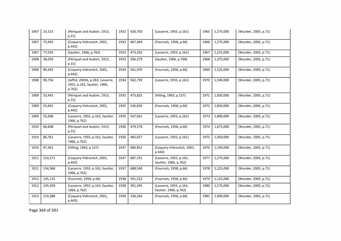
Page 364 of 391
1907 23,515 (Périquet and Audoin, 1913, p.31)
1932 420,703 (Lasserre, 1955, p.161) 1965 1,275,000 (Wunder, 2005, p.71)
1907 75,942 (Coquery‐Vidrovitch, 2001, p.442)
1933 467,464 (Fournols, 1958, p.66) 1966 1,275,000 (Wunder, 2005, p.71)
1907 77,035 (Sautter, 1966, p.762) 1933 473,202 (Lasserre, 1955, p.161) 1967 1,225,000 (Wunder, 2005, p.71)
1908 38,059 (Périquet and Audoin, 1913, p.31)
1933 506,279 (Sautter, 1966, p.768) 1968 1,375,000 (Wunder, 2005, p.71)
1908 89,443 (Coquery‐Vidrovitch, 2001, p.442)
1934 561,970 (Fournols, 1958, p.66) 1969 1,525,000 (Wunder, 2005, p.71)
1908 90,756 (Jaffré, 2003b, p.263; Lasserre, 1955, p.161; Sautter, 1966, p.762)
1934 562,739 (Lasserre, 1955, p.161) 1970 1,500,000 (Wunder, 2005, p.71)
1909 53,443 (Périquet and Audoin, 1913, p.31)
1935 473,825 (Hilling, 1963, p.157) 1971 1,650,000 (Wunder, 2005, p.71)
1909 55,691 (Coquery‐Vidrovitch, 2001, p.442)
1935 536,656 (Fournols, 1958, p.66) 1972 1,850,000 (Wunder, 2005, p.71)
1909 55,696 (Lasserre, 1955, p.161; Sautter, 1966, p.762)
1935 547,661 (Lasserre, 1955, p.161) 1973 1,800,000 (Wunder, 2005, p.71)
1910 66,608 (Périquet and Audoin, 1913, p.31)
1936 479,278 (Fournols, 1958, p.66) 1974 1,675,000 (Wunder, 2005, p.71)
1910 86,761 (Lasserre, 1955, p.161; Sautter, 1966, p.762)
1936 485,027 (Lasserre, 1955, p.161) 1975 1,050,000 (Wunder, 2005, p.71)
1910 97,361 (Hilling, 1963, p.157) 1937 686,852 (Coquery‐Vidrovitch, 2001, p.444)
1976 1,100,000 (Wunder, 2005, p.71)
1911 153,571 (Coquery‐Vidrovitch, 2001, p.442)
1937 687,191 (Lasserre, 1955, p.161; Sautter, 1966, p.762)
1977 1,275,000 (Wunder, 2005, p.71)
1911 154,368 (Lasserre, 1955, p.161; Sautter, 1966, p.762)
1937 688,540 (Fournols, 1958, p.66) 1978 1,225,000 (Wunder, 2005, p.71)
1912 145,133 (Fournols, 1958, p.66) 1938 391,522 (Fournols, 1958, p.66) 1979 1,125,000 (Wunder, 2005, p.71)
1912 145,459 (Lasserre, 1955, p.161; Sautter, 1966, p.762)
1938 391,595 (Lasserre, 1955, p.161; Sautter, 1966, p.762)
1980 1,175,000 (Wunder, 2005, p.71)
1913 219,388 (Coquery‐Vidrovitch, 2001, p.443)
1939 236,264 (Fournols, 1958, p.66) 1981 1,000,000 (Wunder, 2005, p.71)
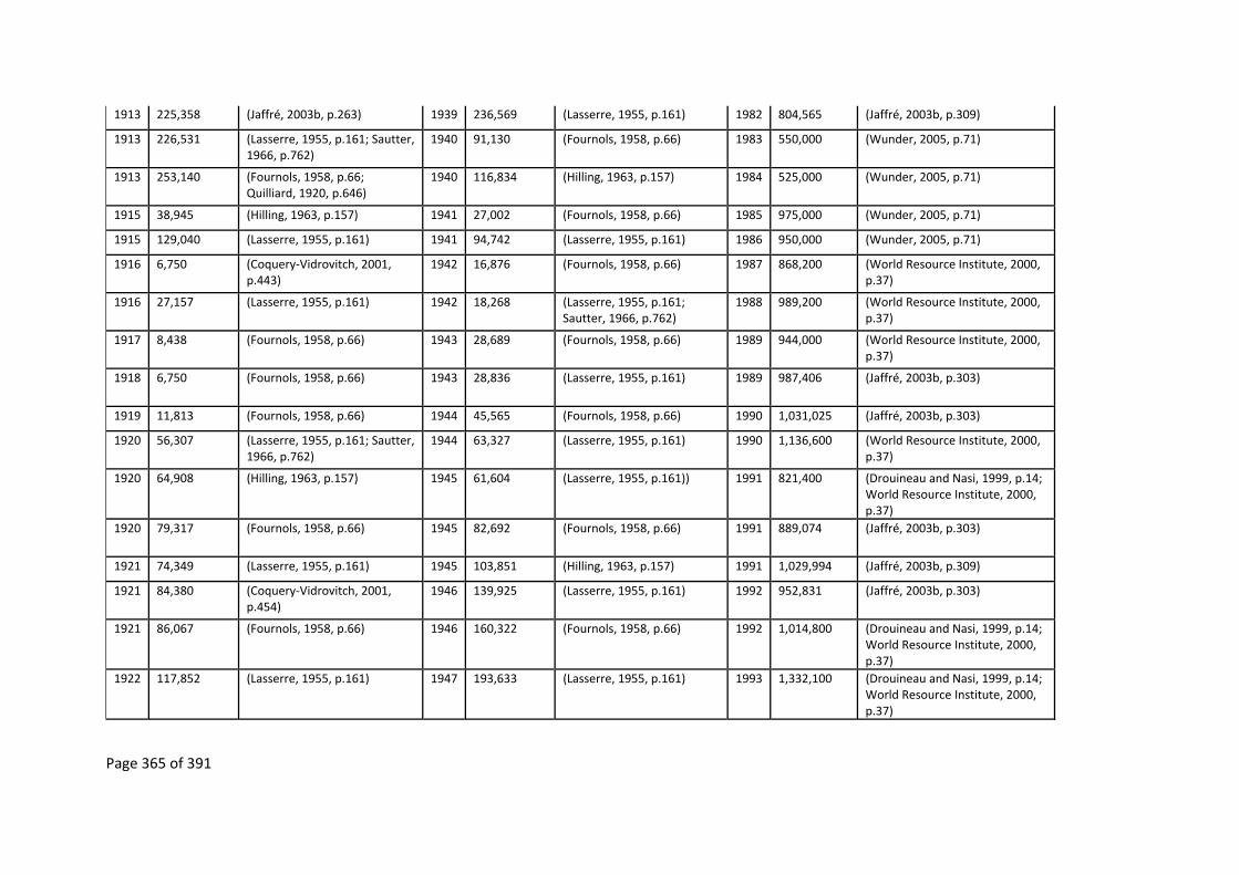
Page 365 of 391
1913 225,358 (Jaffré, 2003b, p.263) 1939 236,569 (Lasserre, 1955, p.161) 1982 804,565 (Jaffré, 2003b, p.309)
1913 226,531 (Lasserre, 1955, p.161; Sautter, 1966, p.762)
1940 91,130 (Fournols, 1958, p.66) 1983 550,000 (Wunder, 2005, p.71)
1913 253,140 (Fournols, 1958, p.66; Quilliard, 1920, p.646)
1940 116,834 (Hilling, 1963, p.157) 1984 525,000 (Wunder, 2005, p.71)
1915 38,945 (Hilling, 1963, p.157) 1941 27,002 (Fournols, 1958, p.66) 1985 975,000 (Wunder, 2005, p.71)
1915 129,040 (Lasserre, 1955, p.161) 1941 94,742 (Lasserre, 1955, p.161) 1986 950,000 (Wunder, 2005, p.71)
1916 6,750 (Coquery‐Vidrovitch, 2001, p.443)
1942 16,876 (Fournols, 1958, p.66) 1987 868,200 (World Resource Institute, 2000, p.37)
1916 27,157 (Lasserre, 1955, p.161) 1942 18,268 (Lasserre, 1955, p.161; Sautter, 1966, p.762)
1988 989,200 (World Resource Institute, 2000, p.37)
1917 8,438 (Fournols, 1958, p.66) 1943 28,689 (Fournols, 1958, p.66) 1989 944,000 (World Resource Institute, 2000, p.37)
1918 6,750 (Fournols, 1958, p.66) 1943 28,836 (Lasserre, 1955, p.161) 1989 987,406 (Jaffré, 2003b, p.303)
1919 11,813 (Fournols, 1958, p.66) 1944 45,565 (Fournols, 1958, p.66) 1990 1,031,025 (Jaffré, 2003b, p.303)
1920 56,307 (Lasserre, 1955, p.161; Sautter, 1966, p.762)
1944 63,327 (Lasserre, 1955, p.161) 1990 1,136,600 (World Resource Institute, 2000, p.37)
1920 64,908 (Hilling, 1963, p.157) 1945 61,604 (Lasserre, 1955, p.161)) 1991 821,400 (Drouineau and Nasi, 1999, p.14; World Resource Institute, 2000, p.37)
1920 79,317 (Fournols, 1958, p.66) 1945 82,692 (Fournols, 1958, p.66) 1991 889,074 (Jaffré, 2003b, p.303)
1921 74,349 (Lasserre, 1955, p.161) 1945 103,851 (Hilling, 1963, p.157) 1991 1,029,994 (Jaffré, 2003b, p.309)
1921 84,380 (Coquery‐Vidrovitch, 2001, p.454)
1946 139,925 (Lasserre, 1955, p.161) 1992 952,831 (Jaffré, 2003b, p.303)
1921 86,067 (Fournols, 1958, p.66) 1946 160,322 (Fournols, 1958, p.66) 1992 1,014,800 (Drouineau and Nasi, 1999, p.14; World Resource Institute, 2000, p.37)
1922 117,852 (Lasserre, 1955, p.161) 1947 193,633 (Lasserre, 1955, p.161) 1993 1,332,100 (Drouineau and Nasi, 1999, p.14; World Resource Institute, 2000, p.37)

Page 366 of 391
1922 152,896 (Coquery‐Vidrovitch, 2001, p.454)
1947 227,826 (Fournols, 1958, p.66) 1993 1,337,439 (Jaffré, 2003b, p.303)
1922 189,011 (Fournols, 1958, p.66) 1948 281,967 (Lasserre, 1955, p.161)) 1994 1,332,440 (Jaffré, 2003b, p.303)
1923 147,450 (Lasserre, 1955, p.161) 1948 310,518 (Fournols, 1958, p.66) 1994 1,461,300 (Drouineau and Nasi, 1999, p.14; World Resource Institute, 2000, p.37)
1923 176,860 (Coquery‐Vidrovitch, 2001, p.454)
1949 324,019 (Sautter, 1966, p.804) 1995 1,529,700 (World Resource Institute, 2000, p.37)
1923 177,198 (Fournols, 1958, p.66) 1949 345,038 (Lasserre, 1955, p.161) 1992 1,531,000 (Drouineau and Nasi, 1999, p.14)
1924 303,040 (Lasserre, 1955, p.161; Sautter, 1966, p.762)
1949 366,209 (Fournols, 1958, p.66) 1995 1,552,622 (Jaffré, 2003b, p.303)
1924 335,663 (Coquery‐Vidrovitch, 2001, p.454)
1950 374,115 (Lasserre, 1955, p.161)) 1996 1,779,000 (Drouineau and Nasi, 1999, p.14)
1924 335,832 (Fournols, 1958, p.66) 1950 376,464 (Hilling, 1963, p.157) 1996 1,780,900 (World Resource Institute, 2000, p.37)
1924 506,279 (Jaffré, 2003b, p.264) 1950 426,962 (Fournols, 1958, p.66) 1997 1,836,000 (Drouineau and Nasi, 1999, p.14; World Resource Institute, 2000, p.37)
1925 341,463 (Lasserre, 1955, p.161) 1951 381,397 (Lasserre, 1955, p.161) 1998 1,576,600 (World Resource Institute, 2000, p.37)
1925 365,533 (Coquery‐Vidrovitch, 2001, p.454)
1951 502,904 (Fournols, 1958, p.66) 1999 1,562,763 (Jaffré, 2003b, p.309)
1925 369,584 (Fournols, 1958, p.66) 1952 297,017 (Lasserre, 1955, p.161) 2001 137,300 (Nguimbi et al., 2006, p.189)
1925 389,445 (Hilling, 1963, p.157) 1952 410,086 (Fournols, 1958, p.66) 2002 1,037,964 (Nguimbi et al., 2006, p.189)
1926 387,683 (Lasserre, 1955, p.161) 1952 1,024,371 (Sautter, 1966, p.806) 2003 935,942 (Nguimbi et al., 2006, p.189)
Table 11‐4: Exports of Okoumé from Gabon, with references. The 1896 to 1962 data was converted from metric tons to cubic metres calculated using Brunck et al. (1990, p.92) conversion factor.

Page 367 of 391
11.13 ComparisonoftheWakasitewithtwoothersitescloseby
Waka Koulamoutou Franceville
Case study this study Coad and Starkey Walters
Principal ethnicities Babongo Pygmy and Mitsogho Pove and Massango Teke
Terrain Mountainous with deep valleys Foothills with flood plains
Rolling hills
Principal vegetation Forest with some agriculture Agricultural with some Forest
Savannah with riverine forest and some agriculture
Access Track built in 1960s by loggers Road built in 1930 to 1950s by administration with forced labour
Sand track “built” after independence
Effects of regroupement
People fled into forest Regrouped during colonial administration into villages along road
Regrouped onto sand track and then some to the main road after Independence
Political representation Babongo Pygmy ‐ no representation Mitsogho ‐ some representation including an assistant minister
At several levels of administration including some ministers
At all levels of administrations
Type of traditional rule Babongo Pygmy and Mitsogho – Based around head of families
Based around head of families
Hierarchical with land chiefs.
Main economic livelihood
Babongo Pygmy ‐ Subsistence Mitsogho ‐ Labourers for logging companies / subsistence
Subsistence, commercial agriculture and commercial hunting
Hand‐outs from elites, selling pineapple wine, jobs with army / police and subsistence
Access to markets 5 to 6 hours away 1 to 2 hours away 1.5 hours away
Spirituality Both Babongo Pygmy and Mitsogho thought of as the originators of Bwiti in Gabon. Also known for their healing and sorcery powers throughout Gabon
Branch of Bwiti Own religion, Njobi, Mungala that is not shared by others in Gabon but rather with the peoples of Congo
Literature on people and area
Dating back to late 1800s with early explores such as Du Chaillu and Raponda Walker
Little known Dating back to late 1800s and early 1900s with de Brazza
Number of long term (>1 year) university researchers in last 10 years
3 3 1
Principal house building material
Mud huts with thatch roof Mud huts with corrugated iron roofs
Corrugated iron walls and roof
Electricity None Solar from administration
Solar and generator from administration
Water supply River Hand pumps and solar pump from administration
River
Shops and bars in village
Usually none Both Both
Distance from park 5‐10 km 50 km 30 km
Table 11‐5: Comparisons of three study sites that are within one hundred kilometres from each other.

Page 368 of 391
11.14 TherecentmigrationoftheMitsoghointotheIkobeystudysite
The Mitsogho used two different migration routes to get to the Ikobey area, the principal route
was down the Oumba River, with the Ikoy River route being only used by the Mitsogho of
Divinde, a migration of 80 km overland through the forest. The migration from the Mimongo
village started with a Fang Prefet (called Ekoga) trying to regroup them to Mimongo town. Some
accepted, while others refused and started their migration towards the Ikobey area:
Depuis Ngoassa, il avait une chef, un rigolo, Ekoga, qui demande au parents
quittez de la – donc au vieux village – au vieux village – quittez de la ‐ retourne
– retournant chez nous, retournant chez nous là‐bas. Eux ils ont dit nous on ne
part pas là‐bas. Ekoga, qu’est‐ce que il a fait, il a pris tous les chefs. Il y avait 6
villages, il avait 6 villages. Ekoga a pris les chefs de village, il dit bon c’est vous
qui faites l’orgueil, c’est vous qui faites en sort que les populations ne vont pas
de ce côté‐là, donc moi je vous prends, allons‐y ! Là‐bas. Ils sont allés là‐bas, ils
étaient même présent, ils l’ont chopé, bien frappé, on les choppait. Donc ce sont
eux que on a choppé, c’était le commandant Ekoga ‐ donc on les a choppé. Mais
eux aussi quand ils ont suivi comme ça ils ont dit ‘Comme on nous a tapé donc
obligatoire on doit descendre on ne part plus à Mimongo, il n’a pas fallu que il
nous tape’. Voilà comment ils sont descendus.
Ceux qu’ont descendu, de cette côté, l’Oumba, c’est nous là [Nyoe I]. Ceux que
sont de l’autre cote de l’Oumba, ce sont‐ceux qui ont accepté Ekoga leur
brimade, mais a un certain moment ils sont revenus en disant que les autres, qui
sont de l’autre côté, ont mieux réagit que nous208.
The village of Ngoassa (Map 11‐2), had a large community where “les gens était trop au Ngoassa,
les gens sont partir vers Divinde, les autre vers Nyoe … un avec l’Ikoy les autre suivre la river
208 “Since Ngoassa, there was a chief [Prefet], a joker, Ekoga, who asked our parents to leave – at our old village – leave there, go back, go back home, go back home, over there. They said we will not go over there. Ekoga, what did he do, he took all the chiefs, there were six villages, there were six villages. Ekoga took the chiefs of the villages, and said ‘ok you are being arrogant, it’s you who makes it that the population does not go over there, so I will take you, let’s go! Over there’. They went over there, he himself was with them, he took them, beat them well. So they got hit, it was the commander Ekoga who took them. But they, when they saw how things were, they said ‘as we were hit, we are obliged to go down, we will no longer go to Mimongo, he should not have hit us’. And that is why they went down.
Some went down one side of the Oumba River, that was us [people of Nyoe I]. Those who went down the other side of the Oumba River, were the ones who accepted Ekoga’s beatings, but after a time they came back, saying that the others, on the other side of the Oumba River, reacted better than we did”. Nyoe I, Mitsogho 09/05/10 [recording DS400093; 1:19:03].

Page 369 of 391
Oumba”209. They first descended the Oumba and Ikoy by using the old trade and administration
routes that ran nearby “c’est la route là où les vieux passent avec le tipoi [Picture 11‐4] la, qui ils
ont suivi ... dans les rivières on coupait les arbres pour traverser”210. Then, where the old trade
routes turn back to Mimongo town, they continued through the forest down the Bakounga
River, which leads into the Oumba River, while the people of Divinde went down the Ikoy River.
By following these rivers they eventually came upon the roads of M. Madre and La SONG.
The Mitsogho who migrated down the Oumba River encountered La SONG at Ikobey. While the
others, who migrated down the Ikoy River, met the road that the timber company had made at
an old village near where Tchibanga village is today. In both cases their “objectif c’était d’aller
vers les Blancs, on voyait les layons [Madre] ils en profitaient déjà pour dire que quand les Blancs
vont venir on va nous retrouver là”211. Once on the Madre road they followed the timber
companies up and down it.
Picture 11‐4: Tipoi being used during the colonial period in Gabon reproduced from (Meyo‐Bibang, 1975, p.51), this mode of transport is said to have been very uncomfortable (de Hillerin, 2005).
The Mitsogho of Nyoe II, predicting the La SONG were going to come, set up a camp near what
today is the junction outside of Nyoe II. When La SONG left their camp at Nyoe II, the Mitsogho
took over the camp and the buildings, recovering the materials to construct their own homes.
For these people their migration took them 90 km overland partly through the forest and partly
along the road.
209 “there were too many people at Ngoassa, people left for Divinde, towards the other Nyoe’s … one with the Ikoy the others followed the Oumba river”. Nyoe I, Mitsogho 09/05/10 [recording DS400093; 48:21]. 210 “it was the road where our parents passed, with the tipoi, they followed it … and then at rivers we cut trees to cross”. Nyoe II, Mitsogho 23/04/10 [recording DS400080; 30:10]. 211 “objective was to go towards the Whites, we could see their transects [Madre’s], they took advantage of the situation and said that when the Whites come they will find us here”. Nyoe II, Mitsogho 23/04/10 [recording DS400093; 27:26].

Page 370 of 391
Map 11‐2: Current and past Mitsogho villages around Ikobey, with their migration route. Based on the following sources: Basemap ‐ (ESRI, 2012), Park boundaries ‐ (Institut Geographique National, 2008), old village sites, paths and roads from ‐ (Army Map Service, 1966a; Army Map Service, 1966b; Army Map Service, 1966c; Institut Geographique National, 2008; Institut Geographique National, 1994; L’Annexe en Afrique Equatoriale de Institut Geographique National, 1986; L’Annexe en Afrique Equatoriale de Institut Geographique National, 1980; L’Annexe en Afrique Equatoriale de Institut Geographique National, 1969; L’Annexe en Afrique Equatoriale de Institut Geographique National, 1967a; L’Annexe en Afrique Equatoriale de Institut Geographique National, 1967b; L’Annexe en Afrique Equatoriale de Institut Geographique National, 1962).
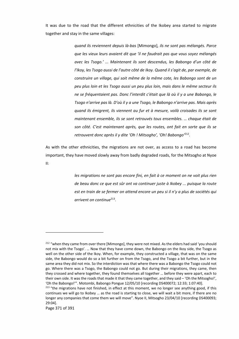
Page 371 of 391
It was due to the road that the different ethnicities of the Ikobey area started to migrate
together and stay in the same villages:
quand ils reviennent depuis là‐bas [Mimongo], ils ne sont pas mélangés. Parce
que les vieux leurs avaient dit que ‘il ne faudrait pas que vous soyez mélangés
avec les Tsogo.’ ... Maintenant ils sont descendus, les Babongo d’un côté de
l’Ikoy, les Tsogo aussi de l’autre côté de Ikoy. Quand il s’agit de, par exemple, de
construire un village, qui soit même de la même cote, les Babongo sont de un
peu plus loin et les Tsogo aussi un peu plus loin, mais dans le même secteur ils
ne se fréquentaient pas. Donc l’interdit c’était que là où il y a une Babongo, le
Tsogo n’arrive pas là. D’où il y a une Tsogo, le Babongo n’arrive pas. Mais après
quand ils émigrent, ils viennent au fur et à mesure, voilà croisades ils se sont
maintenant ensemble, ils se sont retrouvés tous ensembles. … chaque était de
son côté. C’est maintenant après, que les routes, ont fait en sorte que ils se
retrouvent donc après il y dite ‘Oh ! Mitsogho’, ‘Oh! Babongo’212.
As with the other ethnicities, the migrations are not over, as access to a road has become
important, they have moved slowly away from badly degraded roads, for the Mitsogho at Nyoe
II:
les migrations ne sont pas encore fini, en fait à ce moment on ne voit plus rien
de beau donc ce que est sûr ont va continuer juste à Ikobey ... puisque la route
est en train de se fermer on attend encore un peu si il n’y a plus de sociétés qui
arrivent on continue213.
212 “when they came from over there [Mimongo], they were not mixed. As the elders had said ‘you should not mix with the Tsogo’. … Now that they have come down, the Babongo on the Ikoy side, the Tsogo as well on the other side of the Ikoy. When, for example, they constructed a village, that was on the same side, the Babongo would do so a bit further on from the Tsogo, and the Tsogo a bit further, but in the same area they did not mix. So the interdiction was that where there was a Babongo the Tsogo could not go. Where there was a Tsogo, the Babongo could not go. But during their migrations, they came, then they crossed and where together, they found themselves all together … before they were apart, each to their own side. It was the roads that made it that they came together, and they said – ‘Oh the Mitsogho!’, ‘Oh the Babongo!’”. Motombi, Babongo Pongue 12/05/10 [recording DS400072; 12:33; 1:07:40]. 213 “the migrations have not finished, in effect at this moment, we no longer see anything good, if this continues we will go to Ikobey … as the road is starting to close, we will wait a bit more, if there are no longer any companies that come them we will move”. Nyoe II, Mitsogho 23/04/10 [recording DS400093; 29:04].
Page 372 of 391
11.15 TherecentmigrationoftheAkeleintotheIkobeystudysite
Currently there are only three Akele living in the Ikobey area, all elderly, one lives in Ikobey and
a couple in Nyoe II. All others have either died or migrated to Sindara and further afield. There
were originally two general directions that had been used during the first Akele migration into
the area, one was up along the Ngounié and the other along the Ogooué, details of which can
be found in Ngolet (2003), Gray (2002) and Avelot (1905). While the names of rivers and
mountains in the Ikobey area are Akele, by the 1960s the original Akele in‐migrants had long
gone and a new wave of Akele came into the Ikobey area at this time from around the town of
Mimongo by following the Ikoy River (Map 11‐3).
This second wave of Akele migrations started along the old trade routes that surround the town
of Mimongo and the village of Eteke (Map 4‐6, Map 11‐3), at a similar time the Mitsogho were
moving as a reaction to regroupement (Abitsi and Lepemangoye‐Mouleka, 2009). The Prefet of
Mimongo town, Ekoga, had asked people to move towards Mimongo town and although some
Akele followed his demand, others refused and went into the forest. They first used the old
caravan routes, and then followed the Ikoy down, at each step the Prefet urged them to go back
to Mimongo town. As they went down the Ikoy they found no villages, or signs of old villages.
Due to the ferocious reputation of the Akele, the Babongo Pygmies and Mitsogho kept away
from their villages. As the Akele explain:
nous sauvages avant, c’est‐à‐dire nous les Akele, c’est que on était trop
méchant, quand les autres [Mitsogho and Babongo Pygmies] voit dans la route,
qu’on a passé la route, ou on mangeait la casse à dent ‘ oh les Akele ont passés’
pour les histoires de bagarre étaient parce que nous était trop mauvais ... ils
évitent cette zone214.
At the time the Akele were telling the other ethnicities that:
la forêt ce n’était pas pour les Babongo donc quand il croise une de ces ethnies
aller, TIMBAKA, pour dire buter, quoi. Maintenait que ils se sont mélangeait215.
214 “before we were savage, that is us the Akele, we were too horrible, when the others [Mitsogho and Babongo] see in the road that we had passed, as we left behind traces of casse à dents [a type of food made from manioc tuber], ‘Oh the Akele have passed through here and, due to past fighting as we were so bad, … they avoided these zones”. Nyoe II, Akele 22/05/10 [recording DS400078; 31:42]. 215 “the forest was not for the Babongo, so when we crossed with them, there Boom, to say they shot us. Today we are mixed”. Motombi, Babongo Pongue 12/05/10 [recording DS400072; 26:00].

Page 373 of 391
When other ethnicities asked the chief if they could join their community the chief would refuse:
Les Tsogo à cette époque étaient à Ndjona [also called Ngoassa‐Moupaka], et ils
sont venu retrouves mon défunt papa pour qu’ils puisse vivre ensemble, et son
défunt papa a dit ‘non nous ne peut pas vivre avec vous parce que vous est des
sourcelleries’216 .
Some of the communities that the Akele set up were along the Idemba River, where they started
to create several villages including down to the Ikoy River in the area that is currently Makoko.
It was at one of these villages that they met La SONG timber company. By this time disease and
migration had once again resulted in the decimation of this second wave of Akele people. The
Akele that remained decided to go and live with the Mitsogho in the Nyoe communities. Overall
the Akele migrated 40 km overland through the forest, to end up in the furthest of these
communities. As they migrated and abandoned villages so the Babongo Pygmies took over some
of their old village sites, such as at Makoko. The Akele have continued to migrate down the road,
up to Nyoe II, moving when the old bridges of La SONG collapse:
Par rapport aux ponts qui étaient coupés on a préféré de venir ce côté‐ici. A
l’époque La SONG était retourné, et on ne pouvait pas travailler ce pont, et les
voitures pouvaient refuser de nous retrouves dans les villages217.
216 “The Tsogo at that time were at Ndjona [also called Ngoassa‐Moupaka], they came to see my deceased father [at that time he was the chief] so that they could live together, and my deceased father told them ‘no we cannot live with you as you are all sorcerers’”. Nyoe II, Akele 24/05/10 [recording DS400082; 10:34]. 217 “Due to the bridges that were broken, we preferred to come this side. At the time La SONG had gone and we could not repair the bridge, and cars would refuse to come to fetch us in our villages” Nyoe II, Akele 24/05/10 [recording DS400082; 1:17:02].
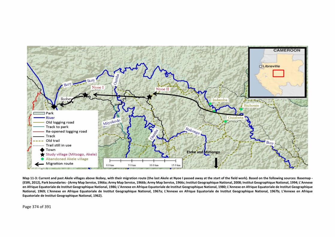
Page 374 of 391
Map 11‐3: Current and past Akele villages above Ikobey, with their migration route (the last Akele at Nyoe I passed away at the start of the field work). Based on the following sources: Basemap ‐ (ESRI, 2012), Park boundaries ‐ (Army Map Service, 1966a; Army Map Service, 1966b; Army Map Service, 1966c; Institut Geographique National, 2008; Institut Geographique National, 1994; L’Annexe en Afrique Equatoriale de Institut Geographique National, 1986; L’Annexe en Afrique Equatoriale de Institut Geographique National, 1980; L’Annexe en Afrique Equatoriale de Institut Geographique National, 1969; L’Annexe en Afrique Equatoriale de Institut Geographique National, 1967a; L’Annexe en Afrique Equatoriale de Institut Geographique National, 1967b; L’Annexe en Afrique Equatoriale de Institut Geographique National, 1962).
Eteke and Mimongo

Page 375 of 391
11.16 The recentmigration of the Babongo Pygmies into the Ikobey
studysite
Above Ikobey, the Babongo Pygmies can today be found in the villages of Ngondet, Makoko,
Motombi, Egouba, Sogha, Divinga, Tranquille, Tchibanga and Ossimba (Map 11‐4). They can also
be found mixed with the Mitsogho in the Mitsogho villages of Nyoe II, Evouta and Ebel. For the
purposes of this study the Babongo Pygmies of Makoko, Ngondet, Motombi, Tchibanga,
Tranquille and Ossimba were interviewed. All the Babongo Pygmies originate from an area
around Mimongo town and Massima, “tous près de Mimongo ville là‐bas … Où c’était les
maisons c’est les grands bois déjà”218.
As with the Mitsogho the Babongo Pygmies migrated in two groups, which, for the case of this
study have been called the Babongo Ghebondgi (the Babongo Pygmies from the village of
Ebondji) and the Babongo Pongue219 (the Babongo Pygmies from the village of Pongou):
ils étaient ensemble, mais le problème avec les autres c’était parce qu’eux ils
voulaient suivre les Simba, donc c’est pourquoi ceux des Ebondji sont retrouves
avec les Simba, ils voulaient parler Simba. Mais lorsque ceux‐là on a dit que,
‘nous on ne part pas là‐bas ont reste ici avec nous Bio’, c’est les Tsogo. Voilà
comment ils sont séparés. … Les Ebondji pour les Simbaka, les Pongo pour les
Mitsogho220.
Through marriage, the Babongo Pygmies of Ossimba are a mixture of Babongo Ghebondgi and
Babongo Pongue. For the last part of their migrations the Babongo Ghebondgi group followed
218 “very close to the town of Mimongo … Where there were houses there is already big wood”. Tchibanga, Babongo Pongue 27/04/10 [recording DS400084; 21:05]. 219 Pongou seems to be an old name for Pygmies, it crops up in several historical documents, as is also used as an alternative to Libreville. A newspaper article in 1884 mentions the following (it should be noted that this is before du Chaillu’s observations of “dwarfs” in the 1860s): "Conversing upon this subject with two most experienced persons, who had for many years traded all the important rivers of the Guinea coast, they informed me that those dwarfs were called Pongos, and were most numerous high up the Gabon river, nearly upon the equinoctial line and due west of the Juba river, so that when I heard of them in connection with the Juba I considered it a confirmation of these accounts. These merchants looked upon them as between men and baboons, and deserving the attention of naturalists. I observed in some maps the river Gabon is called the river Pongo, and Ponga, but without mentioning why it is so called." (Anonymous, 1884, p.1). 220 “they were together, but the problem with the other was because they wanted to follow the Simba, that is why the people of Ebondji found themselves with the Simba, they wanted to talk Simba. But when we said ‘we will not go over there, we are going to stay with our Bio’, that is to say the Tsogo. That is how they separated. … the Ebondji with the Simbaka, the Pongou with the Mitsogho”. Motombi, Babongo Pongou 12/05/10 [recording DS400072; 06:10].
Page 376 of 391
the Ikoy River downstream, while the Babongo Pongou group crossed over to the Oumba River,
via the Bakonga River (Map 11‐5).
As with the Mitsogho and Akele, the Babongo Pygmies were also impacted by regroupement,
the same Fang prefect asking them to move towards Mimongo town, once again some refused
and carried on up the river, into the forest, to live in the various Ebondji villages near the
headwaters of the Mimongo River. In some cases they used the old trade routes to move from
village to village but in most cases they went through the forest and later followed the Ikoy River.
For the Babongo Pygmies, regroupement is still occurring, with local administrations still asking
them to move closer to the road. Most recently the Babongo Ghebondgi, of Makoko and
Ngondet, were asked to leave the village of Massika and come towards the road. Approximately
ten years after La NEF, a timber company, had left Makoko, a group of Babongo Pygmies went
towards Makoko via Carrié (near an old quarry made by La SONG), while others went to
Ngondet. A few years later the people of Carrié moved to Makoko. This migration was due to
their desire to get out of the forest for:
la souffrance, chercher le savon le pétrole les autres ont voulait approcher d’un
village plus proche... on ne voulait plus rester où il y avait les éléphants et les
gorilles ... [papa] il était fatigué de la forêt [maman] par rapport à l’approche
pour certain nourriture, pour le savon et le sel221.
Though both the Babongo Ghebondgi of Makoko and Ngondet have come closer to the road,
having respectively, migrated approximately 100 and 70 km overland through the forest, they
are still not on an accessible road. The people of Makoko have to walk approximately seven
hours to get to Nyoe II, while the people of Ngondet have a day’s walk to get to Massika. In the
case of the route between Makoko and Nyoe II, this was mostly along the old La SONG road, a
road that was so overgrown that the people of Makoko preferred to go through the forest. At
the end of the field study, a Chinese logging company, SUNNLY, had re‐opened part of this road
to a river where one of their old hunting camps was located, and some of the people of Makoko
migrated towards this site. By 2014 the village of Makoko had been abandoned with everyone
moving down the road towards Nyoe II (personal communication Ndong, 2014).
221 “suffering, to go get soap, kerosene, the other wanted to go closer to a village … we did not want to stay where there were elephants and gorillas … we were tired of the forest … due to the distance of certain foods, for soap and salt” Motombi, Babongo Ghebondgi 24/02/10 [recording DS400010; 02:41, 06:10].

Page 377 of 391
Map 11‐4: Current Babongo Pygmies villages above the town of Ikobey. Based on the following sources: Basemap ‐ (ESRI, 2012), Park boundaries ‐ (Institut Geographique National, 2008), trails, tracks, roads – track logs collected between 2008 to 2011.

Page 378 of 391
Map 11‐5: Migration of the Babongo from their old abandoned villages to the Babongo villages above Ikobey. Based on the following sources: Basemap ‐ (ESRI, 2012), Park boundaries ‐ (Institut Geographique National, 2008), old village sites, paths and roads from ‐ (Army Map Service, 1966a; Army Map Service, 1966b; Army Map Service, 1966c; Institut Geographique National, 2008; Institut Geographique National, 1994; L’Annexe en Afrique Equatoriale de Institut Geographique National, 1986; L’Annexe en Afrique Equatoriale de Institut Geographique National, 1980; L’Annexe en Afrique Equatoriale de Institut Geographique National, 1969; L’Annexe en Afrique Equatoriale de Institut Geographique National, 1967a; L’Annexe en Afrique Equatoriale de Institut Geographique National, 1967b; L’Annexe en Afrique Equatoriale de Institut Geographique National, 1962).

Page 379 of 391
That the Babongo Ghebondgi of Makoko and Ngondet are still in the forest is due to the past
conflicts that they have had with their Bantu‐speaking neighbours, such as being blamed for the
death of a Mitsogho or issues due to intermarriage with Bantu‐speaking peoples. These conflicts
have yet to be resolved but the young adults of Ngondet would like to continue their migration
and move closer to Massika, so that they can have better access to education, and for the
traditional doctors to be closer to their patients but:
de fait que je suis nganga Missoko [traditional doctor], beaucoup de mes
étrangers, mes malades, n’arrivent plus à venir ici, par rapport à la distance …
parce que, si j’étais au moins près d’une ville mes malades devraient venir à
chaque fois. Je ne vais plus souffrir, en manquant du pétrole [for hurricane
lamp], du savon ou autre article. … Le problème que me retarde, c’est parce que
il y a encore mon père ma mère ici. Si je déplaçais plus loin, qui maintenant va
garder mes parents222.
It was at the village of Indamba (on the Ikoy River) that the Babongo Ghebondgi came into
contact with La SONG’s road, it was here that
il y a eu beaucoup d’étrangers sont venus pour se faire soigner, et il y avez
maintenant la joie, par rapport aux autres villages que ils ont franchi. Maintenait
le savon, le sel qu’en venir donner. A parti de là ils ont fait la commerce de bois
amer [to ferment palm wine] où les gens venir les payer223.
It was also along this old La SONG road that the Babongo Ghebondgi later migrated to Makoko
and then, for some, to Ossimba.
Previously, the Babongo Pygmy elders had given an interdiction in Mimongo village where the
people were not allowed to mix “parce que les vieux leurs avaient dit que ‘il faudrait pas que
vous soyez mélanges avec les Tsogo’224”. This interdiction probably originated during the time of
222 “as I am Nganga Missoko [traditional doctor], many of my strangers, my sick, cannot get to here, due to the distance … as, if I was at least nearer a town, my sick can come all the time. I will no longer suffer, not having kerosene [for hurricane lamps], soap or other articles. … The problem, and what is keeping me back, is because I still have my father and mother here. If I left to, go further away, who will now look after my parents”. Ngondet, Babongo Ghebondgi 04/02/10 [recording DS400010; 02:10]. 223 “there are many strangers who come here to get treated, and there is now happiness, compared to other villages that we were in. Now there is soap, salt, that we are given. From here we started to trade bois amer [to ferment palm wine] where people came to pay for it”. Ossimba, Babongo Ghebondgi 28/04/10 [recording DS400085; 1:04:41]. 224 “they did not mix. As the elders had told them that ‘you should not mix with the Tsogo’”. Motombi, Babongo Pongue 12/05/10 [recording DS400072; 12:33; 1:07:40].
Page 380 of 391
slave raiding carried out by the Mitsogho on the Babongo Pygmies in the Eteke / Massima area
(Klieman, 1999, p.96). Today the Babongo Pongue have reconciled their differences with the
Mitsogho. The conflict that the Babongo Ghebondgi have with the Mitsogho has resulted in
them trying to circumvent trading with the Mitsogho, preferring to wait for outsiders to come,
or in some cases going directly to Sindara to trade, reminiscent of the migrations towards the
coast carried out by different Bantu‐speaking peoples in the 1800s to come into direct contact
with the European traders (Chapter 3).
While the majority of the Babongo Ghebondgi in the Ikobey area are still in the forest and far
from other neighbouring Mitsogho, the Babongo Pongue are found along the still functional
road.
The Babongo Pongue who live in the Mitsogho villages of Nyoe II, Evouta, and Ebel and those
who live by‐themselves in the villages of Tranquille, Tchibanga and Motombi, all refer to a
common village of Pongou, approximately a 130 km away overland through the forest (Map 4‐6
near the town of Mimongo), as being the village from which their migration started. Once again
their migration started at the beginning of independence with the Fang Prefet of Mimongo town
asking the Babongo Pongue, now at Idamba (near Mimongo town), to move towards the town.
They refused and moved away towards Divine and by doing so started their migration away from
Mimongo town and into the forest.
The Babongo Pongue carried on their migration down the Ikoy River to Pongo (Map 4‐6), they
left the Ikoy River and went across the forest, sometimes using the old trade routes, till they
reached the Bakonga River, which they followed down to the Oumba River. It was in the area
around today’s villages of Motombi / Mimongo II where the Babongo Pongue came into contact
with the La SONG road and so the Bantu‐speaking Mitsogho. It was also here that they started
to split up into separate groups because the local administration were once again trying to bring
the Babongo Pygmies closer to the road, though family conflicts also contributed to the
separation.
Today the villages of the Babongo Pongue are found all along the road from villages of Tranquille
to Mimongo II, and currently move when “la route était tellement fermé, on abandonnait, partir
pour route ouverte”225, but also when “les éléphants ils venait descendre toujours au bord du de
225 “the road was so closed, we left, left for the open road”. Tchibanga, Babongo Pongue 27/04/10 [recording DS400084; 1:19:22].

Page 381 of 391
village”226. Migration due to human‐elephant conflict is not new, with Bouet writing in 1974 that
“devant les ravages habituels des éléphants, (surtout des “assala” ou petits éléphants de forêt),
l’une des causes principales du découragement général et de l’exode de nombreux villageois
gabonais”227 (Bouet, 1974, p.9).
If the road continues to degrade and becomes impracticable then some Babongo Pongue may
stay but others will continue to follow the road towards Sindara “Si la route est ferme est ce que
ont pouvez vivre? – Na [sic] pas on continue, oui ont continuait ... juste au Sindara”228, “avant on
a souffert pour débrousser la pistes à partir de la route, aider la migration car on souffre plus
pour débrousser car ont suivre la route”229, indicating that the Babongo Pygmies are more
interested in securing access to trade routes than forest resources.
226 “the elephants were always coming to the village edge”. Tchibanga, Babongo Pongue 27/04/10 [recording DS400084; 1:23:20]. 227 “in front of the habitual ravages of elephants (especially the “assala” or small forest elephant), is one of the principal causes of general discouragement and the exodus of a number of Gabonese villagers” 228 “If the road close would we be able to live here – Na, we will continue … all the way to Sindara”. Ossimba, Babongo Pongue 28/04/10 [recording DS400088; 02:20]. 229 “before we suffered to clear the forest to make a path, since the arrival of the road this has helped our movement, as we no longer suffer to cut a path, we just follow the road”. Ossimba, Babongo Ghebondgi 04/05/10 [recording DS400091; 38:45].

Page 382 of 391
11.17 Ashorthistoryofthe“discovery”ofPygmiesandtheroleofGabon
Though Pygmies were rediscovered first in Gabon, having been previously been relegated to the
myths and legends of the Ancient Egyptian, Greek and Roman Empires, until recently the only
thing know about the Pygmies of Gabon is that they are more or less found throughout the
county (Bahuchet, 2007) and very little is known about them (Bahuchet, 1993a; Knight, 2003;
Mayer, 2007; Mayer, 1987). Before the 1980s “anthropological and ethnographical research
was, with a couple of exceptions, not encouraged in Gabon” (Knight, 2003, p.82). Since 2000 this
is being rectified by young anthropologists (Bonhomme et al., 2012; Knight, 2006; Knight, 2003;
Matsuura, 2009; Matsuura, 2006; Paulin, 2010; Soengas, 2010; Soengas, 2009; Ruyter, 2010;
Ruyter, 2003; Weig, 2013).
Gabon had many Pygmy populations that lived next to the coast, and so within easy reach of the
ears of the first trading ships from Europe. In contrast the Pygmy groups living in the heart of
Central Africa were less accessible. It was along these Gabonese trading routes that the first
second‐hand reports of Pygmies were recorded by the likes of Battell (1625) and Dapper (1686).
These second‐hand accounts were published 200 years before the first‐hand encounters by Du
Chaillu (Touchard, 1861).
The first European to have a recorded face to face encounter with Pygmies in Gabon was Du
Chaillu in 1861 (du Chaillu, 1867a; du Chaillu, 1867b)230, the existence of Pygmies was confirmed
by Schweinfurth, a German botanist and explorer, in 1870 (Bahuchet, 1993b; Ballard, 2006; de
Quatrefages, 1887; Le Roy, 1928; Schweinfurth, 1969). Du Chaillu’s first‐hand encounter was
quickly followed by other encounters at first or second hand including: Marche in 1877 (Marche,
1882; Marche, 1878), Fleuriot De Langle in 1868 (Bahuchet, 1993b), Crampel (Crampel, 1890),
Mgr le Roy in 1897 (Le Roy, 1928), Migeod in 1921 (Migeod, 1922), Fleuriot in the 1930s
(Fleuriot, 1942) Trilles around 1932 (Trilles, 1945; Trilles, 1935; Trilles, 1933), Andersson (1983)
writing about his trips in 1931, 1934, and 1949 (Andersson, 1983), Fairley circa the 1940s
(Fairley, n.d.) and Deschamps (Deschamps, 1965; Deschamps, 1962).
Behind these encounters was a race by explorers, missionaries and anthropologist to find the
“ultimate pygmy”, the “original human” (Frankland, 2001), holders of the first human culture, a
“culture primordiale”231 (Montadon, 1934 in Bahuchet, 1993b, p.170). This being judged on size,
230 However, as du Chaillu was not a scientist his discoveries were ridiculed (Bahuchet, 2007; Bahuchet, 1993b; Hombert and Perrois, 2007). 231 “primordial culture”.
Page 383 of 391
whereby the smaller the people the more “authentic” the population (Bahuchet, 1993b; Ballard,
2006) and “pas d’agriculture, pas d’élevage, pas d'arme de frappe, pas de poterie, pas de fer,
pas d’ornements corporels, pas de circoncision, pas de sépulture, pas d’instruments de musique,
pas d’art plastiques, pas de chef, pas de totem”232 (Bahuchet, 1993b, p.170).
In the 1950s ethnographers such as Turnball (Turnbull, 1976), started to spend substantial
amount of time living with, and studying the Pygmy groups in the northern Congo basin, which
lead to a vast literature on these groups and their mobile way of life (Bahuchet, 1996; Bahuchet,
1993a; Bahuchet, 1985; Colchester, 2000; Colchester, 1999; Demesse, 1980; Demesse, 1978;
Demesse, 1957; Dounias and Bahuchet, 2002; Hart, 1978; Hayashi, 2008; Thomas and Bahuchet,
1991).
232 “no agriculture, no herding, no projectile weapons, no pottery, no iron, no jewellery, no circumcision, no cemeteries, no music instruments, no sculptures, no chief, no totems”.
Page 384 of 391
11.18 Somecasesofassumptiondrag
The results in this thesis indicate that there are many inaccurate assumptions being made by
conservation practitioners and development professionals who have worked in the Ikobey area
(Table 9‐1). This includes understanding of who is “indigenous” and “autochthons” peoples
(Geschiere, 2009) to the area, whereby the presence of Pygmies in the area does not
automatically mean that they are “indigenous” (Geschiere, 2009) to it, and so projects that
include them as the principal focus of any development and conservation land management
projects may incur resentment by other local populations, such as was the case of the 3D forest
mapping undertaken in the Ikobey area (see Brainforest, 2010; Eisen, 2010; Rambaldi et al.,
2010), whereby the Mitsogho felt more attention being paid to the Babongo Pygmies.
This thesis also highlights the conservation myth that Gabon has only recently been touched by
humanity (Fay, 2004a; Fay, 2004b) and because of this is one of Africa’s Last Eden’s (BBC Travel,
2013; National Geographic, 2007; Odendaal and Day, 1999)
These inaccuracies and myths that have been incorporated into the assumptions of conservation
and development practitioners working in Gabon, with the consequence that assumption drag
and negative learning have also been unwittingly integrated into the conservation of Gabon’s
environment.
Assumption drag can be reduced233, but not eradicated, through multidisciplinary methods,
preferably by including people from different academic disciplines, which may not just include
the usual suspects but also economists, historians and transport geographers. Some of these
methods have been used in this thesis to highlight some of the issues when the simplistic chain
of logic is used in conservation and development projects. For the study sites used in this thesis
some of the assumptions in the original chain of logic have been found to be inaccurate (as
summarised in Table 9‐1), while the proposed chain of logic (Figure 1‐3) may be more applicable.
This has implications for the long‐term success of conservation and development projects.
233 Though the assumptions maybe inaccurate at the present time, these could change over‐night due to multiple factors that cannot currently be predicted. For example in the Ikobey area they could include, but are not limited to, events such as: the discovery of a mineral that is important in future technologies e.g. rare earths, a hydro‐electric dam built across the Ngounié River that also allows easier access to the Ikobey site, the long‐term commitment by a timber company to exploit the forests in the areas and the creation of a cheap product that stops biting insects, which would open up the area to outsiders, including tourists, much as quinine did in the 1800s.

Page 385 of 391
11.18.1 AssumptiondragconcerningPygmies
An often made assumption in remote rural forest areas is that if a Pygmy population is in these
areas they are not only “indigenous” to an area but are also the people who have lived in the
area for the longest period of time. For this reason there are many conservation and
development projects whose principal focus are Pygmy populations, while disregarding other
people (Rupp, 2011). It is also assumed that because Pygmy groups live off the land and are very
mobile so it is more important for them to have their land rights recognised (Frankland, 2001).
In the Ikobey site these assumptions have created tension between the Bantu‐population and
the Pygmy population as it is the Bantu‐population that have lived in the area the longest
(Chapter 4).
Though the Babongo Pygmies, the group found in the study site, are slowly out‐migrating with
the Bantu‐speaking population, this does not mean that they are a mobile people as described
in the “traditional” Pygmy literature. This research and others on Pygmies of Central and
Southern Gabon, have found that these Pygmy groups are relatively sedentary compared to
other groups in the northern Congo Basin (Matsuura, 2009; Matsuura, 2006; Soengas, 2010;
Soengas, 2009) and have been since at least the 1930s (Andersson, 1983; Fairley, n.d.; Le Roy,
1928; Trilles, 1933). Others have found similar trends in the Congo Basin (Rupp, 2011). That
Pygmies are often thought of as mobile may be an artefact resulting from the approach used by
the researchers that have studied them, which since the colonial period has been to find the
most “authentic” (Frankland, 2001) Pygmy group which are those that are the least integrated
into “modern culture” and live on hunting and gathering in remote forest areas away from
outside influences in a “forest cocoon”, with little trade except with their direct neighbours
(Bahuchet and Guillaume, 1982, p.189; Riddell, 2011, p.44; see also Rupp, 2011).
As Klieman and others (Klieman, 2003; 1999; 1997; Rupp, 2011) have shown, this lack of trade
with outsiders could be one of the outcomes of the start of the Atlantic trade, stemming from
fierce competition for a good position in the tiered structure of the trade in African resources
with the Europeans (Chamberlin, 1977). This resulted in Pygmies being marginalised to the
lowest rungs in the trade, only able to trade forest products to their patrons. This contrasts
sharply with Battell’s 1600s encounter with Pygmies who fiercely guarded their status in the
ivory trade of the time (Battell, 1901). However, and in sharp contrast to Battell, du Chaillu’s
1860s description of the Babongo Pygmies (du Chaillu, 1872) is similar to the description of the
Pygmies in the northern part of the Congo Basin, implying that they had significant mobility.
Assuming that these descriptions are accurate, it can be concluded that there has been a
substantial shift in Pygmy mobility in Gabon during this two century period.

Page 386 of 391
11.18.2 Implicationsofassumptiondragonfundingandcommunication
Funding is a hindrance to conservation. Though fundraising is a necessity (Adams, 2004;
Balmford and Cowling, 2006; Martín‐López et al., 2009; Martín‐López et al., 2008), the
practitioner needs to be aware how this diminishes the scientific basis of a project. As funding
usually comes from outside donors, foundations, the public, governments, etc. the conservation
practitioner is faced with a dilemma either to communicate accurate information, including
uncertainty that arises from long‐term detailed studies or just best guesses that originate from
quick short‐term studies that can be out by several factors. Due to funding cycles and the crisis
driven way that conservation practitioners operates, the latter of the two sources of information
is usually the norm, which in turn results in the conservation targets of projects being impaired
by assumption drag, especially in long‐term projects.
As the conservation practitioner needs to capture the publics and government’s imaginations
and attention this can lead to an “exaggerated forecast [that] might well capture attention
better than a strictly accurate one” (Overholt, 2000, p.102; see also Fairhead and Leach, 1998)
especially as more information gives political advantages and so the increases the temptation
to distort it (Healy and Ascher, 1995, p.11). However, soliciting knee jerk reactions by using
uncertain data may come at the cost of professionalism (Brewer, 1983, p.179) and can result in
the loss of the public trust (Brewer, 1983, p.180) or manipulation by politicians (Ascher, 2004)
as seen in the politics of world fisheries and climate change. All of which adds to assumption
drag and the long‐term likelihood of project failure as seen in the case of conservation in Gabon
where unrealistic hopes were pinned on revenue from eco‐tourism as a way preserve Gabon’s
environment while generating revenue for the state (WCS, 2007b).
Assumption drag is pervasive in conservation in Gabon, and probably elsewhere. As such
practitioners need to be aware of their preconceived ideas. If active measures are not taken to
check the assumptions made then assumption drag can result in the failure of conservation and
development projects in the long‐term. Assumption drag is made worse due to the scientific
culture that surrounds it, for the assumptions behind theories and models are rarely checked
with hindsight, as there are cultural barriers to “retrospective appraisals” (Ascher, 1981, p.258).
The reasons for this include lack of funding for such work especially as it can be time consuming
and the general lack of interest in academic journals to publish such material, especially at a
time when scientific careers are largely dependent on publishing (Ascher, 1981; Brysse et al.,
2013; Oppenheimer et al., 2008).

Page 387 of 391
11.18.3 Implicationsofassumptiondragforresearch
Assumption drag due to short‐term research are not just limited to research on the impacts of
timber companies. The need for a rapid research turn‐over has resulted in studies that require
time consuming data collect methods becoming increasingly rare. Leading to fewer detailed
ethnographies (a la Burnham (1980) and Evans‐Pritchard (1969)), long‐term animal behaviour
(a la Goodall (2010)), or studies in the long‐term population dynamics of certain species (a la
Peterson (1977) (see also Peterson et al., 1998; Sand et al., 2012)), all of which affect the base‐
line data upon which conservation practitioners can base their assumptions and hence the long‐
term objectives of their projects.
As the conservation of a landscape, habitat, species, is a complex undertaking, with factors from
multiple disciplines interacting with each other to create the composition and dynamics of these
landscapes, habitats and species (Fairhead and Leach, 1996; Milner‐Gulland and Rowcliffe,
2007), it will never be possible to eliminate all the assumed ideas that a practitioner may have
towards a certain environment or project. All the conservation practitioner and development
professional can do is to minimise assumption drag before undertaking a project and
continuously re‐evaluate them during the project.
11.18.4 Implicationsofassumptiondragforsustainabledevelopmentprojects
The possible failure of the development of remote rural forest areas through initiatives that
involve timber companies, such as alternative livelihoods, Integrated Conservation and
Development Projects (ICDPs), Reducing Emissions from Deforestation and Degradation
(REDD+), Payments for Ecosystem Services (PES) and Forest Stewardship Council (FSC)
initiatives, could be due to a variety of reasons, one of which is the way that development
professionals, conservation practitioners and donors design projects to “increase local cash
income” (Scherr et al., 2003, p.1) through the timber industry, in the worst‐case scenario
without consulting the private sector or, at best, consulting them late in the project design. This
process immediately limits the impact that any initiative could have. The development
professional’s and conservation practitioner’s mind‐set may come packaged with ideas that are
rarely found in a corporate environment, resulting in the promotion of sustainable development
while assuming that they understand the business and market realities of the timber industry as
well as indirect economic impact of the conservationists or developers interventions themselves
(Scherr et al., 2003). It is the assumption that conservation practitioners understand business
and market realities that has led to many alternative livelihood projects and their ilk to fail, it is
therefore wrong to seek reasons for project failure due to some aspect within communities (see
examples in Coad et al., 2014; Wicander and Coad, 2015).

Page 388 of 391
For sustainable development projects that involve market economies or commodification of
natural resources, for example alternative livelihoods, there is a need to look at the assumptions
of the project before it is undertaken, for this a business plan has to be drawn up. Like any
business plan (Peterson, 2005) this includes base‐line economic data234 to see if the project
makes economic sense (Ascher, 1994, p.23), the foreseeable market trend in the product that is
going to be marketed or commodified, especially if boom and bust scenarios are to be avoided,
and cultural acceptance of the product that is going to be marketed, both by the reseller and by
the buyer235. Until the creation of such business plans are routinely carries out by conservation
practitioner who want to undertake sustainable development projects then it is impossible to
say that such project as alternative livelihoods (Roe et al., 2014) have ever been tried.
11.18.5 Implicationsofassumptiondragforenvironmentalscience
Conservation initiatives usually have their theoretical basis rooted in the environmental
sciences, such as conservation biology and ecology (Balmford and Cowling, 2006; Mermet et al.,
2013). Because of this foundation conservation projects inherit aspects of its culture from these
disciplines, which include: the choice of personnel employed who usually have a background in
environmental sciences, the types of conservation initiatives carried out which are usually based
on these biological sciences, and the intended project outcomes including data collected to
evaluate them which are based on methods that collect “scientific” quantitative data at the
expense of traditional knowledge (Pretty, 2011), all of which can contribute to assumption drag.
This approach introduces a weakness that a conservation practitioner needs to be aware of and
includes the risk of generalisation from a broad but not in‐depth quantitative data and theories,
especially in the light of the “new ecology” (Grabbatin and Rossi, 2012, p.278) of non‐equilibrium
ecology where ecosystems may not be as stable as previously thought (Behnke et al., 1993;
Grabbatin and Rossi, 2012). The environmental science approach also reduces the role that
humans have in shaping the environment, especially in Africa, to the one dimensional process
of an outsider236 that destroys other species and the environment. When the role of humans in
234 In the case of the marketing of a product this would include the cost of transport and production costs, including how seasons impact both and possible fines (e.g. in the case of when animals eat another person’s crops). It would also need to considered the effects of major changes from outside the community, such as the departure of a timber company or conservation project. 235 In certain cultures some products that could be marketed may be taboo in the community. While other marketable products that the community has access to may not be of the same quality that the consumer expect, e.g. some honey produced in Africa does not have the same taste as European honey. 236 With, at the extreme, humans being “outside nature” – “Thus at every step we are reminded that we by no means rule over nature like a conqueror over a foreign people, like someone standing outside nature — but that we, with flesh, blood, and brain, belong to nature, and exist in its midst, and that all
Page 389 of 391
shaping ecological landscapes is recognised, it is usually in a negative role on what was a
“pristine environment” (Lowe et al., 2009) rather than the recognition that since their
appearance on earth “human cultures have shaped, and in turn been shaped by, local
ecosystems” (Pretty, 2011, p.127). Humans cannot simply be wished away and treated as only
an “ecological audience” (Lowe et al., 2009, p.298). Doing so runs contrary to the Darwinian
postulate that species in a particular environment, and even the environment itself, are a result
of a natural co‐evolution process in which each part has a role to play. Diminishing the role that
humans have to one dimension reduces the important role humans have in both the co‐
evolution process and their role in shaping the environment, species and even species behaviour
that we see today, especially in Africa where humans have inhabited the longest (McComb et
al., 2014).
Though the ultimate goal of conservation is the environment, and so in the biological domain,
to achieve these goals the ‘‘‘triple bottom line’: economic productivity, environmental
protection, and sociocultural integrity are all important” (Ascher, 2007, p.142). To achieve this
conservationists need to be multidisciplinary in their thinking which includes political, social,
economic, public awareness through communication etc., all of which are the domain of the
social sciences, especially psychology (Clayton and Brook, 2005; Schultz, 2011). Multidisciplinary
approaches have long been utilised but are usually initiated by a conservationist practitioner
with a biological background (Campbell, 2005; Sievanen et al., 2012). Only once this is done can
the search for solutions to environmental threats be carried out.
our mastery of it consists in the fact that we have the advantage over all other beings of being able to know and correctly apply its laws” (Engels, 1940, p.292).
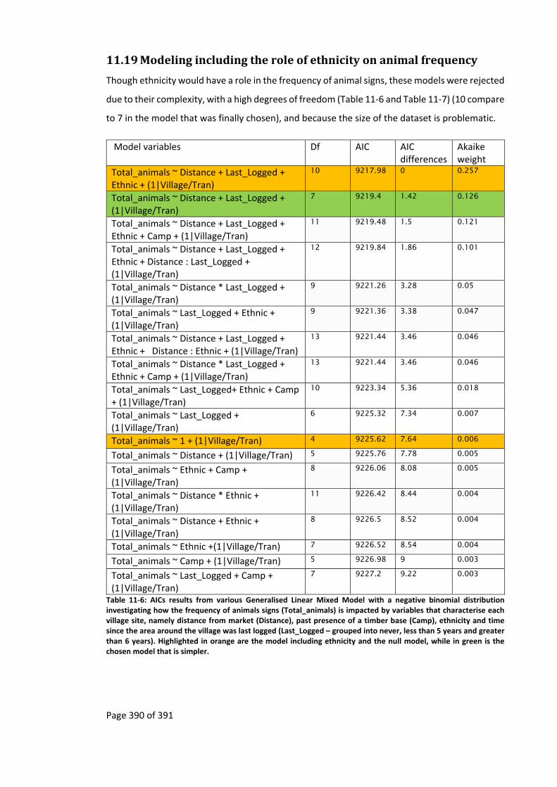
Page 390 of 391
11.19 Modelingincludingtheroleofethnicityonanimalfrequency
Though ethnicity would have a role in the frequency of animal signs, these models were rejected
due to their complexity, with a high degrees of freedom (Table 11‐6 and Table 11‐7) (10 compare
to 7 in the model that was finally chosen), and because the size of the dataset is problematic.
Model variables Df AIC AIC differences
Akaike weight
Total_animals ~ Distance + Last_Logged + Ethnic + (1|Village/Tran)
10 9217.98 0 0.257
Total_animals ~ Distance + Last_Logged + (1|Village/Tran)
7 9219.4 1.42 0.126
Total_animals ~ Distance + Last_Logged + Ethnic + Camp + (1|Village/Tran)
11 9219.48 1.5 0.121
Total_animals ~ Distance + Last_Logged + Ethnic + Distance : Last_Logged + (1|Village/Tran)
12 9219.84 1.86 0.101
Total_animals ~ Distance * Last_Logged + (1|Village/Tran)
9 9221.26 3.28 0.05
Total_animals ~ Last_Logged + Ethnic + (1|Village/Tran)
9 9221.36 3.38 0.047
Total_animals ~ Distance + Last_Logged + Ethnic + Distance : Ethnic + (1|Village/Tran)
13 9221.44 3.46 0.046
Total_animals ~ Distance * Last_Logged + Ethnic + Camp + (1|Village/Tran)
13 9221.44 3.46 0.046
Total_animals ~ Last_Logged+ Ethnic + Camp + (1|Village/Tran)
10 9223.34 5.36 0.018
Total_animals ~ Last_Logged + (1|Village/Tran)
6 9225.32 7.34 0.007
Total_animals ~ 1 + (1|Village/Tran) 4 9225.62 7.64 0.006
Total_animals ~ Distance + (1|Village/Tran) 5 9225.76 7.78 0.005
Total_animals ~ Ethnic + Camp + (1|Village/Tran)
8 9226.06 8.08 0.005
Total_animals ~ Distance * Ethnic + (1|Village/Tran)
11 9226.42 8.44 0.004
Total_animals ~ Distance + Ethnic + (1|Village/Tran)
8 9226.5 8.52 0.004
Total_animals ~ Ethnic +(1|Village/Tran) 7 9226.52 8.54 0.004
Total_animals ~ Camp + (1|Village/Tran) 5 9226.98 9 0.003
Total_animals ~ Last_Logged + Camp + (1|Village/Tran)
7 9227.2 9.22 0.003
Table 11‐6: AICs results from various Generalised Linear Mixed Model with a negative binomial distribution investigating how the frequency of animals signs (Total_animals) is impacted by variables that characterise each village site, namely distance from market (Distance), past presence of a timber base (Camp), ethnicity and time since the area around the village was last logged (Last_Logged – grouped into never, less than 5 years and greater than 6 years). Highlighted in orange are the model including ethnicity and the null model, while in green is the chosen model that is simpler.
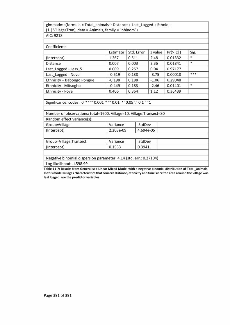
Page 391 of 391
glmmadmb(formula = Total_animals ~ Distance + Last_Logged + Ethnic + (1 | Village/Tran), data = Animals, family = "nbinom")
AIC: 9218
Coefficients:
Estimate Std. Error z value Pr(>|z|) Sig.
(Intercept) 1.267 0.511 2.48 0.01332 *
Distance 0.007 0.003 2.36 0.01841 *
Last_Logged ‐ Less_5 0.009 0.257 0.04 0.97177
Last_Logged ‐ Never ‐0.519 0.138 ‐3.75 0.00018 ***
Ethnicity – Babongo Pongue ‐0.198 0.188 ‐1.06 0.29048
Ethnicity ‐ Mitsogho ‐0.449 0.183 ‐2.46 0.01401 *
Ethnicity ‐ Pove 0.406 0.364 1.12 0.36439
Significance. codes: 0 ‘***’ 0.001 ‘**’ 0.01 ‘*’ 0.05 ‘.’ 0.1 ‘ ’ 1
Number of observations: total=1600, Village=10, Village:Transect=80
Random effect variance(s):
Group=Village Variance StdDev
(Intercept) 2.203e‐09 4.694e‐05
Group=Village:Transect Variance StdDev
(Intercept) 0.1553 0.3941
Negative binomial dispersion parameter: 4.14 (std. err.: 0.27104)
Log‐likelihood: ‐4598.99 Table 11‐7: Results from Generalised Linear Mixed Model with a negative binomial distribution of Total_animals. In this model villages characteristics that concern distance, ethnicity and time since the area around the village was last logged are the predictor variables.