Poinciana Park Civic Association Project Update March 9, 2022
32
Project Update for: Poinciana Park Civic Association Project Update March 9, 2022
-
Upload
khangminh22 -
Category
Documents
-
view
1 -
download
0
Transcript of Poinciana Park Civic Association Project Update March 9, 2022
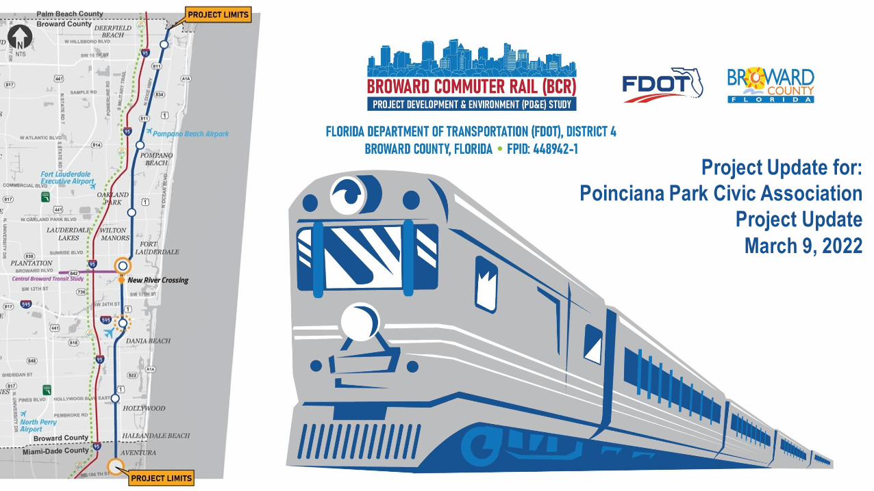
Project Update for:
Poinciana Park Civic Association
Project Update
March 9, 2022
2
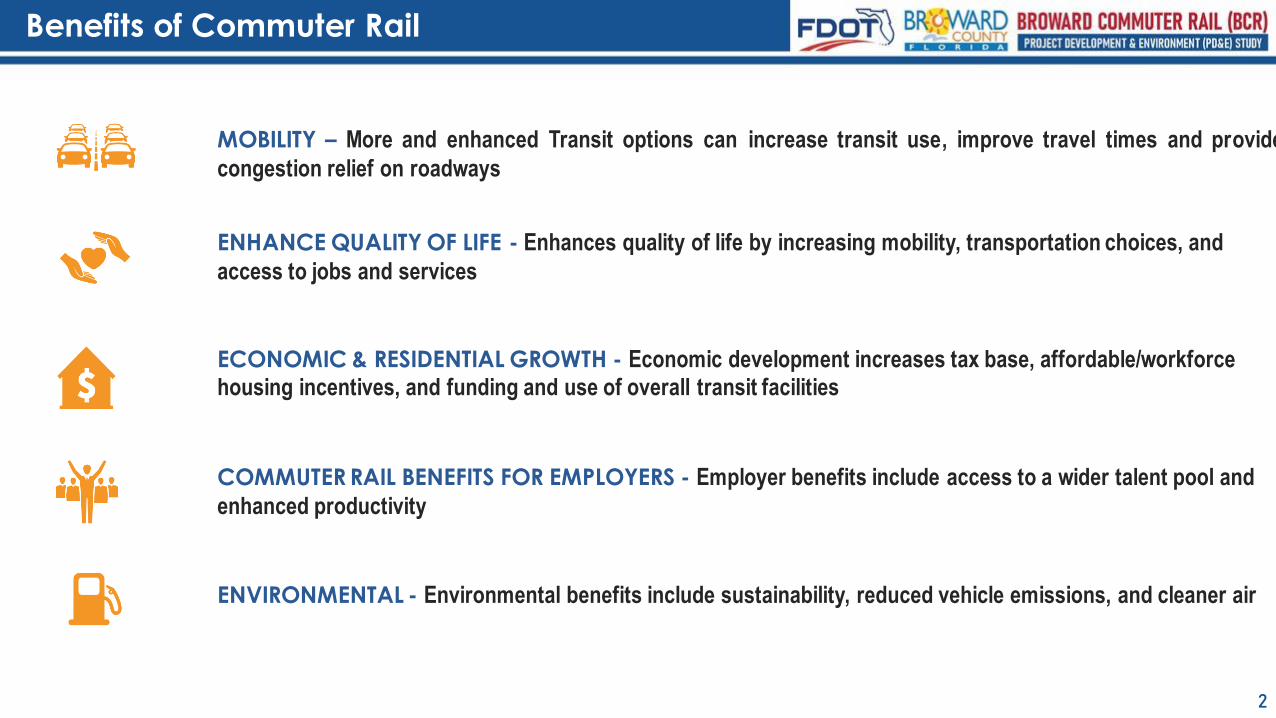
MOBILITY – More and enhanced Transit options can increase transit use, improve travel times and provide
congestion relief on roadways
ENHANCE QUALITY OF LIFE - Enhances quality of life by increasing mobility, transportation choices, and
access to jobs and services
ECONOMIC & RESIDENTIAL GROWTH - Economic development increases tax base, affordable/workforce housing incentives, and funding and use of overall transit facilities
COMMUTER RAIL BENEFITS FOR EMPLOYERS - Employer benefits include access to a wider talent pool and
enhanced productivity
ENVIRONMENTAL - Environmental benefits include sustainability, reduced vehicle emissions, and cleaner air
Benefits of Commuter Rail
3
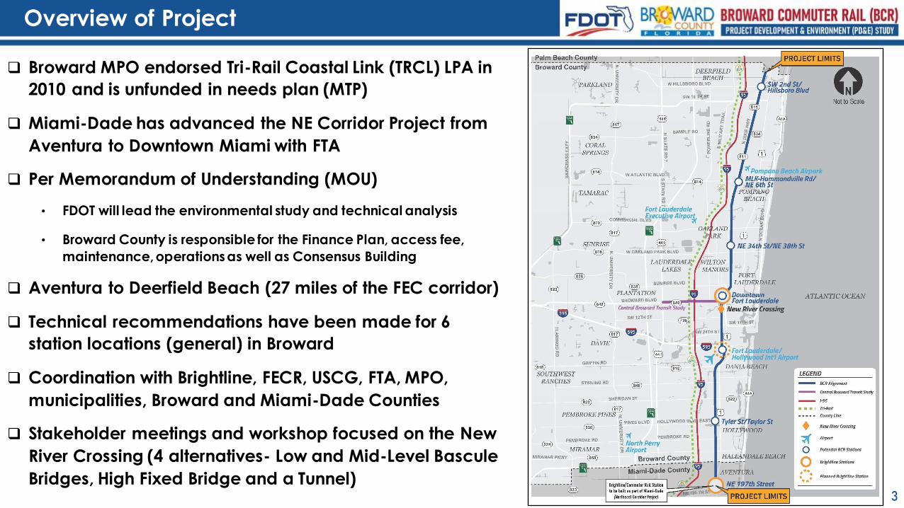
❑ Broward MPO endorsed Tri-Rail Coastal Link (TRCL) LPA in
2010 and is unfunded in needs plan (MTP)
❑ Miami-Dade has advanced the NE Corridor Project from
Aventura to Downtown Miami with FTA
❑ Per Memorandum of Understanding (MOU)
• FDOT will lead the environmental study and technical analysis
• Broward County is responsible for the Finance Plan, access fee,
maintenance, operations as well as Consensus Building
❑ Aventura to Deerfield Beach (27 miles of the FEC corridor)
❑ Technical recommendations have been made for 6
station locations (general) in Broward
❑ Coordination with Brightline, FECR, USCG, FTA, MPO,
municipalities, Broward and Miami-Dade Counties
❑ Stakeholder meetings and workshop focused on the New
River Crossing (4 alternatives- Low and Mid-Level Bascule
Bridges, High Fixed Bridge and a Tunnel)
Overview of Project
4
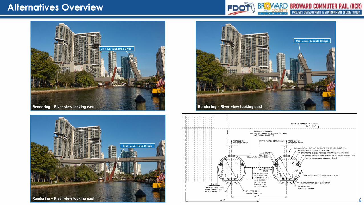
Alternatives Overview
Rendering – River view looking east
Tunnel Alternative
Low-Level Alternative: Technical Take-aways
5
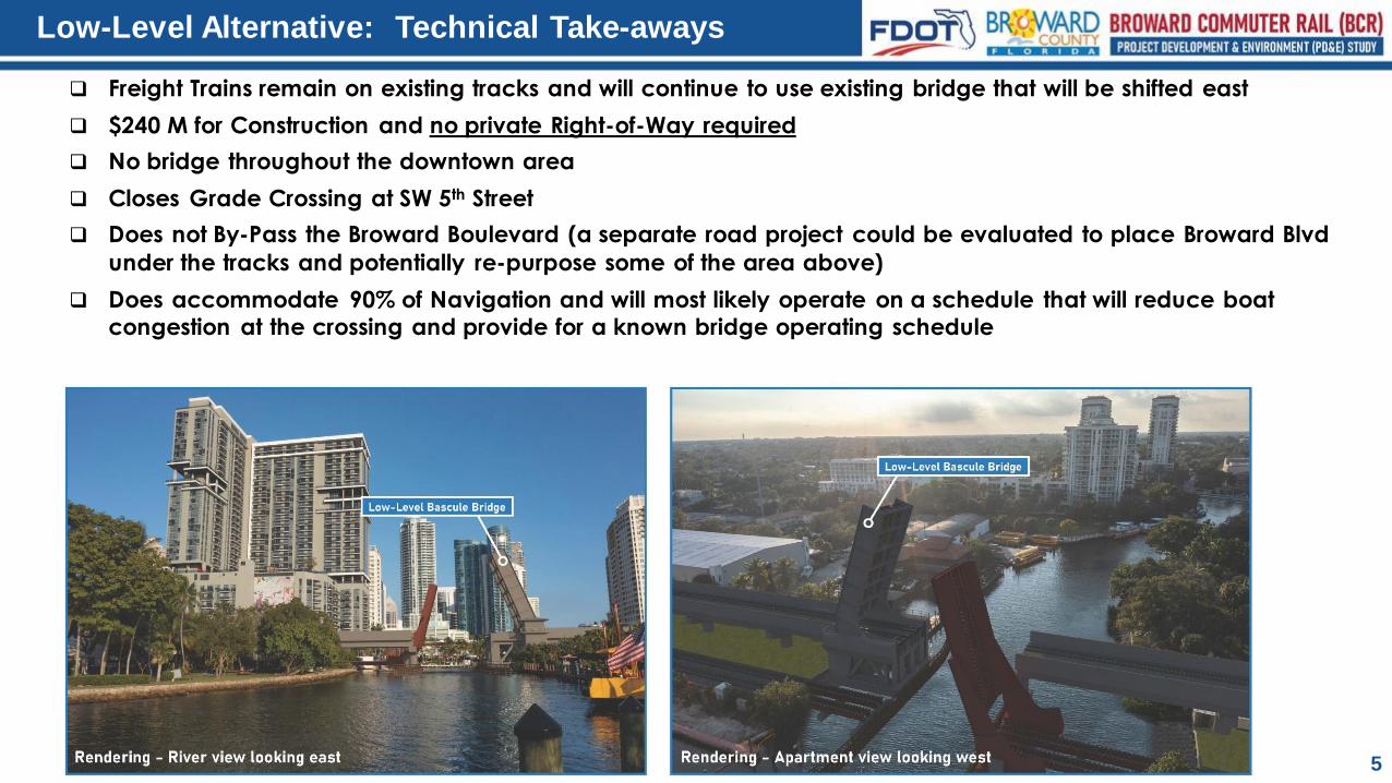
❑ Freight Trains remain on existing tracks and will continue to use existing bridge that will be shifted east
❑ $240 M for Construction and no private Right-of-Way required
❑ No bridge throughout the downtown area
❑ Closes Grade Crossing at SW 5th Street
❑ Does not By-Pass the Broward Boulevard (a separate road project could be evaluated to place Broward Blvd
under the tracks and potentially re-purpose some of the area above)
❑ Does accommodate 90% of Navigation and will most likely operate on a schedule that will reduce boat congestion at the crossing and provide for a known bridge operating schedule
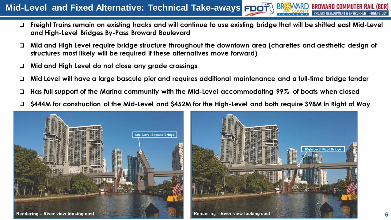
Mid-Level and Fixed Alternative: Technical Take-aways
6
❑ Freight Trains remain on existing tracks and will continue to use existing bridge that will be shifted east Mid-Level
and High-Level Bridges By-Pass Broward Boulevard
❑ Mid and High Level require bridge structure throughout the downtown area (charettes and aesthetic design of
structures most likely will be required if these alternatives move forward)
❑ Mid and High Level do not close any grade crossings
❑ Mid Level will have a large bascule pier and requires additional maintenance and a full-time bridge tender
❑ Has full support of the Marina community with the Mid-Level accommodating 99% of boats when closed
❑ $444M for construction of the Mid-Level and $452M for the High-Level and both require $98M in Right of Way
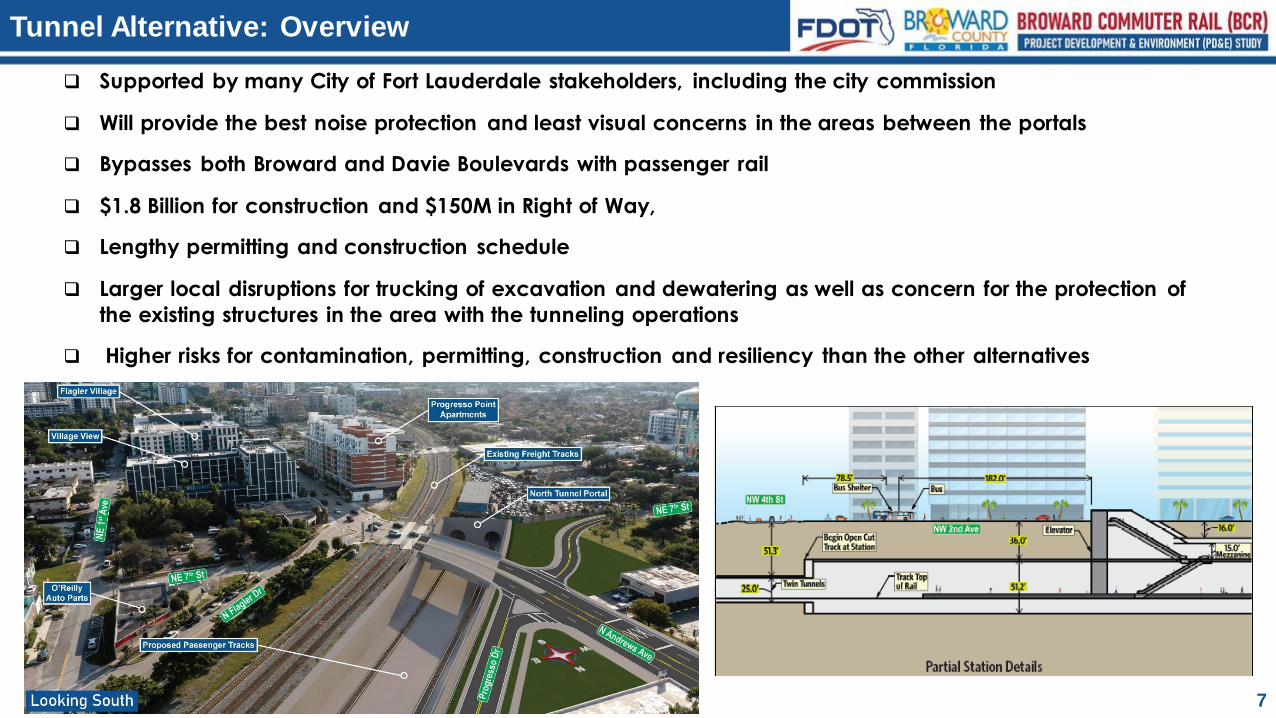
Tunnel Alternative: Overview
7
❑ Supported by many City of Fort Lauderdale stakeholders, including the city commission
❑ Will provide the best noise protection and least visual concerns in the areas between the portals
❑ Bypasses both Broward and Davie Boulevards with passenger rail
❑ $1.8 Billion for construction and $150M in Right of Way,
❑ Lengthy permitting and construction schedule
❑ Larger local disruptions for trucking of excavation and dewatering as well as concern for the protection of
the existing structures in the area with the tunneling operations
❑ Higher risks for contamination, permitting, construction and resiliency than the other alternatives
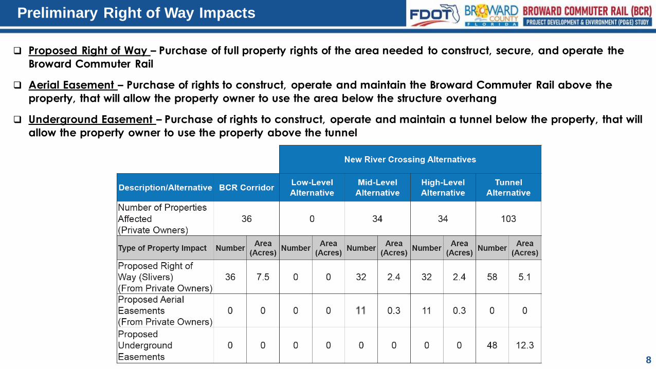
Preliminary Right of Way Impacts
8
❑ Proposed Right of Way – Purchase of full property rights of the area needed to construct, secure, and operate the
Broward Commuter Rail
❑ Aerial Easement – Purchase of rights to construct, operate and maintain the Broward Commuter Rail above the
property, that will allow the property owner to use the area below the structure overhang
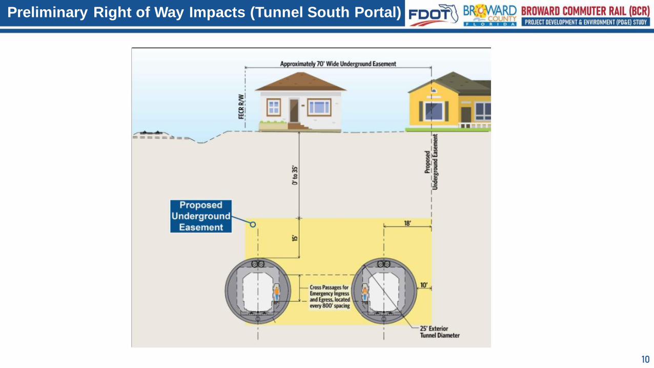
❑ Underground Easement – Purchase of rights to construct, operate and maintain a tunnel below the property, that will
allow the property owner to use the property above the tunnel
9
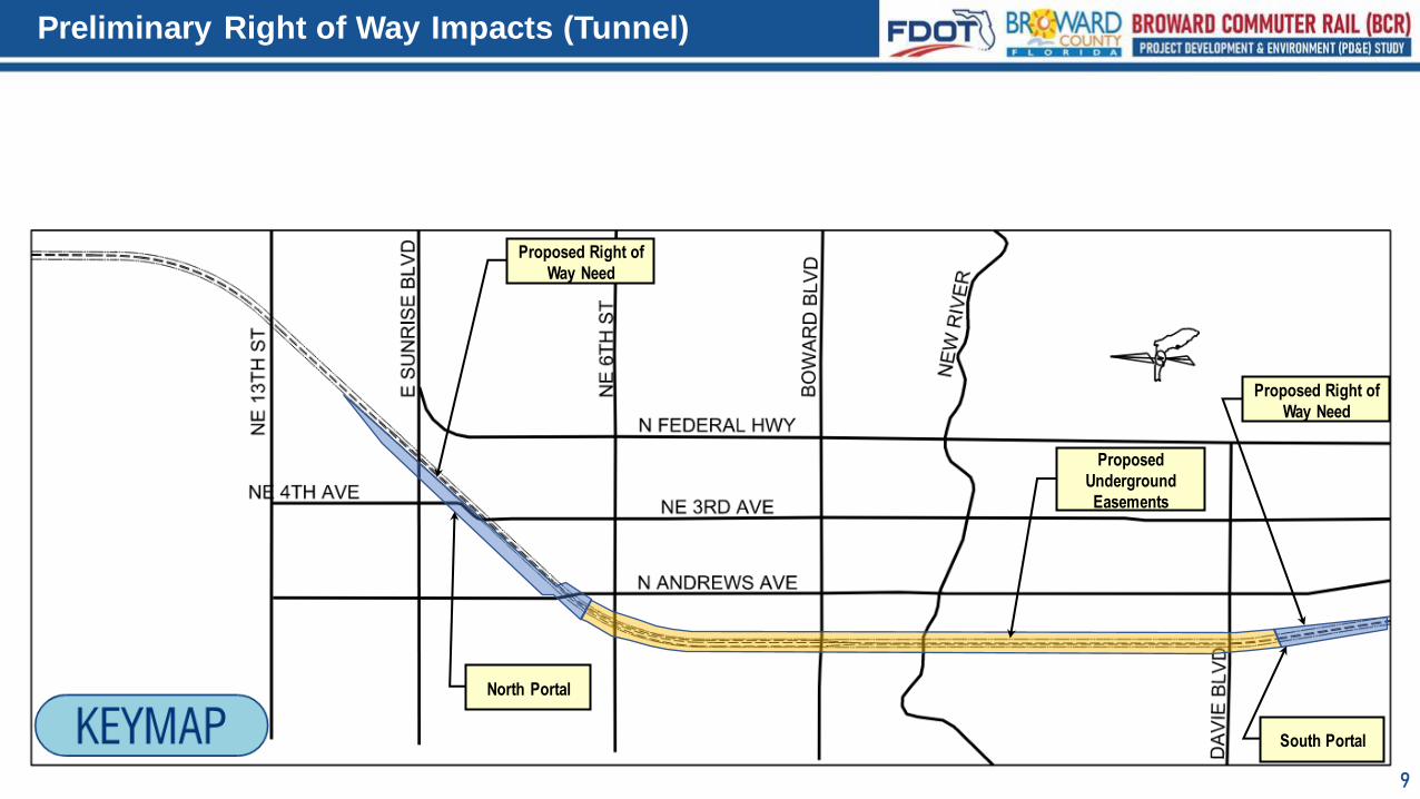
Preliminary Right of Way Impacts (Tunnel)
Proposed
Underground
Easements
Proposed Right of
Way Need
Proposed Right of
Way Need
North Portal
South Portal
10
Preliminary Right of Way Impacts (Tunnel South Portal)
11
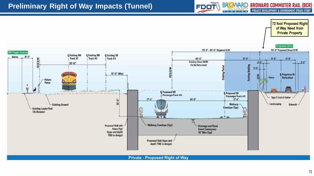
Preliminary Right of Way Impacts (Tunnel)
72 foot Proposed Right
of Way Need from
Private Property

12NE 4th Avenue to NE 2nd Avenue
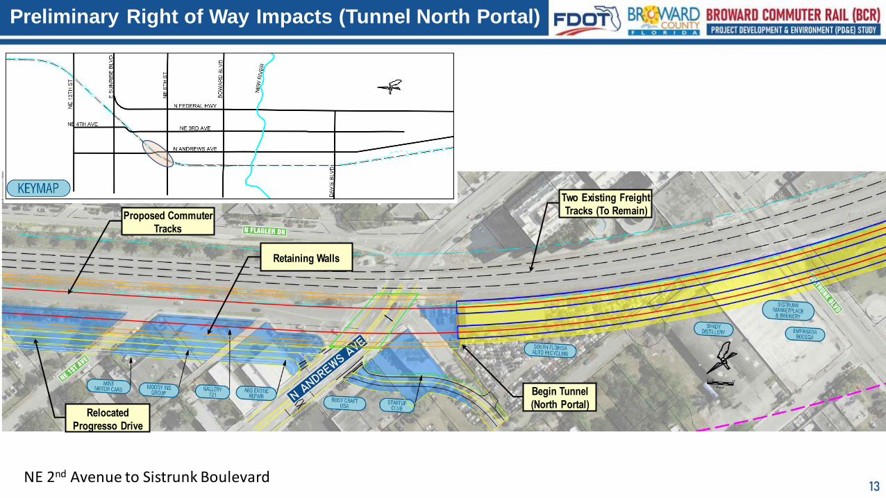
Preliminary Right of Way Impacts (Tunnel North Portal)
Two Existing Freight
Tracks (To Remain)
Proposed Commuter
Tracks
Relocated
Progresso Drive
Relocated NE 3rd
Avenue
Begin Retaining
Walls
13
Preliminary Right of Way Impacts (Tunnel North Portal)
NE 2nd Avenue to Sistrunk Boulevard
Two Existing Freight
Tracks (To Remain)Proposed Commuter
Tracks
Retaining Walls
Begin Tunnel
(North Portal)Relocated
Progresso Drive
14
Preliminary Right of Way Impacts (Tunnel South Portal)
South of Davie Boulevard to SW 16th Street
Proposed LauderTrail
by Others
Existing Freight
Tracks (To Remain)
Proposed Commuter
Tracks
SW 15th Street
CLOSED
Retaining Walls Relocated SW 2nd
AvenueEnd Tunnel
(South Portal)
SW FLAGLER AVE
15
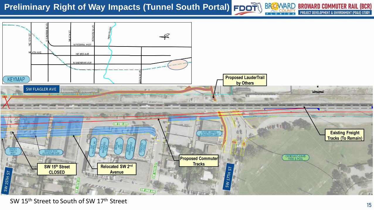
Preliminary Right of Way Impacts (Tunnel South Portal)
SW 15th Street to South of SW 17th Street
Proposed LauderTrail
by Others
Existing Freight
Tracks (To Remain)
Proposed Commuter
TracksSW 15th Street
CLOSED
Relocated SW 2nd
Avenue
SW FLAGLER AVE
16
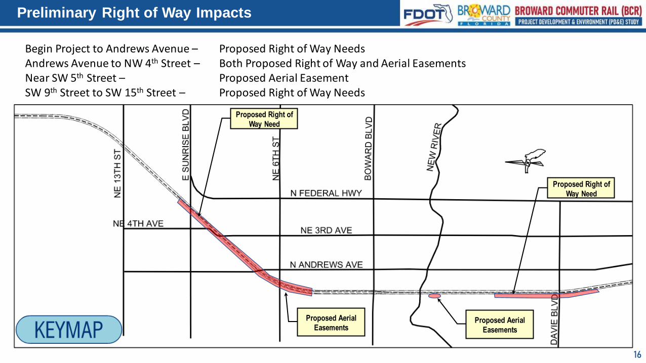
Preliminary Right of Way Impacts
Proposed Right of
Way Need
Proposed Right of
Way Need
Proposed Aerial
Easements
Proposed Aerial
Easements
Begin Project to Andrews Avenue – Proposed Right of Way NeedsAndrews Avenue to NW 4th Street – Both Proposed Right of Way and Aerial EasementsNear SW 5th Street – Proposed Aerial EasementSW 9th Street to SW 15th Street – Proposed Right of Way Needs
17
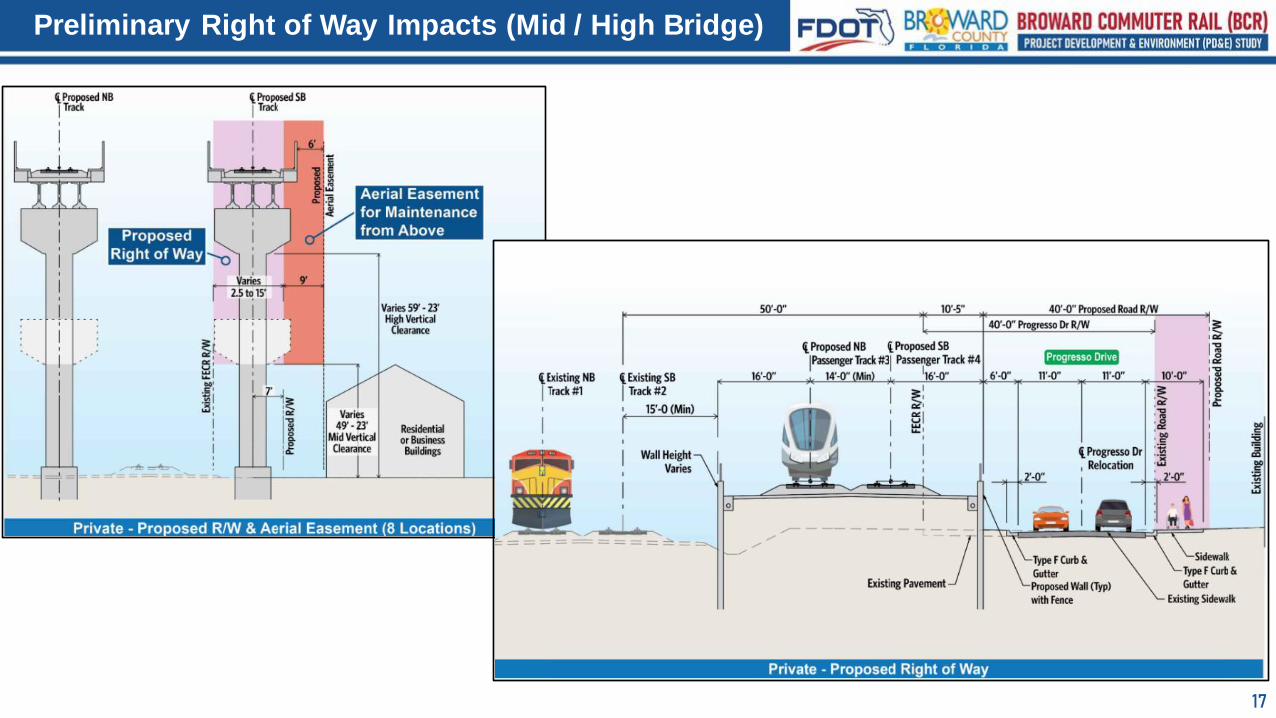
Preliminary Right of Way Impacts (Mid / High Bridge)
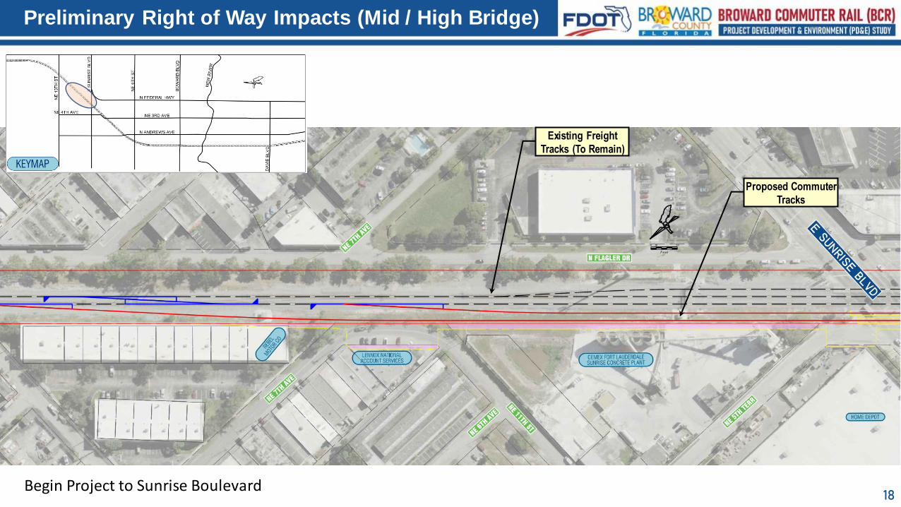
18
Preliminary Right of Way Impacts (Mid / High Bridge)
Existing Freight
Tracks (To Remain)
Proposed Commuter
Tracks
Begin Project to Sunrise Boulevard
19
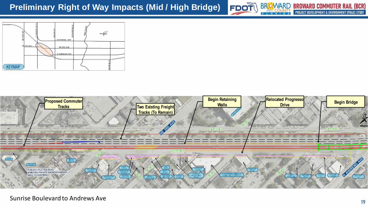
Preliminary Right of Way Impacts (Mid / High Bridge)
Sunrise Boulevard to Andrews Ave
Two Existing Freight
Tracks (To Remain)
Proposed Commuter
Tracks
Relocated Progresso
Drive
Begin Retaining
WallsBegin Bridge
20
Preliminary Right of Way Impacts (Mid / High Bridge)
Andrew Ave to NW 4th Street
Two Existing Freight
Tracks (To Remain)
Proposed Commuter
Tracks
R/W Need 2.5’ to 15’
9’ Aerial Easement
21
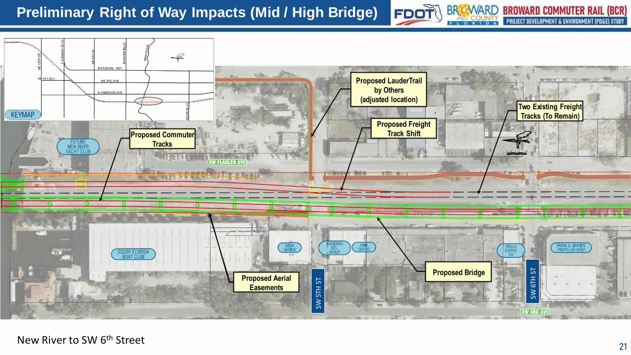
Preliminary Right of Way Impacts (Mid / High Bridge)
New River to SW 6th Street
Two Existing Freight
Tracks (To Remain)
Proposed Commuter
Tracks
Proposed Aerial
Easements
Proposed Bridge
Proposed Freight
Track Shift
Proposed LauderTrail
by Others
(adjusted location)
SW 6
TH S
T
SW 5
TH S
T
22
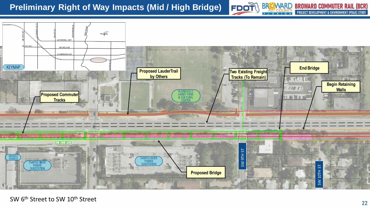
Preliminary Right of Way Impacts (Mid / High Bridge)
SW 6th Street to SW 10th Street
Begin Retaining
Walls
End BridgeProposed LauderTrail
by OthersTwo Existing Freight
Tracks (To Remain)
Proposed Commuter
Tracks
Proposed Bridge
SW 1
0TH
STSW
9TH
ST
23
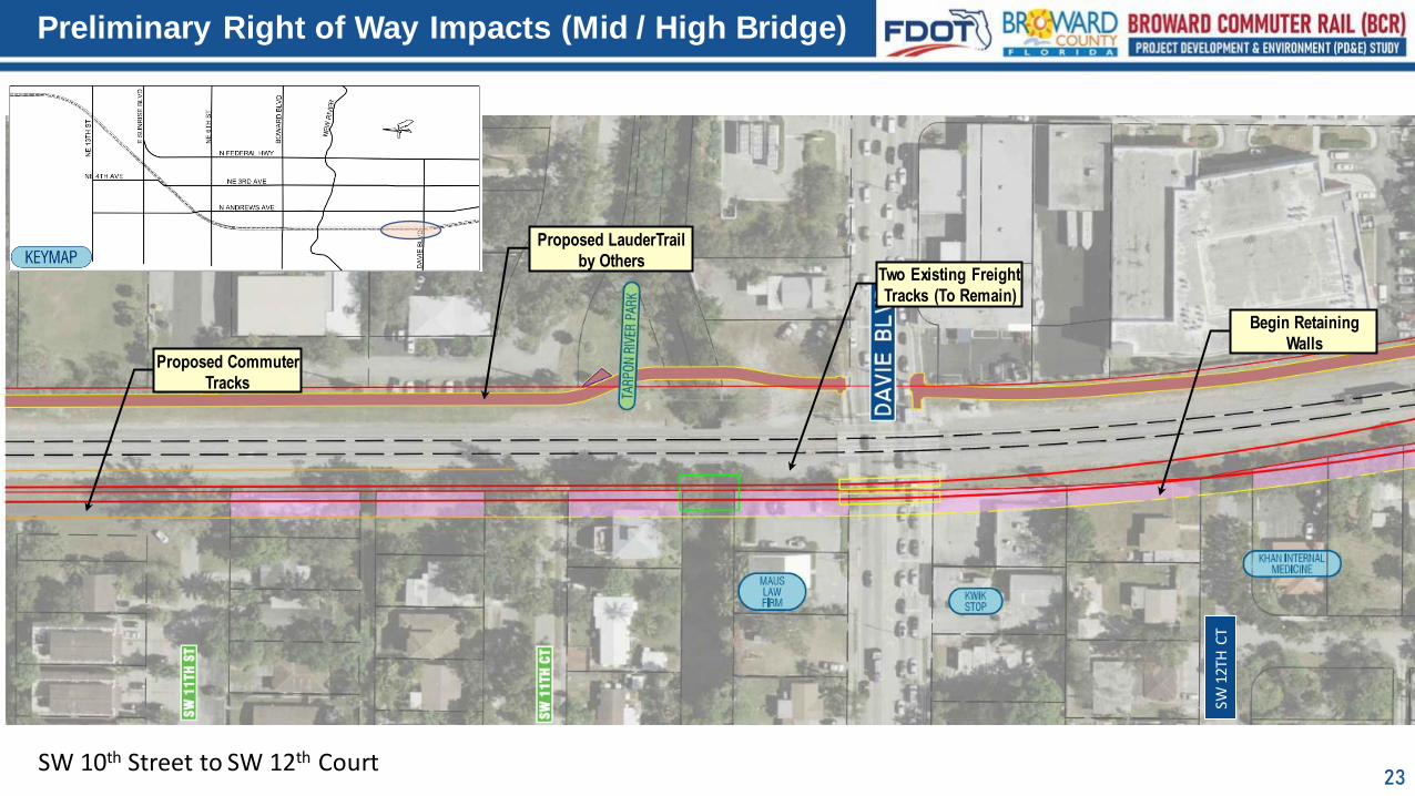
Preliminary Right of Way Impacts (Mid / High Bridge)
SW 10th Street to SW 12th Court
Begin Retaining
Walls
Proposed LauderTrail
by OthersTwo Existing Freight
Tracks (To Remain)
Proposed Commuter
Tracks
SW 1
2TH
CT
24
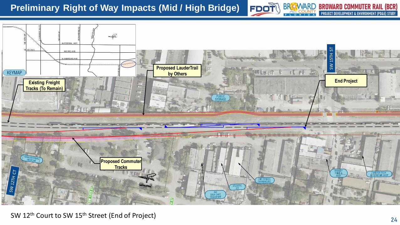
Preliminary Right of Way Impacts (Mid / High Bridge)
SW 12th Court to SW 15th Street (End of Project)
End Project
Proposed LauderTrail
by Others
Existing Freight
Tracks (To Remain)
Proposed Commuter
Tracks
SW 1
5TH
ST
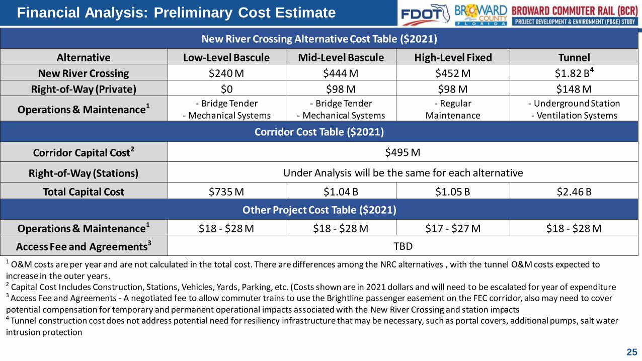
Financial Analysis: Preliminary Cost Estimate
25
New River Crossing Alternative Cost Table ($2021)
Alternative Low-Level Bascule Mid-Level Bascule High-Level Fixed Tunnel
New River Crossing $240 M $444 M $452 M $1.82 B4
Right-of-Way (Private) $0 $98 M $98 M $148 M
Operations & Maintenance1 - Bridge Tender- Mechanical Systems
- Bridge Tender- Mechanical Systems
- Regular Maintenance
- Underground Station- Ventilation Systems
Corridor Cost Table ($2021)
Corridor Capital Cost2 $495 M
Right-of-Way (Stations) Under Analysis will be the same for each alternative
Total Capital Cost $735 M $1.04 B $1.05 B $2.46 B
Other Project Cost Table ($2021)
Operations & Maintenance1 $18 - $28 M $18 - $28 M $17 - $27 M $18 - $28 M
Access Fee and Agreements3 TBD1 O&M costs are per year and are not calculated in the total cost. There are differences among the NRC alternatives , with the tunnel O&M costs expected to increase in the outer years.2 Capital Cost Includes Construction, Stations, Vehicles, Yards, Parking, etc. (Costs shown are in 2021 dollars and will need to be escalated for year of expenditure3 Access Fee and Agreements - A negotiated fee to allow commuter trains to use the Brightline passenger easement on the FEC corridor, also may need to cover potential compensation for temporary and permanent operational impacts associated with the New River Crossing and station impacts4 Tunnel construction cost does not address potential need for resiliency infrastructure that may be necessary, such as portal covers, additional pumps, salt water intrusion protection
26
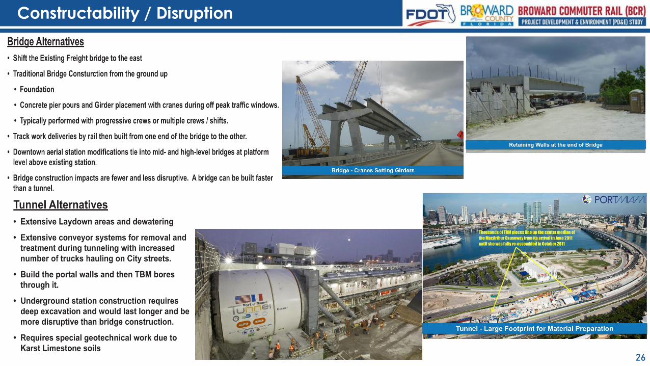
Constructability / Disruption
27
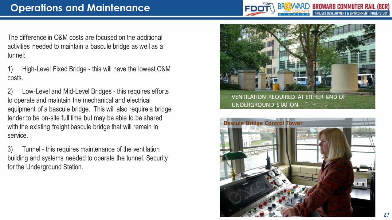
Operations and Maintenance
The difference in O&M costs are focused on the additional
activities needed to maintain a bascule bridge as well as a
tunnel:
1) High-Level Fixed Bridge - this will have the lowest O&M
costs.
2) Low-Level and Mid-Level Bridges - this requires efforts
to operate and maintain the mechanical and electrical
equipment of a bascule bridge. This will also require a bridge
tender to be on-site full time but may be able to be shared
with the existing freight bascule bridge that will remain in service.
3) Tunnel - this requires maintenance of the ventilation
building and systems needed to operate the tunnel. Security
for the Underground Station.
VENTILATION REQUIRED AT EITHER END OF UNDERGROUND STATION
Bascule Bridge Control Tower
28
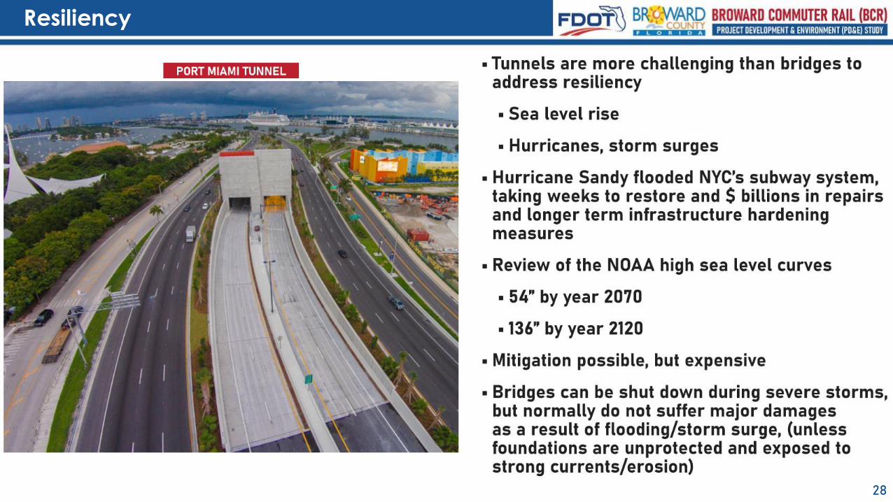
Resiliency
29
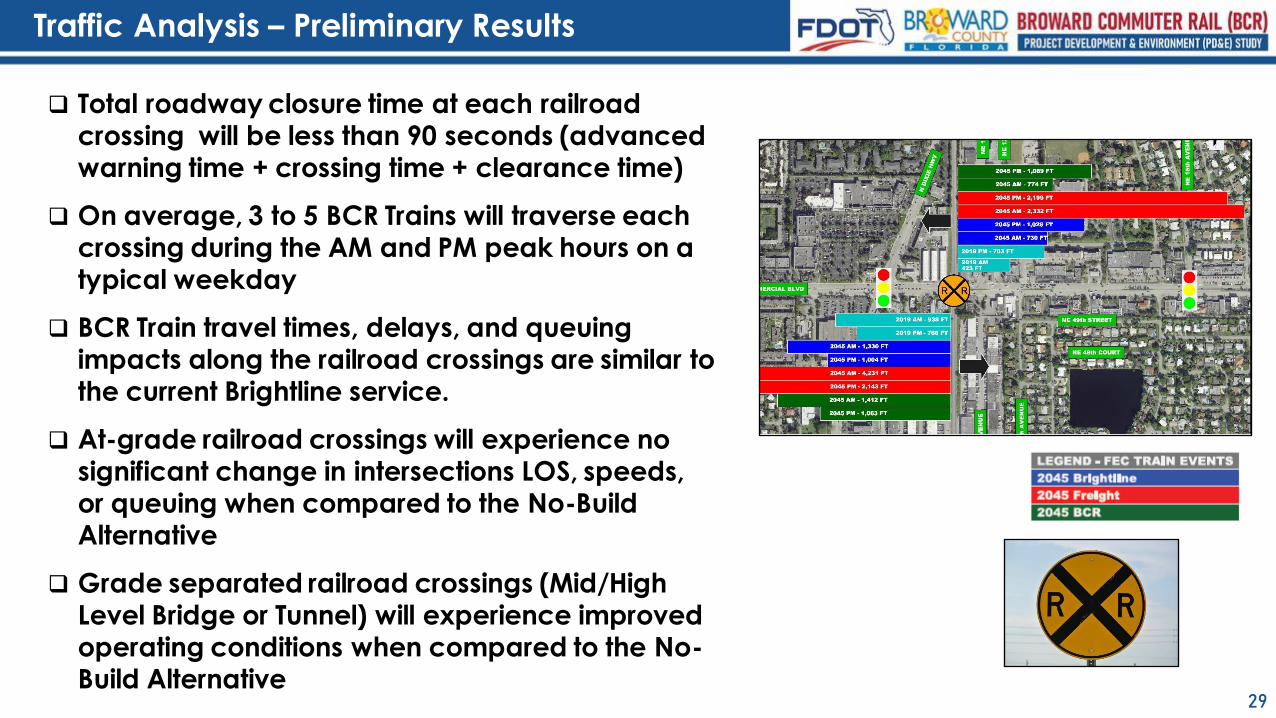
Traffic Analysis – Preliminary Results
❑ Total roadway closure time at each railroad crossing will be less than 90 seconds (advanced warning time + crossing time + clearance time)
❑ On average, 3 to 5 BCR Trains will traverse each crossing during the AM and PM peak hours on a typical weekday
❑ BCR Train travel times, delays, and queuing impacts along the railroad crossings are similar to the current Brightline service.
❑ At-grade railroad crossings will experience no significant change in intersections LOS, speeds, or queuing when compared to the No-Build Alternative
❑ Grade separated railroad crossings (Mid/High Level Bridge or Tunnel) will experience improved operating conditions when compared to the No-Build Alternative
30
Connectivity
Note: Freight will remain at-grade and on existing tracks(that may be shifted within the existing rail Right of Way)
❑ Low Level
▪ Closes SW 5th Street
▪ Closure of 2nd Avenue between SW 10th and SW 11th Street (they will be cul-de sacs)
❑ Mid-Level Bascule and High-Level Fixed Bridges
▪ No Road Closures
▪ Closure of NW 5th Terrace at Sunrise Blvd (will be cul-de sac)
▪ Visual Impact of 8050-foot-long Bridge and +/- 1700 feet of approach walls to the bridge
❑ Tunnel
▪ Closure of SW 15th Street
▪ Closure of NW 5th Terrace at Sunrise Blvd (will be cul-de sac)
▪ Visual Impact of Portals/Trenches +/- 2600 feet short walls with protective fencing/barrier
surrounding the portals
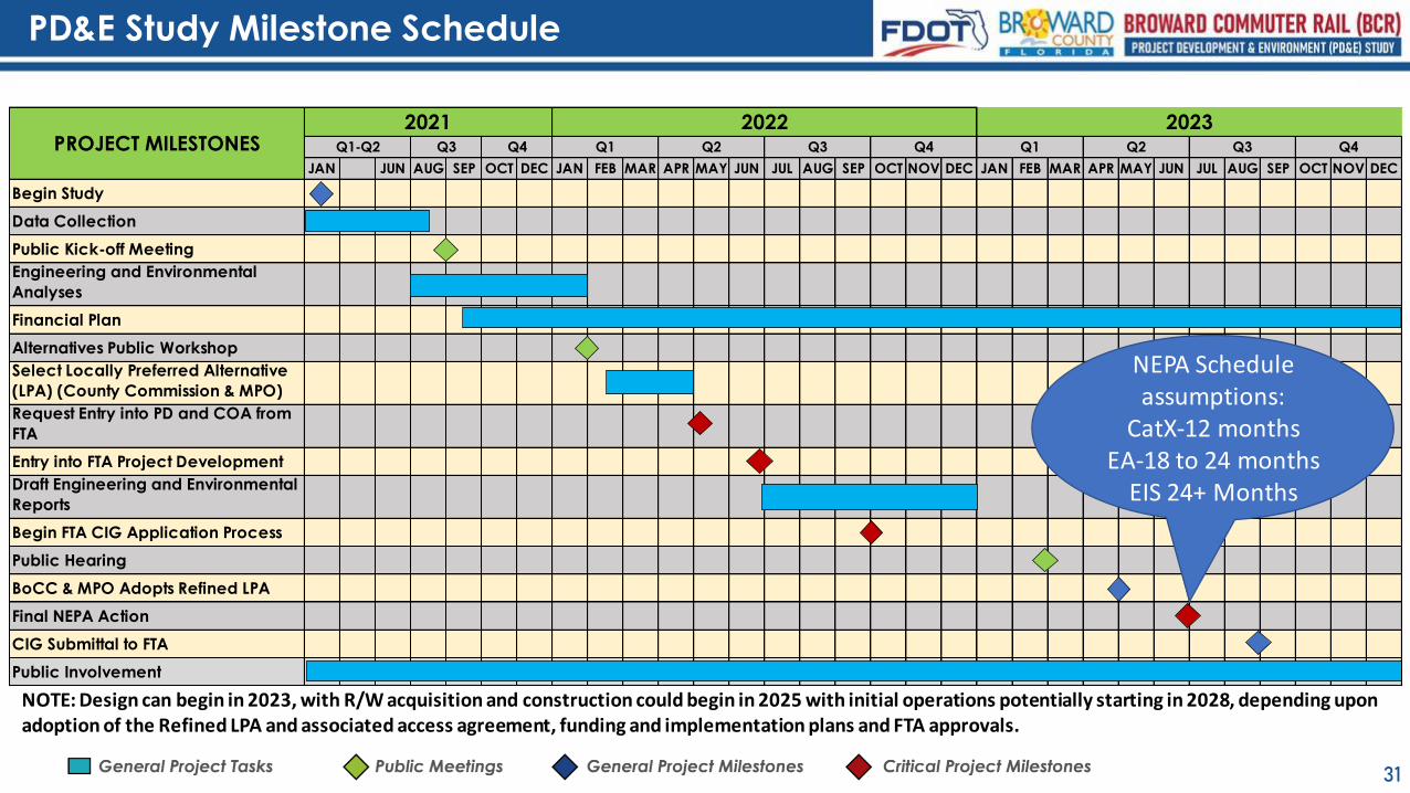
PD&E Study Milestone Schedule
31
JAN JUN AUG SEP OCT DEC JAN FEB MAR APR MAY JUN JUL AUG SEP OCT NOV DEC JAN FEB MAR APR MAY JUN JUL AUG SEP OCT NOV DEC
Begin Study
Data Collection
Public Kick-off Meeting
Engineering and Environmental
Analyses
Financial Plan
Alternatives Public Workshop
Select Locally Preferred Alternative
(LPA) (County Commission & MPO)
Request Entry into PD and COA from
FTA
Entry into FTA Project Development
Draft Engineering and Environmental
Reports
Begin FTA CIG Application Process
Public Hearing
BoCC & MPO Adopts Refined LPA
Final NEPA Action
CIG Submittal to FTA
Public Involvement
Q2 Q3 Q4
2023Q1PROJECT MILESTONES Q1-Q2 Q3 Q4
2021 2022Q1 Q2 Q3 Q4
NEPA Schedule assumptions:
CatX-12 monthsEA-18 to 24 months
EIS 24+ Months
NOTE: Design can begin in 2023, with R/W acquisition and construction could begin in 2025 with initial operations potentially starting in 2028, depending upon adoption of the Refined LPA and associated access agreement, funding and implementation plans and FTA approvals.
32
Questions???