Platform for Effective Use of Research Results and Networking Efforts and the Opportunities of...
21
Platform for Effective Use of Research Results and Networking Efforts and the Opportunities of Collaboration with the New Network Francisco Pérez Trejo Senior Advisor of the Global Information System, PGRFA Treaty FIRST WORKSHOP OF THE CONSORTIUM OF INTERNATIONAL DRYLAND RESEARCH AND KNOWLEDGE NETWORKS University of Hamburg, Germany The increased frequency of processes and events linked to desertification like droughts, economic crises, famines, floods, forest fires have triggered an increase in the need to improve the adaptability – response capacity of populations around the world, and also highlights the multi-dimensional nature of any initiative that might be undertaken to find more resilient pathways to attain sustainable development, particularly for rural areas, home to 70 percent of the world's poor and hungry people. This initiative on the development of the Network of Networks Platform for reducing desertification will utilize a framework that can guide a coordinated multi-dimensional approach by key stakeholders, decision makers and operations from the many organization and agencies to take advantage of information systems and thus increase both the effectiveness and efficiency of research results, programs and projects. Besides the scientific dimension, social and ecological community thresholds are certainly a requirement for addressing the challenges of assessing the possible effects and impacts of policies, climate-driven tipping points, land-use changes, and other driving forces on the environment and desertification vulnerability 1 and resilience 2 . The specter of desertification linked to natural disasters, climate change, land-use changes and a greater frequency of natural and socio-economic shocks contribute to the growing interest and recognition of the value of a joint multi-sector approach to the improvement of adaptability and response capacity to every aspect of the livelihoods of populations, particularly in rural areas, with a territorial perspective, particularly in terms of their livelihoods, water resources management and the need for sustainable agri-food systems. The Platform for the Networks of Networks presented here can establish better access, interaction and collaboration among stakeholders and decision-makers at all levels with a comprehensive package of methodological frameworks and tools to handle information about present-day conditions of environment and livelihood, risks associated with natural resource degradation, climatic events, economic crises, water management risks, and other relevant processes under and against a range of future scenarios. The framework of the Platform includes user-based functionalities to compare selected options (trade-off s) for significantly improving the necessary coordination efforts required for promoting and enhancing policy development and management intervention. The establishment of the Platform focuses on user-centric, co-design co-development approaches to develop key features linking across stakeholder networks, also focusing on key interoperability considerations going beyond technological barriers, like research results database structures or server-to-server interaction, in order to focus on operational functionalities that integrate across social, sectorial, geographic location, decision- making levels, production-chain phases, stakeholder objectives/interests, economic and institutional frameworks, and economic and environmental sustainability considerations. The participatory innovation 1 Vulnerability is defined as the potential for susceptibility to negative impacts in terms of the degree to which a system (for example, community) is susceptible to pressures and disturbances, such as climate change, desertification or socio-economic processes. 2 In a Complex Systems framework, resilience is defined as an emergent property of an ecosystem that is presented in three main ways in the literature: as recovery, as stability and as transformation (Maguire and Cartwright 2008). This means that systems can evolve a capacity to recover from perturbations (extreme climatic events, forest fires, drought, over-grazing, floods, economic-food crises) by developing emergent resilience characteristics.
-
Upload
independent -
Category
Documents
-
view
0 -
download
0
Transcript of Platform for Effective Use of Research Results and Networking Efforts and the Opportunities of...
Platform for Effective Use of Research Results and Networking Efforts
and the Opportunities of Collaboration with the New Network
Francisco Pérez Trejo
Senior Advisor of the Global Information System, PGRFA Treaty
FIRST WORKSHOP OF THE CONSORTIUM OF INTERNATIONAL DRYLAND RESEARCH
AND KNOWLEDGE NETWORKS
University of Hamburg, Germany
The increased frequency of processes and events linked to desertification like droughts, economic crises,
famines, floods, forest fires have triggered an increase in the need to improve the adaptability – response
capacity of populations around the world, and also highlights the multi-dimensional nature of any initiative that
might be undertaken to find more resilient pathways to attain sustainable development, particularly for rural
areas, home to 70 percent of the world's poor and hungry people. This initiative on the development of the
Network of Networks Platform for reducing desertification will utilize a framework that can guide a
coordinated multi-dimensional approach by key stakeholders, decision makers and operations from the many
organization and agencies to take advantage of information systems and thus increase both the effectiveness and
efficiency of research results, programs and projects. Besides the scientific dimension, social and ecological
community thresholds are certainly a requirement for addressing the challenges of assessing the possible effects
and impacts of policies, climate-driven tipping points, land-use changes, and other driving forces on the
environment and desertification vulnerability1 and resilience2.
The specter of desertification linked to natural disasters, climate change, land-use changes and a greater
frequency of natural and socio-economic shocks contribute to the growing interest and recognition of the value
of a joint multi-sector approach to the improvement of adaptability and response capacity to every aspect of the
livelihoods of populations, particularly in rural areas, with a territorial perspective, particularly in terms of their
livelihoods, water resources management and the need for sustainable agri-food systems.
The Platform for the Networks of Networks presented here can establish better access, interaction and
collaboration among stakeholders and decision-makers at all levels with a comprehensive package of
methodological frameworks and tools to handle information about present-day conditions of environment and
livelihood, risks associated with natural resource degradation, climatic events, economic crises, water
management risks, and other relevant processes under and against a range of future scenarios. The framework of
the Platform includes user-based functionalities to compare selected options (trade-off s) for significantly
improving the necessary coordination efforts required for promoting and enhancing policy development and
management intervention.
The establishment of the Platform focuses on user-centric, co-design co-development approaches to develop
key features linking across stakeholder networks, also focusing on key interoperability considerations going
beyond technological barriers, like research results database structures or server-to-server interaction, in order
to focus on operational functionalities that integrate across social, sectorial, geographic location, decision-
making levels, production-chain phases, stakeholder objectives/interests, economic and institutional
frameworks, and economic and environmental sustainability considerations. The participatory innovation
1 Vulnerability is defined as the potential for susceptibility to negative impacts in terms of the degree to which a system (for example, community)
is susceptible to pressures and disturbances, such as climate change, desertification or socio-economic processes. 2 In a Complex Systems framework, resilience is defined as an emergent property of an ecosystem that is presented in three main ways in the
literature: as recovery, as stability and as transformation (Maguire and Cartwright 2008). This means that systems can evolve a capacity to recover
from perturbations (extreme climatic events, forest fires, drought, over-grazing, floods, economic-food crises) by developing emergent resilience
characteristics.
mechanisms associated with implementation and developments provide the means for applying the Platform at
all policy levels, from international policy scale to the local and regional policies.
Environmental challenges such as desertification, land degradation and climate change affect different people in
different ways. The Platform will provide the mechanisms and tools for information exchange about the people
(individuals, communities, countries, regions) who are impacted by these pressures to enhance their ability to
respond effectively and adapt to fast-evolving changes.
The components of the Platform will also help to identify priorities for adaptability and response in order to find
the areas and communities where the need for support is greatest. In general, communities with different
livelihoods face rather different kinds of risks, and have different capacity to respond to pressures, so livelihood
is a good starting point. The community’s ability to cope with economic, environmental and social pressures is
measured in terms of their capacity to respond (adaptation capacity) and the indicators of coping ability needs to
be based upon an analysis with explicit geographic reference. Dimensions like data, information and people are
the foundations for introducing environmental and socio-economic information into the decision-making
process. This initiative will focus on the need for integrated actions that concurrently permit the evaluation and
instrumentation of the broadening of the response capacity of an ever increasing number of organizations to
actually have an impact in terms of vulnerability to economic and social crises, natural disasters and
emergencies.
The perceived need for a coherent policy response to the development, food security and public health and
sustainability challenges facing populations (mostly in rural areas) is dependent on an urgent need for a more
effective and up-to-date information based coordination system. In this respect there is also an urgent need for
information technology innovations that can improve the harmonization and coordination of interventions and
support actions in terms of systems and criteria for the collection and collation of information at the community
level, including production, trade, processing and marketing, agro-meteorological and social vulnerability data.
For this purpose, local, national and regional networking systems capable of exchanging information about
imminent disasters need to be strengthened or developed where they do not exist, and better linked to the
numerous decision making and response organisations.
The Platform proposed here will provide support for the identification, generation and collaborative
development and policy-making initiatives that can significantly reduce the risk of desertification. The Platform
will be developed and strengthened by functionalities in the areas of Stakeholder Profiling, User Support,
Vulnerability Research, Natural Resources Use, Livelihood Sustainability Spatial Analysis, Sustainability
Scenarios and Territorial Analysis.
The objectives of the Platform initiative include:
1. To develop a co-design/co-development process for the development of the Network of Networks Platform
of the stakeholders involved in both the demand and supply of livelihoods-related adaptability and response
capacity information and services in order to involve these communities in the development of usage
scenarios and requirements by combining recent advancements in research results, social, cognitive and
behavioral application, with novel user interaction paradigms in order to better understand individual and
community-level practices and behaviors and mediated interaction among potential partners.
• Activation of key network members and stakeholders (including project participants, research and academic organizations, public authorities, economic, industrial, rural communities, civil society) to
consolidate user communities with specific territorial dimensions.
• Development and implementation plans of alternative emergency risk reduction development
communities using the Platform methodological framework and according to use scenarios.

• Collecting and analyzing feedback from participants for enhancing the effectiveness of the Platform.
• Implementation of a participatory innovation process as the mechanism to engage key stakeholders in
the design and development of the functionalities of the Platform for ensuring and enhancing the
impact of the participatory process by assessing impact at different policy levels and using social
impact measures.
• To design and make available the functionalities of the Platform which will allow end users to
seamlessly capture in real time information on their actual behavior, as well share and confront
behavior and action within their social communities (participatory sensing) by originally combining
pervasive computing, context awareness, participatory/social sensing, and social network analysis. It
will also provide support for heterogeneous multi-sector information sources, which will include
aggregation of multi-sensory spatial and time distributed geo-localized data with subjective
information captured through social media analysis (i.e. geo-spatial data fusion, heterogeneous data
mining). The ultimate objective of the Platform will be fostering adaptability and response capacity
initiatives by providing a suitable information networking support for identifying potential lines of
action, generating collective actions in an intelligent way and linking the policy making process to
social priorities.
2. To develop robust data/information multi-level interoperability for the Platform, covering themes for
Stakeholder Profiling, User Support, Desertification Research Results, Natural Resources Use, Livelihood
Sustainability Spatial Analysis, Future Sustainability Scenarios and Spatial Public Goods Management
Analysis, as a coherent set of spatial adaptability and response capacity-related information themes,
building on existing databases and content provided by project partners, with the support and consensus of
key stakeholders involved in handling and maintaining such information.
3. To apply the participatory innovation methodological framework and other effective techniques, for
conveying feedback to the interested end-users, either individuals, either communities and/or local policy-
makers, with the ultimate aim of increasing their awareness on the sustainability and adaptability and
response capacity matters and, eventually to drive individual behavioral changes towards more eco-
sustainable ones or to make larger linkages to local policy-makers. In particular techniques from the visual
analytics domain will be linked to the spatial and temporal distributed environmental situation.
4. To define an open but efficient participation network architecture for discovery, visualization,
transformation and processing of economic, environmental and social data stored and maintained in
services distributed throughout the world, both for accessing data and capturing user-generated information,
based on shared-data principles for demonstrating the effectiveness of the proposed approach in generating
the sustainability-related Platform.
5. To set up and run a coherent set of demonstration activities in actual communities in developing countries
within concrete user scenarios and based on linkage among stakeholders, services and information sources,
using fast participatory innovation to enhance those functionalities to validate the robustness, relevance and
added value of the data models in supporting concrete services of adaptability and response capacity
relevance.
6. To disseminate and foster the exploitation of research results to the broader scientific, rural population and
policy community, as well as to Local Authorities and economic actors as “lead users” of the Platform in
the Open-Source systems, stimulating the seamless replication of the conceptual, socio-technical approach
in specific contexts.
The initiative will establish the Network of Networks Platform to develop and strengthen a networking
capacities across sectors, institutions, organizations, associations involved in the entire production system, that
will provide the necessary mechanisms, instruments, processes, and technology tools for using information,
maps and future scenarios for promoting and supporting risk reduction, focusing on the innovation processes
linked to sustainable land management systems.

The Platform is based on key mechanisms and instruments for promoting citizen participation in the networking
process for the generation and use of contents, and dynamic mapping to collect, aggregate and display the key
indicators of participatory innovation performance, barriers, obstacles and opportunities. The Indicators include
effective means for identifying the vulnerability associated with threats like droughts, floods, water scarcity or
quality regarding activities, sectors and livelihoods with specific territorial dimension. And the Platform will
deploy and promote the use of tools and Apps for active social participation (the citizen as a sensor) that will
transform the process from risk assessment tools into real-time monitoring.
The Platform provides mechanism and tools to address barriers and innovation challenges that are not directly
related to emergency operations, but are more associated with social, institutional and economic factors (like
private sector involvement), that can impact the risk reduction process in rural areas and can have an important
role in stimulating and enhancing the enabling environment to address social, economic and environmental
challenges, and also stimulate transnational competitiveness, and contribute to inclusive job creation and
sustainable economic growth.
As a process, desertification can be seen as a risk of land degradation in many regions of the world associated
with numerous causes, but for certain regions the vulnerability is particularly acute, such as semi arid regions,
characterised by ecological conditions such as aridity, intense human activity, irregular but intense precipitation,
frequent extreme events such as droughts, all of which combine to generate sensitivity to physical land
degradation, erosion, salinization, and deterioration of soil structure and vegetation cover (Perez-Trejo, 19943).
The purpose of this paper is to provide the elements of an integrated methodological framework of the Platform
that can integrate the principal issues ecological, physical, social, economic and cultural which are collectively
contributing to the increasing risk of desertification.
We shall present the Platform for addressing desertification processes from a complex systems perspective as a
means for integrating the many sources of causality based upon a methodological framework on a knowledge
and information exchange that can include all sectors of society and focuses especially on improving access and
empowers the poor marginalized rural populations who are one of the key actors in reducing land degradation
and desertification.
It is envisioned that the framework for the Network of Networks partnership will focus on developing a joint
activity program for mobilizing the existing information systems, taking advantage of the methodological
approaches and tools developed for the Platform for organizing, classifying, documenting and disseminating
research results. A second component of the activity program could concentrate on transforming and re-
packaging research results in order to enhance its impact by delivering and exchanging knowledge within an
integrated, systematic, inter-disciplinary framework, focusing on the low input-low cost requirements, whose
users in many cases may be farmers, pastoralists, and rural families. Therefore, a strong emphasis can be placed
on an initial effort to identify, tap, organize, store and mobilize relevant knowledge, and create and strengthen
mechanisms for improving access and use of the research results among the target audiences.
Components of the Establishment and Development of the Platform
• Promoting the exchange and use of associated economic and social information among all key stakeholders and policy-makers to suggest services and locations useful for sustainable development;
3 Desertification and land degradation in the European Mediterranean. In: Environment and Quality of Life (EC), / European Commission, Brussels
(Belgium). Perez-Trejo, F. Directorate-General for Science, Research and Development. 1994. 63 p.
• Facilitating stakeholders engagement and discussion on product and service quality, with an especial focus
on agricultural conservation needs and adaptation to climate change and environmental changes and other
related matters;
• Mobilizing existing resources and initiatives to contribute to the success of the Network of Networks by
raising the profile of the needs and priorities within the partners’ work programs;
• Facilitating adaptation and participatory innovation to local needs by addressing specific desertification
reduction an ecological recovery targets;
• Assisting in preventing risks and collaboration among research networks and environmental practitioners.
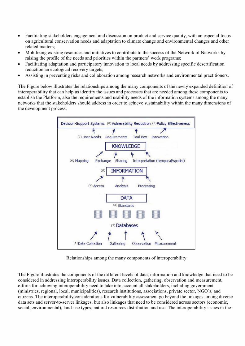
The Figure below illustrates the relationships among the many components of the newly expanded definition of
interoperability that can help us identify the issues and processes that are needed among these components to
establish the Platform, also the requirements and usability needs of the information systems among the many
networks that the stakeholders should address in order to achieve sustainability within the many dimensions of
the development process.
Relationships among the many components of interoperability
The Figure illustrates the components of the different levels of data, information and knowledge that need to be
considered in addressing interoperability issues. Data collection, gathering, observation and measurement,
efforts for achieving interoperability need to take into account all stakeholders, including government
(ministries, regional, local, municipalities), research institutions, associations, private sector, NGO´s, and
citizens. The interoperability considerations for vulnerability assessment go beyond the linkages among diverse
data sets and server-to-server linkages, but also linkages that need to be considered across sectors (economic,
social, environmental), land-use types, natural resources distribution and use. The interoperability issues in the
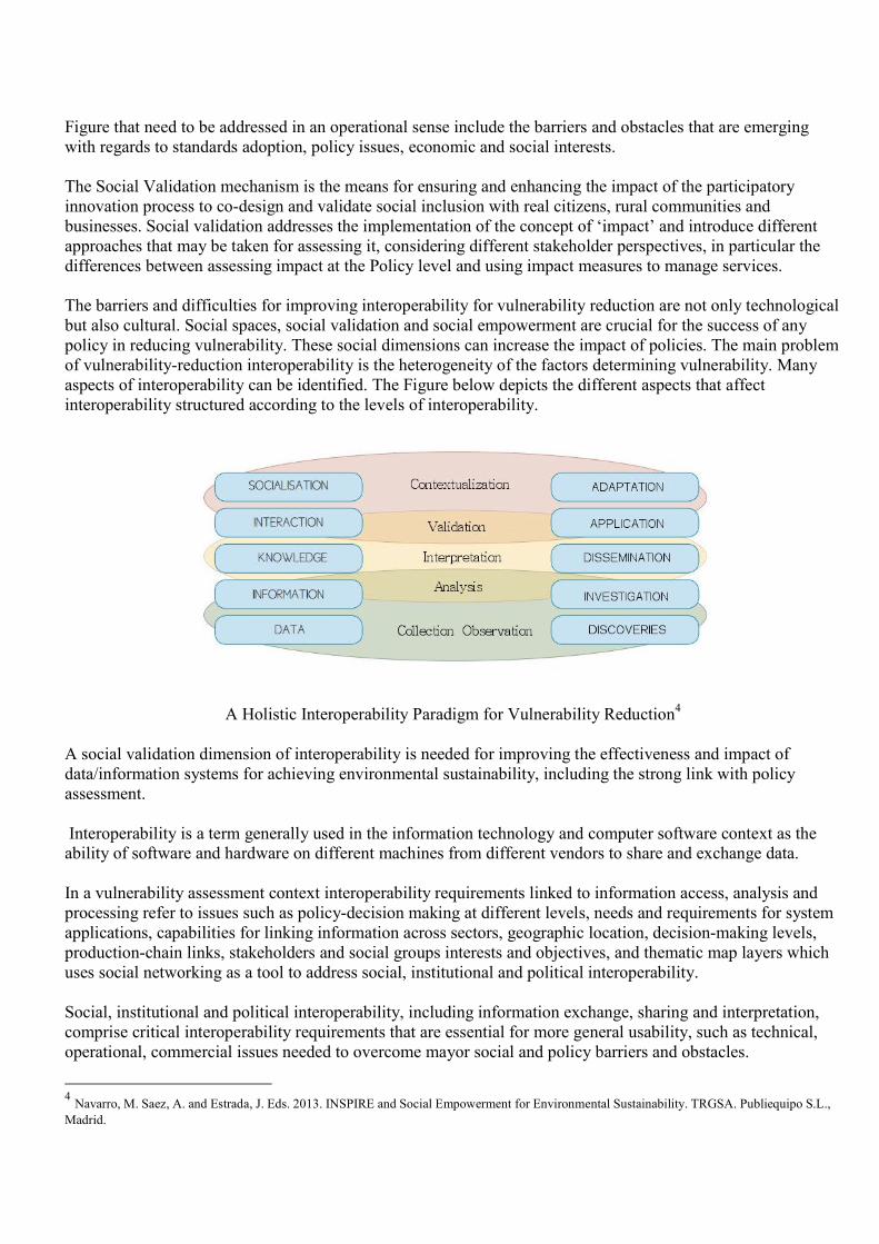
Figure that need to be addressed in an operational sense include the barriers and obstacles that are emerging
with regards to standards adoption, policy issues, economic and social interests.
The Social Validation mechanism is the means for ensuring and enhancing the impact of the participatory
innovation process to co-design and validate social inclusion with real citizens, rural communities and
businesses. Social validation addresses the implementation of the concept of ‘impact’ and introduce different
approaches that may be taken for assessing it, considering different stakeholder perspectives, in particular the
differences between assessing impact at the Policy level and using impact measures to manage services.
The barriers and difficulties for improving interoperability for vulnerability reduction are not only technological
but also cultural. Social spaces, social validation and social empowerment are crucial for the success of any
policy in reducing vulnerability. These social dimensions can increase the impact of policies. The main problem
of vulnerability-reduction interoperability is the heterogeneity of the factors determining vulnerability. Many
aspects of interoperability can be identified. The Figure below depicts the different aspects that affect
interoperability structured according to the levels of interoperability.
A Holistic Interoperability Paradigm for Vulnerability Reduction
4
A social validation dimension of interoperability is needed for improving the effectiveness and impact of
data/information systems for achieving environmental sustainability, including the strong link with policy
assessment.
Interoperability is a term generally used in the information technology and computer software context as the
ability of software and hardware on different machines from different vendors to share and exchange data.
In a vulnerability assessment context interoperability requirements linked to information access, analysis and
processing refer to issues such as policy-decision making at different levels, needs and requirements for system
applications, capabilities for linking information across sectors, geographic location, decision-making levels,
production-chain links, stakeholders and social groups interests and objectives, and thematic map layers which
uses social networking as a tool to address social, institutional and political interoperability.
Social, institutional and political interoperability, including information exchange, sharing and interpretation,
comprise critical interoperability requirements that are essential for more general usability, such as technical,
operational, commercial issues needed to overcome mayor social and policy barriers and obstacles.
4 Navarro, M. Saez, A. and Estrada, J. Eds. 2013. INSPIRE and Social Empowerment for Environmental Sustainability. TRGSA. Publiequipo S.L.,
Madrid.
Besides sharing the same interoperability needs for social validation there are very important considerations
regarding methodological approaches for social validation and policy impact assessment on vulnerability
reduction, that will ensure identifying and addressing the innovation process that could be blocked by the lack
of interoperability for accessing, consulting and reporting spatial data and information.
As a first step in establishing the collaboration between key stakeholders would be to set the basis for the
establishment of a joint working group that can prepare a work plan for the establishment of knowledge
networks, the application of methodological approaches, and for the preparation and adaptation of contents to
meet the needs of key knowledge users, and the application of the knowledge in their specific context for
reducing desertification and improving food security and sustainable development.
Functions of the Platform’s Joint Working Group
The Joint Working Group of the Platform will focus on developing and strengthening networking information
capacities for the application of major information systems and tools.
The Joint Working Group of the Platform will serve as an instrument to discover and make available, following
a decentralized participatory approach, information that is essential for the development of local, national and
global plant breeding and conservation programmes in support of food security and agricultural development.
The Joint Working Group of the Platform will explore the key processes and interactions among stakeholders
for achieving interoperability related to data / information systems collection, gathering, observation and
measurement, efforts need to take into account all stakeholders, including government (ministries, regional,
local, municipalities), research institutions, associations, private sector, NGO´s, and citizens.
Besides identifying the processes and interaction needs for interoperability among diverse kinds of information
systems and server-to-server linkages, the Joint Working Group of the Platform will also explore linkages that
need to be considered across sectors (economic, social, environmental), land-use types, natural resources
distribution and use; and also the interoperability issues that need to be addressed in an operational sense with
regards to standards adoption, policy issues, economic and social interests among policy-makers, key
stakeholder and information systems users.
The Joint Working Group of the Platform will work on identifying and characterizing important processes and
interoperability components which include information access, analysis and processing requirements, referring
to issues such as policy-decision making at different levels, needs and requirements for system applications,
capabilities for linking information across sectors, geographic location, decision-making levels, production-
chain links, stakeholders and social groups interests and objectives, and thematic map layers.
These identified and characterized need, requirements, processes among stakeholders will then be used by the
Joint Working Group of the Platform to determine the diverse aspects of information mapping, exchange,
sharing and interpretation requirements that are essential for more general usability, such as technical,
operational, commercial issues needed for the co-design and co-development process to be carried out by the
Platform.
These findings will also help the Joint Working Group of the Platform to establish the important considerations
regarding methodological approaches to operationalize the expanded dimensions of interoperability
components, for participatory innovation and policy impact assessment, that will ensure identifying and keep-up
with the fast evolving user needs and requirements, ICT tools and the innovation process that require
interoperability for accessing, consulting and using environmental spatial data and information systems for
achieving sustainability.
The vulnerability reduction component requires key interoperability considerations regarding updated
assessments that will be shared through the Platform for coordinating efforts among the many agencies,
organizations and government bodies involved in desertification reduction sustainable use process; but also to
address the need for citizens to become more involved and contributing to sustainability through data collection,
reporting threats, and accessing and/or sharing information with action groups and networks.
The Joint Working Group will stimulate sharing information about strategic issues that needs to be considered
for the interoperability of the policy effectiveness component associated with stakeholder location information
systems that are required to identify and overcome the barriers and obstacles that can emerge in certain
locations over time.
The social dimension of interoperability can become the mechanism for incorporating the spatial distribution of
the multiple dimensions of sustainable development through the improved policy integration with spatial
information systems that can really improve their effectiveness in dealing with such formidable global
challenges.
There is an important interoperability consideration regarding the development and use of information
platforms with explicit geographic dimensions for policy assessment, which refers to the complex nature of the
development process and the many dimensions of the policy process itself. The Joint Working Group will
explore the policy agenda of governments and funding agencies to identify interoperability issues between
development, environment and social objectives. These may include achieving infrastructure or financial
targets, biodiversity conservation, watershed protection, or income diversification programmes. While these
policy objectives are not necessarily contradictory, the interoperability of policies that might include economic
growth, natural resource management and energy self-sufficiency presents important challenges for policy-
makers, donor and target populations to effectively use information systems to achieve and operationalize
policy coordination and cooperation for attaining sustainable development.
In order to make progress towards sustainable development we must contend with the fact that attitudes towards
land degradation and desertification will tend to incorporate a divergent set of approaches to issues such as
sustainability, productivity and marginal returns all of which reflect various degrees of similarity and conflict
between the value systems of land managers, policy makers and individual farmers. Thus, from a socio-
economic perspective, with agricultural systems and productivity tied to government policy directives, land
degradation and desertification is inescapably a political question.
The contents of the Network of Networks information systems inter-linkage would include analysis and
synthesis of the results of field activities, projects, country experience, and knowledge of expedient and
effective procedures in every aspect of the work of key partners relevant to the strategic objectives of the
Program.
The Platform is developed and used using the participatory innovation process. The innovation mechanism of
this initiative is the means for ensuring and enhancing the impact of the participatory adaptability and response
capacity process to co-design and use geospatial information with citizens and key stakeholders. The
participatory innovation work will address the implementation of the concept of ‘impact’ and introduce
different approaches that may be taken to assess adaptability and response options, considering different
stakeholder perspectives, in particular the differences between assessing adaptability and response capacity at
the policy level and using locally-based measures to manage livelihoods based on the Platform, including:

• Strategic policy level evaluation, which will consider the impact of the Platform with respect to the geo-
spatial data produced and how it targets priority groups and demonstrates the effectiveness in terms of
social inclusion and sustainability. Validation will include a study of the content needed by users;
identifying evidence of users benefiting from the contents available; and the impact of the Platform on
the national and local-level strategies supporting citizen participation and sustainability of livelihoods.
• An assessment of the Platform in different countries to consider aspects such as resource management,
competencies and capacity building, partnership and collaboration, good practice in managing and
presenting content, and the impact of pilot results.
The aim of the participatory innovation mechanisms for ensuring the impact of the Platform include:
• To assist policy makers. This could be at a variety of levels, national government, as when the case is
made for strengthening the role of spatial data in improving environmental policy;
• Local government, where it may be necessary to show the positive impacts of public investment on local
communities, or improve local environmental assets;
• Potential collaborators, for example in other institutions (research, policy), educational institutions or
commercial enterprises which need to be persuaded of the value to them of contributing to vulnerability
assessment and reduction.
• In strategic management to understand better where impacts are being made (or failing to be made) so as
identify options and then plan strategically for future vulnerability reduction options;
• To check whether policies are having the anticipated results - and to adjust plans and planning processes
accordingly based on the Platform mapping results.
• To develop an understanding of how policies in other sectors might be adjusted to increase impact in
livelihoods sustainability;
• To develop insights into the different responses and needs of different user groups
Methodological Frameworks for Integrated Knowledge Management and Dissemination on Natural
Resources Management, Rural Development and Food Security
The Platform also supports stakeholder collaboration through a set of services, integrating various types of
instruments and tools, such as citizen participation, collaborative spaces and thematic networks, where
participants can assess the sustainability strategies of the results to be achieved.
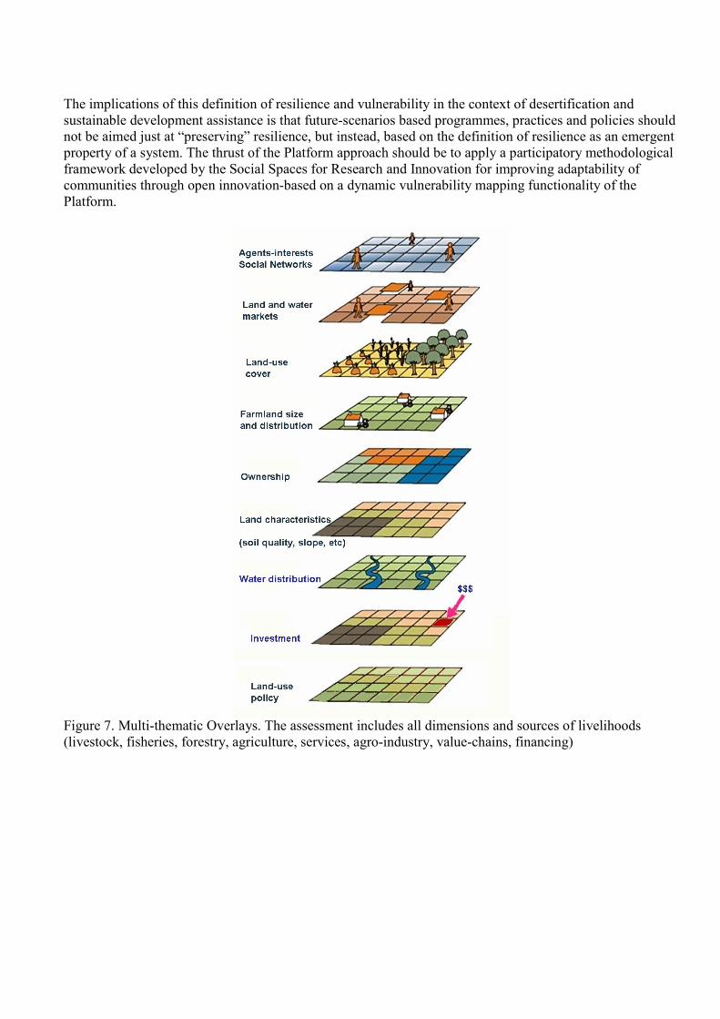
The map-based stakeholder engagement component of the Platform to assess development sustainability
desertification reduction involves the generation of “Response-Unit” maps based on an overlay of natural
resources use maps and spatial data, including topography, land-use, vegetation cover, species distribution,
ecosystems, biomes, water distribution, watersheds, livelihoods human activity (agriculture, livestock, forests,
fishing, parks and natural reserves, tourism, industry, population distribution and density, roads and transport,
ports5. These maps use inputs and contributions from diverse sources, including climate change scenarios,
energy crisis, migration scenarios, and economic crisis effects. These map-based scenarios will serve to identify
priorities for policy and programs at the territorial level.
A key element of the Platform is to provide the social inclusion mechanisms, instruments and technologies to
establish and sustain stakeholder networks much more effectively, and enable the development of research-
based land-use systems innovation partnerships in order to improve the effectiveness for ensuring sustainability.
5 Figure 7 presented in Annex 1. Multi-thematic Overlays Mapping, the assessment includes all dimensions and sources of livelihoods (livestock,
fisheries, forestry, agriculture, services, agro-industry, value-chains, financing)
This Platform is based upon a methodological approach for enhancing the impact of development policies and
programs by means of a set of tools and functionalities with explicit geographic reference for assessing future
development scenarios to explore the interactions among key driving forces physical, social, economic,
ecological, and cultural drivers which are linked with land use, climate change, economic and environmental
driving forces. The methodological framework is set as a means for integrating knowledge and information that
include all sectors of society and focuses on exploring the possible impacts like climate change and policy
options affecting the conservation and sustainable use of natural resources and reducing desertification.
The Platform will also help to identify priorities for response in order to find the areas and communities where
the need for action is greatest. The community’s ability to cope with environmental pressures is then
represented by ecosystem’s capacity to respond (adaptation capacity) and the indicator is vulnerability analysis.
These two steps (data and ecosystem response) represent the approach for introducing environmental and socio-
economic information into the decision-making process. In this respect there is an urgent need for information
technology open innovations that can improve the harmonization and coordination of interventions and support
auctions in terms of systems and criteria for the collection and collation of information at the community level,
including climatic, water scarcity, and other data essential for adaptability and response capacity.
The impact of the Platform is ensured by the wide network of organizations associated with participatory
innovation across the world and all sectors, the explicit geographic reference of adaptability and response
capacity linked to policy management scenarios, as well as the innovative methodological approach used in this
Platform with direct involvement of citizens (citizen as a sensor) in every phase of the innovation process.
The methodological framework on knowledge and information exchange described below is proposed as a
means to improve decision-making while considering the high degree of interaction between the natural,
physical, social and economic processes in a systematic way. The methodological framework includes the
spatial dimension of systems in an explicit way, as it is a strong determinant of how these interactions actually
unfold and of their ultimate effect on specific locations of the landscape. The methodological framework
focuses on a process-oriented approach, where the overall system (socio-economic, ecological, environmental)
is characterized in terms of processes at different temporal and spatial scales. In this way, a hierarchy of
processes can provide a way of understanding what are the driving forces of land-use changes in landscapes and
how policy can act most effectively based on research results to mitigate the effects of land degradation and loss
of biological potential that these changes might bring about.
The interactions among these processes are represented in dynamic simulation models where we give explicit
spatial dimensionality to variables such as available land for any given economic activity, the choice of
residence or migration of the population, and most importantly to the choices that the different sectors of the
economy or consumers make in purchasing goods and services locally, from other regions, or from international
markets; depending on location, price and choice of supplier. It consists of two sets of actors (or agents) –
business firms which invest in different regions in response to economic signals, and households which can
migrate between regions, largely responding to perceived benefits relative to their current situation. As each set
of agents varies its behaviour it achieves impacts on regions which alter the behaviour of the other set in a
continuous cycle of activity.
In its conventional private sector context, the Platform development encompasses identifying and mapping
intellectual assets, generating new knowledge in order to have a competitive advantage with the external
environment, making vast amounts of corporate information accessible, sharing of best practices, and utilizing
the appropriate information and communications technology that enable all of the above. This private sector
perspective of knowledge as an asset essential for competitiveness does not apply to a UN convention, such as
the UNCCD, but could be adapted in order to help us articulate better the UN’s unique role within the UN
system in achieving the Millennium Development Goals. Of particular relevance is the consideration that
knowledge management involves the establishment of the appropriate corporate culture, value and reward
systems that measure and reward the application of intellectual capital to achieve remarkable performance.
The Platform intends to be a flagship in the participatory co-design and co-development with all the
stakeholders involved in the support of social needs. The platform allows the participation of all interested
agents, from citizens, to research representatives, epistemic communities, policy agents.
The Platform will collect relevant information from multiple sources like Open Data, smart environments,
mobile applications and social media. This information from different sources will be modeled, processed and
visualized allowing the identification and generation of new initiatives so as to improve social innovation.
The Platform impact strategy is based upon a network building plan and mechanisms to establish robust
collaboration and communication among the representatives of the research community, civil society
organizations, community members (students-general public), entrepreneurs, global and regional networks,
decision-makers in municipalities, regions and national governments agencies, service providers, corporations
and SMEs. The instrument supporting this network building and scaling-up the impacts of project results will be
based upon the Platform. This configuration brings together the expertise of different networks and
collaborations, thereby enhancing the open and inclusive social innovation process. At the same time, the
engagement of partners in different networks multiplies the pathways to dissemination and adoption of results.
The Platform will have policy impacts through the application of a participatory process for policy assessment
using multi-dimensional information and knowledge with explicit geographic reference, which will enhance
social and individual well-being through improved resilience and reduced vulnerability to economic,
environmental threats, and overcoming barriers to social innovation.
Catalyzing and enabling new production and consumption patterns, lifestyles, and socio-economic
processes based on commons, sharing, exchange, and participation at local and global scales
The methodological approach of co-design, co-development of systems, tools and processes, based on the
needs, expectations, identification of gaps in the context of needs, like water energy, and technologies, will
guarantee the Platform’s impact of improved livelihoods and well-being, and also guarantees the scaling-up of
the use and uptake of any effective measure as end users at any geographic level.
Co-design means the engagement of users within the design and development process of a solution that will
lead to a better incorporation in the people’s lives of that solution.
The Platform will have significant impacts through the robust & user-friendly functionalities developed and
tested to support the participatory process for networking, stakeholder relationship management, policy
assessment using multi-dimensional information and knowledge, with explicit geographic reference, which will
enhance social and individual well-being through improved resilience and reduced vulnerability to economic,
environmental threats, and overcoming barriers to social innovation.
The Platform will apply the participatory process of innovation for launching a new conceptual and operational
framework for interoperability for data/information gathering, access, analysis, processing, sharing, that focuses
on social validation and inclusion-based innovation, linking information across sectors, geographic location,
decision-making levels, production-chain links, stakeholders and social groups interests and objectives, and
thematic map layers.
In the other hand, users themselves will be able, through usable and friendly interfaces, to provide information
so that processes that information can influence in order to be visualized and feed the social innovation impact
mechanisms.
The inbuilt impact assessment process of the Platform methodological framework ensures a sustainable model
that allows the scaling-up of the results of the project, and a robust institutional structures led by representatives
of the community of users, (Associations, Foundations, Local Action Groups.) The main impact to be achieved
by the Platform is to ensure continuous and systemic social innovation ecosystem, with enhanced policy
exploration and evaluation, in which the citizens are protagonist of the open innovation process.
The Platform will provide in this way mechanism to show the evidences to the policies at different territorial
levels, based them on relevant and tangible data, making even more fictile the incorporation of those policies to
the citizen real lives and the policy efforts dissemination.
The systematic, inter-disciplinary framework required to integrate the many databases and information
resources already available is based on similar contexts, such as farming systems and ecological conditions that
can capture the communalities of the types of problems and solutions that characterize livelihoods across the
world. The knowledge materials produced need to be generic, aimed at communication and training, not
specific for specialized sectorial audiences. This constitutes an area of knowledge management that if
developed as a common corporate practice would greatly enhance our effectiveness in addressing the challenges
of applying research results to reduce desertification with explicit geographic reference.
It is clear that the emphasis of an initiative on a Network of Networks would need to focus on some key
challenges to guarantee an impact. First, the relevant technical programs working with partners in every aspect
of sustainable rural development and food security would need to identify the needs and requirements (much
has already been done in identifying knowledge and information requirements for poor and hungry people), and
put together a selection of relevant materials, many of which already exist in digital format. One key
consideration for this is that much of the relevant knowledge required in such an initiative is actually local
knowledge. Therefore, a strong emphasis would need to be placed on collaborating with key partners in order to
tap, organize, store and mobilize relevant local knowledge, and create and strengthen mechanisms for
improving access and use of the knowledge among the target audiences.
For an initiative of Network of Networks to have an impact on reducing poverty and land degradation, an
essential first step would be to agree on a common work plan together with all the key partners in order to
achieve the relevant geographic coverage, including the coordination mechanism which would enhance
effectiveness in reaching the totality of the populations living in vulnerable arid and semi-arid regions. These
include local population active participation.
In this way the Platform can contribute to the interdisciplinary programs with a structured approach; a
framework for organizing the many dimensions of the problems associated with sustainable development and
food security, and the tools for managing and visualizing the vast amount of knowledge and information. And
most importantly it can help to better understand the linkages between all these facets, connecting sectorial
agriculture to socio-economic factors and environmental constraints. This section presents several of the most
salient examples of existing knowledge networks.
It is envisioned that the framework for the multi-stakeholder partnership would focus on developing a joint
program for mobilizing and applying existing research knowledge for organizing, classifying, documenting and
disseminating research results, in an effort to identify, tap, organize, store and mobilize relevant knowledge, and
create and strengthen mechanisms for improving access and use of the knowledge among the target audiences in
their specific context for reducing desertification and achieving sustainable development.
Science and Research Impacts
The methodological platform is designed to serve as a tool in the process of identifying common goals between
the parties concerned in the territory, and for ensuring agreement and implementation of action plans at local
level. The participants and beneficiaries of the project may use the platform to collect and integrate data,
information and knowledge about the five dimensions of the livelihoods and lifestyles as a mechanism for
sustainable development, which will serve to define territorial priority areas, and thus work together in the
mechanisms and tools that generate the greatest impact.
Another aspect of the territorial focus of this component of the project will be to provide innovative solutions
for the management of the territorial innovation process based on the conversion of information into knowledge.
The apparatus of semantic technology and the formalization of knowledge on the interaction between the
drivers of sustainable development will ensure tailored solutions based on semantic analysis of the needs of
members of the network in the territory.
Communication Among Policy-makers
In order to make visible the results of this project and to achieve the objectives of the Program, it is needed to
communicate among policy-makers effectively. The activities regarding this issue will follow the practical
guide of communicating research for evidence-based policy-making, a form of publication specially intending
to provide orientation for those dealing with policy matters.
Further recommendations will be followed in order to create an effective strategy of communication, which will
be drawn up from the very beginning of the project and regularly reviewed. It will consist of:
1. Form a communication and dissemination team who identify potential beneficiaries (audiences) and
anticipate their questions
2. Create a promotional flyer
3. Produce a detailed identity brochure
4. Develop an attractive project website
5. Seek out dialogue with stakeholders
6. Engage the media
7. Write policy briefs
8. Arrange briefing sessions and dialogue panels
9. Organize a final conference
10. Produce a final publishable summary report
Standardization
The partners of Platform will not only proved new technologies aligned with current and future standards, but
also contribute to roadmaps of standardization or industry groups. Dissemination and impact to standardization
bodies will be carefully implemented by working with representatives coordinating contributions among the
network members. It is desirable, for instance, to have few, but well defined, cross work package standard
contributions to strengthen architectural and protocol functionalities that everybody can refer to.
Key standardization bodies have been identified with the relevant bodies, which are key elements for
interoperability issues in the relevant fields, in which public agency partners are already active.
The expected results from the Platform include:
The Platform and methodological framework, validated by all stakeholders in diverse operational situations.
1. An increased awareness of the value of social innovation, and the implementation using the state-of-the-art
Platform for enhanced decision making and engagement of all stakeholders – based on dissemination
activities, contributing to new relationships between national and local public agencies, their citizens and
communities, NGOs, commercial organisations, ICT companies and researchers.
2. Improved management and better decision making in engaging agencies, citizens, communities, and all
stakeholders in participatory innovation, providing quantified and verified significant improvements.
3. Providing a forum for all interested actors to discuss and share its results and lessons learned.
Future scenarios provide decision-makers at all levels an integrated approach for handling information about
present-day (baseline) conditions of ecosystems, risks associated with natural resource degradation, climatic
events, economic crises, and land-use change risks, under a range of decision-making options. The framework
includes citizen-based perspectives to compare selected options (trade-off´s) for significantly improving the
necessary coordination efforts required for promoting and enhancing policy development and management
intervention.
Future scenarios can also help to identify priorities for response in order to find the areas and communities
where the need for action is greatest. The community’s ability to cope with future vulnerability challenges is
then represented by local communities and ecosystem’s capacity to respond (adaptation capacity) and the
indicator is vulnerability in every dimension of livelihoods. Future scenarios represent the approach for
introducing environmental and socio-economic research results into the decision-making process focusing on
the need for integrated actions that would concurrently permit the evaluation of programmes to reduce risks,
and the broadening of the response capacity of an ever increasing number of organizations to actually have an
impact in terms of poverty vulnerability reduction.
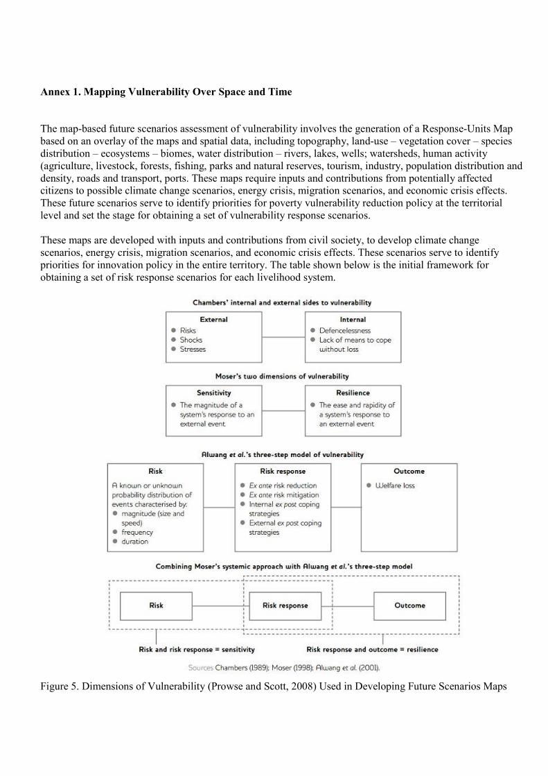
Annex 1. Mapping Vulnerability Over Space and Time
The map-based future scenarios assessment of vulnerability involves the generation of a Response-Units Map
based on an overlay of the maps and spatial data, including topography, land-use – vegetation cover – species
distribution – ecosystems – biomes, water distribution – rivers, lakes, wells; watersheds, human activity
(agriculture, livestock, forests, fishing, parks and natural reserves, tourism, industry, population distribution and
density, roads and transport, ports. These maps require inputs and contributions from potentially affected
citizens to possible climate change scenarios, energy crisis, migration scenarios, and economic crisis effects.
These future scenarios serve to identify priorities for poverty vulnerability reduction policy at the territorial
level and set the stage for obtaining a set of vulnerability response scenarios.
These maps are developed with inputs and contributions from civil society, to develop climate change
scenarios, energy crisis, migration scenarios, and economic crisis effects. These scenarios serve to identify
priorities for innovation policy in the entire territory. The table shown below is the initial framework for
obtaining a set of risk response scenarios for each livelihood system.
Figure 5. Dimensions of Vulnerability (Prowse and Scott, 2008) Used in Developing Future Scenarios Maps
Global challenges like climate change, water scarcity, the energy crisis and environmental degradation are
pushing conventional economics-based policy thinking towards the realization that policy based on single
cause- and-effect sectorial approaches seriously limits the impact of environmental policy. The potential lies in
activating the Platform involving citizens to make the explicit linkages of interacting social, economic and
environmental factors that determine the impact of policies. The social dimension of interoperability can
become the mechanism for incorporating the spatial distribution of the multiple dimensions of livelihoods and
wellbeing for integrated policy assessment spatial information systems that can really improve their
effectiveness in dealing with such formidable global challenges.
The policy agenda of the many governments and funding agencies may contain potential conflicts between
development, environment and social objectives. These may include achieving infrastructure or financial
targets, biodiversity conservation, watershed protection, or income diversification programmes. While these
policy objectives are not necessarily contradictory, the harmonization of policies that might include economic
growth, natural resource management and energy self-sufficiency presents serious challenges to policy-makers,
donor and target populations.
Rondinelli (1993) suggests that the policy process is best described as a sort of social experiment. By this he
means that the policy process is less a matter of prediction, and more a matter of trial and error or learning by
doing. This perspective highlights the importance of research in the policy process as means for providing
feedback to all stakeholders and society in general, so that policy has a chance to readjust and adapt to
unforeseen circumstances as it develops. A ‘’research perspective' on the policy process requires a complex
systems approach.
Understanding the nature and dimensions of policy (Figure 6) is very important in realizing the potential of how
spatial information can contribute to improve the impact of policy on environmental sustainability. Information
linkages with the policy processes have been viewed as a linear process, whereby a set of spatial databases are
linked from the 'research community' over to the 'policy makers community', with no explicit spatial relation to
policy impact. It can no longer be assumed that spatial data systems influence policy in such a linear process, or
that the link can be made between researchers and policy-makers using spatial metadata. Instead, the social
validation process applied to the research-policy link is now moving towards a more dynamic approach that
emphasises a two-way process between all stakeholders, shaped by multiple relations and knowledge sources.
This shift reflects the fact that social validation has generated an effective means for improving the impact of
policy on environmental sustainability.
While it is generally agreed that a participatory approach is a key element of a successful livelihood approach, it
does not in itself guarantee that the livelihoods programmes and projects will be environmentally sustainable, or
that the benefits of the development initiative will not increase risks and vulnerabilities to natural disasters,
climate variability, drought, or market dysfunction. Each of the livelihoods aspects (natural resources, social,
financial, physical and human) cannot be seen in isolation as each of these is linked to other aspects of the
livelihoods assets that need to be considered in order for people to improve their well-being in a sustainable
way.
Many policies and programmes do not make these links, focusing on the management of the resources to the
exclusion of other issues. Most policies, even when they are aimed at improving livelihoods, tend to ignore the
links that exist between the different aspects of livelihoods, but also the linkages that exist with what are
considered “external factors” such as economic, trade or investment policies. Given the limited scope and
capability of the analytical tools, there are serious limitations in our ability to consider the complex linkages
among all the aspects in the interoperability framework.
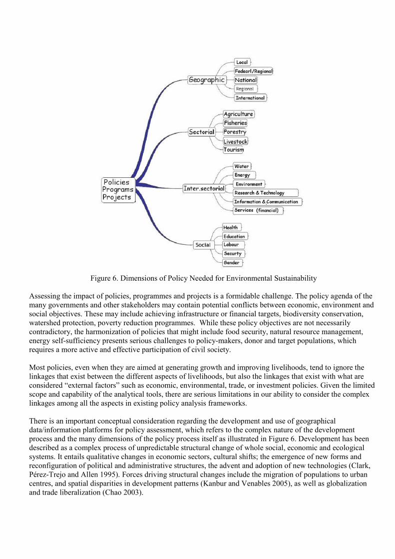
Figure 6. Dimensions of Policy Needed for Environmental Sustainability
Assessing the impact of policies, programmes and projects is a formidable challenge. The policy agenda of the
many governments and other stakeholders may contain potential conflicts between economic, environment and
social objectives. These may include achieving infrastructure or financial targets, biodiversity conservation,
watershed protection, poverty reduction programmes. While these policy objectives are not necessarily
contradictory, the harmonization of policies that might include food security, natural resource management,
energy self-sufficiency presents serious challenges to policy-makers, donor and target populations, which
requires a more active and effective participation of civil society.
Most policies, even when they are aimed at generating growth and improving livelihoods, tend to ignore the
linkages that exist between the different aspects of livelihoods, but also the linkages that exist with what are
considered “external factors” such as economic, environmental, trade, or investment policies. Given the limited
scope and capability of the analytical tools, there are serious limitations in our ability to consider the complex
linkages among all the aspects in existing policy analysis frameworks.
There is an important conceptual consideration regarding the development and use of geographical
data/information platforms for policy assessment, which refers to the complex nature of the development
process and the many dimensions of the policy process itself as illustrated in Figure 6. Development has been
described as a complex process of unpredictable structural change of whole social, economic and ecological
systems. It entails qualitative changes in economic sectors, cultural shifts; the emergence of new forms and
reconfiguration of political and administrative structures, the advent and adoption of new technologies (Clark,
Pérez-Trejo and Allen 1995). Forces driving structural changes include the migration of populations to urban
centres, and spatial disparities in development patterns (Kanbur and Venables 2005), as well as globalization
and trade liberalization (Chao 2003).
This definition of development has a number of implications for assessing the impact of policies, programme
and project implementation with an explicit spatial dimension. First, the complexity of the process and inter-
relatedness of the social, economic and environmental systems makes it highly unpredictable, and most
importantly, generates a high degree of uncertainty in the possible impact of any policy, project or intervention.
In practice, this means that any policy or programme tends to affect the perceptions, interactions and dynamics
among all the groups in society in an unpredictable way. For example, agricultural subsidies might end up
increasing land degradation in certain farming systems and drive out of business entire farming communities in
other regions (Clark, Pérez-Trejo and Allen 1995). Another example is the way that inter-sectorial linkages can
be the cause of otherwise unexplained land abandonment in previously prosperous agricultural regions, such as
South-east Spain, where the ever-increasing demand for water from the powerful tourism sector can create
serious water scarcity problems for farmers in adjacent watersheds (Epp et al. 2003, Gomes 1993).
Conclusions
Mapping livelihoods dimensions allow us to identify key elements of spatial data infrastructures and
environmental management platforms to assess the possible effect of policy on environmental sustainability and
the well-being of populations, and to define a new interoperability framework that can significantly enhance the
effectiveness of initiatives like the INSPIRE Directive, by actively involving policy-makers, the private sector,
and local agents in order to really have an impact on environmental sustainability.
The research has generated a new social dimension to the framework for interoperability for improving the
effectiveness and impact of data/information systems for achieving environmental sustainability, including the
strong link with policy assessment. The SSRI methodological framework for social validation has provided a
platform for developing future scenarios to identify priorities for policy with an explicit territorial dimension.
The paper introduces strategic social issues that need to be considered for the interoperability linked to policy
effectiveness as the new approach for the development and implementation of stakeholder participation that are
required to identify and overcome emerging barriers and obstacles to environmental sustainability in certain
locations over time. The social dimension to interoperability can be a vehicle for improving policy impact
through the active participation of citizens that will sustain their livelihoods. The livelihoods approach used to
map the closely linked dimensions of well-being can provide the means to find effective means for linking
human activity with the major driving forces that will ultimately determine the impact of policy at the territorial
level.
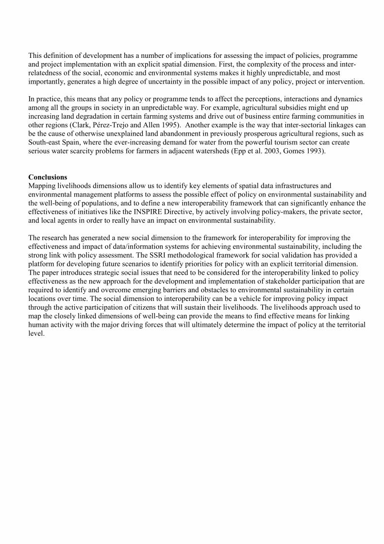
Assessing vulnerability of the five livelihood dimensions. Adapted from Benson and Twigg. 2007
The literature generally defines five dimensions of Livelihoods Assets (see Figure above), including human,
social, physical, financial, natural assets. We have added two additional dimensions that relate to the Social
Spaces for Research and Innovation (SSRI) framework, which are essential for creating the enabling
environment for open, community-based innovation as the motor of vulnerability reduction; these are policy
(local, national, regional, international), and the institutional framework (government, alliances, associations,
partnerships). SSRI constitute a methodological approach that brings together citizens, experts, professionals,
policy-makers, researchers, and organizations working in areas related to sustainable development, social
inclusion, and eco-innovation. The initiative on SSRI has become a point of reference for the innovation and
development community as an evolving methodological approach for effectively addressing the social,
ecological, economic and policy challenges associated with turning the innovation process into the driving force
of sustainability and well being of citizens and communities with an explicit territorial reference.
SSRI are innovation ecosystems in which the innovation process and strategic alliances are directed by needs
and constraints of the communities benefiting from the results. These innovation ecosystems involve balanced
participation of the various actors in the value chain of and innovation that can more effectively benefit rural
citizens, linking them to local communities, enterprises, technology providers, representatives of research
communities and policy makers that will ensure the equitable use and promotion of the use of the results. The
SSRI methodological approach has proven very effective in developing a collective understanding the dynamics
of our fast-changing world and a participatory policy assessment process that can bridge the existing gap
between spatial data systems and policy impact.
The main impact to be achieved by SSRI is to ensure continuous and systemic policy exploration and
evaluation, in which the citizens are protagonist of the co-creation process, contributing to their effective
integration into the environmental sustainability process regardless of their physical location (rural or urban), or
their personal circumstances or socioeconomic condition.
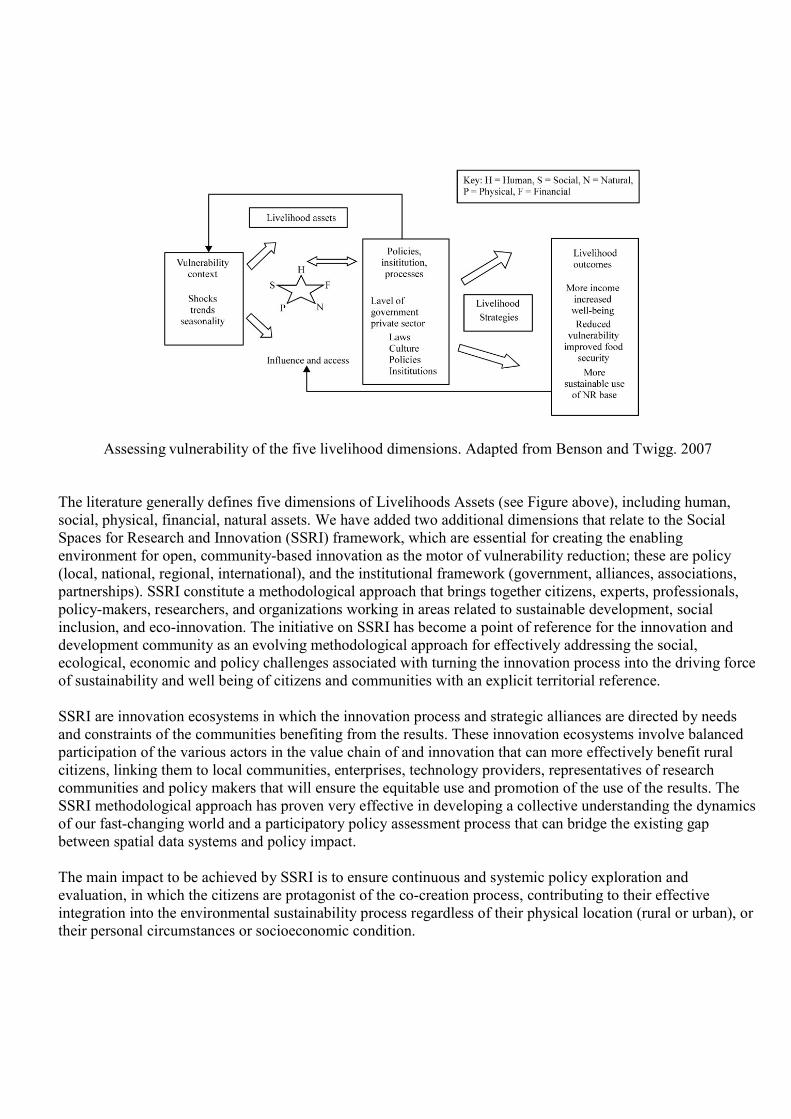
The implications of this definition of resilience and vulnerability in the context of desertification and
sustainable development assistance is that future-scenarios based programmes, practices and policies should
not be aimed just at “preserving” resilience, but instead, based on the definition of resilience as an emergent
property of a system. The thrust of the Platform approach should be to apply a participatory methodological
framework developed by the Social Spaces for Research and Innovation for improving adaptability of
communities through open innovation-based on a dynamic vulnerability mapping functionality of the
Platform.
Figure 7. Multi-thematic Overlays. The assessment includes all dimensions and sources of livelihoods
(livestock, fisheries, forestry, agriculture, services, agro-industry, value-chains, financing)
References
Benson, C. and J. Twigg. 2007. Tools for mainstreaming disaster risk reduction. Guidance Note 9. Vulnerability and
Capacity Analysis. http://www.preventionweb.net/files/1066_toolsformainstreamingDRR.pdf
Chao Elaine, L. 2003. “Globalization and Structural Change” U.S. Secretary of Labor. G-8 Labor and Employment
Ministers Conference Stuttgart, Germany, December 15.
Clark, N., Perez-Trejo, F. and Allen, P. 1995. Evolutionary Dynamics and Sustainable Development: A Systems
Approach, Aldershot: Edward Elgar, U.K.
Collaboration @ Rural Project (C@R) http://www.c-rural.eu/
Epp Christian, Dercas Nicholas, Tondi Gianluca, Capaccioli Stefano, Ribeiro Jacqueline F. 2003. MedWater Policy – EC
Project on Policy Initiative to Overcome Water Competition between Agriculture and Tourism.
Geertman, S.and Stillwell J. 2009. Planning Support Systems. Best Practices and New Methods. Springer
Gomes, Albert J. 1993. "Integrating Tourism and Agricultural Development." In Dennis J. Gayle and Jonathan N.
Goodrich (eds.) Tourism Marketing and Management in the Caribbean, London and New York: Routledge, 155-166
Kanbur, R. & Venables, T. 2005. Introduction: Spatial inequality and development Journal of Economic Geography.
2005; 5: 1-2.
Mediterranean Living Labs Project (MedLab) http://www.medlivinglab.eu/
Maguire, B. and Cartwright, S. (2008). Assessing a community’s capacity to manage change: A resilience approach to
social assessment. Australian Government Bureau of Rural Sciences, Canberra.
Navarro, M. Saez, A. and Estrada, J. Eds. 2013. INSPIRE and Social Empowerment for Environmental Sustainability.
TRGSA. Publiequipo S.L., Madrid.
Perez-Trejo, F. 1994. Desertification and land degradation in the European Mediterranean. In: Environment and
Quality of Life (EC), / European Commission, Brussels (Belgium). Directorate-General for Science, Research and
Development. 63 p.
Prowse, M. and Scott, L. 2008.Assests an Adaptation: An Emerging Debate. IDS Bulletin. 39:42-52.
DOI:10.1111/j.1759-5436.2008.tb00475.x
Rondinelli, D. 1993. Development Projects as Policy Experiments: An Adaptive Approach to Development
Administration. London: Routledge.
Zargar, A. Devillers, R. 2009. An Operation-based Communication of Spatial Data Quality. Advanced Geographic
Information Systems & Web Services. Proceedings of the 2009 International Conference on Advanced Geographic
Information Systems & Web Services, IEEE, pp. 140–145.