Plant Communities of San Nicolas Island, California
53
1
-
Upload
independent -
Category
Documents
-
view
0 -
download
0
Transcript of Plant Communities of San Nicolas Island, California

1

2
Plant Communities of San Nicolas Island, California William L. Halvorson Steve Junak Cathy Schwemm Thomas Keeney Technical Report No. 55 September 1996 National Biological Service Cooperative Park Resources Studies Unit School of Renewable Natural Resources 125 Biological Sciences East The University of Arizona Tucson, Arizona 85721

3

iii
Contents List of Figures ................................................................................................................................ iv List of Tables ...............................................................................................................................v Acknowledgements ....................................................................................................................... vi Abstract ........................................................................................................................................ vii Introduction .....................................................................................................................................1
Methods ...........................................................................................................................................7 Results ...........................................................................................................................................14 Community Descriptions .............................................................................................................18
Grassland .................................................................................................................................18 Coastal Marsh .........................................................................................................................18 Annual Iceplant (Mesembryanthemum) ..................................................................................18 Coastal Dune ...........................................................................................................................20 Inland Dune (Astragalus-Carpobrotus) ..................................................................................20 Caliche Scrub ..........................................................................................................................20 Coastal Scrub ...........................................................................................................................20
Isocoma Scrub .......................................................................................................................23 Baccharis Scrub ....................................................................................................................23 Lupinus Scrub .......................................................................................................................23 Coreopsis Scrub ....................................................................................................................23
Riparian/Deep Drainages ........................................................................................................23 Vernal Pools.............................................................................................................................23 Discussion .....................................................................................................................................25 Literature Cited .............................................................................................................................26 Appendix 1. Frequency and Relative Importance Value Data for Plants Observed within Each Plant Community during 1992 Vegetation Sampling on San Nicolas Island, California ..............................................................................28 Appendix 2. Plant Taxa Identified during 1992 Vegetation Sampling on San Nicolas Island, California ......................................................................................41

iv
Figures Figure 1. San Nicolas Island and Vicinity..................................................................................2 Figure 2. Topography of San Nicolas Island..............................................................................3 Figure 3. Locations of the Relevés Used for Characterizing the Vegetation of San Nicolas Island, California ....................................................................................9 Figure 4. Land Cover of San Nicolas Island, California ..........................................................12 Figure 5. Grassland on San Nicolas Island, California ............................................................19 Figure 6. Coastal Marsh on San Nicolas Island, California .....................................................19 Figure 7. Coastal Dune on San Nicolas Island, California.......................................................21 Figure 8. Inland Dune (Astragalus-Carpobrotus) San Nicolas Island, California ..................21 Figure 9. Caliche Scrub on San Nicolas Island, California......................................................22 Figure 10. Isocoma Scrub on San Nicolas Island, California ....................................................22 Figure 11. Baccharis Scrub on San Nicolas Island, California..................................................24 Figure 12. Coreopsis Scrub on San Nicolas Island, California..................................................24

v
Tables
Table 1. Size and Number of Relevés Sampled within Each Plant Community on San Nicolas Island, California, 1992 ....................................................................8
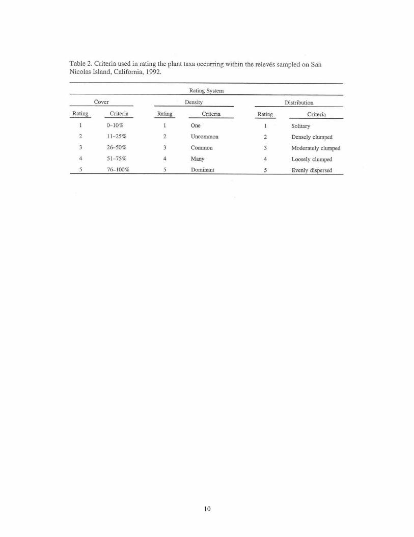
Table 2. Criteria Used in Rating the Plant Taxa Occurring within the Relev6s Sampled on San Nicolas Island, California, 1992 ......................................10 Table 3. Coverage of Plant Communities, Dunes, and Bare Ground Observed on San Nicolas Island, California during 1992 Vegetation Sampling ......................13 Table 4. Plant Taxa Occurring within at Least 4 of the 9 Plant Communities on San Nicolas Island, California during 1992 Vegetation Sampling ......................15 Table 5. Plant Taxa Occurring Only 1 within Plant Community on San Nicolas Island, California during 1992 Vegetation Sampling ...........................................................16 Table 6. Total Number of Plant Taxa and Their Origin (Native vs Nonnative) Observed
within Each Plant Community on San Nicolas Island, California during 1992 Vegetation Sampling ................................................................................................17

vi
Acknowledgements We appreciate the support of the U.S. Navy for housing us during the field portion of field studies: A number of people helped us to conduct the field studies: R. Clark, K. Danielsen, J. Hosokawa, T. Ingram, D. Loch, T. Miner, L. Parker, and T. Thomas. Heidi David assisted with computer map preparation. Jeff Lenay provided the aerial photo interpretation in producing the plant community map. Tim Payson United States Forest Service gave us helpful insight in our discussions of plant community type on the island. This project was funded through a number of Department of Defense U.S. Navy programs. The project started with funding through MIPR numbers N631269IMP62288 and N6312692MP62290 from the Naval Air Weapons Station, Point Mugu Environmental Division. The geographic information system work and the completion of this report was accomplished with funds from the Department of Defense Legacy Resources Management Program. We acknowledge the generous support and encouragement of Dick Rugen, Natural Resources Management, Naval Facilities Engineering Support Facilities, San Bruno, California.

vii
Abstract
A survey of the plant communities on San Nicolas Island, California, was conducted from February to June 1992. Data on plant species importance were collected at 103 sites using a relevé technique. The plant communities described include grassland, coastal marsh, annual iceplant (Mesembryanthemum), coastal dune, inland dune (Astragalus-Carpobrotus), caliche scrub, Isocoma scrub, Baccharis scrub, Lupinus scrub, Coreopsis scrub, riparian/deep drainages, and vernal pools. The areal extent of these communities, at times lumped into larger aggregates, was mapped on a United States Geological Survey 7.5' topographic map, and digitized using ArcInfo for geographic information system analysis.
The description of the communities presented here provides the first quantitative analysis of the vegetation of San Nicolas Island, and provides a baseline against which future comparisons of the condition of vegetation resources can be made. San Nicolas Island has a grazing history that spans nearly a century and a military use history of over half a century. At present there are no large introduced herbivores on the island, but it is an active military base. Grassland, Isocoma scrub, and Coreopsis scrub are the most prominent plant communities today.
The island is recovering from past use of natural resources, but there are many areas of serious soil erosion and impacts from nonnative plants. Rehabilitation of the island to a more natural setting will require a complex active restoration scheme that includes soil restoration, enhancement of native species populations, and restoration of natural ecosystem processes. A long-term commitment by Naval Air Weapons Station, Point Mugu decision-makers and managers of both monies and personnel are necessary to accomplish these goals. The success of this endeavor will be a great accomplishment and correspond well with similar actions on some of the other California Channel Islands.

1
Introduction
The most isolated of 8 islands off the coast of southern California (Fig. 1), San Nicolas lies 98 km south-southwest of Ventura; the center is near 33° 15'N latitude, 119° 28'W longitude. The nearest neighboring island is Santa Barbara, 45 km to the northeast. San Nicolas is separated by deep ocean channels from Santa Barbara and the other islands in the chain, which are situated 80-96 km to the north and about 80 km to the east and southeast. Approximately 58 sq km in size, San Nicolas is an oval-shaped island (Fig. 2) about 15.5 km long and 5.4 km wide. From the sea, San Nicolas presents a low, table-like profile. The island topography is dominated by a broad terrace or mesa with no distinctive peaks; this mesa covers most of the surface area of the island, being roughly 10.3 km long and 3.4 km wide (United States Geological Survey 1:24,000 Topographic Map, San Nicolas Island, California). The main axis of the island runs from northwest to southeast and the mesa slopes gently to the northeast from the highest points, which are near the south rim of the terrace. The maximum elevation on the island is 277 m at Jackson Peak.
Geology and Soils According to Vedder and Norris (1963), San Nicolas Island is a broad, complexly faulted anticline that parallels the long dimension of the island, with the crest near the southwestern shoreline. The exposed Tertiary section on the island consists of nearly 1,067 m of alternating marine sandstone and siltstone beds that contain minor amounts of interbedded conglomerate and pebbly mudstone. Vedder and Norris divided this sedimentary rock sequence into 35 mappable units, all of Eocene age, and they reported that several small andesitic dikes of Miocene age intrude the sedimentary rocks near the southeastern end of the island. They found that dune sand and fossiliferous marine terrace deposits of Quaternary age cover most of the central and western parts of San Nicolas Island.
The U.S. Soil Conservation Service (1985) mapped 27 soil units on San Nicolas Island, including beach and dune sand; Jehemy clay; several sandy loams and loamy sands; rock outcrops; and eroded, channeled, and gullied complexes. Rock outcrops (1,497 ha), Vizcapoint severely eroded land complexes (514 ha), dune sand (469 ha), and Vizcapoint sandy loam (437 ha) were identified as the most common soil types on the island.
Climate Climatic data, primarily of temperatures and precipitation, have been gathered on San Nicolas Island between September 1933 and August 1944 and continuously since 1947 (De Violini 1974). The climate of the island is characterized by a Mediterranean pattern of relatively warm, wet winters and cool, dry summers. A dominant feature of island weather is the prevailing northwest wind, which averages 14 knots per hour with an annual mean maximum of 52 knots per hour.
Interactions between strong winds, marine layer fogs, and the island topography promote distinctive microclimatic zones which affect the distribution of individual species and plant communities. The island presents an obstruction to the prevailing wind flow. If low clouds are present over adjacent waters, then the northern and western portions of the island may be

2

3

4
covered by low stratus clouds while the southern and eastern portions of the island may be clear (De Violini 1974).
Mean monthly temperatures vary only slightly, from 12.2° C in January to 17.8° C in September, being moderated by the surrounding ocean. Freezing temperatures have not been recorded on the island; the minimum of 0.5' C was recorded in January 1949 when a light snow fell. Temperatures above 37.8' C are occasionally experienced on the island; a 25-year maximum temperature of 40.5' C was recorded in September 1955 (De Violini 1974).
Mean annual precipitation on the island between 1948 and 1973 was 16.63 cm with 73% of that amount falling between November and the end of February. The summer months average less than 0.25 cm, and most of what falls is drizzle from stratus clouds. Annual extremes of 6.68 cm and 34.26 cm were recorded in the 1960-1961 and 1951-1952 seasons, respectively (De Violini 1974).
Relevant Land Use History The following description of human activities on the island is intended to be an overview. For a more detailed history of sheep ranching activities, see Swanson (1993). Like the other smaller islands off the coast of southern California, San Nicolas was not a Mexican land grant and eventually came under the jurisdiction of the Lighthouse Board of the United States Treasury Department. Ranching began on the island by the middle of the 19th century and continued until June 1943. As a result of these ranching activities, introduced plants and grazing animals have had profound effects on the plant communities of San Nicolas Island.
Because of the relatively gentle topography, virtually all of the island has been accessible to grazing animals and few areas have escaped decades of disturbance. The heaviest impacts apparently occurred in the 1860s and 1870s, when sheep numbers were highest and a series of dry years drove the animals to strip the island of vegetation. Sheep were first brought to the island by Captain Martin M. Kimberly in 1857 and multiplied for several years. According to Mrs. Kimberly (1888):
Captain Kimberly stocked San Nicolas with sheep, and they increased very rapidly. The ewes had young twice a year and two were almost always born each time. The flocks increased until they numbered 15,000 ....
Then came the dry year of 1864, which dealt Captain Kimberly a very hard blow. There was no rain at all, and many of the sheep died.
Another dry year, in 1869 or'70, turned San Nicolas into a desert and drove my husband out of the sheep business with heavy loss. In those days, San Nicolas was luxuriantly covered with vegetation, but the sheep, in their frantic efforts to get water, clipped off all that survived the dry, hot winds.
The wild carrot [Coreopsis gigantea?], with long, strong roots which went far down into the soil, had moisture at the bottom of them and the sheep dug two or three feet into the ground to get at the bottom of them. The winds blew sand completely over the island, burying the roots and the seeds that remained so deep that they were smothered and have made the island simply a waste of yellow sand ....

5
Captain Kimberly saw that he would lose all his sheep unless he could get them off, so he chartered a large vessel and took the sheep, 1,000 at a time, to San Francisco, where he sold them to the butchers. The last 4,000 he could not get off and they remained on the island when he sold it to Mr. Hamilton, a San Francisco banker, in 1870 or 7 1.
Paul Schumacher (1877) visited San Nicolas Island in June 1875 and observed, "The vegetation is like that of San Miguel [Island], and also ruined by overstocking it with sheep, which are here found in a like starving condition. Near the house on the northeast side, we found some malva bushes [Lavatera assurgentiflora?] cleared of their foliage to the reach of sheep, which gave them the appearance of scrub oak trees when seen from a distance."
By 1876, the Pacific Wool Growing Association had obtained grazing rights to San Nicolas and Anacapa islands and reportedly owned 3,000 sheep and 400 lambs (Ventura Signal Supplement, 16 February 1876, Delinquent Tax List for year 1875-1876).
In 1879, Stehman Forney reported that the island was occupied by H. D. Mills, who had about 2,000 head of sheep at that time (Forney 1879).
Blanche Trask visited San Nicolas Island in 1897 and saw "a cabin, a barn, shearing sheds, a cistern and a platform which drains its rain water into a reservoir." She surmised that "all these improvements are due to the once ambitious ranchmen who. seem now to have abandoned the sheep; about 500 are occasionally seen. . . ." (Trask 1900). Trask collected plant specimens on the island in 1897 and 1901; several species were found only in cactus clumps, which apparently protected them from the sheep (Eastwood 1898; Junak and Vanderwier 1990).
During the first half of the 20th century, sheep numbers apparently varied between 1,200 and 2,000 animals, until they were removed during World War II. Sebree and Davis (1901) reported 1,200 sheep on the island during their visit in September 1901. The U.S. Lighthouse Bureau leased the island to ranchers in 5-year increments between 1902 and 1934. Successful bidders for the leases included W. J. McGimpsey (1902-1907), D. R. Weller (1907-1909), J. G. Howland (1909-1919), and E. N. Vail (1919-1934). The Navy then continued ranching under a revocable permit until June 1943. Bryan (1970) visited San Nicolas Island in late 1926 and met Captain Nelson, "the 76-year-old sheepherder (an ex-sea captain), who lived on the island `tending' about 2,500 head of half-wild sheep."
Wheeler (1944) reported that "in past years some 2,500 head of sheep have been supported by the grass that grows on the high central plateau [of San Nicolas Island]. The sheep have been removed for the duration of the war [World War II]."
In 1933, the island was transferred to the U.S. Navy by Executive Order of President Hoover. In November 1942, the U.S. Army was given temporary jurisdiction over the island, and it became a gunnery range. San Nicolas Island was returned to the U.S. Navy following the end of World War II and in 1947, the island came under the control of the Naval Air Station at Point Mugu as part of the Naval Air Missile Test Center (De Violini 1974).
Past land uses (including grazing by sheep) have affected the composition and distribution of plant communities and of individual species on San Nicolas Island. The full extent of the

6
changes are unknown because of the lack of biological monitoring and even periodic biotic surveys. It is assumed, however, (and anecdotal evidence supports) that the island biota is slowly recovering from the grazing damage.
Since the ranching era ended, the impacts on the island plant communities have been from Naval operations of building and road construction, accidental fires, borrow pits, erosion from roads and pipeline, and attempts at revegetation with introduced species. None of these activities are well documented.

7
Methods
Aerial photographs were used to outline the plant communities of San Nicolas Island. After transferring the outlines to a United States Geological Survey topographic map at a scale of 1:12,000, the vegetation map was then computerized using a digitizing tablet. Coverage of the plant communities was then computer analyzed and graphically displayed using ArcInfo software. In the field, these communities were described using the relevé, or sample stand technique as outlined in Mueller-Dombois and Ellenberg (1974). The appropriate relevé size for each community type was determined by I species-area curve using data gathered in a previous study on Santa Rosa Island (Clark et al. 1990). This method indicated appropriate relevé sampling sizes as follows: 2 x 2 m (4 m2) for herbaceous communities and 5 x 8 m (40 m2) for shrubs (see Table 1).
The specific sites sampled were chosen to, represent the range of variation in habitats occupied by, and the geographic spread of, each plaint community on the island (Fig. 3). Plant species importance data were collected between February and June 1992. The plant taxa within each relevé were identified using Munz (I974),and Junak and Vanderweir (1990), and assigned cover, density, and distribution using the criteria presented in Table 2. In 1995, nomenclature was changed to follow Hickman (1993). The cover, density, and distribution data for each taxon were used to calculate an importance value for each species in each relevé sampled; from this a mean importance value for each taxon within each community was calculated. The importance value data were then used to compare the contribution of individual taxa within the communities, including the relative importance of nonnative and native taxa. The frequency of occurrence of each plant taxon within plant communities was calculated and those frequency data used to compare the abundance of taxa within each community. Finally, the number of plant communities in which each taxon occurred was determined.

8

9
10

11
The land cover map that resulted from mapping efforts is shown in Figure 4. These data are stored as part of the Point Mugu/San Nicolas Island geographic information system. The data on the map are shown in Table 3. There are a total of 5,769 ha mapped on the land cover map for San Nicolas Island.
The most prominent land cover type is a diverse plant community type that we are calling coastal scrub. On San Nicolas Island this type is primarily a community called Isocoma scrub. It also includes patches of various sizes of Baccharis scrub, caliche scrub, and annual iceplant where Baccharis pilularis, the geologic phenomenon of surface caliche, or Mesembryanthemum crystallinum become the local dominating feature. Since the island is undergoing recovery, the vegetation cover of the island is quite dynamic and changing rapidly as individual species mixes sort out with physical environment conditions. We expect that there will be a sorting out of species and patches over time in broad community types such that we may be able to give better definition to what we now consider to be a community complex.
Past sheep grazing and the semi-arid climate have left the second most common cover type barren or as extremely sparse vegetation cover. In many cases erosion continues to occur and there is a great need to develop a program to augment natural recovery through human intervention. We have an ongoing project to develop techniques and protocols for stabilizing the soil, and developing a native plant cover in what amounts to a quarter of the island surface.
The third most common (in aerial extent) plant community is that of a grassland dominated by introduced Mediterranean grasses. This community type is a nonnative, disturbance-based community that developed on the island under grazing pressure. With the removal of grazers and protection of that portion of the island from disturbance, the community will gradually make the transition to one of the types in the coastal scrub complex, or, in those areas with the most mesic conditions and best soils, to the Coreopsis community.
The Coreopsis community only develops well in the parts of the island that are relatively mesic and protected. With time and lack of disturbance, this community type should expand beyond the 9.5% of the island that it inhabited in 1992. Now Coreopsis is found on the northern slopes of the island, but with time it will be seen to expand to the mesa-top near the center of the island. As it does expand from the north-facing slopes, the stature of the community will tend to change the micro-environment of the area that it is expanding into, therefore making conditions suitable for further expansion. This will happen by the larger plants capturing more moisture from clouds and fog and by reducing evaporation with increased shade.
In 1990, the flora of San Nicolas Island was known to consist of 251 species (7unak and Vanderwier). Of these, 118 were introduced to the island flora. Of all the Channel Islands, San Nicolas has, at 47%, the highest amount of introduced species. Such a high number is an indication of the amount of human activity and disturbance that had taken place over the last 150 years. Of the 251 plants known to exist on the island, only 82 or 32.7% of them were recorded during this survey of plant community types (Appendix 2).

12

13

14
Results
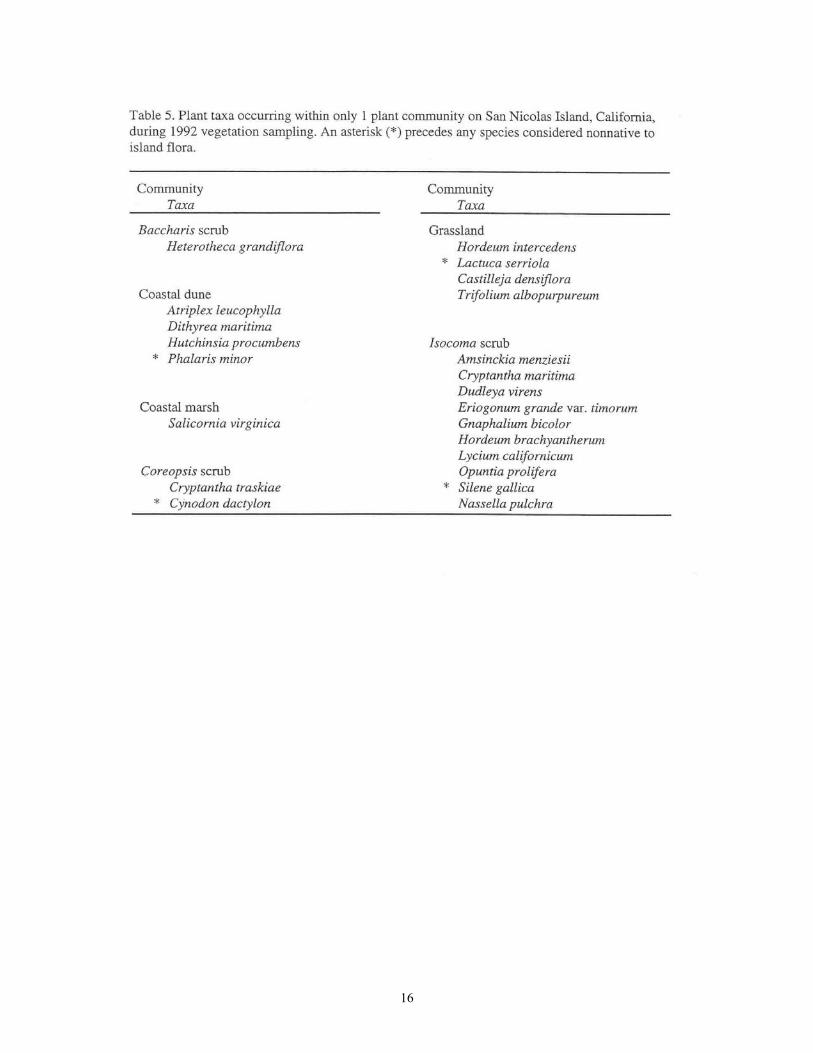
The condition of the plant communities on San Nicolas Island can be determined by the number of taxa in each community and by the relative importance of native and nonnative species in those communities. These provide some insight into the wide range of ecological tolerances of some species, and the apparent narrow range of suitable habitats of others. These also give some indication of the consistency of habitat conditions on the island and relative stability of the communities. Thirty-three plant taxa were found in at least 4 of the 9 plant communities recognized on the island (Table 4). Eighteen of these are nonnative forbs and grasses that are characteristic of over-grazed or otherwise damaged sites, while 16 are widespread native taxa. The natives include 1 grass, 1 vine, 4 shrub, and 11 forb species. Twenty-two species are restricted in their distribution to only 1 community type (Table 5).
The community with the largest number of these restricted species is the Isocoma scrub; only 1 of the 11 species restricted to this community is nonnative. This situation indicates that Isocoma scrub is a relatively pristine, stable community. The low importance of nonnative species in this community is another indication that this Isocoma scrub community is still healthy and stable despite repeated disturbance (Table 6).
An indication of the amount of disturbance to the plant communities of the island is the fact that a nonnative species, Mesembryanthemum crystallinum, was found in 8 of the 9 communities. An indication that the disturbance is not wholesale, but that recovery is underway, is the fact that this widespread nonnative ranges in relative importance from 1.7% to 4.9% except in the community where it is the dominant, and there its relative importance is only 14.1 %. In general, nonnative species make up an important part of the ecology of San Nicolas Island while floristically they constitute about 47% of the total flora. Their importance to the structure of plant communities ranges from 29.4% in the coastal marsh to 62.9% in caliche scrub, with grassland a close second (60.2%) in domination by nonnative species (Table 6). In numbers of species per community type, nonnatives range from 33.9% in Isocoma scrub to 64.3% in caliche scrub.

15
16

17

18
Community Descriptions
A discussion of the findings of this research by plant community follows. Appendix 1 provides data on the frequency of occurrence and the relative importance values of plant taxa within each community.
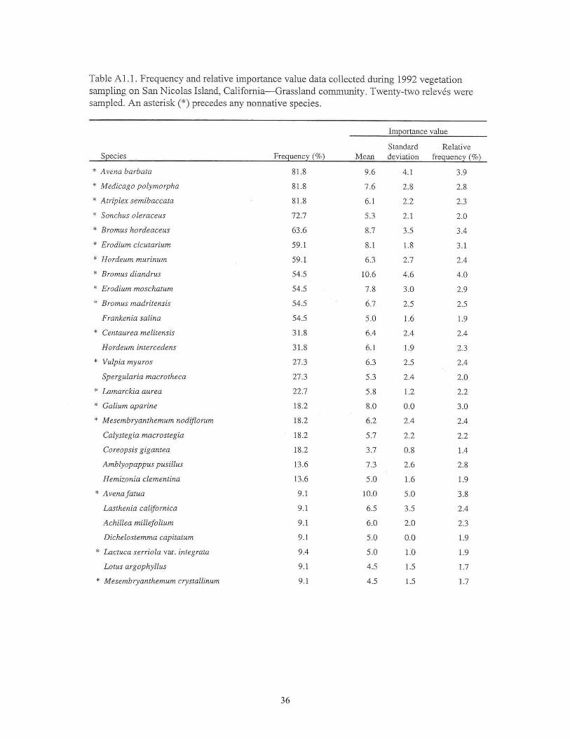
Grassland The grassland community (Fig. 5 and Table Al. l) is an important component of the vegetation on the mesa-top of San Nicolas Island. This grassland is composed of nonnative (introduced) grasses and a mixture of native and nonnative forbs. The dominant grasses are Avena barbata, Hordeum murinum, Bromus diandrus, and Bromus madritensis. The dominant forbs, which are all nonnatives, are Medicago polymorpha, Sonchus oleraceus, and Erodium spp. The herbaceous perennial Atriplex semibaccata is another nonnative species important to San Nicolas grasslands. Frankenia salina is an important native perennial found in many grasslands. The structure of this community consists of an overstory of A. barbatus and B. diandrus with an understory, that is usually much more dense, of Hordeum spp. and other Bromus spp.
An important characteristic to watch in the long-term monitoring of San Nicolas Island vegetation is that of shrub invasions. It appears that with protection from grazing and fire, the grassland is giving way to shrub dominated communities, the specific dominants of which are dependant upon topography and soils. Native shrubs that were present in this analysis included Coreopsis gigantea, Lotus argophyllus, Hemizonia clementina, Malacothrix incana, and Isocoma menziesii. The native perennial grass, Nassella pulchra, does exist on the island, but it is primarily found in association with shrubs, such as Lupinus and Coreopsis. We did not find it in any of the localities chosen to sample the grassland community, but it is present within the boundaries of this community type.
Coastal Marsh The marsh community (Fig. 6 and Table A1.2) is found primarily in 3 small.areas on the east end of San Nicolas Island. Two species, Salicornia virginica and Frankenia salina, dominate. They were found to cover most of the marsh area and, between them, constitute 33% of the importance of all species. Other important species that were found here include Mesembryanthemum nodiflorum, Distichlis spicata, Atriplex californica, Calystegia macrostegia, and Parapholis incurva. There are other scattered localities, such as Thousand Springs, where small patches of these species occur.
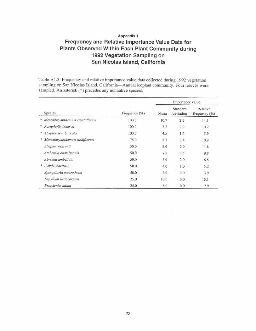
Annual Iceplant (Mesembryanthemum) A small area on the west end of the island is dominated by Mesembryanthemum crystallinum (Table A1.3). This annual iceplant has been shown to inhabit areas of disturbance and to cause continued damage by increasing soil salinity in the area that it inhabits (Halvorson et al. 1988, D'Antonio et al. 1992). This is also an area that is used extensively as a western gull (Larusoccidentalis) nesting area. Plant species associates of the iceplant are Lepidium lasiocarpum, Atriplex watsonii, Mesembryanthemum nodiforum, and Parapholis incurva.

19

20
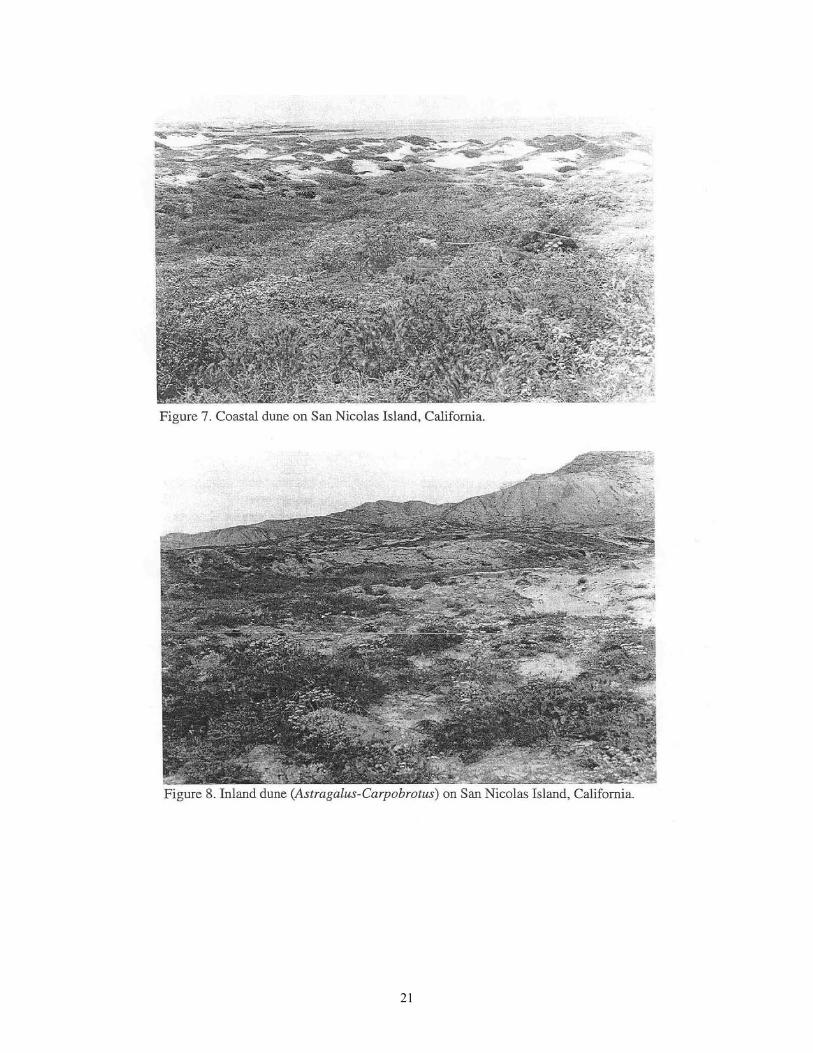
Coastal Dune Coastal dunes (Fig. 7 and Table A1.4) are best developed on the west end and north side of San Nicolas Island. The plant community that exists on these active dunes is diverse and scattered, with no species dominating over large expanses. The plants do sort out relative to position on the dunes in such a way that single-species to few-species patches are formed. Closer to the water, Abronia maritima has the highest importance. Other important associates on the dunes include Malacothrix incana, Lupinus albifrons, Abronia umbellata, Ambrosia chamissonis, Mesembryanthemum crystallinum, Calystegia macrostegia, Camissonia cheiranthifolia, and Lotus argophyllus. With increasing distance from the water, the plant cover becomes more dense and diverse. A total of 36 species were recorded in this community type.
Inland Dune (Astragalus-Carpobrotus) Behind the active dunes are areas that are more stable but still sandy substrates (Table AL5). These areas are characterized by a minor, but important cover of Carpobrotus edulis, and by the domination of Astragalus traskiae (Fig. 8) Because this area has some instability, it also has an important component of nonnative weedy species such as Medicago polymorpha, Sonchus oleraceus, and Erodium cicutarium. Others of the 17 species in this community type are a mixture of upland and dune species; the area serves as an ecotone between active dune and upland.
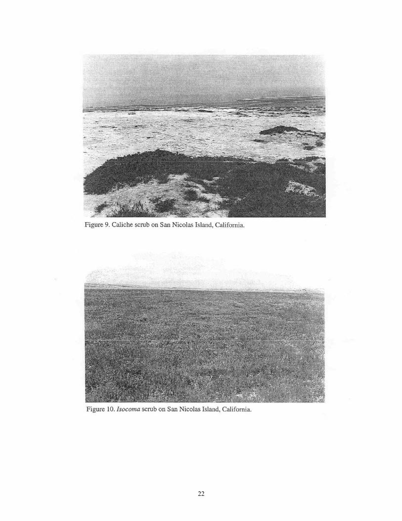
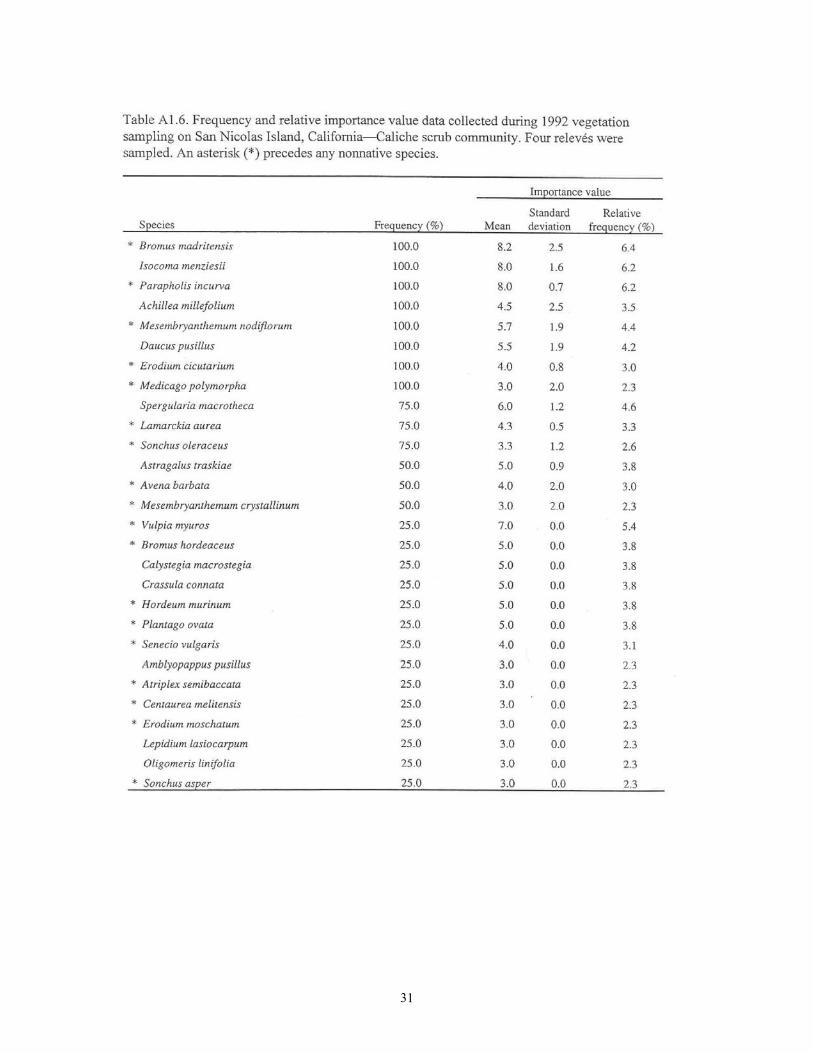
Caliche Scrub (Isocoma) At the south edge of the mesa, there are some areas that have been completely denuded of top soil. The dominant feature of these sites is the presence of a calcium carbonate layer called caliche. This substance typically forms a hardpan layer in arid-land soils. On the California Channel Islands (particularly San Miguel, and west end of Santa Rosa), this layer is on the surface because of erosion caused by wind and water after the vegetation has been removed by grazing, farming, and other land uses. In these areas, plant cover is widely scattered because there are very few pockets of available soil (Fig. 9 and Table A1.6). Eighteen of the 28 species found in this community type were nonnative, presumably due to the disturbed nature of the sites. The most important native species in this community are Isocoma menziesii and Achillea millefolium. The long-term trend for this community type is to eventually establish a soil layer and give way to the following.
Coastal Scrub
Isocoma scrub The most diverse community on the island is. characterized by Isocoma menziesii (Fig. 10 and Table A1.7). Isocoma is also the most ubiquitous shrub on the island. These facts lead to the conclusion that, except for the cooler north slopes where Coreopsis dominates or some of the wetter mesa top areas where Baccharis is important, the rest of the island will, with sufficient protection and restoration, be covered with a short shrub community with its most important member being Isocoma menziesii. Another indication that this is the community of the future for San Nicolas Island is that 67% of the species found here are natives. This community is so diverse that no one species dominates over vast acreage. The community is made up of patches of various sizes and various species assemblages. Numerous patches of Apuntia sp. occur in this community and can be lacally dominant. The species most widespread over the
21
22

23
landscape are Bromus madritensis, Isocoma menziesii, Daucus pusillus, Mesembryanthemum crystallinum, and Lotus argophyllus.
Baccharis scrub The Baccharis scrub community (Fig. 11 and Table A1.8) exists in scattered locations on the mesa top, principally where there are depressions or other areas where there is more protection and overall wetter conditions such as in some of the drainages on the north side of the island. The more important species are Baccharis pilularis, Bromus diandrus, Avena barbata, Calystegia macrostegia, and many forbs, both native and nonnative. Other shrubs that are often found in the community type are Isocoma menziesii and Lupinus albifrons. There is some evidence (Clark et al. 1990) that Baccharis is, in many localities, a weedy, quick invader shrub that will reduce in importance in later stages of community development. It would be well, therefore, to monitor this plant community as it may evolve into another type, dominated by Coreopsis, Isocoma, or Lupinus.
Lupinus scrub The Lupinus scrub plant community is a rare community-type for San Nicolas Island. The survey found only 2 patches large enough to be considered for mapping. We did not include this community in the long-term monitoring program. The community is a segregate of the coastal scrub complex and occurs in sandy situations where Lupinus albifrons takes on a dominant role. In this community, Lupinus and Coreopsis form an overstory of up to a meter in height with a diverse and patchy understory of forbs and grasses.
Coreopsis scrub Coreopsis scrub (Fig. 12 and Table A1.9) is the second most diverse community on the island and the most dominating in terms of stature. It is the only community type on San Nicolas Island that reaches heights above 2 m. It is found on the cooler, north-facing slopes of the north side of the island. Throughout much of the range 'of this community, Coreopsis maintains a frequency of 100%, (i.e., it is widely and generally distributed, not prone to be found in scattered patches). Other shrubs can be found in patches within the range of Coreopsis, including Lupinus albifrons, Isocoma menziesii, and Lotus argophyllus. For the most part, however, the stand consists of an overstory of Coreopsis with an understory of vines, grasses, and forbs.
Riparian/Deep Drainages Currently there is only a disturbed and depauperate riparian community on San Nicolas Island. These areas were mapped because they do represent a unique land cover category. The deep drainages on the south side of the island are bare and eroded. The deep drainages on the mesa top and the north side of the island have areas of erosion slopes, but they also have areas where biodiversity and plant density increases to form a community that looks different even though it is mainly composed of the same species of plants that occur on the slopes. We were not able to do a releve analysis of these areas, but do recommend that they be monitored over time. It is likely that with protection and cessation of erosion, these areas will begin to develop a more unique assemblage of species and begin to take on a more characteristic riparian physiognomy.
Vernal Pools Several depauperate, disturbed vernal pools were observed in the western and northeastern portions of the mesa. The dominant species around these pools is Eleocharis macrostachya.

24
25
Discussion
The plant communities of San Nicolas Island are similar to those documented for others of the California Channel Islands (Junak et al. 1980, Minnich 1980, Clark et al. 1990, Junak et al. 1995). A low shrub community dominated by Isocoma menziesii covers the largest amount of surface area. This covers much of the south and west portions of the island, including those areas where the dominant landscape feature is eroded, barren ground. The other 2 plant community types that are important for the amount of land surface they cover are annual grassland and Coreopsis scrub. The grassland is dominated by nonnative species and is found on the central and eastern top of the island. Coreopsis scrub is best developed on the north-facing slopes on the north side of the island.
While there are riparian habitats within moist canyons, on both the north and south sides of the island, there is presently little development of riparian vegetation. Woodland tree species are very rare on San Nicolas Island, and no native woodland community is present. Our expectation is that as the plant communities on the island begin to recover, a riparian community dominated by Baccharis and willow will develop. The appropriate habitats should be monitored `over time to check the rate at which this occurs.
The island vegetation has been damaged by past land uses, including grazing and military developments and activities. This has led to a great deal of open, eroded ground and an increased importance of nonnative plant species in the flora in general and in the plant communities in specific. While some areas will recover only slowly on their own, others will only continue to degrade, and some will recover with a speed that is recognizable in the short-term (i.e., 5-10 years). The easily recognized changes will be native shrubs (such as Isocoma, Lupinus, Baccharis, and Coreopsis) invading the nonnative grassland. Thus, with time there will be more of a shrubby nature to the island, and grassland will probably phase out to the point that it becomes patches in a scrubland.
The areas that will need resource management implementation for recovery and restoration of native plant communities are areas such a$ the south slope, where damage has occurred to such an extent that top soil has been lost and erosion cycles have started, and the extensive erosion areas on the north slope. Such areas will need soil erosion control and active revegetation. These restoration projects should be started as soon as possible. In addition, active restoration should take place any time that new disturbances take place, such as pipeline developments, new construction or rehabilitation of existing construction (e.g., the runway project).

26
Literature Cited
Bryan, B. 1970. Archaeological explorations on San Nicolas Island. Southwest Museum Paper 22:1-160. Southwest Museum, Los Angeles, California.
Clark, R. A., W. L. Halvorson, A. A. Sawdo, and K. C. Danielsen. 1990. Plant communities of Santa Rosa Island, Channel Islands National Park. Cooperative Park Studies Unit, University of California, Davis, Technical Report 42. 93 p.
De Violini, R. 1974. Climatic handbook for Point Mugu and San Nicolas Island. Part 1. Surface Data. Technical Publication PMR-TP-74-1. Pacific Missile Range, Point Mugu, California. 98 p., appendices.
D'Antonio, C. M., W. L. Halvorson, and D. B. Fenn. 1992. Restoration of denuded areas and iceplant areas on Santa Barbara Island, Channel Islands National Park. Cooperative Park Studies Unit, University of California, Davis, Technical Report NPS/WRUC/NRTR-92/46. 90 p.
Eastwood, A. 1898. Studies in the herbarium and field II. Notes on the plants of San Nicolas Island. Proceedings of the California Academy of Science, Series 3, Botany, 1:89-120, 140.
Forney, S. 1879. Topographical Survey Map #T-1523. U.S. Coast and Geodetic Survey, Scale 1:20,000. Copy at Library, University of California at Santa Barbara, Map and Imagery Room.
Halvorson, W. L., D. B. Fenn, and W. R. Allardice. 1988. Soils and vegetation of Santa Barbara Island, Channel Islands National Park, California, USA. Environmental Management 12:109-118.
Hickman, J. C. (ed.) 1993. The Jepson manual: higher plants of California. University of California Press, Berkeley, California. 1,400 p.
Junak, S. A., and J . M. Vanderwier. 1990. An annotated checklist of the vascular plants of San Nicolas Island, California. P. 121-145 is Proceedings of the fifth biennial Mugu Lagoon/San Nicolas Island ecological research symposium, Naval Air Weapons Station, Point Mugu, California.
Junak, S.A., M. Hochberg, R. Philbrick, and S. Timbrook 1980. Plant Communities of Anacapa Island. p. 222-231 In Proceedings of the Second Conference on Scientific Research in the National Park Service. Washington, D.C.
Junak, S. A., T. Ayers, R. Scott, D. Wilken, D. Young 1995. A Flora of Santa Cruz Island Santa
Barbara Botanic Garden and California 'Native Plant Society, Sacramento, California. p. 397. Kimberly, J. M. 1988. Fifty years and more in Santa Barbara. Noticias 34(3):50-62.
Minnich, R. A. 1980. Vegetation of Santa Cruz and Catalina Islands. P. 123-137 in The California Islands: Proceedings of a multi-disciplinary symposium (D. M. Power, ed.), Santa Barbara Museum of Natural History, Santa Barbara, California.

27
Mueller-Dombois, D., and H. Ellenberg. 1974. Aims and methods of vegetation ecology. John Wiley and Sons, Inc., New York. 547 p
Munz, P. A. 1974. A flora of southern California. University of California Press, Berkeley. 1,086 p.
Schumacher, P. 1877. Researches in the kjokkenmoddings and graves of a former populations of the Santa Barbara Islands and the adjacent mainland. Bulletin of the U.S. Geological and Geographical Survey of the Territories 3(1):37-56.
Sebree, U., and E. Davis. 1901. Letter to Lighthouse Board, Washington, D.C., 25 September 1901. U.S. National Archives, Record Group 26, Lighthouse Board Correspondence (1901-1910), File 2998 (San Nicolas Island).
Swanson, M.T. 1993. Historic Sheep Ranching on San Nicolas Island. Technical Series #41. Statistical Research, Tucson, Arizona. p,. 82.
Trask, B. 1900. Dying San Nicolas. Land of Sunshine 13(2):97-100.
U.S. Soil Conservation Service. 1985. Soil survey of Channel Islands area, California: San Nicolas Island part. Interim Publication; National Cooperative Soil Survey. 248 p., map sheet.
Vedder, J. G., and R. M. Norris. 1963. Geology of San Nicolas Island. U.S. Geological Survey Professional Paper 369:1-65. U.S. Government Printing Office, Washington, D.C.
Wheeler, S. A. 1944. California's little known Channel Islands. U.S. Naval Institute Proceedings 70(493):256-267.
28

29

30
31

32

33

34

35
36

37

38

39

40

41
Appendix 2 Plant Taxa Identified during 1992 Vegetation Sampling on San Nicolas Island, California
For each taxon, the four-letter acronym (indicated in bold typeface) and common name (indicated in SMALL CAPS typeface) follow the scientific name (indicated in italic typeface). An asterisk (*) precedes plant taxa presumed to be introduced to San Nicolas Island by human activities.
AIZOACEAE, Iceplant Family * Carpobrotus edulis CAED, HOTTENTOT-FIG * Mesembryanthemum crystallinum MECR, CRYSTALLINE ICEPLANT * Mesembryanthemum nodiflorum MENO, SMALL-FLOWERED ICEPLANT
ALLIACEAE, Onion Family
Dichelostemma capitatum DICA, BLUE DICKS
APIACEAE, Celery Family
Daucus pusillus DAPU, RATTLESNAKE : WEED Lomatium insulare LOIN, SAN NICOLAS ISLAND LOMATIUM Sanicula arguta SAAR, SHARP-TOOTHED SNAKEROOT
ASTERACEAE, Sunflower Family
Achillea millefolium ACMI, YARROW Amblyopappus pusillus AMPU, PINEAPPLE WEED Ambrosia chamissonis AMCH, SILVER BEACH WEED, BEACHBUR Baccharis pilularis BAPI, COYOTE BRUSH
* Centaurea melitensis CEME, TOCALOTE Coreopsis gigantea COGI, GIANT COREOPSIS Gnaphalium bicolor GNBI, BICOLOR EVERLASTING Gnaphalium stramineum GNST, COTTON-BATTING Isocoma menziesii ISME, COASTAL GOLDENBUSH Hemizonia clementina HECL, CATALINA TARWEED Heterotheca grandiflora HEGR, TELEGRAPH WEED
* Lactuca serriola LASE, PRICKLY LETTUCE Lasthenia califomica LACA, GOLDFIELDS Malacothrix incana MAIN, DUNE MALACOTHRIX

42
Malacothrix foliosa MAFO, SAN NICOI AS ISLAND MALACOTHRIX * Senecio vulgaris SEVU, COMMON GROUNDSEL * Sonchus asper SOAS, PRICKLY SOW-THISTLE
Sonchus oleraceus SOOL, COMMON SOW-THISTLE BORAGINACEAE, Borage Family
Amsinckia menziesii var. intermedia AMME, COMMON FIDDLENECK Amsinckia spectabilis var. spectabilis AMSP, SEASIDE FIDDLENECK Cryptantha traskiae CRTR, TRASK'S CRYPTANTHA Cryptantha maritima var. maritima CRMA, GUADALUPE ISLAND CRYPTANTHA
BRASSICACEAE, Mustard Family * Cakile maritima CAKMA, SEA ROCKET
Dithyrea maritima DIMA, BEACH SPECTACLE POD Hutchinsia procumbens HUPR Lepidium lasiocarpum var. lasiocarpum LELA, SAND PEPPERGRASS
CACTACEAE, Cactus Family
Opuntia prolifera OPPR, COASTAL CHOLLA
CARYOPHYLLACEAE, Pink Family
Spergularia macrotheca SPMA, SAND SPURREY • Silene gallica SIGA, WINDMILL PINK
CHENOPODIACEAE, Goosefoot Family
Atriplex califomica ATCA, CALIFORNIA SALTBUSH Atriplex leucophylla ATLE, SEASCALE
* Atriplex semibaccata ATSE, AUSTRALIAN SALTBUSH Atriplex watsonii ATWA, MATSCALE Salicomia virginica SAVI, PICKLEWEEP

43
CONVOLVULACEAE, Morning Glory Family
Calystegia macrostegia subsp. Amplissima CALMA, SOUTHERN ISLAND MORNING GLORY
CRASSULACEAE, Stonecrop Family
Crassula connata CRCO, PYGMY WEED Dudleya virens subsp. Insularis DUVI, LIVE-FOREVER
FABACEAE, Pea Family
Astragalus traskiae ASTR, TRASK'S LOCOWEED Lotus argophyllus var. omithopus LOAR, SILVER LOTUS Lupinus albifrons var. douglasii LUAL, SILVER LUPINE Medicago polymorpha MEPO, BUR-CLOVER Melilotus indicus MEIN, YELLOW SWEET-CLOVER Trifolium albopurpureum TRAL, RANCHERIA CLOVER Trifolium willdenovii TRWI, TOMCAT CLOVER
FRANKENIACEAE, Frankenia Family
Frankenia salina FRSA, ALKALI HEATH
GERANIACEAE, Geranium Family * Erodium cicutarium ERCI, REDSTEM * Erodium moschatum ERMO, WHITES
NYCTAGINACEAE, Four-O'Clock Family
Abronia maritima ABMA, STICKY SAND-VERBENA Abronia umbellata ABUM; BEACH SAND-VERBENA
ONAGRACEAE, Evening Primrose Family
Camissonia cheiranthifolia subsp. Cheiranthifolia CACH, BEACH-PRIMROSE

44
PAPAVERACEAE, Poppy Family
Platystemon californicus PLCA, CREAM CUPS
PLANTAGINACEAE, Plantain Family
* Plantago ovata PLOV
POACEAE, Grass Family * Avena barbata AVBA, SLENDER WILD * Avena fatua AVFA, WILD OATS * Bromus diandrus BRDI, RIPGUT BROME * Bromus hordeaceus BRHO, SOFT CHESS * Bromus madritensis subsp. rubens BRMA, RED BROME * Cynodon dactylon CYDA, BERMUDA GRASS * Distichlis spicata DISP, SALTGRASS * Hordeum brachyantherum subsp. calif( Hordeum intercedens HOIN, VERNAL BARLEY * Hordeum murinum HOMU, FOXTAIL * Lamarckia aurea LAAU, GOLDENTOP * Parapholis incurva PAIN, SICKLE GRASS * Phalaris minor PHMI, MEDITERRANEN CANARY GRASS
Nassella cernua NACE, NODDING NEEDLEGRASS Nassella pulchra NAPU, PURPLE NEEDLEGRASS
* Vulpia myuros VUMY, FOXTAIL FESCUE Vulpia octofora VUOC, SIX-WEEKS FESCUE
POLYGONACEAE, Buckwheat Family
Eriogonum grande var. timorum ERGR, SAN NICOLAS ISLAND BUCKWHEAT
PORTULACACEAE, Purslane Family
Claytonia perfoliata subsp. Mexicana CLPE, MINER’S LETTUCE
RESEDACEAE, Mignonette Family
Oligomeris linifolia OLLI, MIGNONE

45
RUBIACEAE, Coffee Family * Galium aparine GAAP, CLEAVERS
SCROPHULARIACEAE, Figwort Family
Castilleja densiflora CADE, OWL'S-CLOVER
SOLANACEAE, Nightshade Family Lycium califomicum LYCA, CALIFORNIA BOXTHORN