Planning Proposal - NSW Government
49
Surveying Town Planning Civil Engineering Project Management Planning Proposal Proposed amendment to Minimum Lot Size Map Prepared for GJA & BA Cooper Site address Lot 1 DP 1081549 268A Beach Road, Berry Date 9 June 2021
-
Upload
khangminh22 -
Category
Documents
-
view
0 -
download
0
Transcript of Planning Proposal - NSW Government

Surveying Town Planning Civil Engineering Project Management
Planning Proposal Proposed amendment to
Minimum Lot Size Map
Prepared for
GJA & BA Cooper
Site address
Lot 1 DP 1081549
268A Beach Road,
Berry
Date
9 June 2021

Planning Proposal – Min. Lot size 268A Beach Rd, Berry Ref N28228
2
Table of Revisions Initials Rev Date Details
DS 0 9/6/2021 Submit to SCC
Copyright Statement
© Allen Price & Scarratts Pty Ltd 2021
Other than as permitted by the Copyright Act 1968, no part of this report may be reproduced, transmitted, stored in a retrieval system or adapted in any form or by any means (electronic, mechanical, photocopying, recording or otherwise) without written permissions. Enquiries should be addressed to Allen Price & Scarratts Pty Ltd.
The document may only be used for the purposes for which it was commissioned. Unauthorised use of this document in any form whatsoever is prohibited. Allen Price & Scarratts Pty Ltd assumes no responsibility where the document is used for purposes other than those for which it was commissioned.
This report has been prepared on behalf of and for the exclusive use of the Client, and is subject to and issued in connection with the provisions of the agreement between Allen Price & Scarratts Pty Ltd and the Client. Allen Price & Scarratts Pty Ltd accepts no liability or responsibility whatsoever for or in respect of any use of or reliance upon this report by any third party.
Nowra Office: 75 Plunkett Street, Nowra NSW 2541 • PO Box 73, Nowra 2541 Kiama Office: 1/28 Bong Bong Street, Kiama NSW 2533 • PO Box 209, Kiama 2533 tel 02 4421 6544 • email [email protected]
ABN 62 609 045 972
Liability limited by a scheme approved under Professional Standards Legislation

Planning Proposal – Min. Lot size 268A Beach Rd, Berry Ref N28228
3
CONTENTS
INTRODUCTION...................................................................................................................................... 4 BACKGROUND ....................................................................................................................................... 5 PART 1 – STATEMENT OF OBJECTIVES OR INTENDED OUTCOMES .............................................. 8 PART 2 – EXPLANATION OF PROVISIONS .......................................................................................... 8 PART 3 – JUSTIFICATION OF OBJECTIVES, OUTCOMES AND PROCESS ...................................... 9
3.1 – NEED FOR THE PLANNING PROPOSAL ........................................................................... 9
3.2 – RELATIONSHIP TO STRATEGIC PLANNING FRAMEWORK .......................................... 10
3.3 – ENVIRONMENTAL, SOCIAL AND ECONOMIC IMPACT .................................................. 18
3.4 – STATE AND COMMONWEALTH INTERESTS .................................................................. 19
PART 4 – MAPPING .............................................................................................................................. 19 PART 5 – COMMUNITY CONSULTATION ........................................................................................... 20 PART 6 – PROJECT TIMELINE ............................................................................................................ 20 CONCLUSION ....................................................................................................................................... 21
APPENDIX A - PLAN OF SITE .................................................................................................... 22
APPENDIX B - LARGER SCALE OF PROPOSED SLEP 2014 MAPPING MODIFICATIONS ... 23
APPENDIX C - SUMMARY OF THE PP CONSISTENCY AGAINST S9.1 DIRECTIONS ........... 24
APPENDIX D – COWMAN STODDART AGRICULTURAL ASSESSMENT ............................... 25
APPENDIX E –SHOALHAVEN CITY COUNCIL PRE-LODGEMENT MEETING LETTER (30.03.2021) …………………………………………………………………………………….. 46

Planning Proposal – Min. Lot size 268A Beach Rd, Berry Ref N28228
4
INTRODUCTION
This proponent-led Planning Proposal (PP) has been prepared in accordance with Section 3.32 and 3.33 of the Environmental Planning and Assessment Act 1979 and the following relevant documents:
• Department of Planning, Industry and Environment's "A guide to preparing planning proposals"; and,
• Shoalhaven City Council’s Planning Proposal Policy.
The PP seeks to amend the Shoalhaven Local Environmental Plan (SLEP) 2014 as it applies to Lots 1 and 2 DP1081549 at 268A Beach Road, Berry by amending the minimum lot size on a 4Ha portion of Lot 1 to allow a future boundary adjustment between the subject lots to allow:
• Lot 1 to be reduced from 10ha to 4ha; and
• Lot 2 to be increased from 10ha to 16ha.
The intended outcome of this planning proposal is to amend the minimum lot size in order to permit the creation of a 4ha lot within the RU4 Primary Industry Small Lot zone. A future application for a boundary adjustment between Lot 1 DP1081549 would follow the SLEP 2014 amendment and would retain two allotments both with an existing dwelling on each parcel. The revised minimum lot size would ensure that no further subdivision of either lot could occur and that no additional dwelling entitlements could be achieved.
The proposal is consistent with strategic outcomes identified in: Illawarra – Shoalhaven Regional Plan 2015, Illawarra - Shoalhaven Regional Plan 2041, Shoalhaven Growth Management Strategy 2019-2041 and Shoalhaven 2040, Our Strategic Land-use Planning Statement.
The outcome of this amendment will not impact on the current approved land use of the subject land and the agricultural viability of each lot will be retained. The existing land developments would remain as they are currently, and the capacity for primary production of the subject land will be ensured, safeguarding primary industry in the Shoalhaven and the environmental attributes of the area.
The creation of 4ha lot within the RU4 Primary Industry Small Lot zone will support continued investment in agricultural land in the Shoalhaven by permitting a rural land holding for emerging primary industries and agricultural uses that operate on smaller rural holdings such as horticultural uses and other intensive plant industries.
The future proposed boundary adjustment would result in the majority of the native vegetation within the two lots being located within one allotment rather than straddled between the two existing lots.
Should Council support this initiative, and formally initiate the PP process, this document is proposed to assist Council by providing the majority of background information. Therefore, the format of this document follows Council’s adopted Planning Proposal Guidelines and reference to all information set out in Section 3.33 of the EP&A Act and the Department’s Guide to Preparing Planning Proposals.
Further to the above, the format of this document is to also optimise a timely and easier path for a Council merit-based assessment of the PP and to provide potential recommendations to the elected Council. This format will further assist with agency and landowner consultation prior to formal exhibition.
As outlined in this PP, this modification of minimum lot size will have no visual impacts and the current built form on of each allotment will remain.
The PP also continues to provide legal access for the existing two rural dwellings and associated agricultural activities. The land use zones are not to be revised and the objectives of the land zone are not compromised.
The justification of the minimum lot size amendment area is explained in this PP which informs subsequent related amendments for the SLEP 2014.
Planning Proposal – Min. Lot size 268A Beach Rd, Berry Ref N28228
5
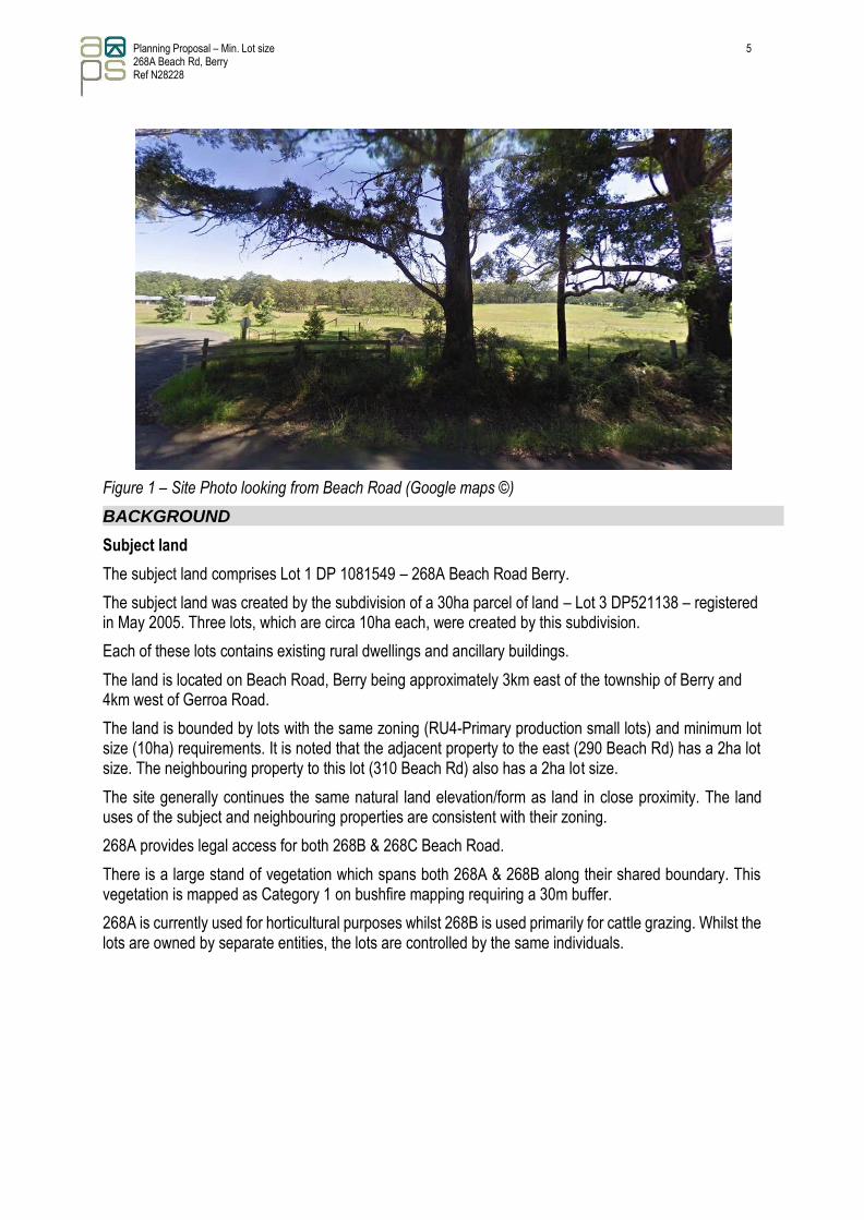
Figure 1 – Site Photo looking from Beach Road (Google maps ©)
BACKGROUND
Subject land
The subject land comprises Lot 1 DP 1081549 – 268A Beach Road Berry.
The subject land was created by the subdivision of a 30ha parcel of land – Lot 3 DP521138 – registered in May 2005. Three lots, which are circa 10ha each, were created by this subdivision.
Each of these lots contains existing rural dwellings and ancillary buildings.
The land is located on Beach Road, Berry being approximately 3km east of the township of Berry and 4km west of Gerroa Road.
The land is bounded by lots with the same zoning (RU4-Primary production small lots) and minimum lot size (10ha) requirements. It is noted that the adjacent property to the east (290 Beach Rd) has a 2ha lot size. The neighbouring property to this lot (310 Beach Rd) also has a 2ha lot size.
The site generally continues the same natural land elevation/form as land in close proximity. The land uses of the subject and neighbouring properties are consistent with their zoning.
268A provides legal access for both 268B & 268C Beach Road.
There is a large stand of vegetation which spans both 268A & 268B along their shared boundary. This vegetation is mapped as Category 1 on bushfire mapping requiring a 30m buffer.
268A is currently used for horticultural purposes whilst 268B is used primarily for cattle grazing. Whilst the lots are owned by separate entities, the lots are controlled by the same individuals.

Planning Proposal – Min. Lot size 268A Beach Rd, Berry Ref N28228
6
Figure 2 - Site Locality Plan (aerial imageSource: Nearmaps)
Figure 3 – Subject Land for LSZ to be modified (aerial image source: Nearmaps)
Subject Land Lot
1 DP1081549 268A Beach Rd
Subject 4ha Area for amendment to minimum lot
size
Line of potential future boundary adjustment to create 4ha lot
Existing lot boundary

Planning Proposal – Min. Lot size 268A Beach Rd, Berry Ref N28228
7
Current Lot Size Mapping SLEP2014
Current 10ha minimum lot sizes affecting the site is shown in Figure 4.
Figure 4 – Current Minimum Lot size affecting Lots 1 and 2 DP 1081549 (Source: SLEP 2014)
Current Relevant Land Use Zones SLEP2014
Current land use zones affecting the site is shown in Figure 5. This proposal, and any potential future boundary adjustment, will not have any impact on the current land use zones.
Figure 5 – Current Land Zones affecting Lots 1 and 2 DP 1081549 (Source: SLEP 2014)
Status of current investigations
The outcomes of a pre-lodgement meeting and correspondence with Shoalhaven City Council (Appendix E). has informed this Planning Proposal.
The following accompanying assessments to this PP have been prepared and provide more detailed specific investigation of the site:

Planning Proposal – Min. Lot size 268A Beach Rd, Berry Ref N28228
8
• Agriculture Assessment by Cowman Stoddart– February 2021 (Appendix D).
Strategies planning assessment
In preparing this PP, the following SCC or State Government strategies or plans have been assessed as supporting this proposal and are reviewed further in Part 3 – Justification.
• Illawarra – Shoalhaven Regional Plan 2015;
• Illawarra - Shoalhaven Regional Plan 2041;
• Shoalhaven Growth Management Strategy 2019-2041;
• Shoalhaven 2040, Our Strategic Land-use Planning Statement
PART 1 – STATEMENT OF OBJECTIVES OR INTENDED OUTCOMES
(s.3.33(2)(a) A statement of the objectives or intended outcomes of the proposed instrument)
The objective of the PP is to amend SLEP 2014 with regards to the minimum lot size of a portion of land within registered Lot 1 DP1081549.
Property description and current Minimum Lot Size
Lot DP / Property Address Current SLEP 2014 Min. Lot Size
Lot 1 DP 1081549, No. 268A Beach Road, Berry AB1 – 10ha
The intended outcome of this planning proposal is to amend the minimum lot size of a portion of Lot 1 only in order to permit the creation of a 4ha lot within the RU4 Primary Industry Small Lot zone.
A future application for a boundary adjustment between Lots 1 & 2 DP1081549 would follow the SLEP 2014 amendment and would retain two allotments both with existing dwelling on each parcel. Lot 1 is proposed to reduce to 4ha, whilst Lot 2 would be 16ha. The revised minimum lot size would ensure that no further subdivision of either lot can occur, nor any additional dwelling entitlements be possible.
This potential boundary adjustment would retain two allotments with an existing dwelling on each parcel. Lot 1 is proposed to reduce to 4ha, whilst Lot 2 would be increased to 16ha. The revised minimum lot sizes would ensure that no further subdivision of either lot can occur. The existing built developments would remain as they are currently, and the agricultural viability of each lot will be ensured, safeguarding the environmental attributes of the area.
The proposed minimum lot size amendments are shown in Appendix B.
PART 2 – EXPLANATION OF PROVISIONS
(s.3.33(2)(b) An explanation of the provisions that are to be included in the proposed instrument)
The PP seeks to amend the Shoalhaven Local Environmental Plan (SLEP) 2014 as it applies to Lot 1 DP1081549 at 268A Beach Road Berry by amending the minimum lots size as follows:
• Lot 1 from 10ha to 4ha; and
• Lot 2 from 10ha to 16ha.
The amendment would be facilitated by amending the minimum lot size map. No specific clause amendments to SLEP 2014 are proposed.

Planning Proposal – Min. Lot size 268A Beach Rd, Berry Ref N28228
9
Proposed SLEP 2014 map for amendment
Map type Map sheet (identification numbers) Reasoning for amendment
Lot Size – LSZ 6950_COM_LSZ_019E_020_20210406 Minimum lot size is currently 10ha.
These amendments/adjustments are required in general to meet the aims of the SLEP2014 are as outlined below:
(aa) to protect and promote the use and development of land for arts and cultural activity, including music and other performance arts,
(a) to encourage the proper management, development and conservation of natural and man- made resources,
(b) to facilitate the social and economic wellbeing of the community,
(c) to ensure that suitable land for beneficial and appropriate uses is made available as required,
(d) to manage appropriate and essential public services, infrastructure and amenities for Shoalhaven,
(e) to minimise the risk of harm to the community through the appropriate management of development and land use.
The subject land has a land use zone of RU4 - Primary Production small lots. The objectives of this zone are:-
• To enable sustainable primary industry and other compatible land uses.
• To encourage and promote diversity and employment opportunities in relation to primary industry enterprises, particularly those that require smaller lots or that are more intensive in nature.
• To minimise conflict between land uses within this zone and land uses within adjoining zones.
The proposed use of the subject land is permissible within this zone.
The future boundary adjustment to create a 4ha and 16ha lot (as a result of the proposed amendment to the minimum lot size requirement) enables each lot to achieve the zone objectives. The proposed intended uses of the lots are for intensive horticultural purposes on the 4ha lot and cattle grazing on the larger 16ha lot. It is considered that these lot sizes are appropriate for their intended uses.
PART 3 – JUSTIFICATION OF OBJECTIVES, OUTCOMES AND PROCESS
(s.3.33(2)(c) Justification for those objectives, outcomes and provisions and the process for their implementation)
3.1 – Need for the Planning Proposal
3.1.1 Is the planning proposal a result of an endorsed local strategic planning statement, strategic study or report?
The PP is the result of a pre-lodgement meeting advice and guidance from Shoalhaven City Council (Appendix E) regarding the processes and investigations required to enable a future boundary adjustment.
An agricultural assessment of the site (Appendix D) supports the agricultural viability of the land particularly related to the future boundary adjustment which would result in the creation a 4ha lot. The conclusion of the agricultural report is that the creation of a 4ha lot in the location of the proposed amended
Planning Proposal – Min. Lot size 268A Beach Rd, Berry Ref N28228
10
LSZ to Z3 will have no negative impact on the existing use of the land which is consistent with the objectives of the land use zone being RU4 – Primary Production-Small lots.
These objectives have been outlined above and the proposed future lot sizes are consistent with these. The creation of 4ha lot within the RU4 zone is consistent with the zone objectives and will permit more intensive use of the site for emerging primary industries and agricultural uses such as horticultural purposes.
It is noted that the vegetated area which currently straddles Lots 1 & 2 will be contained within the one land holding following the future boundary adjustment. This will result in a more concentrated management of this area.
The proposal:-
• Enables sustainable primary industry and compatible land uses by creating lot sizes that are better suited to the intended production on each future lot and unique attributes of the site;
• Creates diversity of the land use and employment opportunities with each lot attaining the optimal size land for their respective production purposes;
• Does not create any conflicts with adjoining land uses.
Further justification is contained within this assessment.
3.1.2 Is the Planning Proposal the best means of achieving the objectives or intended outcomes, or is there a better way?
The PP is the only planning mechanism of achieving the intended minimum lot size amendment and related outcomes.
3.2 – Relationship to Strategic Planning Framework
3.2.1 Will the planning proposal give effect to the objectives and actions of the applicable regional, or district plan or strategy (including any exhibited draft plans or strategies)?
The PP is consistent with the following regional strategic planning framework.
Illawarra Shoalhaven Regional Plan 2015
The PP is consistent with the Illawarra Shoalhaven Regional Plan 2015 which recognises the need for economic development, building of communities, improving housing choice and protection of farmland and natural resources.
The proposal is consistent with the goals of the Plan.
Goal 1 - A prosperous Illawarra-Shoalhaven.
The PP proposes the retention of the current use of the subject allotment which already provides an effective use of the land.
Goal 2 - A variety of housing choices, with homes that meet needs and lifestyles.
The PP does not conflict with this goal and retains the existing dwellings and lifestyles..
Goal 3 - A region with communities that are strong, healthy and well-connected.
The PP allows for the retention of the qualities of the community in a rural setting.
Goal 4 - A region that makes appropriate use of agricultural and resource lands
Goal 4.1 specifically gives the direction to “Protect regionally important agricultural lands as an asset to food and fibre production” noting that agricultural land in Berry a feature of the landscape that attracts both residents and tourists.

Planning Proposal – Min. Lot size 268A Beach Rd, Berry Ref N28228
11
The creation of 4ha lot within the RU4 zone will support continued investment in agricultural land by permitting a land holding for emerging primary industries and agricultural uses that operate on smaller rural holdings such as horticultural uses and other intensive plant industries.
This PP is accompanied by an agricultural assessment supporting this goal. The sought controls within this proposal aim to achieve a more economically viable small lot primary production land holding and improve land management practices by containing native vegetation for management on a single allotment rather than split in half by the current shared boundary between lots 1 & 2. This boundary adjustment can only be realised following the proposed amendment to the minimum lot size requirement on Lot 1. The result will be a better management of the bushland whilst retaining the agricultural viability of the future allotments as detailed in the accompanying agricultural assessment.
Lots 1 & 2 are currently in the same ownership which has enabled the owners to utilise the prime crop and pasture lands on both lots for cattle grazing purposes. A future change in ownership would reduce this current access to the lands. The future boundary adjustment will ensure the retention of the grazing land for the existing stock. The creation of a 4ha lot will support an intensive agricultural use, such as horticulture, and is consistent with the management of the land within the proposed lot 1.
Goal 5 - A region that protects and enhances the natural environment.
The PP further contributes to protecting and enhancing the natural environment as outlined in Goal 4 (above) with the protection of the natural environment being contained in a more orderly manner on each of the potential allotments. This outcome can be achieved following the adoption of this planning proposal.
The subject land is mapped as containing a portion of vegetation with biodiversity value and wildlife corridor under clause 7.5 of the Shoalhaven LEP 2014 biodiversity mapping. The future boundary adjustment, which will result by the amendment to the minimum lot size requirement, will ensure a more practical management and protection of these lands which will be entirely contained within a single holding.
Illawarra -Shoalhaven Regional Plan 2041
The PP is consistent with the Illawarra -Shoalhaven Regional Plan 2041.
The proposal is specifically consistent with Objective 9 of the Plan to promote agriculture innovation, sustainability and value-add on opportunities. The PP will not have a negative impact on the agricultural land use nor fragment the site. It is considered that the future boundary adjustment will consolidate the management of the land parcels in a more structured way than the current boundary.
Objective 11 requires the protection of important environmental assets. The containment of the portion of biodiversity lands within a future single holding will result in a more structured management of this land.
3.2.2 Is the Planning Proposal consistent with the local council’s Community Strategic Plan, or other local strategic plan? The PP is broadly consistent with Shoalhaven City Council’s Shoalhaven Growth Management Strategy 2019-2041 and the Shoalhaven 2040, Our Strategic Land use Planning Statement
Shoalhaven Growth Management Strategy 2019-2041
The Shoalhaven Growth Management Strategy (GMS) is a strategic document intended to guide future growth and land use decision making in the Shoalhaven while maintaining and protecting social, economic and environmental values. The GMS discourages “rural residential” development types which create new dwelling entitlements in existing rural areas.
The planning proposal is not considered to facilitate rural residential development for the following reasons:
Planning Proposal – Min. Lot size 268A Beach Rd, Berry Ref N28228
12
• No rezoning of rural land or intensification uses is proposed that would permit additional dwellings or create dwelling entitlements is proposed;
• No additional lots will be permitted following the amendment;
• There will be no loss of productive agricultural land;
• There will be no conflict between agricultural and new residential uses;
• Existing RU4 Primary Production Small Lots on lots under 4ha adjoin the subject site;
• The rural amenity of the neighbourhood is not compromised.
• Future land uses related to each of the existing dwellings will be consistent with the current uses;
• Lots 1 & 2 are currently in the one ownership. This PP will ensure that future change of ownership will guarantee current level of cattle grazing on a single 16ha parcel whilst the 4ha can accommodate a more intensive small lot primary production use;
• An Agricultural Assessment accompanies this PP and details the agricultural viability of a future boundary adjustment along the proposed 4ha minimum lot size boundary.
Shoalhaven 2040 Local Strategic Planning Statement Shoalhaven 2040 Local Strategic Planning Statement (LSPS) is a high-level strategic planning document which provides a vision for the Shoalhaven the next 20 years and identifies priorities and actions to achieve set outcome over this period. Planning Priority 8 - Supporting agriculture and aquaculture of the LSPS sets a policy statement to retain and manage existing rural land, avoiding the rezoning of land for other uses including rural-residential and residential outcomes.
The planning proposal is not considered to facilitate rural residential and residential outcomes for the following reasons:
• No rezoning of rural land or intensification uses is proposed that would permit additional dwellings or create dwelling entitlements ;
• The planning proposal will not permit the creation of any additional lots;
• The future land use will be the same as the current land use;
• Existing RU4 Primary Production Small Lots on lots under 4ha adjoin the subject site;
• A future 4ha lot size will sustain the current agricultural use of the land as supported by the accompanying agricultural assessment;
• A potential 4ha rural allotment used for horticultural purposes is not considered a rural-residential lot. This is supported by the accompanying agricultural assessment which concludes that a 2.1ha portion of the 4ha allotment is suitable for intensive agriculture such as horticulture; and
• It is noted that 2ha allotments with the same land zone of RU4 are adjacent to the subject land and are considered to be suitable for the zoned land use.
3.2.3 Is the Planning Proposal consistent with applicable State Environmental Planning Policies?
The PP is considered generally consistent with applicable State Environmental Planning Policies (SEPP) which are assessed in the table below and relevant SEPPs summarised in the following subsections. No physical works are proposed which would impact upon any applicable SEPP requirements. Further comment is provided below the summary table.
SEPP Summary SEPPs relevant to the Site Relevant to PP
No 21—Caravan Parks
No 33—Hazardous and Offensive Development
No 36—Manufactured Home Estates
No 50—Canal Estate Development
No 55—Remediation of Land
Planning Proposal – Min. Lot size 268A Beach Rd, Berry Ref N28228
13
SEPPs relevant to the Site Relevant to PP
No 64—Advertising and Signage
No 65—Design Quality of Residential Apartment Development
Affordable Rental Housing 2009
Building Sustainability Index: BASIX 2004
Coastal Management 2018
Concurrences and consents 2018
Educational Establishments and Child Care Facilities 2017
Exempt and Complying Development Codes 2008
Housing for Seniors or People with a Disability 2004
Infrastructure 2007
Mining, Petroleum Production and Extractive Industries 2007
Primary Production and Rural Development 2019 ✓ Consistent
SEPP (Primary Production and Rural Development) 2019
SEPP (Primary Production and Rural Development) does apply to these lands. The proposed amendment to the minimum lots size mapping does not create any conflicts with this SEPP. Current land uses will be retained. Any future development application to Council for a boundary adjustment will be accompanied by the attached agricultural assessment and a full assessment of the SEPP aims.
The PP is consistent with the above objectives of the SEPP (Primary Production and Rural Development) and as outlined in the accompanying Agriculture Assessment.
3.2.4 Is the Planning Proposal consistent with applicable Ministerial Directions (s.9.1 Directions)
A summary of the PP consistency with relevant Section 9.1 Ministerial Directions (2) of the Environmental Planning and Assessment Act 1979 is provided in Appendix C and relevant directions discussed below.
Direction 1.2 Rural Zones
This direction applies when a relevant planning authority prepares a planning proposal that will affect land within an existing or proposed rural zone (including the alteration of any existing rural zone boundary). Clause 4(a) applies and states,
A planning proposal must not rezone land from a rural zone to a residential, business, industrial, village or tourist zone.
However, a planning proposal may be inconsistent with the terms of this direction only if the relevant planning authority can satisfy the Director-General of the Department of Planning (or an officer of the Department nominated by the Director-General) that the provisions of the planning proposal that are inconsistent are:
Rural Zones Direction Assessment
Direction Requirement Assessment Comment
(a) justified by a strategy which:
(i) gives consideration to the objectives of this direction,
As outlined in this document, the proposal is consistent with the following strategic plans:
• Illawarra – Shoalhaven Regional Plan 2015;

Planning Proposal – Min. Lot size 268A Beach Rd, Berry Ref N28228
14
Direction Requirement Assessment Comment
(ii) identifies the land which is the subject of the planning proposal (if the planning
proposal relates to a particular site or sites),and
(iii) is approved by the Director-General of the Department of Planning, or
• Illawarra - Shoalhaven Regional Plan 2041;
• Shoalhaven Growth Management Strategy 2019-2041;
• Shoalhaven 2040 Local Strategic Planning Statement
(b) justified by a study prepared in support of the planning proposal which gives consideration to the objectives of this direction, or
Not applicable.
(c) in accordance with the relevant Regional Strategy, Regional Plan or Sub-Regional Strategy prepared by the Department of Planning which gives consideration to the objective of this direction, or
As outlined in this document, the proposal is consistent with the following strategic plans:
• Illawarra – Shoalhaven Regional Plan 2015;
• Illawarra - Shoalhaven Regional Plan 2041;
• Shoalhaven Growth Management Strategy 2019-2041;
• Shoalhaven 2040, Our Strategic Land- use Planning Statement
(d) is of minor significance It is noted that rezoning per say is not proposed. The adjustment to the minimum lot size requirement is to enable a future boundary adjustment which will retain the existing zoning and land use of the sites.
The PP is not inconsistent with this direction.
Direction 1.5 Rural Lands
This direction applies as the PP meets the following Clause 3 requirements:
(a) will affect land within an existing or proposed rural or environment protection zone (including the alteration of any existing rural or environment protection zone boundary) or
(b) changes the existing minimum lot size on land within a rural or environment protection zone.
Note: Reference to a rural or environment protection zone means any of the following zones or their equivalent in a non-Standard LEP: RU1, RU2, RU3, RU4, RU6, E1, E2, E3, E4.
Rural Lands Direction Assessment
Direction Requirement Assessment Comment
(4) A planning proposal to which clauses 3(a) or 3(b) apply must:
Noted.
(a) be consistent with any applicable strategic plan, including regional and district plans
As outlined in this document, the proposal is consistent with the following strategic plans:

Planning Proposal – Min. Lot size 15 268A Beach Rd, Berry Ref N28228
Direction Requirement Assessment Comment
endorsed by the Secretary of the Department of Planning and Environment, and any applicable local strategic planning statement
• Illawarra – Shoalhaven Regional Plan 2015;
• Illawarra - Shoalhaven Regional Plan 2041;
• Draft Shoalhaven Growth Management Strategy 2019-2041;
• Shoalhaven 2040, Our Strategic Land- use Planning Statement
(b) consider the significance of agriculture and primary production to the State and rural communities
The accompanying agricultural assessment supports the viability of each future lot for agricultural purposes that is proposed to be created following the adoption of this planning proposal.
(c) identify and protect environmental values, including but not limited to, maintaining biodiversity, the protection of native vegetation, cultural heritage, and the importance of water resources
The minimum lot size variation will have no impact on this direction. The future boundary adjustment will retain the wildlife corridor from Beach Road to the bushland.
(d) consider the natural and physical constraints of the land, including but not limited to, topography, size, location, water availability and ground and soil conditions
Accompanying agricultural assessment supports this proposal which retains the current uses on both Lots 1 & 2.
(e) promote opportunities for investment in productive, diversified, innovative and sustainable rural economic activities
Accompanying agricultural assessment recognises the opportunity to continue the existing agriculture use and provide opportunities for investment in productive and sustainable rural economic activities.
(f) support farmers in exercising their right to farm
Accompanying agricultural assessment recognises the opportunity to continue the current farming uses of the lots.
(g) prioritise efforts and consider measures to minimise the fragmentation of rural land and reduce the risk of land use conflict, particularly between residential land uses and other rural land uses
Accompanying agricultural assessment recognises the opportunity to minimise the fragmentation of rural land, consolidation of residual agriculture land and reduce the risk of land use conflict. The current uses of the land will be retained.
(h) consider State significant agricultural land identified in State Environmental Planning Policy (Primary Production and Rural Development) 2019 for the purpose of ensuring the ongoing viability of this land
Not applicable as no State significant agricultural land identified on the URA site.

Planning Proposal – Min. Lot size 268A Beach Rd, Berry Ref N28228
16
Direction Requirement Assessment Comment
(i) consider the social, economic and environmental interests of the community.
The PP has initially considered social, economic and environmental interests of the community.
(5) A planning proposal to which clause 3(b) applies must demonstrate that it:
Noted.
(a) is consistent with the priority of minimising rural land fragmentation and land use conflict, particularly between residential and other rural land uses
Accompanying agricultural assessment recognises the opportunity to minimise the fragmentation of rural land, consolidation of residual agriculture land and reduce the risk of land use conflict.
(b) will not adversely affect the operation and viability of existing and future rural land uses and related enterprises, including supporting infrastructure and facilities that are essential to rural industries or supply chains
Accompanying agricultural assessment recognises the opportunity to continue agriculture use and provide opportunities for investment in productive and sustainable rural economic activities.
(c) where it is for rural residential purposes: i. is appropriately located taking account of the availability of human services, utility infrastructure, transport and proximity to existing centres ii. is necessary taking account of existing and future demand and supply of rural residential land.
Noted. Land use will not be impacted by this Planning Proposal.
The PP is not inconsistent with this direction.
Direction 2.1 Environmental Protection Zones
The direction applies as the PP direction states that a PP must not reduce the environmental protection standards that apply to the land (including by modifying development standards that apply to the land) which in achieved in this PP.
However, a PP may be inconsistent with the terms of this direction only if the relevant planning authority can satisfy the Director-General of the Department of Planning (or an officer of the Department nominated by the Director-General) that the provisions of the planning proposal that are inconsistent are:
(a) justified by a strategy which:
(i) gives consideration to the objectives of this direction,
(ii) identifies the land which is the subject of the planning proposal (if the planning proposal relates to a particular site or sites), and
(iii) is approved by the Director-General of the Department of Planning, or
(b) justified by a study prepared in support of the planning proposal which gives consideration to the objectives of this direction, or

Planning Proposal – Min. Lot size 268A Beach Rd, Berry Ref N28228
17
(c) in accordance with the relevant Regional Strategy, Regional Plan or Sub-Regional Strategy prepared by the Department of Planning which gives consideration to the objective of this direction, or
(d) is of minor significance.
Environmental Protection Zone Assessment Direction Requirement Assessment Comment
(4) A planning proposal must include provisions that facilitate the protection and conservation of environmentally sensitive areas
The subject lot contains land mapped as significant vegetation and habitat corridor in the SLEP2014 mapping. The PP to amend the minimum lot size has no impact on these mapped lands. These lands span the subject lot and the adjacent lot. The potential future boundary adjustment between these 2 lots will result in the entirety of the mapped lands being within a single parcel of land. This will not create a negative impact on the protection and conservation of these areas.
(5) a planning proposal that applies to land within an environment protection zone or land otherwise identified for environment protection purposes in a LEP must not reduce the environmental protection standards that apply to the land (including by modifying development standards that apply to the land). This requirement does not apply to a change to a development standard for minimum lot size for a dwelling in accordance with clause (5) of Direction 1.5 “Rural Lands”.
Noted.
The PP is not inconsistent with this direction.
Direction 2.3 Heritage Conservation
The objective of this direction is to conserve items, areas, objects and places of environmental heritage significance and indigenous heritage significance.
This direction applies when a relevant planning authority prepares a planning proposal.
Heritage Conservation Direction Assessment Direction Requirement Assessment Comment
(4) A planning proposal must contain provisions that facilitate the conservation of:
(a) items, places, buildings, works, relics, moveable objects or precincts of environmental heritage significance to an area, in relation to the historical, scientific, cultural, social, archaeological, architectural, natural or aesthetic value of the item, area, object or place, identified in a study of the environmental heritage of the area,
SLEP2014 – Schedule 5 indicates that the land does not contain heritage items. Further-more, a basic AHIMS search does not indicate any mapped items of indigenous heritage significance. It is noted that this application is for an amendment to the minimum lot size requirement and no physical works are

Planning Proposal – Min. Lot size 268A Beach Rd, Berry Ref N28228
18
proposed that would have any negative impact on this requirement.
(b) Aboriginal objects or Aboriginal places that are protected under the National Parks and Wildlife Act 1974, and
See comment above
(c) Aboriginal areas, Aboriginal objects, Aboriginal places or landscapes identified by an Aboriginal heritage survey prepared by or on behalf of an Aboriginal Land Council, Aboriginal body or public authority and provided to the relevant planning authority, which identifies the area, object, place or landscape as being of heritage significance to Aboriginal culture and people.
See comment above
The PP is not inconsistent with this direction.
Direction 4.4 Planning for Bushfire Protection
This direction applies as the PP as part of the land is mapped as being bushfire prone.
It is noted that no physical development will arise following the adoption of this PP. The existing dwellings have been constructed in compliance with PBP requirements with regards to the vegetation on the land.
The preparation of this planning proposal has been informed by Planning for Bushfire Protection 2019 and it is acknowledged that the relevant planning authority must consult with the NSW Rural Fire Service following receipt of a gateway determination under section 3.34 of the EP&A Act, and prior to undertaking community consultation taking into account any comments so made.
Direction 5.10 Implementation of Regional Plans
This direction applies as the PP meets the following Clause 3 requirements:
This direction applies when a relevant planning authority prepares a planning proposal.
Implementation of Regional Plans Directions Assessment
The PP is not inconsistent with this direction.
3.3 – Environmental, Social and Economic Impact
3.3.1 Is there any likelihood that critical habitat or threatened species, populations or ecological communities, or their habitats, will be adversely affected as a result of the proposal?
The PP will not adversely affect any critical habitat or threatened species, populations or ecological communities, or their habitats as it involves an amendment to the minimum lot size only. The land use will remain unchanged and no physical development is proposed. Any future boundary adjustment will retain the central stand of vegetation within a single parcel of land.
Direction Requirement Assessment Comment
(4) Planning proposals must be consistent with a Regional Plan released by the Minister for Planning.
Noted and the PP is generally consistent with the Illawarra – Shoalhaven Regional Plan 2015 and Illawarra – Shoalhaven Regional Plan 2041.

Planning Proposal – Min. Lot size 268A Beach Rd, Berry Ref N28228
19
3.3.2 Are there any other likely environmental effects as a result of the Planning Proposal and how are they proposed to be managed?
Other environmental impacts are not anticipated as the PP involves only an amendment to the minimum lot size requirement and no physical works are to occur or anticipated in the future.
No additional dwelling entitlements are being created. There will be no impact on traffic as a result of this PP.
3.3.3 Has the Planning Proposal adequately addressed any social and economic effects?
The social and economic impacts related to the PP and associated land zone adjustments are considered minimal. The intended outcome of this PP will result in a better allocation of land for two purposes. One lot for horticultural purposes and the other for cattle grazing. Public amenity will not be impacted upon by this PP.
3.4 – State and Commonwealth Interests
3.4.1 Is there adequate public infrastructure for the planning Proposal?
As a requirement of the PP and Gateway Determination process,we confirm that the infrastructure which currently exists for the approved developments on the land will not be impacted upon by this PP.
3.4.2 What are the views of State and Commonwealth public authorities consulted in accordance with the Gateway Determination?
Consultation with State and Commonwealth public authorities will be subject to the recommendations of the Gateway determination however, it is unlikely that the PP has any impacts which require significant input of State or Commonwealth public authorities.
PART 4 – MAPPING
(s.3.33(2)(d) Maps to be adopted by the proposed instrument)
The PP proposes amendments to the maps are shown in the table below (larger scale of proposed SLEP 2014 mapping modifications shown in Appendix B). At the conclusion of the PP process, it is expected SCC will prepare mapping associated with this amendment in accordance with the Standard Technical Requirements for LEP Maps.
Proposed amendments to SLEP 2014 mapping
Minimum Lot Size (LSZ_019E)
Proposed Existing

Planning Proposal – Min. Lot size 268A Beach Rd, Berry Ref N28228
20
PART 5 – COMMUNITY CONSULTATION
(s.3.33(2)(e) Detailed of the community consultation)
In accordance with Section 3.34 of the Environmental Planning and Assessment Act 1979, SCC will require the PP to be made publicly available for a minimum of 28 days.
The exhibition would involve:
• Notices in the local newspaper;
• Exhibition material and all relevant documents will be available at SCC’s Administrative and District Offices; and
• Exhibition material and all relevant documents will be available on SCC’s website.
Any further consultation required by the Gateway Determination will also be undertaken.
PART 6 – PROJECT TIMELINE
In accordance with the DPIE guidelines, the following estimated timeline is provided in the table below, which includes the tasks deemed necessary for the making of this local environmental plan.
Estimate project timeline
Task Responsibility Timeframe Date (approximate)
Council resolution to support the PP
SCC Less than 90 days July 2021
Lodgement of PP for Gateway determination
SCC 2 weeks August 2021
Gateway determination issued DPIE 6 weeks September 2021
Applicant response to any Gateway conditions
Applicant to provide to SCC
1 month December 2021
Public exhibition of PP SCC Minimum of 28 days December 2021
Report to Council to finalise PP and adopt LEP changes
SCC 4 weeks February 2022
Making of Local Environmental Plan amendments
Minister for Planning
6 weeks March 2022

Planning Proposal – Min. Lot size 268A Beach Rd, Berry Ref N28228
21
CONCLUSION
The land which is subject to this PP is 268A Beach Road, Berry being Lot 1 DP 1081549, although the proposed modification to the minimum lot area is intended to allow a future boundary adjustment between Lot 1 and Lot 2 DP1081549.
This PP provides sufficient planning justification for an amendment to SLEP 2014 to amend the minimum lot size in order to permit a boundary adjustment to allow Lot 1 to be reduced in area to 4Ha whilst Lot 2 would increase in area to 16Ha, both within the RU4 Primary Industry Small Lot zone on a 4ha lot.
The creation of 4ha lot within the RU4 Primary Industry Small Lot zone will support continued investment in agricultural land in the Shoalhaven by permitting a rural land holding for emerging primary industries and agricultural uses that operate on smaller rural holdings such as horticultural uses and other intensive plant industries.
The proposal is consistent with strategic outcomes identified in: Illawarra – Shoalhaven Regional Plan 2015, Illawarra - Shoalhaven Regional Plan 2041, Shoalhaven Growth Management Strategy 2019-2041 and Shoalhaven 2040, Our Strategic Land-use Planning Statement.
The outcome of this amendment will not impact on the current approved land use of the subject land and the agricultural viability of each lot will be retained. The existing land developments would remain as they are currently, and the agricultural viability of the subject lands will be ensured, safeguarding primary industry in the Shoalhaven and the environmental attributes of the area.
No rezoning of rural land or intensification of uses is proposed that would permit additional dwellings or create dwelling entitlements.
There are no additional residential development opportunities being created and the planning proposal will not permit the creation of any additional lots.
The majority of the native vegetation mapped as significant vegetation and habitat corridor in the SLEP2014 mapping will be retained on the 16ha min lot size land - which will be within a single allotment following a future boundary adjustment.
Agricultural use remains viable on each of the potential future lots (4ha and 16ha), following the amendment to the minimum lot size and subsequent boundary adjustment. The accompanying agricultural assessment supports the 4ha lot being suitable for horticultural purposes and the 16ha lot for cattle grazing.
The PP also results in no additional demand on social infrastructure that supports that use. Therefore, the PP reflects consistency with wider public interest.
The PP will have negligible impact on the environment and amenity of the neighbouring lands and accordingly we seek SCCs support to this PP for Gateway Determination. This PP identifies and addresses key site considerations to a suitable level to allow SCC to forward this application through the DPIE’s Gateway process

Planning Proposal – Min. Lot size 268A Beach Rd, Berry Ref N28228
22
Appendix A - Plan of site

Planning Proposal – Min. Lot size 268A Beach Rd, Berry Ref N28228
23
Appendix B - larger scale of proposed SLEP 2014 mapping modifications

Planning Proposal – Min. Lot size 268A Beach Rd, Berry Ref N28228
24
Appendix C - Summary of the PP consistency against s9.1 Directions
Direction Applicable Relevant Not inconsistent
1 Employment and Resources
1.1 Business and Industrial Zones n/a
1.2 Rural Zones ✓ ✓ See Section 3.2.4
1.3 Mining, Petroleum Production and Extractive Industries n/a
1.4 Oyster Aquaculture n/a
1.5 Rural lands ✓ ✓ See Section 3.2.4
2 Environment and Heritage
2.1 Environmental Protection Zones ✓ ✓ See Section 3.2.4
2.2 Coastal Protection n/a
2.3 Heritage Conservation ✓ ✓ See Section 3.2.4
2.4 Recreation Vehicle Area ✓ n/a
2.5 Application of E2 and E3 Zones in Environmental Overlays in Far North Coast LEPs
n/a
2.6 Remediation of Contaminated Land n/a
3 Housing, Infrastructure and Urban Development
3.1 Residential Zones n/a
3.2 Caravan Parks and Manufactured Home Estates n/a
3.3 Home Occupations n/a
3.4 Integrating Land Use and Transport n/a
3.5 Development Near Licensed Aerodromes n/a
3.6 Shooting Ranges n/a
3.7 Reduction in non-hosted short term rental accommodation period n/a
4 Hazard and Risk
4.1 Acid Sulphate Soils n/a
4.2 Mine Subsidence and Unstable Land n/a
4.3 Flood Prone Land n/a
4.4 Planning for Bushfire Protection ✓ ✓ See Section 3.2.4
5 Regional Planning
5.1 Implementation of Regional Strategies n/a
5.2 Sydney Drinking Water Catchments n/a
5.3 Farmland of State & Regional Significance Far North Coast n/a
5.4 Commercial & Retail Development Far North Coast n/a
5.9 North West Rail Link Corridor Strategy n/a
5.10 Implementation of Regional Plans ✓ ✓ See Section 3.2.4
5.11 Development of Aboriginal Land Council land n/a
6 Local Plan Making
6.1 Approval and Referral Requirements n/a
6.2 Reserving Land for Public Purposes n/a
6.3 Site Specific Provisions n/a

Planning Proposal – Min. Lot size 268A Beach Rd, Berry Ref N28228
25
Appendix D – Cowman Stoddart Agricultural Assessment

AGRICULTURAL ASSESSMENT
PROPOSED BO
UNDARY ADJUSTMENT
BETWEEN
LOTS 1 and 2 DP 1081549
268A and 268B Beach Road, Berry
Prepared for
The Cooper Family Trust &
268B Beach Road Property Trust
February 2021
COWMAN STODDART PTY LTD

Agricultural Assessment
Project Proposed Boundary Adjustment
Address Lots 1 & 2 DP 1081549, 268A and 268B Beach Road, Berry
Our ref: 20/80
Prepared by Peter Cowman
Draft
Final
26/2/21
…………….
© Cowman Stoddart Pty Ltd
This document is and shall remain the property of Cowman Stoddart Pty Ltd. The document may only be used for the purpose for which it was commissioned and in accordance with the General Terms & Conditions for the commission.
Unauthorised use of this document in any form whatsoever is prohibited.
Town Planning, Agricultural & Environmental Consultants
Stephen Richardson, M.App.Sc., BTP, Grad. Dip. Env. Mgt, RPIA
Stuart Dixon, B. Urb. & Reg. Plan., RPIA
Associates: Peter Cowman, B.Sc.Agr., MAIA Angela Jones, BA Hons, MSc, MSSA Toni Wearne, BA (Hist.), Grad. Dip. Urb. & Reg. Plan.
Nowra: 31 Kinghorne Street, Nowra NSW 2541 (02) 4423 6198 Wollongong: 166 Keira Street, Wollongong NSW 2500 (02) 4208 2205 Email: [email protected]
PO Box 738, Nowra NSW 2541
Fax: (02) 4423 1569 www.cowmanstoddart.com.au
COWMA N STODDAR T PT Y LT D

CONTENTS
1.0 INTRODUCTION .......................................................................................................... 1
2.0 AGRICULTURAL SUITABILITY .................................................................................. 4
3.0 BACKGROUND ........................................................................................................... 7
4.0 PRIME CROP AND PASTURE LAND ......................................................................... 9
5.0 DCP NO. 72 RURAL LIFESTYLE .............................................................................. 10
6.0 SHOALHAVEN LEP (2014) ....................................................................................... 11
7.0 AGRICULTURAL ENTERPRISES ............................................................................. 13
7.1 AGRICULTURAL LAND ................................................................................................. 13
7.1.1 Proposed Lot 101 .............................................................................................. 13
7.1.2 Proposed Lot 102 .............................................................................................. 14
7.2 HORTICULTURE (PROPOSED LOT 101) .................................................................... 14
7.3 BEEF CATTLE (PROPOSED LOT 102) ........................................................................ 14
8.0 MINISTERIAL DIRECTIONS ..................................................................................... 16
8.1 SECTION 1.2 RURAL ZONES ...................................................................................... 16
8.2 SECTION 1.5 RURAL LANDS ...................................................................................... 16
9.0 CONCLUSION ........................................................................................................... 17
FIGURES
Figure 1 Location of Lot 1 DP 1081549, 268A Beach Road
Figure 2 Location of Lot 2 DP 1081549, 268B Beach Road
Figure 3 Aerial photo of Lot 1 DP 1081549, 268A Beach Road, Berry
Figure 4 Aerial photo of Lot 2 DP 1081549, 268B Beach Road, Berry
Figure 5 Agricultural Land Classification (NSW Agriculture)
Figure 6 Agricultural Land Classification (P. Cowman)
Figure 7 Deposited Plan 1081549
Figure 8 Proposed boundary adjustment between 268A and 268B Beach Road, Berry
COWMA N STODDAR T PT Y LT D

Agricultural Assessment Proposed Boundary Adjustment
Lots 1 & 2 DP 1081549, Beach Road, Berry
1.0 INTRODUCTION
This report is an agricultural assessment of a proposed boundary adjustment between Lots 1
and 2 DP 1081549 at 268 Beach Road, Berry. See Figures 1 and 2.
Lots 1 and 2 each comprise a mix of natural bushland and open grazing land and each have an
area of 10 ha (approx.). See Figures 3 and 4.
It is proposed to reduce the area of Lot 1 to 4 ha and increase the size of Lot 2 to 16 ha to allow
increased agricultural use of Lot 2 while retaining agricultural potential for Lot 1. Lot 1 will
become Lot 101 and Lot 2 will become Lot 102.
A dwelling house is located on each lot and the subdivision will not create any additional building
entitlements.
Please note that Lot 1 is also referred to as 268A Beach Road; and Lot 2 as 268B.
© Cowman Stoddart Pty Ltd Ref. 20/80 – February 21
Page 1

Agricultural Assessment Proposed Boundary Adjustment
Lots 1 & 2 DP 1081549, Beach Road, Berry
Figure1: Location of Lot 1 DP 1081549, 268A Beach Road
Figure 2: Location of Lot 2 DP 1081549, 268B Beach Road, Berry
© Cowman Stoddart Pty Ltd Ref. 20/80 – February 21
Page 2
268A
268B

Agricultural Assessment Proposed Boundary Adjustment
Lots 1 & 2 DP 1081549, Beach Road, Berry
Figure 3: Aerial photo of Lot 1 DP 1081549, 268A Beach Road, Berry
Figure 4: Location of Lot 2 DP 1081549, 268B Beach Road, Berry
© Cowman Stoddart Pty Ltd Ref. 20/80 – February 21
Page 3
268A
268B

Agricultural Assessment Proposed Boundary Adjustment
Lots 1 & 2 DP 1081549, Beach Road, Berry
2.0 AGRICULTURAL SUITABILITY
The Department of Agriculture uses a 5 class system to map rural land on the basis of its
suitability for agriculture. It is a hierarchical system such that Class 1 is the best agricultural land
and Class 5 has virtually no value for agriculture. Classes 1, 2 and 3 are grouped as prime crop
and pasture land.
Class 1
Arable alluvial land with deep, fertile soils having a very good capability for agriculture. These lands have only minor or no constraints to sustained high to very high levels of production.
Class 2
Arable lands having a very good capability for agriculture. Minor to moderate constraints to sustained high levels of production are present.
Class 3
Grazing land or land well suited to pasture improvement. It may be cultivated or cropped in rotation with sown pasture. The overall production level is moderate because of edaphic factors or environmental constraints. Erosion hazard, soil structural breakdown or other factors including climate may limit the capacity for cultivation, and soil conservation or drainage works may be required.
Class 4
Land suitable for grazing but not for cultivation. Agriculture is based on native pastures or improved pastures established using minimum tillage techniques. Production may be seasonally high, but the overall production level is low as a result of major environmental constraints.
Class 5
Land unsuitable for agriculture or at best suited only to light grazing. Agricultural production is very low or zero as a result of severe constraints, including economic factors which preclude land improvement.
The subject land appears on the “Nowra” Agricultural Land Classification Map prepared as part
of the Illawarra Region Maps (1986) at a scale of 1:50,000 and shows the entire property and
surrounding land mapped as Class 3. See attached Figure 5.
In November 2000, Lot 3 DP 521138 was the subject of an Agricultural Assessment by Peter
Cowman as part of a submission to Council on Draft DCP 72. The Assessment included more
detailed mapping of the land at a scale of 1:12,500. This stated, “Essentially the two large
cleared areas have been mapped as Class 3 land; the belt of timber on the ridge in the centre
of the property as Class 4 land; and the densely timbered, poorly drained land in the south as
Class 5.” See Figure 6.
That more detailed mapping is still correct 20 years later. The NSW Agriculture mapping was
incorrect in 1986; due to the small scale of the mapping.
© Cowman Stoddart Pty Ltd Ref. 20/80 – February 21
Page 4

Agricultural Assessment Proposed Boundary Adjustment
Lots 1 & 2 DP 1081549, Beach Road, Berry
Figure 5: Agricultural Land Classification (NSW Agriculture)
© Cowman Stoddart Pty Ltd Ref. 20/80 – February 21
Page 5
Subject Land

Agricultural Assessment Proposed Boundary Adjustment
Lots 1 & 2 DP 1081549, Beach Road, Berry
Figure 6: Agricultural Land Classification (P. Cowman)
© Cowman Stoddart Pty Ltd Ref. 20/80 – February 21
Page 6

Agricultural Assessment Proposed Boundary Adjustment
Lots 1 & 2 DP 1081549, Beach Road, Berry
3.0 BACKGROUND
The subdivision to create Lots 1, 2 and 3 in DP 1081549 from Lot 3 DP 521138 was prepared
under the Shoalhaven LEP 1985 in 2003 and the Deposited Plan 1081549 registered in May
2005. See Figure 7.
A Statement of Environmental Effects (SEE) and Planning Report for the proposed subdivision
was prepared by Cowman Stoddart Pty Ltd, Town Planning, Agricultural & Environmental
Consultants in February 2003. An extract from the Introduction is as follows:
“The subject land is zoned Rural 1(c) Rural Lifestyle zone under the provisions of Shoalhaven Local Environmental Plan 1985 (SLEP 1985). Whilst subdivision is permissible within this zone, clause 12(3)(c) of this planning instrument stipulates that where it is proposed to fragment prime crop and pasture land each lot must contain 10 hectares of prime crop and pasture land. All of the subject site is classified as prime crop and pasture land for the purposes of SLEP 1985. The proposal complies with this standard.
Class 3 grazing land well suited to pasture improvement and increased productivity.
© Cowman Stoddart Pty Ltd Ref. 20/80 – February 21
Page 7

Figure 7: Deposited Plan 1081549.

Agricultural Assessment Proposed Boundary Adjustment
Lots 1 & 2 DP 1081549, Beach Road, Berry
4.0 PRIME CROP AND PASTURE LAND
The matter of prime crop and pasture land was discussed on page 11 of the SEE dated February
2003 as follows:
“(c) Prime Crop and Pasture Land
Prime crop and pasture land is defined within the provisions of SLEP 1985 as meaning:
“land identified as Class 1, 2 or 3 on a map entitled ‘Agricultural Land Classification’ produced by the Department of Agriculture, dated 1986, and available for public inspection at the office of the Council, but does not include land which the Director-General of the Department of Agriculture has notified Council in writing is not prime crop and pasture land.”
A review of the 1:50,000 scale Nowra Agricultural Land Classification Map clearly indicates that the subject site and lands surrounding are Class 3. In accordance with the above definition, the subject site is therefore classified as prime crop and pasture land for the purposes of SLEP 1985.
Under the terms of clause 12(3)(c) where it is proposed to fragment prime crop and pasture land, each lot affected must contain at least 10 hectares of prime crop and pasture land. This proposal has been designed in compliance with this requirement. Each of the proposed lots are 10 hectares or more in area.’
Boundary between Class 3 grazing land and Class 4/5 natural bushland.
© Cowman Stoddart Pty Ltd Ref. 20/80 – February 21
Page 9

Agricultural Assessment Proposed Boundary Adjustment
Lots 1 & 2 DP 1081549, Beach Road, Berry
5.0 DCP NO. 72 RURAL LIFESTYLE
Development Control Plan (DCP) No. 72 – Subdivision for Rural Lifestyle Development in
the City of Shoalhaven
The subject land is located within Area 1, the Berry – Beach Road Area, and specific objectives
for this area were addressed in the 2003 SEE including:
“Lifestyle and rural character
2. To recognise the presence of prime crop and pasture land in the area and to provide opportunities for small scale part time farming.
The reality is that with the large areas of natural bushland on Lot 3 DP 521138, only about 50%
of the land in each of the three lots was prime crop and pasture land.
That being the case, the available area for agriculture was too small to justify the property
improvements necessary such as fencing, stockyards, stock water, pasture improvement, farm
machinery, etc.
For that reason, the Cooper family run their small beef cattle grazing enterprise over both Lots 1
and 2 with a total area of 20 ha (approx.), of which 11 ha (approx.) is Class 3, prime crop and
pasture land and the remainder is natural bushland. See Figures 3 and 4.
The proposed boundary adjustment will reduce Lot 1 to 4 ha (of Class 3 land) and increase Lot 2
to 16 ha (of which 8 ha will be class 3 land).
© Cowman Stoddart Pty Ltd Ref. 20/80 – February 21
Page 10

Agricultural Assessment Proposed Boundary Adjustment
Lots 1 & 2 DP 1081549, Beach Road, Berry
6.0 SHOALHAVEN LEP (2014)
The land is zoned RU4 Primary Production Small Lots under the current LEP. Objectives of
Zone RU4 are:
• To enable sustainable primary industry and other compatible land uses.
• To encourage and promote diversity and employment opportunities in relation to primary industry enterprises, particularly those that require smaller lots or that are more intensive in nature.
• To minimise conflict between land uses within this zone and land uses within adjoining zones.
As discussed earlier, the boundary adjustment will create a larger Lot 2 of 16 ha, of which 8 ha
will be prime crop and pasture land which will meet the objectives of the zone.
Lot 1 has been reduced to 4 ha which will also meet the objectives of the zone (see Section
7.0). See Figure 8.
© Cowman Stoddart Pty Ltd Ref. 20/80 – February 21
Page 11

Figure 8
Agricultural Assessment Proposed Boundary Adjustment
Lots 1 & 2 DP 1081549, Beach Road, Berry
7.0 AGRICULTURAL ENTERPRISES
7.1 AGRICULTURAL LAND
7.1.1 Proposed Lot 101
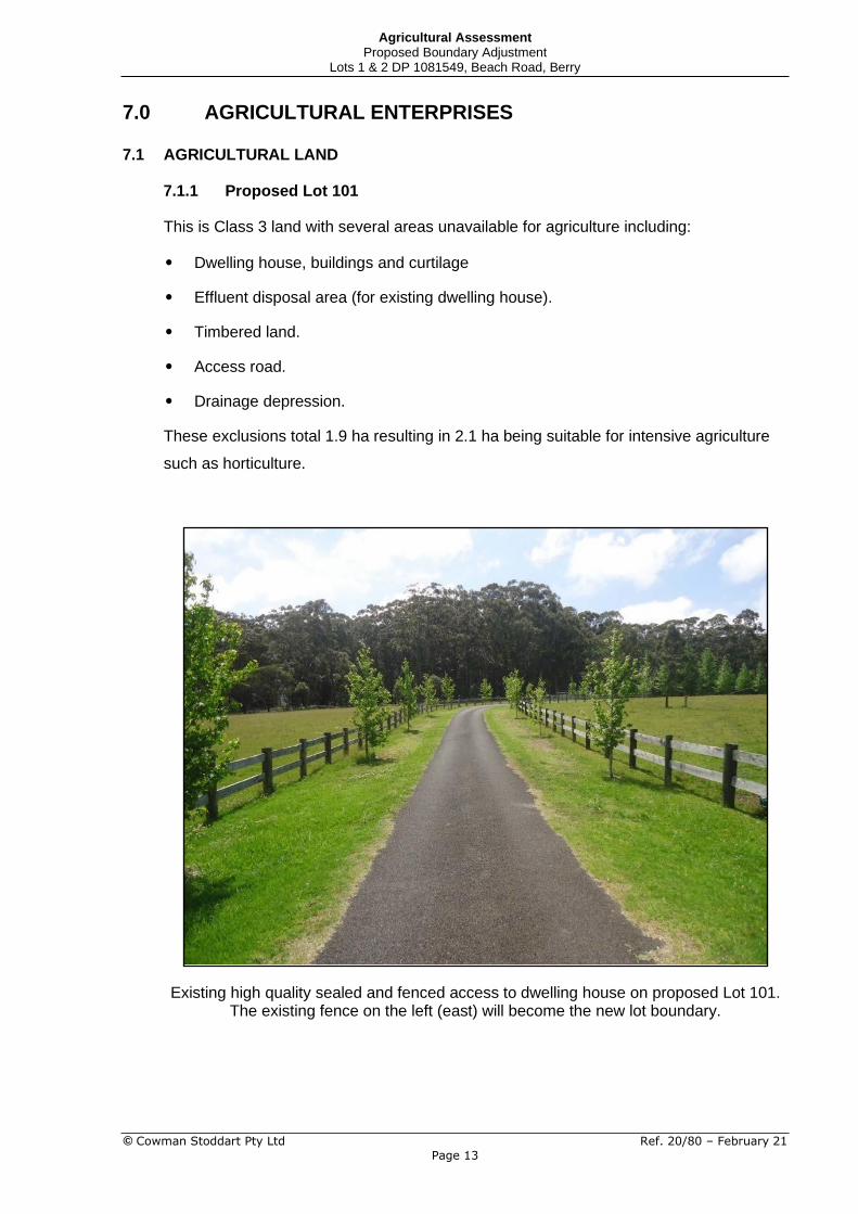
This is Class 3 land with several areas unavailable for agriculture including:
• Dwelling house, buildings and curtilage
• Effluent disposal area (for existing dwelling house).
• Timbered land.
• Access road.
• Drainage depression.
These exclusions total 1.9 ha resulting in 2.1 ha being suitable for intensive agriculture
such as horticulture.
Existing high quality sealed and fenced access to dwelling house on proposed Lot 101. The existing fence on the left (east) will become the new lot boundary.
© Cowman Stoddart Pty Ltd Ref. 20/80 – February 21
Page 13

Agricultural Assessment Proposed Boundary Adjustment
Lots 1 & 2 DP 1081549, Beach Road, Berry
7.1.2 Proposed Lot 102
This is a mix of Class 3, 4 and 5 land as follows:
• Class 3 land - 8 ha;
• Class 4 land - 4 ha
• Class 5 land - 4 ha
It is most suited to a beef cattle grazing enterprise.
7.2 HORTICULTURE (PROPOSED LOT 101)
The most likely horticultural enterprise is a vineyard and there are many successful
examples in the Shoalhaven generally in conjunction with a tourism component (subject
to Council approval). The smallest commercial area is generally about 2 hectares so that
is feasible on either proposed Lot 101 or Lot 102.
Other horticultural enterprises include blueberries, flowers, fruit, vegetables and herbs.
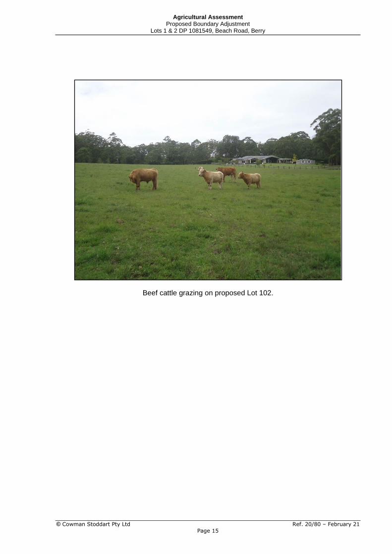
7.3 BEEF CATTLE (PROPOSED LOT 102)
The most common enterprise in the district for small area landowners is raising beef cattle,
either as a breeding herd or growing out and fattening steers.
Livestock carrying capacity is related to land suitability classes such that the better the
land suitability, the higher the potential carrying capacity.
Stocking rates generally used for beef cattle on improved pastures in the district are:
Class 2 land 1.5 cow/hectare (18 d.s.e./hectare)
Class 3 land 1.0 cow/hectare (12 d.s.e./hectare)
Class 4 land 0.5 cow/hectare (6 d.s.e./hectare)
Class 5 land Nil
With an area of 8 hectares of Class 3 land (plus a similar area of Class 4 and 5 land), the
carrying capacity is about 10 cows producing young stock for sale as weaners at 8 months
of age; or steers. It seems that this was the scale of enterprise envisaged for the 1(c) zone.
If the landowner aspired to a greater involvement in agriculture then the stock numbers
could be reduced and some of the land given over to horticulture.
© Cowman Stoddart Pty Ltd Ref. 20/80 – February 21
Page 14
Agricultural Assessment Proposed Boundary Adjustment
Lots 1 & 2 DP 1081549, Beach Road, Berry
Beef cattle grazing on proposed Lot 102.
© Cowman Stoddart Pty Ltd Ref. 20/80 – February 21
Page 15
Agricultural Assessment Proposed Boundary Adjustment
Lots 1 & 2 DP 1081549, Beach Road, Berry
8.0 MINISTERIAL DIRECTIONS
8.1 SECTION 1.2 RURAL ZONES
Clause (4):
A planning proposal must:
(a) not rezone land from a rural zone to a residential, business, industrial, village or tourist zone.
Not applicable.
8.2 SECTION 1.5 RURAL LANDS
(1) The objectives of this direction are to:
(a) protect the agricultural production value of rural land,
At least 2.0 hectares of arable land, mapped as Class 3 prime agricultural land by NSW
Agriculture, will be available in the small Lot 101.
The larger Lot 102 (of 16 ha) will include 8 ha (approx.) of Class 3 agricultural land and
other Class 4 and 5 land which is more able to support a small scale grazing enterprise
compared to the present subdivision layout.
The revised proposal will protect the agricultural production value of Lots 1 and 2 DP
1081549 and meet this objective of the zone.
(b) facilitate the orderly and economic use and development of rural lands for rural and related purposes,
The proposal is not contrary to this objective.
(c) assist in the proper management, development and protection of rural lands to promote the social, economic and environmental welfare of the State,
The proposal is not contrary to this objective.
(d) minimise the potential for land fragmentation and land use conflict in rural areas, particularly between residential and other rural land uses,
There is no further subdivision potential for the land.
The proposal minimises conflict between land uses with increased separation between
the dwelling on Lot 1 and the cleared agricultural land on Lot 2.
(e) encourage sustainable land use practices and ensure the ongoing viability of agriculture on rural land
The proposed lots are of adequate size and land quality to provide opportunities for small
scale part time farming. This is the original objective for the Berry – Beach Road Area in
DCP 72.
© Cowman Stoddart Pty Ltd Ref. 20/80 – February 21
Page 16

Agricultural Assessment Proposed Boundary Adjustment
Lots 1 & 2 DP 1081549, Beach Road, Berry
9.0 CONCLUSION
This report is an agricultural assessment of a proposed boundary adjustment between Lots 1
and 2 DP 1081549 at 268 Beach Road, Berry.
Each of the two lots comprises about 50% (5 ha) prime crop and pasture land and 50% (5 ha)
natural bushland with little value for agriculture.
It is proposed to reduce the area of Lot 1 to 4 ha (proposed Lot 101) and increase the size of
Lot 2 to 16 ha (proposed Lot 102) to allow increased cattle grazing on Lot 2. Proposed Lot 101
is suitable for a range of horticultural enterprises.
It was originally intended by Council that the Rural Lifestyle 1(c) zone should contain at least 10
hectares of prime crop and pasture land. However, due to the small scale of the 1986 mapping
programme, only about 50% of the land is actually Class 3 with the remainder being Class 4 and
5 land, less suitable for agriculture. The boundary adjustment will create a small lot (proposed
Lot 101) suitable for horticulture and a larger lot (proposed Lot 102) suitable for beef cattle
grazing.
A dwelling house is located on each lot and the subdivision will not create any additional building
entitlements.
Peter Cowman AGRICULTURAL CONSULTANT
© Cowman Stoddart Pty Ltd Ref. 20/80 – February 21
Page 17

Planning Proposal – Min. Lot size 46 268A Beach Rd, Berry Ref N28228
Appendix E –Shoalhaven City Council Pre-lodgement meeting letter
(30.03.2021)
Council Reference: 50572E (D21/125491)
30/03/2021
Matt Philpott Allen Price & Scarratts Pty Ltd PO Box 73 NOWRA NSW 2541
By email only: [email protected]
Dear Matt
Pre-Lodgement Meeting, Possible Planning Proposal Lots 1 & 2 DP 1081549, 268A & 268B Beach Road, Berry
I refer to the pre-lodgement meeting between Gordon Clark and Eric Hollinger from Council, yourself and Greg Cooper (owner) via Teams at 10:30 AM on 4 August 2020, and to information provided in your emails of 2 April and 27 November 2020, and 23 March 2021, in relation to a possible planning proposal for the above land. The purpose of this letter is to outline matters discussed at the pre-lodgement meeting, and to provide feedback on matters that will need to be addressed if you intend to formally submit a planning proposal (PP) request. Please note that that this is preliminary feedback and other matters may be identified.
Background
• Zoning = RU4 – Primary Production Small Lots
• Minimum lot size = 10 ha
• Both properties have existing approved dwellings, and both are >10 ha
• Council understands that the owners wish to do a boundary adjustment to:
o Reduce 268A/Lot 1 to around 4 ha; o Increase 268B/Lot 2 to around 16 ha; o No additional dwelling entitlements or development opportunities are being
sought.
Matter discussed on 4 August 2020
• Matt Philpott / Greg Cooper
o Both properties held in trusts which are owned by the same individuals. o Existing configuration based on numeric lot size requirements (10 ha) and to
minimise road construction costs. o Purpose of the proposed boundary adjustment would be to have most of the
cleared agricultural land within one lot (Lot 2). This would be more practical than the current L-shaped configuration, avoid property boundary dissecting the forested ‘belt’, and would also have tax benefits for the owners.

o Proposed 4 ha /16 ha split – open to suggestions. o Not seeking to allow any further subdivision or development.
• Alternatives to planning proposal (PP)
o Exempt and complying SEPP – tentative ‘no’. APS to investigate/confirm. o Cl 4.6 variation – no, extent of variation is too large.
• Gordon emphasised that any PP request would need to clearly explain the intent and encouraged early dialogue with the Berry Forum.
• Need an agricultural assessment of the proposal from an agricultural production perspective. Comment: a draft agricultural report dated 26 February 2021, prepared by Cowman Stoddard was subsequently provided and is considered adequate at this stage.
• Local Strategic Planning Statement – references to agricultural land
Matters that would need to be addressed in a PP request. As you are aware, the Department of Planning, Industry and Environment (DPIE) has indicated that PPs will have to be completed within one year. This will effectively mean that any lengthy and/or key supporting studies will generally need to be completed prior to seeking Gateway approval. Unfortunately, DPIE has not revised its PP guidelines at this point in time. Council will revise its Planning Proposal Guidelines once this has occurred.
As is the case with any PP request, it is important to address consistency with strategy as well as site merit issues. Preliminary information is provided below.
Preliminary comments on justification
• Illawarra Shoalhaven Regional Plan, Direction 4.1: Protect regionally important agricultural lands as an asset to food and fibre production.
• The Shoalhaven Growth Management Strategy states: The rezoning of rural land to create more rural-residential properties is generally not supported because of the loss of productive agricultural land and potential conflicts between agricultural and residential uses.
• Shoalhaven 2040, Council’s Strategic Landuse Planning Statement includes the following policy statement in relation to agricultural land: Retain and manage existing rural land, avoiding the rezoning of land for other uses including rural- residential and residential outcomes, unless identified in a relevant Strategy. The subject land is not identified in any relevant strategy. While it is acknowledged that increasing the size of Lot 2 would make its use for agriculture more viable, it is also important that proposed Lot 1 is not too small to preclude a viable agricultural enterprise.
• Notwithstanding the information provided in the agricultural assessment prepared by Cowman Stoddart, the entire area of Lots 1 and 2 is mapped as class 3 agricultural land, and therefore defined as ‘prime crop and pasture land’ under Shoalhaven LEP 2014.
• The PP would need to address the applicable Ministerial Directions under Section
9.1 of the Environmental Planning and Assessment Act. My preliminary assessment is that the following Directions would be applicable:
• 1.2 Rural Zones. • 1.5 Rural Lands. • 2.1 Environment Protection Zones. • 2.3 Heritage Conservation.
• 4.4 Planning for Bushfire Protection. Comment: this Direction requires consultation with the RFS prior to public exhibition. Given the relatively minor nature of the proposal and that no additional residential

development is proposed, it may be beneficial for you prepare a basic bushfire assessment (particularly to determine if there is any overlap of the APZs for the existing approved dwellings onto the proposed adjoining lots) and consult with the RFS prior to lodging a PP request to Council to determine if a strategic bushfire assessment is needed in this case.
• 5.10 Implementation of Regional Plans.
Conclusion As previously indicated, based on the information provided to date, we are generally supportive of this proposal in principle provided that:
1. no additional residential development opportunities will be created. 2. all of the bushland will be located within one property. 3. agriculture will remain viable on both proposed properties and it will not increase the
potential for land use conflict. 4. the proposal is consistent with the relevant section 9.1 Ministerial directions (see
below).
The above information is based on a preliminary assessment of the information provided to Council and does not preclude additional matters from being identified.
The PP lodgement fee is $5,408.00 (incl GST) (2020/21 FY). Note: contrary to Council’s PP Guidelines which state the PPs should be submitted in digital and hard copy forms, due to the COVID-19 situation, digital form (pdf) will suffice. Should Council resolve to support and progress a PP over the site, additional fees will apply as outlined in Council’s PP Guidelines.
If you need further information about this matter or would like further feedback before submitting a PP request, please contact Eric Hollinger, City Futures on 0409 256 192 or email [email protected]. Please quote Council’s reference 50572E (D21/125491).
Yours faithfully
Eric Hollinger Coordinator - Special Projects Team