sydney central planning panel - NSW Government
64
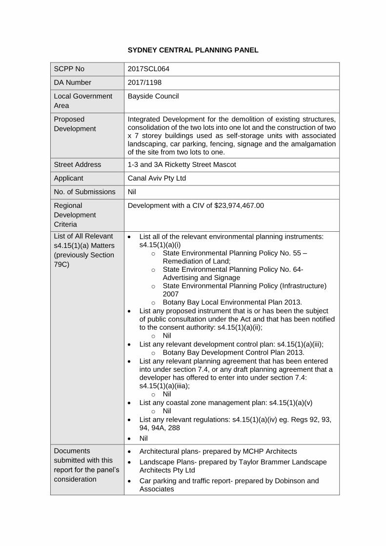
SYDNEY CENTRAL PLANNING PANEL SCPP No 2017SCL064 DA Number 2017/1198 Local Government Area Bayside Council Proposed Development Integrated Development for the demolition of existing structures, consolidation of the two lots into one lot and the construction of two x 7 storey buildings used as self-storage units with associated landscaping, car parking, fencing, signage and the amalgamation of the site from two lots to one. Street Address 1-3 and 3A Ricketty Street Mascot Applicant Canal Aviv Pty Ltd No. of Submissions Nil Regional Development Criteria Development with a CIV of $23,974,467.00 List of All Relevant s4.15(1)(a) Matters (previously Section 79C) List all of the relevant environmental planning instruments: s4.15(1)(a)(i) o State Environmental Planning Policy No. 55 – Remediation of Land; o State Environmental Planning Policy No. 64- Advertising and Signage o State Environmental Planning Policy (Infrastructure) 2007 o Botany Bay Local Environmental Plan 2013. List any proposed instrument that is or has been the subject of public consultation under the Act and that has been notified to the consent authority: s4.15(1)(a)(ii); o Nil List any relevant development control plan: s4.15(1)(a)(iii); o Botany Bay Development Control Plan 2013. List any relevant planning agreement that has been entered into under section 7.4, or any draft planning agreement that a developer has offered to enter into under section 7.4: s4.15(1)(a)(iiia); o Nil List any coastal zone management plan: s4.15(1)(a)(v) o Nil List any relevant regulations: s4.15(1)(a)(iv) eg. Regs 92, 93, 94, 94A, 288 Nil Documents submitted with this report for the panel’s consideration Architectural plans- prepared by MCHP Architects Landscape Plans- prepared by Taylor Brammer Landscape Architects Pty Ltd Car parking and traffic report- prepared by Dobinson and Associates
-
Upload
khangminh22 -
Category
Documents
-
view
0 -
download
0
Transcript of sydney central planning panel - NSW Government
SYDNEY CENTRAL PLANNING PANEL
SCPP No 2017SCL064
DA Number 2017/1198
Local Government
Area
Bayside Council
Proposed
Development
Integrated Development for the demolition of existing structures, consolidation of the two lots into one lot and the construction of two x 7 storey buildings used as self-storage units with associated landscaping, car parking, fencing, signage and the amalgamation of the site from two lots to one.
Street Address 1-3 and 3A Ricketty Street Mascot
Applicant Canal Aviv Pty Ltd
No. of Submissions Nil
Regional
Development
Criteria
Development with a CIV of $23,974,467.00
List of All Relevant
s4.15(1)(a) Matters
(previously Section
79C)
List all of the relevant environmental planning instruments: s4.15(1)(a)(i)
o State Environmental Planning Policy No. 55 – Remediation of Land;
o State Environmental Planning Policy No. 64- Advertising and Signage
o State Environmental Planning Policy (Infrastructure) 2007
o Botany Bay Local Environmental Plan 2013.
List any proposed instrument that is or has been the subject of public consultation under the Act and that has been notified to the consent authority: s4.15(1)(a)(ii);
o Nil
List any relevant development control plan: s4.15(1)(a)(iii); o Botany Bay Development Control Plan 2013.
List any relevant planning agreement that has been entered into under section 7.4, or any draft planning agreement that a developer has offered to enter into under section 7.4: s4.15(1)(a)(iiia);
o Nil
List any coastal zone management plan: s4.15(1)(a)(v) o Nil
List any relevant regulations: s4.15(1)(a)(iv) eg. Regs 92, 93, 94, 94A, 288
Nil
Documents
submitted with this
report for the panel’s
consideration
Architectural plans- prepared by MCHP Architects
Landscape Plans- prepared by Taylor Brammer Landscape Architects Pty Ltd
Car parking and traffic report- prepared by Dobinson and Associates
Civil engineering plans- prepared by Northrop
Flood study- prepared by Northrop
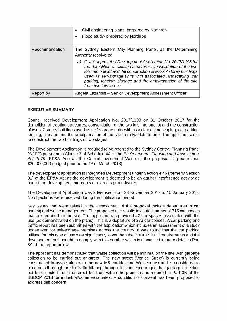
Recommendation The Sydney Eastern City Planning Panel, as the Determining
Authority resolve to:
a) Grant approval of Development Application No. 2017/1198 for the demolition of existing structures, consolidation of the two lots into one lot and the construction of two x 7 storey buildings used as self-storage units with associated landscaping, car parking, fencing, signage and the amalgamation of the site from two lots to one.
Report by Angela Lazaridis – Senior Development Assessment Officer
EXECUTIVE SUMMARY
Council received Development Application No. 2017/1198 on 31 October 2017 for the demolition of existing structures, consolidation of the two lots into one lot and the construction of two x 7 storey buildings used as self-storage units with associated landscaping, car parking, fencing, signage and the amalgamation of the site from two lots to one. The applicant seeks to construct the two buildings in two stages. The Development Application is required to be referred to the Sydney Central Planning Panel (SCPP) pursuant to Clause 3 of Schedule 4A of the Environmental Planning and Assessment Act 1979 (EP&A Act) as the Capital Investment Value of the proposal is greater than $20,000,000 (lodged prior to the 1st of March 2018). The development application is Integrated Development under Section 4.46 (formerly Section 91) of the EP&A Act as the development is deemed to be an aquifer interference activity as part of the development intercepts or extracts groundwater. The Development Application was advertised from 28 November 2017 to 15 January 2018. No objections were received during the notification period.
Key issues that were raised in the assessment of the proposal include departures in car parking and waste management. The proposed use results in a total number of 315 car spaces that are required for the site. The applicant has provided 42 car spaces associated with the use (as demonstrated on the plans). This is a departure of 273 car spaces. A car parking and traffic report has been submitted with the application which includes an assessment of a study undertaken for self-storage premises across the country. It was found that the car parking utilised for this type of use was significantly lower than the BBDCP 2013 requirements and the development has sought to comply with this number which is discussed in more detail in Part 3A of the report below.
The applicant has demonstrated that waste collection will be minimal on the site with garbage collection to be carried out on-street. The new street (Venice Street) is currently being constructed in association with the new M5 corridor and Westconnex and is considered to become a thoroughfare for traffic filtering through. It is not encouraged that garbage collection not be collected from the street but from within the premises as required in Part 3N of the BBDCP 2013 for industrial/commercial sites. A condition of consent has been proposed to address this concern.
In summary, the proposed development has been assessed against the relevant controls and on balance, Council is generally supportive of the proposal.
It is recommended that the application be granted consent, subject to the conditions in the attached Schedule.
BACKGROUND
The proposal was subject to a pre-DA meeting which was held on 17 January 2017 for a self-storage premises. The proposal was generally supported subject to changes to the design and additional information required at lodgement.
On 20 February 2018, the application was presented to a briefing meeting with the SECPP. Issues raised regarding to internal aisle and vehicular widths, car parking, external façade treatment, and access to the premises were raised. An additional information letter was sent from Council on 20 February 2018 raising issues related to the setback from Alexandra Canal, internal vehicle access to the units, façade treatment and material selection, car parking, waste management, inconsistencies with the traffic report, and additional information relating to engineering.
In regard to the external façade treatment, the applicant has amended the plans provided 9 March 2018 to provide fin walls and breaks in the solid western elevations through the use of colour and framing the windows.
The application was not presented to a Design Review Panel as the applicant did not want to pursue this due to the proposed use and standardised branding of the development.
Amended documentation was provided to Council on 9 March 2018 for assessment with further amended information relating to flooding and stormwater provided at a later date.
The amended plans and additional information are relied upon for the assessment in the report.
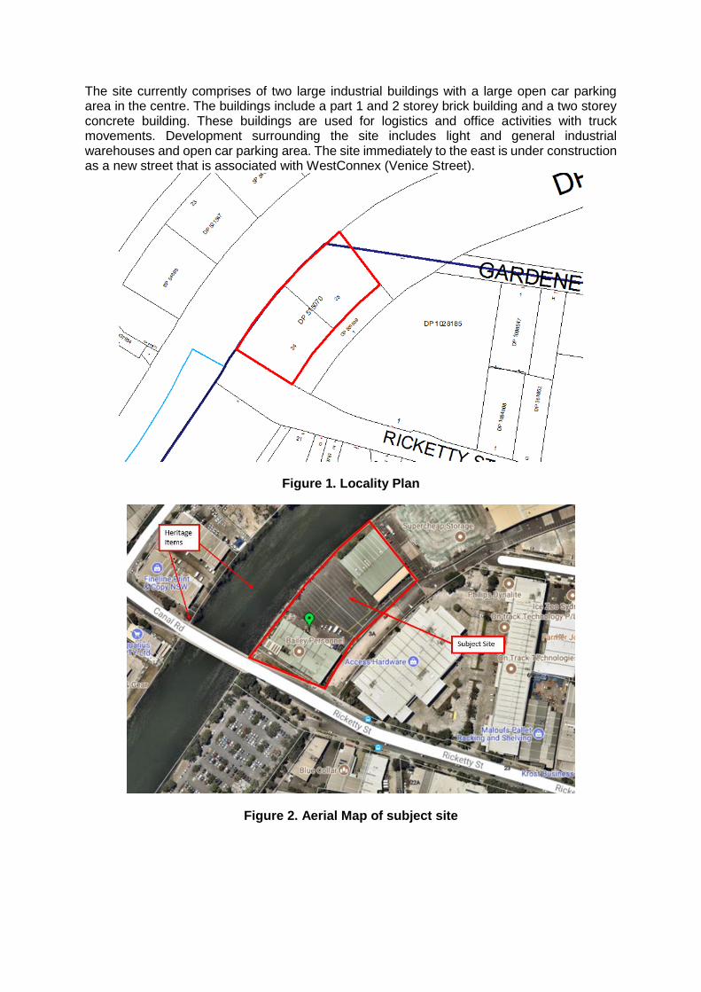
DESCRIPTION OF SITE AND SURROUNDING LOCALITY
The subject site is legally known as 1-3 and 3A Ricketty Street Mascot and forms two parcels of land described as Lot 24 and 25 of DP 515070. The site is located on the northern side of Ricketty Street and is bound along its western side by Alexandra Canal which a State Heritage Item, Ricketty Street to the south, a new road related to Westconnex (Venice Street) to its north.
The site is generally flat with a fall gradually to the north and west towards Alexandra Canal. The total site area is 8,947sqm and is irregular in shape and has a southern street boundary length of 63.64 metres, a northern boundary length of 63.76 metres, an eastern frontage length of 129.41 metres and the western boundary has an arched length of 151.11 metres.
The site is zoned as B7 Business Park and is in close proximity to two heritage items (Item 1- Alexandra Canal [including sandstone embankment] and Item 154- Ricketty Street Bridge). The site is also affected by sea level rise and flooding. A small portion of the site is located within the City of Sydney Local Government Area.
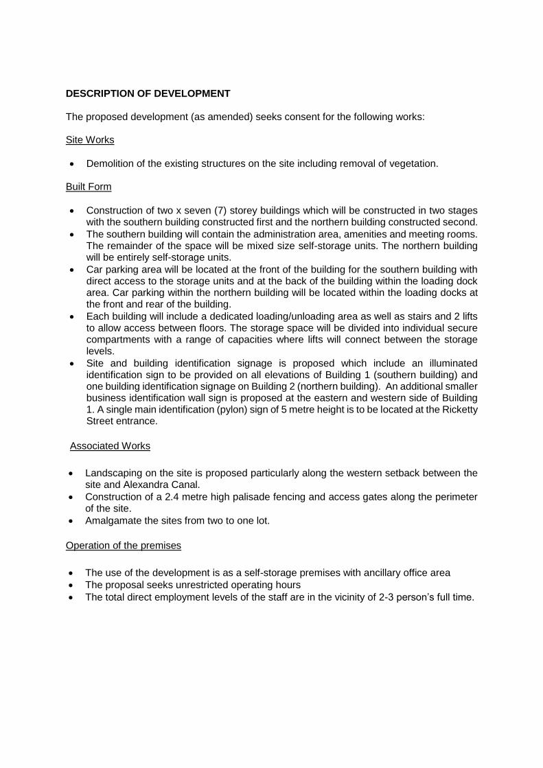
The site currently comprises of two large industrial buildings with a large open car parking area in the centre. The buildings include a part 1 and 2 storey brick building and a two storey concrete building. These buildings are used for logistics and office activities with truck movements. Development surrounding the site includes light and general industrial warehouses and open car parking area. The site immediately to the east is under construction as a new street that is associated with WestConnex (Venice Street).
Figure 1. Locality Plan
Figure 2. Aerial Map of subject site
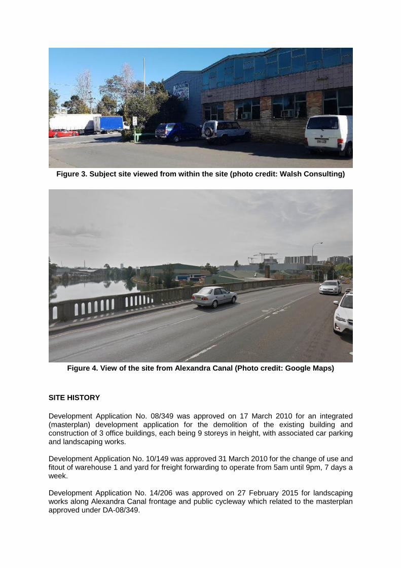
Figure 3. Subject site viewed from within the site (photo credit: Walsh Consulting)
Figure 4. View of the site from Alexandra Canal (Photo credit: Google Maps)
SITE HISTORY
Development Application No. 08/349 was approved on 17 March 2010 for an integrated (masterplan) development application for the demolition of the existing building and construction of 3 office buildings, each being 9 storeys in height, with associated car parking and landscaping works. Development Application No. 10/149 was approved 31 March 2010 for the change of use and fitout of warehouse 1 and yard for freight forwarding to operate from 5am until 9pm, 7 days a week. Development Application No. 14/206 was approved on 27 February 2015 for landscaping works along Alexandra Canal frontage and public cycleway which related to the masterplan approved under DA-08/349.
DESCRIPTION OF DEVELOPMENT The proposed development (as amended) seeks consent for the following works: Site Works
Demolition of the existing structures on the site including removal of vegetation. Built Form
Construction of two x seven (7) storey buildings which will be constructed in two stages with the southern building constructed first and the northern building constructed second.
The southern building will contain the administration area, amenities and meeting rooms. The remainder of the space will be mixed size self-storage units. The northern building will be entirely self-storage units.
Car parking area will be located at the front of the building for the southern building with direct access to the storage units and at the back of the building within the loading dock area. Car parking within the northern building will be located within the loading docks at the front and rear of the building.
Each building will include a dedicated loading/unloading area as well as stairs and 2 lifts to allow access between floors. The storage space will be divided into individual secure compartments with a range of capacities where lifts will connect between the storage levels.
Site and building identification signage is proposed which include an illuminated identification sign to be provided on all elevations of Building 1 (southern building) and one building identification signage on Building 2 (northern building). An additional smaller business identification wall sign is proposed at the eastern and western side of Building 1. A single main identification (pylon) sign of 5 metre height is to be located at the Ricketty Street entrance.
Associated Works
Landscaping on the site is proposed particularly along the western setback between the site and Alexandra Canal.
Construction of a 2.4 metre high palisade fencing and access gates along the perimeter of the site.
Amalgamate the sites from two to one lot.
Operation of the premises
The use of the development is as a self-storage premises with ancillary office area
The proposal seeks unrestricted operating hours
The total direct employment levels of the staff are in the vicinity of 2-3 person’s full time.
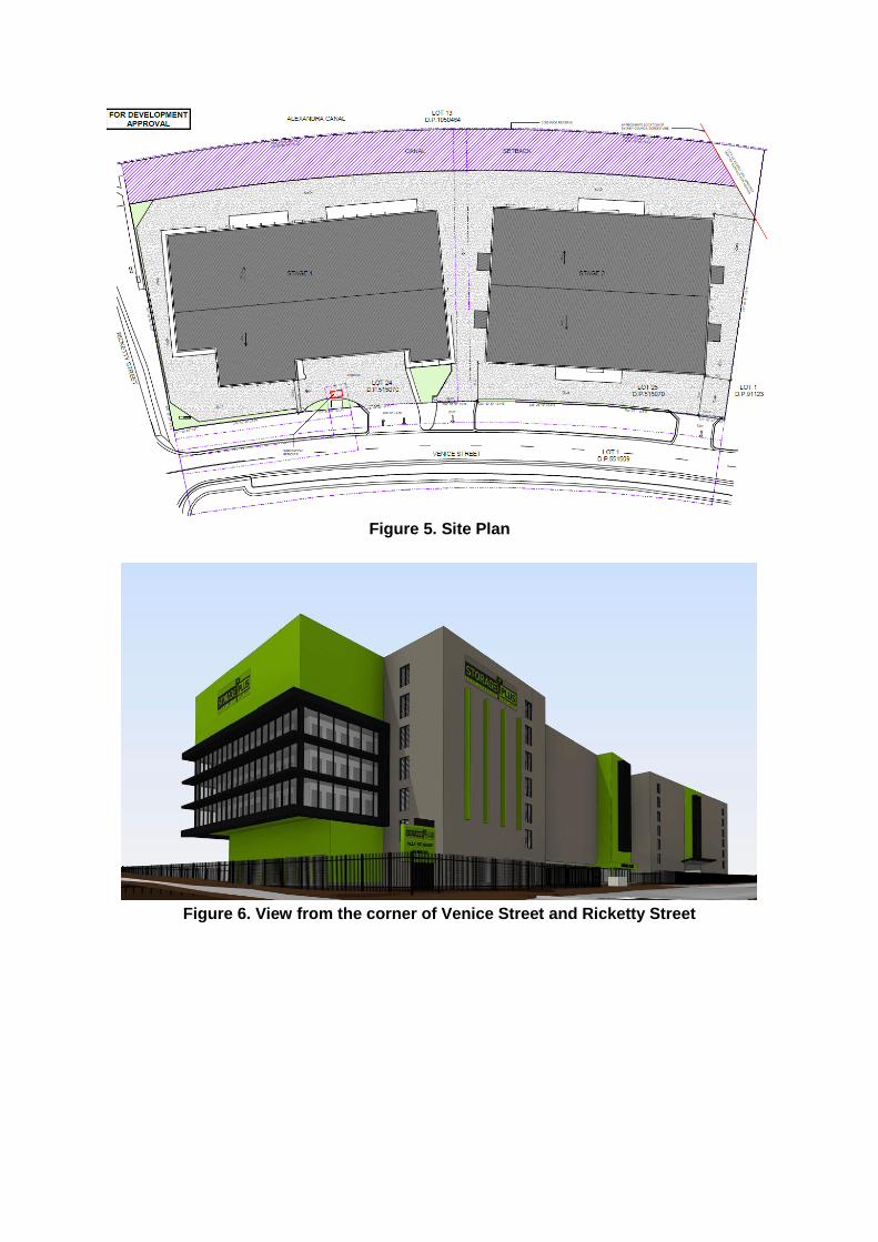
Figure 5. Site Plan
Figure 6. View from the corner of Venice Street and Ricketty Street
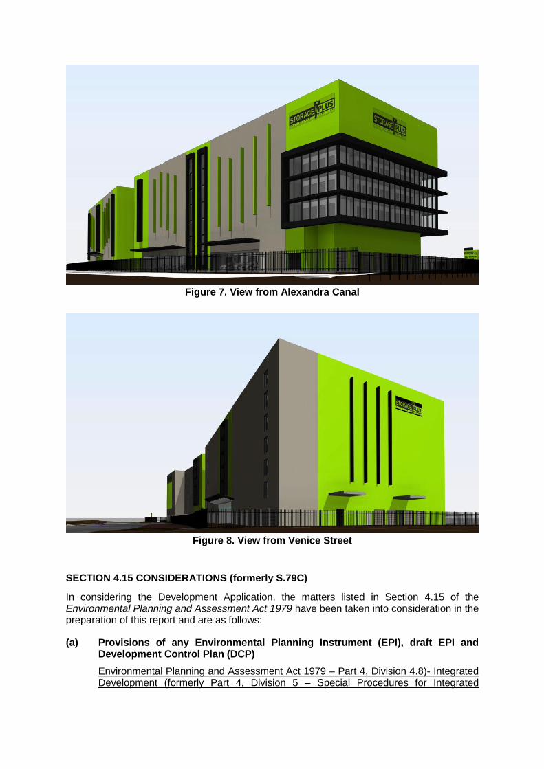
Figure 7. View from Alexandra Canal
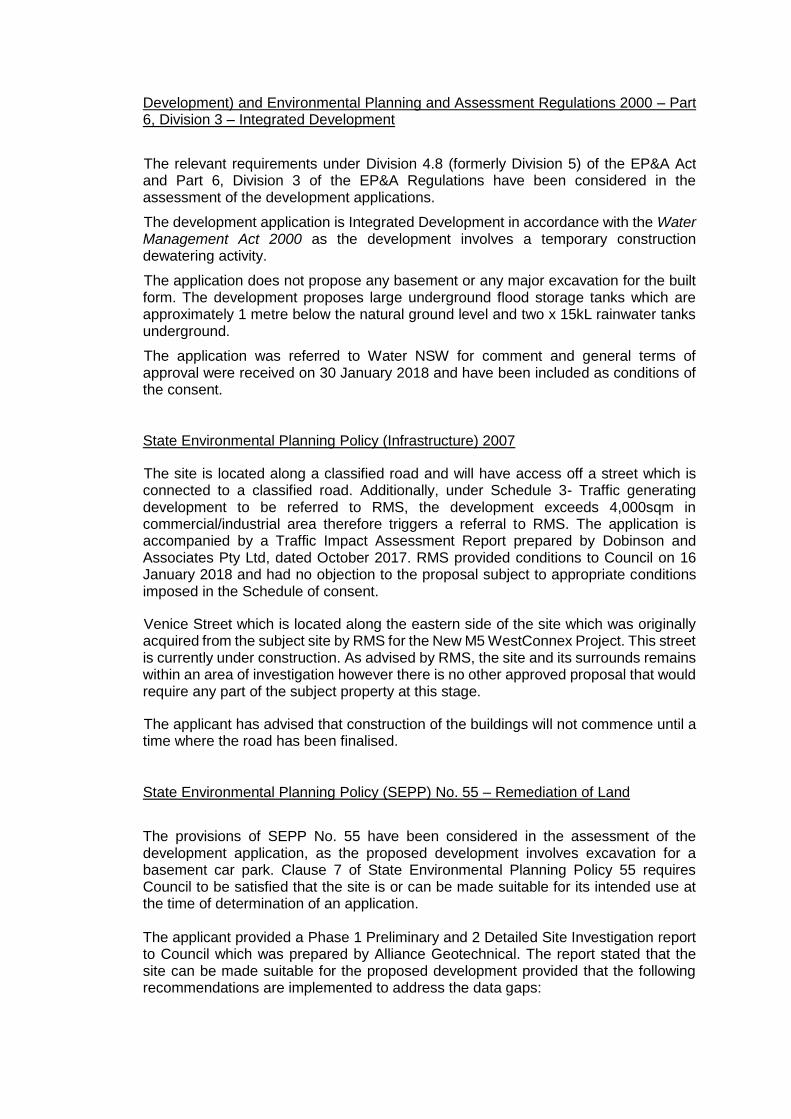
Figure 8. View from Venice Street
SECTION 4.15 CONSIDERATIONS (formerly S.79C)
In considering the Development Application, the matters listed in Section 4.15 of the Environmental Planning and Assessment Act 1979 have been taken into consideration in the preparation of this report and are as follows:
(a) Provisions of any Environmental Planning Instrument (EPI), draft EPI and Development Control Plan (DCP)
Environmental Planning and Assessment Act 1979 – Part 4, Division 4.8)- Integrated Development (formerly Part 4, Division 5 – Special Procedures for Integrated
Development) and Environmental Planning and Assessment Regulations 2000 – Part 6, Division 3 – Integrated Development
The relevant requirements under Division 4.8 (formerly Division 5) of the EP&A Act and Part 6, Division 3 of the EP&A Regulations have been considered in the assessment of the development applications.
The development application is Integrated Development in accordance with the Water Management Act 2000 as the development involves a temporary construction dewatering activity.
The application does not propose any basement or any major excavation for the built form. The development proposes large underground flood storage tanks which are approximately 1 metre below the natural ground level and two x 15kL rainwater tanks underground.
The application was referred to Water NSW for comment and general terms of approval were received on 30 January 2018 and have been included as conditions of the consent.
State Environmental Planning Policy (Infrastructure) 2007
The site is located along a classified road and will have access off a street which is connected to a classified road. Additionally, under Schedule 3- Traffic generating development to be referred to RMS, the development exceeds 4,000sqm in commercial/industrial area therefore triggers a referral to RMS. The application is accompanied by a Traffic Impact Assessment Report prepared by Dobinson and Associates Pty Ltd, dated October 2017. RMS provided conditions to Council on 16 January 2018 and had no objection to the proposal subject to appropriate conditions imposed in the Schedule of consent.
Venice Street which is located along the eastern side of the site which was originally acquired from the subject site by RMS for the New M5 WestConnex Project. This street is currently under construction. As advised by RMS, the site and its surrounds remains within an area of investigation however there is no other approved proposal that would require any part of the subject property at this stage.
The applicant has advised that construction of the buildings will not commence until a time where the road has been finalised.
State Environmental Planning Policy (SEPP) No. 55 – Remediation of Land
The provisions of SEPP No. 55 have been considered in the assessment of the development application, as the proposed development involves excavation for a basement car park. Clause 7 of State Environmental Planning Policy 55 requires Council to be satisfied that the site is or can be made suitable for its intended use at the time of determination of an application. The applicant provided a Phase 1 Preliminary and 2 Detailed Site Investigation report to Council which was prepared by Alliance Geotechnical. The report stated that the site can be made suitable for the proposed development provided that the following recommendations are implemented to address the data gaps:
1. Undertake a Hazardous Materials Assessment (Hazmat) for the existing buildings prior to the commencement of demolition work;
2. Prepare an Asbestos Management Plan outlining the management measure required to minimise potential adverse impacts due to exposure of asbestos impacted soils;
3. Prepare an Acid Sulfate Soil Management Plan (ASSMP) to minimise the potential for adverse impacts due to oxidation of ASS; and
4. Implement an unexpected finds protocol requiring work to cease and the engagement of an experienced environmental consultant to assess site conditions should below ground conditions be different to those outlined in this report.
The application was referred to Council’s Environmental Scientist for review and comment. The following comments were provided as follows:
“This undertook some analysis of soil to delineate any potential hydrocarbon impact. However some samples were taken in the surface fill. Additionally groundwater was not assessed. Given the proximity of groundwater to the surface and the detection of hydrocarbon odour in several bore logs, groundwater sampling needs to be undertaken to ensure there is no risk to the future buildings that may be constructed at the site, and analysis for soil vapour F1 and F2 and BTEX down to 2m needs to be undertaken. There was also no dangerous goods search undertaken to rule out potential UST’s onsite that may not be decommissioned and acting as a potential source. Clarification that there is no onsite issue is needed prior to buildings being constructed across the site. Additionally the excavation below ground level for a flood storage unit also needs to be addressed in regards to any risk issues for workers or environment into the future. The information required above can be addressed through conditions of consent as there is no indication that the site can’t be made suitable for the proposed development based on the data provided, however based on the outcome of the additional assessment, remediation of the site or risk management measures in the building if required could be completed prior to construction of the buildings. An Acid Sulfate Soil Management Plan has not been provided, and there is no basement construction requiring dewatering during construction.”
Appropriate conditions have imposed in the consent to address the data gaps that have been identified above.
State Environmental Planning Policy No.64 – Advertising and Signage
There is a total of six signs that are proposed on the site. Five of the signs are wall mounted business identification signs while the sixth sign is a pylon sign located on the corner of Ricketty Street and the new Venice Street which will be 5 metres in height. All signs will be illuminated.
In accordance with SEPP 64:
building identification sign means a sign that identifies or names a building, and that may include the name of a business or building, the street number of a building, the nature of the business and a logo or other symbol that identifies the business, but that does not include general advertising of products, goods or services.
The proposed signage is required for building identification purposes, to aid site identification and access to entries from Ricketty Street and Venice Street and from the street to the north connecting to Venice Street. The signs contains the business name. In this regard the proposed sign satisfies the definition for building identification signs under the provisions of SEPP 64. The proposed signage has been assessed against Clauses 8 and 13 of SEPP 64 which requires Council to determine consistency with the objectives stipulated under Clause 3(1)(a) of the SEPP and to assess the proposed signage against the assessment criteria of Schedule 1. The application is considered to satisfy the objectives of the policy by ensuring that the proposed building identification signage is compatible with the desired amenity and visual character of the locality, provides effective communication and is of high quality having regard to both design and finishes. The assessment criteria contained in Schedule 1 are addressed in detail below:
Matters for Consideration Comment Complies
1. Character of the area
Is the proposal compatible with the
existing or desired future character
of the area or locality in which it is
proposed to be located?
The proposed signage is compatible with
the existing and desired future character
of the locality within the business park
zone and is consistent with the type of
signage associated with the identification
of a self-storage premises.
Yes
Is the proposal consistent with a
particular theme for outdoor
advertising in the area or locality?
The proposed signage will be located
entirely within the boundaries of the site
and whilst the signs are not considered
to be a form of outdoor advertising, the
proposed signs are constructed of
materials and presents a colour scheme
which does not detract from the existing
quality of the streetscape.
Yes
2. Special areas
Does the proposal detract from the
amenity or visual quality of any
environmentally sensitive areas,
heritage areas, natural or other
conservation areas, open space
areas, waterways, rural
landscapes or residential areas?
The proposed signage is not located in
an environmentally sensitive area,
heritage area, natural or other
conservation area, open space area,
waterway, or rural landscape. The
proposed signs are to be constructed
within the site of an existing industrial
premises and surrounding development
is primarily industrial. The scale,
materials of construction and colour
scheme of the proposed sign does not
detract from the existing quality of the
streetscape and aligns with the branding
of the development.
Yes
3. Views and vistas
Does the proposal obscure or
compromise important views?
The majority of the signs are mounted to
the walls of the buildings with the
exception of a 5-metre-high pylon sign
Yes
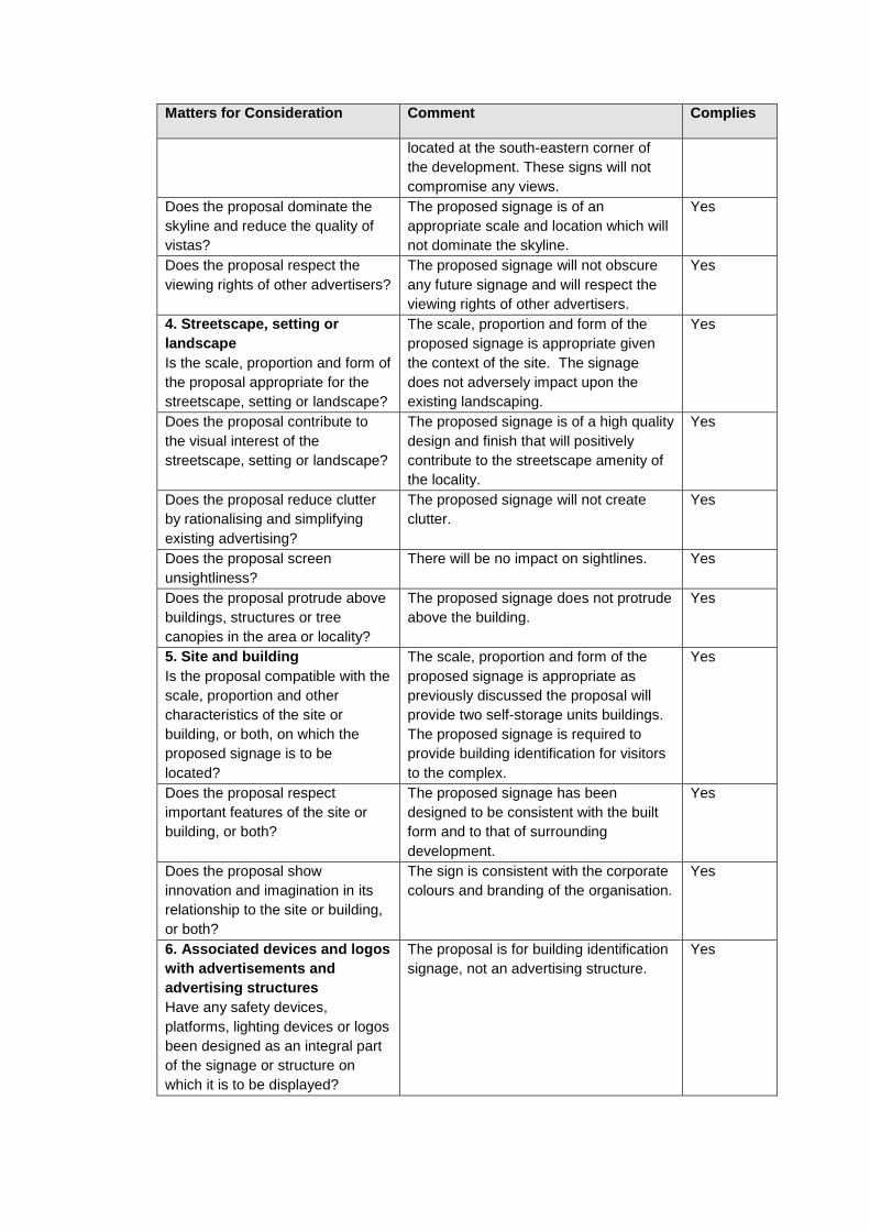
Matters for Consideration Comment Complies
located at the south-eastern corner of
the development. These signs will not
compromise any views.
Does the proposal dominate the
skyline and reduce the quality of
vistas?
The proposed signage is of an
appropriate scale and location which will
not dominate the skyline.
Yes
Does the proposal respect the
viewing rights of other advertisers?
The proposed signage will not obscure
any future signage and will respect the
viewing rights of other advertisers.
Yes
4. Streetscape, setting or
landscape
Is the scale, proportion and form of
the proposal appropriate for the
streetscape, setting or landscape?
The scale, proportion and form of the
proposed signage is appropriate given
the context of the site. The signage
does not adversely impact upon the
existing landscaping.
Yes
Does the proposal contribute to
the visual interest of the
streetscape, setting or landscape?
The proposed signage is of a high quality
design and finish that will positively
contribute to the streetscape amenity of
the locality.
Yes
Does the proposal reduce clutter
by rationalising and simplifying
existing advertising?
The proposed signage will not create
clutter.
Yes
Does the proposal screen
unsightliness?
There will be no impact on sightlines. Yes
Does the proposal protrude above
buildings, structures or tree
canopies in the area or locality?
The proposed signage does not protrude
above the building.
Yes
5. Site and building
Is the proposal compatible with the
scale, proportion and other
characteristics of the site or
building, or both, on which the
proposed signage is to be
located?
The scale, proportion and form of the
proposed signage is appropriate as
previously discussed the proposal will
provide two self-storage units buildings.
The proposed signage is required to
provide building identification for visitors
to the complex.
Yes
Does the proposal respect
important features of the site or
building, or both?
The proposed signage has been
designed to be consistent with the built
form and to that of surrounding
development.
Yes
Does the proposal show
innovation and imagination in its
relationship to the site or building,
or both?
The sign is consistent with the corporate
colours and branding of the organisation.
Yes
6. Associated devices and logos
with advertisements and
advertising structures
Have any safety devices,
platforms, lighting devices or logos
been designed as an integral part
of the signage or structure on
which it is to be displayed?
The proposal is for building identification
signage, not an advertising structure.
Yes

Matters for Consideration Comment Complies
7. Illumination
Would illumination result in
unacceptable glare, affect safety
for pedestrians, vehicles or
aircraft, detract from the amenity
of any residence or other form of
accommodation?
The signage will be illuminated however
will not result in unacceptable glare
considering the size and location of the
signs.
N/A
Can the intensity of the
illumination be adjusted, if
necessary?
Should required, the intensity of
illumination can be modified.
Yes
Is the illumination subject to a
curfew?
The signs are lit during the night hours to
distinguish the premises. It is considered
that a curfew is not necessary.
Yes
8. Safety
Would the proposal reduce the
safety for any public road,
pedestrians or bicyclists?
The proposed signage is not considered
to have any adverse impact upon the
safety for any public road, pedestrians or
bicyclists
Yes
Would the proposal reduce the
safety for pedestrians, particularly
children, by obscuring sightlines
from public areas?
The location of proposed signage will not
disrupt sightlines from public areas.
Yes
Botany Bay Local Environmental Plan 2013 (BBLEP)
The provisions of the Botany Bay Local Environmental Plan (BBLEP) 2013 have been considered in the assessment of the Development Application and the following information is provided:
Principal Provisions of BBLEP
2013
Complies
Yes/No Comment
Land use Zone - The site is zoned B7 Business Park under
the BBLEP 2013.
Is the proposed use/works
permitted with development
consent?
Yes The proposed self-storage premises is
permissible with Council’s consent under
the BBLEP 2013.
Does the proposed use/works
meet the objectives of the zone?
Yes The proposed development is consistent
with the following objectives of the B7 zone:
To provide a range of office and light industrial uses.
To encourage employment opportunities.
To enable other land uses that provide facilities or services to meet the day to day needs of workers in the area.
To encourage uses in the arts, technology, production and design sectors.
Principal Provisions of BBLEP
2013
Complies
Yes/No Comment
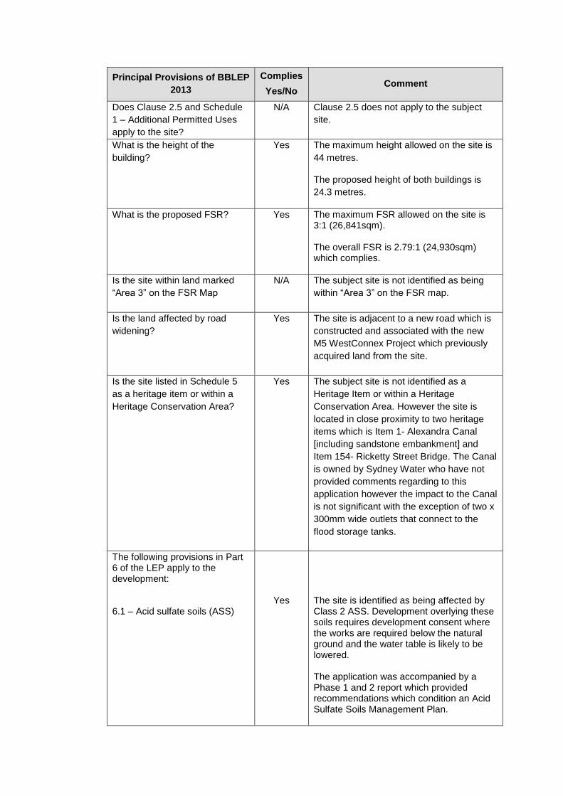
Does Clause 2.5 and Schedule
1 – Additional Permitted Uses
apply to the site?
N/A Clause 2.5 does not apply to the subject
site.
What is the height of the
building?
Yes The maximum height allowed on the site is
44 metres.
The proposed height of both buildings is
24.3 metres.
What is the proposed FSR?
Yes
The maximum FSR allowed on the site is 3:1 (26,841sqm). The overall FSR is 2.79:1 (24,930sqm) which complies.
Is the site within land marked
“Area 3” on the FSR Map
N/A
The subject site is not identified as being
within “Area 3” on the FSR map.
Is the land affected by road
widening?
Yes
The site is adjacent to a new road which is
constructed and associated with the new
M5 WestConnex Project which previously
acquired land from the site.
Is the site listed in Schedule 5
as a heritage item or within a
Heritage Conservation Area?
Yes The subject site is not identified as a
Heritage Item or within a Heritage
Conservation Area. However the site is
located in close proximity to two heritage
items which is Item 1- Alexandra Canal
[including sandstone embankment] and
Item 154- Ricketty Street Bridge. The Canal
is owned by Sydney Water who have not
provided comments regarding to this
application however the impact to the Canal
is not significant with the exception of two x
300mm wide outlets that connect to the
flood storage tanks.
The following provisions in Part 6 of the LEP apply to the development: 6.1 – Acid sulfate soils (ASS)
Yes
The site is identified as being affected by Class 2 ASS. Development overlying these soils requires development consent where the works are required below the natural ground and the water table is likely to be lowered. The application was accompanied by a Phase 1 and 2 report which provided recommendations which condition an Acid Sulfate Soils Management Plan.
Principal Provisions of BBLEP
2013
Complies
Yes/No Comment
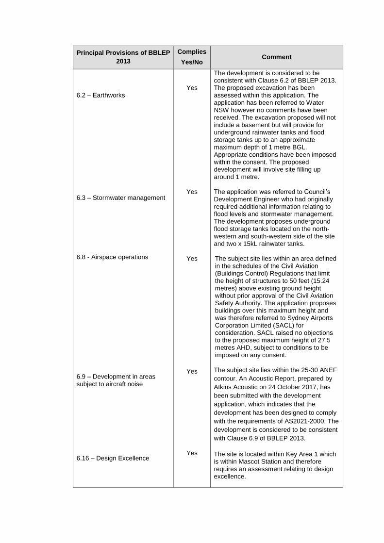
6.2 – Earthworks
6.3 – Stormwater management 6.8 - Airspace operations
6.9 – Development in areas subject to aircraft noise 6.16 – Design Excellence
Yes
Yes
Yes
Yes
Yes
The development is considered to be consistent with Clause 6.2 of BBLEP 2013. The proposed excavation has been assessed within this application. The application has been referred to Water NSW however no comments have been received. The excavation proposed will not include a basement but will provide for underground rainwater tanks and flood storage tanks up to an approximate maximum depth of 1 metre BGL. Appropriate conditions have been imposed within the consent. The proposed development will involve site filling up around 1 metre. The application was referred to Council’s Development Engineer who had originally required additional information relating to flood levels and stormwater management. The development proposes underground flood storage tanks located on the north-western and south-western side of the site and two x 15kL rainwater tanks. The subject site lies within an area defined in the schedules of the Civil Aviation (Buildings Control) Regulations that limit the height of structures to 50 feet (15.24 metres) above existing ground height without prior approval of the Civil Aviation Safety Authority. The application proposes buildings over this maximum height and was therefore referred to Sydney Airports Corporation Limited (SACL) for consideration. SACL raised no objections to the proposed maximum height of 27.5 metres AHD, subject to conditions to be imposed on any consent. The subject site lies within the 25-30 ANEF
contour. An Acoustic Report, prepared by
Atkins Acoustic on 24 October 2017, has
been submitted with the development
application, which indicates that the
development has been designed to comply
with the requirements of AS2021-2000. The
development is considered to be consistent
with Clause 6.9 of BBLEP 2013.
The site is located within Key Area 1 which is within Mascot Station and therefore requires an assessment relating to design excellence.

Principal Provisions of BBLEP
2013
Complies
Yes/No Comment
The proposed development has been designed with their corporate colours and branding in mind in addition to Council’s controls within Part 6 of the BBDCP. The applicant has amended their plans particularly along the western elevation façade to incorporate fins to break up the solid wall that was originally proposed. Additionally the elevations are broken up through windows, colour changes and awnings.
The objectives and provisions of BBLEP 2013 have been considered in relation to the subject development application. The proposal is considered satisfactory in terms of the BBLEP 2013.
Botany Bay Development Control Plan (BBDCP) 2013
The most relevant and applicable clauses of the BBDCP 2013 are considered in the assessment of this development proposal and are provided below.
Part 3A – Parking and Access
Table 1 of Part 3A of the BBDCP 2013 require self-storage units to provide 2 spaces for employees plus 1 space per 80sqm GFA. Office premises require 1 space per 40sqm. Based on an overall GFA of 24,930sqm (approx. 122sqm offices and 24,808sqm for storage premises). Therefore based on these figures, the total amount of car parking that has been generated is 3 car spaces for the office use and 312 car spaces for the storage premises resulting in a total number of 315 car spaces that are required for the site. The applicant has provided 42 car spaces associated with the use. This is a departure of 273 car spaces. The application was accompanied by a traffic and car parking report prepared by Dobinson and Associates Pty Ltd, dated October 2017. The departure in car parking was raised as an issue by Council and by the Panel. The applicant has provided a cover letter addressing this issue and their comments are as follows:
“The BBDCP for parking is a generic requirement for parking and in this case, as acknowledged by Council, inappropriate and excessive for the actual development proposed. A self-storage facility is used essentially for storage of housing goods and materials; use by commercial users is only about 25%. In contrast the Aurecon Australia Pty Ltd study is specific to these self-storage facilities and extends over cities and towns in NSW, Queensland, South Australia, Victoria and Western Australia. The parking requirement assessed for the proposed development is based on the findings of that study but selected specifically for an inner city self-storage facility at the higher end of the scale. It should be appreciated also that the period a user of the self-storage facility stays on site is very short. For customers enquiry about lease of units, picking up boxes

and the like about 10 minutes average and for patrons storing, collecting or removing goods, about 20 minutes average. Thus the 38 spaces identified as required is the high case need and additional parking spaces are not considered necessary for usage by staff, customers or patrons.”
A review of the traffic report goes into depth regarding to the study carried out by Aurecon Australia Pty Ltd which undertook a study of self-storage facilities in cities and towns within NSW and recommended car parking for self-storage facilities related to maximum leasable area as set out below.
Ref: Study Results and Findings, Self-Storage Facility Traffic and Parking Study
This requirement is borne out by parking assessed and provided at numerous self-storage facilities in Sydney. In this respect, the busier the establishment the greater the parking need and hence should be related to the higher end of the scale in the table above, e.g. 11 spaces for 6,000 m2 MLA whereas quieter locations require a lesser number of spaces and should be related to the lower end of the scale e.g. 11 spaces for 9,500 m2 MLA. The development has a total Net Lease Area (NLA) of 18,855sqm on completion of both stages. Based on the traffic report provided with the application and on the basis of the Self-Storage Association of Australia Self-Storage Facility Traffic and Parking Study, the higher end of the scale for this inner city site of 11 spaces for a self-storage facility of 6,000sqm MLA has been adopted. This yields on a pro-rata basis a requirement for 9,072sqm NLA/6,000sqm NLA x 11 spaces = 18.3, say 19 parking spaces for Stage 1 and 18,855sqm NLA/6,000sqm NLA x 11 spaces = 34.6, say 35 for Stage 2 when both buildings are completed. The development provides 42 car parking spaces therefore it complies with the figures that are provided within the study. In regards to access into the premises, all access will be off the new Venice Street located on the eastern side of the site. The street is currently under construction therefore access to the site will need to be carried out once construction has been completed and this has been verified by the applicant. Plans have been provided demonstrating that ingress/egress will be off this street from a combined entry/exit for Building 1 and a separate 2 exits for Buildings 1 and 2. In regard to loading and unloading, the buildings contain a loading dock within the premises for a number of SRV to accommodate the use premises. There is no loading dock for MRV or HRV vehicles as it is not anticipated that HRV vehicles i.e. B-doubles are permitted within the site. The site does not make any provisions for a loading area for garbage collection. This is discussed in greater detail in Part 3N below. A condition has been imposed in the consent requiring all garbage collection to be carried out from within the site.
Traffic flow and traffic generation from the proposed use has been considered in the traffic report. It is not anticipated that the use will impact on the existing traffic network with the proposed 42 car parking spaces adequate for the proposed use. Therefore car parking and traffic have been considered in the proposal and have been sufficiently addressed and satisfied. In regard to the vehicle and internal aisle issue that was raised as an issue by the Panel at the briefing, the applicant provided the below comment:
‘Vehicular Access
Self-storage facilities, like the proposed development at Mascot, are low traffic generators with usually a wide spread of patronage over the period opened, and a small occupancy period by all individual users.
In this case vehicle aisles or driveways around the buildings are to be used by some patrons for parking. These aisles are wide and all used for one-way movement by passing vehicles. There is ample width in aisles at all likely parking locations along aisles for a vehicle to pass a parked vehicle with ease.
Patrons park vehicles at the various locations shown and carry goods to self-storage units by various means including hand carry, trollies, and the like. Patrons invariably park at the most convenient location to their leased storage unit.
Marked spaces are provided for up to 8 customers outside the secure storage area. Remaining spaces for customers picking up boxes and the like, staff and patrons are provided inside the secure area; 16 of these spaces are marked within loading dock areas with the remainder to be accommodated along aisles adjacent to buildings; at peak demand 30 spaces will be occupied in the secure area. The spaces shown alongside buildings are illustrative of spaces available but will not specifically be line marked. This is common practice for almost every storage facility today to leave these spaces unmarked so that spaces can accommodate various sizes of vehicles, trailers, trucks and the like.
As can be seen from the original site plan layout drawing even more other spaces could be used for this purpose. At any one time however, if all marked spaces are occupied only 14 such spaces alongside buildings would be occupied i.e. overall a total maximum of 38 spaces.
The maximum number of spaces required of 38 is based of years of data and analysis outlined by Self Storage operators and industry specific traffic data as outlined in the report. We are confident that this maximum number required is more that sufficient to adequately service the usage pattern of the future customers of this development.
For your reference we include a MRV Truck turning pattern attached to this letter.
A review of the above comments and the turning path plans provided with the amended package has satisfied this concern.
Part 3B – Heritage
The site is not a heritage item or is located within a heritage conservation area however is in close proximity to two heritage items (Item 1- Alexandra Canal [including sandstone embankment] and Item 154- Ricketty Street Bridge). Alexandra Canal is a Stage Heritage Item therefore the application was referred to the Office of Environment and Heritage. No response was provided in return.
The application was not accompanied by a heritage statement or a heritage report however has been briefly addressed within the SEE. The applicant has provided the following in regards to heritage:
“The particular DCP provisions relating to development in the vicinity of heritage items do not all relate to new commercial development in an identified zone (with several provisions aligning more to the more common residential development typology in the LGA). Below relevant provisions are considered after some initial context statements on each of the two relevant items. Alexandra Canal was built between 1887 and 1899 and is a State-listed item considered of high historic, aesthetic and technical/research significance. It is listed as “a rare example of 19th century navigational canal construction in Australia, being one of only two purpose built canals in the State … (demonstrating the) Governments initiative to create water transport as a means of developing an industrial complex in the Alexandria and Botany areas and exploiting the use of unemployed labour to achieve its scheme”. The canal environs is now the property of Sydney Water which has undertaken detailed analysis of the item (Graham Brooks and Associated Pty Ltd, 1996) and preparation of a Conservation Management Plan (NSW Department of Commerce, Heritage Design Services, 2004). This specialist analysis has determined some controls of pertinence to the subject application. The analysis has determined an appropriate curtilage/boundary for the canal, determining that the curtilage (for heritage analysis purposes) includes: “the Canal stone walls, the Canal and 3 metres above the Canal. The analysis indicates that: “Heritage impacts should be considered for any new construction within 10 metres of the Canal.” New building construction is outside the 10m limitation. As shown in the accompanying drawings, a 10m landscaped corridor has been requested by Council and is accommodated in the proposal.
The proposed building setback and the material choice is appropriate for the heritage items as they are not buildings but structures. Part 3B.7 of the BBDCP 2013 have general requirements relating to bulk and scale of proposed developments when considering the neighbouring buildings that are heritage items. Therefore the controls within this section of the BBDCP 2013 are not relevant in the assessment of the application. However, it is noted that the proposed development will have two 375 low level stormwater outlet pipes with non-return flaps proposed to the canal walls to allow for stormwater runoff to be discharged from the site to Alexandra Canal from the below ground pit and pipe stormwater drainage network as well as below ground culverts. The impact onto the canal is minimal in this regard.
Part 3C – Access and Mobility
The applicant provided a Statement of Consistency within the SEE which provided the following:
A single signposted parking space designated for use by people with a disability is provided in the public (i.e. non-secured) parking area as one of eight marked

spaces. This accords with the requirements of the BCA and is consistent with the provisions of the Table 1 of this part of the DCP.
Lift access would provide for access throughout the development
An accessible toilet is provided at the ground level of Building 1 (southern building)
Table 1 of Part 3C- Access, Mobility and Adaptability of the BBDCP 2013 states that for industrial developments, one disabled car parking space has to be provided within the development in accordance with AS2890.06 and is to provide accessible facilities within the premises associated with an office. The development has provided these facilities. Therefore access and mobility has been addressed in the development.
Part 3D – Signage
Refer to the discussion above in the Stage Environmental Planning Policy (SEPP) No. 64 - Advertising and Signage section of the report addressing signage.
Part 3G – Stormwater Management
The development application was accompanied by Stormwater Management and Civil Engineering Plans that were prepared by Northrop. The development proposes two underground flood storage tanks located on the north-western and south-western side of the site and two x 15kL rainwater tanks to collect stormwater. The application was referred to Council’s Development Engineer who originally did not support the application and required additional information relating to the flood levels, turning path and vehicle movements and stormwater management. Originally a request for an OSD system was sought for however the applicant provided the following comment regarding to this concern:
‘An OSD system has not been provided with consideration to the location of the site relative to the wider catchment. Due to being at the bottom end of the catchment, stormwater detention of the site is not considered to be beneficial in reducing adverse flooding impacts and may actually exacerbate flooding upstream. This has been discussed previously with Council and also supported by Sydney Water (with consideration to discharging to Alexandra Canal).’
The applicant also provided a flood impact assessment report which Northrop undertook a site specific flood study which indicated a flood level of approximately 2.5m AHD at the channel with a localised flood level of 2.7m AHD for the upstream catchment conveyance flow. The proposed finished floor level has been set to 3.2 metres AHD which is above the 1% AEP plus 500mm freeboard which is considered appropriate. It was also demonstrated that the adjacent properties are not negatively impacted by changes in flood behaviour caused by the development. In addition, the applicant provided swept path diagrams and truck paths of an 8.8m, 12.5m and 19m truck. The revised plans were provided to Council’s Development Engineer who had no objections to the revised information subject to the imposition of appropriate conditions of consent.
Part 3H – Sustainable Design
The applicant has stated that the self-storage buildings proposed in this DA are very low energy and water users (especially in respect to their floor area). The building design incorporates natural ventilation, timer light switches to turn off lights to manage energy use and insulation in the small office area. This allows for goods to be stored in low energy settings (i.e. without mechanical heating and cooling systems). The

proposal incorporates the use of glazing along the north-western building alignment. Apart from encouraging a sense of security and passive surveillance (see below), these windows will provide for a degree of solar heating for building users. The building would need to comply with Part J Energy Efficiency within the BCA. It is noted that 2x15kL rainwater tanks are proposed to capture roof runoff from each of the buildings. Therefore the buildings have been designed to address sustainable design.
Part 3I – Crime Prevention, Safety and Security
The development is a fairly low intensity development. The applicant has indicated that the development will have its own access control and security and night-lighting arrangements to meet territorial reinforcement and space management principles. Night-lighting throughout and the intended window treatments at both the Venice Street and Canal frontage will assist with perceived public surveillance over both of these future public areas.
Part 3K – Contamination
Refer to the discussion above in State Environmental Planning Policy (SEPP) No. 55 – Remediation of Land section of the report addressing contamination.
Part 3L – Landscaping and Tree Management
The development application was accompanied by landscape plans that were prepared by Taylor Brammer Landscape Architects Pty Ltd which demonstrates a 10 metre landscape buffer between the buildings and vehicle circulation area and the canal. A development application was approved on 27 February 2015 for landscaping works along Alexandra Canal frontage with the provision of a public cycleway and pedestrian path associated with an approved masterplan for the site. This has been indicated within the landscape plan should this be pursued in the future and if not, the landscape buffer is adequate in size to allow this to occur. The existing public domain planting along Ricketty Street is to be retained. There is no significant vegetation on the site that is to be removed. Considering the size and the car parking and vehicle manoeuvring on the site, the amount of landscaped area proposed is adequate.
Part 3N – Waste Minimisation and Management
A Waste Minimisation Management Plan (WMMP) was submitted with the application. The waste management plan indicates that due to the amount of waste generated on the site being minimal, the development proposes on-street garbage collection. The DCP requires commercial and industrial developments to provide on-site waste collection. This was raised as an issue by Council to the applicant to address and the following was the response that was provided:
‘The site plans already show two wheely bins in the central driveway near the office. This is for Self-storage office general waste and recycling. It is anticipated that the bins will be picked up by council from Venice Street. Private gardeners/contractors would take away garden waste from any maintenance work however our self-storage operation does not collect or gather rubbish as customers are responsible for their own. Any rubbish that customers leave would be disposed of via a third party private contractor from the customers unit directly.’
The provision of on-street garbage collection particularly to a road that will be associated with the new M5 works is not suitable therefore a condition of consent has
been imposed that the site accommodate a loading space for garbage collection of a MRV. The waste management plan is to be amended to reflect any change to the waste management on the site.
Part 6 – Employment Zones
The site is located within the Mascot (West) Business Park Precinct which is bound by Coward Street, Alexandra Canal to the west and the airport to the south. Relevant controls relating to the precinct and general employment zone are assessed below.
Part 6 – Employment Zone
Control Proposed Complies
6.2.2 Mascot (West) Business Park Precinct
C1 Development is to encourage a higher public transport (including walking and cycling) use and include strategies to encourage and promote car sharing and car polling strategies. In this respect a Workplace Travel Plan is to be lodged with the development application.
The self-storage development’s provision of space for the flexible storage of personal and/or business-related items is complementary to the shift to more compact urban living and thus is supportive of the practicalities and economics of PT use. In regard to the project itself, self-storage development is a relatively low scale employee. The total direct employment levels for the project are in the vicinity of 2-3 persons full-time. As such, any car-pooling or sharing would be likely to occur informally and there is no practical need for a formalised plan.
Acceptable
C2 Developments, including
alterations and additions must:
(i) Improve the appearance of buildings, particularly along the roads which serve a gateway function to Sydney Airport and the Sydney CBD; and
The proposed development is located on a site that is prominent and considered to be the gateway into the Bayside Local Government Area and towards the Sydney CBD and the Sydney Airport. The applicant has amended their plans provide greater articulation and detail to the western façade of both buildings that fronts to Alexandra Canal.
The applicant provided the following information relating to this point as follows:
The built form proposed with the DA is as a modern light industrial/commercial building incorporating a range of materials, windows and some considerable articulation which contribute to a breaking up of the otherwise perceived bulk. It seems reasonable to consider this building as an example of the higher standard architect designed self-storage buildings which are now emerging in Sydney, exhibiting considerably superior appearance than the more common self-storage premises scattered around the city. The locality has very low levels of pedestrian usage at present and there are
Acceptable

Part 6 – Employment Zone
Control Proposed Complies
(ii) Comply with Sydney Airport’s regulations in regard to safety, lighting and height of buildings.
no residences in the site vicinity. There are two viewlines which warrant consideration at this stage:
Motor vehicle travellers along Canal Road (eastbound): Due to the angle of Canal Road and development along its northern edge the subject site really only comes into view as one reaches the Burrows Rd/Canal environs. See Photos 6-8 within pg. 25 of the SEE. The proposed development would add to the commercial building massing for this viewline and present as part of the eclectic development activity which is very apparent in Mascot today. It is likely that the development would be seen as another enlivening element in this activating precinct as travellers pass through.
Motor vehicle travellers along Ricketty Street (westbound): the development would again only come into view as vehicles approach the bridge and move beyond the sightline of 6-8 Ricketty and street landscaping. In this case it would be seen when viewing to the right away from the line of travel. The effect is seen to be similar to that described above. A third viewline might be that of the future users of the intended Alexandra Canal Corridor. These users will be travelling along a landscaped pathway (in part created as a consequence of the subject proposal) and it is reasonable to believe that the subject building would again be perceived as part of the building mix expected in this precinct.
Consideration to whether a mural can be incorporated within the façade was raised with the applicant later in the assessment however no comments have been received regarding to this issue.
The application was referred to SACL and appropriate conditions of consent have been provided.
Yes
C3 Developments within the precinct shall submit a detailed Flood Study/Assessment for 1
A flood study was submitted to Council and was satisfactory.
Yes
Part 6 – Employment Zone
Control Proposed Complies
in 100 year average recurrence interval (ARI) design storm events and probable maximum flood (PMF).
C4 Development shall:
(i) Have finished floor levels of a minimum 500mm above the 1 in 100 year flood level habitable areas and 300mm for industrial areas and garages; and
(ii) Not impede the passage of floodwater to cause a rise (afflux) in the flood level upstream and/or increase the downstream velocities of flow.
Amended plans have been received to address this. Issues relating to flooding and stormwater management has been discussed in Part 3G above.
Yes
C5 Development within the precinct shall require submission of a Risk Management Plan to address potential risks related to coastal sea levels (projected to increase above Australian Height Datum by 40cm by 2050 and by 90cm by 2100).
A risk management plan has been provided with the development application and assessed.
Yes
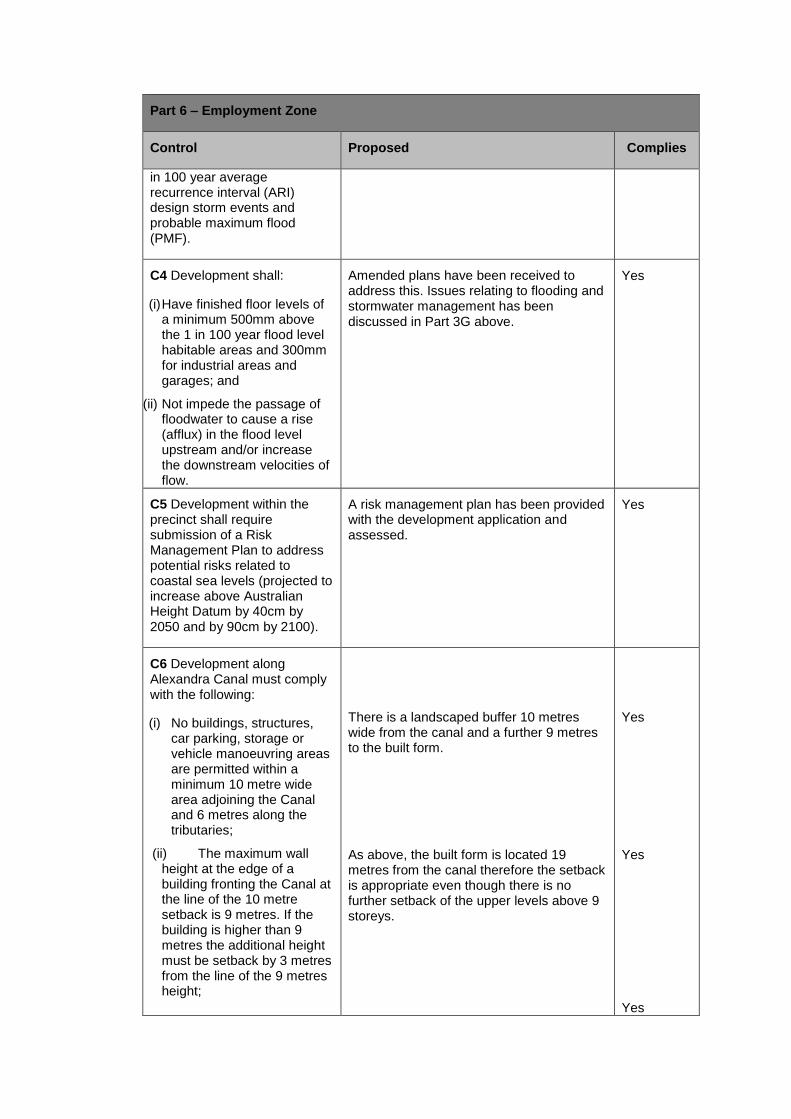
C6 Development along Alexandra Canal must comply with the following:
(i) No buildings, structures, car parking, storage or vehicle manoeuvring areas are permitted within a minimum 10 metre wide area adjoining the Canal and 6 metres along the tributaries;
(ii) The maximum wall height at the edge of a building fronting the Canal at the line of the 10 metre setback is 9 metres. If the building is higher than 9 metres the additional height must be setback by 3 metres from the line of the 9 metres height;
There is a landscaped buffer 10 metres wide from the canal and a further 9 metres to the built form. As above, the built form is located 19 metres from the canal therefore the setback is appropriate even though there is no further setback of the upper levels above 9 storeys.
Yes Yes Yes
Part 6 – Employment Zone
Control Proposed Complies
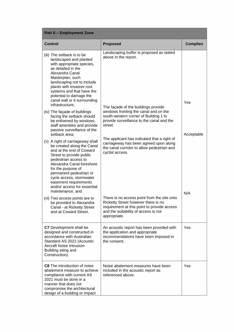
(iii) The setback is to be landscaped and planted with appropriate species, as detailed in the Alexandra Canal Masterplan, such landscaping not to include plants with invasive root systems and that have the potential to damage the canal wall or it surrounding infrastructure;
(iv) The façade of buildings facing the setback should be enlivened by windows, staff amenities and provide passive surveillance of the setback area;
(v) A right of carriageway shall be created along the Canal and at the end of Coward Street to provide public pedestrian access to Alexandra Canal foreshore for the purpose of permanent pedestrian or cycle access, stormwater easement requirements and/or access for essential maintenance; and
(vi) Two access points are to be provided to Alexandra Canal - at Ricketty Street and at Coward Street.
Landscaping buffer is proposed as stated above in the report. The façade of the buildings provide windows fronting the canal and on the south-western corner of Building 1 to provide surveillance to the canal and the street. The applicant has indicated that a right of carriageway has been agreed upon along the canal corridor to allow pedestrian and cyclist access. There is no access point from the site onto Ricketty Street however there is no requirement at this point to provide access and the suitability of access is not appropriate.
Yes Acceptable N/A
C7 Development shall be designed and constructed in accordance with Australian Standard AS 2021 (Acoustic Aircraft Noise Intrusion-Building siting and Construction).
An acoustic report has been provided with the application and appropriate recommendations have been imposed in the consent.
Yes
C8 The introduction of noise abatement measure to achieve compliance with current AS 2021 must be done in a manner that does not compromise the architectural design of a building or impact
Noise abatement measures have been included in the acoustic report as referenced above.
Yes
Part 6 – Employment Zone
Control Proposed Complies
on the character of an existing streetscape.
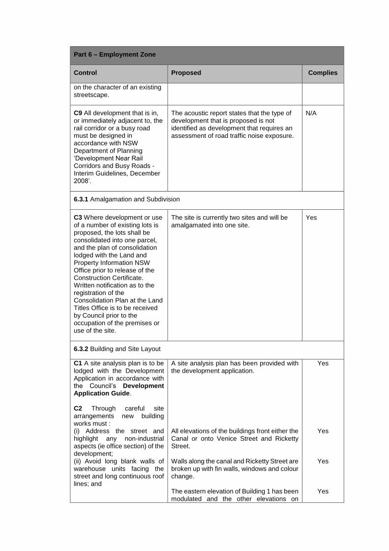
C9 All development that is in, or immediately adjacent to, the rail corridor or a busy road must be designed in accordance with NSW Department of Planning ‘Development Near Rail Corridors and Busy Roads - Interim Guidelines, December 2008’.
The acoustic report states that the type of development that is proposed is not identified as development that requires an assessment of road traffic noise exposure.
N/A
6.3.1 Amalgamation and Subdivision
C3 Where development or use of a number of existing lots is proposed, the lots shall be consolidated into one parcel, and the plan of consolidation lodged with the Land and Property Information NSW Office prior to release of the Construction Certificate. Written notification as to the registration of the Consolidation Plan at the Land Titles Office is to be received by Council prior to the occupation of the premises or use of the site.
The site is currently two sites and will be amalgamated into one site.
Yes
6.3.2 Building and Site Layout
C1 A site analysis plan is to be lodged with the Development Application in accordance with the Council’s Development Application Guide. C2 Through careful site arrangements new building works must : (i) Address the street and highlight any non-industrial aspects (ie office section) of the development; (ii) Avoid long blank walls of warehouse units facing the street and long continuous roof lines; and
A site analysis plan has been provided with the development application. All elevations of the buildings front either the Canal or onto Venice Street and Ricketty Street. Walls along the canal and Ricketty Street are broken up with fin walls, windows and colour change. The eastern elevation of Building 1 has been modulated and the other elevations on
Yes
Yes
Yes
Yes
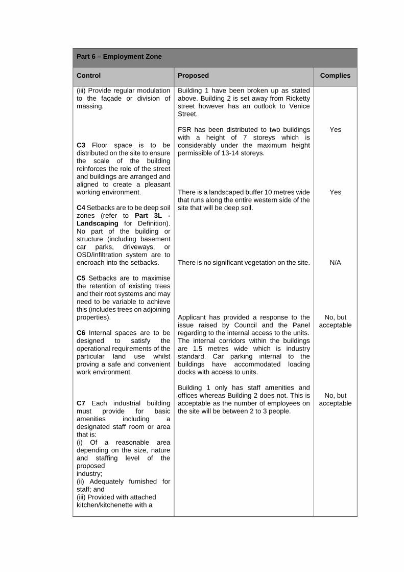
Part 6 – Employment Zone
Control Proposed Complies
(iii) Provide regular modulation to the façade or division of massing. C3 Floor space is to be distributed on the site to ensure the scale of the building reinforces the role of the street and buildings are arranged and aligned to create a pleasant working environment. C4 Setbacks are to be deep soil zones (refer to Part 3L - Landscaping for Definition). No part of the building or structure (including basement car parks, driveways, or OSD/infiltration system are to encroach into the setbacks. C5 Setbacks are to maximise the retention of existing trees and their root systems and may need to be variable to achieve this (includes trees on adjoining properties). C6 Internal spaces are to be designed to satisfy the operational requirements of the particular land use whilst proving a safe and convenient work environment. C7 Each industrial building must provide for basic amenities including a designated staff room or area that is: (i) Of a reasonable area depending on the size, nature and staffing level of the proposed industry; (ii) Adequately furnished for staff; and (iii) Provided with attached kitchen/kitchenette with a
Building 1 have been broken up as stated above. Building 2 is set away from Ricketty street however has an outlook to Venice Street. FSR has been distributed to two buildings with a height of 7 storeys which is considerably under the maximum height permissible of 13-14 storeys. There is a landscaped buffer 10 metres wide that runs along the entire western side of the site that will be deep soil. There is no significant vegetation on the site. Applicant has provided a response to the issue raised by Council and the Panel regarding to the internal access to the units. The internal corridors within the buildings are 1.5 metres wide which is industry standard. Car parking internal to the buildings have accommodated loading docks with access to units. Building 1 only has staff amenities and offices whereas Building 2 does not. This is acceptable as the number of employees on the site will be between 2 to 3 people.
Yes
Yes
N/A
No, but acceptable
No, but acceptable
Part 6 – Employment Zone
Control Proposed Complies
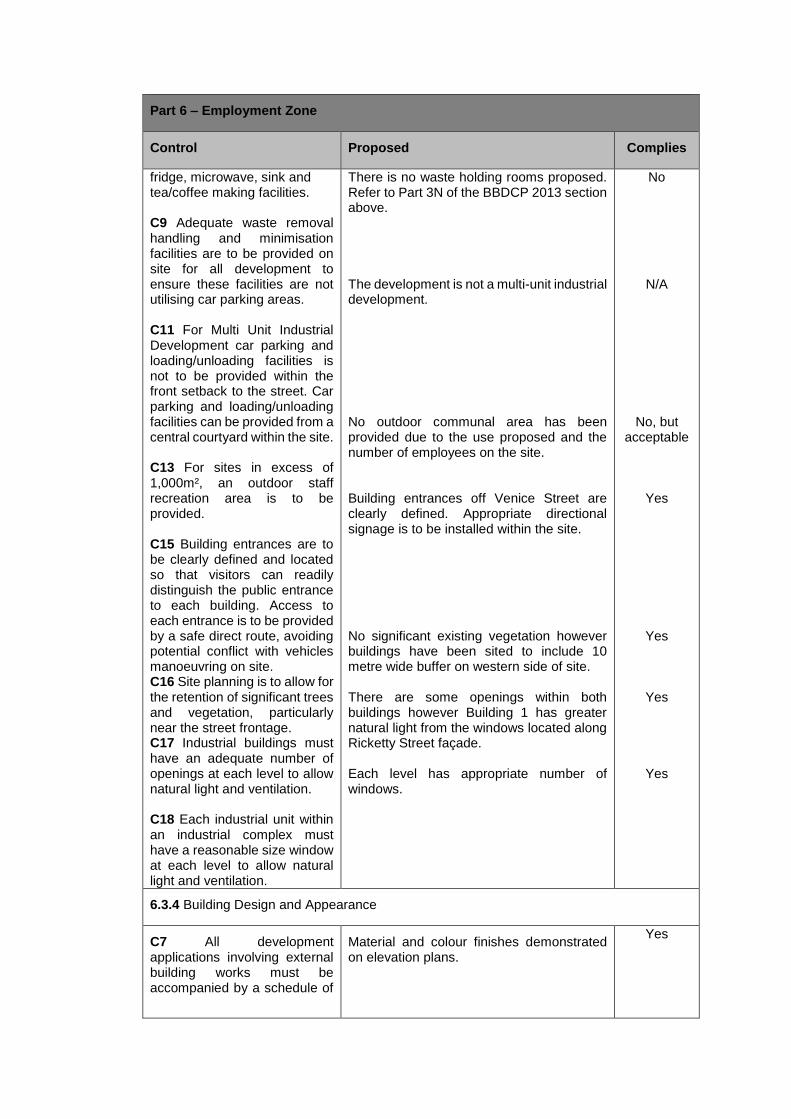
fridge, microwave, sink and tea/coffee making facilities. C9 Adequate waste removal handling and minimisation facilities are to be provided on site for all development to ensure these facilities are not utilising car parking areas. C11 For Multi Unit Industrial Development car parking and loading/unloading facilities is not to be provided within the front setback to the street. Car parking and loading/unloading facilities can be provided from a central courtyard within the site. C13 For sites in excess of 1,000m², an outdoor staff recreation area is to be provided. C15 Building entrances are to be clearly defined and located so that visitors can readily distinguish the public entrance to each building. Access to each entrance is to be provided by a safe direct route, avoiding potential conflict with vehicles manoeuvring on site. C16 Site planning is to allow for the retention of significant trees and vegetation, particularly near the street frontage. C17 Industrial buildings must have an adequate number of openings at each level to allow natural light and ventilation. C18 Each industrial unit within an industrial complex must have a reasonable size window at each level to allow natural light and ventilation.
There is no waste holding rooms proposed. Refer to Part 3N of the BBDCP 2013 section above. The development is not a multi-unit industrial development. No outdoor communal area has been provided due to the use proposed and the number of employees on the site. Building entrances off Venice Street are clearly defined. Appropriate directional signage is to be installed within the site. No significant existing vegetation however buildings have been sited to include 10 metre wide buffer on western side of site. There are some openings within both buildings however Building 1 has greater natural light from the windows located along Ricketty Street façade. Each level has appropriate number of windows.
No
N/A
No, but acceptable
Yes
Yes
Yes
Yes
6.3.4 Building Design and Appearance
C7 All development applications involving external building works must be accompanied by a schedule of
Material and colour finishes demonstrated on elevation plans.
Yes
Part 6 – Employment Zone
Control Proposed Complies
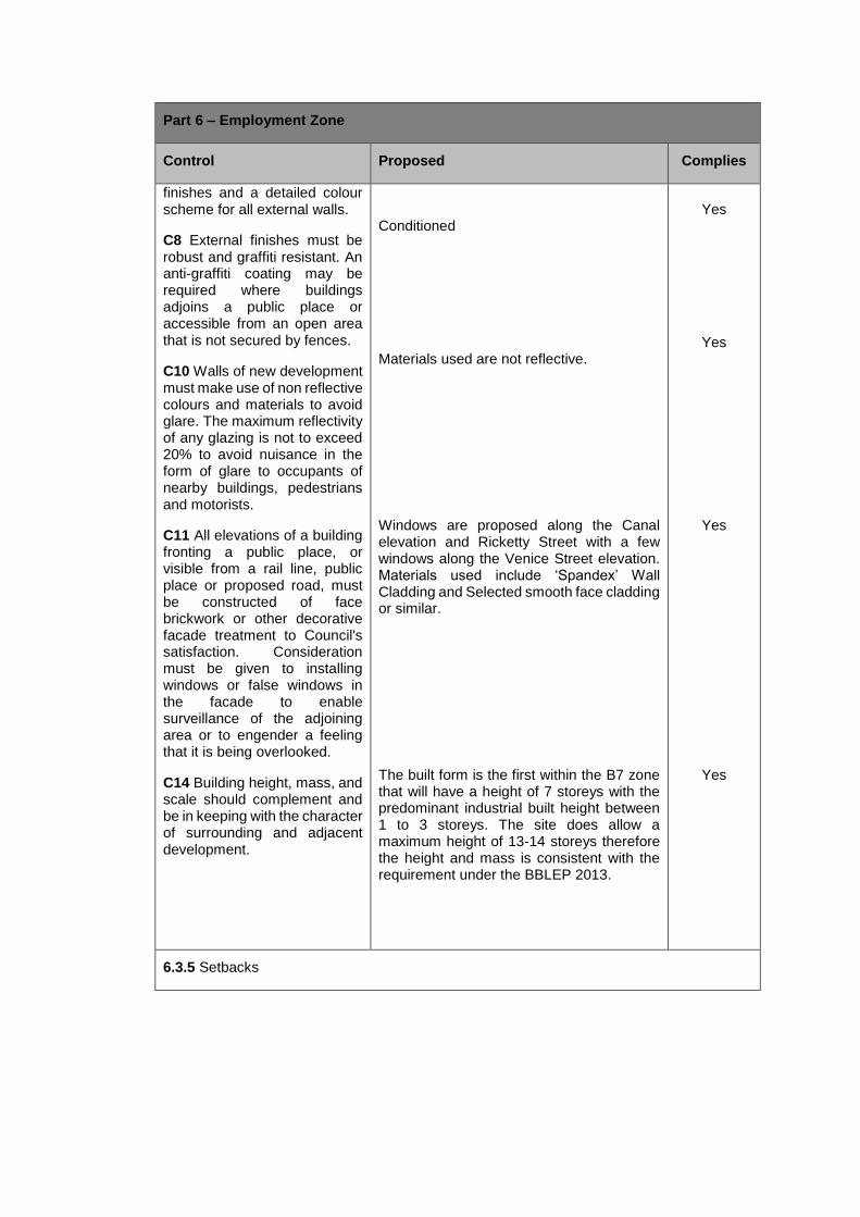
finishes and a detailed colour scheme for all external walls.
C8 External finishes must be robust and graffiti resistant. An anti-graffiti coating may be required where buildings adjoins a public place or accessible from an open area that is not secured by fences.
C10 Walls of new development must make use of non reflective colours and materials to avoid glare. The maximum reflectivity of any glazing is not to exceed 20% to avoid nuisance in the form of glare to occupants of nearby buildings, pedestrians and motorists.
C11 All elevations of a building fronting a public place, or visible from a rail line, public place or proposed road, must be constructed of face brickwork or other decorative facade treatment to Council's satisfaction. Consideration must be given to installing windows or false windows in the facade to enable surveillance of the adjoining area or to engender a feeling that it is being overlooked.
C14 Building height, mass, and scale should complement and be in keeping with the character of surrounding and adjacent development.
Conditioned Materials used are not reflective. Windows are proposed along the Canal elevation and Ricketty Street with a few windows along the Venice Street elevation. Materials used include ‘Spandex’ Wall Cladding and Selected smooth face cladding or similar. The built form is the first within the B7 zone that will have a height of 7 storeys with the predominant industrial built height between 1 to 3 storeys. The site does allow a maximum height of 13-14 storeys therefore the height and mass is consistent with the requirement under the BBLEP 2013.
Yes
Yes
Yes
Yes
6.3.5 Setbacks
Part 6 – Employment Zone
Control Proposed Complies
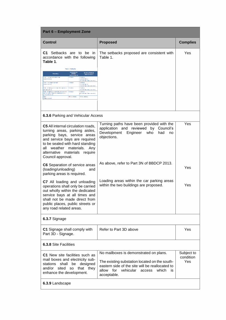
C1 Setbacks are to be in accordance with the following Table 1.
The setbacks proposed are consistent with Table 1.
Yes
6.3.6 Parking and Vehicular Access
C5 All internal circulation roads, turning areas, parking aisles, parking bays, service areas and service bays are required to be sealed with hard standing all weather materials. Any alternative materials require Council approval.
C6 Separation of service areas (loading/unloading) and parking areas is required.
C7 All loading and unloading operations shall only be carried out wholly within the dedicated service bays at all times and shall not be made direct from public places, public streets or any road related areas.
Turning paths have been provided with the application and reviewed by Council’s Development Engineer who had no objections. As above, refer to Part 3N of BBDCP 2013. Loading areas within the car parking areas within the two buildings are proposed.
Yes
Yes
Yes
6.3.7 Signage
C1 Signage shall comply with
Part 3D - Signage. Refer to Part 3D above Yes
6.3.8 Site Facilities
C1 New site facilities such as mail boxes and electricity sub-stations shall be designed and/or sited so that they enhance the development.
No mailboxes is demonstrated on plans. The existing substation located on the south-eastern side of the site will be reallocated to allow for vehicular access which is acceptable.
Subject to condition
Yes
6.3.9 Landscape
Part 6 – Employment Zone
Control Proposed Complies
C9 Not less than 10% of the development site shall be landscaped. On sites over 2000m² the front landscaped setbacks are additional to the 10% requirement. The majority of landscaping shall front the street/s to which the development has frontage and include side and rear landscaped areas.
The development will provide at least 17.4% or 1,554.3sqm of landscaped area (including landscape buffer) for a total site area of 8,947sqm.
Yes
6.3.10 Fences
C1 Fences are to be located behind the street frontage landscaped area or incorporated within the landscapes setback. All fencing along the street frontage is required to be permeable metal palisade or picket powdercoated in a suitable colour, dark colours are preferable. Maximum height is 1.8 metres on street frontages.
Fencing proposed is 2.4 metre high palisade style fencing. A condition has been imposed that all the fencing is to have a maximum height of 1.8 metres
Condition
6.3.12 Noise and Hours of Operation
C4 All applications for noise generating uses are to be accompanied by documentation from a qualified acoustic engineer certifying that the acoustic standards can be met. C9 Hours of operation for the use of a site are to be restricted by Council if it is at all likely that the use will cause an impact on any adjoining or adjacent residential development. Uses that operate outside of normal hours of operation (ie Monday to Friday 8am to 5pm and Saturdays 8am to 4pm) are required to submit a Plan of Management (POM).
An acoustic report was submitted with the development application. The development proposes unrestricted hours. The site is not in close proximity to residential development. An operational management plan has been submitted with the application.
Yes
Yes
In addition to the assessment of Part 6 of the BBDCP 2013, the applicant has provided the following justification relating to internal circulation of the premises:
Customer usage patterns
In this particular facility, most customers will be encouraged to use the rear loading area facing the canal in building 1 and or one of the two loading docks provided in building 2. Each loading bay has been designed to have double height clearance at opening and allow the user to drive or reverse under the building to unload goods out of bad weather and within close proximity to the lift entrance.
Once goods are unloaded at the designated unloading bays and access points, customers will travel with goods down corridors to units, and in this building in most cases up commercial good lifts to access different levels and walk down corridors to their allotted unit.
The indicative unit layouts are depicted on the floor plan drawings so that larger units will be located on the ground floors for commercial customers and again larger units located closer to the lifts on each level whilst smaller units located further away from lift access points. Each building will have two large commercial sized lifts that will easily accommodate household furniture of most sizes or dimensions.
The corridor width in each case has been prescribed as 1.5m, which is a industry standard. This width allows for bulky items to be loaded on trolleys and sent around the facility and has been demonstrated over many years to be an appropriate size. It would be a rare event for two people to be heading different directions down the same corridor at the same time, but even if this was to happen there are multiple corridors travel paths that can be taken to resolve this unlikely event.
To further avoid these issues we provide larger spaces made available closer to the loading/unloading points in and out of lifts on the ground floor for people with larger than usual items and driveway access units available for people requiring non household items to be stored ie boats, cars etc.
This demonstrates that the internal circulation of the buildings is appropriate and adequate for the daily use and operation of the premises.
(b) The likely impacts of the development including environmental impacts on both the natural and built environments, social and economic impacts in the locality.
The proposed development will have no significant adverse environmental, social or economic impacts on the locality.
(c) The suitability of the site for the development.
The site is affected by flooding and aircraft noise. This has been addressed in the body of the report under Part 3G and 3J of the BBDCP 2013. Any contamination and remediation required as part of the development has been addressed within SEPP No. 55 in the report above. It is anticipated with the use proposed that the traffic impact will not be significant. Therefore based on these issues being addressed, it is concluded that the site is suitable for self-storage premises subject to the imposition of appropriate conditions of consent.
(d) Any submission made in accordance with the Act or Regulations.
In accordance with Part 2 Notification & Advertising of the BBDCP 2013, the proposed development was notified to surrounding property owners and advertised in the local newspaper for a period of thirty-eight (38) days from 28 November 2017 to 15 January 2018. No submissions were received during the notification process.
(e) The public interest.
It is considered that the proposed development is in the public interest.
OTHER MATTERS
Section 94 Contributions
The Section 94 Contributions, as calculated within the Section 94 Contributions Plan 2016, for the proposed development are calculated as follows:
Based on three workers on the site, the following rate per worker of $2,705.01 (as indexed on 1 July 2017) applies for the Mascot Station Area.
This rate is based on the following section of the Section 94 Contributions Plan 2016, pg. 89 relating to specific contribution:
‘If a development application is lodged for a specific use or business where the number of employees is known with reasonable certainty and is stated in the development application or complying development certificate application, the number of employees as stated may be accepted for the purpose of assessing the total contribution for that particular development. This is subject to the assessment of Council officers or certifying authority who will determine the reasonableness of the application having regard to the development for which consent is sought and the uses to which the building or land that is the subject of the application could be put without the need for subsequent development consent.’
The argument in regard to the total amount of workers on the site rather than at any one time has not been provided by the applicant. Therefore based on three people working at any one time and each shift is 8 hours, the total number of workers at the premises is 9 employees. Therefore based on 9 workers at a rate of $2,705.01, the total number of section 94 contributions is $24,345.09.
CONCLUSION
In accordance with Clause 3 of Schedule 4A of the Environmental Planning and Assessment Act, the Application is referred to the the Sydney Central Planning Panel (SCPP) for determination. The non-compliances relating to the car parking has been appropriately addressed in the report and has carried out a comparison of other self-storage developments within the metropolitan area. The traffic report supported the departure in car parking therefore the issue has been satisfactorily addressed. The issue relating to waste management to occur from within the site has been imposed as a condition of consent. The final amended plans submitted to the Panel for determination are considered to address the issues raised by the Panel and Council’s request for further information.
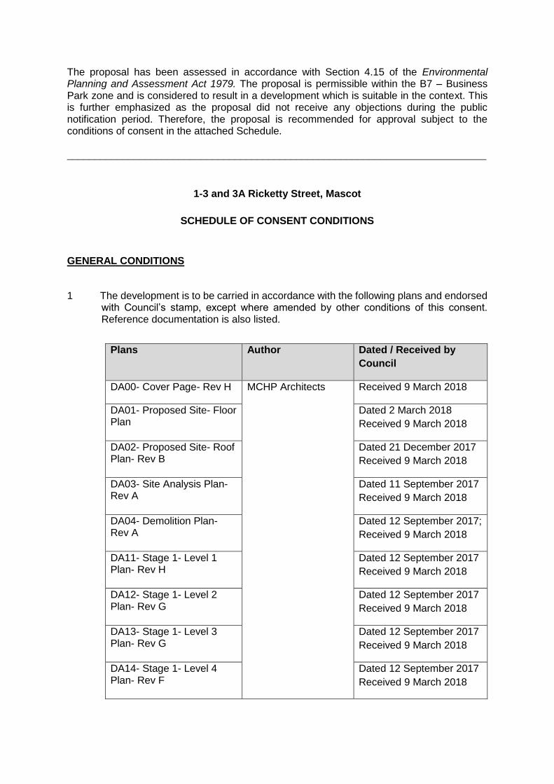
The proposal has been assessed in accordance with Section 4.15 of the Environmental Planning and Assessment Act 1979. The proposal is permissible within the B7 – Business Park zone and is considered to result in a development which is suitable in the context. This is further emphasized as the proposal did not receive any objections during the public notification period. Therefore, the proposal is recommended for approval subject to the conditions of consent in the attached Schedule.
___________________________________________________________________________
1-3 and 3A Ricketty Street, Mascot
SCHEDULE OF CONSENT CONDITIONS
GENERAL CONDITIONS
1 The development is to be carried in accordance with the following plans and endorsed with Council’s stamp, except where amended by other conditions of this consent. Reference documentation is also listed.
Plans Author Dated / Received by
Council
DA00- Cover Page- Rev H MCHP Architects Received 9 March 2018
DA01- Proposed Site- Floor Plan
Dated 2 March 2018
Received 9 March 2018
DA02- Proposed Site- Roof Plan- Rev B
Dated 21 December 2017
Received 9 March 2018
DA03- Site Analysis Plan- Rev A
Dated 11 September 2017
Received 9 March 2018
DA04- Demolition Plan- Rev A
Dated 12 September 2017;
Received 9 March 2018
DA11- Stage 1- Level 1 Plan- Rev H
Dated 12 September 2017
Received 9 March 2018
DA12- Stage 1- Level 2 Plan- Rev G
Dated 12 September 2017
Received 9 March 2018
DA13- Stage 1- Level 3 Plan- Rev G
Dated 12 September 2017
Received 9 March 2018
DA14- Stage 1- Level 4 Plan- Rev F
Dated 12 September 2017
Received 9 March 2018

DA15- Stage 1- Level 5 Plan- Rev G
Dated 12 September 2017
Received 9 March 2018
DA16- Stage 1- Level 6 Plan- Rev F
Dated 12 September 2017
Received 9 March 2018
DA17- Stage 1- Level 7 Plan- Rev B
Dated 12 September 2017
Received 9 March 2018
DA18- Stage 1- Roof Plan- Rev B
Dated 12 September 2017
Received 9 March 2018
DA21- Stage 2- Level 1 Plan- Rev F
Dated 12 September 2017
Received 9 March 2018
DA22- Stage 2- Level 2 Plan- Rev F
Dated 12 September 2017
Received 9 March 2018
DA23- Stage 2- Level 3 Plan- Rev F
Dated 12 September 2017
Received 9 March 2018
DA24- Stage 2- Level 4 Plan- Rev F
Dated 12 September 2017
Received 9 March 2018
DA25- Stage 2- Level 5 Plan- Rev F
Dated 12 September 2017
Received 9 March 2018
DA26- Stage 2- Level 6 Plan- Rev F
Dated 12 September 2017
Received 9 March 2018
DA27- Stage 2- Level 7 Plan- Rev D
Dated 12 September 2017
Received 9 March 2018
DA28- Stage 2- Roof Plan- Rev C
Dated 12 September 2017
Received 9 March 2018
DA33- Stage 1- South Elevation and Schedule of Finishes- Rev G
Dated 8 November 2017
Received 9 March 2018
DA34- Stage 1- West Elevation- Rev H
Dated 5 March 2018
Received 9 March 2018
DA35- Stage 1- East Elevation- Rev G
Dated 8 November 2017
Received 9 March 2018
DA36- Stage 1- North Elevation- Rev H
Dated 5 March 2018
Received 9 March 2018
DA37- Stage 2- East Elevation- Rev G
Dated 5 March 2018
Received 9 March 2018

DA38- Stage 2- North Elevation- Rev G
Dated 5 March 2018
Received 9 March 2018
DA39- Stage 2- South Elevation- Rev G
Dated 5 March 2018
Received 9 March 2018
DA40- Stage 2- West Elevation- Rev G
Dated 5 March 2018
Received 9 March 2018
DA41- Stage 1- Section- Rev D
Dated 5 March 2018
Received 9 March 2018
DA42- Stage 2- Section- Rev D
Dated 5 March 2018
Received 9 March 2018
DA50- Site Elevations- Rev D
Dated 2 March 2018
Received 9 March 2018
DA51- Site Elevations- Rev B
Dated 2 March 2018
Received 9 March 2018
DA70- Signage Details- Rev A
Dated 13 October 2017;
Received 9 March 2018
DA100- Proposed 12.5m Truck Path- Rev B
Dated 7 March 2018;
Received 9 March 2018
DA101- Proposed 19m Truck Path- Rev B
Dated 7 March 2018;
Received 9 March 2018
DA102- Proposed 8.8m Truck Path- Rev A
Dated 3 March 2018;
Received 9 March 2018
DAC01.01- Cover sheet, drawing schedule and locality plan- Rev 1
Northrop Dated 7 September 2017;
Received 31 October 2017
DAC02.01- Sediment and Soil Erosion Control Plan- Rev 2
Dated 14 September 2017;
Received 31 October 2017
DAC02.11- Sediment and Soil Erosiion Control Details- Rev 1
Dated 7 September 2017;
Received 31 October 2017
DAC03.01- Cut and Fill Plan- Rev 3
Dated 27 October 2017;
Received 31 October 2017
DAC03.02- Cut and Fill Sections- Rev 1
Dated 7 September 2017;
Received 31 October 2017
DAC04.01- Concept Siteworks and Stormwater management plan- Rev 3
Dated 16 October 2017;
Received 31 October 2017
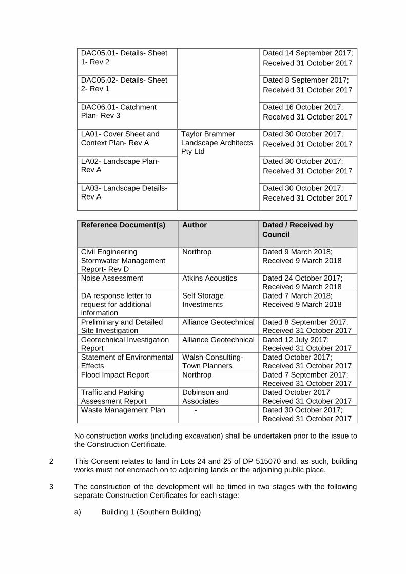
DAC05.01- Details- Sheet 1- Rev 2
Dated 14 September 2017;
Received 31 October 2017
DAC05.02- Details- Sheet 2- Rev 1
Dated 8 September 2017;
Received 31 October 2017
DAC06.01- Catchment Plan- Rev 3
Dated 16 October 2017;
Received 31 October 2017
LA01- Cover Sheet and Context Plan- Rev A
Taylor Brammer Landscape Architects Pty Ltd
Dated 30 October 2017;
Received 31 October 2017
LA02- Landscape Plan- Rev A
Dated 30 October 2017;
Received 31 October 2017
LA03- Landscape Details- Rev A
Dated 30 October 2017;
Received 31 October 2017
Reference Document(s) Author Dated / Received by
Council
Civil Engineering Stormwater Management Report- Rev D
Northrop Dated 9 March 2018; Received 9 March 2018
Noise Assessment Atkins Acoustics Dated 24 October 2017; Received 9 March 2018
DA response letter to request for additional information
Self Storage Investments
Dated 7 March 2018; Received 9 March 2018
Preliminary and Detailed Site Investigation
Alliance Geotechnical Dated 8 September 2017; Received 31 October 2017
Geotechnical Investigation Report
Alliance Geotechnical Dated 12 July 2017; Received 31 October 2017
Statement of Environmental Effects
Walsh Consulting- Town Planners
Dated October 2017; Received 31 October 2017
Flood Impact Report Northrop Dated 7 September 2017; Received 31 October 2017
Traffic and Parking Assessment Report
Dobinson and Associates
Dated October 2017 Received 31 October 2017
Waste Management Plan - Dated 30 October 2017; Received 31 October 2017
No construction works (including excavation) shall be undertaken prior to the issue to the Construction Certificate.
2 This Consent relates to land in Lots 24 and 25 of DP 515070 and, as such, building works must not encroach on to adjoining lands or the adjoining public place.
3 The construction of the development will be timed in two stages with the following separate Construction Certificates for each stage:
a) Building 1 (Southern Building)
b) Building 2 (Northern Building)
Note: The consent is structured to include conditions to be satisfied prior to the issue of the first/any construction certificate or prior to the relevant construction certificate.
4 The consent given does not imply that works can commence until such time that:
a) Detailed plans and specifications of the building have been endorsed with a Construction Certificate by:
(i) The consent authority; or,
(ii) An accredited certifier; and,
b) The person having the benefit of the development consent:
(i) Has appointed a principal certifying authority; and
(ii) Has notified the consent authority and the Council (if the Council is not the consent authority) of the appointment; and,
(iii) The person having the benefit of the development consent has given at least 2 days notice to the council of the persons intention to commence the erection of the building.
5 All building work must be carried out in accordance with the provisions of the Building Code of Australia.
CONDITIONS IMPOSED BY AN EXTERNAL AUTHORITY
Where relevant, the following external authority conditions apply:
The following conditions are imposed by Roads and Maritime Services:
6 All buildings and structures, together with any improvements integral to the future use of the site shall be wholly within the freehold property (unlimited in height or depth) and clear of the New M5 works.
7 Detailed design plans and hydraulic calculations of any changes to the stormwater drainage system are to be submitted to Roads and Maritime for approval, prior to the commencement of any works. Details should be forwarded to: The Sydney Asset Management Roads and Maritime Services PO Box 973 Parramatta CBD 2124. A plan checking fee will be payable and a performance bond may be required before Roads and Maritime approval is issued. With regard to the Civil Works requirement please contact the Roads and Maritime Project Engineer, External Works Ph: 8849 2114 or Fax: 8849 2766.
8 The developer is to submit design drawings and documents relating to any excavation of the site and support structures to Roads and Maritime for assessment, in accordance with Technical Direction GTD2012/001.

The developer is to submit all documentation at least six (6) weeks prior to commencement of construction and is to meet the full cost of the assessment by Roads and Maritime.
9 The report and any enquiries should be forwarded to: Project Engineer, External Works Sydney Asset Management Roads and Maritime Services PO Box 973 Parramatta CBD 2124. Telephone 8849 2114 Fax 8849 2766
If it is necessary to excavate below the level of the base of the footings of the adjoining roadways, the person acting on the consent shall ensure that the owner/s of the roadway is/are given at least seven (7) days notice of the intention to excavate below the base of the footings. The notice is to include complete details of the work.
10 A Construction Traffic Management Plan detailing construction vehicle routes, number of trucks, hours of operation, access arrangements and traffic control should be submitted to Council for approval prior to the issue of a Construction Certificate. Further comment will be provided upon receipt of the Construction Traffic Management Plan.
11 Ricketty Street is identified in the NSW Governments 2013 Sydney Clearways Strategy for a possible future clearway. Full time No Stopping restrictions are to be implemented along the full Ricketty Street frontage of the development site. This restriction should be implemented prior to the commencement of any demolition works relating to the proposed development. Prior to the installation of the parking restrictions the applicant is to contact Roads and Maritime South East Network and Safety Unit by email [email protected] for a works instruction. Roads and Maritime may, in the future, supplement the No Stopping restriction with Clearways.
Parking for all vehicles associated with the proposed development should be fully contained within the development site and must not encroach onto any state road. Council should be satisfied that the parking provision for the proposed development is adequate to cater for all current and future demand.
All service vehicles (including garbage collection, building maintenance vehicles and removalists), must service this property from within the development or from the local road network.
12 A Road Occupancy Licence (ROL) should be obtained from Transport Management Centre for any works that may impact on traffic flows on Ricketty Street during construction activities. A ROL can be obtained through https://myrta.com/oplinc2/pages/security/oplincLogin.jsf.
13 The layout of the proposed car parking areas associated with the subject development (including, driveways, grades, turn paths, sight distance requirements in relation to landscaping and/or fencing, aisle widths, aisle lengths, and parking bay dimensions) should be in accordance with AS 2890.1- 2004, AS2890.6-2009 and AS 2890.2 – 2002 for heavy vehicle usage.
14 All demolition and construction vehicles are to be contained wholly within the site and vehicles must enter the site before stopping. A construction zone will not be permitted on Ricketty Street.
15 All works and signposting associated with the subject development shall be at no cost to Roads and Maritime.

The following conditions are imposed by Water NSW:
16 Design of works and Structures
GT0009-00004- Before commencing any proposed controlled activity on waterfront land, an application must be submitted to Crown Lands and Water Division, and obtained, for a controlled activity approval under the Water Management Act 2000.
17 Erosion and Sediment Controls
GT0006-00001- The following plan(s): - Erosion and Sediment Controls Plan must be: A. prepared in accordance with Managing Urban Stormwater: Soils and Construction, Volume 1 (Landcom, 2004), as amended or replaced from time to time, and B. submitted with an application for a controlled activity approval.
GT0014-00003- A. The consent holder must ensure that any proposed materials or cleared vegetation, which may: i. obstruct water flow, or ii. wash into the water body, or iii. cause damage to river banks, are not stored on waterfront land, unless in accordance with a plan held by Crown Lands and Water Division as part of a controlled activity approval. B. When the carrying out of the controlled activity has been completed, surplus materials must be removed from waterfront land.
GT0021-00001 The proposed erosion and sediment control works must be inspected and maintained throughout the carried out; construction or operation period of the controlled activity and must not be removed until the site is fully stabilised.
18 Plans, Standards and Guidelines
GT0001-00001 A. The application for a controlled activity approval must include the document(s) listed in Schedule 1. B. The document(s) must be prepared by a suitably qualified person.
GT0002-00119 A. This General Terms of Approval (GTA) only applies to the proposed activities described in the plans and associated documents found in Schedule 1, relating to Development Application DA2017/1198/1 provided by Council to Crown Lands and Water Division. B. Any amendments or modifications to the proposed activities may render the GTA invalid. If the proposed controlled activity is amended or modified, Crown Lands and Water Division, Parramatta Office, must be notified in writing to determine if any variations to the GTA will be required.
GT0005-00023 A. The application for a controlled activity approval must include the following plan(s): - Works Schedule; Outlet Structures; Erosion and Sediment Control Plan; and, Vegetation Management/Rehabilitation Plan that includes details of riparian corridor rehabilitation works. B. The plan(s) must be prepared in accordance with Crown Lands and Water Division's guidelines located on the website http://www.water.nsw.gov.au/water-licensing/approvals/controlled-activity. GT0010-00003 All documents submitted to Crown Lands and Water Division as part of an application for a controlled activity approval must be prepared by a suitably qualified person.
GT0030-00001 The application for a controlled activity approval must include plans prepared in accordance with Crown Lands and Water Division's guidelines located on the website as follows: http://www.water.nsw.gov.au/waterlicensing/approvals/controlled-activity.
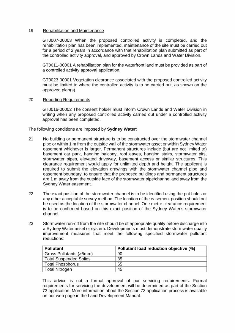
19 Rehabilitation and Maintenance
GT0007-00003 When the proposed controlled activity is completed, and the rehabilitation plan has been implemented, maintenance of the site must be carried out for a period of 2 years in accordance with that rehabilitation plan submitted as part of the controlled activity approval, and approved by Crown Lands and Water Division.
GT0011-00001 A rehabilitation plan for the waterfront land must be provided as part of a controlled activity approval application.
GT0023-00001 Vegetation clearance associated with the proposed controlled activity must be limited to where the controlled activity is to be carried out, as shown on the approved plan(s).
20 Reporting Requirements
GT0016-00002 The consent holder must inform Crown Lands and Water Division in writing when any proposed controlled activity carried out under a controlled activity approval has been completed.
The following conditions are imposed by Sydney Water:
21 No building or permanent structure is to be constructed over the stormwater channel pipe or within 1 m from the outside wall of the stormwater asset or within Sydney Water easement whichever is larger. Permanent structures include (but are not limited to) basement car park, hanging balcony, roof eaves, hanging stairs, stormwater pits, stormwater pipes, elevated driveway, basement access or similar structures. This clearance requirement would apply for unlimited depth and height. The applicant is required to submit the elevation drawings with the stormwater channel pipe and easement boundary, to ensure that the proposed buildings and permanent structures are 1 m away from the outside face of the stormwater pipe/channel and away from the Sydney Water easement.
22 The exact position of the stormwater channel is to be identified using the pot holes or any other acceptable survey method. The location of the easement position should not be used as the location of the stormwater channel. One metre clearance requirement is to be confirmed based on this exact position of the Sydney Water's stormwater channel.
23 Stormwater run-off from the site should be of appropriate quality before discharge into a Sydney Water asset or system. Developments must demonstrate stormwater quality improvement measures that meet the following specified stormwater pollutant reductions:
Pollutant Pollutant load reduction objective (%)
Gross Pollutants (>5mm) 90
Total Suspended Solids 85
Total Phosphorus 65
Total Nitrogen 45
This advice is not a formal approval of our servicing requirements. Formal requirements for servicing the development will be determined as part of the Section 73 application. More information about the Section 73 application process is available on our web page in the Land Development Manual.
24 Sydney Water has an email address for planning authorities to submit statutory or strategic planning documents for review. This email [email protected].
25 A Section 73 Compliance Certificate under the Sydney Water Act 1994 must be obtained from Sydney Water prior to development commencement. It is recommended that the Council includes this term as a Condition of the DA approval.
The proponent is advised to make an early application for the certificate, as there may be water and wastewater pipes to be built that can take some time. This can also impact on other services and buildings, driveways or landscape designs.
Applications must be made through an authorised Water Servicing Coordinator. For help either visit www.sydnevwater.com.au > Plumbing, building and developing> Developing> Land development or telephone 13 20 92.
26 The approved plans must be submitted to the Sydney Water Tap in™ online service to determine whether the development will affect any Sydney Water sewer or water main, stormwater drains and/or easement, and if further requirements need to be met.
The Sydney Water Tap in TM online self-service replaces our Quick Check Agents as of 30 November 2015.
The Tap in™ service provides 24/7 access to a range of services, including:
a) building plan approvals
b) connection and disconnection approvals
c) diagrams
d) trade waste approvals
e) pressure information
f) water meter installations
g) pressure boosting and pump approvals
h) changes to an existing service or asset, e.g. relocating or moving an asset.
Sydney Water's Tap in™ online service is available at:
https:/Iwww.sydnevwater.com.au/SW/plumbing-building-developing/building/sydney-
water-tap-in/index.htm
27 Conduct a site assessment to confirm the hazard rating of the property and its services. Contact PIAS at NSW Fair Trading on 1300 889 099.
For installation you will need to engage a licensed plumber with backflow accreditation who can be found on the Sydney Water website: http://www.sydneywater.com.au/Plumbing/BackflowPrevention/
28 Water is our most precious resource and every customer can play a role in its conservation. By working together with Sydney Water, business customers are able
to reduce their water consumption. This will help your business save money, improve productivity and protect the environment.
Some water efficiency measures that can be easily implemented in your business are:
a) Install water efficiency fixtures to help increase your water efficiency, refer to WELS (Water Efficiency Labelling and Standards (WELS) Scheme, http://www.waterrating.gov.au/
b) Consider installing rainwater tanks to capture rainwater runoff, and reusing it, where cost effective. Refer to
http://www.sydneywater.com.aulWater4Life/lnYourBusiness/RWTCalculator.cfm
c) Install water-monitoring devices on your meter to identify water usage patterns and leaks.
d) Develop a water efficiency plan for your business.
It is cheaper to install water efficiency appliances while you are developing than retrofitting them later.
29 Under Sydney Water's customer contract Sydney Water aims to provide Business Customers with a continuous supply of clean water at a minimum pressure of 15meters head at the main tap. This is equivalent to 146.8kpa or 21.29psi to meet reasonable business usage needs.
Sometimes Sydney Water may need to interrupt, postpone or limit the supply of water services to your property for maintenance or other reasons. These interruptions can be planned or unplanned.
Water supply is critical to some businesses and Sydney Water will treat vulnerable customers, such as hospitals, as a high priority.
Have you thought about a contingency plan for your business? Your Business Customer Representative will help you to develop a plan that is tailored to your business and minimises productivity losses in the event of a water service disruption.
For further information please visit the Sydney Water website at:
http://www.sydneywater.com.au/OurSystemsandOperationslTradeWaste/ or contact Business Customer Services on 1300985227 or [email protected].
The following conditions are imposed by Sydney Airport Corporation Limited (SACL):
30 This location lies within an area defined in schedules of the Civil Aviation (Buildings Control) Regulations which limit the height of structures to 15.24 metres above existing ground height (AEGH) without prior approval of the Civil Aviation Safety Authority.
31 The application sought approval for the PROPERTY DEVELOPMENT to a height of 30.0 metres Australian Height Datum (AHD).
32 In the capacity as Airfield Design Manager and an authorised person of the Civil Aviation Safety Authority (CASA) under Instrument Number: CASA 229/11, in this
instance, the Airfield Manager has no objection to the erection of this development to a maximum height of 30.0 metres AHD.
33 The approved height is inclusive of all lift over-runs, vents, chimneys, aerials, TV antennae, construction cranes etc.
34 Should you wish to exceed this height a new application must be submitted.
35 Should the height of any temporary structure and/or equipment be greater than 15.24 metres AEGH, a new approval must be sought in accordance with the Civil Aviation (Buildings Control) Regulations Statutory Rules 1988 No. 161.
36 Construction cranes may be required to operate at a height significantly higher than that of the proposed development and consequently, may not be approved under the Airports (Protection of Airspace) Regulations.
37 Sydney Airport advises that approval to operate construction equipment (ie cranes) should be obtained prior to any commitment to construct.
38 "Prescribed airspace" includes "the airspace above any part of either an Obstacle Limitation Surface (OLS) or Procedures for Air Navigation Services – Aircraft Operations (PANS-OPS) surface for the airport (Regulation 6(1)).
39 The height of the prescribed airspace at this location is 51 metres above AHD.
Planning for Aircraft Noise and Public Safety Zones
40 Current planning provisions (s.117 Direction 3.5 NSW Environmental Planning and Assessment Act 1979) for the assessment of aircraft noise for certain land uses are based on the Australian Noise Exposure Forecast (ANEF). The current ANEF for which Council may use as the land use planning tool for Sydney Airport was endorsed by Airservices in December 2012 (Sydney Airport 2033 ANEF).
41 Whilst there are currently no national aviation standards relating to defining public safety areas beyond the airport boundary, it is recommended that proposed land uses which have high population densities should be avoided.
CONDITIONS WHICH MUST BE SATISFIED PRIOR TO THE COMMENCEMENT OF ANY WORKS
42 The proposed development shall comply with the following:
(a) A sign must be erected in a prominent position on any work site on which work involved in the erection or demolition of a building is being carried out:
(i) Stating that unauthorised entry to the work site is prohibited;
(ii) Showing the name of the person in charge of the work site and a telephone number at which that person may be contacted outside working hours;
(iii) The Development Approval number; and
(iv) The name of the Principal Certifying Authority including an afterhours contact telephone number.
(b) Any such sign is to be removed when the work has been completed.
43 If the land to which the application relates is served by a common sewerage system that is also used by others, then measures must be placed in effect and prior to the commencement of work to ensure the operation of the sewerage system is without disruption to other joint users.
44 Prior to the commencement of any demolition, excavation or remediation works, the applicant must inform Council, in writing, of:
(a) The name of the contractor, and licence number of the licensee who has contracted to do, or intends to do, the work: or
(b) The name and permit number of the owner-builder who intends to do the work;
(c) The Council also must be informed if: -
(i) A contract is entered into for the work to be done by a different licensee; or
(ii) Arrangements for the doing of the work are otherwise changed.
45 Prior to commencement of any works, application(s) shall be made to Council's Customer Services Counter and obtained the following approvals and permits on Council’s property/road reserve under Road Act 1993 and Local Government Act 1993: - (It should be noted that any works shown within Council’s road reserve or other Council Lands on the development approval plans are indicative only and no approval for these works is given until this condition is satisfied.)
a) Permit to erect hoarding on or over a public place, including Council’s property/road reserve,
b) Permit to construction works, place and/or storage building materials on footpaths, nature strips,
c) Permit to install temporary ground anchors in public land,
d) Permit to discharge ground water to Council’s stormwater drainage system,
e) Permit for roads and footways occupancy (long term/ short term),
f) Permit to construct vehicular crossings, footpaths, kerbs and gutters over road reserve,
g) Permit to open road reserve area, including roads, footpaths, nature strip, vehicular crossing or for any purpose whatsoever, such as relocation / re-adjustments of utility services,
h) Permit to place skip/waste bin on footpath and/or nature strip, and
i) Permit to use any part of Council’s road reserve or other Council lands.
46 Soil and sedimentation controls are to be put in place prior to commencement of any work on site. The controls are to be maintained in effective working order during construction.
The controls are to be designed and installed in accordance with the Soil and Water Management for Urban Development Guidelines produced by the Southern Sydney Regional Organisation of Council. Copies of the guidelines are available from Council.
47 Prior to the commencement of demolition work a licensed demolisher who is registered with WorkCover NSW must prepared a Work Method Statement to the satisfaction of the Principal Certifying Authority (Council or an accredited certifier) and a copy shall be sent to Council (if it is not the PCA). A copy of the Statement shall also be submitted to WorkCover NSW.
The statement must be in compliance with AS2601:1991 – ‘Demolition of Structures’, the requirements of WorkCover NSW and conditions of the Development Approval, and shall include provisions for:
a) Enclosing and making the site safe, any temporary protective structures must comply with the “Guidelines for Temporary Protective Structures (April 2001)”;
b) Induction training for on-site personnel;
c) Inspection and removal of asbestos, contamination and other hazardous materials (by appropriately licensed contractors);
d) Dust control – Dust emission must be minimised for the full height of the building. A minimum requirement is that perimeter scaffolding, combined with chain wire and shade cloth must be used, together with continuous water spray during the demolition process. Compressed air must not be used to blow dust from the building site;
e) Disconnection of Gas and Electrical Supply;
f) Fire Fighting – Fire fighting services on site are to be maintained at all times during demolition work. Access to fire services in the street must not be obstructed;
g) Access and Egress – No demolition activity shall cause damage to or adversely affect the safe access and egress of this building;
h) Waterproofing of any exposed surfaces of adjoining buildings;
i) Control of water pollution and leachate and cleaning of vehicles tyres – Proposals shall be in accordance with the “Protection of the Environmental Operations Act 1997”;
j) Working hours, in accordance with this Development Consent;
k) Confinement of demolished materials in transit;
l) Proposed truck routes, in accordance with this Development Consent;
m) Location and method of waste disposal and recycling in accordance with the “Waste Minimisation and Management Act 1995”.
n) Sewer – common sewerage system ad08.
48 A sufficient area shall be provided onsite to enable separate stockpiling of excavated materials for sampling and analysis prior to removal or re-use on site. Details of this area shall be provided in the Soil and Water Management Plan (SWMP). This plan shall incorporate and reference the construction environmental management plan and address site limitations.
49 Toilet facilities are to be provided at or in the vicinity of the work site on which work involves:
a) demolition and construction of a building is being carried out, at the rate of one toilet for every 20 persons or part of 20 persons employed at the site;
b) Each toilet provided:
(i) must be standard flushing toilet; and,
(ii) must be connected:
to a public sewer; or
if connection to a public sewer is not practicable to an accredited sewerage management facility approved by the Council; or,
if connection to a public sewer or an accredited sewerage management facility is not practicable to some other sewerage management facility approved by the Council.
c) The provisions of toilet facilities in accordance with this condition must be in place before work commences.
50 This Consent shall not preclude the demolisher from giving notice to other statutory authorities, such as Sydney Water Corporation, WorkCover, etc.
51 Prior to the commencement of any works, the site to which this approval relates must be adequately fenced or other suitable measures employed that are acceptable to the Principal Certifying Authority to restrict public access to the site and building works. Such fencing or other measures must be in place before the approved activity commences.
52 A Soil and Water Management Plan shall be prepared in accordance with Soil and Water Management for Urban Development Guidelines produced by the Southern Sydney Region Organisation of Councils. A copy of the plan must be submitted to Council. The Plan must include details of the proposed erosion and sediment controls to be installed on the building site. A copy of the Soil and Water Management Plan must be kept on-site at all times and made available on request. Sediment control devices shall not be located beneath the driplines of trees, which are to be retained.
53 For any water from site dewatering to be permitted to go to the stormwater, the water must meet ANZECC 2000 Water Quality Guidelines for Fresh and Marine Water for the 95% protection trigger values for marine water. The results of all testing must be completed by a NATA accredited laboratory.
All laboratory results must be accompanied by a report prepared by a suitably qualified person indicating the water meets these guidelines and is acceptable to be released into council’s stormwater system. If it is not acceptable, details of treatment measures to ensure that the water is suitable for discharge to council’s stormwater shall be provided in this report. Reports shall be provided to council prior to discharge of any groundwater to the stormwater system.
54 To ensure that relevant engineering and water quality provisions are met during the period of dewatering for construction, prior to any water from site dewatering to be
permitted to go to council’s stormwater system a permit to discharge to the stormwater shall be obtained from Council. Dewatering shall not commence until this is issued by Council.
55 Council's warning sign for soil and water management must be displayed on the most prominent point on the building site, visible to both the street and site workers. The sign shall be erected prior to commencement of works and shall be displayed throughout construction.
56 The applicant shall provide Council with a 24 hour contact number for the manager of the remediation works prior to the commencement of any works at the site.
57 Prior to the commencement of any building works, the required Long Service Levy payable under Section 34 of the Building and Construction Industry Long Service Payments Act 1986 has to be paid. The Long Service Levy is payable at 0.35% of the total cost of the development, however this is a State Government Fee and can change without notice.
58 Where any shoring is to be located on or is supporting Council’s property, or any adjoining private property, engineering drawings certified as being adequate for their intended purpose by an appropriately qualified and practicing engineer, showing all details, including the extent of encroachment and the method of removal (or any other method) and de-stressing of shoring elements, shall be submitted with the Construction Certificate to the Principle Certifying Authority along with Council’s (or other) consent if the works intrude on Council’s (or other) property.
CONDITIONS WHICH MUST BE SATISFIED PRIOR TO THE ISSUE OF THE CONSTRUCTION CERTIFICATE AS INDICATED 59 The applicant must prior to the issue of any Construction Certificate, pay the following
fees:
(a) Development Control $3,000.00
(b) Footpath Crossing Deposit $592,706.25 (See below)
(c) Section 94 Contributions $24,345.09 (See below)
60 Prior to the issue of any Construction Certificate, the applicant shall lodge a Footpath Crossing Deposit of $592,706.25 (GST Exempt) by way of cash deposit or unconditional bank guarantee to Council against possible damage to Council’s asset during the course of the building works. The deposit will be refunded subject to inspection by Council 12 months after the completion of all works relating to the proposed development and Final Occupational Certificate has been issued.
61 Bayside Council being satisfied that the proposed development will increase the demand for public amenities within the area, and in accordance with Council’s Section 94 Contributions Plans, a contribution of $5,194,622.36 is payable as calculated below:
City of Botany Bay Section 94 Contributions Plan 2016
The s94 contributions (as indexed from July 2017) for the development is as follows:
a) Community Facilities- Citywide $3,742.90
b) Recreation Facilities- Mascot Precinct $379.74 c) Recreation Facilities- Citywide $16,258.42 d) Transport Management- Citywide $1,531.89 e) Transport Management- Mascot $2,153.18 f) Administration $278.95
TOTAL: $24,345.09
The total Section 94 Contribution of $24,345.09 is to be paid to Council prior to the issue of any Construction Certificate.
Note: The Section 94 Contributions are subject to annual review and the current rates are applicable for the financial year in which your consent is granted. If you pay the contribution in a later financial year you will be required to pay the fee applicable at the time.
62 Prior to the issue of any Construction Certificate, amended plans are to be provided to Council’s Manager of Development Services demonstrating the following:
a) The perimeter open palisade fencing around the site is to be reduced from 2.4 metres to 1.8 metres in height;
b) A loading bay is to be demonstrated within the site to address the concerns relating to garbage collection. The plans are to demonstrate that any waste vehicle can appropriately manoeuvre and collect within the site and is to enter and exit the site in an appropriate manner;
c) On the eastern façade of both buildings, fin walls or a similar building material is to be mounted similar to the western façade to break up the solidness of these elevations and add visual interest to the buildings.
63 Prior to the issue of the relevant Construction Certificate, detailed construction plans for demonstrating a 2.5 metre wide pedestrian path to be provided along the full site frontage to cater for Pedestrians and Cyclists. This path is to connect the existing pedestrian path on Alexandra Canal bridge with the eastern site road frontage. These plans are to be submitted to Council for approval.
64 Prior to the issue of any Construction Certificate, an amended waste management plan is to be provided to the principal certifying authority demonstrating that all waste collection is to occur from within the site.
65 Prior to the issue of the relevant Construction Certificate, the development shall make provision for the following car parking allocations:
a) 24 spaces for Building 1 (Stage 1)
b) 18 spaces for Building 2 (Stage 2)
This requirement shall be reflected on the relevant Construction Certificate plans. The approved car parking spaces shall be maintained to the satisfaction of Council, at all times.
66 Prior to the issue of the Construction Certificate, a dilapidation survey shall be undertaken of all properties and/or Council infrastructure, including but not limited to all footpaths, kerb and gutter, stormwater inlet pits, and road carriageway pavements,
in the vicinity which could be potentially affected by the construction of this development. Any damage caused to other properties during construction shall be rectified. A copy of the dilapidation survey and an insurance policy that covers the cost of any rectification works shall be submitted to the Principal Certifying Authority prior to issue of the Construction Certificate. The insurance cover shall be a minimum of $10 million.
67 A Section 73 Compliance Certificate under the Sydney Water Act 1994 must be obtained. Application must be made through an authorised Water Servicing Coordinator. Please refer to “Your Business” section of Sydney Water’s web site at www.sydneywater.com.au then the “e-developer” icon or telephone 13 20 92.
i) Following application a “Notice of Requirements” will detail water and sewer extensions to be built and charges to be paid. Please make early contact with the Co-ordinator, since building of water/sewer extensions can be timed consuming and may impact on other services and building, driveway or landscape design. The Section 73 Notice of Requirements must be submitted to the Principal Certifying Authority prior to the issue of any Construction Certificate.
68 Any part of the proposed building located in the vicinity of the existing pipeline shall be constructed on a pier and beam type foundation, piers shall be located outside the boundary of the drainage easement and to extend to a depth no less than 300mm below the invert of the pipeline.
69 Commercial vehicle facilities shall be designed strictly in accordance with AS2890.2:2002.
70 Prior to the issue of any Construction Certificate, detailed drainage design plans for the management of stormwater are to be submitted to Council or an Accredited Certifier for assessment and approval and drainage design calculations are to be submitted with the plans. Botany DCP Part 10 sets out the minimum documentation requirements for detailed design plans.
71 Prior to the issue of any Construction Certificate, the applicant shall contact “Dial Before You Dig” to obtain a utility service diagram for, and adjacent to the property. The sequence number obtained from “Dial Before You Dig” shall be forwarded to Principal Certifying Authority. All utilities within the work zone shall be protected during construction. Any adjustments or damage to public utilities/services as a consequence of the development and associated construction works shall be restored or repaired at the applicant’s expense.
72 Prior to the release of the relevant Construction Certificate, the following required section(s) are to be submitted to and approved by the Principal Certifying Authority:
a) Disabled car parking spaces shall be provided and clearly marked as per the Stage 2 Traffic and Transport Report by ARUP Group, dated 10 August 2016, Australian Standards AS 2890.6, SEPP 65 Design Code and Council requirements, and
b) All off street disabled parking shall have access to the adjacent road(s) and to the communal open space as per Australian Standards AS 2890.6 and Council requirements.

73 The off-street parking areas associated with the subject development shall be
designed strictly in accordance with AS2890.1:2004.
74 The building shall be constructed in accordance with AS2021- 2000: Acoustics, Aircraft Noise Intrusion, Building Siting and Construction, the details of which must be prepared by a practicing professional acoustical consultant. The report shall be submitted to the certifying authority prior to the issue of the relevant Construction Certificate and the building plans endorsed with the required acoustical measures.
75 Prior to the issue of the relevant construction certificate, to ensure that utility authorities and Council are advised of any effects to their infrastructure by the development, the applicant shall:
a) Carry out a survey of all utility and Council services within the site including relevant information from utility authorities and excavation if necessary to determine the position and level of services,
b) Negotiate with the utility authorities (e.g. AusGrid, Sydney Water, Telecommunications Carriers and Council in connection with:
i. The additional load on the system, and
ii. The relocation and/or adjustment of the services affected by the construction.
76 A Construction Management Program shall be submitted to, and approved by the Private Certifying Authority prior to the issue of any Construction Certificate. The program shall detail:
a) The proposed method of access to and egress from the site for construction vehicles, including access routes through the Council area and the location and type of temporary vehicular crossing for the purpose of minimising traffic congestion and noise in the area, with no access across public parks or public reserves being allowed,
b) The proposed phases of construction works on the site and the expected duration of each construction phase,
c) The proposed order in which works on the site will be undertaken, and the method statements on how various stages of construction will be undertaken,
d) The proposed manner in which adjoining property owners will be kept advised of the timeframes for completion of each phase of development/construction process,
e) The proposed method of loading and unloading excavation and construction machinery, excavation and building materials, formwork and the erection of any part of the structure within the site. Wherever possible mobile cranes should be located wholly within the site,
f) The proposed areas within the site to be used for the storage of excavated materials, construction materials and waste containers during the construction period,
g) The proposed method/device to remove loose material from all vehicles and/or machinery before entering the road reserve, any run-off from the washing down of vehicles shall be directed to the sediment control system within the site,
h) The proposed method of support to any excavation adjacent to adjoining properties, or the road reserve. The proposed method of support is to be designed and certified by an Accredited Certifier (Structural Engineering), or equivalent,
i) Proposed protection for Council and adjoining properties, and
j) The location and operation of any on site crane. Please note that a crane may require prior approval from Sydney Airports Corporation.
k) The location of any Construction Zone (if required) approved by Council’s Traffic Committee, including a copy of that approval.
77 Prior to the issue of any Construction Certificate, a detailed Traffic Management Plan for the pedestrian and traffic management of the site during construction shall be prepared and submitted to the relevant road authority (Council or Roads and Maritime Services) for approval. The plan shall:
a) be prepared by a RMS accredited consultant,
b) nominate a contact person who is to have authority without reference to other persons to comply with instructions issued by Council’s Traffic Engineer or the Police,
c) during construction, if access from Ricketty Street is required, the applicant is to submit documentary evidence to the Principal Certifying Authority that the required Section 138 Consent under the Roads Act, 1993 has been issued by the New South Wales Roads and Maritime Services, and
d) if required, implement a public information campaign to inform any road changes well in advance of each change. The campaign may be required to be approved by the Traffic Committee.
Note: Any temporary road closure shall be confined to weekends and off-peak hour times and is subject to Council’s Traffic Engineer’s approval. Prior to implementation of any road closure during construction, Council shall be advised of these changes and Traffic Control Plans shall be submitted to Council for approval. This Plan shall include times and dates of changes, measures, signage, road markings and any temporary traffic control measures.
78 An Acid Sulfate Soils Management Plan, that has been prepared by a suitably qualified
and experienced environmental/geotechnical consultant, shall be submitted to the
Principal Certifying Authority (and the Council if the Council is not the Principal
Certifying Authority) prior to the issue of any Construction Certificate. This plan shall
include any site specific procedures and mitigation measures required and shall
include a site analysis from a NATA registered laboratory. The plan shall provide
details of the following:
a) Site specific mitigation measures to both minimise the disturbance of acid
sulfate soils as well as any measures relating to acid generation and acid
neutralisation of the soil;
b) Management of acid sulfate affected excavated material;
c) Measures taken to neutralise the acidity of any acid sulfate affected material;
and
d) Run-off control measures for the acid sulfate affected soil.
This report shall be provided prior to the issue of any construction certificate and all recommendations of the report shall be implemented during works on site.
79 An amended Stage 2 Detailed Site Investigation shall be completed by a suitably
qualified and experienced environmental consultant to address the following data
gaps:
a) Undertake a SafeWork Dangerous Goods Search to determine if there are
any known underground petroleum storage tanks on the site.
b) Undertake groundwater sampling across the site to delineate any potential
contamination that may be a risk and to enable management of any risks on
and off site.
c) Undertake additional soil sampling as required to delineate potential risk from
hydrocarbons in soil, notably to 2m in areas of concern where olfactory
detection was noted to these depths.
These works and reports shall be undertaken in accordance with:
d) NSW Office of Environment and Heritage (OEH) ‘Contaminated Sites –
Guidelines for Consultants Reporting on Contaminated Sites’;
e) NSW Environment Protection Authority (NSW EPA) approved guidelines
under the Contaminated Land Management Act 1997; and
f) State Environmental Planning Policy 55 (SEPP55) – Remediation of Land;
and shall be provided to the Principal Certifying Authority and Bayside Council for concurrence and written approval prior to the issue of any Construction Certificate.
Following completion of the amended Stage 2 Detailed Site Investigation, if required a Stage 3 Remedial Action Plan shall be prepared. This shall be provided to the Principal Certifying Authority and Bayside Council for concurrence and written approval prior to the issue of any Construction Certificate. Approvals from appropriate government departments where required shall be obtained and full details of the investigation and site remediation are to be submitted to Bayside Council, in accordance with Section 80(A)2 of the Environmental Planning and Assessment Act 1979 prior to any Construction Certificate being issued for the proposed development.
80 Prior to the issue of the relevant Construction Certificate, amended landscape plans
are to be submitted to the principal certifying authority demonstrating a greater variety
in the plant species provided along the landscape buffer along the Alexandra Canal.
Augmentation of the quantity and variety of proposed trees with Melaleuca
quinquenervia (Paperbark), Tristaniopsis laurina (WaterGum), Leptospermum
laevigatum (Coastal Tea tree), Banksia integrifolia (Coastal Banksia), Banksia serrata
(Old man Banksia), and Banksia aemula (Wallum Banksia). All trees shall be planted
at 6 meters or more from existing retaining wall and a variety of shrubs and
groundcovers shall be increased, with some other species that can be included
include:
a) Imperata cylindrical, Blady Grass
b) Themeda australis, Kangaroo Grass,
c) Dianella caerulea, Paroo Lily,
d) Acacia ulicifolia, Prickly Moses,
e) Hakea teretifolia
f) Epacris paludosa
g) Ficina nodosa, Knobby Club Rush
h) Juncus pallidus, Pale Rush,
i) Juncus usitatus, Pale rush,
j) Lomandra flaviatilis,
k) Lomandra tanika,
l) Banksia ericifolia
m) Leptospermum liversidgei,
n) Leptospermum juniperinum
o) Leptospermum continentale
p) Callistemon citrinus
DURING WORKS
81 All contractors shall comply with the following during all stages of demolition and construction:
a) A Waste Container on Public Road Reserve Permit must be obtained prior to the placement of any waste container or skip bin in the road reserve (i.e. road or footpath or nature strip). Where a waste container or skip bin is placed in the road reserve without first obtaining a permit, the Council’s fees and penalties will be deducted from the Footpath Reserve Restoration Deposit. Permits can be obtained from Council’s Customer Service Centre.
b) A Road Opening Permit must be obtained prior to any excavation in the road reserve (i.e. road or footpath or nature strip). Where excavation is carried out on the road reserve without first obtaining a permit, the Council’s fees and penalties will be deducted from the Footpath Reserve Restoration Deposit. Permits can be obtained from Council’s Customer Service Centre.
c) A Hoarding Permit must be obtained prior to the erection of any hoarding (Class A or Class B) in the road reserve (i.e. road or footpath or nature strip). Where a hoarding is erected in the road reserve without first obtaining a permit, the Council’s fees and penalties will be deducted from the Footpath Reserve Restoration Deposit. Permits can be obtained from Council’s Customer Service Centre.
d) A Crane Permit must be obtained from Council prior to the operation of any activity involving the swinging or hoisting of goods across or over any part of a public road by means of a lift, hoist or tackle projecting over the footway. Permits can be obtained from Council’s Customer Service Centre.
e) A Permit to Dewater or Pump Out a site must be obtained prior to the discharge of pumped water into the road reserve, which includes Council
stormwater pits and the kerb and gutter. Permits can be obtained from Council’s Customer Service Centre.
82 Stockpiles are not permitted to be stored on Council property (including nature strip) unless prior approval has been granted. In addition stockpiles of topsoil, sand, aggregate, soil or other material shall be stored clear of any drainage line or easement, natural watercourse, kerb or road surface.
83 The vehicular entry/exits to the site must be protected from erosion and laid with a
surface material which will not wash into the street drainage system or watercourse.
84 Building and demolition operations such as brickcutting, washing tools or paint brushes, and mixing mortar shall not be performed on the roadway or public footway or any other locations which could lead to the discharge of materials into the stormwater drainage system.
85 All disturbed areas shall be stabilised against erosion within 14 days of completion, and prior to removal of sediment controls.
86 Builders and demolishers are required to confine access to building and demolition sites to no more than two 3m driveways, and provide a footpath protection pad over Council’s footpath at these points (see attached detail). Within the site, provision of a minimum of 100mm coarse crushed rock is to be provided for a minimum length of 2 metres to remove mud from the tyres of construction vehicles.
A vehicle wheel wash, cattle grid, wheel shaker or other appropriate device, shall be installed prior to commencement of any site works or activities, to prevent mud and dirt leaving the site and being deposited on the street. Vehicular access is to be controlled so as to prevent tracking of sediment onto adjoining roadways, particularly during wet weather or when the site is muddy. Where any sediment is deposited on roadways it is to be removed by means other than washing and disposed of appropriately.
In addition builders / demolishers are required to erect a 1.5m high fence along the whole of the street alignment other than at the two openings. Such protection work, including fences, is to be constructed, positioned and maintained in a safe condition to the satisfaction of the Principal Certifying Authority, prior to the demolition of the existing structures and commencement of building operations.
87 Building, demolition and construction works not to cause stormwater pollution and being carried out in accordance with Section 2.8 of Council's Stormwater Pollution Control Code 1993. Pollutants such as concrete slurry, clay and soil shall not be washed from vehicles onto roadways, footways or into the stormwater system. Drains, gutters, roadways and access ways shall be maintained free of sediment. Where required, gutters and roadways shall be swept regularly to maintain them free from sediment.
Note: The Applicant may be liable to prosecution under the Environmental Planning and Assessment Act 1979 for a breach of an approval condition, or under the Protection of the Environment Operations Act 1997, if its employees, agents or sub-contractors allow sediment, including soil, excavated material, building materials, or other materials to be pumped, drained or allowed to flow to the street, stormwater pipes or waterways. The Applicant shall ensure that its employees, agents or sub-contractors understand and maintain sediment control measures.
88 Construction related activities must not take place on the roadway without Council approval. Short-term activities (including operating plant, materials delivery) that reduce parking spaces, affect access to a particular route or prevent or restrict the
passage of vehicles along the road must not occur without a valid Temporary Roadside Closure Permit. Activities involving occupation of the parking lane for durations longer than allowed under a Temporary Roadside Closure Permit require a Construction Zone Permit and must not occur prior to the erection of Construction Zone signs by the RTA. Permit application forms should be lodged at Council's Customer Service Centre allowing sufficient time for evaluation. An information package is available on request.
89 There shall be no encroachment of paths, fencing or other improvements onto the drainage easements without Council approval.
90 All footpath, or road and drainage modification and/or improvement works to be undertaken in the road reserve shall be undertaken by Council, or by a Private Licensed Contractor subject to the submission and approval of a Private Contractor Permit, together with payment of all inspection fees. An estimate of the cost to have these works constructed by Council may be obtained by contacting Council on 9562 1670. The cost of conducting these works will be deducted from the Footpath Reserve Restoration Deposit, or if this is insufficient the balance of the cost will be due for payment to Council upon completion of the work.
91 All driveway, footpath, or road and drainage modification and/or improvement works to be undertaken in the road reserve shall be undertaken in accordance with Council’s Subdivision and Civil Works Construction Specification (AUS-SPEC 1). Amendment to the works specification shall only apply where approved by Council. Where a conflict exists between design documentation or design notes and AUS-SPEC 1, the provisions of AUS-SPEC 1 shall apply unless otherwise approved by Council.
92 This Roads Act approval does not eradicate the need for the Contractor to obtain a Road Opening Permit prior to undertaking excavation in the road or footpath.
93 Stormwater management requirements for the development site, including the final discharge / end connection point, must comply with Botany DCP Part 10 – Stormwater Management.
94 Fire booster assemblies and electrical kiosks and the like are to be housed within the building structure or screened by a built screen enclosure and/or landscaping so as not to reduce the visual amenity of the development or the streetscape and public domain.
95 During excavation and construction work the Council nature strip shall be maintained in a clean and tidy state at all times. The nature strip shall be suitably replaced where damaged due to construction work in accordance with Council Specification at the completion of construction, and at the Applicant’s expense.
96 During excavation and construction works, the applicant / builder is required to ensure the protection and preservation of all boundary fencing or boundary walls between the subject site and adjoining properties. Any damage caused as a result of such works will be at the full cost of the applicant/builder.
97 An experienced Landscape Contractor shall be engaged to undertake all landscaping (site and public domain) work and shall be provided with a copy of both the approved landscape drawing and the conditions of approval to satisfactorily construct the landscape to Council requirements. The contractor shall be engaged weekly for a minimum period of 52 weeks from final completion of landscaping for maintenance and defects liability, replacing plants in the event of death, damage, theft or poor performance. After that time regular and ongoing maintenance is required.
98 Results of the monitoring of any field parameters such as soil, groundwater, surface water, dust or noise measurements shall be made available to Council Officers on request throughout the remediation and construction works.
99 All possible and practicable steps shall be taken to prevent nuisance to the inhabitants of the surrounding neighbourhood from wind-blown dust, debris, noise and the like.
100 Vibration levels induced by the demolition activities shall not exceed 1mm/sec peak particle velocity (ppv) when measured at the footing of any occupied building.
101 The following shall be complied with during construction and demolition:
(a) Construction Noise
(i) Noise from construction activities associated with the development shall comply with the NSW Environment Protection Authority’s Environmental Noise Manual – Chapter 171 and the Protection of the Environment Operations Act 1997.
(b) Level Restrictions
(i) Construction period of 4 weeks and under:
(1) The L10 sound pressure level measured over a period of not less than 15 minutes when the construction site is in operating must not exceed the background level by more than 20dB(A).
(ii) Construction period greater than 4 weeks and not exceeding 26 weeks:
(1) The L10 sound pressure level measured over a period of not less than 15 minutes when the construction site is in operating must not exceed the background level by more than 10 dB(A).
(c) Time Restrictions
(i) Monday to Friday 07:00am to 06:00pm
(ii) Saturday 08:00am to 04:00pm
(iii) No demolition or construction to take place on Sundays or Public Holidays.
(d) Silencing
(i) All possible steps should be taken to silence construction site equipment.
102 To ensure that relevant engineering and water quality provisions are met during the period of dewatering for construction, prior to any water from site dewatering to be permitted to go to council’s stormwater system a permit to discharge to the stormwater shall be obtained from Council. Dewatering shall not commence until this is issued by Council.

103 All materials excavated from the site (fill or natural) shall be classified in accordance with the NSW Environment Protection Authority (EPA) Waste Classification Guidelines (2014) prior to being disposed of to a NSW approved landfill or to a recipient site.
104 To prevent contaminated soil being used onsite and to ensure that it is suitable for the proposed land use, all imported fill shall be appropriately certified material and shall be validated in accordance with the:
a) Office of Environment and Heritage (OEH) approved guidelines; and
b) Protection of the Environment Operations Act 1997; and
c) Protection of the Environment Operations (Waste) Regulation 2014.
All imported fill shall be accompanied by documentation from the supplier which certifies that the material has been analysed and is suitable for the proposed land use.
105 The principal contractor or owner builder must install and maintain water pollution, erosion and sedimentation controls in accordance with:
a) The Soil and Water Management Plan;
b) “Managing Urban Stormwater - Soils and Construction” (2004) Landcom (‘The Blue Book’); and
c) Protection of the Environment Operations Act 1997.
106 During demolition, excavation, construction and any associated delivery activities, access to the site shall be available in all weather conditions. The area shall be stabilised and protected from erosion to prevent any construction-related vehicles (including deliveries) tracking soil materials onto street drainage system/watercourse, Council’s lands, public roads and road-related areas. Hosing down of vehicle tyres shall only be conducted in a suitable off-street area where wash waters do not enter the stormwater system or Council’s lands.
107 Any new information that comes to light during demolition or construction which has the potential to alter previous conclusions about site contamination and remediation must be notified to Council and the accredited certifier immediately. All work on site shall cease until the council is notified and appropriate measures to assess and manage the contamination in accordance with any relevant NSW EPA adopted guidelines is completed by an appropriately qualified and experienced environmental consultant.
108 All remediation work must be carried out in accordance with:
a) NSW Office of Environment and Heritage (OEH) ‘Contaminated Sites – Guidelines for Consultants Reporting on Contaminated Sites’;
b) NSW Environment Protection Authority (NSW EPA) guidelines under the Contaminated Land Management Act 1997;
c) State Environmental Planning Policy 55 (SEPP55) – Remediation of Land; and
d) Any Remedial Action Plan (RAP) required to be submitted prior to the issue of the Construction Certificate.
109 Any material containing asbestos found on site during the demolition process shall be removed and disposed of in accordance with:
a) SafeWork NSW requirements. An appropriately licensed asbestos removalist must complete all asbestos works if they consist of the removal of more than 10m2 of bonded asbestos and/or any friable asbestos.
b) Protection of the Environment Operations Act 1997.
c) Protection of the Environment Operations (Waste) Regulation 2014.
d) NSW Environment Protection Authority Waste Classification Guidelines 2014.
110 During Demolition, Excavation and Construction, care must be taken to protect Council’s infrastructure, including street signs, footpath, kerb, gutter and drainage pits etc. Protecting measures shall be maintained in a state of good and safe condition throughout the course of demolition, excavation and construction. The area fronting the site and in the vicinity of the development shall also be make safe for pedestrian and vehicular traffic at all times. Any damage to Council’s infrastructure and surrounding development (including damage caused by, but not limited to, delivery vehicles, waste collection, contractors, sub-contractors, concrete delivery vehicles) shall be fully repaired in accordance with Council’s specification and AUS-SPEC at no cost to Council.
111 During Demolition, Excavation, Construction and Deliveries, access to the site shall be available in all weather conditions. The area shall be stabilised and protected from erosion to prevent any vehicles (including deliveries) tracking soil materials onto street drainage system/watercourse, Council’s lands, public roads and road-related areas. Hosing down of vehicle tyres shall only be conducted in a suitable off-street area where wash waters do not enter the stormwater system or Council’s land.
112 During construction, the applicant shall ensure that all works and measures have been implemented in accordance with approved Traffic Management Plan and Construction Management Plan at all times.
CONDITIONS WHICH MUST BE SATISFIED PRIOR TO THE ISSUE OF THE OCCUPATION CETIFICATE AS INDICATED
113 Prior to use and occupation of the building an Occupation Certificate must be obtained under Section 109C(1)(c) and 109M of the Environmental Planning and Assessment Act 1979.
114 All works within the road reserve, which are subject to approval pursuant to Section 138 of the Roads Act 1993, shall be completed and accepted by council.
115 The applicant is responsible for the installation and protection of all regulatory/ parking / street signs fronting the property. Any damaged or missing street signs as a consequence of the development and associated construction works shall be replaced at full cost to the applicant.

116 Evidence of a Sydney Water permit or consent for discharge of wastewater to the sewer shall be submitted to the Principal Certifying Authority prior to any use or occupation of the premises. Where a permit or consent may not be required from Sydney Water, certification shall be provided verifying that any discharges to the sewer will meet specific standards imposed by Sydney Water.
117 Prior to release of the any Occupation Certificate the developer must submit to the Principal Certifying Authority an acoustic report to verify that the measures stated in the acoustic report have been carried out and certify that the construction meets the above requirements. The report must be prepared by a qualified practicing acoustic engineer (who is a member of either the Australian Acoustical Society or the Association of Australian Acoustical Consultants).
118 Prior to the issue of any Occupation Certificate, street numbers shall be clearly displayed with such numbers being of contrasting colour and adequate size and location for viewing from the footway and roadway.
119 At the completion of landscaping on the site, the Applicant is required to obtain a Certificate of Compliance from the Landscape Consultant to certify that the landscaping has been installed in accordance with the Council approved landscape plan. The Certificate is to be submitted to the Bayside Council prior to the issue of the relevant Occupation Certificate.
120 Vehicles shall enter and exit the site in a forward direction at all times. A plaque with minimum dimensions 300mm x 200mm shall be permanently fixed to the inside skin of the front fence, or where there is no front fence a prominent place approved by the Principal Certifying Authority, stating the following: “Vehicle shall enter and exit the site in a forward direction at all times”.
121 Prior to the issue of the relevant Occupation Certificate, a total of 42 off-street car spaces shall be provided in accordance with the submitted plans. Stage 1 is to have 24 car spaces while Stage 2 is to have 18 spaces. Such spaces shall be paved, linemarked and made freely available at all times during business hours of the site for staff and visitors.
122 Any damage not shown in the photographic survey submitted to Council before site works have commenced will be assumed to have been caused by the site works (unless evidence to prove otherwise). All damages as a result from site works shall be rectified at the applicant’s expense to Council’s satisfaction, prior to occupancy of the development and release of damage deposit.
123 Prior to the issue of the relevant Occupation Certificate, a Chartered Professional Engineer shall certify that the stormwater system has been constructed in accordance with the approved plans and as required by Council’s Botany DCP Part 10 - Stormwater Management. A works-as-executed drainage plan shall be prepared by a registered surveyor based on a survey of the completed works. A copy of the certificate and works-as-executed plan(s) shall be supplied to the Principal Certifying Authority. A copy shall be provided to Council if Council is not the Principal Certifying Authority.
124 If an Remedial Action Plan (RAP) is required, a Stage 4 – Site Validation Report (SVR) shall be prepared by a suitably qualified contaminated land consultant and shall be in accordance with:
a) NSW Office of Environment and Heritage (OEH) ‘Contaminated Sites – Guidelines for Consultants Reporting on Contaminated Sites’;
b) NSW Environment Protection Authority (NSW EPA) approved guidelines under the Contaminated Land Management Act 1997; and
c) State Environmental Planning Policy 55 (SEPP55) – Remediation of Land.
The site validation report shall provide a notice of completion of remediation works, whether there are any ongoing site management requirements and a clear statement on the suitability of the likely proposed site use. The report shall be submitted to the Principal Certifying Authority and Bayside Council. The report is to be submitted after completion of remediation works and prior to the issue of any Occupation Certificate.
125 Prior to the issue of the relevant Occupation Certificate, the drainage system shall be constructed in accordance with the approved drainage plans and any amendments in red. All stormwater drainage plumbing work shall comply with the NSW Code of Practice: Plumbing and Drainage and Australian Standard AS3500.
126 Prior to the issue of the relevant Occupation Certificate, all plumbing work proposed for the installation and reuse of rainwater shall comply with the NSW Code of Practice: Plumbing and Drainage and be installed in accordance with Sydney Water “Guidelines for rainwater tanks on industrial properties.
127 A positive covenant must be created under Section 88E of the Conveyancing Act 1919, burdening the owner(s) with the requirement to maintain the on-site stormwater detention facilities on the site. The terms of the 88E instrument with positive covenant shall include, but not be limited to, the following:
a) The Proprietor of the property shall be responsible for maintaining and keeping clear all pits, pipelines, trench barriers and other structures associated with the on-site stormwater detention facilities (“OSD”).
b) The Proprietor shall have the OSD inspected annually by a competent person;
c) The Council shall have the right to enter upon the land referred to above, at all reasonable times to inspect, construct, install, clean, repair and maintain in good working order all pits, pipelines, trench barriers and other structures in or upon the said land which comprise the OSD or which convey stormwater from the said land and recover the costs of any such works from the proprietor;
d) Comply with the terms of any written notice issued by the Council in respect of the requirements of this covenant within the time stated in the notice;
e) The registered proprietor shall indemnify the Council and any adjoining land owners against damage to their land arising from the failure of any component of the OSD, or failure to clean, maintain and repair the OSD.
The Bayside Council is to be nominated as the Authority to release, vary or modify
this Covenant. The proprietor or successor must bear all costs associated in the
preparation of the subject 88E instrument. Proof of registration with NSW Land and
Property Information must be submitted to and approved by the Principal Certifying
Authority prior to the issue of the relevant Occupation Certificate.
128 A positive covenant must be created under Section 88E of the Conveyancing Act 1919, burdening the owner(s) with the requirement to maintain the stormwater quality improvement device/s on the site. The terms of the 88E instrument with positive covenant shall include, but not be limited to, the following:
a) The Proprietor of the property shall be responsible for maintaining and keeping the SQID clean and free from silt, rubbish, debris and any obstructions at the sole expense of the registered proprietors so that it functions in a safe and efficient manner;
b) The Proprietor shall have the overland flow path inspected annually by a competent person;
c) The Council shall have the right to enter upon the land referred to above, at all reasonable times to inspect, construct, install, clean, repair and maintain in good working order all pits, pipelines, trench barriers and other structures in or upon the said land which comprise the overland flow path and recover the costs of any such works from the proprietor;
d) Comply with the terms of any written notice issued by the Council in respect of the requirements of this covenant within the time stated in the notice;
e) The registered proprietor shall indemnify the Council and any adjoining land owners against damage to their land arising from the failure of any component of the SQID, or failure to clean, maintain and repair the SQID.
The Bayside Council is to be nominated as the Authority to release, vary or modify this Covenant. The proprietor or successor must bear all costs associated in the preparation of the subject 88E instrument. Proof of registration with NSW Land and Property Information must be submitted to and approved by the Principal Certifying Authority prior to the issue of the relevant Occupation Certificate.
129 A separate application must be made for a subdivision certificate to consolidate Lot 24 and 25 of DP 515070. The application is to be accompanied by:
a) Linen plans with six (6) copies and appropriate fees. The linen plans must include details of any easement or encroachments and include a Section 88B Instrument under the Conveyancing Act, 1919.
b) Documentary evidence demonstrating full compliance with all conditions of this Development Consent No.2017/1198 and all pertinent Development Consent(s) and Section 96 Application(s) related to the subject allotment.
c) The linen plans must include a new right of carriageway easement for public pedestrian and cyclist access via the 10 metre wide landscape buffer between Alexandra Canal and the western side for the entire length of the site providing pedestrian access.
130 a) Prior to the issue of any Occupation Certificate, Lot 24 and 25 of DP 515070 shall
be consolidated into one title. The linen plans for the consolidation shall be registered with Land & Property Information.
b) Prior to the issue of an Occupation Certificate a Section 73 Compliance Certificate under the Sydney Water Act 1994 must be obtained.
CONDITIONS WHICH MUST BE SATISFIED DURING THE ONGOING USE OF THE DEVELOPMENT
131 The overflow from the rainwater tank shall be directed to the storm water system.
132 All loading, unloading and transfer of goods to and from the loading bay and premises shall take place wholly within the property.
133 All wastewater and stormwater treatment devices (including drainage systems, sumps and traps) shall be regularly maintained in order to remain effective. All solid and liquid
wastes collected from the device shall be disposed of in accordance with the Protection of the Environment Operations Act, 1997.
134 The rainwater tank shall be routinely de-sludged and all contents from the de-sludging process disposed – solids to the waste disposal and de-sludged liquid to the sewer.
135 The existing and future owners (Registered Proprietor) of the property will be responsible for the operation and maintenance of the detention system.
The Registered Proprietor will:
a) permit stormwater to be temporarily detained by the system;
b) keep the system clean and free of silt, rubbish and debris;
c) maintain, renew and repair the whole or parts of the system so that it functions in a safe and efficient manner; and in doing so complete the same within the time and in the manner specified in written notice issued by the Council;
d) carry out the matters referred to in paragraphs (ii) and (iii) at the proprietor’s expense;
e) not make alterations to the system or elements thereof without prior consent in writing of the Council.
f) permit the Council or its authorised agents from time to time upon giving reasonable notice (but at any time and without notice in the case of emergency) to enter and inspect the land for compliance with the requirement of this clause;
g) comply with the terms of any written notice issued by the Council in respect to the requirements of this clause within the time stated in the notice.
136 Ongoing maintenance of the road verges and footpaths and nature strips in Ricketty Street shall be undertaken by the owner/body corporate/Strata Corporation. Maintenance includes mowing, watering and maintaining the landscaping in these areas at all times. Maintenance does not include pruning, trimming, shaping or any work to street trees at any time.
137 The use of the premises shall not give rise to any of the following when measured or assessed at “sensitive” positions within any other property. These “sensitive” positions should be selected to reflect the typical use of a property (ie any outdoor areas for day and evening but closer to the façade at night time), unless other positions can be shown to be more relevant.
(a) The operation of all plant and equipment shall not give rise to an equivalent continuous (LAeq) sound pressure level at any point on any residential property greater than 5dB(A) above the existing background LA90 level (in the absence of the noise under consideration).
(b) The operation of all plant and equipment when assessed on any residential property shall not give rise to a sound pressure level that exceeds LAeq 50dB(A) day time and LAeq 40 dB(A) night time.
(c) The operation of all plant and equipment when assessed on any neighbouring commercial/industrial premises shall not give rise to a sound pressure level that exceeds LAeq 65dB(A) day time/night time.
(d) For assessment purposes, the above LAeq sound levels shall be assessed over a period of 10-15 minutes and adjusted in accordance with EPA guidelines for

tonality, frequency weighting, impulsive characteristics, fluctuations and temporal content where necessary.
138 All parking bays shown on the approved architectural plans shall be set aside for parking purpose only and shall not be used for other purposes, e.g. storage of goods. Vehicle turning areas shall be kept clear at all times and no vehicles are permitted to park in these areas.
ADVISORY NOTES
Comments provided by Roads and Maritime Services are as follows:
139 RMS has acquired a strip of land for road, as shown by blue colour on the attached aerial — "X". The acquired land is described as Lot 1 DP 515070. Roads and Maritime has no other approved proposal that would require any part of the subject property being Lots 24 & 25 DP 515070. Please note however the detailed design for the project has not been finalised and accordingly land requirements may be subject to change.
140 Road Occupancy Licence (ROL) should be obtained from Transport Management Centre for any works that may impact on traffic flows on Ricketty Street during construction activities. A ROL can be obtained through https://myrta.com/oplinc2/pages/security/oplincLogin.jsf.
141 A broad area under investigation for the New M5 WestConnex Project. The contractor for this project has now been announced and the contractor's final design requirements for this project do not require the subject property. Further information can be obtained by visiting the WestConnex Website www.westconnex.com.au or by contacting the WestConnex Team on 1800 660 248 or via Email: [email protected].
142 A broad area currently under investigation in relation to the proposed WestConnex Project (M4-M5). An indicative route has been proposed for the road proposal which includes a tunnel and at present Roads and Maritime advises that the subject property remains within an area of investigation. The design will be finalised following feedback on the environmental impact statement and once a contractor has been appointed Roads and Maritime will directly advise owners whose properties are impacted by the final road design.
143 A broad area currently under investigation for the proposed F6 Extension (F6E) corridor. Further information about the corridor, please contact the F6 Team on 1800 789 297 or [email protected], or by visiting http://www.rms.nsw.gov.au/projects/sydneysouth/f6/index.html.
144 A community update on the F6 Extension (F6E) Corridor & F6E Stage 1 Project is enclosed for your information.
145 The proponent should also be advised that the New M5 contractor will be delivering the future Venice Street on Lot 1 DP 551509 on behalf of Roads and Maritime through to March 2020. There will be a need for construction interface management and there may be some restrictions as a result (for example, staging/access/deliveries, etc).