Planning Justification Report - City of Kitchener
70
Planning Justification Report Grand River Flats, Block 214, Stage 3 Rockway Holdings Ltd. City of Kitchener Official Plan Amendment Zoning By-law Amendment March 2020
-
Upload
khangminh22 -
Category
Documents
-
view
0 -
download
0
Transcript of Planning Justification Report - City of Kitchener

Planning Justification Report
Grand River Flats, Block 214, Stage 3
Rockway Holdings Ltd.
City of Kitchener
Official Plan Amendment
Zoning By-law Amendment
March 2020

Planning Justification Report
Grand River Flats, Block 214, Stage 3
City of Kitchener
Official Plan Amendment
Zoning By-law Amendment
March 2020
Prepared for:
Rockway Holdings Limited
5 Hill Street
Kitchener, ON
N2H 5T4
Prepared by:
GSP Group Inc.
201-72 Victoria St. South
Kitchener, ON
N2G 4Y9

Planning Justification Report | Grand River Flats, Block 214, Stage 3 3
GSP Group | March 2020
Contents
1. Introduction ....................................................................................................................... 6
1.1 Background ............................................................................................................. 6
1.2 Proposed Applications ............................................................................................. 6
1.3 Report Content and Structure .................................................................................. 7
2. Site Description and Context ............................................................................................ 9
2.1 Location and Description ......................................................................................... 9
2.2 Existing Site Conditions ........................................................................................... 9
2.3 Surrounding Land Uses ........................................................................................... 9
3. Proposed Development ...................................................................................................14
3.1 Design and Integration ...........................................................................................14
3.2 Unit Configuration ...................................................................................................20
3.3 Access, Parking, and Loading ................................................................................20
3.4 Public and Active Transit ........................................................................................21
3.5 Amenity Space .......................................................................................................21
3.6 Servicing and Stormwater Management .................................................................22
3.7 Sustainability ..........................................................................................................22
4. Planning Act Applications ................................................................................................24
4.1 Zoning By-law Amendment .....................................................................................24
4.3 Amendment to the Grand River South Community Plan .........................................24
4.4 Public Engagement Strategy ..................................................................................25
5. Technical Studies ............................................................................................................26
5.1 Heritage Impact Assessment (2010) .......................................................................26
5.2 Functional Servicing Report ....................................................................................26
5.3 Urban Design Brief .................................................................................................27

Planning Justification Report | Grand River Flats, Block 214, Stage 3 4
GSP Group | March 2020
5.4 Environmental Noise Study ....................................................................................27
5.5 Parking Review and Justification Study ..................................................................29
6. Planning Overview and Analysis ......................................................................................30
6.1 Planning Act ...........................................................................................................30
6.2 Provincial Policy Statement ....................................................................................31
6.3 Growth Plan for the Greater Golden Horseshoe .....................................................36
6.4 Grand River Source Water Protection Plan ............................................................38
6.5 Region of Waterloo Official Plan .............................................................................39
6.6 City of Kitchener Official Plan .................................................................................43
6.7 Grand River South Community Plan .......................................................................49
6.8 Kitchener Urban Design Manual .............................................................................51
6.9 Kitchener Zoning By-law 85-1 .................................................................................51
6.10 Kitchener Zoning By-law 2019-051 Draft Residential Zones ...................................54
7. Summary and Conclusions ..............................................................................................57
8. Appendix 1 – Proposed Official Plan Amendment............................................................59
9. Appendix 2 – Proposed Zoning By-law Amendment ........................................................62
10. Appendix 3 – Proposed Amendment to the Grand River South Community Plan ............65
11. Appendix 4 – TAPS Notice ..............................................................................................66

Planning Justification Report | Grand River Flats, Block 214, Stage 3 5
GSP Group | March 2020
Figures
Figure 1 – Site Location ……………………………………………………………………… 11
Figure 2 – Proposed Draft Plan of Subdivision ……………………………………………. 12
Figure 3 – Registered Plan 58M-597 ……………………………………………………….. 13
Figure 4A – Block 214 Site Plan …………………………………………………………….. 16
Figure 4B – Block 214 Parking Plan ………………………………………………………… 17
Figure 4C – Block 214 Building Sections …………………………………………………… 18
Figure 4D – Block 214 Elevations …………………………………………………………… 19
Figure 5 – Regional Official Plan Map 3A ………………………………………………….. 40
Figure 6 – Regional Official Plan Map 6A ………………………………………………….. 42
Figure 7 – Kitchener Official Plan Map 1 …………………………………………………… 44
Figure 8 – Kitchener Official Plan Map 3 …………………………………………………… 46
Figure 9 – Grand River South Community Plan Schedule 1 ……………………………… 50
Figure 10 – Kitchener Zoning By-law 85-1 ………………………………………………… 52
Figure 11 – Kitchener Zoning By-law Proposed Residential Zoning Ward 2 …………… 56

Planning Justification Report | Grand River Flats, Block 214, Stage 3 6
GSP Group | March 2020
1. Introduction
1.1 Background
GSP Group Inc. was retained by Rockway Holdings Ltd. (the “Owner”) as the planning
consultants for the continued development of the Grand River Flats subdivision (30T-
10202) in Kitchener. The subdivision is located north of the Fairway Road extension and
is generally west of the Grand River. Grand River Flats received Draft Plan approval in
2012 with four stages registered and home construction underway in Stage 4. The subject
of this report is Block 214 in Stage 3, which is a vacant block within registered subdivision
58M-597 and is known municipally as 239 Eden Oak Trail. Block 214 is located between
Fairway Road to the south, Rivertrail Avenue to the north, Eden Oak Trail to the west, and
a stormwater management block to the west.
The Owner is seeking an Official Plan Amendment and a Zoning By-law Amendment to
facilitate a density transfer from Stage 5 of the Grand River Flats subdivision. The transfer
will enhance the compatibility of Stage 5 with the surrounding neighbourhood while
ensuring that smart growth policies are adhered to. The amendments to Stage 5 are the
subject of separate Planning Act applications.
Stage 3 was registered as Plan 58M-597 in August 2016 for 379 units, of which 162 units
are allocated to Block 214. The townhome and single detached dwellings within Stage 3
have been constructed, leaving Block 214 as the only remaining undeveloped block within
Stage 3.
The proposed development would permit 352 residential units in the form of 5 storey
apartment buildings and townhouses. One ground floor unit is proposed to be used for
convenience retail and personal services. The buildings will be oriented towards Fairway
Road with setbacks of approximately 25 metres from the single detached dwellings on
Rivertrail Avenue to the north.
1.2 Proposed Applications
Block 214 is designated “Low Density Residential” in the City of Kitchener Official Plan,
which permits a maximum floor space ratio of 0.6 and a maximum height of three storeys.
An Official Plan Amendment is required to change the designation to “Medium Density
Residential” to facilitate the proposed development’s height and density.
A 2012 Zoning By-law Amendment (ZC10/08/Z/KA) rezoned the Grand River Flats
Subdivision, including Block 214, to facilitate the conversion of the lands from a former
gravel pit to a residential subdivision. In 2016, Minor Variance application A 2016-103 was
approved for Block 214. The variance was requested to permit the development of a

Planning Justification Report | Grand River Flats, Block 214, Stage 3 7
GSP Group | March 2020
cluster townhome development similar to the development at 70 Willowrun Drive, directly
west of Block 214 across Eden Oak Trail. The variance was approved subject to site plan
approval and granted an increase in floor space ratio, balconies supported on the ground
rather than cantilevered, a reduction in the required setback from Fairway Road, and
reductions to off-street parking and visitor parking. The development concept that
necessitated the variance was abandoned.
Block 214 is currently zoned Residential Six (R-6 1R, 596R, 597R, 419U) in the City of
Kitchener Zoning By-law 85-1. The Zoning By-law Amendment would rezone the Block to
the Residential Eight (R-8, 597R, 419U) zone with exceptions to:
Cap the overall height to 18.0 metres;
Cap the overall Floor Space Ratio to 1.5;
Reduce the parking requirements to 1.2 spaces per unit, inclusive of visitor
parking;
In addition, the Amendment would remove Special Regulations 1R and 596R.
An amendment to the Grand River South Community Plan is also requested to
redesignate Block 214 from “Low Density Residential” to “Medium Rise Multiple
Residential (200 uha)”.
The proposed development scheme was discussed with City of Kitchener, Region of
Waterloo, and Grand River Conservation Authority staff at Pre-submission Consultation
meetings held on July 25, 2019. A Planning Justification Report, Urban Design Brief,
Functional Servicing Report, Water Distribution Report, Parking Justification Study, and
Environmental Noise Study are required to assess consistency and conformity of the
proposed applications with applicable Provincial and Municipal policy as well as the
suitability of the development for the Site. These studies are summarized in Section 5 of
this Report.
1.3 Report Content and Structure
This Planning Justification Report provides the justification and professional opinion for
the proposed applications. It provides:
o A description of the site’s existing conditions and its context within Kitchener and
the immediately surrounding neighbourhood (Section 2);
o A summary of the proposed site development plan, including a discussion of
layout, uses, and form, development intensity and phasing (Section 3);
o An outline of the proposed planning applications (Section 4);

Planning Justification Report | Grand River Flats, Block 214, Stage 3 8
GSP Group | March 2020
o A summary of the findings of the other studies and reports prepared for the
complete applications submission (Section 5);
o An overview and analysis of the relevant provincial and municipal planning policies
applicable to the proposed applications (Section 6); and,
o A planning opinion and justification for the proposed planning applications (Section
7).

Planning Justification Report | Grand River Flats, Block 214, Stage 3 9
GSP Group | March 2020
2. Site Description and Context
2.1 Location and Description
The Grand River Flats subdivision is located in eastern Kitchener, north of the Fairway
Road extension and west of the Grand River (Figure 1). The subdivision is 41.99 hectares
in size, of which Block 214 in Stage 3 comprises 2.36 hectares. The block is bordered by
Rivertrail Avenue to the north, a stormwater management pond to the west, Fairway Road
to the south, and Eden Oak Trail to the west.
The block has two vehicular accesses on Rivertrail Avenue as well as vehicular and
pedestrian access onto Eden Oak Trail.
2.2 Existing Site Conditions
Block 214 is currently vacant and is the last remaining development block within Stage 3
(58M-597) (Figures 2 and 3). The block has been stripped of vegetation and has been
graded in accordance with the approved grading for the subdivision. An easement for
temporary access in favour of the Region is located across the Fairway Road frontage of
the block. This easement was established for the construction of Fairway Road and is no
longer required.
2.3 Surrounding Land Uses
Block 214 is located within a mixed density residential neighbourhood, with single
detached, cluster townhomes, and row townhomes comprising the majority of built form
within walking distance of the site. The site is well serviced by community parks, including
the Eden Oak Trail Park and a park to be constructed as part of Stage 4 of the subdivision.
Further recreation opportunities are provided by proximity to the Walter Bean Trail, which
travels through the Grand River Watershed and connects to surrounding communities,
and the Chicopee Ski Club and Tube Park, which provides year-round entertainment.
Residents of the subdivision have convenient access to education facilities. The Lackner
Woods Public School and Chicopee Hills Public School are each approximately 2
kilometres from Stage 5, while the Saint John Paul II Catholic Elementary School is closer
at 1.1 kilometres. The nearest public library is the Grand River Stanley Park Community
Library on Heritage Drive, which is approximately 5 kilometres from the Site.
Multiple Groundwater Under Direct Influence (“GUDI”) wells are located south of the
subdivision and provide municipal drinking water for the Region. As such, the surrounding
area is within a Wellhead Protection Sensitivity Area 2 and high risk activities that could
Planning Justification Report | Grand River Flats, Block 214, Stage 3 10
GSP Group | March 2020
threaten drinking water are prohibited. Conditions of Draft Plan Approval include a notice
to all purchasers that geothermal wells are prohibited to protect groundwater.
The Region of Waterloo International Airport is located east of the subdivision across the
Grand River. The entirety of the subdivision is within the 25 Noise Exposure Forecast
(“NEF”) area associated with the airport, which permits residential development. Stage 3
is proposed to be outside all NEF contours when the Airport expands runway 08-26 to the
east by 600 metres, as is planned in the Region of Waterloo Airport Master Plan (2017).
In recognition of potential nuisances associated with the airport, the Conditions of Draft
Plan approval require that offers to purchase or rental agreements for all lots and blocks
within the subdivision include a warning notifying purchasers and tenants of the aircraft
noise and lighting that may be a nuisance to some individuals.

ZELLERDR
WOOLNER
TRAIL
FOUNTAIN ST N
UP PER MERCER ST
SIMS
ESTATE PL
OLDZELLERDR
AMELIA CRT
GRAND FLATS TRAIL
EDENOAK
TRAIL
BROOKM
EADST
KOSSU TH RD
PEBBLECREEK DR
TREMAINE DR
VALLEYBROOK DR
WO
OLWICH
S T S
RIVERTRAIL AVE
WILLO
W RUN DR
BRIDGEM
ILLCRT
ED
GEWATERCRES
LANDG REN CRT
WAT
ERBEND CRES
SIMS ESTATEDRF A IR
WAY
CR
ES
VALEBROOK ST
JANI
NEST
AIRPORT RD
COLTONCIR
FEEN
STRA ST
RIVERBANK CRT
FAIRWAYRDN
COUNTRY CLAIR ST
SILVERDART
PL
CHICOPEEHILLSDR
OTTER CRT
JETLINER CRT
ZELLER CRES
BRIDGEMILL CR ES
TREM
A INE
CRE
S
WAT
ER
VALECRES
STILL
WATER ST
CANUCKRD
S
RIVE
RBAN
KDR
±
0 340 680170
Meters
Site
Grand River Flats
Subdivisions
GRAND RIVER
GRAND RIVER
GRT Route 23
GRT Route 23
Township of Woolwich
City of Cambridge
City
of K
itche
ner
Region of Waterloo Airport
Chicopee Hills Public
School
Saint John Paul II School
Grand River Trail
Agricultural
Agricultural
Industrial
Residential
Residential
Location MapSource: Google Earth (2019)
Planning Justification Report | Grand River Flats, Stage 3GSP Group | March 2020
Figure
1

Site
Current Draft Plan of SubdivisionSource: City of Kitchener, Draft Plan of Subdivsion, 30T-10202 (December 30, 2011)
Planning Justification Report | Grand River Flats, Stage 3GSP Group | March 2020
Figure
2

Site
Registered Plan 58M-597Source: ACI Survey Consultants (August 18, 2016)
Planning Justification Report | Grand River Flats, Stage 3GSP Group | March 2020
Figure
3

Planning Justification Report | Grand River Flats, Block 214, Stage 3 14
GSP Group | March 2020
3. Proposed Development
A concurrent Zoning By-law Amendment and Major Modification to Draft Plan of
Subdivision is currently under review for Stage 5 of the subdivision, which proposes to
transfer density from Stage 5 to Block 214. A density transfer is requested to meet the
smart growth objectives of Provincial and municipal plans. The approved density for Stage
5 does not reflect the Stage’s location in the interior of a predominately low density
residential neighbourhood. As Block 214 fronts on a major road, is accessible, and has a
dense multiple residential development to the west, it is a more suitable location for higher
density.
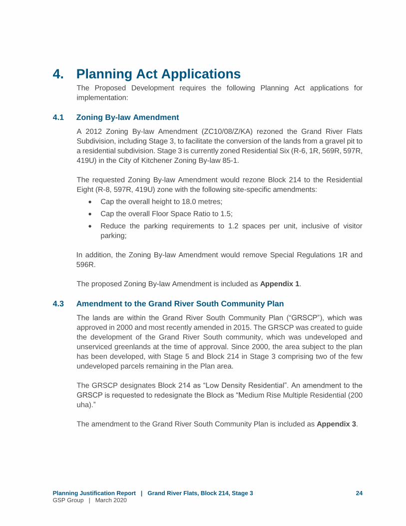
Accordingly, the Owner is seeking an Official Plan and Zoning By-law Amendment to
facilitate the development of Block 214 with four 5 storey apartment buildings with one
floor of at grade parking in each (for a total height of 5 storeys) and four 1 storey
townhouse blocks along the face of each apartment building along Fairway Road. (Figure
4A-D). Block 214 is currently Draft Plan approved for 162 multiple residential units.
The Block will be condominium in form with private waste collection and private outdoor
amenity space.
The proposed development is described in greater detail below.
3.1 Design and Integration
The proposed development is oriented towards Fairway Road with all buildings and units
facing Fairway, creating an active streetscape along Fairway while providing a 25 metre
separation between the new buildings and the existing single detached dwellings on
Rivertrail Avenue. A surface parking area and children’s play area are located between
Rivertrail Avenue and the rear wall of the apartment buildings.
One storey townhomes are attached to the south building face of the apartments, creating
an active streetscape along Fairway Road and transitioning the height to create a softer
Planning Justification Report | Grand River Flats, Block 214, Stage 3 15
GSP Group | March 2020
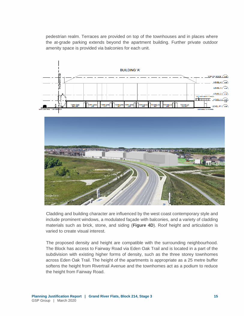
pedestrian realm. Terraces are provided on top of the townhouses and in places where
the at-grade parking extends beyond the apartment building. Further private outdoor
amenity space is provided via balconies for each unit.
Cladding and building character are influenced by the west coast contemporary style and
include prominent windows, a modulated façade with balconies, and a variety of cladding
materials such as brick, stone, and siding (Figure 4D). Roof height and articulation is
varied to create visual interest.
The proposed density and height are compatible with the surrounding neighbourhood.
The Block has access to Fairway Road via Eden Oak Trail and is located in a part of the
subdivision with existing higher forms of density, such as the three storey townhomes
across Eden Oak Trail. The height of the apartments is appropriate as a 25 metre buffer
softens the height from Rivertrail Avenue and the townhomes act as a podium to reduce
the height from Fairway Road.

EDEN
OAK TR
AIL
FAIRWAY ROAD NORTH
EXIT
CO
RRID
OR
EXIT
CO
RRID
OR
EXIT
CO
RRID
OR
EXIT
CO
RRID
OR
EXIT
CO
RRID
OR
EXIT
CO
RRID
OR
EXIT
CO
RRID
OR
EXIT
CO
RRID
OR
BUILDING 'F'1 STOREYTOWNHOUSES9 UNITSBUILDING 'G'
1 STOREY
TOWNHOUSES
9 UNITS
BUILDING 'H'
1 STOREY
TOWNHOUSES
9 UNITS
BUILDING 'E'1 STOREY
TOWNHOUSES9 UNITS
SIDEWALKSIDEWALK
BUILDING 'A'
PROPOSED
4 STOREY
RESIDENTIAL BUILDING
79 UNITS
BUILDING 'B'
PROPOSED
4 STOREY
RESIDENTIAL BUILDING
79 UNITS
BUILDING 'C'PROPOSED4 STOREYRESIDENTIAL BUILDING79 UNITS
BUILDING 'D'PROPOSED4 STOREY
RESIDENTIAL BUILDING79 UNITS
70000
70000
70000
70000
2100
0
2100
0
2 1000
21000
12210
12445
9500
6500
6500
9500
6500
LANDSCAPE
LANDSCAPE
LANDSCAPE
104506500
10450
9500
104509500
10450
9500
CHILDREN'S
PLAY AREA
N
SITE PLAN
EXPLORER'S WALK
PROPOSED RESIDENTIAL DEVELOPMENT | KITCHENER, ONVANMAR
JUNE 11, 201919-032
Block 214 Site PlanSource: Kirkor Architects + Planners (June 11, 2019)
Planning Justification Report | Grand River Flats, Stage 3GSP Group | March 2020
Figure
4a

EDEN
OAK TR
AIL
FAIRWAY ROAD NORTH
6000
5500
7300
5500
6000
6450
7300
5500
10450
6500
12006500
65006500
65006500
12006500
10450
7300
LOADING4500 13000
LINE
OF
BUIL
DING
ABO
VE
LINE
OF
BUIL
DING
ABO
VE
LINE
OF
B UIL
D ING
ABO
VE
L INE
OF
BUILD
ING
ABO
VE
7.3M WIDE DRIVE AISLE
7.3M WIDE DRIVE AISLE
7.3M WIDE DRIVE AISLE
7.3M WIDE DRIVE AISLE
9500
GARBAGE ROOM
GARBAGE ROOM
GARBAGE ROOM
GARBAGE ROOM
EXIT
CO
RRID
OR
EXIT
CO
RRID
OR
EXIT
CO
RRID
OR
EXIT
CO
RRID
OR
EXIT
CO
RRID
OR
EXIT
CO
RRID
OR
EXIT
CO
RRID
OR
EXIT
CO
RRID
OR
7.3M
WID
E DR
IVE
AISL
E
7.3M
WID
E DR
IVE
AISL
E
TOTAL PARKING SPACES = 352 SPACES
LANDSCAPE
CHILDREN'S
PLAY AREA
LOBBY
ELEVATORLOBBY
ELEVATOR
LOBBY
ELEVATOR
LOBBY
ELEVATOR
7.3M WIDE DRIVE AISLE
104506500
12006500
6500 65006500
6500
12006500
10450
9500
10450 65001200
6500 6500 6500 6500 6500 12006500 10450
9500
10450
6500 12006500
65006500
65006500 1200
6500
10450
9500
1054
5
7.3M
WID
E D
RIV
E AI
SLE
3895
4500
7745
4025
4945
21 20
3365
5170
1386
5
6000
10320
9640
9420
11040
6430
6635
4000
4000
4000
4000
6000
6750
6950
6905
12800
9450
12800
945012800
9450
12800
9450
6450
7150
7150
6450
7150
2600
5500
2600
5500
2600
5500
5500
2600
N
PARKING AT GRADE
EXPLORER'S WALK
PROPOSED RESIDENTIAL DEVELOPMENT | KITCHENER, ONVANMAR
JUNE 11, 201919-032
Block 214 Parking PlanSource: Kirkor Architects + Planners (June 11, 2019)
Planning Justification Report | Grand River Flats, Stage 3GSP Group | March 2020
Figure
4b

LEVEL 1 0.000.00
LEVEL 2 3.103.10
LEVEL P1 -3.60-3.60
LEVEL 3 6.206.20
LEVEL 4 9.309.303100
3100
3100
3100
3600TOWNHOUSE UNITLOWER LEVEL LOBBY
BUILDING 'A'PARKING AT GRADE EXIT STAIR
CORRIDOR
BUILDING 'A'
PRO
PER
TY L
INE
PRO
PER
TY L
INE
UNCOVEREDPARKING
AT GRADE
7.3M WIDEDRIVE AISLE
UNCOVEREDPARKING
AT GRADE
2.0M SIDEWALK FAIRWAY ROAD NORTH
TOP OF ROOF 12.4012.40
BUILDING 'H'
BUILDING SECTION - A
EXPLORER'S WALK
PROPOSED RESIDENTIAL DEVELOPMENT | KITCHENER, ONVANMAR
JUNE 11, 201919-032
LEVEL 1 0.000.00
LEVEL 2 3.103.10
LEVEL P1 -3.60-3.60
LEVEL 3 6.206.20
LEVEL 4 9.309.30
TOWNHOUSEEND UNIT
BUILDING 'A'
TOWNHOUSEUNIT
TOWNHOUSEEND UNIT
OUTDOOR AMENITY SPACE
TOP OF ROOF 12.4012.40
1.8M SIDEWALKEDEN OAK TRAIL ENTRANCE TO PARKING
PRO
PER
TY L
INE
TOWNHOUSEUNIT
TOWNHOUSEUNIT
TOWNHOUSEUNIT
TOWNHOUSEUNIT
TOWNHOUSEUNIT
TOWNHOUSEUNIT
BUILDING SECTION - B
EXPLORER'S WALK
PROPOSED RESIDENTIAL DEVELOPMENT | KITCHENER, ONVANMAR
JUNE 11, 201919-032
Building SectionsSource: Kirkor Architects + Planners (June 11, 2019)
Planning Justification Report | Grand River Flats, Stage 3GSP Group | March 2020
Figure
4c
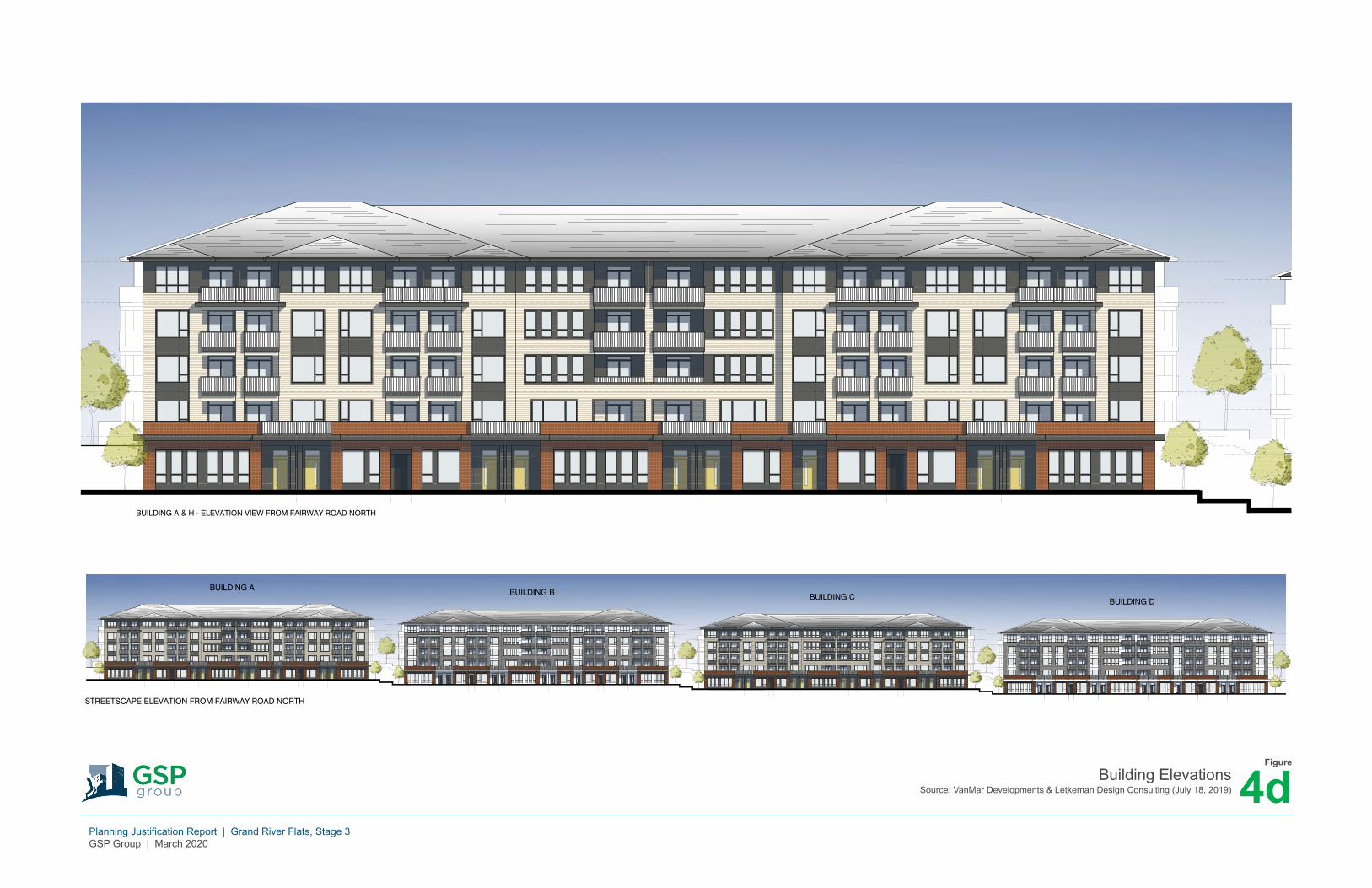
LETKEMANDESIGNCONSULTING
ELEVATION STUDIES
07.18.2019PROPOSED MULTI-FAMILY DEVELOPMENTEXPLORER'S WALK KITCHENER, ONT. A01
CHARACTER REFERENCES - WEST COAST CONTEMPORARY STYLE
BUILDING A & H - ELEVATION VIEW FROM FAIRWAY ROAD NORTH
LETKEMANDESIGNCONSULTING
ELEVATION STUDIES
07.18.2019PROPOSED MULTI-FAMILY DEVELOPMENTEXPLORER'S WALK KITCHENER, ONT. A02
STREETSCAPE ELEVATION FROM FAIRWAY ROAD NORTH
BUILDING A BUILDING B BUILDING C BUILDING D
COLOUR SCHEME NO. 1 COLOUR SCHEME NO. 2
Building ElevationsSource: VanMar Developments & Letkeman Design Consulting (July 18, 2019)
Planning Justification Report | Grand River Flats, Stage 3GSP Group | March 2020
Figure
4d

Planning Justification Report | Grand River Flats, Block 214, Stage 3 20
GSP Group | March 2020
The impacts of increased traffic, servicing, and other technical considerations are
addressed in separate reports and are summarized in Section 5 of this Report. An Urban
Design Brief has been prepared by GSP in support of the application and provides a
detailed description of the proposed development. The Report provides a spatial
assessment of the physical context of the Site, a description of the design elements of the
proposed development, model views of the development, an overview of the relevant
urban design policies and regulations, and an update to the Urban Design Guidelines.
3.2 Unit Configuration
The proposed unit configuration is as follows:
Number of Units Number of Storeys GFA (m2)
Apartment A 79 5 22,275
Apartment B 79 5 22,275
Apartment C 79 5 22,275
Apartment D 79 5 22,275
All Apartments 316 89,100
Townhome
Building E
9 1 2,545
Townhome
Building F
9 1 2,545
Townhome
Building G
9 1 2,545
Townhome
Building H
9 1 2,545
All Townhomes 36 10,180
Total 352 99,280
Note that the GFA for the parking areas within the buildings are not included in the above
and that the numbers above are subject to change during the detailed design process.
One ground floor unit is proposed to be utilized for convenience retail and personal
services. The unit will be configured to convert to residential if commercial uses are not
feasible. Signage and other details will be addressed during Site Plan Approval.
3.3 Access, Parking, and Loading
The proposed development will be accessed via two connections to Rivertrail Avenue and
one connection to Eden Oak Trail. An internal driveway network provides internal
circulation and connects the multiple access points and parking areas.

Planning Justification Report | Grand River Flats, Block 214, Stage 3 21
GSP Group | March 2020
Pedestrian access is provided via the surrounding sidewalk and trail network. Connections
are provided to the sidewalk along Fairway Road, Eden Oak Trail, and Rivertrail Avenue
as well as the trails along the stormwater management pond to the east of the Block. The
Walter Bean Trail is accessible from the sidewalk along Fairway Road near the stormwater
management pond.
1.05 parking spaces is provided for each unit, plus 0.15 parking spaces per unit for visitors,
for a total of 1.2 spaces per unit. 423 parking spaces are required for the proposed 352
units. Parking is provided at grade in a combination of outdoor surface parking and interior
parking within the first floor of the four apartment buildings. In accordance with the current
zoning and Source Water Protection policies of the Regional Official Plan, underground
parking is not permitted in this area to protect drinking water. A Parking Justification Study
has been prepared to examine the proposed reduced parking rate and is summarized in
Section 5.5 of this Report.
Access to the rear parking area is provided for townhome residents via internal corridors
through the first floor of the apartment buildings. Stairwells and elevators will provide
access to the apartments above.
One loading area is located between the surface parking area and Rivertrail Avenue. A
waste collection room is within the enclosed parking area of each apartment building and
will be collected by a private contractor arranged by the condominium board.
3.4 Public and Active Transit
The Grand River Flats neighbourhood is serviced by Grand River Transit bus route 23
(“Idlewood”), which travels along Fairway Road and Zeller Drive. Route 23 connects to
the Stanley Park Mall and the Fairway Mall, providing connections to other transit routes
and the Ion Light Rail and Ion Bus systems.
Active transit is provided via connections to the surrounding sidewalk network and the
Walter Bean Trail, including a connection via a walkway block in Stage 5. The Walter Bean
Trail provides continuous access to the Grand River watershed through Waterloo,
Kitchener, Cambridge, Woolwich, and North Dumfries and is accessible year-round.
3.5 Amenity Space
A 445 square metre children’s play area is proposed at the rear of Building A and B. The
play area is visible from Fairway Road, Eden Oak Trail, and Rivertrail Avenue and is
connected to the sidewalk along Fairway via a sidewalk. Additional outdoor amenity space

Planning Justification Report | Grand River Flats, Block 214, Stage 3 22
GSP Group | March 2020
is included between each apartment building on the second floor, above a portion of the
first floor parking that extends beyond the building face of each apartment. Each
apartment unit includes a balcony for private outdoor amenity space for apartment
residents.
Public parkland dedication for the subdivision has been provided through previous stages
in the Grand River Flats development.
3.6 Servicing and Stormwater Management
WalterFedy prepared a Functional Servicing and Stormwater Management Report in
support of the proposed development (summarized in Section 5.2 of this Report). The
Report determines that the development can be adequately serviced by municipal water
and sewage services. The existing stormwater management pond accounted for
development of all of Stage 3 at an impervious rate of 71% and the proposed development
will have a lower impervious rate.
3.7 Sustainability
A Sustainability Statement was prepared as part of the Urban Design Brief. The Proposed
Development will be comprised of modern buildings designed and built with environmental
and operational efficiency as a priority. At a macro level, the Proposed Development is
sustainable as it intensifies underutilized portions of the Site in a prominent location. It
promotes walkability by proximity to the Walter Bean Trail and access to the local bus
network.
Specific sustainability features will be defined at the detailed design stage. Some
examples of potential features include:
Centralized HVAC system with programmable thermostats;
Occupancy sensors for common area lighting;
LED interior and exterior lighting, with daylight sensors for building exteriors;
Priority given to light coloured roofs where possible;
Low consumption fixtures in accordance or exceeding the Building Code;
Sensor activated faucets, soap dispensers and hand dryers;
Durable construction materials;
Bird friendly design and dark sky compliance through the use of down lights only
for exterior illumination;
Robust recycling and waste management plans;
Provision for of electric-vehicle parking charging stations;

Planning Justification Report | Grand River Flats, Block 214, Stage 3 23
GSP Group | March 2020
Priority to native and perennial plantings to reduce water and maintenance
requirements;
All plantings will be salt and drought tolerant;
Permeable unit pavers in certain areas;
All parking islands, areas adjacent to driveways, and pedestrian entrances and
walkways will include trees;
Outdoor and indoor bike storage, locker room and shower facilities where
feasible;
Carpool and carshare parking spaces;
Parking provided at minimum required rate to promote walking, cycling and
bus/light rail use; and,
Provision of stormwater infiltration surfaces and enhanced management
systems.
Planning Justification Report | Grand River Flats, Block 214, Stage 3 24
GSP Group | March 2020
4. Planning Act Applications The Proposed Development requires the following Planning Act applications for
implementation:
4.1 Zoning By-law Amendment
A 2012 Zoning By-law Amendment (ZC10/08/Z/KA) rezoned the Grand River Flats
Subdivision, including Stage 3, to facilitate the conversion of the lands from a gravel pit to
a residential subdivision. Stage 3 is currently zoned Residential Six (R-6, 1R, 569R, 597R,
419U) in the City of Kitchener Zoning By-law 85-1.
The requested Zoning By-law Amendment would rezone Block 214 to the Residential
Eight (R-8, 597R, 419U) zone with the following site-specific amendments:
Cap the overall height to 18.0 metres;
Cap the overall Floor Space Ratio to 1.5;
Reduce the parking requirements to 1.2 spaces per unit, inclusive of visitor
parking;
In addition, the Zoning By-law Amendment would remove Special Regulations 1R and
596R.
The proposed Zoning By-law Amendment is included as Appendix 1.
4.3 Amendment to the Grand River South Community Plan
The lands are within the Grand River South Community Plan (“GRSCP”), which was
approved in 2000 and most recently amended in 2015. The GRSCP was created to guide
the development of the Grand River South community, which was undeveloped and
unserviced greenlands at the time of approval. Since 2000, the area subject to the plan
has been developed, with Stage 5 and Block 214 in Stage 3 comprising two of the few
undeveloped parcels remaining in the Plan area.
The GRSCP designates Block 214 as “Low Density Residential”. An amendment to the
GRSCP is requested to redesignate the Block as “Medium Rise Multiple Residential (200
uha).”
The amendment to the Grand River South Community Plan is included as Appendix 3.
Planning Justification Report | Grand River Flats, Block 214, Stage 3 25
GSP Group | March 2020
4.4 Public Engagement Strategy
The applications require a Statutory Public Meeting in accordance with the Planning Act
R.S.O. 1990, c. P.13. The Applicant is proposing to utilize the public process provided in
the Planning Act. In accordance with Sections 17(15), 17(17), 17(19), 17(21), 34(12) and
34 (13) of the Planning Act, the City of Kitchener provides public notice of the applications
in the prescribed manner and holds a Statutory Public Meeting as part of a regularly
scheduled Council Meeting. Any individuals or property owners that request further
notification regarding the applications would be formally notified by the City as to the time
and location when City Council will be considering the applications. GSP Group and
project team will attend the Public Meeting and will give a formal presentation on the
Proposed Development and the requested amendments as well as answer questions from
residents, staff, and Councillors. During the Meeting, contact information for GSP Group
will be provided to the public to address any follow up questions or concerns.
Planning Justification Report | Grand River Flats, Block 214, Stage 3 26
GSP Group | March 2020
5. Technical Studies
The following studies have been prepared in support of the applications. For further
details, please consult the full reports.
5.1 Heritage Impact Assessment (2010)
A Heritage Impact Assessment (“HIA”) was prepared by The Landplan Collaborative Ltd.
in support of the original Draft Plan of Subdivision and was most recently amended on
February 12, 2010. The HIA was required to address the interface between the Grand
River, a Canadian Heritage River, and the Grand River Flats subdivision.
The HIA determined that the significance of the Grand River would be preserved and
honoured through the provision of visual and physical access to the river floodplain
through parkland blocks. This was incorporated into the design of the subdivision and is
maintained in Stage 5 through the proposed park, which maintains views of the floodplain,
and the walkway block that provides physical access to the river via the Walter Bean Trail.
As the proposed applications continue to implement the HIA, City staff noted that a revised
HIA is not required.
5.2 Functional Servicing Report
WalterFedy prepared a Functional Servicing Report to assess how the proposed
development will be serviced. As the block is part of a registered plan, the stormwater
servicing for the block has already been accounted for in the overall design of the
subdivision and existing services are available within the surrounding right-of-ways.
Existing services include a hickenbottom (vertical drain) installed in the low point of the
block that conveys the majority of stormwater from the block towards a 675 mm storm
sewer within the block. Stormwater from then directed to a manhole and 900 mm storm
sewer on Rivertrail Avenue, and from there drains into the stormwater management pond
east of the block. The remaining stormwater from the block is currently directed via runoff
directly to the stormwater management facility east of the block. A 200 mm sanitary stub
and a 150 mm watermain stub are provided at the property line off Rivertrail Avenue.
Additional services are available on Eden Oak Trail, however, the storm and sanitary
services on Eden Oak Trail are not sized to accept discharge from the block.
The report concludes that the proposed development can be fully serviced. The existing
sanitary sewer on Rivertrail Avenue is sufficient to convey sanitary flows, however, an
additional manhole close to the property line is required to maintain an appropriate full

Planning Justification Report | Grand River Flats, Block 214, Stage 3 27
GSP Group | March 2020
flow velocity. Water services will be provided via the watermain on Eden Oak Trail and
will meet domestic and fire flow requirements. As the watermain on Rivertrail Avenue is
not required, it will be decommissioned and removed back to the main. Stormwater will
continue to be conveyed towards the storm sewer on Rivertrail Avenue that outlets into
the stormwater management pond east of the block. Stormwater for the block was
designed at an impervious rate of 80%, while the proposed development has an
impervious rate of 71%. As long as the rate doesn’t exceed 80%, no stormwater quality
or quantity control is required.
Perimeter silt fences, silt fences at the base of stockpiles, filter fabric over storm and
sanitary structures, and construction entrance mud mats can provide erosion and
sediment control. These features will be designed during the detailed design process.
5.3 Urban Design Brief
An Urban Design Brief has been prepared by GSP in support of the application and
provides a detailed description of the proposed development. The Brief provides a spatial
assessment of the physical context of the Site, a description of the design elements of the
proposed development, model views of the development, an overview of the relevant
urban design policies and regulations, an update to the Urban Design Guidelines, and
sustainability.
The Brief concludes that the proposed development is compatible with the surrounding
neighbourhood in terms of site design, massing and scale, and architectural style.
5.4 Environmental Noise Study
A Noise Feasibility Study was prepared by HGC Engineering to assess potential noise
impacts of the Region of Waterloo International Airport and road traffic on Fairway Road
on the Proposed Development.
A site visit in February 2020 concluded that the significant noise generators in proximity
to the Site is the airport and road traffic on Fairway Road. The Noise Exposure Forecast
/ Noise Exposure Projection (“NEF” or “NEP”) information that predicts airport noise
generation was obtained from the Region of Waterloo Airport Master Plan, using the 2000
Noise Contour Plans. These projections were combined with the guidelines of the Ministry
of the Environment, Conservation and Parks (“MECP”), the Region of Waterloo, and the
City of Kitchener. The Study determined that the Site is within the 25-30 NEF.
Road traffic forecasts were obtained from the Region of Waterloo. Traffic forecasts were
imputing into a computer algorithm that generates a corresponding noise value. Worst

Planning Justification Report | Grand River Flats, Block 214, Stage 3 28
GSP Group | March 2020
case scenarios were used to assess noise forecasts. Balconies that are 4m or less in
depth are not considered outdoor living areas under MECP guidelines and are exempt
from traffic noise assessment.
Noise levels will exceed MECP guidelines for all dwelling units due to proximity to the
airport and traffic on Fairway Road. Accordingly, the following noise mitigation is
recommended:
Central air conditioning is required.
Building components including windows, doors, walls, and ceiling/roof must be
designed to achieve indoor sound criteria.
o Windows must meet an Acoustic Insulation Factor (“AIF”) of 28 is required
for living and dining rooms as well as bedrooms.
o Exterior walls must be brick or masonry.
o Exterior doors must be insulated metal.
o Sloped roofs with ventilated attics are recommended above noise sensitive
rooms. Cathedral ceilings or vaulted ceilings are not recommended.
o An acoustical consultant should review detailed floor plans prior to
construction.
The following warning clauses regarding noise are required for property and
tenancy agreements:
o Purchasers/tenants are advised that sound levels due to increasing road
and air traffic may on occasion interfere with some activities of the dwelling
occupants as the sound levels exceed the sound level limits of the
Municipality and the Ministry of the Environment, Conservation and Parks.
o This dwelling unit has been supplied with a central air conditioning system
which will allow windows and exterior doors to remain closed, thereby
ensuring that the indoor sound levels are within the sound level limits of
the Municipality and the Ministry of the Environment, Conservation and
Parks.
To ensure the above mitigation measures are implemented, HGC recommends that an
acoustical consultant review building plans and that the noise control measures have
been properly incorporated prior to the issuance of building permits. Prior to assumption,
the building inspector or an engineer qualified to perform acoustical engineering services
in Ontario should certify that the noise control measures have been properly installed and
constructed.

Planning Justification Report | Grand River Flats, Block 214, Stage 3 29
GSP Group | March 2020
5.5 Parking Review and Justification Study
Salvini Consulting prepared a Parking Review and Justification Study to examine if the
proposed reduction to 1.05 spaces per unit for residents and 0.15 spaces per unit for
visitors is parking is adequate. The Study notes that the current City of Kitchener Zoning
By-law requires 1.5 parking spaces per unit including 20% for visitors and the proposed
Zoning By-law requires 1.0 spaces per unit for residents and 0.1 spaces per unit for
visitors.
Parking data collected by Salvini Consulting for five suburban townhome developments
in Kitchener was used to estimate parking demand for the Proposed Development. The
townhomes have similar transportation contexts. The data revealed an average parking
demand of 1.04 spaces per unit during the week and 1.00 spaces per unit during the
weekend. The maximum observed parking demand was 1.12 spaces per unit during the
week and 1.13 spaces per unit during the weekend. These rates include visitor parking.
The parking data supports the City’s proposed parking reduction in the new Zoning By-
law and supports a reduction to 1.2 spaces / unit, inclusive of visitor parking.
The Study assessed public transit and active transportation options in proximity to the
Site. There is a bus stop at the intersection of Fairway Road and Old Zeller Drive / Wolner
Trail approximately 300 metres from the Site that access Grand River Transit Route 23
that provides access to the LRT. Fairway Road has bicycle lanes and sidewalks on both
sides and connections to the Walter Bean Trail.
The Review concludes that the proposed reduction in parking is justified based on
comparable parking data, active transit opportunities, proximity to public transit, and the
City’s recently reduced parking standards in the new Zoning By-law.

Planning Justification Report | Grand River Flats, Block 214, Stage 3 30
GSP Group | March 2020
6. Planning Overview and Analysis
The following section sets out the relevant planning policy framework to assess the
appropriateness of the applications considering Provincial, Regional, and City policies.
6.1 Planning Act
6.1.1 Matters of Provincial Interest
The Planning Act R.S.O. 1990, c. P.13 (“Planning Act”) establishes the policy-led land use
planning system for Ontario that outlines matters of provincial interest as part of municipal
planning decisions and provides for statutory planning processes in Ontario. Section 2 of
the Planning Act identifies those matters of provincial interest which a municipality must
“have regard to” in carrying out its responsibility under the Planning Act. These matters
are general in nature and broad in range. These matters are addressed in more detail
through the policy statements and provincial plans issued under the Section 3 of the
Planning Act and through the official plans of the Region of Waterloo and City of Kitchener,
as outlined in the following sections.
6.1.2 Policy Statements and Plans
Section 3(5) of the Planning Act requires that the decisions of municipal councils regarding
the exercise of authority concerning planning matters “shall be consistent with the policy
statements issued under subsection (1) that are in effect on the date of the decision” and
“shall conform with the provincial plans that are in effect on that date, or shall not conflict
with them, as the case may be". For the subject site and proposed applications:
o The 2020 Provincial Policy Statement, 2017 Growth Plan for the Greater Golden
Horseshoe and the Grand River Source Water Protection Plan are applicable and
relevant to the consideration of the proposed applications per Section 3(5) of the
Planning Act. These are addressed in Sections 6.2, 6.3 and 6.4, respectively, of
this Report.
o The 2017 Greenbelt Plan, 2017 Oak Ridges Moraine Conservation Plan, and 2017
Niagara Escarpment Plan are provincial plans per Section 3(5) of the Planning Act;
however, Waterloo Region is outside the geographic extent of these plans.
o “The Big Move” is a policy statement issued under section 31.1 of the Metrolinx
Act, 2006 per Section 3(5) of the Planning Act; however, Waterloo Region is
outside of the geographic extent of this plan.
o There have been no policy statements issued under Section 11 of the Resource
Recovery and Circular Economy Act, 2016, per Section 3(8) of the Planning Act.

Planning Justification Report | Grand River Flats, Block 214, Stage 3 31
GSP Group | March 2020
6.1.3 Criteria for Subdivisions
Section 51(24) of the Planning Act identifies a municipality’s consideration of a draft plan
of subdivision shall have regard to “the health, safety, convenience, accessibility for
persons with disabilities and welfare of the present and future inhabitants”, as well more
specific criteria. These matters are captured in more detail through the policy statements
and provincial plans issued under the Section 3 of the Planning Act and through the official
plans of the Region of Waterloo and City of Kitchener, which are reflected in Sections 6.2
through 6.5 below of this Planning Justification Report.
6.2 Provincial Policy Statement
The Provincial Policy Statement (“PPS”) provides land use planning policy on matters of
provincial interest. The 2020 PPS has received royal assent and will be in effect on May
1, 2020. The overriding vision of the PPS states that “the long-term prosperity and social
well-being of Ontario depends upon planning for strong, sustainable and resilient
communities for people of all ages, a clean and healthy environment, and a strong and
competitive economy”. The below sub-sections address the relevant PPS policies
concerning the site and the proposed applications and assess the consistency of the latter
with these policies.
6.2.1 Community Design
Section 1.1.1 of the PPS seeks the establishment of “healthy, livable, and safe
communities” through:
a) promoting efficient development and land use patterns which sustain the financial
well-being of the Province and municipalities over the long term;
b) accommodating an appropriate, affordable and market-based range and mix of
residential types (including single-detached, additional residential units, multi-unit
housing, affordable housing and housing for older persons), employment
(including industrial and commercial), institutional (including places of worship,
cemeteries and long-term care homes), recreation, park and open space, and
other uses to meet long-term needs;
c) avoiding development and land use patterns which may cause environmental or
public health and safety concerns; …
e) promoting the integration of land use planning, growth management, transit-
supportive development, intensification and infrastructure planning to achieve
cost-effective development patterns, optimization of transit investments, and
standards to minimize land consumption and servicing costs; …
h) promoting development and land use patterns that conserve biodiversity and
consider the impacts of a changing climate.

Planning Justification Report | Grand River Flats, Block 214, Stage 3 32
GSP Group | March 2020
Consistency: The proposed applications are consistent with Section 1.1.1 of the PPS in
that the proposed development would assist in establishing a healthy, livable and safe
community as part of the Grand River South neighbourhood and the broader Kitchener
context. In respect to the above policies, the proposed development:
1. Has an efficient, compact layout and that can be serviced efficiently.
2. Provides a mix of housing types and densities to meet housing needs.
3. Includes a private children’s play area and connections to the surrounding public
recreation infrastructure including parks and trails.
4. All buildings and the park are positioned outside of the floodplain, which was
recently surveyed to consider the impacts of changing topography and a changing
climate on the flood elevation.
6.2.2 Settlement Area Land Use Patterns
Section 1.1.3.2a) of the PPS directs that land use patterns in settlement areas are to be
based on densities and a mix of land uses which:
a) efficiently use land and resources;
b) are appropriate for, and efficiently use, the infrastructure and public service
facilities which are planned or available, and avoid the need for their unjustified
and/or uneconomical expansion;
c) minimize negative impacts to air quality and climate change, and promote energy
efficiency; …
e) support active transportation;
f) are transit-supportive, where transit is planned, exists or may be developed; …
Consistency: The proposed applications are consistent with Section 1.1.3.2 a) of the
PPS as the proposed development promotes a compact addition to the surrounding
neighbourhood. In respect to the above policies, the proposed development:
1. Is compact and efficiently utilizes the site.
2. Will be served by municipal services which can accommodate the proposed
development per WalterFedy’s Functional Servicing Report.
3. Proximity to transit and connections to active transportation routes lessen the need
for travel by automobile, thereby reducing air quality impacts.
4. Includes sidewalks on both sides of all new public streets and connections to the
Walter Bean Trail to support active transportation through the phase.
5. Is served by a bus route on Zeller Drive that will support the use of public transit
by residents, employees and visitors, lessening the needs for travel by automobile.
Planning Justification Report | Grand River Flats, Block 214, Stage 3 33
GSP Group | March 2020
6.2.3 Intensification and Compact Form
Section 1.1.3.4 of the PPS directs the promotion of appropriate development standards
“which facilitate intensification, redevelopment and compact form, while avoiding or
mitigating risks to public health and safety”. Further, Section 1.1.3.6 identifies that new
development in designated growth areas “should occur adjacent to the existing built-up
area and shall have a compact form, mix of uses and densities that allow for the efficient
use of land, infrastructure and public service facilities”.
Consistency: The proposed applications are consistent with Sections 1.1.3.4 and 1.1.3.6
of the PPS in that the development:
1. Will be of compact form and is of an appropriate density to efficiently utilize land,
infrastructure, and public services.
2. All buildings and the park are positioned outside of the floodplain, protecting public
health and safety.
6.2.4 Housing Mix and Densities
Section 1.4.3 of the PPS directs that planning authorities are to provide for an appropriate
range and mix of housing types and densities to meet projected requirements by:
b) permitting and facilitating:
1. all housing options required to meet the social, health and wellbeing
requirements of current and future residents, including special needs
requirements; and
2. all forms of residential intensification, including second units, and
redevelopment in accordance with policy 1.1.3.3;
c) directing the development of new housing towards locations where appropriate
levels of infrastructure and public service facilities are or will be available to
support current and projected needs;
d) promoting densities for new housing which efficiently use land, resources,
infrastructure and public service facilities, and support the use of active
transportation and transit in areas where it exists or is to be developed; and
e) establishing development standards for residential intensification, redevelopment
and new residential development which minimize the cost of housing and facilitate
compact form, while maintaining appropriate levels of public health and safety.
Consistency: The proposed applications are consistent with Section 1.4.3 of the PPS as
the proposed development would contribute to the provision of a mix of housing stock. In
respect to the above policies, the proposed development:
Planning Justification Report | Grand River Flats, Block 214, Stage 3 34
GSP Group | March 2020
1. Includes a mix of townhomes and apartment-style condominium units in a variety
of sizes.
2. Will be serviced through municipal infrastructure and has several public schools
and community facilities within the surrounding neighbourhood. Public and active
transit is available.
3. Provides a total net residential density of 43.6 units per hectare between Stage 5
and Block 214 of Stage 3.
4. Promotes active transportation through connections to the surrounding sidewalk
network.
5. Includes appropriate zoning regulations that facilitate a compact urban form.
6.2.5 Recreation and Open Spaces
Section 1.5.1 of the PPS directs that healthy, active communities should be promoted by,
among other matters, “planning for safe public streets and spaces that meet the needs of
pedestrians, foster social interaction and facilitate active transportation and community
connectivity” as well as “planning and providing for a full range and equitable distribution
of publicly-accessible built and natural settings for recreation, including parks, open
spaces, and trails”.
Consistency: The proposed applications are consistent with Section 1.5.1. of the PPS.
As discussed in the Urban Design Brief, the proposed development is well connected to
the surrounding active transportation network and the height, scale, and orientation of the
buildings foster a pedestrian-friendly streetscape along Fairway Road. Public parks have
been provided within the Grand River Flats subdivision in previous stages and an
additional 2.05 hectare park is planned in the Stage 5 lands.
6.2.6 Stormwater Management
Section 1.6.6.7 of the PPS identifies that stormwater management planning shall:
a) minimize, or, where possible, prevent increases in contaminant loads;
b) minimize changes in water balance and erosion;
c) not increase risks to human health and safety and property damage;
d) maximize the extent and function of vegetative and pervious surfaces; and
e) promote stormwater management best practices, including stormwater
attenuation and re-use, and low impact development.
Consistency: The proposed applications are consistent with Section 1.6.6.7 of the PPS
in that the proposed development incorporates a series of stormwater management
strategies and retention measures that maximize infiltration and minimize run-off. The

Planning Justification Report | Grand River Flats, Block 214, Stage 3 35
GSP Group | March 2020
Functional Servicing Report by WalterFedy determined that the existing storm sewer stub
is sufficient to convey runoff from the block towards the existing storm sewer on Rivertrail
Avenue, which outlets into the existing stormwater management pond to the east of the
block.
6.2.7 Transportation
Section 1.6.7.1 of the PPS seeks transportation systems that are “safe, energy efficient,
facilitate the movement of people and goods, and are appropriate to address projected
needs”. Section 1.6.7.4 promotes land use patterns, densities and mixes of uses that
“minimize the length and number of vehicle trips and support current and future use of
transit and active transportation”.
Consistency: The proposed applications are consistent with Sections 1.6.7.1 and 1.6.7.4
of the PPS in that the proposed development is within walking distance of a bus route and
has a street pattern that provides safe and efficient travel. The block’s connections to the
surrounding sidewalk and active transportation network, as well as proximity to schools
and recreation, will provide an opportunity for reduced dependence on travel by
automobile.
6.2.8 Sustainability
Section 1.8.1 of the PPS provides direction for environmental sustainability through land
use and development patterns which:
a) promote compact form and a structure of nodes and corridors;
b) promote the use of active transportation and transit in and between residential,
employment (including commercial and industrial) and institutional uses and other
areas; …
e) improve the mix of employment and housing uses to shorten commute journeys
and decrease transportation congestion;
f) promote design and orientation which:
1. maximizes energy efficiency and conservation, and considers the mitigating
effects of vegetation; and
2. maximizes opportunities for the use of renewable energy systems and
alternative energy systems; and
g) maximize vegetation within settlement areas, where feasible.
Consistency: The proposed applications are consistent with Section 1.8.1 of the PPS.
The phase is located within the Urban Boundary of the City of Kitchener and is connected
to the local road, active transportation, and transit system, providing access to
surrounding land uses and shortening commutes. The block is compact in form and
designed to maximize sustainability.

Planning Justification Report | Grand River Flats, Block 214, Stage 3 36
GSP Group | March 2020
6.2.9 Airports
The Grand River Flats subdivision is partially affected by the Noise Exposure Forecast
(“NEF”) associated with the Region of Waterloo International Airport. The NEF contours
forecast noise generated by aircraft associated with the airport. Section 1.6.9 of the PPS
requires the long-term operation and economic role of airports to be protected from
incompatible land uses by prohibiting sensitive land uses in areas near airports above 30
NEF.
Consistency: The proposed applications are consistent with Section 1.6.9 of the PPS.
The block is beyond the 30 NEF contour, protecting the long term operation of the airport
while ensuring residents are protected from excessive noise. As required in the conditions
of draft plan approval, all leases and agreements of purchase and sale for lots/units within
the subdivision will have a notice advising renters/purchasers of noise associated with the
airport, and all units will have air conditioning to assist with noise management during the
summer.
6.3 Growth Plan for the Greater Golden Horseshoe
The Growth Plan for the Greater Golden Horseshoe (the “Growth Plan”) is the Province’s
growth strategy for the Greater Golden Horseshoe region. The Growth Plan builds on the
PPS’s foundation with more specific land use planning policies as “a framework for
implementing the Government of Ontario’s vision for building stronger, more prosperous
communities by managing growth in the region to 2031”. The Growth Plan came into effect
on May 16, 2019, replacing the previous 2017 Growth Plan. The below sub-sections
address the relevant Growth Plan policies concerning the site and the proposed
applications and assess the conformity of the latter with these policies.
6.3.1 Growth Management
Section 2.2.1 of the Growth Plan outlines the growth management policies for Ontario.
Section 2.2.1.2a) directs that most growth will be directed to settlement areas that have
delineated boundaries, have existing or planned water and wastewater systems, and can
support achieving complete communities. Within Settlement Areas, Section 2.2.1.2c)
directs that growth will be focused in delineated built-up areas, strategic growth areas,
locations with existing or planned transit (prioritizing those existing or planned “higher
order transit”), and areas with existing or planned public service facilities. Section 2.2.1.4
identifies the Growth Plan policies are meant to support the achievement of complete
communities that:
a) feature a diverse mix of land uses, including residential and employment uses,
and convenient access to local stores, services, and public service facilities;

Planning Justification Report | Grand River Flats, Block 214, Stage 3 37
GSP Group | March 2020
b) improve social equity and overall quality of life, including human health, for people
of all ages, abilities, and incomes;
c) provide a diverse range and mix of housing options, including second units and
affordable housing, to accommodate people at all stages of life, and to
accommodate the needs of all household sizes and incomes;
d) expand convenient access to:
i. a range of transportation options, including options for the safe,
comfortable and convenient use of active transportation;
ii. public service facilities, co-located and integrated in community hubs;
iii. an appropriate supply of safe, publicly-accessible open spaces, parks,
trails, and other recreational facilities; and
iv. healthy, local, and affordable food options, including through urban
agriculture; provide for a more compact built form and a vibrant public
realm, including public open spaces;
e) mitigate and adapt to climate change impacts, improve resilience and reduce
greenhouse gas emissions, and contribute to environmental sustainability; and
f) integrate green infrastructure and appropriate low impact development.
Conformity: The proposed applications conform to Section 2.2.1 of the Growth Plan. The
site is within the Urban Designated Greenfield Area of Kitchener, an area within the
Settlement Boundary that is designated for growth. The Grand River Flats subdivision is
well connected to the surrounding active and public transit networks and is within walking
distance of recreation and schools, contributing to a complete community. A variety of
housing sizes and types are provided in the new design for Block 214.
6.3.2 Housing
Section 2.2.6 of the Growth Plan establishes policies for the provision of housing as part
of the community. Housing choice is to be supported by achieving minimum intensification
and density targets, including second units and affordable housing.
Conformity: The proposed applications conform to Section 2.2.6 of the Growth Plan as
the development plan will provide options for a variety of housing types and sizes in the
form of townhouses and apartment-style units.
6.3.3 Designated Greenfield Areas
The Grand River Flats subdivision is within a Designated Greenfield Area. Such areas are
intended to support the achievement of complete communities, active transportation, and
transit. Section 2.2.7.2(a) states that the minimum density target for the Region of

Planning Justification Report | Grand River Flats, Block 214, Stage 3 38
GSP Group | March 2020
Waterloo is 50 residents and jobs per hectare, to be measured across the entire
Designated Greenfield Area.
Conformity: The proposed applications conform to Section 2.2.7 of the Growth Plan.
Block 214 is currently approved for 162 units, yielding a density of 68.6 units per hectare
(“UPH”). The proposed applications, as well as the concurrent applications for Stage 5,
would transfer density from Stage 5 to Block 214. Once approved, this change would
increase the density in Block 214 from 68.6 UPH to 149.2 UPH. Overall, the combined
density of the two Stages would change from 36.1 UPH to 43.6 UPH, representing an
increase in density that contributes to the Designated Greenfield Area density targets.
Density Calculations (Phase 3 and 5)
Draft Approved Proposed
Block 214,
Stage 3 Stage 5
Block 214,
Stage 3 Stage 5
Residential Area 2.36 9.64 2.36 9.54
# of Units 162 units 271 units 352 units 167 units
Total # of Units 433 units 519 units
Stage Density 68.6 UPH 28.1 UPH 149.2 UPH 17.5 UPH
Overall Density
(both Stages) 36.1 UPH 43.6 UPH
6.4 Grand River Source Water Protection Plan
The Grand River Source Protection Plan (GRSWP) was approved in November 2015 and
came into effect on July 1, 2016. It contains policies to protect sources of municipal
drinking water against existing and future drinking water threats prescribed in the Clean
Water Act, 2006 within the Grand River watershed. Per the Clean Water Act,
municipalities are to bring their official plans into conformity with the GRSWP’s significant
threat policies within five years of the Plan coming into effect and zoning by-laws into
conformity with the amended official plans within two years from its amendment. The
Clean Water Act requires that decisions under the Planning Act must “conform with”
significant threat/condition policies for those threats that are identified as significant
drinking water threats and are to “have regard to” for threats that have been designated
moderate or low.
Conformity: The site is within Wellhead Protection Area with a vulnerability score of 8
and 10 on Schedule J of the GRSWP. Vulnerability level 10 generally corresponds with
the portion of the Phase nearest Grand Flats Trail while vulnerability level 8 corresponds
with the northwestern portion of the Phase. Significant drinking water threats within the
Planning Justification Report | Grand River Flats, Block 214, Stage 3 39
GSP Group | March 2020
level 10 area include waste disposal, sewage systems, the application of pesticide and
commercial fertilizer, livestock, and the application of road salt. Within the level 8 area,
significant threats are waste disposal, sewage systems, and the use of specific chemicals
(DNAPLs).
As part of a complete application, a Notice of Source Protection Plan Compliance has
been completed (Appendix 4).
6.5 Region of Waterloo Official Plan
The Region of Waterloo Official Plan (referenced as the “Regional Official Plan” or “ROP”)
was passed by Regional Council in June 2009, replacing the previously 1995 plan, and
was approved by the Ministry of Municipal Affairs and Housing in December 2010. The
Regional Official Plan came into effect in June 2015 further to OMB orders regarding
appeals, except for certain sections and policies that remain deferred. The Planning Act
requires that all local official plans, local land use related by-laws, and all future
development must conform to the Regional Official Plan. The below sub-sections address
the relevant Regional Official Plan policies concerning the site and the proposed
applications and assess the conformity of the latter with these policies.
6.5.1 Community Structure and Reurbanization
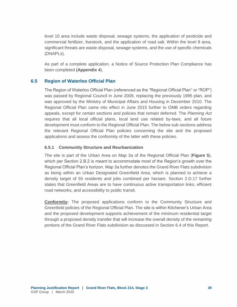
The site is part of the Urban Area on Map 3a of the Regional Official Plan (Figure 5),
which per Section 2.B.2 is meant to accommodate most of the Region’s growth over the
Regional Official Plan’s horizon. Map 3a further denotes the Grand River Flats subdivision
as being within an Urban Designated Greenfield Area, which is planned to achieve a
density target of 55 residents and jobs combined per hectare. Section 2.D.17 further
states that Greenfield Areas are to have continuous active transportation links, efficient
road networks, and accessibility to public transit.
Conformity: The proposed applications conform to the Community Structure and
Greenfield policies of the Regional Official Plan. The site is within Kitchener’s Urban Area
and the proposed development supports achievement of the minimum residential target
through a proposed density transfer that will increase the overall density of the remaining
portions of the Grand River Flats subdivision as discussed in Section 6.4 of this Report.
H
HWY 7
TO GUELP
H
HWY 401 TO TORONTO G
rand
River
Speed River
BRIDGE ST
BLEAMS RD
OXFORD-WATERLOO RD QUEEN ST
HWY 401
WY 7/8
NEW DUNDEE RD
SP
RA
GU
ES
R
D
ROSEVILLE RD
R’S RD EAST
CEDAR CREEK RD
SHANTZ STATIO
N RD
TRU
SSLER R
D
VICTORIA ST
MAIN ST
BLEAMS RD
FOUNTAIN
ST
CLYDE RD
D
BRAN
CH
TON
RD
RIVER RD
BRIDGEST
WATE
R S
T
KATH
ER
INE
ST
SAWM
ILL RD
HE
SP
E LER
RD
OLD BEVERLY RD
TOW
NLIN
E RD
MAPLE GROVE RD
ST CHARLES ST
ARTH
UR
ST
HIGHLAND RD
FO UNTAINST
NO
RTH
UM
BERLAN
D ST
HWY 85
ERBSVILLE RD
VICTORIA ST
FAIRWAYR D
ERB ST
KING ST
NORTHFIELD DR
WEBER
ST
HWY 401
DU
MFR
IES
RD
LOBSINGER LINE
FISCH
ER-H
ALLMA
NR
D
EAGLE ST
CAN-AMER A
PKY
KING ST
KING ST
HOMERW
ATSON
BLVD
WESTM
OU
NT
RD
UNIVERSITY AVE
COURTLANDAVE
FRAN
KLINBLVD
IRANEEDLES
BLVD
BISHOP ST
MYERS RD
OTTAWA ST
LACKNB
LV D
FISCHER-HALLMAN
RD
BR IDGEPORT RD
CORONATION BLVD
PINEBUSH RD
CHARLES ST
CONCESSION ST
OTTAWA ST
HWY 7
BLOOMINGDALE RD N EBYCREST RD
KOSSUTH RD
BLAIR RD
DUNDAS ST
PLANNED HWY 7
Township of LEGEND Woolwich
ER
Urban Area Built-Up Area*
Urban Designated Greenfield Areas Prime Industrial/Strategic Reserve (Serviced) Urban Growth Centres GReurbanization Corridors **
Major Transit Station Areas ** Central Transit Corridor Environmental Assessment Study Area
Planned Highway 7
Region of Waterloo County of International Airport Wellington Urban Area Boundary
Key Map Township of
North Dumfries Township of
Township of Woolwich Wellesley
City of Waterloo
Township of Wilmot
City of City of Cambridge Kitchener
Township of North Dumfries
N.T.S.
R
C
MAP 3a URBAN AREA
LEGEND Provincial Highway Regional Road
River Region of Waterloo International Airport
Municipal Boundary
Railway
0 1 20.5 Km
Sources: Region of Waterloo, Ministry of Energy and Infrastructure
2015
* Built-Up Area includes all lands within the built boundary, as established by the Province.
** Map 3a will be amended to designate ReurbanizationCorridors and Major Transit Station Areas following the completion of the Rapid Transit Environmental Assessment.
Note: This map forms part of the Official Plan of the Regional Municipality of Waterloo and must be read in conjunction with the policies of this Plan.
H
HWY 7
TO GUELP
H
HWY 401 TO TORONTO
Grand
River
Speed River
BRIDGE ST
BLEAMS RD
OXFORD-WATERLOO RD
QUEEN ST
HWY 401
WY 7/8
NEW DUNDEE RD
SP
RA
GU
ES
R
D
ROSEVILLE RD
R’S RD EAST
CEDAR CREEK RD
SHANTZ STATIO
N RD
TRU
SSLER R
D
VICTORIA ST
MAIN ST
BLEAMS RD
FOUNTAIN
ST
CLYDE RD
D
BRAN
CH
TON
RD
RIVER RD
BRIDGEST
WATE
R S
T
KATH
ER
INE
ST
SAWM
ILL RD
HE
SP
E LER
RD
OLD BEVERLY RD
TOW
NLIN
E RD
MAPLE GROVE RD
ST CHARLES ST
ARTH
UR
ST
HIGHLAND RD
FO UNTAINST
NO
RTH
UM
BERLAN
D ST
HWY 85
ERBSVILLE RD
VICTORIA ST
FAIRWAYR D
ERB ST
KING ST
NORTHFIELD DR
WEBER
ST
HWY 401
DU
MFR
IES
RD
LOBSINGER LINE
FISCH
ER-H
ALLMA
NR
D
EAGLE ST
CAN-AMER A
PKY
KING ST
KING ST
HOMERW
ATSON
BLVD
WESTM
OU
NT
RD
UNIVERSITY AVE
COURTLANDAVE
FRAN
KLINBLVD
IRANEEDLES
BLVD
BISHOP ST
MYERS RD
OTTAWA ST
LACKNB
LV D
FISCHER-HALLMAN
RD
BR IDGEPORT RD
CORONATION BLVD
PINEBUSH RD
CHARLES ST
CONCESSION ST
OTTAWA ST
HWY 7
BLOOMINGDALE RD N EBYCREST RD
KOSSUTH RD
BLAIR RD
DUNDAS ST
PLANNED HWY 7
Township of LEGEND Woolwich
ER
Urban Area Built-Up Area*
Urban Designated Greenfield Areas Prime Industrial/Strategic Reserve (Serviced) Urban Growth Centres GReurbanization Corridors **
Major Transit Station Areas ** Central Transit Corridor Environmental Assessment Study Area
Planned Highway 7
Region of Waterloo County of International Airport Wellington Urban Area Boundary
Key Map Township of
North Dumfries Township of
Township of Woolwich Wellesley
City of Waterloo
Township of Wilmot
City of City of Cambridge Kitchener
Township of North Dumfries
N.T.S.
R
C
MAP 3a URBAN AREA
LEGEND Provincial Highway Regional Road
River Region of Waterloo International Airport
Municipal Boundary
Railway
0 1 20.5 Km
Sources: Region of Waterloo, Ministry of Energy and Infrastructure
2015
* Built-Up Area includes all lands within the built boundary, as established by the Province.
** Map 3a will be amended to designate ReurbanizationCorridors and Major Transit Station Areas following the completion of the Rapid Transit Environmental Assessment.
Note: This map forms part of the Official Plan of the Regional Municipality of Waterloo and must be read in conjunction with the policies of this Plan.
Site
Regional Official Plan - Urban AreaSource: Region of Waterloo Official Plan, Urban Area, Map 3a (2015)
Planning Justification Report | Grand River Flats, Stage 3GSP Group | March 2020
Figure
5

Planning Justification Report | Grand River Flats, Block 214, Stage 3 41
GSP Group | March 2020
6.5.2 General Development Policies
Section 2.D.1 identifies general development policies for the review of development
planning applications. These policies seek to ensure that development in the Urban Area
is “planned and developed in a manner that:
(a) supports the Planned Community Structure described in this Plan;
(b) is serviced by a municipal drinking-water supply system and a municipal
wastewater system;
(c) contributes to the creation of complete communities with development patterns,
densities and an appropriate mix of land uses that supports walking, cycling and
the use of transit;
(d) protects the natural environment, and surface water and groundwater resources;
(e) conserves cultural heritage resources and supports the adaptive reuse of historic
buildings;
(f) respects the scale, physical character and context of established neighbourhoods
in areas where reurbanization is planned to occur;
(g) facilitates residents’ access to locally grown and other healthy foods in
neighbourhoods; and
(h) promotes building designs and orientations that incorporate energy conservation
features and the use of alternative and/or renewable energy systems.”
Conformity: The proposed applications conform to Section 2.D.1 as the proposed
development:
(a) Supports the Regional Official Plan’s Urban Area policies for a compact and
transit-supportive form of development.
(b) Will be serviced by water and wastewater infrastructure.
(c) Contributes to the creation of complete communities as outlined above for the PPS
and Growth Plan considerations.
(d) Supports active transportation through the inclusion of sidewalks and walkways.
(e) Protects drinking water. No prohibited uses are proposed and geothermal wells
and no underground parking is proposed.
(f) Implements the recommendations of the Heritage Impact Assessment for the
Grand River.
6.5.2 Source Water Protection
Stage 3 is in proximity to GUDI wells, which provides municipal drinking water.
Accordingly, Map 6a of the ROP identifies Stage 3 as being within Wellhead Protection
Areas 2 and 5, while Map 6f adds the High Microbial Risk Management overlay to Stage
3 (Figure 6).

HWY 7
TO G
UELPH
HWY 401 TO TORONTO
Grand
River
Gra
ndR
i ver
Speed River
hip ofot
Township ofNorth
DumfriesBRIDGE ST
BLEAMS RD
OXFORD-WATERLOO RDQUEEN ST
HWY 401
HWY 7/8
NEW DUNDEE RD
ROSEVILLE RD
B L A I RR D
CEDAR CREEK RD
SHANTZ STATION RD
TRU
SSLER R
D
VICTORIA ST
MAIN ST
BLEAMS RD
FOUNTAIN
ST
CLYDE RD
DU
ND A S S T
BRAN
CH
TON
RD
RIVER RD
BRIDGEST
WATE
R ST
SAWM
ILL RD
HE
SP
ELE
RR
D
OLD BEVERLY RD
TOW
NLIN
E RD
MAPLE GROVE RD
ST CHARLES ST
ARTH
UR
ST
HIGHLAND RD
FO UNTAINST
NO
RTHU
MBER
LAND
ST
KRE
SSL
ER
RD
HWY 85
ERBSVILLE RD
VICTORIA ST
FAIRWAYR D
ERB ST
KING ST
NORTHFIELD DR
WEBER
ST
HWY 401
DUMFR
IESR
D
LOBSINGER LINE
FISCH
ER-H
ALLMAN
RD
EAGLE ST
CAN-AMERA
PKY
KING ST
KING ST
HOMERW
ATSONBLVD
WEST M
OU
NT
RD
UNIVERSITY AVE
COURTLANDAVE
BR
ANT FO
RD
HW
Y(H
WY
24)
FRAN
KLINBLVD
IRANEEDLES
BLVD
BISHOP ST
MYERS RD
OTTAWA ST
LACKNE
RB
LV D
FISCHER-HALLMAN
RD
BRIDGEPORT RD
CORONATION BLVD
PINEBUSH RD
CHARLES ST
CONCESSION ST
OTTAWA ST
HWY 7
BLOOMINGDALE RD NEBYCREST RD
KOSSTH RD
Township ofWilmot
Township ofWoolwichTownship of
Wellesley
City ofKitchener
Township ofNorth Dumfries
City ofCambridge
City ofWaterloo
Key Map
N.T.S.
LEGEND
Wellhead Protection AreasWPSA-1WPSA-2
WPSA-3
WPSA-4
WPSA-5
WPSA-6
WPSA-7
WPSA-8
Municipal WellheadMunicipal WellheadsGroundwater Under Direct Influence (GUDI)
m
MAP 6aURBAN AREA
SOURCE WATERPROTECTION
AREAS
Note: This map forms part of the Official Plan of the Regional Municipality of Waterloo and must be read in conjunction with the policies of this Plan.
2015
Sources: Region of Waterloo
LEGEND
0 1 20.5Km
Railway
Municipal Boundary
Provincial Highway
River
Regional Road
Region of WaterlooInternational Airport
HWY 7
TO G
UELPH
HWY 401 TO TORONTO
Grand
River
Gra
ndR
i ver
Speed River
hip ofot
Township ofNorth
DumfriesBRIDGE ST
BLEAMS RD
OXFORD-WATERLOO RD
QUEEN ST
HWY 401
HWY 7/8
NEW DUNDEE RD
ROSEVILLE RD
B L A I RR D
CEDAR CREEK RD
SHANTZ STATION RD
TRU
SSLER R
D
VICTORIA ST
MAIN ST
BLEAMS RD
FOUNTAIN
ST
CLYDE RD
DU
ND A S S T
BRAN
CH
TON
RD
RIVER RD
BRIDGEST
WATE
R ST
SAWM
ILL RD
HE
SP
ELE
RR
D
OLD BEVERLY RD
TOW
NLIN
E RD
MAPLE GROVE RD
ST CHARLES ST
ARTH
UR
ST
HIGHLAND RD
FO UNTAINST
NO
RTHU
MBER
LAND
ST
KRE
SSL
ER
RD
HWY 85
ERBSVILLE RD
VICTORIA ST
FAIRWAYR D
ERB ST
KING ST
NORTHFIELD DR
WEBER
ST
HWY 401
DUMFR
IESR
D
LOBSINGER LINE
FISCH
ER-H
ALLMAN
RD
EAGLE ST
CAN-AMERA
PKY
KING ST
KING ST
HOMERW
ATSONBLVD
WEST M
OU
NT
RD
UNIVERSITY AVE
COURTLANDAVE
BR
ANT FO
RD
HW
Y(H
WY
24)
FRAN
KLINBLVD
IRANEEDLES
BLVD
BISHOP ST
MYERS RD
OTTAWA ST
LACKNE
RB
LV D
FISCHER-HALLMAN
RD
BRIDGEPORT RD
CORONATION BLVD
PINEBUSH RD
CHARLES ST
CONCESSION ST
OTTAWA ST
HWY 7
BLOOMINGDALE RD NEBYCREST RD
KOSSTH RD
Township ofWilmot
Township ofWoolwichTownship of
Wellesley
City ofKitchener
Township ofNorth Dumfries
City ofCambridge
City ofWaterloo
Key Map
N.T.S.
LEGEND
Wellhead Protection AreasWPSA-1WPSA-2
WPSA-3
WPSA-4
WPSA-5
WPSA-6
WPSA-7
WPSA-8
Municipal WellheadMunicipal WellheadsGroundwater Under Direct Influence (GUDI)
m
MAP 6aURBAN AREA
SOURCE WATERPROTECTION
AREAS
Note: This map forms part of the Official Plan of the Regional Municipality of Waterloo and must be read in conjunction with the policies of this Plan.
2015
Sources: Region of Waterloo
LEGEND
0 1 20.5Km
Railway
Municipal Boundary
Provincial Highway
River
Regional Road
Region of WaterlooInternational Airport
Site
Regional Official Plan Urban Area Source Water Protection Areas
Source: Region of Waterloo Official Plan, Urban Area Source Water Protection Areas, Map 6a (2015)
Planning Justification Report | Grand River Flats, Stage 3GSP Group | March 2020
Figure
6
Planning Justification Report | Grand River Flats, Block 214, Stage 3 43
GSP Group | March 2020
Wellhead Protection Sensitivity Areas (“WPSA”) are classified according to vulnerability,
which different activities permitted depending on risk. Stage 3 falls within a WPSA 2 and
WPSA 5, which delineates a high sensitivity area with a two to ten year time of travel to a
municipal well. Policy 8.A.12 states that certain uses are prohibited within such areas,
including waste treatment facilities, salvage yards, bulk storage of hazardous chemicals,
geothermal wells, underground parking garages, and individual wastewater treatment
systems and wells.
Policy 8.A.19 states that individual wastewater treatment systems and/or private wells are
not permitted within High Microbial Risk Management Zones.
Conformity: The proposed applications conform to the Source Water Protection policies
of the ROP. No prohibited uses are proposed, and the Zoning By-law for the Grand River
Flats subdivision prohibits geothermal wells and underground parking garages. These
provisions are not requested to be altered as part of the proposed applications.
In recognition of the High Microbial Risk Management policy and in accordance with the
PPS and ROP, the Grand River Flats subdivision will be serviced by municipal water and
wastewater.
6.6 City of Kitchener Official Plan
The new City of Kitchener Official Plan (the “OP”) was adopted by Kitchener City Council
in 2014 and was approved with modifications by the Region in November 2014. It will
replace the previous 1994 Kitchener Official Plan once it is in force and effect. Portions of
the 2014 Official Plan were appealed to the OMB (LPAT) while the remaining un-appealed
policies came into effect on September 23, 2015. The LPAT Order dated March 21, 2019
approved settled revisions for most of the outstanding appeals concerning Official Plan
Amendment No. 103, with one site-specific appeal remaining.
The below sub-sections address the relevant 2014 Kitchener Official Plan policies
concerning the site and the proposed applications and assess the conformity of the latter
with these policies.
6.6.1 Urban Structure
The site is part of the “Designated Greenfield Area” on Map 1 of the OP (Figure 7). Further
to the Regional Official Plan, the Greenfield Area has a minimum density target of 55
residents and jobs combined per hectare.

Map 1
DISCLAIMER: This document is subject to copyright and may only be used for your personal, non-commercial use, provided you keep intact the copyright notice. © 2019 Some portions of this publication are produced using information under licensed use from: Teranet © 1998, Region of Waterloo © 2010, Grand River Conservation Authority (GRCA) © 2010, and OntarioMinistry of Natural Resources © 2005 Queen’s Printer Ontario and may not be reproduced without Permission. THIS IS NOT A PLAN OF SURVEY - PROJECTION: UTM NAD 83 zone 17 PRINTED: AUGUST 2019 PRODUCED BY: TIS Department - GIS for Development Services Department - Planning
Note:1. This map forms part of the Official Plan of the City ofKitchener and must be read in conjunction with the policiesof this Plan.
Adopted by City Council - June 30, 2014Approved by Regional Council - November 19, 2014Modified by Regional Council - January 18, 2017Effective Date - September 23, 2015Last Revised - January 18, 2017Revised by Amendments -
City Urban Area andCountryside
City of KitchenerO f f i c i a l P l a n
A complete and healthy Kitchener
WATERLOO
OTTAWA ST S
FISCHER HALLMAN RD
QUEENS BLVD
WEBER ST E
WELLINGTON ST N
KING ST E
EDNA ST
VICTORIA ST NBIN GEMANS CENTRE DR
RIVE
R RD E
BLVD
VICTORIA ST S
CONESTOGA PKY
WESTM
OU
NT
RD
W
QUEEN S
T S
HWY401
Grand River
L AN
CAS
T ERS
TW
BRIDGE ST E
WOOLWICH
WILMOT
GLASGOW ST
WEBER ST W
BLVD
LACK
NER
B
LVD
C.N.R.
HWY 8
FAIRWAY RD N
MILL ST
FREDERICK ST
HURON RD
HOMER
SHIRLEY AVE
HIGHLAND RD W
BELMO
NT AVE W
BLOCK LINE RD
FISCH
ER H
ALLMAN
RD
BLOOMINGDALE RD
NEW DUNDEE RD
STRASBUR
GR
D
NORTHDUMFRIES
C.P.R.
KING ST E
CAMBRIDGE
WESTM
OUNT
RDE
KING ST W
BLEAMS RD
COURTLAND AVE E
BRIDGEPORT RD
WATSO
N
FAIRWAY RD S
IRANEEDLES
C.N.R.
TRUSSLER RD
CHARLES ST E
CONESTOGAPKY
MAN
ITOU
DR
OTTAWA ST
N
WABANAKI DR
°LegendCity Urban Area
Built Up Area
Designated Greenfield Area
Urban Growth Centre(Downtown)
Urban Area Boundary
CountrysideProtected Countryside
Area subject to Policy 3.C.1.22
Southwest Kitchener PolicyArea
Countryside Line
Exact location of CountrysideLine yet to be determined
Major RoadsExistingPlanned
Railway
Grand River
Municipal Boundary
0 1 2km
Map 1
DISCLAIMER: This document is subject to copyright and may only be used for your personal, non-commercial use, provided you keep intact the copyright notice. © 2019 Some portions of this publication are produced using information under licensed use from: Teranet © 1998, Region of Waterloo © 2010, Grand River Conservation Authority (GRCA) © 2010, and OntarioMinistry of Natural Resources © 2005 Queen’s Printer Ontario and may not be reproduced without Permission. THIS IS NOT A PLAN OF SURVEY - PROJECTION: UTM NAD 83 zone 17 PRINTED: AUGUST 2019 PRODUCED BY: TIS Department - GIS for Development Services Department - Planning
Note:1. This map forms part of the Official Plan of the City ofKitchener and must be read in conjunction with the policiesof this Plan.
Adopted by City Council - June 30, 2014Approved by Regional Council - November 19, 2014Modified by Regional Council - January 18, 2017Effective Date - September 23, 2015Last Revised - January 18, 2017Revised by Amendments -
City Urban Area andCountryside
City of KitchenerO f f i c i a l P l a n
A complete and healthy Kitchener
WATERLOO
OTTAWA ST S
FISCHER HALLMAN RD
QUEENS BLVD
WEBER ST E
WELLINGTON ST N
KING ST E
EDNA ST
VICTORIA ST NBIN GEMANS CENTRE DR
RIVER RD E
BLVD
VICTORIA ST S
CONESTOGA PKY
WESTM
OU
NT
RD
W
QUEEN S
T S
HWY401
Grand River
L AN
CAS
T ERS
TW
BRIDGE ST E
WOOLWICH
WILMOT
GLASGOW ST
WEBER ST W
BLVD
LACK
NER
B
LVD
C.N.R.
HWY 8
FAIRWAY RD N
MILL ST
FREDERICK ST
HURON RD
HOMER
SHIRLEY AVE
HIGHLAND RD W
BELMO
NT AVE W
BLOCK LINE RD
FISCH
ER H
ALLMAN
RD
BLOOMINGDALE RD
NEW DUNDEE RD
STRASBUR
GR
D
NORTHDUMFRIES
C.P.R.
KING ST E
CAMBRIDGE
WESTM
OUNT
RDE
KING ST W
BLEAMS RD
COURTLAND AVE E
BRIDGEPORT RD
WATSO
N
FAIRWAY RD S
IRANEEDLES
C.N.R.
TRUSSLER RD
CHARLES ST E
CONESTOGAPKY
MAN
ITOU
DR
OTTAWA ST
N
WABANAKI DR
°LegendCity Urban Area
Built Up Area
Designated Greenfield Area
Urban Growth Centre(Downtown)
Urban Area Boundary
CountrysideProtected Countryside
Area subject to Policy 3.C.1.22
Southwest Kitchener PolicyArea
Countryside Line
Exact location of CountrysideLine yet to be determined
Major RoadsExistingPlanned
Railway
Grand River
Municipal Boundary
0 1 2km
Site
Kitchener Official Plan City Urban Area and Countryside
Source: City of Kitchener Official Plan, City Urban Area and Countryside, Map 1 (revised January 18, 2017)
Planning Justification Report | Grand River Flats, Stage 3GSP Group | March 2020
Figure
7

Planning Justification Report | Grand River Flats, Block 214, Stage 3 45
GSP Group | March 2020
The residential portion of Phase 5 is within the “Community Areas” on Map 2 of the OP.
Section 3.C.2.50 states that the objective of Community Areas is to provide for residential
uses and related non-residential uses that support residential areas. Intensification is
limited to compatible development that is sensitive to the surrounding context.
Conformity: The proposed applications conform to the Urban Structure policies of the
OP. As discussed, the applications propose to transfer density from Stage 5 to Block 214
in Stage 3. The result would be and increase in the overall density over the two areas
from 36.1 UPH to 43.6 UPH, meeting the density targets for Greenfield Areas of the OP.
The proposed applications conform to the Community Area policies of the OP. The
proposed development continues the approved residential use of the lands, while
relocating density to increase compatibility with the surrounding neighbourhood.
6.6.2 Land Use
Stage 5 is identified as “Low Rise Residential” and “Open Space” on Map 3 of the OP
(Figure 8).
The Low Rise Residential designation permits single detached, semi-detached, street
townhouses, townhouse clusters, low-rise multiple dwellings, special needs housing, and
other forms of low-rise housing at a maximum net residential density of 30 units per
hectare (“UPH”). Policy 15.D.3.7 states that all residential designations within the
Designated Greenfield Area, which applies to the Grand River Flats subdivision, are to be
planned to achieve an overall minimum density target of 55 residents and jobs per hectare.
A maximum Floor Space Ratio of 0.6 applies, and the maximum building height of 3
storeys or 11 metres.
Conformity: The proposed applications exceed the height and density policies of the Low
Density Residential designation, necessitating an Official Plan Amendment.
An amendment to the Medium Rise Residential designation is requested. The Medium
Rise Residential designation permits a variety of housing types including townhouse
dwellings and multiple dwellings at a net residential density from 30 units per hectare to
200 units per hectare. A floor space ratio between 0.6 and 2.0 is permitted, and the height
must be below 8 storeys or 25 metres. Policy 15.D.3.21 states that new Medium Rise
Residential will:
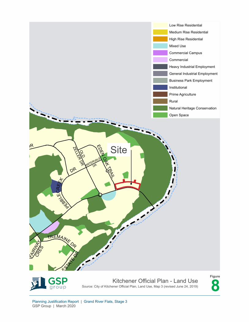
Map 3 Land UseCity of Kitchener
O f f i c i a l P l a nA complete and healthy Kitchener
COUN
TRYS
TONE DR
DR
IFTWOO
D
DR
OPRIN
GTO
N
DR
ROSENBERG WAY
UNION
BLVD
ACTIVA
AVE
GRE
ENST
CO
MM
ON
WEALTH
AMANDDR SEABROOK DR
TUERR DR
EDNA ST
FALCONR I DGE
DR
DR
OLD
HURON RD
MAN
ITOU
DR
TRAYNORAVE
EIG
HTH
AVE
NIN
TH A
VE
DO
ON
VILLAGERD
HERITAGE
DR
DOON MILLSDR
WABAN
AKID
R
HOMER
WATSONBLVD
DO
ON
SOUTH
DR
PIONEER TOWER RD
FISCHER HALLMAN RD
FOR ESTHI
LLDR
MOOREAVE
WEST OAK TRAIL DR
PLEASANTAVE
CHARLES ST W
SEABROOK
DR
BENTON
ST
UNIONST
QUE
ENST
N
GUELPH ST
BRIDGE ST W
ALPI NE RD
FREDERICK ST
GR
A N DR I V E R
NEWCASTLE
ROCKCLIFFE
DR
BORD
EN
AVE N
EAST AVE
BRUCE
ST
HOMERW
ATSONBLVD
SHEL
LEY
DR
MAN
CH
ESTE
RR
D
BECHTEL DR
WABANAKI DR
TREMAINE DR
EDENO
AKTRAIL
IRA
NE
EDLE
S BL
VD
TRUSSLERRD
HIGHLAND RD W
HAZELGLENDR
DO
NN
ENW
ERTH
DR
WILDERN E S S DR
WILLIAMSBURG
RD
PATRICIA AVEW
ESTAVE
CHERRYST
ER
INBROO
KD
R
OTTAWA ST S
QUEEN
STS
BREITHAUPT ST
LUD
OLPH
ST
BLEAMSRD
LAU
RE
NTIAND
R
MILL ST
CEDAR
STN
RIVER BEND
DR
HAWKSWOOD
CARWOOD AVE
C.N.R.
BATTLERRD
FALLOWFIELD
DR
WEBER
STE
HEARTHWOO
DD
R
CONNAUGHT ST
VICTORIA ST N
BLACKWALNUTDR
SOUTH
CREEKD
R
C ONWAY DR
NEW DUNDEE RD
ROBERT FERRIE DR
FERGUS AVE
SHIRLEY DR
BRIARMEADOWDR
THOMAS SLEED
R
HWY 8
HIG
HGAT
E
RD
YELLOWBIRCH DR
BANKSID
E
D R
KARN STBRYBECK CRES
LAWRENCE AVE
AMAN
D D
R
MAX BECKER DR
MARGARETAVE
ST LEGER ST
FISCH
ER H
ALLMAN
RD
SELKIRK
DR
CHARLES ST E
KING ST E
DIX
ON
ST
FRAN
KLIN
ST
S
WILSON AVE
BRA DL EY DR
LORRAINEAVE
RIVER
RDE
IND
IAN
RD
G R A N D R I V E R
SIMSESTA
TEDR
BRAMBLE-
WOOD
ST
WES
TFOREST TRAIL
WEST WO
OD
DR
MCGARRY DR
GRE
ENBROOKDR
STONYBROOK
DR
GAGE AVE
KING ST W
TILLSLEYDR
HOW
LAND
DR
JOSEPH ST
DU
KE ST W
BLACKHO RNED
R
LANC
ASTER
ST W
HURON
RD
TRILLIUM DR
KINGSWOOD DR
LANC
A STER
STE
BRIDGE ST E
CO
UR
TLANDAVE
E
SHELDON AV E N
VANIERDR
BINGEMANS CENTRE DR
C.P.R
FAIRWAY RD S
MO
NT
CA
LM
DR
HURON RD
KINZIE
AVE
OLD
FIELD
D
R
HIDDEN VALLEY RD
PIN
NAC
LE D
R
OLD MILL RD
SPOR
TSW
ORL
D
DR
KING ST E
GATEWAY PARK DR
EAST F OREST TRAIL
S TOK EDR
CONESTOGA PARKWAY
WESTM
OUNT
RDW
QUEENS BLVD
VICTORIAST
S
STRAN
GE
STPARK
ST
HURON RDW
ESTMOUNT
RDE
SPADINARD E
WELLINGTON ST N
T HE COUNTRY WAY
LUCERN E DR
DUKE ST E
DR
CAR
YND
ALED
R
FRANKLIN
STN
CARSON
DRNATCHEZ
RD
PIONEER DR
EDENBRIDGE DR
DODGE DR
WINDRU
S
H TRAIL
FAIRWAY RD N
ID LE CREEK DR
NEW
DUN
DEE
RD
C.N.R
WESTMEADOWDR
BLACKWELL DR
HAZELGLEN DR
GLASGOW ST
GEO
RG
E
ISRAEL ST
WINDFLOWER
DR
CHOPI
N
DR
BELMO
NTAVE
W
ABR
AMCLEM
ENS
ST
ROCKWOODRD
WEBER ST W
RITTENHOUSE RD
STIRLINGAVE
S
BRIDGEPORT
RD
LOUISA ST
C.N.R
SPRI
NG
VALLEY
RD
SEREDA
RD
CENTURY HILL DR
COUN TRY HILL DR
KRUGST
SHIRLEY AVE
BIE
HN
DR
SHE
LLE
Y D
R
HOLBO RNDR
GIBSON DR
OLDCHICOPEE
DR
KEEWATINAVE
THOMAS SLEEDR
DOON VILLAGE RD
MILL PARK DR
DAIMLE R
DR
LACKNER BLVDFO
RES T
EDGE
TRAIL
MORRISON
RD
FAIR
WAY
CRES
DOONVALLEY
DR
RIVERBANK
DR
GRAND
RIVERBLVD
PEBBLEC
REE
K
DRO
LD
ZELLER DR
WATERVALE
DR
HIGHV IEWDR
RESURRECTIO
NDR
WESTHEIGHTS DR
FOXGLOVE CRES
ELMRIDGE
DR
ISAIAH D
R
ACTIVA AVE
DAVIDBERGEY
DR
ST
DUN SMERE DR
JUBILEE DR
BLOCK LINE RD
WO
OD
BINE
AVE
PARKVALE
DR
HIGHLAND RD E
MAD
ISON
AVE
SCE
DAR
STS
MCINTY RE
DR
STRASBU
RG
RD
BORDENAV
ES
BLOOMINGDALE RD
HAYWARD AVE
M A RL
MEADOW DR
WALTON
AVE
SIEBERT
AVE
KINGSWAY DR
OTTAWA ST N
KINGSW
AYDR
MID
LAND
DR
APPLE RIDGE
DR
BLAIRCREEK DR
MORGANAVE
ZELLER DR
CON
ESTO
GA
COLL
EGE
BLVD
DEERRIDGE D R
DEFERRALNO. 9
Notes:1. This map forms part of the Official Plan of the City of Kitchener and must be read in conjunction with the policies of this Plan.
2. Land use boundaries on this map are general only.
3. Road locations on this map are only to assist in locating land use. For road status refer to Map 11 - Integrated Transportation System.
4. The Secondary Plans are deferred and do not form part of this Official Plan. The land use policies and land use designations in the Secondary Plans contained in Part 3, Section 13 of the 1994 City of Kitchener Official Plan, as amended, continue to apply until such time as the Secondary Plans are reviewed and adopted as part of this Official Plan.
Adopted by City Council - June 30, 2014Approved by Regional Council - November 19, 2014Effective Date - September 23, 2015Last Revised - June 24, 2019Revised by Amendments - OPA 3, PL150200, OPA 2, OPA 5
DISCLAIMER: This document is subject to copyright and may only be used for your personal, non-commercial use, provided you keep intact the copyright notice. © 2019 Some portions of this publication are produced usinginformation under licensed use from: Teranet © 1998, Region of Waterloo © 2010, Grand River Conservation Authority (GRCA) © 2010, and Ontario Ministry of Natural Resources © 2005 Queen’s Printer Ontario and may not bereproduced without Permission. THIS IS NOT A PLAN OF SURVEY - PROJECTION: UTM NAD 83 zone 17 PRINTED: AUGUST 2019 PRODUCED BY: TIS Department - GIS for Development Services Department - Planning
Railway
Major and Minor RoadsExisting
Planned
Municipal Boundary
Grand River
°Scale 1:24,000
0 1km
Legend
Refer to Secondary Plan For Detail
Urban Growth Centre (Downtown)Refer to Map 4
Area Under Deferral
Low Rise Residential
Medium Rise Residential
High Rise Residential
Mixed Use
Commercial Campus
Commercial
Heavy Industrial Employment
General Industrial Employment
Business Park Employment
Institutional
Prime Agriculture
Rural
Natural Heritage Conservation
Open Space
Major Infrastructure and Utilities
Map 3 Land UseCity of Kitchener
O f f i c i a l P l a nA complete and healthy Kitchener
COUN
TRYS
TONE DR
DR
IFTWOO
D
DR
OPRIN
GTO
N
DR
ROSENBERG WAY
UNION
BLVD
ACTIVA
AVE
GRE
ENST
CO
MM
ON
WEALTH
AMANDDR SEABROOK DR
TUERR DR
EDNA ST
FALCONR I DGE
DR
DR
OLD
HURON RD
MAN
ITOU
DR
TRAYNORAVE
EIG
HTH
AVE
NIN
TH A
VE
DO
ON
VILLAGERD
HERITAGE
DR
DOON MILLSDR
WABAN
AKID
R
HOMER
WATSONBLVD
DO
ON
SOUTH
DR
PIONEER TOWER RD
FISCHER HALLMAN RD
FOR ESTHI
LLDR
MOOREAVE
WEST OAK TRAIL DR
PLEASANTAVE
CHARLES ST W
SEABROOK
DR
BENTON
ST
UNIONST
QUE
ENST
N
GUELPH ST
BRIDGE ST W
ALPI NE RD
FREDERICK ST
GR
A N DR I V E R
NEWCASTLE
ROCKCLIFFE
DR
BORD
EN
AVE N
EAST AVE
BRUCE
ST
HOMERW
ATSONBLVD
SHEL
LEY
DR
MAN
CH
ESTE
RR
D
BECHTEL DR
WABANAKI DR
TREMAINE DR
EDENO
AKTRAIL
IRA
NE
EDLE
S BL
VD
TRUSSLERRD
HIGHLAND RD W
HAZELGLENDR
DO
NN
ENW
ERTH
DR
WILDERN E S S DR
WILLIAMSBURG
RD
PATRICIA AVEW
ESTAVE
CHERRYST
ER
INBROO
KD
R
OTTAWA ST S
QUEEN
STS
BREITHAUPT ST
LUD
OLPH
ST
BLEAMSRD
LAU
RE
NTIAND
R
MILL ST
CEDAR
STN
RIVER BEND
DR
HAWKSWOOD
CARWOOD AVE
C.N.R.
BATTLERRD
FALLOWFIELD
DR
WEBER
STE
HEARTHWOO
DD
R
CONNAUGHT ST
VICTORIA ST N
BLACKWALNUTDR
SOUTH
CREEKD
R
C ONWAY DR
NEW DUNDEE RD
ROBERT FERRIE DR
FERGUS AVE
SHIRLEY DR
BRIARMEADOWDR
THOMAS SLEED
R
HWY 8
HIG
HGAT
E
RD
YELLOWBIRCH DR
BANKSID
E
D R
KARN STBRYBECK CRES
LAWRENCE AVE
AMAN
D D
R
MAX BECKER DR
MARGARETAVE
ST LEGER ST
FISCH
ER H
ALLMAN
RD
SELKIRK
DR
CHARLES ST E
KING ST E
DIX
ON
ST
FRAN
KLIN
ST
S
WILSON AVE
BRA DL EY DR
LORRAINEAVE
RIVER
RDE
IND
IAN
RD
G R A N D R I V E R
SIMSESTA
TEDR
BRAMBLE-
WOOD
ST
WES
TFOREST TRAIL
WEST WO
OD
DR
MCGARRY DR
GRE
ENBROOKDR
STONYBROOK
DR
GAGE AVE
KING ST W
TILLSLEYDR
HOW
LAND
DR
JOSEPH ST
DU
KE ST W
BLACKHO RNED
R
LANC
ASTER
ST W
HURON
RD
TRILLIUM DR
KINGSWOOD DR
LANC
A STER
STE
BRIDGE ST E
CO
UR
TLANDAVE
E
SHELDON AV E N
VANIERDR
BINGEMANS CENTRE DR
C.P.R
FAIRWAY RD S
MO
NT
CA
LM
DR
HURON RD
KINZIE
AVE
OLD
FIELD
D
R
HIDDEN VALLEY RD
PIN
NAC
LE D
R
OLD MILL RD
SPOR
TSW
ORL
D
DR
KING ST E
GATEWAY PARK DR
EAST F OREST TRAIL
S TOK EDR
CONESTOGA PARKWAY
WESTM
OUNT
RDW
QUEENS BLVD
VICTORIAST
S
STRAN
GE
STPARK
ST
HURON RD
WESTM
OUNTRD
E
SPADINARD E
WELLINGTON ST N
T HE COUNTRY WAY
LUCERN E DR
DUKE ST E
DR
CAR
YND
ALED
R
FRANKLIN
STN
CARSON
DRNATCHEZ
RD
PIONEER DR
EDENBRIDGE DR
DODGE DR
WINDRU
S
H TRAIL
FAIRWAY RD N
ID LE CREEK DR
NEW
DUN
DEE
RD
C.N.R
WESTMEADOWDR
BLACKWELL DR
HAZELGLEN DR
GLASGOW ST
GEO
RG
E
ISRAEL ST
WINDFLOWER
DR
CHOPI
N
DR
BELMO
NTAVE
W
ABR
AMCLEM
ENS
ST
ROCKWOODRD
WEBER ST W
RITTENHOUSE RD
STIRLINGAVE
S
BRIDGEPORT
RD
LOUISA ST
C.N.R
SPRI
NG
VALLEY
RD
SEREDA
RD
CENTURY HILL DR
COUN TRY HILL DR
KRUGST
SHIRLEY AVE
BIE
HN
DR
SHE
LLE
Y D
R
HOLBO RNDR
GIBSON DR
OLDCHICOPEE
DR
KEEWATINAVE
THOMAS SLEEDR
DOON VILLAGE RD
MILL PARK DR
DAIMLE R
DR
LACKNER BLVDFO
RES T
EDGE
TRAIL
MORRISON
RD
FAIR
WAY
CRES
DOONVALLEY
DR
RIVERBANK
DR
GRAND
RIVERBLVD
PEBBLEC
REE
K
DR
OLD
ZELLER DR
WATERVALE
DR
HIGHV IEWDR
RESURRECTIO
NDR
WESTHEIGHTS DR
FOXGLOVE CRES
ELMRIDGE
DR
ISAIAH D
R
ACTIVA AVE
DAVIDBERGEY
DR
ST
DUN SMERE DR
JUBILEE DR
BLOCK LINE RD
WO
OD
BINE
AVE
PARKVALE
DR
HIGHLAND RD E
MAD
ISON
AVE
SCE
DAR
STS
MCINTY RE
DR
STRASBU
RG
RD
BORDENAV
ES
BLOOMINGDALE RD
HAYWARD AVE
M A RL
MEADOW DR
WALTON
AVE
SIEBERT
AVE
KINGSWAY DR
OTTAWA ST N
KINGSW
AYDR
MID
LAND
DR
APPLE RIDGE
DR
BLAIRCREEK DR
MORGANAVE
ZELLER DR
CON
ESTO
GA
COLL
EGE
BLVD
DEERRIDGE D R
DEFERRALNO. 9
Notes:1. This map forms part of the Official Plan of the City of Kitchener and must be read in conjunction with the policies of this Plan.
2. Land use boundaries on this map are general only.
3. Road locations on this map are only to assist in locating land use. For road status refer to Map 11 - Integrated Transportation System.
4. The Secondary Plans are deferred and do not form part of this Official Plan. The land use policies and land use designations in the Secondary Plans contained in Part 3, Section 13 of the 1994 City of Kitchener Official Plan, as amended, continue to apply until such time as the Secondary Plans are reviewed and adopted as part of this Official Plan.
Adopted by City Council - June 30, 2014Approved by Regional Council - November 19, 2014Effective Date - September 23, 2015Last Revised - June 24, 2019Revised by Amendments - OPA 3, PL150200, OPA 2, OPA 5
DISCLAIMER: This document is subject to copyright and may only be used for your personal, non-commercial use, provided you keep intact the copyright notice. © 2019 Some portions of this publication are produced usinginformation under licensed use from: Teranet © 1998, Region of Waterloo © 2010, Grand River Conservation Authority (GRCA) © 2010, and Ontario Ministry of Natural Resources © 2005 Queen’s Printer Ontario and may not bereproduced without Permission. THIS IS NOT A PLAN OF SURVEY - PROJECTION: UTM NAD 83 zone 17 PRINTED: AUGUST 2019 PRODUCED BY: TIS Department - GIS for Development Services Department - Planning
Railway
Major and Minor RoadsExisting
Planned
Municipal Boundary
Grand River
°Scale 1:24,000
0 1km
Legend
Refer to Secondary Plan For Detail
Urban Growth Centre (Downtown)Refer to Map 4
Area Under Deferral
Low Rise Residential
Medium Rise Residential
High Rise Residential
Mixed Use
Commercial Campus
Commercial
Heavy Industrial Employment
General Industrial Employment
Business Park Employment
Institutional
Prime Agriculture
Rural
Natural Heritage Conservation
Open Space
Major Infrastructure and Utilities
Site
Kitchener Official Plan - Land UseSource: City of Kitchener Official Plan, Land Use, Map 3 (revised June 24, 2019)
Planning Justification Report | Grand River Flats, Stage 3GSP Group | March 2020
Figure
8

Planning Justification Report | Grand River Flats, Block 214, Stage 3 47
GSP Group | March 2020
a) result in the preservation of features of the natural environment which may
otherwise be compromised with more dispersed low density development;
b) take advantage of vistas;
c) constitute neighbourhood landmarks or reference points;
d) be located within walking distance of nodes, corridors and public transit stops and
non-residential uses; and,
e) have a strong focus placed on the creation of links for pedestrians and cyclists
with surrounding non-residential uses.
The proposed applications conform to the Medium Rise Residential policies. The
development has a floor space ratio of 1.31 and a maximum height of 5 storeys and 12.4
metres. The development utilizes the vista identified in the Heritage Impact Study for the
Grand River, providing views of the Grand River and associated basin. Natural heritage
features are protected from development and no development is proposed within the
floodplain of the Grand River. Block 214 is an appropriate location for Medium Rise density
and is within walking distance of transit and public parks. Chicopee Hills Public School is
approximately 1.5 km from the block, an approximate 19 minute walk. The block is
connected to the surrounding active transportation network.
6.6.3 Housing
The OP encourages a range and mix of housing types, densities, and tenures and
promotes intensification that is sensitive to compatibility. Designated Greenfield Areas are
subject to the City’s Growth Management Program, which ensures residential growth
occurs in tandem with infrastructure and services. The Growth Management Strategy was
last updated in 2009 and notes that greenfield development will require higher density
housing than traditional single detached subdivisions in order to meet density targets.
Policy 4.C.1.12 states that the City favours a land use pattern that “… mixes and disperses
a full range of housing types and styles both across the city as a whole and within
neighbourhoods”. Policy 4.C.1.16 states that the City requires that large residential
developments have a minimum of 30% of new residential units to be in forms other than
single detached and semi-detached dwellings.
Conformity: The proposed applications conform to the relevant housing policies of the
2014 Kitchener Official Plan. The proposed development provides 353 units, of which 36
are townhomes and 316 are apartment style condominium units, contributing to the
provision of residential dwellings that are not single detached or semi-detached dwellings.
As discussed in WalterFedy’s Servicing Report, the development will be adequately
serviced by municipal water and wastewater, and stormwater management is provided.

Planning Justification Report | Grand River Flats, Block 214, Stage 3 48
GSP Group | March 2020
6.6.4 Community Design and Neighbourhood Policies
Section 11 of the OP contains urban design policies that promote healthy, attractive, and
safe communities. The most applicable to the proposed applications are addressed in the
community and neighbourhood policies and supplement the Urban Design Manual.
The community design policies encourage a sense of place, integrated street networks,
walkable neighbourhoods, and integrated natural and cultural heritage resources. An
accessible and linked parks and open space system is promoted.
The neighbourhood design policies state that in suburban neighbourhoods, the focus is
“… to create diverse, attractive, walkable neighbourhoods that contribute to complete and
healthy communities”.
Conformity: The proposed applications conform to the community and neighbourhood
design policies of the OP. The proposed development is well integrated with the
surrounding street and active transportation networks and provides access to the
surrounding trails. Views and access to the Grand River are retained and enhanced,
contributing to a sense of place while preserving cultural and natural heritage. Proximity
to recreation and schools, as well as the mix of housing types, contributes to a complete
community.
6.6.5 Parkland
Section 8.C of the OP provides the policy direction for parkland within Kitchener. Per
Sections 8.C.1.13 and 8.C.1.15, the Parks Strategic Plan is meant to provide the direction
for the requirements for open space and public parks in each neighbourhood including
where future parkland is required.
Conformity: The proposed applications conform to the parkland policies of the OP. While
all public parkland required for the Grand River Flats subdivision has been provided, the
proposed development incorporates a private children’s playground and outdoor amenity
areas for residents of the condominiums.
6.6.6 Source Water Protection
Map 8 of the OP identifies Stage 3 as being within Wellhead Protection Sensitivity Areas
2 and 5 and within a Zone 2 Surface Water Intake Protection Zone. The OP refers to the
Regional Official Plan policies.

Planning Justification Report | Grand River Flats, Block 214, Stage 3 49
GSP Group | March 2020
Conformity: The proposed applications conform to the Source Water Protection policies
are discussed in Section 6.6.2 of this Report.
6.6.7 Sustainability
Section 7.C.4. of the 2014 Kitchener Official Plan provides the policy direction for
sustainable development. Section 7.C.4.1 provides the general direction indicating that
the City “will ensure that development and redevelopment strives to be increasingly
sustainable by encouraging, supporting and, where appropriate, requiring:
a) compact development and efficient built form;
b) environmentally responsible design (from community design to building design)
and construction practices;
c) the integration, protection and enhancement of natural features and landscapes
into building and site design;
d) the reduction of resource consumption associated with development; and,
e) transit-supportive development and redevelopment and the greater use of other
active modes of transportation such as cycling and walking.
As well, Section 7.C contains a series of other sections and policies related to promoting
and encouraging supporting sustainable development matters, including water
conservation, energy conservation and efficiency, alternative energy systems, waste
reduction and management, and air quality.
Conformity: The proposed development supports the general sustainable development
policies of the OP. Specifically, the proposed development:
a) Will be compact in form to provide sufficient servicing and reduce the consumption
of greenfields to meet residential demand;
b) Is transit-supportive and provides opportunities for active transportation;
c) Is in proximity to recreation and education facilities to reduce reliance on vehicular
travel and shorten vehicular trips; and,
d) Will incorporate sustainability into building and site design.
6.7 Grand River South Community Plan
The lands are within the Grand River South Community Plan (“GRSCP”), which was
approved in 2000 and most recently amended in 2015. The GRSCP designates Stage 3
as “Low Rise Residential” (Figure 9).

Site
Grand River South Community Plan Land Use
Source: Grand River South Community Plan, Land Use Plan, Schedule 1 (March 9, 2015)
Planning Justification Report | Grand River Flats, Stage 3GSP Group | March 2020
Figure
9

Planning Justification Report | Grand River Flats, Block 214, Stage 3 51
GSP Group | March 2020
An amendment is requested to the GRSCP to change the designation to “Medium Rise
Multiple Residential (200 uha)”. Section 4.5 of the GRSCP states that the Medium Rise
Multiple Residential (200 uha) designation permits street townhouse and multiple
dwellings at a net residential density range of 60 to 200 units per hectare.
Conformity: The GRSCP was created to guide the development of the Grand River South
community, which is now developed, with Stage 5 and Block 214 in Stage 3 comprising
two of the few undeveloped parcels remaining in the Plan area. The proposed applications
conform to the intent of the GRSCP, which is to provide residential uses in this area.
The proposed change to the Medium Rise Multiple Residential designation implements
the requested Official Plan Amendment and aligns the use of the block with more current
Provincial. Regional, and municipal planning policies that focus on the creation of compact
developments with a variety of housing types and densities.
6.8 Kitchener Urban Design Manual
The City of Kitchener Urban Design Manual includes policies for Community and Site
design that apply to the site. These policies are briefly summarized in Section 6.7.4 of this
Report and are further addressed in the Urban Design Brief provided as part of a complete
application. The Brief is summarized in Section 5.3 of this Report.
6.9 Kitchener Zoning By-law 85-1
Block 214 is zoned Residential Six with Special Provisions 1, 596, and 597 and Special
Use Provision 419 (R-6, 1R, 596R, 597R, 419U) in Zoning By-law 85-1 (Figure 10). The
special provisions are as follows:
Special Regulation 1 requires a Grand River Conservation Authority permit prior
to development or site alteration.
Special Regulation 596:
o Permits a maximum height of 12 metres for multiple dwellings,
o Does not require private patio areas for ground floor units abutting Fairway
Road,
o Establishes a minimum setback of 7.5 metres to Fairway Road and a
maximum setback of 12.0 metres to Fairway Road. If a multiple dwelling is
less than 12 metres from Fairway Road central air condition, double glazed
windows, and EW1 exterior wall type is required.
Special Regulation 597 prohibits geothermal wells.

PART 16
PAR
T 8
58R-15941
PAR
T 9
PART 13
PART 1
PAR
T 4
PART 53
PART 12
PART 12
PART
1
PART
3
PAR
T 153
PAR
T 154
PART 15
PAR
T 155
PAR
T 59
58R-15435
PART 62
PART 67
PART 64
PART 68
58R-15941
PART 4
PART 2
PART 5
PART 5
58R-14647
PAR
T 9
58R-15961
PART 14
PART 8
PART 5
PART 13
PART 4
PART 25
PART 59
PART 50
PART 46
PART 26
PART
50
PAR
T 12
PART 23
PART 28
PART 47
PART 46
PART 48
PART 22
PART 42
PART 41
PART 40
PART 17
58R-1719
1PART 5
PART 12
PAR
T 34
PART 1
PART 9
PART 11
PART 4
PART 9
PART 17
PAR
T 1
PAR
T 3
PAR
T 4
PAR
T 87
PAR
T 51
PAR
T 6PA
RT 7
PAR
T 3
PAR
T 19
PAR
T 82
PAR
T 2
2
58R-15709
PART
13
PART 9
PART 11
PART 9
PART 14
PART 2
PART 14
PART 7
PART 66
PART 2
PART
3
PART 5
PART 16
PART 14
PART
7PART 40
PART 10
PART 10
PART 62
PART 61
PART 2
PART 7
PART 20
PART 65
PART 10
PART 16
PART 14
PART 3
PART 10
PART 2
PART 22
PART 46
PART 19
PART 29
PART 62
PART 45
PART 47
PART
51
PAR
T 10
PAR
T 47
PART 31
PART 30
PART 25
PART 24
PART 37
PART 49
PAR
T 29
PART 23
PART 38
PART 18
PART 20
58R-18030
PAR
T 33
58R-180
36
PART 24
PART 25
PART 3
6
PART 10
PAR
T 4
PAR
T 49
PART 4
PAR
T 5
PAR
T 8
PAR
T 50
PART 14
PAR
T 2
PAR
T 6 PA
RT
14 PAR
T 16
PAR
T 17
PART 2
PART 4PA
RT 8
PAR
T 152
58R-15709
PART 16
PART 13
PART 74
PAR
T 15
6
PART
1
PART 8
PART 20
PART 65
PART 157
PART
1
PART
4PA
RT 7
PART 1
PART 158
PART 15
PART 6
PART 64
PART 1
PART 2
PART 1
PART 41
58R-14737
PART 11
PART 67
PART 16
PART 63
PART 11
PART 9
PART 66
PART 20
PART 57
PART 17
PART 43
PART 6
PART 61
PART 54
PART 49
PART 21
PAR
T 54
PAR
T 53
PART 20
PART 21
PART 31
PART 43
PART 27PA
RT 2
4
PART 29
PART 43
PART 17
58R-1719
1
PART 15
PART 26
58R-17541
PART 1
58R-16593
PAR
T 3
PAR
T 88
PAR
T 12
PART 2
PART 5
PART 11
PART 8
PAR
T 83
PAR
T 20
PAR
T 80
PART 55
PART
2
PART 5
58R-17063
PART 11
PART 16
PART
2
PART 61
PART 3
58R-18030
PART 15
PART 17
PART 11
PART 8
PART 17
PART 1
PART 10
PART 42
PART 21
PART 52
PART 18
PART 19PART 7
PART 15
PART 18
PART 5
PART 56
PAR
T 23
PART 22
PART 17
PART 30
PART 41
PART 71
PART 29
PART 24
PART 36
PART 26
PART 27
PART 26
PART 34
PART 35
PART 30
PART 44
PART
14
PART 24
PART 8
PART 3
PART 37
PART 20
PART 2
PART 2
PART 14
PAR
T 5
PAR
T 9
PAR
T 86
PAR
T 10
PAR
T 84
PART 13
58R-16642
PAR
T 13
PAR
T 15
PAR
T 81
PART 1
PART 10
PART 6
PART 8
58R-16895
PAR
T 6
PART 7
PART 8
58R
-170
63
PAR
T 56
PART 17
PART 18
PART 1
PART 7
58R-17217
PART 12
PART 9
PART 72
PART 3
PART 63
PART
6
PART 3
58R-14737
PART 4
58R-16070
PART 4
PART 1
PART 16
PART 12
PART 12
PART 13
58R-17254
PART 18
PART 8
PART 7
PART 6
PART 11
PART 9
PART 13
PART 15
PART 27
PART 2
PART 1
PART 58
PART 55
PAR
T 55
PART 3
PART 23
PART 18
PART 20
PART 28
PART 63
PART 28
PART 35
58R-
5654
PART 39
PART 36
PART 69
PART 39
PART 65
PART 19
PART 14
PART 39
PART 23
PART 1
58R-16824
PAR
T 2
PAR
T 85
PAR
T 8
PART 1
PART 3
PART 4 PART 12PART 13
PAR
T 14
PART 6
PART 54
PART 3
PART 10
PART 13
PART 16
PAR
T 9
PAR
T 78
PAR
T 77
PAR
T 151
PAR
T 57
PART 6
PART 9
PART 17
PAR
T 18
58R
-157
09
PART 12
PART 71
PART
2
PART
6
PART 2
PART 6
PAR
T 8
PART 15
PART 12
58R-18030
PART 19
PART 58PART 6
PART 2
PART 2
58R-18111
PART 9
PART 26
PART 33
PART 32
PART 60
58R-17254
PART 56
PART 57
PART 16
PART 44
PART 70
PART 25
PAR
T 52
PART 25
PAR
T 26
PART 22
PART 25
PART 31
PART 16
PART
13
PART 38
PART 34
PART 37
PART 36
PART 35
PART 18
PAR
T 32
PART 2
PART 3
PART 13PART 10
PAR
T 7
PART 3
58R-16973
PAR
T 1
PAR
T 2
58R-16899
PAR
T 52
PART 12
PAR
T 4
PAR
T 5
PART 11PART 14
PAR
T 21
PART 11
PART 7
PAR
T 11
PART 15
PAR
T 18
PART 4
PART 4
PART
76
PAR
T 58
PART 10
58R-17434
PART
4
PART
5
PART 1
PART 2
PART 7
PART 1
PART 3
PART 13
PART 9
PART 60
PART 12
PART 24
PART 22
PART 23
PART 4
PART 59PART 5
PART 45
PART 11
PART 8
PART 1
PART 3
PART 72
PART 73
PART 53
PART 48
PART 51
PAR
T 9
PART 21
58R-18030
58R-15412
PART 14
PART 64
PART 40
PART 33
PART 32
58R-18111
PART 27
58R-17149
PART 16
PART 19
58R-18030
PART 6
PART 2
PART 21
58R-16593
PART 11
PART 15
PAR
T 7
PAR
T 11
58R-16973
58R-17143
PART 12
PAR
T 1
PAR
T 13
PAR
T 12
PART 5
PAR
T 7PA
RT 10
PART 10
PAR
T 79
PART 15
PART 19
PART 11
PAR
T 19
PART 5
PART 6
PART 8
PART 10
PART
75
PART 73
PART
3
PART 70
PART 69
PART 60
PART
5
58R-15707
PART 14
58R-17257
PART 4
PART 44
PART 12
PART 7
PART 8
PART 19
PART 42
58R-17254
PAR
T 11
PART 34
PART 33
PART 32
PART 68
PART 45
PART
15
PAR
T 27
PAR
T 28
PART 21
PART 1
PAR
T 30
PAR
T 31
PART 4
PART 7
PART 38
PART
35
PART 5
PART 22
PART 3
PART 2
BLOCK 62
BLOC
K 60
12
6
7
8
9
10
11
1213
1415
1617
1819
20
2223
2425
27
28
29
30
31
32
33
34
3
4
5
35
36
37
38
BLOCK 61
REG PLAN 58M-397REG PLAN 58M-397
REG P
LAN
58M
-397
REG PLAN 58M-397
BLK 18
2
3
4
5
67
8
910
1112
1314
1516
16
9
84
85
86
87
88
89
90
91
92
93
9495
9697
1718
1920
2122
2324
2627
28
3031
REG PLAN 58M-449
REG PLAN 58M
-449
BLOCK 37
1
98
99
100
101
102
103
104
105
106
144
145
146147
149
151
152
23
45
6
89
1011
1213
1415
1617
1819
2021
22
23
153
154
156
157
158
159
160
REG PLAN 58M-331
REG PLAN 58M-331
REG PLAN 58M
-331
BLOCK 180
(0.300 RESERVE) BLOCK 181
24
25
26
28
29
30
31
32
33
34
35
36
37
38
39
40
41
42
43
4445
(0.300 RESERVE)
BLOCK 179
1
23
4
56
7
8
9
10
11
12
14
15
16
17
18
46
47
48
50
51
52
53
54
5556
57
58
5960
6162
63
64
65
66
67
19
20
21
23
24
25
26
27
28
2935
36
37
38
39
40
41
68 69
71
72
73
74
BLK 76
BLK
75
REG PLAN 58M
-448
REG
PLA
N 58
M-4
48
REG PLAN 58M
-448
REG
PLA
N 58
M-4
48
REG
PLA
N 58
M-4
48
REG PLAN 58M-448
REG
PLA
N 58
M-4
48
REG
PLA
N 58
M-5
08
20
21
22
23
42
43
44
45
BLO
CK
46 (6
.0 W
ALKW
AY)
REG PLAN 58M-336
REG PLAN 58M
-336
REG PLAN 58M
-336
REG PLAN 58M
-336
BLK 6
BLK 7
BLK 8
BLK 9
BLK 10
BLK 12
24
25
26
27
28
29
30
18
17
31
32
1
2
3
4
5
6
7
8
9
10
BLK 22
BLK
23
REG PLAN 58M-364REG PLAN 58M-364
REG PLAN 58M-365
BLK 6
11
12
13
14
15
16
BLO
CK
36
150
(0.300 RESERVE)
BLK 1
21
1
25
155
22
BLK 12
26
BLK 3
BLK 4
BLK 5
BLK 8
BLK 9BLK 10
BLK
11
BLK 12
BLK 13
REG PLAN 58M-367
REG PLAN 58M-367
REG PLAN 58M-367
BLK 5
BLK 6
BLK 1
7
2749
70
19
13
BLK 11
29
REG PLAN
58M-369 BLK 3
BLK 4
BLK 2
BLK 10
BLK 1
BLK 2BLK 3
BLK 4
BLK 5
BLK 6
BLK 7
BLK 8
BLK 9
BLK 11
BLK 13
BLK 14
BLK 15
BLK 16
BLK 17BLK 18
BLK 19
BLK 20
BLK 21
BLK 22
BLK 23
BLK 24
BLK 25
BLK 26
BLK 27
BLK 28
REG PLAN 58M-370
REG PLAN 58M-370
REG PLAN 58M-370
REG PLAN 58M-370
REG PLAN 58M-370
REG PLAN 58M-370
BLK 1
BLK 2BLK 3 BLK 4
BLK 5
BLK 6
BLK 7
BLK 8
REG PLAN 58M-371
BLK 3
BLK 4
BLK 5
BLK
8
BLK 2
REG PLAN 58M-372
REG PLAN 58M-372
BLK 7
REG PLAN 58M-37
2
REG PLAN 58M-373
BLK 1
BLK 2
ZELLER CRES
PEBBLECREEK DR
ZELLER D
R
FEENSTRA ST
STILLWATER ST
WATERVALE CRES
SANDYBAY AVE
RIVERTRAIL AVE
COLTON CIR
AMELIA ST
COLTO
N CIR
CRO
SSBRID
GE
AVE
RIVERTRAIL CRT
VENTURIN ST
APPLEROCK CRT
RIV
ER
RID
GE
EDEN OAK TRAIL
RIVERTRAIL AVEWATERVALE DR
WILLO
WRUN DR
CR
T
RIVER RID
GE ST
GRAND FLATS TRAIL
CROSSW
INDS DR
OLD ZELLER DR CR
EEK
ST
OLD ZELLER DR
EDEN OAK CRT
EDEN OAK TRAIL
VALLEYBROOK DR
PEBBLECREEK CRT
SPR
ING
WATER
BOW
TRAIL
")37
")36
P-3(116)
P-1(1806)
R-4597R(1806)
R-31R, 597R
(1806)
R-3326R(268)
R-6597R(1806)
R-4(2004)
R-4(1554)
R-3326R(268)
R-41R, 639R
(2004)P-2
(268)
R-4597R(2204)
R-4(1697) I-2
597R(2644)
R-4597R(1806)
P-2(2004)
P-2(2004)
R-61R, 596R
597R, 419U(2204)
R-4327R(268)
R-3326R(2004)
R-3326R(2004)
P-1(1806)
R-6597R(1806)
R-4597R(2204)
P-11R
(1806)
R-6327R, 231U
(268)
R-4327R(2004)
R-6597R(1806)
I-1(268)
P-227H(268)
P-227H(268)
R-6596R
597R, 419U(1806)
R-6596R597R419U(1806)
R-6596R
597R, 419U(1806)
R-4640R(2004)
P-2(268)
P-3(2004)
R-4597R(1806)
R-41R
597R(2204)
R-4327R(268)
I-2429U;597R(2644)
R-3326R(268)
P-1(1806)
R-4597R(2204)
P-3(1806)
P-1(3484)
METRIC SCALE 1:4000
266
271 292267
268
272
270
291
293
0 25 50 75 10012.5
Metres´Date: June 1, 2015
")7 Property Detail Schedule Number
(134) Zoning By-law Index Number
Schedule 271
Schedule 271
PART
33
PART
28
PAR T 62
PAR T 42
PART
9
PART
7
PAR T 6
0
PART 22
PAR T 47
PART 5
58R-14968
58R-15435
PART 105
PART 89
PART 10
PART
5
PAR
T4
PART
6
PART
7
PART 1
10
PART 40
PART 11
PART
49
PART
55
PART 19
PART 4
PART 5
PAR
T8
PART 65
PART 74
PART 75
PART 82
PART 132
PART 124
PLAN 58R-16364
PART 9
PART 1
0
58R-14930
PAR
T 11
PAR
T 12
PART 5
PART 2
PART 31
PAR
T 66
PAR
T 76
PAR
T 27
PAR
T 28
PART 44
PART 5
PART 15
PART 32
PLAN 58R-17376
PAR T 41
PART 1
PLAN 58R-14664
PART 26
PART 11
PART 14
PA
RT
5
8
PART 2
PART 83
PART 3
PART 13
PART 102
PART 1
PART 11
PART 3
PAR
T1
PART
112
PART 39
PART 99
PART 6
PART 2
PAR
T5
PART
115
PART
12
0
PART 26
PART 18
PART 24
PART 12
PLAN 58R
-14737
PAR
T9
PART 122
PART 66
PART 64PART 129
PART 126
PART 134PART 11
PART 12
PAR
T 2
PAR
T 4
PART 19
PART 5
PART 7
PART 6
PART 18
PLAN 58R-15412
PAR
T 48
58R-16364
PART 1
PLAN 58R-16364
PLAN
58R
-565
4
PAR
T 44
PART 24
PART 8
PAR
T 64
PART 2
PART 7
PART 8
PAR
T 67
PAR
T 74
PLAN 58R-17033
PART 9
PART 3
PART 6 PART 43
PART 45
PART 30PART 34
PART 17
PART 7
PAR
T 11
PART 14
PART 8
PART 6
PART 1
PART
37
PAR T 4
PART
34
PLAN 58R-14428
PART 11
PART 16
PAR T 6
1
PAR
T 49
PART 4PART 13
PART 38
PART 19
PAR
T 5
7
PART 1
58R-12917
PART 8
PART
1
PART 6
PART 8
PART 9
PART 88
PART 7
PART 9
PART
4
PART 5
58R-15242
PART
48
PART 5
4
PART
58
PART 23
PART 96
PART 7
PART11
PART
119
PART 153
PART 130
PART 70
PART 76
PART 7
PART 123
PART 20
PART 141
PART 139
PART 3
PART 9
PART 1
PART 17
PAR
T 50
PAR
T 52
PART 9
PAR
T 47
PAR
T 56
PART 7
PAR
T 4
PART 6
PART 5
PAR
T 18
PAR
T 40
PART 5
PAR
T 22
PAR
T 39
PAR
T 80
PAR
T 35
PAR
T 34
PAR
T 33
PAR
T 70
PART 4
PART 33
PART 30
PART 6
PART 4
PART 9
PART 12
PART 18
58R-15382
PART
32
PAR T 39
PART
29
PART
10
PAR T 44
PART 15
PAR
T 52
PAR
T 54
PART 9
PART 18
PART 86
PART 7
PART 2
PART 3
PART 5PART 14
PART
3
PART 103
PART 5
PART 5
3
PART 98
PART15
PAR
T 4
6
PART
113
PART
118
PART
56
PART 27PART 97
PART 21
PART 14
58R-15374
PLAN 58R-14647
PART 59
PART 69
PART 72
PART 80PART 149
PAR
T 3
PART 5
PART 127
PART 135
PAR
T 6
PART 14
PART 13
PART 12
PART 11
PART 1
PART 6
PART 2
PAR
T 42
PAR
T 60
PART 3
PAR
T 24
PART 42
PART 1
PART 7
PLAN 58R-5654PAR
T 42
PART 31
PART1
PLAN
PART 2
PAR
T 10
PART 5
PART 13
PART 11
PLAN 58R-14724
PART 1
PART
31
PART 38
PAR T 43
PART
6
PART 2
PART 24
PAR T 46
PART
4
PART
3 PART
2
PART 4
PA
RT
5
9
PART 84 PART 4
PART 7
PART 1
PART 11
PART 4
PART 12
PART 101
PART 6
PAR
T3
PART 108
PART 41
PART
42
PART
44
PART
45
PART 33
PART 30
PART 13
PART 15PART 93
PART 1PLAN 58R-17452
PART 1PART 9
PART16
PLAN 58R-14737PAR
T6
PART
117
PART 94
PART 13
PART 6
PART 1
PART 61
PART 71
PART 79
PART 77
PART 6
PART12
PART 2
PART 136
PART 147
PART 148
PLAN 58R-15730
PART 2
PART 13
PART 11
PART 3
PAR
T 15
PART 8
PART 14
PAR
T 43
PAR
T 62
PART 1
58R-17452
PAR
T 23
PAR
T 37
PAR
T 65 PA
RT
68
PAR
T 26
PAR
T 72
PART 8
PART 7
PART 5
PAR
T 31
PART 2
PART 38
PART
1
PART 5
PART 1
PART 2
PLAN 58
R-12917
PLAN 58R-6733
PART
35
PART
30
PAR T 40
PART 13
PART 14
PAR T 45
PART 23
PAR
T 55
PAR
T 48
PAR
T 50
PAR
T 51
58R-14942
PART 12
PAR T 5
6
PART 9
PART 10
PART 107
PART 38
PART 87
PART 2
PART 12
PART
43
PART 90
PART 29
PART 16
PART 4
PART 7
PART 13
PART 10
PART14
PART
47
PART 1
21
PART
57
PART 150
PART 17
PART 22
PART 11
PART10
PART 62
PART 68PART 133
PART 2
PART 5
58R-15641
PART 7
PART 3
PART 131
PART 144
PART 10
PART 8
PART 2
PART 7
PART 16
PAR
T 13
PART 10
58R-15345
PAR
T 14
PART 3
PLAN 58R
-17452
PAR
T 19
58R-15530
PAR
T 61
PART 9
PAR
T 21
PAR
T 38
PAR
T 78
PAR
T 77 PA
RT
75
PART 6
PAR
T 25
PAR
T 73
58R-17541PART 4
58R-
1764
6
PART 3
PAR
T 23
58R-17542
PART 3
PLAN 58
R-13564
PART
36
PAR T 3
PART 12
PART
5
PART 17
PAR
T 53
PART 2
PART 3
PART 6
PART 106
PART 34
PART 35
PART 37
PART 7
PART 10
PART 8
PART 1
11
PART 5
2
PART 32
PART 31PART 91
PART 12
PART 14
PART
50
PLAN 58R-16271
PART 20
PART 95
PART 8
PART 9
PLAN 58R-17147
PART
51
PART 125
PART 81
PART 10
PART 3
PART 4
PART 14
PART 8
PART 4
PLAN 58R-14717
PART 5
PART2
PART 15
PART4
PAR
T 53
PAR
T 54
PLAN 58R-17452
PAR
T 16
PAR
T 45
PAR
T 55
PAR
T 57
PAR
T 58
PART 4
PAR
T 10
PAR
T 20
58R-15530
PAR
T 63
PAR
T 81
PLAN 58R
-17452
58R-17541
PART 3
PAR
T 71
PART 1
PAR
T 30
58R-16576
PLAN
58R-1
3486
PLAN WDR-123
PART 19
PART 8
PART 20
58R-16973
PLAN 58R-16832
PART
8
PART 25
PART 21
PART 27
PART
1
PART 1
PART 10
PART 3
PART 20
PART 85
PART
2
PART 104
PART 36
PAR
T2
PART 1
09
PART 100
PART 92
PART 14
PART 8
PAR
T7
PART
114
PART
116
PART 28
PART 151
PART 152
PART 25
PART 3
PART 1
PLAN 58R-16750
PART 63
PART 60
PART 67
PART 73
PART 137
PART 78
PART 146
PART 145
PART 13
PART 1
PAR
T 1 PA
RT
5
PART 128
PART 138
PART 142
PART 140
PART 143
PART 1
PART 1
PART 4
PLAN 58R-14683
CREEK CENTRE LINE
PART 4
PART 8
PAR
T 49
PAR
T 51
PAR
T 17
PAR
T 46
PAR
T 59
58R-15944
PART 3
PAR
T 41
PAR
T 36
PAR
T 69
PAR
T 79
PAR
T 32
PAR
T 29
PART 6
PART 3
67R-24
98PART 3
PART 6
5
6
7
8
9
10
11
121314
1517 18
19
20
21
22
23
24
25
2627
28
29
30
31
32
33
3435
3637
394041
42
4445 46 47
48
15
REG
PLAN
591
REG PLAN 591
1
2
4
REG PLAN 58M-393
REG PLAN 58M-393
REG PLA
N 58M-39
3
REG PLAN 58M-392
BLOCK 29
1
2
3
4
5
6
7
8
9
10
11
12131415161718
19
20
21
23
24
25
26
27
REG PLA
N 58M
-392
REG PLAN 58M-392
REG PLAN 58M-392BLOCK 30
10 11 12 13 14 15
16
17
18
19
2021
22
24
25
BLK 1
BLK 9
BLK 32
BLK
33
BLK 39
BLK 40
REG PLAN 58M-394
REG PLAN 58M-394
REG PLAN 58M-394
REG PLAN 58M-394
REG PLAN 58M-394
2
3
4
5
6
78
9
26
BLO
CK 2
98
27 28 2931
3233
34
35
36
37
38
39
40
41
BLOCK 2
92
42
4344
45
54
REG PLAN 58M-398
REG PLAN 58M-398
46
47
49
50
BLOCK
289
BLOCK 296
BLOCK 55
BLOCK 56
BLOCK 58
BLK 31
BLK 10
BLK 11
BLK 12
BLK 14BLK 15
BLK 16BLK 17
BLK 18
BLK 19
BLK 20
BLK 21
BLK 22
BLK 23
BLK 24
BLK 25
BLK 26
BLK 27
BLK 28
BLK 29
BLK 30
BLK 8
BLK 7
BLK 5
BLK 35
BLK 37
BLK 38
BLK 36
BLK 4
BLK 3
BLK 2
BLK 41
35
141
REG P
LAN 5
8M-3
93
3
107
108110
111
112
113
114
115
11611
7
118
119
120
12112
212312
412512
6
127
128
16
38
57
74
23
30
48
109
BLOCK 28
BLK 13
164
129
130
131
132
133
134
22
BLK 34
BLK 6
153
154
155156
157
158
162
163
164
49
50
5253
5455
56
5859
60
61
62
63
64
65
66
67
6869
70
71
72
73
75
76
77
7879
8081
82
110
111
112
113
114
115
116
117
118
119
120
121
122
123
124
125
126
127
128
129
130
131
13213
3
134
135
136
137
138
139
140
142
REG PLAN 58M
-331
REG PLAN 58M-331
REG PLAN 58M-331REG
PLAN 58M-331
REG PLAN 58M
-331
REG PLAN 58M-331
REG PLAN 58M-331
REG PLAN 58M
-331
REG PLAN 58M
-331
REG PLAN 58M-331
REG PLAN 58M-331
REG PLAN 58M-331
REG PLAN 58M-331
BLOCK 170
BLOCK 169
BLOCK 168
BLOCK 167
BLOCK 166
BLOCK 165
BLOCK 2
95
BLOCK 293
BLOCK 29
7
BLOCK 175
(0.300 RESERVE)
BLOCK 176
(0.300 RESERVE)
BLOCK 177
(0.300 RESERVE)
BLOCK 183(0.300 RESERVE)
BLOCK 174
(6.00 WALKWAY)
BLOCK 172
BLOCK 182
(0.300 RESERVE)
31
REG P
LAN 5
8M-3
93
REG P
LAN 5
8M-3
93
REG P
LAN 5
8M-3
93
REG PLAN 58M-393
REG PLAN 58M-393
REG PLAN 58M-393
BLOC
K 60
BLOCK 58
12
6
7
8
9
10
11
1213
14
15
1617
1819
20
2223
2425
31
32
33
34
3
4
5
35
36
37
38
394041
42
50
51
52
53
54
55
56
57
REG PLAN 58M-397REG PLAN 58M-397
REG P
LAN 5
8M-3
97
REG PLAN 58M-397
REG PLAN 58M-397
REG PLAN 58M-397
2
3
4 910
1112
1314
1516
51
84
85
86
87
88
89
90
91
92
93
94
95
96
97
1718
1920
2122
2324
2627
28
3031
3233
34
REG PLA
N 58M-449
BLOC
K 37
98
99
100
101
102
103
104
105
106
107
108
109143
144
145
146
147
148
149
151
152
153
154
156
157
158
159
160
161
162
163
REG PLAN 58M-331
REG PLAN 58M-331
REG PLAN 58M-331REG PLAN 58M-331
REG PLA
N 58M-331
BLO
CK
17
8(0
.300
RE
SE
RV
E)
BLOCK 180
(0.300 RESERVE) BLOCK 181
(0.300 RESERVE)
BLOCK 173 (6.00 WALKWAY)
BLOCK 179
1
2
34
56
7
8
9
10
11
12
14
15
16
17
18
19
20
21
23
24
25
26
27
28
29
30
32
33
34
35
36
37
38
39
40
41
42
43
44
45
BLO
CK
46 (6
.0 W
ALK
WAY
)
REG PLAN 58M-336
REG PLA
N 58M-336
REG PLA
N 58M-336
REG PLA
N 58M-336
32
150
(0.300 RESERVE)
BLOCK 47 (6.0 WALKWAY)
21
1
25
83
155
22
13
43
29
JANIN
E ST
JANINE ST
UPPER MERCER ST
PEBBLECREEK DR
FAIRWAY RD N
COUNTRY
CLAIR ST
EDGEW
ATER C
RES
EDGEWATER CRES
WILLO
WR
UN D
R
LOWER MERCER ST
RIVERTRAIL AVE
PEBB
LECREE
K DR
COLTON CIR
AMELIA ST
TREMAINE DR
COUNTRY CLAIR ST
FUNG PL
COLTO
N CIR
CROSSBRIDG
E
AVE
VENTURIN ST
AMELIA CRT
APPLEROCK CRT
WO
OLNER TRAIL
FAIRWAY RD N
COLTON CIR
SANDYH
OO
K AVE
CROSSW
INDS DR
LANDGREN CRTO
LD ZELLER D
R
EDEN OAK TRAIL
VALLEYBROOK DR
R-6322U(1599)
P-2(268)
R-41R,
327R(1884)
R-3438R(1655)R-3
(1599)
R-6324U(1599)
R-6(1599)
R-4327R(1884)
R-4327R(1884)
P-3(1599)
R-6(1599)
R-6327R,231U(1884)
R-41R,
327R,603R(1884)
R-3438R
(1655)
R-3438R(1655)
R-3438R(1655)
R-6322U(1599)
P-3(1615)
R-6(1599)
R-6(1599)
R-6322U(1599)
P-1(1806)
P-1(1806)
R-6597R(1806) R-6
597R(1806)
R-3175R,437R(1655)
R-3175R(1637)
R-6381R(1615)
R-6324U(1599)
R-6327R,231U(1561)
P-2(1846)
R-6596R,597R,419U(1806)
A-1(116)
P-11R
(2204)
R-3175R(1637)
R-3175R,437R(1655)
P-3(1599)
P-227H(268)
P-3(1599)
P-1(1599)
R-4327R(1561)
R-31R,
597R(2204) P-3
(1806)
P-3(1806)
R-3(1599)
R-3(1599)
E-1401R(1555)
E-1(1777)
P-3(1777)
A-1(116)
A-11R
(116)
R-4597R(1806)
R-4597R(1806)
R-4597R(1806)R-4
597R(1806)
C-6(116)
P-3(116)
P-2(1777)
P-2(1777)
I-1(268)
R-6323R(1554)
R-61R,
381R(1615) P-3
(1615)
P-2(1599)
R-3(1561)
R-6381R(1599) P-3
(1615)
A-169U,107R(1561)
P-2(1554)
P-2(268)
R-4597R(2204)
R-4597R(2204)
P-3(2204)
R-3175R(1637)
P-3(1599)
R-6(1777)
R-4323R(1554)
R-4(1554)
P-3(1615)
R-61R,
596R,597R,419U(2204)
R-41R,
597R(2204)
271 292
265291266
273
267272´Date: September 16, 2013
")7 Property Detail Schedule Number
(134) Zoning By-law Index Number
Schedule 272
Schedule 272
Site
Kitchener Zoning By-law 85-1Source: City of Kitchener Zoning By-law 85-1, Schedules 271 & 272 (2013)
Planning Justification Report | Grand River Flats, Stage 3GSP Group | March 2020
Figure
10

Planning Justification Report | Grand River Flats, Block 214, Stage 3 53
GSP Group | March 2020
Special Use Provision 419 permits convenience retail and personal services
(except dry cleaning) within multiple dwellings or a residential care facility to a
maximum total gross leasable commercial space that does not exceed 20% of the
gross floor area. Such uses are only permitted on the ground floor and cannot
exceed 225 square metres in size.
The Residential Six zone permits coach dwelling units, duplexes, home businesses,
hospices, lodging houses, multiple dwellings, private home day cares, residential care
facilities, semi-detached duplexes, semi-detached dwellings, single detached dwellings,
and street townhouse dwellings. The maximum building height is 10.5 metres and the
maximum floor space ratio is 0.6.
Minor Variance A2016-103 applies to the block and was requested to facilitate a previous
development proposal. The variance was subject to site plan approval and permitted a
floor space ratio of 0.88, balconies that are supported by columns on the ground instead
of cantilevered balconies, a reduced setback to Fairway Road of 4.5 metres, and a
reduction in parking. The development proposal that necessitated the variance has since
been abandoned.
Amendment:
A Zoning By-law Amendment to change the zone to Residential Eight (R-8, 597R, 419U)
is requested. Special Regulation 596 is proposed to be removed from the Site. The R-8
zone permits coach house dwelling units, day care facilities, duplexes, home businesses,
lodging houses, multiple dwellings, private home day cares, residential care facilities,
street townhouse dwellings, and semi-detached and single detached dwellings that
existed when the R-8 zone was applied to the land. The R-8 zone implements the Medium
Rise Residential designation of the Official Plan and permits a floor space ratio between
0.6 and 2.0 and a maximum building height of 24.0 metres.
In accordance with the Pre-submission consultation, the following site-specific
amendments to the R-8 zone are requested:
Cap the overall height to 18.0 metres;
Cap the overall Floor Space Ratio to 1.5; and,
Reduce the parking requirements to 1.2 spaces per unit, inclusive of visitor
parking.
The requested amendment is appropriate. The proposed zones implement the proposed
Medium Rise Residential designation of the Official Plan and facilitates a density transfer
from Stage 5 of the subdivision, improving compatibility within the neighbourhood while

Planning Justification Report | Grand River Flats, Block 214, Stage 3 54
GSP Group | March 2020
conforming to the Designated Greenfield Area targets. The site-specific amendments
ensure the scale of the development will be compatible with the surrounding
neighbourhood, which includes a mix of three storey townhomes and single detached
dwellings.
Removing Special Regulation 596 is appropriate. An updated concept plan and
corresponding Noise Feasibility Study will ensure noise is addressed, and Site Plan
Approval will address patio areas and building siting. The removal of Special Regulation
1 is requested as the Block is not within the Regulated Area of the GRCA.
The proposed reduction in parking is justified as set out in Section 5.5 of this Report.
6.10 Kitchener Zoning By-law 2019-051 Draft Residential Zones
Draft zoning provisions for residential uses in Ward 2 were released for public review in
January 2020 as part of the City of Kitchener’s ongoing comprehensive update of the
zoning by-law (comprising “Stage 2b” of the updated by-law). The draft mapping proposes
to zone the Block 214 in Stage 3 RES-5 (Figure 11) and continues the current Special
Regulation and Special Use provisions.
The table below provides a comparison of the current zoning in By-law 85-1, the proposed
zone in Stage 2b, and the zoning requested by this Zoning By-law Amendment.
City Base Zone Requested Amendment
Multiple Dwelling Current: R-6 Stage 2b: RES-5
85-1: R-8 Would be: RES-6
Minimum Lot Area 495
Minimum Lot Width 15.0 19.0 15.0 15.0
Minimum Front Yard Setback or Exterior Yard Setback
4.5 4.5 4.5 3.0
Minimum Interior Side Yard Setback
2.5 3.0 6 4.5
Minimum Rear Yard Setback
7.5 7.5 7.5 7.5
Minimum Landscaped Area
20% 20% 20% 20%
Minimum FSR 0.6 0.6
Maximum FSR 0.6 0.6 2.0 2.0
Minimum # of Storeys
2

Planning Justification Report | Grand River Flats, Block 214, Stage 3 55
GSP Group | March 2020
City Base Zone Requested Amendment
Maximum Building Height
10.5 11.0 24 25.0
Maximum # of Storeys
3 8
Minimum # of Dwelling Units
5
Private Patio Area For each dwelling unit
located at ground floor
level, an exclusive use
patio area adjacent to the unit with direct access to such
unit shall be provided.
Ground floor units must
have adjacent exclusive use
patio with direct access
to unit
For each dwelling unit
located at ground floor
level, an exclusive use
patio area adjacent to the unit with direct access to such unit
shall be provided.
Ground floor units must
have adjacent exclusive use
patio with direct access
to unit
Maximum GFA of Individual Non-Res Use
600
Parking Minimum of 1.5 spaces per dwelling unit, 20% of required parking allocated to visitors
Minimum of 1.0 per dwelling unit plus 0.1 visitor spaces per dwelling unit. Maximum of 1.4
spaces per dwelling unit, inclusive of visitor parking.

#
#
#
#
#
##
###
##
###
#
#
## #
#
#
#
#
#
#
#
#
# #
#
#
### #
#
#
#
##
# #
#
#
#
#
#
# #
#
#
#
##
#
## #
#
#
#
#
KING ST BYPASS(HWY 8) CAM BND
KING ST BYPASS(HWY 8) KIT BND
KING ST E
FAIRWAY RD S
FAIRWAY
RDS
WEBER ST E
WEBERST E
OTTAWA ST N
OTTAWA ST N
OTTA
WA
STN
KING ST E
KING ST E
KING
ST E
RIVER RD E
RIVER RD E
RIVERRD
E
RIVER RD E
RIVER RD E
RIVER RD E
KRU
G S
T
VICTORIA ST N
KRUG ST
FAIR
WAY
RDN
FAIRWAY RD N
FAIRWAY RD N
FRED
ERIC
K ST
BLOCK
LINE
RD
COURTLANDAVE
E
MO
NTG
OM
ERY
RD
LACKNER
BLVD
LACKNER BLVD
LACKNER BLVD
MANITOU
DR
FAIRWAY RD N
BELLEVIEW AVE
VERONICA DR
VERONICADR
COR
FIELD DR
LORRAINE AVE
SHUH AVE
DALEWOOD DR
OSW
EGO
CRT
ETON DR
OLD
FIELD D
R
OLDFIELD DR
VALEBROOK ST
MO
NTCALM DR
GLENWOOD DR
ARCHER PL
FAIR
LAW
NRD
SMITHSON ST
FRANKLIN ST N
FRANKLIN
ST
N
CARS
ON
DR
FORFAR
CRT
TEC
UM
SE
HCR
ES
KRAFT AVE
WILSON AVE
WILSON AVE
RIV
ERR
IDG
EC
RT
DENLOW ST
KINZIE AVE
GLENW
OOD
DR
VANIER DR
ZELLERCRT
CHAMPLAIN
CRE
S
WENDY
CRT
THALER AVE
OTTERBEIN RD
OTTERBEIN RD
BRIARMEADOW PL
SHE
LLEY
DR
BRO
ADVI
EW A
VE
GRAND RIVER BLVD
GRANDRIVER
BLVD
CROSBY DR
ROCKWAY DR
BRENTWOOD AVE
S H U
H
AVE
TUPPER
CRT
KEEWATIN AVE
YULE PL
APPLETREE
CRT
IDLEWO
ODDR
HOLBORN DR
DEER CREEK PL
HUD
SO
N
CRT
CASEY DR
GIBSON DR
DO
ON
RD
WRE
NWO
OD
PL
VERONICA
CRT
K EEWATIN
PL
DEAN
SGAT
ECR
T
FERGUS AVE
NIPIGON PLSTONEGATE DR
KN
OLLWOOD CRT
FAIRLAWN RD
QU
AISER
CRT
MAYFAIR
CRT
LAMBERT
PL
CHARTWELL CRT
QUEENSTON
DR
CAMDEN PL
DONALD ST
WIL
FRE
DAV
E
CHA
RLESTON PL
FRAN
KLIN
ST
S
BRIARMEADOW
DR
SHAFTSBURY DR
EDENBRIDGE DR
RIVERBANK DR
BURBANK RD
WE
STC
HES
TER
DR
ZELL
ERDR
ZELLERDR
LIN
TON
PL
FLORAL CRES
BROOKVIEW
CRT
ROSS
AVE
SHERWOOD AVE
BRIARFIELD
CRT
GRAND FLATS TRAIL
HILLMOUNT ST
BRADLEY DR
CLIFFORD RD
OLD CHICOPEE DR
OLD
CHICO
PEE
DR
CH
AND
OS
CRT
NINT
H A
VE
CARNABY PL
BERWICK PL
DEER CREEK
CRT
AMELIA CRT
ARD
WOO
DPL
JANSEN AVE
GRAND FLATS TRAIL
EDEN OAK TRAIL
KINZIE AVE
SIMS ESTATE DR
SIMS
ESTA
TEDR
CHICOPEE
TERR
CRAY CRES
GEORG
IANST
BRYANC
RT
BRO
OKM
EAD ST
HIC
KSO
NDR
BROADVIEWCRT
TWEE
DSM
UIR
CRT
KENORA DR
MATTHEW
CRT
WO
OD
VIEW
CRE
S
IDLE CREEK DR
FIFT
H A
VE
MC
GIB
BON
CR
T
QUAISER ST
PEBBLECREEKDR
DUNNIGANDR
AVON RD
HAL
LIW
ELL
DR
NOTCHWO
ODCRT
VIEWMONT CLOSE
BANBURY ST
TREMAINE DR
DALEW
OOD DR
BREMBE
LST
TRAYNOR AVE
TRAY
NOR
AVE
WIL
LIA
MLE
WIS
ST
WEDGEWOOD DR
BLACKFRIARS PL
WATERVALE DR
THALERAVE
DELL
ROY
AVE
FOXWOODPL
RIVERRIDGE
ST
BEAUMONT CRES
QUINTE CRT
BRIERDALE PL
MIDLAND
DR
ROEHAMPTON CRT
HAROLDAVE
PROSPECT AVE
VALLEYBROOK DR
CO
UNTRY
CLAIR
PL
CHEROKEE CRT
DE
SM
ON
D S
T
MANOR DR
TILLEY CRT
WO
OLNER TRAIL
CONNAUGHT ST
JACKSON AVE
RIVERTRAIL AVE
RIVERTRAIL AVE
MORGAN AVE
MAYWOOD RD
KEEWATIN AVE
GREENFIELD AVE
GREENFIELD AVE
DIN
EEN
CR
T
MA
SSE
YAV
E
ONEIDA
PL
WILLOWRUN DR
BET T I N
APL
CONFEDERATION DR
BRID
GE
MIL
LCR
T
CROSSW
INDSD
R
EDGEW
AT
ER CRES
DARLINGTO
NPL
BAIRD AVE
SPRING
MO
UNTDR
CHA
M
PLAIN
CR
T
STANMO
RE
AVE
BRIERDALE DR
DAIMLER DR
WOLFES CRT
F O RW
ELLCR
T
BURLINGTO
N DR
QUINTE CRES
FALESY AVE
HERITAGE DR
HERITAGE DR
ROLLING ACRES DR
HUDSON CRES
MATTH
EW
ST
AMBER DR
INLET AVE
MA
NCH
EST
ERR
D
COLTON CIRAM
ELIA ST
HARBER
AVE
LANDGREN CRT
CARNABY CRES
HUNTINGDALEPL
PENROSE AVE
NIPIGON ST
CLA
RKAVE
ROSEMOUNT DR
FUNG PL
MISTY ST
WATERBEND CRES
BRO
ADVI
EWAV
E
SANDW
ELLCRT
CAMBRIDGE AVE
TECUMSEH CRES
KENSINGTO
NAVE
VENTURIN ST
KINGSWAY DR
KINGSWAY DR
KINGSWAY
DR
KINGSW
AY D
R
CHELSEA RD
HOFSTETTER
AVE
FLORENCE AVE
MICHENER
CRES
PEACHWOOD AVE
WALKER ST
GUERIN AVE
K
R I ST
IPL
HUBER ST
PEBBLECREEK CRT
CO
R
F IEL
DPL
WOODHAVEN RD
WO
OD
HAV
EN R
D
GLOUCESTER CRT
BON
IFAC
E A
VE
MONTEREY RD
SUFFOLK AVE
EBYDALE DR
TRAFALGAR AVE
KING ST E
LYNNCRT
LYNDHURST DR
SHERWOOD AVE
FAIRWAY CRES
MUSKOKACRT
FRAN
KLIN
STN
EASTWO
OD
DR
STRATHCONA CRES
CONWAY DR
MOR
GAN AVE
ZEF F ER
PL
DEER CREEK ST
NORTH H I LLPL
EVEL
YN
CRE
S
KENWOOD DR
WO
RDS
WO
RTH
PL
ISLINGTON AVE
ERIEAVE
ADA ST
WENDY CRES
CHRISTINECRES
NOEL CRES
WIL
FRE
DAV
E
NOTTINGHAM AVE
HOLBO
RN CRT
KENNETH AVE
JANINE ST
OSWEGO CRT
HERITAGE DR
VALE
BROOK
CRT
CHICOPEE PARK CRT
STRATHCONA CRES
MICHENER CRT
BISHOP CRT
DREGER AVE
EDMUND RD
CROSSBRIDGE
AVE
HIGHPARK AVE SIEBERT AVE
BRAD
LEY PL
WILD
MEADO
WST
LICHTY C
RES
EDEN OAK CRT
LYLE PL
EDENO
AKTRA
IL
HUNTINGD
ALE
DR
SUSAN CRT
ROSE
WOOD
DR
ED
EN
BR
IDG
EPL
DIX
ON
ST
KINZ
IE A
VE
FAIRMOUNT RD
APPLEROCK CRT
WATER
BOW
TRAIL
RIVER RD E
DRUM
OA K PL
MISTY CRT
BRECKW OOD PL
ANTHONY PL
PEACHWOOD CRT
WAYNE DR
PLYMOUTH RD
IDLERIDGE CRT
MELVER
N CRT
PLA
ZACR
T
HALIFAX DR
GIBSON
CRT
NOEL
CRES
MORRISON RD
MORRISON
RD
MO
RRIS
ON
RD
SANDYBAY AVE
TAMI CRT
VOLTA AVE
EIG
HTH
AVE
ROLLING
AC
RESCRT
SHELDON AVE N
SPR
ING
CRE
EKST
RUTHERFORD DR
WIN
DOM
RD
HAMPTON PL
CHANDOS DR
STJE
ROM
EAV
E
SCE
NIC
DR
NATCHEZ RD
WYAN
DO
T TEC
RT
TISDALE
CRT
FAIRWAY CRT
ROSS AVE
COLTO
N CIR
BIRKSHIRECRT
OLD ZELLER DR
FEEN
STRA
ST
EBYDALE DR
CRAIG DR
FERG
US
AVE
ROSEMOUNT DR
COVENTRY DR
INDIAN RD
OWEN AVE
MO
NTG
OM
ER
Y R
D
BYRON AVE
JEAN AVE
SUSAN CRES
GRAY ST
CLIVE RD
EULE
R A
VE
EMER
ALD
AVE
CAIT AVE
ASKIN PL
BURGETZAVE
WAN
DSW
ORTH PL
WREN PL
BURNTEMBER
CRT
ECKERT ST
GEORGIAN CRES
APPLEWOOD AVE
GREGGCR
T
BOUND
BRO
OK
CRT
KINGSBURY DR
CENTREVILLE ST
AP
P LE TREE DR
SPRINGMOUNT PL
TIN
ATAW
ACR
T
TUPPER CRES
ELKINGTON DR
JANE
T CRT
BREMBE L CRE
S
WREN
CRES
SIMS ESTATE P L
DERBY LANE
PERKELL PL
DOO
LEYDR
GR
AS
SW
OO
DST
EBYDALE DR
SIMPSON AVE
UPPER MERCER ST
BANCROFT ST
BRANDYCRES
JADE
STONE
CRT
CON
NAU
GH
T PL
DAVIDEL
SEYST
BEAUMONT CRES
GLEN
CLIFFE
CRT
WABAN
AKI DR
RANDERSON AVE
ARLI
NGTO
N BL
VD
CHAR
TWE
LLC
RT
TURNER AVE
DEERFIELD AVE
COUNTRY CLAIR ST
CEDARWOODS CRES
MUN
ROE
ST
CAR
RO
L ST
SIXT
H AV
E
GERARDAVE
OLD YORK CRES
FIR
ST A
VEBRO
ADMOOR
AVE
BRIARFIELD ST
MCGEE AVE
PINE
CR
EST
DR
ROSE GARDEN
ST
TEMPLETON DR
CAMEO DR
LOW
ERMER CE R ST
FORFAR AVE
PARKVIEWC RES
BETTLEY CRES
TANGLEWOOD
AVE
CHICOPEE HILLS DR
RENNIE DR
NIA
GA
RARD
FOU
RTH
AVE
REYBURN AVE
OBERMEYER DR
LEWIS CRES
LACKNER PL
BRIARMEADOW CRES
BALFOUR CRES
KIPLING AVE
CHARLOTTE CRES
ZELLER CRES
BRIDGEMILL CRES
SCENICWOODCRES
WILSO
N AVE
QUEENSTONCRES
BALZER RD
TREMAI
NECR
ES
MANITOULIN CRES
GRULKEST
CO
RN
ELL
AVE
SEC
OND
AVE
SOUT
HILL
DR
UNDERHILL CRES
WATERVALE
CRES
THIR
D A
VE
STILLW
ATERST
GRABER PL
KINGSTO
NC
RE
S
BELWOOD CRES
MAN
CH
ESTE
R R
D
MAN
CH
ESTE
R R
D
SECORD AVE
ONEIDA PL
CEDA
RWOO
DSCRES
GRE
ENDA
LECR
ES
MISTY CRES
OAKHURST CRES
WIMBLETON CRES
ST JEROME CRESPEPPERW
OO
DCRES
GAY CRES
BRECKENRIDGE DR
OLD CHICOPEE TRAIL
HIDDEN VALLEY RD
HIDDEN VALLEY RD
HIDDEN
VALLEY
RD
MISTY
C
R T
ASKIN
P L
LYLE
P L
LINTON
P L
BR
ADLEY
P L
FAIRWAY
CRT
CAMDEN
P L
COVENTRY
DR
KENNETH
AV E
MONTEREY
CRES
RES-4171R(M)
RES-5
RES-4
RES-2
RES-4
INS-2
RES-5
NHC-1
NHC-1
RES-6
RES-4
RES-5
RES-710HSR(M)
RES-5
RES-4 RES-4
RES-3
NHC-1
RES-3
RES-3
RES-4
RES-6
RES-3
NHC-1
NHC-1
RES-5
RES-5
RES-2
RES-2
A-1
RES-1470R(M)
RES-5
RES-2
RES-5597R(M)
NHC-1
A-11R
RES-1
P-3
RES-5597R(M)
RES-4597R(M)
RES-5
RES-4
RES-5
RES-5
RES-4
RES-5
NHC-1(M)
RES-5
RES-5411R(M)
RES-5
RES-7169R(M)
RES-5
RES-5
RES-3
RES-5
RES-4
RES-5
RES-4
RES-5
RES-3
RES-4
RES-4
NHC-1
RES-4
NHC-1169R(M)
RES-2200R(M)
RES-5
RES-2
NHC-1
RES-5
NHC-1
RES-5
MIU-1
RES-3
NHC-1
A-1
P-3
P-3
RES-2472R(M)
RES-5
RES-2322R(M)
RES-4640R(M)
A-11R
RES-5RES-4
RES-7
NHC-1
RES-5(M)
RES-4
NHC-1
RES-2
RES-4
RES-4
RES-4
RES-5
RES-4
RES-4RES-5
RES-4
RES-1
RES-5399R(M)
RES-2
RES-2
RES-5
RES-2
RES-6
RES-1469R(M)
RES-5
RES-4
RES-4597R(M)
RES-4
RES-2
RES-5
RES-2
RES-7 RES-6
RES-3
RES-4
RES-5
RES-3
RES-3
RES-3
RES-5
RES-4
RES-2
RES-2
RES-4
RES-2
RES-4
A-1
OSR-2
NHC-1472R(M)
RES-2
RES-4603R(M)
RES-4
RES-4597R(M)
EUF-1
RES-4 RES-4
OSR-2
RES-5
NHC-1
RES-6
RES-5
RES-5
RES-4
RES-5
RES-5RES-4
RES-3RES-3
RES-2
NHC-1
RES-2
RES-4
RES-4
NHC-1(M)
NHC-1
RES-2
RES-4
NHC-1
OSR-2
RES-4
P-3
RES-2
RES-1471R(M)
RES-5
RES-5
RES-4639R(M)
RES-2
RES-2
EUF-1
RES-4
RES-5
RES-2
RES-2
RES-4178U(M)
RES-3
RES-5470U(M), 744R(M)
RES-5
RES-3
RES-3
RES-4
RES-4
RES-2
RES-4
A-11R
P-227H(M)
RES-5
RES-3
RES-4
A-169U(M),107R(M)
RES-5596R(M), 597R(M),
419U(M)
P-3
RES-4597R(M)
RES-4
RES-2
RES-4
RES-5
RES-5
RES-5745R(M),472U(M)
RES-4
RES-3
RES-3
RES-4
RES-2386R(M)
RES-5
RES-5
RES-2
NHC-1RES-5
RES-3
RES-5
RES-4
RES-4597R(M)
RES-3597R(M)
RES-5
RES-4
RES-4
RES-7
RES-4
RES-4
RES-5RES-3
RES-5
RES-3
RES-3
RES-4
RES-4
RES-5
RES-4
RES-2
RES-4
NHC-1
RES-5
P-3
RES-2167R(M)
RES-2 MIU-1
RES-5597R(M)
RES-2597R(M)
FOUNTAINST N
FAIRWAY
RDN
City of Kitchener - Ward 2City of Kitchener - Ward 2Proposed Residential ZoningProposed Residential Zoning
Disclaimer: This document is subject to copyright and may only be used for your personal, non-commercial use, provided you keep intact the copyright notice. The City of Kitchener assumes no responsibility for any errors, and is not liable for any damages of any kind resulting from the use of, or reliance on, the information contained in this document. The City of Kitchener does not make any representations or warranty, express or implied, concerning theaccuracy, quality, likely results or reliability of the use of the information contained in this document. © 2020 The Corporation of the City of Kitchener Some portions of this publication are produced using information under licensed use from Teranet ©1998 Protected by Copyright - May not be reproduced without Permission THIS IS NOT A PLAN OF SURVEY - PROJECTION: UTM NAD 83 zone 17
°
Corporate ServicesTechnology Innovation and Services - Geospatial Data and AnalyticsPrinted: 1/30/2020
0 0.5 1
Kilometres
LegendRail Line
RailwayHydro
# Hydro TowerHydro Corridor
Ward Boundary
CROZBY Proposed Residential Zoning Stage 2RES-1RES-2RES-3RES-4RES-5RES-6RES-7EUF-1OSR-2NHC-1MIU-1INS-2A-1P-3P-2
CROZBY Zoning Stage 1
QUEEN S
T S
BLOOMINGDALE RD
HWY 401HWY 401 LONDON BOUND
IRANEED
LESBL VD
HIGHLAND RD W
OTTAWA ST S
BLEAMS RD
COURTLAND AVE E
HURON RD
OTTAWA ST N
BLVD
HWY
401
TO
RO
NTO
BO
UN
D
KING ST BYPASS
CONESTOGA PKY
CONESTOGA PKY(HWY7/8) STRA BND
FISCHER HALLMAN RD
CHARLES ST E
STRASBU
RG
RD
CONESTO
GA PKY(HWY 7) W
AT BND
BRIDGE ST E
KING ST BYPASS(HWY 8) CAM BND
KING ST BYPASS(HWY 8) KIT BND
HWY 401 TORONTO BOUND
KITCHENER BOUND
VICTORIAST
S
CONESTOGA PKY(HWY 7/8) WAT BND
WESTM
OU
NT
RD
W
KING ST W
BLOCK LINE RD
FISCH
ER H
ALLMAN
RD
MAN
ITOU
DR
LAC
KNER
BLVD
CAMBRIDGE BOUND
HOMER
SHIRLEY AVE
WATSO
N
VICTORIA ST N
TRUSSLER RD
WESTM
OU
NT
RD
E
KING ST E
CONESTOGAPKY
FAIRWAY RD S
RIV
ERRD
E
HWY 8
HWY
401
LO
ND
ON
BO
UND
GLASGOW STWEBER ST E
CON
ESTO
GA PK
Y(HW
Y 86) STRA B
ND
NEW DUNDEE RD
NEW DUNDEE RD
KING ST E
KING ST BYPASS
WEBER
STW
FREDERICK ST
LANC
ASTER
ST
W
FAIRWAY RD N2
N O R T H D U M F R I E S
W I L M O T
C A M B R I D G E
W A T E R L O O
W O O L W I C H
3
4
6
7
1
98
10
5
#
#
#
#
#
##
###
##
###
#
#
## #
#
#
#
#
#
#
#
#
# #
#
#
### #
#
#
#
##
# #
#
#
#
#
#
# #
#
#
#
##
#
## #
#
#
#
#
KING ST BYPASS(HWY 8) CAM BND
KING ST BYPASS(HWY 8) KIT BND
KING ST E
FAIRWAY RD S
FAIRWAY
RDS
WEBER ST E
WEBERST E
OTTAWA ST N
OTTAWA ST N
OTTA
WA
STN
KING ST E
KING ST E
KING
ST E
RIVER RD E
RIVER RD E
RIVERRD
E
RIVER RD E
RIVER RD E
RIVER RD E
KRU
G S
T
VICTORIA ST N
KRUG ST
FAIR
WAY
RDN
FAIRWAY RD N
FAIRWAY RD N
FRED
ERIC
K ST
BLOCK
LINE
RD
COURTLANDAVE
E
MO
NTG
OM
ERY
RD
LACKNER
BLVD
LACKNER BLVD
LACKNER BLVD
MANITOU
DR
FAIRWAY RD N
BELLEVIEW AVE
VERONICA DR
VERONICADR
COR
FIELD DR
LORRAINE AVE
SHUH AVE
DALEWOOD DR
OSW
EGO
CRT
ETON DR
OLD
FIELD D
R
OLDFIELD DR
VALEBROOK ST
MO
NTCALM DR
GLENWOOD DR
ARCHER PL
FAIR
LAW
NRD
SMITHSON ST
FRANKLIN ST N
FRANKLIN
ST
N
CARS
ON
DR
FORFAR
CRT
TEC
UM
SE
HCR
ES
KRAFT AVE
WILSON AVE
WILSON AVE
RIV
ERR
IDG
EC
RT
DENLOW ST
KINZIE AVE
GLENW
OOD
DR
VANIER DR
ZELLERCRT
CHAMPLAIN
CRE
S
WENDY
CRT
THALER AVE
OTTERBEIN RD
OTTERBEIN RD
BRIARMEADOW PL
SHE
LLEY
DR
BRO
ADVI
EW A
VE
GRAND RIVER BLVD
GRANDRIVER
BLVD
CROSBY DR
ROCKWAY DR
BRENTWOOD AVE
S H U
H
AVE
TUPPER
CRT
KEEWATIN AVE
YULE PL
APPLETREE
CRT
IDLEWO
ODDR
HOLBORN DR
DEER CREEK PL
HUD
SO
N
CRT
CASEY DR
GIBSON DR
DO
ON
RD
WRE
NWO
OD
PL
VERONICA
CRT
K EEWATIN
PL
DEAN
SGAT
ECR
T
FERGUS AVE
NIPIGON PL
STONEGATE DR
KN
OLLWOOD CRT
FAIRLAWN RD
QU
AISER
CRT
MAYFAIR
CRT
LAMBERT
PL
CHARTWELL CRT
QUEENSTON
DR
CAMDEN PL
DONALD ST
WIL
FRE
DAV
E
CHA
RLESTON PL
FRAN
KLIN
ST
S
BRIARMEADOW
DR
SHAFTSBURY DR
EDENBRIDGE DR
RIVERBANK DR
BURBANK RD
WE
STC
HES
TER
DR
ZELL
ERDR
ZELLERDR
LIN
TON
PL
FLORAL CRES
BROOKVIEW
CRT
ROSS
AVE
SHERWOOD AVE
BRIARFIELD
CRT
GRAND FLATS TRAIL
HILLMOUNT ST
BRADLEY DR
CLIFFORD RD
OLD CHICOPEE DR
OLD
CHICO
PEE
DR
CH
AND
OS
CRT
NINT
H A
VE
CARNABY PL
BERWICK PL
DEER CREEK
CRT
AMELIA CRT
ARD
WOO
DPL
JANSEN AVE
GRAND FLATS TRAIL
EDEN OAK TRAIL
KINZIE AVE
SIMS ESTATE DR
SIMS
ESTA
TEDR
CHICOPEE
TERR
CRAY CRES
GEORG
IANST
BRYANC
RT
BRO
OKM
EAD ST
HIC
KSO
NDR
BROADVIEWCRT
TWEE
DSM
UIR
CRT
KENORA DR
MATTHEW
CRT
WO
OD
VIEW
CRE
S
IDLE CREEK DR
FIFT
H A
VE
MC
GIB
BON
CR
T
QUAISER ST
PEBBLECREEKDR
DUNNIGANDR
AVON RD
HAL
LIW
ELL
DR
NOTCHWO
ODCRT
VIEWMONT CLOSE
BANBURY ST
TREMAINE DR
DALEW
OOD DR
BREMBE
LST
TRAYNOR AVE
TRAY
NOR
AVE
WIL
LIA
MLE
WIS
ST
WEDGEWOOD DR
BLACKFRIARS PL
WATERVALE DR
THALERAVE
DELL
ROY
AVE
FOXWOODPL
RIVERRIDGE
ST
BEAUMONT CRES
QUINTE CRT
BRIERDALE PL
MIDLAND
DR
ROEHAMPTON CRT
HAROLDAVE
PROSPECT AVE
VALLEYBROOK DR
CO
UNTRY
CLAIR
PL
CHEROKEE CRT
DE
SM
ON
D S
T
MANOR DR
TILLEY CRT
WO
OLNER TRAIL
CONNAUGHT ST
JACKSON AVE
RIVERTRAIL AVE
RIVERTRAIL AVE
MORGAN AVE
MAYWOOD RD
KEEWATIN AVE
GREENFIELD AVE
GREENFIELD AVE
DIN
EEN
CR
T
MA
SSE
YAV
E
ONEIDA
PL
WILLOWRUN DR
BET T I N
APL
CONFEDERATION DR
BRID
GE
MIL
LCR
T
CROSSW
INDSD
R
EDGEW
AT
ER CRES
DARLINGTO
NPL
BAIRD AVE
SPRING
MO
UNTDR
CHA
M
PLAIN
CR
T
STANMO
RE
AVE
BRIERDALE DR
DAIMLER DR
WOLFES CRT
F O RW
ELLCR
T
BURLINGTO
N DR
QUINTE CRES
FALESY AVE
HERITAGE DR
HERITAGE DR
ROLLING ACRES DR
HUDSON CRES
MATTH
EW
ST
AMBER DR
INLET AVE
MA
NCH
EST
ERR
D
COLTON CIR
AMELIA ST
HARB
ERAV
E
LANDGREN CRT
CARNABY CRES
HUNTINGDALEPL
PENROSE AVE
NIPIGON ST
CLA
RKAVE
ROSEMOUNT DR
FUNG PL
MISTY ST
WATERBEND CRES
BRO
ADVI
EWAV
E
SANDW
ELLCRT
CAMBRIDGE AVE
TECUMSEH CRES
KENSINGTO
NAVE
VENTURIN ST
KINGSWAY DR
KINGSWAY DR
KINGSWAY
DR
KINGSW
AY D
R
CHELSEA RD
HOFSTETTER
AVE
FLORENCE AVE
MICHENER
CRES
PEACHWOOD AVE
WALKER ST
GUERIN AVE
K
R I ST
IPL
HUBER ST
PEBBLECREEK CRT
CO
R
F IEL
DPL
WOODHAVEN RD
WO
OD
HAV
EN R
D
GLOUCESTER CRT
BON
IFAC
E A
VE
MONTEREY RD
SUFFOLK AVE
EBYDALE DR
TRAFALGAR AVE
KING ST E
LYNNCRT
LYNDHURST DR
SHERWOOD AVE
FAIRWAY CRES
MUSKOKACRT
FRAN
KLIN
STN
EASTWO
OD
DR
STRATHCONA CRES
CONWAY DR
MOR
GAN AVE
ZEF F ER
PL
DEER CREEK ST
NORTH H I LLPL
EVEL
YN
CRE
S
KENWOOD DR
WO
RDS
WO
RTH
PL
ISLINGTON AVE
ERIEAVE
ADA ST
WENDY CRES
CHRISTINECRES
NOEL CRES
WIL
FRE
DAV
E
NOTTINGHAM AVE
HOLBO
RN CRT
KENNETH AVE
JANINE ST
OSWEGO CRT
HERITAGE DR
VALE
BROOK
CRT
CHICOPEE PARK CRT
STRATHCONA CRES
MICHENER CRT
BISHOP CRT
DREGER AVE
EDMUND RD
CROSSBRIDGE
AVE
HIGHPARK AVE SIEBERT AVE
BRAD
LEY PL
WILD
MEADO
WST
LICHTY C
RES
EDEN OAK CRT
LYLE PL
EDENO
AKTRA
IL
HUNTINGD
ALE
DR
SUSAN CRT
ROSE
WOOD
DR
ED
EN
BR
IDG
EPL
DIX
ON
ST
KINZ
IE A
VE
FAIRMOUNT RD
APPLEROCK CRT
WATER
BOW
TRAIL
RIVER RD E
DRUM
OA K PL
MISTY CRT
BRECKW OOD PL
ANTHONY PL
PEACHWOOD CRT
WAYNE DR
PLYMOUTH RD
IDLERIDGE CRT
MELVER
N CRT
PLA
ZACR
T
HALIFAX DR
GIBSON
CRT
NOEL
CRES
MORRISON RD
MORRISON
RD
MO
RRIS
ON
RD
SANDYBAY AVE
TAMI CRT
VOLTA AVE
EIG
HTH
AVE
ROLLING
AC
RESCRT
SHELDON AVE N
SPR
ING
CRE
EKST
RUTHERFORD DR
WIN
DOM
RD
HAMPTON PL
CHANDOS DR
STJE
ROM
EAV
E
SCE
NIC
DR
NATCHEZ RD
WYAN
DO
T TEC
RT
TISDALE
CRT
FAIRWAY CRT
ROSS AVE
COLTO
N CIR
BIRKSHIRECRT
OLD ZELLER DR
FEEN
STRA
ST
EBYDALE DR
CRAIG DR
FERG
US
AVE
ROSEMOUNT DR
COVENTRY DR
INDIAN RD
OWEN AVE
MO
NTG
OM
ER
Y R
D
BYRON AVE
JEAN AVE
SUSAN CRES
GRAY ST
CLIVE RD
EULE
R A
VE
EMER
ALD
AVE
CAIT AVE
ASKIN PL
BURGETZAVE
WAN
DSW
ORTH PL
WREN PL
BURNTEMBER
CRT
ECKERT ST
GEORGIAN CRES
APPLEWOOD AVE
GREGGCR
T
BOUND
BRO
OK
CRT
KINGSBURY DR
CENTREVILLE ST
AP
P LE TREE DR
SPRINGMOUNT PL
TIN
ATAW
ACR
T
TUPPER CRES
ELKINGTON DR
JANE
T CRT
BREMBE L CRE
S
WREN
CRES
SIMS ESTATE P L
DERBY LANE
PERKELL PL
DOO
LEYDR
GR
AS
SW
OO
DST
EBYDALE DR
SIMPSON AVE
UPPER MERCER ST
BANCROFT ST
BRANDYCRES
JADE
STONE
CRT
CON
NAU
GH
T PL
DAVIDEL
SEYST
BEAUMONT CRES
GLEN
CLIFFE
CRT
WABAN
AKI DR
RANDERSON AVE
ARLI
NGTO
N BL
VD
CHAR
TWE
LLC
RT
TURNER AVE
DEERFIELD AVE
COUNTRY CLAIR ST
CEDARWOODS CRES
MUN
ROE
ST
CAR
RO
L ST
SIXT
H AV
E
GERARDAVE
OLD YORK CRES
FIR
ST A
VEBRO
ADMOOR
AVE
BRIARFIELD ST
MCGEE AVE
PINE
CR
EST
DR
ROSE GARDEN
ST
TEMPLETON DR
CAMEO DR
LOW
ERMER CE R ST
FORFAR AVE
PARKVIEWC RES
BETTLEY CRES
TANGLEWOOD
AVE
CHICOPEE HILLS DR
RENNIE DR
NIA
GA
RARD
FOU
RTH
AVE
REYBURN AVE
OBERMEYER DR
LEWIS CRES
LACKNER PL
BRIARMEADOW CRES
BALFOUR CRES
KIPLING AVE
CHARLOTTE CRES
ZELLER CRES
BRIDGEMILL CRES
SCENICWOODCRES
WILSO
N AVE
QUEENSTONCRES
BALZER RD
TREMAI
NECR
ES
MANITOULIN CRES
GRULKEST
CO
RN
ELL
AVE
SEC
OND
AVE
SOUT
HILL
DR
UNDERHILL CRES
WATERVALE
CRES
THIR
D A
VE
STILLW
ATERST
GRABER PL
KINGSTO
NC
RE
S
BELWOOD CRES
MAN
CH
ESTE
R R
D
MAN
CH
ESTE
R R
D
SECORD AVE
ONEIDA PL
CEDA
RWOO
DSCRES
GRE
ENDA
LECR
ES
MISTY CRES
OAKHURST CRES
WIMBLETON CRES
ST JEROME CRESPEPPERW
OO
DCRES
GAY CRES
BRECKENRIDGE DR
OLD CHICOPEE TRAIL
HIDDEN VALLEY RD
HIDDEN VALLEY RD
HIDDEN
VALLEY
RD
MISTY
C
R T
ASKIN
P L
LYLE
P L
LINTON
P L
BR
ADLEY
P L
FAIRWAY
CRT
CAMDEN
P L
COVENTRY
DR
KENNETH
AV E
MONTEREY
CRES
RES-4171R(M)
RES-5
RES-4
RES-2
RES-4
INS-2
RES-5
NHC-1
NHC-1
RES-6
RES-4
RES-5
RES-710HSR(M)
RES-5
RES-4 RES-4
RES-3
NHC-1
RES-3
RES-3
RES-4
RES-6
RES-3
NHC-1
NHC-1
RES-5
RES-5
RES-2
RES-2
A-1
RES-1470R(M)
RES-5
RES-2
RES-5597R(M)
NHC-1
A-11R
RES-1
P-3
RES-5597R(M)
RES-4597R(M)
RES-5
RES-4
RES-5
RES-5
RES-4
RES-5
NHC-1(M)
RES-5
RES-5411R(M)
RES-5
RES-7169R(M)
RES-5
RES-5
RES-3
RES-5
RES-4
RES-5
RES-4
RES-5
RES-3
RES-4
RES-4
NHC-1
RES-4
NHC-1169R(M)
RES-2200R(M)
RES-5
RES-2
NHC-1
RES-5
NHC-1
RES-5
MIU-1
RES-3
NHC-1
A-1
P-3
P-3
RES-2472R(M)
RES-5
RES-2322R(M)
RES-4640R(M)
A-11R
RES-5RES-4
RES-7
NHC-1
RES-5(M)
RES-4
NHC-1
RES-2
RES-4
RES-4
RES-4
RES-5
RES-4
RES-4RES-5
RES-4
RES-1
RES-5399R(M)
RES-2
RES-2
RES-5
RES-2
RES-6
RES-1469R(M)
RES-5
RES-4
RES-4597R(M)
RES-4
RES-2
RES-5
RES-2
RES-7 RES-6
RES-3
RES-4
RES-5
RES-3
RES-3
RES-3
RES-5
RES-4
RES-2
RES-2
RES-4
RES-2
RES-4
A-1
OSR-2
NHC-1472R(M)
RES-2
RES-4603R(M)
RES-4
RES-4597R(M)
EUF-1
RES-4 RES-4
OSR-2
RES-5
NHC-1
RES-6
RES-5
RES-5
RES-4
RES-5
RES-5RES-4
RES-3RES-3
RES-2
NHC-1
RES-2
RES-4
RES-4
NHC-1(M)
NHC-1
RES-2
RES-4
NHC-1
OSR-2
RES-4
P-3
RES-2
RES-1471R(M)
RES-5
RES-5
RES-4639R(M)
RES-2
RES-2
EUF-1
RES-4
RES-5
RES-2
RES-2
RES-4178U(M)
RES-3
RES-5470U(M), 744R(M)
RES-5
RES-3
RES-3
RES-4
RES-4
RES-2
RES-4
A-11R
P-227H(M)
RES-5
RES-3
RES-4
A-169U(M),107R(M)
RES-5596R(M), 597R(M),
419U(M)
P-3
RES-4597R(M)
RES-4
RES-2
RES-4
RES-5
RES-5
RES-5745R(M),472U(M)
RES-4
RES-3
RES-3
RES-4
RES-2386R(M)
RES-5
RES-5
RES-2
NHC-1RES-5
RES-3
RES-5
RES-4
RES-4597R(M)
RES-3597R(M)
RES-5
RES-4
RES-4
RES-7
RES-4
RES-4
RES-5RES-3
RES-5
RES-3
RES-3
RES-4
RES-4
RES-5
RES-4
RES-2
RES-4
NHC-1
RES-5
P-3
RES-2167R(M)
RES-2 MIU-1
RES-5597R(M)
RES-2597R(M)
FOUNTAINST N
FAIRWAY
RDN
City of Kitchener - Ward 2City of Kitchener - Ward 2Proposed Residential ZoningProposed Residential Zoning
Disclaimer: This document is subject to copyright and may only be used for your personal, non-commercial use, provided you keep intact the copyright notice. The City of Kitchener assumes no responsibility for any errors, and is not liable for any damages of any kind resulting from the use of, or reliance on, the information contained in this document. The City of Kitchener does not make any representations or warranty, express or implied, concerning theaccuracy, quality, likely results or reliability of the use of the information contained in this document. © 2020 The Corporation of the City of Kitchener Some portions of this publication are produced using information under licensed use from Teranet ©1998 Protected by Copyright - May not be reproduced without Permission THIS IS NOT A PLAN OF SURVEY - PROJECTION: UTM NAD 83 zone 17
°
Corporate ServicesTechnology Innovation and Services - Geospatial Data and AnalyticsPrinted: 1/30/2020
0 0.5 1
Kilometres
LegendRail Line
RailwayHydro
# Hydro TowerHydro Corridor
Ward Boundary
CROZBY Proposed Residential Zoning Stage 2RES-1RES-2RES-3RES-4RES-5RES-6RES-7EUF-1OSR-2NHC-1MIU-1INS-2A-1P-3P-2
CROZBY Zoning Stage 1
QUEEN S
T S
BLOOMINGDALE RD
HWY 401HWY 401 LONDON BOUND
IRANEED
LESBL VD
HIGHLAND RD W
OTTAWA ST S
BLEAMS RD
COURTLAND AVE E
HURON RD
OTTAWA ST N
BLVD
HWY
401
TO
RO
NTO
BO
UN
D
KING ST BYPASS
CONESTOGA PKY
CONESTOGA PKY(HWY7/8) STRA BND
FISCHER HALLMAN RD
CHARLES ST E
STRASBU
RG
RD
CONESTO
GA PKY(HWY 7) W
AT BND
BRIDGE ST E
KING ST BYPASS(HWY 8) CAM BND
KING ST BYPASS(HWY 8) KIT BND
HWY 401 TORONTO BOUND
KITCHENER BOUND
VICTORIAST
S
CONESTOGA PKY(HWY 7/8) WAT BND
WESTM
OU
NT
RD
W
KING ST W
BLOCK LINE RD
FISCH
ER H
ALLMAN
RD
MAN
ITOU
DR
LAC
KNER
BLVD
CAMBRIDGE BOUND
HOMER
SHIRLEY AVE
WATSO
N
VICTORIA ST N
TRUSSLER RD
WESTM
OU
NT
RD
E
KING ST E
CONESTOGAPKY
FAIRWAY RD S
RIV
ERRD
E
HWY 8
HWY
401
LO
ND
ON
BO
UND
GLASGOW STWEBER ST E
CON
ESTO
GA PK
Y(HW
Y 86) STRA B
ND
NEW DUNDEE RD
NEW DUNDEE RD
KING ST E
KING ST BYPASS
WEBER
STW
FREDERICK ST
LANC
ASTER
ST
W
FAIRWAY RD N2
N O R T H D U M F R I E S
W I L M O T
C A M B R I D G E
W A T E R L O O
W O O L W I C H
3
4
6
7
1
98
10
5
Site
Proposed Residential Zoning - Ward 2Source: City of Kitchener, CRoZBy, Stage 2b, Ward 2, Proposed
Residential Zoning (January 30, 2020)
Planning Justification Report | Grand River Flats, Stage 5GSP Group | March 2020
Figure
11

Planning Justification Report | Grand River Flats, Block 214, Stage 3 57
GSP Group | March 2020
7. Summary and Conclusions
Rockway Holdings Ltd. is proposing to transfer density from Stage 5 of the Grand River
Flats subdivision to Block 214 in Stage 3. The transfer is requested to increase
compatibility of Stage 5 with the surrounding neighbourhood and to relocate the density
to a part of the subdivision that has better access and can accommodate multiple
residential buildings. When implemented, the shift in density will result in an overall
increase in yield and density when the two parcels are considered.
Applications for an Official Plan Amendment, Zoning By-law Amendment, and an
amendment to the Grand River South Community Plan are required to permit the
proposed development. The Official Plan Amendment would redesignate the Block to
“Medium Rise Residential”. The Zoning By-law Amendment would rezone the block to the
Residential Eight (R-8) zone with site-specific exceptions to limit the height and density of
the development and reduce the required parking to 1.0 spaces per unit, inclusive of visitor
parking.
In our professional planning opinion, the proposed applications are justified and represent
good planning. They are consistent with the Provincial Policy Statement, conform to the
Growth Plan for the Greater Golden Horseshoe, and conform to the Region of Waterloo
Official Plan and Kitchener Official Plan as outlined in Section 6 of this Report. Per the
applicable Provincial, Regional and City policy direction, the proposed applications and
the resulting development will:
o Facilitate the development of a residential neighbourhood within the Urban
Boundary of Kitchener;
o Increase the density of Block 214 in Stage 3 in accordance with Provincial, Regional
and City growth management policies;
o Assist in providing a complete community that includes residential uses together
with supporting park and outdoor recreation spaces;
o Accommodate a compact development pattern that efficiently uses existing roads
and servicing infrastructure abutting the site and support existing public facilities and
community resources in the surrounding neighbourhood;
o Provide for a diversity of housing options in the form of townhomes and multiple
residential units in a variety of sizes;
o Establish a transportation pattern on the site that will accommodate direct
movements for all travel modes and will particularly support active transportation;
o Implement the Heritage Impact Assessment for the Grand River; and,

Planning Justification Report | Grand River Flats, Block 214, Stage 3 58
GSP Group | March 2020
o Establish an open space system on the site that meets the Official Plan’s intent of
providing sufficient green spaces and recreation opportunities.

Planning Justification Report | Grand River Flats, Block 214, Stage 3 59
GSP Group | March 2020
8. Appendix 1 – Proposed Official Plan
Amendment
AMENDMENT NO. ___ TO THE OFFICIAL PLAN OF THE CITY OF KITCHENER
SECTION 1 – TITLE AND COMPONENTS
This amendment shall be referred to as Amendment No. ___ to the Official Plan of the City of
Kitchener. This amendment is comprised of Sections 1 to 4 inclusive.
SECTION 2 – PURPOSE OF THE AMENDMENT
The purpose of the Official Plan Amendment is to change the designation on Block 214,
Registered Plan 58M-597, municipally known as 239 Eden Oak Trail. The proposed Amendment
would change the land use designation on the site to Medium Rise Residential. The Amendment
would facilitate a density transfer from Stage 5 of the Grand River Flats Subdivision and would
accommodate the development of four 5 storey apartment buildings and four 1 storey townhome
blocks on the site.
SECTION 3 – BASIS OF THE AMENDMENT
The subject land is 2.36 hectares in size and is within registered plan 58M-597, which together
forms Stage 3 of the Grand River Flats subdivision. The block is currently approved for 162
multiple residential units.
Rockway Holdings Limited is proposing to transfer density from Stage 5 of the Grand River Flats
subdivision (not yet registered) to the subject land in order to increase compatibility of Stage 5
with the surrounding neighbourhood. Stage 5 is located at the rear of the subdivision, furthest
from major roads and is currently draft approved for 243 multiple residential units and 27 single
detached lots. Rockway is proposing to reduce Stage 5 to 167 single detached and townhome
units and to increase the density of the subject lands from 162 units to 352 units.
The proposed Amendment ___ is consistent with the policies of the Provincial Policy Statement
and conforms to the Growth Plan for the Greater Golden Horseshoe. The proposed Amendment
promotes the creation of livable, sustainable and complete communities through efficient
development patterns and an appropriate mix of housing types and densities on the subject land.
It would allow for the development of a serviced block within the Designated Greenfields Area of

Planning Justification Report | Grand River Flats, Block 214, Stage 3 60
GSP Group | March 2020
Kitchener and would result in a net increase to density, in accordance with the smart growth
principles of the Provincial Policy Statement and Growth Plan for the Greater Golden Horseshoe.
The proposed Amendment ___ conforms to the Region of Waterloo Official Plan. Further to the
above provincial policy considerations, the proposed development meets source water protection
policies and assists with meeting the density targets of the Urban Designated Greenfield Area.
The subject lands are integrated into the surrounding active transportation and road networks
and have access to public transit. The proposed development will be municipally serviced and is
outside the floodplain.
The proposed Amendment ___ conforms to the objectives and policies of the 2014 City of
Kitchener Official Plan. It provides opportunities for a compact development that is supportive of
active transportation and transit use and contributes to the mix of housing types, forms, and
tenures available within the City.
SECTION 4 – THE AMENDMENT
1. The City of Kitchener Official Plan (2014) is hereby amended as follows:
a) Amend Map No. 3 by changing the designations on the subject land, as shown on the
attached Schedule ‘A’, from the “Low Rise Residential” designation to the “Medium Rise
Residential” designation.

Schedule ACity of Kitchener
COMMUNITY SERVICES DEPARTMENTDATE: MARCH 10, 2020
SCALE 1: 3,000
AREA 1
FROM LOW DENSITY RESIDENTIAL TO MEDIUM DENSITY RESIDENTIAL
OFFICIAL PLAN REFERENCEMAP NO. 3 LAND USE
GRAND RIVER FLATS, BLOCK 214ROCKWAY HOLDINGS LTD.
0 10 50 100
Map 3 Land UseCity of Kitchener
O f f i c i a l P l a nA complete and healthy Kitchener
COUN
TRYS
TONE DR
DR
IFTWOO
D
DR
OPRIN
GTO
N
DR
ROSENBERG WAY
UNION
BLVD
ACTIVA
AVE
GRE
ENST
CO
MM
ON
WEALTH
AMANDDR SEABROOK DR
TUERR DR
EDNA ST
FALCONR I DGE
DR
DR
OLD
HURON RD
MAN
ITOU
DR
TRAYNORAVE
EIG
HTH
AVE
NINT
H AV
E
DO
ON
VILLAGERD
HERITAGE
DR
DOON MILLSDR
WABAN
AKID
R
HOMER
WATSONBLVD
DO
ON
SOUTH
DR
PIONEER TOWER RD
FISCHER HALLMAN RD
FOR ESTHI
LLDR
MOOREAVE
WEST OAK TRAIL DR
PLEASANTAVE
CHARLES ST W
SEABROOK
DR
BENTON
ST
UNIONST
QUE
ENST
N
GUELPH ST
BRIDGE ST W
ALPI NE RD
FREDERICK ST
GR
A N DR I V E R
NEWCASTLE
ROCKCLIFFE
DR
BORD
EN
AVE N
EAST AVE
BRUCE
ST
HOMERW
ATSONBLVD
SHEL
LEY
DR
MAN
CH
ESTE
RR
D
BECHTEL DR
WABANAKI DR
TREMAINE DR
EDENO
AKTRAIL
IRA
NE
EDLE
S BL
VD
TRUSSLERRD
HIGHLAND RD W
HAZELGLENDR
DO
NN
ENW
ERTH
DR
WILDERN E S S DR
WILLIAMSBURG
RD
PATRICIA AVEW
ESTAVE
CHERRYST
ER
INBROO
KD
R
OTTAWA ST S
QUEEN
STS
BREITHAUPT ST
LUD
OLPH
ST
BLEAMSRD
LAU
RE
NTIAND
R
MILL ST
CEDAR
STN
RIVER BEND
DR
HAWKSWOOD
CARWOOD AVE
C.N.R.
BATTLERRD
FALLOWFIELD
DR
WEBER
STE
HEARTHWOO
DD
R
CONNAUGHT ST
VICTORIA ST N
BLACKWALNUTDR
SOUTH
CREEKD
R
C ONWAY DR
NEW DUNDEE RD
ROBERT FERRIE DR
FERGUS AVE
SHIRLEY DR
BRIARMEADOWDR
THOMAS SLEED
R
HWY 8
HIG
HGAT
E
RD
YELLOWBIRCH DR
BANKSID
E
D R
KARN STBRYBECK CRES
LAWRENCE AVE
AMAN
D D
R
MAX BECKER DR
MARGARETAVE
ST LEGER ST
FISCH
ER H
ALLMAN
RD
SELKIRK
DR
CHARLES ST E
KING ST E
DIX
ON
ST
FRAN
KLIN
ST
S
WILSON AVE
BRA DL EY DR
LORRAINEAVE
RIVER
RDE
IND
IAN
RD
G R A N D R I V E R
SIMSESTA
TEDR
BRAMBLE-
WOOD
ST
WES
TFOREST TRAIL
WEST WO
OD
DR
MCGARRY DR
GRE
ENBROOKDR
STONYBROOK
DR
GAGE AVE
KING ST W
TILLSLEYDR
HOW
LAND
DR
JOSEPH ST
DU
KE ST W
BLACKHO RNED
R
LANC
ASTER
ST WHURON
RD
TRILLIUM DR
KINGSWOOD DR
LANC
A STER
STE
BRIDGE ST E
CO
UR
TLANDAVE
E
SHELDON AV E N
VANIERDR
BINGEMANS CENTRE DR
C.P.R
FAIRWAY RD S
MO
NT
CA
LM
DR
HURON RD
KINZIE
AVE
OLD
FIELD
D
R
HIDDEN VALLEY RD
PIN
NAC
LE D
R
OLD MILL RD
SPOR
TSW
ORL
D
DR
KING ST E
GATEWAY PARK DR
EAS
T F OREST TRAIL
S TOK EDR
CONESTOGA PARKWAY
WESTM
OUNT
RDW
QUEENS BLVD
VICTORIAST
S
STRAN
GE
STPARK
ST
HURON RD
WESTM
OUNTRD
E
SPADINARD E
WELLINGTON ST N
T HE COUNTRY WAY
LUCERN E DR
DUKE ST E
DR
CAR
YND
ALED
R
FRANKLIN
STN
CARSON
DRNATCHEZ
RD
PIONEER DR
EDENBRIDGE DR
DODGE DR
WINDRU
S
H TRAIL
FAIRWAY RD N
ID LE CREEK DR
NEW
DUN
DEE
RD
C.N.R
WESTMEADOWDR
BLACKWELL DR
HAZELGLEN DR
GLASGOW ST
GEO
RG
E
ISRAEL ST
WINDFLOWER
DR
CHOPI
N
DR
BELMO
NTAVE
W
ABR
AMCLEM
ENS
ST
ROCKWOODRD
WEBER ST W
RITTENHOUSE RD
STIRLINGAVE
S
BRIDGEPORT
RD
LOUISA ST
C.N.R
SPRI
NG
VALLEY
RD
SEREDA
RD
CENTURY HILL DR
COUN TRY HILL DR
KRUGST
SHIRLEY AVE
BIE
HN
DR
SHE
LLE
Y D
R
HOLBO RNDR
GIBSON DR
OLDCHICOPEE
DR
KEEWATINAVE
THOMAS SLEEDR
DOON VILLAGE RD
MILL PARK DR
DAIMLE R
DR
LACKNER BLVDFO
RES T
EDGE
TRAIL
MORRISON
RD
FAIR
WAY
CRES
DOONVALLEY
DR
RIVERBANK
DR
GRAND
RIVERBLVD
PEBBLEC
REE
K
DR
OLD
ZELLER DR
WATERVALE
DR
HIGHV IEWDR
RESURRECTIO
NDR
WESTHEIGHTS DR
FOXGLOVE CRES
ELMRIDGE
DR
ISAIAH D
R
ACTIVA AVE
DAVIDBERGEY
DR
ST
DUN SMERE DR
JUBILEE DR
BLOCK LINE RD
WO
OD
BINE
AVE
PARKVALE
DR
HIGHLAND RD E
MAD
ISON
AVE
SCE
DAR
STS
MCINTY RE
DR
STRASBU
RG
RD
BORDENAV
ES
BLOOMINGDALE RD
HAYWARD AVE
M A RL
MEADOW DR
WALTON
AVE
SIEBERT
AVE
KINGSWAY DR
OTTAWA ST N
KINGSW
AYDR
MID
LAND
DR
APPLE RIDGE
DR
BLAIRCREEK DR
MORGANAVE
ZELLER DR
CON
ESTO
GA
COLL
EGE
BLVD
DEERRIDGE D R
DEFERRALNO. 9
Notes:1. This map forms part of the Official Plan of the City of Kitchener and must be read in conjunction with the policies of this Plan.
2. Land use boundaries on this map are general only.
3. Road locations on this map are only to assist in locating land use. For road status refer to Map 11 - Integrated Transportation System.
4. The Secondary Plans are deferred and do not form part of this Official Plan. The land use policies and land use designations in the Secondary Plans contained in Part 3, Section 13 of the 1994 City of Kitchener Official Plan, as amended, continue to apply until such time as the Secondary Plans are reviewed and adopted as part of this Official Plan.
Adopted by City Council - June 30, 2014Approved by Regional Council - November 19, 2014Effective Date - September 23, 2015Last Revised - June 24, 2019Revised by Amendments - OPA 3, PL150200, OPA 2, OPA 5
DISCLAIMER: This document is subject to copyright and may only be used for your personal, non-commercial use, provided you keep intact the copyright notice. © 2019 Some portions of this publication are produced usinginformation under licensed use from: Teranet © 1998, Region of Waterloo © 2010, Grand River Conservation Authority (GRCA) © 2010, and Ontario Ministry of Natural Resources © 2005 Queen’s Printer Ontario and may not bereproduced without Permission. THIS IS NOT A PLAN OF SURVEY - PROJECTION: UTM NAD 83 zone 17 PRINTED: AUGUST 2019 PRODUCED BY: TIS Department - GIS for Development Services Department - Planning
Railway
Major and Minor RoadsExisting
Planned
Municipal Boundary
Grand River
°Scale 1:24,000
0 1km
Legend
Refer to Secondary Plan For Detail
Urban Growth Centre (Downtown)Refer to Map 4
Area Under Deferral
Low Rise Residential
Medium Rise Residential
High Rise Residential
Mixed Use
Commercial Campus
Commercial
Heavy Industrial Employment
General Industrial Employment
Business Park Employment
Institutional
Prime Agriculture
Rural
Natural Heritage Conservation
Open Space
Major Infrastructure and UtilitiesAREA 1

Planning Justification Report | Grand River Flats, Block 214, Stage 3 62
GSP Group | March 2020
9. Appendix 2 – Proposed Zoning By-law
Amendment
BY-LAW NUMBER ___________________
OF THE
CORPORATION OF THE CITY OF KITCHENER
(Being a by-law to amend By-law No. 85-1, as amended, known as the
Zoning By-law for the City of Kitchener for Stage 5 of the Grand River Flats Subdivision
30T-10202)
WHEREAS it is deemed expedient to amend Zoning By-law 85-1;
NOW THEREFORE the Council of The Corporation of the City of Kitchener enacts as
follows:
1. Schedule Numbers 271, 272, 291, and 292 of Appendix “A” to By-law 85-1 is hereby
amended by changing the zoning applicable to the parcel of land specified and illustrated
as Area 1 on Map No. 1, attached hereto, from Residential Six with Special Regulation
Provisions 1R, 596R, and 697R, as well as Special Use Regulation 419U (R-6 1R, 596R,
597R, 419U) to Residential Eight with Special Regulation Provisions 597R and XXXR as
well as Special Use Regulation 419U (R-8, 597R, XXXR, 419U).
2. Appendix “D” to By-law 85-1 is hereby amended by adding Section “XXX”R thereto as
follows:
“XXX”R. Within the land zoned R-8 597R, XXXR, 419U on Schedule Numbers 271, 272,
291, and 292 of Appendix “A”, the following special regulations shall apply:
i) Notwithstanding Section 42.2.1, the maximum Floor Space Ratio shall be
1.5.
ii) Notwithstanding Section 42.2.6, the maximum building height shall be 18.0
metres.
iii) Notwithstanding Section 6.1.2(a), the minimum of-street required parking
for multiple dwellings totalling 61 dwelling units or more shall be 1.2 spaces
for each dwelling unit.

Planning Justification Report | Grand River Flats, Block 214, Stage 3 63
GSP Group | March 2020
PASSED at the Council Chambers in the City of Kitchener this ___ day of ___________,
2020.
_________________________________________
Mayor
_________________________________________
Clerk
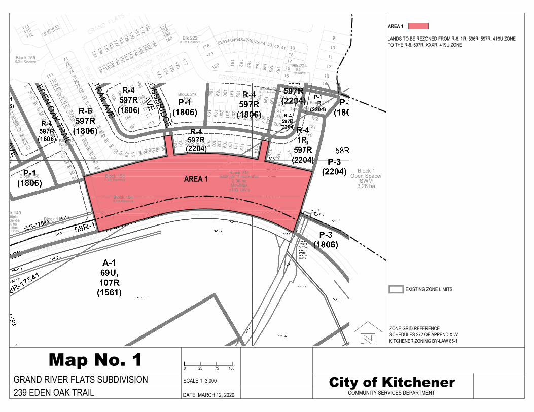
Block 1Open Space/
SWM3.26 ha
Block 217Park
0.14 ha
Blk 218Open
Space/SWM
Blk 2240.3m
Reserve
Block 216Park
0.46 ha
Block 214Multiple Residential
2.36 haMin-Max
±162 Units
Blk 152Walkway
0.03 ha
Block 150Park
0.30 ha
Block 1530.3m Reserve
Block 1540.3m Reserve
Block 1550.3m Reserve
Blk 2220.3m Reserve
Block 149Multiple
Residential1.50 haMin-Max
± 92 Units
Block 1580.3m Reserve
188 196207
203
118
121
5152
5354
71727374757677787980
81828384
858687
88
8990 91 92 93 94 95 96 97 98 99
167166
165
172171
170169168
164
160161
162163
159
173174
175176
177
158157156155
146147
148149
150151
152153
154
178
179
180
181
182
183
184
185 186
187
189
190191192193194
195 197
213
210
212211
209
208
51 49
206205204
198199200201202
100101102
47
103104105106107108109110111112113
114 115
116
117
122
120
119
123124
125126
127128
129130
131
137
112 138139140
132
52 50 48 46 45 44
64
43 1942
65
1817
16
71
15
78
67
7973
91
9897
100102
113114
63
66
68697072
77
808182
8384
8586
8788
8990
929394
9596
101
99
103104105106107108109110111
120
9
10
11
12
1314
41
133
Block 2230.3m Reserve
Blk 2250.3m Reserve
Map No. 1City of Kitchener
COMMUNITY SERVICES DEPARTMENTDATE: MARCH 12, 2020
ZONE GRID REFERENCESCHEDULES 272 OF APPENDIX 'A'KITCHENER ZONING BY-LAW 85-1
AREA 1
LANDS TO BE REZONED FROM R-6, 1R, 596R, 597R, 419U ZONETO THE R-8, 597R, XXXR, 419U ZONE
239 EDEN OAK TRAILSCALE 1: 3,000
0 25 75 100
EXISTING ZONE LIMITS
GRAND RIVER FLATS SUBDIVISION
AREA 1

Planning Justification Report | Grand River Flats, Block 214, Stage 3 65
GSP Group | March 2020
10. Appendix 3 – Proposed Amendment to the
Grand River South Community Plan
That the Grand River South Community Plan is hereby amended as follows:
a. Schedule 1 is amended to change the land use of the subject lands from the “Low
Density Residential” designation to the “Medium Rise Multiple Residential (200
uha)” designation.

Planning Justification Report | Grand River Flats, Block 214, Stage 3 66
GSP Group | March 2020
11. Appendix 4 – TAPS Notice

Notice of Source Protection Plan Compliance
Issued under Section 59(2) of the Clean Water Act
Based on the information submitted as to the Region of Waterloo as of the date above,
it has been determined that the potential activity(s) associated with the proposed
development or building on the Site/Lands are not subject to either Section 57
(Prohibition) or Section 58 (Risk Management Plan) of the Act.
• This Notice is only effective as it relates to the above-noted Application.
• Any change to the information submitted under this Application nullifies this Notice,
unless otherwise permitted by the Risk Management Official.
• This Notice is valid for 1 year from the date of issuance in respect of the above-noted
Application only.
• This Notice is not valid for any subsequent applications for approvals which the
proposal may require under the Planning Act or for any building permits that may be
required under the Building Code Act.
• This notice only addresses requirements in the Source Protection Plan under Section
57 (Prohibition) and Section 58 (Risk Management Plan) of the Act. Other Source
Protection Plan policies may still apply.
• The applicant acknowledges they provided complete and truthful information to the
Region of Waterloo for the generation of this notice. Schedule 1 is an accurate
summary of this information.
• The applicant acknowledges any potential prohibitions identified in Schedule 2.
239 Eden Oak Trail, Kitchener
Address of Site:Applicant Name:
Application Type:
March 9, 2020 Official Plan Amendment, Zone Change
Date:
GSP Group Inc.
Municipal File Number:
(building permit, site plan, consent, etc.)
Page 1 of 4DOCS 1737472

Notice of Source Protection Plan Compliance
Issued under Section 59(2) of the Clean Water Act
Page 2 of 4DOCS 1737472
• This notice does not constitute an approval(s) under the Planning Act or Building Code
Act.
• The applicant acknowledges they are the owner or authorized agent of the owner of the
above-noted property
Signature of Applicant Eric Thuss, Risk Management Official

Notice of Source Protection Plan Compliance
Issued under Section 59(2) of the Clean Water Act
Page 3 of 4DOCS 1737472
SCHEDULE 1 – SUMMARY OF ACTIVITIES PROPOSED FOR PROPERTY
The following activities are either not occurring on or proposed for the property, or are not related to this application:
The application is related to the following activities on the property:
Surface type: Paved area equivalent to more than 80 parking spaces
Application of Road Salt
• Application of manure
• Livestock yards or pastures
• Storage of manure
• Aircraft de-icing
• Storage of DNAPLS (dense oils)
• Application of fertilizer
• Storage of fertilizer
• Storage of fertilizer
• Storage of fuel
• Application of non-agricultural source material (eg: compost or biosolids)
• Storage of non-agricultural source material (eg: compost of biosolids)
• Storage of solvents
• Application of pesticides
• Storage of pesticides
• Storage of pesticides
• Storage of road salt
• Storage of snow (from off-site)
• Landfilling of waste
• Storage of hazardous waste
• Storage of PCB waste
Chemical Handling
Farming Activities
Waste Handling
Winter Maintenance
Private Sewage Operations
• Septic system
• Storm water management

Notice of Source Protection Plan Compliance
Issued under Section 59(2) of the Clean Water Act
Page 4 of 4DOCS 1737472
The following activities may be prohibited under Section 57 of the Clean Water Act at the location indicated on page 1 of this notice:
SCHEDULE 2 – SUMMARY OF ACTIVITIES PROHIBITED AT PROPERTY
The covered storage of de-icing salt in quantities greater than 1 tonne •
The uncovered storage of de-icing salt in quantities greater than 1 tonne •
Piling of snow from other properties •
Communal septic systems or holding tanks •
Fuel stored above ground in quantities greater than 2500 litres •
Fuel stored below ground in quantities greater than 250 litres •
The handling and storage of dense non-aqueous phase liquids (DNAPLs) •
The below ground handling and storage of an organic solvent in quantities greater than 25 litres
•
The storage of hazardous, liquid industrial, or PCB waste •
The temporary field storage of manure or other agricultural source material •