PLANNING FOR BICYCLES
18
2013 Ayaz Zamanov, İrem Bahçelioğlu CRP 454 Urban Transport Systems: Planning and Design 5/30/2013 PLANNING FOR BICYCLES
Transcript of PLANNING FOR BICYCLES

2013
Ayaz Zamanov, İrem Bahçelioğlu
CRP 454 Urban Transport
Systems: Planning and Design
5/30/2013
PLANNING FOR BICYCLES
A.Zamanov,İ.Bahçelioğlu
Page | 1 CRP 454 Urban Transport Systems: Planning and Design
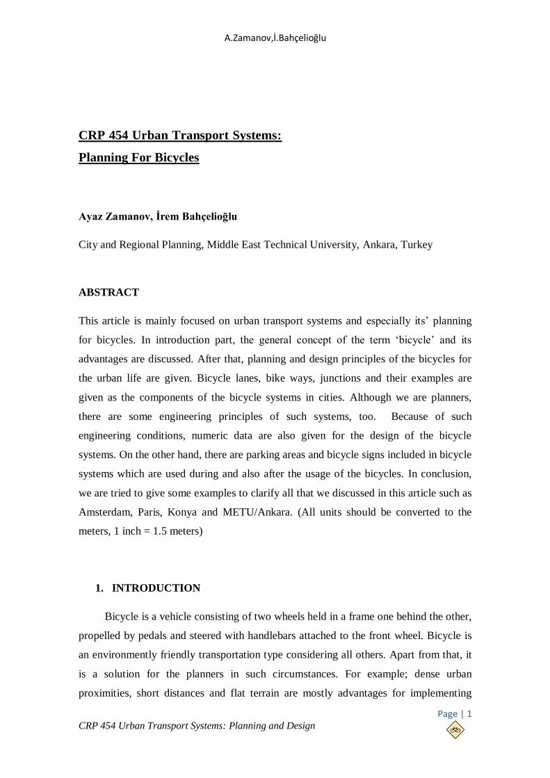
CRP 454 Urban Transport Systems:
Planning For Bicycles
Ayaz Zamanov, İrem Bahçelioğlu
City and Regional Planning, Middle East Technical University, Ankara, Turkey
ABSTRACT
This article is mainly focused on urban transport systems and especially its’ planning
for bicycles. In introduction part, the general concept of the term ‘bicycle’ and its
advantages are discussed. After that, planning and design principles of the bicycles for
the urban life are given. Bicycle lanes, bike ways, junctions and their examples are
given as the components of the bicycle systems in cities. Although we are planners,
there are some engineering principles of such systems, too. Because of such
engineering conditions, numeric data are also given for the design of the bicycle
systems. On the other hand, there are parking areas and bicycle signs included in bicycle
systems which are used during and also after the usage of the bicycles. In conclusion,
we are tried to give some examples to clarify all that we discussed in this article such as
Amsterdam, Paris, Konya and METU/Ankara. (All units should be converted to the
meters, 1 inch = 1.5 meters)
1. INTRODUCTION
Bicycle is a vehicle consisting of two wheels held in a frame one behind the other,
propelled by pedals and steered with handlebars attached to the front wheel. Bicycle is
an environmently friendly transportation type considering all others. Apart from that, it
is a solution for the planners in such circumstances. For example; dense urban
proximities, short distances and flat terrain are mostly advantages for implementing

Planning For Bicycles
Page | 2 CRP 454 Urban Transport Systems: Planning and Design
bicycle systems. To give some advantages of using bicycles in urban, firstly we should
take in to consideration the scale factor. Bicycles are helping us to reduce pollution,
ease traffic congestion and it offers
cheap infrastructure in such cases
comparing to the other transportation
types. These advantages can be
categorized in urban scale. In human
scale, however, bicycles promote better
fitness and health. It is mostly chosen
because of its efficiency and it saves
money in case. Also, it has better mobility than the private cars, motorcycles, buses or
any other transportation type.
A research made by a website which is called 2kr2 is analyzed the top 15 cities
according to the usage of bicycle in the world. As a result, most countries are
contributed this research from Europe. Amsterdam, Barcelona, Berlin, Copenhagen,
Paris, Boulder, Chicago, Davis, Ottawa, Portland, San Francisco, Beijing, Cape Town,
Bogota and Perth are the top 15 countries which mostly use bicycle transportation in the
world. (www.2kr2.com/bisiklet-dostu-dunyanin-15-kenti.html)
Bicycles are generally use special paths. These paths are called as bikeways. First
known use of bikeway was designed in 1894. First separated bike lane is built in New
York. In general, paving of these roads are consist of asphalt, concrete, rubber or stone.
Their management is given to the municipality (such as
infrastructure and maintenance). Sometimes they are fully
separated, but they also have a shared access with the other roads.
To prevent cyclists from any accidents, bikeways are painted in
different colors such as blue (in Turkey), green or grey or orange
(in USA and Europe).
A.Zamanov,İ.Bahçelioğlu
Page | 3 CRP 454 Urban Transport Systems: Planning and Design
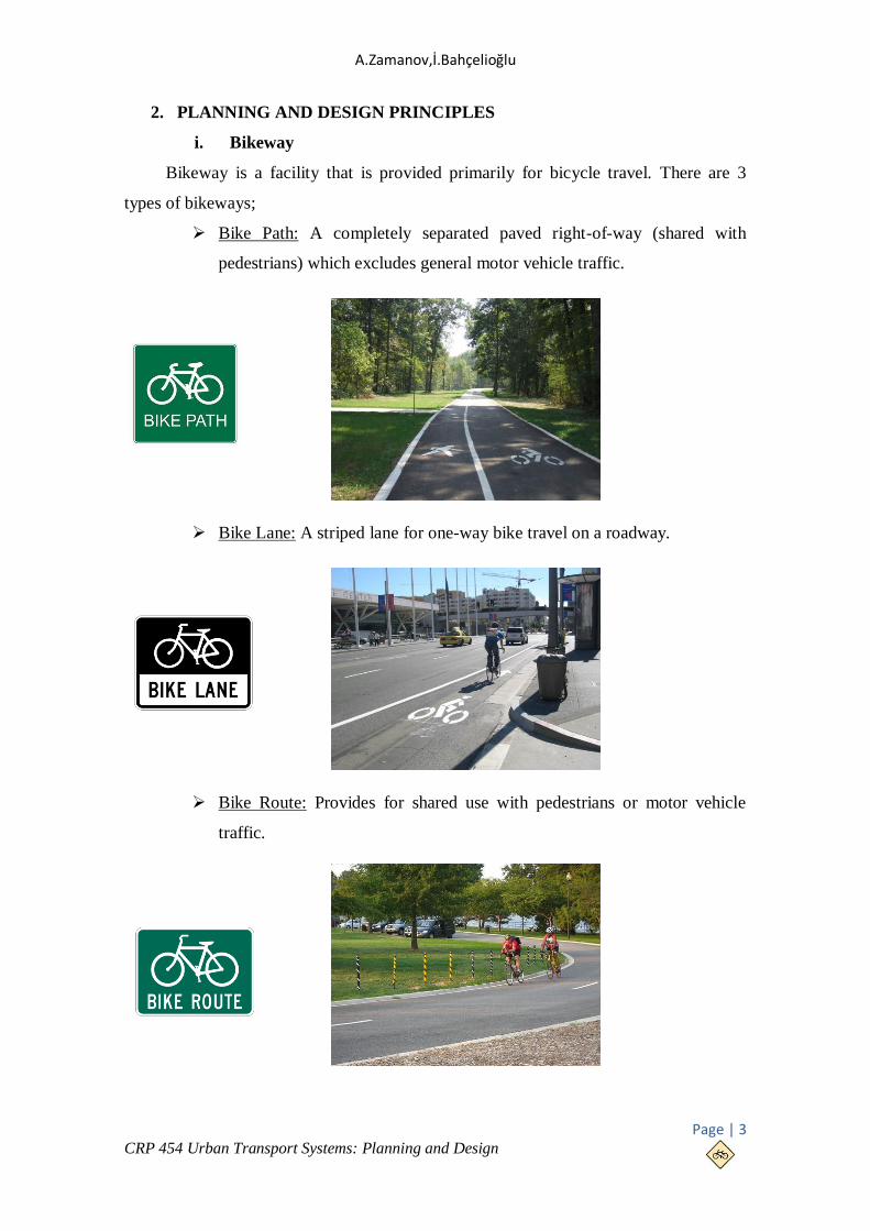
2. PLANNING AND DESIGN PRINCIPLES
i. Bikeway
Bikeway is a facility that is provided primarily for bicycle travel. There are 3
types of bikeways;
Bike Path: A completely separated paved right-of-way (shared with
pedestrians) which excludes general motor vehicle traffic.
Bike Lane: A striped lane for one-way bike travel on a roadway.
Bike Route: Provides for shared use with pedestrians or motor vehicle
traffic.

Planning For Bicycles
Page | 4 CRP 454 Urban Transport Systems: Planning and Design
Bike lanes are defined as "a portion of the roadway which has been designated by
striping, signing and pavement marking for the preferential or exclusive use by
bicyclists". Bicycle lanes make the movements of both motorists and bicyclists more
predictable and as with other bicycle facilities there are advantages to all road users in
striping them on the roadway. There are 6 types of bicycle lanes;
Copenhagen Style Bicycle Lane: Cars are not permitted to enter these at
any time.
Exclusive Bike & Parking Lane: In this type, parking is not an issue, as it’s
provided for separately. The bike lane is always exclusive.

A.Zamanov,İ.Bahçelioğlu
Page | 5 CRP 454 Urban Transport Systems: Planning and Design
Exclusive Bike Lane: For this style of lane the road typically is just too
narrow to allow car parking on both sides. Outside clearway times cars can
legally park over the bike lane.
Shared Parking & Bicycle Lane: It is similar to an Exclusive Bike Lane
but you can park on it at any time. Most of the time the road will be
sparsely parked leaving a fairly continuous wide lane for the cyclist.
Overall Bicycle Facility Width (m)
Road Speed (km/h) 60 80
Desirable Width (on new roads) 4.0 4.5
Acceptable Range
(when retrofitting to roads)
3.7-4.5 4.0-4.7
Overall Bicycle Facility Width (m)
Road Speed (km/h) 60 80 100
Desirable Width (on new roads) 1.5 2.0 2.5
Acceptable Range
(when retrofitting to roads)
1.2-2.5 1.8-2.7 2.0-3.0
Planning For Bicycles
Page | 6 CRP 454 Urban Transport Systems: Planning and Design
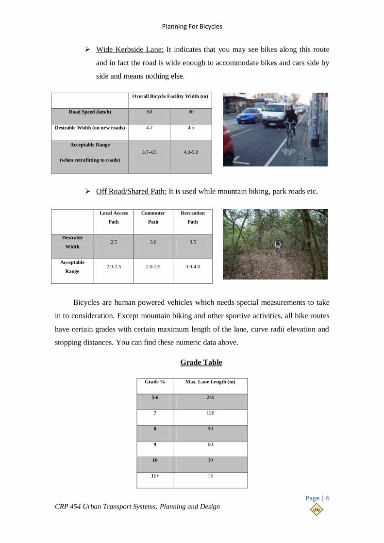
Wide Kerbside Lane: It indicates that you may see bikes along this route
and in fact the road is wide enough to accommodate bikes and cars side by
side and means nothing else.
Off Road/Shared Path: It is used while mountain biking, park roads etc.
Bicycles are human powered vehicles which needs special measurements to take
in to consideration. Except mountain biking and other sportive activities, all bike routes
have certain grades with certain maximum length of the lane, curve radii elevation and
stopping distances. You can find these numeric data above.
Grade Table
Overall Bicycle Facility Width (m)
Road Speed (km/h) 60 80
Desirable Width (on new roads) 4.2 4.5
Acceptable Range
(when retrofitting to roads)
3.7-4.5 4.3-5.0
Local Access
Path
Commuter
Path
Recreation
Path
Desirable
Width 2.5 3.0 3.5
Acceptable
Range 2.0-2.5 2.0-3.5 3.0-4.0
Grade % Max. Lane Length (m)
5-6 240
7 120
8 90
9 60
10 30
11+ 15

A.Zamanov,İ.Bahçelioğlu
Page | 7 CRP 454 Urban Transport Systems: Planning and Design
Curve Radii & Super elevation
Design
Speed
(km/h)
Minimum Radius (m)
2% Superelevation 3% Superelevation 4% Superelevation 5% Superelevation
40 47 45 43 41
50 86 82 79 76
Stopping Distance
Design
Speed
(km/h)
Stopping distance (m)
0% Grade 5% Grade 10% Grade 15% Grade 20% Grade
40 53 60 70 91 155
50 75 85 100 134 233
ii. Junctions
Junctions are the most problematic
areas for the cyclists and pedestrians to pass
over. Dutch engineers and planners have a
new design advice for the junctions. They put
the cyclists on the right turning lane. The
problem is the extremely bad angle of
crossing. Driver have to look to his right
shoulder to see is there any bicycle or not. For
this reason, Dutch stop building lane like they
used to. They keep cyclist to right of the
motorized traffic and deal with the crossing on the junction itself. To make it possible in
safe way, they created an extra curb to connect the cycle lanes on both streets. It has the
same radius as the existing curb and car should turn the cycle path anyway. When we
open certain areas for cyclist on the right way turn, we can see that we created a cycle
path on the junction itself without needing more space.
Planning For Bicycles
Page | 8 CRP 454 Urban Transport Systems: Planning and Design
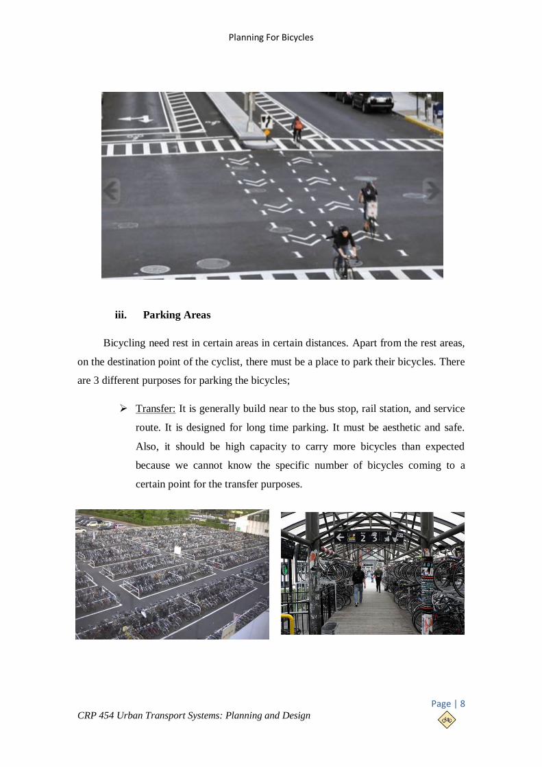
iii. Parking Areas
Bicycling need rest in certain areas in certain distances. Apart from the rest areas,
on the destination point of the cyclist, there must be a place to park their bicycles. There
are 3 different purposes for parking the bicycles;
Transfer: It is generally build near to the bus stop, rail station, and service
route. It is designed for long time parking. It must be aesthetic and safe.
Also, it should be high capacity to carry more bicycles than expected
because we cannot know the specific number of bicycles coming to a
certain point for the transfer purposes.

A.Zamanov,İ.Bahçelioğlu
Page | 9 CRP 454 Urban Transport Systems: Planning and Design
Working: It is generally placed near or in to the working area. It is also
designed for long time parking and high capacity.
Other: In this category, we can include the shopping, leisure and social
purpose travels. As long as they are categorized in commercial purpose,
we can say that they should be near to the central area. Since they are
designed for shopping, short time parking is needed. This type of parking
doesn’t need that much capacity.
iv. Bicycle Signs
Signs are used in each type of transportation mode because transportation is
handled by many different individuals and the only way to organize them is to put
certain signs. Wherever you travel in the world, and whatever mode of travel you
choose, you are guided by and are expected to be ruled by a common set of roadway
signs and pavement markings. STOP signs all look alike and are the same color. Lane

Planning For Bicycles
Page | 10 CRP 454 Urban Transport Systems: Planning and Design
markings follow a consistent pattern. Traffic signals operate in the
same way. Some signs are regulatory or mandatory, while others are
advisory or are informative. Certain signs warn you of conditions
that may affect your journey. Each type of sign or marking has a
common shape and color depending on its function. All of this helps
to ensure that traffic flows safely and efficiently.
v. Integration Bicycle With Other Transportation Modes
Interchange points are very important for bicycles because sometimes it is more
efficient to change transportation mode rather than riding directly to the destination. The
crucial question is how to create such places in a good manner for cyclists. Bicycling
integrates well with public transit (bus,
train, ferry, and air transport). Transit is
most effective for moderate- and long-
distance trips on busy corridors, while
cycling is effective for shorter-distance
trips with multiple stops. Combining transit
and cycling can provide a high level of
mobility comparable to automobile travel.

A.Zamanov,İ.Bahçelioğlu
Page | 11 CRP 454 Urban Transport Systems: Planning and Design
Transit vehicles can carry bicycles, with bike racks mounted on buses or by
carrying bicycles in vehicles (often only during off-peak periods). This allows a bicycle
to be used at both ends of the journey, and helps cyclists who experience a mechanical
failure, unexpected bad weather, or sudden illness. It also allows cyclists to pass major
barriers, such as tunnels or bridges, where cycling is prohibited or particularly difficult.
In addition, exchange points such as park-and-ride is much expensive than an exchange
point which is used only by bicycles. The table above shows the land requirements and
costs both for park-and-ride and bike-and-ride systems.
3. EXAMPLES
i. Amsterdam/Netherlands
Amsterdam is one of the most bicycle-friendly large cities in the world. In
Amsterdam over %60 of trips are made by bike in the inner city and %38 of trips are
made by bike overall in the greater city area. The city is one of the most important
centers of bicycle culture worldwide with world-class facilities for cyclists such as bike
paths and bike racks, and several guarded bike storage garages (Fietsenstalling) which
can be used for a nominal fee. In 2006, there were about 1.000.000 bicycles in
Amsterdam.
Bicycles are used by all socio-
economic groups because of their
convenience, Amsterdam's small size,
the 400 km of bike paths, the flat
terrain, and the arguable
inconvenience of driving an
automobile. Each bike path (Fietspad)
is colored brown, in order to
differentiate it from a footpath.
Characteristic Park-and-Ride Bike-and-Ride
Land requirements (m2) 30 1-2
Installation cost per space $10,000 - $12,000 $140 - $800
Operating cost per space (year) $110 $0 - $30

Planning For Bicycles
Page | 12 CRP 454 Urban Transport Systems: Planning and Design
In Amsterdam, %59 of the whole city uses bicycle as for transportation and %27
of all trips are also made by bicycles in nationwide. There are many cycle-paths and
segregated cycle facilities. The shortest distance from one station to another is
approximately 2.5km, and the longest is 5-7.5km.
Dutch planners studied this issue in a complete manner because they linked the
cycle paths, or let’s say bicycle system, with the public transport system which gives an
opportunity for easy travelling and access to the whole city. In addition to this, Woonerf
streets (living streets) are also making this city more pedestrianized. We can expect that,
with these rates of pedestrianized roads and cycling paths, children should have some
access to their schools with more non-motorized transportation type. Children (10-16
ages) use bicycle to reach their destination. Secondary school children cycle over 15 km
in each direction. %49 of all transport to school occurs by bicycle in Amsterdam.
Amsterdam has rental bike services and stations in the whole
city. It is very easy to get used to biking because they have make it
very simple to use. If you have a credit card or did create an
account for yourself in the web, you can easily transfer money to
the system and rent a bike. Rental daily rate is 9.50€ – 13.50€ for
24 hours.

A.Zamanov,İ.Bahçelioğlu
Page | 13 CRP 454 Urban Transport Systems: Planning and Design
(Map of bicycle routes in Amsterdam)
ii. Paris/France
Paris has steadily increased its network of bicycle paths since the late 1990s. As of
2010 there were 440 km of cycling routes in Paris, including bike paths and bus lanes
that had been widened for use by bike riders. Following the successful examples of
bicycle hire schemes in the French cities of Rennes and Lyon the city of Paris launched
a system of rental bikes free service called Vélib'
on the 15th of July 2007. Managed by the
company JCDecaux there were originally 10,648
bikes available at 750 Vélib' stations. More than
20,600 bikes at 1,451 stations are planned for late
2007 and Paris may eventually have 50,000 Vélib'
bikes for hire. Vélib's main aim is to replace car
use in Paris for short trips.
Vélib started this system with this motto; ‘take a bike, return it where you like’.
Vélib’ is a self-service bike system available 24 hours a day, all year round. To access
the service, the person should buy a 1-day (1.70€) or a 7-day (8.00€) ticket online or at
any Vélib’ station or sign-up for a long-term subscription.

Planning For Bicycles
Page | 14 CRP 454 Urban Transport Systems: Planning and Design
Map of Bicycle Routes in Paris
iii. Konya/Turkey
Konya is one of the cities in Turkey which has bicycle system integrated in the
city. %3.4 of all transport occurs by bicycle in the city. It is favorable for around 10 km
distance for the citizens. Government has planned 460 km of bike route, but only 60 km
is completed. In this plan, 13 different regions integrated with this bicycle system.
It works with a card system
which is called ‘ELKART’. Bikers
should register themselves in the
system from internet or it is possible
to register directly in the stations.
There is a penalty for any damage or
stealing which is worth of 300 TL. A
company called Nextbike is the
sponsor and they have all the
responsibilities about this system. They put these prices for the customers;

A.Zamanov,İ.Bahçelioğlu
Page | 15 CRP 454 Urban Transport Systems: Planning and Design
1 TL for a hour (Once in a
day free for first 30 min)
15 TL for 24 hours
60 TL for 7 days
180 TL for 30 days
(Map of bicycle routes in Konya)
iv. METU/Turkey
Middle East Technical
University is planning to integrate
bicycle system in the campus. METU
has high rates of bicycle ridership.
For now, only problem is the
governmental issues which make this
plan difficult to implement. Planners
have put specific features to create
such bicycle paths. For example the minimum width of bicycle lane should be 2.8 m.
They also thought about the hierarchy of different types of transportation such as;
motorized road will be on the highest priority in the system, then comes bicycle lane
and after that pedestrian are the last one. Minimum of 50cm should be between road and
bicycle lane and bicycle lanes should be 3m for two way of cycling.

Planning For Bicycles
Page | 16 CRP 454 Urban Transport Systems: Planning and Design
Environment also has taken into consideration
while designing this system. They put some
limitations for the ground materials that are going to
be used for the bicycle lanes. Some examples are
shown above.
(Material limitations for the bicycle lanes)
(Map of bicycle routes in METU)

A.Zamanov,İ.Bahçelioğlu
Page | 17 CRP 454 Urban Transport Systems: Planning and Design
4. REFERENCES
(2011). 2010 Bicycle Plan.
Çevre ve Şehircilik Bakanlığı, (2012). Bisiklet Yolu Kılavuzu.
Bicycle Design Guidelines/Best Practices Manual.
(2006). Bikeway Planning and Design. Highway Design Manual. içinde
Design Standards for Bicycle Faciities. (2002). Cycle Notes .
Mert, K., & Öcalır, E. (2010). Konya'da Bisiklet Ulaşımı:Planlama ve Uygulama
Süreçlerinin Karşılaştırılması.
National Association of City Transportation Officials. http://nacto.org/cities-for-
cycling/design-guide/ adresinden alınmıştır
Pedesrian and Bicycle Information Center.
http://www.bicyclinginfo.org/ adresinden alınmıştır
http://www.nextbike.com.tr/tr/konya/ adresinden alınmıştır
Pedestrian and Bicycle Facilities in California. (2005).
http://www.fietsberaad.nl/index.cfm?lang=en§ion=Voorbeeldenbank
http://boroondarabug.org/wiki/Types_of_Bike_Lanes