5. PLANNING FOR INTERMODAL INTEGRATION - Mumbai ...
53
TECHNO-ECONOMIC SURVEY AND PREPARATION OF DPR FOR PANVEL-DIVA-VASAI-VIRAR CORRIDOR Final TES & Detail Project Report Sept, 2014 5-1 5 5 . . P P L L A A N N N N I I N N G G F F O O R R I I N N T T E E R R M M O O D D A A L L I I N N T T E E G G R R A A T T I I O O N N 5.1 STUDY CORRIDOR The proposed Panvel - Virar suburban corridor runs from south to north along the eastern edge of MMR. A total of 13 stations are located along the 69.5 Km long corridor with inter-station spacing of 2.3 - 8.35 km (Table 5.1 and Figure 5.1). Table 5.1: Existing Stations S. No. Station Aprox Chainage (in km) Inter-station Distance (in km) 1 Panvel 0.0 - 2 Kalamboli 5.1 5.1 3 Navade Road 7.4 2.4 4 Taloje 10.8 3.3 5 Nilaje 19.4 8.6 6 Kopar 27.4 8.0 7 Bhiwandi 35.2 7.8 8 Kharbao 43.3 8.1 9 Kaman 51.7 8.4 10 Juchandra 57.3 5.6 11 Vasai 62.7 5.4 12 Nalasopara 67.0 4.3 13 Virar 69.5 2.5 A total of 24 stations (including 11 future stations) at an average inter-station spacing of 3 km are proposed along the suburban corridor (Table 5.2) to cater to serve a larger catchment and increased population in the future years. The proposed Corridor will have major passenger interchange with other existing/ proposed mass transit Corridors at the following stations. S. No. Station Interchange with 1 Virar Interchange with WR and proposed Elevated suburban Corridor. It is the main terminal station of WR Churchgate – Virar Line, with suburban services extending upto Dahanu Road 2 Vasai Road WR and proposed Elevated suburban Corridor 3 Kopar CST - Kalyan Corridor of CR 4 Taloje Navi Mumbai Metro Phase 1 – (Belapur - Pendhar Line) 5 Navade Navi Mumbai Metro Phase 2 – (Pendhar - Khandeshwar Line) 6 Panvel Harbour (Slow and Fast) Lines, Bus Terminal
-
Upload
khangminh22 -
Category
Documents
-
view
0 -
download
0
Transcript of 5. PLANNING FOR INTERMODAL INTEGRATION - Mumbai ...

TECHNO-ECONOMIC SURVEY AND PREPARATION OF DPR FOR PANVEL-DIVA-VASAI-VIRAR CORRIDOR
Final TES & Detail Project Report Sept, 2014 5-1
55.. PPLLAANNNNIINNGG FFOORR IINNTTEERRMMOODDAALL
IINNTTEEGGRRAATTIIOONN
5.1 STUDY CORRIDOR The proposed Panvel - Virar suburban corridor runs from south to north along the eastern edge of MMR. A total of 13 stations are located along the 69.5 Km long corridor with inter-station spacing of 2.3 - 8.35 km (Table 5.1 and Figure 5.1).
Table 5.1: Existing Stations
S. No. Station Aprox Chainage (in km) Inter-station Distance (in km) 1 Panvel 0.0 -
2 Kalamboli 5.1 5.1
3 Navade Road 7.4 2.4
4 Taloje 10.8 3.3
5 Nilaje 19.4 8.6
6 Kopar 27.4 8.0
7 Bhiwandi 35.2 7.8
8 Kharbao 43.3 8.1
9 Kaman 51.7 8.4
10 Juchandra 57.3 5.6
11 Vasai 62.7 5.4
12 Nalasopara 67.0 4.3
13 Virar 69.5 2.5
A total of 24 stations (including 11 future stations) at an average inter-station spacing of 3 km are proposed along the suburban corridor (Table 5.2) to cater to serve a larger catchment and increased population in the future years.
The proposed Corridor will have major passenger interchange with other existing/ proposed mass transit Corridors at the following stations.
S. No. Station Interchange with 1 Virar Interchange with WR and proposed Elevated suburban Corridor.
It is the main terminal station of WR Churchgate – Virar Line, with suburban services extending upto Dahanu Road
2 Vasai Road WR and proposed Elevated suburban Corridor 3 Kopar CST - Kalyan Corridor of CR 4 Taloje Navi Mumbai Metro Phase 1 – (Belapur - Pendhar Line) 5 Navade Navi Mumbai Metro Phase 2 – (Pendhar - Khandeshwar Line) 6 Panvel Harbour (Slow and Fast) Lines, Bus Terminal

TECHNO-ECONOMIC SURVEY AND PREPARATION OF DPR FOR PANVEL-DIVA-VASAI-VIRAR CORRIDOR
Final TES & Detail Project Report Sept, 2014 5-2
Figure 5.1. Proposed Panvel – Virar Suburban Corridor Alignment

TECHNO-ECONOMIC SURVEY AND PREPARATION OF DPR FOR PANVEL-DIVA-VASAI-VIRAR CORRIDOR
Final TES & Detail Project Report Sept, 2014 5-3
The traffic dispersal and proposed arrangements and infrastructure for future traffic dispersal of the present stations are discussed in this report. The sites for future stations have no developments and road network at present – as and when these stations are developed, similar arrangements/ facilities in relation to the station precincts and surrounding developments can be provided there.
Table 5.2: Proposed Stations
S. No. Stations * Railways Kms from CSTM
Tentative chainages in km from Panvel
ISD (in Km)
Existing/ Proposed
Connection to main line
1 Panvel 68.128 0.000 - Existing
2 New Panvel - 1.466 1.466 Proposed
3 Tembode - 2.485 1.019 Proposed
4 Kalamboli 62.892 5.077 2.592 Existing Proposed
5 Navade Road 60.334 7.435 2.358 Existing
6 Pindhar - 8.850 1.415 Proposed
7 Taloje Panchanand 57.092 10.782 1.932 Existing Proposed
8 Nighu - 14.876 4.094 Proposed
9 Narivali - 16.733 1.857 Proposed
10 Nilaje 48.630 19.360 2.627 Existing Proposed
11 Nandavali - 24.815 5.455 Proposed
12 Kopar 48.790 27.353 2.538 Existing
13 New Dombivli - 28.650 1.297 Proposed
14 Pimplas - 32.315 3.665 Proposed
15 Bhiwandi Road 56.600 35.202 2.887 Existing Proposed
16 Kalwar - 37.715 2.513 Proposed
17 Dunge - 40.507 2.792 Proposed
18 Kharbao 64.940 43.310 2.803 Existing Proposed
19 Paye Gaon - 47.305 3.995 Proposed
20 Kaman Road 73.051 51.665 4.360 Existing Proposed
21 Juchandra 79.850 57.280 5.615 Existing Proposed
22 Vasai Road 84.110 62.710 5.430 Existing
23 Nalasopara 88.270 67.020 4.310 Existing
24 Virar 92.320 69.500 2.480 Existing
* Names of proposed stations are tentative and subject to change
5.2 EXISTING TRAFFIC DISPERSAL ARRANGEMENTS
Walk is the pre-dominant mode of feeder passenger trips to/ from the sub-urban rail system. At all stations, buses and IPT in the form of autos are the other major modes of the traffic dispersal. The details of existing stations of Panvel - Virar Corridor alongwith their respective landuse, catchment areas and interchanges with other systems are described in the following paragraphs, Figures 5.2 to 5.14 and Table 5.3.

TECHNO-ECONOMIC SURVEY AND PREPARATION OF DPR FOR PANVEL-DIVA-VASAI-VIRAR CORRIDOR
Final TES & Detail Project Report Sept, 2014 5-4
5.2.1 PANVEL Panvel station is the first station of the proposed corridor. It is an important railway station on the Harbour Line and CST - Diva - Panvel route of the Central Railways. The station comes under Mumbai Division of Central Railway and is technically divided into Suburban and Main Line. The station Platforms 1,2,3 and 4 are for Suburban Trains while Platforms 5,6 and 7 are for main line trains. 9 pairs of daily express trains, 13 pairs of non-daily express trains and 12 daily commuter (passenger) trains stop here. The station also handles a sizeable amount of freight trains. The surrounding landuse near the station is a mix of commercial, industrial, semi public and residential. The connecting roads to the station are Old Panvel Road, Station Road, Panvel Matheran Road and Mumbai Pune Expressway. The prominent catchment areas of the station include Takka colony, forest colony and Panvel colony on western side while New Panvel Township is on eastern side. Road based public transport is provided by buses and autos. There is one bus stand / terminal in on the western side of the railway station which handles about 200 NMMT (New Mumbai Municipal Transport) buses per day mostly to other nodes in Navi Mumbai and a few services to Mumbai. The station has four passenger entries , three formal (two in west and one in east) and one informal in west .
The pictorial depiction of traffic dispersal and related issues of Panvel station are presented in Figure 5.2.

TECHNO-ECONOMIC SURVEY AND PREPARATION OF DPR FOR PANVEL-DIVA-VASAI-VIRAR CORRIDOR
Final TES & Detail Project Report Sept, 2014 5-5
i. Panvel
1. Parking of vehicles near the station entry 2. Unavailability of continuous and uniform
footpath
3. Lack of organized Autobays results in on-street
parking of Autos near the old station road
4. Lack of pedestrian facilities on Station Road
results in Pedestrian – vehicle conflicts
Figure 5.2. Traffic dispersal and related issues of Panvel Station
1
2
4
3
PANVEL

TECHNO-ECONOMIC SURVEY AND PREPARATION OF DPR FOR PANVEL-DIVA-VASAI-VIRAR CORRIDOR
Final TES & Detail Project Report Sept, 2014 5-6
5.2.2 KALAMBOLI
Kalamboli is one of the nodes prominent of Navi Mumbai. It is a transportation hub, being situated at the junction of the Sion Panvel Highway, National Highway 4, Panvel By-Pass, Mumbai-Goa Highway & Mumbai-Pune Expressway, and is among the biggest iron & steel delivery centers in India Kalamboli station is about 5 km north of Panvel Station and located in Raigad district. The connecting roads to the station are Steel Market Road, Old Pune Road and Kalamboli Station Road. The surrounding landuse near the station is a mix of semi public and residential on western side while large pockets of undeveloped open area/ water bodies exist on eastern side. The important catchment areas near the station include Kudupapa and Kalamboli Township on western side while Valavali , Padghe and Tembhode are present on eastern side. Steel Market Yard is one of the major landmark on western side near the Kalamboli station. The station has four passenger entries out of which two are formal (one in west, one in east) and another two are informal (one in west, one in east) The pictorial depiction of traffic dispersal and related issues of Kalamboli station are presented in Figure 5.3.
5.2.3 NAVADE It is located about 7.4 km north of Panvel Station. The connecting roads to the station are MIDC Road, Navade Station Road and Kalamboli Link Road. At present, very sparse urban development exists near the station. The landuse on western side of the station is characterized by residential areas like Navade Township while large pockets of undeveloped open areas/ water bodies (Kasardi River) exist on eastern side. The station has four passenger entries out of which two are formal (one in west, one in east) and another two are informal (one in west, one in east) The pictorial depiction of traffic dispersal and related issues of Navade station are presented in Figure 5.4.

TECHNO-ECONOMIC SURVEY AND PREPARATION OF DPR FOR PANVEL-DIVA-VASAI-VIRAR CORRIDOR
Final TES & Detail Project Report Sept, 2014 5-7
ii. Kalamboli
1. Low traffic intensity near the Kalamboli station 2. Poor condition of the pedestrian bridge connecting the station
3. Present development around station area is
negligible
4. Lack of transport facilities near the station
Figure 5.3. Traffic dispersal and related issues of Kalamboli Station
1 2
4
3
KALAMBOLI

TECHNO-ECONOMIC SURVEY AND PREPARATION OF DPR FOR PANVEL-DIVA-VASAI-VIRAR CORRIDOR
Final TES & Detail Project Report Sept, 2014 5-8
iii. Navade
1. Lack of transportation facilities near the station area
2. Commuters uses the staircase to access the station.
3. On-street parking of vehicles Lack of infrastructure facilities near the station
Figure 5.4. Traffic dispersal and related issues of Navade station
1
2
4
3
NAVADE

TECHNO-ECONOMIC SURVEY AND PREPARATION OF DPR FOR PANVEL-DIVA-VASAI-VIRAR CORRIDOR
Final TES & Detail Project Report Sept, 2014 5-9
5.2.4 TALOJE
It is located about 10.8 km north of Panvel Station. The connecting roads to the station are Old Pune Road and Taloje Station Road. The landuse on either side of the station is characterized by small pockets of residential areas and large undeveloped open areas. The important catchment areas near the station include Imampuri, Taloje Panchanand, Owe and Pethapada on western side while Petali and Majkur gaon are present on eastern side .The station has one formal passenger entry on western side and an informal one on the eastern side. The pictorial depiction of traffic dispersal and related issues of Taloje Station are presented in Figure 5.5.
5.2.5 NILAJE
It is located about 19.4 km north of Panvel Station. The access roads to station are MIDC Pipe Line Road, Kalian Shilphata Road and Nilaje Station Road. The landuse on eastern side is characterized by large pockets of undeveloped open areas while on the western side, new township is developing. The catchment areas on western side include New Township, Khidkali Gaon , Sagarli Gaon and Paddle Gaon while Nilaje Gaon, Lodha Casa Bella Gold Township, Kalegaon, Hedutane and Shirdhon are present on eastern side. The station has four passenger entries out of which two are formal (one in west, one in east) and another two are informal (one in west, one in east) The pictorial depiction of traffic dispersal and related issues of Nilaje Station are presented in Figure 5.6.
5.2.6 KOPAR
It is located about 27.4 km north of Panvel Station. It is a mini-junction connecting the Central Line and the Dahanu Road-Panvel Line. Only Slow trains halt at this station. The connecting roads to the station are Kopar Road, Raj Road and New Ayre Road.The surrounding landuse near the station is a mix of commercial, semi public and residential and large pocket of open area on western side. The important catchment areas near the station include Kopar Gaon on western side while Mahtre Nagar , Tukaram Nagar , Dattanagar , Shastri Nagar and Ram Nagar are present on eastern side .The station has four passenger entries out of which two are formal (one on either side) and another two are informal (one on either side) The pictorial depiction of traffic dispersal and related issues of Kopar Station are presented in Figure 5.7.

TECHNO-ECONOMIC SURVEY AND PREPARATION OF DPR FOR PANVEL-DIVA-VASAI-VIRAR CORRIDOR
Final TES & Detail Project Report Sept, 2014 5-10
iv. Taloje
1. Lack of formal parking facilities 2. Haphazard parking of vehicles near the station
area
3. Informal entry on eastern side of the station 4. Absences of formal parking and pedestrian facilities
Figure 5.5. Traffic dispersal and related issues of Taloje station
1
2
4
3
TALOJE

TECHNO-ECONOMIC SURVEY AND PREPARATION OF DPR FOR PANVEL-DIVA-VASAI-VIRAR CORRIDOR
Final TES & Detail Project Report Sept, 2014 5-11
v. Nilaje
1. Absence of formal footpath and parking facilities
2. on-street parking on Lodha Casa Rio Gold Road
3. Undeveloped area near the station results in Low Traffic Intensity
Figure 5.6. Traffic dispersal and related issues of Nilaje station
1 2 3 NILAJE

TECHNO-ECONOMIC SURVEY AND PREPARATION OF DPR FOR PANVEL-DIVA-VASAI-VIRAR CORRIDOR
Final TES & Detail Project Report Sept, 2014 5-12
vi. Kopar
1. Unorganised parking of vehicles near the station 2. Inadequate Pedestrian Facilities
3. Garbage and Discontinuous footpath result in difficulty for pedestrian movement.
4. Upcoming Residential developments near the station area are likely to increase the ridership in coming years
Figure 5.7. Traffic dispersal and related issues of Kopar station
1
2
4
3
KOPAR

TECHNO-ECONOMIC SURVEY AND PREPARATION OF DPR FOR PANVEL-DIVA-VASAI-VIRAR CORRIDOR
Final TES & Detail Project Report Sept, 2014 5-13
5.2.7 BHIWANDI ROAD
It is located about 35.2 km north of Panvel Station andfalls under Thane district .The access roads to station are Chinchoti Anjur Phata Road , Kamatghar Road and Bhiwandi Station Road. The landuse on either side of the station is characterized by residential, semi-public areas and small pockets of undeveloped open areas. The catchment areas on western side include Rahanal, Millat Nagar, Val and Ovali while Bhiwandi , Narpoli gaon and Balaji Nagar are present on eastern side . The station has two formal passenger entries on western side and another two are informal (one in west, one in east) The pictorial depiction of traffic dispersal and related issues of Bhiwandi Road Station are presented in Figure 5.8.
5.2.8 KHARBAO
It is located about 43.3 km north of Panvel Station. The road access to station is via Chinchoti Anjur Phata Road. The landuse on either side of the station is characterized by small pockets of residential areas and large undeveloped open areas/ water body (Ulhas River). The station has one formal passenger entry on eastern side and one informal western side
The pictorial depiction of traffic dispersal and related issues of Datiwali Station are presented in Figure 5.9.
5.2.9 KAMAN
It is located about 51.6 km north of Panvel Station. The access roads to station are Chinchoti Anjur Phata Road and Station Road. The landuse on either side of the station largely composed of undeveloped open areas and small pockets of residential areas. The station has one formal passenger entry on eastern side and one informal western side The pictorial depiction of traffic dispersal and related issues of Kaman Station are presented in Figure 5.10.

TECHNO-ECONOMIC SURVEY AND PREPARATION OF DPR FOR PANVEL-DIVA-VASAI-VIRAR CORRIDOR
Final TES & Detail Project Report Sept, 2014 5-14
vii. Bhiwandi Road
1. Lack of passenger infrastructure facilities near the station area
2. Absence of formal Pedestrian and parking facilities
3. Haphazard parking near the station entry 4. Lack of transportation facilities on station road
Figure 5.8. Traffic dispersal and related issues of Bhiwandi Road Station
1
2
4
3
BHIWANDI ROAD

TECHNO-ECONOMIC SURVEY AND PREPARATION OF DPR FOR PANVEL-DIVA-VASAI-VIRAR CORRIDOR
Final TES & Detail Project Report Sept, 2014 5-15
viii. Kharbao
1. No formal entry on the Western side of the station – may be required for future developments
2. Present development around station area is negligible
3. Absence of formal parking facilites. 4. Low traffic intensity on station access roads
Figure 5.9. Traffic dispersal and related issues of Kharbao Station
1
2
4
3
KHARBAO

TECHNO-ECONOMIC SURVEY AND PREPARATION OF DPR FOR PANVEL-DIVA-VASAI-VIRAR CORRIDOR
Final TES & Detail Project Report Sept, 2014 5-16
ix. Kaman Road
1. Narrow street and absence of footpath on eastern side
2. Present development around station area is negligible
3. Lack of transportation facilities near the station
area 4. Lack of passenger platform safety
Figure 5.10. Traffic dispersal and related issues of Kaman Road Station
1
2
4
3
KAMAN ROAD

TECHNO-ECONOMIC SURVEY AND PREPARATION OF DPR FOR PANVEL-DIVA-VASAI-VIRAR CORRIDOR
Final TES & Detail Project Report Sept, 2014 5-17
5.2.10 JUCHANDRA
It is located about 57.3 km north of Panvel Station. The access roads to station are Naigaon East Road and Station Road. The landuse on either side of the station is characterized by sparsely developed residential areas and large pockets of undeveloped open areas.
The catchment areas near the station include the localities of Juchandra and Naigaon . The station has one formal passenger entry on western side and one informal eastern side.
The pictorial depiction of traffic dispersal and related issues of Juchandra Station are presented in Figure 5.11.
5.2.11 VASAI
It is located about 62.7 km north of Panvel Station. The access roads to station are Vasant Nagari Road, Ambati Road and Station Road. The landuse on either side of the station is characterized by residential, commercial, semi-public areas and salt pan areas.
The catchment areas on western side include Anand Nagar,Dindayal Nagar, Omar Nagar and Panchal Nagar while Vasai township and salt pans are present on eastern side . The station has two formal passenger entry on western side and two on eastern side. There are various residential apartments in the western side such as Shiv shakti apartment, Shamim apartment, etc and also Navghar Bus station. It hasa formal auto stand on the western side . The pictorial depiction of traffic dispersal and related issues of Bhiwandi Road Station are presented in Figure 5.12.
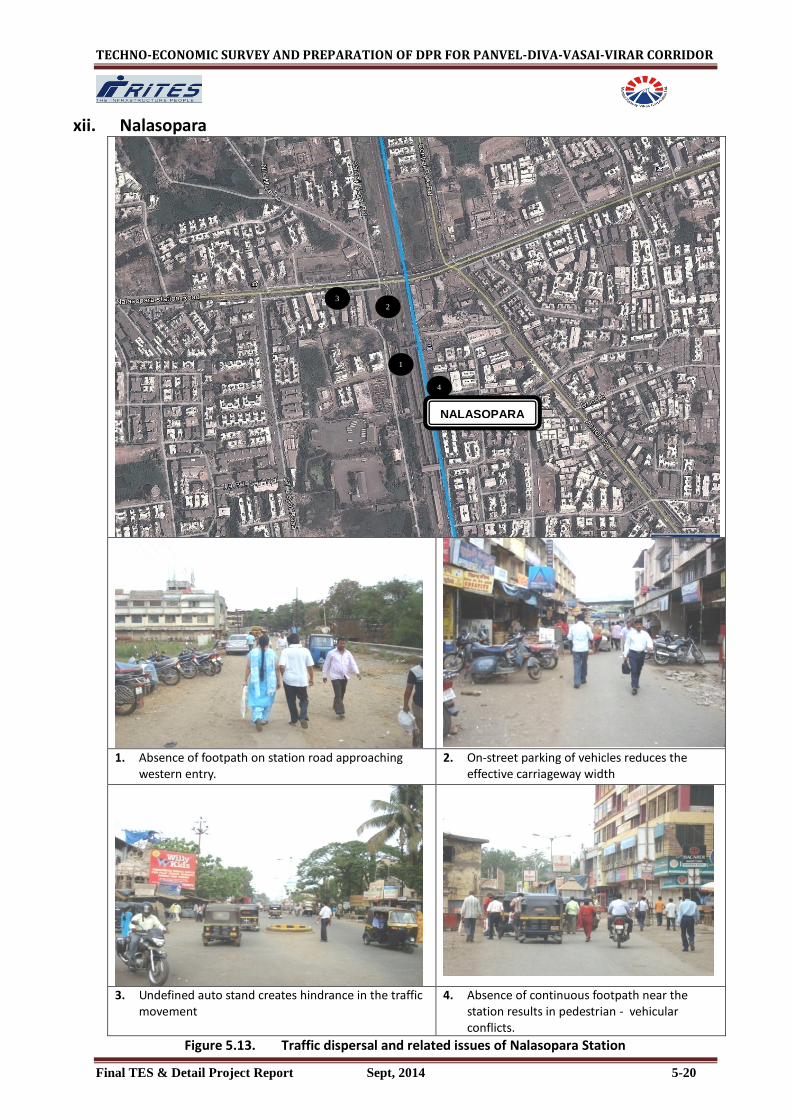
5.2.12 NALASOPARA
It is located about 67 km north of Panvel Station. The access roads to station are Nalasopara Station Road, S.T.Depot Road, and Achole Road. The landuse on either side of the station is characterized by residential, commercial , semi-public areas and small pockets of undeveloped open areas.
The catchment areas on western side include Morya Nagar, Kaveri Society and Samel Pada while Oswal Nagri, Damodar Nagar and Ambewadi exist on eastern side . The pictorial depiction of traffic dispersal and related issues of Nalasopara Road Station are presented in Figure 5.13.

TECHNO-ECONOMIC SURVEY AND PREPARATION OF DPR FOR PANVEL-DIVA-VASAI-VIRAR CORRIDOR
Final TES & Detail Project Report Sept, 2014 5-18
x. Juchandra
1. Lack of pedestrian infrastructure facilities on platform
2. Lack of transportation facilities on station access road
3. Informal access to the platform from the
southern end of the station 4. Present development around station area is
negligible
Figure 5.11. Traffic dispersal and related issues of Juchandra Station
1
2
4
3
JUCHANDRA

TECHNO-ECONOMIC SURVEY AND PREPARATION OF DPR FOR PANVEL-DIVA-VASAI-VIRAR CORRIDOR
Final TES & Detail Project Report Sept, 2014 5-19
xi. Vasai
1. Absence of no footpaths results in pedestrian spillover on road.
2. On- street parking of two wheelers
3. On-street parking of vehicles reduces the effective carriageway width
4. Pedestrian traffic conflicting with vehicular traffic
Figure 5.12. Traffic dispersal and related issues of Vasai Station
1
2
4
3
VASAI
TECHNO-ECONOMIC SURVEY AND PREPARATION OF DPR FOR PANVEL-DIVA-VASAI-VIRAR CORRIDOR
Final TES & Detail Project Report Sept, 2014 5-20
xii. Nalasopara
1. Absence of footpath on station road approaching
western entry. 2. On-street parking of vehicles reduces the
effective carriageway width
3. Undefined auto stand creates hindrance in the traffic movement
4. Absence of continuous footpath near the station results in pedestrian - vehicular conflicts.
Figure 5.13. Traffic dispersal and related issues of Nalasopara Station
1
2
4
3
NALASOPARA

TECHNO-ECONOMIC SURVEY AND PREPARATION OF DPR FOR PANVEL-DIVA-VASAI-VIRAR CORRIDOR
Final TES & Detail Project Report Sept, 2014 5-21
5.2.13 VIRAR
Virar station is the last station of the proposed corridor and located about 69.5 km north of Panvel Station. The surrounding landuse near the station is a mix of commercial, semi public and residential. The connecting roads to the station are Veer Savarkar Road, Bazaar Road and Manvel Pada Road. The catchment of the station includes the dense localities of Vasai Virar Municipal Corporation.
Road based public transport is primarily provided by buses and supported by autos .The station has five passenger entries , three in east and two in west. The pictorial depiction of traffic dispersal and related issues of Virar station are presented in Figure 5.14.

TECHNO-ECONOMIC SURVEY AND PREPARATION OF DPR FOR PANVEL-DIVA-VASAI-VIRAR CORRIDOR
Final TES & Detail Project Report Sept, 2014 5-22
xiii. Virar
1. Lack of defined auto stand on approach road of the eastern entry results in haphazard on-street parking of autos
2. Encroachment on footpath by informal activities results
3. Pedestrian spillover on road in absence of
sufficient footpath width 4. On-street parking of vehicles conflicts the
pedestrian movement Figure 5.14. Traffic dispersal and related issues of Virar station
1
2
4
3
VIRAR

TECHNO-ECONOMIC SURVEY AND PREPARATION OF DPR FOR PANVEL-DIVA-VASAI-VIRAR CORRIDOR
Final TES & Detail Project Report Sept, 2014 5-23
Table 5.3: Issues and Concerns of the Station Areas
Station Names
Issues Concern Potential
Panvel (East) New Panvel
Encroachment of road by parking of vehicles reduces the effective width of carriageway.
Encroached footpaths by informal activities and projections by shopkeepers results in pedestrian movement on roadway
Lack of pedestrian facilities on station road results in Pedestrian – vehicle conflicts
On-street parking of vehicles is a matter of concern.
Encroachment on footpath by informal activities is also a major concern.
Lack of pedestrian facilities is also a matter of concern.
Encroached Railway land, by slum near Railway Station can be used for providing transport infrastructure / pedestrian facilities
Scope of generating revenue through advertisements/ commercial development of surrounding station area
Panvel (West) Old Panvel
Haphazard on-street parking of autos in absence of organized auto stand
Encroached footpaths by informal activities and projections by shopkeepers results in pedestrian movement on roadway
Lack of pedestrian facilities is a matter of concern.
Vacant land near the station area, which can be used for providing transport infrastructure / pedestrian facilities
Wide footpaths can accommodate the passenger dispersal
Kalamboli (East)
Lack of connectivity to the railway station with main road.
Planned passenger facilities are required to ensure passenger safety and convenience
Vacant land near the station area can be used for providing transport infrastructure / pedestrian facilities
Kalamboli (West)
Absence of adequate formal off-street parking
Container Depot on the west side of the station results in difficult to access the station
Planned passenger facilities are required to ensure passenger safety and convenience
Vacant land near the station area can be used for providing transport infrastructure / pedestrian facilities
Navade (East)
Lack of proper connectivity to the railway station with main road.
Planned passenger facilities are required to ensure passenger safety
Vacant land near the station area can be used for providing transportation Infrastructure
Navade (West)
Lack of transportation facilities on station road
Lack of proper parking areas around station area
Lack of transportation facilities and On-street parking are the major concern
Vacant land near the station area can be used for providing parking space and transportation facilities
Taloje (East)
Lack of proper connectivity to the railway station with main road.
Planned passenger facilities are required to ensure passenger safety
vacant land near the station area, can be used for parking space
New developments & Navi Mumbai Metro will generate more ridership for the station.
Taloje (West)
Lack of passenger safety and infrastructure facilities near the station
Lack of formal parking space near the station
Lack of passenger safety and infrastructure facilities.
vacant land near the station area, can be used for parking space
New developments & Navi Mumbai Metro will generate more ridership for the station.
Nilaje (East)
Lack of proper connectivity to the railway station with main road.
Lack of Railway Infrastructure like platform and ticketing counter
Lack of Transportation infrastructure for better connectivity with railway station
Vacant land near the station area can be used for providing transport infrastructure /

TECHNO-ECONOMIC SURVEY AND PREPARATION OF DPR FOR PANVEL-DIVA-VASAI-VIRAR CORRIDOR
Final TES & Detail Project Report Sept, 2014 5-24
Station Names
Issues Concern Potential
pedestrian facilities
Nilaje (West)
Absence of footpaths and on-street parking of vehicles
On-street parking reduces the effective carriageway width
Lack of proper Public Transport / IPT stopping facilities
Absent and Encroached footpaths
On-street parking of vehicles, undefined auto parking
Vacant land near the station area can be used for providing transport infrastructure / pedestrian facilities
Kopar (East)
Discontinuous footpath
Encroached footpaths by informal activities
Discontinuous and Encroached footpaths, are the major concern of traffic circulation.
Wide footpaths can accommodate the passenger dispersal
Kopar (East)
Lack of formal parking space near the station
Discontinuous footpath
Formal parking of vehicles and Discontinuous, are the major concern of traffic circulation.
Vacant land near the station are can be used for providing transport infrastructure
Bhiwandi (East)
Lack of infrastructure facilities near the station area.
Haphazard & Undefined parking of vehicles near the station
Absence of footpath on station road results in difficulty for Pedestrian movement
Lack of transportation facilities
On-street parking of vehicles, Absence of footpaths are the major concern.
Vacant land near the station area can be used for providing infrastructure / pedestrian facilities
Bhiwandi (west)
Lack of proper connectivity to the railway station with main road.
Planned passenger facilities are required to ensure passenger safety
Vacant land near the station area can be used for providing infrastructure / pedestrian facilities
Kharbav (East)
Lack of passenger safety and infrastructure facilities near the station
Absence of footpath on station road results in difficulty for Pedestrian movement
Lack of passenger safety and infrastructure facilities.
Absence of footpaths
Vacant land near the station area can be used for providing transport infrastructure / pedestrian facilities
Kharbav (West)
Lack of proper connectivity to the railway station with main road.
Planned passenger facilities are required to ensure passenger safety
Vacant land near the station area can be used for providing transport infrastructure / pedestrian facilities
Kaman road (East)
Lack of proper connectivity to the railway station with main road.
Planned passenger facilities are required to ensure passenger safety and convenience
Vacant land around the station can be utilised for station facilities
Kaman road (West)
Lack of proper connectivity to the railway station with main road.
Lack of Railway Infrastructure like platform and ticketing counter
Planned passenger facilities are required to ensure passenger safety and convenience
Vacant land around the station can be utilised for station facilities
Juchandra (East)
Lack of proper connectivity to the railway station with main road.
Lack of Railway Infrastructure like platform and ticketing counter
Lack of passenger safety and infrastructure facilities.
Vacant land near the station area can be used for providing transport infrastructure / pedestrian facilities
Juchandra Lack of passenger safety and infrastructure facilities. Lack of passenger safety and infrastructure Vacant land near the station area can be used

TECHNO-ECONOMIC SURVEY AND PREPARATION OF DPR FOR PANVEL-DIVA-VASAI-VIRAR CORRIDOR
Final TES & Detail Project Report Sept, 2014 5-25
Station Names
Issues Concern Potential
(East) facilities.
for providing transport infrastructure / pedestrian facilities
Vasai road (East)
Lack of defined auto stand area near the station
Absent footpaths near station area
Encroached footpaths by informal activities
Narrow Street, Absence of designated pick-drop areas, footpaths, on street parking and encroachment are the major traffic issues.
Vacant land near the station area can be used for providing transport infrastructure / pedestrian facilities
Vasai road (West)
Narrow street on western entry partially encroached by the parking of vehicles
Lack of defined auto stand area near the station
Absent footpaths near station area
Encroached footpaths by informal activities
poor road condition
Narrow Street, Absence of designated pick-drop areas, footpaths, on street parking and encroachment are the major traffic issues.
Bus stop location adjacent to the station will aid in accessible and more efficient passenger interchange.
Nalasopara (East)
Heavy on -street parking and encroachment
Absent footpaths near station area
Narrow street
Narrow Street, Absence of designated pick-drop areas, footpaths, on street parking and encroachment are the major traffic issues.
Vacant land near the station area can be used for providing parking space and transportation facilities
Nalasopara (East)
Lack of defined auto stand near station area
Heavy on -street parking and encroachment
Absent footpaths near station area
Absence of designated pick-drop areas, footpaths, on street parking and encroachment are the major traffic issues.
Vacant land near the station area can be used for providing parking space and transportation facilities
Virar (East) Heavy pedestrian traffic on road conflicting with vehicular traffic due to unutilisation of footpath on some road stretches.
Lack of defined auto stand on approaching road of the eastern entry results in haphazard street parking of autos creating hindrance to the traffic.
Undefined and inadequate Bus stop area, resulting in passenger spillover on road.
absence of designated pick-drop and encroachment on the footpath result in undesirable pedestrian-vehicle conflicts and inefficient traffic circulation.
Transport infrastructure facilities can be provided by reconfiguration.
Virar (West)
Unavailability of footpath on major stretch of station road on western entry forces the pedestrians to use road for walking thus creating conflicts with vehicular traffic.
Heavy on street parking and encroachment reduces the effective carriageway width.
Lack of defined auto stand on approaching road of the eastern entry results in haphazard street parking of autos creating hindrance to the traffic.
Traffic congestion at station entries, absence of designated pick-drop result in undesirable pedestrian-vehicle conflicts and inefficient traffic circulation. On street parking is other concerns.
Transport infrastructure facilities can be provided by reconfiguration and better utilisation of available land /road space.

TECHNO-ECONOMIC SURVEY AND PREPARATION OF DPR FOR PANVEL-DIVA-VASAI-VIRAR CORRIDOR
Final TES & Detail Project Report Sept, 2014 5-26
5.3 PLANNING FOR INTERCHANGE FACILITIES
It is necessary to plan for inter-modal integration at major interchange stations. The proposed inter-modal integration measures have the following objectives;
To facilitate efficient transfer and dispersal of passengers from/ to the stations
To provide for effective inter-modal interchange of the passengers with the feeder modes including walk
In conjunction with the projected ridership, planning of inter-modal integration is carried out for the year 2041. The existing Panvel - Virar Rail Corridor carries passenger traffic volume reaching sectional passenger load levels of around 3000 PHPDT and station loads upto 2000 passengers during peak hours. Majority of the sub-urban rail passengers walk to/ from the Railway stations. However, a significant percentage also depends on buses and IPTs for feeder mode to/ from the stations.
The modal distribution of the feeder trips at the station for the proposed system is likely to be similar to as presently observed at the major stations such as Panvel , Kopar, Nalasopara, Vasai and Virar . However, the quantum of passenger dispersal volumes in the station areas would increase significantly in the future.
With the increase in passenger traffic dispersing via the road network for their feeder trips, it is vital that adequate traffic dispersal facilities are available at the stations in terms of capacity of roads, footpaths/ pedestrian facilities, bus stops, IPT stands, Pick-Drop Areas and Parking to cater to the projected requirements.
The present transport infrastructure and dispersal facilities would need to be augmented to handle the additional volumes. Up-gradation of walkways, pedestrian cross-over facilities, new/ augmented bus/ IPT stands, planned pick-up/ drop-off areas, parking facilities and increased frequencies of public transport are the prominent measures envisaged for this purpose.
The proposed corridor will have potential passenger interchange with the proposed Navi Mumbai metro corridor which would been in vicinity of Kalamboli, Navade and Taloje. Accordinly the skywalks are proposed or extended in such a ways to have an integration with the proposed metro stations at concourse level
The traffic dispersal and proposed arrangements and infrastructure for future inter-modal transport integration and traffic dispersal for the thirteen existing stations along the Corridor have been prepared at conceptual level (Tables 5.4 to 5.16 and Figures 5.15 to 5.27). The sites for future stations have no developments and road network at present – as and when these stations are developed, similar arrangements/ facilities in relation to the station precincts and surrounding developments can be provided there.

TECHNO-ECONOMIC SURVEY AND PREPARATION OF DPR FOR PANVEL-DIVA-VASAI-VIRAR CORRIDOR
Final TES & Detail Project Report Sept, 2014 5-27
Table 5.4: Peak hour Passenger Dispersal Demand Levels and Proposed Connectivity & Traffic Circulation at Panvel Station Road Names
Existing width
Existing capacity
Existing Load
Issues proposal Proposed capacity Projected load
Roads
West
Panvel Station
10m 5000 PCU/Hr
2500 PCU/Hr
• Encroachment of road by parking of vehicles, vendors reduces the effective width of carriageway.
• Road widening upto 30 m (continued carriageway width of approach roads) for better station connectivity
• Strengthening of Road shoulder areas • Removal of on-street parking of vehicles • Relocation of Vendors/ Hawkers from roadway. • Provision of pedestrian guardrails along footpath, zebra crossing, road marking and
traffic signages
15000 PCU/Hr 12000 PCU/Hr
East
Station Road
17.5 m 8500 PCU/Hr
500 PCU/Hr • On-street parking and vendors constrain the vehicular movement
• Relocation of Vendors/ Hawkers from roadway • Removal of on-street parking by providing off-street parking near the station.
10,000 PCU/Hr 7000 PCU/Hr
Pedestrian Facilities
PanvelStation Road (West)
13850 Persons/Hr
• Intense Pedestrian – Vehicle conflicts, On-Street vendors, IPT, Stands
• Proposal of two subway of 10 m on northern side & southern side of the existing subwayand extension of existing one upto the proposed platforms.
• Footpath (2m to 4m ) with the Provision of pedestrian guardrails along zebra crossing, road marking and traffic signages
• It is also proposed to have linkages with IPT and Bus Stops.
48000 Persons/Hr 44500 Persons/Hr
Station Road (East)
3000 persons/Hr
• Intense Pedestrian – Vehicle conflicts, • Discontinuous and encroached foot
path with vendors and IPT movements,
• Proposal of two subway of 10 m on northern side & southern side of the platform and extension of existing one upto the proposed platforms.
• Footpath (2m to 4m ) with the Provision of pedestrian guardrails along zebra crossing, road marking and traffic signages
• Removal of vendors from foot path and re-organised pick and drop area. • Widening of total footpath width by utilizing Road shoulder areas
48000 Persons/Hr 9500 Persons/Hr
Bus Stops
West /East On-Street
2 buses /minute
• The on-street Bus Stops impede traffic flow
• Demarcation of designated Bus Bays on main roads, especially near the proposed station entry/exits
• Existing bus depot on western side need to be augmented with more bus bays
21 Bus bays to handle a total of at least 22 buses/ minute
21 buses / minute
IPT (Auto/Taxi)
West /East
On-Street 12.5 Autos /minute
• The on-street Auto Stops impede traffic flow
• No Designated Pick-Drop Areas result in traffic congestion
• Demarcation of designated Bays and pick-drop zones near station entry/ exits by utilizing Road shoulder areas
65 Auto bays to handle a total of at least 40 Auto / minute
63 Auto / minute
Parking
West /East 540 ECS • Inadequate formal parking facilities results in unorganized and On-Street Parking leading to congestion
• Formal parking facilities can be provided near the station • Multistory parking • Ground floor parking
3000 ECS 3000 ECS

TECHNO-ECONOMIC SURVEY AND PREPARATION OF DPR FOR PANVEL-DIVA-VASAI-VIRAR CORRIDOR
Final TES & Detail Project Report Sept, 2014 5-28
Table 5.5: Peak hour Passenger Dispersal Demand Levels and Proposed Connectivity & Traffic Circulation at kalamboli Station Road Names
Existing Width
Existing Capacity
Existing Load Issues Proposal Proposed Capacity Projected Load
Roads
West
Uran Road
12m 6000 PCU/Hr
2800 PCU/Hr Discontinuous and Encroached footpaths resulting in pedestrian spillover on road
Strengthening of Road shoulder areas, Relocation of Vendors/ Hawkers from roadway.
Demarcation of planned IPT Stands and Bus Stops in unutilized Road shoulder areas.
6000 PCU/Hr 3500 PCU/Hr
East
Kalamboli station raod
- - - Lack of connectivity to eastern side of the station with main road.
Road widen upto 30m on an eastern side of the station along with the provision of organized IPT stands/ Drop-off Areas for better station connectivity.
15000 PCU/Hr -
Pedestrian Facilities
Station Road (West )
- - 250 Persons/Hr
Bridge connected the road to station is Poor in condition creates safety hazards for the pedestrian
Poor connectivity with the station
Widen/Improve the existing bridge condition
4m footpath (2 m on each side) near the station entry/exit
Proposal of 6m FOB on northern side of the platform and extension of existing one upto the proposed platform
It is also proposed to have linkages with IPT and Bus Stops.
9000 Persons/Hr
2200 Persons/Hr
Station Road (East)
- - 100 Persons/Hr
Lack of pedestrian facilities on station road
Provision of pedestrian guardrails along footpath, zebra crossing, road marking
It is also proposed to have linkages with IPT and Bus Stops.
4m footpath (2m on each side) near the station entry/exit
9000 Persons/Hr
1000 Persons/Hr
Bus Stops
West
On-Street
1 buses/minute
Lack of Bus stop facility near the station area
Demarcation of designated Bus Bays near the proposed station entry/exits
4 Bus bays to handle a total of at least 4 buses/ minute
2 Buses / Minutes
East
- - No Bus stop facility near the station area
Demarcation of designated Bus Bays near the proposed station entry/exits
Proposal of one bus terminal near the station to fulfil the passengers requirement
4 Bus bays to handle a total of at least 4 buses/ minute
1 Buses / Minutes
IPT (Auto) Stands/ Pick-Drop Areas
West
On-Street
1 Auto / minute
On Urban Road, Unorganized Auto stands and lack of pick/drop
Near the station No Auto stands and pick/drop areas.
Demarcation of designated Auto /pick-drop Bays by utilizing Road shoulder areas
20 bays to handle total volume of 20 vehicles/ minute
3Auto / minute
East - - - No Auto stands and pick/drop areas.
Demarcation of designated Auto /pick-drop Bays by utilizing Road shoulder areas
20 bays to handle total volume of 20 vehicles/ minute
2 Auto / minute
Parking
West/ East
- -
- No authorized Parking areas for vehicles near
the station.
Planned parking facility with defined parking bays is suggested near the station, subject to land availability
250 ECS
-

TECHNO-ECONOMIC SURVEY AND PREPARATION OF DPR FOR PANVEL-DIVA-VASAI-VIRAR CORRIDOR
Final TES & Detail Project Report Sept, 2014 5-29
Table 5.6: Peak hour Passenger Dispersal Demand Levels and Proposed Connectivity & Traffic Circulation at Navade Station
Road Names
Existing width
Existing capacity
Existing load
issues proposal Proposed capacity Projected load
Roads
West
Old Pune Road Road
17.5m 8750 PCU/Hr
4050 PCU/Hr
Lack of transportation facilities on road, which approaches the station
Strengthening of Road shoulder areas.
Demarcation of planned IPT Stands and Bus Stops in unutilized Road shoulder areas
8750 PCU/Hr 6000 PCU/Hr
East
Station Road
- - - No access road to the station on the eastern side
Widening of road on an eastern side of the station along with the provision of organized IPT stands/ Bus stop/Drop-off Areas
12000 PCU/Hr -
Pedestrian Facilities
MIDC Road (West)
- - 150 Persons/Hr
Lack of pedestrian facilities on station road.
No footpath
Proposal of 6m FOB on southern side of the platform and extension of existing one upto the proposed platform
It is also proposed to have linkages with IPT and Bus Stops.
4m footpath (2m on each side) near the station entry/exit
Provision of pedestrian guardrails along footpath, zebra crossing, road marking
9000 Persons/Hr 1500 Persons/Hr
Station road (East)
-
- 50 Persons/Hr
Lack of pedestrian facilities on station road
Discontinuous and Encroached footpaths resulting in pedestrian spillover on road
4m footpath (2m on each side) near the station entry/exit
Proposal of 4m wide skywalks with connections to the existing FOB, and integrated with the proposed station no. 5 of Navi Mumbai metro corridor
9000 Persons/Hr 500 Persons/Hr
Bus Stops
West On-Street
1buses /minute
Lack of bus stop facility near the station Demarcation of designated Bus Bays on western side main roads, near the
proposed station entry/exits 4 Bus bays to handle a total of at least 4 buses/ minute
3 buses / minute
East - - Lack of bus stop facility near the station Demarcation of designated Bus near the proposed station entry/exits
4 Bus bays to handle a total of at least 4 buses/ minute
1 buses / minute
IPT (Auto)
West
On-Street 1 Auto / minute
Lack of organised Auto stand and Designated Pick-Drop Areas
Demarcated of designated Bays and pick-drop zones near station entry/ exits by utilizing Road shoulder areas as per requirement
20 Auto bays to handle a total of at least 30 Auto / minute
6 Auto / minute
East
- - No Autostand and Pick-Drop Areas Demarcated of designated Bays and pick-drop zones near station entry/
exits by utilizing Road shoulder areas as per requirement
20 Auto bays to handle a total of at least 20 Auto / minute
2 Auto / minute
Parking
West / East
- - No parking facilities near the station
Planned off-street parking facilities with defined parking bays on both side of the station on the basis of land availability
270 ECS on both sides

TECHNO-ECONOMIC SURVEY AND PREPARATION OF DPR FOR PANVEL-DIVA-VASAI-VIRAR CORRIDOR
Final TES & Detail Project Report Sept, 2014 5-30
Table 5.7: Peak hour Passenger Dispersal Demand Levels and Proposed Connectivity & Traffic Circulation at Taloje Station Road Names
Existing width
Existing capacity
Existing load
issues proposal Proposed capacity Projected load
Roads
West
Station Road
17.5m 8750 PCU/Hr
1150 PCU/Hr
Narrow road with Lack of transportation facilities which approaches the station
Widening of road upto 15 m near the station for the free flow movement.
Strengthening of Road shoulder areas
8750 PCU/Hr 1800 PCU/Hr
East
Station Road
6.5 m 3250 PCU/Hr
100 PCU Narrow road on an eastern side to connect the station
Widening of road upto 15 m near the station for the free flow movement.
Demarcation of planned IPT Stands and Bus Stops in unutilized Road shoulder areas
7500 PCU/Hr 200 PCU
Pedestrian Facilities
Station Road (West)
- 1200 Persons/Hr
Absences of footpath
Lack of pedestrian facilities like footpath on station road
4m footpath (2m on each side) near the station entry/exits
Proposal of 6m FOB on northern side of the platform and extension of existing one upto the proposed platform
Widening of existing FOB upto 6m
12000 Persons/Hr 11000 Persons/Hr
Station Road (East)
- 250 Persons/Hr
Absences of footpath and on-street parking of vehicles reduces the effective carriageway width
4m footpath (2m on each side) near the station entry/exits
Proposal of 4m wide skywalks with connections to the existing FOB, and integrated with the proposed station no. 10 of Navi Mumbai metro corridor. It is also proposed to have linkages with IPT and Bus Stops.
12000 Persons/Hr 2500 Persons/Hr
Bus Stops
West
On-Street 1 buses /minute
Lack of bus stop facility near the station
Proposed designated Busbay near the proposed station entry/exits
4 Bus bays to handle a total of at least 4 buses/ minute
3 buses / minute
East
- - No bus stop facility
Proposal of one bus terminal near the station to fulfil the passengers requirement
Demarcation of designated Busbay near the proposed station entry/exits
4 Bus bays to handle a total of at least 4 buses/ minute
1 buses / minute
IPT (Auto)
West
On-Street 3 Auto / minute
Unorganized Auto stands and lack of pick/drop areas
Demarcation of designated Auto Bays and pick-drop zones by utilizing Road shoulder areas and open Land near Station entry
20 bays to handle total volume of 30 vehicles/ minute
6 Auto / minute
East - -
No Auto facility /Autostand near the station area
Demarcation of new designated Autobay near the proposed station entry/exits
20 bays to handle total volume of 10 vehicles/ minute
2 Autos/ minute
Parking
West / East 8 ECS No parking facility on both side of r the station
Planned parking facility with defined parking bays is suggested near the station, subject to land availability
350 ECS 70 ECS

TECHNO-ECONOMIC SURVEY AND PREPARATION OF DPR FOR PANVEL-DIVA-VASAI-VIRAR CORRIDOR
Final TES & Detail Project Report Sept, 2014 5-31
Table 5.8: Peak hour Passenger Dispersal Demand Levels and Proposed Connectivity & Traffic Circulation at Nilaje Station Road Names
Existing width
Existing capacity
Existing load
Issues Proposal Proposed capacity Projected load
Roads
West
Station Road
15.5m 7250 PCU/Hr
550 PCU/Hr Road partially encroached by on-street parking reduces the effective carriageway width
Lack of transport infrastructure facilities
Widening of road upto 15m near the station for the free flow movement.
Strengthening of Road shoulder areas
Provision of pedestrian guardrails along footpath, zebra crossing, road marking and traffic signages
Demarcation of planned IPT Stands and parking in unutilized Road shoulder areas
7500 PCU/Hr 800 PCU/Hr
East
Station Road
- - - No access road to station
Widening of Road upto 15 m near Station Entry for the free flow movement
Demarcation of planned IPT Stands and parking in unutilized Road shoulder areas
7500 PCU/Hr -
Pedestrian Facilities
West 600 Persons/Hr
Absence of footpaths and On-street parking of vehicles conflict the pedestrian movement.
Removal of parking
4m footpath (2m on each side) near the station entry/exits Proposal of 6 m FOB on northern side of the platform and extension of
existing one upto the proposed platform
9000 Persons/Hr
5500 Persons/Hr
East 250 Persons/Hr
Absence of footpaths & lack of Pedestrian Facilities
4m footpath (2m on each side) near the station entry/exits
Provision of pedestrian guardrails along footpath, zebra crossing, road marking and traffic signages
9000 Persons/Hr 2500 Persons/Hr
Bus Stops
West - -
No bus stop facility near the station
Demarcation of designated Bus Bays on main roads, near the proposed station entry/exits
4 Bus bays to handle a total of at least 4 buses/ minute
1 Buses / Minutes
East - -
No bus stop facility near the station
Demarcation of designated Bus Bays on main roads, near the proposed station entry/exits
4 Bus bays to handle a total of at least 4 buses/ minute
1 Buses / Minutes
IPT (Auto) Stands/ Pick-Drop Areas
West
On-Street 1Auto / minute
Lack of organised stand and Designated Pick-Drop Areas
Demarcation of designated Bays and pick-drop zones near station entry/ exits by utilizing Road shoulder areas
25 bays to handle total volume of 25 vehicles/ minute 3 Auto /
minute
East - -
No IPT stand and Designated Pick-Drop areas near the station
Demarcation of designated Bays and pick-drop zones near station entry/ exits by utilizing Road shoulder areas
20 bays to handle total volume of 20 vehicles/ minute
1Auto / minute
Parking
West 5 ECS Lack of parking facility
Formal parking facilities can be provided near the station on subject to land availability
150 ECS 50 ECS
East -
No parking areas around station area
Planned parking facility with defined parking bays is suggested near the station, subject to land availability
90 ECS 20 ECS

TECHNO-ECONOMIC SURVEY AND PREPARATION OF DPR FOR PANVEL-DIVA-VASAI-VIRAR CORRIDOR
Final TES & Detail Project Report Sept, 2014 5-32
Table 5.9: Peak hour Passenger Dispersal Demand Levels and Proposed Connectivity & Traffic Circulation at kopar Station Road Names
Existing width
Existing capacity
Existing load
issues proposal Proposed capacity Projected load
Roads
West
Station road
6m 3000
PCU/Hr
850
PCU/Hr
Unorganised parking of vehicles near the station reduces the effective carriageway width
Strengthening of Road shoulder areas for increasing road traffic capacity
Removal of parking of vehicles
Provision of pedestrian guardrails along footpath, zebra crossing, road marking and traffic signages
3000 PCU/Hr 4500 PCU/Hr
East
Kopar Road 6m 3000 PCU/Hr
950 PCU PCU/Hr
Narrow road with lack of transportation facilities
Widening of road upto 12 m near the station for the free flow movement.
Strengthening of Road shoulder areas for increasing road traffic capacity
Demarcation of planned IPT Stands and Bus Stops in unutilized Road shoulder areas
6000 PCU/Hr
5500
PCU/Hr
Pedestrian Facilities
Station road (West)
1m 1000 Persons/Hr
850 Persons/Hr
Discontinuous and unpaved footpath
Encroached footpaths by informal activities, slums
Station Entry/ Exits provided across all directions for facilitating convenient access
Relocation of Vendors/ Hawkers from footpath and provide pedestrian facilities
3m footpath (1.5m on each side) near the station entry/exit
Proposal of 6m FOB on northern side of the platform and extension of existing one upto the proposed platform
12000 Persons/Hr 7500 Persons/Hr
Station road (East)
1m 1000 Persons/Hr
1350 Persons/Hr
Discontinuous footpaths 3m footpath (1.5m on each side) near the station entry/exist .
Widen of existing FOB upto 6m
Provision of pedestrian guardrails along footpath, zebra crossing, road marking and traffic signages
12000 Persons/Hr 11500 Persons/Hr
Bus Stops
West - -
The on-street Bus Stops impede traffic flow
Demarcation of designated Bus Bays on main roads, near the proposed station entry/exits 1 Bus bays to handle a total of at least 1 buses/ minute
1buses / minute
East On-Street
1 buses /minute
The on-street Bus Stops impede traffic flow
Demarcation of designated Bus Bays on main roads, near the proposed station entry/exits
Proposal of one bus terminal near the station to fulfill the passengers requirement
4 Bus bays to handle a total of at least 5 buses/ minute
5 buses / minute
IPT (Auto)
West
- - No IPT facility
Demarcation of designated Auto /pick-drop Bays by utilizing Road shoulder areas
20 bays to handle total volume of 20 vehicles/ minute
5 Auto / minute
East
On-Street
2 Auto / minute
The on-street Auto Stops impede traffic flow
No Designated Pick-Drop Areas result in traffic congestion
Demarcation of designated Auto /pick-drop Bays by utilizing Road shoulder areas
20 bays to handle total volume of 20 vehicles/ minute
13 Auto / minute
Parking
West 50 ECS Inadequate formal parking facilities results in unorganized and On-Street Parking leading to congestion
Planned off-street parking facilities with defined parking bays is suggested near the station
460 ECS 450 ECS
East - No parking facilities Planned off-street parking facilities with defined parking bays is suggested near the station 60 ECS

TECHNO-ECONOMIC SURVEY AND PREPARATION OF DPR FOR PANVEL-DIVA-VASAI-VIRAR CORRIDOR
Final TES & Detail Project Report Sept, 2014 5-33
Table 5.10: Peak hour Passenger Dispersal Demand Levels and Proposed Connectivity & Traffic Circulation at Bhiwandi Station
Road Names
Existing width
Existing capacity
Existing load
Issues Proposal Proposed capacity Projected load
Roads
West
Bhiwandi Station Road
- - - No access road to the station Proposal of road upto 12 m near the station for the free flow movement.
Strengthening of Road shoulder areas 6000 PCU /Hr
-
East
Bhiwandi Road
7m 3500 PCU/Hr
900 PCU/Hr Narrow road with lack of transportation facilities
Widening of road upto 12m near the station for the free flow movement.
Demarcation of planned IPT Stands and Bus Stops in unutilized Road shoulder areas
6000 PCU/Hr 1100 PCU/Hr
Pedestrian Facilities
West - - 1000 Persons/Hr
Absence of footpath and Lack of pedestrian facilities
Strengthening of footpath area
Proposal of one 6 m FOB on northern side of the platform and extension of existing one upto the proposed platform
4 m footpath (2m on each side) near the station entry/exit
9000 Persons/Hr 1000 Persons/Hr
East - - 250 Persons/Hr
Absence of footpaths and On-street parking of vehicles conflict the pedestrian movement.
4 m footpath (2m on each side) near the station entry/exit
Removal of parking
Provision of pedestrian guardrails along footpath, zebra crossing, road marking and traffic signages
9000 Persons/Hr 2500 Persons/Hr
Bus Stops
West - - No Bus Stops facility
Demarcation of designated Bus Bays on main roads, near the proposed station entry/exits
2 Bus bays to handle a total of at least 2 buses/ minute
1 buses / minute
East
On-Street
2 buses /minute
Lack of Bus Stops facility
Demarcation of designated Bus Bays on main roads, especially near the proposed station entry/exits
Proposal of one bus terminal near the station to fulfil the passengers requirement
4 Bus bays to handle a total of at least 4 buses/ minute
3 buses / minute
IPT (Auto)
West
- - No IPT stand Demarcation of designated Bays and pick-drop zones near station entry/
exits by utilizing Road shoulder areas
20 bays to handle total volume of 20 vehicles/ minute
2 Autos/ minute
East On-Street
2 Autos/ minute
Unorganized Auto stands and No Designated Pick-Drop Areas result in traffic congestion
Demarcation of designated Bays and pick-drop zones near station entry/ exits by utilizing Road shoulder areas
16 bays to handle total volume of 16 vehicles/ minute
9 Auto / minute
Parking
West - No parking facility
Planned off-street parking facilities with defined parking bays is suggested near the station
100 ECS -

TECHNO-ECONOMIC SURVEY AND PREPARATION OF DPR FOR PANVEL-DIVA-VASAI-VIRAR CORRIDOR
Final TES & Detail Project Report Sept, 2014 5-34
East 13 ECS
Inadequate formal parking facilities results in unorganized and On-Street Parking leading to congestion
Planned off-street parking facilities with defined parking bays is suggested near the station
120 ECS 110 ECS
Table 5.11: Peak hour Passenger Dispersal Demand Levels and Proposed Connectivity & Traffic Circulation at Kharbao Station Road Names
Existing width
Existing capacity
Existing load issues proposal Proposed capacity Projected load
Roads
West
Station Road
5m 2500 PCU -
No road connectivity to access the station on western side
Widening of road upto 15m near the station for the free flow movement.
Demarcation of planned IPT Stands and parking in unutilized Road shoulder areas
7500
-
East
Station Road
11m 5500 PCU/Hr
100 PCU/Hr Lack of transport infrastructure facilities
Widening of road upto 11m near the station for the free flow movement.
Strengthening of Road shoulder areas
Demarcation of planned IPT Stands and parking in unutilized Road shoulder areas
5500 PCU/Hr 500 PCU/Hr
Pedestrian Facilities
West 100 Persons/Hr
Absence of footpath
Lack of pedestrian facilities on station road
4m footpath (2m on each side) near the station entry/exits
Proposal of 6m FOB on northern side of the platform and extension of existing one upto the proposed platform
9000 Persons/Hr 1000 Persons/Hr
East 50 Persons/Hr
Absence of footpath
Lack of pedestrian facilities
Provision of pedestrian guardrails along footpath ,zebra crossing, road marking
4m footpath (2m on each side) near the station entry/exits
9000 Persons/Hr 500 Persons/Hr
Bus Stops
West/East - -
No Bus Stops facility near the station
Demarcation of designated Busbay on both sides near the proposed station entry/exits
4 Bus bays to handle a total of at least 4 buses/ minute
1 buses / minute
IPT (Auto)
West/ East
- -
No IPT stand near the station Demarcation of new designated Auto / pick drop bays near the
proposed station entry/exits 40 bays to handle total volume of 40 vehicles/ minute
3 Autos/ minute
Parking
West - No parking facility near the station
Planned parking facility with defined parking bays is suggested near the station, subject to land availability
100 ECS -
East 13 ECS Lack of parking facilities near the station
Planned off-street parking facilities with defined parking bays is suggested near the station
120 ECS 110 ECS

TECHNO-ECONOMIC SURVEY AND PREPARATION OF DPR FOR PANVEL-DIVA-VASAI-VIRAR CORRIDOR
Final TES & Detail Project Report Sept, 2014 5-35
Table 5.12: Peak hour Passenger Dispersal Demand Levels and Proposed Connectivity & Traffic Circulation at Kaman Road Station Road Names
Existing width
Existing capacity
Existing load issues proposal Proposed capacity Projected load
Roads
West
Station Road
- - - No station entry from western side of the station
No road
Provision of entry exist on western side with all facilities
Proposal of road upto 30m near the station for the free flow movement.
Demarcation of planned IPT Stands and Bus Stops in unutilized Road shoulder areas
15000 PCU -
East
Station Road
6m 3000 PCU/Hr
50 PCU/Hr Narrow street and absence of footpath
Lack of transportation facilities which approaches the station
Widening of road upto 24m near the station for the free flow movement.
Demarcation of planned IPT Stands and Bus Stops in unutilized Road shoulder areas
Strengthening of Road shoulder areas
12000 PCU/Hr 200 PCU/Hr
Pedestrian Facilities
West - - 100 Persons/Hr
Absence of footpath and Lack of pedestrian facilities
Proposal of one 6m FOB on southern side of the platform and extension of existing one upto the proposed platform
3m footpath (1.5m on each side) near the station entry/exits
Provision of pedestrian guardrails along footpath, zebra crossing, road marking
9000 Persons/Hr 1000 Persons/Hr
East - - 50 Persons/Hr
Absence of footpath
Lack of pedestrian facilities
3m footpath (1.5m on each side) near the station entry/exits
Provision of pedestrian guardrails along footpath, zebra crossing, road marking
9000 Persons/Hr 500 Persons/Hr
Bus Stops
West/ East
- -
No Bus Stops facility near the station
Proposed of designated Bus Bays on main roads, near the proposed station entry/exits
4 Bus bays to handle a total of at least 4 buses/ minute
1 buses / minute
IPT (Auto)
West/ East
- -
No Auto facility /Autostand near the station area
Demarcation of designated Autobay near the proposed station entry/exits
20 bays to handle total volume of 20 vehicles/ minute
2 Auto / minute
Parking
West/ East
- - No formal parking facilities
Planned parking facilities with defined parking bays is suggested near the station
300 ECS

TECHNO-ECONOMIC SURVEY AND PREPARATION OF DPR FOR PANVEL-DIVA-VASAI-VIRAR CORRIDOR
Final TES & Detail Project Report Sept, 2014 5-36
Table 5.13: Peak hour Passenger Dispersal Demand Levels and Proposed Connectivity & Traffic Circulation at Juchandra Station Road Names
Existing width
Existing capacity
Existing load issues proposal Proposed capacity Projected load
Roads
West
Naigaon East Road
10 5000 PCU/Hr
2200 PCU/Hr Narrow road,
Lack of transportation facilities
Widening of road upto 15m near the station for the free flow movement.
Provision of continuous & uniform footpaths, pedestrian guardrails, zebra crossing, road markings and traffic signages
7500 PCU/Hr 3000 PCU/Hr
East
Naigaon Road
- - - No road on an eastern side to connect the station
Proposal of road upto 15 m near the station for the free flow movement.
Provision of continuous & uniform footpaths, pedestrian guardrails, zebra crossing, road markings and traffic signages
7500 PCU/Hr -
Pedestrian Facilities
West - - 100 Persons/Hr
Absence of footpath,
lack of pedestrian facilities
3m footpath (1.5m on each side) near the station entry/exit
Proposal of 6m FOB on northern side of the platform and extension of existing one upto the proposed platform
9000 Persons/Hr 1000 Persons/Hr
East - - 50 Persons/Hr Absence of footpath and Lack of pedestrian facilities
3m footpath (1.5m on each side) near the station entry/exit
Strengthening of footpath area in front of station Entry/Exits.
Provision of pedestrian guardrails along zebra crossing, road marking
Station Entry/ Exits provided across all directions for facilitating convenient access
9000 Persons/Hr 500 Persons/Hr
Bus Stops
West/ East -
- - No Bus stop facility near the
station area
Demarcation of designated Busbay near the proposed station entry/exits
Proposal of one bus terminal near the station on western side of the station
4 Bus bays to handle a total of at least 4 buses/ minute
2 buses / minute
IPT (Auto)
West - On-Street
1 Auto / minute
No organised stand and Designated Pick-Drop Areas
Demarcation of designated Auto / pick drop bays near the proposed station entry/exits by utilizing Road shoulder areas
20 bays to handle total volume of 20 vehicles/ minute
2 Auto / minute
East - - -
No Auto facility near the station area
Demarcation of designated Auto / pick drop bays near the proposed station entry/exits
20 bays to handle total volume of 20 vehicles/ minute
1 Autos/ minute
Parking
West - - 13 ECS Lack of formal parking facilities
Planned parking facilities with defined parking bays is suggested near the station, subject to land availability
120 ECS 110 ECS
East - - - No parking areas around station area
Planned parking facility with defined parking bays is suggested near the station, subject to land availability
115 ECS -

TECHNO-ECONOMIC SURVEY AND PREPARATION OF DPR FOR PANVEL-DIVA-VASAI-VIRAR CORRIDOR
Final TES & Detail Project Report Sept, 2014 5-37
Table 5.14: Peak hour Passenger Dispersal Demand Levels & Proposed Dispersal Facilities & Traffic Circulation at Vasai Road Station Existin
g width Existing Capacity
Existing Load
Issues Proposal Proposed Capacity Projected Load Roads
Main Road (West)
24m 12000 PCU 7800 PCU/Hr
On-street parking of vehicles
on-street vendors on reduce the effective carriageway width.
Removal of on-street parking
Relocation of vendors
Provision of pedestrian guardrails along footpath, zebra crossing, road marking and traffic signages
Demarcation of planned IPT Stands and parking in unutilized Road shoulder areas
12000 PCU/Hr 12000 PCU/Hr
Bazar Road (East)
5m 2500 PCU 1150 PCU/Hr
On-street parking and vendors constrain the vehicular movement
Proposal of road near the station for the free flow movement.
Removal of on-street parking
Strengthening of Road shoulder areas,
Relocation of Vendors/ Hawkers from roadway
Demarcation of planned IPT Stands in unutilized Road shoulder areas
5500 PCU/Hr 1500 PCU/Hr
Pedestrian Facilities
Main Road (West)
10700 Persons/Hr
Heavy pedestrian volume on lesser width of footpath
4m footpath (2m on each side) near the station entry/exits
Provision of pedestrian guardrails along footpath, zebra crossing, road marking
Proposal of 10m FOB on southern side of the platform and extension of existing one upto the proposed platform
20000 Persons/Hr 16000 Persons/Hr
Station Road (East)
7500 persons
Absence of footpath results in pedestrian traffic on road
3m footpath (1.5m on each side) near the station entry/exits
Widen of existing FOB upto 10m
Provision of pedestrian guardrails along footpath, zebra crossing, road marking
20000 Persons/Hr 11500 persons
Bus Stops West On street 1bus/
minute on-street Bus Stops conflict with other
traffic Demarcation of designated Busbay near the proposed station entry/exits
Existing bus terminal need to be augmented
4 bus bays to handle total volume of 4 buses/ minute
3 buses/ minute
East On street 1bus/ minute
on-street Bus Stops conflict with other traffic
Demarcation of designated Busbay near the proposed station entry/exits 2 bus bays to handle total volume of 2 buses/ minute
2 buses/ minute
IPT (Auto) Stands/ Pick-Drop Areas
West On-Street
5Autos/ minute
on-street Auto Stops conflict with other traffic
No Designated Pick-Drop Areas
Demarcation of designated Bays and pick-drop zones by utilizing Road shoulder areas
20 bays to handle total volume of 20 vehicles/ minute
8 Autos/ minute
East On-Street
1Autos/ minute
No organised stand and Designated Pick-Drop Areas
Demarcation of designated Bays and pick-drop zones by utilizing Road shoulder areas
20 bays to handle total volume of 20 vehicles/ minute
5 Autos/ minute
Parking
West 200 ECS Lack of Off-Street Parking results in unorganized and On-Street Parking leading to congestion
Planned parking facilities with defined parking bays is suggested near the station, subject to land availability
350 ECS 300 ECS
East 50 ECS Lack of Off-Street Parking results in unorganized and On-Street Parking leading to congestion
Planned parking facilities with defined parking bays is suggested near the station, subject to land availability
90 ECS 60 ECS

TECHNO-ECONOMIC SURVEY AND PREPARATION OF DPR FOR PANVEL-DIVA-VASAI-VIRAR CORRIDOR
Final TES & Detail Project Report Sept, 2014 5-38
Table 5.15: Peak hour Passenger Dispersal Demand Levels and Proposed Connectivity & Traffic Circulation at Nalasopara Station Existing
width Existing Capacity
Existing Load
Issues Proposal Proposed Capacity Projected Load Roads
ST Depot Road (West)
14m 7000 PCU/Hr
900 PCU/Hr
Pedestrian traffic conflicting with vehicular traffic
Provision of pedestrian guardrails along footpath, zebra crossing, road marking
Demarcation of planned IPT Stands and Bus Stops in unutilized Road shoulder areas
7000 PCU/Hr 1400 PCU/Hr
Station Road (East)
5m 2500 PCU/Hr
800 PCU/Hr
On-street parking with undefined auto stand
Removal of on-street parking
Demarcation of planned IPT Stands 2500 PCU/Hr
1200 PCU/Hr
Pedestrian Facilities
ST Depot Road (West)
11900 Persons/Hr
Pedestrian traffic conflicting with vehicular traffic and auto movements
3m footpath (1.5m on each side) near the station entry/exits
Provision of pedestrian guardrails along footpath, zebra crossing, road marking
Proposal of one 10m FOB on southern side of the platform and extension of existing one upto the proposed platform
Widen of existing FOB upto 10m
20000 Persons/Hr 18000 Persons/Hr
Station Road (East)
10400 Persons/Hr
Absence of footpath on station road
Lack of pedestrian facilities on station road
3m footpath (1.5m on each side) near the station entry/exits
Provision of pedestrian guardrails along footpath, zebra crossing, road marking
20000 Persons/Hr 16000 Persons/Hr
Bus Stops
West
On street
2 bus/ minute
The on-street Bus Stops conflict with other traffic
Demarcation of designated Busbay near the proposed station entry/exits
Existing bus terminal need to be augmented requirement
4 bus bays to handle total volume of 4 buses/ minute
4 buses/ minute
East
- - No bus stop facility near the station Demarcation of designated Busbay near the proposed station entry/exits
4 bus bays to handle total volume of 4 buses/ minute
1 buses/ minute
IPT (Auto) Stands/ Pick-Drop Areas
West - On-Street
3 Autos/ minute
The on-street Auto Stops conflict with other traffic
No Designated Pick-Drop Areas result in traffic congestion
Demarcation of designated Bays and pick-drop zones by utilizing Road shoulder areas
30 Auto bays to handle total volume of 30 autos/ minute
6Autos/ minute
East - On-Street
2 Autos/ minute
No organised stand and Designated Pick-Drop Areas
Demarcation of designated Bays and pick-drop zones near station entry/ exits by utilizing Road shoulder areas
20 bays to handle total volume of 20 vehicles/ minute
4 Autos/ minute
Parking
West - - 10 ECS Lack of Off-Street Parking results in unorganized and On-Street Parking leading to congestion
Planned parking facilities with defined parking bays is suggested near the station, subject to land availability
100 ECS 20 ECS
East - - 50 ECS Lack of Off-Street Parking results in unorganized and On-Street Parking leading to congestion
Planned parking facilities with defined parking bays is suggested near the station, subject to land availability
150 ECS
70ECS

TECHNO-ECONOMIC SURVEY AND PREPARATION OF DPR FOR PANVEL-DIVA-VASAI-VIRAR CORRIDOR
Final TES & Detail Project Report Sept, 2014 5-39
Table 5.16: Peak hour Passenger Dispersal Demand Levels & Proposed Dispersal Facilities & Traffic Circulation at Virar Station Existing
width Existing Capacity
Existing Load
Issues Proposal Proposed Capacity Projected Load
Roads
Station Road (West)
9m 4500 PCU/Hr
1600 PCU/Hr
On-street parking with encroachment on footpath and pedestrian movement on road
Widening of road upto 15m near the station for the free flow movement.
Removal of encroachments and on-street parking
Demarcation of planned IPT Stands
4500 PCU/Hr 2400 PCU/Hr
Station Road (East)
8m 4000 PCU/Hr
1700 PCU/Hr
Unorganised IPT stand along with encroachment on the street
Widening of road upto 15m near the station for the free flow movement.
Removal of encroachments and Demarcation of planned IPT Stands 4000 PCU/Hr 2500 PCU/Hr
Pedestrian Facilities
Station Road (West)
- - 9900 persons/Hr
Heavy pedestrian traffic on carriageway due to encroachment on footpath
Proposal of two 10m FOB on southern and northern side of the platform
Widening of total footpath width to 4m (2m on each side) by utilizing Road shoulder areas
Provision of pedestrian guardrails along footpath zebra crossing, road marking
20000 Persons/Hr 15000 persons/Hr
Bazar Road (East)
- - - Discontinuous and Encroached footpaths
resulting in pedestrian spillover on road
6m wide skywalks with the connection to the existing Virar suburban station.
Provision of pedestrian guardrails along footpath zebra crossing, road marking
Widening of total footpath width to 4m (2m on each side) by utilizing Road shoulder areas
Relocation of Vendors/ Hawkers from footpath
20000 Persons/Hr
IPT (Auto) Stands/ Pick-Drop Areas
East/West
On-Street 25 Autos/ minute
The on-street Auto Stops conflict with other traffic
No Designated Pick-Drop Areas result in traffic congestion
Demarcation of designated Auto / pick-drop Bays by utilizing Road shoulder areas
50 bays to handle total volume of 20 vehicles/ minute
45 Autos/ minute
Bus Stops
East/West
On street 1 bus/ minute
The on-street Bus Stops conflict with other traffic
Demarcation of designated Bus Bays
6 bus bays to handle total volume of 6 buses/ minute
5 buses/ minute
Parking
West 210 ECS Lack of Parking results in unorganized and
On-Street Parking leading to congestion Planned parking facility with defined parking bays is suggested near the
station, subject to land availability 700 ECS 640 ECS
East 150 ECS Lack of Parking results in unorganized and
On-Street Parking leading to congestion Planned parking facility with defined parking bays is suggested near the
station, subject to land availability 450 ECS 445 ECS

TECHNO-ECONOMIC SURVEY AND PREPARATION OF DPR FOR PANVEL-DIVA-VASAI-VIRAR CORRIDOR
Final TES & Detail Project Report Sept, 2014 5-40
Figure 5.15:Proposed Traffic Integration & Circulation Plan of Panvel Station

TECHNO-ECONOMIC SURVEY AND PREPARATION OF DPR FOR PANVEL-DIVA-VASAI-VIRAR CORRIDOR
Final TES & Detail Project Report Sept, 2014 5-41
Figure 5.16 Proposed Traffic Integration & Circulation Plan of Kalamboli Station

TECHNO-ECONOMIC SURVEY AND PREPARATION OF DPR FOR PANVEL-DIVA-VASAI-VIRAR CORRIDOR
Final TES & Detail Project Report Sept, 2014 5-42
Fig 5.17 Proposed Traffic Integration & Circulation Plan of Navade Station

TECHNO-ECONOMIC SURVEY AND PREPARATION OF DPR FOR PANVEL-DIVA-VASAI-VIRAR CORRIDOR
Final TES & Detail Project Report Sept, 2014 5-43
Figure 5.18: Proposed Traffic Integration & Circulation Plan of Nilaje Station

TECHNO-ECONOMIC SURVEY AND PREPARATION OF DPR FOR PANVEL-DIVA-VASAI-VIRAR CORRIDOR
Final TES & Detail Project Report Sept, 2014 5-44
Figure 5.19: Proposed Traffic Integration & Circulation Plan of Nilaje Station

TECHNO-ECONOMIC SURVEY AND PREPARATION OF DPR FOR PANVEL-DIVA-VASAI-VIRAR CORRIDOR
Final TES & Detail Project Report Sept, 2014 5-45
Figure 5.20:Proposed Traffic Integration & Circulation Plan of Kopar Station

TECHNO-ECONOMIC SURVEY AND PREPARATION OF DPR FOR PANVEL-DIVA-VASAI-VIRAR CORRIDOR
Final TES & Detail Project Report Sept, 2014 5-46
Figure 5.21:Proposed Traffic Integration & Circulation Plan of Bhiwandi Station

TECHNO-ECONOMIC SURVEY AND PREPARATION OF DPR FOR PANVEL-DIVA-VASAI-VIRAR CORRIDOR
Final TES & Detail Project Report Sept, 2014 5-47
Figure 5.22: Proposed Traffic Integration & Circulation Plan of Kharbao Station

TECHNO-ECONOMIC SURVEY AND PREPARATION OF DPR FOR PANVEL-DIVA-VASAI-VIRAR CORRIDOR
Final TES & Detail Project Report Sept, 2014 5-48
Figure 5.23:Proposed Traffic Integration & Circulation Plan of Kaman Station

TECHNO-ECONOMIC SURVEY AND PREPARATION OF DPR FOR PANVEL-DIVA-VASAI-VIRAR CORRIDOR
Final TES & Detail Project Report Sept, 2014 5-49
Figure 5.24: Proposed Traffic Integration & Circulation Plan of Juchandra Station

TECHNO-ECONOMIC SURVEY AND PREPARATION OF DPR FOR PANVEL-DIVA-VASAI-VIRAR CORRIDOR
Final TES & Detail Project Report Sept, 2014 5-50
Figure 5.25: Proposed Traffic Integration & Circulation Plan of Vasai Station

TECHNO-ECONOMIC SURVEY AND PREPARATION OF DPR FOR PANVEL-DIVA-VASAI-VIRAR CORRIDOR
Final TES & Detail Project Report Sept, 2014 5-51
Figure 5.26: Proposed Traffic Integration & Circulation Plan of Nalasopara Station

TECHNO-ECONOMIC SURVEY AND PREPARATION OF DPR FOR PANVEL-DIVA-VASAI-VIRAR CORRIDOR
Final TES & Detail Project Report Sept, 2014 5-52
Figure 5.27:Proposed Traffic Integration & Circulation Plan of virar Station

TECHNO-ECONOMIC SURVEY AND PREPARATION OF DPR FOR PANVEL-DIVA-VASAI-VIRAR CORRIDOR
Final TES & Detail Project Report Sept, 2014 5-53